
AGENDAST. TAMMANY PARISH BOARD OF ADJUSTMENT MEETING
WEDNESDAY, NOVEMBER 7, 2018 - 4:00 P.M.ST. TAMMANY PARISH GOVERNMENT COMPLEX BUILDING “A”
2 1490 KOOP DRIVE, PARISH COUNCIL CHAMBERSMANDEVILLE, LOUISIANA
CALL TO ORDER
ROLL CALL
APPROVAL OF THE OCTOBER 2ND, 2018 MINUTES
PUBLIC HEARINGS
BOA CASE NO. 2018-1249-BOARequest by applicant for a variance to reduce the required rear landscaping buffer from 10 feet to 5 feet andto provide Class B trees & Shrubs, within the requested 5’ greenspace, only along the parking area.The property is located at 4331 Iberville Street, Mandeville, Louisiana.Applicant: Microland Computer Center - Tim HymelRepresentative: Centurion Builders, LLC — Tommy Meagher
BOA CASE NO. 2018-1252-BOARequest by applicant to waive the required 50 foot no cut buffers along the sides and rear of the property,to allow for the land clearing/clear cutting of all trees on the subject property, to comply with the wetlandmitigation plan.The property is located at 13330-13398 Boyd Road, Covington, Louisiana.Applicant: Fifth Louisiana Resoure, LLC — Richard Greig
BOA CASE NO. 2018-1261-BOARequest by applicant for a waiver of the required 50 foot no cut buffers along the sides, to clear the pinetrees, damage trees and underbrush, on a property having a width of 100 feet.The property is located at 720 Orleans Avenue, Covington, Louisiana.Applicants: Jimmy R. Rogers Jr. & Denise A. Hurstell
BOA CASE NO. 2018-1264-BOARequest by applicant for a reduction of the required front yard setback from 25 feet to 24.5 feet and areduction of the required rear yard setback from 20 feet to 18.6 feet.The property is located at 62132 N. I 11h Street, Slidell, Louisiana.Applicants: Denis & Velma Lewis
OLD BUSINESS
NEW BUSINESS
ADJOURNMENT
1

MINUTESST. TAMMANY PARISH BOARD OF ADJUSTMENT MEETING
3:00 PM - TUESDAY, OCTOBER 2, 2018LA HIGHWAY 59/KOOP DRIVE ADMINISTRATIVE COMPLEX BUILDING
MANDEVILLE, LOUISIANA
The October 2, 2018 meeting of the St. Tammany Parish Board of Adjustment was called to order by theChairman, Mr. Fandal.
The roll was called as follows:
PRESENT: Mr. Fandal, Mr. Brookter, Mr. Gordon, Mr. Ballantine, Mr. Schneider and Mr. Guidry.
ABSENT: N/A
STAFF PRESENT: Mr. Sevante, Mrs. Lambert, Mrs. Contois
APPROVAL OF THE MINUTESMoved by Mr. Brookter and seconded by Mr. Ballantine to accept the September 11 ~ 2018 minutes
MOTION CARRIED UNANIMOUSLYPUBLIC HEARINGS
BOA CASE NO. 2018-1175-BOA - WithdrawnRequest by applicant for a waiver of the staff interpretation of Section 115, Drainage and Flood Control, ofthe St. Tammany Parish Code of Ordinances regarding the use of the preliminary FIRM map to determinethe finish floor elevation and according to the preliminary Base Flood Elevation. The property is located at320 Hawk Drive Slidell, Louisiana.Applicant: Douglas GraffeoRepresentative: Norman Manton Jr.
BOA CASE NO. 2018-1210-BOARequest by applicant for a reduction of the required 30’ street planting area along Ben Thomas Road, asclose to 5 feet to the property line and for the removal of some of the live oak trees to allow for theconstruction of a test track.The property is located on the north side of Ben Thomas Road, west of US Highway 11, Slidell,Louisiana.Applicant: Textron Marine & Land Systems - Mr. Daniel LatournerieRepresentative: Evans-Graves Engineers, INC — Stephen Lundgren, Jr.
(Mrs. Contois read the staff report into the record...)
Stephen Lundgren, Jr.: identify himself as representative for the project.Mr. Ballantine: it the project going to take place?Stephen Lundgren, Jr.: last time we requested the variance, the financing felt through. Now we are here,ready to start the project and ready to move forward.
1

Mrs. Lambert: Ijust want to confirm that the representative agrees to the mitigation of the live oaks that arerequested to be removed from the site.Stephen Lundgren, Jr.: Agree to meet the mitigation requirements. Will meet onsite with Regan to inspectthe trees.
Moved by Mr. Schneider and seconded by Mr. Gordon to approve the requested variance with stipulationthat it shall meet the tree mitigation requirements.
MOTION CARRIED UNANIMOUSLY
OLD BUSINESS
NEW BUSINESSMrs. Lambert: Next month, Board of Adjustment meeting will be on November 7, 2018 at 4PM.
ADJOURNMENT: Moved by Mr. Fandal.
MOTION CARRIED UNANIMOUSLY
MR. TIM FANDAL, CHAIRMANST. TAMMANY PARISH BOARD OF ADJUSTMENTS
Disclaimer: These minutes are intended to represent an overview of the meeting and generalrepresentation of the testimony given; and therefore, does not constitute verbatim testimony or atranscription of the proceedings.
2

ST. TAMMANY PARISH BOARD OF ADJUSTMENTSTAFF ANALYSIS REPORT
Case File Number: BOA Case No. 2018-1249-BOAInitial Hearing Date: 11/07/18Date of Report: 10/29/2018
GENERAL INFORMATIONApplicant(s) Name: Microland Computer Center - Tim HyrnelRepresentative: Centurion Builders, LLC — Tommy MeagherLocation of Property: 4331 Iberville Street, Mandeville, Louisiana.Zoning of Property: HC-2 Highway Commercial DistrictVariance(s) Requested: Reduction of the required rear yard landscaping buffer
OVERVIEWThe applicant is requesting a variance to reduce the required rear landscaping buffer from 10 feetto 5 feet and to provide Class B trees & Shrubs, within the requested 5’ greenspace, only along theparking area.
STAFF COMMENTSAlthough, no hardship or practical difficulties are being demonstrated in this case, staff does nothave any maj or objection to the requested setback variance considering that the addition to thebuilding is proposed to be located over an existing paved area, currently used as parking. Also, itdoes not appear that the addition and the reduction in setback will have any adverse impact toadjacent or surrounding properties.
A variance is also being requested to provide Class B trees and shrubs, instead of a mix of ClassA & Class B trees, within the 5 foot greenspace, along the north side of the property/parking area.Staff is favor of the request considering that Clas~ ~ trees and shrubs are more prone to survivewithin such a small landscaping area, than a mix of Class A & B trees. Note that the proposedaddition to the building will require a reconfiguration of the parking lot; however it will not affectthe existing 5 foot greenspace in the rear of the property/along the parking area.

/
~ / F - /~
I
2018-1249-BOA
w7~cI~
S - : ~ IgI
- S S S
I I280 Feet A

~-)flf~. t2I~Ni
MI(~~<QL-,~cN 1-i’ ~-7?MI2Li]1~K CEI~IjEl~~ ~ ~i7~PL-VIL-Lt~
2~q ~,pI ~
(~.
V~:r/ r?~I~i’mIcz
\\
F3T~F2~/1 L~Lt
/

ST. TAMMANY PARISH BOARD OF ADJUSTMENTSTAFF ANALYSIS REPORT
Case File Number: BOA Case No. 2018-1252-BOAInitial Hearing Date: 11/07/18Date of Report: 10/29/2018
GENERAL INFORMATION
Applicant(s) Name: Fifth Louisiana Resoure, LLC — Richard GreigLocation of Property: 13330-13398 Boyd Road, Covington, Louisiana.Zoning of Property: A-1 Suburban DistrictVariance(s) Requested: waiver of the required 50 foot no cut buffers along the sides
and rear of the propertyOVERVIEW
The applicant is requesting a waiver of the required 50 foot no cut buffers along the sides and rearof the property, to allow for the land clearing/clear cutting of all trees on the subject property, inorder to comply with the wetland mitigation plan.
STAFF COMMENTS
The clear cutting of the entire property, including the buffers, is being requested in order to complywith the wetland mitigation plan associated with the property. The property is proposed to bedeveloped and managed as a natural wetland habitat to offset the wetlands impacts associated withthe construction of the 1-12 to Bush Corridor/LA Highway 3421. The wetlands will also contributeto the improvements of the local water quality, the water storage, and the level of ecologicalsustainability, in the area.
As required, a conservation servitude will be placed on the property within the next few months,to ensure that the site will stay in a managed natural wetland state in perpetuity. The property willalso be visited regularly for required maintenance and monitoring. No building or structures willbe placed on the property since the permit and associated conservation servitude will not allow forany other use than natural space. Staff does not have any objection to the request considering thatobjective of the clear cutting of trees is to meet the requirements of the wetlands mitigation plan.

j~c~-~g&1200 Camellia Blvd. Suite 220
Lafayette LA 70508
Corporate Headquarters5020 Montrose Blvd Suite 650
Houston TX 77006Main: 713.520.5400
September 26, 2018
Director Sidney FontenotDepartment of Planning & DevelopmentSt Tammany Parish Government
via email sfontenot(~strQov.org
Subject: Request for Landscape Buffer Variance (Sec. 130-2155 (b))
On behalf of Fifth Louisiana Resource, LLC, a subsidiary of Resource Environmental Solutions,LLC (RES), I am requesting a variance for the buffering requirements associated with the RESproperty indicated in Figure 1 and Permittee Responsible Mitigation Plan (PRMP), attached. ThePRMP has been highlighted in those sections that relate to this request. An Application Form hasalso been attached.
It appears that the subject property is in an A-I zone and bounded by A-I, A-4 and PF-2 zones.This means that the property would require an uncut buffer 50 foot in depth as we are currentlyconsidering our work to classify under an agricultural clearing permit as there is no wetlandmitigation clearing permit. We currently have a timber removal permit (2018-40497) andanticipate initializing that removal within the next few weeks. We initially planned to clear-cut theentire property do comply with our wetland mitigation plan.
The subject property’s wetland mitigation plan is associated with the US Army Corps of Engineers(USACE) Permit # MVN 2005-00037. Specifically, this project is the Permittee ResponsibleMitigation for the 1-12 to Bush Highway LA 3421. As required by the USACE Permit, the land isto be managed as a natural wetland habitat to offset the wetland impacts associated with the 1-12to Bush Highway LA 3421 project. It will also contribute to local water quality, water storage andlandscape level ecological sustainability. A perpetual conservation servitude will be placed onthe property within the next few months requiring it to be managed as mandated by MVN 2005-00037.
Following clear-cutting, this property will be replanted in trees historically native to this ecosystem,specifically longleaf pine (Pinus palustris). A prescribed burn rotation will be initiated similar to ourneighboring property to the east, the Lake Ramsey Savannah WMA and in general coordinationwith their burn regime. Because it must be burned in perpetuity, fire breaks are required alongthe property perimeters (See Figure 1). This fire break installation is mandated by the permit aspart of the mitigation property management and has safety implications concerning neighboringland.
The fire breaks will consist of naturally occurring herbaceous vegetation, serving as our buffer,which will then merge into the longleaf pine savanna habitat in the interior. This property will stayin a managed natural wetland state in perpetuity and will be visited regularly during monitoring
res.us

c?’~~ -(~*
and maintenance events. There will be no buildings or structures placed on this property as thepermit and associated conservation servitude will not allow for anything other than natural space.
We welcome you to review our variance request and documentation of our wetland mitigationplan and permit. Please call or email with any questions, concerns or additional informationrequests. Thank you for your assistance.
Sincerel
Frank J. Cuccio Richard GreigGulf Coast Operations Manger Gulf Coast Regulatory Manger337-288-1497 or [email protected] 225-505-6354 or [email protected]

c3~~ L~C~
Figure 1: Fire Breaks as required on property boundaries.
—~
~ :~ ~Q~U≤L* ~racl B (7386 ad
Fire Zone Id - Acres
—2 79aC
—1389ac
—6- 82 ac
~ T-5573C
6- 54 .0 ad
— Fire Break WIdth FT - Acree— 0 - 20-9lac
0
0
0
~0*~C’C3S1UTUZ IA -
• hOURS 17
PIRMIIISI! RI!. PO7ISIBLF MIt 0~tI N I’! Alt ronia TO BUSH UIS ANA PROPOSED 111011 WAV IA 3471 SPN Il.004985(EIS)
1R4 I PRE:CRIBED BURR 01 Alt usr
ST. TAMMAHY PARISH. LOUISIAnA

...~C~D~ (~c~ -~~y~
Page 1
N
•2• •;~
• • ~c~••~i •~c,
-. — •• • •
V ~
~~oogIeEaçtM~:
• 4,•v
1-12 to Bush mitigation MVN 2005-00037.kmz

ST. TAMMANY PARISH BOARD OF ADJUSTMENTSTAFF ANALYSIS REPORT
Case File Number: BOA Case No. 2018-1261-BOAInitial Hearing Date: 11/07/18Date of Report: 10/29/2018
GENERAL INFORMATION
Applicant(s) Name: Jimmy R. Rogers Jr. & Denise A. HurstellLocation of Property: 720 Orleans Avenue, Covington, Louisiana.Zoning of Property: A-4 Single Family Residential DistrictVariance(s) Requested: waiver of the required 50 foot no cut buffers along the sides
and rear of the property
OVERVIEW
The applicant is requesting a waiver of the required 50 foot no cut buffers along the sides to clearthe pine trees, damage trees, and underbrush, on a property having a width of 100 feet.
STAFF COMMENTS
Staff is no opposed to the requested waiver considering that the required 50’ no cut buffer wouldcompletely prohibit the removal of any trees on the property, since it is only 100 feet in width.However, staff recommends that the clearing be limited to only remove the underbrush, the pinetrees, and the damaged trees. No hardwoods shall be allowed to be removed from the property.Note that the limited clearing will also allow for the preservation of the hardwoods and to provideaccess to remove trash and debris located on the property.

WALNUT
/
~o.
I — -
‘ii
I
0 ~80 Feet
A

HICKORY STREETI I
N 89°42’03” E 99.98’3/4’ ~F
1 —~
C’23
THE POINT OF BEGINNING (P.O.B.)IS REPORTED TO BES 88~35’ 16” W—181.54’. THENCEN O2~OO 00” W—33 14.63’ FROM THESECTION CORNER COMMON TOSECTIONS 27, 34, & 39, T—7—S, R—1 1—E.
$
JUDGEREFERENCES:1. PLAT OF WESTWOOD ESTATES SUBD. BY THIS FIRM
FILED FOR RECORD 10—19—1992, MAP NO. 109282. PLAT OF COLONIAL VILLAGE SUBD. BY THIS FIRM
FILED FOR RECORD 07—30—1987, MAP NO. 9608
A MINOR SUBDIVISION OF4.51 ACRES INTO PARCELS 1 & 2,SECTION 27, T—7—S, R—11—E,G.L.D., ST. TAMMANY PARISH, LA.
APP~AL~ k~UtA~~
~ :~ED:P
105 ~ ~~953~— DATE FILED FILE NO.
~flc~f~CLERK OF COURT
tD 1~3 1PameIaM.Tripp,Deputycler
- 1O2~c~-~ A00~ C!)ok.: 101~ A ç~
IC,) 10O~AE-’
Cl-i(~n Cz:1A ~ PARCEL 1 = 1.01 ACRESo PARCEL 2 = 3.50 ACRES
~ 98 0I0A~10 E~
I~ ~97 ç~1
I~
95A
94A
93A
92A
91A
NO AtTE)~T HAS NEEN MANE NY ISLLY IIANJON I, ASSOC.. NC. TOA~Y lUtE. ACTUAL LEGAl. OWIERWG’, ~RS1flJOES. EASSANNTS,ROITS OF WAY. DEED (ESINCTIONS. WETLIACS OR EHAR~RIENTAI.ROES OR OTIER El ~IJI~S OR TI4S PROFERTY OIlER THANTHODE ft NIlE ~1IS~~ ctf?IT,11,
.~Al,~.OFLOL1 1,,
~ff
— ,j— ~A
PARK RD.
q~
Q7v1 -~
110A
111A
112A
113~ A
1146 gi~1 A
3/4~~ ~ 1157 a.,, A
1168 A
117A
118A
‘.3.
CD
C’)It)
00C0aC’)C
z
.1;;’
‘~e. “~
10 ~‘
11
12
a13
LEGEND:
•= IRON ROD FOUND(1/2” UNLESS NOTED
OTHERWISE)
A = 2” IRON PIPE FOUND
o = 1/2” IRON ROD SET
‘Sb
4~ i?~
14
15
N14~
E 99.96’(T—100.0’)
28DANETTE ST.
(NOT CONST.)
r
19
0.4’
I126A
127A
C200
621 ~‘
220CC
3~.1C’)
24 C~\ P.0~
00
S 8~°O0’O” W99.96’ (T—100.0)
TANNER BLVD.
SCALE: 1” = 200’ DATE: 06—02—18DRAWN: DRJ .108 NO. 18—135
A ~ALWJ1VEY MANE ON THE ORIOSe AIC CORPLYRIG WITH TIECLNRIO4T APPUCA&E STANDAIIOS OF PRACTICE FOR A 0.ASSC” SLWIVEY. RO STAI~ WOIFES C~CT FLAT.
JIMMY R. ROGERS &DENISE A. HURSTELL
KELLY J. McHUGH & ASSOC., INC.CIVIL ENGINEERS & LAND SURVEYORS845 GALVEZ ST., MANDEVILLE. LA. 626—5611
REVISED:

~1~- /11~oy9-Denise Hurstell October 9, 2018Jimmy Rogers, Jr.P0 Box 8903Mandeville, La. 70470
RE: 720 Orleans Ave., Covington —Scope of work
St. Tammany Parish Board of Adjustments
To Whom It May Concern;
Background:
We have sold the 1-acre parcel on the south end of our property (Parcel 1 of attached survey) and thenew owner is planning to build a single-family home. We are in process of making provisions to build asingle-family home at the north end of the remaining 3.5 acres (Parcel 2)- 100’ wide x 1524.89’ deepwhere a home was previously placed. The property is zoned A-4 Residential and as such allows 1residence with the following minimums of which our proposed home will meet.
• Lot width of 90 feetSide setback of 10 feet
• Rear setback of 25 feet• Front setback of 30 feet
Proposed:
Currently the property in the middle is overgrown and access is limited. We are wanting to remove thepines, diseased trees, and underbrush while the property is accessible to minimize damage to thehardwoods and healthy trees. We will not be clear cutting the property. In addition, neighboringresidents have thrown trash and debris on the property over their fences that we would like to be ableto remove but are unable to at this time due to the overgrowth and inability to access with equipment(See attached photos). No outside fill will be introduced to the property during this process.
Problem:
Because we are greater than 3 acres in total size, we are required to obtain a land clearing permit. forwhich we were turned down and required to come before this board due to the regulations requiring a50-foot buffer along the sides. We are requesting a waiver of the 50-foot buffer on each side by virtueof the fact that our entire property is only 100 feet wide. We are requesting to remove the pine trees,damaged trees, and underbrush.
Denise HurstellJimmy Rogers

2rr~iO._ —, _ _g. ~
H
~ : : ~ — —
I - -
I- - -
\jj -~ ~
• • -~:---~ •~• - •
—‘I -~
•~:••~•• ~ _~~‘•••~•~•
.-~.• ,•.~---
—- ..-• -.
-~ I~- - ~- ~-
4 __ — —— — —
~ ~
- /-:;fe’~4~’-~ -
H ~ ~ ~ ~./
4
-.
p * ~J— Sj
~1 •~
•\.__ -~2~t-~\— -,*-
‘~.r~ ~-~-— • -
— ~— ;-*~~_ ‘— ~
-T ~---~ 4-’-~. z-~-.
~-
~
). •-~~:
I —I-r
,-
~
•‘
• -•~- A •-~
—. —~

-
-
I—i
‘4. • *
~& ~
.‘ ~-•
V.
4 •
dl
/ /
/ ..‘ ‘A —
-
~,/
—I. ~ ~
~ ~ ~- - \‘~4•’ _...• .•~. . —
—— . -__~X—=~...~ - - . ~. —- - - -- ~ ,..
-- . ,~_ — -. - ~ —-1.~ ~ ~ \•i ~ ~ ~ — -
- -S S~~• •~~• •
- •. :- ~. .!\~.J t~ - . ——• :-~-- - ‘-c •‘• - ~ .‘.~. —
~ ~ -.~
— ~
~~ :— ~ .-‘~:
- 1 4•~c- ~S ~ ~ ~ ‘~
- ;—~- n . p4~ •~ .
— ~c:’~ ~i, f.-::!-~-, - ~ g! •~ •.—,-: .~
—‘ —~ ;~_ S
••.—--;..~ ~- • ;:.- ,t.,:,~r.. •‘ -
—‘ :. L- \_~ 4-- .i.’ ..- ~ -:-~-- ——
~ ~ .-. ~ ‘.—, - . - .
-- 4’?~ . ~ :•
—.4; — 1~
* - f~ j~ :~, ~~ ~-- -
-.4

ST. TAMMANY PARISH BOARD OF ADJUSTMENTSTAFF ANALYSIS REPORT
Case File Number: BOA Case No. 2018-1264-BOAInitial Hearing Date: 11/07/18Date of Report: 10/29/2018
GENERAL INFORMATION
Applicant(s) Name: Denis & Velma LewisLocation of Property: 13330-13398 Boyd Road, Covington, Louisiana.Zoning of Property: A-4 Single Family Residential DistrictVariance(s) Requested: Reduction of the required front and rear yard setbacks
OVERVIEW
The applicant is requesting a reduction of the required front yard setback from 25 feet to 24.5 feetand a reduction of the required rear yard setback from 20 feet to 18.6 feet.
STAFF COMMENTSThe applicant is seeking “afier the fact” front and rear yard setback variances, for a manufacturedhome placed on the property without a permit. Although the applicant was unaware of the setbackrequirements and that a permit was required for the manufactured home, staff does not have anyreason to be in favor of the requested variances, since the property does not have unique physicalcharacteristics or conditions making it impossible to meet the setback requirements.

i~2018-1264-BOA0~
I,.,
I
2018-1 264-BOA
I
~ (
01
180 Feet A
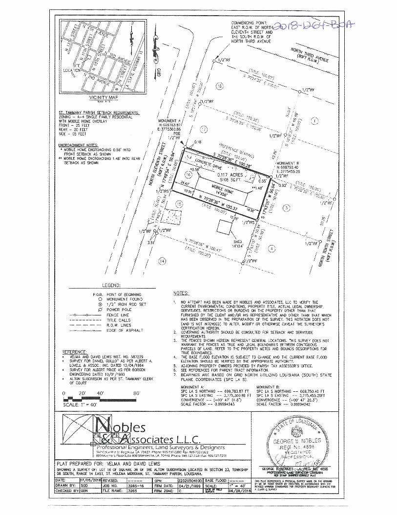
REFERENCE:• VELMA AND DAVD L.EIMS INST. NO. 587229• SURVEY FOR DANIEL GUILLOT AS PER ALBERT A.
LOVELL & ASSOC., INC. DATED 12/04/1984• SURVEY FOR ALBERT PRICE AS PER BORGEN
ENGINGERING DATED 10/01/1980• ALlaN SUBOIV1SON AS PER ST. TAMMANY CLERK
OF COURT
o 20’ 40’ 80’
SCALE 1’ —40
I)
NOTES:
1. NO ATTEMPT HAS BEEN MADE BY NOBLES AND ASSOCIATES, LLC TO VERIFY THECURRENT ENVIRONMENTAL CONDITIONS, PROPERTY TiTLE, ACITJAL LEGAL OWNERSHIP,SERVITUDES, RESTRICTiONS OR BURDENS ON THE PROPERTY OTHER THAN THATFTJRNISNEO BY THE CLIENT AND/OR HIS REPRESENTATiVE AND OTHER THAN THAT WHICHHAS BEEN OBSERVED IN THE PREPARATION OF THE SURVEY. THIS NOTATION DOES NOT(AND IS NOT INTENDED) TO ALTER, MOOIFY OR OTHERWISE CAVEAT THE SURVEYOR’SCERTiFICATION HEREON.
2. GOVERNING AUTHORITY SHOULD BE CONSULTED FOR SETBACK AND SERI.IIIJOEREOI.IIREMENTS.
3. THE FENCES SHOWN HEREON REPRESENT GENERAL LOCA11ONS. THIS SURVEY DOES NOTWARRANT TIlE FENCES AS TRUE AND LEGAL BOUNDARIES BETWEEN CC9I1TOIJOUSPARCELS OF LAND. REFER TO TIlE PROPERTY METES AND BOUNDS DESCRIPTIONS FORTRUE BOUNDARIES.
4. TIlE BASE FLOOD ELEVATION IS SUB~CT TO CHANGE AND THE CURRENT BASE FLOODELEVATiON SHOULD BE VERIFiED BY TIlE APPROPRiATE AUTHORITY.
5. ADJOINING PROPERTY OWNERS PROVIDED BY PARISH TA)I ASSESSOR’S OFFiCE.6. SEE REFERENCES FOR PARENT TRACT INFORMATION.7. BEARINGS ARE BASED ON GRID NORTH U11LIZING LOUISIANA (SOUTH) STATE
PLANE COORDINATES (SPC LA S).
MONUMENT A:SPC LA S NORTHING —— 699,783.87 FT
LA S EASTTNG —— 3,775.360.86 FTCONVERGENCE —— (+00’ 47’ Dl 6’)SCALE FACTOR —— 0.99994243
VICINITY MAPtML KIS
ST. TAAII4ANY PARISH SFTRAO(ZONING — A—4 SINELE FAMILY RESDENTIALWITH MOBILE HOME OVERLAYFRONT — 25 FEETREAR — 20 FEETSIDE — 05 FEET
/2’IRF
/
E
/
)
ENCROACHMENT NOTES:MOBILE HOME ENCROACHING 0.58’ INTOFRONT SETBACI< AS SHOWN
•‘ MOBILE HOME ENCROACHING 1.48’ INTO REARSETBACK AS SHOWN
/
—-S.’-’ i~O71,-
~
‘:~ ~?1/2’IRF ~
-
,110”
/
/
B
/
26
/
/
~‘ ~ ‘
C’Cc 1/2’IRF/
/
//
//
LEGEND:
i/2IRF~.~
~1~
/~
l1/2’IPF
P.0.8.00
POINT OF BEGINNINGMONUMENT FOUND1/2’ IRON ROD SETPOWER POLEFENCE LINETiTLE CALLSROW. UNESEDGE OF ASPHALT
MONUMENT B:SPC LA S NORTIIING —— 669,75040 FTSPC LA S EASTING —— 3,775,455.26FFCONVERGENCE —— (÷00’ 47’ 20.3’)SCALE FACTOR —— 0.99994242
ssociates LLC. .~~!0b~sProfessional Engineers, Land Su~eyors & Designers EORGE ~ NOBLES\~ RE~ ND 4896
~56? Cn,b.’ SI Bo51A~. LA 7042? Phone 9113-7 32.0380 Fa~ 985-7320322 ~800 M.l’,c~ I P3la SAlle 808 MCnSI’vlUe IA 70448 P7,one 985-127-7221 F,~. 985-727-7231
SHO~G A ~JRVEY OF: LOT 16 OF ~ARC 36 01 TIlE ALTON SU8DIVI~ON LOCA~ IN SECTiON 23, TOWNSH~ ~ ~
PLAT PREPARED FOR: ~El.MA AND DA’d~D LEViiS
~08 SOUTH, RANGE 14 EAST, ST. HELENA MERIDIAN. ST. TAMMANY PARISH, LOUIBANA.
3~ RAT ~3~IT3 A P838CL R83t0 8A~C 0~ 5€ ~C8~DRAWN BY: ISOD I JOB NO. 13265—18 F~ DA1EI 04/21/1999 I SCALE 1 4O~ ~ 1807 o~c00c ~ ~isDA1E b7/O5/2OT8IREMSEO: I CRN: 1225205041(1)1 BASE FLOOD:
~HECK~ BY:IGBN IRLE NAME: 3265 R~ ZONL Ic I ~ —‘ L/28/ZOlR ~883~ b~~8M ST~C8~ rc8 P*~1Y 18M5~R1 8181830981
•fl8


