Page 1 of 1
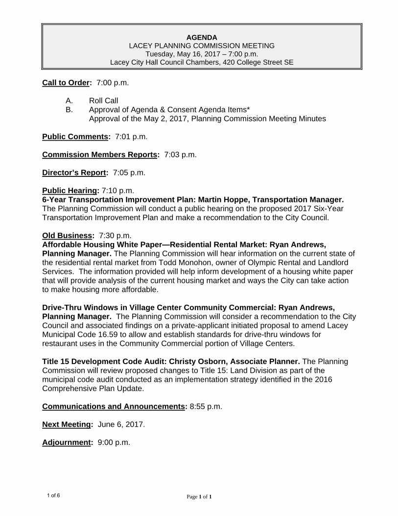
AGENDA
LACEY PLANNING COMMISSION MEETING Tuesday, May 16, 2017 – 7:00 p.m.
Lacey City Hall Council Chambers, 420 College Street SE
Call to Order: 7:00 p.m.
A. Roll Call B. Approval of Agenda & Consent Agenda Items*
Approval of the May 2, 2017, Planning Commission Meeting Minutes Public Comments: 7:01 p.m. Commission Members Reports: 7:03 p.m. Director’s Report: 7:05 p.m. Public Hearing: 7:10 p.m. 6-Year Transportation Improvement Plan: Martin Hoppe, Transportation Manager. The Planning Commission will conduct a public hearing on the proposed 2017 Six-Year Transportation Improvement Plan and make a recommendation to the City Council. Old Business: 7:30 p.m. Affordable Housing White Paper—Residential Rental Market: Ryan Andrews, Planning Manager. The Planning Commission will hear information on the current state of the residential rental market from Todd Monohon, owner of Olympic Rental and Landlord Services. The information provided will help inform development of a housing white paper that will provide analysis of the current housing market and ways the City can take action to make housing more affordable. Drive-Thru Windows in Village Center Community Commercial: Ryan Andrews, Planning Manager. The Planning Commission will consider a recommendation to the City Council and associated findings on a private-applicant initiated proposal to amend Lacey Municipal Code 16.59 to allow and establish standards for drive-thru windows for restaurant uses in the Community Commercial portion of Village Centers. Title 15 Development Code Audit: Christy Osborn, Associate Planner. The Planning Commission will review proposed changes to Title 15: Land Division as part of the municipal code audit conducted as an implementation strategy identified in the 2016 Comprehensive Plan Update. Communications and Announcements: 8:55 p.m. Next Meeting: June 6, 2017. Adjournment: 9:00 p.m.
1 of 6
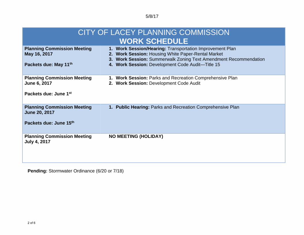
5/8/17
CITY OF LACEY PLANNING COMMISSION WORK SCHEDULE
Planning Commission Meeting May 16, 2017 Packets due: May 11th
1. Work Session/Hearing: Transportation Improvement Plan 2. Work Session: Housing White Paper-Rental Market 3. Work Session: Summerwalk Zoning Text Amendment Recommendation 4. Work Session: Development Code Audit—Title 15
Planning Commission Meeting June 6, 2017 Packets due: June 1st
1. Work Session: Parks and Recreation Comprehensive Plan 2. Work Session: Development Code Audit
Planning Commission Meeting June 20, 2017 Packets due: June 15th
1. Public Hearing: Parks and Recreation Comprehensive Plan
Planning Commission Meeting July 4, 2017
NO MEETING (HOLIDAY)
Pending: Stormwater Ordinance (6/20 or 7/18)
2 of 6
Page 1 of 2
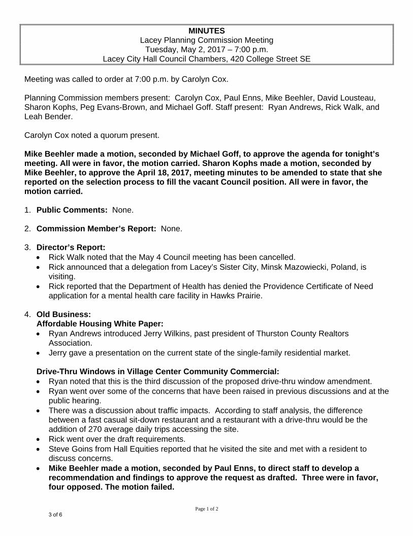
MINUTES Lacey Planning Commission Meeting
Tuesday, May 2, 2017 – 7:00 p.m. Lacey City Hall Council Chambers, 420 College Street SE
Meeting was called to order at 7:00 p.m. by Carolyn Cox. Planning Commission members present: Carolyn Cox, Paul Enns, Mike Beehler, David Lousteau, Sharon Kophs, Peg Evans-Brown, and Michael Goff. Staff present: Ryan Andrews, Rick Walk, and Leah Bender. Carolyn Cox noted a quorum present. Mike Beehler made a motion, seconded by Michael Goff, to approve the agenda for tonight’s meeting. All were in favor, the motion carried. Sharon Kophs made a motion, seconded by Mike Beehler, to approve the April 18, 2017, meeting minutes to be amended to state that she reported on the selection process to fill the vacant Council position. All were in favor, the motion carried. 1. Public Comments: None.
2. Commission Member’s Report: None.
3. Director’s Report:
Rick Walk noted that the May 4 Council meeting has been cancelled. Rick announced that a delegation from Lacey’s Sister City, Minsk Mazowiecki, Poland, is
visiting. Rick reported that the Department of Health has denied the Providence Certificate of Need
application for a mental health care facility in Hawks Prairie. 4. Old Business:
Affordable Housing White Paper: Ryan Andrews introduced Jerry Wilkins, past president of Thurston County Realtors
Association. Jerry gave a presentation on the current state of the single-family residential market.
Drive-Thru Windows in Village Center Community Commercial: Ryan noted that this is the third discussion of the proposed drive-thru window amendment. Ryan went over some of the concerns that have been raised in previous discussions and at the
public hearing. There was a discussion about traffic impacts. According to staff analysis, the difference
between a fast casual sit-down restaurant and a restaurant with a drive-thru would be the addition of 270 average daily trips accessing the site.
Rick went over the draft requirements. Steve Goins from Hall Equities reported that he visited the site and met with a resident to
discuss concerns. Mike Beehler made a motion, seconded by Paul Enns, to direct staff to develop a
recommendation and findings to approve the request as drafted. Three were in favor, four opposed. The motion failed.
3 of 6
Page 2 of 2
There was continued discussion regarding neighboring residents’ concerns, negative traffic and environmental impacts, and putting faith in the existing zoning to protect the area against negative impacts.
David Lousteau made a motion, seconded by Sharon Kophs, to direct staff to develop a recommendation to deny the request with findings that the application is inconsistent with the intent of the pedestrian-orientation goals of the zone, is inconsistent with City policies to reduce automobile dependency, and the additional automobile traffic that the drive-thru restaurant will generate will adversely impact adjacent residents. Four were in favor, three opposed. The motion carried.
Staff will put together the final recommendation for the next Planning Commission meeting. Commissioners will then have an opportunity to make a final motion and vote on the recommendation and associated findings.
5. Communications and Announcements:
Sharon reminded everyone that this weekend is the Lacey Fun Fair. Carolyn noted that she will be out of town and should be back by the next meeting but wanted
to make sure the Vice-Chair is prepared in the event she is not.
6. Next meeting: May 16, 2017.
7. Adjournment: 8:40 p.m.
4 of 6
PLANNING COMMISION May 16 2017
SUBJECT: 2018 Six-Year Transportation Improvement Plan ________________________________________________________________________ RECOMMENDATION: Hold a Public Hearing for the proposed 2018 Six-Year Transportation
Improvement Program and make a recommendation to the City Council.
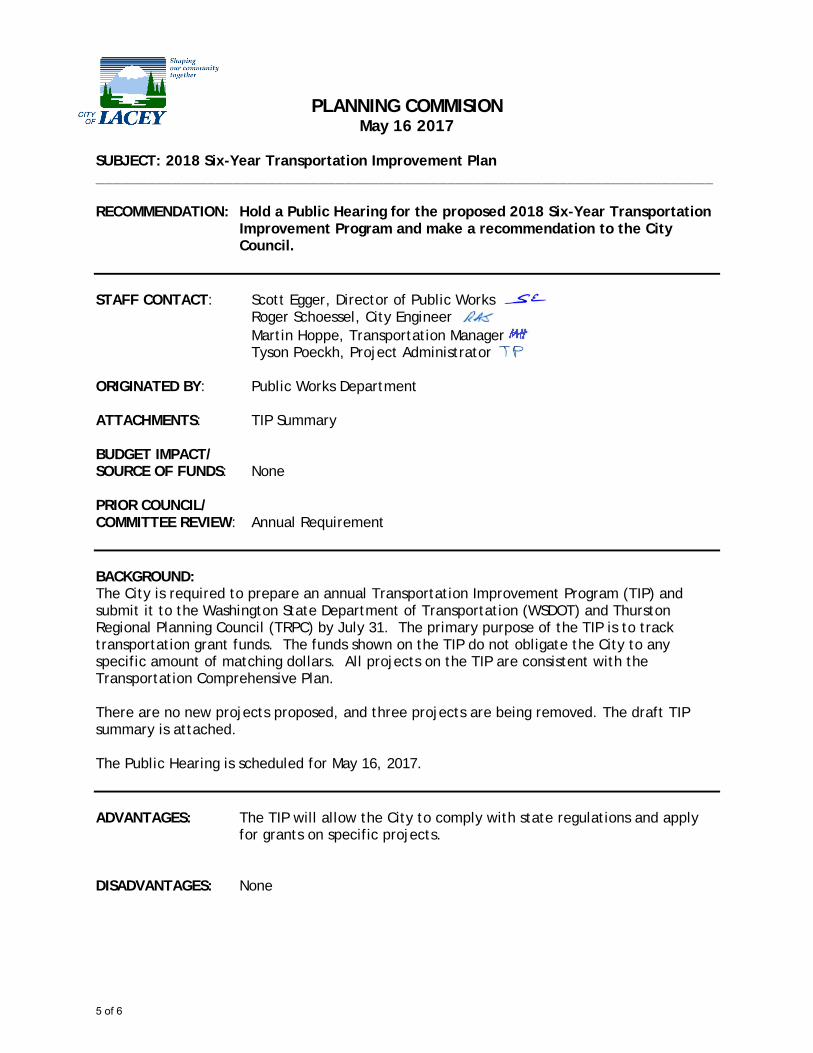
STAFF CONTACT: Scott Egger, Director of Public Works Roger Schoessel, City Engineer Martin Hoppe, Transportation Manager Tyson Poeckh, Project Administrator ORIGINATED BY: Public Works Department ATTACHMENTS: TIP Summary BUDGET IMPACT/ SOURCE OF FUNDS: None PRIOR COUNCIL/ COMMITTEE REVIEW: Annual Requirement BACKGROUND: The City is required to prepare an annual Transportation Improvement Program (TIP) and submit it to the Washington State Department of Transportation (WSDOT) and Thurston Regional Planning Council (TRPC) by July 31. The primary purpose of the TIP is to track transportation grant funds. The funds shown on the TIP do not obligate the City to any specific amount of matching dollars. All projects on the TIP are consistent with the Transportation Comprehensive Plan. There are no new projects proposed, and three projects are being removed. The draft TIP summary is attached. The Public Hearing is scheduled for May 16, 2017. ADVANTAGES: The TIP will allow the City to comply with state regulations and apply
for grants on specific projects. DISADVANTAGES: None
5 of 6
Current Process
LACEY STIP ID
PROJECT TITLE 2017 Total
Project Cost
R/W 11-001College St Corridor -- Phase 1 (College St and 22nd Ave Roundabout)
5,300,000$
Planned 11-005 College Street Extension NE 3,298,000$
Planned 11-010 Carpenter Rd Capacity and Safety Improvements Pacific to Shady Lane 4,340,000$
Planned 11-013 Marvin Road from Britton Parkway to Columbia Drive 15,535,000$
Planned 11-014 Martin Way / I-5 Interchange Improvements 42,600,000$
Planned 11-015 Carpenter Road Widening from Martin Way to Britton Parkway 19,100,000$
Planned 11-016 Rainier Road from Yelm Hwy to City Limits (near Beckonridge) 2,858,000$
Planned 11-017 Britton Parkway and Carpenter Road Intersection Improvements 648,000$
Planned 11-018 Britton Parkway -- Phase II 2,500,000$
Planned 11-019 Lebanon Street Extension 500,000$
Planned 11-020 Sleater-Kinney at 14th Ave Improvements 875,000$
Planned 11-021 College Street Corridor Improvements 38,000,000$
Planned 11-022 31st Avenue Extension Hogum Bay to Marvin Road 5,178,000$
Planned 11-024 Yelm Highway Improvements from Ruddell Rd to Amtrak Bridge 5,000,000$
Planned 11-025 Martin Way East Roadway Improvements 5,500,000$
Planned 11-026 Lacey Hawks Prairie Business District (LHPBD) Commercial Corridors 11,000,000$
Planned 14-001 Willamette Drive / Campus Glen Drive Roundabout 1,510,000$
Total TIP Costs 163,742,000$
Indicates Fully Funded
Projects to be Removed
Const 11-002 Hogum Bay Truck Route 8,203,000$
THCO 11-011 Carpenter Road /Mullen Road Intersection Improvements 950,000$
Complete 11-012 Martin Way / Hoh Street Intersection Improvements 636,000$
6 of 6
1
PLANNING COMMISSION STAFF REPORT
May 16, 2017
SUBJECT: Housing Discussion: Rental Market
________________________________________________________________________ RECOMMENDATION: Hear a presentation from a local expert on the current state of the rental
housing market in Lacey.
TO: Lacey Planning Commission STAFF CONTACTS: Ryan Andrews, Planning Manager ATTACHMENT(S): 1. Lacey Rental Market Statistics PRIOR COUNCIL/ COMMISSION/ COMMITTEE REVIEW: May 2, 2017 Planning Commission Meeting March 21, 2017 Planning Commission Meeting February 21, 2017 Planning Commission Meeting
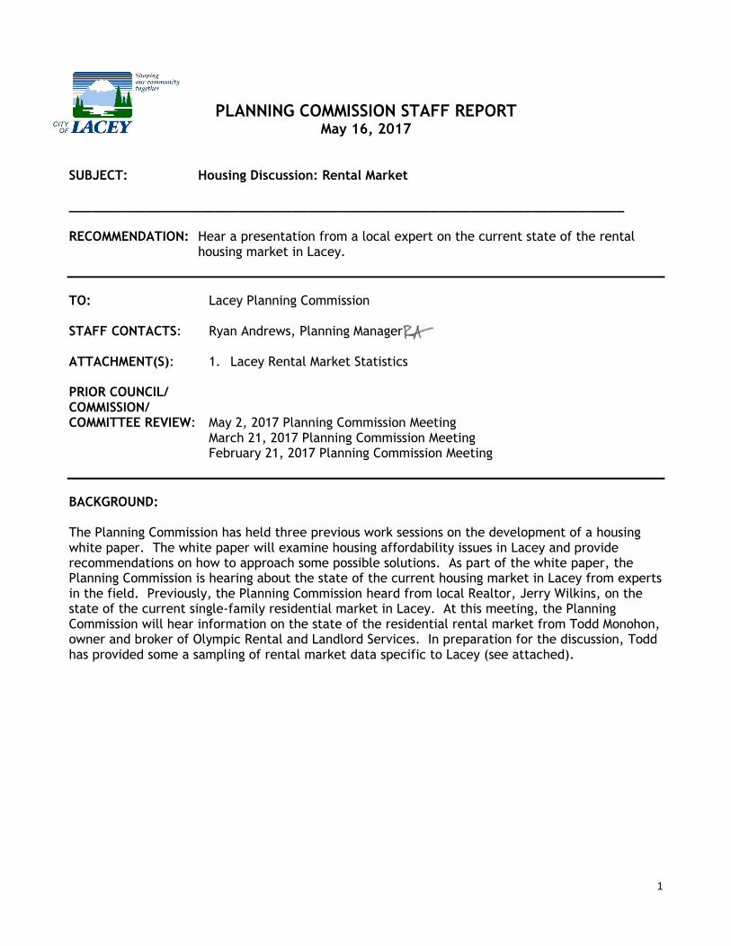
BACKGROUND: The Planning Commission has held three previous work sessions on the development of a housing white paper. The white paper will examine housing affordability issues in Lacey and provide recommendations on how to approach some possible solutions. As part of the white paper, the Planning Commission is hearing about the state of the current housing market in Lacey from experts in the field. Previously, the Planning Commission heard from local Realtor, Jerry Wilkins, on the state of the current single-family residential market in Lacey. At this meeting, the Planning Commission will hear information on the state of the residential rental market from Todd Monohon, owner and broker of Olympic Rental and Landlord Services. In preparation for the discussion, Todd has provided some a sampling of rental market data specific to Lacey (see attached).
LACEY - LIMITED SAMPLING - APRIL 2017 RENTAL STATS
single family/small multiplexes/condos/townhomes
Type Ave rent Ave yr built Ave sq ft Rent/sq ft Rent/sq ft/type
CONDO 1/1 $975 1984 674 $1.45
CONDO 2/2 $1,275 1998 1524 $0.84
CONDO 3/2.5 $1,334 2000 1536 $0.87
ALL CONDOS $1,195 1994 1245 1 $1.05
Type Ave rent Ave yr built Ave sq ft Rent/sq ft Rent/sq ft/type
DUPLEX 2/1 $953 1977 952 $1.00
DUPLEX 2/1.5 $820 1968 1032 $0.79
DUPLEX 2/2 $1,195 1993 1380 $0.87
DUPLEX 3/1.5 $1,120 1967 1100 $1.02
ALL DUPLEXES $1,022 1976 1116 1 $0.92
Type Ave rent Ave yr built Ave sq ft Rent/sq ft Rent/sq ft/type
HOUSE 2/1 $1,183 1971 1037 $1.14
HOUSE 2/2 $1,185 2008 1224 $0.97
HOUSE 3/1 $1,350 1959 1340 $1.01
HOUSE 3/1.5 $1,370 1972 1424 $0.96
HOUSE 3/2 $1,368 1986 1455 $0.94
HOUSE 3/2.5 $1,516 2002 1817 $0.83
HOUSE 3/3 $1,588 1992 1820 $0.87
HOUSE 4/2 $1,500 1972 1818 $0.83
HOUSE 4/2.5 $1,775 2007 2285 $0.78
HOUSE 4/3 $1,847 1993 2532 $0.73
HOUSE 4/3.5 $1,595 1993 1830 $0.87
HOUSE 5/3 $1,895 1993 2270 $0.83
ALL HOUSES $1,514 1987 1738 1 $0.90
Type Ave rent Ave yr built Ave sq ft Rent/sq ft Rent/sq ft/type
TWN HS 2/1.5 $1,135 1985 1200 $0.95
TWN HS 2/2.5 $1,285 2007 1323 $0.97
TWN HS 3/2 $1,150 1988 1200 $0.96
TWN HS 3/2.5 $1,433 2003 1496 $0.96
All TWN HS $1,251 1996 1305 1 $0.96
Page 1 of 4
PLANNING COMMISSION STAFF REPORT
May 16, 2017
SUBJECT: Village Center Community Commercial Zoning Text Amendment Application. Project no. 17-37.
________________________________________________________________________ RECOMMENDATION: Move to recommend to the City Council denial of the application to amend
Lacey Municipal Code 16.59 to allow and establish standards for drive-thru windows for restaurant uses subject to the findings of fact listed in this report.
TO: Lacey Planning Commission STAFF CONTACTS: Rick Walk, Director of Community and Economic Development Ryan Andrews, Planning Manager ATTACHMENT(S): 1. Proposed Draft Village Center Community Commercial Zoning Text PRIOR COUNCIL/ COMMISSION/ COMMITTEE REVIEW: May 2, 2017 Planning Commission Work Session April 18, 2017 Public Hearing April 4, 2017 Planning Commission Work Session
BACKGROUND: The Community and Economic Development Department received a private applicant-initiated zoning text amendment request. The request is to amend Chapter 16.59 of the Lacey Municipal Code to allow drive-thru windows for restaurant uses and establish standards applying to all drive-thru’s within the Community Commercial portion of Village Centers. The request is to amend specific text within the zoning code and does not require the need to amend any policies within the Comprehensive Plan. These applications are received periodically and are not subject to the docketing or annual Comprehensive Plan amendment timelines because amendment of the Comprehensive Plan is unnecessary. The Planning Commission has reviewed the request and will provide a recommendation on the amendment to the City Council. At the initial Planning Commission briefing held on April 4, Planning Commission members reviewed the request and raised concerns on whether drive-thru windows were appropriate for this zone given that the Village Center regulations should create a commercial area that is neighborhood oriented and distinct from the standard Community Commercial zone. Additional issues raised by the Planning Commission included: idling cars and air quality, poor drive-thru
Page 2 of 4
design and circulation issues, impacts on neighboring residential properties, and concerns about the proliferation of drive-thru’s within the city. At the conclusion of the April 4 briefing, the Planning Commission agreed to schedule the public hearing for April 18 with expanded notification to adjacent property owners. At the April 18 public hearing, the applicant and three members of the public provided testimony on the application. The applicant provided information related to various drive-thru examples both locally and nationally. The three members of the public had concerns related to the commercial area including: noise impacts from cars idling, dogs barking from inside of cars, engine noise, and parking lot blowers; garbage; parking lot lights; potential fast food odors; and the proliferation of drive-thru’s in the area. After the conclusion of the public hearing, the Planning Commission requested staff to research and provide additional information to inform their deliberation for the May 2 meeting. At the May 2 meeting, the Planning Commission discussed the central issue surrounding the application—whether drive-thru restaurants are inconsistent with the policies and intent of the Village Center Community Commercial zone. Specifically, the issue is whether the additional traffic generated by the drive-thru will alter the character of this zone and affect the character of the neighborhood-oriented commercial center. Staff provided traffic data to the Planning Commission including the most recent traffic counts on Yelm Highway in this area, approximately 19,356 trips per day pass by the Summerwalk commercial area. The center’s viability depends on the traffic passing by the center on a daily basis, as the adjacent neighborhood does not have the density, population, or the number of residential units that support a center of this scale. Therefore, the commercial area has to balance the needs of the adjacent residential areas with those of the greater Lacey community and the regional traffic that Yelm Highway supports in this location. Staff also provided data related to the number of daily trips a drive-thru restaurant generates versus a typical sit-down restaurant. Based on data contained in the 9th Edition, Volume 3, of the Institute of Transportation Engineers (ITE) Trip Generation Manual, City of Lacey transportation staff has modeled a typical 3,000 square foot fast food restaurant with drive-thru and a fast casual high turnover restaurant. The comparison of each use is provided below: Fast Food Restaurant with Drive-Thru (3,000 square feet in multi-tenant building): 98 p.m. peak trips generated* 42 p.m. new peak trips (p.m. peak minus internal capture and pass by)* 420 average daily trips High Turnover Sit Down Restaurant (3,000 square feet in multi-tenant building): 30 p.m. peak trips generated*
15 p.m. new peak trips (p.m. peak minus internal capture and pass by)* 150 average daily trips
*= p.m. peak trips are trips are those trips generated between 4 and 6 p.m. At the public hearing on April 18, the Planning Commission also requested information related to the percentage of total business done through the drive-thru for various uses. According to industry journals, the typical drive-thru restaurant conducts approximately 60 to 70 percent of
Page 3 of 4
business through the drive-thru meaning that between 252 and 294 average daily trips would be going through a drive-thru restaurant at the Summerwalk Village Center. At the May 2 meeting, the Planning Commission voted to direct staff to develop a recommendation of denial with associated findings for final consideration by the Planning Commission. The Planning Commission is requested to review the findings, revise as necessary, and adopt a final recommendation to the City Council. RECOMMENDATION AND FINDINGS: The Lacey Planning Commission recommends to the Lacey City Council the denial of the application to amend Lacey Municipal Code 16.59 to allow and establish standards for drive-thru windows for restaurant uses in the Community Commercial portion of Village Centers subject to the following findings of fact:
1. The 2003 Comprehensive Land Use Plan for Lacey and the Lacey Urban Growth contains discussion and policies on the development of Village Centers, including:
“The design of urban centers with mixed uses provides a full range of land uses within the center. Commercial Services are provided, within walking distance of village center residents, thereby potentially reducing the need for single-occupant vehicle trips.” (page 5-5)
“The village center promises an opportunity to reduce automobile trips and enhance other multi-modal transportation opportunities.” (page 5-9)
“The business component must fit within the character of the development and surrounding neighborhood and not be the prominent land use element of a project…Zones with Community Commercial designations may be designed to achieve a balance in serving the village center and the surrounding community.” (Policy F.1.e, page 6-7)
2. Lacey Municipal Code 16.59.110 “Intent” contains statements related to the purpose of
the Village Center zone, including: “D. Promote creation of places which have pedestrian emphasis, connectivity, mixed use, and centralized public spaces. Emphasize these features and neighborhood concepts of place.”
3. Lacey’s Village Center regulations were developed in 1995 and specifically prohibited drive-thru restaurant uses in both the Community Commercial and Neighborhood Commercial portions of Village Centers. The Planning Commission finds that the application is inconsistent with the zoning as intended to prevent the proliferation of drive-thru restaurant uses in these zones.
4. The 9th Edition, Volume 3, of the Institute of Transportation Engineers (ITE) Trip Generation Manual documents that a 3,000 square foot fast food restaurant with drive-thru would generate 270 average daily, 68 peak hour and 27 net peak hour trips more than a 3,000 square foot high-turnover restaurant would generate.
5. Based on the anticipated average daily and peak hour trips accessing a drive-thru restaurant, the potential impact on the circulation within the Village Center zone, and the associated change of character to the zone additional auto traffic would create, the traffic impacts associated with this use will be inconsistent with the goals for pedestrian orientation of the Community Commercial portion of the Village Center.
Page 4 of 4
6. Based on the anticipated amount of traffic a drive-thru restaurant would generate, a
drive-thru restaurant is inconsistent with policies related to the neighborhood orientation of the zone, pedestrian emphasis, and associated goals for reduction of single-occupant automobile use and dependency.
7. The Planning Commission received comments from adjacent residents at a public hearing conducted on April 18, 2017. Residents were concerned about the additional automobile traffic, idling, and noise that a drive-thru lane and window would generate. Based on these comments, the Planning Commission finds that the proposed drive-thru use is incompatible with the adjacent residential uses.
Lacey Municipal Code
Page 1/7
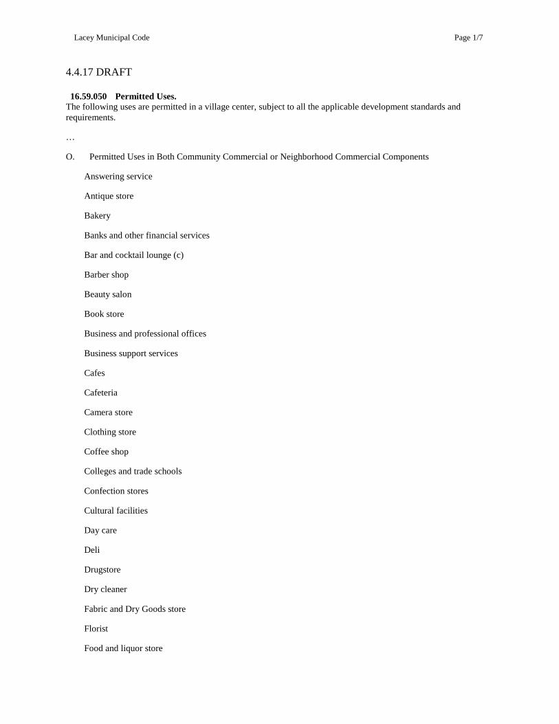
4.4.17 DRAFT 16.59.050 Permitted Uses. The following uses are permitted in a village center, subject to all the applicable development standards and requirements.
…
O. Permitted Uses in Both Community Commercial or Neighborhood Commercial Components
Answering service
Antique store
Bakery
Banks and other financial services
Bar and cocktail lounge (c)
Barber shop
Beauty salon
Book store
Business and professional offices
Business support services
Cafes
Cafeteria
Camera store
Clothing store
Coffee shop
Colleges and trade schools
Confection stores
Cultural facilities
Day care
Deli
Drugstore
Dry cleaner
Fabric and Dry Goods store
Florist
Food and liquor store
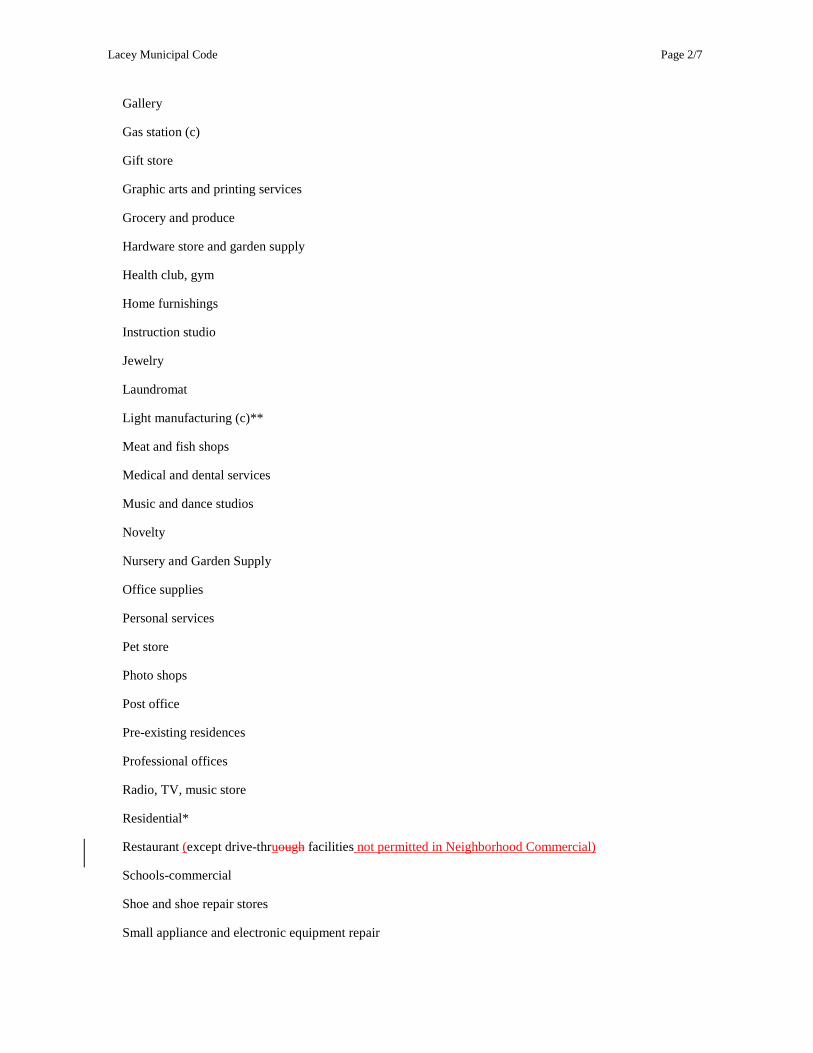
Lacey Municipal Code
Page 2/7
Gallery
Gas station (c)
Gift store
Graphic arts and printing services
Grocery and produce
Hardware store and garden supply
Health club, gym
Home furnishings
Instruction studio
Jewelry
Laundromat
Light manufacturing (c)**
Meat and fish shops
Medical and dental services
Music and dance studios
Novelty
Nursery and Garden Supply
Office supplies
Personal services
Pet store
Photo shops
Post office
Pre-existing residences
Professional offices
Radio, TV, music store
Residential*
Restaurant (except drive-thruough facilities not permitted in Neighborhood Commercial)
Schools-commercial
Shoe and shoe repair stores
Small appliance and electronic equipment repair
Lacey Municipal Code
Page 3/7
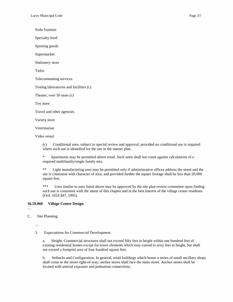
Soda fountain
Specialty food
Sporting goods
Supermarket
Stationery store
Tailor
Telecommuting services
Testing laboratories and facilities (c)
Theater, over 50 seats (c)
Toy store
Travel and other agencies
Variety store
Veterinarian
Video rental
(c) Conditional uses, subject to special review and approval, provided no conditional use is required where such use is identified for the site in the master plan.
* Apartments may be permitted above retail. Such units shall not count against calculations of a required multifamily/single family mix.
** Light manufacturing uses may be permitted only if administrative offices address the street and the use is consistent with character of area, and provided further the square footage shall be less than 20,000 square feet.
*** Uses similar to uses listed above may be approved by the site plan review committee upon finding such use is consistent with the intent of this chapter and in the best interest of the village center residents. (Ord. 1024 §47, 1995).
16.59.060 Village Center Design …
C. Site Planning.
…
3. Expectations for Commercial Development.
a. Height. Commercial structures shall not exceed fifty feet in height within one hundred feet of existing residential homes except for tower elements which may extend to sixty feet in height, but shall not exceed a footprint area of four hundred square feet.
b. Setbacks and Configuration. In general, retail buildings which house a series of small ancillary shops shall come to the street right-of-way; anchor stores shall face the main street. Anchor stores shall be located with arterial exposure and pedestrian connections.
Lacey Municipal Code
Page 4/7
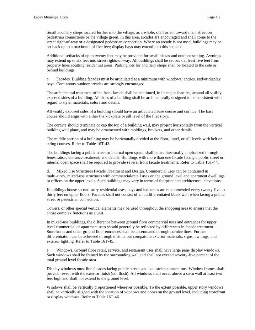
Small ancillary shops located further into the village, as a whole, shall orient toward main street on pedestrian connections or the village green. In this area, arcades are encouraged and shall come to the street right-of-way or a designated pedestrian connection. Where an arcade is not used, buildings may be set back up to a maximum of five feet; display bays may extend into this setback.
Additional setbacks of up to twenty feet may be provided for small plazas and outdoor seating. Awnings may extend up to six feet into street rights-of-way. All buildings shall be set back at least five feet from property lines abutting residential areas. Parking lots for ancillary shops shall be located to the side or behind buildings.
c. Facades. Building facades must be articulated at a minimum with windows, entries, and/or display bays. Continuous outdoor arcades are strongly encouraged.
The architectural treatment of the front facade shall be continued, in its major features, around all visibly exposed sides of a building. All sides of a building shall be architecturally designed to be consistent with regard to style, materials, colors and details.
All visibly exposed sides of a building should have an articulated base course and cornice. The base course should align with either the kickplate or sill level of the first story.
The cornice should terminate or cap the top of a building wall, may project horizontally from the vertical building wall plane, and may be ornamented with moldings, brackets, and other details.
The middle section of a building may be horizontally divided at the floor, lintel, or sill levels with belt or string courses. Refer to Table 16T-43.
The buildings facing a public street or internal open space, shall be architecturally emphasized through fenestration, entrance treatment, and details. Buildings with more than one facade facing a public street or internal open space shall be required to provide several front facade treatments. Refer to Table 16T-44.
d. Mixed Use Structures Facade Treatment and Design. Commercial uses can be contained in multi-story, mixed-use structures with commercial/retail uses on the ground level and apartment dwellings or offices on the upper levels. Such buildings may vary in terms of footprint and architectural elevations.
If buildings house second story residential uses, bays and balconies are recommended every twenty-five to thirty feet on upper floors. Facades shall not consist of an undifferentiated blank wall when facing a public street or pedestrian connection.
Towers, or other special vertical elements may be used throughout the shopping area to ensure that the entire complex functions as a unit.
In mixed-use buildings, the difference between ground floor commercial uses and entrances for upper level commercial or apartment uses should generally be reflected by differences in facade treatment. Storefronts and other ground floor entrances shall be accentuated through cornice lines. Further differentiation can be achieved through distinct but compatible exterior materials, signs, awnings, and exterior lighting. Refer to Table 16T-45.
e. Windows. Ground floor retail, service, and restaurant uses shall have large pane display windows. Such windows shall be framed by the surrounding wall and shall not exceed seventy-five percent of the total ground level facade area.
Display windows must line facades facing public streets and pedestrian connections. Window frames shall provide reveal with the exterior finish (not flush). All windows shall occur above a stem wall at least two feet high and shall not extend to the ground level.
Windows shall be vertically proportioned wherever possible. To the extent possible, upper story windows shall be vertically aligned with the location of windows and doors on the ground level, including storefront or display windows. Refer to Table 16T-46.
Lacey Municipal Code
Page 5/7
f. Roofs. Gable, saltbox, or vegetated roofs are the preferred roof types. Flat and mansard roofs are generally discouraged. Where flat roofs are necessary for larger anchor commercial, community-oriented structures, or vegetated roof designs, gable elements and other architectural elements must be used to break up the roof line and create architectural interest consistent with the design vocabulary. Roof types should be appropriate to the building’s architecture. Architectural embellishments that add visual interest to roofs, such as dormers, belvederes, masonry chimneys, cupolas, clock towers, and other similar elements are encouraged. Refer to Table 16T-47.
g. Materials. For exterior finishes masonry or wood siding is recommended. Other building materials used locally such as concrete block and CMU are also acceptable if special consideration is given to design. Rated panel siding such as T1-11 shall not be allowed. Techniques that provide architectural interest like texturing, fenestration and modulation shall be used. Materials are not as important as the overall objectives of providing human-scaled building elements and finishes with architectural interest.
h. Entries. Primary entries shall address a public street or designated pedestrian connection. Secondary entries may face parking lots or loading areas. Anchor store entries must, at a minimum, face main street. Anchor stores shall provide continuous sidewalks that connect with adjacent streets and the pedestrian connection. Ancillary shops should normally provide entries every twenty-five to thirty feet. Upper story residential uses should have entries every fifty to seventy feet.
All entrances to a building shall be defined and articulated by architectural elements such as:
(1) Lintels.
(2) Pilasters.
(3) Columns.
(4) Porticos.
(5) Porches.
(6) Overhangs.
(7) Railings.
(8) Balustrades, and others, where appropriate.
Any such element utilized shall be architecturally compatible with the style, materials, colors, and details of the building as a whole, as shall the doors. (See Table 16T-48.)
i. Square Footage. The maximum ground level footprint of commercial uses along a main street should normally be limited to ten thousand square feet. Provided that an anchor store with arterial exposure may be of appropriate size to service the designated market area for a neighborhood commercial area or community commercial area.
j. Awnings. Fixed or retractable awnings are permitted at ground floor level, and on upper levels where appropriate, if they complement a building’s architectural style, materials, colors, and details and do not conceal architectural features. Canvas is the preferred material, although other water-proofed fabrics may be used; metal or aluminum awnings are prohibited. In buildings with multiple storefronts, compatible awnings should be used as a means of unifying the structure. Refer to Table 16T-49.
k. Compatible Materials and Colors. Buildings with multiple storefronts shall be unified through the use of architecturally compatible materials, colors, details, awnings, signage, and lighting fixtures.
All materials, colors, and architectural details used on the exterior of a building shall be compatible with the building’s style, and with each other.
Lacey Municipal Code
Page 6/7
l. Corner Stores. Corner stores may be located in residential areas of the village center away from the core, provided they are located on Type 2 or 3 residential streets. Corner store buildings shall be designed to appear semi-residential and shall be limited to one ground level commercial use not to exceed two thousand square feet in gross floor area. Apartment dwellings should be located on the upper level(s) to help integrate the building into the residential area.
The commercial use in a corner store shall be primarily oriented to serve the residents of the immediately surrounding neighborhood. Refer to Table 16T-50. A corner store building shall be set back a maximum of ten feet from the right-of-way line.
m. Restaurants. Restaurants shall be permitted to operate outdoor cafes on sidewalks, including areas within the public right-of-way and in courtyards, provided that pedestrian circulation and access to store entrances shall not be impaired. Refer to Table 16T-51. The following standards and guidelines are applicable:
(1) To allow for pedestrian circulation, a minimum of five feet of sidewalk along the curb and leading to the entrance to the establishment shall be maintained free of tables and other encumbrances and delineated in some fashion for visually impaired persons.
(2) Planters, posts with ropes, or other removable enclosures are encouraged and shall be used as a way of defining the area occupied by the cafe.
(3) Extended awnings, canopies, or large umbrellas shall be permitted and located to provide shade. Colors shall complement building colors.
(4) Outdoor cafes shall be required to provide additional outdoor trash receptacles.
(5) Tables, chairs, planters, trash receptacles, and other elements of street furniture shall be compatible with the architectural character of the building where the establishment is located.
(6) Outdoor cafes shall not be entitled to additional signage, over and beyond what is permitted for this type of establishment.
(7) The operators of outdoor cafes shall be responsible for maintaining a clean, litter-free, and well-kept appearance within and immediately adjacent to the area of their activities.
n. Drive-thru facilities. Where a drive-thru is proposed as part of a building, the following requirements shall apply:
(1) The drive-thru shall be accessory to the principal use of the development, which includes interior space for customers to enter the building for goods or services.
(2) The entrance and exit for the drive-thru lane shall not be located on a public street.
(3) The drive-thru lane and the drive-thru window shall be screened when visible from a public street. Screening shall include architectural projections, fencing, landscaping, or a combination of these elements.
(4) Drive-thru lanes and windows shall be located a minimum of 150 feet from adjacent residential uses. Drive-thrus are permitted on the same property as residential uses provided that the residential uses are not located on the ground floor.
(5) Drive-thru lanes shall not result in queuing or stacking which impedes pedestrian or bicycle access or mobility.
(6) Drive-thru lanes for restaurant uses shall only be allowed in buildings divided into multiple tenant spaces.
Lacey Municipal Code
Page 7/7
(7) Drive-thru lanes for restaurant uses shall be located more than 150 feet from a signalized intersection.
no. Commercial uses shall be permitted to have sidewalk displays of retail merchandise. Refer to Table 16T-52. The following standards and guidelines are applicable.
(1) Sidewalk displays of merchandise similar to merchandise sold within the store are permitted directly in front of an establishment; provided, that at least five feet of clearance is maintained at the storefront entrance and delineated in some fashion for visually impaired persons. The display must be located against the building wall not more than three feet deep, and the display area may not exceed seventy-five percent of the length of the storefront.
(2) Display cases shall be permitted only during normal business hours and shall be removed at the end of the business day. Cardboard boxes shall not be used for sidewalk displays.
(3) Sidewalk displays shall maintain a clean, litter-free, and well-kept appearance at all times and shall be compatible with the colors and character of the storefront from which the business operates.
…
Staff Report May 16, 2017 Page 1 of 2
PLANNING COMMISSION STAFF REPORT
May 16, 2017
SUBJECT: Proposed revisions to Title 15, Land Division as part of the Development Code Audit.
________________________________________________________________________ RECOMMENDATION: Staff will provide an overview of proposed revisions to draft Title 15
LMC, Land Division.
TO: Lacey Planning Commission STAFF CONTACTS: Rick Walk, Community Development Director Ryan Andrews, Planning Manager Christy Osborn, Associate Planner ATTACHMENT(S): 1. Draft Title 15 LMC, Land Division PRIOR COUNCIL/ COMMISSION/ COMMITTEE REVIEW: This is the first workshop on revisions to Title 15, Land Division.
BACKGROUND: A work session was held on April 4, 2017 to discuss an upcoming audit of the zoning, land division, and design review standards contained in the Lacey Municipal Code (LMC). The state Growth Management Act (GMA) requires counties and cities to periodically conduct a review of their comprehensive plan and development regulations to bring them up to date with any relevant changes in the GMA and to respond to changes in land use and population growth. The review and adoption of the Comprehensive Plan was completed last year with updates to several sections in the plan. This review identified implementation strategies necessary to implement the goals and policies in the plan. Several amendments to the development regulations have been adopted as identified in the plan. The review of Title 15 is a continuation of this review and auditing process. This title regulates the division of land such as short plats, binding site plans, subdivisions, condominiums, and design standards applicable to land divisions and alterations. Land divisions are required to comply with state law established in Chapter 58.17 RCW, the comprehensive plan, and other city plans, policies, and standards.
Staff Report May 16, 2017 Page 2 of 2
PROPOSED CHANGES The proposed changes to the land division code address the following issues:
Implement goals and policies in comprehensive plan
Identify redundancies, inconsistencies, and conflicting language with comprehensive plan intent and between chapters in the development code
Ensure compliance with changes in state and federal law requirements, particularly 58.17RCW,Plats-Subdivisions-Dedications
Address issues with implementation of development regulations City staff members who routinely implement the provisions contained in the land division title reviewed the draft changes. The majority of the recommended changes have been included in the review draft. Additional revisions to the title regarding design standards may be added after additional input and review by staff. RECOMMENDATION: The Planning Commission will review proposed changes to the land division title and recommend any changes or additions.
Lacey Municipal Code
TITLE 15 LAND DIVISION
Page 1/59
The Lacey Municipal Code is current through Ordinance 1509, passed March 23, 2017.
TITLE 15
LAND DIVISION1
Chapters:
15.01 General Provisions
15.02 Definitions
15.04 Boundary Line Adjustments and Lot Consolidations
15.05 Plat, Short Plat and Binding Site Plan Alterations and Vacations
15.06 Binding Site Plans
15.07 Condominium Development and Conversion
15.08 Short Subdivision
15.10 Subdivision
15.12 Design Standards for Subdivisions, Short Subdivisions and Binding Site Plans
15.14 Dedications-Plats, Short Plats and Binding Site Plans
15.16 Improvements
15.18 Repealed
15.20 Land Division Fees, Variances, Exceptions, and Enforcement
15.22 Community Facilities
15.28 Repealed
15.32 Repealed
15.36 Repealed
1 Editor’s Note: LMC Title 15, was repealed and replaced by new chapters by Ord. 1235, §1, passed on January 13,
2005. LMC Title 15, as amended by Ord. 660, was readopted in its entirety by Ord. 744, passed March 28, 1985.
Lacey Municipal Code
CHAPTER 15.01 GENERAL PROVISIONS
Page 2/59
The Lacey Municipal Code is current through Ordinance 1509, passed March 23, 2017.
CHAPTER 15.01
GENERAL PROVISIONS
Sections:
15.01.010 Title
15.01.020 Purpose and intent
15.01.025 Authority
15.01.030 General sScope
15.01.040 Specific exemptions
15.01.050 Regulations mandatory
15.01.055 Conformance with other regulations
15.01.0560 Concurrency for public facilities, utilities and roads
15.01.0605 Land DivisionsSubdivisions adjacent to resource lands
15.01.070 Administration
15.01.010 Title.
This title shall be known as the city of Lacey Land Division Ordinance. (Ord. 1235 §1,2, 2005).
15.01.020 Purpose and intent.
It is the purpose and intent of this title to provide rules, regulations, requirements, and standards for the division,
alteration, adjustment, and vacation of land within the city to ensure the following:
A. These regulations are for the purpose of regulating the division of land and tTo promote and protect the
public health, safety, and general welfare, and aesthetics of the city in compliance with Chapter 58.17 RCW.
B. To provide for orderly growth, development, and the conservation, protection, and proper use of land to
maintain and perpetuate environmental quality, and provide adequate open space, light, and air.
C. in accordance with established standards to provide for expeditious review of land divisions; to ensure land
divisions conform to requirements of Chapter 58.17 RCW; tTo regulate the division of land in furtherance of the
goals and objectives meet requirements of all of the elements of the City of Lacey & Lacey Urban Growth Area
Comprehensive Plan, all elements of the Lacey Comprehensive Land Use Plan, including the city of Lacey and
Thurston County Land Use Plan for the Lacey Urban Growth Area, the Housing Element, Utility Element, Capital
Facilities Element, Economic Development Element, Transportation Element, the Environmental Protection and
Resource Conservation Plan (Environmental Element)
D. and other city plans and policies; tTo meet zoning standards and other provisions of the Lacey Municipal
Code and the Lacey Development Guidelines and Public Works Standards.
E. To facilitate adequate provision of potable water supplies, sewer, drainage, fire protection, parks and
recreation areas, sites for schools and school grounds, and other public uses.
F. ; Tto promote the proper arrangement and provision of adequate streets or roads, lots, easements, pathways,
trails, transit stops, and other private or public ways that aussre safe walking conditions for students.; providing for
adequate and convenient provision of open spaces, utilities, recreation and access for service and emergency
vehicles; providing for adequate provision of water, drainage, sewer and other public facilities;
G. tTo promote a coordination of development as land develops.
; to conserve and restore natural beauty and other natural resources to maintain and perpetuate environmental
quality;
H. tTo require uniform monumenting of land divisions and conveyance by accurate legal description.
Lacey Municipal Code
CHAPTER 15.01 GENERAL PROVISIONS
Page 3/59
The Lacey Municipal Code is current through Ordinance 1509, passed March 23, 2017.
I. ; and tTo adequately provide for land use, housing and commercial needs of the citizens of Lacey. (Ord. 1235
§1, 2, 2005).
15.01.025 Authority
This title is authorized pursuant to the authority delegated to the city of Lacey under Chapter 58.17 RCW, Plats –
Subdivisions – Dedications.
15.01.030 General sScope.
A. This title shall apply to the division, alteration, adjustment, and vacation or re-division of land for sale, lease,
transfer, or building development into two or more lots, tracts, or parcels by the means specifically provided for
herein. It shall also apply to boundary line adjustments, lot consolidations, binding site plans, condominium
development, condominium conversions, plat alterations, plat vacations, and any other lot line alteration and/or
re-division of land. As part of the Lacey Municipal Code, this title recognizes and incorporates the standards,
provisions, and regulations contained in other parts of the Lacey Municipal Code as it exists now or as it may
hereafter be amended. As such, approvals granted pursuant to this title shall only occur in compliance with these
other regulatory provisions, as well as with all elements of the City of Lacey & Lacey Urban Growth Area
Comprehensive Land Use Plan, City of Lacey Development Guidelines and Public Works Standards, concurrency
requirements and any other applicable laws and regulations. Where provisions of other official controls and
regulations overlap or conflict with the provisions of this title, the more restrictive provisions shall govern.
B. Any survey, plat, short plat, replat or plan hereafter made of a proposed division, alteration, and vacation of
land pursuant to this title or any part thereof shall be presented for approval and be recorded as prescribed by this
title. No such map, plat, replat or plan shall be recorded or have any validity unless or until it is approved as may be
required by this title. No person shall sell, lease, transfer or offer to sell, lease or transfer any lot, tract or parcel
subject to the requirement of this title without first receiving approval hereunder and filing a map of the approved
division with the Thurston County Auditor, provided, that if performance of an offer or agreement to sell, lease, or
otherwise transfer a lot, tract, or parcel of land is expressly conditioned on the recording of the plat containing the
lot, tract, or parcel, the offer or agreement is not subject to RCW 58.17.200 or 58.17.300 and does not violate any
provision of this title. All payments on account of an offer or agreement conditioned as provided in this section shall
be deposited in an escrow or other regulated trust account and no disbursement to sellers shall be permitted until the
plat is recorded.
C. All records and surveys in connection with any plat, short plat or binding site plan shall be in conformance
with Chapter 58.09 RCW.
(Ord. 1369 §2, 2011; Ord. 1235 §1, 2, 2005).
15.01.040 Specific exemptions.
The subdivision and short subdivision provisions of this title shall not apply to the following:
A. Cemeteries and other burial plots while used for that purpose;
B. Divisions of land into lots or tracts each of which is forty acres or larger provided each lot created has legal
access, and connectivity is provided to adjacent land pursuant to road grid requirements, or provision has otherwise
been satisfied for future development and surrounding connectivity; provided further, that division of any amount of
land zoned for nonresidential use shall either be accomplished through a plat, a short plat, or the binding site plan
regulations pursuant to subsection F of this section and Chapter 15.06 LMC;
C. Divisions made by testamentary provisions or the laws of descent. In order to be buildable, lots formed in this
fashion must meet the requirements of all other ordinances including access, lot size, etc., in effect at the time of
probate;
D. A division for the purpose of lease when no residential structure other than manufactured homes (mobile
homes) or travel trailers are permitted to be placed on the land and the land is to be developed as a manufactured or
mobile home park or a recreational vehicle park; provided the city has approved a binding site plan pursuant to
Chapter 15.06 LMC and a site plan has been approved pursuant to Chapter 16.84 LMC;
Lacey Municipal Code
CHAPTER 15.01 GENERAL PROVISIONS
Page 4/59
The Lacey Municipal Code is current through Ordinance 1509, passed March 23, 2017.
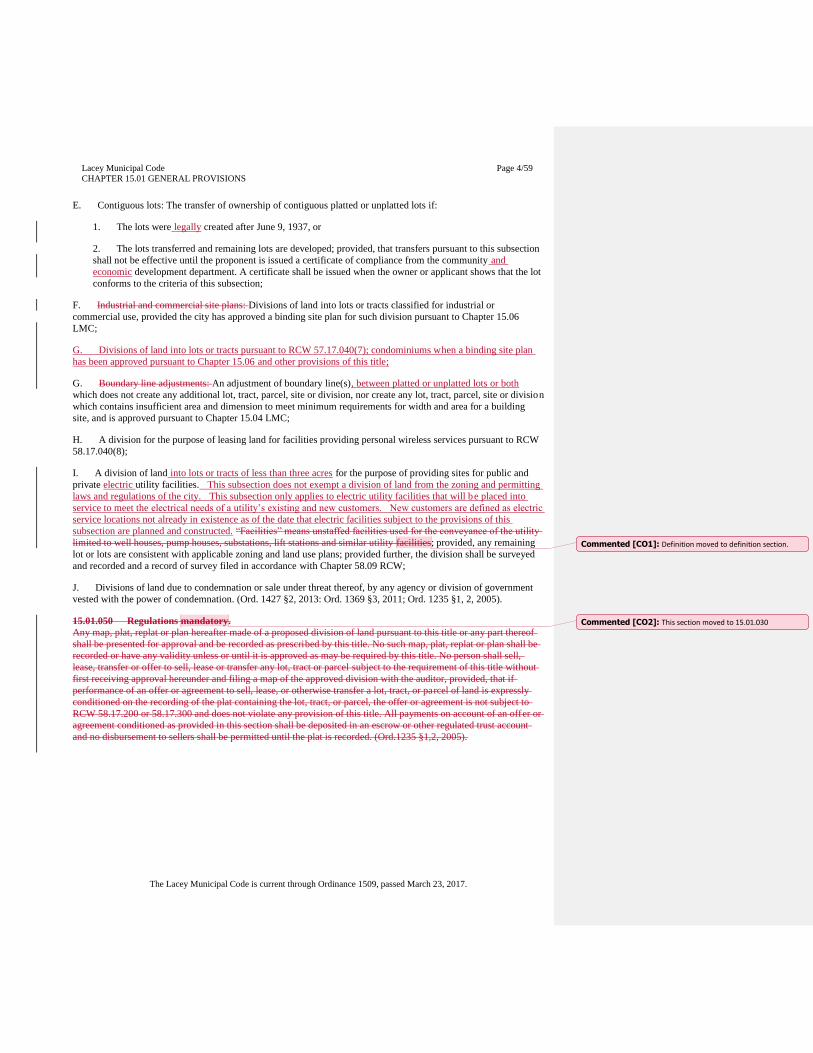
E. Contiguous lots: The transfer of ownership of contiguous platted or unplatted lots if:
1. The lots were legally created after June 9, 1937, or
2. The lots transferred and remaining lots are developed; provided, that transfers pursuant to this subsection
shall not be effective until the proponent is issued a certificate of compliance from the community and
economic development department. A certificate shall be issued when the owner or applicant shows that the lot
conforms to the criteria of this subsection;
F. Industrial and commercial site plans: Divisions of land into lots or tracts classified for industrial or
commercial use, provided the city has approved a binding site plan for such division pursuant to Chapter 15.06
LMC;
G. Divisions of land into lots or tracts pursuant to RCW 57.17.040(7); condominiums when a binding site plan
has been approved pursuant to Chapter 15.06 and other provisions of this title;
G. Boundary line adjustments: An adjustment of boundary line(s), between platted or unplatted lots or both
which does not create any additional lot, tract, parcel, site or division, nor create any lot, tract, parcel, site or division
which contains insufficient area and dimension to meet minimum requirements for width and area for a building
site, and is approved pursuant to Chapter 15.04 LMC;
H. A division for the purpose of leasing land for facilities providing personal wireless services pursuant to RCW
58.17.040(8);
I. A division of land into lots or tracts of less than three acres for the purpose of providing sites for public and
private electric utility facilities. This subsection does not exempt a division of land from the zoning and permitting
laws and regulations of the city. This subsection only applies to electric utility facilities that will be placed into
service to meet the electrical needs of a utility’s existing and new customers. New customers are defined as electric
service locations not already in existence as of the date that electric facilities subject to the provisions of this
subsection are planned and constructed. “Facilities” means unstaffed facilities used for the conveyance of the utility
limited to well houses, pump houses, substations, lift stations and similar utility facilities; provided, any remaining
lot or lots are consistent with applicable zoning and land use plans; provided further, the division shall be surveyed
and recorded and a record of survey filed in accordance with Chapter 58.09 RCW;
J. Divisions of land due to condemnation or sale under threat thereof, by any agency or division of government
vested with the power of condemnation. (Ord. 1427 §2, 2013: Ord. 1369 §3, 2011; Ord. 1235 §1, 2, 2005).
15.01.050 Regulations mandatory.
Any map, plat, replat or plan hereafter made of a proposed division of land pursuant to this title or any part thereof
shall be presented for approval and be recorded as prescribed by this title. No such map, plat, replat or plan shall be
recorded or have any validity unless or until it is approved as may be required by this title. No person shall sell,
lease, transfer or offer to sell, lease or transfer any lot, tract or parcel subject to the requirement of this title without
first receiving approval hereunder and filing a map of the approved division with the auditor, provided, that if
performance of an offer or agreement to sell, lease, or otherwise transfer a lot, tract, or parcel of land is expressly
conditioned on the recording of the plat containing the lot, tract, or parcel, the offer or agreement is not subject to
RCW 58.17.200 or 58.17.300 and does not violate any provision of this title. All payments on account of an offer or
agreement conditioned as provided in this section shall be deposited in an escrow or other regulated trust account
and no disbursement to sellers shall be permitted until the plat is recorded. (Ord.1235 §1,2, 2005).
Commented [CO1]: Definition moved to definition section.
Commented [CO2]: This section moved to 15.01.030
Lacey Municipal Code
CHAPTER 15.01 GENERAL PROVISIONS
Page 5/59
The Lacey Municipal Code is current through Ordinance 1509, passed March 23, 2017.
15.01.055 Conformance with other regulations.
A. No subdivision, short subdivision, or binding site plan shall be approved unless it is found to be in
conformance with all adopted and applicable city ordinances, plans and policies. The City of Lacey Comprehensive
Land Use Plan shall guide the use of all land within the city’s urban growth area boundary. The type and intensity of
land use as shown in the Comprehensive Land Use Plan shall be used as a guide to determine the character of land
division, which includes but is not limited to lot size and arrangement, type and extent of streets and roads,
dedications, improvements, services, and other utilities and public facilities.
B. All records and surveys in connection with any plat, short plat or binding site plan shall be in conformance
with Chapter 58.09 RCW. (Ord. 1235 §1,2, 2005).
15.01.0560 Concurrency for public facilities, utilities and roads.
Those public facilities and utilities required to be provided as a condition of approval shall be fully operational or
shall have bonding or other financial security provided for concurrently with the use and occupancy of the
development, pursuant to concurrency policies of the city. (Ord. 1235 §1, 2, 2005).
15.01.0605 Land divisionsSubdivisions adjacent to resource lands.
A. SubdivisionsAll short plats, binding site plans, and subdivisions within five hundred feet of designated
resource lands shall contain a notice that a variety of commercial or operational activities may occur that are not
compatible with residential development for certain periods of limited duration. If the designated resource area is a
mineral extraction site, like a gravel pit, the notice should also state that activities may include such things as
mining, mineral extraction, washing, crushing, stockpiling, blasting and transporting and recycling of minerals.
(Ord. 1235 §1, 2, 2005).
B. Intent and purpose of notice: In Lacey there are no areas of designated “long term commercial significance”.
Nevertheless, there are designated areas of short term use including mineral extraction, agricultural and forestry.
These areas are expected to be utilized throughout the foreseeable future, and might have conflicts with other land
use planned within the urban growth area. As such, the statements described in Subsection A. are required to provide
notice to perspective lot purchasers that are close to these areas for disclosure purposes, and also the protection of
the short term resource activities established within the urban growth boundaries.
15.01.070 Administration.
A. The director of the Lacey community and economic development department or designee, is vested with the
duty of administering this title, and may prepare and require the use of such forms as are essential to the
administration of this title. (Ord. 1235 §1, 2, 2005).
B. Minimal interpretation. In their interpretation and application, the provisions of this title shall be held to be the
minimum requirements.
C. Severability. The provisions of this title are severable. If a section, sentence, clause, or phrase of this title is
adjusted by a court of competent jurisdiction to be invalid, the decision shall not affect the remaining portions of this
title.
Commented [CO3]: Repetitive language, removed.
Commented [CO4]: This provision moved to 15.01.030
Lacey Municipal Code
CHAPTER 15.02 DEFINITIONS
Page 6/59
The Lacey Municipal Code is current through Ordinance 1509, passed March 23, 2017.
CHAPTER 15.02
DEFINITIONS
Sections:
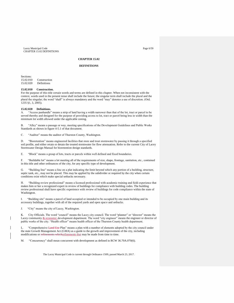
15.02.010 Construction
15.02.020 Definitions
15.02.010 Construction.
For the purpose of this title certain words and terms are defined in this chapter. When not inconsistent with the
context, words used in the present tense shall include the future; the singular term shall include the plural and the
plural the singular; the word “shall” is always mandatory and the word “may” denotes a use of discretion. (Ord.
1235 §1, 3, 2005).
15.02.020 Definitions.
A. “Access panhandle” means a strip of land having a width narrower than that of the lot, tract or parcel to be
served thereby and designed for the purpose of providing access to lot, tract or parcel being less in width than the
minimum lot width allowed under the applicable zoning.
B. “Alley” means a passage or way, meeting specifications of the Development Guidelines and Public Works
Standards as shown in figure 4-5.1 of that document.
C. “Auditor” means the auditor of Thurston County, Washington.
D. “Bioretention” means engineered facilities that store and treat stormwater by passing it through a specified
soil profile, and either retain or detain the treated stormwater for flow attenuation. Refer to the current City of Lacey
Stormwater Design Manual for bioretention design standards.
E. “Block” means a group of lots, tracts or parcels within well defined and fixed boundaries.
F. “Buildable lot” means a lot meeting all of the requirements of size, shape, frontage, sanitation, etc., contained
in this title and other ordinances of the city, for any specific type of development.
G. “Building line” means a line on a plat indicating the limit beyond which any portion of a building, structure,
septic tank, etc., may not be placed. This may be applied by the subdivider or required by the city when certain
conditions exist which make special setbacks necessary.
H. “Building review professional” means a licensed professional with academic training and field experience that
makes him or her a recognized expert in review of buildings for compliance with building codes. The building
review professional shall have specific experience with review of buildings for code compliance within the state of
Washington.
I. “Building site” means a parcel of land occupied or intended to be occupied by one main building and its
accessory buildings, together with all of the required yards and open space and setbacks.
J. “City” means the city of Lacey, Washington.
K. City Officials. The word “council” means the Lacey city council. The word “planner” or “director” means the
Lacey community & economic development department. The word “city engineer” means the engineer or director of
public works of the city. “Health officer” means health officer of the Thurston County health department.
L. “Comprehensive Land Use Plan” means a plan with a number of elements adopted by the city council under
the state Growth Management Act (GMA) as a guide to the growth and improvement of the city, including
modifications or refinements whichrefinements that may be made from time to time.
M. “Concurrency” shall mean concurrent with development as defined in RCW 36.70A.070(6).
Lacey Municipal Code
CHAPTER 15.02 DEFINITIONS
Page 7/59
The Lacey Municipal Code is current through Ordinance 1509, passed March 23, 2017.
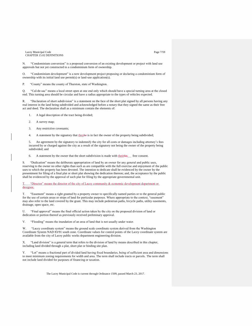
N. “Condominium conversion” is a proposed conversion of an existing development or project with land use
approvals but not yet constructed to a condominium form of ownership.
O. “Condominium development” is a new development project proposing or declaring a condominium form of
ownership with its initial land use permit(s) or land-use application(s).
P. “County” means the county of Thurston, state of Washington.
Q. “Cul-de-sac” means a local street open at one end only which should have a special turning area at the closed
end. This turning area should be circular and have a radius appropriate to the types of vehicles expected.
R. “Declaration of short subdivision” is a statement on the face of the short plat signed by all persons having any
real interest in the land being subdivided and acknowledged before a notary that they signed the same as their free
act and deed. The declaration shall as a minimum contain the elements of:
1. A legal description of the tract being divided;
2. A survey map;
3. Any restrictive covenants;
4. A statement by the signatory that theyhe is in fact the owner of the property being subdivided;
5. An agreement by the signatory to indemnify the city for all costs or damages including attorney’s fees
incurred by or charged against the city as a result of the signatory not being the owner of the property being
subdivided; and
6. A statement by the owner that the short subdivision is made with theirhis free consent.
S. “Dedication” means the deliberate appropriation of land by an owner for any general and public uses,
reserving to the owner no other rights than such as are compatible with the full exercise and enjoyment of the public
uses to which the property has been devoted. The intention to dedicate shall be evidenced by the owner by the
presentment for filing of a final plat or short plat showing the dedication thereon; and, the acceptance by the public
shall be evidenced by the approval of such plat for filing by the appropriate governmental unit.
T. “Director” means the director of the city of Lacey community & economic development department or
designee.
T. “Easement” means a right granted by a property owner to specifically named parties or to the general public
for the use of certain areas or strips of land for particular purposes. Where appropriate to the context, “easement”
may also refer to the land covered by the grant. This may include pedestrian paths, bicycle paths, utility easements,
drainage, open space, etc.
U. “Final approval” means the final official action taken by the city on the proposed division of land or
dedication or portion thereof as previously received preliminary approval.
V. “Flooding” means the inundation of an area of land that is not usually under water.
W. “Lacey coordinate system” means the ground scale coordinate system derived from the Washington
Coordinate System NAD 83/91 south zone. Coordinate values for control points of the Lacey coordinate system are
available from the city of Lacey public works department engineering division.
X. “Land division” is a general term that refers to the division of land by means described in this chapter,
including land divided through a plat, short plat or binding site plan.
Y. “Lot” means a fractional part of divided land having fixed boundaries, being of sufficient area and dimensions
to meet minimum zoning requirements for width and area. The term shall include tracts or parcels. The term shall
not include land divided for purposes of financing or taxation.
Lacey Municipal Code
CHAPTER 15.02 DEFINITIONS
Page 8/59
The Lacey Municipal Code is current through Ordinance 1509, passed March 23, 2017.
Z. “Low impact development (LID) facility” means distributed stormwater management practices, integrated into
a project design that strives to mimic pre-disturbance hydrologic processes of infiltration, filtration, storage,
evaporation, and transpiration. LID facilities include, but are not limited to: bioretention, rain gardens, permeable
paving, roof downspout controls, dispersion, soil quality and depth, minimal excavation foundations, vegetated
roofs, and water re-use.
AA. “Low impact development (LID) principles” means land use management strategies that emphasize
conservation, use of on-site natural features, and site planning to minimize impervious surfaces, native vegetation
loss, and stormwater runoff.
BB. “Multiunit structure” means two or more units under the same ownership where the land has not been
divided, i.e., duplex, triplex, quadraplex, apartment units, or in the case of commercial or industrial development a
building with units designed to be rented or leased to two or more tenants.
CC. “Native vegetation” means vegetation including trees, comprised of plant species that are either indigenous
or naturalized to the Puget Sound region. Native vegetation does not include noxious weeds.
DD. “Owner” means the owner of record, as determined by the records of the auditor; provided, that the owner
under a real estate contract is the purchaser-vendee and the owner of mortgaged property is the mortgagor.
EE. “Permeable paving” means pervious concrete, porous asphalt, permeable pavers or other forms of pervious
or porous paving material intended to allow passage of water through the pavement section. It often includes an
aggregate base that provides structural support and acts as a stormwater reservoir. Refer to the current City of Lacey
Stormwater Design Manual for permeable paving design standards.
FF. “Person” means every natural person, firm, partnership, association, social or fraternal organization,
corporation, estate, trust, receiver, syndicate, branch of government, or any other group or combination acting as a
unit.
GG. “Plat” means a map or representation of a subdivision, showing thereon the division of a tract or parcel of
land into lots, blocks, streets and alleys or other divisions or dedications.
HH. “Plat, final” or “final short plat” means the final drawing of the subdivision or short subdivision and the
dedication prepared for filing for record with the auditor and containing all elements and requirements set forth in
Chapter 58.17 RCW and in this title adopted pursuant thereto.
II. “Plat, preliminary” means a neat and approximate drawing of a proposed subdivision showing the general
layout of streets and alleys, lots, blocks and other elements of a subdivision consistent with the requirements of this
title.
JJ. “Plat, preliminary short” means a neat and approximate drawing of a proposed short subdivision showing the
general layout of streets and alleys, lots, blocks and other elements of a short subdivision consistent with the
requirements of this title.
KK. “Plat, short” means the map or representation of a short subdivision containing all of the pertinent
information as required by this title.
LL. “Preliminary approval” means the official action approving a proposed division of land when provision of
improvements or fulfillment of conditions are to occur prior to final approval.
MM. “Rain garden” means a non-engineered shallow, landscaped depression, with compost-amended native
soils and adapted plants. The depression is designed to pond and temporarily store stormwater runoff from adjacent
areas, and to allow stormwater to pass through the amended soil profile.
NN. “Reserve strip” means a parcel of ground located usually at the edge of a subdivision or short subdivision
for the purpose of restricting access from the end or side of a street.
Lacey Municipal Code
CHAPTER 15.02 DEFINITIONS
Page 9/59
The Lacey Municipal Code is current through Ordinance 1509, passed March 23, 2017.
OO. “Right-of-way” means the area between boundary lines of a dedicated street, alley or easement dedicated to
or owned by the city for public use.
PP. “Roadway” means that portion of the street, including shoulders and bike lanes, for vehicular use.
QQ. Street. A street is a public way for purposes of travel and includes the entire area within the right-of-way. A
street serves public transit, vehicular, pedestrian and bicycle traffic plus the accommodation of all utility facilities
within the right-of-way.
RR. “Subdivider” means a person who undertakes the subdividing of a parcel of land, also referred to as the
applicant.
SS. “Subdivision, short” means every division or resubdivision of contiguous land into nine or less lots, tracts,
parcels, sites, or subdivisions for the purpose of transfer of ownership, sale, or lease.
TT. “Subdivision” or “subdivision, long” means the division or resubdivision of land into ten or more lots, tracts,
parcels, sites or divisions, whether immediate or future, for the purpose of sale, lease or transfer of ownership.
UU. “Treasurer” means the treasurer of Thurston County, Washington.
VV. “Vacation” means a process pursuant to the requirements of RCW 58.17.212 of voiding a plat, short plat,
binding site plan, or portion thereof, or any area designated or dedicated for public use.
WW. “Vegetated LID facility” means bioretention, rain gardens, dispersion, and vegetated roofs.
XX. “Vegetated roofs” (also known as ecoroofs and green roofs) means thin layers of engineered soil and
vegetation constructed on top of conventional flat or sloped roofs. Refer to the City of Lacey Stormwater Design
Manual for vegetated roof design standards. (Ord. 1496 §28, 2016: Ord. 1369 §5, 2011; Ord. 1235 §1, 3, 2005).
Lacey Municipal Code
CHAPTER 15.04 BOUNDARY LINE ADJUSTMENTS
AND LOT CONSOLIDATIONS
Page 10/59
The Lacey Municipal Code is current through Ordinance 1509, passed March 23, 2017.
CHAPTER 15.04
BOUNDARY LINE ADJUSTMENTS AND LOT CONSOLIDATIONS
Sections:
15.04.010 Applicability
15.04.030 Criteria
15.04.040 Application
15.04.050 Review and approval
15.04.060 Final survey and recording
15.04.010 Applicability.
Every adjustment made for the purpose of adjusting boundary lines between platted or unplatted lots or both, which
does not create any additional lot, tract, parcel, site or division nor create any lot, tract, parcel, site, or division which
contains insufficient area and dimension to meet minimum requirements for width and area for a building site shall
proceed in compliance with this chapter. A consolidation of lots shall proceed through the same process as outlined
for boundary line adjustments described in this chapter. Boundary line adjustments and lot consolidations may also
be accomplished as part of a plat, or short plat, or binding site plan. (Ord. 1235 §4, 2005).
15.04.030 Criteria.
All boundary line adjustment requests shall be subject to the following limitations:
A. A boundary line adjustment shall not result in the creation of any additional lots, sites, tracts, or parcels;
B. A boundary line adjustment shall not result in the entire relocation of lots, sites, tracts, or parcels from one
area to another;
C. A boundary line adjustment shall not violate or be inconsistent with any conditions of approval for a
previously filed plat, short plat, or binding site plan;
D. No lot shall be reconfigured or adjusted which would render access for vehicles, utilities, fire protection, or
existing easements impractical to serve their purpose;
E. No adjustment shall be used to provide new frontage for a lot that will create an expectation of, or require, a
new access right to said road. Provided nothing shall prohibit the city from granting an adjustment with a new access
if the city determines it creates a better overall road geometric for the site consistent with city transportation plan
goals and policies;
F. Any lot or parcel that is a legally created lot of record shall be qualified for a boundary line adjustment;
G. The adjustment does not result in a lot, tract or parcel smaller than the minimum lot size required by LMC
Title 16, in effect at the time the application is filed, except as follows:
Whenever any one or more lots involved in the proposed change are smaller than the allowable minimum size, the
change may be approved so long as no resulting lot is smaller than the smallest of the existing lots and the
adjustment does not increase the existing nonconformity in consideration of land use regulations and standards;
H. The boundary line adjustment process shall not be used to adjust easements, utilities, or other non-property
line features;
I. A boundary line adjustment approved by the city of Lacey is not to be construed as a statement as to the lot’s
suitability for building purposes. (Ord. 1235 §4, 2005).
15.04.040 Application.
An applicant shall submit a complete boundary line adjustment application to the department of community &
economic development. A complete application for the purposes of this chapter shall consist of the following:
Lacey Municipal Code
CHAPTER 15.04 BOUNDARY LINE ADJUSTMENTS
AND LOT CONSOLIDATIONS
Page 11/59
The Lacey Municipal Code is current through Ordinance 1509, passed March 23, 2017.
A. A fully completed and signed (by those individuals or corporations holding any ownership or security
interest) boundary line adjustment application form provided by the department of community & economic
development that contains the following information:
1. The names, addresses, and telephone numbers of all persons holding interest in the land;
2. The existing and proposed legal descriptions of the affected lots prepared by a land surveyor licensed by
the state of Washington or by a title company;
3. The assessor’s tax parcel numbers;
4. A brief narrative description of the proposed boundary line adjustment;
5. A scale drawing prepared by a licensed land surveyor in accordance with WAC 332-130-050 of the
existing and proposed boundary lines. Existing boundary lines shall be shown as dashed lines, and proposed
boundary lines shown as solid lines. The drawing shall also include all lot measurements in feet, existing and
proposed lot areas, location of all existing improvements such as buildings, roads, easements, and other
pertinent features;
6. An access plan approved by the department of public works, if the boundary line adjustment changes
existing access requirements;
7. A signed, dated, and notarized Statement of Declaration of Boundary Line Adjustment and Covenants.
B. Application fees.
C. A plat certificate issued within the preceding thirty days that includes confirmation that the title to the lands as
described and shown on said boundary line adjustment is vested in the owners whose names appear on the plat
certificate and includes any easements or restrictions affecting the property. (Ord. 1235 §4, 2005).
15.04.050 Review and approval.
A. Upon submittal and acceptance of a complete application, the assigned planner shall review the boundary line
adjustment and determine if it contains sufficient information to furnish a basis for a decision in conformance with
application and processing requirements of Chapter 1 of the Development Guidelines and Public Works Standards.
The planner may refer the request to other departments that, in his/her judgment, may have information or comments
that bear directly on the application. Referral agencies and departments, if any, shall have fourteen days to comment
on the application. Their failure to respond within the referral period will be considered as having no comment on
the application as submitted. (Ord. 1235 §4, 2005).
15.04.060 Final survey and recording.
A. A survey of the boundary line adjustment or lot consolidation and preparation of the adjustment or
consolidation shall be made by or under the supervision of a registered land surveyor who shall certify on the
boundary line adjustment that it is a true and correct representation of the lands actually surveyed. The survey shall
be in conformance with the drafting standards contained in LMC 15.06.090 and as otherwise required by law.
B. All boundary line adjustments and lot consolidations shall be filed for recording with the Thurston County
Auditor and shall not be deemed formally approved until so filed.
Lacey Municipal Code
CHAPTER 15.05 PLAT, SHORT PLAT AND BINDING
SITE PLAN ALTERATIONS AND VACATIONS
Page 12/59
The Lacey Municipal Code is current through Ordinance 1509, passed March 23, 2017.
CHAPTER 15.05
PLAT, SHORT PLAT AND BINDING SITE PLAN ALTERATIONS AND VACATIONS
Sections:
15.05.010 Applicability - alteration
15.05.020 Application - alteration
15.05.030 Review criteria and process - alteration
15.05.040 Applicability - vacation
15.05.050 Application - vacation
15.05.060 Review criteria and process - vacation
15.05.010 Applicability - alteration.
A. Every alteration of a subdivision, short subdivision or binding site plan or portion thereof, except as provided
for in Chapter 15.04 LMC, shall proceed in compliance with this chapter. This process cannot be used to
createdcreate additional lots, tracts, or parcels.
B. Easements established by a dedication are property rights that cannot be extinguished or altered without the
approval of the easement owner or owners, unless the plat or other document creating the dedicated easement
provides for an alternative method or methods to extinguish or alter the easement. (Ord. 1235 §1,5, 2005).
15.05.020 Application - alteration.
An applicant shall submit a complete alteration application to the department of community & economic
development. A complete application for the purposes of this chapter shall consist of the following:
A. A fully completed, and signed alteration application form provided by the director that contains the
information as required by this chapter.
B. Information that would be required for a final plat, short plat or binding site plan, whichever is applicable,
provided the director may waive information requirements he/she deems unnecessary for adequate review of the
specific alteration proposed.
C. Any other information deemed necessary by the director for the adequate review of the proposed alteration in
conformance with the provisions of this title and all other applicable federal, state and local regulations.
D. Payment of all applicable review fees by the person requesting the alteration or vacation. (Ord. 1235 §1, 5,
2005).
E. If the alteration is subject to restrictive covenants that were filed at the time of approval of the division and the
alteration would result in violation of a covenant, the application must be signed by all parties subject to the
covenants. The agreement shall provide that the parties agree to terminate or alter the relevant covenants to
accomplish the purpose of the alteration of the land division or portion thereof.
15.05.030 Review criteria and process - alteration.
A. When a person is interested in alteration of any division of property or altering of any portion thereof, except
as provided in RCW 58.17.040 and Chapter 15.04 LMC (boundary line adjustments and lot consolidations) that
person shall submit an application to request the alteration. The application shall contain the signatures of the
majority of persons having an ownership interest of the lots, tracts, or parcels, sites or divisions in the subject land
division or portion to be altered. If the land division is subject to protective covenants which were filed at the time of
approval of the land division and the alteration would result in violation of the covenants, the application shall
contain an agreement signed by all parties subject to the covenants. The agreement shall provide that the parties
agree to terminate or alter the relevant covenants to accomplish the purpose of the alteration of the land division or
portion thereof.
Commented [CO5]: Relocated
Lacey Municipal Code
CHAPTER 15.05 PLAT, SHORT PLAT AND BINDING
SITE PLAN ALTERATIONS AND VACATIONS
Page 13/59
The Lacey Municipal Code is current through Ordinance 1509, passed March 23, 2017.
B. An application submitted for a plat, or for a short plat or binding site plan that contains a public dedication,
shall meet all requirements and standards provided for in RCW 58.17.215.
C. Public notice shall be given for alteration of plats, and for alteration of short plats and binding site plans that
contain a public dedication, as provided in RCW 58.17.080 and 58.17.090. A public hearing shall be required if a
person receiving notice requests a hearing within fourteen days of receiving notice or if the department determines
that the public hearing is within the public interest. Where a public hearing is required or requested, the Hearings
Examiner may approve, conditionally approve or deny the application for an alteration after determining the public
use and interest will be served by the alteration of the land division. If a public hearing is not required or requested,
the director may administratively approve, conditionally approve or deny the alteration after determining the public
use and interest will be served by the alteration of the land division.
D. Alteration of a short subdivision or binding site plan or portion thereof that does not contain a public
dedication may be administratively approved or denied by the director after determining that the public use and
interest will be served by the alteration of the short subdivision or binding site plan.
E. If any land within the alteration is part of an assessment district, any outstanding assessments shall be
equitably divided and levied against the remaining lots, parcels, or tracts, or be levied equitably on the lots resulting
from the alteration.
F. If any land within the alteration contains a dedication to the general use of persons residing within the land
division, such land may be altered and divided equitably between the adjacent properties, provided open space
designated as a requirement of a plat, short plat, or binding site plan shall not be altered unless it is replaced as part
of the alteration and meets the requirements of this title for the provision of open space.
G. If the alteration is approved, the applicant shall produce a revised drawing of the final plat or fina l short plat
or binding site plan, in compliance with the requirements of this title for a final plat , or short plat or binding site
plan, whichever is applicable. (Ord. 1235 §1, 5, 2005).
15.05.040 Applicability - vacation.
A. Every vacation of a recorded short plat, or binding site plan, or portion thereof that involves a public
dedication, or a plat or portion thereof, or any area designed or dedicated for public use shall proceed in compliance
with this chapter. If the land division is subject to protective covenants which were filed at the time of approval of
the land division and the vacation would result in violation of the covenants, the application shall contain an
agreement signed by all parties subject to the covenants. The agreement shall provide that the parties agree to
terminate or alter the relevant covenants to accomplish the purpose of the vacation of the land division or portion
thereof.
B. Vacations of streets or roads may be approved through this process only when the street or road vacation is
proposed with the vacation of a land division, or portions thereof.
C. When a vacation is specifically for a road or alley, the procedures for road, or street or alley vacation in
Chapter 35.79 RCW, pursuant to Chapter 12.32 LMC, shall apply.
D. Vacations of streets or roads may not be made that are prohibited under RCW 35.79.035. (Ord. 1235 §1, 5,
2005).
15.05.050 Application - vacation.
An applicant shall submit a complete vacation application to the community development director. A complete
application for the purposes of this chapter shall consist of the following:
A. A fully completed, signed and notarized vacation application form provided by the department of community
& economic development that contains the information as required by this chapter and signed by all parties having
an ownership interest in that portion of the land division subject to the vacation;
B. Information that would be required pursuant to this title for a final plat, short plat or binding site plan,
whichever is applicable, provided that such information is relevant to the vacation and necessary for adequate
Lacey Municipal Code
CHAPTER 15.05 PLAT, SHORT PLAT AND BINDING
SITE PLAN ALTERATIONS AND VACATIONS
Page 14/59
The Lacey Municipal Code is current through Ordinance 1509, passed March 23, 2017.
review. The director may waive information requirements he/she deems unnecessary for review of the specific
vacation proposed;
C. Any other information deemed necessary by the director for the review of the vacation in conformance with
the provisions of this title and all other applicable federal, state and local regulations; and
D. Payment of all applicable review fees. (Ord. 1235 §1, 5, 2005).
15.05.060 Review criteria and process - vacation.
A. Vacation of a plat or portion thereof, or vacation of a short plat, or binding site plan that contains a public
dedication, or any area designated or dedicated for public use shall follow the review procedures as outlined in RCW
58.17.212.
B. Applications following procedures and requirements of RCW 58.17.212 shall be subject to Hearings
Examiner review. Public notice shall be provided as required in RCW 58.17.080 and 58.17.090. A public hearing by
the Hearings Examiner shall be held and the Hearings Examiner may approve or deny the application for a vacation
after determining the public use and interest will be served by the vacation of the land division.
C. Vacation of a short plat or binding site plan or portion thereof that does not contain a public dedication may be
administratively approved or denied by the director after determining that the public use and interest will be served
by the vacation of the short subdivision.
D. If any portion of the land contained in the land division was dedicated to the public for public use or benefit,
such land, if not deeded to the city shall be deeded to the city unless findings are set forth that the public use would
not be served in retaining title to those lands.
E. Title to the vacated property shall vest with the rightful owner in conformance with RCW 58.17.212. (Ord.
1235 §1, 5, 2005).
Lacey Municipal Code
CHAPTER 15.06 BINDING SITE PLANS
Page 15/59
The Lacey Municipal Code is current through Ordinance 1509, passed March 23, 2017.
CHAPTER 15.06
BINDING SITE PLANS
Sections:
15.06.010 Applicability
15.06.015 Applicability condominiums
15.06.020 Administration
15.06.030 Application
15.06.040 Preliminary binding site plan review
15.06.050 Review criteria and required findings
15.06.060 Final approval and recording
15.06.070 Final binding site plan permanent control monuments
15.06.080 Final survey of binding site plan and preparation of map
15.06.090 Final binding site plan drafting standards
15.06.010 Applicability.
A binding site plan may be performed as an alternate method of land division under the following circumstances:
A. The division of land into two or more lots, parcels, or tracts located for the lease, sale, or transfer of lots in a
commercial or industrial zoning district., or the lease of property for use by mobile homes or travel trailers.
B. The division of land into lots or tracts when performed in accordance with Chapters 64.32 and 64.34 RCW
and RCW 58.17.040(7). (Ord. 1235 §1, 6, 2005).
15.06.015 Applicability Condominiums.
A. General requirements. Every condominium in Lacey, as defined by Chapter 64.34 RCW is subject to the
requirements of this chapter. In addition to the requirements of state law, the requirements of this chapter must be
satisfied before the condominium can be approved by the City of Lacey and filed with Thurston County or the state.
For condominiums in Lacey, this chapter provides both oversight to the requirements of state law and the
implementation of additional local standards and requirements as provided for and authorized by state law.
B. Requirements for filing. No declaration to create a condominium shall be filed or recorded at Thurston County
without first having the approval of the City of Lacey. The City shall work with the County Treasurer, Assessor and
Auditor’s offices to coordinate this requirement. (Ord. 1369 §3, 2011).
15.06.020 Administration.
The administration of this chapter is set forth within the provisions of this chapter and the Development Guidelines
and Public Works Standards in Section 1C.040 (full administrative review). The director is vested with the duty of
administering and interpreting the provisions of this title and with the authority to summarily approve, approve with
conditions, disapprove, or return for modification all proposed binding site plans. Prior to the submission of a
binding site plan application, the applicant shall arrange for a pre-application meeting as required and outlined in the
Development Guidelines and Public Works Standards Section 1B.020. (Ord. 1235 §1, 6, 2005).
15.06.030 Application.
An applicant shall submit a complete binding site plan application to the department of community & economic
development. A complete application for the purposes of this chapter shall consist of the following:
A. Binding site plan application and supporting materials.
B. Environmental checklist.
C. Preliminary binding site plan.
Lacey Municipal Code
CHAPTER 15.06 BINDING SITE PLANS
Page 16/59
The Lacey Municipal Code is current through Ordinance 1509, passed March 23, 2017.
1. The preliminary binding site plan shall show specifically and clearly all of the requested information in
the application information on one or more maps, drawings or application forms. Specific items may be waived
if it is the opinion of both the planner and city engineer they are not necessary.
2. Accuracy for all data and information submitted on or with a binding site plan shall be the responsibility
of the applicant. Any proposed binding site plan found to be inaccurate or misleading shall not be considered a
complete application and shall be returned to the applicant with a letter stating the application is incomplete,
pursuant to the requirements of the Development Guidelines and Public Works Standards Section 1B.040 and
1B.050.
D. Scale and Size. The preliminary binding site plan shall be at a scale of not less than fifty feet to the inch, nor
more than two hundred feet to the inch.
E. General Information Required.
1. Proposed name of the binding site plan. This name shall not duplicate nor resemble the name of another
land division in Thurston County and shall be approved by the Thurston County Auditor.
2. The names and addresses of all landowners within the proposed binding site plan, the developer if other
than the owners, the land surveyor and/or the professional registered engineer responsible for laying out the
land division.
3. The legal description of all lands included in the proposed binding site plan.
4. The site plan scale, datum, north arrow and date.
5. The boundary lines of the tract to be divided.
6. Proposed and existing access and cross easements on site, adjacent to, and across the street.
F. Existing Conditions.
1. A vicinity sketch indicating the boundary lines and names of adjacent subdivisions, streets and boundary
lines of adjacent parcels, and the relationship of the proposed binding site plan to major highways, schools,
parks, shopping centers and similar facilities.
2. The location and direction of all watercourses, lakes and streams and the location of all areas subject to
flooding. Watercourses and drainage ways shall be located within an easement which reserves to the city the
right to enter such properties for the purpose of flood control or maintenance.
3. Natural features such as rock outcroppings, marshes, wooded areas and trees and those natural features to
be preserved in the land division.
4. Existing uses on the property, including location of all existing structures to remain on the property after
the binding site plan is developed.
5. Existing zoning on the land to be divided and also on the surrounding land for a distance of three hundred
feet.
6. The location and size of all pertinent existing sewers, septic tank systems, water mains, wells, culverts,
and other public or private underground installations within the subdivision and immediately adjacent thereto
and elevations of sewers at points of probable connections.
7. The location, widths and names of both unopened and open streets, easements and other access points
including pedestrian, within or adjacent to the proposed development. The location of other important features
such as the general outline of permanent buildings, water sources, power lines, telephone lines, railroads, city
boundaries, section lines and section corners.
Lacey Municipal Code
CHAPTER 15.06 BINDING SITE PLANS
Page 17/59
The Lacey Municipal Code is current through Ordinance 1509, passed March 23, 2017.
8. All parcels of land intended to be dedicated or temporarily reserved for public use, or to be reserved in
the deeds for common use of the property owners in the land division with the purpose, conditions, or
limitations of such dedications or reservations clearly indicated.
G. Proposed Plan of Partitioning.
1. The location, width, name and approximate grade and radii of curves of streets. The relationship of streets
to any projected streets as shown oin the Comprehensive Land Use Plan and the Transportation Plan.
2. Approximate centerline profiles with extensions for a reasonable distance beyond the limits of the
proposed land division showing the finished grade of streets and the nature and extent of street construction.
3. A proposal for domestic water supply stating the source and preliminary distribution system layout.
4. Proposals for sewage disposal, storm water drainage and flood control.
5. If lot areas are to be substantially graded, a plan showing the nature of cuts and fills and information on
the character of the soil.
6. Proposals for other improvements such as electric utilities and boat docks, pathways, recreation facilities,
etc.
7. The layout of proposed street rights-of-way, alleys, street easements, utility easements, lots and blocks,
and the approximate dimensions of each.
8. All parcels of land intended to be dedicated or temporarily reserved for public use, or to be reserved in
the deeds for common use of the property owners in the binding site plan with the purpose, conditions, or
limitation of such dedications or reservations clearly indicated.
H. Partial Development. If the proposed binding site plan pertains to only part of the tract owned or controlled by
the applicant, a sketch showing the tentative layout for streets and contemplated land use in the undivided portion
shall be submitted.
I. Additional Information. The applicant shall supply any additional information as may be required by the
department of community development.
J. Wetland, habitat and other sensitive area information. A binding site plan application that involves wetlands,
wetland buffer areas, habitat area or other sensitivecritical areas pursuant to Chapter 14.28, 14.33, 14.34, 14.36, or
14.37 LMC shall include all information required by these chapters for proper consideration of wetlands, habitat and
other sensitive area issues during binding site plan review. (Ord. 1235 §1, 6, 2005).
15.06.040 Preliminary binding site plan review.
Binding site plans shall be subject to the procedures established in the Development Guidelines and Public Works
Standards, application process, Section 1C.040, full administrative review. A preliminary and final review and
approval process will be utilized that is similar to the subdivision process, except that it will be handled in an
administrative capacity. (Ord. 1235 §1, 6, 2005).
15.06.050 Review criteria and required findings.
A. The proposed preliminary binding site plan shall be reviewed and approved only when the following criteria
and findings are satisfied:
1. Compliance with the provisions of this title including Chapter 15.12 LMC, Design Standards.
2. Conformity with all applicable zoning requirements of LMC Title 16.
3. Conformance with the goals and policies contained in the Comprehensive Land Use Plan and all
associated elements.
Lacey Municipal Code
CHAPTER 15.06 BINDING SITE PLANS
Page 18/59
The Lacey Municipal Code is current through Ordinance 1509, passed March 23, 2017.
4. Consistency with applicable design standards of Chapter 14.23 LMC.
5. Compliance with the provisions of any applicable federal, state and local law.
6. Appropriate provisions are made for, but not limited to, the public health, safety, and general welfare, for
open spaces, drainage ways, streets or roads, access points, alleys, other public ways, transit stops, potable
water supplies, sanitary wastes, parks and recreation, playgrounds, schools and school grounds, and all other
relevant requirements, including safe walking conditions for students who walk to and from school.
7. The public interest will be served by the binding site plan and dedications.
B. The director may disapprove a proposed binding site plan because of flood, inundation, or sensitivecritical
area limitations. Construction of protective improvements may be required as a condition of approval, and such
improvements shall be noted on the final map. No binding site plan shall be approved covering any land situated in a
flood control zone (floodway) as provided in Chapter 86.16 RCW without the prior written consent of the
Washington State Department of Ecology unless a note and identification of this area is shown on the face of the
final plat which prohibits the development of this area in any manner except as specifically approved by law. These
areas cannot be included in the area calculated to meet the requirements for minimum lot area.
C. As a condition of approval, the director may require dedication of land to any public body, provisions of
public improvements to serve the land division, and/or mitigation fees authorized by law.
D. Preliminary binding site plan approvals are valid for a period of five years. During that period the conditions
of approval must be fulfilled or financial security provided for as required in Chapter 15.16 LMC. If the conditions
attached to the preliminary binding site plan approval are not satisfied or appropriately bonded for, and the binding
site plan is not filed for record within the required period, preliminary approval of the binding site plan shall become
null and void. (Ord. 1235 §1, 6, 2005)
15.06.060 Final approval and recording.
The following shall be shown or accompany the final binding site plan at the time it is submitted to the department
of community & economic development:
A. Certificate of title by a recognized title insurance company, dated not to exceed thirty days prior to submitting
a plat for final approval, showing the names of all persons whose consent is necessary to dedicate roads, streets and
other easements shown upon the map.
B. Names, addresses, phone numbers, fax and email of the owner, land-divider, engineer, and surveyor.
C. A copy of any deed restrictions applicable to the binding site plan.
D. A copy of any dedication requiring separate documents.
E. A certificate by the city engineer that the land-divider has complied with one of the following:
1. All improvements have been installed in accordance with the requirements of these regulations and with
the action of the director giving approval of the preliminary binding site plan.
2. An agreement has been executed as provided for in LMC 15.16.020 to assure completion of required
improvements.
F. The date, scale, north arrow, legend, binding site plan number, controlling topography and existing features
such as highways and railroads.
G. Legal description of the tract boundaries.
H. Reference points and lines of existing surveys identified, related to the plat as follows:
Lacey Municipal Code
CHAPTER 15.06 BINDING SITE PLANS
Page 19/59
The Lacey Municipal Code is current through Ordinance 1509, passed March 23, 2017.
1. Stakes, monuments, or other evidence found on the ground and used to determine the boundaries of the
binding site plan.
2. Adjoining corners of adjoining subdivisions.
3. City or county boundary lines when crossing or adjacent to the land division.
4. Section and donation land claim lines within and adjacent to the binding site plan.
5. Whenever the county or city has established the centerline of a street adjacent to or within the proposed
binding site plan, the location of this line and monuments found or reset.
6. All other monuments found or established in making the survey of this binding site plan or required to be
installed by provisions of this title.
I. Mathematical boundary closures of the binding site plan showing the error of closure, if any.
J. The mathematical lot closures and street centerline closures, and square footage of each parcel.
K. The exact location and width of streets and easements intersecting the boundary of the tract and additional
information required by the public works department.
L. Tract, block, and lot boundary lines and street rights-of-way and centerlines with dimensions, bearings or
deflection angles, radii, arcs, points of curvature, and tangent bearings. Tract boundaries, lot boundaries and s treet
bearings shall be shown to the nearest second with basis of bearings. The basis of the bearings shall be the Lacey
coordinate system. All distances shall be shown to the nearest one-hundredth foot.
M. The width of the portion of streets being dedicated, the width of any existing right-of-way, and the width on
each side of the centerline. For streets on curvature, curve data shall be based on the street centerline. In addition to
the centerline dimensions, the radius and central angle shall be indicated.
N. Easements denoted by fine dotted lines clearly identified and, if already of record, their recorded reference.
The width of the easement, its length and bearings, and sufficient ties to locate the easement with respect to the
binding site plan must be shown. If the easement is being dedicated by the map, it shall be properly referenced in the
owner’s certificate of dedication.
O. Lot numbers beginning with number “1” and numbered consecutively without omission or duplication
throughout the binding site plan. The numbers shall be solid, of sufficient size and thickness to stand out, and so
placed as not to obliterate any figure. Lot numbers in an addition to a binding site plan of the same name shall be a
continuation of the numbering in the original land division.
P. Land parcels to be dedicated for any purpose, public or private, shall be distinguished from lots intended for
sale.
Q. The following certificates may be combined where appropriate:
1. A certificate signed and acknowledged by all parties with any record title interest in the land divided,
consenting to the preparation and recording of the binding site plan.
2. A certificate signed and acknowledged as above, dedicating all parcels of land shown on the final map
intended for any public use except those parcels which are intended for the exclusive use of the lot owners in
the binding site plan, their licensees, visitors, tenants and servants.
3. A certificate with the seal of and signed by the engineer or the surveyor responsible for the survey and
final map.
4. Other certifications now or hereafter required by law.
Lacey Municipal Code
CHAPTER 15.06 BINDING SITE PLANS
Page 20/59
The Lacey Municipal Code is current through Ordinance 1509, passed March 23, 2017.
R. Lots containing one acre or more shall show net acreage to nearest hundredth.
S. Each and every binding site plan of any property filed for record shall:
1. Contain a statement of approval from the city engineer or by a licensed engineer acting on behalf of the
city as to the survey data, the layout of streets, alleys, and other rights-of-way, design of bridges, sewage and
water systems, and other structures. No engineer who is connected in any way with the binding site plan and
dividing of the land for which binding site plan approval is sought shall examine and approve such binding site
plan on behalf of the city.
2. Be accompanied by a complete survey of the section or sections in which the binding site plan is located,
or as much thereof as may be necessary to properly orient the binding site plan within such section or sections.
3. Be acknowledged by the person filing the binding site plan before the auditor, or any other officer who is
authorized by law to take acknowledgment of deeds, and a certificate of the acknowledgment shall be enclosed
or annexed to such binding site plan and recorded therewith.
4. Contain a certification from the Thurston County treasurer that all taxes and delinquent assessments for
which the property may be liable, as of the date of certification, have been duly paid, satisfied or discharged.
T. Final application shall include information necessary for the administrator to determine whether all conditions
of approval have been met.
U. An approved binding site plan shall not be filed for record with the Thurston County auditor until the
applicant has constructed or provided financial security for all improvements and satisfied all conditions as required
by the director in the granting of preliminary approval.
V. A binding site plan shall not be considered final until recorded with the Thurston County auditor. (Ord. 1480
§3, 2015: Ord. 1235 §1, 6, 2005).
15.06.070 Final binding site plan permanent control monuments.
Permanent control monuments shall be established at each and every controlling corner on the boundaries of the
parcel of land being divided. The city shall determine the number and location of permanent control monuments
within the binding site plan, if any. (Ord. 1235 §1, 6, 2005).
15.06.080 Final survey of binding site plan and preparation of map.
The survey of the proposed binding site plan and preparation of the binding site plan shall be made by or under the
supervision of a registered land surveyor who shall certify on the binding site plan that it is a true and correct
representation of the lands actually surveyed. (Ord. 1235 §1, 6, 2005).
15.06.090 Final binding site plan drafting standards.
All final binding site plans shall be drawn in accordance with the following:
A. The final binding site plan shall be clearly and legibly drawn in permanent black ink upon mylar or paper.
B. The scale of the binding site plan shall be not less than one inch equals fifty feet nor greater than two hundred
feet. Lettering size shall be at least eight-point font. The perimeter of the binding site plan being recorded shall be
depicted with heavier lines wider than the remaining portion of the binding site plan.
C. The size of each sheet shall be eighteen by twenty-four inches.
D. A marginal line shall be drawn completely around each sheet, leaving an entirely blank margin of two inches
on the left side, and one-half inch on each of the other three sides.
E. If more than two sheets are used, an index of the entire binding site plan showing the arrangement of all sheets
shall be included. Each shall be appropriately numbered.
Lacey Municipal Code
CHAPTER 15.06 BINDING SITE PLANS
Page 21/59
The Lacey Municipal Code is current through Ordinance 1509, passed March 23, 2017.
F. The binding site plan title and number, date, scale, and north arrow shall be shown on each appropriate sheet
of the final binding site plan.
G. When a condominium or condominium conversion is the subject of a site plan, the final plan drawing shall
have a title that is reflective of the subject, stating specifically the plan is either for a “condominium development”
or a “condominium conversion.” (Ord. 1480 §4, 2015: Ord. 1369 §4, 2011; Ord. 1235 §1, 6, 2005).
Lacey Municipal Code
CHAPTER 15.07 CONDOMINIUM DEVELOPMENT
AND CONVERSION
Page 22/59
The Lacey Municipal Code is current through Ordinance 1509, passed March 23, 2017.
CHAPTER 15.07
CONDOMINIUM DEVELOPMENT AND CONVERSION
Sections:
15.07.010 Purpose and intent
15.07.020 Applicability
15.07.025 Pre-submission conference required
15.07.029 Administration
15.07.030 Application
15.07.045 Minimum standards, development of condominium, conversions, dependent on development form
15.07.050 Conversion - inspection, repair, upgrades, warranty
15.07.055 Conversion - tenant assistance
15.07.057 Incentives for conservation and development of affordable housing resources
15.07.065 Review criteria and required findings
15.07.070 Final drafting standards for recording
15.07.073 Notice of resource lands
15.07.080 Recording
15.07.010 Purpose and Intent.
It is the purpose and intent of this chapter to provide requirements and standards for condominium development and
conversion within the city to ensure the following
A. To satisfy the intent and promote opportunities described in the State Condominium Act Chapter 64.34 RCW.
B. To provide local oversight of requirements of the State Condominium Act Chapter 64.34 RCW;
C. To provide a City review and approval process for condominium conversions and the condominium form of
housing ownership;
D. To provide standards for conversions to mitigate identified impacts and provide for the public health, safety,
welfare, use and interest;
E. To promote the intent of GMA to provide a range of housing types including high density forms of housing;
F. To provide opportunities for home ownership with a variety of housing types including high density forms of
housing;
G. To provide the residents of the City an opportunity for a variety of housing choices and opportunities;
H. To promote new and maintain existing affordable housing opportunities in a variety of housing types;
I. To provide minimum standards for inspections of condominium conversions to promote the public’s health and
safety;
J. To provide access to necessary services for residents of rental housing, mobile home parks, manufactured
home parks and other forms of housing that may be impacted by condominium conversions;
K. To provide opportunities and incentives for development of a variety of housing types and forms to promote
the Ccity’s various housing goals, policies and programs.
15.07.020 Applicability.
Every condominium and condominium conversion in Lacey, as defined by Chapter 64.34 RCW, is subject to the
requirements of this chapter. In addition to the requirements of state law, the requirements of this chapter must be
satisfied before the condominium development or conversion can be approved by the Ccity of Lacey and filed with
Thurston County or the state. For condominium development or conversions in Lacey, this chapter provides both
Lacey Municipal Code
CHAPTER 15.07 CONDOMINIUM DEVELOPMENT
AND CONVERSION
Page 23/59
The Lacey Municipal Code is current through Ordinance 1509, passed March 23, 2017.
oversight to the requirements of state law and the implementation of additional local standards and requirements as
provided for and authorized by state law.
15.07.025 Pre-submission Conference Required.
Before making an application for a condominium development or conversion, the applicant shall attend a
pre-submission conference in accordance with Section 1B.020 of the City of Lacey Development Guidelines and
Public Works Standards.
15.07.029 Administration.
A. Generally: The administration of this chapter is set forth within the provisions of this chapter, other sections
of LMC Title 15 (Land Division Ordinance) and the Development Guidelines and Public Works Standards. The
Director is vested with the duty of administering and interpreting the provisions of this title.
B. Review Process: The process for review of a condominium development or conversion will be the
administrative binding site plan process described within Chapter 15.06 LMC.
15.07.030 Application.
An applicant shall submit a complete condominium development or conversion application to the Department of
Ccommunity & economic Ddevelopment department. A complete application for the purposes of this chapter shall
consist of the application material required in LMC 15.06.030.
15.07.045 Minimum Standards, Development of Condominium, Conversions, DependantDependent on
Development Form.
A. Review of State Requirements: All standards, requirements, conditions and expectations of state law shall be
satisfied as determined by the Director. No declaration to create a condominium within the Ccity of Lacey shall be
filed or recorded at Thurston County or the State of Washington without first having the approval of the Ccity of
Lacey. The City shall work with the County Treasurer, Assessor and Auditor’s offices to coordinate this
requirement.
B. General Application: The process and review applied to an application for condominium development or a
conversion are described in LMC Title 15, specifically Chapters 15.06 and 15.12 LMC and as otherwise described
in this Chapter.
C. Manufactured Home Park: New condominium development, in the form of a manufactured home park, shall
be reviewed subject to the requirements and performance standards contained in Chapters 16.63 and 15.06 LMC as
applicable.
D. Townhomes, Duplexes, Triplexes: New condominium development in the form of townhomes, duplex or
triplex units shall be subject to the performance standards contained in Chapters 16.61 and 15.06 LMC as
applicable.
E. Review of conversions: Review process and standards applied to a conversion from a previously approved
land use form will generally follow the same process and standards applied to similar development forms under a
different ownership type. Review, performance standards and conditions, if applicable, will be tailored to each
project, based on site specific review to address unique circumstances and need. Provided, where this would include
new physical improvements to infrastructure a full disclosure of deficiencies as identified in LMC 15.07.050(D)
shall be sufficient, except as otherwise may be allowed under LMC 15.07.050.
F. Consistency with the Comprehensive Land Use Plan: New condominium development must be consistent with
the provisions of the Comprehensive Land Use Plan. Based upon individual site evaluations and identified impacts,
conditions may be applied to new development, to achieve goals and policies of the Plan.
G. Finding for Approval: Prior to approval, the Director or his/her designee shall make findings that adequate
provisions have been made for roads, utilities, emergency access, the general public health safety and welfare and
the application is consistent with the goals and policies of the Comprehensive Plan. Provided, in application to
conversions, where this would include new physical improvements to infrastructure a full disclosure of deficiencies
as identified in LMC 15.07.050(D) shall be sufficient.
Lacey Municipal Code
CHAPTER 15.07 CONDOMINIUM DEVELOPMENT
AND CONVERSION
Page 24/59
The Lacey Municipal Code is current through Ordinance 1509, passed March 23, 2017.
H. Decision for best process: Where there is a question as to the most appropriate review process for a new
condominium development or conversion, the Director shall be given latitude necessary to determine and apply the
process that would most reflect the underlying land form.
I. Decision for applicable requirements and conditions: In application of conditions to a new condominium
development or conversion, the Director shall be given latitude to apply requirements and conditions necessary to
achieve the objectives and intent of this chapter and state condominium law.
15.07.050 Conversion - Inspection, Repair, Upgrades, Warranty.
A. Multiunit buildings: The conversion of an existing building(s) into a condominium shall comply with the
provisions of RCW 64.34.440(6) regarding building code compliance, reports and repairs. Within 45 days of the
determination of a complete application, the Building Official shall inspect the building (s) and within 14 days of
inspection prepare an inspection report consisting of the following:
1. A list and summary of housing codes adopted by Lacey that are applicable regardless of whether the real
property is owned as a condominium or other form of ownership.
2. A list of any violations of the International Building Code (IBC) or other applicable regulations.
3. Recommendation of corrections necessary prior to approval and recording of the final condominium.
The inspection by the Building Official does not apply to building(s) that have received a certificate of occupancy
from the City of Lacey within the preceding 24 months.
B. Building Official Determination: The recommendations of the Building Official shall be incorporated into the
preliminary approval of the application and, if necessary, incorporated into conditions of approval that are to be
satisfied prior to final approval and recording of the condominium.
C. Contracting for services required under Chapter 64.55 RCW: The City may contract with one or more
professionals that qualify as a Building Review Professional under the definition of this chapter. Said professional or
professionals shall be responsible for providing the information and services required of a Building Review
Professional described herein.
Individual applicants will be responsible for payment of the costs and fees of the designated Building Review
Professional for projects necessitating work to be performed by the Building Review Professional that is required
under Chapter 64.55 RCW. The City shall be responsible for billing and collecting costs and fees charged to the
applicant and transferring said payment to the Building Protection Professional unless the City has opted for some
other mechanism of providing for the costs and fees, such as inclusion of such costs and fees in the schedule of
application fees.
D. Mitigation strategies for non-multiunit conversions: An audit of infrastructure and other urban standards,
typically applied to establishment of other similar urban development in a different ownership form, will be
reviewed and disclosure required of any improvements that would be necessary to bring said facilities up to current
standards. Said findings will be incorporated into an information disclosure along with a reserve study as part of the
governing documents (covenants, conditions and restrictions) where detail of maintenance responsibilities and
anticipated expenses can be addressed and disclosed to future purchasers.
E. Structures under individual ownership exempted. Where there is already private ownership of separate
structures, such as manufactured home parks, the standards required under LMC 15.07.050D shall apply only to
infrastructure and improvements that were owned and maintained by the park owner that will need to be assumed
and maintained by the new condominium association.
15.07.055 Conversion - Tenant Assistance.
A. Impacts of conversion and need for assistance for low income households: Conversion of rental units or
mobile/manufactured home parks to a condominium form of ownership may have significant impact to tenants who
rent apartment units or spaces within a mobile/manufacture home park. Apartment renters may not be able to meet
expenses associated with moving and relocation. Mobile/manufactured home owners who rent spaces are of
Lacey Municipal Code
CHAPTER 15.07 CONDOMINIUM DEVELOPMENT
AND CONVERSION
Page 25/59
The Lacey Municipal Code is current through Ordinance 1509, passed March 23, 2017.
particular concern, faced with significant challenges finding available space for location of their home in addition to
significant relocation costs. Low income tenants are at particular risk of not being able to meet financial costs of
displacement.
Pursuant to RCW 64.34.440 and 59.21.021, impacted individuals, with a household income below 80% of the
median income of comparable sized household in the standard metropolitan statistical area, may qualify for
assistance during conversion of apartment units or mobile/manufactured home parks.
B. Multiunit structures with existing tenants: The City hereby exercises the option provided under RCW
64.34.440 to require any conversion condominium to comply with the requirements of RCW 64.34.440(6) regarding
tenant relocation assistance and the requirements of RCW 64.34.440(7) for enforcement. The Lacey Community
Development Director or his/her designee shall work with the conversion applicant(s), housing authority, and other
non profit housing organizations as necessary, to help coordinate the smooth transition of qualified tenants into
replacement housing.
Guidelines implementing this requirement shall be developed administratively by the Ccommunity & economic
Ddevelopment Ddepartment.
C. Manufactured home parks and similar land forms: Applications for the conversion of a manufactured home
park, mobile home park or similar land form shall mitigate displacement impacts to low income tenants. To identify
current impacts and provide appropriate assistance, the City will require the applicant of a manufactured or mobile
home park conversion to provide an analysis of impacts.
1. Identifying impacts and need:
a. A current analysis (within 120 days of the application date) of the number of available spaces for
location of these units within the City of Lacey and Thurston County;
b. A current analysis (within 120 days of the application date) of the relative cost of moving units from
the subject site to replacement sites and applicability of the costs identified in Chapter 59.21 RCW;
c. Proposed alternative mitigation strategies if moving units are not possible. This may include:
(1) Discounts with financing on the purchase of lots once the residents’ lots are converted to
condominium ownership;
(2) Purchase of the manufactured or mobile home unit at fair market value;
(3) Other strategies that mitigate the impact of loss of the resident’s housing or moving expenses.
2. Forms of mitigation: There are generally two forms of mitigation discussed in state law for low income
tenants; future rents, RCW 64.34.440(6) and relocation expenses for mobile manufactured homes, RCW
59.21.021. Both of these forms of mitigation may be used in developing a mitigation plan.
Within Chapter 59.21 RCW the state has established a program for relocation of displaced low income
mobile/manufactured home owners. However, this program may have limited funds, a backlog over a year and
requires outlay of expenses that will later be reimbursed. Because of these limitations it is not a guaranteed
mitigation alternative for low income homeowners
The state program for reimbursement of relocation expenses for mobile/manufactured homes should be a part
of a mitigation strategy proposed by the applicant, as well as other strategies necessary to mitigate impacts.
Other mitigation actions shall include:
a. Work with low income mobile/manufactured home owners to help tenants secure loans to cover
relocation expenses;
b. Coordinating work with the state and tenants to qualify for relocation assistance;
Lacey Municipal Code
CHAPTER 15.07 CONDOMINIUM DEVELOPMENT
AND CONVERSION
Page 26/59
The Lacey Municipal Code is current through Ordinance 1509, passed March 23, 2017.
c. Helping locate areas to move homes through studies completed as part of the mitigation plan.
d. Relocation expenses for future rents as allowed under Chapter 64.34 RCW.
15.07.057 Incentives for conservation and development of affordable housing resources.
A. Incentive programs for housing: A condominium conversion will be eligible for incentives that may be
available to promote housing goals. Condominium conversions are encouraged to participate in these program(s) as
they become available.
B. Forecasted planning area housing resources: Housing incentives available to a conversion may be based upon
the demographic needs of individual planning areas or other incentive criteria as established by the ci ty; see Chapter
16.58 LMC.
15.07.060 Preliminary and Final Review.
Preliminary and final review of the Project Plan Drawing and application shall follow the same review procedures
and shall have the same review requirements for submittals and process as described in Chapter 15.06 LMC
(Binding Site Plans),
15.07.065 Review Criteria and Required Findings.
The criteria used to review the application shall be as follows:
A. Conformance with Plans and implementing codes: To assure conformance of the proposed condominium
development or conversion to the general purposes of this chapter, all elements of the Comprehensive Land Use
Plan and implementing legislation including the Zoning Code (LMC Title 16), the Development Guidelines and
Public Works Standards, and other applicable planning standards, specifications and policies adopted by the city
council shall be considered and where appropriate, required as conditions of the conversion. Provided, where this
would include new physical improvements to infrastructure a full disclosure of deficiencies as identified in LMC
15.07.050(D) shall be sufficient;
B. Conformance with requirements for a binding site plan. All the requirements discussed and required for a
binding site plan in LMC 15.06.050 shall be met. Provided, where this would include new physical improvements to
infrastructure a full disclosure of deficiencies as identified in LMC 15.07.050(D) shall be sufficient;
C. Provisions for Inspections and relocation assistance: Adequate provision shall be made for requirements of
LMC 15.07.050 and 15.07.055;
D. Findings: Consideration shall be given to all of the above items. Written findings of fact on each item
considered shall be provided in the decision.
15.07.070 Final drafting standards for recording.
The final Plan drawing shall conform to the general requirements of LMC 15.06.090. Provided the drawing shall
have a title that is reflective of the subject, stating specifically the Plan is either for a “Condominium Development”
or a “Condominium Conversion”.
15.07.073 Notice of Resource Lands.
A. General requirement for notice: Any new condominium development or condominium conversion that is
within five hundred feet of a designated resource area shall have a statement on the face of the project plan drawing
stating that the subject property is near a designated natural resource area. This statement shall designate on which
said areas commercial activities may occur that may not be compatible with residential development for certain
periods of limited duration. If the designated resource area is a mineral extraction site, like a gravel pit, the notice
should also state that activities may include such things as mining, mineral extraction, washing, crushing,
stockpiling, blasting and transporting and recycling of minerals.
B. Intent and purpose of notice: In the Lacey growth area there are no areas of designated “long term commercial
significance”. Nevertheless, there are designated areas of short term use including mineral extraction, agricultural
and forestry. These areas are expected to be utilized throughout the foreseeable future, and might have conflicts with
other land use planned within the urban growth area. As such, the statements described in Subsection A. are required
Lacey Municipal Code
CHAPTER 15.07 CONDOMINIUM DEVELOPMENT
AND CONVERSION
Page 27/59
The Lacey Municipal Code is current through Ordinance 1509, passed March 23, 2017.
to provide notice to perspective lot purchasers that are close to these areas for disclosure purposes, and also the
protection of the short term resource activities established within the urban growth boundaries.
15.07.080 Recording.
A. Requirements for recording: The form and composition of applications for all condominiums within the Ccity
of Lacey shall meet the requirements of this chapter, as well as requirements of the Thurston County Assessor and
Thurston County Auditor’s office.
B. Required form for City of Lacey approval: A form for the signature of the Lacey Community Development
Director, or designee, has been developed to demonstrate review and approval from the Ccity of Lacey. This form,
with the required signature, shall be submitted to the County Assessor and County Auditor’s office with application
for all condominium approvals within the Ccity of Lacey.
C. No condominium recorded without Ccity of Lacey review and approval: No declaration to create a
condominium within the City of Lacey shall be filed or recorded at Thurston County or the state of Washington
without first having been reviewed and approved of the City of Lacey. (Ord. 1369 §1, 2011).
Lacey Municipal Code
CHAPTER 15.08 SHORT SUBDIVISION
Page 28/59
The Lacey Municipal Code is current through Ordinance 1509, passed March 23, 2017.
CHAPTER 15.08
SHORT SUBDIVISION
Sections:
15.08.010 Applicability
15.08.020 Presubmission conferences
15.08.030 Minimum standards
15.08.040 Application
15.08.050 Preliminary and final maps
15.08.060 Identification marker posting
15.08.070 Posting of other data and markers
15.08.080 Time for preliminary action
15.08.090 Department action
15.08.100 Conditional approvals
15.08.110 Final approval and recording
15.08.120 Certificates
15.08.130 Certification
15.08.140 Treasurer’s certification
15.08.150 Redivisions
15.08.160 Appeals
15.08.170 Revocation procedure
15.08.010 Applicability.
Every division of contiguous land for the purpose of lease, sale or development into two or more but less than ten
lots within the incorporated area of the city shall proceed in compliance with this chapter. (Ord. 1235 §1, 7, 2005) .
15.08.020 Presubmission conferences.
Before making an application for short subdivision approval, the applicant shall attend a presubmission conference
in accordance with Section 1B.020 of the City of Lacey Development Guidelines and Public Works Standards. (Ord.
1235 §1, 7, 2005).
15.08.030 Minimum standards.
Design standards shall be substantially the same as those for subdivisions as itemized in Chapter 15.12 LMC,
Design Standards and the City of Lacey Development Guidelines and Public Works Standards. (Ord. 1235 §1, 7,
2005).
15.08.040 Application.
An applicant shall submit a complete short subdivision application to the community development department. A
complete application for the purposes of this chapter shall consist of the following:
A. Short subdivision application, supporting materials and fees;
B. Environmental checklist, unless exempt under WAC 197-11-800, LMC 14.24.055, or LMC 14.24.060;
C. A vicinity sketch clearly identifying the location of the property being short subdivided, the sketch having a
scale of not less than three inches to the mile;
D. Copies of restrictions, if any, presently encumbering the land;
E. Copies of restrictions, if any, proposed to be imposed upon the use of the land. Such restrictions, if required
by the city, must be recorded either prior to or simultaneously with the moment the short plat becomes effective;
F. In any short subdivision where lots are served or to be served by a private street, the subdivider shall furnish
copies of such further covenants or documents that will result in:
Lacey Municipal Code
CHAPTER 15.08 SHORT SUBDIVISION
Page 29/59
The Lacey Municipal Code is current through Ordinance 1509, passed March 23, 2017.
1. Each lot owner having access thereto having responsibility for maintenance of any private street
contained within the short subdivision, and
2. Such covenants or documents shall obligate any seller to give actual notice to any prospective purchaser
of the method of maintenance of the private road, which notice shall be caused to be included in any deeds or
contracts relating to such sale, and such covenants or documents shall be recorded either prior to or
simultaneously with the short subdivision.
G. Be accompanied by a plat certificate no more than thirty days old from a title company showing interest of the
persons signing the declaration of short subdivision and showing restrictions encumbering the land;
H. Each application for short plat including wetlands or wetland buffers as defined in Chapter 14.28 LMC shall
include all informational requirements of said chapter. (Ord. 1235 §1, 7, 2005).
15.08.050 Preliminary and final maps.
A preliminary map of the proposed short plat shall be submitted for preliminary short plat approval. The preliminary
map need not be based upon a survey and shall be of the following dimensions: eighteen inches by twenty-four
inches. A final short plat map shall be prepared in accordance with the standards contained in WAC 332-130-050
and shall be done on the Lacey Coordinate System by or under the supervision of a registered land surveyor. The
final and preliminary map shall contain the following information:
A. A description of the boundaries of the tract, including the objects that fix the corners, the length and direction
of the lines, and the area of the tract. Also included shall be a description of the lots, tracts or parcels together with
the legal description of the private roads and easement therein, all prepared by or under the direction of a registered
land surveyor. In addition, where it differs from the description of the short subdivision, a legal description of the
contiguous land owned by the subdivider;
B. The date, scale and north arrow;
C. The boundary lines to scale of the tract to be subdivided and each lot contained therein;
D. The number assigned to each lot;
E. The location and widths of any easements and rights-of-way for public services or utilities within the area
contained within the short subdivision;
F. The boundaries of all lands reserved in the deeds for the common use of the property owners of the short
subdivision;
G. The location of permanent features outside the land to be subdivided which will have an impact upon the short
subdivision, such as all existing or platted streets and roads adjacent to the short subdivision, watercourse, railroad
rights-of-way, all utility rights-of-way, township lines and section lines;
H. The location of existing houses and outbuildings, with notation as to type of structure, sufficiently accurate to
ensure compliance with setback requirements;
I. Short plat maps shall show the location of environmentally sensitive areas, including, but not limited to,
wetlands, shorelines, and streams. All pertinent information shall be shown on the preliminary and final short plat
maps. (Ord. 1235 §1, 7, 2005).
15.08.060 Identification marker posting.
The subdivider shall, for property location and identification purposes only, cause markers of a type approved by the
community & economic development department to be placed upon each of the approximate road frontage corners
of the subject land and maintain them thereon during the period extending from the time of application to the time of
final action for the purpose of permitting field checks of the proposed short subdivision. (Ord. 1235 §1, 7, 2005).
Lacey Municipal Code
CHAPTER 15.08 SHORT SUBDIVISION
Page 30/59
The Lacey Municipal Code is current through Ordinance 1509, passed March 23, 2017.
15.08.070 Posting of other data and markers.
Where other data or where identification markers are found necessary by any relevant agency to assist it in
identification of the property or specific portions of the property in making its determination, such data and markers
shall be placed upon the land and maintained thereon during the period extending from the time of application to the
time of final action for the purpose of permitting field checks by the applicable agencies. (Ord. 1235 §1, 7, 2005).
15.08.080 Time for preliminary action.
Preliminary short subdivisions shall be reviewed according to the full administrative review process and timelines
outlined in Section 1C.040 of the City of Lacey Development Guidelines and Public Works Standards. (Ord. 1235
§1, 7, 2005).
15.08.090 Department action.
A. The community & economic development department shall consider and review the proposed short
subdivision with regard to:
1. Its conformance to the general purposes, goals and policies of the Comprehensive Land Use Plan and
standards of the Zoning Code, LMC Title 16, and other implementing legislation developed under the state
Growth Management Act;
2. Its conformance with the City of Lacey Development Guidelines and Public Works Standards and
whether appropriate provisions are made for: drainage ways, streets, alleys, other public ways, water supplies
and sanitary wastes;
3. Its conformance with the Environmental Protection and Resource Conservation Plan and implementing
legislation in LMC Title 14 including wetland, habitat, flood plain, steep slopes and geological sensitive areas.
The physical characteristics of the short subdivision site shall be considered and the short plat may be denied
because of environmentally sensitive features pursuant to LMC Title 14. Construction of protective
improvements as a condition of approval may be required;
4. All other relevant facts to determine whether the public use and interest will be served by the short
subdivision.
B. The community development department may:
1. Approve the preliminary short plat with or without conditions; or
2. Return the short plat to the applicant for correction or for applicant’s construction of improvements in a
manner consistent with the department findings; or
3. Disapprove the short subdivision and the short plat thereof; or
4. Submit the proposed short plat to the hearings examiner for consideration. (Ord. 1235 §1, 7, 2005).
15.08.100 Conditional approvals.
When the community development department’s approval of the preliminary short plat requires the meeting of
conditions, the approval of such short plat shall not be final until said conditions are met and all required
improvements have been installed and approved. Provided financial security may be provided to guarantee provision
of required improvements pursuant to Chapter 15.16 LMC. The applicant shall have one year following preliminary
short plat approval to fulfill said conditions. Provided, however, if a written request for extension is filed with the
community development department prior to the expiration of such time period and the applicant has attempted in
good faith to fulfill such conditions, the community development department may grant an additional one year
period for the fulfillment of such conditions. (Ord. 1235 §1, 7, 2005).
15.08.110 Final approval and recording.
When all of the requirements of preliminary approval have been fulfilled and the subdivider has provided all of the
required documentation and certification, then written approval shall be inscribed upon the face of the short plat.
(Ord. 1235 §1, 7, 2005).
Lacey Municipal Code
CHAPTER 15.08 SHORT SUBDIVISION
Page 31/59
The Lacey Municipal Code is current through Ordinance 1509, passed March 23, 2017.
15.08.120 Certificates.
The following declarations and certificates must be obtained prior to final approval of the short subdivision:
A. A declaration of short subdivision shown on the face of the short plat; and
B. Certification of approval by the community development department given when it finds the short plat serves
a public use and interest and complies with all adopted recommendations for approval. (Ord. 1235 §1, 7, 2005).
15.08.130 Certification.
The director of the community & economic development department shall sign the short plat once it is determined
the short plat conditions have been satisfied. The plat shall also contain the inscription of the surveyor that the map
correctly represents a survey made by or under his supervision. If the short plat contains a private road, there shall
also be inscribed on the face of the short plat the following language:
NOTICE: The City of Lacey has no responsibility to build, improve, maintain or otherwise service the private roads
within or providing access to the property described in this short plat. (Ord. 1235 §1, 7, 2005).
15.08.140 Treasurer’s certification.
No final short plat shall be filed with the auditor until the treasurer has certified that all taxes and assessments on the
property as of the date of filing have been paid in accordance with RCW 58.17.160(4). (Ord. 1235 §1, 7, 2005).
15.08.150 Redivisions.
Land within a short subdivision, the short plat of which has been approved within five years immediately preceding,
may not be further divided in any manner until a final plat thereof has been approved and filed for record pursuant to
the regulations concerning the subdivision of property into ten or more lots, tracts or parcels. Provided, however,
when a short plat contains fewer than nine lots nothing in this section shall prevent the owner who filed the short
plat from filing an alteration within the five-year period to create up to a total of nine lots within the original short
plat boundaries pursuant to RCW 58.17.060(1).
Where there have been no sales of any lots in a short subdivision, nothing contained in this section shall prohibit a
subdivider from completely withdrawing the entire short plat and thereafter presenting a new application. (Ord. 1235
§1, 7, 2005).
15.08.160 Appeals.
Any decision of the community development department may be appealed in accordance with Chapter 1D of the
City of Lacey Development Guidelines and Public Works Standards. (Ord. 1235 §1, 7, 2005).
15.08.170 Revocation procedure.
Prior to the revocation of any approved short plat, notice will be mailed to the subdivider at the address listed on the
application form setting a date and time not less than fifteen days or more than thirty days after date of mailing
where the matter will be considered by the city council. Issuance of or final approvals of any building permits may
be withheld until action on the proposed revocation is completed. Appropriate administrative or legal action may be
taken after the meeting date provided for herein. If it is determined that such is necessary to prevent imminent sales,
legal action may be instituted without notice by the city. (Ord. 1235 §1, 7, 2005).
Lacey Municipal Code
CHAPTER 15.10 SUBDIVISION
Page 32/59
The Lacey Municipal Code is current through Ordinance 1509, passed March 23, 2017.
CHAPTER 15.10
SUBDIVISION
Sections:
15.10.010 Preliminary plat presubmission conference
15.10.020 Preliminary plat review process and time limit for action
15.10.030 Preliminary plats within flood plain
15.10.040 Preliminary plat specific submission requirements
15.10.050 Standards
15.10.060 Preliminary plat distribution
15.10.070 Preliminary plat hearing - notice procedure
15.10.080 Preliminary plat hearing - public record
15.10.090 Preliminary plat hearings examiner review procedure
15.10.100 Preliminary plat hearings examiner report to city council
15.10.110 Preliminary plat city council - procedure
15.10.120 Preliminary plat council record
15.10.130 Preliminary plat notice of final decision
15.10.140 Preliminary plat duration of approval
15.10.150 Preliminary plat alterations
15.10.160 Final plat submission
15.10.170 Final plat specific requirements.
15.10.180 Final plat permanent control monuments
15.10.190 Final plat survey of subdivision and preparation of plat
15.10.200 Final plat drafting standards
15.10.210 Final plat approval
15.10.220 Final plats within flood zone
15.10.230 Final plats containing private streets
15.10.240 Filing for record
15.10.250 Final plat filing by subdivider
15.10.260 Final plat composition
15.10.010 Preliminary plat presubmission conference.
Prior to the submission of an application for a preliminary plat, the applicant shall attend a presubmission meeting in
accordance with Section 1B.020 of the City of Lacey Development Guidelines and Public Works Standards. (Ord.
1235 §1, 8, 2005).
15.10.020 Preliminary plat review process and time limit for action.
Preliminary plats of any proposed subdivision shall be reviewed according to the quasi-judicial process and
timelines outlined in Section 1C.050 of the City of Lacey Development Guidelines and Public Works Standards.
(Ord. 1235 §1, 8, 2005).
15.10.030 Preliminary plats within flood plain.
No plat shall be approved covering any land situated in a flood control zone as provided in Chapter 86.16 RCW
without the proper written approval of the Washington State Department of Ecology. (Ord. 1235 §1, 8, 2005).
15.10.040 Preliminary plat specific submission requirements.
An applicant shall submit a complete subdivision application through the department of community & economic
development. A complete application for the purposes of this chapter shall consist of the following:
A. Preliminary plat application and supporting materials.
B. Environmental checklist.
C. Preliminary plats.
Lacey Municipal Code
CHAPTER 15.10 SUBDIVISION
Page 33/59
The Lacey Municipal Code is current through Ordinance 1509, passed March 23, 2017.
1. The preliminary plat shall show specifically and clearly all of the following features and information on
one or more maps, drawings or application forms. Specific items may be waived if in the opinion of both the
assigned planner and city engineer they are not necessary.
2. Accuracy for all data and information submitted on or with a preliminary plat shall be the responsibility
of the applicant. Any proposed plat found to be inaccurate or misleading shall not be considered a complete
application and shall be returned to the applicant with a letter stating the application is incomplete pursuant to
the requirements of the Development Guidelines and Public Works Standards Section 1B.040 and 1B.050.
D. Scale and Size. The preliminary plat shall be at a scale of not more than fifty feet to the inch, nor less than two
hundred feet to the inch.
E. General Information Required.
1. Proposed name of the subdivision. This name shall not duplicate nor resemble the name of another
subdivision in Thurston County and shall be approved by the hearings examiner;
2. The names and addresses of all landowners within the proposed subdivision, the developer if other than
the owners, the land surveyor and/or the professional registered engineer responsible for laying out the plat;
3. The legal description of all lands included in the proposed subdivision;
4. The plat scale, datum, north arrow and date;
5. The boundary lines of the tract to be divided.
F. Existing Conditions.
1. A vicinity sketch indicating the boundary lines and names of adjacent subdivisions, streets and boundary
lines of adjacent parcels, and the relationship of the proposed subdivision to major highways, schools, parks,
shopping centers and similar facilities;
2. Replats. If the plat constitutes a replat, the lots, blocks, streets, etc., of the original plat shall be shown
with dotted lines in their proper positions in relation to the new arrangement of the plat; the new plat being so
clearly shown in solid lines so as to avoid ambiguity, all as required by Chapter 58.12 RCW;
3. The location and direction of all watercourses, lakes and streams and the location of all areas subject to
flooding. Watercourses and drainage ways shall be located within an easement which reserves to the city the
right to enter such properties for the purpose of flood control or maintenance;
4. Natural features such as rock outcroppings, marshes, wooded areas;
5. Existing uses on the property, including location of all existing structures to remain on the property after
platting;
6. Existing zoning on the land to be platted and also on the surrounding land for a distance of three hundred
feet;
7. The location and size of all pertinent existing sewers, water mains, culverts, and other public or private
underground installations within the subdivision and immediately adjacent thereto and elevations of sewers at
points of probable connections;
8. The location, widths and names of both unopened and open streets, access points on both sides of the
street, site distance information at proposed intersections, easements and other ways within or adjacent to the
proposed development. The location of other important features such as the general outline of permanent
buildings, water sources, power lines, telephone lines, railroads, city boundaries, section lines and section
corners;
Lacey Municipal Code
CHAPTER 15.10 SUBDIVISION
Page 34/59
The Lacey Municipal Code is current through Ordinance 1509, passed March 23, 2017.
9. All parcels of land intended to be dedicated or temporarily reserved for public use, or to be reserved in
the deeds for common use of the property owners in the subdivision with the purpose, conditions, or limitations
of such dedications or reservations clearly indicated;
10. Trees and natural features which are to be preserved in the subdivision.
G. Proposed Plan of Partitioning.
1. The location, width, name and approximate grade and radii of curves of streets. The relationship of streets
to any projected streets as shown on the Comprehensive Land Use Plan and the Transportation Plan.
2. Sites, if any, allocated for purposes other than single-family dwellings.
3. Approximate centerline profiles with extensions for a reasonable distance beyond the limits of the
proposed subdivision showing the finished grade of streets and the nature and extent of street construction.
4. A proposal for domestic water supply stating the source and preliminary distribution system layout.
5. Proposals for sewage disposal, storm water drainage and flood control.
6. If lot areas are to be substantially graded, a plan showing the nature of cuts and fi lls and information on
the character of the soil.
7. Proposals for other improvements such as electric utilities and boat docks, pathways, recreation facilities,
etc.
8. The layout of proposed street rights-of-way, alleys, easements, lots and blocks, and the approximate
dimensions of each.
9. All parcels of land intended to be dedicated or temporarily reserved for public use, or to be reserved in
the deeds for common use of the property owners in the subdivision with the purpose, conditions, or limitation
of such dedications or reservations clearly indicated.
10. Trees and natural features which are to be preserved in the subdivision.
H. Partial Development. If the proposed plat pertains to only part of the tract owned or controlled by the
subdivider, a sketch showing the tentative layout for streets and contemplated land use in the unsubdivided portion
shall be submitted.
I. Additional Information. The subdivider shall supply any additional information as may be required by the
staff.
J. Wetland, Habitat and other sensitive area Information. A preliminary plat application that involves wetlands,
wetland buffer areas, habitat area or other sensitive areas pursuant to Chapter 14.28, 14.33, 14.34, 14.36, or 14.37
LMC, shall include all information required by those chapters for proper consideration of wetlands, habitat, and
other sensitive area issues during preliminary plat review. (Ord. 1235 §1, 8, 2005).
15.10.050 Standards.
Preliminary plats shall meet all of the design standards of Chapter 15.12 LMC. (Ord. 1235 §1, 8, 2005).
15.10.060 Preliminary plat distribution.
The assigned planner shall distribute copies of the preliminary plat and pertinent information to agencies and
departments affected by the proposal or with review authority. Other departments and agencies may charge
additional fees. (Ord. 1235 §1, 8, 2005).
15.10.070 Preliminary plat hearing - notice procedure.
Upon receipt of a preliminary plat and all required data, the planner shall set a date for public hearing before the
hearings examiner. Notice of the date, time and place of the public hearing before the hearings examiner shall follow
Lacey Municipal Code
CHAPTER 15.10 SUBDIVISION
Page 35/59
The Lacey Municipal Code is current through Ordinance 1509, passed March 23, 2017.
the guidelines for quasi-judicial review in Section 1C.050 of the City of Lacey Development Guidelines and Public
Works Standards, in addition to the following notifications:
A. Notice to any town, city or county whose boundaries are adjacent to or within one mile of the proposed
subdivision;
B. Notice to the state Department of Transportation on every proposed subdivision located within three hundred
feet of the right-of-way of a state highway;
C. Notice to the state Department of Ecology, Division of Water Resources, if the land is situated in a floodplain
or flood control zone as provided in Chapter 86.16 RCW;
D. Notice to any city or town whose utilities are contemplated to be used by the proposed subdivision;
E. Notice to other federal, state or local agencies as may be relevant to determine if the public use and interest
may be served by the proposed subdivision. (Ord. 1235 §1, 8, 2005).
15.10.080 Preliminary plat hearing - public record.
All hearings shall be public. Records of the hearings examiner hearings on preliminary plats shall be kept by the
community development department and shall be made available to the public upon request. (Ord. 1235 §1, 8,
2005).
15.10.090 Preliminary plat hearings examiner review procedure.
At the public hearing the hearings examiner shall consider all relevant evidence to determine whether to recommend
that the preliminary plat be approved or disapproved by the city council. Any hearing may be continued at the
discretion of the hearings examiner within the time limits allowed by law. The hearings examiner’s obligation to
review the preliminary plat shall be as follows:
A. To assure conformance of the proposed subdivision to the general purposes of this chapter, all elements of the
Comprehensive Land Use Plan and implementing legislation including the Zoning Code (LMC Title 16), the
Development Guidelines and Public Works Standards, and other applicable planning standards, specifications and
policies adopted by the city council shall be considered;
B. To inquire into the public use and interest proposed to be served by the establishment of the subdivision
and/or dedication, the examiner shall determine if appropriate provisions are made for, but not limited to, the
following:
1. Prevention of overcrowding. Consideration shall be given to designations of the Comprehensive Land
Use Plan and Zoning Code, and the requirements of the Development Guidelines and Public Works Standards
in consideration of the physical characteristics of the land in relation to the number of persons, buildings or
sites proposed to be located thereon, and also to the availability of public facilities such as water, sewers, fire
protection, streets, schools, parks, etc., if not adequately provided for within the subdivision.
2. Conformance with the Transportation Plan and Development Guidelines and Public Works Standards to
facilitate traffic circulation on the streets and highways. Proposed streets must be aligned or built in such a way
as to best facilitate the movement of pedestrians and vehicles and reduce the possibility of crashes. Traffic
calming techniques and other standards of the Development Guidelines and Public Works Standards will be
required. Key pedestrian intersection improvements for pedestrians will be considered where so designated on
the Comprehensive Land Use Plan Map.
3. Meeting requirements of the Zoning Code (LMC Title 16) and Design Review (Chapter 14.23 LMC) to
provide adequate light air and privacy by meeting setbacks, dimensional standards, yard areas and design
principals. Assurance that the plat is arranged in such a way that all lots have adequate light, air, and
opportunity for privacy.
4. Satisfying principals, goals and policies of the Comprehensive Land Use Plan and Parks and Recreation
Comprehensive Plan for Outdoor Recreation for proper arrangement and provision of easements and pathways
and other bicycle-pedestrian paths, etc. Adequate provisions for pathways, sidewalks and other pedestrian
Lacey Municipal Code
CHAPTER 15.10 SUBDIVISION
Page 36/59
The Lacey Municipal Code is current through Ordinance 1509, passed March 23, 2017.
features connecting various parts of a subdivision shall be an emphasis of design. Goals and policies of the
Comprehensive Land Use Plan for key pedestrian intersections and improvements shall be used when
designing pedestrian movement and circulation. Consideration shall be given to key focus areas in every
neighborhood, particularly considering local grade schools and open space, and how each subdivision relates to
these areas and provides connectivity to key sites within each neighborhood. Provisions for trail systems in
areas conducive to such (along creeks, rivers, scenic areas, etc.) shall also be considered.
5. Conformance with goals, policies and standards of the Parks and Recreation Comprehensive Plan for
Outdoor Recreation and standards of this title for provision of adequate recreation and open space and buffers.
Sufficient guaranteed open space and recreational areas shall be designed and provided to adequately serve the
subdivision. Plans for connectivity between subdivisions and throughout neighborhood areas shall be provided
to residents of the subdivision and shall be implemented in the design of each subdivision. This shall include
trail systems, key pedestrian intersection concepts, sensitive area buffers and corridors with trails systems and
other global circulation concepts (including more than just the local circulation of the individual subdivision)
for the neighborhood and community.
C. To consider the physical characteristics of the proposed subdivision site. The hearings examiner may
recommend disapproval because of flood, inundation or wetland or other sensitive area conditions pursuant to the
standards of LMC Title 14. The examiner may recommend the construction of protective improvements be required
as a condition of approval, with such improvements to be noted on the final plat in order to assure that:
1. All such proposals are consistent with the need to minimize flood damage;
2. All public utilities and facilities, such as sewer, gas, electrical and water systems are located, elevated and
constructed to minimize or eliminate flood damage; and
3. Adequate drainage is provided so as to reduce exposure to flood hazards;
4. Other purposes as described in the City Environmental Protection and Resource Conservation Plan and
implementing legislation of LMC Title 14 are achieved.
The hearings examiner shall give due consideration to all of the above items. Written findings of fact on each item
considered shall be submitted to the city council with the preliminary plat. (Ord. 1235 §1, 8, 2005).
15.10.100 Preliminary plat hearings examiner report to city council.
The hearings examiner shall prepare a recommendation to the city council according to the process outlined in
Section 1C.050 of the City of Lacey Development Guidelines and Public Works Standards. The hearings examiner
shall submit such written decision and findings of fact and recommendations to the city council. The hearings
examiner may recommend that the proposed plat be approved, conditionally approved or disapproved. In the event
that a decision cannot be reached by the hearings examiner, the preliminary plat shall be forwarded to the city
council with no recommendation. (Ord. 1235 §1, 8, 2005).
15.10.110 Preliminary plat city council--procedure.
Upon receipt of the recommendations on any preliminary plat, the city council shall, at a public meeting held no
longer than thirty days from the date of the hearings examiner’s recommendation, adopt, reject or modify with
findings the hearings examiner’s recommendations.
After reviewing the written record and hearings examiner’s report, the city council shall inquire into the public use
and interest proposed to be served by the establishment of the subdivision and dedication. It shall determine if
appropriate provisions are made for, but not limited to, the public health, safety and general welfare, for open
spaces, drainage ways, streets, alleys, other public ways, water supplies, sanitary wastes, parks, playgrounds, sites
for schools and school grounds, and shall consider all other relevant facts and determine whether the public interest
will be served by the subdivision and dedication. If it finds that the proposed plat makes appropriate provisions for
the public health, safety and general welfare and for such open spaces, drainage ways, streets, alleys, access points,
other public ways, water supplies, sanitary wastes, parks, playgrounds, sites for schools and school grounds and that
the public use and interest will be served by the platting of such subdivision, then it shall be approved. If it finds the
Lacey Municipal Code
CHAPTER 15.10 SUBDIVISION
Page 37/59
The Lacey Municipal Code is current through Ordinance 1509, passed March 23, 2017.
proposed plat does not make such appropriate provisions or the public use and interest will not be served, then the
city council may disapprove the proposed plat. (Ord. 1235 §1, 8, 2005).
15.10.120 Preliminary plat council record.
A record of all public meetings of the council shall be kept by the city clerk and shall be made available to the public
upon request. (Ord. 1235 §1, 8, 2005).
15.10.130 Preliminary plat notice of final decision.
Upon approval, disapproval or modification of the preliminary plat by the council, the assigned planner shall so
notify the applicant by mail pursuant to the notice requirements of the Development Guidelines and Public Works
Standards Section 1C.070 within ten days of said action. The action of the council shall be noted on two copies of
the preliminary plat, including reference to any attached documents describing conditions imposed by the council.
The planner shall return one copy to the subdivider and retain one copy for the permanent file. (Ord. 1235 §1, 8,
2005).
15.10.140 Preliminary plat duration of approval.
A. Approval of the preliminary plat shall be effective for five years from the date of approval by the city council,
during which time a final plat or plats may be submitted. During this time the terms and conditions upon which the
preliminary approval was given will not be changed.
B. An applicant who files a written request with the community & economic development department at least
thirty days before the expiration of this five-year period, shall be granted a one-year time extension by the
Directorhearings examiner upon showing that the applicant has attempted in good faith to submit the final plat
within the five-year period.
C. An applicant who files a written request with the community & economic development department prior to
the expiration of the one one-year time extension may be granted additional extension(s) for not more than one year
at a time by the Directorhearings examiner. If this additional extension of time is approved, the preliminary plat
shall be subject to all new and amended regulations, requirements, policies or standards which are adopted or in
effect at the time the additional extension is granted.
D. Knowledge of the expiration date and initiation of a request for extension of approval time is the
responsibility of the applicant. The city shall not be held accountable for notification, although it may notify an
applicant of the date of expiration. All requests for an extension of time must be submitted prior to expiration of the
preliminary plat or any prior extensions, whichever is applicable. (Ord. 1235 §1, 8, 2005).
15.10.150 Preliminary plat alterations.
Once the preliminary plat has been submitted it shall not be altered unless approved by both the assigned planner
and city engineer. If the alteration is felt to be of a substantial nature by the planner and city engineer, then it shall be
required that the plat be resubmitted in compliance with these regulations. (Ord. 1235 §1, 8, 2005).
15.10.160 Final plat submission.
Within five years after approval or within one year following extension of the preliminary plat , or as otherwise
provided by law, the subdivider shall prepare a final plat in conformance with the preliminary plat (or portion
thereof) as approved, and submit it to the department of community development. (Ord. 1235 §1, 8, 2005).
15.10.170 Final plat specific requirements.
The following shall be shown or accompany the final plat at the time it is submitted to the department of community
development:
A. A certificate of title by a recognized title insurance company, dated not to exceed thirty days prior to
submitting a plat for final approval, showing the names of all persons whose consent is necessary to dedicate roads,
streets and other easements shown upon the map;
B. Names, addresses, and phone numbers of the owner, subdivider, engineer, and/or surveyor;
C. A copy of any deed restrictions applicable to the subdivision;
Lacey Municipal Code
CHAPTER 15.10 SUBDIVISION
Page 38/59
The Lacey Municipal Code is current through Ordinance 1509, passed March 23, 2017.
D. A copy of any dedication requiring separate documents;
E. A certificate by the city engineer that the subdivider has complied with one of the following:
1. All improvements have been installed in accordance with the requirements of these regulations and with
the action of the council giving conditional approval with approval of the preliminary plat;
2. An agreement has been executed as provided for in LMC 15.20.020 to assure completion of required
improvements.
F. The date, scale, north arrow, legend, controlling topography and existing features such as highways and
railroads. The basis for bearings shall be the Lacey Coordinate System;
G. Legal description of the tract boundaries;
H. Reference points and lines of existing surveys identified, related to the plat as follows:
1. Stakes, monuments, or other evidence found on the ground and used to determine the boundaries of the
subdivision;
2. Adjoining corners of adjoining subdivisions;
3. City or county boundary lines when crossing or adjacent to the subdivision;
4. Section and donation land claim lines within and adjacent to the plat;
5. Whenever the county or a city has established the centerline of a street adjacent to or within the proposed
subdivision, the location of this line and monuments found or reset;
6. All other monuments found or established in making the survey of this subdivision or required to be
installed by provisions of this title.
I. Mathematical boundary closures of the subdivision showing the error of closure, if any;
J. The mathematical lot closures and street centerline closures, and square footage of each parcel;
K. The exact location and width of streets and easements intersecting the boundary of the tract;
L. Tract, block, and lot boundary lines and street rights-of-way and centerlines, with dimensions, bearings or
deflection angles, radii, arcs, points of curvature, and tangent bearings. Tract boundaries, lot boundaries and street
bearings shall be shown to the nearest second with basis of bearings. All distances shall be shown to the neares t
one-hundredth foot;
M. The width of the portion of streets being dedicated, the width of any existing right-of-way, and the width on
each side of the centerline. For streets on curvature, curve data shall be based on the street centerline. In addition to
the centerline dimensions, the radius and central angle shall be indicated;
N. Easements denoted by fine dotted lines, clearly identified and, if already of record, their recorded reference.
The width of the easement, its length and bearings, and sufficient ties to locate the easement with respect to the
subdivision must be shown. If the easement is being dedicated by the map, it shall be properly referenced in the
owner’s certificate of dedication;
O. Lot numbers beginning with number “1” and numbered consecutively without omission or duplication
throughout the plat. The numbers shall be solid, of sufficient size and thickness to stand out, and so placed as not to
obliterate any figure. Lot numbers in an addition to a subdivision of the same name shall be a continuation of the
numbering in the original subdivision;
Lacey Municipal Code
CHAPTER 15.10 SUBDIVISION
Page 39/59
The Lacey Municipal Code is current through Ordinance 1509, passed March 23, 2017.
P. Land parcels to be dedicated for any purpose, public or private, shall be distinguished from lots intended for
sale;
Q. The following certificates may be combined where appropriate:
1. A certificate signed and acknowledged by all parties with any record title interest in the land subdivided,
consenting to the preparation and recording of the plat;
2. A certificate signed and acknowledged as above, dedicating all parcels of land shown on the final map
intended for any public use except those parcels which are intended for the exclusive use of the lot owners in
the subdivision, their licensees, visitors, tenants and servants;
3. A certificate with the seal of and signed by the engineer or the surveyor responsible for the survey and
final map;
4. Other certifications now or hereafter required by law.
R. Lots containing one acre or more shall show net acreage to nearest hundredth, whenever possible;
S. Each and every plat, or replat, of any property filed for record shall:
1. Contain a statement of approval from the city engineer or by a licensed engineer acting on behalf of the
city as to the survey data, the layout of streets, alleys, and other rights-of-way, design of bridges, sewage and
water systems, and other structures. No engineer who is connected in any way with the subdividing and platting
of the land for which subdivision approval is sought shall examine and approve such plats on behalf of the city;
2. Be accompanied by a complete survey of the section or sections in which the plat or replat is located, or
as much thereof as may be necessary to properly orient the plat within such section or sections. The plat and
section survey shall be submitted with complete field and computation notes showing the original or
reestablished corners with descriptions of the same and the actual traverse showing error of closure and method
of balancing. A sketch showing all distances, angles, and calculations required to determine corners and
distances of the plat shall accompany this data. The allowable error of closure shall not exceed one foot in five
thousand feet;
3. Be acknowledged by the person filing the plat before the auditor, or any other officer who is authorized
by law to take acknowledgment of deeds, and a certificate of the acknowledgment shall be enclosed or annexed
to such plat and recorded therewith;
4. Contain a certification from the Thurston County treasurer that all taxes and delinquent assessments for
which the property may be liable as of the date of certification have been duly paid, satisfied or discharged.
T. Final application shall include information necessary to determine whether all conditions of approval have
been met. (Ord. 1235 §1, 8, 2005).
15.10.180 Final plat permanent control monuments.
Permanent control monuments shall be established at each and every controlling corner on the boundaries of the
parcel of land being subdivided. The city shall determine the number and location of permanent control monuments
within the plat, if any. (Ord. 1235 §1, 8, 2005).
15.10.190 Final plat survey of subdivision and preparation of plat.
The survey of the proposed subdivision and preparation of the plat shall be done using the City of Lacey Coordinate
System and shall be made by or under the supervision of a registered land surveyor who shall certify on the plat that
it is a true and correct representation of the lands actually surveyed. (Ord. 1235 §1, 8, 2005).
15.10.200 Final plat drafting standards.
All final plats shall be drawn in accordance with the following:
A. The final plat shall be clearly and legibly drawn in permanent black ink upon mylar or paper.
Lacey Municipal Code
CHAPTER 15.10 SUBDIVISION
Page 40/59
The Lacey Municipal Code is current through Ordinance 1509, passed March 23, 2017.
B. The scale of the plat shall be not less than one inch equals two hundred feet. Lettering shall be at least 0.08
inches high. The perimeter of the plat or subdivision being recorded shall be depicted with heavier lines wider than
the remaining portion of the plat or subdivision.
C. The size of each sheet shall be eighteen by twenty-four inches.
D. A marginal line shall be drawn completely around each sheet, leaving an entirely blank margin of two inches
on the left side, and one-half inch on each of the other three sides.
E. If more than two sheets are used, an index of the entire subdivision showing the arrangement of all sheets shall
be included. Each shall be appropriately numbered.
F. The plat title, date, scale and north arrow shall be shown on each appropriate sheet of the final plat.
G. All signatures placed on the final plat shall be original signatures written in permanent black ink. (Ord. 1480
§5, 2015: Ord. 1235 §1, 8, 2005).
15.10.210 Final plat approval.
A. Upon receipt of the final plat and accompanying data, the staff of the community & economic
developmentplanning, engineering, and other commenting departments and agencies shall review the final map and
documents to determine that the plan conforms with the approved preliminary plat, and that there is compliance with
provisions of the law and of this title. The staff may make checks in the field to verify that the map is sufficiently
correct on the ground, and may enter the property for this purpose.
B. In lieu of the completion of actual construction of any required improvements prior to final plat approval the
city may accept financial security as provided for in Chapter 15.16 LMC for securing the actual construction and
installation of such improvements. In addition, the city may require that financial security provide for the successful
maintenance and operation of required improvements for up to two years after final construction, installation and
approval.
C. If the city engineer, planner and health department determine the final plat conforms fully with all applicable
regulations and standards, they shall then affix their signatures thereto. Health department signature is not required
when potable water and sanitary sewer are provided by the city.
D. After being approved as required above, the final plat shall be presented to the city council. After finding that
the final plat has been completed in accordance with the provisions of this title, and that all required improvements
have been completed or that financial security has been provided to guarantee that such required improvements will
be completed, and that the interests of the city are fully protected, the mayor shall sign the final plat accepting such
dedications and easements as may be included thereon, and the final plat shall be returned to the applicant for filing
for record with the county auditor as provided in LMC 15.10.240.
E. Final plats shall be approved, disapproved or returned to the applicant within thirty days from the date of
filing with the planner thereof, unless the applicant consents to an extension of such time period. (Ord. 1480 §6,
2015: Ord. 1235 §1, 8, 2005).
15.10.220 Final plats within flood zone.
No plat shall be approved covering any land situated in a flood control zone as provided in Chapter 86.16 RCW
without the proper written approval of the Washington State Department of Ecology. (Ord. 1235 §1, 8, 2005).
15.10.230 Final plats containing private streets.
If the plat contains a private road, there shall be inscribed on the face of the plat the following language:
“Notice: The Ccity of Lacey has no responsibility to build, improve, maintain or otherwise service the private roads
within or providing access to property described in this plat.” (Ord. 1235 §1, 8, 2005).
Lacey Municipal Code
CHAPTER 15.10 SUBDIVISION
Page 41/59
The Lacey Municipal Code is current through Ordinance 1509, passed March 23, 2017.
15.10.240 Filing for record.
The original of the final plat shall be filed for record with the auditor. One paper copy shall be filed with the
assessor, community development department, health department, building department, city engineer and the fire
chief. All required paper copies shall bear the auditor’s recording data.
The auditor shall refuse to accept any plat for filing and recording until approval of the plat has been given by the
council. Should a plat or dedication be filed or recorded without such approval, the prosecuting attorney shall apply
for writ of mandate in the name of and on behalf of the city council directing the auditor and assessor to remove
from their files or records the unapproved plat or dedication of record. (Ord. 1480 §7, 2015: Ord. 1235 §1, 8, 2005).
15.10.250 Final plat filing by subdivider.
Approval of the final plat shall be null and void if the plat is not recorded within thirty days after the date the last
required signature has been obtained. (Ord. 1235 §1, 8, 2005).
15.10.260 Final plat composition.
A. Dedication. The completed plat must contain a dedication which shall read as shown on Table 15T-01, or as
approved by the planner.
B. Acknowledgment. The completed plat must show an acknowledgment in the form as shown on Table 15T-02,
or as approved by the planner.
C. Certificate--Land Surveyor. The completed plat must show certificate from engineer or land surveyor who
platted the property in the form as shown on Table 15T-03, or as approved by the planner.1
D. Any plat that is within five hundred feet of a designated resource area shall have a statement on the face of the
plat in conformance with LMC 15.01.060. stating that the subject property is near a designated natural resource area
on which commercial activities may occur that may not be compatible with residential development for certain
periods of limited duration. If the designated resource area is a mineral extraction site, like a gravel pit, the notice
should also state that activities may include such things as mining, mineral extraction, washing, crushing,
stockpiling, blasting and transporting and recycling of minerals. In the Lacey growth area there are no areas of
designated “long term commercial significance”. Nevertheless, there are designated areas of short term use
including mineral extraction, agricultural and forestry. These areas are expected to be utilized throughout the
foreseeable future, and might have conflicts with other land use planned within the urban growth area . As such, the
statements above are required to provide notice to perspective lot purchasers that are close to these areas for
disclosure purposes, and also the protection of the short term resource activities established within the urban growth
boundaries. (Ord. 1480 §8 (part), 2015; Ord. 1235 §1, 8, 2005).
1 Editor’s Note: See Table 15T-04 for an example of a final plat map.
Lacey Municipal Code
CHAPTER 15.12 DESIGN STANDARDS FOR
SUBDIVISIONS, SHORT SUBDIVISIONS AND
BINDING SITE PLANS
Page 42/59
The Lacey Municipal Code is current through Ordinance 1509, passed March 23, 2017.
CHAPTER 15.12
DESIGN STANDARDS FOR SUBDIVISIONS, SHORT SUBDIVISIONS AND BINDING SITE PLANS
Sections:
15.12.010 General standards
15.12.020 Streets
15.12.030 Water supply
15.12.040 Sewage disposal
15.12.050 Storm drainage
15.12.060 Fire protection standards
15.12.070 Utility standards
15.12.080 Lots
15.12.085 Community design
15.12.090 Pedestrian features
15.12.100 Blocks
15.12.110 Easements
15.12.120 Open space/park
15.12.130 Street lights
15.12.140 Pedestrian and transit friendly improvements
15.12.010 General Standards.
A. The design and development of a subdivision, short plat, or binding site plan, or alteration thereof shall
conform with the goals and policies of all of the elements of the City of Lacey Urban Growth Area Comprehensive
Land Use Plan, andthe standards and requirements of the Zoning Ordinance LMC Title 16, Development Guidelines
and Public Works Standards, environmental legislation contained in LMC Title 14, design criteria of Chapter 14.23
LMC, and other regulations and resolutions adopted by the city council.
B. The design and development of subdivisions, short plats and binding site plans shall comply with the
provisions contained in LMC Title 14 for designated critical areas, and , insofar as it is possible, preserve or enhance
the natural terrain, natural drainage, trees and other natural vegetation.
C. Design standards for short subdivisions shall be substantially the same as those for subdivisions. Provided,
residential short plats shall have no common open space requirements. In addition, short plats designed for infilling
on parcels of record and with existing residential development shall meet the following minimum requirements:
1. Each newly created lot shall provide minimum street frontage as provided in the zoning district in which
it is located. Private streets or drives shall not be used to provide access to new lots.
2. Each newly created lot shall be configured in a manner so that new residential construction will be
oriented parallel to the fronting public road. Flag lots or other configurations that result in the placement of a
structure behind an adjacent residential unit shall not be allowed.
3. Each new lot shall have sufficient area for the construction of a new residential structure meeting all
requirements of the underlying zoning standards of LMC Title 16, and Design Review Standards of Chapter
14.23 LMC.
D. Design standards for commercial short plats and binding site plans shall be substantially the same as for
commercial plats. (Ord. 1235 §1, 9, 2005).
15.12.020 Streets.
A. Streets shall satisfy the goals and policies of the City Transportation Plan and the City of Lacey & Lacey
Urban Growth Area Comprehensive Land Use Plan and meet City Development Guidelines and Public Works
Standards.
Lacey Municipal Code
CHAPTER 15.12 DESIGN STANDARDS FOR
SUBDIVISIONS, SHORT SUBDIVISIONS AND
BINDING SITE PLANS
Page 43/59
The Lacey Municipal Code is current through Ordinance 1509, passed March 23, 2017.
B. A modified grid pattern with alleys is encouraged.
C. The alignment of major streets shall conform as nearly as possible with that shown on the Comprehensive
Land Use Plan and associated Transportation Element (the City Transportation Plan) of the growth area.
D. The layout of streets shall provide for the continuation of principal streets existing in adjoining subdivision or
of their proper connections when adjoining property is not subdivided. The layout shall also provide for future
connection of streets into areas which presently are not subdivided.
E. The layout of streets should consider orientation to be able to take advantage of solar access opportunities for
development of lots.
F. Local residential streets which serve primarily to provide access to abutting property only shall be designed to
discourage through traffic. A full range of traffic calming techniques may be required.
G. Where a subdivision abuts or contains an existing or proposed arterial or collector street, the subdivision shall,
be required to provide a twenty foot buffer between the road and lot lines, designated as common property, with
screen planting separated from the lots for protection of residential properties from noise, light and glare and to
afford separation of through and local traffic.
H. All streets within a subdivision shall either be dedicated to the public, or be private streets to be owned and
maintained by an approved homeowners’ association. Public and private streets shall be subject to the design and
construction requirements of the City’s Development Guidelines and Public Works Standards. (Ord. 1235 §1, 9,
2005).
15.12.030 Water Supply
All lots shall be served by the sanitary water system approved by the city of Lacey.
All water supply systems shall be designed and constructed according to all applicable provisions of LMC Title 14
and the City’s Development Guidelines and Public Works Standards. (Ord. 1235 §1, 9, 2005).
15.12.040 Sewage disposal.
All lots shall be served by the sanitary sewer system of the city of Lacey or an approved septic tank system approved
by the Thurston County Department of Health. All sanitary sewers shall be designed and constructed according to
all applicable provisions of Development Guidelines and Public Works Standards. (Ord. 1235, §1, 9, 2005).
15.12.050 Storm drainage.
All lots shall be provided with adequate provisions for storm drainage that is connected to the storm drainage system
of the city or other on-site system as approved by the director of public works. All storm drainage systems shall be
designed and constructed according to all applicable provisions of the Development Guidelines and Public Works
Standards and the Stormwater Design Manual, as amended. (Ord. 1235 §1, 9, 2005).
15.12.060 Fire protection standards.
The land division shall meet all fire protection requirements pursuant to the Development Guidelines and Public
Works Standards and LMC Title 14. (Ord. 1235 §1, 9, 2005).
15.12.070 Utility Standards.
A. Utilities serving all land divisions shall be placed underground and shall be in conformance with the
provisions contained in the Development Guidelines and Public Works Standards. If topographic constraints
otherwise prohibit their placement underground, the public works director may waive this requirement.
B. Where possible, utilities shall serve lots through alleys. If alleys are not available, easements may be required
along the lot lines or through blocks where necessary for the extension of existing or planned utilities. Such
easements shall have written approval from the utility purveyor prior to the acceptance of the final plat. (Ord. 1235
§1, 9, 2005).
Lacey Municipal Code
CHAPTER 15.12 DESIGN STANDARDS FOR
SUBDIVISIONS, SHORT SUBDIVISIONS AND
BINDING SITE PLANS
Page 44/59
The Lacey Municipal Code is current through Ordinance 1509, passed March 23, 2017.
15.12.080 Lots.
A. Lot size, width, shape and orientation shall be appropriate for the location and contemplated use of the
subdivision. Each lot shall contain a satisfactory building site and shall conform to requirements of the Zoning Code
and Comprehensive Land Use Plan.
B. Consideration should be given to orientation of lots that takes advantage of solar access.
C. Each lot shall be provided with satisfactory access by means of a public street or by some other legally
sufficient right-of-access which is permanent and inseparable from the lot served.
D. Side lot lines shall be substantially at right angles or radial to street lines unless other factors considered in
item G below suggest a different configuration has advantages.
E. Double frontage and reverse frontage lots shall be avoided except where essential to provide separation of
residential development from traffic arteries or to overcome specific disadvantages of topography and orientation.
For such lots, there shall be a reserve strip designated alongside the lot lines abutting such a traffic arterial to which
there shall be no right-of-access.
F. Modulation of front yard setbacks. To avoid long monotonous rows of homes, particularly where street grids
are used, land divisions may integrate setback offsets. Setbacks may be adjusted on the plat sufficient to create
desired design opportunities. At the request of the developer front yard setbacks may be increased on some lots and
reduced on other lots, by up to thirty percent. In zoning districts where the minimum front yard setback is only ten
feet, the front yard setbacks for those particular lots may be reduced up to thirty percent (down to seven feet, for
example), but no porch projections into the front yard setback are permitted on such lots (preventing the scenario
where porches could be within one foot of the sidewalk). (See Table 15T-05 and 15T-06 for good and bad examples
of front yard setback modulation.)
Other setback options can be considered by the director at the subdivision stage if requested by the developer to
promote better design. Alternative setback concepts should create opportunities for such things as a more interesting
streetscape, more privacy for lots, or be necessary to maximize solar orientation or other desired design outcomes
that require flexibility from standard setbacks.
G. Alternative lot configurations. Alternative lot configurations can be considered to maximize design
opportunities for land divisions, as identified in LMC 14.23.072. Alternatives can consider functional and aesthetic
components of design. Functional considerations include efficient access and utilization of open space and natural
amenities, opportunities for privacy on individual lots, pedestrian connections, neighborhood focus points, micro
climate and solar access opportunities, safety issues and other considerations related to the functionality of the plat
serving the physical needs of future residents. Aesthetic issues will include the look and feel of the streetscape and
the land division’s visual integration with adjacent development. (Ord. 1310 §11, 2008; Repealed Ord. 1310 §10,
2008; Ord. 1235 §1, 9, 2005.)
15.12.085 Community design.
A. Development of Neighborhoods. Each new residential project shall be designed to be integrated with the
surrounding neighborhood to ensure that it maintains the established character. Subdivisions in city expansion areas
should be designed so that individual, separately developed projects work together to create distinct neighborhoods,
instead of disjointed or isolated enclaves.
B. Integration with Existing/Planned Open Space. New subdivisions adjacent to planned or existing parks or
other public open spaces (e.g., creeks, riparian areas), or the landscaped grounds of schools or other public facilities
should maximize visibility and pedestrian access to these areas through street configuration, pathways, and
development orientation.
C. Integration with Natural Amenities. Natural amenities (views, mature trees, creeks, rock outcrops, and other
similar features) should be preserved and integrated with the development as an amenity to the maximum extent
feasible and as required in the Zoning Code. Clustering of lots/units and adjusting roadway configuration to
integrate these features is encouraged as a means of achieving these goals. Public access and visibility to these
natural amenities is encouraged. For example, trails along the perimeter of wetland buffers are an attractive option.
Lacey Municipal Code
CHAPTER 15.12 DESIGN STANDARDS FOR
SUBDIVISIONS, SHORT SUBDIVISIONS AND
BINDING SITE PLANS
Page 45/59
The Lacey Municipal Code is current through Ordinance 1509, passed March 23, 2017.
D. Edges and Fences.
1. “Gated communities,” and other residential developments designed to appear as continuous walled-off
areas, disconnected and isolated from the rest of the community, shall not be permitted. Design shall consider
neighborhood focus points and opportunities to promote participation and integration into the surrounding
neighborhood and the Lacey community. While walls and fences may be useful for security, sound attenuation
and privacy, these objectives can often be met by creative design that controls the height and length of walls,
develops breaks and variations in relief, and uses landscaping, along with natural topographical changes, for
screening.
2. Encourage residential developments to face arterials (except for principal arterials) instead of backing up
to them and walling off the street. Such lots along arterials could be designed with alleys to provide for garage
access.
3. For fences along side yards at the end of a block, a three-foot planting strip with native and drought
tolerant shrubs and groundcover is required to help screen the fence and add visual interest. Where more than
one house backs up to a public right-of-way, planting strips at least ten feet wide with a combination of trees,
and native and drought tolerant shrubs, and groundcover sufficient to screen the fence are required. Vegetated
LID facilities can also be used to meet screening requirements. The required landscaped areas and fence
location shall be noted on the plat.
E. Architectural Diversity. Subdivisions shall be designed to accommodate a variety of architectural treatments
pursuant to LMC 14.23.072. (Ord. 1496 §29, 2016: Ord. 1310 §12, 2008.)
15.12.090 Pedestrian features.
A. Adequate provisions for pathways, sidewalks and other pedestrian features connecting various parts of the
land division shall be an emphasis of design. Goals and policies of the Comprehensive Land Use Plan for key
pedestrian intersections and improvements, Chapter 4 of the City of Lacey Development Guidelines and Public
Works Standards, and applicable criteria of the design review Chapter 14.23 LMC shall be used when designing
pedestrian movement and circulation.
B. For residential land divisions, consideration shall be given to key focus areas in every neighborhood,
particularly considering local grade schools, and how each land division relates to these areas and provides
connectivity to key sites within each neighborhood. Particular emphasis shall be given to provision of sidewalks and
other planning features that assure safe walking conditions for students who walk to and from school pursuant to
RCW 58.17.060(2).
C. For commercial land divisions, emphasis shall be connectivity with adjacent neighborhoods, commercial uses
on site and providing a comfortable, safe and convenient pedestrian movement throughout the land division.
D. The overall design of the land division shall emphasize the pedestrian and shall provide for pedestrian
circulation within the public right-of-way. However, pedestrian corridors and walks shall be provided outside the
public right-of-way where necessary to provide access and connectivity to key areas within or adjacent to the land
division or neighborhood. The pedestrian corridor shall be wide enough to accommodate the anticipated use. Paved
areas shall be minimized and permeable paving used where feasible. These areas shall be located where it is most
convenient for pedestrians to provide circulation or access to schools, playgrounds, shopping centers, bus stops and
other community facilities. Such areas shall be designed as common property and maintained by the home
owners/lot owners association or dedicated to a public entity.
E. Residential or commercial land divisions shall meet the pedestrian design requirements for the zone in which
it is located pursuant to requirements of Chapter 14.23 LMC. (Ord. 1496 §30, 2016: Ord. 1235 §1, 9, 2005).
15.12.100 Blocks.
A. Blocks shall be consistent with the topography and the needs for convenient access, circulation, control and
safety of street traffic, and type of land use proposed, but ordinarily, block lengths shall not exceed five hundred feet
or be less than two hundred fifty feet.
Lacey Municipal Code
CHAPTER 15.12 DESIGN STANDARDS FOR
SUBDIVISIONS, SHORT SUBDIVISIONS AND
BINDING SITE PLANS
Page 46/59
The Lacey Municipal Code is current through Ordinance 1509, passed March 23, 2017.
B. Except for reverse frontage parcels, the width of blocks shall ordinarily be sufficient to allow for two tiers of
lots of depths consistent with the type of land use proposed and an alley. The depth of lots will depend upon the
zoning district the subdivision is in. (Ord. 1235 §1, 9, 2005).
15.12.110 Easements.
A. Easements for public utilities shall be provided in alleys or on front or side lot lines where necessary when
alleys are not available. Such easements shall not be more than is required for normal provision of utilities and
maintenance; normally tenfive feet. Insofar as possible, the easements shall be continuous and aligned from block to
block within the subdivision and with adjoining subdivisions.
B. Easements for unusual facilities such as high voltage electrical lines, shall be of such widths as is adequate for
the purpose, including any necessary maintenance roads. (Ord. 1235 §1, 9, 2005).
15.12.120 Open space/park.
The minimum usable open space/park area for commercial/industrial land divisions of ten acres or more and all
residential land divisions, except short subdivisions, shall be ten percent of the total site. At least half of the open
space within a residential development must be usable for active recreation. Open space shall meet the design
criteria contained in LMC 14.23.088. (Ord. 1431 § 4, 2014: Ord. 1310 §14, 2008; Repealed Ord. 1310 §13, 2008;
Ord. 1235 §1, 9, 2005).
15.12.130 Street lights.
A. Street lights within residential subdivisions shall be of a pedestrian scale, meeting requirements of the
Development Guidelines and Public Works Standards and the intent of the Comprehensive Land Use Plan to
provide a pedestrian emphasis in our residential neighborhoods. Street lights shall be of a design and shall be spaced
according to the City’s Development Guidelines and Public Works Standards.
B. In addition to, normal collector and arterial street lighting, street lights in commercial subdivisions and in
commercial zones with a pedestrian emphasis shall provide pedestrian scale street lights for pedestrian areas. The
design shall be consistent with the lighting standards for the specific commercial zone pursuant to the Development
Guidelines and Public Works Standards, local planning subarea plan or neighborhood plan, if any. (Ord. 1235 §1, 9,
2005).
15.12.140 Pedestrian and transit friendly improvements.
Each residential or commercial subdivision shall meet the pedestrian design requirements for the zone in which it is
located pursuant to requirements of Chapter 14.23 LMC. (Ord. 1235 §1, 9, 2005).
Commented [CO6]: This standard has been changed to a 10 foot minimum.
Commented [CO7]: Provisions stated above.
Lacey Municipal Code
CHAPTER 15.14 DEDICATIONS - PLATS, SHORT
PLATS AND BINDING SITE PLANS
Page 47/59
The Lacey Municipal Code is current through Ordinance 1509, passed March 23, 2017.
CHAPTER 15.14
DEDICATIONS - PLATS, SHORT PLATS AND BINDING SITE PLANS
Sections:
15.14.010 Requirements
15.14.020 Shown on plat, short plat or binding site plan
15.14.030 Access to lots
15.14.040 Exemption - Conveyance to corporation
15.14.050 Exemption - corporate membership and responsibilities - conditions
15.14.010 Requirements.
A. All streets, highways and parcels of land shown on the final map and intended for any public use shall be
offered for dedication for public use.
B. Streets intended for future use as access to adjoining properties must be dedicated and constructed even
though their immediate use is not required.
C. Easements being dedicated shall be so indicated in the certificate of dedication and on the face of the plat,
short plat, or binding site plan map.
D. Every final plat, short plat, or binding site plan, or alteration thereof, map filed for record must contain a
certificate giving a full and correct description of the lands divided and common areas delineated as they appear on
the plat, short plat, or binding site plan, including a statement that the subdivision, short subdivision or binding site
plan, has been made with the free consent and in accordance with the desires of the owner or owners. If the plat,
short plat, or binding site plan, includes a dedication, the certificate shall also contain the dedication of all streets
and other areas to the public, and individual or individuals, religious society or societies or to any corporation,
public or private, as shown on the plat, short plat, or binding site plan and a waiver of all claims for damages against
any governmental authority which may be occasioned to the adjacent land by the established construction, drainage
and maintenance of said road. Said certificate shall be signed and acknowledged before a notary public by all parties
having any interest in the lands subdivided or homes established through a condominium form of ownership.
E. Every plat, short plat and binding site plan, or alteration thereof, containing a dedication filed for record must
be accompanied by a title report confirming that the title of the lands as described and shown on said plat, short plat
or binding site plan, is in the name of the owners signing the certificate.
F. An offer of dedication may include a waiver of right of direct access to any street from any property, and if the
dedication is accepted, any such waiver is effective. Such waiver may be required by local authorities as a condition
of approval. Roads not dedicated to the public must be clearly marked on the face of the plat, short plat or binding
site plan. Any dedications, donation or grant as shown on the face of the plat, short plat or binding site plan shall be
considered, to all intents and purposes, as a quit claim deed to the said donee or donees, grantee or grantees for his,
her or their use for the purpose intended by the donors or grantors as aforesaid.
G. All wetland and buffer areas shall be shown dedicated to the city of Lacey or other entity approved by the city
of Lacey on the final plat, short plat or binding site plan map. (Ord. 1373 §1, 2011; Ord. 1235 §1, 10, 2005).
15.14.020 Shown on plat, short plat or binding site plan.
All dedications of land shall be clearly and precisely indicated on the face of the plat, short plat or binding site plan.
(Ord. 1235 §1, 10, 2005).
15.14.030 Access to lots.
Convenient access to every lot shall be provided by a dedicated public streetroad unless served by a private road
approved in accordance with this title and the standards contained in the City of Lacey Development Guidelines and
Public Works Standards. (Ord. 1235 §1, 10, 2005).
Lacey Municipal Code
CHAPTER 15.14 DEDICATIONS - PLATS, SHORT
PLATS AND BINDING SITE PLANS
Page 48/59
The Lacey Municipal Code is current through Ordinance 1509, passed March 23, 2017.
15.14.040 Exemption-Conveyance to corporation.
A. If the council concludes that the public interest will be served thereby, the council may, in lieu of requiring
the dedication of land in a land division for protective improvements, drainage ways, streets, alleys, sidewalks,
parks, playgrounds, recreational, community or other general purposes, allow the land to be conveyed to a
homeowner’s association or similar nonprofit corporation.
B. When park, playground, recreational, community or other general purpose areas are conveyed to a
homeowner’s association or similar nonprofit corporation, the following shall be placed on the face of the final plat:
1. “Community area(s) (as identified on the map) shall be designated as community open space to be owned
and maintained in common for the benefit of all lot owners.”
2. “The ownership interest in the community area(s) (as identified on the map) shall be stated in the deed to
each lot.”
C. A statement similar to the following shall be placed on the face of the final plat, short plat or binding site plan
when park, playground, recreational, community or other general purpose areas have specific restrictive uses
attached by the city council:
“Community area(s) (as identified on the map) shall be left in a substantially natural state. No clearing, grading,
filling or construction shall occur within the tract(s) other than that specifically authorized by the Ccity of Lacey and
the (Name of land division) homeowners/lot owner’s association.” (Ord. 1235, §1, 10, 2005).
15.14.050 Exemption - corporate membership and responsibilities - conditions.
Any property owner creating a land division, condominium or condominium conversion, who wishes to make a
conveyance as permitted by LMC 15.14.040 shall, at or prior to the time of filing a final plat, short plat or binding
site plan for approval, supply the city with copies of the grantee organization’s articles of incorporation, protective
covenants, conditions and restrictions (CCR’s), bylaws, rules and regulations, and collection and enforcement
policies, (hereafter referred to as Governing Documents) applicable to the land together with evidence of the
conveyance or a binding commitment to convey. These Governing Documents shall satisfy the requirements of state
law Chapter 64.38 or 64.34 RCW, whichever is applicable, and the requirements of this chapter.
It is the intent of this section in conformance with Chapter 64.38 RCWto Supplement Laws of 2011, Chapter 189
and to provide standards for development of homeowner or lot owner associations to promote financial
sustainability. The Ccity shall require that the standards of this section be fulfilled prior to approval of the final land
division or condominium application. However, home owner and lot owner associations are self governing
independent bodies and after control is transferred to resident owners, an association may change budgeting
particulars according to procedures specified within its governing documents. The Ccity does not review such
decisions and will not be responsible or liable for an association’s failure to maintain responsible financial
procedures as described herein or any financial problems that result as a consequence.
Governing Documents shall contain at a minimum the following provisions:
A. Mandatory membership: Membership in the lot or home owners association will be mandatory for all lot or
home owners;
B. Power to levy fees/dues: The lot owners association shall have the power to levy fees and dues necessary to
successfully maintain all common areas and improvements, including, but not limited to, utilit ies, shared parking
facilities, open space, landscaped areas, fences, drainage infrastructure and ponds and streets;
C. Assessments/fees accessed to every lot and home owner: Assessments shall apply to every lot or home owner
within the land division or condominium that owns a home, or a lot(s) that has been developed with a building or
remains undeveloped. Provided, owners of lots that are undeveloped shall be responsible for payment of dues
commensurate with lower benefits realized by the lot owner. Benefits will not be as extensive for lot owners without
a building accommodating active use as they will not have comparable drainage impacts or residents utilizing
common recreation improvements. However, some benefits are realized on undeveloped lots simply from
maintenance of drainage infrastructure, attractive streetscapes and open space. Value shall be prorated to all lots
Lacey Municipal Code
CHAPTER 15.14 DEDICATIONS - PLATS, SHORT
PLATS AND BINDING SITE PLANS
Page 49/59
The Lacey Municipal Code is current through Ordinance 1509, passed March 23, 2017.
based upon these benefits as determined by the developer of the land division or condominium and approved by the
Ccity of Lacey under the provisions of subsections D through E of this section.
D. Basis for setting fees/assessments “cost allocation study”: The developer shall be required to obtain a full cost
allocation study by a recognized professional (trained in development of budgeting documents and reserve studies)
to determine the ongoing annual maintenance costs of the lot owner’shomeowner’s association’s community areas
and community facilities including a reserve study to determine the replacement costs of the common facilit ies
conveyed to the lot or homeowners association. The cost allocation study shall be used as the basis for the
establishment of both an operating budget and capital replacement budget that will set the initial annual dues for the
lot owner’s or home owner’s association to adequately fund the maintenance of community areas and common
facilities, and to fund a reserve for future replacement of common facilities.
A cost allocation study shall adhere to the provisions of item E. and be furnished prior to final plat, or any final land
division or condominium approval. The conclusions of such study shall be incorporated into the governing
documents, protective covenants, and articles of incorporation as appropriate.
E. Amount of fees/assessments established: The amount of the Iinitial annual fees or dues shall be subject to the
approval of the city and established by the “cost allocation study”, according to item D, and the itemization of a
budget, prepared by a recognized professional, that includes at a minimum the following details and considerations:
1) The responsibility of the HOA in relationship to the maintenance of the various common facilities and
areas.
2) The long term professional care and maintenance of all common open space areas shall be detailed and
shall include such things as tree and vegetation care and maintenance.
3) The long term professional care and maintenance of planter strips and street trees within public right of
way identified as the responsibility of the HOA. Professional care shall require work preformedperformed or
supervised by an arborist certified by the International Society or Arboriculture.
4) Defined schedule of maintenance requirements for drainage areas and infrastructure based upon
assumptions and example schedules and calculations provided in the City Drainage Manual; chapter 9 and
appendix 9A currently existing at the time of this writing or as hereafter amended. This shall be developed as a
guide for HOA drainage maintenance operations and shall detail expectations and costs for maintenance of the
specific drainage facilities and areas of the land division, condominium or condominium conversion. This
schedule shall be attached to the Governing Documents as an appendix.
5) Plats and other land divisions designed to provide maintenance of front yard areas shall include an
appropriate schedule and budget reserves for professional maintenance of areas identified for this purpose.
6) Long term maintenance provisions and cost estimates shall include maintenance and repair of any
common facilities, structures or improvements including such things as playground toys, recreation facilities,
common fences, walls, common road areas that are not city right of way identified as the responsibility of the
HOA, lighting, common private utilities and all other infrastructure, structures or facilities owned by the HOA.
7) Reserve contribution rate within the budget shall be based on a “full funding” method of reserve study
funding calculation, as opposed to baseline and threshold funding methods, to ensure reserves for major
components are attained and maintained at or near 100%.
F. Detailed budget: A budget incorporating operating budget and all of the proceeding HOA maintenance
activities and responsibilities identified in subsections B through E of this section shall be included as an appendix
to the Governing Documents to disclose the assumptions made for initial assessment requirements and provide a
guide for HOA leadership to schedule and implement maintenance activities.
G. HOA assessment schedule established: Provisions shall be provided in the Governing Documents establishing
a periodic assessment schedule and fees necessary to establish reserves to support expected maintenance
Lacey Municipal Code
CHAPTER 15.14 DEDICATIONS - PLATS, SHORT
PLATS AND BINDING SITE PLANS
Page 50/59
The Lacey Municipal Code is current through Ordinance 1509, passed March 23, 2017.
responsibilities based upon itemized responsibilities and costs identified through the requirements of subsections B
through F of this section.
H. Assessment schedule stabilized during development period: Provisions shall be provided in the Governing
Documents that the initial assessment and fee structure may not be reduced until the Declarant control ends and the
developer turns the responsibility for running the association over to the owners and the owners control the HOA
and have the HOA responsibilities identified in budget document(s).
I. Authority granted to Board of Directors for annual adjustment of assessments: Provisions shall be provided in
the HOA documents enabling the HOA Board of Directors to accomplish periodic reserve studies (recommended at
least once every four years for full reserve study and annual updates) to determine maintenance needs and to help set
and raise assessments on an annual basis necessary to support identified maintenance needs. Provided, any special
assessments not related to maintenance responsibilities may be subject to approval by a vote of the general HOA
membership according to the procedures established in the HOA Ggoverning Ddocuments. The intent is to ensure
the HOA Board of Directors responsible for maintenance activities always have the ability to levy fees to pay for
maintenance costs and that the HOA has adequate reserves for the purpose.
J. Collection of attorney fees: Provisions shall be provided in the Ggoverning Ddocuments for the collection of
attorney and third party fees extended in collecting delinquent assessments from lot and home owners .;
K. Shared parking: All agreements and requirements for shared parking shall be set forth.;
L. Governing Ddocuments subject to Ccity approval: The Ggoverning Ddocuments applicable to the properties
within the land division, condominium or condominium conversion shall be subject to approval of the city.
M. Content of Ggoverning Ddocuments consistent with GMA and Lacey Comprehensive Land Use Plan: The
Governing Documents may have protective covenants that are more restrictive than Ccity requirements pertaining to
the use of land and activities permitted within the land division, condominium or condominium conversion. It is
suggested that the governing documents do not contain language that will conflict with GMA strategies and
concepts of Lacey’s Comprehensive Land Use Plan for the development of neighborhoods.
N. Appropriate content: Governing Ddocuments should address items appropriate to ongoing maintenance of
common areas and replacement cost of community facilities and use of common property or establishment of the
desired character, look and feel and functionality of a development. Governing Ddocuments should not be used for
purposes unrelated to the general intent and purpose of these legal instruments, such as requiring the collection of
fees at closing of the sale of a home to reimburse a developer for expenses of development not related to future
maintenance of common improvements, or loans to the association to reimburse Ddeclarant/developer for
subsidizing the association related expenses during the development period.
O. Necessary conditions: The city may impose such other conditions as it deems appropriate to assure that the
property and improvements will be adequately constructed and maintained.
The Ccommunity & economic Ddevelopment Ddepartment may develop suggested language related to the
mandatory provisions contained within this section. The applicant may choose to utilize such language or to propose
documents which, although not utilizing such language, contain provisions meeting the requirements of this section.
(Ord. 1373 §3, 2011; Repealed, Ord. 1373 §2, 2011; Ord. 1235, §1, 10, 2005).
Lacey Municipal Code
CHAPTER 15.16 IMPROVEMENTS
Page 51/59
The Lacey Municipal Code is current through Ordinance 1509, passed March 23, 2017.
CHAPTER 15.16
IMPROVEMENTS
Sections:
15.16.010 Agreement
15.16.020 Financial guaranteessecurity
15.16.010 Agreement.
Before council approval is certified on the final plat or before the director approves the short plat or binding site plan
the subdivider shall install required improvements and repair existing streets and other public facilities damaged in
the development of the project. Provided, however, with the prior approval of the city’s director of public works, the
subdivider may, in lieu of the installation and repair of portions of said improvements, execute and file with the city
an agreement between the subdivider and the city specifying the period within which required improvements and
repairs shall be completed. The agreement shall provide that if the work is not completed within the period
specified, including any extensions of time authorized by the council, the city may complete the work and recover
the full cost and expense thereof from the subdivider. The agreement may provide for the construction of the
improvements in units and for an extension of time under specified conditions.A final plat, short plat, binding site
plan, or alteration thereof shall not be recorded and no building permit issued until all required improvements are
completed and final approval is granted. Exceptions to this requirement may be granted with the approval of the
Director of Public Works as provided for in 3.080(C)(1) of the City of Lacey Development Guidelines and Public
Works Standards. In addition, the agreement must contain a provision whereby the subdivider will be responsible
for the successful operation of all repairs to the improvements for a two yearsa one-year period following their
installation and post with the city a maintenance bond in conformance with LMC 14.20.025(Ord. 1324 §1, 2009;
Ord. 1235 §1, 11, 2005).
15.16.020 Financial guaranteessecurity.
A. The subdivider shall file with the agreement to assure full and faithful performance and manitenance thereof a
financial guarantee in conformance with Section 3.090 of the City of Lacey Development Guidelines and Public
Works Standards., one of the following:
1. A surety bond executed by a surety company authorized to transact business in the state of Washington in a
form approved by the city attorney;
2. A personal bond approved by the city attorney cosigned by at least one additional person together with
evidence of financial responsibility and resources of those signing the bond sufficient to provide reasonable
assurance of ability to proceed in accordance with the agreement;
3. Cash;
4. Letter of credit approved by the city attorney from a financial institution stating that the money is held for the
purposes of development of the stated project;
5. Assignment of savings from a financial institution approved by the city attorney stating that the money is held
for the purposes of development of the stated project.
B. Such assurance of full and faithful performance shall be for a sum equal to one hundred fifty percent of the
amount determined by the city engineer as sufficient to cover the cost of the improvements and repairs, including
related engineering and incidental expenses.
C. If the subdivider fails to carry out provisions of the agreement and the city has unreimbursed costs or expenses
resulting from such failure, the city shall call on the bond or cash deposit for reimbursement. If the amount of the
bond or cash deposit exceeds the cost and expense incurred by the city, the city shall release the remainder. If the
amount of the bond or cash deposit is less than the cost and expense incurred by the city, the subdivider shall be
liable to the city for the difference. (Ord. 1235 §1, 11, 2005).
Lacey Municipal Code
CHAPTER 15.18 RESERVED FOR FUTURE USE
Page 52/59
The Lacey Municipal Code is current through Ordinance 1509, passed March 23, 2017.
CHAPTER 15.18
RESERVED FOR FUTURE USE
Commented [CO8]: Repealed chapters do not need to be included in
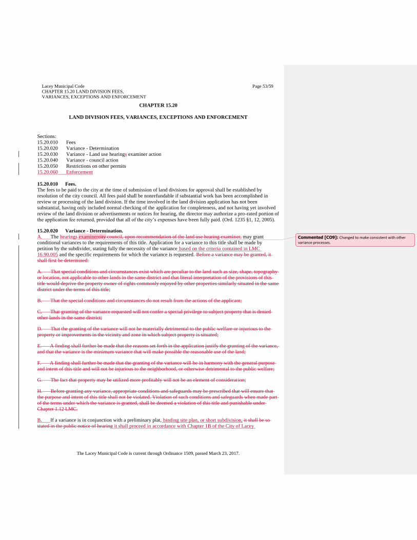
Lacey Municipal Code
CHAPTER 15.20 LAND DIVISION FEES,
VARIANCES, EXCEPTIONS AND ENFORCEMENT
Page 53/59
The Lacey Municipal Code is current through Ordinance 1509, passed March 23, 2017.
CHAPTER 15.20
LAND DIVISION FEES, VARIANCES, EXCEPTIONS AND ENFORCEMENT
Sections:
15.20.010 Fees
15.20.020 Variance - Determination
15.20.030 Variance - Land use hearings examiner action
15.20.040 Variance - council action
15.20.050 Restrictions on other permits
15.20.060 Enforcement
15.20.010 Fees.
The fees to be paid to the city at the time of submission of land divisions for approval shall be established by
resolution of the city council. All fees paid shall be nonrefundable if substantial work has been accomplished in
review or processing of the land division. If the time involved in the land division application has not been
substantial, having only included normal checking of the application for completeness, and not having yet involved
review of the land division or advertisements or notices for hearing, the director may authorize a pro-rated portion of
the application fee returned, provided that all of the city’s expenses have been fully paid. (Ord. 1235 §1, 12, 2005).
15.20.020 Variance - Determination.
A. The hearings examinercity council, upon recommendation of the land use hearing examiner, may grant
conditional variances to the requirements of this title. Application for a variance to this title shall be made by
petition by the subdivider, stating fully the necessity of the variance based on the criteria contained in LMC
16.90.005 and the specific requirements for which the variance is requested. Before a variance may be granted, it
shall first be determined:
A. That special conditions and circumstances exist which are peculiar to the land such as size, shape, topography
or location, not applicable to other lands in the same district and that literal interpretation of the provisions of this
title would deprive the property owner of rights commonly enjoyed by other properties similarly situated in the same
district under the terms of this title;
B. That the special conditions and circumstances do not result from the actions of the applicant;
C. That granting of the variance requested will not confer a special privilege to subject property that is denied
other lands in the same district;
D. That the granting of the variance will not be materially detrimental to the public welfare or injurious to the
property or improvements in the vicinity and zone in which subject property is situated;
E. A finding shall further be made that the reasons set forth in the application justify the granting of the variance,
and that the variance is the minimum variance that will make possible the reasonable use of the land;
F. A finding shall further be made that the granting of the variance will be in harmony with the general purpose
and intent of this title and will not be injurious to the neighborhood, or otherwise detrimental to the public welfare;
G. The fact that property may be utilized more profitably will not be an element of consideration;
H. Before granting any variance, appropriate conditions and safeguards may be prescribed that will ensure that
the purpose and intent of this title shall not be violated. Violation of such conditions and safeguards when made part
of the terms under which the variance is granted, shall be deemed a violation of this title and punishable under
Chapter 1.12 LMC.
B. If a variance is in conjunction with a preliminary plat, binding site plan, or short subdivision, it shall be so
stated in the public notice of hearing it shall proceed in accordance with Chapter 1B of the City of Lacey
Commented [CO9]: Changed to make consistent with other variance processes.
Lacey Municipal Code
CHAPTER 15.20 LAND DIVISION FEES,
VARIANCES, EXCEPTIONS AND ENFORCEMENT
Page 54/59
The Lacey Municipal Code is current through Ordinance 1509, passed March 23, 2017.
Development Guidelines and Public Works Standards. A separate hearing shall be held for all other requests for
variances. (Ord. 1235 §1, 12, 2005).
15.20.030 Variance - Land use hearings examiner action.
The quasi-judicial review of a variance by the hearings examiner shall proceed in conformance with the
requirements contained in LMC 16.90 and Section 1C.050 of the City of Lacey Development Guidelines and Public
Works Standards. In recommending a variance, the land use hearing examiner shall make a written record of
findings and shall specifically describe the variance and any conditions which the examiner may designate. The
hearing examiner shall keep the findings on file as a matter of public record. (Ord. 1235 §1, 12, 2005).
15.20.040 Variance - council action.
Upon receipt the recommendation of the land use hearing examiner,If a variance is processed in conjunction with a
preliminary plat and upon receipt of the recommendation of the hearings examiner, the council shall act upon the
variance in the same manner as authorized in LMC 15.10.110. (Ord. 1235 §1, 12, 2005).
15.20.050 Restrictions on other permits.
No building permit, septic tank permit, or other development permit shall be issued for any lot, tract, or parcel of
land divided in violation of Chapter 58.17 RCW or this title unless the official authorized to issue such permit finds
that the public interest shall not be adversely affected thereby. The prohibition contained in this section shall not
apply to an innocent purchaser for value without actual notice. (Ord. 1235 §1, 12, 2005).
15.20.060 Enforcement
Enforcement and penalties shall be applied pursuant to Chapter 14.17 LMC.
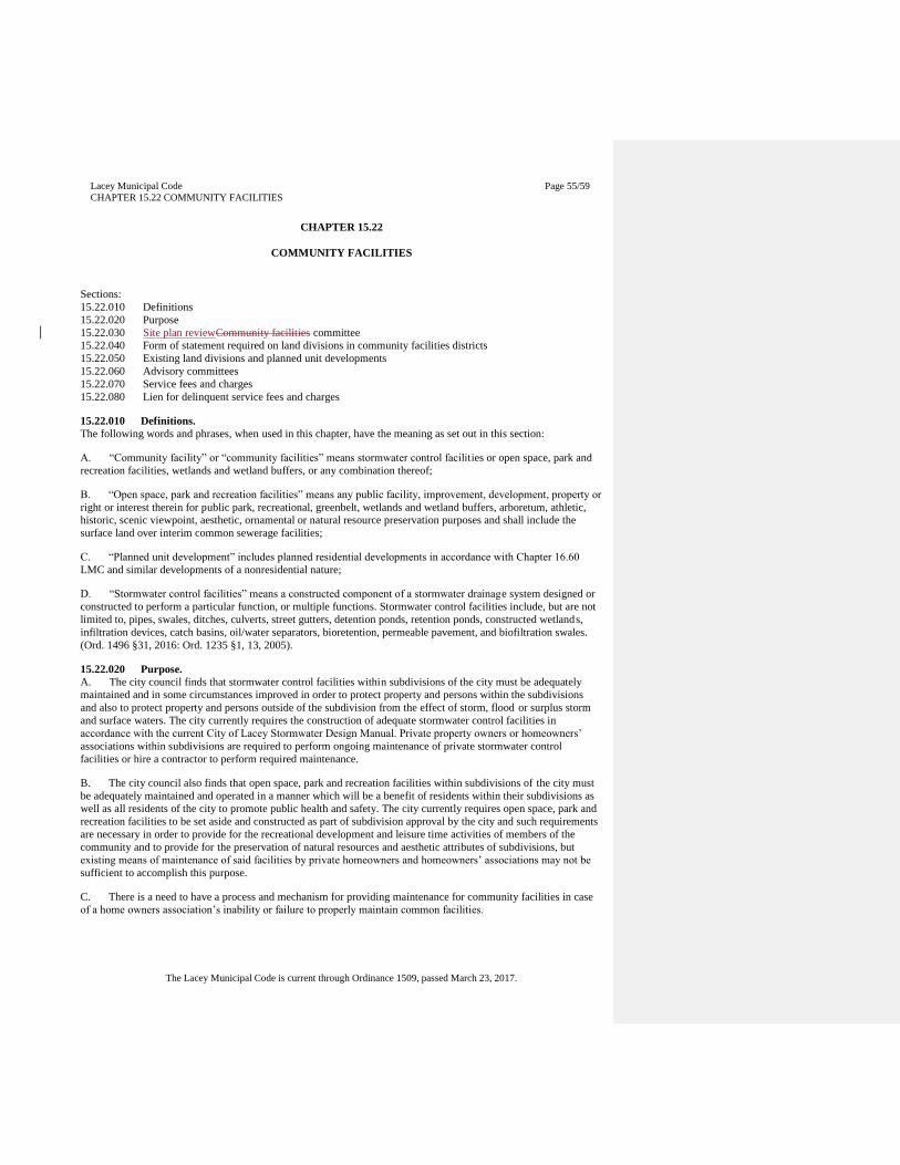
Lacey Municipal Code
CHAPTER 15.22 COMMUNITY FACILITIES
Page 55/59
The Lacey Municipal Code is current through Ordinance 1509, passed March 23, 2017.
CHAPTER 15.22
COMMUNITY FACILITIES
Sections:
15.22.010 Definitions
15.22.020 Purpose
15.22.030 Site plan reviewCommunity facilities committee
15.22.040 Form of statement required on land divisions in community facilities districts
15.22.050 Existing land divisions and planned unit developments
15.22.060 Advisory committees
15.22.070 Service fees and charges
15.22.080 Lien for delinquent service fees and charges
15.22.010 Definitions.
The following words and phrases, when used in this chapter, have the meaning as set out in this section:
A. “Community facility” or “community facilities” means stormwater control facilities or open space, park and
recreation facilities, wetlands and wetland buffers, or any combination thereof;
B. “Open space, park and recreation facilities” means any public facility, improvement, development, property or
right or interest therein for public park, recreational, greenbelt, wetlands and wetland buffers, arboretum, athletic,
historic, scenic viewpoint, aesthetic, ornamental or natural resource preservation purposes and shall include the
surface land over interim common sewerage facilities;
C. “Planned unit development” includes planned residential developments in accordance with Chapter 16.60
LMC and similar developments of a nonresidential nature;
D. “Stormwater control facilities” means a constructed component of a stormwater drainage system designed or
constructed to perform a particular function, or multiple functions. Stormwater control facilities include, but are not
limited to, pipes, swales, ditches, culverts, street gutters, detention ponds, retention ponds, constructed wetlands,
infiltration devices, catch basins, oil/water separators, bioretention, permeable pavement, and biofiltration swales.
(Ord. 1496 §31, 2016: Ord. 1235 §1, 13, 2005).
15.22.020 Purpose.
A. The city council finds that stormwater control facilities within subdivisions of the city must be adequately
maintained and in some circumstances improved in order to protect property and persons within the subdivisions
and also to protect property and persons outside of the subdivision from the effect of storm, flood or surplus storm
and surface waters. The city currently requires the construction of adequate stormwater control facilities in
accordance with the current City of Lacey Stormwater Design Manual. Private property owners or homeowners’
associations within subdivisions are required to perform ongoing maintenance of private stormwater control
facilities or hire a contractor to perform required maintenance.
B. The city council also finds that open space, park and recreation facilities within subdivisions of the city must
be adequately maintained and operated in a manner which will be a benefit of residents within their subdivisions as
well as all residents of the city to promote public health and safety. The city currently requires open space, park and
recreation facilities to be set aside and constructed as part of subdivision approval by the city and such requirements
are necessary in order to provide for the recreational development and leisure time activities of members of the
community and to provide for the preservation of natural resources and aesthetic attributes of subdivisions, but
existing means of maintenance of said facilities by private homeowners and homeowners’ associations may not be
sufficient to accomplish this purpose.
C. There is a need to have a process and mechanism for providing maintenance for community facilities in case
of a home owners association’s inability or failure to properly maintain common facilities.
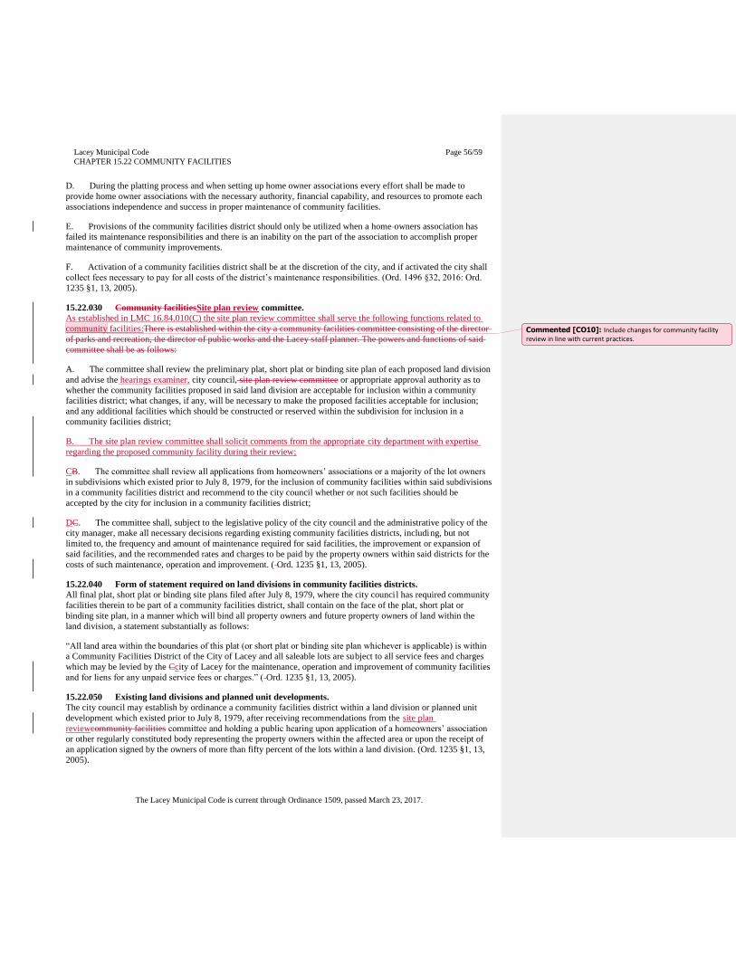
Lacey Municipal Code
CHAPTER 15.22 COMMUNITY FACILITIES
Page 56/59
The Lacey Municipal Code is current through Ordinance 1509, passed March 23, 2017.
D. During the platting process and when setting up home owner associations every effort shall be made to
provide home owner associations with the necessary authority, financial capability, and resources to promote each
associations independence and success in proper maintenance of community facilities.
E. Provisions of the community facilities district should only be utilized when a home owners association has
failed its maintenance responsibilities and there is an inability on the part of the association to accomplish proper
maintenance of community improvements.
F. Activation of a community facilities district shall be at the discretion of the city, and if activated the city shall
collect fees necessary to pay for all costs of the district’s maintenance responsibilities. (Ord. 1496 §32, 2016: Ord.
1235 §1, 13, 2005).
15.22.030 Community facilitiesSite plan review committee.
As established in LMC 16.84.010(C) the site plan review committee shall serve the following functions related to
community facilities:There is established within the city a community facilities committee consisting of the director
of parks and recreation, the director of public works and the Lacey staff planner. The powers and functions of said
committee shall be as follows:
A. The committee shall review the preliminary plat, short plat or binding site plan of each proposed land division
and advise the hearings examiner, city council, site plan review committee or appropriate approval authority as to
whether the community facilities proposed in said land division are acceptable for inclusion within a community
facilities district; what changes, if any, will be necessary to make the proposed facilit ies acceptable for inclusion;
and any additional facilities which should be constructed or reserved within the subdivision for inclusion in a
community facilities district;
B. The site plan review committee shall solicit comments from the appropriate city department with expertise
regarding the proposed community facility during their review;
CB. The committee shall review all applications from homeowners’ associations or a majority of the lot owners
in subdivisions which existed prior to July 8, 1979, for the inclusion of community facilities within said subdivisions
in a community facilities district and recommend to the city council whether or not such facilities should be
accepted by the city for inclusion in a community facilities district;
DC. The committee shall, subject to the legislative policy of the city council and the administrative policy of the
city manager, make all necessary decisions regarding existing community facilities districts, including, but not
limited to, the frequency and amount of maintenance required for said facilities, the improvement or expansion of
said facilities, and the recommended rates and charges to be paid by the property owners within said districts for the
costs of such maintenance, operation and improvement. ( Ord. 1235 §1, 13, 2005).
15.22.040 Form of statement required on land divisions in community facilities districts.
All final plat, short plat or binding site plans filed after July 8, 1979, where the city counci l has required community
facilities therein to be part of a community facilities district, shall contain on the face of the plat, short plat or
binding site plan, in a manner which will bind all property owners and future property owners of land within the
land division, a statement substantially as follows:
“All land area within the boundaries of this plat (or short plat or binding site plan whichever is applicable) is within
a Community Facilities District of the City of Lacey and all saleable lots are subject to all service fees and charges
which may be levied by the Ccity of Lacey for the maintenance, operation and improvement of community facilities
and for liens for any unpaid service fees or charges.” ( Ord. 1235 §1, 13, 2005).
15.22.050 Existing land divisions and planned unit developments.
The city council may establish by ordinance a community facilities district within a land division or planned unit
development which existed prior to July 8, 1979, after receiving recommendations from the site plan
reviewcommunity facilities committee and holding a public hearing upon application of a homeowners’ association
or other regularly constituted body representing the property owners within the affected area or upon the receipt of
an application signed by the owners of more than fifty percent of the lots within a land division. (Ord. 1235 §1, 13,
2005).
Commented [CO10]: Include changes for community facility review in line with current practices.
Lacey Municipal Code
CHAPTER 15.22 COMMUNITY FACILITIES
Page 57/59
The Lacey Municipal Code is current through Ordinance 1509, passed March 23, 2017.
15.22.060 Advisory committees.
The property owners within a land division or planned unit development which contains a community facilities
district may elect or appoint an advisory committee. The duty of such advisory committee shall be to advise the site
plan review community facilities committee as to the wishes and needs of residents of the land division or planned
unit development regarding maintenance, operation and improvement of community facilities within their subject
area. (Ord. 1235 §1, 13, 2005).
15.22.070 Service fees and charges.
The city council shall fix service fee rates and charges for the furnishing of maintenance and operation services and
for the making of improvements for all community facilities within each community facilities district after receiving
recommendation of such fees and charges from the site plan reviewcommunity facilities committee. In fixing rates
and charges, the council may consider services furnished or to be furnished, benefits received or to be received, the
improvements made or to be made, and in the case of stormwater control facilities, the water run-off characteristics
of the land within the district and the cost to control said water after it leaves the district and any other matters which
present a reasonable basis for setting rates or present a reasonable difference as grounds for distinction in setting the
rates for one district in relationship to other districts. (Ord. 1235 §1, 13, 2005).
15.22.080 Lien for delinquent service fees and charges.
The city shall have a lien for delinquent service charges, including interest thereon, against any property against
which they were levied pursuant to this chapter, which liens shall be superior to all other liens and encumbrances
except general taxes and local and special assessments. Such liens shall be effective and shall be enforced and
foreclosed in the same manner as city charges for water and sewerage service. (Ord. 1235 §1, 13, 2005).
Lacey Municipal Code
CHAPTER 15.32 RESERVED FOR FUTURE USE
Page 58/59
The Lacey Municipal Code is current through Ordinance 1509, passed March 23, 2017.
CHAPTER 15.32
RESERVED FOR FUTURE USE
Commented [CO11]: Repealed chapters do not need to be included in text of the chapter.

Lacey Municipal Code
CHAPTER 15.36 RESERVED FOR FUTURE USE
Page 59/59
The Lacey Municipal Code is current through Ordinance 1509, passed March 23, 2017.
CHAPTER 15.36
RESERVED FOR FUTURE USE


