Download - Abraham Path - Nablus v1.0

Nablus Atlas
topographical maps & route descriptions
a work in progress - v1.0
*
!
!
!
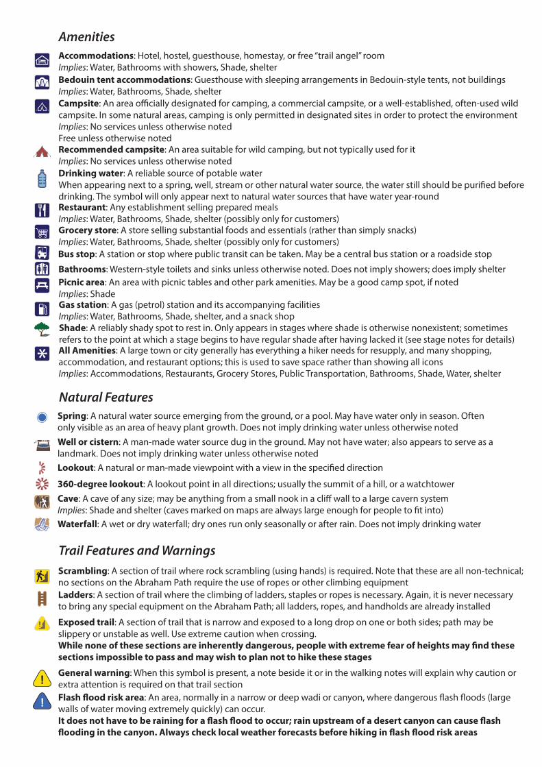
Accommodations: Hotel, hostel, guesthouse, homestay, or free “trail angel” roomImplies: Water, Bathrooms with showers, Shade, shelterBedouin tent accommodations: Guesthouse with sleeping arrangements in Bedouin-style tents, not buildingsImplies: Water, Bathrooms, Shade, shelterCampsite: An area o�cially designated for camping, a commercial campsite, or a well-established, often-used wild campsite. In some natural areas, camping is only permitted in designated sites in order to protect the environmentImplies: No services unless otherwise notedFree unless otherwise notedRecommended campsite: An area suitable for wild camping, but not typically used for itImplies: No services unless otherwise notedDrinking water: A reliable source of potable waterWhen appearing next to a spring, well, stream or other natural water source, the water still should be puri�ed before drinking. The symbol will only appear next to natural water sources that have water year-roundRestaurant: Any establishment selling prepared mealsImplies: Water, Bathrooms, Shade, shelter (possibly only for customers)Grocery store: A store selling substantial foods and essentials (rather than simply snacks)Implies: Water, Bathrooms, Shade, shelter (possibly only for customers)Bus stop: A station or stop where public transit can be taken. May be a central bus station or a roadside stop
Bathrooms: Western-style toilets and sinks unless otherwise noted. Does not imply showers; does imply shelterPicnic area: An area with picnic tables and other park amenities. May be a good camp spot, if notedImplies: ShadeGas station: A gas (petrol) station and its accompanying facilitiesImplies: Water, Bathrooms, Shade, shelter, and a snack shopShade: A reliably shady spot to rest in. Only appears in stages where shade is otherwise nonexistent; sometimes refers to the point at which a stage begins to have regular shade after having lacked it (see stage notes for details)All Amenities: A large town or city generally has everything a hiker needs for resupply, and many shopping, accommodation, and restaurant options; this is used to save space rather than showing all iconsImplies: Accommodations, Restaurants, Grocery Stores, Public Transportation, Bathrooms, Shade, Water, shelter
Spring: A natural water source emerging from the ground, or a pool. May have water only in season. Often only visible as an area of heavy plant growth. Does not imply drinking water unless otherwise notedWell or cistern: A man-made water source dug in the ground. May not have water; also appears to serve as a landmark. Does not imply drinking water unless otherwise notedLookout: A natural or man-made viewpoint with a view in the speci�ed direction
360-degree lookout: A lookout point in all directions; usually the summit of a hill, or a watchtowerCave: A cave of any size; may be anything from a small nook in a cli� wall to a large cavern systemImplies: Shade and shelter (caves marked on maps are always large enough for people to �t into) Waterfall: A wet or dry waterfall; dry ones run only seasonally or after rain. Does not imply drinking water
Scrambling: A section of trail where rock scrambling (using hands) is required. Note that these are all non-technical; no sections on the Abraham Path require the use of ropes or other climbing equipmentLadders: A section of trail where the climbing of ladders, staples or ropes is necessary. Again, it is never necessary to bring any special equipment on the Abraham Path; all ladders, ropes, and handholds are already installed
Exposed trail: A section of trail that is narrow and exposed to a long drop on one or both sides; path may be slippery or unstable as well. Use extreme caution when crossing. While none of these sections are inherently dangerous, people with extreme fear of heights may �nd these sections impossible to pass and may wish to plan not to hike these stages
General warning: When this symbol is present, a note beside it or in the walking notes will explain why caution or extra attention is required on that trail sectionFlash �ood risk area: An area, normally in a narrow or deep wadi or canyon, where dangerous �ash �oods (large walls of water moving extremely quickly) can occur. It does not have to be raining for a �ash �ood to occur; rain upstream of a desert canyon can cause �ash �ooding in the canyon. Always check local weather forecasts before hiking in �ash �ood risk areas
Amenities
Natural Features
Trail Features and Warnings

3
Ruins or archaeological site: Ruins of any age or size. Free admission (or non-maintained site) unless otherwise noted
Point of interest: Generic symbol for relevant locations not covered by another symbol; see notes beside the point for more information
Church/Mosque or religious site: This may be either a signi�cant site for one or more religions (tomb of a famous �gure; traditional site of a story or event; etc.) or simply one serving as a landmark
Abraham Path route: Shows the route followed by the Abraham Path on a given stage
Other Abraham Path route: Shows Abraham Path routes other than the one that is the focus of a stage map; includes previous and next stages, detours, spurs, etc.
City Walk routes: Shows City Walk routes, special spurs/alternates of the Abraham Path
Begin/End Stage: Mark the beginning and ending of a stage on stage maps
Waypoints and Distance Indicators: Waypoints mark turn-by-turn directions and navigational landmarks along a trail stage. There may be a distance markers, indicating cumulative distance from the beginning of the stage. Even if no distance is attached, each waypoint has a corresponding entry in the stage’s data book which does list its distance as well as a description of the location and directions
Roads: Beige are larger highways, up to expressways; white are smaller roads as well as city streets. Labelled with road number if applicableRoads marked this way are virtually always asphalt, but in some places with very few paved roads, a wide, smooth, easily driveable dirt road may also be marked as a white road (e.g. Harran region)
Dirt road or 4x4 track: A wide, unpaved surface generally large enough to accommodate a jeep or 4x4 vehicle. Should be assumed not to be accessible by normal car unless otherwise noted. The distinction between these and paths (below) is a gradual one, and some trails are on the borderline between both, or change from one to the other over a distance
Footpath: A narrow, unpaved walking surface generally too small or too rough to be driven by a 4x4 vehicle. May be wide enough for two people to walk abreast, or a narrow, faint goat path. May be very clear and easy to follow, or faint and more intermittent.
Wadi or ditch: A “wadi” is an intermittent streambed which �ows with water only in the wet season or after rain. Many of them form very large canyons, and “wadi” can refer either to the broader canyon or to the streambed in the bottom of it
Stream/River: Waterways that �ow year-round, rather than seasonally. A stream is usually small enough to cross easily by foot, while a river is larger. Canals appear the same as streams or rivers
Contour Lines: Show the topography of a landscape; a line is drawn every 10m of elevation, and a thicker line every 100m with a label showing its height. Lines closer together mean a steeper slope; further apart mean a gradual one
Border: Country boundaries
Summit: A peak or local high point
Built-up area: A town, residential, commercial or industrial area
Forest: A densely wooded area
Cultural Features
Trail Indicators
Other Geography
1.4
Wadi Name
900
-100
0
0 5km 10 15 20 25 35 4030 45 50 55 58.1
100
200
300
400
500
600
700
800
900
-100
0
100
200
300
400
500
600
700
800
900
Nablus (0.0km)
Awarta
(10.2km)Duma
(28.8km) Kafr Malek
(43.7km)
Auja
(58.1km)
Stage 1: 10.2 km Stage 2: 18.6 km Stage 1: 14.9 km Stage 1: 14.4 km
abrahampath.org
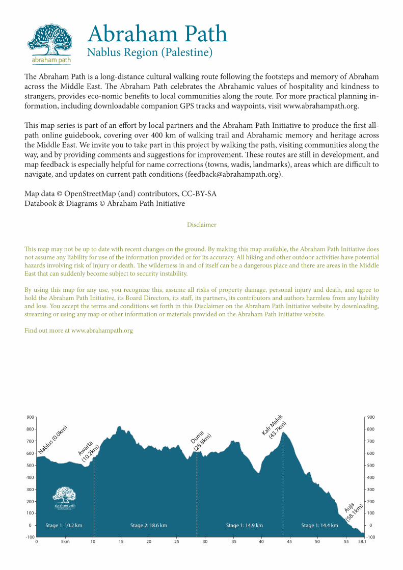
The Abraham Path is a long-distance cultural walking route following the footsteps and memory of Abraham across the Middle East. The Abraham Path celebrates the Abrahamic values of hospitality and kindness to strangers, provides eco-nomic benefits to local communities along the route. For more practical planning in-formation, including downloadable companion GPS tracks and waypoints, visit www.abrahampath.org.
This map series is part of an effort by local partners and the Abraham Path Initiative to produce the first all-path online guidebook, covering over 400 km of walking trail and Abrahamic memory and heritage across the Middle East. We invite you to take part in this project by walking the path, visiting communities along the way, and by providing comments and suggestions for improvement. These routes are still in development, and map feedback is especially helpful for name corrections (towns, wadis, landmarks), areas which are difficult to navigate, and updates on current path conditions ([email protected]).
Map data © OpenStreetMap (and) contributors, CC-BY-SADatabook & Diagrams © Abraham Path Initiative
Abraham PathNablus Region (Palestine)
Disclaimer
This map may not be up to date with recent changes on the ground. By making this map available, the Abraham Path Initiative does not assume any liability for use of the information provided or for its accuracy. All hiking and other outdoor activities have potential hazards involving risk of injury or death. The wilderness in and of itself can be a dangerous place and there are areas in the Middle East that can suddenly become subject to security instability.
By using this map for any use, you recognize this, assume all risks of property damage, personal injury and death, and agree to hold the Abraham Path Initiative, its Board Directors, its staff, its partners, its contributors and authors harmless from any liability and loss. You accept the terms and conditions set forth in this Disclaimer on the Abraham Path Initiative website by downloading, streaming or using any map or other information or materials provided on the Abraham Path Initiative website.
Find out more at www.abrahampath.org
55 km
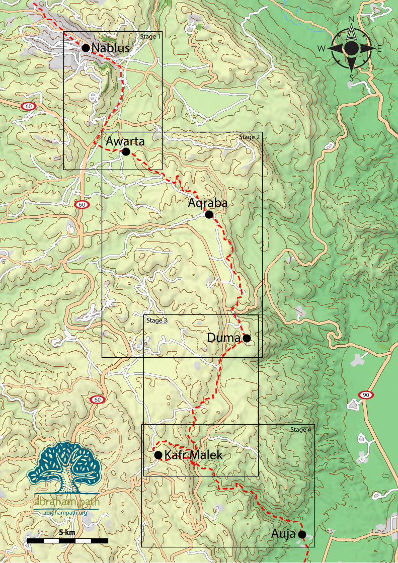
Nablus
Awarta
Aqraba
Duma
Auja
Kafr Malek
Stage 1
Stage 2
Stage 3
Stage 4
9060
60
60
abrahampath.org
800
700
800
500
600
500
1 km
abrahampath.org
Al Ein Camp
BalataCamp
Burin
RujeibKafr Qalil
Iraq Burin
UdalaHuwara
Nablus
Awarta
Itamarsettlement
Brakha settlement
60
60
5077
5077
5487
5487
0.0
0.5
1.5
2.4
3.9
4.5
6.0
6.9
7.9
9.59.9
10.2
Huwaracheckpoint
United Feed
Jacob’s Well
Mt. Ebal
Mt. Gerezim

7
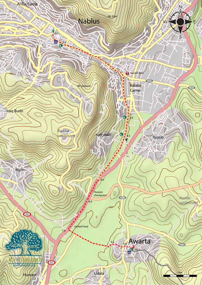
km Walking notes +km0.0 STAGE BEGIN- Start at info center kiosk at Duwwar
al-Hussein, or Martyr’s Square, “Maydan Shohadda.” Cross street under arch into market next to CairoAm-man Bank, stay straight. 0.1
0.1 Turn L on main market street. 0.40.5 Mosque “Jamir Kbir,” leave market and stay straight on
open road market St., Suq al-Sharqe St. (mosque pos-sible to enter for foreigners if women cover heads). 0.8
1.3 Stay straight, Faisal St joins from L with eastern market street. 0.2
1.5 Cross to other side of busy road to walk on sidewalk, continue straight towards al-Quds St., Duwwar al-Muqata’a on L (L turn uphill Amman St., R turn to Old City). 0.3
1.8 Pass “Nablus Childhood Happiness Center” Park/re-sort on L, nice shaded area (entrance fee). 0.3
2.1 Stay straight on sidewalk, pass sign noting L turn to “Tel Balata.” 0.3
2.4 Bear R from Jamal Abd An-Nasr St onto Al Quds St at traffic light (turn L to visit Jacob’s well in 300m) 0.1
2.5 Supermarket on R, trail continues straight along L side on sidewalk. 1.4
3.9 Mosque “Al Fattouh” on R. 0.64.5 Mosque “Hajje I’tdal” on R. 0.14.6 Gas station “Al Sayel Co.” on L. 1.46.0 Turn R on busy road #57 toward Hawara and Ramal-
lah, checkpoint ahead, 2m wide shoulder, no passport check, you just need to cross in vehicle 0.6
6.6 Hawara checkpoint 0.36.9 After checkpoint where taxi dropped us off, pass settle-
ment access road on R. 0.47.3 Stay straight, road on R goes to Burin and Asira el
Qabliye, Qabliye means towards the Qaba/Mecca, used as a substitute for the word south. 0.3
7.6 Stay straight, pass small olive grove and house on L. 0.17.7 “United Feed Co.” small factory on L. 0.27.9 Turn L on the next dirt road after “United Feed Co.”,
pass through olive grove towards Awarta on hillside ahead, leave busy road (dirt road crosses the paved road here). 0.3
8.2 Stay straight, small garbage pile on R. 0.18.3 Stay straight, dirt part crossroads. 0.99.2 Enter olive groves on far side of field near base of
town/hillside, pass small house on L. 0.39.5 Go straight on paved road on edge of town at 4-way
intersection. 0.3
9.8 Go straight uphill to village center at 4-way intersec-tion and stop sign, small shop and Awarta pharmacy nearby. 0.1
9.9 Stay straight (R & L options rejoin soon), shop nearby. 0.110.0 Stay straight (R & L options rejoin as same road). 50m10.0 Shops: fruit/vegetables, non-perishables. 50m10.1 Turn R, Awarta mosque in front to R. 0.110.2 STAGE END- Awarta mosque 0.0
100200300400500600700800900
1000
0
1002003004005006007008009001000
1km 2 3 4 5 6 7 8 9 10.2
Nablus Awarta
2.7 6.0
Jaco
b’s Well
Highway 60!
abrahampath.org
1: Nablus to Awarta (Nablus Region)
Distance: 10.2kmTime: 3 hours
Physical Challenge: easyTrail Difficulty: easy

500
600
700
700
600
600
700
400
800
800
800
800
2 km
abrahampath.org
Majdal Bani Fadel
Udala
Usarin
Aqraba
Yanun
Bir Muksaifa
Yatma
Qabalan Jurish
Qusra
JaludQaryut
Eli
Beita e-Tahta
Beita el-Foqa
Tal�t
Awarta
Duma
Rekhelim
Itamarsettlement
Shilosettlement
Shvut Rakhelsettlement
Migdalim
60
458
458
505
505
505
505
505
5077
47774777
5077
5077
5077
0.0 0.5
1.4
3.1
3.8
4.5
4.9
5.8 6.4
7.3
7.7
8.2 8.8
9.6
10.2
12.3
13.0
14.1
14.8
15.3
16.5
17.7
18.6
11.3
waterstation
Olim spring
Mt. Arma
9
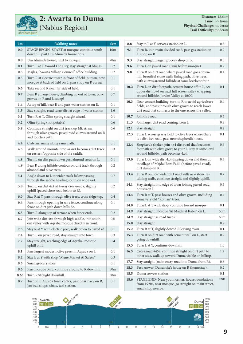
km Walking notes +km0.0 STAGE BEGIN- START at mosque, continue south
downhill past Um Ahmad’s house on R.10m
0.0 Um Ahmad’s house, next to mosque. 70m0.1 Turn L at T toward Old City, stay straight at Majlas. 0.20.3 Majlas, “Awarta Village Council” office building. 0.20.5 Turn R at electric tower in front of field in town, new
mosque at back of field on L, pass shop on R corner0.1
0.6 Take second R near far side of field. 0.10.7 Bear R at large house, climbing up out of town, olive
groves on R and L, steep!0.7
1.4 At top of hill, bear R and pass water station on R. 0.11.5 Stay straight, road turns dirt at edge of water station 1.63.1 Turn R at T, Olim spring straight ahead. 0.13.2 Olim Spring (not potable) 0.63.8 Continue straight on dirt track up Mt. Arma
through olive groves, paved road curves around on R and touches path.
0.6
4.4 Cisterns, many along same path. 0.14.5 Walk around mountaintop as 4x4 becomes dirt track
on eastern/opposite side of the saddle.0.3
4.8 Turn L on dirt path down past almond trees on L. 0.14.9 Bear R along hillside contour on dirt track through
almond and olive trees.0.2
5.1 Angle down to L to wider track below passing through the saddle heading south on wide 4x4.
0.7
5.8 Turn L on dirt 4x4 at 4-way crossroads, slightly uphill (paved close road below to R).
0.2
6.0 Stay R at Y, pass through olive trees, cross ridge top. 0.46.4 Pass through opening in wire fence, continue along
fence on dirt path down hillside.0.1
6.5 Turn R along top of terrace when fence ends. 0.26.7 Join wide dirt 4x4 through high saddle, into south-
ern valley with Aqraba mosque directly in front.0.6
7.3 Stay R at Y with electric pole, walk down to paved rd 0.17.4 Turn L on paved road, stay straight into town. 0.37.7 Stay straight, reaching edge of Aqraba, mosque
uphill on L.0.4
8.1 Pass largest modern olive press in Aqraba on L. 0.18.2 Stay L at Y with shop “Mene Market Al Safeer” 0.38.5 Small grocery store. 0.18.6 Pass mosque on L, continue around to R downhill. 50m
8.65 Turn R/straight downhill. 50m8.7 Turn R in Aqraba town center, past pharmacy on R,
Jawwal, shops, circle, taxi station.0.1
8.8 Stay to L at Y, servees station on L. 0.39.1 Turn R, join main divided road, pass gas station on
L, shop on R.0.2
9.3 Stay straight, larger grocery shop on R. 0.39.6 Turn L on paved road (50m before mosque). 0.29.8 Turn R on dirt road where paved road goes down-
hill, beautiful stone walls lining path, olive trees, path curves around hillside at same level/contour.
0.4
10.2 Turn L on dirt footpath, cement house off to L, see upper dirt road on next hill across valley wrapping around hillside, Jordan Valley at 10:00.
0.1
10.3 Near cement building, turn to R to avoid agriculture fields, and pass through olive groves to reach lower dirt road that connects to the one across the valley.
0.4
10.7 Join dirt road. 0.611.3 Join larger dirt road coming from L. 0.812.1 Stay straight. 0.212.3 Turn L across grassy field to olive trees where there
is a dirt 4x4 road, pass near shepherd’s house.0.1
12.4 Shepherd’s shelter, join 4x4 dirt road that becomes footpath with olive grove to your L, stay at same level around hillside, path becomes 4x4.
0.6
13.0 Turn L on wide dirt 4x4 dipping down and then up to village of Majdal Bani Fadil (before paved road), dirt dump on R.
0.4
13.4 Turn R on new wider dirt road with new stone re-taining walls, continue straight and slightly uphill.
0.7
14.1 Stay straight into edge of town joining paved road, houses on L.
0.3
14.4 Turn R at T, pass houses and olive groves, including some very old “Roman” trees.
0.4
14.8 Turn L at T with shop, continue toward mosque. 0.114.9 Stay straight, mosque “Al Majdil al Kabir” on L. 50m14.9 Stay straight as road turns L. 50m15.0 Stay straight. 0.215.2 Turn R at T, slightly downhill leaving town. 0.115.3 Turn R on dirt road with cement wall on L, start
going downhill.0.2
15.5 Turn L at Y, continue downhill. 1.016.5 Cross road #458, continue straight on dirt path to
other side, walk up toward Duma visible on hilltop.1.2
17.7 Stay straight (main entry road into Duma from R). 0.618.3 Pass Anwar’ Dawabshe’s house on R (homestay). 0.218.5 Duma servees station 0.118.6 STAGE END- Near youth center, house foundations
from 1920s, near mosque, go straight on main street, small shop nearby.
END
2: Awarta to Duma(Nablus Region)
Distance: 18.6kmTime: 5-7 hours
Physical Challenge: moderateTrail Difficulty: moderate
100200300400500600700800900
1000
0
1002003004005006007008009001000
1km 2 3 4 5 6 7 8 9 10 11 12 13 14 15 16 17 18 18.6
3.1 8.5 15.0
Olim Sprin
g
Aqraba
Majdal Bani
Fadel
Awarta Duma
abrahampath.org
600
600
700
700
700
800
800
800
800
400 500
500
1 km
abrahampath.org
Shvut Rakhelsettlement
Duma
Kafr Malek
Khirbet Abu Falah Mughayir
Turmus Aya
Shilosettlement
Qusra
458
458
458
Wadi Auja
Wadi Samia
Ein Samia
Ein al-Ayanboa
Khirbetal-Miraje
0.00.2
1.4
1.9
3.6
4.1
4.9
5.2
6.1
7.2
7.5
8.8
9.8
10.5
10.9
12.312.9
13.7
14.1
14.9
7.7

11
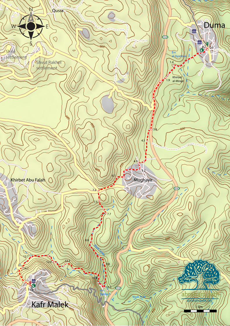
km Walking notes +km0.0 STAGE BEGIN- From youth center, near mosque,
go straight on main street, small shop nearby.70m
0.1 Take first R, walk on paved road through old build-ing foundations.
30m
0.1 Stay L at Y. 0.10.2 Turn L after passing mosque on R, continue straight. 0.20.4 Stay straight as paved road leaves town, dropping
down and back up to main road, almond trees on R.0.5
0.9 Al-Ayanboa’ Spring. 0.51.4 Stay straight and cross wadi/high water bridge just
after cave on R.0.4
1.8 Stay straight, pass access road to Khirbet Al-Miraje on L, SPNI red trail marker along path.
0.1
1.9 Stay straight, road becomes dirt. 0.22.1 Turn L on Rt #458 (large paved road), Mughayir on
hillside ahead of you, 2m wide soft shoulder.0.6
2.7 Stay straight, road to settlements “Kidah” and “Svot Rackel” on R, not used by Palestinians.
0.9
3.6 Turn R (crossing road) near beginning of olive field, pass through field up to 4x4.
0.1
3.7 Turn L on faint 4x4 in middle of olive grove toward Mughayir.
0.4
4.1 Stay straight joining larger 4x4 coming from L from paved road (some garbage along path ahead).
0.7
4.8 Turn R off dirt road before edge of town, cross olive groves toward split in the hills.
0.1
4.9 Pass through hole in fence at far side of olive groves, then L on dirt road, facing minaret directly in front.
0.2
5.1 Rest stop at Dar Jawwad, private house and small shop, house of Anwar’s sister.
50m
5.1 Turn R on main street through town, paved, starts to climb on the north side of village.
0.8
5.9 Turn R, leaving paved road through 3 rows of olive trees to base of hillside opposite.
0.2
6.1 Turn L on dirt footpath at base of hillside at end of 3 rows of olive trees facing Kfar Malek on hill in front and above.
0.8
6.9 Turn R on main paved road along electric lines. 0.37.2 Turn L off main paved road onto dirt 4x4 at begin-
ning of olive groves at intersection (R to Turmasaya, straight to Abu Falah).
0.3
7.5 Turn L down from 4x4 before orchard on small dirt footpath, all the way down to the valley floor, catch-ing dirt road on far side of valley (almost non-exis-tent footpath), aim for small quarry scar on far side, trail bends to R at gate toward and around plum, apricot and apple orchard.
0.2
7.7 Turn R on stone/dirt road which curves down to L into valley, (new stone/dirt road).
0.8
8.5 Stay straight, pass stone well on your R. 0.38.8 Valley tightens, beautiful path into the depths of
Wadi Samia, find best path for season, often on R side of wadi, slightly above lowest part.
0.7
9.5 Cross wadi floor to the other side. 0.39.8 Pass Bedouin tents. 0.7
10.5 Ein Samia complex, stay R along fence (see old Ro-man water mill on L with stone arch).
0.1
10.6 Pass under water pipe into cement channel with cave above on hillside, walk straight through (dry) streambed with water complex on L.
0.2
10.8 Turn R to leave wadi, some rock scrambling on faint footpath uphill to L side of notch above with tree growing in rocks (faint path).
0.1
10.9 Reach notch in hillside, shade tree on rock on L, fol-low faint footpath along R side of rock fin uphill.
0.2
11.1 Climb up to L onto top of rock fin, continue on dirt path parallel to wadi (halfway up R side) toward houses on hilltop. Trail follows ancient Roman Path used to carry water from the spring to the villages. Path is about halfway up the wadi on the R side, rocky, requires solid footing.
0.9
12.0 After turning corner, wadi flattens with large shade tree straight ahead, follow same path/contour around valley to tree.
0.3
12.3 Large shade tree in olive grove, continue around val-ley to olive groves with 4x4 track on valley floor.
0.1
12.4 Turn R on faint 4x4 in middle of valley up toward olive groves.
0.4
12.8 Leave faint 4x4 up to L to stone walls/power line at base of hillside.
0.1
12.9 Follow 4x4 path between stone walls, pass under power line into center of valley, passing quarry on R.
0.2
13.1 Bear L onto larger 4x4 in front of stone quarry. 0.613.7 Stay straight at 4-way intersection toward paved road
visible ahead just on L of 4 tall Cyprus trees.0.4
14.1 Turn L on paved road steeply, nice shade tree and rest spot, Abu Farah visible on hillside to R.
0.6
14.7 Stay straight uphill toward mosque, pass “Kafr Malek” sign.
0.1
14.8 Stay straight at top of hill toward mosque. 0.114.9 STAGE END- Kafr Malek mosque
3: Duma to Kafr Malek (Nablus Region)
Distance: 14.9kmTime: 5-7 hours
Physical Challenge: difficultTrail Difficulty: moderate
100200300400500600700800900
1000
0
1002003004005006007008009001000
1km 2 3 4 5 6 7 8 9 10 11 12 13 14 14.9
Highway 458
Mughayir
Samia Spring!
DumaKafr Malek
2.1 5.2 10.5
abrahampath.org
400
400
500
500
500
600
600
700
700
100
200
200
300
1 km
Qur
net
al-M
edin
a Um
al-K
hafa
�ish
abraha
mpa
th.org
Kafr
Mal
ek
Auja
Tayb
eh
Koha
v H
aSha
har
sett
lem
ent
458
458
458
449
449
Wadi Samia
Wad
i Auj
a
Wad
i Auj
a
Wad
i Auja
Ein
Sam
ia
Ein
Auja
0.0
0.8
1.6
3.8
4.2
4.8
5.7
6.5
7.6
7.8
9.4 10
.0
11.7
12.4
13.7
13.9
14.4
ruin
s
wat
er
pum
ping
stat
ion

13
400
400
500
500
500
600
600
700
700
100
200
200
300
1 km
Qur
net
al-M
edin
a Um
al-K
hafa
�ish
abraha
mpa
th.org
Kafr
Mal
ek
Auja
Tayb
eh
Koha
v H
aSha
har
sett
lem
ent
458
458
458
449
449
Wadi Samia
Wad
i Auj
a
Wad
i Auj
a
Wad
i Auja
Ein
Sam
ia
Ein
Auja
0.0
0.8
1.6
3.8
4.2
4.8
5.7
6.5
7.6
7.8
9.4 10
.0
11.7
12.4
13.7
13.9
14.4
ruin
s
wat
er
pum
ping
stat
ion
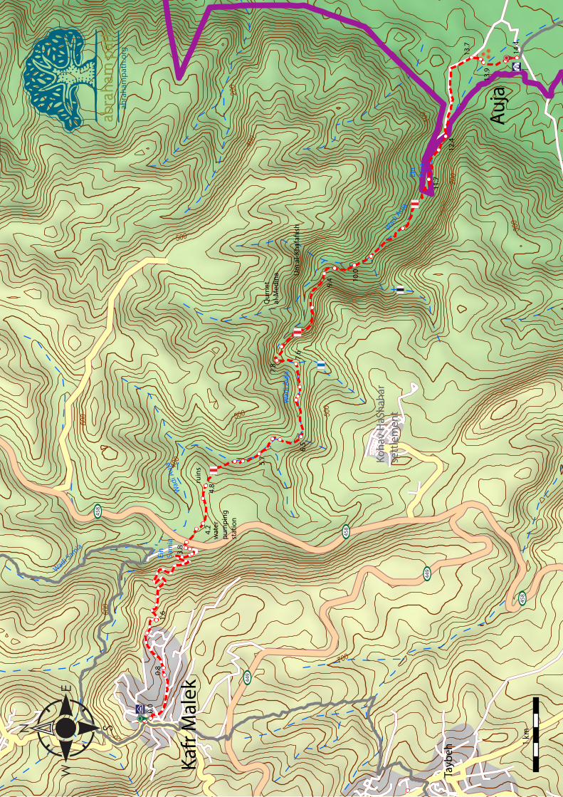
km Walking notes +km0.0 STAGE BEGIN- Follow main road to east downhill
(shops on your R), all the way to Ain Samia area. You can see the mountain ridge of Jordan to front.
0.7
0.7 Stay straight, pass road to L winding back up toward the old city/mosque.
0.1
0.8 Stay L at Y on main road downhill, not road up to houses on R.
0.6
1.4 Stay straight, pass through small stone quarry. 0.21.6 Stay straight down, pass “Jerusalem Water Undertak-
ing” pumping station on R (water pipe on L).2.0
3.6 Road block to cars by large stones and dirt pile, Ro-man cemetery and tombs in hillside below, cut down to lower roadblock below.
0.1
3.7 Lower roadblock, follow road down to main road. 0.13.8 Turn R down to main road. 0.13.9 Cross main road #458 to palm tree on R, stay
straight along power lines toward water station (begin red markings).
0.2
4.1 Stay to R of “Jerusalem Water Undertaking” build-ing, path becomes dirt 4x4.
0.1
4.2 Turn R off of 4x4 up on footpath (rocky, but well defined), follow red marks.
0.4
4.6 Ruins on L (qasr, hamam, borj). 0.24.8 Reach crest of pass on saddle, old building founda-
tions/animal pens nearby, continue down and to R into wadi to where three trees stand in the middle of a small field.
0.6
5.4 Shade trees, follow edge of field on R into wadi. 0.15.5 Reach valley floor, continue straight. 0.25.7 Turn R to take higher path above wadi floor (leave
red markings).0.3
6.0 Rejoin lower red markings on trail near bottom of wadi.
0.1
6.1 Cross wadi, switch to L side, leave red markings. 0.46.5 Return to wadi base via short switchback, rejoin red
trail and walk on streambed.0.5
7.0 Large carob tree with shade, trail becomes rockier, some scrambling.
0.1
7.1 1-2m drop on rocks, difficult if full of water, possible detour on L side.
0.1
7.2 Large carob tree, shady area. 0.47.6 Stay straight as wadi deepens, junction with (dif-
ficult) blue trail up to R.0.2
7.8 Turn R to take higher path on R of wadi with a steep incline on L, some loose footing, area locally called “Makhtal el Bedoue,” leave red markings.
0.3
8.1 Stay straight to shade tree up on point/pass, soon valley begins to open, great views from high trail, mountains of Jordan on horizon.
0.8
8.9 Viewpoint across wadi to area called “qurnet al-medina”, or corner of the city, visible near high rock crease with a cave roof ledge.
0.5
9.4 Viewpoint for “Um al-Khafafeesh” or “mother of the bats” across valley in the caves high on the hillside, next wadi after qurnet al medina.
0.2
9.6 Start descending back down to wadi floor after pass-ing protruding rock point on R, loose stones and dirt, faith path.
0.4
10.0 Path returns to wadi floor, rejoins red markings, continues close to base of the wadi.
0.2
10.2 Stay straight on red trail, junction with black trail on R, path wide and easy.
0.6
10.8 Stay straight on red path as wadi deepens, cross over smooth stone flood plane wash.
0.9
11.7 Ein Auja (Ras Al-Ain, head of the spring) and oasis!, great swimming spot if water is flowing. Follow red trail along R side of stream toward parking area (leave red trail for higher path to R past parking area if too much water).
0.5
12.2 Pass parking area on other side of stream, stay on high trail.
0.2
12.4 Cross stream by water station (lower water level), continue on paved road (modern aqueduct on L of road).
1.3
13.7 Leave paved road toward old tell and building walls near first Bedouin tent close to road (no trail).
0.1
13.8 Khirbet/tell ___, old church and Islamic cemetery, continue down across streambed, aqueduct and old mill nearby.
0.1
13.9 Cross (dry) streambed, continue up and over to date palms on end of ridge, another old mill on ridge side.
0.3
14.2 Reach top of ridge, many old foundations of houses, continue past two date palms on L to Ali Abu Khar-bish’s tent.
30m
14.2 Tent and bathroom from Siraj, very bad shape, near palm tree.
0.20
14.4 STAGE END- Tent.
4: Kafr Malek to Auja (Nablus Region)
Distance: 14.4kmTime: 5-7 hours
Physical Challenge: moderateTrail Difficulty: difficult
-1000
100200300400500600700800
-1000
100200300400500600700800
0 1km 2 3 4 5 6 7 8 9 10 11 12 1413 14.4
Auja
Kafr Malek
Samia Spring
Auja Spring
Ruins
abrahampath.org


