
A96 Dualling Hardmuir to Fochabers
Detailed Options Assessment
Pairwise Round 1 Workshop Report
A96PHF-MMS-GEN-00000-RP-PM-00004

A96 Dualling Hardmuir to Fochabers
Detailed Options Assessment
Pairwise Round 1 Workshop Report
A96 Dualling Hardmuir to Fochabers
Detailed Options Assessment
Pairwise Round 1 Workshop Report
A96PHF-MMS-GEN-00000-RP-PM-00004
Revision Record
Ver No Date
Originator
Checker
Approver
Status Suitability
C01 26/04/18 Various KMH ICS A1 Approved as Stage
Complete
This document has been prepared on behalf of Transport Scotland by Mott MacDonald Sweco JV
for A96 Dualling Hardmuir to Fochabers. It is issued for the party which commissioned it and for
specific purposes connected with the above-captioned project only. It should not be relied upon by
any other party or used for any other purpose. Mott MacDonald Sweco JV accepts no responsibility
for the consequences of this document being relied upon by any other party, or being used for any
other purpose, or containing any error or omission which is due to an error or omission in data
supplied to us by other parties.
This document contains confidential information and proprietary intellectual property. It should not
be shown to other parties without consent from Transport Scotland.
Prepared for:
Transport Scotland
Buchanan House, 58 Port Dundas Road
Glasgow, G4 0HF
Prepared by:
Mott MacDonald Sweco JV
Quay 2, 139 Fountainbridge,
Edinburgh, EH3 9QG
A96 Dualling Hardmuir to Fochabers
Detailed Options Assessment
Pairwise Round 1 Workshop Report
Contents Page
1. Introduction ........................................................................................................................ 1
2. Workshop Information ....................................................................................................... 2
2.1 Background ...................................................................................................................... 2
2.2 Scheme Objectives ........................................................................................................... 3
2.3 Assessment Process ........................................................................................................ 3
3. Workshop Participants, Agenda and Outputs ................................................................ 11
3.1 Workshop Participants .................................................................................................... 11
3.2 Workshop Agenda .......................................................................................................... 12
3.3 Workshop Outputs .......................................................................................................... 13
Appendices
Appendix A Workshop Presentation

A96 Dualling Hardmuir to Fochabers
Detailed Options Assessment
Pairwise Round 1 Workshop Report

A96 Dualling Hardmuir to Fochabers
Detailed Options Assessment
Pairwise Round 1 Workshop Report
Page 1
1. Introduction Pairwise Round 1 Workshop for the A96 Dualling Hardmuir to Fochabers scheme was held
on 12 January 2018 at Transport Scotland, Glasgow with representatives from Transport
Scotland (TS) and their scheme consultants Mott MacDonald Sweco (MMS).
The objective of the workshop was to present a series of paired elements in three specific
areas and ratify which elements were taken forward in the preferred option selection
process.
This is the report from the workshop comprising background information about the scheme
and the assessment process, agenda, workshop issues, attendees, presentation material
and assessment outputs.

A96 Dualling Hardmuir to Fochabers
Detailed Options Assessment
Pairwise Round 1 Workshop Report
Page 2
2. Workshop Information The following sections provide background details about the A96 Dualling Hardmuir to
Fochabers scheme and information required for the workshop session.
2.1 Background
Transport Scotland is progressing a programme to upgrade the A96 between Inverness
and Aberdeen to dual carriageway standard by 2030. The route is approximately 160km
(99 miles) long, of which 138km (86 miles) is currently single carriageway.
Following the Strategic Assessment (Stage 1), the A96 Dualling Programme has been
divided into sections (i.e. individual schemes within the overall dualling programme) for
further assessment at Design Manual for Roads and Bridges (DMRB) Stages 2 and 3
(route options assessment and preliminary design).
The Hardmuir to Fochabers Scheme (Western Section) will provide a new A96 dual
carriageway between the tie-in of the Inverness to Nairn (including Nairn Bypass) Scheme
at Hardmuir (east of Auldearn) to the east of Fochabers - approximately 46km (28 miles).
MMS were appointed in June 2016 to take forward the design and assessment of this
section.
A Stage 1 Handover workshop was held on 19 July 2016 and an Inception workshop was
held on 30 September 2016. Scheme objectives were agreed at the Inception workshop.
Since appointment and following these workshops MMS have commenced the
identification of possible options and assessment of same as part of their DMRB Stage 2
tasks as indicated in Figure 2.1 below.
Figure 2.1 DMRB Stage 2 Process for A96 Dualling Hardmuir to Fochabers
A96 Dualling Hardmuir to Fochabers
Detailed Options Assessment
Pairwise Round 1 Workshop Report
Page 3
An Options Sifting Workshop was held on 19 April 2017 to conclude the initial options
assessment task. The workshop resulted in the de-selection of several poorer performing
options prior to presentation of route options at public exhibitions between 19 and 22 June
2017 to gain vital feedback from the public. Detailed Options Assessment commenced
following the consultation and this resulted in the Pairwise Round 1 comparisons contained
in this report.
2.2 Scheme Objectives
The scheme objectives, which were agreed at the inception stage, are as follows:
1. To improve the operation of the A96 and inter-urban connectivity through: 1.1. Reduced journey times; 1.2. Improved journey time reliability; 1.3. Increased overtaking opportunities; 1.4. Improved efficiency of freight movements along the transport corridor; and 1.5. Reduced conflicts between local traffic and other traffic in urban areas, and
strategic journeys.
2. To improve safety for motorised and non-motorised users through: 2.1. Reduced accident rates and severity; 2.2. Reduced driver stress; and 2.3. Reduced non-motorised user conflicts with strategic traffic in urban areas.
3. To provide opportunities to grow the regional economies on the corridor through:
3.1. Improved access to the wider strategic transport network; and 3.2. Enhanced access to jobs and services.
4. To facilitate active travel in the corridor;
5. To facilitate integration with Public Transport Facilities; and
6. To avoid significant environmental impacts and, where this is not possible, minimise
the environmental effects on: 6.1. Communities and people in the corridor; and 6.2. Natural and cultural heritage assets.
2.3 Assessment Process
Introduction
This workshop report provides details of the various assessments undertaken in three
specific areas of the A96 Dualling Hardmuir to Fochabers scheme. Selecting a preferred
element within each of these areas will allow the options work to progress to further
assessments and ultimately the preferred option decision for the scheme. The locations of
these areas are shown in Figure 2.2 below and are:
• Pairwise A: on the Red route involving elements R2 and R3;
• Pairwise B: on the Orange route involving elements O2 and O3; and
• Pairwise C: on the Red route involving elements R8 and R9.

A96 Dualling Hardmuir to Fochabers
Detailed Options Assessment
Pairwise Round 1 Workshop Report
Page 4
Figure 2.2
Further details of engineering constraints, environmental factors and traffic economic performance are shown in Appendix A

A96 Dualling Hardmuir to Fochabers
Detailed Options Assessment
Pairwise Round 1 Workshop Report
Page 5
Options Design Development
All of the options displayed at public exhibitions in June 2017 are being developed taking
into account:
– feedback from consultations (public, statutory bodies, landowners, etc);
– three-dimensional geometric design of mainline, junctions and side roads;
– consideration of Non-Motorised Users (NMUs);
– preliminary drainage design;
– outputs from flood models to identify suitable structural forms for major river crossings;
– optimisation of junction locations using the A96 CRAM traffic model; and
– interaction with environmental / landscape specialists in optimising alignments and junction layouts.
Engineering Assessment
All designs are in accordance with DMRB1 guidance and no departures from standard are
required for any of the options under consideration at this stage. The cost estimates
prepared for each design provide the main differentiating factor between elements in
engineering terms. It is considered that all elements can be developed using value
engineering to reduce the costs and this will be carried out on the preferred option at
DMRB Stage 3.
Traffic / Economic Assessment
Forecast traffic flows for each pairwise section have been produced to inform noise and air
quality assessments. Traffic model outputs for the do-minimum (no scheme) and do-
something (with scheme) scenarios have been used to calculate benefits of journey time
savings (using TUBA) and accidents savings (using COBALT). The element with the best
value for money has been identified by comparing the additional benefits and additional
costs between each pair being assessed.
Environmental Assessment
The approach to environmental assessment has been adapted from Environmental Impact
Assessment (EIA) methodology, drawing on relevant guidance from DMRB Volume 11 and
other good practice guidance including Interim Advice Notes. The principles of the EIA
assessment provide a robust basis for examination of the pairwise elements and their
comparative performance. The assessment has been structured according to the 12 key
environment topics drawn from DMRB which are reported in two groupings shown in the
following table.
1 http://www.standardsforhighways.co.uk/ha/standards/dmrb/index.htm

A96 Dualling Hardmuir to Fochabers
Detailed Options Assessment
Pairwise Round 1 Workshop Report
Page 6
Topic Group
Air Quality
Communities and People
Noise and Vibration
People and Communities
Agriculture, Forestry and Sporting
Policies and Plans
Materials
Visual Effects
Cultural Heritage
Natural and Cultural Heritage
Landscape
Nature Conservation
Geology, Soils, Contaminated Land and Groundwater
Road Drainage and the Water Environment
Environment Topics and Groups for Detailed Options Assessment
The significance of an environmental effect results from the interaction between its
magnitude (which is related to the extent of the physical change, its spatial extent, duration
and frequency) and the value of the resource or the number and sensitivity of those people
who might be affected. Effects have been categorised into:
– none or negligible: no detectable change to the environment;
– minor: a detectable but non-material change to the environment;
– moderate: a material and important but non-fundamental change to the environment;
– major: a fundamental change to the environment and a principal consideration.
Effects categorised as being moderate or major (adverse or beneficial) are considered to
be significant.
Assessment Framework
The engineering, environmental and traffic/economic findings and key differences have
been drawn together into a multi-disciplinary framework for determining the element to be
taken forward for each pairwise comparison. The following colour coding has been used to
indicate preferences for each paired element:
Clear preference
Slight preference
No clear preference
Figures 2.3, 2.4 and 2.5 show the comparison frameworks tabled at the workshop.

A96 Dualling Hardmuir to Fochabers
Detailed Options Assessment
Pairwise Round 1 Workshop Report
Page 7
Topic and Assessment Indicator Pairwise Element R2 Pairwise Element R3 Preference Comment / Summary of Key Differences
Engineering Assessment
- Cost estimate difference
(2014 prices)
£12M more than R3 £12M less than R2 R3 Preference for R3
Environmental Assessment – Communities and People
- Air Quality • Approx. 1,800 receptors predicted to experience minor (non-significant)
beneficial effects on local air quality (reduced NO2 and PM10 concentrations)
• <100 receptors predicted to experience minor (non-significant) adverse
effects on local air quality (increased NO2 and PM10 concentrations)
• Approx. 1,800 receptors predicted to experience minor (non-significant)
beneficial effects on local air quality (reduced NO2 and PM10 concentrations)
• <100 receptors predicted to experience minor (non-significant) adverse
effects on local air quality (increased NO2 and PM10 concentrations)
No preference since differences between effects are
negligible in terms of numbers of receptors and all
predicted effects are non-significant
- Noise & Vibration • Approx. 240 dwellings with predicted significant adverse traffic noise impacts,
<10 dwellings with significant beneficial traffic noise impacts (compared with
opening year do minimum)
• Approx. 130 dwellings with predicted significant adverse traffic noise impacts,
<10 dwellings with significant beneficial traffic noise impacts (compared with
opening year do minimum)
R3 Preference for R3 due to fewer adverse noise impacts
(non-mitigated at this stage). Additional potential
residential receptors affected by R2 if LDP housing sites
in Forres are built out
- People & Communities • Reduction in amenity on 13 NMU routes, of which eight would have increased
journey length
• No land take from residential property. Alteration to route serving 10
properties with increased journey time due to Feddan to Dalvey Road
realignment
• A loss of approx. 17ha of woodland used by the community and alterations to
access to the woodland areas for NMUs, particularly within Fairyhills Wood
• Reduction in amenity on 11 NMU routes, of which seven would have
increased journey length
• Land take from Riverview Caravan Park and Limekilns Cottage access. Altered
access for a further approx. 80 properties (in addition to those for R2) through
the stopping up of Mundole Road resulting in longer journey times to the
south
• A loss of approx. 29ha of woodland used by the community and alterations to
access to the woodland areas for NMUs particularly within Limekilns Wood
R2 Preference for R2. R2 and R3 result in reduced amenity
and increased journey lengths for some NMU routes. R3
is in close proximity to the caravan park and stopping up
of Mundole Road in R3 results in an increase in journey
length for more residents than for R2. R3 also results in a
greater loss of woodland used by the community than R2
- Agriculture, Forestry and
Sporting
• Land take from six farm / forestry units with a loss of approx. 52ha of
agricultural land, approx. 41ha of which is prime land. Major adverse effects
at Mundole Farm
• Land take from six farm / forestry units with a loss of approx. 26ha of
agricultural land, approx. 22ha of which is prime land. Major adverse effects
at Mundole Farm
R3 Preference for R3 which results in less high value
agricultural land being lost
- Policies & Plans • Potential for conflict with 15 LDP policies
• Moderate land take from housing/small business opportunity site in Forres
• Potential for conflict with 16 LDP policies
• Minor land take impact on designated amenity site in Mundole
R3 Preference for R3 which has less land take from
designated LDP sites
- Materials • Materials required for road pavement (4.6km mainline & 1.2km side roads),
earthworks (approx. 0.8Mm3) and structures (deck area approx. 7,300m2)
• Materials required for road pavement (4.6km mainline & 0.4km side roads),
earthworks (approx. 0.5Mm3) and structures (deck area approx. 6,800m2)
R3
Preference for R3 due to lower material requirement for
structures and earthworks
- Visual Effects • Significant adverse visual effects predicted on residential receptor groups at
four locations and on some NMU routes and local roads
• Significant adverse visual effects predicted on residential receptor groups at
two locations and on some NMU routes and local roads. Effects in some
locations contained by topography and woodland
R3 Preference for R3 as visual effects more contained by
topography and screening
Overall – Impacts on Communities
and People
R2 Element closer to Forres including some planned residential areas, with predicted traffic noise impacts more extensive than for R3. R2 has less loss of woodland
used by the community, but greater loss of prime agricultural land than R3. Topography of R3 also allows for better screening of the road than for R2
R3 Preference for R3 primarily due to lower noise and visual
impacts than R2, less impact on LDP sites and less
agricultural land lost
Environmental Assessment – Natural and Cultural Heritage
- Cultural Heritage • Predicted significant effect on Darnaway Castle GDL as route crosses edge of
designated area, and impacts directly on two regionally significant
archaeological sites
• Predicted significant effect on Darnaway Castle GDL as route crosses edge of
designated area
R3 Preference for R3 which avoids direct effects on
regionally important archaeological sites
- Landscape • Significant adverse residual landscape effects predicted from changes to, and
loss of, landscape features and impact from elevated infrastructure
• Significant adverse residual landscape effects predicted from change to spatial
character, woodland loss and impact from elevated infrastructure
No preference identified by the landscape assessment
- Nature Conservation • Greater distance from Darnaway & Lethen Forest Special Protection Area
(SPA) than R3 (approx. 700m to SPA boundary)
• Loss of approx. 17ha ancient woodland and approx. 4.5ha native woodland
• Potential likely significant effect (LSE) to Darnaway & Lethen Forest SPA from
disturbance (approx. 100m to SPA boundary)
• Loss of approx. 27.5ha ancient woodland and approx. 1ha native woodland
R2 Preference for R2 with less loss of ancient woodland and
less potential for LSE on Darnaway & Lethen Forest SPA
- Geology, Soils,
Contaminated Land &
Groundwater
• Potentially significant contamination and unexploded ordnance issues
associated with former Forres RAF base
• Potential contamination associated with former Forres RAF base (more
distant from potential unexploded ordnance than R2)
R3 Preference for R3. R2 has greater potential to encounter
contamination and unexploded ordnance
- Road Drainage & Water
Environment
• No predicted material changes in flood levels
• Minor effect on river geomorphology at Findhorn crossing
• No predicted material changes in flood levels
• Geomorphological effects on Findhorn not predicted to be significant
R3 Preference for R3 as crossing point of River Findhorn has
potentially lower morphological effects (but neither
significant)
Overall – Impacts on Natural and
Cultural Heritage
R2 has significant effects on cultural heritage (GDL and regionally important sites) and both options significantly affect landscape character. Potentially significant
contamination and unexploded ordnance risks are greater for R2 than R3. Significant effects from loss of ancient woodland are greater for R3 which is also closer to
the Darnaway and Lethen Forest SPA than R2
No preference. R3 has fewer effects on archaeology &
lower contamination and ordnance risk however R3 has
greater potential for LSE (although there is potential to
mitigate LSE) and greater loss of ancient woodland
Traffic / Economic Assessment
- Traffic assessment Effective transfer of traffic from existing network, very similar to R3 Effective transfer of traffic from existing network, very similar to R2 R3 R3 provides best value
- Additional Cost (PVC) £6M (Discounted value – scheme construction 2027 – 2030) -
- Additional Benefit (PVB) - £1M (Discounted value – 1st scheme year is 2030)
- Best Value - £7M
Figure 2.3 Pairwise A Assessment – Comparison Framework

A96 Dualling Hardmuir to Fochabers
Detailed Options Assessment
Pairwise Round 1 Workshop Report
Page 8
Topic and Assessment Indicator Pairwise Element O2 Pairwise Element O3 Preference Comment / Summary of Key Differences
Engineering Assessment
- Cost estimate difference
(2014 prices)
£54M more than O3 £54M less than O2 O3 Preference for O3
Environmental Assessment - Communities and People
- Air Quality • Approx. 900 receptors predicted to experience minor (non-significant)
beneficial effects on local air quality (reduced NO2 and PM10 concentrations)
• <50 receptors predicted to experience minor (non-significant) adverse effects
on local air quality (increased NO2 and PM10 concentrations)
• Approx. 900 receptors predicted to experience minor (non-significant)
beneficial effects on local air quality (reduced NO2 and PM10 concentrations)
• <50 receptors predicted to experience minor (non-significant) adverse effects
on local air quality (increased NO2 and PM10 concentrations)
No preference since differences between effects are
negligible in terms of numbers of receptors and all
predicted effects are non-significant
- Noise & Vibration • Approx. 90 dwellings with predicted significant adverse traffic noise impacts,
approx. 180 dwellings with significant beneficial traffic noise impacts
(compared with opening year do minimum)
• Approx. 170 dwellings with predicted significant adverse traffic noise impacts,
approx. 120 dwellings with significant beneficial traffic noise impacts
(compared with opening year do minimum)
O2 Preference for O2 due to fewer adverse noise impacts
(non-mitigated at this stage). No difference when future
housing sites are considered however O3 is closer to
Forres and existing transport corridors
- People & Communities • Reduction in amenity on seven NMU routes
• No direct land take or alterations to access to property
• A loss of approx. 1ha of woodland used by the community
• Reduction in amenity on 11 NMU routes, of which four would have increased
journey length including for children using paths to access schools from Broom
of Moy area
• Land take from grounds of Greshop House. Altered route to vehicle access
serving nine properties
• A loss of <1ha of woodland used by the community
O2 Preference for O2 which avoids the effects on properties
(Greshop House land take and changes in vehicle access
to properties) and avoids the diversion of NMU routes
used to access Forres from Broom of Moy area for NMUs
on O3
- Agriculture, Forestry and
Sporting
• Significant effects predicted on four farm units
• Land take from six farm / forestry units and a loss of approx. 41ha of
agricultural land, approx. 36ha of which is prime quality agricultural land
• Significant effects predicted on two farm units
• Land take from six farm / forestry units and a loss of approx. 32ha of
agricultural land, approx. 29ha of which is prime quality agricultural land
O3 Preference for O3 due to less land take than O2, slightly
less loss of high agricultural value land and fewer farm
units significantly affected
- Policies & Plans • Potential for conflict with 12 LDP policies • Potential for conflict with 13 LDP policies No preference. Options predicted to have very similar
policy issues
- Materials • Materials required for road pavement (4.7km mainline only), earthworks
(approx. 1.3Mm3) and structures (deck area approx. 13,400m2)
• Materials required for road pavement (4.6km mainline & 0.8km side roads),
earthworks (approx. 0.9Mm3) and structures (deck area approx. 10,400m2)
O3 Preference for O3 due to less material requirement for
structures and earthworks
- Visual Effects • Significant adverse visual effects predicted on residential receptor groups at
12 locations and on key NMU routes including core paths and the Moray
Coastal Trail
• Significant adverse visual effects predicted on residential receptor groups at 12
locations and on key NMU routes including core paths and the Moray Coastal
Trail. Located close already developed areas and existing transport corridor
O3 Preference for O3 which results in fewer overall adverse
visual effects and is located closer than O2 to already
developed areas
Overall – Impacts on Communities
and People
O2 Element further than O3 from Forres, with greater effects on agriculture. More receptors affected on O3 by noise than O2 (closer to Forres). O2 predicted to have
fewer effects on property and access than O3 but O3 has fewer adverse visual effects and lower materials requirements than O2
No clear preference for people and property (O3 is
closer to Forres and follows the urban edge)
Environmental Assessment – Natural and Cultural Heritage
- Cultural Heritage • No significant effects • Predicted significant effect on setting of category B listed Greshop House and
loss of one regionally significant archaeological site
O2 Preference for O2 which avoids significant setting
effects on listed Greshop House
- Landscape • Significant adverse residual landscape effects predicted from road and
structures whose vertical scale contrasts strongly with flat landscape
• Significant adverse residual landscape effects however road in proximity to
northern edge of Forres
O3 Preference for O3 which relates better in character to
the landscape of northern edge of Forres
- Nature Conservation • Option avoids direct loss of designated woodland (<1ha other woodland
affected)
• Loss of approx. 0.1ha ancient woodland and approx. 0.5ha native woodland No preference. Both options cross the Findhorn and
would result in the minor loss of some woodland
- Geology, Soils,
Contaminated Land &
Groundwater
• Potentially significant contamination associated with former landfill
• Risk of effect on hydrogeology and water supplies, including wells at Broom of
Moy
• Risk of effects on hydrogeology and water supplies, including Benromach
Distillery
O3 Preference for O3 due to likely scale of remediation to
mitigate potentially significant contamination risks on
O2 associated with former landfill
- Road Drainage & Water
Environment
• No predicted material changes in flood depths
• Minor (non-significant) permanent effect on river geomorphology at River
Findhorn crossing
• No significant effects predicted on water quality; potential risk of
contamination from former landfill
• No predicted material changes in flood depths
• No significant effects predicted on water quality; no identified risk of
contamination
O3 Preference for O3 as crossing point of River Findhorn has
potentially lower geomorphological effects. No
identified risk of contamination in proximity to O3
Overall – Impacts on Natural and
Cultural Heritage
O2 predicted to have more significant effects on landscape character than O3. Potential for greater risks from contamination associated with former landfill on O2
than O3. O3 has significant effects on listed building and on landscape character although route follows existing transport corridor more closely than O2
O3 Preference for O3 due to better landscape fit of O3 and
less geo-environmental and hydrological risks
associated with former landfill
Traffic / Economic Assessment
- Traffic assessment Effective transfer of traffic from existing network, very similar to O3 Effective transfer of traffic from existing network, very similar to O2 O3 O3 provides best value
- Additional Cost (PVC) £27M (Discounted values – scheme construction 2027 – 2030) -
- Additional Benefit (PVB) - £4M (Discounted values – 1st scheme year is 2030)
- Best Value - £31M
Figure 2.4 Pairwise B Assessment – Comparison Framework

A96 Dualling Hardmuir to Fochabers
Detailed Options Assessment
Pairwise Round 1 Workshop Report
Page 9
Topic and Assessment Indicator Pairwise Element R8 Pairwise Element R9 Preference Comment / Summary of Key Differences
Engineering Assessment
- Cost estimate difference
(2014 prices)
£61M less than R9 £61M more than R8 R8 Preference for R8
Environmental Assessment – Communities and People
- Air Quality • Approx. 350 receptors predicted to experience minor (non-significant)
beneficial effects on local air quality (reduced NO2 and PM10 concentrations)
• <10 receptors predicted to experience minor (non-significant) adverse effects
on local air quality (increased NO2 and PM10 concentrations)
• Approx. 350 receptors predicted to experience minor (non-significant)
beneficial effects on local air quality (reduced NO2 and PM10 concentrations)
• <10 receptors predicted to experience minor (non-significant) adverse effects
on local air quality (increased NO2 and PM10 concentrations)
No preference since differences between effects are
negligible in terms of numbers of receptors and all
predicted effects are non-significant
- Noise & Vibration • Approx. 70 dwellings with predicted significant adverse traffic noise impacts,
<10 dwellings with significant beneficial traffic noise impacts (compared with
opening year do minimum)
• Approx. 30 dwellings with predicted significant adverse traffic noise impacts,
<10 dwellings with significant beneficial traffic noise impacts (compared with
opening year do minimum)
R9 Preference for R9 due to fewer adverse noise impacts
(non-mitigated at this stage). R8 is slightly closer to
receptors in Fochabers
- People & Communities • Reduction in amenity on 18 NMU routes, of which seven would have
increased journey length
• No land take from residential properties
• A loss of approx. 10ha of woodland used by the community and alterations to
NMU access in woodland areas, particularly in Castle Hill & Slorach’s Wood
• Reduction in amenity on 23 NMU routes, of which eight would have increased
journey length
• Potential land take from grounds of residential property at Upper Ordiequish
• A loss of approx. 22ha of woodland used by the community and alterations to
NMU access in woodland areas, particularly in Castle Hill and Slorach’s Wood
R8 Preference for R8 with fewer significant effects on NMU
routes, no land take from residential property and less
loss of woodland areas used for recreation
- Agriculture, Forestry and
Sporting
• Land take from five farm / forestry units and a loss of approx. 20ha of
agricultural land, c6ha of which is prime quality agricultural land, and a loss of
approx. 10ha of commercial forestry
• Land take from five farm / forestry units and a loss of approx. 20ha of
agricultural land, approx. 7ha of which is prime quality agricultural land, and a
loss of approx. 22ha of commercial forestry
R8 Preference for R8 due to less loss of commercial forestry
- Policies & Plans • Potential for conflict with 13 LDP policies • Potential for conflict with 12 LDP policies No preference. Options predicted to have similar policy
issues
- Materials • Materials required for road pavement (3.5km mainline & 2km side roads),
and structures (deck area approx. 34,000m2); export for earthworks (approx.
0.1Mm3)
• Materials required for road pavement (4km mainline & 1.4km side roads), and
structures (deck area approx. 47,000m2); export for earthworks (approx.
0.9Mm3)
R8 Preference for R8 due to lower material requirement for
structures and earthworks
- Visual Effects • Significant adverse visual effects for residential receptor groups at five
locations and on key NMU routes including Speyside Way
• Significant adverse visual effects for residential receptor groups at six locations
and on key NMU routes including Speyside Way
No preference. No significant difference in visual effects
Overall – Impacts on Communities
and People
R8 route closer to Fochabers than R9 with slightly more receptors predicted to have adverse noise impacts. R8 has fewer effects on NMUs and loss of woodland used
by the community 2.5unity than R9. R9 has potential land take from the grounds of one property, greater effects on commercial forestry and requires more materials
than R8
R8 Preference for R8 due to fewer effects on NMUs and
recreation than R9 and avoids land take from
residential property. R8 has reduced materials
requirement
Environmental Assessment – Natural and Cultural Environment
- Cultural Heritage • Significant effect on setting of one listed building (burial ground, Dipple) • No significant effects R9 Preference for R9 which is more distant from burial
ground at Dipple than R8
- Landscape • Significant adverse residual landscape effects and direct effect on northern
edge of Speyside AGLV
• Significant adverse residual landscape effects including from large cutting near
Ordiequish and direct effect on Speyside AGLV. Route intrudes further into
AGLV than R8
R8 Preference for R8 due to less incursion into AGLV and
less landscape intrusion at Ordiequish from earthworks
- Nature Conservation • Potential for likely significant effects (LSE) from disturbance to River Spey
Special Area of Conservation (SAC) (and SSSI)
• Loss of approx. 7ha ancient woodland and approx. 0.5ha native woodland
• Potential for LSE from disturbance to River Spey SAC (and SSSI)
• Loss of approx. 21ha ancient woodland
R8 Preference for R8 with significantly less loss of ancient
woodland than R9. Potential to mitigate LSE on River
Spey SAC for both options
- Geology, Soils,
Contaminated Land &
Groundwater
• Effects on hydrogeology and private water supplies, including Spey
Abstraction Scheme (direct effect on at least eight abstraction wells;
upgradient of approximately two thirds of scheme)
• Effects on hydrogeology and private water supplies, including Spey Abstraction
Scheme (direct effect on at least two abstraction wells; upgradient of entire
abstraction scheme and the Ordiequish Galleries)
No Preference. Consultation with Scottish Water
concluded at this stage there is no preference between
the options, as both would require complex mitigation
- Road Drainage & Water
Environment
• No predicted material changes in flood depths
• Risk of significant effect on river geomorphology at River Spey crossing on
large meander bend, potentially requiring stabilisation works
• No predicted material changes in flood depths
• Geomorphological effects on River Spey not predicted to be significant
R9 Preference for R9 due to lower risk of fluvial
geomorphological effects on River Spey
Overall – Impacts on Natural and
Cultural Heritage
Significant effects on landscape character predicted for R8 and R9 although R9 is more intrusive in the landscape and on the designated AGLV. Complex mitigation
required for replacement water supply on R8 and R9. There is significant loss of ancient woodland for R9 (greater than R8). R9 has lower risk of effects on river
geomorphology than R8
R8 Preference for R8 which has lower ecological and
landscape effects than R9. R9 has less cultural heritage
effect and lower geomorphology risks than R8
Traffic / Economic Assessment
- Traffic assessment Effective transfer of traffic from existing network, slightly higher than R9 Effective transfer of traffic from existing network, slightly lower than R8 R8 R8 provides best value
- Additional Cost (PVC) - £31M (Discounted values – scheme construction 2027 – 2030)
- Additional Benefit (PVB) £17M (Discounted values – 1st scheme year is 2030) -
- Best Value £48M -
Figure 2.5 Pairwise C Assessment – Comparison Framework

A96 Dualling Hardmuir to Fochabers
Detailed Options Assessment
Pairwise Round 1 Workshop Report
Page 10

A96 Dualling Hardmuir to Fochabers
Detailed Options Assessment
Pairwise Round 1 Workshop Report
Page 11
3. Workshop Participants, Agenda and Outputs
3.1 Workshop Participants
Alasdair Graham TS – A96 Dualling Programme Sponsor
Craig Cameron TS – A96 Dualling Programme Manager
John MacIntyre TS – A96 Dualling Hardmuir to Fochabers Project Manager
Adam Gould TS – A96 Dualling Hardmuir to Fochabers Assistant Project
Manager
Angus Corby TS – Landscape Adviser
Sinead Thom TS – Environmental Adviser
Maeve Glover TS – Environmental Adviser
Jim Brown TS – Bridges
Iain Scott MMS - Contract Director
Mike Hodgson MMS - Contract Manager
Steve Wallace MMS – Roads and Infrastructure Manager
David Webster MMS – Roads and Infrastructure Manager
Tara O’Leary MMS – Deputy Traffic and Economics Manager
Annie Say MMS – Environment and Landscaping Manager
Henry Collin MMS – Deputy Environment and Landscaping Manager
Ronan Lyng MMS – Senior Roads Engineer
Gordon Gray MMS – Senior Roads Engineer

A96 Dualling Hardmuir to Fochabers
Detailed Options Assessment
Pairwise Round 1 Workshop Report
Page 12
3.2 Workshop Agenda
Timings of the day were flexible but all items of the agenda were completed.
Time Item
09:30 Introductions and Background
09:40 Workshop Process and Assessment Methods
10:00 Pairwise A (R2 v R3)
11:00 Coffee
11:15 Pairwise B (O2 v O3)
12:30 Lunch
13:15 Pairwise C (R8 v R9)
14:15 Workshop Summary and Findings
Appendix A contains the Workshop Presentation.
A96 Dualling Hardmuir to Fochabers
Detailed Options Assessment
Pairwise Round 1 Workshop Report
Page 13
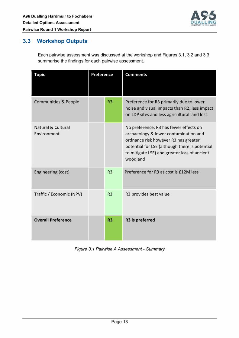
3.3 Workshop Outputs
Each pairwise assessment was discussed at the workshop and Figures 3.1, 3.2 and 3.3
summarise the findings for each pairwise assessment.
Topic Preference Comments
Communities & People
R3 Preference for R3 primarily due to lower
noise and visual impacts than R2, less impact
on LDP sites and less agricultural land lost
Natural & Cultural
Environment
No preference. R3 has fewer effects on
archaeology & lower contamination and
ordnance risk however R3 has greater
potential for LSE (although there is potential
to mitigate LSE) and greater loss of ancient
woodland
Engineering (cost)
R3 Preference for R3 as cost is £12M less
Traffic / Economic (NPV)
R3 R3 provides best value
Overall Preference
R3 R3 is preferred
Figure 3.1 Pairwise A Assessment - Summary

A96 Dualling Hardmuir to Fochabers
Detailed Options Assessment
Pairwise Round 1 Workshop Report
Page 14
Topic Preference Comments
Communities & People
No clear preference for people and property
(O3 is closer to Forres and follows the urban
edge)
Natural & Cultural
Environment
O3 Preference for O3 due to better landscape fit
of O3 and less geo-environmental and
hydrological risks associated with former
landfill
Engineering (cost)
O3 Preference for O3 as cost is £54M less
Traffic / Economic (NPV)
O3 O3 provides best value
Overall Preference
O3 O3 is preferred
Figure 3.2 Pairwise B Assessment - Summary

A96 Dualling Hardmuir to Fochabers
Detailed Options Assessment
Pairwise Round 1 Workshop Report
Page 15
Topic Preference Comments
Communities & People R8
Preference for R8 due to fewer effects on
NMUs and recreation than R9 and avoids
land take from residential property. R8 has
reduced materials requirement
Natural & Cultural
Environment
R8
Preference for R8 which has lower ecological
and landscape effects than R9. R9 has less
cultural heritage effect and lower
geomorphology risks than R8
Engineering (cost) R8
Preference for R8 as cost is £61M less
Traffic / Economic (NPV) R8
R8 provides best value
Overall Preference R8
R8 is preferred
Figure 3.3 Pairwise C Assessment - Summary
The output from the workshop was that Route elements R3, O3 and R8 were to be taken
forward to the next stage of assessment to identify the preferred option for the A96 Dualling
Hardmuir to Fochabers scheme. Route elements R2, O2, and R9 were removed from
further consideration.
A number of general comments were raised during the workshop following which
responses were drafted and captured as recorded below.
General Comments Raised
1. All the elements have been designed to standard. If value engineering was applied
throughout, would there still be clear preferences for the selected elements?
Response: Following the workshop an exercise to identify any areas where significant
cost savings could be gained through value engineering techniques was undertaken.
This established if there would be a significant change to the preference scoring for

A96 Dualling Hardmuir to Fochabers
Detailed Options Assessment
Pairwise Round 1 Workshop Report
Page 16
each pairwise comparison. The results of this exercise are reported in questions 5,6
and 8.
2. It was noted that the 2017 EIA Regulations potentially introduce new/amended topics
for environmental assessment.
Response: The current Stage 2 work is representative of the range of topics and key
environmental impacts to be considered for the options assessments. At Stage 3, which
involves the preferred option assessment, the structure of the EIA Report will reflect the
requirements of the Regulations and any guidance from Transport Scotland.
Pairwise A Comments Raised
3. It was noted that R3 comes close (approximately 100m) to the Darnaway and Leven
Forest SPA designation.
Response: This was acknowledged. MMS explained that the SPA extends over a
larger area approximately 10km to the south. The drawing included in Annex A of this
report has been revised since the workshop to indicate the extensive nature of this
designation which is a large area stretching further to the south of Forres.
4. Does the R3 route pass through lands owner by the caravan park at Mundole?
Response: The land labelled as caravan park / caravan site on the ordnance survey
mapping is part of Mundole Farm and not under the ownership or usage of the caravan
park. The drawing included in Annex A of this report has been updated to indicate the
extents of Riverview Caravan Park.
5. What areas of the designs could be subject to cost savings and would there be a
change in the workshop findings?
Response: Some savings could be gained through earthworks design however this
applies equally to both R2 and R3 and therefore there is no change to the clear
preference for the R3 element in this pairwise comparison.
Pairwise B Comments Raised
6. What areas of the designs could be subject to cost savings and would there be a
change in the workshop findings?
Response: On O2 the number of bridges east of the River Findhorn could be reduced
by providing a parallel road adjacent to the dual carriageway. However, the net cost
saving for this is considered to be relatively small and therefore the clear preference for
O3 in both engineering and overall terms is maintained.
Pairwise C Comments Raised
7. It was noted that both R8 and R9 pass through the Speyside Area of Great Landscape
Value (AGLV) designation.

A96 Dualling Hardmuir to Fochabers
Detailed Options Assessment
Pairwise Round 1 Workshop Report
Page 17
Response: Noted. The AGLV extends approximately 62km to the south (the report
drawing has been updated to better indicate that R8 and R9 are at the northern extent
of the AGLV).
8. What areas of the designs could be subject to cost savings and would there be a
change in the workshop findings?
Response: On R9 the deck width assumed for the Spey Crossing could be reduced in
width and whilst still achieving acceptable forward visibility around the parapet and
central safety barrier. This could save approximately £23M. No equivalent savings
were identified for R8. The cost differential between R8 and R9 when considered in
value engineering terms is therefore £38M. Given this difference both the engineering
and overall clear preferences for R8 is maintained.
A96 Dualling Hardmuir to Fochabers
Detailed Options Assessment
Pairwise Round 1 Workshop Report
Page 18
Appendix A
Workshop Presentation

12/01/2018
1
A96 DuallingHardmuir to Fochabers
DMRB Stage 2Pairwise Round 1 Workshop
12 January 2018
Background - Approach to Route Selection
use sub-criteriabased on scheme objectives toidentify poorer performingoptions
DMRB-based assessmentsfor engineering, environment,traffic & economics todetermine preferred option
Public Consultation on Shortlist of Options
Initial options assessment
Develop route options taking account of feedbackfrom 2015 exhibitions and 2016 consultations
Public consultation to present preferred option
Detailed options assessment
Develop options following public consultation
Early public consultation on options June 2017
Second half 2018

12/01/2018
2
Route Option Exhibitions
• Exhibitions held 19-22 June 2017
• Over 1,800 Attendees
• Approx 750 Responses0
100
200
300
400
500
600
700
ELGIN (1) ELGIN (2) FOCHABERS FORRES
610
347238
652
Route Options for Public Consultationshowing Pairwise Round 1 Locations
A
B
C
12/01/2018
3
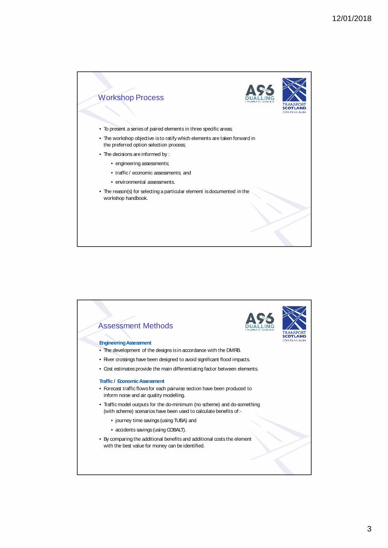
Workshop Process
• To present a series of paired elements in three specific areas;
• The workshop objective is to ratify which elements are taken forward inthe preferred option selection process;
• The decisions are informed by :
• engineering assessments;
• traffic / economic assessments; and
• environmental assessments.
• The reason(s) for selecting a particular element is documented in theworkshop handbook.
Assessment Methods
Engineering Assessment• The development of the designs is in accordance with the DMRB.
• River crossings have been designed to avoid significant flood impacts.
• Cost estimates provide the main differentiating factor between elements.
Traffic / Economic Assessment• Forecast traffic flows for each pairwise section have been produced to
inform noise and air quality modelling.
• Traffic model outputs for the do-minimum (no scheme) and do-something(with scheme) scenarios have been used to calculate benefits of:-
• journey time savings (using TUBA) and
• accidents savings (using COBALT).
• By comparing the additional benefits and additional costs the elementwith the best value for money can be identified.

12/01/2018
4
Environmental AssessmentAdapted from Environmental Impact Assessment (EIA)methodology, drawing on relevant guidance from DMRB Volume 11.
The assessment is structured according to the key environmenttopics drawn from DMRB which are reported in two groupings:
• Communities and People
• Natural and Cultural Heritage
The significance of an effect results from the interaction between its magnitude and thevalue of the resource or the number and sensitivity of those people who might be affected.Effects are categorised into:
– none or negligible: no detectable change to the environment– minor: a detectable but non-material change to the environment– moderate: a material and important but non-fundamental change to the environment– major: a fundamental change to the environment and a principal consideration
Effects categorised as being moderate or major are considered to be significant.
Assessment FrameworkThe engineering, environmental andtraffic/economic findings are drawn together into amulti-disciplinary framework for determining theoption to be taken forward for each pairwisecomparison. The following colour coding has beento indicate preferences for each paired element:
Clear preference
Slight preference
No preference
12/01/2018
5
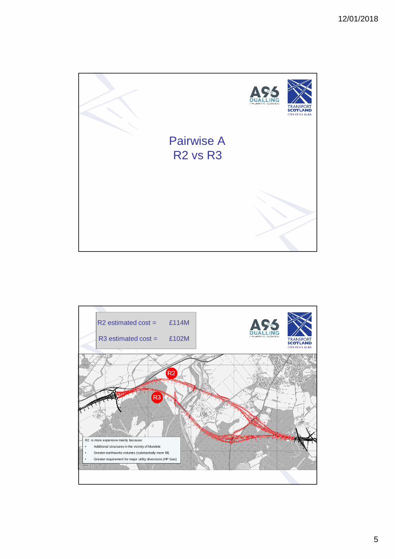
Pairwise AR2 vs R3
R2 estimated cost = £114M
R3 estimated cost = £102M
R2 is more expensive mainly because:
• Additional structures in the vicinity of Mundole
• Greater earthworks volumes (substantially more fill)
• Greater requirement for major utility diversions (HP Gas)

12/01/2018
6
Traffic Flows in 2030(AADT)
Do Min
R2
R3
16600
6400
6500
2300
1700
1700
18600
7900
8100
1400
2400
2500
R3
R2
N/A
18400
N/A
N/A
N/A
18200 N/A
19000
18900
N/A
2300
2400
Pairwise AEconomics
AdditionalCost (PVC)
AdditionalBenefit (PVB)
Best Value
R2 £6M
R3 £1M £7M

12/01/2018
7
Pairwise A
Typical landscape character of the Pairwise A study area
Pairwise A – Air Quality & Noise
Topic R2 R3 Preference
Air Quality
(OpeningYear)
• Approx 1800 receptors withminor beneficial change
• <100 receptors with minoradverse change
• Approx 1800 receptors withminor beneficial change
• <100 receptors with minoradverse change
Nopreference
Noise &Vibration
(OpeningYear)
• Approx 240 dwellings withsignificant adverse trafficnoise impacts
• <10 dwellings withsignificant beneficial trafficnoise impacts
• Approx 130 dwellings withsignificant adverse trafficnoise impacts
• <10 dwellings with significantbeneficial traffic noiseimpacts
R3

12/01/2018
8
Pairwise A – People & Communities
Topic R2 R3 Preference
People &Communities
• Reduced amenity on 13 NMUroutes, of which eight wouldhave increased journey length
• Alteration of route serving 10properties
• Loss of approx 17ha woodlandused by community & adverseeffect on local paths inFairyhills Wood
• Reduced amenity on 11 NMUroutes, of which seven wouldhave increased journey length
• Alteration of route to approx 90properties & minor land takefrom caravan park
• Loss of approx 29ha woodlandused by community
R2
Agriculture,Forestry &Sporting
• Loss of approx. 52haagricultural land of whichapprox. 41ha prime land
• Adverse effects on sixfarm/forest units, major effectat Mundole
• Loss of approx 26haagricultural land of whichapprox 22ha prime land
• Adverse effects on sixfarm/forest units, major effectat Mundole
R3
Pairwise A – Policy, Materials &Visual Effects
Topic R2 R3 Preference
Policies &Plans
• Land take from LDPallocation for housing &small business opportunitysite at Forres
• Slight land take from LDPdesignation for amenity site atMundole
R3
Materials • Materials required forpavement (4.6km mainline &1.2km side roads),earthworks (0.8Mm3) andstructures (deck area7,300m2)
• Materials required for roadpavement (4.6km mainline &0.4km side roads),earthworks (0.5Mm3) andstructures (deck area6,800m2)
R3
Visual • Significant adverse visualeffects on residentialreceptor groups at fourlocations and on four keyNMU routes
• Significant adverse visualeffects on residential receptorgroups at two locations andon three key NMU routes
R3

12/01/2018
9
Pairwise A – Communities &People: Summary
Topic Preference Reasons
Air Quality No significant effects
Traffic Noise R3 Clear difference in adverse traffic noise effects
People &Communities
R2 Smaller loss of woodland used for recreationand fewer property accesses affected
Agriculture R3 Lower loss of prime quality land
Policies & Plans R3 Less effect on designated development sites inMoray LDP
Materials R3 Less material requirement, particularlyearthworks
Visual R3 Visual effects more contained
Overall –Communities &People
R3 Clear preference for R3 which is situatedfurther from communities and people receptors
Pairwise A – Cultural Heritage,Landscape & Nature Conservation
Topic R2 R3 Preference
CulturalHeritage
• Predicted significant effectson Darnaway Castle GDLand two regionally significantarchaeological sites
• Predicted significant effecton Darnaway Castle GDL
R3
Landscape • Significant adverselandscape effects
• Significant adverselandscape effects
Nopreference
NatureConservation
• Loss of approx 17ha ancientwoodland and approx 4.5hanative woodland
• Disturbance to DarnawayForest SPA
• Loss of approx 27.5haancient woodland andapprox 1ha native woodland
R2

12/01/2018
10
Pairwise A – Geology & Water
Topic R2 R3 Preference
Geology,Soils,ContaminatedLand &Groundwater
• Potentially significantcontamination andunexploded ordnanceissues associated withformer Forres RAF base
• Significant effects onhydrogeology/watersupplies
• Potential contaminationassociated with formerForres RAF base
• Significant effects onhydrogeology/watersupplies
R3
RoadDrainage &WaterEnvironment
• No significant flood effect• Potential effect on river
geomorphology at Findhorncrossing
• No significant effects R3
Pairwise A – Natural & CulturalEnvironment: Summary
Topic Preference Reasons
Cultural Heritage R3 Less effect on regionally significant archaeology
Landscape Changes to spatial character, woodland loss andelevated structures
Nature Conservation R2 Less ancient woodland loss and more distantfrom Darnaway & Lethen Forest SPA withpotential to mitigate for LSE
Geology, Soils, CL &Groundwater
R3 Further from potential sources of contaminationand unexploded ordnance at former militaryairfield
RDWE R3 Lower risk of morphological effects at rivercrossing
Overall – Natural & CulturalEnvironment
On balance no preference - R3 has fewer effectson cultural heritage and contaminated land butR3 affects more ancient woodland and is closerto the SPA than R2
12/01/2018
11
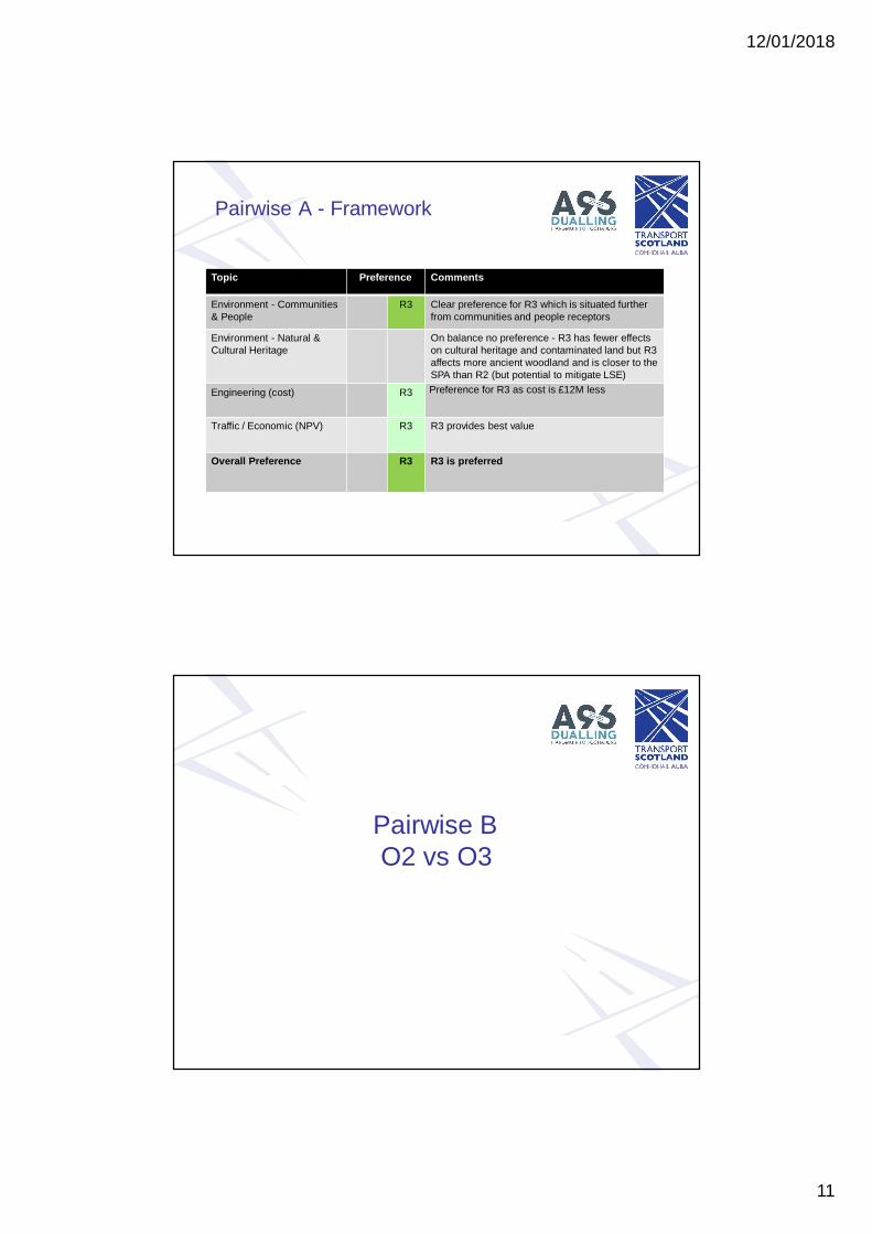
Pairwise A - Framework
Topic Preference Comments
Environment - Communities& People
R3 Clear preference for R3 which is situated furtherfrom communities and people receptors
Environment - Natural &Cultural Heritage
On balance no preference - R3 has fewer effectson cultural heritage and contaminated land but R3affects more ancient woodland and is closer to theSPA than R2 (but potential to mitigate LSE)
Engineering (cost) R3 Preference for R3 as cost is £12M less
Traffic / Economic (NPV) R3 R3 provides best value
Overall Preference R3 R3 is preferred
Pairwise BO2 vs O3

12/01/2018
12
O2 estimated cost = £171M
O3 estimated cost = £117M
O2 is significantly more expensive because:
• Longer River Findhorn Crossing (500m vs 425m)
• Three additional side road structures
• Substantially more earthworks
• Significantly more utility diversions (OHL & HP Gas)
17000
7400
7300
18600
8600
8500
17300
7800
7800
N/A
17600
N/A
N/A
N/A
17700
O3
O2
Pairwise BEconomics
AdditionalCost (PVC)
AdditionalBenefit (PVB)
Best Value
O2 £24M
O3 £4M £28M
Traffic Flows in 2030(AADT)
Do Min
O2
O3
12/01/2018
13
Pairwise B - Character
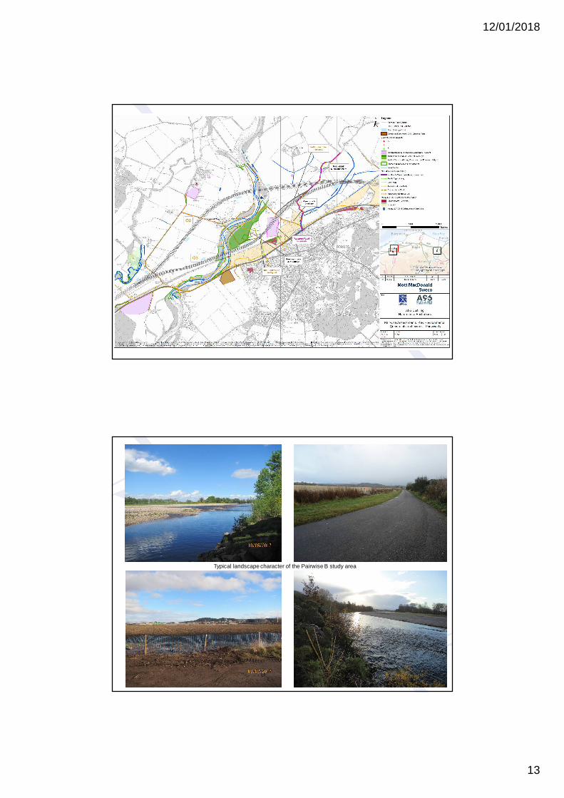
Typical landscape character of the Pairwise B study area
12/01/2018
14
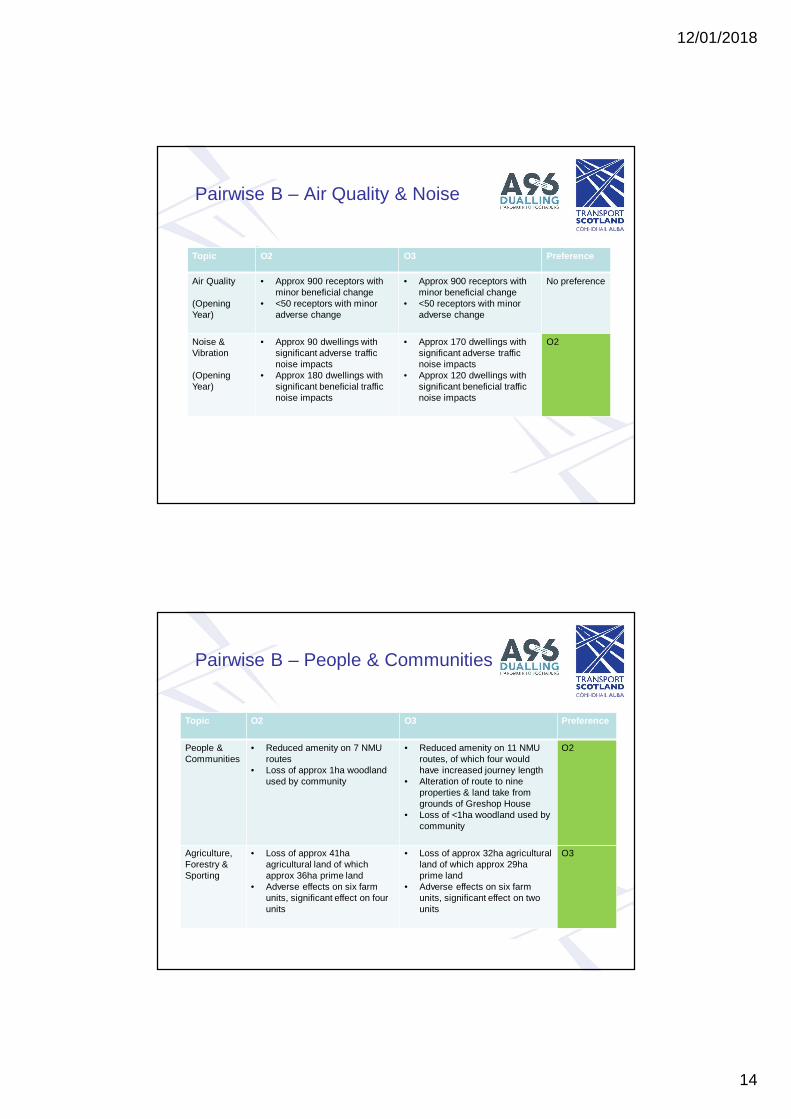
Pairwise B – Air Quality & Noise
Topic O2 O3 Preference
Air Quality
(OpeningYear)
• Approx 900 receptors withminor beneficial change
• <50 receptors with minoradverse change
• Approx 900 receptors withminor beneficial change
• <50 receptors with minoradverse change
No preference
Noise &Vibration
(OpeningYear)
• Approx 90 dwellings withsignificant adverse trafficnoise impacts
• Approx 180 dwellings withsignificant beneficial trafficnoise impacts
• Approx 170 dwellings withsignificant adverse trafficnoise impacts
• Approx 120 dwellings withsignificant beneficial trafficnoise impacts
O2
Pairwise B – People & Communities
Topic O2 O3 Preference
People &Communities
• Reduced amenity on 7 NMUroutes
• Loss of approx 1ha woodlandused by community
• Reduced amenity on 11 NMUroutes, of which four wouldhave increased journey length
• Alteration of route to nineproperties & land take fromgrounds of Greshop House
• Loss of <1ha woodland used bycommunity
O2
Agriculture,Forestry &Sporting
• Loss of approx 41haagricultural land of whichapprox 36ha prime land
• Adverse effects on six farmunits, significant effect on fourunits
• Loss of approx 32ha agriculturalland of which approx 29haprime land
• Adverse effects on six farmunits, significant effect on twounits
O3

12/01/2018
15
Pairwise B – Policy, Materials &Visual Effects
Topic O2 O3 Preference
Policies &Plans
• Potential for conflict with12 LDP policies
• Potential for conflict with 13LDP policies
No preference
Materials • Materials required for roadpavement (4.7kmmainline), earthworks(1.3Mm3) and structures(deck area 13,400m2)
• Materials required for roadpavement (4.6km mainline& 0.8km side roads),earthworks (0.9Mm3) andstructures (deck area10,400m2)
O3
Visual Effects • Significant adverse visualeffects on residentialreceptor groups at 12locations and on four keyNMU routes
• Significant adverse visualeffects on residentialreceptor groups at 12locations and on three keyNMU routes
• Closer to existing urbanedge and transport corridor
O3
Pairwise B – Communities &People: Summary
Topic Preference Reasons
Air Quality No significant effects
Traffic Noise O2 Clear difference in adverse traffic noise effects
People &Communities
O2 Fewer effects on private properties and theirmeans of access
Agriculture O3 Less prime quality land affected and fewereffects on farm units
Policies & Plans No significant effects
Materials O3 Lower material requirement, particularly forearthworks
Visual Effects O3 Less extensive effects on visual receptors
Overall –Communities &People
On balance no preference - O2 is further fromconcentrations of people and property but hasgreater effects on agriculture, materials andvisual receptors than O3

12/01/2018
16
Pairwise B – Cultural Heritage,Landscape & Nature Conservation
Topic O2 O3 Preference
CulturalHeritage
· No significant effects · Significant effect on setting ofcategory B listed GreshopHouse & loss of one regionallysignificant archaeological site
O2
Landscape • Significant adverselandscape effects
• Vertical scale contrastsstrongly with flat landscape
• Significant adverse landscapeeffects
• In proximity to northern edge ofForres
O3
NatureConservation
• Avoids direct loss ofdesignated woodland
• Loss of 0.1ha ancient woodlandand 0.5ha native woodland
Nopreference
Pairwise B – Geology & Water
Topic O2 O3 Preference
Geology, Soils,ContaminatedLand &Groundwater
• Potential contaminationassociated with formerlandfill
• Effects on hydrogeology andwater supplies, includingwells at Broom of Moy
• Effects on hydrogeologyand water supplies,including at BenromachDistillery
O3
Road Drainage& WaterEnvironment
• No significant flood effect• Potential effect on river
geomorphology at RiverFindhorn crossing
• No significant effects O3

12/01/2018
17
Pairwise B – Natural & CulturalEnvironment: Summary
Topic Preference Reasons
Cultural Heritage O2 Avoids significant setting effects on GreshopHouse
Landscape O3 Closer in character to urban edge of Forres
Nature Conservation No significant difference in effects
Geology, Soils, CL &Groundwater
O3 Further from potential sources of contaminationat former landfill site on Waterford Road
RDWE O3 Lower risk of morphological effects at rivercrossing
Overall – Natural & CulturalEnvironment
O3 On balance preference for O3 due to fewereffects on landscape and lower environmentalrisk
Pairwise B - Framework
Topic Preference Comments
Environment -Communities & People
On balance no preference - O2 is further fromconcentrations of people and property but hasgreater effects on agriculture, materials andvisual receptors than O3
Environment - Natural &Cultural Heritage
O3 On balance preference for O3 due to fewereffects on landscape and lower environmentalrisk
Engineering (cost) O3 Preference for O3 as cost is £54M less
Traffic / Economic (NPV) O3 O3 provides best value
Overall Preference O3 O3 is preferred

12/01/2018
18
Pairwise CR8 vs R9
R8 estimated cost = £109M
R9 estimated cost = £170M
R9 is more expensive mainly because:
• Spey Crossing has greater deck area
• One extra large structure at Ordiequish
• More earthworks

12/01/2018
19
R9
R8
18000
4500
5900
17800
4300
5700
10600
7700
6400
N/A
2400
2400
N/A
N/A
17900
N/A
19400
N/A
Pairwise CEconomics
AdditionalCost (PVC)
AdditionalBenefit (PVB)
Best Value
R8 £17M £48M
R9 £31M
Traffic Flows in 2030(AADT)
Do Min
R8
R9
12/01/2018
20
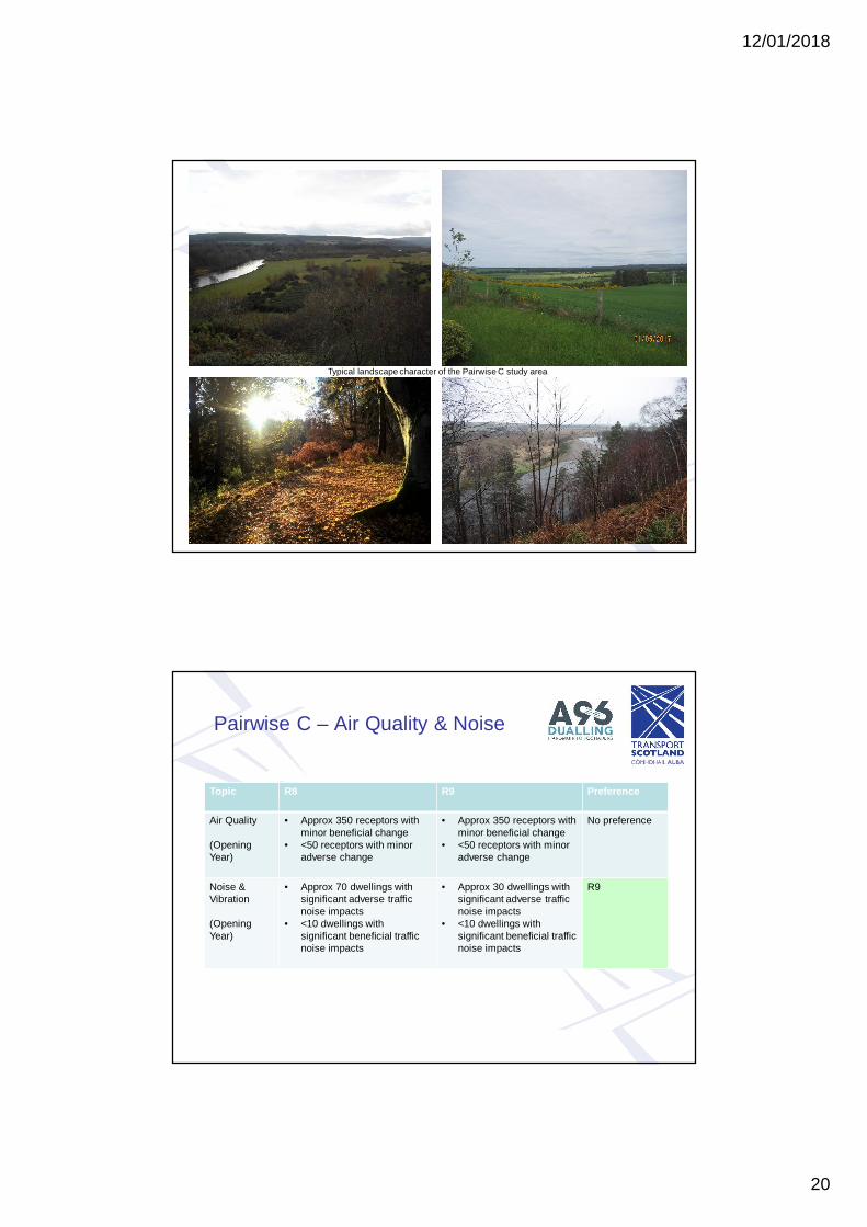
Pairwise C - Character
Typical landscape character of the Pairwise C study area
Pairwise C – Air Quality & Noise
Topic R8 R9 Preference
Air Quality
(OpeningYear)
• Approx 350 receptors withminor beneficial change
• <50 receptors with minoradverse change
• Approx 350 receptors withminor beneficial change
• <50 receptors with minoradverse change
No preference
Noise &Vibration
(OpeningYear)
• Approx 70 dwellings withsignificant adverse trafficnoise impacts
• <10 dwellings withsignificant beneficial trafficnoise impacts
• Approx 30 dwellings withsignificant adverse trafficnoise impacts
• <10 dwellings withsignificant beneficial trafficnoise impacts
R9
12/01/2018
21
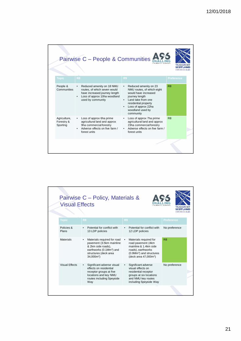
Pairwise C – People & Communities
Topic R8 R9 Preference
People &Communities
• Reduced amenity on 18 NMUroutes, of which seven wouldhave increased journey length
• Loss of approx 10ha woodlandused by community
• Reduced amenity on 23NMU routes, of which eightwould have increasedjourney length
• Land take from oneresidential property
• Loss of approx 22hawoodland used bycommunity
R8
Agriculture,Forestry &Sporting
• Loss of approx 6ha primeagricultural land and approx9ha commercial forestry
• Adverse effects on five farm /forest units
• Loss of approx 7ha primeagricultural land and approx23ha commercial forestry
• Adverse effects on five farm /forest units
R8
Pairwise C – Policy, Materials &Visual Effects
Topic R8 R9 Preference
Policies &Plans
• Potential for conflict with13 LDP policies
• Potential for conflict with12 LDP policies
No preference
Materials • Materials required for roadpavement (3.5km mainline& 2km side roads),earthworks (0.1Mm3) andstructures (deck area34,000m2)
• Materials required forroad pavement (4kmmainline & 1.4km sideroads), earthworks(0.9Mm3) and structures(deck area 47,000m2)
R8
Visual Effects • Significant adverse visualeffects on residentialreceptor groups at fivelocations and key NMUroutes including SpeysideWay
• Significant adversevisual effects onresidential receptorgroups at six locationsand NMU key routesincluding Speyside Way
No preference

12/01/2018
22
Pairwise C: Communities & People:Summary
Topic Preference Reasons
Air Quality No significant effects
Traffic Noise R9 Difference in adverse traffic noise effects
People &Communities
R8 Fewer effects on private property and woodlandused by community
Agriculture R8 Lower loss of commercial forestry
Policies & Plans No significant effects
Materials R8 Lower material requirement, particularlyearthworks
Visual Effects
Overall –Communities &People
R8 Fewer direct effects on private properties,commercial and recreational woodland, andless material intensive
Pairwise C – Cultural Heritage,Landscape & Nature Conservation
Topic R8 R9 Preference
CulturalHeritage
• Adverse effect on setting oflisted Dipple Burial Ground
• No significant effectspredicted
R9
Landscape • Significant adverselandscape effects
• Direct effect on northernedge of Speyside AGLV
• Significant adverselandscape effects
• Greater intrusion into AGLVand more significant cuttingthan for R8
R8
NatureConservation
• Disturbance to River SpeySAC and SSSI
• Loss of 7ha ancientwoodland and 1ha nativewoodland
• Disturbance to River SpeySAC and SSSI
• Loss of 21ha ancientwoodland
R8

12/01/2018
23
Pairwise C – Geology & Water
Topic R8 R9 Preference
Geology,Soils,ContaminatedLand &Groundwater
• Effects on hydrogeology andprivate water supplies,including Spey AbstractionScheme
• Effects on hydrogeologyand private water supplies,including Spey AbstractionScheme
Nopreference
RoadDrainage &WaterEnvironment
• No significant flood effect• Potential effect on river
geomorphology at Speycrossing
• No significant flood effect R9
Pairwise C – Natural & CulturalEnvironment: Summary
Topic Preference Reasons
Cultural Heritage R9 Avoids significant setting effects on Dipple BurialGround
Landscape R8 Avoids very extensive cut in hillside east of Speyand less intrusion to AGLV
Nature Conservation R8 Lesser effect on ancient woodland. Potential tomitigate for LSE on Spey SAC for both options
Geology, Soils, CL &Groundwater
Complex/extensive mitigation of DippleAbstraction Scheme for R8 and R9
RDWE R9 Lower risk of geomorphological effects at rivercrossing
Overall – Natural & CulturalEnvironment
R8 R8 has lower ecological and landscape effectsbut R9 has less cultural heritage effect andlower geomorphology and hydrogeology risks

12/01/2018
24
Pairwise C - Framework
Topic Preference Comments
Environment -Communities & People
R8 Fewer direct effects on private property,commercial and recreational woodland, and lessmaterial intensive
Environment - Natural &Cultural Heritage
R8 R8 has lower ecological and landscape effectsbut R9 has less cultural heritage effect andlower geomorphology risks
Engineering (cost) R8 Preference for R8 as cost is £61M less
Traffic / Economic (NPV) R8 R8 provides best value
Overall Preference R8 R8 is preferred


