A Partnership in Building Resilience: NIDIS and RISAs
Veva Deheza Deputy Director The National Integrated Drought Information System NOAA Boulder, CO
February 25, 2016 Tucson, AZ

The creation of NIDIS began with a partnership

“Today, I signed the National Integrated Drought
Information System Reauthorization Act into law……to help
communities better prepare for droughts…, and prevent the worst impacts on families
and businesses”
March 6, 2014. President Obama
“develop and expand the Regional Drought Early Warning Information Systems” May, 2014
NIDIS 2014: Public Law 113-86
Interdisciplinary research,
applications, and
assessments
Monitoring &
Prediction
Communication and
Outreach
Integrated Information Systems:
Preparedness and Resilience
Engaging Preparedness &
Adaptation Communities
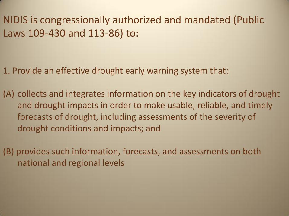
NIDIS is congressionally authorized and mandated (Public Laws 109-430 and 113-86) to: 1. Provide an effective drought early warning system that: (A) collects and integrates information on the key indicators of drought
and drought impacts in order to make usable, reliable, and timely forecasts of drought, including assessments of the severity of drought conditions and impacts; and
(B) provides such information, forecasts, and assessments on both national and regional levels
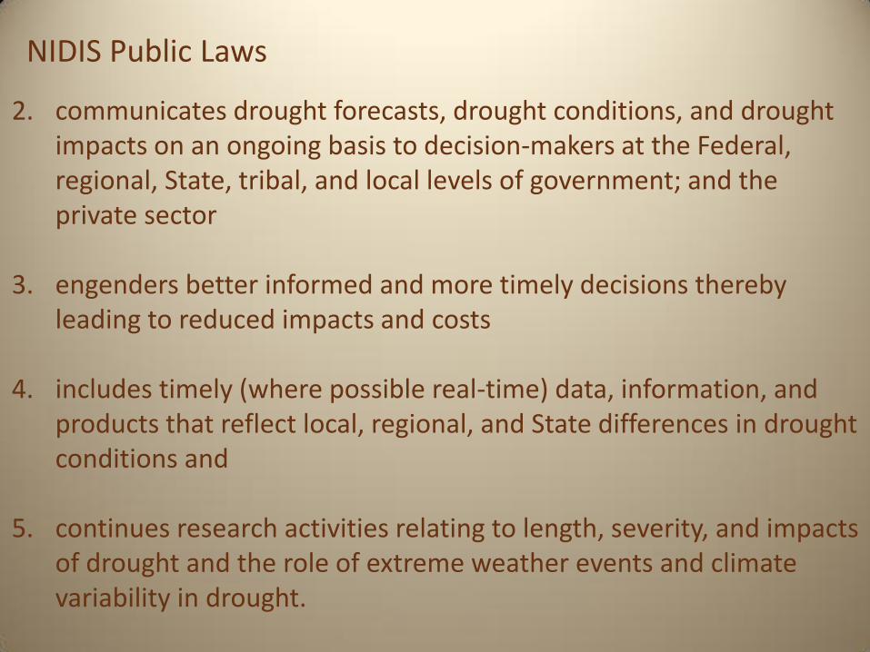
2. communicates drought forecasts, drought conditions, and drought impacts on an ongoing basis to decision-makers at the Federal, regional, State, tribal, and local levels of government; and the private sector
3. engenders better informed and more timely decisions thereby leading to reduced impacts and costs
4. includes timely (where possible real-time) data, information, and products that reflect local, regional, and State differences in drought conditions and
5. continues research activities relating to length, severity, and impacts
of drought and the role of extreme weather events and climate variability in drought.
NIDIS Public Laws

Provision of timely and effective information, through
identified institutions, that allows individuals exposed to a hazard to take action to avoid or reduce their risk and prepare
for effective response1
What really is Drought Early Warning?
1International Strategy for Disaster Reduction

What is a NIDIS Drought Early Warning System?
A DEWS utilizes new and existing partner networks to optimize the expertise of a wide range of federal, tribal, state, local and academic partners in order to make climate and drought science and impact data readily available, easily understandable and usable for decision makers; and to improve the capacity of stakeholders and economic sectors to better monitor, forecast, plan for and cope with the impacts of drought at all spatial and time scales.
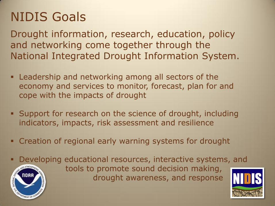
Drought information, research, education, policy and networking come together through the National Integrated Drought Information System. Leadership and networking among all sectors of the
economy and services to monitor, forecast, plan for and cope with the impacts of drought
Support for research on the science of drought, including indicators, impacts, risk assessment and resilience
Creation of regional early warning systems for drought
Developing educational resources, interactive systems, and tools to promote sound decision making, drought awareness, and response
NIDIS Goals
NIDIS 2.0

10 10
• Develop and coordinate partnerships:
networks of practitioners public-private: map decision-making arrangements
• Advance earth system observations and
prediction capabilities • Construct risk profiles: the role of rates of
change in trends, frequency, and magnitude of
extremes at different scales
• Capacity and Coordination: Integrate
Research, Observations, and Assessments into
early warning information on critical transitions
and capacity for response • Overcoming impediments
- Do this for a long time
From Risk to Resilience:
Research-based Integrated Information Systems
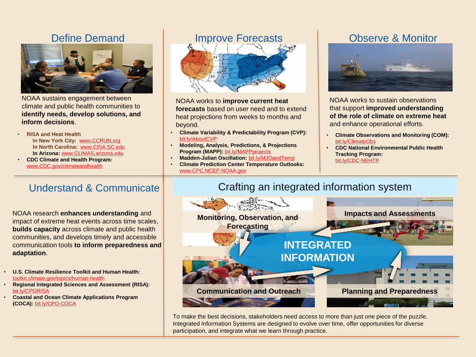
NOAA sustains engagement between
climate and public health communities to
identify needs, develop solutions, and
inform decisions.
Define Demand
• RISA and Heat Health
In New York City: www.CCRUN.org
In North Carolina: www.CISA.SC.edu
In Arizona: www.CLIMAS.arizona.edu
• CDC Climate and Health Program:
www.CDC.gov/climateandhealth
Crafting an integrated information system
Monitoring, Observation, and
Forecasting
INTEGRATED
INFORMATION
Impacts and Assessments
Planning and Preparedness
Improve Forecasts
NOAA works to improve current heat
forecasts based on user need and to extend
heat projections from weeks to months and
beyond. • Climate Variability & Predictability Program (CVP):
bit.ly/AboutCVP
• Modeling, Analysis, Predictions, & Projections
Program (MAPP): bit.ly/MAPPprojects
• Madden-Julian Oscillation: bit.ly/MJOandTemp
• Climate Prediction Center Temperature Outlooks:
www.CPC.NCEP.NOAA.gov
NOAA works to sustain observations
that support improved understanding
of the role of climate on extreme heat
and enhance operational efforts.
Observe & Monitor
• Climate Observations and Monitoring (COM):
bit.ly/ClimateObs
• CDC National Environmental Public Health
Tracking Program:
bit.ly/CDC-NEHTP
Understand & Communicate
• U.S. Climate Resilience Toolkit and Human Health:
toolkit.climate.gov/topics/human-health
• Regional Integrated Sciences and Assessment (RISA):
bit.ly/CPORISA
• Coastal and Ocean Climate Applications Program
(COCA): bit.ly/CPO-COCA
NOAA research enhances understanding and
impact of extreme heat events across time scales,
builds capacity across climate and public health
communities, and develops timely and accessible
communication tools to inform preparedness and
adaptation.
To make the best decisions, stakeholders need access to more than just one piece of the puzzle.
Integrated Information Systems are designed to evolve over time, offer opportunities for diverse
participation, and integrate what we learn through practice.
Communication and Outreach
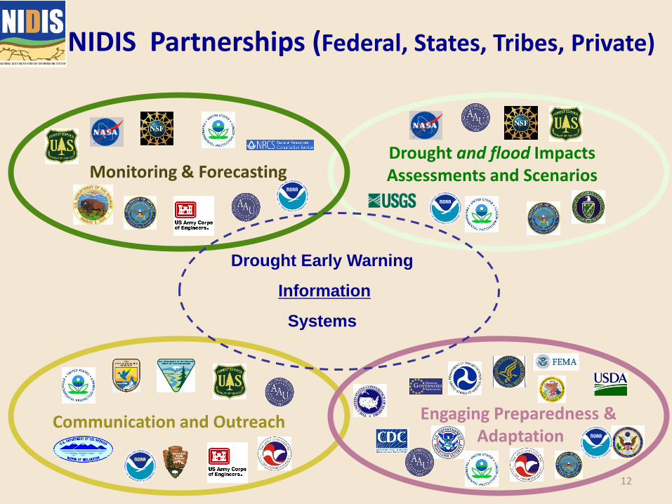
NIDIS Partnerships (Federal, States, Tribes, Private)
Monitoring & Forecasting Drought and flood Impacts Assessments and Scenarios
Communication and Outreach Engaging Preparedness & Adaptation
Drought Early Warning
Information
Systems
12
13
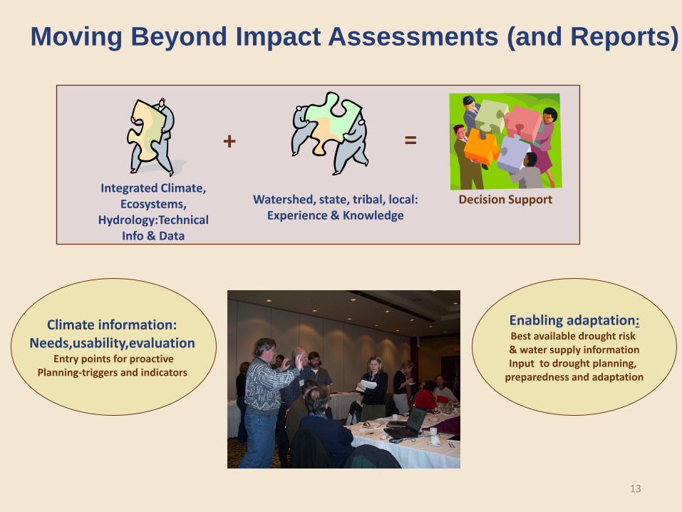
Moving Beyond Impact Assessments (and Reports)
Climate information: Needs,usability,evaluation
Entry points for proactive Planning-triggers and indicators
Enabling adaptation: Best available drought risk & water supply information Input to drought planning,
preparedness and adaptation
+ =
Decision Support Integrated Climate,
Ecosystems, Hydrology:Technical
Info & Data
Watershed, state, tribal, local: Experience & Knowledge

14
Applications Research Analogs/
Predictions
Monitoring
Integrating Tools-scenarios Information Portals
Coordinate existing national, state, and local climate-related data and information support activities (e.g., within watersheds and states)
Identifying and transferring indicators, decision support tools and innovative local strategies for risk assessment, communication and preparedness
Impact Mitigation
Proactive Planning
Improved Adaptation
NIDIS REGIONAL INFORMATION MANAGEMENT MODEL

Regional Drought Early Warning Systems
(DEWS)
Working with communities and existing
networks to build capacity for better
decision making for drought planning
and mitigation.
Drought assessments
Climate outlook forums
Education and outreach webinars – risk management
Engaging the preparedness community
Builds capacity to utilize existing products
Regional Drought Early
Warning System
Monitoring/ Forecasts
Research & Applications
Education/ Communication
US Drought Portal
Engaging Preparedness
Comm.


Public Awareness And Education
Engaging Preparedness Communities
Integrated Monitoring and
Forecasting
Interdisciplinary Needs Assess.,
Research, Applications
U.S. Drought Portal
NIDIS
Implementation Over 50 Federal, state,
tribal and private
sector representatives
nationally
Regional Integrated Sciences
and Assessments
Regional Climate Centers
NCAR
NCDC
NDMC-NOAA,USGS, USDA,
USBoR
State Climatologists, NWS-
CSD
USDA Extension
NDMC
State and Tribal Offices,
RISAs
US BoR, USACE, Counties
NRCS, USGS
River Forecast Center, BoR
Climate Prediction Center
USDA NIDIS Technical Working Groups
Regional Drought
Early
Warning Systems

Upper Colorado River Basin
Snowpack monitoring workshops in CO, UT and WY Monthly/biweekly webinars Capacity development on the Wind River Reservation to
support drought planning decision support tools
Four Corners/Tribal Lands Effort to increase monitoring capacity using CoCoRaHS by
USDA, NWS and Colorado Climate Center University of Arizona (supported by NOAA SARP/NIDIS) is
working with Hopi Dept. of Natural Resources to develop a drought status-monitoring program
California Drought/ENSO outlooks and outreach Sub-regional focus on research and activities
Examples of DEWS Activities

Southern Plains
Texas and Oklahoma Inter-agency Climate Extremes Workshop San Antonio Multi-Hazard Tournament
Apalachicola-Chattahoochi-Flint (ACF) Basin
Series of sub-regional workshops and one basin-wide workshop Monthly webinar series
Coastal Carolinas
CoCoRaHS Citizen Science Conditions Monitoring project Coastal Drought Index
Missouri River Basin Tribal capacity building for drought plans, vulnerability assessment, leveraging federal resources Monthly webinar series
Examples of DEWS Activities

Year 1: Scoping the Drought Early Warning Information System Gap analyses: What information exists and how is it being coordinated and used? Characterize and communicate risks across timescales-with existing information for 2-3 critical issues
Year 2. Implementation of the Drought Early Warning System (seasonal, multi-year, longer term trends): Develop drought sub-portals Embed information into preparedness and adaptation plans Establish network for ongoing briefings on impacts and projections across climate timescales
Develop subteams to assess (1) Monitoring and forecasting; (2) Impact indicators and triggers (3) Preparedness and education: Assemble drought-sensitive planning indicators and management triggers database; Assess present drought information coordination partnerships and processes Identify Federal and state-level partnerships, decision support tools and actions needed (to improve information development, coordination and flow for preparedness and risk reduction)
Develop an operational plan for designing and implementing an EWS process
Initiate development of a region or basin specific Drought Information Monitor and Portal (as a subset of the U.S. Drought Portal) Develop decision support tools for demand projections and revise triggering criteria Prototyping: Given better data and information coordination would responses have been improved for past events? Assess (1) value of improved information using past conditions, (2) responses for projections/ scenarios (decadal, climate change), (3) feedback on priorities (e.g. data gaps) to Executive Council. Feedback into regional Drought Monitor and Portal. Early Warning System maintenance (Fed-state-tribal) and transfer to other sub-basins

RISAs support research teams that help expand and build the nation's capacity to prepare for and adapt to climate variability and change. Central to the RISA approach are commitments to process, partnership, and trust building. RISA teams work with public and private user communities to: ● advance understanding of context and risk; ● support knowledge to action networks; ● innovate services, products and tools to enhance the use of science in decision making; and ● advance science policy
RISA

adviser, expert, specialist, authority

Climate impacts training;
Climate outlooks and outlook fora; Climate extension; Communication tools (visualization, white papers, report,
etc.); and Decision support tools and information systems for drought,
climate, water supply and availability, agriculture and other impacts.
Innovating and Developing Services
25


