Download - 11 ESIA Report (Mar. 11, 2020)

Prepared by
CEMMATS Group Ltd
Freetown, Sierra Leone
on behalf of:
SIERRA TROPICAL LIMITED (STL)
June 2018
ENVIRONMENTAL AND SOCIAL IMPACT ASSESSMENT STUDY
FOR CT IN LUGBU CHIEFDOM BO
DISTRICT
ESIA VOLUME 1: EXECUTIVE SUMMARY & MAIN
REPORT

Environmental and Social Impact Assessment (ESIA) for the Sierra Tropical Ltd Agricultural Project Volume 1: Executive Summary and Main Report
ii © CEMMATS Group Ltd, October 2016
DOCUMENT HISTORY
Version History Date Reviewer
Title Environmental and Social Impact Assessment for the Sierra Tropical Ltd Agricultural Project Volume 1: Executive Summary and Main Report
Authors Anthony Mansaray; Arnold Okoni-Williams; Bartholomew Bockarie; Joe Lappia; Leonard B. Buckle; Ralph Bona; Rashidu Sinnah; Vanessa James
Date Written September 2016; updated June 2018
Subject Environmental and Social Impact Assessment
Publisher CEMMATS Group Ltd
Type Client Report
Description ESIA for the Sierra Tropical Ltd
Contributors Joseph Gbassa; Josephine Turay; Mariama Jalloh
Format
Source Text
Rights © CEMMATS Group Ltd
Identifier
Language English
Relation

Environmental and Social Impact Assessment (ESIA) for the Sierra Tropical Ltd Agricultural Project Volume 1: Executive Summary and Main Report
iii © CEMMATS Group Ltd, October 2016
CEMMATS Group Ltd (hereafter, 'CEMMATS') has prepared this Environmental and Social Impact Assessment (ESIA) Report for the sole use of the Client and for the intended purposes as stated in the Contract between the Client and CEMMATS under which this work was completed. This ESIA Report may not be relied upon by any other party without the express written agreement of CEMMATS and/or the Client.
CEMMATS has exercised due and customary care in conducting this ESIA but has not, save as specifically stated, independently verified information provided by others. No other warranty, expressed or implied is made in relation to the conduct of the ESIAS or the contents of this Report. Therefore, CEMMATS assumes no liability for any loss resulting from errors, omissions or misrepresentations made by others. This Report has been prepared at the request of the Client. The use of this Report by unauthorised third parties without written authorisation from CEMMATS shall be at their own risk, and CEMMATS accepts no duty of care to any such third party.
Any recommendations, opinions or findings stated in this Report are based on circumstances and facts as they existed at the time CEMMATS performed the work. Any changes in such circumstances and facts upon which this Report is based may adversely affect any recommendations, opinions or findings contained in this Report.
No part of this Report may be copied or duplicated without the express written permission of the Client and/or CEMMATS. Where field investigations have been carried out, these have been restricted to a level of detail required to achieve the stated objectives of the work referred to in the Contract. This work has been undertaken in accordance with CEMMATS' Quality System.
Signed by:
Andrew Keili CEMMATS Group Ltd Beyoh House 7A Cantonment Road Off King Harman Road Brookfields Freetown Sierra Leone Email: [email protected] Tel: +232 76602174 Website: www.cemmatssl.com

Environmental and Social Impact Assessment (ESIA) for the Sierra Tropical Ltd Agricultural Project Volume 1: Executive Summary and Main Report
iv © CEMMATS Group Ltd, October 2016
ACKNOWLEDGEMENTS We wish to extend our appreciation to various government of Sierra Leone (GOSL) ministries, departments, agencies, institutions, statutory bodies, organisations and individuals whose assistance, either directly or indirectly, made the Environmental and Social Impact Assessment (ESIA) study possible. We are particularly grateful to the assistance availed to us by the Environment Protection Agency Sierra Leone (EPA-SL), especially for providing us with useful take off guidance to carry out the ESIA study.
We acknowledge the assistance and cooperation of Sierra Tropical Limited, who availed us relevant documents and information, to successfully carry out this study.
We are thankful to the local authorities and members of the various communities visited in the Lugbu Chiefdom for their diverse assistance during the main field visit.
Last but not least, we would like to thank all those who, in one way or another contributed to making this ESIA study successful.

Environmental and Social Impact Assessment (ESIA) for the Sierra Tropical Ltd Agricultural Project Volume 1: Executive Summary and Main Report
v © CEMMATS Group Ltd, October 2016
TABLE OF CONTENTS
DOCUMENT HISTORY ........................................................................................................ iiACKNOWLEDGEMENTS ................................................................................................... ivTABLE OF CONTENTS ........................................................................................................ vLIST OF FIGURES ................................................................................................................ ixLIST OF TABLES ................................................................................................................... xLIST OF ACRONYMS ......................................................................................................... xiiGLOSSARY........................................................................................................................... xivEXECUTIVE SUMMARY ..................................................................................................... 161 INTRODUCTION ............................................................................................................ 40
1.1 Project Background ................................................................................................... 401.2 National Perspective .................................................................................................. 401.3 Project Area ............................................................................................................... 41
1.3.1 Brief History of Lugbu Chiefdom...................................................................... 42
1.4 Environmental and Social Impact Assessment Process ............................................ 42
1.4.1 Stages of the ESIA Process ................................................................................ 421.4.2 Purpose of the ESIA Study ................................................................................ 421.4.3 Objectives of the ESIA Study ............................................................................ 431.4.4 ESIA Consultants and Teams ............................................................................ 43
1.5 Description of the Terms of Reference (TOR).......................................................... 441.6 Scope of Work ........................................................................................................... 521.7 Assumptions and Limitations of Study ..................................................................... 521.8 ESIA Study Boundaries ............................................................................................ 521.9 Organisation of the ESIA Report(s) .......................................................................... 53
1.9.1 The ESIA Report................................................................................................ 531.9.2 Management Plans featured in the ESMP ......................................................... 54
2 PROJECT DESCRIPTION .............................................................................................. 56
2.1 Specific Project Components .................................................................................... 61
2.1.1 Phase 1 ............................................................................................................... 612.1.2 Phases 2 and 3 .................................................................................................... 76
2.2 Timescale of Operations............................................................................................ 78
3 ANALYSES OF PROJECT ALTERNATIVES .............................................................. 79
3.1 ........................................................................................... 793.2 The Project Site ......................................................................................................... 803.3 Project Technology & Operations Option ................................................................. 80
4 POLICY, LEGAL, REGULATORY and INSTITUTONAL CONTEXT ....................... 81

Environmental and Social Impact Assessment (ESIA) for the Sierra Tropical Ltd Agricultural Project: Executive Summary and Main Report
vi
© CEMMATS Group Ltd, October 2016
4.1 Policies and Plans ...................................................................................................... 81
4.1.1 National Environmental Policy, 1994 ................................................................ 814.1.2 Agricultural Policy ............................................................................................. 824.1.3 Draft National Lands Policy, 2015 .................................................................... 824.1.4 Forestry Policy, 2010 ......................................................................................... 834.1.5 Conservation and Wildlife Policy, 2010 ............................................................ 844.1.6 Disaster Management Preparedness Plan, 2006 ................................................ 84
4.2 Legislation ................................................................................................................. 85
4.2.1 Environment Protection Agency Act, 2008/2010 .............................................. 854.2.2 The Forestry Act, 1988 ...................................................................................... 864.2.3 Land Tenure and Ownership .............................................................................. 864.2.4 Fisheries Act, 2007 ............................................................................................ 874.2.5 Wildlife Conservation Amendment Act, 1990 .................................................. 874.2.6 Factories Act 1974 .......................................................................................... 874.2.7 Local Government Act, 2004 ............................................................................. 90
4.3 Regulations ................................................................................................................ 91
4.3.1 Forestry Regulations, 1990 ................................................................................ 914.3.2 Fisheries Regulations ......................................................................................... 914.3.3 Draft Wildlife Regulation, 1997 ........................................................................ 92
4.4 Institutional Context .................................................................................................. 92
4.4.1 Ministry of Water Resources ............................................................................. 924.4.2 Ministry of Fisheries and Marine Resources ..................................................... 924.4.3 Ministry of Agriculture, Forestry and Food Security ........................................ 934.4.4 Ministry of Lands, Country Planning and the Environment .............................. 934.4.5 EPA-SL .............................................................................................................. 93
4.5 International Conventions Policies, Codes, Protocols and Guidelines ..................... 94
4.5.1 International Conventions .................................................................................. 944.5.2 International Lending Institutions Policies, Standards and Guidelines ............. 98
5 BASELINE SURVEY AND CONDITION ................................................................... 100
5.1 Physical Environment ............................................................................................. 102
5.1.1 Climate ............................................................................................................. 1025.1.2 Air Quality and Dust ........................................................................................ 1065.1.3 Noise ................................................................................................................ 1085.1.4 Geology ............................................................................................................ 1095.1.5 Landform.......................................................................................................... 1105.1.6 Soils.................................................................................................................. 1105.1.7 Hydrology ........................................................................................................ 118
5.2 Biological environment ........................................................................................... 141

Environmental and Social Impact Assessment (ESIA) for the Sierra Tropical Ltd Agricultural Project: Executive Summary and Main Report
vii
© CEMMATS Group Ltd, October 2016
5.2.1 Ecology ............................................................................................................ 1415.2.2 Creation of Buffer Zones ................................................................................. 1515.2.3 High Conservation Value Assessment ............................................................. 154
6 DESCRIPTION OF THE SOCIAL ENVIRONMENT .................................................. 156
6.1 Introduction ............................................................................................................. 156
6.1.1 National Socio-Political Context ..................................................................... 1566.1.2 Local Governance Structure ............................................................................ 1586.1.3 Local Regional Socio-Economic Context ........................................................ 1586.1.4 Socio-Economic Condition of Project Area (Lugbu Chiefdom) ..................... 163
6.2 Socio-economic Status and Living Conditions ....................................................... 164
6.2.1 Methodology Used for Socio-Economic Baseline Survey .............................. 164
6.3 Results of Questionnaires administered to Landholders ......................................... 167
6.3.1 Status of Respondents ...................................................................................... 1676.3.2 Gender of Landholder ...................................................................................... 1686.3.3 Marital Status of Landholder ........................................................................... 1696.3.4 Number of households living in a dwelling unit .............................................. 1706.3.5 Educational Level of Landholders ................................................................... 1706.3.6 Size o ............................................................................... 1716.3.7 Availability of Sufficient Land for food production ........................................ 1726.3.8 Income from Land Cultivation......................................................................... 1726.3.9 Proportion of upland to be leased to Sierra Tropical ....................................... 1736.3.10 1736.3.11 Preferred Land Lease Payment Method ........................................................... 1746.3.12 Intended use of lease rent ................................................................................. 1746.3.13 Main Ooccupation of Landholder .................................................................... 1756.3.14 Secondary Occupation of Landholder ............................................................. 1766.3.15 Lan ................................ 1776.3.16 Perceived Impacts of Project ........................................................................... 1786.3.17 Food Security ................................................................................................... 1796.3.18 Health ............................................................................................................... 1816.3.19 Education ......................................................................................................... 1826.3.20 Water and Sanitation ........................................................................................ 185
7 IDENTIFICATION OF POTENTIAL IMPACTS ......................................................... 188
7.1 Introduction ............................................................................................................. 1887.2 Environmental and Social Impact Assessment ....................................................... 188
7.2.1 Methodology .................................................................................................... 188
8 CONCLUSION .............................................................................................................. 220
8.1 Summary ................................................................................................................. 220

Environmental and Social Impact Assessment (ESIA) for the Sierra Tropical Ltd Agricultural Project: Executive Summary and Main Report
viii
© CEMMATS Group Ltd, October 2016
8.1.1 Components of the ESIA ................................................................................. 2208.1.2 Key Assessment Findings ................................................................................ 221
8.2 Conclusion ............................................................................................................... 221
REFERENCES ...................................................................................................................... 223APPENDICES ....................................................................................................................... 225

Environmental and Social Impact Assessment (ESIA) for the Sierra Tropical Ltd Agricultural Project Volume 1: Executive Summary and Main Report
ix © CEMMATS Group Ltd, October 2016
LIST OF FIGURES
Figure 1.9-1: Proposed Location of STL Project Features Spanning 1st, 2nd and 3rd Phases of the Project ................................................................................................................................ 57Figure 2.1-1: Field showing Natural contours of a selected field ............................................ 61Figure 2.1-2: Water flow and natural drainage pattern ............................................................ 62Figure 2.1-3: The field layout is adapted to the relief. The center road follows the watershed and the orientation of the field blocks is approximately parallel to the contour lines. ............ 62Figure 2.1-4: Pineapple Farm Plots (Previously owned by ALA) ........................................... 65Figure 5.1-1: Map of Water Quality Sampling Sites at or in the vicinity of the Project site. 126Figure 5.1-2: Location in the Sewa River at Heima where water is fetched for drinking and domestic use ........................................................................................................................... 132Figure 5.1-3: Sampling at Heima Village .............................................................................. 132Figure 5.1-4: Hand-pump well in Kormende ......................................................................... 133Figure 6.3-1: Status of Respondent ........................................................................................ 168Figure 6.3-2: Gender of Landholders..................................................................................... 168Figure 6.3-3: Age Distribution of Landholders ..................................................................... 169Figure 6.3-4: Marital Status of Landholder ........................................................................... 169Figure 6.3-5: Number of Wives per Male Landholder .......................................................... 170Figure 6.3-6: Number of households per dwelling unit ......................................................... 170Figure 6.3-7: Educational Level of Landholders ................................................................... 171Figure 6.3-8: Size of Land Sufficient for Food Production Requirements ............................ 172Figure 6.3-9: Income Generated from Land Cultivation ....................................................... 172Figure 6.3-10: Proportion of upland land to be leased to Sierra Tropical ............................. 173Figure 6.3-11: Sufficiency of Remaining Land for Food Cultivation Requirements ............ 174Figure 6.3-12: Intended use of lease rent to landholder ......................................................... 175Figure 6.3-13: Occupation of Landholders ............................................................................ 175Figure 6.3-14: Secondary Occupations .................................................................................. 176Figure 6.3-15: Income from Secondary Occupation.............................................................. 177Figure 6.3-16: Perception about Project ................................................................................ 178Figure 6.3-17: Perceived Positive Outcomes of Project ........................................................ 178Figure 6.3-18: Experience of Food Shortage ......................................................................... 180Figure 6.3-19 ........................................... 182Figure 6.3-20: Sources of Health Care .................................................................................. 182Figure 6.3-21: Children of Primary School age (6 ........ 183Figure 6.3-22School .................................................................................................................................... 183Figure 6.3-23: Ease of Meeting Financial Requirements of School ...................................... 184Figure 6.3-24: Landholders with Children of Secondary School Age in their Households .. 184Figure 6.3-25: Children of Secondary School Age attending School .................................... 185Figure 6.3-26 ............................................................. 186Figure 6.3-27: Types of Toilet Facilities or Alternatives ...................................................... 187Figure 6.3-28: Waste Disposal Methods ................................................................................ 187

Environmental and Social Impact Assessment (ESIA) for the Sierra Tropical Ltd Agricultural Project Volume 1: Executive Summary and Main Report
x © CEMMATS Group Ltd, October 2016
LIST OF TABLES
Table 1.3-1: Lugbu Chiefdom.................................................................................................. 41Table 1.4-1 ESIA Consultants and Teams ............................................................................... 44Table 1.5-1 Terms of Reference of the ESIA Study ................................................................ 45Table 2.1-1: Land Preparation Flow Diagram ......................................................................... 63Table 2.1-2: Fertilizers ............................................................................................................. 71Table 2.1-3: Pesticides ............................................................................................................. 72Table 2.1-4: Plant Growth Regulators ..................................................................................... 73Table 2.1-5: Post Harvest Chemicals ....................................................................................... 73Table 4.5-1 : List of International Conventions and Agreements to which Sierra Leone is Party ......................................................................................................................................... 94Table 5-4.5-1: Physical Site measurement points .................................................................. 101Table 5.1-1: Summary of Some Climatic Data for Bo .......................................................... 103Table 5.1-2: Annual Water Budgets (mm) for the Transitional Agro-Climatic Region and for BO .......................................................................................................................................... 104Table 5.1-3: Wind speed measurements for settlements within and around the project area 105Table 5.1-4: Dust level within and around the project area ................................................... 107Table 5.1-5: Noise level data for settlements within and around project area ....................... 108Table 5.1-6: Typical representatives of Soil/Landform Physical Properties in Sierra Tropical Limited Project Area .............................................................................................................. 113Table 5.1-10: Sensitive Receptors ......................................................................................... 120Table 5.1-11: Calculation of Monthly Evapotranspiration Using Thornthwaite Method for Sierra Leone ........................................................................................................................... 121Table 5.1-12: Calculation of the Monthly Evt using the Blaney & Criddle Method for Sierra Leone...................................................................................................................................... 121Table 5.1-13: Monthly Water Balance for Sierra Leone using average data and ETP by Thornthwaite method ............................................................................................................. 122Table 5.1-14: Numerical Standards ....................................................................................... 125Table 5.1-15: Sampling locations and characterization ......................................................... 129Table 5.1-16: Sample Chemical Data .................................................................................... 131Table 5.1-20: Water Analysis Res................................................................................................................................................ 137Table 5.2-1: Site number, names, GPS data and comments of areas visited during the survey................................................................................................................................................. 142Table 5.2-2: Google Earth (February 2016) image of part of the main areas and photos of the vegetation and landscape features of the Sierra Tropical Limited proposed concession zone in the Lugbu Chiefdom, in the Bo District................................................................................. 145Table 5.2-3: Tree species of IUCN conservation status observed forest patches and gallery
....................................................................... 146Table 5.2-4: Amphibians and reptile species encountered, their IUCN status and habitat distribution ............................................................................................................................. 148

Environmental and Social Impact Assessment (ESIA) for the Sierra Tropical Ltd Agricultural Project: Executive Summary and Main Report
xi
© CEMMATS Group Ltd, October 2016
Table 5.2-5: Sites identified for the creation of buffer zones within concession zones. The sites are marked by yellow polygons. .................................................................................... 152Table 5.2-6: Sites identified for buffer zone establishment within the Sierra Tropical Limited Concession zone..................................................................................................................... 152Table 6.1-1: Information on National Social Indicators ........................................................ 156Table 6.1-2: Population of Lugbu Chiefdom ......................................................................... 164Table 6.1-3: Social Facilities in Lugbu .................................................................................. 164Table 6.3-1 ................................................................................ 171Table 6.3-2: Preferred Lease Rent Payment Method ............................................................. 174Table 6.3-3: Income from Primary Occupation ..................................................................... 175Table 6.3-4 .................................................................. 177Table 6.3-5: Perceived Negative Outcomes of Project .......................................................... 178Table 6.3-6: Proposed Remedies for Perceived Negative ..................................................... 179Table 6.3-7: Months during which Food Shortage is Experienced ....................................... 180Table 6.3-8: Coping Strategies during Food Shortages ......................................................... 181Table 6.3-9: Reasons why children of primary school age are not in School ....................... 183Table 6.3-10: Reasons Children for Children not in School .................................................. 185Table 7.2-1: Degree of Certainty of Impact ........................................................................... 188Table 7.2-2: Environmental and Social significance scale .................................................... 189Table 7.2-3: Impact Assessment Scale .................................................................................. 189Table 7.2-4: Degree of Difficulty to Mitigate ........................................................................ 189Table 7.2-5: Categories of Impact ......................................................................................... 190Table 7.2-6: Land Preparation and Construction Phase - Environmental and Mitigation Measures ................................................................................................................................ 192Table 7.2-7: Land Preparation and Construction Phase - Social Impacts and Mitigation Measures ................................................................................................................................ 197Table 7.2-8: Operational Phase Environmental Impacts and Mitigation Measures ........... 204Table 7.2-9: Operations Phase - Social Impacts and Mitigation Measures ........................... 211Table 7.2-10: Decommissioning Phase Environmental and social impacts ....................... 216
Environmental and Social Impact Assessment (ESIA) for the Sierra Tropical Ltd Agricultural Project Volume 1: Executive Summary and Main Report
xii © CEMMATS Group Ltd, October 2016
LIST OF ACRONYMS 0C Degrees Celsius % Percentage Inch
Al Aluminium AMSL above mean sea level CBD Convention on Biodiversity CBO community-based organisation CDAP Community Development Action Plan CEMMATS Construction Engineering Maintenance, Manufacturing and Technical Services CI Corrugated Iron CITES Convention on International Trade in Endangered Species on wild flora and fauna Cl Chloride cm centimetre Cm2 Square centimetre dB decibels DO Dissolved Oxygen EC Electrical Conductivity EPA-SL Environment Protection Agency Sierra Leone ESIA Environmental and Social Impact Assessment ESMP Environmental and Social Management Plan ERP Emergency Response Plan FAO Food and Agricultural Organization GDP Gross Domestic Product GIS Geographic Information Systems GoSL Government of Sierra Leone GPS Global Positioning System HC Hydrocarbons HDI Human Development Index IFC International Finance Corporation IMR Infant Mortality Rate IVS Inland Valley Swamp JSS Junior Secondary School K+ Potassium ions kg kilogram km kilometre Km2 Square kilometre Le Leones m metre MDA Ministries, Departments and Agencies MFIs micro-finance institutions mg milligram

Environmental and Social Impact Assessment (ESIA) for the Sierra Tropical Ltd Agricultural Project: Executive Summary and Main Report
xiii
© CEMMATS Group Ltd, October 2016
mg/L Milligram per litre mg/m3 Milligram per cubic metre mm millimetre m/s Metre per second N North NE North-east NGO Non-Governmental Organization PAC Project Affected Communities PAPs Project Affected Persons PCDP Public Consultation and Disclosure Plan PM Particulate Matter PRSP Poverty reduction Strategy Paper RH Relative Humidity RPF Resettlement Policy Framework Si Silicon t tons TOR Terms of Reference WMP Waste Management Plan
Environmental and Social Impact Assessment (ESIA) for the Sierra Tropical Ltd Agricultural Project Volume 1: Executive Summary and Main Report
xiv © CEMMATS Group Ltd, October 2016
GLOSSARY
Aquatic Ecosystem An aquatic area where living and non-living elements of the environment interact. This includes the physical, chemical, and biological processes and characteristics of rivers, lakes, and wetlands and the plants and animals associated with them
Avifauna Birds
Board of EPA-SL
This is a board of directors that form the governing body of EPA-SL; it is headed by the Executive Chairperson and consists of mainly representatives of a number of line ministries.
Client Individual or organization which uses the services or advice of a professional person or organization
Community A group of interacting families or households, living in some proximity (i.e., in space, time, or relationship) that shares common values and has social cohesion and is recognized as
.
Community Development Action Plan (CDAP):
A CDAP is an action plan to address key community issues that are based on the expressed development needs and aspirations of the local residents of a community.
Conservation The planning, management, and implementation of an activity with the objective of protecting the essential physical, chemical, and biological characteristics of the environment against degradation;
The process of managing biological resources (e.g., timber, fish) to ensure replacement by re-growth or reproduction of the part harvested before another harvest occurs. A balance between economic growth and environmental and natural resource protection.
Ecosystem A community of interdependent organisms together with the environment they inhabit and with which they interact
Environmental and social management plan:
A plan of action for the management of impacts on the environment and human settlements as a result of the project, as well as maintaining compliance with relevant legislature
EPA-
A list of procedures developed and provided by EPA-SL to be systematically followed by a client for the conduct of ESIA and the issuance of an EIA license
Environmental and Social Impact Assessment (ESIA) for the Sierra Tropical Ltd Agricultural Project: Executive Summary and Main Report
xv
© CEMMATS Group Ltd, October 2016
Human Development Index:
The Human Development Index (HDI) is a composite statistic used by the UN to rank countries by level of "human development"
pH A measure of the intensity of the acid or base chemistry of the water. A pH of 7 is neutral, while below 7 is acidic and above 7 is basic. pH in surface water is regulated by the geology and geochemistry of an area and is affected by biological activity. The distribution of aquatic organisms and the toxicity of some common pollutants are strongly affected by pH
Potable Water Water that is suitable for human consumption
Project Affected Persons
Any person who, as a result of the implementation of a project, loses the right to own, use, or otherwise benefit from a built structure, land (residential, agricultural, or pasture), annual or perennial crops and trees, or any other fixed or moveable asset, either in full or in part, permanently or temporarily. Also, includes any person whose use of, and access to, natural resources is lost or restricted with an expected adverse effect on their livelihoods
Project Proponent An individual or organization having responsibility for acquiring all necessary consents, and if successful, implementing a project
RAMSAR Convention on wetlands of international importance
Runoff Water that moves across (or through) soils on the land during snowmelt or rainstorms
Socio-economic data/study
Data or study to determine and describe social and economic factors characteristic of an area, such as a District, or defined population entity such as a community.
Social Indicators A direct and valid statistical measure often used to monitor levels and changes over time of specified social factors such as average family size
Stakeholders Individuals, groups, organizations, and institutions interested in and/or potentially affected by a project and/or having the ability to influence a project

Environmental and Social Impact Assessment (ESIA) for the Sierra Tropical Ltd Agricultural Project Volume 1: Executive Summary and Main Report
16
© CEMMATS Group Ltd, October 2016
EXECUTIVE SUMMARY
Introduction Sierra Tropical Ltd (STL) proposes to embark on an agro-processing project involving large scale planting and processing of tropical fruits in Sierra Leone using approximately 15,000 hectares. It is envisioned to be fully integrated from cultivating, growing and harvesting pineapple, mango, papaya and other tropical fruit and processing them into manufactured products. The project is proposed to be implemented in Sierra Leone as it has the necessary favorable conditions, such as ideal weather, plentiful land, duty concessions, and a business friendly government and administration particularly with regards agriculture.
The project will initially grow up to 4,335 hectares of leased land in Lugbu Chiefdom, Bo District, and will be implemented in phases, starting with the development of a pineapple nursery, spreading out in phases to eventually cover the maximum area desired and possible.
If the first phase of the project is successful and the quality/productivity of the fruits meet our requirements, a manufacturing facility will be constructed in the later stages of the second phase, to process the raw materials into manufactured products in various packages of cans, drums, plastics and boxes.
Environmental and Social Impact Assessment Process
Prior to commencement of any project that may affect the environment and communities, it is mandated by legislation that an Environmental and Social Impact Assessment (ESIA) study be done, and, upon approval by EPA-SL, a licence is secured.
The Sierra Leone Environment Protection Agency Act, (SLEPAA) 2008 and the EIA Supplementary Acts, 2010 describe the requirements and process for securing an EIA licence,
-SL. In short, the client first applies to the local regulatory body, Environment Protection Agency, Sierra Leone (EPA-SL) for an EIA licence. EPA-SL requires that a screening form be filled and submitted with the application letter, after which a decision is made on the category of the project; this is followed by a scoping report. EPA-SL will then decide on the terms of reference (TOR) to be drafted by the project proponent or an independent consultant hired by the proponent.
On the approval of the agency, the consultant carries out an assessment of the environmental and social impacts of their planned operations on ecosystems and communities in the project area. A report is prepared at the end of the study and submitted to EPA-SL for review. If approved, the proponent will then be requested to conduct public disclosure meetings with relevant stakeholders on the findings and recommendations of the study, and incorporate comments, suggestions and requests made during those meetings into a public consultation and disclosure report. Finally, all reports pertaining to the ESIA study are then forwarded to the Board of EPA-SL for a decision to be made on the issue of the licence.

Environmental and Social Impact Assessment (ESIA) for the Sierra Tropical Ltd Agricultural Project Volume 1: Executive Summary and Main Report
17
© CEMMATS Group Ltd, October 2016
Project Description Through Sierra Tropical Ltd., Dole Asia Holdings will establish a new agro-processing project in Sierra Leone. It has elected to set up its project in Sierra Leone because there are the necessary favourable conditions, such as ideal weather, plentiful land, duty concessions, business friendly government and administration especially to agriculture.
The project is envisioned to be fully integrated from cultivating and marketing fresh pineapple papaya and tropical fruits as well as processing those fruits into manufactured products in various packages of cans, drums, plastics and boxes, thereby adding further value to the product. The manufacturing aspect of the project will involve the construction and installation of a cannery and a canning plant. The finished products will be exported to Europe, United States, Middle East and Africa, as product of Sierra Leone, primarily under the Dole label.
The acquisition of the entire 15,000 hectares required for the project will be done gradually, over a series of phases. Phase 1 will last approximately 2 years, and will utilise a minimum of 800 hectares. The second phase will be implemented in the third year and will last for 3 years, with a proposed expansion to a minimum of 4,000 hectares. For years 6 to 10, more than 2,000 hectares roughly may be acquired, and with the proven success of Phase 2, expansion will continue to increase steadily. Using this projection, and assuming success at each stage, the project is estimated to continue for over well over 50 years.
Phase 1 Technical Feasibility Study
Phase 1 will be a technical feasibility study phase in order to confirm the viability of establishing a pineapple plantation in the areas identified for the project site. While the Company estimates completion of this phase approximately two years from commencement, the company may need to extend this period in order to fully accomplish its feasibility study.
The main focus of Phase 1 in addition to initial commercial planting of pineapple is to propagate planting materials through development of a nursery.
Phase 2 -First Expansion
If Sierra Tropical Ltd. determines to continue with the project following Phase 1, it then intends to further expand its operations. In this phase, the company intends to lease more land and increase plantation capability. Furthermore, the Company intends to establish a cannery and also install additional equipment for IQF Frozen products and other processes for the expansion of this project.
Phase 3 and beyond Long Term Goal
Sierra Tropical Limited intends to expand its operations further in this phase, depending on the success of Phases 1 and 2. The Company's long term goal is to develop and establish a large scale agriculture and manufacturing operation in Sierra Leone. It aims to be the major

Environmental and Social Impact Assessment (ESIA) for the Sierra Tropical Ltd Agricultural Project Volume 1: Executive Summary and Main Report
18
© CEMMATS Group Ltd, October 2016
exporter of high quality and competitive pineapple and other tropical fruit products in the major markets in Europe, United States, Middle East and Africa. It also aims to be a major source of employment in the country, continuously developing and improving the skills of Sierra Leoneans.
Policy, Legal, Regulatory and Institutional Context Sierra Leonean policy, legal and regulatory requirements are outlined to ensure that all project related requirements are taken into full consideration throughout the project.
The following was assessed:
Policies and Plans:
National Environmental Policy (1994);
Agriculture Policy (2009);
National Land Policy (2015);
Forest Policy (2010);
National Biodiversity Strategy and Action Plan (2003);
Conservation and Wildlife Policy (2010);
Disaster Management Preparedness Plan (2006).
Legislation
Sierra Leone Environment Protection Agency Act (2008 / 2010);
The Forestry Act (1988);
Land Tenure and Ownership
Fisheries Act (2007);
Wildlife Conservation Amendment Act (1990);
Factories Act (1974)
Local Government Act (2004).
Institutional Context:
The Ministry of Water Resources
The Ministry of Fisheries and Marine Resources
The Ministry of Agriculture, Forestry and Food Security

Environmental and Social Impact Assessment (ESIA) for the Sierra Tropical Ltd Agricultural Project Volume 1: Executive Summary and Main Report
19
© CEMMATS Group Ltd, October 2016
Ministry of Lands, Country Planning and the Environment
The Environment Protection Agency Sierra Leone
Baseline Survey and Condition
The baseline assessment was carried out on the physical, biological and social environments. Descriptions of the existing environment include primary and secondary data and information from relevant and available sources; Physical Environment Climate Information and climatic data relating directly to the Freetown ports area was available from the Sierra Leone Meteorological Department. Field measurements, specifically wind speed, were used in conjunction with secondary data obtained, to represent climatic conditions within the project area and its surroundings. Climatic and other data for Bo area have been used to represent conditions within the project area. Summary of Some Climatic Data for Bo
Climatic Variable
Jan
Feb
Mar
Apr
May
Jun
Jul
Aug
Sep
Oct
Nov
Dec
Monthly
Mean Temp (oC)
(1976-1980)
Max
31.9
33.6
33.9
33.1
31.8
30.3
28.5
27.9
29.3
30.7
31.0
30.
Min
20.1
20.8
21.6
22.2
22.4
20.0
21.8
21.2
21.8
21.5
21.7
20.8
Average Relative Humidity (%) (1976 2005)
9 a.m. 78.7
79.1
78.1
78.9
81.4
86.0
89.4
91.1
88.7
86.3
83.6
79.8
3 p.m. 62.4
63.4
64.0
65.9
70.5
75.5
81.0
82.8
78.8
76.0
74.1
67.9
Monthly Means of Rainfall (mm) (2007)
4.3
5.2
46.8
93.7
176.
5
446.3
649.1
637
445.
6
290.
4
125.
2
12.1
Air Quality and Dust
The quantity of dust particles (PM10) in the air was recorded within and around twenty one (21) settlements in the study area.
From the analysis of the data collected the dust levels at the time of the study were so low that the dust probe barely recorded levels of particulate matter. This was due to the period during which the measurements were taken (rainy season), with rainfall occurring during the time of data collection.
The WHO threshold for PM10 is 3; the maximum values recorded range between 0.001mg/m3 (1 3) and 0.011 mg/m3 (11 3) while the average values is 0.00 mg/m3

Environmental and Social Impact Assessment (ESIA) for the Sierra Tropical Ltd Agricultural Project Volume 1: Executive Summary and Main Report
20
© CEMMATS Group Ltd, October 2016
(0 3) in all the settlements. All values are within the WHO recommended standards indicating that the settlements have an environmentally friendly atmosphere during the rainy season which permits healthy living conditions.
Noise
Noise levels were measured and recorded within and around twenty one (21) settlements in the project area.
The noise levels ranged from 38 decibels (dB) in Momandu to 71 decibels (dB) in Garinga. Levels were influenced by vehicular movements and ambient noise of normal community activities, normally referred to as community noise. Noise levels in some of the communities measured exceed 55db which is the average community noise level threshold. In terms of industrial environment (which the project area will soon become), noise levels are within the World Health Organisation (WHO) recommended limits, which stipulates that hearing protection gear must be used for noise exposure levels above 85 dB.
Geology
The project area geological study was done mostly through desk studies on information gathered applicable to the site and its general surroundings.
The Project area geology is within the Basement Granite and Acid Gneiss Terrain of the geology of Sierra Leone as it stretches along the Sewa River alluvial diamond field and covers approximately 7.5 to 17 km of reach to the diamondiferous Sewa River.
Landform There are four main landforms occurring within the project area which is described below:
Isolated hills - short, straight to convex, gentle to moderately sloping.
Interfluves - medium length undulating, very gentle to gentle sloping.
Valley swamps - level to nearly level with varying width and locally channelled
Floodplains - level to almost flat with varying width and locally channelled and terraced.
Soils
An exploratory Soil Survey, Water and Climate Assessment of Sierra Leone was conducted by Dr. Carlos Gauggel, Mr. Carlos Mandujano and Mr. Romeo Patricio in 2011. The assessment resulted in the following conclusions:
1. There are about 2.8 million ha of suitable soils for pineapple production in the Lower and Inner Coastal Plains of Sierra Leone out of which 1.8 million can be irrigated using the major rivers and very close to roads and townships.
2. In general, in this study, soil quality for pineapple production, as the first priority, has been ranked A, B, B2 and C in this report. Availability for water has been considered for this ranking. The available number of ha per zone is as follows : Area A 630000 ha, Area B 720000 ha, Area B2 360000 ha, Area C 180000 ha
Environmental and Social Impact Assessment (ESIA) for the Sierra Tropical Ltd Agricultural Project Volume 1: Executive Summary and Main Report
21
© CEMMATS Group Ltd, October 2016
3. Irrigation has to be implemented from December to May, river water and water reservoirs are the main source of water for irrigation. The number of ha indicated above have access to irrigation.
4. Primary roads and bridges are in very good shape and can handle containers. Second grade roads are very varied in condition, the condition of unpaved roads is a major issue in the rainy season.
5. Surface drainage and sub-surface drainage, in some areas, are a must for successful pineapple production due to heavy rains during the rainy season.
6. All soils will require an initial cross-way deep sub soiling to loosen the soil matrix and to break up any laterite of iron-stone layers, followed by disk harrowing, this is a must for the success of the project and it is probably required once (deep sub soiling).
7. Due to water availability, sloping landscapes, and the high risk of soil erosion, drip or low discharge irrigation is the best option.
8. The low temperatures (December-March), limited sun-light hours during some months (July-August) constitute the major constraint for pineapple production in Sierra Leone. Soil and water-wise it is very good area for pineapple cultivation with vast land and water resources available.
Hydrology
Sierra Leone falls within a tropical climate zone with peculiar wet and dry seasons splitting the year in equal halves:
Rainy Season (May November): Thunderstorms and squalls and Steady rains;
Dry season (December April): Dry weather with high humidity and Dry weather with low humidity.
These seasons could be subdivided into four (4) distinct types of weather. (i) Heavy squalls and thunderstorms, (ii) steady rains (iii) Harmattan season characterised by dry and windy weather with low humidity and (iv) Hot and humid weather.
Sierra Leone has a complex drainage pattern that includes numerous rivers and smaller creeks and streams. The larger rivers originate in the Fouta Djallon highlands of Guinea and generally flow from northeassystem includes nine major rivers and minor coastal creeks and tidal streams. The river watersheds range in size from 14,140 km2 for the Sewa River to less than 385 km2 for the smaller watersheds.
Field investigations were conducted within the study area and its immediate environs to obtain water quality data. This involved identifying water points and channels within the study area. The methodology used for the study includes the following:
Environmental and Social Impact Assessment (ESIA) for the Sierra Tropical Ltd Agricultural Project Volume 1: Executive Summary and Main Report
22
© CEMMATS Group Ltd, October 2016
The field party travelled to the study area to identify sites for sampling and measurements and to acquaint residents and project officials with the purpose of the study;
Questionnaires were administered to residents in the villages within the study area by CEMMATS Social team to obtain data on several issues regarding water supply and quality and sanitation issues;
Samples were collected from the identified water sources. Some physical parameters were tested in-situ and the remaining samples were transported to a laboratory for further physical, chemical and biological tests;
benchmark for drinking water contamination levels; and
Critical observations of the nature of water systems and sanitary conditions in and around the project site.
Details of the analysis and results can be found in section 5.1.7 (Hydrology) of the report.
Biological Environment
Ecology
The Lugbu Chiefdom is located in the Bo District, Southern Province of Sierra Leone, and is biogeographically part of the western extent of the Guinea-Congo forest biome and the Upper Guinea Forest.
The landscape is now dominated by vast areas of agricultural fallow land (farm bush) as a consequence of the widespread traditional cut and burn agriculture. Much of the remnant forests are kept as sacred groves (society bush and cemeteries) and occur as gallery forest along river courses. No forest reserves exist within the chiefdom, but some of the gallery forest and sacred groves are still healthy and can be protected.
Social Environment National Level Sierra Leone covers a total area of 71,740 km2 and had an estimated population of 4.9 million in 2004 (Sierra Leone Population and Housing Census, 2004) but according to the 2015 Housing and Population Census result, the population has increased to 7,075,641. Political instability and poor economic growth led to the brutal and destructive 10 year civil war which officially ended in 2002. National Social Indicators
Key Social Indicators Rate Source
GDP per capita $497.89 in 2015 http://www.tradingeconomics.com/sierra-leone/gdp-per-capita

Environmental and Social Impact Assessment (ESIA) for the Sierra Tropical Ltd Agricultural Project Volume 1: Executive Summary and Main Report
23
© CEMMATS Group Ltd, October 2016
Key Social Indicators Rate Source
Economic growth rate 13.8% in 2014 World Bank, 2015
Infant mortality rate 87/1000 World Bank, 2015
Life expectancy at birth 46 years HDI, 2015
Maternal Mortality ratio
1410/100,000 World Bank, 2014
Population Growth rate 2.19% (World Bank, 2014)
Adult literacy 44.46 (World Bank, 2012)
Illiteracy rate 55.54% (World Bank, 2012)
Primary school enrolment
1,353,723 (MEST), (WAEC, 2008/2010)
Net primary enrolment rate
78% (MEST, 2014)
Gender parity in primary school enrolment for boys and girls
1.1 : 1 (MEST, 2014)
District Level
Administratively, Sierra Leone is divided into four distinct areas: the Northern Province with its headquarters in Makeni, the Southern Province with Bo as its headquarters, the Eastern Province with Kenema as its headquarters and the Western Area comprising the Freetown Peninsular with Freetown as its headquarters.
Bo District is the largest of the four administrative Districts in the Southern Region and occupies a total area of 7,003km2 and a population of 574,201 people (Sierra Leone 2015 Population And Housing Census, 2016). Agriculture is the largest economic sector in the district with more than half of the population of Bo District depending on it as their main source of livelihood. Thus economic growth and poverty reduction in the district will only be sustained with development in this sector as the District is endowed with cultivable land (Upland and Inland Valley Swamps) and adequate rain-fall. The expansion of this sector in the district will stimulate growth in other sector like the supply of input, job creation, marketing, processing etc.

Environmental and Social Impact Assessment (ESIA) for the Sierra Tropical Ltd Agricultural Project Volume 1: Executive Summary and Main Report
24
© CEMMATS Group Ltd, October 2016
Chiefdom Level
Lugbu chiefdom is one of 15 chiefdoms in the Bo District. The general occupations of the inhabitants are agriculture, diamond mining and fishing. Agriculture, engaged in by more than two thirds of the inhabitants, is dominated by crop farming; this is mostly done on subsistence basis and employs rudimentary production techniques with the main crops being rice, cassava, groundnut, potatoes, yam, cocoyam and palm oil plantations. Fishing is also done in the Sewa River for both subsistence and commercial purposes.
A socio-economic baseline survey was carried out covering twenty-two (22) towns and villages in the Lugbu Chiefdom. Details of this assessment can be found in section 6.2 (Socio-economic Status and Living Conditions) of this report.
Identification of Potential Impacts Land Preparation and Construction Stage Impacts at this stage are often temporary. The main concerns at the construction stage will environmental and occupational health and safety. Risks would be reduced by strict adherence to best construction management practices. In relation to land preparation for nursery development, the main concerns are loss of biodiversity and erosion. The following table presents environmental and social impacts anticipated during this stage, which remain of medium and above impact after mitigation. The full tables of impacts is presented in Table 7.2.6 (Land Preparation and Construction Phase - Environmental and Mitigation Measures) and Table 7.2.7 (Land Preparation and Construction Phase - Social Impacts and Mitigation Measures).

Env
iron
men
tal a
nd S
ocia
l Im
pact
Ass
essm
ent (
ES
IA)
for
the
Sie
rra
Tro
pica
l L
td A
gric
ultu
ral P
roje
ct V
olum
e 1:
Exe
cuti
ve S
umm
ary
and
Mai
n R
epor
t
25
©
CE
MM
AT
S G
roup
Ltd
, Oct
ober
201
6
Issu
e L
ocat
ion
/ P
roje
ct
Act
ivit
y
Imp
act
Cer
tain
ty
of im
pac
t S
ign
ific
ance
M
itig
atio
n m
easu
re
Deg
ree
of
dif
ficu
lty
Imp
act
Cat
egor
y
Los
s of
ha
bita
t C
lear
ing
of
vege
tatio
n fo
r nu
rser
y de
velo
pme
nt
and
cons
truc
tion
Cle
arin
g of
veg
etat
ion
in t
he
conc
essi
on a
rea
will
res
ult
in
loss
of
ve
geta
tion
cove
r re
sulti
ng in
loss
of
habi
tat
for
vari
ous
spec
ies.
T
his
may
ca
use
inte
rrup
tion
of n
atur
al
cycl
es
incl
udin
g br
eedi
ng
and
mat
ing.
Dif
fere
nt s
peci
es
of f
lora
may
be
lost
whi
ch
will
not
be
rein
stat
ed w
hen
the
area
is r
efor
este
d.
Cer
tain
M
oder
ate
Buf
fer
zone
s w
ill b
e es
tabl
ishe
d as
w
ell
as
bota
nica
l ga
rden
s/
ecol
ogic
al c
orri
dors
.
Alth
ough
ce
rtai
n sp
ecie
s lo
st
duri
ng
clea
ring
m
ay
not
be
repl
aced
, th
e cl
eare
d ar
eas
will
ev
entu
ally
be
re-v
eget
ated
with
tr
ees.
A
new
th
rivi
ng
and
bala
nced
ec
osys
tem
w
ill
deve
lop
Ach
ieva
ble
Med
ium
Los
s of
biod
iver
sit
y
Cle
arin
g of
ve
geta
tion
for
nurs
ery
deve
lopm
ent
an
d co
nstr
uctio
n
Cle
arin
g of
ve
geta
tion,
so
il tr
eatm
ent
and
prep
arat
ion
befo
re
plan
ting
will
ca
use
loca
l sp
ecie
s w
ithin
th
e pr
ojec
t ar
ea
to
mig
rate
to
ot
her
area
s,
leav
ing
the
proj
ect
site
de
void
of
im
port
ant
spec
ies
(mam
mal
s,
rept
iles
, bi
rds
and
inse
cts)
w
hich
co
ntri
bute
to
th
e na
tura
l ba
lanc
e of
th
e ec
osys
tem
with
in th
is a
rea.
Cer
tain
M
oder
ate
Buf
fer
zone
s w
ill b
e es
tabl
ishe
d as
w
ell
as
bota
nica
l ga
rden
s/
ecol
ogic
al c
orri
dors
.
Som
e an
imal
s m
ay r
etur
n to
the
pl
anta
tion
area
s,
but
natu
ral
proc
esse
s m
ay
cont
inue
to
be
di
srup
ted
with
op
erat
iona
l ac
tiviti
es i
nclu
ding
tre
e te
ndin
g an
d tr
eatm
ent,
harv
est,
etc.
Dif
ficu
lt
Med
ium

Env
iron
men
tal a
nd S
ocia
l Im
pact
Ass
essm
ent (
ES
IA)
for
the
Sie
rra
Tro
pica
l L
td A
gric
ultu
ral P
roje
ct V
olum
e 1:
Exe
cuti
ve S
umm
ary
and
Mai
n R
epor
t
26
©
CE
MM
AT
S G
roup
Ltd
, Oct
ober
201
6
Issu
e L
ocat
ion
/ P
roje
ct
Act
ivit
y
Imp
act
Cer
tain
ty
of im
pac
t S
ign
ific
ance
M
itig
atio
n m
easu
re
Deg
ree
of
dif
ficu
lty
Imp
act
Cat
egor
y
Soi
l er
osio
n
Site
pr
epar
atio
n fo
r nu
rser
y de
velo
pme
nt
and
cons
truc
tion
Exp
osur
e of
lo
ose
soil
re
sult
ing
from
ve
geta
tion
clea
ring,
so
il pr
epar
atio
n ac
tiviti
es a
nd p
re-c
onst
ruct
ion
activ
ities
.
Cer
tain
H
igh
Impl
emen
tati
on
of
eros
ion
prev
enti
on
mea
sure
s in
pa
rtic
ular
co
ntou
r fa
rmin
g an
d co
ver
crop
ping
to
m
inim
ise
exce
ssiv
e ru
noff
an
d er
osio
n.
The
in
stal
lati
on o
f se
dim
ent
trap
s in
dra
inag
e li
nes
and
stor
m
wat
er
coll
ecti
on
chan
nels
/set
tlin
g po
nds.
Veg
etat
ion
w
ill b
e le
ft a
roun
d ri
vers
and
sur
face
wat
er b
odie
s to
m
inim
ise
sedi
men
t en
try.
Fi
elds
w
ill
also
be
su
rrou
nded
by
veg
etat
ion
to c
reat
e bu
ffer
s.
The
ri
sk
of
soil
eros
ion
wil
l re
duce
on
ce
plan
ting
com
men
ces;
th
e sa
me
appl
ies
once
co
nstr
ucti
on
com
men
ces
and
the
soil
is
no
lo
nger
ex
pose
d.
Ach
ieva
ble
Med
ium
Hyd
rolo
gy
Site
pr
epar
atio
n fo
r nu
rser
y de
velo
pme
nt
and
cons
truc
tion
Cle
arin
g of
ve
geta
tion
will
re
sult
in
an a
ltera
tion
of t
he
natu
ral
hydr
olog
ical
cyc
le a
s ev
apot
rans
pira
tion
in th
e ar
ea
will
be
re
duce
d.
Sim
ilarl
y w
ithou
t ve
geta
tion
to
brea
k th
e vo
lum
e of
ra
infa
ll
Cer
tain
H
igh
Thi
s w
ill b
e a
shor
t liv
ed i
mpa
ct
whi
ch w
ill b
e re
vers
ed o
nce
the
frui
t tre
es b
egin
to g
row
.
Ach
ieva
ble
Med
ium
Env
iron
men
tal a
nd S
ocia
l Im
pact
Ass
essm
ent (
ES
IA)
for
the
Sie
rra
Tro
pica
l L
td A
gric
ultu
ral P
roje
ct V
olum
e 1:
Exe
cuti
ve S
umm
ary
and
Mai
n R
epor
t
27
©
CE
MM
AT
S G
roup
Ltd
, Oct
ober
201
6
Issu
e L
ocat
ion
/ P
roje
ct
Act
ivit
y
Imp
act
Cer
tain
ty
of im
pac
t S
ign
ific
ance
M
itig
atio
n m
easu
re
Deg
ree
of
dif
ficu
lty
Imp
act
Cat
egor
y
reac
hing
the
soi
ls,
ther
e w
ill
be
an
incr
ease
in
su
rfac
e ru
noff
w
hich
ha
s di
rect
im
pact
s on
soi
l er
osio
n an
d se
dim
enta
tion
in
wat
er
bodi
es.
Gro
und
cove
r cr
ops
and
mul
chin
g w
ill b
e us
ed t
o re
duce
th
e im
pact
of
the
rain
fall
on t
he
soil.
Wat
er
qual
ity
Site
pr
epar
atio
n fo
r nu
rser
y de
velo
pmen
t and
co
nstr
uctio
n
Sur
face
wat
er r
unof
f fr
om t
he
site
m
ay
cont
ribu
te
to
the
tota
l su
spen
ded
soli
ds
and
turb
idit
y of
th
e re
ceiv
ing
wat
er
bodi
es
whi
ch
may
af
fect
the
aqu
atic
lif
e. R
unof
f m
ay
also
ca
rry
off
cons
truc
tion
re
late
d de
bris
, sp
ills
or
was
te n
ot p
rope
rly
hand
led.
Lik
ely
Hig
h Im
plem
enta
tion
of
er
osio
n pr
even
tion
m
easu
res
incl
udin
g gr
ound
co
ver
(gra
ss
and
othe
r gr
ound
co
ver
plan
ts),
th
e in
stal
lati
on o
f se
dim
ent t
raps
and
st
orm
w
ater
co
llect
ion
chan
nels
/set
tlin
g po
nds.
C
hem
ical
spi
lls
in t
he f
ield
wil
l no
t oc
cur
as a
ll c
hem
ical
s w
ill
be
mix
ed
at
mix
ing
stat
ions
w
hich
w
ill
be
desi
gned
to
co
ntai
n sp
ills
dur
ing
mix
ture
and
lo
adin
g. W
aste
will
be
stor
ed i
n se
cure
was
te r
ecep
tacl
es w
here
th
ey
wil
l no
t be
ex
pose
d to
ru
noff
.
Ach
ieva
ble
Med
ium
Noi
se
pollu
tion
Dai
ly
oper
atio
ns
Noi
se
leve
ls
wit
hin
the
proj
ect
area
w
ill
incr
ease
pa
rtic
ular
ly
as
a re
sult
of
co
nstr
ucti
on
and
othe
r m
echa
nise
d ac
tivi
ties
.
Cer
tain
M
oder
ate
M
oder
n eq
uipm
ent
will
be
used
w
hich
ar
e fi
tted
with
no
ise
supp
ress
ion
devi
ces
to
pres
crib
ed s
tand
ards
.
Dif
ficu
lt
Med
ium

Env
iron
men
tal a
nd S
ocia
l Im
pact
Ass
essm
ent (
ES
IA)
for
the
Sie
rra
Tro
pica
l L
td A
gric
ultu
ral P
roje
ct V
olum
e 1:
Exe
cuti
ve S
umm
ary
and
Mai
n R
epor
t
28
©
CE
MM
AT
S G
roup
Ltd
, Oct
ober
201
6
Issu
e L
ocat
ion
/ P
roje
ct
Act
ivit
y
Imp
act
Cer
tain
ty
of im
pac
t S
ign
ific
ance
M
itig
atio
n m
easu
re
Deg
ree
of
dif
ficu
lty
Imp
act
Cat
egor
y
Noi
se
gene
rati
ng
agri
cult
ural
ac
tivi
ties
su
ch
as
land
pr
epar
atio
n (e
very
3
year
s),
mai
nten
ance
(f
ortn
ight
ly)
and
harv
esti
ng
(eve
ry
12
14
m
onth
s) w
ill
occu
r pe
riod
ical
ly
and
not o
n a
dail
y ba
sis.
Los
s of
la
nd
Pro
ject
de
velo
pme
nt
Los
s of
lan
d m
ay b
e an
iss
ue
even
af
ter
land
le
ase
agre
emen
ts
have
be
en
reac
hed.
Lik
ely
Hig
h In
tens
ive
com
mun
ity
cons
ulta
tions
an
d ad
ditio
nal
sens
itiza
tion
mee
tings
w
ill
be
cond
ucte
d pr
ior
to
the
com
men
cem
ent
of t
his
stag
e of
th
e pr
ojec
t to
en
sure
th
at
are
hear
d an
d ta
ken
into
co
nsid
erat
ion.
L
ocal
s w
ill
be
mad
e aw
are
of t
he i
mpl
icat
ions
an
d po
tent
ial
impa
ct o
f a
larg
e pr
ojec
t st
artin
g in
th
eir
com
mun
ities
, in
clud
ing
the
pitf
all
of g
ivin
g aw
ay t
oo m
uch
land
.
Lan
d w
ill b
e le
ased
in
phas
es a
s th
e pr
ojec
t pro
gres
ses
in o
rder
to
prev
ent
leas
ed
land
re
mai
ning
un
used
ove
r an
ext
ende
d pe
riod
.
Ach
ieva
ble
Med
ium
Env
iron
men
tal a
nd S
ocia
l Im
pact
Ass
essm
ent (
ES
IA)
for
the
Sie
rra
Tro
pica
l L
td A
gric
ultu
ral P
roje
ct V
olum
e 1:
Exe
cuti
ve S
umm
ary
and
Mai
n R
epor
t
29
©
CE
MM
AT
S G
roup
Ltd
, Oct
ober
201
6
Issu
e L
ocat
ion
/ P
roje
ct
Act
ivit
y
Imp
act
Cer
tain
ty
of im
pac
t S
ign
ific
ance
M
itig
atio
n m
easu
re
Deg
ree
of
dif
ficu
lty
Imp
act
Cat
egor
y
Com
mun
ity
Hea
lth
and
Saf
ety
Dai
ly
Act
iviti
es
Com
mun
ity
resi
dent
s w
ill b
e ex
pose
d to
in
crea
sed
vehi
cula
r tr
affi
c an
d ot
her
oper
atio
nal
activ
ities
w
hich
be
ing
unfa
mili
ar p
uts
them
at
risk
of
safe
ty h
azar
ds.
Lik
ely
Hig
h R
egul
ar
com
mun
ity
cons
ulta
tions
an
d co
mm
unit
y he
alth
an
d sa
fety
se
nsiti
zatio
n w
ill
be
cond
ucte
d pe
riod
ical
ly
thro
ugho
ut
the
life
of
th
e pr
ojec
t.
Ach
ieva
ble
Mod
erat
e

Environmental and Social Impact Assessment (ESIA) for the Sierra Tropical Ltd Agricultural Project Volume 1: Executive Summary and Main Report
30
© CEMMATS Group Ltd, October 2016
Operational Stage
Once best practices have been observed during the initial stages of the project - planning/design set up and construction stages - much of the threat to the safety and integrity of the environment and society will be reduced to levels defined by legislation and best practices.
The following table presents environmental and social impacts anticipated during this stage, which remain of medium and above impact after mitigation. The full tables of impacts is presented in Table 7.2.8 (Operational Phase - Environmental and Mitigation Measures) and Table 7.2.9 (Operational Phase - Social Impacts and Mitigation Measures).
Env
iron
men
tal a
nd S
ocia
l Im
pact
Ass
essm
ent (
ES
IA)
for
the
Sie
rra
Tro
pica
l Ltd
Agr
icul
tura
l Pro
ject
Vol
ume
1: E
xecu
tive
Sum
mar
y an
d M
ain
Rep
ort
31
©
CE
MM
AT
S G
roup
Ltd
, Oct
ober
201
6
Issu
e L
ocat
ion
/ P
roje
ct
Act
ivit
y
Imp
act
Cer
tain
ty o
f im
pac
t S
ign
ific
ance
M
itig
atio
n m
easu
re
Deg
ree
of
dif
ficu
lty
Imp
act
Cat
egor
y
Los
s of
biod
iver
sity
Cle
arin
g of
ve
geta
tion
for
pr
ogre
ssiv
e ex
pans
ion
of
plan
tati
on
area
s
Cle
arin
g of
ve
geta
tion,
so
il
trea
tmen
t an
d pr
epar
atio
n be
fore
pl
anti
ng w
ill
caus
e lo
cal
spec
ies
wit
hin
the
proj
ect
area
to
mig
rate
to
othe
r ar
eas,
lea
ving
the
pro
ject
si
te d
evoi
d of
im
port
ant
spec
ies
(mam
mal
s,
rept
iles
, bi
rds
and
inse
cts)
whi
ch c
ontr
ibut
e to
the
nat
ural
bal
ance
of
the
ecos
yste
m w
ithin
thi
s ar
ea.
Cer
tain
M
oder
ate
Buf
fer
zone
s w
ill
be
esta
blis
hed
as
wel
l as
bo
tani
cal
gard
ens/
ec
olog
ical
co
rrid
ors.
E
nvir
onm
enta
l m
onit
orin
g pl
ots
also
es
tabl
ishe
d to
m
onit
or
chan
ges
in th
e ar
ea.
Som
e an
imal
s m
ay
retu
rn t
o th
e pl
anta
tion
area
s,
but
natu
ral
proc
esse
s m
ay c
ontin
ue
to
be
disr
upte
d w
ith
oper
atio
nal
activ
itie
s in
clud
ing
tree
te
ndin
g an
d tr
eatm
ent,
harv
est,
etc.
Dif
ficu
lt
Med
ium
Soi
l ero
sion
C
lear
ing
of
vege
tati
on f
or
prog
ress
ive
expa
nsio
n of
pl
anta
tion
ar
eas
Exp
osur
e of
lo
ose
soil
resu
ltin
g fr
om
vege
tati
on
clea
ring
an
d so
il p
repa
rati
on a
ctiv
itie
s
Cer
tain
H
igh
Impl
emen
tati
on
of
eros
ion
prev
enti
on
mea
sure
s in
clud
ing
in
part
icul
ar
cont
our
farm
ing
and
cove
r cr
oppi
ng
to
min
imis
e
Ach
ieva
ble
Med
ium

Env
iron
men
tal a
nd S
ocia
l Im
pact
Ass
essm
ent (
ES
IA)
for
the
Sie
rra
Tro
pica
l Ltd
Agr
icul
tura
l Pro
ject
Vol
ume
1: E
xecu
tive
Sum
mar
y an
d M
ain
Rep
ort
32
©
CE
MM
AT
S G
roup
Ltd
, Oct
ober
201
6
Issu
e L
ocat
ion
/ P
roje
ct
Act
ivit
y
Imp
act
Cer
tain
ty o
f im
pac
t S
ign
ific
ance
M
itig
atio
n m
easu
re
Deg
ree
of
dif
ficu
lty
Imp
act
Cat
egor
y
exce
ssiv
e ru
noff
an
d er
osio
n, t
he i
nsta
llat
ion
of
sedi
men
t tr
aps
and
stor
m
wat
er
colle
ctio
n ch
anne
ls/s
ettl
ing
pond
s.
Veg
etat
ion
w
ill b
e le
ft
arou
nd
rive
rs
and
surf
ace
wat
er b
odie
s to
m
inim
ise
sedi
men
t en
try.
The
ris
k of
soi
l er
osio
n w
ill
redu
ce
once
pl
anti
ng
com
men
ces;
th
e sa
me
obta
ins
once
co
nstr
ucti
on
com
men
ces
and
the
soil
is
no
long
er e
xpos
ed.
Hyd
rolo
gy
Irri
gati
on
Wat
er
abst
ract
ion
from
th
e S
ewa
Riv
er
coul
d af
fect
the
ava
ilab
ilit
y an
d hy
drol
ogic
al
regi
me
wit
hin
the
proj
ect a
rea.
Cer
tain
M
oder
ate
Agr
icul
tura
l pr
acti
ces
such
as
no ti
ll or
the
use
of
cove
r cr
ops/
mul
ch
and
the
inco
rpor
atio
n of
or
gani
c m
atte
r fr
om
plan
t re
sidu
es
are
all
Ach
ieva
ble
Med
ium
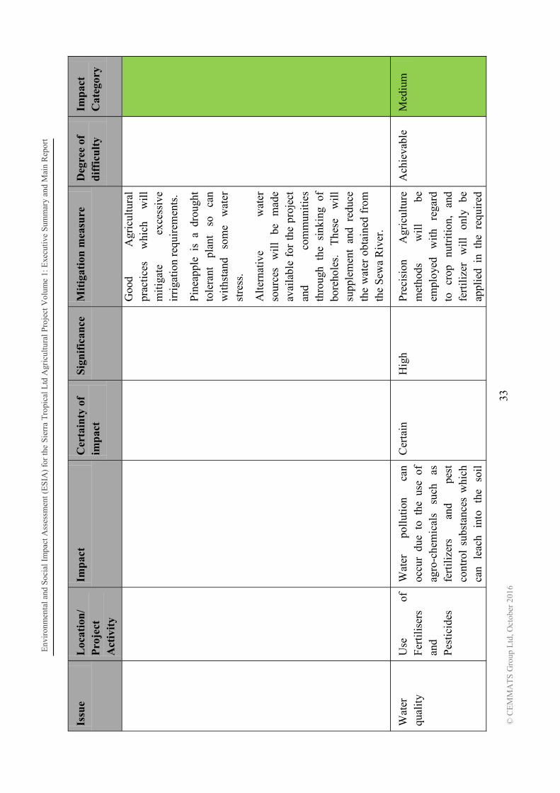
Env
iron
men
tal a
nd S
ocia
l Im
pact
Ass
essm
ent (
ES
IA)
for
the
Sie
rra
Tro
pica
l Ltd
Agr
icul
tura
l Pro
ject
Vol
ume
1: E
xecu
tive
Sum
mar
y an
d M
ain
Rep
ort
33
©
CE
MM
AT
S G
roup
Ltd
, Oct
ober
201
6
Issu
e L
ocat
ion
/ P
roje
ct
Act
ivit
y
Imp
act
Cer
tain
ty o
f im
pac
t S
ign
ific
ance
M
itig
atio
n m
easu
re
Deg
ree
of
dif
ficu
lty
Imp
act
Cat
egor
y
Goo
d A
gric
ultu
ral
prac
tice
s w
hich
w
ill
mit
igat
e ex
cess
ive
irri
gati
on r
equi
rem
ents
.
Pin
eapp
le i
s a
drou
ght
tole
rant
pl
ant
so
can
wit
hsta
nd
som
e w
ater
st
ress
.
Alt
erna
tive
w
ater
so
urce
s w
ill
be
mad
e av
aila
ble
for
the
proj
ect
and
com
mun
itie
s th
roug
h th
e si
nkin
g of
bo
reho
les.
T
hese
w
ill
supp
lem
ent
and
redu
ce
the
wat
er o
btai
ned
from
th
e S
ewa
Riv
er.
Wat
er
qual
ity
Use
of
Fe
rtil
iser
s an
d P
esti
cide
s
Wat
er
poll
utio
n ca
n oc
cur
due
to t
he u
se o
f ag
ro-c
hem
ical
s su
ch
as
fert
iliz
ers
and
pest
co
ntro
l su
bsta
nces
whi
ch
can
leac
h in
to
the
soil
Cer
tain
H
igh
Pre
cisi
on
Agr
icul
ture
m
etho
ds
wil
l be
em
ploy
ed
with
re
gard
to
cr
op
nutr
itio
n,
and
fert
iliz
er
wil
l on
ly
be
appl
ied
in t
he r
equi
red
Ach
ieva
ble
Med
ium

Env
iron
men
tal a
nd S
ocia
l Im
pact
Ass
essm
ent (
ES
IA)
for
the
Sie
rra
Tro
pica
l Ltd
Agr
icul
tura
l Pro
ject
Vol
ume
1: E
xecu
tive
Sum
mar
y an
d M
ain
Rep
ort
34
©
CE
MM
AT
S G
roup
Ltd
, Oct
ober
201
6
Issu
e L
ocat
ion
/ P
roje
ct
Act
ivit
y
Imp
act
Cer
tain
ty o
f im
pac
t S
ign
ific
ance
M
itig
atio
n m
easu
re
Deg
ree
of
dif
ficu
lty
Imp
act
Cat
egor
y
and
get
carr
ied
into
wat
er
by
runo
ff.
Aqu
atic
li
fe
wou
ld b
e af
fect
ed.
amou
nts
foli
arly
so
co
ntam
inat
ion
of
surf
ace
wat
er i
s gr
eatl
y re
duce
d.
Che
mic
als
i.e.
Her
bici
des
and
pest
icid
es w
ill
be u
sed
only
as
re
quir
ed
or
whe
n pa
rtic
ular
pe
st
thre
shol
ds a
re r
each
ed.
Noi
se
poll
utio
n D
aily
op
erat
ions
E
leva
ted
nois
e le
vels
will
re
sult
fr
om
mov
emen
t an
d op
erat
ion
of v
ehic
les
and
mac
hine
ry.
Cer
tain
M
oder
ate
Mod
ern
equi
pmen
t w
ill
be u
sed
whi
ch a
re f
itted
w
ith
nois
e su
ppre
ssio
n de
vice
s to
pr
escr
ibed
st
anda
rds.
Noi
se
gene
rati
ng
agri
cult
ural
ac
tivit
ies
such
as
land
pre
para
tion
(e
very
3
year
s),
mai
nten
ance
Dif
ficu
lt
Med
ium

Env
iron
men
tal a
nd S
ocia
l Im
pact
Ass
essm
ent (
ES
IA)
for
the
Sie
rra
Tro
pica
l Ltd
Agr
icul
tura
l Pro
ject
Vol
ume
1: E
xecu
tive
Sum
mar
y an
d M
ain
Rep
ort
35
©
CE
MM
AT
S G
roup
Ltd
, Oct
ober
201
6
Issu
e L
ocat
ion
/ P
roje
ct
Act
ivit
y
Imp
act
Cer
tain
ty o
f im
pac
t S
ign
ific
ance
M
itig
atio
n m
easu
re
Deg
ree
of
dif
ficu
lty
Imp
act
Cat
egor
y
(for
tnig
htly
) an
d ha
rves
ting
(ev
ery
12
14
m
onth
s)
will
occ
ur
peri
odic
ally
and
not
on
a da
ily
basi
s.
Wor
kers
w
ill
be
prov
ided
w
ith
nois
e pr
otec
tion
PP
E.
Em
erge
ncy
Res
pons
e an
d D
isas
ter
Man
agem
ent
Thr
ough
out
proj
ect l
ife
Poo
r m
anag
emen
t of
em
erge
ncie
s or
dis
aste
rs
wil
l re
sult
in
loss
of
life
, da
mag
e to
equ
ipm
ent a
nd
disr
upti
on o
f op
erat
ions
Lik
ely
Ver
y hi
gh
Impl
emen
tati
on
of
Em
erge
ncy
Res
pons
e P
lan,
reg
ular
dri
lls a
nd
trai
ning
ex
erci
ses
for
staf
f,
mon
itor
ing
of
pote
ntia
l si
tuat
ions
le
adin
g to
dis
aste
r.
Ach
ieva
ble
Med
ium
Com
mun
ity
Hea
lth
and
Saf
ety
Dai
ly
Act
iviti
es
Com
mun
ity
resi
dent
s w
ill
be
expo
sed
to
incr
ease
d ve
hicu
lar
traf
fic
and
othe
r op
erat
iona
l ac
tiviti
es
whi
ch
bein
g un
fam
iliar
pu
ts
them
at
ri
sk
of
safe
ty h
azar
ds.
Lik
ely
Hig
h R
egul
ar
com
mun
ity
cons
ulta
tions
an
d co
mm
unit
y he
alth
and
sa
fety
sen
sitiz
atio
n w
ill
be
cond
ucte
d pe
riod
ical
ly t
hrou
ghou
t th
e lif
e of
the
proj
ect.
Ach
ieva
ble
Mod
erat
e

Environmental and Social Impact Assessment (ESIA) for the Sierra Tropical Ltd Agricultural Project Volume 1: Executive Summary and Main Report
36
© CEMMATS Group Ltd, October 2016
Environmental and Social Management Plans The Environmental and Social Management Plan (ESMP) for the Project identifies the principles, approach, procedures and methods that will be used to control and minimize the environmental, social, health and safety impacts of all project activities.
Environmental Health and Safety Plan
The Environmental Health and Safety Plan (EHS) Plan identifies the principles, approach, procedures and methods that will be used to control and minimize the adverse environmental and social impacts of all construction and operational activities associated with project
Assessment (ESIA) and ensure that commitments made by Sierra Tropical Ltd. to minimize project related adverse environmental and social impacts are upheld throughout all project phases.
Waste Management Plan
The Waste Management Plan (WMP) describes the procedures, systems, equipment, and structures specific to waste management and disposal. Waste generation should be limited at all levels of the operation in order to decrease the volume of waste generated and make waste disposal more manageable. The WMP also defines who is responsible for developing and implementing the plan, and what records and reporting will be required.
Pesticide and Chemical Management Plan
The Pesticide and Chemical Management Plan (PCMP) outlines the general measures and approaches for prevention and mitigation of occurrences of pesticides and other agro-chemicals in ground and surface waters following their application, and recommended actions to accomplish appropriate goals. Risks associated with the use of pesticides during the period of managing a pest outbreak are outlined.
Emergency Response Plan
The Emergency Response Plan provides employees and managers with specific instructions that will enable them to respond quickly and efficiently to any foreseeable emergencies likely to occur at the Project. It is developed using recognized and accepted methods and practices and includes specific responses, protocols, and management contacts. The ERP essentially has the goal of protecting people, the environment, property and the operations. This document deals with typical emergency types that characterize the operation which include:
a. Fire or Explosion; b. Pollution or Chemical Spills; c. Flooding, Landslides, Rain Storm (Natural Conditions); d. Medical Health Cases; e. Civil Unrest & Disturbances.

Environmental and Social Impact Assessment (ESIA) for the Sierra Tropical Ltd Agricultural Project Volume 1: Executive Summary and Main Report
37
© CEMMATS Group Ltd, October 2016
Resettlement Policy Framework
It is not envisaged that the project will entail any displacement of people and extensive damage to crops. However, it is possible that the infrastructure requirements of the project in terms of feeder road construction/rehabilitation and other project logistical requirements may result in damage to crops. It is impossible at this stage to determine and assess these, procedures should nevertheless be put in place to handle such matters if they arise.
Community Development Action Plan
Specific community development and social assistance programmes aimed at improving the living conditions of the local communities in a sustainable way are captured under the CDAP.
Public Consultation and Disclosure Plan
The PCDP is intended to define objectives and establish the framework necessary to provide understandable information to all parties involved. This plan will be implemented to ensure timely and effective communications with the project management and the affected stakeholders, throughout the lifetime of the project. The main objective of the PCDP is to establish a program for multi-directional communication between the management and stakeholders.
Closure Plan
After the project has reached its economic life span and can no longer be operated in an efficient, reliable and safe manner, the Project reclamation activities are implemented to re-establish a beneficial post-operation land use. All structures would have to be removed in order to return the site to its pre-construction phase. Monitoring programmes will be implemented to ensure that the site reverts to a natural and useable state.
Management, Mitigation, Monitoring and Implementation Measures
The Environmental Monitoring Plan (EMP) outlines the plans for monitoring within the plantation areas and project facilities; key personnel and their responsibilities are also identified.
Conclusion Key Assessment Findings Physical Environment There are potential major impacts relating to hydrology and water quality, biodiversity, soil erosion, water & soil pollution due to agro-chemical and water abstraction. Mitigation measures to limit the extent of impacts have been highlighted and will be implemented.

Environmental and Social Impact Assessment (ESIA) for the Sierra Tropical Ltd Agricultural Project Volume 1: Executive Summary and Main Report
38
© CEMMATS Group Ltd, October 2016
Biological Environment There will be some loss of floral and faunal species during land clearing and preparation, however it is not expected that any species will be wiped out from the region as a result. Mitigation measures have been presented to ensure that minimal clearing is carried out to limit the extent of biodiversity loss. Socio-economic Environment Perhaps the most critical aspect of the project is the potential reduction of farm land by the communities, potential conflict from issues related to labour, unrealistic expectations held by the communities with regard to benefits created by the project, vehicular traffic and safety risk. The selection of the project site has been judiciously done to avoid the need for community relocation. The project will have positive impacts in the area of job creation, improving the quality of life of locals through payment of land lease rent and compensation, outgrower schemes, creation of secondary businesses, etc. Conclusion This Environmental and Social Impact Assessment has been professionally carried out to
the following objectives for such an exercise, viz:
Baseline Survey of the Project Area;
Execution of an Environmental and Social Impact Assessment (ESIA) and development of Environmental and Social Management Plans (ESMP);
The investigations of impacts on the social environment are a crucial part of the study, since the operation may impact the communities which reside at close proximity to the project site. The investigation of social impacts has involved the following:
A baseline socio-economic study of the community envisaged to be impacted by the project activities in both the construction and operational phases;
A Public Consultation and Disclosure Process (PCDP) undertaken to sensitize stakeholders.
The baseline environmental and socio-economic situations have been presented.
Enviproject. The most significant of these impacts is the change of morphology and soil and water (surface and ground) pollution due to agro-chemicals utilization. Social impacts include loss of agricultural farm land and unrealistic expectation from the people regarding benefits as the project progresses.
Generally, the investigations reveal that environmental and social problems incurred by the project can be adequately managed and that there are no insurmountable problems that should stop the project from proceeding.

Environmental and Social Impact Assessment (ESIA) for the Sierra Tropical Ltd Agricultural Project Volume 1: Executive Summary and Main Report
39
© CEMMATS Group Ltd, October 2016
A monitoring system must however be put in place to ensure that management practices for mitigating negative impacts and enhancing those that are positive are affected. It must however be ensured that recommendations made in the Environmental and Social Management Plans are followed through.
Environmental and Social Impact Assessment (ESIA) for the Sierra Tropical Ltd Agricultural Project Volume 1: Executive Summary and Main Report
40 © CEMMATS Group Ltd, October 2016
1 INTRODUCTION
1.1 Project Background Sierra Tropical Ltd. is a wholly owned subsidiary of Dole Asia Holdings Pte. Ltd., a Singapore based Agro-processing Company. A leader in growing fruits and vegetables, Dole Asia Holdings also markets or processes these fruits into fruit juice and healthy snack products throughout the world.
Sierra Tropical Ltd (STL) proposes to embark on an agro-processing project involving large scale planting and processing of tropical fruits in Sierra Leone using approximately 15,000 hectares. It is envisioned to be fully integrated from cultivating, growing and harvesting pineapple, mango, papaya and other tropical fruit and processing them into manufactured products. The project is proposed to be implemented in Sierra Leone as it has the necessary favorable conditions, such as ideal weather, plentiful land, duty concessions, and a business friendly government and administration particularly with regards agriculture.
The project will initially grow up to 4,335 hectares of leased land in Lugbu Chiefdom, Bo District, and will be implemented in phases, starting with the development of a pineapple nursery, spreading out in phases to eventually cover the maximum area desired and possible.
If the first phase of the project is successful and the quality/productivity of the fruits meet our requirements, a manufacturing facility will be constructed in the later stages of the second phase, to process the raw materials into manufactured products in various packages of cans, drums, plastics and boxes. An extension of this ESIA Study will be done at this point, to cover the manufacturing facility; however this will be dependent on the success of phase 1 and the early stages of phase 2.
1.2 National Perspective The agricultural sector, comprising food crops, tree crops, fishery, livestock, and forestry sub- (Ighobor, 2014) with the crop sector dominating the agricultural GDP with 33% in 2010 (Larbi, 2012). More than half of the country depends on agriculture for livelihood.
The major food crops are rice, cassava, maize, millet, sorghum, sweet potato, and groundnut which are produced by smallholders with an average land holding averaging from 0.5-2.0 hectares (Larbi, 2012).
Rice is the most important crop, cultivated by nearly 85% of farmers, while cassava is the second most important crop. Oil palm is the main tree crop and other perennial crops include citrus, cocoa, coffee, coconut and sugarcane (Larbi, 2012).
Crop yields are generally low due to: limited access to agricultural inputs, low levels of mechanization, pest and disease problems, lack of markets and market information, labour shortages and a weak private sector.

Environmental and Social Impact Assessment (ESIA) for the Sierra Tropical Ltd Agricultural Project Volume 1: Executive Summary and Main Report
41
© CEMMATS Group Ltd, October 2016
There has been a steady decrease in the amount of funds spent by the government on food importation due to its drive to promote increased agricultural capability within the country. Between 2007 and 2013, costs on food importations dropped from $32 million to $15 million, improvement which has been confirmed by the World Health Organisation (Ighobor, 2014). The government believes that the agriculture sector can be further improved, and aims to increase the national budget to more than 10% of the national budget. This increase will allow farmers to have access to farm implements, machinery, fertilisers and other materials that will enhance their work/yield.
1.3 Project Area The project will start in Lugbu Chiefdom, Bo District which will primarily be the host community. It is however anticipated that as the project develops, more agricultural land will be required which will necessitate expansion to other areas within Lugbu Chiefdom and possibly into the neighbouring Tikonkor Chiefdom.
Since five of the six Sections in Lugbu Chiefdom qualify for the establishment of pineapple farms in terms of land suitability and environmental friendliness, sufficient land is available in the Chiefdom for the next phases of the project (three to ten years and beyond). There would also be adequate land within the settlements for food production.
Table 1.3-1: Lugbu Chiefdom

Environmental and Social Impact Assessment (ESIA) for the Sierra Tropical Ltd Agricultural Project Volume 1: Executive Summary and Main Report
42
© CEMMATS Group Ltd, October 2016
1.3.1 Brief History of Lugbu Chiefdom According to Reeit is believed that the father of the first Paramount Chief of Lugbu Chiefdom Samuka Nallo was a warrior and hunter who came from Sudan. In an account that has not been verified, he is said to have travelled through Liberia and entered Sierra Leone through Pujehun, settling in a place called Gikubu, a Mende ward meaning settlement under the tree.
This chiefdom is mostly descended from two related families Nallo and Magawo. The Nallo family has however, has dominated the chieftaincy since the early 20th century.
1.4 Environmental and Social Impact Assessment Process
1.4.1 Stages of the ESIA Process Prior to commencement of any project that may affect the environment and communities, it is mandated by legislation that an Environmental and Social Impact Assessment (ESIA) study be done, and, upon approval by EPA-SL, a licence is secured.
The Sierra Leone Environment Protection Agency Act, (SLEPAA) 2008 and the EIA Supplementary Acts, 2010 describe the requirements and process for securing an EIA licence,
-SL. In short, the client first applies to the local regulatory body, Environment Protection Agency, Sierra Leone (EPA-SL) for an EIA licence. EPA-SL requires that a screening form be filled and submitted with the application letter, after which a decision is made on the category of the project; this is followed by a scoping report. EPA-SL will then decide on the terms of reference (TOR) to be drafted by the project proponent or an independent consultant hired by the proponent.
On the approval of the agency, the consultant carries out an assessment of the environmental and social impacts of their planned operations on ecosystems and communities in the project area. A report is prepared at the end of the study and submitted to EPA-SL for review. If approved, the proponent will then be requested to conduct public disclosure meetings with relevant stakeholders on the findings and recommendations of the study, and incorporate comments, suggestions and requests made during those meetings into a public consultation and disclosure report. Finally, all reports pertaining to the ESIA study are then forwarded to the Board of EPA-SL for a decision to be made on the issue of the licence.
1.4.2 Purpose of the ESIA Study The purpose of the environmental impact assessment is to identify and mitigate potential negative and identify and enhance positive environmental impacts. This is done through the conduct of desktop and field studies to:
Obtain secondary and primary biophysical and socio-economic data;
Anticipate the potential impacts of the proposed project on the environment and communities;

Environmental and Social Impact Assessment (ESIA) for the Sierra Tropical Ltd Agricultural Project Volume 1: Executive Summary and Main Report
43
© CEMMATS Group Ltd, October 2016
Propose an environmental management plan that mitigates adverse impacts whilst enhancing positive ones;
These are achieved by employing a methodology that inter alia consists of a literature review, field investigations and a social survey.
The purpose and findings of the study will be disclosed to project interested and affected persons in a series of stakeholder consultation and disclosure meetings to elicit community acceptance and participation that are imperative for the construction and operation of the facility.
1.4.3 Objectives of the ESIA Study The objectives of the study were as follows:
i. To assess the potential positive and negative impacts of the planned construction project and its operations on society and the environment;
ii. To recommend mitigation measures to avoid or mitigate negative impacts and enhance benefits;
iii. To prepare an environmental and social management and monitoring plan (ESMP) that integrates mitigation and monitoring measures;
iv. To develop specific topic management plans which will include the following:
a. Waste Management Plan (WMP)
b. Environmental Health and Safety Plan (EHSP)
c. Community Development Action Plan (CDAP)
d. Public Consultation and Disclosure Plan (PCDP)
e. Emergency Response Plan (ERP)
v. To conduct public disclosure and consultation meetings on the findings and recommendations of the EIA study.
1.4.4 ESIA Consultants and Teams A number of specialists were identified to undertake the investigations and address the issues outlined during the ESIA phase. A team was formed of the respective ESIA consultants and sub-teams (Table 1.4-1).
The terms of reference for each of these studies are outlined in the next section. The specialist studies were undertaken during the ESIA phase. This Environmental and Social Impact Assessment (ESIA) report summarizes all their findings and has been compiled using the information gathered during these studies. The recommendations and mitigation measures developed from these studies have also been pulled together to generate an Environmental and Social Management Plan (ESMP) (Volume 2 of this report) which will be adhered to during the various stages of the project.
Environmental and Social Impact Assessment (ESIA) for the Sierra Tropical Ltd Agricultural Project Volume 1: Executive Summary and Main Report
44
© CEMMATS Group Ltd, October 2016
Table 1.4-1 ESIA Consultants and Teams
Specialist Specialist investigation
Andrew Keili Project Director
Vanessa James Project Manager/Infrastructure and Operations Assessment
Ralph Bona/ Josephine Turay
Hydrologist/water quality specialist
Leonard Buckle Soils/air/noise specialist
Arnold Okoni Williams
Ecologist- Flora and Fauna
B. Bockarie GIS/Land Use expert
J. Lappia Socio-Economist/Resettlement expert/lease expert
/Rashidu Sinnah Socio-Economist
Joseph Gbassah GIS/ Environmentalist
1.5 Description of the Terms of Reference (TOR) The ESIA study conducted by CEMMATS Group Ltd, was primarily done to meet the local requirements for securing an Environmental Impact Assessment licence from EPA-SL.
This study commenced in August 2016 and consists of biophysical and socio-economic baseline data collection and impact assessments conducted in the project area by an inter- and multi-disciplinary team of professionals. The Terms of Reference as submitted to and duly approved by the EPA-SL is outlined in the following table.

Env
iron
men
tal a
nd S
ocia
l Im
pact
Ass
essm
ent(
ES
IA)
for
the
Sie
rra
Tro
pica
l Ltd
Agr
icul
tura
l Pro
ject
Vol
ume
1: E
xecu
tive
Sum
mar
y an
d M
ain
Rep
ort
45
© C
EM
MA
TS
Gro
up L
td, O
ctob
er 2
016
Tab
le 1
.5-1
Ter
ms
of R
efer
ence
of
the
ESI
A S
tud
y
Fie
ld
Ob
ject
ives
M
eth
odol
ogy
H
ydro
logy
Det
erm
ine
dire
ct p
hysi
cal i
mpa
cts
of t
he p
roje
ct
on th
e su
rfac
e an
d gr
ound
wat
er.
R
ecor
ding
bas
elin
e qu
alit
ativ
e an
d qu
anti
tati
ve
data
.
Sug
gest
m
itig
atio
n m
easu
res
to
addr
ess
the
impa
cts
note
d in
the
sur
face
and
gro
undw
ater
hy
drol
ogic
ass
essm
ent.
Des
k st
udy:
A
rev
iew
of
exis
ting
dat
a on
thi
s ar
ea w
ill b
e un
dert
aken
tog
ethe
r w
ith
addi
tion
al in
form
atio
n w
hich
may
incl
ude:
A d
escr
ipti
on o
f th
e si
te in
term
s of
cat
chm
ents
cha
ract
eris
tics
suc
h as
sit
e bo
unda
ries
, M
ean
Ann
ual
Run
off
(MA
R),
M
ean
Ann
ual
Eva
pora
tion
(M
AE
),
Mea
n A
nnua
l P
reci
pita
tion
(M
AP
) us
ing
avai
labl
e so
urce
s (N
atio
nal R
epor
ts);
A r
evie
w o
f la
nd (
wat
er)
uses
and
pre
dict
ing
the
pote
ntia
l im
pact
s th
at
coul
d ar
ise
from
the
prop
osed
pro
ject
; and
Rev
iew
of
exis
ting
bas
elin
e w
ater
qua
lity
dat
a (l
ocal
/reg
iona
l) a
nd t
he
nati
onal
wat
er q
uali
ty ta
rget
s ap
plic
able
to th
e pr
ojec
t. Fi
eld
surv
eys:
Ver
ify
catc
hmen
t ch
arac
teri
stic
s su
ch
as
sub-
catc
hmen
ts,
vege
tati
on
cove
r, l
and
uses
, to
pogr
aphy
, an
d av
erag
e sl
opes
in
orde
r to
des
crib
e th
ehy
drol
ogic
al c
hara
cter
isti
cs o
f th
e pr
ojec
t sit
e ;
C
olle
ct a
ddit
iona
l sam
ples
to s
ubm
it th
ese
to a
labo
rato
ry f
or a
naly
sis
Id
enti
fy p
oten
tial s
ourc
es o
f po
lluti
on.
Id
enti
fy p
oten
tial
impa
cts
that
cou
ld r
esul
t fr
om t
he p
ropo
sed
proj
ect
on
the
surf
ace
wat
er r
esou
rces
. H
ydro
geol
ogy
Thi
s ph
ase
wil
l in
clud
e a
desk
top
stud
y to
acq
uire
re
leva
nt
hydr
ogeo
logi
cal
info
rmat
ion
for
stud
ies
perf
orm
ed in
the
area
to d
ate.
A
hy
droc
ensu
s w
ill
be
take
n of
th
e st
udy
area
. D
urin
g th
e hy
droc
ensu
s im
port
ant
data
per
tain
ing
to
the
curr
ent
grou
ndw
ater
con
diti
ons
and
use
wil
l be
co
llec
ted.
Thi
s w
ill i
nclu
de:
The
hyd
roce
nsus
sur
veys
will
inc
lude
int
ervi
ews
wit
h la
ndho
lder
s/m
anag
ers,
vi
sits
to
indi
vidu
al w
ells
. T
his
data
tog
ethe
r w
ith
its
spat
ial
dist
ribu
tion
wil
l de
term
ine
the
curr
ent
wat
er r
esou
rce
and
envi
ronm
enta
l st
atus
and
ser
ve a
s re
fere
nce
to a
ny f
utur
e en
viro
nmen
tal p
roje
cts
cond
ucte
d in
the
area
.

Env
iron
men
tal a
nd S
ocia
l Im
pact
Ass
essm
ent (
ES
IA)
for
the
Sier
ra T
ropi
cal L
td A
gric
ultu
ral P
roje
ctV
olum
e 1:
Exe
cuti
ve S
umm
ary
and
Mai
n R
epor
t
46
© C
EM
MA
TS
Gro
up L
td, O
ctob
er 2
016
Fie
ld
Ob
ject
ives
M
eth
odol
ogy
loca
liti
es
of
curr
ent
grou
ndw
ater
ab
stra
ctio
n po
ints
owne
rshi
p
curr
ent u
sage
vol
umes
and
type
s,
E
quip
men
t and
gro
undw
ater
leve
ls.
Hyd
ro
chem
ical
sa
mpl
es
wil
l al
so
be
take
n fr
om
sele
cted
wel
ls.
The
dat
a co
llec
ted
wil
l se
rve
as a
re
fere
nce
poin
t ag
ains
t hi
stor
ical
an
d fu
ture
gr
ound
wat
er c
ondi
tions
in th
e ar
ea.
Wat
er Q
ual
ity
P
rovi
de b
asic
cha
ract
eriz
atio
n of
the
qua
lity
of
surf
ace
and
pota
ble
wat
er s
ourc
es.
A
sses
s th
e ri
sk o
f co
ntam
inat
ing
grou
nd w
ater
, sp
ring
s an
d su
rfac
e w
ater
.
O
n-si
te
Mea
sure
men
ts
of
phys
ico-
chem
ical
pa
ram
eter
s su
ch
as,
pH,
Tem
pera
ture
, dis
solv
ed o
xyge
n, tu
rbid
ity
and
cond
ucti
vity
.
Sam
plin
g fo
r la
bora
tory
ana
lysi
s of
che
mic
al (
anio
ns a
nd c
atio
ns)
and
mic
robi
olog
ical
(fa
ecal
and
tot
al c
olif
orm
s) c
hara
cter
isti
cs.
Info
rmat
ion
from
the
orig
inal
ES
IA s
tudy
of
this
are
a w
ill a
lso
be u
tili
sed.
S
oils
A
sses
smen
t/A
gric
ult
ura
l is
sues
T
o ch
arac
teri
ze t
he s
oils
, in
the
stu
dy a
rea
that
ar
e to
be
affe
cted
by
the
prop
osed
pro
ject
. It
wil
l pr
ovid
e an
indi
cati
on o
f th
e ex
isti
ng s
oil a
nd la
nd
capa
bili
ties
fo
r th
e su
rvey
ar
ea
and
give
a
char
acte
riza
tion
of
the
land
cap
abil
ity
with
in t
he
stud
y ar
ea.
T
o de
scri
be
and
asse
ss
the
agri
cult
ural
is
sues
re
late
d to
the
proj
ect
Som
e ar
eas
wit
hin
the
leas
e w
ill b
e su
rvey
ed b
y ha
nd a
uger
obs
erva
tion
s.
Coo
rdin
ates
of
the
obse
rvat
ion
poin
ts w
ill
be l
oade
d on
to a
GP
S t
o lo
cate
po
ints
in th
e fi
eld.
A
uger
obs
erva
tion
s w
ill b
e m
ade
to th
e de
pth
of th
e fi
rst r
estr
icti
ng la
yer.
T
he f
ollo
win
g at
trib
utes
will
be
reco
rded
at
each
obs
erva
tion
poi
nt o
f th
e de
tail
ed s
urve
y:
S
oil
form
cl
assi
fied
ac
cord
ing
to
an
appr
opri
ate
Soi
l C
lass
ific
atio
n S
yste
m;
S
oil d
epth
;
Est
imat
ed s
oil t
extu
re;
S
oil s
truc
ture
;
Cur
rent
land
use
;
Lan
d ca
pabi
lity.
Sam
ples
wil
l be
ana
lyse
d fo
r so
il a
cidi
ty,
fert
ilit
y an
d te
xtur
al i
ndic
ator
s

Env
iron
men
tal a
nd S
ocia
l Im
pact
Ass
essm
ent (
ES
IA)
for
the
Sier
ra T
ropi
cal L
td A
gric
ultu
ral P
roje
ctV
olum
e 1:
Exe
cuti
ve S
umm
ary
and
Mai
n R
epor
t
47
© C
EM
MA
TS
Gro
up L
td, O
ctob
er 2
016
Fie
ld
Ob
ject
ives
M
eth
odol
ogy
as
fol
low
s:
pH
(w
ater
);
E
xtra
ctab
le c
atio
ns a
nd N
a, K
, Ca,
Mg
Pho
spho
rus
Cat
ion
exch
ange
cap
acity
(C
EC
);
C
arbo
n co
nten
t;
S
oil t
extu
re (
3 cl
asse
s na
mel
y sa
nd, s
ilt a
nd c
lay)
.
Des
crib
e an
d as
sess
sal
ient
agr
icul
tura
l iss
ues
Air
Qu
alit
y
To
iden
tify
ke
y as
pect
s th
at
mig
ht
have
si
gnif
ican
t ai
r qu
alit
y im
pact
s du
ring
all
pha
ses
of th
e pr
ojec
t.
A
mbi
ent
and
met
eoro
logi
cal
data
will
be
sour
ced
for
the
area
und
er in
vest
igat
ion.
Qua
lita
tive
ass
essm
ent
wil
l be
und
erta
ken
whi
ch
wil
l ev
alua
te
the
poss
ible
im
pact
s of
ot
her
poll
utin
g so
urce
s in
the
area
.
Poi
nt a
nd n
on-p
oint
sou
rces
of
poll
utio
n
Iden
tifi
cati
on a
nd q
uant
ific
atio
n of
dus
t em
issi
ons
sour
ces;
D
evel
opm
ent o
f em
issi
ons
inve
ntor
y
Noi
se
Ass
essm
ent
To
asse
ss t
he a
mbi
ent
nois
e le
vels
in
sett
lem
ents
in
and
arou
nd
the
proj
ect
area
in
ac
cord
ance
w
ith
inte
rnat
iona
l gui
deli
nes.
P
reli
min
ary
surv
ey a
nd i
dent
ific
atio
n of
mea
suri
ng p
oint
s fo
r da
y an
d ni
ght
tim
e re
adin
gs.
Mon
itori
ng m
easu
rem
ents
wil
l be
tak
en a
t 1.
5m
abov
e gr
ound
leve
l;
S
ound
pre
ssur
e re
adin
gs w
ill b
e do
ne a
t the
clo
sest
res
iden
tial
are
a;
N
oise
su
rvey
at
th
e id
entif
ied
mea
suri
ng
site
s
Am
bien
t no
ise
mea
sure
men
ts;
Lan
d U
se
E
ngag
e w
ith
the
soci
al s
cien
tist
s to
ens
ure
that
qu
esti
ons
rela
ted
to la
nd u
se a
re a
sked
dur
ing
the
soci
al im
pact
ass
essm
ent;
Cla
rify
th
e co
mpl
exit
ies
asso
ciat
ed
wit
h
S
et u
p fo
cus
grou
ps t
oget
her
with
the
soc
ial
scie
ntis
ts t
o an
swer
the
se
ques
tion
s;
A
lan
duse
GIS
cov
er d
atas
et w
ill
be d
igit
ised
usi
ng v
isua
l id
enti
fica
tion
cl
assi
fica
tion
met
hod.
The
mos
t re
cent
col
our
aeri
al p
hoto
grap
hy w
ill

Env
iron
men
tal a
nd S
ocia
l Im
pact
Ass
essm
ent (
ES
IA)
for
the
Sier
ra T
ropi
cal L
td A
gric
ultu
ral P
roje
ctV
olum
e 1:
Exe
cuti
ve S
umm
ary
and
Mai
n R
epor
t
48
© C
EM
MA
TS
Gro
up L
td, O
ctob
er 2
016
Fie
ld
Ob
ject
ives
M
eth
odol
ogy
ro
tati
onal
land
use
;
Whe
re
poss
ible
, in
tegr
ate
find
ings
w
ith
thos
e ob
tain
ed f
rom
soi
l sur
veys
;
Dev
elop
str
ateg
ies,
to
deal
with
iss
ues
rela
ted
to
inco
me
gene
rati
on a
nd f
ood
secu
rity
;
Ens
ure
that
the
stu
dy d
eals
wit
h an
y ot
her
issu
es
rela
ted
to la
nd u
se r
aise
d du
ring
sco
ping
;
Ass
ess
the
envi
ronm
enta
l si
gnif
ican
ce
of
the
anti
cipa
ted
impa
cts;
Pro
vide
fe
asib
le
reco
mm
enda
tion
s on
th
e m
itig
atio
n of
impa
cts
rela
ted
to la
nd u
se.
augm
ent o
ur b
ase
map
s fo
r th
is a
naly
sis;
Eco
logy
-F
aun
a A
mph
ibia
n, r
epti
le a
nd m
amm
al s
urve
ys t
o in
clud
e ca
usal
ob
serv
atio
ns
and
refu
ge
exam
inat
ions
(e
.g.
sear
chin
g un
der
rock
s, l
ogs,
rot
ten
tree
stu
mps
, le
af
litt
er,
old
term
ite
mou
nds
and
rode
nt b
urro
ws
wit
h co
nsid
erat
ion
to
Hea
lth
and
Saf
ety
prot
ocol
s).
Info
rmat
ion
wil
l al
so b
e av
aila
ble
thro
ugh
sigh
ting
s fr
om
loca
l pe
ople
; ho
wev
er,
thes
e da
ta
wil
l on
ly
com
plem
ent
the
mai
n su
rvey
. Fa
vour
able
hab
itat
s to
al
so b
e ex
amin
ed w
ithi
n th
e de
velo
pmen
t are
a.
Pri
orit
y w
ill b
e gi
ven
to k
ey in
dica
tor
grou
ps s
uch
as:
fr
ogs
and
toad
s
smal
l rep
tile
s su
ch a
s li
zard
s
ot
her
smal
l mam
mal
s
mon
keys
M
etho
ds f
or s
urve
ying
the
abo
ve g
roup
s w
ill
sim
ply
invo
lve
visu
al o
bser
vati
ons
and
phot
ogra
phs.
Res
ults
for
the
ecol
ogic
al s
urve
y fo
r th
is a
rea
in th
e or
igin
al E
SIA
stu
dy w
ill
be u
tili
sed
as b
est a
s po
ssib
le.
Add
itio
nal i
nfor
mat
ion
in a
reas
with
in th
e le
ase
area
will
be
coll
ecte
d. T
he
coll
ecti
ve in
form
atio
n w
ill c
over
the
follo
win
g is
sues
:
Con
side
rati
on w
ill
be g
iven
to
the
loca
tion
and
whe
reab
outs
of
each
su
rvey
und
erta
ken
befo
re a
rriv
ing
at s
ite.
Sur
veyo
rs w
ill r
ecor
d th
e ha
bita
t typ
es p
rese
nt in
eac
h of
the
surv
ey a
reas
The
loc
atio
n of
all
sur
veys
und
erta
ken
will
be
reco
rded
wit
h th
e ai
d of
a
hand
held
GP
S.
P
hoto
grap
hs w
ill b
e ta
ken
of th
e an
imal
s, w
here
pos
sibl
e.
S
ight
ings
fro
m p
eopl
e an
d lo
cal c
omm
unit
ies
wit
hin
the
vici
nity
sho
uld
be
note
d in
the
rep
orts
but
rem
ain
sepa
rate
fro
m t
he f
ield
sur
veys
abo
ve.
Impo
rtan
ce
and
rele
vanc
e of
sp
ecie
s id
enti
fied
in
re
spec
t of
lo
cal
stak
ehol
ders
sho
uld
also
be
incl
uded
in th
e re
port
s.
Env
iron
men
tal a
nd S
ocia
l Im
pact
Ass
essm
ent (
ES
IA)
for
the
Sier
ra T
ropi
cal L
td A
gric
ultu
ral P
roje
ctV
olum
e 1:
Exe
cuti
ve S
umm
ary
and
Mai
n R
epor
t
49
© C
EM
MA
TS
Gro
up L
td, O
ctob
er 2
016
Fie
ld
Ob
ject
ives
M
eth
odol
ogy
E
colo
gy-
Flo
ra/w
etla
nd
s S
ensi
tive
an
d cr
itic
al
plan
t sp
ecie
s (s
peci
es
of
cons
erva
tion
im
port
ance
) w
ill
be
iden
tifi
ed
and
habi
tats
map
ped.
The
po
siti
on
and
loca
lity,
as
w
ell
as
spec
ies
com
posi
tion
of
se
nsit
ive
area
s in
vent
ory
wil
l be
co
nduc
ted
in o
rder
to
iden
tify
and
map
all
wet
land
s in
the
area
.
A
flo
rist
ic s
urve
y w
ill b
e co
nduc
ted
to d
eter
min
e th
e sp
ecie
s co
mpo
siti
on
of t
he a
rea
of i
nter
est.
Thi
s w
ill
give
an
indi
cati
on o
f th
e ac
tual
spe
cies
pr
esen
t on
site
and
thes
e w
ill b
e di
scus
sed
in c
onte
xt o
f pl
ant c
omm
uniti
es
(sho
uld
the
area
sup
port
dis
tinc
t com
mun
itie
s) w
ithin
the
ecos
yste
m o
f th
e ar
ea.
A
sses
smen
t of
rar
e sp
ecie
s of
flo
ra a
nd f
auna
wil
l be
car
ried
out
; th
is w
ill
iden
tify
the
cat
egor
ies
of b
iodi
vers
ity
and
give
an
indi
cati
on o
f th
e of
fset
re
quir
ed.
Pos
sibl
e lo
cati
ons
for
biod
iver
sity
off
set,
if r
equi
red
will
be
sugg
este
d as
th
e N
atio
nal
rese
rves
su
rrou
ndin
g th
e pr
ojec
t ar
ea
are
iden
tifi
ed.
Wet
land
s A
bas
elin
e in
vest
igat
ion
invo
lvin
g a
desk
top
asse
ssm
ent
and
lim
ited
grou
nd
trut
hing
wil
l be
und
erta
ken
cove
ring
the
pro
pose
d si
te.
Wet
land
s, i
nclu
ding
ri
pari
an w
etla
nds
with
in t
he s
ite
boun
dari
es w
ill
be i
dent
ifie
d us
ing
a ra
nge
of
tool
s, in
clud
ing
topo
grap
hica
l map
s.
G
IS
and
m
app
ing
The
mos
t pr
ogre
ssiv
e m
eans
of
map
ping
is
thro
ugh
the
use
of G
eogr
aphi
c In
form
atio
n S
yste
ms
(GIS
) as
it
ena
bles
sou
nd c
arto
grap
hy a
s w
ell
as a
hol
isti
c an
alys
is o
f an
are
a. G
IS i
s a
digi
tal
cart
ogra
phic
too
l ca
pabl
e of
cr
eatin
g,
inte
grat
ing,
st
orin
g,
edit
ing,
an
alys
ing,
sh
arin
g,
and
disp
layi
ng
geog
raph
ical
ly
refe
renc
ed
info
rmat
ion.
It
al
low
s us
ers
to
crea
te
quer
ies,
ana
lyse
spa
tial i
nfor
mat
ion
as w
ell a
s ed
itin
g an
d m
anag
ing
data
wit
h a
fina
l pr
oduc
t be
ing
the
crea
tion
of
map
s to
aid
in v
isua
l int
erpr
etat
ion.
T
he u
se o
f m
appi
ng i
n E
IAs
is i
nteg
ral,
as m
aps
prov
ide
the
mea
ns
thro
ugh
whi
ch
the
prop
osed
Hig
h re
solu
tion
aer
ial s
urve
ys, s
atel
lite
imag
ery
wil
l als
o be
use
d
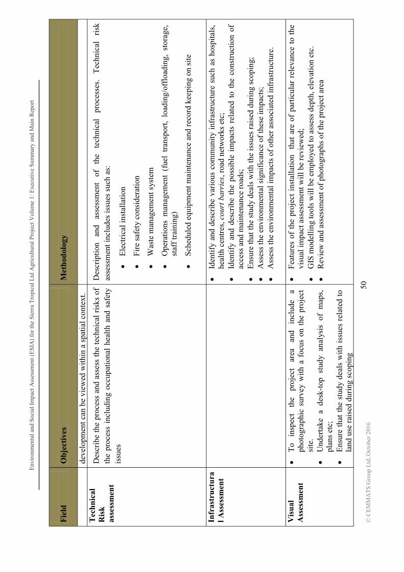
Env
iron
men
tal a
nd S
ocia
l Im
pact
Ass
essm
ent (
ES
IA)
for
the
Sier
ra T
ropi
cal L
td A
gric
ultu
ral P
roje
ctV
olum
e 1:
Exe
cuti
ve S
umm
ary
and
Mai
n R
epor
t
50
© C
EM
MA
TS
Gro
up L
td, O
ctob
er 2
016
Fie
ld
Ob
ject
ives
M
eth
odol
ogy
de
velo
pmen
t can
be
view
ed w
ithi
n a
spat
ial c
onte
xt.
Tec
hn
ical
R
isk
as
sess
men
t
Des
crib
e th
e pr
oces
s an
d as
sess
the
tec
hnic
al r
isks
of
the
proc
ess
incl
udin
g oc
cupa
tiona
l he
alth
and
saf
ety
issu
es
Des
crip
tion
an
d as
sess
men
t of
th
e te
chni
cal
proc
esse
s.
Tec
hnic
al
risk
as
sess
men
t inc
lude
s is
sues
suc
h as
:
E
lect
rica
l ins
tall
atio
n
Fi
re s
afet
y co
nsid
erat
ion
W
aste
man
agem
ent s
yste
m
O
pera
tion
s m
anag
emen
t (f
uel
tran
spor
t, lo
adin
g/of
floa
ding
, st
orag
e,
staf
f tr
aini
ng)
S
ched
uled
equ
ipm
ent m
aint
enan
ce a
nd r
ecor
d ke
epin
g on
sit
e
In
fras
tru
ctu
ral A
sses
smen
t
Id
enti
fy a
nd d
escr
ibe
vari
ous
com
mun
ity
infr
astr
uctu
re s
uch
as h
ospi
tals
, he
alth
cen
tres
, cou
rt b
arri
es, r
oad
netw
orks
etc
;
Iden
tify
and
des
crib
e th
e po
ssib
le i
mpa
cts
rela
ted
to t
he c
onst
ruct
ion
of
acce
ss a
nd m
aint
enan
ce r
oads
;
Ens
ure
that
the
stud
y de
als
wit
h th
e is
sues
rai
sed
duri
ng s
copi
ng;
A
sses
s th
e en
viro
nmen
tal s
igni
fica
nce
of th
ese
impa
cts;
Ass
ess
the
envi
ronm
enta
l im
pact
s of
oth
er a
ssoc
iate
d in
fras
truc
ture
.
Vis
ual
A
sses
smen
t
To
insp
ect
the
proj
ect
area
an
d in
clud
e a
phot
ogra
phic
sur
vey
with
a f
ocus
on
the
proj
ect
site
.
Und
erta
ke a
des
k-to
p st
udy
anal
ysis
of
map
s,
plan
s et
c;
E
nsur
e th
at t
he s
tudy
dea
ls w
ith
issu
es r
elat
ed t
o la
nd u
se r
aise
d du
ring
sco
ping
Fe
atur
es o
f th
e pr
ojec
t in
stal
lati
on
that
are
of
part
icul
ar r
elev
ance
to
the
visu
al im
pact
ass
essm
ent w
ill b
e re
view
ed;
G
IS m
odel
ling
tool
s w
ill b
e em
ploy
ed to
ass
ess
dept
h, e
leva
tion
etc
.
Rev
iew
and
ass
essm
ent o
f ph
otog
raph
s of
the
proj
ect a
rea

Env
iron
men
tal a
nd S
ocia
l Im
pact
Ass
essm
ent (
ES
IA)
for
the
Sier
ra T
ropi
cal L
td A
gric
ultu
ral P
roje
ctV
olum
e 1:
Exe
cuti
ve S
umm
ary
and
Mai
n R
epor
t
51
© C
EM
MA
TS
Gro
up L
td, O
ctob
er 2
016
Fie
ld
Ob
ject
ives
M
eth
odol
ogy
Ass
ess
the
envi
ronm
enta
l si
gnif
ican
ce o
f th
ese
impa
cts
Environmental and Social Impact Assessment (ESIA) for the Sierra Tropical Ltd Agricultural Project Volume 1: Executive Summary and Main Report
52 © CEMMATS Group Ltd, October 2016
1.6 Scope of Work The purpose of the environmental impact assessment is to obtain prevailing biophysical and socio-economic data, anticipate the potential impact of the proposed project on the environment and communities and propose an environmental management plan to mitigate adverse impacts whilst enhancing positive ones. These will be achieved by employing a methodology that consists of literature review, field visits and administration of questionnaires.
The ESIA study covers the start-up area of the project of 4,335 ha and related activities including nursery development, establishment of plantations, construction of administrative buildings and quarters.
1.7 Assumptions and Limitations of Study 1. The EIA study is done mainly to meet the local requirements for securing the EIA
licence; relevant international guidelines will be taken into consideration and referred to during the study.
2. The initial ESIA will be done to assess the agricultural phase of the project. Additional studies for the processing phase of the project will be carried out closer to the implementation of this phase and included as an addendum to this ESIA document.
3. Consultation will be carried out and relevant information disseminated throughout the execution of the project which will keep to the tenets of a proper Public Consultation and Disclosure Process (PCDP) for an EIA. However the EPA-SL would normally require that the results of the EIA report are discussed with communities after submission of the report.
4. The timeframe within which the study is carried out will not allow for seasonal variations to be taken into consideration, however desk studies was done on historical climatic data and other records obtained at various times during previous years.
1.8 ESIA Study Boundaries In carrying out an ESIA project like this one, various issues outside the immediate project boundary may have to be considered. The project spatial boundaries which have been considered for this project include:
Project Boundary - Includes all areas of direct physical changes - the 'footprint' of the Project.
Environmental (Ecological) Boundary - Encompasses all areas in which environmental impacts, including indirect impacts, may occur.

Environmental and Social Impact Assessment (ESIA) for the Sierra Tropical Ltd Agricultural Project Volume 1: Executive Summary and Main Report
53
© CEMMATS Group Ltd, October 2016
Socio-economic Boundary - Includes all communities potentially affected by the Project. The Project area and the area of potential environmental, physical and biological impacts fall within the Socio-economic Boundary.
Administrative Boundary - Includes the various jurisdictions with influence on the Project.
ESIA Study Boundary - Includes source of the impacts as well as the area of potential environmental and socio-economic concern. Study was carried out during the rainy season.
1.9 Organisation of the ESIA Report(s) The final report consists of two volumes. Below are brief comments on the contents.
1.9.1 The ESIA Report
Volume 1 Environmental and Social Impact Assessment (ESIA) contains the Executive summary and main report. The Executive Summary presents a concise overview of the significant findings recommendations and actions contained in the ESIA. The Main Report contains the policy, legal and administrative framework under which the ESIA was carried out. There is an analysis of the feasible alternatives, and a description of the project in its geographic, ecological, social and temporal context. It includes baseline data describing the relevant physical, biological and historical conditions and the environmental effects associated with project implementation. Mitigation measures needed to control those effects to acceptable levels are presented. Volume 2 Environmental and Social Management Plan (ESMP) presents the environmental management, mitigation, monitoring and institutional measures to be undertaken during project implementation and operation to reduce adverse environmental and social effects to acceptable levels and to enhance potential benefits. It specifically defines what actions must be taken and who is responsible to reduce adverse project impacts and enhance benefits. The ESMP also includes action plans for waste management, emergency response, closure, community development, and public consultation and disclosure. The ESMP highlight the issues and concerns that are presented in the ESIA report and identifies reasonable and practical responses to address and mitigate potentially adverse effects/enhance benefits. It describes the specific actions that will be required to effectively implement those responses in a timely manner and describes the methods by which management will demonstrate that those requirements have been met. It also establishes the course that will be followed in complying with Government of Sierra Leone environmental laws and regulations as well as international policies and guidelines.
Environmental and Social Impact Assessment (ESIA) for the Sierra Tropical Ltd Agricultural Project Volume 1: Executive Summary and Main Report
54
© CEMMATS Group Ltd, October 2016
1.9.2 Management Plans featured in the ESMP
1.9.2.1 Environmental Health and Safety Plan
The Environmental Health and Safety Plan (EHS) Plan identifies the principles, approach, procedures and methods that will be used to control and minimize the adverse environmental and social impacts of all construction and operational activities associated with project development. It is intenAssessment (ESIA) and ensure that commitments made by Sierra Tropical Ltd. to minimize project related adverse environmental and social impacts are upheld throughout all project phases.
1.9.2.2 Waste Management Plan
The Waste Management Plan (WMP) describes the procedures, systems, equipment, and structures specific to waste management and disposal. Waste generation should be limited at all levels of the operation in order to decrease the volume of waste generated and make waste disposal more manageable. The WMP also defines who is responsible for developing and implementing the plan, and what records and reporting will be required.
1.9.2.3 Pesticide and Chemical Management Plan
The Pesticide and Chemical Management Plan (PCMP) outlines the general measures and approaches for prevention and mitigation of occurrences of pesticides and other agro-chemicals in ground and surface waters following their application, and recommended actions to accomplish appropriate goals. Risks associated with the use of pesticides during the period of managing a pest outbreak are outlined.
1.9.2.4 Emergency Response Plan
The Emergency Response Plan provides employees and managers with specific instructions that will enable them to respond quickly and efficiently to any foreseeable emergencies likely to occur at the Project. It is developed using recognized and accepted methods and practices and includes specific responses, protocols, and management contacts. The ERP essentially has the goal of protecting people, the environment, property and the operations. This document deals with typical emergency types that characterize the operation which include:
a. Fire or Explosion; b. Pollution or Chemical Spills; c. Flooding, Landslides, Rain Storm (Natural Conditions); d. Medical Health Cases; e. Civil Unrest & Disturbances.
1.9.2.5 Resettlement Policy Framework
It is not envisaged that the project will entail any displacement of people and extensive damage to crops. However, it is possible that the infrastructure requirements of the project in terms of feeder road construction/rehabilitation and other project logistical requirements may
Environmental and Social Impact Assessment (ESIA) for the Sierra Tropical Ltd Agricultural Project Volume 1: Executive Summary and Main Report
55
© CEMMATS Group Ltd, October 2016
result in damage to crops. It is impossible at this stage to determine and assess these, procedures should nevertheless be put in place to handle such matters if they arise.
1.9.2.6 Community Development Action Plan
Specific community development and social assistance programmes aimed at improving the living conditions of the local communities in a sustainable way are captured under the CDAP.
1.9.2.7 Public Consultation and Disclosure Plan
The PCDP is intended to define objectives and establish the framework necessary to provide understandable information to all parties involved. This plan will be implemented to ensure timely and effective communications with the project management and the affected stakeholders, throughout the lifetime of the project. The main objective of the PCDP is to establish a program for multi-directional communication between the management and stakeholders.
1.9.2.8 Closure Plan
After the project has reached its economic life span and can no longer be operated in an efficient, reliable and safe manner, the Project reclamation activities are implemented to re-establish a beneficial post-operation land use. All structures would have to be removed in order to return the site to its pre-construction phase. Monitoring programmes will be implemented to ensure that the site reverts to a natural and useable state.
1.9.2.9 Management, Mitigation, Monitoring and Implementation Measures
The Environmental Monitoring Plan (EMP) outlines the plans for monitoring within the plantation areas and project facilities; key personnel and their responsibilities are also identified.

Environmental and Social Impact Assessment (ESIA) for the Sierra Tropical Ltd Agricultural Project Volume 1: Executive Summary and Main Report
56 © CEMMATS Group Ltd, October 2016
2 PROJECT DESCRIPTION
Through Sierra Tropical Ltd., Dole Asia Holdings will establish a new agro-processing project in Sierra Leone. It has elected to set up its project in Sierra Leone because there are the necessary favourable conditions, such as ideal weather, plentiful land, duty concessions, business friendly government and administration especially to agriculture.
The project is envisioned to be fully integrated from cultivating and marketing fresh pineapple papaya and tropical fruits as well as processing those fruits into manufactured products in various packages of cans, drums, plastics and boxes, thereby adding further value to the product. The manufacturing aspect of the project will involve the construction and installation of a cannery and a canning plant. The finished products will be exported to Europe, United States, Middle East and Africa, as product of Sierra Leone, primarily under the Dole label.
As part of its corporate responsibility, the project intends to develop a smallholder or out grower scheme in the areas where the project sites are located. Activities to be developed may include but not be limited to providing access to basic agricultural inputs, training, market access, etc. in line with the Smallholder Commercialization Programme (SCP) and the Food Security flagship programme of GoSL. It is expected that this program will create more local employment directly and indirectly and positively impact on the livelihood of the surrounding communities.
In addition, Sierra Tropical Limited will establish and implement appropriate training programs to all levels of its employees. Training programs will be developed for potential Sierra Leoneans who will be tapped to occupy key positions in the supervisory and managerial positions.
The acquisition of the entire 15,000 hectares required for the project will be done gradually, over a series of phases. Phase 1 will last approximately 2 years, and will utilise a minimum of 800 hectares. The second phase will be implemented in the third year and will last for 3 years, with a proposed expansion to a minimum of 4,000 hectares. For years 6 to 10, more than 2,000 hectares roughly may be acquired, and with the proven success of Phase 2, expansion will continue to increase steadily. Using this projection, and assuming success at each stage, the project is estimated to continue for over well over 50 years.

Env
iron
men
tal a
nd S
ocia
l Im
pact
Ass
essm
ent (
ES
IA)
for
the
Sie
rra
Tro
pica
l Ltd
Agr
icul
tura
l Pro
ject
: Exe
cuti
ve S
umm
ary
and
Mai
n R
epor
t
57
© C
EM
MA
TS
Gro
up L
td, O
ctob
er 2
016
F
igur
e 1.
9-1:
Pro
pose
d L
ocat
ion
of S
TL
Pro
ject
Fea
ture
s S
pann
ing
1st, 2
nd
and
3rd P
has
es o
f th
e P
roje
ct

Environmental and Social Impact Assessment (ESIA) for the Sierra Tropical Ltd Agricultural Project: Executive Summary and Main Report
58 © CEMMATS Group Ltd, October 2016
Details of each phase are as follows: Phase 1 Technical Feasibility Study
Phase 1 will be a technical feasibility study phase in order to confirm the viability of establishing a pineapple plantation in the areas identified for the project site. While the Company estimates completion of this phase approximately two years from commencement, the company may need to extend this period in order to fully accomplish its feasibility study.
In this phase, the company intends to lease land, import planting material and other agricultural inputs, establish a nursery, and implement land preparation, set up generators and water supply, and other capital requirements necessary to establish a pineapple plantation. Sierra Leoneans, who will be adequately qualified and trained, will be employed to implement the project.
The main focus of Phase 1 in addition to initial commercial planting of pineapple is to propagate planting materials through development of a nursery. Sufficient planting materials need to be generated to achieve commercial planting of Phase 1 covering approximately 1,200 hectares and, if the feasibility study is confirmed, to expand to the end of Phase 2 covering up to or beyond 4,000 hectares and onwards. Planting materials will be initially imported as there are no materials available locally of the quality and variety that the company requires.
Sierra Tropical Ltd. will invest more than or up to a total of US$4.5 million for Phase 1. This investment will cover cost of the start up processes, legal, consultations, importing planting materials, cost of preparing land for commercial and nursery plantings, establishing and maintenance of a nursery, purchasing of various agricultural equipment, construction of buildings, purchase of generators, construction and installation of water supply and water treatment, and construction of offices, first aid facilities and staff housing.
This phase would require about 500 or more direct, causal or indirect employees estimated to be broken down into 490 or more Sierra Leoneans and possibly up to 8 to 10 expatriates, also on a rotational basis will come from Dolefil, Agricultural and other Specialist to develop the farm the practices and to train the local supervisors and employees. From 2 to 4 persons every 3 to 4 months . However, the project will indirectly use hundreds more Sierra Leoneans as it contracts out several construction projects covered by Phase 1. As the project develops, Sierra Tropical Ltd. will begin looking for a new generation of supervisors and managers to be trained. The Dolefil training teams will assist in this as stated above. They will be appropriately trained to assume future positions in the project if the company confirms the viability of the project after Phase 1 and then expands its operations.
A complete growing cycle of pineapple is about 36 months from time of planting to harvest of first crop and second crop and allowing for up to 6 months fallow period to rest the land in preparation for the next cycle. Phase 1 commercial fruit planting produce less than 1,000 metric tons of fresh pineapple for testing of fruit quality.
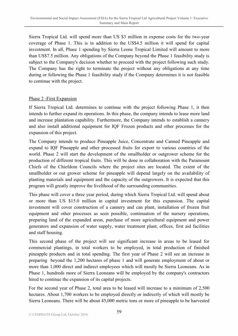
Environmental and Social Impact Assessment (ESIA) for the Sierra Tropical Ltd Agricultural Project Volume 1: Executive Summary and Main Report
59
© CEMMATS Group Ltd, October 2016
Sierra Tropical Ltd. will spend more than US $3 million in expense costs for the two-year coverage of Phase 1. This is in addition to the US$4.5 million it will spend for capital investment. In all, Phase 1 spending by Sierra Leone Tropical Limited will amount to more than US$7.5 million. Any obligations of the Company beyond the Phase 1 feasibility study is subject to the Company's decision whether to proceed with the project following such study. The Company has the right to terminate the project without any obligations at any time during or following the Phase 1 feasibility study if the Company determines it is not feasible to continue with the project.
Phase 2 -First Expansion
If Sierra Tropical Ltd. determines to continue with the project following Phase 1, it then intends to further expand its operations. In this phase, the company intends to lease more land and increase plantation capability. Furthermore, the Company intends to establish a cannery and also install additional equipment for IQF Frozen products and other processes for the expansion of this project.
The Company intends to produce Pineapple Juice, Concentrate and Canned Pineapple and expand to IQF Pineapple and other processed fruits for export to various countries of the world. Phase 2 will start the development of the smallholder or outgrower scheme for the production of different tropical fruits. This will be done in collaboration with the Paramount Chiefs of the Chiefdom Councils where the project sites are located. The extent of the smallholder or out grower scheme for pineapple will depend largely on the availability of planting materials and equipment and the capacity of the outgrowers. It is expected that this program will greatly improve the livelihood of the surrounding communities.
This phase will cover a three year period, during which Sierra Tropical Ltd. will spend about or more than US $15.0 million in capital investment for this expansion. The capital investment will cover construction of a cannery and can plant, installation of frozen fruit equipment and other processes as seen possible, continuation of the nursery operations, preparing land of the expanded areas, purchase of more agricultural equipment and power generators and expansion of water supply, water treatment plant, offices, first aid facilities and staff housing.
This second phase of the project will see significant increase in areas to be leased for commercial plantings, in total workers to be employed, in total production of finished pineapple products and in total spending. The first year of Phase 2 will see an increase in preparing beyond the 1,200 hectares of phase 1 and will generate employment of about or more than 1,000 direct and indirect employees which will mostly be Sierra Leoneans. As in Phase 1, hundreds more of Sierra Leoneans will be employed by the company's contractors hired to continue the expansion of its capital projects.
For the second year of Phase 2, total area to be leased will increase to a minimum of 2,500 hectares. About 1,700 workers to be employed directly or indirectly of which will mostly be Sierra Leoneans. There will be about 45,000 metric tons or more of pineapple to be harvested

Environmental and Social Impact Assessment (ESIA) for the Sierra Tropical Ltd Agricultural Project Volume 1: Executive Summary and Main Report
60
© CEMMATS Group Ltd, October 2016
and processed. The third and last year coverage of Phase 2 will involve leasing a minimum of 3,000 hectares. Sierra Tropical Limited will generate generate employment of about or more than 1,900 direct and indirect employees, About 65,000 metric tons or more of pineapple will be harvested.
Training will continue to develop potential Sierra Leoneans who will occupy supervisory positions as the company continues to expand beyond Phase 2. Training programs will also continue in all areas of the company operations to develop new workers to be employed and improve skills of present ones.
During this second phase, company-hired contractors will be employing hundreds more of Sierra Leoneans for the completion of the expansion projects.
In summary, at the end of Phase 2, Sierra Tropical Limited will have 4,000 or more hectares planted to pineapple. It will produce pineapple juice, concentrate, canned pineapple, frozen pineapple and fresh pineapple to be sold to markets in Europe, United States, Middle East and Africa.
Phase 3 and beyond Long Term Goal
Sierra Tropical Limited intends to expand its operations further in this phase, depending on the success of Phases 1 and 2. The Company's long term goal is to develop and establish a large scale agriculture and manufacturing operation in Sierra Leone. It aims to be the major exporter of high quality and competitive pineapple and other tropical fruit products in the major markets in Europe, United States, Middle East and Africa. It also aims to be a major source of employment in the country, continuously developing and improving the skills of Sierra Leoneans.
Lastly, the smallholder or out grower scheme will play a strategic role for Sierra Tropical Limited to achieve its long term goal. The company aims to source a good portion of its pineapple requirements from the growers. In this regard, Sierra Tropical Limited will continue to develop an effective growers program by providing growers with adequate training and appropriate technical assistance in cultivating and growing tropical crops. The company's growers program aims to continuously create more local employment and greatly improve the livelihood of the communities.
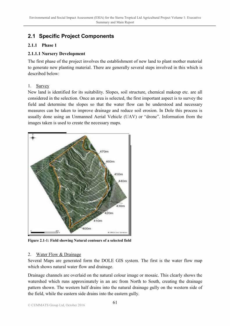
Environmental and Social Impact Assessment (ESIA) for the Sierra Tropical Ltd Agricultural Project Volume 1: Executive Summary and Main Report
61
© CEMMATS Group Ltd, October 2016
2.1 Specific Project Components
2.1.1 Phase 1
2.1.1.1 Nursery Development
The first phase of the project involves the establishment of new land to plant mother material to generate new planting material. There are generally several steps involved in this which is described below: 1. Survey New land is identified for its suitability. Slopes, soil structure, chemical makeup etc. are all considered in the selection. Once an area is selected, the first important aspect is to survey the field and determine the slopes so that the water flow can be understood and necessary measures can be taken to improve drainage and reduce soil erosion. In Dole this process is usually done using an Unmanned Aerial Vehicle images taken is used to create the necessary maps.
Figure 2.1-1: Field showing Natural contours of a selected field
2. Water Flow & Drainage Several Maps are generated form the DOLE GIS system. The first is the water flow map which shows natural water flow and drainage.
Drainage channels are overlaid on the natural colour image or mosaic. This clearly shows the watershed which runs approximately in an arc from North to South, creating the drainage pattern shown. The western half drains into the natural drainage gully on the western side of the field, while the eastern side drains into the eastern gully.

Environmental and Social Impact Assessment (ESIA) for the Sierra Tropical Ltd Agricultural Project Volume 1: Executive Summary and Main Report
62
© CEMMATS Group Ltd, October 2016
Figure 2.1-2: Water flow and natural drainage pattern
3. Field Design Using this information and the GIS software the layout or intended direction of rows (or blocks) can be added taking into account the natural slope of the field. An accurate map indicating the field layout is then prepared for the land preparation team to rip, bed forming and make drains all respecting the natural contours and slope of the field as best as possible.
Figure 2.1-3: The field layout is adapted to the relief. The center road follows the watershed and the orientation of the field blocks is approximately parallel to the contour lines.
Environmental and Social Impact Assessment (ESIA) for the Sierra Tropical Ltd Agricultural Project Volume 1: Executive Summary and Main Report
63
© CEMMATS Group Ltd, October 2016
Once land preparation starts steps in the following flow diagram are followed. As the project will be starting on new land, certain practices are modified, for example knock down and shredding may be different. Table 2.1-1 is an indication of the type of process which will be adapted for local requirements.
Table 2.1-1: Land Preparation Flow Diagram
Nyandehun Nursery Site Sierra Rutile Mine Background As part of the feasibility studies and preparations for establishing this project, an agreement was reached between Sierra Rutile Ltd (SRL) and African Lion Agriculture (ALA) in 2015,

Environmental and Social Impact Assessment (ESIA) for the Sierra Tropical Ltd Agricultural Project Volume 1: Executive Summary and Main Report
64
© CEMMATS Group Ltd, October 2016
for the establishment of a 2ha test plot for the Sierra Tropical proprietary variety of pineapples. The test plot aimed at testing the suitability of the Sierra Tropical variety to conditions in Sierra Leone. The test was conducted by ALA within the scope of their EIA Licence, as part of a Corporate Social Responsibility (CSR) project for SRL. In early 2016, a further agreement was reached between SRL and ALA to convert the existing 30 hectare pineapple farm into a nursery for the production of planting materials (using the proprietary variety) for the proposed site at Sumbuya. In 2017 however, SRL was purchased and taken over by Iluka Resources. The agricultural areas were subsequently handed over to Carmanor, a new company not covered by an EIA Licence. This plot of land is now to be included in Sierra Tropical The nursery was planned and intended as a temporary alternative to grow and speed up the provision of planting material for the Sumbuya Project. As the plants life cycle is completed the area will be cleared and returned to Carmanor for their continued use. It is expected that this will be achieved and the nursery cleared away by the end of 2019. Description of Nursery Site The following table highlights key features of the nursery site:
Location Nyandehun village, Pirri Chiefdom, Bonthe district
Boundary Coordinates 1) 7.647477 - 12.321794
2) 7.653429 - 12.312056
3) 7.652139 - 12.302529
4) 7.650363 - 12.303786
Land area 30 hectares
Work force size 133
Capital Outlay USD 1.43million
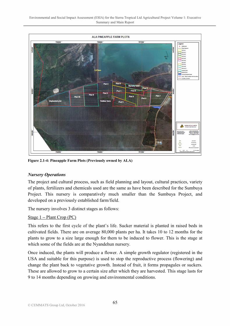
Environmental and Social Impact Assessment (ESIA) for the Sierra Tropical Ltd Agricultural Project Volume 1: Executive Summary and Main Report
65
© CEMMATS Group Ltd, October 2016
Figure 2.1-4: Pineapple Farm Plots (Previously owned by ALA)
Nursery Operations
The project and cultural process, such as field planning and layout, cultural practices, variety of plants, fertilizers and chemicals used are the same as have been described for the Sumbuya Project. This nursery is comparatively much smaller than the Sumbuya Project, and developed on a previously established farm/field.
The nursery involves 3 distinct stages as follows:
Stage 1 Plant Crop (PC)
This refers life. Sucker material is planted in raised beds in cultivated fields. There are on average 80,000 plants per ha. It takes 10 to 12 months for the plants to grow to a size large enough for them to be induced to flower. This is the stage at which some of the fields are at the Nyandehun nursery.
Once induced, the plants will produce a flower. A simple growth regulator (registered in the USA and suitable for this purpose) is used to stop the reproductive process (flowering) and change the plant back to vegetative growth. Instead of fruit, it forms propagules or suckers. These are allowed to grow to a certain size after which they are harvested. This stage lasts for 9 to 14 months depending on growing and environmental conditions.

Environmental and Social Impact Assessment (ESIA) for the Sierra Tropical Ltd Agricultural Project Volume 1: Executive Summary and Main Report
66
© CEMMATS Group Ltd, October 2016
Stage 2 Ratoon Crop (R1)
Once all the suckers are harvested for plant production, one sucker is left behind to create a second mother plant. The process mentioned above is then repeated. This stage takes a further 8 to 10 months, depending on growing and environmental conditions.
Stage 3 Knock Down/Clearing
After all the propagules/suckers have been harvested the plants are removed or incorporated into the soil and the process starts again following land preparation if required. Minimum tillage is practiced by Dole in order to keep cultivation to a minimum.
The full cycle of a pineapple plant takes 36 to 40 months depending on growing and environmental conditions.
Water Requirements
Water is sourced from the SRL lagoons based opposite the pineapple nursery area. This water is tested by the mine on a regular basis and is also suitable for use as irrigation water. Water requirements of the plants are as described for the Sumbuya Project, as the soil composition is very similar.
Chemical Requirements
Chemicals and Fertilizers used at Nyandehun are all registered and approved for use on Pineapples. They are also approved by Dole for use in their worldwide operations. The list is exactly the same as that provided for the Sumbuya Project.

Environmental and Social Impact Assessment (ESIA) for the Sierra Tropical Ltd Agricultural Project Volume 1: Executive Summary and Main Report
67
© CEMMATS Group Ltd, October 2016
2.1.1.2 Organizational structure
2.1.1.3 Construction Work
Construction work will be an integral part of the developmental activities during this first phase of the project. It will involve the development of offices, warehouse, support facilities, security posts, wells and water tower, the facility boundary wall and living quarters.
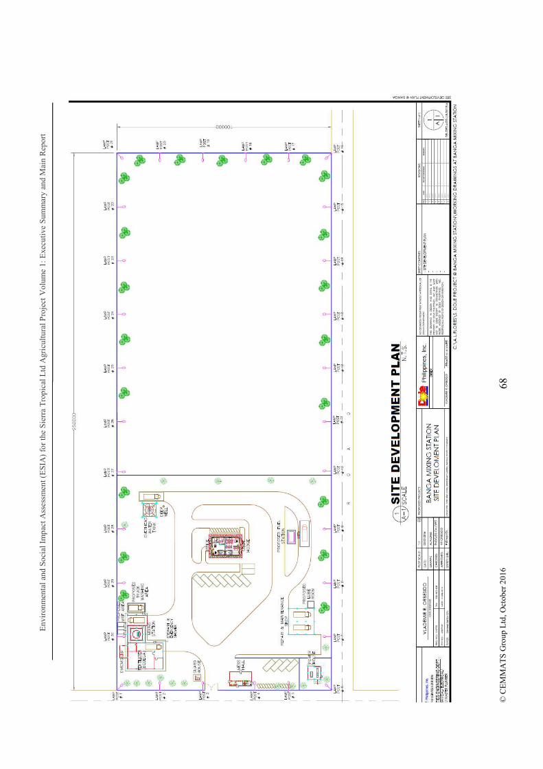
Env
iron
men
tal a
nd S
ocia
l Im
pact
Ass
essm
ent (
ES
IA)
for
the
Sie
rra
Tro
pica
l Ltd
Agr
icul
tura
l Pro
ject
Vol
ume
1: E
xecu
tive
Sum
mar
y an
d M
ain
Rep
ort
68
© C
EM
MA
TS
Gro
up L
td, O
ctob
er 2
016

Environmental and Social Impact Assessment (ESIA) for the Sierra Tropical Ltd Agricultural Project Volume 1: Executive Summary and Main Report
69 © CEMMATS Group Ltd, October 2016
Different construction contractors will be selected through a bidding process following the acquisition of the EIA License for the different projects.
2.1.1.4 Water Supply
Water for the project will be sourced from boreholes and from the Sewa River. Boreholes will be sunk to provide water for the day to day running of the facility including domestic use. Water for irrigation and spraying will be obtained from the Sewa River; the following table shows the average calculated water requirements for the project.
Water required (in terms of precipitation) 7mm/day
Continuous water flow required in litres/second/ha
0.81lt/sec./ha
Total equivalent ha 500 ha
Total irrigation water requirements (maximum) 875,000 m3 per year
2.1.1.5 Power Supply
Power supply will be used for running the offices and irrigation purposes. Several diesel wer requirements initially. It is estimated
that a total of 1 1.5MW of electricity will be required to power the project initially; in the longer term as the project progresses, demand may increase to beyond 3MW.
There are however plans to look into other more environmentally friendly sources of energy as the project progresses. Options are Hydroeletric, Solar, Biomass for combustion and the use pineapple/fruit waste to produce methane gas. For Methane gas production a sufficient amount of biomass would be required to be available on a regular basis to sustain energy production. This could be possible after 2023. All of these options will be be investigated and pursued later, we look to reduce Diesel generation and consumption to a minimum and have it as a backup capacity. The following table highlights the total expected power requirements to supply irrigation needs assuming a pump rate of 50m3/hour (Pump head of 60m, pump and motor efficiency of 70%):

Environmental and Social Impact Assessment (ESIA) for the Sierra Tropical Ltd Agricultural Project Volume 1: Executive Summary and Main Report
70
© CEMMATS Group Ltd, October 2016
Estimated maximum water application over a season (in terms of precipitation)
1000 mm
Expected kW 12
Estimated running time 1500 hours
Estimated number of pumps 3
Total annual estimated Power requirements 36kW
2.1.1.6 Chemical Usage
The following list highlights the full range of chemicals approved for use operations. It is not likely that most of these chemicals will be used, but at this stage it is difficult to identify exactly which ones will be required for the project. The Material Safety Data Sheets for these chemicals are compiled in Volume 3 of this report: List of DOLEFIL-Approved Agrochemicals and their MSDS.

Environmental and Social Impact Assessment (ESIA) for the Sierra Tropical Ltd Agricultural Project Volume 1: Executive Summary and Main Report
71
© CEMMATS Group Ltd, October 2016
Table 2.1-2: Fertilizers
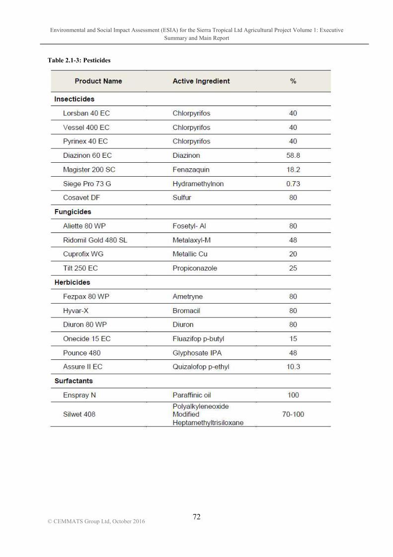
Environmental and Social Impact Assessment (ESIA) for the Sierra Tropical Ltd Agricultural Project Volume 1: Executive Summary and Main Report
72
© CEMMATS Group Ltd, October 2016
Table 2.1-3: Pesticides
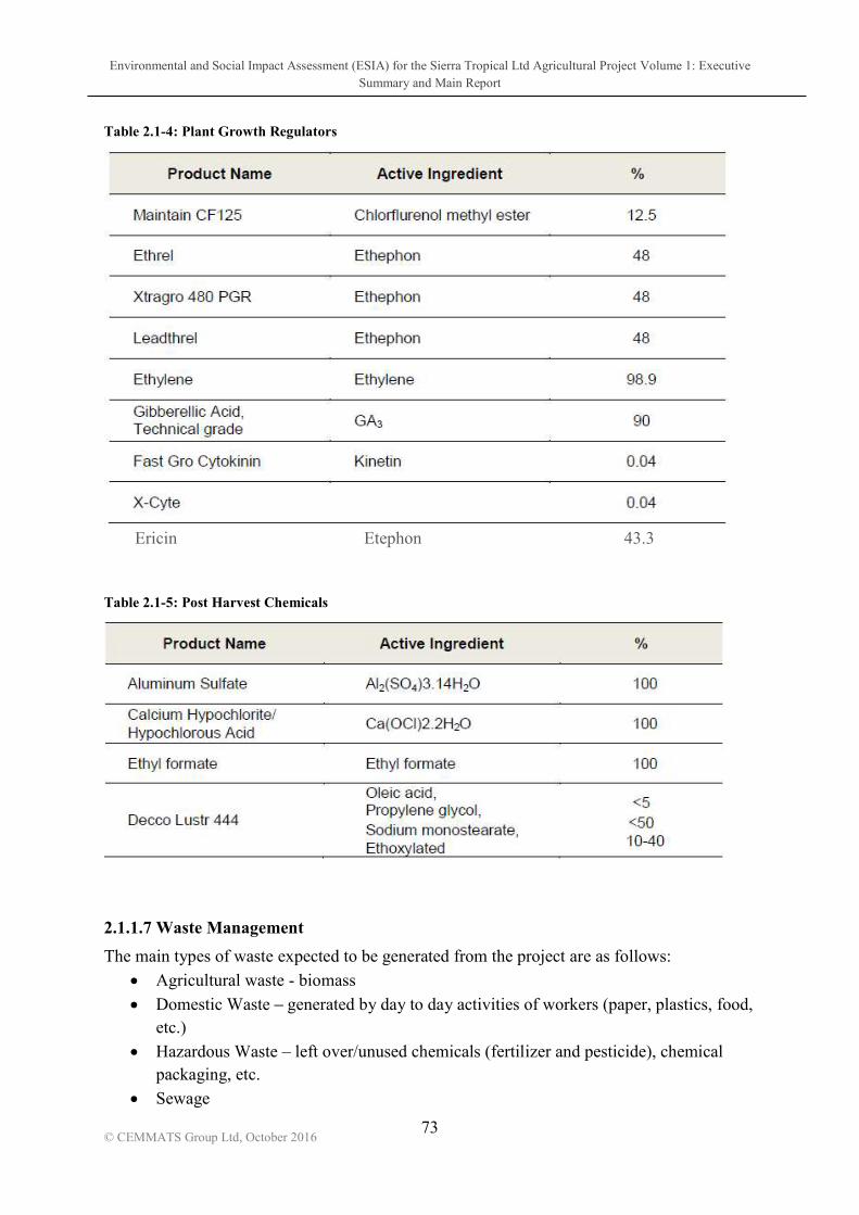
Environmental and Social Impact Assessment (ESIA) for the Sierra Tropical Ltd Agricultural Project Volume 1: Executive Summary and Main Report
73
© CEMMATS Group Ltd, October 2016
Table 2.1-4: Plant Growth Regulators
Ericin Etephon 43.3
Table 2.1-5: Post Harvest Chemicals
2.1.1.7 Waste Management
The main types of waste expected to be generated from the project are as follows:
Agricultural waste - biomass
Domestic Waste generated by day to day activities of workers (paper, plastics, food, etc.)
Hazardous Waste left over/unused chemicals (fertilizer and pesticide), chemical packaging, etc.
Sewage
Environmental and Social Impact Assessment (ESIA) for the Sierra Tropical Ltd Agricultural Project Volume 1: Executive Summary and Main Report
74
© CEMMATS Group Ltd, October 2016
During this initial phase of the project, there will be no processing of fruits; this will feature during the second phase following the introduction of the cannery. Agricultural Waste: This category of wastes will comprise of plant waste (from vegetation clearing, pruning, etc.) and will be shredded (using a wood chipper) and used as compost or the vegative material will be Mulched user a forestry mulcher and incorporated directly back in to the soil, improving the organic material content. Care will however be taken to ensure that these wastes do not become a haven for rodents and other pests. Burning of biomass will be avoided unless absolutely necessary.
There are proposals to be reviewed for the use of biomass generated by the project to produce electricity to supplement or replace the diesel generators. There are two options under consideration 1) is a dry biomass burner for steam generation, burning rice hulls or other materials this is not possible at this time, 2) the other system of Biomass is for the production of Methane gas for steam production and electrical generation- that is a separate investment to be reviewed at a later date.
This will however only become feasible when the project has developed and expanded to a point where sufficient biomass is produced to support energy production. Domestic Waste: Domestic waste will be produced in offices and day to day activities in other areas of the facility. Waste minimization, reuse and recycling will be employed as much as possible, and workers will receive training in these waste management methods. Waste receptacles will be labeled to collect different types of wastes which can then be disposed of appropriately. Hazardous Waste: Hazardous wastes will include items such as waste oils, fuel filters, pesticide/fertilizer containers and packaging. These will be disposed of in assigned and labeled waste receptacles and stored safely for transportation to and disposal at a hazardous waste management facility. Staff will be trained in the safe handling and disposal of these wastes. Sewage: Grey and black water will be directed into underground soak away pits which will be emptied by a licenced sewage management company when required. Such a company will be identified at a later stage. It will be ensured that sewage disposal regulations are adhered to.
2.1.1.8 Occupational Health, Safety and Security Issues
Dole is committed to providing its employees with a safe and healthy work environment. This includes providing appropriate protective equipment, as well as following good manufacturing practices and taking proper safety and sanitation measures. By complying with

Environmental and Social Impact Assessment (ESIA) for the Sierra Tropical Ltd Agricultural Project Volume 1: Executive Summary and Main Report
75
© CEMMATS Group Ltd, October 2016
applicable environmental and occupational health and safety laws and regulations, a safe working environment will be ensured.
In order to uphold the ommitment to a safe and healthy workplace, management and employees will be required to:
Follow all safety laws and procedures
Observe posted safety-related signs
Use prescribed safety equipment whenever required
Management and staff will be required to work together to prevent hazardous or unsafe working conditions. Each staff will be responsible to follow prescribed safety and reporting procedures if any hazardous conditions or unsafe behaviour is detected.
Use of alcohol and illegal drugs will not be accommodated and employees will be prohibited from possessing, distributing, selling or using these items while on the Sierra Tropical Premises.
To further ensure a safe work environment, acts or threats of violence will not be tolerated. Any threatening behaviour will be addressed immediately with utmost seriousness. Weapons will not be permitted on the premises.
2.1.1.9 Environmental Health and Safety
It is STL and to take all practicable steps to promote health, safety and environmental protection. company, Dole, manages operations worldwide that belong to different economic sectors farming, food processing, manufacturing, research, transportation (including trucking, shipping and managing port facilities), distribution and sales. In all these operations, it is
and subsidiaries are required to operate within the same standards.
Dole strives to develop and employ approaches that are most appropriate and effective under local conditions and are guided by: scientific research and knowledge; principles of risk analysis; public, community and worker concerns; and regulatory policies and standards of Japan, the U.S., the European Union and international organizations such as the World Health Organization.
sustainable agricultural practices and integrated pest management methods that employ biological and agricultural approaches to controlling pests and plant diseases. Crop protection products are used only when and where necessary, and always with the proper care and in accordance with applicable laws. Dole and its subsidiaries will not use any product banned for reasons of unacceptable health or environmental risk by the United States Environmental Protection Agency, Japan or the European Union.
Environmental and Social Impact Assessment (ESIA) for the Sierra Tropical Ltd Agricultural Project Volume 1: Executive Summary and Main Report
76
© CEMMATS Group Ltd, October 2016
2.1.2 Phases 2 and 3
2.1.2.1 Outgrower Program
The Outgrowers scheme will play an important role for Sierra Tropical Ltd. in achieving its longer term goals. The company may source a good proportion of its pineapple and other fruit requirements from local growers in and around Sumbuya, the site of the new plantation.
Sierra Tropical Ltd will, like it has done in its Philippine operations, continue to develop an effective growers program. This will involve the training and appropriate technical assistance along with access to necessary equipment and material inputs to cultivate and produce quality fruit. Other tropical fruits such a Papaya (pawpaw), Mangoes, Guavas and Passion fruit will also be considered as the project develops.
The outgrower s program aims to create more local employment opportunities, improve the livelihood of farmers and greatly improve the economic wellbeing of the local communities in the area.
Main Objectives:
Increase tonnages for the cannery
Improve global competitiveness
Generate new employment opportunities for the community near to their homes
Create a new social landscape in Sumbuya Rational:
There is an expanding world market creating additional needs for our products
There are well suited growing land/soils in Sierra Leone
There is well established production technology and technical knowledge available from the company
The company has many years of experience working with small commercial farmers in different countries around the world.
Potential Benefits To The Growers and their Communities
Out Growers will have a firm commitment for their contracted production
Access to well tested and proven tropical fruit growing technology
Access to low cost and a reliable supply of agricultural inputs as part of a contracted grower program.
Access to quality training and disciplined systems/structures
Higher earnings versus current crop alternatives (i.e. Cassava)
Employment of family members and neighbors who meet the qualifications required.
Sound company relationships with the growers and community through community outreach programs (i.e. Improvements to clinics and schools / infra-structure improvements, i.e. water system, sanitation and others)

Environmental and Social Impact Assessment (ESIA) for the Sierra Tropical Ltd Agricultural Project Volume 1: Executive Summary and Main Report
77
© CEMMATS Group Ltd, October 2016
Improved farmers income, bring new opportunities for economic activity to the community
The relationship between outgrowers and local government representatives, Chiefs and government line agencies will be enhanced.
2.1.2.2 Development of Cannery
The development of a cannery is anticipated to commence in 2019. The cannery will be used to process the fruit into various forms including canned fruit, fruit juice, juice concentrate, etc.
The development of this aspect of the operations will involve the following aspects:
Fruit Receiving Area
Dumper Truck or trailers
Receiving Conveyor
Small flume (to wash fruit)
Fruit Elevator with Washer Spray
Feed Conveyor
Fruit Grader
Fruit Accumulator
Fruit Distribution merry-go-round (MGR)
Truck Scale System
Four (4) Ginaca Pineapple Processing Machines intended for juicing
Two (2) preparation lines with slicers, handguns
Four-stage juice press system
25-GPM 6-effect tube -type evaporator and aseptic filling system expandable to 50 gpm
Boiler at 20K pounds per hour, saturated steam.
Reverse Osmosis water at 55,000 liters per hour - source would be deep borehole
Cold storage for the juice concentrate
3 units 350 KVA continuous and stand by generators
A laboratory
Waste Water Treatment Plant
2 settling ponds
2 aeration ponds
3 facultative ponds
Fire Protection System

Environmental and Social Impact Assessment (ESIA) for the Sierra Tropical Ltd Agricultural Project Volume 1: Executive Summary and Main Report
78
© CEMMATS Group Ltd, October 2016
2.2 Timescale of Operations
Phase 1 will last approximately 2 years, and will utilise a minimum of 800 hectares. The second phase will be implemented in the third year and will last for 3 years, with a proposed expansion to a minimum total of 4,000 hectares. For years 6 to 10, more than 2000 hectares roughly maybe be acquired, and with the proven success of Phase 2, expansion will continue to increase steadily. Using this projection, and assuming success at each stage, the project is estimated to continue for over well over 50 years.

Environmental and Social Impact Assessment (ESIA) for the Sierra Tropical Ltd Agricultural Project Volume 1: Executive Summary and Main Report
79 © CEMMATS Group Ltd, October 2016
3 ANALYSES OF PROJECT ALTERNATIVES
In accordance with current ESIA good practice, it is appropriate for the study to review alternatives considered during planning of the project, and to explain why the proposed project activities have been selected, including potential environmental, social and advanced technological considerations. For the purpose of the agro-processing (plantation, product processing & marketing) activities for which this ESIA is being condProject Option have been considered.
3.1 The project area is virgin ground for the agro-processing industry and the Sierra Tropical Ltd project will be first large scale mechanized cultivation and tropical fruit processing project in the southern region and Sierra Leone.
The project will provide opportunities for socio-economic development and growth within the Lugbu Chiefdom. This will come about as a result of land lease payments, outgrower programs, job opportunities, business opportunities, community development activities etc. Infrastructural development within the project area will contribute towards improving the standard of living and improve the social conditions within the related communities.
National benefits will be realized through the socio-economic improvement of the project area as well as the through the exportation of the fruits and fruit products (juice, canned fruit and juice concentrate)
The socio-economic assessment carried out during this study indicated that currently in the absence of an Industrial Project such as Sierra , most community residents (over 85%) depend mostly on small scale farming with the next most popular livelihood being artisanal mining (6%). On a district level, more than half of the population of Bo District depends on farming as their main source of livelihood. Thus economic growth and poverty reduction in the district will only be sustained with development in this sector as the District is endowed with cultivable land (Upland and Inland Valley Swamps) and adequate rain-fall.
The implementation of the Sierra Tropical agro-processing will therefore have far reaching benefits to the project area and Sierra Leone as a whole, which would not be realized if the
project in an environmentally sustainable manner will have greater benefits for the local communities and Sierra Leone as a whole, than not implementing the project and maintaining the existing biophysical, socio-economic and physical conditions at the site.
Environmental and Social Impact Assessment (ESIA) for the Sierra Tropical Ltd Agricultural Project Volume 1: Executive Summary and Main Report
80
© CEMMATS Group Ltd, October 2016
3.2 The Project Site Dole Worldwide Packaged Foods has projects in different parts of the world including the Philippines and Thailand. The company became interested in establishing a project in West Africa due to the suitable soil and climate, and the fact that this region is it minimal risk of typhoons or hurricanes. The proximity to the USA, Europe, South America and the Middle East markets was also taken into consideration.
In specifically selecting Sierra Leone for the project, the following factors were taken into consideration:
1. Suitable Climate and Soil for PA - Confirmed through exploratory Soil survey, Water and Climate assessment
2. Enough land for the project can be acquired at a reasonable cost. 3. The project can be established at a competitive running cost; labour is also available
and competitive. 4. Political Stability and Public Safety
Experienced democratic election twice peacefully (2007/2012) and current government is stable.
No tribal/religious conflict in Sierra Leone.
Many Foreign Investors recognize political stability and Public Safety of Sierra Leone.
5. Attractive Incentives by Supportive Government The Lugbu Chiefdom was chosen due to the proximity of the Sewa River, good rainfall and encouraging preliminary soil surveys.
3.3 Project Technology & Operations Option Sierra Tropical has plans to adopt the most modern technology in the cultivation, processing and marketing of the tropical fruits. This will ensure that maximum yield and production output is obtained, resulting in a thriving local and international market.
During the second phase on the project, STL intends to install a fully mechanised Cannery where the fruit will be processed. The equipment utilised will provide an extraction efficiency of about 90% (this refers to the percentage extracted from the total juice present in the fruit).
The fully industrialised agricultural and processing methods to be used will be a vast improvement from the existing rudimentary farming methods used within the project area.

Environmental and Social Impact Assessment (ESIA) for the Sierra Tropical Ltd Agricultural Project Volume 1: Executive Summary and Main Report
81 © CEMMATS Group Ltd, October 2016
4 POLICY, LEGAL, REGULATORY and INSTITUTONAL CONTEXT
4.1 Policies and Plans
4.1.1 National Environmental Policy, 1994 This National Environmental Policy seeks to achieve sustainable development in Sierra Leone through the implementation of sound environmental management systems which will encourage productivity and harmony between man and his environment. It also promotes efforts which will prevent or eliminate damage to the environment and biosphere and stimulate the health and welfare of nationals, and serves to enrich the understanding of ecological systems and natural resources important to the Nation. Thus the key objective of the policy is to secure for all Sierra Leoneans a quality environment that can adequately provide for their health and well-being.
The policy takes into consideration major sector goals and policies for enhancing sustainability in environmental management systems. The following sectorial policies are highlighted within the National Environmental Policy:
Land Tenure, Land Use and Soil Conservation;
Water Resources Management;
Forestry and Wildlife;
Biodiversity and Cultural Heritage;
Air Quality and Noise;
Sanitation and Waste Management;
Toxic and Hazardous Substances;
Coastal and Marine Resources;
Working Environment (Occupational Health and Safety);
Energy Production and Use;
Settlements, Recreational Space and Greenbelts;
Public Participation;
Quality of Life;
Gender Issues and the Environment;
Institutional and Government Arrangements;
Legal Arrangement.
Subsequent to this policy is the Environmental Protection Act of 2008

Environmental and Social Impact Assessment (ESIA) for the Sierra Tropical Ltd Agricultural Project Volume 1: Executive Summary and Main Report
82 © CEMMATS Group Ltd, October 2016
4.1.2 Agricultural Policy
development and poverty reduction objectives. The policy deals with pertinent issues of crop production, crop post-harvest technology, livestock production, produce marketing and pricing, agricultural finance/credit, agricultural research, agricultural extension, mechanisation, land and water resources management, food security, natural resource management, biotechnology and genetic engineering as well as other policy issues. It also establishes significant guidelines for the participation of various stakeholders in the agricultural sector to promote sustained growth. The policy makes reference to land tenure situational factors and seeks to ensure compliance amongst different stakeholders by setting
accommodating the demands of commercial agriculture.
The government through this policy seeks to build, in the medium and long-term, technology pyramids to provide alternatives to the significant proportion of its foreign exchange used to purchase fossil fuels. The policy therefore provides for the use of existing or new crops for biomass production or conversion to biofuels to ensure sustainability in the agricultural processing sector and meeting the energy needs of the country
4.1.3 Draft National Lands Policy, 2015 This policy framework provides the vision, principles and policy components to give direction to and definition of the roles and responsibilities of various government and customary authorities, and other non-state actors, in land management. Specifically, it enunciates Policy Statements in respect of the key components of the National Land Policy such as access to land and tenure, land use, regulation and the management of special land issues, land administration structures, land laws and the Constitution.
The National Land Policy proposes to improve upon and strengthen the existing land administration systems and land laws, particularly by recognizing and working with the differentiated land tenure categories in the Western Area and the Provinces, and enhancing the capacities of relevant institutions on mobilizing sufficient national and international resources to ensure the implementation of the National Land Policy.
The specific objectives of this National Land Policy are:
a. To clarify the complex and ambiguous constitutional and legal framework for sustainable management of land resources;
b. To promote law reforms that will further harmonize the two separate jurisdictions of the current land tenure systems;
c. To ensure the security of tenure and protection of land rights to all legitimate landholders, regardless of their form of land tenure;
d. To promote equitable access to land

Environmental and Social Impact Assessment (ESIA) for the Sierra Tropical Ltd Agricultural Project Volume 1: Executive Summary and Main Report
83 © CEMMATS Group Ltd, October 2016
e. To promote and enforce sound land use, regulation and management
f. To streamline and decentralise land administration to be more efficient, transparent and effective
g. To modernize and streamline land information system
h. To promote the eradication and/or avoidance and efficient settlement of land disputes by rationalising and strengthening the capacity of traditional institutions, local and national courts in the speedy and effective resolution of land disputes;
i. To ensure protection and security of Sierra Leone national boundaries in accordance with international conventions as enshrined in the International Law of the Sea, Anglo-Francophone Protocols and Joint Border Commissions;
j. To build capacity for the effective monitoring and evaluation of the implementation and impact of the national land policy.
4.1.4 Forestry Policy, 2010 The Forestry Policy support relevant provisions of the Constitution which permits restrictions on activities within forests which is reasonably required in the interests of conservation of the natural resources, the respect for international law and treaty, obligations, as well as the seeking of settlement of international disputes by negotiation, conciliation, arbitration or adjudication.
This Forestry Policy also supports strategies outlined in the Framework for Effective Management of Natural Resources.
4.1.4.1 Biodiversity Strategic Action Plan, 2003
The Sierra Leone Biodiversity Strategic Action Plan comprises a series of measures and mechanisms intended to conserve and promote the sustainable use of the different
s proposed cover several key tHeimatic areas under: terrestrial biodiversity, inland water ecosystems, forest biodiversity, marine and coastal biodiversity and agricultural biodiversity. In addition, actions are also proposed for key cross-cutting issues affecting the sustainable utilization of biodiversity, including: policy, legislation and institutional review, capacity building, identification and monitoring, sustainable use, incentive measures, research and training, public education and awareness, regulation of access to genetic resources, protection of indigenous knowledge and intellectual property rights of local communities, technology transfer and handling of biotechnology and exchange of information and technical co-operation. This Action Plan is intended to:
Provide a framework for setting priority policies and actions for the conservation and sustainable use of biological diversity in Sierra Leone;
Environmental and Social Impact Assessment (ESIA) for the Sierra Tropical Ltd Agricultural Project Volume 1: Executive Summary and Main Report
84 © CEMMATS Group Ltd, October 2016
Catalyze and provide guidance for legal policy and institutional reforms necessary to achieve effective conservation and sustainable use of biological diversity;
Enhance the planning and co-ordination of national efforts aimed at the conservation and sustainable use of biological diversity;
Guide the investment and capacity building programmes for the conservation and sustainable use of bio-diversity;
Facilitate information sharing and coordinated action among the various stakeholders at the national level and foster scientific and technical cooperation with other countries and international organisation.
4.1.5 Conservation and Wildlife Policy, 2010 The Conservation and Wildlife Policy (2010) was developed in recognition that the previous wildlife conservation policy was in need of modernisation. Current legislation based on the 1972 Wildlife Conservation Act (as was the case of the previous wildlife conservation policy) does not reflect the advances made in biodiversity conservation in the past four decades; it also does not take into account international obligations that arose after its entry into force, such as the Convention on Biological Diversity (CBD), the Convention on International Trade in Endangered Species (CITES) and the United Nations Framework Convention on Climate Change (UNFCCC).
The Conservation and Wildlife Policy identifies that challenges to biodiversity conservation
uncontrolled exploitation of natural resources, and a lack of recent comprehensive inventory". that achieves sustainable, rights-based management of wildlife resources for biodiversity conservation inside and outside wildlife conservation areas which benefits present and future
licy goals and develops the necessary institutional arrangements for policy implementation.
4.1.6 Disaster Management Preparedness Plan, 2006 As part of its post-war recovery effort, the Government of Sierra Leone reviewed its National Security Structure to meet the demands of the 21st century. This led the Government to enact the National Security and Central Intelligence Act in 2002 thereby mandating The Office of
-ordinator for the management of national emergencies such as disasters both natural and man-
The disaster management Plan, 2006 is a comprehensive approach that enhances increased political commitment to disaster risk management, thereby encouraging government agencies to take the lead and supported by non-governmental organisations. It also promotes public awareness and the incorporation of disaster risk management into development planning. The policy highlights the sources of funding and the reduction of bureaucracies in accessing such funds for effective disaster co-ordination.

Environmental and Social Impact Assessment (ESIA) for the Sierra Tropical Ltd Agricultural Project Volume 1: Executive Summary and Main Report
85 © CEMMATS Group Ltd, October 2016
The Policy document emphasizes the following:
Ensure the integration of disaster risk management into sustainable development programmes and policies to ensure a holistic approach to disaster management;
Ensure priority and requisite institutional capacities for disaster risk reduction at all levels;
Enhance the use of knowledge, education, training, innovation and information sharing to build safe and resilient societies;
Improve the identification, assessment, monitoring and early warning of risks;
Improve effectiveness of response through stronger disaster preparedness.
4.2 Legislation
Laws and regulations governing environmental issues are found as Acts of parliament. The pieces of legislation of the various government line ministries or institutions include:
4.2.1 Environment Protection Agency Act, 2008/2010
The EPAA 2008 the protection of the environment. The Environment Protection Agency was established with a Board of Directors set up as its governing body. Subject to this Act, the control and supervision of the Agency is the responsibility of the Board, whose administrative functions as stipulated by the EPAA, 2008 include the following:
i. Promoting effective planning and the management of the environment;
ii. Coordinating and monitoring the implementation of national environmental policies relating to Sierra Leone;
iii. Providing policy guidance and advice to ensure the efficient implementation of the functions of the Agency so as to enhance its overall performance;
iv. Facilitating co-operation and collaboration among Government Ministries, local authorities and other governmental agencies, in all areas relating to environmental protection;
v. Coordinating environmentally related activities as well as serving as the focal point of national and international environmental matters, relating to Sierra Leone.
Environmental and Social Impact Assessment (ESIA) for the Sierra Tropical Ltd Agricultural Project Volume 1: Executive Summary and Main Report
86 © CEMMATS Group Ltd, October 2016
4.2.2 The Forestry Act, 1988
The Forestry Act, which first came into effect on 1st July 1988, mandates the Forestry Department to take steps to ensure compliance with the provisions of the Act. It mandates the Director of Forestry or his representatives to enforce the legislation.
The following activities in a forest reserve are considered offences under Sierra Leone forest laws:
Establishing or carrying on a forest industry in or with resources of the core forest: charcoal burning, wood cutting, hunting, stone or soil deportation
Clearing, cultivating or breaking up land for any reason
Removing soil, sand or gravel
Erecting a building or shelter in the core forest or its buffer zone
Lighting, keeping or carrying fire
Carrying a firearm, pasturing cattle or permitting them to trespass
Damaging, altering or removing any notice board, land-mark or fence
Assaulting or obstructing any person carrying out his/her duty under the Forest Act e.g. Forest Guards
Altering, defacing or obliterating any mark placed on timber by a forest officer The maximum penalty under the Forestry regulations is Le 5,000,000 or one year imprisonment. Once convicted, an offender can also lose the equipment that was used to carry out the offence, as the court may order that it be forfeited to the state in addition to the imposition of a fine or term of imprisonment.
4.2.3 Land Tenure and Ownership Land administration in Sierra Leone is governed by a dual system of law, dispersed in about twenty statutes and regulations.
In the Western Area of Sierra Leone, land tenure is governed by Property Statutes. Land is either State (publicly) owned or privately owned. The right of the state to public land is inalienable and indefeasible. Rights of occupation over public land may be granted under warrant. The state has the power, conferred by the Unoccupied Lands Act, Cap 117, to take possession of unoccupied land.
In the provinces, customary law co-exists with statutes. The recognition of the force of customary law in the provinces is established by section 76 (1) of the Courts Act 1965.
Through customary law, ownership of land is vested in the chiefdoms and communities; and can never be owned freehold. Land always belongs to the communities under the different forms of tenure under customary law. This principle is established by the Chiefdom Councils Act as well as by Section 28 (d) of the Local Government Act 1994.

Environmental and Social Impact Assessment (ESIA) for the Sierra Tropical Ltd Agricultural Project Volume 1: Executive Summary and Main Report
87 © CEMMATS Group Ltd, October 2016
4.2.4 Fisheries Act, 2007 The Fisheries Act of 2007 provides protection for both fresh and marine water species as classified by IUCN with the Sierra Leone water. It defines clearly where commercial vessels could harvest-Exclusive Economic Zone (EEZ) and where artisanal fisheries operations could exploit Inshore Exclusive Zone (IEZ).
4.2.5 Wildlife Conservation Amendment Act, 1990
The Wildlife Conservation Act, 1972 and the Forestry Act, 1988 are the main legislations that deal with issues of Biodiversity Conservation in Sierra Leone. It provides for the establishment, conservation and management of National Parks, Game Reserves and other forms of Natural Reserves.
Specific provisions dealing with the protection, management and conservation of these areas and the limitations therein are highlighted in Part II of the Act and include the following:
Prohibition of all forms of hunting, capture and other activities leading to the injury of wild animals;
Destruction of any plant form by any means including fire;
Fishing within these protected areas;
Erection of structures, construction of dams, forestry, agriculture, mining or prospecting activities;
Introduction of species from outside of the boundaries of the reserve.
The Wildlife Conservation Act of 1972 saw minor amendment in 1990 (known as the Wildlife Conservation Amendment Act), which included redefinition of terms, and other modifications and qualifications. For example, the prohibition of hunting of elephants which was limited to protected areas in the 1972 Act was extended to include all forests. The 1990 Amendment Act provided for change of name from Forestry Department to Forestry Division. Despite the minor amendment the Wildlife Conservation Act of 1972 along with the Forestry Act of 1988 continue to be the main legislature for biodiversity conservation in Sierra Leone.
The Wildlife Regulations of 1997 however makes provision for the acquisition of licences or permits for hunting in such designated areas and for other purpose as may be prescribed.
4.2.6 Factories Act 1974
This Act became effective on the 30th May, 1974. It basically deals with health and safety measures as they concern the factory worker. It protects the worker through demands for all aspects of cleanliness, reports of all injuries, accidents, diseases and death.

Environmental and Social Impact Assessment (ESIA) for the Sierra Tropical Ltd Agricultural Project Volume 1: Executive Summary and Main Report
88 © CEMMATS Group Ltd, October 2016
Rules for the Implementation of the Act
As stated in section 16, the Minister may make rules for the effective implementation of this Act and such rules may provide:
For the safety of persons employed in such trades and occupations as may be declared to be dangerous trades;
For imposing obligations for the better safeguarding of persons against accidents from dangerous parts of any machinery;
For the construction and maintenance of fencing to the dangerous parts of any machinery;
For the proper maintenance and safe-working of raising and lowering machinery;
For prescribing the qualifications to be possessed by engineers and other persons, for them to be placed in charge of, or entrusted with the care or management of any specified machinery;
For the reporting of any occurrences at any works arising from, or in connection with, the use, maintenance or repair of any machinery;
For the appointment of persons to hold enquiries under this Act, and prescribing powers and duties of such persons; and
For the fixing of penalties not exceeding a fine of one hundred Leones or imprisonment for a term of six months or both such fine and imprisonment, for the contravention of any rule.
Safety, Security and Welfare of Employees
Part V of this Act, deals with the aspect of health and stipulates that every factory shall be kept in a clean state and free from effluvia arising from any drain, sanitary convenience or nuisance. This part of the Act also states that for overall safety of all employees, the factory must not be overcrowded, must be effectively ventilated, and provided with suitable lighting systems. Every care must be taken by the factory holder, to secure the health, safety and welfare of all employees.
Offences and Penalties
Part VIII of this Act emphasizes on offences, penalties and legal proceedings. Section 47, subsection 1 of this part, states that in the event of any contravention of the provisions of this Act or of any Regulation or Order made there under, the occupier or owner of the factory, shall, be guilty of offence under the Act.
Regarding offences for which there are no penalties provided, section 48 stipulates that, any person guilty of an offence under this Act for which no express penalty is provided by or under the Act, shall be liable to a fine not exceeding fifty Leones or to imprisonment for a
Environmental and Social Impact Assessment (ESIA) for the Sierra Tropical Ltd Agricultural Project Volume 1: Executive Summary and Main Report
89 © CEMMATS Group Ltd, October 2016
term not exceeding one month or both. If the contravention for which he was convicted continues, he shall be guilty of a further offence and liable to a fine not exceeding ten Leones for each day on which the contravention is continued.
Section 50 states that if anyone is killed, or dies, or suffers any bodily injury, in consequence of the occupier or owner of a factory having contravened any provision of this Act, the occupier or owner of the factory, shall, without prejudice to any other penalty, be liable to a fine not exceeding two hundred Leones or to imprisonment for a term not exceeding three months, or to both.
All offences committed under this Act shall, as section 56 states, be prosecuted in a magistrate court.
Powers of Inspectors
Section 14 of part IV of this Act states that an inspector shall, in executing this Act, have the power to do the following:
To enter, inspect and examine a factory and its environs at any time, as long as he has reasonable cause to believe that explosives or any highly inflammable materials are stored or used;
To take with him during an inspection, a police officer, if he has reasonable cause to expect any serious obstruction during the execution of his duty;
To require the production of all documents and to examine and copy them in pursuance of this Act;
To make necessary inquires and examinations to ascertain whether the provisions of the Act are complied with; and
To prohibit the use of any machinery, if he is reasonably of the opinion after examination, that it is not in good and safe condition.
If anyone wilfully delays or obstructs the Inspector in the exercise of any of his duties under this Act, then such a person shall be guilty of an offence and be liable to a fine not exceeding twenty Leones or to imprisonment for a term not exceeding one month or both. The occupier of the factory shall also be guilty of such an offence and be liable to punishment in like manner, even though he has not personally caused the obstruction.
Safety, Security and Welfare of Employees
Part V of this Act, deals with the aspect of health and stipulates that every factory shall be kept in a clean state and free from effluent arising from any drain, sanitary convenience or nuisance. This part of the Act also states that for overall safety of all employees, the factory must not be overcrowded, must be effectively ventilated, and provided with suitable lighting systems. Every care must be taken by the factory holder, to secure the health, safety and welfare of all employees.

Environmental and Social Impact Assessment (ESIA) for the Sierra Tropical Ltd Agricultural Project Volume 1: Executive Summary and Main Report
90 © CEMMATS Group Ltd, October 2016
As indicated in section 38, it is incumbent on the company to notify the District Inspector, in writing, of any accident or death in the factory. It is also stated in section 39 that all factory contracted diseases identified by a medical Practitioner, must be brought to the notice of the Chief Inspector in Freetown.
Section 40 states that: Where injury immediately results in death, the site of the accident must be left undisturbed after the removal of the corpse, until inspected by a police officer or an inspector.
On receipt of the report of an accident, the inspector shall if he considers it necessary or if directed by a higher authority immediately proceed to the scene of the accident, as indicated in section 41, and shall make enquiry into the cause of the death. This section further states that for the purpose of this enquiry, the inspector is free to use any one under oath, any document, and award fees for giving evidences, as may be fixed by the minister.
Any person, who, without reasonable cause, fails to comply with the terms of summons of the inspector, or refuses to be examined or to answer questions other than that which may incriminate him, or anyone who obstructs an Inspector or any person acting under his directions in the execution of his duty under section 41, shall be guilty of an offence.
The owner of every factory, according to section 45, must within 24 hours report in writing to an Inspector every dangerous occurrence caused by any machinery or electrical abnormality.
Section 26 of part VI stipulates that there shall be kept posted in a prominent position in every factory:
The prescribed abstract of this Act;
The address of the Chief Inspector and of the nearest Inspector; and
Printed copies of any regulations made under any part of this Act which are for the time being in force in the factory; or the prescribed abstracts of such regulations.
4.2.7 Local Government Act, 2004 This Act deals with the establishment and operation of local councils around the country to enable meaningful decentralization and devolution of Government functions. It stipulates that a local council shall be the highest political authority in the locality and shall have legislative and executive powers to be exercised in accordance with this Act or any other enactment. It shall be responsible, generally for promoting the development of the locality and the welfare of the people in the locality with the resources at its disposal and with such resources and capacity as it can mobilize from the central government and its agencies, national and international organisations, and the private sector. The local council should initiate and maintain programmes for the development of basic infrastructure and provide works and services in the locality. A local council shall cause to be prepared a development plan which shall guide the development of the locality.

Environmental and Social Impact Assessment (ESIA) for the Sierra Tropical Ltd Agricultural Project Volume 1: Executive Summary and Main Report
91 © CEMMATS Group Ltd, October 2016
Many companies are bound to operate within areas controlled by one local council or another. There is also a relationship between the local council and the Chiefdom within which a company operates. It is advisable for companies to involve local councils in their development work. The schedules to the Local Government Act outline the activities of various MDAs that have been devolved to local councils.
4.3 Regulations
4.3.1 Forestry Regulations, 1990 These regulations are deemed to have come into force on the 1st July, 1990. The Chief Conservator holds the same responsibilities as he does for the Act of 1988.
As a method of environmental protection, it is stated in that no land between the high and low water marks, nor those above the high water mark on both sides of the bank of any waterway, covering a distance of one hundred feet (approx. 33m), shall be cleared of any vegetation except permitted by a clearance licence.
Sacred bushes are protected by the stipulated regulations of section 40, whereby clearance of vegetation from land designated as sacred bush, is prohibited except by clearance authority from the Chief Conservator.
4.3.2 Fisheries Regulations National Fisheries Regulations such as the Fisheries Act 1988 and Fisheries Amendment Act 1990 respectively, have evolved over time in order to address specific matters relating to the conservation and management of natural resources within the marine environment.
The 1994 Decree, passed during the military government regime of NPRC, further established sufficient provisions for the conservation of Marine Resources. These range from monitoring, control and surveillance provisions, as well as those relating to enforcement.
Section 9 (1 & 2) of the Decree gives the government sovereign right over the Economic Exclusion Zone. They include rights for the exploitation, exploration, conservation and management of its natural resources. It further stresses the requirement for a written consent to be provided by government for any form of activities to be undertaken within this zone by states, international organizations or persons.
The Fisheries Act of 2007 provides protection for both freshwater and marine species as classified by the International Union for Conservation of Nature (IUCN), within Sierra Leonean waters. It clearly defines where commercial vessels are to harvest that is the Exclusive Economic Zone (EEZ) and where artisanal fishing is to harvest that is the Inshore Exclusive Zone (IEZ). It also stipulates the fishing equipment tolerable in Sierra Leone, and it also stipulates the quality and quantity of fish to be harvested.

Environmental and Social Impact Assessment (ESIA) for the Sierra Tropical Ltd Agricultural Project Volume 1: Executive Summary and Main Report
92 © CEMMATS Group Ltd, October 2016
4.3.3 Draft Wildlife Regulation, 1997 The Wildlife Regulation came in to force in 1997. It describes Wildlife Conservation Estate as areas described under the 1972 Wildlife Conservation Act as a National Park, Game Reserve, Strict Natural Reserve, Game Sanctuary or Non-hunting Forest Reserve. The regulation prohibits all unlicensed hunting with a Wildlife Conservation Estate, which includes the removal of honey. It prohibits the hunting of young and immature wild animals or birds; female wild animal accompanied by its young; and birds which are apparently breeding. It also prohibits hunting at night with lights to dazzle birds and animals.
The regulations stipulates that a license or permit should be sought before any form of hunting of game and bird can be done as required by Section 33 and 34 of the Act. The regulation also states that such licenses and permits can be revoked by the Chief Conservator of Forest if the holder fails to comply with the provisions of the regulations.
4.4 Institutional Context
4.4.1 Ministry of Water Resources
This ministry has the mandate for the development of policies and programmes for the provision of safe drinking water on a constant and sustainable basis to the entire population of Sierra Leone by carrying out activities under the following major headings:
Guma Valley water company (GVWC);
Sierra Leone Water Company (SALWACO);
Development of Dams and other water supply schemes;
Protection and management of water resources;
In relation with:-
International Hydrological Association
Collaboration with relevant Government Ministries and national and international organizations/Institutions
4.4.2 Ministry of Fisheries and Marine Resources
The Ministry of Fisheries and Marine Resources is the sole government agency with the legal mandate to promote aquaculture activities and to develop policies regarding the fishing sector, control and monitor fisheries and other aquatic resources within the territorial waters in Sierra Leone. The Ministry's overall responsibility is the control, development and conservation of all aquatic organisms, including:
Protection of the marine and Fresh water environments;

Environmental and Social Impact Assessment (ESIA) for the Sierra Tropical Ltd Agricultural Project Volume 1: Executive Summary and Main Report
93 © CEMMATS Group Ltd, October 2016
Prevention of the deposit of toxic and nontoxic waste in the territorial waters;
Maritime Laws relating to territorial rights and fishing limits;
Preservation of Marine Species.
4.4.3 Ministry of Agriculture, Forestry and Food Security
The Ministry of Agriculture Forestry and Food Security (MAFFS) is the central government agency responsible for promoting the development of appropriate policies and programmes geared towards the development of agriculture, animal husbandry and the attainment of national food security in the country.
4.4.4 Ministry of Lands, Country Planning and the Environment
This Ministry develops appropriate policies and programmes for lands country planning and the environment (role now limited with the formation of the EPA-SL) and carry out activities under the following major headings:
Land and Land Tenure;
State Lands;
Surveys, Mapping and Triangulations;
Relations with the Directorates outside Sierra Leone;
Geodetic and Topographical Surveys;
Enforcement of planning and building control;
Demolition of unauthorized structures;
Collaboration with relevant Government Ministries and with national and international organisations and Institutions.
4.4.5 EPA-SL
The Environment Protection Agency was set up to replace the National Commission for Environment and Forestry (NaCEF), which was mandated to oversee issues pertaining to the environment and forestry. The Environment Protection Agency was established with a Board of Directors set up as its governing body. This Board consists of a Chairman and representatives from the various line Ministries and a Unit as stated in section 3 of part II of the Environmental Protection Agency Act. Subject to this Act, the Board shall have the control and supervision of the Agency. The Agency shall act in liaison and co-operation with government agencies to control pollution and the general protection of the environment. The Agency, subject to this Act, shall promote effective planning in the management of the environment and coordinate and monitor the implementation of national environmental policies, relating to Sierra Leone.

Environmental and Social Impact Assessment (ESIA) for the Sierra Tropical Ltd Agricultural Project Volume 1: Executive Summary and Main Report
94 © CEMMATS Group Ltd, October 2016
4.5 International Conventions Policies, Codes, Protocols and Guidelines
4.5.1 International Conventions
Sierra Leone is a party to many international agreements, conventions, and protocols that seek to protect the environment and ensure sustainable development that are applicable to such a project. These include the following:
Table 4.5-1 : List of International Conventions and Agreements to which Sierra Leone is Party
International Commitments and/Agreements Republic of Sierra Leone
The UN Framework Convention on Climate Change (New York, 1992)
Yes +
The Kyoto Protocol is a protocol aimed at fighting global warming. The Protocol was initially adopted on 11 December 1997 in Kyoto, Japan and entered into force on 16 February 2005.
Yes +
Ramsar Convention for the Internationally Important Wetlands Especially as Waterfowl Habitats (1971)
Yes+
The Basel Convention on the Control of Transboundary Movements of Hazardous Waste and Their Disposal (Basel, 22 March 1989)
Yes+
Convention on the Environmental Impact Assessment in a Transboundary Context (EPS, Finland, 1991)
Yes+
Stockholm Convention on Persistent Organic Pollutants (22 May 2001; has not come into force yet)
Yes+
Convention on Biological Diversity (Rio de Janeiro, 1992) Yes+
Convention on the Protection and Use of Transboundary Watercourses and International Lakes (Helsinki, 1992)
Yes+
Convention on International Trade in Endangered Species of Wild Flora and Fauna (Washington, 1973)
Yes+
Aarhus Convention on Access to Information, Public Participation in Decision-Making and Access to Justice in Environmental Matters (1998)
Yes+
Rio Declaration on Environment and Development (UN Yes+
Environmental and Social Impact Assessment (ESIA) for the Sierra Tropical Ltd Agricultural Project Volume 1: Executive Summary and Main Report
95 © CEMMATS Group Ltd, October 2016
International Commitments and/Agreements Republic of Sierra Leone
Conference, 1992)
The following sections briefly discuss the International conventions that have relevance to the STL Project.
4.5.1.1 United Nations Framework Convention on Climate Change
Sierra Leone ratified this convention on 22nd June, 1995. The objective of this convention is to regulate levels of greenhouse gas concentration in the atmosphere, so as to avoid the occurrence of climate change on a level that would impede sustainable economic development, or compromise initiatives in food production. The Parties are required to protect the climate system for present and future generations. Developing countries should be accorded appropriate assistance to enable them to fulfil the terms of the Convention. The Parties should work in cooperation, so as to obtain maximum benefit from initiatives in the control of the climate systems; The Parties are to prepare national inventories on greenhouse gas emissions, and on actions taken to remove them; formulate and implement programmes for the control of climate change; undertake cooperation in technology for the control of change in the climate system; incorporate suitable policies for the control of climate change in national plans; undertake education and training policies that will enhance public awareness in relation to climate change. The developed country Parties (and other Parties listed commit themselves to take special measures to limit their anthropogenic emissions of greenhouse gases, and to enhance the capacity of their sinks and reservoirs for the stabilization of such gases.
4.5.1.2 United Nations Convention on Biological Diversity
This convention, the main objectives of which is to preserve biological diversity and rehabilitate all degraded areas, was ratified by Sierra Leone on 12 December 1994. All signatory States are obliged to affect the prescribed undertakings which include:
Development of national biological diversity strategy plan;
Establishment of protected areas;
Prevention, control and eradication of invasive and alien species;
Provision of educational facilities.

Environmental and Social Impact Assessment (ESIA) for the Sierra Tropical Ltd Agricultural Project Volume 1: Executive Summary and Main Report
96 © CEMMATS Group Ltd, October 2016
4.5.1.3 Vienna Convention for the Protection of the Ozone Layer
The Vienna Convention, concluded in 1985, is a framework agreement in which States agree to cooperate in relevant research and scientific assessments of the ozone problem, to
ozone layer. The obligations are general and contain no specific limits on chemicals that deplete the ozone layer. The ozone layer protects the earth against excessive ultraviolet radiation, which could cause damage and mutations in human, plant, and animal cells.
4.5.1.4 Montreal Protocol
The Montreal Protocol on Substances that Deplete the Ozone Layer (a protocol to the Vienna Convention for the Protection of the Ozone Layer) is an international treaty designed to protect the ozone layer by phasing out the production of a number of substances believed to be responsible for ozone depletion. The Treaty was opened for signature on 16 September 1987, and entered into force on 1 January 1989, followed by the first meeting in Helsinki in May 1989. Since then, it has been revised seven times, in 1990 (London), 1991 (Nairobi), 1992 (Copenhagen), 1993 (Bangkok), 1995 (Vienna), 1997 (Montreal), and 1999 (Beijing). It is believed that adherence to the international agreement will lead to the recovery of the ozone layer by 2050.
4.5.1.5 Rotterdam Convention
The Rotterdam Convention is a multilateral treaty to promote shared responsibilities in relation to the importation of hazardous chemicals. The Convention promotes the sharing of information and calls on exporters of hazardous chemicals to use proper labelling, include directions on safe handling, and inform purchasers of any known restrictions or bans. Parties can decide whether to allow or ban the importation of chemicals listed in the Convention, and exporting countries are obliged to ensure compliance by producers within their jurisdiction.
4.5.1.6 Convention on Wetlands of International Importance (RAMSAR)
The Ramsar Convention on Wetlands (Ramsar) was signed by Sierra Leone on December 13, 1999, and went into effect on April 13, 2000. Signatory countries to the Ramsar convention agree to:
Include conservation of wetlands in land use planning throughout the
Establish nature reserves within wetland areas;
Promote training in the fields of research, management, and gardening; and
Consult with other signatory countries about implementation of the convention especially in areas of shared wetlands, shared water systems, and shared species.

Environmental and Social Impact Assessment (ESIA) for the Sierra Tropical Ltd Agricultural Project Volume 1: Executive Summary and Main Report
97 © CEMMATS Group Ltd, October 2016
As required by Ramsar, Sierra Leone identified and listed one wetland site for inclusion on the Ramsar wetland list. This non-contiguous wetland is located along the Sierra Leone River Estuary near Freetown. The three areas making up the wetland have a combined area of approximately 295,000 hectares (ha) and include mangrove swamps and upland coastal plains. The mangrove swamp included in this wetland makes up approximately 19% of all the mangrove swamp in Sierra Leone.
4.5.1.7 The Stockholm Convention on Persistent Organic Pollutants
The Stockholm Convention on Persistent Organic Pollutants is an international environmental treaty that aims to eliminate or restrict the production and use of persistent organic pollutants (POPs) - chemicals that are persistent bio-accumulates found in fatty tissues and are bio- magnified through the food chain, and adversely affect health and the environment. This Convention was adopted on the 22nd May 2001 in Stockholm and Sierra Leone became a signatory on the 27th August 2001. The convention came into force on 17 May 2004 with ratification by an initial 128 parties and 151 signatories. Co-signatories agree to outlaw nine of the dozen dirty chemicals, and curtail inadvertent production of dioxins and furans.
This Convention recommends the elimination or restriction of production and use of all internationally produced POPs (i.e. Industrial chemicals and pesticides), particularly, Aldrin, Chlordane, Dieldrin, Endrin, Heptachlor, Hexa-chlorobenzene (HCB), Mirixtexaphene, Polychlorinated Biphensylsis (PCBs). The convention also seeks continuing minimization and, where feasible, ultimate elimination of the releases of POPs, such as Dioxins and Furans. Wastes containing POPs, must be managed and disposed of in a safe, efficient and environmentally friendly manner, with regards for international rules, standards and guidelines.
4.5.1.8 Convention on the International Trade of Endangered Species - (CITES)
The requirements of this convention became effective in Sierra Leone on the 16th January 1995. The convention seeks to eliminate and/or reduce trade in certain species inclusive of those that are considered endangered. By this convention, a list has been produced comprising of species that require protection against trade. The majority of the species listed in CITES are those also considered by the International Union for Conservation of Nature and Natural Resources (IUCN), as endangered and threatened. CITES also takes cognizance of species not necessarily threatened, but which require trade control to protect them from being threatened or endangered.

Environmental and Social Impact Assessment (ESIA) for the Sierra Tropical Ltd Agricultural Project Volume 1: Executive Summary and Main Report
98 © CEMMATS Group Ltd, October 2016
4.5.1.9 The UNESCO Convention for the Protection of the World Cultural and Natural Heritage (the World Heritage Convention), 1972
This convention is the foremost example of an international treaty developed to protect outstanding natural areas and resources. These sites, usually nominated for preservation by the state, are listed as part of "the world heritage". A 21-State elected committee of the treaty parties (the World Heritage Committee) decides which to list, and then States are obligated to protect their sites in perpetuity. Over 100 States are parties to the treaty, and 119 "natural" and "mixed" natural-cultural sites have been established as of 1996. Sierra Leone ratified this convention in 2005; however there are no sites currently listed in Sierra Leone.
4.5.2 International Lending Institutions Policies, Standards and Guidelines
Recognizing the political and resource differences among nations in their ability to set and implement environmental and social safeguards, the International Lending Institutions (ILI), development banks and private financial institutions, developed environmental and social safeguard policies and procedures. The purpose of these safeguards was to foster adoption and enforcement of the environmental and social assessment and protective measures required to implement the provisions of international agreements; to reinforce the intent of national legislation, and to foster sustainable development. Examples of these safeguards can be found in the following:
World Bank Operational Policies and Bank Procedure
International Finance Cooperation Performance Standards
The Equator Principles
4.5.2.1 Roundtable on Sustainable Palm Oil (RSPO)
The RSPO, an association for the sustainable palm oil production, was formally established under Article 60 of the Swiss Civil Code on 8 April 2004 in Zurich, Switzerland.
The RSPO was established with the overall objective of promoting the growth and use of sustainable palm oil through cooperation within the supply chain and open dialogue with stakeholders. It has adopted and published a set of principles and criteria to help oil palm producers to be more sustainable. Within the overall framework of the document, practical advice is given to assist plantation managers in developing operational procedures towards identifying impacts and also to measure and monitor appropriate indicators that demonstrates a reduction of impacts over time.
The RSPO acknowledges that a key aspect of achieving sustainability is to identify the significant impacts especially those that are negative on the environment. The RSPO request producers to prepare:
Documentation of the impacts and assessment of their relative importance;

Environmental and Social Impact Assessment (ESIA) for the Sierra Tropical Ltd Agricultural Project Volume 1: Executive Summary and Main Report
99 © CEMMATS Group Ltd, October 2016
Development of strategic management plans which includes the results of such assessments;
Development of operational procedures which identify impacts and the required changes in current practices to mitigate their negative effects; and
Production of improvement plans, including a tismetable for change
The RSPO undertakes the following principle tasks towards the fulfilment of its objectives:
Research and develop definitions and criteria for sustainable production and use of palm oil
Undertake practical projects designed to facilitate implementation of sustainable best practices
Develop solutions to practical problems related to the adoption and verification of best practices for plantation establishment and management, procurement, trade and logistics
Acquire financial resources from private and public funds to finance projects under the auspices of RSPO

Environmental and Social Impact Assessment (ESIA) for the Sierra Tropical Ltd Agricultural Project Volume 1: Executive Summary and Main Report
100 © CEMMATS Group Ltd, October 2016
5 BASELINE SURVEY AND CONDITION
The purpose of the present section is to establish an accurate baseline of the project area before the implementation of this project.
The baseline assessment was carried out on the physical, biological and social environments. Descriptions of the existing environment include primary and secondary data and information from relevant and available sources; text is illustrated with summary tables of data, maps, graphs, photographs and detailed written descriptions.
Noise, dust and wind speed measurements were taken in various locations as indicated in the following figure:
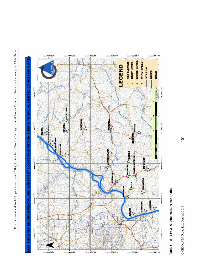
Env
iron
men
tal a
nd S
ocia
l Im
pact
Ass
essm
ent (
ES
IA)
for
the
Sie
rra
Tro
pica
l Ltd
Agr
icul
tura
l Pro
ject
Vol
ume
1: E
xecu
tive
Sum
mar
y an
d M
ain
Rep
ort
101
© C
EM
MA
TS
Gro
up L
td, O
ctob
er 2
016
T
able
5-4
.5-1
: P
hys
ical
Sit
e m
easu
rem
ent
poin
ts
Environmental and Social Impact Assessment (ESIA) for the Sierra Tropical Ltd Agricultural Project Volume 1: Executive Summary and Main Report
102 © CEMMATS Group Ltd, October 2016
5.1 Physical Environment
5.1.1 Climate
distinct seasons: the dry season (November April) and the rainy season (May - October). The hottest months are March and April whiles the wettest months are July, August and September.
5.1.1.1 Methodology
Information and climatic data relating directly to the Freetown ports area was available from the Sierra Leone Meteorological Department. Field measurements, specifically wind speed, were used in conjunction with secondary data obtained, to represent climatic conditions within the project area and its surroundings. Climatic and other data for Bo area have been used to represent conditions within the project area.
The following climatic data represents the period 1976 - 2006 except for wind speed which was measured during the period of this study, August 2016.
5.1.1.2 Findings
The analysis could not be extended, with sufficient reliability because during the period of the baseline study, there was no climatic station in the area.
A summary of some climatic data for Bo was used and is presented in the following table:

Env
iron
men
tal a
nd S
ocia
l Im
pact
Ass
essm
ent (
ES
IA)
for
the
Sie
rra
Tro
pica
l Ltd
Agr
icul
tura
l Pro
ject
Vol
ume
1: E
xecu
tive
Sum
mar
y an
d M
ain
Rep
ort
103
© C
EM
MA
TS
Gro
up L
td, O
ctob
er 2
016
Tab
le 5
.1-1
: Su
mm
ary
of S
ome
Cli
mat
ic D
ata
for
Bo
C
lim
atic
Var
iab
le
Ja
n
F
eb
M
ar
A
pr
M
ay
Ju
n
J
ul
A
ug
Se
p
O
ct
N
ov
D
ec
M
onth
ly M
ean
T
emp
(o C)
(1
976-
1980
)
M
ax
31
.9
33
.6
33
.9
33
.1
31
.8
30
.3
28
.5
27
.9
29
.3
30
.7
31
.0
30
.
M
in
20
.1
20
.8
21
.6
22
.2
22
.4
20
.0
21
.8
21
.2
21
.8
21
.5
21
.7
20
.8
A
vera
ge
Rel
ativ
e
Hu
mid
ity
(%)
(1
976
200
5)
9 a.
m.
78
.7
79
.1
78
.1
78
.9
81
.4
86
.0
89
.4
91
.1
88
.7
86
.3
83
.6
79
.8
3 p.
m.
62
.4
63
.4
64
.0
65
.9
70
.5
75
.5
81
.0
82
.8
78
.8
76
.0
74
.1
67
.9
Mon
thly
Mea
ns
of
Rai
nfal
l (m
m)
(200
7)
4.
3
5.2
46
.8
93
.7
17
6.5
44
6.3
64
9.1
63
7
445.
6
290.
4
125.
2
12.1
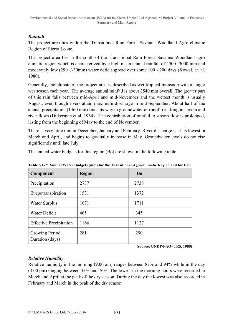
Environmental and Social Impact Assessment (ESIA) for the Sierra Tropical Ltd Agricultural Project Volume 1: Executive Summary and Main Report
104 © CEMMATS Group Ltd, October 2016
Rainfall The project area lies within the Transitional Rain Forest Savanna Woodland Agro-climatic Region of Sierra Leone.
The project area lies in the south of the Transitional Rain Forest Savanna Woodland agro climatic region which is characterized by a high mean annual rainfall of 2500 -3000 mm and moderately low (290+/-30mm) water deficit spread over some 100 - 200 days (Kowal, et. al. 1980).
Generally, the climate of the project area is described as wet tropical monsoon with a single wet season each year. The average annual rainfall is about 2540 mm overall. The greater part of this rain falls between mid-April and mid-November and the wettest month is usually August, even though rivers attain maximum discharge in mid-September. About half of the annual precipitation (1460 mm) finds its way to groundwater or runoff resulting in stream and river flows (Dijkerman et al, 1964). The contribution of rainfall to stream flow is prolonged, lasting from the beginning of May to the end of November.
There is very little rain in December, January and February. River discharge is at its lowest in March and April, and begins to gradually increase in May. Groundwater levels do not rise significantly until late July.
The annual water budgets for this region (Bo) are shown in the following table.
Table 5.1-2: Annual Water Budgets (mm) for the Transitional Agro-Climatic Region and for BO
Component Region Bo
Precipitation 2737 2738
Evapotranspiration 1531 1372
Water Surplus 1671 1711
Water Deficit 465 345
Effective Precipitation 1166 1127
Growing Period Duration (days)
281 290
Source: UNDP/FAO- TR5, 1980)
Relative Humidity Relative humidity in the morning (9.00 am) ranges between 87% and 94% while in the day (3.00 pm) ranging between 45% and 76%. The lowest in the morning hours were recorded in March and April at the peak of the dry season. During the day the lowest was also recorded in February and March in the peak of the dry season.

Environmental and Social Impact Assessment (ESIA) for the Sierra Tropical Ltd Agricultural Project Volume 1: Executive Summary and Main Report
105
© CEMMATS Group Ltd, October 2016
Temperature Normal temperature range is 20.1ºC to 33.9ºC although it can drop below 20oC at night during the Harmattan season in January. Day temperatures average is 31ºC in the dry season and 28ºC in the wet season (Hall, 1966). Average short wave radiation of the season is 393 calories per cubic centimetre (cal/cm3). The duration of growing period is 271 - 298 days. Evaporation Evaporation is high during the dry season with highest in March/April, while it is relatively low in the rainy season with August/September recording the lowest. Evapotranspiration is very high in March been the hottest month and lowest in August which is peak of the rainy season. Wind Speed Wind speed measurements were recorded within and around twenty one (21) settlements in the STL study area. The measurements were recorded at different locations and times of the day using the portable anemometer vane probe.
Table 5.1.3 below shows the level of wind speed recorded during this period (10/08/16 to 13/08/16). The figures (0.03 m/s 1.7m/s) indicate that wind speeds for this time of the year are almost nil in some settlement, while in other areas they are generally low to moderate depending on the time, elevation and open spaces.
Table 5.1-3: Wind speed measurements for settlements within and around the project area
Location GPS coordinates Date Time
Average Wind speed m/s
Gelehun 0177169/0854025 10/8/2016 1.30 pm 0.03
Heima 0179944/0856603 10/8/2016 2.20 pm 0.8
Benduma Sewa 0178712/0855668 10/8/2016 5.00 pm 0.1
Kpatema 0182311/0853217 11/8/2016 10.40 am 0.3
Kpumbu 0180341/0853432 11/8/2016 2.00 pm 0.4
Benduma 0180962/0850991 11/8/2016 3.00 pm 1.4
Momandu 0830956/0842895 12/8/2016 10.55 pm 0.0
Komendi 0169318/0841307 12/8/2016 11.50 am 0.0
Baoma 0830575/0844190 12/8/2016 1.55 pm 0.4
Moforay 0171211/0845094 12/8/2016 2.52 pm 0.2
Mokombo 0172155/0842281 12/8/2016 3.55 pm 0.2

Environmental and Social Impact Assessment (ESIA) for the Sierra Tropical Ltd Agricultural Project Volume 1: Executive Summary and Main Report
106
© CEMMATS Group Ltd, October 2016
Location GPS coordinates Date Time
Average Wind speed m/s
Gola 0172451/0843968 12/8/2016 4.45 pm 0.03
Mosogbo 0174984/0842056 13/8/2016 11.05 am 0.2
Tawamahehun 0174506/0843587 13/82016 12.10 pm 0.0
Garinga 0174256/0844568 13/8/2016 12.55 pm 0.0
Bamba 0176595/0844300 13/8/2016 1.55 pm 0.3
Sumbuya 0173447/0846516 13/8/2016 3.15 pm 1.7
Lower Saama 0175661/0847342 13/8/2016 4.05 pm 0.0
Yambama 0180728/0847114 13/8/2016 4.50 pm 0.0
Gendema 0179769/0843782 13/8/2016 5.20 pm 0.0
Tungie 0180326/0843466 13/8/2016 5.50 pm 0.0 Source: CEMMATS field measurements 2016
5.1.2 Air Quality and Dust
5.1.2.1 Methodology
The quantity of dust particles (PM10) in the air was recorded within and around twenty one (21) settlements in the study area. The measurements were recorded at different times and duration using a portable micro-dust pro aerosol monitoring system.
5.1.2.2 Findings
From the analysis of the data collected the dust levels at the time of the study were so low that the dust probe barely recorded levels of particulate matter. This was due to the period during which the measurements were taken (rainy season), with rainfall occurring during the time of data collection.
The WHO threshold for PM10 is 3; the maximum values recorded range between 0.001mg/m3 (1 3) and 0.011 mg/m3 (11 3) while the average values is 0.00 mg/m3 (0
3) in all the settlements. All values are within the WHO recommended standards indicating that the settlements have an environmentally friendly atmosphere during the rainy season which permits healthy living conditions. It is advisable to also carry out dry season measurements to determine dust levels during that period. Table 5.1.3 displays dust measurement results within the study area.
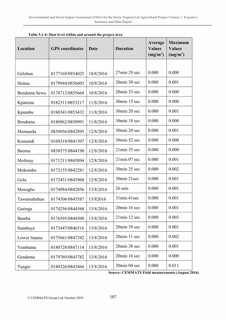
Environmental and Social Impact Assessment (ESIA) for the Sierra Tropical Ltd Agricultural Project Volume 1: Executive Summary and Main Report
107
© CEMMATS Group Ltd, October 2016
Table 5.1-4: Dust level within and around the project area
Location GPS coordinates Date Duration Average Values (mg/m3)
Maximum Values (mg/m3)
Gelehun 0177169/0854025 10/8/2016 27min 29 sec
0.000
0.000
Heima 0179944/0856603 10/8/2016 20min 38 sec 0.000 0.001
Benduma Sewa 0178712/0855668 10/8/2016 20min 33 sec 0.000 0.000
Kpatema 0182311/0853217 11/8/2016 30min 15 sec 0.000 0.000
Kpumbu 0180341/0853432 11/8/2016 30min 20 sec 0.000 0.001
Benduma 0180962/0850991 11/8/2016 30min 18 sec 0.000 0.000
Momandu 0830956/0842895 12/8/2016 30min 20 sec 0.000 0.001
Komendi 0169318/0841307 12/8/2016 30min 52 sec 0.000 0.000
Baoma 0830575/0844190 12/8/2016 21min 35 sec 0.000 0.000
Moforay 0171211/0845094 12/8/2016 21min 07 sec 0.000 0.001
Mokombo 0172155/0842281 12/8/2016 30min 25 sec 0.000 0.002
Gola 0172451/0843968 12/8/2016 30min 21sec 0.000 0.001
Mosogbo 0174984/0842056 13/8/2016 26 min 0.000 0.001
Tawamahehun 0174506/0843587 13/82016 31min 41sec 0.000 0.001
Garinga 0174256/0844568 13/8/2016 20min 16 sec 0.000 0.001
Bamba 0176595/0844300 13/8/2016 21min 12 sec 0.000 0.003
Sumbuya 0173447/0846516 13/8/2016 20min 39 sec 0.000 0.001
Lower Saama 0175661/0847342 13/8/2016 20min 11 sec 0.000 0.002
Yambama 0180728/0847114 13/8/2016 20min 38 sec 0.000 0.001
Gendema 0179769/0843782 13/8/2016 20min 16 sec 0.000 0.000
Tungie 0180326/0843466 13/8/2016 20min 04 sec 0.000 0.011
Source: CEMMATS Field measurements (August 2016)

Environmental and Social Impact Assessment (ESIA) for the Sierra Tropical Ltd Agricultural Project Volume 1: Executive Summary and Main Report
108
© CEMMATS Group Ltd, October 2016
5.1.3 Noise
5.1.3.1 Methodology
Noise levels were measured and recorded within and around twenty one (21) settlements in the project area. The measurements were recorded at different times and durations of the day using hand held Lutron sound meter.
5.1.3.2 Findings
The noise levels ranged from 38 decibels (dB) in Momandu to 71 decibels (dB) in Garinga. Levels were influenced by vehicular movements and ambient noise of normal community activities, normally referred to as community noise. Noise levels in some of the communities measured exceed 55db which is the average community noise level threshold. In terms of industrial environment (which the project area will soon become), noise levels are within the World Health Organisation (WHO) recommended limits, which stipulates that hearing protection gear must be used for noise exposure levels above 85 dB.
Table 5.1-5: Noise level data for settlements within and around project area
Location GPS coordinates Date Time
Average Peak noise level range (dB) for 5 mins
Gelehun 0177169/0854025 10/8/2016 1:35 pm 41.5 59.30
Heima 0179944/0856603 10/8/2016 2:27 pm 47.8 68.3
Benduma Sewa 0178712/0855668 10/8/2016 5: 05 pm 38.8 58.5
Kpatema 0182311/0853217 11/8/2016 10:45am 47.8 63.5
Kpumbu 0180341/0853432 11/8/2016 12:20 pm 42 68.3
Benduma 0180962/0850991 11/8/2016 3:05 pm 40.5 60
Momandu 0830956/0842895 12/8/2016 11:00 am 38 56.8
Komendi 0169318/0841307 12/8/2016 11:55 am 45.5 64.5
Baoma 0830575/0844190 12/8/2016 2:00 pm 45.3 - 66
Moforay 0171211/0845094 12/8/2016 2.57 pm 39 58.8
Mokombo 0172155/0842281 12/8/2016 4.00 pm 40 60.8
Gola 0172451/0843968 12/8/2016 4.50 pm 43.3 62.3

Environmental and Social Impact Assessment (ESIA) for the Sierra Tropical Ltd Agricultural Project Volume 1: Executive Summary and Main Report
109
© CEMMATS Group Ltd, October 2016
Location GPS coordinates Date Time
Average Peak noise level range (dB) for 5 mins
Mosogbo 0174984/0842056 13/8/2016 11.11 am 46.5 65
Tawamahehun 0174506/0843587 13/82016 12.15 pm 42.5 - 67
Garinga 0174256/0844568 13/8/2016 1.00 pm 48.5 - 71
Bamba 0176595/0844300 13/8/2016 2.00 pm 44.3 65.3
Sumbuya 0173447/0846516 13/8/2016 3.20 pm 57.3 70.1
Lower Saama 0175661/0847342 13/8/2016 4.10 pm 51.3 63.5
Yambama 0180728/0847114 13/8/2016 4.55pm 44.5 59.8
Gendema 0179769/0843782 13/8/2016 5.30pm 44.8 - 56
Tungie 0180326/0843466 13/8/2016 5.55 pm 43 59.8
Source: CEMMATS Field measurements (August 2016)
5.1.4 Geology The project area geological study was done mostly through desk studies on information gathered applicable to the site and its general surroundings.
The Project area geology is within the Basement Granite and Acid Gneiss Terrain of the geology of Sierra Leone as it stretches along the Sewa River alluvial diamond field and covers approximately 7.5 to 17 km of reach to the diamondiferous Sewa River. The floor-rocks to the wide-spread gravel occurrences comprise the Leonean Granite and Gneiss Terrain of the Man Craton of West Africa.
The project areas along the Sewa River hosts both modern and palaeo diamondiferous gravel deposits. A variety of alluvial facies, including high terrace, middle terrace, low terrace, swamp and river depositional environments types spread sporadically throughout the project area. As a result of the alluvial deposits, majority of the artisanal mining activities are confined to the lower terrace facies, swamp facies and the modern river system.
The area is composed of prospective gravel horizons made up of lower terrace, middle terrace, upper terrace and swamp facies. The middle and upper terraces are terrestrial, chemically weathered and relatively in-situ, regolith landforms that form a lateritic residuum comprising a ferruginous (haematite and goethite) gravel horizon, containing abundant pisoliths and nodules, as well as diamonds. Unlike the lower terrace gravels, a relatively thin overburden allows easy access to these gravels, with a considerable thickness.

Environmental and Social Impact Assessment (ESIA) for the Sierra Tropical Ltd Agricultural Project Volume 1: Executive Summary and Main Report
110
© CEMMATS Group Ltd, October 2016
The alluvial deposits comprise a range of environments of deposition, from down-wasted, residual regolith landforms, to fringing terraces of the Sewa River and elongate inland swamps systems, which comprise a large percentage of the total drainage network; in fact, the gravel horizons of the swamps have, in the past, constituted the second-most important source of alluvial diamonds
5.1.5 Landform
5.1.5.1 Methodology
The landform assessment study was done mainly through desktop review of secondary data and field observations.
5.1.5.2 Results
The project area is generally located on a gently undulating plain with isolated hill remnants and dissected by well-defined valley swamps. The hills are usually rising with an extremely low relief from fairly broad interfluves. The gently to moderately sloping interfluves side slopes have commonly dissected by broad gullies giving rise to narrow, uneven crests. There is usually a well-defined break of slope between the interfluves and valley swamps, except where gentle, narrow foot slopes and terraces occur. Adjacent to the Sewa River there is continuous alluvial plains of variable width. There are four main landforms occurring within the project area which is described below:
Isolated hills - short, straight to convex, gentle to moderately sloping.
Interfluves - medium length undulating, very gentle to gentle sloping.
Valley swamps - level to nearly level with varying width and locally channelled
Floodplains - level to almost flat with varying width and locally channelled and terraced.
5.1.6 Soils
5.1.6.1 Methodology
The soil baseline study was done by a random survey method. Soil descriptions were done using auger borings on the different landforms within and around the study area. At each observation point, the soil was augered up to at least 100cm where possible and described in detail using FAO Guidelines for soil profile descriptions (FAO 1990). The parameters described are shown on the soil/landform physical properties table.
The results of soil tests conducted by STL in 2014, in which 20 composite samples collected within Moyamba and Bo were sent to the Sierra Leone Agricultural Institute (SLARI) Laboratory for testing, are included in the analyses.

Environmental and Social Impact Assessment (ESIA) for the Sierra Tropical Ltd Agricultural Project Volume 1: Executive Summary and Main Report
111
© CEMMATS Group Ltd, October 2016
5.1.6.2 Results
Generally the soils can be classified as uplands and bottomlands. The upland soils are deep to shallow, gravelly and gravelfree and well drained while the bottomland is deep, generally gravelfree, poorly drained to waterlogged.
From observations the soils can be divided into four types according to textural differences. Texture is an important physical characteristic that plays an important role in the fertility and degradation of the land, provisions for the minimisation and control of soil erosion and degradation can be implemented by proper management strategies and operational techniques which will minimise erosion. Related impacts of the project on soils in the project area relate mainly to the land clearing phase which will result in loose exposed soil susceptible to erosion. These impacts and their mitigation measures are detailed in the impact table.
Physical Properties The physical properties of the various soils are described below:
a) Gravelly soils These soils occur on the interfluves of the upland and are generally shallow with compacted ironstone gravels occurring at an average depth of 50cm. These soils comprise of the following properties:
Moderately deep to shallow;
Texture vary from gravelly Sandy loam to gravelly sandy clay loam in the topsoil and very gravelly sandy clay in the subsoil ;
Well drained with water table below 50 cm ; and
Black to dark brown over brown to dark yellowish brown colour
b) Gravel free over gravel soils These soils generally occur on the interfluves of the uplands and are generally gravel free in the topsoil and very gravelly in subsoil. These soils comprise of the following properties:
These soils are generally shallow to moderately deep;
Texture ranges between sandy loam and sandy clay loam in the topsoil and gravelly sandy clay subsoil;
They are well drained with water table below 80 cm; and
Colours are black to dark brown top soil and dark yellowish brown in the subsoil
c) Gravel free soils (interfluves/terrace) The soils generally are gravel free throughout the profile and occur on the floodplains/lower terraces These soils comprise of the following properties:
Generally deep;
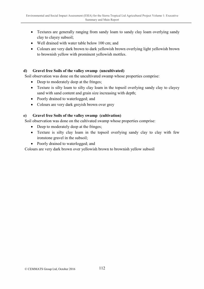
Environmental and Social Impact Assessment (ESIA) for the Sierra Tropical Ltd Agricultural Project Volume 1: Executive Summary and Main Report
112
© CEMMATS Group Ltd, October 2016
Textures are generally ranging from sandy loam to sandy clay loam overlying sandy clay to clayey subsoil;
Well drained with water table below 100 cm; and
Colours are very dark brown to dark yellowish brown overlying light yellowish brown to brownish yellow with prominent yellowish mottles.
d) Gravel free Soils of the valley swamp (uncultivated) Soil observation was done on the uncultivated swamp whose properties comprise:
Deep to moderately deep at the fringes;
Texture is silty loam to silty clay loam in the topsoil overlying sandy clay to clayey sand with sand content and grain size increasing with depth;
Poorly drained to waterlogged; and
Colours are very dark greyish brown over grey
e) Gravel free Soils of the valley swamp (cultivation) Soil observation was done on the cultivated swamp whose properties comprise:
Deep to moderately deep at the fringes;
Texture is silty clay loam in the topsoil overlying sandy clay to clay with few ironstone gravel in the subsoil;
Poorly drained to waterlogged; and Colours are very dark brown over yellowish brown to brownish yellow subsoil
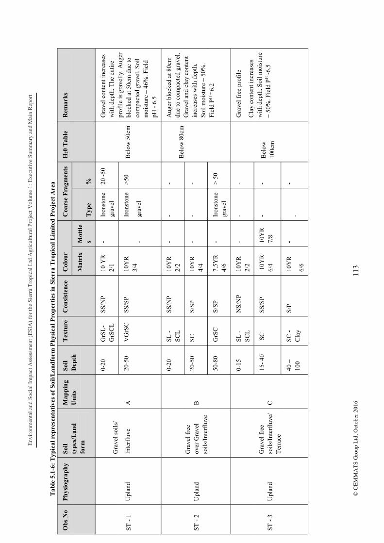
Env
iron
men
tal a
nd S
ocia
l Im
pact
Ass
essm
ent (
ES
IA)
for
the
Sie
rra
Tro
pica
l Ltd
Agr
icul
tura
l Pro
ject
Vol
ume
1: E
xecu
tive
Sum
mar
y an
d M
ain
Rep
ort
113
© C
EM
MA
TS
Gro
up L
td, O
ctob
er 2
016
Tab
le 5
.1-6
: T
ypic
al r
epre
sen
tati
ves
of S
oil/
Lan
dfo
rm P
hys
ical
Pro
per
ties
in S
ierr
a T
ropi
cal L
imit
ed P
roje
ct A
rea
Ob
s N
o P
hys
iogr
aphy
So
il ty
pes
/Lan
d fo
rm
Map
pin
g U
nit
s So
il D
epth
T
extu
re
Con
sist
ence
C
olou
r C
oars
e F
ragm
ents
H
20 T
able
R
emar
ks
Mat
rix
Mot
tle
s T
ype
%
ST -
1
Upl
and
Gra
vel s
oils
/
Inte
rflu
ve
A
0-20
G
rSL
-G
rSC
L
SS/N
P
10 Y
R
2/1
- Ir
onst
one
grav
el
20 -
50
Bel
ow 5
0cm
Gra
vel c
onte
nt in
crea
ses
wit
h de
pth.
The
ent
ire
prof
ile
is g
rave
lly.
Aug
er
bloc
ked
at 5
0cm
due
to
com
pact
ed g
rave
l. So
il m
oist
ure
46%
. Fie
ld
pH -
6.5
20-5
0 V
GrS
C
SS/S
P
10Y
R
3/4
-
Iron
ston
e
grav
el
>50
ST -
2
Upl
and
Gra
vel f
ree
over
Gra
vel
soil
s/In
terf
luve
B
0-20
SL
-SC
L
SS/N
P
10Y
R
2/2
- -
- B
elow
80c
m
Aug
er b
lock
ed a
t 80c
m
due
to c
ompa
cted
gra
vel.
Gra
vel a
nd c
lay
cont
ent
incr
ease
s w
ith
dept
h.
Soil
moi
stur
e 5
0%.
Fiel
d P
H
6.2
20-5
0 SC
S/
SP
10Y
R
4/4
- -
-
50-8
0 G
rSC
S/
SP
7.5Y
R
4/6
- Ir
onst
one
grav
el
> 5
0
ST -
3
Upl
and
Gra
vel f
ree
soil
s/In
terf
luve
/T
erra
ce
C
0-15
SL
-SC
L
NS
/NP
10
YR
2/
2 -
- -
Bel
ow
100c
m
Gra
vel f
ree
prof
ile
Cla
y co
nten
t inc
reas
es
wit
h de
pth.
Soi
l moi
stur
e 5
0%. F
ield
PH -
6.5
15-
40
SC
SS
/SP
1
0YR
6/
4 10
YR
7/
8 -
-
40
10
0 SC
-
Cla
y S/
P
10Y
R
6/6
- -
-

Env
iron
men
tal a
nd S
ocia
l Im
pact
Ass
essm
ent (
ES
IA)
for
the
Sier
ra T
ropi
cal L
td A
gric
ultu
ral P
roje
ctV
olum
e 1:
Exe
cuti
ve S
umm
ary
and
Mai
n R
epor
t
114
© C
EM
MA
TS
Gro
up L
td, O
ctob
er 2
016
Ob
s N
o P
hys
iogr
aphy
So
il ty
pes
/Lan
d fo
rm
Map
pin
g U
nit
s So
il D
epth
T
extu
re
Con
sist
ence
C
olou
r C
oars
e F
ragm
ents
H
20 T
able
R
emar
ks
Mat
rix
Mot
tle
s T
ype
%
ST -
4
Low
land
G
rave
l fre
e so
ils/
Inla
nd
valle
y sw
amp
(unc
ulti
vate
d)
D
0 50
50 -
100
SiL
- Si
cl
SC -
CS
SS/N
P
SS/S
P
2.5Y
3/
2
2.5Y
5/
1
--
-
- -
- -
Wat
erlo
gged
S
and
cont
ent i
ncre
ases
w
ith
dept
h. S
oil m
oist
ure
80%
.
Fiel
d P
H
5.6
ST -
5
Low
land
G
rave
l fre
e so
ils/
Inla
nd
valle
y sw
amp
(cul
tiva
ted)
D1
0 2
0
20
40
40 -
100
SiC
L
SC -
C
SC
- C
SS/S
P
S/P
S/P
10Y
R
2/2
10Y
R
5/6
10Y
R
6/8
- - -
- - -
- - -
Bel
ow 1
0cm
V
ery
littl
e ir
onst
one
grav
el in
the
sub
soil
. C
lay
cont
ent i
ncre
ases
w
ith
dept
h. S
oil m
oist
ure
59%
. Fie
ld P
H -
6.9
Not
e: C
S
Cla
yey
San
d, S
L
San
dy lo
am, S
C
San
dy C
lay,
VG
r V
ery
grav
elly
, SC
L
San
dy
Cla
y L
oam
, Si -
sil
t

Environmental and Social Impact Assessment (ESIA) for the Sierra Tropical Ltd Agricultural Project: Executive Summary and Main Report
115 © CEMMATS Group Ltd, October 2016
Chemical Properties
Soil tests were carried out in 2014 on samples from Moyamba and Bo, using methods described jointly by the International Soil Reference and Information Center (ISRIC) and the FAO (ISRIC/FAO, 2002, Procedures for Soil Analysis. Technical Paper 9, 6th Edition).
Soil color was visually compared with the Munsell Chart. Soil pH was determined on 1:1 soil:water and 1:1 KCl extracts. Exchangeable cations (Na, K, Ca, and Mg) were measured on neutral 1N ammonium acetate extracts. Exchangeable K and Na were read on a Flame Photometer while exchangeable Ca and Mg were read on an Atomic Absorption Spectrophotometer (AAS). Exchangeable Acidity (Al + H) was extracted by 1M KCl and titrated with 0.025 M NaOH. Effective CEC was calculated as the sum of exchangeable cations and exchangeable acidity. Zn, Cu, Fe and Mn were measured by AAS on DTPA (Diethylenetriaminepentaacetic acid) extracts.
The results of these tests are highlighted in the following tables:
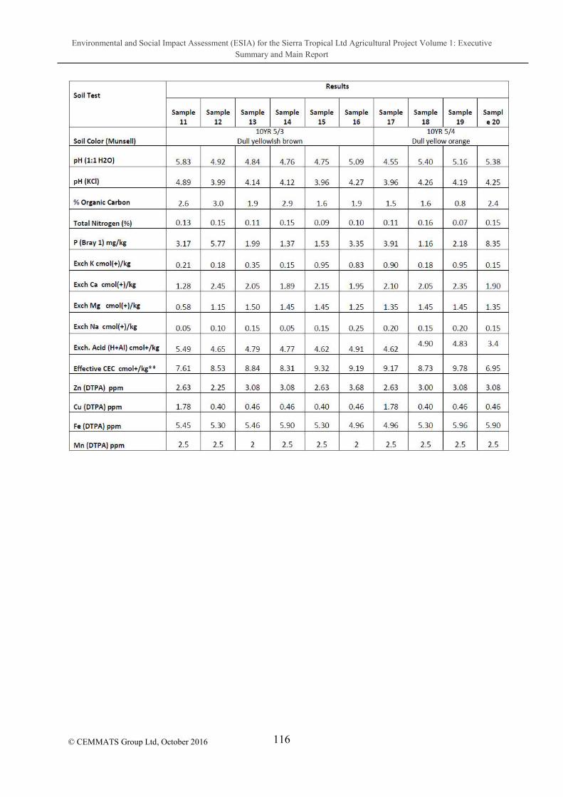
Environmental and Social Impact Assessment (ESIA) for the Sierra Tropical Ltd Agricultural Project Volume 1: Executive Summary and Main Report
116
© CEMMATS Group Ltd, October 2016
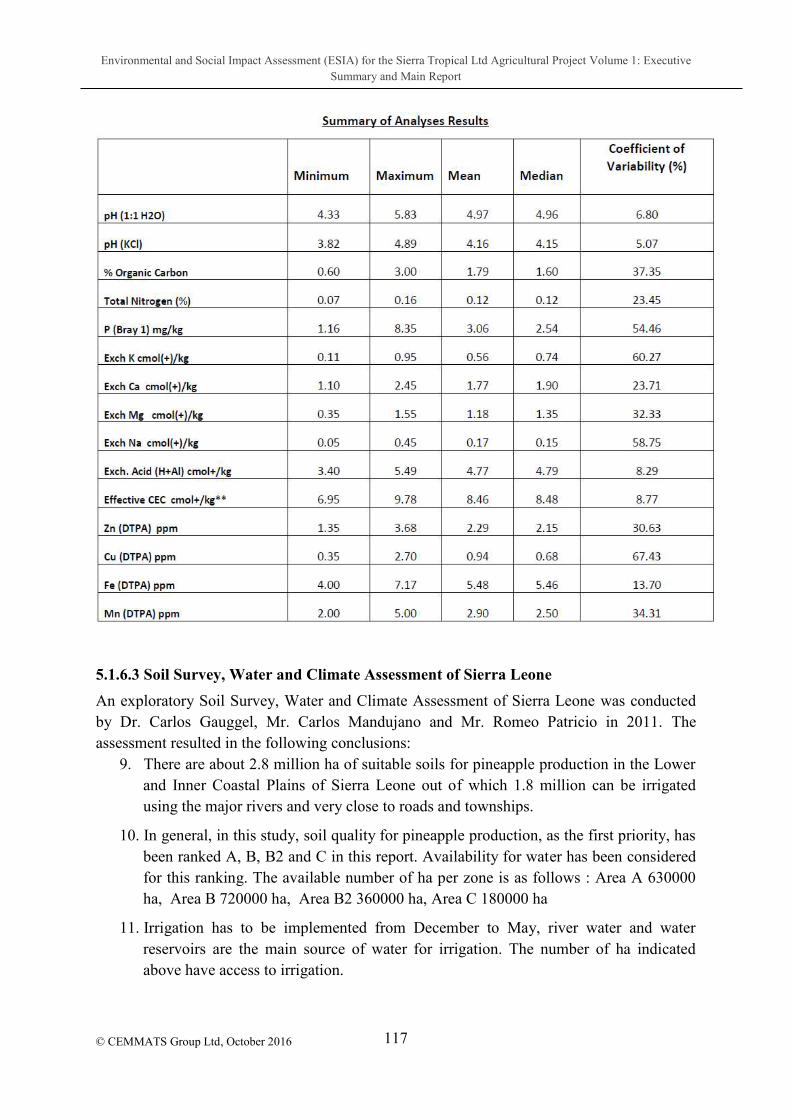
Environmental and Social Impact Assessment (ESIA) for the Sierra Tropical Ltd Agricultural Project Volume 1: Executive Summary and Main Report
117
© CEMMATS Group Ltd, October 2016
5.1.6.3 Soil Survey, Water and Climate Assessment of Sierra Leone
An exploratory Soil Survey, Water and Climate Assessment of Sierra Leone was conducted by Dr. Carlos Gauggel, Mr. Carlos Mandujano and Mr. Romeo Patricio in 2011. The assessment resulted in the following conclusions:
9. There are about 2.8 million ha of suitable soils for pineapple production in the Lower and Inner Coastal Plains of Sierra Leone out of which 1.8 million can be irrigated using the major rivers and very close to roads and townships.
10. In general, in this study, soil quality for pineapple production, as the first priority, has been ranked A, B, B2 and C in this report. Availability for water has been considered for this ranking. The available number of ha per zone is as follows : Area A 630000 ha, Area B 720000 ha, Area B2 360000 ha, Area C 180000 ha
11. Irrigation has to be implemented from December to May, river water and water reservoirs are the main source of water for irrigation. The number of ha indicated above have access to irrigation.

Environmental and Social Impact Assessment (ESIA) for the Sierra Tropical Ltd Agricultural Project Volume 1: Executive Summary and Main Report
118
© CEMMATS Group Ltd, October 2016
12. Primary roads and bridges are in very good shape and can handle containers. Second grade roads are very varied in condition, the condition of unpaved roads is a major issue in the rainy season.
13. Surface drainage and sub-surface drainage, in some areas, are a must for successful pineapple production due to heavy rains during the rainy season.
14. All soils will require an initial cross-way deep sub soiling to loosen the soil matrix and to break up any laterite of iron-stone layers, followed by disk harrowing, this is a must for the success of the project and it is probably required once (deep sub soiling).
15. Due to water availability, sloping landscapes, and the high risk of soil erosion, drip or low discharge irrigation is the best option.
16. The low temperatures (December-March), limited sun-light hours during some months (July-August) constitute the major constraint for pineapple production in Sierra Leone. Soil and water-wise it is very good area for pineapple cultivation with vast land and water resources available.
5.1.7 Hydrology
5.1.7.1 Methodology
The hydrology study was conducted through literature review of relevant reports on the project area, collection of samples and laboratory analyses, conduct of a hydro census and general observational assessments of the project area.
5.1.7.2 Results and Discussion
5.1.7.2.1 Description of Climatic Condition Sierra Leone falls within a tropical climate zone with peculiar wet and dry seasons splitting the year in equal halves:
Rainy Season (May November): Thunderstorms and squalls and Steady rains;
Dry season (December April): Dry weather with high humidity and Dry weather with low humidity.
These seasons could be subdivided into four (4) distinct types of weather. (i) Heavy squalls and thunderstorms, (ii) steady rains (iii) Harmattan season characterised by dry and windy weather with low humidity and (iv) Hot and humid weather.
Thunder Storms and Squalls Heavy squalls and thunderstorms characterize two different times of the year: May and June, which marks the beginning of the wet season and October and November, the end of the rainy season. Thunder storms accompanied by heavy rains travel east to west against the general wind direction. They are usually preceded by squall of the easterly wind. These thunderstorms are responsible for most of the rains at those times of the year. Towards the

Environmental and Social Impact Assessment (ESIA) for the Sierra Tropical Ltd Agricultural Project Volume 1: Executive Summary and Main Report
119
© CEMMATS Group Ltd, October 2016
beginning and the end of the rainy season, the thunderstorms decrease in frequency and intensity and the weather is very changeable. The relative humidity throughout the rainy season is very high.
Steady Rains Steady rains occur from July through September which is about the middle of the rainy season. Rainfall is frequent and often heavy and generally, most of the annual rainfall occurs during this period, being brought in by the south-west Monsoon winds. The sky is mainly overcast, sunshine is rare and the relative humidity ranges from 95% to 100%. The temperatures are at their lowest during this period and the diurnal range of temperature is small.
Dry Weather with High Humidity Dry Weather with High Humidity occurs mostly during the dry season. Skies are usually clear and therefore day temperatures are relatively high. The nights are also warm and very humid. Heavy dew and fog often occur during the night and early morning. Winds predominantly come from the west.
Dry Weather with Low Humidity (Harmattan) Dry Weather with Low Humidity (Harmattan) usually occurs between late December and early February. The lengths of these periods vary from a few days to a number of weeks. The weather is characterized by a sudden drop in relative humidity from almost 100% to sometimes as low as 20%. Evapotranspiration is high because of low relative humidity and high temperature.
Climatic Evaluation Daily rainfall and temperature records from the station at Bo from 2003 to 2009 were analyzed. There are no records for Sumbuya, but because Bo Town is the closest station to the project area, data from this station were used for analysis (Reference Table 5.1-1 on page 83).
5.1.7.2.2 Sensitive Human and Ecological Receptors
With regards to hydrology, a range of human and environmental receptors are located within the Sierra Tropical Agriculture (STA) concession area and immediate vicinity as listed in Table 5.1-7. These receptors were defined during the baseline studies undertaken for this ESIA, and are used as part of an integrated approach in the analysis of water resources.
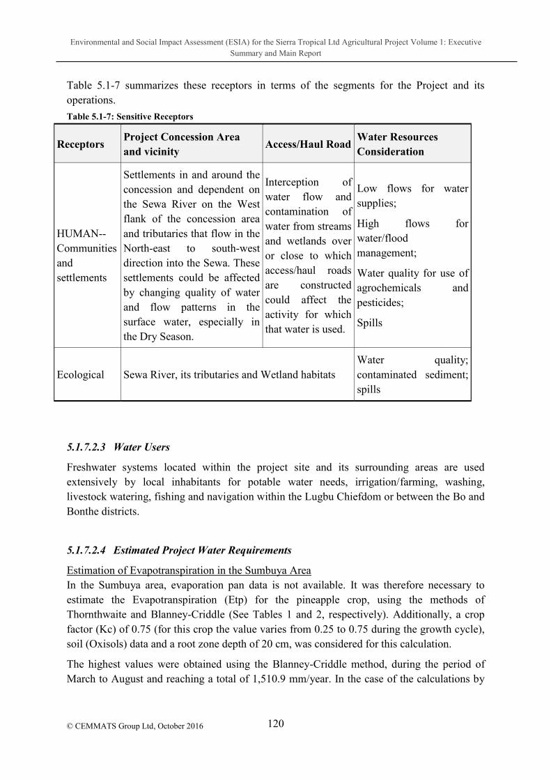
Environmental and Social Impact Assessment (ESIA) for the Sierra Tropical Ltd Agricultural Project Volume 1: Executive Summary and Main Report
120
© CEMMATS Group Ltd, October 2016
Table 5.1-7 summarizes these receptors in terms of the segments for the Project and its operations.
Table 5.1-7: Sensitive Receptors
Receptors Project Concession Area and vicinity
Access/Haul Road Water Resources Consideration
HUMAN-- Communities and settlements
Settlements in and around the concession and dependent on the Sewa River on the West flank of the concession area and tributaries that flow in the North-east to south-west direction into the Sewa. These settlements could be affected by changing quality of water and flow patterns in the surface water, especially in the Dry Season.
Interception of water flow and contamination of water from streams and wetlands over or close to which access/haul roads are constructed could affect the activity for which that water is used.
Low flows for water supplies;
High flows for water/flood management;
Water quality for use of agrochemicals and pesticides;
Spills
Ecological Sewa River, its tributaries and Wetland habitats Water quality; contaminated sediment; spills
5.1.7.2.3 Water Users
Freshwater systems located within the project site and its surrounding areas are used extensively by local inhabitants for potable water needs, irrigation/farming, washing, livestock watering, fishing and navigation within the Lugbu Chiefdom or between the Bo and Bonthe districts.
5.1.7.2.4 Estimated Project Water Requirements
Estimation of Evapotranspiration in the Sumbuya Area In the Sumbuya area, evaporation pan data is not available. It was therefore necessary to estimate the Evapotranspiration (Etp) for the pineapple crop, using the methods of Thornthwaite and Blanney-Criddle (See Tables 1 and 2, respectively). Additionally, a crop factor (Kc) of 0.75 (for this crop the value varies from 0.25 to 0.75 during the growth cycle), soil (Oxisols) data and a root zone depth of 20 cm, was considered for this calculation.
The highest values were obtained using the Blanney-Criddle method, during the period of March to August and reaching a total of 1,510.9 mm/year. In the case of the calculations by

Environmental and Social Impact Assessment (ESIA) for the Sierra Tropical Ltd Agricultural Project Volume 1: Executive Summary and Main Report
121
© CEMMATS Group Ltd, October 2016
the Thornthwaite method the Etp is lower and the highest values occurred during the Months of March to July, with a total value of 1,273.2 mm/year.
Table 5.1-8: Calculation of Monthly Evapotranspiration Using Thornthwaite Method for Sierra Leone
Jan Feb Mar Apr May Jun Jul Aug Sept Oct Nov Dec
Mean T (ºC)
26.0 27.0 27.5 28.0 27.5 26.5 25.5 24.5 25.0 25.5 26.5 26.0
I 12.1 12.8 13.2 13.6 13.2 12.5 11.8 11.1 11.4 11.8 12.5 12.1
E 131.7 141.2 145.6
149.8
145.6
136.5
126.7 115.9 121.4 126.7
136.5
131.7
Nd 31 28 31 30 31 30 31 31 30 31 30 31
Ni 1.03 0.93 1.03 1.00 1.03 1.00 1.03 1.03 1.00 1.03 1.00 1.03
HRS 12.1 12.2 12.4 12.7 12.9 13.0 12.9 12.8 12.5 12.3 12.1 12.0
Li 1.01 1.02 1.03 1.06 1.08 1.08 1.08 1.07 1.04 1.03 1.01 1.00
ETTho (mm)
137.2 133.9 155.4
158.5
161.7
147.9
140.7 127.8 126.5 134.2
137.7
136.1
ETPPineapple
102.9 100.5 116.6
118.9
121.3
110.9
105.5 95.8 94.8 100.6
103.3
102.1
Source of Temperature, Length day and Rainfall Data: (Sierra Leone Weatherbase).
Table 5.1-9: Calculation of the Monthly Evt using the Blaney & Criddle Method for Sierra Leone
Jan Feb Mar Apr May Jun Jul Aug Sept Oct Nov Dec
Mean T (ºC)
26.0 27.0 27.5 28.0 27.5 26.5 25.5 24.5 25.0 25.5 26.5 26.0
Nd 31 28 31 30 31 30 31 31 30 31 30 31
Ni 12.1 12.2 12.4 12.7 12.9 13.0 12.9 12.8 12.5 12.3 12.1 12.0
Ii 375.1 341.6 384.4
381.0
399.9
390.0
399.9 396.8 375.0 381.3 363.0
372.0
Ii/I 8.23 7.49 8.43 8.36 8.77 8.55 8.77 8.70 8.22 8.36 7.96 8.16
ETBla&Crid (mm)
164.6 153.4 174.5
174.9
181.5
173.1
173.5 168.2 160.8 165.5 161.2
163.3
ETPPinea 123.5 115.0 130. 131. 136. 129. 130.1 126.1 120.6 124.1 120. 122.
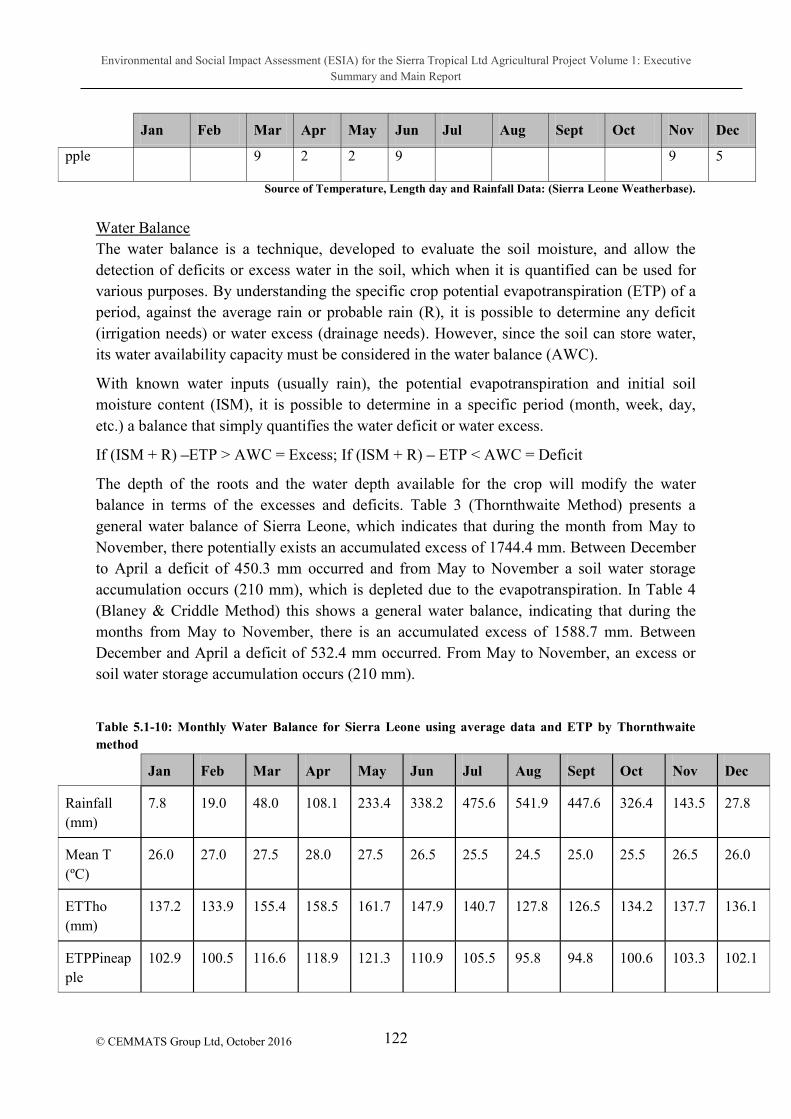
Environmental and Social Impact Assessment (ESIA) for the Sierra Tropical Ltd Agricultural Project Volume 1: Executive Summary and Main Report
122
© CEMMATS Group Ltd, October 2016
Jan Feb Mar Apr May Jun Jul Aug Sept Oct Nov Dec
pple 9 2 2 9 9 5
Source of Temperature, Length day and Rainfall Data: (Sierra Leone Weatherbase).
Water Balance The water balance is a technique, developed to evaluate the soil moisture, and allow the detection of deficits or excess water in the soil, which when it is quantified can be used for various purposes. By understanding the specific crop potential evapotranspiration (ETP) of a period, against the average rain or probable rain (R), it is possible to determine any deficit (irrigation needs) or water excess (drainage needs). However, since the soil can store water, its water availability capacity must be considered in the water balance (AWC).
With known water inputs (usually rain), the potential evapotranspiration and initial soil moisture content (ISM), it is possible to determine in a specific period (month, week, day, etc.) a balance that simply quantifies the water deficit or water excess.
If (ISM + R) ETP > AWC = Excess; If (ISM + R) ETP < AWC = Deficit
The depth of the roots and the water depth available for the crop will modify the water balance in terms of the excesses and deficits. Table 3 (Thornthwaite Method) presents a general water balance of Sierra Leone, which indicates that during the month from May to November, there potentially exists an accumulated excess of 1744.4 mm. Between December to April a deficit of 450.3 mm occurred and from May to November a soil water storage accumulation occurs (210 mm), which is depleted due to the evapotranspiration. In Table 4 (Blaney & Criddle Method) this shows a general water balance, indicating that during the months from May to November, there is an accumulated excess of 1588.7 mm. Between December and April a deficit of 532.4 mm occurred. From May to November, an excess or soil water storage accumulation occurs (210 mm).
Table 5.1-10: Monthly Water Balance for Sierra Leone using average data and ETP by Thornthwaite method
Jan Feb Mar Apr May Jun Jul Aug Sept Oct Nov Dec
Rainfall (mm)
7.8 19.0 48.0 108.1 233.4 338.2 475.6 541.9 447.6 326.4 143.5 27.8
Mean T (ºC)
26.0 27.0 27.5 28.0 27.5 26.5 25.5 24.5 25.0 25.5 26.5 26.0
ETTho (mm)
137.2 133.9 155.4 158.5 161.7 147.9 140.7 127.8 126.5 134.2 137.7 136.1
ETPPineapple
102.9 100.5 116.6 118.9 121.3 110.9 105.5 95.8 94.8 100.6 103.3 102.1

Environmental and Social Impact Assessment (ESIA) for the Sierra Tropical Ltd Agricultural Project Volume 1: Executive Summary and Main Report
123
© CEMMATS Group Ltd, October 2016
Jan Feb Mar Apr May Jun Jul Aug Sept Oct Nov Dec
SWAC (mm)¹
0.0 0.0 0.0 0.0 30.0 30.0 30.0 30.0 30.0 30.0 30.0 0.0
Deficit (mm)
125.1 111.5 98.6 40.8 0.0 0.0 0.0 0.0 0.0 0.0 0.0 74.3
Excess (mm)
0.0 0.0 0.0 0.0 82.1 227.3 370.1 446.1 352.8 225.8 40.2 0.0
¹ Soil Water Available Capacity for an average Oxisol with up to 20 cm root zone depth.
Conclusion
1. The results of the monthly water balance, calculated by the methods of Thornthwaite and Blaney-Criddle, indicate that during the months of December to May an accumulated water deficit of 450.3 and 532.4 mm occurs, respectively. The only way to satisfy this deficit it is by the use of an irrigation system. (A drip or sprinkler systems are the likely considered options).
2. The highest monthly irrigation requirement corresponds to January with values of 125.1 and 145.7 mm/month, meaning that daily watering needs are 4 and 4.7 mm/day, according Thornthwaite and Blaney-Criddle methods, respectively.
3. In order to accurately characterize the soils of Sierra Leone for irrigation potential, it is necessary to acquire laboratory and field equipment to determine physical characteristics like bulk density, saturation point, field capacity, wilting permanent point, soil-moisture curves, etc. The services of SLARI at Njala University will be acquired to complete the proper and required soil physical/moisture curves and characteristics.
4. To program and monitor irrigation requirements in Sumbuya, it will be necessary to install 5-10 weather stations (Watch Dog 2000) five at very least , A type evaporation pans (according to specifications of the USDA) to determine the daily irrigation requirements for the pineapple crop. Also, additional equipment, to measure the soil-moisture will be necessary to implement a monitoring system of irrigation and soil moisture or the Daily Water Balance.
Summary of Total Water Requirements for a Season From the above assumptions and calculations 5mm/day at the driest time of the year, is the minimum quantity of water required. To allow a safety margin, as we are only generally estimating climate and soil data, calculations for this exercise are based on 7mm/day.
Note: after more detailed soil analysis, by SLARI, the adoption of conservation tillage and agriculture principles, as well as irrigation type, greater soil water conservation can be achieved and in practice, total irrigation water requirements maybe much lower.

Environmental and Social Impact Assessment (ESIA) for the Sierra Tropical Ltd Agricultural Project Volume 1: Executive Summary and Main Report
124
© CEMMATS Group Ltd, October 2016
Annual estimated crop irrigation water requirements:
Water required 7mm/day
Continuous water flow required in litres/second/ha
0.81lt/sec./ha
Total equivalent ha 4335ha
Total irrigation water requirements (maximum) 7,585, 000 m3 per year
5.1.7.2.5 Regional Context Sierra Leone has a complex drainage pattern that includes numerous rivers and smaller creeks and streams. The larger rivers originate in the Fouta Djallon highlands of Guinea and
system includes nine major rivers and minor coastal creeks and tidal streams. The river watersheds range in size from 14,140 km2 for the Sewa River to less than 385 km2 for the smaller watersheds.
5.1.7.2.6 Project Site During the field work conducted in July, 2016, within the project concession area, plans to conduct stream velocities and stage (water elevation) measurements were thwarted by the high discharge of the Sewa River. The team considered it unsafe to carry out such measurements.
5.1.7.2.7 Water Quality
The following receptors have been identified:
Residents who use surface water for drinking water purposes (largely outside of the mining concession area);
Residents who are exposed to surface water through fishing, rice farming, or swimming. Although these may not be considered purely recreational activities, international recreational guideline values would apply; and
Ecological receptors within the sediment and surface water.
In order to assess potential risks to these receptors the following screening values were used:
World Health Organisation (WHO), 2011 Guidelines for drinking-water quality;
IFC, 2007 Environmental, Health and Safety Guidelines for Mining.
The following table summarizes the numerical standards used to compare the baseline data.

Environmental and Social Impact Assessment (ESIA) for the Sierra Tropical Ltd Agricultural Project Volume 1: Executive Summary and Main Report
125
© CEMMATS Group Ltd, October 2016
Table 5.1-11: Numerical Standards
Parameter Units
WHO Drinking Water Guidelines (2011)
IFC effluent guidelines
Sierra Leone Environment Protection Regulations 2013. Maximum at any moment (Annual average maxima) (unfiltered concentrations)
Field Temp <3°C differential
Field pH pH units 6.5-8.5 6 9 6 9
Field EC uS/cm
Field Turbidity NTU
Field DO mg/l
Field TDS mg/l 600
Total Alkalinity as CaCO3
mg/l
Total Hardness Dissolved
mg/l 200
Sulphate mg/l 250
TSS mg/l 50 50 (25)
COD (settled) mg/l 150
Trace elements Metals are total
Metals are total
Aluminum ug/l 100*
Arsenic ug/l 10 100 100 (80)
Barium ug/l 700
Cadmium ug/l 3 50 50 (40)
Total Chromium ug/l 50 100 100 (80)
Copper ug/l 2000 300 600 (400)
Total Iron ug/l 300* 2000 2000 (1600)
Lead ug/l 10 200 200 (160)
Magnesium mg/l
Manganese ug/l 100*
Mercury ug/l 6 2 2 (1.6)
Nickel ug/l 70 500
Zinc ug/l 3000* 500 1500 (1200)
The WHO guidelines were used in this study to assess drinking water quality and the lower values of either the IFC EHS guidelines or Environment Protection Regulations were used to assess effluent quality.
It should be noted that the Sierra Leone Environment Protection Regulations and the WHO standards are the only values to which water/effluent discharges from the study area need comply
5.1.7.2.8 Project Area and Surroundings
This work includes the measurement of inorganic compounds and other physical and chemical parameters (i.e. metals, temperature, pH, dissolved oxygen (DO), turbidity, conductivity, and total dissolved solids (TDS). Error! Reference source not found. provides a brief description of the key sites sampled in August, 2016.

Environmental and Social Impact Assessment (ESIA) for the Sierra Tropical Ltd Agricultural Project Volume 1: Executive Summary and Main Report
126
© CEMMATS Group Ltd, October 2016
Figure 5.1-1: Map of Water Quality Sampling Sites at or in the vicinity of the Project site
5.1.7.2.9 Analysis and Summary
Specifically, seasonal and spatial variation in water quality in the catchments can be driven by:
Dry season stagnation, resulting in a reduction of oxygen levels.
Elevation of TSS and turbidity as a result of rainfall runoff, which typically has high suspended sediment loads from disturbed areas, combined with lower dilution during the dry season.
Low pH in surface waters related to low natural buffering capacity, and reactions associated with biological activity in the wetland areas. pH varies seasonally, with a lower average pH in the wet season.
Elevated levels of iron, manganese and other metals are natural to the geology though weathering and erosion of exposed areas may be a
5.1.7.2.10 Domestic Water Quality and Environmental Sanitation
Domestic Water Quality Introduction

Environmental and Social Impact Assessment (ESIA) for the Sierra Tropical Ltd Agricultural Project Volume 1: Executive Summary and Main Report
127
© CEMMATS Group Ltd, October 2016
This study was aimed at collecting data on all water points and channels within the project site as well as the surrouand the analysis of potential impacts of the proposed activity on the water resources.
Water is a very important resource that needs to be maintained and preserved to ensure its potability. Water is vitally important to every aspect of our lives. Monitoring the quality of surface water will help protect waterways from pollution by project activities. It is therefore essential for development practitioners to embark on activities that will protect water resources as well as water channels within local communities that solely depend on these sources for their survival.
Methodology Field investigations were conducted within the study area and its immediate environs to obtain all relevant data. This involved identifying all water points and channels within the study area. The methodology used for the study includes the following:
An initial reconnaissance visit was made to the study area by a field party;
The field party travelled to the study area to identify sites for sampling and measurements and to acquaint residents and project officials with the purpose of the study;
Questionnaires were administered to residents in the villages within the study area by CEMMATS Social team to obtain data on several issues regarding water supply and quality and sanitation issues;
Samples were collected from the identified water sources. Some physical parameters were tested in-situ and the remaining samples were transported to a laboratory for further physical, chemical and biological tests;
benchmark for drinking water contamination levels; and
Critical observations of the nature of water systems and sanitary conditions in and around the project site.
Samples were collected from receptacles in the project area for water quality determination. A total of 23 water sources were assessed through in situ measurements using a water meter and/or sampled (6 sources) for laboratory analyses within and around the project site (12 underground wells, 6 streams and 4 locations in the Sewa River; all from a total of 20 communities, Table 3). Measurement of physical parameters was done in all these locations, whilst only 6 were selected for chemical and microbiological measurements in the laboratory, due to the critical values obtained from the physical measurements relative to the end use. Water samples were collected in sterilized polyethylene bottles. Physical Analyses: Portable water testing meter, the Maji MeterTM was used to measure the temperature, pH, electrical conductivity, turbidity and total dissolved solids of each water sample immediately it was obtained from the source.

Environmental and Social Impact Assessment (ESIA) for the Sierra Tropical Ltd Agricultural Project Volume 1: Executive Summary and Main Report
128
© CEMMATS Group Ltd, October 2016
Chemical Analyses: Concentrations of iron, manganese, chloride, magnesium, calcium, nitrate, carbonate, bicarbonate, aluminium and hydrogen ions were determined on a standard sample obtained from each field sample. Microbiological Analyses: The membrane filtration technique was used to enumerate faecal indicator bacteria. Results and Findings The results are shown in Error! Reference source not found. and 5.
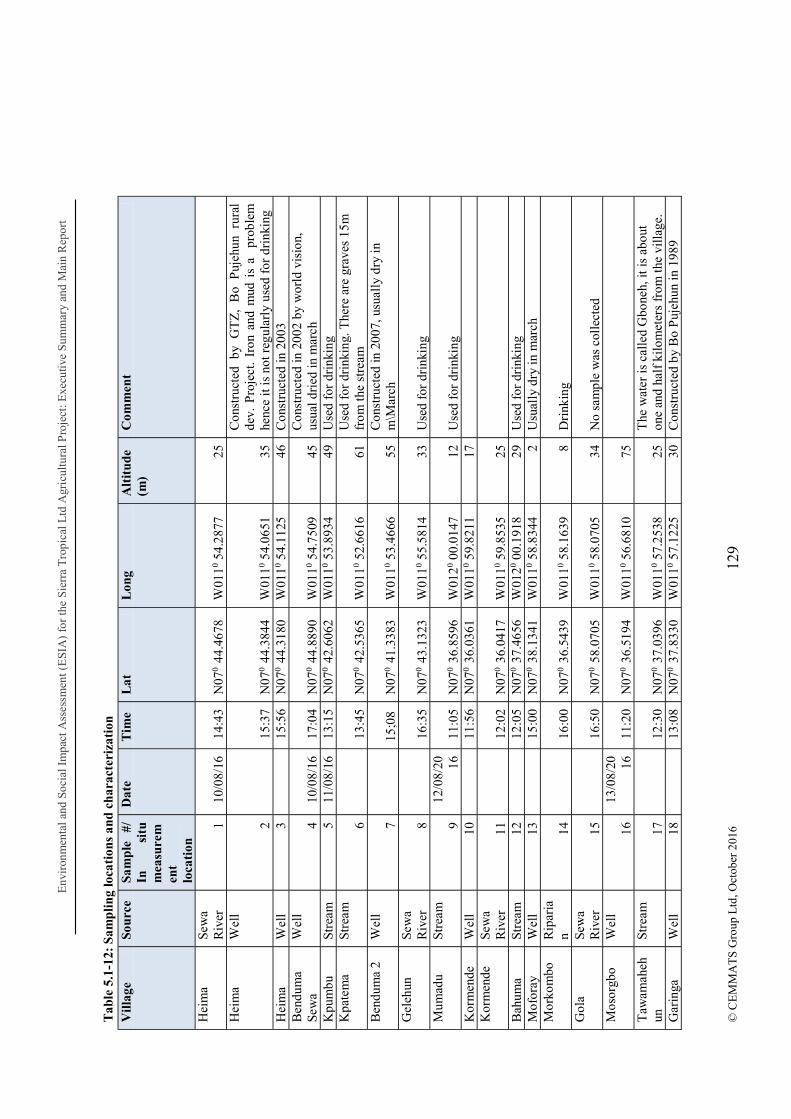
Env
iron
men
tal a
nd S
ocia
l Im
pact
Ass
essm
ent (
ES
IA)
for
the
Sie
rra
Tro
pica
l Ltd
Agr
icul
tura
l Pro
ject
: Exe
cuti
ve S
umm
ary
and
Mai
n R
epor
t
129
© C
EM
MA
TS
Gro
up L
td, O
ctob
er 2
016
Tab
le 5
.1-1
2: S
amp
lin
g lo
cati
ons
and
ch
arac
teri
zati
on
Vil
lage
So
urce
Sa
mp
le
#/
In
situ
m
easu
rem
ent
loca
tion
Dat
e T
ime
Lat
L
ong
Alt
itu
de
(m)
Com
men
t
Hei
ma
Sew
a R
iver
1
10/0
8/16
14
:43
N07
0 4
4.46
78
W01
10 54
.287
7 25
Hei
ma
Wel
l
2
15:3
7 N
070
44.
3844
W
0110
54.0
651
35
Con
stru
cted
by
GT
Z,
Bo
Puj
ehun
rur
al
dev.
Pro
ject
. Ir
on a
nd m
ud i
s a
pro
blem
he
nce
it is
not
reg
ular
ly u
sed
for
drin
king
H
eim
a W
ell
3
15:5
6 N
070
44.
3180
W
0110
54.1
125
46
Con
stru
cted
in 2
003
Ben
dum
a Se
wa
Wel
l 4
10/0
8/16
17
:04
N07
0 4
4.88
90
W01
10 54
.750
9 45
C
onst
ruct
ed in
200
2 by
wor
ld v
isio
n,
usua
l dri
ed in
mar
ch
Kpu
mbu
St
ream
5
11/0
8/16
13
:15
N07
0 4
2.60
62
W01
10 53
.893
4 49
U
sed
for
drin
king
K
pate
ma
Stre
am
6
13:4
5 N
070
42.
5365
W
0110
52.6
616
61
Use
d fo
r dr
inki
ng. T
here
are
gra
ves
15m
fr
om th
e st
ream
B
endu
ma
2 W
ell
7
15;0
8 N
070
41.
3383
W
0110
53.4
666
55
Con
stru
cted
in 2
007,
usu
ally
dry
in
m\M
arch
G
eleh
un
Sew
a R
iver
8
16
:35
N07
0 4
3.13
23
W01
10 55
.581
4 33
U
sed
for
drin
king
M
umad
u St
ream
9
12/0
8/20 16
11
:05
N07
0 3
6.85
96
W01
20 00
.014
7 12
U
sed
for
drin
king
K
orm
ende
W
ell
10
11
:56
N07
0 3
6.03
61
W01
10 59
.821
1 17
Kor
men
de
Sew
a R
iver
11
12:0
2 N
070
36.
0417
W
0110
59.8
535
25
B
ahum
a St
ream
12
12:0
5 N
070
37.
4656
W
0120
00.1
918
29
Use
d fo
r dr
inki
ng
Mof
oray
W
ell
13
15
:00
N07
0 3
8.13
41
W01
10 58
.834
4 2
Usu
ally
dry
in m
arch
M
orko
mbo
R
ipar
ian
14
16
:00
N07
0 3
6.54
39
W01
10 58
.163
9 8
Dri
nkin
g G
ola
Sew
a R
iver
15
16:5
0 N
070
58.
0705
W
0110
58.0
705
34
No
sam
ple
was
col
lect
ed
Mos
orgb
o W
ell
16
13/0
8/20 16
11
:20
N07
0 3
6.51
94
W01
10 56
.681
0 75
Taw
amah
ehun
St
ream
17
12:3
0 N
070
37.
0396
W
0110
57.2
538
25
The
wat
er is
cal
led
Gbo
neh,
it is
abo
ut
one
and
half
kil
omet
ers
from
the
vill
age.
G
arin
ga
Wel
l 18
13:0
8 N
070
37.
8330
W
0110
57.1
225
30
Con
stru
cted
by
Bo
Puj
ehun
in 1
989
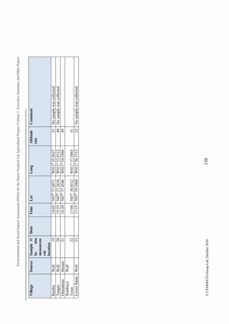
Env
iron
men
tal a
nd S
ocia
l Im
pact
Ass
essm
ent (
ES
IA)
for
the
Sier
ra T
ropi
cal L
td A
gric
ultu
ral P
roje
ctV
olum
e 1:
Exe
cuti
ve S
umm
ary
and
Mai
n R
epor
t
130
© C
EM
MA
TS
Gro
up L
td, O
ctob
er 2
016
Vil
lage
So
urce
Sa
mp
le
#/
In
situ
m
easu
rem
ent
loca
tion
Dat
e T
ime
Lat
L
ong
Alt
itu
de
(m)
Com
men
t
Bam
ba
Wel
l 19
14:0
5 N
070
37.
6971
W
0110
55.8
627
41
No
sam
ple
was
col
lect
ed
Tun
gei
Wel
l 20
15:5
5 N
070
37.
2654
W
0110
53.8
312
40
No
sam
ple
was
col
lect
ed
Gba
ndam
a St
ream
21
16:2
0 N
070
37.
4546
W
0110
54.2
966
49
Su
mbu
ya
Tow
n W
ell
22
17
:04
N07
0 3
8.85
12
W01
10 57
.586
5 51
Low
er S
ama
Wel
l 23
17:1
5 N
070
39.
3460
W
0110
56.3
713
32
No
sam
ple
was
col
lect
ed

Environmental and Social Impact Assessment (ESIA) for the Sierra Tropical Ltd Agricultural Project Volume 1: Executive Summary and Main Report
131 © CEMMATS Group Ltd, October 2016
Table 5.1-13: Sample Chemical Data Location Heima
Sewa River Heima Well Benduma
Sewa River Gelehun
Sewa River Kormende
Well Kormende
Sewa River Sample # S1 S2 S4 S8 S10 S11 Turb (NTU) 5.8 6.4 19.12 0.8 0.6 8.5 Cond. 28.8 142.4 14.24 30.7 148.6 30.2 TDS (mg/L) 14.4 71.2 7.12 25.3 74.3 25.1 Residual chlorine (mg/L)
0
0.01 0 0.01 0 0 Al (mg/L) 0.03 0.02 0.28 0.01 0.02 0.03 NH4 (mg/L) 0.02 0 0.28 0.01 0.01 0.02 Ca-hardness (mg/L CaCO3) 12 6 0 5 10 15 Cr (mg/L) 0.2 0.1 4.48 0 0.1 0.2 Cu (mg/L) 0.14 0.23 0.12 0.11 0.12 0.18 F (mg/L) 0.56 0.62 0.35 0.28 0.66 0.58 Dissolved Fe (mg/L) 0.6 0.4 0.3 0.2 0.2 0.8 Mg (mg/L) 27 25 15 10 12 28 Mn (mg/L) 0.4 0.3 0.2 0.1 0.2 0.5 NO2- (mg/L) 0.04 0.06 0.2 0.02 0.01 0.08 NO3-N (mg/L) 0.86 0.88 0.65 0.58 0.62 0.84 K (mg/L) 8.1 10.3 6.7 4.2 5.5 8.8 PO43- (mg/L) 5,4 6.2 4.8 3.3 5.1 6.7 SO42- (mg/L) 4 6 3 2 4 5 S2- (mg/L) 0.12 0.16 0.11 0.12 0.15 0.17 HCO3- (mg/L) 12 16 7 6 10 14 Zn (mg/L) 0.02 0.03 0 0 0.01 0.02 E. coli (cfu/100 ml) 45 20 10 5 25 50 Faecal coliform (cfu/100ml) 80 35 15 10 20 60 Non-faecal coliform (cfu/100ml) 20 10 0 5 15 30
Faecal indicator Bacteria: Faecal coliforms are a group of intestinal tract microbes and their presence in drinking water sources is an indication of faecal contamination. According to the World Health Organization (WHO), these bacteria should not occur repeatedly in drinking water. They therefore recommend zero faecal coliforms counts per 100 ml water sample. A total of six (6) samples were analyzed and the results show that all 6 had high amounts of both E. coli and feacal coliforms per 100ml of water sample; most of the values were in excess of 20 counts/100 ml. four of these samples were taken from the Sewa River where the respective communities claimed to be coursing water for drinking and domestic use, namely Heima, Benduma, Gelehun and Kormende villages (Error! Reference source not found.). It is therefore obvious that such waters are contaminated. The main surprises were wells in Heima and Kormende villages (Error! Reference source not found. and Error! Reference source not found.), which were both well protected and at least 10m from the nearest dwelling. Contamination could possibly be linked to handling and roaming livestock.
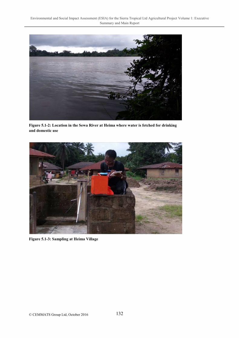
Environmental and Social Impact Assessment (ESIA) for the Sierra Tropical Ltd Agricultural Project Volume 1: Executive Summary and Main Report
132
© CEMMATS Group Ltd, October 2016
Figure 5.1-2: Location in the Sewa River at Heima where water is fetched for drinking and domestic use
Figure 5.1-3: Sampling at Heima Village
Environmental and Social Impact Assessment (ESIA) for the Sierra Tropical Ltd Agricultural Project Volume 1: Executive Summary and Main Report
133
© CEMMATS Group Ltd, October 2016
Figure 5.1-4: Hand-pump well in Kormende
Dissolved Chemicals Iron (Fe2+): Iron is mainly present in water in two forms. It is either the soluble ferrous iron or the insoluble ferric iron. Water containing ferrous iron is clear and colorless because the iron is completely dissolved. When it is exposed to air, the water turns cloudy and a reddish brown substance begins to form. This sediment is the oxidized or ferric form of iron that will not dissolve in water.
Concentrations of iron as low as 0.3 mg/l will leave reddish brown stains on fixtures, tableware and laundry that is very hard to remove. Dissolved ferrous iron gives water a disagreeable taste. When the iron combines with tea, coffee and other beverages, it produces an inky, black appearance and a harsh, unacceptable taste. Vegetables cooked in water containing excessive iron could turn dark and look unappealing.
The analyses show that three (3) of the water sources have concentrations of iron above the WHO recommended value (0.3mg/l) for drinking water. These were the Sewa River at Heima (0.6 mg/L), the Heima well (0.4 mg/L) and the Sewa River at Kormende (0.8 mg/L). This could be attributed to the geology of the base rocks. Local inhabitants claimed that the Heima well is not used in the Dry Season due to the reddish appearance and unpleasant taste of the water. High Fe3+ content could be linked to high oxidation and corrosion, and the destruction of hand pump equipment.
Manganese (Mn): This is present in groundwater as the divalent ion (Mn2+). High concentrations of manganese in water can cause dark stains in laundry and plumbing fixtures. It imparts an objectionable taste to beverage and tea.
However, deficiencies in manganese are rare but would include poor bone growth, problems with the disks between the vertebrae, birth defects, and problems with blood glucose levels and reduced fertility. Serious deficiency in children can result in paralysis, deafness and

Environmental and Social Impact Assessment (ESIA) for the Sierra Tropical Ltd Agricultural Project Volume 1: Executive Summary and Main Report
134
© CEMMATS Group Ltd, October 2016
blindness. Manganese is not easily absorbed but since small amounts are needed, deficiencies are not very general.
The analyses show that all water sources had manganese concentration above the secondary maximum contamination level (SMCL) standard of 0.05 mg/l by an order of magnitude.
Iron and manganese are non-hazardous elements that can be a nuisance in a water supply. Iron and manganese are chemically similar and cause similar problems. Iron is the more frequent of the two contaminants in water supplies; manganese is typically found in iron-bearing water. Water percolating through soil and rock can dissolve minerals containing iron and manganese and hold them in solution. Occasionally, iron pipes also may be a source of iron in water.
Iron and manganese can affect the flavour and colour of water. Iron will cause reddish-brown staining of laundry, porcelain, dishes, utensils and even glassware. Manganese acts in a similar way but causes a brownish-black stain. A problem that frequently results from iron or manganese in water is iron or manganese bacteria. These non-pathogenic (not health threatening) bacteria occur in soil, shallow aquifers and some surface waters.
There are several methods available for removing iron and manganese from water. These include (1) phosphate compounds; (2) ion exchange water softeners; (3) oxidizing filters; (4) aeration (pressure type) followed by filtration; and (5) chemical oxidation followed by filtration.
Nitrogen-Nitrate-Nitrite: Nitrogen is required by all organisms for the basic processes of life to make proteins, to grow, and to reproduce. Nitrogen is very common and found in many forms in the environment. Common sources of nitrate - nitrite contamination include fertilizers, animal wastes, septic tanks, municipal sewage treatment systems, meat preservatives and decaying plant debris. Nitrate is highly soluble in water and is stable over a wide range of environmental conditions. Ten (10) mg/l is the standard maximum contaminant level (MCL) for nitrate-nitrogen and 1 mg/l for nitrite-nitrogen for regulated public water systems.
The analytical result for the samples collected is found within the range of 0.01 0.88 mg/l. These results are below the WHO standards of 10 mg/l. The potential sources of nitrate could have been runoff from fertilizer use within the surrounding farms, sewage, and possible erosion of natural deposits from increased surface runoff. Excessive concentrations of nitrate can be harmful to humans and wildlife. Symptoms include shortness of breath and blue-baby syndrome.
The primary health hazard from drinking water with nitrate-nitrogen occurs when nitrate is transformed to nitrite in the digestive system. The nitrite oxidizes iron in the hemoglobin of the red blood cells to form methemoglobin, which lacks the oxygen-carrying ability of hemoglobin. This creates the condition known as methemoglobinemia (sometimes referred to as "blue baby syndrome"). Infants below the age of six months who drink water containing nitrate in excess of the maximum contaminant level (MCL) could become seriously ill and, if
Environmental and Social Impact Assessment (ESIA) for the Sierra Tropical Ltd Agricultural Project Volume 1: Executive Summary and Main Report
135
© CEMMATS Group Ltd, October 2016
untreated, may die. Nitrite in high doses is also linked with cancer as it can make carcinogenic nitrosamine and N-nitroso compounds.
Chloride (Cl-) - Chlorine is a chemical used in industry and in household cleaning products. At room temperature, chlorine is a gas. It has a yellow-green color, and a pungent, irritating odor similar to bleach. Chlorine does not catch fire easily, but may combine with other common substances to form explosive compounds.
Chloride in drinking-water originates from natural sources, sewage and industrial effluents, urban runoff containing de-icing salt and saline intrusion. The main source of human exposure to chloride is the addition of salt to food, and the intake from this source is usually greatly in excess of that from drinking-water.
No health-based guideline value is proposed for chloride in drinking-water. However, chloride concentrations in excess of about 250 mg/litre can give rise to detectable taste in water. The sample analyses for chloride levels were within the range of 0.00 0.01 mg/L and these values are below the WHO recommended maximum contamination level (250 mg/l). Excessive chloride concentrations increase rates of corrosion of metals in the distribution system, depending on the alkalinity of the water. This can lead to increased concentrations of metals in the supply.
When chlorine enters the body as a result of breathing, swallowing, or skin contact, it reacts with water to produce acids. The acids are corrosive and damage cells in the body on contact. Most harmful chlorine exposures are the result of inhalation. Health effects typically begin within seconds to minutes. Following chlorine exposure, the most common symptoms may include:
Wheezing
Difficulty breathing
Sore throat
Cough
Chest tightness
Eye irritation
Skin irritation
The severity of health effects depend upon the route of exposure, the dose and the duration of exposure to chlorine. Breathing high levels of chlorine causes fluid build-up in the lungs, a condition known as pulmonary edema. The development of pulmonary edema may be delayed for several hours after exposure to chlorine. Contact with compressed liquid chlorine may cause frostbite of the skin and eyes.

Environmental and Social Impact Assessment (ESIA) for the Sierra Tropical Ltd Agricultural Project Volume 1: Executive Summary and Main Report
136
© CEMMATS Group Ltd, October 2016
Bicarbonate and Total Hardness - Bicarbonate is a major element in our body. Secreted by the stomach, it is necessary for digestion. When ingested, for example, with mineral water, it helps buffer lactic acid generated during exercise and also reduces the acidity of dietary components. Bicarbonate is an alkaline, and a vital component of the pH buffering system of the body (maintaining acid-base homeostasis). About 70 to 75 percent of CO2 in the body is converted into carbonic acid (H2CO3), which can quickly turn into bicarbonate (HCO3 ).
The Bicarbonate (HCO3) ion is the principal alkaline constituent in almost all water supplies. Alkalinity in drinking water supplies seldom exceeds 300 mg/l. The sample analyses for bicarbonate levels show a range of 6-16 mg/l. These values are below the expected maximum contaminant level which indicates that bicarbonate levels in the water sources are very low to almost being negligible.
However, bicarbonate alkalinity is introduced into the water by CO2 dissolving carbonate-containing minerals. Alkalinity neutralizes the acidity in fruit flavors as well as acting as a buffer and acid dying.
Hardness generally represents the concentration of calcium (Ca2+) and magnesium (Mg2+) ions, because these are the most common polyvalent cations. Waters with high hardness values are referred to as "hard," while those with low hardness values are "soft".
Total Hardness is also the concentration of dissolved salts in water, expressed as total parts of dissolved salts in a million parts of water. The analysis from all samples indicates values below the recommended 100 mg/l (i.e. Ca2+ and Mg2+ concentration).
Hard water usually affects the amount of soap that is needed to produce foam or lather. It requires more soap, because the calcium and magnesium ions form complexes with soap, preventing the soap from lathering. Hard water can also leave a film on hair, fabrics, and glassware.
Aluminium (Al3+): Aluminum is the third most common element in the earth's crust and is present in soil, water and air. Alumin s physical and chemical properties make it ideal for a variety of uses in food, drugs, consumer products, and water treatment processes.
The concentration of aluminum as recommended by the United States Environmental Protection Agency should range between 0.05 0.2mg/l of sampled water. The analysis gives a range of values that are below the recommended limit for aluminum concentration.
Although most of our daily aluminium intake comes from food, aluminum in food appears to be bound to other food substances and thus is in a form that cannot be absorbed into the bloodstream. In fact, it seems that the body's main defense against aluminum in food is that it does not allow aluminum to pass through the intestinal wall.
However, the amount of aluminium absorbed from drinking water is usually very small. One reason for this is that the presence of food in the stomach reduces the absorption. Absorption then is greatest when water is drunk on an empty stomach. In spite of this, the high concentrations of aluminium in water can increase the toxicity of the water because it has the
Environmental and Social Impact Assessment (ESIA) for the Sierra Tropical Ltd Agricultural Project Volume 1: Executive Summary and Main Report
137
© CEMMATS Group Ltd, October 2016
potential to reduce the pH level. When this happens, the successful growth of aquatic life may slow down to significant levels.
5.1.7.2.11 Physical Parameters Table 5.1-14: Water Analysis Res
Village Source Sample #/ In situ measurement location
Temp (o
C) DO (mg/L)
pH Turb (NTU)
TDS (mg/L)
EC (µs/cm)
Sal (ppT)
Heima Sewa River 1 27 6 7.31 7.9 0 0 0
Heima Well 2 28.6 3.08 6.91 0 100 155 0.07
Heima Well 3 29.4 6.57 5.26 0 7 12 0
Benduma Sewa
Well
4 29 6.99 6.44 0 105 163 0
Kpumbu Stream 5 27.1 1.25 6.03 0 7 11 0
Kpatema Stream 6 26.8 5.12 6.25 3.6 0 0 0
Benduma 2
Well
7 28.7 6.09 7.21 0 63 98 0.04
Gelehun Sewa River 8 27.3 7.68 8.18 22 0 0 0
Mumadu Stream 9 27.1 5.39 8.26 9.7 0 0 0
Kormende Well 10 29.3 6.21 6.5 0 92 142 0.07
Kormende Sewa River 11 27 7.52 7.12 16.6 0 0 0
Bahuma Stream 12 27.5 5.32 7.57 6.3 0 0 0
Moforay Well 13 27.3 7.2 8.03 43.1 0 0 0
Morkombo
Riparian
14 28.5 0.41 6.47 6.3 0 0 0
Gola Sewa River 15 27.4 4.22 6.02 0 0 0 0
Environmental and Social Impact Assessment (ESIA) for the Sierra Tropical Ltd Agricultural Project Volume 1: Executive Summary and Main Report
138
© CEMMATS Group Ltd, October 2016
Village Source Sample #/ In situ measurement location
Temp (o
C) DO (mg/L)
pH Turb (NTU)
TDS (mg/L)
EC (µs/cm)
Sal (ppT)
Mosorgbo Well 16 27.3 4.53 5.77 4.1 14 23 0.01
Tawamahehun
Stream
17 26.9 1.06 4.92 0 0 0 0
Garinga Well 18 27.8 5.26 5.07 4 0 0 0
Bamba Well 19 27.8 5.67 4.49 2.4 0 0 0
Tungei Well 20 29.3 6 5.49 0 147 226 0.11
Gbandama Stream 21 26.8 5.71 5.6 0 0 0 0
Sumbuya Town
Well
22 29.7 6.02 5.45 13.3 52 79 0
Lower Sama
Well
23 28.2 6.31 5.92 0 8 13 0
Electrical Conductivity (EC): This is a measure of the ability of water to conduct electricity. It is an indication of the total amount of dissolved ions in water and this is related to the taste
while ground water with EC values greater than 850 µS/cm becomes progressively less potable.
The EC values for all the water samples were found to be less than the recommended 450 µS/cm. The highest conductivity levels from the analyses were seen in well water from Tungei, Heima and Kormende. The only source of water in the Sewa River with high conductivity value was at Benduma Village. The rate of conductance may be affected by certain factors which have the potential to impair the potability of a water source. Runoff from farms for example can contain fertilizers, which contain phosphate and nitrate. In addition, runoff from roads can also contain leaked automobile fluids which may eventually flow into nearby water sources. These compounds may have the tendency to increase the amount and mobility of ions when they break down and when this happens, conductivity level increases because they are negatively or positively charged when dissolved in water.
Total Dissolved Solids (TDS) - TDS are solids in water that can pass through a filter. It is a measure of the amount of salts or compounds dissolved in water. These compounds can include carbonate, bicarbonate, chloride, sulfate, phosphate, nitrate, calcium, magnesium, sodium, organic ions, and other ions.
Environmental and Social Impact Assessment (ESIA) for the Sierra Tropical Ltd Agricultural Project Volume 1: Executive Summary and Main Report
139
© CEMMATS Group Ltd, October 2016
A certain level of these ions in water is necessary for aquatic life. Changes in TDS concentrations can be harmful because the density of the water determines the flow of water into and out of an organism's cells (Mitchell and Stapp, 1992). However, if TDS concentrations are too high or too low, the growth of many aquatic lives can be limited, and death may occur.
Total Dissolved Solids are classified as a secondary contaminant and a recommended maximum limit is 1,000 ppm. Concerns with secondary standards relate to aesthetic or cosmetic quality of the water rather than health concerns. TDS can give water a murky appearance and detract from the taste quality of the water.
Gastrointestinal irritation in some individuals can be caused by high TDS levels. Water is considered hard when it has a relatively high concentration of calcium and magnesium ions. Water is referred to as hard when it presents difficulty to get a good lather from soap. This situation makes washing generally difficult.
The samples all show TDS levels way below the maximum recommended limit for drinking water (1,000 ppm) as recommended by the WHO.
pH - The pH is a measure of how acidic or basic (alkaline) the water is. pH stands for
mount of hydrogen ions dissolved in a sample of water. pH is measured on a scale that runs from 0-14. Seven is neutral, indicating there is no acid or alkalinity present. The normal range for pH level in ground water lies between 6.5 and 8.5 as recommended by WHO.
Water sources in the southern section of the chiefdom recorded low pH values outside of the recommended WHO range; the observed range was from 4.49 5.92 in this area. 9 out of the 23 sampled water sources fell in this region, and would therefore be characterized as slightly acidic.
Many chemical reactions inside aquatic organisms (cellular metabolism) that are necessary for survival and growth of the organisms require a narrow pH range. At the extreme ends of the pH scale, (2 or 13) physical damage to gills, exoskeleton, and fins of aquatic plants and animals occurs.
Water with a low pH can be acidic, soft and corrosive. This water can leach metals from pipes and fixtures, such as copper, iron, lead, manganese and zinc. It can also cause damage to metal pipes and pose aesthetic problems, such as a metallic or sour taste, laundry staining or blue-green stains in sinks and drains. Low pH drinking water can be treated with a neutralizer.
Water Temperature Temperature of water is a very important factor for aquatic life. It controls the rate of metabolic and reproductive activities of aquatic plants and animals.

Environmental and Social Impact Assessment (ESIA) for the Sierra Tropical Ltd Agricultural Project Volume 1: Executive Summary and Main Report
140
© CEMMATS Group Ltd, October 2016
Temperature also affects the concentration of dissolved oxygen and can influence the activity of bacteria and toxic chemicals in water.
Temperature readings for the sampled water sources range between 26.8 and 29.7 oC. These values are within the recommended permissible limits for potable water.
The rate of chemical reactions generally increases at higher temperature, which in turn affects biological activity. An important example of the effects of temperature on water chemistry is its impact on oxygen. Warm water holds less oxygen that cool water, so the water may be saturated with oxygen but still not contain enough for the survival of aquatic life. Some compounds are also more toxic to aquatic life at higher temperatures. Also, high water temperature enhances the growth of micro-organisms and may increase taste, odour, colour and corrosion problems.
Turbidity - This is a measure of the cloudiness of water, that is, the cloudier the water, the greater the turbidity. Turbidity in water is caused by suspended matter such as clay, silt, and organic matter and by plankton and other microscopic organisms that interfere with the passage of light through the water.
Although turbidity does not have a direct effect on health, it reduces the effectiveness of any disinfection procedures. Highly turbid water can lead to user rejection of a water source purely for aesthetic reasons. According to WHO, the threshold at which turbidity can be detected in water by the naked eye is above 5 NTU (Normal Turbidity Unit).
The turbidity values for samples analyzed show that eleven (11) of the water sources have turbidity values above the WHO recommended limit (1.1 2.7 NTU). The most turbid were the well at Moforay, Sewa River at Kormende and a common well at Sumbuya in order of reducing magnitude. The possible causes for such high value may be the high rate of soil erosion and sedimentation from sloped terrain, as well as the decaying of plants and animals. These have the tendency to alter the natural clarity of the water.
Conclusion Water is a very important resource that needs to be maintained and preserved to ensure its potability for consumption. It is vitally important to every aspect of our lives. Monitoring the quality of surface water will help protect waterways from pollution. It is therefore essential for development practitioners to embark on activities that will protect water resources as well as water channels within local communities that solely depend on these sources for their survival.
The proposed agro-based project may result in the emission of significant levels of dust particles through land clearing and preparation activities. These particles when emitted into the atmosphere may be carried away by wind and deposited on surface water bodies. This condition could increase the concentration of contaminants for surface water bodies as well as increase turbidity levels of the water thus altering the natural clarity of the water body.
Environmental and Social Impact Assessment (ESIA) for the Sierra Tropical Ltd Agricultural Project Volume 1: Executive Summary and Main Report
141
© CEMMATS Group Ltd, October 2016
The presence of total coliform bacteria was found in all the samples collected and their concentrations exceed the zero limits for drinking water. Total coliform concentration was more evident in the well at Heima village at the North-western angle of the project concession area.
However, due to the poor quality of drinking and domestic water within the settlements surveyed, it is essential for the company to incorporate in their community development program, a comprehensive water resource management system which will ensure access to adequate and safe drinking water. The following are however recommended:
Settlements without wells be provided with at least one well which can be frequently monitored for impurities;
Well protection should be improved with proper lining and a cap (cover);
At least one well from each settlement be identified for treatment to eliminate contamination, and to prevent further contamination;
A Water Management Committee be established, and members should be trained at cleaning and maintenance of hand pumps and continuous treatment of well water against bacterial contamination; and
operational activities.
5.2 Biological environment
5.2.1 Ecology The Lugbu Chiefdom is located in the Bo District, Southern Province of Sierra Leone, and is biogeographically part of the western extent of the Guinea-Congo forest biome and the Upper Guinea Forest. Historic and current land tenure system and land use practices have however extensively modified the landscape resulting in only few patches of forest now remaining. The landscape is now dominated by vast areas of agricultural fallow land (farm bush) as a consequence of the widespread traditional cut and burn agriculture. Much of the remnant forests are kept as sacred groves (society bush and cemeteries) and occur as gallery forest along river courses. No forest reserves exist within the chiefdom, but some of the gallery forest and sacred groves are still healthy and can be protected. There is also a proposed game reserve called Bo Plains, but this is located in the Gbo Chiefdom in western part of the Bo District and it is yet to be constituted.
The Lugbu Chiefdom and environs have experienced long-term diamond mining both from the industrial and artisanal sectors, leaving large areas of land unproductive. No published information exists on the ecology of the area, and there is no record of existing environmental impact assessment report for any past or current industrial or artisanal mining project in the area. This ecological report details findings of a six-day survey of the proposed concession zone, against the backdrop of very little or no baseline ecological information of the area. The survey constitutes a rapid assessment of key ecological indicators and the vegetation and landscape features of the area, an assessment of impacts and recommended mitigation

Environmental and Social Impact Assessment (ESIA) for the Sierra Tropical Ltd Agricultural Project Volume 1: Executive Summary and Main Report
142
© CEMMATS Group Ltd, October 2016
measures for the project, which will also constitute the first ecological impact assessment report in the area.
5.2.1.1 Methodology
This work was conducted in and around 17 sites/settlements within the project concession zone (Table 1). Data was collected between 9th and 15th August 2016, during the rainy season (which cover the month of April to October) and coincides with the peak of the growing season in country Sierra Leone (Birchall et al., 1979). The general methodology applied is consistent with a rapid assessment exercise and so no detailed long-term experimental sampling was done. However, the data collected was adequate for the purpose of the assignment. The following methods were used for the respective ecological themes:
5.2.1.2 Results
5.2.1.2.1 Vegetation and Botanic assessment The ecology team visited various locations to observe, identify and describe the vegetation types that occur in the proposed project area. Assessment of the size and nature of vegetation cover, tree species, tree density and the diameter at breast height of trees were done to provide appropriate indications of the vegetation status. No transact assessment was done, but a general identification was done for wood plants (particularly trees and shrubs), focussing on the possible occurrence of species of conservation interest in the area.
Table 5.2-1: Site number, names, GPS data and comments of areas visited during the survey.
Site No.
Village/Town Eastings Nothings Comments
Site 1 Heima 175849 847395 Mainly farm bush, farms, community/sacred forest good; Swamp vegetation exists
Site 2 Kpetema 182305 853225 Mainly Farm bush and farms; small community/sacred forest exist
Site 3 Kpumbu 180345 853433 Mainly Farm bush and farms; small community/sacred forest exist
Site 4 Momandu 168960 842499 Mainly farm bush and farms; a small sacred forest; Stream and associated flood plains exists
Site 5 Komande 169317 841305 Mainly Farm bush and farms; small community/sacred forest exist
Site 6 Baoma 830567 844176 Mainly Farm bush and farms; small community/sacred forest exist

Environmental and Social Impact Assessment (ESIA) for the Sierra Tropical Ltd Agricultural Project Volume 1: Executive Summary and Main Report
143
© CEMMATS Group Ltd, October 2016
Site No.
Village/Town Eastings Nothings Comments
Site 7 Mokombo 172327 842210 Riparian ecology near village; sacred forest exist. Some farm bush and farms
Site 8 Ngola 172488 843963 Mainly Farm bush and farms; small community/sacred forest exist
Site 9 Mogorbor 174968 842043 Mainly Farm bush and farms; small community/sacred forest exist
Site 10 Tohamahehun 174450 843451 Plantations of oil palm and citrus; secondary forest exist. Some farm bush and farms
Site 11 Gahinga 174252 844584 Mainly farm bush and farms; a small sacred forest; Stream and associated flood plains exists.
Site 12 Bamba 176659 844275 Mainly farm bush and farms; small sacred forest; oil palm and citrus plantations exists
Site 13 Moforay 171258 845089 Gallery forest degraded; small patch of community/sacred forest. Some farm bush and farms.
Site 14 Sumbuya 173477 846440 Small town, thin gallery forest, Good community/sacred forest in places. Some farm bush and farms.
Site 15 Lower Sama 176113 847527 Mainly Farm bush and farms; small community/sacred forest exist
Site 16 Gendema 179772 843776 Mainly farm bush and farms; large oil palm plantation and small sacred forest
Site 17 Tongei 180311 843474 Mature forest/sacred forest close to village. Oil palm plantation nearby. Some farm bush and farms.
Nb. The site number and names is consistent with those used in the table of results.
5.2.1.2.2 Mammals Assessment
The mammalian diversity present in the area was assessed through direct field observations and semi-structured interviews with local hunters and farmers. Direct field observations were
Environmental and Social Impact Assessment (ESIA) for the Sierra Tropical Ltd Agricultural Project Volume 1: Executive Summary and Main Report
144
© CEMMATS Group Ltd, October 2016
carried out along established transects or foot paths and in forest locations and involved first hand sightings, footprints and faecal deposits of the animal. Semi-structured interviews (which provided much of the data on mammals) were conducted for at least three respondents in each of the 14 villages and settlements visited. Information provided by respondents was normally verified through triangulation.
5.2.1.2.3 Herpeto-fauna (Reptiles and Amphibians) Assessment
Assessment of the herpetofauna was carried out mainly by a random check on locations that possibly hold such species. Since reptiles are more active, they were either directly observed whilst moving about or by shaking of tree logs and stems to scare them out of their hide-outs, during which identification was done. In the case of amphibians, these were sampled by search for them under small rocks, logs, foliage and general observations. Local field guides, who are mostly farmers, were also asked about the type of snakes existing in the area.
5.2.1.3 Results and Discussions
5.2.1.3.1 Vegetation and Botanic characteristics A 2016 Google Earth image of most of the areas covered in the concession shows a landscape mosaic dominated by bush fallows (farm bush) at various stages of succession, farms, human settlements and patches of secondary and gallery forest (Fig 1).
On the ground, the vegetation found in all areas visited is an exact reflection of the satellite imagery shown, with vast areas of farmbush (agricultural fallow vegetation), farms with cassava cultivation, some plantations of oil palm around villages and other places and small isolated patches of forest, most of which are sacred groves. No protected areas are found within the vicinity of the potential areas to be leased, except that sacred groves are generally protected by traditional bye-laws. Farm bush, are found to be mostly between one and five years. However, agricultural practices mainly involving cassava cultivation is very active in the chiefdom. The cassava is mainly processed into garri, an activity that constitute the main local industry in the area and a major income earner for the local communities.
Swamps form a very important component of the ecology in the Lugbu Chiefdom. The network form by the Sewa River and its associated tributaries and streams, is the main source of swamp inundation. Swamps are very vital substrates for agriculture, particularly for rice production by the local communities. However, the proliferation of mining activities over the last two decades is destroying swamp ecology and rendering substantial portions of swamp unfit for rice production. In fact, based on anecdotal evidence corroborated by some local respondents, rice production dropped significantly in swamps affected by mining activities, although agricultural activities are gradually regaining momentum.
From observation, most forests are secondary, except for a few sacred groves and the tract of gallery forest along the river banks that appears to be dwindling because it is very thin in most areas visited. Some gallery forests are contiguous with riparian ecologies found in places and these are vital ecosystems for a number of reasons. From experience and

Environmental and Social Impact Assessment (ESIA) for the Sierra Tropical Ltd Agricultural Project Volume 1: Executive Summary and Main Report
145
© CEMMATS Group Ltd, October 2016
information obtained locally, the forests are the main hosts of most of the mammal species identified, although the forest extent is small and is under constant threat of degradation and depletion because of agriculture and artisanal diamond mining.
Table 5.2-2: Google Earth (February 2016) image of part of the main areas and photos of the vegetation and landscape features of the Sierra Tropical Limited proposed concession zone in the Lugbu Chiefdom, in the Bo District.
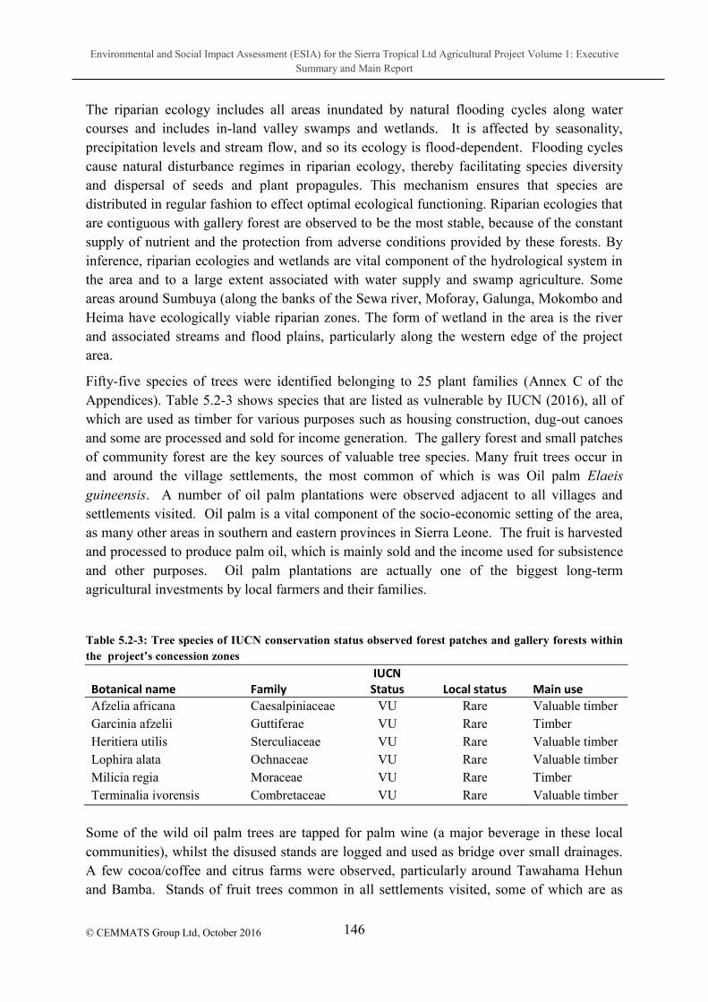
Environmental and Social Impact Assessment (ESIA) for the Sierra Tropical Ltd Agricultural Project Volume 1: Executive Summary and Main Report
146
© CEMMATS Group Ltd, October 2016
The riparian ecology includes all areas inundated by natural flooding cycles along water courses and includes in-land valley swamps and wetlands. It is affected by seasonality, precipitation levels and stream flow, and so its ecology is flood-dependent. Flooding cycles cause natural disturbance regimes in riparian ecology, thereby facilitating species diversity and dispersal of seeds and plant propagules. This mechanism ensures that species are distributed in regular fashion to effect optimal ecological functioning. Riparian ecologies that are contiguous with gallery forest are observed to be the most stable, because of the constant supply of nutrient and the protection from adverse conditions provided by these forests. By inference, riparian ecologies and wetlands are vital component of the hydrological system in the area and to a large extent associated with water supply and swamp agriculture. Some areas around Sumbuya (along the banks of the Sewa river, Moforay, Galunga, Mokombo and Heima have ecologically viable riparian zones. The form of wetland in the area is the river and associated streams and flood plains, particularly along the western edge of the project area.
Fifty-five species of trees were identified belonging to 25 plant families (Annex C of the Appendices). Table 5.2-3 shows species that are listed as vulnerable by IUCN (2016), all of which are used as timber for various purposes such as housing construction, dug-out canoes and some are processed and sold for income generation. The gallery forest and small patches of community forest are the key sources of valuable tree species. Many fruit trees occur in and around the village settlements, the most common of which is was Oil palm Elaeis guineensis. A number of oil palm plantations were observed adjacent to all villages and settlements visited. Oil palm is a vital component of the socio-economic setting of the area, as many other areas in southern and eastern provinces in Sierra Leone. The fruit is harvested and processed to produce palm oil, which is mainly sold and the income used for subsistence and other purposes. Oil palm plantations are actually one of the biggest long-term agricultural investments by local farmers and their families.
Table 5.2-3: Tree species of IUCN conservation status observed forest patches and gallery forests within
Afzelia africana Caesalpiniaceae VU Rare Valuable timber Garcinia afzelii Guttiferae VU Rare Timber Heritiera utilis Sterculiaceae VU Rare Valuable timber Lophira alata Ochnaceae VU Rare Valuable timber Milicia regia Moraceae VU Rare Timber Terminalia ivorensis Combretaceae VU Rare Valuable timber
Some of the wild oil palm trees are tapped for palm wine (a major beverage in these local communities), whilst the disused stands are logged and used as bridge over small drainages. A few cocoa/coffee and citrus farms were observed, particularly around Tawahama Hehun and Bamba. Stands of fruit trees common in all settlements visited, some of which are as

Environmental and Social Impact Assessment (ESIA) for the Sierra Tropical Ltd Agricultural Project Volume 1: Executive Summary and Main Report
147
© CEMMATS Group Ltd, October 2016
follows: Coconut, Bread fruit trees, Mango, Pawpaw; Banana; are very common in and around all settlements in the project area.
5.2.1.3.2 Mammals Twenty-four species of mammals were identified by both visual evidence and interviews to occur across all sections of the project area (Appendix B). These include the following species of global conservation interest according to IUCN (2016): two endangered species (Western Chimpanzee Pan troglodytes verus and Red Colobus Monkey Procolobus badius); two vulnerable (Pied Colobus Colobus polykomus, Zebra Duiker Cephalophus zebra and Tree Pangolin Phataginus tricuspis) and two near threatened (Sooty Mangabey Cercocebus atys and Bongo Tragelaphus euryceros). The rest of the species are actually considered least concern (LC), meaning that there is no global threat to their occurrence and distribution; however, some of these least concern species are locally getting rare.
e local status; the latter indicate the occurrence and distribution status for each of the species listed. Most of the species that are of global conservation concern are very rare and respondents indicated that encounter rates for these species are seldom. In fact, the endangered and vulnerable species mentioned require adequate forest cover to survive, but with the contracting and increasing fragmented forest cover, it is very likely that these species might be locally extinct in the near future. Monkeys and antelopes are the main target species for hunting in these communities and this activity is further driving the rare species to the brink of local extinction and depleting the population of once common species. Also, in nearly all farms and farm bush, trap fences are installed to trap Marsh Cane Rat Thryonomys swinderianus which is also a delicacy, in addition to the monkeys and antelopes. Bush meat constitutes one of the main protein sources for people in the project area.
5.2.1.3.3 Herpetofauna The herpetofauna in the project area is not impressive based on the data obtained. This may have resulted from two main factors: (i) the time and duration of the survey, which did not allow the installation of traps; and (ii) the high level of degradation, which may have driven some of the species into areas where they are difficult to reach. However, a total of 21 species of amphibians and reptiles were identified through visual evidence across all sites visited (Table 3). In the case of amphibians, 12 species belonging to six families were encountered. Among these were three species of conservation interest (IUCN, 2016) - Hyperolius macrotis (NT), Petropedetes natator (NT) and Ptychadena arnei (DD) the last two are endemic to West Africa and depend on gallery forest, which is dwindling in the area. These species of global conservation interest are actually rare, but appear to be widely distributed in moist forest environment in the country. The family Hyperoliidae accounted for the highest number of species among amphibians. Amphibians are partly water-dependent (their main breeding habitat) and much of their foraging is done on land; a good diversity is forest dependent, and
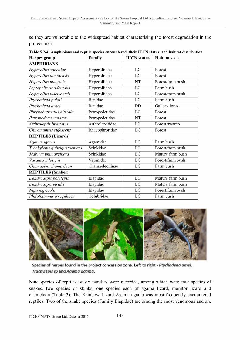
Environmental and Social Impact Assessment (ESIA) for the Sierra Tropical Ltd Agricultural Project Volume 1: Executive Summary and Main Report
148
© CEMMATS Group Ltd, October 2016
so they are vulnerable to the widespread habitat characterising the forest degradation in the project area.
Table 5.2-4: Amphibians and reptile species encountered, their IUCN status and habitat distribution
Herpes group Family IUCN status Habitat seen AMPHIBIANS Hyperolius concolor Hyperoliidae LC Forest Hyperolius lamtoensis Hyperoliidae LC Forest Hyperolius macrotis Hyperoliidae NT Forest/farm bush Leptopelis occidentalis Hyperoliidae LC Farm bush Hyperolius fusciventris Hyperoliidae LC Forest/farm bush Ptychadena pujoli Ranidae LC Farm bush Ptychadena arnei Ranidae DD Gallery forest Phrynobatractus alticola Petropedetidae LC Forest Petropedetes natator Petropedetidae NT Forest Arthroleptis bivittatus Arthrolepetidae LC Forest swamp Chiromantris rufescens Rhacophroridae LC Forest REPTILES (Lizards) Agama agama Agamidae LC Farm bush Trachylepis quiiriquetaeniata Scinkidae LC Forest/farm bush Mabuya unimarginata Scinkidae LC Mature farm bush Varanus niloticus Varanidae LC Forest/farm bush Chamaeleo chamaeleon Chamaeleoninae LC Farm bush REPTILES (Snakes) Dendroaspis polylepis Elapidae LC Mature farm bush Dendroaspis viridis Elapidae LC Mature farm bush Naja nigricolis Elapidae LC Forest/farm bush Philothamnus irregularis Colubridae LC Farm bush
Nine species of reptiles of six families were recorded, among which were four species of snakes, two species of skinks, one species each of agama lizard, monitor lizard and chameleon (Table 3). The Rainbow Lizard Agama agama was most frequently encountered reptiles. Two of the snake species (Family Elapidae) are among the most venomous and are

Environmental and Social Impact Assessment (ESIA) for the Sierra Tropical Ltd Agricultural Project Volume 1: Executive Summary and Main Report
149
© CEMMATS Group Ltd, October 2016
responsible for most of the death from snake bite in rural communities in Africa (www.tlcafrica.com/tlc_snakes). Incidences of snake bites occur in the area, but not officially recorded; however, these incidences rarely result in death because, according to local people, most victims recover fully after treatment with traditional herbs.
5.2.1.4 Discussion of Impacts and Mitigation
The establishment of any large-scale agricultural venture means that vegetation would have to be modified to a monoculture that empirically has associated ecological and environmental problems (Altieri, 1995). With reference to the project concession area, the key impact would be the conversion of vast areas of land into a new ecological paradigm through loss of original vegetation cover including forest cover, which distorts ecological processes, causes ecosystem instability, increase pest problems and loss of species. Such negative ecological state has apparently been set in motion by the establishment of large cassava farms.
Although much of the original forest in the area has been modified into farm bush and farm lands, yet the remaining patches provide many ecological functions including stabilization of local climatic conditions, store of valuable genetic resources, store of carbon that would otherwise be injurious to the environment (the main culprit in the climate change phenomenon) and store of water associated with proper functioning of the hydrological system. With large-scale monocultures it is expected that the nutrient, energy, water and waste cycling will be distorted, whilst some naturally available resources (such as wood, timber and medicinal herbs) for use by local communities may be depleted. .
Upland and gallery forests support a diversity of both vascular and non-vascular plant species including epiphytic plants, lianas, macro-fungi, bryophytes and pteridophytes that are equally vital to the proper functioning of forest ecosystems. The loss of plant cover and possible key-stone species within the forest ecology, resulting from possible removal of some gallery forest and sacred groves may have irreversible consequences, if not controlled.
Large-scale monocultures also reduce the ability for natural enemies to control pest and plant disease, thus creating serious ecological imbalance on the food web and attendant environmental problems. According to Altieri (1995), pest explosion in monocultures results from the concentration of resources for specialist crop herbivores, which also increase areas available for pest immigration. Such pest problems could creep into local agro-ecology and farming systems, with devastating effects such as reduction in crop yield and loss of soil nutrient. Pest problems in Sierra Leone has mainly involved grasshopper invasion that tend to increase in open agriculture environment, increased rodents pests on local farming system, and viral plant pest on cassava and oil palm.
The main impact on fauna is related to the reductions in vegetation cover to be replaced by more open farm ecological setting, dominated by monocultures. This situation negatively affects the habitats for wildlife and biodiversity in general. The loss of vegetation and the remaining forest patch will displace wildlife species, exposing them to hunting, predation and other threats that would lead to population reduction and eventual local extinction. In

Environmental and Social Impact Assessment (ESIA) for the Sierra Tropical Ltd Agricultural Project Volume 1: Executive Summary and Main Report
150
© CEMMATS Group Ltd, October 2016
addition, foraging habitats and breeding areas for species will be destroyed, whilst refugia for juveniles and less aggressive wildlife are cleared, rendering these areas ecologically redundant to adequately support wildlife. The extent of habitat and home range size of some of the large mammals that exist in the area is expected to decline and so species that may not be able to find alternative habitats could go extinct locally, whilst others will migrate into nearby habitats and increase inter-specific and intra-specific competition. The implication to wildlife is that, whereas degradation-tolerant species such as rodents may increase in number, forest dependent species including amphibians and large mammals may decline significantly, distorting the predator-prey dynamics in the natural food chain, with potentially deleterious ecological consequences, including loss of biodiversity.
Increased human presence and equipment use in the area as people engage in various operational activities of the establishment will create new ecological problems. New types of waste will be produced in large volumes never experienced previously in such environments; some of these wastes may be injurious to wildlife, particularly herpeto-fauna. Increased tramping of substrate may adversely effect on soil organisms and soil structure and this may be injurious to ground-dwelling fauna such as amphibians. Increased human presence could also mean increase hunting of wildlife for subsistence, particularly large mammals and primate and may render them susceptible to local extinctions.
5.2.1.4.1 Recommendations It is overly important that areas that are important for biodiversity such as sacred groves, gallery forests, swamps and riparian zones be reserved and protected. In fact, the lay out of the project zone must take into consideration the importance of the hydrological system. Care must be taken to avoid the deposition of debris, silt and waste into these sensitive areas in order to avoid ecological distortions that may put further stress on the already degraded ecosystem that has undergone many years of mining-related perturbations..
Biodiversity conservation and conservation management areas must be established within the concept of co-management with local authorities and their respective communities. This is to ensure regulated and controlled use of resources such as timber and wood which is required by the local people for various purposes. If practicable, based on collaboration with relevant institutions, a botanic reserve could be created for areas with reasonable forest cover that may not be under any traditional management system. Such reserves could serve as natural plant genetic store for genetic diversity and as a repository for rare or less common flora, including some of the endemic species.
Some patches of vegetation must be allowed between defined rows of the fruit crops and some connectivity must be established with forest patches where possible. This is necessary in order to enhance some level of ecological integrity of the modified landscape. Such a system will provided ecological corridors and allow movement of species between habitats and serve as refugia for a host of small mammals and juveniles of many species.

Environmental and Social Impact Assessment (ESIA) for the Sierra Tropical Ltd Agricultural Project Volume 1: Executive Summary and Main Report
151
© CEMMATS Group Ltd, October 2016
The historic and current state of deforestation by the local communities has, by default, created serious shortfall in the biomass resource needs of the community, in terms of fuel wood and timber. As part of the environmental offset, the company could collaborate with local communities to establish and manage woodlots and/or agroforestry systems as a means of addressing the expected loss of wood biomass and other naturally available resources, once vegetation is cleared for industrial agriculture.
A proper waste management system should be put in place, to address all types of waste particularly, industrial waste water, industrial refuse and domestic refuse. This will ensure that viable ecological systems such as wetlands, riparian zone and community water supply systems are not contaminated or polluted, and people and wildlife are not exposed to environmental and health risks.
The data shows that dangerous snakes exist in the area encompassed by the project concession. With bush clearing and reduced forest cover, there is an increased chance that people will be exposed to snake bites more frequently.
5.2.2 Creation of Buffer Zones
In any large monocultures established a glaring effect is the modification of the vegetation and ecology in such way that once heterogeneous ecosystems and habitats at the macro-level and micro-level are reduced to a almost homogeneous state, which is injurious to biodiversity. In situations where the entire area is convert to an agricultural monoculture, there is very slim chance that any species not tolerant to disturbance would survive. In fact, the status and distribution of species of flora and fauna in such monocultures is expected to be drastically changed from its original state prior to conversion. To guard against the impact of large monoculures on biodiversity, there is need to reserve areas that are sensitive to change and are most important in maintaining some level of ecological functionality within concession zone. A number of sensitive sites have been identified (Table 5.2-5) which together would consitute a good representation of the original ecosytems and habitats that characterised the concession zone.

Environmental and Social Impact Assessment (ESIA) for the Sierra Tropical Ltd Agricultural Project Volume 1: Executive Summary and Main Report
152
© CEMMATS Group Ltd, October 2016
Table 5.2-5: Sites identified for the creation of buffer zones within concession zones. The sites are marked by yellow polygons.
Table 5.2-5 is a google map of the concession zone on which sensitive sites have been identified and mark by yellow polygons. These areas encompass a wide diversity of ecosystems and habitats which have been practically assessed during the field work, as sites that hold the largest complement of species associated with the concession zone. They include gallery forests, sacred groves, community forests, wetlands, streams, swamps and riparian zones. It is therefore important that these areas are reserved as buffer zones and remained untouched in order to provide functional habitats for species and to maintain some viability in the local gene pool, thereby sustaining some degree of species diversity. The sites identified with their central coordinates given in Table 5.2-6. The justification for the conservation of key ecosystems and habitats are explained below.
Table 5.2-6: Sites identified for buffer zone establishment within the Sierra Tropical Limited Concession zone
Site Number Key habitat Central coordinate
1 Wetland, floodplain and forest 171456 E & 841269 N
2 Gallery forest and community forest 172376 E & 847685 N
3 Gallery forest and community forest 172705 E & 846417 N

Environmental and Social Impact Assessment (ESIA) for the Sierra Tropical Ltd Agricultural Project Volume 1: Executive Summary and Main Report
153
© CEMMATS Group Ltd, October 2016
Site Number Key habitat Central coordinate
4 Community forest 174329 E & 843595 N
5 Community forest and swamps 175719 E & 847946 N
6 Community forest and swamps 176194 E & 846914 N
7 Community forest 180199 E & 843332 N
8 Community forest 182599 E & 852843 N
5.2.2.1 Habitat Corridors
Habitat corridors are areas of vegetation cover or wetland connectives which are used by animals to traverse large areas and to move across their home range during foraging and mate searching activities. These corridors include road site vegetation, streams, flood zones, and swamps. The corridor must also include everything that a species needs to live and breed, such as soil for germination, burrowing areas, and multiple other breeding adults (Beier & Loe 1992). At least 10 50 meters of vegetation cover should be allowed along the entire road network and around wetlands, swamps, riparian zones and gallery forest. This is necessary to create areas of activities for animals and to provide refugia for a diversity of fauna, whose habitat has already been depleted. In the case of road side vegetation, the cover also provides a source of ecosystem service for the local people, including wild fruits, shade against the hot burning sun when people walk along these roads and medicinal herbs. Habitat corridors (especially roadside vegetation) are also important for the survival and maintenance of the population of small mammals (squirrels, giant rats, cane rats) herpes (amphibians and reptiles) and a significant diversity of birds. Dispersal of seeds and the mixing of the gene pool through pollinations and mating is facilitated by the existence of passage for species, thus creating heterogeneity in populations and maintaining species diversity.
5.2.2.2 Sacred groves and community forests
Community forests including sacred groves are very important to biodiversity and the maintenance of the culture and traditional practices to the local communities. Sacred groves are among the most protected forest network in the country and these area are held in trust by the chiefs and traditional heads for the observance of cultural and traditional rights of the people. Entry to sacred groves by non-indigenes is strictly prohibited except by special permission, usually preceded by a traditional ceremony. These sites by virtue of their protection level constitute some of the most important biodiversity concentrations in rural communities. By all means, it is important that sacred groves be protected and some buffer be allowed between cultivated zones and these very important community forests. Other types of
Environmental and Social Impact Assessment (ESIA) for the Sierra Tropical Ltd Agricultural Project Volume 1: Executive Summary and Main Report
154
© CEMMATS Group Ltd, October 2016
community forest need to be reserved to provide source of wood, timber and bush meat for the community. One of the key problems with the Socfin Project in the Pujehun District is the limited availability of wood, timber and other forest resources for use by the local inhabitants of most of the villages. Lessons should be learnt from these experiences to avoid discontent among the local communities.
5.2.2.3 Wetlands and water catchments
According to includes all lakes and rivers, underground aquifers, swamps and marshes, wet grasslands, peat lands, oases, estuaries, deltas and tidal flats, mangroves and other coastal areas, coral reefs, and all human-made sites such as fish ponds, rice paddies, reservoirs and salt pans . The convention further describes indispensable ecosystem services that they provide humanity, ranging from freshwater supply, food and building materials, and biodiversity, to flood control, groundwater recharge, and climate change mitigation As Sierra Leone is the 108th signatory to the Ramsar Convention it is incumbent on the country to protect and conserve wetlands, including areas within the Sierra Tropical Limited concession zone. These areas included the riparian zones and gallery forest along the main river course and associated with Njalated streams and tributaries, swamps and floodplains. In fact, the swamps and floodplains are vital components of the agro-ecology of the area and so are required to be reserved for maintaining food production through traditional agricultural activities of the local people.
5.2.3 High Conservation Value Assessment
Prior to any land clearing and development, a comprehensive HCV Assessment/Biodiversity study will be initiated. The study will be led by an environmental scientist from the Dole Philippines Research department with assistance from local students at the nearby Njala University. The study will focus on the inter-relationship between agro-diversity conservation and sustainable use and development practices in Dole Plantations, including the proposed plantations Lugbu Chiefdom with emphasis on biodiversity.
5.2.3.1 Objectives
To identify all existing natural ecosystems within the new Lugbu Plantation and immediate surroundings.
To document the existing collection and count of flora (vegetation), fauna (animals), micro flora and fauna (plants and animals) among the newly identified Plantation areas and immediate surroundings.
Establish biodiversity monitoring stations within the Lugbu Plantations and immediate surroundings.

Environmental and Social Impact Assessment (ESIA) for the Sierra Tropical Ltd Agricultural Project Volume 1: Executive Summary and Main Report
155
© CEMMATS Group Ltd, October 2016
Using the baseline data collected, develop a possible program of Restoration, Protection, Conservation and the development of a Botanical garden within the new plantation areas.
5.2.3.2 Methods
1. Selection of Uncultivated areas
Low Elevation, Medium Elevation and High Elevation
10 sampling sites (20-30 sq. m) distanced at 10-20 m apart
Located with GPS Coordinates 2. Count, Identification and Photographs 3. Data Gathering and Collection
For Flora:
Leaf samples and other plant parts of unidentified plants will be collected for further identification.
For Fauna:
Counting of animals (mammals, birds, insects, spiders etc.)
Shaking of trees
Sweep Netting will be used to capture low vegetation fauna (not visibly seen).
Installation of trapping baits (improvised malaise traplight traps, water trap).
As an update for the procedure for the year 2016 surveys and onwards, only Light traps will be installed in the survey sites and count of animals observed on site will also be recorded.
For micro flora and fauna:
Samples will be gathered from soil pit, boulders underneath, soil-root area, tree trunks/ barks/ stem/ leaves, soil horizon O and others.
Isolation of fungi and bacteria (Simple Plating Technique)
Extraction of nematodes using the Baerman technique.

Environmental and Social Impact Assessment (ESIA) for the Sierra Tropical Ltd Agricultural Project Volume 1: Executive Summary and Main Report
156 © CEMMATS Group Ltd, October 2016
6 DESCRIPTION OF THE SOCIAL ENVIRONMENT
6.1 Introduction
The implementation of the STL Agricultural project will have both positive and negative social impacts throughout its various phases. This section highlights the baseline situation as it existed during the time of the ESIA study to serve as a benchmark for future reference purposes after the project would have been implemented.
6.1.1 National Socio-Political Context Sierra Leone covers a total area of 71,740 km2 and had an estimated population of 4.9 million in 2004 (Sierra Leone Population and Housing Census, 2004) but according to the 2015 Housing and Population Census result, the population has increased to 7,075,641. Political instability and poor economic growth led to the brutal and destructive 10 year civil war which officially ended in 2002.
The 2015 Global Human Development Report (HDR) titled Work for Human Development shows that Sierra Leone continues to make steady progress in human development despite the recent devastating Ebola epidemic in 2014-2015, but that deep poverty and various forms of inequality in Sierra Leone are among the highest in Africa.
The country moved one position up the Human Development Index (HDI) placing the country in 181 out of 188 countries with an HDI value of 0.413, but still below the 0.518 average for Sub Saharan Africa. Liberia is positioned at 177, Guinea at 182 and Ghana at 140 out of 188 countries. This means that Sierra Leone has overtaken its bigger neighbour Guinea for the first time while Liberia continues to lead its two bigger Mano River neighbours on the Human Development Index.
The report further shows that 77.5% of the population of Sierra Leone (about 4, 724,000 people) are multi-dimensionally poor even though income poverty (i.e. $1.2 per day) is 56.6%.
Siseats held by women and only 10% of adult women have reached at least secondary level of education compared to 21.7% for their male counterparts. Gender Inequality Index (GII) reflects gender based inequalities in the areas of reproductive health, empowerment and
This implies that there is 65.0% loss in human development as a result of gender inequalities in reproductive health, empowerment and economic activity (UNDP, 2016)
Table 6.1-1 presents some of these gloomy socio-economic indicators.
Table 6.1-1: Information on National Social Indicators
Key Social Indicators Rate Source
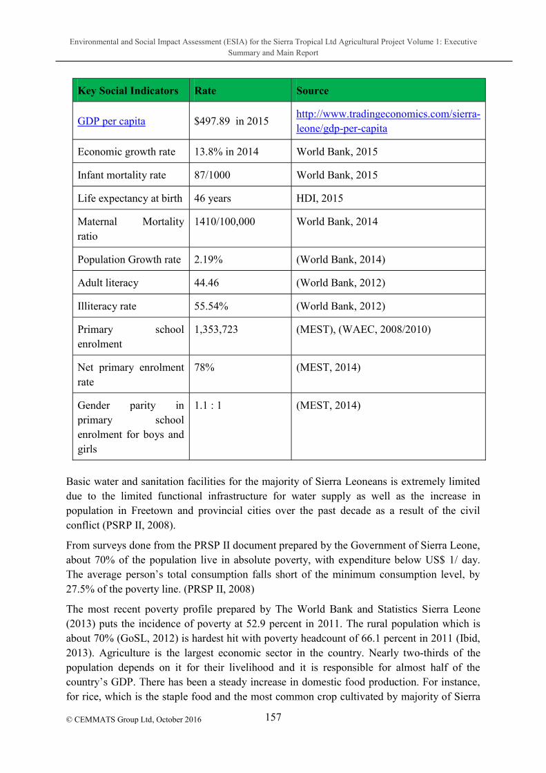
Environmental and Social Impact Assessment (ESIA) for the Sierra Tropical Ltd Agricultural Project Volume 1: Executive Summary and Main Report
157
© CEMMATS Group Ltd, October 2016
Key Social Indicators Rate Source
GDP per capita $497.89 in 2015 http://www.tradingeconomics.com/sierra-leone/gdp-per-capita
Economic growth rate 13.8% in 2014 World Bank, 2015
Infant mortality rate 87/1000 World Bank, 2015
Life expectancy at birth 46 years HDI, 2015
Maternal Mortality ratio
1410/100,000 World Bank, 2014
Population Growth rate 2.19% (World Bank, 2014)
Adult literacy 44.46 (World Bank, 2012)
Illiteracy rate 55.54% (World Bank, 2012)
Primary school enrolment
1,353,723 (MEST), (WAEC, 2008/2010)
Net primary enrolment rate
78% (MEST, 2014)
Gender parity in primary school enrolment for boys and girls
1.1 : 1 (MEST, 2014)
Basic water and sanitation facilities for the majority of Sierra Leoneans is extremely limited due to the limited functional infrastructure for water supply as well as the increase in population in Freetown and provincial cities over the past decade as a result of the civil conflict (PSRP II, 2008).
From surveys done from the PRSP II document prepared by the Government of Sierra Leone, about 70% of the population live in absolute poverty, with expenditure below US$ 1/ day.
27.5% of the poverty line. (PRSP II, 2008)
The most recent poverty profile prepared by The World Bank and Statistics Sierra Leone (2013) puts the incidence of poverty at 52.9 percent in 2011. The rural population which is about 70% (GoSL, 2012) is hardest hit with poverty headcount of 66.1 percent in 2011 (Ibid, 2013). Agriculture is the largest economic sector in the country. Nearly two-thirds of the population depends on it for their livelihood and it is responsible for almost half of the
for rice, which is the staple food and the most common crop cultivated by majority of Sierra
Environmental and Social Impact Assessment (ESIA) for the Sierra Tropical Ltd Agricultural Project Volume 1: Executive Summary and Main Report
158
© CEMMATS Group Ltd, October 2016
Leoneans, production increased at an annual rate of 17.8% between 2000 and 2010 compared to -7.1% between 1990 1999 (FAO, 2013). Nonetheless, the living conditions continue to be difficult especially for rural villagers who struggle to remain at subsistence levels. Poor health indicators reflect the lack of access among the population to basic service notably - health. Endemic diseases, especially malaria and HIV/AIDS, loom as a threat; in 1997, UNAIDS estimated the HIV prevalence among adults to be 3.2%. In 2002, a national prevalence survey estimated the rate at 5% while the survey in 2010 revealed an increase of 1.5% (UNDP, 2013).
Sanitary conditions are very poor as sewage and refuse disposal systems do not function effectively in most places. Urban living conditions are extremely difficult; (PRSP II, 2008).
in Ghana, 46% in Nigeria, 96% in North Africa, 73% in Asia, 99% in China and 76% global average. Only around 1% of the rural population in Sierra Leone has access to electricity.
Of the 11,300km of classified roads in the country, 8,148km are classified in the national road system. The remaining roads consist of urban roads, community roads, local roads and farm tracks. With respect to the regional distribution of roads, the Northern Province accounts for 41% of the roads followed by the Southern Province with 33% and the Eastern Province with 23%. The Western Area accounts for only 3% (PRSP II, 2008).
6.1.2 Local Governance Structure
Administratively, Sierra Leone is divided into four distinct areas: the Northern Province with its headquarters in Makeni, the Southern Province with Bo as its headquarters, the Eastern Province with Kenema as its headquarters and the Western Area comprising the Freetown Peninsular with Freetown as its headquarters.
Freetown is the capital city where most of the government ministries are located. District councils were established in the year 2000, with the appointment of management committees. The government is committed to decentralization and has held three Local Government elections in 2004, 2008 and 2012 and the elections scheduled for 2016 postponed to 2018. The elected councils constitute representative bodies with delegated powers and funds for local governance.
Councils are operating and the government is slowly devolving power and functions of various ministries to these devolved bodies.
6.1.3 Local Regional Socio-Economic Context The information in this section was obtained from the Bo District Development Plan, 2014-2016.
Bo District is the largest of the four administrative Districts in the Southern Region of Sierra Leone. It is bounded on the north by Tonkolili District, to the west by Moyamba District, to

Environmental and Social Impact Assessment (ESIA) for the Sierra Tropical Ltd Agricultural Project Volume 1: Executive Summary and Main Report
159
© CEMMATS Group Ltd, October 2016
the south west and south by Bonthe and Pujehun Districts, and to the East by the Kenema District. The District is sub-divided into 15 Chiefdoms, 94 sections and 1,654 Villages, each of which has long established traditional Chieftaincy for Local Administration.
Bo District occupies a total area of 7,003km2 and a population of 574,201 people (Sierra Leone 2015 Population And Housing Census, 2016) of which about 173, reside in the cosmopolitan city of Bo. The district population is ethnically and culturally diverse, particularly in the city of Bo, however, over 60% of the population belongs to the Mende ethnic group; other ethnic groups include Temne, Limba, Susu, Mandingo, and Fullahs forming large settlements around Bo and the mining towns. Bo Town serves as the District and Regional headquarters and commercial centre for Bo District and Southern Region. The District is well fed by the Sewa River that flows east centrally through Baoma, Tikonko, and Lugbu Chiefdoms, the Wanje River that flows south through the Wunde Chiefdom into the Pujehun District and the Taia that flows through Valunia and Gbo Chiefdoms into Moyamba District. Other big rivers include the Tabe and Dematoe in the Bumpeh Ngao and the Bagbo Chiefdoms.
6.1.3.1 Economic Activities
The major economic activities of the district population are gold and diamond mining, other activities include trading, agricultural production of rice and root crops, cash crops such coffee, cacao and oil palm plantation. Trading is also a livelihood means for many residents as the district serves the important trade route and business hub for the south west of the country. Traditional farming is a common livelihood and family income source for the majority of the population in the country, however, less than half (49%) of Bo residents are engaged in farming activities.
Agriculture
Agriculture is the largest economic sector in the district with more than half of the population of Bo District depending on it as their main source of livelihood. Thus economic growth and poverty reduction in the district will only be sustained with development in this sector as the District is endowed with cultivable land (Upland and Inland Valley Swamps) and adequate rain-fall. The expansion of this sector in the district will stimulate growth in other sector like the supply of input, job creation, marketing, processing etc.
There has been a steady increase in agricultural production - crops, livestock and even fisheries. Thus household food consumption has increased with regards to specific food like rice, cassava and potato.
In Bo District the consumption and production of rice has increased as the staple food crop due to progress in the expansion of land cultivated, increase in the farormation is availablem families, donor and government input assistance to farmers through the ABCs, mechanized farming services etc. However rice production is still insufficient to meet the total

Environmental and Social Impact Assessment (ESIA) for the Sierra Tropical Ltd Agricultural Project Volume 1: Executive Summary and Main Report
160
© CEMMATS Group Ltd, October 2016
consumption rate of the people in the district and thus there is a need to relay on imported rice. Root tubers such as cassava and potato have being the key substitute for rice in the district. Also the production of livestock such as (goats, sheep and poultry) and cash crops such as coffee, cocoa has also increased in the district.
Despite the progress made so far, the sector still face challenges in the district, among them are:
Limited access to credit and saving facilities hereby limiting farmers to access loans for input.
Inadequate budget allocation from centre Government.
Limited irrigation system thus farmers depend on rainfall.
Farmers depend on manual labour instead of the use of machinery to carry out their agricultural activities.
Weak extension system due to low capacity of personnel.
Productivity is hinder due to bad roads, transport, markets, energy and power.
Weak coordination among partners in the sectors.
Housing
The quality of construction materials used in housing construction are often used as proxy indicators for assessing household poverty.
The housing condition in the district is poor with overcrowded houses and lack of minimal basic facilities. Foundations of most houses are also being destroyed by erosion because of poor drainage system.
Some residents have water facilities in their houses, while only a very few have bathrooms and toilet facilities in the house. Most have no electricity.
Mining
Mining activities in Bo District are concentrated in the Baoma, Tikonko, Lugbu, Kakua, Jaiama Bongor and Badjia Chiefdoms for diamonds and in Valunia, Selenga and Niawa-Lenga Chiefdoms for gold and Bumpe Ngao for Bauxite. The full mineral potential of the District is still to be explored even though illegal mining activities along the riverine banks and valley swamps fed by the Sewa, Moa, Taia, Tabe, and other large streams is a challenge in the district.

Environmental and Social Impact Assessment (ESIA) for the Sierra Tropical Ltd Agricultural Project Volume 1: Executive Summary and Main Report
161
© CEMMATS Group Ltd, October 2016
Industry
Industrial development in the District is poor. However, strides have been taken to promote cotton industries and small enterprises, particularly in construction, transportation, carpentry, clothing and blacksmithery. Development of industries for food processing is still poor and primitive.
Fishing
Fishing activities are limited as Bo District is land-locked. The District heavily depends on the weekly fish markets from Gbondappi (Pujehun District), Gbangbatoke and Shenge (Moyamba District), and Mattru Jong (Bonthe District). The District also heavily relies on fresh-water fish harvested from the streams and rivers that flow through the District. The result, therefore, is a high rate of malnutrition, especially among children and lactating women in villages.
Trade
The Lebanese and Fullah communities largely control Trade in Bo District. Indigenous trading is still at the petty-trader level because indigenous entrepreneurship is poorly developed, and credit facilities are not easily extended to locals with demands for high collaterals that are difficult and somehow impossible to meet. Most of the trading in Bo
Chiefdom), Koribondo (Jaiama-Bongo Chiefdom), Gerihun (Baoma Chiefdom) and Mani Junction (Bagbo Chiefdom), however, the existing weekly markets will be improved and daily markets constructed. Also the private sector will be encouraged to take the lead for a rapid economic growth.
6.1.3.2 Education
There are 433 Primary schools and 28 Junior Secondary Schools in Bo District; the pre-schools are largely private owned and are not well-established. The participation rates decrease from primary to Junior Secondary Schools as well as the female participation when compared to males. The teacher to pupil ratio stands at 1:50 in primary and 1:35 in Junior Secondary School, but looking at these rates they are no better considering the number of out of schools.
The sector experiences a number of challenges that needs to be addressed
Overcrowding in schools, limited school infrastructure including WASH
Deplorable existing school structures
Limited libraries/reading facilities
Inadequate school furniture and school material-Teaching Learning Material

Environmental and Social Impact Assessment (ESIA) for the Sierra Tropical Ltd Agricultural Project Volume 1: Executive Summary and Main Report
162
© CEMMATS Group Ltd, October 2016
Low capacity and morale of teachers-untrained and unqualified
Inadequate facilities for Non-formal education for parent and vocational institution for drop out.
Non-functional school feeding programme.
Inadequate or damage staff quarters
Exclusion of Inclusive Education-girls education disables ECD.
Lack of science equipment and labs in JSS schools.
Effect of Sporting in schools to academic work.
6.1.3.3 Health and nutrition
Health services in Bo District are provided by government institution, NGOS, Private Hospitals and clinics. Access to health services in Bo District has increased from 40% to 65%
Periphery Health Units, the smallest units for health delivery, are the major facilities in the district providing health services to the rural communities. The district has three hospitals that support the PHUs as they serve as referral points for complicated cases.
There is still high infant and maternal mortality rate even with the Free Health Care initiative.
health status poses a major challenge mainly because of:
High illiteracy and poor understanding of the spread of diseases;
Large household population and congested community layout;
Traditional norms about diseases and refuse disposal
The high poverty level of people.
6.1.3.4 Water and Sanitation (WASH)
The Ministry of Energy and Water Resources (MEWR) comprehensive mapping of water points report 2012 indicated that the major drinking water sources for the district residents are wells, hand pumps, public water supplies (piped) and other sources (streams and untreated sources). There are some 3,656 functional water points of different sources, majority (2,412) of which are wells without a pump. During the time of the mapping exercise in 2012, 22% (797) water points were found not functioning, 275 of these sources need repairing. The Ministry of Education, Science and Technology (MEST) census for the 2012-13 school year indicated that 344 (47%) schools have safe drinking water sources (piped supplies and boreholes) inside the school compound while other schools are using wells, streams and other

Environmental and Social Impact Assessment (ESIA) for the Sierra Tropical Ltd Agricultural Project Volume 1: Executive Summary and Main Report
163
© CEMMATS Group Ltd, October 2016
untreated sources. 69% (499) of schools have access to toilet facilities within the school premises. (UN Office for the Coordination of Humanitarian Affairs, 2016)
6.1.3.5 Infrastructure
Roads and Works
The condition of major roads especially feeder roads in the District have deteriorated and suffered seriously from neglect and require extensive rehabilitation. All the bridges and culverts on the roads inspected require rehabilitation or reconstruction.
6.1.3.6 Information and Communication Technology Sector
Postal services do not function within the district. Mobile telecommunications companies, Africell and Airtel operate within the district as well as 5 radio stations. These two means of communications have contributed immensely to the communication systems in the district.
6.1.4 Socio-Economic Condition of Project Area (Lugbu Chiefdom) Lugbu chiefdom is one of 15 chiefdoms in the Bo District. The general occupations of the inhabitants are agriculture, diamond mining and fishing. Agriculture, engaged in by more than two thirds of the inhabitants, is dominated by crop farming; this is mostly done on subsistence basis and employs rudimentary production techniques with the main crops being rice, cassava, groundnut, potatoes, yam, cocoyam and palm oil plantations. Fishing is also done in the Sewa River for both subsistence and commercial purposes.
Politically, Lugbu chiefdom is in ward 249 and 250 of the local council and part of constituency 75. The chiefdom is divided into 6 sections (Yarma, Gbo, Magbao, Kemo, Kamba and Kargbevu sections) and 44 villages. The main ethnic group in the chiefdom is the Mende, with smaller proportions of Sherbro, Temne, Fullas and Loko. These all have their own traditions, but there are broad cultural similarities among them, including the traditional secret societies, use of the Krio language, and their religions (traditional Christianity and Islam). The sacred sites of cultural importance include male and female secret society groves, ancestral cemeteries, shrines etc.
Education levels in the Lugbu chiefdom are low and illiteracy rates are high with many families unable to afford formal or informal school fees. The chiefdom has a total of 30 primary schools (4 of which are unapproved schools), 3 junior Secondary School and 1 Senior Secondary School (Sir Albert Senior School- Sumbuya).
The health sector is not well established in the chiefdom. Peripheral Health Units (the smallest units for health delivery) are the main facilities in the chiefdom providing health services. The chiefdom has 9 health centres with about 5 villages per health centre. The Mattru Jong Hospital and Government hospitals in Bo serve as referral points for complicated cases. There is still high infant and maternal mortality rate even with the Free Health Care
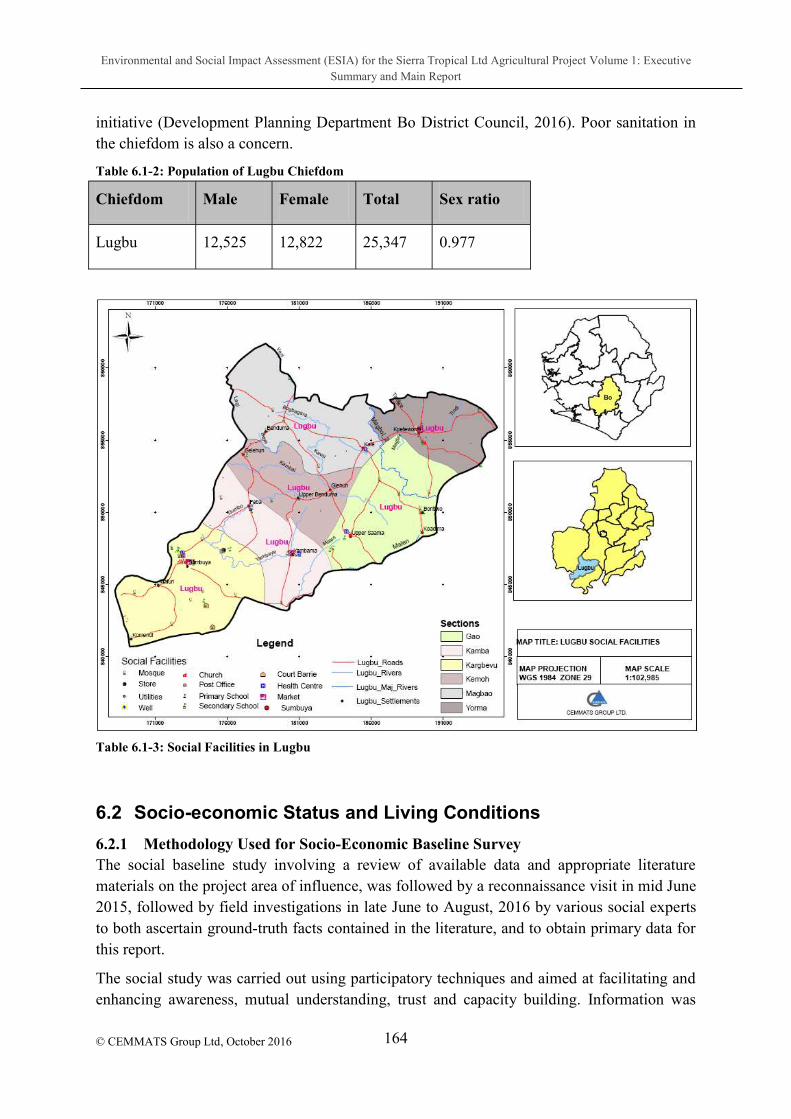
Environmental and Social Impact Assessment (ESIA) for the Sierra Tropical Ltd Agricultural Project Volume 1: Executive Summary and Main Report
164
© CEMMATS Group Ltd, October 2016
initiative (Development Planning Department Bo District Council, 2016). Poor sanitation in the chiefdom is also a concern.
Table 6.1-2: Population of Lugbu Chiefdom
Chiefdom Male Female Total Sex ratio
Lugbu 12,525 12,822 25,347 0.977
Table 6.1-3: Social Facilities in Lugbu
6.2 Socio-economic Status and Living Conditions
6.2.1 Methodology Used for Socio-Economic Baseline Survey The social baseline study involving a review of available data and appropriate literature materials on the project area of influence, was followed by a reconnaissance visit in mid June 2015, followed by field investigations in late June to August, 2016 by various social experts to both ascertain ground-truth facts contained in the literature, and to obtain primary data for this report.
The social study was carried out using participatory techniques and aimed at facilitating and enhancing awareness, mutual understanding, trust and capacity building. Information was

Environmental and Social Impact Assessment (ESIA) for the Sierra Tropical Ltd Agricultural Project Volume 1: Executive Summary and Main Report
165
© CEMMATS Group Ltd, October 2016
collected on the following issues:
Socio-economic conditions and land use patterns of affected communities,
Formal and informal governing structures,
Local infrastructure (transport, housing, health),
Farming, Fishing, mining and other socio-economic activities and relevant statistics, and
Income and expenditure trends.
Data analysis was carried out for both primary data collected at the focus group meetings and household surveys for landholders as well as the secondary data collected by means of a desktop review of existing data sources to gather relevant socio-economic baseline information at a national, district, and local level.
6.2.1.1 Project Area of Influence
The socio-economic baseline survey covered twenty-two (22) towns and villages in the Lugbu Chiefdom as outlined in the following table:
Sumbuya Town Gelehun Village
Moforay Village Bamba Village
Garinga village Momandu Village
TawamahehunVillage Mosomgbo Village
Komende Village Gola Village
Makombo Village Baoma Village
Upper Saama Town Heima Village
Yambama Town Tungie Village
Bendumasewa Village Gbaloahun Village
Gelehun Village Kpumbu Village
Kpatema Village Lower Saama Village
6.2.1.2 Primary Data Collection
The 22 affected villages in the Lugbu Chiefdom constituted the sample frame from which a total of 121 randomly selected landholders were drawn and targeted for questionnaire survey. These villages were accessed by often narrow and unpaved roads with palm log bridges in
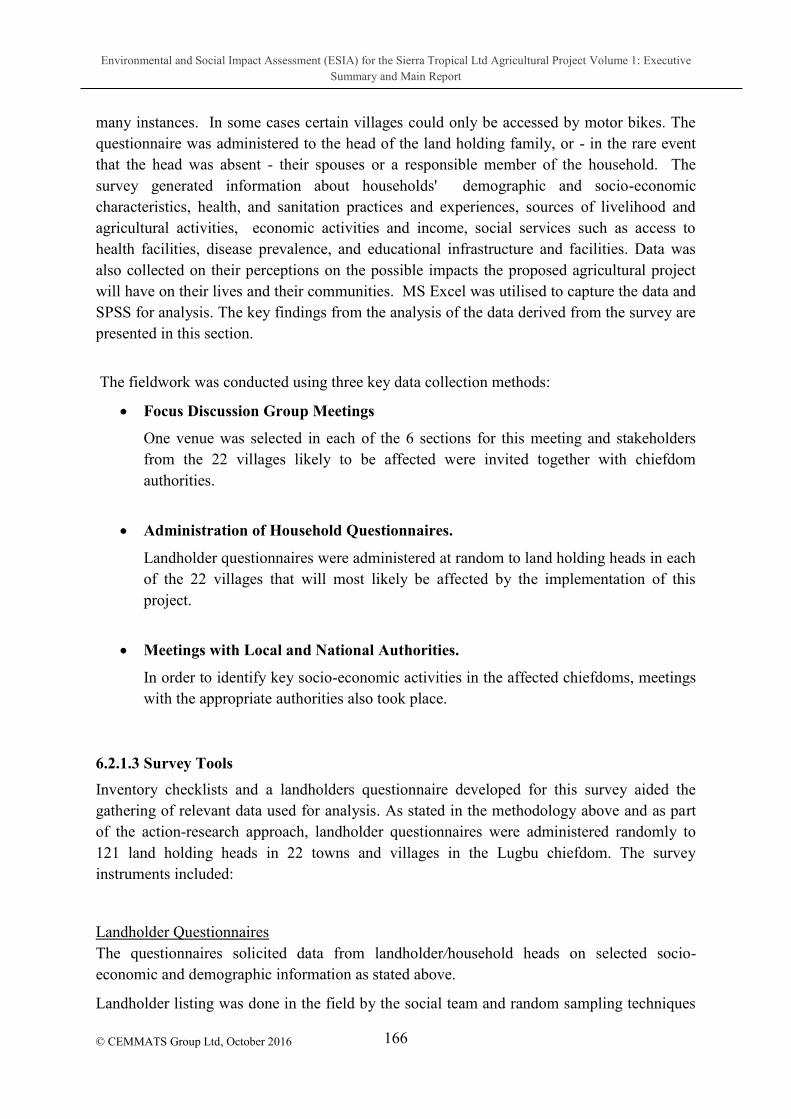
Environmental and Social Impact Assessment (ESIA) for the Sierra Tropical Ltd Agricultural Project Volume 1: Executive Summary and Main Report
166
© CEMMATS Group Ltd, October 2016
many instances. In some cases certain villages could only be accessed by motor bikes. The questionnaire was administered to the head of the land holding family, or - in the rare event that the head was absent - their spouses or a responsible member of the household. The survey generated information about households' demographic and socio-economic characteristics, health, and sanitation practices and experiences, sources of livelihood and agricultural activities, economic activities and income, social services such as access to health facilities, disease prevalence, and educational infrastructure and facilities. Data was also collected on their perceptions on the possible impacts the proposed agricultural project will have on their lives and their communities. MS Excel was utilised to capture the data and SPSS for analysis. The key findings from the analysis of the data derived from the survey are presented in this section.
The fieldwork was conducted using three key data collection methods:
Focus Discussion Group Meetings
One venue was selected in each of the 6 sections for this meeting and stakeholders from the 22 villages likely to be affected were invited together with chiefdom authorities.
Administration of Household Questionnaires.
Landholder questionnaires were administered at random to land holding heads in each of the 22 villages that will most likely be affected by the implementation of this project.
Meetings with Local and National Authorities.
In order to identify key socio-economic activities in the affected chiefdoms, meetings with the appropriate authorities also took place.
6.2.1.3 Survey Tools
Inventory checklists and a landholders questionnaire developed for this survey aided the gathering of relevant data used for analysis. As stated in the methodology above and as part of the action-research approach, landholder questionnaires were administered randomly to 121 land holding heads in 22 towns and villages in the Lugbu chiefdom. The survey instruments included:
Landholder Questionnaires The questionnaires solicited data from landholder/household heads on selected socio-economic and demographic information as stated above.
Landholder listing was done in the field by the social team and random sampling techniques

Environmental and Social Impact Assessment (ESIA) for the Sierra Tropical Ltd Agricultural Project Volume 1: Executive Summary and Main Report
167
© CEMMATS Group Ltd, October 2016
were used to select the landholder to be interviewed. The enumerators interviewed the landholderspouse).
The questionnaires were administered by trained enumerators in both Krio and Mende Languages. These interviews lasted for about 30 - 35 minutes per landholder and were conducted during the daytime. The enumerators carefully crosschecked responses in order to reduce observational errors arising from the use of this method. At the end of each day, the team met to share their field experiences as well as to identify ways of overcoming potential problems.
(subsistence or commercial farming), whether the villages have farmersrules and laws govern such an organisation; the kind of labour employed; how their farm products are sold and if they pay taxes or receive help from the government or non-governmental organisations.
The
govern such an organisation; the kind of labour employed; methodology employed in the mining process, how/where their gold and diamonds are sold and if they pay taxes on their revenue
Focus Group Discussion Checklist
The checklist of questions for the focus group discussion (FGD) solicited information mainly on the perceptions of the likely impacts the agricultural project might have on the economic activities especially the fishing activities and the communities as a whole. Mitigating measures to reduce perceived negative impacts from the project were discussed. Also discussed were the necessary community needs.
6.3 Results of Questionnaires administered to Landholders
6.3.1 Status of Respondents Questionnaires were successfully administered to 90% of targeted participants (landholder/household head). The remaining 10% of participason/daughter (5%), spouse, parent or brother/sister.

Environmental and Social Impact Assessment (ESIA) for the Sierra Tropical Ltd Agricultural Project Volume 1: Executive Summary and Main Report
168
© CEMMATS Group Ltd, October 2016
Figure 6.3-1: Status of Respondent
6.3.2 Gender of Landholder
Results revealed that about 92% of landholders are male.
Figure 6.3-2: Gender of Landholders
6.3.2.1 Age of Landholders
The following bar chart shows the age ranges of landholders interviewed. The majority (40%) fall into the 30 to 49 year age bracket.

Environmental and Social Impact Assessment (ESIA) for the Sierra Tropical Ltd Agricultural Project Volume 1: Executive Summary and Main Report
169
© CEMMATS Group Ltd, October 2016
Figure 6.3-3: Age Distribution of Landholders
6.3.3 Marital Status of Landholder
Landholders were asked their marital statuses, and in the case of respondents which were not the landholder/household head, what the landholder/household 95% were reportedly married. Male landholders were asked how many wives they had (female landholders were not asked as polyandry is not practised in Sierra Leone). Monogamy was found to be prevalent in the communities (Figure 6.3-5).
Figure 6.3-4: Marital Status of Landholder

Environmental and Social Impact Assessment (ESIA) for the Sierra Tropical Ltd Agricultural Project Volume 1: Executive Summary and Main Report
170
© CEMMATS Group Ltd, October 2016
Figure 6.3-5: Number of Wives per Male Landholder
6.3.4 Number of households living in a dwelling unit One household per dwelling unit is not common in these communities, with only 10% reportedly in this living condition. Over 45% of respondents lived in houses with two or more households.
Figure 6.3-6: Number of households per dwelling unit
6.3.5 Educational Level of Landholders The educational level of landholders was investigated over a range of various academic levels of formal and informal education. 59% or landholders had never had any kind of education as shown in the following figure.

Environmental and Social Impact Assessment (ESIA) for the Sierra Tropical Ltd Agricultural Project Volume 1: Executive Summary and Main Report
171
© CEMMATS Group Ltd, October 2016
Figure 6.3-7: Educational Level of Landholders
6.3.6 Size of Landholder Land
Landholders were asked to indicate the size of their land. The results are shown below.
Table 6.3-1: Size of Landholder
Size of Land (hectares)
Frequency Percentage
1 20 12 9.9
21 - 40 17 14.0
41 - 60 19 15.7
61 - 80 17 14.0
81 - 100 31 25.6
101 - 120 5 4.1
121 140 4 3.3
141 160 5 4.1
161 - 180 0 0
181 200 4 3.3
Over 200 7 5.8
Total 121 100.0

Environmental and Social Impact Assessment (ESIA) for the Sierra Tropical Ltd Agricultural Project Volume 1: Executive Summary and Main Report
172
© CEMMATS Group Ltd, October 2016
6.3.7 Availability of Sufficient Land for food production Landholders were also asked to indicate whether their land was big enough to cater for their
food production requirements, to which the majority reported that it was.
Figure 6.3-8: Size of Land Sufficient for Food Production Requirements
6.3.8 Income from Land Cultivation Landholders were asked how much income they were able to generate annually from the cultivation of their land; the majority (62%), indicated between Le 1 million and Le 4 million per year.
Figure 6.3-9: Income Generated from Land Cultivation

Environmental and Social Impact Assessment (ESIA) for the Sierra Tropical Ltd Agricultural Project Volume 1: Executive Summary and Main Report
173
© CEMMATS Group Ltd, October 2016
6.3.9 Proportion of upland to be leased to Sierra Tropical
The following bar chart shows the result of landholderpercentage of their upland they were willing to lease to STL. 45% indicated one third, while 37% indicated half of their land.
Figure 6.3-10: Proportion of upland land to be leased to Sierra Tropical
6.3.10 Sufficiency of Remaining Land for Family Food Cultivation Requirements When asked whether the remaining land left over after leasing a portion to STL would be enough for their family food production, an overwhelming majority (94%) reported that it would.

Environmental and Social Impact Assessment (ESIA) for the Sierra Tropical Ltd Agricultural Project Volume 1: Executive Summary and Main Report
174
© CEMMATS Group Ltd, October 2016
Figure 6.3-11: Sufficiency of Remaining Land for Food Cultivation Requirements
Landholder
6.3.11 Preferred Land Lease Payment Method
Landholders were asked how they would prefer the lease rent payments to be made. The following table highlights the results. by cash to each landholder .
Table 6.3-2: Preferred Lease Rent Payment Method
Frequency Percent
By cash to every landholder 57 47.1
By cheque through community Bank 33 27.3
Through village Authority 31 25.6
Total 121 100.0
6.3.12 Intended use of lease rent Landholders were asked what they planned to do with the lease rent money; 47% responded that they would build a new house.

Environmental and Social Impact Assessment (ESIA) for the Sierra Tropical Ltd Agricultural Project Volume 1: Executive Summary and Main Report
175
© CEMMATS Group Ltd, October 2016
Figure 6.3-12: Intended use of lease rent to landholder
6.3.13 Main Ooccupation of Landholder The overwhelming majority of landholders are reportedly farmers.
Figure 6.3-13: Occupation of Landholders
Incomes reportedly generated from these primary occupations are detailed in the following
table:
Table 6.3-3: Income from Primary Occupation
Amount Frequency Percent

Environmental and Social Impact Assessment (ESIA) for the Sierra Tropical Ltd Agricultural Project Volume 1: Executive Summary and Main Report
176
© CEMMATS Group Ltd, October 2016
Not Stated 2 1.7
Up to Le100,000 31 25.6
Le 101,000 - Le150,000 3 2.5
Le 151,000 - Le 200,000 8 6.6
Le 201,000 - Le 400,000 5 4.1
Le 401,000 - Le 600,000 7 5.8
Le 601,000 - Le 800,000 10 8.3
Le 1m - Le 2M 45 37.2
Le 2.1M to Le 3M 5 4.1
Over Le 4M 5 4.1
Total 121 100.0
6.3.14 Secondary Occupation of Landholder Landholders were asked whether they engaged in any other income generating activities in addition to their primary occupations. Responses are highlighted in Figure 6.3-14 and income generated monthly from these secondary occupations outlined in
Figure 6.3-14: Secondary Occupations

Environmental and Social Impact Assessment (ESIA) for the Sierra Tropical Ltd Agricultural Project Volume 1: Executive Summary and Main Report
177
© CEMMATS Group Ltd, October 2016
Figure 6.3-15: Income from Secondary Occupation
6.3.15 Landholder
Respondents were asked whether they were aware of the STL agricultural project in their communities, and whether they thought it is a positive or negative initiative. 98% felt it would be a good project while the remainder did not have any particular perception about whether it would be good or bad.
Table 6.3-4: Landholder
Frequency Percent
Not stated 1 0.5
Yes 188 95.4
No 8 4.1
Total 197 100.0

Environmental and Social Impact Assessment (ESIA) for the Sierra Tropical Ltd Agricultural Project Volume 1: Executive Summary and Main Report
178
© CEMMATS Group Ltd, October 2016
Figure 6.3-16: Perception about Project
6.3.16 Perceived Impacts of Project Positive outcomes identified by respondents include community development and job opportunities (Figure 6.3-17). Fears about possible negative impacts were also investigated and are outlined in
Figure 6.3-17: Perceived Positive Outcomes of Project
Table 6.3-5: Perceived Negative Outcomes of Project
Frequency Percent
Not Stated 37 30.6
Corruption in recruitment 2 1.7

Environmental and Social Impact Assessment (ESIA) for the Sierra Tropical Ltd Agricultural Project Volume 1: Executive Summary and Main Report
179
© CEMMATS Group Ltd, October 2016
Inadequate land for farming 4 3.3
Poor Management 34 28.1
Land grabbing 13 10.7
Inadequate job facility 28 23.1
Lack of security 3 2.5
Total 121 100.0
6.3.16.1 Recommended Remedies for Perceived Negative Outcomes
When asked what they felt should be put in place by the company to prevent the negative outcomes which they felt would occur, most indicated the implementation of proper systems and planning.
Table 6.3-6: Proposed Remedies for Perceived Negative
Frequency Percent
Not Stated 37 30.6
Proper land lease arrangements 16 13.2
Proper paying arrangements 7 5.8
Proper Management System 53 43.8
Good security network 8 6.6
Total 121 100.0
6.3.17 Food Security Landholders were asked whether their households had experienced food shortage in recent years. 70% reported that they had.

Environmental and Social Impact Assessment (ESIA) for the Sierra Tropical Ltd Agricultural Project Volume 1: Executive Summary and Main Report
180
© CEMMATS Group Ltd, October 2016
Figure 6.3-18: Experience of Food Shortage
Months during which food shortages occurred in spite of a relatively good harvest were
investigated, with the following result:
Table 6.3-7: Months during which Food Shortage is Experienced
Frequency Percent
July 2 1.7
August 11 9.1
July to September 91 75.2
August to September 14 11.6
May to July 2 1.7
November 1 .8
Total 121 100.0
Months during which households experienced food shortage following a particularly poor harvest are highlighted in the following table:
Frequency Percent
From June to September 26 21.5
From Feb, to the next harvest 67 55.4
July to September 14 11.6
Throughout the year 14 11.6

Environmental and Social Impact Assessment (ESIA) for the Sierra Tropical Ltd Agricultural Project Volume 1: Executive Summary and Main Report
181
© CEMMATS Group Ltd, October 2016
Frequency Percent
From June to September 26 21.5
From Feb, to the next harvest 67 55.4
July to September 14 11.6
Throughout the year 14 11.6
Total 121 100.0
Respondents were asked what they did to cope during food shortages: Table 6.3-8: Coping Strategies during Food Shortages
Frequency Percent
Sale of animals 29 24.0
Sale of other household assets 4 3.3
Obtain loan to purchase food 82 67.8
Others 6 5.0
Total 121 100.0
6.3.18 Health The various types of illnesses experienced by each landholder are documented in Figure 6.3-19.

Environmental and Social Impact Assessment (ESIA) for the Sierra Tropical Ltd Agricultural Project Volume 1: Executive Summary and Main Report
182
© CEMMATS Group Ltd, October 2016
Figure 6.3-19: Illnesses experienced by Landholder
Sources of health care treatment listed by respondents are primarily from the local hospitals and Community Health Centre.
Figure 6.3-20: Sources of Health Care
6.3.19 Education
6.3.19.1 Primary School Enrolment
Landholders were asked whether they had any children of primary school-going age in their households.
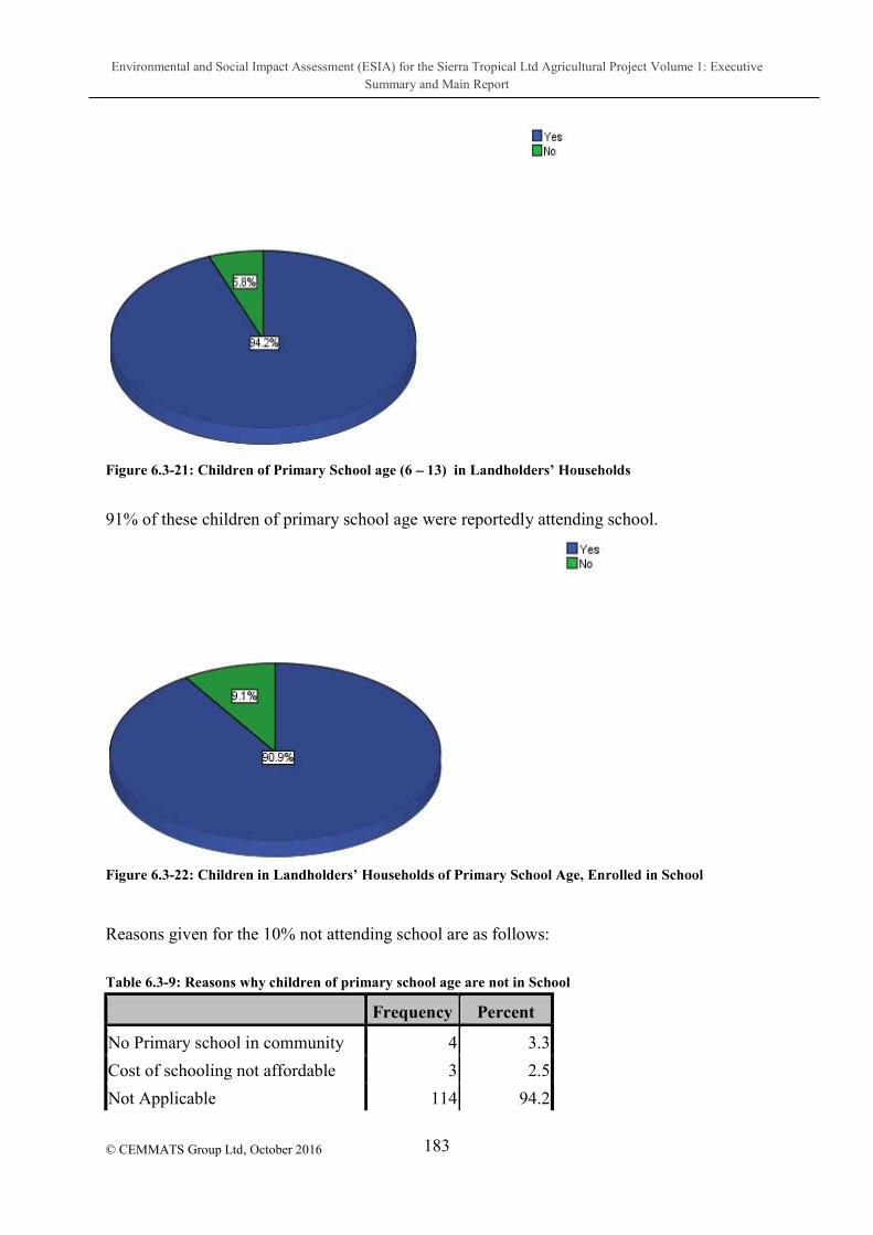
Environmental and Social Impact Assessment (ESIA) for the Sierra Tropical Ltd Agricultural Project Volume 1: Executive Summary and Main Report
183
© CEMMATS Group Ltd, October 2016
Figure 6.3-21: Children of Primary School age (6 13) in Landholder
91% of these children of primary school age were reportedly attending school.
Figure 6.3-22: Children in Landholder
Reasons given for the 10% not attending school are as follows:
Table 6.3-9: Reasons why children of primary school age are not in School
Frequency Percent
No Primary school in community 4 3.3
Cost of schooling not affordable 3 2.5
Not Applicable 114 94.2

Environmental and Social Impact Assessment (ESIA) for the Sierra Tropical Ltd Agricultural Project Volume 1: Executive Summary and Main Report
184
© CEMMATS Group Ltd, October 2016
Frequency Percent
Total 121 100.0
In spite of the encouraging percentage of children enrolled in and attending school, respondents reported facing difficulty meeting school fee requirements and other expenses.
Figure 6.3-23: Ease of Meeting Financial Requirements of School
6.3.19.2 Secondary School Enrolment
Landholders were asked whether they had any children of secondary school-going age (14 23) in their households. 76% reported that they did
Figure 6.3-24: Landholders with Children of Secondary School Age in their Households
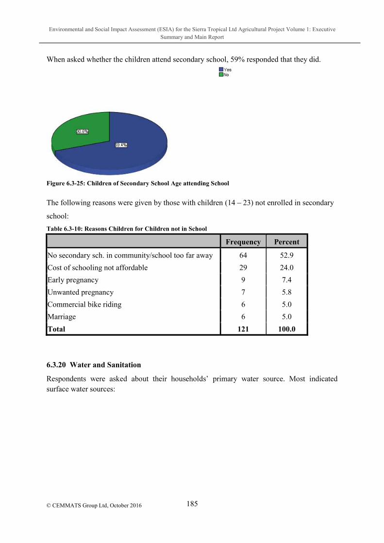
Environmental and Social Impact Assessment (ESIA) for the Sierra Tropical Ltd Agricultural Project Volume 1: Executive Summary and Main Report
185
© CEMMATS Group Ltd, October 2016
When asked whether the children attend secondary school, 59% responded that they did.
Figure 6.3-25: Children of Secondary School Age attending School
The following reasons were given by those with children (14 23) not enrolled in secondary
school:
Table 6.3-10: Reasons Children for Children not in School
Frequency Percent
No secondary sch. in community/school too far away 64 52.9
Cost of schooling not affordable 29 24.0
Early pregnancy 9 7.4
Unwanted pregnancy 7 5.8
Commercial bike riding 6 5.0
Marriage 6 5.0
Total 121 100.0
6.3.20 Water and Sanitation
surface water sources:
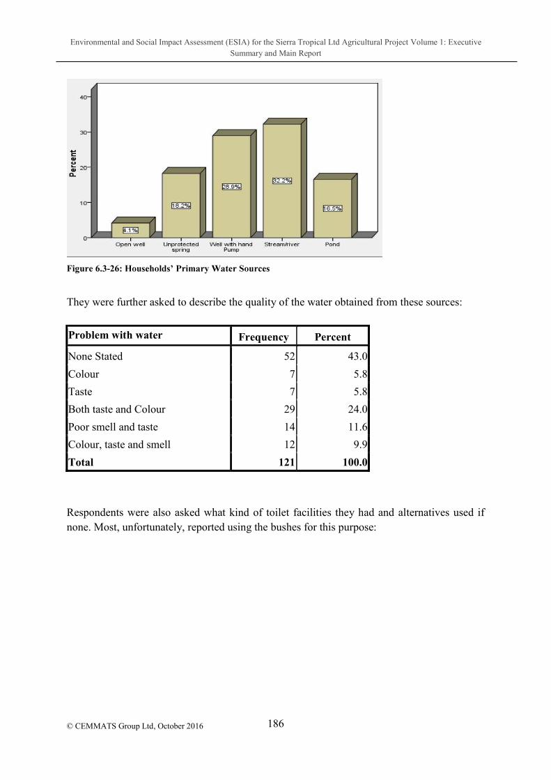
Environmental and Social Impact Assessment (ESIA) for the Sierra Tropical Ltd Agricultural Project Volume 1: Executive Summary and Main Report
186
© CEMMATS Group Ltd, October 2016
Figure 6.3-26
They were further asked to describe the quality of the water obtained from these sources:
Problem with water Frequency Percent
None Stated 52 43.0
Colour 7 5.8
Taste 7 5.8
Both taste and Colour 29 24.0
Poor smell and taste 14 11.6
Colour, taste and smell 12 9.9
Total 121 100.0
Respondents were also asked what kind of toilet facilities they had and alternatives used if none. Most, unfortunately, reported using the bushes for this purpose:

Environmental and Social Impact Assessment (ESIA) for the Sierra Tropical Ltd Agricultural Project Volume 1: Executive Summary and Main Report
187
© CEMMATS Group Ltd, October 2016
Figure 6.3-27: Types of Toilet Facilities or Alternatives
Methods of waste disposal were also identified; again the bushes were indicated as the primary means of disposal:
Figure 6.3-28: Waste Disposal Methods

Environmental and Social Impact Assessment (ESIA) for the Sierra Tropical Ltd Agricultural Project Volume 1: Executive Summary and Main Report
188 © CEMMATS Group Ltd, October 2016
7 IDENTIFICATION OF POTENTIAL IMPACTS
7.1 Introduction
This chapter identifies and describes the potential environmental and social impacts of the project components on the biophysical and socioeconomic conditions of the environment and communities. Where applicable, it also identifies mitigation measures that will reduce adverse impact and enhance positive ones. The assessments carried out in this chapter are on potential impacts on overall environmental and social receptors caused by the project activities in the construction/development, operational and decommissioning phases with mitigation measures recommended accordingly.
7.2 Environmental and Social Impact Assessment
7.2.1 Methodology As the method of assessment of project impacts may be subjective and sometimes difficult to quantify, the experience of the project team was relied upon to assess such impacts. The knowledge of the project area by team members was invaluable in analyzing impacts. A number of steps were followed:
i. A matrix of important project-specific impact categories was prepared; ii. The level of significance, achievability of mitigation steps measured against
practicality and cost-effectiveness were discussed in a workshop/meeting setting;
An impact assessment scale was then developed. Table 7.2-1: Degree of Certainty of Impact
Certainty of
Impact
Description
Certain The impact will occur.
Very Likely It is expected that this impact will occur,
Likely On balance the impact may occur
Unlikely The possibility of this impact occurring is remote, however it must be considered

Environmental and Social Impact Assessment (ESIA) for the Sierra Tropical Ltd Agricultural Project Volume 1: Executive Summary and Main Report
189
© CEMMATS Group Ltd, October 2016
Table 7.2-2: Environmental and Social significance scale
Significance scale
Description
Very High Major or permanent alteration of environmental or social dynamics, with severe or very severe consequences, or (in the case of benefits), beneficial or very beneficial effects.
High Long term effect on the social or natural environment. This category should be treated with a significant degree of importance at the project decision making stage.
Moderate Medium to long term effects on the social or natural environment. This category should also be taken into cognizance in decision making as constituting a fairly important degree of threat.
Low These would have medium to short term ramifications on the social or natural environment; these are relatively unimportant and pose very little real threat.
Table 7.2-3: Impact Assessment Scale
Mitigation Potential
Impact Significance
Low Moderate High Very High
Very Difficult Medium Major Extreme Extreme
Difficult Minor Medium Major Extreme
Achievable Minor Minor Medium Major
Easily Achievable
Minor Minor Minor Medium
Table 7.2-4: Degree of Difficulty to Mitigate
Degree of
Difficulty
Description
Very Difficult The impact can be mitigated in theory, but the extent of financial or technical involvement militates against its application or effectiveness

Environmental and Social Impact Assessment (ESIA) for the Sierra Tropical Ltd Agricultural Project Volume 1: Executive Summary and Main Report
190
© CEMMATS Group Ltd, October 2016
Degree of
Difficulty
Description
Difficult The impact can be mitigated, but there is a significant degree of difficulty in implementing the proposed measures.
Achievable The impact can be mitigated without much technicality or cost.
Easily Achievable The impact can be easily and effectively mitigated
Table 7.2-5: Categories of Impact
Impact Description
Extreme Such impacts would prevent the action or option concerned from being taken or approved; and alternatives would have to be considered.
Major These impacts are significant, meaning that if effective mitigation measures are not taken, a project may be hindered from commencing or continuing. Such option would require effective management and monitoring, or abandonment altogether for other options.
Medium These impacts though important, are of less serious nature; in such a case, the Best Available Technology (or Practice) Not Entailing Excessive Cost (BATNEEC) should be employed. Such impacts alone are usually not significant enough to prevent a project from commencing or proceeding.
Minor These impacts fall within the acceptable limits of the impact of a project on the environment, and mitigation is desirable but not
avoiding cumulative impacts.

Environmental and Social Impact Assessment (ESIA) for the Sierra Tropical Ltd Agricultural Project Volume 1: Executive Summary and Main Report
191 © CEMMATS Group Ltd, October 2016
7.2.1.1 Land preparation and Construction Stage
Impacts at this stage are often temporary. The main concerns at the construction stage will environmental and occupational health and safety. Risks would be reduced by strict adherence to best construction management practices. In relation to land preparation for nursery development, the main concerns are loss of biodiversity and erosion. The impacts anticipated their recommended mitigation measures and residual impacts are shown in the following table.

Env
iron
men
tal a
nd S
ocia
l Im
pact
Ass
essm
ent (
ES
IA)
for
the
Sie
rra
Tro
pica
l Ltd
Agr
icul
tura
l Pro
ject
Vol
ume
1: E
xecu
tive
Sum
mar
y an
d M
ain
Rep
ort
192
© C
EM
MA
TS
Gro
up L
td, O
ctob
er 2
016
Tab
le 7
.2-6
: L
and
Pre
par
atio
n a
nd C
onst
ruct
ion
Ph
ase
- E
nvir
onm
enta
l an
d M
itig
atio
n M
easu
res
Issu
e L
ocat
ion
/ P
roje
ct
Act
ivit
y
Imp
act
Cer
tain
ty o
f im
pac
t S
ign
ific
ance
M
itig
atio
n m
easu
re
Deg
ree
of
dif
ficu
lty
Imp
act
Cat
egor
y
Los
s of
ha
bita
t C
lear
ing
of
vege
tatio
n fo
r nu
rser
y de
velo
pmen
t an
d co
nstr
uctio
n
Cle
arin
g of
veg
etat
ion
in
the
conc
essi
on a
rea
will
re
sult
in
loss
of
ve
geta
tion
cove
r re
sulti
ng
in
loss
of
ha
bita
t fo
r va
riou
s sp
ecie
s. T
his
may
cau
se
inte
rrup
tion
of
natu
ral
cycl
es
incl
udin
g br
eedi
ng
and
mat
ing.
D
iffe
rent
spe
cies
of
flor
a m
ay b
e lo
st w
hich
will
no
t be
re
inst
ated
w
hen
the
area
is r
efor
este
d.
Cer
tain
M
oder
ate
Buf
fer
zone
s w
ill
be
esta
blis
hed
as
wel
l as
bo
tani
cal
gard
ens/
ec
olog
ical
cor
rido
rs.
Alth
ough
ce
rtai
n sp
ecie
s lo
st
duri
ng
clea
ring
m
ay
not
be
repl
aced
, th
e cl
eare
d ar
eas
will
eve
ntua
lly
be
re-v
eget
ated
w
ith
tree
s. A
ne
w t
hriv
ing
and
bala
nced
ec
osys
tem
will
dev
elop
Ach
ieva
ble
Med
ium
Los
s of
biod
iver
sity
Cle
arin
g of
ve
geta
tion
for
nurs
ery
deve
lopm
ent
and
cons
truc
tion
Cle
arin
g of
ve
geta
tion,
so
il
trea
tmen
t an
d pr
epar
atio
n be
fore
pl
antin
g w
ill c
ause
loc
al
spec
ies
with
in
the
proj
ect a
rea
to m
igra
te to
ot
her
area
s, l
eavi
ng t
he
proj
ect
site
de
void
of
im
port
ant
spec
ies
(mam
mal
s, r
eptil
es, b
irds
an
d in
sect
s)
whi
ch
cont
ribu
te t
o th
e na
tura
l ba
lanc
e of
the
eco
syst
em
Cer
tain
M
oder
ate
Buf
fer
zone
s w
ill
be
esta
blis
hed
as
wel
l as
bo
tani
cal
gard
ens/
ec
olog
ical
cor
rido
rs.
Som
e an
imal
s m
ay
retu
rn t
o th
e pl
anta
tion
area
s,
but
natu
ral
proc
esse
s m
ay c
ontin
ue
to
be
disr
upte
d w
ith
oper
atio
nal
activ
ities
in
clud
ing
tree
te
ndin
g an
d tr
eatm
ent,
harv
est,
etc.
Dif
ficu
lt
Med
ium

Env
iron
men
tal a
nd S
ocia
l Im
pact
Ass
essm
ent (
ES
IA)
for
the
Sier
ra T
ropi
cal L
td A
gric
ultu
ral P
roje
ctV
olum
e 1:
Exe
cuti
ve S
umm
ary
and
Mai
n R
epor
t
193
© C
EM
MA
TS
Gro
up L
td, O
ctob
er 2
016
Issu
e L
ocat
ion
/ P
roje
ct
Act
ivit
y
Imp
act
Cer
tain
ty o
f im
pac
t S
ign
ific
ance
M
itig
atio
n m
easu
re
Deg
ree
of
dif
ficu
lty
Imp
act
Cat
egor
y
with
in th
is a
rea.
Gen
erat
ion
of B
iom
ass
Cle
arin
g of
ve
geta
tion
for
nurs
ery
deve
lopm
ent
and
cons
truc
tion
Veg
etat
ion
clea
ring
will
re
sult
in
th
e ge
nera
tion
of b
iom
ass
whi
ch w
ould
ne
ed t
o be
dis
pose
d of
sa
fely
Cer
tain
M
oder
ate
Bio
mas
s w
ill
be
used
as
fa
r as
po
ssib
le
as
com
post
. It
can
als
o be
us
ed
as
fire
woo
d so
urce
s fo
r lo
cal
vill
ages
to
cu
t an
d re
mov
e.
Bio
mas
s w
ill
be
rein
corp
orat
ed
into
th
e so
il an
d tu
rned
int
o co
mpo
st.
It c
an a
lso
be
used
as
fi
rew
ood
sour
ces
for
loca
l vi
llag
es
to
cut
and
rem
ove.
B
urni
ng w
ill
only
be
reso
rted
to
as
an a
bsol
ute
last
opt
ion.
Ach
ieva
ble
Min
or
Soi
l ero
sion
S
ite
prep
arat
ion
for
nurs
ery
deve
lopm
ent
and
cons
truc
tion
Exp
osur
e of
lo
ose
soil
re
sult
ing
from
veg
etat
ion
clea
ring,
so
il pr
epar
atio
n ac
tiviti
es
and
pre-
cons
truct
ion
activ
ities
.
Cer
tain
H
igh
Impl
emen
tati
on
of
eros
ion
prev
enti
on
mea
sure
s in
pa
rtic
ular
co
ntou
r fa
rmin
g an
d co
ver
crop
ping
to
m
inim
ise
exce
ssiv
e ru
noff
and
ero
sion
. T
he
in
stal
lati
on o
f se
dim
ent
trap
s in
dr
aina
ge
line
s an
d st
orm
w
ater
Ach
ieva
ble
Med
ium
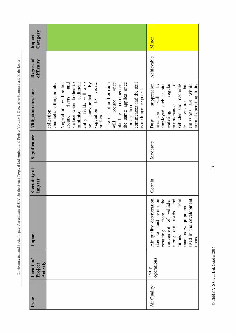
Env
iron
men
tal a
nd S
ocia
l Im
pact
Ass
essm
ent (
ES
IA)
for
the
Sier
ra T
ropi
cal L
td A
gric
ultu
ral P
roje
ctV
olum
e 1:
Exe
cuti
ve S
umm
ary
and
Mai
n R
epor
t
194
© C
EM
MA
TS
Gro
up L
td, O
ctob
er 2
016
Issu
e L
ocat
ion
/ P
roje
ct
Act
ivit
y
Imp
act
Cer
tain
ty o
f im
pac
t S
ign
ific
ance
M
itig
atio
n m
easu
re
Deg
ree
of
dif
ficu
lty
Imp
act
Cat
egor
y
coll
ecti
on
chan
nels
/set
tlin
g po
nds.
Veg
etat
ion
w
ill b
e le
ft
arou
nd
rive
rs
and
surf
ace
wat
er b
odie
s to
m
inim
ise
sedi
men
t en
try.
Fi
elds
w
ill
also
be
su
rrou
nded
by
ve
geta
tion
to
cr
eate
bu
ffer
s.
The
ris
k of
soi
l er
osio
n w
ill
redu
ce
once
pl
anti
ng
com
men
ces;
th
e sa
me
appl
ies
once
co
nstr
ucti
on
com
men
ces
and
the
soil
is
no
long
er e
xpos
ed.
Air
Qua
lity
Dai
ly
oper
atio
ns
Air
qua
lity
dete
rior
atio
n du
e to
du
st
emis
sion
re
sulti
ng
from
th
e m
ovem
ent
of
vehi
cles
al
ong
dirt
ro
ads,
an
d fu
mes
fr
om
mac
hine
ry/e
quip
men
t us
ed i
n th
e de
velo
pmen
t ar
eas.
Cer
tain
M
oder
ate
Dus
t su
ppre
ssio
n m
easu
res
wil
l be
em
ploy
ed s
uch
as s
ite
wat
erin
g;
regu
lar
mai
nten
ance
of
ve
hicl
es a
nd m
achi
nes
to
ensu
re
that
em
issi
ons
are
with
in
norm
al o
pera
ting
lim
its
Ach
ieva
ble
Min
or

Env
iron
men
tal a
nd S
ocia
l Im
pact
Ass
essm
ent (
ES
IA)
for
the
Sier
ra T
ropi
cal L
td A
gric
ultu
ral P
roje
ctV
olum
e 1:
Exe
cuti
ve S
umm
ary
and
Mai
n R
epor
t
195
© C
EM
MA
TS
Gro
up L
td, O
ctob
er 2
016
Issu
e L
ocat
ion
/ P
roje
ct
Act
ivit
y
Imp
act
Cer
tain
ty o
f im
pac
t S
ign
ific
ance
M
itig
atio
n m
easu
re
Deg
ree
of
dif
ficu
lty
Imp
act
Cat
egor
y
Hyd
rolo
gy
Site
pr
epar
atio
n fo
r nu
rser
y de
velo
pmen
t an
d co
nstr
uctio
n
Cle
arin
g of
ve
geta
tion
will
re
sult
in
an
al
tera
tion
of t
he n
atur
al
hydr
olog
ical
cy
cle
as
evap
otra
nspi
ratio
n in
the
ar
ea
will
be
re
duce
d.
Sim
ilar
ly
with
out
vege
tatio
n to
br
eak
the
volu
me
of
rain
fall
reac
hing
the
soi
ls,
ther
e w
ill
be
an
incr
ease
in
su
rfac
e ru
noff
whi
ch h
as
dire
ct
impa
cts
on
soil
eros
ion
and
sedi
men
tatio
n in
w
ater
bo
dies
.
Cer
tain
H
igh
Thi
s w
ill
be
a sh
ort
lived
impa
ct w
hich
will
be
re
vers
ed
once
th
e fr
uit
tree
s be
gin
to
grow
.
Gro
und
cove
r cr
ops
and
mul
chin
g w
ill
be
used
to
re
duce
th
e im
pact
of
th
e ra
infa
ll on
the
soil.
Ach
ieva
ble
Med
ium
Wat
er
qual
ity
Site
pr
epar
atio
n fo
r nu
rser
y de
velo
pmen
t an
d co
nstr
uctio
n
Sur
face
w
ater
ru
noff
fr
om
the
site
m
ay
cont
ribu
te
to
the
tota
l su
spen
ded
soli
ds
and
turb
idit
y of
the
rec
eivi
ng
wat
er b
odie
s w
hich
may
af
fect
th
e aq
uati
c li
fe.
Run
off
may
al
so
carr
y of
f co
nstr
ucti
on
rela
ted
debr
is, s
pill
s or
was
te n
ot
Lik
ely
Hig
h Im
plem
enta
tion
of
er
osio
n pr
even
tion
m
easu
res
incl
udin
g gr
ound
cov
er (
gras
s an
d ot
her
grou
nd
cove
r pl
ants
), t
he i
nsta
llat
ion
of
sedi
men
t tr
aps
and
stor
m
wat
er
coll
ectio
n ch
anne
ls/s
ettl
ing
pond
s.
Che
mic
al
spil
ls
in
the
fiel
d w
ill
not
occu
r as
Ach
ieva
ble
Med
ium
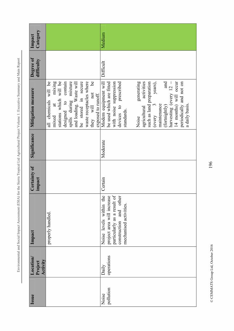
Env
iron
men
tal a
nd S
ocia
l Im
pact
Ass
essm
ent (
ES
IA)
for
the
Sier
ra T
ropi
cal L
td A
gric
ultu
ral P
roje
ctV
olum
e 1:
Exe
cuti
ve S
umm
ary
and
Mai
n R
epor
t
196
© C
EM
MA
TS
Gro
up L
td, O
ctob
er 2
016
Issu
e L
ocat
ion
/ P
roje
ct
Act
ivit
y
Imp
act
Cer
tain
ty o
f im
pac
t S
ign
ific
ance
M
itig
atio
n m
easu
re
Deg
ree
of
dif
ficu
lty
Imp
act
Cat
egor
y
prop
erly
han
dled
.
all
chem
ical
s w
ill
be
mix
ed
at
mix
ing
stat
ions
w
hich
w
ill
be
desi
gned
to
co
ntai
n sp
ills
du
ring
m
ixtu
re
and
load
ing.
Was
te w
ill
be
stor
ed
in
secu
re
was
te r
ecep
tacl
es w
here
th
ey
wil
l no
t be
ex
pose
d to
run
off.
N
oise
po
llutio
n D
aily
op
erat
ions
N
oise
le
vels
w
ithi
n th
e pr
ojec
t ar
ea w
ill i
ncre
ase
part
icul
arly
as
a re
sult
of
cons
truc
tion
an
d ot
her
mec
hani
sed
acti
viti
es.
Cer
tain
M
oder
ate
M
oder
n eq
uipm
ent
wil
l be
use
d w
hich
are
fitt
ed
wit
h no
ise
supp
ress
ion
devi
ces
to
pres
crib
ed
stan
dard
s.
Noi
se
gene
rati
ng
agri
cult
ural
ac
tivi
ties
su
ch a
s la
nd p
repa
ratio
n (e
very
3
year
s),
mai
nten
ance
(f
ortn
ight
ly)
and
harv
esti
ng (
ever
y 12
14
mon
ths)
w
ill
occu
r pe
riod
ical
ly a
nd n
ot o
n a
dail
y ba
sis.
Dif
ficu
lt
Med
ium
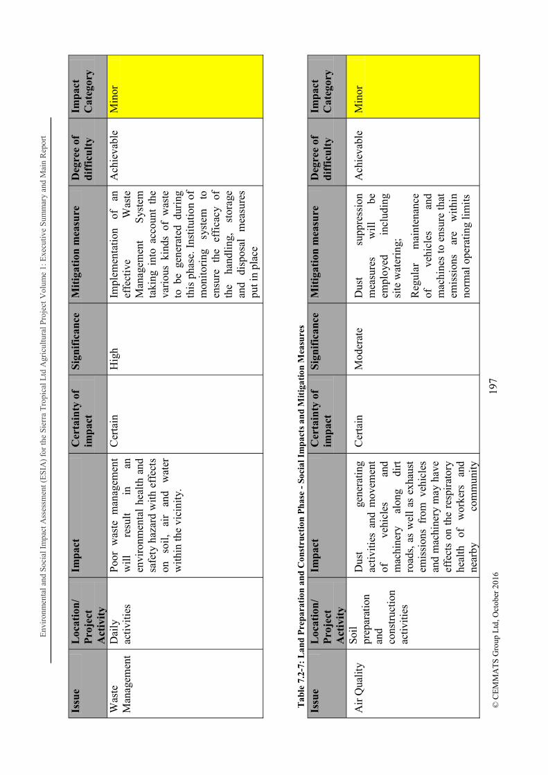
Env
iron
men
tal a
nd S
ocia
l Im
pact
Ass
essm
ent (
ES
IA)
for
the
Sier
ra T
ropi
cal L
td A
gric
ultu
ral P
roje
ctV
olum
e 1:
Exe
cuti
ve S
umm
ary
and
Mai
n R
epor
t
197
© C
EM
MA
TS
Gro
up L
td, O
ctob
er 2
016
Issu
e L
ocat
ion
/ P
roje
ct
Act
ivit
y
Imp
act
Cer
tain
ty o
f im
pac
t S
ign
ific
ance
M
itig
atio
n m
easu
re
Deg
ree
of
dif
ficu
lty
Imp
act
Cat
egor
y
Was
te
Man
agem
ent
Dai
ly
acti
viti
es
Poo
r w
aste
man
agem
ent
wil
l re
sult
in
an
en
viro
nmen
tal
heal
th a
nd
safe
ty h
azar
d w
ith e
ffec
ts
on
soil
, ai
r an
d w
ater
w
ithi
n th
e vi
cini
ty.
Cer
tain
H
igh
Impl
emen
tati
on
of
an
effe
ctiv
e W
aste
M
anag
emen
t S
yste
m
taki
ng i
nto
acco
unt
the
vari
ous
kind
s of
was
te
to b
e ge
nera
ted
duri
ng
this
pha
se. I
nsti
tuti
on o
f m
onit
orin
g sy
stem
to
en
sure
th
e ef
fica
cy
of
the
hand
ling
, st
orag
e an
d di
spos
al
mea
sure
s pu
t in
plac
e
Ach
ieva
ble
Min
or
Tab
le 7
.2-7
: L
and
Pre
par
atio
n a
nd C
onst
ruct
ion
Ph
ase
- So
cial
Im
pac
ts a
nd
Mit
igat
ion
Mea
sure
s
Issu
e L
ocat
ion
/ P
roje
ct
Act
ivit
y
Imp
act
Cer
tain
ty o
f im
pac
t S
ign
ific
ance
M
itig
atio
n m
easu
re
Deg
ree
of
dif
ficu
lty
Imp
act
Cat
egor
y
Air
Qua
lity
Soi
l pr
epar
atio
n an
d co
nstr
uctio
n ac
tiviti
es
Dus
t ge
nera
ting
activ
ities
and
mov
emen
t of
ve
hicl
es
and
mac
hine
ry
alon
g di
rt
road
s, a
s w
ell
as e
xhau
st
emis
sion
s fr
om v
ehic
les
and
mac
hine
ry m
ay h
ave
effe
cts
on t
he r
espi
rato
ry
heal
th
of
wor
kers
an
d ne
arby
co
mm
unit
y
Cer
tain
M
oder
ate
Dus
t su
ppre
ssio
n m
easu
res
wil
l be
em
ploy
ed
incl
udin
g si
te w
ater
ing;
Reg
ular
m
aint
enan
ce
of
vehi
cles
an
d m
achi
nes
to e
nsur
e th
at
emis
sion
s ar
e w
ithi
n no
rmal
ope
rati
ng li
mit
s
Ach
ieva
ble
Min
or

Env
iron
men
tal a
nd S
ocia
l Im
pact
Ass
essm
ent (
ES
IA)
for
the
Sier
ra T
ropi
cal L
td A
gric
ultu
ral P
roje
ctV
olum
e 1:
Exe
cuti
ve S
umm
ary
and
Mai
n R
epor
t
198
© C
EM
MA
TS
Gro
up L
td, O
ctob
er 2
016
Issu
e L
ocat
ion
/ P
roje
ct
Act
ivit
y
Imp
act
Cer
tain
ty o
f im
pac
t S
ign
ific
ance
M
itig
atio
n m
easu
re
Deg
ree
of
dif
ficu
lty
Imp
act
Cat
egor
y
resi
dent
s.
Noi
se
pollu
tion
Dai
ly
oper
atio
ns
Noi
se
leve
ls
wit
hin
the
proj
ect
area
will
inc
reas
e pa
rtic
ular
ly a
s a
resu
lt o
f co
nstr
ucti
on
and
othe
r m
echa
nise
d ac
tivi
ties
w
hich
m
ay
serv
e as
a
sour
ce o
f di
stur
banc
e to
ne
arby
com
mun
itie
s an
d ef
fect
w
orke
rs
dire
ctly
op
erat
ing
nois
e ge
nera
ting
mac
hine
ry.
Cer
tain
M
oder
ate
M
oder
n eq
uipm
ent
wil
l be
use
d w
hich
are
fitt
ed
wit
h no
ise
supp
ress
ion
devi
ces
to
pres
crib
ed
stan
dard
s.
Noi
se
gene
rati
ng
agri
cult
ural
ac
tivi
ties
su
ch a
s la
nd p
repa
ratio
n (e
very
3
year
s),
mai
nten
ance
(f
ortn
ight
ly)
and
harv
esti
ng (
ever
y 12
14
mon
ths)
w
ill
occu
r pe
riod
ical
ly a
nd n
ot o
n a
dail
y ba
sis.
Wor
kers
w
ill
be
prov
ided
w
ith
nois
e pr
otec
tion
PP
E.
Con
stru
ctio
n an
d ot
her
acti
viti
es
wil
l be
re
stri
cted
to
th
e da
ylig
ht h
ours
in
orde
r to
m
inim
ise
effe
ct
on
com
mun
itie
s.
Ach
ieva
ble
Min
or

Env
iron
men
tal a
nd S
ocia
l Im
pact
Ass
essm
ent (
ES
IA)
for
the
Sier
ra T
ropi
cal L
td A
gric
ultu
ral P
roje
ctV
olum
e 1:
Exe
cuti
ve S
umm
ary
and
Mai
n R
epor
t
199
© C
EM
MA
TS
Gro
up L
td, O
ctob
er 2
016
Issu
e L
ocat
ion
/ P
roje
ct
Act
ivit
y
Imp
act
Cer
tain
ty o
f im
pac
t S
ign
ific
ance
M
itig
atio
n m
easu
re
Deg
ree
of
dif
ficu
lty
Imp
act
Cat
egor
y
Was
te
Man
agem
ent
Dai
ly
acti
viti
es
Poo
r w
aste
man
agem
ent
wil
l re
sult
in
an
en
viro
nmen
tal
heal
th a
nd
safe
ty
haza
rds
for
wor
kers
an
d th
e co
mm
unit
ies
wit
h fa
r re
achi
ng
effe
cts
beyo
nd
the
imm
edia
te
was
te
stor
age
or d
ispo
sal a
reas
.
Cer
tain
H
igh
Impl
emen
tati
on
of
an
effe
ctiv
e W
aste
M
anag
emen
t S
yste
m
taki
ng i
nto
acco
unt
the
vari
ous
kind
s of
was
te
to b
e ge
nera
ted
duri
ng
this
pha
se. I
nsti
tuti
on o
f m
onit
orin
g sy
stem
to
en
sure
th
e ef
fica
cy
of
the
hand
ling
, st
orag
e an
d di
spos
al
mea
sure
s pu
t in
plac
e
Ach
ieva
ble
Min
or
Pes
t in
fest
atio
n
Cle
arin
g of
ve
geta
tion
for
nurs
ery
deve
lopm
ent
and
cons
truc
tion
Veg
etat
ion
clea
ring
will
re
sult
in
th
e ge
nera
tion
of
biom
ass
whi
ch
may
pr
esen
t a
have
n fo
r pe
sts
if n
ot p
rope
rly
hand
led.
P
ests
ca
n w
reak
ha
voc
on
loca
l co
mm
uniti
es
thro
ugh
thei
r de
stru
ctiv
e an
d di
seas
e ca
rryi
ng
tend
enci
es.
Lik
ely
Mod
erat
e B
iom
ass
will
be
us
ed
as
far
as
poss
ible
. B
iom
ass
will
be
re
inco
rpor
ated
int
o th
e so
il an
d tu
rned
in
to
com
post
. It
can
als
o be
us
ed
as
fire
woo
d so
urce
s fo
r lo
cal
vill
ages
to
cu
t an
d re
mov
e,
or
burn
t if
no
othe
r op
tions
for
reu
se
or
safe
di
spos
al
are
avai
labl
e
Ach
ieva
ble
Min
or

Env
iron
men
tal a
nd S
ocia
l Im
pact
Ass
essm
ent (
ES
IA)
for
the
Sier
ra T
ropi
cal L
td A
gric
ultu
ral P
roje
ctV
olum
e 1:
Exe
cuti
ve S
umm
ary
and
Mai
n R
epor
t
200
© C
EM
MA
TS
Gro
up L
td, O
ctob
er 2
016
Issu
e L
ocat
ion
/ P
roje
ct
Act
ivit
y
Imp
act
Cer
tain
ty o
f im
pac
t S
ign
ific
ance
M
itig
atio
n m
easu
re
Deg
ree
of
dif
ficu
lty
Imp
act
Cat
egor
y
Los
s of
land
P
roje
ct
deve
lopm
ent
Los
s of
lan
d m
ay b
e an
is
sue
even
af
ter
land
le
ase
agre
emen
ts
have
be
en r
each
ed.
Lik
ely
Hig
h In
tens
ive
com
mun
ity
cons
ulta
tions
an
d ad
ditio
nal
sens
itiza
tion
mee
tings
w
ill
be
cond
ucte
d pr
ior
to t
he
com
men
cem
ent
of t
his
stag
e of
the
pro
ject
to
ensu
re
that
la
ndho
lder
opin
ions
are
hea
rd a
nd
take
n in
to
cons
ider
atio
n.
Loc
als
will
be
mad
e aw
are
of
the
impl
icat
ions
an
d po
tent
ial
impa
ct
of
a la
rge
proj
ect
star
ting
in
thei
r co
mm
uniti
es,
incl
udin
g th
e pi
tfal
l of
gi
ving
aw
ay t
oo m
uch
land
.
Lan
d w
ill b
e le
ased
in
phas
es
as
the
proj
ect
prog
ress
es i
n or
der
to
prev
ent
leas
ed
land
re
mai
ning
unu
sed
over
an
ext
ende
d pe
riod
.
Ach
ieva
ble
Med
ium

Env
iron
men
tal a
nd S
ocia
l Im
pact
Ass
essm
ent (
ES
IA)
for
the
Sier
ra T
ropi
cal L
td A
gric
ultu
ral P
roje
ctV
olum
e 1:
Exe
cuti
ve S
umm
ary
and
Mai
n R
epor
t
201
© C
EM
MA
TS
Gro
up L
td, O
ctob
er 2
016
Issu
e L
ocat
ion
/ P
roje
ct
Act
ivit
y
Imp
act
Cer
tain
ty o
f im
pac
t S
ign
ific
ance
M
itig
atio
n m
easu
re
Deg
ree
of
dif
ficu
lty
Imp
act
Cat
egor
y
Vis
ual
Impa
ct
Cle
arin
g of
ve
geta
tion
for
nurs
ery
deve
lopm
ent
and
cons
truc
tion
The
re
will
be
a
shar
p co
ntra
st
betw
een
area
s cl
eare
d fo
r pr
ojec
t de
velo
pmen
t an
d th
e re
st
of t
he s
urro
undi
ngs;
thi
s m
ay
crea
te
som
e ap
preh
ensi
on
or
caus
e fo
r co
ncer
n in
res
iden
ts.
Lik
ely
Low
T
he
clea
red
area
s w
ould
soo
n be
rep
lace
d w
ith t
rees
and
mod
ern
stru
ctur
es.
How
ever
, th
is m
ay s
till
be c
ause
fo
r co
ncer
n to
so
me
resi
dent
s. D
urin
g in
itial
se
nsiti
zatio
n m
eetin
gs
cond
ucte
d pi
ctur
es
of
the
Phi
lippi
nes
sist
er
oper
atio
n w
ere
show
n to
the
res
iden
ts t
o gi
ve
them
an
id
ea
of
the
build
ings
and
fie
lds
in
a la
rge
agri
cultu
ral
oper
atio
n.
Dif
ficu
lt M
inor
Occ
upat
iona
l H
ealth
and
S
afet
y
Dai
ly
activ
ities
W
orke
rs w
ill b
e at
ris
k of
in
jury
fr
om
the
vari
ous
mac
hine
ry,
equi
pmen
t, pr
oces
ses
and
oper
atio
nal m
etho
ds;
this
ri
sk
is
part
icul
arly
he
ight
ened
in
the
case
of
loca
lly
empl
oyed
w
orke
rs
who
m
ay
not
have
be
en
prev
ious
ly
expo
sed
to t
he w
orki
ng
cond
ition
s.
Lik
ely
Mod
erat
e S
TL
in
tend
s to
m
aint
ain
the
safe
ty o
f its
wor
kers
thr
ough
the
fo
llow
ing
mea
ns:
1.
Use
of
mod
ern,
low
ri
sk e
quip
men
t
2.
Tra
inin
g to
en
sure
th
at
only
qu
alif
ied
and
lice
nced
op
erat
ors
are
allo
wed
to
op
erat
e
Ach
ieva
ble
Min
or

Env
iron
men
tal a
nd S
ocia
l Im
pact
Ass
essm
ent (
ES
IA)
for
the
Sier
ra T
ropi
cal L
td A
gric
ultu
ral P
roje
ctV
olum
e 1:
Exe
cuti
ve S
umm
ary
and
Mai
n R
epor
t
202
© C
EM
MA
TS
Gro
up L
td, O
ctob
er 2
016
Issu
e L
ocat
ion
/ P
roje
ct
Act
ivit
y
Imp
act
Cer
tain
ty o
f im
pac
t S
ign
ific
ance
M
itig
atio
n m
easu
re
Deg
ree
of
dif
ficu
lty
Imp
act
Cat
egor
y
mac
hine
ry
and
equi
pmen
t.
3.
Pro
visi
on o
f PP
E
4.
Con
duct
ing
risk
as
sess
men
ts
5.
Mai
nten
ance
of
m
achi
nery
an
d eq
uipm
ent
6.
Impl
emen
tatio
n of
M
anag
emen
t an
d M
onito
ring
Pla
ns.
Com
mun
ity
Hea
lth
and
Saf
ety
Dai
ly
Act
iviti
es
Com
mun
ity
resi
dent
s w
ill
be
expo
sed
to
incr
ease
d ve
hicu
lar
traf
fic
and
othe
r op
erat
iona
l ac
tiviti
es
whi
ch
bein
g un
fam
iliar
pu
ts
them
at
ri
sk
of
safe
ty h
azar
ds.
Lik
ely
Hig
h R
egul
ar
com
mun
ity
cons
ulta
tions
an
d co
mm
unit
y he
alth
and
sa
fety
sen
sitiz
atio
n w
ill
be
cond
ucte
d pe
riod
ical
ly t
hrou
ghou
t th
e lif
e of
the
proj
ect.
Ach
ieva
ble
Mod
erat
e

Environmental and Social Impact Assessment (ESIA) for the Sierra Tropical Ltd Agricultural Project Volume 1: Executive Summary and Main Report
203 © CEMMATS Group Ltd, October 2016
7.2.1.2 Operational Stage
Once best practices have been observed during the initial stages of the project - planning/design set up and construction stages - much of the threat to the safety and integrity of the environment and society will be reduced to levels defined by legislation and best practices.

Env
iron
men
tal a
nd S
ocia
l Im
pact
Ass
essm
ent (
ES
IA)
for
the
Sie
rra
Tro
pica
l Ltd
Agr
icul
tura
l Pro
ject
Vol
ume
1: E
xecu
tive
Sum
mar
y an
d M
ain
Rep
ort
204
© C
EM
MA
TS
Gro
up L
td, O
ctob
er 2
016
Tab
le 7
.2-8
: O
pera
tion
al P
hase
E
nvir
onm
enta
l Im
pact
s an
d M
itig
atio
n M
easu
res
Issu
e L
ocat
ion
/ P
roje
ct
Act
ivit
y
Imp
act
Cer
tain
ty o
f im
pac
t S
ign
ific
ance
M
itig
atio
n m
easu
re
Deg
ree
of
dif
ficu
lty
Imp
act
Cat
egor
y
Los
s of
ha
bita
t C
lear
ing
of
vege
tati
on f
or
prog
ress
ive
expa
nsio
n of
pl
anta
tion
ar
eas
Cle
arin
g of
veg
etat
ion
in
the
conc
essi
on a
rea
wil
l re
sult
in
lo
ss
of
vege
tati
on
cove
r re
sult
ing
in
loss
of
ha
bita
t fo
r va
riou
s sp
ecie
s. T
his
may
cau
se
inte
rrup
tion
of
na
tura
l cy
cles
inc
ludi
ng b
reed
ing
and
mat
ing.
D
iffe
rent
sp
ecie
s of
flo
ra m
ay b
e lo
st
whi
ch
wil
l no
t be
re
inst
ated
whe
n th
e ar
ea
is
refo
rest
ed
wit
h Fr
uit
Tre
e.
Cer
tain
M
oder
ate
Buf
fer
zone
s w
ill
be
esta
blis
hed
as
wel
l as
bo
tani
cal
gard
ens/
ec
olog
ical
co
rrid
ors
and
envi
ronm
enta
l m
onito
ring
pl
ots
also
es
tabl
ishe
d to
m
onito
r ch
ange
s.
Alt
houg
h ce
rtai
n sp
ecie
s lo
st
duri
ng
clea
ring
m
ay
not
be
repl
aced
, th
e cl
eare
d ar
eas
wil
l ev
entu
ally
be
re-v
eget
ated
w
ith
frui
t tr
ees.
A
ne
w
thri
ving
an
d ba
lanc
ed e
cosy
stem
w
ill d
evel
op
Ach
ieva
ble
Min
or
Los
s of
biod
iver
sity
Cle
arin
g of
ve
geta
tion
for
pr
ogre
ssiv
e ex
pans
ion
of
plan
tati
on
area
s
Cle
arin
g of
ve
geta
tion,
so
il
trea
tmen
t an
d pr
epar
atio
n be
fore
pl
anti
ng w
ill
caus
e lo
cal
spec
ies
wit
hin
the
proj
ect
area
to
mig
rate
to
othe
r
Cer
tain
M
oder
ate
Buf
fer
zone
s w
ill
be
esta
blis
hed
as
wel
l as
bo
tani
cal
gard
ens/
ec
olog
ical
co
rrid
ors.
E
nvir
onm
enta
l m
onit
orin
g pl
ots
also
Dif
ficu
lt
Med
ium

Env
iron
men
tal a
nd S
ocia
l Im
pact
Ass
essm
ent (
ES
IA)
for
the
Sier
ra T
ropi
cal L
td A
gric
ultu
ral P
roje
ctV
olum
e 1:
Exe
cuti
ve S
umm
ary
and
Mai
n R
epor
t
205
© C
EM
MA
TS
Gro
up L
td, O
ctob
er 2
016
Issu
e L
ocat
ion
/ P
roje
ct
Act
ivit
y
Imp
act
Cer
tain
ty o
f im
pac
t S
ign
ific
ance
M
itig
atio
n m
easu
re
Deg
ree
of
dif
ficu
lty
Imp
act
Cat
egor
y
area
s, l
eavi
ng t
he p
roje
ct
site
dev
oid
of i
mpo
rtan
t sp
ecie
s (m
amm
als,
re
ptil
es,
bird
s an
d in
sect
s) w
hich
con
trib
ute
to t
he n
atur
al b
alan
ce o
f th
e ec
osys
tem
wit
hin
this
ar
ea.
esta
blis
hed
to
mon
itor
chan
ges
in th
e ar
ea.
Som
e an
imal
s m
ay
retu
rn t
o th
e pl
anta
tion
ar
eas,
bu
t na
tura
l pr
oces
ses
may
con
tinu
e to
be
di
srup
ted
wit
h op
erat
iona
l ac
tivi
ties
incl
udin
g tr
ee
tend
ing
and
trea
tmen
t, ha
rves
t, et
c.
Gen
erat
ion
of B
iom
ass
Cle
arin
g of
ve
geta
tion
du
ring
pl
anta
tion
ex
pans
ion,
pr
unin
g, e
tc.
Veg
etat
ion
clea
ring
w
ill
resu
lt in
the
gene
rati
on o
f bi
omas
s w
hich
w
ould
ne
ed
to
be
disp
osed
of
sa
fely
Cer
tain
M
oder
ate
Bio
mas
s w
ill
be u
sed
as
far
as
poss
ible
as
co
mpo
st.
It m
ay a
lso
be
mad
e av
aila
ble
as
a so
urce
of
fire
woo
d fo
r co
mm
unit
y m
embe
rs.
Bur
ning
w
ill
only
be
re
sort
ed
to
as
an
abso
lute
last
opt
ion.
Ach
ieva
ble
Min
or

Env
iron
men
tal a
nd S
ocia
l Im
pact
Ass
essm
ent (
ES
IA)
for
the
Sier
ra T
ropi
cal L
td A
gric
ultu
ral P
roje
ctV
olum
e 1:
Exe
cuti
ve S
umm
ary
and
Mai
n R
epor
t
206
© C
EM
MA
TS
Gro
up L
td, O
ctob
er 2
016
Issu
e L
ocat
ion
/ P
roje
ct
Act
ivit
y
Imp
act
Cer
tain
ty o
f im
pac
t S
ign
ific
ance
M
itig
atio
n m
easu
re
Deg
ree
of
dif
ficu
lty
Imp
act
Cat
egor
y
Soi
l ero
sion
C
lear
ing
of
vege
tati
on f
or
prog
ress
ive
expa
nsio
n of
pl
anta
tion
ar
eas
Exp
osur
e of
lo
ose
soil
resu
ltin
g fr
om
vege
tati
on
clea
ring
an
d so
il p
repa
rati
on a
ctiv
ities
Cer
tain
H
igh
Impl
emen
tati
on
of
eros
ion
prev
enti
on
mea
sure
s in
clud
ing
in
part
icul
ar
cont
our
farm
ing
and
cove
r cr
oppi
ng
to
min
imis
e ex
cess
ive
runo
ff
and
eros
ion,
the
ins
tall
atio
n of
se
dim
ent
trap
s an
d st
orm
w
ater
co
llec
tion
ch
anne
ls/s
ettl
ing
pond
s.
Veg
etat
ion
w
ill b
e le
ft
arou
nd
rive
rs
and
surf
ace
wat
er b
odie
s to
m
inim
ise
sedi
men
t en
try.
The
ris
k of
soi
l er
osio
n w
ill
redu
ce
once
pl
anti
ng
com
men
ces;
th
e sa
me
obta
ins
once
co
nstr
ucti
on
com
men
ces
and
the
soil
is
no
long
er e
xpos
ed.
Ach
ieva
ble
Med
ium

Env
iron
men
tal a
nd S
ocia
l Im
pact
Ass
essm
ent (
ES
IA)
for
the
Sier
ra T
ropi
cal L
td A
gric
ultu
ral P
roje
ctV
olum
e 1:
Exe
cuti
ve S
umm
ary
and
Mai
n R
epor
t
207
© C
EM
MA
TS
Gro
up L
td, O
ctob
er 2
016
Issu
e L
ocat
ion
/ P
roje
ct
Act
ivit
y
Imp
act
Cer
tain
ty o
f im
pac
t S
ign
ific
ance
M
itig
atio
n m
easu
re
Deg
ree
of
dif
ficu
lty
Imp
act
Cat
egor
y
Soi
l ac
idif
icat
ion
Use
of
fe
rtil
izer
s an
d pe
stic
ides
Soi
l ac
idif
icat
ion
is
acce
lera
ted
by t
he u
se o
f fe
rtil
izer
s co
ntai
ning
am
mon
ium
sal
ts o
r ur
ea.
Aci
dic
soil
ca
n re
stri
ct
abil
ity
to r
each
nut
rien
ts
and
wat
er.
Lik
ely
Mod
erat
e N
atur
al
fert
ilize
rs
and
com
post
w
ill
be
empl
oyed
as
fa
r as
po
ssib
le;
only
app
rove
d an
d no
n-pe
rsis
tent
ch
emic
als
wil
l be
use
d w
here
ne
cess
ary.
R
egul
ar s
oil
test
ing
and
anal
ysis
wil
l be
car
ried
ou
t to
mon
itor
che
mic
al
chan
ges
in th
e so
il.
Ach
ieva
ble
Min
or
Air
Qua
lity
D
aily
op
erat
ions
A
ir q
uali
ty
dete
rior
atio
n du
e to
du
st
gene
rati
on
resu
ltin
g fr
om
the
mov
emen
t of
ve
hicl
es
alon
g di
rt
road
s,
and
fum
es
from
m
achi
nery
/equ
ipm
ent
Cer
tain
M
oder
ate
Dus
t su
ppre
ssio
n m
easu
res
wil
l be
em
ploy
ed i
nclu
ding
sit
e w
ater
ing;
Reg
ular
mai
nten
ance
of
vehi
cles
an
d m
achi
nes
to e
nsur
e th
at e
mis
sion
s ar
e w
ithi
n no
rmal
op
erat
ing
lim
its
Ach
ieva
ble
Min
or
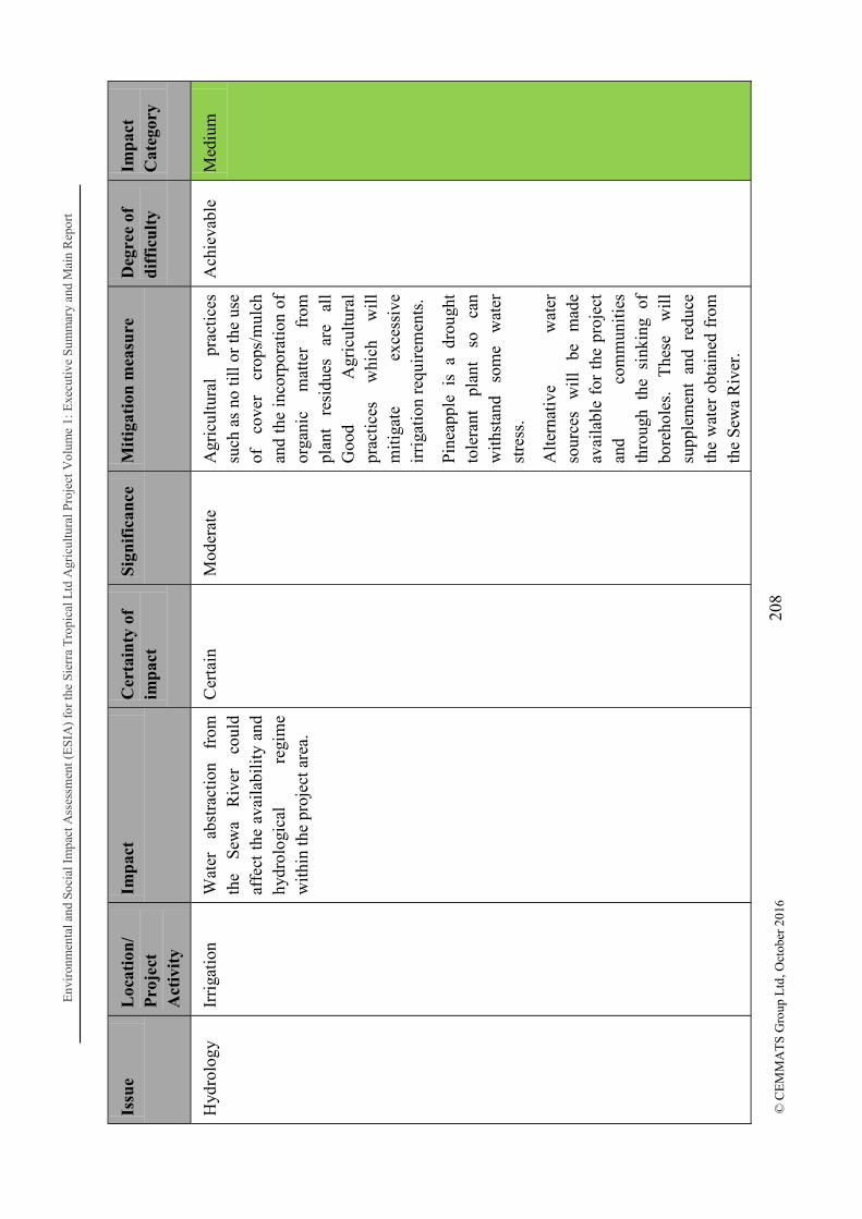
Env
iron
men
tal a
nd S
ocia
l Im
pact
Ass
essm
ent (
ES
IA)
for
the
Sier
ra T
ropi
cal L
td A
gric
ultu
ral P
roje
ctV
olum
e 1:
Exe
cuti
ve S
umm
ary
and
Mai
n R
epor
t
208
© C
EM
MA
TS
Gro
up L
td, O
ctob
er 2
016
Issu
e L
ocat
ion
/ P
roje
ct
Act
ivit
y
Imp
act
Cer
tain
ty o
f im
pac
t S
ign
ific
ance
M
itig
atio
n m
easu
re
Deg
ree
of
dif
ficu
lty
Imp
act
Cat
egor
y
Hyd
rolo
gy
Irri
gati
on
Wat
er
abst
ract
ion
from
th
e S
ewa
Riv
er
coul
d af
fect
the
ava
ilab
ility
and
hy
drol
ogic
al
regi
me
wit
hin
the
proj
ect a
rea.
Cer
tain
M
oder
ate
Agr
icul
tura
l pr
acti
ces
such
as
no ti
ll o
r th
e us
e of
co
ver
crop
s/m
ulch
an
d th
e in
corp
orat
ion
of
orga
nic
mat
ter
from
pl
ant
resi
dues
ar
e al
l G
ood
Agr
icul
tura
l pr
acti
ces
whi
ch
wil
l m
itig
ate
exce
ssiv
e ir
riga
tion
req
uire
men
ts.
Pin
eapp
le i
s a
drou
ght
tole
rant
pl
ant
so
can
wit
hsta
nd
som
e w
ater
st
ress
.
Alt
erna
tive
w
ater
so
urce
s w
ill
be
mad
e av
aila
ble
for
the
proj
ect
and
com
mun
itie
s th
roug
h th
e si
nkin
g of
bo
reho
les.
T
hese
w
ill
supp
lem
ent
and
redu
ce
the
wat
er o
btai
ned
from
th
e S
ewa
Riv
er.
Ach
ieva
ble
Med
ium

Env
iron
men
tal a
nd S
ocia
l Im
pact
Ass
essm
ent (
ES
IA)
for
the
Sier
ra T
ropi
cal L
td A
gric
ultu
ral P
roje
ctV
olum
e 1:
Exe
cuti
ve S
umm
ary
and
Mai
n R
epor
t
209
© C
EM
MA
TS
Gro
up L
td, O
ctob
er 2
016
Issu
e L
ocat
ion
/ P
roje
ct
Act
ivit
y
Imp
act
Cer
tain
ty o
f im
pac
t S
ign
ific
ance
M
itig
atio
n m
easu
re
Deg
ree
of
dif
ficu
lty
Imp
act
Cat
egor
y
Wat
er
qual
ity
Use
of
Fe
rtil
iser
s an
d P
esti
cide
s
Wat
er
poll
utio
n ca
n oc
cur
due
to t
he u
se o
f ag
ro-c
hem
ical
s su
ch
as
fert
iliz
ers
and
pest
co
ntro
l su
bsta
nces
whi
ch
can
leac
h in
to
the
soil
an
d ge
t ca
rrie
d in
to w
ater
by
ru
noff
. A
quat
ic
life
w
ould
be
affe
cted
.
Cer
tain
H
igh
Pre
cisi
on
Agr
icul
ture
m
etho
ds
wil
l be
em
ploy
ed
wit
h re
gard
to
cr
op
nutr
itio
n,
and
fert
iliz
er
wil
l on
ly
be
appl
ied
in t
he r
equi
red
amou
nts
foli
arly
so
co
ntam
inat
ion
of
surf
ace
wat
er i
s gr
eatl
y re
duce
d.
Che
mic
als
i.e.
Her
bici
des
and
pest
icid
es w
ill
be u
sed
only
as
re
quir
ed
or
whe
n pa
rtic
ular
pe
st
thre
shol
ds a
re r
each
ed.
Ach
ieva
ble
Med
ium
Noi
se
poll
utio
n D
aily
op
erat
ions
E
leva
ted
nois
e le
vels
wil
l re
sult
fr
om
mov
emen
t an
d op
erat
ion
of v
ehic
les
and
mac
hine
ry.
Cer
tain
M
oder
ate
Mod
ern
equi
pmen
t w
ill
be u
sed
whi
ch a
re f
itted
w
ith
nois
e su
ppre
ssio
n de
vice
s to
pr
escr
ibed
st
anda
rds.
Dif
ficu
lt
Med
ium

Env
iron
men
tal a
nd S
ocia
l Im
pact
Ass
essm
ent (
ES
IA)
for
the
Sier
ra T
ropi
cal L
td A
gric
ultu
ral P
roje
ctV
olum
e 1:
Exe
cuti
ve S
umm
ary
and
Mai
n R
epor
t
210
© C
EM
MA
TS
Gro
up L
td, O
ctob
er 2
016
Issu
e L
ocat
ion
/ P
roje
ct
Act
ivit
y
Imp
act
Cer
tain
ty o
f im
pac
t S
ign
ific
ance
M
itig
atio
n m
easu
re
Deg
ree
of
dif
ficu
lty
Imp
act
Cat
egor
y
Noi
se
gene
rati
ng
agri
cult
ural
ac
tivi
ties
su
ch a
s la
nd p
repa
ratio
n (e
very
3
year
s),
mai
nten
ance
(f
ortn
ight
ly)
and
harv
esti
ng (
ever
y 12
14
mon
ths)
w
ill
occu
r pe
riod
ical
ly a
nd n
ot o
n a
dail
y ba
sis.
Wor
kers
w
ill
be
prov
ided
w
ith
nois
e pr
otec
tion
PP
E.
Was
te
Man
agem
ent
Dai
ly
acti
viti
es
Poo
r w
aste
man
agem
ent
wil
l re
sult
in
an
en
viro
nmen
tal
heal
th a
nd
safe
ty h
azar
d w
ith e
ffec
ts
on
soil
, ai
r an
d w
ater
w
ithi
n th
e vi
cini
ty.
Cer
tain
H
igh
Impl
emen
tati
on
of
an
effe
ctiv
e W
aste
M
anag
emen
t S
yste
m
taki
ng i
nto
acco
unt
the
vari
ous
kind
s of
was
te
to b
e ge
nera
ted
duri
ng
this
pha
se. I
nsti
tuti
on o
f
Ach
ieva
ble
Min
or
Env
iron
men
tal a
nd S
ocia
l Im
pact
Ass
essm
ent (
ES
IA)
for
the
Sier
ra T
ropi
cal L
td A
gric
ultu
ral P
roje
ctV
olum
e 1:
Exe
cuti
ve S
umm
ary
and
Mai
n R
epor
t
211
© C
EM
MA
TS
Gro
up L
td, O
ctob
er 2
016
Issu
e L
ocat
ion
/ P
roje
ct
Act
ivit
y
Imp
act
Cer
tain
ty o
f im
pac
t S
ign
ific
ance
M
itig
atio
n m
easu
re
Deg
ree
of
dif
ficu
lty
Imp
act
Cat
egor
y
mon
itor
ing
syst
em
to
ensu
re
the
effi
cacy
of
th
e ha
ndli
ng,
stor
age
and
disp
osal
m
easu
res
put i
n pl
ace
Em
erge
ncy
Res
pons
e an
d D
isas
ter
Man
agem
ent
Thr
ough
out
proj
ect l
ife
Poo
r m
anag
emen
t of
em
erge
ncie
s or
dis
aste
rs
wil
l re
sult
in
loss
of
life
, da
mag
e to
equ
ipm
ent a
nd
disr
upti
on o
f op
erat
ions
Lik
ely
Ver
y hi
gh
Impl
emen
tati
on
of
Em
erge
ncy
Res
pons
e P
lan,
reg
ular
dri
lls a
nd
trai
ning
ex
erci
ses
for
staf
f,
mon
itor
ing
of
pote
ntia
l si
tuat
ions
le
adin
g to
dis
aste
r.
Ach
ieva
ble
Med
ium
Tab
le 7
.2-9
: O
pera
tion
s P
hase
- S
ocia
l Im
pact
s an
d M
itig
atio
n M
easu
res
Issu
e L
ocat
ion
/ P
roje
ct
Act
ivit
y
Imp
act
Cer
tain
ty o
f im
pac
t S
ign
ific
ance
M
itig
atio
n m
easu
re
Deg
ree
of
dif
ficu
lty
Imp
act
Cat
egor
y
Air
Qua
lity
Dai
ly
oper
atio
ns
Dus
t ge
nera
ting
activ
ities
and
mov
emen
t of
ve
hicl
es
and
mac
hine
ry
alon
g di
rt
road
s, a
s w
ell
as e
xhau
st
emis
sion
s fr
om v
ehic
les
Cer
tain
M
oder
ate
Wor
kers
ar
e pr
ovid
ed
wit
h du
st
prot
ecti
on
PP
E.
Dus
t su
ppre
ssio
n m
easu
res
wil
l be
em
ploy
ed
incl
udin
g
Ach
ieva
ble
Min
or
Env
iron
men
tal a
nd S
ocia
l Im
pact
Ass
essm
ent (
ES
IA)
for
the
Sier
ra T
ropi
cal L
td A
gric
ultu
ral P
roje
ctV
olum
e 1:
Exe
cuti
ve S
umm
ary
and
Mai
n R
epor
t
212
© C
EM
MA
TS
Gro
up L
td, O
ctob
er 2
016
Issu
e L
ocat
ion
/ P
roje
ct
Act
ivit
y
Imp
act
Cer
tain
ty o
f im
pac
t S
ign
ific
ance
M
itig
atio
n m
easu
re
Deg
ree
of
dif
ficu
lty
Imp
act
Cat
egor
y
and
mac
hine
ry m
ay h
ave
effe
cts
on t
he r
espi
rato
ry
heal
th
of
wor
kers
an
d ne
arby
co
mm
unit
y re
side
nts.
site
wat
erin
g;
Reg
ular
m
aint
enan
ce
of
vehi
cles
an
d m
achi
nes
to e
nsur
e th
at
emis
sion
s ar
e w
ithi
n no
rmal
ope
rati
ng li
mit
s
Noi
se
pollu
tion
Dai
ly
oper
atio
ns
Hig
h no
ise
leve
ls
as
a re
sult
of
ve
hicu
lar
and
mac
hine
ry
mov
emen
t m
ay s
erve
as
a so
urce
of
dist
urba
nce
to
near
by
com
mun
itie
s an
d af
fect
w
orke
rs
dire
ctly
op
erat
ing
nois
e ge
nera
ting
mac
hine
ry.
Cer
tain
M
oder
ate
M
oder
n eq
uipm
ent
wil
l be
use
d w
hich
are
fitt
ed
wit
h no
ise
supp
ress
ion
devi
ces
to
pres
crib
ed
stan
dard
s.
Noi
se
gene
rati
ng
agri
cult
ural
ac
tivi
ties
su
ch a
s la
nd p
repa
ratio
n (e
very
3
year
s),
mai
nten
ance
(f
ortn
ight
ly)
and
harv
esti
ng (
ever
y 12
14
mon
ths)
w
ill
occu
r pe
riod
ical
ly a
nd n
ot o
n a
dail
y ba
sis.
Wor
kers
w
ill
be
prov
ided
w
ith
nois
e pr
otec
tion
PP
E.
Ach
ieva
ble
Min
or
Env
iron
men
tal a
nd S
ocia
l Im
pact
Ass
essm
ent (
ES
IA)
for
the
Sier
ra T
ropi
cal L
td A
gric
ultu
ral P
roje
ctV
olum
e 1:
Exe
cuti
ve S
umm
ary
and
Mai
n R
epor
t
213
© C
EM
MA
TS
Gro
up L
td, O
ctob
er 2
016
Issu
e L
ocat
ion
/ P
roje
ct
Act
ivit
y
Imp
act
Cer
tain
ty o
f im
pac
t S
ign
ific
ance
M
itig
atio
n m
easu
re
Deg
ree
of
dif
ficu
lty
Imp
act
Cat
egor
y
Was
te
Man
agem
ent
Dai
ly
acti
viti
es
Poo
r w
aste
man
agem
ent
wil
l re
sult
in
an
en
viro
nmen
tal
heal
th a
nd
safe
ty
haza
rds
for
wor
kers
an
d th
e co
mm
unit
ies
wit
h fa
r re
achi
ng
effe
cts
beyo
nd
the
imm
edia
te
was
te
stor
age
or d
ispo
sal a
reas
.
Cer
tain
H
igh
Impl
emen
tati
on
of
an
effe
ctiv
e W
aste
M
anag
emen
t S
yste
m
taki
ng i
nto
acco
unt
the
vari
ous
kind
s of
was
te
to b
e ge
nera
ted
duri
ng
this
pha
se. I
nsti
tuti
on o
f m
onit
orin
g sy
stem
to
en
sure
th
e ef
fica
cy
of
the
hand
ling
, st
orag
e an
d di
spos
al
mea
sure
s pu
t in
plac
e
Ach
ieva
ble
Min
or
Pes
t in
fest
atio
n
Cle
arin
g of
ve
geta
tion
for
nurs
ery
deve
lopm
ent
and
cons
truc
tion
Veg
etat
ion
clea
ring
will
re
sult
in
th
e ge
nera
tion
of
biom
ass
whi
ch
may
pr
esen
t a
have
n fo
r pe
sts
if n
ot p
rope
rly
hand
led.
P
ests
ca
n w
reak
ha
voc
on
loca
l co
mm
uniti
es
thro
ugh
thei
r de
stru
ctiv
e an
d di
seas
e ca
rryi
ng
tend
enci
es.
Lik
ely
Mod
erat
e B
iom
ass
will
be
us
ed
as
far
as
poss
ible
as
co
mpo
st. I
t may
als
o be
m
ade
avai
labl
e as
a
sour
ce o
f fi
rew
ood
for
com
mun
ity
mem
bers
. B
urni
ng
will
on
ly
be
reso
rted
to
as
an
ab
solu
te la
st o
ptio
n.
Ach
ieva
ble
Min
or
Occ
upat
iona
l H
ealth
and
S
afet
y
Dai
ly
activ
ities
W
orke
rs w
ill b
e at
ris
k of
in
jury
fr
om
the
vari
ous
mac
hine
ry,
equi
pmen
t, pr
oces
ses
and
oper
atio
nal m
etho
ds;
this
ri
sk
is
part
icul
arly
Lik
ely
Mod
erat
e S
TL
in
tend
s to
m
aint
ain
the
safe
ty o
f its
wor
kers
thr
ough
the
fo
llow
ing
mea
ns:
1.
On
the
job
trai
ning
Ach
ieva
ble
Min
or

Env
iron
men
tal a
nd S
ocia
l Im
pact
Ass
essm
ent (
ES
IA)
for
the
Sier
ra T
ropi
cal L
td A
gric
ultu
ral P
roje
ctV
olum
e 1:
Exe
cuti
ve S
umm
ary
and
Mai
n R
epor
t
214
© C
EM
MA
TS
Gro
up L
td, O
ctob
er 2
016
Issu
e L
ocat
ion
/ P
roje
ct
Act
ivit
y
Imp
act
Cer
tain
ty o
f im
pac
t S
ign
ific
ance
M
itig
atio
n m
easu
re
Deg
ree
of
dif
ficu
lty
Imp
act
Cat
egor
y
heig
hten
ed i
n th
e ca
se o
f lo
call
y em
ploy
ed
wor
kers
w
ho
may
no
t ha
ve
been
pr
evio
usly
ex
pose
d to
the
wor
king
co
nditi
ons.
2.
Pro
visi
on o
f PP
E
3.
Con
duct
ing
risk
as
sess
men
ts
4.
Mai
nten
ance
of
m
achi
nery
an
d eq
uipm
ent
5.
Impl
emen
tatio
n of
M
anag
emen
t an
d M
onito
ring
Pla
ns.
Com
mun
ity
Hea
lth
and
Saf
ety
Dai
ly
Act
iviti
es
Com
mun
ity
resi
dent
s w
ill
be
expo
sed
to
incr
ease
d ve
hicu
lar
traf
fic
and
othe
r op
erat
iona
l ac
tiviti
es
whi
ch
bein
g un
fam
iliar
pu
ts
them
at
ri
sk
of
safe
ty h
azar
ds.
Lik
ely
Hig
h R
egul
ar
com
mun
ity
cons
ulta
tions
an
d co
mm
unit
y he
alth
and
sa
fety
sen
sitiz
atio
n w
ill
be
cond
ucte
d pe
riod
ical
ly t
hrou
ghou
t th
e lif
e of
the
proj
ect.
Ach
ieva
ble
Mod
erat
e

Environmental and Social Impact Assessment (ESIA) for the Sierra Tropical Ltd Agricultural Project Volume 1: Executive Summary and Main Report
215 © CEMMATS Group Ltd, October 2016
7.2.1.3 Termination/Decommissioning Stage
It is now common practice that closure operations are integrated into the planning/design, and operational stages, as the environmental gains of implementing certain mitigation measures may take much longer to be realized. This approach reduces the burden and cost of an end of project rehabilitation, reclamation or clean-up. Closure activities are generally performed to stabilize the site, and remove fixed and moveable surface and sub-surface structures. .

Env
iron
men
tal a
nd S
ocia
l Im
pact
Ass
essm
ent (
ES
IA)
for
the
Sie
rra
Tro
pica
l Ltd
Agr
icul
tura
l Pro
ject
Vol
ume
1: E
xecu
tive
Sum
mar
y an
d M
ain
Rep
ort
216
© C
EM
MA
TS
Gro
up L
td, O
ctob
er 2
016
Tab
le 7
.2-1
0: D
ecom
mis
sion
ing
Pha
se
Env
iron
men
tal a
nd
soci
al im
pact
s
Issu
e L
ocat
ion
/ P
roje
ct
Act
ivit
y
Imp
act
Cer
tain
ty o
f im
pac
t S
ign
ific
ance
M
itig
atio
n m
easu
re
Deg
ree
of
dif
ficu
lty
Imp
act
Cat
egor
y
Air
Qua
lity
D
emol
itio
n
Air
qua
lity
de
teri
orat
ion
due
to
dust
ge
nera
tion
fr
om
dem
olit
ion
and
rela
ted
acti
vitie
s.
Cer
tain
M
oder
ate
Thi
s w
ill
be t
empo
rary
, an
d w
ill
norm
alis
e fo
llow
ing
com
plet
ion
of
clos
ure
acti
viti
es.
Pos
t cl
osur
e m
onito
ring
w
ill
be i
mpl
emen
ted
for
at
leas
t 3
year
s fo
llow
ing
clos
ure.
Dus
t su
ppre
ssio
n m
easu
res
wil
l be
em
ploy
ed i
nclu
ding
sit
e w
ater
ing;
w
orke
rs
wil
l be
pr
ovid
ed
wit
h re
spir
ator
y P
PE
.
Ach
ieva
ble
Min
or
Hyd
rolo
gy
Pos
t Clo
sure
T
he
pre-
proj
ect
hydr
olog
ical
re
gim
e of
th
e S
ewa
Riv
er w
ill b
e re
stor
ed
over
ti
me
wit
h w
ater
no
lo
nger
be
ing
abst
ract
ed
for
irri
gati
on
and
othe
r pu
rpos
es.
Cer
tain
Impl
emen
tati
on o
f po
st
clos
ure
mon
itor
ing
Pos
itiv
e
Env
iron
men
tal a
nd S
ocia
l Im
pact
Ass
essm
ent (
ES
IA)
for
the
Sie
rra
Tro
pica
l Ltd
Agr
icul
tura
l Pro
ject
Vol
ume
1: E
xecu
tive
Sum
mar
y an
d M
ain
Rep
ort
217
© C
EM
MA
TS
Gro
up L
td, O
ctob
er 2
016
Issu
e L
ocat
ion
/ P
roje
ct
Act
ivit
y
Imp
act
Cer
tain
ty o
f im
pac
t S
ign
ific
ance
M
itig
atio
n m
easu
re
Deg
ree
of
dif
ficu
lty
Imp
act
Cat
egor
y
Wat
er
qual
ity
Pos
t clo
sure
T
he
risk
of
po
llut
ion
from
agr
oche
mic
als
will
be
el
imin
ated
fo
llow
ing
clos
ure.
Cer
tain
H
igh
Clo
sure
ac
tivi
ties
will
in
clud
e ta
king
w
ater
qu
alit
y te
sts
on s
urfa
ce
wat
er
bodi
es
and
impl
emen
ting
tre
atm
ent
if r
equi
red.
Pos
t cl
osur
e m
onit
orin
g w
ill b
e ca
rrie
d ou
t for
at
leas
t 3 y
ears
.
Ach
ieva
ble
Pos
itiv
e
Noi
se
poll
utio
n D
emol
itio
n an
d ot
her
clos
ure
acti
viti
es
Ele
vate
d no
ise
leve
ls w
ill
resu
lt
from
m
ovem
ent
and
oper
atio
n of
veh
icle
s an
d m
achi
nery
du
ring
cl
osur
e.
Cer
tain
M
oder
ate
Tem
pora
ry
impa
ct;
foll
owin
g cl
osur
e,
elev
ated
no
ise
leve
ls
resu
ltin
g fr
om
proj
ect
acti
viti
es
wil
l be
re
vers
ed.
Veh
icle
s an
d m
achi
nery
w
ill
be
fitte
d w
ith
sile
ncer
s or
muf
fler
s to
he
lp m
inim
ize
the
nois
e ge
nera
ted.
PP
E w
ill b
e pr
ovid
ed to
wor
kers
.
M
inor

Env
iron
men
tal a
nd S
ocia
l Im
pact
Ass
essm
ent (
ES
IA)
for
the
Sie
rra
Tro
pica
l Ltd
Agr
icul
tura
l Pro
ject
Vol
ume
1: E
xecu
tive
Sum
mar
y an
d M
ain
Rep
ort
218
© C
EM
MA
TS
Gro
up L
td, O
ctob
er 2
016
Issu
e L
ocat
ion
/ P
roje
ct
Act
ivit
y
Imp
act
Cer
tain
ty o
f im
pac
t S
ign
ific
ance
M
itig
atio
n m
easu
re
Deg
ree
of
dif
ficu
lty
Imp
act
Cat
egor
y
Was
te
Man
agem
ent
Clo
sure
P
oor
was
te m
anag
emen
t w
ill
resu
lt
in
an
envi
ronm
enta
l an
d co
mm
unit
y he
alth
an
d sa
fety
ha
zard
s w
ith
effe
cts
on
soil
, ai
r an
d w
ater
wit
hin
the
vici
nity
.
Cer
tain
H
igh
Impl
emen
tati
on
of
an
effe
ctiv
e W
aste
M
anag
emen
t S
yste
m
taki
ng i
nto
acco
unt
the
vari
ous
kind
s of
was
te
to b
e ge
nera
ted
duri
ng
this
pha
se (
cons
truc
tion
w
aste
from
de
mol
ishe
d st
ruct
ures
, do
mes
tic
was
te,
sew
age,
etc
)
Soi
l te
sts
will
be
take
n fr
om
stor
age
and
disp
osal
are
as i
n or
der
to
trea
t an
y co
ntam
inat
ion.
Pos
t cl
osur
e m
onit
orin
g w
ill
incl
ude
chec
ks a
nd
test
s in
w
aste
di
spos
al/s
tora
ge a
reas
.
Ach
ieva
ble
Med
ium

Env
iron
men
tal a
nd S
ocia
l Im
pact
Ass
essm
ent (
ES
IA)
for
the
Sie
rra
Tro
pica
l Ltd
Agr
icul
tura
l Pro
ject
Vol
ume
1: E
xecu
tive
Sum
mar
y an
d M
ain
Rep
ort
219
© C
EM
MA
TS
Gro
up L
td, O
ctob
er 2
016
Issu
e L
ocat
ion
/ P
roje
ct
Act
ivit
y
Imp
act
Cer
tain
ty o
f im
pac
t S
ign
ific
ance
M
itig
atio
n m
easu
re
Deg
ree
of
dif
ficu
lty
Imp
act
Cat
egor
y
Occ
upat
iona
l Hea
lth
and
Saf
ety
Dem
olit
ion
and
othe
r cl
osur
e ac
tivi
ties
Wor
kers
wil
l be
at r
isk
of
inju
ry
from
th
e va
riou
s m
achi
nery
, eq
uipm
ent
and
proc
esse
s re
late
d to
cl
osur
e.
Lik
ely
Mod
erat
e P
rofe
ssio
nal
and
expe
rien
ced
deco
mm
issi
onin
g co
ntra
ctor
s w
ill
be
cont
ract
ed
for
this
ph
ase.
Ach
ieva
ble
Min
or
Com
mun
ity
Con
sult
atio
ns
Bef
ore
and
duri
ng
clos
ure
phas
e
Lac
k of
or
po
or
com
mun
ity
cons
ulta
tions
m
ay
resu
lt
in
the
esta
blis
hmen
t of
a
post
cl
osur
e la
nd
use
not
bene
fici
al
to
or
appr
ecia
ted
by
the
com
mun
itie
s
Lik
ely
Hig
h C
omm
unit
y co
nsul
tati
ons
wil
l be
co
nduc
ted
thro
ugho
ut
the
life
of
the
pro
ject
; sp
ecif
ic
clos
ure
mee
ting
s w
ill b
e he
ld to
ob
tain
vi
ews
and
pers
pect
ives
of
re
side
nts
in
dete
rmin
ing
the
post
cl
osur
e la
nd u
se.
Ach
ieva
ble
Min
or

Environmental and Social Impact Assessment (ESIA) for the Sierra Tropical Ltd Agricultural Project Volume 1: Executive Summary and Main Report
220 © CEMMATS Group Ltd, October 2016
8 CONCLUSION
8.1 Summary
8.1.1 Components of the ESIA The principal objective of the ESIA is two-fold: the first objective is to satisfy the requirements of the local environmental regulatory body, EPA-SL for the issuance of the EIA license for the project to commence; the second objective is to adhere to best practice for carrying out an impact assessment for an agricultural/agro-processing project. The study involved predicting the environmental impacts of the project as described, and suggesting mitigation measures where impacts are adverse and enhancement measures where impacts are positive.
The ESIA report comprised:
i. Compilation of an Environmental and Social Impact Assessment (ESIA) based on the primary and secondary information obtained through field and desk studies;
ii. Development of Environmental and Social Management Plans based on the proposed impact mitigation measures.
iii. Formulation of a Community Development Action Plan (CDAP) from socioeconomic analysis and stakeholder discussions;
iv. Description of the stakeholder, interested and affected parties engagement process in a Public Consultation and Disclosure Plan;
The investigations of impacts on the social environment are a crucial part of the study, since the operation will affect the livelihoods of the communities that reside in and around the project area. The investigation of social impacts has involved the following:
i. A baseline socio-economic study of communities surrounding in and around the project area;
ii. Project Affected Persons (PAPs) on the Project.
Discussions and meetings with stakeholders during the public consultation and disclosure process indicated general acceptability for the project with demonstrated enthusiasm at the local level. Local authorities within the project area expressed their opinions, concerns and general willingness for full co-operation and support during the survey and these were evident during the field investigations.

Environmental and Social Impact Assessment (ESIA) for the Sierra Tropical Ltd Agricultural Project Volume 1: Executive Summary and Main Report
221
© CEMMATS Group Ltd, October 2016
8.1.2 Key Assessment Findings
8.1.2.1 Physical Environment
There are potential major impacts relating to hydrology and water quality, biodiversity, soil erosion, water & soil pollution due to agro-chemical and water abstraction. Mitigation measures to limit the extent of impacts have been highlighted and will be implemented.
8.1.2.2 Biological Environment
There will be some loss of floral and faunal species during land clearing and preparation, however it is not expected that any species will be wiped out from the region as a result. Mitigation measures have been presented to ensure that minimal clearing is carried out to limit the extent of biodiversity loss.
8.1.2.3 Socio-economic Environment
Perhaps the most critical aspect of the project is the potential reduction of farm land by the communities, potential conflict from issues related to labour, unrealistic expectations held by the communities with regard to benefits created by the project, vehicular traffic and safety risk. The selection of the project site has been judiciously done to avoid the need for community relocation. The project is will have positive impacts in the area of job creation, improving the quality of life of locals through payment of land lease rent and compensation, outgrower schemes, creation of secondary businesses, etc.
8.2 Conclusion This Environmental and Social Impact Assessment has been professionally carried out to
the following objectives for such an exercise, viz:
Baseline Survey of the Project Area;
Execution of an Environmental and Social Impact Assessment (ESIA) and development of Environmental and Social Management Plans (ESMP);
The investigations of impacts on the social environment are a crucial part of the study, since the operation may impact the communities which reside at close proximity to the project site.
The investigation of social impacts has involved the following:
A baseline socio-economic study of the community envisaged to be impacted by the project activities in both the construction and operational phases;
A Public Consultation and Disclosure Process (PCDP) undertaken to sensitize stakeholders.
Environmental and Social Impact Assessment (ESIA) for the Sierra Tropical Ltd Agricultural Project Volume 1: Executive Summary and Main Report
222
© CEMMATS Group Ltd, October 2016
The baseline environmental and socio-economic situations have been presented.
project. The most significant of these impacts is the change of morphology and soil and water (surface and ground) pollution due to agro-chemicals utilization. Social impacts include loss of agricultural farm land and unrealistic expectation from the people regarding benefits as the project progresses.
Generally, the investigations reveal that environmental and social problems incurred by the project can be adequately managed and that there are no insurmountable problems that should stop the project from proceeding.
A monitoring system must however be put in place to ensure that management practices for mitigating negative impacts and enhancing those that are positive are affected. It must however be ensured that recommendations made in the Environmental and Social Management Plans are followed through.

Environmental and Social Impact Assessment (ESIA) for the Sierra Tropical Ltd Agricultural Project Volume 1: Executive Summary and Main Report
223 © CEMMATS Group Ltd, October 2016
REFERENCES
Alatec, S.A., Valenciaport (Alatec-Valenciaport) and CEMMATS Group Ltd, (2008). Environmental Audit for Freetown Port. Freetown. Altieri, M. A. (1995). Agroecology: the science of sustainable agriculture. Boulder: Asamoah Larbi (2012). Country Pasture/Forage Resource Profile: Sierra Leone. [online] Available at http://www.fao.org/ag/agp/agpc/doc/counprof/Sierraleone/Sierraleone.htm [Accessed 20th September 2016] Beier, P., Loe, S. (1992). "In My Experience: A Checklist for Evaluating Impacts to Wildlife Movement Corridors. Wildlife Society Bulletin". Wildlife Society Bulletin. Allen Press. 20 (4): 434 440.
Birchall, C.J., Bleeker, P. & Cusani-Visconti, C. (1979). Land in Sierra Leone: A Reconnaissance Survey and Evaluation for Agriculture. Technical Report No. 1 AG: DP/SIL/73/002. UNDP/FAO 1979. CEMMATS Group Ltd, (2016). Freetown Terminal Limited ESIA Scoping Report. Freetown Gleave, M.B. (1996). The Length of the Fallow Period in Tropical Fallow Farming Systems: a discussion with evidence from Sierra Leone. The Geographical Journal Vol. 162, No. 1 (Mar., 1996), pp. 14-24. Ighobor Kingsley, (2014). Sierra Leone: Nursing Agriculture Back To Health. [online] Available at http://www.un.org/africarenewal/magazine/special-edition-agriculture-2014/sierra-leone-nursing-agriculture-back-health. [Accessed 20th September 2016] IUCN. (2016). IUCN Red List of Threatened Species. Gland, Switzerland www.iucn.org Kingdon, J. (1997). The Kingdon field guide to African mammals. Academic Press, San Diego. Okoni-Williams, A.D. (2013). Vegetation, carbon and nutrient cycling in the bush fallow system: the implications to the environment and local farming communities in Sierra Leone. PhD Thesis, University of Sierra Leone.
Shafagoj, J. A. A (2015). Logistics Capacity Assessment. [Online] Available at http://dlca.logcluster.org/display/public/DLCA/2.1+Sierra+Leone+Port+of+Freetown;jsessionid=645327F2D09307EF7D38F4526461E081 [Accessed 7th July 2016]
Sierra Leone 2015 Population And Housing Census (2016). [online] Available at https://www.statistics.sl/wp-content/uploads/2016/06/2015-Census-Provisional-Result.pdf [Accessed 10th October 2016]

Environmental and Social Impact Assessment (ESIA) for the Sierra Tropical Ltd Agricultural Project Volume 1: Executive Summary and Main Report
224
© CEMMATS Group Ltd, October 2016
UN Office for the Coordination of Humanitarian Affairs (2016). Sierra Leone: Bo District Profile (04 December 2015). [online] Available at http://reliefweb.int/report/sierra-leone/sierra-leone-bo-district-profile-04-december-2015 [Accessed 28/09/16] UNDP (2016). Sierra Leone makes progress in human development, but poverty and inequality persist. [online] Available at http://www.sl.undp.org/content/sierraleone/en/home/presscenter/pressreleases/2016/03/10/sierra-leone-makes-steady-progress-in-human-development-despite-ebola-but-deep-poverty-and-inequality-persist-/ [Accessed 27/09/16]

Environmental and Social Impact Assessment (ESIA) for the Sierra Tropical Ltd Agricultural Project Volume 1: Executive Summary and Main Report
230 © CEMMATS Group Ltd, October 2016
ANNEX C: ECOLOGICAL SPECIES RECORDED

Environmental and Social Impact Assessment (ESIA) for the Sierra Tropical Ltd Agricultural Project Volume 1: Executive Summary and Main Report
231
© CEMMATS Group Ltd, October 2016

Env
iron
men
tal a
nd S
ocia
l Im
pact
Ass
essm
ent (
ES
IA)
for
the
Sie
rra
Tro
pica
l Ltd
Agr
icul
tura
l Pro
ject
Vol
ume
1: E
xecu
tive
Sum
mar
y an
d M
ain
Rep
ort
232
© C
EM
MA
TS
Gro
up L
td, O
ctob
er 2
016

Environmental and Social Impact Assessment (ESIA) for the Sierra Tropical Ltd Agricultural Project Volume 1: Executive Summary and Main Report
233 © CEMMATS Group Ltd, October 2016


