downham circular walk 2 os explorer - ribblesdale.net · gps: sd 8062 4441 pass through this stile...
TRANSCRIPT

Start Point Distance/Time Terrain Public transport Key to Facilities
www.forestofbowland.com
GPS Waypoints (OS grid refs)
© C
row
n C
opyr
ight
. A
ll ri
ghts
res
erve
d (1
0002
3320
) (2
010)
OS Explorer OL41
3
4
5
6
1
2
7
8
SD 7846 4411
SD 7873 4402
SD 7940 4366
SD 8008 4337
SD 8028 4369
SD 8035 4404
SD 8062 4441
SD 7940 4464
Post Office, Café, Pub, Toilets, Bus stop
4 Miles
2 - 3 Hrs
Tracks, fields and roads. Gates and some stiles. Can be wet underfoot
5 - Clitheroe to Chatburn & Downham (Mon to Sat)70/71 - From Nelson & Clitheroe (Summer Suns & Bank Hols)
Downham Visitor Car Park
SD 7846 4411
Downham Circular Walk 2
0.5 Mile0 Miles0 Km 1 Km
N
1 2
8
3
4
5
6
7
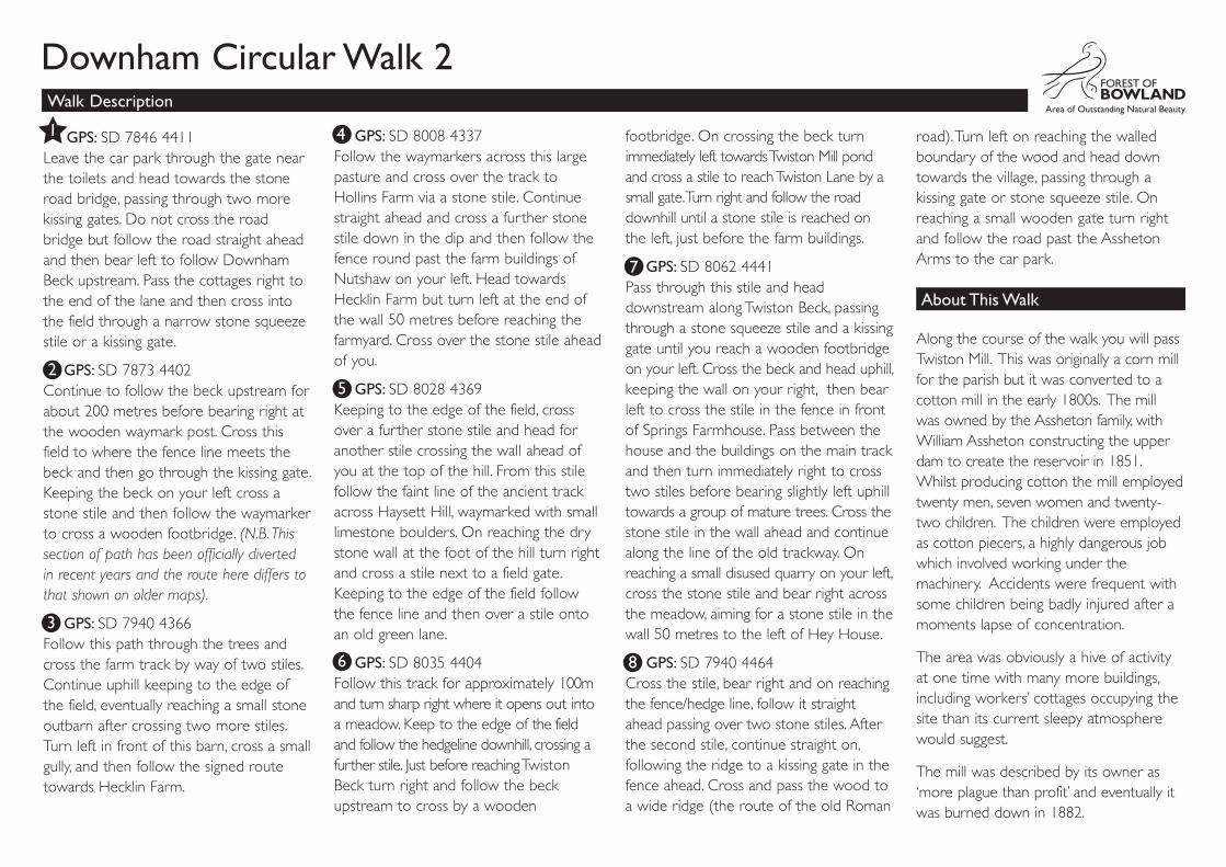
footbridge. On crossing the beck turn immediately left towards Twiston Mill pond and cross a stile to reach Twiston Lane by a small gate. Turn right and follow the road downhill until a stone stile is reached on the left, just before the farm buildings.
GPS: SD 8062 4441Pass through this stile and head downstream along Twiston Beck, passing through a stone squeeze stile and a kissing gate until you reach a wooden footbridge on your left. Cross the beck and head uphill, keeping the wall on your right, then bear left to cross the stile in the fence in front of Springs Farmhouse. Pass between the house and the buildings on the main track and then turn immediately right to cross two stiles before bearing slightly left uphill towards a group of mature trees. Cross the stone stile in the wall ahead and continue along the line of the old trackway. On reaching a small disused quarry on your left, cross the stone stile and bear right across the meadow, aiming for a stone stile in the wall 50 metres to the left of Hey House.
GPS: SD 7940 4464Cross the stile, bear right and on reaching the fence/hedge line, follow it straight ahead passing over two stone stiles. After the second stile, continue straight on, following the ridge to a kissing gate in the fence ahead. Cross and pass the wood to a wide ridge (the route of the old Roman
road). Turn left on reaching the walled boundary of the wood and head down towards the village, passing through a kissing gate or stone squeeze stile. On reaching a small wooden gate turn right and follow the road past the Assheton Arms to the car park.
Along the course of the walk you will pass Twiston Mill. This was originally a corn mill for the parish but it was converted to a cotton mill in the early 1800s. The mill was owned by the Assheton family, with William Assheton constructing the upper dam to create the reservoir in 1851. Whilst producing cotton the mill employed twenty men, seven women and twenty-two children. The children were employed as cotton piecers, a highly dangerous job which involved working under the machinery. Accidents were frequent with some children being badly injured after a moments lapse of concentration.
The area was obviously a hive of activity at one time with many more buildings, including workers’ cottages occupying the site than its current sleepy atmosphere would suggest.
The mill was described by its owner as ‘more plague than profit’ and eventually it was burned down in 1882.
GPS: SD 7846 4411Leave the car park through the gate near the toilets and head towards the stone road bridge, passing through two more kissing gates. Do not cross the road bridge but follow the road straight ahead and then bear left to follow Downham Beck upstream. Pass the cottages right to the end of the lane and then cross into the field through a narrow stone squeeze stile or a kissing gate.
GPS: SD 7873 4402Continue to follow the beck upstream for about 200 metres before bearing right at the wooden waymark post. Cross this field to where the fence line meets the beck and then go through the kissing gate. Keeping the beck on your left cross a stone stile and then follow the waymarker to cross a wooden footbridge. (N.B. This section of path has been officially diverted in recent years and the route here differs to that shown on older maps).
GPS: SD 7940 4366Follow this path through the trees and cross the farm track by way of two stiles. Continue uphill keeping to the edge of the field, eventually reaching a small stone outbarn after crossing two more stiles. Turn left in front of this barn, cross a small gully, and then follow the signed route towards Hecklin Farm.
GPS: SD 8008 4337Follow the waymarkers across this large pasture and cross over the track to Hollins Farm via a stone stile. Continue straight ahead and cross a further stone stile down in the dip and then follow the fence round past the farm buildings of Nutshaw on your left. Head towards Hecklin Farm but turn left at the end of the wall 50 metres before reaching the farmyard. Cross over the stone stile ahead of you.
GPS: SD 8028 4369Keeping to the edge of the field, cross over a further stone stile and head for another stile crossing the wall ahead of you at the top of the hill. From this stile follow the faint line of the ancient track across Haysett Hill, waymarked with small limestone boulders. On reaching the dry stone wall at the foot of the hill turn right and cross a stile next to a field gate. Keeping to the edge of the field follow the fence line and then over a stile onto an old green lane.
GPS: SD 8035 4404Follow this track for approximately 100m and turn sharp right where it opens out into a meadow. Keep to the edge of the field and follow the hedgeline downhill, crossing a further stile. Just before reaching Twiston Beck turn right and follow the beck upstream to cross by a wooden
Walk Description
1
2
3
4
5
6
7
8
Downham Circular Walk 2
About This Walk