dorrigo np bellinger river np - forestry corporation · s cot hman gladstone dieha py roses creek...
TRANSCRIPT

fG
Dorrigo NP
Bellinger River NP
Baalijin NR
Juugawaarri NR
Ganay NR
New England NP
Waterfall Way
Darkwood Road
Horseshoe Road
Kalan
g Roa
d
Bellbucca Road
Orama Road
Yo Yo Road
Hospital Range Road
Black
wood
Roa
d
Zeehan Road
Middle Camp Fire Trail
Holberts Fire Road
Middle
Ridg
e Roa
d
Little North Arm Road
Horseshoe Road
SCO TCHMAN
GLADSTO NE
DIEHAPPY
RO SES CREEK
IRISHMAN
O AKES
470000
470000
475000
475000
480000
480000
6620
000
6620
000
6625
000
6625
000
6630
000
6630
000
6635
000
6635
000
³
0 1,250 2,500 3,750 5,000625Meters
Map Sheets: 1:100,000 Dorrigo 94371:25,000 Darkwood 9437-3SScale: 100,000
Projection: GDA_1994_MGA_Zone_56Datum: GCS_GDA_1994
Loca lity Ma pCom pa rtm e nt 125,126,127 & 128
Scotchm a n & Rose s Cre e k Sta te Fore stUrung a Ma na g e m e nt Are a
Ñ Safety Points
SAFETY PO INTSHelicopter Landing Areaf
Shannon Creek Rd
RO ADSSealedAll Weather, UnsealedDry Weather, UnsealedFour Wheel DriveProposed HaulageDrainage Feature
MAP FEATURESHarvest Area
State ForestNational Park & Nature Reserve
Private Plantations
Created: 13/03/2017Bob AspdenCreated By:
He li la nding Point (Pe rm a ne nt)Dum p 8 - Cle a re d a re a on Wye m b a h Roa d800m south of Middle Ca m p Road junction.N 30° 29.25' E 152° 42.11’
Em e rg e ncy Me e ting PointInte rse ction of Horse shoe Road & Middle Ca m p Roa dGrid Re f: 470580 E 627740 N
88
8
88
88 8
8
8
"""""###
R
"
G
"
!
!"
!"
!
!
!
#³#³
$T$T$T
$T
$T$T$T$T$T$T$T$T$T
$T$T$T
$T$T
$T$T$T$T$T
$T
$T
$T
$T $T
$T
$T
$T$T$T$T$T$T
$T$T$T$T
$T
$T
$T$T
$T
XD
XA
XC
XB
SCOTCHMAN 486
ROSES CREEK 829
Baalijin NR
BA 2
8
9
3
5
4
6
7
1
14
1312
1110
127
126
125
128
137
119124 118
114
136
Kalang R oad
127/1 Trail
M iddle Camp Fire Trail
128/1 Trail
Horseshoe R oad
W yembah R oad
R oses Creek Road
128/2 Trail
J amiesons R oad
Kalang Road
469000
469000
470000
470000
471000
471000
472000
472000
473000
473000
474000
474000
6625000
6625000
6626000
6626000
6627000
6627000
6628000
6628000
Prepared By: Bob Aspden Date: 25/07/2017
CHECKED BY .................................................................DATE........................
1:15,000
Date Printed: 2/08/2017
FORESTRY CORPORATION OF NSW, HARDWOOD FORESTS DIVISIONHARVEST PLAN OPERATIONAL MAP
M apsheet: DOR R IGO - 9437 1:100,000
S COTCHM AN & R OS ES CR EEK S TATE FOR ES TNO. 486 & 829
Plan Name: U_125_126_127_128M anagement Area:UR UNGAContour Interval 10m
GDA_1994_M GA_Z one_56
© Crown Copyright 2013. The information and data contained in this map is to the best of Forestry Corporation’s belief, true and correct at the time of publication. However, changes in cumstances after the publication may impact upon theaccuracy of the material. No warranty or guarantee is provided by the S tate of New S outh W ales, Forestry Corporation and its employees and agents and no liability is accepted for any loss or damage, costs or expense resulting from the use or reliance upon the information and data contained in this map
Plan No:58797
0 0.5 1 1.5Kilometres
Cpt No: 125, 126, 127 & 128
V ER S ION:
1
Safety Meeting Point (Dump 7)
RoadsAll W eather, UnsealedDry W eather, UnsealedFour W heel DriveNon Haulage R oadsR oads not to be used
TSL Prescription ZoneY ellow-Bellied GliderM odified Harvesting Z one
$T Parsonsia dorrigoensis
# V aried S ittella! Glossy Black-Cockatoo
" Glossy Black-Cockatoo feed tree
Y ellow-bellied Glider
Koala
R Little Bent-wing Bat
G S phagnum Frog
Threatened Species Locations
Little Lorikeet!<Cadastral Lots/DP #(LPI Property Bdys)S table S nig Tracks
M GA Grid 100m! ! Compartments (Line)
S tate Forest Boundary (Line)
S tate ForestNational Park & Nature R eserve
Map Features
10m Contour
Indicative Drainage FeatureDrainage Line
IFOA crossingsR idge & Headwater CrossingIndicative S nig TracksS lope > 30 degrees (LiDAR )
8 Buildings
Y Temporary Log Dumpú Approved Crossing
f Heli Landing Point
Blaz e Trees
Drainage features (IHL 3 Hard Buffers)S tream PZ 1st Order (10m)S tream PZ 2nd Order (20m)S tream PZ 3rd Order (30m)S tream PZ 4th Order (50m)
Harvesting PrescriptionsGeneral M anagement (FM Z 4)Inaccessible Area
4 Bar Exclusions
R ainforest
3 Bar Limited FallingM apped Limited Falling EZR idge and Headwater Habitat EZ
Forest Management Protection
Lowland R ainforest TECLowland R ainforest on Floodplain TECTEC Buffers
Kalang R iver Additional 100m Buffer
FM Z 7 (Non-forestry Use - Old Quarry)
DRAFT

!!!!!
!!
!
!
!!
!!
!
!!
!!
!!
!!
!!
!!
!
!!!!!!!!!!!!!!
!!!
!!
!!
!!
!
!!
!
!
!!
!!
!!
!!
!!
!!
!!
!
!
!!
!!
!!!!!!!!!!!!!!
!!
!!
!!
!!
!!
!!
!!
!!
!!
!!
!!
!!
!!
!!
!!!!
!!!!
!!
!!
!!
!!
!!
!!!!!!!!!!
!!!!!!!!!!!
!!
!
!! ! ! ! ! !
!
!
!!
! ! !
!
!
! !
!
!! ! ! ! ! !
!
!
!!
! ! !
!
!
! !
!!
!!
!!
!!
!
!!
!!
!!
!!
!!
!!
!!
!!
!!
!!
!
!
!!
!!
!
!!
!!
!!
!!
!
!!
!!
!!
!!
!!
!!
!!
!!
!!
!!
!
!
!!
!!
!
! !! !
!!
!!
!!
!!
!!
!!
!!
!!
!!
!!
!!
!!
!
!!
!!
!!
!!
!!
!!
!!
!!
!!
!!
!!
!!
!
!!
!!
!
!!
!!!!
!!!!!!!!!
!!!!
!!
!!
!
!!
!!!!
!!!!!!!!!
!!!!
!
!!
!!!
!
!
!
! ! ! !!
! ! ! !
!
! !
!!
!!
!
!!
!!
!!
!!
!
! ! !!
!! !
! ! !!
!!
!!
!!
!!
!!
! !
!
! !!
!!
! !
!!
! !!
!! !
!
! !
!
!
!! !
!
! !!
!!
! !
!!
! !!
!! !
!
! !
!
!37a
47
23
37b
37a
23
53
37a
37a
37a
53
53
37b53
6/23
53
6/23
53
53
53
53
53
53
53
37a
53
53
53
6/23
53
37b
6/2353
47
53
53
37a
47
5353
53
53
37a
37b
53
37a
53
53
37a
53
53
37a
6/23
53
23
53
Baalijin NR
Kalang Road
127/1 Trail
Mid d le Cam p Fire Trail
128/1 Trail
Horse shoe Road
Wye m b ah RoadRose s Cre e k Road
128/2 Trail
Jam ie sons Road
Mid dle Ca
m p Fire tra
il
Kalang Road
469000
469000
470000
470000
471000
471000
472000
472000
473000
473000
474000
474000
6625000
6625000
6626000
6626000
6627000
6627000
6628000
6628000
Pre p are d By: Bob Asp d e n Date : 31/03/2017
CHECKED BY.................................................................DATE........................
1:15,000
Date Printe d : 31/03/2017
FORESTRY CORPORATION OF NSW, HARDWOOD FORESTS DIVISIONFOREST TYPE MAP
Map she e t: DO RRIGO - 9437 1:100,000
SCO TCHMAN & RO SES CREEK STATE FO RESTNO . 486 & 829
Plan Name: U_125_126_127_128Manage m e nt Are a:URUNGAContour Inte rval 10m
GDA_1994_MGA_Zone _56
© Crown Cop yright 2013. The inform ation and d ata containe d in this m ap is to the b e st of Fore stry Corp oration’s b e lie f, true and c orre ct at the tim e of p ub lication. Howe ve r, change s in cum stanc e s afte r the p ub lication m ay im p act up on theac curacy of the m ate rial. No warranty or guarante e is p rovid e d b y the State of Ne w South Wale s, Fore stry Corp oration and its e m p loye e s and age nts and no liab ility is ac c e p te d for any loss or d am age , costs or e xp e nse re sulting from the use or re lianc e up on the inform ation and d ata containe d in this m ap
Plan No:58797
0 0.5 1 1.5Kilom e tre s
Cp t No: 125, 126, 127 & 128
VERSIO N:
1
Forest TypesTEC (EPA Mapping)TEC
Lowland Rainfore stLowland Rainfore st on Flood p lainBuffe rs
Typ e 6 Fig - Giant Stinge rTyp e 23 MyrtleTyp e 37 Dry Blackb uttTyp e 47 Tallowwood - Syd ne y Blue GumTyp e 53 Brush Box
Document title: HFD Harvest Plan Template Version No.: 1 Page 1 of 11 Harvest Plan no.: 58797 Approval Date: 1/5/2017 Expiry Date: 25/2/2024 Warning: a printed copy of this document may be uncontrolled. Please verify this is the latest version prior to use.
Hardwood Forests Division
Harvest and Haul Plan
State Forest Scotchman & Roses Creek Compartments 125, 126, 127 & 128
Management Area Urunga IFOA Region Lower North East
Harvest Plan No. 58797 Supply Zone Urunga Up-River
Legal Conditions Native Forest Harvesting under the LNE IFOA.
Survey expiry date for this plan is 25/2/2024
Certification Timber products removed from the plan area are within the Defined Forest Area covered by Australian Forestry Standard and ISO14001 Certificate 13761
Prepared by Senior Planner Bob Aspden DRAFT
Date:
Reviewed by Senior Planner Flavio Bugno DRAFT
Date:
Approved by Planning Supervisor Matt Kinny DRAFT
Date:
Abbreviations FT = Forest Technician, HC = Harvesting Coordinator, PtS= Protection Supervisor, HS = Harvesting Supervisor, RC = Roading Coordinator, RS = Roading Supervisor, Crew = Harvest Contractor/Forest Operators, IFOA = Integrated Forestry Operations Approval, TSL = Threatened Species Licence, EPL = Environment Protection Licence, FL = Fisheries Licence, CH = Cultural Heritage, SOP = Standard Operating Procedure.
1. Harvest Area Details (all Slope info is LiDAR derived)
Cpt 125 Cpt 126 Cpt 127 Cpt 128 Total
PlanCpt ID 128211 128212 128209 128210
Gross Area (ha) 172 205 209 149 735
Harvest Area* 50 36 30 20 136 Estimated Yield 1200 950 650 900 3700
Yield/ha 24 26 22 45
Slope (% 0-15 degrees) 8 11 7 9 Slope (% 15-30 degrees) 92 89 93 91
Slope (% 0-20 degrees) 20 27 18 22
Slope (% 20-25 degrees) 33 34 26 31
Slope (% 25-30 degrees) 47 39 57 47 *Harvest Area is an estimate and does not include area predicted to be inaccessible or otherwise unavailable. Contractor must ensure timber removed is allocated to the correct compartment when entered into Electronic Delivery Docket.
Document title: HFD Harvest Plan Template Version No.: 1 Page 2 of 11 Harvest Plan no.: 58797 Approval Date: 1/5/2017 Expiry Date: 25/2/2024 Warning: a printed copy of this document may be uncontrolled. Please verify this is the latest version prior to use.
2. Management Conditions on Boundaries Boundary Conditions
SMZ / FMZ FMZ 2 (SMZ) and 3 a – occur and are mapped on HPOM as exclusion zones. Additional areas are embedded within mapped areas of Rainforest and High Conservation Value Old Growth.
FMZ 4 – Available and displayed on the HPOM as net harvest area. Normal harvest conditions apply.
FMZ 7 – Non-Forestry Use – Orange circle under Dump7 illustrates quarry site. This area is available for log dump use.
Cultural Heritage Surveys have been conducted during May 2014 and previously in May 2004. No sites have been identified within the operational area. If any potential heritage sites are identified an interim 100m exclusion buffer must be applied and Planning Supervisor notified immediately.
National Park (Baalijin NR)
The Baalijin Nature Reserve adjoins the operational area to the north. The boundary of the National Park is mainly defined by the Horseshoe Road and Middle Camp Fire Trail (see operational map). The boundary is offset 20m to the north from the centrelines of these two roads. The remaining small sections of boundary not covered by exclusion are to be marked conservatively in the field with a GPS (e.g. 50m section to the west of Dump 1, adjacent to the Horseshoe Road).
Neighbours The operational area is bounded by several private properties. These boundaries are not fenced but have been precision surveyed in the past. Several blaze (boundary) trees have been identified (see operational map). Where no blaze trees can be identified the FT’s are to mark private property boundaries conservatively using a GPS.
Wyembah Road Wyembah Road weaves on and off state forest and snigging logs along Wyembah Road is only permitted on state forest.
3. Expected Yields
Product Estimates Volume (m3) Species Species Mix (Sawlog)
HQ Large Sawlog (Quota) 1,500 BBT 90%
HQ Small Sawlog 750 TWD 3%
Poles, Piles and Girders 500 BG 2%
LQ Sawlog (Salvage) 800 Other species 5%
Total 3,550
4. Haulage Route and Contractor Travel Route Haul Route The haulage route will be from internal state forest roads north onto the
Horseshoe Road and onto the Waterfall Way.
BEWARE – This haulage route is frequently used by the local community and recreational drivers/riders.

Document title: HFD Harvest Plan Template Version No.: 1 Page 3 of 11 Harvest Plan no.: 58797 Approval Date: 1/5/2017 Expiry Date: 25/2/2024 Warning: a printed copy of this document may be uncontrolled. Please verify this is the latest version prior to use.
Dust and Speed Limit - Horeseshoe Road
Houses are adjacent to the northern end of the Horseshoe Road; log trucks and other operational vehicles are to slow down to 40km/hr when passing these residents. The HC must erect speed limit signage.
Waterfall Way and Horseshoe Road Intersection
All drivers exiting the Horseshoe Road onto the Waterfall Way must be vigilant and give way to passing traffic before proceeding with caution onto the Waterfall Way (80km/hr zone).
5. Community Issue Conditions
Private property neighbours and local traffic
The operational area is surrounded by several private property neighbours. Some of these neighbours and the local community use state forest roads within the operational area for commuting. The operational area will be closed to the public during roading and harvesting operations to ensure a safe work environment. Harvesting and roading contractors are to ensure that the operational area is closed to all public. Sections of the Horseshoe Road will be closed to the public while adjacent harvesting operations are underway. Advisory signs must be placed at strategic points along the Horseshoe Road to advise the public of this temporary closure.
Kalang River Community Concerns
As a result of community consultation, a 100m harvesting exclusion has been mapped along the Kalang River. This additional buffer should ease community concerns given that research indicates the normal 50m protection zone is more than adequate to minimise any impact from the harvesting operation on the Kalang River.
6. Infrastructure
Infrastructure Conditions
All Mapped Fire Trails Mapped trails must be reinstated to similar or better condition to that prior to harvesting/snigging and comply with the EPL.
7. Harvesting Conditions
Silviculture Type Harvesting Objectives and Condition for each stand condition
Moderate STS & Light STS
Location:
Throughout NHA
In stands dominated by regrowth Blackbutt, the objective is to remove the mature and commercial component of the stand whilst promoting advanced regeneration (of commercial potential) to grow on into a vigorous Blackbutt stand.
In stands dominated by mature Blackbutt, the objective is to stimulate regeneration and establish a new, vigorous Blackbutt stand.
Crew must retain well-formed seed trees of preferred species at ~40 m spacing
The crew is responsible for selecting retained seed trees and retaining patches of advanced regeneration.
BA removal may exceed 40% in some localized areas, but will be balanced by non-harvest areas and tree retention across the tract.

Document title: HFD Harvest Plan Template Version No.: 1 Page 4 of 11 Harvest Plan no.: 58797 Approval Date: 1/5/2017 Expiry Date: 25/2/2024 Warning: a printed copy of this document may be uncontrolled. Please verify this is the latest version prior to use.
Inaccessible Areas
The operational map indicates areas presumed to be inaccessible. It is highly likely that more of the net harvestable area will also be deemed inaccessible. The FT’s must record areas deemed inaccessible.
Monitoring The HC is to monitor basal area removal in line with the following table. Any changes to treatment and offset areas need to be endorsed by the Planning Supervisor.
IFOA Limits Moderate STS
Light STS Inaccessible (predicted)
Total
STS Tract 140 ha 30 ha 13 ha 183 ha* Pre-harvest BA 36 m2/ha 36 m2/ha 36 m2/ha Post-harvest BA 22 m2/ha 29 m2/ha 36 m2/ha Planned Removal 40% 20% 0 34% Note: Average post-harvest BA in regen STS tract likely to be higher due to difficult to access areas. *Areas based on potentially available NHA as shown on Operational Map. Much of this is predicted to be inaccessible or otherwise unavailable.
8. Tree Retention - refer to TSL booklet for full conditions
Prescription Condition/Responsibility
Mark-Up – the FT is responsible for marking up the forest ahead of harvesting operations consistent with SOP 2 Exclusion Zone Boundary Mark Up - and SOP 3 - Forest Mark Up
Compartment Mark-Up Survey
(5.1, 5.2, 5.13)
Compartment mark-up surveys must be conducted at least 300m in advance of operations. The survey must search for threatened and protected species features listed in conditions 5.1 and 5.2 of the TSL.
No Koala star search triggers were identified during pre- harvest surveys.
Hollow-bearing and Recruitment tree retention (H and R)
Regrowth Zone - 5.6 d), e) and f) conditions apply.
Significant Food Resources
(5.6 g)
FT must mark for retention - glider sap feed trees, stands of forest oak and forest oak feed trees.
Glossy Black Cockatoo feed trees (as mapped) – 5.6 g) (iii)
Harvesting - Crew and HC responsibilities
Protection of Retained Trees (5.6h)
Trees marked or selected for retention must not be felled.
The crew must minimise damage to H and R trees by using directional felling.
Harvesting debris should not accumulate within 5 m of retained trees. Where debris does accumulate, the crew must remove or flatten to < 1m high.
The HC must be notified of any badly damaged retained trees and they must assess and record if a replacement retained tree is required.

Document title: HFD Harvest Plan Template Version No.: 1 Page 5 of 11 Harvest Plan no.: 58797 Approval Date: 1/5/2017 Expiry Date: 25/2/2024 Warning: a printed copy of this document may be uncontrolled. Please verify this is the latest version prior to use.
Stag Retention (Dead standing trees 5.6f)
The crew should retain stags where safe to do so.
The crew must record the date, DBH, risk and location of unsafe stags removed.
Significant food resources The crew should avoid damaging flowering or fruiting banksias or grass trees.
Impenetrable Understory Areas identified as Impenetrable Understory by the FT must be managed as per the requirements of SOP3.
9. Site-Specific Flora and Fauna (see SOP 1, 2 and 3)
Present in Compartment
Condition Boundary Type
Prescription
Riparian Habitat Protection (5.7)
IHL 3 (SOP 4)
(The HPOM indicates LIC drainage order corrected by LiDAR)
2 bars Implement filter strip and protection zone (hard as per IHL 3) around drainage features as shown on the HPOM. Refer to SOP 4.
FT must mark unmapped drainage lines and 1st order protection zone boundary with 2 bars.
The crew will locate and protect all 2nd order and above streams with GPS.
Ground Habitat (5.17)
N/A Commercial firewood collection in these compartments is not permitted.
TEC Exclusion 4 bars Mapped Exclusion zone to be marked by FT.
Rainforest (5.4) Accidental Mapped exclusion embedded in mapped Limited Falling Exclusion Zone. Mapped Exclusion zone to be located by GPS in harvester. FT to continue to search for unmapped rainforest and mark for exclusion if identified
HCVOG (5.3) Limited Mapped Exclusion zone to be located by GPS in harvester.
Ridge & Headwater Habitat (5.8)
Limited Mapped Exclusion zone to be located by GPS in harvester.
FMZ 2 & 3A Limited Mapped Exclusion zone to be located by GPS in harvester.
Yellow-bellied Glider (6.17g) ii)
Modified Harvest
Tree retention requirements to be implemented by FT. Heard call detection west of Dump 1 - 15 feed trees in 200 m radius to be retained.
Fish N/A Class 2 Aquatic Habitat. Fisheries licence conditions apply.
Sphagnum Frog N/A 50m exclusion on record (already falls within larger exclusion)

Document title: HFD Harvest Plan Template Version No.: 1 Page 6 of 11 Harvest Plan no.: 58797 Approval Date: 1/5/2017 Expiry Date: 25/2/2024 Warning: a printed copy of this document may be uncontrolled. Please verify this is the latest version prior to use.
Parsonsia dorrigoensis
N/A Managed under monitoring program. No conditions apply.
Not mapped as occurring in compartment, however markup searches should target these potential exclusions.
Condition Boundary Type
Prescription
Powerful Owl (5.13) 3, Machinery Mark 50m exclusion from nest site.
Powerful Owl (5.13) 3, Machinery Mark 30m exclusion from roost site.
Varied Sittella (5.13) 3, Machinery Mark 20m exclusion from nest site if detected and No commercial fire wood collection & protect ground habitat.
Little Lorikeet (5.13) 3, Machinery Mark 30m exclusion from nest site.
Giant-barred Frog (6.03) 3, Machinery
Mark 30 m exclusion on mapped streams within 200 m of a record. Revert to 10m UMDL EPL protection.
Rocky Outcrop and Cliffs (5.11)
4, Limited To be assessed and marked by FT during mark-up.
20m buffer on outcrops >0.1 ha or cliffs >3m high.
Glossy Black-cockatoo nest (5.13) 4, Limited
Mark 50m exclusion from nest site.
Powerful Owl, Masked Owl, Barking Owl (7bv) 4, Limited Mark landscape exclusions as mapped.
10. Soil & Water – Refer to EPL Booklet for full conditions
Issue Assessment Conditions
EPL Scheduled Activity No
EPL Licenced Activity Yes RS and HS responsible for updating IFOA report
Unmapped drainage Line harvesting
Not -Permitted
Apply SOP 4.
15m Hard buffer on UMDL’s
Inherent hazard level 3 Refer SOP 4
Harvesting Slope Limits 30 degrees Slopes ≥ 25° excluded - 1st January – 31st March

Document title: HFD Harvest Plan Template Version No.: 1 Page 7 of 11 Harvest Plan no.: 58797 Approval Date: 1/5/2017 Expiry Date: 25/2/2024 Warning: a printed copy of this document may be uncontrolled. Please verify this is the latest version prior to use.
EPL – Sch 4 Condition 3.
See seasonality (below)
Dispersible Soils No
Mass Movement / Instability Yes Refer to SOP 14
• The construction of new snig tracks should not involve side cuts of greater than 2m batter height.
• Wherever possible snig tracks should follow the terrain rather than sidecut across it, particularly where the slope exceeds 25°.
• Any old snig tracks on slopes up to 30° (including side cut snig tracks) that are showing no sign of mass movement may be used provided they can be satisfactorily drained to EPL specifications.
• Several existing snig tracks occur on slopes >30° (see HPOM). These tracks have been assessed as stable and are available for operational use.
Seasonality Conditions Yes Harvesting excluded on Slopes ≥ 25° from 1st January – 31st March
See EPL schedule 3, section 4.3.
Ground cover >70% Nil
Burning conditions Yes No burning permitted during February and March
See EPL schedule 4, conditions G36-37.
Log Dumps Refer to SOP4 and SOP 5
HC is responsible for authorising moving the location of a log dump.
Roading management during harvesting
Refer to SOP 6 & 14
HC is responsible for monitoring road and crossing drainage during haulage.
Wet Weather and Rutting Refer to SOP 6.
Crew is responsible for implementing automatic closures and following notified closures.
HC is responsible for ensuring crew notified when notified closure is lifted.
Snigging Refer to SOP 8
Crew is responsible for progressive drainage of snig

Document title: HFD Harvest Plan Template Version No.: 1 Page 8 of 11 Harvest Plan no.: 58797 Approval Date: 1/5/2017 Expiry Date: 25/2/2024 Warning: a printed copy of this document may be uncontrolled. Please verify this is the latest version prior to use.
tracks
Snig Track Crossings Refer to SOP 8
HC is responsible to ensure snig track crossings are approved prior to use and rehabilitated upon completion.
11. Crossing Approvals All crossing approvals are shown on the operational map – any other feature crossings must be assessed, recorded below and approved by the Planning Supervisor before use.
Crossing EPA
Approval
Conditions
IFOA Crossings A
N/A Use existing roads/tracks where practicable. Minimise size of snig track and drain to EPL on completion of snigging. Apply special conditions to section of snig track on slopes >30° as per Section 10 (page 8).
IFOA Crossings B & C
N/A Use existing roads/tracks where practicable. Minimise size of snig track and drain to EPL on completion of snigging.
Ridge & Headwater Crossing D
N/A Use existing roads/tracks. No trees >20cm to be removed, and drain to EPL at the completion of snigging
12. Operational Plan Briefing: A briefing of this operational plan was conducted by
Person Role Nature of Briefing Date

Document title: HFD Harvest Plan Template Version No.: 1 Page 9 of 11 Harvest Plan no.: 58797 Approval Date: 1/5/2017 Expiry Date: 25/2/2024 Warning: a printed copy of this document may be uncontrolled. Please verify this is the latest version prior to use.
13. Acknowledgement of Briefing: I acknowledge that I have received a copy of the plan documents and that I have been briefed on the conditions of the Plan. I understand the operational control requirements as outlined in the plan and take responsibility for the implementation of plan conditions relevant to my responsibilities
Name Role Signature Date

Document title: HFD Harvest Plan Template Version No.: 1 Page 10 of 11 Harvest Plan no.: 58797 Approval Date: 1/5/2017 Expiry Date: 25/2/2024 Warning: a printed copy of this document may be uncontrolled. Please verify this is the latest version prior to use.
14. Standard Operating Procedures: The following SOP’s apply to this plan. FCNSW staff and the crew must hold a copy on site whilst operating and comply with the conditions set out in each SOP.
Procedure Number
Title
1 Drainage Feature Protection
2 Exclusion Zone Boundary Management
3 Forest Mark-Up
4 Operating in Inherent Hazard Level 3 Areas
5 Log Dump Operation and Use
6 Road and Crossing Management and Wet Weather Controls
7 Safety Requirements
8 Snig Tracks and Extraction Tracks
9 Tree Felling and Servicing Logs
10 Fire Precautions and miscellaneous requirements

Document title: HFD Harvest Plan Template Version No.: 1 Page 11 of 11 Harvest Plan no.: 58797 Approval Date: 1/5/2017 Expiry Date: 25/2/2024 Warning: a printed copy of this document may be uncontrolled. Please verify this is the latest version prior to use.
Operational Diary:
Date Issue Action Required
Action Completed Initials
Record: Daily activities (eg tree marking, dump 2); Condition 5.2 of TSL items - EEC locations, rocky outcrops, koala scats, feed tree identification etc), discussions with stakeholders/neighbours/ site visitors; areas of impenetrable understorey; unviable areas not marked, non-conformances; harvesting issues identified, twice weekly road and crossing drainage checks
ROADING PLAN –Scotchman & Roses Creek State Forest, Compartments U_125_126_127_128
1
FORESTRY CORPORATION OF NSW – NORTH EAST REGION
ROADWORKS PLAN
Scotchman & Roses Creek State Forest; Compartments 125, 126, 127 & 128
ASSOCIATED HARVEST PLAN NO. 58797
Certification
Prepared by:
Senior Planner DRAFT Date:
Bob Aspden
Reviewed by:
Senior Planner DRAFT Date:
Flavio Bugno
Reviewed by:
Planning Supervisor DRAFT Date:
Matt Kinny
Road Works and Operational Expenditure Approved by:
Regional Manager DRAFT Date:
Craig Busby
Duration of Approval:
The above approval is valid until 12 months from date of signature. Contents
1. Cover Page
2. Operational Map
3. Costings
4. Roadworks Plan Text/Prescriptions/Road and crossings work sheets
5. Locality Map
6. Safety Plan HAMEEP
7. Harvesting Plan
8. Harvesting Notification List (Operations Team Leader and Roading Supervisor Only)

ROADING PLAN –Scotchman & Roses Creek State Forest, Compartments U_125_126_127_128
2
This
page
is
intentionally
Blank

ROADING PLAN –Scotchman & Roses Creek State Forest, Compartments U_125_126_127_128
3
1. Objectives
• Roadworks are required to service native forest harvesting operations within the above compartments. The proposed harvesting operation is expected to take between 3-6 months depending on markets and weather. Harvesting might be completed in stages between September 2017 and late 2018 (harvesting will only be scheduled during spring due to seasonality restrictions).
• The operational map shows the location of the proposed works. • Attachments: Financial Analysis Spreadsheet gives full details of costs, benefits, material &
plant requirements (Internal FCNSW use only).
2. Specifications and Legal Conditions
This operation must comply with: • Standard Operating Procedures for Native Forest Operations on the North Coast. • Licence Conditions issued by Forestry Corporation of NSW under the Forestry Act (2012). • State Forests of NSW Forest Practices Code - Part 2 Timber Harvesting in Native Forests
February 1999 and Forest Practices Code Part 4 Forest Roads and Fire Trails (February 1999). • Integrated Forestry Operations Approval issued under part 5B of the Forestry Act 2012 (IFOA)
including the associated licences: - Threatened Species Licence issued under the Threatened Species Conservation Act (1995). - Fisheries Licence issued under section 220ZW of the Fisheries Management Act 1994. - This operation is a non-scheduled operation under the Environment Protection Licence issued
under section 55 of the Protection of the Environment Operations Act 1997. Roading and harvesting operations are licensed. All EPL conditions will apply to roading operations.
• Technical Guidance Notes for Roadworks.
3. Special Conditions
Feature Conditions
Threatened Species Some Parsonsia sp. individuals occur close to roads (E.g. east of Dump 12. Operators to minimise disturbance to road verge in these areas.
Dispersible Soils Hazard No
Mass Movement Hazard Yes – Although mass movement is unlikely within the roading network given the existing geology the following precautionary conditions apply:
• Where possible retaining the existing vegetation on the batters to assist in maintaining their current stability.
• Minimise disturbance to the toe of cut batters
Works on >30° slopes Some short sections of road traverse slopes >30°. The following conditions apply to these sections of road:
• Mark out sections of road on +30˚ slopes
• Minimise disturbance of cut batter (no undercutting).
• No loose spoil material to be pushed over onto fill batter – must be either worked into road matrix or transported to stable area.
• Ensure outlet of drainage structures falls onto stable surface, e.g. rock face, vegetation, fluming
Seasonality Forestry activities (includes – Rd construction, Rd reopening & harvesting) not to be conducted between 1st

ROADING PLAN –Scotchman & Roses Creek State Forest, Compartments U_125_126_127_128
4
January and 31st March (slopes ≥25˚) – as per Module 4 Schedule 3 of the EPL.
National Park Yes – National park occurs to the north of sections of the Horseshoe Road and Middle Camp Road (see operational map). The boundary is 20m from the centreline of the road in use.
Private Property Yes – Some private property is accessed only through the operational area. If this PP is to be accessed, PP owners are required to obtain a permit for access through the operational area.
Safety Issues (includes hazards, public use of roads)
Yes – The Horseshoe Road Wyembah Road acts as a thorough fare between the Kalang and Darkwood Valley’s and carries an intermittent volume of public traffic. All operators are to remain vigilant to the presence of other road users.
4. General Conditions
• Tree removal should be undertaken mechanically where possible. Refer to Safety Procedures 4.25 “Manual Tree Felling” and 4.26 “Management of Hazardous Trees & Overhead Hazards”.
• Remove vegetation within 3m of the road prism only where required to maintain safe sight distance and passage of trucks.
• Note: Clearing is generally permitted within 3m of the road prism for all roads. Ground disturbance and tree debris may impact outside this 3m either side of the road prism as is required to effect clearing within 3m of the road prism. Conditions 5, 6 and 47 Schedule 5 of the EPL must apply.

ROADING PLAN –Scotchman & Roses Creek State Forest, Compartments U_125_126_127_128
5
5. Works Schedule
Road Name: Horeshoe Road (within Cpts) Road Category: Permanent Road Length 2000 m from National Park boundary in the east to NP boundary in west (see ops map)
WORKS REQUIRED INSTRUCTIONS/SITE SPECIFIC CONDITIONS
Site
Info
Works on >30° slopes C See special conditions
Mass movement conditions C
See special conditions
Dispersible Soils Conditions C
Pave
men
t
Widening
Minor Realignment C
Re-opening C Remove vegetation / debris C
Repair surface C
Crown / Crossfall C Gravel C
Road
side &
Bat
ters
Remove trees >20 cm dbhob C
Remove Dangerous trees/stags only
Remove trees <20 cm dbhob C
Repair/upgrade of Batters C
Drain
age
Culverts C Clean Mitre Drains C Clean ROD / Spoon C Belts/Channels C Maintain and install as per EPL spacing Drop Downs C As per >30° slopes – if required Silt Trapping C
1. Start Date: Finish Date: Date Event Initial

ROADING PLAN –Scotchman & Roses Creek State Forest, Compartments U_125_126_127_128
6
Road Name: Middle Camp Fire Trail Road Category: Temporary Road Length 3500 m from Horseshoe Road to Dump 14
WORKS REQUIRED INSTRUCTIONS/SITE SPECIFIC CONDITIONS
Site
Info
Works on >30° slopes C See special conditions Mass movement conditions C
See special conditions
Dispersible Soils Conditions C
Pave
men
t
Widening
Minor Realignment C
Re-opening C Remove vegetation / debris C
Slope mow road sides
Repair surface C
Crown / Crossfall C Gravel C 4 x loads on steep section
Road
side &
Bat
ters
Remove trees >20 cm dbhob C
Remove Dangerous trees/stags only
Remove trees <20 cm dbhob C
Repair/upgrade of Batters C
Drain
age
Culverts C Mitre Drains C Clean ROD / Spoon C Maintain and install as per EPL spacing Belts/Channels
C Maintain and install as per EPL spacing (approx. 30 x sets)
Drop Downs C As per >30° slopes – if required Silt Trapping C
2. Start Date: Finish Date: Date Event Initial

ROADING PLAN –Scotchman & Roses Creek State Forest, Compartments U_125_126_127_128
7
Road Name: Wyembah Road Road Category: Temporary Road Length 900 m from Middle Camp Road to Dump 8
WORKS REQUIRED INSTRUCTIONS/SITE SPECIFIC CONDITIONS
Site
Info
Works on >30° slopes C See special conditions Mass movement conditions C
See special conditions
Dispersible Soils Conditions C
Pave
men
t
Widening
C
Widen intersection with Middle Camp Road, excess soil to be used to build up box-cut section further south on Wyembah Rd
Minor Realignment C
Re-opening C
Clear vegetation around old dump (Dump 8) to create heli-pad clearing (approx. 50m x 50m)
Remove vegetation / debris C
Slope mow road sides
Repair surface C
Crown / Crossfall C Gravel C
Road
side &
Bat
ters
Remove trees >20 cm dbhob C
Remove Dangerous trees/stags only
Remove trees <20 cm dbhob C
Repair/upgrade of Batters C
Drain
age
Culverts C Mitre Drains C Clean ROD / Spoon C Maintain and install as per EPL spacing Belts/Channels
C Maintain and install as per EPL spacing (approx. 2 x RF’s)
Drop Downs C As per >30° slopes – if required Silt Trapping C
3. Start Date: Finish Date: Date Event Initial

ROADING PLAN –Scotchman & Roses Creek State Forest, Compartments U_125_126_127_128
8
Road Name: 127/1 Trail Road Category: Temporary Road Length 1700 m from Horseshoe Road to Dump 6
WORKS REQUIRED INSTRUCTIONS/SITE SPECIFIC CONDITIONS
Site
Info
Works on >30° slopes C See special conditions Mass movement conditions C
See special conditions
Dispersible Soils Conditions C
Pave
men
t
Widening C
Minor Realignment C
Re-opening C Remove vegetation / debris C
Slope mow road sides
Repair surface C
Crown / Crossfall C Gravel C
Road
side &
Bat
ters
Remove trees >20 cm dbhob C
Remove Dangerous trees/stags only
Remove trees <20 cm dbhob C
Repair/upgrade of Batters C
Drain
age
Culverts C Mitre Drains C Clean ROD / Spoon C Maintain and install as per EPL spacing Belts/Channels
C Maintain and install as per EPL spacing (approx. 30 x RF’s)
Drop Downs C As per >30° slopes – if required Silt Trapping C
4. Start Date: Finish Date: Date Event Initial

ROADING PLAN –Scotchman & Roses Creek State Forest, Compartments U_125_126_127_128
9
Road Name: 128/1 Trail Road Category: Temporary Road Length 700 m from Horseshoe Road to Dump 3
WORKS REQUIRED INSTRUCTIONS/SITE SPECIFIC CONDITIONS
Site
Info
Works on >30° slopes C See special conditions Mass movement conditions C
See special conditions
Dispersible Soils Conditions C
Pave
men
t
Widening C
Minor Realignment C
Re-opening C Remove vegetation / debris C
Slope mow road sides
Repair surface C
Crown / Crossfall C Gravel C 2 x loads on steep section
Road
side &
Bat
ters
Remove trees >20 cm dbhob C
Remove Dangerous trees/stags only
Remove trees <20 cm dbhob C
Repair/upgrade of Batters C
Drain
age
Culverts C Mitre Drains C Clean ROD / Spoon C Maintain and install as per EPL spacing Belts/Channels
C Maintain and install as per EPL spacing (approx. 5 x RF’s)
Drop Downs C As per >30° slopes – if required Silt Trapping C
5. Start Date: Finish Date: Date Event Initial

ROADING PLAN –Scotchman & Roses Creek State Forest, Compartments U_125_126_127_128
10
Road Name: Dump1 Trail Road Category: Temporary Road Length 100 m from Horseshoe Road to Dump 1
WORKS REQUIRED INSTRUCTIONS/SITE SPECIFIC CONDITIONS
Site
Info
Works on >30° slopes C Mass movement conditions C
Dispersible Soils Conditions C
Pave
men
t
Widening C
Minor Realignment C
Re-opening C Remove all trees from road prism Remove vegetation / debris C
Repair surface C
Crown / Crossfall C Gravel C
Road
side &
Bat
ters
Remove trees >20 cm dbhob C
Remove Dangerous trees/stags only
Remove trees <20 cm dbhob C
Repair/upgrade of Batters C
Drain
age
Culverts C Mitre Drains C Clean ROD / Spoon C Maintain and install as per EPL spacing Belts/Channels C Drop Downs C Silt Trapping C
6. Start Date: Finish Date: Date Event Initial

ROADING PLAN –Scotchman & Roses Creek State Forest, Compartments U_125_126_127_128
11
Road Name: Horeshoe Road (Road maintenance) Road Category: Permanent Road Length 18 kms from National Park boundary to Waterfall Way (see Rd Maintenance map)
WORKS REQUIRED INSTRUCTIONS/SITE SPECIFIC CONDITIONS
Site
Info
Works on >30° slopes C
Mass movement conditions C
Dispersible Soils Conditions C
Pave
men
t
Widening
Minor Realignment C
Re-opening C Remove vegetation / debris C
Repair surface C
Crown / Crossfall C Gravel C
Road
side &
Bat
ters
Remove trees >20 cm dbhob C
Remove Dangerous trees/stags only
Remove trees <20 cm dbhob C
Repair/upgrade of Batters C
Drain
age
Culverts C Clean Mitre Drains C Clean ROD / Spoon C Maintain and install as per EPL spacing Belts/Channels C Drop Downs C Silt Trapping C
7. Start Date: Finish Date: Date Event Initial
ROADING PLAN –Scotchman & Roses Creek State Forest, Compartments U_125_126_127_128
12
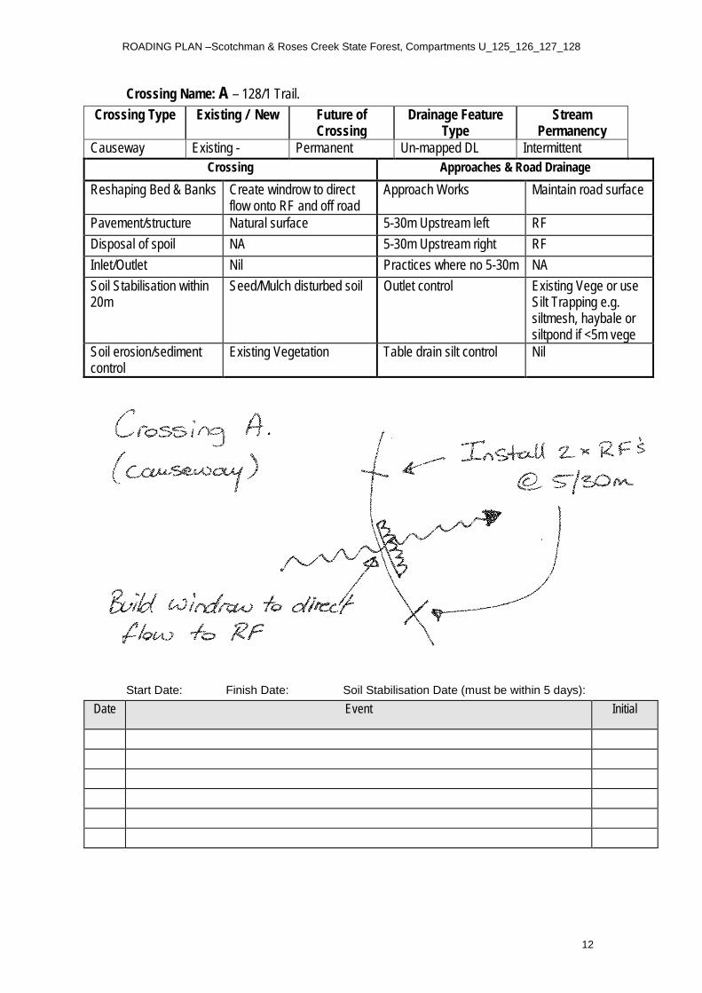
Crossing Name: A – 128/1 Trail. Crossing Type Existing / New Future of
Crossing Drainage Feature
Type Stream
Permanency Causeway Existing - Permanent Un-mapped DL Intermittent
Crossing Approaches & Road Drainage Reshaping Bed & Banks Create windrow to direct
flow onto RF and off road Approach Works Maintain road surface
Pavement/structure Natural surface 5-30m Upstream left RF Disposal of spoil NA 5-30m Upstream right RF Inlet/Outlet Nil Practices where no 5-30m NA Soil Stabilisation within 20m
Seed/Mulch disturbed soil Outlet control Existing Vege or use Silt Trapping e.g. siltmesh, haybale or siltpond if <5m vege
Soil erosion/sediment control
Existing Vegetation
Table drain silt control Nil
Start Date: Finish Date: Soil Stabilisation Date (must be within 5 days): Date Event Initial

ROADING PLAN –Scotchman & Roses Creek State Forest, Compartments U_125_126_127_128
13
Crossing Name: B – 128/1 Trail. Crossing Type Existing / New Future of
Crossing Drainage Feature
Type Stream
Permanency Causeway Existing - Permanent Un-mapped DL Intermittent
Crossing Approaches & Road Drainage Reshaping Bed & Banks Create windrow to direct
flow onto RF and off road Approach Works Maintain road surface
Pavement/structure Natural surface 5-30m Upstream left ROD Disposal of spoil NA 5-30m Upstream right RF Inlet/Outlet Nil Practices where no 5-30m NA Soil Stabilisation within 20m
Seed/Mulch disturbed soil Outlet control Existing Vege or use Silt Trapping e.g. siltmesh, haybale or siltpond if <5m vege
Soil erosion/sediment control
Existing Vegetation
Table drain silt control Nil
Start Date: Finish Date: Soil Stabilisation Date (must be within 5 days): Date Event Initial

ROADING PLAN –Scotchman & Roses Creek State Forest, Compartments U_125_126_127_128
14
6. Operational Control
Roading Supervisor to sign here
I acknowledge that I have received a copy of the plan documents and that I have been briefed on the conditions of the Plan. I understand the operational control requirements as outlined in the plan and take responsibility for the implementation of plan conditions as the principle controller of the operation.
I will brief any other operators not present at this briefing prior to them starting any work on site and ensure that risk assessment for the Safety Management Plan is completed for this area prior to operations commencing
Name: Signature:
Position: Date: From
Company: To
Name: Signature:
Position: Date: From
Company: To
Name: Signature:
Position: Date: From
Company: To
Name: Signature:
Position: Date: From
Company: To
Name: Signature:
Position: Date: From
Company: To

ROADING PLAN –Scotchman & Roses Creek State Forest, Compartments U_125_126_127_128
15
7. Handover Briefing
I acknowledge that I have received a copy of the plan documents and that I have been briefed on the conditions of the Plan. I understand the operational control requirements as outlined in the plan.
Position - Company Name Signature Date