with zig-zag lines i'm painted: hohokam petroglyphs on tempe butte, arizona
TRANSCRIPT
WITH ZTG-ZAG LINES I'M PAINTED:
HOHOKAM PETROGLYPHS ON TEMPE BUTTE, ARIZONA
By
Larry Loendorf
and
Chris Loendorf
Contributions by
]. Claire Dean
Loendorf and Associates
1995

ACKNOWLEDGEMENTS
As wittr so nrany projects, the Tempe Butte Rock art recording project w.rs a greatereffort than originally anticipated. The data recorded at the site adds to the informationbase on rock art for the Hohokam and hopefully other rock art researchers will be able touse the Tet pe Butte study for comparative puposes. We want to thank the City of Tempeand the support of Amy A. Douglass, Museum Administrator for the Tempe HistoricalMuseum. Arty carefully read the draft report and offered us several dranges and additionsthat are incorporated into the final document. Several other individuals also providedvaluable review comments on the draft, induding T.iz 31d Peter Welsh, David |acobes, andGlen Rice.
Lorrie Lincoln, Dianna Clise, Ellen Barber, Tom Herrschaft, Ted Oliver, GlenaBrownlee Cain, and Rob Ciaccio worked on the project.some of these individuals werepaid and others volunteered their time and effort. We appreciate the work they put intothe project Several people visited us while we were completing the field work andofferedus information about the site, induding Barbara Moulard, and Matt Thomas. Weacknowledge their interest in Tempe Butte and the help they gave us in completing theproject.


TABLE OF CONTENTS
ACKNOWLEDGMENTS
LIST OF FIGURES
INTRODUCTION
HOHOKAM PETROGLYPHS
GEOLOGY OF TEMPE BUTTE
RECORDING THE TEMPE BUfiE PETROGLYPHSPhotogragphyRock Art Sketches and Scale DrawingsWritten Data CollectadVamish EstimatesSite Map
SURVEY RESULTS
DESCRIPTION OF THE PETROGLYPHSOutcrop One
SummaryOutcrop Two
SummaryOutcrop Three
SummaryOutcrop Four
SummaryOutcrop Five
SummaryOutcrop Six
SummaryOutcrop Seven
SummaryOutcrop Eight
SummaryOutcrop Nine
SummaryOutcrop Ten
SummaryOutcrop Eleven
SummaryOutcrop Twelve
SummaryOutcrop Thirteen
SummaryOutcrop Fourteen
SummaryOutcrop Fifteen
SummaryOutcrop Sixteen
SummaryOutcrop Seventeen
Summary
ll
iv
1
1
2
3567710
11
13142225272737384646*55555558585858606060606262626363636363u64ilil70
Outcrop EighteenSummary
Outcrop NineteenSummarv
Outcrop fwentySummary
Outcrop fwenty-oneSummary
Outcrop Twenty-twoSummary
Outcrop Twenty-threeSummarv
Outcrop fwenty-fourSummarv
Outcrop fwenty-fiveSummary
Outcrop iwenU-sixSummarv
Outcrop fwenty-sevenSummarv
Ortcrop Twenty-eightuummary
Outcrop Twenty-nineSummary
Outcrop fhirtySummary
Outcrop Thirty-oneSummary
AGE ESTIMATES FOR THE TEMPE BUTTE PETROGLYPHS
INTERPRETING ROCK ARTEthnography and Rock ArtShamanism and Rock ArtTrance States and RockArtLocationalAnalyses and Rock ArtAstronomy and Rock Art
SELECTED HOHOKAM ROCK ART MOTIFS AT TEMPE BUTTEPipette PetroglyphsLizard and Horned Toad Petroolyohsflpirat, 9.croll, Concentric Circl-e,'and Bull's Eye petroglyphsHuman Hands and Feet Petroglyphs
PETROGLYPH CLASSIFICATION AT TEMPE BUTTE
THEORETICAL IMPLICATIONS OF THE TEMPE BUTTE PETROGLYPHS
PROPOSED TEXT FOR INTERPRETATIVE SIGNS
70uu85858787898989899090909092929393101102102102102104105105105
105
109113114117119
121128129131
132
135
138
APPENDIX A: GENERAL CONDITION ASSEMENT OF THE RocK ART AT TEMPEBUTTE PARK, PHOENIX, AHIZONA
REFRENCES CITED
LIST OF FIGURES
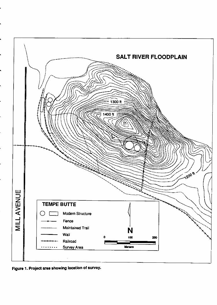
Figure 1. Project area showing location of survey.
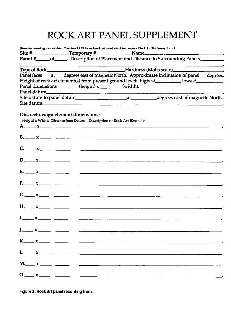
Figure 2. Rock art panelrecording form.
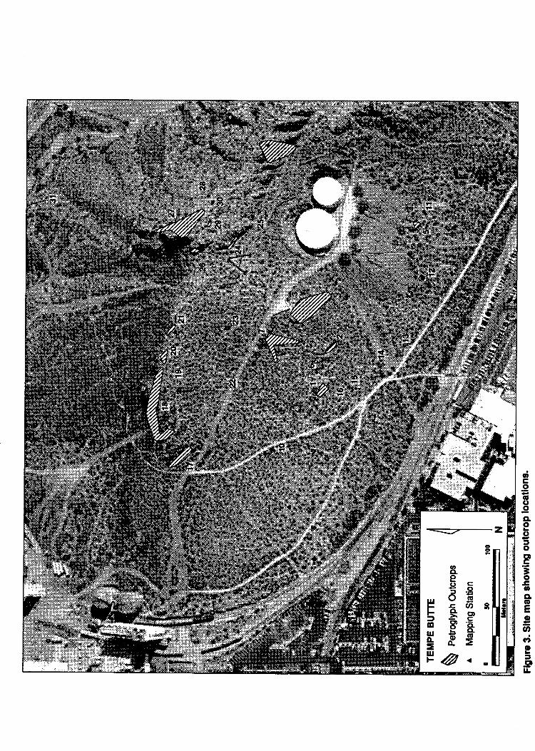
Figure 3. Site map showing outcrop locations.
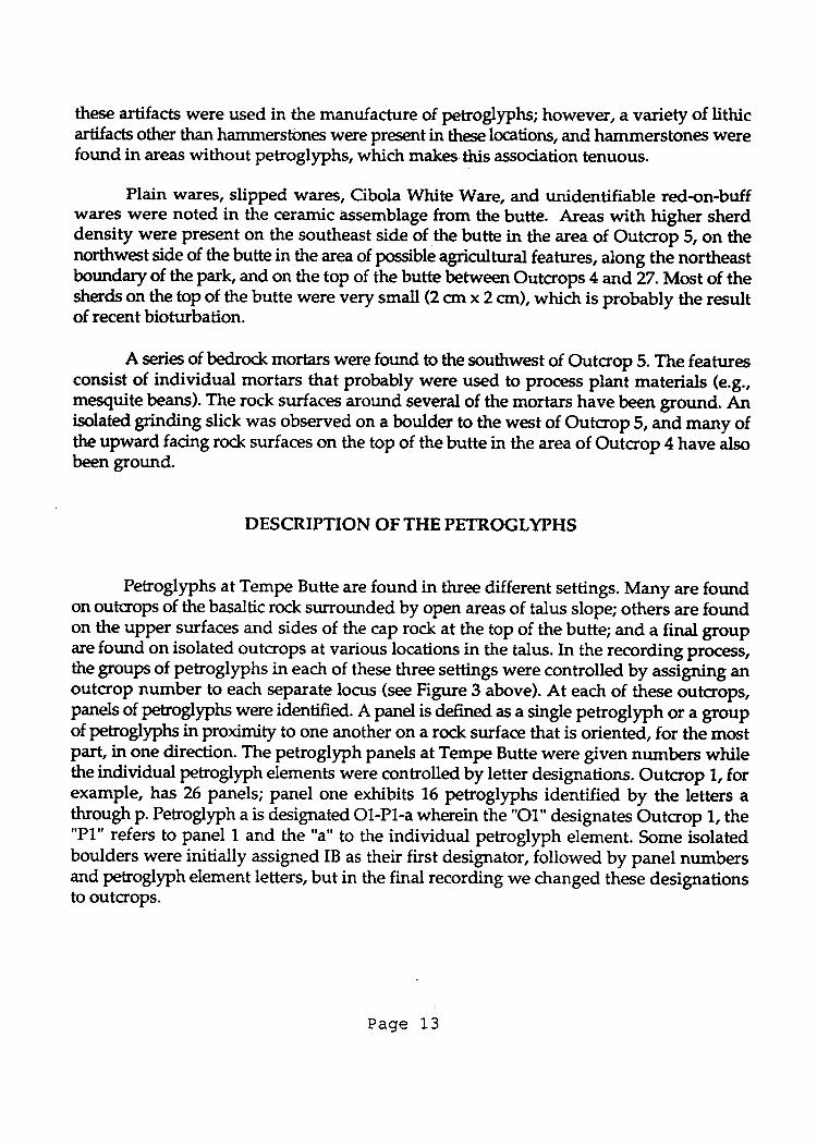
Figure 4. Map showing locations of panels on Outcrops 1, 2, 3, 6, 7, 9, 10, 14, 15, and 16.
Figure 5. Petroglyphs on Outcrop 1, Panels 1-6. Shown atl0o/o of actualsize.
Figure 6. Petroglyphs on Outcrop 1 , Panels 7-12. Shown at 10o/o of actual size.
Figure 7. Petroglyphs on Outcrop 1, Panels 13 & 14. Shown at 10% of actualsize.
Figure 8. Petroglyphs on Outcrop 1, Panels 15-18. Shown at1O"/" of actualsize.
Figure 9. Petroglyphs on Outcrop 1, Panels 19. Shown at10Vo of actualsize.
Figure 10. Petroglyphs on Outcrop 1 , Panels 20-26. Shown at 107" of actual size.
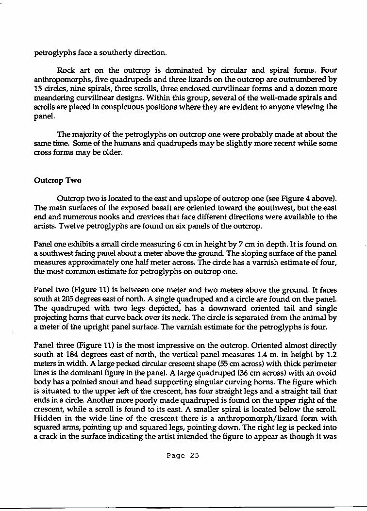
Figure 11. Petroglyphs on Outcrop 2, Panels 2-6. Shown at 10% of actual size.
Figure 12. Petroglyphs on Outcrop 3, Panels 1-5. Shown at 10% of actualsize.
Figure 13. Petroglyphs on Outcrop 3, Panels 6-13. Shown at 10% of actualsize.
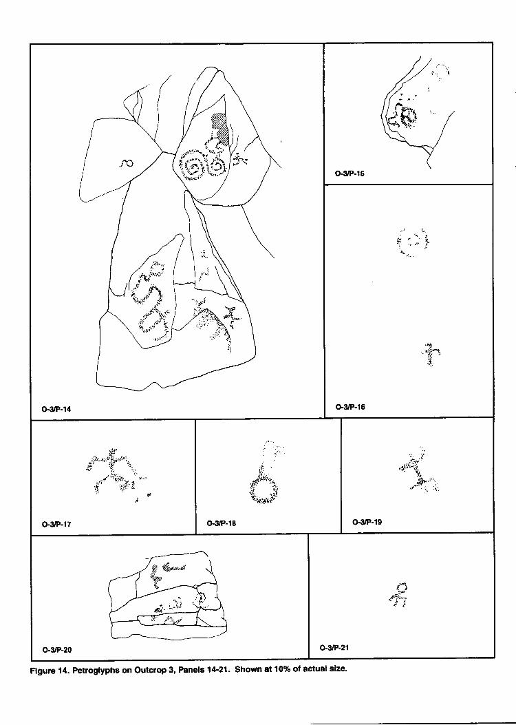
Figure 14. Petroglyphs on Outcrop 3, Panels 14-21. Shown at101o of actualsize.
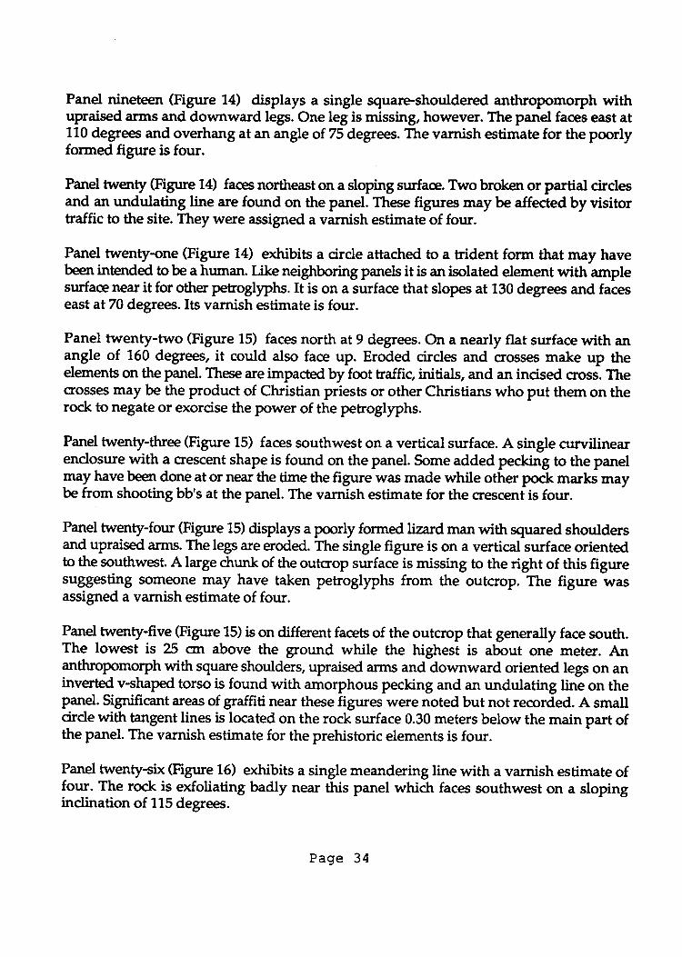
Figure 15. Petroglyphs on Outcrop 3, Panels 22-25. Shown at 10% of actual size.
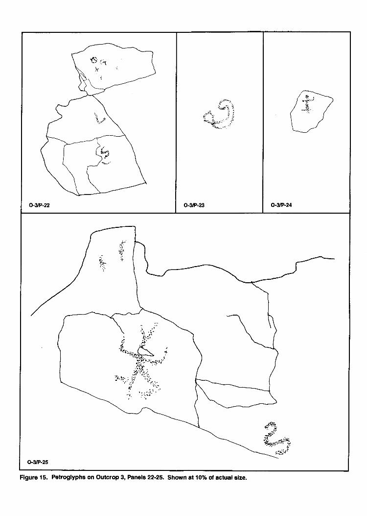
Figure 16. Petroglyphs on Outcrop 3, Panels 26-34. Shown ?t1Oo/" of actualsize.
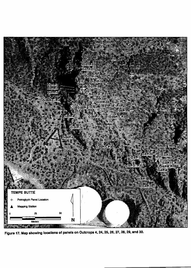
Figure 17. Map showing locations of panels on Outcrops 4, 24, 25, 26,27 , 28,29, and 30. AFigure 18. Petroglyphs on Outcrop 4, Panels 1-4. Shown at1Q/" of actualsize.
Figure 19. Petroglyphs on Outcrop 4, Panels 5-9. Shown at 10% of actualsize.
Figure 20. Petroglyphs on Outcrop 4, Panels 10-12. Shown at 10% of actual size.
Figure 21. Petroglyphs on Outcrop 4, Panels 13-17. Shown at 10% of actualsize.
Figure 2. Map showing locations of panels on Outcrops 5, 8, 11 , 12, and 13.
Figure 23. Petroglyphs on Outcrop 5, Panels 1-7. Shown at 10% of actualsize.
Figure 24. Petroglyphs on Outcrop 5, Panels 8-18. Shown at 10% of actual size.
Figure 25. Petroglyphs on Outcrop 5, Panels 19-23. Shown atl0o/o of actualsize.
Figure 26. Petroglyphs on Outcrop 5, Panels 6 & 7. Shown at 10Vo of actualsize.
Figure 27. Petroglyphs on Outcrops 8 & 9. Shown at 10% of actual size.
Figure 28. Petroglyphs on Outcrops 10-16. Shown at 10% of actual size.
Figure 29. Map showing locations of panels on Outcrops 17, 18, 1 9, 20, 21, 22, and 23.
Figure 30. Petroglyphs on Outcrop 17 , Panel 1 . Shown at 10ol" of actual size.
Figure 31. Petroglyphs on Outcrop 17, Panels 2-5. Shown at 10/" of actual size.
Figure 32. Petroglyphs on Outcrop 17 , Panels 6-10. Shown at 10% of actual size.
U.
lt
Figure 3dl.
Figure 34.
Figure 35.
Figure 36.
Figure 37.
Figure 38.
Figure 39.
Figure 40.
Figure 41.
Figure 42.
Figure 4it.
Figure 44.
Figure 45.
Figure 46.
Figure 47.
Figure 48.
Figure 49.
Figure 50.
Figure 51.
Figure 52.
Figure 53.
Figure 54.
Petroglyphs on Outcrop 18, Panel 1-6. Shown at 10% of actualsize.
Petroglyphs on Outcrop 18, Panel 7. Shown at 10% of actual size.
Petroglyphs on Outcrop 18, Panel 8-14. Shown atlOo/o of actualsize.
Petrogllphs on outcrop 18, Panel 15, 16, 18-24. shown ?t1oo/o of actualsize.Petroglyphs on Outcrop 18, Panel 17. Shown atl}o/o of actualsize.
Petroglyphs on outcrop 18, Panel2s-90. shown atlCf/oof actualsize.
Petroglyphs on outcrop 18, Panelgl-36. shown at 1o% of actualsize.
Petroglyphs on outcrop 18, Panel3z-M. shown atl}yoof actualsize.Petroglyphs on Outcrops 19 & 20. Shown at 10% of actualsize.
Petroglyphs on Outcrops 21-23. Shown at 1}o/o of actual size.
Petrogfyphs on Outcrops 24-26. Shown "t
llo/o of actual size.
Petroglyphs on outcrop 27, panel 1-g. shown at lovo of actual size.Petroglyphs on outcrop 21, panel 9-1s. shown at 10% of actualsize.Petroglyphs on outcrop 27, panel 14-19. shown at1}o/oof actualsize.Petroglyphs on outcrop 27, panel 19-22. shown at 10% of actualsize.Petroglyphs on outcrops 28-31. shown at 1oy" of actual size.
Outcrop 1, Panel 17 as it may have appeared prehistorically.
outcrop 27,Panel18 as it may have appeared prehistorically.
Outcrop 17, Panel4 as it may have appeared prehistorically.
Outcrop 3, Panel5 as it may have appeared prehistorically.
Outcrop 2, Panel3 as it may have appeared prehistorically.
Proportions of selected element types for rock outcrops with more than 50 codedelements.
INTRODUCTION
Petroglyph sites are abundant on the rock outcrops, buttes, and mountains alongthe Salt River in southern Arizona. Frequently found on basalt and other volcanic rockswith varnish, the primary technique for making the petroglyphs was to use a tool to peckthrough the dark-colored rock varnish to ergose the lighter-colored interior stone. The dintmarks left in making the petroglyphs suggest the most frequently used tool was a sharppick-like instrument while lesser areas were made by abrading the rock surface.Occasionally parts of Hohokam petroglyphs are made by incising the rock surface with a
smaller and more refined tool.
The pick-like tool was probably made of a spall of crypto-crystalline material likequartzite or chert. It had to have sufficient size to be held easily and enough weight topenetrate the varnish. The finer incising was likely completed with chiPPed-stone flakes.Abrading tools were probably fist-sized chunks of sandstone.
The petrogllphs on Tempe Butte (AZU:9:30 AStt) are mudt like their counterpartsat nearby locations in the Phoenix basin. Most of them were made by the Hohokam,accomplished farmers who grew maizc,beans, squash, cotton, and other crops, in the area
of the butte for more than 1000 years. Hohokam farmers supported their desert lifeway byan elaborate system of canals that took irrigation water from the Salt River. Canal Tempe,passing just south of the butte, was a branch of the Canal Muertos, whidt had an intakeon the Salt River to the east of where Country Club Road currently crosses the river.Another canal, known as Canal Viejo, had its intake immediately north of the butte. Inadditiory dry farming methods were practiced in some locations, possibly induding thenorth side of the butte.
The culmination of the Hohokam was in the Classic period when they had greathouses that stood more than 25 feet and had walls as thick as seven feet. In contrast toearlier periods, Classic period villages were walled, suggesting a period when theHohokam needed defense from raiders and/or internal conflict. The Classic periodHohokam also constructed platform mounds that, in part, served as residences for somemembers of Hohokam communities.
HOHOKAM PETROGLYPHS
Polly Schaafsma (1980:81-103) identifie the Gila petrogllph style as associated withthe Hohokam culture. Gila style petroglyphs are frequently found near permanenthabitation and farming sites, as well as near seasonal camps, trails, and activity sites.Grinding slicks and pitted botrlders are often found in direct association with rock art sites(Schaafs m a 1980:9 6-97) .
The Gila petroglyph style contains both representational and abstract designs,usually appearing on the s:une surfaces, applied to the rock in a seemingly haphazardway. Wallace and Holmlund argue that "the integration of separate elements pecked atdifferent times into a single ovenall design" is a draracteristic feature of the sgle (1985:83).Abstract designs make up from 20Vo - 80Vo of the art at Gila style sites. Characteristicelements are: spirals (Schaafsma 1980:90); variations on a cirde motif (such as circleclusters, dtains, pairs, concentric cirdes, bull's €y€s, barbells, cirdes with arcs, and sundisks) (Wallace and Holmlund 1986:82); wavy lines; curvilinear meanders; and mazescomposed of meander segments (Schaafsma 1980:88).
However, it is primarily the representational quadrupeds and anthropomorphs thatdistinguish this tradition from others. Characteristic elements include human figures, andquadrupeds such as mountain sheep, deer, and what could be either coyotes or dogs.I'izards, often indistinguishable from phallic humaru, are @nrmon. Some of the figures arepecked outlined stick figures, but they more commonly are totally pecked. Somequ4ruPeds have extended half-cirde bellies that suggest pregnancy (Schaafsma 1980:83).Althorrgh birds have not been induded as a significant element in the sgle Todd Bostwick(1994) recently studied the birds in Hohokam petroglyphs in the South Mountains, wherehe found more than a dozen cranes or herons in several adjacent sites. Lr addition, materialculture sudr as bows and arrows is sometimes depicted (Wallace and Holmlund 19g5:g2).
GEOLOGY OF TEMPE BUTTE
Tempe Butte, also known as Hayden Butte and A Mountain, has an elevation ofslightly less than 1500 feeg it stands about 300 feet above the level of the river. The exposedrocks on the butte include the Tempe Beds and an overlying or interbedded group ofvolcanic flows. The Tempe Beds are a mixture of coarse and-fine-grained arkose, iittrtor,g,volcanic arenite, and tuff. Arkose is the most abundant rock in the-beds, especially at lowerlevels; it is pink to red in color. The siltstones are more abundant in the tipsecti6n. Colorsof the siltstone are tan, brownish-green, yellow, and purple (Schulten 1979:42). -II,esiltstones are well stratified. Arenite is usually pink, but can be greenish near the tuff.Sometimes found in beds as much a meter in thickness, it is a poorly sorted tuffaceoussandstone. Tuffs are the least abundant rock in the Tempe Beds. Fou"a i" the upsection,they are often thi.ly bedded and associated with the voicanic arenite (Schultenl979:4ilt.
A: Ter]Pe B$s werg deposited at the startof volcanic activity. Th"y represent thedistal facies of an alluvial fan sequence that is suggested to have been the pioduct of aflash flood (Peters lg79). Th"y contain worm buriows, palm fronds, and other plantfragments; a camel's tooth was found in the Tempe BedJexposed at Tempe Butte andalthough it was not dated, a mid- to late-Tertiary age is suggeited by the tooth (Schulten
Page 2
19D246). The Tempe Beds are found in scattered localities of the Papago Park Pediment.The type locality is on the north side of Tempe Butte.
The volcanic rocks in the upsection and overlying the Tempe Beds are best exposedatTempe Butte (Schulten 1979:45). These volcanic rocks are dark gray to grayrsh pink incolor and dthough they look mudr alike, they represent different volcanic events in themid-Tertiary. The oldet flow, about 3 meters in thickness, is a alkali-olivine basalt. Easilyweathered, it forms the slopes of Tempe Butte (Sdrulten 1979248). Another highlyweathered basalt flow, above the oldest flow, is a layer of amygdaloidal basalt. Ttreresistant layer on top of Tempe Butte is the most prominent of the volcanic flows.According to Schulten (7979:4&49):
This flow has trachytic texture, with a preferred orientation of the phenocrysts ofpotassium feldspar and hornblende. There is a minor amount of unstable quartzpresent The ground mass is composed of hornblende and pyroxene. It is probablya latite in composition having more potassium feldspar and sodium and less
calcium than an andesite. Xenoliths of a dark, fine-grained volcanic rock and ofgranite occur in this flow.
The majority of the petroglyphs are apparently found on this latter volcanic flow althoughsome of the isolated outcrops may represent earlier flows. The rock varnish on the TempeBeds is not as well developed as on the volcanic flows, although one could still makepetrogllphs on these rocks. Panel 1 of Outcrop 31, on the north side of Tempe Butte, is onthese rocks, and although the petroglyphs do not have the same contrast as those on thevolcanic rocks, they are still evident. It is noteworthy that this panel does not appear to beof Hohokam origin.
Portions of the Tempe Beds may have been exposed and covered by periodicflooding along the Salt River, but it is clear there have always been exposed rock surfacesin the Terr,pe Beds for petroglyphs on the north side of Tempe Butte. Thus the absence ofHohokam petroglyphs on the Tempe Beds may be related to the selection of basalt andother volcanic rocks by the Hohokam for their petroglyphs. This is particularly importantat Tempe Butte, because, as discussed below, the normal orientation for Hohokamperogllphs is toward river courses (Hamman and Hedges 1986). At Tempe Butte,however, the orientation of the petroglyphs is toward the canals and irrigated farm lands.This may be significant.
RECORDING THE TEMPE BUTTE PETROGLYPHS
A full-coverage high intensity survey of Tempe Butte Park was performed in anattempt to identify all prehistoric modifications to rock surfaces in the park (Figure 1). In
Page 3
\\IIttII
f, -'--.il\.il!Ti[:!tiilittTIIl !-.
'/"'--
{iI r'r-! / \-.-....
SALT RIVER FLOODPLAIN
:iii \li....\
! i\
::-ti.1:.:--'\:m,=
1400ft E'x-r;:;!4li
-.}--/..---.-_-_*..-..-f!-::::::=:::._....__ I
*:\------=.. '\ \
NI\I.JJ
fzUJ
JJ=
TEMPE BUTTE
o+ Fence
Maintained Trail
Wall
-F+--++f..+ RailfOad
Area
t{l\
I
I
N0l(n?fnl
-
lLt 13
4-a
Figure 1. Proiect area showing location of survey.
addition, the locations of prehistoric features and artifacts were noted, but artifacts werenot collected. The butte was traversed in parallel transects spaced 10 to 15 meters apart,with the intent of examining all rock surfaces that are suitable for the identification ofprehistoricrock art (i.e., rock surfaces with dark varnish, or sheltered rock faces that maypreserve paind deigrs). In areas with extensive suitable rock surfaces, transect spacingwas decreased. Loose rock, steep grades, and sheer diffs complicated the survey,especially on the north side of the butte. These conditions necessitated irregular transectspacing; however, no areas were exduded from survey coverage.
Photography
The primary recording technique at Tempe Butte was photography, using bothcolor transparency film and black and white film. Before exposing photographs, we spentseveral days exami.irg the rock art panels at different times of the day to note differinglighting conditions. This light study took place while we completed the forms forrecording panels and collected other descriptive information about the rock art. Usingthis approach we rue assured that all of the elements have been recorded and the crcrrect
information, such as the panel and element number, is available to the photographer whencompleting photography.
Both Canon and Minolta 35mm cilmeri$ were used on a tripod with a quick releasemounting head for the primary recording. Because of its excellent archival qualitiesEastman Kodak Kodaduome color slide film was exposed for the majority of the colorphotographs. Film speeds varied according to lighting cronditions, but most o(posureswere with Kodaduome 64. The black and white film of choice was Illford Pan-S (ASA 80)primarily because of the film's grain and high performance, but we had some difficultyobtaining this film so we used primarily Kodak Plus-X Pan ASA 125.
After the camera was adjusted to the correct settings, on the tripod, we used a cablerelease to expose multiple individual photographs. At least one of these was taken witha data board and scale while the others were exposed without these objects. The databoard (a black menu board with press-on white lefters) induded the site name, the outcropnumber, the panel number, and the date. At Tempe Butte, some of the data boardexposlrres induded more than a single panel, but in all instances the photographs can beused to determine the position of various panels.
Overall panel photographs were generally takm to show the relationship of one designto another. If the panel is too large for a single overview, a series of photographs weretaken across the rock face. More detailed photographs were taken of eadr element, orgroups of related elements, and in some instances, detailed photographs were taken of aparticularly important point in the rock art panel. In addition to these documentary
\
Page 5
a\
photographs, a series of general site exposures were taken to place the site into its setting.Finally, a series of photographs were taken of the crew completing the various phases ofthe research. The latter photographs are especially useful in slide preentations wherecontinuous slides of one petroglyph after another quickly become boring.
A photographic log sheet was kept for each roll of exposed film. Information kept onthe log indudes the site name and number, the general site location, the date, the tlpe offilm, film roll number, the ASA, and the size of the roll. Data collected for eachphotograph indude a photograph nu:nber, the subject, the panel number, the time of day,the light conditions, the direction the subject of the photograph is facing, and anycomments considered important.
A rubber stamp with permanent fast-drying ink was used to put the site number ontoeach slide; the more specific information was printed with a felt tipped pen. We used anultra fine point, pennanent ink, SC-UF, made by PILOT. Persons completing the labelingwere instructed to never toudr the transparenry and if they accidentally toudr it, not to tryto remove finger prints. Th"y were also instructed in other good slide managemeng notto do things like wrap a group of slides in rubber bands.
Black and white negatives were printed on a contact sheet with the labels enteredadjacent to each photograph. The negatives, stored in acid free paper sleeves, were thenattached to the contact print with archival tape.
One set of labeled slides, designated as the arctrival set, was delivered to the City ofTempe for storage in a dry and cool location for up to 30 years, at which point the setshould be duplicated and the new set returned to the archival conditions. In this manner,photographic specialists believe good color can be maintained on slides for up to 1000years.
Rock Art Sketches and Scale Drawings
Early in the research we completed panel plan sketdres that identify the elements.These drawings are used, in numerical order, for control of the photography and panelrecording.
Scale drawings of all the rock art panels were made by trained artists with acuteobservational skills. The artists were asked to include rock contours, natural features,cracks, ocfoliation, and lidrens to establish reference points to place and scale the rock artmore accurately.
With the above considerations in mind, the artists took ample measurements of the artand rock surface and made field notations on the field drawings about the condition of therock surface, abrasions, exfoliation, amorphous pecking, lichen growth, or any other
Page 6
information. Eadr scale drawing includes the site niune, panel number, datum, elementletters, date, and artist's name.
We also had artist Robert Gaccio create pen-and-ink drawings of five significantpetroglyph panels. For these drawings, we asked Ciaccio to remove the graffiti so.ls t<lmake the petogllphs appear as they may have in their original form. These reconstructedart works showing how the original petrogl)?hs once looked are useful in presentationsand public brodrures.
Field drawings were inked for the final report by Glena Cain. This was accomplishedby carefully redrawing them over a light table onto archival quality paper.
Written Data Collected
Loendorf and Associates supplement the photography and scale drawings withmeasurelnents and other documentary information, using a rock art panel supplementform to assist in recording this information (Figure 2). A temporary datum point wasestablished on the panel and marked by a sticky-paper dot. The datum point wasestablished at the intersection of a vertical line immediately left of the most left elementin the Panel and a horizontal line immediately below the lowest element in the panel. Incases where the rock is eroded or broken and not amenable to these rules, another side ofthe panel was used. Because the rules were recnrded on the panel form, anyone can returnto the site at a later date and establish datum. By measuring distance and direction, datumcan be used to control the location of various elements in the panel. In most instances, thesame information is recorded for graffiti as any other art.
Other measurements recorded on the panel form were panel dimensions, distance ofelements to present ground surface, size of individual elements, and depth of thepetroglyphs. The angle of the panel face was recorded and noted on the form.Information on the color of the rock surface and the petroglyphs was recorded by usingMunsell crolor drarts and the hardness of the rock was noted, usually calculated only oncefor eaclr outcroP, according to the Mohs scale. Information on the condition of the rockand the use of natural features in the rock to make part of the design were also noted onthe panel forms.
Varnish Estimates
Each panel was assigned an estimate as to the degree of re-varnish on thepetrogllphs. The range of possibilities were from zero, for a petroglyph with no varnish,to 1O for a petroglyph completely re.varnished. Estimates are based on more than color,although the darkness of the peuoglyph in cnmparison to the unaltered rock surface playsan important role in the estimate. Other factors indude the thickness of the varnish and the
A
Page 7
ROCK ART PANEL SUPPLEMENT(Form for reording rock rrt drte. Crmpl€ae RAPS for crch rock ert prrcl, rtech to onrplcfcd Rock Ail Sfe Survcy Forn)
Site # Temporary #Panel #-of-. Description of Placement and Dstance to Surrounding Panels-
Tlpeof Rock Flardness (Mohs scde)-Panel faces-at-degrees east of magnetic North. Approximate indination of panel-degrees.Height of rock art element(s) from present ground level highest- lowest-.Panel dimensions-(height) x
-(width).
PanelSite datum to panel datuuat-degrees east of magnetic North.
- Site datu .
Discreet design element dimensions:; Height x Width Distance from Datum Description of Rock Art Eleurents:
A.-xB.-x
C.-x
D.- x
E.-x
F.- x
G.- x
H.- x
I.- x
I.- x
K.- x
L.- x
M.- x
O.- x
Figure 2. Rock art panel recording lrom.
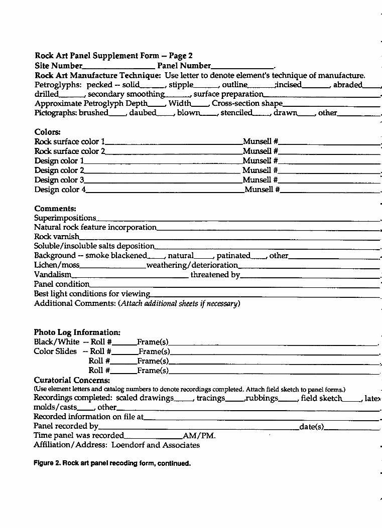
Rock Art Panel Supplement Form - Page 2
Site Number- Panel Number-. \Rodc Art Manufacture Technique: Use letter to denote element's tedmique of manufacture.Petroglyphs: pecked - solid-, stipple-, outline :incised-, abraded-,'drilled-, secondary smoothing-, surface preparatioApproximate Petroglyph Depth- Widtt\-, Cross-section shapePicbgraphs: brushed-, daubed , blown-, stenciled , drawn-, other,
Colors:Rock surface color 1 Munsell #Rock surface color ^ Munsell #
Munsell #Design colorDeign color Munsell #Design color 3 Munsell #.
Design color 4 Munsell #.
Comments:Superimpositions-Natural rock feature incorporation -iRock varnisSoluble/insoluble salts depositio .
Background - smoke blackened , natural , patinated , other =Lidten / moss-weatherin g / deterioratioVandalis threatened by.Panel conditio nBest light conditions for viewinAdditional Comments: (Attach additional shats if necrenry)
Photo Log Information:Black/White - Roll #-Frame(sColor Slides - Roll #-Frame(s)
Roll #-Frame(s)Roll #-Frame(s)
Curatorial Concerns:(Use element letters and catalog numbers to denote recordings completed. Attach field sketch to panel forurs.) 1Recordings completed: scaled drawings-, tracings-,rubbings-, fietd sketch-, latexmolds,/casts-, other .
Recorded information on file atPanel recorded by date(s)-. .
Time panel was recorderl AM/PM.Affiliation/Address: Loendorf and Associates
Figure 2. Rock art panel recoding form, continued.
A
degree to which it is covering the center of a petroglyph in comparison with the edges.
Assigning revarnish estimate is a subjective proc€ss. These estimates have nothingto do with the dating methods using rock varnish developed by Ron Dorn (Dorn 1990). Infact, Dorn believes there are too many variables in varnish growth to make use of suchestimates. Making estimates as to the degree of varnish development on petrogllphs isinfluenced by many variables, such as the lighting conditions, the individual making theestimate, and the angle at which the panel is viewed. We try to minimize some of thesevariables by facing the panel directly when making the estimate and having only one ortwo individuals make estimates.
While there are many problems in assigning a varnish estimate, most researchersagree that there are differences recognizable in the degree of varnish cover (see Wallaceand Holmlund 1986 for another attempt at varnish estimating). For example, it is oftenfairly easy to recognize re-pecking of one or two petroglyphs on a panel where themajority have not been altered.
It is undoubtedty true that the orientation of a petogllph panel, its proximity to thesurface of the ground, or the presence of nearby vegetation will alter the varnish estimate.We believe these sorts of problems tmd to "average out" if a large number of estimates iuemade on a site, but they are none the less a source of error in varnish estimating.Regardless of whether there are problems, however, we believe it is worth while to makevarnish estimates and collecting the information is better than not collecting it.
Site Map
Near the completion of the recnrding effort, a site map w.ls compiled. A permanentsite datum and a back sight, both 40-centimeter lengths of iron rebar, were placed on thesite. Locations and elevations of individual petroglyph panels and other prehistoricfeatures, as well as trails, railroad tracks, and fences were recorded using electronicsurveying equipment (LietzlSokkish Total Station). In areas with dosely spaced panels,points on the perimeter of rock outcrops were mapped.
Figures and maps presented in this report were produced by overlapng themapped petroglyphs and modern features on topography digitized from the 1952 (photo-revised 7973) U.S.G.S. 7.5 minute Tempe, Arizona Quadrangle. Additional detail wasincorporated from the Ffoot contour interval maps on file at the City of Tempe,Engineering Deparbrrent. Iaations of petroglyph panels were transposed onto a scannedreproduction of 1:1200 scale aerial photograph on file at the City of Tempe, EngineeringDepartrnent. The aerial photograph was produced by Kenney Aerial Mapping,Inc., onAptil 8,19F.3. The original field data were manipulated using AutoC,4D, and all map draftswere produced using the Maplnfo software package.
,a
Page L0
SURVEY RESULTS
Outcrop numbers were assigned to 31 loci with petrogllphs in the project area(Fignre 3). A total of 232 panels were identified on these outcrops. The petroglyphs wereconcentrated on the south side of the butte. While suitable rock surfac€s were present,petroglyphs were not identified in many of the more inaccessible locations on the northside of the butte.
The flanks and upper surfaces of the butte Eue covered by a sp:use scatter ofprehistoric criltural materials. Several locatioru with higher artifact dersity were identified.Lithic, shell, groundstone, and ceramic artifacts were observed. Because of theaccessibility of the location it is likely that much of the prehistoric cultural material,especially decorated ceramics and other diagnostic artifacts, that was originally presenton the butte has been removed by historic visitors. For example, large sherds anddecorated ceramics predominantly oc,nrnea below the top of the butte alon[ the northeastboundary of the park. Steep grades in this .uea prevent easy access, and it is likely thatother areas of the butte originally had similar scatters of larger sherds.
A series of 50 or more shallow depressions were identified on the northwest flankof the butte. The depresions average approximately 1.5 meters long, 0.75 meter wide and0.30 metens deep. These features have previously been recorded as the Terraced Butte Site(AZU:9:77 ASLI) and are thought to be prehistoric agrictrltural features. At least one largerdepresion, which may represent an ephemeral field house, was identified near the baseof the butte in the area of these possible agricultural features.
The area of these features exhibited the highest diversity of prehistoric artifacts inthe project area. Worked marine shell was observed including one bracelet fragment. Arelatively dmse scatter of lithics and ceramics w:rs also present. The single projectile pointthatwas located during the survey was found in this area. All of the groundstone artifactsfrom the project area, induding 5 metate fragments and several fragmentary manos, werefound in this location. The presence of groundstone artifacts and the diversity of materialsPresent in this location support the possibility that habitation features are presenghowever, subsurface testing is necessary to establish this with certainty.
Lithic artifacts induding a projectile point, cores, hammerstones, primary,seondary, and tertiary flakes were noted. A sparse scatter of these artifacts was observedthroughout mudr of the project area. Lithic materials identified were predominantly typesavailable in the Salt River gravels below the buttg induding: basalt, greenstone, rhyolite,slate/shales, quartzite, and other metamolphic materials. Materials that may have beentransported from somewhat more distant locations $/ere also identified, including: fine-Sfaind rhyolite, chert, and dnlcedony. The only diagnostic lithic artifact identified wasa late prehistoric ctrert projectile point that was triangular and had side notches.Hammerstones were found in close proximity to Outcrops 3,5, and 18. It is possible that
Page LL
A
sicI6ooeo(,5oEDtrEoE0ogEo=oG'o3EDlt
these artifacts were used in the manufacture of petrogl)rptu; however, a variety of lithicartifacts other than hammerstirnes were present in thee locatioru, and hammerstones werefound in areas without petroglyphs, which makes this association tenuous.
Plain wares, slipped wares, Cibola White Ware, and unidentifiable red-on-buffwares were noted in the ceramic assemblage from the butte. Areas with higher sherddensity were present on the southeast side of the butte in the area of Outcrop 5, on thenorthwest side of the butte in the area of possible agriarltural features, along the northeastborurdaryof thepark,andonthetopof thebutteU"tt"eet Outcrops4and ZZ.Uostof thesherds on the top of the butte were very small (2 cm x 2 cur), which is probably the resultof recent bioturbation.
A serie of bedrock mortars were found to the southwest of Outcrop 5. The featuresconsist of individual mortars that probably were used to proc€ss plant materials (e.g.,mequite beans). The rock surfaces around several of the mortars have been ground. Anisolated grinding slick was observed on a boulder to the west of Outcrop 5, and many ofthe upward facing rock surfaces on the top of the butte in the area of Outcrop 4 have alsobeen ground.
DESCRIPTION OF THE PETROGLYPHS
Peroglyphs at Tempe Butte are found in three different settings. M*y are foundon outcrops of the basaltic rock su:rounded by open areas of talus slope; others are foundon the uPPer surfaces and sides of the cap rock at the top of the butte; and a final groupare found on isolated outcrops at various locations in the talus. In the recording process,the groups of petroglyphs in each of these three settings were controlled by assigning anoutcrop number to each separate locus (see Figure 3 above). At each of these outcrops,panels of petroglyphs were identified. A panel is defined as a single petroglyph or a gpoupof petrogllphs in prodmity to one another on a rock surface that is oriented, for the mostpart, in one direction. The petroglyph panels at Tempe Butte were given numbers whilethe individual pehoglyph elements were controlled by lefter designations. Outcrop 7, forexample, has 25 panels; panel one exhibits 16 petroglyphs identified by the letters athrough p. Petroglyph a is designated Ol-Pl-a wherein the "O1" designates Outcrop L, the"P1" refers to panel 1 and the "a" to the individual petroglyph element. Some isolatedboulders were initially assigned IB as their first designator, followed by panel numbersand petroglyph element letters, but in the final recording we changed these designationsto outcrops.
Page 13
5
Outcrop One
The outcrop is situated on the south side of the butte, above the trail about onequafier of the way up, where it exhibits one of the more visible groups of petroglyphs onTempe Butte. Many of the panels face a southerly direction, but one of the unique thingsabout the outcrops on Tempe Butte is the number of different directions, in closeproximity, available to an artist. Ninety petroglyph elements were assigned letterdesignatiotts on?6 separate panels at outcrop one (Figure 4). The largest panel exhibits tdelements, but 12 have only a single element on them. Prehistoric cultural materialinduding plain ware and red-slipped sherds were observed at the base of the outcrop.
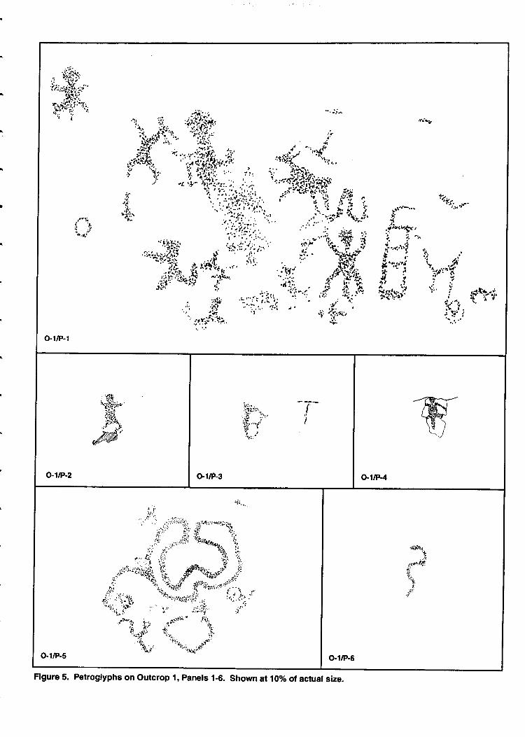
P"r1l one (Figrye 5) is situated on the lower west end of the outcrop on a nearly flatsurface of 740 degrees. Facing south at207 degrees east of magnetic north, the rock is avery dusky red (2.5 YR 2.5/2). The panel is badly exfoliated and this makes theffg"glyphs difficult to see when compared to other nearby panels. An anthropomorph,alizard, and two crude quadrupeds are intermixed on the panel with meandering p".k"dlines, a rectangular group of connected boxes, a circle, and amorphous peckid iueas.Because the panel is so eroded, varnish estimates are not meaningful.
Pangl two (Figure 5) is small, measuring 13 on high by 7 on wide. The panel contains asingle anthropomorph. The nearly vertical panel face is oriented to the southwest. Thepetroglyph is lightly varnished with an estimate of 2.S.
Panel three (Figqe 5) is oriented southwest on another vertical surface of the outcrop. Anamorphous circtrlar f9T, perhaps once crrnnected circle, is the only element on the panel.The surface of the rock-is a very dark gray (5YR 3/1) while the petroglyph is pinkishihite(sYR 8/2). The varnish estimate for the petroglyph (1.5) suglests i-t is relatively recent.
l*"1four (Figure 5)exhibits a large lizard-like form that fills most of the panel surface.Measuring 12 on il heightby 11 cm in width, the lizard has a broad body with thick legs*d_" 19.^g pot"ted tail. The slightly sloping panel faces southwest at232degree eastifnorth. The varnish estimate for the lizard is 3.suggesting a fairly well-deve6p"a varnishcover.
Panel five (Figure 5) is located on a small vertical surface 1.5 meters above the presentground surface. It faces southwest at 235 degrees east of north. Six elements on the panelindude a brandring orrved line, a large (34 cm by 43 cm) spiral connected to an enclosedcurvilinear form,2 circles, a pecked dot, and .ln amorphbus area. The circles and thebranching curved line may have once been connected tb the larger enclosed curvilinearform to create a large outlined circular petroglyph. The varnislh estimate suggests thepetroglyph might be slightly older than some of iis neighbors.
Page 14
dEc6rtdda
dt\'d_(ltc.i
a-Bo(tf
oLa,trEII
ooco=-oo.9EDc=-osoqg
=^do39Alr
l+tl-';1.'rt
=hlt3,W ,: h."
ffi -'"'.;;ffi.f,
,*r:i'-'"ri..
;'i; ,?,W# t f_ i,-b ':| :{ly,i!',.,'
i:,inp doi ;i.--'. ""'*"'''
'li?L* '' ,,,;Mif',-ri. *
''-"::;'ii;""'''!'t ' '; u;::' r*"0 t
tf''iilf''t,.'
;r,j*l"&
1l
!. 't; .l
o-1/P-1
o-1tP-z
iir','". '7-..-'Jr:n-. I.s i" 'ir;!:n\t' t!fl't2?l:-
G1/P-3 o,1/P-4
rlirr
:rr;y:;'$yi'r:d
::1
ts
o.1/P-5
rllltu,,
...r,'rotft)
o-1/P€
Figure 5. Petroglyphs on outcrop 1, Panels 1-6. Shown al 10o/o of actual size.

Panel six (Figure 5) is located on a surface above panel four. Facing southwest, it o&ibitsa single curving or wavy line that measures 20 cm in height by 11 cm in width. It appearsto have been made at the same time as the large curving petroglyPh below it.
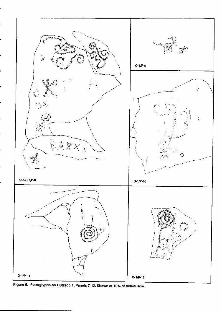
Panel seven (Figrrre 6) is situated on a vertical surface about 1.5 meters above the groundsurface. Facing southwest, the panel exhibits a spiral, a double spiral or scroll, a scrollconnected to a curvilinear meander with a spiral on one end, an endosed oblong forntwith a curving tail, a tailed cirde, some intersecting curved lines, and a non-digitateanthropomorph. The curving forms, spirals, and scrolls have a varnish estimate of fourindicating they were likely made at the same time as the figures on the nearby panels butthe human figure has slightly less developed varnish suggesting it may have been madelater than the abstract figures.
Panel eight (Figure 5) is on a vertical sr:rface about one meter above the ground. It exhibitsa single amorphous pecked area, which apparently was made about the same time as thespirals and scrolls on adjacent panels. The panel faces southwest.
Panel nine (Figure 6) displays a quadruped with curving horns, straight legs, and a
poind upturned tail (sheep?). A small circular form is found in front of the quadruped.The panel which faces southwest is located about 2.3 meters above the ground. The varnishsuggests the quadruped was made about the same time as the spirals and scrolls on nearbypanels.
Panel ten (Figure 6) faces 245 degrees east of north on a nearly verticd surface about onemeter above the ground surface. A non-digitate anthropomorph with upturned arms andsquared down turned legs is connected to a long vertical straight line that terminates in acurving forms. A possible cross and a circle are also found on the panel. The figures wereapparently made about the same time as their neighbors.
Panel eleven (Figure 6) exhibits a well-executed counterclockwise spiral that measures 26on in height by 19 crn in width. Some amorphous pecking has been added to the outsidewhorl in the spiral. The panel, is located about one meter above the ground surface,290degrees west-north-west. The spiral which appears to be about the same age as nearbypetrogllphs has some scratching that may represent the same time period as the originalartists and other historic scratching.
Panel twelve (Figure 6) faces southwest at 195 degree east of north. It displays an endosedspiral with a tail (35 cm high by 15 cnr wide) that is connected to a circular form and aseparate cirde. The petroglyphs which nearly fill the vertical panel surface were madeabout the same time as those on adjacent panels.
Page 77
-
o-1/P-7,P.8
, r*or,':,,# -*n,.
o.1/P-9
i:i it{i '-
,,
,.''.li:..'.:r,'i.':''
'& ::"". ...;;r..lfrrt','1. r"l::'-'T';. \-'' ,--/'' ,/',--
--//'U/
o-1/P-10
o-1tP-12
h,.t \t-i.tr \.*"\::i , ,rbr+, \!j. , ",4 \''. it r I
ii' :'i"J'.i
/:.'./t ,.'.r' , ////'
I/
Figure 6. Petroglyphs on outcrop I, pansls 7-12. Shown al 1oo/o of actual size.
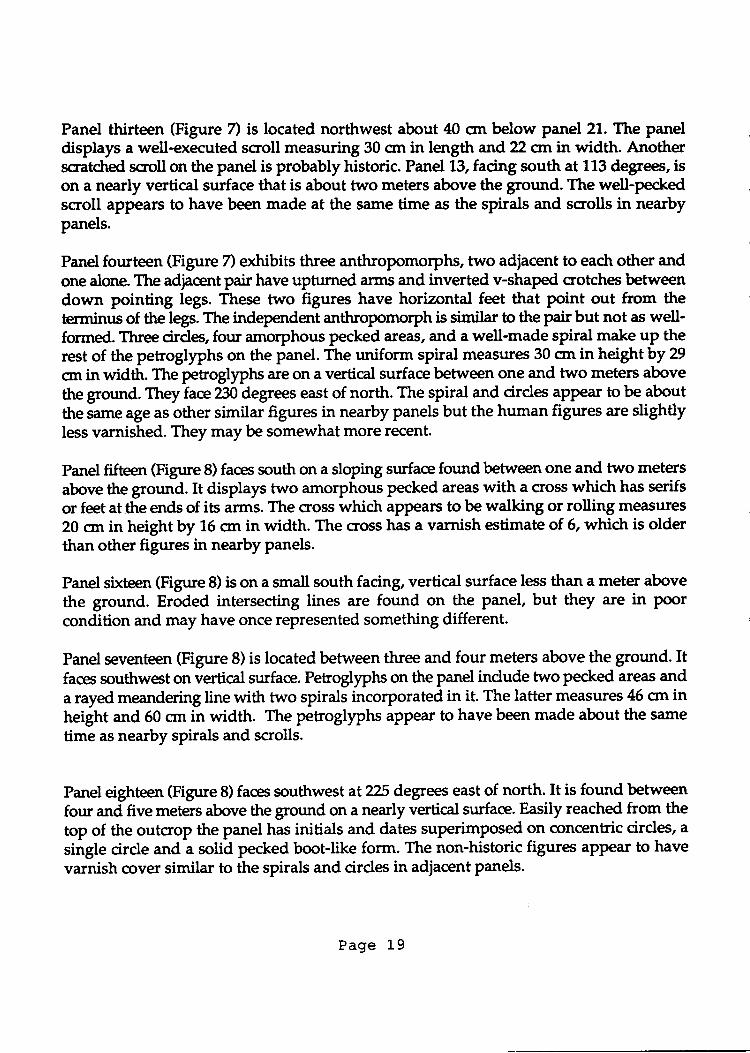
Panel thirteen (Figure 7) is located northwest about 40 cnr below panel 21. The paneldisplays a well-executed scroll measuring 30 cm in length and22 crn in width. Anotherssatdred scroll on the panel is probably historic. Panel 13, facing south at 113 degrees, ison a nearly vertical surface that is about two meters above the ground. The well-peckedscroll appears to have been made at the same time as the spirals and scrolls in nearbypanels.
Panel fourteen (Figure 7) exhibits three anthropomo{phs, two adjacent to each other andone alone. The adjacent pair have upturned €fins and inverted v-shaped crotche betweendown pointing legs. These two figures have horizontal feet that Point out from theterminus of the legs. The independent anthropomorph is similar to the pair but not as well-formed. Three cirde, four amorphous pecked areas, and a well-made spiral make up therest of the petroglyphs on the panel. The uniform spiral measures 30 cm in height by 29
cnr in widttr. The petroglyphs are on a vertical surface between one and two meters abovethe ground.Th"y fae?30 degrees east of north. The spiral and cirdes aPPear to be
"boltthe same age as other similar figures in nearby panels but the human figures are slightlyless varnished. They may be somewhat more recent.
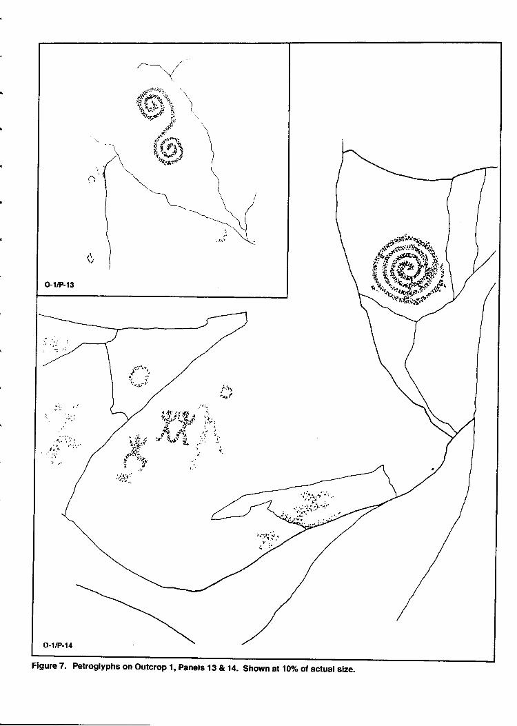
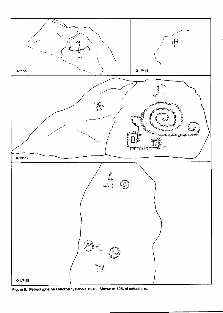
Panet fifteen (Figrrre 8) faces south on a sloping surface found betrreen one and two metersabove the ground. It displays two amorphous pecked areas with a cross whidt has serifsor feet at the ends of its arms. The cross which appear to be walking or rolling measures20 on in height by 1,5 crn in width. The cross has a varnish estimate of 6, whidt is olderthan other figures in nearby panels.
Panel sixteen (Figure 8) is on a small south facing, vertical surface less than a meter abovethe ground. Eroded intersecting lines are found on the panel, but they are in poorcondition and may have once represented something different.
Panel seventeen (Figure 8) is located between three and four meters above the ground. Itfaces southwet on vertical surface. Pehogllphs on the panel indude two pecked areas anda rayed meandering line with two spirals incorporated in it. The latter measures 45 cm inheight and 50 crn in width. The petroglyphs appear to have been made about the same
time as nearby spirals and scrolls.
Panel eighteen (Figrrre 8) faces southwest at2?5 degrees east of north. It is found betweenfour and five meters above the ground on a nearly vertical surface. Easily reached from thetop of the outcrop the panel has initials and dates superimposed on concentric cirdes, a
single circle and a solid pecked boot-like form. The non-historic figures aPPear to have
varnish cover similar to the spirals and cirdes in adjacent panels.
Page 19
-
-
Flgure 7. Petroglyphs on outcrop 1, panels 19 & 14. Shown at 10% of actual size.
j.\
o'1/P-15
7 .J.:
ji'
'h-r9o'- .r.slF?f;b{pr.'+
r..'-=# +i.*,: f A
.ii3.i:*H;L#Efr# i#f,,.Ep.g j--gy*J."*fu.
./
o-1tP-17
?:
'rIS'ii!
i;\i:' {.,rit
tj*uu.'rIi;?n.{y
'2tF!
o'1/P-18
Figurc 8. Petroglyphs on Outcrop 1, Panels 1$18. Shown at 10% of actual slze.
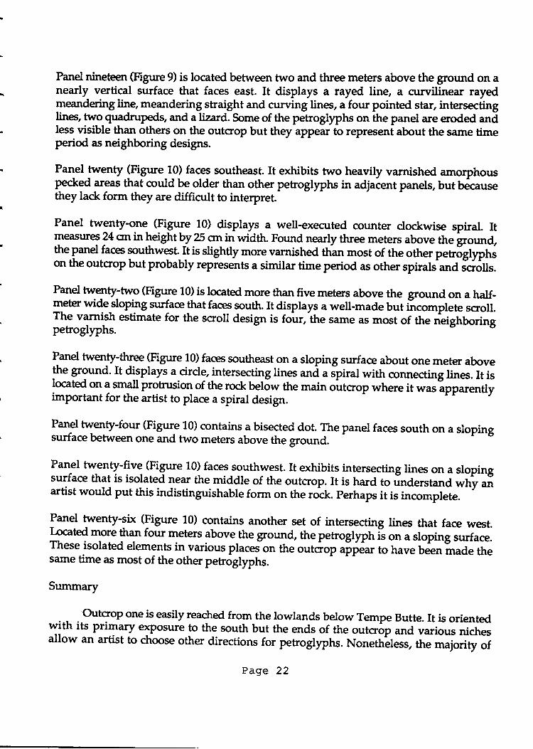
Panel nineteen (Figure 9) is located between two and three meters above the ground on anearly vertical surface that faces east. It displays a rayed line, a ctrrvilinear rayedmeandering line, meandering straight and curving lines, a four pointed star, intersectinglines, two quadrupeds, and a lizard. Some of the petroglyphs on the panel are eroded andless visible than others on the outcrop but they appear to represent about the same timeperid as neighboring designs.
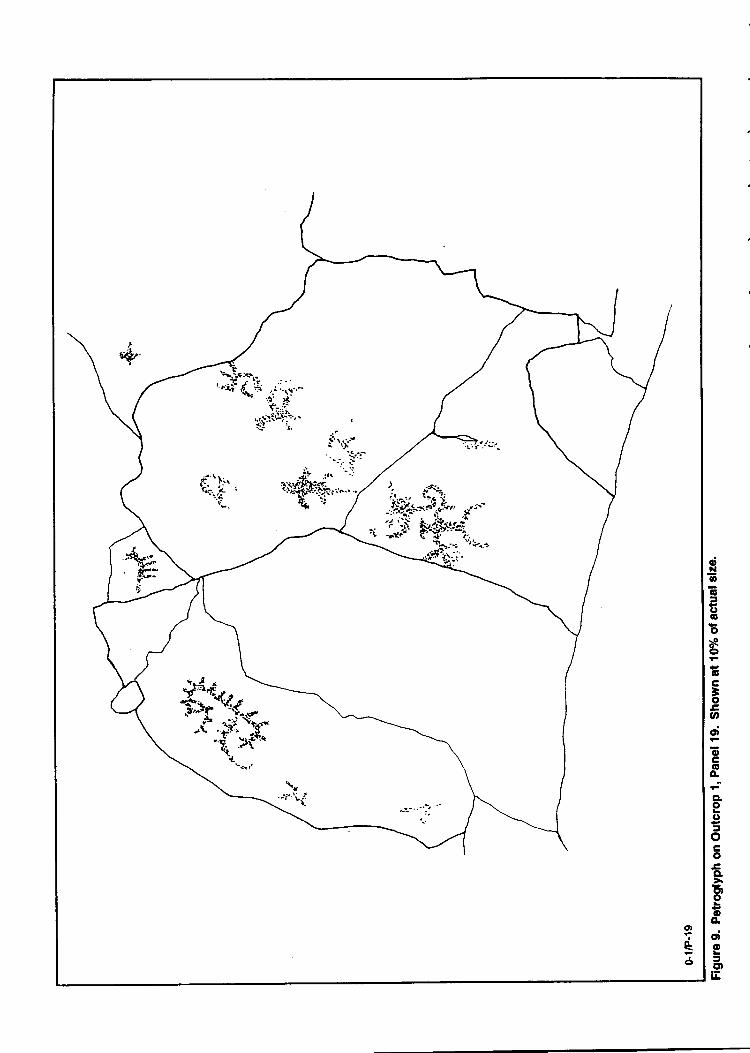
Panel lt"t ty lFigure 10) faces southeast. It exhibits two heavily varnished amorphousPecked areas that could be older than other petroglyphs in adjaient panels, but b&ausethey lack form they are difficult to interpret.
Panel twenty-one (Figure 10) displays a well-executed counter clockwise spiral. Itme:rsures 24 srtin heightby 25 on in width. Found nearly three meters above the groundthe panel faces southwest
{t is slightly more varnished than most of the other p"tt|gf}"},ton the outcrop but probably represents a similar time period as other spirahana Jd6Us.
Panel twenty;two (Figure 10) is located more than five metes above the ground on a half-rleter widesloping surface that faces p,rtt . It disptays a well-made but ircomplete scroll.The varnish estimate for the scroll design is f&r, the s,une as most of the neighborin!petroglyphs.
Panel twenty-three (Figure 10) faces southeast on a sloping surface about one meter abovethe ground. It displays a circle, intersecting lines *d u Jpiral with connecting lines. It islocated on a small protrusion of the rock below the main outcrop where it waslpparentlyimportant for the artist to place a spiral design.
P*9 twenty-four (Figure 10) contains a bisected dot. The panel faces south on a slopingsurface between one and two meters above the ground.
Panel twenty-five (Figure 10) faces southwest. It exhibits intersecting lines on a slopingsurface that is isolated near the middle-of the outcrop. It is hard to ,irrd"rrt*a wfry aiartist would put this indistinguishable form on the rock. Perhaps it is incomplete.
Panel twenty-six (Figure 10) contains another set of intersecting lines that face west.I-ocated more than four meters above-the gro,rld, the petrogllph is on a sloping surface.These isolated elements invarious places on the outcrop appear to have been made thesame time as most of the other petroglyphs.
Summary
Outcrop one is easily reached from the lowlands below Tempe Butte. It is orientedw.ith its primary exPosure to the south but the ends of the outcr6f "t
a v*ious nichesallow an artist to choose other directions for petroglyphs.NonethLless, the majority of
Page 22
'?*. .;-'t'.,+ ;.i'1:"
ft,,f::t*iqj:"
ot.o..-''j.. i:"
;! .,,. "l'l't;tt{?'.Sh,*.. ./
q+n /
ot
e6
a;Allo6:.J6o-oo\o6-tr-ooo;
otroO.-
eoot-oCoECIb-ro)oocd<o=C'tE
3
Figure 10. petroglyphs on Outcrop r, r"n"
;!:inV\
o-2tP-2 o-ztP-4
i. i4.
'ti,ro-2n-3
Figure 11. Petroglyphs on outcrop 2, panels 2€. shown al l(Fh of actual size.
entering or leaving the ro& The majority of the elements were assigned a varnish estimateof four, but parts of the varnish on the lizard figure and some areas of the crescent are
lighter suggesting repecking.The spiral at the lower right was assigned an estimate ofeight, suggesting it predates other figures in the panel.
Panel four (Figure 11) is oriented toward the south on a small panel slightly more than ameter above the ground. A single squiggly line is found on the panel.
Panel five Gigure 11) faces south on a vertical surface about 30 crn above the ground. The
only petrogly"h on the panet is an undulating line that may rePresent a crude quadruped.
It was assigned a varnish estimate of three.
Panel six (Figure 11) is an exfoliating vertical shelf of the outcroP that faces southeast.
Fotsrd on theLast end of the outcrop, the petroglyph is a quadruped with a boat-shaped
body and short, straight legs. Its long neck, an extension of the body,has a pointed h$$and'curving horns. Ttre entire quadruped is enclosed in an oblong oval form. The varnish
estimate for the figure is four.
Summary
Outcrop two is situated on the south side of Tempe Buttg about onethird of the wayup. It displays several panels of individual or minor PetroglyPhs and a single panel ofwell-made figures. The latter dominates the outcrop.
A large crescent shaped circular form with a thick perimeter line is found in the
major panel. Hidden in this thick line, a Lizardman is emerging_from a crack in the rock.
A distinct quadruped, probably a sheep and a less distinct quadruped of unknown Wpe,are found on the upper sides of the crescent, while a well-formed scroll and a heavily
varnished spiral are found on its open side.
The majority of the petroglyphs on the panel were assigned a varnish estimate offour. This is consistent with nearby figures-
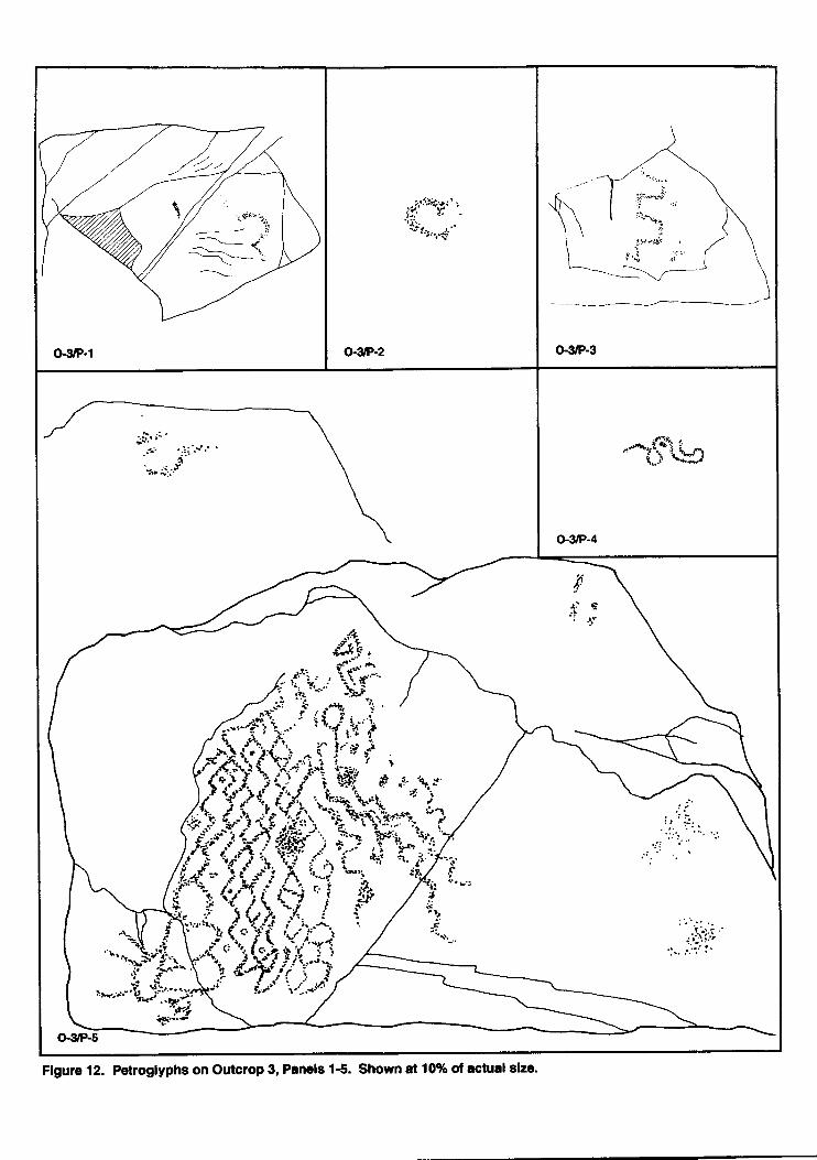
Outcrop Three
Outcrop three is sittrated at the base of the current viewing plafform area about two-
thirds of the way up the butte (see Figure 4 above). Sixty-six petroglyph elements were
recorded on 34 ian-ets at outcrop three. Like other outcrops on the south side of Tempe
Butte, outcrop tt t* is oriented primarily toward the south but the west and east ends ofthe outcrop were also available for petroglypht. The o<posed top of outcroP three was also
a good place for petroglyPhs.
Page 27
Outcrop three is heavily impacbd by the visibrs who use the trail system on TempeButte. The asphalt trail and stone retaining wall help to keep visitors off the outcrop butthere are still many who go off the controlled areas. There is onsiderable broken glass andother trash in the crevices and around the base of the outcrop.
There is a small grotto on the south of outcrop three whictr, penetrates the basaltabout one meter. Approximately two meters of level area in froni of the grotto offersth:ltg. During the recordilg of outcrop three, we noted a side-notchea propcUte point,a feather, and a small pile of ceramic sherds in the shelter. The projectile point washadeon a flat basalt flake with litde shaping except to give it a poin-ted end and side notches.
It appgars to be of recent manufacture, perhaps within the past few years. The point wasfound YJh 1 group of used paper matches in a small offering pile at the mouth of thegrotto. The feather was ttrcked into a crack in the side of the grotto. It was decayed butaPPgars to rePresent alarge bird, possibly an eagle. The eight ceramic sherds were put ona-fedge in the grotto. They include plain orange ware, red-on-buff ware, and an or"t g*slipped ware. Thesg objectg appear to represint "new age" offerings - objects made"orcollected and placed near the petroglyphs in some smaf ceremot/Uy individuals whopractice some form of "mother earth" beliefs.
Thegrotto was probably used in prehistoric times, as well. Even though there hasbeen considerable impact by modern intruders, the grotto could still contain evidence ofits former use. The ceiling is not smoke-blackened nor are there any visible culturaldeposits near its
^9Ylh. This suggests it was likely not used for extensive domiciliary
pursuits, but it could have served as a shaman's ciche or a place for offerings. In otherwords, it may have been used in the past much the way ii appears to be used in thepresent.
P-*d one (Figure 12) faces 198 degrees from magnetic north on a vertical surface 1 meterabove the ground. The panel has a ctrrvilinear mJandering line, and a amorphous peckedarea. The element was assigned a varnish estimate of four.
Panel two (Figue 12) faces south on a rock surface that is nearly vertical. A single crescentor circle was recorded on the panel. The petroglyph was
"ssigned a varnish estimate of
four.
Panel three (Figure 12) faces southwest on a vertical surface 15 on above the ground. Arectangtrlar meandering line and some amorphous pecked lines are the only elEments onthe panel. Th"y were assigned a varnish estimate oi fi.r".
Panel four (Figure 14 f on a sloping surface about one meter above the ground. It exhibits
a squiggly undulating line about 22srtacross its maximum dimension.-It faces southweston a panel 78 cnr west of the main panel on the outcrop.
Page 28
/-
i'
^ -{---l
ir
o.3/P-s
fi'r, \.----,-
_/,r*"r'S /f;'i";- iif,-u'i
$trffi',,,r
ffiffif1{:i;.1',-'a.,*-'A*r;
Figure 12. Petrogtyphs on Outcrop 3, Panels 1€. Shown at 10% of actual slze.
Panel five (Figure 12) is the main panel on the outcrop. It is found at ground level on avertical surface that faces south at 190 degrees east of north. The panel measures 110 cntin height by 170 on in width; much of the western half of the panel is covered withPetroglyph design. The largest design is a group of vertically oriented diamond drainswhich parallel each other across the panel. Some of the diamond patterns have cirdes ordots in their interior while other dots and cirdes appear to have been added to the design.An angular scroll and several areas of amorphous pecking make up the remainder of thepanel. Large groups of chains like these are often labeled 'blanket designs", but they areprobably more properly associated with the "Hohokam pipette". The varnish estimate forthe main petroglyphs in the panel was five, but there are obvious areas of more recentsaltdqng and pecking. The panel appears to have been made and then added to by otherindividuals at a later time.
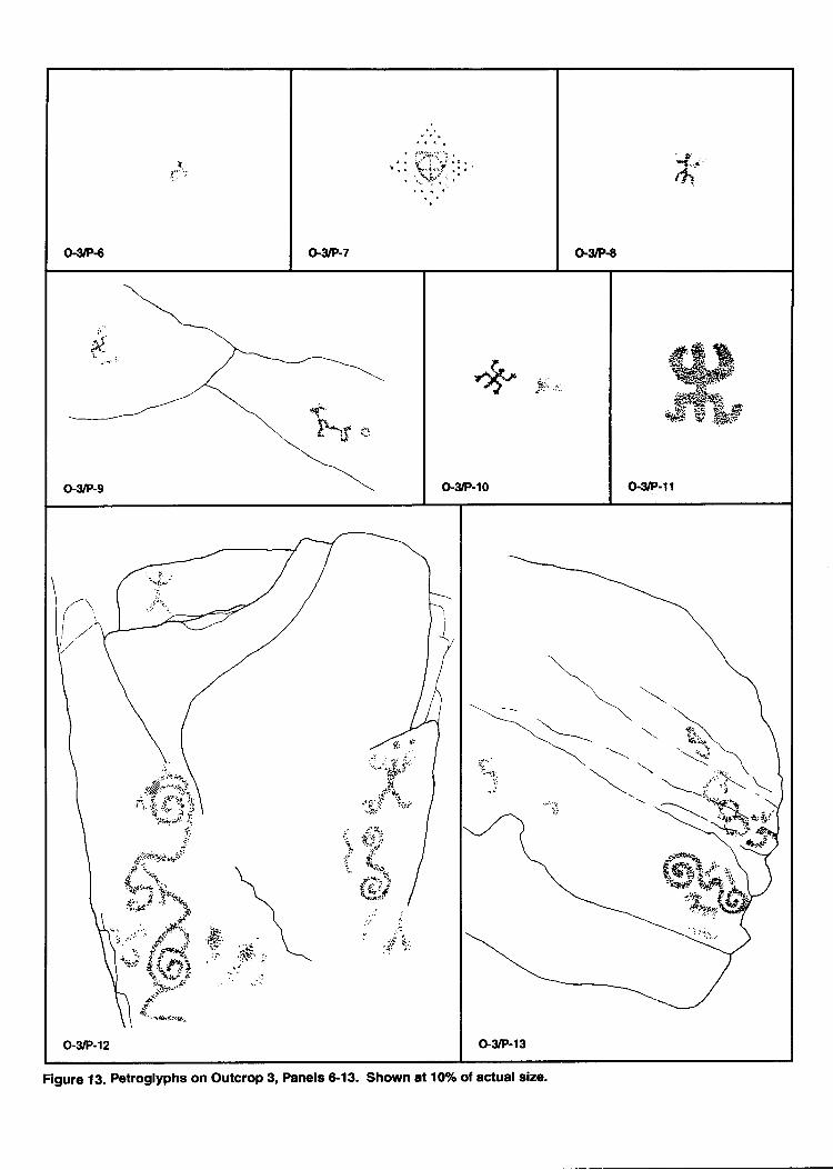
Panel qix (Figure 13) is a small south facing surface about a meter above the ground. Asquiggly line, assigned a varnish estimate of four, is the only peEoglyph on ttre panel.
Panel seven (Figure 13) faces south on a sloping surface located between 1.26 to 1.57 m.above theground. The single petroglyph on the panel is a diamond-shaped grid of dotswith a cirded cross in its interior. Assigned a rock varnish estimate of one, the petrogtyphapparently represents the recent "new age" visitors to the site.
Panel eight (Figure 13) exhibits a single lizard man with upturned anns, squareddownward turned legs and a tail or penis. Some small dots at the terminus of the armsmay have been intended as digits. The figure has a varnish estimate of 7.5 suggesting itmay predate othen getroglyphs at the site. Panel eight faces south at 158 degr& easfofnorth on a slightly sloping surface 1.59 to 1.g0 cm above the ground.
panel nine (Figure 13) is on a southwestfacing surface located between 52 crn and 114 cmabove the ground. It exhibits a squiggly line and a cross design which measures 11 cmacross. The varnish estimate for the petroglyphs is five.
l*"1 ten (Figtue 13) is a sloping surface which faces to the southwest It exhibits a digitatelizard man with squared arms turned upward, squared legs turned downward and-a tail
-ot P$s: An angular line is pecked near the anthropomorphic figure. The varnish estimate
for the figures is four.
Panel eleven (Figure 13) is located 42 cn above the ground surface on a south facingsurface that slopes slightly. A single lizard man is founa on the panel. He differs frorineighbors in the thicknesg 9f the pecking used to create his featuret.'Hir upraised anns .reon rounded shoulders while the legs are on a squared torso. The legs ut"'do*r,*ard withhorizontal_feet appended to their ends. This figures has a varnishlstimate of four, but itmay have been re-pecked.
Page 30
o€/P6 o-slP-7
,swat
t-{1
G3/P-8
"F" .qj
o'3/P-10
ffi##,ffi,s
G3/P-ll
,:
|iitr:g";,!E
.:rll
G3/P-13
Flgure 13. Petroglyphs on Outcrop 3, Panels &13. Shown at 1006 of actual eize.
Panel twelve (Figure 13) is located on a nearly vertical surface that faces almost directlyeast. This panel is a good example of the possible orientations for petrogllphs availableto the artists on the Tempe Butte. The petroglyphs indude a vertical group ofinterconnected spirals or scrolls that measure 54 cm across their greatest dimension.Another smaller scroll measures 18 crn high. Two anthropomorphs are made on straightbodies with rounded crossing arns, inverted v-shaped torsos and downward legs. Oneof thee, although badly exfoliated, has dots over its head. Other figures in the panel areamorphous Pecked iueas. Varnish is variable across the panel with estimates from four tofive for the petroglyphs.
Panel thirFen (Figure 13) et*dbits a double spiral or scroll design neasuring 31 cm acrossits maximum dimension and a group of connected cirdes or drain that measures 44 qnacross its macimum dimension. An area of amorphous pecking is also found on the panel.The varnish estimate for the petroglyphs is four. The panel, facing almost directly iorrth,slopes at120 degrees. It is located between 70 cm andl274crn above the ground.
Panel fotrrteen (Figure 14) is on a southeast facing surface located between 28 on and 154ctn above the ground. The main panel surface slopes at 155 degrees but the orientationchanges at other^ places in this panel. Petroglyphs on the panel include a wavy,mgandering line with enclosures at both ends, a horizontal scroll, a crudely pecked c"osswhich could repreent a human, a crude quadruped, ild a group of intersechng [nes. Ttrescroll in the most apparent figure in the panel. The varniJh estimate for the petroglyphsis four.
Panel fifteen (Figure 14) exhibits a single undulating wavy line with an enclosureinorrporated into it. Measurinq 13 on across its maximum dimension, the design is foundon a sloping surface oriented to the northeast at 45 degrees east of north. The varnishestimate is four.
Panel sixteen (Figure 14) faces east at 80 degrees; its surface ranges from nearly vertical! st_oping 110 degrees. Petroglyphs on the panel include a gro.rp of exfoliated concentriccircles and a single figure which has a vertical body, pointed snout, head and crossingarms that resembles a bird as much a human. This figuie is only 5 cm above the groundlThe varnish estimate for the figures is four.
Panel seventeen (Figure 14) is on a sloping surface with an inclination of 140 degrees.Itfaces southeast at 124 degrees. A single square-shouldered anthropomorpl *itf,downward pointing arms and legs is found on the panel. It was assigrred a varnishestimate of four.
Panel eighteen (Figure 14) exhibits a tailed circle with a varnish estimate of four. Thepanel faces southeast on a vertical surface about a meter above the ground.
Page 32
o'3/P-14
!,i::..Ar. $',.?''::r 'il ) :
t*
,/ ::'.-,,
/y,!*'"r:..+t ;f'r^,,Jt,,3
';l?:'r"' rx
:j' -.:"3'\"ic.!'- .1.
"".;ai..':i#s,t'1'':'
:-'1i:
Gg/P-l5
."t's'-;!
F :.- ,i
L
o-s/P-l6
i:ir
,7r,.#fusr,tqtr,;., i '+:.
",r/ n;.l:r,.
.''.{ 'i!ir' .
)
o-3/F-17
:t'
,s*\{**#
G3/P-18
,. ii..,i';1Y
rrl'''tr;i!.
-'j&-''"r
.., ,.
o-3/P-19
o-3/P-20
<,-..J'
?{
o-3/P-21
Figure 14. Petroglyphs on Outcrop 3, Panels 14-21. Shown at 10% of actual size.
Panel nineteen (Figure 14) displays a single square-shouldered anthropomorph withupraised arms and downward legs. One leg is missing, however. The panel faces east at110 degrees and overhang at an angle of 75 degrees. The varnish estimate for the poorlyforrred figure is four.
Panel twenf Gtgrrte 14) faces northeast on a sloping surfae. Two broken or partial cirdesand an undulating line are found on the panel. These figures may be affected by visitortraffic to the site. They were assigned a varnish estimate of four.
Panel twenty-one (Figure 14) exhibits a cirde attached to a trident forrr that may havebeen intended to be a human. Like neighboring panels it is an isolated element with amplesurface near it for other petroglyphs. It is on a surface that slopes at 130 degrees and faceseast at 70 degrees. Its varnish estimate is four.
Panel twenty-two (Figure 15) faces north at 9 degrees. On a nearly flat surface with anangle of 150 degrees, it could also face up. Eroded cirdes and crosses make up theelements on the Panel. These are impacted by foot traffic, initials, and an incised cross. Thecrosses may be the product of Christian priests or other Christians who put them on therock to negate or exorcise the power of the petroglyphs.
Panel twenty-three (Figure 15) faces southwest on a vertical surface. A single curvilinearenclosure with a crescent shape is found on the panel Some added pecking to the panelmay have been done at or near the time the figure was made while other pock marks maybe from shooting bb's at the panel. The varnish estimate for the crescent is four.
Panel twenty-for:r (Figr:re 15) displays a poorly formed Lizardman with squared shouldersand upraised Eurrrs. The legs are eroded. The single figure is on a vertical surface orientedto the southwest. A large chunk of the outcrop surface is missing to the right of this figuresuggesting someone may have taken petroglyphs from the outcrop. The figure wasassigned a varnish estimate of four.
Panel twenty-five (Figure 15) is on different facets of the outcrop that generally face south.The lowest is 25 crn above the ground while the highest is about one meter. Ananthropomorph with square shoulders, upraised arms and downward oriented legs on aninverted v-shaped torso is found with amorphous pecking and an undulating line on thePanel. Significant Eueas of graffiti near these figures were noted but not recorded. A smallcirde with tangent lines is located on the rock surface 0.30 meters below the main part ofthe panel. The varnish estimate for the prehistoric elements is four.
Panel twenty-six (Figure 16) exhibits a single meandering line with a varnish estimate offour. The rock is exfoliating badly near this panel which faces southwest on a slopingindination of 115 degrees.
Page 34
fiI, --tr i.-{\ .rL-'
o-3/P-23
!; -.'+r*:\r.'!,
--i.r \:. ! .ig + ,.:l
"2r..&!:.:: ..i'
o-otP-24
{eJ.r;t''*ue4t
;':.
,i:trl
o-3P-2s
r:1.'{'
Figure 15. Petroglyphs on Outcrop 3, Panels 22-25. Shown at 10% of actual size.
o-3/P-28
.;i:lliji'r f....i.#'':."jt$'"?:i5 /j
.:.t.j.
-l'.'.. tii; - ..'-'
, ..:j''':i.li.'':''i'i' "i.+:i'.i iit ':
o'3/P-29
o-3/P-30 o-3/P-31
o-&P-32 o-3/P-gl
Figure 16- Petroglyphs on outcrop 3, panels 26€4. shown at 107o ot actual size.
Panel twenty-seven (Figrrre 15) displays a single anthropomorph on a south facing surfacethat slopes at 130 degrees. It has squared shoulders and torso with upraised arms anddownward oriented legs. It displays the ubiquitous tail or penis of the lizard man motif.The figure was assigned a varnish estimate of four.
Panel twenty-eight Gigure 15) is on a nearly vertical surface oriented southwest at24}degrees east of north. A cirde inside another with rays off opposing sides is the onlyelement on the panel. The figure was assigned a varnish estimate of four.
Panel twenty-nine (Figure 15) is on a slightly sloping surface that faces west. A silgl,eanthropomorph is found on the panel with a varnish estimate of four. The{iqure whichis attaihed to a crack in the surface, has squared shoulders and torso with downwardpointing arr$ and legs; it displays either a tail or penis.
Panel thifty (Figrre 15) is on a sloping strface with an indination of 140 degrgT that faces
southwest. a sit gte meander lineis found on the panel, but missing areas of the outcrop
near the figure mly have once had petroglyphs that were removed. The varnish estimate
for the figure is five.
panel thirty-one (Figure 16) faces 150 degrees from magnetic north. The rock surface has
an inclination of 126 degrees, and is located 1..50 meters above the current ground surface.
A single anthropomorpt /lizatd figure is found on the panel. The surface of the Panell:bady?eterioratid, and the petroglyph is indistinct. The element was assigned a varnish
estimate of four.
panel thirty-two (Figure 15) faces 100 degrees from magnetic north. The rock surface has
an inclination of f3O-degree. Two elements are present on the panel. One is a faint cirde,
and the other is a crosl in a square enclosure. The petroglyphs were assigned a varnish
estimate of four.
panel thirty-ttuee (Figure 16) faces east at 80 degreer.T" panel t*{".: has an indination
of 135 degrees, andls 1.45 above the modern ground surface. A single quadruped witlthorns is piesent near the center of a large rock face. The element is heavily overgrown withlichens
"t a tne figure is not distinct. The petroglyph was assigned a varnish estimate of
five.
panel thirty-four (Figrrre 16) faces 60 degrees from magnetic_north. The panel has a single
cross thatis on a laige rock face. lhe element was assigned a varnish estimate of four.
Summary
Ogtcrop three contains another of the primary grouPs ofpetrogl{Pht on the basalt
exposrues along the south side of Tempe Butte. The outcrop is near the present visitor
Page 37
viewing area where most individuals who hike the trail stop to view the city and theArizona State University campus to the south.
An impressive group of vertically oriented diamond shaped chain paterns is found,f""itg sorth, on the lower side of the outcrop. Other petroglyphs are found in a variety oforientations with-some facing all directions of the compass. The number of single andisotated Petrogl)"hs is worth noting. The large number of different surfaces availible formaling Peg%brPtts mayacrcoturt for thee isolated petroglfhs, and they may also be thework of individuals who have chosen to place their images away from the others. On theother hand, the main panel of diamond chains has dear evidenie of use by others after itwas made, perhaps placing images on or near it to obtain some of its power.
Although the majority of the peuoglyphs on the outcrop appear to be related to theHohokam rock art at the site, some are heavily varnished. Some oi ttre recent petrogllphscottld be the work of-Christian priests who may have put crosses on the rock ti t
"git! tf,"
nativePower, and still other appear to be the result of "new age" ritual. A small frotto ittthe outcrop apparently receives use from the "new age" ritualists.
Outcrop Four
The outcroP is situated near the top of the butte where it forms the saddle betweenits west and east ends (Figurc17). Areas of the south side are vertical cliffs with drops offive or six meters wt-tite lesser ledges are found along the bedded top of the orrttop.Orientation of petroglyphs in any direction was availaSle to the prehistoric artists.
A fence bisects the outcrop from north to south. This fence is the boundary betweeng" Ciry of'Tempe ProPerty and the Arizona State University property to its east where SunDevil Stadium is located. Although there are petroglyphi at'various locations on thiseastern portion of the butte, they were outside the scope of this researcl.
Mudt of the area of oulcrop four is altered by humans. In places, the rock varnishis nearly worn off by foot traffic and it is clear that large chunks of tf," basalt are missingfr9-mgther places. These_may have been removed for SnUait g purposes or simply to roiloff the butte. Some of these, including one which was founl it tft" base of tf,i 6"toop,had petrogtlphs on them.
The fence dividing the property was put on petroglyph panels and additionallttemPts toward ryking the fence impenetrabll have a*"g"d peiroglyphs. The currentfoot traffic through a hole in the fenc-e is over a petroglypnianir.
a J L
- Large amounts of graffiti on the south side of the outcrop have been covered witha brown Pl"td Paint At one time there was a large slogan placed on the outcrop whichread "Africa Unite. End Apartheid", but now thi-s is oity partially legible through the
Page 38
TEMPE BUTTE
+ P€roglyph Panel Localion
A i,rapfring Stalion
0?550
llotarg
I
N
Figure 17. Map showing locations of panels on Outcrops 4,24,25,26,T1,28,29' and 30.
peeling brown paint.
Eighteen Panels of rock aft were recrrrded on the outcrop. These had 56 petroglyphelenents on them but the nurnber of petrogllphs in this area of the butte was undoubtedlydouble that in prehistoric times.
Panel one (Figure 18) faces southwest on a sloping surface with an inclination of 115degrees. The petroglyphs still visible on the panel indude a set of intersecting straight linesthat may have once been a walking cross form and an eroded anthropomorph that oncemay have held a hoop. Both figures are too eroded for adequate classlfication.
T*d two (Figure 18) is the end of a bedded ledge with several surfaces that are inclinedfrom 82 degrees to 115 degrees. Th"y face southwest. Three sets of concentric circles, onewittr rays and a sPiral are the most important petrogllphs remaining on the panel. Theseare intermixed with amorphous pecked areas and modern graffiti. Scratching over sreasof the grigiTt petrogllphs may also represent prehistoric associations with th6panel. firevarnish estimate for the prehistoric figures is four to five.
Panel three (Figure 18) displays a chain of circles, assigned a varnish estimate of five, thatare eroded. They face southwest on a sloping panei surface with an inclination of 120degrees. The initials W.K. are carved above the circles.
Panel four (Figure 18) is situated on a small sloping facet of the outcrop sloping 130degrees to the southwest. The singFpetroglyptr onihe panel is an invertea anguiar io*.It was given a varnish estimate of five.
l-d fivg Gigure 19) faces southwest at2Edegrees east of north. Sloping at 110 degrees,9" p-,"t o&ibits a vertical line with two crossing horizontal lines *'a .ot .ntric circles.The varnish estimate is four for these figures.
P*9 six (Figure 19) is on an eastern elposure where it faces southeast on a nearly verticaltd1*: APecked cross, abisected circle and an amorphous pecked.uea are found on thePanel. Apparently the s.une age the peEogtyphs werelssigned a varnish estimate of four.
Panel seven (Figure 19) slopes a1?5 degrees on a south facing slab of the outcrop. A stipplepecked cirde and connected concentrlc circles are found Jn the upper part of the p'anelwhile two anthropomorphs_appear below them. The hum* iii"t"s have squaredshoulders and torsos,one with upraised arms and the other with dJwnward ". r. I,"g,are eroded. The varnish estimate for all the figrrres is four. A block of the outcrop that miyhave once had rock art on it is missing from an.rea adjacent to this panel.
Panel eight (Figure 19), on a rock surface with an inclination of 120 degrees, facessouthwest. The petroglyphs on the panel, assigned a varnish estimate of fivelinclude an
Page 40
Figure 18. Petroglyphs on Outcrop 4, Panels 14. Shown at 107o of actual size.
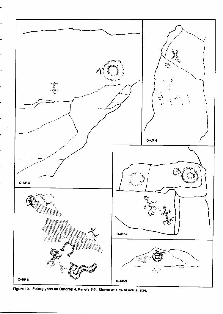
Figure 19. Petroglyphs on outcrop 4, panele $9. Shown at 107o d actual size.
outlind snake or currrilinear endosure with a crescent shape a horseshoe shaped figure,an amorphous pecked :uea, an enclosed curving and rectangrlar form and twoanthropomorphs. The latter differ in that one has straight crossing arrns on a straight-bo$yand rectangular hips with down pointing legs. This figure has a tail or penis while theother figrrre-has a straightbody, crossing, upraised arrns, and legs on an inverted-v torso,but no tail or pmis. Exfoliation on the panel may have destroyed some other petroglyphs.
Panel nine (Figure 19) faces southwest on a surface that slopes 120 degrees. A Peckedspiral on the panel has scratched or incised cross-hatching over 1 Part of it with other
scratching near it The incised patterns appeil to be prehistoric. The figures have a varnishestimate of five.
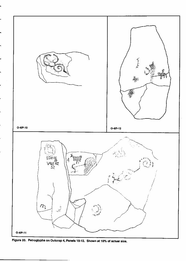
Panel ten (Figure 20) exhibits a spiral corurected to a curvilinear form and a pecked straightline. The p*"1 faces southeast on a nearly flat surface with an inclination of 766 degrees.
The surfice is too badly deteriorated to assign a varnish estimate.
panel eleven (Figrrre 20) displays a circular amorphous pecked Tea, the graffiti of EDDIE
VAI-ENZ 52, concentric circles, a quadruped with only two legs shown, another concentric
circle where the interior circle touches the outer one, and a spiral or scroll that measures
4d cm across its maximum d.imension. A grinding slick,located on the sloping surface near
the quadruped, may have been associated with the pehoglyphs. The surface of the panel
inclines at 155 degrees and it may have been intended to point skyward. A varnish
estimate of four was assigned to the elements.
panel twelve (Figure 20) is oriented toward th" sky on a surface with an inclination of 170
degree. Exhibiting primarily amorphous pecked area-s there is a possible -anthropomorphs*i
" possible qn"-at tp"a ot the pur,el. Erosion from foot traffic has nearly obliterated the
petroglyphs.
panel thirteen (Figure 21) is oriented toward the north on a surface that slopes I 134
degrees. Rectangular boxes inside boxes and an amorphous pecked area trre found withinitials FA and GL ot the panel. The varnish on the geometric group endosed boxes is
seven suggesting it may bi older, but the flat surface may simply aPPear darker from
settling water.
panel fourteen (Figure 21) exhibits a single tizard man with rounded shoulders and
upward pointing ui*s. The figure has a rounded body, dgwnw-a1d oriented legs,and a
t"il ot p*ir The-figure measures 32 on in height. The panel on which it is found is facing
the eait atTl degrlr "urt
of north. It surface slopes at an indination of 155 degrees. The
varnish estimate for the lizard man is four.
panel fifteen (Figure 21) is on a vertical surface that faces west at 281 degrees.The Plneldisplays a spiralirdth connecting ray lines and a rectangular figure with a head, two legs
Page 43
G4/P-10 o-4tP-12
:ii .i
I-'$; II t+.{,...,l t,
.\t r'"''i.. \
: i i i1: :. f ii -j'.. -;- s'
,lr/
.:n I
O"/t/P-l1
Figure 20. Petroglyphs on outcrop 4, panets 10-12. shown at 107o of actual size.
O'IVP-13
i .,.rst 'i'6-i'q
-1t,:.-rfl..C
tlit '
-I,i,s$f4
(!'ruP-15 "+3
Figure 21. Petroglyphs on Outcrop 4, Panels 1&17. Shown at 107o of actual size'
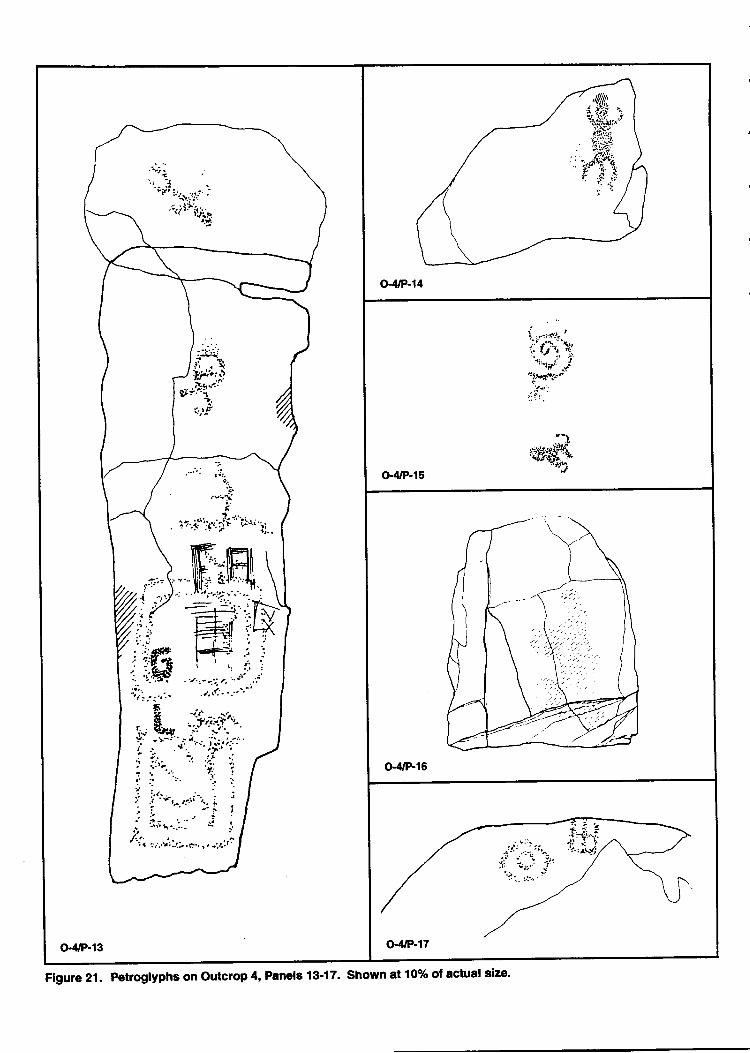
and a curved tail that reserrbles a monkey. The panel is at the highet point on the outcrop.The varnish estimate for the figures is four.
Panel sixteen (Figure 21) was assigned to a ground area over the top of a boulder locatedin the talus below the outcrop. Apparently the boulder has either fallen or was pushedfrom an area in the outcrop near its top. Light brown, blue, and yellow paint, of modernderivation, is found over much of the upper surfacre and side of the boulder.
Panel seventeen (Figure 21) is on the side of the boulder. It exhibits a cross enclosed in arectangle and concentric cirdes. Because the panel has been moved, its orientation is nolonger relevant.
Panel eighteen is located on a flat surface near the top of the outcrop where it pointsskyward. An amorphous pecked area on the panel resembles an anthrbpomorph. It hassome scratched lines over it.
Summary
The outcrop is located along the saddle between the two primary parts of TempeBlT". Petroglyphs are found on the steep southern exposure
"t i o. teiges near the tip
of the outcrop.
Foot traffic and human destruction have greatly altered the outcrop and the rockart.-Spirals and concentric circles continue to be impoitant elements, but there are well-T"d9 and cnnspictrous human and quadruped formJon the outcrop as well. No elementsdominate the rock
"tt o.t theoutoop-Many of the upward-facing rock surfaces on the ;;
oi the butte aPP€ar to have been utilized as grinding slicks durlng prehistoric times, butthe wear caused by foot traffic in the area complicatls identificati-on of these features.
This outcrop exhibits an attempt at painting the basalt to cover graffiti. Theconservation section of this report discusses the merits and shortcomings of"p"ir,tit g or,a rock surface in greater detail.
Outcrop Five
The outcrop is located on the south side of Tempe Butte below the enclosure withthe water towers (Figure 22). The outcrop is near a drainage channel off the butte whichcollecb moisture and supports a slightly dlnser vegetation ihan nearby areas of the butte.
An alcove on the south side of the outcrop contains a grotto that offers someprotection from the elements. The lion's share ofthe petroglyphs oi the outcrop are foundin this area. As with other outcrops on the south side of ti6'U"tt", the main orientation isto the south but becawe the basllt layer eroded into ledger
"trd crevices, an artist had
Page 46
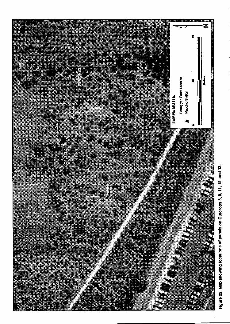
rd
!,Ac6G{
FA
dU'ttqo(,5oCAo!2oc6eo6ce6^(,.9CD
E;aosae6=-ci6|o=!P-lr
-
--1
many differing facets of the rock on which to put petrogllphs. At outcrop five, the east endoffered some excellent surfaces for petroglyphr. Recent offerings were observed on theoutcrop, induding cigarettes and bundles of sage.
Access to the outcrop would have been easy from the surrounding lowlands.Ceramic sherds of plain wares and lithics were noted in the soils near the outcrop. An areaof bedrock mortars was located downslope to the southwest, and a grinding slick ispresent to the west.
Twenty-three panels of petroglyphs were recorded on the outcrop. Seventy-fivepetrogllph elements were assigned letter designations on the panels; nine panels containonly a single petroglyph while eleven are the most found on a panel.
Panel one (Figure 23) is located on the edge of the grotto where it faces southwest on avertical surface. An anthropomorph and a tailed cirde with varnish estimates of four are
on the Panel The anthropomorph has square shoulders and upraised arms; ib legsare downward on an inverted-v shaped torso.
Panel two (Figrrre 23) is on a slightly sloping surface on the face of a ledge at the back ofthe grotto. It faces south at 191 degrees east of north. Located between onelnd two metersabove the ground, the panel is eroded and difficult to see in poor light. The dominantpetrogllph on the panel is a long undulating horizontal line that measures 62 crn acrossits maximum dimension that may represent a snake. Another wavy line and an amorphousPecked area make up the remainder of the petroglyphs on the panel. The varnish cover forthe petroglyphs is estimated at five to six.
Panel three (Figure 23) faces south at 794 degrees east of north. It is situated on a verticalsurface between L.5 and 1.9 meters above the ground. Petroglyphs on the panel includeconnected cirdes, a single cirde, and an amorphous area. The varnish estimate for thepetroglyph elements was five.
Panel four (Figure 23) faces southwest at2],4 degrees east of magnetic north. It is locatedon a vertical surface between 4 and 4.5 meters above the ground. ftuee recognizable circlesand a fourth eroded circle are the main petroglyphs on the panel. A densJy pecked areathat may be a quadruped in profile and pecked amorphous areas constitute the remainderof the rock art. The panel is deteriorating and in poor condition.
Panel five (Figure 23) is in the alcove and grotto area where it faces southeast at 145degrees. It is on a vertical surface more than four meters above the ground. A single circlewith a dot in it or a bull's eye is found on the panel. The varnish estimate for the filrre wasfour.
Panel six (Figure 23) is beneath panels four and five on a sloping surface with an
Page 48

Gs/P-1
o-5/P-3 o.5/F-4
o-s/P-5
Figure 23. Petroglyphs on Outcrop 5, Panels 1-7. Shown at 10olo of actual size.
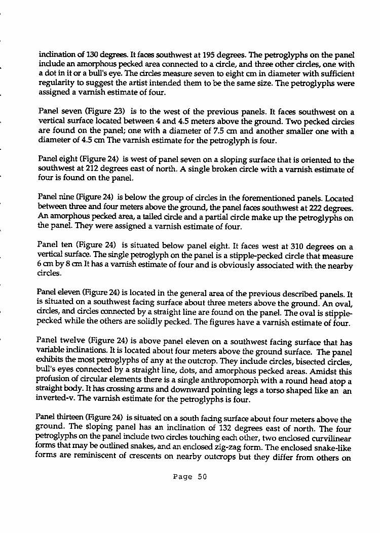
indinationof 130 degrees.Itfaces southwest at 195 degrees. The perogllphs on the panelindude an amorphous pecked area connected to a cirde, and three other cirdes, one witha dot in it or a bull's eye. The cirde measure seven to eight cm in diameter with sufficientregularity to suggest the artist intended them to be the same size. The petroglyphs wereassigned a varnish estimate of four.
Panel seven (Figure 23) is to the west of the previous panels. It faces southwest on avertical surface located between 4 and 4.5 meters above the ground. Two peckd cirdesare found on the panel; one with a diameter of 7.5 cnr and another smaller one with adiarneter of 4.5 crn The varnish estimate for the petroglyph is four.
Panel eight (Figure 24) is west of panel seven on a sloping surface that is oriented to thesouthwest at272 degrees east of north. A single broken circle with a varnish estimate offour is found on the panel.
l*"1 nine (Figrrre 24) isbelow the group of cirdes in the forementioned panels. Locatedbetween three and four meters above the ground the panel faces southwesiat ??? dggrees.
{n amo-rplus Pecked area, a taited cirde and a partial cirde make up the petroglyphs ottthe panel. They were assigned a varnish estimate of four.
Panel len lFigure 24) is situated below panel eight. It faces west at 310 degrees on avertical surface. The single petrogllph on the panel is a stipple-pecked circle thal measure6 on by 8 ort It has a varnish estimate of four and is obvioully issociated with the nearbycirdes.
l*9 eleven (Figr:re 24) is located in the general area of the previous described panels. Itis situated on a southwest facing surface about three meters above the ground.-An oval,cirdes, and cirdes connectd by a straight line are found on the panel. T?re oval is stipple-pecked while the others are solidly pecked. The figures have Jvarnish estimate of iour.
Pale_l_twelve (Figur_e 2! is above panel eleven on a southwest facing surface that hasvariable indinations. It is located about four meters above the ground siuface. The paneletddbits the mostpetroglyphs of any at the outcrop. They include circles, bisected .ii.l"r,bull-s eyes connected by a straight line, dots, and amorphous pecked areas. Amidst thisprofusion of circular elements there is a single anthropohorptr-with a round head atop agtaightbody. It has crossing arms and downward pointing legs a torso shaped like an aninverted-v. The varnish estimate for the petroglyphs is four.
Panel Stf" (Figure 24) issituated on a south facing surface about four meters above theground. The sloping panel has an inclination otlgZ degrees east of north. The fourpetrogllphs on the Panel indude two circles touctring each oiher, two enclosed curvilinearfgrms that may be outlined snakes, and an enclosed iig-zagform. The enclosed snake-likeforms are reminiscent of crescents on nearby outcropslut they differ from others on
Page 50
Gs/P-8 Gs/P-9 Gs,P-l0
lIi&\t.#{LL
o-s/P-14
+-- l; ^i -
\ StnEdtx _.L-- __ _s ry*,,
G5/P-15
G5'P-16
"uffi
G5/P-17
Flgure 24. Petroglyphs on Outcrop 5, Panels &18. Shown at 10% of actual size.
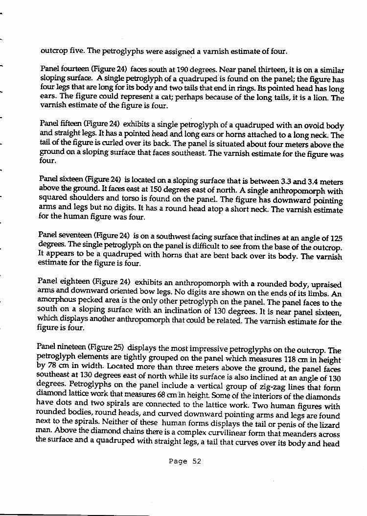
outcrop five. The petroglyphs were assigned a varnish estimate of four.
Panel fourteen (Figrrre 24) faces south at 190 degrees. Near panel thirteen, it is on a similarsloping surface. A single petoglyph of a quadruped is found on the paneL the figure hasfour legs that are to^q f:t its body and two tails that end in rings. Its pointed head has bngears. The figure could iepresent a cag perhaps because of the long tails, it is a lion. TtrEvarnish estimate of the figure is four.
Panel fifteen (Figure 24) exhibits a single petroglyph of a quadruped with an ovoid bodyanf straight legs. It has a pointed head and long ears or horns attached to a long neck. fhetail of the figure is curled over its back. The panel is situated about four meteri above theground on a sloping surface that faces southeast. The varnish estimate for the figure wasfour.
P--d siteen (Figure 24) is located on a sloping surface that is betrn een 3.3 and 3.4 metersabove the ground. It faces east at 150 degrees e"st of north. A single anthropomorph withsquared shoulders and torso is found on th9 panel. Thefigurelas downwara tointing]ml and legs but no digits. It has a round trela atop a short neck. The varnish estimatefor the human figure was four.
Panel seventeen (Figure 24) is on a southwet facing surface that inclines at an angle of l?Sdegree. The single petroglyph on the panel is diffi< to see from the base of thJoutcropIt appears to be a quadruped with horns that are bent back over its body. Ttre varnisiestimate for the figure is four.
Panel eighteen (Figure 24) exhibits an _anthropomorph with a rounded body, upraisedarms and downward oriented bow legs. No digits
"reiho*o on the ends of itl UmUs. anamorphous pecked areajs the only other petroglyph on the panel. The panel faces to theto-ltl on a sloping surface with an inclination oi rgo degr'ees. It is near panel sixteen,which displays another h that could be related. The varnish estimate for thefigure is four.
Panel T""g (Figtue 25) displays the most impressive petrogllphs on the outcrop. TheF loglyph elemelts_are tightly grouped-on the panel whictr *e"s*es 118 cm in ireightby 78 on in width. Located *ote thin three
^"t"rs above the ground, the panel falessoutheast at 130 degrees east of north while its surface is also inilined at an angle of 130degrees'
-Petroglyplo-o. the panel include a vertical group of zig-zaglines that formdiamond lattice work that measures 68 cmin height. Some of the interiors of the diamondshave dots and two spirals :ue connected to ttre lattice work. Two human figures withrounded bodies, round heads, and curved downward pointing arrns ur,d l"gr""r" foundnext to,the spirals. Neither of these human forms dispiays ttri'tait or penis of the lizardman' Above the diamond dains there is a compl"*
"*nilit ear form that meanders acrossthe surface and a quadruped with straight legs, a tail that curves over its body and head
Page 52
t\
o,5/P-19
Gs,P-20
: J t.;:'r
(
iI
't \. ',
Gs/P-21-\-.==
\i
o-5lP-?12 o-5/P-23
Figure 25. Petroglyphs on outcrop 5, Panels 1923. Shown at 10% of aslual size.
appendages which turn forward. The varnish estimate for the panel is four to five.
Panel twenty (Figure a5) faces southeast at 145 degrees. It is on a sloping surface nearlyfour meters above the groud surface. A quadruped with fotu straight legs, a pointed headand two straight horns or ears if found on the panel. A rayed circular form is connectedto the back legs of the quadruped. The varnish estimate for the petroglyph is four.
Panel twenty-one (Figure 25) faces 5 degrees from magnetic norttu It is on a sloping surfacewith an indination of 135 degrees, that is nearly four meters from the modern groundsurface. The panel surface is heavily overgrown with lichens, md the petrogllphs areindistinct At least seven elements occtr on the panel. A large lizard figure with is near thetop of the panel, and several spirals or concentric cirdes cover the remainder of the rockface. The petrogllphs were assigned a varnish estimate of four.
Panel twenty-two (Figure 25) is located about two meters above the ground on anoverhanging surface that faces south. A tailed cirde and an amorphous pecked area aredisplayed on the panel. Both are faint and diffictrlt to see. The varnish estimate for thefigures is four.
Panel twenty-three (Figure 25) faces east at 92 degrees on a surface with an indination of133 degree. A single cirde is the only element on the panel. The varnish estimate for theelement is four.
Summary
Outcrop five is situated on the south side of Tempe Butte near a drainage channelthat supports relatively dense vegetation. The walls of a sheltered area on the south sideof the outcrop were the most intensively used for petroglyph manufacture. Surfaceevidence of former fires is not evident in this area.
The dominant motif on the outcrop is circles, concentric cirdes, bull's eyes, andconnected cirdes. At least 28 petroglyph motifs on the outcrop, nearly half of the total,employ one or more cirdes in them. At the sarne time, there are only six human figures(tm percenO and noneof the lizard men found on nearby outcrops. Quadrupeds are alsorare, constituting about ten percent. There are no scrolls and only two spirals on theoutcrop.
The majority of the petrogllphs on the outcrop were assigned a varnish estimate offour. This suggests they were made about the same time as the petroglyphs on nearbyoutcrops.
Page 54
Outcrop Six
Outcrop six is a low protruding bed that.is located between outcrop one andoutcrop three. Originally combined with outcrop tliree, it was decided the petrogllphswere separated from nearby outcrops with sufficient distance to give it a separatedesignation. The outcrop is oriented toward the southwest.It is above and northeast ofoutcrop one and below and southwest of outcrop three (see Figure 4 above).
A single panel of petroglyphs was recorded on the outcrop. It displays an isolatedpetroglyph element. :
Panel one (Figure 26) faces west a 276 degres east of north. The panel slopes at an angleof 120 degrees on a surface that is betrpeen one and two meters above the ground. Thesingle eleurent on the panel is a spiral with a dockwise whorl. Short lines are attached toouter whorl to give it a rayed appearance. The figure was assigned a varnish estimate offour.
Summary
Theoutcrop is small and has fewer rock surfaces for making petroglyphs; perhapsthis accounts for the presence of only a single panel with one element. The fact that thefigure is a spiral is noteworthy because it suggests that spirals were important to the artistswho utilized this part of the butte.
Outcrop Seven
The outcrop is located higher on the butte, to the southwest of outcrop three anddown the trail from theobservation plafform (see Figure 4 above). Surfaces of the beddedbasalt in this location are mainly oriented toward the south and southwest but an artistcould have found surfaces which are directed toward most directions except north.
Although we did not find as muctr evidence for current use as we did at outcropthree, the area around outcrop seven has also received heavy visitor use. Thirteenpetroglyph elements on nine panels were recorded on the outcrop but two of the panelscontain only historic graffiti.
Panel one (Figure 26) displays the most petroglyphs of any on the outcrop.It is situatedmore than six meters above the nearest ground surface on a sloping area with anindination of 130 degrees. The panel faces southwest at 218 degrees. Five petroglyphsinduding a rectangular box form, a well-made tailed spiral, an indistinct spiral, aquadruped, and an pecked area are found on the panel. The well-made spiralmeasures 39 cm across its maximum diameter. The varnish estimate for the petroglyphsis five.
Page 55
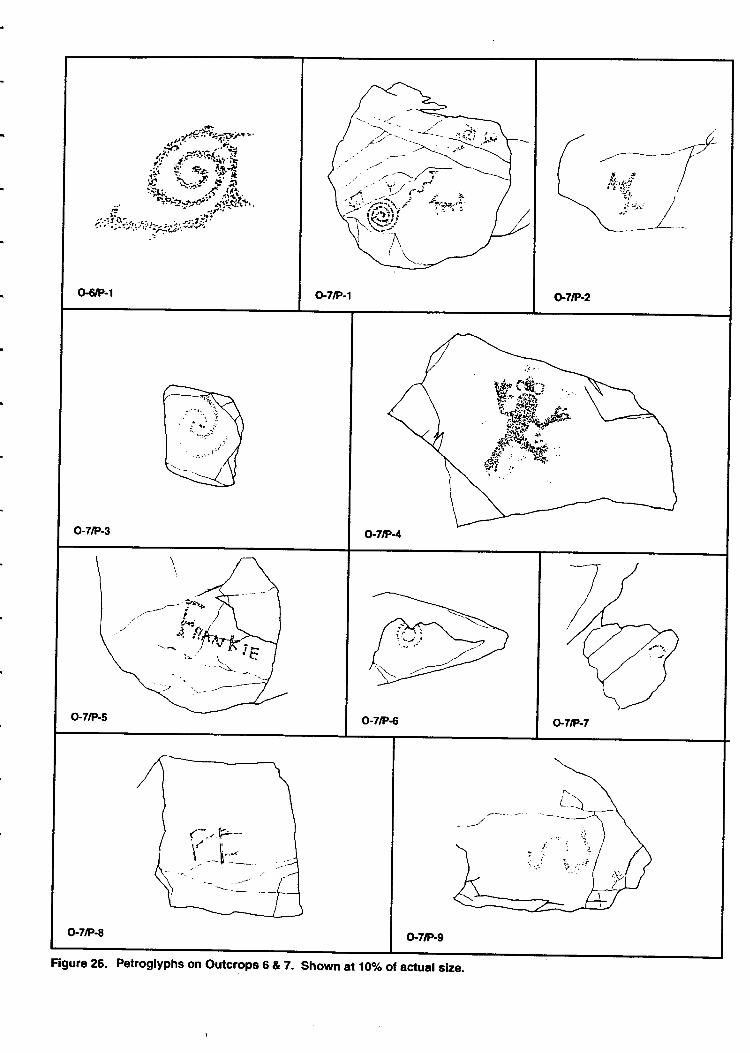
Figure 26. Petroglyphs on outcrops 6 & 7. shown at i07o of actual size.
Panel two (Figure 2,5) is on a vertical surface that faces southwest at 230 degrees: The onlyelement on the panel is a single quadru@ with only two legs that appears to be standingupright. There is ample room for more petroglyphs on the panel, but the artist drose bcreate the animal within an empty space. Its varnish estimate is five.
Panel three (Figure 26) is fotrnd on a boulder in the talus below the outcrop. It appears tohave fallen since the penoglyph was made, making its present orientation not relevant. Aheavily varnished spiral form, measuring 12 crn by 11 on, is found on the panel. Parts ofthe spiral were assigned a varnish estimate of four while other parts were much darkerand assigned a number six. These differences may be the product of ttre new location ofthe boulder, near the ground surface, where there are increased opportunities for nutrientsto affect the varnish.
Panel four (Figure 26) is located on a south facing surface oriented 172 degree east ofnorth. The panel surface whidr slope at an angle of 7E degrees is less than a meter abovethe ground. A single anthropomorph measuring 25 crn in height is found on the panel. Thefigure has a rounded body and head upraised anns, and downward oriented legs. Peckeddigb at the ends of the arms and legs give the figure a frog-like appearance. The creaturehas no tail. The varnish estimate for the figure is seven, suggesting it is older than most ofthe rock art on Tempe Butte.
Panel five (Figure 25) is on a southwest facing surface more than five meters above theground. The only element on the panel is a printed "FRA\IK[E". The F whidr has serifs islarger than the other letters in the n.une. The varnish estimate one for the figure, and thestyle of the printing suggest it may be roughly 75 years old.
Panel six (Figure 26) exhibits a broken spiral that measures 10 cm across its maximumdiameter. Located more than five meters above the present ground, the panel facessouthwet at 280 degrees on a sloping surface. The varnish estimate for the spiral was four.
Panel seven (Figure 26) faces west at 260 degrees east of north. Located more than sixmeters above the ground, a single poorly formed circle is found on the panel. It was glvena varnish estimate of five.
Panel eight (Figure 26) is oriented south on a sloping surface. The initials FF or FL arescratdred into the panel. The varnish estimate of zeto suggests they are recent.
:
Panel nine (Figure 25) is a southwest facing surface less than a meter above the groundsurface. Slightly overhanging, the panel has a wavy or undulating line peckedhorizontally, suggesting a snake. The figure, 19 on across, was given a varnish estimateof three.
Page 57
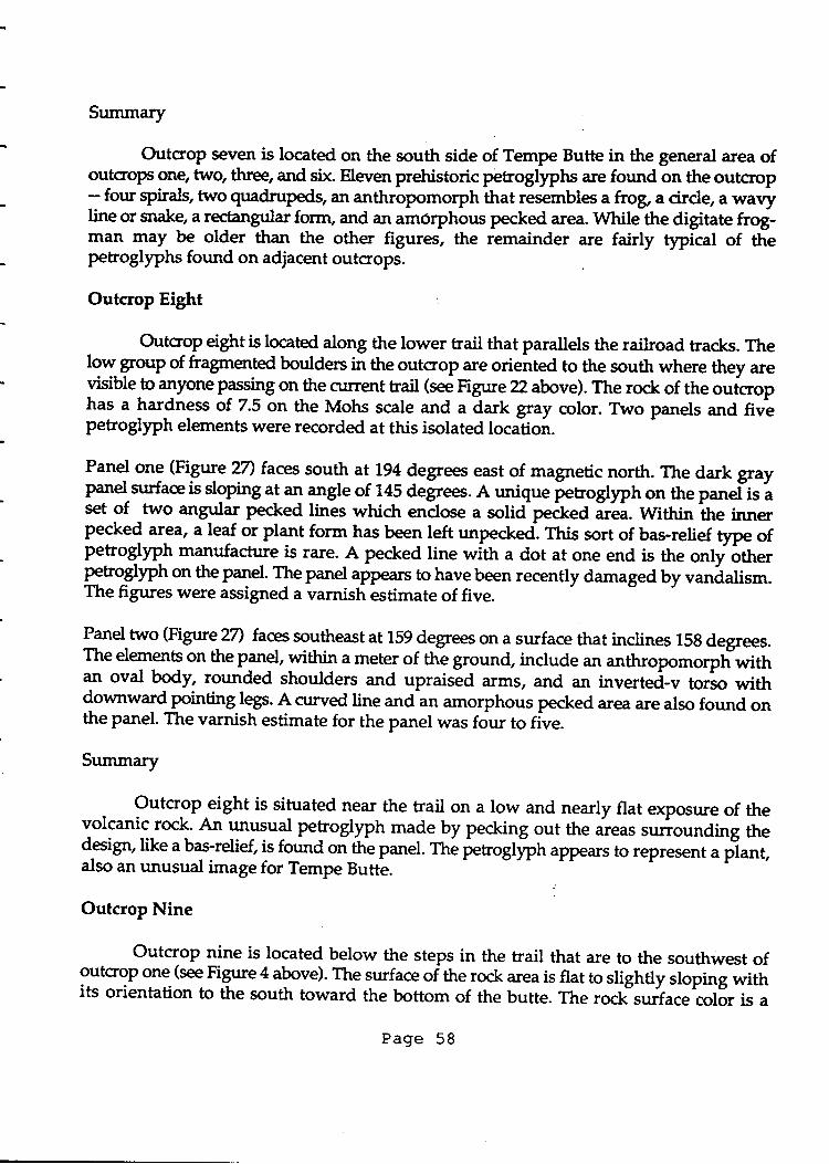
Summary
Outcrop seven is located on the south side of Tempe Butte in the general area ofoutcroPs one, two, three, and six Eleven prehistoric petroglyphs are found on the outcrlop- fonr sPit+, trro qradru@s, an anthropomorph that resembles atrog,a cirde, a wavyline or snake, a rectangular form, and an amorphous pecked area. While the digitate frogman may be older than the other figures, the remainder are fairly tlpical of thepetroglyphs found on adjacent outcrops
Outcrop Eight
Outcrop eightis located along the lower trail that parallels the railroad tracks. Thelow qroup of fragmened boulders in the outcrop are oriented to the south where they areyisible-to anyone plTi"g on the curent trail (see Figure 22 above). The rock of the o,ri"rophas a hardness of 7.5 on the Mohs scale and a dark gray crclor. Two panels and fivepetrogllph elements were recorded at this isolated location.
Panel one (Figure 27) faces south at^194 {egrees east of magnetic north. The dark grayPanel strrface is sloping
"_t "1 angle of 745 degrees. A unique petroglph on the panel-is a
set of -two angular pecked lines which enclose a solid-pecked it!i. WiAi" tt e iooo
pecked area, a leaf or plant form has been left unpecked,. This sort of bas-relief type ofpetroglyph manufacture is rare. A pecked line wilh a dot at one end is the only ott"tpetroglyph on the PTd. T_he panel appears to have been recently damaged by .'*i"lir*.The figures were assigned a varnish estimate of five.
Panel two (Figr.ue 27) fassoutheast at 159 degrees on a surface that inclines 15g degrees.The elements on the Panel, within a meter of thL ground, include an anthropo^o1pti*itt1n oval bodn rounded shoulders and upraised arms, and an inverted-v torso with{ownward pointing legs. A curved line and an amorphous pecked area are also found onthe panel. The varnish estimate for the panel was four to five.
Summary
_ Outcrop eight is situated near the trail on a low and nearly flat exposure of thevolcanic rock. h:"H"f Petroglyph made by pecking out the areas sur:rounding thedesign, like a bas-relief, is found on the panel. ftre petoglyph appears to represent a p-lant,also an unusual image for Tempe Butte.
Outcrop Nine
Outcrop nine is located below the steps in the trail that are to the southwest ofoutcrop one (see Figure 4 above). The surface of ttre ro& area is flat to slightly sloping withits orientation to the south toward the bottom of the butte. The roclisurface'col6r is a
Page 58
O-8rP-12
o-g/P-1 o,9tP-2
Flgure 27. Petroglyphs on Outcrops 8 & 9. Shown at 107o of actual slze.
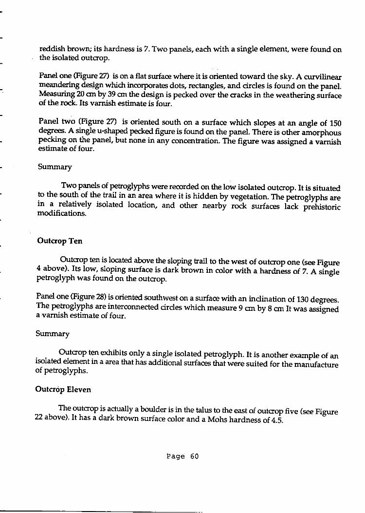
reddish brown; its hardness is 7. Two panels, each with a single element, were found onthe isolated outcrop.
Parrel one (Figrrre m ison a flat surface where it is oriented toward the sky. A curvilinearleandenng desiSn whidt incorporates dots, rectangles, and cirdes is found on the panel.U-elsuring 20 on by 39 crn the design is pecked over the cracks in the weathering surfaceof the rock. Its varnish estimate is four.
Panel two (Figure 2n is oriented south on a surface wNch slope at an angte of 150defeet. A single u*l9$ pecked figrue is found on the panel. Ttrere is other aiorphouspecking ol tt
" panel, but none i. *y concentration. The figure was assigned a vinish
estimate of four.
Summary
T*9 Panels of petrogllphs were recorded on the low isolated outcrop. It is situatedto the south of the trail in an area where it is hidden by vegetation. The petroglyphs areit
1. relatively isolated location, and other nearby ro& surfa."r lu.k irliristoricmodifications.
Outcrop Ten
Oulaog ten is located above the sloping trail to the west of outcrop one (see Figure4 above). Its low, sloping surface is dari brown in color with a hardness of 7. Asliglepehoglyph was found on the outcrop.
rynel one (Figrrre 28) is oriented southwest on a surface with an inclination of 130 degrees.The peloglyphs areinterconnected circles which measure 9 on by 8 crn It was assi"gneda varnish estimate of four.
Summary
Outoop ten exhibits only a single isolated petroglyph. It is another example of anisolated element in a area that has additional surfa& that were suited for the **'uf""t rr"of petroglyphs.
Outcrop Eleven
- fu_oYtcroP is
a5tually a boutder is in the talus to the east of outcrop five (see Figure22 above). It has a dark brown surface color and a Mohs hardness of a.s.
Page 60
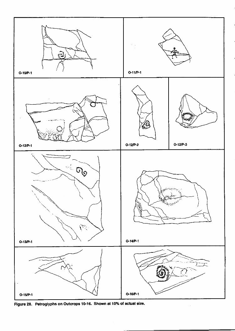
o.10/P-1 o.l1/P-1
a1?JP-1 o-12tP-2 o-12/P€
o-13/P-1
-%-
G1&P-1
Figure 28. Petroglyphs on Outctops 1G16. Shown at 10% of actual size-
Panel one (Figure 28) is located on a west face of the boulder. It exhibits a poorly formedanthropomorph with rounded shoulders and torso. It arms and legs point down. Thefigure had a varnish estimate of five.
Summary
Outcrop eleven was used to designate a large boulder to the east of outcrop five. Asingle petroglyph on it may represent a human figure.
Outcrop Twelve
The feature is located to the west of outcrop five, in the drainage above the bedrocklortars (see Figtrre 22abxl,ve). The rock has a hardness of 5 and a surface color that rangesfroT a very far,k Sray to a reddish brown. Three panels were found on the outcrop.l,[oJ the Petroglph elements are circles. Recalling thl abundance of circles at outcrop five,the presence of cirdes at this location is noteworthy.
panel one (Figrrre 2g) is_facing south on a nearly flat surface. An indistinct pecked area andtwo circles are the gnl-y pgcoS]fptrs found on the panel. The circles were assigned avarnish estimate of sr& but this older appearance is likely related to their flat and dp"r.aposition near the ground where they collect more nutrients.
Panel two (Figure 28) is located 30 cnr west of panel one on the same general surface.fuT" cru{el1 pecked interconnected circles, measuring 8 cm across, are found on thesurface which is oriented to the south. A varnish estimate of five was given to thepetroglyph.
P*9 three (Figure 28) is located nearly 2.5 meters north of panel one on another slopingstrrface of the bedro& A single circte measuring 8 crn in diimeter, is found on the pi""lThe figure is oriented to the south.
Summary
The outcrop designation was used to combine two small groups of isolatedPetroglyPhs. The petroglyphs occur in an area that has been heavif, impacted by theconstruction of the water tanks on the butte. Most of the rock in'tL" *"" has beendisplaced from above by the crrrutruction activities, and additional panels may have beendestroyed.-Large amounts of trash are present around the bouldeis, and vagrants wereobserved sleeping in the area at night.
Page 62
Outcrop Thirteen
Outcrop thirteen (see Figure 22 above) is located in the oPen talus area betweenoutcrop one and outcrop five. It is north of the curent trail and west of the grinding slicks.The rock surface color is a very dark gray and its hardness is 4.5.
Panel one (Figure 28) is located on a west facing surface that has an indination of 150
degrees. A scroll design, measuring 10 crn by 77 on, is found on the panel. The figure isbroken up and eroded; it was not given a varnish estimate.
Summary
' The outcrop is on the sloping side of the butte in an area where it is hidden in the
vegetation. This isolated element occurs on a relatively large rock surface that is suitable
forthe manufacture of petroglyPhs, but lacks additional figures.
Outcrop Fourteen
This outcrop is located in the open talus area downslope and t9 the southeast ofoutcrop one (see Figo" 4 above). The rock surface, at this location, has a hardness of 7 and
a darkreddish brown color. A single petroglyph was recorded on the outctop.
panel one (Figure 28) faces directly south on a surface which slopes at 119 degree. Asingle bisected circle or two connected cirdes are the only petroglyph on the panel,
measuring 19 cm by 22 cm
Summary
This isolated outcrop exhibits a single petroglyPh. This sort of feature may not
appear to be significant, but these locations provide data on variables that effect
pehoglyph placement, and may be useful in establishing why concentrations ofpetroglyphs were placed in certain areas-
Outcrop Fifteen
The outcrop is located 20 meters southeast and downslope from outcrop on9 (rye
Figure 4 above). ti." ,rery dark gray rock has a hardness of 6 on the Mohs scale. A single
petroglyph was found on the boulder.
panel one (Figure 28) is facing southwest at 218 degrees east of north. It surface slopes a1
an inclinatioir of 160 degreel. The petroglyph is a zig'z-ag line that may be part of an
eroded lattice pattern. Although it isin poor condition and eroding from the rock, it was
given a varnish estimate of five.
Page 63
Summary
The outcrop is situated in the open talus below outcrop one. The relationshipbetween this feature and the pefroglyphs on outcrop one is a topic for future reeardr.
Outcrop Sixteen
Otrtcrop sixteen is located 15.5 meters southwest and downslope from outcrop one.The surfae color of the outcrop is dark brown and it has a hardnes of 6 on the Mohs scale.A single panel with two petroglyphs on it is found on the outcrop.
Panel one (Figure 28) is oriented southwest at 220 degrees east of north. It is on a flatsurface with an angle of 150 degrees. A counterclockwise spiral measuring 14 cnr acrossits maximum diameter is found on the boulder. Near this petrogllph there is an indistinctpecked cirde. The figures were assigned a varnish estimate of five.
Summary
The outcroP is situated on the talus slope area below outcrop one. A well-forrredsgiral is found on the singlepanel of the outcrop. It is interesting to note that the locationof this spiral is near outcrop one which has several well-made ipirals and scrolls.
Outcrop Seventeen
The outcrop is located on the southwest corner of Tempe Butte above the crrrrenttrail where it makes its switctrback (Figure 29). The primary exposures on the outcrop facewest and south but petroglyphs could have been made facing any direction on the viriousnooks and crevices of the outcrop. There is a cavern or grotto in the south side of thegulcroP *iF * opening that is 60 crn in height. Although it does not have petrogl)?hs init, it would have served as a place to cache or hide things. Muctr of the itoneiJi aartreddish brown in color. It has a hardness ranging from 7-tolon the Mohs scale.
Thirty-four Perrogl)"h elements were recorded on ten panels on the outcrop. Fivepanels have only a single petroglyph on them while one has ten elements.
The west end of the butte has received heavy use from foot traffic and there areareas of carved initials and dates. Comparing the area to the higher points on the buttghowever, the area is in more pristine condition. The outcrop is not on the direct'route toand from the large cnncrete A on the Butte and this apparently helps protect it from somefoot traffic.
Panel one (Figure 30) faces west at 249 degres east of north. It is a vertical surface thatmeasures 2 meters by 2.?5 meters. Modern petroglyphs inctude depictions of the leafy part
Page 64
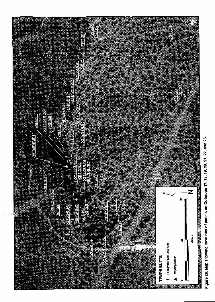
:atN!tEAgoiN
N-ct(\|ot
odA
o8AC)
oC .^,ooc,CG'CLAooc"9ql()IEDcE-osoCL(g
=dNo=CDFIL
z
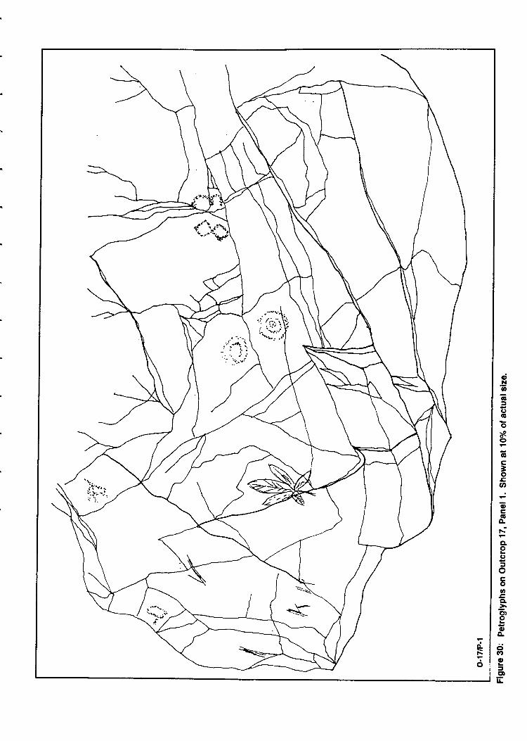
qt!!6Gf(tooao€C3oo-oc6c
qo()
ocoo3CL
ct)ooA
G'a)otcDIL
itv..i:); -.:
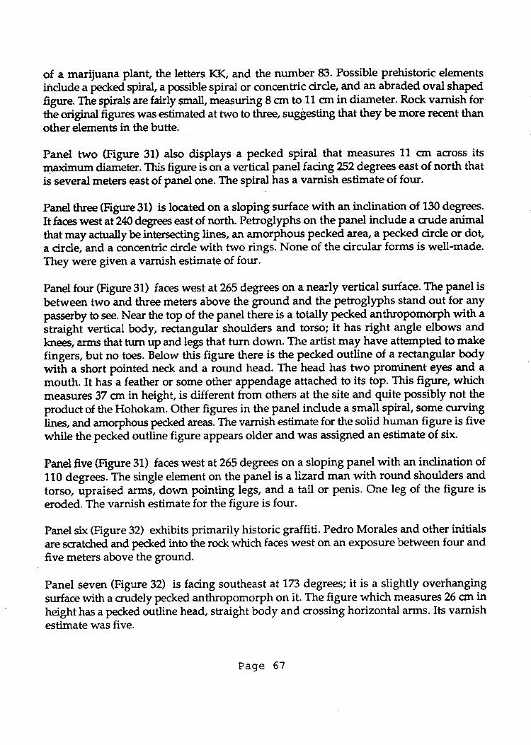
of a marijuana plant, the letters KK, and the number 83. Possible prehistoric elementsindude a pecked spiral, a possible spiral or concentric cirdg and an abraded oval shapedfigure. The spirals are fairly small, measuring 8 crn to.11 crn in diameter. Rock varnish forthe original figure was estimated at two to three, suggesting that they be nirore recent thanother elements in the butte.
Panel two Gigure 31) also displays a pecked spiral that measures 11 cm across itsmaximurn diameter. This figure is on a vertical panel facing 252 degrees east of north thatis several meters east of panel one. The spiral has a varnish estimate of four.
Panel three (Figrrre3l) is located on a sloping surface with an indination of 130 degrees.
It faces west at 240 degrees east of north. Petroglyphs on the panel indude a crude animalthat may actually be intersecting lines, an amorphous pecked area, a pecked cirde or dot,a cirde, and a concentric circle with two rings. None of the circular forms is well-made.They were given a varnish estimate of four.
Panel four (Figure31) faces west at 255 degrees on a nearly vertical surface. The panel is
between two and three meters above the ground and the petroglyphs stand out for anypasserby to see. Near the top of the panel there is a totally pecked anthropomorph with a
straight vertical body, rectangular shoulders and torso; it has right angle elbows andknee, arms that turn up and legs that turn down. The artist may have attempted to makefingers, but no toes. Below this figure there is the pecked outline of a rectangrlar bodywith a short pointed neck and a round head. The head has two prominent eyes and amouth. It has a feather or some other appendage attached to its top. This figure, whichmeasrues 37 qn in height, is different from others at the site and quite possibly not theproduct of the Hohokam. Other figures in the panel indude a small spiral, some curvinglines, and amorphous pecked areas. The varnish estimate for the solid human figure is fivewhile the pecked outline figure appears older and was assigned an estimate of six.
Panel five (Figure 31) faces west at265 degrees on a sloping panel with an indination of110 degrees. The single element on the panel is a lizard man with round shoulders andtorso, upraised arms, down pointing legs, and a tail or penis. One leg of the figure is
eroded. The varnish estimate for the figure is four.
Panel six (Figure 32) exhibits primarily historic graffiti. Pedro Morales and other initialsare scratched and pecked into the rock which faces west on an exPosure between four andfive meters above the ground.
Panel seven (Figure 32) is facing southeast at 173 degrees; it is a slightly overhangingsurface with a crudely pecked anthropomorph on it. The figure which measures 26 on inheight has a pecked outline head, straight body and crossing horizontal arms. Its varnishestimate was five.
Page 67
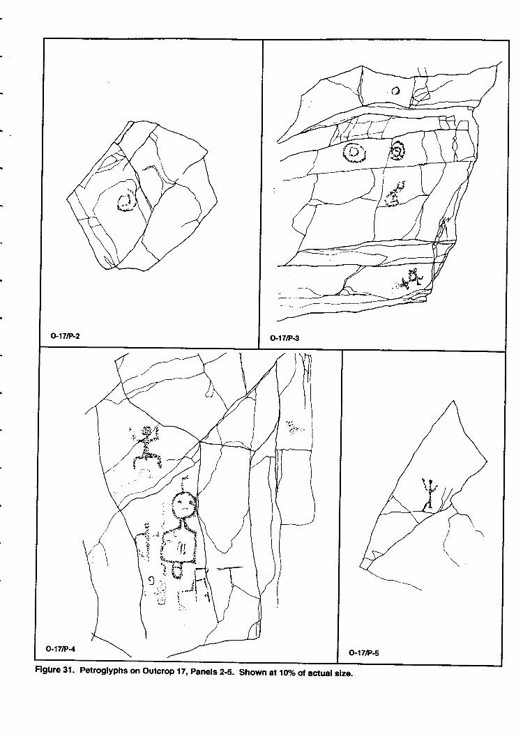
( r'7\: a,/ t4'\we
o-17/F.-2 O"t7lP€
o-171P4 o.17lP-s
Figfrre 31. Petroglyphs on outcrop 17, panels 2-5. shown at 10vo of ac{ual slze.
o-17tP6
o.17F.-7
o-17/P-8o.l7/P-9
o,17lP-'t0
Figure 32. Petroglyphs on outcrop 17, Panels &10. Shown at l0% of actual size.
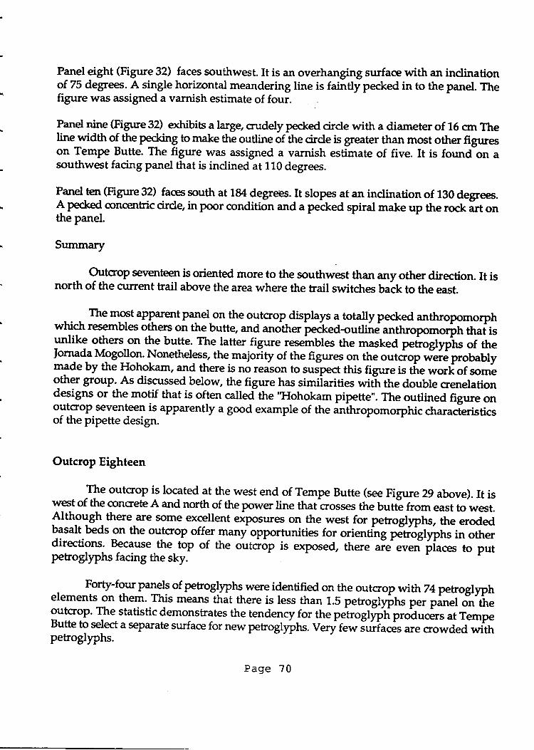
Panel eight (Figure 32) faces southwest. It is an overhanging surface with an inclinationof 75 degrees. A single horizontal meandering line is faintly pecked in to the panel. Thefigure was assigned a varnish estimate of four.
Panel nine (Figure 32) exhibie a large, crudely pecked circle with a diameter of 16 cm Theline widttt of the p:$hg to make the outline of the circle is greater than most other figtueson Tempe Butte. The figure was assigned a varnish estimate of five. It is foundln asouthwest facing panel that is indined at 110 degrees.
Panelten (Figure 32) faces south at l&4 degrees. It slopes at an inclination of 130 degrees.A Pecled qrncentric cirde in poor condition and a pecked spiral make up the rock irt onthe panel.
Summary
Outcrop seventeen is oriented more to the southwest than any other direction. It isnorth of the current trail above the area where the trail switctres back to the east.
The most apparentpanel on the outcrop displays a totally pecked anthropomorphwhich resembles others on the bufte, and another pecked-ouUine an*uopomoritr tnaiisunlike others on the butte. The latter figure resembles the masked pecogl)"hs of theIornad| Mogollon. Nonetheless, the majority of the figures on the outcrop ;d.; probablym3de by the Hohokam, and there is no reason to suspect this figure is tfre *ott of sornegther gouP.As discussed below, the figure has simiiarities witl the double crenelationdesigns or the motif that is often called the "Hohokam pipette". The outlined fig're onoutcrop seventeen is apparently a good example of the anthropomorphic characferisticsof the pipette design.
Outcrop Eighteen
The outcrop is located at the west end of Tempe Butte (see Figure 29 above). It iswest of the concrete A and north of the power line that crosses the butte from east to west.Although there €re some excellent eiposu.es on the west for petrogly?hs, the erodedbasalt beds on the outcrop offer many opportunities for orienting dttogfyphs in otherdirections. Because-the top of the orrtoop is exposed, there "i" """tipiu.a to putpetroglyphs facing the sky.
. Fotty-four plels of petrogllphs were identified on the outcrop withT4petrogllphelements on them. This means tfrit there is less than 1.5 petroglyihs per panel oi.,'tf,"outcrop. The statistic demonstrates the tendencyfor the peirogfffh ptoa,t.&r at TempeButte t9 se]ect a separate surface for new pero4yprrs. Very r"* J*?u"& are crowded withpetroglyphs.
Page ?0
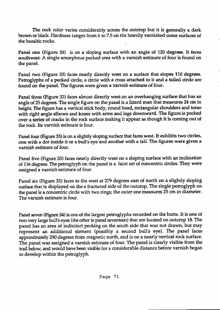
The rock color varies considerably across the outcrop but it is generally a darkbrown or black. Flardness ranges from 6 to7.5 on the heavily varnished outer surfaces ofthe basaltic rocks.
Panel one (Figure 33) is on a sloping surface with an angle of 120 degrees. It facessouthwest. A single amorphous pecked area with a varnish estimate of four is found onthe panel.
Panel two (Figure 33) faces nearly directly west on a surface that slopes 110 degree.Petrogllphs of a pecked cirde, a cirde with,a cross attactred to it and a tailed cirde arefound on the panel. The figures were given a varnish estimate of four.
Panel three (Figure 33) faces almost directly west on an overhanging surface that has anangle of 25 degfee. The single figure on the panel is a lizard man that measures 24 cm inheight The figure has a vertical stick body, round head, rectangular shoulders and torsowith right angle elbows and knees with arms and legs downward. The figure is pecked
over a series of cracks in the rock surface making it appear as though it is coming out ofthe rock. Its varnish estimate is four.
Panel four (Figrue 33) is on a slightly sloping surface that faces west. It exhibits two cirdes,one with a dot inside it or a bull's eye and another with a tail. The figures were given avarnish estimate of four.
Panel five (Figure 33) faces nearly directly west on a sloping surface with an inclinationof 116 degees.The petroglyph on the panel is a faint set of concentric circles. They wereassigned a varnish estimate of four.
Panel six (Figure 33) faces to the west at 279 degres east of north on a slightly slopingsurface that is displayed on the a fractured side of the outcrop. The single petroglyph onthe panel is a concentric cirde with two rings; the outer one measures 25 orr in diameter.The varnish estimate is four.
Panel seven (Figure 34) is one of the largest petroglyphs recorded on the butte. It is one oftwo very large bull's eyes (the other is panel seventeen) that are located on outcroP 18. Thepanel has an area of indistinct pecking on the south side that was not drawn, but mayrepresent an additional element (possibly a second bull's eye). The panel faces
approximately 290 degrees from magnetic north, and is on a nearly vertical rock surface.
The panel was assigned a varnish estimate of four. The panel is dearly visible from thetrail below, and would have been visible for a considerable distance before varnish b"g*to develop within the petroglyph.
Page '11
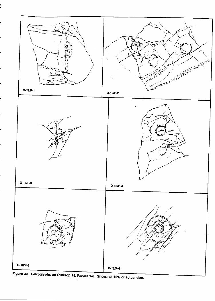
$
Figure 33. Petroglyphs on Outcrop lg, panels 1€. Shown at 10% of actual size.
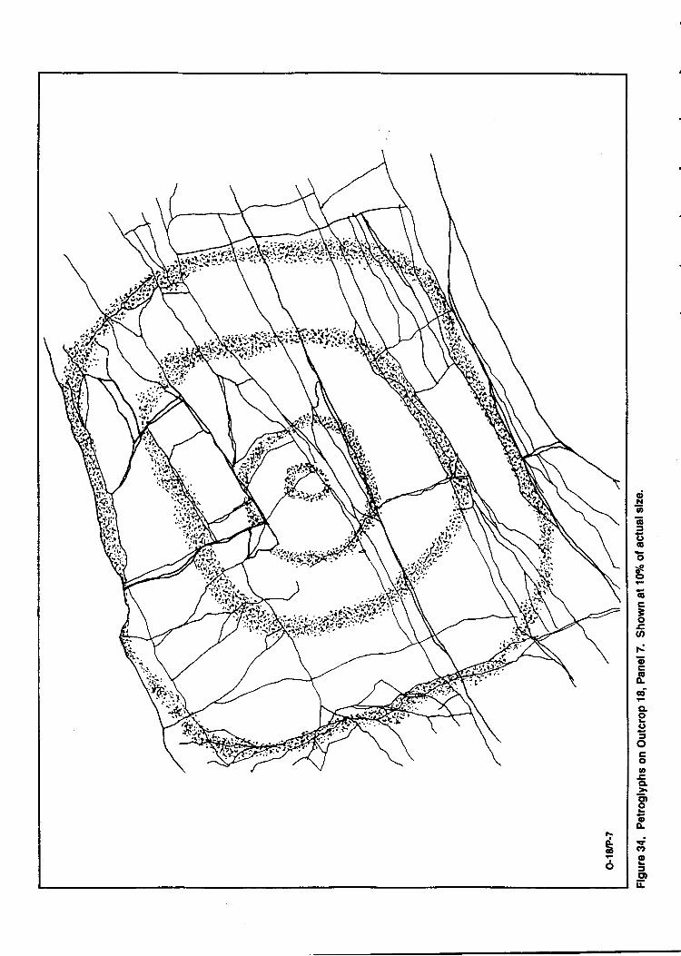
6
6
o!!]D
65(toonct
6c3osat-oc6o-ctCIoC)
3ogooECL
ctloo4{atoJg)lr
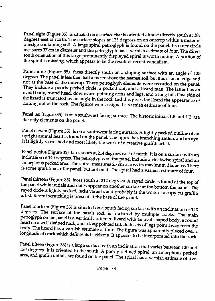
Panel eight (Figure 35) is situated on a surface that is oriented almost directly south at 181degrees east of north. The surface slopes atl25 degrees on rul outcrop within a meter ofa ledge containing soil. A large spiral petroglyph is found on the panel. Its outer [email protected] 37 snin diameter and the petroglyph has a varnish estimate of four. The directsouth orientation
9f this targe prominently displayed spiral is worth noting. A portion ofthe spiral is missing, whidr appears to be the result of recent vandalism.
panel nine (Figure 35) faces directly south on a sloping surface with an angle of lEdegreest Qe panel is less than half a meter above the nearet soil, but this is on a iedge andnot at the base of the outcrop. Three petroglyph elements were recorded on the"panel.They-indrrde a poorly pecked cirde, ; p".k"d dot, and a lizard man. The latter ti",
"oo-void body, round head, downward pointing arms and legs, and a long tail. One side ofthe lizard is truncated-b1an angle in ihe rocf and this gives the lizard ti"
"pp""rance of
coming out of the rock The figures were assigned a varnish estimate of four.
l*"1 ten lFigure 35) is on a southwest facing surface. The historic initials LB and LE arethe only elements on the panel.
Panel-eleven (FiSure 35) is on a southwest facing surface. A lightly pecked outline of anupright animal head is found on the payrel. rh9 igure rras uraicrri-ni *uor *a * "y".It is lightly varnished and most likely the work of"a creative graffitiLtirt.
lq9 twelve (Figure35) faces south atll4degrees east of north. It is on a surface with anindination of 7N {e$ees:Ihe petrgglyp}rs o"-tr,e panel include a clockwise spiral and anamorphous Pecked ar9a. The lPyat measures 23 on across its maximum diameter. Thereis some graffiti near the panel, but not on it. The spiral had a varnish estimate of four.
Panel thirteen (Figure 35) faces south atzlzdegrees. A rayed circle is found at the top ofthe panel while inilials a1d.$te-s appear ot unother surface at the bottom the panel. Therayed cirde is lightly Pecked, lacks varnish, and probably is the work of a copy cat graffitiartist. Recent scratching is present at the base of the panel.
Panel fourteen (Figure 35) is situated on a south facing surface with an inclination of 140degrees' The surface of the basalt rock is fracturJd by multipl"-.r".tr. The mainpetrogllph on the Panel is a vertically oriented lizard with an o"a lr,"p"d body, a roundhead on a welldefined neck, and a long pointed tail. Both sets of legs point away from thebody' The lizard has a varnish estimaie of fou1. The figure was apparently placed over alongitudinal crack which defines its backbone. It "pp"uir
to be ir,cirporated into the rock.
l:P fifteen 9ig*"f) it alarge surface with an inclination that varies betrneen 120 and130 degrees' It is oriented to the south. A poorly defined _spiral, an amo{phous peckedarea, and graffiti initials are found on the panel. 'ihe spiral has a varnish estimate of five.
Page 74
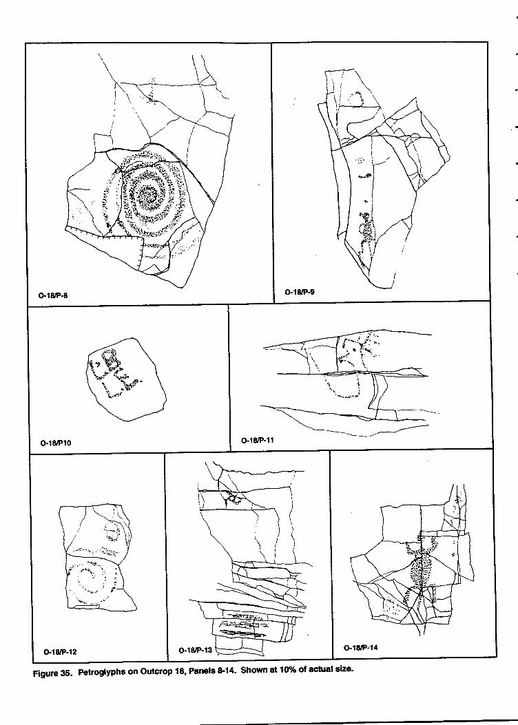
-sngl
'5+*i ""Sr*'
r -t'trt
o.l8'P10 Gl8/P-11
Gl8/P-12 G.18rP-14
Figure 35. Petroglyphs on Outcrop 18, Panels &14- Shown at l0% ot actual slze's
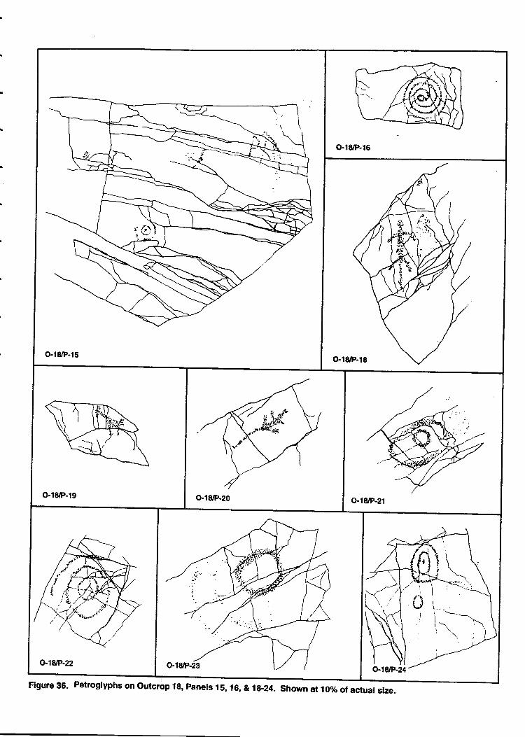
G,l8/P-15
O-18rP-16
o'1&P-18
Gl8/P-19 o-18/F-20 o-r8/P-21
o18tP-22
Figure 35. Petroglyphs on outcrop 18, Panels ls, 16, &7&124. Shown atloToof actual size.

Panel sixteen (Figure 35) faces south on a small surface that overhangs slightly. A well-formed counter dodswise spiral, measuring 16 crn in diameter, is found on the panel. Thespiral which uses all the available space has a varnish estimate of four.
Panel seventeen (Figure 37) exhibits a large set of concentric cirdes on a surfacre thatmeasures 170 crn by 110 crn The cirdes are eroded at the dgo, but they are 115 cm inheightby 89 crn in width and they fill rp their space. At least five and possibly seven tingswere made in the cirdes. The panel faces northwest at 29 degrees east of north on astuface that slopes at 115 degrees. Although the petrogllph is facing north, it is orientedmore toward the sky than the river. The varnish estimate for the figure is four.
Panel eighteen (Figure 36) elhibits a vertically oriented lizard figure tha,t measures 27 cm
in heigtrt. The lizard has a long narrow body, a round head, a well-defined neck, a longpoi"ted tail and legs that are oriented back. The figure faces northwest at294 degrees ona vertical surface. Its varnish estimate is four.
panel nineteen (Figure 35) is on a northwest facing surface that slopes at 120 degree. A,
profile view of a trJo-legged animal with a long neck, Poind head, and short tail is found
bn the panel. Ttre varnish estimate of two suggests the figure could be more recent.
Panel twenty (Figure 36) exhibits a lizard with a long tail, elongated Fdy, roun{ h9ad,
and legs thaf are otiented forward. Although they are faint, there maY F toes on its feet.
fne Uira figure measures 24snfrom its head to tip of its tail. The panel faces northwestat295d"g* on a surface that slopes at 140 degrees. The varnish estimate for the figure
is two.
Panel twenty-one (Figure 36) is on a surface facing southwest at299 degrees east of north.
The surfacsis inclined at 110 degrees. The single petroglyph on the panel is a concentric
circle with two rings. It has a varnish estimate of four to five.
Panel twenty-two (Figure 36), on a surface that slopes at 114 degrees, is oriented northwestatp8degrees east of north. The petroglyph is a single concentric circle with three rings;
the outei ring is eroded and missing in places. It has a varnish estimate of four, but itcontairu Uchen and appears to be older than nearby PetroglyPhs. Perhaps the exfoliatingrock accounts for this weathered appearance.
Panel twenty-thee (Figure 35) faces west at 255 degrees east Of north. The panel,_abo-ut-a
meter u."*i, has an inclination of 104 degrees. The single PetroglyPh is a well-made cirdethat has two rings of curvilinear forms attached to one side. It was assigned a varnish
estimate of three.
Page 77
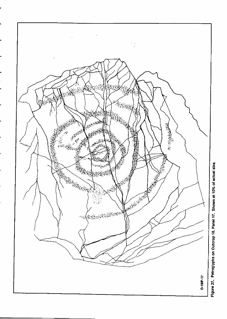
dl!ao=(,ooao6
3ooriocG'o..dcto(t5ocoah
CLiE)o{'A
(Do=ED
|r
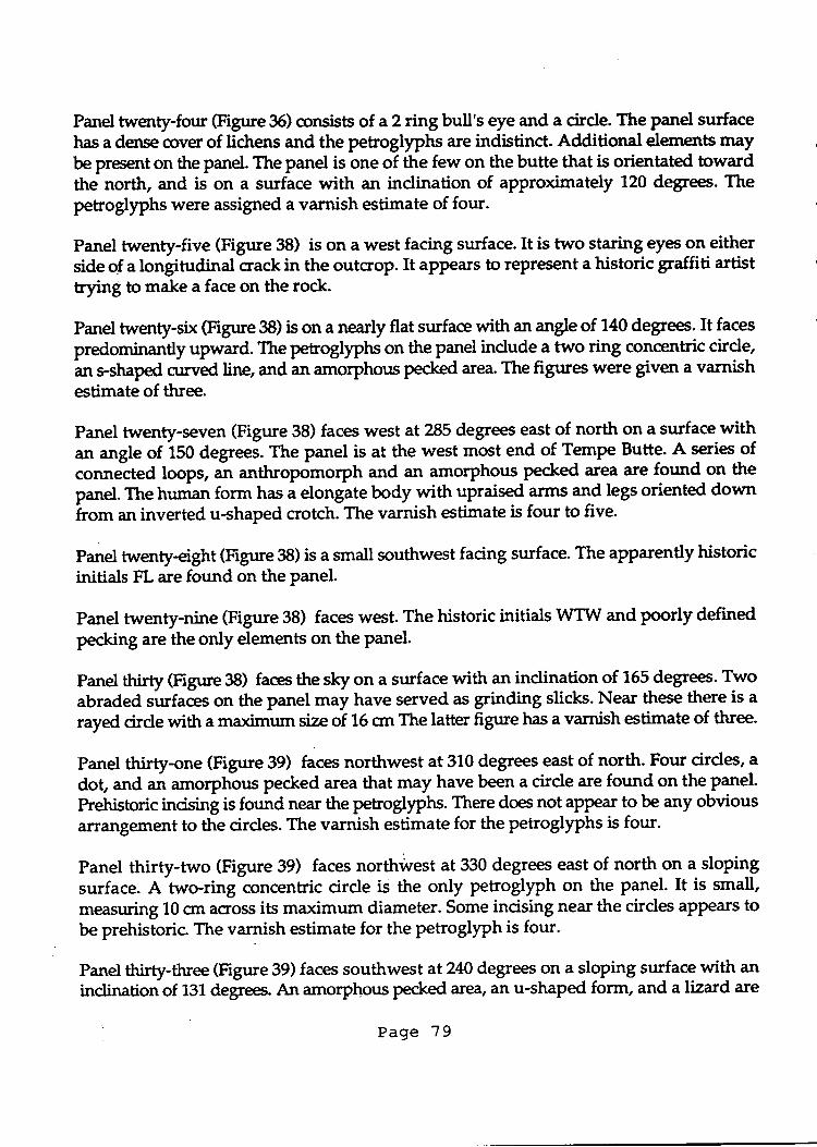
Panel twenty-four (Figrrre 35) consists of a?ring bull's eye and a cirde. The panel surfacehas a dense cover of lichens and the petroglyphs are indistinct. Additional elements maybe preent on the panel. The panel is one of the few on the butte that is orientated towardthe north, and is on a surface with an indination of approximately 120 degrees. Thepetroglyphs were assigned a varnish estimate of four.
Panel twenty-five (Figure 38) is on a west facing surface.It is two staring eyes on eitherside of a longitudinal crack in the outcrop. It appears to represent a historic graffiti artisttrnt g to make a face on the rock.
Panel twenty-six (Figrre 38) is on a nearly flat surface with an angle of 140 degrees. It faces
predominantly upward. The petroglyphs on the panel indude a two ring concentric cirde,an rshaped cunred line, and an amorphotrs pecked area. The figrrres were gt.ten a varnishestimate of three.
Panel twenty-seven (Figure 38) faces west at 285 degrees east of north on a surface withan angle of iSO degreei. The panel is at the west most end of Tempe Butte. A series ofcot ttelted loops, an anthropomorph and an amorphous pecked :rea are found on the
panel.Tlnehuman form has i elongltebody with upraised arms and legs oriented downfrom an inverted u-shaped crotch. The varnish estimate is four to five-
Panel twenty-eight (Figure 38) is a small southwest facing surface. The apparently historicinitials FL are found on the panel.
Panel twenty-nine (Figure 38) faces west. The historic initials WTW and poorly definedpecking are the only elements on the panel.
Panel thirty (Figrrre 38) faes the sky on a surface with an indination of 165 degrees Twoabraded surfaies on the panel may have served as grinding slicks. Near these there is a
rayd circle with a maximum size of 15 crn The latter figrrre has a varnish estimate of three.
Panel thirty-one (Figrrre 39) faces northwest at 310 degrees east of north. Four circles, a
dot, and an amorphous pecked area that may have been a circle are found on the panel.
Prehistoric incising is found near the petroglyphs. There does not aPPear to be any obviousrurangement to the cirdes. The varnish estimate for the petroglyphs is four.
Panel thirty-two (Figure 39) faces northwest at 330 degrees east of north on a slopingsurface. A two-ring concentric circle is the only petroglyph on the panel. It is small,measuring 10 qn across its maximum diameter. Some incising near the cirdes appears tobe prehistoric. The varnish estimate for the PetroglyPh is four.
Panel thirty-three (Figure 39) faces southwest at240 degrees on a sloping surface *itl *inclinationof 131 degrees. An amorphpus pecked area, an u-shaped form, and a lizard are
Page 79
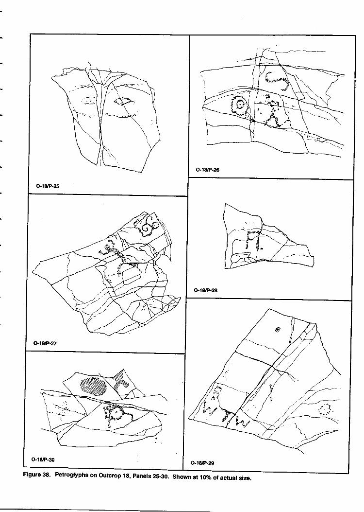
Figure 38. Petroglyphs on Outcrop 1g, panels 25€0. Shown al 10% of actual size.
T(t
o.r8/P-32
Gl8/P-34
o.l8/P-3s
Figure 39. Petroglyphs on Outcrop 18, Panels 31€6. Shown at lffio of actual size.
the petrogllph elerrcnts_on the panel.The lizard has a round body, short neck, rotrndhead, an{ Rointed tail. Its 9u.k tegr have 45 degree bends at the knee; while the front legsare straighter withoutany bend. The figure *uy teptesetrt a horned trg,ad. There are incisedlines and a small Spndlng:li*,
"pgateluy prehistoric, on the upper left part of the panel.
The varnish estimate for the nztd is four.-
Panel thirty-four (Figrrre 39) is orieyfl "t ?43 degree east of north on a surface that slopes
at 120 9eg*, The petrogllptr, whiclt has been bioken recently, is a branching curvi[nlarmeandering fonn. A portion of the figure appears to be niisi"g. rrr" p"trogl)"h has avarnish estimate of three.
PTgt-tl-tirty-five (Figure 39) faes southwest at?gdegrees on a surface with an inclinationo!.1?5 degrees' Asingle Petrog_lyph of a sectioned &r.1", measurinf 12 cm in maximumdiameter, is found on the put Jt.-ti has a varnish estimate of four.
Panel thirty-six (Figure 39) is on a sloping surface that faces southwest atz31degrees. Thepetrogllphs tue a circlg a spiral, an inostinct human form, and an amorphous peckedarea' The **tt":{g*}"*lpiral is placed betrveen two cracks in the rock surface withthe cirde below it' The human is too indistind to classify. The spirJ and the circle wereassigned a varnish estimate of four while the human and the pecked area were given athree.
Panel thirty-seven (Figure 40) is ona.northeast facing surface. The petroglyph is a peacesymbol, the work of a historic graffiti artist. c
Panel thirty-ei8ht (Figr[e 40) is a fractured rock face with an indination of 123 degrees. Itfaces b the east at 91 degrees- A one ring btrll's eye, measuring 8.5 crr across its maximumdiameter, is found o1 ae panel with"two ",,i;rph;* pecked iueas. some prehistoricincising is found on the punlt. The bull's eye has i ""tirr, estimate of four.
Panel thirty-nine (Figure a0) erhibits a small-anthropomorph measuring g crn in height.It has horizontal cossing arms, and an inverted u-snafea crotctr with legs pointing down.The head is round' The panel faces northeast on a sloping surface. Varnish on thepehoglyph was estimated at four.
P*9 fo.rq qigure 40) faces west at 270 degrrcon a sloping surface that is fractured andcracked' A lizard that measures 21-cm in-iength is found 6n the p*"r. rr," fizard has acrack running lengthwise down its back, a snirt neck, oblong heid, *a t"g, with jointsat 90 degrees' Digits are shown at the ends of tiliA;. Another figure on the panel is ahorned anthropomolph or lizard man. It is not ^"i" as well ", i-t, neighbor, but it isclearly the same artistic tradition- T: bgoy of thi; Gre is oval and it has a short neck,a rounded head' and horns' Arms md/or l"ir *";;i&tr"grl"t shoulders and hips; theyare bent at right angle at the joints. A.small-spiral and amoiphous pecked areas make up
Page 82
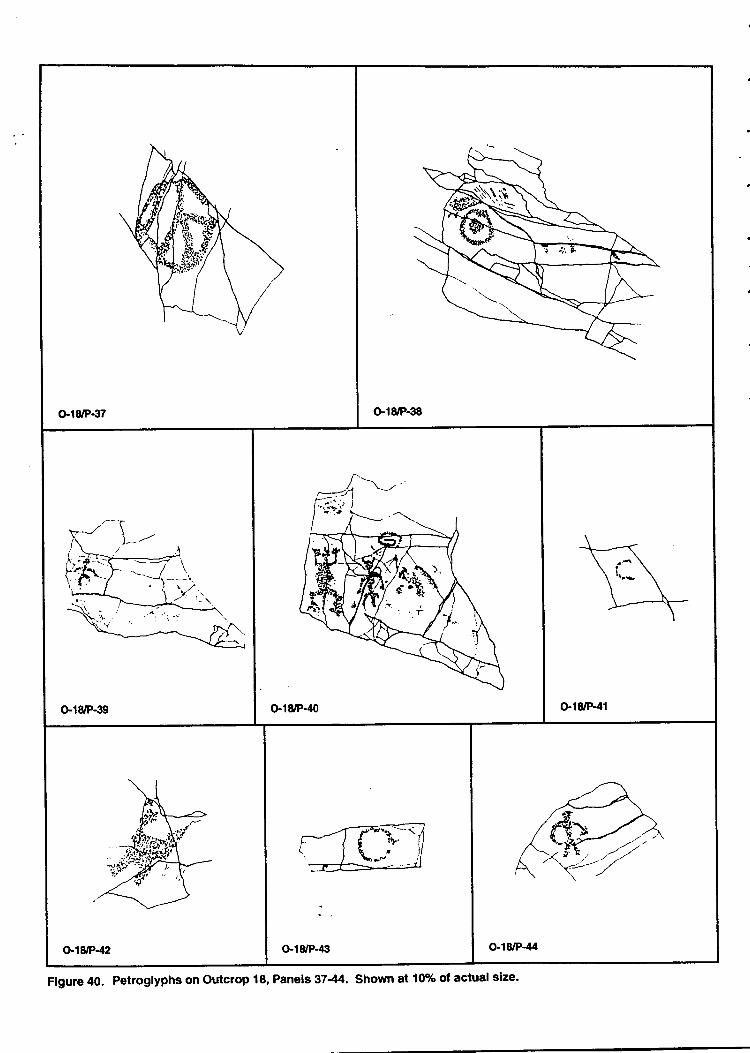
o.l8rP€7 Gl8/F€8
G18/P-39 G18'P.40 G18/P-41
o-18/P-€ O"r8/P-44
Figure 40. Petroglyphs on Outcrop 18, Panels 37-44. Shown at 10% of actual size.
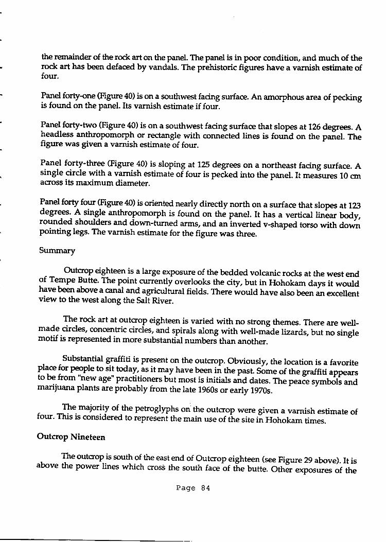
the rerxrainder of the rock art on the panel. The panel is in poor condition, and much of therock art has been defaced by vandals. The prehistoric figures have a varnish estimate offour.
PTd forty-one (Figure 40) is on a southwest facing surface. An amorphous area of peckingis found on the panel.Its varnish estimate if four.
Panel forfy-two (Figure 40) is on a southwest facing surface that slopes at126 degrees. Aheadless anthropomorph or rectangle with connetted lines is found on the paiel. Ttrefigure was given a varnish estimate of four.
Panel forty-three (Figure 40) is sloping at 125 degrees on a northeast facing surface. Asingle cirde with a varnish estimate of four is pe&ed into the panel. It measures l0 cmacross its maximum diameter.
P-anel forty fotu (Figure 4CI) is nearly directly north on a surface that slopes at 123degrees. A single anthropomorph is-found on the panel. It has a vertical hnlar body,rounded shoulders and down-turned arms, and an inverted v-shaped torso with downpointing legs. The varnish estimate for the figure was ouee
Summary
Outcrop eighteen is a large exposure of the bedded volcanic rocks at the west endof Tempe Butte. The point ctrnently overlooks the city, but in Hohokam days it wouldhave been above a canal and agricultural fields. There would have also been an excellentview to the west along the Salt River.
The rock art at gutcro,p eighteen is varied with no strong themes. There are well-made cirdes, concentric circfus, ana spiras along with well-*Id" [zards, but no singlemotif is represented in more substantial numberJthan another.
Substantial qraffi! is present on the outcrop. obviously, the location is a favoritePll* f:t p"opt" to sit today, as it may have been in the past. Sott
" of the graffiti appears
to be from "new age" practitioners but most is initials ut d d"t"r. The p""." symbols andmarijuana plants are probably from the late 1950s or early 1970s.
L
- -F" majority of $e petroglyphs on'the outcrop were given a varnish estimate offour' This is considered to iepreJe"i tt
" main use of the site in Hohokam times.
Outcrop Nineteen
, The outcrop is south of the eastend of Outcrop eighteen (see Figure 29 above). It isabove the power lines which cross the south facebf the butte. oth; exposures of the
Page 84
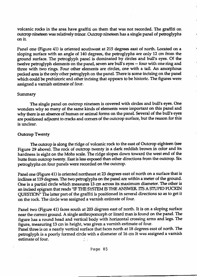
volcanic rocks in the area have graffiti on them that was not recorded. The graffiti onoutcrop nineteen was relatively minor. Outcrop nineteen has a single panel of petroglphson it.
Panel one (Figure 47) is oriented southwest at 215 degrees east of north. Located on asloping surface with an angle of 140 degrees, the petroglyphs are only 12 crn from theground surface. The petroglyph panel is dominated by cirdes and bull's eyes. Of thetwelve petroglyph elements on the panel, seven are bull's eyes - four with one ring andthree with two rings. Four other elements are cirdes, one with a tail. An amorphouspecked area is the only other petroglyph on the panel. There is some incising on the panelwhich could be prehistoric and other incising that appears to be historic. The figures wereassigned a varnish estimate of four.
Summary
The single panel on outcrop nineteen is covered with cirdes and bull's eyes. Onewonders why so many of the s:une kinds of elements were important on this panel andwhy there is an absence of human or animal forms on the panel. Several of the bull's eyes
are positioned adjacent to cracks and crrrners of the outcrop surface, but the reason for thisis unclear.
Outcrop Twenty
The outcrop is along the ridge of volcanic rock to the east of Outcrop eighteen (see
Figure 29 above). The rock of outcrop twenty is a dark reddish brown in color and itshardness is eight on the Mohs scale. The ridge slopes down toward the west end of thebutte from outcrop twenty. East is less exposed than other directions from the outcrop. Six
petroglyphs on four panels were recorded on the outcroP.
Panel one (Figure 41) is oriented northeast at 23 degrees east of north on a surface that isinclines at 119 defees. The two petroglyphs on the panel are within a meter of the ground.One is a partial cirde which measures 13 cm across its maximum diameter. The other isan incised epigram that reads 'IF TfG SYSTEM IS TFIE AI{S\MER ITS A STUPID FUCKIN
QUESIION" The latter part of the graffiti is positioned in several directions so as to get iton the rock. The cirde was assigned a varnish estimate of four.
Panel two (Figure 41) faces south at 203 degrees east of north. It is on a sloping surface
near the cturent grotrnd. A single anthropomorph or lizard man is found on the panel. The
figure has a round head and vertical body with horizontal crossing arms and legs. Thefigure, measuring 13 cm in height, was given a varnish estimate of four.Panel-three is on a nearly vertical surface that faces north at 18 degrees east of north. Thepetroglyph is a poorly formed cirde with a diameter of 16 crn It was assigned a varnishestimate of four. I .
Page 85
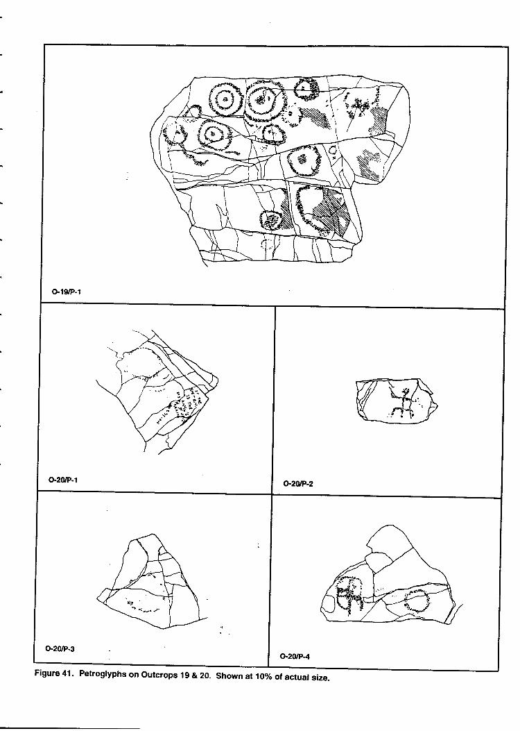
G19/P-1
Figure 41 . Petrogryphs on outcrops 19 & 20. shown at 10vo or actuar size.
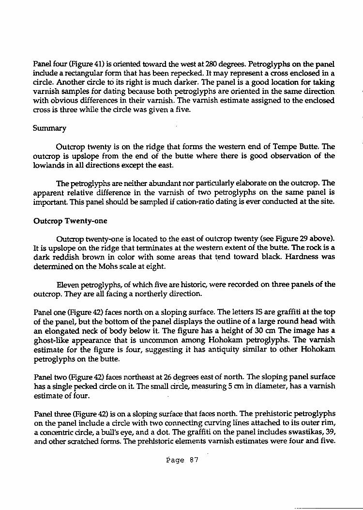
Panel four (Figure 41) is oriented toward the west at 280 degrees. Petroglyphs on the panelindude a rectangular form that has been repecked. It may represent a cross endosed in acirde. Another cirde to its right is much darker. The panel is a good location for takingvarnish samples for dating because both petrogtyphs are oriented in the s:rme directionwith obvious differences in their varnish. The varnish estimate assigned to the endosedcross is three while the cirde was given a five.
Summary '
Outcrop twm$ is on the ridge that forms the western end of Tempe Butte. Theoutcrop is upslope from the end of the butte where there is good observation of thelowlands in all directions except the east.
The petroglyphs are neither abundant nor particularly elaborate on the outcrop. Theapparent relative difference in the varnish of two petroglyphs on the same panel isimportant. This panel should be sampled if cation-ratio dating is ever conducted at the site.
Outcrop Twenty-one
Outcrop twenty-one is located to.the east of outcrop twenty (see Figure 29 above).It is upslope on the ridge that terminates at the western extent of the butte. The rock is adark reddish brown in color with some areas that tend toward black. Hardness wasdetermined on the Mohs scale at eight.
Eleven petroglypts, of whictr five are historic, were recorded on three panels of theoutcrop. They are all facing a northerly direction.
Panel one (Figure42) faces north on a sloping surface. The letters IS are graffiti at the topof the panel, but the bottom of the panel displays the outline of a large round head withan elongated neck of body below it The figtue has a height of 30 cm The image has aghost-like appearance that is uncornmon .rmong Hohokam petrogllphs. The varnishestimate for the figure is four, suggesting it has antiquity similar to other Hohokampetroglyphs on the butte.
Panel two (Figure 42) faces northeast at 26 degree east of north. The sloping panel surfacehas a single pecked cirde on it The small cilde measuring 5 orr in diameter, has a varnishestimate of four.
Panel three (Figrrre,12) is on a sloping surfacre that faces north. The prehistoric petroglyphson the panel include a circle with tr,rro connecting curving llnes attached to its outer rim,a concentric cirde, a bull's eye, and a dot. The graffiti on the panel indudes swastikas,39,and other scratdred forms. The preNstoric elements varnish estimates were four and five.
Page 87
o,21F.-l ol1/P'-2
azJP-1
- ' -------
o-l721P-2
'V.t'l \t(dffrq z if"t'- |
Figure 42- Petroglyphs on outcrops 2r-23. shown ar 1oo/o of actual size.
Sunmary
Otrtcrop twenty-one is up the ridge from outcrop twenf. The petroglyphs on theoutcrop are neither nrunerous nor elaborate. Apparently the focus of the prehistoric artistswas on either the west end or the high point of the butte. Outcrops twenty and twenty-oneare between these zueas, and were not selected as frequently for petrogllphs.
Outcrop Twenty-two
The outcrop is located to the north of the cturent trail to the east of outcropseventeen (see Figure 29 above). The best surfaces for petrogllphs on the low protrudingoutcrop are toward the south. The primary surface color of the outcrop is dark reddishbrown with some areas that are more black. Its Moh's hardness is eight.
Two panels of petrogllphs were recnrded on the outcrop. One has two petroglyphson it and the other has only one.
Panel one (Figur e 42) faces south at 192 degrees east of north. The nearly flat surfaceexhibits the petroglyph of a curvilinear meander with endosures that most doselyreerrrbles a preael. The figure has a madmum dimension of 14 cm and a varnish estimateof five.
Panet two Gigure 42) is located to tlre est of panel one on another flat surface that is facingsouthwesl The two pebogllphs indude a dot with a line through it and a bisected cirde.It was assigned a varnish estimate of five.
Summary
Outcrop twenty-two is adjacent to the ctrrrent trail up the south side of TempeButte. Suitable panels are relatively common in the area of outcrop 22,but these surfaceslacked prehistoric modifications. The varnish estimate of five is probably slightly higherbecause the figures .ue near the ground where they are exposed to more nutrients.
Outcrop Twenty-three
The outcrop is a low exposure of volcanic rock in the open talus area of the uPPerpartof Tempe Butte (see Figure 29 above). It is north of the existing trail and south of thepower line to the east of outcrop nineteen. The rock is dark reddish brown to black in crolor
and it has a hardness of eight. A single panel of petroglyphs is found on the outcrop.
Panel one (Figure 42)isoriented northeast at 28 degrees east of north. The sloping surfacedisplays petroglyphs within a meter of the current ground. The panel is badly defacedwith narnes "JOE TOBIN -IENINIE MARTINE Z -FEB 9-7963. The names are apparently
Page 89
endosed in a segmented outline heart. Prehistoric petroglyph elements indude a spiral,a double cross, curvilinear forsr and an amorphous pecked area. The prehistoric elementsare pecked into the surface about L mm while the historic n,unes are incised into tttesurface about 2 mm. The prehistoric figures were assigned a varnish estimate of four.
Summary
The single Panel of petroglyphs on outcrop twenty-three has been seriously defacedby vandalisur The prehistoric spiral and double cross are draracteristic of nearby panels.The panel shows the indination for Hohokam artists to put a few elements in isolatedlocations.
Outcrop Twenty-four
The outcrop is located on the southwest side of the high point on Tempe Butte (seeFigure 17 above). It is above and northeast of the concrete A. The rock surface is darkreddish brown in color and it has a hardness of 8 on the Mohs scale. Two panels ofPetroglyPhs were recorded. Most of the rock surfaces in the outcrop have been heavilyimpacted by historic activities, making it impossibte to determine the number ofpeuogllphs that were originally preent. Only one prehistoric panel was identified on theoutcrop. A historic motif was also recorded.
Pane_l one {Figure 43) faces west at 240 degrees. The sloping surface has a peckedrectilinear forur on it. It was assigned a varnish estimate of four.
Panel two (Figure 43) faces southwest. This historic figure exhibits an incised saguarocactus that is set in front of a sun and mountains. The scene at least shows horeimagination than initials and dates.
Summary
_ OtrtcroP twenty-four is located on the uppermost exposure of volcanic rock on thebutte. Most of the rock surface is covered by a heavy coatbf paint that has been used toobsctre graffiti. The rock faces in the outcrop are large panels that appear well suited forpetrogllphs, and it highly probable that additional petrogllphs have been obscured by theover-painting.
Outcrop Twenty-five
The outcrop is located to the east of outcrop twenty-four (see Figure 17 above). Itis situated on a protuberance of thd rock along the southern base of thJrugh point. The
Page 90
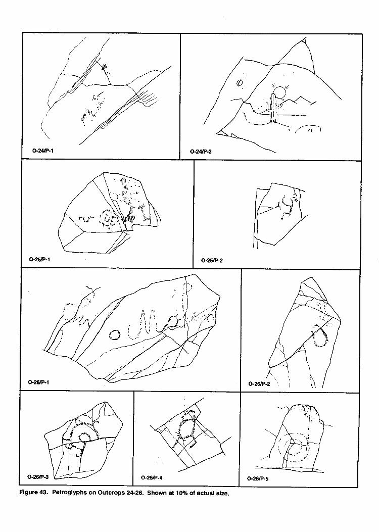
I
o-24tP-1 a2&-2
G2stP-2
.( f+j'r'*'lr{
c
Figure tli!. Petroglyphs on Outcrops 24-26. Shown al loolo ol actual size.
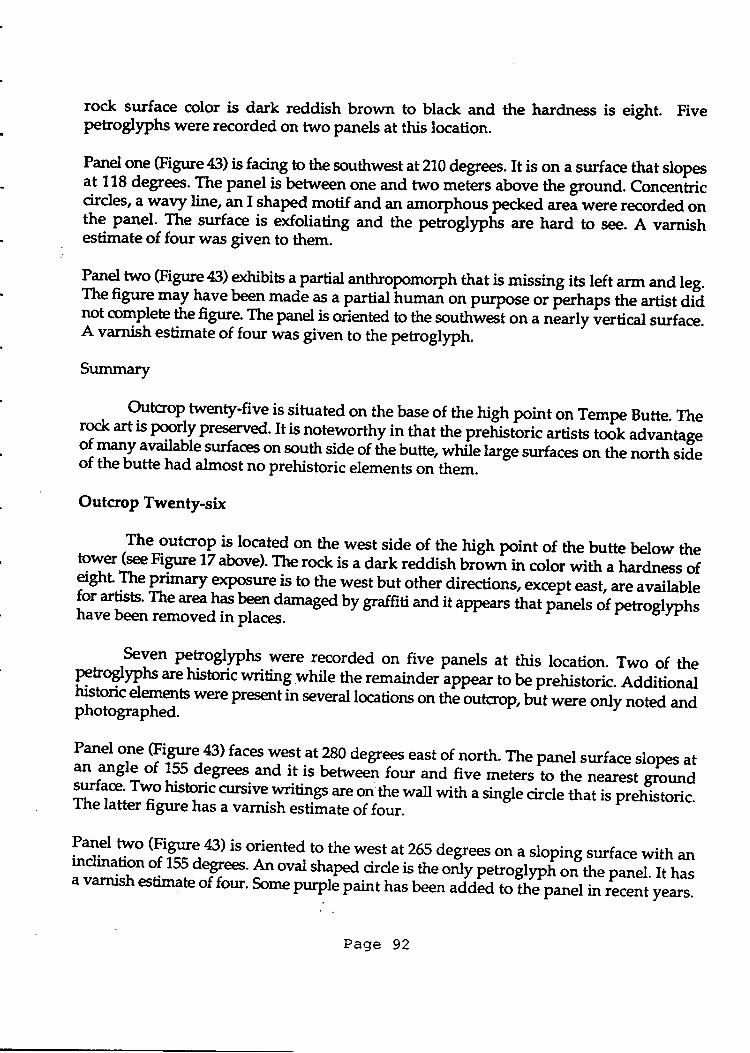
rock surface color is dark reddish brown to black and the hardness is eight. Fivepetroglyphs were recorded on two panels at this location.
na19l o1e (Figrue 43) is facing to the southwe t at210 degtees. It is on a strface that slopesat 1-18 degrees. The panel is betrueen one and two meters above the ground. Concen'triccircles, a yI? line, an I shaped motif and an amorphous pecked
"tei *ete recorded on
the panel- The surface is exfoliating and the petroglyphr are hard to see. A varnishestimate of four was given to them.
l*1 two (Figure 43) octribits a partial anthropomorph that is missing its left arm and leg.Thefigure may havebeen made as a partialhuman on purpose or ferhaps the artist diinot complete thefigure. Thepanel is oriented to the southwest on a nlarly vertical surface.A varnish estimate of four was given to the petroglyryh.
Summary
. Outcrop twenty-five is situated on the base of the high point on Tempe Butte. Therock art is pqg4y preserved. It is noteworthy in that the pret istbtic artists took advantageo{ r-naly available surfaces on south side of tr," Untte *t il" large sgrfaces on the north sideof the butte had almost no prehistoric elements on them.
Outcrop Twenty-six
The outcrop is located on the west side of the high pornt of the butte below theto.
ryer Gee Figrrre 17 above). The rock is a dark reddish brown in color with a hardness of}ght P"lfu"ty exPosure is to the west but other directions, except east, are availablefor artists' The area lf T* damaged by graffraand it appears that panels of petrogl)?h;have been removed in places.
-Seyen petroglyphs were recorded on five panels at this location. Two of the
Ftr€yphs are historic writing while the remainder appear to be prehistoric. Additionathistoric elements were present in several locations on the outcrop, but were only noted andphotographed.
Panel one (Figure 43) faces west at 280 degrees east of-north. The panel surface slopes atan angle of 155 degrees and it is betriveen four and five meterr'to tt "
nearest groundsurface' Two historic cursive.l ti"gt are on'the wall with a single circle that is prehistoric.The latter figure has a varnish estiirate of four.
lq:t tlo (lieure 43) is oriented to the west at 255 degrees on a sloping surface with anindination of 155 degrees. An oval shaped circle is the only petroglyph on the panel. It hasa varnish estimate of four. some purp6 paint has been "aa"a
trTriJp*J in recent years.
Page 92
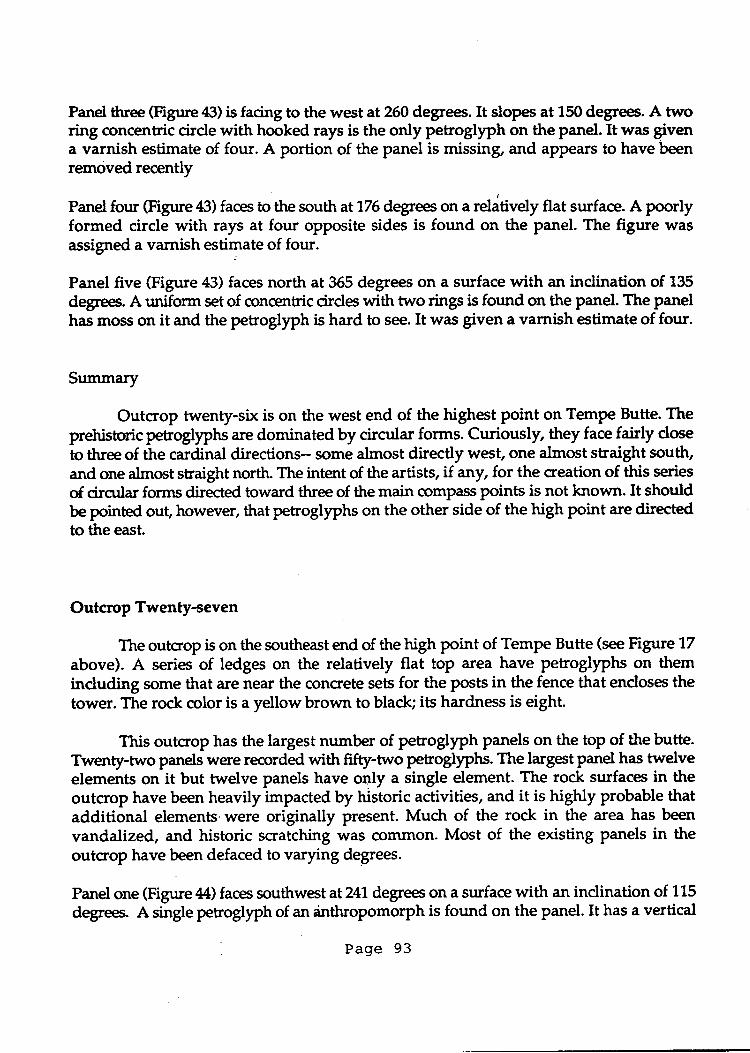
Panel three (Figrrre tt3) is facing to the west at 260 degrees. It slopes at 150 degrees. A tworing concentric cirde with hooked rays is the only petrogllph on the panel. It was Fvena varnish estimate of four. A portion of the panel is missing, and appears to have beenremoved recently
Panel fonr (Figure 43) faces to the south atlT6degrees on a reldtively flat surface. A poorlyformed circle with rays at four opposite sides is found on the panel. The figure wasassigned a varnish estimate of four.
Panel five (Figure 43) faces north at 365 degrees on a surface with an indination of 135
degees. A uniform set of qcncentric cirdes with two rings is forurd on the panel. The panelhas moss on it and the petroglyph is hard to see. It was given a varnish estimate of four.
Suurmary
Outcrop twenty-six is on the west end of the highest point on Tempe Butte. Theprehisoric petroglyphs are dominated by circular forms. Curiously, they face fairly doseto three of the cardinal directions- some almost directly west, one almost straight south,and one almost straight north. The intent of the artists, if any, for the creation of this series
of circtrlar forms directed toward three of the main @mpass pornts is not known. It shouldbe pointed out, however, that petroglyphs on the other side of the high point are directedto the east.
Outcrop Twenty-seven
The outcrop is on the southeast end of the high point of Tempe Butte (see Figure 17
above). A series of ledges on the relatively flat top area have petroglyphs on theminduding some that are near the concrete sets for the posts in the fence that encloses thetower. The rock color is a yellow brown to black; its hardness is eight.
This outcrop has the largest number of petroglyph panels on the top of the butte.Twenty-two panels were recorded with ffry-two petrogllphs. The larget Panel has twelveelements on it but twelve panels have oqly a single element. The rock surfaces in theoutcrop have been heavily impacted by historic activities, and it is higNy probable thatadditional elements.were originally present. Much of the rock in the area has been
vandalized, and historic scratching was corunon. Most of the existing panels in theoutcrop have been defaced to varying degrees.
Panel one (Figure44) faces southwest at24l degrees on a surface with an inclination of 115
degrees. A single petroglyph of an dnthropomorph is found on the panel. It has a vertical
Page 93
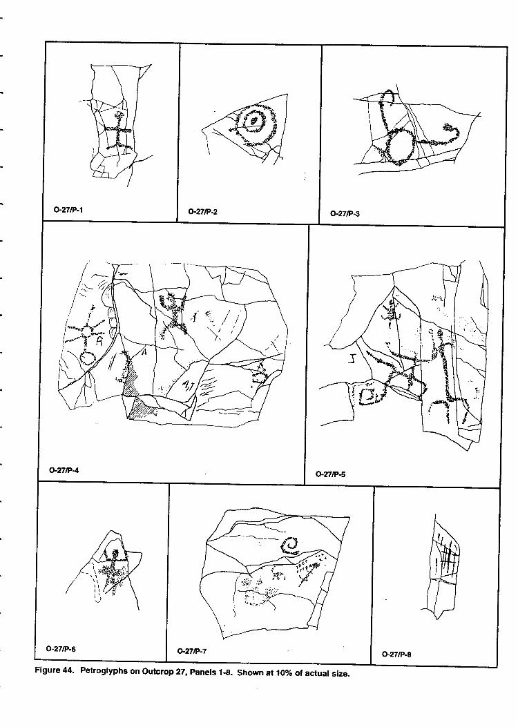
/"'*u*,.t'-/--"-?'T'
Figure 44. Petroglyphs on outcrop 27, panels 1-g. shown at 1oo/o ol actual size.
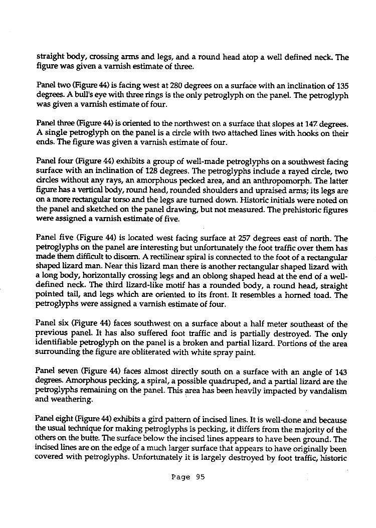
straight body, crossing iurrs and legs, and a round head atop a well defined neck. Thefigure was given a varnish estimate of three.
Panel two (Figure4t4) is facing west at 280 degrees on a surface with an inclination of 135degfees. A bull's eye with three ti.gs is the only petroglyph on the panel. The petrogllphwas given a varnish estimate of four.
Panel three (Figure 44) is oriented to the northwest on a surface that slopes at'1.47 degrees.A single petroglyph on the panel is a cirde with two attached tines with hooki on theirends. The figure was given a varnish estimate of four.
Panel four (Figure 44) exhibits a group of well-made petroglyphs on a southwest facingsurface with an indination of 128 degrees. The peeoglyphs indude a rayed circle twocirdes without any rays, an amorphous pecked area, and an anthropomorph. The latterfigure has a vertical body, round head, rounded shoulders and upraised arms; its legs areon a more rectangular torso and the legs are turned down. Historic initials were noted onthe panel and sketdred on the panel drawing, but not measured. The prehistoric figureswere assigned a varnish estimate of five.
Panel five (Figur e M) is located west facing surface at ?57 degrees east of north. Thepetroglyphs on the panel are interesting but unfortunately the foot traffic over them hasmade them diffictrlt to discern. A rectilinear spiral is connected to the foot of a rectangularshaped lizard man. Near this lizard man there is another rectangular shaped lizard witha long body, horizontally crossing legs and an oblong shaped head at the end of a well-defined neck. The third lizard-like motif has a rounded body, a round head, straightpointed tail, and legs whidr are oriented to its front. It resembles a horned toad. Thepetroglphs were assigned a varnish estimate of four.
Panel six (Figure 44) faces southwest on a surface about a half meter southeast of theprevious ganel. It has also suffered foot traffic and is partially destroyed. The onlyidentifiable petroglyph on the.panel is a broken and partial lizard. Portions of the areasurrounding the figure are obliterated with white spray paint.
Panel sev€n (Figure 44) faces almost directty south on a surface with an angle of 743degree. Amorphous pecking, a spiral, a possible quadruped, ild a partial liztd are thepetrogtlphs remaining on the panel. This area has been heavily impacted by vandalismand weathering.
Panel eight (Figure44) o&ibits a gird pattern of incised lines. It is welldone and becausethe usual !c!{qge for making petroglyphs is pecking, it differs from the majority of theothers on the butte. The surface below the incised lines appears to have been ground. Theincised lines are on the edge of a much larger surface that appears to have originatty Ueencovered with petroglyphs.Unfortulrately it is largely destroyed by foot traffic, historic
Page 95
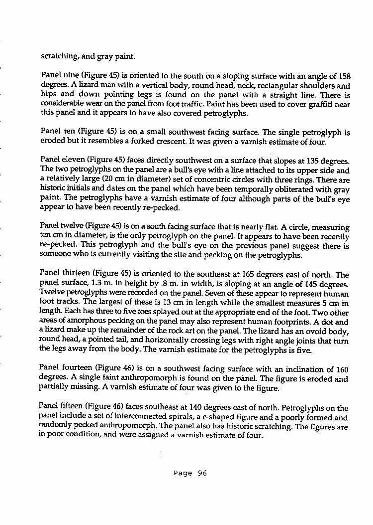
scratching, and gray paint.
Panel nine (Figure 45) is oriented to the south on a sloping surface with an angle of 158degree. A lizard man with a vertical body, round head, neck, rectangular shoulders andhips and down pointing legs is found on the panel with a straight line. There isqrnsiderable wear on the panel from fmt traffic. Paint has been used to cover graffiti nearthis panel and it appears to have also covered petroglyphs.
Panel ten (Figure 45) is on a small southwest facing surface. The single petroglyph iseroded but it resembles a forked crescent. It was given a varnish estimate of four.
-
Panel eleven (Figure 45) faces directly southwest on a surface thai slopes at 135 degrees.The two petroglyphs on the panel are a bull's eye with a line attached toits upper side anda relatively large (20 crn in diameter) set of concentric cirdes with three ti"gt.There arehistoric initials and dates on the panel which have been temporally obliteratea with graypaint. Thg netrgglyphs have a varnish estimate of four although parts of the bull'ieyeappear to have been recently repecked.
Panel tudY9 Gigtrre 45) is on a south facing surface that is nearly flat. A circle, measuringten ort in diameter, is the only petroglyph on the panel. It appears to have been recentlfre-pecked. This Petroglyph and the bull's eye on the previous panel suggest there issomeone who is currently visiting the site and pecking on the petroglyphs.
-
Panel thirteen (Figure 45) is oriented to the southeast at 155 degrees east of north. Thepanel surface, 1.3 m. in height by .S m. in width, is sloping at an angle of 145 degrees.Twelve PgEogly"hs were recorded on the panel. Seven of these appear to reptesent himanfoot tracks. The largest of these is 13 crnin length while the smallest measures 5 crn inl*gth. Eadt has three to five toes splayed out at the appropriate end of the foot. Two otheraleas of amorphow pecking on the panel may also represint human footprints. A dot and
" l{q make up the remainder of the rock art on the panel. The lizard hai an ovoid body,
round head, a pointed tail, and horizontally crossinglegs with right angle joints that turnthe legs away from the body. The varnish estimate for the petroglyptrJis hve.
Panel fourteen (Figure 46) is on a southwest facing surface with an inclination of 160degref.A single faint anthropomorph is found on-the piinel.The figure is eroded andpartially missing. A varnish estimate of four was given tb the figure.
Panef ftr@l Gigure 46) faces southeast at 140 degrees east of north. petroglyphs on thepanel include a set of interconnected spirals, a c-shaped figure and a poorl| iormed andrandomly Pecked anthropomorph. The panel also hal historic scratchihg. ri" figures arein poor condition, and were assigned avarnish estimate of four.
Page 96
o-271P-11
.4.:.- rr.:,:.
II ..
o-27tP-13
Figure 45. Petroglyphs on outcrop 27, Panels 913. Shown at 10yo of actual size.
o'l7tP-14 o-27fiP-1s o27tP-17
o-27tP-16
FigUre 46- Petroglyphs on Outcrop 27, Panels 14-18. Shown at 10olo ot actual size.
Panel sixteen (Figure 46) is heavily vandalized with graffiti and spray paint. Thepetsogllphs on the panel induded curvilinear meandering fonns, paired cirdes, and apossible rayd cirde, but the vandalism has nearly obscured them. The panel faces to thenortheaston a surface that slopes at 135 degrees. A varnish estimate of four was given toareas where the vandalism has not destroyed the images.
Panel seventeen (Figure 46) faces northeast on a surface that slopes at 130 degrees. Thepanel,40 on by 35 on, exhibits two petroglyphs. One is a cirde and the other is an ovoidoutline form. The varnish estimate for the petroglyphs is four.
Panel eighteen (Figure 46) is oriented to the northeast at 66 degrees east of north. It is ona surface, measuring 1.1 m- by 55 cm, with an indination of 140 degrees. The entire surfaceof the Panel has been defaed by historic scratching. The petroglyphs on the panel indudetwo Hohokam pipette or double crmelation designs made by parallel zrg-zrigor step$lines. Grdes and dots fill in areas of the designs, and in this case both take on :u1anthropomorphic appearance. One of the figures me,rsures 105 crn in height by 30 crn inwidth and the other is 82 qr tall and 134 cm wide. Portions of both pipettes have been re-Pecked (darker areas on the drawing). Although it is difficult to estimate when this tookplace, it does not appear to have been in the past 50 years and may have been in the lateprehistoric or possibly protohistoric. The circles on the left side of the panel have a muchlighter varnish. These may be more recent additions to the panel that were done at thesarne time as some of the repecking to the pipettes. Some of the petroglyphs on this panelare more deeply pecked than those on neighboring panels and in some places one canidentify individual v-shaped dint marks. The varnish estimate for the unaltered areas ofthe petroglyPh is five while the repecked areas were assigned an estimate of one.
Panel nineteen (Figure 47) faces east at 95 degrees on a large sloping surface. A singlepretristoric curvilinear motif with endosure reembli.g
" preael is fourd on the panel. The
figure was given a varnish estimate of four. There is historic scratching across much of thepanel, which was only photographed because of density.
Panel twenty (Figure 47) facs east at 100 degrees east of north. There is concrete acrossmudr of the panel strrface but it is still discernable and reads "GEO. Mct{EAL - FEB, XXVI1880 -BALTIMOTE" Some of the writing is eroded but the date appears to be accurate.M*y of the rock surfaces in the area of the panel have historic initials, but all appear tobe considerably more recent.
.
P*9 twgnty-one (Figure 47) is on the northern edge of outcrop twenty-seven. The panelsurface faces west at 283 degrees. A single phallic anthropomorph or lizard figure ispresent on the Panel, that has an indination of 105 degrees. The panel surface is exfoliated,and the petroglyph was assigned a varnish estimate of four.
Page 99
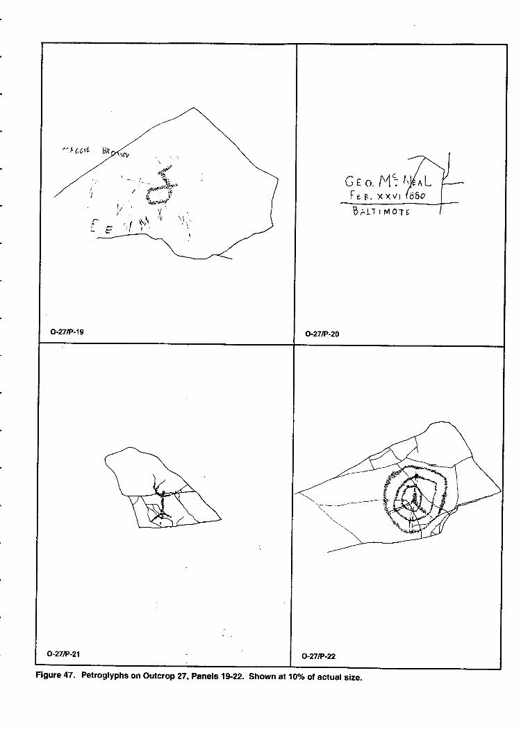
r1N.(,C,te 8n
G e o. A4':Fr r. x xvr
Betr ' Mo'rt
Figure 47. Petroglyphs on outcrop 27, panels 1922. Shown at 107o of actual size.
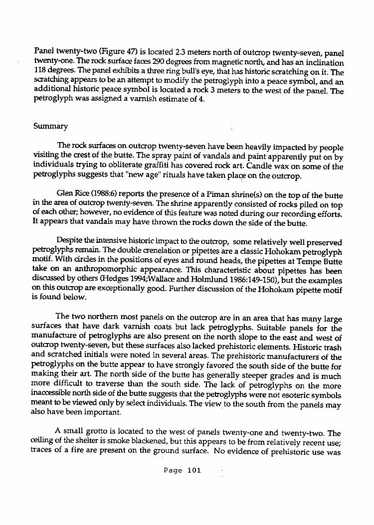
Panel twenty-two (Figure 47) is located 2.3 meters north of outcrop twenty-seven, paneltwenty-one. The rock surface faces 290 degrees from magnetic north, and hasan inclnltion118 degrees. The panel exhibits a three ring bull's eye.thit has historic scratching on it. Thescrl&ing aPPea$ to be an attempt to rnodify the petroglyph into a peace sy bol, and anadditional historic Peace symbot is located a rock 3 meteis to the west of the panel. Ttrepetroglyph was assigned a varnish estimate of 4.
Summary :
The rock tqflq on outcrop twenty-seven have been heavily impacted by peopletititi.g the crest of theb-utte. The spray paint of vandals and paint apparently pui on byindividuals trying to obliterate graffiti has covered rock art. Candle *ax on some of tnlpetroglyphs suggests that "new age" rituals have taken placp on the outcrop.
Glm Rice (1988:6) reports the presence of a piman shrine(s) on the top of the buttein the area of outcrop twenty-seven. T-h9 shrine apparently consisted of rocki piled on topof each other; however, no evidence of this feature was noied during o* r""oriing efforti.It appears that vandals may have thrown the rocks down the side of the butte.
Depite the intensive historic impact to the outcrop, some relatively well preservedpetrogllphs remain- The double crenelation or pipettes are a classic Hohokam petroglyphmotif. Wittt cirdes in the positions of eyes and round heads, the pipettes at Tempeblitetake on an anthropomolphic aPPearance. This ctraracteristic a-b6ut pipettes has beendt"Tfd by others (Hedges 7994;Wallace and Holmlund 19t36:749-lSOl, Uut the examples9"-tt it orrtcrop are exceptionally good. Further discussion of the Hohokam pipette motifis found below.
The two northern most panels on the outcrop are in an :rea that has many largesurfaces that have dark varnish coats but lack petroglyphs. Suitable panels ior tf,"manufacture of petroglyphs are also present on the north stope to the east and west ofoutcrop twen$r-seven, but these surfaces also lacked prehistoric elements. Historic trashand sctatched initials were noted in several ;ueas. The prehistoric manufacturers of thepetrogllphs on the butte aPPear to have strongly favored the south side of the butte formaking their art. The north side of the butte has generally steeper grades and is muchmore difficult to traverse than the south side. The lack of p"t ogtyphs on the moreinaccessible north s-ide9f the butte suggests that the petroglyphs were iof
"rot"ric symbols
meant to be viewed only by select individuats. The view iothe south from the panels mayalso have been important.
A small grotto is located to the west of panels twenty-one and twenty-two. Theceiling of the shelter is smoke blackened, but this appears to be from relativelyiecent use;traces of a fire are Present on the ground surface. No evidence of prehistoric use was
Page l-01-
noted on the ground surface, but it is possible that the shelter was utilized.
Outcrop Twenty-eight
The outcrop is located to the northeast of outcrop twenty-seven (see Figure 12above)' It is a small ledge of the volcanic rock with u srrf""" coloiof btack. o^ly a singlepanel of petroglyphs was recorded on the outcrop.
lanel one (Figur:1s) is facing northeastwhere it overlooks the Salt River in the lowlands.The sloping p*q.|l6 Yo -p"ttoglyphs on it, both of which were made by incising ratherthan pecking' Although this is oitlnthe technique ry"g{or graffitr, botn of the figuresaPPear to be varnished and old. one figure has a vertical bod; *J p*rry formed head.It has horizontally crossing arms and legl. one "r *a leg are pointed down on one sideof the body and up on the other. rnei*rer figure 4l ;ro.rna h;;;, shown in profile,aPPears to be walking' rts arms T" d-"*". ihe position of th" iig;" suggests a fluteplayer' but there is no evidmce of a flute betrueen th^e mouth and arms. There is also recentgraffiti on the panel.
Summary
The outcrop is located to the northeast of the Hqlpoilt on Tempe Bufte. A singlepanel of Petroglyphs is found on tle. outcrop. Th;* aiff", from o*reJs in that they aremade by incising rather than pecking. Noneth"t"rr, they appear to be part of theprehistoric petroglyph tradition on the 6utte.
Outcrop Twenty-nine
The outcrop is located near the t9p o{ Tempe Butte to the southeast of the fencesurrounding the toryer (see Figure 17 above). Outcrop twenty-nine is south of outcroptwenty-seven' The volcanic rocks *p*q in outcrop twenty-nine are almost black in color.some of this qrlor is from the heaw varnish the ro&s get in their exposed position on thetop of the butte. The rock has a hardno, orJ!t;;ri" Mohs scale.
Two panels of petroglyphs were recorded on the outcrop. one of these has eightpetroglyphs on it wh'e the oirrer exhibits "r""""
p"uogryphs.
Panel one (Figure 48) is oriented to the southwest at 205 degrees east of north. The surfaceof the panel, less than a meter across, slopes at 130 allr""r. six bull,s eyes, two with twotings and four dT o.": ring, are the most'obvious p""3giilnr;;;i";l;el. A circle witha crescent' a pair of cirdes, an individual circle, ur,d "
zig-Lig line maki up tt e remainderof the rock art on the panel. The figures were assigned a varnish estimate of four.Panel two (Figure 48) is oriented south at 185 degrees on a nearly flat surface. The
Page I02
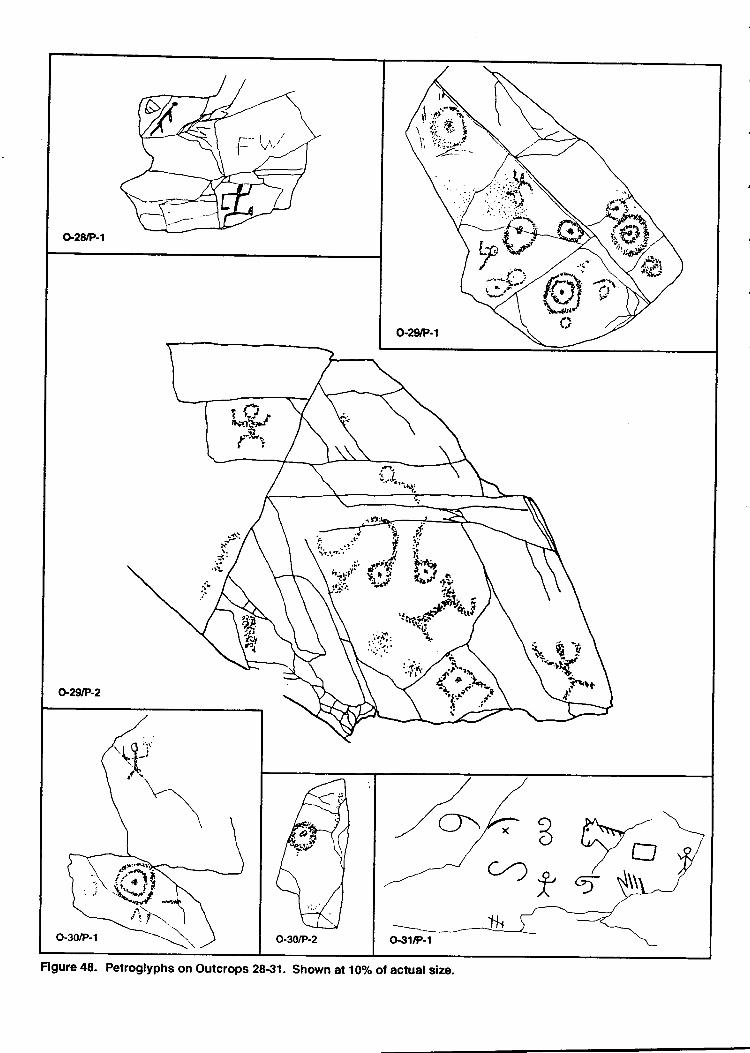
o-29tP-2
Figure 48- Petroglyphs on outcrops 28-31. Shown at 10olo of actual size.
PetroglPhs on the Panel indude three anthropomorphs, one without a head; one with anoutlined head, holizoltally cossing arms and-legs, upraised arms and down turned legs;and one with a "otiq stickbody, iound head, c*ea shoulders and upraisea arrrs, aidan inverted-v shaped crotdt with its legs down. Other figures on the panel include twoSttS bull's eyes, a possible human f*tpti"t, amorphow p".ki"g and a triangle with a dotinside it and tangmt lines connected io it. The ri'g.tt"s were glrren a varnish estimate offour.
Summary
Outcrop tu/enty-nine is situated on the south side of the highest point on TempeButte' The exposed rocf "j-th"
top of the butte offered the prehistoii. "ttilrtr
opport rr,i'tyto PutPetrogllphs on all sides in every possible orientation. it is ir,teresting that they cil;the south, east, or west sides ror ttrg.liore elaborate panels. rrr" p"ttotrfoi, or, 6.riooptwenty-nine are l gTq example of this selection. The artists *"y nurr"'"hosen directionsoriented toward the irrigationianals and the agricultural fields below, rather than the SaltRiver.
The outcrop is dominated by petroglyphs of circles and bull's eyes.unlike otherlocations, howevei, there are anthropo^oipt r on this outcrop. on the other hand, nolizards are present on the outcrop.
Outcrop Thirty
otttcrop tltirty is on the south side of the east end of the high point on Tempe Butte.It is situated to the south.gf o.utqop trv.en!/-eight. The rock suifacl at outcrop thirty is adark reddish brown and the hardness is eightin the Moh,s scale.
Two panel3 of netroelyphs were recorded on the outcrop. one exhibits fourprehistoric PetroglyPhJwhi[ ihe other.h* i r1";]ipet ogtyph onit. outcrop thirtyhasbeen heavily impacted by historic activities inclu?ini, r*i t'Jri. ana grafriti.
Panel one (FiSure4ti) is facing nearly direaly south on a surface that slopes at 155 degrees.The small panel,53 :Il high by soon wide, exhibits a circle made by stipple pecking, atwo ring bull's eye, a horizontai line, and 3 antr_uopomorph with rectangular shoulders,upraised arms, and an inverted-v shaped gotch with down pointing legs. The originalpetrogllphs were assigned a varnish &timate orro"i. Modern puir,t?"riaue is found onthe panel and it is possible some of it may have been scraped off. Historic initials are foundon the panel.
Pl:t-ry" Gigure 48) isJacing southeast at 110 degrees east of north. The panel is inclinedat rz2 degrees. A single petrogryph 9f-" """ ,iig bJ[-;t;;];;*;i the panel. rhefigure was given a varnish estiiraie.bf four.
Page 104
Summary
Outcrop thirty is on the south side on the east end of the highest point on the ridge.Two panels of petroglyphs are found on the outcrop. Much like adjacent panels, the rockart on outcrop thfuty is dominated by cirdes and anthropomorphs. The absence of lizardsis of interesl when comparing this area of the butte with others where lizards tend todominate the rock art.
Although there are only two panels of petroglyphs on this outcrop they are allattributable to the Hohokam. This assignment is based on the subject matter and thevarnish estimates for the petroglyphs. -
Outcrop Thirty-one
Otrtcrop thirty-one is at the base of the butte on the north side (see Figure 3 above).One hisbric panel with eleven elements was the only rock art recorded in this area. Muchof the rock in the area has recent spray panting and scratdting. The rock in the outcrop isa tan siltsone that has a hardness of 4 on the Mohs scale. The rock is comparatively friable,and the bottom portion of panel one appears to have weathered away. This suggests ttratif petrogllphs were made on these surfaces during prehistoric times, they may not have Abeen preenrcd. Several shallow rock shelters are present in the formation, but no evidenceof prehistoric use was apparent on the ground surface.
Panel one (Figure 48) is on a nearly vertical rock surface that faces north. The panelindude two anthropomorphs with outlined heads, a horse head a possible human hand,crossing incised lines, a scroll, and interlocking cr.rrvilinear lines. The elements in the panelwere assigned a varnish estimate of znro and all are clearly historic.
Summary
Outcrop thirty-one is located at the northern edge of the area that was surveyed. Asingle historic panel was recorded in this location. The location has extensive historicvandalism, ild trash is scattered throughout most of the area. Vagrants appear to beutilizing several of the rock shelters as camping locations.
AGE ESTIMATES FOR THE TEMPE BUTTE PETROGLYPHS
Age estimation for rock art has undergone some significant dtanges in recent yetus.At the s:une time, the terminology used for all ardraeological dating processes has also
Page 105 F
been revised (Colman et al. 1987). For example, the term "absolute" is no longer usedbecause the ages arb never so certain. The term "age estimate" is recommended as thereplawrent for "date" because the latter implies a fixed or known time. Relative ages arethose established by ordering and/or by using a known point in time as the referent.Relative age estimates are presented as "older than", "younger than", or the "same age as"something else. Numerical age estimates are presented in years, usually with their degreeof uncertainty.
Ron Dorn, a geography professor at Arizona State University, has led the field inexperimental petroglyph age estimation. The age of a petroglyph is established by twomeans. One method requires the removal of a small bit of organic matter from the varnishthat has developed in the petrogllph since it was made. Once removed, this organic mattercan be submitted for an accelerator mass spectrometry radiocarbon date (AMS 14C) bobtain a nurnerical age estimate for the petroglyph. The second method, known as cation-ratio dating relies uPon predictable dranges in the composition of the rock varnish. Rockvarnistt is a dark, thin accretion of manganese and iron oxides, clay minerals, and over 30minor and trace elements that accrrmulate on rock surfaces in arid and semi-arid regions.
Precise measurements of the composition of the varnish on petroglyphs can beobtained through use oj 1 wavelength dispersive electron microprobe. A ratiJof potassiumplus calcium divided by titanium [K+Ca)/Til provides an age when calibrated bynumerical dates (Dorn 1983). Potassium and calcium leach out of the varnish; thus, thera$o ch_anges systematically over time. The cation ratios are calibrated by measuringradiocarbon dates and the (K + Ca)/Ti ratio from the same varnish. The initial calibratioiis based on historic time and is obtained by measuring the cation-ratios of dust samplesollected from the site. The other calibrations are obtained by AMS 14C measurements oforganic matter encapsulated by the varnish.
After calibration orrves are established for a particular area, petroglyphs may be datedby co|paring their cation ratios to the calibiation curve. Extremety small samples ofvarltis! are required; these are collected by removing roughly five diiferent spots-on thepecked area of a petroglyph. A tungsten carbide needlels used to loosen the varnish,which is then collected on a neutral tape. This results in up to five pin-point sized markson an individual petroglyph. Marks are visible only if one is aware ihat the samples weretaken; they are not noticeable to the casual site viiitor.
To date, relatively few sites in the area have been sampled using these methods. Asingle AMS assisted radiocarbon age was obtained on * org"tic sample from apetrogl)?h at the Bass Point petroglyph site rocated in the Tontobasin (Ioendorf et al.17). Te negogtlphs at this site are generally consistent with the Gila style and the tree-ring calibrated onesigma maximum range foi the dated petroglyph *.r a.p. 1023 to't'1.g2.Cation-ratio samples were obtained from 13 peuoglyphr u-['g"5 point. These samples
Page L06
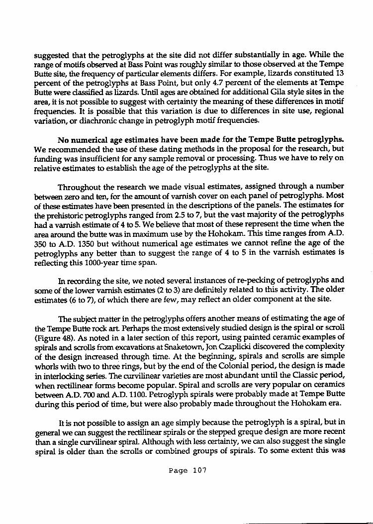
suggestd that the petrogllphs at the site did not differ substantially in age. While therange of motifs observed at Bass Point was rougNy similar to those observed at the TempeButE site, the frequency of particular elements differs. For example, lizards constituted 13
percent of the petroglyphs at Bass Point, but only 4.7 percent of the elements at TempeButte were dassified as lizards. Until ages Ere obtained for additional Gila style sites in thearea, it is not possible to suggest with certainty the meaning of these differences in motiffrequencies. It is possible that this variation is due to differences in site use, regionalvariatiory or diachronic change in petroglyph motif frequencies.
No numerical age estimates have been made for the Tempe Butte petroglyphs.We recommended the use of these dating methods in the proposal for the research, butftrnding was insufficient for any sample removal or processing. Thus we have to rely onrelative estimates to establish the age of the petroglyphs at the site.
Throughout the research we made visual estimates, assigned through a-numberbetween zero and ten, for the amount of varnish cover on each panel of petroglyphs. Mostof these etimates have been presented in the descriptions of the panels. The estimates forthe pretristoric petroglyphs ranged from 2.5 to 7,but the vast maiority of the petroglyphshada varnish *timateof 4 to 5. We believe that most of these represent the time when thearea around the butte was in maximum use by the Hohokam. This time ranges from A.D.
350 to A.D. 1350 but without numerical age estimates we cannot refine the age of thepetrogtyphs any better than to suggest the range of 4 to 5 in the varnish estimates is
reflecting this 100Gyear time sPan.
br recording the site, we noted several instances of re-pecking of petroglyphs andsome of the lower varnish etimates (2 to 3) are definitely related to this activity. The olderestimates (6 to7), of which there are few, may reflect an older component at the site.
The subject matter in the petroglyphs offers another means of estimating the age ofthe Tempe Butte rock art. Perhaps the most extensively studied deign is the spiral or scroll(Figure rl8). As noted in a later section of this report, using painted ceramic examples ofspirals and scrolls from occavations atSnaketown, ]on Czaplicki discrrvered the compl"*iryof the design increased through time. At the beginning, spirals and scrolls are simplewhorls with two to three rings, but by the end of the Colonial period, the design is made
in interlocking series. The curvilinear varieties are most abundant until the Classic period,when rectilinear forms become popular. Spiral and scrolls are very popular on ceramicsbetween A.D. 7m and A.D. 1100. Petroglyph spirals were probably made at Tempe Butteduring this period of time, but were also probably made throughout the Hohokam era.
It is not possible to assign an age simply because the petroglyph is a spiral, but ingeneral we can suggest the rectilinear spirals or the step$ greque design are more recent
than a single curvilinear spiral. Although with less certainty, we can also suggest the singlespiral is older than the scrolls or combined groups of spirals. To some extent this was
Page 107
noted in the varnish estimates at outcrop one, where we can compare a scrol.on panelthirteen (see Fieure 7 above) with a single curvilinear spiral on panel twen'r-one (seeFigure 10 aboveiThepanels;" t*; to tnlL ^"terp "Love
the ground lever and less thana half meter aparr-They are both on aearly verticaisurfaces. pi erirurtl",. faces south at190 degrees east of magnetic north wnile pla,."I +;t;"e fages 221 degrees east of north.ffr'#S'g"iiffim:tions on tire rock race make them ;;; candidates foi
The simpt"-:tl-g'" spiral on-panel T-"lty-one was assigned a varnish estimate offive while the more compG* scroll'on panel thirt""r, was given an estimate of four. Thelower estimate suggesb Lss varnish developril;;i in tiis ."r", *tr, the petroglyphsare on comparable surfaces, the less complex aesign is apparently older.
The example offered above supports the possibility of an increase in the complexityof the spiral aesign tht;gh-l;;r.flr-ng,rrri th;;" are m.rny other spiral and scrolrpetrogllphs at Tempe ButteJnearly all of th; *"i" *rigned a varnish estimate of four.This suggests they are -Tlt"*p:'rary or we were not ible to "o*irttry recognize adifference in the varnish q)ver on the design. w" b.il;e the latter is a-distinct possibility
Figure 4g. Outcrop f ,
Page 108
but recognize thatrtumerical age estimates will have to be completed to determine anytime depth in the design.
'"In sum, a few isolated petroglyphs may be or very early Hohokam times and some
re-pecked designs may be the work of post-Hohokanr cultures. In the best estimate we canmake without numerical ages, however, the majority of the petroglyphs on Tempe Buttewere made during the Hohokam tradition.
INTERPRETING ROCK ART
Ethnography and Rock Art
Atthough anthropologiss seldom sought direct information about rock art sites, thereare three or four relevant ethnographic accounts for petroglyph sites in Arizona. Some ofthese acnounts were stated directly in answer to a question about a site locality, and othertimes the reference to rock art was made in the course of more general conversation. Morefrequently,because rock art is often part of rituals or ceremonies that are kept within the -purview of shamans, it is necessary to crrnstruct feasible explanations by searching theethnography for dues and metaphors to rock paintings and engravings. This approachinvolves using direct references to the practies of shamans in a local group and using thisinfonnation with the more general knowledge of shamanism and trance states on a world-wide scale.
The prevailing betief among rock art researchers is that significant numbers of rockart sites in western North America are the products of shamans. This idea is by no meansa new one. Only recently, however, have researchers completed intensive reviews of theethnographic record to support the link betrueen rock art sites and shamans. DavidWhitley (1992a,1992b,1994) has completed the most significant research on these topicsand a review of his publications will give the reader an excellent overview.
Rock art is commonly explained by modern groups as the product of the "ancientones". For example, the Pima of south-central Arizona attributed a rock art site in theeastern Santan Hills to "those who were there before them", presumably the Hohokam orpeoples. Nonetheless, they revered the site and made offerings at a large cairn of rocksnear the petroglyphs. This site is described by Russell (1908:254):
The largest pictograph [he is using pictograph in a generic way to indudepetroglyphsl ever seen by the writer in the Southwest is cut upon it [a largeblock of laval and 2 or 3 tons of small angular stones foreign to the locdityare piled before it. There are many pictographs on the boulders roundabout.
Page 109
The Piman shrine (Rice 1988:5) that apparently existed on the bp of Tempe Butte may havebeen a similar feature.
The Santan Hills were used by medicir,e *en for various ceremonies and some ofthee individuals left the objects used in their practices in secret places in these hills. Therelationship betvueen these secret places and rock art is not dear but it is noteworthy thatan area of importance for medicine men was also an area of rock art.
In other examples, the relationship between the "ancient ones" and the ro& art isattributed to former spirits rather than peopleiFor example, the Apache believe that manyPetroglyPhs are the products of the Gans or mountain spirits. The Apactre have manydifferent kinds of Catts that are usually described as being mudr like humans, except theyare shorter. The spirits wear a G-string, high-top moccasins, and a buckskin hood overtheir heads. C-andelabra-like headdresses are attached to the tops of the hoods. They carrysPruce branches in their hands and some have knives. Some Gans will cut you to piecesif you touch them (fuwin notes Aptil 2,1937:313). As described below, the Apache canreocgnize the rock drawings of a Gan:
...about one day's journey west of Zuni there is a place on the bluff of a hill whereth" g* people have pecked pictures on the cliff higher than you can reach. Theyhave pictures of themselves there. You can tell when the gan have done it andwhen g.s nalk ige (shamans) have done it, because only the former make picturesthat are up above your reach on the diff. The latter usually make them in caves.[Goodwin notes lwre 24, 7936:827)
These ocamples make it dear that the native peoples of Arizona believe that some rock artis the product of former spirits and former peoples.
Placing gifts or offerings at rock art sites, as described by the Pima, was alsopracticed by the Havasupai. Cushing (1965:Zl) describes the small ritual at a rock art site:
The worship of the Ha-va-su-pai' consists of prayers, made during theirsmokes, or at hunting shrines, which are merely groups of rude pictographsalong the nooks or caves in the walls of the canyon. Here, seated on theground, the worshiper blows smoke to the north, west, south, and east,upward and downward; then says in a low tone, some simple prayer...
Apparently, some of the offerings were ad hoc and made by passersby or short-termvisitors who spent a few minutes at the site to insure success in their endeavors. Otherrituals may have been more sophisticated and induded shamans who utilized the rock artin their practices.
Page 110
One should remember, when searching for an explanation for rock art, that manyusers of the sites are persons other than the original artists. The individual artists re-sponsible for the rock drawings may have had a reason for their efforts, and that reaeonmay differ significantly from that of persons who visft the sites. Some sites are apparentlyused for many generations by persons who have high regard for the images on the rocks.
Throughout Arizona, the ethnographic record relates an association betrreen rockart and the work of shamaru. For example, Smithson and Euler (1994:12) describe the fearof pictographs among the Havasupai
Itwas thought that pictographs painted on diff walls were done by shamans with -intent to harm someone. Those in a rockshelter in Cataract Canyon a few milesupstream from the village were considered especially dangerous... My layconsultant denied any knowledge of the paintings. Our shaman consultantbelieved that one individud who lost his vision did so because he frequently passedthis point.
Itis important to recognize that the shaman had knowledge of the paintings whilethe lay person did not understand them. This does not mean, of course, that the lay persondid not repect them. To the contrary, they were respected because they were the workof shamans. The link between shamans and the rock paintings is made again for a GrandCanyon site. Writing about the dream of a Havasupai shaman who is instructed to visitRain Tank a few miles south of Grand Canyon village Smithson and Euler (1994:9) state:
When he arrived there in his dream, he followed trryo tracks leading east. Soon he Fcame to two tall blue rocks. He dimbed the south one and, halfway up, he foundsome barely visible pictographs that appeared old. He blew on them four timesuntil the pictures became dear. They depicted many kinds of animals and somehumans.
Many rock art sites are described as having been made in a shaman's dream. In otherwords, the rock art is the result of a vision or a trance associated with an altered state ofcrrnsciousness (ASC) that was sought by the shaman.
The Western Apache, a group who ut'rlized the Tempe Butte region in protohistoricand historic times, have important descriptions of rock art sites. Most of these are foundin the unpublished notes (curated with the Arizona State Museum) from conversationsbetween Grenville Goodwin and various Apache consultants. The Apache frequentlyattribute the petrogtyphs to the Gans or mountain spirits. The Gan live inside the rock,entering their homes through caves or small holes in the rock. Some of their homes aredescribed as little worlds with trees, grass, and water, inside the rock. The locations oftheir homes are considered holy places.
Page 111
Groups of men formerly went to the mountains to the Gan homes to sing whilewaiting for them to come out, and if they were lucky the mountain spirib c€une 6ut anddanced with them. Although Goodwin's consultang knew a medicinl man who dancedwith the C'an ata place about four miles east of Coolidge Dam, he did not believe anyonehad done this for forty years. Goodwin's information was collected in the 1930s, ri, tf,"suggetion is that the calling out of Gan to dance ended sometime before the turn of thecentury.
Encrnrnters with the Gans are interrelated with the acquisition of power through atrance or vision. Harry Hoijer and Morris Ci'pler indicate that althougtr-each experiJncediffers, they have a great deal in conrmon. Ttre Mountain Spirit, ot g",i, appears to a manwho is Prafng or sleeping in front of a rock outcrop. Preiumably, U".",n* they are theproducts of the Gans, the locations are often rock artiites. The gan bids the supplicant tofollow into the rock where they encounter four obstacles and leparate chambers whereTf"lt and zupernatural of all kindsgfferpower and display their wares. Following theadvice of the gan he refuses these and, in the last chambei, the Gans are waiting foririm.Accepting their power, he spends:
.t.four nights qrning the details of the ceremony and the designs to be painted onthepasons and parapherrralia of the dancers. His guide condircre him back to thedoor oncre more and then the Apactre finds hirnself awate at the place where he laydown to rest. [Hoijer and Opler 193g:154]
Once-he has acquired the power, a man may put on gan dances and ceremonies for hispeople. Maty of these are for healing, usually witli a particular power, such as bearmedicine, used to heal wounds or other illnesses caused Ly bears.
The Yavapai of north-central Arizona had a spirit known as lGlcala,that was muchlike the Apache Gans. \\e lhlaka are little people, about 3 to 4 feet in height with ro'ndheads, €I€s, and a mouth but no nose. (Gifford 1936:30g; Harrison ana Wlttiam s l9T7:45;Khera and lvlariella 1983:52). \\e lGtutu live in the mountains and the rocks and they aregagable of supernatural feats sudt as walking up a vertical cliff or passing through u tit yhole into what would otherwise seem to be sbUa rock. The l&laka *'L" imilated byYavapai men in the Crown Dance, and they were called upon by shamans to help witircuring.
Although ftq" are no published accounts of the l<aknl(nmaking petroglyphs, thereare images at several sites in the region that depict a typical Kaknka.ftl V"""ir'ui explainthat if one sees these image, it is a precursor of death. The death, it is explained, is not theend of life; rather, it is trance like state.
The similarity of $ese supernatural little people and the Gan of the Apactre isapparent. Both are small, anthropomorphic characters, both live in the rocks and the
Page1,12
mountains, and both are called upon by shamans for ceremonies.
Laird (1976:703) notes that when the Chemehuevj (Southern Paiute) were questionedabout rock art, they commonly replied that it was tutuguuoo?opi, "made by the spirithelpers". David Whitley Q992a;1992b) points out that this reply did not result becausethere was confi.r.sion in the minds of the cnnsultants concerning who made the art. Instead,tutuguuaoTopi was a ritual circumlocution used to avoid naming a dead shaman. Ashaman and his helper were one and the same; thus, tutuguuoo?opi qually may betranslated as "made by the shamans".
..
A point that should be made dear is the identification of these spiritual helpers as
they are related to humans. An association of rock art with "little people", Gans or Kalenlu,
is a recurring theme among various native groups in the desert southwest. DescribingNumic peoples, Whitley (1992a;1992b) recognizes this series of supernatural persona as
shaman's assistants. He states:
The art was metaphorically dmoted as made by these spirits for one simple reason:no distinction was made, semantically, epistemologically, linguistically, orotherwise, betvyeen the actions of a shaman, his spirit helper and his dream. To saythat the art was made by a water baby, in other words, was simply to affirm thatit was engraved by a shaman [Whitley 7992a:9fl.
In other words, rock art said to be made by the l@lelca or Gans among the Yavapai andApache could also be oblique references to shamans, or the human counterpart of thespirifiral Knlel@ or Gans.
Shananism and Rock Art
The study of shamanism is ctrnently popular in North America among groups thatrange from psychoanalysts to proponents of new age religion (Walsh 1989:1). While thereis considerable attention paid to shamanism, there is little understanding of its basiccomponents because researchers have not developed a series of fundamental principles ora collective definition. In part, this reflects the diversity within shamanism, practiced onall the inhabited continents of the world, and the compledty of such a widespreadphenomenon makes it difficult to find consensus. Although Ake Hultkrantz (7973) offereda definition of shamanisrn two decades ago, it has not gained extensive acceptance.
Recentty, research has been directed toward remedying this deficiency OVinkelman 1989;
Walsh 1989) with studies on the distribution of shamanism throughout the world'scultures, their similarities and differences, and defining the practice of shamanism.
Cuttures that practice shamanism can be said to divide their universe into objectiveand subjective space. Objective space includes the region that has been explored and is
Page 113
known to the members of the culture. More extensive than the territory controlled by atribe, objective sPace is verified by exploration and through narrative traditions
Subjective space, on the other hand, include! the unknown parts of the universe.When one wonders what is on the other side of the mountains, one is thinking aUoutsu$ective space (Tuan l9T7:fj6).One's cognitive processes construct geographies f6, tn"r"yn\no.wn parts of the trniverse. The sky and the tnings that are in itit
" underworld that
is obvior-r.s in the Pafages of caves, and the bottom of the water that swirls in a whirl pool,:ue examples of subjective space.
A basic Power of shamaru is the ability to pass from objective space into subjectivesPace; i.e., from one's home territory to the sky, from the earth to the underworld, or overthe mountains to the unknown side. Shamans accomplish this exploration by travel thatis taken in altered states of consciousness, trances, or dreams. -
Movementbetween the principal realms are often made possible by the makeupof the universe which is on "levelt-:ky, earth, and underworld--connected by a centralaxis" (Eliade Dg). This "axis mundi'iis one route used by shamans to travel from oneworld to another. Cultures Tlily have an archetype of thelaxis mundi" - a tree, a rope,a ladder, or some_other symbolic representation oltire connecting link betr.veen the realmsof the universe. But many other routes-are used by sharnans tJtravel between objectiveand subjectiye sPace, suctr as the paths of the s.tt
"t d the moon or a cave passage into the
canyon wall.
To undertake a journgy to the cosmic realm, an individual goes to a location ofspiritual significance. Among theNumic peoples, these locations *"rf frequently rock artsites thatwerenamedpohaghani or,'hou-se of po*"." (Malouf L974:g;Shimkin l9ft5:38).rasfnS
-md prayinp the supplicant would stay at the "house of power" for 4or 5 days oruntil a dream (an ASC) was obtained. The morning after an ASC experienc€, so it would
never-be forgotten, the shaman recorded the viJon in rock art. 'WtiU"y (1g4:5) hascomqiled ethnographic data forNumic speakers which explain that a shaman returned toa rock artsite to refresh his memory regarding the dream or to renew his connection withthe supernatural.
Trance States and Rock Art
David Lewis-Williams and Thomas Dowson (19g9) offer a framework forinterpreting rock arb labeled the "neuropsychological model", it is based on the visions ordreams of individuals in altered statLs-of cotrlciottsness (ASC). Lewis-williams andDowson utilize Bushman ethnography to interpret rock art by examining the process ofente{ng trances. Explanations are more cnmplex-than suggesting the artist-simpiy painteda replica of the animal witnessed in the trance. Rather, thJrock art is a combinatioir of thevarious stages of trance; it indudes the bizarre and strange creatures encountered by the
Page'1.'1.4
suPPlicant during the trance, as well as the animals utilized for ritual reasons -rainmaking, prophesy and healing. The explanation is intertwined with metaphors thatcan only be interpreted by understanding Bushmanculture.
At the sarne time, however, Lewis-Williams and Dowson assert that individualswho enter trance (regardless of what part of the woild they live in or what culture theyrepresent) experience similar phenomena. Thus descriptions of ASC can be very similarin culttues that are widely separated in time and space
The acquisition of a vision appears to be rooted in human biology and, although theprocess is influenced by culture, it follows a similar course throughout the world. At thebeginning of a trance an individual sees flickers of light or wavy patterns, calledphosphene or entoptic phenomena. Research into these phenomena has revealed that theyoccur with sufficient regularity that they can be dassed into 8 or 9 groups; i.e., dots andshort flecks, sets of parallel lines, ag-zag lines or angular lines across the field of vision,and basic grids. Ken Hedges (1976) pointed out a possible association of these abstractphenomena with rock art, but Lewis-Williams and Dowson augment the comparison ofdtered states of consciousness and rock art.
As the tranc€ progresses, the abstract images take on a form that has meaning. Inthis stagg labeled the consrrral stage, the entoptic phenomena start to look like somethingrecognizable in the ctrlture of the supplicant. Thus, a human form might expand out of aog-agline as though it were on a spring. This helps explain the partial human or animalpictographs that have bodies without legs, or heads attached to wavy lines. Ultimately,the supplicant receive a full+cale vision with motion. Decriptions of this.process suggestthat some individuals go from the entoptic phenomena to the full vision, while others havethe full vision without any of the prelude. Individuals also describe a sensation of theirbodybeing drawn, or ptrlled, into the experience. In this sensation they may be spinningand going to another location, such as down a whirlpool or into a cave. An auditorycomponent often accompanies the vision and it is not unusual for the supplicant to equatethe sound with something from his ctdture. The Bushmen, for example, suggest they heara swarm of bees when entering a trance.
Any single part of the trance, or all of these components, may be depicted in rockart. The entoptic phenomena, the stretched or misshapen body, the whirlpool, the bees
from the auditory component, or the full-scale vision are all depicted in rock art.
Lommel disctrsses trance as the "...process of giving shape in irurer images..." andemphasize that a "shaman's psychological experiences in a trance are always expressedin images from the real world" (7967:U). The foregoing studies make it dear that manyreearchers believe the lion's share of the rock art in the world was associated with trancestates. Some art may have been completed during trance and some may have been doneafter the individual completed the ffance as a record of the experience.
Page 115
The key to recognizing ASC related art is the identification of a series of universalattributes in cross-culturd contexts. Power I'ines connecting figures to one another orradiating lines from the head is one ocample of an universal attribute. foan Halifax (1931)outlines the universal themes that are found in the iut of shamans:
Maps - Not crrnventiondl maps of a geographic territory but maps which show crcsmicgeography that is revealed to shamans in their initiation. These maps often show thecornection betr^reen the Sky Realm, the Living World, and the Underworld. Thus it is notunusual to have stars, moon, sun and/or birds in the sky realm; humans, other animalsand plants in the living world; and snakes, inonsters or spirits in the underworld. ThePaths betrueen the worlds rnay be represented by lines or paths or by an "axis mundi" thatmight take the form of a cosmic tree.
Spirits of the other worlds - These may be demonic figures encountered by the shamanon thepurney betrpeen the worlds. Or they may be fln g figure upon whictr the shamanrides between the worlds.
Disnernberrnent and/or skeletonization of human figures - These represent death sincethe shaman first dies to be reborn in another form. These skeletonizedfigures have oftenbeen labelled as x-ray art, since they reveal internal structure for human figures.
Therianthropic figures - Once dismembered, a shaman assunes a new form. This formis often a cornbination of an animal with the shaman's human form. It may be winged.
Energy_foroes/power line - Some shamans become solarized and radiate the power ofthe sun. Others are depicted attached to whorls and concentric circles. These lines mayradiate from the head but frequently the eyes of a figure are shown with radiating lines.
Flight - The travels of the shaman are in trance. Th"y transcend space and time.Shamans often report flyt^g and depict it in their imagery.
The explanation for rock art described above involves a journey into another realmby the supplicanl Lr some cases the travel is into the rock walls, entering through a cave,a crevice, or a hole in the rock, upon which the pictographs and petroglyphs are found.This iourney can be led by a spirit helper, in this case the Kal(nka of the Yavapai or Gans of.the Apache, grving the rock art a personal component.
Other art may be associated with the rock because the rock itself is consideredpowerftrl or nuninous. In these cases the rock does not necessarily hold a spiritual form;rather itis recognized as a powerful force because it is enduring and strong. Power fromthe rock was acquired by associating with it, by putting one's hands on it, carrying a smallfragment of it with you, or pecting and painting on it. This sort of power is often labeled"mana" by anthropologists. It is impersonal, because it functions without an
Page 115
anthropomorphic spirit.
Rock art on the surface of the rock added to.it9 power. After the initial artist put apictograph or petroglyph on the rock, for whatever reason, it added to the quality andcharacter of the rock. The rock surface was recognized as different from that around itbecause it had a painting or engraving on it. Once it was decorated, it received theattention of any passerby, sometimes to look at it, but more often to pay respect by offeringPrayers.
Obviously, adding rock art also serv€d as a memorial to the site. Sometimes thenew rock art was a copy of an original paintin& but other times it was an original drawing. FIt also appears that some of the additions may have been rather casual. Some of theamorphous blobs and the amoeba-like forms at Tempe Butte may represent this casualassociation with the rock art site. -
There is a dear link between the practice of shamanism and hunting and gatheringctrltures. Using a cross-cultural study of a sample of the world's cultures, Michael -Winkelman presents a correlation between shamans and non-sedentary ctrltures thatpractice some ombination of hunting, foraging, or fishing as their primary me:rns of foodprocurement (Winkelman 1989). Although peoples who live in sedentary villages andprocure their food by gardening continue to have shamans, th"y are usuallyovershadowed by other religious institutions.
Locational Analyses and Rock Art
Ernest Snyder (1966) in his important study of the distribution of Hohokampetroglyphs in the South Mountains conduded that rock art sites were more abundant inthe areas where canals were concentrated. Snyder also examined the diversity of the -petrogl1ph designs found at sites of different locations and elevations but he was not ableto discern any differences between the petroglyphs at one site versus another. Perhapsbecause Snyder tried to understand Hohokam petroglyphs by studying their location, -other researchers have continued to emphasize the location of Hohokam rock art sites(Weaver and Rossenberg 1978; Wallace 7983; Kintigh 19M; Weaver 1985; Hedges andHedges 1985).
Several important conclusions have developed from these studies. Studying thedistribution of peroglyphs at I-os Morteros, a site near Tucson, and comparing the imagesto nearby sites, Wallace (1983) condudes that pehoglyph designs do in fact vary betweensites. He suggests three explanations for these distributions: time differences between thesites, the variety of social groups who used the sites, and the different functions orpurposes for the sites. Kintigh (1984:51-52) used a statistical procedure to support Wallace'sconclusions. Wallace also studied the intrasite distribution of the petroglyphs at Los -Morteros and learned that the petroglyphs were crmcentrated along the eastern slope of
Page117 -
the Rillito peak where they could be associated with the Santa Cruz River, the adjacentmesquite thickets, or lands suitable for gardening along the river. Hamann and Hedges(1986) expand upon this study by examining thg orientation and placement of 153Hohokam rock art sites in Arizona. Th"y conclude:
The first observation is that most of the rock art sites are on the points of mountainranges or buttes dosest to major watercourses. Of the 153 sites used in this study,fiVo are associated with major rivers: the Gila, the Salt, the Santa Cruz, and the SanPedro. Large, tributary washes which feed the major rivers contain 77.5Vo of thesites; 77Vo arc located on smaller, side washes which feed major tributaries(Hamann and Hedgq 19t36:79).
The remaining sites (10) may also be associated with springs or prominent water holes.More importantly, Hamann and Hedges (19f35:79) recognize the distribution is not just onwater ct)urses, but it is oriented toward the water course. They conclude that HohokamPetrogl)?hs are specifically located on rock outcrops dosest to the water course and onrocks thatare the nearest to the water course. Apparently Tempe Butte was not includedin their study, because the majority of the rock art faces directions away from the river.
Weaver and Rosenburg (1978) utilize an economic locational model to examine thedistribution of rock art in the Sierra Estrella southwest of Phoenix. Using archaeologlcaland ethnological data they suggest the locational exploitation pattern for the telotconsisted of two major activities. One, the use of the riverine areas for irrigitionhortictrltural and collecting mequite beans or other wild foods and two, the heavyirse ofhg tppo bajadas, mountain slopes, and plateaus for the collection of sagu:uo fruits andothgr plants and the hunting of deer, desert bighorn sheep, and desert tortoise (Weaverand Rosenburg 1978:1 18).
When the distribution of petroglyph sites is examined within these zones ofecrrnomic exploitation, they learned:
By far the largest number of petroglyph localities (7) and the most complexlocalities are located along the northern, eastern, and southern base of the SierraEstrella in a zone of high potential for wild food resources. Five additional localitiesare located in areas of high potential for wild food resources associated with pimaButte, Lone Butte, and high basins and plateaus in the Sierra Estrella OVeaver andRosenburg1978:719).
In a later study of Hieroglyphic Canyon, a rock art site in the Superstition Mountains tothe east of Phoenix, Weaver (1985) continues to underscore the importance of the locationof petroglyPhs in areas where game animals and plant resources were sought. Weaversuggets that rock art located in thee zones is related to a "success in the hunt'i hypothesisi.e., theanimal is shown with a spear in its side to magically assist the hunter in-killing it.
Page 118
Research by David Whitley (1994:83) demonstrates that Numic petroglyphs of trn arrowin the side of a bighorn sheep is in fact a metaphor for the power of a shaman to controlthe weather. Thus the idea that magical petroglyphs showing spears in the sides of ananimal is directly associated with improving the drances of hunter is not necessarily valid.Nonetheless, the concentration of animal petroglyphs in habitats where these organismoc€ur suggests the shamans were trying to control weather or practice some type of magicin the territory of the animals.
Summarizing the reults of these locational studies, four conclusions can be made.
One, Hohokam rock art is not randomly placed on the landscape or within an individualsite; two, Hohokam rock art sites are most often associated with rivers and water courses;
three, not only is Hohokam ro& art associated with rivers, it is oriented toward the rivers
and placed on rocks nearest the water q)urses; and four, the rock art found in the uplands
exhi-bits more animals than that in the riverine settings and although it is probably not
associated with improving the chances of a succesful kill, it is the product of shamans
calting upon their ipirit helpers. An economic locational study suggests that Hohokam
rock art ii in tr,tro pti^rty zones - riverine rock art associated with permanent villages,
irrigation, hortictriture "oa
to.t art of the upper bajajdas, mountain slopes and basins
associated with temporary huntin& and gathering camPs'
Astronomy and Rock Art
Since Anna Sofaer noted the "light dagger" penetrate the spiral on Fajada Bujte-ln
Chaco Canyon (Frazier 79f15:794) rock irt specialists have sought out similar petroglyphs
across trloitfr America. This research, now labeled archaeoastronomy, has expanded
beyond rock art to include many other archaeological features (Williamson 19&1). The
association between petroglyphs and events in the solar cycle is now commonplace. The
most nrunerogs e*a ple are peuogtyphs of spirals and concentric circles which designate
the solstices and equinoxes. Solstices designate the shortest day ofsunlightin_Decemberand the longest day in lune. The equinoxes which occur in March and September,
designate dals when the sun sets due Last and west and the amount of sunlight is equal
to th"e amount of darkness. Using petroglyphs to determine the solstices and equinoxes
offers a calendar by which it users can divide the year into four segments.
The scheduling of ceremonies and other annual events among various American
Indian tribes accordin[ to the solstices and equinoxes has been recognized for many years.
h the American Soutf,west, Pueblo groups practiced their ceremonial cycle according to
this schedule 0,^amphere 1983:756). ettho"gh there are correct times for some ceremonies
among the pima "11d
Tohot o O'odahm, the evidence for use of solstices and equinoft t-o
schedule them is not apparent. Among the Hohokam the evidence for use of calendars is
also elusive. The gr""i'ho,s" at Casa-Grande, for example, is suggltud to have holes in
its walls for obserfrng the solar events like solstices and equinoxes. Thedebate as to who
made and used calendars will continue but the number of petroglyphs with apparent
Page 119
associations to solar events is so great it cannot be explained by chance.
Calendars and rituals sdreduled according to solstices or equinoxes iue most oftenassociated with sedentary societies. The Hohokam, ivho made the spirals and concentriccirdes on Tempe Butte, may have had powerful shamans. North American shamans hada core of knowledge common to their practice across the continent. This knowledgeinduded an understanding of a cosmic model:
To begin with, the shamanistic crcsmic model is axial. That is, the horizontal axes ofthe world are determined by facing the rising sun in the east. West is then at theback, and right and left arms, extended, point to the south and north. Thefirmament above is conceived of as a house structure ... The doors in the cosmicstructure are to the east and west to allow the sun in and out of the house on itsd{ly transit. Among most New World and Siberian peoples, there are fouradditional solstice doors which permit entrance and exit of ttre sun at the summerand winter solstices [MacDonal d 1981:22il.
The Hohokam almost certainly had knowledge of the solstices and they likely used thisknowledge in their rock art.
_ _Anthony Wallace has identified four principal kinds of religious organizationsthroughout the world's societies - individualistic culG, shamanistic cul-ts, communal cults,and ecdesiastical cults. These categories have broad evolutionary implications withindividualistic and shamanistic cults practiced primarily by huntinl
""d gathering and
pastoralist societies while conununal cults exisfin gardining societik and ecclesiJtti""todts a1e practiced where the economy is sufficiently complex t6 support full-time religiousspecialists or priests.It is important_to recognize that these ."tegbti"r are not tr,,ri
"ttyexclusive. Although there is no conclusive evidence the Hohok"i n"a a class of priesisw-fo
1ver9 suPPoltd by the remainder of the society, they probably had some combination
of individualistic, shamanistic and communal rerigioui organizations.
Each Person is their own religious specialist in societies with individualisticreligion. Often receiving Power or assistanCe from an animal or other spirit helper,individuals use their power for their day to day activities. Religion in these societies ispracticed on an ad hoc basis, with individuals using their poweias they need it.
In shamanistic societies some individuals become specialists at the use of spiritualPower. Communal cults are more elaborate beliefs that are held by groups in sedentarysocieties. These ceremonies and rituals are practiced by clans,
-lineagLs,
^"r,'s "rrdwomen's groups, age grades, and clubs.
Shamars are capable of completing tasks for a group (e.g. calling for rain) or for anindividual (e.g. ctring a rattlesnake bite). Shamanistic rehglon il frequently used on an ad
Page 120
hoc basis, but shamans are also found in societies with scheduled annual ceremonies.Although the shamans may not initiate or dictate the times that certain ceremonies shouldtake place, they were on hand to use their power at important ceremonies. Among theO'odham for example, the headman and the shaman worked in combination to scheduleand perform important ceremonies. Donald Bahr (1983:18$186) erplains that the headmanused his trust and knowledge of a group's feelings to schedule communal ceremonieswhile the shaman attended these ceremonies to perform magic.
The Hohokam chronictes (Bahr et al 1994), discussed in greater detail below, makeit dear that they had both chiefs and shaman5. Chiefs and\or shamans are candidates forusing petrqllyph calendars on Tempe Butte. Although the person who makes a petrogllphcalendar has to have knowledge of the solstices, the use of these calendars does not havetobe associated with trane and an altered sbte of consciousness. This does not mean thatthe knowledge of how these calendars worked was common and used by everyone. Morelikely the knowledge was kept secret and used, as much knowledge is used, todemonstrate power.
SELECTED HOHOKAM ROCK ART MOTIFS AT TEMPE BUTTE
Pipette petroglyphs
The double crenelation figures known as Hohokam pipettes :ue arnong the mostsignificant on the butte (Figure 50). Because they are distinctive and often large and
impressive, these figures have been the topic of considerable disctrssion in the literature.fnitiatly recognized as an important element in Hohokam rock art by Ferg (1979) anddiscussed in detail by Wallace and Holmlund (1986), the design is recognized as apotential time marker for Classic period Hohokam rock art.
Recently, an overview and comparison of the motif was completed by Ken Hedges(79 94) for a symposium on shamanism in North American rock art Hedges (1994:1M) uses
the term phosphenes for what Lewis-Williams and Dowson (1989) identify as entopticphenomena in the "neuropsychological model" and he contends that the doublecrenelation is an expansion of these basic phosphenes:
Any instance of visionary imagery, from simple pressure phosphene to-fullyaevaopea halucinatory states, presents a continually changing set of image forms
subjeci to infinite personal and cultural choices in the selection of elements foremphasis [Hedges 1994:108).
Hedges relies upon an ethnographic example from the Tukano, a South America Indian
tribelwho also draw the double crenelation figure after seeing it in a trance. The Tukano
identify the double crenelation motif as a snake canoe and link it to the anaconda snake
that plays an important role in their creation myth.
Page127
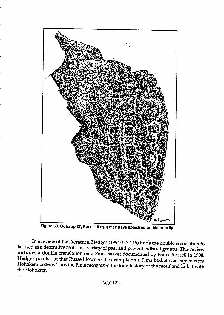
In a review of the literature, Hedges (1994:71T115) finds the double crenelation tobe used as a deqrrative motif in a varierylf past and present cultural groups. This reviewincludes a double crenelation on a Pima basket documented by rrlnk Russell in 190g.!e$S9s points out that Russell learned the example on a pima basket was copied fromT"\gk"t Pottery. Thus the Pima recognized the long history of the motif and link it withthe Hohokam.
Figure 50. outcrop 22, panet 1g as it may have "pp""r"o
pr"tristoricaily.
Page722
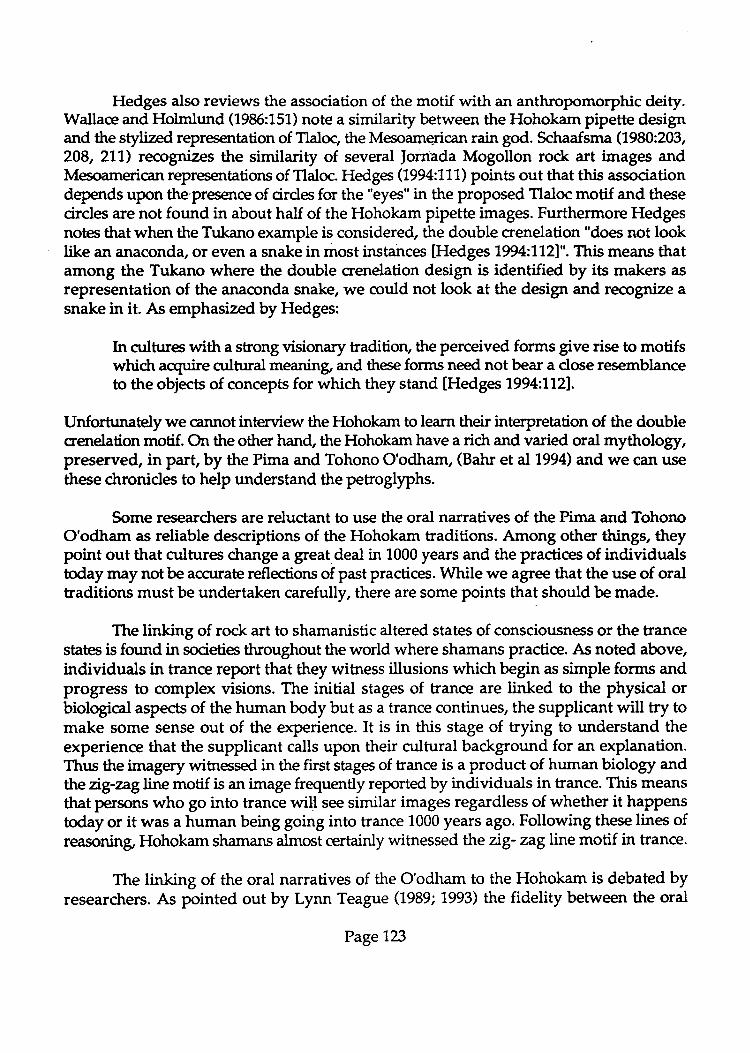
r
Hedges also reviews the association of the motif with an anthropomorphic deity.Wallace and Holmlund (1985:151) note a similarity between the Hohokam pipette designand the stylized representation of Tlaloc, the Mesoamerican rain god. Schaafima (1980:203, ts
208,211) recognizes the similarity of several ]orn'ada Mogollon rock art images andMesoamerican representations of Tlaloc. Hedges (1994:111) points out that this associationdepends upon the'presence of cirdes for the "eyes" in the proposed Tlaloc motif and these -circles are not found in about half of the Hohokam pipette images. Furthermore Hedgesnotes that when the Tukano example is considered, the double crenelation "does not looklike an anaconda, or even a snake in most instances [Hedges 1994:7121". This means thatamong the Tukano where the double crenelation design is identifi"d by its makers asrepresentation of the anaconda snake, we could not look at the design and recognize a -snake in it. As emphasized by Hedges:
Irr ctrlture with a strong visionary tradition, the perceived forms give rise to motifs dwhidr acquire cultural meaning, and these forms need not bear a close resemblanceto the objects of concepts for which they stand [Hedges 1994:7121.
Unfortrutately we cannot interview the Hohokam to learn their interpretation of the doublecrenelation motif. On the other hand, the Hohokam have a rich and varied oral mythology,preserved, in part, by the Pima and Tohono O'odham, (Bahr et al 1994) and we can use -these chronides to help understand the petroglyphs.
Some researchers are reluctant to use the oral narratives of the Pima and Tohono aO'odham as reliable descriptions of the Hohokam traditions. Among other things, theypoint out that cultures change a great deal in 1000 years and the practices of individualstoday may not be acrtrate reflections of past practices. While we agree that the use of oraltraditions must be undertaken carefully, there are some points that should be made.
The linking of rock art to shamanistic altered states of consciousness or the trancestates is found in societies throughout the world where shamans practice. As noted above,individuals in trance report that they wibress illusions which begt. as simple forms and -progress to complex visions. The initial stages of trance are linked to the physical orbiological aspects of the human body but as a trance continues, the supplicant will try tomake some sense out of the experience. It is in this stage of trying to understand the -experience that the supplicant calls upon their cultural background for an explanation.Thus the imagery wibressed in the first stages of trance is a product of human biology andtheng-zagline motif is an image frequently reported by individuals in trance. This means -that persons who go into trance wiH see similar images regardless of whether it happenstoday or it was a human being going into trance 1000 years ago. Following these lines of
Hohokam shamans almost certainly witnessed the zig- zag line motif in trance. -
The linking of the oral narratives of the O'odham to the Hohokam is debated byresearchers. As pointed out by Lynn Teague (1989;1993) the fidelity between the oral
Page123 A
Figure 51. Outcrop 17, Panel4 as it may have appeared prehistorically.
traditions and the archaeological evidence is so good that there must be a historical corein the nanatives. Bahr et al (1994:2{) reviews the piffalls of using oral traditions with fourhundred years of time between their telling and the events they describe. None the less,the oral traditions "should be taken as good faith histories, that is, as stories that wereoffered by their tellers as true" [Bahr eta]1994:4. Writing about the merit of the narrativesfor understanding Hohokam archaeology, Bahr states "... I believe the mythologies couldhave a base, if not their sole basis, in nonmystical local fifteenth-century fact" lBahr et al1994:91. Furthermore, Bahr believes that three'quarters of the narratives are about theHohokam and that is why he chooses to refer to them as the "Hohokam chronides" [Bahr
Page724
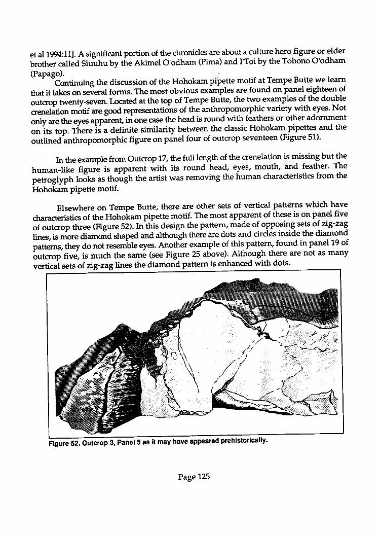
et al 1g4:111. A significant portion of the ctronides are about a culture hero figure or elder
brother called Siuuhu by tire Akimel O'odham (Pima) and I'Toi by the Tohono O'odham
(Papago). : '. ^ "C-ontinuing the discussion of the Hohokam pipette motif at Tempe Butte we learn
that it takes on several forms. The most obvious examples are found on panel-eight-ee1 9foutcrop twenty-seven. I-ocad at the top of T:^p" Butte, the two examples of the double
crenelation motif are good representations of the anthropomorphic variety with eyes. Not
only are the eyes applrent, in one case the head is round with feathers or other adornment
or, it, top. There is a definite similarity ryy*n-the classic Hohokam pipettes. and the
outlined anthropomorphic figure on pinel four of outcrop seventeen (Figure 51).
In the example from Outcrop 72, thefull tmgth of the crenelation is missing butthe
human-like figur! is apparent wittr its round head, eles, mouth, and feather' The
pet ogtyph loiks as tnolugn the artist was removing the human characteristics from the
Hohokam piPette motif.
Elsewhere on Tempe Butte, there are other sets of vertical patterns which have
characteristics of ttre Hoho'kam pipette motif. The most apparent of these is on panel five
;f outcrop three (Figure 52). In this design the pattern, made of opposing seF of ag-zag.
line, is more aiamofia shaped and althotigh there are dots and cirdes inside the diamond
patterns, they do not resemble eyes. Anoth--er example of this pattern, found in panel 19 of
butcrop five, is much the same (see Figure 25 above). Although there are not as many
vertioi sets of ng-aglines the diamond pattern is enhanced with dots'
@ 5 as it may have appeared prehistorically.
Page725
Neither of the l"{q examples has a resemblance to an anthropomorphic form, butthe proposed origin of the motif in entoptic form,s is still evideni. As pbinted out byHedges (7994:1'07), the variation in eltopiic phenomena or phosphenes is muctr gr"tJ,than thebasic shapes identified in psyctrological studies.An import'*t aspect to the motifs3t Tempe Butte is the extension of these basic designs into more cnmplicated motifs. Lewis-Williams and Dowson (1989) identify this as tf,e construal stage of a trance when thePerson experiencing the visual images attempts to make ro*i sense of them. In theT" PtT at Tempe Butte, the diamorrd patterns_
"re "pp*et tly
"t extension of the paraUeiag-aglines seen as b-asic entoptic forms and the pipettes arl an expansion of the doublecrenelation form- B.oth gxamples are the_apparently-the product of persons trying to finda cultural explanation for the imagery th;i are wiinessing in trancl.
-Reyiewing the Hohokam chronicles, we have found a song that may relate to thePetrgglyPfu. This song was sung, in the Delores account of how i'Toi, the Elder Brotherwas killed and kept coming back to life. I'Toi sang:
The sunrise I'm going with.The sunrise I,m following.With zigzaglines I'm painted.Following the sun,with zrgzag lines I'm painted. tBahr et aL7994:1971
Interpreting this 9or]8 we believe that in the verses about following the sun, I'Toi isreferring to his ability to die repeatedly like the sun (Bahr et al 1994:200). This is anapparent metaphor for trance in which the shaman dies and q)mes back to life - just as the:Y.dio e1n {f)r and comes back the next. More important are the verses whictr refer toI"Toi as Paind by }g:oglines. We believe these *" r"f"r*ces to the entoptic phenomenathat ar9 experienced in trance. Thus in the,s9nA I'Toipresents a metaphor for an alteredstate of consciousness and tells us that his likeiess is zrg-znglines.
L
(1968:'l'42'144) recorded the song of a medicin" *"n that tells of the ro",.,r." of his power:
Do you see, my younger brother?Now I sit down.My gourd rattle moves in a circle.Evening rushes outAnd yonder goes sifting down.
Do you see, my younger brother?Now I sit down.My gourd rattle moves in a circle.
Page726
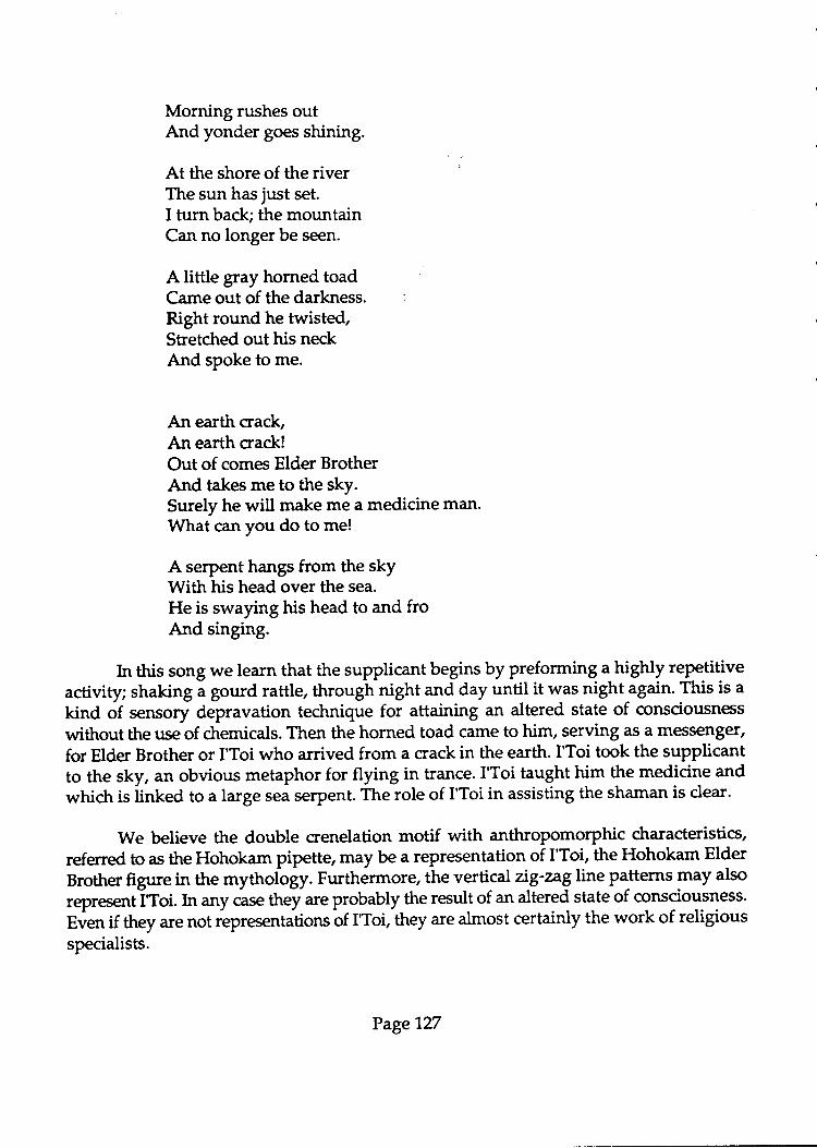
Morning rushes outAnd yonder goes shining.
At the shore of the river :
The sun has just set.I turn back; the mountainCan no longer be seen.
A little gray horned toadCame out of the darkness. :
Right round he twisted,Stretched out his neckAnd spoke to me.
An earth crack,An earth crack!Out of comes Elder BrotherAnd takes me to the sky.Surely he will make me a medicine man.What can you do to me!
A serpent hangs from the skyWith his head over the sea.
He is swaying his head to and froAnd singing.
In this song we learn that the supplicant begins by preforming a highly repetitiveactivity; shaking i gourd rattle, through night and day until it was nightagain. This is a
kind of sensory depravation technique for attaining an altered state of consciousness
without the use of chemicals. Then the horned toad came to him, serving as a messenger,
for Elder Brother or I'Toi who arrived from a crack in the earth. I'Toi took the supplicantto the sky, an obvious metaphor for flying in trance. I'Toi taught ry^ the medicine and
which is iinted to a large sei serpent. The role of I'Toi in assisting the shaman is dear-
We believe the double crenelation motif with anthropomorphic characteristics,
referred to as the Hohokam pipette, may be a representation of I'Toi, the Hohokam Elder
Brother figure in the mythol,ogy. Furthermore, the vertical Ag'ngline patterns may also
representiToi. In any case they are probably the result of an altered state of consciousness.
Even if they are not iepresentations of IToi, they are almost certainly the work of religious
specialists.
Page127
Lizard and horned toad petroglyphs
The lizard and the horned toad are another group of common petroglyphs atHohokam rock artsites. Frequently it is difficult to determine whether the artist intendedthe petroglyph to represent alizard, a horned toad, or a male human figure.
In a detailed examination of lizard/ anthropomorph figures we may find clues asto the intent of the artist At Tempe Butte, we noted that some of these figures have ro.undbodies, round heads, and pointed tails. Petroglyphs like element a, panel33, outcrop 18(see Figure 39 above) and element b, panel5, outcrop 27 (se Figure 44 above) are goodexamples. An important characteristic is the back legs of these figures. The upper leg isPointing backward but the knees are bent at acute angles so that the fore legs and feet areon along side the body. Front legs are oriented forward and they do not display well-defined Fints. This leg iurangement appears more like the creature commonly referred toas the horned toad. Because toads do not have tails, these figures are certainly not toadsbut more likely a horned lizard like the Texas or corunon horned li"ard Phrlmosomacornutum or the desert horned lizard Phrynosoma platyrhino.
The more obvious lizard petroglyphs have elongated bodies sometimes depictedby straight lines and other times as long ovoid forms. These figures often have a well-defined neck and a pointed or diamond-shaped head. The tails are long and pointed andalthough the legs are variable, they frequently have right angle bends at the joints.Element a, panel 14, outcrop 18 (see Figure 35 above); element a, panel4, outcrop 1 (seeFigure 5 above); and element d, panel 5, outcrop 2Z (se Figure 44 above) are goodexartples of lizard petrogtyphs. The latter example, on the siune panel as a horned toad,presents the crrntrast in the figures.
It might be possible to identify some male human figures that are diffiorlt todistinguish from lizards by the shape of the head, the orientation of the upper arms andthe length of the penis/tait. The human forms appear to have more rounded heads thanIizards and the penis of the human differs from the tail in that it is not pointed and usuallynot longer than the back legs. Element b, panel 9, outcrop 27 (se Figure 45 above);element + panel 1., outcrop 3 (see Figure 12 above); and element a, panel 4, outcrop 17 (seeFigure 31 above) are exiunples of human male figures.
There are many figures which do not fit these criteria and it is clear that they haveto be combined into a gloup of lizafi/fuunan category. In some cases it may have been theintent of the artist to make a therianthropic figure representing a combination of a humanand a lizard.
Throughout the mythology and oral narrative of western North American Indiantribes, the lizard plays a significant role as a liminal animal. Lizards are capable oftravelling into the ground or the rock and in doing so lizards travel into a world that is
Page 128
restrictd to humans. Lizards also have the ability to lose their tails, and then regrow them.This may have been coruidered to be an important ability. As described by David Whitley:
I.i-ards, though typically thought to lack poiver, were the most conrmon of theseliminal species, serving as messengers between the worlds. Lizard motifs arecorunon at rock art site, as aremotifs "emerging" from cracks in the rock OVhitley7994:26).
One should note that the messenger for the medicine man in the song, quoted above, wasa "little gray horned toad". Furthermore,I'Toi arrived from an "earth crack" suggestingthat the horned toad served as the shaman's messenger to communicate with I'Toi.
A substantial number of the lizard and horned toad petrogllphs at Tempe Butte areconnected to cracks in the rock. In some cases this is obviously a product of surfaceweathering and the general cracking of the volcanic rock but in others it is moreapparently the intent of the artist to connect the lizard to a crack.
The Hohokam chronicles make it dear that they had a belief in power that was inthe ground and the rock. After IToi is resurrected he does things to make it more difficultfor humans. Taking four separate steps, he stomps the power sought by variousindividuals - healing shamans, prophesizing sharnans, warriors, and sharpshooters -deep into the ground (Bahr et al 1994:187-188). Obviously a shaman seeking one of thesepo$'ers must find access to it. Lizards and horned toads are the sorts of animals that canlead a supplicant to the places where the power is located in the ground. Caves andfissures also contained power. I'Toi, himself, is said to be living as an old man in a cave.
In sum, lizards and horned toads are considered to be liminal animals that mayhave served the Hohokarn as go betweens. Putting their images on the rock might be as
a record of a trance or it might be to placate them so they will help a shaman.
Spiral, scroll, concentric circle, and bull's eye petroglyphs
The spiral design is a hallmark of the Hohokam. In this discussion, we havecombined spirals - dockwise, counter-clockwise, tailed, and those with radiating lines.We use the term scroll to mean a combination of spirals (Figure 53). Concentric cirdes andbull's eyes are induded in the discussion, although in future research they should probablybe separated.
Using the research of Mountjoy (1,974), Schaafsma (1980:103) points out that the
spiral motif likely c:une to the Hohokam from western Mexico. As to the meaning of the
spiral motif, Schaafsma (1980:9G91) uses the research of various authors who have studiedthe spiral in Mexico. The Huichol, for example, associate the spiral with water, rain,
Page129
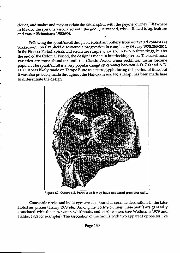
clouds, and snakes and they associate the ticked spiral with the Peyote journey. Elsewhere
in Mexico the spiral is associated with the god Quetzacoatl, who is linked to agricultureand water (Schaafsma 1980:90)
Following the spiral/scroll design on Hohokam pottery from excavated contexts atSnaketown, fon Czaplicki discovered a progression in complexity (Haury 7978:?5U257).
In the Pioneer Period, spirals and scrolls are simple whorls with two to three rings, but bythe end of the Colonial Period, the design is made in interlocking series. The curvilinearvarieties are most abundant until the Classic Period when rectilinear forms becomepopular. The spiral/scroll is a very popular deign on ceramics between A.D. 700 and A.D.1100. It was likely made on Tempe Butte as a pe8oglyph during this period of time, butit was also probably made throughout the Hohokam era. No attempt has been made hereto differentiate the design.
Figure 53. Outcrop 2, Panel3 as it may have appeared prehistorically.
Concentric cirdes and bull's eyes are also found as ceramic decorations in the laterHohokam phases (Haury 7978:2t6). Among the world's cultures, these motifs are generallyassociated with the sun, water, whirlpools, and earth centers (see Wellmann 1979 andHalifax 1982for examples). The association of the motifs with two apparent opposites like
Page 130
sun and water is somewhat hard to understand, but sun and water are freqrrently
juitaposed. Among the Pima, fol examgle,-the sun,dries up the water' As described by
Bahr et al (lgg4,+ii, r* power is usedty siuuhu (the Pima n.une for elder brother) in
battle where he makes the fog u"a *rt Jvaporate.'Bahr et ar (1994:139) spectrlates that
Siuuhu,s nalne ,,Drink-it.all-up,, is solar u'.a tr." sun drinks water. with this dose
association between the sun and water, it is not unreasonable to assume that when a
shaman *"s seekirrg tr," r"it, he might need the help of the sun to release it'
Across Arizona, spirals or concentric circles are coEunon petrogllpht t9 Fassociated with solstices and eqrrino*es-Usually thereis a sun/shadow interface with the
spirals or conc€noi. "lr.to nJh"r" trr" rn"lrr,udow line either moves across the circular
images or a ,,dagger of light'lel:tr;tes the pet19qlyPh, often stoPPing with ic point on
the center (Patter'son tgiz:$i\'Mtc;;{y <igga'l5il informs us that astronomer Robert
fteston and his wife anr, have identifi aiosolstice PetroglyPhs. in Arizona' Furthermore
the pretons ,'determined that certain rock art images, pr"itbmioTqy spirals and circles
(including concentric cirdes), **" to mark solar siies and to interact with sun and
shadow [Vf cCreery 799427331"'
Although we are not aware of published accounts of the P"tto-glyPh spirals and
concentric circres on Tempe Butte;il;* calendars, individuals who visited the site
d'ring the recordir,g ploitinformed.rittn"t such occurrences do take place' The spiral
on outcrop r, p"net-ti (u.. rigure 7 above) is apparently a1 exampleof a figure that has
shadows which intersect rines witrrin tr." rpiiir on certain days of the year (Barbara
Moulard personal communi..tio*'ig9li ci""" the rarge number of similar associations
in Arizona, this is not surprising. The concentration oipetroglyphs 9n the south facing
slopes of the butte provides furth";;;;;.tt -f9t tlt" ttse bf thJietroglyphs as calendars'
The movement of shadows on the noril. ru.. of the butte would have been less pronouncecl
during the winter months when tr," t"" is relatively low on the horizon' whereas the south
facing slopes *;;h;; provided Jnoopportunities to view the movement of the sun'
Human hands and feet Petrogllryhs
Thehumanhandisacommonrockartmotif.InsomeareasofNorthAmerica,human hand prir,t constitute r,""rty rlz, of thg lot -t imagery. e-nonutar way to depict
human hands is with paint where.i";J;;ith" design-cJveis a liand.i" P"ii:g*:applies it to the waU. iaentified as positive hand prints' these pictographs are common In
northern Arizona where,h"y -5;;;;iy.F"J.d to the anisazi (Schaafsma 1980:119)'
.Negative hand prints where tr," *"t"i oritlines the hand in paint are also fairly conrmon
in northern Arizona'
Peroglyphs of human hands are less common than painted examples' but they are
found in Anasazi and Mogorlon rock art (we'mantlgzglgg, schaafsma 1980:135)' with
theprevalerrceforthemoti-felsewhereinArizonaandNewMexico,thealmostcomplete
Page 131
absence of human hand prints in Hohokam petroglyphs is significant. None were foundat the Tert pe Butte Site. Wellmann noted the absence of human hand prints in Hohokamrock arh
The rarity of depictions of the human hand or foot is striking. A single hand, onewith six fingers, appears among the designs at the Fortified Hill site in the GilaBend area [Wellmann 1979:781.
As Weltmann poinb out, human foot prinb are also very rare in Hohokam rock art.For this reasorL if no other, the group at Tempe Butte is significant (see Figure 45 above).Snyder (1978:7?5) compared Hohokam examples of human hand prints and foot prints toPatayan rock art sites with the following results. He presents zero exarnples of humanhand prints or foot prints for the Hohokam to 4.3Vo foot prints andl,.ZVo hand prints forthe Patayan. Because a Patayan rock art style is not well-defined, his examples of Patayansites mightindude some and other styles.The more important observation is the absenceof the human hand prints and human foot prints at Hohokam rock art sites.
Atother locations in Arizon+ petrogllphs of the human foot are more crrmmon thanpainted ocamples. This is the opposite of the hand prints. Foot prints are often smaller thanan actual human foot, giving them a baby-like character, but there is tittle evidence tosuggest they are intended to represent babies. In some cases they may exemplify "littlepeople" or small spiritual characters, but again there is little evidence to support thispossibility. The presence of a sixth toe or finger (polydactylism) in hand print and footprint petroglyphs is suggested to represent a veneration of the unusual in humans, butagain there is little evidence to suggest this was true among Arizona native groups(Wellmann 1979:1.02).
To summarize, the absence of human hand prints in the petrogtyphs at Tempe Bufteis not unusual. At the sarne time, the presence of human foot prints at Tempe Butte isunusual. The foot print petroglyphs would be good candidates for dating to learn whenthey fit within the Hohokam tradition or if they might represent some other period of time.
PETROGLYPH CLASSIFICATION AT TEMPE BUTTE
The Tempe Butte Petroglyphs were dassified using a simplified system thatemployed ordy 22categories (Table 1). Panel drawings of all of the petroglyphs have beenincluded in this report in order to allow other researchers to classify the elements in adifferent system.
Table 1 liss the crrunt and proportion of element dasses by rock outcrop. The tablelists only prehistoric elements. Considerable variation eists in the apperunnce of thePetroglyphs, which necessitated the grouping of petroglyphs with somewhat different
Page1,32
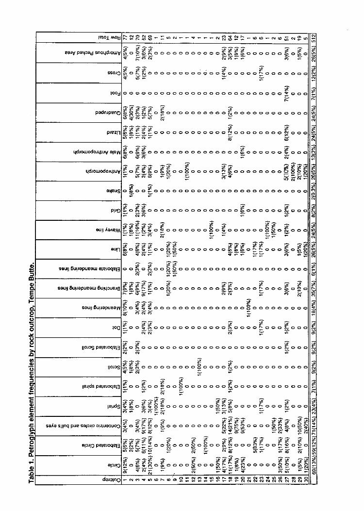
q;
3@
F
oc)
lslol rllot F SRSB * = -
N F F{ F F - crl R 3 S } - @ @ * or <o fi nr g u N|r)
sro(oN
sNGI
sF-
s|f'stOJ
srn9AI
sc,c,
$rr}(oo,
sa?o(\I
s(!o
srosol
*lt)(o(\,1
s(o
sF.ro(',
sso
ss9o,
sNO)
sN(D
sN
sIc)N
ssF.
sN
o,u1
sCJ
o(o
EaJV palrad snoqd:our5G 3aa6.965..o o o ooo oo. d666..o oo o 6.6.<t x.oN Nc)-- a, ;
;e ss S sioo i\ F! ooo o o oooo g o o + o o o o o roo o o oooY ;'= =
soo oooooooooooooooooooooooo.(' ooo=N
^:;^^^ -:>S*>e>s>g ;< s€8OUSo Soooooooooo Uoooooooo o oo o(o ii(! - tn ;f
^ssS 5IS 5o oo o oooooooo Nooooo ooo c! ooo6'=:V= ;. I>S :e ;g ;s >e6o 61 6ooooo oooo ooooo o iooooooo + ooo6' 6-;' = ;f
^: G -:^g. ggg. g$.. E o o o o. EE. <> oo o o o oSEt$
oN(o F= =
ai{ ntkV=-c \o
o $ o o Io o o o o o ooooo o ooooo c, ooo o o oo==
- --f .SSoooooooooooooooSoooooo N ooo=i(;==^^G^^ ? G G*953S9. Eo o o o o o o H o 5o o ooo o F H. $oooFFFF(9 -:
-=
>e >g >e >e ;< ;<eo ggLo o R B o o o o oo.. 888. { N o o o 8-8$<> tcor-
==>g :e ;F ;<o o oo ie o o R 3 o o oo o o o o o o oooo o oo o o o oNoJ==
SSFieS ie Fe s F sbgb| !o o R o o o o oo o o UUo o o o F- o o o 9o I or.--rod-
= oJoJ
= s, v
a a=':; FE. 555..oooooooo ooooo$oo oo o o ooo6' -or-
=: =-f ..SS ooo o ooo oooo o Soooo{ ooo So o o=iriri(==:e >e >Si\l O ir O o o o o oo O O o O O O O O O O O OO O O o 6u O O Ov;f=
G':S:Q>e I >gin b io o o o o o o o o o E; o o o o i! o o o o o o o o o o o ov=;i'
= ='iG>e>e;sx:e:oo ft o o I o oEio o o o ooo 6,tooooo o o o o o o oV=
^^-?=aa 88AS ssG S O$ $ o O$ t ! oo ooo ooo fi ! 0oo ooi ooo $ oooii= ;;= v Y;6- = =a os'F a F8S'F F'F's 8SS.- 3.: !. 0o o o o ooo o- N Ep *oo o oB g 0-E€(., oEiE. ;':dEi =v{ 9N
^.: 'iaQQSd S S X QS SS SS SbUL: :o o RoooB oEooF, Io oog :o o: I o I or',c\rrnb'o
= i( =
c\rd' ii'= =6- i(
$. Egg. g. o o o $o.. $.E gS$.. o o o $t. gH
6 sN& ;i =Y5-Y ;t;' F=
sso.rc
looj
podnJpPnC
prezn
qdrourodorquy e;ey1
qd:ourodorqluS
eleus
p!r5
arl IoAe/V
eur
seurt 6uuapueeul €leroqel:
saul; 6uuepuear 6urqcuel6
seurl 6urrepueep
loc
llorcs Pateroqel:
llorcs
leJlos psleroqEl:
CIolEI(l)l6l.ElcuxC'IolLIolrl;l.Crl(EIFI
lP!ds
sar(e s,11nq PUP selsjtt crluacuoS
alcr!c paleroqel:
olJJlc
dorctnc F c^r <.',r .r' (o F- o o 9 =
I : : I I : I I R F S R & K R h R R I
aPpearanc€s. Some unique elements were not classified, and the elements listed in Table1 do not indude all of those in the assemblage, but are a representative sample of thosepresent. j
The prehistoric elements at the butte are largely (75 percent) ctrrvilinear forms.Rectilinear forms crmprise 9-{y tt percent of the assembiuge, ;d elements comprised ofboth curvilinear and rectilinear pecking constitute thJremaining 14 p"r."tt of thepetroglyphs.
The assemblage from Tempe Butte is'dominated by variations of the circle motif.limgle cirdes, elaborated circles, crcncentric circles or buli's eyes comprise 39 percent ofthe elements. "Representational" (snakes, male anttuopomorptrs, antfuofomorphs, lizards,and quadrupeds) elements constitute only t4 percent of the petroglyph motifs, which issomewhat lower thal the proportion of these elements (20 to80 p"r"!.t) that is commontyreported for Gila style petroglyph sites (Wallace and Holmlund l9fj6:g2). Simple spir"tJ,elaborated spirals, simple scrolls, and elaborated scrolls constitute just over e p"t.*t oithe assemblage. The remainder of 9-" assemblage is predominantly varioui types ofmeandering lines which exhibit considerable variitior, it upp""rut..
Figure 54 presents bar graphs of the proportions of selected element t)"es and rockoutcroPs. For ease of comparison similar ellment types have been combineiin the figurefd :{f outooPs with 50 or more petroglyphs .r" pro"t ted. Visual examination of Table-1 *d Figr-ue 54 suggets that all of the ouicrops with large samples of coded petroglyphs
have a similar ranqe of motifs present, but ttre propoitiotrs of motifs appear to differFT*" outcroPs. For example outcrops 1 and S'ocau at roughly the same elevation onthe butte, but Outcrop 5 has a consideiably higher proportiot oi circular elements thanoutcrop 1- In contrast
-Outcrops 5 and rs Loth na.'" "o*puratively
high proportions ofcircular forms and roughly similar proportions of other element typ"r, b"ut ihese outcropsare seParated by a substantial distance and occur at different elevations-
In order to identify rock outcrops with similar sets of petrogllph motifs a Ward,sminimum variance method clwter analysis was preformed on cnunts of the cnded element?Po' Otly outcrops with 50 or more coded elements were considered in this analysis(Table 1). At the two duster level Outcrops 5 and 18 were differentiated from Outcrops 1,3, 4, and 27. At the three duster solution level, Outcrops L and 3 were in cluster 1.,Outcrops 4 and 27 werein cluster 2, and Outcrops 5 and l&were in the third cluster. Theoutcrops in dusters 1. and 2 occur in relativeiy close proximity to one another, whichsuggets that some variation in motif frequencies may occur in relation to the location oftheoutcrops. However, Outcrops 5 and 18 occtu u.o*idoable distance from one another,and it is likely that variables other than proximity also affect motif frequency.
Page1.34
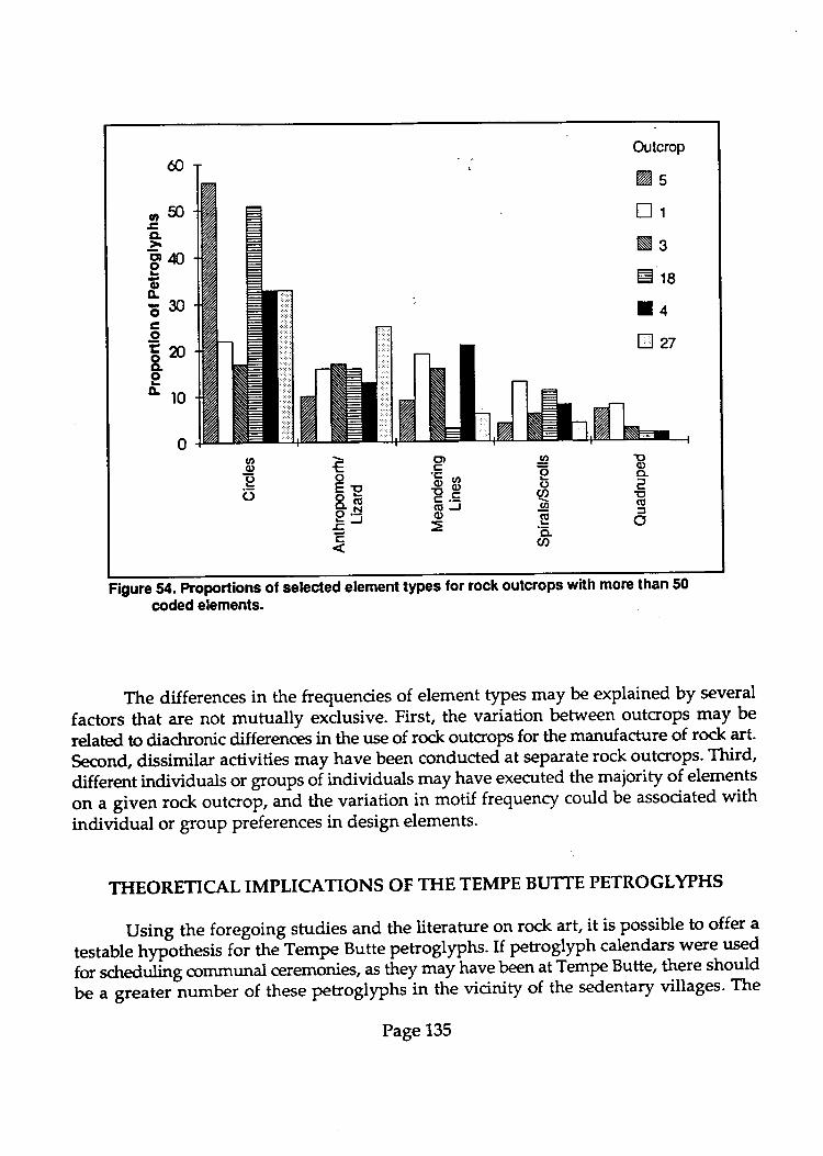
Outcrop
%s
lrNsE18
lnBzt
Eq)o-aE(E:to
60
o50ECL
-3 ao
oG530c.9ENo.orlo
IEc)U)I(o'd-U)
€oEtx(E6.S-E--c
c')'5
g?E:(EJ(l)
oo.go
fl$rre 5a. Proportions of selected element types for rock outcrops with more than 50
coded elements.
The differences in the frequencies of element types may be explained by several
factors that are not mutually exclusive. First, the variation between outcrops may be
related to diachronic differences in the use of rock outcrops for the manufacture of rock art-
Second, dissimilar activities may have been conducted at separate rock outcrops. Third,
different individuals or groups oi it dividuals may have executed the majority of elements
on a given rock outcro!, and the variation in motif frequenry could be associated withindividual or grouP preferences in design elements.
THEORETICAL IMPLICATIONS OF THE TEMPE BUTTE PETROGLYPHS
Using the foregoing studies and the literarure on rock art, it is possible to offer a
testable rrypiUresir foi th"1empe Butte petroglyphs. If petroglyph calendars were used
for scheduling communal ceremoni€s, s tLey r"uy t ave been at Tempe Butte, there should
be a greater number of these pefroglyphs in the vicinity of the sedentary villages. The
Page 135

Iocation of Tempe Butte adjacent to major canals, irrigated fields, and permanent villagesis precisely where we should predictthe need fdr calendars while the petroglyph sites inthe mountains, near temporary camps, are less likely locations for ceremonies scheduledaccording to calendars. If this hypothesis is correct, there should be fewer spirals andconcentric cirdes at the sites near the hunting and gathering localities.
This does notmean that there would be no petroglyphs on Tempe Butte associatedwith trance and altered states of consciousness, because as presented above, shamans stillpracticre in societie with communal ctrlts. Likewise, there may be petroglyphic designatorsof solstices and equinoxes near hunting and gathering sites because shamans in thesesocieties also use these solar events in their practices Ooendorf 1994). We are suggesting,however, that tlre need for calendars wotrld have been greater in the vicinity of the villageswhere the more sdreduled activities took place.
To test the hypothesis we have put forth, we need to look at the distribution ofspirals and concentric cirdes in Hohokam rock art. This is often difficult because in mostreports no distinction is made betrareen Archaic and Hohokam petrogly?hs. Weaver'sstudy of the distribution of petroglyph designs at Hieroglyphic Canyon offers somecomparative material. Although he does not present the number of spirals and concentriccirdes,202 quadrupeds were recorded in area two at the site. He writes:
Of the 45 panels, only 13 have no quadrupeds whatsoever. Of the 13, three are sob"dly weathered that no definite design elements were discernible. The remaining10 out of 13 all have less than three design elements each, with 7 having only oneelement each. Quadrupeds occur in most of the panels and, in fact, are thedominant design element in 23 of 32panels in which they occur. Quadrupeds arethe only elements in 13 panels. It is obvious that quadrupeds were important to theindividuals who produced the petroglyphs in Area 2 (Weaver 1985:8).
Area 1 and Area 3 of the site are also dominated by quadrupeds. Although geometricdesigns dominate most of the panels, quadrupeds are also abundant in the sites of theSierra Esbella OVeaver and Rosenbergl978:119). These data tend to support the possibilitythat there are more calendrical petroglyphs near the permanent communities of theHohokam period.
At Hedgepeth Hills, a site where the majority of the rock art is now assigned to theArdraic, Bruder (1983:150) identified four varieties of scrolls or spirals and five kinds ofconcentric cirdes (bulls eyes). The spirals constitute about one percent of the petroglyphsat the site while the crcncentric circles account for about two percent. Because much of therock art at Hedgepeth Hills site is older than Tempe Butte, the low numbers of spirals andcrrncentric cirde should not be surprising. The data point out that spirals and concentriccirdes are more popular at some Hohokam rock art sites.
Page 136
Snyder (19662707), quoting Gladwin (1958) points out that the Hohokam were thefirst in the Southwest to extensively use spiral and scroll designs on their ceramics. He
identified 156 (7.6Vo of his sample) spiral and scrgl!petroglyPhs in the South Mountainstudy. This percentage would undoubiedly double rnrith the addition of concentric cirdes.
Althlugh Snyder diJ notrecognize any pittern to the distribution of petroglyPhs, nV: ?jthe spiials and scro[s and i%o of the cbncentric cirdes are found below 1500 feet while
to*" of the better made humans and quadrupeds are found above this elevation.
Indirectly this suggests the possible use of spiraq or concentric circles for calendars in the
lower td.t o of i}ie ^o.n
tuios, near the canals. Ternpe Butte is slightly less than 1500 feet
in elevation.
At Ternpe Buftg, the categories of spirals, elabgr-ated spirals, scrolls, and elaborated
scrolls constitute 9.4vo ofthe peioglyptrs it the site. This number is comparable to the7.6vo
found by Snyder in the South Mountains.
One of the most extensive studies of Hohokam rock art is that of Wallace and
Holmlund (1936,) in the Picacho Mountains north of Tucson, Arizona' Their categories-of
counter-clockwise, clockwise, connected, interlocking, and running connected scrolls
q),,espond to the spiral and scroll designs at Tempe futte. of the seven sites studied in
the picactp uounains with more than ldpehoglyphs, four had no spirals or scrolls while
the other three had betwen.Tvo andi.gzr-of these forms (Wallace and Holmlund
19g6:210). h other words, the rock art sites in the Picacho Mountain have less than?Vo of
their imagery as spirals and scrolls. If the concentric circles and bull's eyes are adied to
the spiradand scrolts, the percentage of the rock art at the seven sites with more than 16
petrdglypfrs ranges fuom1% tos.lVo: At Tempe Butte, on the other hand, nearly a quarter
?nE"i6itn"rocf art is accounted for when the concentric cirde and bull's eye motifs are
combined with the spirals and scrolls.
Examining the distribution of petroglyph motifs at sites that Wallace and Holmlund
used for comparison, one site stands o,riiit "tting
a large number-of-spirals' This site,
Signal Hill sitl in Saguaro National Park near Tucson, has 13.6vo spirals and scrolls in it
inientory of petroglipnr. The site is a prominent land.mark in the region as reflected by
its name - Signal Hill.
The Signal Hill site also has substantial numbers of concentric circles and bull's eye
petroglyphs. Lombining these motifs with the spirals and scrolls, accounts fot 17'8Vo of the
i".f. "ti-"t
the site, a pJrcentage that is similar to the 23Vo atTempe butte'
Apparently the distribution of petroglyph.l*{t is not random in the Phoenix and
Tucson basins. siies like Tempe Butte and 5i'g""t Hill have greater percentages of spirals,
scrolls, concentric circles, urrd b.,U', eyes. TYhe reason for this is not yet totally clear but
there is s6ong possibility for a relatiot t'nip befween the location of major villages and the
use of calendar PetroglYPhs'
Page137
In sum, the prevalence of spiral forms and other possible calendric devices in theassemblage of petrogllph motifs at Tempe Butte suggests that these forms may have beenmore important to the sedentary agriculturalists who manufactured them. Quadrupedsand other "representational'elements are under-represented at Tempe Butte, while othersites in the area that are in doser proimity to hunter and gathering localities appear tohave higher frequencies of these elements.
PROPOSED TEXT FOR INTERPRETIVE SIGNS
ftoposed text for interpretive signs at Tempe Butte is offered in this section. Wehave not attempted to edit it for final concisenels nor have we had it examined byrepreentatives from Arizona Indian tribes. We strongly recommend the latter take phclbefore the interpretive information is used on signs.
Example one
9" ry*qr$<s on Tempe Butte have both a volcanic and a sedimentary origin.The Tempe Beds, exposed along the Salt River on the north side of the bulte, ui"
"mixture of arkose, silbtone, volcanic arenite, and tuff. Geologists believe these bedsrepreent the end of an alluvial fan, perhaps the product of flash floods, which wasgverlain by rocks of volcanic origrn. The Tempe Beds contain worrn burrows, palmfronds and other plant fragments. A camelb tooth was found in the Tempe'Bedswith a suggested age in the mid- to late-Tertiary period.
The volcanic rocks are in the upsection of the butte overlying the Tempe Beds.These are the dark qray to grayish pink colored rocla that mikeirp the outLop, or,the south, east, and west ends of the butte. The majority of the petroglyphs arefound on these volcanic rocks.
Example two
The outer surface of the rocks on Tempe Butte is covered with rock varnish. Oftendark brown to nearly black in color, rock varnish is a natural coating of clayminerals and manganese'and iron-oxides. Petroglyphs are made by"pecfcin!;through this dark varnish to expose the lighter-colored interior stone. After about100 years, the newly exposed stone inside the petroglyphs begins to develop rockvarnish.
Page 138
Scientists at Arizona State University have studied rock varnish extensively andin
the process, they have developed several experimental methods by which it can be
,tr"& to date petoglyphs. aola age dating of petrogllphs on Tempe Butte has not
been completed, butby comparinfUt.^ t6 otliers oJ kno*n age, we know most of
them were *^d" by ih" Hotrotim. This means that most of the petroglyphs are
more than 500 years old but less than 1500 years in age.
Example three
More than half of the petroglyphs identified as Hohokam are abstract designs and
symbols. we may never klro# the meaning of many of these abstract designs, but
clues are beginning to emerge. The spirals-and tctous, for example, are relatively
conrmon #;i;;""t HohJkam to.t art sites. Recently archaeologists and
astronomers have learned that some of these spiral- and scroll petroglyphs were
used to mark the solstices. They often work with a shadow arrow that pierces the
spiral on the solstice'
Example Four
Petrogllphs known as the Hohokam "PiP9T"-" because they resemble a chemist's
tube, are found on Tempe Butte. So;; Hohokam "pipettes" take on a human
appearance. On a rock ""tcrop "ear
the trail, a *"sk-like human form may be
retated to the "pipette" design'
Example Five
Petroglyphs of tizards are common on Tempe Butte' Lizards are corunon ro& art
fig'res b*; they have the ability to move-in and out of the stone and in this way
they serve as "go betweens" to carry messages to the spiritual forces in the rocks'
Many petroglyph lizards -u pi"."a adjace-nt to crackl in the stone to symbolize
their-abitity to move into the rock'
This series of short interpretive messages could be supplemented with others' we
recorunend the use of illustratio* o" tt "
ti"g* io lelP pui Lach.mes.sagg agoss to the
public. We have r,ot prgp-{ tf,"t"*t}* u potLti."f sign'that describes the Hohokam and
their canals. Suctr;;rB" might be effective at the vlsitor look-out near the crest of the
existing trail.
Page139

GENERAL CONDITION ASSESSMENT OF THE ROCK ART ATTEMPE BUTTE PARK, PHOENIX, ARIZONA.
ry
J. Claire DeanConservator
Prepared for
I-oendorf and Associates985 W. Eucalyptus Place
Tucson, AZ857U
Prepared by
Dean and Associates Conservation Services3438 NE 62nd AvenuePonland, OR 97213
May, 1995

L INTRODUCTION
This report is based on information gathered during a field visit to Tempe Butte Park,Phoenix, Arizona, on 6th Febnuary, 1995. Additional information and observations were obtained -through discussions wittr Chris Ioendorf, Archaeologist, and Diana Clise, Assistant, both withInendorf and Associates, Tucson, Arizona, who were on-site during my field visir
The condition of the rock art at the park was examined and assessed under the weatherand other environmental conditions prevailing on the day of the freld visir The weather
conditions were dry and sunny with some breez.e. As many condition related phenomena are
dependent upon differing environmental states - different from those experienced on 6th Febnuary
- it must be understood that other states of condition may be present and active at other times ofthe year. This is especially true with variations in the environment connected to seasonal changes
throughout a year. These other states cannot be accurately predicted but need to be observed inorder to be correctly assessed and recorded. -
This document reprcsents a very basic and general assessment of the conditions seen at
Tempe Butte Park. The Park covers a large area of ground which includes a number of rockoutcrops that carry rock art. Under the circumstances pertaining to this contract, it was notpossible for me to visit and examine every rock art panel within the boundaries of the Park. Thus -I could not carry out a detailed condition assessment of every area of rock art. During the fieldvisit I became generally acquainted with as many of the sites as possible and then decided toconcentrate my examination on three areas which I felt represented the range of conditions and -problems seen at the Park. The areas chosen were a series of panels from outcrops 1, 3 and 4(outcrop numbers used are those designated by I-oendorf and Associates). These three areas are
discussed under separate headings in the following sections of the reporl
IL DESCRIPTION OF GENERAL AREA
Tempe Butte Park covers an area of a little over 23 hectares. It is located close to thecampus of Arizona State University and a business district, and is therefore overlooked by severaloffrce buildings. The Park is a popular place and during the day I spent there it was obvious thatit is heavily used by people from the nearby offices as a place to walk and relax during lunch timeand at other breaks in their working day. It is also used by joggen, bicyclists, and walkers as aplace to exercise. There is a main paved trail running through the Park along which are placedbenches where people can rest. Access to the Park is very easy as it is located immediately next tothe business arca, sharing a cornmon boundary. There is a parking lot at the base of the mainbutte, and it is here that the trail head is located.
The presence of trash, especially beer cans and bonles, in areas well off the trail, suggeststhe use of the Park by other groups of individuals. In addition, graffiti is found both adjaceirl tothe trail (on retaining walls along its route) and on the rock outcrops away from the trail. Notsurprisingly, a lot of the graffiti is found in areas out of sight of nearby buildings and roads. Theeastern end of the Park adjoins a parcel of land belonging to the Univenity and containing SunDevil Stadium. At ttris point the Bune is higher than the Stadium, thus prwiding an e"cellentvantage point from which to view events in the arena below. It is clear from the condition of theboundary fence at the top of the Butte, that this is indeed a popular spot for people to trespassinto the univenity property and make use of this visual vantage poini.
Another feature of the Park is the presence on the main slope of the Butte of a giantcapital letter "A" - the initial for the University. Made of concrete poured directly ontg theglound, measuring several meters from top to bottom, and brightly iuint"a, it is an unavoidablevisual component of the Park. It is repainted by the students s"ueol times a year and in betweencoatings it is a magnet for graffiti - it was extensively covered with spray painted graffrti at thetime of my visir The popular act of repainting it, coupled with the rurrounong gnffiti and trash,indicate ttrat this area of the Park is a popular tr-g-oui for certain individuals. As such activitiesare illegal in the Park and do not seem to be reported or witnessed by those occupying theadjacent office buildings, it seems reasonable to assume that these activities take piacJ after dark.The absence of lighting along the trail or elsewhere in the Park would also conceal such events.
Besides the rock outcrops that dominate the park, the ground is covered with vegetationtypical of desert areas in this part of Arizona. Several species of cactus are present, atorig witfrgrasses' desert shrubs, such as creosote bush and salt bush. Between stands bf pt-tr either bareearth or stony ground characterizes the surface condition.
IIL ROCK ART CONDITION ASSESSMENT
The condition of a rock art site is usually related to two potential sources of deterioration:
natural and human induced deterioration. The former is caused by natural phenomena such as
wind, rain, frost, sun exposurc, flora and faunal impacts, and so fonh. The latter is the result ofdirect visitation to sites (resulting in such things as ground erosion, abrasion of rock surfaces,
theft of rock art, vandalism, and so forth), or less direct contact, for example the encroachment ofurban development causing changes in the natural environment via ground and air pollution.
During field work atTempe Butte Park, a Rock Art Condition Documentation Form (Fig.
1.) was used to record the general condition and other observations with regard to each visited
site or panel. In addition photogfaphs were taken for general reference.
a. Natural Deterioration
Due to the topographical characteristics of the butte that forms the Park, many of the sites
are subject to exposue to extremes of wind and rain. However, I saw no areas that appeared to
be suffiring mor€ than othen from these impacts. In keeping with many sites chosen for the
location olrock art, many of the sites at the Park are located in areas that are somewhat nanrally
sheltered from the elements and thus bener preserved. Such sites include those in small rock
shelters, on rock faces protected by overhangs above, and others protected by the proximity oflarger rock masses or by vegetation.
Although potentially abrasive (cactus, woody shrubs) and disruptive (lichen) vegetation
and other biologiCal activity (possibly bacteria) are predominant in the Park,I saw no examples of
direct damage to rock art by these possible sources. Likewise, animal activity seemed not to be a
sogrce of deterioration to the sites either. Many small animal burrows, some possible roosting
sites for birds, and dens for larger animals where all observed, however none appeared to be
causing harm to rock art sites.
In general, natural deterioration of the sites within the Park apPears to be normal for the
type of terrain and location, and does not raise concern at this point.
b. Human Induced Deterioration
By far the biggest concern ar Tempe Butte Park is the human impact on the rock art sites.
Three sites can Ue sinEfeO out to reflect the range of conditions related to public use found within
the park. They are aescribed and discussed below in descending order of condition, the first site
being an example of the least damaged rock art area examined.
Outcrop I (Fig. 2): Of the three highlighted sites, outcrop I represents rock art ar Tempe ButtePark in its best condition. The site consists of a series of over 20 identified panels of petroglyphspecked or abraded into the faces of the outcrop. The site is situated close to, but not immediatelyon, the main paved trail. Access is gained by stepping off the tail and climbing up a moderateslope, through ground brush, a distance of approximately 20 meters. It is in clear view of anypersons on the trail.
Only a few items of trash were seen in ttre vicinity of the sitc, and they may have beenwind blown or washed down from other parts of the Park. Only a few obvious areas of graffitiwerc seen; for example, the letter "T" on panel 3, the letters "BAR X" on panel Z, and someinitials "'WAD" and "RMA 71" on panel 18. All of these inscriptions are scratched into the rocksurface.
It seems likely that the excellent condition of this sire is due to its location; although fairlyclose to the trail, a hike through brush is required to reach it, and any person doing ttris witt stitt
-
find themselves in full view of the trail and surrounding buildings. Evin at nighg the site isprobably still visible due to the over-spill of light from the streei and buildingi.
The idea that protection is offered by the combination of slight distance from the trail andopen visibility may be borne out by considering the area a short distance further up the trail wherethe public benches are located. The benches are situated in "pull outs" on the side of the trailwhich are contained within stone retaining walls. The walls hunr spruy painted graffiti on thern Inthis situation, the immediate proximity ofthe trail allows forvandals to strike and then leave thearea quickly. This ability to be able to leave the area immediately negates the protection given bythe area's closeness to buildings and the public trail.
Outcrop z (Fig. 3): This site, similar to outcrop I (above), consists of a series of 30 peuoglyphpanels. The outcrop lies in front of and just below a paved viewing area at the top of the truii.'Access to the site is gained by a fairly difficult scramble down theilope of the butte and round thefront of the ourcrop. It can also be reached by climbing directly up the slope from the trail startingat a point a short distance from the trail head at the entrance to the Park. Either route requirescrossing loose, unsrable slopes and passing through brush.
The site contains a fair amount of trash ranglng from spent shotgun shells to beer cans andfood wrappers. This suggests that the site is used fairly frequently for illicit parrying. The site doesoverlook the trail below, the parking lot and local buildings; however, it is pnrbably far enoughaway from the street area so as not to be illuminated at night by over-spilling fighr The site is notvisible from the viewing area located above it
The site displays more graffiti than outcrop 1, once again in the form of scratched orabraded letters and numbers. Relative to the range of conditions found at Tempe Butte park, thissite represents a moderately vandalized site.
4
In this case it seems likely that despite the effort needed to reach the sitc, it is attractive tounauthorized visiors due to its rclative seclusion from nearby trails, and lack of visibility at nighttime. Another of its probable attractions is the panoramic view it affords of Phoenix, which isspectacular and is probably nrore so at night
Outcrop 4: Outcrop 4 is an example of the worst vandalism problems at the Park. The area is ahuge complex of smaller outcrops included under the single designation of "outcrop 4", includingover 20 large panels (or groups) of petroglyphs. The area is located at the very top of the butte, at
a considerable distance from any offrcial rail, and immediately adjacent to the Park's east
boundary fence. Indeed archaeologically, the site continues into the property on the ofter side ofthe fence. This neighboring prcperty belongs to Arizona State University and is the site of Sun
Devil Stadium.
The presence of many unofficial trails across the outcrop, along with large amounts oftrash - especially broken beer and wine bonles, beer cans and food unappers - indicates the heavy
use of this area by unauthorized visitors. Vandalism of the rock surfaces, including rock art, is
wide spread. There appears to be various materials and methods used to leave graffiti, but by farthe most common is paint (spray and bnushed), and scratching or pecking.
One of the most problematic parts of outcrop 4 is the area around panel 11 (Flg. 4) whichis situated on the highest point of the outcrop, which is also one of the highest points of the Park.
The panel is located on an almost flat surface that provides a perfect platform from which to viewttre city below. In addition, the panel is crossed by a trail that leads to the boundary fence only a
couple of meters away @g. 5). The trail is used by people entering the Sun Devil Stadiumproperry illegally, and taking advantage of the overview into the Stadium afforded by the end ofthe butte. A large hole in the boundary fence is witness to this activity. As a result of the trafficacross the panel, areas of it are being worn away, and graffiti has been added to it @g. 6).
Evidence of possible theft of rock art can also be seen in close proximity to panel I l. To
the south and slightly below panel 11, there is a small petnoglyph panel designated as panel 8.
Herc an area to ttre right hand side of the panel is missing, exposing a freshly broken rock surface
free from weathering (Frg. 7). The missing area includes part of a petroglyph - the remaining part
can be seen running "into" the broken edge of rock. The missing section of rock could not be
found in the immediate area, which would be normal had the fragment fractured and fallen due to
weathering or accidental breakage (this damage can occur when areas are being walked over
continuously - this is unlikely at this location as this area is not part of any trail). The general
appearance of the fracture, coupled with the presence of rock art, the missing fragment and its
apparently portable size, suggests that the fragment was deliberately broken off and stolen.
Toward the west end of the outcrop, on the south side and below the top, there is an area
that has obviously been heavily vandalized with painted graffiti of various kinds. Anemps have
been made to camouflage the graffiti by painting over it using a shiny, chocolate brown,
horrsehold paint @g. 8). The exact type of paint used is unclear, but it could be an enamel.Although this treatrnent may be fairly acceptable when viewed fuom a disrance, on closeinspection it is both obvious and unsightly, and it is now failing. This treatrnent of graffiti is foundat other locations in the Park in addition to outcrop 4.
The need to deal with graffiti by eitherremoving or hiding it, is well known. Thephenorncnon of "graffiti breeds more graffiti" has been observedL numerous places and is anestablished problem. It is also well known ttrat painted graf,Frti, especially on natural surfaces suchas rock, can be very difficult and time consuming to remove. Painting over graffiti is a commonsolution to the problem of graffiti on buildings and other man made structures. However, over-painting gatriti on sites such as outcrop 4, is fraught with problems.It can look almost asunsightly as the original vandalism due to the difficulty in blending the uniform naturc of a paint'sfinish and color with the uneven texnre and color properties of a iock surface. C-ommerciai painsare not necessarily designed for application on stone, and they arc certainly not designed to bepennanent (if commercial paints were pennanent, the paint industry wouldrapidly lose its marketas no one would ever need to re-paint anything). This situation usually resultJ in the applied paint:velhrally peeling off, which is actively happening at outcrop 4. Indeed, not only is it poeting otr,but-in places it is peeling away from the paint it was supposed to hide, thus revealing tt
" oriitnaf
problem once again (Frg.9).
C-amouflaging graffiti by over-painting it can serve as an adequate temporary measurc, butit should not be relied on as a pennanent answer to the problem. When it is used as a remedialu€atrnent, its use should be uniform and complete. In the case of outcrop 4, alargearea of againted inscription has not been covered (Fig. 8), thus defeating the purpose of the treatrnent, thatbeing to discourage additional gnffiti by "removing" the attracrion oiexisting graffiti. Why theremaining inscription was not covered is not clear. Speculation suggests ttratiitfre, the availablesupply of brown covering paint ran out, or the area was too high and difficult to access for thoseother than vandals.
It is not clear whether any rock art exists in this area of outcrop 4, although the generalappeanance and location of the arca is similar to other sites where to"t an is found. The use ofcamouflaging paint on such a wide scale only adds to the problem that petroglyphs may existbelow the paints (both graffrti paint and cover-up paint) and can now no longer be recognized. Anexample of this possibility is inferred by panel 16 at outcrop 4 (Frg. t0). panil 16 is in fact aboulder situated at the base of the outcrop on the south side. Here the rock has a bright blue paintspilled over it' presumably as a rcsult of it being used o paint graffiti on the rock behind theboulder. The western face of the boulder (Frg. I l) carriei several petroglyphs which have splashesof the blue paint" and another yellow paint, on top of them (these iptasfies may be the result of theuse of the paint to leave graffiti on the rock behind). Had the blue faint spill occtgred over thisface, instead of its actual location, these petroglyphs would have been covered and difficult, if notimpossible to see- The top of the boulder was also covered with blue paint, however most of thishas now naturally weathered away as this surface is directly exposed io all natural weatheringagents. The loss of the paint has revealed the existence of a grinding slick on this surface, which I
6
would suggest was hatd to discern when covered with ttre thick blue paint.
Finally, it has o be pointed out, that in some ways the use of paint on such a large scale tocover up painted gaffiti can be seen as a form of vandalism in itself. The application of any paingfor whatever purpose, in an area where these materials are intnrsive and unacceptable, runscounter to the message of what is, and is not, considered appropriate and acceptable in such asetting.
Besides the use of paint to mitigate graffiti, signs of another possible attempt to nemovevandalism using a different method can be seen on an unidentified face of rock to the southwestand slightly below panel ll (Flg. 12). Here an area of very smooth rock was observed, with nosigns of the normal weathered surface found on rock immediately adjacent to this arca, or inkeeping with the general appeamnce of weathered surfaces in the Park. Not only is the rockuncharacteristically smooth and unweathered, it is also a much lighter color than the surroundingrock surfaces. It has the appearance of having been anificially altered, but seems too large anduniforrr an area and in an impractical setting to be a giant grinding slick. However, it does have anappearance similar to that caused by the use of a commercial sandblaster on stone. This methodhas been used for gratriti removal at many sites, but is considered to be inappropriate as it is tooaggressive for this tlpe of work, is difficult to control, and poses an extreme risk of damage to, ortotal loss of, rock art Close examination of the surface reveals traces of what may be a darkred/brown paint left in the pits of the few remaining panially textured sections of this arrea.
Prresently the area retains the remains of some gxatriti and a drawing, both executed insilver metallic paint, which has largely weathered away. This graffiti appears to have been appliedover the smooth surface, and is not the remains of graffrti that was being removed by sandbiasting- if indeed that is what is represented herc.
The attraction of outcrop 4 for unauthorized activities at the Park is almost certainly dueo its relatively secluded naturc, the only moderately difficult access, and - especially in the case ofthe top of the outcrop - its close proximity to access to Sun Devil Stadium and the spectacular360" view of the city of Phoenix gained when standing on top of the butte.
c. Other Observations
The formation of unofficial trails across the Park, especially those that lead to areas ofrock art, cause accelerated erosion of the ground around the sites. This leads to direct damage tothe sitcs, either by the physical impact of walking across a site, or by undermining the structuralsupport of ttre site. In addition, such trails can act to divert rain water along anificial drainageK)ute, thus causing further erosion and ground instability.
The visual presence of unofficial trails is an open invitation to other visitors to followthem, once again compounding the problems already mentioned.
At the trail head there is a large sign that outlines how and when the park can be used bythe public. However, nowhere in the wording is it made clear that vandalizing, stealing orotherwise damaging the rock art rcsources is prohibited. Neither is any penafii for such behaviordetailed. Presumably the rock art is included in a general sense within the wording of the signs.
There is no interpretation or explanation for the rock art, and this can lead to theimpression that it is of little value or importance. Education of the public with regard o theprctection of this resource and ia significance, is important and can be a useful t*t in crubinginappropriate behavior.
d. Summary
As with all rock art sites, natural deterioration in the form of erosion is actively takingplace at the Park. However, there appears at this time to be no accelerated erosion or othernatual deterioration processes taking place that raise cause for concern.
As already noted, general visual observations suggest the Park is used by a wide range ofvisitor tyPes- The condition of the rock art areas mirors this range of use, with some areas beingin close to p'ristine condition, while others are heavily vandalized- In general, sites where a lot oftrash and other debris is found are more heavily u*d"li""d than thosJ which are clean. Thevandalized sites tend to be in more secluded orhidden, yet reasonably accessible areas, whilethose that are in full view of the trail or neighboring buiidings, or are more difficult to access,show less vandalisrn
Guidance as to the value and importance of the rock art in the Park is lacking and could beprovided by improved signage.
Past attempts to mitigate gnffiti have not been totally successful and are now failing inplaces. In addition, Past methods may have adversely impacted petroglyphs and otherarchaeological features.
The formation of unofficial trails is encouraging visitation to arcas of the park well awayfrrom the main official trail, and will accelerate rrotion of the ground.
Despite the heavy use of the Park by responsible visitors and the obvious problems withregard to unauthorized use for inappropriate activities, many of the rock art areas of the park arein good condition.
IV. RECOMMENDATIONS
The following recommendations are made with regard to the conservation of the rock artat Tempe Butte Park, Arizona.
o I baseline condition documentation of all of ttre rock art sites at the Park should beundertaken as soon as possible. Such documentation should include both natural andhuman induced deterioration, and rccord all of the existing graffiti and other vandalism.This will provide the Park with an exact record of a site's condition at a known point intime against which the future condition of the site can be compared and evaluated. In thisway new vandalism, theft and other possible deterioration related changes can be assessed.
' Photographic monitoring points of the main rock art areas should be established, and aprogram to regularly photograph the areas should be started. This type of monitoringwould work along side the baseline condition documentation as a way to gauge visior andnanrral impacts on the sites.
. Both interpretive and visitor etiquette signs should be provided or improved so as tobetter inform the visiting public about the importance of the sites, their fraglity and thelegal provisions that exist to protect them.
o { prcgarn to remove or reduce existing gaffiti should be implemented. This shouldinclude the removal of all of the paint used to over paint graffiti in the pasl This vandalismremoval should be carried out in consultation and under the supervision of a professionalConservator with experience in rock art conservation.
' An active prognm to collect and remove trash from all areas of the Park should beestablished-
The use of unofficial trails should be discouraged and existing trails of this t)?e should bereclaimed and re-vegetated.
Better law enforcement with regard to the unauthorized use of the Park should beattemPted, especially at times when events such as the repainting of the University "A" istaking place, or when activities at Sun Devil Stadium are likely to attract people to thatarea of the Park.
9
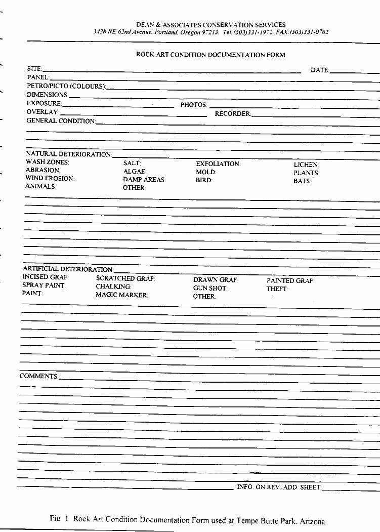
DEAN & ASSOCIATES CONSERVATION SERVICES3J38 NE 62nd Avenue. Ponland. Oregon 97213. Tel:(501331-197l. FA\.(503)3314762
ROCK ART CONDMON DOCI.IMENTATION FORM
PETRO/PICTO (COLOURS}
DIMENSIONS:EXPOSURE PHOTOSOVERLAY: RECORDERGENERAL CONDMON
NATTIRAL DETERIORATIONWASH ZONES:ABRASION:WIND EROSION:ANIMALS:
SALT:AIGAE;D.AMP AREASOTHER:
EXFOLTATIONMOLD:BIRD:
LICHENPLANTSBATS:
ARTMCIAL DETERIORATIONINCISED GRAF:SPRAY PAINT:PAINT:
SCRATC}IED GRAFC}I"ALKING:MAGIC MARKER:
DRAWN GRAFGUN SHOT:OTHER:
PAhITED GRAFTHEFT
COMMENTS
INFO ON REV.,ADD SFIEET
Fis I Rock ,Alt Condition Documentation Form used at Tempe Butte Park. Arizona
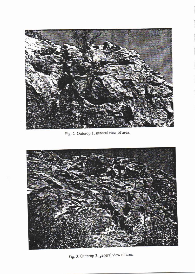
Fig. z Outcrop l. general l'ie*-of area'
Fis. 3. Outcrop 3, general view of area
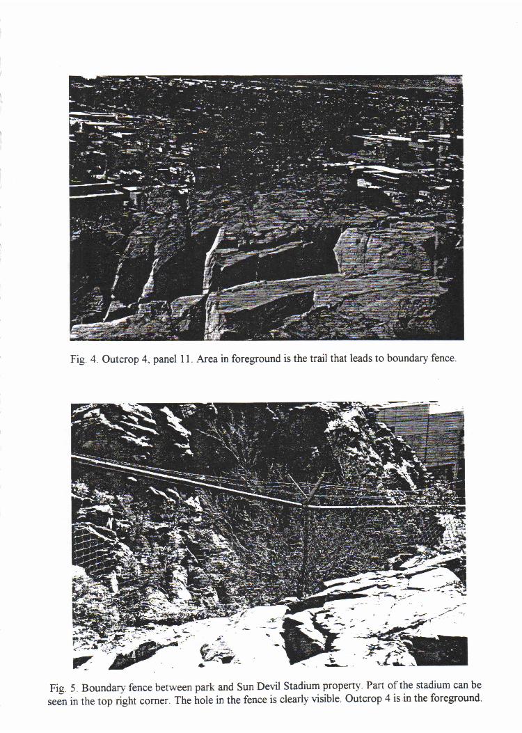
Fig. 4. Outcrop 4, panel I l. Area in foreground is the trail that leads to boundary fence.
Fig. 5. Boundary fence between park and Sun Devil Stadium property. Part of the stadium can be
seJn in the top right corner. The hole in the fence is clearly visible. Outcrop 4 is in the foreground.
/
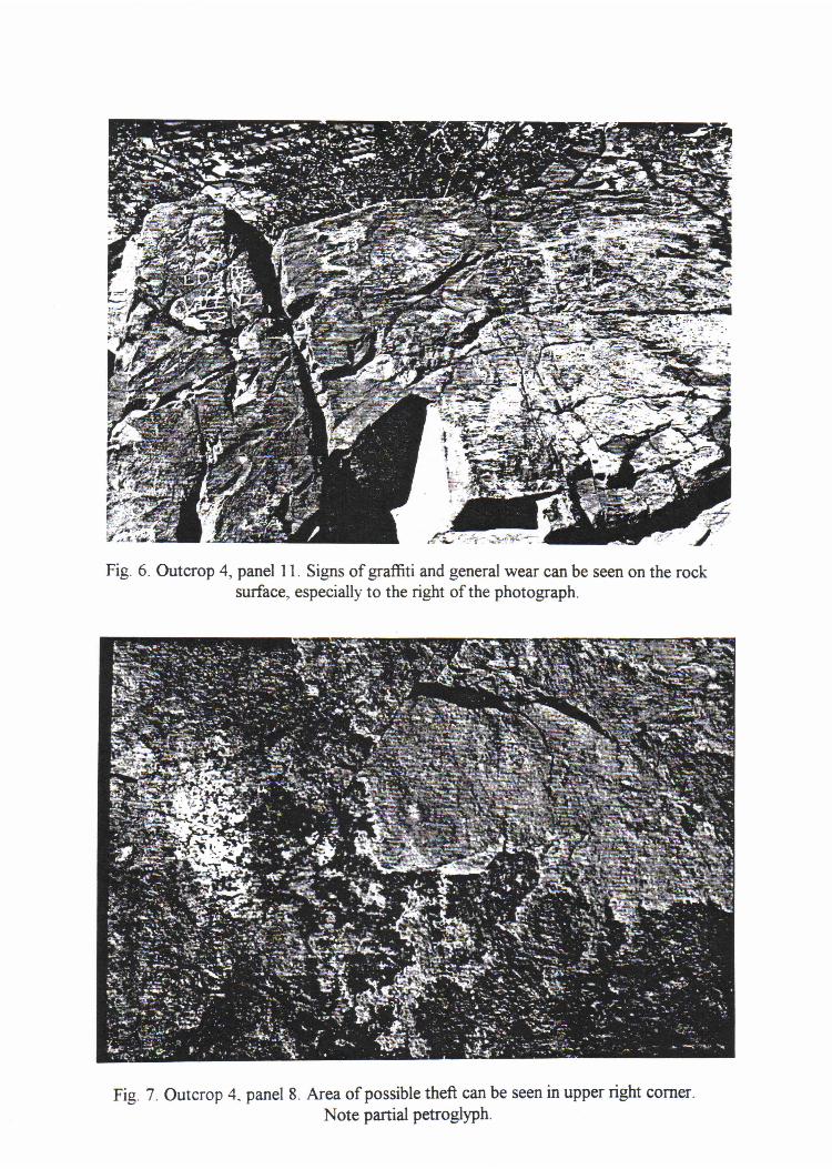
Fig 6. Outcrop 4, panel 1 1. Signs of grafffrti and general wear can be seen on the rocksurface. especially to the right of the photograph.
Fig. 7 . Outcrop 4. panel 8. Area of possible theft can be seen in upper right corner.
Note partial petroglyPh.
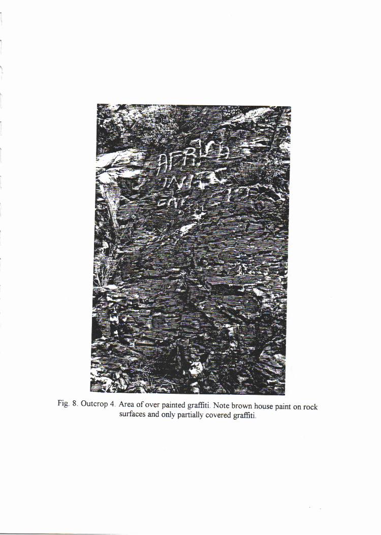
Fig. 8. outcrop a Arelof over painted graffiti. Note brown house paint on rocksurfaces and only partially covered graffiti.
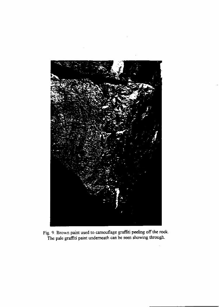
i
Fig. 9. Brown paint used to camouflage graffiti peeling offthe rock.
The pale graffti paint underneath can be seen showing through.
a
Fig. 10. Outcrop 4, panel 16. Boulder with blue paint spill. Note the way the blue paint has
weathered a*'ay from the top surface.
Fig. 12. Outcrop 4. Area of possible sandblasting to remove vandalismNote light color of rock and smooth surface.
Fig. I l. Outcrop 4, panel 16. The west face showing paint splashes on the petroglyphs.
. REFRENCES CTTED
Bahr, Donald, |uan Smith, William Smith Allison, and |ulian Hayden
, 1994 Tlre Short Swift Time of Gods on Farth: The Hohokam Chronides.University of California Press Berkeley and Los Angeles.
i; Bostrvick';"i1" Greenway Road and 17th Avenue petroglyph site (AZ T:8:102tAsul).
Report No. PGM-8&19. City of Phoenix, Enginering Department,
.A Transportation Division.
7994 Hohokam Bird Petroglyphs in the South Mountains, Phoenix, Arizona. Paper
.^ presented at San Dego Museum of Man Rock Art Meetings.
Bruder, !. Simon€. 1983 Archaeological Investigations at the Hedgpeth Hills Petroglyph Site.
Research Paper 28. Museum of Northern Arizona, Flagstaff.
A Colman, S.M.; K.L. Pierce, ild P.W. Birkeland7987 Suggested Terminology for Quaternary Dating Methods. Ouaternary
Researdr 28231b379.
Cushing, Frank H.
,; 7965 The Nation of Willows. Reprintgd. Northland Press, Flagstaff, Arizona.Originally published in two 1882 issues of the Atlantic Monthly magazine.
_ Dorn, Ronald I.1983 Cation-ratio Dating. A New Rock Varnish Agedetermination Technique.
Ouaternary Research 20:49-73.
Dorn, Ronald I. and David S. Whitley1983 Cation-Ratio Dating of Petroglyphs from the Western Great Basin. Nature
302:81G818.
Dorn, RI., D.B. Bamforth, T.A. Cahill,I.C Dohrenwend, B.D. Turrin, D.! Donahue, A.].T.Ei Jull, A. Long, M.E Macko, E.B Weil, D.S. Whitley and T.H. Zabel
19f36 Cation-Ratio and Accelerator Radiocarbon Dating of Rock Varnish on
^ Mojave Artifacts and Landforms. Sciense 231:83&833.
Dorn, R.I., T.A. Cahill, R.A. Elred, T.E. Gill, B.H. Kusko, A.I Bach, and D.L. Elliot-Fisk
,- TggO Dating Rock Varnishes by the Cation-ratio Method with PDG, ICP, and theElectron Microprobe. International fournal of Pixe ].:157-195.
:
Dorn, R.I., P.B. Clarkson, M.F. Nobbs, L.L. Loendorf and D.S. Whitley7992 New Approach to the Radiocarbon Dating of Rock Varnish, with Examples
from Drylands. Annals of the Association of American Geofaphers 82:73G151.
Eliade, Mircea7954 Shamanism: Archaic Techniques of Ecstasy. Princeton, N.f.: Princeton
University Press.
Ferg, Alan7979 The Petroglyphs of Temanoc Hill. The Kiva 45(1-2):9F118.
Francis, |ulie, Lawrence Loendorf and Ronald Dorn7993 AN{S Radiocarbon and Cation-Ratio Dating of Rock Art in the Bighorn Basin
of Wyoming and Montana. American Antiquity 58:7ll-737.
Gifford, E.W.1932 Ttre Southeastern Yavapai. University of California T\rblications in
^ mericanA rchaeology and Fthnology 29 :777 -252.
7936 Northeastern and Wetern Yavapai. University of California Publications inAmencan Archaeology and Fthnology 34:247-354.
Gladwin, H.S1958 ^ History of the Ancient Southwest. Portland:Bond Wheelwirhgt Company.
Golio,I.I. and Ernest Snyder7993 PeE%l)?hSr:rveys of South Mountain:7997/7964. Rock Art Papers 10:1{.
San Diego Museum of Man ed. Ken Hedges.
Halifax, foan1981 Shaman. the Wounded Healer. Crossroad, New York.
Flamann, Diane and Ken Hedges19ffi Topographical Distribution of Hohokam Pictograph Sites. Rock Art Pafrers
7:77-f16. San Diego Museum of Man, ed. Ken Hedges.
Harrison, Mike and ]ohn Williams1977 How Everything Began and We Learned to Live Right. Tlre Yavapai of Fort
Mcfrowell : An Outline of Their History and Culture. pp. a04. editor SigridKhera. Fort McDowell Mohave-Apache Indian Community.
Hartley, R., A.W. Vawser, A.R Smith, and M.A |ohnson7993 Documenting Rock Art in Dinosaur National Monument. Midwest
rcheological Center C\ccasional Studies in nthroPology 29:7'122. NationalPark Service.
Haury, Emil1976 The Hohokam, Desert Farrners and Craftsmen: E-cavations at Snaketown-
1o64-1q65. Tucson, University of Arizona Press.
Hedges, Ken7976 Southern California Rock Art as Shamanistic Art. American Tndian Rock Art
2:126-738. Editor Kay Sutherland. El Paso Archaeological Society, El Paso,Texas.
7982 Phosphene in the C-ontext of Native American Rock Art. American IndiansRock Art. 7 and 8:1-10. editor Frank Bock. American Rock Art ReseardrAssociation.
1994 Pipefte Dreams and the Primordial Snake{anoe: Analysis of a FlallucinatoryForm Constant. Shamanism and Rock Art in North America 703-124. SpecialPublication 1; Rock Art Foundation,Inc. San Antonio, Texas.
Heizer, Robert F., and Martin A. Baumhoff1962 Prehistoric Rock Art of Nevada and Eastern California.
University of California Press, Los Angeles.
Hoijer, Harry and Morris E. Opler1938 Chiricahua and Mescalero Apache Texts. University of Chicago Press.
Hultkrantz, Ake7973 Prairie and Plains Indians. Iconography of Relig'ons 10(2). Leiden, The
Netherlands: E.f. Brill.
Kelly,Isabel T. and Catherine S. Fowler79f36 Southern Paiute. Handhook of North American Tndians: Great Basin.
Smithsonian Institution, Washington, D. C.
Khera, Sigrid and Patricia A. Mariella1983 Yavapai. Handbook for North American Indians 10:3&54. Smithsonian
Institution Press, Washington D. C.
Kintigh, Keith W.798/. Measuring Archaeological Diverstiy by Comparison with Simulated
Assemblages. American Antiquig 49:4*54.
Kodack, Marc11gg1 A Discussion of Element Pools and an Application Using Late Prehistoric
Rock Art From the Zuni and Hopi Area. North ^merican Archaeologist.7't(2):707-119.
Laird, Carobeth7976 TheChemhuev's. Mdki Museum Press, Banning, Cdifornia.
Lamphere, Louise1983 Southwestern Ceremonialism. Handbook of North American Indians 70:747
753.
Iewis-Williams, |. D. and T. A. Dowson1988 The signs of all times:entoptic phenomena in Upper Paleolithic art. Current
I nthroFol og)r 29 :201245.1989 rrnages of Power: Understanding Bushman Rock Art. Southern Book,
fohannesburg, South Africa.
7990 Through the Veil: San Rock Paintings and the Rock Face. South AfricanArchaeological Bulletin 45:F15.
Loendorf, Chris, David Jocobs, and Glen E. Rice7994 Petroglyphs, Grinding Slicks, and Cupules of the Rock Island Complex:
U:8:392/1162. ftl Where the Rivers Converge: Report on the Rock IslandComplex, Roosevelt Plafform Mound Study, by Owen Lindauer. DraftrePort, Roosevelt Monograph Series 4 Anthropological Field Studies 33.Office of Culturd Resource Management, Department of Anthropology,Arizona State University, Tempe.
Loendorf, Lawrence7994 Traditional Ardtaeological Methods and Their Applications at Rock Art
Sites. New Light on Old Art Recent Advances in Hunter-Gatherer Rock ArtResearcbed. David S. Whitley and Iawrence Loendorf. Institute of Archaeology,University of California, Los Angeles.
7994 Finnegan Cave A Rock Art Vision Quest Site in Montana.Shamanism and Rock Art in North America 70]-724. Special Publication 1;Rock Art Foundation,Inc. San Antonio, Texas.
Loendorf, Lawrence;lefftey R Hanson; Sally Chirinos, Cherie E. Haury and Ronald I.Dorn
7989 Nine Rock Art Sites in the Pinon Canyon Maneuver Site. SoutheasternColorado. Departrnent of Anthropolory, University of North Dakota, GrandForks.
[.ommel, Andreas1.967 Shamanism. the Beginnings of Art. McGraw-Hill, NewYork.
>r
Maloul C.1.974 Ttre Gosiute Indians.Pp. E-l7Z in Shoshone Indians.American Indian Ethnohistory: California and Basin-plateauIndians) New york: Garland.
McCreery, Patricia7994 T P MVFNr: The Rock rt Galleries of Pet'ified Fo'esf and Beyonrt.
Petrified Museuam Association, Petrigied Forest, Arizona.
McDonald, George F.1981 Cosmic Equations in Northwest Coast Indian Art. The World is Sha? as a
Knife: an Anthology in Honor of wilson rru:ff. Ed. Donald N Abbot,pp.22s-238. University of British Columbia Press.
Opler, Morris1965 An ^ pache T ifeway. Cooper Square, New york.
1983 The Apachean Culture Pattern and Its Origins. Handbook for NorthAmerican Indians 70:36&392. Washington D. C.
^ *"'*"i;T'Mff;:l;,f,$j3uarReportortheBureauorAmerican
Schaafsma, Polly1980 Indian Rock Art of the Southwest. University of New Mexico Press,
Albuquerque.
1990 shaman's Gallery: A Grand Canyon Rock Art site. Kiva s5:213-?-34.
1992 Rock Art in New Mexico. Museum of New Medco Press, Santa Fe.
Schmader, Matthew P. and |ohn D. Hays19f36 I as Tnagines: The 'chaeology of lhuque'que's West Mesa F"carfment.
Submitted to the Open Space Division, Parks and Recreation Department,Gty of Albuquerque: and the Historic Preservation Division of the Office ofCultural Affairs, State of New Mexico.
Schulten, Cathy S.
1979 Environmental Geology of the Tempe Quadrangle, Maricopa County,Arizona: Part I. Master's Thesis. Department of Geology: Arizona StateUnviersity, Tempe.
Smithson, Carma and Robert Euler1994[19U] Flavasupai I egends. University of Utah Press,
Salt Lake Ciry.
Snyder, Ernest1966 Petroglyphs of the South Mountairu of Arizona. American Antrquity 3'1;70*
709.
1975 Petroglyphs of the South Mountains of Arizona. American Indian Rock ArtI:105-109. l
7978 A Comparison of Hohokam and Possible Patayan Petroglyphs near Phoenix,Arizona. Arnerican Indian Rock Art TY:1,24.727.
Teague, Lynn1993 Prehistory and the Traditions of the O'odham and Hopi. Kiya 58:435-454.
7989 The Post{lassic and the Fate of the Hohokam. In Synthesis and Conclusions.The 1982-1984 Excavations at Los Colinas, Vol. 10, by David Gregory andothers. Archaeological Series No. 162. Arizona State Museum, Universityof Arizona, Tucson.
Tuan, Yi-Fu7977 Space and Place: The Perspechve of F-perience. University of Minnesota
Press, Minneaplois.
Underhill, Ruth1968 Singing for Power: The Song Magic of the Papago Indians of Southern
^ rizona. University of California Press, Berkeley and Los Angeles.
Wallace, Henry D.1983 The Mortars, Petroglyphs, and Trincheras on Rillito Peak. The Kiva,18:(3).
Wallace, Henry D. and |ames P. Holmlund19f36 Petroglyphs of the Picacho Mountains Southcentral Arizona. Institute for
American Research. Anthropological Papers 5
Walsh, Roger1989 What is a Shaman? Definition, Origin and Distribution. The Journal of
Transpersonal Psychology 21 (1 ): 1 -1 1.
Weaver, Donald1985 Hieroglyphic Canyon: A Petroglyph Record of a Changing Subsistence
Pattern. Monograph 1 American Rock Art Research Association.

Wellmann, Klaus F.1979 A Survey of North American Indian Rock Art. Graz, Austria: Akademische
Druck-u. Verlagsanstalt. : .
Whitley, David S.1992a Shamanism and Rock Art in Far Western North America. Camb"idge
Archaeologr cal Iournal 2(1):g9-1 13.
lggzbEthnography and Rock Art in the Far West. in New Light on Old ,rrrR.".tt ^ dn"t"". it Ht t'tt""- G"th.""" R."k A"t R".""i"h. in pressUCLA Institute of Archaeology.
7994 Shamanism, Natural Modeling and the Rock Art of Far Western NorthAmerican Hunter-Gatherers. Shamanism and Rock Art in No'th Americal'O3'124. Special Publication 1; Rock Art Foundation,Inc. San Antonio,Texas.
Winkelman, Michael1989 Shamans and Other'Magico-Religious" Healers: A Cross{ultural Study
of Their Origins, Nature, and Social Transformations. Ethos:30&352.