wadi abu qalqal regional survey, syria. report for 2006
TRANSCRIPT
WADI ABU QALQAL REGIONAL SURVEY, SYRIA
REPORT FOR 2006
INTRODUCTION
The first official season of the Wadi Abu Qalqal Regional Survey was conducted between 24th April and 24th June 2006.1 Given the terms of the survey permit, which in the first year confined investigations to a 5 km area around the Hellenistic site of Jebel Khalid (WAQ Site 1), it was decided to focus efforts on Jebel Khalid itself and on its immediate environs in order to obtain a more precise idea of the settlement history of the site, and of the extent to which such a large establishment and the land-use practices of its inhabitants may have been responsible for shaping the adjacent archaeological landscape.2
The investigations covered four areas: Jebel Khalid, the adjacent mountain Jebel el-Ja῾adeh, the village of Khirbet Khalid (immediately north of Jebel Khalid), and Tell Rumeilah and the fields to the south of the village of Rumeilah, on the east bank of the Euphrates directly opposite Jebel Khalid (pl. 12: 1).
It was expected that the hillslopes around Jebel Khalid might preserve evidence for land-use practices during the Hellenistic period such as the remains of small farmsteads or of installations such as wine or olive presses. At the same time it was considered probable that since the last occupation of the site large amounts of habitation debris might have dispersed throughout the adjoining landscape, thus having the potential to confuse the archaeological record of these areas.
The western slopes of Jebel Khalid combine with the eastern slopes of Jebel el-Ja῾adeh to form a valley approximately one kilometre wide. The presence of numerous Hellenistic cemeteries on both sides of this valley held promise for finding further archaeological features in the area.3 As with the slopes of Jebel Khalid, it was expected that the slopes of Jebel el-Ja῾adeh might furnish evidence of past land-use practices.
Its name, previous visits, and the evidence from satellite and aerial photographs indicated that the village of Khirbet Khalid was founded on the ruins of an earlier settlement. An initial survey was therefore planned to assess the site and gauge the potential of more detailed investigations.
Also planned for this season was an intensive survey of Tell Rumeilah, directly opposite Jebel Khalid on the east bank of the Euphrates, which had earlier produced evidence for Hellenistic occupation. In addition, we planned to examine the extensive lower site adjoining Tell Rumeilah described by M. Van Loon in his report on the 1964 Tabqa Dam survey.4
1 See M. Mottram–D. Menere, ‘Preliminary surface investigations in the Wadi Abu Qalqal region, North Syria’, Meditarch 18, 2005, 161–74, for a discussion of the 2004 pilot season.2 We would like to express our sincere gratitude to Dr Bassam Jammous, Director General of Antiquities and Museums (DGAM), Syria, for granting us permission to undertake this work. Our thanks go also to DGAM Director of Excavations, Dr Michel el-Maqdissi, and to Dr Widad Khoury who extended to us every administrative assistance. Investigations were conducted under the auspices of the Australian National University/University of Melbourne archaeological mission to Jebel Khalid. In this regard
we would like to express our deep gratitude to Professor Emeritus Graeme Clarke, Director of Excavations at Jebel Khalid, for supporting us in our endeavours. In addition to the primary investigators, members of the survey team included Dr Ted Nixon and Mr Toby Fleming. We also gratefully acknowledge the practical support, in-field assistance, and warm and generous company of DGAM representative Mr Hikmat Awwad and our driver, Mr Mustafa Shehadah.3 J. Littleton et al., ‘Preliminary Excavation of the Jebel Khalid Necropolis’, Meditarch 9/10, 1996/97, 187–205.4 M. N. Van Loon, The Tabqa Reservoir Survey 1964 (1967) 13.
MEDITARCH 21, 2008, 79–104
80 Australian and New Zealand Fieldwork: Wadi Abu Qalqal
Van Loon’s mention of an area thickly strewn with pottery, including wasters and kiln slag, indicated the presence there of pottery kilns which we anticipated might be Hellenistic, since no industrial installations of this kind had yet been found on Jebel Khalid itself.
The techniques used in 2006 followed those used successfully in 2004, i.e. CORONA satellite images were closely inspected and potential features of interest were identified for on-ground inspection.5 Where appropriate, this was followed up with intensive surface collection, site documentation, and mapping.
JEBEL KHALID (WAQ SITES 1A–B)
Investigations began with a general reconnaissance of Jebel Khalid. Although the mountain has been explored on numerous occasions throughout the course of the excavations,6 the purpose of the latest investigations was to gain a sense of the overall chronology of settlement and of the different uses of the site over time, as well as of the various formation processes that have gone into shaping the site as it appears today. Surface sherds were collected where it was felt that these were unusual in any way and might add to the typology of pottery finds from the excavations, or where they might either pre- or post-date the main Hellenistic occupation.
As far as the dynamics of site formation are concerned, it is clear that since the last substantive occupation of the site, during the Byzantine period, Jebel Khalid has undergone some dramatic physical transformations and considerable erosion caused principally by water run-off and slope wash in the direction of the central gully, itself also significantly eroded by flash floods. Robbing of the defensive walls and major buildings for building stone has also contributed to the deflation of the archaeological deposits;7 the main transformation, however, seems to have been a massive collapse of the rock-cut galleries and quarry caves, which, given that the latest of these edifices was probably constructed during the Byzantine period, must have occurred sometime after the 6th or 7th centuries AD.8 The ubiquity of the collapse suggests a single, sudden, catastrophic event such as an earthquake.9 If so, there are two events that are most likely to have contributed to such widespread destruction—the massive region-wide earthquake of 748/749 during which a church at the nearby town of Menbij collapsed killing numerous people, and a second major earthquake in early 1344 when it is said that most of Menbij collapsed and many of its inhabitants were buried under the debris.10
The extent of the collapse has confused the stratigraphy around the rock-cut galleries by causing Hellenistic materials that were originally upslope of the galleries to cave in on the later remains. Although many of these caverns probably began life as Hellenistic stone quarries, several were adapted during Late Roman and Byzantine times to serve as a monastic retreat, comprising dwellings, communal facilities, and places for worship and contemplation, including a primitive church and cells used by individuals during periods of withdrawal from the community.11 Such an arrangement was typical of monasticism throughout the region
5 Mottram–Menere art. cit.6 See, for example, P. J. Connor–G. W. Clarke, ‘Jebel Khalid in North Syria: the First Campaigns’, Meditarch 9/10, 1996/97, 151–83.7 Jebel Khalid has long been—and still is—utilised as a source of building materials for the adjacent village of Khirbet Khalid.8 For a description of these features see G. W. Clarke, ‘Syriac inscriptions from the Middle Euphrates’, Abr-Nahrain 23, 1985, 73–82.
9 Pers. comm. Dr Eddy De Pauw, International Center for Agricultural Research in the Dry Areas (ICARDA).10 M. R. Sbeinati et al., ‘The historical earthquakes of Syria: an analysis of large and moderate earthquakes from 1365 B.C. to 1900 A.D’, Annals of Geophysics 48 (3), 2005, 362–4, 374–5.11 Connor–Clarke art. cit. 153; Clarke art. cit.; G. W. Clarke, ‘Inscriptions, symbols and graffiti near Joussef Pasha’, Abr-Nahrain 25, 1987, 19–39.
Australian and New Zealand Fieldwork: Wadi Abu Qalqal 81
during the late 4th and 5th centuries, with several similar ‘quarry monasteries’ having been identified further upstream.12 In this case the settlement probably housed the followers of a particular Christian anchorite whose cell overlooks the main gully.13 The chronology of this phase of occupation is suggested by numerous coins recovered during the excavations, and by roof tiles and sherds found around the caverns which can be dated to the 4th to 7th centuries. Amongst these are part of a grooved-rim amphora with a graffito (eta - hemi = half) on the shoulder (pl. 12: 2), various Brittle Ware rims and handles, and the rim of a Hayes Form 99B African Red Slip Ware bowl.14 A few transitional Byzantine/Umayyad sherds were also found in the gully below the caverns. These suggest that occupation of the monastery continued well into the second half of the 7th century, while two later Syriac inscriptions in the hermit’s cell indicate that it was still being visited several hundred years later.15
Investigation of the gully and lower parts of the site, especially along the water’s edge, yielded a number of Hellenistic pottery wasters which attest to the likelihood that at least some pottery was manufactured on site. At present the most likely location for kilns seems to have been near the wharves, which are situated about 100 m south of the mouth of the gully. Above the wharves is a complex of rooms showing signs of ash and burning. A few wasters and kiln slag were noted in this area, which would have been particularly suitable for pottery manufacture, being located close to water for cleaning and levigating the clay, and where fuel and raw materials could be readily delivered. A location close to the wharves is also consistent with pottery production being linked to the river trade, as has been suggested for the nearest excavated Hellenistic pottery workshop (at Harabebezikan, 65 km to the north).16
Part of the purpose of examining Jebel Khalid more intensively was to establish whether the western slopes of the site, below the city walls, had been cultivated or used for intensive agriculture during the Hellenistic period. The distribution of areas previously identified as the location of cemeteries suggested that any agricultural use of the slopes was probably limited, perhaps to olive groves and viticulture given the prevalence of olive charcoal and carbonized olive and grape seeds amongst the excavated botanical remains.17 The expectation was that if the slopes had been intensively farmed during the Hellenistic period, using settlement refuse and composted nightsoils to boost soil fertility, then artefacts of Hellenistic date were likely to be distributed widely throughout the fields.18 Regrettably, disturbance to the slopes caused by modern tree planting and terracing has made this impossible to establish in some areas. Nevertheless, several bulldozer cuts along the western slope indicate that there is little in the way of erosion of cultural debris from the Hellenistic settlement down into the fields which could be confused with agricultural use of the land. The only places where Hellenistic pottery occurs in any density in the bulldozer sections is on the slopes immediately below the main
12 A. E. Vivancos, Poblamiento Romano en el Alto Éufrates Sirio (2002).13 Clarke art. cit. (n. 8).14 For the coins see C. E. V. Nixon in: G. W. Clarke et al., Jebel Khalid on the Euphrates. Report on the Excavations 1986–1996, Meditarch Suppl. 5 (2002) 291–335. For the ceramics see, for example, R. P. Harper, ‘Athis—Neocaeasareia—Qasrin—Dibsi Faraj’, in: J.-Cl. Margueron (ed.), Le Moyen Euphrate: Zone de contacts et d’échanges (1980) 336 fig. C: 58; 339 fig. E: 69; M. Konrad, ‘Flavische und spätantike Bebauung unter der Basilika B von Resafa-Sergiupolis’, DaM 6, 1992, 388 fig. 8: 13, 15; 390 fig. 10: 3, 7; B. Bavant–D. Orssaud, ‘Stratigraphie et typologie. Problèmes posés par l’utilisation de la céramique comme critère de datation: l’example de la fouille de Déhès’, in: E. Villeneuve–P. M. Watson (eds.), La céramique Byzantine
et Proto-Islamique en Syrie-Jordanie (IVe-VIIIe siècles apr J.-C.) (2001) 44 fig. 6: 26; J. W. Hayes, Late Roman Pottery (1972) 152–5.15 T. Muraoka, ‘Two Syriac inscriptions from the Middle Euphrates’, Abr-Nahrain 23, 1985, 83–9.16 A. O. Alp–V. M. Tekinalp, ‘Harabebezikan excavation: 1999 season’, in: N. Tuna et al. (eds.), Salvage Project of the Archaeological Heritage of the Ilısu and Carchemish Dam Reservoirs. Activities in 1999 (2001) 405.17 Littleton et al. art. cit. (n. 3); A. Fairbairn in: G. W. Clarke et al., ‘Jebel Khalid: the 2002 season’, Meditarch 16, 2003, 182–3.18 See T. J. Wilkinson, ‘The definition of ancient manured zones by means of extensive sherd-sampling techniques’, JFieldA 9 (3), 1982, 323–33.
82 Australian and New Zealand Fieldwork: Wadi Abu Qalqal
town dump just outside the Main Gate and which bulldozer activity has helped to distribute further downslope, and below Tower 11 where there is another large refuse dump.
As part of this exercise, the team also wanted to examine the extent to which the cemeteries may have been contributing material to the fields, where it might be confused with material spread as a result of manuring. Intensive collection of three cemeteries (C1, C2 and C11) and the fields adjacent to them indicated that most of the sherds occurring in the fields are of Byzantine or Early Islamic date rather than Hellenistic. Hellenistic sherds are concentrated only within the cemeteries themselves, the main types represented being consistent with those found in excavations of the grave areas, i.e. small bowls and saucers, large torpedo jars or amphorae, table jars, and unguentaria.19 Byzantine and Early Islamic materials, however, continue to be distributed throughout the cemeteries as was also noted during excavations.20 This suggests widespread use, and quite possibly intensive annual cropping, of the slopes during these periods.21 Two of the cemeteries (C1 and C2, immediately downhill from the main dump) also produced a few lightly patinated flint Levallois points and flakes, while the olive grove adjacent to C11, downhill from Tower 8, produced a Levallois core. These point to exploitation of the area during the Middle Palaeolithic.
From these data it seems likely that any Hellenistic cultivation of the western slopes of the site was limited to specific areas, and did not involve intensive cereal cropping if the lack of artefacts which might be construed as indicative of nightsoiling is any guide. Indeed, the fact that the inhabitants of the Hellenistic settlement disposed of much of their refuse in large dumps outside the city walls implies that the city’s waste was not generally employed as a source of fertilizer, and consequently, that the settlement’s requirements for grain, fruit, and oil crops were met without recourse to intensive farming practices. Instead, irrigation agriculture is likely to have been carried out adjacent to the river and along the sides of wadis, while precipitation was sufficient in most years to support rain-fed cultivation of the surrounding slopes.22 Another important potential agricultural resource is the river terrace adjacent to Rumeilah directly opposite Jebel Khalid on the east bank of the river. Tell Rumeilah may therefore have functioned as a grainstore or emporium for the larger site.
Probably the most important result of the reconnaissance work at Jebel Khalid was the discovery of an extensive scatter of Middle Palaeolithic (c.150,000–40,000 BP) stone implements covering the southernmost slopes of the site (Site 1/B). This area has been badly disturbed in recent times by bulldozer activity, and the lower slopes have been ploughed regularly. Below the bulldozed track, a previously unrecorded Hellenistic cemetery was identified, in the centre of the area. The Palaeolithic remains, which consist of numerous cores, points, and flakes of Levallois-Mousterian aspect (pl. 13), cannot therefore be regarded as in situ, the sediments from which they derive having long ago been dismantled or deflated. Nevertheless, the density with which the artefacts occur indicates that the locality was favoured by Neanderthal or early modern human groups, perhaps both as a source of shelter amongst the rocky outcrops of the jebel and of a wide range of plant foods and game along the river gallery.
This type of non-fluviatile surface site presently represents a scarce occurrence along the Syrian Euphrates where the few Middle Palaeolithic finds have come mainly either from
19 H. Jackson, ‘The Cemetery Pottery—1996 and 1997’, in: Clarke et al. op. cit. 101–24.20 J. Littleton–B. Frohlich, ‘Excavations of the Cemetery—1996 and 1997’, in: Clarke et al. op. cit. 66; H. Jackson–J. Littleton, ‘Appendix. Inventory of Graves Excavated in 1996 and 1997’, in: Clarke et al. op. cit. 71–100; Jackson art. cit.21 See T. J. Wilkinson, ‘Extensive sherd scatters and land-use
intensity: some recent results’, JFieldA 16, 1989, 31–46; id., Town and Country in Southern Anatolia, I: Settlement and Land Use at Kurban Höyük and Other Sites in the Lower Karababa Basin (1990) 117–27, 143–5.22 For ancient agricultural systems in the area immediately downstream see T. J. Wilkinson, On the Margin of the Euphrates. Settlement and Land Use at Tell es-Sweyhat and in the Upper Lake Assad Area, Syria (2004) 38–40.
Australian and New Zealand Fieldwork: Wadi Abu Qalqal 83
consolidated Pleistocene terrace deposits or from derived materials in Holocene tells founded on these same terraces.23 However, extensive Lower to Middle Palaeolithic surface sites have been identified further upstream in the Carchemish Dam area of southern Turkey indicating that a similar situation is likely to have prevailed along the Syrian section of the valley.24 The discovery of several additional Middle Palaeolithic artefacts on other parts of the jebel, as well as on the eastern slopes of Jebel el-Ja῾adeh to the west of Jebel Khalid (see below), would seem to bear this out. All the artefacts found are characterized by a white or light grey patina and show no signs of water rolling.
KHIRBET KHALID (WAQ SITE 2)
Investigations this year included the village of Khirbet Khalid at the foot of the northern slopes of Jebel Khalid. The name ‘khirbet’ implies that the village was founded on the ruins of an earlier settlement, and, when first explored in the early 1980s, remains of these were still clearly visible, including a series of large ‘tannurs’ or round, clay-lined structures located behind the village on the lower slopes of the jebel. In later years this area was identified as the location of several robbed-out Roman tombs.25 Our 2006 survey of the area, however, established that while tombs exist higher up on the cliff face overlooking the river, most of the supposedly disturbed tombs are in fact the remains of robbed-out, and now badly damaged, Early Islamic pottery kilns.
Owing not only to use of the area as a rubbish dump, but also to major damage caused to the deposits by the dredging works located immediately adjacent to the village, collection of the factory site did not proceed in a systematic manner, although the area was planned in detail and was found to have originally contained at least 15 kilns. Instead, collection was selective owing to the large amount of material on the surface and was restricted to diagnostic items such as rims, bases, handles, and decorated sherds, of which there were a great many. Nevertheless, collection was for the most part comprehensive, items only being rejected if already present in the collection in significant numbers and represented by better-preserved examples of the same type. Collections also included lumps of kiln slag and numerous wasters. Many of these probably came originally from large waste dumps which are visible on the CORONA satellite image of the area dating to 1968 (see pl. 12: 1). In later aerial images of Jebel Khalid these zones are pock-marked, indicating that disturbance was already well under way by the early 1990s.
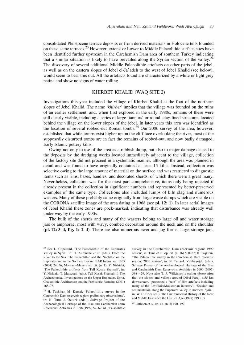
The bulk of the sherds and many of the wasters belong to large oil and water storage jars or amphorae, most with wavy, combed decoration around the neck and on the shoulder (pl. 12: 3–4, fig. 1: 2–4). There are also numerous ewer and jug forms, large storage jars,
23 See L. Copeland, ‘The Palaeolithic of the Euphrates Valley in Syria’, in: O. Aurenche et al. (eds.), From the River to the Sea. The Palaeolithic and the Neolithic on the Euphrates and in the Northern Levant. BAR Intern. ser. 1263 (2004) 24, 56; Mottram–Menere art. cit. (n. 1); Y. Nishiaki, ‘The Palaeolithic artifacts from Tell Kosak Shamali’, in: Y. Nishiaki–T. Matsutani (eds.), Tell Kosak Shamali, I: The Archaeological Investigations on the Upper Euphrates, Syria. Chalcolithic Architecture and the Prehistoric Remains (2001) 165–78.24 H. Taşkiran–M. Kartal, ‘Palaeolithic survey in the Carchemish Dam reservoir region: preliminary observations’, in: N. Tuna–J. Öztürk (eds.), Salvage Project of the Archaeological Heritage of the Ilısu and Carchemish Dam Reservoirs. Activities in 1998 (1999) 52–62; id., ‘Palaeolithic
survey in the Carchemish Dam reservoir region: 1999 season’, in: Tuna et al. op. cit. (n. 16) 500–27; H. Taşkiran, ‘The Palaeolithic survey in the Carchemish Dam reservoir region: 2000 season’, in: N. Tuna–J. Velibeyoğlu (eds.), Salvage Project of the Archaeological Heritage of the Ilısu and Carchemish Dam Reservoirs. Activities in 2000 (2002) 398–429. Note also T. J. Wilkinson’s earlier observation that the slopes and valleys around Dibsi Faraj, c.55 km downstream, ‘possessed a “rain” of flint artefacts including many of the Levallois/Mousterian industry’: ‘Erosion and sedimentation along the Euphrates valley in northern Syria’, in: W. C. Brice (ed.), The Environmental History of the Near and Middle East since the Last Ice Age (1978) 219 n. 3.25 Littleton et al. art. cit. (n. 3) 190, 192.
84 Australian and New Zealand Fieldwork: Wadi Abu Qalqal
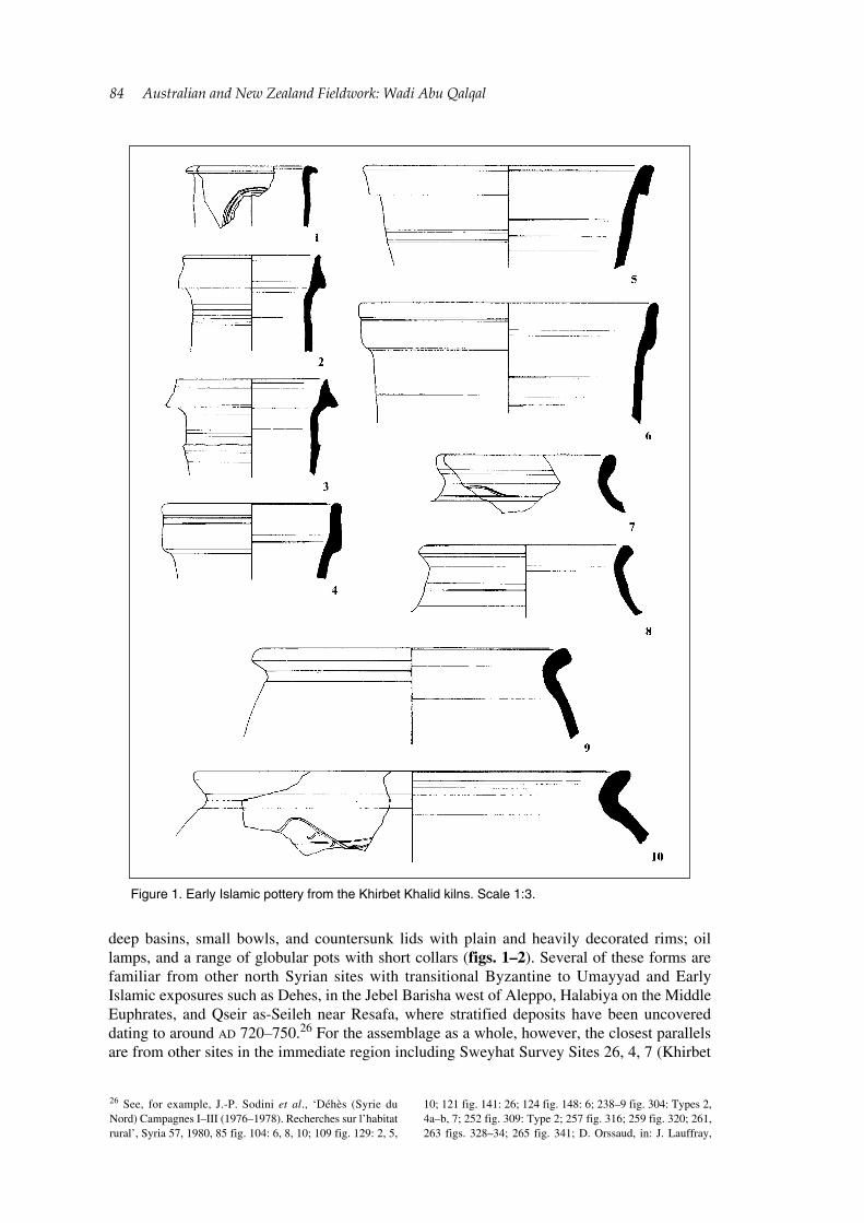
deep basins, small bowls, and countersunk lids with plain and heavily decorated rims; oil lamps, and a range of globular pots with short collars (figs. 1–2). Several of these forms are familiar from other north Syrian sites with transitional Byzantine to Umayyad and Early Islamic exposures such as Dehes, in the Jebel Barisha west of Aleppo, Halabiya on the Middle Euphrates, and Qseir as-Seileh near Resafa, where stratified deposits have been uncovered dating to around AD 720–750.26 For the assemblage as a whole, however, the closest parallels are from other sites in the immediate region including Sweyhat Survey Sites 26, 4, 7 (Khirbet
26 See, for example, J.-P. Sodini et al., ‘Déhès (Syrie du Nord) Campagnes I–III (1976–1978). Recherches sur l’habitat rural’, Syria 57, 1980, 85 fig. 104: 6, 8, 10; 109 fig. 129: 2, 5,
10; 121 fig. 141: 26; 124 fig. 148: 6; 238–9 fig. 304: Types 2, 4a–b, 7; 252 fig. 309: Type 2; 257 fig. 316; 259 fig. 320; 261, 263 figs. 328–34; 265 fig. 341; D. Orssaud, in: J. Lauffray,
Figure 1. Early Islamic pottery from the Khirbet Khalid kilns. Scale 1:3.
Australian and New Zealand Fieldwork: Wadi Abu Qalqal 85
al-Hamrah), and 11 (Khirbet Dhiman) which have produced several of the same amphora, jug, bowl, basin, and pot forms.27 Given the similarities between these assemblages and the fact that certain shapes such as the collared pots do not appear to be common elsewhere, it
Halabiyya-Zenobia: Place forte du limes oriental et la Haute-Mésopotamie au VIe siècle, II (1991) 265 fig. 123: 34; 266 fig. 124: 56–8, 60, 62–3; M. Konrad, ‘Umayyad pottery from Tetrapyrgium (Qseir as-Seileh), North Syria. Traditions and innovations’, in: Villeneuve–Watson (eds.) op. cit. (n. 14)
167–8 fig. 2: 1–3; 173 fig. 5: 8, 10; 177 fig. 7: 4; 183 fig. 10: 5; 185 fig. 11: 5–7; 189 fig. 13: 6–7, 14–15.27 Wilkinson, op. cit. 120 fig. 6.19: 1–2; 123 fig. 6.22: 5–6; 124 fig. 6.23: 10–11, 15; 129 fig. 6.28: 11; 130 fig. 6.29: 4, 6–10, 13–16.
Figure 2. Early Islamic pottery from the Khirbet Khalid kilns. Scale 1:3.
86 Australian and New Zealand Fieldwork: Wadi Abu Qalqal
seems quite possible that some of these vessel types were manufactured at Khirbet Khalid and transported the short distance (about 15 km) downstream to the Sweyhat embayment. This possibility runs counter to the assumption that the pottery from the Sweyhat sites must have been manufactured at Balis (Meskene), a further 33 km downstream—the nearest urban centre to Sweyhat during the Umayyad/Abbasid periods.28
As regards dating, the presence of forms such as the decorated bowls and band-rimmed amphorae, and of comb-incised and rouletted decoration, that elsewhere appears around the middle of the 7th century, places most of the remains firmly within the Umayyad period. That some of the forms found at Khirbet Khalid continue into the Abbasid period (as seen at Khirbet Dhiman, for example) also points to occupation continuing into the latter part of the 8th century. Whether occupation continued much beyond this, however, is presently difficult to ascertain. No glazed wares typical of the Abbasid period were found around the kilns nor was any evidence found for the distinctive ledge-handled casseroles which are also characteristic of this period. This may be due to the sampling methods employed, or it may be indicative of the dating of the kilns, as both types were present in fields surrounding the cemeteries on Jebel Khalid. On the other hand, the only cooking pot shapes recovered are typically Umayyad, consisting of a tall-necked pot with a flattened rim and angled shoulder handles—a type which first emerged late in the 6th century—and a rather coarsely tempered holemouth vessel with a groove beneath the rim, which appears to be a precursor of the Abbasid casserole shape (fig. 2: 6–7).29 One example of a Late Roman Phocaean Ware bowl in Hayes Form 10C was found within the village, hinting at the presence of an earlier, Byzantine foundation, although this particular form is also known to have continued into the second half of the 7th century.30 The village itself, which is not in any imminent danger of destruction, has yet to be thoroughly investigated for archaeological remains. In some areas between house compounds the foundations of ancient buildings are visible and it should be possible to plot at least some of these and recover surface pottery. All sherds noted this year, however—apart from the Phocaean Ware bowl—are consistent with those occurring around the kilns.
JEBEL EL-JA῾ADEH (WAQ SITES 46–49)
The eastern slopes and summit of Jebel el-Ja῾adeh , which lies immediately to the west of Jebel Khalid (see pl. 12: 1), were explored intensively this year. Previously, extensive robbed-out Hellenistic cemeteries had been identified along the W/E trending ridges which characterize the jebel’s heavily dissected lower slopes.31 Like Jebel Khalid, parts of Jebel el-Ja῾adeh have been reforested, especially the higher eastern and southern slopes. As a result, some areas have incurred significant bulldozer damage, including one of the cemeteries close to the road (C12) and one in the northern part of the distribution high up on the slopes (C13). There has also been widespread olive planting, so that some areas formerly attested as the locations of cemeteries are now covered with olive trees.
One aim this year was to locate again the cemeteries identified in earlier years and to record any others that might subsequently have been exposed. As was the case with the cemeteries on Jebel Khalid we wanted to establish whether, and the extent to which, they were contributing to surrounding field scatters. The number and postulated extent of the cemeteries recorded previously on Jebel el-Ja῾adeh’s lower slopes suggested that the valley
28 Ibid. 99.29 Cf. Bavant–Orssaud art. cit. 47 fig. 9: 39; Konrad art. cit. (n. 26) 171 fig. 4: 1–2.
30 E.g. at Antioch: Hayes op. cit. (n. 14) 345.31 Littleton et al. art. cit. (n. 3) 189 fig. 1; Littleton–Frohlich art. cit.
Australian and New Zealand Fieldwork: Wadi Abu Qalqal 87
was probably not intensively cultivated in Hellenistic times; nevertheless, the present situation, which sees different parts of the hillslopes under barley, olives, fruit trees, and vines, demonstrates the area’s agricultural potential, suggesting the likelihood of agricultural use at other times. In particular, the discovery of a significant number of Byzantine and/or Early Islamic sherds throughout the cemeteries, which were described by the excavators as typical of the surrounding surface pottery, was a clue that both sides of the valley floor may have been intensively farmed in Byzantine and Early Islamic times.32
We therefore set out to examine in detail the eastern slopes of the jebel, restricting ourselves to the main drainage system effective in this area, which debouches into the Euphrates immediately to the south of Jebel Khalid. We also planned to inspect the summit of Jebel el-Ja῾adeh which had been visited briefly in 1986 by members of the Jebel Khalid mission.
SLOPES
The initial result of this work was the discovery high up on the southern slopes, immediately below the lowest line of trees and adjacent to one the deeper drainage channels, of an area of grey soil (c.10 x 15 m) with associated pottery and other habitation debris (Site 46 on pl. 12: 1). On the CORONA image this appears as the corner of a rectilinear feature, suggesting the presence of some sort of small dwelling and/or animal pen. A number of large fieldstones were found within and adjacent to the scatter, but these could not be resolved into a structure of any sort (pl. 14: 1). All the slopes in this area have been heavily ploughed in the past, and some more recently prepared for olive planting. Some of the stones have also been moved during recent field clearance. The quantity and type of objects found here suggest that the site represents the remains of a small seasonal shelter or campsite utilized by transhumant pastoralists.33
The pottery collected (78 sherds in total) is largely consistent with the Early Islamic pottery from Khirbet Khalid comprising examples of band-rimmed amphorae with shoulder combing, small jugs, and fragments of both plain and corrugated ‘Brittle’, or cooking pot wares. Amongst these are several handles from a type of shallow casserole or pan that appeared in the second half of the 7th century and which evidently derived from earlier Byzantine forms.34 Also in Brittle Ware is part of a jug with an omphalos base, a type which first appeared in the 6th century,35 while part of a handle stub and shoulder of a coarse cooking pot is probably from a vessel of the same holemouth type found at Khirbet Khalid. Two basalt mortars and several basalt handstone fragments are unattributable, but presumably Early Islamic also. The area also produced seven rather crudely flaked flint tools, probably contemporary with the other finds, as well as a core and part-cortex blade, both of Levallois to Mousterian aspect. Altogether the remains suggest an early Umayyad date (late 7th century) for the site, with material mixed in from earlier Palaeolithic use of the area.
Further along the slopes to the north, and at a lower elevation, another Early Islamic site (Site 47 on pl. 12: 1) was encountered. On the CORONA image this appears as a long, linear feature oriented NE/SW, apparently meeting at a corner at its southern end and with a hint of further walls nearby. In a later, aerial image of the region a darker, rectangular feature is
32 Ibid. 66.33 See C. S. Gamble, ‘An introduction to the living spaces of mobile peoples’, in: C. S. Gamble–W. Boismeier (eds.), Ethnoarchaeological Approaches to Mobile Campsites: Hunter Gatherer and Pastoralist Case Studies (1991) 1–23.34 See, for example, Sodini et al. art. cit. (n. 26) 248, 250
fig. 307: Types 8–10; J.-P. Sodini–E. Villeneuve, ‘Le passage de la céramique Byzantine à la céramique Omeyyade’, in: P. Canivet–J.-P. Rey-Coquais (eds.), La Syrie de Byzance à l’Islam VIIe-VIIIe siècles (1992) 203–4 fig. 8; Bavant–Orssaud art. cit. (n. 14) 38 fig. 9: 41–2.35 See, for example, Sodini et al. art. cit. 260 fig. 308: Type 5a.
88 Australian and New Zealand Fieldwork: Wadi Abu Qalqal
visible at the northern end of the wall. Both images also show the outlines of two smaller rectangular structures a little to the north and upslope of this feature, which appear to be linked to it by a shallow linear depression or ‘hollow way’. Of these latter there is no surface trace, the area having been comprehensively destroyed by terracing and tree planting. There is also no obvious evidence of the dark rectangular feature, which may represent an area of deeper or ashy soil, such as a hearth.
Unfortunately, as with Site 46, Site 47 and its surrounds are in the process of being adapted to olive cultivation, having already been cleared of smaller stones. Planting is expected to occur within the next season. Furthermore, the site has evidently been subject over the years to heavy run-off, which has stripped away the surface deposits. These may never have been very deep as the associated artefacts point to a relatively short-lived occupation; nevertheless, both the run-off and olive planting mean that the site is being rapidly destroyed. This is consequently a prime example of the way in which historical CORONA satellite images can be of major assistance in revealing the patterns of ancient land-use throughout this region. Through careful study they enable the identification of features which are now lost or in the process of destruction, and which may otherwise have left unexplained artefact scatters.
As a result of the disturbance it was difficult to resolve the features visible on the satellite images into a definite structure or structures, although the line of unhewn stones (which presumably formed the rear wall of a large tentsite) is clearly visible and there is some evidence for adjacent walls and stone structures, including a large, oval or semicircular animal corral (pl. 14: 2). Another line of stones, presumably marking a further tentsite, occurs further upslope from the main wall, and it is likely that the two now-obliterated structures were also tentsites.36 This was evidently a nomadic campsite of some size, covering an area of around 300 m x 150 m.
Like Site 46, Site 47 lies on a high slope adjacent to a deep gully, which at first raised questions as to why people would choose to camp in such a potentially unstable area where there was likely to be considerable run-off and erosion of soil and rock from further upslope. However, in this respect both sites are consistent with the sort of terrain and locations chosen by contemporary and historical pastoral nomadic groups, who tend to camp above the zones of cultivation.37 There are also close similarities between the configuration of Site 47 and that of the Early Islamic villages sites of Khirbet al-Hamrah and Khirbet Dhiman further down-river, where the adjacent wadi beds were apparently modified in order to exploit the water run-off from the hills.38 Although Site 47 was clearly not a permanent settlement in the same sense as these more southerly sites, the resemblance in dwelling and settlement structure suggests that the organization and layout of Early Islamic villages was strongly influenced by the form of nomad tents and campsites.39
Much of the pottery from Site 47 (475 sherds) is highly weathered as a result of constant water run-off down the slope. In this area we carried out a total surface collection because of
36 See R. Cribb, Nomads in Archaeology (1991), for a discussion of the architecture, structure, and organization of pastoral nomadic campsites.37 Ibid. 137–9. For similar campsites both in the regional ethnographic and archaeological record, see, for example, E. B. Banning–I. Köhler-Rollefon, ‘Ethnographic lessons for the pastoral past: Camp locations and material remains near Beidha, Southern Jordan’, in: O. Bar-Yosef–A. Khazanov (eds.), Pastoralism in the Levant. Archaeological Materials in Anthropological Perspectives (1992) 181–204; S. Rosen, ‘The case for seasonal movement of pastoral nomads in the Late
Byzantine/Early Arabic period in the Southern Levant’, in: Bar-Yosef–Khazanov (eds.) op. cit. 153–64; E. B. Banning, ‘Peasants, pastoralists and Pax Romana: mutualism in the Southern Highlands of Jordan’, BASOR 261, 1986, 25–50.38 Wilkinson op. cit. (n. 21) 149–50 fig. 7.10.39 A similar development is attested at the Early Islamic city of Hadir Qinnasrin (Chalcis), 25 km south of Aleppo. See D. S. Whitcomb, ‘Discovering a new city in Syria. Hadir Qinnasrin 1998’, The Oriental Institute Notes and News 163, 1999 (http://oi.uchicago.edu/research/pubs/nn/fal99_qin.html).

Australian and New Zealand Fieldwork: Wadi Abu Qalqal 89
the likelihood that the site would no longer exist by the next season. We also carried out an intensive collection of the field immediately below and to the east of the enclosure, walking it in 2 m transects in order to recover all surface material that might have washed downhill.
The pottery from Site 47 is largely consistent with that from the Khirbet Khalid kilns, the most prevalent types being the small bowls or countersunk lids with decorated rims, medium basins with grooved or simply decorated, rounded ledge rims, various amphora and storage jar types with tall band or flanged rims and rouletted or comb-incised shoulder decoration, and a collection of pots, bowls, and flasks. The main difference between the two assemblages seems to be the presence at Site 47 of some distinctively Abbasid types, including a sherd of Splash Glazed Ware and a rouletted Brittle Ware sherd from a characteristic ledge-handled casserole.40 These same types were also found in the field adjacent to C11 at the foot of Jebel Khalid confirming use of this area well into the Abbasid period. Several glass fragments were also found, including a bluish-green goblet rim, a thick, bluish-green flask rim, and a pale blue bowl base, all of which date either to the Umayyad or Abbasid periods.41 Thus, the site was probably in use throughout the 8th century, but not much beyond it if we accept the dating of the Sweyhat region sites to 750–800.42
Apart from their occurrence on these two sites, Byzantine and Early Islamic artefacts were not evident in any great quantity throughout the landscape. Instead, there were noticeable concentrations in some areas, including on and around several of the cemeteries (e.g. C13 and C21) and in the fields between C3 and C4. As mentioned above, significant numbers of Byzantine/Early Islamic sherds were recovered during excavation of some of the Hellenistic cemeteries, leading the excavators to conclude that this might have been when the earliest robbing of the cemeteries took place, or, alternatively, that such materials, being typical of the surrounding surface assemblages, had been ploughed in at a later date.43 However, rather than signifying intensive cultivation of the area as was assumed for the lower slopes of Jebel Khalid, these clusters of Byzantine and Early Islamic artefacts—especially where the cemeteries were cut into bedrock—point instead to the later use of these exposed and agriculturally marginal areas as small pastoralist campsites.
The relatively dense scatter of Early Islamic artefacts observed in two fields east of C3, designated Site 49, certainly supports this interpretation, particularly as the artefacts were again associated with weathered fieldstones like those found at Sites 46 and 47. These occur on a low ridge which was earlier recorded as a cemetery,44 but which produced only three items—a torpedo jar sherd and two bases—which are likely to be Hellenistic. On the CORONA image this locality shows up as a short linear feature, while the aerial image shows it as a dark rectangular shadow. The use of some cemeteries for the same purpose during the Early Islamic period was advanced as a possible explanation as to why pottery of this era should occur so consistently in these contexts, particularly given the tendency in the region for Islamic burials to be located on rocky outcrops or on agriculturally poor or useless areas.45
40 Wilkinson op. cit. (n. 21) 124 fig. 6.23: 5; 125 fig. 6.24: 3: 126 fig. 6.25: 7–8; 127 fig. 6.26: 12; 128 fig. 6.27: 9, 11-12; Sodini et al. art. cit. (n. 34) 247 fig. 307: Type 7; 263 fig. 337; K. Bartl, Frühislamische Besiedlung im Balih-Tal/Nordsyrien (1994) pls. 30: 2–3, 5; 31: 4, 7, 10; 37: 1–2, 5.41 See K. Al-As῾ad–F. M. Stepniowski, ‘The Umayyad Suq in Palmyra’, DaM 4,1989, 207–23 fig. 8: 2, 11; Dr Margaret O’Hea, pers. comm.42 Wilkinson op. cit. (n. 21) 99.43 Littleton–Frohlich loc. cit. (n. 20), describe their finds as Late Roman or Byzantine; however, comparanda from sites such as Dehes, in particular, and the discoveries at Khirbet
Khalid, make it clear that most of these materials should be dated to the Early Islamic period. Jackson art. cit., on the other hand, identifies the later materials from the cemeteries as Byzantine or Early Islamic.44 Littleton et al. art. cit. (n. 3) 189 fig. 1.45 St. J. Simpson, ‘Death and burial in the Late Islamic Near East: some insights from archaeology and ethnography’, in: S. Campbell–A. Green (eds.), The Archaeology of Death in the Ancient Near East (1995) 240–51; G. Matilla Séiquer, ‘Tell Khamīs’, in: G. del Olmo Lete–J.-l. Montero Fenollós (eds.), Archaeology of the Upper Syrian Euphrates: The Tishrin Dam Area (1999) 207 n. 2.
90 Australian and New Zealand Fieldwork: Wadi Abu Qalqal
However, it is most unusual for Islamic burials to contain grave-goods, particularly ceramics, and there is nothing about the orientation or construction of any of the excavated graves to suggest that they are Islamic rather than Hellenistic.46 At least six other possible pastoralist campsites are visible on the CORONA images, along the slopes of both Jebel el-Ja῾adeh and Jebel el-Masafa to the west. It is planned to explore these localities more closely in future seasons.
SUMMIT
The eastern and southern flanks of Jebel el-Ja῾adeh, above an altitude of about 380 m a.s.l., have been almost completely altered by modern reforestation which has involved large-scale terracing of the hillsides and bulldozing of access roads. Given the extent of disturbance, these areas were not explored intensively by the survey team; however, the revegetated slopes are rich in low shrubs and perennial and annual herbs and grasses, including species such as Avena barbata (Slender oat), Bromus danthoniae (Brome), and Stipa barbata (Feather grass), which provide excellent spring grazing. Remnant woody species such as Amygdalus orientalis (Bitter almond) are preserved in rocky crevices above the bulldozer line.47 The top of the jebel, as with Jebel Khalid, forms a roughly semicircular gallery arranged around a deep gully in one side, in this case in the centre of the northern slopes. There is very little soil cover on the mountain top, which at its highest point is almost 120 m higher than Jebel Khalid, and therefore affords excellent views of the river valley in both directions, and of the countryside to the north and west, and thus of the main communication route between Menbij and the former river crossing at Khirbet Khalid.
The dominance of Jebel el-Ja῾adeh over the surrounding landscape and its location at the intersection of communication routes from the west and south may well explain the archaeological features found here. The first of these consists of what appear to be the remains of two large tumuli constructed of unhewn fieldstones. One (T1) is located on the eastern crest of the mountain where it is clearly visible from the valley below. Although disturbed it was possible to make out the corners of an inner rectangular podium, which measures 7 m from east to west and 8 m from north to south (pl. 14: 3). The second tumulus (T2) must have been much larger, given the extent of the collapse. Unfortunately, being located on the highest point of the jebel, overlooking the Wadi el-Hamīd basin to the south and west, this structure has suffered significant damage as a result of construction on its highest point of a survey benchmark for the Tishrīn Dam. The precise purpose of these structures is uncertain, but it is worth noting that they are located on the two points of the summit that provide best overall visibility. The quantity of collapsed material indicates that they were substantial structures of sufficient height to be visible from (and able to see) much of the surrounding landscape. They may therefore have functioned as observation towers; however, parallels from elsewhere in the Near East suggest that they were the burial tumuli of ancient tribal leaders, their prominent locations serving to emphasize status and/or claims over territory.48
Very few artefacts were found around the tumuli. Of the 14 sherds recovered, only three are diagnostic, those from the vicinity of T2 comprising a common Hellenistic bowl rim and a corrugated Brittle Ware body-sherd, while the piece from T1 consists of a typical Early
46 Simpson art. cit.; T. Insoll, The Archaeology of Islam (1999) 166ff.47 Botanical identifications were undertaken by Mr. Amin Khatib Salkini of the Rangelands Herbarium, ICARDA. See also M. Al-Oudat et al. Major Native Plant Species in Khanasser Area, Syria (Al-Hass and Shbeith Mountains) (2005).
48 Even in recent times tribal sheikhs’ tombs have been constructed on the top of mountains as in the case of Jebel Sheikh ῾Anān, north-east of Rumeilah, and Jebel Sheikh Aruda about 18 km downstream. For similar circumstances elsewhere see, for example, S. W. Helms, ‘Jawa, Tell Um Hammad and the EB I/ Late Chalcolithic landscape’, Levant 19 (1987) 53.
Australian and New Zealand Fieldwork: Wadi Abu Qalqal 91
Islamic amphora or jug handle as found at the Khirbet Khalid kilns. At present there is no direct evidence to link these finds to the period(s) of construction, and they may in fact simply reflect demographic peaks in the settlement of the region when more people are likely to have visited the mountain. However, the discovery also of several flint artefacts not dissimilar to those from Site 46 suggests that the tumuli should probably be dated to the Early Islamic period.
The second major archaeological feature on Jebel el-Ja῾adeh, and clearly associated with the former, is a dolmen field comprising at least 26 separate megalithic constructions. These are located principally along the south-eastern and eastern sides of the summit, the majority facing down into the central gully. One is located over the crest of the eastern ridge facing towards Jebel Khalid, and there are also three—including the largest and best preserved of the monuments—on the more precipitous western side of the summit, again facing down into the gully. All the monuments are oriented either W/E or NW/SE.
This discovery represents the first unequivocal report of dolmen architecture from the Syrian Euphrates Valley. Although the Japanese Archaeological Mission who worked at Rumeilah and Mishrifat in the 1970s and 1980s claims to have excavated three Early Bronze Age dolmen tombs, the description of these monuments is vague as to their actual form, a situation which is not helped by the absence of illustrations.49 However, from their location amongst other types of mid- to late 3rd-millennium tombs, as well as their grave-goods, it seems likely that the Rumeilah ‘dolmens’ are to be equated with the corbelled tombs found further downstream at Munbaqa, Tawi, and Halawa, and identified by some as dolmens owing to the use of megalithic capstones.50 These, likewise, occurred amongst more extensive EBA necropoleis containing various types of graves; moreover, in several instances they appear to have been underground rather than above-ground structures, and are therefore technically cists rather than dolmens.51 While such corbelled tombs and stone-lined cists may be typologically related to dolmens,52 it is misleading to refer to them as such when so many other elements characteristic of dolmens sensu stricto and dolmen fields known from elsewhere in the Levant appear to be missing. We note, for example, that few of these tombs were constructed in locations where suitably sized, naturally formed stone slabs were readily available, nor are they located on high slopes or ridges overlooking important crossroads or where they might be visible from the surrounding landscape.53 Even more telling is the fact that these other tombs (to which Porter has subsequently added the above-ground chamber tombs at Tell Banat, Jerablus Tahtani, Mari, and Tell Ahmar) are all quite clearly connected to 3rd-millennium habitation sites, if not actually located within them, whereas the dolmens in Palestine, Jordan, and southern Syria are often remote from any obviously contemporary settlement.54 There is also the issue of skeletal remains and grave-goods, which are present in all the Euphrates tombs where undisturbed, but often absent from the Levantine dolmens.
In this case there can be little doubt of the authenticity of the monuments which consist in all cases of a small rectangular tomb chamber formed of at least two upright stone slabs
49 N. Egami et al., Rumeilah and Mishrifat: Excavations of Hellenistic Sites in the Euphrates Basin 1974–1978. Preliminary Report of Archaeological Researches in Syria, I (1979) 4; S. Masuda, ‘The dolmens found in Palestine and in North Syria’, Studies in the History and Archaeology of Palestine, II (1987) 73–5.50 W. Orthmann, ‘Burial customs of the 3rd millennium B.C. in the Euphrates valley’, in: Margueron (ed.) op. cit. (n. 14) 97–105; E. Carter–A. Parker, ‘Pots, people and the archaeology of death in northern Syria and southern Anatolia in the latter half of the third millennium BC’, in: Campbell–Green (eds.) op. cit. (n. 45) 107, 111.
51 Orthmann art. cit. 102; Porter op. cit. 384–6.52 Ibid. 381; cf. M. Zohar, ‘Megalithic cemeteries in the Levant’, in: Bar-Yosef–Khazanov (eds.) op. cit. (n. 37) 49, 52–3.53 Zohar art cit.; id., ‘Rogem Hiri: a megalithic monument in the Golan’, IEJ 39 (3–4), 1989, 18–31.54 A. Porter, Mortality, Monuments and Mobility: Ancestor Traditions and the Transcendence of Space (2000) 355ff. Table 2; Zohar art. cit. 50; T. Steimer-Herbert, Classification des sépultures à superstructure lithique dans le Levant et l’Arabie Occidentale (2004) 27–9.
92 Australian and New Zealand Fieldwork: Wadi Abu Qalqal
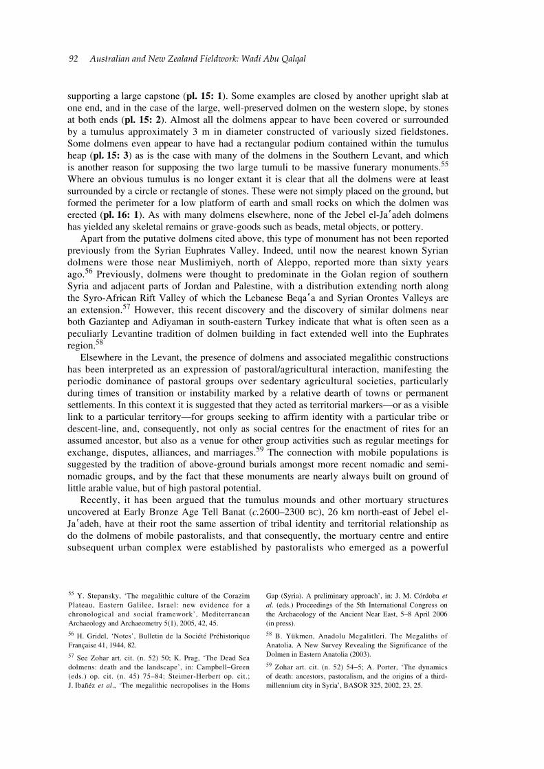
supporting a large capstone (pl. 15: 1). Some examples are closed by another upright slab at one end, and in the case of the large, well-preserved dolmen on the western slope, by stones at both ends (pl. 15: 2). Almost all the dolmens appear to have been covered or surrounded by a tumulus approximately 3 m in diameter constructed of variously sized fieldstones. Some dolmens even appear to have had a rectangular podium contained within the tumulus heap (pl. 15: 3) as is the case with many of the dolmens in the Southern Levant, and which is another reason for supposing the two large tumuli to be massive funerary monuments.55 Where an obvious tumulus is no longer extant it is clear that all the dolmens were at least surrounded by a circle or rectangle of stones. These were not simply placed on the ground, but formed the perimeter for a low platform of earth and small rocks on which the dolmen was erected (pl. 16: 1). As with many dolmens elsewhere, none of the Jebel el-Ja῾adeh dolmens has yielded any skeletal remains or grave-goods such as beads, metal objects, or pottery.
Apart from the putative dolmens cited above, this type of monument has not been reported previously from the Syrian Euphrates Valley. Indeed, until now the nearest known Syrian dolmens were those near Muslimiyeh, north of Aleppo, reported more than sixty years ago.56 Previously, dolmens were thought to predominate in the Golan region of southern Syria and adjacent parts of Jordan and Palestine, with a distribution extending north along the Syro-African Rift Valley of which the Lebanese Beqa῾a and Syrian Orontes Valleys are an extension.57 However, this recent discovery and the discovery of similar dolmens near both Gaziantep and Adiyaman in south-eastern Turkey indicate that what is often seen as a peculiarly Levantine tradition of dolmen building in fact extended well into the Euphrates region.58
Elsewhere in the Levant, the presence of dolmens and associated megalithic constructions has been interpreted as an expression of pastoral/agricultural interaction, manifesting the periodic dominance of pastoral groups over sedentary agricultural societies, particularly during times of transition or instability marked by a relative dearth of towns or permanent settlements. In this context it is suggested that they acted as territorial markers—or as a visible link to a particular territory—for groups seeking to affirm identity with a particular tribe or descent-line, and, consequently, not only as social centres for the enactment of rites for an assumed ancestor, but also as a venue for other group activities such as regular meetings for exchange, disputes, alliances, and marriages.59 The connection with mobile populations is suggested by the tradition of above-ground burials amongst more recent nomadic and semi-nomadic groups, and by the fact that these monuments are nearly always built on ground of little arable value, but of high pastoral potential.
Recently, it has been argued that the tumulus mounds and other mortuary structures uncovered at Early Bronze Age Tell Banat (c.2600–2300 BC), 26 km north-east of Jebel el-Ja῾adeh, have at their root the same assertion of tribal identity and territorial relationship as do the dolmens of mobile pastoralists, and that consequently, the mortuary centre and entire subsequent urban complex were established by pastoralists who emerged as a powerful
55 Y. Stepansky, ‘The megalithic culture of the Corazim Plateau, Eastern Galilee, Israel: new evidence for a chronological and social framework’, Mediterranean Archaeology and Archaeometry 5(1), 2005, 42, 45.56 H. Gridel, ‘Notes’, Bulletin de la Société Préhistorique Française 41, 1944, 82.57 See Zohar art. cit. (n. 52) 50; K. Prag, ‘The Dead Sea dolmens: death and the landscape’, in: Campbell–Green (eds.) op. cit. (n. 45) 75–84; Steimer-Herbert op. cit.; J. Ibañéz et al., ‘The megalithic necropolises in the Homs
Gap (Syria). A preliminary approach’, in: J. M. Córdoba et al. (eds.) Proceedings of the 5th International Congress on the Archaeology of the Ancient Near East, 5–8 April 2006 (in press).58 B. Yükmen, Anadolu Megalitleri. The Megaliths of Anatolia. A New Survey Revealing the Significance of the Dolmen in Eastern Anatolia (2003).59 Zohar art. cit. (n. 52) 54–5; A. Porter, ‘The dynamics of death: ancestors, pastoralism, and the origins of a third-millennium city in Syria’, BASOR 325, 2002, 23, 25.
Australian and New Zealand Fieldwork: Wadi Abu Qalqal 93
regional force after the collapse of the Uruk trading system c.3100 BC.60 This may indeed be the case, but if so, the low elevation, urban location, stylistic complexity, and continuing use and modification of some of the Banat monuments provide a sharp contrast to the rather simpler Jebel el-Ja῾adeh dolmen field. Where dolmens have been excavated and dated, principally in the southern Levant, two main periods of construction seem to predominate: c.3400–2900 BC, the southern EB I period, and c.2200–1900 BC, the southern EB IV/MB I periods.61 In view of this, and given the evident complexity of the Banat mortuary structures and others like them which start to appear c.2700 BC, it is not unreasonable to assume that the el-Ja῾adeh dolmens belong to the enigmatic period pre-dating the emergence of urban polities along the Euphrates, i.e. c.3100–2700 BC.
However, an alternative interpretation, and one more in keeping with the other data recovered in this area, is that they constitute the burials of the pastoralist group(s) whose campsites are preserved on the surrounding mountain slopes. The two large tumuli are therefore likely to denote the burials of èlite members of this group—massive ancestral tombs which would have acted as highly visible and tangible social and territorial markers.62 The connection between the different sites is reinforced by the fact that a very similar association of dolmens and pastoralist campsite may be observed at Yavuzeli near Gaziantep.63 The resemblance is such that we feel confident in stating that the Turkish monuments are more likely to date to the Early Islamic period than to any part of the Bronze Age as has previously been assumed.64 In the case of the Jebel el-Ja῾adeh sites, their proximity to Khirbet Khalid as well as the prolonged period of residence they imply,65 suggests that close economic relations were maintained between the nomadic pastoralists and sedentary farmers, some of whom may very well have been tribal kinsmen.
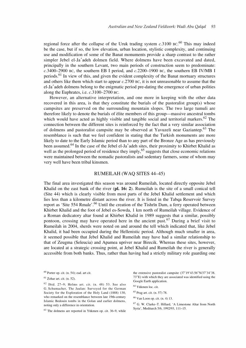
RUMEILAH (WAQ SITES 44–45)
The final area investigated this season was around Rumeilah, located directly opposite Jebel Khalid on the east bank of the river (pl. 16: 2). Rumeilah is the site of a small conical tell (Site 44) which is clearly visible from most parts of the Jebel Khalid settlement and which lies less than a kilometre distant across the river. It is listed in the Tabqa Reservoir Survey report as ‘Site 554 Rmale’.66 Until the creation of the Tishrīn Dam, a ferry operated between Khirbet Khalid and the foot of Jebel es-Sowda, 1 km north of Rumeilah village. Evidence of a Roman dedicatory altar found at Khirbet Khalid in 1989 suggests that a similar, possibly pontoon, crossing may have operated here in the ancient past.67 During a brief visit to Rumeilah in 2004, sherds were noted on and around the tell which indicated that, like Jebel Khalid, it had been occupied during the Hellenistic period. Although much smaller in area, it seemed possible that Jebel Khalid and Rumeilah may have had a similar relationship to that of Zeugma (Seleucia) and Apamea upriver near Birecik. Whereas these sites, however, are located at a strategic crossing point, at Jebel Khalid and Rumeilah the river is generally accessible from both banks. Thus, rather than having had a strictly military role guarding one
60 Porter op. cit. (n. 54); ead. art cit. 61 Zohar art. cit. (n. 52).62 Ibid. 27–9; Helms art. cit. (n. 48) 53. See also G. Schumacher, The Jaulan: Surveyed for the German Society for the Exploration of the Holy Land (1888) 130, who remarked on the resemblance between late 19th-century Islamic Bedouin tombs in the Golan and earlier dolmens, noting only a difference in orientation.63 The dolmens are reported in Yükmen op. cit. 36–9, while
the extensive pastoralist campsite (37˚19’43.56”N/37˚34’38.73”E) with which they are associated was identified using the Google Earth application.64 Yükmen loc. cit.65 Prag art. cit. (n. 57) 78.66 Van Loon op. cit. (n. 4) 13.67 G. W. Clarke–T. Hillard, ‘A Limestone Altar from North Syria’, Meditarch 5/6, 1992/93, 111–15.
94 Australian and New Zealand Fieldwork: Wadi Abu Qalqal
end of a river crossing, Tell Rumeilah may have had a more domestic or industrial function in relation to the larger site.
The area selected for survey during the 2006 season also included a terraced area immediately to the south of the tell, and several cultivated fields to the south and south-east (Site 45), a total area (including the tell) of some 9 ha. The field area was of particular interest in the light of Van Loon’s reference to the presence here of abundant pottery wasters and slag, and also owing to the zones of apparent disturbance visible on the CORONA images.
THE TELL AND ‘LOWER TOWN’
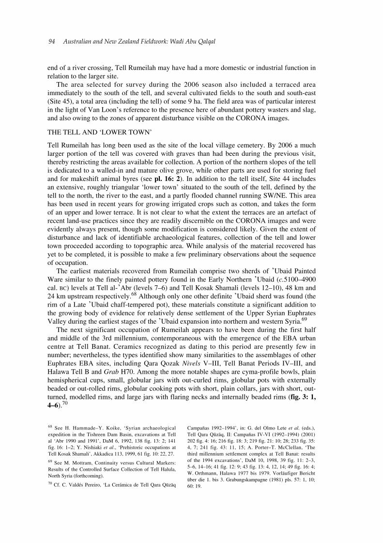
Tell Rumeilah has long been used as the site of the local village cemetery. By 2006 a much larger portion of the tell was covered with graves than had been during the previous visit, thereby restricting the areas available for collection. A portion of the northern slopes of the tell is dedicated to a walled-in and mature olive grove, while other parts are used for storing fuel and for makeshift animal byres (see pl. 16: 2). In addition to the tell itself, Site 44 includes an extensive, roughly triangular ‘lower town’ situated to the south of the tell, defined by the tell to the north, the river to the east, and a partly flooded channel running SW/NE. This area has been used in recent years for growing irrigated crops such as cotton, and takes the form of an upper and lower terrace. It is not clear to what the extent the terraces are an artefact of recent land-use practices since they are readily discernible on the CORONA images and were evidently always present, though some modification is considered likely. Given the extent of disturbance and lack of identifiable archaeological features, collection of the tell and lower town proceeded according to topographic area. While analysis of the material recovered has yet to be completed, it is possible to make a few preliminary observations about the sequence of occupation.
The earliest materials recovered from Rumeilah comprise two sherds of ᾽Ubaid Painted Ware similar to the finely painted pottery found in the Early Northern ᾽Ubaid (c.5100–4900 cal. BC) levels at Tell al-᾽Abr (levels 7–6) and Tell Kosak Shamali (levels 12–10), 48 km and 24 km upstream respectively.68 Although only one other definite ᾽Ubaid sherd was found (the rim of a Late ᾽Ubaid chaff-tempered pot), these materials constitute a significant addition to the growing body of evidence for relatively dense settlement of the Upper Syrian Euphrates Valley during the earliest stages of the ᾽Ubaid expansion into northern and western Syria.69
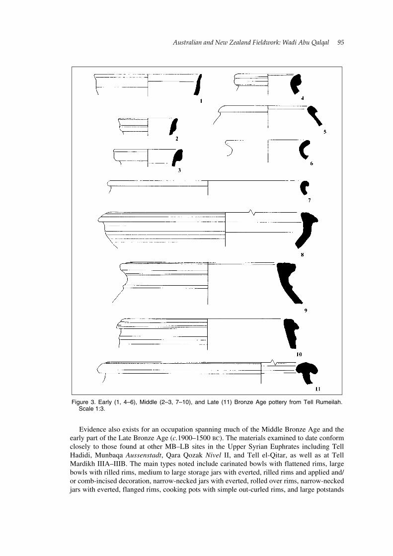
The next significant occupation of Rumeilah appears to have been during the first half and middle of the 3rd millennium, contemporaneous with the emergence of the EBA urban centre at Tell Banat. Ceramics recognized as dating to this period are presently few in number; nevertheless, the types identified show many similarities to the assemblages of other Euphrates EBA sites, including Qara Qozak Nivels V–III, Tell Banat Periods IV–III, and Halawa Tell B and Grab H70. Among the more notable shapes are cyma-profile bowls, plain hemispherical cups, small, globular jars with out-curled rims, globular pots with externally beaded or out-rolled rims, globular cooking pots with short, plain collars, jars with short, out-turned, modelled rims, and large jars with flaring necks and internally beaded rims (fig. 3: 1, 4–6).70
68 See H. Hammade–Y. Koike, ‘Syrian archaeological expedition in the Tishreen Dam Basin, excavations at Tell al ‘Abr 1990 and 1991’, DaM 6, 1992, 138 fig. 13: 2; 141 fig. 16: 1–2; Y. Nishiaki et al., ‘Prehistoric occupations at Tell Kosak Shamali’, Akkadica 113, 1999, 61 fig. 10: 22, 27.69 See M. Mottram, Continuity versus Cultural Markers: Results of the Controlled Surface Collection of Tell Halula, North Syria (forthcoming).70 Cf. C. Valdés Pereiro, ‘La Cerámica de Tell Qara Qūzāq
Campañas 1992–1994’, in: G. del Olmo Lete et al. (eds.), Tell Qara Qūzāq, II: Campañas IV-VI (1992–1994) (2001) 202 fig. 4: 16; 216 fig. 18: 3; 219 fig. 21: 10; 28; 233 fig. 35: 4, 7; 241 fig. 43: 11, 15; A. Porter–T. McClellan, ‘The third millennium settlement complex at Tell Banat: results of the 1994 excavations’, DaM 10, 1998, 39 fig. 11: 2–3, 5–6, 14–16; 41 fig. 12: 9; 43 fig. 13: 4, 12, 14; 49 fig. 16: 4; W. Orthmann, Halawa 1977 bis 1979. Vorläufiger Bericht über die 1. bis 3. Grabungskampagne (1981) pls. 57: 1, 10; 60: 19.
Australian and New Zealand Fieldwork: Wadi Abu Qalqal 95
Evidence also exists for an occupation spanning much of the Middle Bronze Age and the early part of the Late Bronze Age (c.1900–1500 BC). The materials examined to date conform closely to those found at other MB–LB sites in the Upper Syrian Euphrates including Tell Hadidi, Munbaqa Aussenstadt, Qara Qozak Nivel II, and Tell el-Qitar, as well as at Tell Mardikh IIIA–IIIB. The main types noted include carinated bowls with flattened rims, large bowls with rilled rims, medium to large storage jars with everted, rilled rims and applied and/or comb-incised decoration, narrow-necked jars with everted, rolled over rims, narrow-necked jars with everted, flanged rims, cooking pots with simple out-curled rims, and large potstands
Figure 3. Early (1, 4–6), Middle (2–3, 7–10), and Late (11) Bronze Age pottery from Tell Rumeilah.
Scale 1:3.
96 Australian and New Zealand Fieldwork: Wadi Abu Qalqal
(fig. 3: 2–3, 7–10).71 Only one definite LB type has been identified to date, that being a large storage jar with an internally and externally thickened, mushroom-profile rim, a type which is found in LB I contexts at both Hadidi and Hammam et-Turkman in the Balikh (fig. 3: 11).72 It is expected that additional LBA ceramic types will be identified as analysis progresses.
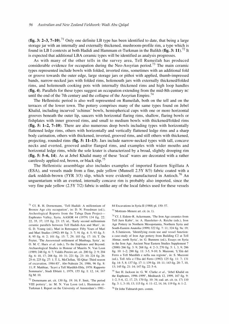
As with many of the other tells in the survey area, Tell Rumeilah has produced considerable evidence for occupation during the Neo-Assyrian period.73 The main ceramic types represented include bowls with folded, inverted rims, sometimes with an additional fold or groove towards the outer edge, large storage jars or pithoi with applied, thumb-impressed bands, narrow-necked jars with folded rims, holemouth jars with externally thickened/folded rims, and holemouth cooking pots with internally thickened rims and high loop handles (fig. 4). Parallels for these types suggest an occupation extending from the mid-8th century BC until the end of the 7th century and the collapse of the Assyrian Empire.74
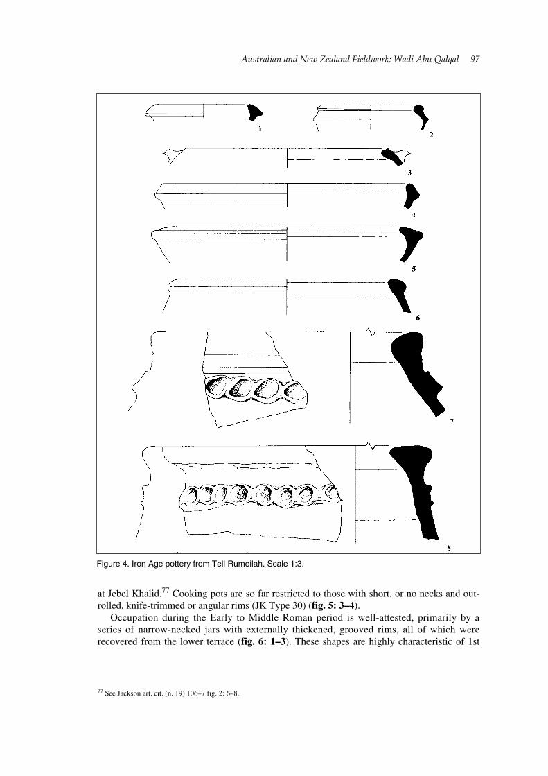
The Hellenistic period is also well represented on Rumeilah, both on the tell and on the terraces of the lower town. The pottery comprises many of the same types found on Jebel Khalid, including incurved ‘echinus’ bowls, hemispherical cups with one or more horizontal grooves beneath the outer lip, saucers with horizontal flaring rims, shallow, flaring bowls or fishplates with inner grooved rims, and small to medium bowls with thickened/folded rims (fig. 5: 1–2, 7–10). There are also numerous deep bowls including types with horizontally flattened ledge rims, others with horizontally and vertically flattened ledge rims and a sharp body carination, others with thickened, inverted, grooved rims, and still others with thickened, projecting, rounded rims (fig. 5: 11–13). Jars include narrow-necked types with tall, concave necks and everted, grooved and/or flanged rims, and examples with wider mouths and horizontal ledge rims, while the sole krater is characterized by a broad, slightly drooping rim (fig. 5: 5–6, 14). As at Jebel Khalid many of these ‘local’ wares are decorated with a rather carelessly applied red, brown, or black slip.75
The Hellenistic assemblage also includes examples of imported Eastern Sigillata A (ESA), and vessels made from a fine, pale yellow (Munsell 2.5Y 8/3) fabric coated with a dark reddish-brown (5YR 3/3) slip, which were evidently manufactured in Antioch.76 An unguentarium with an everted, internally concave rim is probably also imported, since the very fine pale yellow (2.5Y 7/2) fabric is unlike any of the local fabrics used for these vessels
71 Cf. R. H. Dornemann, ‘Tell Hadidi: A millennium of Bronze Age city occupation’, in: D. N. Freedman (ed.), Archeological Reports from the Tabqa Dam Project—Euphrates Valley, Syria. AASOR 44 (1979) 134 fig. 22: 22, 35, 37; 135 fig. 23: 15; id., ‘Early second millennium ceramic parallels between Tell Hadidi-Azu and Mari’, in: G. D. Young (ed.), Mari in Retrospect: Fifty Years of Mari and Mari Studies (1992) 89 fig. 3: 7; 91 fig. 4: 5; 93 fig. 5: 8; 95 fig. 6: 2; 101 fig. 15: 7, 29; 103 fig. 17: 10; T. De Feyter, ‘The Aussenstadt settlement of Munbaqa, Syria’, in: O. M. C. Haex et al. (eds.), To the Euphrates and Beyond. Archaeological Studies in Honour of Maurits N. Van Loon (1989) 248 fig. 6: 7; Valdés Pereiro art. cit. 200 fig. 2: 9; 204 fig. 6: 10, 17; 208 fig. 10: 31; 221 fig. 23: 10; 224 fig. 26: 25–6; 225 fig. 27: 1; T. L. McClellan, ‘El-Qitar: Third season of excavation, 1984-85’, Abr-Nahrain 24, 1986, 96 fig. 8: 11; P. Matthiae, ‘Scavi a Tell Mardikh-Ebla, 1978: Rapporto Sommario’, Studi Eblaiti 1, 1979, 155 fig. I: 12, 14; 167 fig M: 10.72 Dornemann art. cit. 130 fig. 19: 16; F. Smit, ‘The period VIII pottery’, in: M. N. Van Loon (ed.), Hammam et-Turkman I. Report on the University of Amsterdam’s 1981–
84 Excavations in Syria II (1988) pl. 150: 57.73 Mottram–Menere art. cit. (n. 1).74 Cf. J. Eidem–R. Ackermann, ‘The Iron Age ceramics from Tell Jurn Kabir’, in: A. Hausleiter–A. Reiche (eds.), Iron Age Pottery in Northern Mesopotamia, Northern Syria and South-Eastern Anatolia (1999) 322 fig. 7: 11; 324 fig. 9a: 19; A. S Jamieson, ‘Identifying room use and vessel function: a case-study of Iron Age pottery from Building C2 at Tell Ahmar, north Syria’, in: G. Bunnens (ed.), Essays on Syria in the Iron Age. Ancient Near Eastern Studies Supplement 7 (2000) 266 fig. 3: 9; 268 fig. 4: 2–3; 270 fig. 5: 1, 3, 9; 286 fig. 10: 1–2; 288 fig. 11: 3-5, 9-10; S. Mazzoni, ‘L’Età del Ferro a Tell Mardikh e nella sua regione’, in: S. Mazzoni (ed.), Tell Afis e l’Eta del Ferro (1992) 125 fig. 11: 7; 131 fig. 14: 5, 8; 137 fig. 17: 1; 139 fig. 18: 11; 143 fig. 20: 7, 10, 13; 145 fig. 21: 14; 147 fig. 22: 5–6.75 See H. Jackson in: G. W. Clarke et al., ‘Jebel Khalid on the Euphrates, 1996–1999’, Meditarch 12, 1999, 167 fig. 9: 1–2, 5–6, 12, 17, 23; 170 fig. 10: 34; ead. art. cit. (n. 17) 110 fig. 3: 1, 3–10, 13; 115 fig. 4: 11–12, 14, 16; 119 fig. 6: 1–2.76 Dr John Tidmarsh pers. comm.
Australian and New Zealand Fieldwork: Wadi Abu Qalqal 97
at Jebel Khalid.77 Cooking pots are so far restricted to those with short, or no necks and out-rolled, knife-trimmed or angular rims (JK Type 30) (fig. 5: 3–4).
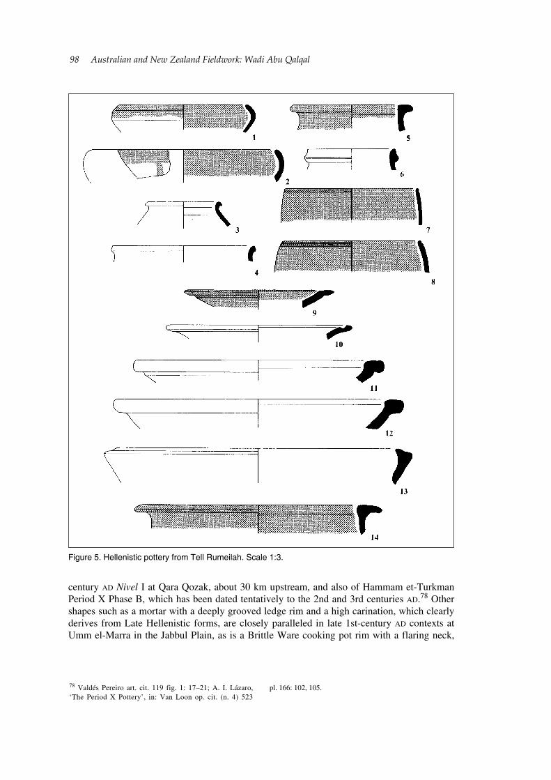
Occupation during the Early to Middle Roman period is well-attested, primarily by a series of narrow-necked jars with externally thickened, grooved rims, all of which were recovered from the lower terrace (fig. 6: 1–3). These shapes are highly characteristic of 1st
77 See Jackson art. cit. (n. 19) 106–7 fig. 2: 6–8.
Figure 4. Iron Age pottery from Tell Rumeilah. Scale 1:3.
98 Australian and New Zealand Fieldwork: Wadi Abu Qalqal
century AD Nivel I at Qara Qozak, about 30 km upstream, and also of Hammam et-Turkman Period X Phase B, which has been dated tentatively to the 2nd and 3rd centuries AD.78 Other shapes such as a mortar with a deeply grooved ledge rim and a high carination, which clearly derives from Late Hellenistic forms, are closely paralleled in late 1st-century AD contexts at Umm el-Marra in the Jabbul Plain, as is a Brittle Ware cooking pot rim with a flaring neck,
78 Valdés Pereiro art. cit. 119 fig. 1: 17–21; A. I. Lázaro, ‘The Period X Pottery’, in: Van Loon op. cit. (n. 4) 523
pl. 166: 102, 105.
Figure 5. Hellenistic pottery from Tell Rumeilah. Scale 1:3.
Australian and New Zealand Fieldwork: Wadi Abu Qalqal 99
and externally thickened, folded rim (fig. 6: 5, 9).79 This same Brittle Ware form is also extremely common in Qara Qozak Nivel I, and occurs as a surface find and in the upper levels at Jebel Khalid. Along with various other finds including coins, glass objects, and lamps, such vessels are part of mounting evidence for occupation of Jebel Khalid during the first centuries of the Roman era.80 Also of Early Roman date, based on parallels from Qara Qozak, is a large
79 Cf. Jackson art. cit. (n. 75) 167 fig. 9: 22; A. M. Berlin, ‘The plain wares’, in: S. C. Herbet (ed.), Tel Anafa II, i. The Hellenistic and Roman Pottery (1997) 125–6 pl. 39: PW 361–2; pl. 41: PW 389–92; H. H. Curvers–G. M. Schwartz,
‘Umm el-Marra, a Bronze Age urban center in the Jabbul Plain, western Syria’, AJA 101, 1997, 220 fig. 17: 4, 8.80 Valdés Pereiro art. cit. 199 fig. 1: 32–4; G. Clarke, ‘The Jebel Khalid Temple’, Meditarch 19/20, 2006/07, 139.
Figure 6. Roman (1–10) and Byzantine (11–13) pottery from Tell Rumeilah. Scale 1:3.
100 Australian and New Zealand Fieldwork: Wadi Abu Qalqal
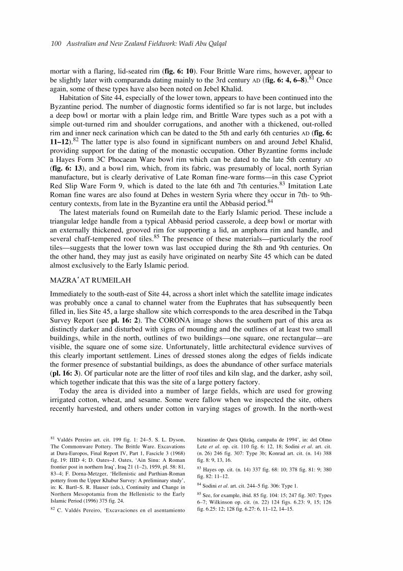
mortar with a flaring, lid-seated rim (fig. 6: 10). Four Brittle Ware rims, however, appear to be slightly later with comparanda dating mainly to the 3rd century AD (fig. 6: 4, 6–8).81 Once again, some of these types have also been noted on Jebel Khalid.
Habitation of Site 44, especially of the lower town, appears to have been continued into the Byzantine period. The number of diagnostic forms identified so far is not large, but includes a deep bowl or mortar with a plain ledge rim, and Brittle Ware types such as a pot with a simple out-turned rim and shoulder corrugations, and another with a thickened, out-rolled rim and inner neck carination which can be dated to the 5th and early 6th centuries AD (fig. 6: 11–12).82 The latter type is also found in significant numbers on and around Jebel Khalid, providing support for the dating of the monastic occupation. Other Byzantine forms include a Hayes Form 3C Phocaean Ware bowl rim which can be dated to the late 5th century AD (fig. 6: 13), and a bowl rim, which, from its fabric, was presumably of local, north Syrian manufacture, but is clearly derivative of Late Roman fine-ware forms—in this case Cypriot Red Slip Ware Form 9, which is dated to the late 6th and 7th centuries.83 Imitation Late Roman fine wares are also found at Dehes in western Syria where they occur in 7th- to 9th-century contexts, from late in the Byzantine era until the Abbasid period.84
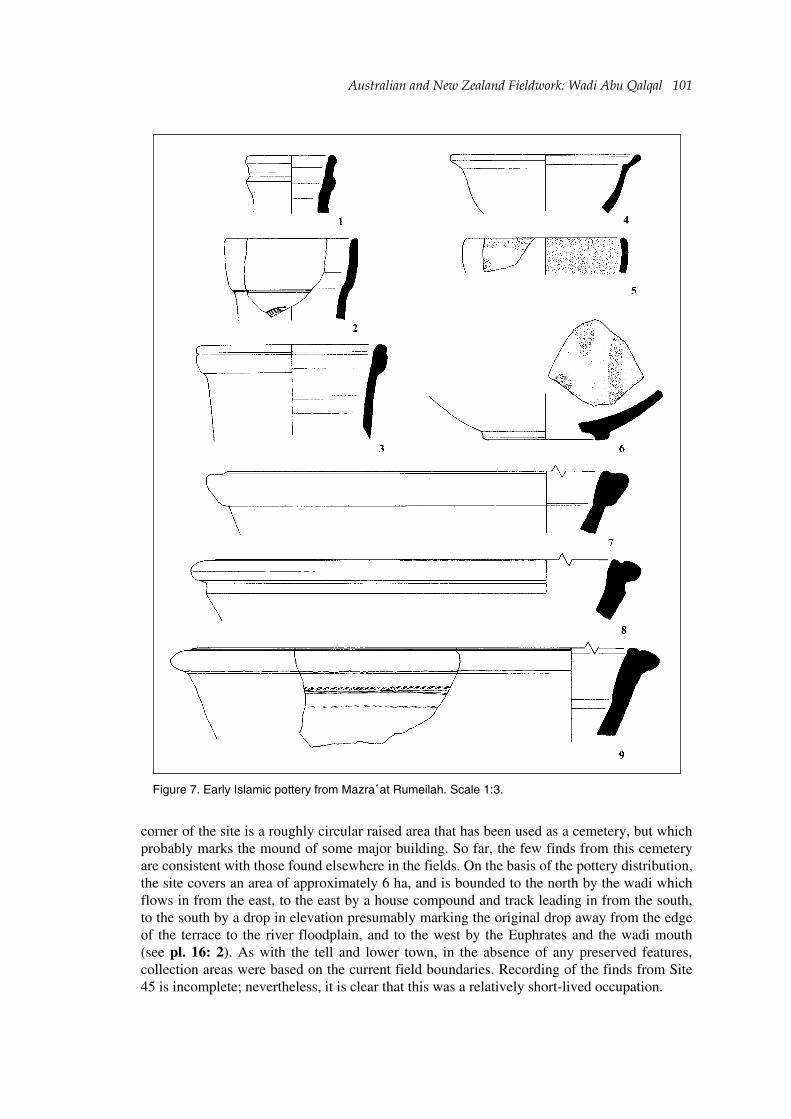
The latest materials found on Rumeilah date to the Early Islamic period. These include a triangular ledge handle from a typical Abbasid period casserole, a deep bowl or mortar with an externally thickened, grooved rim for supporting a lid, an amphora rim and handle, and several chaff-tempered roof tiles.85 The presence of these materials—particularly the roof tiles—suggests that the lower town was last occupied during the 8th and 9th centuries. On the other hand, they may just as easily have originated on nearby Site 45 which can be dated almost exclusively to the Early Islamic period.
MAZRA῾AT RUMEILAH
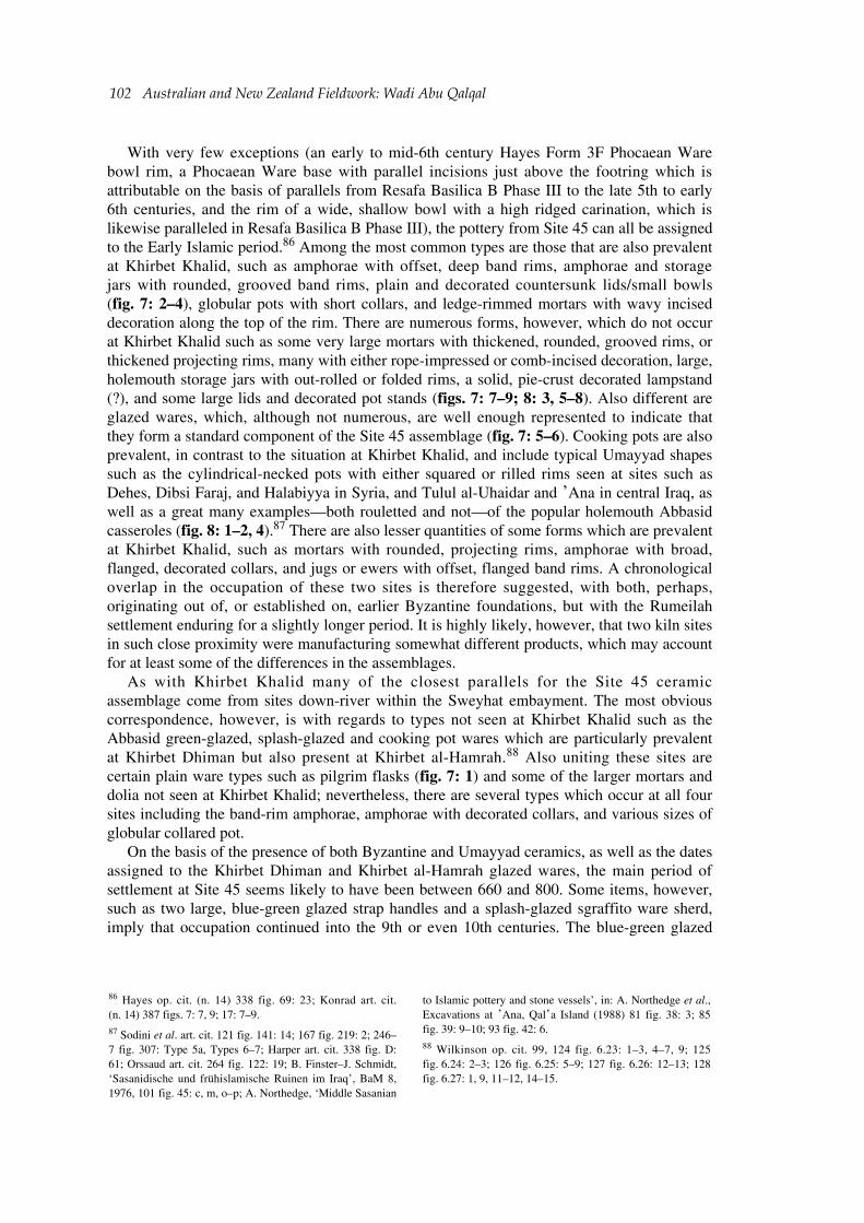
Immediately to the south-east of Site 44, across a short inlet which the satellite image indicates was probably once a canal to channel water from the Euphrates that has subsequently been filled in, lies Site 45, a large shallow site which corresponds to the area described in the Tabqa Survey Report (see pl. 16: 2). The CORONA image shows the southern part of this area as distinctly darker and disturbed with signs of mounding and the outlines of at least two small buildings, while in the north, outlines of two buildings—one square, one rectangular—are visible, the square one of some size. Unfortunately, little architectural evidence survives of this clearly important settlement. Lines of dressed stones along the edges of fields indicate the former presence of substantial buildings, as does the abundance of other surface materials (pl. 16: 3). Of particular note are the litter of roof tiles and kiln slag, and the darker, ashy soil, which together indicate that this was the site of a large pottery factory.
Today the area is divided into a number of large fields, which are used for growing irrigated cotton, wheat, and sesame. Some were fallow when we inspected the site, others recently harvested, and others under cotton in varying stages of growth. In the north-west
81 Valdés Pereiro art. cit. 199 fig. 1: 24–5. S. L. Dyson, The Commonware Pottery. The Brittle Ware. Excavations at Dura-Europos, Final Report IV, Part 1, Fascicle 3 (1968) fig. 19: IIID 4; D. Oates–J. Oates, ‘Ain Sinu: A Roman frontier post in northern Iraq’, Iraq 21 (1–2), 1959, pl. 58: 81, 83–4; F. Dorna-Metzger, ‘Hellenistic and Parthian-Roman pottery from the Upper Khabur Survey: A preliminary study’, in: K. Bartl–S. R. Hauser (eds.), Continuity and Change in Northern Mesopotamia from the Hellenistic to the Early Islamic Period (1996) 375 fig. 24.82 C. Valdés Pereiro, ‘Excavaciones en el asentamiento
bizantino de Qara Qūzāq, campaña de 1994’, in: del Olmo Lete et al. op. cit. 110 fig. 6: 12, 18; Sodini et al. art. cit. (n. 26) 246 fig. 307: Type 3b; Konrad art. cit. (n. 14) 388 fig. 8: 9, 13, 16.83 Hayes op. cit. (n. 14) 337 fig. 68: 10; 378 fig. 81: 9; 380 fig. 82: 11–12.84 Sodini et al. art. cit. 244–5 fig. 306: Type 1.85 See, for example, ibid. 85 fig. 104: 15; 247 fig. 307: Types 6–7; Wilkinson op. cit. (n. 22) 124 figs. 6.23: 9, 15; 126 fig. 6.25: 12; 128 fig. 6.27: 6, 11–12, 14–15.
Australian and New Zealand Fieldwork: Wadi Abu Qalqal 101
corner of the site is a roughly circular raised area that has been used as a cemetery, but which probably marks the mound of some major building. So far, the few finds from this cemetery are consistent with those found elsewhere in the fields. On the basis of the pottery distribution, the site covers an area of approximately 6 ha, and is bounded to the north by the wadi which flows in from the east, to the east by a house compound and track leading in from the south, to the south by a drop in elevation presumably marking the original drop away from the edge of the terrace to the river floodplain, and to the west by the Euphrates and the wadi mouth (see pl. 16: 2). As with the tell and lower town, in the absence of any preserved features, collection areas were based on the current field boundaries. Recording of the finds from Site 45 is incomplete; nevertheless, it is clear that this was a relatively short-lived occupation.
Figure 7. Early Islamic pottery from Mazra῾at Rumeilah. Scale 1:3.
102 Australian and New Zealand Fieldwork: Wadi Abu Qalqal
With very few exceptions (an early to mid-6th century Hayes Form 3F Phocaean Ware bowl rim, a Phocaean Ware base with parallel incisions just above the footring which is attributable on the basis of parallels from Resafa Basilica B Phase III to the late 5th to early 6th centuries, and the rim of a wide, shallow bowl with a high ridged carination, which is likewise paralleled in Resafa Basilica B Phase III), the pottery from Site 45 can all be assigned to the Early Islamic period.86 Among the most common types are those that are also prevalent at Khirbet Khalid, such as amphorae with offset, deep band rims, amphorae and storage jars with rounded, grooved band rims, plain and decorated countersunk lids/small bowls (fig. 7: 2–4), globular pots with short collars, and ledge-rimmed mortars with wavy incised decoration along the top of the rim. There are numerous forms, however, which do not occur at Khirbet Khalid such as some very large mortars with thickened, rounded, grooved rims, or thickened projecting rims, many with either rope-impressed or comb-incised decoration, large, holemouth storage jars with out-rolled or folded rims, a solid, pie-crust decorated lampstand (?), and some large lids and decorated pot stands (figs. 7: 7–9; 8: 3, 5–8). Also different are glazed wares, which, although not numerous, are well enough represented to indicate that they form a standard component of the Site 45 assemblage (fig. 7: 5–6). Cooking pots are also prevalent, in contrast to the situation at Khirbet Khalid, and include typical Umayyad shapes such as the cylindrical-necked pots with either squared or rilled rims seen at sites such as Dehes, Dibsi Faraj, and Halabiyya in Syria, and Tulul al-Uhaidar and ᾽Ana in central Iraq, as well as a great many examples—both rouletted and not—of the popular holemouth Abbasid casseroles (fig. 8: 1–2, 4).87 There are also lesser quantities of some forms which are prevalent at Khirbet Khalid, such as mortars with rounded, projecting rims, amphorae with broad, flanged, decorated collars, and jugs or ewers with offset, flanged band rims. A chronological overlap in the occupation of these two sites is therefore suggested, with both, perhaps, originating out of, or established on, earlier Byzantine foundations, but with the Rumeilah settlement enduring for a slightly longer period. It is highly likely, however, that two kiln sites in such close proximity were manufacturing somewhat different products, which may account for at least some of the differences in the assemblages.
As with Khirbet Khalid many of the closest parallels for the Site 45 ceramic assemblage come from sites down-river within the Sweyhat embayment. The most obvious correspondence, however, is with regards to types not seen at Khirbet Khalid such as the Abbasid green-glazed, splash-glazed and cooking pot wares which are particularly prevalent at Khirbet Dhiman but also present at Khirbet al-Hamrah.88 Also uniting these sites are certain plain ware types such as pilgrim flasks (fig. 7: 1) and some of the larger mortars and dolia not seen at Khirbet Khalid; nevertheless, there are several types which occur at all four sites including the band-rim amphorae, amphorae with decorated collars, and various sizes of globular collared pot.
On the basis of the presence of both Byzantine and Umayyad ceramics, as well as the dates assigned to the Khirbet Dhiman and Khirbet al-Hamrah glazed wares, the main period of settlement at Site 45 seems likely to have been between 660 and 800. Some items, however, such as two large, blue-green glazed strap handles and a splash-glazed sgraffito ware sherd, imply that occupation continued into the 9th or even 10th centuries. The blue-green glazed
86 Hayes op. cit. (n. 14) 338 fig. 69: 23; Konrad art. cit. (n. 14) 387 figs. 7: 7, 9; 17: 7–9.87 Sodini et al. art. cit. 121 fig. 141: 14; 167 fig. 219: 2; 246–7 fig. 307: Type 5a, Types 6–7; Harper art. cit. 338 fig. D: 61; Orssaud art. cit. 264 fig. 122: 19; B. Finster–J. Schmidt, ‘Sasanidische und frühislamische Ruinen im Iraq’, BaM 8, 1976, 101 fig. 45: c, m, o–p; A. Northedge, ‘Middle Sasanian
to Islamic pottery and stone vessels’, in: A. Northedge et al., Excavations at ᾽Ana, Qal῾a Island (1988) 81 fig. 38: 3; 85 fig. 39: 9–10; 93 fig. 42: 6.88 Wilkinson op. cit. 99, 124 fig. 6.23: 1–3, 4–7, 9; 125 fig. 6.24: 2–3; 126 fig. 6.25: 5–9; 127 fig. 6.26: 12–13; 128 fig. 6.27: 1, 9, 11–12, 14–15.
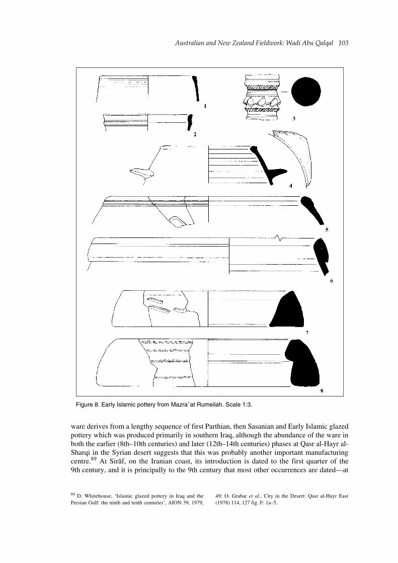
Australian and New Zealand Fieldwork: Wadi Abu Qalqal 103
ware derives from a lengthy sequence of first Parthian, then Sasanian and Early Islamic glazed pottery which was produced primarily in southern Iraq, although the abundance of the ware in both the earlier (8th–10th centuries) and later (12th–14th centuries) phases at Qasr al-Hayr al-Sharqi in the Syrian desert suggests that this was probably another important manufacturing centre.89 At Sirāf, on the Iranian coast, its introduction is dated to the first quarter of the 9th century, and it is principally to the 9th century that most other occurrences are dated—at
89 D. Whitehouse, ‘Islamic glazed pottery in Iraq and the Persian Gulf: the ninth and tenth centuries’, AION 39, 1979,
49; O. Grabar et al., City in the Desert: Qasr al-Hayr East (1978) 114, 127 fig. F: 1a–5.
Figure 8. Early Islamic pottery from Mazra῾at Rumeilah. Scale 1:3.
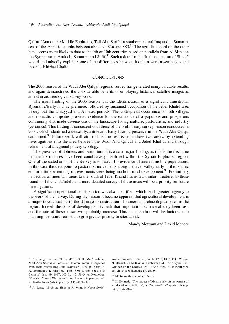
104 Australian and New Zealand Fieldwork: Wadi Abu Qalqal
Qal῾at ᾽Ana on the Middle Euphrates, Tell Abu Sarīfa in southern central Iraq and at Samarra, seat of the Abbasid caliphs between about AD 836 and 883.90 The sgraffito sherd on the other hand seems more likely to date to the 9th or 10th centuries based on parallels from Al Mina on the Syrian coast, Antioch, Samarra, and Sirāf.91 Such a date for the final occupation of Site 45 would undoubtedly explain some of the differences between its plain ware assemblages and those of Khirbet Khalid.
CONCLUSIONS
The 2006 season of the Wadi Abu Qalqal regional survey has generated many valuable results, and again demonstrated the considerable benefits of employing historical satellite images as an aid in archaeological survey work.
The main finding of the 2006 season was the identification of a significant transitional Byzantine/Early Islamic presence, followed by sustained occupation of the Jebel Khalid area throughout the Umayyad and Abbasid periods. The widespread occurrence of both villages and nomadic campsites provides evidence for the existence of a populous and prosperous community that made diverse use of the landscape for agriculture, pastoralism, and industry (ceramics). This finding is consistent with those of the preliminary survey season conducted in 2004, which identified a dense Byzantine and Early Islamic presence in the Wadi Abu Qalqal catchment.92 Future work will aim to link the results from these two areas, by extending investigations into the area between the Wadi Abu Qalqal and Jebel Khalid, and through refinement of a regional pottery typology.
The presence of dolmens and burial tumuli is also a major finding, as this is the first time that such structures have been conclusively identified within the Syrian Euphrates region. One of the stated aims of the Survey is to search for evidence of ancient mobile populations; in this case the data point to pastoralist movements along the river valley early in the Islamic era, at a time when major investments were being made in rural development.93 Preliminary inspection of mountain areas to the south of Jebel Khalid has noted similar structures to those found on Jebel el-Ja῾adeh, and more detailed survey of these areas will be a priority for future investigations.
A significant operational consideration was also identified, which lends greater urgency to the work of the survey. During the season it became apparent that agricultural development is a major threat, leading to the damage or destruction of numerous archaeological sites in the region. Indeed, the pace of development is such that important sites have already been lost, and the rate of these losses will probably increase. This consideration will be factored into planning for future seasons, to give greater priority to sites at risk.
Mandy Mottram and David Menere
90 Northedge art. cit. 91 fig. 42: 1–3; R. McC. Adams, ‘Tell Abu Sarifa: A Sassanian–Islamic ceramic sequence from south central Iraq’, Ars Islamica 8, 1970, pl. 3 fig. 7d; A. Northedge–R Falkner, ‘The 1986 survey season at Samarra’, Iraq 49, 1987, 163 fig. 12: 51–3; A. Northedge, ‘Friedrich Sarre’s Die Keramik von Samarra in perspective’, in: Bartl–Hauser (eds.) op. cit. (n. 81) 240 Table 1.91 A. Lane, ‘Medieval finds at Al Mina in North Syria’,
Archaeologia 87, 1937, 21, 36 pls. 17: 2; 18: 2; F. O. Waagé, ‘Hellenistic and Roman Tableware of North Syria’, in: Antioch-on-the-Orontes, IV 1 (1948) figs. 70–1; Northedge art. cit. 241; Whitehouse art. cit. 59.92 Mottram–Menere art. cit. (n. 1)93 H. Kennedy, ‘The impact of Muslim rule on the pattern of rural settlement in Syria’, in: Canivet–Rey-Coquais (eds.) op. cit. (n. 34) 292–3.
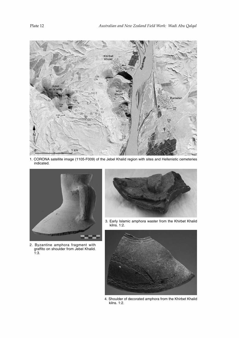
!"#$%&'( !"#$%&'(&)*&)+*,-.*/-&'&)+*0(-'+*12%34**1&+(*!5"*6&'7&'
!"#$%&%'(#)*+,--.+,#./*0,#1!!23452267#89#+:,#;,<,-#=:*-.>#?,0.8@#A.+:#).+,)#*@>#B,--,@.)+.C#C,/,+,?.,)#.@>.C*+,>"
D"# EFG*@+.@,# */H:8?*# 9?*0/,@+# A.+:#0?*99.+8#8@#):8I->,?#9?8/#;,<,-#=:*-.>"!!JK"
K"#L*?-F#M)-*/.C#*/H:8?*#A*)+,?#9?8/#+:,#=:.?<,+#=:*-.>#N.-@)"#!JD"
O"#P:8I->,?#89#>,C8?*+,>#*/H:8?*#9?8/#+:,#=:.?<,+#=:*-.>#N.-@)"#!JD"
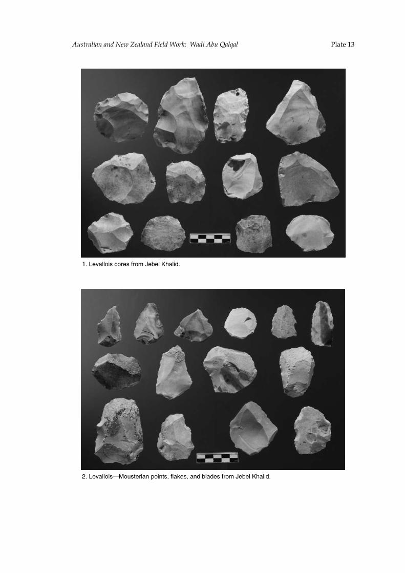
!"#$%&'(!"#$%&'(&)*&)+*,-.*/-&'&)+*0(-'+*12%34**1&+(*!5"*6&'7&'
!"#$%&'(()*+#,)-%+#.-)/#0%1%(#23'(*4"
5"#$%&'(()*+67)8+9%-*':#;)*:9+<#.('=%+<#':4#1('4%+#.-)/#0%1%(#23'(*4"
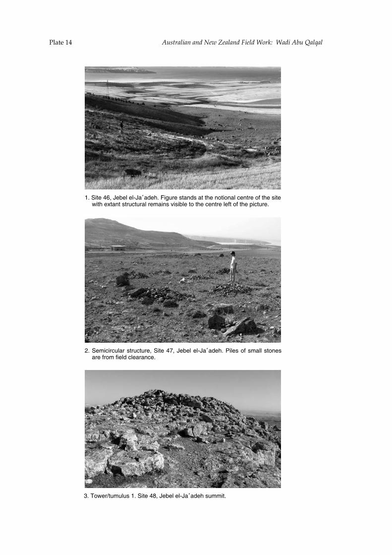
!"#$%&'( !"#$%&'(&)*&)+*,-.*/-&'&)+*0(-'+*12%34**1&+(*!5"*6&'7&'
!"#$%&'#()*#+','-#'-.+/!/0'1"#2%345'#6&/706#/&#&1'#78&%87/-#9'7&5'#8:#&1'#6%&'#;%&1#'<&/7&549&45/-#5'=/%76#>%6%,-'#&8#&1'#9'7&5'#-'::#&1'#?%9&45'"
@"#$'=%9%594-/5#6&549&45'*#$%&'#(A*#+','-#'-.+/!/0'1"#B%-'6#8:#6=/--#6&87'6#/5'#:58=#:%'-0#9-'/5/79'"
C"#D8;'5E&4=4-46#!"#$%&'#(F*#+','-#'-.+/!/0'1#64==%&"

!"#$%&'(!"#$%&'(&)*&)+*,-.*/-&'&)+*0(-'+*12%34**1&+(*!5"*6&'7&'
!"#$%&'()"#*+,(#-./#0(1(&#(&203!34(5#67''+,"
8"#97&&:#();&%6(4#4%&'()#<+,5#=%7>#7?>+@5,6"
A"#$%&'()#<+,5#>(;,+&+)(3>#,7'7&76"#B5(#>('%C(4#;3?6,%)(#+6#,%#,5(#&(=,#%=#,5(#?+;,7>("
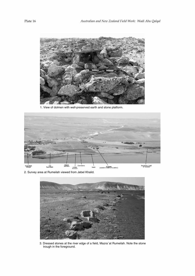
!"#$%&'( !"#$%&'(&)*&)+*,-.*/-&'&)+*0(-'+*12%34**1&+(*!5"*6&'7&'
!"#$%&'#()#*(+,&-#'%./#'&++012&3&24&*#&52./#5-*#3.(-+5.)(2,"
6"#72&33&*#3.(-&3#5.#./%4&2#&*8&#()#5#)%&+*9#:5;25!5.#<=,&%+5/"#>(.&#./.(-&#.2(=8/#%-#./&#)(2&82(=-*"
?"#@=24&A#52&5#5.#<=,&%+5/#4%&'&*#)2(,#B&C&+#D/5+%*"