vertical distribution of the natural and artificial radionuclides in various soil profiles to...
TRANSCRIPT

Journal of Radioanalytical and Nuclear Chemistry, Vol. 259, No. 2 (2004) 265–270
0236–5731/2004/USD 20.00 Akadémiai Kiadó, Budapest© 2004 Akadémiai Kiadó, Budapest Kluwer Academic Publishers, Dordrecht
Vertical distribution of the natural and artificial radionuclidesin various soil profiles to investigate soil erosion
A. Uğur,1* M. M. Saç,1 G. Yener,1 Ü. Altınbaş,2 Y. Kurucu,2 M. Bolca,2 B.Özden11 Ege University, Institute of Nuclear Sciences, Bornova, İzmir, 35100, Turkey
2 Ege University, Faculty of Agriculture, Soil Science Department, Bornova, İzmir, 35100, Turkey(Received July 21, 2003)
Vertical distributions of 137Cs and 210Pb in soil profiles were examined to study their availability in soil erosion at Gökova region where thereexists intensive agricultural activities on sloppy fields. Since the mobility of these radionuclides depend on soil characteristics, soil samples wereanalyzed also for their physical and chemical properties. From 137Cs inventories measured, erosion rates for cultivated and disturbed (nocultivation) soils were calculated to range from 79.1 to 6.5 t.ha–1.y–1 and from 79.9 to 3.5 t.ha–1.y–1, respectively. The 210Pb technique is found tobe not suitable for erosion determination for this area, presumably due to the coal-fired power plants operating in the region.
Introduction
Recent years have seen increasing interest in thepotential for using 137Cs as a tracer in soil erosioninvestigations and 137Cs measurements are nowaccepted as an effective and valuable means ofproducing retrospective information on medium-termrates and patterns of soil redistribution.1 Fallout of thisartificial radionuclide from the atmospheric testing ofnuclear weapons began in 1954 and reached a peak in1963, the year of international test ban treaty, afterwhich it declined sharply.2 The annual deposition of137Cs has been characterized by great temporal variationrelated to the timing of the large-scale atmospherictesting of nuclear weapons. Measuring the spatialredistribution of 137Cs in the landscape affords a fastand economical way of estimating the result of soilredistribution that took place over the last 35–40 years.Naturally derived unsupported 210Pb (T1/2 = 22.2 y) canoffer a viable alternative to 137Cs as a sediment tracer inmany environments. In addition, when used incombination with 137Cs, it offers a potential as acomplementary tracer, which can provide additionalinformation on the erosional history of a site.1 Lead-210is a natural product of the 238U decay series that isderived from the decay of gaseous 222Rn (T1/2 = 3.8 d),the daughter of 226Ra (T1/2 = 1622 y). Radioactivedisequilibrium between 210Pb and its parent isotope226Ra, arises through the mobility of the intermediategaseous isotope 222Rn. A proportion of the 222Rnformed by 226Ra decay in soils diffuses into theatmosphere where it decays to 210Pb and then 210Pb isprecipitated onto the land surface.3 The 210Pb activity inexcess of the fraction which is derived from decay of thein situ 226Ra is called unsupported 210Pb. Unsupported210Pb is measured by subtraction of 210Pb supported
* E-mail: [email protected]
by the parent 226Ra from the total 210Pb activity. Uponreaching the land surface as fallout from the atmosphere,unsupported 210Pb will be rapidly adsorbed by the clayminerals and organic matter in the surface soil, and, asin the case of 137Cs, its subsequent redistribution in thesoil and across the land surface will be controlled by itsinteraction with land use practices, erosion, andsediment transport processes.4 Clay mineralogy, soilorganic matter and soil clay content determine the cationexchance capacity (CEC) of soils which has the maininfluence on the sorption of these radionuclides.
The 137Cs approach for documenting soil erosion hasbeen used in a wide range of environments in differentregions of the world.1,4–9 It is, therefore, important toknow the global deposition pattern of 137Cs in order tobe able to identify countries and regions where thetechnique has the potential for estimating soil erosionand sedimentation. International Atomic Energy Agency(IAEA) have sponsored, since 1995, the implementationof two co-ordinated research projects (CRP’s) dealingwith the application of the 137Cs technique in soilerosion and sedimentation studies.
Soil erosion hangs as a most serious threat overTurkey’s nature and economy, because of their impacton both sustainable agricultural production andenvironmental conservation. The semiarid regions ofCentral, Eastern and Southern Anatolia are particularlyprone to erosion because of a combination of climaticfactors and topography. Although many studies byconventional methods have been conducted for soilerosion in Turkey, there has been no research work donefor the problem using nuclear techniques.
The objective of the present research was to evaluatethe applicability of 137Cs and 210Pb techniques inobtaining information on soil erosion rates in cultivatedand disturbed (no cultivation) soils in Gökova Region at

A. UĞUR et al.: VERTICAL DISTRIBUTION OF THE NATURAL AND ARTIFICIAL RADIONUCLIDES IN VARIOUS SOIL PROFILES
266
south western Turkey. This area was chosen as the studysite because of the existence of intensive agriculturalactivities and to investigate if there is any influence ofthe coal-fired power plants (CPPs) on 210Pb use forerosion rate applications.
Experimental
Location
In Gökova region where Yatağan Basin is located,there are three major uraniferous coal-fired power plants(CPPs) namely, Yatağan in operation since 1982,Yeniköy, since 1988 and Kemerköy, since 1994.Yatağan plant has three units producing 210 MW each,the other two plants have only two units of similarpower. Two hills (Yatağan Hill, 4.5 km and Ürnez Hill,7 km from the plant) were chosen near Yatağan CPP, asstudy areas. The shoulder slopes of the hills wereselected for sampling. Yatağan Hill is one of the biggesthills of the basin and its land cover type is shrub land.Soils were sampled from disturbed and undisturbed(reference) areas on the back slope of southeast side ofthe hill. Parent material of soils of this area is cretaceancalcerious rock, which is formed of calcium carbonate.The soils of Ürnez hill are formed of marl parentmaterial, the sampling points were located at thecultivated and uncultivated (reference) slopes at the hill.Yatağan Hill located (37°21’57” N, 28°08’07”E) in theupper part and Ürnez Hill located (37°18’46”N,28°09’43”E) in the medium part of the basin wherewater-induced erosion is effective. The yearly meanrainfall is 630.2 mm and average annual temperaturesrange from 6.6 to 27.4 °C. Soil loss occurs mainly lateautumn and winter between November and February.
Topography and sampling procedureThe soil samples were collected from upperslope,
shoulder slope, backslope, footslope and toeslopephysiographic positions of Yatağan and Ürnez Hills,which are located 700 m and 382 m above sea level,respectively. The general topography of Yatağan Hill isundulated with slopes between 20% and 35%. Slope ofÜrnez Hill ranges from 15% to 35%. Different grid sizeswere applied at different fields depending on the soilstructure, geological formation and the topographicfutures. The study sites at Yatağan Hill were sampledwith a 25×64 m2 grid with a spacing of 25 m betweensampling points. At Ürnez Hill a 10×24 m2 samplinggrid was laid out with 10 m sample spacing. Samesampling procedures were applied at the reference sitesof both hills. Bulk core samples were collected using a15.5 and a 8.5 cm diameter steel core tubes at Yatağanand Ürnez, respectively, inserted to depth of 13 to30 cm. Core samples were collected from each of these
moderate and steep sloppy sites, up to the maximum soildepth (15 to 40 cm). To estimate the 137Cs referenceinventory, reference sites were chosen near each studyfield on a flat area with a minimal intervention, locatedat some altitude with respect to the study field and alsonot affected by soil erosion or sedimentation andexhibiting a full grass and shrub cover during the wholeyear.
Sample analysisAll samples were oven dried at 105 °C for 48 hours,
disaggregated and dry sieved to separate the <2 mmfraction. The bulk density and porosity of theconcretions were determined using a pycnometer. Soilsamples taken from eight depths (0–5, 5–10, 10–15,15–20, 20–25, 25–30, 30–35 and 35–40 cm) of eachsampling point were analyzed for the most commonphysical and chemical properties such as texture, pH,organic matter and calcium carbonate.
Gamma-spectrometric analysis for 226Ra and 137Cs insoil samples
Samples were analyzed for 226Ra and 137Cs by directgamma-assay, using Tennelec/Nucleus HPGe (184 cc)planar-type coaxial intrinsic germanium detector. Inorder to determine supported 210Pb, 226Ra was measuredvia its gamma-emissions at 295 keV and 352 keV γ-raysemitted by its daughter isotope 214Pb following 4 weeksstorage in sealed containers to allow radioactiveequilibrium between 226Ra and its daughter 222Rn. 137Cswas measured by its emissions at 662 keV. Backgroundcounts were made at regular intervals to ensuremaintenance of the low background characteristics. Eachsample was counted for 30000 seconds. For calculationthe detector efficiencies, Cs standard of Amersham,(Certificate No. 317776-3 of sealed radioactive sources)and IAEA pitch-blend of 0.039% U3O8 (ReferenceSample 13) were used.
Alpha-spectrometric analysis for 210Po and 210Pbin soil samples
Soil samples were stored for a period of 2–3 half-lives (9–14 months) of 210Po (T1/2 = 138 d) beforeanalysis to allow build-up of 210Po from 210Pb. Thedetermination of the 210Po activity by alpha-countingprovided an indirect measurement of the 210Pb activity.The 210Po measurements were performed on 1–2 g ofdried, ground soil placed in 20 ml Teflon bombs with a208Po tracer (AEA). The 208Po recovery indicator wasprepared. The soil was digested in HF and HNO3 and210Po and 208Po were plated onto silver discs from 0.5NHCl solution.10 Chemical yields were measured to rangefrom 77 to 87% from the recovery of the 208Po tracer.

A. UĞUR et al.: VERTICAL DISTRIBUTION OF THE NATURAL AND ARTIFICIAL RADIONUCLIDES IN VARIOUS SOIL PROFILES
267
Alpha-activities were measured by silicon surface-barrier detector, Tennelec 400 mm2, 300 µm depletiondepth, for which the efficiency is 29% using 226Rasource. Samples were counted for a period of 40000seconds.
Estimation of the erosion ratesfrom 137Cs measurements
The annual soil losses (t.ha–1.y–1) for disturbed siteswere estimated using profile distribution model givenfor uncultivated soils by PORTO et al.9 In this model anexponential function is fit to vertical distribution of137Cs at reference site to obtain the relaxation depthdescribing the profile shape and 137Cs behavior. Thenthe 137Cs inventories of bulk samples from disturbedand reference points are compared by making use of therelaxation depth. For cultivated sites, net soil loss wascalculated comparing 137Cs inventories in bulk samplesof eroded fields with that of reference area using theproportional method. It assumes that soil loss is directlyproportional to the amount of 137Cs removed from thesoil and is applicable to point measurements incultivated areas.11
Digital elevation model (DEM) and digital terrainmodel (DTEM) of the working area was build up fromcontour lines. The surface was created on triangulatedmap.
Results
Yatağan Hill
The results of the radiometric analyses, organicmatter and grain size distribution in the 5 cm intervalsalong the profiles of the studied soils at Yatağan Hill areshown in Fig. 1. The main soil type is classified asLithic Rhodoxeralf which is formed on hard sedimentarycalcareous rock. These kinds of soils have lithic contactswhich are the boundary between soil and a coherentunderlying material. The underlying material is coherentenough when the moist is low and hand digging withspade is impractical. Colour of the soil is reddishbecause of high iron oxide content. These soils areslightly alkaline (pH 7.23–7.65), with average organicmatter contents between 1.14% and 2.96% andcarbonate contents varying from 7.21% to 16.99%. In allprofiles, the range of pH variation is small with a meanvalue of 6.5 and shows a slight increase with soil depth.It is observed that clay content is slightly increasing withdepth because of the structural properties of suchsedimentary rocks. The chemical characteristics of soilsuch as Na, K and Ca+Mg were relatively uniform, witha mean value of 0.2 meq/100 g, 0.96 meq/100 g and19.8 meq/100 g, respectively.
Fig. 1. Vertical distribution of radionuclides, organic matter and grain size at Yatağan Hill

A. UĞUR et al.: VERTICAL DISTRIBUTION OF THE NATURAL AND ARTIFICIAL RADIONUCLIDES IN VARIOUS SOIL PROFILES
268
The highest 137Cs activity was found within thesurface layers in both undisturbed and disturbed soils ofYatağan Hill as it can be observed in Fig. 1. In thedisturbed (eroded) profile, the 137Cs concentration aswell as that of the organic matter and other three mainconstituents do not change much with depth. As theorganic matter and 137Cs contents of the layersespecially in undisturbed (reference) profiles decreasewith depth, clay contents increase slightly becausealfisol have an illivual horizon of clay, sesquioxides andlime. This indicates that 137Cs adsorbtion to soil ismainly surfacial and strongly related to organic mattercontent of the soil. The smooth exponential variation of137Cs in undisturbed (reference) profile made it possibleto use profile distribution model to estimate soil loss.137Cs activity concentrations in bulk cores variedbetween 129.8 and 19.06 Bq.kg–1. The mean 137Csinventory in the summit, shoulder and footslope of thehill is calculated to be 4972, 12195 and 26778 Bq.m–2,respectively. The mean 137Cs reference inventory is36564 Bq.m–2. Erosion rate intervals for slope soilprofiles estimated for the Yatağan Hill are shown in Fig.2. The average soil loss obtained from these data by137Cs technique was 36.37 t.ha–1.y–1.
226Ra activities in disturbed and reference soil atYatağan Hill were relatively uniform, with a mean valueof 31.6 and 32.4 Bq.kg–1, respectively. In reference siteat Yatağan Hill, total 210Pb activity concentrationsvaried between 197.3 and 35.1 Bq.kg–1 and decreasedsharply and reached their lowest value in the deeperlayers as it is expected. Contribution of CPP’s to Pbconcentrations, especially in surface soils, is clearlyobserved in Fig. 1.
Ürnez HillThe results of the radiometric analyses, organic
matter and grain size distribution in the 5 cm intervalsalong the profiles of the soils at Ürnez Hill are shown inFig. 3. The soils were classified as typic Rendoll withinthe dark gray colour. They have high organic matter andlime content. Parent material, marl, of the soils is softand erodable. Carbonate contents are between 7.60%and 21.00% and organic matter contents varying from1.61% to 2.47%. The chemical characteristics of soilsuch as Na, K, Ca+Mg and pH were relatively uniform,with a mean value of 0.2 meq/100 g, 1.2 meq/100 g,14.9 meq/100 g and 7.7, respectively.
Fig. 2. Spatial distributions of 137Cs inventories and soil erosion rates estimated using the 137Cs technique for Yatağan Hill

A. UĞUR et al.: VERTICAL DISTRIBUTION OF THE NATURAL AND ARTIFICIAL RADIONUCLIDES IN VARIOUS SOIL PROFILES
269
Fig. 3. Vertical distribution of radionuclides, organic matter and grain size at Ürnez Hill
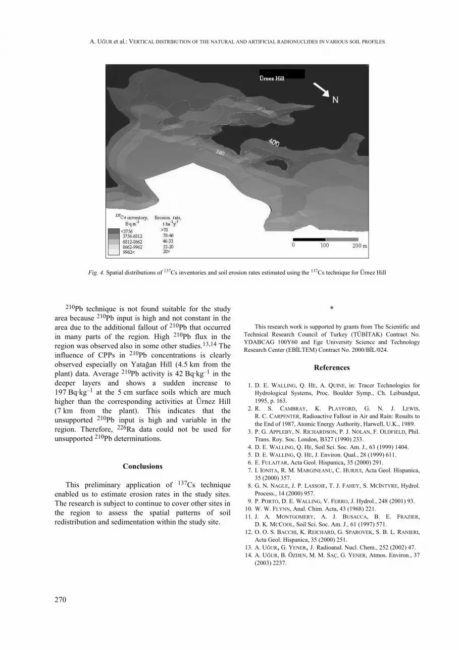
At Ürnez Hill in the profiles from cultivated site thetexture of the soil did not vary with depth but the 137Csand organic matter contents of the layers within theplough depth are almost uniform and than decreasedslightly again, indicating the strong relation betweenthem. For the uncultivated (reference) site the clayfraction decreases with depth while silt and sandincrease due to the fact that Rendoll type soils do nothave illivual horizon. Surfacial adsorbtion of 137Cs isslow due to the higher calcium carbonate content of thistype of soils. On the other hand, organic matter and137Cs contents are comparetively lower in deeper layersbut they do not show a clear decrease along the profileas it was observed in Yatağan soils. That is why adifferent model, namely proportional model which issuitable for cultivation areas, was used for erosion rateestimation at Ürnez Hill. 137Cs activities are relativelylow ranging from 24 to 5 Bq.kg–1 in bulk cores and themean 137Cs inventories in the summit, shoulder andfootslope of the hill are 3756, 8162 and 8662 Bq.m–2,respectively. The mean reference 137Cs inventory isfound to be 12487 Bq.m–2. Erosion rate intervals for
slope soil profiles estimated for Ürnez Hill are shown inFig. 4. The average soil loss estimated from these databy 137Cs technique was 47.44 t.ha–1.y–1.
The mean 226Ra activity concentrations in cultivatedand reference sites at Ürnez Hill are 24.2, 21.9 Bq.kg–1,respectively. At reference site at Ürnez Hill, the total210Pb activity concentrations varied between 83.1 and22.8 Bq.kg–1, with a sharp decline between the surfaceand deeper layers (Fig. 3).
An alternative approach, the Universal Soil LossEquation (USLE) was used to compare the results withthose of profile distribution and proportional models.Erosion rates estimated by USLE in Yatağan and ÜrnezHills are 28.6 and 45.6 t.ha–1.y–1, while 137Cs techniqueresults are 36.37 and 47.44 t.ha–1.y–1, respectively.These results are in agreement with the literature valuesthat erosion rates determined by radionuclide techniquesare in general higher than the ones obtained by USLE.12It could be attributed to the fact that USLE model hassome limitations while 137Cs technique covers all thefactors effecting erosion.
A. UĞUR et al.: VERTICAL DISTRIBUTION OF THE NATURAL AND ARTIFICIAL RADIONUCLIDES IN VARIOUS SOIL PROFILES
270
Fig. 4. Spatial distributions of 137Cs inventories and soil erosion rates estimated using the 137Cs technique for Ürnez Hill
210Pb technique is not found suitable for the studyarea because 210Pb input is high and not constant in thearea due to the additional fallout of 210Pb that occurredin many parts of the region. High 210Pb flux in theregion was observed also in some other studies.13,14 Theinfluence of CPPs in 210Pb concentrations is clearlyobserved especially on Yatağan Hill (4.5 km from theplant) data. Average 210Pb activity is 42 Bq.kg–1 in thedeeper layers and shows a sudden increase to197 Bq.kg–1 at the 5 cm surface soils which are muchhigher than the corresponding activities at Ürnez Hill(7 km from the plant). This indicates that theunsupported 210Pb input is high and variable in theregion. Therefore, 226Ra data could not be used forunsupported 210Pb determinations.
Conclusions
This preliminary application of 137Cs techniqueenabled us to estimate erosion rates in the study sites.The research is subject to continue to cover other sites inthe region to assess the spatial patterns of soilredistribution and sedimentation within the study site.
*
This research work is supported by grants from The Scientific andTechnical Research Council of Turkey (TÜBİTAK) Contract No.YDABCAG 100Y60 and Ege University Science and TechnologyResearch Center (EBİLTEM) Contract No. 2000/BİL/024.
References
1. D. E. WALLING, Q. HE, A. QUINE, in: Tracer Technologies forHydrological Systems, Proc. Boulder Symp., Ch. Leibundgut,1995, p. 163.
2. R. S. CAMBRAY, K. PLAYFORD, G. N. J. LEWIS,R. C. CARPENTER, Radioactive Fallout in Air and Rain: Results tothe End of 1987, Atomic Energy Authority, Harwell, U.K., 1989.
3. P. G. APPLEBY, N. RICHARDSON, P. J. NOLAN, F. OLDFIELD, Phil.Trans. Roy. Soc. London, B327 (1990) 233.
4. D. E. WALLING, Q. HE, Soil Sci. Soc. Am. J., 63 (1999) 1404.5. D. E. WALLING, Q. HE, J. Environ. Qual., 28 (1999) 611.6. E. FULAJTAR, Acta Geol. Hispanica, 35 (2000) 291.7. I. IONITA, R. M. MARGINEANU, C. HURJUI, Acta Geol. Hispanica,
35 (2000) 357.8. G. N. NAGLE, J. P. LASSOIE, T. J. FAHEY, S. MCINTYRE, Hydrol.
Process., 14 (2000) 957.9. P. PORTO, D. E. WALLING, V. FERRO, J. Hydrol., 248 (2001) 93.
10. W. W. FLYNN, Anal. Chim. Acta, 43 (1968) 221.11. J. A. MONTGOMERY, A. J. BUSACCA, B. E. FRAZIER,
D. K. MCCOOL, Soil Sci. Soc. Am. J., 61 (1997) 571.12. O. O. S. BACCHI, K. REICHARD, G. SPAROVEK, S. B. L. RANIERI,
Acta Geol. Hispanica, 35 (2000) 251.13. A. UĞUR, G. YENER, J. Radioanal. Nucl. Chem., 252 (2002) 47.14. A. UĞUR, B. ÖZDEN, M. M. SAÇ, G. YENER, Atmos. Environ., 37
(2003) 2237.