union county - scholars' bank
TRANSCRIPT

Union County
Transportation System Plan Final
August 1999
Prepared for
Union County
Prepared by Union County Planning Department
Dara Decker Stacy Warren Scott Hartell
Hanley Jenkins, II

Acknowledgements
This project was funded by a grant from the Transportation and Growth Management Program (TGM), a joint program of the Oregon Department of Transportation and the Department of Land Conservation and Development. TGM grants rely on federal Intermodal Surface Transportation Efficiency Act and Oregon Lottery Funds. The contents of this document do not necessarily reflect the views or policies of the State of Oregon. A special thank you to the following individuals, who have contributed significant time and effort to this project: • Norm Paullus, Union County Technical Advisory Committee Member • Larry Monical, Union County Technical Advisory Committee Member • Tom Carman, Union County Technical Advisory Committee Member • Howard Perry, Union County Technical Advisory Committee Member • Bob Wilkins, Union County Technical Advisory Committee Member • Steve Gurnsey, Union County Technical Advisory Committee Member • Colleen MacLeod, Union County Commissioner & Technical Advisory Committee
Member • Richard Comstock, Union County Public Works Director • Bob Kelly, Union County Assistant Public Works Director • Bob Clark, Union County Traffic Specialist • Cheryl Jarvis-Smith, Transportation Growth Management Coordinator • Teresa Penninger, ODOT Region 5 Modal Planner • John Preston, ODOT Region 5 Planner • Theresa Yih, ODOT Bridge Section • Mike Buchanan, ODOT District 13 Manager • Tom Kuhlman, ODOT Region 5 Traffic Operations Manager • ODOT Region 5 Student Interns Special recognition should also be given to Hann Lee of H. Lee and Associates for providing the necessary technical analysis for this project.

Union County Transportation System Plan
Table of Contents Union County Transportation System Plan
Chapter 1 – Introduction ........................................................................................1
Chapter 2 – Goals and Objectives..........................................................................7
Chapter 3 – Transportation System Inventory.......................................................9
Chapter 4 – Current Transportation Conditions ....................................................23
Chapter 5 – 2018 Traffic Volume Forecast ...........................................................39
Chapter 6 – Transportation Improvement Options................................................43
Chapter 7 – Transportation System Plan and Recommendations..........................59
Chapter 8 – Funding Options.................................................................................78
Chapter 9 – Recommended Policy and Ordinance Amendments..........................83
APPENDICES
A. Public Involvement Record
B. Existing Conditions Inventory
C. Union County Bicycle and Pedestrian Plan
D. ODOT Analysis of Booth Lane/Hunter Road Intersection
E. “The Grande Tour” Brochure

Union County Transportation System Plan
List of Tables and Figures Union County Transportation System Plan
Table 3-1 Existing Union County Functional Classifications................................................13 Table 3-2 Recommended Union County Functional Classifications .....................................14 Table 3-3 Based Aircraft and Operations Forecast ................................................................22 Table 4-1 Summary of Seasonal Adjustment Factors ............................................................25 Table 4-2 Truck Volume and Percentage Summary ..............................................................26 Table 4-3 Level of Service Criteria for Unsignalized Intersections.......................................27 Table 4-4 Level of Service Criteria for Roadway Mid-Blocks ..............................................28 Table 4-5 Existing Intersection Level of Service ...................................................................29 Table 4-6 Existing Arterial Roadway Level of Service Summary.........................................30 Table 4-7 Roadway Segment Accident Summary..................................................................31 Table 4-7A Roadway Segment Accident Summary, Continued ...............................................32 Table 4-7B Roadway Segment Accident Summary, Continued ..............................................33 Table 4-8 Intersection Accident Summary.............................................................................34 Table 4-8A Intersection Accident Summary, Continued ..........................................................35 Table 4-9 Departure to Work Distribution .............................................................................36 Table 4-10 Journey to Work Trips ...........................................................................................36 Table 5-1 Union County Historic Population Growth Trend.................................................39 Table 5-2 Union County Historic Traffic Growth Trend on State Highways........................39 Table 5-3 2018 Intersection Level of Service ........................................................................41 Table 5-4 2018 Arterial Roadway Level of Service Summary ..............................................42 Table 6-1 Union County Recommended Bicycle and Pedestrian Projects ............................51 Table 7-1 Current Road Development Standards for Union County .....................................59 Table 7-2 Recommended Road Development Standards for Union County .........................61 Table 7-3 Oregon State Highway Access Management Standards ........................................63 Table 7-4 State Identified Transportation System Recommendations ...................................64 Table 7-5 Locally Identified Recommended Transportation Projects ...................................66 Table 7-6 Union County Recommended Bicycle and Pedestrian Projects ............................68 Table 7-7 Committed & Preliminary STIP Transit Grant Applications.................................73 Table 7-8 La Grande/Union County Airport 20-Year Capital Improvement Program ..........74 Table 7-9 TSP Capital Improvement Program.......................................................................75 Table 8-1 Road Revenue Allocation by Jurisdiction Level....................................................78 Table 9-1 Required Code Elements of the Transportation Planning Rule .............................83
Follows Page Figure 1-1A Union County Planning Area, North Section .......................................................1 Figure 1-1B Union County Planning Area, South Section........................................................2 Figure 3-1A Recommended Street Classifications, North Section ...........................................14 Figure 3-1B Recommended Street Classifications, South Section ...........................................15 Figure 3-2 Airport Overlay Zone ............................................................................................20 Figure 4-1 1998 Existing AM and PM Peak Hour Traffic Volumes ......................................23 Figure 5-1 2018 AM and PM Peak Hour Traffic Volumes.....................................................39 Figure 6-1 Airport Layout Plan ...............................................................................................57

Union County Transportation System Plan
Figure 7-1 Recommended Typical Cross Sections ................................................................59 Figure 7-2 Roadway Improvement Projects...........................................................................66 Figure 7-3A Bicycle and Pedestrian Plan, North Section .........................................................69 Figure 7-3B Bicycle and Pedestrian Plan, South Section..........................................................70 Figure 8-1 State Highway Fund ..............................................................................................78

Union County Transportation System Plan
CHAPTER 1: INTRODUCTION The Union County Transportation System Plan (TSP) identifies existing transportation facilities and provides guidelines for future planned and constructed transportation facilities until the year 2018. This TSP updates the transportation element of the Union County Land Use Plan and replaces the 1979 Union County Transportation Plan. It is intended to satisfy the requirements of the Oregon Transportation Planning Rule (TPR) and implement Statewide Planning Goal 12: Transportation, which is Oregon’s transportation planning law. The TPR requires local jurisdictions to coordinate land use and transportation planning, and to consider all modes of travel. It is important to recognize the relationship between land use and transportation because vehicle trip generation is a direct result of land use. Intense land uses produce large amounts of traffic. If the transportation system around these land uses cannot accommodate the traffic, then congestion, delays, and pollution can degrade quality of life and harm business opportunities. Planning for future development in conjunction with planning the future transportation system results in the most efficient possible transportation system. Identifying transportation needs for the next 20 years also provides the opportunity to plan the most equitable and economically beneficial transportation system for Union County. The TSP takes into account surrounding land uses as it identifies potential transportation projects. PLANNING AREA The TSP planning area includes all areas inside Union County but outside established Urban Growth Boundaries (UGB). Located along the Interstate 84 corridor in the northeast corner of Oregon, Union County is approximately 250 miles east of Portland, Oregon and 160 miles northwest of Boise, Idaho. The county area is 2,038 square miles and contains an estimated population of 24,500 people. The Grande Ronde Valley floor supports extensive agricultural activities. Principal industries include agriculture, timber, and public employment. The natural beauty of Union County provides a stunning backdrop for many outdoor activities, including skiing, hunting, fishing, and hiking. National Forest land comprises the majority of the 49% publicly owned lands in Union County. A large foldout map showing the Union County planning area is located in Figures 1-1A and 1-1B. The maps show state highways, county roads, and key United States Forest Service (USFS) roads. The major transportation corridors are primarily comprised of state facilities. Six highways (including Interstate 84) link 7 of the 8 county incorporated jurisdictions. Interstate 84 is part of the federal interstate system, providing Union County with a significant link to the surrounding region and other parts of the country. Though five of the six facilities originate in Union County, none of them terminate within the county’s boundaries. At the local level, these transportation corridors are principal arterials, and support a large volume of freight and passengers. In addition to state facilities, a web of county roads connects the state system and outlying jurisdictions. The county road system serves many purposes but the primary function is individual property access. County roads also provide connectivity between urban street grids, agricultural activities, recreational areas, and national forests. USFS roads are important roads in Union County because they provide access to the surrounding Umatilla and Wallowa-Whitman National Forests.
1


Union County Transportation System Plan
PLANNING PROCESS The Union County Transportation System Plan is part of a larger project funded by the Transportation and Growth Management Program to also develop individual TSPs for the incorporated jurisdictions of Imbler and Elgin. The Imbler and Elgin City Councils served as the Technical Advisory Committees (TACs). In Union County, the County Transportation Advisory Committee served as the Technical Advisory Committee. Important components of the process include: • Involving the Union County community (Chapter 1) • Developing goals and objectives (Chapter 2) • Reviewing existing plans, policies, and transportation conditions (Chapters 3 & 4) • Developing travel volume forecasts (Chapter 5) • Developing and evaluating potential transportation system improvements (Chapter 6) • Developing the modal plans (Chapter 7) • Identifying funding options (Chapter 8) • Developing implementing policy and ordinance amendments (Chapter 9) Community Involvement Community involvement is an important aspect of any planning process. Part of the transportation planning process includes providing opportunity for the public to participate in the development of the Union County Transportation System Plan. The opportunity for the public to become involved depends on distribution of notice to affected citizens. Letters mailed to stakeholders, local officials, and interested citizens are the most direct method of notification, and proved most useful to Union County. Posters, flyers, and public service announcements in local newspapers also serve to notify citizens of upcoming opportunities for public participation. At each public meeting, comment cards were available to those who wished to write down their comments and recommendations. A public involvement record is included in Appendix A. Goals and Objectives The goals and objectives of the Union County TSP were developed using input from the TAC. These goals and objectives were used to make decisions about potential improvement projects. They are described in Chapter 2. Review and Inventory of Existing Plans, Policies, and Public Facilities In order to understand the present conditions of the current transportation system, and to identify system deficiencies, an analysis of existing plans and policies took place, as well as an inventory of the current system and facilities. The purpose of this inventory and analysis is to assess Union County’s growth and development based on existing policies and ordinances, and to catalog the current transportation system and facilities. The inventory of existing conditions is included in Appendix B and is explained in detail in Chapter 3, while Chapter 4 describes how the system functions. Future Transportation System Demands The Transportation Planning Rule requires a 20-year forecast be incorporated into each TSP. Future traffic volumes for the existing, plus committed, transportation system were projected using ODOT’s Level 1 - Trending Analysis methodology. The travel forecasts are discussed in detail in Chapter 5.
4

Union County Transportation System Plan
Potential Transportation System Improvements Once future traffic volumes were developed, then an evaluation of several potential improvement projects took place. These potential projects were also weighed against the goals and objectives identified in Chapter 2. The evaluation of potential improvements was based on many factors, including the estimated cost of each project, land use impacts, safety, and equity to all transportation users. The potential improvement projects were identified with the help of the TAC, community members, and Union County staff. After an assessment of the potential improvement projects was complete, recommended transportation system improvements were selected. These recommended system improvements are detailed in Chapter 6. Transportation System Plan The Transportation System Plan addresses all modes of travel for Union County. This section of the TSP provides a framework for implementation by including street design standards, access management standards, and a capital improvement program. The roadway system plan was developed from the traffic forecasting analysis and evaluation of potential transportation improvement projects. The Union County Bicycle and Pedestrian Plan is a separate document adopted by the Union County Commissioners on October 2, 1996. The public transportation, rail, air, pipeline, and waterborne transportation plans were developed based on discussions with the owners and operators of the facilities and services. Chapter 7 details each of the modal plans and discusses street standards and access management techniques. Funding Options Union County will have to work with ODOT and each of the other eight county incorporated jurisdictions to pay for new transportation projects over the next 20 years. A survey of potential financing and funding opportunities is described in Chapter 8. Recommended Policies and Ordinances Recommended policy and ordinance amendments for the Union County Land Use Plan and the Union County Zoning, Partition, and Subdivision Ordinance are included in Chapter 9. These policy and ordinance changes are necessary in order to implement the TSP and meet the requirements of the TPR. RELATED DOCUMENTS The Union County TSP addresses regional and local transportation needs in the rural portions of the county. There are several other documents related to specific local and regional transportation needs, which are listed below. City Transportation System Plans Three city TSPs were developed and adopted during the summer of 1998 for communities in the southern portion of Union County. These are: • City of Cove Transportation System Plan • City of Union Transportation System Plan • City of North Powder Transportation System Plan Additionally, La Grande and Island City are in the process of preparing a joint TSP to address transportation needs within both cities. This TSP is slated for adoption during fall 1999. In conjunction with the Union County TSP, two more city TSPs were developed. These are: • City of Elgin Transportation System Plan • City of Imbler Transportation System Plan
5

Union County Transportation System Plan
All small city TSPs address local needs within each community’s Urban Growth Boundary (UGB). Each plan describes street development standards, access management standards, a Street System Plan showing the layout of future streets, modal plans, and policy and ordinance changes necessary for the implementation of each TSP. There are instances where projects that are identified in the individual city TSPs also need to be addressed in the County’s TSP. These projects include: • A multi-use path along the abandoned Idaho Northern Pacific railroad right-of-way between Elgin
and Joseph. (Elgin TSP) • Improvements to, and possible reconstruction of, Godley Lane. (Union TSP) Corridor Strategies Oregon Highway 82 is a highway of statewide significance and constitutes a major transportation corridor in Union County. A final Oregon Highway 82 Corridor Plan was completed in May, 1998 and details several corridor strategy objectives in order to protect the function of the state highway system. Other Plans The Union County TSP will coordinate with the Oregon Highway 82 corridor strategies as well as the following plans: • Oregon Transportation Plan (1992) • Oregon Highway Plan (1991) • Union County Bicycle and Pedestrian Plan (1996) • Oregon Aviation System Plan (1974 – currently being updated) • La Grande/Union County Airport Master Plan Update (1998) • Oregon Rail Freight Plan (1994) • Oregon Public Transportation Plan (1997)
6

Union County Transportation System Plan
CHAPTER 2: GOALS AND OBJECTIVES The following goals and objectives provide a framework against which to compare each element of the TSP; specifically, the potential transportation system improvement projects. These goals and objectives were developed with input from the Technical Advisory Committee. OVERALL TRANSPORTATION GOAL Develop a transportation system that enhances the livability of Union County and accommodates growth and development through careful planning and management of existing and future transportation facilities. GOAL 1: Improve and enhance safety and traffic circulation on the county road system. Objectives: A) Develop an efficient road network for the county. B) Improve and maintain existing roadways. C) Ensure planning coordination between the county and the state. D) Identify truck routes to reduce truck traffic in urban areas where needed. E) Ensure that roads created in land division and development be designed to tie into existing and
anticipated road circulation patterns. F) Review and revise, if necessary, street cross section standards for local, collector, and arterial streets
to enhance safety and mobility. G) Evaluate the need for traffic control devices. H) Analyze the safety of traveling speeds and consider proposals to modify posted speeds. I) Identify local problem spots and recommended solutions. GOAL 2: Preserve the function, capacity, level of service, and safety of the state highway system. Objectives: A) Develop access management standards. B) Develop alternative, parallel routes. C) Promote alternative modes of transportation. D) Promote demand management (rideshare, park & ride). E) Promote transportation system management (signal synchronization, median barriers, etc.) F) Develop procedures to minimize impacts to and protect transportation facilities, corridors, or sites
during the development review process. G) Promote railroad freight service. GOAL 3: Identify the 20-year roadway system needs to accommodate developing or undeveloped areas without undermining the rural nature of Union County. Objectives: A) Adopt policies and standards that address street connectivity, spacing, and access management. B) Integrate new arterial and collector routes into improved grid systems with an emphasis on
removing the pressure from traditionally heavy traffic collectors. C) Examine improved access into and out of the county for goods and services. D) Explore improved access on and off arterials to encourage growth.
7

Union County Transportation System Plan
E) Determine whether there are opportunities to promote railroad freight service to reduce truck-related traffic.
GOAL 4: Increase the use of alternative modes of transportation (walking, bicycling, rideshare/carpooling, and transit) through improved access, safety, and service. Objectives: A) Identify where shoulder bikeways are appropriate on rural collector and arterial roads. B) Promote alternative modes and rideshare/carpool programs through community awareness and
education. C) Promote future expanded transit service by recommending funding to local transit efforts and
seeking consistent state support. D) Promote air freight and air passenger service to and from the La Grande/Union County Airport.
8

Union County Transportation System Plan
CHAPTER 3: TRANSPORTATION SYSTEM INVENTORY Part of the planning process includes an inventory of Union County’s existing transportation system. The inventory records the roadway system and roadway classifications, pedestrian and bicycle facilities, public transportation, rail service, and whether air service, pipeline systems, and waterborne transportation are present. ROADWAY SYSTEM The most obvious element of the transportation system is the roadway system. Historically, reliance on the automobile and rapid urbanization have led to the majority of transportation dollars being spent on building and maintaining roads. Recently, consideration of other modes, in addition to vehicular travel, has emerged as an alternative focus for transportation dollars. This TSP inventories and discusses all modes of travel, but in rural Union County, the automobile remains the prevalent mode. As a result, over the 20-year planning period, the roadway system will remain the emphasis of the transportation system; therefore, maintaining a safe, equitable transportation system is the primary focus of this TSP. The existing roadway system in Union County was inventoried through several different methods and includes facilities under different jurisdictions. All state highways and county arterials, collectors, and local roads included in the planning area were cataloged. Components of the inventory include: • Road name, classification, and jurisdiction • Road length, pavement width and total right-of-way width • Road surface and surface condition • Number of travel lanes • Presence of parking, bicycle, and pedestrian facilities • Posted speed limits The complete inventory of Union County’s roadway system is included in Appendix B. Roadway Classification Roads inventoried for the TSP include those under federal, state, and county jurisdiction. Each jurisdiction has a separate process for identifying road classifications based on the road function. The TSP recognizes state and federal road classifications as being separate from the county classification system. Union County roadways are classified into three categories, which are rural arterials, rural collectors, and rural local roads. State Highways In Union County, state highways serve as principal arterials and form the basis of the primary road network. This network facilitates the movement of large volumes of people and freight within and throughout Union County and the outlying area. State highways also link outlying jurisdictions and provide connections with the greater region and surrounding states. Though the purpose of an arterial is to expeditiously move cars and trucks from one destination to the next, state highways also serve to access property. This is evident in Union County where the state highways accommodate local, regional, and statewide transportation needs. In Union County, there are six state highways: Interstate 84, Oregon Highway 82, Oregon Highway 237, Oregon Highway 203, Oregon Highway 204, and Oregon Highway 244. These principal transportation routes carry most of the county’s traffic, and as a result, these routes link most of the
9

Union County Transportation System Plan
commercial and industrial development. This TSP, however, is primarily concerned with the sections of state highways that lie in the rural portions of Union County because incorporated jurisdictions’ TSPs address the urban sections of state highways. The Oregon Department of Transportation (ODOT) has a highway classification system to prioritize improvement needs and define operational objectives. The 1991 Oregon Highway Plan identifies four levels of importance, which are: interstate, statewide, regional, and district. A primary and secondary function is designated for each level of importance, as well as management objectives to guide highway operation. Union County has one highway of interstate significance, Interstate 84; one highway of statewide significance, Oregon Highway 82; one highway of regional significance, Oregon Highway 204; and the remaining three highways are of district significance, Oregon Highways 244, 203, and 237. Interstate 84 Interstate 84 (I-84) traverses about 44 miles of Union County in a southeasterly direction. It enters Union County from Umatilla County near Kamela and exits into Baker County near North Powder. Interstate 84 is part of the federal interstate system and has two eastbound travel lanes and two westbound travel lanes. It is a fully controlled facility, therefore, there are no connecting roadways except for interchanges. I-84 has a posted speed of 55 for trucks and 65 for passenger vehicles. The pavement condition is generally “good.” There are no pedestrian or bicycle facilities, though cyclists do utilize the shoulder on extended bicycle trips. Interstate 84 is a highway of interstate significance, and according to the 1991 Oregon Highway Plan, the primary function of interstate highways is to provide connections and links to major cities, regions of the state, and other states. The management objective is to provide for safe and efficient high-speed, continuous-flow operation of vehicles in both urban and rural areas. Oregon Highway 82 Oregon Highway 82 extends approximately 33 miles in a northeasterly direction to the Wallowa County line, connecting Interstate 84 and La Grande to Imbler and Elgin, and eventually terminating at Wallowa Lake in Wallowa County. Oregon Highway 82 is a two-lane, paved highway with a posted speed of 55 miles per hour, except within cities, and potentially hazardous areas due to topography or weather. Pavement condition is generally “good.” There are passing lanes in the corridor that facilitates the movement of slow-moving vehicles, so traffic can move in an efficient manner and safety is not compromised. Turn refuge lanes are provided at different high volume locations to facilitate turning movements without jeopardizing safety or through travel. In rural areas, the highway does not have dedicated pedestrian or bicycle facilities but bicyclists commonly travel along the paved shoulders, which are typically 4 feet wide. Land uses along the highway in rural areas are generally zoned for exclusive farm use. County roads connect with the state highway to provide access to public and private lands. Oregon Highway 82 is a highway of statewide significance whose purpose is to provide connections and links to larger urban areas, ports and major recreation areas that are not directly served by interstate highways. Statewide highways also provide connection to the interstate system. The management objective of statewide highways is to provide for safe and efficient high-speed, through travel in rural areas and high-to-moderate speed traffic flow with limited interruptions in urban and urbanizing areas. According to the 1991 Oregon Highway Plan, Oregon Highway 82 is part of the Access Oregon Highway classification system which was developed in order to identify a network of primary statewide highways that link major economic and geographic activity centers to each other, to other high level highways, to ports, and to other states. Designation as an Access Oregon Highway means that the Oregon Highway 82 corridor is a top priority for improvement project funding. Oregon Highway 82 is
10

Union County Transportation System Plan
also part of the Hells Canyon Oregon Scenic Byway system and portions of the corridor in Wallowa County are part of the Oregon Scenic Waterway and National Wild and Scenic Study Corridor, which is tied to the Wallowa and Minam River systems. According to the Oregon Highway 82 Corridor Plan, “the overall strategy for the Highway 82 Corridor is to maintain the condition and increase the functionality of existing transportation facilities.”1 Corridor strategy objectives were identified in order to achieve the overall strategy and are grouped into either “transportation performance measures” or “transportation impacts.” These are terms developed by ODOT to provide common language for statewide corridor analysis and are based on Oregon Transportation Plan goals and policies. Each corridor strategy objective is also associated with specific “decisions.” Decisions can be either “management decisions,” “capital improvement decisions,” or “service improvement decisions.” These decisions, then, become the recommended improvement projects from the plan for the next 20 years. ODOT chose to use the term “decision” in order to demonstrate that some action was proposed to address an identified need within the corridor. These decisions, or improvement projects, will be implemented through the Statewide Transportation Improvement Program (STIP) and the ODOT Region 5 work program. The STIP balances recommended improvement projects from the Oregon Highway 82 Corridor Plan with other recommended improvement projects throughout the state in order to achieve a safe, efficient, and equitable transportation system. Each decision, or recommended improvement project, is prioritized as a “near” (0-5 years), “mid” (5-10 years), or “long” (10-20 years) term project. A more detailed discussion of improvement projects follows in Chapter 6. Oregon Highway 204 Oregon Highway 204, also known as the Weston-Elgin Highway, is a highway of regional significance. It originates in Weston (Umatilla County) and extends roughly 20 miles in a southeasterly direction to its terminus at the junction with Oregon Highway 82 in Elgin. It is a two lane, paved highway with turn-outs provided for slow-moving vehicles, and snow storage during periods of heavy snow. There are no pedestrian facilities but there are two-foot wide paved shoulders. Posted speeds are 55 miles per hour, except where topography or weather necessitates lower speeds, or within cities. Generally, pavement conditions are “fair” to “poor.” Land uses along the highway in rural areas are generally zoned for timber and grazing uses. County and Forest Service roads connect with the state highway to provide access to resource lands. The primary function of regional highways is to provide connections and links to areas within regions of the state, between small, urbanized areas and larger population centers, and to higher level facilities. A secondary function is to serve land uses in the vicinity of these highways. The management objective of regional highways is to provide for safe and efficient high-speed, through travel in rural areas, except where there are significant environmental constraints, and moderate-to-low speed traffic operation in urban and urbanizing areas with moderate interruptions of traffic flow.
1 Otak, “Oregon Highway 82 Corridor Plan,” May 1998, 7-1.
11

Union County Transportation System Plan
Oregon Highways 203, 237, and 244 Oregon Highway 203 originates in La Grande and extends in a southeasterly direction to Union and continues on to Medical Springs at the southern boundary of Union County. This section of highway is approximately 30 miles in length. Oregon Highway 203 terminates at its junction with Interstate 84 in Baker County. Oregon Highway 237 extends about 46 miles from Island City east to Cove and continues in a southerly direction to Union, terminating in North Powder. Both Oregon Highway 203 and Oregon Highway 237 are important connectors for the southeast portion of Union County and at one time provided the only links with Baker County and the eastern region of the state. Oregon Highway 244 originates in the City of Ukiah (Umatilla County). In Union County, the highway extends about 25 miles in a northeasterly direction to its terminus at Interstate 84 near Hilgard Junction State Park. This state facility provides access to Ukiah from Interstate 84 and provides an important link to the north-central region of Oregon. Oregon Highways 203, 237, and 244 are district level highways, which are two lane, paved highways with generally “fair” to “good” pavement conditions. Posted speed is 55 miles per hour, except where topography or weather necessitates lower speeds, or within cities where highways are subject to lower speeds. Highway 237 provides a two-foot gravel shoulder that is utilized by bicyclists but Oregon Highways 203 and 244 provide very little shoulder. In urban areas, pedestrian facilities are present. Land uses along the highways in rural areas are generally zoned for exclusive farm use, or timber and grazing uses. County and Forest Service roads connect with the state highways to provide access to resource lands. The primary function of district highways is to serve local traffic and land access. These highways are often routes that held a higher function during the early development of Oregon’s highway system. The management objective of district highways is to provide for safe and efficient moderate-to-high speed, through travel in rural areas, and moderate-to-low speed traffic operation in urban and urbanizing areas with a moderate-to-high level of interruption in traffic flow. U.S. Forest Service Roads The U.S. Forest Service has jurisdiction over a significant number of roads in Union County. Most of these Forest Service roads are located in the Wallowa-Whitman National Forest. The primary function of these roads is to provide access for commercial and recreational vehicles. Figures 3-1A and 3-1B show major U.S. Forest Service roads and their connections to the Union County road system. The U.S. Forest Service is not a public road agency; therefore, responsibilities and liabilities are not the same as those for the county and state. Roads may be closed, opened, and maintained as use, environmental constraints, and budgetary constraints dictate. U.S. Forest Service road maintenance level descriptions can be obtained from any U.S. Forest Service office, and are located in the Forest Service Handbook (FSH), Section 7709.58, Chapters 10 and 12.3. County Roads Union County has 188 public and public use roads totaling approximately 650 miles in its jurisdiction. These roads connect with the state highway system to form a network that provides circulation between towns, cities, and rural areas, and provides individual land access. County roads are generally two-lane facilities, though some of the less traveled, primitive roads become one-lane facilities with turnouts. There is no on-street parking or identified pedestrian facilities provided on county roads in the rural areas. The adopted Union County Bicycle and Pedestrian Plan identifies bicycle facilities on selected
12

Union County Transportation System Plan
county roads and is included in Appendix C. Recommended roadway functional classifications for Union County are shown in Figures 3-1A and 3-1B. For the purposes of the TSP, county roads are divided into three functional classifications. Functional classifications for state highways are determined at the state level. Their function is mobility (movement through Union County) versus access (movement to a specific destination within Union County), and they carry the highest traffic volumes. County roads are designated either as rural arterials, rural collectors, or rural local roads based on their function. Rural arterials carry higher traffic volumes than rural collectors or rural local roads, and their function is to facilitate efficient traffic and freight movement. Rural collectors balance mobility and access. Most collectors are paved, but some are gravel. Local roads carry the lowest traffic volumes and their purpose is primarily to provide access to individual properties. Rural local roads are largely gravel. Table 3-1 lists existing rural arterials and collectors. County roads not identified as rural arterials or collectors are classified as local roads. Table 3-2 lists the recommended rural functional classifications. Figures 3-1A and 3-1B depict the roadway system and recommended functional classifications for Union County.
Table 3-1 Existing Union County Functional Classifications
Union County Rural Arterials Summerville Road Hunter Road Dry Creek Lane Mt. Glen Road Market Lane Lower Cove Road Booth Lane Pierce Road Buchanan Lane North Powder River Lane Grande Ronde River Road Union County Rural Collectors Palmer Junction Road Valley View Road McKenzie Lane Courtney Lane Brooks Road Woodell Lane Gekeler Lane Foothill Road Airport Lane Hot Lake Lane High Valley Road Mill Creek Lane Lantz Lane Haefer Lane Stackland Road
13

Union County Transportation System Plan
Table 3-2 Recommended Union County Functional Classifications
Union County Rural Arterials Summerville Road Hunter Road Market Lane Lower Cove Road Pierce Road – Foothill Exit to Oregon Highway 82 North Powder River Lane Palmer Junction Road Mt. Glen Road – La Grande City Limit to Booth Lane McAlister Road – Buchanan Lane to Oregon Highway 203 Union County Rural Collectors Valley View Road McKenzie Lane Courtney Lane Brooks Road Woodell Lane Gekeler Lane – McAlister Road to Pierce Road Airport Lane – Pierce Road to east airport property Hot Lake Lane Mill Creek Lane Lantz Lane Haefer Lane – to Stackland Road Stackland Road Dry Creek Lane Booth Lane – Mt. Glen Road to Oregon Highway 82 Buchanan Lane – La Grande east City Limit to McAlister Road Grande Ronde River Road Walton Road Mt. Glen Road – Booth Lane to Standley Lane Standley Lane – Mt. Glen Road to Hunter Road Bridges There are 203 bridges in Union County on both county and state facilities. Union County has 70 bridges in its jurisdiction, 22 of which are less than 20 feet in length, making them ineligible for federal rehabilitation funding. ODOT has 133 bridges on its system. Union County bridges are relatively new, or have recently undergone maintenance and improvement. The process for determining the priority of bridge rehabilitation projects is dependent upon several factors. ODOT has a program where a consultant bridge inspector is retained to inspect bridge facilities. Specific elements, such as structural conditions and functional obsolescence, are evaluated. A complex formula based on several factors is used to rate each bridge. The rating system ranges from 0 to 100 with numbers over 80 indicating bridge sufficiency. Bridges can, however, be considered functionally obsolete yet still be structurally sound. This means that the bridge no longer meets minimum horizontal or vertical size requirements because the amounts and types of vehicles have changed over time, yet the integrity of the structure is not compromised. Bridge ratings then serve to prioritize maintenance and rehabilitation projects. This information is forwarded to the appropriate
14


Union County Transportation System Plan
governmental unit. Union County’s Public Works Department analyzes the information and determines local rehabilitation and maintenance projects based on the inspector recommendations, bridge ratings, and available funding. See Chapter 4 for a list of deficient and obsolete bridges. PEDESTRIAN SYSTEM Walking is a popular form of exercise, as well as the most basic form of transportation for people of all ages and income levels. Everyone is a pedestrian, yet in rural Oregon, pedestrian facilities are seldom designed as an integral component of the road system. According to the Oregon Bicycle and Pedestrian Plan, a person in reasonable physical condition can walk up to one kilometer (about .6 miles) in less than twenty minutes with minimal physical exertion. This makes walking a viable alternative to many short commuter trips, and actually may take less time than driving a car. Most pedestrian traffic in Union County is concentrated within Urban Growth Boundaries where dense commercial and residential activity, including school activity, is centered. Since several miles separate each of the incorporated towns and cities in Union County, pedestrian traffic between each of these cities does not exist and is unlikely. County roads and state highways outside of UGBs do not have designated pedestrian facilities. One exception is along Oregon Highway 82 between La Grande and Island City. A continuous sidewalk exists along the south side of Oregon Highway 82, linking La Grande and Island City. This is a well-used route for the disabled and pedestrians of all ages. In the rural portions of Union County, pedestrian activity is typically for exercise. Pedestrians utilize the shoulder of the road, and can generally do so safely because traffic volumes are relatively low. There are also many hiking trails present in the Umatilla and Wallowa-Whitman National Forests. BIKEWAY SYSTEM Bicycle facilities, like pedestrian facilities, are seldom designed as an integral component of the road system. Often, bikeways are added as an afterthought, and as a result, conflicts between cyclists and vehicles can occur, compromising safety. Cycling is an efficient mode of travel, with the average bicycle trip being two miles in length, and cycling mitigates some of the negative impacts of growth, such as air and water pollution, traffic congestion, and noise. The Union County Board of Commissioners adopted the Union County Bicycle and Pedestrian Plan on October 2, 1996. This plan identifies appropriate roads, based on traffic volumes and posted speeds, that could safely accommodate bicycle traffic. Few of these roadways contain facilities designated only for bicycle travel; the majority of bicycle travel is conducted in shared travel lanes with vehicles or on roadway shoulder bikeways. Incorporated jurisdictions and the rural portions of Union County see a moderate level of bicycle use, both for recreational and transit purposes. Bicycle travel between cities commonly occurs on arterials and collectors. The recommendations from the Union County Bicycle and Pedestrian Plan will expand and enhance bicycle travel along these roads and is included in Appendix C. The Union County Bicycle and Pedestrian Plan was funded by the Transportation and Growth Management Program and prepared in accordance with the TPR. The plan identifies a set of goals and objectives to guide the development of safe and efficient bikeway systems for the rural portions of Union County. The plan was developed involving citizen participation and was guided by the Union County Bicycle Advisory Committee.
17

Union County Transportation System Plan
PUBLIC TRANSPORTATION SYSTEM Public transportation in Union County is provided by Community Connection, who provides transit services to the general public. Client transport services are provided by New Day Enterprises and the Center for Human Development for the elderly and disabled. Shelter from the Storm provides transportation to those escaping crisis situations, such as an abusive relationship, on a strictly volunteer basis. Wallowa Valley Stage Line, Blue Mountain Cab Company, Greyhound Bus Lines, and Mid-Columbia Bus Company offer a variety of specific transportation services, all affecting Union County. Community Connection is a Dial-A-Ride transit service begun originally for the transportation disadvantaged, but has expanded to serve the general public. Requests for rides should be made a day in advance. The service area includes La Grande, Island City, Elgin, Cove, and Union. The bus fare is 50 cents per one way trip and $1.00 per round trip. A monthly transportation pass may be purchased for $20.00 for La Grande service only. Community Connection has six vans; four utilized in La Grande, one utilized in Elgin, and one utilized in Cove/Union. La Grande has one 15-passenger bus, one 14-passenger bus, one ADA mini-bus, and one 12-passenger bus. All vehicles except the 12-passenger bus are ADA accessible. Elgin has one 10-passenger bus, and Union has one 8-passenger bus; both of which are ADA accessible. Community Connection provides transit service within the La Grande/Island City area on a Dial-A-Ride basis between 7:00 A.M. to 6:00 P.M., Monday through Friday. Transit service in Cove, Union, and Elgin operates two days per week. All drivers are volunteers. On Tuesdays, the Union bus travels between Cove and Union, with a focus on the Union Senior Meal Site. On Wednesdays, the Union bus travels between Cove and Union, and then travels to La Grande. The Elgin bus also operates on Wednesdays, traveling to Elgin and Imbler, then continuing to La Grande. On Thursdays, the Elgin bus provides transit exclusively in Elgin, with a focus on the Elgin Senior Meal Site. Community Connection is projecting a substantial ridership increase. In the mid-1990s, countywide, Community Connection served about 13,650 rides per year, and this is anticipated to grow to 27,000 rides per year. New Day Enterprises and the Center for Human Development both provide client transportation only. New Day Enterprises operates three lift-equipped vans, one lift-equipped mini-van, two standard vans, one standard mini-van, one lift-equipped station wagon, and one lift-equipped bus. The Center for Human Development operates one lift-equipped van, one lift-equipped bus, and three standard vans. These vehicles are used to transport group home clients on a 24-hour basis. Additionally, Union-Wallowa County Veteran’s Services has one 8-passenger van stationed in La Grande for the transportation of veterans to the Veteran’s Administration Hospital in Walla Walla, Washington two times per month. The van also travels periodically to Portland, Oregon. This van is used for medical transportation only and transported 700 people in 1997. There is no cost to passengers. The Veteran’s Administration Hospital pays for vehicle maintenance and fuel and drivers are volunteers. Together Community Connection, New Day Enterprises and the Center for Human Development provide necessary transit services for the transportation disadvantaged of Union County. In 1990, these three non-profit groups formed the Union County Transportation Coalition to pool resources in an effort to lower the cost per trip, and to efficiently increase service in Union County without duplicating services. Shelter from the Storm is a non-profit organization that focuses on helping people through crisis situations. Their transportation program is voluntarily staffed and is comprised of rural outreach to those who are isolated from a range of services, including legal and medical services, trips to the grocery store, and trips to/from school. The largest obstacle to consolidating with the Union County Transportation Coalition is the varied needs of their clients. Because they are a crisis response organization, their transit needs do not often overlap with Community Connection or even local taxi service.
18

Union County Transportation System Plan
The Wallowa Valley Stage Line is owned by Moffit Brothers Transportation and is based out of the City of Lostine (Wallowa County). An 8-person van operates daily, except Sundays and holidays, between Joseph in Wallowa County and La Grande in Union County with stops in Enterprise, Lostine, Wallowa, Minam, Elgin, Imbler, and Island City. This transit service is a fixed route service but during the summer months, Wallowa Lake is added to the route on an on-call basis only. Scheduled departure from Joseph is 6:30 A.M. with arrival in La Grande at 8:45 A.M. and the return trip is scheduled to depart from La Grande at 11:55 A.M. with arrival in Joseph at 2:45 P.M. The cost for a one-way trip from Joseph to La Grande is $8.80 while a round trip costs $15.85. Fare prices vary depending upon trip length. Wallowa Valley Stage Line does not currently have a van with wheelchair transport capabilities but is taking steps to remedy this situation. Until they have a van that complies with the Americans with Disabilities Act (ADA), Wallowa Valley Stage Line rents a van with these capabilities when a patron specifically requests the service. In addition to transporting passengers, Wallowa Valley Stage Line also transports individual packages. Moffit Brothers Transportation also offers charter service. Blue Mountain Cab Company provides 24-hour taxi service to the general public, though they do not comply with the ADA. Trips within La Grande’s City Limits cost $5.00 one way and trips outside the city limits cost an additional $1.25 per mile. The cost for senior citizens is $2.50 one way, to any destination. Greyhound Bus Lines does not provide transit service within Union County, but does provide connections with destinations outside of Union County. During the summer months there are eight buses per day traveling through Union County while during the rest of the year there are five buses per day traveling through the county. Wallowa Valley Stage Line coordinates its arrival in La Grande to connect with Greyhound Bus service. Greyhound Bus Lines has an agreement with AMTRAK whereby AMTRAK tickets can be used to ride Greyhound buses in order to facilitate the movement of passengers through areas no longer served by passenger rail. Mid-Columbia Bus Company, based in Condon (Gilliam County), does not provide public transit services but does hold the contract in Union County for bussing school children. Additionally, Mid-Columbia Bus Company offers charter service. RAIL SERVICE Union County no longer has passenger rail service. AMTRAK’s “Pioneer” route originated in Chicago, Illinois and ended in Seattle, Washington, utilizing the corridor that parallels Interstate 84 and stopping in La Grande. AMTRAK terminated its passenger rail service in May 1997 due to federal budget cuts. There is local interest in restoring AMTRAK service to La Grande. As passenger rail is developed in other parts of Oregon, an extension of this service to the east may be considered within the 20-year planning period. According to the ODOT Rail Section, there is a tentative proposal to implement a fleet of small, efficient trains for express service in the Willamette Valley within the 20-year planning period. This would serve as a test case to gauge support and ridership, and if successful, may impact eastern Oregon because express rail service may be extended to the eastern region of the state. AMTRAK designated Greyhound Bus Lines a carrier of AMTRAK ticket holders in order to move passengers through areas no longer served by the passenger rail company. This means that through trips can be booked using the same ticket.
19

Union County Transportation System Plan
Union Pacific and Idaho Northern and Pacific railroads both operate freight lines in Union County. The Union Pacific mainline enters Union County from Baker County near North Powder, traverses the county in a northwesterly direction, and exits into Umatilla County near Kamela. There are approximately 13 miles of double track used to accommodate two-way train travel. Peak freight movement typically includes between 35 and 40 trains per day running through Union County while the slower times include 25 to 30 trains per day. This line moves over 40 million gross tons of freight per year. The Idaho Northern and Pacific (INP) railroad utilizes a branch line that diverges from the Union Pacific mainline in La Grande and heads due north along Oregon Highway 82 through Imbler to Elgin. This line moves less than one million gross tons of freight per year, mostly timber and agricultural products. In 1994, the Idaho Northern and Pacific petitioned the Surface Transportation Board to abandon roughly 61 miles of track between Elgin and Joseph, which lies mostly in Wallowa County. This petition for abandonment was approved March 12, 1997 by the Surface Transportation Board. The Oregon Highway 82 Corridor Plan identifies the acquisition of the INP railroad right-of-way to utilize as a multi-use path between Elgin and Joseph as a potential improvement project. There is an intermodal freight transfer facility tentatively in use in the City of North Powder. The transfer facility is located at the southeast end of C Street on a half-mile of side track. The facility is within .5 miles of the Interstate 84 interchange and is primarily used to transfer agricultural goods from truck to train. AIR SERVICE Union County owns and operates the La Grande/Union County Airport, which is located roughly four miles to the southeast of the U.S. Highway 30 and Oregon Highway 82 junction in La Grande. Vehicle access is provided from Pierce Road, which intersects with Oregon Highway 82 north of Island City and intersects with Oregon Highway 203 south of La Grande. A light industrial park is situated south of the airport containing land uses that are fully compatible with airport uses. The airport and the airport light industrial park are on approximately 680 acres of land zoned for Public Airport and Light Industrial uses. Approximately half of the acreage is vacant and one scenario for future land use is to expand the light industrial park. Surrounding zoning is for exclusive agricultural use. According to the Union County Zoning, Partition & Subdivision Ordinance, an Airport Overlay Zone was “created in 1983 to provide safe and suitable airport operations without dangerous obstructions to air space and to provide an environment around airports which will not be adversely affected by noise and safety problems and which is compatible with an airport and its operations.” Figure 3-2 shows the airport overlay zone. The La Grande/Union County Airport is currently a Transport Class Airport and is served by two runways, two parallel taxiways, and two stubtaxiways. Runway 12/30 is 5,600 feet long by 100 feet wide. Runway 16/34 is 3,400 feet long by 60 feet wide. The 1998 La Grande/Union County Airport Master Plan Update delineates two instrument approach procedures: a Non-Precision Instrument Global Positioning System (GPS) approach to Runway 16 or a circling type Non-Precision Non-Directional Beacon (NDB/GPS-A) approach to the airport; though this type is not aligned with a specific runway. In 1997, there were 40 based aircraft and an estimated 15,500 operations (take-offs and landings). As the number of based aircraft increases, so will the number of operations. Table 3-3 shows the forecast of based aircraft and operations until the year 2017.
20


Union County Transportation System Plan
Table 3-3 Based Aircraft and Operations Forecast
2000 2005 2010 2017 Based Aircraft 40 42 49 54 Operations 16,436 17,661 18,971 20,983 Source: La Grande/Union County Airport Master Plan Update, 1998 The La Grande/Union County Airport does not have scheduled passenger air service, but charter services are available. Federal Express and United Parcel Service (UPS) both land at the La Grande/Union County Airport on a daily basis (except Sundays) to deliver and pick up individual packages, as well as business inventory. There is also a plane landing twice daily to pick up and deliver bank notes and other important banking documents. This airport also serves as a base of operations for the U.S. Forest Service during fire suppression season facilitating air tanker operations, transporting fire crews and smoke jumpers to fire sites, operating fire spotter planes, and storing and delivering food and materials. The U.S. Forest Service estimates that the La Grande/Union County Airport is the most economically efficient and most strategically located airport for fire suppression in this region. The La Grande/Union County Airport is currently equipped to accommodate commuter passenger service, except for the necessary metal detectors and related safety equipment for the terminal facilities. Union County supports commuter passenger service and has studied this issue to determine ridership in order to draw an air carrier to Union County. According to the Union County Director of General Services, an informal study of local travel agencies determined that approximately 36 airline tickets per day are purchased in Union and Wallowa Counties. So, theoretically, an airline with a six to ten passenger plane performing four operations per day would have the ridership necessary to support it. It is hard to gauge potential ridership, though, until a carrier actually tries to provide the service. The Union County Director of General Services speculates that La Grande would have to be a stop in between two points and that fares would probably be high to cover start-up costs. So while the La Grande/Union County Airport would like to see commercial passenger service, it is not likely within the 20-year planning period. PIPELINE SYSTEM There are two major pipelines that traverse Union County. The Chevron Pipeline carries refined products such as gasoline, diesel, and jet fuel. Chevron owns two lines but only one is utilized; the other is abandoned. The Northwest Pipeline includes two large lines carrying natural gas, which is administered locally in Union County by WP Natural. This pipeline serves seven of the eight incorporated jurisdictions in Union County; only Cove does not have access to natural gas service. Both the Chevron and Northwest Pipelines occupy the same corridor and enter Union County from Baker County at North Powder. They generally parallel Interstate 84 and exit into Umatilla County near Kamela. WATER TRANSPORTATION SYSTEM Union County has no navigable waterways, therefore Union County has no waterborne transportation services.
22

Union County Transportation System Plan
CHAPTER 4: CURRENT TRANSPORTATION CONDITIONS As part of the planning process, the current operating conditions for the transportation system were evaluated. This evaluation focused primarily on street system operating conditions since the automobile is by far the dominant mode of transportation in Union County. TRAFFIC VOLUMES A.M. and P.M. peak hour turning movement traffic volumes were collected by Union County and ODOT staff in August and September 1998 at the following study area intersections:
• Highway 82/Market Lane • Highway 82/Pierce Road • Highway 203/Pierce Road • Highway 82/Particle Board Plant Access • Booth Lane/Hunter Road • Gordon Creek Road/Palmer Junction Road • Highway 204/Summerville Road
The study intersections generally represent major intersections and access points for land uses generating significant amounts of traffic. These traffic volumes were adjusted by applying seasonal factors from ODOT’s 1997 Traffic Volume Tables. The seasonal adjustment factors were derived from a permanent count station located on Highway 82 east of the Elgin City Limits. These seasonal factors are summarized in Table 4-1. The resulting A.M. and P.M. peak hour traffic volumes are shown in Figure 4-1. The A.M. peak hour traffic counts indicate that the beginning of the A.M. peak hour varies between 6:30 and 7:30 A.M. The beginning of the P.M. peak hour varies between 3:30 and 4:30 P.M. Truck traffic peak hour turning movements were counted during the A.M. and P.M. by intersection approach. Table 4-2 summarizes the truck volumes and percentages. As shown in Table 4-2, the truck percentage in the A.M. peak hour at the Union County study intersection approaches range from 0% to 40%. These percentages translate to 3 to 50 trucks per intersection in the A.M. peak hour. The truck percentages in the P.M. peak hour by intersection approaches range from 0% to 29%. These percentages translate to 4 to 74 trucks per intersection in the P.M. peak hour. The relatively high truck percentages are primarily a function of the relatively low traffic volumes, which skew the importance of each truck. The truck percentages were used as one of the input parameters in the levels of service analysis. Existing average daily traffic volumes for Highways 82, 203, 204, 237, and 244 were obtained from ODOT's 1997 Traffic Volume Tables. To factor the 1997 daily traffic volumes to 1998 daily traffic volumes, an annual growth factor was derived from historical daily traffic volumes obtained from ODOT’s Traffic Volume Tables between 1980 and 1997. Based on the ODOT Traffic Volume Tables historical counts, Oregon Highway 82 traffic volumes have generally decreased from 1993 to 1997. Therefore, no growth factor was applied to the 1997 daily traffic volumes to derive the 1998 daily traffic volumes. The 1998 average daily traffic volumes on Oregon Highway 82 range from 1,600 to 5,500 vehicles per day in unincorporated Union County.
23


Union County Transportation System Plan
Table 4-1 Summary of Seasonal Adjustment Factors
Month Seasonal Adjustment Factors
January 1.27
February 1.22
March 1.25
April 1.22
May 1.02
June 0.93
July 0.79
August 0.80
September 0.87
October 0.97
November 1.05
December 1.27
Oregon Highway 203 traffic volumes between 1980 and 1997 have increased an average of 6.9% per year. This relatively high growth factor is a function of the low traffic volumes on Highway 203. The 1998 daily traffic volumes on Highway 203 range from 300 to 1,000 vehicles per day in unincorporated Union County. Oregon Highway 204 has experienced an average annual traffic growth of 0.7% from 1980 to 1997. The 1997 daily traffic volumes on Highway 204 were factored by this 0.7% annual historical growth rate to obtain 1998 daily traffic volumes. The daily traffic volumes on Highway 204 range from 600 to 1,200 vehicles per day in unincorporated Union County. Highway 237 has experienced an average annual traffic growth of 1.7% from 1980 to 1997. The 1997 daily traffic volumes on Highway 237 were factored by this 1.7% annual historical growth rate to obtain 1998 daily traffic volumes. The 1998 daily traffic volumes on Highway 237 range from 600 to 1,900 vehicles per day in unincorporated Union County. Highway 244 has experienced an average annual traffic growth of 3.6% from 1980 to 1997. The 1997 daily traffic volumes on Highway 244 were factored by this 3.6% annual historical growth rate to obtain 1998 daily traffic volumes. The daily traffic volumes on Highway 244 range from 300 to 1,000 vehicles per day in unincorporated Union County.
25

Union County Transportation System Plan
Table 4-2 Truck Volume and Percentage Summary
A.M. Peak Hour Truck Volume and Percentage Summary Intersection Approach Northbound Southbound Eastbound Westbound Intersection
Truck Vol
Total Vol
Truck%
Truck Vol
Total Vol
Truck %
Truck Vol
Total Vol
Truck %
Truck Vol
Total Vol
Truck %
Hwy 82/Market Lane 24 102 24% 19 190 10% - - - 1 13 8% Hwy 82/Pierce Road 3 22 14% 0 1 0% 31 128 24% 15 192 8% Hwy 203/Pierce Road 1 9 11% 5 22 23% 4 112 4% 2 136 1% Hwy 82/Particle Board Plant
16 171 9% 12 191 6% - - - 2 37 5%
Booth Lane/Hunter Road
1 25 4% 0 89 0% 2 17 12% 0 7 0%
Gordon Ck/Palmer Junction
1 6 17% 2 11 18% 0 4 0% - - -
Hwy 204/Summerville Road
0 7 0% - - - 6 15 40% 8 25 32%
P.M. Peak Hour Truck Volume and Percentage Summary Hwy 82/Market Lane 17 243 7% 30 182 16% - - - 0 7 0% Hwy 82/Pierce Road 8 49 16% 0 0 0% 27 235 11% 39 185 21% Hwy 203/Pierce Road 2 7 29% 13 119 11% 10 165 6% 6 99 6% Hwy 82/Particle Board Plant
22 235 9% 36 199 18% - - - 5 32 16%
Booth Lane/Hunter Road
1 106 1% 7 61 11% 0 17 0% 3 19 16%
Gordon Ck/Palmer Junction
3 12 25% 1 14 7% 0 7 0% - - -
Hwy 204/Summerville Road
3 20 15% - - - 3 38 8% 5 38 13%
LEVEL OF SERVICE The following section provides a summary of the level of service (LOS) analysis conducted for the Union County intersections and roadways. The level of service definition, methodologies used in calculating level of service, and the results of the analysis are summarized below. The purpose of this information is to provide an overview of LOS and to identify its relationship to the transportation goals and policies of Union County.
26

Union County Transportation System Plan
Level of Service Definition Level of service (LOS) is an estimate of the quality and performance of transportation facility operations in a community. The degree of traffic congestion and delay is rated using the letter "A" for the least amount of congestion to the letter "F" for the highest amount of congestion. The following level of service categories provide individual descriptions for local roadways. Communities decide what level of traffic congestion is tolerable (i.e. decides whether "C," "D," or some other level). The choice of a particular LOS threshold can vary by planning sub-area, roadway classification, or specific corridor or street. The level of service methodology for unsignalized intersections was based on reserve or unused capacity available for critical turning movements. Level of service values range from LOS A, indicating free-flowing traffic, to LOS F, indicating extreme congestion and long vehicle delays. Table 4-3 summarizes the relationship between level of service and reserve capacity at unsignalized intersections. Level of service at the roadway mid-blocks was calculated based on correlating the volume to capacity ratio (V/C) to LOS values. Table 4-4 summarizes the Volume/Capacity ratio ranges that have been developed for determining planning level roadway mid-block LOS on urban and rural roadways.
Table 4-3 Level of Service Criteria for Unsignalized Intersections
Level of Service Reserve Capacity Expected Delay
A 400 or more Little or no delay
B 300 to 399 Short delays
C 200 to 299 Average delays
D 100 to 199 Long delays
E 0 to 99 Very long delays
F less than 0 Failure - extreme congestion
27

Union County Transportation System Plan
Table 4-4 Level of Service Criteria for Roadway Mid-Blocks
LOS Description Volume/Capacity (V/C) Ratio
A less than 0.60
B less than or equal to 0.70
C less than or equal to 0.80
D less than or equal to 0.90
E less than or equal to 1.00
F Greater than 1.00 Existing Level of Service Based on current A.M. peak hour, P.M. peak hour, and daily traffic volumes, levels of service were calculated for the study area intersections and roadway mid-blocks. The results of the unsignalized intersection level of service analysis are summarized in Table 4-5. The results of the roadway mid-block level of service are summarized in Table 4-6. As shown in Table 4-5, all of the study area intersections in both the A.M. and P.M. peak hours operate at LOS A. All of the roadway mid-block sections are also operating at LOS A as shown in Table 4-6.
28

Union County Transportation System Plan
Table 4-5 Existing Intersection Level of Service
AM Peak PM Peak Unsignalized Intersection LOS Reserve Capacity LOS Reserve Capacity Highway 82/Market Lane Southbound Left Westbound Approach
A A
1548 886
A A
1358 730
Highway 82/Pierce Road Northbound Approach Southbound Approach Eastbound Left Westbound Left
A A A A
743 740 1409 1492
A - A A
791 - 1413 1336
Highway 203/Pierce Road Northbound Approach Southbound Approach Eastbound Left Westbound Left
A A A A
694 1035 1397 1591
A A A A
682 776 1511 1486
Highway 82/Particle Board Plant Southbound Left Westbound Approach
A A
1377 637
A A
1307 595
Booth Lane/Hunter Road Northbound Left Southbound Left Eastbound Approach Westbound Approach
A A A A
1550 1661 1031 916
A A A A
1614 1532 933 944
Gordon Creek Road/Palmer Junction Road Southbound Left Westbound Approach
A A
1680 1113
A A
1681 1117
Highway 204/Summerville Road Northbound Approach Westbound Left
A A
1279 1663
A A
1244 1614
29

Union County Transportation System Plan
Table 4-6 Existing Arterial Roadway Level of Service Summary
Roadway Section AADT Capacity V/C Ratio LOS Highway 82
0.01 mi east of Hunter Ln mi south of Stanley Ln On Grande Ronde River Bridge – MP 17.88 mi west of Parson-Hug Rd Union-Wallowa County Line
5,600 3,900 3,500 2,000 1,600
14,000 14,000 14,000 14,000 14,000
0.40 0.28 0.25 0.14 0.11
A A A A A
Highway 203 mi west of Kofford Road 0.05 mi west of Catherine Creek Park mi northwest of Mill Creek Road 0.01 mi south of Collins Road
700 400 300 200
14,000 14,000 14,000 14,000
0.05 0.03 0.02 0.01
A A A A
Highway 204 Umatilla-Union County Line mi east of Summerville Rd mi east of Foothill Rd
600 800
1,200
14,000 14,000 14,000
0.04 0.06 0.09
A A A
Highway 237 mi west of Pierce Ln mi west of Peach Ln At Grande Ronde River – MP 9.44 mi west of Lower Cove Road 0.01 mi west of Phys Point Rd
1,900 1,600 1,400 1,000 600
14,000 14,000 14,000 14,000 14,000
0.14 0.11 0.10 0.07 0.04
A A A A A
Highway 244 Umatilla-Union County Line 0.10 mi west of Starkey Rd 0.60 mi east of Jordon Creek Rd 0.40 mi south of Old Oregon Trail (I-84)
300 400 600
1,000
14,000 14,000 14,000 14,000
0.02 0.03 0.04 0.07
A A A A
TRAFFIC ACCIDENTS Accident data at the study area intersections and roadway mid-block sections were obtained from ODOT. Data was provided for a five year period between January 1, 1993 and December 31, 1997. Table 4-7 summarizes the roadway mid-block accident data and Table 4-8 summarizes the intersection accident data. The accident data was summarized by accidents per year rather than a rate because traffic volumes were not readily available at most of the accident locations. As shown in Tables 4-7 and 4-8, all of the county roadway mid-blocks and intersections have 1.0 accidents per year or less. Locations with 1.0 accidents per year or less are not considered high accident locations. All of the state highway roadway mid-blocks had less than 5.0 accidents per year with the exception of the following three mid-block sections: • I-84 between Summit Road and Spring Creek Road – 7.7 accidents/year • I-84 between Ladd Creek Interchange and Ladd Canyon Interchange – 5.3
accidents/year • Oregon 204 between Spout Springs Road and Valley View Road – 7.7 accidents/year
30

Union County Transportation System Plan
Table 4-7 Roadway Segment Accident Summary (January 1993 to December 1997)
Average Accidents per Year by Severity Total County Road Roadway Segment PDO2 Injury Fatal (acc/yr)3
Glass Hill Rd (CR 6) 0.0 0.7 0.0 0.7 Robb’s Hill Rd (CR 7) 0.0 0.3 0.0 0.3 Monroe Lane (CR 10) Webster Rd to Hunter Rd 0.3 0.3 0.0 0.7 Igo Ln to Lizabeth Ln 0.0 0.3 0.0 0.3 Lizabeth Ln to Gaertner Ln 0.0 0.3 0.0 0.3 May St to Russell Ave 0.3 0.0 0.0 Foothill Rd (CR 12) 20 th St to McAlister Rd 0.3 0.3 0.0 0.7 McAlister Rd to I-84 Interchange 0.7 0.0 0.0 0.7 ORE203 to Miller Ln 0.0 0.3 0.0 0.3 Hunter Rd (CR 14) McKenzie Ln to End Rd 0.3 0.3 0.0 0.7 Woodell Ln to Monroe Ln 0.3 0.3 0.0 0.7 Fruitdale Ln to ORE82 0.3 0.0 0.0 0.3 Behrens Ln (CR 18) Hunter Road to Slack Ln 0.3 0.0 0.0 0.3 End Rd (CR17) 0.3 0.0 0.0 0.3 Hawkins Rd (CR 30) 0.0 0.3 0.0 0.3 Summerville Rd (CR 39) Crescent Rd to Howell Rd 0.0 0.3 0.0 0.3 Behrens Ln to Dry Creek Ln 0.3 0.0 0.0 0.3 Valley View Rd (CR 40) 0.3 0.0 0.0 0.3 Middle Rd (CR42) Hartford Ln to Gordon Creek Rd 0.0 0.3 0.0 0.3 Gordon Creek Rd to Palmer Jnct. Rd 0.3 0.3 0.0 0.7 Kingsbury Ln to Cabin Creek Rd 0.3 0.3 0.0 0.7 Palmer Jnct. to Bowman Lp 0.7 0.0 0.0 0.7 Lookout Mt. Rd (CR 43) 1.0 0.0 0.0 1.0 Palmer Junction Rd (CR 44) C St to N 9 th Ave 0.7 0.3 0.0 1.0 Golding Rd (CR 47) 0.0 0.3 0.0 0.3 Clark Creek Rd (CR 56) 0.7 0.0 0.0 0.7 Hindman Rd (CR 59) 0.0 0.3 0.0 0.3 Mill Creek Ln (CR 65) 0.0 0.3 0.0 0.3 Telocaset Ln (CR 70) 0.0 0.3 0.0 0.3 Miller Lane (CR 109) 0.3 0.0 0.0 0.3 Woodruff Ln (CR113) 0.0 0.3 0.0 0.3 Rock Creek Rd (CR 118) 0.3 0.0 0.0 0.3 Haefer Ln (CR 121) 0.0 0.3 0.0 0.3 Fruitdale Ln (CR 125) 0.3 0.0 0.0 0.3
Table 4-7A Continued Roadway Segment Accident Summary (January 1993 to December 1997)
2 PDO=property damage only 3 acc/yr=total accidents per year
31

Union County Transportation System Plan
Average Accidents per Year by Severity Total County Road Roadway Segment PDO4 Injury Fatal (acc/yr)5
Booth Ln (CR 126) Glenn Rd to Hunter Rd 0.3 0.0 0.0 0.3 Roulet Lp (CR 137) 0.0 0.3 0.0 0.3 Russell Ave (CR 204) 0.0 0.3 0.0 0.3 State Highway Roadway Segment I-84 (Old Oregon Trail) Summit Rd to Spring Creek Rd 4.0 2.7 1.0 7.7 Spring Creek Rd to ORE244 1.0 2.0 0.3 3.3 ORE244 to Hamilton Canyon Rd 2.0 2.3 0.0 4.3 Hamilton Canyon Rd to Robbs Hill Rd 0.7 0.3 0.3 1.3 Robbs Hill Rd to ORE203 0.7 0.7 0.0 1.3 ORE203 to Hwy. No. 10 0.3 1.0 0.0 1.3 ORE82 to ORE203 1.0 1.0 0.0 2.0 ORE203 to Foothill Rd 2.3 1.0 0.0 3.3 Foothill Road to Rest Area 0.0 0.3 0.0 0.3 Rest Area to Ladd Creek Interchange 2.0 0.3 0.0 2.3 Ladd Crk Intrchg to Ladd Canyon Intrchg 2.7 2.0 0.0 4.7 Ladd Canyon Intrchg to Clover Crk Intrchg
3.0 2.3 0.0 5.3
Clover Crk Intrchg to Wolf Creek Intrchg 1.0 1.7 0.0 2.7 Wolf Creek Intrchg to ORE203 Intrchg 1.3 0.7 0.0 2.0 ORE203 Intrchg to County Line 1.0 0.3 0.3 1.7 ORE82 (Wallowa Lake) 26 th St (LaGrande) to “D” St (Island City)
0.3 0.3 0.0 0.7
Halley Lane to Pierce Lane 0.3 0.0 0.0 0.3 Pierce Lane to Booth Lane 0.0 0.3 0.0 0.3 Sandridge Road to Lower Cove Road 0.3 0.0 0.0 0.3 Lower Cove Road to Depot Street 0.3 0.0 0.0 0.3 Standley Lane to Hayes Road 0.3 0.7 0.0 1.0 Woodell Lane to Hull Lane 0.0 0.3 0.0 0.3 Dry Creek Road to Parks-Rinehart Road 0.3 0.3 0.0 0.7 Parks-Rinehart Road to Hallgarth Road 0.7 0.3 0.0 1.0 Hallgarth Road to Philberg Lane 1.0 0.3 0.0 1.3 Philberg Lane to Frontage Road 0.7 0.0 0.0 0.7 ORE204 to Parson-Hug Road 0.7 0.3 0.0 1.0 Parson-Hug Road to Golding Road 0.3 1.0 0.0 1.3 Golding Road to Witherspoon Road 0.0 0.7 0.0 0.7 Hindman Road to Merritt Road 0.0 0.3 0.0 0.3 Merritt Road to Minam River Road 0.3 0.3 0.0 0.7 Minam River Road to County Line 0.0 0.7 0.0 0.7 ORE203 (LaGrande–Baker) I-84 to City Limits 0.0 0.7 0.0 0.7
Table 4-7B Continued Roadway Segment Accident Summary (January 1993 to December 1997)
Average Accidents per Year by Severity Total
4 PDO=property damage only 5 acc/yr=total accidents per year
32

Union County Transportation System Plan
State Highway Roadway Segment PDO6 Injury Fatal (acc/yr)7
ORE203 (LaGrande–Baker) McAlister Lane to I-84 0.3 0.0 0.0 0.3 I-84 to Pierce Lane 0.0 0.7 0.0 0.7 Pierce Lane to Foothill Road 0.0 1.7 0.0 1.7 Foothill Road to Hot Lake Road 0.0 0.7 0.0 0.7 Hot Lake Road to Hawkins Road 0.3 0.7 0.0 1.0 Hawkins Road to Godley Road 0.3 0.0 0.0 0.3 Godley Road to Ramo Creek Road 0.3 0.0 0.0 0.3 Hog Valley Road to Ramo Flat Road 0.3 0.0 0.0 0.3 Ramo Flat Road to Telocaset Lane 0.7 0.3 0.0 1.0 Telocaset Lane to Gov’t Gulch Road 0.7 0.3 0.0 1.0 Gov’t Gulch Rd to Jimmy Creek Road 0.3 0.0 0.0 0.3 ORE204 (Weston-Elgin) County Line to Spout Springs Road 0.7 0.7 0.0 1.3 Spout Springs Road to Foothill Road 5.0 2.7 0.0 7.7 ORE203 (Medical Springs) 0.3 0.3 0.0 0.7 ORE244 (Ukiah-Hilgard) County Line to Tin Trough Road 0.3 0.3 0.0 0.7 Tin Trough Road to Marley Creek Road 0.3 0.3 0.0 0.7 Ronde River Road to Red Bridge State Park
0.7 0.7 0.0 1.3
Red Bridge State Park to Rock Creek Road 0.3 0.3 0.0 0.7 Rock Creek Road to I-84 0.0 0.3 0.0 0.3 ORE237 (Cove) ORE82 to Pierce Road 0.0 0.3 0.0 0.3 Pierce Road to Peach Road 0.0 0.7 0.0 0.7 Peach Road to Phys Point Road 0.0 0.0 0.3 0.3 Phys Point Road to Conley Road 0.3 0.0 0.0 0.3 Antles Road to Conley Road 0.0 0.3 0.0 0.3 Phys Point Road to ORE203 0.3 0.0 0.0 0.3
6 PDO=property damage only 7 acc/yr=total accidents per year
33

Union County Transportation System Plan
Table 4-8 Intersection Accident Summary (January 1993 to December 1997)
Average Accidents per Year by Severity
Total County Road Intersections PDO8 Injury Fatal (acc/yr)9
Robb’s Hill Rd/City Sanitary Landfill 0.0 0.0 0.3 0.3 Black Hawk Trail (8)/Mt. Glenn Rd (10) 0.3 0.0 0.3 0.7 Monroe Ln (10)/Standly Ln (103) 0.3 0.0 0.0 0.3 Mt. Glenn Rd (10)/Fruitdale Ln (125) 0.0 0.3 0.0 0.3 Mt. Glenn Rd (10)/May Ln (LaGrande) 0.3 0.0 0.0 0.3 Hunter Rd (14)/Booth Ln (126) 0.0 1.0 0.0 1.0 McAlister Rd (14)/Country Club Ln (Island City) 0.3 0.0 0.0 0.3 McAlister Rd (14)/Buchanan Ln (117) 0.0 0.3 0.0 0.3 McAlister Rd (14)/I-84 Overpass 0.3 0.3 0.0 0.7 Pierce Rd (23)/ORE82 0.3 0.0 0.0 0.3 Pierce Rd (23)/Airport Ln (29) 0.3 0.0 0.0 0.3 Summerville Rd (39)/ORE82 0.3 0.0 0.0 0.3 Summerville Rd (39)/Courtney Ln (135) 0.3 0.0 0.0 0.3 Mill Creek Ln (65)/McNeill Rd (142) 0.0 0.3 0.0 0.3 Case Rd (79)/Market Ln (128) 0.3 0.0 0.0 0.3 North Powder River Rd (101)/Rock Creek Rd (101A) 0.0 0.3 0.0 0.3 Buchanan Ln (117)/26 th St (LaGrande) 0.3 0.0 0.0 0.3 Catherine Creek Ln (141)/Thompson Rd 0.0 0.3 0.0 0.3 State Highway Intersections I-84 /Summit Rd Interchange 0.7 0.7 0.0 1.3 I-84/Spring Creek Rd 0.3 0.0 0.0 0.3 I-84/ORE244 0.0 0.3 0.0 0.3 I-84/Foothill Rd 0.3 0.0 0.0 0.3 I-84/Rest Area 0.3 0.3 0.0 0.7 ORE82/Hunter Lane 0.3 0.7 0.0 1.0 ORE82/Halley Lane 0.0 0.3 0.0 0.3 ORE82/Pierce Lane 0.0 0.3 0.0 0.3 ORE82/Booth Lane 0.0 0.3 0.0 0.3 ORE82/Standley Lane 0.0 0.3 0.0 0.3 ORE82/Janson Lane 0.0 0.3 0.0 0.3 ORE82/Woodell Lane 0.7 0.3 0.0 1.0 ORE82/Parks-Rinehart Rd 0.3 0.0 0.0 0.3 ORE82/Hallgarth Rd 0.0 0.3 0.0 0.3 ORE82/Philberg Lane 0.0 0.3 0.0 0.3 ORE82/Golding Road 0.0 0.7 0.0 0.7 ORE82/Merritt Rd 0.3 0.3 0.0 0.7 ORE203/Gekeler Lane 0.0 0.3 0.0 0.3 ORE203/McAlister Road 1.0 0.3 0.0 1.3 ORE203/I-84 Interchange 0.0 1.0 0.0 1.0 ORE203/Pierce Lane 0.0 0.3 0.0 0.3 ORE203/Hawkins Road 0.3 0.0 0.0 0.3 ORE203/Godley Road 0.3 0.0 0.0 0.3 ORE204/Spout Springs Road 0.7 0.0 0.0 0.7
Table 4-8A Continued 8 PDO=property damage only 9 acc/yr=total accidents per year
34

Union County Transportation System Plan
Intersection Accident Summary (January 1993 to December 1997) Average Accidents per Year by Severity Total State Highway Intersections PDO10 Injury Fatal (acc/yr)11
ORE244/Grande Ronde River Road 0.3 0.0 0.0 0.3 ORE237/Pierce Road 0.3 0.3 0.0 0.7 ORE237/Peach Road 0.3 0.0 0.0 0.3 ORE237/Phys Point Road 0.0 0.3 0.0 0.3 ORE237/Conley Road 0.3 0.0 0.0 0.3 ORE237/Conley Road 0.3 0.0 0.0 0.3 ORE237/Phys Point Road 0.7 0.0 0.0 0.7 All of the state highway intersections had 1.3 accidents per year or less. Locations with 1.3 accidents or less are not considered to be high accident locations. TRANSPORTATION DEMAND MANAGEMENT MEASURES Transportation Demand Management (TDM) measures consist of efforts taken to reduce the demand on an area’s transportation system. TDM measures include such things as alternative work schedules, carpooling, and telecommuting. Alternative Work Schedules One way to maximize the use of the existing transportation system is to spread peak traffic demand over several hours instead of a single hour. Statistics from the 1990 Census show the spread of departure to work times over a 24-hour period (see Table 4-9). Approximately 32% of total employees depart for work between 7:00 and 8:00 A.M. Another 32% depart either the hour before or the hour after the peak. Assuming an average nine-hour workday, the corresponding afternoon peak can be determined for work trips. Using this methodology, the peak work travel hour would occur between 4:00 and 5:00 P.M., which corresponds with the peak hour of activity measured for traffic volumes. The actual P.M. peak hour begins between 3:30 and 4:30 P.M. and is slightly earlier than the P.M. peak indicated by the departure to work distribution. TRAVEL MODE DISTRIBUTION Although the automobile is the primary mode of travel for most residents in Union County, some other modes are used as well. Modal split data is not available for all types of trips, however, the 1990 census data does include statistics for journey-to-work trips as shown in Table 4-10. The census data reflects the predominant use of the automobile. Most Union County residents travel to work via private vehicle. In 1990, 73.4% of all trips to work were in an auto, van, motorcycle, or truck. Carpooling accounted for 11.4% of work trips. Only one tenth of a percent used public transportation to commute. The remaining 15.1% of work trips were accounted by either bicycling, walking or telecommuting.
10 PDO=property damage only 11 acc/yr=total accidents per year
35

Union County Transportation System Plan
Table 4-9 Departure to Work Distribution
1990 Census
Departure Time Trips Percent
12:00 a.m. to 4:59 a.m. 303 3.3
5:00 a.m. to 5:59 a.m. 711 7.8
6:00 a.m. to 6:59 a.m. 1,373 15.0
7:00 a.m. to 7:59 a.m. 2,911 31.8
8:00 a.m. to 8:59 a.m. 1,508 16.5
9:00 a.m. to 9:59 a.m. 466 5.1
10:00 a.m. to 10:59 a.m. 227 2.5
11:00 a.m. to 11:59 a.m. 150 1.6
12:00 p.m. to 3:59 p.m. 867 9.5
4:00 p.m. to 11:59 p.m. 632 6.9
Total 9,148 100
Table 4-10 Journey to Work Trips
1990 Census
Trips Percent
Car, Truck, or Van:
Drove alone 7,076 73.1
Carpooled 1,103 11.4
Public Transportation 6 0.1
Motorcycle 34 0.3
Bicycle 143 1.5
Walked 728 7.5
Other Means 58 0.6
Worked at Home 529 5.5
Total 9,677 100
36

Union County Transportation System Plan
EXISTING DEFICIENCIES The existing deficiencies are described in the following sections: roadway system deficiencies, bridge deficiencies, and bicycle and pedestrian system facilities. There are no capacity deficiencies in unincorporated Union County based on the level of service analysis. All of the deficiencies are related to existing geometric problems and safety related issues.
Roadway System Deficiencies Many Union County roads were constructed prior to the adoption of land use regulations stipulating road development standards; therefore many Union County roads can be identified as deficient. As development allows, and traffic volumes warrant, Union County is modifying its road system to conform to its land development regulations. The following existing deficiencies exist within the local roadway system of Union County:
• Buchanan Lane, which is classified as a collector, has a surface width of only 22 feet. Based on Union County roadway standards, collectors should have a minimum surface width of 24 feet, with 4-foot paved shoulders where bicycle and pedestrian facilities are designated.
• Dry Creek Lane, which is classified as a collector, has a surface width of only 21 feet.
Based on Union County roadway standards, collectors should have a minimum surface width of 24 feet, with 4-foot paved shoulders where bicycle and pedestrian facilities are designated.
• Mt. Glen Road, which is classified as a collector, has a surface width of only 21 feet. Based
on Union County roadway standards, collectors should have a minimum surface width of 24 feet, with 4-foot paved shoulders where bicycle and pedestrian facilities are designated.
• Stackland Road, which is classified as a collector, has a surface width of only 18 feet. Based
on Union County roadway standards, collectors should have a minimum surface width of 24 feet.
• Valley View Road, which is classified as a collector, has a surface width of only 20 feet.
Based on Union County roadway standards, collectors should have a minimum surface width of 24 feet.
• Woodell Lane, which is classified as a collector, has a surface width of only 20 feet. Based
on Union County roadway standards, collectors should have a minimum surface width of 24 feet.
• A significant number of county roads are either gravel or narrow, with surface widths less
than 20 feet. Bridge Deficiencies Forty-three bridges in Union County’s jurisdiction are included in the National Bridge Inventory and are eligible for federal funding for reconstruction and maintenance projects. According to data from ODOT’s Bridge Section, 35 bridges are sufficient, 5 are structurally deficient, and 3 are functionally obsolete.
37

Union County Transportation System Plan
Structurally Deficient • Bridge # 01495 on Market Lane over the State Ditch (MP 2.83) 2.8 miles east of Oregon Highway
82 (scheduled for improvement in 2000). • Bridge # 61C15 on Striker Lane over the Grande Ronde River (MP 1.25) 1.3 miles east of Oregon
Highway 82 (scheduled for improvement in 2000). • Bridge # 61C16 on Yarrington Road over the Grande Ronde River (MP 10.00) at the intersection of
Palmer Junction and Yarrington Roads. • Bridge # 61C30 on High Valley Road over Little Creek (MP 3.34) 3.3 miles east of Oregon
Highway 203 (scheduled for improvement in 2001). • Bridge # 61C42 on Jones Road over Phillips Creek (MP .10) .1 miles south of Oregon Highway
204. Functionally Obsolete • Bridge # 10749A on Summerville Road over Willow Creek (MP 1.90) 1.9 miles northwest of
Oregon Highway 82. • Bridge # 61C05 on Palmer Junction Road over Gordon Creek (MP 2.00) 2 miles north of Oregon
Highway 204 (scheduled for improvement in 1999). • Bridge # 61C19 on McKennon Lane over the Grande Ronde River (MP 1.30) 1.3 miles east of
Imbler Road (scheduled for improvement in 2001).
Bicycle and Pedestrian System Deficiencies There are no sidewalk facilities along county roads. Pedestrian travel is limited to county roads with adequate shoulders. Most county roads do not have adequate shoulders for safe pedestrian travel. There are no dedicated bicycle lanes within the unincorporated areas of Union County. Cyclists either have to share the roadway with motorists, or travel on shoulders where available. Existing county roadways currently have limited shoulders available for safe bicycle travel.
38

Union County Transportation System Plan
CHAPTER 5: 2018 TRAFFIC VOLUME FORECAST This chapter identifies historical and projected population and employment trends, and how future traffic volumes could impact the current and planned transportation system in Union County. 2018 TRAFFIC FORECAST METHODOLOGY The 2018 traffic projections developed as a part of this study are used as the basis for assessing future roadway conditions and likely improvement requirements. These projections were developed through a two step process. First, the historical relationship between traffic growth and population growth was developed. Second, this traffic-to-population relationship was applied to the 20-year projected population to obtain the 20-year traffic forecast. The population growth in unincorporated Union County between 1980 and 1997 has been very modest. Based on historical population information, Union County’s population has increased from 23,921 to 24,500 from 1980 to 1997. This equates to an annual population growth rate of 0.1%. Table 5-1 summarizes this information.
Table 5-1 Union County Historic Population Growth Trend
1980
1997 1980-1997
Percent Change Annual Growth
Rate
23,921
24,500
2.4%
0.1% Table 5-2 shows the traffic growth rate for Highways 82, 203, 204, 244, 237 and US 30 (currently Oregon Highway 203) in Union County between 1980 and 1997. As shown in Table 5-2, the historic annual traffic growth rates range from 0.7% to 6.9% on the state highways in Union County. The historic traffic-to-population growth rate ratios from 1980 to 1997 range from 7.00 to 69.00. These ratios are extremely high and indicate that there is not a direct correlation between the historic traffic and population growth. Since there is not a direct correlation between traffic growth and population growth, the traffic to population relationship was not applied to the expected future population growth to obtain the future traffic volumes. Instead, the historical traffic growth rates listed in Table 5-2 were used to forecast the 2018 traffic volumes.
Table 5-2 Union County Historic Traffic Growth Trend on State Highways
State Highway Annual Growth Rate Highway 82 2.0% US 30 1.6% Highway 203 6.9% Highway 204 0.7% Highway 237 1.7% Highway 244 3.6% The 2018 A.M. and P.M. peak hour and daily traffic volume forecasts based on the annual traffic growth rates are shown in Figure 5-1.
39


Union County Transportation System Plan
2018 LEVELS OF SERVICE Level of service analyses were conducted based on the 2018 traffic volumes shown in Figure 5-1. The results of the analysis are summarized in Tables 5-3 and 5-4, which show that all of the study area intersections and roadways are projected to continue to operate at LOS A, except the Highway 203/Pierce Road intersection. In the 2018 A.M. peak hour, the northbound and southbound approaches are projected to operate at LOS D and C, respectively. These level of service changes are primarily due to the high 6.9% per year traffic growth factor used to project the 2018 traffic volumes. Although, the traffic volumes have increased 6.9% per year since 1980, it is not likely that this growth trend will continue. Also, the growth is biased due to the extremely low traffic volumes. Even with the high growth assumption and worsening level of service, the Highway 203/Pierce Road intersection would still operate at LOS D or better, which is considered acceptable. 2018 DEFICIENCIES No additional deficiencies to those previously defined in the Existing Deficiencies section have been identified since the 2018 levels of service analysis yielded the same results as the existing levels of service analysis.
Table 5-3
2018 Intersection Level of Service
AM Peak PM Peak Unsignalized Intersection LOS Reserve Capacity LOS Reserve Capacity Highway 204/Market Lane Southbound Left Westbound Approach
A A
1471 750
A A
1213 595
Highway 82/Pierce Road Northbound Approach Southbound Approach Eastbound Left Westbound Left
A A A A
599 613 1282 1393
A A A A
614
- 1285 1182
Highway 203/Pierce Road Northbound Approach Southbound Approach Eastbound Left Westbound Left
D C A A
105 298 646 1293
A A A A
503 550 1420 1390
Highway 82/Particle Board Plant Southbound Left Westbound Approach
A A
1237 462
A A
1148 412
Booth Lane/Hunter Road Northbound Left Southbound Left Eastbound Approach Westbound Approach
A A A A
1477 1640 940 846
A A A A
1569 1449 825 845
Gordon Creek Road/Palmer Junction Road Southbound Left Westbound Approach
A A
1663 1072
A A
1666 1108
Highway 204/Summerville Road Northbound Approach Westbound Left
A A
1284 1658
A A
1206 1569
41

Union County Transportation System Plan
Table 5-4 2018 Arterial Roadway Level of Service Summary
Roadway Section AADT Capacity V/C Ratio LOS Highway 82
0.01 mi east of Hunter Ln mi south of Stanley Ln On Grande Ronde River Bridge – MP 17.88 mi west of Parson-Hug Rd Union-Wallowa County Line
8,300 5,700 5,100 3,000 2,400
14,000 14,000 14,000 14,000 14,000
0.59 0.41 0.36 0.21 0.17
A A A A A
Highway 203 mi west of Kofford Road 0.05 mi west of Catherine Creek Park mi northwest of Mill Creek Road 0.01 mi south of Collins Road
2,500 1,600 1,300 800
14,000 14,000 14,000 14,000
0.18 0.11 0.09 0.06
A A A A
Highway 204 Umatilla-Union County Line mi east of Summerville Rd mi east of Foothill Rd
700 1,000 1,400
14,000 14,000 14,000
0.05 0.07 0.10
A A A
Highway 237 mi west of Pierce Ln mi west of Peach Ln At Grande Ronde River – MP 9.44 mi west of Lower Cove Road 0.01 mi west of Phys Point Rd
2,700 2,300 2,000 1,400 900
14,000 14,000 14,000 14,000 14,000
0.19 0.16 0.14 0.10 0.06
A A A A A
Highway 244 Umatilla-Union County Line 0.10 mi west of Starkey Rd 0.60 mi east of Jordon Creek Rd 0.40 mi south of Old Oregon Trail (I-84)
600 800
1,300 2,100
14,000 14,000 14,000 14,000
0.04 0.06 0.09 0.15
A A A A
42

Union County Transportation System Plan
CHAPTER 6: TRANSPORTATION IMPROVEMENT OPTIONS
The Transportation Planning Rule requires that Transportation System Plans evaluate alternatives to resolve system deficiencies. Various improvement alternatives were developed and analyzed with input from the TAC, Union County staff, ODOT, and the public. The transportation system alternatives attempt to satisfy TSP goals and objectives, and meet identified needs. The proposed improvement projects include state and county road projects; bicycle and pedestrian improvements; bridge projects; rail, air, and public transportation plans; and transportation demand management strategies. The proposed improvement projects address identified needs for all modes of travel in Union County. EVALUATION OF PROJECT ALTERNATIVES Analysis of current and forecasted traffic volumes identified no capacity issues within unincorporated Union County over the next 20 years. Capacity issues aside, safety and connectivity emerged as the Union County TAC’s primary considerations. Each county road improvement alternative was evaluated based on project cost; safety; connectivity between high impact land uses; preservation of state highway capacity; and environmental, socioeconomic, and land use impacts. Listing project alternatives, however, does not imply final approval of the projects. Environmental issues may result in changes, delays or cancellation of projects. The previously listed factors were the basis for determining project priority. Aside from county road projects, many projects were also identified and prioritized in previous plans, such as the Oregon Highway 82 Corridor Plan, the Union County Bicycle and Pedestrian Plan, and the La Grande/Union County Airport Master Plan Update. Safety, connectivity between high impact land uses, and preservation of state highway capacity are interrelated issues in Union County. The Union County TAC prioritized these issues into two roadway improvement project types during a series of monthly public meetings. Union County staff drafted the initial list with refinement from the Union County TAC. The first project type is intersections with safety problems. Many of the intersections listed do not have an accident history, yet were identified as a safety concern based on local knowledge, whether they were design or enforcement issues. Improvements may include signage, the construction of turn refuges or re-alignment of the intersection, and are dependent on staff and financial resource availability. The second project type is based on goals and objectives that would reserve state system capacity. ODOT has indicated that certain types of off-system improvements may qualify for state funding if the project creates alternative routes to the state system, thereby reserving state highway capacity. High traffic volumes and heavily loaded trucks traveling to and from the Baum Industrial Park and the La Grande/Union County Airport Industrial Park necessitate the construction of alternatives to the state highway system to reduce congestion and potential conflicts between automobiles and large trucks. The improvement projects involve improving state system connections and providing alternate routes to the state system. These recommendations may involve improving or reconstructing the roadways and intersections to accommodate high traffic volumes and/or heavily loaded trucks. These projects are summarized in the County Roadway System Improvements Section at the end of this chapter. The TAC recommends all projects eventually be constructed.
43

Union County Transportation System Plan
STATEWIDE TRANSPORTATION IMPROVEMENT PROGRAM PROJECTS The Oregon Department of Transportation has a comprehensive improvement and maintenance program for Oregon’s highway system. The Statewide Transportation Improvement Program (STIP) is updated every two years and identifies projects that could improve the overall transportation system. The 1999-2003 STIP summary list for Union County includes interstate maintenance, preservation projects, bridge projects (on both state and county roads), safety investment projects, hazard elimination program projects, and operations needs for state highways in Union County. The following summary list identifies current STIP projects for 1999, which are committed projects, and draft STIP projects for 2000 through 2003, which specify transportation needs. Draft STIP projects may shift in priority and/or funding level before final publication in the fall of 1999. Additionally, this list identifies highway needs to be prioritized/funded in future Statewide Transportation Improvement Programs. Projects identified in the 1999 STIP for Union County are: Gordon Creek (Palmer Junction Road) Bridge No. 61C05 This is a local bridge replacement project located on Palmer Junction Road near milepoint 2.00. Currently there is $254,000 programmed for this work (1999; Union County). Bear Creek Bridge No. 04846 This is a state bridge replacement project located on the Ukiah-Hilgard Highway (OR-244) near milepoint 42.50. Currently there is $154,000 programmed for this work (1999; Union County). Projects identified in the draft 2000-2003 STIP for Union County are: Island City Strip Section This is a preservation project located on the Wallowa Lake Highway (OR-82) between milepoint 0.00 and 1.20. Improvements to this section include pavement preservation; grind and inlay/overlay. Currently there is $641,000 programmed for this work (2000; Union County). Grande Ronde River (Striker) Bridge No. 61C15 This is a local bridge replacement project located on Striker Lane near milepoint 1.25. Currently there is $659,000 programmed for this work (2000; Union County). State Ditch (Market Lane) Bridge No. 01495 This is a local bridge replacement project located on Market Lane near milepoint 2.81. Currently there is $502,000 programmed for this work (2000; Union County). La Grande Variable Message Sign (Westbound) This is an operations project located on the Old Oregon Trail Highway (I-84) near milepoint 266.00. Improvements to this section include installation of variable message sign. Currently there is $200,000 programmed for this work (2000; Union County). Hilgard - La Grande Section This is an interstate maintenance project located on Old Oregon Trail Highway (I-84) between milepoint 252.83 and 259.19. Improvements to this section include pavement preservation; grind & inlay/overlay. Currently there is $9,900,000 programmed for this work (2001; Union County).
44

Union County Transportation System Plan
Old Oregon Trail Highway Bridges No.’s 8504 & 9630B This is a state bridge project located on the Old Oregon Trail Highway (I-84) between milepoint 253.42 and 260.30. Improvements to this section include placement of scour protection. Currently there is $228,000 programmed for this work (2001; Union County). Catherine Creek (5th Street) Bridge No. 61072 This is a local bridge replacement project located on 5th Street inside the City of Union’s Urban Growth Boundary near milepoint 0.36. Currently there is $258,000 programmed for this work (2001; Union County). Little Creek (High Valley No. 5) Bridge No. 61C30 This is a local bridge replacement project located in unincorporated Union County. Currently there is $188,000 programmed for this work (2001; Union County). Old Oregon Trail Highway Signing This is a safety investment project located on the Old Oregon Trail Highway (I-84) between milepoint 245.00 and 250.00. Improvements to this section include sign installation. Currently there is $60,000 programmed for this work (2001; Union County). Whopper 2 Slide Correction This is an operations project located on the Wallowa Lake Highway (OR-82) between milepoint 16.19 and 16.41. Improvements to this section include slide correction. Currently there is $500,000 programmed for this work (2001; Union County). Island City - Imbler This is a preservation project located on the Wallowa Lake Highway (OR-82) between milepoint 2.64 and 12.80. Improvements to this section include pavement preservation (chip seal). Currently there is $375,000 programmed for this work (2002; Union County). McAlister Lane Bridge No. 9634 This is a state bridge project located on Old Oregon Trail Highway (I-84) near milepoint 264.21. Improvements to this section include placement of overpass screening. Currently there is $25,000 programmed for this work (2002; Union County). Wolf Creek Road Bridge No. 9755 This is a state bridge project located on the Old Oregon Trail Highway (I-84) near milepoint 283.64. Currently there is $25,000 programmed for this work (2002; Union County). Grande Ronde River (McKennon Lane) Bridge No. 61C19 This is a local bridge replacement project located on McKennon Lane near milepoint 1.30. Currently there is $771,000 programmed for this work (2002; Union County). Island Avenue (La Grande) Traffic Signal Section This is an operations project located on Island Avenue (OR-82) near milepoint 0.90. Improvements to this section include traffic signal installation. Currently there is $400,000 programmed for this work (2002; Union County).
45

Union County Transportation System Plan
Wolf Creek Bridges No.’s 7291C & 7291D This is a state bridge project located on the Old Oregon Trail Highway (I-84) near milepoint 284.38. Improvements to this section include bridge rehabilitation; overlay and bridge rail improvements. Currently there is $330,000 programmed for this work (2003; Union County). North Powder Interchange (EB & WB) Bridge No.’s 9499 & 9499A This is a state bridge project located on the Old Oregon Trail Highway (I-84) near milepoint 285.68. Improvements to this section include bridge rehabilitation; overlay and bridge rail improvements. Currently there is $543,000 programmed for this work (2003; Union County). Union County highway needs, including Region 5 priority and project costs, for future STIPs include: La Grande Corridor Transportation Improvements This project implements the Access Management/Circulation Plan for the Island City Strip (OR-82) between milepoints 1.60 and 2.00. Improvements to this section include signals, interchange reconstruction, median barrier, and frontage road connections. Project cost is estimated at $2,600,000 (High Priority; Union County). Elgin Section Project improvements include rebasing and paving Division Street (OR-204), and installing sidewalks, curbs, storm sewers, and utilities between milepoints 40.25 and 40.84. Project cost is estimated at $1,200,000 (High Priority; Union County). Umatilla County Line – NW City Limits (Elgin) Improvements to this section of Highway 204 include resurfacing and alignment improvements between milepoints 21.30 and 40.25. Project cost is estimated at $12,300,000 (High Priority; Union County). Pyles Canyon Section Improvements to this section of Highway 203 include resurfacing with shoulder and alignment improvements between milepoints 17.79 and 19.16. Project cost is estimated at $2,100,000 (High Priority; Union County). Island City Section This project includes resurfacing Highway 82 and improving road alignment between milepoints 2.00 and 2.80. Project cost is estimated at $2,000,000 (Medium Priority; Union County). Truck Route & Rail Enhancements (I-84 to Baum Industrial Park) This project will take place on Highway 84 between milepoints 3.26 and 4.43 and includes development of a frontage road to serve the Baum Industrial Park. Project cost is estimated at $2,400,000 (Medium Priority; Union County). North Powder Section Improvements to this section of Oregon Highway 237 and US Highway 30 between milepoints 31.19 and 32.37 include rebasing and paving the roadway, installing sidewalks, curbs, storm sewers, and utilities, and realigning the Oregon Highway 237/US Highway 30/Coughanour Lane intersection. Project cost is estimated at $1,400,000 (Medium Priority; Union County).
46

Union County Transportation System Plan
Pierce Lane Improvements Project improvements include reconstructing Pierce Lane from the Foothill Interchange to Highway 82 (milepoint 4.43) to a Union County rural arterial standard. Specific improvements include widening, rebasing, and paving the roadway. Project cost is estimated at $3,000,000 (Low Priority; Union County). Highway 82 Scenic Turnouts Improvements to this section include scenic turnouts added to Highway 82 to highlight scenic cultural, historical, environmental, and recreational resources between milepoints 20.74 and 71.42. Project cost is estimated at $300,000 (Low Priority; Union and Wallowa Counties). Minam Grade (Phase 2) Project improvements include realigning curves and widening Highway 82 near milepoint 30.00. Project cost is estimated at $5,000,000 (Low Priority; Union and Wallowa Counties). Imbler Section Project improvements to Highway 82 include rebasing and paving the roadway, installing sidewalks, bulb-outs, curbs, gutters, and relocating utilities. Project cost is estimated at $1,500,000 ( Union County). OREGON HIGHWAY 82 CORRIDOR PLAN Improvement projects identified in the Oregon Highway 82 Corridor Plan will be implemented through the Statewide Transportation Improvement Program (STIP) and the ODOT Region 5 work program. Each recommended improvement project is prioritized as a “near” (0-5 years), “mid” (5-10 years), or “long” (10-20 years) term project. Projects are associated with three categories of management decisions, which are “Management Decisions,” “Capital Improvement Decisions,” and “Service Improvement Decisions.” Improvements projected to be implemented within the next 20 years include: Management Decisions 1. Public Transportation Plan (near: 0-5 years) – In coordination with ODOT, AMTRACK,
Greyhound, Wallowa Valley Stage and other appropriate transit organizations, the Union County Transportation Coalition will lead in the preparation of a refinement plan that integrates all appropriate public transit to make the most efficient use of scare public transit resources. The result will be a comprehensive pubic/private transit plan for the corridor.
Capital Improvement Decisions 1. Right-of-Way Acquisition, Elgin to Joseph (near: 0-5 years) – This project includes the acquisition
and preservation of the Idaho and Northern Pacific (INP) railroad right-of-way between Elgin and Joseph for future rail or other transportation purposes.
2. Shoulder Widening Program (mid: 5-10 years) – This project is designed to increase the safety and access of Oregon Highway 82 to cyclists, motorists, and road maintenance crews while supporting related state and federal mandates. One area in Union County is determined to have substandard shoulders: MP 4.43 to MP 7, between Island City and Imbler.
3. Island City/Imbler Passing Lane (mid: 5-10 years) – This project would widen Highway 82 between approximately MP 8.4 and MP 9.6 to include an eastbound passing lane. The highway would be widened from 28 feet to 48 feet with three travel lanes.
4. High Accident Location Signing/Marking Program (mid: 5-10 years) – High accident locations could be enhanced by warning signs and/or striping. The Oregon Highway 82 Corridor Plan identifies “Hamburger Hill” (approximately MP 14.94) as a candidate for a refinement plan.
47

Union County Transportation System Plan
5. Grade Crossing Protection Program (long: 10-20 years) – The program is intended to improve the safety of highway and side road crossings of the Idaho Northern and Pacific (INP) by consolidating private and public crossings where practical between Island City and Elgin. The following are specific crossings that could be considered for future modification: Combine two crossings near both MP 8.2 and MP14.2; consolidate three crossings to two near Baum Industrial Park; close one of three public crossings near the center of Imbler; close Hayes and Janson Roads near the track; gate the six remaining public crossings between Island City and Elgin’s east end.
6. Railroad Track Improvement Program, La Grande to Elgin (long: 10-20 years) – The program is designed to improve the average speed of the INP to 25 mph between the Union Pacific Railroad interchange in Island City and Elgin by implementing track and maintenance enhancements such as partial tie replacement, addition of ballast, and surface and track alignment.
7. La Grande Intermodal Reload Facility Feasibility (long: 10-20 years) – This project would study the development of an Intermodal Reload Facility near La Grande. The proposed facility would enhance the movement of goods into and out of the region by creating an efficient central site designed to optimize the service and connections between truck and rail freight lines.
8. Truck Route and Rail Enhancements, I-84 to Baum Industrial Park (long: 10-20 years) – This program is designed to enhance grade crossing safety at Baum Industrial Park. An additional goal is to support a proposed inland port district or interstate truck/railroad reload facility at the west end of the corridor. The program includes the consolidation of three railroad crossings at the Baum Industrial Park into two and providing a frontage road to serve the Industrial Park (a potential site for the reload facility).
Service Improvement Decisions 1. Commuter Air/Freight Enhancements to La Grande/Union County Airport (near: 0-5 years) – Work
with airport officials, the Northeast Oregon Air Service Task Force and the aviation branch of ODOT to produce a plan that identifies and addresses the needs related to commuter air and freight enhancements to the La Grande/Union County Airport.
2. Elgin to Joseph Freight Rail Preservation Plan (near: 0-5 years) – Work with Oregon Parks and Recreation Department, Union and Wallowa Counties, local jurisdictions, interested groups and the INP, to develop a plan that addresses the ongoing preservation of the Elgin-Joseph rail line for freight transportation.
OREGON SCENIC BYWAY PROGRAM The Oregon Scenic Byway Program designates portions of state and local roads as scenic byways or tour routes to promote tourism and appreciation for diverse cultural, historical, and environmental sites around Oregon. The La Grande/Union County Visitors and Conventions Bureau proposed 95 miles of Oregon State Highways 203 and 237, and Union County roads for state designation as a tour route. The Oregon Transportation Commission approved this request in the summer of 1999. The Grande Tour starts in La Grande at 4th and Adams Avenue (Oregon Highway 30), extends to Union, and up Catherine Creek to Medical Springs, continues to Telocaset, loops back through Union to Cove, continues to Alicel and ends at Riverside Park in La Grande. According to the application, the Grande Tour showcases the broad diversity of landscape, history, and culture in Union County. Visitors drive through fertile farmlands, rugged sage-covered rangelands, and lush green forests. Rivers, creeks, and Thief Valley Reservoir add beauty to the route and reflect the importance of life-giving water to the livelihood of all area residents, both wild and domestic. It is proposed that this section of roadway will enhance local economies, facilitate an appreciation for rural living, preserve and maintain local history, and provide educational opportunities.
48

Union County Transportation System Plan
Most of the Grande Tour has a paved road surface, though some road segments are gravel. The entire byway is appropriate for recreational vehicles. Although there are no bike lanes along the route, all paved segments are appropriate for bicycle use. Because of narrow shoulders, caution is required on segments of Highway 237 through Pyles Canyon and Highway 203 along Catherine Creek. Brochures are in the process of being printed and will be available at the La Grande/Union County Visitors and Conventions Bureau. A draft version of the brochure, including a map, is located in Appendix E. The scope of the project includes ten interpretive signs delineating the tour route and providing history and specific information about the landscape. The Visitors and Conventions Bureau received money through the Oregon State Tourism Commission and Union County for the tour route signs. State designation as a tour route makes the project eligible for T-21 funds and allows the Oregon Tourism Commission to market the tour route statewide. The 1996 Union County Bicycle and Pedestrian Plan identifies a bikeway improvement project on Foothill Road that may become eligible for T-21 funds through state designation as the Grande Tour. The improvement project is detailed in Table 6-1 and includes roadway widening and the addition of shoulder bikeways.
COUNTY ROADWAY SYSTEM IMPROVEMENTS If safety problems develop, or when significant traffic volume increases occur, the following road improvements are proposed to mitigate identified deficiencies: • Widening to current collector standards: Buchanan Lane, Dry Creek Lane, Mt. Glen Road,
Stackland Road, Valley View Road, and Woodell Lane. Union County’s current collector standard is 24 feet with 4-foot paved shoulders where bicycle and pedestrian facilities are designated.
• A significant number of county roads are either gravel and/or narrow with surface widths of less
than 20 feet. These roadways should be considered for paving and/or widening and are easily identified in Appendix B, the Existing Conditions Inventory.
The following is a summary of roadway system improvements drafted by the Union County TAC: A) Pierce Road – Reconstruct Pierce Road between Foothill Exit and Oregon Highway 237 to a rural
arterial standard (reconstruction is complete between Oregon Highways 237 and 82), including (2) 4-foot paved plus 2-foot gravel shoulder bikeways. After safety evaluation, remove stop signs on Pierce Road at the Pierce/Gekeler Road intersection to facilitate through traffic. Construct one left turn refuge (south bound) on Oregon Highway 82 for Pierce Road and construct two left turn refuges on Oregon Highway 237 for Pierce Road. This project is vital to Union County because it links the Baum Industrial Park and the Airport Industrial Park with the state highway and interstate systems. These high impact land uses produce large volumes of commuter and freight traffic. Reconstructing Pierce Road will provide alternative connections for the industrial parks to the interstate system and can increase safety by reducing conflicts between large trucks and automobiles.
B) McAlister Road – Reconstruct McAlister Road between White Birch Lane and Oregon Highway 203 to a rural arterial standard, including (2) four-foot plus 2-foot gravel shoulder bikeways for shared bicycle and pedestrian use. This is a heavily used connection between Oregon Highways 237, 203 and Interstate 84.
C) Buchanan Lane – Reconstruct Buchanan Lane between the east La Grande City Limit and McAlister Road to a rural collector standard, including (2) six-foot paved bike lanes for shared bicycle and pedestrian use. This is an important connection between the cities of La Grande and Island City, and is heavily used by cyclists.
49

Union County Transportation System Plan
D) Walton Road – Add (2) six-foot bike lanes and (2) five-foot sidewalks to Walton Road. This project provides pedestrian and cycling facilities that connect with Oregon Highway 82 and can provide alternate modes of travel for heavy commercial uses located along Highway 82.
E) Lower Cove Road – Reconstruct Lower Cove Road between Oregon Highway 237 and Market Lane to a rural arterial standard, including (2) four-foot paved plus two-foot gravel shoulder bikeways on the segment of Lower Cove Road between Oregon Highway 237 to Conley Road. Construct one left turn refuge (south bound) on Oregon Highway 82 for Market Lane. This project provides overall safety for traffic at the intersection of Market Lane and Oregon Highway 82. The project also improves the connection between Oregon Highways 82 and 237.
F) Hunter Road – Construct (2) four-foot paved plus two-foot gravel shoulder bikeways between the north Island City City Limit and Woodell Lane. Improve the segment of Hunter Road between Woodell Lane and Dry Creek Lane to a rural arterial standard. Increase the enforcement of traffic laws at the intersection of Booth Lane and Hunter Road (see Appendix D), and extend the 35 mph speed zone to the north approximately one mile (200 feet north of the Booth/Hunter intersection). Hunter Road is a heavily used rural arterial for local access in Union County. This project can improve connectivity between communities in north Union County and the La Grande/Island City area. It should be noted that speed zone modifications must be reviewed and approved by the Oregon Department of Transportation Speed Control Board.
G) Summerville Road – Reconstruct Summerville Road between Oregon Highways 82 and 204 to a rural arterial standard, including (2) four-foot paved plus two-foot gravel shoulder bikeways. This project would improve the connection between Oregon Highways 82 and 204, and improve local access and circulation in north Union County.
H) Godley Lane – Improve Godley Lane from Miller Lane to Becker’s road improvements to a rural local standard. This project was a consideration in the City of Union Transportation System Plan.
I) Mt. Glen Road/Booth Lane Intersection – Realign Booth Lane to intersect perpendicularly with Mt. Glen Road to eliminate an unsafe intersection. Realigning this intersection would improve safety by providing a clear view for all legs of the intersection and removing Yield signs which people tend to ignore.
Additionally, the following project was identified during the compilation of the TSP to improve intersection safety and promote economic development – Remove the airport beacon (NDB) at the northeast portion of the intersection and realign Sandridge Road to intersect perpendicularly with Highway 82 at the crest of the hill (northeast of the intersection) to improve sight distance and increase intersection safety. Project priority is determined by the timing of construction of a straw storage facility at the northeast corner of the intersection. When the straw storage facility is constructed, then the road improvement project becomes a high priority. BICYCLE AND PEDESTRIAN SYSTEM IMPROVEMENTS The Union County Bicycle and Pedestrian Plan was adopted on October 2, 1996. This plan identifies improvements necessary to mitigate previously identified deficiencies, and improves pedestrian and bicycle facilities along county roads. Recommended bicycle and pedestrian improvements for Union County are shown in Table 6-1. Project costs are in 1996 dollars. Additional projects were considered during the bicycle and pedestrian planning process but not selected. These projects are listed in the Union County Bicycle and Pedestrian Plan (Appendix C). Bicycle and pedestrian projects from the Island City Bicycle and Pedestrian Plan are also included where they coincide with a recommended Union County road project and where they are located on a Union County facility. These projects are shown in Table 7-2.
Table 6-1
50

Union County Transportation System Plan
Union County Recommended Bicycle and Pedestrian Projects
Road Segment Project Description Length (in miles)
Priority Cost
OR Highway 203 Union to Kofford Rd (2) 14’ travel lanes & (2) 4’ paved
shoulder bikeways 1.8 High $152,064
Kofford Rd to Baker Co. Line
(2) 14’ travel lanes + fog line 20 Low $844,800
OR Highway 204 Elgin to Umatilla Co. Line (2) 14’ travel lanes 19 Low $802,560 OR Highway 237 Island City to Cove (2) 14’ travel lanes + (2) 4’ paved
shoulder bikeways 4 Medium $1,774,080
Cove to Union (2) 14’ travel lanes + (2) 4’ paved shoulder bikeways
Low
Union to Baker Co. Line (2) 14’ travel lanes + fog line 17 Low $718,080 Mt. Glen Road Black Hawk Trail Ln to Booth Ln
(2) 12’ travel lanes & (2) 4’ paved + 2’ gravel shoulder bikeways
1.56 High $197,000
McKenzie Lane East Summerville to Hunter Ln
(2) 12’ travel lanes & (2) 4’ paved + 2’ gravel shoulder bikeways
2.16 High $131,789
Hunter Road McKenzie Ln to Woodell Ln
(2) 12’ travel lanes & (2) 4’ paved + 2’ gravel shoulder bikeways
3 High $348,480
Woodell Ln to Fruitdale Ln
(2) 12’ travel lanes & (2) 4’ paved + 2’ gravel shoulder bikeways
6.59 High $556,723
McKenzie Ln to Dry Creek Ln
(2) 12’ travel lanes & (2) 4’ paved + 2’ gravel shoulder bikeways
1.49 Medium $173,078
Dry Creek Lane Summerville Rd to Behrens Ln
(2) 12’ travel lanes & (2) 4’ paved + 2’ gravel shoulder bikeways
3.44 Medium $400,000
Pierce Road Hwy 82 to Hwy 237 (2) 12’ travel lanes & (2) 4’ paved
+ 2’ gravel shoulder bikeways 2.06 High $696,115
Hwy 237 to Hwy 203 (2) 12’ travel lanes & (2) 4’ paved + 2’ gravel shoulder bikeways
3.75 High $315,110
Hwy 203 to Foothill Rd (2) 12’ travel lanes & (2) 4’ paved + 2’ gravel shoulder bikeways
2.24 High $756,940
Phys Road Hwy 237 to Hwy 237 (Cove Bypass)
(2) 12’ travel lanes & (2) 4’ paved + 2’ gravel shoulder bikeways
1.16 Low $146,995
51

Union County Transportation System Plan
Summerville Road Imbler to Summerville (2) 12’ travel lanes & (2) 4’ paved
+ 2’ gravel shoulder bikeways 2.71 High $228,941
Summerville to Hwy 204 (2) 12’ travel lanes & (2) 4’ paved + 2’ gravel shoulder bikeways
6.67 Medium $845,222
Lower Cove Road Hwy 237 to Conley Rd (2) 12’ travel lanes & (2) 4’ paved
+ 2’ gravel shoulder bikeways 3.32 Low $385,651
Mill Creek Lane Cove E.C.L. to Comstock Rd
(2) 12’ travel lanes & (2) 4’ paved + 2’ gravel shoulder bikeways
1.25 Medium $52,800
Buchanan Lane La Grande E.C.L. to Island City W.C.L.
(2) 12’ travel lanes & (2) 6’ paved bike lanes
.77 High $130,000
Fruitdale Lane Mt. Glen Rd to Hunter Rd (2) 14’ travel lanes + fog line 2.24 High $189,235 Booth Lane Mt. Glen Rd to Hunter Rd (2) 12’ travel lanes & (2) 4’ paved
+ 2’ gravel shoulder bikeways 1.1 High $46,464
Market Lane Hwy 82 to Lower Cove Rd
(2) 12’ travel lanes & (2) 4’ paved + 2’ gravel shoulder bikeways
10.4 Low $1,209,225
Foothill Road Gekeler Ln to Hwy 203 (2) 12’ travel lanes & (2) 4’ paved
+ 2’ gravel shoulder bikeways (after Pierce Rd reconstruction)
8.88 High $562,637
High Valley Road Union E.C.L. to Kofford Rd
(2) 12’ travel lanes & (2) 4’ paved + 2’ gravel shoulder bikeways
2.03 High $257,241
Kofford Road High Valley Rd to Hwy 203
(2) 12’ travel lanes & (2) 4’ paved + 2’ gravel shoulder bikeways
.39 High $158,400
TRANSPORTATION DEMAND MANAGEMENT STRATEGIES Transportation demand management strategies shift the reliance on one specific mode of travel to other modes, including walking and cycling. Demand management strategies also include ride-sharing, telecommuting, or staggering workdays per week or work hours per day in order to spread traffic demand over many hours instead of focusing it into a specific peak time period. PUBLIC TRANSPORTATION PROJECTS Public transportation is coordinated by the Union County Transportation Coalition. The Coalition includes Community Connection, New Day Enterprises, and the Center for Human Development (CHD). Clients of these various organizations make up the majority of transit trips, but the public is also served by Community Connection. Shelter from the Storm and Union/Wallowa Veteran’s Services are not considered part of the Union County Transportation Coalition, yet if a centralized transit program were developed, with a fixed point system and full-time coordinator to manage the overall program, they would benefit tremendously. The diverse needs of the transportation disadvantaged make it difficult for each organization to reach their financial goals. As a result, the Coalition strives to consolidate resources in order to accommodate the specific needs of the elderly, disabled, and general public. The Union County Transportation Coalition desires to form one corporate umbrella over all of the non-profit transit services in Union County with a full-
52

Union County Transportation System Plan
time coordinator to manage the entire program. Forming the Union County Transportation Coalition has allowed the three groups to combine their efforts to obtain grant money to purchase vehicles. Demand for Dial-A-Ride service has increased steadily and is reaching capacity. The Coalition estimates that transit will have to shift from a Dial-A-Ride system to a fixed point system in order to be efficient. A fixed point system has all bus stops “fixed,” but the route used by the driver varies depending upon the discretion of the dispatcher and driver. Though this is the Union County Transportation Coalition’s primary goal, they estimate they are $13,000 short of instituting a fixed point system. This type of service requires a centralized scheduling system, and specific locations and travel times. A full-time coordinator would be necessary to manage scheduling and coordinate vehicle maintenance. The coordinator would also be responsible for grant writing and identifying other funding opportunities for project support. Currently, the major funding source for these services is ODOT’s Special Transportation Fund, which comes from a 2-cent cigarette tax. Another goal of the Union County Transportation Coalition is intercity bus service between all jurisdictions in Union County, which would provide total connectivity within Union County. This would expand the service area to include North Powder and Summerville, which do not currently have access to transit service. The Coalition would also like to expand service to include weekends. In order to reduce traffic congestion and reserve capacity on the state highway system, the Union County Transportation Coalition is considering utilizing park and ride lots in conjunction with a fixed point system that would primarily benefit commuters to the Baum Industrial Park. AIRPORT PROJECTS The La Grande/Union County Airport Master Plan Update was adopted by Union County in 1998 and identifies a 20-year capital improvement plan for airport expansion. Following is a description, priority ranking, and estimated cost for airport improvements12. Figure 6-1 shows the Airport Layout Plan and proposed improvement projects over the next 20 years. Phase I Projects For 1998-2002 1. Runway Shift/Runway Safety Area Improvements
Description: Shift Runway 30 and Taxiway C 660 feet to the south to meet ARC C-VI runway safety area (RSA) standards on the north end of the airport. This project will require acquisition of property off the south end of the runway to accommodate an adequate RPZ and the relocation of Airport Lane. In order to have a full and unimpaired RPZ, Airport Lane should be relocated approximately 600 feet to the south. This project would also include the reconstruction of the exit from Runway 12/30 to Runway 16/34. Included in this project are:
Environmental Assessment - $65,000 RPZ Property Acquisition – south end - $126,250 Airport Lane Property Acquisition - $19,283 North End RSA Grooming - $5,000 660’ Runway Taxiway Extension - $535,855 Airport Lane Relocation - $420,000 Reconstruct Runway 16/34 Exit, which is failing - $56,000
12 La Grande/Union County Airport Master Plan Update, pages 91-95, W&H Pacific, Inc., July 1998.
53

Union County Transportation System Plan
2. Tanker Ramp Infill As of January 1998, there is a grassy infield between the existing tanker ramp and Taxiway D and C which restricts access to this ramp to two entrances, one on the north side and one on the east side. This limited access creates congestion during heavy traffic. By filling and paving this area, access and maneuvering room at this ramp area will be greatly improved.
Estimated cost - $245,031
3. Tanker Ramp Expansion During the fire season when there is significant activity on the existing ramp area, the tanker operators do not have adequate space to pull a tanker off the line for maintenance or extended parking. Expansion of the tanker ramp on the northwest side of the intersection of Taxiway C and Taxiway D would allow for maintenance and parking of tanker aircraft without interfering with ongoing operations.
Estimated cost - $830,800 4. Lead Plane Ramp
During fire fighting operations, the “lead” aircraft is a small plane, which leads the tankers to their targets and otherwise directs the fire fighting efforts. Currently, these small planes must use the same parking area as the large tanker aircraft. This situation creates both safety and operational efficiency issues. Construction of a Lead Plane Ramp to the south of the tanker ramp and connecting to Taxiway C will provide a separate area for these small planes to park.
Estimated cost - $148,874 5. Taxiway C Extension
Taxiway C is a partial parallel taxiway for Runway 12/30, extending from the end of Runway 30 and ending at Taxiway B. In order to return to the tanker base, the tanker planes must use Taxiway A or B. Use of these taxiways by the large planes is not desirable because of lack of space and conflicting operations between large and small aircraft. Extending Taxiway C to connect with a new runway exit on Runway 12/30 will provide better separation between large and small aircraft operations and expedite fire fighting efforts.
Estimated cost - $350,000 6. Connect Taxiway C to Taxiway A
This project will construct a stub taxiway connecting the north end of Taxiway C with the north end of Taxiway A. This will provide improved access to the terminal area for aircraft arriving on Runway 30.
Estimated cost - $55,833 7. Reconstruct Taxiway B between Runway 16/34 and Taxiway C
Repair and resurface Taxiway B to accommodate the heavier aircraft. Estimated cost - $56,000
8. Fire Attack Helipads Expansion
This project results in an expansion of the existing helipad area to accommodate six additional helicopters, including two of the larger, twin rotor helicopters. This expansion will provide adequate parking for helicopters used during fire fighting operations, consolidate their parking in one area and provide them an operations area that is away from the fixed wing aircraft.
Estimated cost - $96,916 9. Expand Auto Parking Lot
54

Union County Transportation System Plan
Expand the paved parking lot adjacent to the terminal building to add an additional 15 to 20 parking spaces.
Estimated cost - $65,000
Phase II Projects For 2003-2007 1. Acquire Land for North End RPZs
Currently the RPZs at the end of Runways 30 and 34 are not owned by the airport. The FAA encourages airports to have control of this area. This project will result in acquisition of those RPZs. It will be possible for the land to continue in agricultural use. Long term lease back to the current owner is an option.
Estimated cost - $200,000
2. Extend Taxiway A 575 Feet to the South Taxiway A is a partial parallel taxiway ending at Taxiway D. Extend the taxiway the full length of Runway 16/34 in two phases to provide for a connection to the end of Runway 16/34 as well as to open opportunities to develop airside uses along Pierce Road. Phase I will extend the taxiway 575 feet to connect with the end of the runway.
Estimated cost - $93,000
3. Reconstruct Taxiway D Repair and resurface Taxiway D.
Estimated cost - $110,000
4. Overlay Runway 16/34 Harsh weather conditions in eastern Oregon contribute to the deterioration of the runway pavement. In order to preserve the runway, an overlay is required on a periodic basis.
Estimated cost - $454,000
5. Slurry Seal and Restripe Runways and Taxiways Applying a slurry seal to the runways and taxiways will make it possible to achieve the longest usable life from these surfaces. The application of a slurry seal obliterates all markings, so restriping of all areas is included as part of this project.
Estimated cost - $294,000
6. Slurry Seal and Restripe all County Owned/Operated Ramps Applying a slurry seal to the county owned ramps will make it possible to achieve the longest usable life from these surfaces. The application of a slurry seal obliterates all markings, so restriping of all areas is included as part of this project.
Estimated cost - $77,000
7. Runway Lighting for Runway 16/34 Install runway lighting on Runway 16/34.
Estimated cost - $235,000
8. Replace Rotating Beacon The useful life of a rotating beacon is approximately 20 to 30 years. Replacement of the beacon is recommended at the end of its useful life to maintain operating reliability.
Estimated cost - $48,000
Phase III Projects For 2008-2017
55

Union County Transportation System Plan
1. Extend Taxiway A 500 Feet to the South Extending Taxiway A will allow hangar access for aircraft at the southwestern edge of the airport. This area is designated for development of GA flightline.
Estimated cost - $42,000
2. Overlay Runway 12/30 Harsh weather conditions in eastern Oregon contribute to the deterioration of the runway pavement. In order to preserve the runway, an overlay is required on a periodic basis.
Estimated cost - $612,000
3. Overlay Taxiway A and Ramps Harsh weather conditions in eastern Oregon contribute to the deterioration of the taxiway and ramp pavement. In order to preserve the taxiway and ramp, an overlay is required on a periodic basis.
Estimated cost - $548,000
4. Overlay Taxiway C Harsh weather conditions in eastern Oregon contribute to the deterioration of the taxiway pavement. In order to preserve the taxiway, an overlay is required on a periodic basis.
Estimated cost - $641,000
5. Slurry Seal and Restripe Runway 16/34 Applying a slurry seal to the paved areas of the airport will make it possible to achieve the longest usable life from these surfaces. The application of a slurry seal obliterates all markings, so restriping of all areas is included as a part of this project.
Estimated cost - $122,000
6. Replace Lighting System on Runway 12/30 Runway lighting has a useful life of approximately 20 to 30 years. Replacement of the lighting is recommended at the end of its useful life to maintain operating reliability.
Estimated cost - $229,000
7. Construct Taxiway on the East Side of Runway 12/30 Aviation development of the east side of the airport will necessitate the construction of an east side taxiway to provide access for aircraft to hangars and other businesses. This project will construct a full length taxiway east of the runway. It could be constructed in phases.
Estimated cost for full taxiway is $758,000
8. Upgrade and Extend Access and Utilities to East Side of Airport In order to allow for development of the east side of the airport for aviation and related development, the basic infrastructure for this area must be developed. This includes upgrading Airport Lane to allow for access to this area and extending sewer, water, and power to this area. Cost estimates for the extension of utilities are being prepared outside the master plan.
56

Union County Transportation System Plan
Total Estimated Cost for Airport Improvements The total estimated cost for all three phases is $6,069,842 with $4,214,899 contributed by the FAA and $1,854,943 provided through local or other non-FAA funding sources.
57


Union County Transportation System Plan
CHAPTER 7: TRANSPORTATION SYSTEM PLAN AND RECOMMENDATIONS
Elements of the transportation plan include road development standards, access management standards, transportation demand management measures, and modal plans. RURAL ROADWAY DEVELOPMENT STANDARDS Road development standards are an important component of the TSP because they direct future road construction or re-construction design. Therefore, road standards must reflect the kind of road development Union County wants to see in the future. Table 7-1 shows the current road development standards. During the TSP process, the Union County TAC revisited these road standards and the recommended road development standards are shown in Table 7-2.
Table 7-1 Current Road Development Standards for Union County
ARTERIAL COLLECTOR LOCAL PRIVATE R-O-W 60 60 60 30 Surface width
30
24
24
20
Base depth & material
9” deep 1.5-3” aggregate
8” deep 1.5-3” aggregate
8” deep 1.5-3” aggregate
8” deep 2.5-3” aggregate
Leveling course
4” deep 1.5- ¾ aggregate
4” deep 1.5- ¾ aggregate
4” deep 1.5- ¾ aggregate
3” deep 1.5- ¾ aggregate
Overlay material 3” asphalt or asphalt concrete
2” crushed gravel ¾ minus
2” crushed gravel 2” crushed gravel
Shoulder width
8’
6’
None
None
Shoulder depth & material
Same as base + leveling Same as base + leveling None
None
Sidewalk & bicycle shared shoulder
6’-2” asphalt or asphalt
concrete
None
None
None Rural Arterial Roadways Arterial roadways form the backbone of the transportation system in Union County. Rural arterials distribute traffic between communities and state highways, and carry the highest traffic volumes. Figure 7-1 shows the recommended cross section for rural arterial roads in Union County. Right-of-way width is 60 feet, with a 24-foot paved surface width. The right-of-way includes four-foot shoulders on each side, with the inside two feet of the shoulder paved and the outside two feet graveled. There is no parking allowed on rural arterials. Outside of Urban Growth Boundaries, rural arterials do not include sidewalks. Where shared bicycle and pedestrian facilities are designated in the Union County Bicycle and Pedestrian Plan the shoulder will be six feet in width for each side. The shoulder will include four feet of pavement adjacent to the vehicle travel lane, plus another two feet of gravel for a total shoulder width of 6 feet.
59


Union County Transportation System Plan
Rural Collector Roadways Rural collectors distribute traffic between arterial roads and local roads, and can serve to access abutting property. Figure 7-1 shows the recommended cross section for rural collector roads in Union County. The total right-of-way width is 60 feet, with a 24-foot gravel surface. Outside of Urban Growth Boundaries, sidewalks and parking are not designated along rural collectors. Generally, shoulders are only required along rural collectors where the Union County Bicycle and Pedestrian Plan designated shared bicycle and pedestrian facilities. In these cases, a four-foot paved shoulder is required. Rural Local Roadways The primary purpose of rural local roads is to access property. Local roads do not require sidewalks or parking. The recommended rural local road cross section in Figure 7-1 shows a 60-foot right-of-way, with a 24-foot gravel surface. Shoulders are not required on local roads. Foothill Road is the only local road, however, that has a designated bicycle facility by the Union County Bicycle and Pedestrian Plan. In this instance, a four-foot paved shoulder has been recommended. Bicycle and Pedestrian Facilities The Union County Bicycle and Pedestrian Plan designates shared shoulders for bicycle and pedestrian use along selected rural arterials, collectors, and one local road. Average daily traffic, and in some cases, travel speed determined what type of facility would be added. Separate bicycle facilities and sidewalks are not required along rural arterial, collector, or local roads.
Table 7-2
Recommended Road Development Standards for Union County
ARTERIAL* COLLECTOR* LOCAL PRIVATE EASEMENT
R-O-W 60 60 60 30 Surface width
24
24
24
12 with turnouts**
Base depth & material [shall be gridrolled]
9” deep 4” minus aggregate
8” deep 4” minus aggregate
8” deep 4” minus aggregate
8” deep 4”minus
aggregate Leveling course
4” deep 1.5- ¾ minus aggregate
Overlay material
3” asphalt concrete
6” deep
¾ minus aggregate***
6” deep ¾ minus
aggregate***
5” deep ¾ minus
aggregate*** Shoulder width
2’ pavement + 2’ gravel
None
None
None
Shoulder depth & material
Same as base + leveling course
None
None
None
Where designated: sidewalk & bicycle shared shoulder
4’paved + 2’ gravel
4’ paved
None
None *Geotech fabric shall be required between base and subgrade where paved for arterials and collectors. **Private driveways in excess of 200 feet shall require 20 x 40 turnouts at a maximum spacing of ½ the driveway length or 400 feet, whichever is less.
61

Union County Transportation System Plan
***Crushed gravel for the combined leveling course and overlay material shall be non-alluvial in origin. ACCESS MANAGEMENT Access management is an important means of transportation system protection. By managing the location, design, and number of access points to a transportation system, the overall service level can be maintained. Too many connections to state highways in the form of new driveways and public roads can degrade the function of the road by increasing congestion and causing traffic delays. Too many access points can also create safety problems by increasing the potential for traffic conflicts at intersections or driveways. The Oregon Department of Transportation has a state highway access management policy which directs protection of Oregon highway functional classification. State highways are divided into levels of importance to prioritize improvement needs and define operational objectives. The four levels of importance are: interstate, statewide, regional, and district. The degree of access management coincides with each level of importance. A primary and secondary function is designated for each level of importance, as well as management objectives to guide highway operations. Union County has one highway of interstate significance, Interstate 84; one highway of statewide significance, Oregon Highway 82; one highway of regional significance, Oregon Highway 204; and the remaining three highways are of district significance, Oregon Highways 244, 203, and 237. Access Management Techniques The frequency of access points to the state highway system can be managed in the following ways: • Restrict the spacing between access points • Share access points among adjacent properties • Utilize access points on side streets, not the state system • Construct frontage roads for the connection of new access points, instead of connecting to the state
highway system • Offset driveways to produce T-intersections so conflicts between driveway traffic and through
traffic can be minimized • Install raised median islands • Add turn lane refuges Recommended Access Management Standards In order to preserve the function of state highways in Union County, the recommended access management standards for rural Union County were taken directly from the 1991 Oregon Highway Plan. Proposed access to the state highway system is permitted upon review by ODOT, and is authorized by ORS 374.305. Table 7-3 shows the access management category and level of importance associated with each highway, and sets forth the spacing requirements between new public roads and new private driveways connecting to the state highway. Table 7-3 displays spacing standards for connections to the state highways both inside Urban Growth Boundaries (UGBs) and outside Urban Growth Boundaries, however the Union County TSP is only concerned with connections to the state highway outside of UGBs. Legal access points in place as of TSP adoption are designated as conforming features. Applicants proposing new development of property adjoining a state highway must meet the spacing standards identified in Table 7-3 for new driveway or public road connections to the state highway system. Applicants shall coordinate with the Oregon Department of Transportation, Region 5 Office prior to
62

Union County Transportation System Plan
submitting any land use application. The purpose for this contact is to involve ODOT, Region 5 at the beginning of the application process so that the property owner/developer has the benefit of ODOT comments prior to submitting a site plan, conditional use, or tentative plat map. Safety issues, changes in land use generating an additional 100 vehicle trips per day or more, or land use actions such as zone changes or plan amendments accessing the state highway system are triggers for ODOT review. There are several alternatives for access point consideration. Either the access onto the state highway is closed and moved to a side road, the access is combined with other access points, the access is moved according to the spacing standards identified in Table 7-3, the access conforms to previously listed “Access Management Techniques,” or nothing is done and the access is left alone.
Table 7-3
Oregon State Highway Access Management Standards
Intersection Public Road Private Drive
Highway Category Level of Importance
Urban/ Rural
Type Spacing Type Spacing Inside UGB
interchange 2-3 miles
None N/A 84 1 Interstate
Outside UGB
interchange 3-8 miles
None N/A
Inside UGB
at-grade or interchange
1320’ L/R turns 500’ 82 4 Statewide
Outside UGB
at-grade or interchange
5280’ L/R turns 1200’
Inside UGB
at-grade 1320’ L/R turns 300’ 204 5 Regional
Outside UGB
at-grade 2640’ L/R turns 500’
Inside UGB
at-grade 500’ L/R turns 150’ 203 6 District
Outside UGB
at-grade 1320’ L/R turns 300’
Inside UGB
at-grade 500’ L/R turns 150’ 237 6 District
Outside UGB
at-grade 1320’ L/R turns 300’
Inside UGB
at-grade 500’ L/R turns 150’ 244 6 District
Outside UGB
at-grade 1320’ L/R turns 300’
Source: Table 1 – Access Management Classification System, Appendix B, 1991 Oregon Highway Plan. MODAL PLANS Union County modal plans were drafted using data collected from a physical inventory of existing conditions, previous plans, Technical Advisory Committee, ODOT, and public input, forecasts, and community goals. The modal plans address transportation needs over the next 20 years, taking into account projected population and traffic volume growth. The specifics of recommended transportation improvement projects may change slightly depending on the timing and location of projected growth in Union County. Roadway System Plan
63

Union County Transportation System Plan
Recommended improvements to the transportation system, including project priority and estimated cost, are listed in Tables 7-4 and 7-5. Table 7-4 lists state identified transportation system recommendations. Highway project needs for the future STIP do not yet have project cost estimates. Roadway system improvement projects identified by Union County were refined by the Union County TAC and are listed in Table 7-5. Figure 7-2 shows locally identified project locations and is numbered based on Table 7-5.
Table 7-4 State Identified Transportation System Recommendations
Project
Priority or Year
Estimated Cost
1999 STIP Project Recommendations (committed) Palmer Junction Road – Bridge Number 61C05 over Gordon Creek High $254,000 Oregon Highway 244 – Bridge Number 04846 over Bear Creek High $154,000 2000-2003 STIP Project Recommendations (preliminary) Island City Strip Section 2000 $641,000 Striker Lane – Bridge Number 61C15 over Grande Ronde River 2000 $659,000 Market Lane – Bridge Number 01495 over State Ditch 2000 $502,000 La Grande Variable Message Sign (westbound) 2000 $200,000 Hilgard – La Grande Section 2001 $9,900,000 Interstate 84 – Old Oregon Trail Highway Bridge Numbers 8504 & 9630B 2001 $228,000 5th Street (Union) – Bridge Number 61072 over Catherine Creek 2001 $258,000 High Valley #5 – Bridge Number 61C30 over Little Creek 2001 $188,000 Old Oregon Trail Highway Signing 2001 $60,000 Whopper 2 Slide Correction 2001 $500,000 Island City – Imbler Preservation Project 2002 $375,000 Interstate 84 – Bridge Number 9634 over McAlister Lane 2002 $25,000 Interstate 84 – Bridge Number 9755 over Wolf Creek 2002 $25,000 McKennon Lane – Bridge Number C1619 over Grande Ronde River 2002 $771,000 Island Avenue (La Grande) Traffic Signal Section 2002 $400,000 Interstate 84 – Bridge Numbers 7291C & 7291D over Wolf Creek 2003 $330,000 North Powder Interchange (EB & WB) – Bridge Numbers 9499 & 9499A 2003 $543,000 Future STIP Needs List La Grande Corridor Transportation Improvements High $2,600,000 Elgin Section High $1,200,000 Umatilla County Line – NW City Limits (Elgin) High $12,300,000 Pyles Canyon Section High $2,100,000 Island City Section Medium $2,000,000 Truck Route & Rail Enhancements (I-84 to Baum Industrial Park) Medium $2,400,000 North Powder Section Medium $1,400,000 Pierce Lane Improvements Low $3,000,000 Highway 82 Scenic Turnouts Low $300,000 Minam Grade (Phase 2) Low $5,000,000 Imbler Section $1,500,000 Oregon Highway 82 Corridor Plan Project Recommendations Public Transportation Plan High $20,000 Right-of-way Acquisition, Elgin to Joseph High $2,500,000 Shoulder Widening Program High $8,800,000 Island City/Imbler Passing Lane Medium $1,400,000 High Accident Location Signing/Marking Program Medium $20,000 Grade Crossing Protection Program Low no estimate Railroad Track Improvement Program, La Grande to Elgin Low $1,200,000 La Grande Intermodal Reload Facility Feasibility Low $2,400,000 Truck Route and Rail Enhancements Low $2,400,000
64

Union County Transportation System Plan
Commuter Air/Freight Enhancements to La Grande/Union County Airport High $25,000 Elgin to Joseph Freight Rail Preservation Plan High $50,000 Oregon Scenic Byway Program “The Grande Tour” State Tour Route Designation
Not prioritized
no estimate
Recommended Bridge Improvements on County Roads Yarrington Road – Bridge Number 61C16 over Grande Ronde River High no estimate Indian Creek Road – Bridge Number 61C22 over Indian Creek High no estimate Jones Road – Bridge Number 61C42 over Phillips Creek High no estimate Summerville Road – Bridge Number 10749A over Willow Creek High no estimate
65


Union County Transportation System Plan
Bicycle and Pedestrian System Plan Table 7-6 shows the recommended bicycle and pedestrian projects taken from the Union County Bicycle and Pedestrian Plan, which was adopted in 1996. Figures 7-3A and 7-3B show bicycle and pedestrian improvement locations.
Table 7-6 Union County Recommended Bicycle and Pedestrian Projects
Road Segment Project Description Length
(in miles) Priority Cost
OR Highway 203 Union to Kofford Rd (2) 14’ travel lanes & (2) 4’ paved
shoulder bikeways 1.8 High $152,064
Kofford Rd to Baker Co. Line
(2) 14’ travel lanes + fog line 20 Low $844,800
OR Highway 204 Elgin to Umatilla Co. Line (2) 14’ travel lanes 19 Low $802,560 OR Highway 237 Island City to Cove (2) 14’ travel lanes + (2) 4’ paved
shoulder bikeways 4 Medium $1,774,080
Cove to Union (2) 14’ travel lanes + (2) 4’ paved shoulder bikeways
Low
Union to Baker Co. Line (2) 14’ travel lanes + fog line 17 Low $718,080 Mt. Glen Road Black Hawk Trail Ln to Booth Ln
(2) 12’ travel lanes & (2) 4’ paved + 2’ gravel shoulder bikeways
1.56 High $197,000
McKenzie Lane East Summerville to Hunter Ln
(2) 12’ travel lanes & (2) 4’ paved + 2’ gravel shoulder bikeways
2.16 High $131,789
Hunter Road McKenzie Ln to Woodell Ln
(2) 12’ travel lanes & (2) 4’ paved + 2’ gravel shoulder bikeways
3 High $348,480
Woodell Ln to Fruitdale Ln
(2) 12’ travel lanes & (2) 4’ paved + 2’ gravel shoulder bikeways
6.59 High $556,723
McKenzie Ln to Dry Creek Ln
(2) 12’ travel lanes & (2) 4’ paved + 2’ gravel shoulder bikeways
1.49 Medium $173,078
Dry Creek Lane Summerville Rd to Behrens Ln
(2) 12’ travel lanes & (2) 4’ paved + 2’ gravel shoulder bikeways
3.44 Medium $400,000
Pierce Road Hwy 82 to Hwy 237 (2) 12’ travel lanes & (2) 4’ paved
+ 2’ gravel shoulder bikeways 2.06 High $696,115
Hwy 237 to Hwy 203 (2) 12’ travel lanes & (2) 4’ paved + 2’ gravel shoulder bikeways
3.75 High $315,110
Hwy 203 to Foothill Rd (2) 12’ travel lanes & (2) 4’ paved + 2’ gravel shoulder bikeways
2.24 High $756,940
Phys Road Hwy 237 to Hwy 237 (Cove Bypass)
(2) 12’ travel lanes & (2) 4’ paved + 2’ gravel shoulder bikeways
1.16 Low $146,995
68

Union County Transportation System Plan
Summerville Road Imbler to Summerville (2) 12’ travel lanes & (2) 4’ paved
+ 2’ gravel shoulder bikeways 2.71 High $228,941
Summerville to Hwy 204 (2) 12’ travel lanes & (2) 4’ paved + 2’ gravel shoulder bikeways
6.67 Medium $845,222
Lower Cove Road Hwy 237 to Conley Rd (2) 12’ travel lanes & (2) 4’ paved
+ 2’ gravel shoulder bikeways 3.32 Low $385,651
Mill Creek Lane Cove E.C.L. to Comstock Rd
(2) 12’ travel lanes & (2) 4’ paved + 2’ gravel shoulder bikeways
1.25 Medium $52,800
Buchanan Lane La Grande E.C.L. to Island City W.C.L.
(2) 12’ travel lanes & (2) 6’ paved bike lanes
.77 High $130,000
Fruitdale Lane Mt. Glen Rd to Hunter Rd (2) 14’ travel lanes + fog line 2.24 High $189,235 Booth Lane Mt. Glen Rd to Hunter Rd (2) 12’ travel lanes & (2) 4’ paved
+ 2’ gravel shoulder bikeways 1.1 High $46,464
Market Lane Hwy 82 to Lower Cove Rd
(2) 12’ travel lanes & (2) 4’ paved + 2’ gravel shoulder bikeways
10.4 Low $1,209,225
Foothill Road Gekeler Ln to Hwy 203 (2) 12’ travel lanes & (2) 4’ paved
+ 2’ gravel shoulder bikeways (after Pierce Rd reconstruction)
8.88 High $562,637
High Valley Road Union E.C.L. to Kofford Rd
(2) 12’ travel lanes & (2) 4’ paved + 2’ gravel shoulder bikeways
2.03 High $257,241
Kofford Road High Valley Rd to Hwy 203
(2) 12’ travel lanes & (2) 4’ paved + 2’ gravel shoulder bikeways
.39 High $158,400
Transportation Demand Management Plan Transportation demand management promotes efficient utilization of the existing transportation system rather than widening or constructing new roadways. Some successful techniques include ridesharing, telecommuting, encouraging the use of other modes, and staggering work schedules. Many of these strategies work best when focused on high density employment areas. The La Grande/Island City area accounts for the majority of Union County employment. Union County’s population is relatively low and dispersed so that most transportation demand management measures are not practical. In addition, many local residents travel across the county to work so automobile transportation remains necessary. There are, however, potential opportunities for transportation demand management measures in Union County. Some of the larger Union County employers could initiate carpools/vanpools to reduce on-site parking demand and peak hour traffic. Encouraging other modes, such as bicycle and pedestrian facilities, could reduce some traffic congestion and such facilities are being recommended in all local
69


Union County Transportation System Plan
bicycle and pedestrian plans. Telecommuting and staggered work schedules provide for employee work schedule flexibility, less onsite parking demand, and reduced peak hour traffic flows. Union County could consider a rideshare program designed to encourage carpooling ridership. Community Connection is pursuing intercity bus service, and is currently developing a 5-year plan for the identification of transit needs and funding sources. Intercity bus service would incorporate the area industrial parks and may reduce congestion. No costs have been estimated for the transportation demand management plan. Public Transportation Plan Wallowa Valley Stage Line, Blue Mountain Cab Company, Greyhound Bus Lines, and Mid-Columbia Bus Company offer a variety of privately owned public transportation services for Union County. Public transportation is also provided through the Union County Transportation Coalition. The Coalition includes Community Connection, New Day Enterprises, and the Center for Human Development (CHD). Clients of these various organizations make up the majority of transit trips, but the general public is also served by Community Connection. Shelter from the Storm and Union/Wallowa Veteran’s Services provide client transport as well. Wallowa Valley Stage Line, Blue Mountain Cab Company, Greyhound Bus Lines, and Mid-Columbia Bus Company have no plans for service expansion. The Union County Transportation Coalition is working toward the implementation of a fixed point system in the La Grande area, and eventually instituting intercity bus service connecting Union County communities and linking with Baker and Wallowa Counties. The Coalition is currently formulating a 5-year plan that identifies countywide transit needs and funding opportunities to meet those needs. Vehicle replacement and operating funds are also top priorities. Table 7-7 shows grant requests made on behalf of the Union County Transportation Coalition, and its constituents, for the Statewide Transportation Improvement Program (STIP). Shelter from the Storm and Union/Wallowa Veteran’s Services are not members of the Union County Transportation Coalition, however, instituting fixed point bus service and intercity bus service would tremendously benefit the clients of these organizations. Ideally, if a centralized public transportation program were implemented, Shelter from the Storm and Union/Wallowa Veteran’s Services would be added to the program in order to pool resources and utilize public transit most efficiently. Fixed point bus service would include connecting the court system, Eastern Oregon University, and mental and public health services with Max Square, the downtown intermodal transportation hub, and with the senior center and businesses along Island Avenue (Oregon Highway 82) in La Grande. Ultimately, providing transit service within the La Grande area and intercity transit service would reserve capacity on the state highway system by providing alternatives to auto travel, as well as furnishing the transportation disadvantaged with increased mobility within the Union County community.
72

Union County Transportation System Plan
Table 7-7 Committed & Preliminary STIP Transit Grant Applications
Applicant
Project Description (Committed)
Applicant Request
Year (priority)
Union County Transportation Coalition (CHD, New Day Enterprises)
Replace vehicle fleet
$54,400
1999
Union County Transportation Coalition (Community Connection)
Replace vehicle fleet
$44,000
2000
Union County Transportation Coalition (Community Connection)
Replace vehicle fleet
$59,600
2001
Applicant
Project Description (Preliminary)
Applicant Request
Year (priority)
Community Connection Preservation Operating Assistance $42,581 2000 Community Connection Preservation Operation Assistance $38,978 2001 Community Connection Preservation Operation Assistance $35,595 2002 Community Connection Preservation Operation Assistance $28,702 2003
Rail Transportation Plan There is local interest in restoring AMTRAK service to La Grande, and ODOT’s Rail Section is currently pursuing restoration at this time. As passenger rail develops in other parts of Oregon, an extension of this service to the east may be considered within the 20-year planning period. According to the ODOT Rail Section, there is a tentative proposal to implement a fleet of small, efficient trains for express service in the Willamette Valley within the 20-year planning period. This would serve as a test case to gauge support and ridership, and if successful, may be extended to the eastern region of the state. In 1994, the Idaho Northern and Pacific petitioned the Surface Transportation Board to abandon roughly 61 miles of track between Elgin and Joseph, which lies mostly in Wallowa County. This abandonment petition was approved March 12, 1997 by the Surface Transportation Board. The Oregon Highway 82 Corridor Plan identifies the acquisition of the INP railroad right-of-way to be used as a multi-use path between Elgin and Joseph as a potential improvement project. Discussion between Union County and Wallowa County is ongoing. Additionally, the Oregon Parks and Recreation Department is pursuing a grant application for Statewide Transportation Enhancement (TEA-21) funds through the Oregon Department of Transportation for the purchase of the abandoned rail corridor between Elgin and Joseph. The Union County Board of Commissioners is in support of preserving the abandoned Idaho Northern and Pacific railroad right-of-way for a multi-use path between Elgin and Joseph. Air Transportation Plan Table 7-8 shows the La Grande/Union County Airport 20-year capital improvement plan for recommended airport improvements.
73

Union County Transportation System Plan
Insert Table 7-8 20 yr CIP
74
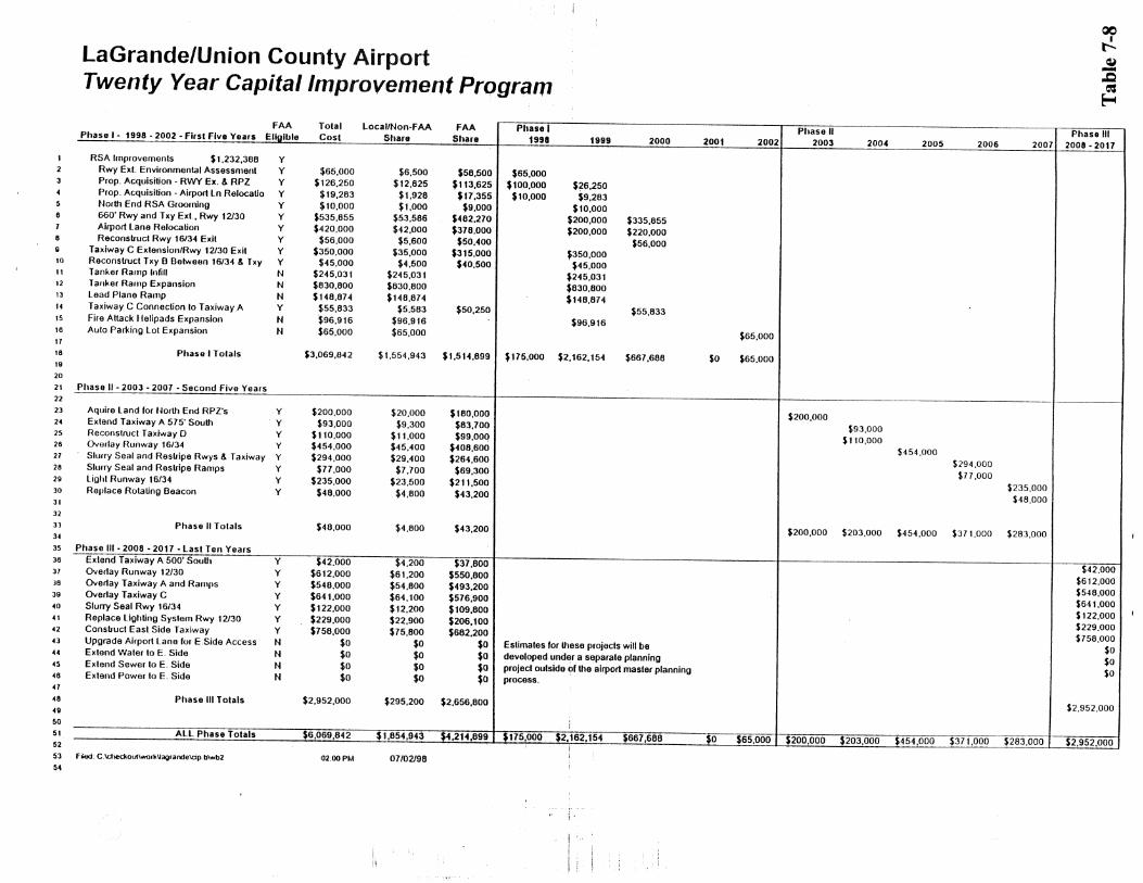

Union County Transportation System Plan
Pipeline Transportation Plan The two major pipelines that traverse Union County are the Chevron and Northwest Natural Gas Pipelines. The pipelines are projected to provide adequate capacity over the next 20 years. Water Transportation Plan Union County has no navigable waterways, therefore Union County has no waterborne transportation services. TRANSPORTATION SYSTEM PLAN IMPLEMENTATION PROGRAM The implementation program includes a 20-year TSP Capital Improvement Program, which identifies project priorities for the next 20 years. High priority projects are those scheduled to be undertaken in the next 5 years, medium priority projects are those scheduled to be undertaken in the next 5 to 10 years, and low priority projects are those scheduled to be undertaken between the next 10 to 20 years. This Capital Improvement Program shall be updated yearly by resolution, if determined necessary by the Union County Transportation Advisory Committee (the standing committee designated by the Union County Board of Commissioners as the Technical Advisory Committee for the TSP process). Table 7-9 includes the Capital Improvement Program, project priority, and estimated project cost. These projects originate from several sources including, the 1999 STIP, the Oregon Highway 82 Corridor Plan, the Union County Bicycle and Pedestrian Plan, the La Grande/Union County Airport Master Plan Update, and locally identified TSP projects. Bicycle and pedestrian facilities are listed in 1996 dollars. The timing of these projects may change based on staff and financial resources.
Table 7-9 TSP Capital Improvement Program
Project
Total Cost
High Priority Palmer Junction Road – Bridge Number 61C05 over Gordon Creek $254,000 Oregon Highway 244 – Bridge Number 04846 over Bear Creek $154,000 Public Transportation Plan $20,000 Right-of-way Acquisition, Elgin to Joseph $2,500,000 Shoulder Widening Program $8,800,000 Commuter Air/Freight Enhancements to La Grande/Union County Airport $25,000 Elgin to Joseph Freight Rail Preservation Plan $50,000 Island City Strip Section $641,000 Striker Lane – Bridge Number 61C15 over Grande Ronde River $659,000 Market Lane – Bridge Number 01495 over State Ditch $502,000 La Grande Variable Message Sign (westbound) $200,000 Hilgard – La Grande Section $9,900,000 Interstate 84 – Old Oregon Trail Highway Bridge Numbers 8504 & 9630B $228,000 5th Street (Union) – Bridge Number 61072 over Catherine Creek $258,000 High Valley #5 – Bridge Number 61C30 over Little Creek $188,000 Old Oregon Trail Highway Signing $60,000 Whopper 2 Slide Correction $500,000 Island City – Imbler Preservation Project $375,000 Interstate 84 – Bridge Number 9634 over McAlister Lane $25,000 Interstate 84 – Bridge Number 9755 over Wolf Creek $25,000 McKennon Lane – Bridge Number C1619 over Grande Ronde River $771,000 Island Avenue (La Grande) Traffic Signal Section $400,000 Interstate 84 – Bridge Numbers 7291C & 7291D over Wolf Creek $330,000 North Powder Interchange (EB & WB) – Bridge Numbers 9499 & 9499A $543,000
75

Union County Transportation System Plan
Yarrington Road – Bridge Number 61C16 over Grande Ronde River no estimate Indian Creek Road – Bridge Number 61C22 over Indian Creek no estimate Jones Road – Bridge Number 61C42 over Phillips Creek no estimate Summerville Road – Bridge Number 10749A over Willow Creek no estimate Pierce Road – Reconstruct 6 miles $2,100,000 Pierce/Gekeler Intersection Safety no estimate McAlister Road – Reconstruct 1 mile $875,000 Buchanan Lane – Reconstruct .77 miles $262,500 Hunter/Booth Intersection Safety – Enforcement and speed zone extension no estimate Runway Extension – Environmental assessment $65,000 Property Acquisition – Runway expansion & RPZ $126,250 Property Acquisition – Airport Lane Relocation $19,283 North End RSA Grooming $10,000 660’ Runway/Taxiway Expansion, 12/30 $535,855 Airport Lane Relocation $420,000 Reconstruct Runway 16/34 Exit $56,000 Taxiway C Extension/Runway 12/30 Exit $350,000 Reconstruct Taxiway B $45,000 Tanker Ramp Infill $245,031 Tanker Ramp Expansion $830,800 Lead Plane Ramp $148,874 Taxiway C Connection to Taxiway A $55,833 Fire Attack Helipads Expansion $96,916 Auto Parking Lot Expansion $65,000 OR Highway 203 – Union to Kofford Road* $152,064 Mt. Glen Road – Black Hawk Trail Lane to Booth Lane* $197,000 McKenzie Lane – east Summerville to Hunter Lane* $131,789 Hunter Road – McKenzie Lane to Woodell Lane* $348,480 Hunter Road – Woodell Lane to Fruitdale Lane* $556,723 Pierce Road – Highway 82 to Highway 237* $696,115 Pierce Road – Highway 237- Highway 203* $315,110 Pierce Road – Highway 203 to Foothill Road* $756,940 Summerville Road – Imbler to Summerville* $228,941 Buchanan Lane – La Grande East City Limit to Island City West City Limit* $130,000 Fruitdale Lane – Mt. Glen Road to Hunter Road* $189,235 Booth Lane – Mt. Glen Road to Hunter Road* $46,464 Foothill Road – Gekeler Lane to Highway 203* $562,637 High Valley Road – Union East City Limit to Kofford Road* $257,241 Kofford Road – High Valley Road to Highway 203* $158,400 La Grande Corridor Transportation Improvements $2,600,000 Elgin Section $1,200,000 Umatilla County Line – NW City Limits (Elgin) $12,300,000 Pyles Canyon Section $2,100,000 Sandridge Road – Realign Sandridge Road/Highway 82 Intersection $50,000 Medium Priority Island City/Imbler Passing Lane $1,400,000 High Accident Location Signing/Marking Program $20,000 Market Lane/Highway 82 – Construct (1) turn refuge for intersection safety $50,000 Pierce/Highway 82 – Construct (1) turn refuge for intersection safety $50,000 Acquire Land for North End RPZs $200,000 Extend Taxiway A 575’ South $93,000 Reconstruct Taxiway D $110,000 Overlay Runway 16/34 $454,000 Slurry Seal and Restripe Runways & Taxiway $294,000 Slurry Seal and Restripe Ramps $77,000
76

Union County Transportation System Plan
Light Runway 16/34 $235,000 Replace Rotating Beacon $48,000 Highway 237 – Island City to Cove* $1,774,080 Hunter Road – McKenzie Lane to Dry Creek Lane* $173,078 Dry Creek Lane – Summerville Road to Behrens Lane* $400,000 Summerville Road – Summerville to Highway 204* $845,222 Mill Creek Lane – Cove East City Limit to Comstock Road* $52,800 Island City Section $2,000,000 Truck Route & Rail Enhancements (I-84 to Baum Industrial Park) $2,400,000 North Powder Section $1,400,000 Low Priority Grade Crossing Protection Program no estimate Railroad Track Improvement Program, La Grande to Elgin $1,200,000 La Grande Intermodal Reload Facility Feasibility $2,400,000 Truck Route and Rail Enhancements $2,400,000 Lower Cove Road – Improve 7 miles $2,450,000 Pierce/Highway 237 – Construct (2) turn refuges for intersection safety $50,000 Hunter Road – Improve 6.5 miles $2,275,000 Summerville Road – Reconstruct 9.38 miles $3,283,000 Godley Lane – Improve .5 miles $50,000 Mt. Glen/Booth Intersection – Realign for intersection safety $100,000 Extend Taxiway A 500’ South $42,000 Overlay Runway 12/30 $612,000 Overlay Taxiway A and Ramps $548,000 Overlay Taxiway C $641,000 Slurry Seal Runway 16/34 $122,000 Replace Lighting System Runway 12/30 $229,000 Construct Eastside Taxiway $758,000 Upgrade Airport Lane for East Side Access no estimate Extend Water to East Side no estimate Extend Sewer to East Side no estimate Extend Power to East Side no estimate Highway 203 – Kofford Road to Baker County Line* $844,800 Highway 204 – Elgin to Umatilla County Line* $802,560 Highway 237 – Cove to Union* no estimate Highway 237 – Union to Baker County Line* $718,080 Phys Road – Highway 237 to Highway 237 (Cove bypass)* $146,995 Lower Cove Road – Highway 237 to Conley Road* $385,651 Market Lane – Highway 82 to Lower Cove Road* $1,209,225 Pierce Lane Improvements $3,000,000 Highway 82 Scenic Turnouts $300,000 Minam Grade (Phase 2) $5,000,000 Imbler Section $1,500,000 “The Grande Tour” State Tour Route Designation (not prioritized) no estimate
*Union County Bicycle and Pedestrian Plan
77

Union County Transportation System Plan
CHAPTER 8: FUNDING OPTIONS The Transportation Planning Rule, OAR 660-012-0040 states under “Transportation Financing Program” that TSPs for jurisdictions within an Urban Growth Boundary containing a population greater than 2,500 people shall include a transportation financing program. Union County’s TSP addresses transportation issues outside of Urban Growth Boundaries, therefore, will not provide a detailed transportation financing program. This TSP will, however, evaluate potential funding and financing sources available for identified transportation improvement projects. HISTORICAL STREET IMPROVEMENT FUNDING SOURCES In the State of Oregon, transportation improvements are coordinated among state, county, and city jurisdictions in order to benefit the overall transportation system. Because of this relationship, project costs are frequently shared. Table 8-1 shows the distribution of road revenues by jurisdiction level in Oregon. This analysis was performed in 1991, and continues to reflect the current funding allocation revenue structure.
Table 8-1 Road Revenue Allocation by Jurisdiction Level
Jurisdiction Level
Revenue Source State County City Statewide Total State Highway Fund 57% 38% 41% 49% Local 0% 22% 55% 17% Federal Road 34% 40% 4% 30% Other 9% 0% 0% 4% Source: ODOT 1993 Oregon Road Finance Study Across Oregon, the State Highway Fund comprises 49% of road revenues and becomes a significant source of funding at all levels of government. Sources of revenue for the fund include gas taxes, vehicle registration fees, and weight/mile taxes. Federal road sources generate another 30% of road revenues, and are comprised of federal highway funds and federal timber revenues. The remainder of road revenues are generated at the local level and are comprised of property taxes, Local Improvement Districts (LIDs), bonds, impact fees, system user taxes, general funds, and other sources. In Oregon, the state produces 94% of its highway revenues from user fees, which is a much higher percentage than the average 78% for all other states. These highway revenues are generated from vehicle registration fees, weight/mile taxes, and fuel taxes. Theoretically, this is an equitable fee system because it generates the highest revenues from those creating the highest system maintenance needs. Oregon has not tied this fee system to inflation, therefore, the fuel tax is a fixed 24 cents per gallon. Transportation Revenue Outlook In a Financial Assumptions document prepared by ODOT in March 1995, some assumptions are recommended for consideration in the preparation of Transportation System Plans. The document projects revenues from the State Highway Fund through the year 2018. These estimates assume (1) the fuel and weight/mile tax will increase one cent per gallon per year, with an additional one cent per gallon every fourth year; (2) TPR goals are met; and (3) that inflation occurs at an average annual rate of 3.7%. Figure 8-1 shows projected State Highway Fund revenues to the year 2018. Both current and adjusted dollar amounts are shown. Revenues are projected to increase faster than inflation in the first 10 years, but slow to a rate less than inflation, and decline slightly, in the last 10 years.
78


Union County Transportation System Plan
System Development Charges System development charges, or SDCs, are a method of generating revenue only if a community has specific infrastructure plans in place according to state guidelines. SDCs allocate infrastructure system development costs to the portion of property development that creates the increased system need. Cities and counties have the legal authority to assess property owners/developers SDCs based on the projected demand from their development. SDCs usually target improvements to infrastructure systems, such as transportation, sewer, and water systems. Union County could utilize SDCs to generate money for transportation system maintenance and improvement. The fee is collected upon building permit issuance. In the case of transportation, SDCs would be calculated based on new development trip generation. This may not prove to be a significant revenue source, because the development rate in Union County is slow, and not projected to increase to a level that make SDCs a pragmatic funding source. State Gas Taxes Fuel taxes are allocated by the state to all cities and counties for road system maintenance and construction. The fuel tax, along with vehicle registration fees and weight/mile taxes, are allocated back to cities and counties based on population and other factors determined at the state level. This is a significant source of revenue for Union County. Local Gas Taxes The Oregon Constitution permits incorporated jurisdictions and counties to levy an additional fuel tax beyond the state fuel tax. The locally levied fuel tax must be used only for road system construction or improvements within the jurisdiction. Currently, only a handful of cities and counties use this method, including Woodburn, The Dalles, Washington County, and Multnomah County. Vehicle Registration Fees Oregon vehicle registration fees are distributed for city and county road funding based on a state level formula. Oregon counties do have state authority to impose local vehicle registration fees. This fee would be assessed to passenger cars on a biannual basis. This method is not currently being used in Oregon and would require coordination among the incorporated jurisdictions and Union County. Local Improvement Districts Oregon Revised Statutes do allow local governments to form Local Improvement Districts (LIDs) to construct public improvements. LIDs are commonly used to construct projects in specific areas, such as a new bikeway, or a neighborhood street improvement project. State statutes allow for district formation by either the local government or property owners. Union County has an ordinance in place stipulating the procedure for district formation and participant payback. Costs can be allocated based on property frontage or other methods, such as trip generation. Participants’ costs are considered an assessment against the property, which is similar to a tax lien. Participants can generally choose to pay the assessment in cash or apply for financing through their local jurisdiction. Since Ballot Measure 5, counties often fund LIDs by selling special assessment bonds.
80

Union County Transportation System Plan
Grants and Loans Most grants and loans are aimed at furthering economic development. They are typically used in developing areas that lack specific infrastructure, such as sewer, water, and adequate transportation. Many grant and loan programs require a local match and should not be counted on as a stable revenue source because there is no guarantee of project selection. These programs include Immediate Opportunity Grants, Oregon Special Public Works Funds, Public Transportation Funds, and Bicycle and Pedestrian Programs, which are described below. Immediate Opportunity Grant Program The Oregon Economic Development Department (OEDD) and the Oregon Department of Transportation jointly administer the Immediate Opportunity Grant Program. The program purpose is to provide financial opportunity for local and regional economic development efforts. The program receives $5,000,000 from Oregon fuel tax revenues and individual maximum grants are $500,000. The most significant components in determining whether a grant request will be funded are the potential improvement of public roads, the inclusion of a regionally significant economic development project, the creation of primary employment, and the presence of a local match. Oregon Special Public Works Fund This fund is derived from the Oregon Lottery and was created in 1995 as a means of distributing lottery money for economic development projects. Grants and loans are available to fund infrastructure construction necessary to support developments creating permanent jobs or retaining jobs. Infrastructure in support of developments wishing to locate, expand, or remain in Oregon are eligible for this program. These funds can be used for new construction or the expansion and rehabilitation of public improvements, such as sewage treatment plants, water works, and public transportation facilities. Even though both loans and grants are available, the program emphasizes loans in order to ensure that money returns to the program for local project reinvestment. The maximum loan amount per project is $11,000,000. The loan term cannot exceed the life of the project, or 25 years, whichever is less. The maximum grant per project is $500,000 and may not exceed 85% of total project cost. Public Transportation Funds There are many grants and loans available for public transportation funding, some include Special Transportation Funds (STF), Section 5311 funds, Community Transportation Program funds, and Special Transportation District funds. All of these programs require local matches from the participating agencies. Bicycle and Pedestrian Program Funds Oregon’s Bicycle and Pedestrian Program have grants for bicycle and pedestrian system improvements. These funds cannot be used for the construction or improvement of purely recreational facilities, but must be spent on projects that provide alternatives to the automobile. Local matches are required. ODOT Funding Options The Statewide Transportation Improvement Program (STIP) is administered by ODOT and prioritizes transportation projects throughout the state that would enhance the statewide transportation system. Projects are identified over a 3-year period and updated yearly. ODOT coordinates projects with local jurisdictions and verifies that the STIP is consistent with other plans including, corridor plans, TSPs, ODOT modal plans, and ISTEA planning requirements. Likewise, the Union County TSP provides ODOT with a 20-year local transportation improvement projects estimation.
81

Union County Transportation System Plan
ODOT has stipulated that improvement projects not on the state highway system may be eligible for state funding if the project would reserve capacity on the state system by reducing congestion and preserving safety. ISTEA made this possible by allowing for the use of federal and state dollars outside of highway corridors. This is a viable option for Union County since many identified improvement projects in the TSP can improve the overall level of service on state highways in Union County. FINANCING TOOLS Financing tools are an opportunity for local governments to pay for projects over time. These are different than the previously mentioned funding opportunities because here financing means accruing money through debt obligation. The previously mentioned funding opportunities are the actual generation of dollars for projects. There are many types of financing options available to the county. These should not be viewed as a source of income, however, only as a method of shifting funding over time. Using debt to finance improvements depends upon the local government’s ability to pay for debt service, the impact of the debt load, and the local government’s credit rating. Debt financing is a way to shift the improvement cost burden to the people using the transportation system, and spreading it over the life of the transportation system. General Obligation Bonds General obligation bonds (GO bonds) are voter-approved and are the least expensive borrowing mechanism on the part of the local government. These bonds are typically supported by property tax levies that are specifically approved to retire debt, and do not expire until the debt is paid. The property tax levy is spread throughout the taxing district based on assessed valuation. These types of bonds are appropriate for public improvements, such as the transportation system, that benefit the entire community. GO bonds are not subject to the limitations set by Ballot Measures 5 and 50 since they are issued subsequent to voter approval. Limited Tax Bonds Limited tax bonds are similar to general obligation bonds because they are an obligation on the part of the local government. This obligation is limited by current revenue sources and does not require voter approval. Since these are not issued pursuant to the taxing power of a local government, there is a higher borrowing cost than general obligation bonds. Because these bonds are not voter approved, Ballot Measure 5 and 50 limitations apply. Bancroft Bonds State law allows for local governments to issue Bancroft bonds. These bonds would pledge Union County’s faith and credit. They are essentially general obligation bonds that are paid with assessments. Historically, these bonds did not require voter approval, yet provided the county with the ability to pledge its faith and credit to obtain a lower borrowing cost. Since they are not voter approved, the Ballot Measure 5 and 50 limitations apply to the taxes levied to pay debt service. Bancroft bonds have generally not been used since 1991 and the passage of Ballot Measure 5.
82

Union County Transportation System Plan
CHAPTER 9: RECOMMENDED POLICY AND ORDINANCE AMENDMENTS
IMPLEMENTATION PLAN Transportation System Plan implementation includes updating road development standards, utilizing access management guidelines, and amending the Union County Land Use Plan and Zoning, Partition and Subdivision Ordinance. This ensures implementation at the local level through coordinated and consistent development review, allows Union County to address emerging transportation issues, and satisfies the requirements of the Transportation Planning Rule (TPR).
Table 9-1 shows TPR requirements for land use regulations and whether they are currently addressed in Union County's Land Use Plan and Zoning, Partition & Subdivision Ordinance. Some elements are partially addressed and some are not addressed at all. Upon adoption of the Transportation System Plan,
I Amend land use regulations to reflect and implement the TSP - I I I I
The Union County Bicycle and Pedestrian Plan was adopted on October 2, 1996 and was found to be in compliance with the TPR for bicycle and pedestrian facilities. Therefore, the proposed amendments in this chapter address other requirements of the TPR. Policy and ordinance amendments are recommended for the Union County Land Use Plan and the Union County Zoning, Partition and Subdivision Ordinance. Upon adoption of the Union County TSP, the 19'79 County Transportation Plan will be repealed and replaced by the Union County Transportation System Plan.

Union County Transportation System Plan
To comply with ORS 197.015 Statewide Planning Goal 12: Transportation, and OAR Chapter 660, Division 12, The Transportation Planning Rule (as amended), adoption of the final Union County Transportation System Plan must take place following public review and comment on the draft TSP.
Proposed language is written in bold format while language proposed for deletion is stricken through.
Union County Land Use Plan
11. Planning Process A. State Planning Goal
To establish a land use policv framework and planning process as a basis for all decisions and actions reiated to use of Iand and to assure an adequate factual base for such decisions and actions.
VI. Air, Water, and Land Resource Quality A. State Planning Goal
To maintain or improve the quality of air, water and land resources of the County.
B. Plan Policies That planning decisions, including transportation projects, will recognize immediate and long range effects on the quality of natural resources, and those uses which may likely have an adverse effect on resource quality will be prohibited.
XII. Transportation A. State Planning Goal
To encourage safe, convenient and economic transportation systems.
Plan Policies The Union County Transportation System Plan is an element of the Union County Land Use Plan and identifies and guides the general location of transportation improvements. L That physical, social, ftffe economic, and environmental considerations will become an integral part of all transportation planning. 2 That roads created by partitioning and subdividing will be designed to tie into existing or anticipated road systems, and that roads (and adjacent curbs and walks), proposed within an urban growth boundary will be constructed to the standards required by that city within the urban growth area. 3; That subdivision and major partitioning activity will be approved only in those areas where roads meet minimum recommended standards and road maintenance can be provided for all weather vehicular access. 4 That all existing railroad crossings will be maintained or improved to provide needed traffic connections, unless local planning determines that such crossings are not needed. S; That transportation improvements will avoid dividing existing economic farm units, unless no feasible alternative exists. & That the transportation facilities will be centralized to the extent practical.

Union County Transportation System Plan
8. That airport and air transport facilities will be protected fiom encroaching, incompatible uses per the Airport Overlay Zone.
9. That the Union County Transportation System Plan, the €%y-&h 2 . La GrandeKJnion County Airport Master Plan Update, and various
respective city's s&&+am Transportation System Plans will be utilized as guidelines for transportation planning.
10. That Union County will protect the function of existing and planned roadways or roadway corridors as identified in the Transportation System Plan through the application of appropriate access control measures and land use regulations.
13. That Union County will cooperate and notify all appropriate local, state, and federal agencies and transportation interest groups when an application potentially impacts a transportation facility. Transportation interest groups must request notice in writing and may be subject to a fee. Notification will help to identify agency standards and provide an efficient and economical transportation system.
14. That the cities and Union County support programs to improve conditions for the transportation disadvantaged as set forth in the Transportation System Plan.
. A priority list (Table 7-9 - TSP Capital Improve Program), as a part of the TSP, road maintenance and construction. This list updated yearly through resolution by the Transportation Advisory Committee and the Board of Commissioners.
XIII. Energy Conservation A. State Planning Goal
To conserve energy.
B. Plan Policies 3. That to conserve energy, high density residential, industrial, and commercial development will be
located along major utility and transportation corridors utilizing access management . . standards identified in the Transportation System Plan. -.
XII. Transportation It is recommended
A. G That the cities and County provide ttlere input into decisions regarding railroad improvements.
B. IS: That arterial, ei= collector and local roads as provided in the Transportation System Plan be accepted into the County Road System.

Union County Transportation System Plan
C. a . . . .
C. That the County work mew closely with the USFS, and other associated agencies and affected parties in determining road locations and level of improvements for roads within the USFS boundary.
Union Counfv Zoning, Partition and Subdivision Ordinance
Article 1 Introductory Provisions and Definitions 1.04 Compliance with Ordinance Provisions All persons shall locate, construct, repair, alter, replace, or use a building or other structure or transportation facility, or transfer land or establish a use only as this ordinance and the Union County Land Use Plan and Transportation System Plan permit.
Agricuiture-Grazing A-2 Agriculture Forest Use A-3 Timber-Grazing Use A-4 Rural Center R- 1 Rural Residential R-2 Farm Residential R-3 Forest Residential R-4 Commercial C-1 Commercial Interchange C - Light Industrial I- 1 Heavy Industrial 1-2 La GrandeNnion County Public Auport PA Surface Mining SM Airport Light Industrial Park A 1-1 Auport Overlay AF' Flood Plain Overlay FP La Grande & Island City Urban Growth
Area Overlay UG- 1 Elgin & North Powder Urban Growth
Area Overlay UG-2
Standards for Transmrtation Projects All transportation facilities will conform with the Transportation System Plan road development standards. Changes in the specific alignment of proposed public roads and highways shall be permitted without plan amendment if the new alignment falls within a transportation corridor identified in the Transportation System Plan. Transportation projects involving the operation, maintenance, repair, and preservation of existing facilities that are consistent with the Transportation System Plan, the ciassification of that roadway an approved road standards shall be allowed, except where specifically regulated (Le. within a floodplain). Dedication of right-of-way, authorization of construction and the construction of facilities and improvements shall be allowed, where the improvements are consistent with the Transportation System Plan, the classification of

Union County Transportation System Plan
the roadway and approved road standards. For state projects that require an Environmental Impact Statement (EIS) or Environmental Assessment (EA), the draft EIS or EA shall serve as the documentation for local land use review, if local review is required. More specifically, uses will be permitted as follows:
A. Uses Permitted Outright Normal operation, maintenance, repair, and preservation activities associated with transportation facilities. Installation of culverts, pathways, fencing, guardrails, lighting, and similar types of improvements that take place within the existing right-of-way. Projects specifically identified in the Transportation System Plan as not requiring further land use regulation.
B. Conditional Uses Permitted 1. Construction, reconstruction, or widening of highways, roads, bridges, or other
transportation projects that are: (1) not specifically identified in the Transportation System Plan or (2) not designed and constructed as part of a subdivision or planned development subject to site plan and /or conditional use review, shall comply with the Transportation System Plan and applicable standards, and shall address the following criteria. For state projects that require an EIS or EA, the draft EIS or EA shall be reviewed and used as the basis for findings to comply with the following criteria:
The project is designed to be compatible with existing lan use and social patterns, including noise generation, safety, and zoning.
o The project is designed to minimize avoidable environmental impacts, to identified wetlands, wildlife habit, air and water quality, and cultural resources.
e The project preserves or improves the safety and function of the facility through access management, traffic calming, or other design features.
e The project includes provision for bicycle and pedestrian circulation as consistent with the Land Use Plan and the Union County Bicycle and Pedestrian Plan.
2. Construction of rest areas, weigh stations, and temporary storage and processing sites. If review under this section indicates that the use or activity is inconsistent with the Transportation System Plan, the procedure for a plan amendment, including any necessary goal exceptions, shall be undertake prior to or in conjunction with the conditional use permit review.
1.07 Land Use Compliance Zoning decisions shall be in compliance with applicable local, state and federal laws, and the Union County Land Use Plan and various sections and elements thereof, including, but not limited to the following:
I . Land Use Plan Classifications 2. Land Use Plan Policies 3. Transportation System Plan and Updates 4. Urban Growth Area Joint Management Agreements

Union County Transportation System Plan
Article 14: Public Airport Zone Location of all development at the La GrandeNnion County MwmjA Airport will be directed by the
l97V La Grandel Union County Airport Master Plan Update - 1998 Airport Layout Plan.
Baum Industrial Park Development, Performance, and Maintenance Standards Land Use & Design Review Requirements, Policies, and Procedures 1. Land use requirements, policies, and procedures are governed by the following documents:
b. Union County Transportation Svstem Plan Road construction standards and access management policies for transportation facilities are provided in this document.
to Section 20.11 OsStreet Parking an
if modes of transportation other than are used or carpooling or public transit is effectively implemented.
6. Access d. Access connections to the state highway system shall observe the access management
standards identified in the Transportation System Plan.
Article 16: Airport Overlay Zone 16.02 Procedure
Figures 1/7 through 717 from the La GrandeNnion County Airport Master Plan Update and performs three functions:
A. Sets the boundary for the Airport Overlay Zone. B. Defines the Federal Aviation Regulations for height restriction. C. Limits structures within approach - clear zones.
Article 20 Supplementaw Provisions 20 .O7 Clear Vision Areas 4. 7
20.10 Site Plan Requirements 1. Before a new building may be constructed or an existing building may be enlarged or substantially
altered, a site development plan shall be submitted to the Planning Commission for approval. . . (A) The applicant shall submit site plans to the Planning Department for Phi&,- C-~BWSSWR consideration. These shall be drawn to scale and of sufficient detail to insure their review in compliance with this section. A site plan shall include the following:
(4) Existing and proposed points of ingress and egress M including vehicular, bicycle, and pedestrian ways. (7) Adjacent road rights-of-way and the location of existing and proposed road facilities, including the provision for the connection of proposed roads with existing roads.

Union County Transportation System Plan
2. Plan review considerations: (C)The location, width, and improvements of vehicular, bicycle and pedestrian access based on requirements of the Transportation System Plan.
Article 2 1 Conditional Uses 2 1.07 Specific Standards Governing Conditional Uses 3. Mineral, Aggregate, or Geothermal Resource Extraction andlor Processing
A. (3) Location of vehicular access points. Access management standards for access points onto a state highway set forth in the Transportation System Plan shall be observed.
4. Mobile Home Parks B. Access, Park Streets, & Walkways
(1) Access - A mobile home park shall not be established on any site that does not have
Unit Development lanned Unit Development Procedure.. .
(3) The Planning Commission shall consider the Preliminary Development Plan at a meeting at which time the comments of person reviewing the Plan for study shall be reviewed. In considering he Plan, the Planning Commission shall seek to determine that: f. The streets are adequate to support the anticipated traffic and the development will not
overload the streets outside the planned area. Access management standards for access points onto a state highway set forth in the Transportation System Plan shall be observed.
23.01 Authorization to Initiate an Amendment An amendment to the text or map of the Union County Land Use Plan or the text or map of this or other land use regulations, including the Transportation System Plan, or adoption of a new land use regulation may be initiated by the Planning Commission, by the County €a& Board of Commissioners, or by the application fiom a property owner(s) or his authorized agent.
23.03 Procedures (8) Notice of the County €ee&- Board of Commissioners fmal action shall be given in the following:
A. The signed copy of each amendment to the Land Use Plan or a land use regulation shall be maintained on file in the office of the County Clerk. Additional copies and a record of such amendments shall be maintained by the Planning Department and made available to the public.
B. Three copies of the ordinance amending the Land Use Plan or land use regulation, or new land use regulations and findings to support the adoption shall be mailed or otherwise submitted to the Director of the Oregon Department of Land Conservation and Development and the Oregon Department of Transportation (ODOT), Region 5 within five working days after the fmal decision by the County €&&-Board of Commissioners.
C. In addition, the final ex&-w& ordinance on the action shall be sent within five working days to persons who participated in the proceedings leading to the adoption and who requested notice in writing.

Union County Transportation System Plan
23.04 Notice of Planning Commission and Countv &t& Board of Commissioners Hearings All notices shall contain the time, place and a brief description of the application and shall be circulated in the following manner: 3. A proposal to amend the Land Use Plan or land use regulation or to adopt a new land use regulation
shall be submitted to the Director of the Oregon DLCD and to ODOT, Region 5 at least 45 days before the final County €eu+ Board of Commissioners hearing on adoption. The proposal submitted shall contain fetiF three copies of the text and any supplemental information that County believes is necessary to inform the Director of DLCD and ODOT, Region 5 as to the effect of the proposal and shall indicate the date of the final hearing on adoption by the County &t& Board of Commissioners.
23.05 Planning Commission and Countv €a&- Board of Commissioners Hearings
level of service of the facility identified in the Transportation System Pian. This shall be accomplished by one of the following: e Limiting allowed land uses to be consistent with the planned function of the
transportation facility; Amending the Transportation System Plan to ensure that existing, improved, or new transportation facilities are adequate to support the proposed land uses consistent with the requirement of the Transportation Planning Rule; or,
a Altering land use designations, densities, or design requirements to reduce demand for automobile travel and meet t s through other
A plan or land use regulation amendment significantly affects a transportation facility if it: Changes the functional classification of an existing or planned transportation Eacility ; Changes standards implementing a functional classification system; Allows types or levels of land use that would result in levels of travel o r access that are inconsistent with the functional classification of a transportation facility; or
e Would reduce the level of service of the facility below the minimum acceptable level identified in the Transportation System Plan.
Article 24 Application Review Procedures 24.05 Pre-application Conference A pre-application conference between the applicant(s) and Planning Department staff shall be conducted to insure that:
(1) The application is consistent with the substantive and procedural provisions of the Land Use Plan, the Transportation System Plan and this Ordinance;
(2) Applicant is aware of all procedural matters relevant to the processing of the respective application; asd
(3) Applicant is aware of his responsibilities, and type and level of information which will be required to enable the reviewing body to act upon his request; and
(4) If any parcel of land proposed for a land use action abuts a state highway then the applicant shall notifjr ODOT, Region 5 prior to submitting any land use application. The

Union County Transportation System Plan
purpose for this contact is to invoke ODOT, Region 5 at the beginning of the application process so that the property owner/developer has the benefit of ODOT comments prior to submitting a site plan, conditional use application, or tentative plat map.
Article 25 Land Division Regulations 25.02 Application Regulations (1) No person shall partition or subdivide land in the unincorporated portion of Union County except as
provided in this Ordinance and the Transportation System Plan. All partition and subdivision plats, all changes in property boundary lines and all streets and ways utilized for the purpose of creating lots or parcels are required to be approved in accordance with these regulations prior to the sale of any such lot or parcel.
25 .03 Enforcement
25.05 Tentative Plan Requkewents (3) A tentative plan map shall be prepared at a scale acceptable to the County Surveyor Map of Survey
Checklist and drawn on material 18 inches by 24 inches in size, unless otherwise approved by the Planning Department Staff. The tentative plan map shall include the following information: (r) Explanatory Information
The following information shall be included as part of the tentative plan, but may be submitted in the form of statements in lieu of being drawn or included as part of the detailed map:
Traffic analysis procedures. If it determined that a Goposed project may impose an undue burden on the public transportation system, then traffic analysis and mitigation must be undertaken. Proposals generating up to 100 vehicle trips per day will reviewed locally by ODOT, Region 5. Proposals generating between 100 and 400 vehicle trips per day will be reviewed by an ODOT Traffic Engineer. Proposals generating over 400 vehicle trips per day will be required to submit a traffic impact study.
For developments that are likely to generate more than 400 average daily motor vehicle trips (ADTs), the applicant shall provide adequate information, such as a traffic impact study or traffic counts, to demonstrate the level of impact to the surrounding street system. Standards by which to gauge average daily vehicle trips include: 10 trips per day per single family household; 5 trips per day per apartment; and 30 trips per day per 1,000 square feet of gross floor area which would equal a new supermarket or other retail development. The developer shall be required to mitigate adverse impacts attributable to the project. The determination of impact or effect, and the scope of the impact study, should be coordinated with the provider of the affected transportation facility.
* Undue burden on the public transportation system includes any one of the following: 1) changes to the functions classification of an existing or planned transportation facility; 2) changes to standards implementing a functional classification system; 3) allowance of land uses that would result in levels of travel or access that are inconsistent with the functional classification of a transportation

facility; or 4) reduction in facility level of service below the minimum acceptable level identified in the Transportation System Plan.
25.09 General Design and Improvement Standards (1) Road Design Conformity. The arrangement, character, extent, width, grade and location of all roads
shall be designed to coordinate with existing and planned roads, topographical conditions, construction and maintenance costs, public convenience and safety, and in their appropriate relation to the proposed uses of the land to be served by such roads. Where not shown on an area plan, the arrangement and other design standards of roads shall conform to the provisions found in the Transportation System Plan and herein.
(2) Relation to Adjoining Road System. The arrangement of roads in partitions and subdivisions shall . . be designed to coordinate with existing or desired roads in ad jo i~ng areas.
(8 j Road Widths and Improvements (a) Road standards shall not be less than those set forth lwam&i= in Table 7-2 in the
Transportation System Plan, except where it can be shown that probable future traffic development or physical characteristics if are such as to unquestionably justify modification of the standards.
(c) Road and related improvements shall be completed or bonded for completion prior to fmal plat consideration and shall be constructed under the direction of the County Planning Department, according to the minimum^ Road Standard Table 7-2:
Table 7-2 Road Development Standards for Union County
/ Shoulder depth & / Same as base + leveling I 1 1 1
Surface width Base depth & material [shall be gridrolledl Leveling course Overlay material Shoulder width I 2' mavel I None I None I None I
24 9" deep
4" minus aggregate
4" deep 1.5- % minus aggregate
3" asphalt concrete 2' pavement +
material Where designated: sidewalk & bicycle
**Private driveways in excess of 200 feet shall require 20 x 40 turnouts at a maximum spacing of K the driveway length or 400 feet, whichever is less.
I shared s h d d e r I 4'paved + 2' gravel I 4' paved
24 8" deep
4" minus aggregate
6" deep % minus aggregate***
course
*Gemtech fabric shall be required between base and subgrade where paved for arterials and collectors. None
24 8" deep
4" minus aggregate
6" deep % minus
aggregate* **
None
None
12 with turnouts**
8" deep 4"minus aggregate
5" deep % minus
aggregate* * *
None None

***Crushed gravel for the combined leveling course and overlay material shall be non-alluvial in origin.
(9) Intersections - Ingress and/or egress to property near the intersection of two or more streets or roads shall be set back from the corner intersection of the street lot lines for a distance of 100 feet. Access for ingress and/or egress to property at an intersection with a state highway shall observe the minimum spacing requirements for state highways identified in Table 7-3. The intersections of more than two roads at one point shall be avoided except where it is impractical to secure a proper road system otherwise. Roads shall intersect one another at an angle as near to a right angle as possible, and no road shall intersect at an angle of less than 75 degrees. Road intersections shall be rounded at the outside lane edge and engineered to meet the intersection angle.
Eghway
LIR turns + 84
82
Category
1
4 UGB
Outside
Level of Importance
204
Interstate
Statewide - interchange at-grade or
I I 1
Source:
Urbani Rural
5
Outside I at-wade / 2640' 1 L/Rturns / 500' UGB I
203
237
Type ! Spacing Inside UGB
Outside UGB Inside
5280'
able 1 - Access Management Classil
1 Spacing ,
-- Intersectioa
Regional
6
6
6
UGB I Outside I at-grade 1 1320' / LIR turns I 300'
Public Road
interchange
interchange
at-grade or
L/R turns
District
Private Drive
2-3 miles 3-8
miles 1320'
1200' UGB Inside
District
District
UGB I UGB Inside
interchange at-grade
UGB Inside UGB
Outside UGB Inside
(18) Dedication - Streets and roads for public use are dedicated without any reservation or restriction other than reversionary rights upon vacation of any street or road and easements for public utilities. Union County shall preserve right-of-way for planned transportation facilities through exactions, voluntary dedications, or setbacks.
(19) Private Roads Easements - Proposed private road easements shall be designated on the tentative plan and may be approved by the Planning Commission if they meet the following conditions:
-
at-grade
Outside UGB
1320'
-
at-grade
at-grade
at-grade
500'
xtion System, Appendix B, 199 1 Oregon Highway Plan.
at-grade
L/R t tms
500'
1320'
500'
300'
LIR turns
1320'
L/R turns
L/R turns
LIR turns
150'
150'
300'
150'
L/R turns 300'

Union County Transportation System Plan
(a) Private roads easements shall provide access to no more than two proposed or potential parcels. No road easement providing access between public roads or other private roads easements shall be approved as a private road easement.
(b) No private s&eet road easement shall be approved unless the Planning Commission is satisfied that such wad right-of-way is not presently needed, nor will ever be needed to be extended through to adjacent property, or to be utilized for public road purposes in the normal growth of the area.
(c) No private road easement shall be less than 30-feet wide, except that a modification may be approved to allow a driveway easement of 20-feet to one parcel or lot.
(d) Surface improvements on private roads easements shall be as prescribed in Table 7-2, Road Development Standards.
(e) Maintenance responsibility for private roads easements shall be predetermined before final plat
(34) Access Connection and Driveway Design. Driveway width shall meet the following guidelines: a) if the driveway is a one way in or one way out, then the driveway shall be a minimum width of 10 feet and shall have appropriate signage designating the driveway as a one way connection; b) for two-way access, each lane shall have a minimum width of 10 feet and a maximum of four lanes shall be allowed. Whenever more than two lanes are proposed, a median should be considered to divide the entrance and exit lanes. Driveway approaches must be designed and located to provide an exiting vehicle with an unobstructed view. Construction of driveways along acceleration or deceleration lanes and tapers shall be avoided due to the potential for vehicular weavi conflicts. The length of driveways shall accordance with the anticipated storage length for entering and exiting vehicles to prevent vehicles from backing into the flow of traffic on the public street or causing unsafe conflicts with onsite circulation.
(35) Existing Access Features. Legal driveway connections on the state highway system in place as of adoption of the TSP shall be designated as conforming features and will be reconsidered only if safety concerns develop, if changes in use occur producing an additional 100 vehicle trips per day or more, or if zone changdplan amendments are proposed accessing the state highway system. There are several alternatives for access point consideration - the access onto the state highway is closed and moved to a side road, the access is combined with other access points, the access is moved according to the spacing standards set forth in Table 7-3 of the Transportation System Plan in order not to conflict with intersection traffic, the access conforms to "Access Management Techniques" listed in the TSP, or nothing is done and the access is left alone.
(36) New Access Features. For proposed development of properties abutting the state highway system, new public roads shall be based on the existing spacing standards set forth in Table 7-3 of the Transportation System Plan. For proposed new development of properties adjacent to the state highway system, the developer/owner shall, prior to making application, notify and coordinate with Union County and the ODOT bistrict Manager (ODOT, Region 5) to ensure access safety and pursue access alternatives if safety is compromised. The highest priority shall be placed on providing access to property abutting the state highway system from local roads or combining driveways. Land development affecting the state highway system will address safety, capacity, functional classification, and level of service. Access management policies for Union County set forth in the Transportation System Plan will be observed.

Union County Transportation System Plan
(37) Shared Access. Proposed subdivisions with frontage on the state highway system shall be designed to share access points from the highway. If access from a local road is possible, then access shall not be allowed onto the state highway. If access from a local road becomes available, then conversion to that access is encouraged, dong with closing the state highway access. A maximum of 2 accesses may be allowed regardless of the number of lots or businesses sewed.

Appendix A
A public. hearing on a proposed .$ransportation system plan will take place durin&Ee-regular meeting of the Imbler City Council a t 7 p.m. - .-- --- ---- --- ___, 3&m&Fak ci$~a:~nion County ~ l a n n e r , ~ a & ~ Jenkins will presedV a re$&. Additional public hearings on the transportation system plan wil l
~ T a C e a t - E 3 @ p . m . Tuesday a t the Joseph Annex and at 8 p.m. Tizday a t Elgin City Hall. Transportation plans are being developed for Uniok County and the cities of Elgin and Imbler. Tbe;plamwill identify exbkbgfacilities .and services and project futuwtiansportation needs,
will,caver 2Q years, % - I&'- n-i - - * r r "

UNION COUNTY TRANSPORTATION SYSTEM PLAN
Tuesday, December 8,1998 1:30 p.m.
Joseph Building Annex Main Conference Room 1108 K Avenue, La Grande
11. Work to Date Existing Conditions
Transportation system inventory Accident history Tr&c vol
Travel Forecasts Future traffic volumes
e Transportation system deficiencies
111. Proposed Alternatives Explanation of alternatives
0 How alternatives shape the future transportation system
IV. Next Steps Where we're going from here
V. Discussion

Union County TAC Meeting Tuesday, December 8,1998
1:30 p.m. - 3:30 p.m. Joseph Building Annex Main Conference Room, La Grande
AddresslAgency

to meet Wednesday The Union County Transpor-
tation Advisory Committee will meet from 2 to 4 p.m. Wednesday in the Joseph Annex.
The committee will discuss the transportation plan for the county.
is open to the puh- lic.

UNION COUNTY TRANSPORTATION SYSTEM PL
Wednesday, January 13,1999 2:00 to 4:00 P.M.
Joseph Building Annex Main Conference Room 1108 K Avenue, La Grande
rs Identification of road segments based on goals and capital improvements that would reserve capacity on the state system Discussion of fiulctional clwsifications
H. Road Project Prioritization (see Discussion items for list)
Prioritize
El. Road Classification System ("Draft Functional Classificationsy' and map) Discuss and finalize classification list
* Discussion of the associated road development standards
IV. Road Jurisdiction Memorandums of Understanding (MOUs) to work together to find W i n g for specific projects
V. Discussion


LIE ~RANDE: Panel to reviewtiansuortation

UNION COUNTY TRANSPORTATION SYSTEM PLAN
Thursday, March 4,1999 2:00 to 4:00 P.M.
Joseph Building Annex Main Conference Room 1106 K Avenue, La Grande
Techniques and purpose Recommended standards How do these standards relate to development?
2. Local Street Plan Future street system - how does this relate to development? Future bicycle and pedestrian system Other Euture modal plans
. Other Discussion/Questions Next TAC meeting is April 8, 1999 fiom 2 to 4 p.m.
Topics include implementing language fir the TSP

PLEASE SIGN IN!
Union County TAC Meeting Thursday, March 4,1999
2:00 to 4:00 p.m. Joseph Building Annex Main Conference Room, La Grande
Name AddressIAgency fl a ac'.~\~ii& o OQOT

The meeting will run for 2 to 4 p.m, in the main conference room of the Joseph Building annex, 1106 E Ave, Policy and ordinance amendments needed to create Union County's Transportation System PIan will be discussed-;
Themeetingis open to the public.

UNION COUNTY TRANSPORTATION SYSTEM PLAN
Thursday, April 8, 1999 2:00 to 4:00 P.M.
Joseph Building Annex Main Conference Room 1106 K Avenue, La Grande
R e Union Comty Land Use Plan e Union County Zoning, Partition & Subdivision Ordinance
Union County Transportation Plan will be replaced by the Union County TSP
2. Other Discussion/Questions Draft final will be provided for your review before the first tentatively scheduled for May 24, 1999 before the Union County Planning Commission

PLEASE SIGN IN!
Union County TAC Meeting Thursday, April 8,1999
2:00 to 4:00 p.m. Joseph Building Annex Main Conference Room, La Grande
Name
w-

1 I 1 bikeway
I I I I I I I I I I 1 Able to I I
N N N 1 P-G /P=P-G; G=GI ~ollector / county / Y 1 60 / G=26 1 I P=26;
71 BIG CREEK ROAD 1.96 2 N N N P-G P=P; G=F Local County Y 60 G=l4-2E 7B8 BLACKHAWK TRAl L LN 1.55 2 N N N P F Local County Y 60 24
P=28;
I 83 BOWMAN LOOP .65 2 N N N P-G P=F; G=F Local County Y 60 G=20
/ 35 BROOKS ROAD 2.09 2 N N N P G Collector County Y 60 24 1 178 BUCHANAN LANE 3 .n 2 N N SH P F Collector/Local County Y 60 22
I

ICOUGHANOUR-FRONTAGE , I I
106 LANE N 1 G
N ' P GRAVEL FRONTAGE-W.-I i
2313 52 16A
&1 GRAYS CORNER ROAD GREINER LANE
144
2.39 8.60 0.51
HACKER LANE 2.00
2 2 2 1
N N N N
N N N N N
N N N
G
G G
' G G
F G=F
G Local 1 County 1 N
Local Local Local
40 12
County County
60 60 60
Y
Y 20
16-30 14 County 1 Y

/HIGHWAY 237 N N SH P 1 G 1 Arterial I State 1 Y 1 80 28 I I I 1 I
/HIGHWAY 244 YN 2 N N 1 P 1 G / ~ r t e h a ~ 1 State 1 Y 1 80 1 1
59 HINDMAN ROAD 8.69 1-2 - N N N G G Local County Y 60 12-24 12A HOT LAKE LANE 2.97 2 N N N G F Collector County Y 60 26 133A HOWELL ROAD 0.66 1 2 N N N G F Local County Y 60 14-20 36 HUG ROAD 3.29 2 N N I N G G Local County Y 60 30 PU HULICKLANE 1 N N N G P Local 7 ! N 40 12 I
I I I
133 HULL LANE 3.63 2 N N N P-G P=F-G; G=F Local County Y / 60 30 14 /HUNTER ROAD 9.69 j 2 N N / N P F-G Arterial County Y 1 60 21-28

54 I (KLINGHAMMER) 2 9 6 1-2 1 N
I 82 KEEN CABIN CREEK ROAD 5 47 4 N N N G F Local County 60 12
- 114 KERNS LOOP 1.17 2 N N N G G Local I County Y 60 20 78A KINGSBURY LANE N N N G F 1 Local , County i Y 60 12 -p ---- 138 KNIGHT LANE 0.75 1 I N N N G F Local 1 County j Y 60 12 66A KOFFORD ROAD , 0 . 3 9 i 2 N N N P F Local 1 County I Y 60 20 --ppp
738 1 LAMPKIN LANE
I +-- N N N 7 F Local I County , Y 60 12 1 I P=24;
' INTERSTATE 84 I 4
N
N
N G F ~ o c a l 1 county Y 1 60
N ' N P i G I Arterlal State Y l
12-24 2 / N 1 N 2 j N l N
53 1 INDIAN CREEK ROAD 152 1 INDUSTRIAL LANE
26A 72 - 81A
12-30 28
I I
N G
N 1 G
4 31 0 19
14 14-20
12
N N - N
JANSON LANE , 046 1 2 I N 1 9 50 1 JIMMEY CREEK ROAD 1-2 i N
F
I Prlnc~ple
JONES ROAD 1 0.30 / 1
Local County Y , 60
I
N N
N
G Local County 1 Y , 60
G G
F j Local , County I Y 1 60 N
G Local County I N 1 40
G G Local ' County Y 1 60

101 /LANE I 9.54 2 N N N 1 P-G /P=F-G;G=G/ Arterial I County 1 Y / 60 / G=18 8 , I I I I I I p=74. - , 105 /OLSEN LANE 1 9 8 ' 2 N N N P-G 1 P=F, G=F 1 LO-l county 1 Y 60 G=20 lOlA ONE-0 ONE-A ROAD 1 0.15 2 N N N G F Local 1 County Y 60 P=16 10A 2 N N N G F Local County Y 60 30 - - 238 OREGON TRAIL ROAD 1 58 2 N N N P G Local County Y 60 22-32
P=24; 23E OREGON TRAIL ROAD 2.27 2 N N N P-G P=F, G=F Y 60 G=20 ---- ppp -,-- 73A OREGON TRAIL ROAD 3.17 2 N N N P P Local I County Y 60 P=20
I 1-- P=20

N N N P-G P=G; G=F 1 Local Y / 60 / G=20 / P=20;
130 129A 39A 39 Y 1 60 21-24
1 1 1
STANDLEY LANE 1 4 7 2 1 2 STARR LANE 2 --
N N N N
STRIKER LANE SUMMERVILLE ROAD
2.17 j 2 997 1 2
N N N N
N N N
SH
P-G G G P
P=P-G; G=P / CollectorILocal
F-G Arterial i County
County County County
G G
Local Local
Y Y Y
60 60 60
G=16 30 30


Appendix C
BICYCLE-PEDESTRIAN PLAN - - - . - - -
A Comprehensive Land Use Plan Supplement
Adopted : October 2 , 1996
Jon Jinings Hanley Jenkins, I1
. --

BICYCLE AND PEDESTRIAN PLAN FOR UNION COUNTY
Table of Contents
Section
I. PLAN PURPOSE
A. Purpose B. Policy Framework and Related Documents
11. EXISTING FACILITIES INVENTORY, NEEDS ANALYSIS AND PEDESTRIAN FACILITY PROcl'ECTS
A. Community Profile 5 B. Comprehensive Plan 5 C. Sicycle and Fedestrian Planning 5 D. Existi~g Road System 6 E. Needs Analysis I F. Inventory and Sikeway Project Recommendations 7
III. SIKEWAY AND WALKWAY PRINCIPLES, OBJECTIVE POLICIES .AND DESIGN STAiiDARDS
A. Planning Principles 3. Objectives and Local Plan Policies C. Bikeway Design Standards D. Walkway Design Standards 2. Additional Planning Considerations Z . Bikeway Signing, Marking and Restriping G . Bicycle Parking Standards 5 . Traffic Calming Techniques
IV. IMPLEMENTATION
Coordination and Maintenance Prioritization Cost Estimates Funding Education and Enforcement
APPENDICES
Glossary Land Use Regulation Code Provision Transportation Planning Rule
PLAN

- - . INTRODUCTION - - - . 7 ' slc;-cir--,s end wzlklnq are ecological, ef f accrve modes of transporta::oc, - - wh c=2~esticn, air anA wacnr poli1.ltio>, - - r2ad c~nstxuczion axe r e ~ z i r . urban adCress zicely the rnsSF1F~y and acces . , . . . CYLVS, Lncl~~CirLc -- c n l ~ d r e n coo young L
too low KO 3wn a car, many eiderly 23
e n e r q efficient, and c ~ s ~ , . - - :cn can he17 rsduce trarric road wear and t h e C S S ~ c z bikeway and walkway nezwcrks s neeas of those who ds noz o drive, peo2le with income ople, aLd ~eople wF=h
Lon 1 s a 2 0 p ~ of our tr:;s
e z nos: af us =her% zrezlz . . . r 3~ wz-:::ng
ar-d Srkeways

and
9. POLICY FXWEWOXK AND RELATED DOCUMENTS >.11 levels of government recognize bicycling and wzlking as viable modes of trans?orzation and encourage planriinu a
Transportation systems to include safe and canve2iint bicycle and 3eciestr-a~ - f&cilL,ies.
1. FEDEXAL POLICY 7 l - 7 i,ce receral governnenc signed the Intermodal Surface Transsoreation 3fficiency Acz (ISTSA) into law in December 1991 m ihe ISTEA requires scaces co stzff a bicycle and pedesczian - c~ordinator and to 2lan fsr bicycles and pedestrians. -t also
I - 1 7 xakes fcnds avallzDie t3 scares for a varLety of bicycle and z~ciiszzian p r o j 1czs I
b. Oregon Transportation Plan -.., - Oressn Transporcacicn 31ar (OTT) sets the ceneral CLrectizr. TC,' --- ,-ansportacion development staiewice for the nexz 20 years. 9-P OTD cuzllnes a visicn of a multi-ncdal eransportacion system, x a sets projecz a and - . ?rocram 3riorlties for che allocazisn of rescurces. Spec-rlc plans for eack transporzation mode - avracion, h i ~ ~ w z y s , xass transit, bicycle and - . pedestrians, rallroads, and transporcaclon corridors - rerlne and exts-d the senera1 provisions ix the OTP. These specieic plans also include zxo prosrams to reduce traffic deaths, and to promote cscnections . c . The Oregon Bicycle and Pedestrian Plan, 1995 Draft The Oregon 3lcycle/Pecestrian ?lan es~ablishes s;a;rwi& 20lici.e~ zrd stacdards for planning and developing safe, attractive trinsgorra~ion facillc~es that ernpnaslze bicycling and walking.
d. Statewide Planning Goals SLactwide 2lanning Goals support bicycling and walking as
7 - s2~si3;e ;ransporra;icn cho;cts, beec;se =hey help reduce air

Sicycle and P e c e s t r i i F l a n
- 7 - - sc--uL:zn, : r a = z l r ccn5csc:or- a-c c3ns;rn~zis- 0 2 ?ezr31212n r i _ s o u ~ ~ . e s ; :iev r e d ~ c e t h e consumption of l a n d f o r roads 2nd -
- - .-l- - dc-.h.-.-5 resr1r :~-c d i n cam2act urba- ~ r o w t h ; -a& they have ve ry low iz~acz en Lana uses ana n a ~ ' ~ r a l syszzms.
Safe and Convenient Bike and psdescri2n Access - = , c i l i ~ i e i s r ~ - ~ - i C i n c d jaf ' a l e c c : - v ~ i ~ ~ ~ ~ e Q ~ s i r ~ ~ ~ an< - . - . . - - . . z:y,cle access s - 2 ~ - - ~e - 1rovideC w i c h i - ECZ ~ ~ ~ l i l ZBW . - , , s z a o l v l s i o ~ s , 31112e: ce-v-t lc?meni~f s h c ; " ~ ~ cen:ers ;nc . - . , . - :--rs=r:a_ z t r k s - 3 . 222'5~ , l S S i f a 2 ~ l i i C T ? i S , Z ~ Z E S ~ L S i 3 3 5 ,
a25 ~ c i g ~ > c r ~ c c d . r c r :-,;:r-q c a r ~ z s r s , such a s sckools , ?arks - . - ""33'7" . - _ . - -
G--- SL"- - ---y. ""is s n a i l l n c l - ~ c e :
. . . i
!C ) ;?>-ere z.?~rzpr:a;a, se?araz? 31x9 OT 3 e d a ~ z z L a ~ ways -3 . , , - - ,,.-,l,::t - .ravel t i s : z _ c ~ s - . ~ i i h - 2 ar!.d 5ecxzen :hi_ a rezs
and atvelcpme11-s -LS;?Q above.
. - . %
l isgr~ - - C ~ > - - J ~ E F E ~ - ~ a ~ ? ~ ~ ~ ~ ~ H nezzs 212yclz 2 e L t s c r i z n . - T fac l l := l=s a r b i ~ c r 5 v ~ ~ , e n e s . - ..<h:c-l; (2 ) a12 r e z s s z a ~ ~ y --== :--- =-- --"TI a z z r f s ? a r ~ : c ~ - r r ~ - ~ z-GBS c z - . 1eva1s 35 t ~ z ~ l i . s b ~ l e
- ? - _ _ _ _ _ L-;---c which voc l5 :zcezfsrz v lch C' c : s c ~ c z ~ g " pecesc r i an - - - -- ,- c v c l c z r i - e l r s r shor: z r l l s . (3) ~ r o v l S e a c l r c c ;
--, - - _ + - , - a af --zv= L- -1 I berwcan 5 e s ~ r r a : r c - s , sacn t s bezueen i - Y 2 7 - "
-----a:- 5 ~ 3 3 CI~C 2 s Z O ~ ~ ; C-, (C) ~.f?~t= i i e L ~ ~ ~ ? l Z.P--SCS of - 7 I_
. . i. _ , r - ~ s : ~ 2r.5 2eiesiz:ans c z - s : C a r i n ~ -2e dss"22~122 and -ST-czn c r r r - z .
- - (045 ( 3 ) ( 5 ) ) .
- -3ternal Pedestrian Cizculation . . I
-7rp-x;l ------ 3eees:~'tn c l r ~ " ~ ' i : ~ " s h a l l s e ~13-: lZet 12 lew - - c = = ~ c = -pr:<e, a;.d. ;smmar::al ~ 2 . 1 2 ~ ~ ; 3 3 2 : 5 =>T?uc~ C L ~ S Z S T ~ ~ ~ - . - . , c2cscrccr:cr- ~5 ~ & E S : ~ Z X X Z ~ S , s k j w ~ ~ s s , whera =--- , 225 s2 - l l - r : ? c h n ~ w s s . ( 3 + 5 ( 2 \ ~ ) j .

Bicycle and P e c e s t r '- P l a n
S i d e w a l k s and B i k e w a y s Sidewalks shall be provided along arterials and collectors i n urban areas. (045) (3) (b) (A) .
B i k e T a r k i n g Facilities 3icycle 2arki~q facilities shall be provided as part of new nulti5xnily residential develop me^-ts of four u~its or morz, new retzil, office institutional developments and all cransl~ tzansfer stz~ions an5 park and ride lots. (C45 ( 3 ) (a) ) .

Bicycle and Pedestrial- Plan
XI. EXISTING FACILITIES INVENTORY, NEEDS ANALYSIS, AND RECOMMENDED BICYCLE AND PEDESTRIAN FACILITY PROJECTS
A , COUNTY PROFILE . . Cx.ion CDunty is a small rurai ]urisdiction, population 23,598. The County, locared in eascern Oregon, 1s composed 70.4% of t~mber lan6, 12.6% cpazing land, and 14.78% farmland. The most productive forest lands are located at the north end of the Csunty wichin the Lsokingglass Creek drainage, north of Palmer Jxnction. Other prime forest land includes areas of the Minam (iver drainage and the headwaters of the Grande Ronde Rlver. .,ss productive forest land occupies the surrounding foothills and mocntzix slopes, except in the dry southern portion of the Cauncy .
Rancelands, often associated wltb 'orest lands, are v2ry impcrtanc to the Counizy. They are the upland areas upon which I l v e s r o c k operations depend for summer grazixg, acd which provr-2 sanmer and winter w;ldl:fe nabita~.
Farmland occ7~pies 7 - the valley - - lowlands of Grande Rcnde River and Powcer River Va-ley. lowever, some :he gently slopixg foo~hilis - A - ,, -,_ iower elevaticns of the 31ue and Wallowa Mountains have ~ I s o been convertsd za farm use.
Srbanized land comprises less 1% of the County land area. ;-zcencrated in :he La Grade-Island City urban areas, ihe - -..- - a Caunty road ne~work, located at rhe base of the Slue ?.:za-=ains on -5e Grande ?.on52 River alluvial Zan. Theri a 51-t: ... incorpora~ed cicies in Union Couniy, seven with less 2 , d : J population, all wickin 25 miles of La Grande.
It is hub of
rs than
B. UNION COUNTY LAND USE PLAN AND TWSPORTATION PLAN T-e Transportation Plan (i973), a supalement t3 the Union Cocnt Land Yse ilan, is inzended rs be used in conjuncrion wizh other - - Tr -r:r> ~ounzy plaxnlrg iocuments to develop a safe, csnver.ienZ. - - - zna erzic~ent sysEam E D ~ transportixg 2eopi-e and goods. 3 s
, , C;cnry identifies and priorlz~zes road improvement projects on a?-nual basis. County roads are classified according to their - . l - C C . L-..clLaE, and road rsvenues are allocated for maintenance and :-.~rs-eme~zs based on roadway functional classificacLcns.
rn.- -- ...- union - - Caunty transporzation plan sugpcrts the development and . , +..- -- 3 "- ,-1 - n36es of zransporzation intended to avoid Dver

Bicycle and Pedestrian Plan
reliance upon any one mode of transportation, and to meet the needs of =he transportation disadvantaged. . . Transportation improvemencs should be designed to u c ~ i i z e existlng rights-of- way, emphasize energy conservazion, and Slcycie and pedestrlac safety.
C. BICYCLE AND PEDESTRIAN PLANNING IN UNION COUNTY Almost 20 years aGo, Unlon County recognized that blcycles were becomlng ac increas~ngly important mode of transportation for Unlon County residents. To accommodate this increase, the County Parks and Recreation Department (no longer In existence) ~niziated a Blkeway Planning effort. At the tlme it was expected thaz most proposed brkeways would be roads shared with auzomoblbes and designated for blcycles ~y slgnmg, strlplng, o r 0:52r vlsual Kark:ngs. Pedestx-lan would also share the cieslgnated roads. The Bikeway Planning effort was never complsted. In zhe years following, a few bicycle and pedestrlax fac:Llt~es (now cf obsolete deslgn) were developed -n the ur~ncorporated Union County, around the La Grande-Isianc Clty urban area, without coordinated planning.
D. EXISTING COUNTY ROAD SYSTEM The ex~szing County road syscern, in combination wieh State Elsnways, and U.S. Forest Service roads, provides access to all I -egions of Union County.
The Union County Zoning Ordinance, Article 29.00, Subdivision 2esicp and Inprovement Standards, establishes the following szanCards f c r County major - collector -- roads: a 50 foot r1gn~-of- way, a 20 foot road surface, and 6 foot shoulders. Minor collector or local roads are to have a 50 foot right-of-way width, a 24 foot surface width, and 6 foot shoulders. County roads are to meet the set standards except where the Planning Commission determines an increase or decrease is warranted.
The inventory of existing County roads included all major 7 - colleczor and minor collector roads, as well as selected local
roads. The minor collector roads which are predominantly graveled were not found to be important to the bike and 2edestrian network. Approximately 82 miles of County major - . coileccor roads were inventoried. The inventory included 5 miles of major collector road with a paved surface greater than 24 feet wide, typicaily 26 feet or 28 feet wide. In addition, there are 27 ailes (33%) of C~unty major collector roads with a 24 foot paved surface width, and over 50 miles (61%) with a substandard 20 or 22 foot road surface width, of which 46 miles are paved. The ~nventory included 14 miles of local County roads which have a 20 foot road surface. About one-half of these are paved. No C3un~y roads have 6 foot shoulders. A few have 2 foot graveled s20ulders, b u ~ most nave no shoulders. Many county road rights- of-way have Sorrow ditches for drainage and snow removal.

Bicycle and Pedestrian Plan
E. NEEDS ANALYSTS During the preparation of this plan, July 1, 1994 to June 30, 1995, the Union County Bicycle and Pedestrian Advisory Committee served as the Citizen Involvement Committee for Union County. The guidelines the committee used in recommending bicycle and pedestrian improvements are based on the requirements of the Transportation Planning Rule as discussed in the POLICY section of this Plan, and guidelines provided in the Oregon Bicycle and Pedestrian Plan and discussed in the STANDARDS section of this Plan.
The Transportation Planning Rule (TPR) requires that cities and counties provide safe, direct, continuous, well connected networks for bicycles and pedestrian travel. It also directs local governments to adhere to the standards and guidelines established in ODOT's Bicycle and Pedestrian Plan.
On rural county roads paved shoulders provide a suitable area for bicycles, safe from conflicts with faster moving traffic. Rural bike travel in unincorporated Union County will be accommodated primarily on paved shoulder bike lanes. The standard width for shoulder bikeways is 6 feet; the minimum shoulder bike lane is 4 feet wide. With few exceptions, the following proposals recommend providing two 4 foot paved shoulders on approximately 60 miles of County major collector roads, and about 14 miles of County local roads. Where shoulder bike lanes are warranted but physical constraints preclude them, two 14 foot shared travel lanes with fog lines are recommended.
F. INVENTORY AM3 PROJECT RECOMMErJDATIONS
1. State Highway 203 La Grande-Baker Highway From La Grande to Union Highway 203 is a minor arterial between the City of La Grande and the City of Union, the two largest cities in the County. It has an 80 foot right-of-way and a 28 foot paved surface including two 14 foot travel lanes.
Recommendatiori: No change.
From City of Union to Kofford Road Highway 203 is a major collector in Union County between the City of Union and the Baker County line. The road has an 80 foot right-of-way and a 24 foot paved surface including two 12 foot travel lanes. The portion from the City of Union east to Kofford Road is used extensively by Union residents for bicycling and walking.
Recommendation: Widen pavement to 36 feet to include two 14 foot travel lanes and two paved shoulder bikeways.
Union County, August 21, 1995, p.7

Bicycle and Pedestrian Plan
Pro j ec t From-To Miles Cost Priority
Widen pavement +8 feet Union-Kofford Rd 1.8 $152,064 high
From Kofford Road to Baker County line Highway 203 functions as a major collector from the City of Union to the Baker County line. It has an 80 foot right-of- way and a 24 foot paved surface. Experienced bicyclists use the road for touring.
Recommendation: Widen the pavement to 28 feet to provide two 14 foot shared lanes, with a fog line.
Widen pavement t4 feet Kofford-Baker Co. 20 $544,800 low
2. State Highway 204 Elgin-Tolgate Hwy From City of Elgin to Umatilla County line State Highway 204 functions as a minor arterial in Union County linking the northern portion of Union County with Umatilla County. It has an 80 foot right-of-way width, and a 24 foot paved surface including two 12 foot travel lanes. ~x~erienced bicyclists share this road traffic.
Recommendation: Widen the pavement to two 14 foot travel lanes.
with interstate truck
28 feet to provide
Project From-To Miles Cost Priority
Widen pavement +4 feet Elgin-Umatilla Co. 19 $802,560 low
3. State Highway 237 Cove Hwy From Island City to Cove Highway 237 functions as a major collector connecting the City of Island City and City of Cove. It has an 80 foot right-of-way and a-28 foot paved surface. It is used by experience bicyclists for touring and by an occasional bicycle commuter.
Union County, August 21, 1995, p.8

Bicycle and Pedestrian Plan
Recommendation: Improving bicycle safety on this stretch of road is important to bicyclists who ride it. Widen the pavement to 36 feet to provide two 14 foot travel lanes and two 4 foot paved shoulder bikeways.
Project From-To Miles Cost Priority
Widen pavement +12 feet Island C.-Cove 14 $1,774,080 medium
Cove to Union Highway 237 functi~ns as a major collector connecting the City of Cove and the City of Union. It has an 80 foot right-of-way and a 28 foot paved surface. It is used by experience bicyclists for touring and by an occasional bicycle commuter.
Recommendation: Improving bicycle safety on this str?c& of road is important to bicyclists who ride it. Widen the pavement to 36 feet to provide two 14 foot travel lanes and two 4 foot paved shoulder bikeways.
State Highway 237 I / / La Grande-Baker Hwy From City of Union to Baker County line Highway 237 functions as a major collector in the southern portion of Union County connecting the City of Union and the City of North Powder. It has an 80 foot right-of-way, and a 24 foot paved surface including two 12 foot travel lanes. This road is used by experienced bicyclists every summer.
Recommendation: Widen the pavement two 14 foot travel lanes with a fog
to 28 line.
feet provide
Project From-To Miles Cost Priority
Widen pavement 17 $718,080 low +4 feet Union-Baker Co.
5. County Road #10 Mt. Glen Road From Black Hawk Trail to Booth Lane Mt. Glen Road is a major collector with a 60 foot right-of- way width and a 20 foot paved surface. It serves a rural residential area in the unincorporated Union County north of La Grande and Island City. It is frequently used by bicyclists from both cities.
Recommendation: Widen the pavement to 32 feet to provide two 12 foot travel lanes and two 4 foot paved shoulder - bikeways. Also see recommendation # 24.
Union County, August 21, 1995, p.9

Bicycle and Pedestrian Plan
Project From-To Miles Cost Priority
Widen pavement +12 feet B.H.Trail-Booth 1.56 $197,000 high
6. County Road #14 McKenzie Lane From east Summerville City Limits to Hunter Lane McKenzie Lane (called 4th Street in Summerville) is a major collector with a 60 foot right-of-way width a 24 foot pa;ed road surface, and 2 foot graveled shoulders. It is an important link in the Union County bike network because it connects Hunter Lane with S mmerville Roa
Recommendation: Widen the avement to 32 two 12 foot travel lanes an two 4 foot pav - bikeways. Also see recommendation # 8 , # 9 , and #13.
Project From-To Miles Cost Priority -.a
Widen pavement +8 feet Sum. ECL-Hunter 2.16 $131,789 high
7. County Road #14 Hunter Road Hunter Road from McKenzie Lane to Fruitdale Lane is an north-south major collector with a 60 foot right-of-way including borrow ditches on both sides. The road links commercial resource land and a rural residential area at the base of Mt. Emily to urban employment and market centers. his section of Goad is frequentiy used by bicyclists.
From McKenzie Lane to Woodell Lane Hunter Road from McKenzie Lane south to Woodell Lane has 21 foot paved surface.
Recommendation: Widen the pavement to 32 feet to provide two 12 foot travel lanes and two 4 foot paved shoulder bikeways.
- -- -
Project From-To Miles Cost Priority
Widen pavement +11 feet McKenzie-Woodell 3.0 $348,480 high
Union County, August 21, 1995, p.10

Bicycle and Pedestrian Plan
From Woodell Lane to Fruitdale Lane Hunter Road from Woodell Lane south to Fruitdale 24 foot paved surface with a fog line painted 10 the center line.
Lane feet
has a from
Recommendation: Widen the pavement to 32 feet to provide two 12 foot travel lanes and two 4 foot paved shoulder bikeways.
Project From-To Miles Cost Priority
Widen pavement +8 feet Woodell-Fruitdale 6.59 $556,723 high
ty Roa er Roa
From PScRenzie Lane to Dry Creek Lane. Hunter Road from McKenzie Lane north to Dry Creek Lane is a major collector with a 60 foot right-of-way width and a 21 foot paved surface. It serves commercial resource and uses and rural residential development at the base of Mt Emily. It is frequently used by bicyclists from the region.
Recommendation: Widen the pavement to 32 feet to provide two 12 foot travel lanes and two 4 foot paved shoulder bikeways.
Pro j ec t From-To Miles Cost Priority - Widen pavement +11 feet McKenzie-Dry Creek 1.49 $173,078 medium
9. County Road #20 Dry Creek Lane From Summenrille Road to Berhens Lane Dry Creek Lane from Summewille Road west and south to Berhens Lane is a major collector with a 60 foot right-of- way width and a 21 foot paved road surface. It is commonly used by bicyclists. from the region.
Xecommendation: Widen the pavement to 32 feet to provide two 12 foot travel lanes and two 4 foot paved shoulder bikeways.
Project From-To Miles Cost Priority
Widen pavement +11 feet Summervil-Berhens 3.44 $400,000 medium
Union County, August 21, 1995, p.11

Bicycle and Pedestrian Plan
10. County Road #23 Pierce Road From Hwy 82 to Foothill Road Pierce Road from H w y 8 2 t o Foo th i l l Road i s a major c o l l e c t o r with a 6 0 foo t r ight-of-way width. I t i n t e r s e c t s S t a t e Hwy 8 2 , Hwy 237, and H w y 2 0 3 providing d i r e c t access t o t h e Airpor t I n d u s t r i a l Park located on Pierce Road.
From Hwy 82 to Hwy 237 From H w y 8 2 t o Hwy 237, P ierce Road has 3 0 foo t graveled road su r face .
Recommendation: Widen and provide a 3 2 f o o t wide paved road su r face inc luding two 1 2 foo t t r a v e l lanes and two 4 foo t
aved shoulder bikeways.
Pave +32 f e e t Hwy 82-hwy 237 2 . 0 6 $ 6 9 6 , 1 1 5 high
From Hwy 237-Hwy 203 From Hwy 237 t o Hwy 203, P ierce Road has a 24 foo t paved road s u r f a c e .
Recommendation: Widen t h e pavement t o 32 f e e t t o provide two 1 2 f o o t t r a v e l lanes and two 4 foot paved shoulder bikeways.
Project From-To Miles Cost Priority
Widen pavement +8 f e e t Hwy 237-Hwy 2 0 3 3.75 $315,110 high
From Hwy 203 to Foothill Road From Hwy 237 t o Hwy F o o t h i l l Road, Pierce Road has 24 foo t graveled road sur face .
Recommendation: Widen and provide a 32 f o o t wide paved road su r face inc luding two 12 foo t t r a v e l l anes and two 4 foo t paved shoulder bikeways.
Project From-To Miles Cost Priority
Pave +32 f e e t Hwy 203-Foothi l l 2 . 2 4 $756,940 high
Union County, August 2 1 , 1995, p.12

Bicycle and Pedestrian Plan
County Road #23B Oregon Trail Road Wolf Creek Lane to North Powder north City Limits The Oregon Trail Road is a major collector in south Union County, serving the Powder River valley. It has a 60 foot right-of-way. From Wolf Creek Lane to Bagwell Road the pavement is 24 feet wide, and from Bagwell Road to the North Powder north City Limits the pavement is 22 feet wide. The road is not recommended for inclusion in the Union County bicycle network because it's infrequently used by bicyclists.
Recommendation: No change.
County Road #32 Phys Point Road From Hwy 237-Hwy 237 (Cove bypass) This bypass is part of the major collector network. It has a 60 foot right-of-way and a 20 foot paved road surface. The short cut is important to the County bicycle network because it allows cyclists to bypass the City of Cove, shortening travel distances.
~ecommendation: Widen the pavement to 32 feet to provide two 12 foot travel lanes and two 4 foot paved shoulder bikeways.
Project From-To Miles Cost Priority
Widen pavement +12 feet Hwy 237-Hwy 237 1.16 $146,995 low
County Road #39 Summerville Road From Hwy 82 to Hwy 204 Summerville Road is an important north-south major collector in Union County. ~t is used by commercial truck traffic to cut travel distances between Hwy 204 and Hwy 82. It is also important to the County bike network because it is commonly used by bicyclists.
From City of Imbler to City of Summerville Between Imbler and Summerville the pavement is 24 feet wide with two 2 foot graveled shoulders. This section is used by people walking, jogging, and bike riding between Imbler and Summerville.
Union County, August 21, 1995, p.13

Bicycle and Pedestrian Plan
Recommendation: Widen the pavement to 32 feet to provide two 12 foot travel lanes and two 4 foot paved shoulder bikeways.
Project From-To Miles Cost Priority
Widen pavement +8 feet Imbler-Summerv. 2.71 $228,941 high
From City of Surrunerville to Hwy 204 Between Summerville and H w y 204 the pavement is 20 feet wide with two 2 foot shoulders.
Recommendation: Widen thl. pavement to 32 feet to provide two 12 foot travel lanes and two 4 foot paved shoulder
Project From-To Miles Cost Priority
Widen pavement +12 feet Summerv-Hwy 204 6.67 $845,222 medium
14. County Road #42 North Palmer JCT Road From Palmer JCT Road to Robinson Road North Palmer JCT Road is a major collector with a 60 foot right-of-way and 24 foot paved road surface. Fog lines are painted 10 feet from the center line. Deep borrow ditches parallel the road on both sides. This road provides access to the northern most portions of Union County and the Umatilla National Forest, used primarily as a logging access road.
Recommendation: No change.
15. County Road #44 Palmer JCT Road From Elgin City Limits to Gordon Creek Road Palmer JCT Road is a major collector with a 60 foot right- of-way and a 24 foot paved road surface. It takes log truck traffic from North Palmer JCT Road to Hwy 204 and the Boise Cascade Mill in Elgin.
Recommendation: No change.
Union County, August 21, 1995, p.14

Bicycle and Pedestrian Plan
16. County Road #63 Lower Cove Road From Hwy 237 to Conley Road Lower Cove Road is a major collector extending nqrth from the City of Cove along the Wallowa Mountain foothills. It has a 60 foot right-of-way and a 21 foot paved road surface. The road is used by commercial farm and forest trucks and is also a popular place to bicycle.
Recommendation: Widen the pavement to 32 feet to provide two 12 foot travel lanes and two 4 foot paved shoulder bikeways. Also see recommendation 25.
o j e c m-To iority
Widen pavement feet 237-Gonley 3.32 $385,651 low
17. County Road #65 Mill Creek Lane From east City Limits of Cove to Comstock Mill Creek Lane is a farm-to-market major collector extending east from the City of Cove to Comstock Road where it becomes a U.S. Forest Service road. It has a 60 foot right-of-way and a 28 foot paved road surface. The road provides access to the Wallowa-Whitman National Forest and the Eagle Cap Wilderness Area. Pedestrian and trail bike riders share the road with commercial farm and forest. trucks.
Recommendation: Widen the pavement to 32 feet to provide two 12 foot travel lanes and two 4 foot paved shoulder bikeways.
Pro j ec t From-To Miles Cost Priority
Widen pavement +4 fest Cove ECL-Comstock 1.25 $52,800 medium
18. County Road #75 Nice Road From Wolf Creek Lane to Coughanour Lane Nice Road is a major collector in the sparsely populated southern portion of Union County, seldom used by bicyclists. It has a 60 foot right-of-way and a 22 paved road surface.
Recommendation: No change.
Union County, August 21, 1995, p.15

Bicycle and Pedestrian Plan
19. County Road #I01 North Powder River Lane From I84 interchange to Ellis Road North Powder ~iver-~ane is a major collector which parallels the Powder River in the southern portion of Union County. The road has a 60 foot right-of-way and a 20 foot paved-road surf ace.
Recommendation: No change.
20. County Road #I03 Ellis Road
ne s Wolf Creek
Lane to North Powder River Lane. The road has a 60 foct right-of-way and a 2Q foot aved road surface.
Recommendation: change.
21. County Road #I04 Wolf Creek Lane From Oregon Trail Road to Nice Road Wolf Creek Lane is a major collector which extends west from I84 just north of the city of North Powder. The road has a 60 foot right-of-way and a 22 foot paved road surface.
Recommendation: No change.
22. County Road #I17 - - -
Buchanan Lane From La Grande ECL to Island City WCL Buchanan Lane is an important major collector in the most populated region of Union County. It extends east from La Grande about three-quarter of one mile to Island City. The road has a 60 foot right-of-way and a 29 foot paved surface. In the past, a 9 foot wide, two-way, shoulder bike lane was constructed on the north side of Buchanan Lane. This wide shoulder is used frequently by pedestrians and bicyclists. However, by today's standards, it is an obsolete facility that will need to be replaced with shoulder bike lanes that meet current standards. Bicycles are considered vehicles which must obey traffic laws including traveling on the right-hand side of the road with the traffic flow. The 9 foot shoulder bike lane was not built to road standards. Thus, additional overlay material will be required prior to restriping the pavement for standard shoulder bike lanes.
Union County, August 21, 1995, p.16

Bicycle and Pedestrian Plan
Recommendation: Widen the pavement to 36 feet to provide two 12 foot travel lanes and two 6 foot paved shoulder bike lanes for bicycle and pedestrian use.
Pro j ec t From-To Miles Cost Priority
Widen pavement +16 feet, paint bike lanes La Gran-Is1 City 0.77 $130,000 high
23. County Road W125 Fruitdale Lane
ne ctor linking Mt. Glen Roa
and Hunter Lane, serving a large rural residential area immediately north of La Grande and Island City, The roa a very pop;lar place for residents of both c walking, jogging, and bike riding. It has a than a 60 foot, right-of-way width, and a 20 surface with two 2 foot graveled shoulders.
iEies for 40 foot, ra foot paved
.ther road
Recommendation: Given the relatively high bicycle and pedestrian traffic volume, two 6 foot shoulder bike lanes are warranted. However, the narrow 40 foot right-of-way width presents a physical constraint which may preclude 6 foot (or 4 foot) shoulder bike lanes. As a second best alternative, the pavement should be widened to 28 feet to include two 14 foot shared travel lanes. Wider travel lanes tend to encourage unsafe higher traffic speeds. A fog line painted 12 feet from the center line will make the travel lane appear narrower and may slow traffic.
Pro j ec t From-To Miles Cost Priority
Widen pavement +8 feet Mt . Glen-Hunter 2.24 $189,235 high
24. County Road #I26 Booth Lane From Mt. Glen Road to Hunter Road Booth Lane is a major collector which extends east from Mt. Glen Road across the valley floor to Lower Cove Road. It intersect Hunter Road. The road section between Mt. Glen Road and. Hunter Road is an important link to complete the County bikeway network. Booth Lane has a 60 foot right-of- way and a 28 foot paved road surface.
Recommendation: Widen the pavement to 32 feet to provide two 12 foot travel lanes and two 4 foot paved shoulder bikeways.
Union County, August 21, 1995, p.17

Bicycle and Pedestrian Plan
Project From-To Miles Cost Priority
Widen pavement +4 feet Mt. Glen-Hunter 1.1 $46,464 high
25 . County Road #12 8 Market Lane From Hwy 82 to Lower Cove Road Market Lane is an east-west major collector with a 60 foot right-of-way, a 21 foot paved road surface, and 2 foot graveled shoulders. As its name implies, the road is used for transporting farm and forest products to market. It is located between Alicel and the City o Cove, and along the Wallowa Msuntai s . This region of the County is not as frequently traveled by bicyclists as the region between La Grande and Elgin. However, Market Lane is included in the County bike facility plan because it connects existing shoulder bike lanes on H w y 82 with proposed shoulder bike lanes on Lower Cove Road. Lower Cove Road terminates at Lantz Lane at a point where Hwy 237 extends south to connect with existing bike lanes on Jasper Street and Main Street in the City of Cove.
Recommendation: Widen the pavement to 32 feet to provide two 12 foot travel lanes and two 4 foot paved shoulder bikeways. Also see recommendation # 16.
Project From-To Miles Cost Priority
Widen pavement +11 feet Hwy 82-L. Cove 10.4 $1,209,225 low
26. County Road #I40 North Palmer JCT Road From Robinson Road to Moses Creek Road This section of road extends into the northern most region of Union County to provide access to the Umatilla ~ational Forest for commercial logging operations. It has a 60 foot right-of-way and 26 foot paved road surface.
Recommendation: No change.
Union County, August 21, 1995, p.18

Bicycle and Pedestrian Plan
County Road #12 Foothill Road From Gekeler Lane to Hwy 203 Foothill Road is County local road which runs south from La Grande along the foothills of the Blue Mountains, adjacent to Ladd Marsh Game Management Area. It has a 60 foot right- of-way and a 26 foot paved road surface. Foothill Road is very important to the County bike facility network for several reasons. It is located in the most populated area of the County and is used extensively for walking, jogging, and bicycling. It intersects Gekeler Lane in south La Grande. There are bike lanes on Gekeler Lane from 6th Street to 16th Street which will be extended to connect with shoulder bike lanes on H 203. Foothill Road intersects Pierce Road near its int section with US H
Recommendation: Widen the pavement to 32 feet to provide two 12 foot travel lanes and two 4 foot paved shoulder bikeways. Also see recommendation # 10 (construct above project only after #lo).
Project From-To Miles Cost Priority
Widen pavement +6 feet Gekeler-Hwy 30 8.88 $562,637 high
28.. County Road #66 High Valley Road From Union east City Limits to Kofford Road High Valley Road is a County minor collector road which crosses the foothills between the City of Cove and the City of Union. The road has a 60 foot right-of-way and a 20 foot paved road surface. A portion of High Valley Road east of Union City Limits combined with Kofford Road and a part of Hwy 203 forms a loop used extensively by Union residents for walking, jogging, and bicycling.
Recommendation: Widen the pavement to 32 feet to provide two 12 foot travel lanes and two 4 foot paved shoulder bikeways. Also see recommendation #1 and # 2 9 .
Project From-To Miles Cost Priority - diden pavement +12 feet Union ECL-Kofford 2.03 $257,241 high
Union County, August 21, 1995, p.19

Bicycle and Pedestrian Plan
29. County Road #66A Kofford Road From High Valley Road to Hwy 203 Kofford Road is a shorc section of road included in the County minor collector network. It connects High Valley Road with Hwy 203 east of the City of Union. It has a 60 foot right-of-way and a 20 foot paved road surface. Together with a portion of High Valley Road and Hwy 203 it is part of loop used extensively by Union residents for walking, jogging, and bicycling.
Recommendation: Widen the pavement to 32 feet to provide two 12 foot travel lanes and two 4 foot paved shoulder bikeways.
ro j ec
Widen pavement +i2 feet High Val.-Hwy 203 .39 $158,400 high
Union County, August 21, 1995, p.20

is,, , , . . < . . - U3--NCOR-30IL%TXD U X I O N C3'GWT'r', CXZZSN 3 ! $ . . , - 0 ,
. , . I JW A : I L L A ,Ak' FUNCTIONAL C L A S S I F I C A ? INS F O R ' ' '
I i 7 ' . -a , ,.-$ , , BICYCLI A?\= P S i i S T i l - 2 l P L A T - 1 9 3 5 r:",
1 ,. .." , ,, . (North County) >. - , & .

UNINCORPORATED UNION COUNTY, OREGON ROADWAY FUNCTIONAL CLASSIFICATIONS FOR


Bicycle and pedestrian Plan
UNINCORPORATED UNION COUNTY, OREGON
(South County)
. . -
' - -
, .- .
EXPLANATION
Planned
Shoulder Bike Lanes
14 Foot Shared Lanes %!\ ,
Union County, August, 1995, p . 2 4

Bicycle and Pedestrian Plan
Table 1: Summary of Existing Facilities and Recommendations
Road Name/Segment
State Hwy 203 La Grande-Baker Hwy
La Grande-Union
Medical Springs Hwy
Union EGL-Kofford Rd
Kofford Rd-Baker Go.
State Hwy 204 Elgin-Tolgate Hwy ECL Elgin-Umatilla Cc
State Hwy 237 Cove Hwy Island City-Union
and Cove - Union
'LaGrande-Baker Hwy SCL Union-Baker Co.
County Road #10 Mt Glen Road
300th-Black Hawk Tr Popular bike route in Union County.
Key: t travel lane,
Existing Geometry
Minor Arterial Right-of-way: 80 Pave: 28 2 (ldt)
Major Collector Right-of-way: 80 Length: Pave: 28 2 (14t)
Length: Pave: 24 2 (12t)
Minor Arterial Right-of-way: 80 Length: Pave: 24 2 (24t) 2 (2sh)
Major Collector Right-of-way: 80 Length : Pave: 28 2(14t) fog line 2 (2sh) gravel
Length: Pave : 24 2 (12t)
Major Collector Right-of-way: 60
Length: 1.56 mi. Pave: 20 2 (lot)
Recommendations
Pave : 2 (14t 2 (4sh
Pave :
No change.
3 6
) paved
2 8 2(14t) fog lines
Pave: 28 (214t) fog lines
Pave: 36 2 (14t) 2(4sh) paved 2 (2sh) gravel
Pave : 28 2(14t) fog line
Pave: 32 2 (12t) 2 (4sh) paved
sh shoulder bikeway, bl bike lane.
Union County, August 21, 1995, p. 25

Bicycle and Pedestrian Plan
Table 1: Summary of Existing Facilities and Recommendations
Road Name/Segment
C o u ~ t y Road #14 McKenzie Lane
ECL Summervil-Hunter Popular bike route in Union County.
County Road #14
McKenzie-Woodell ular bike
In Union County.
Woodell-Fruitdale Popular bike route in Union County.
County Road #18 Hunter Rd
McKenzie-Dry Creek
Popular bike route in Union County.
Existing Geometry
Major Collector Right-of-way: 60
Length: 2.16 mi. Pave: 24 2 (12t) 2 (2sh) gravel
Major Collector Right-of-way: 60
Length: 3 mi. ave: 21 2(10.5t) 2 (2sh) gravel
Length: 6.59 mi. Pave: 24 2 (12t) 2 (2sh) gravel
Major Collector Right-of-way: 60
Length : Pave : 21 2(10.5t)
County Road #20 Dry Creek Lane
Summervil Rd-Behrens
Popular bike route in Union County.
Major Collector Right-of-way: 60
Length: 3.44 mi. Pave: 21 2(10.5t)
Recommendations
Pave: 32 2 (12t) 2(4sh) paved
Pave : 2 (12t 2 (4sh
3 2 ) ) pave
Pave: 32 2 (12t) 2(4sh) paved
Pave: 32 2 (12t) 2 (4sh) paved
Pave: 32 2 (12t) 2(4sh) paved
:way, bl bike lane.
Union County, August 21, 1995, p.26

Bicycle and Pedestrian Plan
Table 1: Summary of Existing Facilities and Recommendations
Road Name/Segment
County Road #23 Pierce Road
Hwy 82-Hwy 237
County Road #23B Oregon Trail Road
Bagwell-NCL North P .
County Road #32 Phys Point Road
Hwy 237-Hwy 237
Popular bike route in Union County.
County Road #39 Summerville Road
Imbler-Summerville
Summerville-Hwy 204
Popular 5 i k e route in Union County.
Key: t travel lane,
Existing Geometry
Major Collector Right-of-way: 60
Length: 2.06 mi. Pave: NA 2(15t) gravel
Length: 3.73 mi. Pave : 24 2 (12t)
Length: 2.24 mi. Pave: NA 2(12t) gravel
Major Collector Right-of-way: 60
Pave: 24 2 (12t)
Pave : 22 2 (11t)
Major Collector Right-of-way: 60
Length: 1.16 mi. Pave: 20 2 (lot)
Major Collector Right-of-way: 60
Length: 2.71 mi. Pave: 24 2 (12t) 2(sh) gravel
Length: 6.67 mi. 2ave: 20 2 (lot) 2 (2sh) paved
Recommendations
Pave: 32 2 (12t) 2(4sh) paved
Same as above.
Same as above.
No change.
No change.
Pave : 32 2 (12t) 2 (4sh) paved
Pave: 32 2 (12t) 2(4sh) paved
Pave: 32 2 (12t)
sh shoulder bikeway, bl bike lane
Union County, August 21, 1995, ~ . 2 7

Bicycle and Pedestrian Plan
Table 1: Summary of Existing Facilities and Recommendations
Road Name/Segment
County Road #42 N Palmer JCT Road
Palmer JCT-Robinson
County Road #44 Palmer JCT Road
Hwy 237-Conley Road
Popular bike route in Union County.
County Road #65 Mill Creek Lane
ECL Cove-Cornstock
Popular bike route in Union County.
County Road #75 Nice Road
Wolf Cr-Coughanour
County Road #I01 N Powder River Lane
184-Ellis Road
County Road #I03 Ellis Road
Key: t travel lane,
Existing Geometry
Major Collector Right-of-way: 60
Pave: 28 2(14t) fog lines
Major Collector Right-of-way; 60
Pave: 24 2 (12t) 2 (2sh) gravel
Major Collector Right-of-way: 6 0
Length: 3.32 mi. Pave : 21 2 (lO.5t) 2 (2sh) gravel
Major Collector Right-of-way: 60
Length: 1.25 mi. Pave: 28 2 (14t)
Major Collector Right-of-way: 60
Pave: 22 2 (11t)
Major Collector Right-of-way: 60
Pave: 20 2 (lot)
Major Collector Right-of-way: 60
Pave: 20 2 (lot)
Recommends tions
No change.
Pave: 32 2 (12t) 2(4sh) paved
Pave: 32 2 (12t) 2(4sh) paved
No change.
No change.
No change.
sh shoulder bikeway, bl bike lane.
Union County, August 21, 1995, p.28

Bicycle and Pedestrian Plan
Table 1: Summary c
Road ~ame/Segment
County Road #I04 Wolf Creek Lane
Oregon Tr Rd-Nice Rd
County Road #I17 Buchanan Lane
Popular bike route between cities.
County Road #I25 Fruitdale Lane
Mt Glen-Hunter
Popular bike route for urban residents
County Road #I26 Booth Lane
Mt Glen-Hunter
Popular bike route.
County Road #I28 Market Lane
Hwy 82-Lower Cove Rd
Popular bike route in Union County.
C o u t y Road #I40 N.Palmer JCT Road Robinson Rd-Moses Cr
Key: t travel lane,
Existing Faciliti
Existing Geometry
Major Collector Right-of-way: 60
Pave: 22 2 (11t)
Major Collector Right-of-way: 60
Length: 0.77 mi. Pave: 29 2 (lot) 1 (9bl) north side 1 (4shj south/grvl Bike lane pavement is not built to road standards.
Major Collector Right-of-way: 60
Length: 2.24 mi. Pave: 20 2 (lot) 2 (2sh) gravel
Major Collector Right-of-way: 60
Length: 1.10 mi. Pave: 28 2 (14t)
Ma] or Collector Right-of-way: 60
Length: 10.41 mi. Pave : 21 2 (10. St) 2 (2-3sh) gravel
Major Collector Right-of-way: 60 Pave: 26 2 (13t)
B and Recommendations
Recommendations
No change.
Pave: 36 2 (E2t) 2 (6sh) paved
Pave: 28 2(14t) fog lines
Pave: 32 2 (12t) 2 (4sh) paved
Pave: 32 2 (12t) 2(4sh) paved
No change.
sh shoulder bikeway, bl bike lane.
Union County, August 21, 1995, p.29

Bicycle and Pedestrian Plan
Table 1: Summary of Existinu Facilities and Recommendations
Road Naae/Segment
County Road #12 Foothill Road
Gekeler Ln-Hwy 30
Popular bike/ped route for La Grande.
County Road #66
ECL Union-Kofford R
ular bike loo for Union.
County Road #66A Kofford Road
High Valley-Hwy 203
Popular bike loop for Union.
Key: & travel Sane,
Existing Geometry
Local Road Right-of-way: 60
Length: 8.88 mi. Pave: 26 2 (13t)
Minor Collector Right-of-way: 60
Pave: 20 2 (lot)
Minor Collector Right-of-way: 60
Length: 0.39 mi. Pave: 20 2 (lot)
Recommendations
Pave: 32 2 (12t) 2(4sh) paved
Pave : 32 2 (12tj
Pave : 32 2 (12t) 2(4sh) paved
sh shoulder bikeway, P bike 1 ane.
Union County, August 21, 1995, p.30

Bicycle and Pedestrian dlan
111. BIKEWAY AND WALKWAY PLANNING PRINCIPLESIOBJECTIVESIPLAN POLICIES AND DESIGN STANDARDS
m- -ne bikeway an6 walkway planning principles and deslgn stazdards ~ i s z ~ ~ s s e ~ below were 6er~ved iz whole or part from the Oregon Bicycle and "descrlan Plar., 1995 draft, whlch has been an invaluable ald in preparation af this plan.
A. PLJXNNING PRINCIPLES
i. INTRODUCTION Ksw national and statewide emphasis on increasing walking and kicycllrq as imporcant modes of transporcacion require that we deslgn and prcvzee appropriate blcycllnq an5 2edescrxan - - -scll:tles that are safe, direct, convenienz and attract~ve to 11seX-S .
- - ,- * 1 - ,, 1s physically, :inancla~,y znd polizically imprackical t~ provrde a new and separate bicycle and pedestrian 3ztwcr:-: Ln
-i 6eveloped urkan areas. A - is therefore necessary to reconf~gure - cxlscing roads to accxmodate bicycles and pesescrians.
- m -n rego on, a basic principle for planning bikeway ard walkway ?-ec-~;orks is z 2 build and reconflg~re roads to serve all users, 50th motorized an6 non-motorized. Bicyclin~ and walking sho~l5 h - -. . Y ,,,,- on zhe existlng roadway system that already serves all tasxinacions.
2. ARTERIAL .AND COLLECTOR STREETS The arzer~al azd z~llector street nerwork is ingorzant to p?<lstrlan a ~ d bicycle c~rculation in ~rban areas Secause .== ser7es zhe mobilizy and access needs of the e - ~ i r o cornmu:-lty. - - -?-PY --,-,--lal streets carry mostly through traffic. Collecror streecs
L -- z - carry ,-a,~ic ta and fram local screots and arterials. Arterials 3 z C collectors ?rovice dir?cc, cant-nuocs and canvenient access - - z z ncsz aes~inaelons. *owever, problems nee2 to be averc~ce . - zerore they can be ~ffectlvely csed. Many z r z e r i a l and csllector
- - < st~stzs have very I rgh trarrlc voiumes and speeds char discourage 3eosle who might want to walk or bike. Local screecs are Gulezer, but arz ofzen noc as dlrecc or convenienz.
. * l v r s r - .~--,--al and ccllector streets can be xodifisd LO accommodate :ic7~clss and ~e6estrians when they are newly built ar v= -3i. - -.- -,- .,,,ucced, or by renovating ~ h e m with brkeways and walkways.

B i c y c l e and P e d e s t r i a n 2lan
3. RURAL AND URBAN BICYCLE AND PEDESTRIAN FACILITIES Union County's road network contains urban and rural areas with both paved and gravel semi-rural roads as well as city streets w ~ t h and without curbs and sidewalks. The pr~nciples used to design bike and pedestrian facilities for urban and rural areas are summarized below.
a. R u r a l A r e a s Rural areas include the unincorporated portion of the cacnty. "or small incorporated rural cltles wlth low population densltles rural standards may sufflce for exlsting levels of urban - - develosmen~. fiowever, as urban aevelopment xcreases, urban standards should be used.
Bikeways On mosc rural county roads shoulder bikeways are appropriate. In general the scandard sho~laer wlciyhs recommended by ODOT for rcral hlghways are zaequaze for - ? . bicycle trzvel These scandards cake r n t o - - aceounz zrarr:c volumes, traffic speeds, and other trazz-c o2eracloc considerations.
Walkways In small rural cities with low population density 6 fooc wide roadway shoulders may be used as inrerim pedescrian facilities. On rural county roads or scace highways where residenriai and commercial uses abut the road, sidewalks may be needed. In a rural community, sidewalks or streets wiLiouc curbs and gutters, on one or both sides of the streez, will provide adequate pedestr-an facllitles - , and ?reserve he rural residential character cr cne street better chan paving 6 foot shoulders.
b . U r b a n A r e a s I n urban areas the type of bicycle and pedescrian facilities is determined by the functional classification of the roadway.
Bikeways Arterials and Maior Collectors On artzrial and collector streets the appropriate facilities for bicycles are bike lanes. Bike lanes help define the road space, provide bicyclists a path free of obstructions, increase the c~rnfort and confidence level of bicyclists riding in traffic, and signal to mo~orists that bicyclists have a right to the road.
Where it is not physically possible to provide bike lanes due to physical constraints such as existing buildings or environmentally sensitive areas, a 14 foot wide outside lane nay be substituted. A 14 foot wide lane allows a motor vehicle co pass a bicycle without leaving the travel lane. The bike lane should resume where the constraint ends.
3nion Caunty, August 21, 1995, 2.32

Bicycle and Pedestrian lan
Where bike lanes cannot be provided, a safer bike and peciestrian environment can be achieved by reducing traffic speeds to 25 MPH or less using traffic calming tech?-iques.
Minor C~llectors and Lccal Streets The aproprlate facilities for b~kes on minor co1iec:ors 6x5 local szreets are shared roadways, because the low craf'ic speeds and volumes allow bicycles and automobLles to safely share the road.
Bike lanes are appropriate on minor collec~ors i: traffic spesi is above 25 MPFI or traffic A3T is over 3000. ~ i k e lanes on minor collec~ors are also appropriate to connect exls~ing bike lanes or to exrend bike lanes to destination ~ O L Y I ~ S ha^ generate high jlcycle use, such as schools, parks and mulrl-famlly residen~ial uses.
Walkways Sidewalks are tie appro2ria:e pedesrrian 'aciltties rn ~ ~ r b s n areas and should be provided cn 311 urban screets. They provide a hard all-weather surface, physically seaarated Iron no:or vehicle traffic as required by .WA reaula~ions. P1;nzicg strips separaco pedestrians from craffic and increase user conforc and safety.
A r z s r F a l s and Ma-or Collectors Sidewalks shocld be jrovided on both sites 05 ar:erial - ...=j - c r colleczcr screets in urban areas. I1 beveloplng .-. - G - zhe urban 'rrxge cr in small ruril . " . c-ties a paved 6 shoulder fcr shared ~edestr~an aza olcl~cie xse may 5e
-L3, as sn inrerlm pedes~rian facility. .-,-s no~ion is 52s rural szanbards. As urban developmerr proceeds sidewa
and areas - TOO&
used ed on iks
should be pr~vided.
\<4 2 ..-xor C~11eczors ar-d Local Streecs Sldewalks shouid be provided con~izuous cn one or boci sides 2' all new miror co1lec:sr and . - local screets. Often it rsn't ?ossible :o ixstall s~cewalks i n zeighborioods which uere developed without :hem. C n minor collector and loczl StreeLs wF.ici 20 no: have sidewalks, and have very low
- - a
+-ez,-- , ~ _ - - - - c volumcs aid speeds, it ~ a y be zgprapriate fcr pedeszri~ns z 3 shire the r3ad with vehicles. When -sri ,-;estrlacs x x s ~ share ;ha road, a safer zedescrian ervirori-re~r can be achievei - - 3y rei~cing trsf5ic spee6s ts 25 i.:?i-: or less csing trazric calning c~ckniques.
cyc 1s guide

Bicycle and Pedestriax, P lan
is available from the American Association of State Highway and Transportation Officials, 444 N. Capitol Street, N.W., Suite 225, Washington, D.C. 20001.
Local bikeway projects funded by ODOT grants must conform to the ASSRTO guidelines as supplemented in the Oregon Bicycle and Pedestrian Plan. The Oregon Bicycle and Pedestrian Plan is available from ODOT's Bicycle and Pedestrian Program, 210 Transportation Building, Salem, OR 97310.
- - All trarzic control devices must conform to the national "Manual on Uniform TrafEic Control Devices" (YUTCD) as supplemented by the Oreson 'raffic Control Devices Committee.
The Transporta:ion Planning Rule (OLR 660 Chapter 12) requires 2.0~21 b:cycle and pedestrian plans ts comply w 1 t . h tie Oregon Transporcacion Plan (OTP). The Oregon 3icycle and PedestrLan
L-nement of the OTP chat sets statewide standards for Plan is a re" :he design, cons;ruction, operation, and maintenance of safe and ---,- aLb-acZive bizycle and pedestrian facilities. The City 05 La Grande 3icycle and Pedestrian Plan is guided by the Oregon 3Fcycle and Fedestrian Plan and adheres to the statewide standards.
The poaL of this Plan is to integrate a county-wide network - . - of sare, c~nvenient , - and attractive bicycle and pedestrian racliities chat w l ~ l link state, county and city systems and enable people in urban and rural residential areas to access any destination within 5 miles of their homes by bike or foot.
The plan policies identify general guidance for future bicycle and pedestrian , p facilities. They are developed LO implement s?ec-zic Oregon Transportation Planning Rule requirements.
Land use plan policies and planning standards are implemented by land use regulation code provisions, i.e. zoning, partition and subeivision ordinances; which are specific, usualiy establishing specific standards for future development.
The 3lan policies, planning standards and code provisions are an assimilation of local experience and o~her loczl references - - i.2. Transportation Rule implementation Project - CiZy of Zugene, Oczober 1992 and Recommenda~ions for Pedestrian, Bicycle and :-,..sit Friendly Development Ordinances - APA, February 1993 DraEt.
m -he following Objectives and Plan Policies will be - T C h V L..+d->orated into the land use plan during implementation. These

Bicycle and Pedestrial 'Ian
- - v prcv:slons are also in~endec zo be uszd as a x~czz-! ror c ~ h e r jurisdictions when they are acidressing federal and state bicycle and ?edestrian transporzation planning requirements.
Objective 1
Integrate bicycle and pedestrian planning into all transportation planning, design, construction and maintenance activities of ODOT, Union County and the eight incorporated cities.
?lan Policies
.-. 2-cyclt and pedestrian rouces along rcad and st-eet networks are referred over separate ~achways or accessways to provide
- , s a f z , z!.:rect and convenient facilities.
. Segarzze Sicvcle and pedestriac pathwzys and accesswzys are . - reszz-vsa LO" STEUZCLO~S where bicycle and pecescuzan access w o u l a ha enhazcec and where street connections do not ~ ~ 1 s t o r are 4-
;-zzzmr~crla~e. - - - ..- . Xew residential streets w r i ~ connect with existing street . + zszworks 1z order co 2rovide more azrect and convenien~ routes
fzr aczornobiles, pedes~rian and Sicycle travel. Cul-de-sacs will . , 52 ~lszouraged except where zecessitaced by environnen~al or --,- -A- - -- - -4L-3 L1--Y develcpenc limitaziozs .
- - i-21 golicies are adopted ts satisfy the bicycle and pedestrian - . sbsxenzs or ;ne TTF. 12.
- . 3 =. .- ,-cyclt 23orc:nazor and perpetual Bicycle Advisory Committee - - w:-- coordinaze the efforts of pianning, public works, =,,7=nv-a m e n , ~ n d promot-onal activities as described in chrs - - =-an, and wlll be res~onsiS1~ for monicoring the continuing . . rcz:evlrnents of t k - e Plan.
- ,e-~elc3 dependable funding sources and actively seek addi~ional L.- u-2. 50'''p' "
Objective 2
3--- . . --,$lde and maintain a network of safe and convenient pedestrian and bicycle access within a d from new subdivisions, planned 5 = - i s l ~ p m e n t s , shopping centers and industrial parks to nearSy recl5ontFal areas, and neighborhood activity centers, such as schools, parks and shcpping.
Tlan Tolicies - --r=v:el bicycle facilitiss along all arcerial and major - - ? - - . -,--5crsrs azd s:Sewa,.~s alcng a l l arslrials and coilect~r S Z T ~ ~ Z S In urban areas.

Bicycle and PedestriaL lan
Improve access and mobility :or commuter and recreational bicycilsts and foot travelers of all ages by removing hazards or barriers and minimizing travel iiistanc~s.
9es:gnate and develop bikeways and sidewalks connecting neighborhoods, schools, commercial, industrial and recreation centers.
Provide internal pedestrian circulation in new office parks, and commercial aevelopmen~s by clusierLng buildrngs. and constructing sidewalks.
Pr,vi.de bicycle parking facilities as part of new multifamily ? ,- resldentlal developments or r o w units or more, new retail,
office, and inscizutional cievelopments.
Ssrablish expenditure prioriries for rhe minimum : percent SLace Eighway Funds set aside by ORS 3 6 6 , 5 1 4 to canstruct, mainiain and
, - I operqte bicycle and pedesrrian racllities.
Adopt design standards and policies that promote safe, convenieni and ~leasurable bicycle and pedestrian facilities to encourage bicycling and walking
?rovide uni'orm signing an6 marking of ail bike and pedestrian facilities.
- ~dentify and adopt management 2ractices such as regular sweeping. pcching and maintenance to ?reserve bikeways and sidewalks in a generally smoo~n, clean and safe condition.
Objective 3
?remote bicycling and walking as safe and convenient forms of transportation for all ages and all trip types by promoting bicycle and pedestrian safety education and enforcement programs.
Plan Policies , -
3 ~ 1 - d bicycle safety education programs to improve bicycle skills, observance of traffic laws, and promote overall safety for bicyclists and pedestrians of all ages.
Yonitor and analyze bicycle accident data to formulate ways to improve bicycle safety.
Modera~e hazards due to high traffic speeds and volumes to ancourage bike and foot travel for shorr trips.
? r Union County, August 21, 1995, 2 . 3 0

Id m & I
a, a , > g o I J
m (1) a, k m nl m d 0 rnk
U
: X r l r-I -4 4 A rd 0 =I E m 0 3 LJ 3 $ 1 rd a)
3 .ri
c !-I a rd
rn a, 0r-i
r l - r I u a $ 2 -4 0 Q LJ
3
2P" $42 Id td 0 0 d k .
m d a a, a) a, G k k r d Id td r l .G A: to rJ1 -I
0) n'l S
crl . L: $ 1 Id 0 1 1
E a , . .I.) rd m a, >i k m a, a
Tj -rl a, m 1J c rd o Ll U UI a) a, U k '2 rd -4

Bicycle and pedestrian I .n
ADT or less. In rural areas, the suitability of a shared roadway decreases as traffic speeds increase, especially on roads w i ~ h poor sight distance.
OregoR szace law estabiishes 25 MPZ as the speed lirnlt for res1dent:al streets and 20 MPH -n Suslness 6:stricts. However, typlcal residential and commercial screecs allow 35-&5 MW sspeeds and volumes which are higher than their func~ional classif~caticn would normally allow. Traffic speeds and volumes may be reduced using relatively low cost ,,,-,--c=; ,,o~-,~ calming" ~echniques such as curb extensions and diagonal diverters.
b. W i d e Outside Lanes A wi5e ouesi.de lane may be used where shoulder bikeways or bike laces are warranted buz cannot be provided due to physxcal conscralnes.
Desian Crkterla .% wrce ouzs~ae lane should be 14 fee: wide but nc -nore than 15 feet wide. A l4 foot wide outside lane allows an averaae size automobile to pass a bicycle without crosslng over into c&e adjacenz travel lane. Lane widchs greater thaE 14 feec encocrage the undesirable operation of two automobiles in one lane. In this situation, Fz is best LO scripe a bike lane or shoulder bikeway. The pavemenc width is normally aeasured from curb face to lane strlpe with adjustmen~s made for drainage graces, parking, and lon5ituainal ridges between pavemenc and gucter sectaons.
e. Shoulder Bikeway Smooch paved roadway shoulciers on rurzl roadways provide a sulzabl5 area for bicycles, safe from conflicts with faster moving craffic. The majority of raral bicycle :ravel In . . m i h-,--,corporated 7 Union County will be ac~ommodaced on shared roadways or roadway shoulders.
Desi~n Triteria In rural arzas the suitability of a shared roadway decreases as tr-,==; a-&&c speeds Increase, especially on roads with poor sight distance. Where bicycle use or demand is expected to be high, roads should be widened to include shoulder bikeways or bike lanes. If traffic speeds are greater tkan 45 MPH and the PDT above 2000, bike lanes are recommended.
Taved shoulders are provided on rural roadways for a variety of safety, operational, and malncenance reasons, including emergency stopping, improved sight distance, struccurzi support of che paved surface, and other maintenance and cperation considerations. In qenerzl, the shoulder widths recommended for r-~rai roadways and highways in the OCOT Eighway Design Manual will serve bicycles well.

Bicycle and P e d e s t r i ~ P l an
II' ' The stzndara width for shoulder bikeways is 6 feer. -22s provides ample width for bicycles, allows bicyclists to ride - -.. Iar enoxgh from :be edge of the pavement to avoid debris, and far enol~~h from passing vehicles to avoid conflicts. Nhere there are physical width limlta~ions, a minimum r f o c c shoulder nay be adequate. Shoulaers against a curb f z c e must have a 5 foot minimum width, measured from lane strips to cxrb face, zh- face ~f a guard rail, or other roaGside barrier. On clinbing lanes, a 6 foot shoulder (5 foc: minimum) is needed to give uphill bicyclists the adcitional s2ace needed to maneuver.
- -. wnenever a highway or roadway is constructed, widened or overlain, ali cpavel driveways should be paved back a
7 - - &,-- . . rninlmum - 3 reet t3 prevent l o o s e gravel from u-ac~:ng onto eke roadway shoulders.
Pedes~rian Plan, 1935 draft.
Hany paved county - - roads are 24 feet wide or less withoct a --ped 10 or li feet Eog line. - = present, rm 5og lines are sZ-'
from the center Ilne. he rernalning 2 faet of ?avernenz should noi be corsidered a snoulcier bikeway (minlmum width Li 4 feei 5cr a shouider bikeway). These ;re csnsiderad shared roadways because most S~cyclists will rice on or nEi: - -he fog line. where existing ravel shoulders have su2Eicient width and base to suFsort shoulder bikerdays, minor excavazicn acd the - . . , , . zsclz:--n of 3 ;3 4 l n c n aspha:: aat is often all t h a ~ 1s r-quirt3 t3 prsvide shaulder ~ikeways. Ir is betzer so csnscrcc: a?sulder wl5enl~-g projec-s in con:u~c~~on w ~ z h 9avznez.z overlays for ~ h e follow~ng reasons:
The top lif: of aspnalz will add struc~ural strexg~h.
- . 1 1:'- The rlna- - - - - wrll srovide a smooth, seamless ;oi?-z.

Bicycle and Pedestr ia l 'lan
The overall cost will generally be less per ton of material because labor and equipment can be used more efficiently.
Traffic will be disrupted only once for both operations (widen the shoulder and overlay the pavement).
Pavement Desisn When shoulder bikeways are constructed as part of a reconstruction project the pavement structural design should be the same as for the roadway. On shoulder widening projects that primarily benefit bicycles, consider building to a lesser thickness to reduce costs. Two to three inches of aggregate and two to four inches of asphalt over the existing roadway shoulders may be adequa~e if the foilowing csnditions are met:
There are no planned widening projects for the road section in the foreseeable future.
The existing shoulder area and roadbed are stable and there is adequate drainage or adequate drainage can be provided without major excavation and grading work.
The existing travel lanes have adequate width and are in stable condition.
The horizontal curvature is not excessive, so that the wheels of large vehicles do not track on the shoulder area. On roads that have generally good horizontal alignment, it may be feasible to build only the inside curves to full depth.
The existing and projected ADT and heavy truck traffic is not considered excessive (e.g., under 10%).
The thickness of base material and pavement will depend upon local conditions. Engineering judgment should be used. On short sections where travel lanes must be reconstructed or widened, the road pavement should be constructed to normal full-depth base design standards.
When paved shoulder bikeways are added to an existing roadway to accommodate bicycles where no overlay project is scheduled, a saw-cut one foot inside the existing edge of the pavement allows a good tight joint, eliminates a ragged joint at the edge of the existing pavement.
d. Bike Lanes A bike lane is a well marked travel lane on the roadway designated for preferential use by bicycles. Bike lanes are appropriate on urban arterials and major collectors. They may
Union County, August 21, i995, p.40

Bicycle and P e d e s t r i a r - 21an
also be established on rural roads where significant bicycle use is expec~eci.
3eslcn Crir2ria - , , 3:ke lares are one-way :acll::ies that carry bicycle traffic in :he same d1rec:ion as adjaceni moior vehicle traff~c.
The standard bike lane width is 6 fee;, wide enough for ; bicyclist to ride far enough from the curb to avois debris ;xi drainage graces and far enough from adjacent traffic to avoid conflicts. aicyclists riding chree or four il feec froc ;he curb are more visible to passing traf'ic Lnan bicyclisis who hug the curb.
The minimum wldth for a bike lane Is 4 feet on open shoulders, or 5 feet from the face of a curb, guard rai' o r parked cars. 31ke lanes wrder cnan 6 feer may be xC.staker for a molol- vekicle zravel or r,ark~:lg Lane.
A bike lane nus- be marked w i ~ n an 8-inch w i d e lane atrL7e and Favemen: siencLls to mark it for prefertntLal use by bicycles
I: parkicg is permitted . the . bike lane should always be siaced jarween the 9arxec cars and :he zravel lane azd be a x~~lrncrn 5 feet wide.
3:ke lznes on one-way straers should be sn the ri~ht sida of zta roadway excep; wnere a bike lane on :he - - left , wzll lecrease rbe numker of conflicts (2.g., ~3~rl:czs w1:h . . - . - 7 CI - - , n t - ~ c m lanes, drlveway elcrances) . 5:~e lzes slou~c . - . ozly be Locared :n the ieft side of one-way streer 1: I: is
r r . - 7 sossible to safely reenter ihe ira:;rc :low aE the azfs of - he seceion.
A csntra-flow bike lane on a one-way street is permitted in the December 1954, draft Oregon Bike and Pedestrian ?Ian, page li2, in some situaricns including the foliowicg:
1. The contra-fl-w bike lane is short and grovi9es direcc access to a high use destination.
i.
2. 3icyclists - - + can sa'eiy an8 conveniently reexrer -ne tra:z;c scream ai either end of ihe seczion.
3 . Bicyclists alrea6y use zhe street.
- - b - -
4 . Thore is su~rrcler~t screet widti zo zcconmcdate : E L L - Limension bike lanes.
# .
3 . The zaE;ra-flow bike lina would be =laced ox rie rlgnr hand s ~ d r of rhe sireec !to drivers' lefz) and nus= be - - - 7
seaaracad from the o-ccx~ng zrar=ic by a i3~bi" ye--ow

Bicycle and Pedestriar 'lan
line. This indicates that the bicyclists are riding on the street legally, in a dedicated travel lane.
3. ADDITIONAL BIKEWAY DESIGN CONSIDERATIONS
a. Signalized Intersections At controlled intersections along roadways designated for bieycles, the traffic signal timing and detection devices should be responsive to bicycles. Bicyclists can usually cross an intersection in the same time allowed for automobiles. On multi- lane streets it is important to use longer signal intervals.
b. Drainage Grates Drainage grate inlets and utility covers pose potential problems for bicycles. When new roadways are designed and constructed all grates and covers should be kept out of the bikeway. It is important that grates and utility covers be installed flush with the roadway surface, even after the road is resurfaced.
Sxisting parallel bar drainage grates with bar spacing wide enough to catch bicycle wheels can cause serious damage to a bicycle wheel or frame and/or injure the rider. The grates should be replaced with bicycle-safe and hydraulically efficient ones. As a short-term safety measure steel cross bars should be welded perpendicular to the parallel bars. Simply flagging parallel grates with pavement markings doesn't make them safe for bikes.
c. Railroad Crossings Xailroad highway grade crossings should be at right angles to the rails. The greater the crossing deviates from 90 degrees, the greater the chances of a bicycle front wheel being caught in the flangeway causing the rider to fall. It is also important for the roadway approach to be the same elevation as the rails. The angles, elevations, materials, and signs used for railroad crossings should conform to AASHTO standards.
d. Community Path System .A system of community trails and paths can contribute to the bikeway and walkway network if carefully designed and developed. Refer to the The Oregon Bicycle and Pedestrian Plan for standards and guidelines.
e. Touring Routes Bicycle touring may be an important regional recreation activity. The cities, county and chambers of commerce are encouraged to work together to develop guides, maps, and brochures to promote recreational bicycling opportunities.
Union County, August 21, 1395, p . 4 2

Bicycle and ~ e d e s t r i a l . 2 lan
D. WALKWAY DESIGN STANDARDS
1. TYPES OF WALKWAY FACILITIES 7 - - ;,aikways, usually sidewaiks, are designed a-d constructed to r;rov:de safe, cozve~ient, and a~tractive places for peopie to walk segarated from traffic. halkways include s~dewalks, gazhs, -
and raadway shoulders.
a . Sidewalks - -2 urban areas siciewalks are recommend for pedestrians. Curbs an2 gutters help drain the road and separate pedestr~ans from
- - , trarr-c. Fiowever, czr5 zzxd cutter - can add substantially t~ che cost of groviding sidewalks in areas without s t ~ r n draiz systems. There are many situations in Saszern Oregon where s~dewalks aye nesdeS but :he c o s ~ of curS, gutter, and drainage cannot be - c
?ust:r:ec, or where curbs don't 5:: the rural ciaracGer of the cornmu2::y.
3esLan Crireria Ideally a sidewalk should b e 6 f 2 e ~ wise, bur i n nosc - - situations a 3 roct sidewalk Is adequate. This width allows ~ w o people LO walk side by sids, or to pass a third Dersoa . . . -. , . ~~lznout leaving :he sbaewalk sur2ace. Sidewalk width does n ~ x includ2 :he curb.
m r ine useaSle 5 f o o ~ sidewalk space musE be ~nobstrucze5 from szreet furnizure, trees, planters, mail boxes, lisht poles, sigzs, or ocher obstructions.
. . - - A sl5ewalk directly aa~acenz a i-ra::ei ~ a n e shoule be 6 f2ez - ~ F d e . ix commercial artas an5 other areas wizh kish focz ---:=; - ,,,-,,, an 8 5oot slatwalk is recommended. it is best r g . - - * - surzer pedestrians from tra:ric by placilg a alantirg s~rig, L i k e lane, cr parki~g lane adjacenc che sidewalk.
'{ertical clearance under sigzs, trees, and other vertical .c ~bstructior-s should be 8 -eec, minimum 7 feet.
SLdewal!-1s on Srid~es should mztch the widt3- of the approach s~Lewalk, bur should no: be less than 5 feet. Xaisea sldewaiks on 3ridges with aesign s2eeds SreaLer thax 4 0 YDH req~irs a fence or ocher vertical barrier at cur5 lin?.

Bicycle
I I / travel lane shouideii
I I . . , , < I , + .._ I
Figure I: Sidewalk piaced behind drainage ditch Source: Oregon Bicycle and Pedestrian Plan, 1995 draft.
Portlanci Cement C~nczece ( P C C ) is the best sidewalk -4.. na-,er:a- ,, prcv lcks a srncoth ciurabie all weather surface
that is easy zo grade and repair. A.sphalt:c Cancre~e (AC) 7,ay be used, 5 u ~ it is susceptible to plant root damage, yequires more maintenznce, and is less durable than PCC.
Paths develo~inc urba2 areas within an Grban Growth Soundary a path - -
zlong rural roads may be adequate. For example, a path to a -.. -,,GI ,-- sckool may serve pedes~rians where sidewalks, curbs, and gnccers are not warranted.
Desion Criteria 2achs can be either ~aved or un~aved. In general the standard width of an-unpaved path is the same as fcr sidewalks. As a rule, an unpaved path should not be constructed where a sidewalk is more appropriate. The unpaved surface must be packed hard enough for wheelchair use. Recycled pavemenc grindings, if available, are usually inex9ensive and easy to grade and pack. Paved paths are surfaced with the same materials used for sidewalks.
c. Roadway Shoulders Along sections of rural roads where few residences or businesses a5ut :he roadway, the roadway shoulder widths recommended by ODOT may be adequate to accommodate pedestrians.
Desicm Criteria ?aved shoulders are recommended as pedestrian facilities srlmarily on quiet sections of rural roads, not as urban pe5estrian facilities. However, in low density rural
, , c~mmunlt-es a 6 foot paved shculder may serve pedestrian needs in the intsrlm. Noce c h a ~ roadway shoulders do not satisfy ADA requirement for pedestrian facilities - F a which are physically separated from motor vehicle trarzlc. On rural caunty roads or state highways where residential and

Bicycle and P e d e s t r i a ~ ' l an
commercial uses abut the road, sidewalks may be needed. Sidewalks without curb and gutter, provided on one or both sides of the road will provide adequate pedestrian fzcili~ies and preserve the rural residential character of ;he community Sezter than paving 6 foot shoulders.
E. ADDTIONAL PLANNING CONSIDERATIONS
1. AMERICANS WITH DISABILITIES ACT (ADA) (?' I-e American w i ~ h Disabilities ACE (ADA) requires that i ~ranspor~atior- facilLties accommodate disabled persons. Far most practical purposes wneelchair users and vision-impaired seople are the pedestri,an facility user groups whose needs rewire special attention. ADA requires that pedestrian - , - 7 ,,c~lities be physically separated 2rom motor vehicle traffic.
Sldewalk scandar~s used 3 y -he ju~bsdiczicns In Union County are based on ODOT's stanciards and meet o r exceed minimum .ADA rszdiremezts .
a. Width requires a micinum 3 foot wide sidewalk; GDGTrs stardard 5
fsot wide sidewalk excee6s his rlquirement.
b. Grade reguires zhzr: faciliiies have 5% or less grade. A naximum
-7- .-. ,-,Ze of 12:l (3.33%) is acceptable for a rise not more zhan 2.5 - - , - -- : - z z :r a level landing at Least five feet l o n ~ is provided at - - m q - - - 6 ~t wocld Se Sect2r to extend the ie~gzh of the rise to
-fi -. rn Cf=er when -"As are 3uLlt i2 hilly tsrrain, and the adjacent .-= --,ieen:ial - - a ~ d c~rnmercial land uses warrant sidewalks, chey will srcbably have t3 be built to the grade of the adjacent road.
c. Crossings :he sllowable cross-slcpe for sidewalks and paths is 2%. At -rlvewav ac~rcaches and ci~rj cuts a nininurn 3 fooc wide area
d. Facilities for the Visually Impaired - - ,- a =fr?s:rian rat-lit~ss should be designed, so visually impaire2 ~ c s ~ l e - - cax track chrou~h iazersections. It is important to lrszill crcsswalks - - s s they Corm a 90 decree angle with tie curb, b e ~ i . ~ ~ e vls~~ai-~/ imgzired peiestrians are condizicned ;o depart --, -.,*h - - T-T b:.- 90 degrees and go scraight ts the op~osite siiie. -- a---;L-s siher than 90 ee~rees are used. then the 2ave-snt mzrking 7 = - 2 - 4 - , - t.h-. . - - - - - - shoulc be deteczrole to the visual;y impairs5 usrnc the
cl- n I,..- d c a ~ e met>-cd. YCS; rec~mnended 2ractizes for sidewalk - m - - r - . - 7 . p ~ . , . , s ,, ,,ticn sailsfy tp.ese requlremencs .

a, U rd w k 3 m
LJ a, a, k LJ m
a, JZ U
c 0
m rd a, k rd
a a, X k rd E C 9
k 0
a a, X k
2 0 k rd
U) .Y r-i
E m ffl 0 L4 U
d u o r d t n a , u a k -4 Fd a, a) l-r
w o m 4 U-I G L J a(
- - - k 3 m ~ a, t n k m tn~) o c , d l J a , G a , k - 4 m a - 4 a, c rd u c - 4 4 k 0
(0 0 0 1 4 0-4 G - r l u a , m ~ O X A 3 U
a ,a ,L )a h a , A 0 d m
k a x a a
U m rr) 0 - 4 m rd U 3LJr-l =I m tno 3 m c a , ~ o

Bicycle and Pede~triar~ lan
and separated crossings, width and clearance, typical pavemer.: struc~ural sections, grades, structures, railings, fences and barriers.
Mulri-use pa~hs, known as "bike laths" ln the past, are separated frcm automok~le traffic. It is imgortanc to recognize these pa:hs wlll br used by bicycles, pedestriars, joggers, and skaters, and sonecimes even by equeszrians, and to desip them fcr a variety of uses.
- in cerzain sltcations multl-use paths can heip compleze tie 7 . a:cycle and pedostriax network by providing a shor~er, more Ilrecz path to destination polnts than :he street ne~work allows. This iccludes shortcuts tnrougk parks, connecting cul-de-sacs, ard gra5e separated freeway, railroad, stream brrdge , . crossixgs. Tisy may iilso be componenzs of a communlzy Era:-!- system.
Yclri-cse zat'cs have some disadvantaces thac are impor~ax; ~o .-,-.-> - - w - - . They create s e c u r i z y problems if they are locared ir - - 1 ~ ~ 1 z r - a s =-aces; 2srso1la; - sec-ri:lJ car! becone a problem is ,~sers car-oc 3e seen. Ln case of emergency, rr could take longer 5or neClcal or solice help to arrive.
Multi-use paths are difficult and expensive to izstall an2 -- ~ a ~ . . . They must be built to nigher standards and recuire szz3z:ai maintenance.
:,::LzL-use 92-5s should not be placed directly adjacen: to Ye- . -4clw~ys - becacsc some of :he bicycL~srs will tave to rFde agtLxst
- - - --. - - - -----LC, i d~zperous and illegal sizuation. Alzhough no: * ,
z a r s r a l l - j - enc3uraaed, mu~zl-use , - o a i s can be zsnstructed parallel rs roadways ~rider s?eclzic conliriocs. 9efer ts the Oregon 3Lc:~ele and Tedes~rian Plm..
5 . INTERSECTION DESIGN - - ,, i-tersec::ons zhe various roadway users must cross paths, -- - - - - _ I I -_,Lng - r ~ s e ro con:-rcts and acci8en~s. iriterseczions shocld be 5es:znei d so rnotsriszs, blcycliscs and pedestrians clearly 5 .- d..csrscand ~ h e : ~ be~: crajeczory across the :n;ersection ard who 53s r1ph:-of-way.
a. Xight Angle Intersections -\c rlghr angle Lntsr;ecticns, bi:<e lanes should be scrlped to =he -.;r..:ed crosswalks or a goirt where rsmlng vehicles would r~rxally cross them. The bike lanes should resume at the other
;rz+swalks, marked or unnarksC, are c3nsi<ered an - extension -. of - - ; - w a l : . : ~ . They si-~ould be ;s shsrz as possible. waeeichair curb 2---
=.:zs shocld Se placed in line wich the crosswalk.

Bicycle and Pedestriz Plan
b. Skewed Intersections Skewed intersections pose problems for all road users and introduce the following complications for bicycles and pedestrians:
Qicycles and pedestrians are no; as visible to motorists;
The crossing distance for pedestrians is increased; and
The best way across the intersection may not be evident.
To address these concerns, sight distances should be improved by removing obstacles. Curb exzensions and pedestrian refuge islands should be provided. Bike lanes may be striped with dashes to guide bicyclists across.
le Intersections Multiple intersections pose problems for all road users and Introduce the following complicaizions for bicyclists and
Multiple conflict points are created as motorists arrive from several directions;
The visibility of bicycles and pedestrians is poor as they cross several lanes of traffic;
Increased distance across the intersection; and
At least one leg of the intersection will be skewed.
Again, to address these concerns, sight distances should be improved by removing obstacles. Curb extensions and pedestrian refuge island should be provided. Bike lanes may be striped with dashes to guide bicyclists across.
d. . Right Turn-Lanes Right-turn lanes present special problems for bicyclists and ?eaestrians for several reasons:
Right turning cars and through bicycles must cross paths;
The Additional lane width adds crossing distances for pedestrians; and
Drivers queued to turn right, may not notice pedestrians on the right, even if pedestrians have the right-of-way.
TO address these concerns for bicyclists, the paths of through bicyclists and right turning drivers should merge and cross prior to the intersection for the following reasons:
Their paths cross and potential conflicts occur prior to the intersection;

Bicycle and Pedestrian lan
The different rravel speeds all~w a vehicle driver to pass a Sicyclisc racner than ride side-by-side; and
Ell usezs ,re encouraged to follow the rules of the road recuirinc a ~hrouch vekicles ~o proceed to t h e left of right-
, turning venrcles.
.ria2 safety and convenience, the pe6estrian crossing
.early visible to the a-,proaching righc-cur~in.; Where needed, curb exzsnsiocs and pedestrian refuges proviQed ta increase visibili~v and decrease the tcta!
3 - . 3IX3WAY SIGNING AND MARKING Szz:-Sards 5 ~ r b~keway sGnrng m.5 marklxg are ~rovi6ed in tke -I -" _--,an 31cyzle and 2edescrFan P l a r i , an6 the YUTCD, and are
three groups of signs: reqclatory, warning and Rocclatsry - - . signs InZorm bicyclists, motorists and
rs of txarr~c laws or regula~ions. Warn-ng signs :dorm 3 and ocher users of poten~ial kazaricus co~cixIons such and curves, inte~sections, szzps, hills, . , slin-~- ry--Y and railroad tracks. Guidance signs c l r e c t b1cycliscs uszrs along an escablisned bikeway.
- C . Shared Roadways and Shoulder Bikeways
SFoninc a d Markir-G S k n s 4 zrec't usually requlr - . shoulder Si:<awz~,'s. SLcyci:
ed on sharsd roadways 2nd sr3 should Se expeccsd 22
rs mosrly snared r~adways. 230: stzndards have a 5 e ~ S:cyclists.
all
.ate
Sn narrow ru . - - - ? t L D Z ' 2 I to 1 " 3 ~ - ?.O.??KAY" . , - - -.sea wzsre -
sts wit :gas th f

Bicycle and ~ e d e s t r i a ~ l P l a n
significant distance. This signing should be placed in advance of the roadway condition. If the roadway condition Is continuous, an Additional rider "NEXT XX MILES" may be used.
i ' i~u.r-e - 2 : S ign L?Zi - 2 wi th riders S~urc-: Oregon Bicycle and Pedestrian Plan, 1995 araft.
DlrecrLonaT s-gcs 3re used whec bicycles follow a rsuts , 7 -
dlf2erezc from aucono=l,es -or reasons or safecy, c~nvenie~ce, or because bicycle are banned fram a aeczion of raadway. The detour route should have obvious advantages over the ocher routs.
KO special aar!<inzs sre 7~szd sn shared roadways. A nornal 4 lnch fog line str:pe Is used to mark shoulder bikeways.
b. Bike Lanes Sicnina and Markinc Official markins of bike lanes on urban arterials and - collectors, and on appropriate suburban and rural roadways, creates an exclusive or preferential travel lane for bicycles.
Sike lanes are differentiated from the automobile travel lane by an 8 inch white bike lane stripe, and by stenciling a bicycle symbol and directional arrows on the bike lane ~avemenc .
If parking is allowed next to the bike lzne, the parking area should be defined by parking space markings or a solid 4 inch wide stripe.
Normally, bike lanes are noc striped adjacent to diagonal parking. Where there is ample roadway width and parking spaces are long enough for large vehicles a bike lane nay be located behind angled parking. A 4 inch stripe is used to separatz the bike lane Erom the 2arking.
3lcycle stenclls should be placed after most intersections to alert drlvers and bicyclists entsrlng the roadway that kike lanes are designated for bicycle use. Stsnc~is should be 2lacsd after every intsrseczlon wner? a parklag lane 2s placed between the blke lane and :he cxrb. Avoid plat-ng

stencils where a1 such as driveway: intersections.
Extra stencils si with no intersect multiply the tra~ 35 MPH zone stenc 1400 f?et. Stenc necessary.
Where parking is 9 and R7-9a) if p yellow to indicat
Figure 3: Typical bike Source: Oregon Bicycle
Union ;

Bicycle and Pedestrian lan
For right turn lanes at intersections, the short through bike lane segment should be striped with two 8 inch stripes to the left of the right-turn lane and connect to the proceeding bike lane with a dashed line, using 8x24 inch segments on 15 foot centers. This allows turning motorists to cross the bike lanes. A stencil must be placed at the beginning of the through bike lane. Sign R4-4, "BEGIN RIGHT TURN LANE, YIELD TO BIKES," must be placed at the beginning of the taper (see ODOT Bicycle and Pedestrian Plan for standard taper rates).
F i g u r e 4 : R i g h t t u r n b ike l a n e S o u r c e : Oregon B i c y c l e and P e d e s t r i a n P l a n , 1995 draft.
c. Multi-Use Paths Sianins and Stri~ina Multi-use paths should be signed with appropriate regulatory, warning and directional signs. Refer to the Oregon Bicycle and Pedestrian Plan.
d. Review of Existing Bikeway Signing and Marking Many older bikeway signs are now obsolete. It is necessary to periodically inventory and review existing bikeway signs and markings to upgrade and standardized them. In most cases this results in a net decrease in the number of signs.
3. BIKE LANE RESTRIPING GUIDELINES As noted, many roadways in the urban areas of Union County were constructed without accommodations for bicycles. Few roads include bike lanes. However, bike lanes can be provided to
Union County, August 21, 1995, p.52

Bicycle and Pedes t r i a r ' lan
remove barriers and encourage bicycle travel by retrofitting exis~ing roadways using the following methods:
Mark and sign existing shoulders as bike lanes. aike lane standards are listed above and outlined in the Oregon aicycle and Pedestrian Plan.
Physically widen the road co add bike lanes. Standards are outliced in the Oregon 3icycle and Pedestrian Plan.
Restripe the existing road to add bike lanes. On many roadways it is necessar1J to use the existing road surzace to acccmmodate bike lanes.
-by. -,,-ee options for modifying existinq roads co accommodate bike Lanes or wide outside lanes are liscussed below: 1. reduce i. Lrzvel lane wia~hs; 2. reduce nuder of iravel 1ar.e~; anc 3. rzco-sider the need for parkin
a* Reduce Travel L a n e Widths C. ------- IS-ran- u r h ~ rcadway width siandards are 12 foot travel Lines li f30i center iurns lanes, 6 foot bike lanes, and 8 foot park Lanes. The reduced lanes wickhs presentad below are withi2 - c 7 - 7 r . A ~ 3 - - u guideli~es. However, review by a traffic engineer i;
, , ;cv:;ed. The zeed fsr Eull-wLdE>- Zrzvel lmes dscrt;sas wl-r.
I
ing
- - irarzic speed.
- -2 25 MFZ speed zones, iravel lanes may be reduced to 10 or 13.3 feec;
In 3 0 to 4 3 NP5 speed zones, 11 foot ira- el lanes and :2 t foct cer-zsr ~-Jrx la~zs may be adequaie; and
Zn 45 MPX or qreater speed zones, min:zix a 12 foot ourslde , - Z G ' =ravel lane, aza iz cra~-=c volumes arc high, ~ainiain a 14
fooc center cur2 lace.
b. Reduce Number of Travel L a n e s :q!;-v one-way couplecs were originally Zwo-way screets. In some
' czses =raiLrc can be handled with one lsss lane.
c . Zeccnsider the Meed for Parking A- rsacways primary fmctiorr - i; - , to xcve geopl z - --2 - - _ - s~ationary veh~cles. ,vnen larking is -- ---5 =. capacity are generilly ~~prcved. 9escr -?-=.rr.. '1 --,- 1-- 2egoczaEions xi-h ~ i i y - - ;9_1lcils iy-d - - m s e n . To stave 3:: 3oca~~la1 ~scf? r-searcn is needed bezare makl7-g i jrogosa:.
- , Coun~ing - . t he number o: scsinesszs and residences a;.' :ha ava;i.ab~-~zy 05 50ii an-scree: a d cff-strszz park2r.s.
- L Selactixg which siee would ba lass alfeczed by rzmoval. i+ ' 7 - . - . , - , . -
Y ~ _ L USU~ILY se :he sine W I . ; ~ zswer busixesses and

Bicycle and Pedestrian Plan
residences or the side with residences rather than businesses in a mixed-use neighborhood. Proposing alternatives such as;
Allow parking for church cr school activities on adjacent iots during services or special events;
Businesses share parking; or
Construct special parking spaces for residents or businesses with no other options.
BEFORE:
-7igure 5 : P -~ov id ing parking when there are no reasonable a l t e r n a t i v e s . Source: Oregon Bicyc le and Pedestr ian 2 lan , 1 9 9 5 draft.
9enove Par?<i3a on One Side Onlv It may be necessary to remove parking from one side of the street to provide bike lanes.
Charaina from Diaaonal to Parallel Parki Diagonal parking takes up an inordinate width relative to the number of par!cing can 3e hazardous as drivers backing out oncoming craffic. Changing co parallel parking spaces by less than one-half.
na - amount of roadwa sgacss provided. of ten can' t see parking reduces
Prohibit Em-nlovee Parkinq Nost businesses cite :he fear of losing sotential customers ,
, -
as the main reason to retain on-street parking. Many c-cles have had successes with ordinances grohibiting employees parking on the street. This could help increase , tke - number of parking spaces available for customers, even ~r che zurnker of sar!.-izg spacos is ~ ~ U C P C . N O C ~ that one parkizg

Sicycle and ~ e d e s t r i a r Plan
space occupied by an employee for eigne 5ours is che equivalent of 16 customers parking for half an hour each, or 32 customezs for 13 minutes.
d. Other Considerations Obviously not all exist~ng roadway conditions and options f o r retrofitting roads for bicycles are discussed here. The examples Lisced provide opcions to combins and use in unique and creative ways to modify existing roads for bike lanes. It 1s import an^ to havt a traffic engineer review proposals which reduce roadway wicchs below che current urban standards.
Adding bike lanes can increase safety ,. - because automobile travel Lanss are farcher from curbs, tra~ric lanes arz better defined, and 2arking is reduced. Adding bike lanes often improve sight distances acd increase r a d i ~ ae ~ntezseczions and driveways.
Xeszripizg travel lanes relocaees automobile craffic lanes which . - -' - , - - - caz 2eLs exten2 the pavecerc L::" as trarflc is no longer drivlncx .-. - - - 1.- -he same w e L l w o r n z-Jes .
G . BICYCLE PARKING STANDARDS
1. INTRODUCTION The Tracsportacicn Planning R c i e requires jurisdictions to adopt jicycle 2arklng standards. OL? 555-12-045(3) (a) requires local o---srnxenLs zc a&-z l a c 6 use . or . suLdivision regulations fcz , .y)r^--, ,,Lm,, areas an6 rural c~rnn;cnlc:ts to require: (a) Sicycle carking - --. - , . - I=CI-:ZLSS as Isart cf new nulzl-zamily , . xes~dential develcpments of Zour xnizs cr more, new retal-, off~ce and inscicctrozal d2vol~pmezzs. . . "
% 7 S a f s and conve~iens parking facilities are essent~a~ to a l l modes ~f zracs~ortazicn, including bicycles. Pny bicycle trip includes m--P
. 0 d=-.<rnc. The lack of secure and conveniect places KO park 3:zycles disco~rages cke~r cse as zrznsporcation. The sane szcsi2eracion should be given c3 bicyclists as is qivon to
7 - zuczno~i-e drivers who 2xpect z 2 2ind 2arkLng at their iesclnations.
3 - . TYPES O F BIKE PARIXING -, - -ayz arz Ywo z p e s of bike ?arking, Class 1 and Class 2:

Sicycle and Pedestrih,, Plan
b. Class 2, short-term parking, provides racks that allow the bicycle frame and both wheels to be locked to the rack, but a
is not necessarily protected from the weather.
3. BICYCLE U C K S Bicycle racks for required bicycle parking must be designed so that they:
Do not bend wheels or damage other bicycle parts;
Accommodate the high security U-shaped locks; and
Accommodate locks securing the frame and both wheels.
I-LO
+?igure 6: Preferred bike racks Source: Oregon aicycle and Pedes t r l a n Plan, i995 draft.
4. SICYCLE P,=ING SPACE DIMENSIONS rn -he foilowing dimensions assure ;hat bicycle racks will be cgnvenienc ~o use and bicycles may be securely locked, safeguarded from theft or accidental damage:
Sicycle parking spaces should be at leasc 6 feet long and 2 feec wiae and overhead clearance in covered spaces should be at least 7 Zeec;
A 5 foot aisle should be ~rovided beside and between rows of -
bike racks; and
3icycle racks should be securely anchored to the surface or - a stricture.
Union County, Augus~ 21, 2.995, 9 . 5 6

Bicycle and Pedestriar 'lan
5. COVERED BICYCLE PARKING REQUIREMENTS Covere6 long term bicycle parking is critical in inclement weather for multifamily residential uses, for employees, and other cDrnmueers. Covered parking is not so important for snort utilitarian or casual trips.
The requirement for covered bike parking can be mec in a number cf ways including building or roof overhangs, awnings, lockers, cr bicycla storage spaces within buildings. Covered parking should be visible for security purposes. The following requirements agply to covered bicycle parking:
All of the required bicycle parking for residential, school and places of employment should be covered.
50% of required bicycle parking for commercial uses should 3e covered.
- - - motar vehicle c a r k i n g is covered, zeguired bicycle - - I? - yarkLn~ should also >e covered.
If 10 or more bicycle parking sgaces are required, then at leas: 50% af the bicycle parking spaces should be covered.
6. BICYCLE PARKING LOCATION 7 $.=culrec bicycle parking shguld 3e located in well lighted, s e ~ ~ r t locaticns wlchin 50 feet of a main erxrance to a building, -,,- ,,t., from =he er,zrance thar, the closest aut3mobile L,, not fur"\-- - ,ar.k-zg - space. A hF~hiy visible location wizh significan~
- - a -2ka" z~.cies-,riax ~ T ~ L Z ~ C reccces she risk of theft. Care must ze bU.,-, z2 :-,mid ccr2lic~s wich cedestrian traff~c.
Skrt zerm bike parking for customers may be located up front; Lon9 carm parkkg for employees should be cover5d and may be l ~ c z ~ s d farther from an entrance.
? P
In tZsntral 3usiness Districts ezrorts shocld 5e made to ~rovide blc-ycls parkirg on the street or in established parking locs zazher thax or sidewalks. aiks parking cn sidewalks encanages
, - , %-. rn - - m -Ab_.., on t h e sidewalks and reduces the availlble sidewalk width. Za-3 YGSC 3e zsken to ~rotzcc on-s~reet bike 2arking f n m suzz~cbiles.
3 1 . - - - '-1 a parki-9 nay be 2rovLde2 xi:hin rte pxblic right-ci-way in are2.s wizhcut Building setbacks, subject ta approval of local
, - ofllc~a~s and srovlded It meezs otkzr Bre;/cle ~ar!c:ng v.=,-. . - -,,I--renants. 3icycle 2ar:cing wlthln a cublic rioht-of d -way - . s k s l ~ - c allow 5 feet cleararice aroucd parked bikes to allow ssdsszrians to pass.

Sicycle and Pedestri, Plan
7. NUM3ER OF PARKING SPACES The required number of bicycle parking spaces should be based on easily measured criteria such as, square feec of buildings, number of residential units, number of classrooms, etc. Tmployment znd retail centers are encouraged to voluntarily provide additional parking to sacisfy the needs of heir customers and employees.
8. SIGNAGE Bicycle parking facilities may be under used if they are not identified with appropriate signs, particularly when parking locations are not visible from the main building entrance. Signs indicating the bicycle parking location should be installed. 9. Bicycle parking should be provided free of cost to bicyclists with only a nominal fee for key deposit for locker use.
1. INTRODUCTION Well designed local streets are intended to provide only low volume, low speed traffic access to neighborhoods. However, zitizens ~ f t z n csmplain about excessive traffic speeds and volumes on neighborhood screees.
Traffic calming involves reducing traffic speeds and volumes on neighborhood screets. Reduced traffic speeds and flows allow bicycles and pedestrians to share the road. Streets are safer, quieter and easier for people of all ages to cross. In genezal, traffic calming involves designing and redesigning streets so local traffic moves at slower speeds, and through ~raffic is discouraged.
Several traffic calming techniques useful for reducing traffic speeds and discouraging through craffic on neighborhood streets are summarized below. There are many other c~c~miques; design details are discussed in ocher publications such as, FHWA-PD-03- 028, Case Study No. 19, Traffic Calming, Auto Xestricted Zones and Other Traffic Management Techniques - Their Effects on 3icycling and Walking, and in the Oregon Bicycle and Pedestrian ?lan, 1995 draft.
2. REDUCE TRAFFIC SPEEDS Many trafEic calming techniques used to control traffic on local streets physically constrict the roadway, while others create an illusion of less space.
a. Physical Constraints and Illusion of Less Space
Narrow local streets tend to reduce traffic speeds and cost less co construct and maintain.
Union County, August 21, 1995, p.58

Sicycle and Pedestr! \ Plan
Narrower travel lanes make many drivers slow down to adjust to the available lane width.
Speed humps (not speed bumps) cause drivers to slow to the intended speed as they proceed over the hump with minimal discomfort-.
Curb extensions restrict the street width and provide pedestrians a shorter crossing distance.
Creating vertical lines by bringing buildings closer to the roadway edge, or by adding trees, make the street appear narrower than it is.
3. Techniques that limit access to local streets for through vehicles have advanrages but may require some ouc-of-direction travel for some residents.
One-way curb extensions allow motor vehicles in or out of a street, but not both. However, bicycles and pedestrians are allowed through travel in both directions.
Diverters and cul-de-sacs prohibit all movements into certain segment of the roadway. Cul-de-sacs restrict access and may conflict wich ocher transportation goals, such as an open grid systen, and should be used judiciously. Cul-de- sacs must provide bicycle and pedestrian access.
Union County, August 21, 1995, p.59

Sicycle and P e d e s t r i a ~ lan
IV. IMPLEMENTATION
A. COORDINATION & MAINTENANCE
Thn success of any plan depends on proper coordination between * ? azrected parties. To properly implement the policies and
standards identified in this documenc coordination among affected parcies will need to be on going.
n racility projec~s identified in this plan have been developed according to the Orepon Department of Transportatisn (ODOT) 5uidelines. ODOT should actively communicate with all local jurisdictions to inform them about State improvement projects in their areas. Opportunities may exist for local projects to be deveLaped i n ccnjuncticn w-th Stare p r o j e c t s . It may also be ~ossible for jurisdictions wlthin the La Grande-Wailowa Lake Transportation Corridor eo have cereain projeces performed by OSOT as part of their Corridor Management Plan.
- - The Union County Planning Department which has supplied sEarr and resources for che creacicn of this plar. shall continue t~ encaurage the adoption of this macerial and to offer technical support. This Deparzrnent has aczed as a nucleus for chis 2lanni-9 effort and will c~ntinue to work wich local communities ard Stac~ AgencLes sn an as needed basis.
Loczl incorpcrac~d jurisdictions are now responsible for ~mplznen~ing their own blcycle and pedestrian - - - facility plans. !4osz jur~sdlccior-s are , - ncE adequateLy s t z r z e s , zherefore Counc.1~ snd Seace agencies :r requested must be available tc~ aid In ckrs 3rocess.
- -zc~rr~al coorcination Setween - - . lccal Public Works a ~ d Road 2eparzzents ad. ocher ozrlces w:Il be essential during ~cnpiernencacion. A11 de2artmencs musi have a firn understacd~ag 2 5 the locazlon and xacnitude of e3ck improvement project. Their r o l e must be identified ~ r i o r to starting aEy projeczs.
Xz-y identified bikeway projects can be accomplished by res~rFping and/or minor widenizg cf the exisclng roadway surface. - -r-tqrating ~hese groleccs into xb-e jurisdictions - rewlar -
L - d :I=rsvement schedcls can 3s az orderly and cosc ezrecclve way " . zcm3ieze these projects. For sxam~le, roads idenzLfied to . . L - z - > ~ c s bicycl? lanes can be reconflpured durlng aCnual stri3ing . ,
, -- -,,:,er - -, zhan receiv;n~ the trad~t-oral s~rl-zing. i s a d w a y s wz:cn - --a - ,-, scheduled zo be zaved or resurfzced may be widened to ~ r ~ p e r l y aczsrnrnodac3 b~cycls and aedestrizn traffiz. Csr.municaticn between agencies will ensure that the projeccs have
, - . 53en rdentlr~ed acd 2roperly fxnded.
- - 3 - , , , wnen rac~llzles have Seen constructed or incrovenezts 'ave Seen - , - csr,sl?csd :he rlnai see? is coordinaeing operation and - ... ;rrce?-ance. - Union C=uncyls seasonal conditions req~ire m m y . . - - 1 ,- - - - _ ; = s 2? sanded or cravelled in the late zali and wincer and macy

Bicycle and PedestriL-- Plan
areas are subject to high water or run off in the spring and early summer months. These conditions dictate that debris will accumulate along roadways and will inevitably end up on the bikeways or shoulders, directly in the path of the bicyclist and pedestrians. This unwanted material often includes other items such as larger rocks, broken glass and woody debris. All of these items represent a hazard to bicyclists and pedestrians.
The presence of vegetation on, in or near the bicycle or pedestrian facility will also discourage the use of these alternate forms of transportation. Tree branches which are allowed to extend into the bikeway or walkway will provide a constant nuisance. Such branches can also create conflicts as bicyclists are encouraged to swerve out into the travel lane to avoid them. Vegetation near intersections can reduce vision and create hazardous condi~ions for automobile users, bicyclists and pedestrians alike. The roots of trees and other types of large vegetation can also run under the facilities which will cause cracking and splitting.
The occurrence of relatively cold winters and warm summers presents a wide temperature range which is hard on road surfaces and sidewalks. Given time, these surfaces will begin to crack and/or fray which will seriously compromise the integrity of the facility.
If nothing is done to remedy these conditions bicycle and pedestrian traffic will be reduced or will be moved back into the travel lanes. Zicher of these situations is in direct conflict with the purpose of establishing facilities for bicycle and pedestrian mobility.
Fortunately the development of a comprehensive maintenance program in coordination with the applicable Public Works Department can ensure thac the above described scenarios do not occur. Probably the simplest and most necessary component of a maintenance program would be a regular cleaning schedule. Most jurisdictions currently have some type of sweeping program. Sweeping the high use bike lanes and shoulders should be incorgorated into the existing street programs. A program which identifies bike lanes and shoulders to be swept at least as frequently as streets will be essential. It may also be beneficial to plan to sweep bicycle routes after large storms which may deposit mud and other debris on the bicycle routes.
Vegetation removal and reduction can focus on a component of the maintenance program. Targeting identified problem areas for regular pruning is necessary to provide safe and efficient opportunities for bicycle and pedestrian mobility. Incorporating leaf and woody debris removal into this program would help to ellrninate other potential hazards. Temoving problem trees will also help to maintam the condition of the facility. Utilizing a root barrier (12 inch recommended) when constructing new facilities will help to supplement this effort.
Union County, August 21, 1995, p.61

Bicycle and Pedestriaa 71ar
The edges of paved areas are typically very susceptible to deteri~ration. Since this is the portion of the roaaway which is utilized for bicycle and pedestrian activicy i~ is important they are maintained in an acceptable condicion. Chlp sealing and oiling needs to be extended across the encire roadway so the ability to utilize shoulders for alternate sources of transporzatlon is not jsopardized. This aceion will also ensure thac _he surface of the roadway is smooth and accommoaa~ing and =hat noticeable inconsistencies between travel lanes and other cortions are rare. Items such as manhole covers and drainage .-ztes should be improved so that they match the surface of the ~aadway with a minimum margin of error (no more than 3 / 4 " is recommended). Where this can not be accomplished, edges should be cagered to provide a transition area in the roadway surface.
Yzintenance work whleh is Limited co cne area o r s ~ o t on zhe r~adway surface may also prove to be detrimental unless - = srtcautisnary aeasures are taken. L- possibls, the improvement 7rz-ject should exrenci across zke e2tire raadway to maintain a consiscent surface. I5 this is not possible, fill or pacch xazerial should be properly compac~td and excess or loose - ,,.azerFals - should be swggt away before they are able co szray onto a bikeway or shoulder and cause conzlic~s. Rolling is preferred z s utilizing a grader blade although a grader having smooch tires
9 , w:-- work accepeably. Yaintenance ~rojects which occur direcely sn she shoulder or in the bike lane should leave a smooth -.,--- a,-:ace. Elixinating sharp edges is also important.
- 7 - 9 -aea~-y sach jurisdiction woulci be capabbe of creazing , ,
a poslc~on -his 2os~tlon woul5 2cr s 3icyclt/?des~rLan Coordinator. "
oversee the d2velopment and maintlr-ance of the program. Acting - , ,
23 z L L ~ L S O ~ Setween involved agenclls the coordinator would have 3r:mary res~onsibiliCy zo ersure chat facilltlts are ?lanned, Izzced, cocstructec, rnaintalned and used. T h - s gositlcn would slso work with the 2ublic on awareness and educacional Icexs. LackLzg such an incividual to work exclcsively and zxtensively
, . wzz2 bicycle and pedestrian zlemercs, a 3icycle/ledsstrian Adv:sory Cornmiczee can slay a key role i n che implementation of - -:-, I = blcyle/pedescrlan grcgrarn.
-.. -9
-1 csnmiccse can iktntify currene or ~otencial conrLrcts kefwcv- - *--
=r-nsaorration system users due -9 5 lack of sigling, mai~t?~h,.t-.::. - P s . - 4 axcicr h-igh levels of trarrlc. Ecic~nq rneetincs in an open for2m
. , 3 - , - 2 - --,, s o - 1 ~ ~ ~ pcb-1~ in9uz. - - , T k ccomistes can pravide supporr- . . -9 - 7 - l,ca- -aw snforcement 3rrlcers who are rewired co issue zrc:<zcs
, - - 1,- -.-,- .-- v-glatiozs reia~ed ca bicycle l~se and 3rovide t3.e public w i ~ h l r -
- . dk~3~czclona~ ~ r i f armacion abouc 5ic;rclFng s tancards - 2nd the lzczcion of bicycle and pedestrian mutes. ~n adaisio?., the - . ~:s~.~lt/?eedescrian Advisory C~mmiztte can work to encsurage -,-= -,-=-- 2 -,--, a,,ona~ 'Lses.

Bicycle and Pedestr! . Plan
conducive to this type of activity and being able to provide information on their location and condition will encouraqe these activities. Workinq with the public to increase awareness of @
such opportunities will also increase recreational uses. People who ride or walk recreationally are that much more likely to utilize these same sources for transportation
B. PRIORITIZATION
Specific bikeway and walkway projects identified in this plan have been designated a high, medium or low priority status. This determination has been made based on public input and other factors relating to levels of current use, safety and funding availability.
The project cost estimates have been calculated using a variety of information. Shoulder additions have Seen estimated assumicg they will be built to County or City road stan2ards and have been calculated based on the following figures:
4 foot shoulders .,Estimate: $2.80 - $$.OO/Linear Foot x 5280 Feet
$14,784 - $21,12O/mile one side $27,568 - $42,24O/mile both sides
6 foot shoulders Estimate: $4.00 - $G.OO/Linear Foot x 5280 Feet
$22,176 - $31,580/mile one side $44,352 - $63,36O/mile both sides
These cost figures were based on a road right-of-way being able to accommodate surface widening with minimal fill.
County roads needing widening have been designated a "chaos factor" of 2 while City streets were given a "chaos factor" of - 1.3. This factor is meant to t3k3 into account the reality that che majority of County roads will need substantial barrow pit filling so that they can be improved. City streets where given a lower chaos factor because less filling and compacting will be necessary to complete the widening. These factors also account lor all labor, material and hopefully, all unforeseen circumstances which will be part of construction. Examples are as follows:
County Road: Widen roadway 6 feet for a distance of i0OO feet (fill needed) $6.00 multipried by 1000 feet = $6,000.00 (one side) S6,000.00 multiplied by a chaos factor of 2 = $12,000.00 $i2,000.00 is the estimated expense of the improvement for one side
Union C~unty, August 21, 1995, p.63

Bicycle and Pedestrian "'.an
Citv Street: Widen roadway 6 feet for a distance of 1000 feec (fill needed) $6.130 multiplied by 1000 Eeet = $6,000.00 (one side) $E,000.00 multiplied by a chaos factor of 1.5 = $9,000.00 59,000.00 is the estimated expense of ;he improvement for or.? s ide
These figures are estina~es and can noL be considered to reprosent the -rue cost of the improvement projeczs. This me~hod of calculating costs has been reviewed by represeniazives of che - unio2 County Road - , Department. Tie analysis concluded that alekcugh the z~gures may noc be correct, they should by no means 52 under staceci.
The eqense of striping the road surface to delineate bicycle lanes and shoulder - b~keways has Seen d e z s m k e d w i z i more zreclslon. ~nformat;on qacherzd f r o m the Oregc2 Deparznent of T Y - --,..sporta~ion l identifies h e Zollowir-g coscs for palnL1r.g l;nes:
e n SclF?. Line - 5180.00/mile approxinztely $.034/fcoc 3 " Solid Lize - $384.00/mi1e approxim&tely $.073/foo; 4 " Skip Line - $70.00/mile . .
CEO" estimates striping prQlects at cost plus 10%. This method xas used to calcclate urojec: ex2enses. The cost for an eight- rnch solid line was utllized.
S:"ew+lk canstruczion coscs have also been estimated with r-liz::-e prec~sizr.. Infomation provided che City of La Grande 7.: - -_E-LZ Works Departmenr. identicies :he City's law bid 2sr srfswzlks a: $4.50 ?er square c o t . This fiqura has beer. used . . z2-x-a:e prgjec: expenses. Cerj rnscalia~isn cosiz :he City o2 - SY-? l.2 - ~ i e Si1.00 per iooc. St35n drains have Sien estlxa;ed ac 5l450.30 2er catcz basin, 52500.00 per maz hol- inco wnrzh r5-a cazcn basin draics and S30.00 per foot for p l p e (8").
_ I . I 2:-crzg funding socrces will be critical to :he iaglementac:on of - - - - - a . ?rograrns such as the Eederal Inr.sr~.odal Surface 1 -rznsporzazion Xf 5iciency Acr ( Z S T A ) and eke Stats Sighway %nC
' W ~ Z ? respect zo a r~y prcjeccs 3r tie area to S B served by the . , --?-- I - - 4 - - - , a?F prov:s:on of facilities for pecestrians azc bicycles, zc;uisi~~on of scenic easements and scenic cr nis:oric signCi,
, , , , . . ~ c + ~ i c or n:s:~r~c clqnway prozrarns, iscdsczping a z d otker scenic , . , - . ? , . ,
c c E , ~~s:sric ~reser7iz:icn, ronz3:;lca;ion ar.c

Bicycle and ~ e d e s t r i Plan
operation of historic transportation buildings, structures or facilities (including historic railroad facilities and canals), preservation of abandoned railway corridors (including the conservation and use thereof for pedestrian and bicycle trails), control and removal of outdoor advertising, archaeological planning and research, and mitigation of water pollution due to highway runoff."
- [23 USC 1011
To be eligible for ISTEA funding a project must meet one of three tests. A project must:
1. Have a functional relationship to an existing or planned transportation facility ( a bicycle facility is -
a good example of this). OR
2. Be related in (ex. removing illegal billboards in the viewshed of a scenic highway) OR
3. Kave an impact on an existing transportation facility (ex. if constructing a system of pedestrian ways reduces auto use in an area, that is an im~acc related enhancement) .
The State Highway Fund may also be a source of financing. O R S 355.514 statss that out of the funds received by any County or City from this source reasonable amounts shall be expended as ~.ecessary to provide foot paths and bicycle paths. One percent of the State Highway Funds received in one fiscal year is the minimum amount a jurisdiction can spend on these types of facilities. However, Cities or Counties in which one percent of received highway funding is less than $250.00 (cities) or $1500.00 (counties) are exempt from this requirement.
3icycle and pedestrian projects which are completed with this funding source are divided into four categories.
Category 1 describes the construction of bikeways associated with new, reconstructed or relocated highways. The cost of these types of improvements is usually quite small when compared to the cost of the overall project.
Category 2 describes projects which maintain and improve existing facilities. Examples of a category 2 project would be the rsplacement of old signs and the establishment of a regular maintenance and sweeping schedule.
Category 3 describes bikeway projects which occur within the State Highway right-of-way. Widening the road surface to provide bike lanes or shoulder bikeways are examples of category 3 projects. The establishment of a separated multi-use path within che right-of-way would also fall into this category.
Union County, August 21, 1995, 9.65

Bicycle and Pedestrian i a n
Category 4 is the name given to local assistance grants which jurisdictions are eligible to apply for. In this category applications can be made for c~nstruccion projects with 805 state cranes up to $S0,000. 3icycle plan de~relopme~t with 50% szate grzncs cp to $20,000 and 3icycle map development with 50% state grants up to $10,000.
The Ozegon Communiey Developrnenc 3lock Grant Program is also 3
possible source of scate funding for bicycle projects. The Orqon Special Works Fund is another. Education and safety programs may be partially funded by the Oregon Traffic Safety 2ivision.
Some projects for jurisdictions such as Union County, La Grande, Irnzler and Z l g l n nay be eligible K O be included in che Oregon De2arrrne~c of TracsportaE~on's Corr~aor Management 2Lzn for zne La Grancie-Wallowa Laks Transporta~lcnai Ccrridor. The Lncsnt of i '- - ,_--s rnanagernenc plan is to analyzs all. types of transportat:cn w::nln the corrid~r and Lo encourage alter-ate sources of traxsportatson which are nsc depenaent on ~ h e ac.zornoblle, The lncluslon 02 scme of these pro]zcts lnto ODOTis improvement prqram may shifi the reqonsibly from the affec~ed jurisdlc~ion.
Lz addition, privac2 citisezs, businesses and developers may all be ;ersuaded LO encourage the use of alternatt sources of zransportation and gerhaps even fund the construction of lacilizies or donate mat2rials and/or equi2menc. Abandoned rzilzoad iines, ucility easements and mazy other tees of czrr~dors ?resent spportunities co establish bicycle and
- , - . ---.a y~l,szriac rac:llties. uur~so~czions need 2s be constancly on
* - - ' 7 ' * z z t Lock o ~ z fcr zoctncla, z a c l ~ ~ ~ i e s .
3 . EDUCATION & ENFORCEmNT
Along with providing facilizies for bicycl~ and pedestrian - - - - 'ity the public needs z3 be educated about their use. Firs~ ...- u--- - - 7 - - - ,- =,A, the pcbliz :?eeds to underseand where such facilities are . , l:c3zed, so th2y can choose safe routes and reducz ccnflicts w:En z>-3 other syscen users.
- - =,:,:ng to educzte the ?ubl;c abcut l3cacFon and proper use can ,- z - - - :.,J- szveral aciverse effsczs. 7actll~i.e~ which are co~,sczucted
- , .-,. . - L,- noc used are of no 5ener:t :o anyone. Misuse of the - = " - 1 L-u,-~:ies can cz5acs an animos~cy 5etween mocsrxsts and ^ - - - . - - - - - ^ , . L , , - . - , - 3 L 3 wnlzh ciiseouraqe bicycle use and encourage conflicr, P 2 - .,\; 2 2 -. -. , -2 zne 2x0 ~sers .

Bicycle and Pedestri Plan
Several tools are available to educate the public about bicycling opportunities and pedestrian mobility. One item which may be easily prepared and cost effective to distribute are INFORMATION a
PACKAGES. These packages should include a map of the particular jurisdiction showing the locations and types of facilities which are offered. The map may also identify recreational or scenic routes and supply language which suggests which route or type of rouce would be most appropriate. Other beneficial information would be the location of local services and the names of local contacts. This information will prove useful to both local users and those from out of the area. The final item is an informational listing of safety tips and bicycle/pedestrian etiquette. This material will act to inform and remind the users how they should act to reduce the potential for injury to themselves and others and to reduce the potential for conflict.
In addition to the information packets, jurisdictions should strive to establish TRAINING CLASSES. Bicyclists need to be tauoht ~c interact with motorists. The use of the facilities in
2
a safe and efficient manner can be demonstrated through these types of classes. This can help to encourage individuals who had previously been reluctant to use the system because of a lack of experience or confidence. While schools are the ideal place to begin these classes, the education does not haveto be, and should not be, limited to children. Churches, community centers, health and recreational centers, community events and skills fairs are only a few of a long list of locations and activities which can present opportunities for bicycle/pedestrian education. Several types of programs have been developed with a variety of age groups and skill levels in mind. There are also videos on bicycle rules and safety precautions available from the State of Oregon.
The creation of COMMUTER PROGRAMS can also be beneficial in encouraging people to utilize the bicycle and pedestrian facilities. Sponsoring "bike-to-workv events has had large amounts of success through out the nation. These types of activities are very beneficial because most people have never ridden a bike to work and may not have gotten on a bicycle for utility reasons since childhood. They need advice and encouragement. They also need to feel secure that they will not be the only ones doing it.
Just as education is necessary, enforcement of bicycle rules is equally important. Bicycles are considered vehicles and must act accordingly on the roadway. A brochure detailing the rules of riding on Oregon's Highways may be obtained from the Department of Motor Vehicles. The Oregon Bicycle Plan identifies 32 statutes relating to bicycle use and ORS 814.400 specifically states that "everyone riding a bicycle or an animal on a public way is subject to che same provisions applicable to and has the same rights and duties as the driver of another vehicle . . . "
Union County, August 21, 1995, p . 6 7

Bicycle and Pedestriar Plan
to obey the rules designed for Requiring bicyclists - farther reachinq effect than simply issuing citations.
them has -
Statistics show that many bicycle/autornobile accidents are the result of a bicyclist failing to yield at a stop sign or weaving in and o u ~ of traffic with reckless abandon. These activities and similar traffic infractions place both the cyclist and the motorist in danger. These are also the type of activities which enrage motorists and discourages their support for construction of bicycle and pedestrian facilities. Police officers must be willing and able to enforce bicycle laws. They must receive the support of the community in doing so.


3izycle and Pedestria- Plan
APPENDIX A: GLOSSARY OF T E m S ABBREVIATIONS
.Us"BTO - American ;"issoc~a.cion of Stace Xighway and Transportation OffLcials. Their publicacion, Guide for Development . - of New aizycle Facili cies, provides the basic f ac~iity csnstructlcn yicelines and specifications for this plan.
Accessway - An incerc~r-nectinq ?aT~ed pathway that provides geciestrian and o r bicycle passage becween blocks running from screec to streec.
A 3 A T h e Americans with Disabilities - - Act; civil rights legislation passed In 1990, erzective July 1992.
- - , T - Average daily trips, a measure of trarrlc voLurne.
?. ,- Arterial-A through road that ccnnects majcr ~rarric gentrators.
, - '.rcsrsass are desl~nac36 by ehe Y'rans~crzac~oE 2lan/CDmprehensive - - =-an and che varlocs Clzy C3m~~ehensFve ?lar-.
3ADT 3lcycle average daily crips measured during the months of ... - 3 2 r 2 ~hrouqh Sec~ember .
3Fcycle - In the scrict~s= sense a bicycle is a human-powered . 7
l 3 ~ 5 veklcle wlth cwo ~andem wheels, a steerinq - k-anaie, a sa5dle =3at, and pedals by which it is propelled. in legal terms, the - . - , , , , - . 23z:nitlon is ex?ar?ded co rncilxie ocher veioclpeces: (1) designed :a speracs on :he craunc2 d cz w-tels, ( 2 ) arcpelled solely by human :3w2r, 230n whlch azy pe rssn zr ?erscr?_s may _-ids, 22d ( 3 ) wich
r . 7 2 - - r e - . -1-y wi-3~21 ncrs :?an ~xches 17 ebanecer. -xis zakes in the - 3 . Lrc3der ranqe s z s~cycle-tlrpe vehicle (recumben:s, ~ricycle, . . - - . =-?. . wkie txc~:c:ng sccr! vehicles as pushcarzs. 3icycles are
. - Itcally classlrled as ve~lclzs thac nay 5e ridden on publ~c rsz5ways ln Oregon.
3icycle Facilities - General tern dezocing improvements and Gr2vlsLons nads by public a~ercies c z acconmodatz or encourage
, - - , . . r-. - 7 --,-~lrzg, 2nc-ua:xs aarklng Eazlll::ss, all siksways, and shared -.-- -" . - --GGwzys noc spec-zically desi~nated for bicycle use.
3icycle Parking Facilities - Spac~ an5 irqroverc~~-cs de2iczt~d f:" - - -(,+-.? -F? - -,,lng bicyclss Incl~dinq 3uc noc 1Lmited zo marked spzces, '"U"t' , - -,- L,~res 1nc~uding lockers, racks and enclosures and areas
a . ---, ,-,VLC~ZS -na-euverlng spact f s r a-css to par!-:izg spzices and 1-.srcvements .
3ike Lane A por-,i.cn of the readway which has been desig~aced by , , -
szrlcinq, s i ~ ~ l n g , 2nd pavPmenc marking for preferelcial or a . F m -.x.,L,~sFve cse by bicyclists.

Bicycle and P e d e s t r i ~ Plan
Bike Route A segment of bikeway system designated with appropriatedirectional and information markers by the jurisdiction having authority.
Bikeway Any road, path, or way which in some manner is specifi~lly designated as being open to bicycle travel, regardless of whether such facilities are designated for the exclusive use by bicycles or are shared with other transportation modes.
CBD Central Business District - A traditional downtown area u s u ~ l y characterized by established businesses fronting the street, sidewalks, slow traffic speeds, on-street parking and a compact grid system.
ance, Late al--Width required for safe passage of a bicycle as measured in a horizontal plane.
Clearance, Vertical Height necessary for the safe passage of a bicycle as measuredyn a vertical plane.
Collector - A branch road that feeds into an arterial from the local roads. Collectors are designated by Union County Comprehensive Plan and Transportation Plan and the respective City Comprehensive Plans.
Commuter Parking-Long-term parking, such as at work or school, where the bicycle must be left unattended for the greater part of zhe day.
Comuter/Utility Bicyclist-Xiders who regularly travel to and from a specific destination, usually as quickly and directly as possible, for very practical purposes, such as to purchase or transport goods and services or to travel to and from work or school.
Convenience Parkingshort-term parking, such as at a store or park, where the bicycle is left for a brief time.
Crosswalk - The portion of a roadway designated for pedestrian crossing. They may be marked or unmarked. Unmarked crosswalks are a natural extension of the shoulder, curb line or sidewalk.
Direct Route - The shortest reasonable route between two points. A route is direct if it does not involve significant out of direction travel which could be avoided. Out of direction travel is significant if it is more than 50% longer that the straight line distance between two points.
Fog Line-A 4-inch white stripe delineating the edge of the roadway and separating it from the shoulder.
Grade (percent) T h e rise (c) or fall ( - ) of a roadway measured in feet per 100 feet of length, expressed as a percentage.
- - ,nisn County, August 21, 1995 - APPENDICES

Bicyc l e and P e d e s t r i a r >Ian
Grade Separation - Vertical separation of travelw~ys through the use of a structure so the traffic crasses withour interference.
Bighway - A general term denoting a public way for pur?oses of travel, lnciuding the eneire area withln the zight-of-way.
ISTEA - The Intsrmodal Surtace Transportation Efficiency Act
Local Street - A street designated to provide access to and from residences or businesses.
?fain Entrance - The principle building entrance or entrances. A inain entrance door is not a door that is locked during normal business hcurs .
. *
Motor Vehicles A vehicle t h a ~ is self ?repelled or aesrgned f 3 r . ? - seiz-psopulsio~.
. - Multi-Use Path - A bikeway physically separacea rrcm motczisec5 - - 8 ,
.shicular :r~fflc by an open s?ace =r barrier and either wltnin -.-.- ,:-, highway right-of-way ar wizhin an incepenckn~ right-of-way.
-
. - - - a
YCTCD - Abbreviation for Manual on Vn:zorm . . Trazz-c Control Devices --"Y -,,,cved - - by che 'edersl Eichway .d Adm:xscracion as - - s a naciaral s=andard for placement and seleczion 3: all zrazzlc c~ntrol ~ Z - T ~ C ~ S on or adjacenc to ail roadways open to 9uSli.c Zravs1.
Xeuntain Bike - A bicycle g2nerally characterized by ruczed 4 d ---- -G.-structicn, wide :ires, extra bcczsrn hrackez ~Learancs, l3w - - ze;rs, and stable ha~aiins - actribcets "at snhance its . , , . a r:seaslllty on rough and szeep terrain.
M:,untain Bike Route - A r2ugh or unpaved bikeway upon which an . n , - - - 3-,-2rzge cyclisz us-ng a zornai road z:.ce would have c~rriczlzy.
ODOT - O~eqon aepartrnent cf Transportzcion
2edestrian - 3- ?erson whose mode of zransprtation i3 oa fcoc. - - -?-A-
- , . . -,-,,,- wa,~:nc 4 a b~cyc-2 ~?c=rnes a 2eceszrlan.


Bicycle and Pedestria Plan
Traffic Control DevicesSigns, s whether permanent or temporary, p travelway by authority of public regulate or guide traffic.
ignals or ot laced on or body having
her fixtures adjacent to jurisdiction
I
the . to
Traffic Volume The number of vehicles that pass a give point for a given amountof time, usually expressed as Average Daily Trips (ADT) .
Travelway Any way, path, road or other travel facility used by any and a n modes of transportation.
UGB - Urban Growth Boundary defines the area near an incorporated city, that is deemed suitable and necessary for urban uses.
icPe Any device in, upon or by which any person or property is or rnz be driven or drawn upon a public highway. A bicycle is a vehicle.
Walkway - A transportation facility buiic for use by pedestrians, including persons in wheel chairs. Walkways include sidewalks, paths and paved shoulders.
Wide Outside Lane A wider than normal curbside travel lane that is provided for ease of bicycle operation where there is insufficient room for a bike lane or shoulder bikeway.
Ynlon County, August 21, 1995 - APPENDICES

Bicycle and Pedestrian Plan
APPENDIX B: LAND USE REGULATION CODE PROVISIONS
TPR Requirements for Urban Areas and Rural Communities [OAR 6 6 0 - 1 2 - 0 4 5 (3) ( a ) 1
(3) ( a ) Bicycle parking facilities as a part of new multi- family residential developments (9c units), n e w retail, office and institutional developments.
A. Discussion
-,:ro tlpes of bicycle parklng are needed: long-term parkrnq for employees and residents and short-zerm parklng for v~slcors and customers. Long-term parking needs to be especially seczre and pratected because it may be unattended for hours at a zlme or ov2rnFghc and possibly even Icnger. However, it 6oes noc need co b~ Lseacsd ary closer to a build-ng entrance than auto park~ng. Short-ter~ parking does not need KO be as secure, 3rcycles w l L > nor be lefz unattended for iong periods of time. To be convenlont, short-zerm brcycle parkrcg does need zc be located near a bcildizg entrance.
Bicycle parking requirements need to address two distinct needs. Gsnerai:y, long-tern Sicycie parking should be 2rsvLded for one Cm ,, - of zen employees
The need for che second type of bicycle parking, short-term, will vary :ran xsz to ase. For example, ac industrial use will not Z Z C ~ ~ T J ~ Tany visicors or customers, a ~ d therefore would not need 2 l s rgs amounr zf shore-terz parking of any kind. ZetaLl uses, zn :Le ztker 5axd, can ex2ecz to receive a Large anounz of skort- - - -a-Prn -,-.,, 4- Lrarzic anti shocid provz.de for Treater amouEzs cf shorr-:ern ---.- ,a,'--ng. "he rac3mnended bicycle 2arkixg recpirenencs are based cn zcese cDncepcs.
3. CSDZ TEOVISIONS
Stmczrds for Conrnercial, %ofessional and Public Zones, and Czrmerzial Uses 13 Xesider!.zFal Zones
- Inzegrzte bicycle par!<lzg sgace requirements w i t h a u t g zark~ng space requirernencs - i . e , one spac2 2er mulzi-family rzsi5ential. unit, one space per 5,000 square ESP= cf rezail - -3 - . S;-OW r3om 2 - 2 3 r 1 cne space ?er zlve employees and one ssace
- 7 -.a ,-, 1,"- ~ersons :sr ?laces of assembly - c-crches, Granges, 2. -"
- Shared bicycle parklrq areas shall be encs:rag?d where 211 ,,= + '
- . -.- ,ne bic:~zle standards can be satisfied fgr "he c3i-2czive 'Lses.

Bicycle and Pedestrir Plan
- The only exempt uses from meeting bicycle parking standards would be seasonal or part-time uses, i.e. fruit stands, fireworks stands and others.
2. Bicvcle Farkinc Facilities
(Short-term sheltering from precipitation is not a necessary requirement in Union County with an average annual precipitation of 16 inches in the Grande Ronde Valley)
- Covered long-term bicycle parking will be provided for multi-family, residential, schools and places of employment
- Appropriate security methods will be adopted as a part of new construction or redevelopment for both long-term and short-term Sicycls parking.
- Bicycle parking areas will be well-lighted, secure lscatlons within 50 feet of the primary building entrance for new buildings and 100 feet for redevelopment. Require pedestrian access from bicycle parking area to building entrance. 3icycle parking area shall be as close as the closest auto parking area.
- Each bicycle parking space shall be a minimum six feet length, two feet width, seven five feet between rows.
- For buildings with multiple term bicycle parking shall be the various public entrances. parking shall also be located applicable.
feet clearance and at least
entrances, required short- distributed proportionally at Required long-term public , - at the employee entrance, 11
- Bicycle parking may be provided within a building, but the location must be easily accessible for bicycles.
- In areas of demonstrated, anticipated or desired high bicycle use, additional bicycle parking, in exchange for required motor vehicle parking, may be authorized by the decisionmaker.
- Employee and residential bicycle parking shall offer a high level of security, i.e., bicycle lockers or a locked cage or room with locking facilities inside, to provide safe, long-tsrm parking.
- Bicycle parking may be provided within the public right-of-way in areas without building setbacks, subject to approval of the approprlace local official and provided it meecs the other bicycle parking requirements.
Vnicn County, August 21, 1995 - APPENDICES

Bicycle and Pedestrian D i a n
- Sicycie 3arking facilities shall be separatsa from nocor vehicle parking and x-taneuverlng areas by a barrier or sufEicient distance to prevent damage co the zarked bicycles.
- If ten or more bicycles spaces are required, then 3t least 50 percent of the bicycie spaces must be covered.
- Vercical or upright bicycle storage structures are exzrnpted from the parking space leng~h staadard.
7, - oach required bicycle parkixg sGace musr be accessible without moving anocher bicycle.
- 3icycle 2arklng facilities shall offer security in ~ h e farn cf e x r h e r a lockable enclosure iz which the bleycle can be s c a r e d or a stationary cbject ii.e., a "zackVj upon which che bicycle czn be locked.
7 - 7 , - - - A,, ~icycle racks, lockers, or other facilities sna-L be securely anchore6 zo the gr=und or to a szructure.
- Lightin9 shall be provided in a bicycle 7arking area so that all facilities are thoroughly illuminated and visibie from adjacenz sidewalks or motor vehicls 2arking iocs during all hours 05 use. Bicycle =ar!<hq shall be ac least 3s well-lit as motor vehicle parlllng.
- Areas sez aside for required jicycle parking must be clearly narkeci and z2served for bicycle parking only.
- Wk.ere jicycle par!<lng Zacilicies ars not directly visiSle 2nd obvious f r ~ m che pubiic rigkc(s) -of-way, . . ertry and directional signs shall be ?rovided c~ crrecz bicyclists from the public rigkt-of-way to the 5icycLe sarkixg facL1itv. Cirections co employee parking 2acilicLes may be signed or supplied by the employer as
0 . - Outdoor 3ic;~cle parking facilrties shall be surfaced 13 =he same manner as the motor vehicle garkrng areas . . - , or with a arnlinun of sne inch tilckness or nard surfacing (i.e., asphalc, concrect, ?zvers, or slmilar
, - rn nater~~i). -his surface will be naincained in a smooch, durabl?, and well-Grained condition.
Reqirernents for TJrban Areas and Rural Communities [OAR
( 3 ) ( 5 ) Safe and convenient pedestrian and bicycle access wiehln and from new subdivisions, glanned developments, shopping a r e a s and industrial parks to nearby residential areas, neighborhood activity centers including:

Bicycle and Pedestrt I Plan
Sidewalks along arterial and collectors in urban areas;
Bikeways along arterials and major collectors;
Where appropriate, separate bicycle and pedestrian ways to minimize travel distances within and between areas; and
(c) l1Safe, convenient and adequate" mean facilities that -
Are reasonably free from hazards, particularly automobile traffic that would discourage short trips;
Provide direct routes of travel between uses; and
Meet cyclists and pedestrian travel needs considering destination.
DISCUSSION
While the TPR does not explicitly require sidewalks on local urban streets, they shculd be requlred by local ordinances. Sidewalks are critical to home-based pedestrian trips and transit. Without sidewalks, pedestrians must walk either in the zoad or on the roadway shoulder. These conditions make walking unsafe and inconvenient and discourage walking trips.
B. CODE PROVISIONS
?ucure Street Extensions
- All streets, alleys, bicycle and pedestrian pathways shall ccnnect to other streets within the development and to existing and planned streets outside the development. Streets shall t5rninate at other streets or at parks, schools or other public land within a neighborhood.
- Local roads shall align and connect with other roads when crossing collectors and arterials.
- Cul-de-sacs, dead end streets or alleys, and flag lots shall only be pernitted when the following conditions are met:
(a) One or more of following conditions prevent a required street connection: excess slope (20% or more); presence of a wetland or other body of water which cannot be bridged or crossed; existing Gevelopment on adjacent property prevents a street connection, presence of a freeway or railroad;
(b)' A street pattern which either meets standards for connection and spacing or requires less deviaticn from standards than possible;
( c ) An accessway is provided consistent with the standards for Accessways;
Vnion County, August 21, 1995 - APPENDICES

Bicycle acd Pedestrian P' an
(d) Cul-de-sacs shall 5e as short as possible and shall noc exceed 400 feet in length.
- Where a subdivision or partition includes or is adjacent to - . , . land likely to 82 alvraed and developed in the future; streets, bizycle paths and pedestrian ways shall continue through the fell lexszh of the s~bd~visicn c r paxition and be planned for che adjacent 1ar.d where necessaxy t3 provide for convenient cedeszrlan and bicycle access to other transportation routes, businzsses and resldencial servlces areas.
- Where subdivision lots or partition parcels can be redivided the location of loe and parcel lines and other layout details . - 7 7 sna'~ ca such chat future division may be rezdily made without Lnterfezing wizh ehe orderly ex~ensicn of , adjacent - screeta, bicycle paehs or psdescrian ways. 'ny bul~6ing restricticns . . . wiz-?ln future crans?ortati.cn locations shall be made a rnaEcer of reco-2 f ~ r the pxrFose 0 2 Z ~ t ~ r s land divisions.
- '& - ,v,,ere detsz3lr!.ed necessary by the decisionmaking b ~ d y for ~u5li.c safe~v ard convenience, the land developer nay be required - L ,o g~kllcly deQlcatt accessways (1) to connecr, zo cul-de-sacs, (2) ?ass throuch oddly . shaped - or unusually long blocks, ( 2 ) :o provrcie for ne~works of pucilc 2edeszrian and bicycle gach-s, or ( 4 ) LO ?rovi.de access LO other transporzatlon rouEes, businesses,
, - zsslzezciaL cz szrvices areas.
7 - - . - cs~szruc=icn or recacszructicn of aajor ccllecLor an6 - - 3 ,- , , sr=sriaE s e y e e c s will ~nzluse ~icycle ~ac~lbties as prescribed by
- - - 3LXeways and szCtwalks shall be insta-led along the frontage of . - i'
a-i new streezs &~rln5 ~ n e construcclon of arzerizi and e~il2ctor -n - -"ads, xhere 33 designaced 17 t k comprehensive land ase pian pi. Y ;--:-g r ~ c ~ n s i r ~ c ~ i o ~ of arterial and csilector rcads and syrsess, and c~ns~ruccion of lscal streets In other ehan single- - . - ---. - S . L . . _ - ~ r2sldenz:al cievel~pmenes.

Bicycle and Pedestr i Plan
- When a sidewalk in good rspair is required and does not exist an applicant for a building permit shall, prior to obtaining the building permit, or in conjunction with the issuance of a building permic, obtain a permit to construction a sidewalk for the full frontage of the lot or parcel. No final inspection or certificate of occupancy shall be issued for said building permit "
until there exists such a sidewalk in accordance with the requirements of the permit to construct the sidewalk.
- Sidewalks are not required along freeways and other fully access controlled highways.
- The provisions of sidewalks may be waived in residential zones where the street serves fewer than five potential dwelling units and cannot be continued or extended to other properties.
- To ensure access between a development site and an existing developed facility such as a commercial center, school, park or trail system, the decisionmaking body may require off-site pedestrian improvements concurrent with development where need for che access and its cos~s can be shown to be roughly proportional to the traffic created by the development.
- S'xuctures are not allowed in any dedicated sidewalk areas - which will obstruct movements of the sidewalk. The minimum areas of obstructions must meet ADA standards. All structures placed in the sidewalk are allowed only with permission of the City or County.
- Sidewalks shall be designed to parallel streets in line and grad2 and shall avoid unnecessary meandering and elevation changes except as necessary to avoid significant trees or traverse topographic barriers.
- Sidewalks shall be constructed to meet the following minimum widths :
Land Use Designation/Sidewalk Type
Street T m e Curb Setback Curb Setback
Local 6 ft 5 ft
Collector 7 ft 5 ft
Arterial 7 ft 6 ft
* Curb sidewalks shall maintain two feet less than the required A mailbox may be located within
a minimum unobstructed width sidewalk width. (Example - two feet of the curb)
- , Jni~n County, August 21, 1995 - APPENDICES

Bicycle and Pedestrian Dlan
A setback sidewaik shail be separated from the czrS by a plantizq strLs of at least four feet in width. The planting strip may be pave6 In neighborhood commercial areas.
* 2ike lanes and shoulder bikeways along collectors and arzerials shall be six feec wide and shall be provided for each direction of travel allowed on the street.
Sidewalk and bicycle path lighting shall be provided in conju~ctlon with new road construction and new develcpmenr.
Wheelchaiz ramps and other facilities shall be provided as required by the Americans with Disabilities Act (A.DA). The lower lip of the wheelchair ramp shall be flush with the rsadway surface.
3ikeways shall be . designed . and constructed co~sistent with tht deslgn standaras In zhe Oregon Sscycle Plan, - 1992 I and AASHTO's "3csde f o r the 3eveioprne~t of Sicycle i.acr'il-,:es,
- 2 - 7 , - s-=?walks a L o 3 ~ co-~ectar and arcerLal screets shall be s z t 3ack from the cur3 where zossible. On Icw-vclurne, residertlal
r . F , D ~ ~ S C Z O ~ screets, a zlve faoc wide, curb-side sidewalk nay be
r - acce?-able. 3n hlgh-volume collaczar streecs :r :he s~dewalk is . . - Z L L L ~ aclfacenz 2 3 the CLZ~, ie shall be a nininun of seven f e e ~ wl%. Gr?acer width, up c3 10 feet, nay be required where higher TIpC--V7 ,-.L,--l;z volz~.es, stared use wizh bicycles, or other jercinenr f a c ~ ~ r s r3qui-2 3 saflr and nove convenient facility.
sxplaix how an accessway 31~-,-:L2/ped2scrr3n rcuces .

Bicycle and Pedestri Plan
3 . CODE PROVISIONS
Accessways shall be provided in the following situations:
a. In residential areas and industrial parks where addition of ' a walkway/bikeway would reduce walking or cycling distance to a school, shopping center, or neighborhood park by 400 feet and by at least 50% over other available pedestrian routes and a street connection is not feasible.
b. For schools, commercial uses where addition of a walkway/bikeway would reduce walking or cycling distance to an existing or planned transit stop, school, shopping center, or neighborhood park by 200 feet and by at least 50% over other available pedestrian routes.
For purposes of (a) and (b) other available pedestrian routes include sidewalks and walkways including walkways within shopping centers, planned developments and industrial parks. (Routes may be across parking locs on adjoining properties if the route is open to public pedestrian use, hard surface, unobstructed, e.g. not through landscaped areas unless step stones are provided.)
c. For cul-de-sacs or dead end streets except when the review authority determines based on evidence in the record that construction of a separate accessway is infeasible or inappropriate. Such evidence may include but is not limited to:
I. When other federal, state or local requirements prevent construction of an accessway;
2. When the nature of abutting existing development makes construction of an accessway impractical;
3. When the walkway/bikeway would cross a natural area with significant natural habi~at and construction would be incompatible with protection of natural values;
4. When the accessway would cross land designated for water quality, flood control or flood hazard and the accessway is incompatible with the designated use;
5 . When the accessway would cross topography wherl slopes exceed 30% or where path grade would exceed 124 slope except when construction or a crossing structure is found to be feasible; or,
6. When a cul-de-sac or dead end street abuts rural resource land in farm or forest use at an urban growth boundary except where the adjoining land is designated as an urban reserve area.
-- , Jnlon County, August 21, 1995 - APPENDICES

Bicycle and Pedestriar Plan
Accessways shall be provided to adjacent developments when fsasible. Development ?atterns must not preclude eventual site- LO-sit2 cDnneccions even if infeasible at the time of development.
(3) (d) Provide internal pedestrian circulation in new office parks and new commercial developments by clustering buildings; constructing gedestrian ways, skywalks, where appropriate; and similar techniques.
Walkways should be provided for the following:
New office ?arks and c~mmerckai developments
Recommended for inscizu~ional development and public buil~i~gs.
- * qv . -,- every 300 fee= cf screet fronzage or for every eighe rows of vzhicle parking.
- . -0 any bikeway or walkway along a frontage of the site wkic3- is not bordered by a str~et.
, - , . - 0r-s;ze wal:<ways snail connecz wlzn wal:<ways, s;5ewaLks, . . - - z:.-cezachs, ai~eyways a?-d other bicycle or pecescrlan - - n - l ~ ,,.,-,,clcns on adlacene properzies us& or planned for cc-mercial, xulci-family, ixstrzueional or park use.
- - - . - ~ a ~ x x a y s azd driveways shall 9rmide a d i r s c t ccnneczicn z~ xal:<ways 232 driveways on ad j ace2c develcgments .

aicycle and Pedestri; Plan
- Accessways shall be located to provide a reasonably direct connection between likely pedestrian destinations. A reasonably direct connection is a route which minimizes out of direction travel for most of the people likely to use the walkway/bikeway considering terrain, safety and likely destinations.
- The length of an accessway shall not exceed 400 feet.
- Accessways shall be as short as possible and, where possible, straight enough to allow one end of the accessway to be seen from the other.
- Stairways shall be at least five feet wide with a handrail on both sides.
- Accessways shall be lighted either by street Lights on adjacent streets or pedestrian scale lighting along the accessway. Lighting shall not shine into adjacent residences.
Fencing along accessways shall meet one of the following standards:
- Accessways shall be fenced from adjoining residential properties with at least a five foot high chain link or similarly constructed fence without a top rail; or,
- Xesidences along accessways which are 200 feet or longer shall have the building fronts orienced to the accessway and shall treat the yard along the accessway as the front yard. 1 zences along such accessways shall not exceed three and one- half feet in height; or,
- For purposes of fencing only, accessways will be treated as a front yard.
Fedestrian walkways shall be directly linked to entrances and the internal circulation of the building. The onsita pedestrian circulation system shall directly connect the street to the main entrance of the primary structure on the site.
- Walkways shall be at least five feet in paved unobstructed width. Walkways bordering parking spaces shall be at least seven feet wide unless concrete bumpers, bollards, or curbing and landscaping or ocher similar improvements are provided which prevent parked vehicles from obstructing the walkway.
- Tedestrian scale lighting fixtures shall be provided along all walkways. Onsite sedestrian walkways must be lighted to 5 level where the system can be used at night by employees, residents and customers.
Ynicn County, August 21, 1995 - APPENDICES

Bicycle and Pedestriaq Plan
- Stairs or ramps shall be provided where necessary to provide a direct route. Walkways without stairs shall have a maximum slope of eight percent and a maximum cross slope of two percent. Where walkways prcvide principal access to building entrances maximum slope is limited to five percent to meet ADA standards.
- Where the pedestrian system crosses driveways, parking areas and loading areas, the system must be clearly identifiable through che use of elevation changes, speed bumps, a different paving material or other similar method.
- Walkways on private propercy that provide direct links between publicly owned pedestrian routes shall be placed in public easemercs or be dedicatsd to t h e public.
August APPENDICES

DIVISION 1 2
6&J- 12.C00 Purpose
The pupose of m6 diwron 1s to implement nalevnde P(onning Goor 12 (Transportation). n a also the purpose of rtus diwson to explain how bcc l governments and state agencies respomble for trcnsportatron aarning demonstrate comp6ance wim orhef slatewde planning go& and to identity how t:cnrportation foc3itie are prokided cn rurd lands corsisten~ vAm me gmls. me division sets tequirements lor cwrdination among affected levels ol govefnment :or premrchon. adoption. refinement, implementation and cmendment of tfarnportatim system @am. Trampcrtation system plans aaopted pursuant to ms dimion fulfil me req~uements for put& f~caities planrung required under ORS 197.7 12(2Xe). Goal l l and OAR Chapter W . Divaon 11. as they @ate to frcr5oortalion facilities. Through meawes designed to reduce relicnce on the culomobde. the rule a aka inrenoea to awre tho: me planned transportationsystem sLppcm o panern of trmef and land use n Lman arecs wtuch wtll avotd th@ ctr pdlution. tmRc and !rfaotith/ problem faced by omer areas of me cmtry. The r~les ,n 3 s Stw:on are not intended to make local government determlnanons 'Icnd use decsrons' under ORS 197 O l , Y l O ) The r~ ies recognize. however. that. uncer exatlng s:atutory cnd case law. many aelemlncrcors relating to the odoption and trn~lemanratlm of trc,-spofla!~on plcm wlll be land use C ecz:ofs
(1) Acces LMonagement means measures raquiotirg cccen to $:reefs. roods cnd hrghwoy; from 3 ~ 3 1 1 ~ ~ O C C S and private Crrvewav Measures m W nc!uds t)u: cre not lim~tea io restrcriorv on me obng of ni?!CPCP(3&. restrtciicns on ;he type end omounf of Zccess :o roaawcys. and u e ot physcal controls. sucn C: 55-nc5 and cncnneiuafton nc!ualng rased rnedlans. 'O :acuca l ~ a a c t s of approacn road IroMc on rhe mom 'CC In /
,2) ACecled local govetnrnent meom a ciW. I 3 m r v sr nefrooolilCn SsrvIce dcslr~cf That 6 a~recily n c c c ' s c s y a prcpcsea 'ranscofloilon lacility or morovenenr
imorove peilofmance of transportorton focLlil~es cnc t o
reduce need lor aacillonal roo0 capaciry. Metnocs moy include but are nor limrfed fo Ine use of clternatp,e mcdes. rlde-sfrorlng cnd vonpoot programs. Cnd trig.
r ed~c I im ordmances.
(5) Major: meors. n genetcl. m a e f~crl~hes or develwments which. ccmder~ng :,he sre of the ubcn or rurol area cnd the rcnge of spe, capauty or semce !eve( of smrlar facdltles a developmenix n me area. are eimer larger tnon average, serve more man nerghborhWd neecs Of have ~gfdficant bncl me or traffic rnpacts on more rhon the immediate netghkarhood.
"Major" a fl modifies tram? cmidon. stops. tramfw stations and new tromwnahon faclihes means those foc:lthes whrcn ate most mwrrcnr to the f~ncnocung of tt?e system a wnccn Pov~de a high level. volume or hequency ol service.
"Major" as d modifies rndcbstrral. mhM~onal orid retad cevelcamenf mecm such developments W:ch are lager mc? cvercge.serve mae man nelghbmood needs or vAch have trctfic tmpccts on more thcn the mrnediate neighborhood
Ap@tcorion of the term 'major' wll vcry from area ro area depenalng upon the scale of iransoonatlon ~mprovements. trcrslt fcc:itles and development whch occu in the crea. A facility cmdered to be mqor In a smaller or less cersew cevelooec area mcy. became of the relcnve sgfuficance and impac: of the tacd~ty or develwmenr. not be comdered a major lac:hty in a larser a more Ceruery dweicped crea w:r: !c:ger or more rntense deve!wrnent or fccil~ttes.
( 6 ) Meiropolttan Rannlng Crganrzatlon (MW). cn orgczeation located w m n the Slcre of Oregon ar.d aescgnated by :he Govedor io coordlncre trarwonotlon Oannmg In an wbaneed crea of thes:c!e inc!udng such deslgna;~om mace subwuent to the adoptlon of t h s :ule. The Congwew-Keko-Jatn~er hiPo 6
nor comtcered an MPO for the purposes of mis rule.
( 7 ) CCOT: means the Cregcn Oeparrmenr of irans~onarton.

( I 1 ) Refmemenl Pian on cmenammt lo the lronsoonolion sWem plop wnlcn resolves. a1 a wtems level. determ~nallons on function mode or genercl location wnlcn were deferred curmg transmflohon sysrem plonncng because detalled ~nformat~on needed 10 make those celermlnaftors could not recsonaoly be oorained d u n g mot pr0cE-s
(12) Roods: meow streets. roacs and hignways
(13) Transit-aienled development (TCO): means a mix of residenhal. retall and ofice Ges and a svpportlng network of roads. bicycle and pedestrran ways foccsed on o major rror&r stop aesigned to suppxl a hgh level of Karrrit use. The key features of hcnsit or~enred develqmenl include:
(a) a mcxed use cenrer a1 the translf stop. or~ented 3:lncipaty to frcnsrt r~ders and pedeslnan and bcycre trove( from me sutrounolng area:
(b) high denscty of resdentlol devdopment proximate to me tramtr dop sufficient to sapport tronsiT c w r d o n and nelghbahood commerclol uses wthtn me iOD
(c) a network ol roads. and blcyde and oedestrian po rn to s u ~ o r t high lev& of pedestrian cccen M'hin ilw 7 0 0 and high levels of tramit use.
(14) ircr-caonation fociiities: means any phyvccl foc~li;y that moves or asssts tn me movemenr of people ond goods including tac:llties identified h OCO- 12-023 but excluding aecirici?y. sewage and water systems.
( 15) Trcnsonotron system managemenf meames. means tecnruaues for lncreasfng me efflclency. safety. cogacQ or level of servlce of a trans~ortoflon facfhfy wrthout lncreasng+tts sue Examples include, but ore nor limlted to. tratiic srgnal ~mprovements. traffic control 3evices inc!uc!fng lnsfallrng medtam ond parking removat. cnannetlzatm. occen monogement. ramp metering. and resnlplng for h~gh occuwncy vehtcle (HOV) lanes
(16) Transmrtahon Needs. means esttmde of the movement of people and g o d s c m t e n t wm ocknowieaged comprehensrve plan ond the requltements ol ma rule Needs are typically based on projections of bJure travei demand resulting horn o conrlnuatlon of currenr trends a modffied by policy oojecltves. ~nc!ud~ng those exDrened In Goal 12 and ma rule. especlolty those lor avordlng pflncrpal reliance on any one mode ot tramportohon
(19) lronspoclar~on Needs. 33te mecns neea lor movemenl of people and gooas Delween and lnrougn reglorn of :he stare and Detwoel the srale cnd Oih~r states.
(M) ironsporrarlon Pofecr Oeveiopmenr mecm ~rnplementng the transoortatlon s-tem plan nSP) by determlnrng the PtecLse locohon. ollgnmen: and prellmrnary desrgn of Improvements rncluaed m h e TS'J bcsed on ute-speclfic engmeerlng and environmentc' swdles
(21) Transportation Service meom a seMce tor moving people one goods. such cis inte<city bus sewce end paaenger rail semlce.
(22) Tramportahon System Ron CIS?) means a plcn for one or more trarvpoftatfon fac~l~hesthot are planned develooed. opecated and mainroined tn a co5rdma:ea rncnne! to supply ~Ontlnu~tv 01 movement beween rncdes. and ntnln and between geogrcpnlc ond juradctronal areas.
(23) Urban Area means lands wttun on urban growth boundary a hyo or more conrlguotn urScn growth boundafles.
&XI- 12-01 0 Transportation Planning
' ( 1 ) As descflbed in thts owwon. rrarnoomiion Dlonnlng moll be dlvtaed cnro ;cvo phases transoonat~on system plonntng and trowortation prolect development. Transponarlon sysrem plonn:ng esfobl~shes land Lse conrrols cnd c nehuofk of facfllrles and sewces lo meet ovetall :rcmponatlon needs TransDortotlon Drojecr develoomenr lrnplements h e TS?
\ by determrnrng the Cxecrse kconon. ahgnmenr and prel~mlnary desrgn of improvements mcluaed m me IS?
'--- (2) It is not the pdrpose of this drvDion to cause
dupecatIon of of to supplant exishng oppilcable transportation plans and pogroms. Where all of wr t of an acknowledged commehenvve plan. TSP ether of the local government or approprtare soec~al datrlct. capno1 ~mprovement program. regional tunc:lonal plan. or ymllor plan or comtmat~on of ocars meets all or some of the requtrernenh of t h s d ~ w o n . those plars or programs moy be tncorporofed by reference Into me TSP required
by thrs divwon. Only mose referenced portions of such documents man be conndered 70 be a pan of the iS? and YIail be suoect to me ad.-~nlsTrar~ve procedures of thu dlwon and ORS Chapter 197
660-12-015 Preparation and Coordination of Transportation System P!anr
! ' 8 ) i~ans~orror~on Neeas. Reglonoi mecm needs :or movcmer: 31 36001e and goocs oerween ona

i service5 uaeauille lo ineel laeni~fied stole I rar~orto l~on nseas
(a) The slale TSP shall include the slale transportarton odicy plan. modal systems plans and Ironsoonation fac~l~ iy plans as sol forth In OAR 731 Owston I5
(b) Sate hawortotton project plans shall be compatible w m acknabieaged cornmehewe dons as provrded lor n OAR 731. Civaron IS. bgreements between OOOT and affected local governments hal l be resolved n me manner establmed rn mat Owaton.
(2) MPOs and counhes shall prepare and amend regional TSPs in complrance wth ths dtwuon. MPOs shall prewre regional TSPs for fac~litres of regronal ugnlficance within theu jurudtct~on Counhes *all prepore regronal T S R for all om- areas and facrlittes
(a) Reg:onal IS& shall esraMisn o mrem of lrcmoortarton fcctlitles and services adequare to meet iaenfrfied regional transporratron needs and snall be consistent wrth adopted elemenrs of me state TSP
(b) Where elemenh of the store TSP hove not been adoptsd. tr;e MPO or county ma11 coordnote me prmrahon of me regronal TSP wrth OOOT to asune mat state tromprtatron needs are accommodated.
(c) Regcnal TSR ptepared by MPOs other than metrwolitan semce arstricrs ha l i Se adopted by me cou~iies anc c:tres wmin me jursdiction of tne MPO. M s ~ : ~ ~ o I i t o n sewce OistrrCtS shall adopt a regional TS? for c:ecs wD:n metf jur~sdictron
(3: t,es cna countles snall prepare. adopr and 3-e.-d IOC=I YSPs 'or Ionas vnthln Peir plannlng ,ur:sc:ci~on In compliance wlm thh dlwsion
(J) Icc31 T S h shall &tabha a W;em of f!znsmczt~cn !cc::ttie~ and semces adequate to meet :zanr10ea iccci !ransponatron neeas and mall be csmsren; 'cnn reg~onal lSPs cnd adopted elements of :% nsle TSP
,o) '~Vr\are tne regional X? or dements of the ::3le -57 have 701 Seen adoo:su. :he c q or cowry snal cacrolccra me oreparanon of Re local iSPwth me rec:on",; :!cns=or;atron planning body and OOOT ro C;;UIe *-sl I-' ,..-.c)nal ona slare trons~crraf~on neeas are
CCCG7?r?ObOilC1
( 6 ) Moss transll ~'O~S~OitOl~On ciroorl and port OISIIIC!~ shall PanlCIPote In Ine developmen1 of is& tor rnose trans pal at^^ lachhes and servlces they provide These distr~cts shall PreDare and adoor olaw for transportatton facllltles and services they provide Such Plans sholl be cocrsulenl wlm and adequate to carry our relevant portions of Oopllcable regronal and local T S h Cooperatwe agreements executed under ORS 197 185(2) shall tnclude the requcrement mat man transit. trans~rtatron. airport and port dstrrcts adopt a plan cora~stent wth the requirements of th~s section
(7) Where conflicts are ldenrified between proposed regional TSPs and acknowledged comprehenwe plans. rwresentotives of affected local governments snall meet to dsccm means to resolve the conflicts. These may mdude:
(a) Changrng the dram 7 S P to elimrnate me confl~crs: sf
(b) Amendlng acrnowiedgea comprenensive pian to ehmmate me conflrcts:
For MWs whtch are rrot metropolitan serace distrrcts. i f conflicts pefw: between :egono! TSPs and acknowledged cornprehemve (3!3N anel efforts to achieve compatib~llry. an affected local government
3 may pention me Commrnrm to resdve me d!spute
660- 12420 Elements ol Transportation System Plans
: 1) A TSP shall establsn a coordlnared nerwork of transportahon facilities adequate To serve slate. regional cna iocal tramportarion neeas.
(2) The 7% shall Include the foilov+~ng elemenis
(a) A deterrninar~on of trcnsaartction needs as orowaed in 660- 12-930.
(b) A road plan :or a nehvbrk of of7ef1als and collectors. hnct~onal closuhcartons of roods in regronol and local TS?s shall be cornstent wth %nCtiCnal c i ~ ~ i f i c ~ t t ~ P S of roaas n state and regional iSR cnd shall prowde for contjnuny Detween adjscenr jur~~flrctlOPS.
(c; A ouDlic rrarsoortarion plan wtvcn

;RANPORTATION PUNNING RULE OAR CHAPER W . DIVISION 12
-- - - - -. - - . . . . - . - . . - -
servea o y Iransil. evaluales lne feGsiZlItn/ or ceveloping o pt~bl~c lionsir system or ~ I J I I C O I J ~ W e r e o fronstr system IS determ~ned to be leasiole. tne plcn shcll meet the requirements of suhsectlon 2(c)(C: of tP,is WChOn
(d) A brcycle and pedestr~an plan for a network of brcycle and pedestrian routes throughour me piannlng area. The nework cnc llst of facillry improvemenh shall be conwstent wt5 me requirements of ORS 3t4 514
(e) An air. ratl. wder and prpellne ;ransoorlot~on plan wtrtch tdentifies Were publlc use arrpom. momline and branchllne railroads and radroad facilitres. port fccilitres. and mala regtonal prpelines and termmob are located or planned wthin me planning area For airports. the plannrng area shcll include all arms wthtn alrpor? magnary surfaces end other area covered by srate or federal regulatrors
Cf) For areas wrrhin an urbon area confa~ntng c popuiafron greater man 2 5 . m personr a pian for :ransDor;ation sysiem managemenr and Uemond management
(g) A park~ng plan In MiW area as pfovlded In 660- 12-045(5)(~).
f
(h) Polrcres and land use regulations for tmplemenrrng the TS? as provtded in M G i 2 m
(I) For areas withrn on urban g r o w boundav contaming a population greater man 25CO persons. o t:cnsponafron financrng program os provided In 660- 12- m.
( 3 ) Each element ~dent~fied m subsectron (2)(5)- (d) of 5% sectton shall contain.
(a) An inventory and general assessment of existng and cornmined :ransoonatton fac~llties and semcss by bncrcon. iype. copccrty and condrhon
(A) The transportation capacrty anolysa shall Include ~nformatron on:
(I) The ca~acrtres o i exattng and cornmined fact11 ties,
01) :he degree to wh~cn those copaaries have been reacned or surpassed on exlstcng facrldtes. and.
(111) ihe assumotions upon wnrcn these copac~t~es are basea
(8) Fot . state and regtonal facrl~ttes. me ironsponclron copacrty anah/w mall De consstent wlth sfandarcs ot lacihty performance cons~dered accepiaole by the ctfeclea date or reglonal transoortat,on agency
(b) A system ot DIcnnec Ircnspoficr~on !ccilt!~es. C W C C : i lnd TIC;=.! : ~ ~ : c v c - c . ? : ~ ',?Q 5 k 5 : ~ : ; . sh,-;r Include a descrlotlon of n?c hpe oc lunctioncl closstficot~on of planned !actIiries cnd servtces and the:: planned capacities and levels of service
(c) A descriptton ol tne locat~on of planned fac~l~tres, servtces and malor Improvements, estoblish~ng the general corrrdor wthrn wtvcn the fac:llties. servlces or ~mprovements may be sted Thts shall include a maD showng the general IocatiM cf ~roposed tronsporiatlon tmprovemenh. a descrrpr~on 01 1ac:lity parameters sucn as mtnimum and maximum road rtght ot way wdm and the number and wze of lanes. and any otPer add~tional description that n approprrate.
(d) ldsntificotion of the provider of each tronsportcrlion facility or serulce.
660-12-025 Complying with the Goals in Preparing Transportation Syste Plans. Refinement Plans
(1) Except as provlded in subsection (3) of rhrs sectton. adoption of a TSP shall constitute the land use decmon regarding the need tor transportotron facil~t~es. seMces and major lmprovemenrs and !heir functron. mode. and generat location
(2) Ftndrngs of comp~ance wim cppllcable statewde planntng goals and acknowledged comprehenscve plan poltcres and land use regulations shall be developed In conjunction wth me adop:ron ot the TSP
(3) A local government or MPO may defer decsions fegarding !unction, general location and mode of a refinement plan r f findings are adODred wtuch:
(a) ldentlty the transpona?on need for wnrcn decis~ons regc:drnQ functron. general locatron or mode are berng deferred:
(b) Demomtra te m y ~nfotmat~on reaulted to make final determtnatrons regarding funcr~on, general locatlon. or mode cannot reasonably be made available wrthrn the rime allowed for preparation ol me TSP.
(C) Explatn how deferral does not tnva!iUote the aaumptions upon M i c h the TP 6 based or Dreclude trnolementar~on of me remocnder of the TSP:
(dl Descrrbe the nature of :ne Rndrngs wt7rch will be needed to (esdve issues aeterred ro o refinement plan; and
(e) Demonstrate that the refinement efforl wlll be Completed wrhin Three years of orlor To rnrtlatron of the periodic revtew following aaoorion of the TSP

cMO- 12-030 Delermrnahon of iransportatlon Needs
( 1 ) The TSP snall rdenIitV rranspoflation needs relevant to the Oann~ng area and the scale of me transpcrtorlon nehuork being plcnned lncluclng
(a) gate. regional. ond local transportation needs.
(b) Needs of the tramponation disadvantaged
(c) Needs for movement of goods and sewces to su~pcf f indcstrial and commercial development plonned :of pursuant :o OAR and Goci 9 (Eccnornlc Development)
( 2 ) Counties or M- pregarcng reg:onol TSk shall rely on the analyss of stat'e :ramporidion needs in adopted dements of the stare TSP. Local governments preparing l ~ c a l 7 3 6 shall rely on me anatyses o l state and regional tramorrahon needs in adopted elements of me sto:e TSP and adoplea regional TSPs.
s
(3) Within urban growth boundaries. the delermmarion of local and reg~onal transportation needs shall be bcsed upon:
(a) ?opulation and employment forecasts and dSi::S~tl0?S W ~ c h are conusrent wm7 the ocknowreaged CC,-?rehemve pion. includrng those polrcies w l c h imoanent Goal 14. ~ncludng Goal 14's requlremenr 70 er,cou!cge urban development ocl urban ionds prior 70 converson a6 urDanccSle :ands. Forecaas and ZiS:iici;:icns snall be for 20 yecrs cnd. II desired. for iongor zerlccs.
:5) Measures adopted Pursuant to 6LU-12045 to encwrage reduced reclance on the automobde.
:dl In M W areas, calcAat~on of loccl and ,.* 9 r e q c ~ c i tiansoonatlon neeas o w snoll be based upon acc3v,planment of me requ~remenf in 6&3-12i?35(0) to a :SCLCB re lance cn I re (3kJomcD1le
&a-12-035 Evaiuat ion a n d Selectron of Transportahon System Alternalives
(c) Transportalion sysfem monogement measures
(d) Demand manogemen1 meawes. and
(e) A no-budd system olfernot~e tequtfed by the Natrmal Envrrmmentol Poky Act Of 1964 or omer l a w
(2) local governmenls rn b1PO areas of larger man iDX.CO3 populahon shall ond omef governments may ako evaluate alternahve land use dewgnotlons. dewties and desgn standards to meet local and reglono1 tronsportdron needs. Local governments preparing such a strategy shall consder
(a) Increasing resisidentiat demties and establishjng mlnimum restdenfial densrtles w m n one quaftec mile of translt lines. major regional employment area and major reglonot retail shoppng areos:
(b) Increasing demities (I e rntrumum Hoof area fanos) in new commeiclol omce and @fail developments:
(c) Desgnahng lands for neignborhood hoppng centers wmin convenreflr walking and cycling asfance of rendentiat arecs:
(d) Oesignotrng land uses to prowde a beRer balance between jobs and hocsng consderlng,
(A) ihe total number of jot35 and Total of number of housing units expected in the area or subarea:
(9) The avaricotlity of affofda5e hous!ng 19 me area or subatea: and.
(C) Prowlon of housvtg opportunnles in ctose proxmity to emdoyrnen! crecs.
(e) Establishing maxlmum parking limns for onice ma' ins:itutronsl developmerns consistent w t h
Hl-i2065(5)(cl M i c h reduce ihe,amount of parklng available at such developments.
(3) The following s:andards shag be ised lo svaliiate and select alternahves:
(a) The irarsi3oflattorr ~ystern shall support urban cnd rurcl deve!opment Sy orovlding Foes and levels of ::cr?q)orrd:on :acrlit:es and ssrv~ces aopropr~ate ro serve 'he land uses 1den:ified In :?e ccknow!edgec! comprenenslve plan
( 5 ) The transporiaf:on V t e m skall be c3n56ren: w m State and federa! sicndzras :or prOteC2On of Cir.
!and and water auaiity includrng :he Sc:e lrrolemenrof~on ?an under The Federal Clem Air A,cf anc :he S!z!e Wcrer (halrry Mcnagemeni Rcn:

RANSPORIATICN PL4t4NING RULE OAR C H A P E R 6tC. DlV190N 12
- - -
(e) ine irarxporiclion system snail avola principal ii.iicli>ie 011 cr'y O r l e riioce o! :rc,?zoo:Torion and shcll reduce p!nc~pcI reliance on me Cu7Cr;lODiIe. in hA,W areas rnrs sholl be accorrpmea by selecing !rcnsporlo:ion alternclives wnicr: meet !ne requxements in 6M- I2Q3S(c)
(4) In MPO areas. regional and local TSiS shall b designed to achieve the followng objectives for reducing cutomoblle venicle miles travelled (VMT) per ccorta fa the MPO area
(a) No increase within 10 yecrs of cdopt~on of a plan as requrred by OAR 66C l2-055(1):
(b) A l m reduc:ion wrthin M years of adwtion of 3 plcn cz :squired by OAR 660- i 2-0554 1): and.
(c) Through subsectienf planning efforts. a 23"a reduchcn v&hm 30 yecrs at adoption of a plcn a recured by CAR 660- 1245% i)
(5) Regioncl iSFs snail specih/ measurable ob;ecrives for each of the !ollowng and aemomtrate how the camtmat~on selected wll accomplsh me oojectives in suSsection 4.
' (a) ~n increase in me modal share of non-automobile trips (1.e. transt. b~cycle. pedestrian). for example. a doubling of me modal mare of non-automob~le trips:
(b) An increase in cverage auromobile occupancy (I e persors per vehicle) during. for examc!e. an ,nc;ease TO an average of 1 5 persons per venicle. cnd.
(c) Where appropriate. a decease in me number or l e n p of autor,ob~le vehic!e trim per captc due lo aemand maflagement programs. rearrangmg of land ~ses or omes means
(6 ) Regional and local TSPs mall lnclude interim benchmarks to assure sa3sfactory progress !oworbs meeting me requirements of this secnon at rive year inrervols over the plannlng period MPOs and local governmenrs shall evaluate progress in meeting lnteflm bencnmarks or five year ~nlervo& from adophon of me reglono! and local TSR Where interrm benchmarks are nor met. me relevant iSP shad be amended to rnclude new 01 aaditronal efforts adequate to meet the reuuiremenrs ol ths sechon
( 7 ) The Commasion hall, at five year intervat5 !ram !he ccoplion of this rule. evaluate ihe results of effom to achieve the reduction in VMT and me eCectivenesof the standard in achieving the objecflve O f reauclng reliance on the automooile
W - 12-C!&J Transportahon Financing Program
( I ) For arms wmin an urban 6row~h ~oundoiy conrcining a popularion greater :han 2.W Dersons :he TSP shcll include o transponclion fincnc:ng Progrc.n
(2) A transporrc:~on 5ncncing program shcii include.
(a) A kt of planned trarsportahon foc~lihes cnd mcjor ~mprovements.
(b) A general est~mcrte of me timing !or ~ lcnned tra,nsportation facilities cnd maja improvements.
(c) Determination of rough c a t estimates for me transportation facilities and major. improvemenb idenhfied in the TSP.
(3) The deferminorion ol rough cost esrinctes s inrended ro provide an es:imcrte of :Re fscci requirements to support ;ne land uses n the acknowledged comptehefme plan and allow jurlvl~criom to assess h e acequacy of exsting ana possble alternative funding mechantsms. In' addrtion to includ~ng rough cost estimates for each tramportotion facihty and major improvement. the transparrahon financing plan shall include a discuss~on of the facll~ty prowder's exubng funding mechanms and me aoillty of these and posuble new mechancsms to fund the development of each transportation focdrty ond major I
improvement. These funding mechanms may also be described in terms of general gudelrnes or local polrcres
(4) Antic:pated timing cnd financing provisions in the transportation financrng program are not cansdered land use decsions as specified In ORS 197.7i2(2)(e) and. therefore. cannot be ?he bass of appeal under ORS 197.610(1) and (2) or ORS i97 835(4).
(5) The transportation financing prog:am shall implement cmprehera~ve plan policies whch promde for phasing of major improvements to encourage infill cnd redevelopment of urban lands prior to focilrties wnich wou!d cause premature developmenl of urbancable areas or conversion oi rural lands to urban uses.
660- 12-045 Implementation ot the Transportation System Plan
( I ) Each local government shall amend its Icnu use regulations to Implement me is?.
(a) The following transportohon fcciiitres. services and mprovements need nor oe subject to land use reguiotrons except as necesscv to ~moiemenl me TSP anc. under ordinary crrcumsrances do not have a signiticanr mpact on land use

- , , I - , r ,I i V * i i
OAR CHAPTER 669. DlVlSlON 12 --
(8) Dectcolion of r i ~ h f ~ o f - ~ . c ~ y . Cuthori2aftOn 01
Construcilon and rfie consfruction of facil~lres ano ~mprovements. *ere the lmorovemenrs ore consistent w in clear and oQecltve dlmenslonal dandards.
( C ) Uses Dermrtted outr~ght unaer ORS 2 15.2 13( 1Xm) mrough (p) and 0 % 215.283(1)(k) mroqn (n). consistent w m the proviwons of 6a- 12-135. and.
(0) Changes in me frequency of tram?. rail and olrport secvices.
(b) To the extent. if any. That a tronsportat~on facility. s e ~ c e or 'm~ovement Concerns the opalcanon of a comprehensive plan provision or land use regulation. it may be allowed wthout furmer land use review if it is permitted outright or if it is subject to standards mat do not require interptetation or me exerclse of fac:ual, pdicy or legal judgment.
(c) in me event mat a transpor?af~Cxl fac~l~ty. SeMce or Improvement IS derermlned lo nave a significant impccr on land me or l o cmcefn b e apd~caiIon of a comptehemve plan or lana use reguictron and to be subject to standards mat requrre ~ntefpretation or me exercse of iacfuai, poky or legal judgment. me focal government snail ptovlde a revew anG apptoval process mat LS consatent wm O&-12-050 To facilitate ~molernentatlon of me TSP. each local government shall amend Its land use regulat~ons to provlde lor coraol~dored revlew of land use decacom reauxed to permrt a transportanon project
( 2 ) Local governments shall adopt land use or s~m!vs~on ordinance regulaf~ons. consslenr wl,n C Z C I I C C ~ ~ ~ federal and Sate reauremenk. to protect ?Crs2src'ion fociln~es, caridors and sites for ihecr SSP::: as '~ncr~ons S ~ c h : e g ~ ~ o t : ~ n s snail tnc!ude
,c) Access control mecsures, for examole. c::,/eway crc ~ u c l i c road soccng. med~an conrra ana acjrc! spoc-ng srardards. wnicn ore convsfent wrh me f~nc-~ona l c I a s , f ' ~ z r ~ o ~ of roads and cocwtenl wln 1 . q . ""
. a . Cevelc'3-ent on furol lands to rural ues and de~s.ries.
:5) Sancam to pctec: fmre opercrion or roads. ::CnS:;wa~ snc mcjcr rrors~t corr~dors:
(C!) .& process !3r coordinated revtew of fflure 5 % ICS T(E.CL~OPS onecttrg Ifofsoortotton 'ccrlirres. CC::tCZcS Oc j i : es.
, P, . ': . .?. ju:~i ior~ :o 3rovtoe rw:~ce :o ~ , , ~ i i c
TCc-C er 2: -;v~r;:,-q !!onsoorlc!~on laciltt~es onc sswces. "'3 . .- . .--.
, s p . - a , - 4 - 3:
(0) Other applrcations wmin airport nose corridors and imaginary surtaces Mrch affect airport operottons.
(g) Regulat~ons assuring mar amendments io land use deslgnat~ons. densities. and deslgn standards ore consistent w m me functions, ccpacltres and levels of setwce of faulrtres ~dentihed in me TSP
(3) local governments shall adopt (ana use or subdimion regulations for urban areas and rural communities lo require:
(a) &cycle pork~ng facti~r~es as pan of new munl-:amity fesidenrial developmen% of four unrrs or more. new retail. office and imtirmonal developments. and all t r a m transfer stat~ons ana park and ride lots
(b) Facll~hes prowding safe and conven~ent pedestrran and bicycle access wmn and from new subdiwons. planned developments. shooplng centers and tndustrral porlcs to nearby resdential areas. translt stops. and necgnborhom actlvlty centers. such as schools. park and shopping. IS snoli lncfude
(A) Sidewalks along onertak and collectors in urban areas.
(8) Bikeways along arteriois and major collectors;
(C) Where aporopr~ate, separate Stke 3r
pedestrian ways to minirnae travel d6iaflCe.i within and oelween ;he areas and developments isied aoove
(c) For purposes of subsection (5) 'safe. convenient and adeauate' me'am bfcycle and oedestrian routes. facilities and im;xovements WIrch.
(A) Are reasonably free born hazards. particularly Wes or leveb of auromo~tle rrcfic M lcn wouia inierfere wm or d l~cou !cp pecesrrcn or Cycle travel for ShOfl RIM
(8) Provide a direct route of trcvel beWeer7 desrlnat~cfs wch as Setween a nsnsR stop and a core. and.
(C) Veer ~ ~ S V O I neeas 0: cycitsfs and peaes'ricns corslcertng aesrlncr!on cna Ieng'? of :rip.

TRANSPCCIATION PLANNING RULE OAC C t i A P i i R W , DIVISION i 2
- --. - - -.. -.
(c) Design ol ironsir roules GP,U rrons:: foc;iities !o suoDort Irons11 use tnrough pcovison of b~~s roos . pu!iou:s cnd sheilers. oDlirnum road geomerrics. on-coca park~ng resiriclions ond simiiar focililies. 0 s aporopriate
(b) New :elail. otfice and instrtutronal butl6:ngs cf or near exuting or manned transrt s:ops to ofowbe peferenhal access to IiOWt n o u g h the followng measures.
(A) Orienring building entrances to the tr~,~s!f s:op or Storion;
(83 CluSering bclildln@ around iiarsit stops. and.
(C) Locating Duilding5 cs close cs Poaib!s to ironsit stops
(c) New indus:rtal and commercial develoynenh to provide preferential parking for coroooS and vanpools
(d) A? opporlunih/ for existing develooment lo reaevelop &onion of exstlng parking areas for transit oriented uses. including bus stops ond pullouts. bus sfielters. park and ride statiors. transit onentea developments. and smtlar facilities. wnere appropriate
(e) Road systems for new develooment which con 3e acequarely served by Transi. including provuion of 3edestrlan occess :o exsling and identifiea hrure trarsir routes This mall include. wnere appropriate. separate OicyC!e and pedes:r~an ways to mrnrmize travel &stances
( 0 Along exsrlng or Donned tramit roues designotion~~o: iypes and densities of iona bses adeauate t&su~pon transit
( 5 ) In MFO areas. local governments sncll odoot Iona use and sucmvlston regulations lo reduce rdiance on the automobile which
(a) Ailow transit onenred developments on Ionas along :ra,-sit routes.
(b) Imclemenrs a demond manogemen1 program :O meet :ne measuaole standards set in tne TSP in resoonse lo &- 1 2 - G X ( A )
(c) Implements o Dalkrng plan which
(A) Acntever a 1046 reducrron in the numoer ol corking soaces Per capita In !he MPO area over me Glannfng oerioa ?his may be accomOllshed mrough a CCmb:noI~or c ( reslricrions on nevelopmenl ol new Dorklrg saoces and ieauiremenrs mot exsting park~ng X X C ~ ~ S be n c c c v e ~ c ~ c n 'o :o orrer uses
(0) Is conststen1 wltn Cemond monogemenl programs. transit-orlenled CeveloDment feQulremenls ond planned transit servtce
( d ) Requ~re all malo( indcstr~ol rnstrtwtional. retort and office developments to provide either :: :farsir stop on We Or connection to a transtt stop along o :farst trunk route when the hanst operator requires sucn an improvement
(6) In developng a Sicycle and pedestricn crculatron plan as required by 669- 121)20(2)(d). local (joveriments sttall idenhty improvemen8 to foc:lriate bicycle and pedestr~an trtps to meel local Travel needs in develooed areas Appropriote imoroveme?:s znould prov~de for more direcl conven~ent and sa:er bicycle or pedestrian travel wrthrn and between restientlal orecis and neighborhood aclivliv centers (I e scnoots. snoppng. transit stops) Specihc measures !nclude. for example. constructing walkwar; between cul-de-sacs and adjacent roads. prowding walkways between buildings. and ptovtding d~rect access between adjacent uses
660- 12-050 Transportation Project Development
( 1 ) For projects identified by OOOT pursuant To OAR 73 1. Owision 15. Droject development snal! occu! in the manner set forrh in mat Civtsion
(2) ~<egional TSR snarl movtde for coordlncreti project developmenl among affecred local governments. The process snall inc!ude:
(a) Designation of a leaa agency to prepare and coordinate pfo~ect developmenrc
(b) A ptocea for cituen involvement, including public notice and hearing. project development ~nvoives land use deceon-making The process snoll include notlce to affected tronsportarion ~ O C I I I ~ and semce Drowders MPOs. and COOT
(c) A process for develooing and odopnng findings of compllonce wrth aopl~coble statewide planning goals. i f any This moll include 0 process 70 oilow omendmenis to acknowledged comorenensive plans wnere such amendments are necessary lo accommodate me prolect.
(d) A process :or develoD~ng ond adODring findings 01 comphance witr o~oIicaDle acxnowleagea comorehensive plan pdlcies and 'and use regulatiom of individual iocal governments 11 any This snall incluce a process lo allow amenaments to ocknowleoged cornorencnsive ~ l o n s or land ;,se ~eguror~ors wnve s,,~'? amenamenis ore necessary '2 occommoao'e lne mo~ect

witt~ appl1cab1P reC;u~rCr~erIIS 'Cmoin ouls10nC1rlq at 'Te prOjOCl develoOmenl oncss Issues may iriclcioe out ore not limtled 10 comol~ance wlth regulotiom protecting or regulating aevelopmenl vnth~n floodway3 and olner hazard areas. ~aenlified Goal 5 resource oreos estuarine and coastcl shoreland areas, ond the Willarnette R~ver Gteenway Where project Uevelopmenl molves land bse decrwonmaktng. all unresolved Issues of compllonce wth app41ccble acknowledged comprehwve Man pcltcies and land use reg~atlons shall be addressed and find~ngs of compliance adopted prtor to ptcject opproval To the extent compllonce has already been daterm~ned dunng trarspoctatlon system plannmg, lncludlng adopt~on of a refinement plan. affected local governments may rely on and reference me earlfef findmgs of compliance w m applicable ztondards
(4) Where an Envlronrnental Impact Statement (EIS) IS pfemred pursuant to me Nat~onal Enwonmental Pcucy Act of 1969. project developmen! shall be eootd~nated wim me ptepaiatton of me EB All unresolved Issues of compliance w r h oppl~coble ccltnowledged Comprehersive plan poltcles and land use regulahom 9-1alf be addressed and finaings of compliance adopted prior To a a n c e of me Fnct €6
(5) If a local government decides not to bu~ld a srpject aufhorlzed by me IS?. it must evalcate whemer t3e needs that h e project would serve could othefwse 3e sot!sfied In c manner consstent wth the TSP If identifies needs cannot be met consutent wim the Tg the locd government shall in~hate a plan amendment :o change the TSP or the cmptehensve pian to assue 'Pat Tefe s on adecuate tramportotlon srjtem to meet ifC?&SOftCt10C needs
6%-12-055 Timing of Adoption and Update of Transportation System Plans; Exemptions
(1) MPOs snall comolete regional TSPs for '-eir ::dmrS srecs wl;?cn tour years foilowng ?ne effec'tve Qzfe o! ?is c:vison For nose areas wihm on MPO. c t!es and counties shcll aaoot Iocsl TSR 2nd Oam+Teqting rneosures %?thin one year followng CY-3 el o? of t rs recjionci -57 Uroan c:eas desiparad cis UPCS wosec~en: to ' re oaoDrlcn of ths rule s!YYI Gcoor 75% ,n cornatonce wrn aF)pI~ccme lequlcernenrs of this u e withtn 'nree years ot aeslgnailon
( 4 ) C~lies an0 counhes s:ioll uoaore Inelf 'S:S and ~rn~iemanting meosures os necessary :o corncily WI? mn aivtscon at eocr Derlodlc review suOseauenr lo lnitlol cornOiionce wlh fh~s divtslon i h ~ ~ \ o i i include o reevoluat~on cf the land use deslgnal~ons. Cenvltes and design stcndards ~n the fdlowng circumstances
(a) if tne interim benchmarks estodished pursuant to &XI- 12035(6) have nor been achewed, or.
(b) If a retinement pian has not been adopted consistent wrfh me Fequ~remen& of 660- 12432~3)
( 5 ) The dsector may grant a whole a porrlal exempbm from the requnemenk of thrs diws~on to citres under 2.5CO Population outsde MPO areas and counties under 2 5 . W population. EligMe jufrsdicr~m may, wmin h e years foliowng the adoptlon o( this rule or at suoseqbent pertodlc reviews. request mat me dlrector oppove on exemption from all or pac t of TT,e requiremenrs In tho dimon until the jurud~cllon 5 nexl periodic revlew
(a) The director's decrscon to awrove an exemption moll be based upon me followng faclots
(A) Whether the existing and cornmlned trcnsoonation system is gene~ally adequate to meet iikely transportation needs.
(8) V"3ether me new develoQment or population grow;h a anhcipared In the planning area over the nexl hve years:
(C) Whether major new transportation fccilltres are Droocsed W c h wouic! affect the plannmg creos;
(3) Whether deferral of ?lcnnmg requirements w m i z connicr win OCCOmmOdcinng sface o: regonai Trc~s30rla:iOn neecs. znd.
(E) Consultarlon wrrh the Oregon Oeoorrment of i ra~porra i~on on the need for tra&onar~on planning in the c:ec. ~ncludtng measures neeaed to protect exsting :ransDonation facil~fies
(b) The alrector s decsron to grant on exemprion under ths sechon is moeclcole to +he Commin!ocr as atowed tn OAP b d 3 2 4 2 i 3 (Deiegcttoc, of AuthonW ?,,e)
W.12-060 Plan ond !and U s e Regulation Amer.cnwnts

TRANSPORTATION PLANNING PULE C A R CHAPER W, DIVISION 12
. .. . - . . . --- - - - -- -- -. . . . ... -.- . ...--
(a) i~millng allowed ;and u x s lo be ccnstsient w~ lh the planned tuncflon. ccpccily and level o! seMce of tne :ransportatrcn :cc:l~ty.
(b) Amending ;ne TSP to C : ~ W C ~ ;;anwonorion facilities caeqilafe fo support the Proposed lond uses consistent wth me requirernenB of :his diviston. or.
(c) Alter~ng land use dej~gnctlors. denstties. or des~gn requ~fements :o reduce demcnd for automobtie travel and meet travel neeCs twough other modes.
( 2 ) A plan or land use regalation amendment srgnlficantly affects a trcmportation fcc!lity i f 11
(a) Chcnc~s 'he func:ioncl clcai~cchon of an exlsting or Dlanned trorspoc;atron foclirty.
(c) Allows types or levels of Icnd ues wtltch would result in levels of travel or acces m r c h are 1nconus:ent wrn the knchoncl clanlf ic~hon of a trcnsponatron focri~ty. or
-
(d) Would !ec!;ce me level of service of ;he fac11it-y Delow me mlncmum accepfoble level idenht5-e-d in the TSP
(3) 3e:e:rninaitons under s~Ssec!ions (1 ) Cnd (2) of :PIS sec:ion shall be coordinated wrm anecteu ?rcnsponatlon fcc~llw cnd servrce prowders and other cffec:ed local governments
(A) 'he aresence of a trar$mrtc!ron fccillty or tmorovemenr shall not be a bcsis for an exception to alicw restdent~ol. commercial. lnstttutional or inaurrlal develooment on rural lands under thrs dwaon or OAR 6LGX-522 and 028
660- 12-C65 Transportation Improvements on Rural Lands
( I) iha sect~on identifies :ransportaf~on fac~lflies. servces and mprovenents wn1c5 may be perrn~tied on :uraI ianas co?sisrent wim Goals 3. 4 . I I and Id 3.dhout a goal exceprion
(2) For :he purposes of this sec:~on. The foliowng derinft~ors oopry.
(a) Access roads meons low volume puMtc or oilvcre loacs '?or provide accen lo propem and trove1 ?.ilt,min a S W I I ~ ond coninf led oreo
(a) %arc hlgfiwa\/s o f reglonot o: stolew~de signifconce means h~ghwcys ~dentihed in 0001's Highway Plan cs Intersfate hlgnwoy; Accass Oregon hcghways. and hrghways of regional or slofevnce wgnrf~cance
(e) Major rood irnpfovernent rneons a major reol~gnment addrfion of travel lanes and new ~nterchanges and ~ntersecf~ons Major rood improvements do not include replocement of an existby ~ntenection wrth an interchange. me replacement of one or more intersectlms w th another ntenechon to cor,=.ct o safely defic!ency. or R e creotron of cn intersachon for a log haul r m a
(Q Mcjcx reclignrnent: ,necrs a realignment M e r e the center line of ?he roodway s h ~ f t s outside of me existing right ot way for a distcnce ot one half rnde or more.
(g) iiealtgnment meom redacemen7 of an existlng rood segment m e r e the rep!ccea road segment s erther cbandmnd or 6 mod~tied to funchon as an accen road New road segments wnich do nor meer :hn definrt~on are cons~dered new roads lor purposes of fhls sectton
(3) The foliowng transportat~on facilities and improvements ore c o M e n t w m Goals 3 ond 4 and may be sited on rural agricultural and forest land:
(a) On land zoned for agricultural use transooftotron fac~llt~es ana improvements permttted outr~ght or condihonally under ORS 2 15 2 13 (1) or (2) or ORS 2 15 283 (I) of (2). and.
(b) On land zoned for fofest use. trorsoortaticn focilihes and Improvements permttted o~Trlght or cond~tronally under OAR &50. Diwson 6.
(4) The followng trcnsporratlon fcc:lrties and improvements are corslstent wth Goois 1 1 and 14 and may be iocated on rural lands.
(a) Mo~ntenance or repolr of an existing transportation focllity
(b) Reconstruct~on. surfacing. mmor w~denlng or realignment of on existmg road, but nor rnctudlng me addition ol travel lanes:
(c) Reolacement of brroges.
(d) Replacement of docks. and other faciilt~es wmout s,gnlficantly Increcwnt; the ccoacity of those focJ~ries
(e) C:lmb~ng and passing ones.

iR.4NSPOEIAjION P!kNi;iNG RULE OAR CHAPTER 660, DIVISJON 12
(Q) Temporary irr1provemen:s m oaoc,o:lon w r n cOmiruCtiOn projects. such as temporacy roads an0 detours
(b) Local travel may be accornmodoted to me edent thal 11 is not feosibte lo meet such needs on omer existing roads a through lrnorovements to oma Pxisring roods, including construc:lon or local access [oobs rn butlt and commrtled areas.
(h) biteways. footpains, and recreot~on trails.
(I) Turn refuges at exishng street inlersec:lons.
a Transpoctotionsy3em management measires. ~ncluding mediam Mrch Qmit or prevent turnlr?g movemenk. but not including me creahm of addlhonal travel lcnes or median turn lanes.
(c) New interchanges or lntenecnons may be allowed onb in me following cucumstcnces:
(A3 To connect to other srate h i g h w a ~ olregionai or statewide significance: (k) Streets and btidges on form or forest lands for
the purpose of managing land for farm or forest in&: (8) To replace existing interchanges or
intersections: or (I) Raiirwd mainlines and branchlines;
(C) To reduce and consolidate direc: road accesses cowslent with (a) and (b) amve.
(m) Pipelines:
(d) Duect prlvare access to new fac~lities snail no: be pe!mlf;ed. (0) Perssnal a e airports and expansom of
af:ersrrons st puSirc u e arcporS that do not ?errnil sawce to a larger c!ass ol auplanes. (e) Median turn lanes shall c m @ y wcm the
fo!lowng standards: .- .
(A) The median turn lane a needed :o correcr o safeiy protiem which cannot prcchccbiy be corrected rmough omer measures such a:
(Dl Accessocy uses to lransportu hon fac:lrtres.such as weign srations. maintenance stations. stockpi!e s-ies. ana safety rest areas.
(sf New local service roads and externom of exlsang Ioca~ service roads on farm and forest lands as prowdad In suSsection (5 ) of ma section.
(i) LimRed left Turn refuges;
(ii) Consrruction or extension of local service roacs as orheme permitted by m6 sechon: jr) Major road improvemenk tosrate highway5of
reg~onci cnd stctewde a~nificonce cs prowded In suDslc:ion (6) of his secmn. (iii) Median 3ar::ers; and
(b) Recomtlucnon of exsting road ccceses or purchcse of access rights.
s Other transgmtanon iaciirhes. sewcs and 1mp:svemenrs servmg local neeas as ptovloea In ss3sac::on (7) ol mrs section.
( I ) be medlcn turn lane ts consistent wrrr: me funchon and operation of me facility comderrng traffic on affected roads cnd accesses at buddou of nearoy rurcl lands: cnd
(5) New local service roads including extenscons o: e~r;:!ng iocal sewce ~oads snail cornpcy wT3 me :oilO~~,'rg standards.
;2) Only two ianes o i traffic mall D e .scccr'nodaled L
(f) Recllgnmenrs shafl not creore new p c r c a of lcna mat are prowaed d~rect access to the hignway.
,c: '.!cjor raa!lgnvents shail not be perm~ned
(7) Other tramcrtahon fac:hties. smlces 3
imorcvemein serve lcccl! needs I!

iRANSPORTAIION PLANNING RULE O A ? CHAPTER 6-59 DIVISCN 12
ncec; In ;he rural area ~nc!udes travel !ha1 woulc rcsult :!Om nnvmopmrl.nt olhews? onric:p?!cz !c ccccr In !hc rura: area consatent wrth plan policics inc!ud!ng those m l c n encourage new development ;o locale wlmln urban g radh boundaries.
&-;2-07C Excepl ions l o r Transportal ion Improverwnts on Rural Land
i , 1 , , ircnsportahon fac~lihes and ~mprovemenrs
.men do no; meet me requlremenrs ol 660-12-065 !ec;ui:e on excephon to be wted on rlirai lands.
(2) LVhere an exception to Goals 3.4. 1 1 , w 14 is reculred, me exception shall be token pursuant to ORS 197 732(1:(c). Goal 2. OAR 660. Civisron 4 and mk BiViSlOn.
(2) An excepilon aaoptea as acrr of a TSP or reiremen' pion shall at a mlnlmun dec~de need. 7 0 0 s '~nc:,on and general locarion for the proposed C , I I T ~ sr rnorcvemenr
(a) h e gensral locat~on shall be specified as a corr~dor wTth~n mrch the proposed fac~lty or improvement IS i o be located. Includng the outer llmlts o: fhe propossd locotran. Specific sites or areas Wthln ine corr~dor may be excluded from the exception to cvoic or lessen l~kely adverse Impacts
(b) Tne size. desrgn and capacity of me prooosed fociirty or improvement mall be described generally. but in s,Cceni ceta~l i O allow a general underslandlng of the lively ~-133~'s of me proposed fac~lity or morcverrent Veawres ;imitlng the size, dmgn or c c x c i i y ~ c y se soeciRed In the description of me sroocsed iisa in order :o s~mol~h/ the ana lp i of the eZec:s of me proposed me
(c) The adopted exception mall lnclude a process cnd stcnccrds to guide selection of the preclse descgn cna loconon wlthm ihe corrrdor and cmsrsient w m me i;enelal descrrphon of me propcsed fac~l~ty or lmofoverrenr 'of examole. where a general IocarIon or corr~dor crosses a rlver. the except~on would spec~ty that a brldge tossing would be built buf would defer to project ceveiooment aecaom about precue locahon cna d a g n 3l :he brldge wmin the selecfed corrldor SuOlect 'O requlremenrs i0 minrmee Impacts on riparlon vegetatlcn haoitat val~es. etc
(C) ~Gnd c?se reguloticrs ~mplementing the exception may include srandards fa spec~ric mrt~ganon rnecsurcs 'o ctbet unavo~doole env~ronmenlol. economc, soc~al or erlergy imoacs of the proposed :cciiiry or morovement or me assure compat~b~l~ty with zqacenr uses
(a) Al1erno:ive modes ol Iranspoiro::on.
( c ) improvements to exlsting 'rcnspof allon fcci!~ties.
(5) To address Goal 2. Pan ll(c)(2), me exception s,?cll demonstrate that non-exceptron locotions cannot reasonatdy cccommcdote the proposed trc?s,sporlation improvemenr or fac!liV
(6) To determine the ieasonableness o f alternatrves to an excephon under subsectiorv (4) and (5) of mls sechon. cost. opetational fecsrbrilty. economlc dislocatron and other relevant factors mall be addressed The thresholds chosen to judge Wether on clternohve memod of location ccnnot recsonob!y accommodole me ptoposed :ranspoOa:80n need or 'ac:lih/ musr be jtsTlfied in ihe exception
( 7 ) To acdress Goal 2. Pan ll(c)(3). me exceotion shall.
(a) Compare :he econom~c, social. env~ronmental and energy comequences of the prooosed locatlon and other alternolive locatiom requirrng exceptrons
(b) 3eterm1ne wnether :he net adverse imoacts associated w th The proposed excephon stie are agnificantly mare adve!se ihan me net tnpack born omef locations wtirch would also requlre an excephon A proposed excephon locatim would la11 to meet Pcs requrrement only I( the anecied local governmerr concludes ma: :he impacts assac~atea vnth ~t ore sign~frcantly more adverse %on the other rdenrrfiad exceohon sites
(c) The evaluat~on of me consequences of General locat~ons or corridors need not be site-spec~fic. DL< may be generalized consutent wm the requuemenrs of MC- 12470(3
(8) To address Goal 2. Par? II(c)(4). the excephon shall.
(a) Describe me adverse etfects mat me proposed tronsporfotion *mprovement IS irkely to have on the surroclnarng urol lands and iand u=s. enC!uding ~ncrecsed traffic and pressure for nonfarm or h~ghwcy orienfed development on areas made more occeaiole by the tronsponat~on lmprovemenl
(b) Adopt cs oan of me excephon. faclIlh/ design cnd Icnd use measures whch minimlze accosr~orl i~ o f rural lands from the proposed Iramponanon facillV or ~mprovemeni and support cont~nued rural use of surrounding lands

Appendix 11D
Department of Transportation Project hlnnager . 1508 East Idaho Avenue
John .i btzhaber, hf D ,Governor Ontario, OR 97914
(541) 889-8538 FAX (541) 889-8568
FILE CODE
March 12, 1999
Richard Comstock Director of Public Works Union County PO Box 1 103 LaGrande, Oregon 97850
Subject: Intersection Review Hunter Road @
ear Mr. Cornstock: As you are aware the intersection of Hunter Road and Booth Lane has been
identified as a dangerous intersection under the draft Union County Transportation System Plan. It was recommended that this intersection be reviewed and possible solutions be identified to include in the Union County TSP. Based upon your request I have completed a review of t h s intersection and provide the following comments.
The accident history that Union County supplied identified 7 accidents since 1983. Of these 7 accidents 2 resulted in fatalities. The accident history is small, however the accident severity is very high. ODOT7s standard for intersection review is normally based upon these same 2 items. For frequency values we look for 5 accidents occurring within a 12-month period. If this type of frequency is occurring it is a strong indicator that there may be capacity issues, physical limitations and or a poor design that is contributing to these accidents. If a single fatality occurs, this triggers a review. Again we look for physical features of the intersection that may have been a contributing factor. Per thd review of the accident data the accident history is small. However, it was identified that the major cause was vehicles running the stop sign. This appeared to be occurring equally from both directions. Per my conversation with you, it was indicated that the majority of this traffic is local traffic going and coming to work and that the majority of these drivers do not stop, as they should at these stop signs. Information on the fatal accidents indicates that one was the result of an intoxicated driver failing to stop and the second one was a lost driver that was not paying attention and or distracted. Traffic Volumes: I don't have any traffic counts. However, from observations it appears that the traffic volumes at this intersection are not at any critical level. Alignment and grade issues - Both roadways are tangent and fairly level and connect at standard 90-degree intersection. This is good. Intersection site distance - Site distances along both roadways are fairly good. However, there are some limiting factors. When driving along Hunter Road either from the north or the south approaches, the intersection is difficult to recognize. An overhead flasher has been installed and this helps tremendously. When coming from

the west approach on Booth Lane there is a slight vertical curve. which does hide the intersection. If the drivers are driving reasonable. there is still adequate distance to get stopped. Advance stop ahead signs are in place to help with this. Also when approaching from the west, an existing power pole does hide the stop sign for a ways. However, it is visible within a couple of hundred feet of the intersection. When sitting at the west approach and heading east. there are two items that do limit the visibility. The fenceline to the left (north) and the flasher pole and mail box to the right (south). If one takes there time they can see around or pass these items, but it does take more concentration. When approaching from the east or west bound there is minimal limitations. However, if a driver is not paying attention, the power poles to the north could block ones view. Speed: Hunter Road a main north - south route and is expected to act as a through route. The posted speed is 55 MPH however; much of the traffic drives it faster. Booth Lane is a main east - west route, but it is secondary to Hunter Road. It's posted
PH. These both seem appropriate for the intended roadway function, Other factors: Per o w conversation it was stated that the majority of the drivers on Booth Lane are local drivers. Many of them ignore the stop signs a d pass throiigh the intersection with only a casual glance onto Hunter Road. The only method to help with this is enforcement.
Conclusions: * This intersection does have fairly good alignment and grade.
Traffic volumes and accident rates are such, that a traffic signal is not warranted. 0 Established speeds do seem appropriate for both of these roadways. 0 The overhead flasher does provide for intersection recognition. 0 There are some minor limitations to the site distance on the west approach.
Many of the local drivers choose to ignore the stop signs on Booth Lane.
Recommendations by Priority: Increase the local patrol and enforcement at this intersection.
* Relocate the flasher pole on the SW quadrant. * Relocate the power pole on the south side of Booth Lane on the west approach.
Relocate the fence line on the NW quadrant. Install advance rumble strips to warn traffic of the upcoming stop signs on Booth Lane.
Continue to monitor this intersection. If additional questions come up please fill free to call me. My phone number is 541-889-8558.
Region 5 Traffic Operations Manager
Cc: Tom Schufi - Region 5 Manager Tom Carman - Region 5 Federal Aide Specialist

Appendix E
The Crande Tour is an Oregon state t ~ u r route that showcases the diverse landscape, history, and culture o i Union County.

TOUR ROUTE HIGHLIGHTS: Used by Native Americans as summer pasture for their horses and a place for gathering winter stores of berries and camas root, the Grande Ronde Valley was first seen by pebple of European descent when the -Wilson Price Hunt Expedition passed through in the winter of 18 1 1- 12. Emigrants passed this way during the great migration on the Oregon Trail. Followin are some of the places where you might want to stop along the route. Birnie Park, is in the oldest section of La Grande. The site of this park.was a cam ing place for wagons traveling on the Oregon Trail. Ceramic pillars commemo- rate the pioneers who gathered and reste here before attempting the steep climb 'across the Blue Mountains, often called t most difficult of the two thousand mile journey west to the Willamette Valley. Foothill Drive is where some of the earliest Grande Ronde Valley settlers esta lished farms in the shadow of the Blues, beginning in the early 1860s. Historic barns and farm homes hug the sides of th winding paved road. Ladd Marsh Wildlife Area provides excellent opportunity for people to enjoy wildlife viewing, bird watching and duck hunting. The wildlife area has a nature hike through the marsh, photography blinds, and a view point. Hot Lake Resort always attracts the attention of passers by. This huge old bri& building is but a fraction of a once sprawlin complex, alive with hundreds of visitors who came frorr iround the world to "take the waters" a, renew their health. The spa/
gon State Univer eriment Station
and was the first in the state to be devel- d and operated by Oregon Agricultural lege. The site was once the farm of
harles Elliott Davis, a prominent Uaion ounty agriculturalist and miller who went
on to become governor. ed in the State Regist
uildings. Area research continues at the site. Turn right onto Ar Street than left on 10th to get to the'st n headquarters.
ibrary is a noteworthy structure
undation. It still'serve; as a library for
Union Hotel was built in 1923.
new road was completed, the Pyle estate reed to sell the toll road and the new
road was abandon6
NATURAL HIGHLIGHTS: A combination of volcanic action; block faulting, and glacier carving formed the Grande Ronde Valley and.the surrounding mountains. The result of all of that earth moving is a landscape rich in diversity. Towering peaks comprised largely of gran- ite are visible in the distance from many vantage points along the Grande Tour route. Millions of years ago, large blocks of rock gradually folded and slid into the earth, leaving ragged cliffs of Columbia River Basalt standing above the valley. Now colorfully covered with lichen, the cliffs guard the many creeks and rivers that tumble from mountain top to valley floor and eventually to the Columbia River and Pacific Ocean. Glacial rock, ground into loess and carried to the valley floor by wind and water, makes up much of the rich soil that is farmed in the Graride Ronde Valley.
Agl-iculture is a major component of the economic structure in Union County. A wide variety of crops including wheat, oats, barley, grass seed, alfalfa hay, seed pota- toes, cherries, peppermint, p&s, garbanzo beans, sugar beets, and evening primrsst are crops grown in the rich valley soils of Union County. The Grande Ronde River, its tributaries, and deep wells supply irriga- tion water. Cattle, sheep, horses, emus, and llamas are raised in the valley and on the surrounding hills.
, Like agriculture, forestry has long played an important roll in the Union County economy, While logging activity and the production of wood products have been significantly reduced i r yecent years, they remain one of the lars employment

resortjhoc-lital was also known as the Clinic of 1. , West, as the famous Mayo Brothers were visitors and friends of Dr. Phy, the adriinistrator. The resort was in its heyday from 1908 through 1932. A complete history of this fascinating place is available for purchase at the visitor center. Hot Lake is private property - do not enter. Union is a Victorian era town that offers a step back in time. 1n' 1862, Conrad Miller settled in the area and planted apple and pear trees and began one of the first nurser- ies in the Grande Ronde Valley. Other settlers soon followed and a town was established. Many of the early settlers around Union engaged in the freighting business, yoking their oxen into teams of six and carrying merchandise from The Dalles or Umatilla to the mines around Auburn in Baker County. Vidtorian homes and char ing brick buildings still line the main street through town. The city of Union recently acquired historic district status and is cur- rently working with local businesses in an effort to restore downtown buildings, Uni County Museum is housed in a historic brick building. The museum recently ac- quired the Cowboys Then & Now exhibi formerly located in Portland. This fascinat- ing collection of Cowboy artifacts and memorabilia traces the histo y of cowboys and cattle in America. The museum is in an expansion mode. A new outdoor agricul-p ture and foresty exhibit is being installed, with completion planned over the next two to three years. Union Municipal Golf Course construc- tion began in May, 1999. Play should begin on the course in late summer, 200
herly, who was accused of stealing four
1 Springs was established around by Dunham Wright, a cousin to
Lincoln and an early state politi- dical Springs became a popular hot springs resort in the late nine-
th and early twentieth centuries. The ical Springs Store is well worth a visit.
Ascension Chapel is the highlight of Cove, a tiny town nestled at the base of Mount
anny. Built in 1869, the picturesque Epis- clupch has been visited by such es- d guests as Desmond Tutu and the
revious Episcopal Church Presiding Bishop, Browning, who visited the chapel
an once. The stained glass window s brought by ship aroun
Cove Hot Spri i "
and adjacent picnic area provides an nt stopping place ults. Long before
ration on the Oregon Trail, mountain en wintered around the mineral spring that
now feeds the pool. The pool is open daily May to Labor Day. es Cemetery, on
established in 1866. It has the graves of some the Grande Ronde Valleys earliest settlers.
sectors for the caunty. The Grande Tour passes through a segment c iixed conifer forest, including a stand of timber owned by the Oregon State University Agriculture Experiment Station (mentioned earlier in the text). This plot is undergoing experi- mental timber management to determine which methods of tifnber harvest best meet the objectives of producing good forage along with sustainable timber harvest. The impact of grazing on upland meadows and fish habitat is also studied here, sometimes with surprising results. Farther down the road, the route passes the Hall Ranch, a l s ~ owned by the Experiment Station, where research into range, grassland, and forest management for the production of beef cattle is conducted.
This section of the tour also passes through a portion of the Wallowa- Whitman National Forest and by several trailheads that access the beautiful Eagle Cap Wilderness. Hiking, camping and fishing are ve y popular activities here in , "
the warmer months. In winter, a SnoPark serves snowmobilers, cross-country skiers, , and sledders.
The Crande Tour begins and ends in La Crande, home of Eastern Oregon University.
f La Crande is the largest city in a three county area and serves as center for commerce, education, and state government.Visitors drive through fertile farmlands, rugged sage covered range lands and lush green forests. Rivers, creeks, and a reservoir add beauty to the route and reflect the importance of l ife giving water to the"live1ihood of all of the area's residents; wild and domestic.

Begin the Gt'ande Tour at the intersec- tion of Fourth and Adams Avenue in' Downtown La Grande. From the park-
- ing lot of the visitor center, turn right onto Fourth Avenue and follow it up the hilr to the intersection with C Avenue. Turn left and conti&e to the small parking lot of Birnie Park onathe right side of the street. After seeing the me- morial exhibitcat Birnje Park, proceed on C Avenue which soon takes a bend and becomes Gekeler Road. Follow Gekeler about 1 mile and turn right unto Foothilr Drive. Follow Foothill Drive four miles as it hugs the base of the hill and winds toward the south. A wildlife viewing sign directs you to a viewpoint overlook- ing the Ladd Marsh Wildlife Area, the Grande Ronde Valley and the distant peaks of the ~ a l l o w a Mountains. I
Return to Foothill Drive and follow it across the freeway. An immedi- ate left leads to a parking area and the
I Ladd Marsh Nature Trail. To continue m the tour route, turn right on Pierce goad then a qu.ick curve to thq left on Hot Lake Road. This section of the route is gravel, but it i s well maintained and suitable for passenger,cars. At the inter- section with Oregon Highway 203, turn right and follow the paved highway to the town of Union. Follow the Main Street through the historic downtown and continue south. The highway is now Oregon Highway 237.
"f
Stay on 237 f, ,everal miles thro Pyles Canyon. mediately after c the railroad ove ass turn left on the road that goes t ugh the tiny railroa town, Telocaset. Stay on Telocaset L turning left to cross the railroad. Thi road wi l l travel for six miles through open range country. The gravel roa an intersection with Oregon Highway 2 the Medical Springs Highway. Turn
follow it past o mmit, and down the
mountain. - Stay on this highway as it follows
ast Catherine Creek State ing Unio,n again, tur n a quick left on Hig
east edge of Union, turn
Turn right onto the g Road and then left onto Alicel Road an follow it to Oregon ~ i g h w a y 82. Cross Highway 82 at Alicel and continue on is now called Standley Lane. Stay on Standley until it intersects with Mt. GI Turn left onto Mt. Glen and follow it to Riverside Park on the northern edge of L Grande. To reac La Grande's main a travel south on S uce Street. Tu Monroe Ave. wh h wil l lead you acr railroad tracks to island Avenue. here wil l take you to Interstate 84. turn wi l l lead you through an unde Adams Avenue, turn right to down
I
ved surface and is a two lane highway
,However, there are a few sections that are hard gravel surfaces. On portions of the route, there may be occasional closure in bad weather.
The entire route of the Grande Tour i s appropriate for recreation vehicles. Although there are no bike lanes along the route, all paved sec- tions are appropriate and popular for bicycle use. Because of narrow shoul- ders, caution i s required on the sec- tions through Pyles Canyon, south of Union on OR Hwy. 237, and along
atherine Creek on OR Hwy. 203. -Before you begin your drive,
please be sure you carry drinking water and have adequate fuel in your vehicle to travel at least fifty miles. The route is ninety-five miles long, with opportunities for fuel and food at La Grande, Union, and Cove. In addi- tion, there i s a small store in.Medical Springs. Figure two to four hours to enjoy the route, depending on stops;
La Grande, Oregon P7850