trrtff seed? zmmsfi ifoc
TRANSCRIPT
Trrtff Seed? ZmMsfi ifocEthiopia
May/June 1993
FRC/National Tree Seed Project Shola, Addis Abeba
prepared by
Anders Aalbsek
for
Danida Forest Seed Centre Humlebsek, Denmark
Tree Seed Zones for Ethiopia
)o : *3) [eg
£ Tr'pSJ . -Q Iff / p.n r s , ^ c i M J f t . r e ^ _ y ^
Z'*-® t 'K , / - G y * ,
May/June 1993 FRC/National Tree Seed Project
Shola, Addis Abeba
prepared by
Anders Aalbaek
for
Danida Forest Seed Centre Humlebaek, Denmark/
11 Abstract
AbstractThe ecological diversity in Ethiopia is great. Usually, trees will be well adapted to the ecological conditions prevalent in their natural habitat but will often perform poorly in areas with different conditions.
Generally, tree planting activities in Ethiopia have not been very successful. An important reason for this is that little attention is given to matching the ecological conditions of seed source site with Che ecological conditions of the planting site. To improve this situation detailed knowledge of the ecological variation in Ethiopia is a prerequisite.
The objective of this report is to produce a "seed zoning system" for forestry and agroforestry for Ethiopia and Eritrea. A seed zoning system divides a country into ecological zones and gives a description of the zones.
The main purposes of establishing a seed zoning system is to provide safe guidelines on transfer of tree seed and to provide a tool for evaluating current seed supply and identifying new seed sources. Other areas of the work of the National Tree Seed Project where the seed zoning system can be useful is seed source certification, provenance testing, gene resource conservation and extension.
Based on all available and relevant information on the ecological and geophysical variation in Ethiopia and Eritrea and a comprehensive number of field visits homogeneous seed zones have been delineated and a map produced. All zones are described in detail.
A manual on how to use the seed zone system in practice has been elaborated. The seed zoning system is furthermore presented and disseminated in a short version to all professional contacts of NTSP.
Table of contents iii
Table of contentsPreface and acknowledgements.................................................................................................... i
A b strac t............................................................................................................................................ ii
Table of contents ........................................................................................................................... iii
List of figures ................................................................................................................................ v
List of ta b le s ..................................................................................................: .............................. v
A cronym s......................................................................................................................................... vi
1 Introduction ................................................................................................................................. 11.1 Background............................................................................................................................. 11.2 Justification............................................................................................................................. 21.3 Terms of reference for consu ltan t...................................................................................... 31.4 Structure of the r e p o r t .......................................................................................................... 4
2 Theory on seed zones ........................................................................................................................ 52.1 The concept of seed zones.................................................................................................... 52.2 Delineation of seed z o n e s ..................................................................................................... 6
3 Design of the seed zoning sy s te m .................................................................................................... 83.1 Requirements of N TSP.......................................................................................................... 8
3.1.1 Uses of the seed zoning system ................................................................... 93.1.2 User orientation............................................................................................... 10
3.2 Choice of strategy.......................................................................................................... 103.2.1 Influence of uses ............................................................................................ 103.2.2 Choice of species and choice of provenance.............................................. 123.2.3 Influence of user orientation ........................................................................... 123.2.4 Influence of local conditions ....................................................................... 13
4 Description and analysis of ecological fac to rs........................................................................ 144.1 Sources of information................................................................................................... 144.2 Ecological fac to rs ........................................................................................................... 14
4.2.1 Landform ........................................................................................................... 144.2.2 Climate .............................................................................................................. 164.2.3 Soil ....................................................................................................................... 214.2.4 Vegetation ........................................................................................................ 22
4.3 Existing ecological zonation systems ........................................................................... .264.3.1 Zonation systems for fo restry ......................................................................... 284.3.2 Agro-ecological zonation systems ................................................................. 30
4.4 Combined assessment ................................................................................................... 32
iv Table of contents
5 Delineation and description of seed zones ............ ......................... .. 3*5.1 M ethodology........... .. .................................................................... ...............................3'5.2 General aspects of analysis of datit ; . . . . . .....................
5.2.1 In relation identification . •. . . . . . . . . . . . .5.2.2 In relation to delineation . . . . ............. • • • •5.2.3 In relation to description . . . . : ; . . . . . . . . . .
5.3 Actual identification and delineation of seed z o n es ...........
313*3;33'
6 Uses of the seed zoning system ........... ..6.1 Guidelines on transfer . . . . . . ................................... .. . 5j6.2 Evaluation of seed supply and identification of new seed sources.........................6.3 Seed source record .............................................................................. ................- . 5f6.4 Provenance testing . . . . . . . . . . . . . . ................................... ...........................6.5 Gene resource conservation ...........................................................................6.6 Extension .............................. .. ................................................................................6.7 Boundaries . .............................................................. ..................................... .. . . .
7 Evaluation of the seed zoning system . . .7.1 Recommendations for ftiture work
Appendix 1 Glossary . .............. ..
Appendix 2 List of contacts ..............
Appendix 3 Description of seed zones...........
References ......................Literature .................... ..Personal communications M a p s .......................
Seed zone map of Ethiopia
List of figures and tables v
List of figuresFigure 4,1 Physiographic u n i t s .................................................................................................... 15Figure 4,2 Rainfall pattern regions............................................................................................... 17Figure 4,3 Mean annual rainfall distribution.............................................................................. 18Figure 4,4 Probable frost occurrence ......................................................................................... 19Figure 4,5 Major plant form ations............................................................................................... 23Figure 4,6 Vegetation regions correlated to altitude and mean annual rainfall...................... 24Figure 4,7 Climatic z o n e s ............................................................................................................. 27Figure 4,8 Growing period zones ............................................................................................... 31Figure 6,1 Natural distribution and examples of seed transfer of species x ............................. 58
List of tablesTable 4,1 Agro-climatic zones 29
vi , Acronyms
AcronymsAACMC: Australian Agricultural Conservation and Management Company
CFSCDD: Community Forests and Soil Conservation Development Department
DFSC: Danida Forest Seed Centre
EM A: Ethiopian Mapping Authority
FAO: United Nations Food and, Agriculture Organisation
FRC: Forestry Research Centre
FRS: Forestry Research Service
LUPRD: Land Use Planning & Regulatory Department
NMSA: National Meteorological Services Agency
NTSP: (Ethiopia) National Tree Seed Project (UNSO/ETH/88/X02)
PPD: Physical Planning Department, Bahir Dar
SFCDD: State Forest Conservation and Development Departmentf . ! '
UNDP: United Nations Development Programme
Introduction 1
1 Introduction
1.1 Background
Since the beginning of this century closed forest in Ethiopia has been reduced from approximately 21% of the country to less than 2% today (SFCDD 1990). Likewise, other vegetation types suchas woodlands are being seriously depleted.
Today, the supply of forest products is far below demands. To meet future demands for industrial wood, it is estimated that an annual afforestation rate of at least 10.000 ha/year is required. A long term solution to Ethiopia’s rural energy problem requires the establishment of another762,000 ha/year by year 2010 (Davidson 1988).
Deforestation causes serious land degradation in large areas and about half of the highlands is already significantly eroded (Davidson 1988). It has been estimated that the annual sediment loss from the Ethiopian highlands is in the order of one billion metric tons, or about 20 tons per hectare (National Herbarium 1992). Land degradation is making an increasing number of Ethiopians vulnerable to the effects of drought attributing for instance to the devastating effects of the famine in 1984/85 (Davidson 1988). Massive tree planting schemes are a prerequisite for slowing and eventually reversing the degradation process.
Until now, afforestation in Ethiopia has, to a large degree, been accomplished by use of exotic tree species. The existing knowledge about these species have permitted a large production of wood (and wood products) of high quality. Some information on aspects of adaptation to various environments is available for several species but the current knowledge is far from sufficient.
Recently, the interest in using indigenous species for afforestation is increasing. Unfortunately, the knowledge on seed biology and genetic variation of these species is very limited. Many species occur over vast areas having very different climates and soil conditions and, therefore, large genetic variation can be expected for many species.
In the efforts to improve and stabilize seed supply large quantities of seed are moved over great distances. Movement of seed is, furthermore, enhanced by the fact that large scale afforestation programs are often undertaken in areas largely devoid of woody vegetation. Keeping in mind that the choice of seed source may be decisive for the success, mediocrity or failure of a planting program, it is crucial (until knowledge on the genetic variation of the species is obtained) that seed should be used only on planting sites having ecological conditions similar to those prevailing on the locality of the seed source. This will serve as a safeguard against serious mistakes (but does not guarantee optimum results). A seed zoning system is a helpful tool in this regard; it gives an account of the ecological conditions in a country and divides die country into ecologically homogenous zones.
On request from the (Ethiopia) National Tree Seed Project (NTSP), a seed zoning system for forestry and agroforestry in Ethiopia is established.
2 Chapter 1
1.2 Justification
So far, tree planting activities in Ethiopia generally have not been very successful. In a UNDP/FAO report on research priorities for the FRC (Davidson 1988) three main reasons for this are outlined:
1. Poor seed sources: use of seed which is genetically and physiologically inferior in quality, e.g. inbred seed or seed of unknown parentage and genetic history.
2. Poor species/site matching: insufficient attention is paid to the great ecological variation in die country which for many species requires quite precise matching to different local environments.
3. Little or no aftercare: targets seem to concern mainly planting.
The two first points relates directly to the work of NTSP.
It is recommended that species and provenance trials on a large scale are established so as to produce species and provenances that are better adapted and better matched to sites (Davidson 1988).
However, establishing and following species and provenance trials is expensive and time consuming. It is not realistic in a foreseeable future to cover more than a fraction of the relevant ecological and genetic variation in the country for all the most important species.
When examining the possible uses of a seed zoning system (see chapter 3) it is immediately obvious that this would be a most helpful tool in the choice of species and when determining limits of seed transfer. The costs involved in establishing and observing seed zones are relatively small, and a seed zoning system is an efficient method of taking into account the genetic variation within species (Morgenstem & Roche 1969).
Furthermore, specific outputs expected from NTSP (NTSP/DFSC 1993, NTSP 1993) that a seed zoning system can assist in fulfilling are:
1. Guidelines on documentation, movement and handling of seed in Ethiopia.
2. Existing priority seed sources identified, protected and managed.
3. New seed sources established, maintained and protected.
4. Guidelines on seed sources of priority species for future selection and tree improvement.
5. In situ and especially ex situ conservation measures executed for priority species.
Insufficient attention has been given to the ecological basis of forestry in Ethiopia (Davidson 1988). An outline of the seed zoning system disseminated to the customers and professional connections of NTSP as well as to Ethiopian foresters in general will strengthen the awareness
Introduction 3
of the utmost importance of using the right seed and make it easier to demand the proper seed source for any given planting operation.
1.3 Terms of reference for consultant
Rationale
The agro-ecological diversity in Ethiopia is great. Climatic and edaphic conditions vary from north to south, east to west and with altitude. Over time, trees have become particularly adapted to rJhe conditions prevalent in their specific agro-climatic zones. They are well suited for growing in geographical areas with similar ecological conditions but often perform poorly in areas with different conditions. Seedlings should be genetically adapted to the conditions of the planting site if maximum tree growth is to be attained.
In Ethiopia little attention is given to matching the ecological conditions of seed source site with Jie ecological conditions of the planting site. To improve this situation detailed knowledge of the ecological variation in Ethiopia is a prerequisite.
Objectives
The objective of this assignment is to produce a "seed zone map” of Ethiopia indicating the different ecological zones of Ethiopia, and a detailed description of each zone.
Specific tasks
While fulfilling the objective listed above, the seed zone consultant will give particular attention to the following specific tasks:
1. compile all available and relevant information on geographical and geophysical variation within Ethiopia; the information will include data like latitude, altitude, rainfall, soil condition and vegetation type;
2. based on the compiled information and a comprehensive number of field visits delineatehomogeneous zones also taking into consideration that it should be possible to identify the boundaries of the zones in the field;
3. prepare a "seed zone map” covering all of Ethiopia;
4. make detailed descriptions of the individual seed zones, including their border lines (rivers,roads, valleys, villages, mountain ridges, etc.);
5. prepare a manual on how to use the seed zone system in practice.

4 Chapter 1
Time and level of effort
The seed zone consultant will provide a maximum of three months services and start working in Ethiopia the 22nd of April 1993. While undertaking his tasks the consultant will work closely with the project staff of NTSP.
Consultancy output
The seed zone consultant will present his outputs, as described above, in draft form to the project management before departure from Ethiopia. Based on comments from the project management the consultant will finalize the outputs and submit them to the project management for final approval, not later than one month after departure from Ethiopia.
1.4 Structure of the ret lit
The structure of the report reflects the working process, i.e. chapter 2-4 deals with different conditions that form the basis upon which the actual establishment of the seed zoning system (chapter 5) rests, chapter 6 and 7 contain uses and final remarks.
Chapter 2 deals with the existing theory on seed zones. The criteria for choice of strategy are outlined. »•
In chapter 3 the choice of straiegy is made on the basis of an evaluation of each use of the seed zoning system and its relative importance (according to the demands of NTSP), the demands to user orientation and the existence of certain assumptions as to local conditions in Ethiopia.
Chapter 4 describes the various ecological factors of importance to the seed zoning system. However, the description is but an introduction as a complete account is beyond the scope of this report. Sources of information for each factor is given and the applicability of the material is discussed. Furthermore, already existing ecological zonation systems are analyzed and their value to the seed zoning system assessed.
In chapter 5 the seed zoning system is established; the choice of methodology is made and the seed zones are finally identified, delineated and described. Important is also a general discussion on additional facets of theory on seed zones and the fact that this chapter is the basis for further work. A thorough description of all seed zones are contained in appendix 3. For easy reference and use a map is produced.
Chapter 6 provides guidelines on die immediate and most important uses of the seed zoning system and outlines suggestions for other (future) uses.
Evaluation of the various ecological factors and seed zones is done continuously and chapter 7 is, therefore, quite short. This chapter also gives a short general view of where future work should be done so as to secure a continuous reform of the seed zoning system.
Theory on seed zones 5
2 Theory on seed zonesThis chapter gives a brief discussion of the importance in any tree planting program (i.e. not with particular reference to Ethiopia) of using seed that is well adapted to the ecological conditions of the planting site. The concept of seed zones is outlined and some basic criteria for delineation of seed zones are discussed.
2.1 The concept of seed zones
Most tree species examined have shown significant genetic differences between seed sources (Wright 1976). The choice of seed source may, therefore, be decisive for the success, mediocrity or failure of future plantings.
Natural selection has tended to produce populations that are well adapted to the conditions in which they evolved. Wherever a tree species has a natural distribution, within which environmental conditions vary, it will probably show genetic variation correlated with site variation. In broad terms, the most suitable provenance is likely to be that where environmental conditions of provenance and planting site match as nearly as possible (Robbins &. Hughes 1983).
OECD defines a seed zone (called a region of provenance) as follows: "For a species, subspecies or distinct variety, the region o f provenance is the area, or group o f areas subject to sufficiently uniform ecological conditions on which are found stands showing similar phenotypic or genetic characters" (OECD 1974).
The OECD definition is formulated with regard to seed zoning systems established for individual species and does not apply to general systems covering many (or all) species. However, the definition should not be interpreted too narrowly. In most systems the individual seed zones will be far too large to make it possible even to check if the genotypic or phenorvpic variation is acceptable according to some standard. Studies on the genotypic and phenotypic variation and the reasons for the latter are still missing for most (tropical) species. The central component in the OECD definition is therefore "area(s) subject to sufficiently uniform ecological conditions". The ecological variation that can be accepted within a seed zone will depend on local conditions and the intended use of the seed zoning system.
In some countries the concept of seed zones has been developed only for seed harvesting. A seed zone is regarded as a seed collection unit, i.e. an area from which seed is harvested, mixed and traded. There the concept of seed zones and the concept of provenances become closely related. In the present seed zoning system for Ethiopia an entirely different approach is used. Seed harvesting and seed utilization are equally important for the concept of seed zones and the most important role of the seed zoning system is to provide safe guidelines on seed transfer.
The concept of seed zones is in principle conceived for indigenous populations derived from the same random mating or base population, i.e. natural forests (Barner 1975; Morgenstern & Roche
It is recom m ended to d istinguish betw een the term s "regions o f provenance" and "seed zones"; the fo rm er should be app lied to system s for individual species and the latter to system s covering m any o r all species.
6 Chapter 2
1969). For a seed collection where provenance and origin are not identical, a seed zoning system may say little about the seeds adaptation to different environments. However, there are numerous examples of exotics that, even after only one or a few generations, have evolved land races that are well adapted to their new environment (i.e. the seed zone in which they are situated). Also, the information about the ecological variation that a seed zoning system gives is equally relevant for the choice of species/provenances of exotics as of indigenous species.
When establishing a seed zoning system the choice of strategy will depend on the objectives of the users and on local conditions. According to Barner et al. (1988) and Robbins & Hughes (1983) a seed zoning system should provide:
1. Information on seed sources available and the ecological conditions prevailing in each zone.
2. Information on the maximum geographic limits for the zone and its sub-zones or elevationbelts.
3. Guidelines on transfer of seed and planting material for national plantation programs.
4. A basis for rational sampling of provenances and location of test areas for provenancetrials.
These demands and their influence on the choice of strategy for establishing the seed zoning system for Ethiopia are discussed in chapter 3.
2.2 Delineation of seed zones
Ideally, seed zones should be delineated so that they fulfil the requirements set out in the OECD definition. In practice, however, a compromise is necessary between the demand for large areas and practical boundaries on one side and the condition of "similar genetic constitution" on the other.
In theory, as there is considerable difference between tree species in the amount of racial variation, the same delineation of seed zones should not be applied to different species. However, in an initial phase of establishing a seed zoning system it may be appropriate to delineate general seed zones covering all species (Yeatman 1976; Gopal & Pattanath 1979).
Ideally, seed zones should be defined on the basis of genotypes. Therefore, only results ol comprehensive provenance trials can provide a safe basis for a proper delineation of seed zones. (Barner & Willan 1983). However, results of provenance trials are usually very poor (especially for indigenous species).
Another possibility is to accept the idea that similarity in ecological conditions implies similarity in genetic constitution and thus delineate seed zones on ecological criteria. A survey of th< ecological conditions should be based on information on climatic, physiographic and edaphu factors and on plant geographic descriptions of the most important vegetation types. (Barner & Willan 1983).
Theory on seed zones 7
When establishing a general system covering all species it is convenient to base the zonation on the natural vegetation as the distribution of vegetation types reflects the combination of all relevant ecological factors. Vegetation types, however, are too general to be considered as seed zones for individual species, but still form a good basis for a division into such seed zones (Robbins & Hughes 1983).
The real problem in delineating seed zones is in trying to fit a system of large units and clearly defined boundaries, which would be operationally most convenient, to the patterns of natural variation. A typical feature of many tree species is a continuous distribution over a broad range of climates. As components of climate normally vary gradually for instance with latitude, elevation and aspect, the resulting genetic variation of adaptability will be mostly continuous but in some cases small and complex. (Keiding & Barner 1990; Barner et al. 1988). Delineation of zones in a continuum will most often be arbitrary, and an extensive mapping of small scale variations is labour intensive and operationally unfortunate.
At the actual delineation it is necessary to resort to compromise as it is no good having ecologically correct boundaries if these cannot be identified in the field. OECD (1974) recommends that seed zones be delimited by means of administrative and geographical boundaries (e.g. rivers, ridges, roads, railways) and, where applicable, by altitudinal and other appropriate boundaries judged to be significant in the country concerned.
A vertical delineation is often made by dividing each zone into altitudinal regions or elevation belts (Barner & Willan 1983). Another possibility is to recommend general limits on transfer of seed within each seed zone. Such general limitations can be applied to both the altitudinal and the horizontal extend of a seed collection.
A seed zoning system deduced from the survey of ecological factors must be considered provisional. Results from provenance trials will adjust initial delineations of seed zones for individual species. Such trials also help to identify the exceptions from the rule that seed source and planting site should match as nearly as possible since unidentifiable ecological factors (and desired end product characters) may result in different provenances being more suitable.
8 Chapter 3
3 Design of the seed zoning systemIn this chapter the requirements of NTSP to a seed zoning system are elaborated and discussed and the choice of strategy is made. The requirements are divided into those directly connected to the uses of the seed zoning system and those of a general nature. The choice of strategy for establishing the seed zoning system is based on an evaluation of each use of the system and its relative importance.
3.1 Requirements of NTSP
The demands of NTSP to the design of the seed zoning system can be summarized in the following points:
1. NTSP wants one general system that covers all indigenous as well as exotic tree species inEthiopia used for forestry and agroforestry.
2. The seed zoning system shall cover Ethiopia and Eritrea.
3. The system is to be used for the choice of species as well as for the choice of provenance.Other uses are evaluation of seed supply, seed source record and seed documentation,provenance testing and gene resource conservation.
4. The output of the consultancy should not only be the final seed zoning system withguidelines on how to use the system. NTSP wishes a complete study including background, justification, theoretical considerations, description of ecological factors, data input, methodology and evaluation.
The wide range of species that NTSP deals with, the size of the country and the limited resources of NTSP call for one general system covering all species. An individual zonation for the most important species is at the moment neither possible nor relevant. All (indigenous) species occur in association with other species and there is very little information on provenance variation in any species. Also, with the present capabilities of NTSP and the purchasers of seed, several different zonation systems with zones of different species overlapping would cause confusion. Later on, however, as a demand for this arises and information becomes available, it may be relevant for certain species to refine the seed zoning system and delineate narrower and more accurate zones.
To this date, all relevant information in Ethiopia on a national level also comprises Eritrea. Therefore, including Eritrea in the seed zoning system will mean only little extra work.
The wish for a complete study is due to the consideration that the system should be easily elaborated/modified and due to aspects of education of NTSP staff and extension to self-reliant (independent) regional seed centres and seed users (NTSP/DFSC 1993). However, as the seed zoning system shall be introduced and disseminated to a large number of people and institutions, a short version concentrating on the final seed zoning system and how to use it is produced. Finally, as the delineation and description of seed zones ought to be continuously revised and elaborated, a centrally based loose-leave system for the description of seed zones is established.
Design of the seed zoning system 9
3.1.1 Uses of the seed zoning system
In section 1.1, Justification of a seed zoning system for Ethiopia, specific outputs expected from NTSP that a seed zoning system can assist in fulfilling are listed. Demands on the seed zoning system following these expectations ar6 then elaborated:
1. Guidelines on transfer o f seeds and plants:The system shall provide safe guidelines on transfer of seed collected and distributed by NTSP ensuring that seed for any planting operation is well adapted to the ecological conditions at the planting site. The concern is both choice of species and choice of provenance.
2. Evaluation o f seed supply:It shall be possible on the basis of the system to evaluate the distribution of seed sources of any species and analyze the demand for identifying new seed sources in different zones.
3. Seed source record:A record of seed sources available in each seed zone shall be made so as to ease the identification of relevant seed sources for a given seed request. Information on the ecological conditions in each zone shall be compiled and follow as supplement in seed documentation.
4. Provenance testing:The system shall make possible a rational selection of provenances for provenance trials so that the full range of genetic variation of the species in question is likely to be sampled and duplication of similar provenances is avoided.
5. Gene resource conservation:The system shall assist in judging the uniqueness of a threatened area or provenance and thereby help identifying areas/provenances where the possibilities of undertaking gene resource conservation measures should be examined.
6. Refinement o f the system:The seed zoning system shall provide a frame for a refinement of the zonation and for elaboration of more detailed guidelines on choice of species as well as specific guidelines on transfer for individual species.
Not all of the above listed demands will affect the choice of strategy for the identification and delineation of seed zones, nor are all the uses given equal priority by NTSP. The establishment of a general system for guidelines on transfer, i.e. choice of species and provenance, has the highest priority and is the main reason of NTSP for wanting a seed zoning system. Theevaluation of seed supply and the establishment of a system for seed source record and seed documentation are naturally linked to the guidelines on transfer. Gene resource conservation and provenance testing are of secondary importance in connection with establishing the seed zoning system. As the system shall be possible to utilize for all species, compromises must be and it is important that the system allows easy modification and refinement for individual species.
10 Chapter 3
3.1.2 User orientation
The seed zoning system must be user friendly. This implies that the final product must be immediately usable. As a detailed zonation is not possible at this stage, the design of the seed zoning system should make a continuation of the work on the system (i.e. identification and delineation of seed zones and elaboration of guidelines on choice of species) possible but not compulsory in the short term.
3.2 Choice of strategy
3.2.1 Influence of uses
The uses that in principle can have a direct influence on the choice of strategy for the zonation are: guidelines on transfer of seed, i.e. choice of species and choice of provenance, gene resource conservation, provenance tesL g and refinement of the system:
Guidelines on transfer a f seed and plants:The aspects of choice of species and choice of provenance imply very different demands on the design of the seed zoning system. These two uses will, therefore, be analyzed separately as follows:
Choice o f species:The ecological conditions decisive for the choice of species may change completely within very short distances. Therefore, safe species recommendations call for a very accurate delineation of even small scale variations, i.e. the delineation of many and small zones.
Choice o f provenance:The shorter distance seed is transferred the higher is generally the probability that the seed is well adapted to the new planting site. However, in large areas where plantation of a species would be highly relevant there may be no local seed sources (of sufficient quality and quantity)„ either because it is outside the species natural range or because the natural vegetation has been more or less destroyed by human interference.
NTSP expects to identify and administer a large number of seed sources. However, the number of identified stands etc. that NTSP potentially can identify, administer and protect is limited. Therefore, as not to restrict the application of species in relevant areas, the aspect of transfer calls for the identification and delineation of few and large seed zones, even if this means that significant variation in ecological conditions will be contained in one zone.
The scale and frequency of ecological variation is very different in different parts of the country. This means that the ideal size of zones will be different and that a larger ecological variation within one seed zone will have to be accepted for instance in mountainous areas (where ecological conditions vary considerably within a short geographical range) than on the lower plains (where less ecological variation might result in the distinction of several zones).
Design of the seed zoning system I I
Gene resource conservation:Due to current limitations on resources for seed procurement, guidelines on transfer shall not be too restrictive. However, in gene resource conservation the identification and protection of not only the currently but also the potentially relevant genetic variation within species is important. This calls for many, small seed zones, especially where ecological conditions changes rapidly, e.g. in mountains. NTSP will be involved boEfa in in-siiu and in ex-situ conservation but only with a limited number of provenances which can be accomplished in connection with the management and protection of identified seed sources.
Provenance testing:A large provenance trial scheme is under way. The first step will be id investigate the provenance - site interaction for different species in order to evaluate for which species the choice of provenance is most crucial.
An ambitious provenance testing scheme would benefit from an identification of many different zones, so as to cover all the genetic variation within a species. However, provenance testing is inherently undertaken on a species level. Therefore, before establishing large scale provenance trials it would be relevant to investigate thoroughly the ecological variation within that particular species natural range. This cannot be done satisfactorily by a general seed zoning system covering all species.
Refinement o f the system:If the authority of the guidelines in the system is not to be eroded, ihe system should not make stricter limitations on transfer than the current state of ecological and genetic knowledge justifies. When more information becomes available, seed zone boundaries can be altered or new seed zones identified. A refinement of the general system can, besides a refinement of identification and delineation, consist in an establishment of individual seed zoning systems for single species. Here the general system only works as a frame and shall not be too detailed, as this will make too many changes of boundaries necessary when making specific zonations for individual species.
Evaluation of seed supply and seed source record and seed documentation will not affect the zonation:
Evaluation o f seed supply:The evaluation of seed supply is based on the available identified seed sources and the general guidelines on transfer that the seed zoning system provides. Therefore, rhk is a use that does not affect the general zonation which is based on ecological criteria.
Seed source record:Like the evaluation of seed supply seed source record and seed documentation is a use of the seed zoning system based on the zonation as it appears.
The need for guidelines on rational choice of provenances for provenance trials is at the moment of minor importance and will not affect the choice of strategy for identification and delineation of seed zones. Gene resource conservation is only indirecdy addressed by the prorect document (NTSP/DFSC 1993) and, therefore, this aspect also will not affect the choice of strategy. Thus,
12 Chapter 3
in effect, the identification and delineation of seed zones is done solely with consideration for guidelines on transfer.
When restricting transfer of seed two fundamentally different strategies can be followed. Specific maximum (geographical or ecological) ranges for transfer can be defined, or zones with fixed boundaries within which transfer is unrestricted can be delineated. The former strategy is naturally the most logical and ecologically sound when dealing with continua. However, this strategy implies that specific transfer ranges be elaborated for all areas of the country. Therefore, in order to make the seed zoning system as consistent and operational as possible, it is decided to delineate zones with fixed boundaries. The choice of a general system covering all species call for few and large zones accepting a certain degree of ecological and thereby genetic variation within zones.
In mountainous areas the ecological conditions vary so much and so often that this strategy cannot be strictly followed. The ecological variation within zones cannot be satisfactorily limited. Instead, sub-zones with fixed altitudinal ranges are identified (but not mapped).
3.2.2 Choice of species and choice of provenance
The choice of species is of course much more crucial than the choice of provenance and a prerequisite for even discussing the latter. It was, therefore, a requirement of NTSP that zones (or subzones) should be so homogenous as to permit consistent guidelines on the choice of species.
However, the choice of species is dependant not only on climate and topography but also on very localized conditions such as soil type and depth, slope steepness etc. These small scale variations can be assessed only at the actual planting site and cannot be encompassed in any national system however detailed.
A seed zoning system must be practicable. That means zones must not be too small or too numerous and boundaries must be easily identifiable in the field. In a too detailed system it is not possible to check but a fraction of the boundaries to see if they are correct or even identifiable.
Therefore, for the choice of species it has to be accepted that, especially in mountainous areas, it will be necessary to include different ecotypes, e.g. due to soil differences, altitude, aspect and steepness of slopes and frost hazard, within zones (or sub-zones). It will be possible to assign a list of relevant species for a zone but for a specific planting operation it is still necessary to examine closely the ecological conditions at the actual planting site.
For the choice of provenance, however, it will in the seed zoning system be attempted to limit the ecological variation in each zone so that free transfer of provenances within the zone is acceptable.
3.2.3 Influence of user orientation
In order to make the seed zoning system immediately usable and as user friendly as possible, certain criteria with regard to the identification and delineation of zones and to the guidelines on the uses of the system has to be fulfilled.
Design of the seed zoning system 13
Boundaries must be easily located in the field using either easily identifiable ecological criteria (e.g. altitude) or recognizable geographical features (e.g. roads and rivers). The grounds for the determination of each boundary shall be given and all boundaries precisely described.
The nomenclature and coding used to specify the individual zones shall facilitate easy understanding of the characteristics of the zones and indicate possible similarities between zones. One zone (or sub-zone) may consist of several scattered areas of ecological similarity.
For a general view and easy reference the various seed zones shall be tabulated. This tabulation will describe the seed zones with regard to nomenclature and coding, geographical area, the prevailing ecological conditions and important vegetational aspects (natural vegetation, priority species).
The final map shall be published in a convenient scale, i.e. not too large as this will result in loss of detail nor too small as the sheet(s) will be unhandy. A scale of 1:2,000,000 is chosen. This wil also ease comparison with road maps and other ecological maps of Ethiopia which are often published in this scale.
The possible uses of the seed zoning system will be thoroughly described to facilitate easy integration into everyday working routines.
3.2.4 Influence of local conditions
Apart from the special ecological conditions which are dealt with in chapter 5, the design of the seed zoning system must consider relevant administrative, economical and infrastructural conditions in Ethiopia.
As the delineation of the service areas of the individual zonal seed centres was based on technical and administrative and not ecological criteria (NTSP/DFSC 1993) the set-up of NTSP (a national seed centre and zonal seed centres) does not influence the system.
The administrative situation in the country is uncertain and some provinces might in the future want their own seed distribution system (i.e. restrict import from other provinces). It would be an advantage to take provincial borders into consideration when delineating seed zones but in practice this was not possible without violating ecological guidelines too much.
It is a requirement for the use of the seed zoning system that the individual foresters are capable of evaluating their planting sites satisfactorily. For illustration of this, see section 4.2.3.
Ethiopia is a large country and the range of ecological variation is pronounced. This calls for a close examination of existing sources of information to determine and analyze the important ecological factors. Only when the nature and relative importance of these different factors have been examined can the actual choice of methodology for the identification and delineation of seed zones be made.
14 Chapter 4
4 Description and analysis of ecological factors
It is emphasized that this chapter is but an introduction to the ecological conditions in Ethiop A complete account is beyond the scope of this report and the reader is referred to the literati {gf and maps mentioned in the text.
4.1 Sources of information
In this chapter the various ecological factors of importance to the identification and delineati of the seed zones are introduced as are some already existing ecological zonation systems. On ti iis background the relative importance of . the factors-and the quality and applicability of the inforna- tion are discussed.
la. *
A major,constraint on establishing a satisfactory s.eed zoning system for Ethiopia is a general ls£ of knowledge on the basic ecological factors, and on how these factors influence the genpii variation within natural populations. Furthermore, a large proportion of the information that dpe exist is difficult to procure.
j:The information used in this report has been obtained mainly from libraries and relevant instftu*'tions in Addis Abeba and from field trips. A list of institutions, departments, organizations <itc contacted during the research period is provided in appendix 2. The list also includes com act persons. On field trips a total of more than 7500 km was travelled. However, though most s<«4 zones were encountered it was far from possible, even superficially, to cover the whole country.
.1;
To this date, nearly all information on a national level includes both Ethiopia and Eritrea. In following account of the ecological factors the term "Ethiopia" most often refers to both Ethicpi| and Eritrea. This terminology has no political intentions.
4.2 Ecological factors
4.2.1 Landform I ;;j i
The landform influence many important environmental factors, e.g. climate and soils and theifeby the vegetation. Thus, knowledge of the major physiographic regions gives a first rough guide t | vegetational differences and can thereby provi.de a framework for the delineation of seed zone j, The following description is mainly based on. National Atlas of Ethiopia (EMA 1988). 1 '■$
Ethiopia and Eritrea, together covering 1,223,600 km2, is situated between 3°S and 18°Sand between 33 °E and 48°E (Last 1987). It is an area of extreme variations in physiography with altitudes ranging from 120 m below sea level, in the. Qalnakil Depression to about 4620 m abjoV£ sea level on Mount Ras Dejen (FAQ/UNDI* 1984e). The physiography is dominated t>y Wp m a s s i f plateau areas separated by the Rift Valley. The; following major physiographic regioijs may be distinguished: ]
Description of ecological factors 15
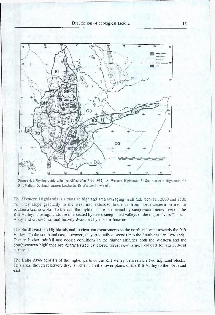
F ig u re 4 ,1 Physiographic units (m odified a fte r F riis 1992). A: W estern H ighlands, B: South-eastern H ighlands, C:
R ift V alley , D: S outh-eastern L ow lands, E: W estern L ow lands.
The W estern Highlands is a massive highland area averaging in altitude between 2000 and 2500 m. They slope gradually to the west into extended lowlands from north-western Eritrea to southern Gamo Gofa. To the east the highlands are terminated by steep escarpments towards the Rir't Valley. The highlands are intersected by deep, steep-sided valleys of the major rivers Tekeze, Abay and Gibe-Omo, and heavily dissected by their tributaries.
The South-eastern Highlands end in clear-cut escarpments to the north and west towards the Rift Valley. To the south and east, however, they gradually descends into the South-eastern Lowlands. Due to higher rainfall and cooler conditions in the higher altitudes both the Western and the South-eastern highlands are characterized by closed forest now largely cleared for agricultural purposes.
The Lake Area consists of the higher parts of the Rift Valley between the two highland blocks. This area, though relatively dry, is richer than the lower plains of the Rift Valley to the north and east.
16 Chapter 4
The Lower Rift Valley extends over the north-eastern part of the country, including the Af§r plains. These are low and very dry areas.
The vast South-eastern Lowlands stretching from the slopes of the South-eastern highlands the borders of Kenya and Somalia are also low and dry areas.
The W estern Lowlands are the lowlands limiting the Western Highlands to the north-west, 'to the south-west these highlands are limited by the Baro-Akobo Basin and the Omo Basin. f
The Red Sea Coastal Plain stretching all along the Red Sea coast is generally low and flat a id j very dry.
Many other divisions are possible. Friis (1992) has a slightly different division also using m ajirl rivers to separate sub-units in the highlands and lowlands, figure 4.1.
4.2.2 Climate
Different aspects of climate are the most important factors for the distribution of ihe larger p ltn | formations, such as forest, woodland and bushland. In the lowlands rainfall is, because ofjit$ marginal nature, the most important single environmental element. In the highlands, howererf temperature becomes a very significant factor with increasing altitude. 1 j
4.2.2.1 Rainfall
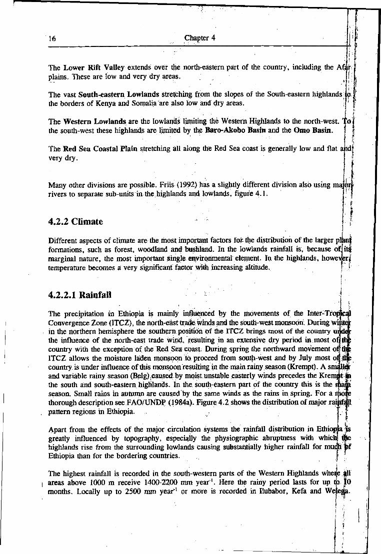
The precipitation in Ethiopia is mainly influenced by the movements of the Inter-Tropi Convergence Zone (ITCZ), the north-east trade winds and the south-west monsoon- During wi in the northern hemisphere the southern position of the ITCZ brings most of the country the influence of the north-east trade wind, resulting in an extensive dry period in most off] country with the exception of the Red Sea coast. During spring the northward movement of ITCZ allows the moisture laden monsoon to proceed from south-west and by July most oj country is under influence of this monspon resulting in the main rainy season (Krempt). A sms 11 and variable rainy season (Belg) caused by moist unstable easterly winds precedes the Krenqit im the south and south-eastern highlands. In the south-eastern part of the country this is the season. Small rains in autumn are caused by the same winds as the rains in spring. For a moj thorough description see FAQ/UNDP (1984a). Figure 4.2 shows the distribution of major rai pattern regions in Ethiopia.
Apart from the effects of the major circulation systems the rainfall distribution in Ethiopia greatly influenced by topography, especially the physiographic abruptness with whic] highlands rise from the surrounding lowlands causing substantially higher rainfall for mui Ethiopia than for the bordering countries.
The highest rainfall is recorded in the south-western parts of the Western Highlands whei areas above 1000 m receive 1400-2200 mm y ear1. Here the rainy period lasts for up months. Locally up to 2500 mm y ear1 or more is recorded in Ilubabor, Kefa and Wejei
io
Description of ecological factors 17
UGANDA K E N Y A|0 3B " 5 T ° 3 9 * 4 1 " 4 3 *
L S E A
E T H I O P I ARAINFALL PATTERN REG IONS
A Rains in simmer.Rains fro * spring to autumn.Rains in spring, summer and aututn merging together.Rains in autuon, winter and spring merging together.Small ra ins in sum er.Small ra ins in spring, b ig rains in su n e r merging together.B ig ra ins in spring, small ra in* in autuan
GULF OF ADEN
n
F ig u re 4 ,2 R ainfall pa tte rn regions (fro m F A O /U N D P 1984a).
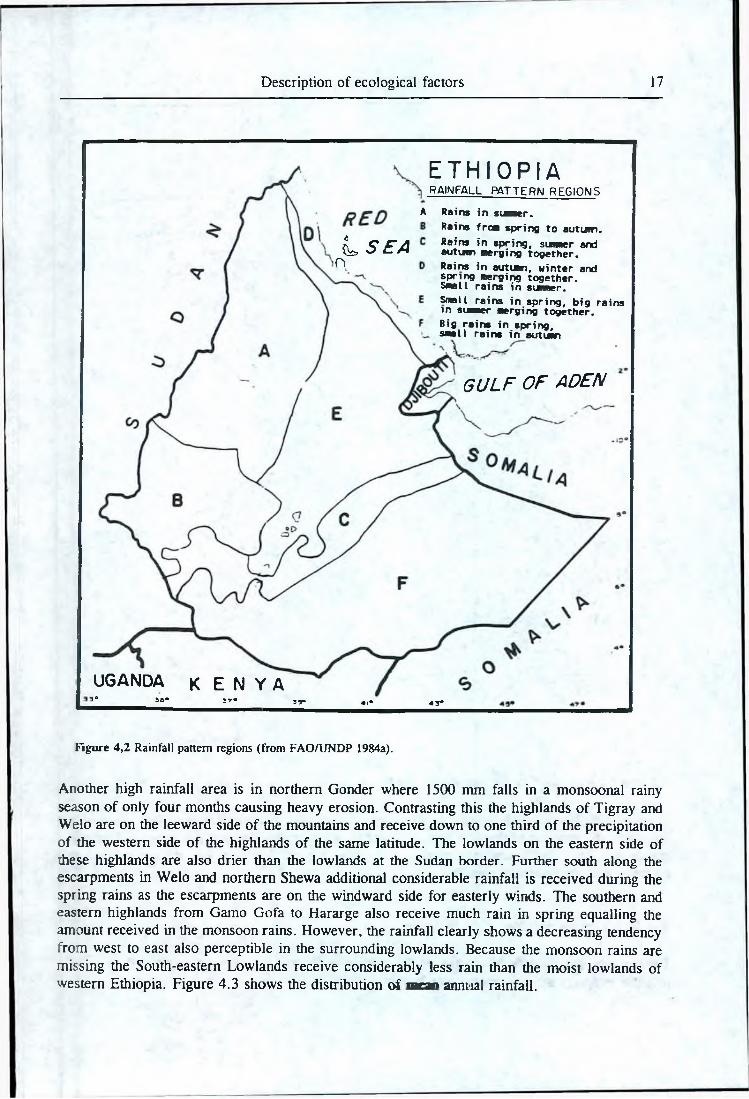
Another high rainfall area is in northern Gonder where 1500 mm falls in a monsoonal rainy season of only four months causing heavy erosion. Contrasting this the highlands of Tigray and Welo are on the leeward side of the mountains and receive down to one third of the precipitation of the western side of the highlands of the same latitude. The lowlands on the eastern side of these highlands are also drier than the lowlands at the Sudan border. Further south along the escarpments in Welo and northern Shewa additional considerable rainfall is received during the spring rains as the escarpments are on the windward side for easterly winds. The southern and eastern highlands from Gamo Gofa to Hararge also receive much rain in spring equalling the amount received in the monsoon rains. However, the rainfall clearly shows a decreasing tendency from west to east also perceptible in the surrounding lowlands. Because the monsoon rains are missing the South-eastern Lowlands receive considerably less rain than the moist lowlands of western Ethiopia. Figure 4.3 shows the distribution of n w n annual rainfall.
18 Chapter 4
LE8ENQ
— — 1 « T C *W I«N A L tOtMOAHV
•#". **OlOK aounMKV
300~ ~ IS Q H Y E T
Figure 4,3 Mean annual rainfall distribution (from NMSA 1987).
In areas with low rainfall the rain is also higtdy unreliable. The extreme droughts which is a f
recurring phenomenon in the arid parts of Ethiopia are; seriously limiting a number of land usp j alternatives, including many tree species. Generally, the reliability of the rain can be said tp ; correlate with mean annual rainfall. \ 1
‘ ■ J : ~ , . . . : - - ' ■. ■ - - I -
: ■ ' - , i t4.2.2.2 Temperature
Temperature greatly affects plant growth - both directly and indirectly, through influence: oj potential evapotranspiration and water budget, ^ n
Description of ecological factors 19
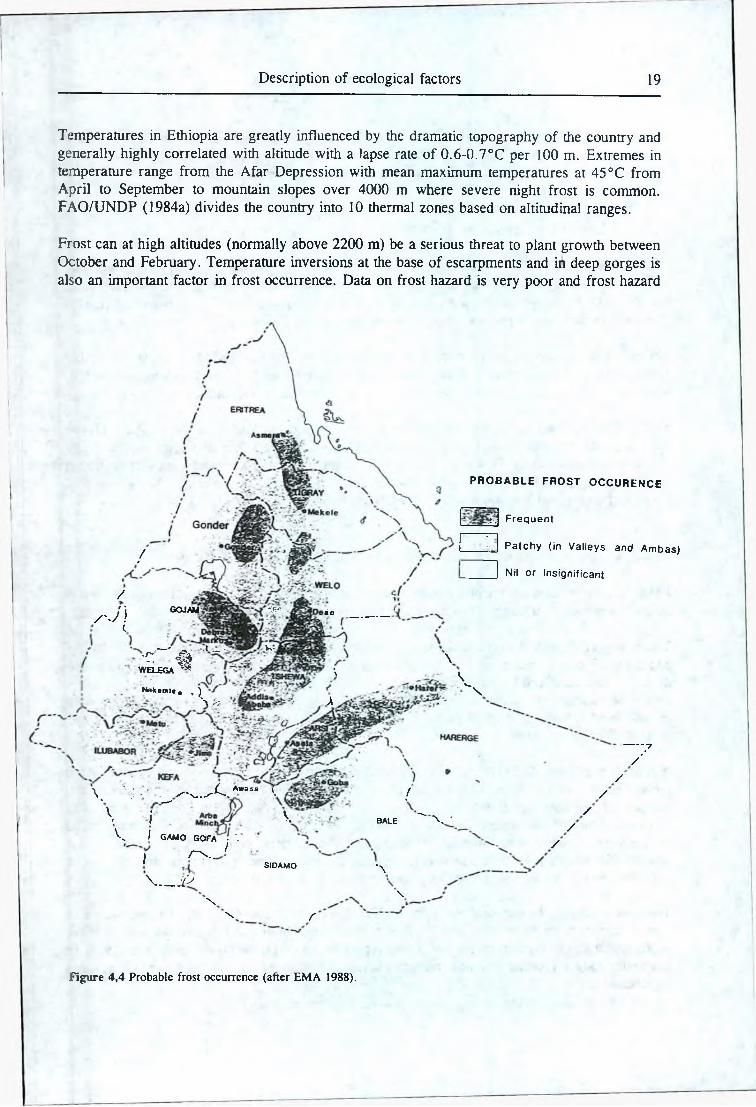
Temperatures in Ethiopia are greatly influenced by the dramatic topography of the country and generally highly correlated with altitude with a lapse rate of 0.6-0.7°C per 100 m. Extremes in temperature range from the Afar Depression with mean maximum temperatures at 45 °C from April to September to mountain slopes over 4000 m where severe night frost is common. FAO/UNDP (1984a) divides the country into 10 thermal zones based on altitudinal ranges.
Frost can at high altitudes (normally above 2200 m) be a serious threat to plant growth between October and February. Temperature inversions at the base of escarpments and in deep gorges is also an important factor in frost occurrence. Data on frost hazard is very poor and frost hazard
/
/w ' i
GOJAM ‘j y -
PROBABLE FROST OCCURENCE
^ Frequent
Patchy (in Valleys and Am bas)
Nil or Insignificant
aie ___________
I.— ' - ■ .1 __- Vv•
•C. #WELEGA ^ ~ \
Nekemte« , )
\
' \ y , -X
Vv" \
\ ' r: • • " - ^ / ' v . . ^ Awasa \ f
\ i V bale " x •
------7/
//
/
V I g a m o GOrA . V __ /
I
/
r \ ._
\ __ i>SIDAMO
\
/
‘\\
\ r
Figure 4,4 Probable frost occurrence (after EM A 1988).
20 Chapter 4
is only loosely related to thermal zones and yearly temperature variability (FAO/UNDP 1984a) | j Rough estimates of frost hazards in different highland areas are given in FAO/UNDP (1984b)j Figure 4.4 shows an estimation of probable frost occurrence in the highlands.
4.2.2.3 Length of growing period
The quality o f the rainfall is dependant not only on mean and probable annual rainfall but als i on the distribution of the rainfall through die year, potential evapotranspiration and soil moistui & storage capacity. In agriculture one speaks of the length and quality of the growing period (LGP- For forestry the most important aspect is the severity of the dry season.
Potential evapotranspiration is governed by air temperature, radiation, wind speed, length of dafe (in higher latitudes), humidity and vegetation. Higher altitudes are associated with higher rainfal and therefore clouds, and with cooler conditions, both leading to reduced evapotranspiration.
FAO/UNDP (1984a) and others have calculated and mapped LGP iso-lines though Pauw (1988) did not find it possible to apply such general LGP iso-lines due to the important aspect of sail J moisture storage capacity. However, within each rainfall pattern region (see figure 4.2) the length j of the growing period (or inversely the severity of the dry"season) can be said to be more or lei;s | correlated with mean annual rainfall (FAO/UNDP 1984a). I
4.2.2.4 Application of climatic data in the seed zoning system j
Relevant climatic data for the delineation of seed zones are especially mean and probable annujal, rainfall, seasonal distribution of rainfall, temperature and evapotranspiration. j [
The quality of climatic data for Ethiopia is very poor, as there are tbo few meteorological stations | and many of them do not have records covering a sufficient number of years to give significative | data. It is recommended by the World Meteorological Organisation that the density of rain gauges f should be at least one gauge per 900-3000 km2 in topographically similar areas and that oqly| rainfall stations with at least 30 years of record should be used when estimating mean anmial t rainfall (Somi et al. 1979).
A rainfall map from 1982 (FAO/UNDP 1984a) is based on Only 405 stations, some of which hajvfc records of only two to three years and not from all months. The NMSA managed to increase tfiei number of meteorological stations to 1600 but during the war with Somalia about 4p0| meteorological stations were destroyed. A 1987 rainfall map (NMSA 1987) is, therefore, based! on the measurements from about 1200 stations. (NMSA, per s. comm.)- Large tracts of the country still has too poor coverage with meteorological stations and here rainfall iso-lines canibe only temporarily drawn using knowledge on topography, vegetation etc..
The. poor quality of the meteorological data in Ethiopia is illustrated by the fact that the two miaft annual rainfall maps from 1982 and 1987 show very large dissimilarities. All the major earfief ecological zonation systems mentioned in this report are based on the rainfall map from 1982. IiJ the future longer records and new rainfall stations probably again will alter rainfall iso-line| significantly.
Description of ecological factors 21
NMSA has in collaboration with Pauw established a database of 381 meteorological stations in Ethiopia. A printout of some of the information from the database can be found in Pauw (1988a). In FAO/UNDP (1984a) meteorological data for 147 meteorological stations in Ethiopia are listed.
It was not possible to obtain a rainfall probability map. Mean monthly rainfall maps (i.e. 12 maps) would, in theory, give valuable information provided they were reasonably reliable. However, an attempt at superimposing 12 such maps together with all the other types of nformation more relevant in identifying and delineating seed zones would only cause confusion.
Only very few stations provide data for an estimation of potential evapotranspiration (FAO/UNDP 1984a). Also, potential evapotranspiration (as well as probable annual rainfall and seasonal distribution o f rainfall) is more or less correlated with mean annual rainfall. Therefore, mean annual rainfall and temperature (supplemented by the database of meteorological stations) will provide the most useful information on the climatic variation in Ethiopia even though the exact delineation of seed zones cannot be based on these.
"Thus, in relation to the identification and delineation of seed zones it is permissible only to look at the two climatic factors mean annual rainfall and temperature, i.e. altitude. The NMSA (1987) rainfall map is supplemented by local more detailed (but not necessarily more accurate) rainfall maps, i.e. Chaffey (1979), FAO (1965) and Pratt (1978). An estimation of frost hazard is included in seed zone descriptions. Some data can be obtained from FAO/UNDP (1984b), Pauw (1988, 1988a) and EMA (1988).
4.2.3 Soil
When pronounced differences in natural vegetation types (different physiognomy and species composition) are found within a region of uniform climate and topography this is in most cases caused by variations in the physical and/or chemical characteristics of the soil.
The most detailed survey of soil types in Ethiopia was done in connection with the Assistance to Land-Use Planning project. FAO/UNDP (1984) gives a brief general account of the major soil types found in the different parts of the country. The major output was a 1:2,000,000 Provisional Soil Association Map showing 17 major soil groups and 35 soil units in Ethiopia (FAO/UNDP 1984f).
This relatively small scale map is justified as an introduction to the existence and approximate distribution of major soil groups. However, when using such national soil maps great care must be exercised as (Olsen & Aalbaek 1991):
1. The soil maps are very generalized and boundaries between soil types often represent very wide zones of transition.
2. The maps are based on scattered observations from limited soil investigations of which the techniques and data vary considerably with the aims. These observations have then been extrapolated with the aid of climatic, geological and topographical maps, many of these being inaccurate in themselves.
2 2 Chapter 4
3. Often there is no correlation between soil capacity for tree growth and the characteristics used to define the soil units. Furthermore, only rarely is the relationship between different species/communities and different soil types known.
Even detailed information from regional soil surveys would not influence the identification and delineation of the seed zones as soil variations are often too local and complex to be included in a national seed zoning system.
Soils are, therefore, not suitable as a basis for a zonation on a broad national scale. However, due to the important effect of soil conditions on tree growth and the frequent small scale variations, soil factors have to be included in a classification/description of local planting sites within a seed zone. Consequently it is of utmost importance for the seed zoning system that the individual foresters are familiar with local soil conditions (as assumed in section 3.2.4).
4.2.4 Vegetation
The natural vegetation; is an expression of all the environmental factors acting in a given area and is, therefore, very suitable as a basis for an evaluation of the ecological conditions with regard to the identification and delineation of seed zones.
A major problem in describing, and indeed reading about, the natural vegetation in Ethiopia is that there is no generally accepted system of classification. This makes it difficult to interpret various authors’ general descriptions of vegetation types and especially to assess the boundaries between types.
Breitenbach (1963) has the most detailed classification of the vegetation in Ethiopia describing countless vegetation types. Unfortunately, this classification does not distinguish between climax and secondary vegetation formations or facilitate an understanding of die ecological factors behind the different formations. Also vegetation types are not described as to areas and only major vegetation type groupings are roughly mapped.
The most thorough study of the vegetation of the whole country based on field observations is made by Pichi-Sermolli (1957) and his map still proves to give the most accurate picture of the vegetation in the country (Zerihun pers. comm.). In the arid parts of the country the map is less exact and should be used with caution (Friis pers. comm.). Pichi-Sermolli distinguishes in Ethiopia 21 different vegetation types based on physiography, figure 4.5.
The Pichi-Sermolli classification does, unfortunately, not distinguish between climax formations and different sub-climatic stages of degradation or regrowth, which in some cases makes it less applicable. For instance the vegetation type "Montane evergreen shrubs and woodland" covering large areas in the highlands comprises both natural dry Juniperus forest/woodland in Eritrea and Hararge and secondary regrowth in the most humid south-western parts of the South-eastern Highlands. Also, large areas of the highlands are merely classified as "Montane savanna’ -
2 T he te rm "natural vegetation" refers to all m ore or less d istu rbed vegetation types that is not actively established by m an and w hich is m ainly m ade up o f indigenous plants.
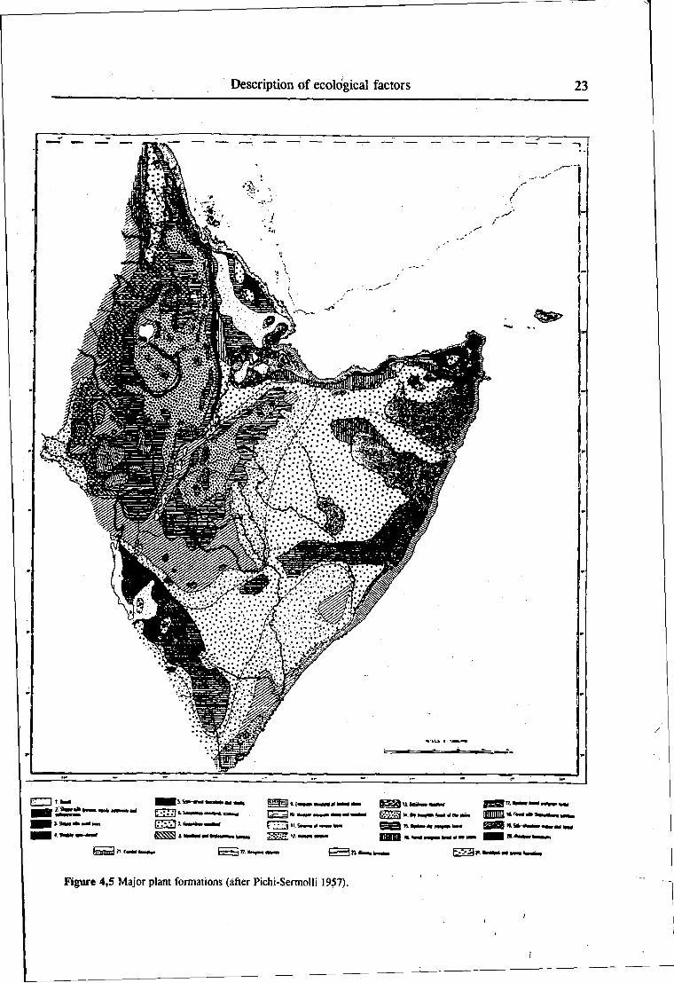
Figure 4,5 Major plant formations (after Pichi-Sermolli 1957).
I
24 Chapter 4
another secondary vegetation type. National Herbarium (1992) contains a modified and simplified version of Pichi-Sermolli’s map which is helpful though not very accurate.
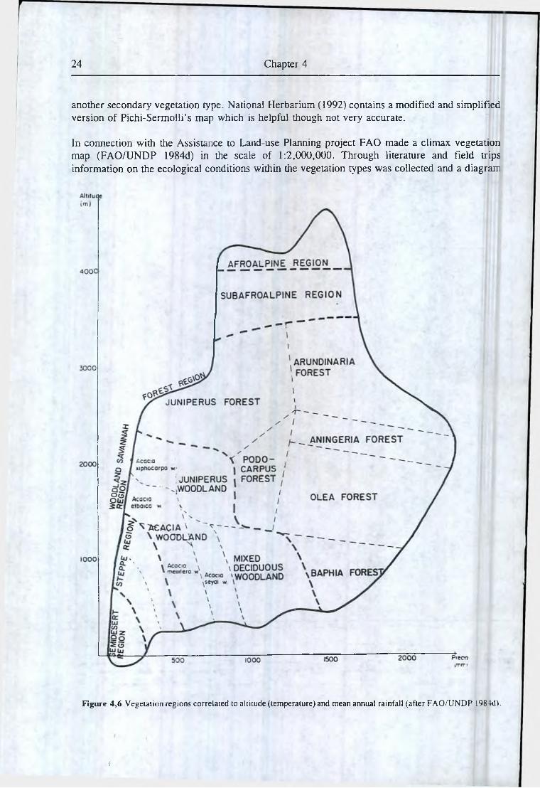
In connection with the Assistance to Land-use Planning project FAO made a climax vegetation map (FAO/UNDP 1984d) in the scale of 1:2,000,000. Through literature and field trips information on the ecological conditions within the vegetation types was collected and a diagram.
Figure 4,6 Vegetation regions correlated to altitude (temperature) and mean annual rainfall (after FAO/UNDP 198-U1).
i
Description of ecological factors 25
showing a theoretical distribution of the climatic climax vegetation types was compiled, figure4.6. The equations on which the distribution of vegetation types is based are rough, have some overlappings between vegetation types and might not be valid in all areas. Furthermore, climatic data in Ethiopia are of a very poor quality as described above and all the uncertainties of the rainfall map are inherited to the vegetation map.
Another map showing the actual land use and land cover was produced in 1:1,000,000 using satellite imageries (FAO/UNDP 1984c). In the highland areas and other intensively cultivated areas this map is less useful for the establishment of a seed zoning system as most of the land is classified as more or less intensively cultivated land or grasslands. In the drier parts of the country, however, this map provides a detailed information on the vegetation though the classification does not tell whether the vegetation is natural or derived.
SFCDD (1990) identifies many of the same vegetation types (within the forest region) as FAO/UNDP (1984d) and defines ecological ranges as to altitude, rainfall, temperature (and soil types) for each vegetation type. However, even though this work is based on the climatic climax vegetation map (FAO/UNDP 1984d) the ecological ranges given in many cases differ considerably from those defining the vegetation types in the Assistance to Land-use Planning project. This illustrates both that the knowledge about the requirements of different vegetation types is insufficient and that trying to press the complex patterns of variation into a fixed scheme always will be very arbitrary.
Friis (1992) provides a very detailed investigation of the botany of the Ethiopian forests. His classification of forest types is rough but generally very convincing. Chaffey (1979) made the most thorough inventory of the humid to wet forests in the southern parts of Ethiopia. Other major inventories are Russ (1979) and Logan (1946).
None of the existing classification systems (covering the whole country) has the desired detail (or necessary overview). Based on field observations and literature (especially Friis (1992), FAO/UNDP (1984d) and Greenway (1973)) the following major vegetation types are defined as the most important:
1. Semi-desert vegetation:Low bushes and stunted trees, mostly spiny, either deciduous or evergreen. More than half of the surface of the ground is bare of vegetation.
2. Bushland, thicket and scrub:Land with a more than 50% cover of shrubs or small trees often growing densely together. Evergreen or deciduous, spiny or non-spiny. Bushes without clearly defined bole, from 1-5 m high. Taller trees may be present. Important genera are Acacia and Commiphora.
3. Semi-arid woodland:Land with an open cover of trees the crowns of which do not form a thickly interlaced canopy and which are leafless for some period in the year. Most important genera is Acacia.
26 Chapter 4
4. Broad-leaved deciduous woodland'Land with an open cover of trees the crowns of which do not form a thickly interlaced canopy and which, as a rule, are leafless for some period of the year. Scattered evergreen shrubs may be present but are not conspicuous. Grasses and herbs form the dominant ground cover. Important genera are for instance Terminalia, Combretum and Boswellia.
5. Juniperus forest:Relatively dry forests dominated by Juniperus procera with Olea africana and a number of other species in the lower stories. In high altitudes Juniperus will also dominate in humid areas.
6. Undifferentiated afro-montane forest:Juniperus-Podocarpus forests or predominantly Podocarpus forests, both with an element of broad-leaved species.
7. Broad-leaved afro-montane , j inforest:Forests with a mixture of broad-leaved species and Podocarpus, but Podocarpus is never predominant.
8. Lowland semi-deciduous forest:Low, relatively dry semi-deciduous (Guineo-Congolian) forests with many lowland species.
In many areas these natural vegetation types are succeeded by agriculture or secondary vegetation, often drier stages of regrowth. Also, many other vegetation formations exist (more or less scattered), e.g. different grasslands, wooded grassland, swamp vegetation, halophytic vegetation and riverine forest. These vegetation types, however, are of minor importance in relation to the seed zoning system.
The botany of the natural vegetation is in large areas of the country not very well known (Friis 1992) and the botanical literature of Ethiopia is relatively poor. Moreover, much of the existing literature proved unobtainable in Ethiopia. As mentioned above the botanical literature is often difficult to interpret and different identified vegetation types are not located in a sufficient extend.
These obstacles meant that own field observation had to be given a high priority. Field observations gave a first hand impression of the ecological conditions in the visited areas and, just as important, gave local interpretation keys (mainly as to topography and rainfall) for all the necessary extrapolations of seed zone boundaries.
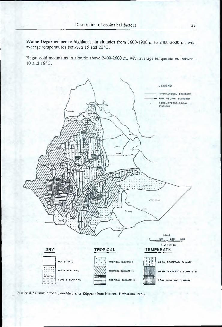
4.3 Existing ecological zonation systems
Since ancient times, a rough classification dividing Ethiopia into three zones based on climatic conditions, mainly expressed by altitude and temperature, has been used. Breitenbach (1963) gives the following ecological ranges but the boundaries between the zones differ among authors:
Kolia: hot lowlands, in altitude below 1600-1900 m, with average temperatures between 20 and 29°C.
Description of ecological factors 27
Woine-Dega: temperate highlands, in altitudes from 1600-1900 m to 2400-2600 m, with average temperatures between 16 and 20°C.
Dega: cold mountains in altitude above 2400-2600 m, with average temperatures between 10 and 16°C.
DRY TROPICALKILOMCTftCa
TEM PERATE
HOT « Anto
H O T a S E M I A » I 0
COOL a SEM IA ftio
W A R M T E M P E R A T E C U M A T E I
W A R M T E M P E R A T E C L I M A T E i l
C O O L H I G H L A N D C L I M A T E
Figure 4,7 Climatic zones, modified after Koppen (from National Herbarium 1992).
28 Chapter 4
This classification has later been extended to include the whole country, i.e. Berha in altitudes below the Kolia and Wurch and High Wurch in altitudes above the Dega.
A more complex classification using Koppens climatic classification system is shown in figure4.7.
4.3.1 Zonation systems for forestry
Several attempts have been made to divide Ethiopia into rough zones for the recommendation or species to different planting sites.
FAO (1979 and 1983) made some preliminary suggestions concerning species selection to site However, their bio-climatic zones show little correlation with the natural vegetation. Later the Forestry Research Service (FRS 1985) made some recommendations based on a compilation o research results. Also SFCDD £1987) contains recommendations for the choice of species.
Bowen (1985) divides the country into four broad ecosystems, i.e. lower plateau, upper plateau, south-west Ethiopia and arid lowlands. He then recommends species for community forestry ant industrial use in the four ecosystems and inversely recommends planting sites for some importan species.
In an attempt at assessing all existing species trials in Ethiopia as to species’ applicability in different ecological zones Orlander (1986) divides the country into five rough zones based on annual rainfall (after FAO 1979):
I: Semi-desert, coastal plains rainfall < 300 mmII: Dry lowland and plateau 300-700 mmIII: Semi-dry lowland and plateau 700-1000 mmIV: Semi-wet lowland and plateau 1000-1400 mmV: All year rainfall, wet region " 1400 mm
He argues that as there are no research plots in most areas of the country , there is no basis for elaborating more sophisticated classifications for-species recommendations. A list of recommended species is then prepared for each zone. However, When selecting species for a specific site altitud and soil conditions must also be considered.
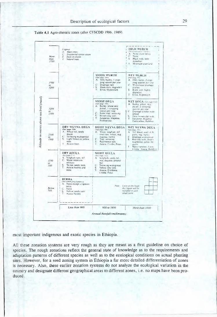
The Community Forestry and Soil Conservation Development Department (CFSCDD 1986, 1989|) has for the choice of species divided the country into 11 agro-climatic zones based on the traditional classification but further sub-divided into dry, moist and wet zones, table 4.1. For ja range of indigenous and exotic species the natural distribution, ecological requirements etc. arb listed and the relevant agro-climatic zones are outlined. j
SFCDD (1990) does not give a general zonation system. Instead, the ecological requirements ojf 120 important species are listed and maps of potential planting areas for 28 species are drawn,
t
Webb et al. (1984) list the natural occurrence, climatic range and soil conditions for 173 tropical ,t and sub-tropical species. Also. Davidson (1988) specifies ecological ranges for a number of the »;
Description of ecological factors 29
T a b le 4,1 A gro-clim atic zones (after C FS C D D 1986, 1989).
rLegend HIGH WURCH tA Main crops . No common.t\ n■e»tr» 1C Traditional conservation A None (frost limit)
More 5 Soils on slopes ' C Nonethan T Satural trees 1 S. Black soils, little.3700 disturbed *
' T M ountain grassland I i ' : i i
i
MOIST WURCH WET WURCHfScc page KM)) (See page Qx iA Only barley. 1 crop A Only barley 2 crop-
1700 ping season per year ping seasons per vcarto C Drainage rare C W idespread dram acc3200 S Black soils, degraded ditches
T Erica. Hypericum S Black soils, highlsdegraded
T Enca. H spencum
2 MOIST DEGA WET DEGA Sve Pdse 102 (See page 104j A Barley, wheat, nug.A Barley, wheat and pulses 2 croppine
£ *200 pulses. 1 cropping seasons per scarto season per year C: Drainage ditches wide*
g 2300 C: Some trad terracing spreadS Brown clay soils S Dark brown clav soils
£ T Juniperus. Hagcnia. T Juniperus. h agenia.
«Podocarpus Podocarpus Bamboo
1 DRY WEYNA DEGA MOIST WEYNA DEGA WET WEYNA DEGAiSer page 1 10) (See page 10H) (See page |(/fn
5 A W heat Icf. rarely A Maize, sorghum, tcf A Tef. maize, inset in W~ 2300 maize inset rare, wheat, nug. pans. nug. bark
Z to C Terracing widespread dagussa. barley C Drainage widespread1500 S Light brown to yellow. C Trad terracing S Red clay soils, decplv
3 soils S Red-brown soils weathered, gullies ireT Acacia trees T Acacia. Cordia. Ficus quern
T T Mans varieties 1icus.Cordia. \cacia Bamboo
DRY KOI.LA MOIST KOLLAj | i>cc page 1 i-s | (See page 112)
A Sorghum rare, tcf A Sorghum, rarely tef.1500 C W ater retention nug. dagussa. groundto terraces nut500 S Yellow sandy soils C. Terracing widespread
T Acacia bushes and S Yellow silty soilstrees T Acacia. E rythnna.
Cordia. Ficus
BF.RHA I, (No community forestry) — ij A None except irrigation j
areas ."vie uuier in m e vookBelow 1 C: None this figure will he 1500 S Yellow sandy soils repeated in such
1
1 T Acacia bushes 1 1 1 |
small form
Less than 900 9 0 0 to 1400 More than 1400 I »
Annual Rainfall (millimetres)
most important indigenous and exotic species in Ethiopia.
All these zonation systems are very rough as they are meant as a first guideline on choice of species. The rough zonations reflect the general state of knowledge as to the requirements and adaptation patterns of different species as well as to the ecological conditions on actual planting sites. However, for a seed zoning system in Ethiopia a far more detailed differentiation of zones is necessary. Also, these earlier zonation systems do not analyze the ecological variation in the country and designate different geographical areas to different zones, i.e. no maps have been produced.
30 r~ Chapter 4
They are, therefore, of limited value for the identification and delineation of seed zomis. However, they are indispensable when designating suitable tree species for each zone in tie description of seed zones.
4.3.2 Agro-ecological zonation systems
Assistance to Land-use Planning (FAO/UNDP 1984-1984f) is a very extensive land resource £ tic land use inventory. The total output of the work comprises maps of mean annual rainfall, rain probability, length of growing season, thermal zones, provisional soil associations, physic pedomorphology, climax vegetation, natural regions, land use and land cover, land use potent al, land resources and generalized agro-climatic zones plus extensive legends and a thorougl description of basic ecological factors.
A Land Resource map in 1:1,000,000 was constructed by superimposing maps of thermal zones) length of growing periods and geomorphology and soils (FAO/UNDP 1984). Soil types are v^rj important and some 1250 significant land facets are identified and grouped into 120 management units.
Another map is the Land Use Potential map. The country is divided into highlands and lowlajids and based on length of growing period areas suitable for perennial crops, annual crops anc livestock and areas not suitable are identified.
Pauw (1988) has established a detailed system of agro-ecological zones. It is pointed out that i£ earlier studies the quality of growing periods has consistently been overestimated and, therefore^ a new inventory of growing periods is the backbone of the present study. Also, it is argued thajjt growing periods can not be mapped by length because of dependence on mainly soil moisiur storage capacity.
Other important inputs are thermal zones, soil and landform. 6 thermal zones and 14 grow period zones are identified and superimposed, creating 53 zones. Including data on soil and form a total of 140 agro-ecological zones are identified. The agro-ecological zones aro, regroup into 15 agro-ecological regions somewhat related to landform units.
As this study is made specifically for agriculture the zonation does in some cases not match demands to a system for forestry. However, the map is relatively clear and shows, especially’ the drier parts of the country, a reassuring correlation with vegetation and other maps.
Negash et al. (1989) have made a system of agro-ecOlogical zones mainly based on lengtn df growing period, temperature and physiography. Seven moisture regime classes (length of growing period) and three temperature classes (thermal zones) were superimposed thus creating 18 agro- ecological zones. These zones were then again superimposed on nine physiographic reg|oijs resulting in 62 sub-zones. J
The primary classification is one into moisture regime classes based on length of growing season. However, the delineation of the primary classes on the map shows in some areas little correlatiqjti
Description of ecological factors 31
with the length of growing season lines on the Natural Regions map produced by FAO/UNDP (1984d) or with mean annual rainfall maps (FAO/UNDP 1984a, NMSA 1987).
Again, the classification criteria, relevant for agriculture, does not always match the demands to a system for forestry. The agro-ecological zone map is, therefore, not suitable for the establishment of seed zones but is useful as an inspiration to the identification of seed zones.
F ig u re 4 ,8 G row ing period zones (a fte r National H erbarium 1992). N is no. S is sing le and D is double grow ing
period . W ith in S and D increasing num bers m ore o r less identify increasing length and quality o f g row ing period(s).
NMSA divides the country into agro-climatic zones based on the number, length and quality of growing periods (National Herbarium 1992). A total of 53 growing period zones which comprise
32 Chapter 4
5 zones with no growing period, 21 with one growing period and 27 with two growing periods are identified. The 53 zones have been grouped into 14 broad growing period regimes showp tjh figure 4.8.
Local agro-ecological zonation systems
Only few local assessments of ecological factors, vegetation etc. resulting in local zonatiin systems have been encountered. The Southern Rift Valley has been investigated by Pratt (I ?7|) and the Awash River Basin by FAO (1965). These two studies present detailed zonations oj study areas which are very useful for the delineation of seed zones.
The Ethiopian Highlands Reclamation Study (FAO 1986) is an extensive study of problei potentials and solutions in the highlands of Ethiopia. It contains an agro-ecological zonatic the area but this zonation is very rough and of limited information.
4.4 Combined assessment
In this chapter the most important ecological factors, i.e. physiography, soil and climate and influence on the vegetation have been described.
The physiography of Ethiopia has a very strong influence on vegetation through temperatur| and water balance and will be given major consideration both in the identification and the delineation of seed zones. [
Soil is a most important factor for the distribution of local different vegetation types but sLil differences are often small and complex and difficult to take into account in a seed zoning syktem. Also soil surveys are in most areas sparse and all soil classification systems have : na|or disadvantages. Therefore, soils will not have decisive influence on the identification delineation of seed zones.
Climate is very important for the identification of seed zones. However , climatic data are in areas sparse and not very reliable and the actual influence of climate on the vegetation is unknown. An identification and delineation of seed zones based directly on climatic data Woiild, therefore, be rather arbitrary. ; !'
There has been a number Of earlier attempts at delineating ecological zones in Ethiopia, nkaiply for agricultural purposes. None of these zonation systems can be used directly in this repojrt put they do give valuable information and inspiration for the identification and delineation of seed zones. |
The (genetic) variation of the natural vegetation is what is of real interest when establishing, a s|ed zoning system. Also, the natural vegetation is an expression of all the ecological factors -acting together and a study of the natural vegetation is, therefore, a shortcut to an understanding joflthe variation of the ecological factors. However, data on the natural vegetation in Ethiopia is insufficient and the existing knowledge has to be interpreted and supplemented using informafion on the basic ecological factors. I *
Description of ecological factors 33
Generally speaking the data in Ethiopia both on the natural vegetation and on the basic ecological factors is too poor to support the establishment of a satisfactory seed zoning system alone. Consequently a number of field trips had to be undertaken, partly in order to gain knowledge necessary to interpret the maps and literature, and partly in order to fill in geographical gaps in the obtainable literature.
36 Chapter 5
zone under the heading "geographical area" (see section 5.2.3). Naturally, there are, counties j similar cases (involving less disjunct areas, areas not recognized, areas that are too small ,ete>' which have not been incorporated into, the system. It is emphasized that common sense must; be employed when using the system. Recognized major exceptions within zones, like the salt affected plains in the Awash Plain Semi-arid Bushland (3.1) ai;e included m the individual zone descriptions under "remarks".
Identification of sub-zones
In many areas die zones still comprise huge ecological variation that cannot be negleci eel, especially due to variations in altitude and thereby temperature and precipitation. This is partly because of the nature of the ecological variation in itself (e.g. the geographical area of the cha rigfe is too small to be separated or conditions change abruptly and repeatedly) and partly because lack of data makes it impossible to assess these variations as to area. In some cases recognized niajor exceptions are described. In cfther cases it was necessary to identify sub-zones within zones. Ttjese sub-zones cannot be shown on a map but have' to be defmed using easily identifiable ecological criteria such as altitude and distinctive changes in vegetation.
-
5.2.2 In relation to delineation
In the mountainous areas of Ethiopia many continua are narrow. Therefore, it is often not possible to move seed zone boundaries to closest roads, rivers Jetc. without violating too much the condition that zones should be ecologically homogeneous. However, these narrow continua (slopes, escarpments etc.) are often easily identifiable in the field and they can'themselves be u sed as seed zone boundaries.
In very wide ecological continue or where die geographical position of the relevant ecolog ileal change is unknown boundaries will be move<l (as short as possible) to coincide with recogn&itiljfc geographical features.
Delineation of sub-zones ' [ i
Most of the sub-zones defined above are altitudinal sub-zones in the high mountains. The number of sub-zones within zones (two or three) and the altitudinal ranges are firted based'on the total ranges in the relevant zones. However, some consistency has been attempted at in order to make the zonation user friendly. Thus, air sufr-zotieS in the Juniperus and the Undifferentiated Ajfro- montane Forest zones have the altitudinal ranges below 2400 m, 2400-3000 rii and above 3000 m. In the southern1 parts of both highland areas rainfall increases and the forest climbs down. Consequently the altitudinal sub-zones of the rainforest zones are fixed below 2000 m, 2000-2700 m and above 2700 m. ^
In FAO/UNDP (1984d) altitudinal boundaries on south-western exposures are pushed up 1300 compared with the colder north-eastern exposures. There is some reason in this though 300 m is too much, especially in high altitudes, and the rainfall aspect is not taken into consideration. However, not all slopes are south-west or north-east exposed and such exposure
Delineation and description of seed zones 37
altitude ranges will be difficult to use in practice. The major zones usually do have southern and western boundaries delineated at lower altitudes than northern and eastern boundaries, mainly due to higher rainfall.
5.2.3 In relation to description
The description of seed zones was standardized by working out a form containing the following details:
1. Nomenclature and coding:Zone and ID.No. Zone names are designed in order to suggest both the geographical position and the ecological grouping of zones.
The zones have been coded in a logical order after humidity so that generally the driest zones have the lowest numbers and the wettest zones have the highest numbers. The semi- deciduous forest zone (25) could not be fitted into this system and is numbered last together with the somewhat associated rainforest zones.
Zones that are both geographically and ecologically close (but not similar) have the same first digit in the ID.No.
2. Geographical area:Makes possible easy location of area. Described using well known predominant physiographic features and administrative regions. Old administrative regions are mentioned in brackets.
3. Boundaries:Described clockwise. The use of the term "boundary" is restricted to seed zone boundaries. The term "border" is used for administrative (i.e. national, regional and district) borders. Boundaries are described using the Series EMA 5 1:1,000,000 maps (EMA 1982).
4. Area:Given in km2 and % of the whole country. Large lakes are excluded. Areas were measured on the fmal seed zone map (using a planimeter) and thus are only rough estimates as the exact position of otherwise distinct ecological/physiographic boundaries cannot be shown on the map.
5. Altitudinal range:Divided into typical range and total range (given in brackets). This distinction is made in order to give a more complete picture of conditions in the zones. Both ranges are estimated using all available information (contour lines, mountain peaks, lake levels, drainage conditions etc.) and it is not possible to calculate the area included only in the typical range. However, the typical range is generally aimed at including at least 90% of the total area. If total range is not indicated it is similar to typical range. Altitudes are given in meters above sea level.
38 Chapter 5
6. Rainfall range:As above, this is divided into typical and total range. Estimations are done using the mean annual rainfall map (NMSA 1987) and data on meteorological stations in FAO/UNDP (1984b). However, extrapolations are often necessary due to lack of data in many areas. Lesser areas with extreme rainfall are included only in total range. If total range is not indicated it is similar to typical range.
7. Frost hazard:Almost no data is available and frost hazard descriptions are based on very rough estimates.
8. Vegetation:Only the major vegetation types are indicated. Every zone contains other less common types, e.g. riverine forest. Major exceptions are described under remarks.
9. Selected species, indigenous:The lists of species are composed from literature, observations in the field and personal communications. The species mentioned are not necessarily those that characterize the main vegetation types in the zone but those (usually within the main vegetation types) that are of (potential) importance to NTSP, i.e. contained in a list of priority species in SFCDD (1990). The length of the lists are not necessarily indicative of the number of species that exists.
Plant names from older botanical literature may have been altered and names have bee ichecked by newer literature (Palgrave 1983, Noad & Birnie 1989).
The examples are listed in alphabetical order. It was not possible to list the species as toecological requirements or relative importance to afforestation in a consistent way.
10. Selected species, exotics:The lists of selected exotic species (i.e. "species recommendations") are made from forestry literature, mainly based on interpretations and comparisons of different lists of ecological ranges of various species with the ecological ranges within seed zones. This is a big and complicated task and, therefore, far from completed. Many species are not mentioned m all relevant zones and it is useful also to look at other, "ecologically close" zones. Most important literature for recommendation of exotic species was for all zones FAO/UNDP (1984g), Orlander (1986) and Webb et al. (1984).
11. Selected literature:Provided to ease evaluation and refinement of the zones. The references are a selection of the material used to describe the individual zones (though with emphasis on vegetation).
12. Remarks:Here the already mentioned major exceptions from the main vegetation types and other special conditions of interest, e.g. special soil conditions are described.
Sub-zones are also described. Sub-zones are coded "1", "i" or "u" to suggest whether they are lower, intermediate or upper sub-zones.
Delineation and description of seed zones 39
13. Typical meteorological station(s):The stations quoted are found in FAO/UNDP (1984b). The stations are as typical as possible. However, some of the zones contain varied climates (due to size, altitudinal range and different aspects) and the climate for any particular area should be estimated carefully. For some of the larger zones two stations have been provided to assist in the estimation. Nevertheless, reference to rainfall and topographic maps should be made. Meteorological stations could not be found for all zones.
Most of the meteorological stations listed in the FAO/UNDP (1984b) have too short records to be truly reliable. These were the only data available, though newer data must exist at the NMSA.
Mean annual temperature is calculated as a crude mean of the mean monthly temperatures. Mean length of dry season is calculated as the number of months with less than 50 mm of rainfall which is the most used criterion in East Africa (Olsen & Aalbaek 1991). It is stressed that the length of dry season is only indicative and does not take into account temperature or soil conditions or rainfall reliability. When no meteorological station is available the length of dry season is estimated.
5.3 Actual identification and delineation of seed zones
A most logical approach is first to identify the zones relevant and necessary according to the ecological variation in the country and the intended uses of the seed zoning system, then to delineate them. However, the identification of zones was partly done simultaneously with the delineation of zone boundaries as the number of zones that it is relevant to identify among many other factors depends on the boundaries that it is possible to delineate. This in turn depends on the limited information in certain areas.
Basically, the major physiographic units and major vegetation types were identified from the beginning whereas the further divisions were made along the way as information concentrated. The degree of elaboration (i.e. the number of identified zones in an area or over an ecological gradient) reflects the amount and quality of the information available. Thus, many divisions would not have been possible without information gathered on field trips.
The following text is a thorough description of the considerations motivating the identification and delineation of each seed zone. This is provided as a guide to:
1. understand the ecological reasons for the identification ana delineation of zones, which is a prerequisite for using the seed zoning system satisfactorily.
2. how users identify boundaries in the field.
3. future evaluation and refinement of zones and zone boundaries.
Most geographical names refer to the old administrative division of the country. This is mostconvenient as all maps and literature use this delineation and because this delineation correspondcloser to the physiographic regions of the country due to the frequent use of major rivers.
40 Chapter 5
1 Coast
Physiography and rainfall pattern suggest a coastal zone. This is confirmed by many authors though the width of the zone differs (Pichi-Sermolli 1957, Breitenbach 1963, National Herbarium 1992, Negash et al. 1989). Breitenbach .(1963) has a hot coastal semi-humid plain from sea level up to 700 m. According to Pauw (1988) potential evapotranspiration is 1800-2000 mm which is considerably lower than further inland. Soils are generally salt affected Orthic Solonchaks (FAO/UNDP 1984f). The zone is generally thought to be 20-40 km wide and the boundary to follow the 500 m contour line.
The coastal zone is very long and narrow and is divided into a somewhat moister north-western zone (1.1) associated with the bushland of north-western Eritrea and a very dry south-eastern zone (1.2) associated with the semi-desert of the Afar Lowlands.
2 Afar Lowlands Semi-desert
In the driest north-eastern part of the Rift Valley a semi-desert zone is identified. A distinction between a semi-desert and somewhat less arid steppe zone to the south is suggested by Pichi- Sermolli (1957), FAO/UNDP (1984d) and Pauw (1988). However, ecological differences are small and of little importance to NTSP.
Pichi-Sermolli (1957) distinguishes several very arid vegetation communities which are grouped into this zone. The zone also more or less comprises the semi-desert and steppe zones of FAO/UNDP (1984d). Wilson (1977) defines a desert zone below 200 mm and different sub-desert scrubs climbing up the escarpment to approx. 1500 m. The latter are probably all more or less derived vegetation types and are here included in the bushland zones (3.2 and 3.3).
The western and southern boundaries towards the bushland zones (3.1-3.3) roughly follow the 700 m contour line which also apparently correlates with the 200 mm rainfall iso-line. Observations from field trip were given priority when setting the boundaries towards the bushland zones (3.1 and 3.2).
3 Northern Rift Valley Semi-arid Bushland
The eastern escarpment of the Western Highlands forms a transition from the arid and semi-arid lowlands to the semi-humid to humid highlands. The transition is divided into a lower bushland zone (3.2) and a higher woodland zone (6.2), the bushland zone from approx. 700 to 1000 m (200-400 mm) and the woodland from 1000 to 1700 m. However, north of Mekele the escarpment is considered too steep to justify two narrow parallel zones and only one zone (3.3) is distinguished.
Botanical literature distinguishes many different plant communities which cannot be mapped. Only two zones are considered relevant and the problem is to group the plant communities. Pichi- Sermolli (1957) is helpful but the delineations are mainly done on the basis of own field observations and extrapolation using topography and rainfall.
Delineation and description of seed zones 41
Field observations: Going W from Mile the steppe appear to continue until Eli Wiha and the bushland almost all the way up to Bati at 1550 m. However, this area E of Dese is supposed to be a high rainfall area. The vegetation along the road is very denuded and the woodland and bushland must have gone further down earlier on. Also, in order to be able to make meaningful extrapolations/interpolations using vegetation, rainfall and topography the boundaries are set further down the escarpment than recognized on the field trip.
The bushland zone is very long and narrow and the criterion of interbreeding stands is hardly fulfilled. Also, for the same altitude rainfall decreases from south to north. The bushland is iherefore divided into the following zones:
3.1 Awash Plain Semi-arid Bushland
Going south the Rift Valley becomes less and less arid and the woodland and bushland zones extend further down the escarpment and out on the Awash Plain than further north along the eastern escarpment. The bushland zone is still defined within the 200-400 mm rainfall range. Altitudes are generally below 850 m.
3.2 Welo-Tigray Eastern Escarpment Semi-arid Bushland
The identification and delineation of this zone is mainly based on own field observations and the extrapolations mentioned above.
3.3 Eritrea-Tigray Eastern Escarpment Semi-arid Bushland/woodiand
As the escarpment here is very steep, it is not convenient to distinguish both a bushland and a woodland zone. Rainfall is low (200-400(500)mm) and this zone is grouped together with the other bushland zones rather than with the woodland zones (6). Altitudes vary approx. between 500 and 1700 m. No altitudinal sub-zones are identified.
4 North-W estern Eritrea Semi-arid Bushland
The north-western triangle of Eritrea NW of Asmera is dominated by Acacia-Commiphora bushland and Acacia woodland and two such zones are identified. Generally rainfall decreases from south to north. However, the foothills of the Western Highlands extend north of Keren more or less to the Sudan border and moisture conditions here are more favourable than in the surrounding lowlands. The Western Eritrea Semi-arid Woodland (8) is identified in the highlands north of Keren above 1500 m curving down to include also the southern third of the triangle which have rainfall generally above 400 mm. The bushland zone thus comprises the northern two thirds of the triangle excluding the highlands. The southern transition towards the woodland zone is broad and an easily identifiable feature (the main road from Keren to the Sudan border) is chosen as boundary.
42 Chapter 5
Most attention is paid to FAO/UNDP (1984d) and Pauw (1988) which correspond closely to mean annual rainfall. Pichi-Sermolli (1957) and National Herbarium (1992) have somewhat different zonations which are believed not to be as good for this purpose.
5 South-eastern Lowlands Semi-arid Bushland
The dry South-eastern Lowlands cover vast areas (though not particularly important to forestry), but data are very scarce and the area was not covered by field trips. It was therefore decided only to distinguish two zones, i.e. a semi-arid bushland zone and a semi-arid woodland zone (9). The boundary is sought to include most of the Acacia woodland of FAO/UNDP (1984d) in the Southeastern Lowlands Semi-arid Woodland (9), a boundary which shows good correlation with Pichi- Sermolli (1957) and the 400 mm rainfall iso-line.
The transition is broad and confused by the number of big rivers and smaller tributaries that crosses the boundary on their ./ay south-east. The bushland zone is believed to extend into all the river valleys cutting north and north-west into the woodland zone. However, due to the lack of data it is not convenient to go into topographical details and the boundary on the map is fixec mainly using rivers and roads and district borders.
6 Northern Rift Valley Semi-arid Woodland
The higher and less arid parts of the Rift Valley, western Eritrea and the South-eastern Lowlands are characterized by woodlands dominated by Acacia species. The identification of these semi-aric zones is supported by Pichi-Sermolli (1957), FAO/UNDP (1984d) and National Herbarium (1992 ) and confirmed by field trips.
In the northern Rift Valley the boundary towards the bushland zones (3.1 and 3.2) approx follows the 400 mm rainfall iso-line and is described under the Northern Rift Valley Semi-aric Bushland (3). The upper boundaries towards the forest zones are approx. at 700-800 mm rainfall. The altitudinal limits depends on the rainfall which decreases from south to north. Delineations are mainly based on own field observations and extrapolations using topography and rainfall.
As the woodland belt is also long and narrow it is divided into a northern higher and a southern lower zone. The boundary between these two zones is chosen (arbitrarily) to follow the Mile-Ban road as the escarpment generally becomes steeper north of this line.
6.1 Awash Semi-arid Woodland
South of Bad the escarpment gradually becomes less steep, rainfall increases for the same altitude and the woodland and bushland zones climbs down the escarpment. However, going east alonj the northern escarpment of the South-eastern Highlands rainfall decreases again and the woodlanc climbs up. Generally the 1500 m contour line is used for extrapolation climbing to 1600 m eas of Asebot.
Delineation and description of seed zones 43
Going east from the Awash-Mile road available knowledge is very scarce. Longhitano & Bovazzano (1973) describes the vegetation approx. 50 km north of Awash Station as bushland and woodland. Edwards (1969) describes the vegetation approx. 40 km north of Erer Station as semi- desert. Little attention is paid to the latter as it must be a local or disturbed feature. According to FAO/UNDP (1984d) huge areas in northern Hararge are "steppe" but it is difficult to distinguish the effect of soil. However, the northern boundaries of the woodland and the bushland zones are extrapolated based on our own field observations, i.e. approx. along the 400 and 200 mm rainfall iso-lines respectively. This is supported by Pichi-Sermolli (1957) and Pauw (1988).
6.2 Welc -Tigray Eastern Escarpment Semi-arid Woodland
Driving from Bati to Kobo the lower limit of the Juniperus/Olea forest remnants were found around 1600 m. The escarpment below this altitude (i.e. not isolated valleys west of the escarpment) is included in this semi-arid woodland zone. Such areas were identified around Idari, around Doro Gibir and between Robit and Alamata.
7 Mitsiwa Escarpment Semi-arid Woodland
South-west of Mitsiwa is a high rainfall area with mean annual rainfall on the escarpment of 500- 1000 mm compared to the low rainfall below 400 mm to the north and south3 . Because of the higher rainfall the Eritrea Dry Juniperus Forest (15.1) is also believed to climb further down the escarpment, i.e. the upper boundary of the woodland zone is thought to follow the 1500 m contour line compared to 1700 m of the Eritrea-Tigray Eastern Escarpment Semi-arid Bushland/woodland (3.3) and 1500 m of the North-Western Eritrea Semi-arid Bushland (4).
8 W estern Eritrea Semi-arid Woodland
The criteria for the identification of this zone and the distinction from the North-western Eritrea Semi-arid Bushland zone (4) are outlined under the latter zone. To the south the semi-arid woodland gradually changes into Tigray Broad-leaved Deciduous Woodland (11.2). Here, there are reasonably good correlation between Pichi-Sermolli (1957), FAO/UNDP (1984d), National Herbarium (1992) and rainfall (the 600(-500)mm rainfall iso-line) and the boundary can very conveniently be situated to follow the Eritrean border from Sudan and east until R. Mereb. From there a tributary is followed east till the western slopes of the highlands which are included in the Eritrea Semi-arid/Broad-leaved Deciduous Woodland (11.1).
9 South-eastern Lowlands Semi-arid Woodland
This zone is an ecologically broad zone situated between the South-eastern Lowlands Semi-arid Bushland (5) and the southernmost forest zones of the Western and South-eastern Highlands. The boundary towards the bushland is described under that zone. The altitudinal transition towards the Lake Area Semi-arid Woodland (10.1) is gentle and the boundary is set along rivers just north
^ h e ex istence o f sim ila r w et spots along the escarpm ent fu rther north cannot be ru led out (F A O /U N D P 1984a).
44 , ! Chapter 5i | P. i : i :
of L. Abaya. Towards the Awash Semi-arid''Woodland (6.1) east of Harar the boundary is arbitrarily set along roads. Towards the Bard-Akobo Basin Grassland (12) the western humid lowlands are excluded and the boundary is set around Tinma Tid along the watershed separating f rivers going east and rivers going west.
The upper (north-western and northern) boundaries are defined by the forest zones (18, 21.k,21.3, 23.2,23.3 and 24.2), i.e. at approx. 13.00-1800 m; However, in certain places the transition towards the real forests zones will, be a special Dry Juniperus Woodland (14).
The zone is very big, ranging more than 1000 km from east to west. However, no ecologic# criteria has been found for cutting the zone into an eastern and a western zone which could redu the variation within zones.
Two altitudinal .sub-zones are identified:
9.1 A lower (southern) sub-zrne below 1500 mr9.u An upper (northern) sub-zone above 1500 m.
10 Central Rift Valley Semi-arid Woodlandv-
The central part of the Rift Valley between the Western and the South-eastern Highlands dominated by Acacia woodland. However, higher slopes are considerably richer and two zone ai# ■ identified.
The delineation towards the forest zones (20.3, 21.1 and 24-1) are mainly based on fid observations and Pratt (1978). Generally the western boundary is extrapolated along the 2000 contour line. However, going north and south the valley bottom are lower and so are tl boundaries towards* the forests (i.e. 1700 m east of Sodo and north-west of Welenchiti).
10.1 Lake Area Semi-arid Woodland
This zone is distinguished from the neighbouring Awash Semi-arid Woodland (6;1) and the Soiiti- eastem . Lowlands Semi-arid Woodland (9) because of higher altitude and thereby richpi vegetation. This is confirmed by Pauw (1988): •'
10,2 Debre Zeyit Slopes Semi-arid Woodland
■ l Jr-Climbing west from Mojo R. to Addis Abeba a broad zond bf transition with teff fields dotted with especially Acacia albida is found. Based on field observations the upper boundary is setjat Dukem and is extrapolated along the 2000 m contour line. The lower boundary is found around f Mojo, R. at 1850 m. Only the area between Dukem and Nazret has been confirmed by fields observations and is mapped. (The zone was also found on the western slopes north 6f Iteya rautf this area is too small to be mapped). ; / -
Delineation and description of seed zones 45
11 Broad-leaved Deciduous Woodland
The Western Lowlands and the western escarpments and the river valleys of the Western Highlands are dominated by broad-leaved deciduous woodlands. This is confirmed by all botanical literature and field observations. Broad-leaved woodlands might occur even in high rainfall areas if the dry period is severe or if the vegetation is repeatedly subject to fires. The definition used for broad-leaved deciduous woodland is thus very broad and ecological conditions vary considerably. Therefore, and because the geographical extend of the vegetation type is naturally split up, the vegetation type is divided into several zones.
11.1 Eritrea Semi-arid/Broad-Ieaved Deciduous Woodland
The zone is distinguished from the other broad-leaved deciduous woodland zones because of much lower rainfall. The state border can very conveniently be us~s as boundary.
The distinction between this zone and the Western Eritrea Semi-arid Woodland zone (8) zone is not due to the apparent amount of rainfall but due to altitude (generally above versus below 1200 m) and all vegetation maps.
The upper boundary towards the Eritrea Dry Juniperus Forest (15.1) follows the 1700 m contour line which is an extrapolation from a field observation north of Adwa. However, further north to the latitude of Asmera the boundary climbs up to 2000 m due to generally lower rainfall.
11.2 Tigray Broad-leaved Deciduous Woodland
Also this zone has lower rainfall than the more southern woodland, i.e. generally below 800 mm. The transition is gradual and the boundary is fixed along rivers. The boundary towards the Tigray Dry Juniperus Forest (15.2) follows the 1700 m contour line which was found north of Adwa and south of Idabaguna on field trip.
11.3 Western Lowlands Broad-leaved Deciduous Woodland
This is the main zone from where the other zones may say to be separated. On a field trip the boundary towards the Western Highlands Moist Juniperus Forest (19) was found at a surprisingly high altitude, i.e. at 2000 m. A reason can be the severity of the dry season which lasts up to 8 months. However, south of Simien Mts. the boundary is set following the 1700 m contour line. Still further south the boundary towards the Lake Tana Undifferentiated Afro-montane Forest (22) also follows the 1700 m line.
South of L. Tana rainfall on the western escarpment gradually increases though the highlands are generally lower. The upper boundary towards the forest zones is therefore lowered accordingly. Thus, he boundary towards the Gojam and Western Humid Undifferentiated Afro-montane Forest (20.1 and 20.4) and the Western Lower Broad-leaved Afro-montane Rainforest (23.1) follows the 1500 m contour line.
46 Chapter 5
Within this zone higher, more humid areas carrying Oxythenanthera bamboo thicket are found. These areas are treated as a separate zone (13).
11.4 Tekeze Broad-leaved Deciduous Woodland
The broad-leaved deciduous woodlands of the Western Lowlands extend far into the river valleys of the Western Highlands (Friis 1992, Wilson 1977, Scott 1955, Logan 1946). However, the three main river systems, Tekeze, Abay and Gibe-Omo are here separated from the Western Lowlands Broad-leaved Deciduous Woodland (11.3). This is partly as to reduce the geographical range o the zones but more important because the ecological conditions of the steep river valleys are highly influenced by the surrounding highlands and are believed to be quite different from the Western Lowlands.
The boundaries towards the Western Lowlands Broad-leaved Deciduous Woodland (11.3) are arbitrarily set close to where the rivers leave the highlands.
Based on field observations from crossing the Tekeze river valley the boundaries are extrapolatec following the 1700 m contour line. North of Simien Mts. woodland species were found up tc 2000 m but were mainly secondary growth and also here the boundary follows the 1700 m line
11.5 Abay Broad-leaved Deciduous Woodland
This zone was crossed between Debre Markos and Addis Abeba and found to extend from top to bottom of the Abay R. gorge. This observation is extrapolated. Boundaries can only be roughl) drawn on the map but are believed to be quite distinct in the field.
South-east of L. Tana the river valley is not very deep and carry the undifferentiated forest ol zone (22).
11.6 Gibe-Omo Broad-leaved Deciduous Woodland
Generally this zone has much higher rainfall than the former zones, i.e. 1200-1400 mm comparec to around 1000 mm. The zone was seen just west of Welkite in the valley below 1800 m but no far up the river at Bako. Again, boundaries can only be roughly drawn on the map but are believed to be distinctive in the field.
12 Baro-Akobo Basin Grassland
The vegetation of this zone is associated with the Western Lowlands Broad-leaved Deciduous Woodland (11.3) but pure grasslands are a main feature due to soil (Eutric Fluvisols) anc flooding. The zone includes the valley of the Akobo tributary at Kantiere. The delineation towards the Western Lower Broad-leaved Afro-montane Rainforest (23.1) and the Baro Lowlands Semi- deciduous Forest (25) is based on the inventory of Chaffey (1979).
Delineation and description of seed zones 47
On higher ground without the special soil and water conditions the grasslands are replaced by broad-leaved deciduous woodlands associated with the Western Lowlands Broad-leaved Deciduous Woodland (11.3). Therefore two sub-zones are identified:
12.1 A grassland sub-zone on the low plains.12.u A woodland sub-zone on higher ground.
13 Western Lowlands Oxythenanthera Bamboo Thicket
Within the Western Lowlands Broad-leaved Deciduous Woodland (11.3) an Oxythenanthera bamboo zone is identified in higher more humid areas approx. above 1500 m. Such areas are identified around Addi Arkay, around Wembera Mts., between Asosa-Bambesi and many places on the western slopes of the highlands. Very important is Chaffey (1979). Only the Asosa- Bambesi area is mapped.
14 South-eastern Dry Juniperus Woodland
Friis (1992) and FAO/UNDP (1984d) have a dry "Juniperus Woodland" zone between the forests of the highlands and the South-eastern Lowlands Semi-arid Woodland (9) extending down to 1500 m (FAO/UNDP down to 1350 m). This very special vegetation type was encountered on a field trip around Yabelo above 1800 m and is also found around Konso, Mega, Arero, Neghelle and east of Harar (Friis 1992) and probably many other places.
Field observations did not confirm the existence of a well defined zone of a comfortable size and the vegetation type is believed to occur scattered in isolated areas throughout the above described transition, especially at altitudes above 1800 m. The isolated areas we do know about are identified on the map. The lower altitudinal limit is compromised to 1700 m or wherever the limit for Juniperus is found.
15 Western Highlands Dry Juniperus Forest
The existence of this zone is confirmed by field trip and all relevant literature. The distinction of three zones as to humidity is based on field observations, Friis (1992), FAO/UNDP (1984d) and mean annual rainfall.
15.1 Eritrea Dry Juniperus Forest
As it gets drier further north the boundary towards the semi-arid woodlands of the escarpment climbs up. The boundary towards the Eritrea-Tigray Eastern Escarpment Semi-arid Bushland/ woodland (3.3) is set at the 1700 m contour line. On the western escarpment the 1700 m contour line found north of Adwa (see below) is extrapolated north. North of Asmera however, the boundary climbs up to 1800-1900 m.
48 Chapter 5
15.2 Tigray Dry Juniperus Forest
The eastern boundary towards the Eritrea-Tigray Eastern Escarpment Semi-arid Bushland/ woodland (3.3) is extrapolatea along the 1700 m contour line (see 15.3). This is partly confirmed by Friis (1992) and Wilson (1977).
West of Wukro the vegetation is recognized as getting moister. No Juniperus is seen but many Ficus, Syzygium and Cordia. However, Olea africana is still a predominant feature. Rainfall is slightly higher on the rainfall map (700-800 mm). To include this area in the deciduous woodland zone would be supported by Pichi-Sermolli (1957) and National Herbarium (1992) but not by FAO/UNDP (1984d) and Wilson (1977) as the altitude is generally near 2000 m and not by Friis (1992). The new species composition is still within Friis’s definition of Dry single-dominant Afro- montane forest (i.e. Juniperus forest) and therefore this zone is extended to include the area west of Wukro down to 1700 m.
Going north from Adwa to Rama the vegetation changes to Acacia woodland when descending to about 1700 m. This altitudinal boundary is extrapolated west to Tekeze R. gorge and east to the Eritrea Border.
The boundary towards the moister Welo Dry Juniperus Forest (15.3) was recognized on field trip when descending from generally 2500 m to generally 2200 m. The boundary towards Eritrea Dry Juniperus Forest (15.1) is politically convenient and supported by rainfall (below 600 mm).
The ecological variation within this zone is still very broad, mainly regarding altitude and rainfal.. It is not possibly at a reasonable scale to take this variation into account when delineating zones. Instead, two altitudinal sub-zones are identified:
15.2.1 A lower sub-zone below 2400 m.15.2.1 An intermediate sub-zone above 2400 m.
15.3 Welo Dry Juniperus Forest
When climbing the eastern escarpment to Bati this zone is encountered at around 1550 m. However, this area has relatively high rainfall and northwards the boundary towards the Welo- Tigray Eastern Escarpment Semi-arid Woodland (6.2) is found at 1600-1700 m. Southwards the boundary is set approx. along the 1500 m contour line.
The western boundary is defined by the Tekeze and Abay river valleys. Across the watershed between the two rivers the old political border between Gonder and Welo is used.
The transition towards the North-eastern Drier Undifferentiated Afro-montane Forest (20.2) s very broad and the boundary is based on rainfall, FAO/UNDP (1984d), Tadesse (1992) aid especially Friis (1992). The boundary is set as to include the northern and eastern drier slop s of Mts. Amba Farit and Abuye Meda in the Juniperus zone and the southern and western slop s in the undifferentiated afro-montane zone.
Delineation and description of seed zones 49
Again the ecological variation within the zone is very broad and three altitudinal sub-zones are identified:
15.3.1 A lower sub-zone below 2400 m.15.3.1 An intermediate sub-zone at 2400-3000 m.15.3.u An upper sub-zone above 3000 m.
16 South-eastern Highlands Dry Juniperus Forest
This zone is distinguished from the South-eastern Highlands Undifferentiated Afro-montane Forest (21.2 and 21.3) because of lower rainfall. The lower northern slopes of the South-eastern Highlands are somewhat drier than the lower western slopes towards the Lake Area (10). Therefore, going down slope Podocarpus disappears instead of becoming more abundant as on the western slopes. This zone is confirmed by Friis (1992), Pichi-Sermolli (1957), Chaffey (1979), Russ (1979) and FAO/UNDP (1984d).
Starting south of Awash Station the lower northern boundary is found when entering the mountains at approx. 1600 m. The upper southern boundary were found just south of Asbe Teferi at approx. 1800 m. Precipitation relative to altitude decreases when going east and the boundaries correspondingly climb up the slopes. Thus, Kersa at 2100 m seems very dry and climbing down towards Dire Dawa only semi-arid woodland is found at 1700 m. The boundary towards the Undifferentiated Afro-montane Forest (21.2 and 21.3), however, is very difficult to fix and it was discussed whether to treat this Juniperus zone only as a sub-zone in the latter.
17 South-eastern High Altitude Juniperus Forest
In Arsi and Bale climbing above approx. 2700 m frost becomes more severe and Podocarpus virtually disappears. The Juniperus forests of the well defined Chilalo and Batu mountain massifs are therefore identified as a separate zone. This is supported by Chaffey (1979), Russ (1979), Friis (1992) and FAO/UNDP (1984d).
On a field trip traversing the Chilalo Mts. boundaries were found at approx. 2700 m and this altitudinal boundary is extrapolated all the way round the Chilalo Mts. massif.
In Batu Mts. the highland Juniperus forest is found only on the northern slopes. The southern slopes receive much higher rainfall and carry broad-leaved afro-montane rainforest (Chaffey 1979, Friis 1992, FAO/UNDP 1984d). Again on a field trip boundaries were found at approx. 2700 m which is used as boundary on the northern side of Batu Mts. Areas above the tree line (approx. 3500 m) is included also on the southern side of the mountains.
18 Upper Wabe Juniperus Forest
This zone was recognized on a field trip and supported by Chaffey (1979). East of Kofele (going :rom Shashemene towards Dodola) rainfall decreases (though not much) and Podocarpus is much
less abundant here than at the same altitudes on the. western escarpment and is mainly found ak n£ I streams and other places with higher moisture.
The boundary towards the South-eastern Upper Wet Broad-leaved Afro-montane Rainforest (24! l | to the west is set along the slope 15 km east of Kofele. East of Goba the boundary towards South-eastern Lower Broad-leaved Afro-montane^Rainforest (24.2) follows the top of the ridfee
a:1East of Ginir the boundary towards the South-eastern Lowlands Semi-arid Woodland (9) is se the 1700 m contour line. However literature is scarce and contradictory and the transition not been verified by field surveys. The northern boundary towards the Wabe R. follows the of the steep escarpment.
19 W estern Highlands Moist Juniperus Forest
The western parts of the Western Highlands receive much higher rainfall than the eastern p irji at the same latitude which distinguishes this zone from the drier Juniperus zones (15). Stir Podocarpus and the moister broad-leaved species are not abundant, maybe due to the raiii i l pattern, i.e. the long dry season. .< :
There is a slight difference between the vegetation, on Mt. Simien and Mt. Guna, the tw<| mountain massifs of Gonder. Both are high rainfall areas, but on Simien Mts. the same rain alj[ iso-lines are found at higher altitudes (where frost becomes a problem) than on Mt. Gu laJ Podocarpus is found in the Mt; Guna area but not in Simien Mts. and Mt. Guna is included itl the Gojam Undifferentiated Afro-montane Forest (20.1). The transition between these two zoi teg is believed to be broad and the boundary is set along the Gonder-Weldiya main road.
jTo the east the boundary is defined by the Tekeze and Abay river valleys, approx. along the lT0(f m contour line. However, where the gorges are very steep the boundary will climb up. This \ ri confirmed when crossing die Abay R. between Debre Markos and Addis Abeba where Jh woodland remnants reached the top of the gorge at 2400 m.
The boundary towards the Lake Tana Undifferentiated Afro-montane Forest (22) is based on fi *ld observations and set along the 2000 m contour line. Towards the Western Lowlands Broad-leai ec| Deciduous Woodland (11.3) the: boundary is extrapolated from observations around Tekeze Brie gQ along the 1700 m contour line. *
Wegera Mts., an isolated mountain massif in the midst of the broad-leaved deciduous woodk (11.2 and 11.3), are included .in this zone (19) as ecological conditions are believed to be sii Boundaries are drawn along the 1700 m contour line but are probably easily identifiable in Jie* field.
Altitudinal variations are large and three altitudinal sub-zones are identified:
19.1 A lower sub-zone below 2400 m.19-i An intermediate sub-zone at 2400-3000 m.19,u An upper sub-zone above 3000 m.
X*.1.
Delineation and description of seed zones 51
20 Western Highlands Undifferentiated Afro-montane Forest
The undifferentiated afro-montane forests are either Juniperus-Podocarpus forests or predominantly Podocarpus forests, both with an element of broad-leaved species (Friis 1992). The identification of this vegetation type is supported by field trips, Friis (1992), FAO/UNDP (1984d) and other botanical literature. The transitions both towards the northern drier Juniperus zones (15.3 and 19) and towards the southern moister broad-leaved afro-montane rainforest zones (23.2 and 23.3) are very broad and different delineations are possible. The present delineations are mainly based on Friis (1992), Tadesse (1992), FAO/UNDP (1984d) and rainfall.
The boundaries towards the other surrounding zones (6.1, 10.1, 10.2, 11.3, 11.5 and 11.6) are described and explained under these zone paragraphs.
This undifferentiated afro-montane forest is divided into four zones based on rainfall and topography. First the areas north and west of R. Abay are separated due to very high altitudes and rainfall and relative geographical isolation. The remaining southern and eastern parts are divided into a north-eastern drier zone in the Amhara Region, a lower drier zone south and east of Addis Abeba and a moister zone north-west of Addis Abeba. In the field it is very difficult to appreciate general ecological differences between these geographical areas as local altitudinal variations work very strongly and thus blur the geographical trends.
20.1 Gojam Undifferentiated Afro-montane Forest
This zone comprises the highlands of Gojam (including the isolated mountains at Wembera and Dangur) and the Mt. Guna area east of L. Tana.
Based on field observations the boundary towards the Lake Tana Undifferentiated Afro-montane Forest (22) is extrapolated along the 2000 m contour line. The boundary towards the Western Lowlands Broad-leaved Deciduous Woodland (11.3) follows the 1500 m contour line (see 11.3). To the west and south the zone is naturally delimited by the R. Abay gorge.
20.2 North-eastern Drier Undifferentiated Afro-montane Forest
This zone comprises the south-eastern part of Amhare Region. Altitudes are generally high and rainfall comparatively low. The boundaries towards the South-eastern Shewa and the Western Humid zones (20.3 and 20.4) follow rivers close to the border between Amhara and Oromia Regions.
20.3 South-eastern Shewa Undifferentiated Afro-montane Forest
The plateaus south and east of Addis Abeba are generally lower than the highlands to the north and drier than the highlands further west. Again the transitions are very broad and the Addis- Ambo and Addis-Alem Ketema roads are used as boundary between this zone and the Western Humid zone (20.4). The boundary towards the Eastern Higher Broad-leaved Afro-montane Rainforest (23.3) follows roads just south of Hosaina.
52 Chapter 5
20.4 W estern Humid Undifferentiated Afro-montane Forest; . s; . 1 ■ . . ,c ! . '
This zone comprises relatively high and moist areas north-west of Addis Abeba. Boundaries are described above. BetweenDidesa arid Gibe* Rivers the boundary towards the Central Wet Broal- leaved Afro-montane Rainforest (23.3) follows roads north of the Gilgil Gibe R. system.
21 South-eastern Highlands Undifferentiated Afro-montane Forest
i ! ii
The north-eastern part of the South-eastern Highlands carry a mixture of different for^tji communities where Podocarpus and Juniperus are more or less dominant. One problem here w as whether areas largely dominated by Juniperus little Podocarpus) should be separated as in the Western Highlands. As explained and delineated-above three such Juniperus zones (16, 17 and 18) are separated.
The remaining areas are divided into three zones: A western humid (and higher zone) with majriyf broad-leaves, a central mostly coniferous zone; and an eastern drier and lower zone whi Juniperus predominate.
21.1 Arsi W estern Escarpment Undifferentiated Afro-montane Forest! k
South ojF Iteya the boundary towards the Lake Area Semi-arid Woodland.(10.1) follows the f jjbi* of the more clear-cut escarpment at approix. 1800 m. . '
All these zones (20.1-20.4) are still ecologically very broad, especially due to big altitud&f variations. The usual altitudinal sub-zoriesfare -identified: v '• *'5
20.1 A lower sub-zone below 2400 m. : '20.1 An intermediate sub-zone at 2400-3000 m.20.u An upper sub-zone above 3000 m.
tr
\j ii
Along the Rift Valley escarpment the southern boundary towards the South-eastern Upper We| Broad-leaved Afro-montane Rainforest (24.1) is based on Friis (1992), Russ (1979) and espech ily the inventory maps of Chaffey,(1.992).. However,’?the boundary .is moved a little north* so as t(f include the Munesa Forest area in zone (24.1).
The boundary, towards the drier central zone (21.2) is arbitrarily set-at Sire.r.
There are some altitudinal variation and two altitudinal sub-zones are identified:
21.1.1 A lower sub-zone below 2400 m.21.1.1 An intermediate sub-zone above. 2400 m,
21.2 Gelemso Central Undifferentiated Afro-montane Forest
The drier conditions and generally lower altitudes in this zone compared to the former zone c uSfe'
Delineation and description of seed zones 53
that Podocarpus disappears in lower altitudes instead of becoming more abundant.
The boundary towards the even drier Harar zone below is based on field observations and set just east of Kulubi along a river.
The transition towards the South-eastern Lowlands Semi-arid Woodland (9) is very broad. Literature is extremely scarce and the transition was not encountered on field trips. The boundary towards this zone (9) is estimated to follow the 1800 m contour line but future ground checking should refine this boundary. Numerous valleys of south-east bound rivers cross this region and thus wedges of semi-arid woodland not shown on the map penetrate into the forest zone.
Dry Juniperus "woodland" (14) will in some areas appear between the forest and the semi-arid woodland. However, in most areas it was not possible to map this vegetation type.
The altitude variations are great and three altitudinal sub-zones are identified:
21.2.1 A lower sub-zone below 2400 m.21.2 .1 An intermediate sub-zone at 2400-3000 m.21.2 .u An upper sub-zone above 3000 m.
21.3 H arar Undifferentiated Afro-montane Forest
Boundaries towards the South-eastern Lowlands Semi-arid Woodland (9), South-eastern Dry Juniperus Woodland (14) and South-eastern Highlands Dry Juniperus Forest (16) are described under those zone paragraphs and above.
22 Lake Tana Undifferentiated Afro-montane Forest
This zone is suggested by Pichi-Sermolli (1957) and Friis (1992) and recognized on field trip. The mair. difference from the surrounding forest zones, i.e. Western Highlands Moist Juniperus Forest (19) and Gojam Undifferentiated Afro-montane Forest (20.1), is the warmer climate caused by altitude and the L. Tana. Differences are small and this zone could be considered a sub-zone of the Gojam Undifferentiated Afro-montane Forest (20.1) instead of as a separate zone. However, the zone is homogeneous and its separation can only add information to the seed zoning system.
T ie zone is delineated so as to include the valley of L. Tana. However, towards the Western Lowlands Broad-leaved Deciduous Woodland (11.3) the boundary follows the 1700 m contour line (i.e. including western slopes outside the lake valley in zone (22)). Boundaries towards the two forest zones (19 and 20.1) are based on field observations and set along the 2000 m contour line.
23 Western Highlands Broad-leaved Afro-montane Rainforest
T:ie south-western parts of the Western and the South-eastern Highlands are very moist and carry broad-leaved afro-montane rainforest. Going south-west and south the undifferentiated afro-
54 Chapter 5
montane forests gradually changes into broad-leaved afro-montane rainforests. The delineations towards the Undifferentiated Afro-montane Forest zones (20.2 and 20.3) are described under these zone paragraphs.
In the Western Highlands three different zones are identified: A central zone with very high rainfall (above 2000 mm) separates a lower western zone (generally below 2000 m) and a higher eastern zone (generally above 2000 m). The eastern zone consists of two areas separated by the Gibe-Omo R.
Transitions are broad and fixed landmarks (roads and rivers) are used as boundaries.
23.1 Western Lower Broad-leaved Afro-montane Rainforest
This zone is also separated by Friis (1992). The boundary towards the Western Lowlands Broadleaved Deciduous Woodland (11.3) is extrapolated from observations further north along the 1500 m contour line.
Towards the Baro-Akobo Basin Grassland (12) the boundary is based on Chaffey (1979) and compromised along the 1000 m contour line. The transition is believed to carry broad-leaved deciduous woodland.
The boundary towards the Baro Lowlands Semi-deciduous Forest (25) is based on Friis (1992) and especially Chaffey (1979) and follows the 1000 m contour line.
Finally, the south-eastern boundary towards the South-eastern Lowlands Semi-arid Woodland (9) is based on Chaffey (1979) and literature and set approx. along the 1300 m contour line.
c
23.2 Central Wet Broad-leaved Afro-montane Rainforest
The central areas receiving more than 2000 m of rain are delineated using fixed boundaries (mainly roads).
23.3 Eastern Higher Broad-leaved Afro-montane Rainforest
Like above the boundary towards the South-eastern Lowlands Semi-arid Woodland (9) is set along the 1300 m contour line. However, the eastern boundary towards the Rift Valley is a steep escarpment with drier conditions on the lower slopes. Here the boundary follows the 1500 m line climbing to 1700 m west of Sodo and 2000 m in the far north (based on field observations south of Sodo and on Pratt (1978)).
For all three zones three altitudinal sub-zones are identified (partly inspired by Chaffey (1979)):
23.1 A lower sub-zone below 2000 m.23.1 An intermediate sub-zone at 2000-2700 m.23.u An upper sub-zone above 2700 m.
Delineation and description of seed zones 55
24 South-eastern Highlands Broad-leaved Afro-montane Rainforest
The south-western parts of the South-eastern Highlands also carry broad-leaved afro-montane rainforest. The delineation of this zone is based on Friis (1992), FAO/UNDP (1984d), Russ (1979) and especially Chaffey (1979).
South of Munesa rainfall increases and at higher altitudes the Podocarpus mixed forest changes jito broad-leaved forest and not Juniperus forest (Chaffey 1979). This boundary towards the Arsi Western Escarpment Undifferentiated Afro-montane Forest (21.1) is also supported by Friis (1992).
The southern boundary towards the South-eastern Lowlands Semi-arid Woodland (9) is very uncertain. Chaffey (1979) has a lower altitudinal limit for the Podocarpus mixed forest around 1350 m but Friis (1992) has a lower limit for the Juniperus woodland (14) (which should be situated below the forest) at around 1500 m. Moreover, the area has not been checked by field trips.
The southern boundary from south of Agere Mariam to south-east of Goba is delineated based on the inventory maps of Chaffey (1979) so as to include all montane broad-leaved forest, montane mixed broad-leaved coniferous forest (with Podocarpus) and Podocarpus forest. Included is also a small patch of coniferous forest (.Juniperus and Podocarpus) 40-50 km south-south-east of Kibre Mengist. Between forest areas the boundary has been interpolated using the 1400 m contour line and the 800-900 mm rainfall iso-lines.
The northern boundary is the tree limit at approx. 3500 m on the southern slopes of Bale Mts. The mountains between Yirgalem and Arbe Gona is fully included (i.e. northern slopes are not included in the high altitude Juniperus zone(17)) because of very high rainfall.
This broad-leaved afro-montane rainforest area ranges approx. from 1400 to 3300 m and from 800 to 2400 mm rainfall and is ecologically far too broad for one zone. Chaffey (1979) divides this forest into an upper wet type above 1600 m and a lower drier type below 1600 m. Friis (1992), FAO/UNDP (1984d) and field observations suggest that a higher altitudinal boundary is more relevant. However, rainfall and aspect are also important factors and it is not exactly clear what causes the differences in species composition in different areas.
An upper wetter and a lower drier zone are identified. The boundary between these two zones more or less follows the 1000 mm rainfall iso-line and the 2000 m contour line and is drawn using Chaffey (1979), FAO/UNDP (1984d) and Friis (1992). However, the boundary is very uncertain.
24.1 South-eastern Upper Wet Broad-leaved Afro-montane Rainforest
This zone has not been satisfactorily confirmed by field trip and boundaries are very uncertain as described above.
56 Chapter 5
East of Awasa and Shashemene just below the foot of the escarpment towards the Lake Area Semi-arid Woodland (10.1) is a narrow moister belt with Podocarpus and Ficus and other broadleaved species (in approx. 1800-2000 m) which is included in this zone (24.1).
Two altitudinal sub-zones are identified:
24.1 .i An intermediate sub-zone below 2700 m.24.1.U An upper sub-zone above 2700 m.
24.2 South-eastern Lower Broad-leaved Afro-montane Rainforest
On a field trip the western extreme of this zone was traversed. Many Podocarpus were seen, especially in the Magada Forests (supported by all literature) which suggests that this area is somewhat drier than would seem from the altitude (up to 2000 m). This is confirmed by the rainfall map (800-900 mm).
25 Baro Lowlands Semi-deciduous Forest
This zone is characterized by low altitude (high temperatures), intermediate rainfall and a very short dry season. The special vegetation type is identified by Friis (1992), Chaffey (1979) ard FAO/UNDP (1984d). Friis has a very strict definition to areas below 600 m. FAO/UNDP (1984d) has a much larger area based on an uncertain definition of ecological ranges. A reasonable compromise and the most exact delineation is based on the inventory of Chaffey (1979).
Uses of the seed zoning system 57
6 Uses of the seed zoning systemIn this chapter guidelines on the immediate and most important uses of the seed zoning system are elaborated and suggestions for other (future) uses are outlined.
6.1 Guidelines on transfer
\ s mentioned in section 3.2.1, restrictions on transfer can be formulated in two fundamentally different ways, i.e. by establishing specific maximum ranges for seed transfer or by delineating zones where transfer between zones should, be avoided but within zones is free. Here the dentification and delineation of seed zones follow the latter strategy and through the whole system
the general guidelines on transfer are:
1. Transfer of seed between seed zones should be avoided
2. Transfer of seed within seed zones is unrestricted.
However, in the highland areas ecological variation within seed zones often could not be limited so that zone boundaries can provide sufficient guidelines on transfer. Therefore, altitudinal subzones had to be delineated (see section 5.2). Sub-zones in this context are just as ecologically different as "major" zones, only sub-zones cannot be geographically delineated. Therefore, transfer between sub-zones within a zone should be avoided. If no seed sources are available in a sub-zone, import from similar (altitudinal) sub-zones in neighbouring zones is preferable.
In zones that comprise several localities (e.g. South Eastern High Altitude Juniperus Forest (19)) no reservations are made against transfer between localities as the ecological conditions are considered to follow similar patterns.
The arbitrary division of continua sometimes have unfortunate but inevitable consequences as illustrated in the following example:
A species x may have a distribution in the lower parts of Welo-Tigray Eastern Escarpment Semi-arid Woodland (6.2) and the upper (western) parts of Welo-Tigray Eastern Escarpment Semi-arid Bushland (6.1), figure 6.1.
The species x thus exists in two zones and seed can be distributed throughout each zone, maybe even outside its natural range (e.g. from point 1 to 3). However, seed should not be moved across the boundary (e.g. from 1 to 2) even though ecological conditions does not vary more than within each zone.
This is an obvious drawback of a rough seed zoning system. Often local transfer of seed will not cause serious problems of adaptation to planting site. However, knowledge of local ecological conditions is often too superficial to form a basis for an evaluation of the suitability of foreign provenances. Therefore, the general limitation on transfer between zones should be upheld and exemptions well founded.
58 Chapter 6
Figure 6,1 Natural distribution and examples of seed transfer of species x.
As illustrated in the example above free transfer may allow the use of seed outside the particular species natural range. If the planting site is otherwise suitable for the particular species, this should in most cases not cause problems. Competition is a key word for the natural distribution of species, and if stronger competitors are absent, a desired species might still be suitable in an area where it does not grow naturally.
As mentioned in section 3.2.2 the choice of species and the choice of provenance imply different considerations: Different ecotypes, especially in mountainous areas, exist within zones (or subzones), e.g. due to soil differences, altitude, aspect and steepness of slopes and frost hazard. Therefore, a list of relevant species is assigned for each zone but for a specific planting operation it is still necessary to examine closely the ecological conditions at the actual planting site. On the other hand, free transfer of provenances within zones (and within subzones) is acceptable.
In case a planting site or a desired seed source is situated close to the boundary of a seed zone (which will often be in an area of transition between two seed zones), great caution has to be applied.
If no seed sources of a desired species are available in a certain zone, it might be permissible to move seed from more to less severe condition, e.g. from higher to lower altitude (concerning frost hazard) or from drier to moister areas.
It is emphasized that the seed zoning system is a systematized further set of restrictions on seed transfer. It does not allow seed transfer that is otherwise obviously or intuitively wrong.
Uses of the seed zoning system 59
6.2 Evaluation of seed supply and identification of new seed sources
New seed sources are usually identified on field surveys and here the procedure could be: Whenever a larger concentration of a particular species in a natural stand is observed "en route”, a stop is made and the status of the stand is examined more closely for its suitability as a seed source. However, the species and the genetic variation covered with this strategy will be rather arbitrary and a more systematic approach should be followed.
With the delineation of seed zones and the general guidelines on transfer the current distribution of seed sources of NTSP can be evaluated. Seed of most species are only collected from one or a few seed sources. It is therefore obvious that in order to have even the most important species represented by just one seed source in all relevant seed zones, a huge number of new seed sources have to be identified.
For many species it will not, in a foreseeable future, be possible for NTSP to establish, administer and harvest from a sufficient number of seed sources to cover all relevant seed zones adequately. Therefore, for a period of time it will be necessary when establishing new seed sources to arrange an order of priority as to species and to seed zones. Also, it will be necessary to compromise on the general restriction that seed must not be transferred between seed zones.
All seed zones are not equally distinct and the zones could be ranked as to how acceptable or unacceptable compromises on the restrictions on seed transfer would be. However, what compromises that will be necessary depend on the number of available seed sources and therefore change with time.
New seed sources shall be identified within the typical range of a particular seed zone so that use of the seed will be safe all over the zone (provided that the planting site is suitable for the species in question). Therefore, if possible, the geographical extremes of seed zones shall be avoided.
6.3 Seed source record
In NTSP’s seed catalogue a summary description of seed sources/seed lots is given as to country, longitude, latitude, altitude and rainfall. For each seed source/seed lot the seed zone in question shall be added to the description, which will allow the customer unmediately to recognize which seed to request.
6.4 Provenance testing
The seed zoning system will be useful for a rational sam pling of p ro v en an ces for p rovenance trials. The genetic variation that it is desirable to test will depend on the purpose of the testing scheme. If the aim is, according to some criteria, to find the best provenances for planting in a particular area, but the whole range of genetic variation cannot be tested, the number of provenances to test can be narrowed into include only provenances from that particular seed zone. 0*1 the other hand, if there is a lack of good seed sources of a species, a provenance testing scieme can aim at assessing the adaptation of provenances "imported" from other seed zones.
60 Chapter 6
6.5 Gene resource conservation
In-situ gene conservation of natural stands is very difficult and even in forest reserves valuable stands often cannot be protected. It is therefore not possible to conserve all provenances. As for the selection of provenances for provenance trials the seed zoning system can be used for the selection of provenances to be included in ex-situ and in-situ gene conservation schemes.
6.6 Extension
A fundamental understanding of the importance of the choice of seed source is still lacking among many local foresters and other users of tree planting material. An extension of this understanding is essential for the success of all the work of NTSP, also for the application of the seed zoning system. Therefore, a summary of the background for and the process of establishing die seed zoning system, its forces and limitations and especially its practical uses will be published and distributed among the customer and professional connections of NTSP.
6.7 Boundaries
A few general comments on the use of the seed zone boundaries are necessary.
Most boundaries have not been confirmed in the field and are more or less arbitrarily extrapolated from scattered observations* However, it is believed that the boundaries usually are ecologically distinguishable in the field.
As described in section 5.3 some boundaries have been drawn using field observations or others inventory maps directly. These boundaries might be very difficult to describe accurately in text and the map should be given priority. In both cases it is important that the considerations for delineating zones and neighbouring zones in section 5.3 are read thoroughly.
Again it must be stressed that seed zone boundaries are always areas of transition. Therefore, ecological conditions close to boundaries might not be typical for a zone.
Evaluation of the seed zoning system 61
7 Evaluation of the seed zoning systemThe present report is a first attempt at delineating homogenous ecological seed zones for forestry and agro-fores try in Ethiopia and Eritrea. Time constraints, the very complex ecological variations in the two countries and lack of existing and available data (i.e. on the ecological variation in the countries as well as on the ecological requirements of species and provenances) did not make possible a very detailed zonation at this stage. Contained in the system are, therefore, elements of uncertainty and doubt that are unavoidable,
t i ' j
7.1 Recommendations for future work
It must be emphasized that the seed zoning system provides a frame inside which work should proceed. Future elaboration of the system will involve continuous evaluation and refinement of existing zone boundaries (i.e. the delineation of zones) but also an evaluation of the identification of zones. Ecologically similar zones might be grouped and treated together in the work of NTSP and broad zones might be divided into smaller and more homogenous zones.
When refining the seed zoning system the methodology set out in chapter 5 should be used. The data and considerations determining the identification and delineation of each seed zone and seed zone boundary are discussed in section 5.3. Examination of this section, as well as the description of the seed zones in appendix 3, will reveal what factors should be investigated more closely in future work. Generally, a continuous reform of the system should include:
1. Field surveys. Only few boundaries have so far been verified in the field. Field surveying is possible on all trips, whatever the purpose of the trip, and notes should be taken when possible.
2. New material. Whenever new information becomes available (new rainfall maps, botanical literature, personal knowledge of the vegetation etc.) this should be checked against zone descriptions and alterations or incorporation made if necessary.
3. Experience. Naturally, all experience from the use and from the users of the system should be utilized to make adjustments.
The seed zone descriptions (Appendix 3) are stored in a computer and as a loose-leave system at NTSP and are thus easy to alter and add to.
In section 2.1 regions of provenances (i.e. individual zonations for selected species) are discussed. However, given the present capabilities of NTSP and the very limited amount of information on provenance variation in any species the preparation of such individual zonations is not relevant in the short or medium term and is thus not recommended.
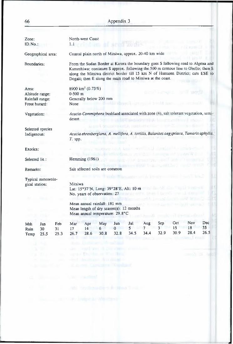
66 Appendix 3
Zone:ID.No.:
Geographical area:
Boundaries:
Area:Altitude range: Rainfall range: Frost hazard:
Vegetation:
Selected species Indigenous:
Exotics:
Selected lit.:
Remarks:
Typical meteorological station:
Mth Jan FebRain 30 31Temp 25.5 25.3
North-west Coast1.1
Coastal plain north of Mitsiwa, approx. 20-40 km wide
From the Sudan Border at Karora the boundary goes S following road to Algena and Kamechiwa; continues S approx. following the 500 m contour line to Obello; then S along the Mitsiwa district border till 15 km N of Hamasen District; cuts ESE to Dogali; then E along the main road to Mitsiwa at the coast.
8900 km2 (0.73%)0-500 mGenerally below 200 mm None
Acacia-Commiphora bushland associated with zone (4), salt tolerant vegetation, semi- desert
Acacia ehrenbergiana, A. mellifera, A. tortilis, Balanites aegyptiaca, Tarnarix aphylla, T. spp.
Hemming (1961)
Salt affected soils are common
MitsiwaLat: 15°37’N, Long: 39°28’E, Alt: 10 m No. years of observation: 27
Mean annual rainfall: 181 mmMean length of dry season(s): 12 monthsMean annual temperature: 29.8°C
Mar Apr May Jun Jul Aug Sep Oct Nov Dec17 14 6 0 5 7 3 15 18 3526.7 28.6 30.8 32.8 34.5 34.4 32.9 30.9 28.4 26.5
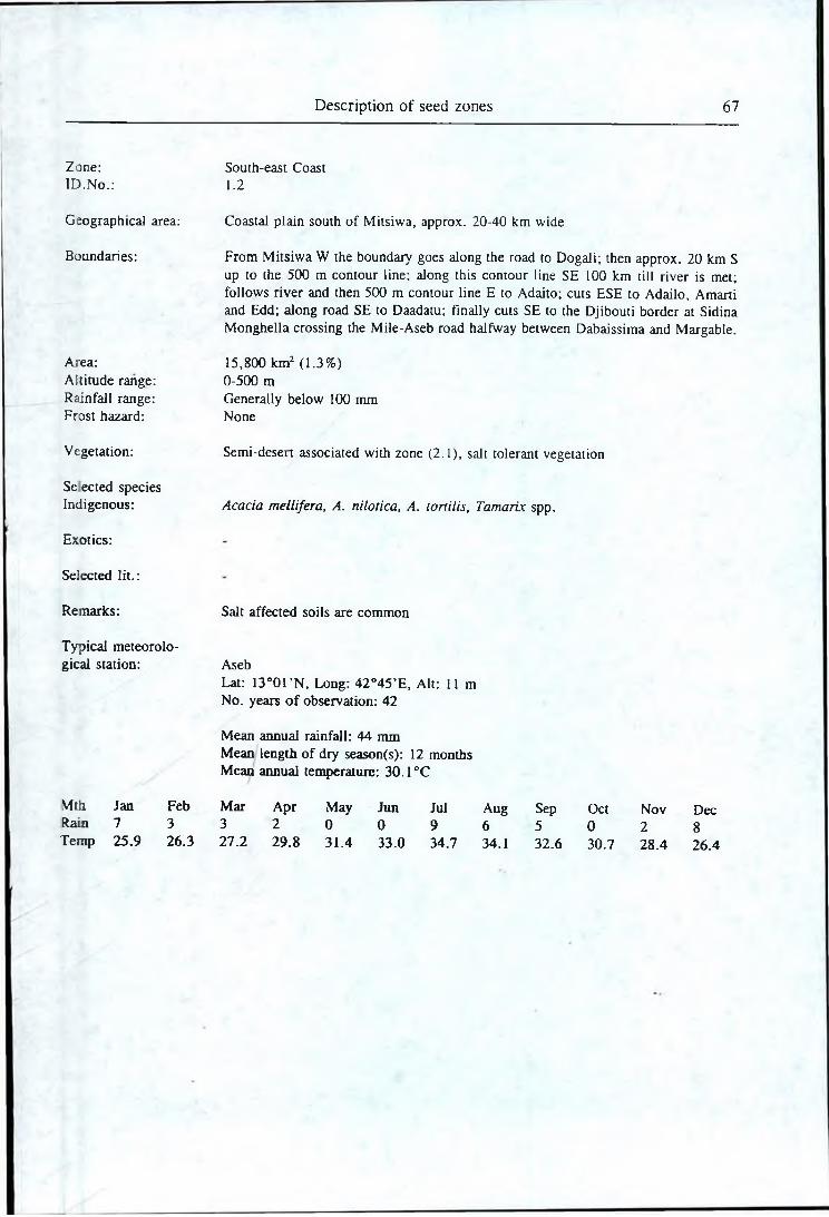
Description of seed zones 67
Zone:ID .N o.:
Geographical area:
Boundaries:
Area:Altitude range: Rainfall range: Frost hazard:
Vegetation:
Se ected species Indigenous:
Exotics:
Selected lit.:
Remarks:
Typical meteorological station:
Mth Jan FebRain 7 3Temp 25.9 26.3
South-east Coast1.2
Coastal plain south of Mitsiwa, approx. 20-40 km wide
From Mitsiwa W the boundary goes along the road to Dogali; then approx. 20 km S up to the 500 m contour line; along this contour line SE 100 km till river is met; follows river and then 500 m contour line E to Adaito; cuts ESE to Adailo, Amarti and Edd; along road SE to Daadatu; finally cuts SE to the Djibouti border at Sidina Monghella crossing the Mile-Aseb road halfway between Dabaissima and Margable.
15,800 km2 (1.3%)0-500 mGenerally below 100 mm None
Semi-desert associated with zone (2.1), salt tolerant vegetation
Acacia mellifera, A. nilotica, A. tonilis, Tamarix spp.
Salt affected soils are common
AsebLat: 1 3 °0 rN , Long: 42°45’E, Alt: 11 m No. years o f observation: 42
Mean annual rainfall: 44 mmMean length of dry season(s): 12 monthsMean annual temperature: 30.1°C
Mar Apr May Jun Jul Aug Sep Oct Nov Dec3 2 0 0 9 6 5 0 2 827.2 29.8 31.4 33.0 34.7 34.1 32.6 30.7 28.4 26.4
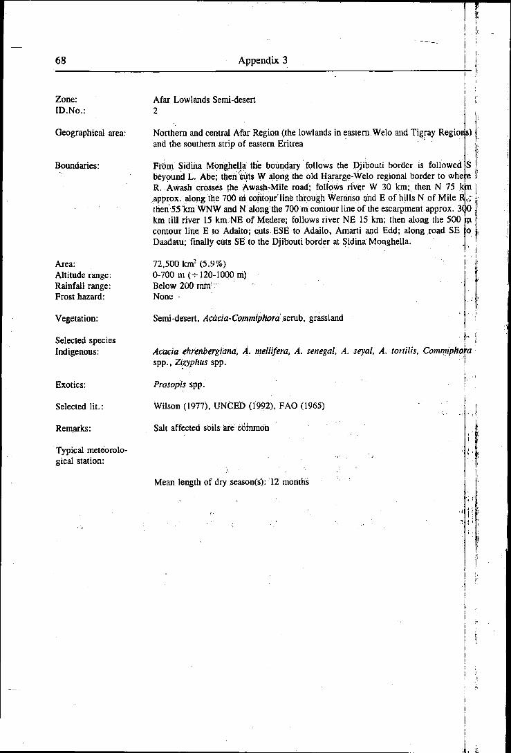
68 Appendix 3s-]■k
Zone:ID. No.:
Geographical area:
Boundaries:
Area:Altitude range: Rainfall range: Frost hazard:
Vegetation:
Selected species Indigenous:
Exotics:
Selected lit.:
Remarks:
Typical meteorological station:
Afar Lowlands Semi-desert 2
Northern and central Afar Region (the lowlands in eastern Welo and Tigray Regioris) j and the southern strip of eastern Eritrea j
Fr6m Sidina Monghella the boundary follows the Djibouti border is followed IS '• beyound L. Abe; then cuts W along the old Hararge-Welo regional border to where I R. Awash crosses the Awash-Mile road; follows river W 30 km; then N 75 km j approx. along the 700 ra contour line through Weranso and E of hills N of Mile Rj.:; • then 55 km WNW and N along the 700 m contour line of the escarpment approx. 3<p 1 km till river 15 km NE of Medere; follows river NE .15 km; then along the 500 ip contour line E to Adaito; cuts ESE to Adailo, Amarti aid Edd; along road SE lo Daadatu; finally cuts SE to the Djibouti border at Sidina Monghella. 1.
72,500 knr (5.9%)0-700 m ( - 120-1000 m)Below 200 mm 'None •
Semi-desert, Acacia-Commiphora scrub, grassland
Acacia ehrenbergiana, A. mellifera, A. Senegal, A. seyal, A. tortilis, Commiphoraspp., Zizyphus spp. f
iProsopis spp. i
Wilson (1977), UNCED (1992), FAO (1965)
Salt affected soils are common
Mean length of dry season(s): 12 months
Description of seed zones 69
Zone:ID .N o.:
Geographical area:
Boundaries:
Area:Akitude range: Rainfall range: Frost hazard:
Vegetation:
Selected species Indigenous:
Exotics:
Selected lit.:
Remarks:
Typical meteorological station:
Mth Jan FebRain 7 44Temp 22.0 22.5
Awash Plain Semi-arid Bushland3.1
Northern extreme of Ethiopian Somali Region and part o f south-central Afar Region (northern part of Hararge Region)
From the Somalia Border at Qoljeit the boundary goes W following rivers till the Djibouti railway just S of Mile; then follows the railway SW to Harewa; then cuts 170 km W approx. along the 850 m contour line till the Awash-Mile road 45 km S of Gewane; turns NW 20 km to lake and follows the Awash R. N and E 150 km till crossing the Awash-Mile road; cuts E along the Welo-Hararge regional border to the Djibouti border; finally the Djibouti and Somalia borders E and S back to Qoljeit.
31,100 km2 (2.5%)500-700 m (500-1100 m)200-400 mm None
Semi-arid bushland, semi-desen, grassland
Acacia ehrenbergiana, A. mellifera, A. nilotica, A. Senegal, A. lortilis, Balanites aegyptiaca, Commiphora spp., Euphorbia spp., Tamarix aphylla
Azadirachta indica, Eucalyptus brockwayi, E. camaldulensis (N. Province), E. microtheca, Parkinsonia aculeata, Prosopis juliflora
Edwards (1969), Longhitano & Bovazzano (1973)
Major exeption: SE of Mile/NE of Gewane, just SE of Gewane and N of Gogti at the Somali Border are areas above 1000 m that might have somewhat richer vegetation associated with zone (6.1). Vertisol with grassland are common
Salt affected soils are common
GewaneLat: 10°09’N, Long: 40°08’E, Alt: 605 m No. years of observation: 12
Mean annual rainfall: 458 mmMean length of dry season(s): 10 monthsMean annual temperature: 24.6°C
Mar Apr May Jun Jul Aug Sep Oct Nov Dec37 34 35 . 15 81 141 49 5 4 624.1 25.7 26.5 28.7 27.2 25.8 26.0 24.5 21.8 20.6
70 Appendix 3 I
Zone:ID.No.: -
Geographical area:
Boundaries:
Area:Altitude range: Rainfall range: Frost hazard:
Vegetation:
Selected species Indigenous:
Exotics:
Selected lit.:
Remarks:
Typical meteorological station:
Welo-Tigray Eastern Escarpment Semi-arid Bushland [3.2
Lower eastern escarpment of northern half of Amhara Region and of southern half if Tigray Region, just skirting Afar Region (Welo and southern Tigray Regions) >
From Eli Wiha on theMile-Bati road the boundary climbs NW 60 km to the 1000 jin contourTiflB'\v;lijich is followed N 200 km till river 30 km E of May Mekden; along this river E 25 km ddwn!t$>700 m; turns S along this contour line 170 km; tarmjESp 55 km and S 80 km to Awash R. 25 km Sof Weranso; turns NW up tributary 2C( fata; finally cuts N 12 km back to Eli Wiha. •».. j
5500 km2 (0.45%) ^ ‘ . !700-1000 m (600-1500 m) ' - -200-400 mm (200-500 mm)None
Semi-arid bushland, succulent bushland
Acacia ntellifera, A. seyal, A. toriilis, Commiphora spp., Euphorbia spp., spp., Ezyphus spp.
See zone (3.1)
Wilson (1977)
Considerable variations in soil types and depth
Mean length of dry season(s): 9 months
Zone:ID. No.:
Geographical area:
Boundaries:
Area:Altitude range: Rainfall range: Frost hazard:
Vegetation:
Selected species Indigenous:
Exotics:
Selected lit.:
Remarks:
Typical meteorological station:
Description of seed zones 71
Eritrea-Tigray Eastern Escarpment Semi-arid Bushland/woodland3.3
Lower eastern escarpment of northern half of Tigray Region and of Eritrea till the latitude of Asmera
From river 30 km E of May Mekden the boundary follows the 1700 m contour line N 200 km till the Mitsiwa-Akele Guzay district border; cuts NNE 20 km down to 500 m; turns SE along this altitude 90 km till river; acsends to 700 m and turns S 130 km to first river; finally up river to starting point.
4300 km2 (0.35%)500-1700 m200-400 mm (200-500 mm)None
Semi-arid bushland, semi-arid open woodland, sub-desert scrub, sub-desert succulent scrub.
Acacia mellifera, A. seyal, A, tortilis, Balanites aegyptiaca, Boswellia papyrifera, Euphorbia spp.
See zone (3.1)
Wilson (1977)
Considerable differences between lower drier and upper moister parts of escarpment
Mean length of dry season(s): 10 months
72 Appendix 3
Zone: ID.No.:
North-Western Eritrea Semi-arid Bushland 4
Geographical area: North-western Eritrea north of the Keren-Teseney road in areas below 1500 m
Boundaries: From 5 km SW of Keren the Keren-Teseney road is followed W to Tesenay; then Mereb R. WNW to the Sudan border; along the border N and NE to Karora (excluding the mountains above 1500 m 50 km SW of Karora); then S along roads to Algena and Kamechiwa; continues S 85 km along the foot of the hills at 500 m; then the Keren-Mitsiwa and Keren-Hamasen district borders S and W 20 km up the escarpment to approx. 1850 m; follows this contour line 50 km NNW and W; descends to 1500 m and follows the eastern escarpment N approx. 150 km; turns W and back SSW along the 1500 m contour line; finally turns E 50 km back to starting poi t.
Area:Altitude range: Rainfall range: Frost hazard:
37,900 km2 (3.1%) 500-1100 m (400-1500 m) 200-350 mm None
Vegetation: Semi-arid bushland
Selected species Indigenous: Acacia ehrenbergiana, A. mellifera, A. seyal, A. Senegal, A. tortilis, Balanites
aegyptiaca, Bos we lli a papyrifera, Commiphora spp ., Euphorbia spp ., Tamarix aph) !la
Exotics: See zone (3.1)
Selected lit.:
Remarks:
Typical meteorological station: Akordat
Lat: 15°33’N, Long: 37°53’E, All: 626 m No. years of observation: 58
Mean annual rainfall: 319 mmMean length of dry season(s): 10 monthsMean annual temperature: 29.0°C
Mth Jan Feb Mar Apr May Jun Jul Aug Sep Oct Nov DecRain 0 0 0 3 14 28 100 130 39 4 1 0Temp 26.1 26.5 27.8 30.8 32.6 31.9 29.0 27.3 29.3 30.6 29.1 27.0
Description of seed zones 73
Zone:ID. No.:
Geographical area:
Boundaries:
Area:Altitude range: Rainfall range: Frost Hazard:
Vegetation:
Selected species Indigenous:
Exotics:
Selected lit.:
Remarks:
Typical meteorological station:
Mth Jan FebRain 0 6Temp 28.2 28.9
South-eastern Lowlands Semi-arid Bushland 5
Lowlands in southern Ethiopian Somali Region (South-eastern extreme of Sidamo, southern Bale and south-eastern Hararge Regions)
From the Kenya border at Kededuma the boundary cuts N and NW through Jima and Dekawata to Wachile; then the road NNE to Dawa R.; the river E till tributary 10 km past Mojo; along tributary NE past Waramus; across watershed to other tributary 10 km SE of Filtu; along this tributary NE to Gemale R.; up Gemale R. 25 km; then cuts NE along the Mendoyu-Elkere district border to Weyb R., up Weyb R. 50 km; then cuts NE along the Wabe-EIkere district border to Wabe-Shebele R.; up river 75 km to Daketa R.; up Daketa R. 75 km till tributary at Segeg and up tributary to Degah Medo; then follows road E to Deror and N to Haskul and the Somalia border; along Somalia and Kenys borders back to Kededuma.
223,000 km2 (18.2%)400-1100 m (250-1500 m)200-350 mm (150-400 mm)None
Semi-arid bushland
Similar to zone (4)
See zone (3.1)
Salt affected soils are common
GodeLat: 5°54’N, Long: 43°35’E, Alt: 275 m No. years of observation: 13
Mean annual rainfall: 340 mmMean length of dry season(s): 4 + 4 monthsMean annual temperature: 2 8 .7 °C
Mar Apr May Jun Jul Aug Sep Oct Nov Dec19 100 69 2 0 0 5 74 60 530.1 29.7 29.1 28.7 28.0 28.0 29.0 28.6 27.8 27.7
74 Appendix 3
Zone:ID.No.:
Geographical area:
Boundaries:
Area:Altitude range: Rainfall range: Frost hazard:
Vegetation:
Selected species Indigenous:
Exotics:
Selected lit.:
Remarks:
Typical meteorological station:
Awash Semi-arid Woodland6.1
Lower eastern escarpment of southern half of Amhara Region and of north-eastern extreme of Oromia Region, southern Afar Region and strip of northern Ethiopian Somali Region (north-centrai Hararge, northern tip of Arsi, north-eastern Shewa and central southern Welo Regions)
From the Somali border at Teferi fier the boundary follows the road SW to Jijga and the main road 5 km W; then NNW 25 km approx. along the 1800 m contour line; then bends W, descending to approx. 1600 m and follows the foot of the mountains W and SW till just SE of Tibila, at 1500 m; cuts N and NW crossing the main road7 fan E of Welenchiti and continues 10 km NW; follows the 1600 m contour line NNE till Kesem R.; then the 1500 m conto,ur line NNE and N 250 km to Bati; then the road E to Eli Wiha; cute S 15 km to tributary and down tributary to Awash R.; then up Awash R. S 130 kni to lake; cuts S and E to road 50 km S of Gewane; cuts E 170 km approx. along the 850 m contour line to Harewa; then the railway NE to tributary just S of Mile; turns E along tributary, across watershed and along other tributary r^ Qoljeit at the Somalia border; finally the border SE back to Teferi Ber.
34,300 km2 (2.8%)700-1500 m (700-1600 m)400-700 mm (400-1000 mm)None
Seini-arid woodland, semi-arid bushland, grassland
Acacia ehrenbergiana, A. mellifera, A. nilotica, A. Senegal, A. seyal, A. tortilis. Balanites aegyptiaca, Celtis integrifolia, C. kraussiana, Euphorbia spp. Grewia spp. , Tamarix aphylla, Zizyphus abyssinica
Acacia cyanophylla, Azadirachta indica, Eucalyptus camaldulensis (N. Province), E. cladocalyx, E. microtheca, K occidentalis, Parkinsonia aculeata, Prosopis juliflora
Edwards (1969), Longhitano & Bovazzano (1973), FAO/UNDP (L984d)
Vertisols with grassland are common
AwashLat: 8°59VN, Long: 40°09’E, Alt: 916 m;». No. years of observation: 26
Mean annual rainfall: 594 nunMean length of dry season(s): 6+2 monthsMean annual temperature: 25.6°C
Mth Jan Feb Mar Apr May Jun Jul Aug Sep Oct Nov DecRain 21 45 45 57 31 36 110 142 61 20 19 7Temp 22.8 24.0 25.8 26.7 28.2 29.0 26.5 25.7 26.7 26.3 23.6 22.4
Description of seed zones 75
Zon(eID.
AreaAltiRail
SelccInd
No.
Geographical area:
Boundaries:
tude range: fall range: t hazard:
Vegetation:
ted species genous:
Exotics:
Selected lit.:
Remarks:
Typical meteorolo- station:
Welo-Tigray Eastern Escarpment Semi-arid Woodland6.2
Upper eastern escarpment of northern Amhara and southern Tigray Regions (northern Welo and Southern Tigray Regions)
From Bad the boundary goes N following the 1600 m contour line 280 km till the river E of May Mekden; descends to 1000 m; turns SE and S 210 km along this contour line; turns SE and again S to Eli Wiha descending to 800 m; finally along the road W back to Bati.
8600 km2 (0.71%)1000-1600 m (700-1700 m)400-800 mm (400-1000 ram)None
Semi-arid woodland, succulent scrub
Acacia seyal, A. tortilis, Balanites aegyptiaca, Croton macrostachys, Euphorbia candelabrum
Acacia cyanophylla, Azadirachta indica, Eucalyptus camaldulensis (N. and S. Province), E. cladocalyx, E. occidentalis, Parkinsonia aculeata, Prosopis juliftora
FAO (1965), Wilson (1977)
Mean length of dty season(s): -

76 Appendix 3
Zone:ID.No.:
Geographical area:
Boundaries:
A rea:Altitude range: Rainfall range: Frost hazard:
Vegetation:
Selected species Indigenous:
Exotics:
Selected lit.:
Remarks:
Typical meteorological station:
Mth Jan FebRain 112 111Temp 18.6 19.6
Mitsiwa Escarpment Semi-arid Woodland 7
North-eastern escarpment between Mitsiwa and Asmera
From Dogali the boundary cuts S 30 km; then SSW 20 km climbing the escarpment to 1500 m; follows the 1500 m contour line NW 70 km till the Keren district border; then E and N 20 km along this border before cutting E back to Dogali.
1900 km2 (0.15%)400-1500 m (300-1600 m)400-1000 mm None
Semi-arid woodland
Similar to zone (6.1)
Acacia cyanophylla, A. saligna, Albizia lebbek, Azadirachta indica, Cassia siainea, Cupressus torulosa, Eucalyptus camaldulensis (N. Province), E. citriodora, E. microtheca, E. tereticomis, Gmelina arborea, Jacaranda mimosifolia, Leucaena leucocephala Hawaiian and Salvador types, Parkinsonia aculeata, Prosopis juliflora
The existence of similar high rainfall areas further north along the escarpment canno' be ruled out
GindaLat: 15°27’N, Long: 39°05’E, Alt: 962 m No. years of observation: 38
Mean annual rainfall: 722 mmMean length of dry season(s): 2+2 monthsMean annual temperature: 24.6°C
Mar Apr May Jun Jul Aug Sep Oct Nov Dec73 52 34 9 63 58 20 43 57 9020.7 23.8 26.6 30.0 30.9 28.5 28.8 24.6 22.7 20.4
Description of seed zones 77
Zone:ID.No.:
Geographical area:
Boundaries:
Area:Altitude range: Rainfall range: Frost hazard:
Vegetation:
Selected species Indigenous:
Exotics:
Selected lit.:
Remarks:
Typical meteorological station:
Mth Jan FebRam 0 0Temp 23.6 24.0
Mth Jan FebRain 4 6Temp 15.2 15.6
Western Eritrea Semi-arid Woodland8
Lowlands in south-western Eritrea and highland areas above 1500 m in north-western Eritrea (including area at the Sudan border 50 km SW of Karora)
Main area: From 5 km SW of Keren the boundary follows the 1500 m contour line NW and N approx. 180 km (in bee-line) E and back S till the steeper N-S climb 20 km NE of Keren; climbs to 1850 m and continues along this contour line till 10 km W of Adi Naamen; follows the Akordat-Hamasen district border S to Seraye District; cuts S 10 km to Mereb R. tributary; down this tributary 65 km to Mereb R. and the Ethiopian border; follows the border SW and W to Sudan and the Sudan border N till Mereb R.; finally E along the river to Teseney and the main road back to Keren.
Highland area at the Sudan border: The boundary follows the 1500 m contour line.
25,800 km2 (2.1%)800-1500 m (500-2200 m)350-500 mm (350-600 mm)None
Semi-arid woodland
Similar to zone (6.1)
See zone (3.1)
FAO/UNDP (1984e)
The relatively moister conditions resulting in this vegetation type compared to the surrounding bushland in zone (4) is caused by higher rainfall in the southern parts and by altitude in the northern parts of the zone
Barentu (lower southern parts)Lat: 15°08’N, Long: 37°36’E, Alt: 980 m No. years of observation: 47
Mean annual rainfall: 516 mm Mean length of dry season(s): 8 months Mean annual temperature: 25.1°C
Mar Apr May Jun Jul Aug Sep Oct Nov Deci 10 22 74 142 178 78 8 3 025.5 27.7 27.6 25.5 24.1 23.1 24.5 26.1 25.5 24.0
Nakfa (higher northern parts)Lat: 16°40’N, Long: 38°20’E, Alt: 1676 m No. years of observation: 82
Mean annual rainfall: 348 mmMean length of dry season(s): 10 monthsMean annual temperature : 19.0 °C
Mar Apr May Jun Jul Aug Sep Oct Nov Dec8 17 36 32 67 110 3 8 17 10 417.1 18.9 20.7 23.3 23.2 22.3 22.0 18.1 16.4 14.9
78 Appendix 3
Zone:ID.No.:
Geographical area:
Boundaries:
Area:Altitude range: Rainfall range: Frost hazard:
Vegetation:
Selected speeics Indigenous:
Exotics:
Selected lit.:
Remarks:
South-eastern Lowlands Semi-arid Woodland9
Lowlands of southern and south-eastern Oromia and north-western Ethiopian Somali Region* (South-eastern Kefa, southern Gamo-Gofa, southern Sidamo, central and north-eastern Bale, south-eastern Arsi and south-central Hararge Regions)
From the Sudan border 20 km SW of Chido the boundary goes N along the E-W watershed till 16 km past T inma Tid; turns E along the 1300 m contour line and continues eastwards till Afa R.; S of Afa R. the boundary climbs up to 1500 m before turning N just N of Komso; continues N climbing to 1700 m till the tributary 15 km E of Sodo; down tributary E and S to Bilate R. and down Bilate R. to L. Abaya; then E along Gidabo R. and tributary to escarpment NE of Dila; turns S along the escarpment in 1700 m to Buiji; cuts E till 10 km S of Finchawa; continues E 100 km and NE 200 km generally around 1400 m; then approx. along the 1700 m contour line N going E of Ginir, E around Wabe R. and N and NE on the south-eastern slopes of the South-eastern Highlands till the main road just W of Jijiga; continues NE along roads to the Somalia border at Teferi Ber and SE along border to Haskul; turns S along road to Deror and W along road to Degah Medo; then down Daketa R. and down Wabe Shebele R. 75 km.; Cuts SW along the Wabe-Elkere district border to Weyb R.; down Weyb R. 50 km; cuts SW along Mendoyu-Elkere district border to Gemale R.; down river 25 km till tributary; up tributary SW 70 km, across watershed and down other tributary to Dawa R.; up Dawa R. W 120 km to Neghele-Wachile road; along road S to Wachile; cuts SW and S to Dekawata, Jima and Kededuma; finally the Kenya border W and the Sudan border N and W back to starting point.
210,000 km2 (17.2%)1000-1700 m (400-2100 m)350-700 mm (350-800 mm)None
Semi-arid woodland, semi-arid bushland
Acacia albida, A. mellifera, A. Senegal, A. seycd, A. tortilis, Balanites aegyptiaca. Comb return spp., Croton macrostachys, Terminalia spp.
See zone (6.2)
FAO/UNDP (1984e), Friis et al. (1982)
The zone is from east to west very wide and free transfer of seed might ought to be restricted. However, the north-south altitude and rainfall gradient is even mon: problematic and two altitude sub-zones are identified:9.1 A (southern) lower sub-zone below 1500 m.9.u A (northern) upper sub-zone above 1500 m.
High areas (usually above 1700 m) carrying dry Juniperus woodland belong to th South-eastern Dry Juniperus Woodland (14).
Description of seed zones 79
Typical meteorological station:
Mth Jan FebRain 14 23Temp 20.9 21.8
Mth Jan FebRain 32 20Temp 21.2 21.4
Midegalola (eastern part)Lat: 8°00’N, Long: 42°07’E, Alt: 1530 m No. years of observation: 10
Mean annual rainfall: 665 mm Mean length of dry season(s): 5 monthsMean annual temperature : 21.2 °C
Mar Apr May Jun Jul Aug Sep Oct Nov Dec49 72 92 87 80 66 101 64 13 422.2 22.1 22.1 21.4 20.6 20.6 20.8 20.9 20.4 20.5
Arba Minch (western part)Lat: 6°05’N, Long: 37°38’E, Alt: 1290 m No. years of observation: 12
Mean annual rainfall: 789 mm Mean length of dry season(s): 3 monthsMean annual temperature : 20.8 °C
Mar Apr May Jun Jul Aug Sep Oct Nov Dec72 121 129 58 50 51 88 104 51 1322.0 21.5 20.6 20.3 20.0 20.3 21.1 20.8 20.4 20.4
80 Appendix 3
Zone:ID.No.:
Lake Area Semi-arid Woodland10.1
Geographical area:
Boundaries:
Area:Altitude range: Rainfall range: Frost hazard:
The lake area of the central Rift Valley down to L. Abaya, i.e. central Orotnia Regioz and parts of the Southern Ethiopian Peoples Administrative Regions 7, 8 and 0- (Shewa, Arsi and Sidamo Regions)
From Nazret the boundary cuts N 6 km to approx. 1900 m and follows this altitude. NNE 50 km to Kesem R.; turns E and SSW along the 1500 m contour line till 10 k ti N of Welenchiti; cuts SE to Tibila and climbs to 1800 m; follows escarpment WsW and S along this altitude (excluding rich plains at the foot of the escarpment) tp Gidabo R. tributary just NW of Dila; along this tributary and Gidabo R. to L. Abay$ up Bilate R. 18 km and tributary N and W up escarpment climbing to 1700.m; turnb N along this altitude climbing to 2000 m around Adilo and continues till 10 km E df Suten; then cuts E 35 km to Mojo R.; along this river up to Mojo and finally along the railway back to Nazret. T
13,800 km2 (1.1%) |1500-1800 m (1400-1900 m) j
600-800 duq (600-1000 mm) f ■'None I
Vegetation:
Selected species Indigenous:
Exotics:
Selected lit.:
Remarks:
Typical meteorological station:
Semi-arid woodland
Acacia albida, A. etbaica, A. mellifera, A. nilotica, A. Senegal, A. seyal, A. tortiij$,y Balanites aegyptiaca, Commiphora spp., Cordia qfricana, Croton macrostachys, Euphorbia candelabrum, Et tirucalli, Olea qfricana, Terminatia brownii
Acacia cyanophylla, A. decurrens, Azadirachta indica, Casuarina cunninghamiu,- Cupressus arizomca, C. torulosa, Eucalyptus camaldulensis (S. province), citriodora, E: gomphocephala, E. maculata, E. tereticomis. Grevillea robusfa,, Parkinsonia aculeata, Pimts brutia, Prosopis juliflora, Seims matte 1
Pratt (1978)
leWAcacia albida areas on slopes above 1850 m belong to the next zone (10.2)1
ZiwayLat: 8°00'N, Long: 38°45’E, Alt: 1640 m No. years of observation: 11
Mean annual rainfall: 642 mm Mean length of dry season(s): 7 months Mean annual temperature: 19.3°C
MthRainTemp
Jan1918.7
Feb3119.8
Mar2920.2
Apr4620.2
May6619.7
Jun7920.1
Jul12519.5
Aug11019.1
Sep9619.0
Oct3719.1
Description of seed zones 81
Zone:ID.No.:
Geographical area:
Boundaries:
Area:Altitude range: Rainfall range: Frost hazard:
Vegetation:
Selected species indigenous:
Exotics:
Selected lit.:
Remarks:
Typical meteorology cal station:
Mth Jan FebRain 11 25Temp 17.6 19.0
Debre Zeyit Slopes Semi-arid Woodland10.2
South-western slopes of the Rift Valley from Dukem to Nazret. Similar areas are found (but not mapped) on western slopes north of Iteya. That is central Oromia Region (central south-eastern Shewa and central north-western Arsi Regions)
Only the mapped area is described: From Dukem the boundary follows the 2000 m contour line E and SE till 6 km N of Nazret; cuts down to Nazret; follows the railway to Mojo; the Mojo R. S 18 km before cutting E and climbing to 2000 m; along this altitude N and E back to Dukem.
1900 km2 (0.16%) (only mapped area)1800-2000 m (1800-2500 m)800-1000 mm Slight at upper extreme
Semi-arid woodland with broad-leaves
Acacia abyssinica, A. albida, A. seyal, A. tortilis, Albizia schimperana, Balanites aegyptiaca, Combretum rnolle, Croton macrostachys, Dodonea viscosa, Erythrina abyssinica, Euphorbia candelabrum, Olea africana
Acacia cyanophylla, A. decurrens, Azadirachta indica, Casuarina cunninghamiana, Cupressus arizonica, C. torulosa, Eucalyptus camaldulensis, E. globulus, E. viminalis, E. tereticomis, Grevillea robusta, Leucaena leucocephala, Parkinsonia aculeata, Pinus brutia, P. patula, P. radiata, Prosopis juliflora, Scinus molle
Pratt (1978)
Debre ZeyitLat: 8°44’N, Long: 37°57’E, Alt: 1900 m No. years of observation: 30
Mean annual rainfall: 866 mmMean length of dry season(s): 6+ 1 monthsMean annual temperature: 18.7°C
Mar Apr May Jun Jul Aug Sep Oct Nov Dec41 58 45 88 231 229 110 18 6 420.2 20.5 20.5 19.6 18.3 18.1 18.4 18.1 17.2 16.9
82 Appendix 3
Zone:ID.No.:
Geographical area:
Boundaries:
Area:Altitude range: Rainfall range: Frost hazard:
Vegetation:
Selected species Indigenous:
Exotics:
Selected lit.:
Remarks:
Eritrea Semi-arid/Broad-leaved Deciduous Woodland I I . 1
Lowlands and western escarpments of southern central Eritrea
Starting on the escarpment 10 km W of Adi Naamen the boundary follows the 1850 m contour line 70 km S beyound Areza; turns E and descends to 1700 m and follows the escarpment SE to the Ethiopian border; then W along the border 170 km to the tributary 10 km S of Shembeko; up this tributary E 60 km; Finally N along the Akordat-Hamasen district border.
6300 km2 (0.51%)1200-1800 m (1000-2000 m)400-500 mm (400-600 mm)None
Semi-arid woodland, broad-leaved deciduous woodland
Acacia seyal, A. tortilis, Balanitesaegyptiaca, Boswelliapapyrifera, Combretum spp.. Euphorbia tirucalli, Terminalia spp.
Acacia cyanophylla, Azadirachta indica, Cupressus arizonica. Eucalyptus camaldulensis, E. cladocalyx, Parkinsonia aculeata, Pinus brutia, Prosopis juliflora
Typical meteorological station:
Mean length of dry season(s): -
Description of seed zones 83
Zone: ID.No.
Tigray Broad-leaved Deciduous Woodland11.2
Geographical area:
Boundaries:
Lowlands of western Tigray and north-western extreme of Amhara Regions (western Tigray and north-western Gonder Regions)
From the Sudan border at Humera the boundary follows the Eritrean border E until climbing the western escarpment just E of Gerahu Semay; turns W and S along the 1700 X contour line till the Tekeze R. tributary E of Maydimu; follows this tributary down to Tekeze R. anu Tekeze R. W 15 km; new tributary S and SW to the Wegera Mts.; along the 1700 m contour line ^ Of the miS. till 25 km N of Angereb; down tributary and Angereb R. to the Sudan border; finally aiGne border N back to the Eritrean border.
Are*;Altitude range: R.ainfall range: Frost hazard:
21,700 km2 (1.8%)700-1700 m (500-1700 m) 600-900 mm (500-1200 mm) None
Vegetation:
Selected species Indigenous:
Exotics:
Broad-leaved deciduous woodland
Acacia albida. A. Senegal, A. seyal, A. tortilis, Albizia gummifera, Balanites ZZgyptiaca, Boswelliapapyrifera, Combretum spp., Terminalia spp., Phoenixreclinata
Acacia cyanophylla, Albizia lebbek, Azadirachta indica, Casuarina cunninghamiana, Cupressus torulosa, Eucalyptus camaldulensis (N. and S. Province), E. citriodora, E. gomphocephala, E. tereticomis, Grevillea robusta, Jacaranda mimosifolia, Leucaena leucocephala (Hawaiian and Salvador types), Parkinsonia aculeata, Pinus bruna, Prosopis juliflora
Selected lit.:
Remarks:
Typical meteorological station:
Wilson (1977), Friis (1992), Scott (1955), FAO/UNDP (1984e), PPD (1985)
ShiraroLat: 14°24’N, Long: 37°47’E, Alt: 1020 m No. years of observation: 4
Mean annual rainfall: 718 mm Mean length of dry season(s): 8 months Mean annual temperature: 25.9°C
Mth Jan Feb Mar Apr May Jun Jul Aug Sep Oct NovRain 0 0 1 4 22 125 243 213 85 18 6Temp 23.3 26.7 28.4 29.6 29.6 .29.5 24.2 23.2 23.9 24.3 24.5
Dec123.8
84 Appendix 3
1 ! !*!
F' ' :S
it
Zone:ID.No.:
Western Lowlands Broad-leaved Deciduous Woodland 11.3 : !!
\Geographical area: Lowlands of Benshangul, western Amhara and western Oromia Regions (western;
Gonder, Goj am and Welega Regions)
Boundaries: From the Sudan border the boundary follows the Angereb R. E to the Wegera Mts.; along the 1700 m contour line S of the mts. to the Tekeze R. tributary; down tributary to Tekeze R.; up the river 15 km and up tributary NNE 30 km climbing to 1700 m; turns S along the escarpment in this altitude to the Aksum-Gonder mainroad; S along road to May Tsemre; cuts SE climbing to 1700 m; then along this contour line SW and S till 20 km SW of Kunzla at L. Tana; then along the 1500 m line S and W to Tibe (excluding the Abay R. valley but including the Didesa and other river valleys); cuts E 60 km to the Sudan border; finally along the border N back tp Angereb R.
!
" \
j;
fArea:Altitude range: Rainfall range: Frost hazard:
83,700 km2 (6.8%)1000-1700 m (500-2000 m) 800-1100 mm (700-1200 mm) None
'
■
;
Vegetation: Broad-leaved deciduous woodland : }:Selected species Indigenous: Acacia albida, A. Senegal, A. seyal, A. tortilis, Albizia gummifera, Balanites
aegyptiaca, Bersamaabyssinic/a, Boswellia papyrife'ra, Celtis ititegrifolia, Combretum spp., Cordiaafricana, Dahlbergiamelanoxylon, Erythrina abyssinica, Olea africana, Oxythenanthera abyssinica, Phoenix reclinata, Tamarindus indica, Terminatia spp. ‘
!t ' 1
;
Y■lExotics: See zone (11.2)
■
Selected lit.: Scott (1955), Friis (1992), FAO/UNDP (1984d,e), PPD (1985), UNCED (1992), Friis et al. (1982)
? j
Remarks: Higher more humid areas, with Oxythenanthera bamboo belong to zone (13). ■ i"
Vertisols are common '. !■
Typical meteorological station: Metema
Lat: l2°57N,;Long: 36°10,E. Alt: 803 m No. years of observation: 6
Mean annual rainfall: 885 mm Mean annual temperature: 27.8<>C Mean length of dry season: 7 months
' .■
1 -f1> )'■
1- j '.' r.
Mth Jan Feb Mar Apr May Jun Jul Aug Sep Oct Nov DecRain 1 0 0 1 67 160 209 211 187 45 4 0Temp 26.9 29.7 30.2 28.9 28.7 27.8 26.1 26.0 26.1 27.3 27.9 27.5
r.lI
iitI
Description of seed zones 85
Zone:ID. No.:
Geographical area:
Boundaries:
Area:Altitude range: Rainfall range: Frost hazard:
Vegetation:
Selected species Indigenous:
Exotics:
Selected lit.:
Remarks:
Typical meteorological station:
Mth Jan FebRain 1 0Temp 25.3 26.4
Tekeze Broad-leaved Deciduous Woodland11.4
The deep valleys and gorges of the Tekeze River and its tributaries, i.e. in Tigray and Amhara Regions (Tigray, Gonder and Welo Regions)
The western boundary is the Aksum-Gonder mainroad. Upper boundary is generally around 1700 m. However, where the gorges are steep the boundary climbs up. Deep in the valleys of the tributaries the upper boundary is lower.
13,100 km2 (1.1%)1000-1700 m (900-1800 m)900-1100 mm (600-1200 mm)None
Broad-leaved deciduous woodland
Acacia seyal, A. spp., Albizia gurnrnifera, Balanites aegyptiaca, Boswellia spp.. Comb return spp., Tenninalia spp.
See zone (11.2)
Wilson <vi977), Scott (1955), Logan (1946)
Short distance vajiqtions in soil and altitude are considerable
Tekeze BridgeLat: 13°45’N, Long: 38°12’E, Alt: s/jO m No. years of observation: 4
Mean annual rainfall: 839 mm Mean length of dry season(s): 8 months Mean annual temperature: 26 .5°C
Mar Apr May Jun Jul Aug Sep Oct Nov Dec0 0 23 97 234 325 138 14 7 028.9 31.7 30.2 28.4 24.1 24.3 25.1 25.6 23.9 23.6
8 6 Appendix 3
Zone:ID.No.:
Geographical area:
Boundaries:
Area:Altitude range: Rainfall range: Frost hazard:
Vegetation:
Selected species Indigenous:
Exotics:
Selected lit.:
Remarks:
Typical meteorological station:
Abay Broad-leaved Deciduous Woodland11.5
The de valleys and gorges of the Abay River and its tributaries, i.e. in Amhara and Oromia Regions (Gonder, Welo, Gojam. Shewa and Welega Regions)
The western boundary follows the tributary S from Dibati, the Abay R. SSW 35 km and a tributary 7 km SSE. Upper boundary is generally around 2000 m. Howe\er, where the gorges are steep the boundary climbs up. Deep in the valleys of the tributaries the upper boundary is lower.
18,100 km2 (1.5%)1000-2000 m (900-2300 m)900-1200 mm (800-1400 mm)Slight at upper extreme
Broad-leaved deciduous woodland
Acacia albida, A. seyal, Albizia spp., Balanites aegyptiaca, B os'^em a spp Cord a. africana, Dodonea viscosa. Euphorbia candelabrum
Acacia cyanophylla, A. decurrens, Azadirachta \tyjica, Cassia siamea, Cupressus arizonica, C. torulosa, Eucalyptus camaldu'tens s Province), E. citriodora, E globulus, E. gomphocephala, E. rnaZulata, E. tereticomis, Grevillea robusta Jacaranda mimosifolia, Leucaena Ir ucocephala, Parkinsonia aculeata, Pinus patula, Prosopis juliflora, Scinus moll^
Logan (1946)
Short distan^e variations in soil and altitude are considerable
FiliklikLat: 10°03’N, Long: 38°13’E, Alt: 1810 m No. years of observation: 5
Mean annual rainfall: 979 mm Mean length of dry season(s): 7 months Mean annual temperature: 20.2°C
Mth Jan Feb Mar Apr May Jun Jul Aug Sep Oct Nov DecRain 0 7 35 34 101 130 280 243 110 17 17 5Temp 20.7 21.9 22.8 22.9 22.3 20.6 17.6 17.2 17.9 19.2 19.7 19.7
Description of seed zones 87
Zone:ID.No.:
Geographical area:
Boundaries:
Area:Altitude range: Rainfall range: Frost hazard:
Vegetation:
Selected species Indigenous:
Exotics:
Selected lit.:
Remarks:
Typical meteorological station:
Gibe-Omo Broad-leaved Deciduous Woodland11.6
The deep valleys and gorges of the Gibe-Omo River and its tributaries, i.e. in Oromia Region and the Southern Ethiopian Peoples Administrative Regions 7, 9, 10 and 11 (Kefa, Shewa, Sidamo and Gamo Gofa)
The south-western boundary is the Omo R. and the two small tributaries 25 km NE of Ducha. Upper boundary is generally around 1500 ra. However, where the gorges are steep the boundary climbs up. Deep in the valleys of the tributaries the upper boundary is lower,
7100 km2 (0.58%)600-1600 m (500-1800 m)1200-1400 mm None
Broad-leaved deciduous woodland
Acacia abyssinica, A. albida, A. seyal, Cordia africana
Acacia decurrens, A. meamsii, Albizia lebbek, Cassia siamea, Casuarina cunning- hamiana, C. equisetifolia, Cordia alliodora, Cupressus lusitanica, C. torulosa, Eucalyptus camaldulensis, E. citriodora, E. dalrympleana, E. globulus, E. gomphoce- phala, E. saligna, E. viminalis, Gmelind arborea, Grevillea robusta, Jacaranda mimosifolia, Pinus patula
Logan (1946) 1
Short distance variations in soil and altitude are considerable
Mean length of dry season(s):
TT
88 Appendix 3
Zone:ID.No.:
Geographical area:
Baro-Akobo Basin Grassland |12 ;
The lowlands of the Baro and Akobo Rivers, i.e. the southern tip of Benshangiil 1 Region, western and southern Gambella Region and south-western tip of Region 11 f (south-western extreme of Welega, western Ilubabor and south-western extreme of j|Kefa Regions) I
Boundaries:
Area:Altitude range: Rainfall range: Frost hazard:
From the Sudan border E of Tibe the boundary goes E and S along the foot of thekm N ofmts. approx. following the 1000 m contour line till the tributary 15
Gambella; then along tributary S to Gambella; continues SSW and S (excluding forest areas to the E) to Gog; turns ESE 100 km along the northern slopes of Gilo R.; cuts S 25 km to the escarpment; follows the 1000 m contour line round W and S to Giab, i climbs to 1300 m and cuts S 30 km; continues S along E-W watershed through Tirma ITid to the Sudan border; finally along the border NW back to starting point.
26,600 km2 (2.2%)400-800 m (400-1000 m)800-1200 mm (700-1400 mm)None
rti
Vegetation:
Selected species Indigenous:
Exotics:
Selected lit.:
Remarks:
Combretum-Terminalia woodland, Acacia woodland, wooded grassland
Acacia seyal, Balanites aegyptiaca, Combretum spp., Cordia africana, Tamarinds indica, Terminalia spp. S
Acacia cyanophylla, A. decurrens, Albizia lebbek, Azadirachta indica, Cassia siame|a, A Casuarina cunninghamiana, C. equisetifolia, Cupressus torulosa, Eucalyptus- camaldulensis, p. citriodora, E. globulus, E. microtheca, E. tereticomis, Grevillgaif robusta, Jacaranda mimosifolia, Leucaena leucocephala (Hawaiian and Salva< types), Parkinsonia aculeata, Pinus patula, Prosopis juliflora
Chaffey (1979)
Vertisols and Eutric fluvisols are most common soil types. On higher ground without? the special soil and water conditions grasslands are replaced by broad-leavje deciduous woodlands associated with zone (11.3). Therefore, two sub-zones identified:12.g A grassland sub-zone on low plains.12.w A woodland sub-zone on higher ground.
Typical meteorological station: Poko
Lat: 8°10’N, Long: 34P28’E, Alt: 425 m No. years of observation: 11
Mean annual rainfall: 1042 mm Mean length of dry season(s): 5 months Mean annual temperature: 27.5°C
Mth Jan Feb Mar Apr May Jun Jul Aug Sep Oct Nov Dec?Rain 6 5 23 50 111 139 197 177 170 106 47 11 |Temp 27.5 29.3 30.6 30.0 28.0 26.5 25.5 25.4 25.9 27.0 26.7 27.0 fi
Description of seed zones 89
Zone:ID.No.:
Geographical area:
Boundaries:
Area:Altitude range: Rainfall range: Frost hazard:
Vegetation:
Selected species Indigenous:
Exotics:
Selected lit.:
Remarks:
Typical meteorological station:
Western Lowlands Oxythenanthera Bamboo Thicket 13
Within the mapped area of Western Lowlands Broad-leaved Deciduous Woodland (11.3) an Oxythenanthera bamboo zone is identified in higher, more humid areas approx. above 1500 m. Such areas are identified around Addi Arkay, around Wembera Mts., between Asosa-Bambesi and many places on the western slopes of the highlands. Only the Asosa-Bambesi area is mapped.
Only the mapped area is described: Just W of Asosa the boundary follows the 1500 m contour line N 40 km; turns SE approx. 75 km; turns SW 50 km to Bambesi and along the 1500 m contour line W and N back to Asosa.
2900 km2 (0.24%) (only mapped area)1500-1800 m (1500-2000 m)1200 mm None
Oxythenanthera bamboo thichet
Oxythenanthera abyssinica, species from zone (11.3)
Acacia decurrens, A. mearnsii, Casuarina equisetifolia, Cupressus cunninghamiana, C. lusitanica, C. macrocarpa, C. torulosa, Delonix regia, Eucalyptus citriouora, E. dalrympleana, E. globulus, E. grandis, E. maidenii, E. saligna, E. viminalis, Pinus patula
Chaffey (1979)
AsosaLat: 10°04*N, Long: 34031’E, Alt: 1560 m No. years of observation: 6
Mean annual rainfall: 1116 mm Mean length of dry season(s): 6 months Mean annual temperature: 21.7°C
Mth Jan Feb Mar Apr May Jun Jul Aug Sep Oct Nov DecRain 0 0 31 32 118. 189 207 208 207 103 21 0Temp 22.2 23.6 24.4 24.4 22.4 20.4 19.5 19.4 20.2 20.4 20.9 22.0
90 'Appendix 3
Zone:ID.No.:
Geographical area:
Boundaries:
Area:Altitude range: Rainfall range: Frost hazard:
Vegetation:
Selected species Indigenous:
Exotics:
Selected lit.:
Remarks:
Typical meteorological station:
South-eastern Dry Juniperus Woodland ' |
14 HScattered in areas above approx. 1800 m mainly within the mapped area of South- J eastern Lowlands Semi-arid Woodland (9) and in areas of transition between zone (p) j and the higher forest zones (18, 21.2, 21.3, 23.3 and 24.2), e.g. around Yabelo, I Konso, Mega, Arero, Neghelle and east of Harar | |
Around the above described areas the boundaries approx. follow the 1800 m contour line.
2300 km2 (0.19 %) (only mapped areas)1800-2100 m600-900 mm (600-1000 mm)None
Dry Juniperus forest/woodland
Acacia seyal, Celtis africana, Croton macrostachys, Dodonea viscosa, Juniperus.. procera, Olea africana j 1
Acacia cyanophylla, A. decurrens, Casuarina cunninghamiana. Cupressus toru'Jsa, Eucalyptus camaldulensis, £. globulus, E. tereticomis, Grevillea robusta, Leucahnd, leucocephala, Parkinsonia aculeata, Pinus brutia, P. patula, P. radiata, Prosopiz juliflora - !'
Friis (1992), FAO/UNDP (1984d), SFCDD (1990), Logan (1946) ;
YabeloLat: 4.53N, Long: 38.06E, Alt: 1740 m No. years o f observation: 21
Mean annual rainfall: 744 mmMean length of dry season(s): 4+1 monthsMean annual temperature: 18.9*0
Dec ( 66. '• j tasrr
Mth Jan Feb Mar Apt May Jun Jul Aug Sep Oct NovRain 29 50 67 133 100 47 30 • 27 40 90 65Temp 20.6 20.7 20.5 18.9 18.3 17.8 17.1 18.0 19.1 18.5 18.7
Description of seed zones 91
Zone:ID.No.:
Geographical area:
Boundaries:
Area:Altitude range: Rainfall range: Frost hazard:
Vegetation:
Selected species Indigenous:
Exotics:
Selected lit.:
Remarks:
Typical meteorological station:
Mth Jan FebRain 4 6Temp 16.3 17.6
Eritrea Dry Juniperus Forest15.1
The highlands of central Eritrea
From Imbaticala on the Asmera-Mitsiwa road the boundary follows the escarpment SE along the 1500 m contour line 35 km climbing to 1700 m; then along this altitude SSE to the Ethiopian border; turns W along the border approx. 40 km to the 1700 m contour line Of the western escarpment; turns N and W and follows this altitude round to Areza; climbs to 1850 and follows this altitude N 120 km before turning E and SSE descending to 1500 m at the Keren-Hamasen district border; back SE along this altitude to Imbaticala. j
6800 km2 (0.56%)1700-2500 m (1500-2500 m)500-800 mm (300-1200 mm) |Mild frost in highest areas
Dry JuniperusJOlea forest
Acacia abyssinica, A. seyal, Apodytes demidiata, Cassipourea malosana, Croton macrostachys, Diospyros abyssinica, Dodonea viscosa, llex mitis, Juniperus procera, Millettia ferruginea, Olea africana
Acacia cyanophylla, A. decurrens, Azadirachta indica, Cupressus torulosa, C. arizonica, Eucalyptus Camaldulensis, E. globulus, E. tereticomis, Grevillea robusta, Leucaena leucocephala, Parkinsonia aculeata, Pinus patula, P. radiata, Prosopis juliflora
Friis (1992)
Adi KeyihLat: 14°5rN, Long: 39°22’E, Alt: 2325 m No. years of observation: 18
Mean annual rainfall: 508 mmMean length of dry season(s): 7+2 monthsMean annual temperature: 17.8 °c
Mar Apr May Jun Jul Aug Sep Oct Nov Dec24 52 39 28 164 126 28 3 24 1018.9 19.4 20.1 19.4 16.7 17.5 18.2 17.7 16.4 15.7
92
Zone:ID.No.;
Geographical area:
Boundaries:
Area:Altitude range: Rainfall range: Frost hazard:
Vegetation:
Selected species Indigenous:
Exotics:
Selected lit.:
Remarks:
Typical meteorological station:
Appendix 3
Tigray Dry Juniperus Forest15.2
The highlands of Tigray Region (Tigray Region)
From the Eritrean border 20 km E of Zela Anbesa the boundary follows thfe, escarpment along the 1700 m contour line S 150 km to Debub; then cuts W to just S of Hiwane; continues E 35 km dong northern slope down to the 1700 m contour lins of the Tekeze R. valley; turns N and W along this altitude to the mouth of the river valley ; continues N and ENE on the western escarpment along the same altitude to th; Eritrean border; finally follows the border E back to the eastern escarpment.
15,400 km2 (1.3%)1700-2700 m (1600-3000 m)500-700 (500-900 mm)Considerable in higher areas
Dry JurC.'perus/Olea forest
Acacia abyssinica, A. albida, A. seyalf A. tortilis, Balanites aegyptiaca, Albizid ( schimperana, Celtis spp., Cordia africana, Croton macrostachys, Dodonea viscosc, Juniperus procera, Mimusops kummel, Olea africana, Phoenix reclinata, Syzygiurp guineense
Acacia cyanophylla, A. decurrens, Acacia saligna, Azadirachta indica, Cassia siamed, Cupressus arizonica, C. lusitanica, Grevillea robusta, Parkinsonia aculeata, Pinus brutia, Prosopis juliflora
Wilson (1977), Tadesse (1992)
Two altitude sub-zones are identified:15.2.1 A lower sub-zone below 2400 m.15.2.1 An intermediate sub-zone above 2400 m.
MekeleLat: 13°30’N, Long: 39°29>E, Alt: 2070 m No. years of observation: 18
Mean annual rainfall: 563 mmMean length of dry season(s): 10 monthsMean annual temperature: 18.0°C
Mth Jan Feb Mar Apr May Jun Jul Aug Sep Oct Nov DecRain 4 9 22 34 28 36 183 205 33 2 4 3Temp 16.3 17.4 18.7 19.6 20.4 20.5 17.9 17.4 18,2 17.6 16.1 15,4
Description of seed zones 93
Zone: ID .No.:
Welo Dry Juniperus Forest 15.3
Geographical area:
Boundaries:
Area:Altitude range: Rainfall range: Frost hazard:
Vegetation:
Selected species Indigenous:
Exotics:
Selected lit.:
Remarks:
Typical meteorological station:
Highlands of north-eastern Amhara Region (Welo (except southern extreme) and southern extreme of Tigray Regions)
From Debub on the eastern escarpment the boundary goes S following the 1700 m contour line gradually descending to the 1600 m line; S of Bati descends to 1500 m and continues S 120 km until 6 km NW of Jebuha; then cuts NNW along the northern slopes of Mt. Abuye Meda to Kabi; follows road to Koke Ager; continues NW along northern slopes of Mt. Amba Ferit to Tala R.; turns N along the 2000 m contour line of the valleys of Jita R. and tributaries till 10 km S of Debre Zebit; cuts N to Tekeze R. tributary and follows this N 25 km to the Tekeze R. valley; then N and NE along the 1700 m contour line o f the western slopes (eastern side of the valley) to 10 km SW of Samre; cuts E along northern slope to Hiwane and back to Debub.
27,300 km2 (2.2%)1600-3300 m (1500-4000 m)700-1100 mm (600-1200 mm)Considerable in higher areas
Juniperus/Olea forest
Acacia abyssinica, A. albida, A. seyal, A. tortilis, Albizia gumrnifera, Celtis, Cordia africana, Croton macrostachys, Dodonea viscosa, Eckebergia capensis, Erythrina abyssinica, Euphorbia candelabrum, Hagenia abyssinica, Juniperus procera, Olea africana
/Acacia cyanophylla, A. decurrens, Casuarina cunninghamiana, Cupressus torulosa, Delonix regia, Eucalyptus camaldulensis, E. globulus, E. tereticomis, Grevillea robusta, Jacaranda mimosifolia, Leucaena leucocephala, Parkinsonia aculeata, Pinus brutia, P. patula, P. radiata, Prosopis juliflora, Scinus molle
Friis (1992), Tadesse (1992)
Three altitude sub-zones are identified:15 .3 .1 A lower sub-zone below 2400 m.15.3.1 An intermediate sub-zone at 2400-3000 m.15.3.u An upper sub-zone above 3000 m.
WeldiyaLat: 11°49’N, Long: 39°36’E, Alt: 1960 m No. years of observation: 18
Mean annual rainfall: 1073 mmMean length of dry season(s): 5 + 1 monthsMean annual temperature: 17.9°C
Mth Jan Feb Mar Apr May Jun Jul Aug Sep Oct Nov DecRain 40 42 79 108 97 28 220 256 85 47 47 24Temp 16.1 16.8 16.8 18.2 19.0 19.5 20.2 19.6 19.3 17.4 16.1 16.3
94 Appendix 3
Zone:ID.No.:
Geographical area:
Boundaries:
Area:Altitude range: Rainfall range: Frost hazard:
Vegetation:
Selected species Indigenous:
Exotics:
Selected lit.:
Remarks:
Typical meteorological station:
South-eastern Highlands Dry Juniperus Forest 16
Nonhem escarpments of the South-eastern Highlands, including Mt. Asebot. That is in north-eastern Oromia Region (north-central Hararge Region)
From 5 km SE of Tibila the boundary follows the escarpment NE along the 1600 m contour line climbing to 1700 m S of Dire Dawa till river 10 km SW of Lewenaji; up river to 2000 m altitude; back W along this contour line descending to 1800 m around Asbe Teferi; continues SW till 5 km NW of Hagere Sisay before descending to starting point.
Asebot Mt.: The boundary follows the 1600 m contour line.
3200 km2 (0.26%)1600-1800 m (1600-2000 m)700-1000 mm None
Dry Juniperus forest
Acacia abyssinica. A. seyal, A. tortilis, Celtis africana, Cordia africana, Croton macrostachys, Dodonea viscosa, Juniperus procera, Olea africana
Acacia cyanophylla, Cupressus torulosa, Eucalyptus camaldulensis (S. Province), £. citriodora, E. globulus, E. gomphocephala, E. maculata, E. tereticornis, Gf ’villea robusia, Leucaena leucocephala, Pinus patula, P. radiata, Prosopis juliflora, Scinus molle
Friis (1992), Logan (1946)
Mean length of dry season(s): -
Description of seed zones 95
Zone:ID.No.:
Geographical area:
Boundaries:
Area:Altitude range: Rainfall range: Frost hazard:
South-eastern High Altitude Juniperus Forest17
Chilalo, Kaka and Batu Mts. in central Oromia Region (western Arsi and northwestern Sidamo Regions)
Chilalo and Kaka Mts.: The boundary follows the 2700 m contour line.
Batu Mts.: From S of Dodola the boundary follows the 2700 m contour line E and SE till 20 km SSE of Goba; then the tree line in approx. 3500 m W till 15 km E of Kokosa; descends to 2700 m and continues W till 10 km W of Bano; then follows the 2700 m line N and E back to Dodola.
7000 km2 (0.57%)2700-3700 m (2700-4300 m)1000-1200 mm Severe
Vegetation:
Selected species Indigenous:
Exotics:
Juniperus/Hagenia forest
Acacia abyssinica, Allophylus abyssinicus, Erica arborea, Hagenia abyssinica, Hypericum revolutum, Ilex mitis, Juniperus procera, Olea africana, Podocarpus gracilior
Acacia cyanophylla, A. meamsii, A. melanoxylon, Cupressus lusitanica, C. torulosa, Eucalyptus dalrympleana, E. globulus, E, regnans, E. robusta, E. saligna, E. tereticomis, E. viminalis, Grevillea robusta> Leucaena leucocephala, Pinus patula, P. radiata
Selected lit.:
Remarks:
Chaffey (1979), Eriksson (1964), Hedberg (1971)
Typical meteorological station: Bekoji
Lat: 7°32’N, Long: 39°15’E, Alt: 2810 m No. years of observation: 15
Mean annual rainfall: 1203 mm Mean length of dry season(s): 2 months Mean annual temperature: 12.9°C
Mth Jan Feb Mar Apr May Jun Jul Aug Sep Oct Nov DecRain 50 59 76 93 115 130 234 215 120 53 44 14Temp 13.4 14.1 14.7 14.3 13.7 12,7 11.6 11.5 12.1 12.1 12.4 12.7
96 Appendix 3
Zone:ID.No.:
Geographical area:
Boundaries:
Area:Altitude range: Rainfall range: Frost hazard:
Vegetation:
Selected species Indigenous:
Exotics:
Selected lit.:
Remarks:
Typical meteorological station:
Mth Jan FebRain 33 33Temp 14.0 13.7
Upper Wabe Juniperus Forest18
The high plateau around upper Wabe River, i.e. in central Oromia Region (southwestern extreme of Arsi and north-western extreme of Sidamo Regions)
From 13 km S of Meraro the boundary follows the 2700 m contour line E and N to Memunye R.; down Memunye R. 20 km; cuts S across Wabe R. and climbs the northern escarpment (S of Wabe R.) to 2000 m; along this altitude E past Gazera; descends to 1700 m and continues ENE 70 km; turns S to 5 km E of Ginir; continues SSW 60 km; climbs up and follows top of ridge NW 30 km; cuts W 30 km climbing to 2700 m; continues along this altitude N of Batu Mts. till 35 km past Dodola; cuts NNE 30 km to the 2700 m contour line of Mt. Chilalo; finally along this altitude ENE back to starting point.
9300 km2 (0.76%)1700-2600 m (1700-2700 m)800-1000 mm Considerable at upper limit
Juniperus forest
Acacia abyssinica, A. seyal, Cordia africana, Croton macrostachys, Eckebergia capensis, Erythrina abyssinica, Hagenia abyssinica, Juniperusprocera, Olea africana, Podocarpus gracilior
Acacia cyanophylla, Casuarina cunninghamiana, Cupressus torulosa, Eucalyptus camaldulensis, E. globulus, E. tereticomis, Grevillea robusta, Leucaena leucocephala, Parkinsonia aculeata, Pinus brutia, P. patula, P. radiaia, Prosopis juliflora, Scinui molle
Vertisols are extremely widespread.
DodolaLat: 6°58’N, Long: 39°11’E, Alt: 2440 m No. years of observation: 11
Mean annual rainfall: 915 mmMean length of dry season(s): 4 + 1 monthsMean annual temperature: 13.9°C
Mar Apr May Jun Jul Aug Sep Oct Nov Dec51 86 41 75 193 179 118 62 23 2114.1 15.0 15.6 14.4 14.0 13.9 13.4 13.2 13.0 12.9
Description of seed zones 97
Zone:ID.No.:
Western Highlands Moist Juniperus Forest19
Geographical area:
Boundaries:
Area:Altiiude range: Rainfall range: Frost hazard:
Vegetation:
Selected species Indigenous:
Exotics:
Selected lit.:
Remarks:
Highlands of North-western Amhara Region (north-eastern Gonder Region) incl. Wegera Mts.
Main area: From E of Adi Arkay the boundary follows the 1700 m contour line of Simien Mts. NE to Tekeze R. valley; turns E and S along the 1700 m line before following the tributary S the last 35 km to Debre Zebit; then follows the road W 85 km and ascending to 2000 m; along this altitude NW to Azezo and round W and N 30 km; descending to 1700 m and along this altitude NE 130 km back to starting point.
Wegera Mts.: The boundary follows the 1700 m contour line.
14.600 km2 (1.2%)2000-3500 m (1700-4600 m)800-1600 mm (700-i 600 mm)Considerable in higher areas
Juniperus/Olea forest
Acacia abyssinica, Bersama abyssinica, Combreturn molle, Cordia africana, Croton rnacrostachys, Ehretia cymosa, Erica arborea, Hagenia abyssinica, Hypericum revolutum, Juniperus procera, Mimusops kummel, Olea africana, Podocarpus gracilior, Syzygium guineense
Acacia cyanophylla, A. decurrens, A. meamsii, A. melanoxylon, Casuarina cunninghamiana, Cupressus lusitanica, C. torulosa, Eucalyptus dalrympleana, E. globulus, E. grandis, E. regnans, E. saligna, E. viminalis, Grevillea robusta, Pinus patula, P. radiata
Friis (1992), Scott (1955)
Three altitude sub-zones are identified:19.1 A lower sub-zone below 2400 m.19.1 An intermediate sub-zone at 2400-3000 m.19.u An upper sub-zone above 3000 m.
Typical meteorological station: Dabat
Lat: 12°59’N, Long: 37°45’E, Alt: 2580 m No. years of observation: 7
Mean annual rainfall: 1254 mm Mean length of dry season(s): 6 months Mean annual temperature: 13.0°C
Mth Jan Feb Mar Apr May Jun Jul Aug Sep Oct Nov DecRain 8 1 6 14 141 199 331 304 163 61 21 5Temp 12.4 12.8 13.7 15.0 14.6 14.2 13.0 12.3 12.8 12.7 10.9 11.8
98 Appendix 3
Zone:ID.No.:
Geographical area:
Boundaries:
Area:Altitude range: Rainfall range: Frost hazard:
Vegetation:
Selected species Indigenous:
Exotics:
Selected lit.:
Remarks:
Typical meteorological station:
Mth Jan FebRain 17 21Temp 15 5 16 6
Gojam Undifferentiated Afro-montane Forest20.1
Highlands of south-western Amhara Region (Gojam and south-eastern Gonder Region), excluding the L. Tana valley
Eastern Gojam: Just NW of Dangila in 2100 m altitude the boundary goes ENE to the Abay R. valley descending to 2000 m; turns SE and continues along the river valley following this contour line; when the gorges are deep (steep) the boundary climbs up; SE of Jiga the boundary generally descends to 1500 m; continues along this altitude leaving the river valley; tuns N along the western slopes of the highlands and follows the 1500 m line till 20 km SW of Kunzla; cuts S 20 km climbing to 2100 m and follows this contour line back to Dangila.
South-eastern Gonder: From Debre Zebit the boundary cuts S 10 km down to the valley of the Jita R. tributary; follows the western side of the river valleys approx along the 2000 m contour line S to the Abay R.; turns W along the 2000 m line to Ti; Abay; turns N still along the 2000 m line to the main road to Weldiya; finally alont. this road back to Debre Zebit.
Mountains at Wembera and Dangur: The boundaries follow the 1500 m contour line
29,200 km2 (2.4%)2000-3300 m (1700-4200 m)1000-2000 mm Considerable in higher areas
Undifferentiated afro-montane forest, Juniperus/Hagenia forest
Acacia abyssinica, Albizia spp., Allophylus abyssinicus, Arundinaria alpina, Bersama abyssinica, Croton macrostachys, Cordia africana, Eckebergia capensis, Erica arborea, Erythrina abyssinica, Hagenia abyssinica, Hypericum revolutum, Ilex miti , Juniperus procera, Olea africana, O. hochstetteri, O. welweitchii, Podocarpus gracilior, Schefflera abyssinica
See zone (20.4)
Three altitude sub-zones are identified:20.1.1 A lower sub-zone below 2400 m.20.1 m An intermediate sub-zone at 2400-3000 m.20.1.U An upper sub-zone above 3000 m.
Debre MarkosLat: 1 0 °2 rN , Long: 37°43’E, Alt: 2440 m No. years of observation: 27
Mean annual rainfall: 1341 mm Mean length of dry season(s): 4 months Mean annual temperature: 15.6°C
Mar Apr May Jun Jul Aug Sep Oct Nov Dec50 67 90 165 299 297 218 76 26 1517 5 17 6 17 1 15 I 14 3 14 Z 14 5 14 9 14 R Id 8
Description of seed zones 99
Zone:ID.No.:
Geographical area:
Boundaries:
Area:Altitude range: Rainfall range: Frost hazard:
Vegetation:
Selected species Indigenous:
Exotics:
Selected lit.:
Remarks:
Typical meteorological station:
Mth Jan FebRain 16 30Temp 12.2 13.2
North-eastern Drier Undifferentiated Afro-montane Forest20.2
Highlands of south-eastern Amhara Region (north-eastern Shewa and south-western Welo Regions)
From W of Jebuha the boundary follows the escarpment along the 1500 m contour line S to Kesem R.; then up Kesem R. 20 km and up tributary N 25 km; cuts NW 10 km to tributary between Bili and Sembo; down this tributary NW to Jema R.; crosses river and follows the valleys of Jema and Wenchit Rivers N and W approx. along the 1500 m contour line; climbs to approx. 2000 m and turns N along the Abay R. valley to Tala R.; up Tala R. and cuts SE to Koke Ager; follows road to Kabi; then cuts E and SSE along the northern slopes of Mt. Abuye Meda back to Jebuha.
19,500 km2 (1.6%)1700-3000 m (1500-3500 m)800-1100 mm (700-1200 mm)Considerable in higher areas
Undifferentiated afro-montane forest, Juniperus I Hagenia forest
Acacia abyssinica, AI lop hy I us abyssinicus, Bersama abyssinica, Croion macrostachys, Eckebergia capensis, Erica arborea, Hagenia abyssinica, Hypericum revolutum, Ilex mitis, Juniperus procera, Olea africana, O. hochsteiteri, O. welweitchii, Podocarpus gracilior, Schefflera abyssinica
Cupressus torulosa, Eucalyptus camaldulensis, E. globulus, E. lereticornis, Leucaena leucocephala, Grevillea robusta, Pinus patula, P. radiata
Chaffey (1979), Friis (1992)
Three altitude sub-zones are identified:21.2.1 A lower sub-zone below 2400 m.21.2.1 An intermediate sub-zone at 2400-3000 m.21 .2 .u An upper sub-zone above 3000 m.
oe>.
Debre BirhanLat: 9°38’N, Long: 39°30’E, Alt: 2750 m No. years of observation: 17
Mean annual rainfall: 1047 mmMean length of dry season(s): 6+ 1 monthsMean annual temperature: 14.4°C
Mar Apr May Jun Jul Aug Sep Oct Nov Dec45 73 45 68 335 307 93 14 14 714.4 15.4 17.0 16.9 14.5 15.7 15.4 13.4 13.1 11.9
100 Appendix 3
Zone:ID.No.:
Geographical area:
Boundaries:
Area:Altitude range: Rainfall range: Frost hazard:
Vegetation:
Selected species Indigenous:
Exotics:
Selected lit.:
Remarks:
Typical meteorological station:
Mth Jan FebRain 26 32Temp 16.4 17.8
South-eastern Shewa Undifferentiated Afro-montane Forest20.3
Highlands east and south of Addis Abeba in Oromia Region and most of Region 7 (south-eastern Shewa Region)
From Dukem the boundary follows the 2000 m contour line S to the Hosaina-AIat a Kulito road; then NW along road to Hosaina and WSW along road to Gimbichi.; follows tributary W to Gibe R. valley; turns N along the 1500 m contour line of the river valley gradually ascending to 1700 m till the tributary just N of Silk Amba; to tributary N to Shenen; along road NE to Guder and mainroad E to Addis Abeba; then along mainroad N to Muke Ture turning NE till river after 30 km; up river SE 60 km to Sembo; cuts SE 10 km; down tributary to Kesem R.; down Kesem R. 25 km; cuts 50 km SSW along 1900 m contour line till 6 km N of Nazret; turns NW and follows the 2000 m line back to Dukem.
22,900 km2 (1.9%)2000-3000 m (1700-3500 m)900-1100 mm (800-1200 mm)Considerable in higher areas
Undifferentiated afro-montane forest, Juniperus /Hagenia forest
Acacia abyssinica, A. albida, Albizia spp., Allophylus abyssinicus, Aningeria ado fi- friederici, Arundinaria alpina, Cordia africana, Croton macrostachys. Erica arborea, Erythrina brucei, Hagenia abyssinica, Juniperus procera, Millettia ferruginea, O, ea africana, O. hochstetieri, Podocarpus gracilior, Polyscias fulva, Pygeum africana, Schefflera abyssinica, Syzygium guineense
See zone (20.2)
Logan (1946), Pratt (1978)
Three altitude sub-zones are identified:21.3.1 A lower sub-zone below 2400 m.21.3.1 An intermediate sub-zone at 2400-3000 m.21.3 .u An upper sub-zone above 3000 m.
HosainaLat: 7°35’N, Long: 37°50’E, Alt: 2320 m No. years of observation: 16
Mean annual rainfall: 1159 mm Mean length of dry season(s): 4 months Mean annual temperature: 16.6°C
Mar Apr May Jun Jul Aug Sep Oct Nov Dec94 164 113 130 160 188 149 62 18 2318.6 17.6 16.8 16.0 15.7 15.5 16.0 15.9 16.5 16 6
Description of seed zones 101
Addis AbebaLat: 9°02’N, Long: 38°45’E, Alt: 2408 m No. years of observation: 32
Mean annual rainfall: 1163 mm Mean length of dry season(s): 5 months Mean annual temperature: 16.0°C
Mth Jan Feb Mar Apr May Jun Jul Aug Sep Oct Nov DecRain 25 30 67 85 74 117 254 271 174 45 10 11Temp 15.3 16.4 17.4 17.4 17.9 16.6 15.4 15.2 15.5 15.4 14.8 14.7
f4i
102 Appendix 3
Zone:ID.No.:
Western Humid Undifferentiated /tfro-montane Fprest 20.4
Geographical area: Highlands of north-western Oromia Region, (western Welega and western Shews Regions)
Boundaries: From Addis Abeba the boundary follows the mainroad W to Guder; then the road SW to Shenen and. the tributary SSW 15 km; cuts W 15 km descending to Gibe R.; up Gilgel Gibe R. 15 km to Alga; then road SW and NW to Koma; cuts E 10 km to Didesa R. Valley; turns NW 90 km approx. along the 1500 m contour line of the valley; continues along the 1500 m line N along the western slopes of the mts. to thfc Abay R. valley; turns E approx. along the 1500 m contour line of the valley gradually climbing up to approx. 2000 m after Guder R. (or higher where the gorges are steepjj; then 60 km up Jema R. ; follows tributary S to the Alem Ketema-Muke Ture road; finally along roads S back to Addis Abeba. |
Area:Altitude range: Rainfall range; Frost hazard;
31,900 kra2 (2.6%) ! 1500-2700 m (1500-3000 m) j 1200-1800 mm (1100-2100 mm)Considerable in higher areas
Vegetation: Undifferentiated afro-montane forest, Juniperus/Hagenia forest
Selected species Indigenous: Acacia abyssinica, A. albida, Albizia spp., Allophylus abyssinicus, Apodytp
demidiata, Arundinaria alpina, Bersarna abyssinica, Cassipourea malosana, Cordia africana, Croton macrostachys, Celtis kraussiana, Eckebergia capensis, Erica arborea, Erythrina brucei, Hagenia abyssinica, Hypericum revolutum, liex mitts, Juniperus procera, Millettia ferruginea, Olea africana, O. hochstetteri, O. welweh- chii> Podocarpus gracilior, Pygeum africana, Schefflera abyssinica, Syzygiutn guineense \
Exotics: Acacia cyanophylla, A. decurrens, A. meamsii, A. melanoxylon, Casuari'pa cunninghamiana, Cupressus lusitanica, C. torulosa, Eucalyptus dalrympleana, E. globulus, E. grandis, E. regnans, E. saligna, E. viminalis, GreviUea robusta, Pinus patula, P. radiata I
Selected lit.: Chaffey (1979), Friis et al. (1982), Logan (1946)
Remarks: Two altitude sub-zones are identified: j 20.4.1 A lower sub-zone below 2400 m. 1 20.4J An intermediate sub-zone above 2400 m.
Typical meteorological station:
1tFincha’a j Lat: 9°34,N, Long: 37°23’E, Alt: 2320 m j No. years of observation: 8 i
fMean annual rainfall: 1610 mm f Mean length of dry season(s): 3 months [ Mean annual temperamre: 15.7°C j
Mth Jan Feb Rain 18 33 Temp 16.5 14.8
Mar Apr May Jun Jul Aug Sep Oet Nov Dec 51 70 124 237 364 352 205 96 50 10 16.9 16.6 17.3 16.4 15.4 15.2 15.4 14.9 14.7 14.7
!i
■ ■ i ;X j :
Description of seed zones 103
Zone:ID .No.:
Geographical area:
Boundaries:
Area:Altitude range: Rainfall range: Frost hazard:
Vegetation:
Selected species Indigenous:
Exotics:
Selected lit.:
Remarks:
Typical meteorological station:
Arsi Western Escarpment Undifferentiated Afro-montane Forest21.1
North-western escarpments of the South-eastern Highlands in central Oromia Region (western Arsi Region)
From Sire the boundary follows the road S climbing to 2700 m; tuns SW along this contour line to Kersa; follows river N down escarpment to 1800 m; then along this altitude N and ENE to the Dera-Sire road; finally the road back up to Sire.
2600 km2 (0.22%)1800-2700 m900-1200 mm (800-1300 mm)Mild in higher areas
Undifferentiated afro-montane forest
Acacia abyssinica, A. seyal, Albizia gummifera, A. macrostachys, Allophylus abyssinicus, Aningeria adolfi-friederici, Apodytes demidiaia, Bersama abyssinica, Celtis kraussiana, Cordia africana,' Croton macrostachys, Eckebergia capensis, Erythrina brucei, Hagenia abyssinica. Ilex mitis, Juniperus procerar Mimusops kummel, Ocotea kenyensis, Olea africana, O. hochstetteri, O. welweitchii, Polyscias fulva, Podocarpus gracilior, Pygeum africana, Syzygium guineense, Schefflera abyssinica
Acacia cyanophylla, A. decurrens, A. meamsii, A. melanoxylon, Casuarina cunninghamiana, Cupressus lusitanica, C. torulosa, Eucalyptus camaldulensis, E. dalrympleana, E. globulus, E. grandis, E. regnans, E. saligna, E. tereticornis, E. viminalis, Grevillea robusta, Leucaena leucocephala, Pinus patula, P. radiaia
Chaffey (1979), Russ (1979), Logan (1946), Pratt (1978)
Two altitudinal sub-zones are identified:21.1.1 a lower sub-zone below 2400 m.21.1.1 an intermediate sub-zone above 2400 m.
Mean length of dry season(s): -
104 Appendix 3
Zone:ID.No.:
Geographical area:
Boundaries:
Area:Altitude range: Rainfall range: Frost hazard:
Vegetation:
Selected species Indigenous:
Exotics:
Selected lit.:
Remarks:
Typical meteorological station:
Mth Jan FebRain 46 87Temp 13.6 14.4
Gelemso Central Undifferentiated Afro-montane Forest21.2
North-eastern parts of the South-eastern Highlands in north-eastern Oromia Region (western Arsi and north-central Hararge Regions)
From Asbe Teferi at 1800 m the boundary follows the escarpment ENE gradually climbing to 2000 m till 5 km NE of Kulubi; cuts SE a few km. to tributary which is followed SE down southern slopes to 1700 m; turns S and W along this contour line to the southern branch of Ulule R.; up this river W till 2700 m; turns N along this contour line to the Diksis-Sire road; follows the road N down the escarpment to 1800 m; finally along this contour line NE back to Asbe Teferi.
12,500 km2 (1.0%)1800-2700 m (1700-3500 m)900-1200 mm (800-1200 mm)Considerable in higher areas
Undifferentiated afro-montane forest, Juniperus /Hagenia forest
Acacia abyssinica, Allophylus abyssinicus, Apodytes demidiata, Bersama abyssinica, Canihium schimperanum, Cassipourea malosana, Celtis africana, Cordia africana, Croton macrostachys, Eckebergia capensis, Erythrina abyssinica, Euphorbia candelabrum, Hagenia abyssinica, Juniperus procera, Olea africana, O. hochstetteri, O. welweitchii, Podocarpus gracilior, Polyscias fulva, Schefflera abyssinica
Acacia decurrens, A. meamsii, A. melanoxylon, Casuarina cunninghamiana, Cupressus lusitanica, C. torulosa, Eucalyptus dalrympleana, E. globulus, E. grandis, E. regnans, E. saligna, E. viminalis, Grevillea robusta, Pinus patula, P. radiata
Chaffey (1979), Russ (1979), Logan (1946)
Three altitude sub-zones are identified:21.2.1 A lower sub-zone below 2400 m.21.2.1 An intermediate sub-zone at 2400-3000 m.21 .2 .u An upper sub-zone above 3000 m.
TichoLat: 7°49’N, Long: 39°32’E, Alt: 2550 m No. years of observation: 11
Mean annual rainfall: 1265 mm Mean length of dry season(s): 2 months Mean annual temperature: 13.9°C
Mar Apr May Jun Jul Aug Sep Oct Nov Dec135 155 101 95 157 165 144 103 54 2314.6 14.6 14.9 14.5 14.0 13.6 13.7 13.1 12.6 12.6
Description of seed zones 105
Zone: Harar Drier Undifferentiated Afro-montane ForestID .No.: 21.3
Geographical area: North-eastern extreme of the South-eastern Highlands in north-eastern extreme ofOromia Region (central north-eastern Hararge Region)
Boundaries:
Area:Altitude range: Rainfall range: Frost hazard:
Vegetation:
Selected species Indigenous:
Exotics:
Selected lit.:
Remarks:
From 5 km NE of Kulubi the boundary approx. follows the 2000 m contour line of the escarpment E 95 km; turns S and SW along this altitude; after Funyan Bira descends to 1700 m and continues W and SW to river 20 km W of Harar; goes up river NW 30 km and cuts NW a few km back to starting point.
2000 km2 (0.16%)1800-2200 m 800-1000 mm Slight in higher areas
Undifferentiated afro-montane forest
Acacia abyssinica, A. albida, A. seyal, A. tortilis, Cordia africana, Croton macrostachys, Ehretia cymosa, Juniperus procera, Millettia ferruginea, Miniusops kummel, Olea africana, Podocarpus gracilior, Syzygium guineense
(to be filled in by NTSP)
Friis (1992)
Typical meteorological station: Alemaya
Lat: 8°23’N, Long: 4 2 ° 0 rE , Alt: 2050 m No. years of observation: 10
Mean annual rainfall: 880 mm Mean length of dry season(s): 5 months Mean annual temperature: 17.1°C
Mth Jan Feb Mar Apr May Jun Jul Aug Sep Oct Nov DecRain 9 38 71 92 100 84 111 190 104 45 29 7Temp 15.8 15.9 17.2 18.4 18.8 18.4 17.0 16.9 17.5 16.8 16.1 15.9
106 Appendix 3
Z o n e :ID .No.:
Geographical area:
Boundaries:
Area:Altitude range: Rainfall range: Frost hazard:
Vegetation:
Selected species Indigenous:
Exotics:
Selected lit.:
Remarks:
Typical meteorological station:
Mth Jan FebRain 2 9Temp 21.1 22.2
Lake Tana Undifferentiated Afro-montane Forest 22
The Lake Tana valley in western Amhara Region (southern Gonder and northern Gojam Regions)
From Azezo the boundary follows the 2000 m contour line SE and S to Abay R.; continues along this line SE on the nonhem side of the river just past Sebeku; cuts SSW across the river and climbs to 2000 m again; turns back NW along this altitude 60 km and turns WSW; at Dangila climbs to 2100 m and turns N 45 km; descends to 1700 m on the western slopes and goes N 30 km past the Azezo-Metema road; turns SE 15 km and climbs to 2000 m; follows this altitude S and E back to Azezo.
9500 km2 (0.77%)1700-2000 m (1500-2100 m)900-1400 mm (800-1500 mm)None
Undifferentiated afro-montane forest
Acacia abyssinica, A. albida, A. seyal, Albizia schimperana, Allophylus abyssinicus Celtis africana, Cordia africana, Croton macrostachys, Diospyrus abyssinica. Erythrina abyssinica, Juniperus procera, Millettia ferruginea, Mimusops kummel Phoenix reclinata, Podocarpus gracilior, Syzygium guineense
(to be filled in by NTSP)
Friis (1992), Friis et al. (1982)
GorgoraLat: 12° 15’N, Long: 37°18’E, Alt: 1795 m No. years of observation: 8
Mean annual rainfall: 1101 mm Mean length of dry season(s): 7 months Mean annual temperature: 21.5°C
Mar Apr May Jun Jul Aug Sep Oct Nov Dec2 21 71 227 312 282 128 36 10 122.6 23.0 22.9 21.4 19.6 19.0 22.3 21.0 21.5 21.8
Description of seed zones 107
Zone:ID.No.:
Geographical area:
Boundaries:
Area:Altitude range: Rainfall range: Frost hazard:
Vegetation:
Selected species Indigenous:
Exotics:
Selected lit.:
Remarks:
Typical meteorological station:
Mth Jan Feb)Rain 11 30Temp 22.2 21.8
Western Lower Broad-leaved Afro-montane Rainforest23.1 "
The highlands in parts of south-western Oromia Region, eastern extreme of Gambella Region and western and south-western-Region 11 (western Welega, central Ilubabor and western Kefa Regions)
From Bonga the boundary follows the Gama R. S 40 km; turns W and SW along the 1300 m contour line till 15 km N of Tirma Tid; turns N 30 km; descends to approx. 1000 m and follows the foot of the escarpment E and round NW to just SW of Tepi; cuts N 30 km and continues N and NW along the 1000 m contour line till 35 km W of Tibe; cuts E to Tibe; follows the 1500 m contour line ENE to Dabus R., N to Buke and SE along the Didesa R. valley to the road to Kone; then the road 10 km up to Kone; cuts W to Meko; then follows the roads' NW to Yirga Dejen and S to Metu and Gecha; cuts E along the foot of the escarpment and up to Abera; finally the road NE back to Bonga.
37,500 km2 (3.1%)1000-2000 m (800-2000 m)1200-1600 mm (1200-2000 mm)None
Broad-leaved afro-montane rainforest
Acacia abyssinica, Albizia gummifera, Allophylus abyssinicus, Aningeria adolfi- friederici, A. altissima, Aniiaris toxicaria, Apodytes demidiata, Arundinaria alpina, Bersama abyssinica, Bligihia unijugata, Bosqueia phoberos, Cassipourea malosana, Celtis africana, C. gomphophylla, Cordia africana, Croton macrostachys, Eckebergia capensis, Ehretiacymosa, Erythrina brucei, Hagenia abyssinica, Ilex mitis, Juniperus procera, Millettiaferruginea, Mimusopskummel, Morns mesozygia, Ocotea kenyensis, Olea hochstetteri, O. welweitchii, Podocarpus graciliior, Polyscias fulva, Pygeum africana, Sapium ellipticum, Schefflera abyssinica, Syzygium guineense
(to be filled in by NTSP)
Friis (1992), Chaffey (1979), AACMC (1987), Russ (1979), Friis et al. (1982), Logan (1946), Tadesse (1992)
TepiLat: 6°59’N, Long: 35014’E, Alt: 1220m No. years of observation: 6
Mean annual rainfall: 1292 mmMean length of dry season(s): 5+1 monthsMean annual temperature : 21.3 °C
Mar Apr May Jun Jul Aug Sep Oct Nov Dec53 46 187 175 259 259 199 45 22 622.2 21.2 21.5 21.1 21.0 21.1 20.7 20.8 20.6 21.6
108 Appendix 3
Zone:ID .N o.:
Geographical area:
Boundaries:
Area:Altitude range: Rainfall range: Frost hazard:
Vegetation:
Selected species Indigenous:
Exotics:
Selected lit.:
Remarks:
Typical meteorological station:
Mth Jan FebRain 33 44Temp 17.7 18.9
Central Wet Broad-leaved Afro-montane Rainforest23.2
The highlands in parts of south-western Oromia Region, north-western Ilubabor (eastern Ilubabor and central north-eastern Kefa Regions)
From Jima the boundary follows the road SW to Abera; then cuts W along the foo’ of the escarpment to Gecha; follows road N to Metu and Yirga Dejen and Se t< Meko; cuts E to Kone; then the road a little NE down to 1500 m; follows the Didesa R. valley along this altitude S till approx. 15 km N of Agaro; cuts S to Agaro; finally the road SE back to Jima.
18,000 km2 (1.5%)1500-2200 m (1500-2500 m)1600-2600 mm (1500-2800 mm)Mild in highest parts
Broad-leaved afro-montane rainforest
Similar to zone (23.1)
(to be filled in by NTSP)
Chaffey (1979), Russ (1979), Friis (1992), Friis et al. (1982)
BedeleLat: 8°27’N, Long: 36°20’E, Alt: 2005 m No. years of observation: 10
Mean annual rainfall: 1966 mm Mean length of dry season(s): 3 monthsMean annual temperature oo b °C
Mar Apr May Jun Jul56 80 245 279 33319.9 19.7 19.3 18.4 17.;
Aug Sep Oct Nov Dec314 337 177 54 1417.0 17.4 17.2 17.0 16.5
Description of seed zones 109
Zone:ID .No.:
Geographical area:
Boundaries:
Area:Altitude range: Rainfall range: Frost hazard:
Vegetation:
Selected species Indigenous:
Exotics:
Selected lit.:
Remarks:
Typical meteorological station:
Mth Jan FebRain 43 46Temp 16.0 16.2
Eastern Higher Broad-leaved Afro-montane Rainforest23.3
The highlands east and west of Gibe-Omo R.. That is south-western Region 7, most of Region 9, north-eastern Region 10, north-eastern Region 11 and south-eastern extreme of western Oromia Region (north-eastern half o f Gamo Go fa, south-western extreme of Shewa and south-eastern Kefa Regions)
Area west of Gibe-Omo R.: From Jima the boundary follows the road NW to Afaro; cuts N 15 km and follows the 1500 m contour line of the eastern side of the Didesa R. valley (westward slopes) till 10 km W of Koma; cuts E to Koma; follows road SE and NE to Alga; then river NE to the western side of Gibe R.; then S and SW approx. along the 1800 m contour line of the valleys of Gime-Omo rivers and tributaries gradually descending to 1500 m till Denchiya R. where Omo R. leaves the mountains.; descends to 1300 m and follows the foothills N and W to Gama R.; up Gama R. to Bonga; finally the road NE back to Jima.
Area east of Gibe-Omo R.: From Hosaina the boundary follows the road SE 10 km down to 2000 m; then along this contour line S gradually descending to 1700 m E of Sodo; continues S to Gotonale; turns W and N descending to 1300 m; continues along the escarpment till road just SE of Key Afer; cuts NW 50 km; follows foot of mts. along the 1300 m contour line N to the Omo R. valley; then NE along river valley climbing to 1500 m to tributary W of Gimbichu; up river to Gimbichu; finally road NE back to Hosaina.
33,600 km2 (2.7%)1300-2500 m (1300-4200 m)1200-1600 mm (1000-1700 mm)Considerable in higher parts
Broad-leaved afro-montane rainforest, Juniperus /Hagenia forest
Similar to zone (23.1)
(to be filled in by NTSP)
Chaffey (1979), Friis (1992), Friis et al. (1982)
Three altitude sub-zones are identified:23.3.1 A lower sub-zone below 2000 m.23 .3 .1 An intermediate sub-zone at 2000-2700 m.23 .3 .u An upper sub-zone above 2700 m.
BulkiLat: 6°20’N, Long: 36°50’E, Alt: 2420 m No. years of observation: 5
Mean annual rainfall: 1887 mm Mean length of dry season(s): 2 months Mean annual temperature: 14.7°C
Mar Apr May Jun Jul Aug Sep Oct Nov Dec191 253 220 159 137 172 183 220 141 11416.4 15.6 15.0 13.6 12.6 13.1 13.9 14.3 14.9 15.2
110 Appendix 3
Zone:ID .No.:
Geographical area:
Boundaries:
Area:Altitude range: Rainfall range: Frost hazard:
Vegetation:
Selected species Indigenous:
Exotics:
Selected lit.:
Remarks:
Typical meteorological station:
Mth Jan FebRain 55 98Temp 13.9 13.2
South-eastern Upper Wet Broad-leaved Afro-montane Rainforest24.1
Southern slopes of Batu Mts. in areas above 2000 m and north of Agere Maryam. That is pans of central Oromia Region and eastern Region 8 (north-eastern Sidamo and north-western extreme of Bale Regions)
From Kersa the boundary follows the 2700 m contour line S 45 km; cuts S 25 km and up to 2700 m again; turns W along this altitude 20 km; turns S and then E 50 km climbing to the tree line in approx. 3500 m; continues E along the tree line 100 km till 20 km S of Goba; cuts NE 20 km descending to 2700 m; turns E 20 km along top of ridge; descends to 2000 m and follows this altitude SW till 20 km ESE of Jeba Sire; cuts W 20 km and descend to 1800 m; turns N along this altitude till first tributary feeding L. Ziway (including rich plains below the escarpment, e.g. between Awasa and Arsi in the zone); finally up tributary back to Kersa.
15,900 km2 (1.3%)2000-3500 m1200-2300 mm (800-2400 mm)Considerable in higher parts
Broad-leaved afro-montane rainforest
Acacia abyssinica, A. seyal, Albizia gummifera, A. schimperana, Allophylus abyssinicus, Aningeria adolfi-friederici, Apodytes demidiata, Bersama abyssinica,i, Bligihia unijugata, Canthium schimperanum, Cassipourea malosana, Celtis africana, Cordia africana, Croton macrostachys, Eckebergia capensis, Erica arborea, Erythrina brucei, Hagenia abyssinica, Hypericum revolutum, Ilex mitis, Juniperus procera, Millettia ferruginea, M oms mesozygia, Ocotea kenyensis, Olea hochstetteri, O. welweitchii, Podocarpus gracilior, Polyscias fulva, Pygeum africana, Sapium ellipticum, Schefflera abyssinica, Syzygium guineense, Warburgia ugandensis
(to be filled in by NTSP)
Chaffey (1979), Friis et al. (1982), AACMC (1987), Russ (1979)
Two altitude sub-zones are identified:24.1.i An intermediate sub-zone below 2700 m.24.1.U An upper sub-zone above 2700 m.
Agere SelamLat: 6°28’N, Long: 38031’E, Alt: 2840 m No. years of observation: 8
Mean annual rainfall: 1228 mm Mean length of dry season(s): 1 months Mean annual temperature: 12.5°C
Mar Apr May Jun Jul Aug Sep Oct Nov Dec88 137 131 109 124 119 113 148 88 2113.4 13.4 13.2 11.8 11.3 10.8 11.7 12.2 12.2 12>-
Description of seed zones III
Zone:ID.No.:
Geographical area:
Boundaries:
Area:Altitude range: Rainfall range: Frost hazard:
Vegetation:
Selected species Indigenous:
Exotics:
Selected lit.:
Remarks:
Typical meteorological station:
Mth Jan FebRain 26 47Temp 19.4 20.1
South-eastern Lower Broad-leaved Afro-montane Rainforest24.2
Southern slopes of Batu Mts. in areas below 2000 m and areas south of Agere Maryam. That is part of central Oromia Region just skirting south-eastern extreme of Region 8 (north-central Sidamo and part of north-western Bale Regions)
From the road just S of Finchawa the boundary cuts W 40 km to the western escarpment; turns N along the 1800 m contour line 80 km; then round S and E till 5 km SW of Jeba Sire; cuts 20 km E; follows the 2000 m contour line NE approx. 250 km till 10 km SE of Boko; turns E and SE 40 km along top of ridge; descends to 1400 m and turns SW 200 km approx. along this altitude; turns W 90 km; finally cuts SW 20 km climbing back up to starting point. NB: The south-eastern boundary is not well defined and there must be referred to section 5.3 and the map.
13,600 knr (1.1%)1500-2000 m (1400-2500 m)800-1000 mm (800-1200 mm)Mild in highest parts
Broad-leaved afro-montane rainforest, undifferentiated afro-montane forest
Acacia abyssinica, Albizia gummifera, Allophylus abyssinicus, Aningeria adolfi- friederici, Apodytes demidiata, Arundinaria alpina, Bersama abyssinica, Canlhium schimperanum, Cassipourea malosana, Celtis africana, Cordia africana, Croton macrostachys, Diospyros abyssinica, Eckebergia capensis, Ehretia cymosa, Erythrina brucei, Fagaropsis angolensis, Hagenia abyssinica, Ilex mitis, Juniperus procera, Millettiaferruginea, Mimusops kummel, Ocotea kenyensis, Olea africana, O. hochstet- teri, O. welweitchii, Phoenix reclinata, Podocarpus gracilior, Polyscias fulva, Schefflera abyssinica, Syzygium guineense
(to be filled in by NTSP)
Chaffey (1978, 1979), Friis (1992), Russ (1979), Friis et al. (1982)
Agere MaryamLat: 5°36’N, Long: 38°20’E, Alt: 1900 m No. years of observation: 15
Mean annual rainfall: 973 mm Mean length of dry season(s): 4 months Mean annual temperature: 18.6°C
Mar Apr May Jun Jul Aug Sep Oct Nov Dec83 180 167 67 62 53 79 140 41 2817.5 19.5 18.7 19.0 17.8 16.4 18.4 18.8 18.1 19.2
112 Appendix 3
Kibre MengistLat: 5°53’N, Long: 38°59’E, Alt: 1680 m No. years of observation: 12
Mean annual rainfall: 958 mmMean length of dry season(s): 3 + 2 monthsMean annual temperature: 19.2°C
vfth Jan Feb Mar Apr May Jun Jul Aug Sep Oct Nov Dec
3ain 20 30 87 224 116 43 35 50 72 160 87 34
Temp 19.1 19.2 19.9 20.3 20.1 19.3 18.4 18.5 19.7 19.4 18.3 18.1

Description of seed zones 113
Zone:ID.No.:
Geographical area:
Boundaries:
Area:Altitude range: Rainfall range: Frost hazard:
Vegetation:
Selected species Indigenous:
Exotics:
Selected lit.:
Remarks:
Typical meteorological station:
Mth Jan FebRain * 8 12Temp 28.0 29.2
Baro Lowlands Semi-deciduous Forest 25
The lowlands of eastern Gambella Region (central Ilubabor)
From Gambela the boundary follows tributary N 15 km till the 1000 m contour line; turns E (and a little N) and S along this line till 13 km S of Peso; turns W and cuts WNW to just S of Gog; turns N and back to Gambela.
6200 km2 (0.51%)500-1000 m1200-1400 mm (1100-1400'mm) *None
Semi-deciduous (Guineo-Congolean) forest, i.e. with a different species composition than the afro-montane rainforest
Aningeria altissima, Antiaris toxicaria, Celtis gomphophylla, C. integrifolia, Chlorophora excelsa, Diospyros abyssinica, Mimusops kummel, Morus mesozygia, Syzygium guineense
Towards lower wooded grasslands: Combretum spp., Cordia africana, Tamarindus indica
Towards higher altitudes: Bosqueia phoberos
(to be filled in by NTSP)
Chaffey (1979), Friis (1992), FAO/UNDP (1984d), AACMC (1987)
GambelaLat: 8°15’N, Long: 34°35’E, Alt: 480 m No. years of observation: 50
Mean annual rainfall: 1327 mm Mean length of dry season(s): 4 monthsMean annual temperature : 27.6 °C
Mar Apr May Jun Jul31 68 163 165 25630.5 29.7 27.4 26.6 26.8
Aug Sep Oct Nov Dec271 177 113 50 1326.3 26.7 27.0 26.1 27.2
\
114 References
References
Literature
AACMC (1987): Assessment of Agricultural Land suitability in South-eastern, Southern, Southwestern and Western Ethiopia, Vol. 1: Main Report, Australian Agricultural Conservation and Management Company, Land Use Planning and Regulatory Department, Addis Abeba, 115 pp.
Barner, H. (1975): Identification of Sources for Procurement of Forest Reproductive Material, in FAO/DANIDA: Report of FAO/DANIDA Training Course on Forest Seed Collection and Handling, Held in Chiang Mai, Thailand, FAO Report No. FOR: TF-RAS 11 (DEN), vol. 2, FAO, Rome, pp. 42-64.
Barner, H ., Olesen, K. & Wellendorf, H. (1988): Classification and Selection of Seed Sources, Lecture Note No. B .l, Danida Forest Seed Centre, Humlebaek, 33 pp.
E arner, H. & Willan, R.L. (1983): The Concept of Seed Zones, in Danida Forest Seed Centre: Seed Collection Units: 1. Seed Zones, Technical Note No. 16, DFSC, Humlebaek, pp. 1-4.
Bowen, M .R. (1985): Selection and Adaptation of Tree Species for Plantation Use in Diverse Ecosystems.
Breitenbach, F. von (1963): The Indigenous Trees of Ethiopia, Ethiopian Forestry Association. Addis Abeba, 305 pp.
CFSCDD (1986): Guidelines for Development Agents on Soil Conservation in Ethiopia. Community Forests and Soil Conservation Development Department, Ministry of Agriculture, Ethiopia, 100 pp.
CFSCDD (1989): Guidelines for Development Agents on Community Forestry in Ethiopia. Community Forests and Soil Conservation Development Department, Ministry of Agriculture, Ethiopia, 144 pp.
Chaffey, D.R. (1978): South-west Ethiopia forest inventory project, An inventory of Magada Forest, 52 pp.
Chaffey, D.R. (1979): South-west Ethiopia forest inventory project, A reconnaissance inventory of forest in South-west Ethiopia, Land Resources Development Centre, Surbiton, 316 pp. + maps.
Davidson, J . (1988): Preparatory Assistance to Research for Afforestation and Conservation, Ethiopia, Research Management at the Forestry Research Centre, FO:DP/ETH/85/OK’, Field Document 1, Vol. 1-2, FAO/UNDP, Addis Abeba, 184 + 81 pp.
Edwards, W .B. (1969): Vegetation of the Erer-Gota Plain, Ethiopia, Journal of Ecology 57(3):655-667.
References 115
EMA (1988): National Atlas of Ethiopia, Ethiopian Mapping Authority, Addis Abeba, 76 map sheets.
Eriksson, J . (1964): Botanical Notes from the Somali Plateau in South Ethiopia, Botaniska Notitser 117:1-14.
FAO (1965): Report on Survey of the Awash River Basin, Vol III, 182 pp.
FAO (1979): Terminal Report: Assistance to Forestry Research, Phase I, Ethiopia, FAO, Rome, 58 pp.
FAO (1983): Terminal Report: Assistance to Forestry Research, Phase II, Ethiopia, FAO, Rome, 35 pp.
FAO (1986): Ethiopian Highlands Reclamation Study, Final Report, Vol. 1, FAO, Rome, 334 pp.
FAO/UNDP (1984): A Land Resources Inventory for Land-use Planning, Assistance to Land-use Planning, Ethiopia, AG: DP/ETH/78/003, Technical Report No. 1, UNDP/FAO, Rome, 67 pp.
FAO/UNDP (1984a): Agroclimatic Resources Inventory for Land-use Planning, Assistance to Land-use Planning, Ethiopia, AG: DP/ETH/78/003, Technical Report No. 2, Vol. I, UNDP/FAO, Rome, 236 pp.
FAO/UNDP (1984b): Agroclimatic Resources Inventory for Land-use Planning, Assistance to Land-use Planning, Ethiopia, AG: DP/ETH/78/003, Technical Report No. 2, Vol. II, UNDP/FAO, Rome, 90 pp.
FAO/UNDP (1984c): Land Use, Production Regions and Farming Systems Inventory, Assistance to Land-use Planning, Ethiopia, AG: DP/ETH/78/003, Technical Report No. 3, Vol. I, UNDP/FAO, Rome, 137 pp.
FAO/UNDP (1984d): Vegetation and Natural Regions and their Significance for Land-use Planning, Assistance to Land-use Planning, Ethiopia, AG: DP/ETH/78/003, Technical Report No. 4, UNDP/FAO, Rome, 75 pp.
FAO/UNDP (1984e): Forest Resources and Potential for Development, Significance for Land-use Planning, Assistance to Land-use Planning, Ethiopia, AG: DP/ETH/78/003, Technical Report No. 7, UNDP/FAO, Rome, 46 pp.
FAO/UNDP (1984f): Geomorphology and soils, Assistance to Land-use Planning, Ethiopia, AG: DP/ETH/78/003, Field Document No. 3, UNDP/FAO, Rome, 424 pp.
FAO/UNDP (1984g): Land Evaluation, Land Utilization Types, Assistance to Land-use Planning, Ethiopia, AG: DP/ETH/78/003, Technical Report No. 5, Vol. 2, UNDP/FAO, Rome, 424 pp.
116 References
Foth, H.D. (1984): Fundamentals of Soil Science, John Wiley & Sons, New York, 435 pp.
Friis, I. (1992): Forests & Forest Trees of Northeast Tropical Africa, Kew Bulletin Additional Series XV, Her Majesty’s Stationary Office, London, 396 pp.
Friis, I ., Rasmussen, F.N. & Vollesen, K. (1982): Studies in the flora and vegetation of southwest Ethiopia, Opera Botanica 63:1-72.
FRS (1985): Technical Paper on Forestry Research Results and Recommendations, Forestry Research Service, Addis Abeba.
Gopal, M. & Pattanath, P.G . (1979): Seed Zoning System Followed in India, Indo-Danish Project on Seed Procurement & Tree Improvement, Hyderabad, 4 pp.
Greenway, P .J. (1973): A Classification of the Vegetation of East Africa; Kirkia Vol. 9, Part 1, pp. 1-68.
Hedberg, O. (1971): The High Mountain Flora of the Galane Mountain in Arussi Province, Ethiopia, Webbia 27(1): 101-128.
Hemming, C:F: (1961): The Ecology of the Coastal Area of Northern Eritrea, Journal of Ecology 49(l):55-78.
Keiding, H. & Barner, H. (1990): Identification, Establishment and Management of Seec; Sources, Lecture Note No. B-2, Danida Forest Seed Centre, Humlebaek, 36 pp.
Last, G .C. (1987): Ethiopia, Physical and Social Geography, in: Africa South of the Sahara 1987, Europa Publications Limited, pp. 418-419.
Logan, W .E.M . (1946): An Introduction to the Forests of Central and Southern Ethiopia, Inst. Paper No. 24, Imperial Forestry Institute, Oxford, 63 pp.
Longhitano, N. & Bovazzano, R. (1973): Researches on the vegetation of the Middle Valley of Awash River (Ethiopia), Webbia 28(2):543-565.
M orgenstem , E .K . & Roche, L. (1969): Using Concepts of Selection to Delimit Seed Zones, Second World Consultation on Forest Tree Breeding, FAO, Rome, 5 pp.
National H erbarium (1992): Ethiopia National Report on Environment and Development (Final Report), A Report prepared for the United Nations Conference on Environment and Development, Rio de Janeiro, 1992, Addis Abeba, 116 pp.
Negash, M ., Haile, T. & Olkeda, T. (1989): Agro-ecological Zones of Ethiopia, Land Use Planning and Regulatory Department, Addis Abeba, 87 pp.
Noad, T .C . & Birnie, A. (1989): Trees of Kenya, T.C. Noad and A. Birnie, Nairobi, 308 f p.
References 117
'VTSP (1993): The Ethiopian National Tree Seed Project (ENTP), Brochure, NTSP, Addis Abeba, 8 pp.
NTSP/DFSC (1993): Ethiopia Tree Seed Project (TSP) Plan of Operation until the end of the project period 30/6 1997 & Work plan for 1993, NTSP, Addis Abeba.
OECD (1974): OECD Scheme for the Control of Forest Reproductive Material Moving in International Trade, OECD, Paris, 25 pp.
OLsen & Aalbaek (1991): A Seed Zoning System for Forestry and Agroforestry in Tanzania, National Tree Seed Project, Danida Forest Seed Centre, Morogoro, 137 pp.
O rlander, G. (1986): Growth of some forest trees in Ethiopia and suggestions for species selection in different climatic zones, Forestry Research Centre, Research Note No. 2, Addis Abeba, 52 p.
Palgrave, K.C. (1983): Trees of Southern Africa, Second Revised Edition, Struik Publishers, Cape Town, 959 pp.
Pauw, E. (1988): A Summary of the Agricultural Ecology of Ethiopia, Main Report, FAO, Rome, 87 pp. plus appendices.
Pauw, E. (1988a): A Summary of the Agricultural Ecology of Ethiopia, Supplementary Data, FAO, Rome.
Pichi-Sermolli, R .E.G . (1957): Una Carta Geobotanica dell’Africa Orientale (Eritrea, Etiopia, Somalia), Webbia 12:15-132.
PPD (1985): A Regional Atlas of North-western Ethiopia, Physical Planning Department, Bahir Dar, 95 map sheets.
■» *Pratt, D .J. (1978): Eco-climatic zones of the Southern Rift Valley, Ethiopia, Land Resource
Report 23, Land Resources Development Centre, Surbiton, 4 pp. + maps.
Robbins, A .M .J. & Hughes, C.E. (1983): Provenance Regions for Pinus caribaea and Pinus oocarpa within the Republic of Honduras, Tropical Forestry Paper No. 18, Commonwealth Forestry Institute, Oxford, 77 pp.
Russ, G.W . (1979): Reports on Ethiopian Forests, Forestry and Wildlife Development Authority, Addis Abeba, 215 pp.
Scott, H. (1955): Journey to the High Simien District, Northern Ethiopia, 1952-53, Webbia 11:425-450.
SFCDD (1987): Ethiopian Forestry Manual for Professional and Sub-Professional Field Staff, Vol 1, State Forest Conservation and Development Department, Addis Abeba.
118 References
SFCDD (1990): Ethiopian Forest Resource Base Identification, Conservation and Rational Use in Ethiopia, State Forest Conservation and Development Department, Addis Abeba, 125 pp.
Somi, F .G .R ., Nshubemuki, L. & Olotu, C. (1979): A Foresters View on Average Monthly and Annual Rainfall and Number of Raindays in Tanzania, II Rainfall and Rainday Distribution among Years, Tanzania Silviculture Technical Note (New Series) No. 46, 13 pp.
Tadesse, M. (1992): A Survey of the Evergreen Forests of Ethiopia, in Edwards, S. & Asfaw, Z. (eds.): Botany 2000: East and Central Africa, The Status of Some Plant Resources in Parts of Tropical Africa, NAPRECA Monograph Series No. 2, Addis Abeba University, Addis Abeba, pp. 1-18.
W ebb, D.B., Wood, P .J ., Smith, J .P . & Henman, G.S. (1984): A Guide to Species Selection for Tropical and Sub-Tropical Plantations, Tropical Forestry Paper No. 15, Commonwealth Forestry Institute, Oxford, 256 pp.
Wilson, R .T. (1977): The Vegetation of Central Tigre, Ethiopia, in Relation to its Land Use, Webbia 32(l):235-270.
W right, J .W ., (1976): Introduction to Forest Genetics, Academic Press, London, 463 pp.
Yeatman, C.W . (1976): Seed Origin - First, Last and Always, Information Report PS-X-64, Petawawa Forest Experiment Station, Chalk River, Ontario, 12 pp.
Personal communications
Friis, I.: Doc., Department of Botany, University of Copenhagen.
NMSA: Name unknown.
Zerihun, W .: Doc., National Herbarium, Addis Abeba University.
Maps
Physical
EMA (1982): Series EMA 5, Edition 1 (1982), 11 Sheets covering all Ethiopia and Eritrea 1: 1,000,000.
EMA (1985): Ethiopia 1:2,000,000.
Friis (1992): Physiographic Units, Approx. 1:18,000,000.
References 119
Soil
FAO/UNDP (1984f): Provisional Soil Associations, 1:2,000,000.
Climate
Chaffey (1979): Rainfall Distribution South of Blue Nile, 1:2,000,000.
EMA (1988): Probable Frost Occurrence, 1:10,000,000.
FAO (1965): Mean Annual Rainfall, Awash River Basin, 1:1,000,000.
FAO/UNDP (1984a): Rainfall Pattern Regions, 1:2,000,000.
FAO/UNDP (1984a): Mean Annual Amount of Rainfall, 1:2,000.000.
NMSA (1987): Mean Annual Amount of Rainfall, 1:2,000,000.
Pratt (1978): Rift Valley Lakes Project Annual Rainfall, 1:500,000.
Vegetation
Breitenbach (1963): Major Vegetation Types, Approx. 1:7,500,000.
Chaffey (1979): A reconnaissance inventory of forest in South-west Ethiopia, 7 maps, 1:250,000.
Chaffey (1979): Distribution of lowland bamboo in western Gojam an northern Welega, 1:500,000.
FAO/UNDP (1984d): Climax Vegetation, 1:2,000,000.
FAO/UNDP (1984d): Natural Regions, 1:2,000,000.
Friis (1992): Floristic Forest Types, Approx. 1:18,000,000.
National Herbarium (1992): Simplified Vegetation Map, 1:10,000,000.
Pichi-Sermolli (1957): Carta Geobotanica dell’Africa Orientale (Eritrea, Etiopia, Somalia), 1:5,000,000.
Existing ecological zonation systems
FAO (1965): Land Use Map of Awash River Basin, 1:1,000,000.
120 References
FAO/UNDP (1984c): Land Use and Land Cover, 1:1,000,000.
National Herbarium (1992): Climatic Zones (Modified after Koppen), 1:10,000,000.
National H erbarium (1992): Agro-climatic Zones, 1:10,000,000.
Negash et al. (1989): Agro-ecological Zones, 1:2,000,000.
Pauw (1988): Agro-ecological zones of Ethiopia, 1:2,000,000.
Pratt (1978): Rift Valley Lakes Project Eco-climatic zones, 1:1,000,000.