transforming utility workflows using gis - infosys bpm
TRANSCRIPT
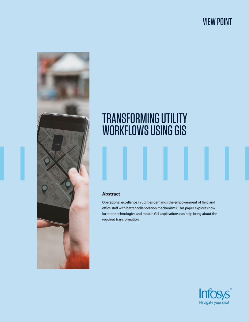
VIEW POINT
Abstract
Operational excellence in utilities demands the empowerment of field and
office staff with better collaboration mechanisms. This paper explores how
location technologies and mobile GIS applications can help bring about the
required transformation.
TRANSFORMING UTILITY WORKFLOWS USING GIS

External Document © 2021 Infosys Limited
Operating in legacy mode
For the utilities industry, complex
physical assets and high-risk operations
involve a great dependence on the
field force for mapping infrastructure
and performing asset inspections.
For telecom, electric, gas, and water
services especially, asset health
monitoring is critical to prevent
network failures. This needs high-
quality field data with an effective
field workflow equipped with digital
applications.
However, many utilities today still
collect asset data through scans of
field staff-supplied hand-drawings on
printed schemas or maps, which then
need to be migrated into enterprise
information systems through several
time-consuming procedures.
External Document © 2021 Infosys Limited
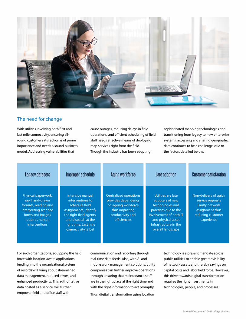
Physical paperwork, raw hand-drawn
formats, reading and interpreting scanned
forms and images requires human
interventions
intensive manual interventions to
schedule �eld assignments, identify the right �eld agents,
and dispatch at the right time. Last mile connectivity is lost
Centralized operations provides dependency on ageing workforce
thus impacting productivity and
e�ciencies
Utilities are late adopters of new
technologies and practices due to the
involvement of both IT and physical asset
infrastructure in the overall landscape
Non-delivery of quick service requests Faulty network
assignment thus reducing customer
experience
Legacy datasets Improper schedule Aging workforce Late adoption Customer satisfaction
The need for change
With utilities involving both first and
last mile connectivity, ensuring all-
round customer satisfaction is of prime
importance and needs a sound business
model. Addressing vulnerabilities that
cause outages, reducing delays in field
operations, and efficient scheduling of field
staff needs effective means of deploying
map services right from the field.
Though the industry has been adopting
sophisticated mapping technologies and
transitioning from legacy to new enterprise
systems, accessing and sharing geographic
data continues to be a challenge, due to
the factors detailed below.
For such organizations, equipping the field
force with location-aware applications
feeding into the organizational system
of records will bring about streamlined
data management, reduced errors, and
enhanced productivity. This authoritative
data hosted as a service, will further
empower field and office staff with
communication and reporting through
real-time data feeds. Also, with AI and
mobile work management solutions, utility
companies can further improve operations
through ensuring that maintenance staff
are in the right place at the right time and
with the right information to act promptly.
Thus, digital transformation using location
technology is a present mandate across
public utilities to enable greater visibility
of network assets and thereby savings on
capital costs and labor field force. However,
this drive towards digital transformation
requires the right investments in
technologies, people, and processes.

External Document © 2021 Infosys Limited
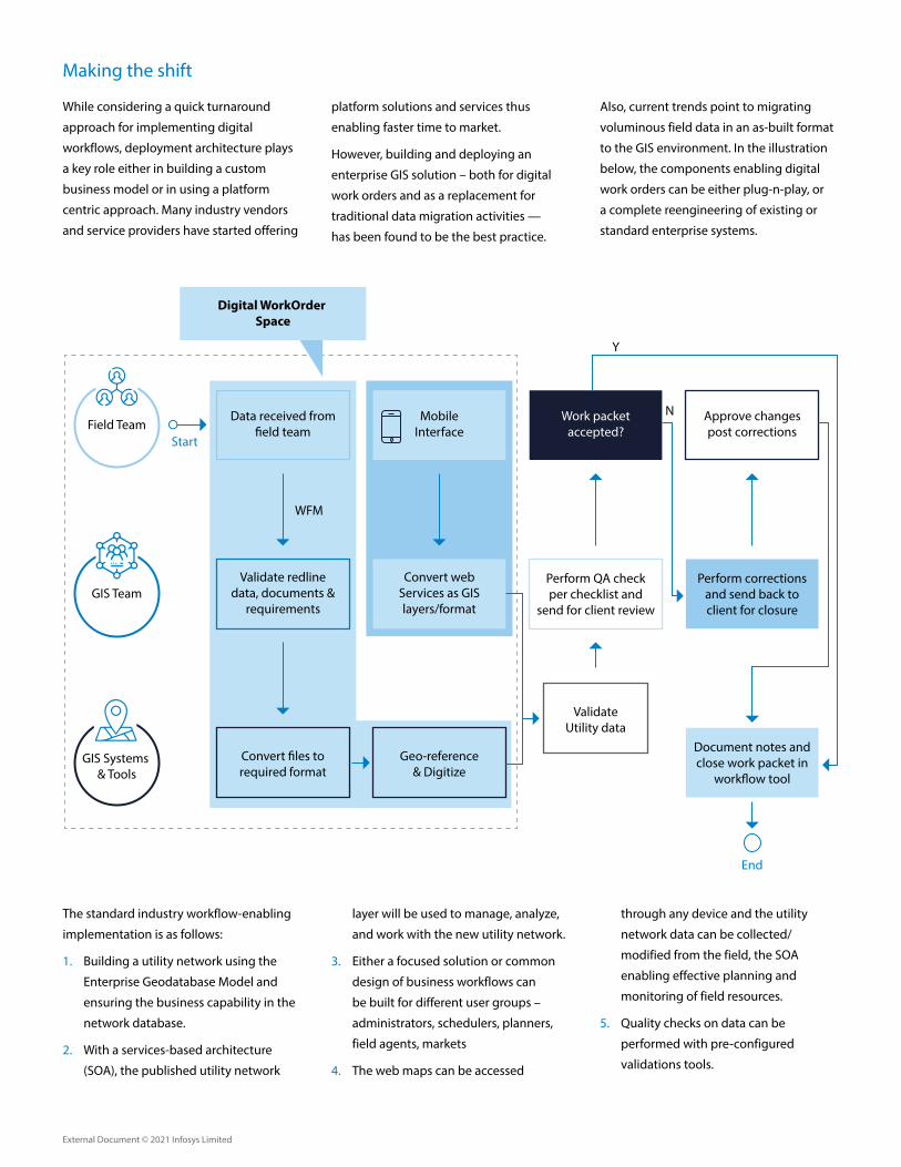
Field Team
GIS Team
GIS Systems & Tools
Data received from �eld team
Validate redline data, documents &
requirements
Convert �les to required format
Approve changes post corrections
Perform corrections and send back to client for closure
Document notes and close work packet in
work�ow tool
Work packet accepted?
Perform QA check per checklist and
send for client review
Data updated in appropriate systems
Geo-reference & Digitize
End
WFM
Y
N
Digital WorkOrder Space
Start
Moving towards digital workflows
Though utilities have begun digitizing
their legacy asset data, a considerable
volume of raw hand-drawn data supplied
by engineers on the field remains to be
converted into digital formats.
In most utilities today, the daily workflow
starts with office staff printing survey maps
and inspection forms for use by crews to
perform their field operations. The field
crews then visit the project site, locate
the marked assets, perform the needed
inspections and collect data in form of
redlines or marked features. This field data
then makes its way to the office where
GIS teams transcribe it to a desktop GIS or
AutoCAD platform.
The typical paper-based workflow
illustrated above suffers from several
drawbacks such as illegible inspection
forms, uncredited asset photos, lost paper
forms, and so on. Hence, especially in the
context of an influx of digital natives into
the field workforce, the critical need is for
enhanced digitalization.
Using online GIS applications and
GIS based mobile apps will efficiently
integrate raw data coming in from the
field into enterprise asset management
systems, increase data collection accuracy,
and reduce outdated information. The
real-time synchronization of collected
map data will enable paperless, digital
workflows for enhanced field efficiency
through improved collaboration and
communication of data. Thus, for example,
field work for outage-based assessments
can be easily scheduled and dispatched,
with map data from updated enterprise
systems delivering relevant location/asset
information to field technicians in the
vicinity through their mobile applications.
External Document © 2021 Infosys Limited
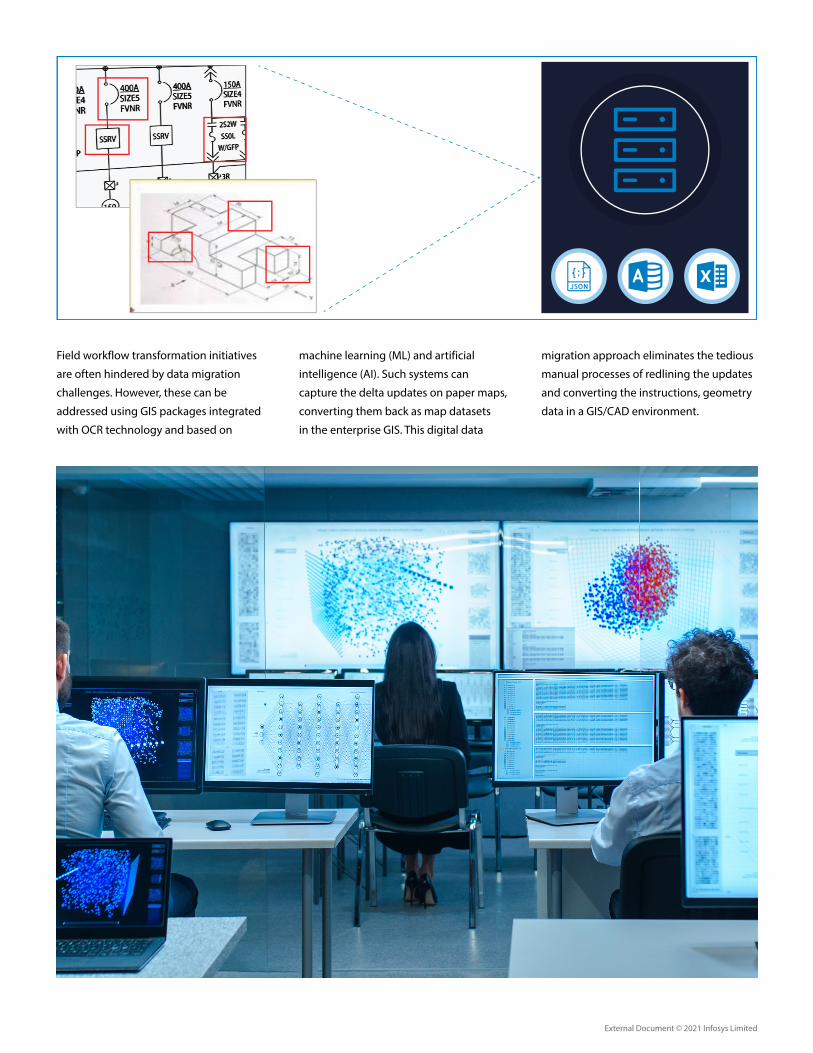
Field workflow transformation initiatives
are often hindered by data migration
challenges. However, these can be
addressed using GIS packages integrated
with OCR technology and based on
machine learning (ML) and artificial
intelligence (AI). Such systems can
capture the delta updates on paper maps,
converting them back as map datasets
in the enterprise GIS. This digital data
migration approach eliminates the tedious
manual processes of redlining the updates
and converting the instructions, geometry
data in a GIS/CAD environment.
External Document © 2021 Infosys Limited
The standard industry workflow-enabling
implementation is as follows:
1. Building a utility network using the
Enterprise Geodatabase Model and
ensuring the business capability in the
network database.
2. With a services-based architecture
(SOA), the published utility network
layer will be used to manage, analyze,
and work with the new utility network.
3. Either a focused solution or common
design of business workflows can
be built for different user groups –
administrators, schedulers, planners,
field agents, markets
4. The web maps can be accessed
through any device and the utility
network data can be collected/
modified from the field, the SOA
enabling effective planning and
monitoring of field resources.
5. Quality checks on data can be
performed with pre-configured
validations tools.
Field Team
GIS Team
GIS Systems & Tools
Data received from �eld team
Validate redline data, documents &
requirements
Mobile Interface
Convert web Services as GIS layers/format
Convert �les to required format
Approve changes post corrections
Perform corrections and send back to client for closure
Document notes and close work packet in
work�ow tool
Work packet accepted?
Perform QA check per checklist and
send for client review
Validate Utility data
Geo-reference & Digitize
End
Start
WFM
Y
N
Digital WorkOrder Space
Making the shift
While considering a quick turnaround
approach for implementing digital
workflows, deployment architecture plays
a key role either in building a custom
business model or in using a platform
centric approach. Many industry vendors
and service providers have started offering
platform solutions and services thus
enabling faster time to market.
However, building and deploying an
enterprise GIS solution – both for digital
work orders and as a replacement for
traditional data migration activities —
has been found to be the best practice.
Also, current trends point to migrating
voluminous field data in an as-built format
to the GIS environment. In the illustration
below, the components enabling digital
work orders can be either plug-n-play, or
a complete reengineering of existing or
standard enterprise systems.
External Document © 2021 Infosys Limited
Incorporating value-added solutions
The field operation or work order
conversion involves many IT and hardware
entities that builds the entire product
solution. During the transition, several
value-adds can be bolted onto each
architecture component. The ones listed
below can be loosely- or tightly-integrated
with the core components:
• Sensor data: Today, utilities are
becoming more aligned to digital
methodologies and placing sensors in
the field. Over time these sensors have
become part of the larger geospatial
picture, with sensor-collected data
used in spatial analytics for insights and
improved decision-making. Sensors in
the field generate real-time data with
positional intelligence enabling the
workforce to access the shared data via
smart phones and tablets to address
asset maintenance and monitor asset
health, with anomalies mapped using
Web GIS technology
• AR/VR model: In recent times, AR based
solutions are being deployed along with
the mapping technology to improve
the restoration and repair processes
associated with overhead/underground
utilities. This has enhanced field force
operations manifold, helping manage
tickets with a quick turnaround time
and with a high quality of field repairs.
• Customized mobile applications:
These provide workers with a real-time
knowledge of field scenarios through
map-centric workflows, enabling
them to collect data, mark-up maps,
capture location tracks, complete
assignments, and navigate to assets. The
applications help save space on mobile
devices through eliminating the need
to duplicate data, such as base maps,
across multiple applications.
Looking ahead
Market surveys indicate that the global
work order management systems market
size will grow from USD 414.1 million in
2018 to USD 694.6 million by 2023, at a
CAGR of 10.9% during the forecast period.
A large part of this growth will come from
utilities, as shifting to digital workflows
has undeniable benefits through better
field-office collaboration on large datasets
within a single editable environment. The
integrated flow will be seamless for the
field worker resulting in higher productivity
and better performance. It will also
provide easier, centralized access to data
through the enterprise/cloud geospatial
environment for clients, subcontractors,
and decision-makers.
References
1. https://www.esri.com/arcgis-blog/products/product/field-mobility/gis-field-technology-benefits-utilities-and-telecoms-during-covid-19/
2. https://www.giscloud.com/blog/gis-for-electric-utilities/
3. https://www.utilitydive.com/spons/gis-should-be-about-digital-transformation/558088/
4. https://www.information-age.com/5-steps-digital-transformation-using-gis-123465157/
5. https://www.infosys.com/about/knowledge-institute/insights/Documents/digital-field-workforce-management.pdf
6. https://www.arcgis.com/apps/Cascade/index.html?appid=ecf58d4a09dd42a8a91e30b9db7283fc
7. GIS for Electric Utilities [The Ultimate Guide] | GIS Cloud
8. https://www.geospatialworld.net/article/iot-gis-transforming-utility-industry/
9. https://bluefolder.com/work-order-management/how-to-boost-efficiency-with-a-digital-work-order-system/
10. https://www.marketsandmarkets.com/Market-Reports/work-order-management-systems-market-81654263.html
© 2021 Infosys Limited, Bengaluru, India. All Rights Reserved. Infosys believes the information in this document is accurate as of its publication date; such information is subject to change without notice. Infosys acknowledges the proprietary rights of other companies to the trademarks, product names and such other intellectual property rights mentioned in this document. Except as expressly permitted, neither this documentation nor any part of it may be reproduced, stored in a retrieval system, or transmitted in any form or by any means, electronic, mechanical, printing, photocopying, recording or otherwise, without the prior permission of Infosys Limited and/ or any named intellectual property rights holders under this document.
For more information, contact [email protected]
Infosysbpm.com Stay Connected
About the Authors
Dr. V. Pradeep Kishore
Solution Design Head, Infosys BPM
Dr. Pradeep leads the GIS data practice in Infosys BPM. He has close to 22 years of experience in the field of GIS, telecom OSS/BSS, mobility and telematics domain, and is involved in the consulting, solution architecture, program/project management, portfolio management for Indian and overseas clients (US/Middle-East). In Infosys BPM, he is responsible for leading the GTM strategy, presales, consulting, COE accountabilities - creating/owning business modeling/framework and contribution to all lines of GIS business/new wins.
Pradeep holds a Doctorate Degree in Disaster Management (landslides prediction) using GIS/remote sensing and has done his post-graduation in Applied Geology.
Sudeep Rautray
Domain Lead, GIS Solution Design, Digital Interactive Services, Infosys BPM
Sudeep has over 13 years of work experience in GIS, Image Processing and data management. He is part of Solution design team responsible for pre-sales activities, developing GIS solutions for key industrial verticals, focuses on growth of GIS data services in new segments/geographies.
Sudeep has delivered solutions for various industrial segments related to Mineral & Mining, Agriculture & forestry, Land Administration & Property Tax, Disaster Management, Urban Infrastructure, and Utilities. Over the years he has served large corporates, e-governance sector, large utilities, public institutions for India and overseas locations. He has worked as domain consultant for reputed e-governance projects funded by International funding agencies.
Sudeep holds a post-graduation degree in Applied Geology from College of Engineering, Anna University, Chennai and also has an MBA from Sikkim Manipal University.