the representation of caesalpinia echinata (brazilwood) in sixteenth-and-seventeenth-century maps
TRANSCRIPT
Anais da Academia Brasileira de Ciências (2007) 79(4): 751-765(Annals of the Brazilian Academy of Sciences)ISSN 0001-3765www.scielo.br/aabc
The representation of Caesalpinia echinata (Brazilwood)in Sixteenth-and-Seventeenth-Century Maps
YURI T. ROCHA, ANDREA PRESOTTO and FELISBERTO CAVALHEIRO†
Departamento de Geografia, Universidade de São Paulo, Av. Prof. Lineu Prestes, 338, Cidade Universitária
05508-000 São Paulo, SP, Brasil
Manuscript received on March 15, 2006; accepted for publication on September 4, 2007;presented by ALCIDES N. SIAL
ABSTRACT
Brazilwood was the first product found in Terra de Santa Cruz, and the first explored by Portuguese colonization of
Brazil. This study aims at the Occidental Cartography and the historical files represented by Portugal’s interest on
mapping the marketed product found in Brazil. The representation of Brazilwood in maps was possible due to scientific
advancements, new land discoveries, and technological improvement during the 15th century, which all have taken
cartography to a whole new period, stressing Portuguese hegemony in Asia and in the New World. The goal of this
research was to identify and analyze maps from 16th and 17th centuries that represented the geographical distribution
of Brazilwood, and its trade. Brazilwood was represented in many maps by illumination and detailed by different
cartographers. The maps and other evidence for this research were found in historical files held in both Brazil and
Portugal.
Key words: Brazilwood, cartography, commerce, history, illumination, sixteenth and seventeenth centuries.
INTRODUCTION
Brazilwood was the first natural resource found and ex-
plored (as the oriental spicery was explored in the Old
World) by Portugal in Terra de Vera Cruz (Land of VeraCruz), later called Terra de Santa Cruz (Land of SantaCruz). Brazilwood (Caesalpinia echinata Lam., botanicfamily Leguminosae) is a tropical arboreous species in
theBrazilianDomain ofAtlanticRainforest (MataAtlân-tica), which had a big impact with the Brazilwood ex-ploration and the Portuguese colonial model. These ex-
ploratory events started the transformation of the tropi-
cal forest in cultures, later in industry and urbanization.
The exploration of Brazilwood had great impor-
tance and expressiveness and was probably responsible
for the official name of the country of Brazil. Brazil
†In MemoriamCorrespondence to: Yuri Tavares RochaE-mail: [email protected]
seems to be the only name given to a country that rep-
resents or was chosen based on a tree (or plant). What
made Brazilwood a first explored product and also a spe-
cial product of exploration was its use to dye fabrics (e.g.
silk, wool, cotton) to the red color.
The word “cartography” was first used by the Por-
tuguese Visconde de Santarém, in December 8th, 1839,
referring to the study of maps in 16th century that he was
doing in Paris. Many of his works were published in the
“History of Cartography”, France, 1841, 1842, 1844 and
1849-1855 (Marques 1994a, Tesouros 1997). The In-
ternational Cartographic Association (ICA), defines car-
tography as “the discipline dealing with the conception,
production, dissemination and study of maps”, and also,
“the art, science and technology of making maps, to-
gether with their study as scientific documents andworks
of art” (Krygier 1995). The cartographic representa-
tion, maps functions and origin were very well studied
and registered by Cortesão (1935), Cortesão and Tei-
An Acad Bras Cienc (2007) 79 (4)
752 YURI T. ROCHA, ANDREA PRESOTTO and FELISBERTO CAVALHEIRO
xeira (1960a,b), Dreyer-Eimbcke (1992), Mapa (1993),
Marques (1994a), Krygier (1995), Tesouros (1997), O
Tesouro (2002). By the 16th and 17th centuries the car-
tography represented the importance of Brazilwood ex-
ploration, focusing on representation of the New World
characteristics, which were frequently allusive to the
Brazilian wood. These representations were basically
drawings named illuminations, “the whole of decorative
elements and representation with images made by hand
to beautify” (Ferreira 1998). Illuminations added aes-
thetic value to maps, and given the lack of geographic
information at that time, it covered the map’s emptiness.
Besides the general essence of maps, which was to
represent science and techniques, they were also artistic
representations, reflecting the tendency of movements
in history, such as Baroque or Romanticism as well as
cultural values (Adonias 2002).
Maps link science, technique and art. The scientific
value played a significant role in the historical develop-
ment of cartography as a key component of geography.
Advance in science is related to the rise of new tech-
niques (not only those specific to develop and elaborate
final maps, but with all techniques, mainly the ones that
contribute to geographic data collection) such as navi-
gation, and naval construction, which involved cartogra-
phers’ skills and artistic influence.
According to Miceli (2002, p. 55), “maps contain
fragments that deserve careful analysis, and became the
most valuable details of these cultural monuments elud-
ing the eyes of the careless observer, despite the fact that
they are all there before us.” In this sense, illuminations
of very high artistic quality in maps are relevant frag-
ments to be observed.
The goal of this research was to identify and ana-
lyze maps and illuminations from 16th and 17th centuries
that mainly represented Brazilwood geographical distri-
bution and trade. Some illuminations relate to Brazil-
wood represented the Tropical Forests (Brazilian veg-
etation) with visual aspects very similar to the Euro-
pean Temperate Forests. Others represent Brazilwood
processing, involving cut, transportation, exchange and
shipping.
The analyzedmapswere found inPortuguese, Span-
ish, French, Italian, Dutch, English, andGerman sources.
However, mainly in the 16th and 17th centuries, Por-
tuguese influence reached all cartographic schools in
those countries (Marques 1994a). These maps contain
a lot of information and are essential for historical stud-
ies which play an important role to understand the past
(Guedes 2002, Curtis 2002).
BRAZILWOOD DISTRIBUTION IN THE BRAZILIAN
DOMAIN OF THE ATLANTIC FOREST (MATA ATLÂNTICA)
Brazilwood for its historical, symbolical and cultural
value, is considered a Brazilian national tree. However,
the geographic distribution of Brazilwood was signifi-
cantly wider in the past. Economic development (agri-
culture, industry and services) along with population
growth and the expansion of urban centers since Por-
tuguese first landed in Brazil in 1500, contributed to
eliminate a huge area of Atlantic Rainforest. With it
went Brazilwood wich today is an endangered species.
The natural distribution of Brazilwood is at costal
forests, the Brazilian Domain of Atlantic Forest, approx-
imately between latitudes 5◦ and 23◦S, in the states ofRio Grande do Norte, Paraíba, Pernambuco, Alagoas,
Sergipe, Bahia, Espírito Santo, and Rio de Janeiro.
Geographic Information about Brazilwood distribu-
tion was gathered from literature, herbariums (collection
places bearing labels of 196 Brazilwood exsiccates, 21
Brazilian and Portuguese herbariums), collections, and
fieldwork. The reproductive material was collected and
georeferenced, and stands of Brazilwood were visited in
extensive fieldwork in Northwest of Brazil from Sergipe
to Rio Grande do Norte (Rocha 2005).
The data contributed to the generation of a geo-
graphic map with the “new” Brazilwood distribution
(Rocha 2005). However, lack of floristic data collection
and fragmentation of natural Brazilwood forests were
some of the challenges that we faced in determining
more precisely the current geographic distribution of
Brazilwood.
THE MAPS AND BRAZILWOOD REPRESENTATION
The cartography considered in this article is mainly from
16th century documents, which represent Brazil and its
value as an exploitable place. Brazilwood appeared in
illuminations, which also represented other elements
(e.g., imaginaries, marine, geographical, marketing, mil-
itary, fauna, flora and ethnography features). Examples
An Acad Bras Cienc (2007) 79 (4)
BRAZILWOOD AND CARTOGRAPHY 753
of such representations are animals, ordinary indigenous
landscape, wars, felling of trees, flags, decorative arms,
legendary pictures, ships, monsters in the ocean, flying
fishes, huge whales, nautical pictures, Neptune king and
siren showing awonderful “artistic-cartographic wealth”
(Adonias 2002). With this amount of “things to rep-
resent” greater cartographers at that time should have
been greater artists too as suggested by Johann Gottfried
Gregorii (1685-1770), a German geographer. At the be-
ginning of the 18th century Gregorii affirmed that a good
cartographer should be, necessarily a good painter, “thus
putting art and technique on the same inseparable level”
(Miceli 2002, p. 101). Paintings were the way Euro-
peans could use to see in detail the new discovered lands,
“as mind-expanding as today’s photographs of Mars or
of a star exploding” (Potter 2002, p. 49).
Brazilian vegetation and Brazilwood had enough
representation in illuminations plotted in many maps of
the 16th and 17th centuries. As mentioned before, maps
of the tropical forest present similarities with the Euro-
pean temperate forests, and Cantino’s map (1502), and
Girolamo Ruscelli’s map (1573) are both good examples
(O Tesouro 2002, Guedes 1999).
CANTINO’S MAP
The planisphere known as Mapa de Cantino – originalsize: 105× 25 cm, Biblioteca Estense, Modena, Italy(Guedes 1999) – made by an unknown Portuguese car-
tographer (1502) with manuscripts and illuminations is
considered the first modern planisphere and the first map
showing the Brazilian Coast, south of Africa, Equator,
and the tropics. It is evidence of the use of astronomic
navigation and of the quality of cartography reached by
Portugal. Besides that it registered the exotic nature in
the NewWorld with huge parrots and big trees (Belluzzo
1994, Miceli 1997, 2002).
Cantino’s map illustrates the Brazilian territory as
Santa Cruz (Mapa 1993) and shows Brazilian vegetationsimilar to that of a temperate forest. There is no indi-
cation for a rainforest, and there is no clear reference to
Brazilwood. The mapmaker follows the Portuguese of-
ficial standard of that time, which was kept in Armazénsda Guiné e Índia (Guianan and Indian Storages). Themap shows the results of the expeditions by Cristoforo
Colombo (1498), Vasco da Gama (1497-1498), Pedro
Álvares Cabral (1500-1501), Gaspar Lemos (1500), and
João Nova (1501). It also shows the Portuguese oriental
knowledge (Marques 1994a, Tesouros 1997, Guerreiro
1999), the expedition where Gonçalo Coelho was the
commander, and explored the Brazilian Coast to latitude
26◦S, between 1501 and 1502 (Tesouros 1997, Maga-lhães 1999).
The history of Cantino’s map is very interesting.
The spy Alberto Cantino paid 12 golden ducados for itwhich was high price at that time. The map suggests a
secret or even an unauthorized trade and Cantino pur-
chased in order to send it to Hercule of Este, the duke
of Ferrara, his Italian boss. The duke kept the map in
his library until 1592, when it was transferred to a palace
in Modena (Italy), after a command from pope Clement
VIII (Gomes 2002).
During a republican riot in 1859 the palace in Mod-
enawas looted and the aforementionedmap disappeared.
It was rediscovered in 1868 in a wall of a sausage place
in Modena, by Giuseppe Bonni, director of the Estense
Library (Tesouros 1997, Amado and Figueiredo 2001,
Gomes 2002).
BRASIL NUOVA TAVOLA
The map “Brasil Nuova Tavola” – original size: 18×25.5 cm, Cid Collection, São Paulo, Brazil (O Tesouro2002) – made by Girolamo Ruscelli (1573) is very poor
in geographic names, even though the Brazilian coast by
that time was well-known. The map has in the center
of the territory a phrase which relates natives to anthro-
pophagi: Gli indi natij di questi paesi mangiano carnehumana (Miceli 2002). This map represented the Orien-tal Marine Coast of Brazil in its central part. Compared
to the majority of maps from 1500’s this was an unusual
position. The North is in the right part of the map and
the illumination by Ruscelli is an extremely simple rep-
resentation of Brazilian vegetation. The Atlantic Rain
Forest was not represented as a tropical forest, but similar
to the Portuguesemontado, which is a kind of vegetationconsisting of arborous groups, spaced plants and herba-
ceous level (relvado), as observed by Pena and Cabral(1996, p. 65): “the montados are arborous groups rel-atively open with very simple structure.” The Atlantic
Rain Forest structure contains multiple canopies in dif-
ferent sizes, and irregularity among the trees.
An Acad Bras Cienc (2007) 79 (4)
754 YURI T. ROCHA, ANDREA PRESOTTO and FELISBERTO CAVALHEIRO
Some maps from 16th century have precise rep-
resentations of cut, transportation, trade, and shipping
of Brazilwood in their illuminations. It is important to
emphasize that “the representation of natives cutting
trees is a constant element in decorations of maps from
the 1500’s” (Mapa 1993). This type of illuminations
frequently and clearly refers to Brazilwood due to its
red color, both internal and externally.
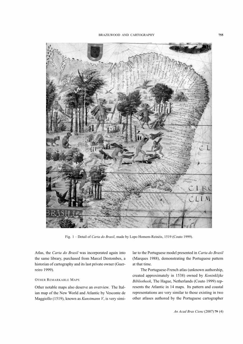
CARTA DO BRASIL
Legend of Carta do Brasil:
“Thismap is from the region of the great Brazil
and in its western part reaching the Antilleans
of Castela King. As to its people, they are of
a somewhat dark skin. Savage and very cruel,
they eat human flesh. These people use, no-
tably, the arch arrow and bows. Here there
are colored parrots and uncountable birds and
monstrous beasts. There are several types of
monkeys, and there is in great number the tree
that, named Brazil, and is considered conve-
nient to dye apparel with a purple color”
(Guerreiro 1999. p. 120).
The Carta do Brasil – original size: 42×59.5 cm– from Atlas Miller, attributed to Lopo Homem-Reinéis(1519), currently in Bibliothèque Nationale, Paris, Fran-ce (Couto 1999) – is considered to be the first economic
thematic document ofBrazil. It shows indigenous people
cutting and felling Brazilwood, close to monkeys and
colorful macaws. In ecological terms, it is the first image
of deforestation of the country (Mapa 1993).
This chart had great importance in the cartogra-
phy history because it shows the most complete geo-
graphic names of the Brazilian Coast and set aside its
importance during a long time (Cortesão and Teixeira da
Mota 1960b).
It is possible to observe four indigenous people in-
volved with cutting and transportation of Brazilwood.
Trees colored more reddish than other trees, probably
represent Brazilwood already peeled and cut, exposing
the red core from where the dye was obtained (Fig. 1).
Illuminations also represent various birds like parrots
and macaws.
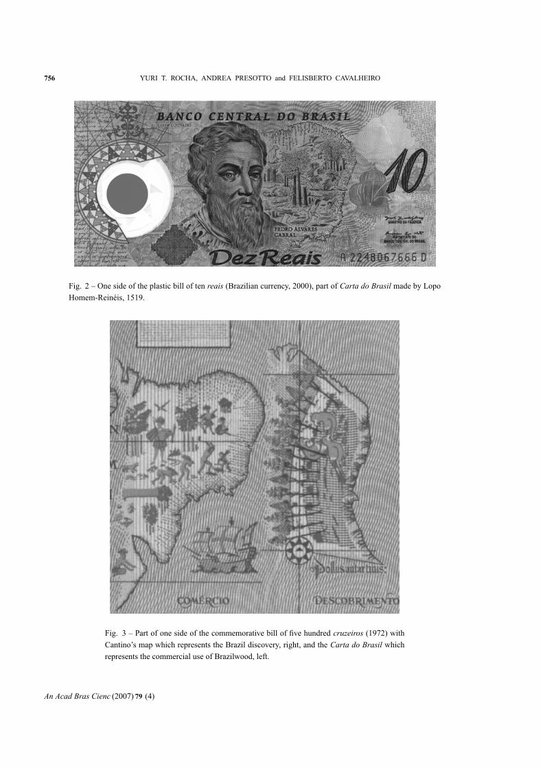
A side of the plastic bill of ten reais (Brazilian cur-
rency) announces the 500 years of the discovery of Brazil
and bears a stylized and partially reproduced version of
the Carta do Brasil by Lopo Homem-Reinéis (Fig. 2).There is no reference in the bill to the authorship or
date of the Carta do Brasil. In terms of iconography theimage produced by Lopo Homem-Reinéis is more con-
nected to Cantino’s Map (1502), which first showed the
Brazilian Coast and registered the discovery of Brazil by
Cabral in the company of a small text and a Portuguese
mark placed in the region of Porto Seguro. Cantino’s
map also appears in the commemorative bill of 150 years
since the independence of Brazil (five hundred cruzeiros)to represent the Brazil discovery, with Carta do Brasilrepresenting the Brazilwood trade (Fig. 3). Another ex-
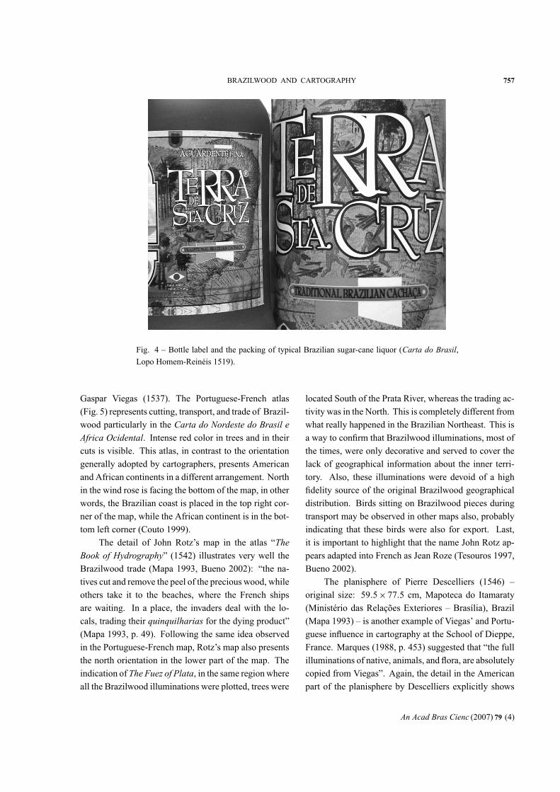
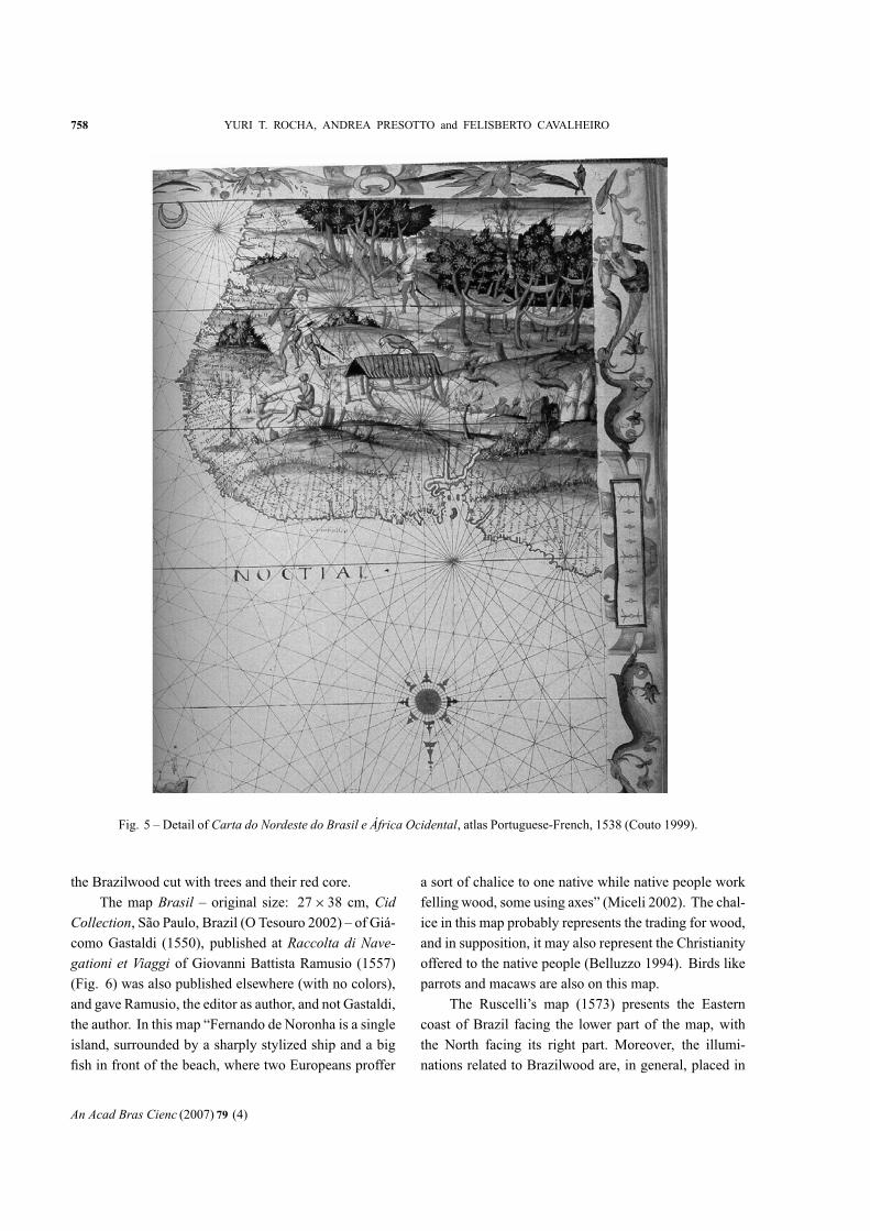
ample of the use of Carta do Brasil was found in a labelof a typical Brazilian sugar-cane liquor (in Portuguese
“pinga”, “aguardente” or “cachaça”), branded “Terra de
Santa Cruz” (Fig. 4). As ten reais bill, there is no refer-ence to the authorship or production year of the map.
Probably the geographic information to elaborate
the Carta do Brasil by Lopo Homem-Reinéis (1519)was gained for the first time by Cristóvão Jaques expedi-
tion, by fidalgo D. Manuel, who navigated the BrazilianCoast between 1516 and 1519, probably to combat the
presence of Brazilwood French traders in the colonial
Portuguese territory (Guedes 1971).
The Carta do Brasil showed on first hand the Ter-ra Brasilis (Land of Brazil) as a territorial unit. It rep-resented people with dark skin living in a forest, with
colorful birds, other animals, and mainly occupied with
the felling of trees. The Carta do Brasil was part of theAtlas Miller, which was ordered from Lopo Homem bythe Portuguese king D. Manoel I, probably to reward the
French king Francisco I.
Homem in order to develop this order counted on
the help of the Reinéis’ maps (Tesouros 1997) and may
have also received help from the artist Antonio de Ho-
landa, a great illuminist from the Netherlands (Marques,
1994b).
The Atlas Miller which contains nine currentlyknown maps is also known as Cartes Miller or Cartesde Madame Miller (Cortesão 1935). It is a Portuguesenaval atlas, purchased by the French Miller from the
Portuguese Visconde of Santarem, being part of the her-
itage to the widow Miller, who sold it to the Biblio-thèque Nationale. After a period being apart from the
An Acad Bras Cienc (2007) 79 (4)
BRAZILWOOD AND CARTOGRAPHY 755
Fig. 1 – Detail of Carta do Brasil, made by Lopo Homem-Reinéis, 1519 (Couto 1999).
Atlas, the Carta do Brasil was incorporated again intothe same library, purchased from Marcel Destombes, a
historian of cartography and its last private owner (Guer-
reiro 1999).
OTHER REMARKABLE MAPS
Other notable maps also deserve an overview. The Ital-
ian map of the New World and Atlantic by Vesconte de
Maggiollo (1519), known as Kunstmann V, is very simi-
lar to the Portuguese model presented in Carta do Brasil(Marques 1988), demonstrating the Portuguese pattern
at that time.
The Portuguese-French atlas (unknown authorship,
created approximately in 1538) owned by KoninklijkeBibliotheek, The Hague, Netherlands (Couto 1999) rep-resents the Atlantic in 14 maps. Its pattern and coastal
representations are very similar to those existing in two
other atlases authored by the Portuguese cartographer
An Acad Bras Cienc (2007) 79 (4)
756 YURI T. ROCHA, ANDREA PRESOTTO and FELISBERTO CAVALHEIRO
Fig. 2 – One side of the plastic bill of ten reais (Brazilian currency, 2000), part of Carta do Brasil made by LopoHomem-Reinéis, 1519.
Fig. 3 – Part of one side of the commemorative bill of five hundred cruzeiros (1972) withCantino’s map which represents the Brazil discovery, right, and the Carta do Brasil whichrepresents the commercial use of Brazilwood, left.
An Acad Bras Cienc (2007) 79 (4)
BRAZILWOOD AND CARTOGRAPHY 757
Fig. 4 – Bottle label and the packing of typical Brazilian sugar-cane liquor (Carta do Brasil,Lopo Homem-Reinéis 1519).
Gaspar Viegas (1537). The Portuguese-French atlas
(Fig. 5) represents cutting, transport, and trade of Brazil-
wood particularly in the Carta do Nordeste do Brasil eAfrica Ocidental. Intense red color in trees and in theircuts is visible. This atlas, in contrast to the orientation
generally adopted by cartographers, presents American
and African continents in a different arrangement. North
in the wind rose is facing the bottom of the map, in other
words, the Brazilian coast is placed in the top right cor-
ner of the map, while the African continent is in the bot-
tom left corner (Couto 1999).
The detail of John Rotz’s map in the atlas “TheBook of Hydrography” (1542) illustrates very well theBrazilwood trade (Mapa 1993, Bueno 2002): “the na-
tives cut and remove the peel of the precious wood, while
others take it to the beaches, where the French ships
are waiting. In a place, the invaders deal with the lo-
cals, trading their quinquilharias for the dying product”(Mapa 1993, p. 49). Following the same idea observed
in the Portuguese-French map, Rotz’s map also presents
the north orientation in the lower part of the map. The
indication of The Fuez of Plata, in the same region whereall the Brazilwood illuminations were plotted, trees were
located South of the Prata River, whereas the trading ac-
tivity was in the North. This is completely different from
what really happened in the Brazilian Northeast. This is
a way to confirm that Brazilwood illuminations, most of
the times, were only decorative and served to cover the
lack of geographical information about the inner terri-
tory. Also, these illuminations were devoid of a high
fidelity source of the original Brazilwood geographical
distribution. Birds sitting on Brazilwood pieces during
transport may be observed in other maps also, probably
indicating that these birds were also for export. Last,
it is important to highlight that the name John Rotz ap-
pears adapted into French as Jean Roze (Tesouros 1997,
Bueno 2002).
The planisphere of Pierre Descelliers (1546) –
original size: 59.5×77.5 cm, Mapoteca do Itamaraty(Ministério das Relações Exteriores – Brasília), Brazil
(Mapa 1993) – is another example of Viegas’ and Portu-
guese influence in cartography at the School of Dieppe,
France. Marques (1988, p. 453) suggested that “the full
illuminations of native, animals, and flora, are absolutely
copied from Viegas”. Again, the detail in the American
part of the planisphere by Descelliers explicitly shows
An Acad Bras Cienc (2007) 79 (4)
758 YURI T. ROCHA, ANDREA PRESOTTO and FELISBERTO CAVALHEIRO
Fig. 5 – Detail of Carta do Nordeste do Brasil e África Ocidental, atlas Portuguese-French, 1538 (Couto 1999).
the Brazilwood cut with trees and their red core.
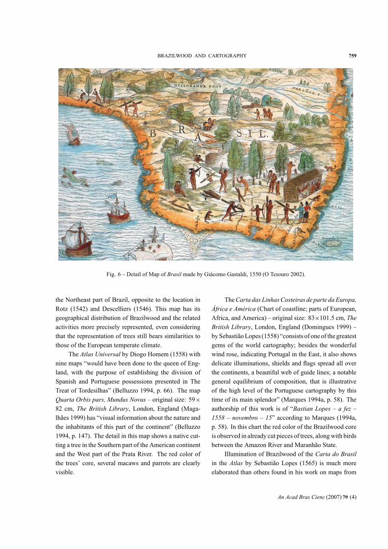
The map Brasil – original size: 27×38 cm, CidCollection, São Paulo, Brazil (O Tesouro 2002) – of Giá-como Gastaldi (1550), published at Raccolta di Nave-gationi et Viaggi of Giovanni Battista Ramusio (1557)(Fig. 6) was also published elsewhere (with no colors),
and gave Ramusio, the editor as author, and not Gastaldi,
the author. In this map “Fernando de Noronha is a single
island, surrounded by a sharply stylized ship and a big
fish in front of the beach, where two Europeans proffer
a sort of chalice to one native while native people work
felling wood, some using axes” (Miceli 2002). The chal-
ice in this map probably represents the trading for wood,
and in supposition, it may also represent the Christianity
offered to the native people (Belluzzo 1994). Birds like
parrots and macaws are also on this map.
The Ruscelli’s map (1573) presents the Eastern
coast of Brazil facing the lower part of the map, with
the North facing its right part. Moreover, the illumi-
nations related to Brazilwood are, in general, placed in
An Acad Bras Cienc (2007) 79 (4)
BRAZILWOOD AND CARTOGRAPHY 759
Fig. 6 – Detail of Map of Brasil made by Giácomo Gastaldi, 1550 (O Tesouro 2002).
the Northeast part of Brazil, opposite to the location in
Rotz (1542) and Descelliers (1546). This map has its
geographical distribution of Brazilwood and the related
activities more precisely represented, even considering
that the representation of trees still bears similarities to
those of the European temperate climate.
The Atlas Universal by Diogo Homem (1558) withnine maps “would have been done to the queen of Eng-
land, with the purpose of establishing the division of
Spanish and Portuguese possessions presented in The
Treat of Tordesilhas” (Belluzzo 1994, p. 66). The map
Quarta Orbis pars, Mundus Novus – original size: 59×82 cm, The British Library, London, England (Maga-lhães 1999) has “visual information about the nature and
the inhabitants of this part of the continent” (Belluzzo
1994, p. 147). The detail in this map shows a native cut-
ting a tree in the Southern part of the American continent
and the West part of the Prata River. The red color of
the trees’ core, several macaws and parrots are clearly
visible.
TheCarta das LinhasCosteiras de parte daEuropa,África e América (Chart of coastline; parts of European,Africa, and America) – original size: 83×101.5 cm, TheBritish Library, London, England (Domingues 1999) –bySebastiãoLopes (1558) “consists of one of the greatest
gems of the world cartography; besides the wonderful
wind rose, indicating Portugal in the East, it also shows
delicate illuminations, shields and flags spread all over
the continents, a beautiful web of guide lines; a notable
general equilibrium of composition, that is illustrative
of the high level of the Portuguese cartography by this
time of its main splendor” (Marques 1994a, p. 58). The
authorship of this work is of “Bastian Lopes – a fez –1558 – novembro – 15” according to Marques (1994a,p. 58). In this chart the red color of the Brazilwood core
is observed in already cut pieces of trees, alongwith birds
between the Amazon River and Maranhão State.
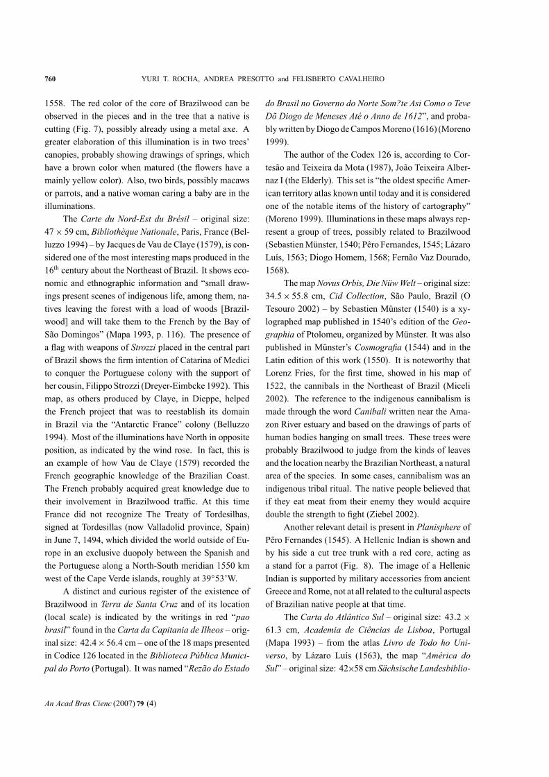
Illumination of Brazilwood of the Carta do Brasilin the Atlas by Sebastião Lopes (1565) is much moreelaborated than others found in his work on maps from
An Acad Bras Cienc (2007) 79 (4)
760 YURI T. ROCHA, ANDREA PRESOTTO and FELISBERTO CAVALHEIRO
1558. The red color of the core of Brazilwood can be
observed in the pieces and in the tree that a native is
cutting (Fig. 7), possibly already using a metal axe. A
greater elaboration of this illumination is in two trees’
canopies, probably showing drawings of springs, which
have a brown color when matured (the flowers have a
mainly yellow color). Also, two birds, possibly macaws
or parrots, and a native woman caring a baby are in the
illuminations.
The Carte du Nord-Est du Brésil – original size:47× 59 cm, Bibliothèque Nationale, Paris, France (Bel-luzzo 1994) – by Jacques de Vau de Claye (1579), is con-
sidered one of the most interesting maps produced in the
16th century about the Northeast of Brazil. It shows eco-
nomic and ethnographic information and “small draw-
ings present scenes of indigenous life, among them, na-
tives leaving the forest with a load of woods [Brazil-
wood] and will take them to the French by the Bay of
São Domingos” (Mapa 1993, p. 116). The presence of
a flag with weapons of Strozzi placed in the central partof Brazil shows the firm intention of Catarina of Medici
to conquer the Portuguese colony with the support of
her cousin, Filippo Strozzi (Dreyer-Eimbcke 1992). This
map, as others produced by Claye, in Dieppe, helped
the French project that was to reestablish its domain
in Brazil via the “Antarctic France” colony (Belluzzo
1994). Most of the illuminations have North in opposite
position, as indicated by the wind rose. In fact, this is
an example of how Vau de Claye (1579) recorded the
French geographic knowledge of the Brazilian Coast.
The French probably acquired great knowledge due to
their involvement in Brazilwood traffic. At this time
France did not recognize The Treaty of Tordesilhas,
signed at Tordesillas (now Valladolid province, Spain)
in June 7, 1494, which divided the world outside of Eu-
rope in an exclusive duopoly between the Spanish and
the Portuguese along a North-South meridian 1550 km
west of the Cape Verde islands, roughly at 39◦53’W.A distinct and curious register of the existence of
Brazilwood in Terra de Santa Cruz and of its location(local scale) is indicated by the writings in red “paobrasil” found in the Carta da Capitania de Ilheos – orig-inal size: 42.4×56.4 cm – one of the 18 maps presentedin Codice 126 located in the Biblioteca Pública Munici-pal do Porto (Portugal). It was named “Rezão do Estado
do Brasil no Governo do Norte Som?te Asi Como o TeveDõ Diogo de Meneses Até o Anno de 1612”, and proba-blywritten byDiogodeCamposMoreno (1616) (Moreno
1999).
The author of the Codex 126 is, according to Cor-
tesão and Teixeira da Mota (1987), João Teixeira Alber-
naz I (the Elderly). This set is “the oldest specific Amer-
ican territory atlas known until today and it is considered
one of the notable items of the history of cartography”
(Moreno 1999). Illuminations in these maps always rep-
resent a group of trees, possibly related to Brazilwood
(SebastienMünster, 1540; Pêro Fernandes, 1545; Lázaro
Luís, 1563; Diogo Homem, 1568; Fernão Vaz Dourado,
1568).
ThemapNovusOrbis, Die NüwWelt – original size:34.5× 55.8 cm, Cid Collection, São Paulo, Brazil (OTesouro 2002) – by Sebastien Münster (1540) is a xy-
lographed map published in 1540’s edition of the Geo-graphia of Ptolomeu, organized by Münster. It was alsopublished in Münster’s Cosmografia (1544) and in theLatin edition of this work (1550). It is noteworthy that
Lorenz Fries, for the first time, showed in his map of
1522, the cannibals in the Northeast of Brazil (Miceli
2002). The reference to the indigenous cannibalism is
made through the word Canibali written near the Ama-zon River estuary and based on the drawings of parts of
human bodies hanging on small trees. These trees were
probably Brazilwood to judge from the kinds of leaves
and the location nearby the Brazilian Northeast, a natural
area of the species. In some cases, cannibalism was an
indigenous tribal ritual. The native people believed that
if they eat meat from their enemy they would acquire
double the strength to fight (Ziebel 2002).
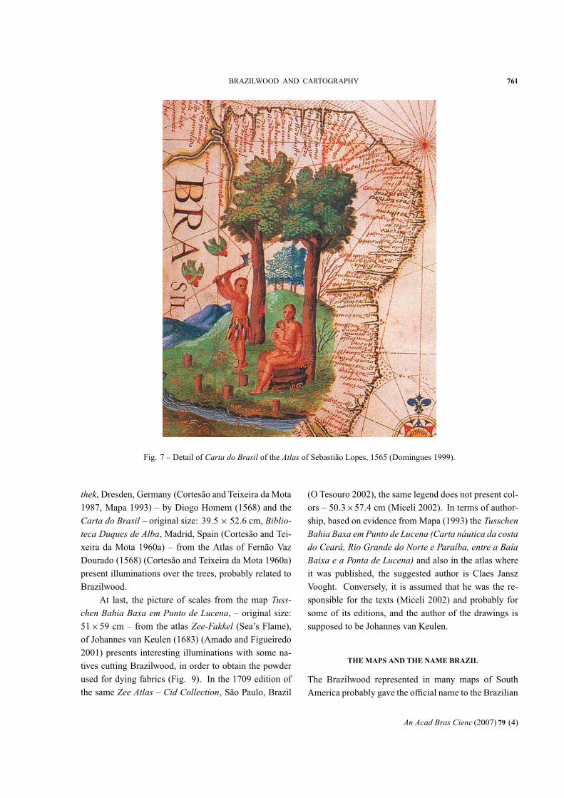
Another relevant detail is present in Planisphere ofPêro Fernandes (1545). A Hellenic Indian is shown and
by his side a cut tree trunk with a red core, acting as
a stand for a parrot (Fig. 8). The image of a Hellenic
Indian is supported by military accessories from ancient
Greece and Rome, not at all related to the cultural aspects
of Brazilian native people at that time.
The Carta do Atlântico Sul – original size: 43.2 ×61.3 cm, Academia de Ciências de Lisboa, Portugal(Mapa 1993) – from the atlas Livro de Todo ho Uni-verso, by Lázaro Luís (1563), the map “América doSul” – original size: 42×58 cm Sächsische Landesbiblio-
An Acad Bras Cienc (2007) 79 (4)
BRAZILWOOD AND CARTOGRAPHY 761
Fig. 7 – Detail of Carta do Brasil of the Atlas of Sebastião Lopes, 1565 (Domingues 1999).
thek, Dresden, Germany (Cortesão and Teixeira da Mota1987, Mapa 1993) – by Diogo Homem (1568) and the
Carta do Brasil – original size: 39.5× 52.6 cm, Biblio-teca Duques de Alba, Madrid, Spain (Cortesão and Tei-xeira da Mota 1960a) – from the Atlas of Fernão Vaz
Dourado (1568) (Cortesão and Teixeira da Mota 1960a)
present illuminations over the trees, probably related to
Brazilwood.
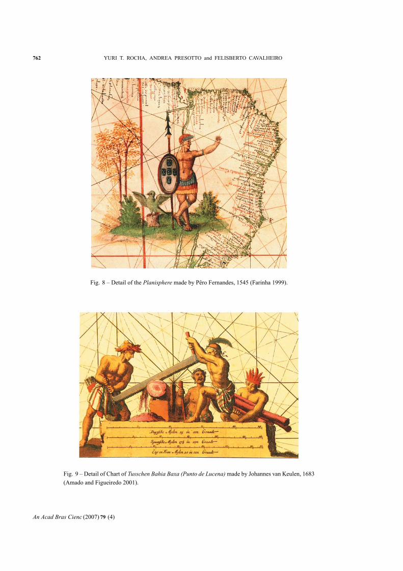
At last, the picture of scales from the map Tuss-chen Bahia Baxa em Punto de Lucena, – original size:51×59 cm – from the atlas Zee-Fakkel (Sea’s Flame),of Johannes van Keulen (1683) (Amado and Figueiredo
2001) presents interesting illuminations with some na-
tives cutting Brazilwood, in order to obtain the powder
used for dying fabrics (Fig. 9). In the 1709 edition of
the same Zee Atlas – Cid Collection, São Paulo, Brazil
(O Tesouro 2002), the same legend does not present col-
ors – 50.3×57.4 cm (Miceli 2002). In terms of author-ship, based on evidence from Mapa (1993) the TusschenBahia Baxa em Punto de Lucena (Carta náutica da costado Ceará, Rio Grande do Norte e Paraíba, entre a BaíaBaixa e a Ponta de Lucena) and also in the atlas whereit was published, the suggested author is Claes Jansz
Vooght. Conversely, it is assumed that he was the re-
sponsible for the texts (Miceli 2002) and probably for
some of its editions, and the author of the drawings is
supposed to be Johannes van Keulen.
THE MAPS AND THE NAME BRAZIL
The Brazilwood represented in many maps of South
America probably gave the official name to the Brazilian
An Acad Bras Cienc (2007) 79 (4)
762 YURI T. ROCHA, ANDREA PRESOTTO and FELISBERTO CAVALHEIRO
Fig. 8 – Detail of the Planisphere made by Pêro Fernandes, 1545 (Farinha 1999).
Fig. 9 – Detail of Chart of Tusschen Bahia Baxa (Punto de Lucena) made by Johannes van Keulen, 1683(Amado and Figueiredo 2001).
An Acad Bras Cienc (2007) 79 (4)
BRAZILWOOD AND CARTOGRAPHY 763
territory, which at the first time was Terra de Vera Cruz,
then Terra de Santa Cruz, and finally Brazil.
The first map which used the name “Brazil” to point
out the Terra de Santa Cruz was the planisphereOrbis ty-pus universalis tabula by Jerônimo Marini (1512) madein Venice, Italy (Matos 1999). However, the Mapa deCantino (1502) already used the name Brazil to identifya river, where the expedition (1501/1502) commanded
by Gonçalo Coelho found assortments of Brazilwood
(Mapa 1993).
The expression “The land of Brazil” emerged for
the first time, in writing, in Esmeraldo de Situ Orbiswork, by Duarte Pacheco Pereira in 1505, when Por-
tugal had received three loadings of Brazilwood from
the New World (Mapa 1993).
The historian Luís de Matos (L’expansion portu-gaise dans la littérature latine de la Renaissance) sug-gested that the name Terra do Brasil became popularafter 1508 (Magalhães 1999).
Alexander von Humboldt suggested the name
Brazil was used ten centuries before that time to nom-
inate a wood ink that came from the Far East to Eu-
rope. This trade had been registered by Arabians in 851
(Mapa 1993). To illustrate Humboldt’s observation, the
wood from the Far East had its use registered by French
in 1085. Other documents fromFrench, Catalans, Dutch,
English, Portuguese, and Irish from the 12th until 16th
centuries had referred to the product (Mapa 1993) much
earlier than its discovery in the New World. The Far
East wood was Caesalpinia sappan L., and belonged tothe same botanical family as the Brazilian Caesalpiniaechinata. The first, C. sappan, was found in Thailand,Moluccas Island and Japan, and also had popular names
such as bakham (Arabian), shappan (Malayalam), andpatanga (Sanskrit) (Souza 1939). Not surprisingly, whenthewood (C. echinata) was discovered in theNewWorld,presenting same properties as C. sappan, the same namewas used.
Among the maps, those registering the change of
the name from Terra de Santa Cruz to Brazil were madeby Diogo Ribeiro (approximately 1532) who used the
name El Brasil (Guerreiro 1999). Additional examplescan be found in the maps developed by Giácomo Gas-
taldi, edited by Paolo Forlani (1562), who named the
countryTerra del Brazil (OTesouro 2002), and byFernão
Vaz Dourado (1571), who named the country Costa doBrazil (Góes 1999).
The map made by Diogo Ribeiro, who gave to the
Brazilian territory the name El Brazil, was the first in-formational cartographic document mentioning the car-
avels Rosa and Princesa, both used by Martim Afonso
de Sousa’s expedition. This expedition was motivated to
control the traffic of products (Brazilwood in the Prata
River) byFrance andSpain, and traveled the entireCoast-
line of Brazil from December 1530 until August 1533
(Tesouros 1997). At that time maps presented a lot of
geographic information about the interior of the New
World (Guerreiro 1999).
In the Planisphere of Weimar, also made by DiogoRibeiro (1529), Brazil was described in one of the 41
legends of one chart, in this way: “II Tiera del Brasil:
Aqui no se alla outra cosa de prouecho mas del brasil q∼no les costa mas de hazerlo cortar e traerlo alas naos lo
qual haze los Jndios por poca cosa come carnes umanas
seyedo enemigos. Aqui tiene elReydeportogal enpernã-
buco vna fatoria donde tiene mucha cantidad de brasil
cogido para las naos q∼ van acargar:∼” (Cortesão 1935,p. 130).
A free translation to the English language could
be: “II Terra do Brasil: Here there is no more valuable
thing than Brazil, it is free, they just need to cut and carry
them to ships, that transportation the indigenous people
can do for almost nothing. These indigenous people are
hostile, and eat human flesh. Here lives the King of Por-
tugal, in Pernambuco State, a feitoria (trade and storage
point) with a lot of quantity of cut Brazilwood to go to
ships, which will transport them.”
The map La Descrittione di Tutto il Peru – originalsize: 51.8×37 cm, Cid Collection, São Paulo, Brazil(O Tesouro 2002) – by Giácomo Gastaldi, published
by Paolo Forlani (1562), named Brazil as Terra delBrasil. TheCarta doBrasil – original size: 40.8×53 cm,Instituto dos Arquivos Nacionais/Torre do Tombo, Lis-
boa, Portugal (Góes 1999) – made by Fernão Vaz Dou-
rado (1571) named the country as Costa do Brazil (Mar-ques 1994a). Martin Waldseemüller (1470-1521), in a
map published in the edition of Ptolomeu’s Geography
(1513), and republished by Lorenz Fries (approximately
1490-1532) in 1541, designates Brazil as Terra Papagalli(Land of Parrots), used the term Brazil only to name the
An Acad Bras Cienc (2007) 79 (4)
764 YURI T. ROCHA, ANDREA PRESOTTO and FELISBERTO CAVALHEIRO
river located between Porto Seguro and Monte Pascoal,
in the actual Bahia State (Miceli 2002). In the CartaMarina navigatoria Portugallen planisphere, also madeby Waldseemüller (1516), Brazil is called Brasilia SiveTerra Papagalli, Brazil or Land of Parrots (Mapa 1993),which proves that the first name was already used. In
the 1525 edition of Geographia of Ptolomeu, Brazil ap-pears as America Vel Brasilia Sive Papagali Terra (Mapa1993).
It is not only the Brazilian territory’s name that
was changed from Terra de Santa Cruz, but also theMundus Novus, to become America, a tribute to AmerigoVespucci by Martin Waldseemüller (Geographia of Pto-lomeu 1507). This fact appeared in a map from 1507. It
ignored that Cristoforo Colombo was the man who first
reached the New World (Mapa 1993).
CONCLUSION
The illuminations referring to Brazilwood are much
elaborated and of high quality, revealing style and rich-
ness of details. They show from the felling of trees to the
exchange of wood for objects brought from Portugal by
Europeans. The illuminations also give clear evidence
of the red color in the core of Brazilwood. Such illu-
minations appropriately represent the link between art,
technique and science along with its features. The 16th
and 17th centuries may have been one of the most artis-
tic phases in the History of Cartography, taking benefits
from modern technological resources.
Many analyzed maps (not printed in this paper)
showed native Americans as cannibals. This is shock-
ing and indicates a lack of anthropological understanding
by that time. Also it was exaggerated by the imagination
of writers and illustrators.
Finally, it is very difficult to find information about
the geographical distribution of Brazilwood in 16th cen-
tury cartography, due to two main reasons. First, by that
time, there was a need to show the discovered lands, their
precise localization and geographical accidents. Sec-
ond, if the Portuguese had had the information about
geographical distribution of the products, probably they
would not have shown it inmaps, because themaps could
be stolen. The choice of not showing the distribution had
both political and strategic purposes.
In conclusion, it is very important to emphasize the
contribution of this study to the existing framework of
geographical procedures and methods. This can be ex-
emplified via the methodological approach used in this
paper by gathering evidence based on geographical doc-
uments and consultation of historical files in Brazil and
Portugal.
While conducting this study, we were exposed to
potential future research topics. Further research should
aim at exploring and explaining the variety of ecological
and anthropological aspects to be found in illuminations.
ACKNOWLEDGMENTS
Fundação de Amparo à Pesquisa do Estado de São Paulo
(FAPESP), Brazilwood Project (Process n. 00/06422-4;
http://www.paubrasilvirtual.bio.br).
RESUMO
O pau-brasil foi o primeiro produto encontrado na Terra de
Santa Cruz e o primeiro a ser explorado pela colonização por-
tuguesa no Brasil. Este estudo enfocou a Cartografia Ocidental
e os arquivos históricos que representassem o interesse de Por-
tugal em mapear esse produto comercial encontrado no Brasil.
A representação do pau-brasil nos mapas foi possível devido
aos avanços científicos, aos descobrimentos de novas terras
e aos avanços tecnológicos alcançados durante o século XV,
os quais deram à cartografia um papel de destaque no novo
período, enfatizando a hegemonia Portuguesa na Ásia e no
Novo Mundo. O objetivo desta pesquisa foi identificar e ana-
lisar os mapas dos séculos XVI e XVII que representassem a
distribuição geográfica do pau-brasil e seu comércio. O pau-
brasil foi representado em muitos mapas por iluminuras e de-
talhes feitos por diferentes cartógrafos. Os mapas e outras fon-
tes presentes nesta pesquisa foram encontrados nos arquivos
históricos sediados em ambos os países, Brasil e Portugal.
Palavras-chave: Pau-brasil, cartografia, comércio, história,
iluminuras, séculos XVI e XVII.
REFERENCES
ADONIAS I. 2002. Olhando o mundo através de símbolos,
cores e palavras. In: MICELI P (Ed), O tesouro dosmapas:
a cartografia na formação do Brasil, São Paulo: Instituto
Cultural Banco Santos, p. 34–47.
AMADO J AND FIGUEIREDO LC. 2001. Brasil 1500: quaren-
ta documentos. Brasília / São Paulo: Editora daUNB / Im-
prensa Oficial do Estado de São Paulo, 550 p.
An Acad Bras Cienc (2007) 79 (4)
BRAZILWOOD AND CARTOGRAPHY 765
BELLUZZO AMM. 1994. O Brasil dos viajantes: imaginários
do Novo Mundo, v. 1. São Paulo: Fundação Emílio Ode-
brecht/Metalivros, 156 p.
BUENO E. 2002. Pau-brasil. São Paulo: Axis Mundi, 279 p.
CORTESÃO A. 1935. Cartografia e cartógrafos portugueses
dos séculos XV e XVI: contribuição para um estudo com-
pleto, 2 v. Lisboa: Seara Nova.
CORTESÃO A AND TEIXEIRA DA MOTA A. 1960a. Portu-
galiae Monumenta Cartographica, 6 v. Imprensa Nacio-
nal/Casa da Moeda.
CORTESÃO A AND TEIXEIRA DA MOTA A. 1960b. Tabu-
larum Geographicarum Lusitanorum Specimen. Lisboa:
Imprensa Nacional/Casa da Moeda, 66 p.
CORTESÃO A AND TEIXEIRA DA MOTA A. 1987. Portuga-
liae Monumenta Cartographica, 6 v. Imprensa Nacional/
Casa da Moeda.
COUTO J. 1999. A expedição cabralina: casualidade versus
intencionalidade. Oceanos 39: 18–31.
CURTIS P. 2002. O novo mundo. In: MICELI P (Ed), O
tesouro dos mapas: a cartografia na formação do Brasil,
São Paulo: Instituto Cultural Banco Santos, p. 24–29.
DOMINGUES FC. 1999. Os Navios de Cabral. Oceanos 39:
70–80.
DREYER-EIMBCKE O. 1992. O descobrimento da Terra. São
Paulo: Melhoramentos/Edusp, 260 p.
FARINHA AD. 1999. A viagem de Pedro Álvares Cabral ao
Brasil e à Índia. Oceanos 39: 54–68.
FERREIRA MV. 1998. Ilustração botânica na era do livro
impresso. Lisboa: Jardim Botânico da Universidade de
Lisboa/Museu Nacional de História Natural, 43 p.
GÓES SS. 1999. Navegantes do Brasil. Oceanos 39: 34–52.
GOMES MCA. 2002. Omapa deCantino. CiencHoj 32 (187):
76–77.
GUEDES MJ. 1971. Conhecimentos geográficos do Brasil em
Portugal e em Espanha em 1540. Rev Cienc Homem 4:
5–58.
GUEDES MJ. 1999. O descobrimento do Brasil. Oceanos 39:
8–16.
GUEDES MJ. 2002. A preservação da memória nacional. In:
MICELI P (Ed), O tesouro dos mapas: a cartografia na
formação do Brasil, São Paulo: Instituto Cultural Banco
Santos, p. 16–23.
GUERREIRO I. 1999. A revelação da imagem do Brasil (1500-
1540). Oceanos 39: 114–126.
KRYGIER JB. 1995. Cartography as an art and a science?
Cartogr J 32: 3–10.
MAGALHÃES JR. 1999. O reconhecimento da costa. Oceanos
39: 102–112.
MAPA: IMAGENS DA FORMAÇÃO TERRITORIAL BRASILEI-
RA. 1993. Rio de Janeiro: Fundação Emílio Odebrecht,
399 p.
MARQUES AP. 1988. A cartografia do Brasil no século XVI.
Rev Univ Coimbra 34: 447–462.
MARQUES AP. 1994a. A cartografia dos descobrimentos.
Lisboa: Edição Elo, 95 p.
MARQUES AP. 1994b. L’Atlas Miller: un problème résolu.
Rev Bibl Nat France 4: 52–57.
MATOS JS. 1999. A navegação atlântica portuguesa. Oceanos
39: 82–99.
MICELI P. 1997. O ponto onde estamos: viagens e viajantes
na história da expansão e da conquista (Portugal, séculos
XV e XVI). Campinas: Editora da Unicamp, 213 p.
MICELI P. 2002. O tesouro dos mapas. In: MICELI P (Ed),
O tesouro dos mapas: a cartografia na formação do Brasil,
São Paulo: Instituto Cultural Banco Santos, p. 50–337.
MORENO DC. 1999. Rezão do Estado do Brasil (ca. 1616):
Códice 126 daBiblioteca PúblicaMunicipal doPorto. Lis-
boa: Edições João Sá da Costa.
O TESOURO DOS MAPAS: A CARTOGRAFIA NA FORMAÇÃO
DO BRASIL. 2002. São Paulo: Instituto Cultural Banco
Santos, 339 p.
PENA A AND CABRAL J. 1996. Roteiros da natureza: região
de Lisboa e Vale do Tejo. Lisboa: Temas & Debates,
142 p.
POTTER J. 2002. Importantes e artísticos documentos do
passado. In: MICELI P (Ed), O tesouro dos mapas: a
cartografia na formação do Brasil, São Paulo: Instituto
Cultural Banco Santos, p. 48–49.
ROCHA YT. 2005. Distribuição geográfica do pau-brasil
(Caesalpinia echinata Lam. – Leguminosae). In: SIM-PÓSIO BRASILEIRO DE GEOGRAFIA FÍSICA APLICADA,
11, São Paulo, Brasil, São Paulo: Departamento de Geo-
grafia/FFLCH/USP, p. 3320–3331.
SOUZA BJ. 1939. O Pau-brasil na história nacional. São
Paulo: Companhia Editora Nacional, 267 p.
TESOUROS DA CARTOGRAFIA PORTUGUESA. 1997. Lis-
boa: Comissão Nacional para as Comemorações dos Des-
cobrimentos Portugueses, 159 p.
ZIEBEL Z. 2002. Terra dos canibais. Porto Alegre: Editora
da Universidade Federal do Rio Grande do Sul, 320 p.
An Acad Bras Cienc (2007) 79 (4)