the rangitikei river, its tributary waterways
TRANSCRIPT
THE RANGITIKEI RIVER, ITS TRIBUTARY
WATERWAYS, AND OTHER TAIHAPE
WATERWAYS
SCOPING REPORT
A report commissioned by Crown Forestry Rental Trust
David Alexander
February 2012
2
CONTENTS
LIST OF MAPS ............................................................................................................. 4
1 INTRODUCTION ..................................................................................................... 5
1.1 The author ............................................................................................................ 5
1.2 Project brief .......................................................................................................... 5
1.3 The structure of the report .................................................................................. 16
1.4 The kaupapa for the report ................................................................................. 16
2 BIBLIOGRAPHY AND ARCHIVAL SOURCES ................................................. 19
3 VIEWS EXPRESSED BY CLAIMANTS............................................................... 22
3.1 Analysis of Statements of Claim and Submissions to the Waitangi Tribunal ... 22
3.1.1 Claims emanating from within Taihape Inquiry District ............................ 22
3.1.2 Claims ‘looking in’ on Taihape Inquiry District from the west .................. 26
3.1.3 Claims ‘looking in’ on Taihape Inquiry District from the north ................ 27
3.1.4 Claims ‘looking in’ on Taihape Inquiry District from the east ................... 28
3.1.5 Claims to the lower Rangitikei River and ‘looking in’ on Taihape Inquiry
District from the south ......................................................................................... 29
3.1.6 Ngati Apa Settlement .................................................................................. 36
3.1.7 Rangitaane o Manawatu Heads of Agreement............................................ 37
3.2 Consultation with claimants ............................................................................... 37
4 THE DIFFERENT RIVERS IN THE STUDY AREA ............................................ 40
5 CUSTOMARY USE AND SIGNIFICANCE ......................................................... 44
6 THE FIRST YEARS OF EUROPEAN SETTLEMENT (UP TO 1897) ................ 51
7 THE FLOOD OF 1897 ............................................................................................ 56
8 TIDAL RIVERS, NAVIGABLE RIVERS, EROSION AND ACCRETION:
LEGAL ISSUES .......................................................................................................... 60
8.1 Bed of a tidal river ............................................................................................. 61
8.2 Bed of a navigable river ..................................................................................... 63
8.3 Riverbed not in a title and subject to the ad medium filum aquae rule ............. 68
8.4 Riverbed (and former riverbed) in a title ........................................................... 70
9 FLOOD PROTECTION WORKS ........................................................................... 72
9.1 Lower Rangitikei River (Rewa to the sea) ......................................................... 72
9.2 Other parts of the study area .............................................................................. 78
3
10 WATER POWER DEVELOPMENTS.................................................................. 80
10.1 Early hydro-electric power investigations ....................................................... 81
10.2 Mangaweka hydro-electric scheme .................................................................. 82
10.3 Taihape hydro-electric scheme ........................................................................ 83
10.4 Private hydro-electric schemes ........................................................................ 84
10.5 Tongariro Power Development scheme ........................................................... 85
10.6 Recent hydro-electric power investigations ..................................................... 93
11 FISHERIES ............................................................................................................ 98
11.1 Traditional fisheries ......................................................................................... 98
11.2 Introduced fisheries ........................................................................................ 102
11.3 National Water Conservation Order .............................................................. 106
12 WATER USES..................................................................................................... 111
12.1 Timber floating .............................................................................................. 111
12.2 Abstraction of water for township, rural and industrial water supplies ......... 112
12.3 Recreational swimming, canoeing and jetboating ......................................... 116
13 WATER QUALITY............................................................................................. 121
14 GRAVEL EXTRACTION ................................................................................... 124
15 RESOURCE MANAGEMENT ........................................................................... 128
16. RECOMMENDATIONS .................................................................................... 132
16.1 Need for further reports ................................................................................. 132
16.1.1 Rangitikei catchment waterways ............................................................ 133
16.1.2 Ngaruroro catchment waterways ............................................................ 134
16.1.3 Pohangina, Oroua and Kiwitea catchment waterways ............................ 135
16.1.4 Turakina and Whangaehu catchment waterways .................................... 137
16.2 Scope of further research ............................................................................... 138
16.2.1 Cultural significance and Crown/Maori interaction ............................... 138
16.2.2 The land’s relationship with the rivers .................................................... 142
16.2.3 The Crown’s resource management regime ........................................... 143
16.3 Possible case studies ...................................................................................... 144
16.4 Timeframes and resources for further research ............................................. 145
APPENDICES
NGATI APA STATEMENT OF ASSOCIATION FOR THE RANGITIKEI RIVER
.................................................................................................................................... 147
BIBLIOGRAPHY ...................................................................................................... 150
ARCHIVAL REFERENCES ..................................................................................... 164
4
LIST OF MAPS
Map 1 Study Area ......................................................................................................... 9
Map 2 Upper Rangitikei Catchment ........................................................................... 10
Map 3 Middle Rangitikei Catchment .......................................................................... 11
Map 4 Lower Rangitikei Catchment ........................................................................... 12
Map 5 Ngaruroro Catchment ...................................................................................... 13
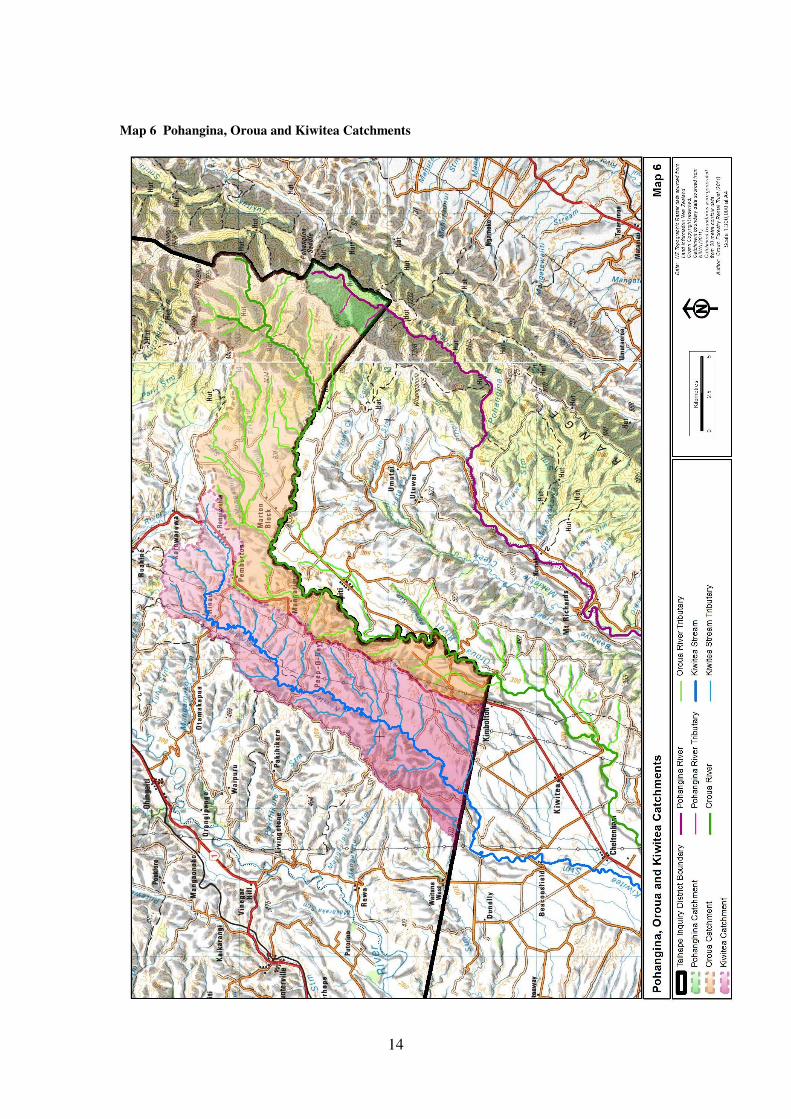
Map 6 Pohangina, Oroua and Kiwitea Catchments .................................................... 14
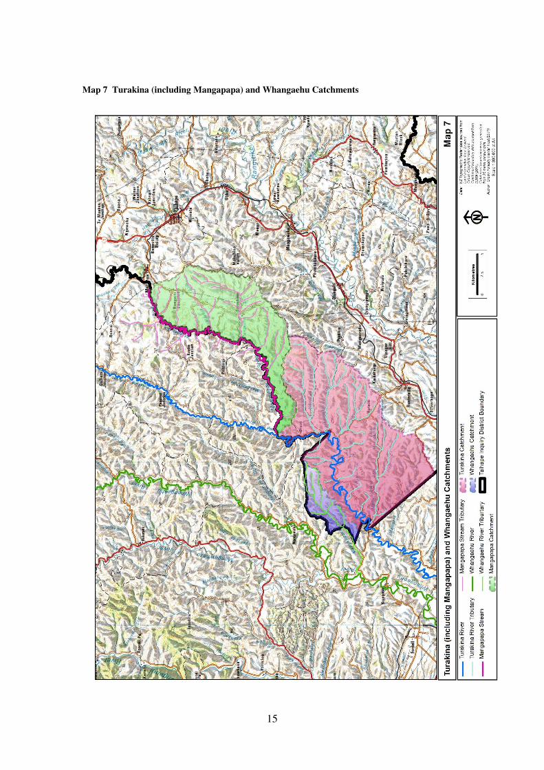
Map 7 Turakina and Mangapapa Catchments ............................................................ 15
5
1 INTRODUCTION
1.1 The author
My name is DAVID JAMES ALEXANDER. I am an environmental and planning
consultant, and historical researcher, of Auckland. I hold a BA (Honours) degree in
Geography, and a MSc degree in Conservation.
From 1975 to 1987 I was a planner in the Department of Lands and Survey. This
enabled me to gain a thorough understanding of land status matters, including the
titles and ownership status of riverbeds. In 1987, after a short period working for the
Department of Conservation, I established my own consultancy. The following year I
prepared my first brief of evidence for the Waitangi Tribunal, which was hearing the
Ngai Tahu claim. Since then I have prepared a number of other reports for claim
hearings. I have prepared reports (and presented them as evidence in most cases) on
the Ngati Rangiteaorere, Pouakani, Te Roroa, Whanganui-a-Orotu, Ngati Awa,
Mohaka River, Ika Whenua Rivers, Turangi Township, Ngati Pahauwera, Hauraki,
Muriwhenua, Rongowhakaata, Te Tau Ihu, Tuhoe, Central North Island, Tauranga,
Northland, East Coast, Whanganui and Te Rohe Potae claims.
Reports I have prepared for the Whanganui-a-Orotu, Mohaka River, Ika Whenua
Rivers, Northland and Whanganui claims have addressed waterways matters, while
reports prepared for the Turangi Township claim have examined certain Crown
activities associated with the Tongariro Power Development scheme.
1.2 Project brief
This report was commissioned by the Crown Forestry Rental Trust as part of the
Taihape inquiry technical research programme. As a scoping report, its purpose is to
identify what issues to do with rivers and waterways are likely to be relevant to a
Waitangi Tribunal inquiry for the Taihape Inquiry District, whether further research
(beyond what is included in this report) would be beneficial, and if so what that
further research might require in terms of skills and resources.
Some issues of potential relevance were identified in the project brief. These are:
6
• Customary use and significance of the Rangitikei River, tributaries and the
other relevant rivers.
• European settlement and the expansion of the economic and farming frontier,
including the impact of extractive industries, as these affected the Rangitikei
River its tributaries and the other relevant rivers.
• Post-colonisation impacts on the river system and tributaries (aggradation,
erosion, water quality, physical changes in river beds, gravel extraction, etc.)
and the impact of any changes on Maori communities.
• ‘Water-take’ issues, such as the water diversion from the Moawhango River
for the Tongariro River Hydro Scheme, and any irrigation schemes identified,
such as the Erewhon Rural Water Scheme.
• Issues of ownership of the bed of the river – the ad medium filum rule – and
the impact, if any, of the Coalmines Act Amendment Act. (These matters
receive coverage in the Whanganui River Report.)
• The impact of local government management and control of the Rangitikei
River, tributaries and the other relevant rivers including water quality issues
(general pollution, industrial and urban waste discharges, dairy farm run-off,
swamp drainage impact on water quality, etc.).
• The nature and extent of flood control activities (stop banks, river-
straightening, diversions, removal of eel weirs etc.) along the Rangitikei River,
tributaries and the other relevant rivers, and the impact of these on Maori land
owners and Maori communities.
• The impact of acclimatisation activities and the introduction of exotic species
of fish into the River system, including Maori consultation and involvement
with this, as well as identifying the exotic fish management regimes in place.
• The present health or condition of the Rangitikei River.
• An overall focus on the recognition by central or local government, if any, of
Maori environmental cultural practices along the Rangitikei River.
• Mana Wahine: any issues relating to Mana Wahine will be considered
throughout the brief when evaluating the experiences of tangata whenua
within the scope of this project.
The purpose of this scoping report is to address these issues, and any others that are
identified.

7
The area studied in this report is different from the area covered by other reports in
the Taihape Inquiry technical research programme. This is because of a
recommendation in the technical research scoping report, endorsed by claimants to the
Waitangi Tribunal, that the whole of the Rangitikei River and all its tributaries be
included in a single report, rather than dealt with in separate reports for individual
inquiry districts. The Waitangi Tribunal has approved this course of action with
respect to the preparation of this scoping report1, and is waiting on the
recommendations of the scoping report, to be followed by discussions between the
presiding officers for the Porirua ki Manawatu and Taihape district inquiries (and
possibly by a joint judicial conference), before deciding whether or not to adopt a
similar approach in a more comprehensive full report of Taihape Inquiry District
rivers. In looking at the Rangitikei and its tributaries from source to sea, this scoping
report examines parts of the river in the Tribunal’s National Park, Whanganui, and
Porirua ki Manawatu Inquiry Districts.
The report also looks at other rivers that flow through the Taihape Inquiry District.
Although it was originally envisaged as a report only about the Rangitikei River and
its tributaries, requests to the Tribunal asked that other rivers not be lost sight of.
While the Tribunal agreed to this with respect to this scoping report, it has reserved
judgment at this stage on whether any final report should cover other rivers in the
inquiry district, or be confined to the Rangitikei River and its tributaries2. As a result
the project brief specifically identifies portions of the following rivers and their
tributaries to be included in the scoping report:
• Ngaruroro River
• Oroua River
• Kiwitea Stream
• Turakina River and Mangapapa River
1 Waitangi Tribunal, Taihape: Rangitikei ki Rangipo District Inquiry (Wai 2180), Directions #2.5.18
dated 14 December 2010. 2 Waitangi Tribunal, Taihape: Rangitikei ki Rangipo District Inquiry (Wai 2180), Directions #2.5.18
dated 14 December 2010.
8
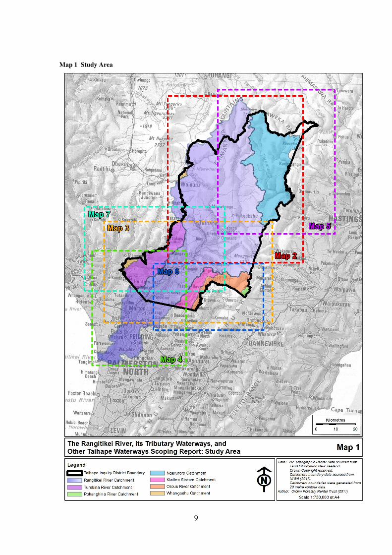
Investigations during the preparation of the scoping report have identified that the
Taihape Inquiry District also contains small parts of the catchments of the following
rivers:
• Pohangina River
• Whangaehu River
The net result is that the study area for the scoping report consists of the following:
• The whole of the catchment of the Rangitikei River system and its tributary
waterways, regardless of which inquiry district any waterway is located in.
• The catchments of the other river systems listed above, but only those parts of
the catchments and associated waterways that are located within the
boundaries of the Tribunal’s Taihape Inquiry District.
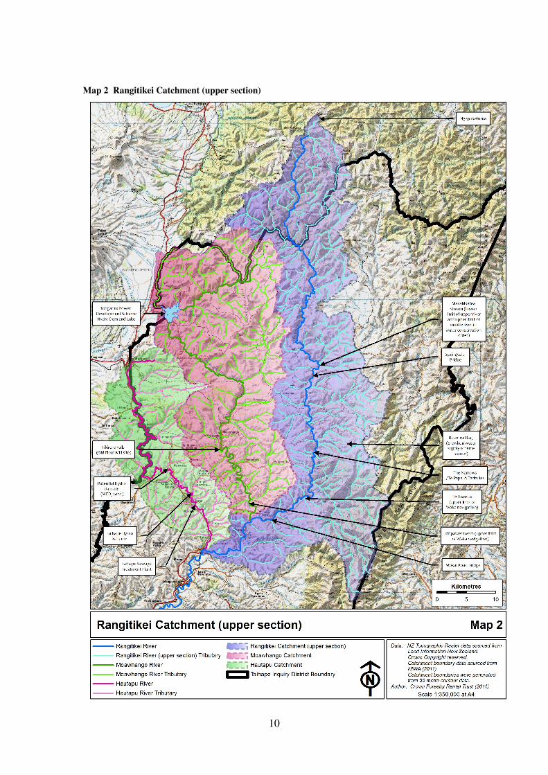
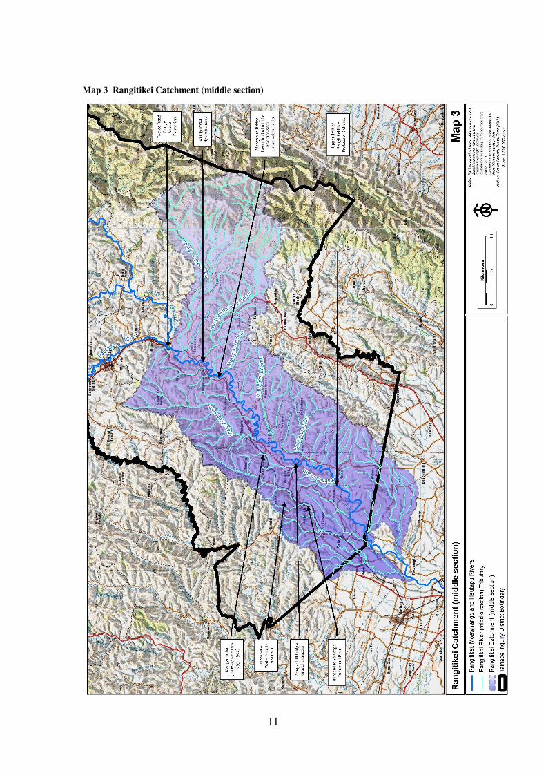
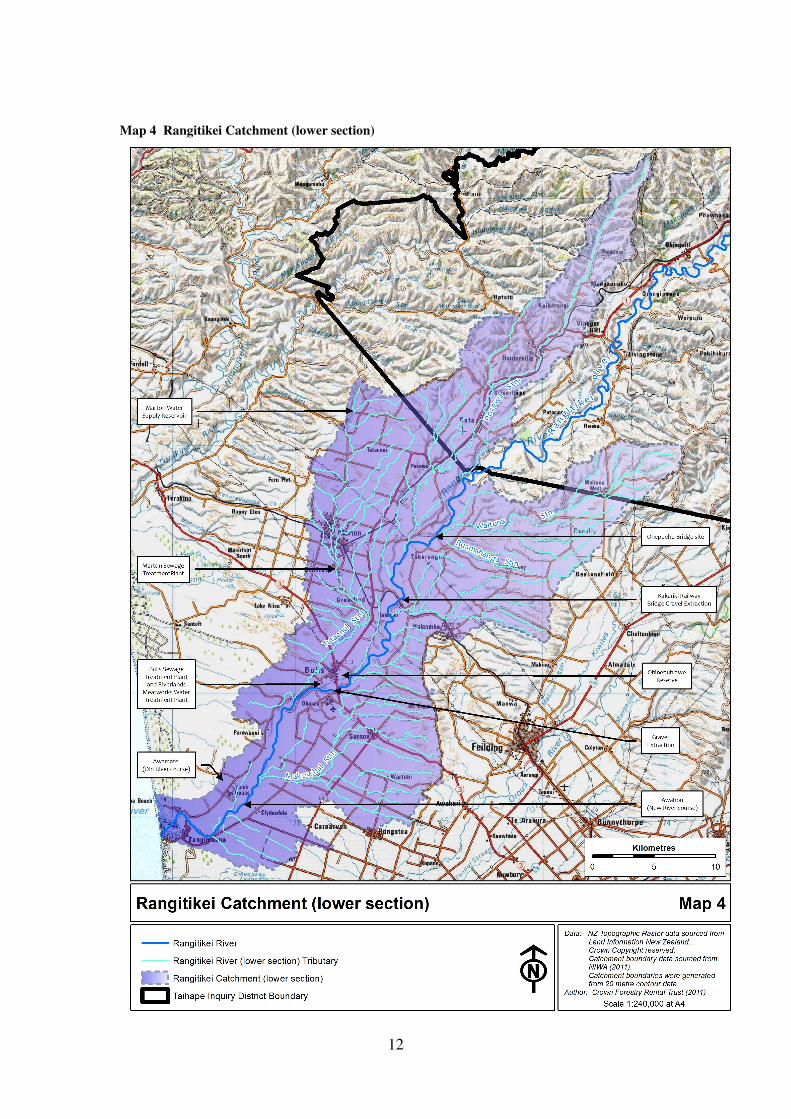
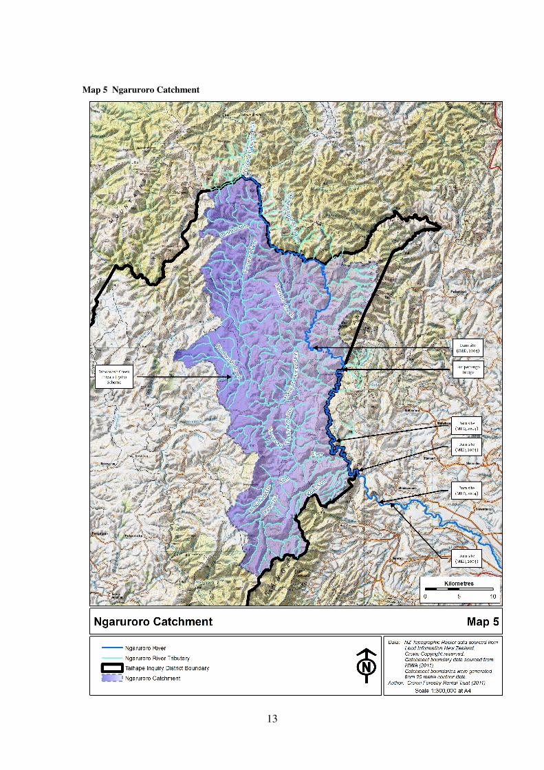
The extent of the study area is shown in Map 1, being all of the shaded areas
(variously coloured to indicate the different catchments). The different catchments
are shown in greater detail in Maps 2 to 7.
During the consultation with claimants as this report was being prepared, it became
apparent that the term ‘Rangitikei River and its tributaries’ was a source of some
confusion. Questions were asked whether this term included the Hautapu River and
the Moawhango River, both of which flow into the Rangitikei River (and therefore
come within the geographical definition of the term ‘tributary’). It is apparent that
there is a cultural and traditional understanding among claimants that there are three
rivers in the upper catchment, being the Hautapu River, the Moawhango River and the
Rangitikei River, each of which has its own tributaries and its own catchment. This
distinction has been adopted in the terminology used in this report.
Claimants have also pointed out that some place names have become corrupted. The
correct name for the Porewa Stream is Pourewa, and the correct name for the Onepuhi
bridge is Onepuehu. The corrected names are used in this report.
9
Map 1 Study Area
10
Map 2 Rangitikei Catchment (upper section)
11
Map 3 Rangitikei Catchment (middle section)
12
Map 4 Rangitikei Catchment (lower section)
13
Map 5 Ngaruroro Catchment
14
Map 6 Pohangina, Oroua and Kiwitea Catchments
15
Map 7 Turakina (including Mangapapa) and Whangaehu Catchments
16
1.3 The structure of the report
The wording of the project brief leaves open the possibility that the scoping report
could provide sufficient information and discussion of the issues such that it is
capable, on its own, of providing a competent enough evidential basis for a Tribunal
inquiry. It is theoretically possible for one of the recommendations of this report to be
that no further research or comprehensive full report is necessary.
However, at an early stage it became apparent that there are a wide range of issues
that would need to be comprehensively examined in order to properly cover, to
Tribunal casebook standard, all the waterway-related matters identified in statements
of claim. The combined effect of all these issues is more substantial than a short
research period and a short report can properly investigate. The large number and
extent of the potential reference sources identified in this report for further research
also shows that it would not be possible in the time available to do them all justice in
the scoping report.
Accordingly, rather than leave open the question of whether a further historical
research report should or should not be prepared, and only answer it at the end of the
report in the recommendations, this scoping report has been written as if that question
has already been answered in the affirmative, and that a further report would be
necessary. It therefore sets out what is known about the issues likely to be relevant to
a Tribunal inquiry, and identifies potential research sources that could usefully be
followed up during the research to be undertaken for such further report.
1.4 The kaupapa for the report
Stirling and Subasic, in their technical research scoping report3, summarised the main
general issues set out in statements of claim as:
• The ability of hapu and iwi to retain, maintain, and exercise te tino
rangatiratanga
• Loss of hapu and iwi authority to the Crown, Crown agencies, and local
government
3 Stirling, Bruce, and Evald Subasic, Taihape: Rangitikei ki Rangipo Inquiry District: Technical
Research Scoping Report, report for Crown Forestry Rental Trust, August 2010.
17
• The ability of hapu and iwi to retain ownership and authority over their
customary lands (with reference to the Native Land Court, land alienaton, and
Maori land administration)
• The compulsory acquisition of Maori land, especially Public Works takings
• The ability of hapu and iwi to exercise kaitiakitanga over (and customary
interests in) lands, forests, wahi tapu, and the environment generally,
particularly with respect to waterways
This report looks at these issues and associated events with respect to the rivers and
waterways of the study area, and their associated waters. It identifies where there
might have been intrusions by the Crown without consent on to the “space” occupied
by tino rangatiratanga rights and kaitiakitanga responsibilities. These possible
intrusions, whose operation in the study area has still to be confirmed by further
district-specific historical research, have their genesis in the following pieces of
statute law (among others):
• Various Public Works Acts declared that bank protection works, the alteration
or diversion of watercourses, and soil conservation and river control works,
were to be considered to be public works, for the purposes of which land and
riverbed could be compulsorily taken and public monies could be expended
• The Salmon and Trout Act 1867 authorised the release of introduced fish
species into rivers, while the Protection of Animals Act 1867 provided
statutory recognition for acclimatisation societies
• The Timber-floating Act 1873 regulated the use of rivers for the floating of
logs from the forest down to the sawmill
• The Fish Protection Act 1877 gave the Crown the responsibility for the
protection and administration of fisheries in rivers, lakes and the sea
• The Harbours Act 1878 gave the Crown the authority to regulate navigation
and the use of rivers by boats and other small craft
• The Coal-mines Act Amendment Act 1903 declared that the beds of navigable
rivers were to be vested in the Crown
• The Water-power Act 1903 vested in the Crown the sole right to develop
hydro-electric power schemes
18
• The Soil Conservation and Rivers Control Act 1941 established regional
catchment boards, which were given the task of controlling rivers to prevent
flooding, and provided for Crown approval and funding of these engineering
works
• The Water and Soil Conservation Act 1967 vested in the Crown the right to
control and regulate the use of all natural waters
Each of these pieces of legislation had successor statutes that continued the powers
that they granted to the Crown when they were repealed. Many of the statutory
powers reside today in the Resource Management Act 1991, making them the day-to-
day responsibility of regional and local authorities.
It is this progressive spread of Crown authority into a greater range of aspects of the
use and management of waterways and water that is the kaupapa underlying the
various events that are described in the report. The historical facts about the
traditional exercise of tino rangatiratanga over the study area’s waterways by iwi, and
the Crown’s involvement with rivers in the study area, will inform the debate before
the Waitangi Tribunal about whether the actions and inactions of the Crown were
consistent with its responsibilities under the Treaty of Waitangi. This debate is, of
course, as much a matter for legal submissions as it is an examination of historical
facts.
19
2 BIBLIOGRAPHY AND ARCHIVAL SOURCES
A key task has been a search of published, unpublished and archival references
relevant to the rivers of the study area. The results of the search are presented in an
Appendix to this report.
Both the bibliography and the list of archival references were developed by means of
a search in online databases of keywords applicable to the study area and to the study
themes set out in the project brief. No claim is being made that the lists of references
are complete. Indeed, an examination of the references cited in the Appendix as part
of further research is likely to result in further published, unpublished and archival
references being identified.
While some of the published sources have been examined, many have not, and only a
few of the archival sources have been looked at. Although a number of the references
may turn out to be of little usefulness, it has been considered better to be over-
inclusive rather than under-inclusive.
As an example of variable potential relevance, many of the archival references are to
do with bridges across the rivers, with a likely emphasis on their construction and
funding. Some bridges over the Rangitikei are high level and will have little
engineering connection with the river itself. Others cross the river at a lower level,
giving them a greater engineering connection with the river. However, references to
the river may be limited, remarking only about occasions when flood flows threaten
the piers and approaches of the bridges. Until the files are examined, their relevance
to a report on the rivers cannot be determined.
With the exception of reports by the former catchment and regional water boards, and
the current regional councils, few published works by European authors are devoted
to the rivers, most mentioning them only in passing or in brief remarks. A remark by
Young about the Rangitikei River in its middle reaches may provide some partial
explanation for this.
Once bridges went up in the district, they immediately changed settler
psychology. As long as they were able to cross the river from on high, locals
20
could keep their distance from the Rangitikei far below them. Usually that is
how they preferred it.
Apart from the odd river flat between Mangaohane and Mangaweka, the few
farmers who dwell along the Rangitikei are “highlanders”. They need not fear
the unwanted encroachments of their river. The “Tiki”, as some locals call it,
is something they might look into from afar, noting its change in colour or
depth, but they are rarely on intimate terms with it. They were taught, all the
old people, that the river was dangerous – something to keep away from.4
A surprising feature of the archival reference list is the small number of Maori Affairs
Department files that have been identified as potentially relevant. These are normally
one of the most fruitful sources of information about the interactions historically
between iwi and the Crown. One possible reason is a general absence of complaints
to the Crown by Maori communities along the rivers of the study area; this will need
to be followed up by further research. A pattern identified in research in other
districts is that Maori very quickly worked out which types of complaints were most
likely to be acted upon by the Crown and which were not; rivers, waters and fishing
rights tended to be areas the Crown did not respond to in any meaningful fashion, so
have not been the subject of many complaints.
Local government archives are only partially catalogued online. For all of the study
area except the Ngaruroro catchment (which is in the Hawke’s Bay region) they are
part of a major project known as Archives Central, which is a collective body of local
councils that is being coordinated by Horizons Regional Council5. Once a suitable
storage building is obtained, all the archives of the constituent councils will be
assembled and available to view in one location. Until then, they are held by the
constituent councils, some of whom (such as Horizons and Manawatu District
Council) have catalogued their collections, while others (such as Rangitikei District
Council) are in the process of doing so. By the time a full report on the rivers is
commissioned, access will be more advanced and easier.
4 David Young, Faces of the River, 1986, page 171.
5 The Council is officially known as Manawatu-Wanganui Regional Council, but has adopted the name
Horizons Regional Council for its dealings with the public. Horizons Regional Council is the
orgnaisation’s name used in this report.
21
Time did not permit an examination and analysis of local newspapers for their
relevance. They can be expected to yield small snippets of information that will help
to fill out the information contained in official reports. One difficulty researchers face
is that the Marton-published Rangitikei Advocate, and various Taihape-published
newspaper titles, are not yet included in Papers Past, the National Library’s searchable
online archive of New Zealand newspapers. This is unlikely to be remedied prior to
the commissioning of a full research report. However, it would appear that a number
of stories from the Rangitikei Advocate did get reprinted in other newspapers
published in other centres that are available in Papers Past. In addition, the newspaper
holdings of the National Library, at present inaccessible due to building modifications
at the Library, will again become available in mid 2012.
In the discussion about particular river issues in this report, potential reference
sources are identified. These provide a cross-referencing to the bibliography and list
of archival references.
22
3 VIEWS EXPRESSED BY CLAIMANTS
3.1 Analysis of Statements of Claim and Submissions to the Waitangi
Tribunal
This section looks at those claims to all or part of the study area that identify
wrongdoing by the Crown with respect to water and watercourse matters. A claim is
not included in this analysis where it clearly addresses only land grievances.
The description of each claim relies on the initial statement of claim, unless stated
otherwise. The statements of claim relied on for this analysis are those that have
currently been lodged with the Waitangi Tribunal; because the Tribunal inquiry
process allows for amended statements to be lodged at any time up to a date
prescribed by the Tribunal, there is still an opportunity for claimants to prepare more
detailed and comprehensive statements of claim.
Claims have been grouped in the following fashion:
• Claims emanating from within Taihape Inquiry District
• Claims ‘looking in’ on Taihape Inquiry District from the west
• Claims ‘looking in’ on Taihape Inquiry District from the north
• Claims ‘looking in’ on Taihape Inquiry District from the east
• Claims to the lower Rangitikei River and ‘looking in’ on Taihape Inquiry
District from the south
Given that a separate tribal landscape report forms part of the Taihape Inquiry District
research programme, it is not the role of this scoping report to identify the web of iwi
and hapu relationships in the study area. However, some brief remarks about the
nature of the claimants are included below.
For the sake of completeness, the settlement already reached between the Crown and
Ngati Apa, and the proposed settlement between the Crown and Rangitane, are also
discussed.
3.1.1 Claims emanating from within Taihape Inquiry District
Claims by Ngati Hinemanu / Ngati Paki
23
WAI-127 Claim by Ngati Hinemanu
WAI-1835 Claim by Ngati Hinemanu and Ngati Paki
Ngati Hinemanu and Ngati Paki are Kahungunu peoples, some of whom reside in
Heretaunga and some of whom reside within the study area (with a marae at Winiata,
just south of Taihape).
The most recent statement of claim for WAI-127 is dated August 20096. The
claimants state that they suffered loss to their unspecified taonga within the Taihape
Inquiry District by legislation, policy, and Crown acts and omissions, in particular by:
• Failure to ensure that Ngati Hinemanu retained their resources and taonga
• Failure to ensure that Ngati Hinemanu could exercise tino rangatiratanga
• Failure to ensure that Ngati Hinemanu could develop, exploit and manage
their resources in a manner consistent with their own cultural preferences
The WAI-1835 statement of claim states that Ngati Hinemanu and Ngati Paki claim
mana linkages and authority, and strong whakapapa connections, with the following
rivers and their tributaries: Rangitikei, Kawhatau, Hautapu, Moawhango, Taruarau,
Ngaruroro. The Crown failed to protect these rivers from erosion and pollution, failed
to protect the fisheries associated with these waterways, and failed to protect the
authority of Ngati Hinemanu and Ngati Paki over the waterways and the right to
control, manage and protect them.
In submissions, the WAI-1835 claimants have asked that the Rangitikei River be
researched in a holistic manner that incorporates the main stem of the river and all
tributaries, together with all other waterways within the Inquiry District. The rivers
are linked both ecologically and culturally to the lands that they drain, and together
the land and the rivers link to the whakapapa of the claimants7.
Claims by Mokai Patea Iwi
WAI-581 Claim by Te Runanga o Ngati Hauiti
WAI-588 Claim by Ngati Tamakopiri and Ngati Whitikaupeka
WAI-1639 Claim by Jack Hoani Cribb
6 WAI-127, Document #1.1(c).
7 Waitangi Tribunal, Taihape: Rangitikei ki Rangipo (Wai 2180) District Inquiry, Document #3.1.134.
24
WAI-1705 Claim by Mokai Patea Waitangi Claims Trust
WAI-1888 Claim by Ngati Whitikaupeka
Ngati Tamakopiri, Ngati Whitikaupeka and Ngati Hauiti are predominantly
Kahungunu peoples who reside within the study area. Ngati Tamakopiri and Ngati
Whitikaupeka (whose closeness to one another means they are sometimes combined
and referred to as Ngati Tama Whiti) are based in the north of the study area, with
marae at Moawhango and Opaea, and have whakapapa links to iwi (such as Ngati
Tuwharetoa) to the north. Ngati Hauiti, with marae at Rata, are based in the southern
part of the study area, and have whakapapa links to iwi (such as Ngati Apa) in the
lower Rangitikei River and south of the study area. The claimants have customary
interest in all the significant waterways: the Rangitikei River, the upper reaches of the
Ngaruroro River, Kiwitea Stream and Oroua River, and all tributaries of those main-
stem rivers.
The WAI-581 statement of claim refers to Ngati Hauiti’s tribal estate broadly
extending on the Rangitikei River from the confluence with the Moawhango River in
the north to the confluence with the Waitapu Stream in the south. The eastern
boundary of the tribal estate is defined by the Ruahine Range, and the western
boundary by the Turakina River. The tribal estate is referred to as being both land
and waterways, with the Rangitikei River at its heart, providing both physical and
spiritual sustenance to the iwi for generations. The river is a spiritual awa and a
taonga over which Ngati Hauiti has held rangatiratanga and kaitiakitanga, but the
Crown has upset that relationship by:
• Dispossessing the iwi of all rights over the river, its water, fisheries, minerals
and other taonga associated with it
• Failing to protect the Ngati Hauiti interest in the river by allowing large-scale
gravel extraction, without consultation or compensation
• Denying Ngati Hauiti a place in the decision making process concerning the
river at both central government level and local government level
The statement of claim refers to the Taraketi 5 block, which was the portion of the
Taraketi block that had been encroached upon by a change of course of the Rangitikei
River, leaving it either under water or a shingle bed; this encroachment was defined as
a separate partition block in 1894. It became lost to Maori ownership in 1959 when
25
the Rangitikei River was deemed to be a navigable river, and thereby was deemed to
have always been the property of the Crown by virtue of the Coal-mines Act
Amendment Act 1903. As Crown property it was set apart in 1959 as a soil
conservation and river control reserve.
The WAI-588 claim started as a grievance only about the Kaimanawa wild horses, but
has since been expanded to include the lands and other features of the northern part of
the inquiry district. The effect of the Moawhango Dam, constructed without consent
on the Moawhango River, is part of the claim. The reduced water flow below the dam
has affected native fish species, once an abundant food source for Ngati Tamakopiri
and Ngati Whitikaupeka (collectively referred to as Ngati Tama Whiti), and has also
affected the spiritual healing properties associated with the river.
The WAI-1639 statement of claim describes the claimant’s area of interest by awa as
well as by land. To the north are the headwaters of the Hautapu, Moawhango and
Ngaruroro Rivers. To the east the boundary follows the Ngaruroro River downstream
to the confluence with the Waitutaki Stream, then follows the Ruahine Range. The
confluence of the Rangitikei River and the Waitapu Stream marks the southern
boundary, and the western edge is Te Whakauae o Tamatea Pokai Whenua. The
rivers within this territory are the Hautapu, Moawhango, Rangitikei, Taruarau and
Ngaruroro and their tributaries. The claimant refers to suffering cultural, social and
economic disadvantage as a result of the Crown taking responsibility for all matters
relating to fisheries and the protection of rivers from erosion and pollution (and other
land-related matters).
The WAI-1705 claim refers to mana over and strong whakapapa connections with the
Rangitikei, Hautapu, Moawhango, Kawhatau, Ngaruroro and Taruarau Rivers and
their tributaries. The Crown has failed to protect the awa from erosion and pollution,
and by allowing diversion and damming. This has led to an undermining of
rangatiratanga, lore and custom, and to the Mokai Patea claimants being unable to
possess, control and manage their traditional resources (including the rivers).
26
The WAI-1888 claim concerns the Moawhango River and related lands. The river
was an integral part of the Ngati Whitikaupeka tribal estate, which has been adversely
affected by unspecified Crown legislation, policies, practices, actions and omissions.
In submissions on behalf of all the Mokai Patea Iwi claimants, support is given for a
report covering the whole of the Rangitikei River, as a split into two different reports
would be contrary to tikanga, and would not be able to properly address the holistic
nature of the environmental issues affecting the river8.
Claim relating to Mana Wahine
WAI-2091 Claim by Maori Women of Ngati Hauiti
This claim is about the failure of the Crown to recognise the historic status,
rangatiratanga and mana of Ngati Hauiti women in Maori custom and Maori law, and
the disentitling of these women from their properties and water, with resultant socio-
economic impact, including mental and other health issues. There has also been a
failure by the Crown to consult with Ngati Hauiti women.
3.1.2 Claims ‘looking in’ on Taihape Inquiry District from the west
Claims by Ngati Rangi
WAI-151 Claim by Ngati Rangi
WAI-1263 Claim by The Rangiteauria Uri
These include a claim to all waterways in the Ngati Rangi tribal area (which includes
the Waiouru army lands), as they are a taonga of the iwi.
Claim by Tamakana Council of Hapu
WAI-954 Claim by Tamakana Council of Hapu
This is a non-specific claim concerning the Crown’s failure to protect the claimants
tino rangatiratanga over their taonga. While the general rohe of the claimants is in the
Whanganui Inquiry District, it also includes lands in the Kaimanawa and Motukawa
areas.
8 Waitangi Tribunal Taihape: Rangitikei ki Rangipo (Wai 2180) District Inquiry Document #3.1.161.
27
3.1.3 Claims ‘looking in’ on Taihape Inquiry District from the north
Claims by Ngati Tuwharetoa
WAI-61 Claim by the Trustees of Rotoaira Forest Trust
WAI-575 Claim by Ngati Tuwharetoa
Ngati Tuwharetoa are based to the north of the study area, but claim an interest that
extends as far south as the Rangitikei rivermouth. They consider that Ngati Waewae,
located at Te Reureu, are the upholders of and maintain the ahi kaa for that wider area
of interest.
The most recent revised statement of claim for these and other Ngati Tuwharetoa
claims was lodged in July 20059, as a preparatory step before the hearings for the
Tribunal’s National Park inquiry. In this revised statement of claim (described as the
“Fourth Amended Statement of Claim” for “the Ngati Tuwharetoa Comprehensive
Claim”) are the following matters:
• The Tongariro Power Development (TPD) scheme was established without
giving adequate consideration to the effects of the scheme on Ngati
Tuwharetoa’s taonga tuku iho, in particular to the permanent transformation of
rivers, a failure to make good on initial promises made to Ngati Tuwharetoa,
restricting Ngati Tuwharetoa’s exercise of tino rangatiratanga over its land and
development, the exclusion of Ngati Tuwharetoa from active involvement in
the ongoing operation of the TPD scheme, a failure to provide an opportunity
for Ngati Tuwharetoa to obtain economic benefit from the assets of the TPD
scheme, the desecration of waterways and riparian lands in environmental and
spiritual terms, and a failure to compensate for such desecration
• The Crown has failed to protect Ngati Tuwharetoa’s mana and tino
rangatiratanga over rivers, including customary rights to use and control the
waters of the rivers, and has excluded Ngati Tuwharetoa from management
and development rights for energy purposes by vesting the right to develop
hydroelectric resources in the Crown under the Water-power Act 1903 and
subsequent legislation
9 WAI-61, Document #1.1(c), and WAI-575, Document #1.1(f).
28
The claims of Ngati Waewae, a hapu of Ngati Tuwharetoa, are discussed below in
connection with the claims of Nga Iwi o te Reureu.
3.1.4 Claims ‘looking in’ on Taihape Inquiry District from the east
Claims by Ngati Kahungunu
WAI-69 Claim by the Ahuriri Executive of Ngati Kahungunu, the
Heretaunga Executive, and the Here Ararau Incorporated Society
WAI-263 Claim by Ngati Hinemanu
WAI-378 Claim by Wero Karena and Owhaoko CB3 Owners
WAI-382 Claim by Ngati Hinemanu, Ngai Te Upokoiri and Hapu of Ngati
Kahungunu
WAI-1425 Claim by Ngati Hinemanu
Ngati Kahungunu are primarily located in Heretaunga (Hawke’s Bay). They see their
whanaunga claimants resident in the study area as maintaining ahi kaa over the
western portion of the tribal rohe. Heretaunga-resident hapu of Ngati Kahungunu
have a particular interest in the upper Ngaruroro part of the study area and the
Owhaoko block.
Since being lodged, these claims have been grouped together as a comprehensive
claim on behalf of the whanau and hapu of Ngati Kahungunu. The grouping has been
achieved under an iwi organisation known as He Toa Takitini. The most recent
revised statement of this comprehensive claim (described as the “amended statement
of claim”) was lodged in July 200810
. The claim includes:
• The Crown’s failure to protect and/or enhance the Ngaruroro River and its
tributaries, and other rivers in the tribal area, and denial of the ability of
claimants to exercise tino rangatiratanga and/or kaitiakitanga over these rivers,
including by permitting and/or facilitating the modification, pollution and
overall degradation of the rivers, by passing legislation, and by failing to
recognise the cultural and spiritual significance of the waterways to claimants
• The Crown’s failure to actively protect the exercise by the claimants of tino
rangatirantanga and kaitiakitanga in regard to their desire to protect the natural
environment, including by passing legislation, and by permitting and
10
WAI-69, Document #1.1(c); WAI-263, Document #1.1(b); WAI-378, Document #1.1(b); WAI-382,
Document #1.1(d); and WAI-1425, Document #1.1.1(a).
29
encouraging the destruction or substantial modification of rivers, swamps and
wetlands as a result of legislation and policy favouring settlement, agriculture
and horticulture
• The Crown’s failure to actively protect the claimants from the effects of water
pollution
3.1.5 Claims to the lower Rangitikei River and ‘looking in’ on Taihape Inquiry
District from the south
Claims by Ngati Raukawa
WAI-113 Claim by Ngati Raukawa ki Te Tonga
WAI-1618 Claim by Ngati Te Au, Ngati Turanga and Ngati Rakau
WAI-1619 Claim by Ngati Parewahawaha
WAI-2197 Claim by Parewahawaha Hapu mai ki Ohinepuhiawe
Some Ngati Raukawa travelled down the Rangitikei River valley and settled in the
Manawatu district during the early part of the nineteenth century (prior to 1840).
They distinguish themselves from Ngati Raukawa resident in the Waikato by referring
to themselves as Ngati Raukawa ki Te Tonga. They were granted a number of
reserves (including Ohinepuhiawe near Bulls) on the eastern bank of the Rangitikei
River as part of the Manawatu purchase.
The WAI-113 claim describes the Rangitikei River as one of the tribal boundaries of
Ngati Raukawa. Crown actions, omissions, policies, practices and legislation have
resulted in the loss of many assets implicit in tino rangatiratanga over Ngati Raukawa
resources, including waterways and fisheries. Ngati Raukawa have suffered a loss of
use and consequent deterioration of fisheries and other resources.
The WAI-1618 claim is by three hapu of Ngati Raukawa who describe themselves as
Nga Hapu o Himatangi. Along with the Manawatu and the Oroua, the Rangitikei is
one of the rivers that is included in their claim area. The rivers are taonga and of
extreme cultural significance, as well as being mahinga kai sites. Together with their
associated waterways and swamps, they have been destroyed, degraded or changed by
unspecified Crown legislation, policies, actions and omissions, and bird life and
customary fisheries have been adversely affected. There has been a failure by the
30
Crown to support hapu environmental management initiatives to preserve the
waterways.
The WAI-1619 claim on behalf of Ngati Parewahawaha refers to failures by the
Crown to:
• Protect against the depletion and pollution of waters, environments and
resources, in particular the Rangitikei River
• Provide for and recognise the intellectual property rights of the hapu to fauna
and flora, foods, rongoa and other taonga within the waters possessed and
enjoyed by the hapu
• Recognise customary rights and title to rivers and waterways (including
waters, groundwaters and associated resources)
• Protect te tino rangatiratanga and the role of the hapu as kaitiaki over rivers
and waterways
• Protect non-commercial customary fishing and customary fisheries in rivers
and waterways
• Protect the physical and spiritual health of the rivers and waterways
The WAI-2197 claim, lodged on behalf of owners at Ohinepuhiawe (near Bulls),
refers to public works takings from the block for soil conservation and river control,
and for river protection, to the removal of metal from the bed of the Rangitikei River,
and to underhand dealings over the payment of royalties for metal excavated from
Ohinepuhiawe block lands. An amended Statement of Claim dated October 2009 also
refers to old riverbed being treated by special legislation as Crown Land rather than as
land to which Ohinepuhiawe owners were legally entitled as riparian owners. It states
that the Ohinepuhiawe owners have been impeded in their enjoyment of their
traditional fishing rights by the actions of the Crown.
Claim by Rangitane
WAI-166 Claim by Rangitane o Tamaki-nui-a-rua
The most recent statement of claim was lodged in April 200311
. This claimed that the
Crown has pursued policies and legislation that have adversely affected the
11
WAI-166, Document #1.1(c).
31
environment and resources of Rangitane, in particular by affecting sites of food
sources such as eels, freshwater crayfish and freshwater mussels, by failing to
recognise customary fishing rights when legislating for the salmon and trout fisheries,
and by excluding Rangitane from participation in environmental management systems
(paragraph 15).
Claims by Ngati Kauwhata
WAI-784 Claim by Kauwhata Treaty Claims Komiti and Nga Uri Tangata o
Ngati Kauwhata ki Te Tonga
WAI-972 Claim by Kauwhata Treaty Claims Komiti and Nga Uri Tangata o
Ngati Kauwhata ki Te Tonga
WAI-1461 Claim by Nga Kaitiaki o Ngati Kauwhata
WAI-1936 Claim by Ngati Kauwhata ki Te Tonga
WAI-2167 Claim by Ngati Kauwhata
Ngati Kauwhata are a branch of Ngati Raukawa ki Te Tonga who are resident in the
Feilding district. Their rohe falls within both the Taihape and the Porirua ki
Manawatu Inquiry Districts.
The most recent statement of claim for WAI-784 is dated August 200912
. Ngati
Kauwhata claims customary interests, mana and authority along the Rangitikei River,
Kiwitea Stream, Oroua River and Manawatu River. The Crown affected these rivers
when it passed legislation in 1903 confiscating the beds of navigable rivers, whenever
it claimed title to riverbeds on the basis of the ad medium filum aquae principle, and
by passing legislation vesting in itself marginal strips along riverbanks. The Crown
has also adversely affected the food and other resources of rivers through ongoing
damage to the environment, including deforestation and pollution.
In correspondence with the author of this report, counsel and the researcher for the
WAI-784 claimants have advised that the tribal territory of Ngati Kauwhata follows
the Rangitikei River inland to Papauku. A petition to the Crown from Ngati
Kauwhata in 1866 referred to the following locations on the tribal boundary:
The boundary commences at Whitirea, in the region of Manawatu, thence
towards the sea by way of Te Atutahi to Otupere; the boundary turns off there
12
WAI-784, Document #1.1(f).
32
and goes to Kaikokopu, thence to Kakukuera, Omanuka, Puketotara, Te
Kawau, Totarata pa, Kopuapokoro Te Pua, Whakamoetakapu, Paeroa,
Papauku; there it strikes off, goes to Umutoi on the Oroua, Te Awahuri, thence
following the course of the Oroua to Puketotara, meeting the formed boundary
at Whitirea.
An amended statement of claim for WAI-972 was filed in January 201113
. It splits
the claims for the southern peoples of Ngati Kauwhata into two parts, those claims
relating to the Porirua ki Manawatu Inquiry District, and those claims relating to the
Taihape (“Rangitikei ki Rangipo”) Inquiry District. However, the statement of claim
does not then proceed to particularise any claims at all for the Rangitikei ki Rangipo
District. With respect to the Porirua ki Manawatu District, the claim concerns the
same rivers as those listed by WAI-784, plus the Pohangina River, all of which Ngati
Kauwhata identify with and have a spiritual connection to. The same legislative
effects and damage to the environment are referred to as WAI-784. However, the
WAI-972 claim goes further, and claims that the waterways are now the day-to-day
responsibility of local government, which has permitted the discharge of effluent,
chemicals and other pollutants, contributed to environmental instability (particularly
with respect to the Oroua River) by removing native trees and encouraging willows,
and allowing narrowing of the channel (due to silt build-up) that has resulted in the
loss of islands in the river and flooding of riparian lands.
In submissions, the WAI-784 and WAI-975 claimants explain that their claims to
waterways apply both within and without the Taihape Inquiry District. While
supportive of a single report covering the Rangitikei River in both the Taihape and
Porirua ki Manawatu Inquiry Districts, their preference is for this single report to also
encompass the whole of the Oroua, Pohangina and Manawatu Rivers, and the whole
of the Kiwitea Stream, because of the links that exist between all these waterways.
They add that the research needs to cover the drainage of swamps, because the
swamps and their resources were inextricably linked to the rivers. They consider that
only by looking at all waterways in the Ngati Kauwhata rohe can a full understanding
of Ngati Kauwhata’s connections with the waterways be gained14
.
13
WAI-972, Document #1.1(b). 14
Waitangi Tribunal, Taihape: Rangitikei ki Rangipo (Wai 2180) District Inquiry, Document #3.1.151.
33
An amendment to the claim for WAI-1461, filed in August 200815
, had the effect of
adding a claim for natural resources (including waterways) to the initial claim. Ngati
Kauwhata claims a customary and ongoing interest in the whole of the Oroua River
and Kiwitea Stream, plus other waterways located solely within the Porirua ki
Manawatu District. In submissions, the WAI-1461 claimants have emphasised their
customary connections with the Oroua River16
, have supported the part of the Oroua
River situated in the Taihape Inquiry District being covered by this scoping report17
,
and have expressed a wish that the remainder of the Oroua River be covered by a
Porirua ki Manawatu District Inquiry rivers report18
. Their support for two separate
reports, to be conducted sequentially, with the Taihape district report being
undertaken first, is based on differing cultural interests being analysed in each report,
and a more complex relationship that exists with that part of the river in the Porirua ki
Manawatu District.
The statement of claim for WAI-1936 concerns unspecified takings for public works
purposes, which could include takings for river protection and other river-related
purposes.
WAI-2167 is at this stage a generalized claim by Ngati Kauwhata, which does not
include any specifics.
Claims by Nga Iwi o Te Reureu
WAI-651 Claim by Waewae, Pikiahu, Matakore and Rangitahi
WAI-1260 Claim by Ngati Waewae
WAI-1623 Claim by Ngati Rangatahi kei Rangitikei
WAI-1872 Claim by Ngati Pikiahu
The Rangitikei River is a key feature of all these claims. All four hapu, Ngati
Waewae, Ngati Pikiahu, Ngati Matakore and Ngati Rangatahi, are based on the Te
Reureu block between the Waitapu Stream and the Rangitawa Stream (at Kakariki).
They see themselves as a “river people”, as traditionally their whole way of life has
been centred around the Rangitikei River and the tributaries that pass through the
15
WAI-1461, Document #1.1.1(a). 16
Waitangi Tribunal, Taihape: Rangitikei ki Rangipo (Wai 2180) District Inquiry, Document #3.1.129. 17
Waitangi Tribunal, Taihape: Rangitikei ki Rangipo (Wai 2180) District Inquiry, Document #3.1.148. 18
Waitangi Tribunal, Taihape: Rangitikei ki Rangipo (Wai 2180) District Inquiry, Document #3.1.160.
34
block, and it is the river that connects them to their whanaunga in the central North
Island.
An amended statement of claim for WAI-651 was lodged in August 200819
. It claims
that the Crown has failed to recognise the tino rangatiratanga of the four hapu to their
resources, including lands, waters, fisheries and other taonga. In allocating the Te
Reureu reserve to the four hapu, the Crown fixed boundaries that failed to incorporate
existing mahinga kai sites including eel fishing sites. Since then:
• The Crown has failed to provide flood protection to the reserve, although it
has provided flood protection on the western (opposite) bank of the river;
together these two influences have had the effect of allowing regular flooding
and encroachment by the river on to the reserve, causing the loss of many
acres of reserve land (including the loss of an urupa)
• Maori title to reserve land has been extinguished where river encroachment
has occurred
• A dramatic change to the course of the river just south of the Waitapu Stream
has meant that some reserve land is now on the western (opposite) side of the
river, so that its use and benefit has been lost to the Maori owners
• Part of the reserve land was also lost to Maori ownership when it was
compulsorily taken under the Public Works Act in 1939 for river protection
works; there were notification, consultation and compensation failures
associated with this taking
Outside the reserve boundaries, the Crown has failed to recognise the ownership right
of the four hapu to the riverbed associated with the reserve, and the resources of the
riverbed. This has meant:
• Access to the riverbed and its resources (including shingle) has been prevented
and restricted
• The hapu have been excluded from decision making processes in relation to
the riverbed and its resources
• Gravel and shingle extraction has occurred without consent and without
compensation
19
WAI-651, Document #1.1(a).

35
• The extraction has directly damaged the plant life of the riverbed, altered the
river’s course and caused erosion
• The extraction has created pollution, damaging plant life and fisheries, and
resulting in a loss of mahinga kai
• Allowing abstraction of water for irrigation and domestic purposes has
dramatically lowered water levels in the river
• Allowing the aerial application of fertilizer and chemical weed control on
farmlands has polluted the waters of the river and its tributaries
• A failure to retain the spiritual value and the mauri of the waters of the river,
from which the four hapu gain material and spiritual sustenance, including
spiritual, healing, domestic and recreational use and enjoyment
• A loss of waiora and purity of the water, which has “damaged the life blood”
of the four hapu
• Desecration of a taonga as a result of the deterioration in the quantity and
quality of the waters of the river
Ngati Waewae is a hapu of Ngati Tuwharetoa with land interests (and related
waterway interests) in the north of the Inquiry District (Rangipo Waiu 1 block) and in
the lower Rangitikei at Te Reureu. Their WAI-1260 claim identifies unspecified
spiritual, cultural and economic loss, and environmental impacts as a result of the
Crown’s management, policies and practices.
Ngati Rangatahi is a hapu of Ngati Maniapoto; they are closely linked to Ngati
Matakore, also a hapu of Ngati Maniapoto, and who also reside on Te Reureu block.
Their WAI-1623 claim states (among other things) that the Crown’s failure to provide
for the Ngati Rangatahi interest in the Rangitikei River adjoining Te Reureu Block
was prejudicial to the hapu.
Ngati Pikiahu is a hapu of Ngati Raukawa whose WAI-1872 claim is for all lands,
waterways, waters and ancestral waters, spring and groundwaters, forests, fisheries
and other taonga within the general area “Te Reureu including the Waitapu Stream,
Whitianga, Umutoi, Te Patu, Miria te Kakara and Rangitikei River”. With respect to
waters and waterways, the Crown:
36
• failed to protect customary title and rights
• failed to protect against depletion of resources and pollution
• failed to protect physical, spiritual and environmental health
Particular grievances referred to in the statement of claim are the application of the ad
medium filum aquae common law rule, compulsory takings for reserves and other
public purposes, lack of protection and provision for non-commercial customary
fisheries, and lack of recognition of rangatiratanga and kaitiakitanga.
Claim by Hinemata Hapu
WAI-1944 Claim by Hinemata Hapu
The Hinemata hapu are a group of hapu of Ngati Raukawa, who operate
autonomously from and have not been included in the generic Raukawa claim. Their
amended statement of claim is dated December 201020
. They have traditional
interests in the Rangitikei, Manawatu and Otaki Rivers, and seek to have claims to
those rivers elevated to a separate claim, in a similar manner to the Waikato River
claim.
3.1.6 Ngati Apa Settlement
Ngati Apa’s rohe lies in the southern part of the Taihape Inquiry District and south of
the Inquiry District. While it traditionally lay to both the east and the west of the
Rangitikei River, the Crown purchases had the effect of confining Ngati Apa to the
area to the west of the river.
A settlement has already been reached between the Crown and Ngati Apa21
. It was
legislated for in the Ngati Apa Settlement Act 2010. The settlement identified Ngati
Apa’s interest in the Rangitikei River as far upstream as the northern boundary of the
Rangatira block (near Mangaonoho), and in the Oroua River as far upstream as a
point 17 kilometres above Kimbolton (near Marton Block). For each of these rivers,
statements of association have been prepared as part of the settlement
documentation22
. The statements set out the significance of each river to Ngati Apa
(including links to ancestors), acknowledge that other iwi also have interests in each
20
WAI-1944, Document #1.1.1(a). 21
The Deed of Settlement is accessible via http://www.ots.govt.nz. 22
The Statement of Association for the Rangitikei River is included as an Appendix to this report.
37
river, identify traditional sites of kainga, pa, urupa, cultivation and food gathering
(including pa tuna), and discuss the environmental concerns that Ngati Apa feel need
to be improved and remedied. A further statement of association for the coastal
region refers to the special significance of the Rangitikei River mouth to Ngati Apa as
a fishing site and a waka landing place. The settlement returns to Ngati Apa
ownership of two small properties on the eastern bank of the Rangitikei River, at
Pakapakatea and at Waitapu. Prior to return each property had been a reserve for
river protection or river control purposes under the control and management of the
Manawatu-Wanganui (Horizons) Regional Council.
3.1.7 Rangitaane o Manawatu Heads of Agreement
Rangitaane o Manawatu (Wai-182 claim) has entered into a heads of agreement with
the Crown as a preliminary to a full settlement of all historical (pre-1992) claims23
.
The heads of agreement defines the iwi’s area of interest on a map, which shows that
the area’s north-western boundary follows the Rangitikei River from its mouth to just
south of Ohingaiti. The area includes the Kiwitea Stream, Oroua River and
Pohangina River. The parties have agreed that the settlement will include statutory
acknowledgements recognising Rangitaane o Manawatu’s interest in that part of the
Rangitikei River within the iwi’s rohe, in the Oroua River and in the Pohangina River.
3.2 Consultation with claimants
The project brief assumed that statements of claim on their own would not be
sufficient to express the full range and intensity of views held by claimants about the
rivers and the waters. It therefore identified that a significant aspect of the project
was to be consultation with claimant groups.
Crown Forestry Rental Trust organised four hui for meeting with claimants:
• An introductory hui in Taihape on 25 October 2011, where the contractors
responsible for seven different research projects (including this rivers project)
were introduced to those claimants and their representatives who attended
• A further hui at Parewahawaha Marae at Bulls on 21 November 2011, to
provide an opportunity for claimants in the Porirua ki Manawatu Inquiry
23
The Heads of Agreement are accessible via http://www.ots.govt.nz.
38
District, with an interest in the lower portion of the Rangitikei River and its
tributaries, to meet the contractor responsible for this rivers report and present
to him the river-related issues of concern to them; the opportunity provided by
this hui was used by Ngati Parewahawaha and Ngati Kauwhata claimants to
speak about the Rangitikei River
• A hui at Taihape on 25 January 2012, where a draft version of this scoping
report was presented, and feedback sought; the opportunity provided by this
hui was used by Ngati Hinemanu and Ngati Paki claimants to provide their
comments
• A hui at Bulls on 26 January 2012, where a draft version of this scoping report
was presented, and feedback sought; the opportunity provided by this hui was
used by Te Hono ki Raukawa Council and Ngati Parewahawaha to provide
their comments
A series of additional meetings have also been held with some of the claimant groups.
These meetings were:
• An introductory meeting with Mokai Patea Claims Trust representatives and
their counsel at Moawhango Marae on 26 October 2011, at which there was
agreement to hold a second meeting. The second meeting was held at Taihape
on 22 November 2011. Both of these meetings were attended by the
contractors for the rivers, environmental and local government scoping reports
• An introductory meeting with Ngati Hinemanu and Ngati Paki representatives
at Winiata Marae on 26 October 2011, at which there was agreement to hold a
second meeting. The second meeting was held at Winiata Marae on 21
November 2011. Both of these meetings were attended by the contractors for
the rivers, environmental and local government scoping reports
• An introductory meeting at Te Tikanga Marae on 27 October 2011 with
representatives of claimants based on Te Reureu block, at which there was
agreement to hold a second meeting. The second meeting was held at Te
Tikanga Marae on 23 November 2011. Both of these meetings were solely
with the contractor for this rivers report
39
• A meeting with Mokai Patea Claims Trust representatives at Taihape on 31
January 2012, at which they provided their comments on the draft version of
the scoping report
Contact has also been made with other claimant groups. Those consulted have been:
• Ngati Kauwhata (WAI-972); e-mail contact and personal contact at hui with
Stephen Bray (researcher for this claim)
• Ngati Kauwhata (WAI-1461); personal contact at hui with Dennis Emery
(claimant)
• Hinemata Hapu (WAI-1944); telephone contact with Te Kenehi Teira
(claimant), and personal and e-mail contact with counsel for the claimants
• He Toa Takatini (WAI-69, WAI-263, WAI-378, WAI-382 and WAI-1425);
telephone contact with Marei Apatu (the WAI-263 claimant, and a contact
person for the wider claimant group)
40
4 THE DIFFERENT RIVERS IN THE STUDY AREA
The Rangitikei River is the third longest river in the North Island, with a total length
of 241 kilometres. In terms of volume of water, it is the sixth largest in the North
Island. Its source is in the Kaimanawa Range, rising from springs on Ngapuketurua.
The character of the river, and the country through which it passes, can be divided
into three general parts, each of which also has its own distinctive cultural and
European settlement history. Some of the remarks below about each part of the river
are drawn from the writings of the Egarrs24
, who represent kayakers and rafters; these
users are probably the non-Maori group that has had the closest contact with the river
in recent years.
The headwaters flow through open tussock-covered country that was only temporarily
occupied before European settlement and is today occupied by large stations grazing
sheep. It has wilderness characteristics because of its isolation, and its waters are of
high quality. Between the Mangamaire confluence and Springvale (on the Taihape –
Napier Road), the river flows through three gorges. Between the gorges the river is
fast-flowing over a shingle bed.
In its middle portion the river has cut down into papa country of mudstones and
sandstones as those rocks were experiencing a series of periods of uplift. The banks
are vertical cliffs below a series of terraces, each terrace representing a pause in
between the periods of uplift where erosion by the river created a wide flat-bottomed
valley. The high cliffs lining the river, overhung by trees along the top, while
scenically impressive, mean the river is only easily accessible at a limited number of
places. The country used to be covered in native forest, but much has been cleared for
farm development. In the Pukeokahu locality the river descends steeply, with a long
series of rapids, interspersed with quieter, deeper water, one stretch of which is
24
Egarr, Graham, New Zealand's North Island rivers: a guide for canoeists and rafters, David
Bateman, Auckland, 1989.
Egarr, GD and JH Egarr, New Zealand recreational river survey: an investigation into the recreational
potential of New Zealand's inland waterways: Part II, summaries of North Island Rivers, National
Water and Soil Conservation Organisation for New Zealand Canoeing Association, Wellington, Water
and Soil Miscellaneous Publication No. 13, 1981.
41
descriptively named The Narrows (known to Maori as Te Papa a Tarinuku). Further
downstream the rapids become less frequent, less challenging to navigate, and
separated by sluggish, deeper, glassy-smooth reaches of the river. Water quality is
affected by point-source pollution from poorly-performing sewage treatment plants,
and non point-source discharge of nutrients from farmland. In this middle portion the
river is joined by a number of tributaries (e.g. Whakaurekou, Kawhatau,
Mangawharariki) on its true left (eastern) bank that rise in the Ruahine Range and are
similarly downcut and gorge-like by the time they meet the Rangitikei.
In the lower portion, from near Rewa to the sea, the river flows through a wider valley
before emerging on to the coastal plain. It meanders and braids across the plain,
threatening the banks with erosion and dropping out large amounts of gravel and
shingle that mostly have their source in the Ruahine Range. Willows and poplars are
the characteristic vegetation of the banks. Water quality is affected by the pollution
occurring in the middle portion, and by similar point and non-point discharges from a
closely settled and heavily farmed lowland area. The Pourewa and Tutaenui Streams
are the largest tributaries joining the river in this portion.
The Moawhango River rises close to the Rangitikei near Waiouru, and flows first
through tussock country and then through formerly forested lands to join the
Rangitikei east of Taihape. Moawhango township is approximately on the boundary
between tussock and forest country. South of the township it flows through a deep,
very narrow gorge that receives little sunlight, and that is impossible to navigate
because of rapids and waterfalls. This gorge fixed the upper limit of waka travel at
Kiripawerawera (near the Otuareiawa Stream tributary). The river has been
significantly affected by a draw-off of water in the headwaters for the Tongariro
Power Development scheme.
The Hautapu River rises close to Waiouru, runs parallel with the Moawhango, and
flows into the Rangitikei near Utiku (below the Moawhango confluence). Above
Taihape it has a small flow over a steep rocky bed overhung by willows. Below
Taihape it flows in a narrow gorge past Utiku. Taihape’s sewage treatment plant has
a negative effect on water quality.
42
The Ngaruroro River rises in the Kaimanawa Range in close proximity to the source
of the Rangitikei, and flows south-eastwards to discharge into the sea in Hawke Bay.
While the catchment of this river in the study area (particularly the valley of the
Taruarau tributary) is predominantly tussock country, the Ngaruroro itself flows
through a steep-sided forested valley. The river separates the Kaweka Range from the
Ruahine Range to its south.
The Pohangina River rises on the southern flank of the Ruahine Range, and flows into
the Manawatu River. Only the headwaters of the river, in the mountainous country of
the range, are included in the study area. The catchment within the study area, in the
former Otumore block, is today part of the Ruahine Conservation Park.
The Oroua River rises in the southern part of the Ruahine Range and flows southward
to join the Manawatu River. Only the upper part of the valley, where settlement and
farming is less intense, is in the study area, and the river is not as affected as further
downstream where it emerges on to the floodplain of the Manawatu district. The river
is shallow, flows over a shingle bed, and has willow growth along its banks.
The Kiwitea Stream rises in lower country near Rangiwahia, and joins the Oroua
River near Feilding. Only the less-intensively-developed upper part of the catchment
is in the study area. Willows dominate the stream channel.
The Mangapapa River is a tributary of the Turakina River. It rises near Mataroa. It is
generally a narrow stream choked with willows. The portion of the Turakina River
itself that is located within the study area runs in a narrow valley and is also
dominated by willows along its banks.
The Waitangi Stream and the Makiokio Stream, minor upland tributaries of the
Whangaehu River, drain a small part of the study area at Waiouru. Although
contributing less acidic water to the Whangaehu than the other tributary streams that
drain the slopes of Mount Ruapehu, the Waitangi Stream is compromised by
discharge from the Waiouru sewage treatment plant. One reference to releases of
overflow water from the Waitangi Stream into the Waiouru Stream has been
43
located25
; this needs to be investigated further as, if correct, it means there are
occasional transfers of water from the Whangaehu catchment into the Hautapu
catchment.
25
Tonkin and Taylor, Water resources of the Rangitikei River, prepared for the Rangitikei Wanganui
Catchment Board, Marton (being also Rangitikei Wanganui Catchment Board Report No. 80/1), 1980.
44
5 CUSTOMARY USE AND SIGNIFICANCE
Tupuna Awa, the nurturing, cleansing, healing waters bringing life to every
organism on the land, is the cultural reminder of who we are, our identity as
Maori, and the rights to claim back what has been stripped away by stealth, the
brutal acts of white colonisation which has almost destroyed our people, our
whenua and our Tupuna Awa Rangitikei.26
To Ngati WhitiTama, mountains and rivers are metaphysical as well as
physical elements…. Those natural elements constantly remind us of the
Beginnings of the World, the Creation – something many relate to, and
wonder about in awe. Maori treat these elements with respect – they have
their moods!
Mountains and rivers are “beings”, not “things”. Consequently the names of
these “beings” were personified – people referred to them in friendly but
respectful manner as “Moawhango” and “Rangitikei” – not Moawhango River,
nor Rangitikei River.
Building the dam severed a Moawhango limb, its flow of life-giving water
staunched as if by a tourniquet. Though it may appear the river lost only a
tributary, Moawhango in fact lost one of its children. Moawhango was
permanently diminished.27
All Maori have a special relationship with awa. This chapter relies upon the
descriptions of that special relationship provided during hui and meetings held with
claimant groups as part of the research for this report. While those descriptions are
about the Rangitikei River, they cover themes that will be generally applicable to
other rivers in the study area as well. This chapter contains a series of statements
about different aspects of the river.
The river is a living being. It has a mauri - a life force - that means that the river
interconnects with the people, and the people interconnect with the river. It both
nurtures and sustains the people, and is accorded respect. Any damage done to the
river is harm done to the mauri of the river and harm done to the people.
26
Oma Heitia (Ngati Parewahawaha, WAI-2197 claimant), personal communication, 30 January 2012. 27
Graeme Gummer, submission of Ngati WhitiTama (Ngati Whitikaupeka and Ngati Tamakopiri) to
Resource Consent Hearing Panel on Genesis Power Ltd application for Tongariro Power Development
Scheme, 23 October 2000.
45
The river provides the iwi and hapu along its banks with a sense of identity. Some of
those consulted refer to themselves as a “river people”, and consider that earlier
generations were as much at home on the water as they were on the land. The river
runs through their lives. A statement made at one of the consultation hui was, “take
away our river, and we are lost”.
The river is a tupuna (ancestor). It is integral to, and provides a compelling
background to, the web of whakapapa connections shared by the different iwi and
hapu along its banks. It is not possible to discuss whakapapa without bringing the
river into the discussion. It is not possible to talk about the river without mentioning a
crossover to whakapapa links.
The Rangitikei River was a means of communication; it was the main highway
between the middle of the island and the sea, with waka (canoe) transport used as far
upstream as the Moawhango River. While that role for the river itself has disappeared
nowadays, the wider river valley is still followed by the Main Trunk Railway and
State Highway 1, so that the historical pattern is maintained, albeit in a different form.
The river was also an access to the sea for those resident along its banks, especially if
they enjoyed rights to harvest kaimoana recognised by the coastal-living peoples.
For those iwi along the river with Ngati Tuwharetoa, Ngati Raukawa and Ngati
Maniapoto links, the river is an integral part of a southward movement that has
spanned generations. It was this more longstanding connection that was relied upon
during the 1820s and 1830s, when iwi used the Rangitikei River valley as a main
migration route.
Similarly, the first movements of people inland from Heretaunga are defined in stories
today by reference to the rivers. Parties journeying into the interior via the Mohaka
River and the Ngaruroro River met up at the confluence of the Taruarau River and
Ikawetea Stream28
. A rock in the stream is variously known as Te Toka a Tamatea
and Te Toka a Kahungunu.
28
The confluence of the Taruarau River and Ikawetea Stream forms a common boundary point
between the Mangaohane, Timahanga and Te Koau land blocks.
46
Use of the Rangitikei River could not have been achieved if the iwi and hapu along its
banks remained in conflict with one another. Any antagonism that different groups
might have felt towards one another was overcome by linking the people through
whakapapa. Strategic marriages were made, offspring were born, and lineages
became linked in order to heal past wounds and smooth the way for the future. Once
started, the process became self-perpetuating. The river, as a route transcending iwi
and hapu boundaries, became both a physical link between the people, and a core part
of the relationship link between the people.
The river is important to the ancestor stories told by the people about themselves and
their rohe. When Tamatea Pokai Whenua first arrived in the district, he left a number
of his mokai (pets) at different locations to act as guardians and as representatives of
his authority over the district. At the confluence of the Hautapu and Rangitikei
Rivers, he left patiki (flounder). At Aorangi he left Pohokura (a lizard). In a pool
below Tikirere Falls (near Moawhango township) he left koura (freshwater crayfish).
These stories are also indicative of the importance of the river to the iwi as a food
source.
The river feeds the people. It used to provide an abundance of tuna (eel), koura
(freshwater crayfish), patiki (flounder), inanga (whitebait, also used in conversations
to describe smelt), kakahi (freshwater mussel) and piharau (lamprey, also used in
conversations to describe blind eel). Pa tuna (eel weirs) and hinaki (trapping baskets)
were set for tuna, and tipi (stone walls) were used to drive and then trap inanga.
Relocations of freshwater food species from one part of the river to another part are
known to have occurred. It also used to provide whio (blue duck) and other
waterfowl. Surpluses could be traded with people in other districts. Many of the
traditional food species are no longer present in the river in the quantities that they
used to be, and the people mourn this depletion of resources they used to rely on and
consider to be a part of their cultural heritage. For them it is a matter of sadness and
regret that the wider community, in its resource management policies for the river, has
failed to look upon the survival of healthy populations of these food sources as
indicators of the health of the river and a worthwhile goal to be aimed for. It irks
them that the introduced trout species are considered to be of more value as indicator
species than the original inhabitants of the river.
47
The river clothes the people. Flax is prepared for weaving in the waters of the river.
Paru (black dye) is taken from creeks and wetlands.
The river cleans the people. Maori used to bathe and play in the rivers, and still visit
certain spots for recreational swimming. However, in some places, such as the
Hautapu River, bathing is no longer appropriate because of water pollution,
principally from the Taihape sewage treatment works. The local swimming place is
now in the Rangitikei River immediately above its confluence with the Hautapu. At
Tokorangi there is a belief that provided proper respect to the river is shown, the
mauri of the river will protect swimmers from drowning. Pumice picked up from the
river is used as an abrasive to clean teeth and remove old skin from the heels of feet.
The river heals the people. Rongoa (traditional medicines) are cleaned and prepared
in the river or in water from the river. The waters of the river are a spiritual cleanser,
and have been used in ceremonies to heal persons suffering from illnesses believed to
be related to infringement of cultural standards and norms.
Te Kere Ngataierua was a nineteenth century spiritual leader of the Pae te Uihau
movement who had strong connections with the Rangitikei River, and for whom the
river was a central part of his existence29
. He was the grandfather of Titi Tihu of
Tokorangi (Rangitikei River) and Tawata (Whanganui River), and a mentor (“his
mana was passed on”) to Mere Rikiriki of Parewanui. Mere Rikiriki, who is
described today as a prophet, mixed customary beliefs with Christianity in her Church
of the Holy Spirit. She gained her spiritual strength in part from a ritual immersion in
the Rangitikei River (on 27 July 1910)30
. She in turn mentored Tahupotiki Wiremu
Ratana (who was brought up at Parewanui before moving with his Ratana Church
followers to Ratana village), and Hori Enoka Mareikura, founder of the Maramatanga
religious movement31
.
29
A biography of Te Kere Ngatai-e-rua is at www.teara.govt.nz/en/biographies/2t21/1. 30
Young, David, ‘Mere Rikiriki’, in Macdonald, C., M. Penfold and B. Williams (eds), The book of
New Zealand women: ko kui ma te kaupapa, Bridget Williams Books, Wellington, 1991. 31
Sinclair, Karen, Prophetic histories: the people of the Maramatanga, Bridget Williams Books,
Wellington, 2002.
48
To Maori, the intimate connection that these spiritual leaders had with the river was
readily accepted, because it arose naturally out of the deep relationship that they
themselves also had with the river on a day-to-day basis. The traditional spiritual and
religious values of the river have been continued into the post-contact era, with its use
for christenings and baptisms, although these are less likely to be performed now that
the mauri of the river has been damaged.
The river has a one-ness from its source to the sea (“mai te puna ana ki Tangaroa”).
The people do not need to have visited the source of the Rangitikei River at
Ngapuketurua in the Kaimanawa Range to know that it is an important place with a
deep spiritual significance, as it is the birthplace of many rivers (including the
Ngaruroro, Mohaka, Tauranga Taupo, and Waimarino) that flow in different
directions from that locality.
Within this pattern of customary use and significance are some particular features of
relevance to women. Women provide the whakapapa link, through marriages with
new arrivals, back to the original people of the land, and therefore are the maintainers
of the mana whenua inter-generational connections of which the river is a central part.
Women have been affected when the state of a river prevents them carrying out the
tasks they are skilled at, such as food gathering, weaving and dyeing.
It is the deep links that the people have with any river that make the changes that the
rivers have experienced since the arrival of Pakeha so traumatic for Maori. Depleting
the rivers’ food-sustaining capacity, polluting their waters, treating them as little more
than drainage channels, altering flows and allowing large-scale gravel extraction, are
all injuries that have affected not just rivers and their mauri, but also Maoridom.
The connection that iwi have with the rivers is as strong with smaller tributary streams
as it is with the main stem watercourses. The conversations held at Winiata Marae
with Ngati Hinemanu and Ngati Paki representatives were as much about Mangaone
Stream, a small tributary near the marae, as they were about the Hautapu and
Rangitikei Rivers. The conversations held at Tokorangi Marae with representatives of
the iwi of Te Reureu were as much about the Waituna Stream and the Rangitawa
Stream as they were about the Rangitikei River. A conversation with a Hinemata
49
Hapu claimant identified that the reason for the laying off of a number of reserves
along the Makowhai Stream as part of the Rangitikei-Manawatu Purchase was
because of the food supplies available there. These side streams, often being more
easily accessible and having gentler flows shaded by bank vegetation, have always
been particularly important as sources of food. In many cases, however, their
character has been changed by vegetation clearance and farm drainage even more
dramatically than the main stem watercourses, sometimes to the extent of not flowing
at all during dry periods.
A more in-depth and more complete overview of the cultural significance of the rivers
is required than can be provided in this scoping report. Such an overview would
require more intensive discussions with the iwi and hapu along the rivers. It would
also examine the effect on the iwi and hapu of the changes that have occurred since
contact with Europeans. While the feelings that the people have for the rivers have
remained constant, the patterns of traditional use have changed. The importance of
the lower Rangitikei River to the people is apparent in the concentration along the
riverbanks of the reserves provided at the time of Crown purchases in the 1850s and
1860s. It is also apparent in the location of the Taraketi block alongside the river
when the owners were willing to part with the remainder of the Rangatira block.
Evidence given to the Maori Land Court when title to land blocks with river frontage
was first investigated can identify pa tuna sites and seasonal camping spots. These
are aspects that can be researched at the same time as elders are interviewed, to build
up a picture of traditional use of the rivers. This pattern can then be compared with
the remnant pattern of use that survives today, to gain an understanding of what has
become lost, and what might be revived and restored.
An example of the research that is still needed can be seen in the Ngati Apa statement
of association for the Rangitikei River. This statement is included in an Appendix to
this report. It is a summation of a wider body of research work that was drawn on to
describe the connections that iwi have with the river, the significance the river has for
the iwi, and the concerns held by the iwi about the current state of the river.
Further research of this nature would not be a substitute for claimant briefs of
evidence provided by individuals (in the event that the Waitangi Tribunal held

50
hearings). Rather it could complement those briefs of evidence by providing more of
an overview perspective about rivers generally and about the Rangitikei, Moawhango
and Hautapu Rivers as an indivisible whole.
51
6 THE FIRST YEARS OF EUROPEAN SETTLEMENT
(UP TO 1897)
The major features marking the arrival of European settlers in the study area are well-
known:
• Purchase of the Rangitikei – Turakina block in 1849
• Purchase of the Rangitikei – Manawatu block in 1866
• First lease of Inland Patea high country in 1867
• First bridge across the Rangitikei River at Bulls in 1873
• Crown and private purchasing of Otamakapua, Rangatira and Otairi blocks in
late 1870s and 1880s32
• The Main Trunk Railway had reached northwards as far as Hunterville by
1887, and as far as Mangaonoho by 1893; Mangaonoho remained the railhead
until 1902, when the Makohine Viaduct was completed33
These matters are important background that will need to be covered in an
introductory manner in any further report. The block history reports, at present being
prepared, will provide a ready-reference to the spread of European settlement, as
measured by land purchasing activity, across the study area. Land purchasing was a
preliminary to settlement, although in the case of Crown purchases there was a short
gap between purchase and the cutting up and offering of sections to European settlers.
With respect to an understanding of the state of the rivers during this early period, the
writings of the first European visitors to the district are important. Travellers through
the study area included:
• Richard Taylor34
, 1845, 1860
• William Colenso35
, 1847-1852
32
By virtue of the Waitapu and Otamakapua purchases by the Crown (notified in New Zealand Gazette
1880 page 451 and 1884 page 1215 respectively), all of the Oroua and Kiwitea catchments within the
study area had been acquired by 1884. 33
Land as far north as Mangaohane was taken for railway in 1892 (New Zealand Gazette 1892 page
1456), while land to the north of Mangaohane (including the Makohine Viaduct site) was taken for
railway in 1898 (New Zealand Gazette 1898 page 1583). 34
Mead, AD, Richard Taylor: missionary tramper, Reed, Wellington, 1966. 35
Colenso, W, An account of visits to, and crossings over, the Ruahine Mountain Range, Hawke's Bay,
New Zealand, and of the natural history of that region, performed in 1845-1847, cum multis aliis: in
52
• Stephenson Percy Smith36
, 1858
• James Crawford37
, 1862
What they, and any other early travellers, have to say about the rivers and their use by
Maori is important in establishing a baseline against which subsequent changes can be
compared. Any further report will need to quote from and discuss the records left by
these travellers in some detail.
Potential reference sources: Taylor, Mead, Colenso, Bagnall and Petersen, Smith,
Crawford
One feature the early traveller records refer to is the use of waka on the Rangitikei
River as far upstream as the lower Moawhango River. Crawford’s book has a sketch
showing a waka, with five or six occupants, at the confluence of the Moawhango and
Rangitikei Rivers. This waka appears to be similar in size and character to those
recorded in later photographs, such as one taken at Onepuehu in 1897 that shows two
river waka with shallow draft and low freeboard38
. Despite this, there are stories of
more substantial waka on the river. At one of the hui at Te Reureu it was noted that
the waka Te Paranihi, currently held in Otago Museum, was at one stage located on
the river, before being moved to the Whanganui River, from whence it was taken to
Dunedin. Church, in his history of the Port of Rangitikei, refers to two waka, each
crewed by 50 men, that towed a sailing ship out over the bar at the rivermouth in
185439
. Waka were regularly used to distribute up the river cargoes discharged at the
rivermouth port, and to carry farm products such as wool bales down the river to the
port40
. Further research may provide a fuller understanding of the use of the river by
waka. This might then allow an assessment to be made about the relative importance
of the river as a transport route, as compared to the use of overland tracks following
the Rangitikei valley.
two papers read before the Hawke's Bay Philosophical Institute, 1878: with additional and copious
notes. Daily Telegraph, Napier, 1884.
Bagnall, AG and GC Petersen, William Colenso, printer, missionary, botanist explorer, politician: his
life and journeys, Reed, Wellington, 1948. 36
Smith, S Percy, An 1858 journey into the interior. Taranaki Herald, New Plymouth, 1953. 37
Crawford, James Coutts, Recollections of travel in New Zealand and Australia, Trubner and
Company, London, 1880. 38
Appendices to the Journals of the House of Representatives (AJHR), 1898, C-1, Appendix 14,
opposite page 129. 39
Church, Ian, ‘The port of Rangitikei’, in New Zealand Marine News, Volume 34(3), pages 72-85,
Volume 34(4), pages 119-127, and Volume 35(1), pages 16-24, 1984. 40
Knight, Rob, Poyntzfield: the McKenzies of Lower Rangitikei, Wright & Carman, Lower Hutt,
c.1975.
53
Potential reference sources: Crawford, Church, Knight, Wilson
Early writings will also provide information that can serve as a baseline about the use
of the rivers by Maori for food gathering. In pre-European times, Maori tended to
move around their territory to harvest foods in season. Certain places along the rivers
would have been important as sites of pa tuna (eel weirs) or as camping places. While
some of this type of information has been handed down, what is known today is not as
full as the knowledge that would have been required then to live off the land.
Writings of early European visitors, and evidence of occupation provided to the
Native Land Court during investigation of title to the initial blocks, can add to the
knowledge still held by iwi and hapu today. An understanding of the importance of
the rivers to Maori during the early days of European settlement will provide some
context for assessing the impact of what has been lost as a result of changes to the
rivers initiated or supported by the Crown in subsequent years.
Potential reference sources: Maori Land Court minute books
A matter that research to establish a baseline will need to address is what the rivers
looked like during the early days of European settlement. How the Rangitikei River
is today is the combined result of the 1897 flood, plus subsequent natural
readjustments since then, plus changes in flow patterns caused by removal of native
forest cover and agricultural development in the catchment, plus changes to the river
channel caused by engineered flood protection works. What the river looks like to
present generations is not a good guide to what it looked like in 1840, or in 1896. For
instance, after the 1897 flood the lower reaches of the Rangitikei were characterised
by a wide, meandering, braided river channel passing through a wide bed of gravel
and shingle. However, before the flood the river may have been a single channel
passing through low-lying well-vegetated terraces. Wilson waxes lyrical about
kowhai flowering on the river flats, when mourning what was lost as a result of
flooding41
. However, even before 1897 the river had been an unstable environment,
being subject to frequent, though smaller, floods. Further research is needed to gain a
comprehensive understanding of the nature of the Rangitikei River and other
41
Wilson, James G, Early Rangitikei: a few notes, collected from various sources of the settlement on
the Rangitikei River of a number of Māoris of different tribes. A short history of the purchase and
colonization of the land between the Turakina and Oroua Rivers, and an account of the various
pioneers, Whitcombe and Tombs, 1914 (reprinted Capper Press, Christchurch, 1976).
54
waterways before 1897, in order to be able to present a detailed word picture of the
awa at that time.
The baseline nature of the rivers, and their characteristics in the early days of
European settlement, need to be well established by this research, because it will be
necessary to be able to critically examine the pros and cons of a particular argument
relevant to Treaty claims. The two sides of this argument are:
• The changes to the waterways were induced by European settlement. The
clearing of the native vegetation cover in the catchment as a result of
European settlement and farming practices, plus other Crown interventions
such as flood protection works, caused changes to the river both before and
after 1897, the Crown was a major player in bringing about those changes, and
it knew at the time that those changes would occur
• The changes to the waterways were natural events. Floods, and in particular
the significant 1897 flood, were so overwhelmingly influential that the Crown
had little or no control over events
In reality, both reasons for the changes probably have some merit. However, the
relative proportions of the two drivers of change do need to be teased out, and
understanding how and to what extent the character of the rivers had been changing
before 1897 as a result of vegetation clearance in the catchments will help in this
regard.
In the tussock country of the upper catchments, there would by 1897 have been a
history of 30 years of firing and burning of the tussocklands, and the scrubland
transitional zone between tussocklands and forest lands42
. These would have changed
the composition of the vegetation cover. However, the extent to which the changes in
vegetation would have changed the patterns of runoff into the rivers is not known, and
needs to be researched.
In the forested country in the middle reaches of the rivers, the extent of forest
clearance by 1897 needs to be identified. In general terms, clearance was spreading
42
Rogers, GM, Landscape history of Moawhango ecological district, PhD thesis in Botany, Victoria
University, Wellington, 1987.
55
northwards as land passed into settler hands, either by direct purchase by settlers from
Maori, or by purchase by the Crown and then the granting of sections to settlers.
However, much of the forest and much of the Crown-owned land was, in 1897, still
intact and undisturbed, because its clearance by logging and burning did not
commence until after the railway had arrived. The dates of the Crown’s published
offers of sections for sale can provide a timeline for the arrival of settlers on the land.
On the coastal plain, much of the native vegetation would have been removed and
replaced by grass and crops by 1897. Timber milling along the eastern bank opposite
Bulls was how James Bull became such a prominent citizen of the district. Wholesale
vegetation change would certainly have occurred with the best well-drained land43
.
However, there may have been a zone of lesser development along the riverbanks
where wetness, poor drainage, or a risk of annual flooding made them less attractive
as farmland. As with the tussocklands and the forest lands, the consequences of these
vegetation changes for runoff patterns and the nature of the rivers, as well as the
understanding at that time about the ecological consequences, needs to be researched.
There were certainly some changes occurring to the river prior to 1897. In 1893 the
residents of Ohinepuhiawe petitioned Parliament that the Rangitikei River had
changed its course and cut through their reserve44
. This new course is a different one
to the course that was later adopted by the river after the 1897 flood. The nature of
the change to the river at Ohinepuhiawe, and the response of the Crown to the
petition, need to be researched, as the petition provides a window into what was
happening on a larger scale on the river as a whole, as well as an example of the
adjustments that Maori were having to make during the early years of European
settlement.
Potential reference sources: Department of Lands and Survey head office registers
and files, local newspapers
43
Wilson, James G, Early Rangitikei: a few notes, collected from various sources of the settlement on
the Rangitikei River of a number of Māoris of different tribes. A short history of the purchase and
colonization of the land between the Turakina and Oroua Rivers, and an account of the various
pioneers, Whitcombe and Tombs, 1914 (reprinted Capper Press, Christchurch, 1976). 44
Petition 495/1893 of Hare Reweti Rongorongo and 29 others.
56
7 THE FLOOD OF 1897
While there have been floods before and since, the flooding that occurred in April
1897 was the most extreme and damaging natural event that has happened to the
Rangitikei River since the start of European settlement. All the other rivers in the
study area were also affected. Destroyed bridges were the most immediate
consequence, while a wide floodway filled with gravel and silt, a constantly shifting
river channel within the floodway, and a new wariness and respect for the river
among the European population, were longer-term effects. The description below
primarly relies on contemporary reports by Government officials45
.
The storm that caused the floods was centred in the high country in the headwaters of
the Rangitikei and the Hawke’s Bay rivers. Only a few rain gauges were in existence
at that time. Rainfall during the 48 hour period from 9am on 15 April to 9am on 17
April 1897 was measured as follows:
Erewhon 8.12 inches (206 millimetres)
Ruanui 46
10.13 inches (257 millimetres)
Raetihi 6.31 inches (160 millimetres)
Tutira (Hawke’s Bay) 8.62 inches (219 millimetres)
Bulls 0.86 inches (24 millimetres)
Despite being near the epicentre of the storm, the upper reaches of the rivers recorded
less damage than the lower reaches. Bridges were destroyed at Kuripapango on the
Ngaruroro River, and at Turangarere on the Hautapu River, while the approaches to
the ford across the Moawhango River at Moawhango township were washed out. The
Moawhango reportedly showed signs of having risen up to 60 feet above its normal
level in the narrow, gorged portion below Moawhango township. The sparse levels of
development and the deeply incised valleys saved this part of the study area from
more severe damage.
45
‘Roads and bridges damaged by the Easter floods of 1897’, in Appendices to the Journals of the
House of Representatives, 1898, C-1, Appendix 14 (pages 126-135). 46
West of Mataroa, near the watershed between the Hautapu River and the Turakina River.
57
In the middle section of the Rangitikei, the waters roared through the cliff-sided river
channel. While the cliffs contained the floodwaters, and prevented damage to
surrounding lands, bridges at Otara, Mangaweka and Vinegar Hill were lost. A bridge
on the Kawhatau Valley Road over the Mangawharariki Stream, some 27 feet above
stream level, was covered by 6 feet of water before a tree carried down by the flood
smashed into it and destroyed it. Totara trees on a river flat upstream of Vinegar Hill
that were known to be more than 300 years old, because their growth rings had been
counted before the flood, were washed away. Measurements at the Mangaweka
bridge showed the floodwaters at their peak to be 32 feet (9.75 metres) higher than
normal flows.
Emerging on to the coastal plain, the Rangitikei flooded riverbank lands, drowned
stock, washed away homesteads, and destroyed road bridges at Onepuehu and Bulls
and the railway bridge at Kakariki. The area flooded (mostly below Bulls) was
mapped by surveyors at more than 5700 hectares. The river also carried down a large
volume of silt and stones, so that river flats became covered by up to two feet of new
material.
Damage caused by the associated flood in the Ngaruroro River was, with the
exception of the loss of the Kuripapango bridge, centred downstream of the study
area, on the lower reaches of the river on the Heretaunga plains47
.
The 1897 flood was a particularly severe event. It was estimated in 1980 that the
volume of flow at Mangaweka would have a return frequency of 1000 years48
. Not
only did it cause major changes to the Rangitikei River at the time, but the river could
hardly be expected to adjust quickly and readily to the dramatically changed
circumstances. Any natural adjustment period could probably be measured in
decades. However, the river was not given a chance to adjust to a new equilibrium
state naturally, because the imperatives of European settlement meant continued
change in the catchment, and engineered interference to the river channel.
47
Armstrong, David, Phillip Cleaver, Terence Green and James Taylor, Heretaunga – Tamatea
Environmental Overview, commissioned by Crown Forestry Rental Trust, Wellington, 2010, pages
278-279. 48
Tonkin and Taylor, Water resources of the Rangitikei River, prepared for the Rangitikei Wanganui
Catchment Board, Marton (being also Rangitikei Wanganui Catchment Board Report No. 80/1), 1980.
58
Contemporary Government reports record damage suffered by Maori in the lower
reaches of the Rangitikei River, including flooding of farmland and stock losses.
However, the emphasis of these records is on the losses suffered by the European
community and the damage to public infrastructure. Further research is needed to
better understand the losses suffered by Maori, and also to understand what, if any,
response the Crown had to the hardships that Maori communities suffered as a result.
For instance, Maori at Ohinepuhiawe petitioned Parliament in 1900 seeking a grant of
land to replace land that had been washed away by a change in the river channel49
;
they did not receive additional land until 1929 (see section on navigable rivers). In
another instance, Maori at Te Reureu were cut off from the western side of the river
until a new Onepuehu bridge was built in 1919; during that time their children had to
cross the river by waka to be able to go to school. A further consequence of the flood
for Maori was the relocation of burials from an urupa at Matahiwi to higher ground50
.
Whether the 1897 flood changed patterns of Maori food gathering is not known, and
needs to be investigated. While the stone and wooden structures used for tuna and
inanga trapping would undoubtedly have been washed away, Maori were probably
familiar with this from previous flood events and expected to have to restore them
after each flood. However, the disruptions to traditional Maori patterns of existence
caused by European land purchase and settlement may have also upset past patterns of
restoration.
Any further report needs to be able to distinguish the natural changes to the rivers
wrought by the 1897 flood from the human-induced changes and subsequent
responses presided over by the Crown. Although to do that in any clearcut fashion
may not be possible, even a partial distinction of the two effects (natural and human)
will help to narrow down the extent to which the Crown may bear responsibility for
the overall changes to the river that have occurred over time.
49
Petition 264/1900 of Riria Aperahama and 17 others. 50
Rangitikei Wanganui Catchment Board, Significance of the Rangitikei River to the Maori people of
the district, Rangitikei Wanganui Catchment Board, Marton, Report No. 85/3, 1985.

59
Potential reference sources: Department of Lands and Survey 1898, Soil
Conservation and Rivers Control Council, Wilson, Department of Lands and Survey
head office files, Maori Land Court minute books, local newspapers
60
8 TIDAL RIVERS, NAVIGABLE RIVERS, EROSION
AND ACCRETION: LEGAL ISSUES
To Maori a river and its banks was a single interconnected functioning system that
was the responsibility of the hapu through whose territory the river passed. However,
to the Crown and the European community there was no such simplicity. Indeed the
legal position of rivers has become increasingly complex over the years. Nowhere is
this more so than with respect to title and ownership of the bed of a river. Today the
legal status of a riverbed can fall into one of four categories, each of which is
discussed in more detail below:
• Bed of a tidal river
• Bed of a navigable river
• Riverbed not in a title and subject to the ad medium filum aquae rule
• Riverbed (and former riverbed) in a title
All these categories apply with respect to the main stem of the Rangitikei River, and
the last two categories apply with respect to tributaries of the Rangitikei River and to
the other rivers covered by this scoping report.
Excluded from these four categories is the concept of Maori ownership of riverbeds
by virtue of a right held since before 1840 and never extinguished. That is because
the possibility of such ownership was itself legally extinguished by the decision of the
Court of Appeal in 1962 with respect to the bed of the Whanganui River51
. The Court
ruled that there was no separate tribal title to the river, and that the investigation of
title to riparian lands by the Native / Maori Land Court extinguished customary title to
those riparian lands and thereby extinguished any rights (apart from ad medium filum
aquae rights on non-navigable rivers) that those riparian lands enjoyed to the riverbed.
It needs to be said that the very complexity of the law with regard to rivers and
riverbeds leaves open a fertile ground for legal argument52
. This argument can extend
to the courts themselves, where dissenting judgements have sometimes been given.
51
Re the Bed of the Wanganui River [1962] NZLR 600. 52
The legal considerations surrounding river ownership have been discussed in reports by the Waitangi
Tribunal about the Mohaka River, Ika Whenua Rivers, and the Whanganui River.
61
These are matters to be taken up by legal counsel. Where historical research can
assist counsel is in identifying particular instances where the law (as interpreted by
the Crown and other bodies such as Catchment Boards and the Maori Land Court) has
been applied to the waterways of the study area.
8.1 Bed of a tidal river
A tidal river is thought of as part of the sea, or as an arm of the sea. This means that
the bed is considered to be either seabed or foreshore. Seabed is continuously
covered in water at all stages of the tide, while foreshore is covered and uncovered by
water during the tidal cycle. As an illustration of the complexity of the law of the
water’s edge, there are two statutory definitions with respect to tidal waters. In the
Crown Grants Act 1908, dealing with land title boundaries, the edge of the land for
title granting purposes is set at high water mark as measured at ordinary tide level. In
the Harbours Act 1878, dealing with the management and administration of the
foreshore and harbours, the upper boundary of the foreshore is the land at high water
mark as measured at ordinary spring tide level.
Despite this specific and apparently scientific basis, defining a tidal river can in
practice still be something of an art form, particularly when it comes to determining
where, when moving upstream, a river ceases to be tidal. This is because at high tide
there will be a certain amount of back-up in the freshwater flow, as its movement
downstream gets impeded by the tidal water flowing upstream. The other issue is that
observers such as surveyors simply do not have the luxury of enough time to wait
around for an ordinary tide or an ordinary spring tide that is not unduly influenced by
the effects of onshore winds or by variations in freshwater flow. A commonsense
best estimate of the upstream limit of a tidal river has tended to be relied upon.
The boundary distinction between an arm of the sea and a non-tidal river is not to be
confused with the boundary of the coastal marine area, which is a different concept
(for a different purpose) set out in a formula in the Resource Management Act 1991.
This and the different high water mark definitions referred to above are micro-
distinctions, but differences nevertheless, and can generate a disproportionate amount
of legal debate.
62
For any part of a river that is tidal, the bed has until recently been considered to
belong to the Crown by prerogative right. The absolute right of the Crown was
challenged in the Ngati Apa Marlborough Sounds case. When the Supreme Court
declared that in certain limited circumstances aboriginal occupation could take
precedence over the Crown’s prerogative right and Maori could therefore have a right
to parts of the foreshore, the Foreshore and Seabed Act 2004, and subsequently the
Marine and Coastal Area (Takutai Moana) Act 2011, were passed. The latter statute
provides for Maori to take a case to Court to seek title.
Prior to the Supreme Court decision and the passing of the recent legislation, the
Crown operated as though it owned the beds of tidal rivers. This claim was repeated
regularly by the Marine Department, and the Harbours Acts gave the Crown authority
to issue titles to reclamations and to port areas.
While Crown ownership might now be less certain, it has accepted responsibility for
management and administration of the beds of tidal rivers. This includes giving itself
powers to permit and regulate reclamations, jetties, whitebait stands, and moorings53
.
The Rangitikei River had a port at its mouth between the 1850s and the 1897 flood.
This was a combination of ships arriving to drop off supplies and departing with
produce from the hinterland, and a ferry service across the river for travelers using the
beach as a highway between Wellington and Wanganui54
. The port was serviced by
canoes traveling up and down the river. As a result of the 1897 flood the rivermouth
changed so drastically that the port was no longer able to be used by shipping.
Although the ferry service across the river was restarted after the flood, it ceased in
1908. The Crown (via powers under the Marine Act 1867 delegated to the
Wellington provincial government) was involved with the appointment of a pilot in
187655
, and with the building of a signal station. It is not known whether these steps
were seen by local Maori as assertions of authority by the Crown with respect to the
53
These powers have now been delegated to regional councils under the Resource Management Act
1991. 54
Church, Ian, ‘The port of Rangitikei’, in New Zealand Marine News, Volume 34(3), pages 72-85,
Volume 34(4), pages 119-127, and Volume 35(1), pages 16-24, 1984. 55
Wellington Provincial Gazette 1876 page 19.
63
port, which challenged or superseded any Maori authority over the rivermouth and
port area that already existed. This requires further research.
Potential reference sources: Church, Melody (1999), NZ Pilot, Marine Department
head office files, Wellington Provincial Government records
With the Crown claiming, in connection with the Rangitikei River, both the bed of the
tidal river and the bed of the river upstream of the tidal river, because it was navigable
(see next category), the boundary between the tidal and non-tidal riverbed has not
been regarded as a significant issue. Further research might, however, identify some
more subtle nuances.
Potential reference sources: Department of Lands and Survey district office files,
Horizons Regional Council (re RMA boundary of coastal marine area)
8.2 Bed of a navigable river
The concept of a navigable river derives from English common law, but its definition
has been a part of New Zealand statute law (and has replaced English common law56
)
since 1903. In 1900, in a Court of Appeal case known as Mueller v Taupiri Coal
Mines Ltd57
(Gerhard Mueller was the Auckland Commissioner of Crown Lands), the
Crown had argued that part of the Waikato River was a navigable river, and that by
Crown prerogative under common law with respect to navigable rivers the riverbed
was therefore vested in the Crown. While the Court by a majority agreed with the
Crown with respect to the particular circumstances argued before it, it left some doubt
in its decision about the general applicability of the prerogative the Crown claimed.
The Crown then passed a law change to put the matter beyond doubt. Section 14 of
the Coal-mines Act Amendment Act 1903 declared that the bed of a navigable river in
New Zealand (including all minerals) was, and always had been, vested in the Crown.
This law change stated the English common law as the Crown had always considered
it to be, but which the Court of Appeal had found to not be the case. ‘Navigable river’
was given a particular statutory definition by the law change, which covered present
(as at 1903) or future navigability by boats, barges, punts or rafts, but not past
navigability before 1903.
56
Whether the 1903 statute completely replaced common law, or only replaced it in part, is a matter for
legal debate and argument. 57
(1900) 20 NZLR 89.
64
The definition left the determination of which rivers in New Zealand were navigable,
and which were not, vague and inconclusive. A Supreme Court decision in 1955
criticised the drafting of Section 14, finding its provisions almost unworkable because
so much was left undetermined58
. It was left open to the Crown to assert that a
particular river was navigable, and that its bed was therefore vested in the Crown, but
the Crown’s assertions were just that, a statement of opinion that could be challenged,
or that could be found by a court to be incorrect.
If it got to the stage that a court was asked for an opinion, it would probably view any
Crown assertion of title in the context of a legal principle that, because of its
confiscatory nature, Section 14 would have to be construed against the Crown,
meaning that if there was any doubt on the facts the court would be predisposed to
favour private rights in existence before 1903 over rights granted to the Crown by the
legislation. However, few cases about the definition have gone to a court hearing.
Without ever seeking the opinion of a court, the Marine Department and its successor
the Ministry of Transport took the view during the 1950s to 1980s period that a river
that could be used by jet boats was a navigable river. This view was formed in the
context of the Harbours Act and boating navigation, rather than in the context of
riverbed ownership rights.
With respect to the Rangitikei River, the Crown has asserted that the main stem of the
river, from the mouth as far upstream as the confluence with the Kawhatau Stream, is
a navigable river making it subject to Section 14 Coal-mines Act Amendment Act
1903 (and its successor statutes59
). Three occasions where the assertion has been
made are known; each of these occasions is discussed separately below. This
discussion relies on a single Crown document that has been located during research
for this scoping report60
. This is insufficient for evidence to the Waitangi Tribunal, or
for arguing a claim in direct negotiations with the Crown that it has been incorrect in
58
Attorney General ex rel Hutt River Board, and Hutt River Board v Leighton. [1955] NZLR 750. 59
Section 206 Coal Mines Act 1925, Section 261 Coal Mines Act 1979, Section 354(1)(c) Resource
Management Act 1991. 60
Draughtsman Maori Section Wellington to Chief Surveyor Wellington, 29 August 1958, attached to
Commissioner of Crown Lands Wellington to Director General of Lands, 27 February 1959. Lands
and Survey Head Office file 15/244/9.
65
its assertions, and further research into the background and details of each occasion
will be required. Research is also necessary to see if there are any other instances of
the Crown claiming that the Rangitikei River was a navigable river, besides the three
occasions discussed here.
In the mid 1920s the Maori owners of Ohinepuhiawe block asked the Crown for help
with the provision of further lands because their reserve had been affected by the
flood of 1897. The Ohinepuhiawe block was originally on a bend of the river on the
south-eastern bank, but the flood had cut a new river channel through the bend and the
reserve, thereby making part of the reserve unusable, and part then located on the
north-western bank of the river opposite the Maori settlement. The old riverbed had
become dry land. The Crown took the view that the old riverbed belonged to the
Crown, by virtue of the river having been a navigable river before it changed its
course. By making this assertion it was then in the Crown’s power to grant the old
riverbed to the Ohinepuhiawe owners, and the Crown appeared before a Native Land
Court inquiry in 1926 to seek the Court’s support for its views. If the Rangitikei
River had not been a navigable river, then in all likelihood the Ohinepuhiawe owners
could have argued that one-half of the old riverbed was able to be claimed as
accretion to the reserve under the ad medium filum aquae rule. Neither argument (for
navigability or accretion) was commented upon by the Court when it recommended
that parts of the old riverbed be granted to particular owners of the Ohinepuhiawe
reserve. The Court’s recommendation was followed by special legislation (Section 58
Native Land Amendment and Native Land Claims Adjustment Act 1929) giving it the
power to vest the old riverbed in Maori owners. So although the Crown did not
receive judicial support for its assertion that the river was navigable at this point, nor
was its assertion rejected.
Potential reference sources: Department of Lands and Survey district office files,
Maori Land Court files and minute books
The second occasion relates to the proposed sale of a Maori-owned portion of the
Otamakapua block to Kiwitea County Council, which required confirmation by the
Native Land Court. The particular parcel of land being sold, and the date of these
proceedings, is not known. The purpose of the sale was to let the County Council
have access to the bed of the Rangitikei River for shingle extraction. When the
66
County Council sought confirmation, the Court identified that the Maori owners of
the land being sold, being riverbank owners, might have ad medium filum aquae
rights to the shingle in the riverbed, and that if it did confirm the sale of the land on
the banks of the river, it might have to reserve to the sellers the rights to the shingle in
the riverbed, for which they would then be able to still claim royalty payments. This
motivated the Crown to assemble information in support of a claim that the river was
navigable, the owners had no ad medium filum aquae rights, and it was not
appropriate to reserve rights to the shingle in the Maori sellers. A rehearing of the
application for confirmation of the sale was held, and this time the Court confirmed
the sale of the land without reserving shingle rights. However, in doing so, the Court
was apparently silent about the navigability claim, referring instead to the shingle
having no royalty value as its reason for making no reservation of the shingle rights.
Further research is required into the information put forward by the Crown in support
of its navigability claim, the legal arguments advanced, and the nature of the Court’s
decisions on the initial application and the rehearing application.
Potential reference sources: Lands and Survey district office files, Maori Land Court
files and minute books
The third occasion was in 1959, when the Crown sought to assist the Rangitikei
Catchment Board by giving it control of the riverbed, so that the Board would be able
to undertake river control works without challenge or legal impediment. The method
it chose to accomplish this was to hold that the river was navigable, the bed was
therefore Crown Land, and the Crown Land could be set apart as a public reserve for
soil conservation and river control purposes, with the Catchment Board appointed to
control and manage the reserve. Because the Crown was debating only with itself
when considering whether to take these actions, it was able to successfully determine
that the whole of the river from its mouth as far upstream as the confluence with the
Kawhatau River was navigable. The whole of the legal riverbed (i.e. between
established banks, to take account of rights relating to erosion from and accretion to
riparian titles) was then reserved61
and delegated to the Catchment Board to control
and manage62
. The reservation of the riverbed is a land status that still applies today.
Further research is required to see if additional Crown correspondence and
61
New Zealand Gazette 1959 page 566. 62
New Zealand Gazette 1959 page 563.
67
memoranda can add to the understanding of the attitudes of Crown officials about the
navigability claim held in 1959, and whether it has been questioned at any stage since
then.
One issue worthy of further research is why an alternative legal mechanism was not
used in 1959 for the Rangitikei River. Section 130 Soil Conservation and Rivers
Control Act 1941 allowed the Governor General by Order in Council to place any
watercourse under the control and management of a catchment board. If used, this
mechanism would have avoided tangling with the issue of navigability. However, it
is possible that at the time it was not considered to be all-encompassing enough to
include parts of a riverbed not actually underwater. Alternatively, the choice may
have been administrative convenience, with the Catchment Board talking to the
Department of Lands and Survey (the Department responsible for the Reserves and
Domains Act) rather than the Ministry of Works (the Department responsible for the
Soil Conservation and Rivers Control Act).
Potential reference sources: Department of Lands and Survey head office and district
office files, Horizons Regional Council records
Because the issue of navigability has been tied to minerals legislation throughout most
of the twentieth century, it has a strong bearing on the ownership of the minerals in
and under the riverbed. It has meant that Maori have generally been excluded from
being able to claim royalties for sand, shingle and metal extracted from the bed of the
Rangitikei River. Declaring the bed of a navigable river to be vested in the Crown
may therefore have had a direct economic consequence for Maori, and may have
represented a form of compulsory acquisition of Maori rights by the Crown, carried
out without consultation or the provision of compensation. This matter is discussed
further in this report under the heading of gravel extraction.
If, as the Crown has claimed, the Rangitikei River from its mouth to the Kawhatau
River confluence is a navigable river, then the part of the Ohinepuhiawe block
referred to in the first occasion set out above, that became (and has remained) the new
riverbed as a result of the 1897 flood, would have been deemed to have been eroded
land, and to have become vested in the Crown. However, a claim that the riverbed
was vested in it was not apparently advanced in the 1970s when the Catchment Board
68
notified its intention to take the eroded land under the Public Works Act. Instead the
taking was allowed to proceed63
. The discussions that the Catchment Board had with
the Crown and with the registered Maori owners needs to be researched to find out
why the Crown did not make a claim to ownership of the land, and whether the Maori
owners were compensated.
Potential reference sources: Department of Lands and Survey head office and district
office files, Rangitikei Catchment Board files
8.3 Riverbed not in a title and subject to the ad medium filum aquae
rule
The general land tenure pattern established in New Zealand has been to survey and
issue a title to land adjoining a river up to the riverbank, but not to survey and issue
title to the riverbed itself. Where the riverbed has no title, the owner of riverbank (or
riparian) land with frontage to the river is deemed to have common law rights to claim
ownership to the middle line of the river. This is known by its Latin term of ad
medium filum aquae rights. These rights apply wherever the river is non-navigable,
the rights in the case of navigable rivers having been removed by the statutory vesting
in the Crown of the beds of navigable rivers. In legal terminology, the ad medium
filum aquae rule is a presumption that can be rebutted (or overturned) if evidence to
the contrary is presented to and accepted by a court.
In the days (approximately before 1971) when colour on survey plans and land titles
was an important signifier of legal status, a riverbank owner could only be said to be a
riparian owner with ad medium filum aquae rights if the riverbank boundary was
marked with a blue wash shading (and the river was not tidal or navigable). If there
was no blue wash, the implication to be drawn by its absence was either that the
riverbank was not the title boundary, or that the riverbed was in some way reserved
such that rights to the riverbed did not go with the riverbank land. The absence of
colour might be part of evidence presented to rebut the presumption.
63
New Zealand Gazette 1974 page 2493, New Zealand Gazette 1980 page 3257, and New Zealand
Gazette 1981 page 1194.
69
Another instance where the riverbank is not the title boundary is where there is a
reserve strip between the titled land and the riverbed. This is sometimes known
colloquially as the Queen’s chain. Since the passing of the Land Act 1892 there has
been a requirement that the Crown, when granting or disposing of any of its own land
that abuts on to a river having a width of three metres or more, or the sea coast, or a
lake with an area of 8 hectares or more, shall retain in its own ownership a one chain
or 20 metre wide strip of land along the riverbank, sea coast or lake edge. The
retention of this strip (known in present day legislation as a marginal strip) as Crown-
owned land means that it is the Crown that holds the riparian rights, and has the right
to claim under the ad medium filum aquae rule to the centre line of the river. Similar
provisions apply if a legal road has been laid off along a riverbank, where the ad
medium filum aquae rights go with the road rather than with private land behind the
road. Before 1892, and for any land that was ordered by the Native Land Court, the
requirement did not apply and the title was issued to the riverbank.
In the last 50 years, under subdivision legislation, land with a title to the riverbank can
have a public reserve strip along the riverbank (an esplanade reserve) imposed upon
it, if the land being subdivided meets certain conditions. Any ad medium filum aquae
rights would then pass to the territorial local authority as a result of the setting aside
of the reserve.
These different provisions mean that unraveling the status history of riverbank land is
necessary to determine if ad medium filum aquae rights apply, and who is the
beneficial rights holder, in any particular instance. The 1892 date is relevant with
respect to the Rangitikei River, because of the spread of colonisation (and granting of
land by the Crown to settlers) up the river both before and after that date. Lands in
the lower parts of the catchment and in the grassland zone of the upper catchment are
likely to have titles that extend to the riverbank, while lands in the upstream part of
the forested zone are likely to have been surveyed by the Crown after 1892 and so
have roads or reserves along the riverbanks.
The right of ownership to the middle line of the river is not absolute to the same
degree as a right of ownership to land where the owner has been granted a title. All
the powers the Crown has vested in itself with respect to natural waters, and common
70
law rights of passage by boats, will apply to place limits on the manner that a
landowner whose titled land is under water can make use of the title rights. There is
also a strict procedure that has to be followed to convert untitled riverbed subject to
ad medium filum aquae rights into titled land (see next section below).
Potential reference sources: legal textbooks
8.4 Riverbed (and former riverbed) in a title
The Rangitikei River is an example of a river that has changed its course to such an
extent that in some instances dry land has been eroded away and become part of the
course of the river, and in other instances former riverbed has become dry land.
Where land in a title has been eroded and become part of the course of a river, the title
to the eroded land does not cease to exist (although the vesting in the Crown of the
bed of a navigable river would take precedence over the private title ownership). This
is because the change putting the titled land underwater might be reversed by another
change of river course making the land dry again.
Taking this right to the next stage, and having it acknowledged by the issue of a
Crown-guaranteed land title, is, however, another matter. The common law principle
is that a riverbed remains a riverbed, subject to the ad medium filum aquae rights,
until such stage as it becomes recognised as permanently dry land, and that a title to a
dry land portion can only be claimed if the bed has ceased to be part of the riverbed
by gradual and imperceptible accretion. The theory is that a dry portion of riverbed
that has become dry by a sudden change of the course of a river might just as easily be
affected by another sudden change of course and become underwater again. Only if
the change to dry land has been gradual and imperceptible is it considered likely to be
a permanent change of circumstance. An application to the Land Registry office
(nowadays Land Information New Zealand) for the issue of a title to dry riverbed (a
title to accretion) needs to be accompanied by a survey of the accretion, a statement
from the surveyor, and statements in support from at least two persons with
longstanding knowledge of the land in question.
The general nationwide rules with regard to Maori Land for the issue of a Maori Land
Court title are not necessarily the same as for General Land, and need to be researched
71
to see whether they are comparable. If they are not comparable, this might lead to a
claim under Article 3 of the Treaty of Waitangi that Maori and Pakeha have not been
treated equally.
Along the Rangitikei River, where there have been significant changes in river course
since the riverbank was first laid down by survey, there are instances of title to
accretion being issued both to Pakeha by the Land Registry office, and to Maori by
the Maori Land Court. These titles to accretion tend to go with the riparian land,
rather than be separate titles just for the accretion. For instance, a partition of a
riverbank block of Maori Land may result in the sum of the partition block areas
being greater than the area of the block being partitioned, because the partition blocks
comprise portions of the partitioned block plus portions of accretion lands. There are
also instances where erosion has been reflected in title boundaries. As one example,
the WAI-581 Statement of Claim refers to the ordering by the Native Land Court of
the Taraketi 5 block, which was defined as all of the Taraketi block that had already
been eroded away by a change of the course of the Rangitikei River. Further
references to this particular block have not been located, but should be easier to
identify once the block history report for Taraketi has been prepared. This and other
examples need to be researched in depth, to demonstrate the processes that were
followed.
Potential reference sources: legal textbooks, Maori Land Court files and records
72
9 FLOOD PROTECTION WORKS
While the fertile soils on the banks of a river were an attraction for European settlers,
they also put the settlers in harm’s way if the river broke its banks and flooded
surrounding lands. This tension has driven substantial efforts to develop stopbanks,
groynes and other engineering works that allow the lands closest to the rivers to be
farmed and utilised while at the same time being protected from the risks of flooding.
In many instances the tension is driven also by a land tenure pattern that, at the
beginning of the era of European settlement, made over-ambitious assessments of
where the legal riverbank should be placed, and in doing so failing to give the river
sufficient space to move around. The Rangitikei River, in its lower 65 kilometres
between Rewa and the sea, has been no exception to this general New Zealand
pattern.
Elsewhere in the study area, protection works have usually been considered only for
particular circumstances, rather than providing more blanket protection for a stretch of
river. The most common of these particular circumstances is where roads cross
rivers, and the bridges or their approaches need protection.
9.1 Lower Rangitikei River (Rewa to the sea)
This has been the part of the study area most affected by flood control works.
Memories of the 1897 flood that carried away all the bridges across the river, and
eroded many of the low-lying flats alongside the river, encouraged efforts to tame
what was viewed as a savage river that could leave a useless wasteland of gravel and
shingle in the aftermath of a flood. Since 1897 the river has continued to be affected
by floods. There was a large flood in 1926, which carried about half the volume of
the 1897 flood. The most recent significant flood, the third largest since 1897 and
with an estimated 50 year return period, was in 200464
.
As early as 1879 the need for flood protection was being recognised implicitly when
two reserves for “the improvement and protection of the Rangitikei River” were set
64
Mulholland, M, P Riley, D Tate and A Sutherland, Preliminary review of flood protection failures on
the Manawatu and Rangitikei river systems, Horizons Regional Council, Palmerston North, Report No.
2004/EXT/583, 2004.
73
aside along the riverbank at Ohakea65
. Protection “of” the river is probably a
misnomer, and should have been rephrased to be about protection of farmed land
“from” the river. The first engineering response that has been identified came in
1915, when a diversion cut was proposed to cut off a bend in the river opposite
Tangimoana that was threatening to erode and undercut the road between Bulls and
Scotts Ferry. As a preliminary to the work being constructed, the necessary legal
authority had to be obtained. As early as 1882, Section 126 of the Public Works Act
of that year had allowed the Governor to declare that any particular bank protection
measure or river diversion was a public work. This statutory provision was repeated
in subsequent Public Works Acts in 1894, 1905 and 1908. It was used to authorise
the diversion cut at Tangimoana66
. Research is needed to determine whether Maori
were consulted and gave their consent prior to the issue of the authority, or prior to
the construction of the diversion cut.
Potential reference sources: Ministry of Works and Development head office files,
Rangitikei District Council records
Whether any other protection works were undertaken during the 1910s and the 1920s
is not known, and research about this period is necessary. In 1933 a set of eight
survey plans were prepared covering the river downstream of Bulls67
. These are
described as being plans of a Rangitikei River Investigation Survey. The purpose of
the survey is unknown, and requires further research. It may have been directed at
identifying what riverbed lands the Crown could lease to local farmers (i.e. related to
assertions that the riverbed was Crown owned because of its status as the bed of a
navigable river), rather than at protecting lands from floods.
Potential reference sources: Department of Lands and Survey district office files,
Ministry of Works and Development head office files
The next works undertaken on the river, that have been identified during research for
this scoping report, occurred in the 1930s. They were associated with the bridges at
Bulls and Onepuehu, and were designed to train the river to follow a course that
would pass safely beneath the bridges and not cause damage to their piers or
65
Sections 282 and 283 Town of Sandon. Wellington plan SO 10965. New Zealand Gazette 1879
page 469. 66
New Zealand Gazette 1915 page 4229. 67
Wellington Survey Office plans SO 19337-9, SO 19360-3, SO 19466.
74
approaches. Land was taken upstream of the Bulls bridge in 193268
, and upstream of
the Onepuehu bridge in 193969
. Both takings involved Maori-owned land. Research
is needed to understand why it was necessary to compulsorily acquire private land,
whether the consent of the Maori owners was obtained, and how they were dealt with
throughout the takings and compensation process.
Potential reference sources: Ministry of Works and Development head office files
While still to be researched further, it appears that a side-effect of the interest of the
Rangitikei County Council in protecting the Onepuehu bridge was the development
during the 1930s of some proposals to protect from flooding some Maori-owned land
alongside the river upstream of the bridge. These proposals were prepared by the
County Engineer, and received the support of both the Reureu Maori community and
the Crown. To pay for the protection works the Crown advanced the cost, and
secured the money then owed to it by establishing the Reureu Development Scheme
and arranging to be repaid by the owners who would benefit under the accounting
provisions common to Maori land development schemes at that time70
.
Potential reference sources: Department of Maori Affairs head office files, Maori
Land Court records
It was not until 1952 that protection works on the Lower Rangitikei were brought
together under a single comprehensive scheme. This was accomplished by the
Rangitikei Catchment Board under powers granted to it by the Soil Conservation and
Rivers Control Act 1941. This Act, “to make better provision with respect to the
protection of property from damage by floods”, established an administrative
structure of a National Soil Conservation and Rivers Control Council and regional
catchment boards. Catchment boards were given the responsibility to carry out
catchment schemes, subject to any scheme receiving the consent of the National
Council and the Minister of Works. Subsidies were available from central
government to augment monies collected from rates. The Rangitikei Catchment
Board was constituted in 194471
, and held its first meeting in April 194572
.
68
New Zealand Gazette 1932 page 315. 69
New Zealand Gazette 1939 page 3062. 70
Maori Affairs Head Office file 65/16. 71
New Zealand Gazette 1944 page 1503. 72
New Zealand Gazette 1945 page 386.
75
In 1939, before the Catchment Board was established, a Public Works Department
engineer had prepared a comprehensive report on the river, which proposed channel
training and flood protection work. Under the first scheme (Rangitikei River Scheme
No. 1), given Government approval in 1952, the new Board put in stopbanks, planted
belts of willows and poplars, and reinforced bends with railway irons and rock rip-
rap. At this time the river was wide, braided and prone to considerable channel
movement. The scheme was aimed at reversing the widening process and limiting the
movement of the channel, in so doing reclaiming some riverbed land for farming use,
protecting riparian land from flooding, and improving drainage of low-lying land.
It was within the context of this work that in 1959 the river was deemed to be
navigable as far upstream as the Kawhatau confluence, and the riverbed was reserved
for soil conservation and river control purposes, with the Catchment Board made
responsible for the reserve’s control and management (see section on navigable
rivers).
Rangitikei River Scheme No. 2 was instituted in 1963, again with Government
approval and attracting Government subsidies73
. It aimed to confine the channel
further, keeping it in a single thread with easy curves. Further expenditure was
approved by Government in 1971, 1977 and 1983, the approvals given in 1977 and
1983 being based on formal reviews of the scheme74
.
There have been further reviews of Scheme No. 2 in 1994 and 201075
. Each of the
four reviews has identified problems with implementation of the scheme. The
meander pattern of the river sets up attack points where the river erodes the banks;
although the banks at these points have been reinforced by tree planting, this has often
been insufficient to prevent erosion. Another dynamic feature of the river is the
amount of gravel and stone transported downstream, which has tended to settle below
73
Rangitikei Catchment Board, Report on the Rangitikei River Control Scheme No. 2, Rangitikei
Catchment Board, Marton, 1964. 74
Rangitikei Wanganui Catchment Board, Rangitikei River Consolidation Scheme, Rangitikei
Wanganui Catchment Board, Marton, Report No. 83/11 (and Appendix 1 to the Scheme report, River
hydrology, hydraulics and channel characteristics, being Report No. 83/8A), 1983. 75
Horizons Regional Council, Rangitikei River scheme review number 4: final draft report, Horizons
Regional Council, Palmerston North, Report No. 2010/EXT/1070, 2010.
76
Bulls. This settling raises (aggrades) the bed of the river, reducing the capacity that
the channel can hold during floods and resulting in overtopping of the bank protection
measures. The 1994 review aimed at making gravel extraction a management tool to
meet the purposes of the flood protection scheme, and proposed a shift of gravel
extraction from sites where it was not necessary to maintain the flood channel’s
capacity, to sites where the channel was aggrading. The 2010 review has shown that
this intention was not achieved during the 1994-2010 period, with gravel extraction
still occurring in existing sites because operators have been unwilling to leave
established locations. This is covered further in a separate section on gravel
extraction.
The various schemes have had a significant effect on the river. After the 1897 flood
changed the river landscape, continued clearing of forest cover in the river’s
catchment encouraged more rapid runoff from the hills and maintained a pattern of
higher peaks of flow during floods. However, all attempts by the river to establish a
new equilibrium in response to these large-scale changes have continually been
thwarted by central and local government’s desire to return it to a narrow single
channel that allows the privately-owned riverbank land first granted to settlers in the
1860s to be maintained as productive farmland.
It needs to be appreciated that the 2010 review was Review Number 4 of Scheme
Number 2, which was first initiated in 1963. The overall objectives of the scheme are
therefore nearly 50 years old. The objectives have tended to be single-focused, aimed
at allowing as much water as possible to slip smoothly and quickly down to the sea
with the minimum of damage to riparian lands76
. The river has been viewed primarily
as a drainage channel, with other viewpoints taking a secondary position or being
ignored altogether. What may have been appropriate as policy objectives in the 1960s
or 1970s may not necessarily be as inclusive of all community aspirations in the
2010s.
76
The single objective focus is apparent in a review by engineers of stopbank failures on the Rangitikei
River River during the 2004 flood (Mulholland, M, P Riley, D Tate and A Sutherland, Preliminary
review of flood protection failures on the Manawatu and Rangitikei river systems, Horizons Regional
Council, Palmerston North, Report No. 2004/EXT/583, 2004), which remarked:
The overall objective of a stopbank or river control system is to prevent uncontrolled release
of floodwater (termed a breach).
77
What the Maori attitude has been to the Rangitikei River Schemes needs to be
researched. While they have been ratepayers who have paid their share of the locally
collected funds that have paid for the protection works, they have been only a small
percentage of all affected ratepayers, so that their voice may not have been heard
above the views of other ratepayers. In addition, it is one thing for Maori to speak as
ratepayers, and another thing for Maori to be consulted and to speak in the capacity of
holder of tino rangatiratanga over the river as a taonga. The extent of consultation
and consent needs to be a major focus of any further report.
There would have been much for Maori to comment on. Maori at Parewanui
abandoned the settlement. While a move to Ratana Pa, encouraged by Tahupotiki
Wiremu Ratana, is usually said to be the reason for abandonment, the influence of
flooding difficulties and the work of the scheme also needs to be investigated. In
1981 Maori at Ohinepuhiawe had land that had become the new course of the river
since 1897 taken under the Public Works Act, and had to fight to be properly
compensated by the Catchment Board. Fish life in the river has been affected by the
emphasis on a single channel, often at the expense of wetlands and backwaters. As
one example of the effect of the scheme, there are now fewer sandy areas forming the
bed of the river, which has reduced the area of habitat for patiki, and threatened the
continuity of that habitat up the river. The habitats and populations of fish
traditionally relied on by Maori as food sources have been casualties of the emphasis
placed by the Crown, the Catchment Board and the Pakeha community on drainage
and flood control. The extent of the depletion of these food sources, and the extent to
which the control scheme has been a factor in the depletion, needs to be researched in
some depth.
Potential reference sources: Horizons Regional Council records, Ministry of Works
and Development head office files, Ministry of Works and Development district office
files
A further matter that will need to be explored is whether the No. 1 and No. 2 schemes
displayed any bias towards protection of the west bank over the east bank, or vice
versa. There is a view among iwi and hapu of the lower Rangitikei that the Maori
reserve lands have historically not received the same degree of protection from the
river as European-owned lands, and that measures to protect European-owned lands
78
had the effect of pushing the river towards, and damaging, Maori lands. Whether this
is true or not needs to be researched. If it were true, the reasons may be similar to, or
a subset of, a more widespread bias against Maori landowners displayed by local
authorities dominated by, or even exclusively run by, European landowners. The
extent to which the Crown was aware of any bias, and sought to remedy any such
bias, also needs to be investigated.
Potential reference sources: Horizons Regional Council records, Ministry of Works
and Development head office files, Ministry of Works and Development district office
files
9.2 Other parts of the study area
There have been protection works elsewhere in the study area. These include:
• Pourewa flood control scheme
• Tutaenui flood control scheme
• Road crossings
The Pourewa flood control scheme was established after a flood in the Pourewa valley
in 1955 left the settlements of Hunterville and Rata underwater. The problem was
identified as immediate runoff from bare hills causing a peak in flood flows. As a
result the scheme was designed to slow down flows off the hills into the Pourewa
Stream. A series of small detention dams on private farms, plus other dams on the
main river, ponds water and releases it slowly, at a rate that can be accommodated by
the stream channel downstream, in an attempt to mimic the sponge effect of the
original forest cover. The scheme has been hailed as a successful solution that was
cheap to construct and is cheap to operate77
. Research is needed to identify whether
Maori were consulted at the time that the scheme was being designed and approved,
and what effect (if any) the scheme has had on in-stream fish and other life in the
river.
Potential reference sources: Horizons Regional Council records, Ministry of Works
and Development head office files, Ministry of Works and Development district office
files
77
Horizons Regional Council, Porewa Valley flood control scheme, Horizons Regional Council,
Palmerston North, 1998.
79
The Tutaenui scheme was a response to a flood in 1950 that left the centre of Marton
under water. The details of the scheme, and its effect on matters of particular interest
to Maori, need to be researched.
Besides the main rivers, flows of water in tributary streams have been affected. Soil
conservation works on farms, and catchment control schemes providing for more
comprehensive works covering a number of farms, have encouraged the development
of detention dams on these tributaries, which have affected flows further down. The
tributaries have always been particularly important to Maori, because their quieter and
often shaded waters tend to be preferred by fish species such as tuna and koura.
Research is needed to identify whether Maori have voiced any concerns about the
changes that have affected the tributary streams, and how any concerns have been
responded to.
Potential reference sources: Horizons Regional Council records, Ministry of Works
and Development head office files, Ministry of Works and Development district office
files

80
10 WATER POWER DEVELOPMENTS
Harnessing the power of moving water has been carried out since the early days of
European settlement. Near Moawhango, at the mouth of the Tikirere Stream, there is
a small historic reserve named the Tikirere Mill Race Historic Reserve on the site of
an early flour mill78
. At Marton, a weir dammed the Tutaenui Stream to provide a
head of water and draw off water into a race to power a waterwheel for another flour
mill79
. There may be other instances of early mills along the rivers covered by this
scoping report; one or more could be researched to see if any information can be
identified about whether Maori gave consent for the use of water for this purpose.
More substantial uses of water for power purposes concern the development of hydro-
electric power. This is a water use that the Crown has taken a central role in
regulating, and also in developing. The Crown’s involvement began in 1903, when it
passed the Water-power Act. This Act vested in the Crown a particular development
right related to water, the right to carry out hydro-electric schemes in New Zealand.
This was in order to ensure that sites with hydro-electric potential were developed to
their full potential, rather than becoming used by undercapitalised schemes that failed
to extract the maximum number of megawatts available. In vesting this right in itself,
the Crown then gave itself the statutory power to licence schemes developed by other
bodies and individuals, once these had been vetted for their efficiency of use. The
issuing of licences also included an ability for the Crown to profit from its monopoly
position, by charging a royalty based on the amount of electricity produced.
Previous research in other inquiry districts has failed to identify any consultation that
the Crown had with Maori prior to passing the Act. The legislation was apparently a
unilateral action taken by the Crown.
The use in the study area of the legislative power that the Crown gave itself in 1903 is
discussed under the following headings:
78
Lot 3 DP 32968 (formerly part of Motukawa 2A2B), reserved by New Zealand Gazette 1972 page
2840. 79
Melody, Paul, They called it Marton: the life and times of Marton, 1866-1979, Cadsonbury
Publications, Christchurch, 1999.
81
• Early hydro-electric power investigations
• Mangaweka hydro-electric scheme
• Taihape hydro-electric scheme
• Private hydro-electric schemes
• Tongariro Power Development scheme
• Recent hydro-electric power investigations
10.1 Early hydro-electric power investigations
In 1904, immediately after the legislation had been passed, an engineer in the Public
Works Department, PS Hay, drew together in a report all that was known by the
Crown at that time about the potential for hydro-electric power development in New
Zealand80
. For this exercise the Rangitikei River between the Hautapu River and
Vinegar Hill bridge was examined. Although the river was not particularly conducive
to power schemes (flats alongside the river that might be sites for power stations were
prone to flooding, and the erosion-prone nature of papa country was not particularly
suitable for canals), one site at Makohine was identified. This would involve drawing
off water just below the junction with the Kawhatau River into a 15 kilometre long
canal on the western (true right) side of the river. If the water was taken out of the
river at river level, the canal would provide a 100 metre fall through the power
station, though this fall could be increased if a dam to raise the water level in the river
was built at the water draw-off site.
This was a large scheme in a part of the country without any substantial population or
electricity demand. It was described in the report as a scheme for “the distant future”.
There was never any further investigation by the Crown into its prospects.
Another investigation report was carried out by another Public Works Department
engineer, L Birks, in 192481
. This report has not yet been examined during research
for this report, and needs to be researched. It is possible that it only repeats the
findings of Hay’s 1904 report so far as the Rangitikei River is concerned.
80
Hay, PS, ‘Report on New Zealand water-powers etc’, in Appendices to the Journals of the House of
Representatives, 1904, D-1A. 81
Birks, L, Hydro-electric power development in New Zealand, Government Printer, Wellington, 1924.
82
In 1954, there was interest expressed in Hawkes Bay in constructing a combined
hydro-electric and flood retention dam in the upper Ngaruroro valley, so as to regulate
the quantity of floodwaters flowing down to the Heretaunga plains, and also control
gravel movement down the river. However, nothing further seems to have come of
this proposal82
.
In 1967 a Ministry of Works engineer, G Natusch, looked at the feasibility of a power
scheme that would utilise the combined water resources of the upper Rangitikei,
Ngaruroro and Mohaka Rivers83
. This scheme would have been similar in scale to the
Tongariro Power Development or the Waitaki schemes. So far as is known, this
proposed scheme never moved beyond being some desk-based musings. However, it
is indicative of the Crown’s willingness to “think big” in its manipulation of rivers as
it struggled to keep up with a rapidly increasing demand for electricity.
Potential reference sources: Hay, Birks, Natusch, Ministry of Works and
Development head office files
10.2 Mangaweka hydro-electric scheme
The Mangaweka Town Council constructed a dam and small-scale power station on
the Mangawharariki Stream in 1911. This was part of a larger scheme to pump water
from the Rangitikei River (beside the Mangaweka bridge) up to a water reservoir
above Mangaweka township. The power station supplied power to operate the
pumping stations as well as supplying electricity to the town. Besides a weir on the
Mangawharariki Stream at the water draw-off point, the power scheme involved a
diversion of the stream so that it now flows into the Rangitikei River at a different
point to its natural course. The effects of the weir and the diversion on fish life in the
stream are not known. The station was decommissioned in 1937, in part because a
large totara log got caught in the inlet structure to the water race at the weir during a
flood and could not be removed.
82
Armstrong, David, Phillip Cleaver, Terence Green and James Taylor, Heretaunga – Tamatea
Environmental Overview, commissioned by Crown Forestry Rental Trust, Wellington, 2010, page 289. 83
Natusch, GG, ‘Hydro-electric power resources of New Zealand’, in New Zealand Engineering,
Volume 22(8), pages 309-316, 1967.
83
To be able to build the scheme the Town Council had to get the permission of the
Crown in terms of the 1903 legislation (and its successors – its provisions have been
incorporated in the Public Works Act since 1905). A licence was granted in May
191384
. The relevant file in former Electricity Department records has not yet been
examined. Based on research for reports prepared in other inquiry districts, it is
unlikely that the Crown sought the views of Maori before issuing consent.
Potential reference sources: Rennie, Electricity Department head office files
In 1914 the Mangawharariki Stream and its bed from the Kawhatau Road bridge for a
distance of one mile upstream was declared to be a sanctuary for imported and native
game85
. This is the location of the hydro scheme. The background to this sanctuary,
whether it was supported or opposed by Mangaweka Town Council, and whether
Maori were consulted or expressed any views about it, all need to be researched.
How long the sanctuary remained in existence is unknown; all sanctuaries had to be
re-notified following the passing of the Animals Protection Act 1921-22, and no
record of this sanctuary being re-notified has been located as yet.
Potential reference sources: Mangaweka Town Council records, Department of
Internal Affairs head office records
10.3 Taihape hydro-electric scheme
Another small hydro scheme was developed by Taihape Borough Council on the
Hautapu River in 1913. This involved the construction of a weir just below the point
where Hautapu Street crosses the river. Water was run from the weir through a tunnel
that cut off a substantial bend in the river, and then through a power station on the
riverbank just upstream of Papakai Road. The bend in the river is part of Taihape
Domain, so the tunnel and the power station were built beneath and on Crown-owned
land. A 42-year licence to use water from the Hautapu River was issued in December
191386
. The licence was renewed in 195387
, but was revoked in 1955 when the power
station was closed88
.
84
New Zealand Gazette 1913 pages 1602-1606. Electricity Head Office file 10/75/1. 85
New Zealand Gazette 1914 page 2784. 86
New Zealand Gazette 1914 pages 7-11. Electricity Head Office file 10/90/1. 87
New Zealand Gazette 1953 page 1309-1310. 88
New Zealand Gazette 1955 page 1731.
84
As with the Mangaweka scheme, the relevant file covering the Crown’s consent of the
scheme needs to be examined.
Potential reference sources: Rennie, Robertson, Electricity Department head office
files
10.4 Private hydro-electric schemes
Outside of the towns such as Mangaweka and Taihape, it was up to private
individuals to develop their own hydro-electric power schemes. While a Wanganui
Rangitikei Electric Power Board was established to reticulate electricity through the
district, there was often no publicly-organised distribution lines network servicing the
more remote rural areas until the 1960s. Two private hydro schemes are known of in
the study area, and further research may identify more. While each private scheme
would have been on a small scale, it is not known how widespread was the practice of
settlers developing their own hydropower sources. Each private scheme required
Crown approval, because of the Crown’s monopoly control of the right to use water
for hydro-electric power purposes.
A licence to develop a hydro scheme on an unnamed stream on Section 1 Block XIV
Pukeokahu Survey District (on the true left bank of the Rangitikei River just
downstream of the confluence of the river and the Whakaurekou Stream) was issued
to the landowner in 193589
. However, this licence was revoked three years later90
,
which may mean that the landowner never went ahead and constructed the scheme.
A small scheme to serve Ngamatea Station was constructed on Woolwash Creek, a
tributary of the Taruarau River. The scheme operated from the early 1950s to 197291
.
Research is required to identify the details of the licence issued by the Crown, and
discover whether there was any consultation with Maori before the licence was
issued.
Potential reference sources: Riseborough, Electricity Department head office files
89
New Zealand Gazette 1935 page 2659. 90
New Zealand Gazette 1938 page 2471. 91
Riseborough, Hazel, Ngamatea: the land and the people, Auckland University Press, Auckland,
2006.
85
10.5 Tongariro Power Development scheme
By far the biggest impact on the Rangitikei River catchment as a result of hydro-
electric works has been caused by the Tongariro Power Development (TPD) scheme.
This scheme takes waters from the Whanganui, Whangaehu, Moawhango and
Tongariro Rivers, and passes them through Lake Rotoaira and the Tokaanu power
station to discharge into Lake Taupo. The extra water from the Whanganui,
Whangaehu and Moawhango Rivers supplements the water in the Waikato River
system as it passes through the series of power stations on that river.
Water in the headwaters of the Moawhango River, plus additional water from the
Whangaehu catchment carried into the Moawhango catchment by the Wahianoa
Aqueduct, is impounded behind a dam north-east of Waiouru. From the lake behind
the dam it travels in a tunnel out of the Moawhango (and Rangitikei) catchments and
into the Tongariro catchment. While the Moawhango was diverted in 1979, there was
a 20-year history of the TPD scheme before then.
There were three occasions where the Crown made substantive decisions about
constructing the TPD scheme. The period leading up to each of these occasions
would have been the most appropriate timing for any consultation with Maori about
the scheme. The three occasions were:
• The issue of a legal authority to investigate and construct hydro-electric works
(in 1958)
• Cabinet approval in principle to proceed with the TPD scheme, given once the
investigations had been completed and had proved the feasibility of the project
(in March 1964)
• Cabinet’s final approval to proceed (in September 1964)
Section 311 Public Works Act 1928 was the successor to the Water-power Act 1903,
requiring the issue of an Order in Council allowing the use of waters for hydro-
electric power development. The consent had the effect of making a power scheme a
public work, and its classification as such then allowed entry on to private land to
carry out investigations and undertake preliminary works. So when the investigations
for the TPD scheme were ready to move beyond office-based studies, and involve on-
86
the-ground examination of suitable sites, the Section 311 Order in Council was
required. That stage was reached in 1958. When the Order in Council was issued it
allowed the Minister of Electricity:
… to erect, construct, provide, and use such works, appliances and
conveniences as may be necessary in connection with the utilisation of water
power from the Wanganui, Tokaanu, Tongariro, Rangitikei and Whangaehu
Rivers, and all their tributary lakes, rivers and streams … for the generation
and storage of electrical energy; and with the transmission, use, supply and
sale of electrical energy when so generated; also to use electrical energy when
so generated in the construction, working, or maintenance of any public work,
or for the smelting, reduction, manufacture or development of ores, metals or
other substances; also to raise or lower the level of all or any of the said rivers
and their tributary lakes, rivers and streams, and impound or divert the waters
thereof; also to construct tunnels under private land, or aqueducts and flumes
over the same, erect pylons, towers or poles thereon, and carry wires over or
along any such land, without being bound to acquire the same, and with right
of way to and along all such works and erections; and also to supply and sell
electrical energy and recover monies due for the same.92
The Order in Council provided all the legal authority necessary for the Crown to
divert water from the Whangaehu catchment into the Moawhango catchment, then
from the Moawhango catchment into the Lake Taupo and Waikato catchment, and to
decide how much water it was prepared to release down the Moawhango River from
the dam in the headwaters.
The 1958 Order in Council retained full legal force and effect through to 2001. It
survived the passing of the Water and Soil Conservation Act 1967, requiring the issue
of water rights to divert waters, because there was a transitional provision protecting
all prior rights to use of water that had been lawfully exercised during the three-year
period between September 1963 to September 1966. It also survived the repeal of the
1967 Act and its replacement with the Resource Management Act 1991, though in the
1991 Act there was a sunset clause (Section 386(3)) specifying that any holder of pre-
1967 water rights had to apply for resource consents (time-limited water permits)
within ten years.
The investigations into the feasibility of the TPD scheme were completed in 1963
when the Ministry of Works accepted a report from consultants from England. The
Crown officials then sought Cabinet approval in principle for the scheme. Their
92
Order in Council, 29 October 1958. New Zealand Gazette 1958 page 1463.
87
attitude at this time was that diversion of water for the TPD scheme out of the
Moawhango / Rangitikei catchment was not of significant public interest, as inflows
from tributaries downstream of the proposed Moawhango dam would offset the
effects of diversion, making the effect unlikely to be noticeable. Of far more concern
to officials at this time was the effect on the Tongariro River sport fishery, and the
effect of reduced flows in the Whanganui River. Cabinet gave its approval in
principle in March 1964, and the decision was widely notified in newspapers at the
time. There was a considerable amount of public disquiet and protest, in particular in
connection with the Tongariro and Whanganui Rivers, and the Government sought a
report from the Nature Conservation Council. When the Council advised it had no
objection, provided the recreational values of the Tongariro River were preserved,
Cabinet gave its final approval in September 1964.
The sequence of events outlined above has been well canvassed in reports for the
National Park inquiry93
and the Whanganui inquiry94
. These reports show that
consultation by the Crown was minimal with the iwi most affected by the TPD
scheme, Ngati Tuwharetoa, and was nonexistent with other affected iwi. The reports
also indicate that the consequences for the Moawhango / Rangitikei catchment were
of less concern to the Crown than the consequences for the other major catchments
affected by the TPD scheme. However, because these Inquiry District reports were
prepared with a focus on those other Inquiry Districts, it would be advisable to go
through the reference sources again to check whether there was anything else
specifically relating to the Moawhango and Rangitikei catchments that might have
been overlooked. One feature particular to the Moawhango was a change in the
design of the scheme in mid 1967, when the water impoundment in the Moawhango
headwaters was changed from a two-lake configuration95
to the single lake that exists
today. What consultation took place as this change was being decided upon, and what
wider impacts it had, need to be researched.
93
Walzl, T, Hydro-electricity issues: the Tongariro Power Development scheme. Evidence to the
Central North Island Inquiry (WAI-1200) and the National Park Inquiry (WAI-1130), February 2005. Walzl, T, Environmental impacts of the Tongariro Power Development scheme. Evidence to the
National Park Inquiry, July 2006. WAI-1130, Document #E12. 94
Alexander, D, Some aspects of Crown involvement with waterways in the Whanganui Inquiry
District, Evidence to the Whanganui District Inquiry (WAI-903), August 2008. 95
Davie, J, ‘A general description of the Tongariro hydro-electric power development’, in New
Zealand Engineering, Volume 22(9), 1967.
88
Potential reference sources: Walzl, Alexander, Electricity Department head office
files, Ministry of Works and Development head office files, Ministry of Works and
Development Moawhango Residency files, newspapers
The Eastern Diversion portion of the TPD scheme which affected the Whangaehu and
Moawhango catchments was constructed later than the northern portions that affected
Lake Rotoaira and the Tongariro and Whanganui catchments. The filling of the lake
behind the Moawhango Dam, together with the diversion of Whangaehu catchment
waters into the Moawhango Lake, did not begin until 1979. There was then no flow
at all in the Moawhango River immediately below the dam, as all water in the lake
was being diverted by tunnel into the Tongariro catchment. Flows further
downstream were totally dependent on inflows from side streams entering the river
below the dam. Only during large floods in the Moawhango headwaters might there
be a flow over the Moawhango Dam spillway.
Before commissioning there had been some studies into the likely effect of the TPD
scheme on the Moawhango / Rangitikei catchment. Modelling had predicted that
there would be a two-thirds reduction in the mean flow in the river at Moawhango
village96
. This flow reduction would affect fish life97
, and would reduce the dilution
effect in the river on any pollution entering the river. Since the TPD scheme was
commissioned, actual measurements of flow have shown that the mean flow has been
reduced by 62% at Moawhango Bridge, and by 13% at Mangaweka after the
Moawhango had joined the Rangitikei River98
. The effects on the Moawhango River
were even greater during times of lower-than-mean flow, with analysis of low-flow
records showing an 80% reduction at Moawhango, though a lesser difference in effect
in the Rangitikei River with a 14% reduction at Mangaweka, and 12% reduction at
Kakariki99
.
96
Rangitikei Wanganui Catchment Board, Rangitikei-Wanganui Regional Water Board involvement
with aspects of the Eastern Diversion of the Tongariro Power Development scheme, Rangitikei
Wanganui Catchment Board, Marton, Report No. 77/1, 1977. 97
Woods, CS, Fisheries aspects of the Tongariro power development project. Marine Department,
Wellington, Fisheries Technical Report No. 10, 1964. 98
Tonkin and Taylor, Water resources of the Rangitikei River, prepared for the Rangitikei Wanganui
Catchment Board, Marton (being also Rangitikei Wanganui Catchment Board Report No. 80/1), 1980. 99
Tonkin and Taylor, Water resources of the Rangitikei River, prepared for the Rangitikei Wanganui
Catchment Board, Marton (being also Rangitikei Wanganui Catchment Board Report No. 80/1), 1980.
89
According to Walzl, the Marine Department and the Ministry of Agriculture and
Fisheries (the Government agencies responsible for fisheries matters during the
construction period), and the Wellington Acclimatisation Society, raised concerns
about sedimentation in the Moawhango as a result of construction activities, and
about the wellbeing of the fishery when the water was diverted. Both the Electricity
Department and the Ministry of Works and Development were generally unreceptive
to these approaches, and resisted any suggestion of spilling over the dam any water
that would provide a residual flow in the river below the dam100
.
Potential reference sources: Rangitikei Wanganui Catchment Board (1977), Tonkin
and Taylor (1980), Horizons Regional Council records, Ministry of Works and
Development head office files, Ministry of Works and Development Moawhango
Residency files, newspapers
When the authority for the TPD scheme expired in 2001, Genesis Energy Ltd (the
State-Owned Enterprise that was operating the TPD scheme) was obliged to make
application under the Resource Management Act 1991 for resource consents for the
scheme’s continued operation. Because there is an obligation built into the Act for an
applicant to demonstrate how it would “avoid, remedy or mitigate” any environmental
effect of any water permit, and to demonstrate that it has consulted with affected
parties, Genesis sought discussions with iwi associated with the Moawhango and
Rangitikei catchments, and examined whether some flow down the river from the
dam could be provided. The applications for the Moawhango Lake and for diversion
from the lake were heard together with the applications for all other resource consents
for the operation of the whole of the TPD scheme, in a joint hearing during 2001.
Genesis offered to release a continuous residual flow of 0.6 cumecs from the dam
down the Moawhango River, and to supplement this with four flushing flows each
summer (December to March) of 30 cumecs, each of nine hours duration. In further
mitigation, willows would be removed from the river banks near Moawhango village
(at a rate of 200 metres a year), and the Wellington Fish and Game Council would
receive an annual contribution towards a rainbow trout enhancement programme.
100
Walzl, T, Environmental impacts of the Tongariro Power Development scheme. Evidence to the
National Park Inquiry, July 2006. WAI-1130, Document #E12.
90
Discussions with iwi prior to the hearing of the applications included contact with
Ngati Tuwharetoa, Ngati Hauiti, Ngati Whitikaupeka, Ngati Tamakopiri and Ngati
Rangi. Those discussions led to formal agreements being reached between Genesis
and each of those iwi except Ngati Rangi prior to the hearings. The agreements with
Ngati Whitikaupeka and Ngati Tamakopiri were covered by a single written
document. While agreement could be considered to be a pleasing outcome, one
consequence was that the voices of those iwi were silent during the hearing of the
applications, and the subsequent hearing of appeals. Besides iwi, Genesis also held
discussions with other stakeholders. One of these was the Wellington Fish and Game
Council, which put in a submission in support of Genesis’ application, because of
Genesis’ offer of financial support for a trout enhancement programme in the upper
Rangitikei River in compensation for the loss of the trout fishery in the Moawhango
River.
Submissions in opposition were made to the hearings committee by both iwi and
Pakeha. While Ngati Hauiti had earlier been dissatisfied with the degree of
consultation it had had with Genesis, by the time of the hearings it had reached
agreement and supported the proposed mitigation measures. However, Ngati Hauiti
continued to have cultural and spiritual concerns, and remained opposed in principle
to the transfer of Whangaehu waters into the Moawhango catchment, to any
disturbance to flows in the Moawhango River, and to setting a residual flow
requirement below the Moawhango Dam. Ngati Rangi was also opposed to a residual
flow, both iwi believing that this would be culturally inappropriate as it would include
water originating in the Whangaehu catchment. A Pakeha farmer, J Marshall, felt that
both the proposed residual flow and the proposed time limitation on the flushing
flows were inadequate, and would be of no real benefit to the Moawhango River.
Another Pakeha, A Appleton, considered that the proposed residual flow was being
set without any regard for the needs of periphyton, macroinvertebrate and fish
populations. Both the Department of Conservation and the Royal Forest and Bird
Protection Society sought a higher residual flow, of 2.0 and 2.7 cumecs respectively,
and a reduction in the rate of the flushing flows.
The joint hearing committee of the Manawatu – Wanganui Regional Council and the
Waikato Regional Council, in its report in August 2001, approved the mitigation
91
offers made by Genesis, and incorporated them into a set of conditions attached to the
issue of the resource consents. The consents were granted for a term of 35 years. The
consents issued by the regional councils were then appealed to the Environment Court
by Ngati Rangi and Whanganui River iwi. Ngati Rangi’s appeal meant that the
diversion of water between catchments and the spilling of water over the Moawhango
Dam were matters for the Environment Court’s consideration. In giving its decision
on the appeals in May 2004, the Court confirmed the issue of the resource consents
and made no change to the conditions, while reducing the term of the permits to 10
years. This was primarily due to the lack of consultation between Genesis and Maori,
and a need, as the Court saw it, for there to be a “meeting of the minds”. Genesis then
appealed the Environment Court’s decision granting a 10-year term to the High Court.
The High Court’s decision found fault with how the Environment Court had
interpreted the requirements of the Resource Management Act and referred the case
back to the Environment Court for further consideration. Before that could happen,
the two iwi appealed the High Court’s decision to the Court of Appeal. When this
appeal failed, the iwi appealed to the Supreme Court. Only at this stage did Genesis
and the two iwi agree to suspend legal proceedings and enter into discussions
together. Those discussions resulted in relationship agreements being reached in
December 2010. With these agreements in place the appeals to the Supreme Court
were withdrawn and the Environment Court has reinstated a 35-year term for the
consents.
The consents themselves, with all their conditions (apart from the term), have been
treated as being operative since the end of 2004. Acting in anticipation of one of the
conditions that was attached to the Moawhango consent, Genesis has been
discharging 0.6 cumecs down the Moawhango River since January 2001. It has
regularly commissioned research from independent scientific research organisations
to monitor the effect of the scheme and the resource consent conditions on the
Moawhango River and Lake since then. An annual environmental report is produced.
The agreements entered into by Genesis with Ngati Whitikaupeka and Ngati
Tamakopiri, with Ngati Hauiti, with Ngati Rangi, with the Wellington Fish and Game
Council, and with the Department of Conservation, provide for ongoing dialogue and
discussions between the parties to each agreement. Results of monitoring are reported
92
back to these parties, and are considered by them in the context of the Moawhango
River being regarded as a “healthy, high-country lake-fed waterway”. What this term
means from both scientific and cultural perspectives (and whether the term is being
correctly interpreted) has not been examined. Both this matter and whether the
ongoing consultation is of a standard that respects tino rangatiratanga and
kaitiakitanga of iwi needs to be researched.
Water levels in Lake Moawhango can vary by as much as 15 metres. The wetting and
drying of the exposed lakeshore increases its risk of erosion and the possibility of dust
storms. There is no public access to the lake, as it is on Defence Department land and
was formerly a firing range. There are no agreements between iwi and the Defence
Department of a similar nature to the relationship agreements with Genesis.
The environmental effects of the TPD scheme on the Moawhango and Rangitikei
Rivers system need to be examined in some detail, because they represent a
significant (and ongoing) change to the river system that has occurred in recent times.
Discussing the TPD scheme and its effects from the perspective of the Rangitikei
River system is important because most previous analyses (e.g. Walzl) have tended to
look at the scheme and its effects as a whole, and in doing so, because the
Moawhango / Rangitikei has always been regarded by the Crown as being less
affected than the Tongariro, Whanganui and Whangaehu systems, may have under-
represented the impact on the Moawhango and Rangitikei Rivers and their iwi. To
fail to fully have regard for the impact on the iwi of the Moawhango and Rangitikei
Rivers would be to do those iwi an injustice.
Potential reference sources: Walzl, Horizons Regional Council records, Ministry of
Works and Development head office files, Ministry of Works and Development
Moawhango Residency files.
The technical evidence for the Whanganui District Inquiry with respect to the
Whangaehu River examined the environmental impact of the TPD scheme under the
following headings101
:
• Changes of flow
101
Alexander, D, Some aspects of Crown involvement with waterways in the Whanganui Inquiry
District, Evidence to the Whanganui District Inquiry (WAI-903), August 2008.
93
• Impact of sedimentation
• Impact on water quality
• Impact on river fauna
• Impact on riparian lands
• Impact on the landscape
These would seem to be appropriate headings for assessing the impacts on the
Moawhango and Rangitikei Rivers (including Moawhango Lake) as well. Besides the
environmental impact, the manner in which the consultation mechanisms between
Genesis and iwi of the Moawhango / Rangitikei catchment have developed also needs
to be discussed.
10.6 Recent hydro-electric power investigations
The period from the 1920s to the 1970s was marked by the development of large-
scale hydro-electric power schemes by central Government, delivering power to
consumers through a national transmission network. After the Tongariro Power
Development scheme came the upper Waitaki power schemes and the Clutha Dam.
Attention then shifted to the potential of smaller more localized power schemes
serving a more local market. This prompted a series of investigations looking at the
hydro-electric potential of individual rivers, including the Rangitikei102
and the
Ngaruroro103
. These reports represent desk-based pre-feasibility studies, with little or
no detailed on-ground investigation, and with little or no more detailed follow up
since they were published. While the issue of water conservation orders since these
reports were prepared (see chapter on fisheries) prevents some of the prospective
developments proceeding, the possibility of others being developed continues to the
present day104
.
102
Tonkin and Taylor, Water resources of the Rangitikei River, prepared for the Rangitikei Wanganui
Catchment Board, Marton (being also Rangitikei Wanganui Catchment Board Report No. 80/1), 1980.
Tonkin and Taylor. Assessment of local hydro-electric potential: Rangitikei – Wanganui Catchment
Board and Manawatu – Oroua Electric Power Board Area, Tonkin and Taylor, Auckland, 1985. 103
Tonkin and Taylor, Hydroelectric development with particular reference to the Ngaruroro River,
prepared for Hawke’s Bay Electric Power Board, 1978.
Tonkin and Taylor, Local hydroelectric assessment, Hawke’s Bay region, stage 2 report, Tonkin and
Taylor, Auckland, 1981. 104
Ministry of Economic Development, Waters of national importance: identification of potential
hydroelectric resources, East Harbour Management Services Ltd for Ministry of Economic
Development, Wellington, 2004.
94
On the Rangitikei River, the potential of the upper part of the catchment is linked with
the potential of the adjoining Ngaruroro (including Taruarau) catchment. Water can
be diverted from the Rangitikei River into either the Taruarau River or the Ngaruroro
River, to supplement flows in these rivers. The diversion of waters in this manner is
as culturally inappropriate as the Tongariro Power Development scheme’s movement
of waters between catchments.
Further down the Rangitikei River, in the gorged portion, there is the potential for a
sequence of dams and storage lakes. Three proposals have been identified, which
together would mean that most of the length of river between Mangaweka and
Vinegar Hill would become lake storage. They are:
• A dam at Mangaweka with lake storage backing up to near Taorua Junction
• A dam at Soldiers Road with lake storage backing up to the Mangaweka Dam
• A dam above Vinegar Hill Bridge with lake storage backing up to near the
Soldiers Road Dam
Above this sequence, other dam sites have been identified at specific sites at Mokai
Road bridge, Pukeokahu and Mangaohane, and more generally on the Hautapu River
upstream of Taihape.
A limiting factor for all Rangitikei dams is the nature of the geology. Any dam built
on papa foundations is less stable, and in the case of the Atene proposal on the
Whanganui River was deemed too risky to construct. A dam built on a foundation of
the greywacke rock that underlies the papa would be more stable and present fewer
problems. All of the dam proposals on the Rangitikei are considered to be less
favourable for development than some other proposals in other catchments, because
the schemes examined were found to be only marginally economic, and of course the
diversion of Moawhango waters by the Tongariro Power Development scheme has
reduced the flow volume in the Rangitikei that can be relied upon (thereby reducing
the economics further).
Since the investigations in the late 1970s, the ability to develop the hydro-electric
potential of the upper and middle Rangitikei and the upper Hautapu Rivers has in
many respects been prevented by the implementation of the Rangitikei River national
95
water conservation order and the Hautapu River local water conservation notice
respectively (see chapter on fisheries). The Hautapu River notice is now covered by
regional rules in the Horizons regional plan (the One Plan). Only a small
development on the Hautapu River, near the Ngawaka Road deviation, was
considered by a recent national assessment to be a ‘live’ possibility today, in that it
had a high to medium level of confidence of being developed in the next 20 years105
.
However, separately there has been some interest shown in reviving the old Taihape
Borough Council hydro-electric scheme106
.
On the Ngaruroro River, two proposals on the main river above Kuripapango involve
damming of the river, diverting the water into tunnels, and then discharging the water
back to the river further downstream through power station turbines. Both these
proposals would result in dramatically reduced river flows between each dam and
power station. There is also a proposal for a small scheme on the Waikarokaro
Stream, a tributary of the Ngaruroro above Kuripapango.
Similarly, there are two proposals for the Taruarau involving diversion through
tunnels, and one small side-stream proposal, on Woolwash Creek at the site of the old
abandoned scheme that used to serve Ngamatea Station. The schemes diverting water
through tunnels would discharge into the Ngaruroro River rather than into the
Taruarau River further downstream, as they are making use of the elevation of the
Taruarau River being higher than the neighbouring Ngaruroro River. These
diversions would mean the Taruarau would be left with dramatically lower flows.
There are a number of alternative proposals for the Ngaruroro River below the
confluence of the Ngaruroro and Taruarau Rivers. These are based around a dam and
power station at Whanawhana, being the downstream end of the Ngaruroro’s gorge
section. Of all the Hawke’s Bay schemes examined, one of the Whanawhana
schemes was potentially the most attractive, with the lowest costs of development.
105
Ministry of Economic Development, Waters of national importance: identification of potential
hydroelectric resources, East Harbour Management Services Ltd for Ministry of Economic
Development, Wellington, 2004. 106
Hydro Energy Ltd, Feasibility study for Taihape Community Development Trust to upgrade and
recommission the existing hydro power facility of the Taihape weir, December 2008. Located at
www.eeca.govt.nz/sites/all/files/dg-fund-taihape-oct-2010.pdf
96
Most of the other Ngaruroro River proposals are only marginally attractive
economically, while the Taruarau River proposals (apart from Woolwash Creek) are
less attractive than those relying on the Ngaruroro River, because the Taruarau’s flow
is about half that of the Ngaruroro. Any development on the Ngaruroro has to take
into account the high amount of shingle movement in the river, and the impact on
already existing uses of the river’s water, such as water abstraction on the Heretaunga
Plains.
Two of the alternative dams at Whanawhana, one dam below the Taruarau
confluence, one dam on the Ngaruroro above the Taruarau confluence, and one of the
upper Ngaruroro schemes, remain ‘live’ possibilities today, being assessed as having
a high to medium level of confidence of being developed in the next 20 years107
.
It is the authority to regulate hydro-electric power developments provided initially by
the Water-power Act 1903 that in part underlies the authority vested in the Crown
(and delegated to regional councils) to issue or refuse water rights under the Resource
Management Act 1991. The 1991 Act’s expectations of consultation with affected
parties such as iwi should, in theory, overcome the failures to involve iwi that are
demonstrated by the experience of the Tongariro Power Development scheme.
However, consultation under the 1991 Act may still have its flaws, especially if there
is endorsement by the Crown or local bodies of just a token attempt at engagement
with iwi about a proposal that has already been fully developed. None of the ‘live’
hydro-electric development opportunities is imminent, certainly not within the likely
timeframe of any Waitangi Tribunal hearings and the Treaty of Waitangi settlement
process. It could therefore be thought that current hydro-electric proposals do not
deserve attention in a report directed towards concluding Treaty settlements. On the
other hand, for iwi to be forewarned about hydro-electric proposals is to be
forearmed. In addition, some discussion of ‘live’ opportunities may assist iwi in
analysing settlement offers against one likely practical use to be made of any
consultation and/or governance mechanisms contained in those offers. Inclusion of
such information in the report may also serve notice on hydro-electric proponents of
107
Ministry of Economic Development, Waters of national importance: identification of potential
hydroelectric resources, East Harbour Management Services Ltd for Ministry of Economic
Development, Wellington, 2004.

97
the need to actively consult with iwi and involve them in the development of any
proposals.
98
11 FISHERIES
The rivers of the study area were traditionally important for their fish stocks and other
indigenous wildlife. Fishing in the rivers continued on an extensive basis after 1840,
and often survived the transfer out of Maori ownership of the riverbank lands. The
decline of Maori fishing can be attributed more to the changes to the character of the
rivers, including water pollution, channel engineering works and gravel extraction,
than to changes to land ownership.
What defines the fishing suitability of the waterways today is the presence of
introduced species such as trout and salmon. These species have assumed a greater
importance as stocks of indigenous fish have declined. They have been introduced
by acclimatisation societies, and it is these societies that have adopted a role of being
protectors of the natural environment of the waterways, albeit for the end-benefit of
the introduced fish and fishers. The national water conservation order for the upper
and middle Rangitikei River, notified in 1993 and still operative today, was originally
applied for and promoted by the acclimatisation movement.
11.1 Traditional fisheries
Maori resident in or travelling through the study area in traditional times relied
heavily on foods sourced from the waterways. Seasonal camps were established
alongside the rivers, especially where pa tuna (eel weirs) and tipi (whitebait and smelt
stone-wall traps) were constructed. The deeper and quieter pools where koura
(freshwater crayfish) and kakahi (freshwater mussels) are to be found were well
known and regularly visited. The upokororo (grayling), which became extinct shortly
after European settlement caused changes to the rivers, was also fished for in the
study area.
The knowledge of fishing sites, and their ongoing use, was an important statement
about ahi kaa and a hapu’s right to its rohe. References to these sites can be gathered
from Native Land Court minute books, as well as early European writings, to build up
a picture of patterns of traditional fishing in the study area. While that picture has not
99
been developed for this scoping report, it deserves to be the subject of a major effort
in the preparation of a full report.
The listing of pa tuna in the Ngati Apa statement of association for the Rangitikei
River (see Appendix) is probably derived, in part at least, from an examination of
Native Land Court minutes, and will almost certainly be able to be added to when
other iwi along the rivers of the study area are interviewed about their own fishing
sites. In the literature, however, the Rangitikei seems to be overshadowed by the
greater attention given to the eel fishery of the Whanganui River. For instance
Downes, whose familiarity with the Rangitikei district and Ngati Apa is apparent
from earlier writings108
, makes only passing reference to eel fishing in the Rangitikei
River while providing numerous examples from the Whanganui River in a paper
given in 1918109
. Whether this is a fair representation of the relative importance of
the two rivers is not known, and needs to be researched further. Even if there was less
total fishing effort on the Rangitikei, it may be that tuna was just as important a food
source to the local people, but the smaller population in the area affected how much
fishing was done.
Potential reference sources: Maori Land Court minute books, Downes, Wilson, early
European writings
The research undertaken so far into potential archival sources suggests that the Crown
interest in the indigenous fish species and traditional fisheries of the study area was
meagre, and less than its interest in introduced fish and fisheries in the study area.
This was notwithstanding an obligation to protect traditional fisheries that was on
occasion included in legislation, such as for instance Section 8 of the Fish Protection
Act 1877:
Nothing in this Act contained shall be deemed to repeal, alter, or affect any of
the provisions of the Treaty of Waitangi, or to take away, annul, or abridge
any of the rights of the aboriginal natives to any fishery secured to them
whatsoever.
108
Downes, TW, ‘Early history of Rangitikei, and notes on the Ngati Apa tribe’, in Transactions of the
New Zealand Institute, Volume XLII (1909), pages 74-114.
Downes, TW, Early history of Rangitikei, and notes on the Ngati Apa tribe, Government Printer,
Wellington, 1910. 109
Downes, TW, ‘Notes on eels and eel-weirs (tuna and pa-tuna)’, in Transactions and Proceedings of
the New Zealand Institute, Volume 50 (1918), pages 296–316.
100
The indigenous fish that the Crown seems to have taken the greatest interest in, with
respect to the Rangitikei River, was whitebait. That, however, was only because of
concerns expressed by European whitebait fishers. Nationwide regulations governing
whitebait fishing were issued in 1908110
, and updated in 1932111
. In the 1932 update
(at Regulation 24), one of only two locations in New Zealand where whitebaiting was
prohibited was Amons Drain, a drain near the mouth of the Rangitikei River that was
the outlet to Awamate Lagoon. This lagoon was believed to be the sole spawning site
for Rangitikei whitebait, and the prohibition was regarded as a conservation measure
to ensure the continued existence of the Rangitikei whitebait population.
With respect to tuna, the Crown generally took a passive stance nationally,
maintaining only a watching brief on the species, until the 1960s. It did not intervene
when acclimatisation societies, in the belief that eels were damaging trout stocks,
encouraged eel trapping by Europeans. Only when Europeans developed commercial
eel fishing using fyke nets in the 1960s did the Crown include tuna in its list of fish
species that it monitored. Commercial eel fishing, which apparently peaked in the
Rangitikei and Hautapu Rivers in 1978-1979112
, has since been included nationally in
the quota management system.
Even up to the present day, indigenous fish species in the study area have received
less attention than introduced trout and salmon. A national assessment of wild and
scenic rivers conducted by the Ministry of Agriculture and Fisheries in 1982
acknowledged that patiki (black flounder) penetrate a considerable distance upstream
in the Rangitikei River113
. However, a more specific assessment of the fish and
fisheries of the Rangitikei River three years later referred to just a single sighting of a
black flounder in the river, and made no comment on any fishing of patiki, while
110
New Zealand Gazette 1908 page 2583. 111
New Zealand Gazette 1932 pages 2086-2088. 112 Hicks, BJ and NRN Watson, Fish and fisheries of the Rangitikei River, New Zealand, Ministry of
Agriculture and Fisheries, Fisheries Research Division, Wellington, Occasional Publication No. 48,
1985. 113
Tierney, LD, MJ Unwin, DK Rowe, RM McDowall and E Graynoth, Submission on the draft
inventory of wild and scenic rivers of national importance. Ministry of Agriculture and Fisheries,
Fisheries Environmental Report No. 28, 1982.
101
discussing in considerable detail the trout fishery, and in lesser detail the whitebait
fishery and the eel fishery114
.
Further research is required into the Crown’s involvement with indigenous fish and
fisheries of the study area. In particular, research is required into any interaction the
Crown has had with fishing by Maori in the rivers of the study area, and what the
Crown’s response has been.
Potential reference sources: Marine Department files, Ministry of Agriculture and
Fisheries files
Of concern is a recent instance of an apparent failure to have regard for the fishing
needs of Maori in the study area. For the preparation of Horizons Regional Council’s
One Plan (the regional policy statement and plan), a “technical report to support
policy development” about “recreational fishing and spawning values in the
Manawatu – Wanganui region” was prepared. Its assessment of fishing for
indigenous species covered only whitebaiting, and offered no policy proposals for
indigenous fish traditionally fished by Maori115
. Research is needed to determine if
this report was the sole report commissioned for the One Plan about fishing for
indigenous species, and what other material about fishing of rivers in the study area
by Maori was collected and relied upon when developing resource management
policy.
Potential reference sources: Horizons Regional Council records
Given the gaps in knowledge and analysis exposed by the technical report referred to
above, it is perhaps not surprising that the One Plan’s treatment of indigenous fish
matters is angled towards protection and conservation of species identified by
biologists as rare and endangered (such as short-jawed kokopu, red-finned bully,
brown mudfish and giant kokopu), rather than aimed at encouraging river conditions
that would allow a build-up of populations of those species of traditional value to
Maori as food sources (such as patiki, koura and kakahi).
114 Hicks, BJ and NRN Watson, Fish and fisheries of the Rangitikei River, New Zealand, Ministry of
Agriculture and Fisheries, Fisheries Research Division, Wellington, Occasional Publication No. 48,
1985. 115
Horizons Regional Council, Recreational fishing and spawning values in the Manawatu –
Wanganui region: technical report to support policy development, Horizons Regional Council,
Palmerston North, Report No. 2007/EXT/797, 2007.
102
11.2 Introduced fisheries
The Salmon and Trout Act 1867 and the Protection of Animals Act 1867 were the
first pieces of legislation governing introduced species of fish, and rights to liberate
and catch those species. There has been a continuous sequence of successor
legislation up to the present day. Along the way the legislative provisions have
formed, validated and regulated the activities of acclimatisation societies.
In Crown records, the administrative supervision of acclimatisation societies has been
divided. The Department of Internal Affairs was responsible for regulating the
societies themselves, and their animal game introduction and hunting activities, while
the Marine Department (and the Ministry of Agriculture and Fisheries after 1972) was
responsible for their fish introduction and fishing activities116
. This division ceased in
1987 when Crown supervision of all acclimatisation society activities became the
responsibility of the Department of Conservation.
As with European settlement generally, there were two movements into the district by
acclimatisation societies, one from the east into the Ngaruroro and upper Rangitikei,
and the other from the south into the lower Rangitikei. The Hawke’s Bay Society
liberated brown trout into the Ngaruroro and the upper Rangitikei in the late 1870s117
,
while the first record of a liberation by the Wellington Society was in the late
1880s118
.
An analysis of Wellington Acclimatisation Society annual reports by Rodway119
shows a number of releases of brown trout between 1886 and 1897, then releases of
both brown trout and rainbow trout from 1899 onwards. The location of these
releases, and the speed and extent of establishment of the trout populations following
116
McDowall, RM, Gamekeepers for the nation, the story of New Zealand’s acclimatisation societies,
1861-1990, Canterbury University Press, Christchurch, 1994. 117
Arthur, W, ‘History of fish culture in New Zealand’, in Transactions of the New Zealand Institute,
Volume 14 (1881), pages 180-210. 118
Rodway, Maurice Allan, The relative abundance, movement and growth of rainbow trout (Salmo
gairdneri) and brown trout (Salmo trutta) in the Rangitikei River, New Zealand, MSc thesis in
Zoology, Massey University, 1984. 119
Rodway, Maurice Allan, The relative abundance, movement and growth of rainbow trout (Salmo
gairdneri) and brown trout (Salmo trutta) in the Rangitikei River, New Zealand, MSc thesis in
Zoology, Massey University, 1984.
103
release, is not known and further research may identify these. For instance, Rodway
records occasional comments from Wellington Society annual reports, which suggest
that during the early part of the twentieth century the fishing on the Rangitikei was
variable, some years being good and some poor. A review of Internal Affairs and
Marine Department files may offer some further information. In general the views of
Maori about any releases of introduced fish, and the impact of introduced fish on
indigenous fish relied on for food by Maori, are not well recorded in Crown files,
unless there has been a petition to Parliament. Where there has been a petition on the
subject from anywhere around New Zealand (and none is known of from Rangitikei
River iwi and hapu), there was usually no action taken by the Crown to alleviate the
hardship that Maori were complaining about.
Potential reference sources: Department of Internal Affairs head office files, Marine
Department head office files, Department of Maori Affairs head office files
The boundaries of the various acclimatisation districts (being the districts of the
different acclimatisation societies) have varied over time and have not been fully
researched; this deserves further study. The general pattern seems to have been that
introductions of fish were undertaken by different acclimatisation societies, as
follows:
Wellington Society Rangitikei (except headwaters), Hautapu, Oroua,
Turakina (including Mangapapa)
Hawke’s Bay Society Rangitikei headwaters, Ngaruroro
The Turakina and Whangaehu catchments may have been part of the Wanganui
Acclimatisation Society during the nineteenth century.
Within the Wellington district, a separate Feilding and Districts Acclimatisation
Society operated between 1899120
and 1937121
. This district was excised from the
Wellington Society’s district on its formation, and absorbed back into the Wellington
Society’s district when it was abolished. Its boundaries were defined by the
Kawhatau River to the north, the Ruahine Range to the east, the Awahuri to Bulls
120
New Zealand Gazette 1899 page 895. 121
In recognition of the abolition of the Feilding and District Acclimatisation Society, acclimatisation
district boundaries were altered to include the Feilding district in the wider Wellington district by New
Zealand Gazette 1937 page 1847.
104
Road to the south, and the Rangitikei River to the west122
. Its relationship to the
Wellington Society while it was in existence, and the role of the Wellington Society
on the Rangitikei River while the Feilding Society existed, is not known and needs to
be researched. The Wellington Society had a series of branches throughout its
district; Taihape, Hunterville, Marton and Palmerston North were the locations of four
of its branches, though it is not known over what time period each branch was
actively in existence.
Potential reference sources: Department of Internal Affairs head office files, Marine
Department head office files, MacDowall
All acclimatisation societies were replaced by regional Fish and Game Councils in
1990 as part of the Government’s restructuring of environmental qangos
(Conservation Law Reform Act 1990). The Wellington Fish and Game Council
(headquartered in Palmerston North despite its name) is responsible for the Rangitikei
and Manawatu (including Oroua and Kiwitea catchments), while the Hawke’s Bay
Fish and Game Council is responsible for the Ngaruroro catchment, and the Taranaki
Fish and Game Council (headquartered in Wanganui despite its name) is responsible
for the Turakina and Whangaehu catchments.
Acclimatisation societies exercised their powers with respect to the management of
introduced fish by issuing licences to fish and by setting fishing seasons. These
matters were provided for by regulations issued by the Crown under various acts,
including the Fisheries Conservation Act 1884, the Fisheries Act 1908 and the
Fisheries Act 1983. The societies also sought to protect the introduced fish from
predation. Both eels and shags were looked upon as predators of trout, with the 1928
annual report for the Feilding Society recording that an eeling competition (with
prizes for the greatest number of heads) had been held, and there was a bounty offered
for the delivery of the feet of dead shags to the society123
. Further research is needed
to determine the extent of these and similar predator control activities in the study
area, the impact they had on Maori communities, and the role of the Crown in these
122
New Zealand Gazette 1925 page 750. 123
Feilding and District Acclimatisation Society annual report for the year ended 31 March 1928.
Copy viewed at Ian Matheson City Archives, Palmerston North Public Library.
105
practices that prioritised introduced wildlife over native wildlife and Maori food
resources.
Today introduced fish are distributed throughout the rivers of the study area, from the
headwaters to the sea124
. In the headwaters of the Moawhango, both above Mount
Azim Gorge (located above the dam) and in Aorangi Stream125
(located below the
dam), are populations of North American brook char. In the Rangitikei River system,
North American rainbow trout concentrate in the upper catchment, while English
brown trout, able to tolerate higher water temperatures, concentrate in the Hautapu
River and the lower catchment. Quinnat salmon are seen and caught only
occasionally.
Potential reference sources: Hicks, Hicks and Watson, Rodway, Rangitikei Wanganui
Regional Water Board, 1985
For the regional Fish and Game Councils the stretches of the rivers of most interest
are those parts where access is straightforward and the fishing is good, and those parts
that are the spawning beds for the introduced fish.
The Rangitikei River produces rainbow and brown trout of trophy quality, and is
considered to be a nationally important recreational fishery. Anglers from throughout
the country visit the catchment, especially the headwaters. A Ministry of Agriculture
and Fisheries assessment in 1982 described the headwaters as a wilderness river
fishery of national importance, because they were awarded the highest possible scenic
beauty and solitude ratings, and because of the size of the rainbow trout they
contained126
. This headwaters area is principally the area within Ngamatea Station.
124
Hicks, BJ and NRN Watson, Fish and fisheries of the Rangitikei River, New Zealand, Ministry of
Agriculture and Fisheries, Fisheries Research Division, Wellington, Occasional Publication No. 48,
1985. Hicks, BJ, Potential effects of hydro-electric development on the fish and fisheries of the Rangitikei
River, Ministry of Agriculture and Fisheries, Fisheries Research Division, Wellington, Fisheries
Environmental Report No. 52, 1985.
Rangitikei Wanganui Catchment Board, Rangitikei River fishery values, Bioresearches Ltd for
Rangitikei Wanganui Catchment Board, Marton, Report No. 85/5A, 1985. 125
The correct name is Oarenga Stream. Richard Steedman, personal communication, 28 February
2012. 126
Tierney, LD, MJ Unwin, DK Rowe, RM McDowall and E Graynoth, Submission on the draft
inventory of wild and scenic rivers of national importance. Ministry of Agriculture and Fisheries,
Fisheries Environmental Report No. 28, 1982.
106
Access to the equally significant wilderness fishery for rainbow trout on the Taruarau
River is also controlled through Ngamatea Station.
While little spawning occurs in the middle and lower sections of the Rangitikei,
brown trout do spawn in the main channel. Rainbow trout spawn in the headwaters,
an annual migration upstream being associated with this. Further research would
identify the prime spawning sites in more detail, and thereby identify whether there is
any clash between the needs of introduced fish spawning and the needs of indigenous
fish species of particular interest to Maori.
During the establishment of the Tongariro Power Development scheme, the impact of
the hydro-electric power scheme on the trout fishery was treated by the Crown as an
issue that needed to be resolved, or at least where some accommodation between
energy generation and fishing values was required. Ministry of Works discussed the
fishery with the Marine Department (later the Fisheries Division of the Ministry of
Agriculture and Fisheries), and with the acclimatisation societies. In these
discussions, concern for the internationally recognised trout fishery on the Tongariro
River tended to overshadow any concerns for the Rangitikei River, the Moawhango
River, and their tributaries. Walzl records how one fisheries scientist was particularly
upset about the lack of consideration given to the trout fishery on the Moawhango
while the Moawhango Dam and diversion was being planned and developed127
.
Potential reference sources: Walzl, Cudby (1979), Ministry of Works and
Development head office files, Ministry of Works and Development Moawhango
Residency files, Ministry of Agriculture and Fisheries head office files
11.3 National Water Conservation Order
It was the high quality of the trout fishery, and the threat of further hydro-electric
power schemes arising from the push at the time to develop local power schemes,
both of which had been highlighted in the 1982 Ministry of Agriculture and Fisheries
report, that encouraged water conservation order applications for the Rangitikei and
the Hautapu Rivers in the mid 1980s. Other features of the rivers were included
among the reasons why the orders should be made, but the trout fishery was the main
127
Walzl, T, Environmental impacts of the Tongariro Power Development scheme. Evidence to the
National Park Inquiry, July 2006. WAI-1130, Document #E12.
107
driving force for the applications. Wellington Acclimatisation Society and the
Council of North Island Acclimatisation Societies lodged the applications.
The ability to proclaim water conservation orders was provided by the Water and Soil
Amendment Act 1981. The Crown’s authority to act was therefore a subset of the
power it had given itself in the Water and Soil Conservation Act 1967 whereby all
rights to the use of natural water were vested in the Crown. The 1981 amending act
implemented a policy of recognizing and protecting wild and scenic rivers; this
characterization of rivers being a concept that had developed in North America, where
creeping incremental change to rivers was seen as threatening those river
environments that had wilderness qualities. By declaring a river to be subject to a
water conservation order, policy lines could be defined beyond which development
was not allowed to go.
The 1981 amending act provided for both national water conservation orders and local
water conservation notices. National orders, as the name implies, were for those
rivers of national significance for their wild and scenic characteristics, and could only
be imposed by the National Water and Soil Conservation Authority. Local notices
were for regionally or locally important rivers, and could be imposed by regional
water boards.
The applications prompted reviews of the Rangitikei fishery128
. The Hicks report
showed that the series of hydro-electric schemes between the Hautapu River
confluence and Vinegar Hill Bridge would result in dams that would be a barrier to
fish migration, and almost total replacement in that stretch of the river of a free-
running river channel by storage lakes. Smaller power scheme sites upstream of the
Moawhango confluence and on the Hautapu River, and also any diversions of
128
Hicks, BJ and NRN Watson, Fish and fisheries of the Rangitikei River, New Zealand, Ministry of
Agriculture and Fisheries, Fisheries Research Division, Wellington, Occasional Publication No. 48,
1985. Hicks, BJ, Potential effects of hydro-electric development on the fish and fisheries of the Rangitikei
River, Ministry of Agriculture and Fisheries, Fisheries Research Division, Wellington, Fisheries
Environmental Report No. 52, 1985.
Rangitikei Wanganui Catchment Board, Rangitikei River fishery values, Bioresearches Ltd for
Rangitikei Wanganui Catchment Board, Marton, Report No. 85/5A, 1985.
108
Rangitikei water in the headwaters into the Ngaruroro and Mohaka catchments, would
also affect the Rangitikei fishery.
In 1986 the National Water and Soil Conservation Authority decided that the
Rangitikei River should be covered by a national water conservation order. This
decision was appealed against, but the appeals were subsequently withdrawn, and the
Planning Tribunal approved the issue of the order in 1992. The order itself was made
the following year129
. It applies to two stretches of the Rangitikei. From the source to
the Makahikatoa Stream (about 4 kilometres upstream of the Taihape – Napier Road
river crossing at Springvale), and including all tributaries upstream of the
Makahikatoa, is defined as the ‘Upper River’, the waters of which are declared to
have outstanding wild and scenic characteristics, and outstanding recreational,
fisheries and wildlife features. The Rangitikei River between the Makahikatoa
Stream and Mangarere Bridge (a short distance downstream of Mangaweka), plus the
Whakaurekau Stream (and all its tributaries) and the Kawhatau River (and two of its
tributaries, the Pouranaki River and the Mangakokeke Stream), are defined as the
‘Middle River’, the waters of which are declared to have outstanding scenic
characteristics and outstanding recreational and fisheries features. No damming of
either the Upper or the Middle River is allowed, and no damming below the Middle
River can allow water to pond up beyond the confluence of the Rangitikei and
Hautapu Rivers. The waters of the Upper River are to be left in their natural state,
and the waters of the Middle River cannot be reduced below their 95% flow volumes.
Limits are set on the extent to which any resource consents that might be granted will
alter water quality. There are provisos allowing water rights to be granted for
fisheries and wildlife research and enhancement, for maintaining roads, bridges and
other public utilities, and for soil conservation works, and allowing renewal of
existing water rights.
The National Water and Soil Conservation Authority declined to issue a water
conservation order for the Hautapu headwaters, on the grounds that the Hautapu
fishery was not nationally significant, and instead referred the application to the
Regional Water Board for it to consider whether a local water conservation notice
129
Water Conservation (Rangitikei River) Order 1993 (Statutory Regulations 1993/15), notified in New
Zealand Gazette 1993 page 473.
109
should be issued. A local water conservation notice was ordered for the Hautapu
headwaters in 1990 and notified the following year130
. This notice declared that the
Hautapu River from its source downstream to its confluence with Oraukura Stream
(on the northern outskirts of Taihape township) was a brown trout fishery of regional
significance, no damming of this stretch of the river was to be permitted, and no water
right was to be granted “if the effect would be to diminish significantly the fisheries
habitat of any part of the waterway”. There were similar provisos to those listed
above for the national order.
The various decisions of the National Water and Soil Conservation Authority, the
Planning Tribunal, and the Central Districts Regional Water Board and/or Rangitikei
Wanganui Regional Council, need to be researched in detail, to identify what public
submissions were made on the applications, whether Maori stated any opinion about
the applications while the opportunity to make submissions was available, and
whether any consultation with Maori was initiated by the respective agencies. When
the Regional Water Board gathered together hydrological and water quality
information about the Hautapu River during the lead-up to its consideration of the
Hautapu local notice application131
, it made no mention of any Maori viewpoint about
the river.
Possible reference sources: Ministry of Works and Development head office files,
Nature Conservation Council files, Rangitikei Wanganui Regional Water Board files
The national water conservation order remains in force today. The local water
conservation notice, although not notified until after the Resource Management Act
1991 had replaced the Water and Soil Conservation Act 1967, was issued under the
1967 Act because it had originally been applied for and made under that earlier act. It
then became one of the transitional regional rules under the Resource Management
Act 1991, and remained in force until a new set of regional rules was written. There
was no requirement in the 1991 Act that any new rules should provide for
continuation of the local notice; instead it was up to the regional council to decide
what rules it chose to have for the Hautapu River in the future without any reference
130
Local Water Conservation (Hautapu River) Notice 1990, notified in New Zealand Gazette 1991
page 2123. 131
Central Districts Catchment Boards, Aspects of the hydrology and water quality of the Hautapu
catchment, Central Districts Catchment Boards, Palmerston North, Report No. 89/5, 1989.

110
back to the local notice. The new regional rules were included in the Manawatu
Wanganui Regional Plan, and draft regional rules (to supercede the Regional Plan’s
rules) have been included in the Horizons One Plan that is yet to become fully
operative. The rules need to be examined closely to see if there has been any change
in the quality of protection they provide to the Hautapu River.
Potential reference sources: Horizons Regional Council records
111
12 WATER USES
This section examines the following uses to which waters in the rivers have been put;
• Timber floating
• Abstraction of water for township, rural and industrial water supplies
• Recreational swimming, canoeing and jetboating
12.1 Timber floating
Using rivers to carry logs out of the forests and down to the mills was primarily a
feature of the North Auckland and Coromandel districts as the kauri forests were
decimated. While only one instance of timber floating in the study area is known,
more may have occurred. It is significant because it is another example of the Crown
passing legislation affecting rivers and affecting Maori authority over rivers.
The Timber-floating Act 1873 prescribed a two-stage process. First a river was
declared to be open, or available, for the floating of timber down it. Then a licence
would be issued to an operator to float timber down that river. A licensee was obliged
to cause as little damage as possible, and pay compensation to riparian owners for any
damage done to riverbank land. Only licensed operators were allowed to use a river
for timber floating. The 1873 Act was administered by Provincial Superintendents,
then, after the provinces were abolished in 1876, by Commissioners of Crown Lands.
A new Timber-floating Act in 1884 repeated the 1873 Act’s provisions and, in
addition, allowed for the damming of rivers to create a head of water for driving
timber down rivers.
No opening of the Rangitikei River, or other rivers in the study area, to timber
floating has been located. However, there is a reference to some timber floating
having occurred on the Rangitikei. Moar, writing in a 1955 thesis, stated:
At Taoroa, a settlement a few miles south of Taihape, sleeper splitting was
quite an industry. The farmers on whose land the timber stood were paid 6d to
8d royalty for each tree by splitters who cut and split the timber, and then
floated it down the river to receive 3s 6d for each log delivered at Ohingaiti.
There was much hard work and considerable hazard in this business. On one
occasion a flood broke the boom across the river at Makohine and carried
some hundreds of sleepers to the sea. On another occasion, a raft with all
112
stores and bedding hit a boulder in a rapid and split from end to end. Losses
from heavy timber that would not float were considerable. One settler, a Mr
Percy Smith, lost his life in the river at Makohine while engaged in this
work.132
Moar does not provide any date for this activity, though the reference to sleepers
suggests that the timber being cut and split was totara for railway sleepers, putting the
likely period, when sleepers were required by the Main Trunk Railway construction at
Ohingaiti, in the early 1900s decade. This is consistent with another reference quoted
by Moar, from evidence to a Supreme Court case in 1905, when a witness said, “I
only know of sleepers and straining posts floating down the river”133
.
Further research is needed to identify the extent of timber floating on the Rangitikei
River, whether it was sanctioned by the Crown, whether Europeans during these
initial settlement years regarded Maori as holding any authority over the river, and
whether Maori gave their consent for this activity.
Potential reference sources: Moar, Robertson, local newspapers
12.2 Abstraction of water for township, rural and industrial water
supplies
Abstraction of water has only been controlled by the Crown since 1967134
. This came
with the passing of the Water and Soil Conservation Act 1967, which vested in the
Crown the sole right to take natural water. The only exceptions where the Crown
could not invoke its vesting power were water abstractions for domestic needs, stock
watering and fire fighting purposes, which all remain common law rights to water.
The same legislation also vested in the Crown the sole right to dam, divert or
discharge natural water, including a right to discharge waste into natural water.
132
Moar, NT, The origins of Taihape: a study in secondary pioneering. MA thesis in history, Victoria
University College, 1955, page 48.
This extract is quoted word for word, but without attribution, in Robertson, Dennis, Give me Taihape
on a Saturday night, 1995, page 47. 133
Moar, NT, The origins of Taihape: a study in secondary pioneering. MA thesis in history, Victoria
University College, 1955, page 46. 134
There were previous instances of a Crown authority to regulate certain water abstractions being
written into statute law, with the Underground Water Act 1953 applying to groundwater abstraction
where powers of regulation could be given by Order in Council to a specially constituted underground
water authority, and with the Geothermal Energy Act 1953 vesting in the Crown all rights to
geothermal resources. However, neither of these statutes had been invoked by the Crown in the study
area. (Alexander, D, Some aspects of Crown involvement with waterways in the Whanganui Inquiry
District, Evidence to the Whanganui District Inquiry (WAI-903), August 2008).
113
Natural water is free-flowing water, both above ground in watercourses and below
ground as groundwater, rather than water in pipes and tanks.
The vesting of these uses of water was in effect a confiscation by the Crown of
common law rights previously held by owners of land through or under which natural
water flowed or stood. There was no attempt at consultation with Maori before the
legislation was passed135
.
With the use of water vested in it, the Crown then established regional water boards
and delegated to them the power to administer how water was used by means of the
issue of water rights. In general around the country, the regional water boards
assumed they had sole authority with respect to water rights, and saw no need to
consult with Maori or seek Maori consent prior to issuing any right; this attitude needs
to be confirmed as also applying in the study area. Three different regional water
boards were involved, the Hawke’s Bay Board for the Ngaruroro catchment waters,
the Manawatu Board for the Pohangina, Oroua and Kiwitea catchment waters, and the
Rangitikei (later the Rangitikei – Wanganui) Board for the waters of all other
catchments in the study area.
Many of the larger townships drew in the past, or draw today, their communal water
supplies from rivers in the study area. Waiouru army camp takes its water from the
Waiouru Stream. Taihape draws its water from the Hautapu River at Ngarukehu136
.
Mangaweka abstracts its water from the Rangitikei River; the township’s hydro-
electric power station was constructed to provide the power to pump water from the
river to a reservoir above the township. Hunterville obtains its water from a tributary
of the Pourewa River; the reservoir site and the catchment upstream of the reservoir is
land reserved for water conservation purposes in 1968137
, but was probably in use for
water supply purposes before that date. Bulls pumps water from wells alongside the
Rangitikei River channel. Lake Alice hospital also relied on wells beside the
Rangitikei; this water supply required the taking of Maori Land in the Ohinepuhiawe
135
Alexander, D, Some aspects of Crown involvement with waterways in the Whanganui Inquiry
District, Evidence to the Whanganui District Inquiry (WAI-903), August 2008. 136
Robertson, Dennis, Give me Taihape on a Saturday night, Waikanae Heritage Press, Waikanae,
1995. 137
New Zealand Gazette 1968 page 2038. Department of Lands and Survey head office file 4/1173.
114
block under the Public Works Act in 1951138
. Marton has dammed Folly Stream (a
tributary of the Tutaenui Stream) to create two reservoirs. Ohakea air base is believed
to source its water supplies from the Rangitikei River. Most of these abstractions
began before the passing of the 1967 Act. The nature of the consents that the local
authorities obtained, in particular whether Maori were included in the consenting
process, needs to be researched. Where an abstraction was pumped from groundwater
alongside a river channel, it is likely that the consent of the landowner was considered
adequate under the common law provisions applying at the time (although the taking
for Lake Alice hospital appears to contradict this). Where an abstraction was from a
river or a riverbed, the absence of a land title for the riverbed may have meant that
obtaining consent was ignored altogether.
Potential reference sources: Ministry of Works and Development head office files,
Ministry of Works and Development district office files, Health Department head
office files, Horizons Regional Council records, Hawke’s Bay Regional Council
records, Rangitikei District Council records
Community water supply schemes in rural areas developed from the 1960s onwards.
A number have been established in the study area, including the Erewhon, Omatane,
Hunterville and Stanway rural water supply schemes. Each scheme was subsidised by
the Crown, and required Crown approval (following a recommendation from the
Water Resources Council) before it could be constructed. With each of these
schemes, research is required to identify whether there was any consultation with
Maori by the Crown as part of its approval process.
The Erewhon scheme draws water from the Reporoa Stream running out of Reporoa
Bog (one of 73 wetlands of international importance in New Zealand139
), and
distributes it to farms on both sides of the Rangitikei River (involving a piped
crossing of the river). This bog is located on the boundary between Mangaohane
station and Aorangi maunga Maori-owned land, and the draw-off weir is located on
Maori Land. Apparently only verbal approval to the draw-off and piping of water
was obtained by Rangitikei County Council (promoter of the scheme) from so-called
138
New Zealand Gazette 1951 page 771. Ministry of Works and Development head office file
24/2602/1. 139
Cromarty, Pam and Derek A Scott (eds), A directory of wetlands in New Zealand, Department of
Conservation, Wellington, 1996.
115
“senior” Maori owners140
; there was no formal consent or occupation right arranged
prior to construction, although an easement has since (in 2006141
) been granted to
Rangitikei District Council by the trustees for the Maori owners. The limited nature
of the verbal approval, particularly in the context of the regional water board’s issue
of a water right, needs to be researched. The draw-off from the Reporoa Stream has
consequences for the management of the catchment area upstream of the weir, in
particular with respect to ensuring high water quality. How this is dealt with by the
relationship between the Council and the Maori owners needs to be investigated, to
see if the scheme has required any limitations on land use that create hardship for the
owners.
The Omatane scheme draws water from a small tributary of the Makino Stream on the
property of one of its farm-owner beneficiaries. The Hunterville scheme pumps water
from wells immediately alongside the Rangitikei River a short distance downstream
of the Vinegar Hill road bridge. The Stanway scheme takes water from a well in river
gravels beside the Rangitikei River, on land that is either part of Te Reureu reserve or
riverbed adjoining Te Reureu reserve; while the pipe traverses the reserve and Maori
landowners are apparently rated for the scheme, few have chosen to join the scheme
and use the water supply. This and other impacts of the different schemes on Maori
need to be investigated further.
Potential reference sources: James, Ministry of Works and Development head office
files, Ministry of Works and Development district office files, Horizons Regional
Council records, Rangitikei District Council records, Manawatu District Council
records
There have been and are still a small number of industrial users of water in the study
area that developed their own water supplies. Examples include a former dairy
factory at Rata, a former freezing works and wool scour at Kakariki, and a meatworks
at Bulls. The details of these industrial abstractions is not known, and need to be
investigated further to identify what impact they might have had on Maori interests,
140
James, Gareth, ‘It’s all downhill from here: the Erewhon rural water supply scheme’, in Soil and
Water, Volume 17(2), pages 10-16, 1981. 141
Maori Land Court minute book 167 AOT 219-221.
116
and whether there was any consultation with Maori as they were developed and
during their use.
Potential reference sources: Ministry of Works and Development head office files,
Horizons Regional Council records
12.3 Recreational swimming, canoeing and jetboating
These uses are sometimes referred to as in-stream uses, in that they do not involve any
consumption of water or any alteration to watercourses. They are, however,
dependent on particular characteristics of a river, including high water purity and
qualities of naturalness and wilderness. Recognition of in-stream uses as a valid use
of water gained some prominence from the 1970s onwards, primarily because there
was a feeling that, although recreation was mentioned in the long title to the Water
and Soil Conservation Act 1967, it was at risk of being overwhelmed by all the other
recognised uses of water, many of which were destructive of passive and amenity
values of water.
Swimming in the rivers relies on public access, and is associated with road crossings
of the rivers. Examples are the confluence of the Hautapu and Rangitikei Rivers, the
domain at the Vinegar Hill bridge, and London Ford on the Oroua. There are few
issues associated with swimming that need to be researched further, although the
ability to swim is one of the drivers of a concern about water quality (see elsewhere in
this report).
Canoeing and jetboating are attractive where the waterways (including rapids) are
suitable for these activities, and where the river environment is attractive to visit. On
a national scale the Rangitikei and Ngaruroro Rivers rate highly in these regards.
Egarr has catalogued the value of rivers in New Zealand to canoeists and rafters142
.
He rated the Rangitikei River (upper river and Pukeokahu sections), and the
142
Egarr, GD and JH Egarr, New Zealand recreational river survey: an investigation into the
recreational potential of New Zealand's inland waterways: Part II, summaries of North Island Rivers,
National Water and Soil Conservation Organisation for New Zealand Canoeing Association,
Wellington, Water and Soil Miscellaneous Publication No. 14, 1981.
Egarr, Graham, New Zealand's North Island rivers: a guide for canoeists and rafters, David Bateman,
Auckland, 1989.
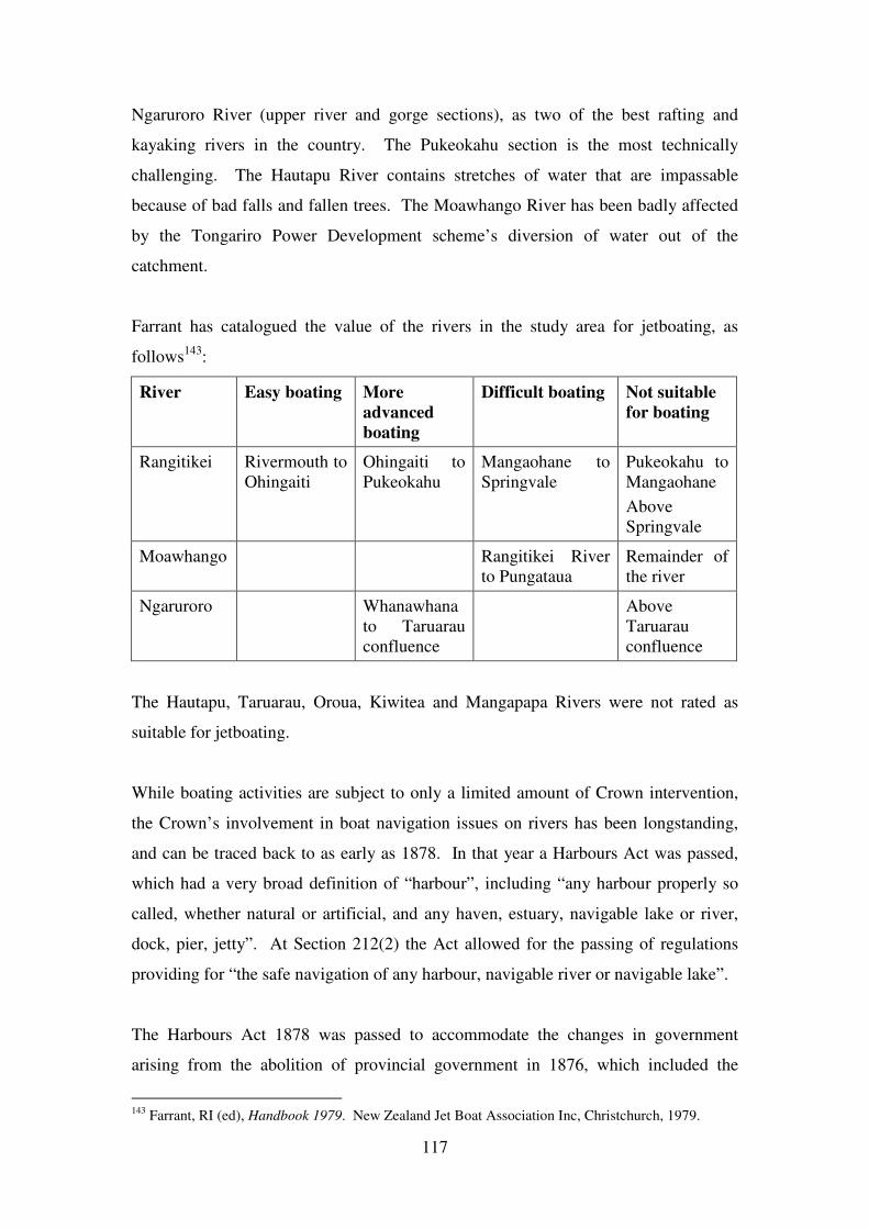
117
Ngaruroro River (upper river and gorge sections), as two of the best rafting and
kayaking rivers in the country. The Pukeokahu section is the most technically
challenging. The Hautapu River contains stretches of water that are impassable
because of bad falls and fallen trees. The Moawhango River has been badly affected
by the Tongariro Power Development scheme’s diversion of water out of the
catchment.
Farrant has catalogued the value of the rivers in the study area for jetboating, as
follows143
:
River Easy boating More
advanced
boating
Difficult boating Not suitable
for boating
Rangitikei Rivermouth to
Ohingaiti
Ohingaiti to
Pukeokahu
Mangaohane to
Springvale
Pukeokahu to
Mangaohane
Above
Springvale
Moawhango Rangitikei River
to Pungataua
Remainder of
the river
Ngaruroro Whanawhana
to Taruarau
confluence
Above
Taruarau
confluence
The Hautapu, Taruarau, Oroua, Kiwitea and Mangapapa Rivers were not rated as
suitable for jetboating.
While boating activities are subject to only a limited amount of Crown intervention,
the Crown’s involvement in boat navigation issues on rivers has been longstanding,
and can be traced back to as early as 1878. In that year a Harbours Act was passed,
which had a very broad definition of “harbour”, including “any harbour properly so
called, whether natural or artificial, and any haven, estuary, navigable lake or river,
dock, pier, jetty”. At Section 212(2) the Act allowed for the passing of regulations
providing for “the safe navigation of any harbour, navigable river or navigable lake”.
The Harbours Act 1878 was passed to accommodate the changes in government
arising from the abolition of provincial government in 1876, which included the
143
Farrant, RI (ed), Handbook 1979. New Zealand Jet Boat Association Inc, Christchurch, 1979.
118
transfer of responsibility for the Port of Rangitikei at the mouth of the river from
Wellington Provincial Government to central government. Research is required to
identify the extent of the Crown’s involvement with the port, and the relationship it
had with local iwi with respect to the port. There was a dispute in connection with the
siting of the signal station at the mouth of the river, but so far as is known this dispute
was over the leasing of Maori-owned land for the station rather than over the Crown’s
authority with respect to the river.
The involvement of the Crown with rivers under the Harbours Act 1878 (and its
successors the Harbours Act 1923 and the Harbours Act 1950) is not fully known, and
needs to be researched further. One instance that has been identified was the passing
of a general regulation in 1906 prohibiting the placing of any obstruction to
navigation in a navigable river, and making it an offence to fail to remove the
obstruction144
. Another instance was the passing of General Harbour Motor Launch
Bylaws in 1934, which among other things prohibited motor launches from travelling
at more than five knots within 200 yards of any erosion protection works145
. By 1958,
with the passing of Motor Launch Regulations in that year, the prohibition had been
expanded to cover boats within 200 yards of any riverbank. The prohibition was
continued in the successor Motor Launch Regulations 1962 and Water Recreation
Regulations 1979.
With the development of jetboats, which needed to travel at more than 15 knots to be
able to plane across the surface of the water, it became necessary to allow exemptions
to the 5 knot maximum speed. Following an application made to the Ministry of
Transport by the New Zealand Jet Boat Association, the removal of speed restrictions
on the Rangitikei River from the source to the sea was notified in 1979146
. The notice
was reissued two months later, as a result of representations from the Wellington
Acclimatisation Society, with an additional provision reducing the operation of the
exemption from the source to the Mangaohane bridge between May and September
144
New Zealand Gazette 1906 page 2653. 145
New Zealand Gazette 1934 page 2744. 146
Water Recreation (Rangitikei River) Notice, 1979, notified in New Zealand Gazette 1979 page
1546.
119
each year, in order to protect trout spawning areas147
. This indicates that at least some
agencies outside government were consulted and had their submissions acted upon.
What consultation was undertaken by the Ministry of Transport with iwi, and in
particular whether Maori living along the river were consulted, needs to be
researched. Fishing and bathing use of the river by Maori stood to be affected by the
Crown’s approval of jetboating.
A different provision under the Harbours Act 1950 was the ability for the Crown to
delegate some of its powers under that Act to local authorities. This delegation,
known as a grant of control of waters, was made under Section 8A of the Act, which
was added by the Harbours Amendment Act 1961. A grant of control of the waters of
the Oroua and Pohangina Rivers, from their source to their confluence with the
Manawatu River, plus the waters of other Manawatu region rivers outside the study
area, was issued to the Manawatu Catchment Board and Regional Water Board in
1980148
. The grant was for a fixed term of twenty-one years. Why a grant of control
was issued for these rivers, what practical effect it had, and whether Maori were
consulted, needs to be researched.
Since the 1990s, the Crown’s direct interest in recreational boating has been narrowed
to a safety and accident investigation focus, while regional councils have been made
responsible for other aspects of boating and riverbed occupation use under the
umbrella of the Resource Management Act and regional policies and plans.
Potential reference sources: Egarr, Farrant, Ministry of Transport head office and
district office files
The amenity value of rivers was recognised by an amendment to the Water and Soil
Conservation Act in 1981. This was in response to a desire to see protection of wild
and scenic rivers, and the Amendment Act aimed to achieve protection by instituting
national water conservation orders or local water conservation notices. The gazetting
of conservation orders and notices has been discussed in the chapter of this report
147
Water Recreation (Rangitikei River) Notice No. 2, 1979, notified in New Zealand Gazette 1979
pages 2293-2294. 148
New Zealand Gazette 1980 page 2181 (amended by New Zealand Gazette 1986 page 1653).
Bylaws drawn up by the Manawatu Regional Water Board were approved by the Crown at New
Zealand Gazette 1980 page 2851.

120
about fisheries, because they were applied for by anglers keen to protect the fishing
experience in wilderness areas of the upper Rangitikei. In that section the need for
research into how (if at all) the Crown consulted with and involved Maori prior to
gazettal was identified. Research is also needed to identify whether there was any
consultation with Maori prior to the passing of the 1981 Amendment Act.
Potential reference sources: Ministry of Works and Development head office files
121
13 WATER QUALITY
The Crown has had a variable attitude towards pollution and water quality over the
years. The Fisheries Conservation Act 1884 allowed regulations to be issued
prohibiting the throwing of sawdust or sawmill refuse into rivers. In the interests of
good sanitation, the pollution of water supplies, and the pollution of watercourses
through towns and boroughs, were made offences under the Public Health Act 1900.
However, other legislation accepted the use of watercourses to dispose of and dilute
waste. Mining Acts in the nineteenth century allowed a watercourse to be proclaimed
to be a sludge channel, in order to carry away arsenic and other polluting wastes of
gold mining. As recently as 1967 the Water and Soil Conservation Act deemed the
discharge of wastes to water as a valid use to which natural water could be put,
because of the dilution effect, and an acceptable reason for the issue of water
discharge rights. The attitude expressed in the 1967 Act still prevails today, with
discharge to water often preferred to higher-standard treatment of waste or discharge
to land.
Any reduction in water quality in the waterways (including related sub-surface
groundwater flows) impacts on Maori to a greater degree than the general population.
While Maori are part of the general population, and therefore share the general
population’s concerns with respect to bathing use, the Maori concern for the mauri of
waterways, for the health and wellbeing of traditional fisheries, and for the ability to
practise other traditional activities such as preparing rongoa and weaving materials,
all mean that the iwi and hapu along the rivers take a keen interest in water quality
matters. This makes consultation with iwi and hapu on the topic a particularly critical
issue.
The worst discharges into rivers in the study area are discharges from sewage
treatment plants, because they discharge into the rivers pathogens harmful to human
health, which then prevent the rivers from being suitable for drinking or bathing, or
for many other uses. Taihape traditionally relied on community septic tanks that
discharged into the Hautapu River. A sewage treatment plant was subsequently built
downstream of the town (although upstream of Winiata and Utiku). While the
122
effluent from this plant that is discharged into the Hautapu River has been treated, it
has consistently failed to meet the water quality standards set out in its resource
consent, and blights not just the Hautapu but also the Rangitikei River below the
Hautapu confluence.
The Hunterville sewage treatment plant has also had a history of poor performance.
The quality of discharges from other treatment plants in the study area, such as at
Waiouru, Halcombe, Bulls, Marton and Ohakea, is not known.
Other discharges affecting water quality are from industrial sites. For instance, a
sawmill north of Taihape discharges treated water into the Hautapu River. In the past
a dairy factory at Rata caused pollution in the Pourewa River. Other industrial sites
are further downstream in the more intensively developed lowlands and the coastal
plain.
A more insidious form of pollution, because it is less easy to develop clean-up
strategies for, is the pollution from chemicals, nutrients and bacteria contained in
general runoff from the land, in particular from farmland. While the intensive
stocking that goes with modern dairying, including the twice-daily concentration of
stock numbers at milking sheds, has a bad reputation, the decline in water quality in
the Rangitikei and Turakina Rivers commences in the parts of the catchments where
cattle and sheep rearing predominates. Research is needed to determine which parts
of the catchments in the study area make the biggest contributions to a decline in
water quality, what mechanisms are being used to reduce this type of pollution
(known as non point source pollution), and how effective they are.
Research is needed to discover whether Maori were consulted about any of these
polluting discharges, whether they have expressed concerns about water quality or
pollution in the rivers of the study area, and how any concerns have been responded to
by the Crown and local authorities.
Potential reference sources: Health Department head office files, Horizons Regional
Council records
123
Research is also required into whether the overall water quality situation is currently
improving or not. The Horizons website includes the following summary statement
made in about September 2009:
The Rangitikei River is pristine at its headwaters coming out of the
Kaimanawa Forest Park. Several tributaries have poor water quality as a
result of town sewage discharges from Taihape, Hunterville, Marton,
Halcombe and Sanson. The river is generally safe for swimming at low flows.
However, below the Bulls Bridge the water quality degrades as a result of
industrial discharge and intensive land use in coastal parts of the catchment.
The river is subject to green slime throughout much of its main channel at
times, however it does not suffer from blue-green algal blooms like other
rivers.149
Although the wording used is different, this recent assessment appears to be very
similar in sentiment to statements about water quality made in the Regional Council’s
two ‘state of the environment’ reports dated 1999150
and 2005151
. If this is a correct
interpretation of the various assessments, then the implication is that there has been
little progress made in recent years to reduce pollution and improve water quality.
The lower Hautapu River, the Pourewa Stream, the Tutaenui Stream and the
Rangitawa Stream remain pollution ‘hot spots’ despite having been identified as such
for a number of years. The Turakina River also appears to still have poor water
quality. However, a finer analysis of Horizons’ data may be able to point to results
that show that some improvement is occurring. Any research on this topic could also
identify whether the consultation that Horizons Regional Council has with Maori via
Nga Pae o Rangitikei forum (see chapter on resource management) has encouraged
Horizons and the District Councils to react positively to Maori concerns about water
quality.
Besides existing pollution, there is also the threat of additional pollutants being
introduced to the rivers of the study area. The didymo algae is present in the South
Island, but has not yet been found in North Island rivers. Introduction by anglers with
contaminated fishing gear is the biggest threat.
149
www.horizons.govt.nz/about-us/who-what-where/news/water-quality-top-priority/a-snapshot-of-
water-quality-in-the-horizons-region/, report undated, but posted on the website on 2 September 2009. 150
Horizons Regional Council, Measures of a changing landscape: state of the environment report,
Manawatu-Wanganui Region. Horizons Regional Council, Palmerston North, 1999. 151
Horizons Regional Council, State of the environment report of the Manawatu-Wanganui region,
Horizons Regional Council, Palmerston North, Report No. 2004/EXT/608, 2005.
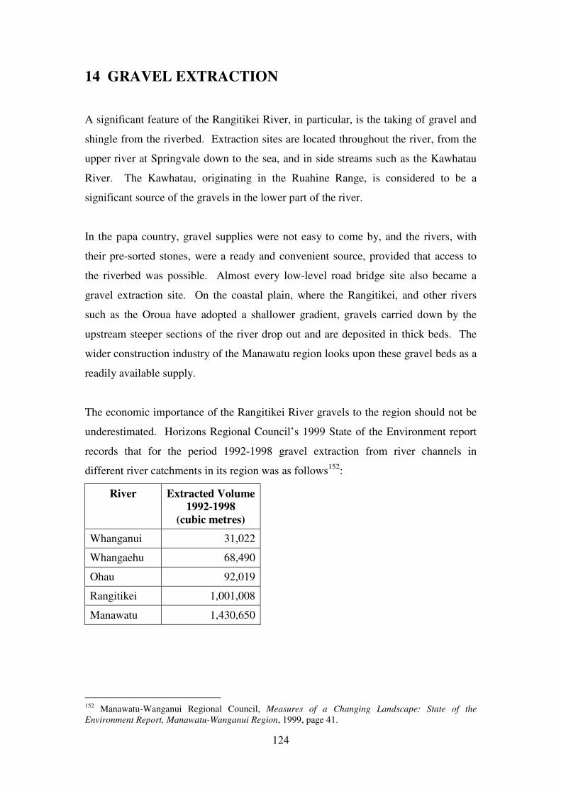
124
14 GRAVEL EXTRACTION
A significant feature of the Rangitikei River, in particular, is the taking of gravel and
shingle from the riverbed. Extraction sites are located throughout the river, from the
upper river at Springvale down to the sea, and in side streams such as the Kawhatau
River. The Kawhatau, originating in the Ruahine Range, is considered to be a
significant source of the gravels in the lower part of the river.
In the papa country, gravel supplies were not easy to come by, and the rivers, with
their pre-sorted stones, were a ready and convenient source, provided that access to
the riverbed was possible. Almost every low-level road bridge site also became a
gravel extraction site. On the coastal plain, where the Rangitikei, and other rivers
such as the Oroua have adopted a shallower gradient, gravels carried down by the
upstream steeper sections of the river drop out and are deposited in thick beds. The
wider construction industry of the Manawatu region looks upon these gravel beds as a
readily available supply.
The economic importance of the Rangitikei River gravels to the region should not be
underestimated. Horizons Regional Council’s 1999 State of the Environment report
records that for the period 1992-1998 gravel extraction from river channels in
different river catchments in its region was as follows152
:
River Extracted Volume
1992-1998
(cubic metres)
Whanganui 31,022
Whangaehu 68,490
Ohau 92,019
Rangitikei 1,001,008
Manawatu 1,430,650
152
Manawatu-Wanganui Regional Council, Measures of a Changing Landscape: State of the
Environment Report, Manawatu-Wanganui Region, 1999, page 41.
125
The Rangitikei contributed 38% of all riverbed-won gravels in the region. It also
contributed additional gravels extracted from dry land alongside riverbeds (referred to
as berm area extraction).
The rights to take gravel are bound up with the ownership of the riverbed. By
asserting that the riverbed of the Rangitikei upstream to the Kawhatau confluence was
a navigable river and was vested in it, the Crown was saying that the riverbed was
Crown Land, and gravel could be extracted under licences issued by the Crown (or by
the Catchment Board if licensing authority had been delegated to it) in accordance
with Section 165 Land Act 1948.
Potential reference sources: Department of Lands and Survey district office files,
Horizons Regional Council records
Taking gravel is also bound up with the catchment and flood control functions of
catchment boards and regional councils. Gravel extraction is an explicit part of the
Rangitikei River Control Scheme No. 2, because it can counteract the tendency of the
river to drop its gravel load and so fill in the floodway, reducing the capacity of the
channel and making it easier for the river waters to overtop bank protection works.
Extraction has now become a tool for the ultimate benefit of flood control. However,
there have been flaws in this approach. In recent years the infilling of the floodway
has occurred downstream of Bulls, but there has been insufficient extraction in this
stretch of the river, with more occurring upstream of Bulls than is being deposited
there naturally. Downstream of Bulls the bed is aggrading, while upstream it is
degrading, so that the flood channel is behaving contrary to the wishes of the flood
engineers. In 2010 one consequence was that an application by Ngati Waewae, one of
the hapu at Te Reureu, to extract gravel in front of the reserve, and so reduce the
threat of erosion to Maori Land, was turned down because, according to the flood
engineers, more gravel was either already being extracted from that stretch of the
river, or was permitted under existing resource consents for future extraction, than
should be allowed to occur. More research is needed to better understand the
relationship between gravel extraction and flood control, and the manner in which the
regional council is managing the links.
126
Potential reference sources: Rangitikei Wanganui Catchment Board (1978),
Rangitikei Wanganui Catchment Board (1979), Rangitikei Wanganui Catchment
Board (1983), Horizons Regional Council (2010)
The earliest known Crown involvement with Rangitikei gravels was the use of the
riverbed at Kakariki, downstream of the railway bridge, as a ballast pit. Extraction
may have commenced as early as the 1870s, when the railway was constructed. For a
reason yet to be determined, the Crown considered that it was necessary to take the
ballast pit site under the Public Works Act in 1912153
. Both the extraction from this
site during the nineteenth century, and the taking, are of particular relevance to a
study of the Rangitikei River, as the site is part of Te Reureu Maori reserve or
riverbed fronting Te Reureu reserve. The dealings the Crown had with Te Reureu
Maori, during a period that was largely before it asserted that the river was navigable
and had become Crown Land, will shed light on the ownership of the gravel before
any further discussion about ownership was shut down by the Crown’s use of the
Coal-mines Amendment Act 1903. In particular, research may show whether or not
the Crown was paying Maori for the gravel that was extracted, and whether the
compensation paid for the taking of the site included any recognition of Maori
ownership of the gravel.
Potential reference sources: Ministry of Works and Development head office files,
Railways Department head office files, Maori Land Court minute books
One of the key concerns of Maori is the suspicion that the Crown’s takeover of the
lower Rangitikei riverbed has prevented Maori from being able to obtain an income
from royalty payments on gravel extracted. At present extractors pay a royalty on
each cubic metre extracted, which goes to the regional council as control and
management agency for the reserve that is the riverbed. Whether there is any
substance to the suspicion needs to be thoroughly researched. It is why an
understanding of the legal rights of Maori before the river was claimed to be a
navigable river is so important.
153
New Zealand Gazette 1912 page 957.
127
A decision of the Wanganui Land Valuation Tribunal in 1984 has revived suspicion
that Maori have missed out on receiving royalty payments. It was asked to determine
the amount of compensation to be paid to some Ohinepuhiawe owners for the taking
of part of their land under the Public Works Act in 1981 for soil conservation and
river control. The Maori owners argued that the compensation value of their land
(which because of river movement was actually riverbed) should include the value of
the river gravel that it contained. The Tribunal agreed, giving a decision in favour of
the Maori owners and against the Catchment Board.
If the further research supports the iwi contention that it has been denied royalty
payments for gravel as a result of Crown actions, then research will also be needed to
identify the quantities of gravel that have historically been taken from those parts of
the riverbed where Maori would have owned the gravel if it were not for the Crown
actions.
Potential reference sources: Department of Lands and Survey head office files,
Department of Lands and Survey district office files, Ministry of Works and
Development head office files, Ministry of Works and Development district office files,
Horizons Regional Council records
128
15 RESOURCE MANAGEMENT
In the days of the catchment board and regional water board, planning tended to be
reactive - to the Tongariro Power Development scheme, to other hydro-electric power
investigations, and to floods and the need to control them. With the passing of the
Resource Management Act 1991, there has been a surge of more holistic planning
about the rivers. Many of the kawanatanga powers to do with rivers and water that
the Crown has accumulated over the years now reside in this Act, and the
administration of these powers has been delegated by central government to regional
and district councils.
Before 1991 catchment boards were responsible for all soil conservation and river
control matters in any catchment, but did not have any statutory obligation to develop
overarching resource management documents which looked at the issues holistically.
They initially developed individual farm plans for soil conservation work, and
individual river control plans for particular control works they wished to construct.
Both these types of plans were produced primarily for the purpose of obtaining Crown
approval for the payment of subsidy funding. Wider catchment control schemes and
river control schemes developed over time, though again for the purpose of obtaining
subsidy funding from the Crown. In a similar manner, when catchment boards had
regional water board functions added to their responsibilities by the Water and Soil
Conservation Act 1967, they tended to be focussed on individual applications for
water rights to take from or discharge into natural waters, without much regard for the
wider context.
This approach did change over time. In the mid 1970s it became a requirement that
each catchment control scheme application for Crown funding included an
environmental impact assessment. The assessment with respect to a scheme in the
Mangatutu Stream catchment looked at such matters as topography, vegetation,
geological features, fauna and cultural features. However, the fauna asessment only
examined the effects on birdlife and waterfowl, and did not assess the effects on fish
life. The cultural assessment looked at farming, forestry and employment issues,
129
while ignoring effects on Maori154
. Whether this assessment, and its blind spots, was
typical of its time needs to be researched further, be examining other contemporary
environmental impact assessments.
From the 1980s more emphasis was placed on resource documents and objectives that
could provide a context for the individual decisions being made. The published
documents of the Rangitikei Wanganui Catchment Board listed in the bibliography
give an indication of the adoption of a wider view. Among these documents was a
report on the significance of the Rangitikei River to Maori produced in 1985155
.
While from today’s perspective it would be considered a slight document, from the
perspective of a Pakeha-centred organisation this was a ground-breaking piece of
work that recognised that the Catchment Board had a duty to consider the impact of
its work on Maoridom when making decisons. According to the report, it was
prepared as a result of Catchment Board involvement in the national water
conservation order application. Research is needed to better understand the context in
which the document was called for, whether the Crown was involved or provided any
guidance at the time on consultation with Maori, and whether the report made a
difference to the way decisions were made subsequently by the Catchment Board.
Research is also needed into whether there were any other initiatives to involve Maori
in the study area prior to 1991.
Potential research sources: Rangitikei Wanganui Catchment Board records, Ministry
of Works and Development head office and district office files
Since the passing of the Resource Management Act 1991, Horizons Regional Council
has been responsible for the Rangitikei, Manawatu, Turakina and Whangaehu
catchments. Hawke’s Bay Regional Council has been responsible for the Ngaruroro
catchment.
Horizons’ first planning document was its Regional Policy Statement, which became
operative in 1998. As subordinate policy documents, Horizons then produced two
regional plans, one for Beds of Lakes and Rivers and Associated Activities (which
154
Works and Development Head Office file 96/327120. 155
Rangitikei Wanganui Catchment Board, Significance of the Rangitikei River to the Maori people of
the district, Rangitikei Wanganui Catchment Board, Marton, Report No. 85/3, 1985.
130
became operative in 2001) and a second for Land and Water (which became operative
in 2003). The riverbed regional plan had to have regard for the Council having at
least three separate responsibilities relating to riverbeds:
• Responsibilities under the Resource Management Act
• Owner of riverbed land by purchase or Public Works Act taking
• Responsibilities under the Reserves Act 1977 for the control and management
of public reserves it administers
Both the Regional Policy Statement and the Regional Plans had 10-year operative
periods. The new statement and plans to replace them are known as the One Plan,
because they have been combined into a single document. The One Plan has been
through all the processes of public consultation, and a revised document incorporating
all amendments has been produced. Parts of the document, however, are still subject
to appeals to the Environment Court, so the whole document has not yet been
approved.
While the Regional Policy Statement and the Regional Plans retain some residual
effect, the advanced stage that the One Plan has reached means that the residual effect
is now minor and the One Plan is the primary planning document.
The planning documents are the principal policies and rules (besides the Act itself)
referred to whenever a resource consent is applied for. They define how the council
will view any proposal for use of rivers, riverbeds and waters.
District councils administer district plans; these are primarily focused on land use,
although they can have some impact on water uses, for instance where access to rivers
is concerned.
Maori have been conscious of the central position of these various planning
documents, and the requirements of the Resource Management Act about consultation
with them. Ngati Hauiti produced an environmental policy statement in 1996, which
set out what matters it considered important, and would be pursued whenever it was
131
given an opportunity under the Act’s consultation processes156
. Te Runanga o Ngati
Whitikaupeka, and later Te Runanga o Ngati Tamakopiri, joined in the production of
an Environmental Policy Statement at the time of the Tongariro Power Development
scheme resource consent applications by Genesis Power157
. The Ngati Apa settlement
legislation requires regional and district councils to have regard (whether or not Ngati
Apa are public submitters) for a statement of association about the Rangitikei River
that forms part of the settlement, and to forward summaries of all resource consent
applications (whether publicly notified or not) to Ngati Apa for the iwi’s
information158
.
With respect to the rivers, Maori iwi and hapu on the Rangitikei River have jointly
developed a group known as Nga Pae o Rangitikei to speak for them all in discussions
with Horizons Regional Council. Research is needed to assess how successful the
group has been, from both a Maori and a Council point of view. One view expressed
at hui has been that only some of Nga Pae’s potential has been acknowledged by
Horizons, and that while its involvement in articulating a Maori viewpoint has been
welcomed at the policy level with respect to developing planning documents, it has
been less successful in fostering a relationship with the council on a more day-to-day
basis.
Potential reference sources: Warren, Nga Pae o Rangitikei records, Horizons
Regional Council records
156
Te Runanga o Ngati Hauiti, Ngati Hauiti: kaupapa taiao - environmental policy statement, Te
Runanga o Ngati Hauiti, Hunterville, 1996. 157
Richard Steedman, personal communication, 28 February 2012. 158
Ngati Apa (North Island) Settlement Act 2010.
132
16. RECOMMENDATIONS
16.1 Need for further reports
A key outcome expected from this scoping report is an assessment of the need for
further research work to provide an adequate level of reporting for Waitangi Tribunal
casebook purposes.
This scoping report has identified the breadth of topics that will need to be covered by
technical research, if the Waitangi Tribunal is to have sufficient factual knowledge of
the relationship between the Crown and Maori with respect to the waterways of the
Taihape Inquiry District, to enable it to form judgements about that relationship. For
every topic discussed, further research opportunities have been identified. The level
of knowledge of the waterways contained in this scoping report is not sufficient for
casebook purposes, and a fuller research programme and report will be necessary.
That conclusion is not unexpected, and was probably anticipated by all parties even
before the scoping report was commissioned. The structure of this scoping report
reflects that, identifying in the introduction that further research would be necessary.
How the further research might be structured, however, is a matter that deserves some
detailed consideration.
Two matters have already been discussed in judicial conferences held by the Tribunal
for the Taihape Inquiry District, and have been awaiting the completion of this
scoping report before being resolved:
• If a full research report on the Rangitikei River and its tributaries (including
the Moawhango River and the Hautapu River) is to be prepared, should it be
confined to the stretches of the rivers within the Taihape Inquiry District, or
should it cover all the waterways in the whole of the general Rangitikei
catchment regardless of Inquiry District boundaries?
• Are full research reports necessary for rivers in those parts of other catchments
(Ngaruroro, Pohangina, Oroua, Kiwitea, Turakina, Whangaehu) that are
located within the Taihape Inquiry District?
133
Each major catchment is addressed individually below.
16.1.1 Rangitikei catchment waterways
The Rangitikei River and its tributaries (including the Moawhango and Hautapu
Rivers and their tributaries), and their relationship to the Taihape Inquiry District
boundaries, are shown on Maps 2 to 4.
Both the technical research scoping report by Stirling and Subasic, and the scoping
exercise by Waitangi Tribunal staff, supported a whole catchment approach to
research on the Rangitikei catchment waterways. Claimants also supported this
approach prior to commissioning of this scoping report, and have been unanimous in
repeating their support at hui held during the report’s preparation. A widespread
expectation has now developed that a whole catchment report is in the best interests of
claimants, and would best serve the process of hearing their claims.
The principal argument in favour of a whole catchment approach is that that is the
way in which the rivers of the catchment are viewed by all parties. Claimants think of
the Rangitikei River as a single entity with intense cultural meaning to them, which
cannot be subdivided into parts. The river as a whole governs their view of
themselves and their relationships with one another. The Crown takes a similar
approach today, by virtue of the Resource Management Act 1991 and the local
government reorganisation of 1989 that between them adopted a catchment
perspective for agency boundaries and the development of rivers management and
policy. Both parties to any settlement of Treaty grievances are likely to agree to terms
of settlement that are underpinned by a whole catchment perspective.
Claimants in the lower Rangitikei catchment, within the Porirua ki Manawatu Inquiry
District, consider that their interest in the Rangitikei River has a stronger link with the
river upstream in the Taihape Inquiry District than with other rivers such as the
Manawatu and the Otaki. They are concerned that any further research into rivers
issues for the Porirua ki Manawatu inquiry, that looked at all the rivers of that Inquiry
District in a single report, might subordinate discussion of the Rangitikei to discussion
of the issues surrounding those other rivers, and would fail to adequately express their
connections with the upstream parts of the Rangitikei River.
134
From a researching and report writing perspective, division of the Rangitikei
catchment waterways by Inquiry District boundary is possible, but would result in
duplication of research effort. To fully capture and express the essence of the cultural
significance of the Rangitikei River to claimants in both the Taihape and Porirua ki
Manawatu Inquiry Districts would involve writing about it from the source to the sea
in reports for each District. The Rangitikei River flood protection scheme in its
lower reaches stretches from Rewa to the sea, thereby spanning both Inquiry Districts,
and so would need to be covered in reports for both Districts. Natural resource
policies and practices under the Resource Management Act cover the whole of the
river and would need to be discussed in reports for each District.
Recommendation:
That a full research report be commissioned that addresses all relevant issues
relating to all waterways in the Rangitikei catchment (including the Moawhango and
Hautapu catchments) from source to sea.
16.1.2 Ngaruroro catchment waterways
The Ngaruroro catchment (including the Taruarau River and its catchment) within the
Taihape Inquiry District boundaries is shown in Map 5. It includes almost all of the
headwater waterways of that river catchment, with just a small part of the headwater
catchment in the National Park Inquiry District. It is of interest to Owhaoko block
owners. These owners are resident in the Heretaunga district (downstream of the
headwater area) and in the Taihape Inquiry District.
While an environmental report for the Heretaunga district (by Armstrong and others)
has been completed, it did not address waterway issues in the headwaters of the
Ngaruroro catchment. The headwater area is, however, a significant part of the story
that Heretaunga-based Ngati Kahungunu iwi tell about themselves, when describing
the first exploration journeys by Tamatea and his son Kahungunu. For Heretaunga
based owners to have a research report about the headwaters area will complete their
coverage of their rohe, so far as the Ngaruroro catchment is concerned. Timing
matters, as regards completion of an upper Ngaruroro catchment report and settlement
negotiations, are beyond the scope of this report.
135
For Ngaruroro catchment owners resident in the Taihape Inquiry District, the
catchment represents a significant portion of their area of interest. If there was no
further research report prepared, there would be a substantial gap in the coverage of
grievances they would wish to present before the Tribunal.
The sparse population and relatively undeveloped nature of the Ngaruroro catchment
within the Taihape Inquiry District means that fewer issues of concern about the
relationship between the Crown and Maori have been identified in this scoping report,
as compared to the range of issues identified in the Rangitikei catchment. By being
less complex, and being concerned with a smaller proportion of the whole river
catchment, a report on the Ngaruroro waterways will be considerably shorter than a
report on Rangitikei waterways. The tensions between introduced fisheries and the
fishing for indigenous species traditionally caught by Maori, and proposals for
hydroelectric dams, are the major concerns that deserve further research effort.
The present-day management of the Ngaruroro waterways by the Hawkes Bay
Regional Council, while the remainder of the waterways in the Taihape Inquiry
District are managed by Horizons Regional Council, indicates that some different
research sources will need to be relied upon. This might suggest that two different
reports, one for the Ngaruroro, and a second for the other Taihape District catchments,
might be appropriate. However, separate reports increase the risk of differential
coverage in the cultural and historical material that is presented to the Waitangi
Tribunal.
Recommendation:
That the report on the waterways of the Rangitikei catchment includes, as a separate
discrete part, coverage of the waterways of the Ngaruroro catchment within the
Taihape Inquiry District.
16.1.3 Pohangina, Oroua and Kiwitea catchment waterways
The portions of the Pohangina, Oroua and Kiwitea catchments within the Taihape
Inquiry District boundaries are shown on Map 6. All three waterways are tributaries
of the Manawatu River. The areas within the Taihape Inquiry District are all upper
136
catchment areas without any population centres (apart from Kimbolton township in
the Oroua catchment). They are less intensively farmed than more heavily-settled
portions of the same catchments downstream. The portion of the Oroua catchment
within the Taihape District is just one bank of the river, the other bank (and all
downstream areas) being in the Porirua ki Manawatu Inquiry District.
No particular issues relating to the interactions between the Crown and Maori have
been identified in the portions of the three waterways within the Taihape District,
apart from general issues of polluting runoff from farmland, and the various Crown
exercises of statutory authority over the waterways that are applicable to most other
waterways nationally. By contrast, there has been a greater degree of active
involvement by the Crown in the more substantial changes to the waterways
downstream in the Porirua ki Manawatu District.
The iwi showing the greatest interest in these waterways is Ngati Kauwhata, whose
centre of interest is the Feilding area. Rangitane, Ngati Apa and Ngati Hauiti also
have an interest, though that interest appears to be more peripheral. Ngati
Kauwhata’s preference, as expressed at hui during the preparation of this scoping
report, is that the portions of the three catchments in the Taihape Inquiry District not
be the subject of specific further research for the Taihape inquiry, but instead be
covered by any report for the Manawatu catchment that is prepared for the Porirua ki
Manawatu inquiry. This preference is not expressed so clearly in earlier submissions
to the Tribunal by Ngati Kauwhata claimants, and would need to be confirmed by
further submissions.
Inclusion of the portions of the waterways in the Taihape District in any research
undertaken into Manawatu catchment waterways would be preferable from a technical
research point of view, as similar source material and similar cultural and traditional
stories would be involved.
Recommendation:
That no specific further research work into the Pohangina, Oroua and Kiwitea
waterways be carried out for inclusion in the Taihape Inquiry District casebook, and
the project briefs for any research reports that address waterways in the Manawatu
137
catchment as part of the Porirua ki Manawatu Inquiry allow the portions of the
Pohangina, Oroua and Kiwitea waterways in the Taihape Inquiry District to also be
covered.
16.1.4 Turakina and Whangaehu catchment waterways
The portions of the Turakina and Whangaehu catchments within the Taihape Inquiry
District boundaries are shown in Map 7. Only a small proportion of each catchment is
involved.
No issues specific to the parts of the waterways within the Taihape Inquiry District
have been identified. The Mangatipona Stream is a small tributary, and only its upper
catchment is included. The Mangapapa Stream is a longer tributary, but is very
isolated, forming the back boundary to farms in the valley and without any public
road access running along its length.
The iwi with the greatest interest in these waterways is Ngati Rangi. The larger and
core part of its rohe is to the west in the Whanganui Inquiry District. Reports about
the waterways of the Whanganui Inquiry District by Marr and Alexander have already
been presented to the Tribunal for that District, and a Tribunal report is being written.
It can be expected that the reports already presented about the waterways, plus
claimant evidence and submissions by counsel, will allow the Whanganui Tribunal to
comprehensively report on waterway issues in the Whanganui District relevant to
Ngati Rangi. It is unlikely that a report on those parts of the Turakina and
Whangaehu catchment waterways in the Taihape Inquiry District could add to the
coverage of issues likely to be provided by the Tribunal’s Whanganui inquiry report.
Ngati Apa has an interest in the southern part of the Turakina catchment within the
Taihape Inquiry District. However, Ngati Apa has already settled their historical
Treaty grievances with the Crown.
Recommendation:
That no specific further research work into the Turakina and Whangaehu catchment
waterways be carried out for inclusion in the Taihape Inquiry District casebook.
138
16.2 Scope of further research
The list of themes and topics set out in the brief for this scoping report (see Section
1.2) has proved to be comprehensive and relevant to an examination of the
relationship between the Crown and the iwi and hapu along the waterways. For each
of the identified topics further research has been identified as being necessary to fully
explore the nature of the relationship. Even for topics where research has so far
shown that there appears to have been no interaction between the Crown and iwi,
more in-depth research is required to confirm that this is the case.
During preparation of the scoping report it became apparent that the list of themes
would be more complete if it included:
• The Crown’s involvement in the management of indigenous fish species and
other indigenous wildlife whose habitat requirements include the waterways
• Resource management regimes for the waterways, including consultation with
Maori, involvement by Maori, and incorporation of Maori perspectives
Recommendation:
That the list of themes and topics for this scoping report, with the two additional
themes described above, form the initial template when preparing a project brief for
further research requirements.
Notwithstanding the general adequacy of the coverage of issues in the project brief for
the scoping report, a number of practical matters have become apparent, which are
discussed in the rest of this section.
16.2.1 Cultural significance and Crown/Maori interaction
For the Waitangi Tribunal to be able to understand (and then to be able to report on in
a meaningful fashion) what has happened to the waterways of the Rangitikei and
upper Ngaruroro catchments, it needs to be presented with evidence about:
• The cultural significance of the waterways to the iwi and hapu that live
alongside them and have an interest in them – their ancestral relationship to
the waterways, and the traditional ways they relied on and made use of the
waterways prior to the arrival of Europeans
139
• The Crown’s historical involvement with the waterways, and with the iwi and
hapu with an interest in these waterways, and the changes to traditional
patterns that have occurred since settlement by Europeans
This will enable the Tribunal to comment on the meaning of tino rangatiratanga with
respect to the Rangitikei and upper Ngaruroro catchment waterways, and assess the
effect of the Crown’s actions and inactions on the safeguards for iwi and hapu
provided by the Treaty.
Each of these aspects involves a different set of skills for the researchers that examine
them and write about them. Comments below assume that the skill sets required
cannot be found in a single individual, and that more than one research professional
will be needed.
Researching the cultural significance of the waterways relies primarily on obtaining
from the iwi and hapu their views about what the waterways mean to them, how they
have been affected by the changes to the waterways, and what their experiences have
been when dealing with the Crown and local authorities. While the stories and
explanations obtained from this source can be supplemented by information from
written sources (such as Maori Land Court minute books), most of the information
will be obtained from interviewing individuals and small groups. The skills required
for this task are those of an oral historian who has the confidence of his or her
interviewees, and who has some prior knowledge about the cultural significance of
waterways, either from elsewhere in the country or from the Rangitikei / upper
Ngaruroro district. Knowledge of te reo Maori may be desirable.
Researching the historical involvement of the Crown since 1840 relies on an
understanding of legislation and Government processes, and an ability to search out
relevant information from the Crown’s historical records. Notwithstanding the
extensive resources gathered together in the first round of the technical research
programme, there are still numerous Crown, local authority and other written records
that need to be examined for their relevance to a rivers report. This work requires the
skills of an historical researcher with expertise in finding information in Government
archives and other written material.
140
The above discussion about involvement of an oral historian presupposes that an
explanation of the cultural significance of the waterways should form part of the
technical research prepared for the Tribunal, and be available to the Tribunal as part
of its casebook prior to the commencement of hearings. While cultural significance
was included in the project brief for this scoping report, it is by no means a necessary
part of a technical research programme of work prepared for casebook purposes. This
is because briefs of evidence by claimant individuals will also form part of the
material presented to the Tribunal, and those individuals would get the chance to
present their views and stories directly to the Tribunal. A report to the Tribunal
prepared by an oral historian might be perceived as being an extra step interfering
with the opportunity for the Tribunal to hear from the claimants in their own words.
Having evidence presented by claimant individuals is an important feature that adds to
the value of the Tribunal hearing process. It is at its most powerful when the personal
reminiscences of claimants and the expert evidence of technical witnesses
complement each other, and allow a human face to be put on otherwise dry historical
facts. However, claimants speak from their own personal experience, and there can
be merit in also having evidence from an expert that presents an overview of the
cultural significance of the waterways, thereby offering some wider context for the
briefs of evidence of each individual.
A cultural significance overview report, while setting out what the rivers mean to each
iwi and hapu having a connection with them, would be able to identify common
threads in each narrative that bind iwi and hapu together and give them a common
purpose when they speak of the rivers to outside agencies such as the Crown, regional
councils, district councils, and fish and game councils. From discussions at hui held
for this scoping report, it was apparent that the Rangitikei, Moawhango and Hautapu
Rivers, in particular, are a unifying force for the iwi and hapu along their banks,
regardless of the different geographical directions from which those peoples arrived in
the district. An overview technical report on cultural significance could inquire into
and expand on this theme, in doing so providing a framework for a better
understanding of a series of claimant briefs of evidence.
141
Such an overview report would benefit claimants in the Taihape Inquiry District.
Claimants resident in the District are small in terms of numbers of participants, and
those persons who are actively involved in pursuing the claims have multiple calls on
their time. While they would undoubtedly rise to the challenge of preparing briefs of
evidence about all aspects of the cultural significance of the waterways to them, if that
was something they were faced with, that might be at the expense of other aspects of
their claim. Having an overview report on cultural significance as part of the
technical research programme would enable them to better allocate their time.
In the absence of an overview report on cultural significance, there is a risk that the
Waitangi Tribunal, in its reporting by two or more different panels159
focusing on
different groupings of iwi and hapu, may not fully articulate the interconnectedness of
the rivers and the cultural linkages between all the iwi and hapu along the rivers from
source to sea. This risk may then extend to the Crown’s understanding of these
matters at the time of settlement negotiations. How real this risk might be is an
unknown. If the risk does turn out to be real, however, an overview report will help to
hold together the whakapapa and ancestral connections that are woven around the
rivers, and avoid unnatural divisions.
Recommendation:
That two reports be prepared, one an overview report on the cultural significance of
the Rangitikei and upper Ngaruroro catchment waterways to iwi and hapu (and
changes to the involvement that iwi and hapu have had with the rivers since European
settlement), and the second an historical report canvassing the Crown’s involvement
with the waterways of the same catchments (and with the iwi and hapu with respect to
those waterways).
Both reports should be in two parts, one part about the Rangitikei River, and the other
part about the Ngaruroro River within the Taihape Inquiry District, so that each is
capable of standing alone and apart from the other. This will ensure the relevance and
usefulness of each report beyond the Tribunal inquiry process, into the settlement
negotiations stage, and beyond the settlements into ongoing relationships with
159
The Taihape District Inquiry, the Porirua ki Manawatu District Inquiry, and theoretically any
inquiry examining the Hawkes Bay / Heretaunga Inquiry District.
142
resource management agencies. Having two discrete parts to each report may result
in a small amount of duplication, but only in terms of providing a wider context.
Thus the reports on the Rangitikei catchment waterways will include material about
the cultural and historical connections with the upper Ngaruroro catchment, and vice
versa. The cultural significance report for the upper Ngaruroro waterways will also,
almost certainly, need to include some contextual material about the linkages with the
Ngaruroro catchment downstream of the Taihape Inquiry District.
16.2.2 The land’s relationship with the rivers
At the scoping stage the technical research programme for the Taihape Inquiry
District has divided the environmental research into a waterways-based project (this
report) and a land-based project (being reported upon by a team from Massey
University). From an ecological perspective, however, this division can be an
artificial distinction. Swamps and wetlands lie on the faultline of the division.
The changes that have occurred on the land, with forest clearance and soil erosion,
have had a significant impact on the waterways, changing runoff patterns and
increasing silt and sediment flows which, in turn, have affected fish life and riverbed
vegetation. Remedial measures adopted by the Crown, such as catchment control
schemes and detention dams on farmland, have also had an affect. It is difficult to
report in a comprehensive fashion about the waterways without also discussing these
related land-based matters.
The opposite can also apply, with the waterways affecting the land, most notably
when flooding erodes away riverbank land. This is most dramatically illustrated in
the lower Rangitikei River. The 1897 flood so threatened the riverside site of Te
Tikanga marae on Te Reureu reserve that the meeting house had to be shifted to the
top of the terrace at Tokorangi, where it now sits. When the river cut a new channel
through the Ohinepuhiawe reserve, this had a major effect on the resident Maori,
because it meant a loss of land that they were not able to make up for with other land
elsewhere to meet their needs.
In some respects there is a continuum of a river’s impact across the landscape, at its
strongest in the riverbed itself, and progressively weakening when moving further
143
away from the river channel. The issue is then where to draw the line, or where a cut-
off point might be, for any waterway-based report.
The draft land-based environmental scoping report prepared by the Massey University
team has provisionally identified some topics for further research in a fuller report.
Whatever emerges in that scoping report’s final recommendations will have a bearing
on the bounds of waterways-based further research. If further land-based research
were to include an examination of the Crown’s soil conservation measures and
involvement, then a waterways-based report would not need to delve into this matter
very deeply. If, on the other hand, this matter is not being followed up in further land-
based environmental research, then a waterways-based report will need to examine
the Crown’s actions, insofar as they have an effect on the waterways.
Looking more closely at the Ohinepuhiawe example above, the extent of the effect on
the people could be quantified, but only by looking at the reserve as a whole and
examining other events affecting the reserve before and after 1897, including the
overall loss of land out of Maori ownership and control. This is normally an aspect
that is covered in a technical research programme by block history reports. In the
absence of that wider research coverage, it would be unwise to draw any general
conclusions about the effect of river channel change on the social and economic
circumstances of Ngati Parewahawaha.
The purpose in mentioning this issue is not to make any specific recommendations,
but rather to draw attention to the potential gaps or overlaps in the technical research
programme. Rather than recommending either a broad or a narrow focus to any
further waterways-based research, the research brief will need to be responsive to the
wider circumstances when deciding what does or does not need to be covered. The
outcome sought is that any further report includes sufficient context to ensure that any
conclusions about harm suffered by iwi and hapu along the waterways as a result of
Crown involvement are robust.
16.2.3 The Crown’s resource management regime
Another area of potential duplication of research effort lies in the manner in which the
Crown has developed its resource management policies and administrative regimes.
144
As the title of the Soil Conservation and Rivers Control Act 1941 implies, the Crown
has determined that to be effective the management regimes it establishes have to
cover both the land and the waterways. This approach has continued up to the present
day, where the Resource Management Act 1991 covers both land and water functions,
and expects all natural resources, both land-based and water-based, to be covered by
regional policy statements and regional plans (the responsibility of regional councils),
and district plans (the responsibility of district councils).
One of the preliminary recommendations of the draft land-based environmental
scoping report is that the relationship between iwi and the Crown’s resource
management regimes since the 1970s be a focus of further research. This is
supported, especially if it examines both land- and water-based regimes. If the
recommendation is adopted, then it would mean that a waterways-based report on the
Rangitikei and upper Ngaruroro catchment waterways could take much of the
statutory background and the various local government planning policies and rules as
a given, and focus more tightly on the impact on the waterways and the associated
impact on iwi and hapu.
Rather than make recommendations, attention is drawn to the potential for integration
between various projects while avoiding duplication.
16.3 Possible case studies
Case studies are a valuable tool to use where there are so many events of a similar
nature that to research them all would be too time-consuming, and it is necessary to
choose one or two examples to study in detail. Examples where there have been a
multitude of similar events would be the bridging of waterways, water abstractions,
water discharges and gravel extractions.
On the other hand, some events associated with the waterways do not necessarily suit
the case study model. This can be the case where all events of a similar nature are so
significant that to concentrate on just one or two examples and ignore the other events
would not adequately convey the extent of the impacts that the waterways have
experienced. Examples where all events deserve coverage include the effects of the
145
1897 flood, all the hydro-electric power stations (including the Tongariro Power
Development scheme), and the whole of the Rangitikei River flood control scheme.
Recommendation:
That, without being prescriptive, the following features are identified in a project
brief for further research into Rangitikei catchment waterways as suitable for
adoption as case studies:
Bridging Bulls, Onepuehu
Water abstractions Taihape water supply
Water discharges Taihape wastewater treatment plant, the series of wastewater
discharges (Bulls township, Ohakea air base, Riverlands
abattoir) in close proximity to one another downstream of Bulls
Gravel extractions Toetoe Road (near Utiku), Kakariki
16.4 Timeframes and resources for further research
There seems to be no apparent advantage in undertaking the cultural significance
interviews before the historical research, or vice versa, and thereby requiring that the
two reports are prepared in sequence. Both reports can be researched concurrently,
with a requirement that each report’s author liaise with the other. For instance, the
interviewer might be told about an historical event involving the Crown, and can ask
the historian to search in the Crown records to find corroboration of this. Equally, the
historian may find a reference in Crown records to an historical event involving
Maori, and by informing the interviewer about it an additional subject for discussion
may be uncovered.
This scoping report has identified the broad range of topics that would need to be
researched further for an historical report. The bibliography and the potential archival
sources in the Appendix demonstrate the extensive material that would need to be
examined as part of this further research. The further historical research work being
recommended is therefore a large project. The report’s author would be an historian
with experience in analysing Crown actions. A researcher could assist with the
review of the written and archival sources.
146
The project into the cultural significance of the waterways needs to give the
interviewer / report author sufficient time to gain the confidence of interviewees, have
more than one meeting with each interviewee, and have the opportunity to obtain
agreement that whatever is written up as a result of the interviews has the approval of
iwi and hapu along the waterways. Compressing the time available might be
counterproductive. The interviewer / report author would have experience in
gathering oral history from Maori interviewees. A researcher or researchers could
assist with transcribing interviews and identifying corroborating information in Maori
Land Court minute books and other written records.
Recommendation:
That both reports be prepared concurrently, and the following timeframes and human
resources be accepted for the two strands of work:
Historical report 1 historian for 44 weeks FTE
1 researcher for 40 weeks FTE
Cultural significance report 1 oral history interviewer for 20 weeks FTE
1 or 2 researchers for combined total of 20 weeks FTE
FTE = Full time equivalent (i.e. 40 hours per week)
In identifying the range of work required and the human resources that would be
necessary to undertake that work, no recommendation is being made about how the
work might be structured. Two separate projects could be undertaken concurrently,
with a requirement for close liaison between each project, or a single project with a
team approach to the workload could be commissioned.
147
NGATI APA STATEMENT OF ASSOCIATION FOR THE
RANGITIKEI RIVER
[This statement is taken from the Schedule to the Ngati Apa (North Island) Deed of
Settlement, Part 6, pages 55-57, downloadable from www.ots.govt.nz. It is presented
as an example of a summary end-product that can be derived from more
comprehensive overview research into the cultural significance of the Rangitikei
River to iwi and hapu.]
The Rangitikei River is of historical, cultural, spiritual and traditional significance to
Ngati Apa (North Island). The Rangitikei River is located in the southern area of the
Ngati Apa (North Island) area of interest. The extent of the Ngati Apa (North Island)
interest in the Rangitikei River extends some 60 kilometres to the northern boundaries
of the Rangatira block.
The naming of the Rangitikei River occurred during Haunui a Nanaia’s pursuit of his
wife, Wairaka, naming the rivers that he crossed along the way. This event is
recorded in the Oriori mo Wharaurangi, or the Lullaby for Wharaurangi, that was
composed by Te Rangitakoru of Ngati Apa (North Island) for his young niece
Wharaurangi.
In referring to Rangitikei, the oriori records the following event:
Ka tikeitia te waewae, ko Rangitikei.
He strode across the land, hence Rangitikei.
The quote refers to the distance Haunui a Nanaia walked in his journey from Turakina
to Rangitikei.
The Rangitikei River is the tribal domain for many hapu of Ngati Apa (North Island),
including Ngati Kauae, Ngati Tauira, Ngati Tupua, Ngati Tupataua, Ngati Ika / Ngati
Tumoetere, and Ngati Tamatea.
The Rangitikei River was occupied by two major descent groups – Ngati Tauira and
Ngati Kauae, who descend from Papawhenua, and the other group including Ngati
Tupua, Ngai Tupataua, Ngati Ika / Tumoetere and Ngati Tamatea, who descend from
Tuariki. Ngati Tupua and Ngati Tupataua occupied the central reaches of the
Rangitikei on a permanent basis, but many of the other hapu only went to the upper
areas of the Rangitikei for refuge from war parties and to snare birds, hunt pigs and
catch eels.
The Papawhenua based groups tended to permanently occupy the lower reaches of the
Rangitikei River, and also utilise the coastal lakes to the south of the river, and
sometimes they would move on a more permanent basis to places on the Oroua River.
148
The River, and its numerous tributaries, were utilised extensively for their plentiful
fishing resources. Pa tuna or eel weirs, including Nganarangi, Kataina, Puapuatauaki,
Taporapora, Te Papa Taane, and Hauhau, were built in the River and its tributaries,
such as the Waiwhero, Mangawhero, Tuwhare, Kirikiri, Tutaenui, Pourewa, Putorino,
Makaraka, Mimi o Ahua, Makowai, Mangapapa, Mangatapu, Rangitawa, Waituna,
and Waitapu Streams.
The River also helped sustain the fertile flat lands that were used extensively for
cultivations. Named cultivations included Onetangi, Ratahi, Titaha, Ngatuahiwi ki
Raukawa, Ngatarawa, Te Oriputaroa, Paiari, Kapakapa, Kurupoke, Kahotea,
Kokomutu, Waotatara, Te Karaka, Te Kapuiro, Otapatu, Matahiwi, Onepuehu, Te
Pohue, Te Mamaku, Te Ngei, Hauhau, Tawhirihoe, Te Whatiwhati, Taiepa,
Pukekuku, Te Awahou, Hinemoa, Korakonui, Potakataka, Pukekura, Kaitoke,
Pohueroa, Takirihitau, Pawerawera, Pakapakatea, Puakohanga, Rangitaua,
Pukekokeko, Waituna, Waitapu, and Pikitara.
Other traditional resource sites include bird snaring trees at Paiari, Okopai and Te
Papa Taane, a number of Karaka groves at Parewanui, Kapakapa and Kahotea, and a
fern root gathering site at Hauhau.
The Rangitikei River, with its sheer cliffs, was ideally suited for traditional kainga
(settlements) and elevated fortified defensive pa sites, including:
• Kainga – Te Pou o Te Rehunga, Te Hou, Ngapuna, Te Kaiwhakataha,
Upokotipua, Whakapuni, Okiwa, Parewanui, Paeroa, Wharekura, Huakitaeore,
Te Ara Taumaihi, Ruapuatanaki, Te Ana, Te Karaka, Te Pohue, Te Ngai, Te
Mahoe, Moengaaitanga, Makaraka, Otuparua, Te Ahi Kawau, Kohairoa,
Raipaoa, Whakapuni, Te Waiwhero, Te Whataroa, Pinui, Tawhirihoe, Te
Kawau, Pakapakatea, Owetara, Mingiroa, and Waitapu.
• Pa – Te Pou o Te Rehunga, Te Awamate, Pokaitu, Puarere, Raparapatu,
Okotare, Otitokotoko, Te Nuku, Paeroa, Okara, Huakitaeore, Orehu,
Ruapuatanaki, Te Ana, Te Karaka, Te Pohue, Paparangiora, Puapuatauaki, Te
Mahoe, Rongomutumutu, Te Maire, Te Awahou, Hokianga, Owetara, Te Ika a
Te Mate, Ongaonga, Pukiore, Waitapu, Tura o Kahukura, and Pikitana.
There were also urupa, including Te Akeake, Okotare, Otitokotoko, Paeroa, Okara, Te
One a Kara, and Te Ngei.
Congruent with the change in Ngati Apa (North Island) settlement patterns on the
Rangitikei River are the changes in land use within the River catchment, and the
development of small townships. This has led to some significant environmental
impacts upon the Rangitikei River.
The key environmental concerns today regarding the Rangitikei River occur
predominantly in the lower reaches and several tributaries. The ratings for contact
recreation are poor in the Tutaenui, Pourewa and Rangitawa tributaries. Nutrient
enrichment is fair for the lower Rangitikei, but very poor for the Tutaenui, Pourewa
and Rangitawa Streams. Turbidity has rated as poor for the lower Rangitikei River.
Even the life supporting capacity of the River (which is generally not an issue for
Rivers within the Rangitikei region) is rated fair in the Tutaenui Stream and poor in
the Rangitawa Stream.
149
A study commissioned by Manawatu-Wanganui Regional Council on the Native
Fishery in the region in 2002 noted surprise at the lack of good reference sites in the
Rangitikei, and it felt that specific catchment studies were required in the Rangitikei.
Ngati Apa (North Island) would support such studies in order to better understand the
impacts occurring in the Rangitikei, in order to develop better guidelines for
management of these waterways.
The Regional Council has also noted three aquatic sites of significance on the
Rangitikei River relevant to Ngati Apa (North Island), including the Redfin Bully in
the lower Rangitikei, the Brown Mudfish in the Tutaenui Stream, and the Giant
Kokopu in the Forest Road wetland near Parewanui, which Ngati Apa (North Island)
would seek to play a significant role in sustaining their environment into the future.
Water quantity needs to be monitored as Ngati Apa (North Island) want to see as
much of the natural flows of the Rangitikei River maintained into the future. The
level of gravel extraction that occurs in the River also needs to be managed in terms
of significant sites to Ngati Apa (North Island), and also the riparian habitats for bird
life that need to be maintained.
As Ngati Apa (North Island) develops its capacity, it looks forward to a time when
hapu are fully engaged in upholding the principle of kaitiakitanga in regard to the
Rangitikei River.
150
BIBLIOGRAPHY
Primary Sources
Government records held by Archives New Zealand, Wellington and Auckland.
See separate listing of Archival References
New Zealand Gazette (various, as itemised in footnotes)
Appendices to the Journals of the House of Representatives (various, as itemised in
footnotes)
Water Conservation (Rangitikei River) Order 1993, Statutory Regulations 1993/15.
Rangitaane o Manawatu Heads of Agreement, 25 November1999 (accessible via
www.ots.govt.nz)
Ngati Apa (North Island) Deed of Settlement, 8 October 2008 (accessible via
www.ots.govt.nz)
Newpapers [list yet to be prepared]
Secondary Sources (Published)
Acheson, AR, River control and drainage in New Zealand, and some comparisons
with overseas practices, Ministry of Works, Wellington, 1968.
Arthur, W, ‘History of fish culture in New Zealand’, in Transactions of the New
Zealand Institute, Volume 14 (1881), pages 180-210.
Bagnall, AG and GC Petersen, William Colenso, printer, missionary, botanist
explorer, politician: his life and journeys, Reed, Wellington, 1948.
Bailey, Dale, ‘On the frontier; the 1871 Small Farm Settlement of Sanson’, in
Manawatu Journal of History, Issue No. 2 (2006), pages 48-54.
Batley, RAL (comp), Moawhango Valley and School: a short history of the Inland
Patea published to commemorate the diamond jubilee of the Moawhango Maori
School, 1897-1957, Moawhango School Jubilee Committee, Taihape, 1958.
Birks, L, Hydro-electric power development in New Zealand, Government Printer,
Wellington, 1924.
Bovey, Melody, and Jaime Ward, We're saving on sunscreen: writings from the
Rangitikei, Rangitikei District Libraries, Marton, 2007.
Buick, T Lindsay, Old Manawatu, or, the wild days of the west, Buick and Young,
Palmerston North, 1903 (reprinted Capper Press, Christchurch, 1975).
151
Cassels, RJS, KL Jones, A Walton and TH Worthy, ‘Late prehistoric subsistence
practices at Parewanui, lower Rangitikei River, New Zealand’, in New Zealand
Journal of Archaeology, Volume 10 (1988), pages 109-128.
Central Districts Catchment Boards, Aspects of the hydrology and water quality of the
Hautapu catchment, Central Districts Catchment Boards, Palmerston North, Report
No. 89/5, 1989.
Church, Ian, ‘The port of Rangitikei’, in New Zealand Marine News, Volume 34(3),
pages 72-85, Volume 34(4), pages 119-127, and Volume 35(1), pages 16-24, 1984.
Colenso, William, Excursion in the Northern Island of New Zealand in the summer of
1841-2, Launceston Examiner, Launceston, Tasmania, 1844.
Colenso, W, An account of visits to, and crossings over, the Ruahine Mountain
Range, Hawke's Bay, New Zealand, and of the natural history of that region,
performed in 1845-1847, cum multis aliis: in two papers read before the Hawke's Bay
Philosophical Institute, 1878: with additional and copious notes. Daily Telegraph,
Napier, 1884.
Colless, Laurel, Andrew Snell and Richard Cassels, An archaeological survey of the
Lower Rangitikei River, North Island, New Zealand, Manawatu Museum Fieldwork
Report No. 3, Palmerston North, 1985.
Coulston, Isobel, Te wairua o Ruapuke: a short history of Ruapuke Farm and the
Mokai valley, Taihape: the land and the people, Gisborne, 1995.
Crawford, James Coutts, Recollections of travel in New Zealand and Australia,
Trubner and Company, London, 1880.
Cromarty, Pam, and Derek A Scott (eds), A directory of wetlands in New Zealand,
Department of Conservation, Wellington, 1996.
Cudby, EJ, The Moawhango fishery: evidence in the case for a water concession,
Ministry of Agriculture and Fisheries, Turangi, Fisheries Research Division Report,
1978.
Cudby, Errol, ‘Moawhango lost to fishermen’ in Freshwater Catch, Volume 3, pages
10-11, 1979.
Cudby, EJ, Moawhango river and lake. Ministry of Agriculture and Fisheries,
Turangi, 1979.
Cumberland, Kenneth B, Soil erosion in New Zealand: a geographic reconnaissance,
Soil Conservation & Rivers Control Council, Wellington, 1944.
Cumberland, Kenneth B, Landmarks, Readers Digest, Surrey Hills, New South
Wales, 1981.
152
Davie, J, ‘A general description of the Tongariro hydro-electric power development’,
in New Zealand Engineering, Volume 22(9), 1967.
Davis, DA and RE Clevely, The Manchester Block, 1874-1974: a centennial history
of the Oroua County and the Feilding Borough, Feilding Borough Council and Oroua
County Council, Feilding, 1981.
Dawber, Carol, and Hilary Haylock, Major Bob: the life and times of Robert Adams
Wilson of Rangitikei, River Press, Dunedin, 2010.
Department of Conservation, Rangitikei District: historic places inventory,
Wellington, 1992.
Doig, Suzanne, Customary Maori freshwater fishing rights: an exploration of Maori
evidence and Pakeha interpretations, Ministry for the Environment, Wellington,
2003.
Downes, TW, ‘Early history of Rangitikei, and notes on the Ngati Apa tribe’, in
Transactions of the New Zealand Institute, Volume XLII (1909), pages 74-114.
Downes, TW, Early history of Rangitikei, and notes on the Ngati Apa tribe,
Government Printer, Wellington, 1910.
Downes, TW, ‘Notes on eels and eel-weirs (tuna and pa-tuna)’, in Transactions and
Proceedings of the New Zealand Institute, Volume 50 (1918), pages 296–316.
Egarr, Graham, Jan Egarr and John Mackay, 64 New Zealand rivers: a scenic
evaluation, New Zealand Canoeing Association, Auckland, 1979.
Egarr, Graham, New Zealand's North Island rivers: a guide for canoeists and rafters,
David Bateman, Auckland, 1989.
Egarr, GD and JH Egarr, New Zealand recreational river survey: an investigation into
the recreational potential of New Zealand's inland waterways: Part I, methods and
conclusions, National Water and Soil Conservation Organisation for New Zealand
Canoeing Association, Wellington, Water and Soil Miscellaneous Publication No. 13,
1981.
Egarr, GD and JH Egarr, New Zealand recreational river survey: an investigation into
the recreational potential of New Zealand's inland waterways: Part II, summaries of
North Island Rivers, National Water and Soil Conservation Organisation for New
Zealand Canoeing Association, Wellington, Water and Soil Miscellaneous Publication
No. 14, 1981.
Evans, ASD (ed), The law relating to watercourses: seminar proceedings 26-27
February 1985, National Water and Soil Conservation Authority, Wellington, Water
and Soil Miscellaneous Publication No.86, 1985.
Farrant, RI (ed), Handbook 1979. New Zealand Jet Boat Association Inc,
Christchurch, 1979.
153
Fuller, IC, ‘February floods in the lower North Island, 2004: catastrophe – causes and
consequences’ in New Zealand Geographer, Volume 61 (2005), pages 40-50.
Fuller, IC and RG Heerdegen, ‘The February 2004 floods in the Manawatu, New
Zealand: hydrological significance and impact on channel morphology’, in New
Zealand Journal of Hydrology, Volume 44(2) (2005), pages 75-90.
George, Ivan, Apiti, where’s that?: 1886-1986, D. I. George, Foxton, 1986.
Gilbert, Noel T, History of Taoroa and districts from the first settlement to 1992,
Taihape, 1996.
Graynoth, E, The Wellington trout fishery. Ministry of Agriculture and Fisheries,
Wellington, Fisheries Technical Report No. 115, 1974.
Grover, Ken and Lucy, Rangiwahia and district, as it was and as it is, 1886-1986,
Rangiwahia Centennial Committee, Rangiwahia, 1986.
Gummer, Graeme, A man from Te Riu o Puanga: Riu Batley, Auckland, 1977.
Hair, Wilhelmina Gibb Law, Tall totara, deep gorges: a story of early Taoroa in the
upper Rangitikei, by a pioneer’s daughter, Ina Hair, R & I Hair, New Plymouth,
1979.
Haywood, M, Rata, in the heart of the Rangitikei, Hamilton, 2003.
Hicks, BJ and NRN Watson, ‘Quinnat salmon (Oncorhynchus tshawytscha) spawning
in the Rangitikei River’, in New Zealand Journal of Marine and Freshwater
Research, Volume 17 (1983), pages 17-19.
Hicks, BJ and NRN Watson, Fish and fisheries of the Rangitikei River, New Zealand,
Ministry of Agriculture and Fisheries, Fisheries Research Division, Wellington,
Occasional Publication No. 48, 1985.
Hicks, BJ and NRN Watson, ‘Seasonal changes in relative abundance of brown trout
(Salmo trutta) and rainbow trout (S. gairdnerii) assessed by drift diving in the
Rangitikei River, New Zealand’, in New Zealand Journal of Marine and Freshwater
Research, Volume 19 (1985), pages 1-10.
Hicks, BJ, Potential effects of hydro-electric development on the fish and fisheries of
the Rangitikei River, Ministry of Agriculture and Fisheries, Fisheries Research
Division, Wellington, Fisheries Environmental Report No. 52, 1985.
History of the Parewanui district and schools, 1819-1857-1979, covering one
hundred and sixty years of change and development in the Lower Rangitikei region,
Parewanui Centennial Committee, Parewanui, 1979.
Hobbs, DF, Trout fisheries in New Zealand, their development and management, New
Zealand Marine Department, Fisheries Bulletin No. 9, 1948.
154
Holcroft, MH, The line of the road: a history of Manawatu County, 1876-1976,
McIndoe, Dunedin, for Manawatu County Council, 1977.
Horizons Regional Council, Oroua catchment water allocation and river flows
regional plan, Horizons Regional Council, Palmerston North, 1995.
Horizons Regional Council, Porewa Valley flood control scheme, Horizons Regional
Council, Palmerston North, 1998.
Horizons Regional Council, Regional policy statement. Horizons Regional Council,
Palmerston North, operative 1998.
Horizons Regional Council, Measures of a changing landscape: state of the
environment report, Manawatu-Wanganui Region. Horizons Regional Council,
Palmerston North, 1999.
Horizons Regional Council, Rangitikei River scheme asset management plan,
Horizons Regional Council, Palmerston North, 1999.
Horizons Regional Council, An instream flow assessment for the Kiwitea and Makino
Streams, Horizons Regional Council, Palmerston North, 1999.
Horizons Regional Council, Regional plan for beds of rivers and lakes and associated
activities. Horizons Regional Council, Palmerston North, operative 2001.
Horizons Regional Council, The Turakina River: a report on flooding and erosion
hazards, Horizons Regional Council, Palmerston North, 2002.
Horizons Regional Council, Land and water regional plan. Horizons Regional
Council, Palmerston North, operative 2003.
Horizons Regional Council, State of the environment report of the Manawatu-
Wanganui region, Horizons Regional Council, Palmerston North, Report No.
2004/EXT/608, 2005.
Horizons Regional Council, Pohangina - Oroua catchment control scheme: scheme
review: amended report, Horizons Regional Council, Palmerston North, 2006.
Horizons Regional Council, Tutaenui Stream, Marton reservoir: water quality
investigation, Horizons Regional Council, Palmerston North, 2007.
Horizons Regional Council, Sites of significance for aquatic biodiversity in the
Manawatu – Wanganui region: technical report to support policy development,
Horizons Regional Council, Palmerston North, Report No. 2007/EXT/794, 2007.
Horizons Regional Council, Recreational fishing and spawning values in the
Manawatu – Wanganui region: technical report to support policy development,
Horizons Regional Council, Palmerston North, Report No. 2007/EXT/797, 2007.
155
Horizons Regional Council, Recommended water quality standards for the Manawatu
– Wanganui region: technical report to support policy development, Horizons
Regional Council, Palmerston North, 2007.
Horizons Regional Council, Rangitikei River scheme review number 4: final draft
report, Horizons Regional Council, Palmerston North, Report No. 2010/EXT/1070,
2010.
James, Gareth, ‘It’s all downhill from here: the Erewhon rural water supply scheme’,
in Soil and Water, Volume 17(2), pages 10-16, 1981.
Knight, Rob, Poyntzfield: the McKenzies of Lower Rangitikei, Wright & Carman,
Lower Hutt, c.1975.
Laing, DM (comp), Hunterville: the first hundred years, Hunterville and District
Settlers Museum and Art Gallery, Hunterville, 1983.
Lake, CM and KJ Whaley, Rangitikei ecological region: survey report for the
protected natural areas programme, Department of Conservation, Wellington, New
Zealand Protected Natural Areas Programme (Series) no.32, 1995.
Lambert, J Leslie, Progress in our district, J.L. Lambert, Poukiore, 1968.
Laurenson, SG, Rangitikei, the day of striding out, Dunmore Press, Palmerston North,
1979.
Leary, Norman, 77 years among the kowhais beyond Hunterville, 1896-1973, Service
Printers, Wellington, 1977.
Lethbridge, C, Sunrise on the hills, Hodder and Stoughton, Auckland, 1971.
Lowry, Ralph, Taihape: be happy, die happy, Taihape, 1985.
Lusk, Stewart, Up the Kimbolton Road: the story of a New Zealand small farm
settlement, Dunmore Press, Palmerston North, 1988.
Macgregor, Miriam, Mangaohane: the story of a sheep station, Herald Tribune Print,
Hastings, 1978.
Mangaweka and district's first 100 years, Mangaweka and District Centennial
Committee, Mangaweka, 1985.
Marshall, F. Basil, Early settlers in the Porewa Valley, Rangitikei, Rotorua, 1974.
Martin, ER, Marine Department centennial history, 1866-1966, Marine Department,
Wellington, 1969.
Martin, Esme, Kiwitea School, 1884-1984: centennial booklet, Kiwitea School,
Wanganui, 1984.
156
Martin, John E, People, politics and power stations: electric power generation in New
Zealand 1880–1998, Electricity Corporation of New Zealand/Historical Branch,
Department of Internal Affairs, Wellington, 1998
McCaskill. LW, Hold this land; a history of soil conservation in New Zealand, A. H.
& A. W. Reed, Wellington, 1973.
McDowall, RM, Gamekeepers for the nation, the story of New Zealand’s
acclimatisation societies, 1861-1990, Canterbury University Press, Christchurch,
1994.
McEwen, JM, Rangitane: a tribal history, Reed Methuen, Wellington, 1986.
McHugh, Paul, ‘Legal status of Maori fishing rights in tidal waters’, in Victoria
University Law Review, Volume 4(3) (1984), pages 247-273.
Mataroa Centennial Committee, District centennial, 1893-1993: Mataroa, Rongoiti,
Tiriraukawa ,Koeke and Ruanui, Taihape Times Ltd, Taihape, 1994.
Mead, AD, Richard Taylor: missionary tramper, Reed, Wellington, 1966.
Melody, Paul, They called it Marton: the life and times of Marton, 1866-1979, G.P.H.
Print, Palmerston North, 1979.
Melody, Paul, Tales of the Rangitikei, Cadsonbury, Christchurch, 1999.
Melody, Paul, They called it Marton: the life and times of Marton, 1866-1979,
Cadsonbury Publications, Christchurch, 1999.
Melody, Paul, The beach highway: the road to Rangitikei from 1849-1875, Paper Plus
Marton, Marton, 2004.
Milne, JDG, Map and sections of river terraces in the Rangitikei Basin, North Island,
New Zealand, NZ Soil Bureau, DSIR, Wellington, NZ Soil Survey Report No. 4,
1973.
Ministry of Economic Development, Waters of national importance: identification of
potential hydroelectric resources, East Harbour Management Services Ltd for
Ministry of Economic Development, Wellington, 2004.
Mulholland, M, P Riley, D Tate and A Sutherland, Preliminary review of flood
protection failures on the Manawatu and Rangitikei river systems, Horizons Regional
Council, Palmerston North, Report No. 2004/EXT/583, 2004.
National Water and Soil Conservation Authority, ‘Rocks from the rivers: a report on
gravel extraction in NZ’s lower North Island’, in Soil and Water, Volume 22(4),
pages 2-14, 1986.
Natusch, GG, ‘Hydro-electric power resources of New Zealand’, in New Zealand
Engineering, Volume 22(8), pages 309-316, 1967.
157
Ogle, CC and P Clerke, Conservation of botanical and wildlife values of Ngamatea
Swamp, Waiouru, Department of Conservation, Wellington, Science and Research
Internal Report No. 37, 1988.
Ohingaiti district and schools - centenary, 1992: Ohingaiti, Orangipongo,
Otamakapua, Tuha, Waipuru, Centenary Committee, Taihape, 1992.
Parrott, AW, ‘Observations on the biology of rainbow trout (salmo irideus) in New
Zealand: the Rangitikei River’, in New Zealand Shooting and Fishing Gazette, Paper
No. 3, 1 January 1935.
Rangitikei District Libraries, The prick of life: writings from the Rangitikei,
Rangitikei District Libraries, Marton, 2009.
Rangitikei Catchment Board, Porewa Valley Control Scheme, Rangitikei Catchment
Board, Marton, 1960.
Rangitikei Catchment Board, Report on the Rangitikei River Control Scheme No. 2,
Rangitikei Catchment Board, Marton, 1964.
Rangitikei Wanganui Catchment Board, Rangitikei-Wanganui Regional Water Board
involvement with aspects of the Eastern Diversion of the Tongariro Power
Development scheme, Rangitikei Wanganui Catchment Board, Marton, Report No.
77/1, 1977.
Rangitikei Wanganui Catchment Board, Planning needs and management objectives
for the Rangitikei River. Rangitikei Wanganui Catchment Board, Report No. 78/7,
1978.
Rangitikei Wanganui Catchment Board, Gravel resources of the Rangitikei River,
Rangitikei Wanganui Catchment Board, Marton, Report No. 79/3, 1979.
Rangitikei Wanganui Catchment Board, Moawhango river sedimentation reports.
Rangitikei Wanganui Catchment Board, Marton, Report No. 82/3, 1982.
Rangitikei Wanganui Catchment Board, The establishment of effluent standards for
the discharge of metal extraction wastes into natural waters, Rangitikei Wanganui
Catchment Board, Marton, Report No. 83/10, 1983.
Rangitikei Wanganui Catchment Board, Rangitikei River Consolidation Scheme,
Rangitikei Wanganui Catchment Board, Marton, Report No. 83/11 (and Appendix 1
to Scheme report, River hydrology, hydraulics and channel characteristics, being
Report No. 83/8A), 1983.
Rangitikei Wanganui Catchment Board, An examination of low flows in the
Moawhango and Wanganui Rivers, Rangitikei Wanganui Catchment Board, Marton,
Report No. 84/6, 1984.
158
Rangitikei Wanganui Catchment Board, Significance of the Rangitikei River to the
Maori people of the district, Rangitikei Wanganui Catchment Board, Marton, Report
No. 85/3, 1985.
Rangitikei Wanganui Catchment Board, Rangitikei River fishery values,
Bioresearches Ltd for Rangitikei Wanganui Catchment Board, Marton, Report No.
85/5A, 1985.
Rangitikei Wanganui Catchment Board, The Tutaenui flood control scheme: flood
control by cooperation, Water and Soil Directorate, Ministry of Works and
Development, for the National Water and Soil Conservation Authority, Wellington,
1985.
Rangitikei Wanganui Catchment Board, Rangitikei River berm management,
Rangitikei Wanganui Catchment Board, Marton, Report No. 86/10, 1986.
Rangitikei Wanganui Catchment Board, Lower Rangitikei River recreational survey,
November 1986 – January 1987, Rangitikei Wanganui Catchment Board, Marton,
Report No. 87/1, 1987.
Rennie, Neil, Power to the people: 100 years of electricity supply in New Zealand,
Electricity Supply Association of New Zealand, Wellington, 1989.
Richardson, J, LD Tierney and MJ Unwin, The relative value of Wellington rivers to
New Zealand anglers, Ministry of Agriculture and Fisheries, Fisheries Research
Division, Fisheries Environmental Report No. 40, 1984.
Riseborough, Hazel, Ngamatea: the land and the people, Auckland University Press,
Auckland, 2006.
Robertson, Dennis, Give me Taihape on a Saturday night, Waikanae Heritage Press,
Waikanae, 1995.
Roche, MM, Land and water: water and soil conservation and central government in
New Zealand, 1941-1988, Department of Internal Affairs, Historical Branch,
Wellington, 1994.
Rochfort, John, The adventures of a surveyor in New Zealand and the Australian gold
diggings, David Bogue, London, 1853 (reprinted Capper Press, Christchurch, 1974).
Rogers, GM, Moawhango ecological region: survey report for the Protected Natural
Areas Programme, Department of Conservation, Wanganui, 1993.
Roygard, Jon and Greg Carlyon, Water allocation project Rangitikei River: water
resource assessment - allocation limits and minimum flows: technical report to
support policy development, Horizons Regional Council, 2004.
Scott, AT, Tangiomoana, Whangaparaoa, 2005.
Selby, Joanna, ‘The day of the logs’, in Te Ukaipo, Volume 1, pages 4-8, 1999.
159
Simmers, I, ‘Analysis of some heavy rainfalls in the Rangitikei district’, in New
Zealand Journal of Hydrology, Volume 1 (1962), pages 23-29.
Simmers, I, ‘Low flow characteristics of the Rangitikei River’, in New Zealand
Journal of Hydrology, Volume 2 (1963), pages 68-70.
Sinclair, Karen, Prophetic histories: the people of the Maramatanga, Bridget
Williams Books, Wellington, 2002.
Smith, S Percy, An 1858 journey into the interior. Taranaki Herald, New Plymouth,
1953.
Soil Conservation and Rivers Control Council, Floods in New Zealand, 1920-53, with
notes on some earlier floods, Soil Conservation and Rivers Control Council,
Wellington, 1957.
Te Punga, MT, The geology of Rangitikei valley, Department of Scientific and
Industrial Research, Wellington, 1953.
Te Runanga o Ngati Hauiti, Ngati Hauiti: kaupapa taiao - environmental policy
statement, Te Runanga o Ngati Hauiti, Hunterville, 1996.
Tierney, LD, MJ Unwin, DK Rowe, RM McDowall and E Graynoth, Submission on
the draft inventory of wild and scenic rivers of national importance. Ministry of
Agriculture and Fisheries, Fisheries Environmental Report No. 28, 1982.
Tonkin and Taylor, Hydroelectric development with particular reference to the
Ngaruroro River, prepared for Hawke’s Bay Electric Power Board, 1978.
Tonkin and Taylor, Water resources of the Rangitikei River, prepared for the
Rangitikei Wanganui Catchment Board, Marton (being also Rangitikei Wanganui
Catchment Board Report No. 80/1), 1980.
Tonkin and Taylor, Local hydroelectric assessment, Hawke’s Bay region, stage 2
report, Tonkin and Taylor, Auckland, 1981.
Tonkin and Taylor, Assessment of local hydro-electric potential: Rangitikei –
Wanganui Catchment Board and Manawatu – Oroua Electric Power Board Area,
Tonkin and Taylor, Auckland, 1985.
Turner, DJP, Fisheries surveys of the Upper Rangitikei and Moawhango catchments,
Ministry of Agriculture and Fisheries, Wellington, Fisheries Technical Report No.
156, 1981.
Waitangi Tribunal, Te Ika Whenua Rivers report, Legislation Direct, Wellington,
1998.
Waitangi Tribunal, The Whanganui River report, Legislation Direct, Wellington,
1999.
160
Waitangi Tribunal, He Maunga Rongo: the report on the Central North Island claims,
Stage 1, Legislation Direct, Wellington, 2008.
Wakefield, Edward J, Adventure in New Zealand, 1839-1844: with some account of
the beginning of the British colonization of the island, Volume 1, John Murray,
London, 1845.
Warren, Te Rina, ‘Ngā Pae o Rangitikei: a model for collective hapū/iwi action?’, in
Selby, Rachael, Pātaka Moore and Malcolm Mulholland (eds), Māori and the
environment: kaitiaki, Huia Publishers, Wellington, 2010.
Watson, Marianne, Setting minimum flows and allocation limits Rangitikei River,
Horizons Regional Council, Palmerston North, 2004.
Wild, LJ, The life and times of Sir James Wilson of Bulls, Whitcombe and Tombs,
Christchurch, 1953.
Wilson, James G, Early Rangitikei: a few notes, collected from various sources of the
settlement on the Rangitikei River of a number of Māoris of different tribes. A short
history of the purchase and colonization of the land between the Turakina and Oroua
Rivers, and an account of the various pioneers, Whitcombe and Tombs, 1914
(reprinted Capper Press, Christchurch, 1976).
Wilson, RA, ‘Sawmilling on the Main Trunk’, in The New Zealand Manufacturer, 15
September 1952.
Wilson, RA, Bulls: a history of the township, Keeling and Mundy, Palmerston North,
1963.
Woods, CS, Fisheries aspects of the Tongariro power development project. Marine
Department, Wellington, Fisheries Technical Report No. 10, 1964.
Young, David, ‘Mere Rikiriki’, in Macdonald, C., M. Penfold and B. Williams (eds),
The book of New Zealand women: ko kui ma te kaupapa, Bridget Williams Books,
Wellington, 1991.
Young, David, Woven by water: histories from the Whanganui River, Huia
Publishers, Wellington, 1998.
Young, David, and Bruce Foster, Faces of the river: New Zealand’s living water,
TVNZ Publishing, Auckland, 1986.
Secondary Sources (unpublished)
Alexander, D, Land-based resources, waterways and environmental impacts,
Evidence to the Northland District Inquiry (WAI-1040), November 2006.
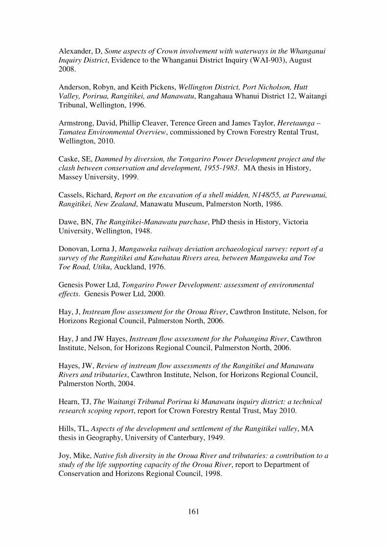
161
Alexander, D, Some aspects of Crown involvement with waterways in the Whanganui
Inquiry District, Evidence to the Whanganui District Inquiry (WAI-903), August
2008.
Anderson, Robyn, and Keith Pickens, Wellington District, Port Nicholson, Hutt
Valley, Porirua, Rangitikei, and Manawatu, Rangahaua Whanui District 12, Waitangi
Tribunal, Wellington, 1996.
Armstrong, David, Phillip Cleaver, Terence Green and James Taylor, Heretaunga –
Tamatea Environmental Overview, commissioned by Crown Forestry Rental Trust,
Wellington, 2010.
Caske, SE, Dammed by diversion, the Tongariro Power Development project and the
clash between conservation and development, 1955-1983. MA thesis in History,
Massey University, 1999.
Cassels, Richard, Report on the excavation of a shell midden, N148/55, at Parewanui,
Rangitikei, New Zealand, Manawatu Museum, Palmerston North, 1986.
Dawe, BN, The Rangitikei-Manawatu purchase, PhD thesis in History, Victoria
University, Wellington, 1948.
Donovan, Lorna J, Mangaweka railway deviation archaeological survey: report of a
survey of the Rangitikei and Kawhatau Rivers area, between Mangaweka and Toe
Toe Road, Utiku, Auckland, 1976.
Genesis Power Ltd, Tongariro Power Development: assessment of environmental
effects. Genesis Power Ltd, 2000.
Hay, J, Instream flow assessment for the Oroua River, Cawthron Institute, Nelson, for
Horizons Regional Council, Palmerston North, 2006.
Hay, J and JW Hayes, Instream flow assessment for the Pohangina River, Cawthron
Institute, Nelson, for Horizons Regional Council, Palmerston North, 2006.
Hayes, JW, Review of instream flow assessments of the Rangitikei and Manawatu
Rivers and tributaries, Cawthron Institute, Nelson, for Horizons Regional Council,
Palmerston North, 2004.
Hearn, TJ, The Waitangi Tribunal Porirua ki Manawatu inquiry district: a technical
research scoping report, report for Crown Forestry Rental Trust, May 2010.
Hills, TL, Aspects of the development and settlement of the Rangitikei valley, MA
thesis in Geography, University of Canterbury, 1949.
Joy, Mike, Native fish diversity in the Oroua River and tributaries: a contribution to a
study of the life supporting capacity of the Oroua River, report to Department of
Conservation and Horizons Regional Council, 1998.

162
Kingett Mitchell and Associates, Moawhango Pond pre-environmental effects
assessment, report prepared for Electricity Corporation of New Zealand, 1993.
Mainwaring, RG, The vital years: the small farm settlement of the Upper Oroua and
Upper Pohangina Valleys, 1885-1900, MA thesis in History, Victoria University,
Wellington, 1966.
Marr, Cathy, Crown impacts on customary Maori authority over the coast, inland
waterways (other than the Whanganui River) and associated mahinga kai in the
Whanganui Inquiry District, Evidence to the Whanganui District Inquiry (WAI-903),
2003.
Melvin, Matthew, Rangatiratanga,"Government", and the Rangitikei-Manawatu
purchase, Dissertation for M.A. in History, University of Auckland, 1995.
Milne, JDG, Upper quaternary geology of Rangitikei drainage basin, North Island,
New Zealand, PhD thesis in Geology, Victoria University, Wellington, 1973.
Moar, NT, The origins of Taihape; a study in secondary pioneering, MA thesis in
History, Victoria University College, Wellington, 1955.
Munday, Peter Michael, The geology of the Oroua Valley, M.Sc. thesis in Geology,
University of Auckland, 1977.
Pond, Wendy, The land with all woods and water, Waitangi Tribunal, Wellington,
Rangahaua Whanui National Theme U, 1997.
Rodway, Maurice Allan, The relative abundance, movement and growth of rainbow
trout (Salmo gairdneri) and brown trout (Salmo trutta) in the Rangitikei River, New
Zealand, MSc thesis in Zoology, Massey University, 1984.
Rogers, GM, Landscape history of Moawhango ecological district, PhD thesis in
Botany, Victoria University, Wellington, 1987.
Stirling, Bruce, and Evald Subasic, Taihape: Rangitikei ki Rangipo Inquiry District:
Technical Research Scoping Report, report for Crown Forestry Rental Trust, August
2010.
Thompson, Roger Campbell, Relationship of geology to slope failures in soft rocks of
the Taihape-Mangaweka area, central North Island, New Zealand, PhD thesis in
Geology, University of Auckland, 1982.
Walzl, T, Hydro-electricity issues: the Tongariro Power Development scheme.
Evidence to the Central North Island Inquiry (WAI-1200) and the National Park
Inquiry (WAI-1130), February 2005.
Walzl, T, Environmental impacts of the Tongariro Power Development scheme.
Evidence to the National Park Inquiry, July 2006. WAI-1130, Document #E12.

163
White, Ben, Inland waterways: lakes, Rangahaua Whanui Series National Theme Q,
Waitangi Tribunal, Wellington, 1998.
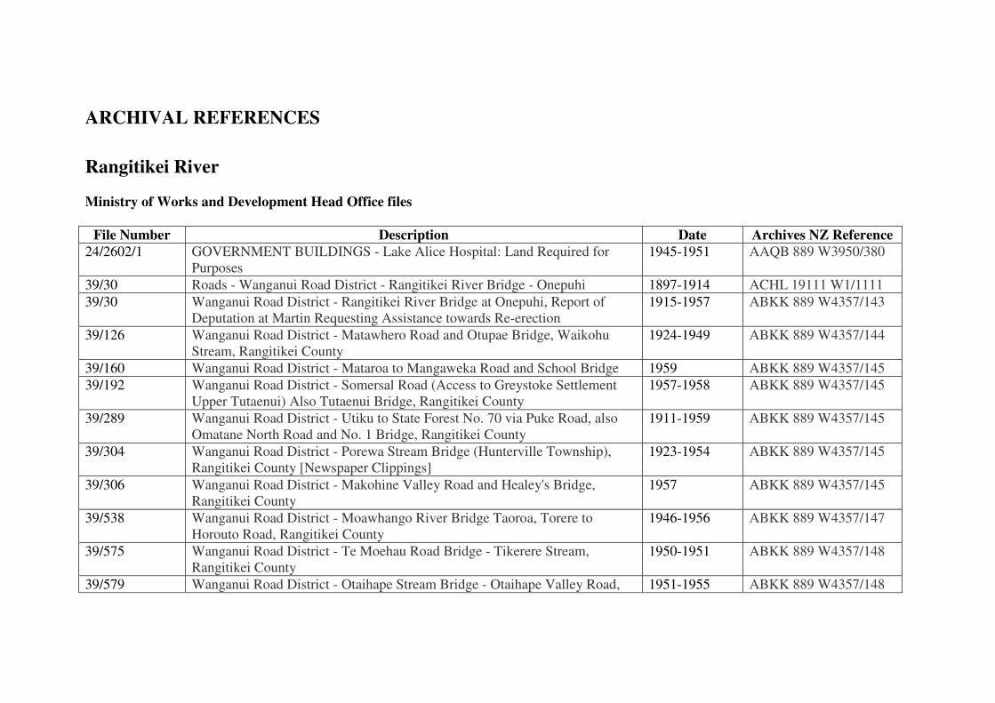
ARCHIVAL REFERENCES
Rangitikei River
Ministry of Works and Development Head Office files
File Number Description Date Archives NZ Reference
24/2602/1 GOVERNMENT BUILDINGS - Lake Alice Hospital: Land Required for
Purposes
1945-1951 AAQB 889 W3950/380
39/30 Roads - Wanganui Road District - Rangitikei River Bridge - Onepuhi 1897-1914 ACHL 19111 W1/1111
39/30 Wanganui Road District - Rangitikei River Bridge at Onepuhi, Report of
Deputation at Martin Requesting Assistance towards Re-erection
1915-1957 ABKK 889 W4357/143
39/126 Wanganui Road District - Matawhero Road and Otupae Bridge, Waikohu
Stream, Rangitikei County
1924-1949 ABKK 889 W4357/144
39/160 Wanganui Road District - Mataroa to Mangaweka Road and School Bridge 1959 ABKK 889 W4357/145
39/192 Wanganui Road District - Somersal Road (Access to Greystoke Settlement
Upper Tutaenui) Also Tutaenui Bridge, Rangitikei County
1957-1958 ABKK 889 W4357/145
39/289 Wanganui Road District - Utiku to State Forest No. 70 via Puke Road, also
Omatane North Road and No. 1 Bridge, Rangitikei County
1911-1959 ABKK 889 W4357/145
39/304 Wanganui Road District - Porewa Stream Bridge (Hunterville Township),
Rangitikei County [Newspaper Clippings]
1923-1954 ABKK 889 W4357/145
39/306 Wanganui Road District - Makohine Valley Road and Healey's Bridge,
Rangitikei County
1957 ABKK 889 W4357/145
39/538 Wanganui Road District - Moawhango River Bridge Taoroa, Torere to
Horouto Road, Rangitikei County
1946-1956 ABKK 889 W4357/147
39/575 Wanganui Road District - Te Moehau Road Bridge - Tikerere Stream,
Rangitikei County
1950-1951 ABKK 889 W4357/148
39/579 Wanganui Road District - Otaihape Stream Bridge - Otaihape Valley Road, 1951-1955 ABKK 889 W4357/148

165
Rangitikei County
39/580 Local Authorities: Wanganui Road District - Rangatira Road, Blocks II, III,
VI and X, Ongo SD [Survey District], Rangitikei County, also Bridges on
Rangatira Road
1951-1983 AAQU 889 W3428/50
39/583 Wanganui Road District - Moawhango River Bridge, Te Moehau Road,
Moawhango, Rangitikei County
1953-1955 ABKK 889 W4357/149
39/595 Wanganui Road District - Kakakino Stream Bridge, Taihape - Napier Road,
Rangitikei County
1955 ABKK 889 W4357/149
39/597 Wanganui Road District - Bridges Rangitikei County: Otuareiawa Stream
Bridge No. 1 Moawhango Valley Road, Otuareiawa Stream Bridge, Otuarei-
Pukeokahu Road, Kapuawhai Stream Bridge Moawhango Valley Road
1955 ABKK 889 W4357/149
39/598 Wanganui Road District - Moawhango Valley Road Bridge No. 2, Duncan's
Bridge, Rangitikei County
1955-1957 ABKK 889 W4357/149
39/604 Wanganui Road District - Tutaenui Stream Bridge, Kensington Road, Marton
Borough [Newspaper Cuttings]
1956-1957 ABKK 889 W4357/149
39/621 Wanganui Road District - Husband's Bridge, Porewa Stream, Pukeko -
Kararanga Road, Rangitikei County
1957 ABKK 889 W4357/149
40/21 Roads - Hawkes Bay Road District - Bridges across Rangitikei River 1914-1933 ACHL 19111 W1/1123
40/21 Roads - Hawkes Bay Road District - Bridges across Rangitikei River 1933-1941 ACHL 19111 W1/1123
40/21 Hawkes Bay Road District - Bridges Across Rangitikei River General
[Newspaper Cuttings and Photographs]
1942-1960 ABKK 889 W4357/150
40/276 Hawkes Bay Road District - Ngaruroro River Bridge, Napier - Taihape Road,
Hawke's Bay County
1926-1959 ABKK 889 W4357/152
41/161 Wellington Road District - Otara Road and Mangamako Bridge, Kiwitea
County
1914-1955 ABKK 889 W4357/159
41/292 Wellington Road District - Mangarere Road and Mangarere Stream Bridge,
Kiwitea County
1955-1959 ABKK 889 W4357/163
41/385 Wellington Road District - Kawhatau (Upper) and Hikurangi River Bridges,
Rangitikei County
1918-1956 ABKK 889 W4357/164
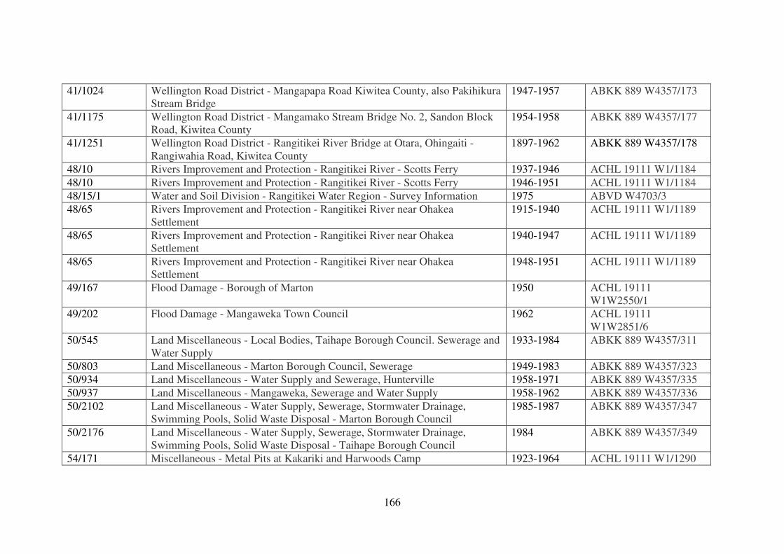
166
41/1024 Wellington Road District - Mangapapa Road Kiwitea County, also Pakihikura
Stream Bridge
1947-1957 ABKK 889 W4357/173
41/1175 Wellington Road District - Mangamako Stream Bridge No. 2, Sandon Block
Road, Kiwitea County
1954-1958 ABKK 889 W4357/177
41/1251 Wellington Road District - Rangitikei River Bridge at Otara, Ohingaiti -
Rangiwahia Road, Kiwitea County
1897-1962 ABKK 889 W4357/178
48/10 Rivers Improvement and Protection - Rangitikei River - Scotts Ferry 1937-1946 ACHL 19111 W1/1184
48/10 Rivers Improvement and Protection - Rangitikei River - Scotts Ferry 1946-1951 ACHL 19111 W1/1184
48/15/1 Water and Soil Division - Rangitikei Water Region - Survey Information 1975 ABVD W4703/3
48/65 Rivers Improvement and Protection - Rangitikei River near Ohakea
Settlement
1915-1940 ACHL 19111 W1/1189
48/65 Rivers Improvement and Protection - Rangitikei River near Ohakea
Settlement
1940-1947 ACHL 19111 W1/1189
48/65 Rivers Improvement and Protection - Rangitikei River near Ohakea
Settlement
1948-1951 ACHL 19111 W1/1189
49/167 Flood Damage - Borough of Marton 1950 ACHL 19111
W1W2550/1
49/202 Flood Damage - Mangaweka Town Council 1962 ACHL 19111
W1W2851/6
50/545 Land Miscellaneous - Local Bodies, Taihape Borough Council. Sewerage and
Water Supply
1933-1984 ABKK 889 W4357/311
50/803 Land Miscellaneous - Marton Borough Council, Sewerage 1949-1983 ABKK 889 W4357/323
50/934 Land Miscellaneous - Water Supply and Sewerage, Hunterville 1958-1971 ABKK 889 W4357/335
50/937 Land Miscellaneous - Mangaweka, Sewerage and Water Supply 1958-1962 ABKK 889 W4357/336
50/2102 Land Miscellaneous - Water Supply, Sewerage, Stormwater Drainage,
Swimming Pools, Solid Waste Disposal - Marton Borough Council
1985-1987 ABKK 889 W4357/347
50/2176 Land Miscellaneous - Water Supply, Sewerage, Stormwater Drainage,
Swimming Pools, Solid Waste Disposal - Taihape Borough Council
1984 ABKK 889 W4357/349
54/171 Miscellaneous - Metal Pits at Kakariki and Harwoods Camp 1923-1964 ACHL 19111 W1/1290
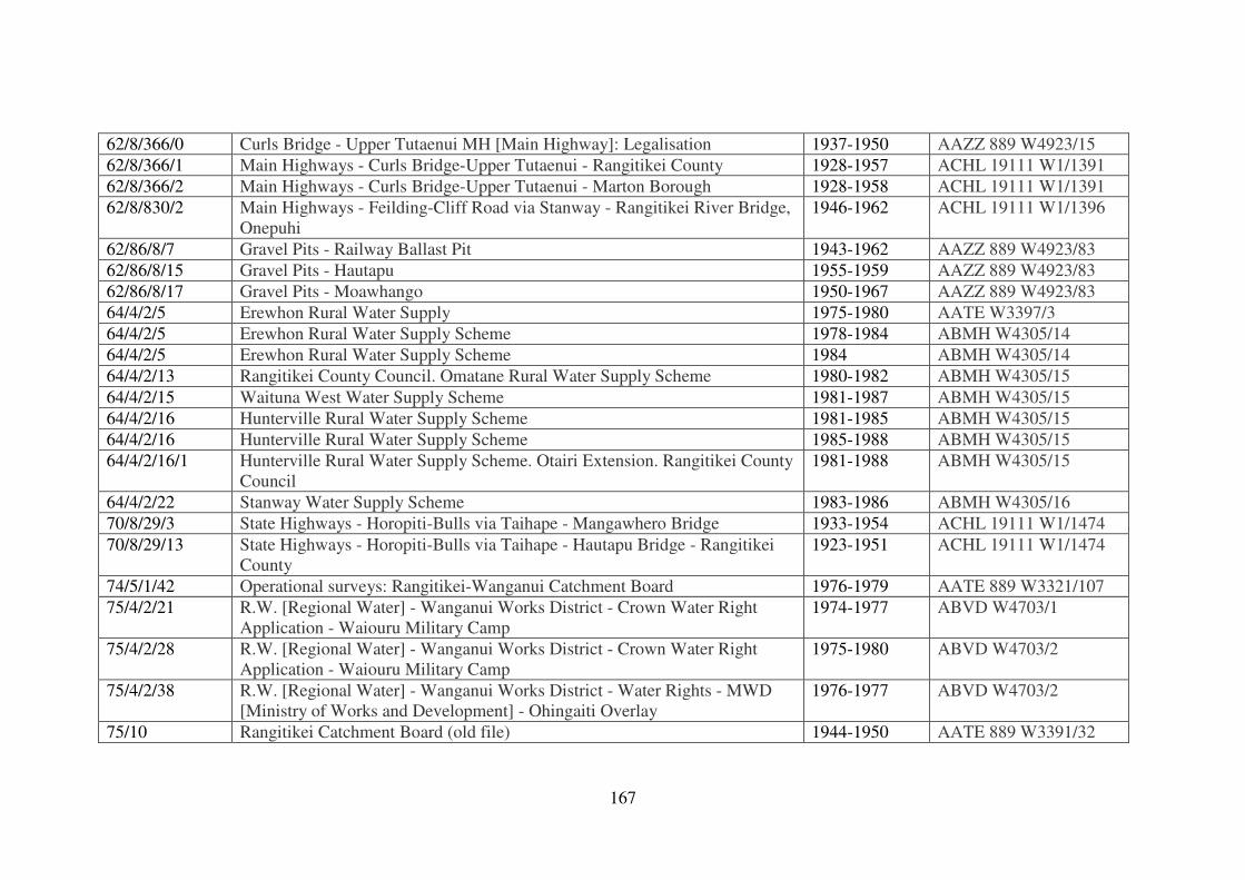
167
62/8/366/0 Curls Bridge - Upper Tutaenui MH [Main Highway]: Legalisation 1937-1950 AAZZ 889 W4923/15
62/8/366/1 Main Highways - Curls Bridge-Upper Tutaenui - Rangitikei County 1928-1957 ACHL 19111 W1/1391
62/8/366/2 Main Highways - Curls Bridge-Upper Tutaenui - Marton Borough 1928-1958 ACHL 19111 W1/1391
62/8/830/2 Main Highways - Feilding-Cliff Road via Stanway - Rangitikei River Bridge,
Onepuhi
1946-1962 ACHL 19111 W1/1396
62/86/8/7 Gravel Pits - Railway Ballast Pit 1943-1962 AAZZ 889 W4923/83
62/86/8/15 Gravel Pits - Hautapu 1955-1959 AAZZ 889 W4923/83
62/86/8/17 Gravel Pits - Moawhango 1950-1967 AAZZ 889 W4923/83
64/4/2/5 Erewhon Rural Water Supply 1975-1980 AATE W3397/3
64/4/2/5 Erewhon Rural Water Supply Scheme 1978-1984 ABMH W4305/14
64/4/2/5 Erewhon Rural Water Supply Scheme 1984 ABMH W4305/14
64/4/2/13 Rangitikei County Council. Omatane Rural Water Supply Scheme 1980-1982 ABMH W4305/15
64/4/2/15 Waituna West Water Supply Scheme 1981-1987 ABMH W4305/15
64/4/2/16 Hunterville Rural Water Supply Scheme 1981-1985 ABMH W4305/15
64/4/2/16 Hunterville Rural Water Supply Scheme 1985-1988 ABMH W4305/15
64/4/2/16/1 Hunterville Rural Water Supply Scheme. Otairi Extension. Rangitikei County
Council
1981-1988 ABMH W4305/15
64/4/2/22 Stanway Water Supply Scheme 1983-1986 ABMH W4305/16
70/8/29/3 State Highways - Horopiti-Bulls via Taihape - Mangawhero Bridge 1933-1954 ACHL 19111 W1/1474
70/8/29/13 State Highways - Horopiti-Bulls via Taihape - Hautapu Bridge - Rangitikei
County
1923-1951 ACHL 19111 W1/1474
74/5/1/42 Operational surveys: Rangitikei-Wanganui Catchment Board 1976-1979 AATE 889 W3321/107
75/4/2/21 R.W. [Regional Water] - Wanganui Works District - Crown Water Right
Application - Waiouru Military Camp
1974-1977 ABVD W4703/1
75/4/2/28 R.W. [Regional Water] - Wanganui Works District - Crown Water Right
Application - Waiouru Military Camp
1975-1980 ABVD W4703/2
75/4/2/38 R.W. [Regional Water] - Wanganui Works District - Water Rights - MWD
[Ministry of Works and Development] - Ohingaiti Overlay
1976-1977 ABVD W4703/2
75/10 Rangitikei Catchment Board (old file) 1944-1950 AATE 889 W3391/32
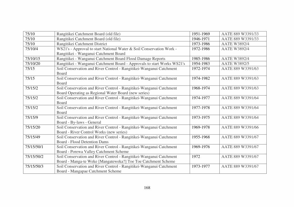
168
75/10 Rangitikei Catchment Board (old file) 1951-1969 AATE 889 W3391/33
75/10 Rangitikei Catchment Board (old file) 1946-1971 AATE 889 W3391/33
75/10 Rangitikei Catchment District 1973-1986 AATE W3892/4
75/10/4 WS21's - Approval to start National Water & Soil Conservation Work -
Rangitikei - Wanganui Catchment Board
1972-1986 AATE W3892/4
75/10/15 Rangitikei - Wanganui Catchment Board Flood Damage Reports 1985-1986 AATE W3892/4
75/10/20 Rangitikei - Wanganui Catchment Board - Approvals to start Works WS21's 1954-1983 AATE W3892/5
75/15 Soil Conservation and River Control - Rangitikei-Wanganui Catchment
Board
1972-1974 AATE 889 W3391/63
75/15 Soil Conservation and River Control - Rangitikei-Wanganui Catchment
Board
1974-1982 AATE 889 W3391/63
75/15/2 Soil Conservation and River Control - Rangitikei-Wanganui Catchment
Board Operating as Regional Water Board (new series)
1968-1974 AATE 889 W3391/63
75/15/2 Soil Conservation and River Control - Rangitikei-Wanganui Catchment
Board
1974-1977 AATE 889 W3391/64
75/15/2 Soil Conservation and River Control - Rangitikei-Wanganui Catchment
Board
1977-1978 AATE 889 W3391/64
75/15/9 Soil Conservation and River Control - Rangitikei-Wanganui Catchment
Board - By-laws - General
1973-1975 AATE 889 W3391/64
75/15/20 Soil Conservation and River Control - Rangitikei-Wanganui Catchment
Board - River Control Works (new series)
1969-1978 AATE 889 W3391/66
75/15/49 Soil Conservation and River Control - Rangitikei-Wanganui Catchment
Board - Flood Detention Dams
1955-1968 AATE 889 W3391/67
75/15/50/1 Soil Conservation and River Control - Rangitikei-Wanganui Catchment
Board - Porewa Valley Catchment Scheme
1969-1976 AATE 889 W3391/67
75/15/50/2 Soil Conservation and River Control - Rangitikei-Wanganui Catchment
Board - Manga-te Weke [Mangateweka?] Toe Toe Catchment Scheme
1972 AATE 889 W3391/67
75/15/50/3 Soil Conservation and River Control - Rangitikei-Wanganui Catchment
Board - Mangapae Catchment Scheme
1973-1977 AATE 889 W3391/67
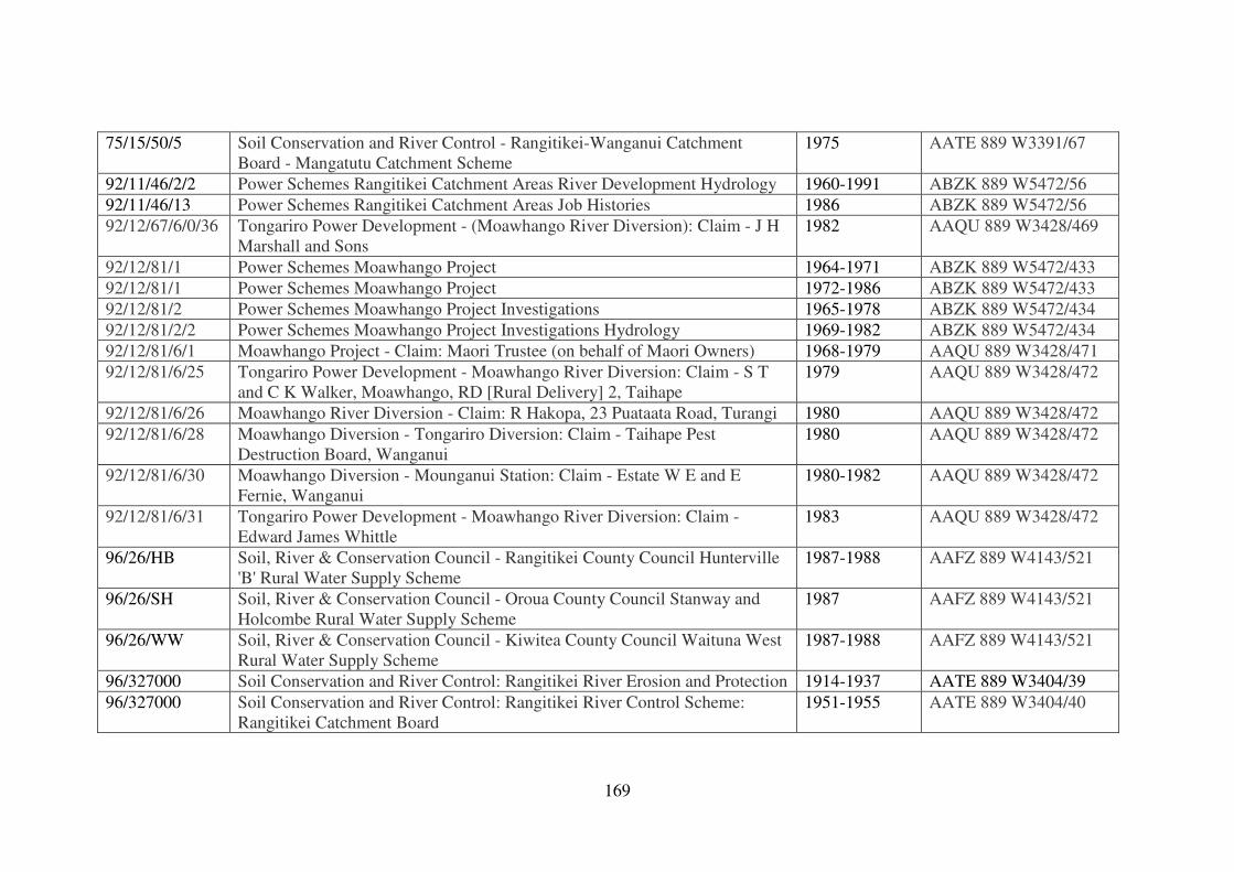
169
75/15/50/5 Soil Conservation and River Control - Rangitikei-Wanganui Catchment
Board - Mangatutu Catchment Scheme
1975 AATE 889 W3391/67
92/11/46/2/2 Power Schemes Rangitikei Catchment Areas River Development Hydrology 1960-1991 ABZK 889 W5472/56
92/11/46/13 Power Schemes Rangitikei Catchment Areas Job Histories 1986 ABZK 889 W5472/56
92/12/67/6/0/36 Tongariro Power Development - (Moawhango River Diversion): Claim - J H
Marshall and Sons
1982 AAQU 889 W3428/469
92/12/81/1 Power Schemes Moawhango Project 1964-1971 ABZK 889 W5472/433
92/12/81/1 Power Schemes Moawhango Project 1972-1986 ABZK 889 W5472/433
92/12/81/2 Power Schemes Moawhango Project Investigations 1965-1978 ABZK 889 W5472/434
92/12/81/2/2 Power Schemes Moawhango Project Investigations Hydrology 1969-1982 ABZK 889 W5472/434
92/12/81/6/1 Moawhango Project - Claim: Maori Trustee (on behalf of Maori Owners) 1968-1979 AAQU 889 W3428/471
92/12/81/6/25 Tongariro Power Development - Moawhango River Diversion: Claim - S T
and C K Walker, Moawhango, RD [Rural Delivery] 2, Taihape
1979 AAQU 889 W3428/472
92/12/81/6/26 Moawhango River Diversion - Claim: R Hakopa, 23 Puataata Road, Turangi 1980 AAQU 889 W3428/472
92/12/81/6/28 Moawhango Diversion - Tongariro Diversion: Claim - Taihape Pest
Destruction Board, Wanganui
1980 AAQU 889 W3428/472
92/12/81/6/30 Moawhango Diversion - Mounganui Station: Claim - Estate W E and E
Fernie, Wanganui
1980-1982 AAQU 889 W3428/472
92/12/81/6/31 Tongariro Power Development - Moawhango River Diversion: Claim -
Edward James Whittle
1983 AAQU 889 W3428/472
96/26/HB Soil, River & Conservation Council - Rangitikei County Council Hunterville
'B' Rural Water Supply Scheme
1987-1988 AAFZ 889 W4143/521
96/26/SH Soil, River & Conservation Council - Oroua County Council Stanway and
Holcombe Rural Water Supply Scheme
1987 AAFZ 889 W4143/521
96/26/WW Soil, River & Conservation Council - Kiwitea County Council Waituna West
Rural Water Supply Scheme
1987-1988 AAFZ 889 W4143/521
96/327000 Soil Conservation and River Control: Rangitikei River Erosion and Protection 1914-1937 AATE 889 W3404/39
96/327000 Soil Conservation and River Control: Rangitikei River Control Scheme:
Rangitikei Catchment Board
1951-1955 AATE 889 W3404/40
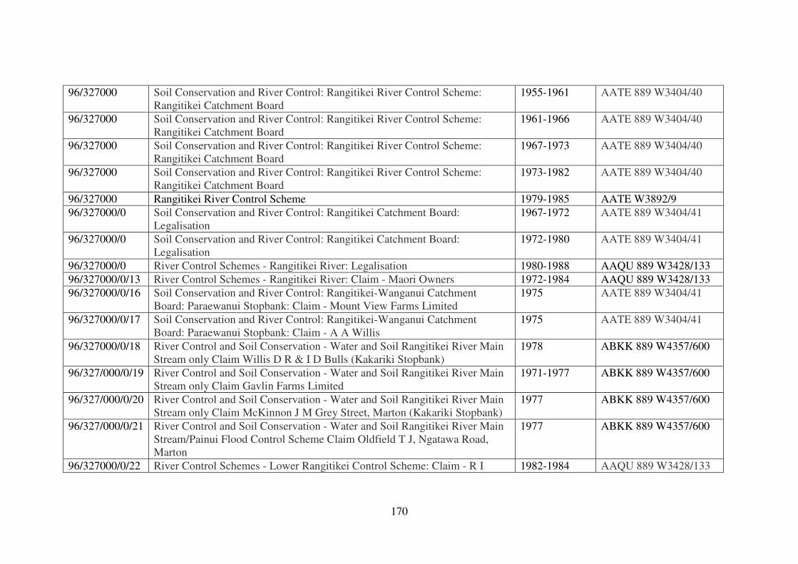
170
96/327000 Soil Conservation and River Control: Rangitikei River Control Scheme:
Rangitikei Catchment Board
1955-1961 AATE 889 W3404/40
96/327000 Soil Conservation and River Control: Rangitikei River Control Scheme:
Rangitikei Catchment Board
1961-1966 AATE 889 W3404/40
96/327000 Soil Conservation and River Control: Rangitikei River Control Scheme:
Rangitikei Catchment Board
1967-1973 AATE 889 W3404/40
96/327000 Soil Conservation and River Control: Rangitikei River Control Scheme:
Rangitikei Catchment Board
1973-1982 AATE 889 W3404/40
96/327000 Rangitikei River Control Scheme 1979-1985 AATE W3892/9
96/327000/0 Soil Conservation and River Control: Rangitikei Catchment Board:
Legalisation
1967-1972 AATE 889 W3404/41
96/327000/0 Soil Conservation and River Control: Rangitikei Catchment Board:
Legalisation
1972-1980 AATE 889 W3404/41
96/327000/0 River Control Schemes - Rangitikei River: Legalisation 1980-1988 AAQU 889 W3428/133
96/327000/0/13 River Control Schemes - Rangitikei River: Claim - Maori Owners 1972-1984 AAQU 889 W3428/133
96/327000/0/16 Soil Conservation and River Control: Rangitikei-Wanganui Catchment
Board: Paraewanui Stopbank: Claim - Mount View Farms Limited
1975 AATE 889 W3404/41
96/327000/0/17 Soil Conservation and River Control: Rangitikei-Wanganui Catchment
Board: Paraewanui Stopbank: Claim - A A Willis
1975 AATE 889 W3404/41
96/327000/0/18 River Control and Soil Conservation - Water and Soil Rangitikei River Main
Stream only Claim Willis D R & I D Bulls (Kakariki Stopbank)
1978 ABKK 889 W4357/600
96/327/000/0/19 River Control and Soil Conservation - Water and Soil Rangitikei River Main
Stream only Claim Gavlin Farms Limited
1971-1977 ABKK 889 W4357/600
96/327/000/0/20 River Control and Soil Conservation - Water and Soil Rangitikei River Main
Stream only Claim McKinnon J M Grey Street, Marton (Kakariki Stopbank)
1977 ABKK 889 W4357/600
96/327/000/0/21 River Control and Soil Conservation - Water and Soil Rangitikei River Main
Stream/Painui Flood Control Scheme Claim Oldfield T J, Ngatawa Road,
Marton
1977 ABKK 889 W4357/600
96/327000/0/22 River Control Schemes - Lower Rangitikei Control Scheme: Claim - R I 1982-1984 AAQU 889 W3428/133
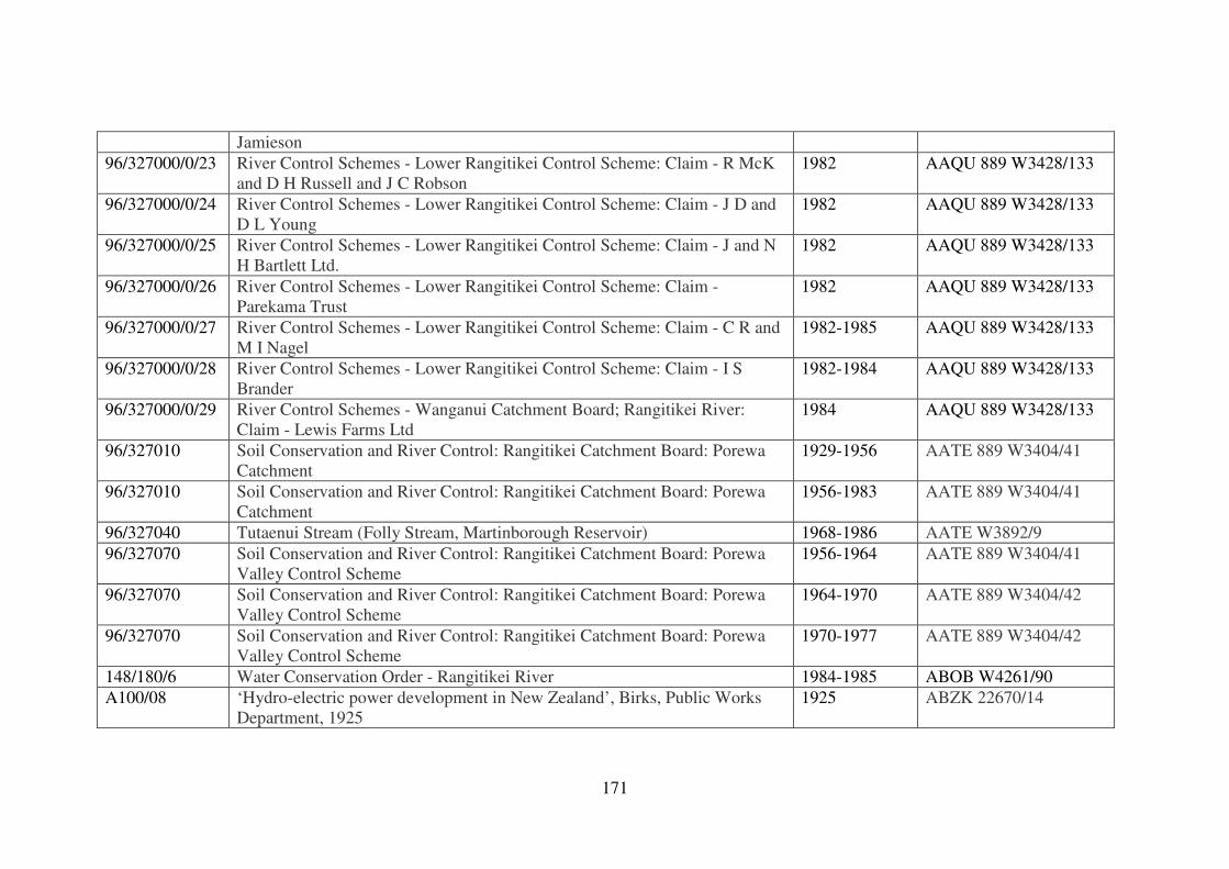
171
Jamieson
96/327000/0/23 River Control Schemes - Lower Rangitikei Control Scheme: Claim - R McK
and D H Russell and J C Robson
1982 AAQU 889 W3428/133
96/327000/0/24 River Control Schemes - Lower Rangitikei Control Scheme: Claim - J D and
D L Young
1982 AAQU 889 W3428/133
96/327000/0/25 River Control Schemes - Lower Rangitikei Control Scheme: Claim - J and N
H Bartlett Ltd.
1982 AAQU 889 W3428/133
96/327000/0/26 River Control Schemes - Lower Rangitikei Control Scheme: Claim -
Parekama Trust
1982 AAQU 889 W3428/133
96/327000/0/27 River Control Schemes - Lower Rangitikei Control Scheme: Claim - C R and
M I Nagel
1982-1985 AAQU 889 W3428/133
96/327000/0/28 River Control Schemes - Lower Rangitikei Control Scheme: Claim - I S
Brander
1982-1984 AAQU 889 W3428/133
96/327000/0/29 River Control Schemes - Wanganui Catchment Board; Rangitikei River:
Claim - Lewis Farms Ltd
1984 AAQU 889 W3428/133
96/327010 Soil Conservation and River Control: Rangitikei Catchment Board: Porewa
Catchment
1929-1956 AATE 889 W3404/41
96/327010 Soil Conservation and River Control: Rangitikei Catchment Board: Porewa
Catchment
1956-1983 AATE 889 W3404/41
96/327040 Tutaenui Stream (Folly Stream, Martinborough Reservoir) 1968-1986 AATE W3892/9
96/327070 Soil Conservation and River Control: Rangitikei Catchment Board: Porewa
Valley Control Scheme
1956-1964 AATE 889 W3404/41
96/327070 Soil Conservation and River Control: Rangitikei Catchment Board: Porewa
Valley Control Scheme
1964-1970 AATE 889 W3404/42
96/327070 Soil Conservation and River Control: Rangitikei Catchment Board: Porewa
Valley Control Scheme
1970-1977 AATE 889 W3404/42
148/180/6 Water Conservation Order - Rangitikei River 1984-1985 ABOB W4261/90
A100/08 ‘Hydro-electric power development in New Zealand’, Birks, Public Works
Department, 1925
1925 ABZK 22670/14
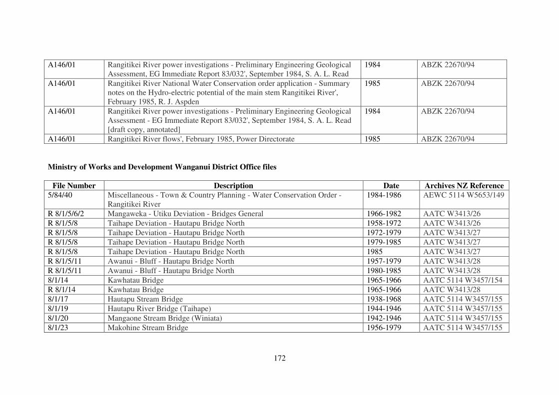
172
A146/01 Rangitikei River power investigations - Preliminary Engineering Geological
Assessment, EG Immediate Report 83/032', September 1984, S. A. L. Read
1984 ABZK 22670/94
A146/01 Rangitikei River National Water Conservation order application - Summary
notes on the Hydro-electric potential of the main stem Rangitikei River',
February 1985, R. J. Aspden
1985 ABZK 22670/94
A146/01 Rangitikei River power investigations - Preliminary Engineering Geological
Assessment - EG Immediate Report 83/032', September 1984, S. A. L. Read
[draft copy, annotated]
1984 ABZK 22670/94
A146/01 Rangitikei River flows', February 1985, Power Directorate 1985 ABZK 22670/94
Ministry of Works and Development Wanganui District Office files
File Number Description Date Archives NZ Reference
5/84/40 Miscellaneous - Town & Country Planning - Water Conservation Order -
Rangitikei River
1984-1986 AEWC 5114 W5653/149
R 8/1/5/6/2 Mangaweka - Utiku Deviation - Bridges General 1966-1982 AATC W3413/26
R 8/1/5/8 Taihape Deviation - Hautapu Bridge North 1958-1972 AATC W3413/26
R 8/1/5/8 Taihape Deviation - Hautapu Bridge North 1972-1979 AATC W3413/27
R 8/1/5/8 Taihape Deviation - Hautapu Bridge North 1979-1985 AATC W3413/27
R 8/1/5/8 Taihape Deviation - Hautapu Bridge North 1985 AATC W3413/27
R 8/1/5/11 Awanui - Bluff - Hautapu Bridge North 1957-1979 AATC W3413/28
R 8/1/5/11 Awanui - Bluff - Hautapu Bridge North 1980-1985 AATC W3413/28
8/1/14 Kawhatau Bridge 1965-1966 AATC 5114 W3457/154
R 8/1/14 Kawhatau Bridge 1965-1966 AATC W3413/28
8/1/17 Hautapu Stream Bridge 1938-1968 AATC 5114 W3457/155
8/1/19 Hautapu River Bridge (Taihape) 1944-1946 AATC 5114 W3457/155
8/1/20 Mangaone Stream Bridge (Winiata) 1942-1946 AATC 5114 W3457/155
8/1/23 Makohine Stream Bridge 1956-1979 AATC 5114 W3457/155
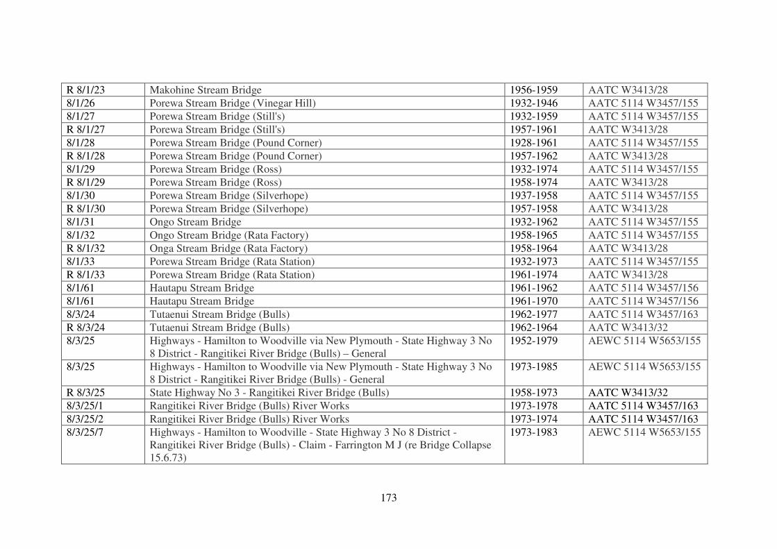
173
R 8/1/23 Makohine Stream Bridge 1956-1959 AATC W3413/28
8/1/26 Porewa Stream Bridge (Vinegar Hill) 1932-1946 AATC 5114 W3457/155
8/1/27 Porewa Stream Bridge (Still's) 1932-1959 AATC 5114 W3457/155
R 8/1/27 Porewa Stream Bridge (Still's) 1957-1961 AATC W3413/28
8/1/28 Porewa Stream Bridge (Pound Corner) 1928-1961 AATC 5114 W3457/155
R 8/1/28 Porewa Stream Bridge (Pound Corner) 1957-1962 AATC W3413/28
8/1/29 Porewa Stream Bridge (Ross) 1932-1974 AATC 5114 W3457/155
R 8/1/29 Porewa Stream Bridge (Ross) 1958-1974 AATC W3413/28
8/1/30 Porewa Stream Bridge (Silverhope) 1937-1958 AATC 5114 W3457/155
R 8/1/30 Porewa Stream Bridge (Silverhope) 1957-1958 AATC W3413/28
8/1/31 Ongo Stream Bridge 1932-1962 AATC 5114 W3457/155
8/1/32 Ongo Stream Bridge (Rata Factory) 1958-1965 AATC 5114 W3457/155
R 8/1/32 Onga Stream Bridge (Rata Factory) 1958-1964 AATC W3413/28
8/1/33 Porewa Stream Bridge (Rata Station) 1932-1973 AATC 5114 W3457/155
R 8/1/33 Porewa Stream Bridge (Rata Station) 1961-1974 AATC W3413/28
8/1/61 Hautapu Stream Bridge 1961-1962 AATC 5114 W3457/156
8/1/61 Hautapu Stream Bridge 1961-1970 AATC 5114 W3457/156
8/3/24 Tutaenui Stream Bridge (Bulls) 1962-1977 AATC 5114 W3457/163
R 8/3/24 Tutaenui Stream Bridge (Bulls) 1962-1964 AATC W3413/32
8/3/25 Highways - Hamilton to Woodville via New Plymouth - State Highway 3 No
8 District - Rangitikei River Bridge (Bulls) – General
1952-1979 AEWC 5114 W5653/155
8/3/25 Highways - Hamilton to Woodville via New Plymouth - State Highway 3 No
8 District - Rangitikei River Bridge (Bulls) - General
1973-1985 AEWC 5114 W5653/155
R 8/3/25 State Highway No 3 - Rangitikei River Bridge (Bulls) 1958-1973 AATC W3413/32
8/3/25/1 Rangitikei River Bridge (Bulls) River Works 1973-1978 AATC 5114 W3457/163
8/3/25/2 Rangitikei River Bridge (Bulls) River Works 1973-1974 AATC 5114 W3457/163
8/3/25/7 Highways - Hamilton to Woodville - State Highway 3 No 8 District -
Rangitikei River Bridge (Bulls) - Claim - Farrington M J (re Bridge Collapse
15.6.73)
1973-1983 AEWC 5114 W5653/155
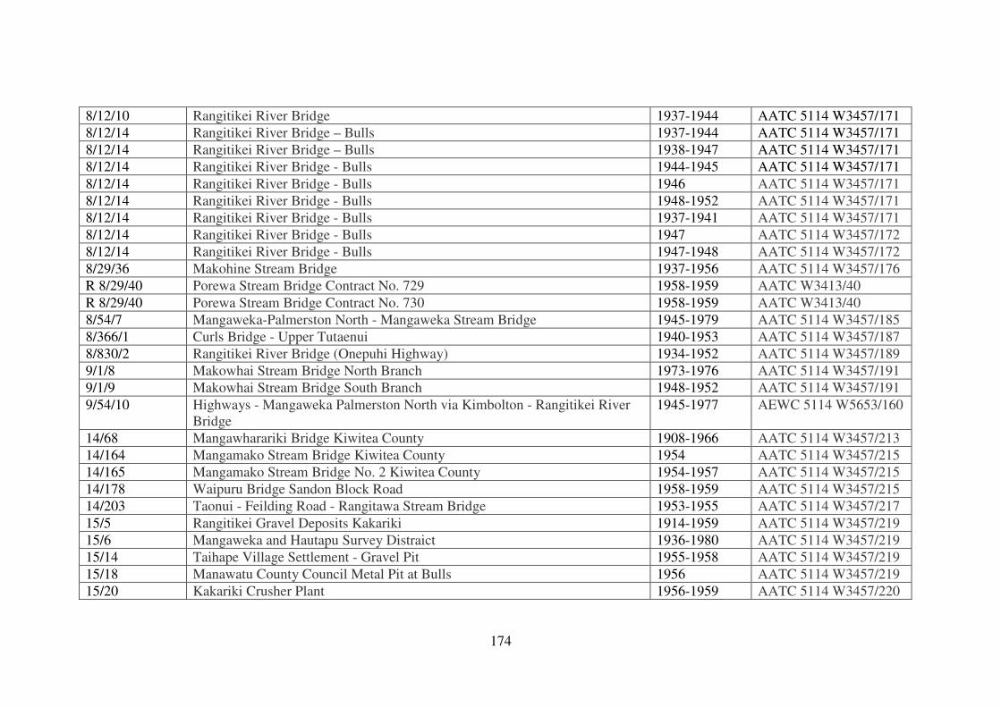
174
8/12/10 Rangitikei River Bridge 1937-1944 AATC 5114 W3457/171
8/12/14 Rangitikei River Bridge – Bulls 1937-1944 AATC 5114 W3457/171
8/12/14 Rangitikei River Bridge – Bulls 1938-1947 AATC 5114 W3457/171
8/12/14 Rangitikei River Bridge - Bulls 1944-1945 AATC 5114 W3457/171
8/12/14 Rangitikei River Bridge - Bulls 1946 AATC 5114 W3457/171
8/12/14 Rangitikei River Bridge - Bulls 1948-1952 AATC 5114 W3457/171
8/12/14 Rangitikei River Bridge - Bulls 1937-1941 AATC 5114 W3457/171
8/12/14 Rangitikei River Bridge - Bulls 1947 AATC 5114 W3457/172
8/12/14 Rangitikei River Bridge - Bulls 1947-1948 AATC 5114 W3457/172
8/29/36 Makohine Stream Bridge 1937-1956 AATC 5114 W3457/176
R 8/29/40 Porewa Stream Bridge Contract No. 729 1958-1959 AATC W3413/40
R 8/29/40 Porewa Stream Bridge Contract No. 730 1958-1959 AATC W3413/40
8/54/7 Mangaweka-Palmerston North - Mangaweka Stream Bridge 1945-1979 AATC 5114 W3457/185
8/366/1 Curls Bridge - Upper Tutaenui 1940-1953 AATC 5114 W3457/187
8/830/2 Rangitikei River Bridge (Onepuhi Highway) 1934-1952 AATC 5114 W3457/189
9/1/8 Makowhai Stream Bridge North Branch 1973-1976 AATC 5114 W3457/191
9/1/9 Makowhai Stream Bridge South Branch 1948-1952 AATC 5114 W3457/191
9/54/10 Highways - Mangaweka Palmerston North via Kimbolton - Rangitikei River
Bridge
1945-1977 AEWC 5114 W5653/160
14/68 Mangawharariki Bridge Kiwitea County 1908-1966 AATC 5114 W3457/213
14/164 Mangamako Stream Bridge Kiwitea County 1954 AATC 5114 W3457/215
14/165 Mangamako Stream Bridge No. 2 Kiwitea County 1954-1957 AATC 5114 W3457/215
14/178 Waipuru Bridge Sandon Block Road 1958-1959 AATC 5114 W3457/215
14/203 Taonui - Feilding Road - Rangitawa Stream Bridge 1953-1955 AATC 5114 W3457/217
15/5 Rangitikei Gravel Deposits Kakariki 1914-1959 AATC 5114 W3457/219
15/6 Mangaweka and Hautapu Survey Distraict 1936-1980 AATC 5114 W3457/219
15/14 Taihape Village Settlement - Gravel Pit 1955-1958 AATC 5114 W3457/219
15/18 Manawatu County Council Metal Pit at Bulls 1956 AATC 5114 W3457/219
15/20 Kakariki Crusher Plant 1956-1959 AATC 5114 W3457/220
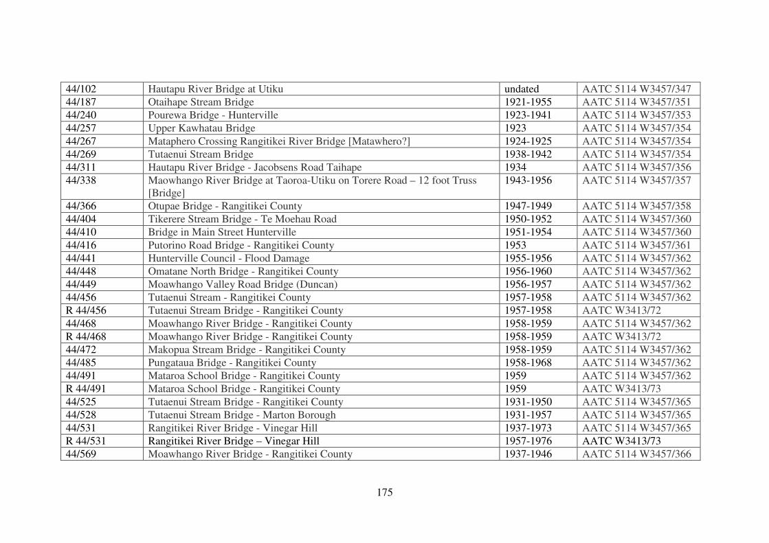
175
44/102 Hautapu River Bridge at Utiku undated AATC 5114 W3457/347
44/187 Otaihape Stream Bridge 1921-1955 AATC 5114 W3457/351
44/240 Pourewa Bridge - Hunterville 1923-1941 AATC 5114 W3457/353
44/257 Upper Kawhatau Bridge 1923 AATC 5114 W3457/354
44/267 Mataphero Crossing Rangitikei River Bridge [Matawhero?] 1924-1925 AATC 5114 W3457/354
44/269 Tutaenui Stream Bridge 1938-1942 AATC 5114 W3457/354
44/311 Hautapu River Bridge - Jacobsens Road Taihape 1934 AATC 5114 W3457/356
44/338 Maowhango River Bridge at Taoroa-Utiku on Torere Road – 12 foot Truss
[Bridge]
1943-1956 AATC 5114 W3457/357
44/366 Otupae Bridge - Rangitikei County 1947-1949 AATC 5114 W3457/358
44/404 Tikerere Stream Bridge - Te Moehau Road 1950-1952 AATC 5114 W3457/360
44/410 Bridge in Main Street Hunterville 1951-1954 AATC 5114 W3457/360
44/416 Putorino Road Bridge - Rangitikei County 1953 AATC 5114 W3457/361
44/441 Hunterville Council - Flood Damage 1955-1956 AATC 5114 W3457/362
44/448 Omatane North Bridge - Rangitikei County 1956-1960 AATC 5114 W3457/362
44/449 Moawhango Valley Road Bridge (Duncan) 1956-1957 AATC 5114 W3457/362
44/456 Tutaenui Stream - Rangitikei County 1957-1958 AATC 5114 W3457/362
R 44/456 Tutaenui Stream Bridge - Rangitikei County 1957-1958 AATC W3413/72
44/468 Moawhango River Bridge - Rangitikei County 1958-1959 AATC 5114 W3457/362
R 44/468 Moawhango River Bridge - Rangitikei County 1958-1959 AATC W3413/72
44/472 Makopua Stream Bridge - Rangitikei County 1958-1959 AATC 5114 W3457/362
44/485 Pungataua Bridge - Rangitikei County 1958-1968 AATC 5114 W3457/362
44/491 Mataroa School Bridge - Rangitikei County 1959 AATC 5114 W3457/362
R 44/491 Mataroa School Bridge - Rangitikei County 1959 AATC W3413/73
44/525 Tutaenui Stream Bridge - Rangitikei County 1931-1950 AATC 5114 W3457/365
44/528 Tutaenui Stream Bridge - Marton Borough 1931-1957 AATC 5114 W3457/365
44/531 Rangitikei River Bridge - Vinegar Hill 1937-1973 AATC 5114 W3457/365
R 44/531 Rangitikei River Bridge – Vinegar Hill 1957-1976 AATC W3413/73
44/569 Moawhango River Bridge - Rangitikei County 1937-1946 AATC 5114 W3457/366
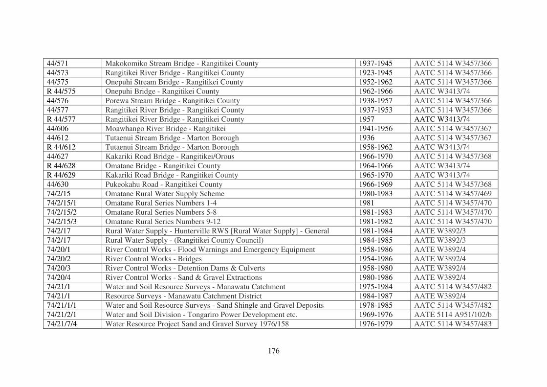
176
44/571 Makokomiko Stream Bridge - Rangitikei County 1937-1945 AATC 5114 W3457/366
44/573 Rangitikei River Bridge - Rangitikei County 1923-1945 AATC 5114 W3457/366
44/575 Onepuhi Stream Bridge - Rangitikei County 1952-1962 AATC 5114 W3457/366
R 44/575 Onepuhi Bridge - Rangitikei County 1962-1966 AATC W3413/74
44/576 Porewa Stream Bridge - Rangitikei County 1938-1957 AATC 5114 W3457/366
44/577 Rangitikei River Bridge - Rangitikei County 1937-1953 AATC 5114 W3457/366
R 44/577 Rangitikei River Bridge - Rangitikei County 1957 AATC W3413/74
44/606 Moawhango River Bridge - Rangitikei 1941-1956 AATC 5114 W3457/367
44/612 Tutaenui Stream Bridge - Marton Borough 1936 AATC 5114 W3457/367
R 44/612 Tutaenui Stream Bridge - Marton Borough 1958-1962 AATC W3413/74
44/627 Kakariki Road Bridge - Rangitikei/Orous 1966-1970 AATC 5114 W3457/368
R 44/628 Omatane Bridge - Rangitikei County 1964-1966 AATC W3413/74
R 44/629 Kakariki Road Bridge - Rangitikei County 1965-1970 AATC W3413/74
44/630 Pukeokahu Road - Rangitikei County 1966-1969 AATC 5114 W3457/368
74/2/15 Omatane Rural Water Supply Scheme 1980-1983 AATC 5114 W3457/469
74/2/15/1 Omatane Rural Series Numbers 1-4 1981 AATC 5114 W3457/470
74/2/15/2 Omatane Rural Series Numbers 5-8 1981-1983 AATC 5114 W3457/470
74/2/15/3 Omatane Rural Series Numbers 9-12 1981-1982 AATC 5114 W3457/470
74/2/17 Rural Water Supply - Hunterville RWS [Rural Water Supply] - General 1981-1984 AATE W3892/3
74/2/17 Rural Water Supply - (Rangitikei County Council) 1984-1985 AATE W3892/3
74/20/1 River Control Works - Flood Warnings and Emergency Equipment 1958-1986 AATE W3892/4
74/20/2 River Control Works - Bridges 1954-1986 AATE W3892/4
74/20/3 River Control Works - Detention Dams & Culverts 1958-1980 AATE W3892/4
74/20/4 River Control Works - Sand & Gravel Extractions 1980-1986 AATE W3892/4
74/21/1 Water and Soil Resource Surveys - Manawatu Catchment 1975-1984 AATC 5114 W3457/482
74/21/1 Resource Surveys - Manawatu Catchment District 1984-1987 AATE W3892/4
74/21/1/1 Water and Soil Resource Surveys - Sand Shingle and Gravel Deposits 1978-1985 AATC 5114 W3457/482
74/21/2/1 Water and Soil Division - Tongariro Power Development etc. 1969-1976 AATE 5114 A951/102/b
74/21/7/4 Water Resource Project Sand and Gravel Survey 1976/158 1976-1979 AATC 5114 W3457/483
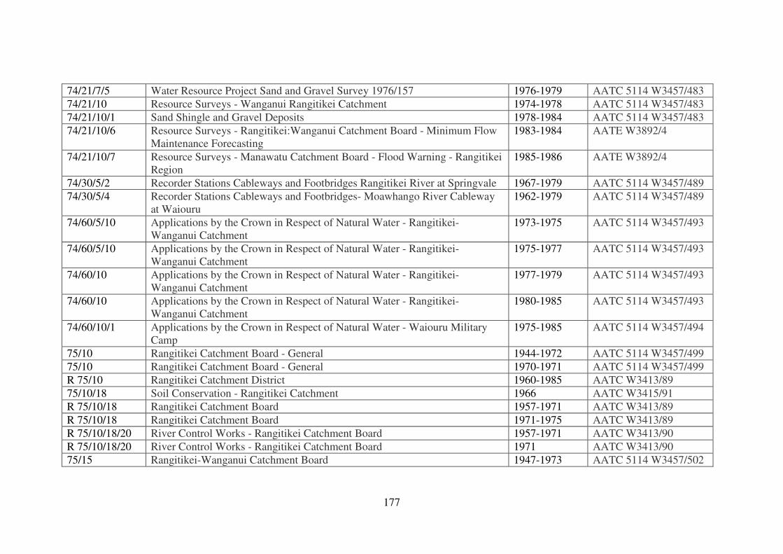
177
74/21/7/5 Water Resource Project Sand and Gravel Survey 1976/157 1976-1979 AATC 5114 W3457/483
74/21/10 Resource Surveys - Wanganui Rangitikei Catchment 1974-1978 AATC 5114 W3457/483
74/21/10/1 Sand Shingle and Gravel Deposits 1978-1984 AATC 5114 W3457/483
74/21/10/6 Resource Surveys - Rangitikei:Wanganui Catchment Board - Minimum Flow
Maintenance Forecasting
1983-1984 AATE W3892/4
74/21/10/7 Resource Surveys - Manawatu Catchment Board - Flood Warning - Rangitikei
Region
1985-1986 AATE W3892/4
74/30/5/2 Recorder Stations Cableways and Footbridges Rangitikei River at Springvale 1967-1979 AATC 5114 W3457/489
74/30/5/4 Recorder Stations Cableways and Footbridges- Moawhango River Cableway
at Waiouru
1962-1979 AATC 5114 W3457/489
74/60/5/10 Applications by the Crown in Respect of Natural Water - Rangitikei-
Wanganui Catchment
1973-1975 AATC 5114 W3457/493
74/60/5/10 Applications by the Crown in Respect of Natural Water - Rangitikei-
Wanganui Catchment
1975-1977 AATC 5114 W3457/493
74/60/10 Applications by the Crown in Respect of Natural Water - Rangitikei-
Wanganui Catchment
1977-1979 AATC 5114 W3457/493
74/60/10 Applications by the Crown in Respect of Natural Water - Rangitikei-
Wanganui Catchment
1980-1985 AATC 5114 W3457/493
74/60/10/1 Applications by the Crown in Respect of Natural Water - Waiouru Military
Camp
1975-1985 AATC 5114 W3457/494
75/10 Rangitikei Catchment Board - General 1944-1972 AATC 5114 W3457/499
75/10 Rangitikei Catchment Board - General 1970-1971 AATC 5114 W3457/499
R 75/10 Rangitikei Catchment District 1960-1985 AATC W3413/89
75/10/18 Soil Conservation - Rangitikei Catchment 1966 AATC W3415/91
R 75/10/18 Rangitikei Catchment Board 1957-1971 AATC W3413/89
R 75/10/18 Rangitikei Catchment Board 1971-1975 AATC W3413/89
R 75/10/18/20 River Control Works - Rangitikei Catchment Board 1957-1971 AATC W3413/90
R 75/10/18/20 River Control Works - Rangitikei Catchment Board 1971 AATC W3413/90
75/15 Rangitikei-Wanganui Catchment Board 1947-1973 AATC 5114 W3457/502
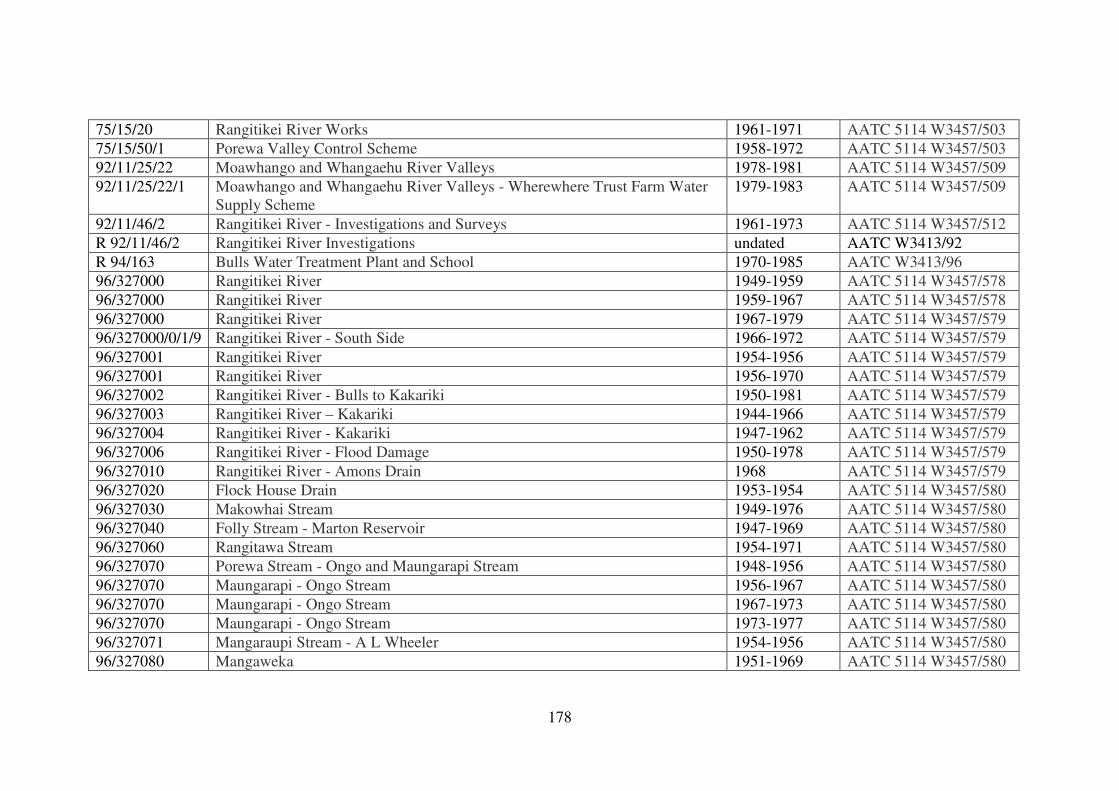
178
75/15/20 Rangitikei River Works 1961-1971 AATC 5114 W3457/503
75/15/50/1 Porewa Valley Control Scheme 1958-1972 AATC 5114 W3457/503
92/11/25/22 Moawhango and Whangaehu River Valleys 1978-1981 AATC 5114 W3457/509
92/11/25/22/1 Moawhango and Whangaehu River Valleys - Wherewhere Trust Farm Water
Supply Scheme
1979-1983 AATC 5114 W3457/509
92/11/46/2 Rangitikei River - Investigations and Surveys 1961-1973 AATC 5114 W3457/512
R 92/11/46/2 Rangitikei River Investigations undated AATC W3413/92
R 94/163 Bulls Water Treatment Plant and School 1970-1985 AATC W3413/96
96/327000 Rangitikei River 1949-1959 AATC 5114 W3457/578
96/327000 Rangitikei River 1959-1967 AATC 5114 W3457/578
96/327000 Rangitikei River 1967-1979 AATC 5114 W3457/579
96/327000/0/1/9 Rangitikei River - South Side 1966-1972 AATC 5114 W3457/579
96/327001 Rangitikei River 1954-1956 AATC 5114 W3457/579
96/327001 Rangitikei River 1956-1970 AATC 5114 W3457/579
96/327002 Rangitikei River - Bulls to Kakariki 1950-1981 AATC 5114 W3457/579
96/327003 Rangitikei River – Kakariki 1944-1966 AATC 5114 W3457/579
96/327004 Rangitikei River - Kakariki 1947-1962 AATC 5114 W3457/579
96/327006 Rangitikei River - Flood Damage 1950-1978 AATC 5114 W3457/579
96/327010 Rangitikei River - Amons Drain 1968 AATC 5114 W3457/579
96/327020 Flock House Drain 1953-1954 AATC 5114 W3457/580
96/327030 Makowhai Stream 1949-1976 AATC 5114 W3457/580
96/327040 Folly Stream - Marton Reservoir 1947-1969 AATC 5114 W3457/580
96/327060 Rangitawa Stream 1954-1971 AATC 5114 W3457/580
96/327070 Porewa Stream - Ongo and Maungarapi Stream 1948-1956 AATC 5114 W3457/580
96/327070 Maungarapi - Ongo Stream 1956-1967 AATC 5114 W3457/580
96/327070 Maungarapi - Ongo Stream 1967-1973 AATC 5114 W3457/580
96/327070 Maungarapi - Ongo Stream 1973-1977 AATC 5114 W3457/580
96/327071 Mangaraupi Stream - A L Wheeler 1954-1956 AATC 5114 W3457/580
96/327080 Mangaweka 1951-1969 AATC 5114 W3457/580
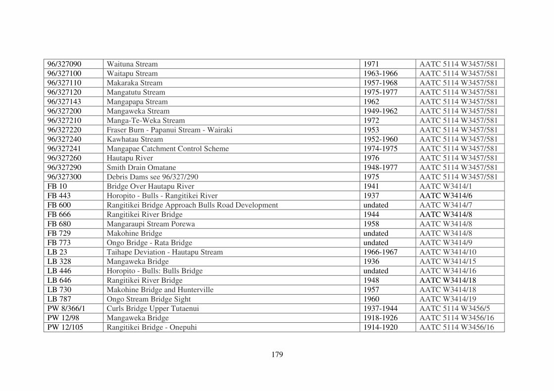
179
96/327090 Waituna Stream 1971 AATC 5114 W3457/581
96/327100 Waitapu Stream 1963-1966 AATC 5114 W3457/581
96/327110 Makaraka Stream 1957-1968 AATC 5114 W3457/581
96/327120 Mangatutu Stream 1975-1977 AATC 5114 W3457/581
96/327143 Mangapapa Stream 1962 AATC 5114 W3457/581
96/327200 Mangaweka Stream 1949-1962 AATC 5114 W3457/581
96/327210 Manga-Te-Weka Stream 1972 AATC 5114 W3457/581
96/327220 Fraser Burn - Papanui Stream - Wairaki 1953 AATC 5114 W3457/581
96/327240 Kawhatau Stream 1952-1960 AATC 5114 W3457/581
96/327241 Mangapae Catchment Control Scheme 1974-1975 AATC 5114 W3457/581
96/327260 Hautapu River 1976 AATC 5114 W3457/581
96/327290 Smith Drain Omatane 1948-1977 AATC 5114 W3457/581
96/327300 Debris Dams see 96/327/290 1975 AATC 5114 W3457/581
FB 10 Bridge Over Hautapu River 1941 AATC W3414/1
FB 443 Horopito - Bulls - Rangitikei River 1937 AATC W3414/6
FB 600 Rangitikei Bridge Approach Bulls Road Development undated AATC W3414/7
FB 666 Rangitikei River Bridge 1944 AATC W3414/8
FB 680 Mangaraupi Stream Porewa 1958 AATC W3414/8
FB 729 Makohine Bridge undated AATC W3414/8
FB 773 Ongo Bridge - Rata Bridge undated AATC W3414/9
LB 23 Taihape Deviation - Hautapu Stream 1966-1967 AATC W3414/10
LB 328 Mangaweka Bridge 1936 AATC W3414/15
LB 446 Horopito - Bulls: Bulls Bridge undated AATC W3414/16
LB 646 Rangitikei River Bridge 1948 AATC W3414/18
LB 730 Makohine Bridge and Hunterville 1957 AATC W3414/18
LB 787 Ongo Stream Bridge Sight 1960 AATC W3414/19
PW 8/366/1 Curls Bridge Upper Tutaenui 1937-1944 AATC 5114 W3456/5
PW 12/98 Mangaweka Bridge 1918-1926 AATC 5114 W3456/16
PW 12/105 Rangitikei Bridge - Onepuhi 1914-1920 AATC 5114 W3456/16
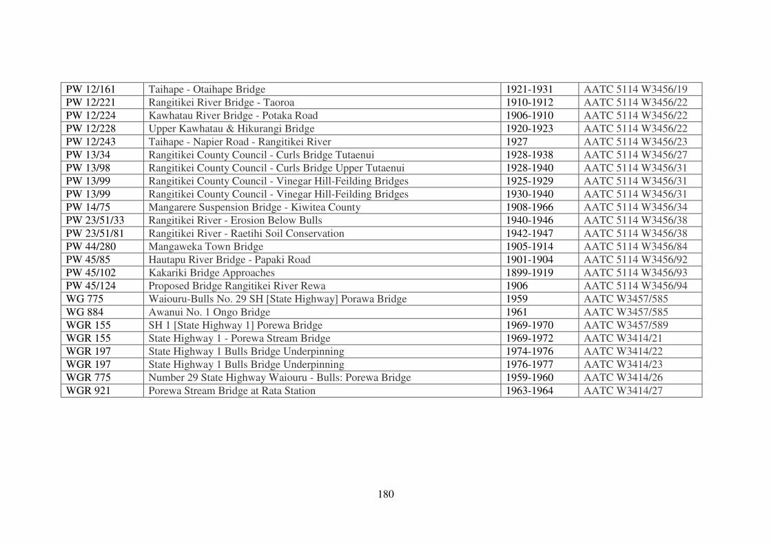
180
PW 12/161 Taihape - Otaihape Bridge 1921-1931 AATC 5114 W3456/19
PW 12/221 Rangitikei River Bridge - Taoroa 1910-1912 AATC 5114 W3456/22
PW 12/224 Kawhatau River Bridge - Potaka Road 1906-1910 AATC 5114 W3456/22
PW 12/228 Upper Kawhatau & Hikurangi Bridge 1920-1923 AATC 5114 W3456/22
PW 12/243 Taihape - Napier Road - Rangitikei River 1927 AATC 5114 W3456/23
PW 13/34 Rangitikei County Council - Curls Bridge Tutaenui 1928-1938 AATC 5114 W3456/27
PW 13/98 Rangitikei County Council - Curls Bridge Upper Tutaenui 1928-1940 AATC 5114 W3456/31
PW 13/99 Rangitikei County Council - Vinegar Hill-Feilding Bridges 1925-1929 AATC 5114 W3456/31
PW 13/99 Rangitikei County Council - Vinegar Hill-Feilding Bridges 1930-1940 AATC 5114 W3456/31
PW 14/75 Mangarere Suspension Bridge - Kiwitea County 1908-1966 AATC 5114 W3456/34
PW 23/51/33 Rangitikei River - Erosion Below Bulls 1940-1946 AATC 5114 W3456/38
PW 23/51/81 Rangitikei River - Raetihi Soil Conservation 1942-1947 AATC 5114 W3456/38
PW 44/280 Mangaweka Town Bridge 1905-1914 AATC 5114 W3456/84
PW 45/85 Hautapu River Bridge - Papaki Road 1901-1904 AATC 5114 W3456/92
PW 45/102 Kakariki Bridge Approaches 1899-1919 AATC 5114 W3456/93
PW 45/124 Proposed Bridge Rangitikei River Rewa 1906 AATC 5114 W3456/94
WG 775 Waiouru-Bulls No. 29 SH [State Highway] Porawa Bridge 1959 AATC W3457/585
WG 884 Awanui No. 1 Ongo Bridge 1961 AATC W3457/585
WGR 155 SH 1 [State Highway 1] Porewa Bridge 1969-1970 AATC W3457/589
WGR 155 State Highway 1 - Porewa Stream Bridge 1969-1972 AATC W3414/21
WGR 197 State Highway 1 Bulls Bridge Underpinning 1974-1976 AATC W3414/22
WGR 197 State Highway 1 Bulls Bridge Underpinning 1976-1977 AATC W3414/23
WGR 775 Number 29 State Highway Waiouru - Bulls: Porewa Bridge 1959-1960 AATC W3414/26
WGR 921 Porewa Stream Bridge at Rata Station 1963-1964 AATC W3414/27
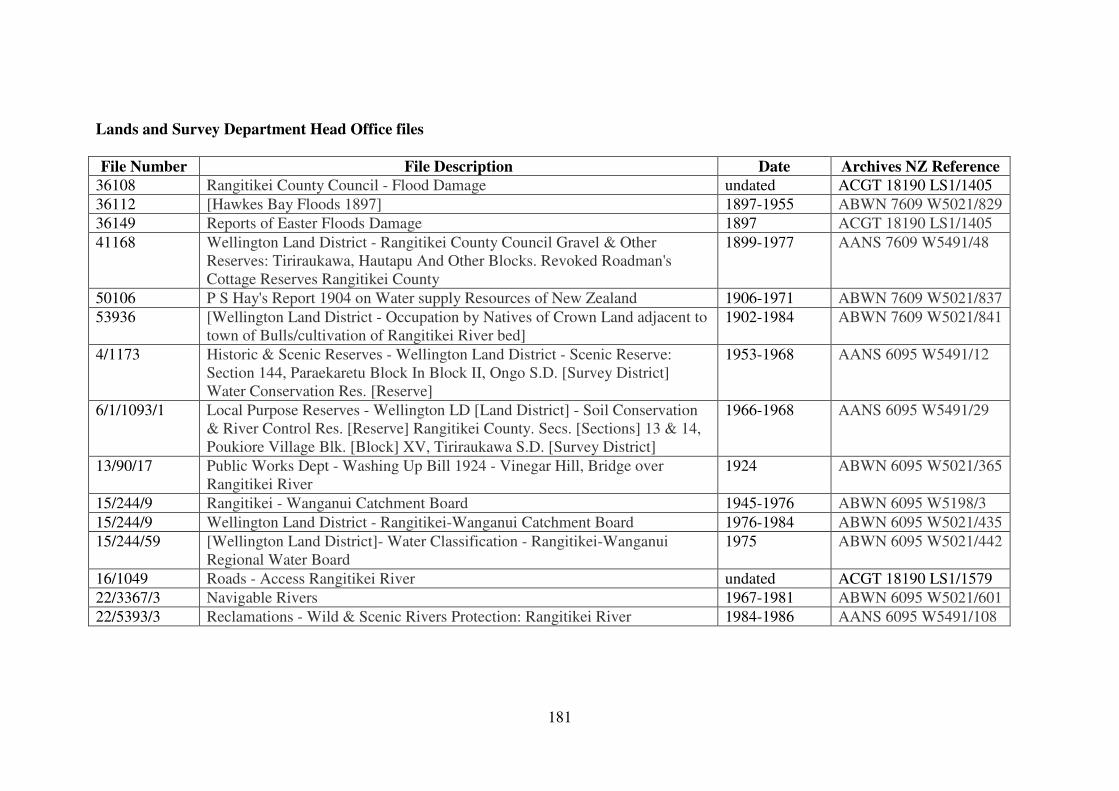
181
Lands and Survey Department Head Office files
File Number File Description Date Archives NZ Reference
36108 Rangitikei County Council - Flood Damage undated ACGT 18190 LS1/1405
36112 [Hawkes Bay Floods 1897] 1897-1955 ABWN 7609 W5021/829
36149 Reports of Easter Floods Damage 1897 ACGT 18190 LS1/1405
41168 Wellington Land District - Rangitikei County Council Gravel & Other
Reserves: Tiriraukawa, Hautapu And Other Blocks. Revoked Roadman's
Cottage Reserves Rangitikei County
1899-1977 AANS 7609 W5491/48
50106 P S Hay's Report 1904 on Water supply Resources of New Zealand 1906-1971 ABWN 7609 W5021/837
53936 [Wellington Land District - Occupation by Natives of Crown Land adjacent to
town of Bulls/cultivation of Rangitikei River bed]
1902-1984 ABWN 7609 W5021/841
4/1173 Historic & Scenic Reserves - Wellington Land District - Scenic Reserve:
Section 144, Paraekaretu Block In Block II, Ongo S.D. [Survey District]
Water Conservation Res. [Reserve]
1953-1968 AANS 6095 W5491/12
6/1/1093/1 Local Purpose Reserves - Wellington LD [Land District] - Soil Conservation
& River Control Res. [Reserve] Rangitikei County. Secs. [Sections] 13 & 14,
Poukiore Village Blk. [Block] XV, Tiriraukawa S.D. [Survey District]
1966-1968 AANS 6095 W5491/29
13/90/17 Public Works Dept - Washing Up Bill 1924 - Vinegar Hill, Bridge over
Rangitikei River
1924 ABWN 6095 W5021/365
15/244/9 Rangitikei - Wanganui Catchment Board 1945-1976 ABWN 6095 W5198/3
15/244/9 Wellington Land District - Rangitikei-Wanganui Catchment Board 1976-1984 ABWN 6095 W5021/435
15/244/59 [Wellington Land District]- Water Classification - Rangitikei-Wanganui
Regional Water Board
1975 ABWN 6095 W5021/442
16/1049 Roads - Access Rangitikei River undated ACGT 18190 LS1/1579
22/3367/3 Navigable Rivers 1967-1981 ABWN 6095 W5021/601
22/5393/3 Reclamations - Wild & Scenic Rivers Protection: Rangitikei River 1984-1986 AANS 6095 W5491/108
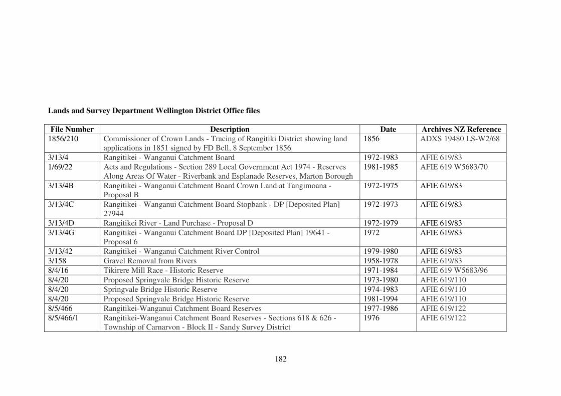
182
Lands and Survey Department Wellington District Office files
File Number Description Date Archives NZ Reference
1856/210 Commissioner of Crown Lands - Tracing of Rangitiki District showing land
applications in 1851 signed by FD Bell, 8 September 1856
1856 ADXS 19480 LS-W2/68
3/13/4 Rangitikei - Wanganui Catchment Board 1972-1983 AFIE 619/83
1/69/22 Acts and Regulations - Section 289 Local Government Act 1974 - Reserves
Along Areas Of Water - Riverbank and Esplanade Reserves, Marton Borough
1981-1985 AFIE 619 W5683/70
3/13/4B Rangitikei - Wanganui Catchment Board Crown Land at Tangimoana -
Proposal B
1972-1975 AFIE 619/83
3/13/4C Rangitikei - Wanganui Catchment Board Stopbank - DP [Deposited Plan]
27944
1972-1973 AFIE 619/83
3/13/4D Rangitikei River - Land Purchase - Proposal D 1972-1979 AFIE 619/83
3/13/4G Rangitikei - Wanganui Catchment Board DP [Deposited Plan] 19641 -
Proposal 6
1972 AFIE 619/83
3/13/42 Rangitikei - Wanganui Catchment River Control 1979-1980 AFIE 619/83
3/158 Gravel Removal from Rivers 1958-1978 AFIE 619/83
8/4/16 Tikirere Mill Race - Historic Reserve 1971-1984 AFIE 619 W5683/96
8/4/20 Proposed Springvale Bridge Historic Reserve 1973-1980 AFIE 619/110
8/4/20 Springvale Bridge Historic Reserve 1974-1983 AFIE 619/110
8/4/20 Proposed Springvale Bridge Historic Reserve 1981-1994 AFIE 619/110
8/5/466 Rangitikei-Wanganui Catchment Board Reserves 1977-1986 AFIE 619/122
8/5/466/1 Rangitikei-Wanganui Catchment Board Reserves - Sections 618 & 626 -
Township of Carnarvon - Block II - Sandy Survey District
1976 AFIE 619/122
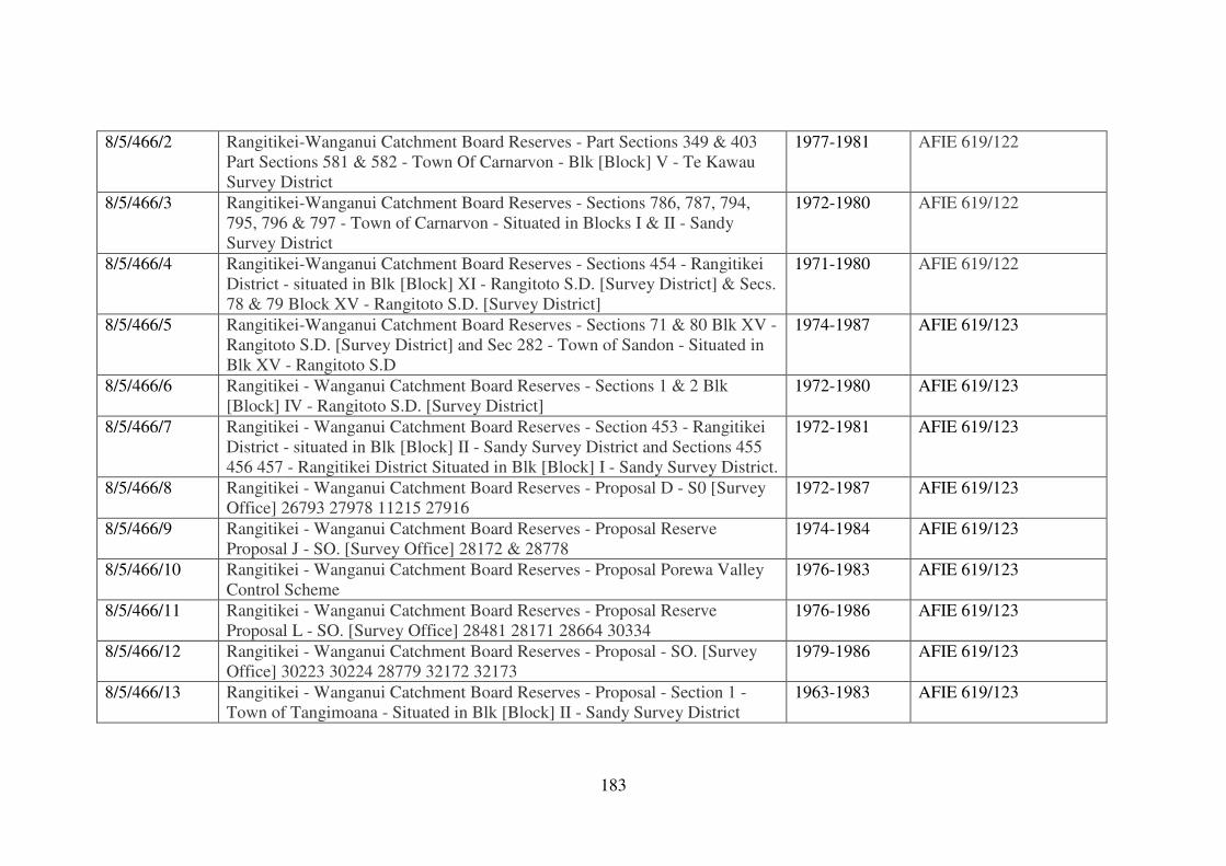
183
8/5/466/2 Rangitikei-Wanganui Catchment Board Reserves - Part Sections 349 & 403
Part Sections 581 & 582 - Town Of Carnarvon - Blk [Block] V - Te Kawau
Survey District
1977-1981 AFIE 619/122
8/5/466/3 Rangitikei-Wanganui Catchment Board Reserves - Sections 786, 787, 794,
795, 796 & 797 - Town of Carnarvon - Situated in Blocks I & II - Sandy
Survey District
1972-1980 AFIE 619/122
8/5/466/4 Rangitikei-Wanganui Catchment Board Reserves - Sections 454 - Rangitikei
District - situated in Blk [Block] XI - Rangitoto S.D. [Survey District] & Secs.
78 & 79 Block XV - Rangitoto S.D. [Survey District]
1971-1980 AFIE 619/122
8/5/466/5 Rangitikei-Wanganui Catchment Board Reserves - Sections 71 & 80 Blk XV -
Rangitoto S.D. [Survey District] and Sec 282 - Town of Sandon - Situated in
Blk XV - Rangitoto S.D
1974-1987 AFIE 619/123
8/5/466/6 Rangitikei - Wanganui Catchment Board Reserves - Sections 1 & 2 Blk
[Block] IV - Rangitoto S.D. [Survey District]
1972-1980 AFIE 619/123
8/5/466/7 Rangitikei - Wanganui Catchment Board Reserves - Section 453 - Rangitikei
District - situated in Blk [Block] II - Sandy Survey District and Sections 455
456 457 - Rangitikei District Situated in Blk [Block] I - Sandy Survey District.
1972-1981 AFIE 619/123
8/5/466/8 Rangitikei - Wanganui Catchment Board Reserves - Proposal D - S0 [Survey
Office] 26793 27978 11215 27916
1972-1987 AFIE 619/123
8/5/466/9 Rangitikei - Wanganui Catchment Board Reserves - Proposal Reserve
Proposal J - SO. [Survey Office] 28172 & 28778
1974-1984 AFIE 619/123
8/5/466/10 Rangitikei - Wanganui Catchment Board Reserves - Proposal Porewa Valley
Control Scheme
1976-1983 AFIE 619/123
8/5/466/11 Rangitikei - Wanganui Catchment Board Reserves - Proposal Reserve
Proposal L - SO. [Survey Office] 28481 28171 28664 30334
1976-1986 AFIE 619/123
8/5/466/12 Rangitikei - Wanganui Catchment Board Reserves - Proposal - SO. [Survey
Office] 30223 30224 28779 32172 32173
1979-1986 AFIE 619/123
8/5/466/13 Rangitikei - Wanganui Catchment Board Reserves - Proposal - Section 1 -
Town of Tangimoana - Situated in Blk [Block] II - Sandy Survey District
1963-1983 AFIE 619/123
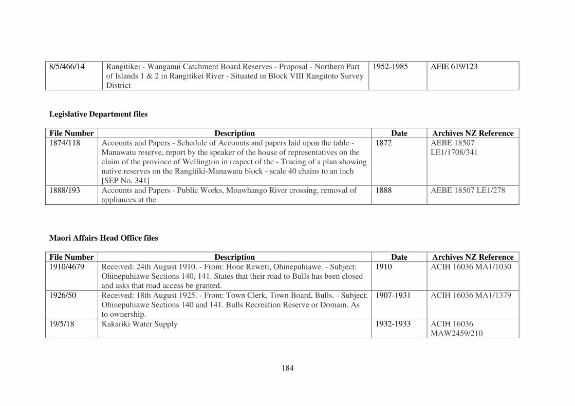
184
8/5/466/14 Rangitikei - Wanganui Catchment Board Reserves - Proposal - Northern Part
of Islands 1 & 2 in Rangitikei River - Situated in Block VIII Rangitoto Survey
District
1952-1985 AFIE 619/123
Legislative Department files
File Number Description Date Archives NZ Reference
1874/118 Accounts and Papers - Schedule of Accounts and papers laid upon the table -
Manawatu reserve, report by the speaker of the house of representatives on the
claim of the province of Wellington in respect of the - Tracing of a plan showing
native reserves on the Rangitiki-Manawatu block - scale 40 chains to an inch
[SEP No. 341]
1872 AEBE 18507
LE1/1708/341
1888/193 Accounts and Papers - Public Works, Moawhango River crossing, removal of
appliances at the
1888 AEBE 18507 LE1/278
Maori Affairs Head Office files
File Number Description Date Archives NZ Reference
1910/4679 Received: 24th August 1910. - From: Hone Reweti, Ohinepuhiawe. - Subject:
Ohinepuhiawe Sections 140, 141. States that their road to Bulls has been closed
and asks that road access be granted.
1910 ACIH 16036 MA1/1030
1926/50 Received: 18th August 1925. - From: Town Clerk, Town Board, Bulls. - Subject:
Ohinepuhiawe Sections 140 and 141. Bulls Recreation Reserve or Domain. As
to ownership.
1907-1931 ACIH 16036 MA1/1379
19/5/18 Kakariki Water Supply 1932-1933 ACIH 16036
MAW2459/210
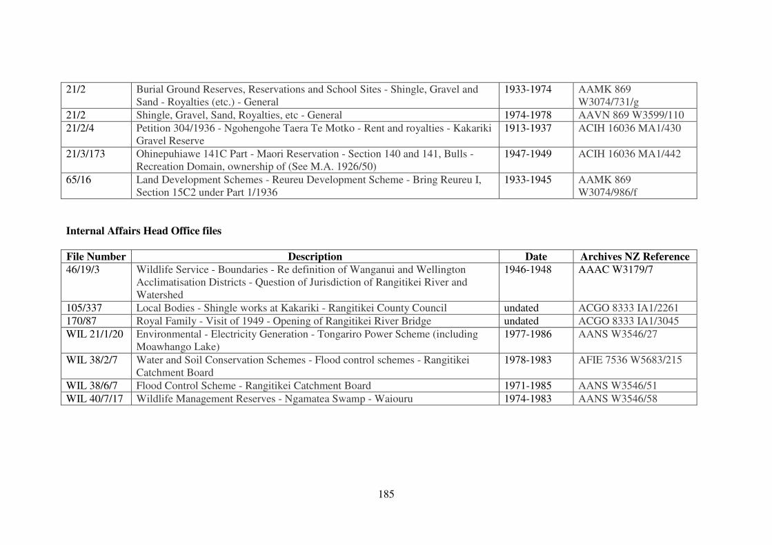
185
21/2 Burial Ground Reserves, Reservations and School Sites - Shingle, Gravel and
Sand - Royalties (etc.) - General
1933-1974 AAMK 869
W3074/731/g
21/2 Shingle, Gravel, Sand, Royalties, etc - General 1974-1978 AAVN 869 W3599/110
21/2/4 Petition 304/1936 - Ngohengohe Taera Te Motko - Rent and royalties - Kakariki
Gravel Reserve
1913-1937 ACIH 16036 MA1/430
21/3/173 Ohinepuhiawe 141C Part - Maori Reservation - Section 140 and 141, Bulls -
Recreation Domain, ownership of (See M.A. 1926/50)
1947-1949 ACIH 16036 MA1/442
65/16 Land Development Schemes - Reureu Development Scheme - Bring Reureu I,
Section 15C2 under Part 1/1936
1933-1945 AAMK 869
W3074/986/f
Internal Affairs Head Office files
File Number Description Date Archives NZ Reference
46/19/3 Wildlife Service - Boundaries - Re definition of Wanganui and Wellington
Acclimatisation Districts - Question of Jurisdiction of Rangitikei River and
Watershed
1946-1948 AAAC W3179/7
105/337 Local Bodies - Shingle works at Kakariki - Rangitikei County Council undated ACGO 8333 IA1/2261
170/87 Royal Family - Visit of 1949 - Opening of Rangitikei River Bridge undated ACGO 8333 IA1/3045
WIL 21/1/20 Environmental - Electricity Generation - Tongariro Power Scheme (including
Moawhango Lake)
1977-1986 AANS W3546/27
WIL 38/2/7 Water and Soil Conservation Schemes - Flood control schemes - Rangitikei
Catchment Board
1978-1983 AFIE 7536 W5683/215
WIL 38/6/7 Flood Control Scheme - Rangitikei Catchment Board 1971-1985 AANS W3546/51
WIL 40/7/17 Wildlife Management Reserves - Ngamatea Swamp - Waiouru 1974-1983 AANS W3546/58
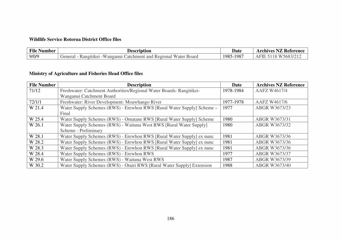
186
Wildlife Service Rotorua District Office files
File Number Description Date Archives NZ Reference
9/0/9 General - Rangitikei -Wanganui Catchment and Regional Water Board 1985-1987 AFIE 5118 W5683/212
Ministry of Agriculture and Fisheries Head Office files
File Number Description Date Archives NZ Reference
71/12 Freshwater: Catchment Authorities/Regional Water Boards: Rangitikei-
Wanganui Catchment Board
1978-1984 AAFZ W4617/4
72/1/1 Freshwater: River Development: Moawhango River 1977-1978 AAFZ W4617/6
W 21.4 Water Supply Schemes (RWS) - Erewhon RWS [Rural Water Supply] Scheme –
Final
1977 ABGR W3673/23
W 25.4 Water Supply Schemes (RWS) - Omatane RWS [Rural Water Supply] Scheme 1980 ABGR W3673/31
W 26.1 Water Supply Schemes (RWS) - Waituna West RWS [Rural Water Supply]
Scheme - Preliminary
1980 ABGR W3673/32
W 28.1 Water Supply Schemes (RWS) - Erewhon RWS [Rural Water Supply] ex nunc 1981 ABGR W3673/36
W 28.2 Water Supply Schemes (RWS) - Erewhon RWS [Rural Water Supply] ex nunc 1981 ABGR W3673/36
W 28.3 Water Supply Schemes (RWS) - Erewhon RWS [Rural Water Supply] ex nunc 1981 ABGR W3673/36
W 28.4 Water Supply Schemes (RWS) - Erewhon RWS 1977 ABGR W3673/37
W 29.6 Water Supply Schemes (RWS) - Waituna West RWS 1987 ABGR W3673/39
W 30.2 Water Supply Schemes (RWS) - Otairi RWS [Rural Water Supply] Extension 1988 ABGR W3673/40
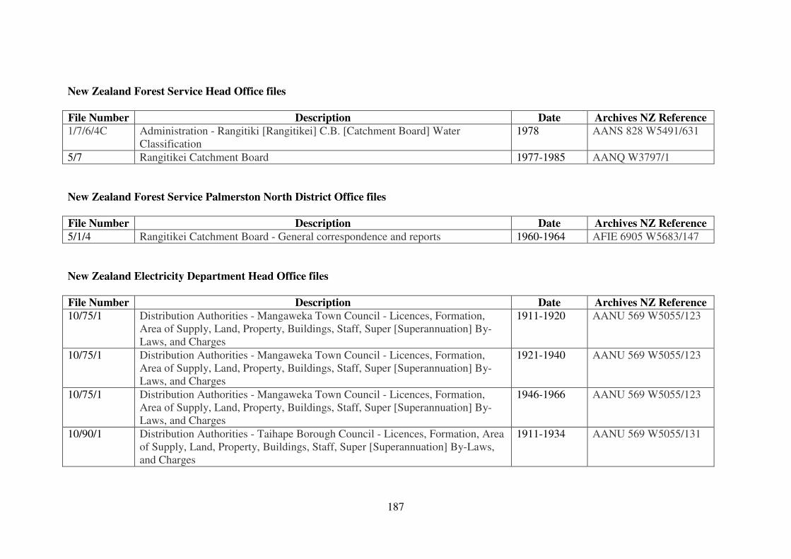
187
New Zealand Forest Service Head Office files
File Number Description Date Archives NZ Reference
1/7/6/4C Administration - Rangitiki [Rangitikei] C.B. [Catchment Board] Water
Classification
1978 AANS 828 W5491/631
5/7 Rangitikei Catchment Board 1977-1985 AANQ W3797/1
New Zealand Forest Service Palmerston North District Office files
File Number Description Date Archives NZ Reference
5/1/4 Rangitikei Catchment Board - General correspondence and reports 1960-1964 AFIE 6905 W5683/147
New Zealand Electricity Department Head Office files
File Number Description Date Archives NZ Reference
10/75/1 Distribution Authorities - Mangaweka Town Council - Licences, Formation,
Area of Supply, Land, Property, Buildings, Staff, Super [Superannuation] By-
Laws, and Charges
1911-1920 AANU 569 W5055/123
10/75/1 Distribution Authorities - Mangaweka Town Council - Licences, Formation,
Area of Supply, Land, Property, Buildings, Staff, Super [Superannuation] By-
Laws, and Charges
1921-1940 AANU 569 W5055/123
10/75/1 Distribution Authorities - Mangaweka Town Council - Licences, Formation,
Area of Supply, Land, Property, Buildings, Staff, Super [Superannuation] By-
Laws, and Charges
1946-1966 AANU 569 W5055/123
10/90/1 Distribution Authorities - Taihape Borough Council - Licences, Formation, Area
of Supply, Land, Property, Buildings, Staff, Super [Superannuation] By-Laws,
and Charges
1911-1934 AANU 569 W5055/131
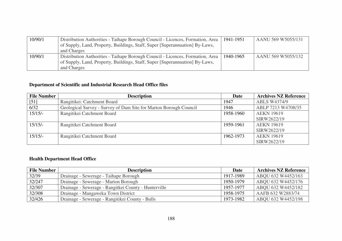
188
10/90/1 Distribution Authorities - Taihape Borough Council - Licences, Formation, Area
of Supply, Land, Property, Buildings, Staff, Super [Superannuation] By-Laws,
and Charges
1941-1951 AANU 569 W5055/131
10/90/1 Distribution Authorities - Taihape Borough Council - Licences, Formation, Area
of Supply, Land, Property, Buildings, Staff, Super [Superannuation] By-Laws,
and Charges
1940-1965 AANU 569 W5055/132
Department of Scientific and Industrial Research Head Office files
File Number Description Date Archives NZ Reference
[51] Rangitikei: Catchment Board 1947 ABLS W4374/9
6/32 Geological Survey - Survey of Dam Site for Marton Borough Council 1946 ABLP 7213 W4708/35
15/15/- Rangitikei Catchment Board 1958-1960 AEKN 19619
SIRW2622/19
15/15/- Rangitikei Catchment Board 1959-1961 AEKN 19619
SIRW2622/19
15/15/- Rangitikei Catchment Board 1962-1973 AEKN 19619
SIRW2622/19
Health Department Head Office
File Number Description Date Archives NZ Reference
32/39 Drainage - Sewerage - Taihape Borough 1917-1989 ABQU 632 W4452/163
32/247 Drainage - Sewerage - Marton Borough 1950-1979 ABQU 632 W4452/176
32/307 Drainage - Sewerage - Rangitkei County - Hunterville 1957-1977 ABQU 632 W4452/182
32/308 Drainage - Mangaweka Town District 1958-1975 AAFB 632 W2883/74
32/426 Drainage - Sewerage - Rangitikei County - Bulls 1973-1982 ABQU 632 W4452/198
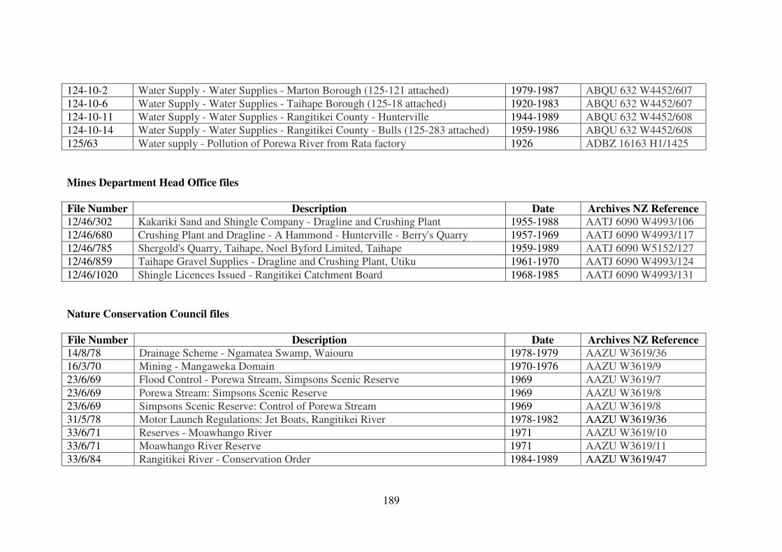
189
124-10-2 Water Supply - Water Supplies - Marton Borough (125-121 attached) 1979-1987 ABQU 632 W4452/607
124-10-6 Water Supply - Water Supplies - Taihape Borough (125-18 attached) 1920-1983 ABQU 632 W4452/607
124-10-11 Water Supply - Water Supplies - Rangitikei County - Hunterville 1944-1989 ABQU 632 W4452/608
124-10-14 Water Supply - Water Supplies - Rangitikei County - Bulls (125-283 attached) 1959-1986 ABQU 632 W4452/608
125/63 Water supply - Pollution of Porewa River from Rata factory 1926 ADBZ 16163 H1/1425
Mines Department Head Office files
File Number Description Date Archives NZ Reference
12/46/302 Kakariki Sand and Shingle Company - Dragline and Crushing Plant 1955-1988 AATJ 6090 W4993/106
12/46/680 Crushing Plant and Dragline - A Hammond - Hunterville - Berry's Quarry 1957-1969 AATJ 6090 W4993/117
12/46/785 Shergold's Quarry, Taihape, Noel Byford Limited, Taihape 1959-1989 AATJ 6090 W5152/127
12/46/859 Taihape Gravel Supplies - Dragline and Crushing Plant, Utiku 1961-1970 AATJ 6090 W4993/124
12/46/1020 Shingle Licences Issued - Rangitikei Catchment Board 1968-1985 AATJ 6090 W4993/131
Nature Conservation Council files
File Number Description Date Archives NZ Reference
14/8/78 Drainage Scheme - Ngamatea Swamp, Waiouru 1978-1979 AAZU W3619/36
16/3/70 Mining - Mangaweka Domain 1970-1976 AAZU W3619/9
23/6/69 Flood Control - Porewa Stream, Simpsons Scenic Reserve 1969 AAZU W3619/7
23/6/69 Porewa Stream: Simpsons Scenic Reserve 1969 AAZU W3619/8
23/6/69 Simpsons Scenic Reserve: Control of Porewa Stream 1969 AAZU W3619/8
31/5/78 Motor Launch Regulations: Jet Boats, Rangitikei River 1978-1982 AAZU W3619/36
33/6/71 Reserves - Moawhango River 1971 AAZU W3619/10
33/6/71 Moawhango River Reserve 1971 AAZU W3619/11
33/6/84 Rangitikei River - Conservation Order 1984-1989 AAZU W3619/47
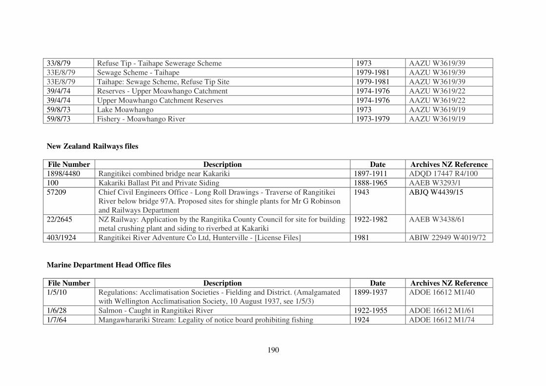
190
33/8/79 Refuse Tip - Taihape Sewerage Scheme 1973 AAZU W3619/39
33E/8/79 Sewage Scheme - Taihape 1979-1981 AAZU W3619/39
33E/8/79 Taihape: Sewage Scheme, Refuse Tip Site 1979-1981 AAZU W3619/39
39/4/74 Reserves - Upper Moawhango Catchment 1974-1976 AAZU W3619/22
39/4/74 Upper Moawhango Catchment Reserves 1974-1976 AAZU W3619/22
59/8/73 Lake Moawhango 1973 AAZU W3619/19
59/8/73 Fishery - Moawhango River 1973-1979 AAZU W3619/19
New Zealand Railways files
File Number Description Date Archives NZ Reference
1898/4480 Rangitikei combined bridge near Kakariki 1897-1911 ADQD 17447 R4/100
100 Kakariki Ballast Pit and Private Siding 1888-1965 AAEB W3293/1
57209 Chief Civil Engineers Office - Long Roll Drawings - Traverse of Rangitikei
River below bridge 97A. Proposed sites for shingle plants for Mr G Robinson
and Railways Department
1943 ABJQ W4439/15
22/2645 NZ Railway: Application by the Rangitika County Council for site for building
metal crushing plant and siding to riverbed at Kakariki
1922-1982 AAEB W3438/61
403/1924 Rangitikei River Adventure Co Ltd, Hunterville - [License Files] 1981 ABIW 22949 W4019/72
Marine Department Head Office files
File Number Description Date Archives NZ Reference
1/5/10 Regulations: Acclimatisation Societies - Fielding and District. (Amalgamated
with Wellington Acclimatisation Society, 10 August 1937, see 1/5/3)
1899-1937 ADOE 16612 M1/40
1/6/28 Salmon - Caught in Rangitikei River 1922-1955 ADOE 16612 M1/61
1/7/64 Mangawharariki Stream: Legality of notice board prohibiting fishing 1924 ADOE 16612 M1/74
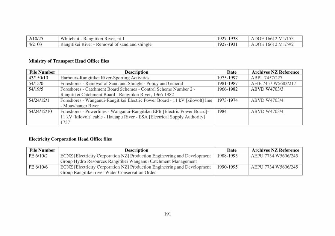
191
2/10/25 Whitebait - Rangitikei River, pt 1 1927-1938 ADOE 16612 M1/153
4/2103 Rangitikei River - Removal of sand and shingle 1927-1931 ADOE 16612 M1/592
Ministry of Transport Head Office files
File Number Description Date Archives NZ Reference
43/150/10 Harbours-Rangitikei River-Sporting Activities 1975-1997 ABPL 7457/227
54/15/0 Foreshores - Removal of Sand and Shingle - Policy and General 1981-1987 AFIE 7457 W5683/217
54/19/5 Foreshores - Catchment Board Schemes - Control Scheme Number 2 -
Rangitikei Catchment Board - Rangitikei River, 1966-1982
1966-1982 ABVD W4703/3
54/24/12/1 Foreshores - Wanganui-Rangitikei Electric Power Board - 11 kV [kilovolt] line
- Moawhango River
1973-1974 ABVD W4703/4
54/24/12/10 Foreshores - Powerlines - Wanganui-Rangitikei EPB [Electric Power Board]-
11 kV [kilovolt] cable - Hautapu River - ESA [Electrical Supply Authority]
1737
1984 ABVD W4703/4
Electricity Corporation Head Office files
File Number Description Date Archives NZ Reference
PE 6/10/2 ECNZ [Electricity Corporation NZ] Production Engineering and Development
Group Hydro Resources Rangitikei Wanganui Catchment Management
1988-1993 AEPU 7734 W5606/245
PE 6/10/6 ECNZ [Electricity Corporation NZ] Production Engineering and Development
Group Rangitikei river Water Conservation Order
1990-1995 AEPU 7734 W5606/245
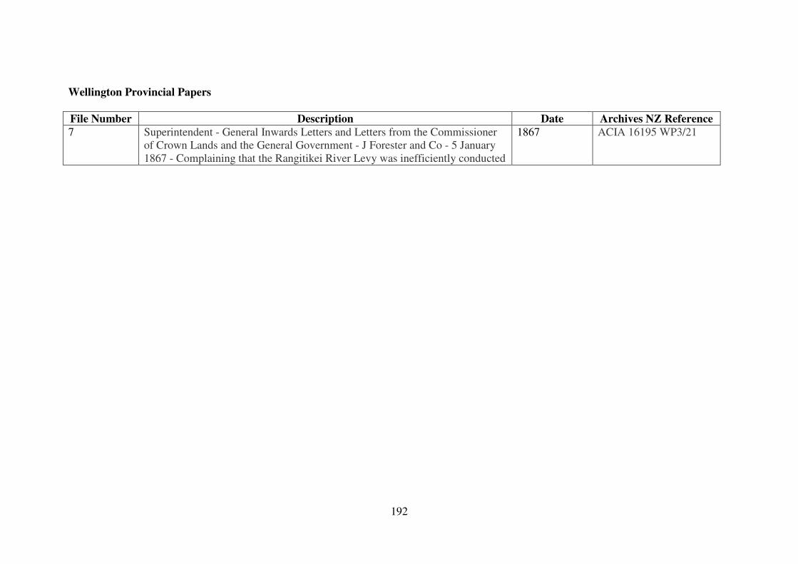
192
Wellington Provincial Papers
File Number Description Date Archives NZ Reference
7 Superintendent - General Inwards Letters and Letters from the Commissioner
of Crown Lands and the General Government - J Forester and Co - 5 January
1867 - Complaining that the Rangitikei River Levy was inefficiently conducted
1867 ACIA 16195 WP3/21
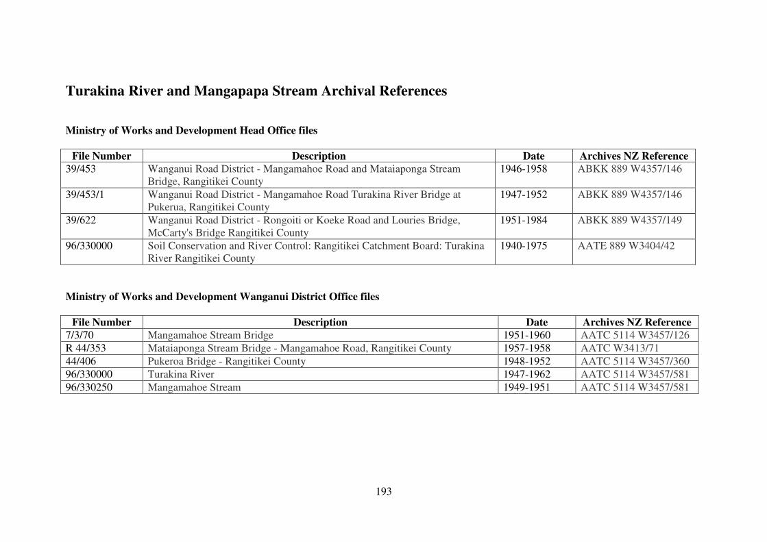
193
Turakina River and Mangapapa Stream Archival References
Ministry of Works and Development Head Office files
File Number Description Date Archives NZ Reference
39/453 Wanganui Road District - Mangamahoe Road and Mataiaponga Stream
Bridge, Rangitikei County
1946-1958 ABKK 889 W4357/146
39/453/1 Wanganui Road District - Mangamahoe Road Turakina River Bridge at
Pukerua, Rangitikei County
1947-1952 ABKK 889 W4357/146
39/622 Wanganui Road District - Rongoiti or Koeke Road and Louries Bridge,
McCarty's Bridge Rangitikei County
1951-1984 ABKK 889 W4357/149
96/330000 Soil Conservation and River Control: Rangitikei Catchment Board: Turakina
River Rangitikei County
1940-1975 AATE 889 W3404/42
Ministry of Works and Development Wanganui District Office files
File Number Description Date Archives NZ Reference
7/3/70 Mangamahoe Stream Bridge 1951-1960 AATC 5114 W3457/126
R 44/353 Mataiaponga Stream Bridge - Mangamahoe Road, Rangitikei County 1957-1958 AATC W3413/71
44/406 Pukeroa Bridge - Rangitikei County 1948-1952 AATC 5114 W3457/360
96/330000 Turakina River 1947-1962 AATC 5114 W3457/581
96/330250 Mangamahoe Stream 1949-1951 AATC 5114 W3457/581
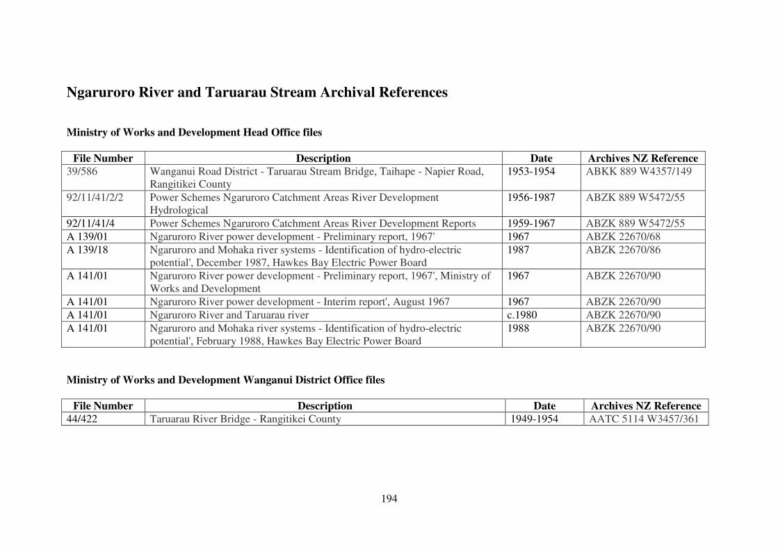
194
Ngaruroro River and Taruarau Stream Archival References
Ministry of Works and Development Head Office files
File Number Description Date Archives NZ Reference
39/586 Wanganui Road District - Taruarau Stream Bridge, Taihape - Napier Road,
Rangitikei County
1953-1954 ABKK 889 W4357/149
92/11/41/2/2 Power Schemes Ngaruroro Catchment Areas River Development
Hydrological
1956-1987 ABZK 889 W5472/55
92/11/41/4 Power Schemes Ngaruroro Catchment Areas River Development Reports 1959-1967 ABZK 889 W5472/55
A 139/01 Ngaruroro River power development - Preliminary report, 1967' 1967 ABZK 22670/68
A 139/18 Ngaruroro and Mohaka river systems - Identification of hydro-electric
potential', December 1987, Hawkes Bay Electric Power Board
1987 ABZK 22670/86
A 141/01 Ngaruroro River power development - Preliminary report, 1967', Ministry of
Works and Development
1967 ABZK 22670/90
A 141/01 Ngaruroro River power development - Interim report', August 1967 1967 ABZK 22670/90
A 141/01 Ngaruroro River and Taruarau river c.1980 ABZK 22670/90
A 141/01 Ngaruroro and Mohaka river systems - Identification of hydro-electric
potential', February 1988, Hawkes Bay Electric Power Board
1988 ABZK 22670/90
Ministry of Works and Development Wanganui District Office files
File Number Description Date Archives NZ Reference
44/422 Taruarau River Bridge - Rangitikei County 1949-1954 AATC 5114 W3457/361
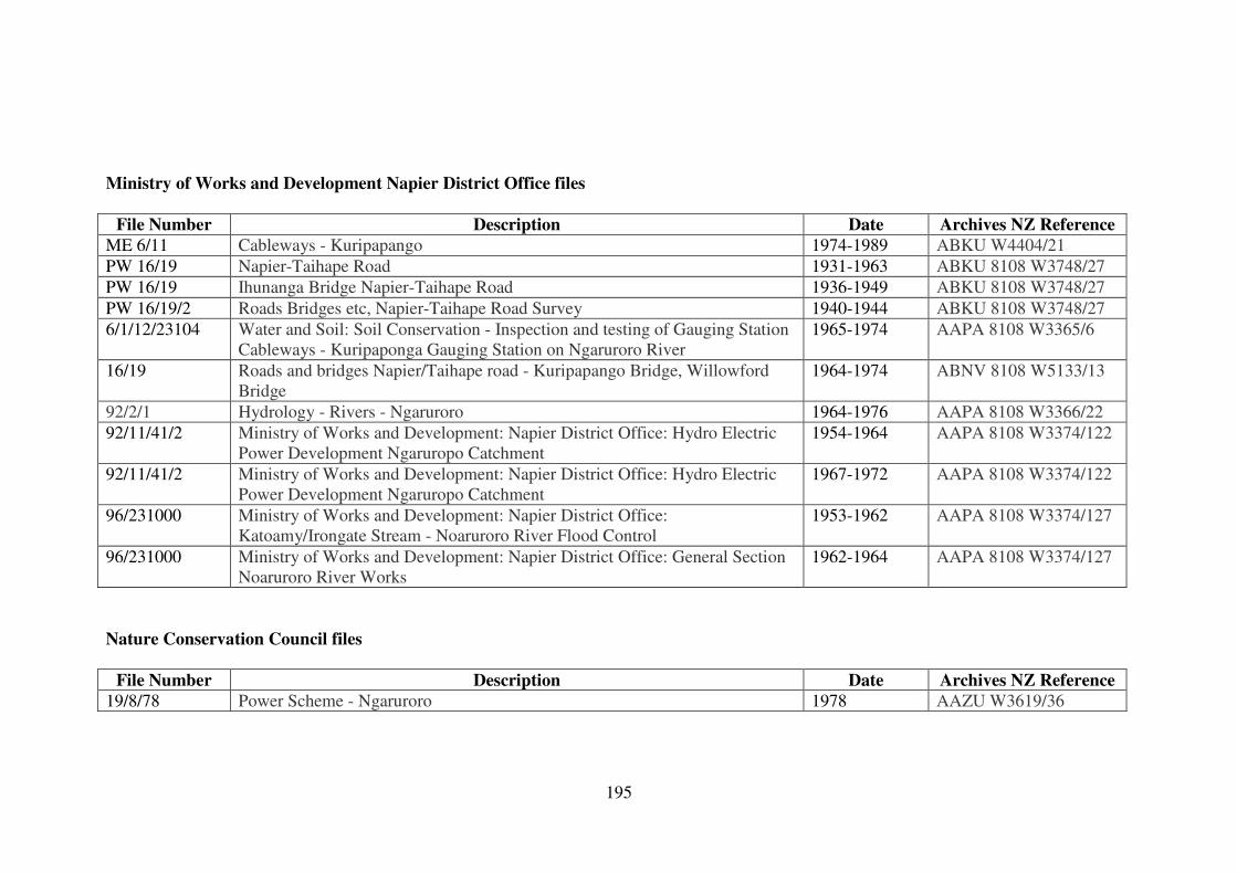
195
Ministry of Works and Development Napier District Office files
File Number Description Date Archives NZ Reference
ME 6/11 Cableways - Kuripapango 1974-1989 ABKU W4404/21
PW 16/19 Napier-Taihape Road 1931-1963 ABKU 8108 W3748/27
PW 16/19 Ihunanga Bridge Napier-Taihape Road 1936-1949 ABKU 8108 W3748/27
PW 16/19/2 Roads Bridges etc, Napier-Taihape Road Survey 1940-1944 ABKU 8108 W3748/27
6/1/12/23104 Water and Soil: Soil Conservation - Inspection and testing of Gauging Station
Cableways - Kuripaponga Gauging Station on Ngaruroro River
1965-1974 AAPA 8108 W3365/6
16/19 Roads and bridges Napier/Taihape road - Kuripapango Bridge, Willowford
Bridge
1964-1974 ABNV 8108 W5133/13
92/2/1 Hydrology - Rivers - Ngaruroro 1964-1976 AAPA 8108 W3366/22
92/11/41/2 Ministry of Works and Development: Napier District Office: Hydro Electric
Power Development Ngaruropo Catchment
1954-1964 AAPA 8108 W3374/122
92/11/41/2 Ministry of Works and Development: Napier District Office: Hydro Electric
Power Development Ngaruropo Catchment
1967-1972 AAPA 8108 W3374/122
96/231000 Ministry of Works and Development: Napier District Office:
Katoamy/Irongate Stream - Noaruroro River Flood Control
1953-1962 AAPA 8108 W3374/127
96/231000 Ministry of Works and Development: Napier District Office: General Section
Noaruroro River Works
1962-1964 AAPA 8108 W3374/127
Nature Conservation Council files
File Number Description Date Archives NZ Reference
19/8/78 Power Scheme - Ngaruroro 1978 AAZU W3619/36
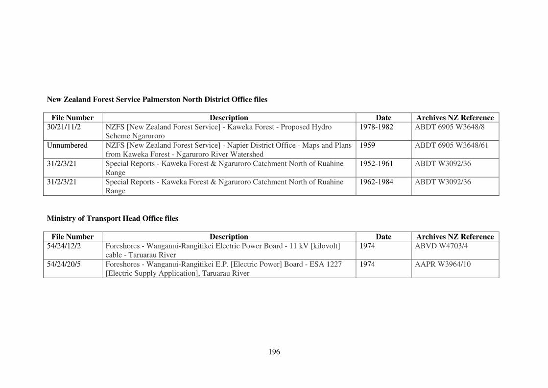
196
New Zealand Forest Service Palmerston North District Office files
File Number Description Date Archives NZ Reference
30/21/11/2 NZFS [New Zealand Forest Service] - Kaweka Forest - Proposed Hydro
Scheme Ngaruroro
1978-1982 ABDT 6905 W3648/8
Unnumbered NZFS [New Zealand Forest Service] - Napier District Office - Maps and Plans
from Kaweka Forest - Ngaruroro River Watershed
1959 ABDT 6905 W3648/61
31/2/3/21 Special Reports - Kaweka Forest & Ngaruroro Catchment North of Ruahine
Range
1952-1961 ABDT W3092/36
31/2/3/21 Special Reports - Kaweka Forest & Ngaruroro Catchment North of Ruahine
Range
1962-1984 ABDT W3092/36
Ministry of Transport Head Office files
File Number Description Date Archives NZ Reference
54/24/12/2 Foreshores - Wanganui-Rangitikei Electric Power Board - 11 kV [kilovolt]
cable - Taruarau River
1974 ABVD W4703/4
54/24/20/5 Foreshores - Wanganui-Rangitikei E.P. [Electric Power] Board - ESA 1227
[Electric Supply Application], Taruarau River
1974 AAPR W3964/10
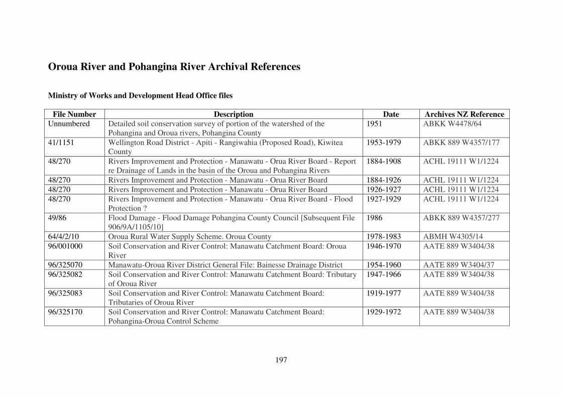
197
Oroua River and Pohangina River Archival References
Ministry of Works and Development Head Office files
File Number Description Date Archives NZ Reference
Unnumbered Detailed soil conservation survey of portion of the watershed of the
Pohangina and Oroua rivers, Pohangina County
1951 ABKK W4478/64
41/1151 Wellington Road District - Apiti - Rangiwahia (Proposed Road), Kiwitea
County
1953-1979 ABKK 889 W4357/177
48/270 Rivers Improvement and Protection - Manawatu - Orua River Board - Report
re Drainage of Lands in the basin of the Oroua and Pohangina Rivers
1884-1908 ACHL 19111 W1/1224
48/270 Rivers Improvement and Protection - Manawatu - Orua River Board 1884-1926 ACHL 19111 W1/1224
48/270 Rivers Improvement and Protection - Manawatu - Orua River Board 1926-1927 ACHL 19111 W1/1224
48/270 Rivers Improvement and Protection - Manawatu - Orua River Board - Flood
Protection ?
1927-1929 ACHL 19111 W1/1224
49/86 Flood Damage - Flood Damage Pohangina County Council [Subsequent File
906/9A/1105/10]
1986 ABKK 889 W4357/277
64/4/2/10 Oroua Rural Water Supply Scheme. Oroua County 1978-1983 ABMH W4305/14
96/001000 Soil Conservation and River Control: Manawatu Catchment Board: Oroua
River
1946-1970 AATE 889 W3404/38
96/325070 Manawatu-Oroua River District General File: Bainesse Drainage District 1954-1960 AATE 889 W3404/37
96/325082 Soil Conservation and River Control: Manawatu Catchment Board: Tributary
of Oroua River
1947-1966 AATE 889 W3404/38
96/325083 Soil Conservation and River Control: Manawatu Catchment Board:
Tributaries of Oroua River
1919-1977 AATE 889 W3404/38
96/325170 Soil Conservation and River Control: Manawatu Catchment Board:
Pohangina-Oroua Control Scheme
1929-1972 AATE 889 W3404/38
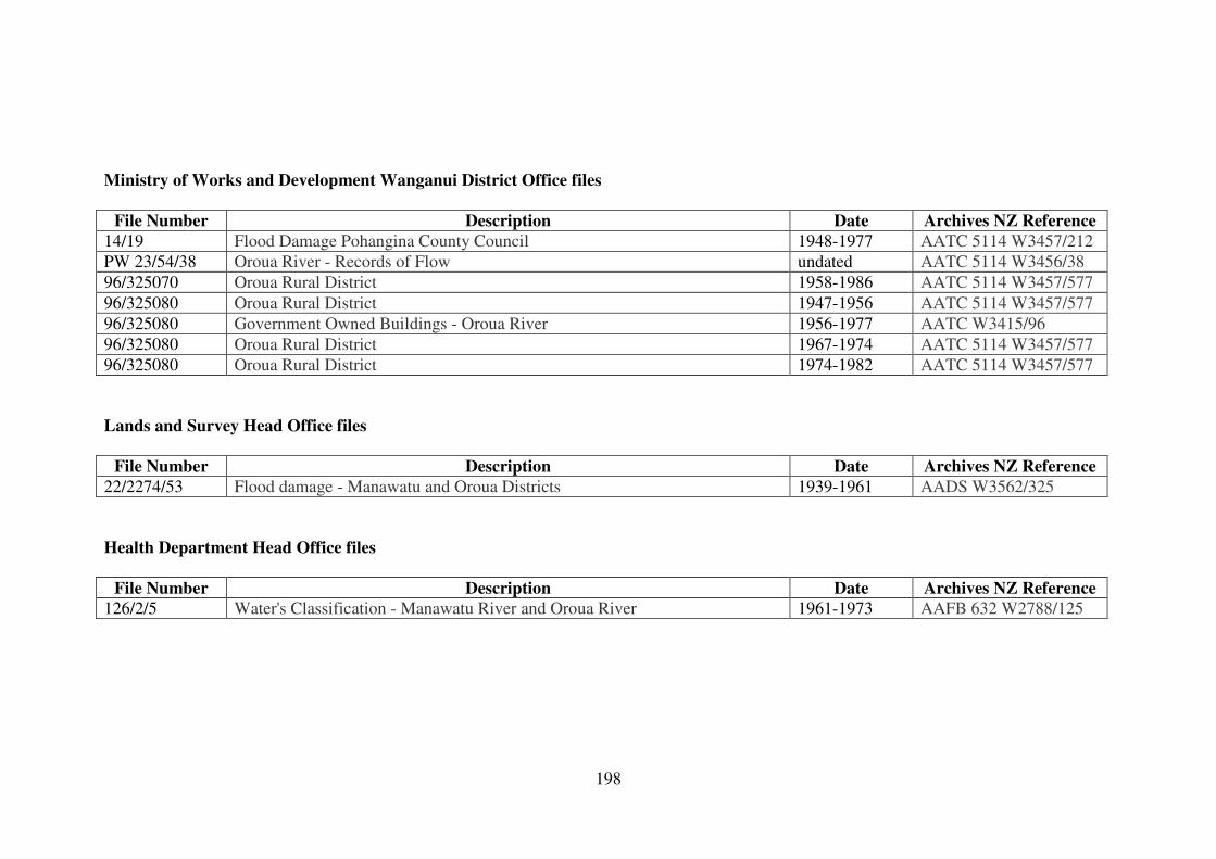
198
Ministry of Works and Development Wanganui District Office files
File Number Description Date Archives NZ Reference
14/19 Flood Damage Pohangina County Council 1948-1977 AATC 5114 W3457/212
PW 23/54/38 Oroua River - Records of Flow undated AATC 5114 W3456/38
96/325070 Oroua Rural District 1958-1986 AATC 5114 W3457/577
96/325080 Oroua Rural District 1947-1956 AATC 5114 W3457/577
96/325080 Government Owned Buildings - Oroua River 1956-1977 AATC W3415/96
96/325080 Oroua Rural District 1967-1974 AATC 5114 W3457/577
96/325080 Oroua Rural District 1974-1982 AATC 5114 W3457/577
Lands and Survey Head Office files
File Number Description Date Archives NZ Reference
22/2274/53 Flood damage - Manawatu and Oroua Districts 1939-1961 AADS W3562/325
Health Department Head Office files
File Number Description Date Archives NZ Reference
126/2/5 Water's Classification - Manawatu River and Oroua River 1961-1973 AAFB 632 W2788/125
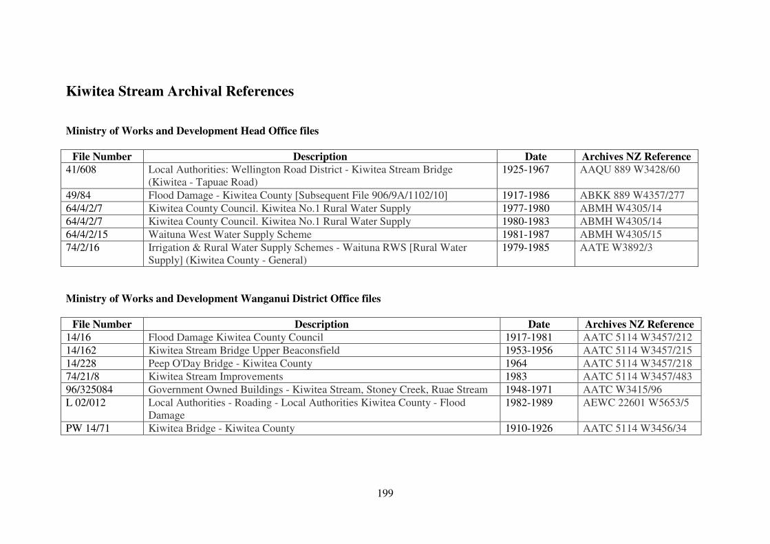
199
Kiwitea Stream Archival References
Ministry of Works and Development Head Office files
File Number Description Date Archives NZ Reference
41/608 Local Authorities: Wellington Road District - Kiwitea Stream Bridge
(Kiwitea - Tapuae Road)
1925-1967 AAQU 889 W3428/60
49/84 Flood Damage - Kiwitea County [Subsequent File 906/9A/1102/10] 1917-1986 ABKK 889 W4357/277
64/4/2/7 Kiwitea County Council. Kiwitea No.1 Rural Water Supply 1977-1980 ABMH W4305/14
64/4/2/7 Kiwitea County Council. Kiwitea No.1 Rural Water Supply 1980-1983 ABMH W4305/14
64/4/2/15 Waituna West Water Supply Scheme 1981-1987 ABMH W4305/15
74/2/16 Irrigation & Rural Water Supply Schemes - Waituna RWS [Rural Water
Supply] (Kiwitea County - General)
1979-1985 AATE W3892/3
Ministry of Works and Development Wanganui District Office files
File Number Description Date Archives NZ Reference
14/16 Flood Damage Kiwitea County Council 1917-1981 AATC 5114 W3457/212
14/162 Kiwitea Stream Bridge Upper Beaconsfield 1953-1956 AATC 5114 W3457/215
14/228 Peep O'Day Bridge - Kiwitea County 1964 AATC 5114 W3457/218
74/21/8 Kiwitea Stream Improvements 1983 AATC 5114 W3457/483
96/325084 Government Owned Buildings - Kiwitea Stream, Stoney Creek, Ruae Stream 1948-1971 AATC W3415/96
L 02/012 Local Authorities - Roading - Local Authorities Kiwitea County - Flood
Damage
1982-1989 AEWC 22601 W5653/5
PW 14/71 Kiwitea Bridge - Kiwitea County 1910-1926 AATC 5114 W3456/34
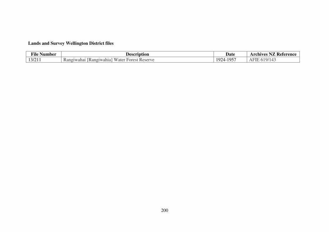
200
Lands and Survey Wellington District files
File Number Description Date Archives NZ Reference
13/211 Rangiwahai [Rangiwahia] Water Forest Reserve 1924-1957 AFIE 619/143
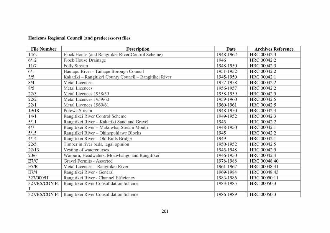
201
Horizons Regional Council (and predecessors) files
File Number Description Date Archives Reference
14/2 Flock House (and Rangitikei River Control Scheme) 1948-1962 HRC 00042:3
6/12 Flock House Drainage 1946 HRC 00042:2
11/7 Folly Stream 1948-1950 HRC 00042:3
6/1 Hautapu River - Taihape Borough Council 1951-1952 HRC 00042:2
3/5 Kakariki – Rangitikei County Council – Rangitikei River 1945-1950 HRC 00042:1
8/4 Metal Licences 1957-1958 HRC 00042:2
8/5 Metal Licences 1956-1957 HRC 00042:2
22/3 Metal Licences 1958/59 1958-1959 HRC 00042:5
22/2 Metal Licences 1959/60 1959-1960 HRC 00042:5
22/1 Metal Licences 1960/61 1960-1961 HRC 00042:5
19/18 Porewa Stream 1948-1950 HRC 00042:4
14/1 Rangitikei River Control Scheme 1949-1952 HRC 00042:3
5/11 Rangitikei River – Kakariki Sand and Gravel 1945 HRC 00042:2
4/7 Rangitikei River – Makowhai Stream Mouth 1948-1950 HRC 00042:1
5/15 Rangitikei River – Ohinepuhiawe Blocks 1945 HRC 00042:2
4/14 Rangitikei River – Old Bulls Bridge 1949 HRC 00042:1
22/5 Timber in river beds, legal opinion 1950-1952 HRC 00042:5
22/13 Vesting of watercourses 1945-1948 HRC 00042:5
20/6 Waiouru, Headwaters, Moawhango and Rangitikei 1946-1950 HRC 00042:4
E7/C Gravel Permits - Assorted 1978-1988 HRC 00048:40
E7/R Metal Licences – Rangitikei River 1961-1967 HRC 00048:41
E7/4 Rangitikei River - General 1969-1984 HRC 00048:43
327/000/H Rangitikei River - Channel Efficiency 1983-1986 HRC 00050:11
327/RS/CON Pt
1
Rangitikei River Consolidation Scheme 1983-1985 HRC 00050:3
327/RS/CON Pt Rangitikei River Consolidation Scheme 1986-1989 HRC 00050:3
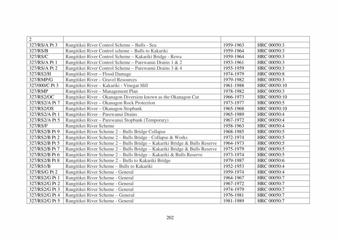
202
2
327/RS/A Pt 3 Rangitikei River Control Scheme – Bulls - Sea 1959-1963 HRC 00050:3
327/RS/B Rangitikei River Control scheme – Bulls to Kakariki 1959-1964 HRC 00050:3
327/RS/C Rangitikei River Control Scheme – Kakariki Bridge - Rewa 1959-1964 HRC 00050:3
327/RS/A Pt 1 Rangitikei River Control Scheme – Parewanui Drains 1 & 2 1953-1961 HRC 00050:3
327/RS/A Pt 2 Rangitikei River Control Scheme – Parewanui Drains 3 & 4 1955-1959 HRC 00050:3
327/RS2/H Rangitikei River – Flood Damage 1974-1979 HRC 00050:8
327/RMP/G Rangitikei River – Gravel Resources 1979-1982 HRC 00050:3
327/000/C Pt 3 Rangitikei River – Kakariki - Vinegar Hill 1961-1988 HRC 00050:10
327/RMP Rangitikei River – Management Plan 1978-1982 HRC 00050:3
327/RS2/OC Rangitikei River – Okanagon Diversion known as the Okanagon Cut 1966-1973 HRC 00050:10
327/RS2/A Pt 7 Rangitikei River – Okanagon Rock Protection 1973-1977 HRC 00050:5
327/RS2/OS Rangitikei River – Okanagon Stopbank 1965-1968 HRC 00050:10
327/RS2/A Pt 1 Rangitikei River – Parewanui Drains 1965-1989 HRC 00050:4
327/RS2/A Pt 5 Rangitikei River – Parewanui Stopbank (Temporary) 1967-1972 HRC 00050:4
327/RS/F Rangitikei River Scheme 1958-1963 HRC 00050:4
327/RS2/B Pt 9 Rangitikei River Scheme 2 – Bulls Bridge Collapse 1968-1985 HRC 00050:5
327/RS2/B Pt 2 Rangitikei River Scheme 2 – Bulls Bridge - Collapse & Works 1972-1974 HRC 00050:5
327/RS2/B Pt 5 Rangitikei River Scheme 2 – Bulls Bridge – Kakariki Bridge & Bulls Reserve 1964-1973 HRC 00050:5
327/RS2/B Pt 7 Rangitikei River Scheme 2 – Bulls Bridge – Kakariki Bridge & Bulls Reserve 1975-1979 HRC 00050:5
327/RS2/B Pt 6 Rangitikei River Scheme 2 – Bulls Bridge – Kakariki & Bulls Reserve 1973-1974 HRC 00050:5
327/RS2/B Pt 8 Rangitikei River Scheme 2 – Bulls to Kakariki Bridge 1979-1987 HRC 00050:6
327/RS1/B Rangitikei River Scheme – Bulls to Kakariki 1952-1953 HRC 00050:4
327/RS/G Pt 2 Rangitikei River Scheme - General 1959-1974 HRC 00050:4
327/RS2/G Pt 1 Rangitikei River Scheme - General 1964-1967 HRC 00050:7
327/RS2/G Pt 2 Rangitikei River Scheme - General 1967-1972 HRC 00050:7
327/RS2/G Pt 3 Rangitikei River Scheme - General 1974-1979 HRC 00050:7
327/RS2/G Pt 4 Rangitikei River Scheme – General 1976-1981 HRC 00050:7
327/RS2/G Pt 5 Rangitikei River Scheme - General 1981-1989 HRC 00050:7
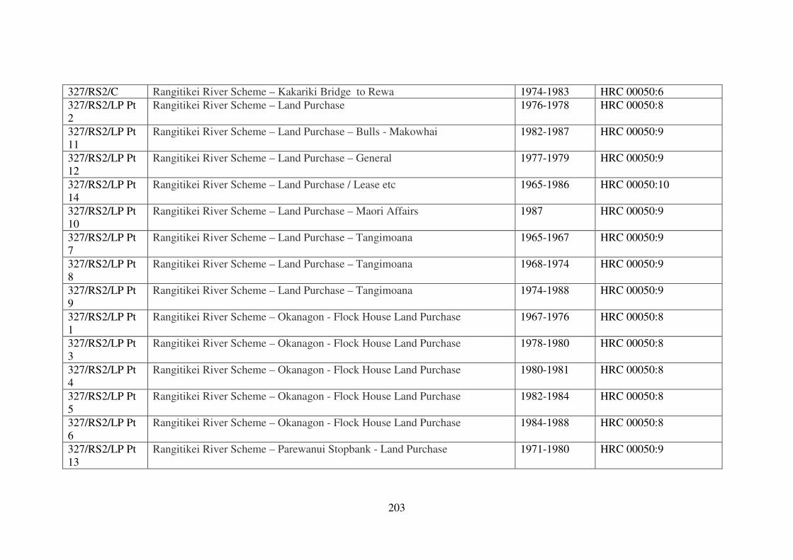
203
327/RS2/C Rangitikei River Scheme – Kakariki Bridge to Rewa 1974-1983 HRC 00050:6
327/RS2/LP Pt
2
Rangitikei River Scheme – Land Purchase 1976-1978 HRC 00050:8
327/RS2/LP Pt
11
Rangitikei River Scheme – Land Purchase – Bulls - Makowhai 1982-1987 HRC 00050:9
327/RS2/LP Pt
12
Rangitikei River Scheme – Land Purchase – General 1977-1979 HRC 00050:9
327/RS2/LP Pt
14
Rangitikei River Scheme – Land Purchase / Lease etc 1965-1986 HRC 00050:10
327/RS2/LP Pt
10
Rangitikei River Scheme – Land Purchase – Maori Affairs 1987 HRC 00050:9
327/RS2/LP Pt
7
Rangitikei River Scheme – Land Purchase – Tangimoana 1965-1967 HRC 00050:9
327/RS2/LP Pt
8
Rangitikei River Scheme – Land Purchase – Tangimoana 1968-1974 HRC 00050:9
327/RS2/LP Pt
9
Rangitikei River Scheme – Land Purchase – Tangimoana 1974-1988 HRC 00050:9
327/RS2/LP Pt
1
Rangitikei River Scheme – Okanagon - Flock House Land Purchase 1967-1976 HRC 00050:8
327/RS2/LP Pt
3
Rangitikei River Scheme – Okanagon - Flock House Land Purchase 1978-1980 HRC 00050:8
327/RS2/LP Pt
4
Rangitikei River Scheme – Okanagon - Flock House Land Purchase 1980-1981 HRC 00050:8
327/RS2/LP Pt
5
Rangitikei River Scheme – Okanagon - Flock House Land Purchase 1982-1984 HRC 00050:8
327/RS2/LP Pt
6
Rangitikei River Scheme – Okanagon - Flock House Land Purchase 1984-1988 HRC 00050:8
327/RS2/LP Pt
13
Rangitikei River Scheme – Parewanui Stopbank - Land Purchase 1971-1980 HRC 00050:9
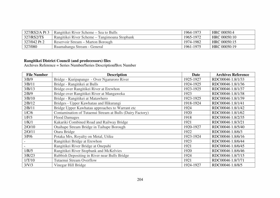
204
327/RS2/A Pt 3 Rangitikei River Scheme – Sea to Bulls 1964-1973 HRC 00050:4
327/RS2/TS Rangitikei River Scheme – Tangimoana Stopbank 1965-1972 HRC 00050:10
327/042 Pt 2 Reservoir Stream – Marton Borough 1974-1982 HRC 00050:15
327/080 Ruamahanga Stream - General 1961-1975 HRC 00050:19
Rangitikei District Council (and predecessors) files
Archives Reference = Series Number/Series Description/Box Number
File Number Description Date Archives Reference
3/B/9 Bridge - Kuripapango - Over Ngaruroro River 1925-1927 RDC00046 1.8/1/33
3/B/11 Bridge - Rangitikei at Bulls 1924-1925 RDC00046 1.8/1/36
3/B/13 Bridge over Rangitikei River at Erewhon 1923-1925 RDC00046 1.8/1/37
2/B/9 Bridge over Rangitikei River at Mangaweka 1923 RDC00046 1.8/1/38
3/B/10 Bridge - Rangitikei at Matawhero 1923-1925 RDC00046 1.8/1/39
2/B/12 Bridges - Upper Kawhatau and Hikurangi 1918-1924 RDC00046 1.8/1/41
2/B/11 Bridge Upper Kawhatau approaches to Warrant etc 1924 RDC00046 1.8/1/42
1/C/6 Contamination of Tutaenui Stream at Bulls (Dairy Factory) 1920 RDC00046 1.8/1/62
1/F/3 Flood Damages 1918 RDC00046 1.8/2/35
1/K/1 Kakariki Combined Road and Railway Bridge 1921 RDC00046 1.8/3/21
2/O/10 Otaihape Stream Bridge in Taihape Borough 1920-1927 RDC00046 1.8/5/40
2/O/11 Otara Bridge 1922 RDC00046 1.8/6/3
3/P/6 Potaka Mrs, Royalty on Metal, Utiku 1923-1924 RDC00046 1.8/6/16
- Rangitikei Bridge at Erewhon 1923 RDC00046 1.8/6/44
- Rangitikei River Bridge at Onepuhi 1921 RDC00046 1.8/6/45
1/R/5 Rangitikei River Stopbank and McKelvies 1920 RDC00046 1.8/6/46
3/R/23 Rubbish Depositing in River near Bulls Bridge 1924 RDC00046 1.8/7/15
1/T/10 Tutaenui Stream Overflow 1921 RDC00046 1.8/7/71
3/V/3 Vinegar Hill Bridge 1924-1927 RDC00046 1.8/8/5
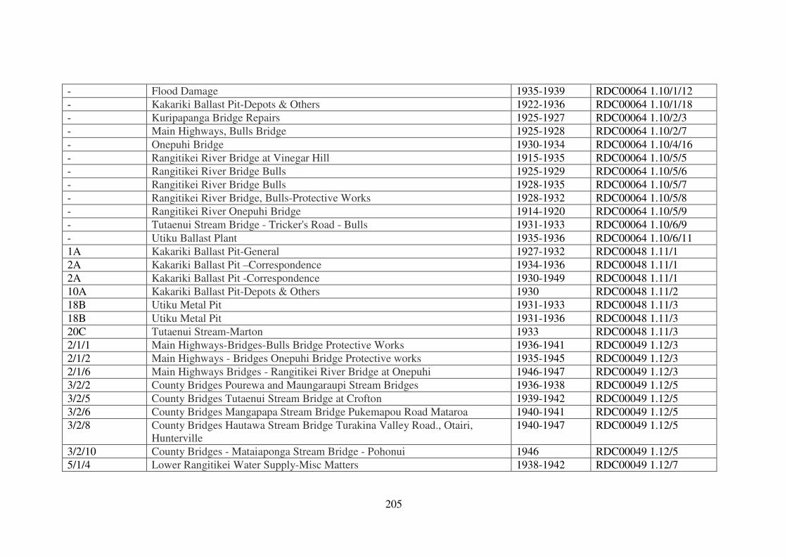
205
- Flood Damage 1935-1939 RDC00064 1.10/1/12
- Kakariki Ballast Pit-Depots & Others 1922-1936 RDC00064 1.10/1/18
- Kuripapanga Bridge Repairs 1925-1927 RDC00064 1.10/2/3
- Main Highways, Bulls Bridge 1925-1928 RDC00064 1.10/2/7
- Onepuhi Bridge 1930-1934 RDC00064 1.10/4/16
- Rangitikei River Bridge at Vinegar Hill 1915-1935 RDC00064 1.10/5/5
- Rangitikei River Bridge Bulls 1925-1929 RDC00064 1.10/5/6
- Rangitikei River Bridge Bulls 1928-1935 RDC00064 1.10/5/7
- Rangitikei River Bridge, Bulls-Protective Works 1928-1932 RDC00064 1.10/5/8
- Rangitikei River Onepuhi Bridge 1914-1920 RDC00064 1.10/5/9
- Tutaenui Stream Bridge - Tricker's Road - Bulls 1931-1933 RDC00064 1.10/6/9
- Utiku Ballast Plant 1935-1936 RDC00064 1.10/6/11
1A Kakariki Ballast Pit-General 1927-1932 RDC00048 1.11/1
2A Kakariki Ballast Pit –Correspondence 1934-1936 RDC00048 1.11/1
2A Kakariki Ballast Pit -Correspondence 1930-1949 RDC00048 1.11/1
10A Kakariki Ballast Pit-Depots & Others 1930 RDC00048 1.11/2
18B Utiku Metal Pit 1931-1933 RDC00048 1.11/3
18B Utiku Metal Pit 1931-1936 RDC00048 1.11/3
20C Tutaenui Stream-Marton 1933 RDC00048 1.11/3
2/1/1 Main Highways-Bridges-Bulls Bridge Protective Works 1936-1941 RDC00049 1.12/3
2/1/2 Main Highways - Bridges Onepuhi Bridge Protective works 1935-1945 RDC00049 1.12/3
2/1/6 Main Highways Bridges - Rangitikei River Bridge at Onepuhi 1946-1947 RDC00049 1.12/3
3/2/2 County Bridges Pourewa and Maungaraupi Stream Bridges 1936-1938 RDC00049 1.12/5
3/2/5 County Bridges Tutaenui Stream Bridge at Crofton 1939-1942 RDC00049 1.12/5
3/2/6 County Bridges Mangapapa Stream Bridge Pukemapou Road Mataroa 1940-1941 RDC00049 1.12/5
3/2/8 County Bridges Hautawa Stream Bridge Turakina Valley Road., Otairi,
Hunterville
1940-1947 RDC00049 1.12/5
3/2/10 County Bridges - Mataiaponga Stream Bridge - Pohonui 1946 RDC00049 1.12/5
5/1/4 Lower Rangitikei Water Supply-Misc Matters 1938-1942 RDC00049 1.12/7
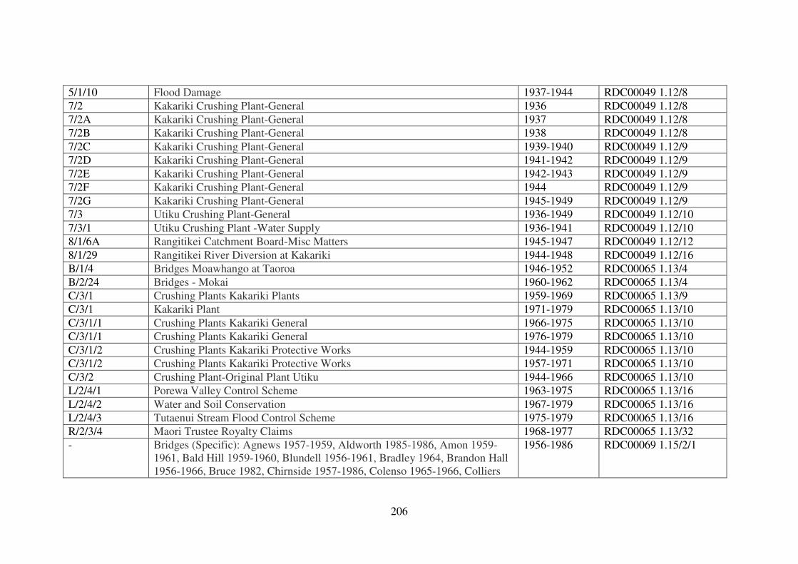
206
5/1/10 Flood Damage 1937-1944 RDC00049 1.12/8
7/2 Kakariki Crushing Plant-General 1936 RDC00049 1.12/8
7/2A Kakariki Crushing Plant-General 1937 RDC00049 1.12/8
7/2B Kakariki Crushing Plant-General 1938 RDC00049 1.12/8
7/2C Kakariki Crushing Plant-General 1939-1940 RDC00049 1.12/9
7/2D Kakariki Crushing Plant-General 1941-1942 RDC00049 1.12/9
7/2E Kakariki Crushing Plant-General 1942-1943 RDC00049 1.12/9
7/2F Kakariki Crushing Plant-General 1944 RDC00049 1.12/9
7/2G Kakariki Crushing Plant-General 1945-1949 RDC00049 1.12/9
7/3 Utiku Crushing Plant-General 1936-1949 RDC00049 1.12/10
7/3/1 Utiku Crushing Plant -Water Supply 1936-1941 RDC00049 1.12/10
8/1/6A Rangitikei Catchment Board-Misc Matters 1945-1947 RDC00049 1.12/12
8/1/29 Rangitikei River Diversion at Kakariki 1944-1948 RDC00049 1.12/16
B/1/4 Bridges Moawhango at Taoroa 1946-1952 RDC00065 1.13/4
B/2/24 Bridges - Mokai 1960-1962 RDC00065 1.13/4
C/3/1 Crushing Plants Kakariki Plants 1959-1969 RDC00065 1.13/9
C/3/1 Kakariki Plant 1971-1979 RDC00065 1.13/10
C/3/1/1 Crushing Plants Kakariki General 1966-1975 RDC00065 1.13/10
C/3/1/1 Crushing Plants Kakariki General 1976-1979 RDC00065 1.13/10
C/3/1/2 Crushing Plants Kakariki Protective Works 1944-1959 RDC00065 1.13/10
C/3/1/2 Crushing Plants Kakariki Protective Works 1957-1971 RDC00065 1.13/10
C/3/2 Crushing Plant-Original Plant Utiku 1944-1966 RDC00065 1.13/10
L/2/4/1 Porewa Valley Control Scheme 1963-1975 RDC00065 1.13/16
L/2/4/2 Water and Soil Conservation 1967-1979 RDC00065 1.13/16
L/2/4/3 Tutaenui Stream Flood Control Scheme 1975-1979 RDC00065 1.13/16
R/2/3/4 Maori Trustee Royalty Claims 1968-1977 RDC00065 1.13/32
- Bridges (Specific): Agnews 1957-1959, Aldworth 1985-1986, Amon 1959-
1961, Bald Hill 1959-1960, Blundell 1956-1961, Bradley 1964, Brandon Hall
1956-1966, Bruce 1982, Chirnside 1957-1986, Colenso 1965-1966, Colliers
1956-1986 RDC00069 1.15/2/1
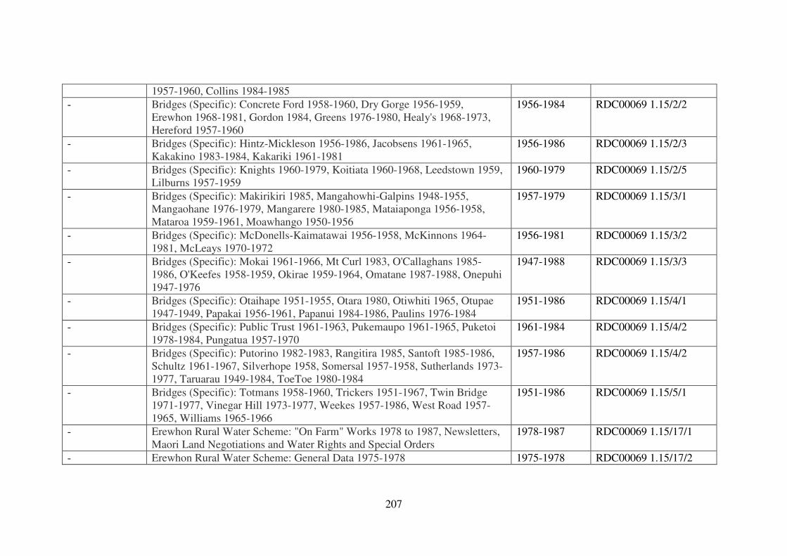
207
1957-1960, Collins 1984-1985
- Bridges (Specific): Concrete Ford 1958-1960, Dry Gorge 1956-1959,
Erewhon 1968-1981, Gordon 1984, Greens 1976-1980, Healy's 1968-1973,
Hereford 1957-1960
1956-1984 RDC00069 1.15/2/2
- Bridges (Specific): Hintz-Mickleson 1956-1986, Jacobsens 1961-1965,
Kakakino 1983-1984, Kakariki 1961-1981
1956-1986 RDC00069 1.15/2/3
- Bridges (Specific): Knights 1960-1979, Koitiata 1960-1968, Leedstown 1959,
Lilburns 1957-1959
1960-1979 RDC00069 1.15/2/5
- Bridges (Specific): Makirikiri 1985, Mangahowhi-Galpins 1948-1955,
Mangaohane 1976-1979, Mangarere 1980-1985, Mataiaponga 1956-1958,
Mataroa 1959-1961, Moawhango 1950-1956
1957-1979 RDC00069 1.15/3/1
- Bridges (Specific): McDonells-Kaimatawai 1956-1958, McKinnons 1964-
1981, McLeays 1970-1972
1956-1981 RDC00069 1.15/3/2
- Bridges (Specific): Mokai 1961-1966, Mt Curl 1983, O'Callaghans 1985-
1986, O'Keefes 1958-1959, Okirae 1959-1964, Omatane 1987-1988, Onepuhi
1947-1976
1947-1988 RDC00069 1.15/3/3
- Bridges (Specific): Otaihape 1951-1955, Otara 1980, Otiwhiti 1965, Otupae
1947-1949, Papakai 1956-1961, Papanui 1984-1986, Paulins 1976-1984
1951-1986 RDC00069 1.15/4/1
- Bridges (Specific): Public Trust 1961-1963, Pukemaupo 1961-1965, Puketoi
1978-1984, Pungatua 1957-1970
1961-1984 RDC00069 1.15/4/2
- Bridges (Specific): Putorino 1982-1983, Rangitira 1985, Santoft 1985-1986,
Schultz 1961-1967, Silverhope 1958, Somersal 1957-1958, Sutherlands 1973-
1977, Taruarau 1949-1984, ToeToe 1980-1984
1957-1986 RDC00069 1.15/4/2
- Bridges (Specific): Totmans 1958-1960, Trickers 1951-1967, Twin Bridge
1971-1977, Vinegar Hill 1973-1977, Weekes 1957-1986, West Road 1957-
1965, Williams 1965-1966
1951-1986 RDC00069 1.15/5/1
- Erewhon Rural Water Scheme: "On Farm" Works 1978 to 1987, Newsletters,
Maori Land Negotiations and Water Rights and Special Orders
1978-1987 RDC00069 1.15/17/1
- Erewhon Rural Water Scheme: General Data 1975-1978 1975-1978 RDC00069 1.15/17/2
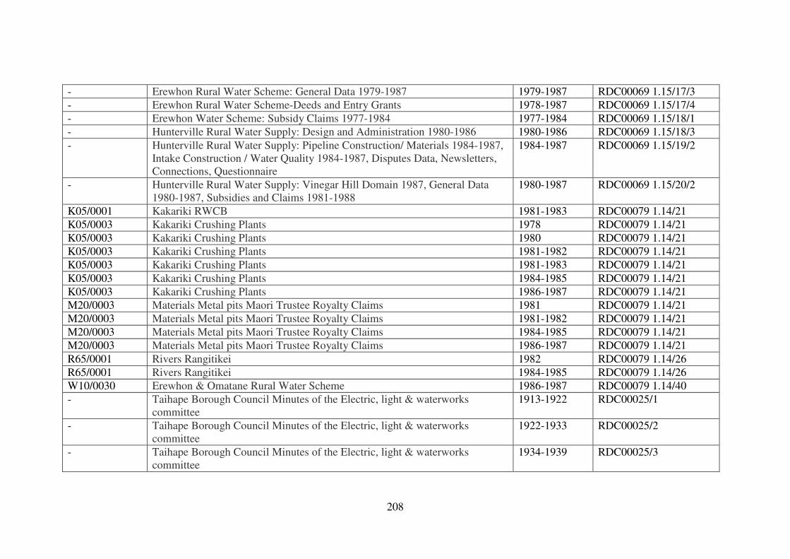
208
- Erewhon Rural Water Scheme: General Data 1979-1987 1979-1987 RDC00069 1.15/17/3
- Erewhon Rural Water Scheme-Deeds and Entry Grants 1978-1987 RDC00069 1.15/17/4
- Erewhon Water Scheme: Subsidy Claims 1977-1984 1977-1984 RDC00069 1.15/18/1
- Hunterville Rural Water Supply: Design and Administration 1980-1986 1980-1986 RDC00069 1.15/18/3
- Hunterville Rural Water Supply: Pipeline Construction/ Materials 1984-1987,
Intake Construction / Water Quality 1984-1987, Disputes Data, Newsletters,
Connections, Questionnaire
1984-1987 RDC00069 1.15/19/2
- Hunterville Rural Water Supply: Vinegar Hill Domain 1987, General Data
1980-1987, Subsidies and Claims 1981-1988
1980-1987 RDC00069 1.15/20/2
K05/0001 Kakariki RWCB 1981-1983 RDC00079 1.14/21
K05/0003 Kakariki Crushing Plants 1978 RDC00079 1.14/21
K05/0003 Kakariki Crushing Plants 1980 RDC00079 1.14/21
K05/0003 Kakariki Crushing Plants 1981-1982 RDC00079 1.14/21
K05/0003 Kakariki Crushing Plants 1981-1983 RDC00079 1.14/21
K05/0003 Kakariki Crushing Plants 1984-1985 RDC00079 1.14/21
K05/0003 Kakariki Crushing Plants 1986-1987 RDC00079 1.14/21
M20/0003 Materials Metal pits Maori Trustee Royalty Claims 1981 RDC00079 1.14/21
M20/0003 Materials Metal pits Maori Trustee Royalty Claims 1981-1982 RDC00079 1.14/21
M20/0003 Materials Metal pits Maori Trustee Royalty Claims 1984-1985 RDC00079 1.14/21
M20/0003 Materials Metal pits Maori Trustee Royalty Claims 1986-1987 RDC00079 1.14/21
R65/0001 Rivers Rangitikei 1982 RDC00079 1.14/26
R65/0001 Rivers Rangitikei 1984-1985 RDC00079 1.14/26
W10/0030 Erewhon & Omatane Rural Water Scheme 1986-1987 RDC00079 1.14/40
- Taihape Borough Council Minutes of the Electric, light & waterworks
committee
1913-1922 RDC00025/1
- Taihape Borough Council Minutes of the Electric, light & waterworks
committee
1922-1933 RDC00025/2
- Taihape Borough Council Minutes of the Electric, light & waterworks
committee
1934-1939 RDC00025/3
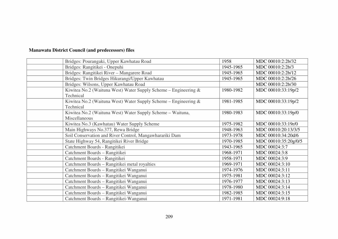
209
Manawatu District Council (and predecessors) files
Bridges: Pourangaki, Upper Kawhatau Road 1958 MDC 00010:2:2b/32
Bridges: Rangitikei - Onepuhi 1945-1965 MDC 00010:2:2b/3
Bridges: Rangitikei River – Mangarere Road 1945-1965 MDC 00010:2:2b/12
Bridges: Twin Bridges Hikurangi/Upper Kawhatau 1945-1965 MDC 00010:2:2b/26
Bridges: Wilsons, Upper Kawhatau Road MDC 00010:2:2b/30
Kiwitea No.2 (Waituna West) Water Supply Scheme – Engineering &
Technical
1980-1982 MDC 00010:33:19p/2
Kiwitea No.2 (Waituna West) Water Supply Scheme – Engineering &
Technical
1981-1985 MDC 00010:33:19p/2
Kiwitea No.2 (Waituna West) Water Supply Scheme – Waituna,
Miscellaneous
1980-1983 MDC 00010:33:19p/0
Kiwitea No.3 (Kawhatau) Water Supply Scheme 1975-1982 MDC 00010:33:19r/0
Main Highways No.377, Rewa Bridge 1948-1963 MDC 00010:20:13/3/5
Soil Conservation and River Control, Mangawharariki Dam 1973-1978 MDC 00010:34:20d/6
State Highway 54, Rangitikei River Bridge 1970-1985 MDC 00010:35:20g/0/5
Catchment Boards - Rangitikei 1943-1965 MDC 00024:3:7
Catchment Boards – Rangitikei 1968-1971 MDC 00024:3:8
Catchment Boards - Rangitikei 1958-1971 MDC 00024:3:9
Catchment Boards – Rangitikei metal royalties 1969-1971 MDC 00024:3:10
Catchment Boards – Rangitikei Wanganui 1974-1976 MDC 00024:3:11
Catchment Boards – Rangitikei Wanganui 1975-1981 MDC 00024:3:12
Catchment Boards – Rangitikei Wanganui 1976-1977 MDC 00024:3:13
Catchment Boards – Rangitikei Wanganui 1978-1980 MDC 00024:3:14
Catchment Boards – Rangitikei Wanganui 1982-1985 MDC 00024:3:15
Catchment Boards – Rangitikei-Wanganui 1971-1981 MDC 00024:9:18
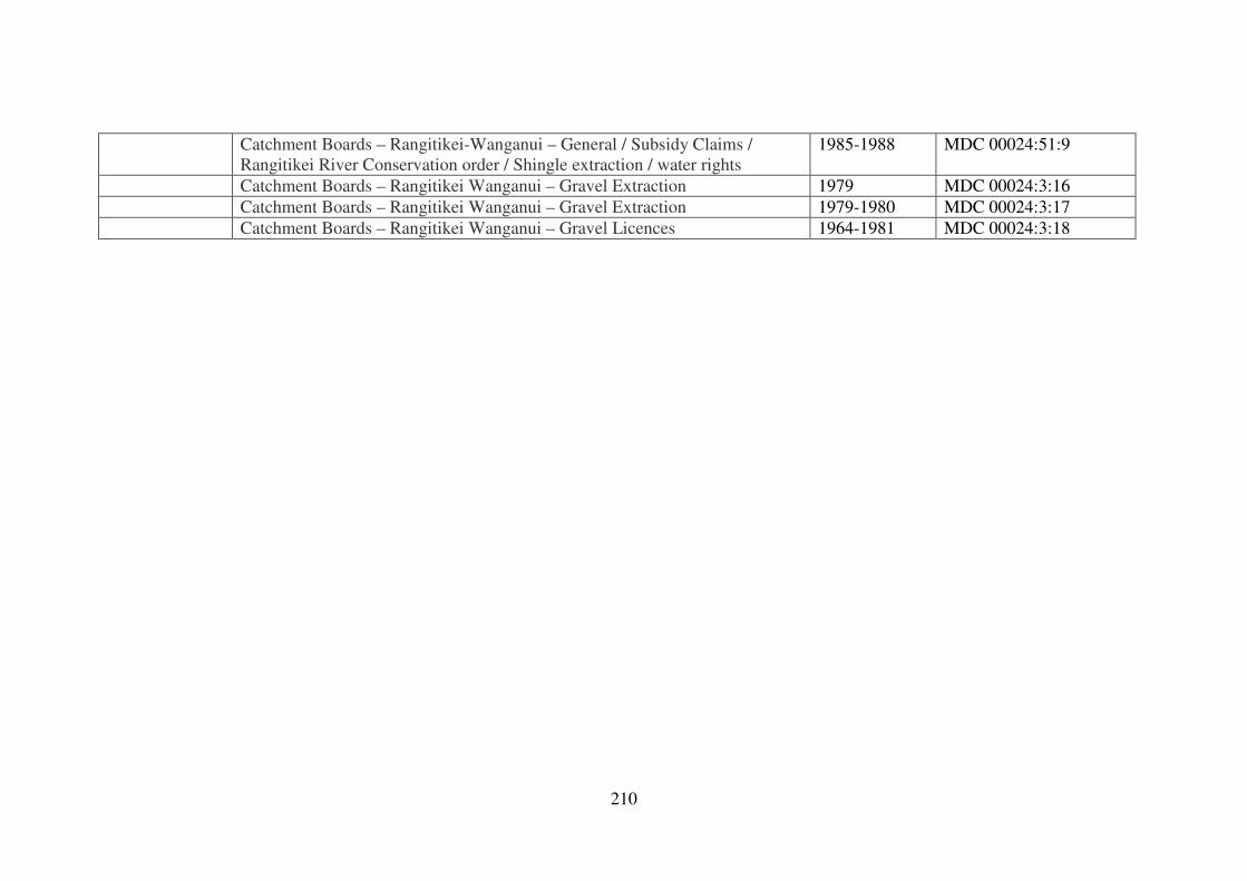
210
Catchment Boards – Rangitikei-Wanganui – General / Subsidy Claims /
Rangitikei River Conservation order / Shingle extraction / water rights
1985-1988 MDC 00024:51:9
Catchment Boards – Rangitikei Wanganui – Gravel Extraction 1979 MDC 00024:3:16
Catchment Boards – Rangitikei Wanganui – Gravel Extraction 1979-1980 MDC 00024:3:17
Catchment Boards – Rangitikei Wanganui – Gravel Licences 1964-1981 MDC 00024:3:18