the fascine unidentified wreck nellie?
TRANSCRIPT

WRECK INSPECTION REPORT The Fascine unidentified wreck
Nellie?
Cover Photo: The wreck at low water (M.McCarthy).
Dr M. McCarthy Department of Maritime Archaeology
W.A. Maritime Museum Cliff SI. Fremantle
6160 January 1998
With assistance from: C. Annstrong, M. Matthias, K. McGowan, C. Miller, C. Smith, W. Smith,
Report : Department of Maritime Archaeology, \Vestern Australian Maritime Museum, No. 135.

Abstract
In December 1997, the Gascoyne Development Commission advised the Maritime Archaeology Department of the Western Australian Maritime Museum that a dredge involved in the deepening of Carnarvon' s Fascine had unearthed what appeared to be an intact shipwreck. In believing that the wreck may that of the schooner Nellie and that it may prove of present and future historic value to the town and to its people, the Commission provided the Maritime Museum with assistance in order to conduct an inspection of the site. The inspection indicates that the wreck is most likely that of the Nellie (1894-c.1920), a former Broome and Shark Bay pearler, which sank whilst engaged in the fishing industry out of Carnarvon. Though the stern of the wreck has been greatly affected (if not entirely destroyed) by the dredging process, the wreck is considered of significance to the Norlh-West and though it cannot be protected under current shipwreck legislation, recommendations are made for the management of the site so that it can remain as a potential asset to the region.
This inspection was funded by The Gascoyne Development Commission
Acknowledgments
Ms Ch';s Annstrong, Gascoyne Development Commission Ms Cecily Miller Gascoyne Historical Society
M. Van Helvoort, The Northem Guardian & Carnarvon Residents, Mr Bill Smith, Mr Ken McGowan, Mr Cyril Smith & Ms Marriann Matthias

Background
While conducting operations for the Carnarvon Fascine Development, a floating dredge encountered an obstruction in riverine sediments at a depth of around one metre below the water surface. In believing, from past experience, that it was discarded rubbish from a known dump in the area, or one of the many tree trunks which were known to have been washed down the Gascoyne River in its regular floods, the operator spent considerable time attempting to clear a way through the obstruction. When this proved unsuccessful a diver was sent down, returning with indications of a small wreck. Work in the vicinity was stopped and an examination planned for low water spring tides when the area being dredged was expected to dry. The presence of a wreck was confirmed and the Gascoyne Development Commission advised the Department of Maritime Archaeology at the Western Australian Maritime Museum. This is in accordance with the 1973 Maritime Archaeology Act which operates in Western Australian State Waters and which requires that the Museum be notified of all wrecks and wreck material believed to be historic. In turn, it is charged with the responsibility to take steps to protect any wreck believed to have been lost before the year 1900.
Technical Data
Site Name: The Fascine unidentified, possihly Nellie.
Date lost c. 1920
Date of Inspection: 20-21112/1997
Personnel: M. McCarthy C. Armstrong K. McGowan W. Smith M. Matthais C. Smith
Approximate Location Northern shore Carnarvon Fascine, opposite the Carnarvon Yacht Club
GPS. 240 53.580'S., 1130 39.005'E (WGS 84)
UTM Coodinates 49767712E 7244293N
Chart No: PWD 50780. Australia West Coast, Carnarvon. 1:12500
File No: 210/80 File Name: Shark Bay Area

/ c;
'. "
Sailing Directions: Drive to the area via the Babbage Island Road proceeding across or around the newly-reclaimed land. Stop above high water and walk out to the site which is visible at low water spring tide. Alternatively proceed by boat from the Fascine area itself.
/) 0'
See Inset
Chart Excerpt From: PWD, WA. 507801:12500
fy'l; ~ :\'
I 'l; - -JI 1
I 11 ''-
~~~ l (;3:.:"~ 0 ~
/' ~~ AIJD\ 0nI : : ~
ie..: , ' "* .. , . . . , . . . . . , .
CV~. ~j~ (~c:~S~, , ;:; (~~ ,
G~;t~\'). <
u " 1::",
4N POINT
PICKLES Dn'NT,'~
',' '.;-:<:~.{'~ ,
,(,
,._ j r .' ..• '. ,". '" • ,.,'" ":" •. ' f,~ ~ .. ,"?;,."",,: - .. ~~.r. ~~,:. .! , , . ..tt-!'.t~t,..vr.~'t'~· -: /.Zi

Site Photographs: W A Maritime Museum Colour: Fascine Wreck
The Northern Guardian Nellie report (3111211997)
Description of Site
The wreck was inspected at low water in intertidal region of the Gascoyne River estuary adjacent the Fascine. Its remains were found on a sloping seafloor of sand and mud in an area bordered by mangrove swamps and river flats to the north and west, by sandbars to the south and by the Fascine wall and the town-site to the east. Though open to the east, there was little fetch in that quarter and it was apparent that this and the sand bars to the south have ensured that the upper works of the site have been well protected from the effect of seas and swell. At the commencement of the inspection the fore part of the wreck was totally exposed on the sandbar and the stern section was submerged in waters sloping to around one metre deep. Frames, some ceiling and outer planking were visible to porl. A Samson post, a windlass and a section of hatch coaming, were also visible. The stump of a mast was visible just foreword of the hatch coaming. The starboard side of the wreck could not be seen ill the poor undelWater visibility, though some frames could be felt by hand, just projec ting above the sand on the seaflooL The wreck lay bows to the south, with an undetermined, though possibly small, heel to starboard and a drop of c. 4° from bow to stern as measured along the top of the starboard hatch coaming. The aft section of the wreck could not be discerned under the sea bed which rapidly sloped from the exposed bow section on a sandbar astern into a channel c. 1.5 metres deep. From the depth of the seabed and its rapidly shelving nature, indications were that dredging had been undertaken along the port and starboard quarters of the wreck and into its stem section. As ex pected of thc wanTI-water, heavily-oxygenated, saline environment in which the site lay, the ironwork has suffered substantial corrosion. The windlass which dominates the foresection of the wreck is heavily corroded for example. On the other hand, the copper/alloy fastenings on the timbers in the forepeak are intact, boding well for the strength of the vessel in that region.
Site Conditions on inspection Sea and Swell: Smooth seas S urge: Imperceptible Visibility: lOcm undelwater, at best. Current: Imperceptible Sea-bed coverage: Sand bottom Tidal range O.I-I.Sm
The Site Survey The exposed timbers appeared to be West Australian Jarrah and being most-likely built to British specifications, it was elected to record the vessel in imperial measurements and to convert to metric where necessary. This is standard practice, with commonalities of frame spacings, scantlings and the like being more evident if measured in units consistent to those used in the building process. Given that the majority of the wreck appeared buried in sand and mud and that an 'area excavation' was not indicated or desirable, it was also decided to conduct a probe survey along the centreline of the site at one foot (25cm) intervals and across the site at four foot (IOOcm) intervals using 6 mm stainless steel rod. Experiencing almost nil visibility in the

water once the sediments were disturbed, a manual examination of the submerged remains was also conducted, where possible. An excavation of a small area forward of the Samson post in the forepeak was conducted to a depth of c. 60cm and at the stem and two locations along the port quarter foreward a manual excavation alongside the timbers was conducted to a similar depth.
Results These analyses indicated that the remains are those of small wooden-hulled two-masted sailing vessel once about 39-40 feet long by around 11-12 feet wide (See site plan). Consistent with that analysis, four inch (200mm) copper-alloy fastening were evident amongst the timbers of the forepeak and the frames (which were quite degraded) appear to vary in size from three inch by four inches (7SrrunXIOOmm) foreward to five inches by three inches (12SmmX7Smm) amidships on the port side. Outer plank thicknesses of around one inch and inner plank (ceiling) thicknesses of around 2 inches (SOmm) were indicated, though those measured were also quite degraded. The vessel was fitted with a small hand-windlass and with a large 12 foot by 6 foot hatch (3.6mX1.8m) between two masts, the fore of which is circular and the aft nine inches (18S mm) square. Aft of the (main or mizzen) mast the remains of another hatch coaming S foot nine inches (l.7Sm) wide are also evident. Its length was not discernible. Apart from the windlass, machinery was not evident, though an analysis of the stern was precluded due to the depth buried. Indications from the probe survey are that the vessel was sail propelled and that it did not have an engine. The manual excavation on the fore side of the stem indicated that it was intact and wellpreserved under the sediments, with the timbers well-bedded into the rabbet and apparently still securely fastened to it. The excavation at two locations externally along the port side revealed copper/allow sheathing at a distance of 2 feet (60cm) down from the seafloor. The test-excavation of the forepcak revealed ship's timbers buried in the sedimcnts and on being examined manually (given the poor visibility) they appeared to have suffered no apparent damage from marine organisms. Though sprung from the stempost, the wen! appar~ntly in good condition and otherwise undamaged. Bottle sherds and a complete bottle were recovered in the excavation, together with what appeared to be small Shark Bay pearl shells, the largest SOmm across. Natural bush timber, seaweed, sbells and other sea and riverine detritus were also located deep within the excavation, along with loose dressed ship's timbers and those structural timbers formin g the forcp~ak itself. While conducting the probe survey through the aft cargo hold a half of a boomerang was discovered amongst the scdimcnts and it was duly recovered for examination.
Figure: Mr Bill Smith of Camarvon with the boomerang. (Photograph, M. Van Helvoort, The Northern Guardian)
·~·:.ik· , :.';~. ~ .. .;.. '
~~;~;.: : - ;i.".... . ~ ,.~'~
,:i~f::~- i~~1~% ~

The location of seaweed and other contaminatory material deep within the deposit indicates considerable disturbance and mixing of material within the hull over the years. The probe survey indicated tbat the floors of the wreck appear intact from the stem to midships and probably to the fore end of the aft hatch c. 28 feet C8.5rn) aft of the stempost. In this region deck beams, the hatch coaming, masts and some decking are evident. It is also evident that most of the deck forward has disintegrated though deck beams are in place, though some were loose and could not be measured with any degree of accuracy. Decking appears strong in the region between the two cargo holds. Probing of the of the site has also indicated that the port and starboard sides of the wreck appear intact from the stem to middle of the fore cargo hold, where they disappear under the sand, to give inconsistent indications of their presence on both the port and starboard sides. It also appears that approximately 10 feet or 3m of the stern section of the wreck has been entirely destroyed by the dredge with the possible exception of the keel and a few inner strakes of timber. Further aft, the keel appears to have been totally destroyed, to lie fragmented under the sand.
Material Raised
Forepeak I clear glass bottle c.1900 I Lea and Perrins neck and stopper 2 small Shark Bay pearl shells ( Largest 50mm across) 1 copperlzinc alloy through bolt 4" (200mm long), 1/4 inch 96mm in diameter).
Cargo hold I Half boomerang
Material raised by the finders previous to this inspection included concreted rope, unidentified and heavily concreted ironwork, a chain plate with deadeye and concreted rope and some concreted sections of the vessel's shrouds.
Manaaement of the material raised. The artefacts were left in the combined care of Ms Chris Armstrong of the Gascoync Development Commission and Ms Marrianne Matthais of Carnarvon. Ms Matthais has undertaken to provide conservation treatment at Carnarvon and to liaise with Museum staff in doing so.
Discussion An anomalous feature of the wreck is the fact that it appears buried up to the deck level. Though a wreck usually buries itself in the seabed sediments, if upright it settles in those sediments at around the turn of the bilge and if on its side it is huried to varying degrees dependent on the angle of heel of the wreck. Occasionally an entire side is buried in the scabcd. If lying in a accessible position on the shore, salvage or burning of those timbers projecting above the sand is the norm. In this manner timber and/or metallic fastenings are recovered for reuse. This, combined with the negative effects of water movement and wood borers, serves to reduce most wrecks to a fraction of their former state, leaving only what lies under the protective sediments intact. It appears that this particular vessel has been totally buried until recently with only the tips of some timbers and the upper surface of the windlass and portion of the hatch coaming projecting above the seafloor and occasionally breaking water at Iow water spring .tides. This has precluded the colonisation of the wreck by marine organisms and the attack by wood borers of those timbers normally buried. It is evident that dredging in the vicinity of the wreck in recent weeks has lowered the sand cover around site, exposing more material than has been the case since the wreck occurred.

Figure: Views of the site and the recording process. (Photographs, M. Van Hclvoort. The Northern Guardian and M. McCanhy. WA Maritime Museum)


/;
",.
-

Plan of Site Sketch by Chris Annstrong ( Gascoyne Development Commission)
1 ' /- " -- ;;~" ),.
-_.- ... ~.--
'\' .'
:\ '\
~ "
"
, '''"'1--,, " , ·:·'~0. ~:~~ '.
.. -;'
.- ...
, ,
" .1
I
1 ... {
>
• C at'
{
. . '
o
\ \:J' V
\~'
{'4
\ \ H · -:.>
"
, .. \
2..1-1' ~
' I .... :; . . : '2:;. u.
I
! :' '.
,:;',';-:. t~;~ ',;;:; ·-.:::.;;:i.i . ':, ".:':: ';; ... ",': ;~.~'f
···:··~.:·::i,}{:'~·f.~f1r?if: .. ;: ....
~/~i:: ,~,' ~I~-
f.~~~ ' JiflL~.["'l-.
"
,. ,

o
3
~ {! t ' 1 ~l 'li
'1 !
I ~
Sections through the wreck
Longitudinal sections (showing intact structure forward, a possible break at the 25 foot mark
and damage aft where the hull appears to have disintegrated)
-~---------~-. - ~------ ~~.{f,q 1""-<-,(/Il.fr4 5/Y1tK. _
l'
5
Lateral sections at 4 foot intervals (showing intact structure from the 0- c. 28 foot marks, and the damage aft.
The depth of the remains indicate that they have sepcralcd from the main hull and t~tllcn through the sediments due to the dredging)
I 4
Pod )'~ t rl,bLfs J/ ~f~ ),L f ~ r{.J<i,r;
01 \1
.£ 7f --- -"5= )'uftCf-
(
1.0

Site Identification Comments
The Fascine Unidentified wreck is that of a late nineteenth to early twentieth century wooden-hulled, two masted sailing vessel. It is possibly a schooner or a ketch of about 39-40 feet long by approximately 12 feet wide, fitted with a windlass and with a large 12' by 6' hatch between the two masts . Aft of the (main or mizzen) mast the remains of another hatch coaming are also evident, suggesting that the vessel was fitted with two similar-sized cargo holds. The copper alloy fastenings and sheathing indicate a mid to late nineteenth century vessel at least. Artefactual material excavated from the vessel's forepeak indicates a wreck of the 1900-1920s period, and one possibly involved in the Shark Bay pearling industry, though indications of this are scant. The location of half a boomerang lying in the hold is indicative of a possible Aboriginal involvement with the vessel (or wreck), though both it and the artefacts found in the forepeak need be treated with some caution given the scouring and filling effect of the regular floods and cyclones that have effected the waters of the Fascine in years past. There has also been a great deal of dumping in the area in previous years and from the indications of the material recovered by the dredge it includes even aircraft parts.
Despite the paucity of material evidence, this data fits the description of 10.14 ton, wooden-hulled two masted schooner Nellie Register Number 1111891, Official Number 101497. It was built at in 1890 and was the second vessel of that name constructed by the well-known Fremantle shipwright Robert Wrightson (Dickson. 1994: 192-197). The Nellie under consideration in this instance was 40 feet long by 11 feet wide and had a draught of 4.5 feet (l2.3m X 4.2m X 1.7m) and was purchased by Godfrey Hemsworth-master mariner of Sydney. It was then transferred to Broome ownership under Sydney Piggott and Rose Gonzalez-pearlers. Rose Gonzalez is noted as a business woman who with her husband lames, owned a number of luggers in the early 1900s. Nellie was later sold to Maud Shaw a 'married woman' and a Ji rs Muramats-pearlcr of Cossack in partnership. Then it passed into the hands of Arthur G. Hcnfrcy-pearlcr of Shark Bay, Edward A. Boyd, 'Li ghterman' of Shark Bay and then to the North Coast Shipping Company Lilnited of Perth. Nellie is recorded as having been fitted with two la rge freezer boxes and to have been moored in the Fascine while in port where it sank during service in the fishing industry out of Carnarvon ( Fry, 19 :). The masts were removed and the suhmerged wreck was apparently taken by the next river downrivcr to its present location. Of considcr"ble importance is the fact that Cyril Smith a long-term Carnarvon resident recently indicated that tilough the Ncllic initially lay on the seabed in the sand up to its wateriine (as is traditionally the case), with the onset of the next flood it quickly sank in the riverbed to around deck level due. This in Mr Smith's opinion was due to the turbulence around the hull acting to excavate under and around the wreck. In this assessment Mr Smith appears to have been correct. This description also fits the circumstances of the present wreck very well. Another possible wreck in the region is the Endeavollr. Two residents have indicated that this vessel sank at the mouth or the 'beginning of Whit lock [Oyster) Creek' (Miller, pers com.). In her work Ms C.A. Miller of the Gascoyne Historical Society gives deta il s of fish processing activities at Pickles point and provides a number of illustrations of boats, including one ketch the Celtic used in the trade. This appears to be around 24 feet (7.4m) long. considerably smaller than Nellie. Details of this vessel and the Carnarvon Endeavour have not been found in the registers. The names are comparatively common and vessels carrying those names are recorded as lost elsewhere (vide Dickson, 1996).

An Illustration of the schooner NelLie A photograph of the sunken Nellie with its masts appears in a book based on excerpts of a diary kept by Shark Bay identity Mick Fry. entitled Shark Bay Days.
"./ . . ':;.~ ~ .. '
.: •• f ....
, .
),
} ,
An Illustration of the much-smaller Ketch Celtic
." -~ ,.
'0 ...:;:,
From Cecily Miller's Photographical histOlY of CarnarvolZ and the Gascoyne region. Volume 5.
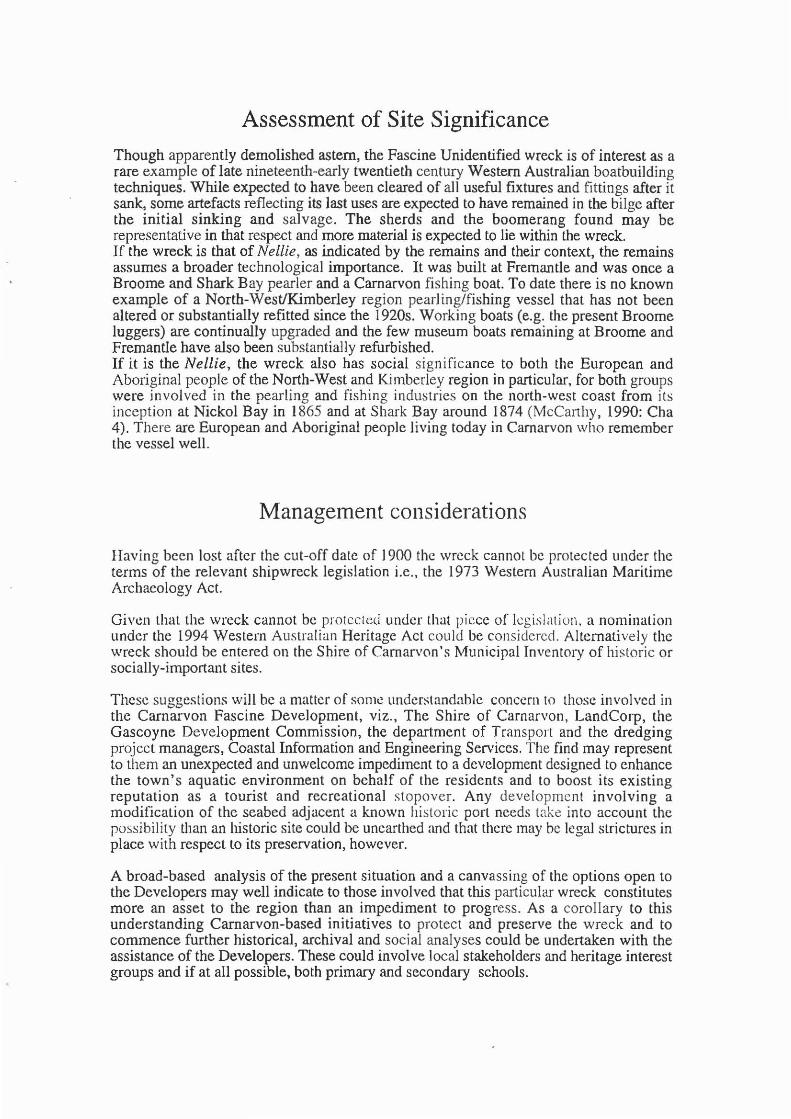
Assessment of Site Significance
Though apparently demolished astern, the Fascine Unidentified wreck is of interest as a rare example of late nineteenth-early twentieth century Western Australian boatbuilding techniques. While expected to have been cleared of all useful fixtures and fittings after it sank, some artefacts reflecting its last uses are expected to have remained in the bilge after the initial sinking and salvage. The sherds and the boomerang found may be representative in that respect and more material is expected to lie within the wreck. If the wreck is that of Nellie , as indicated by the remains and their context, the remains assumes a broader technological importance. It was built at Fremantle and was once a Broome and Shark Bay pearler and a Carnarvon fi shing boat. To date there is no known example of a North-West/Kimberley region pearling/fishing vessel that has not been altered or substantially refitted since the I 920s. Working boats (e.g. the present Broome luggers) are continually upgraded and the few museum boats remaining at Broome and Fremantle have also been substantially refurbished. If it is the Nellie, the wreck also has social significance to both the European and Aboriginal people of the North-West and Kimberley region in particular, for both groups were involved in the pearling and fishing industries on the north-west coast from its inception at Nickol Bay in 1865 and at Shark Bay around 1874 (McCanhy, 1990: Cha 4). There are European and Aboriginal people living today in Camarvon who remember the vessel well.
Management considerations
Having been lost after the cut-off date of 1900 the wreck cannot be protected under the terms of the relevant shipwreck legislation i.e., the 1973 Western Australian Maritime Archaeology Act.
Given that the wreck cannot be protected under that piece of legislation. a nomination under the 1994 Western Australian Heritage Act could be considered. Alternatively the wreck should be entered on the Shire of Carnarv0n 's Municipal Invent0ry of hi storic or socially-irnportant sites.
These suggestions will be a matter of sOl11e understandable concern to those involved in the Carnarvon Fascine Development, viz., The Shire of Carnarvon, LandCorp, the Gascoyne Development Commission, the department of Transport and the dredging project managers, Coastal Information and Engineering Services. The find may represent to them an unexpected and unwelcome impediment to a development designed to enhance the town's aquatic environment on behalf of the residents and to boost its existing reputation as a tourist and recreational stopover. Any developmcnt involving a modification of the seabed adjacent a known histori c port needs take into account the possibility than an historic site could be unearthed and that there may be legal strictures in place with respect to its preservation, however.
A broad-based analysis of the present situation and a canvassing of the options open to the Developers may well indicate to those involved that this particular wreck constitutes more an asset to the region than an impediment to progress. As a corollary to this understanding Carnarvon-based initiatives to protect and preserve the wreck and to commence further historical, archival and social analyses could be undertaken with the assistance of the Developers. These could involve local stakeholders and heritage interest groups and if at all possible, both primary and secondary schools.

In a climate where there is a growing commitment to the preservation of the surviving elements of the natural, social and historic environment the wreck could become a focus for interdisciplinary and cross-cultural studies and through it a long-awaited oral history program designed to capture living memories of the region could begin and later expand into areas other than the maritimes.
In years to come the fore section of the wreck could be raised, conserved and exhibited to advantage, though the costs of such an undertaking are most likely prohibitive at present. Equally as a result of the impetus received in this instance, a locally-based volunteer conservationJheritage unit could be developed out of Camarvon to deal with socially and historically-important materials and finds such as this for the entire North-west. This could complement the work of the Gascoyne Historical Society. Already as a result of this study there has been a transference of specialist knowledge and understandings to enthusiastic Camarvon residents and links have been established with the appropriate conservation specialists at the Maritime Museum. Some further training will need to be undertaken.
The available options
Given the inability of the Western Australian Maritime Museum to protect the wreck, it's future status then is a matter for the North-West people and their Insti tut ions to decide. The options open to them are to proceed with the dredging and to destroy the site, to seek to protect the wreck for the future by leaving it undisturbed ill Silll, or to attempt to relocate the remains.
Given that there is apparently considerable grass-roots support for the notion that the best efforts be made to preserve the site, it is suggested that due consideration should be given to the following possible course of action.
a) To avoid damaging the site further by creating a small dogleg in the channel around the site and backfilling the excavation around the stern. The wreck could be marked and the deviation called Nellie's Bend.
b) Tu remove the wreck from danger by either removing it totally from the f-ascine or to sink the wreck below the harbour datum and/or to relocate it and sink it into the sediments elsewhere.
Given the lessons of the past, it is evident that to totally remove the wreck from its protective sediments with an eye to their exhibition ashore is costly and requires the provision of exhibition and housing preceded by a commitment to the provision of conservation facilities and expertise. To remove the remains from the scabed and to then locate them in any but a proper facility will see their ultimate destruction. There arc established precedents for the moving of protected shipwreck sites either away from the affected area or below the harbour datum of the waters in which they lie, for example. The moving of the former American whaler Day Dawll (1851-1886) firstly below the harbour datum and then out of the area altogether is a case in point. This wreck was located by a dredge at HMAS Stirling Naval Base south of Fremantle and it became the focus of a concerted vo1unteerIMuseum investigation and analysis (McCarthy, 1979). In the first instance the remains were moved into a trench alongside the wreck which was excavated by the contractors to a depth which ensured that the remains lay below harbour datum (Sledge, 1979). In the latter case the wreck was again moved, in that case laterally to a more suitable location (Henderson and Kimpton, 1995). In both instances shoring up of the sides of the wreck with sediment and/or its back filling with a protective cover to guard against accidental anchor or propeller wash damage were considered the best postmovement management options.

Illustrations of these two techniques appear below. Full reports of the successful procedures appear in the references.
Moving a wreck illus tra tions of the methods used to r eloca te the Day Dawn (From, McCarthy, 1979; Sledge, 1979; Kimpton and Henderson, 1991)
Dredging method (a)
On shifting a wooden wreck. Supplementary note to the Day Dawll
The plan for removing the wfl!ck into greater deplh of \~;Jtcr Vv&lS com'civcu from ohservation of the \\'3}"~ in which s3nu~imJlactcd objecg slide or tOPl,lc down a slopc <IS the !land is eroded from heneath durin{! 3irlift :ll1d water-suction dredging. The plan called for the contractor's dredge to make a deep trench alongside the hull starting halfway up the inshore side, working :tcollnd behind the southern cnd and completing the trench parallel to, and slightly in excess of.
I
Figure I. Day {Jaw" dTct.Jging plan' I1nat .. numbered in order of submcrJ,!cnt:c.
the length of the hull to westward (Fig. 1). The theory was that when the dredging of the western trench produced a critical slope under tht.: keel. the southern end, which had been cleared inshore, would move first, and the hull, slightly eanting to shoreward, would gently slide on a skew angle into the trench (McCarthy, 1979: fig. 3).
As wC could find no published descriptiun of a similar operation having been attempted, we considered the possibility of the hull rolling instead of sliding, or of the hull breaking up and moving in .sections. In order to observe whether the plan was successful, I attached buoys to either cnd, and also small floats in pairs along both sides of the hull, so that a dotted outline of the wreck was represented on the surface. The positions of the buoys and the relative distance between floats were fI~corded using a sextant. I was therefore able to observe by the sequence of floats submerging that the plan did in fact work (Fig. I).
The wreck slipped evenly and intact into the dredged lrench and was there out of harm's way. well below the -3-0 m bottom requirelIlent for lhe boat harbour. In this position the wreck was then available for a partial excavation and detailed survey conducted by members oC MAAWA.
ScOff Sledge IVc-stem Australian Museum
Fremantle Branch Finnerry Street
Fremantle, Jj(A. 6160

Dredging method (b&c)
Midship 5eC!lon alinitlcl inspectIon February I~ (b
! · 3m --. -- .. £
--
M'dship sec"Qn dlmm~ relOtOI,on
2 Om
4 ·4m
12 Feb 1976
.. Carecning Bay Wreck, position in small boats harbour before and after relocation. (Drawing: Soot( Sledge).
f

Tidal lift method: A series of wide strops encircle the wreck and lhese are lensioned up at low waler. As lhe tide rises the lifting barge(s) also lift bringing the wreck up oul of its bed ready for relocation.
BULLDOG GRIPS
BARGE
STEEL CABLES [20 mm]
/
BULLDOG ~ GRIPS

Conclusions
The Fascine Unidentified Wreck is most likely that of the Nellie.
Though the stern has been destroyed, it is believed that what remains is significant and that it should not be destroyed by further dredging into its structure.
If possible, the wreck should be protected and preserved for the future . The channel should be realigned, or the wreck should either be buried more deeply, or relocated and reburied.
If properly utilised in a educational and historical milieu the wreck can provide a focus for further studies. An oral-history program amongst European and Aboriginal people in the region using the wreck and early twentieth century Carnarvon fishing industry (Miller, 1997) as an initial unifying thread could be the beginning. Schools and the Historical Society can be involved in further research and/or in assisting in the management and interpretation of the wreck.

References
Articles. books and reports.
Dickson, R., (Transcriber), 1996, Ships registered in WestemAustraliafrom 1856-1969: their details, their owners and their fate. Report, Department of Maritime Archaeology, W A Maritime Museum, No 80
Fry, M., 1997, Shark Bay Days, Hesperian Press, Victoria Park.
Kimpton, G., and Henderson, G., 1991, The last voyage of the Day Dawn wreck. In The Bulletin of the Australian Institutefor Maritime Archaeology, 15:2: 25-28.
McCarthy, M., 1979, The excavation and identification of the ex-American whaler Day Dawn. In, the International Journal of Nautical Archaeology and Undelwater Exploration. 8.2: 143-154.
Miller, C.A., 1997, Plwtograpilical history of Ca rna/v on and the Gascoync region, Volume 5. Private publication, Carnarvon.
Sledge, S., 1979, On shifting a wooden wreck. Supplementary note to the Day Dawn. In, the IlZtel'l1ational Joul7lal of Nautical Archaeology and Undenvater Exploration. 8.3: 245.
Newspapers
The Northern Guardiall. 31/12/1 997.
Charts and Maps
Australia. West Coast: Carnarvon. PWD, \V A, 50780, I: 12500

Nellie's boomerang comes back
,, :
THE Ncllic has been waiting patiently beneath the muddy waters or the Fascinc for more than 60 years. Recently , Fremantle Maritime Museum rcpn-'scn ta tivc Mike McCarthy joined locals nill Smilh, Kcn McGowan and Christine Arm.s lrong to s tart c~cayatiog the wreck. Using ",'aler blaseers, shoYds and measuring equipment, (he group started
.. " .... ,,': . ', ' .
", "."~;' ,.
" . . ' .:.
\ f!t:...
" ': "
'.
!
I -I
""ork on the \'essel, identifying its dimensions. \Vhilc working the}' found an old boomerang, which has yet 10 be dated. old pea ding shells aod debris from the wreck and an old bottle from around 1920 (pictured above). For details oC tht, weekend cx~dilion. scc pagl' J. And sce page 9 for a pit-lure of some 'chaps' s inking Ihl' boal all (hose years ago.

Team delves into sea past fly MELANtF. \'an HELVo.OI{T
TH!:. ve-ssel f~lUnd bv a dred!!l.'r Wnrkl lh! In
the Fasclne last lO(lnih \\la!'> the :>uhJtCI of an Mch:teoluglC.l1 cxpJoral 10!l rec~1111~
hem""ll" Jl.hnnm, /l.lu,~um rcpr('~'I\"L1\C ,\I,h' \kC.lnh) lOJnc-d drcdfJ ll,!; h:u,nn "Ih.er Rill Smith. \':0::'\ ~1cGuwan .11111 r-.bUllm, P, .... ,!a· \ C .. n, Jttlltc:"c memt'l'r ( hn, Arm'lfon~ hI m,'JwI( Ihe \(, .,,1. txhc \<;'d 10 IX f. l fn' o:T ~ar]"':, "" ,,rr Th( 'Jd I" .• 10...1 \Jcl <.'nnw( ,h ,nnu.I,.,n
\1\ I'\ml_utln;; ''' I ~ 11h' ;.\n· ~'·I ,J 1""1"': \\ ol'
JmlC~d a\ uj(IlUl~mt! Ih" \~".;i .. 1"''''''11.11 I", I<"~ltll'~"un
Th" 1(11'.1 {1\ ,hlJnF ~onl~ J.lI.t !=.lI l ..... p " '· oI"j ,-"11,, , .. h o n "' .1\ 10' dCI('m"t:( \ ,( , '1 \ 11 I, " '" JI'lt" "" ' I ',~ .oil.:! '(.:un,jJ~ ""hJI ,'(lJ1J,\tlJi1 11 .... 1'0" .. , .\ ... :I,' ,he - .... J
' "[hI' lom!'ll'''' " IIflpor1.ln! ,n :h ... tU,,' . ,1 !i')" ·:.h ' U ...... ul.Ir..,·I ••• C' ... t,I(,· ·, '
\h Ann,U"flS '.110.1 Ih .. '11.1""10', , ,,",1'\ ~, Ih" h·ugl.'1 .,1 ,fI .. hIla l .In ... 11 , ~ " n" , ~1 " " ",, 10,, .. ,,·,·II1 .. .! . , qJ~'t('I,1 .... .1 , rh,' .... ('lllr
~""",'f (, .... .11\"'1: "11 n" ,q .. . ., .... n •• !, " . I. u .. " ....... r .. ;l lIar. t-Ul i ~ .. 're'" in ... ".;·U rl"h.ll>I~ h ' tlu;, U,r ,.l\·.;l ,n .l ClI<lU: \ulIJhk 'i"li .,,: 11 ... 11:10(" ' ... ,n,: 'l\" ", tile mll.1d ! ~ 'I' rho:' "I(',lrr "h,·,,· ,I ",11 I,,' I.rr .u'cd III Ino:' mud .In..! .ho:'" ...... ,.11, ,,·,u,· .... , 11 .•• .I
I ~ ' O:-f "me .... hell .... c' ,o:- ~Il ' Il,( !(,,,'''t,,' ' ,,' I"I!~
1"'."1(' .1:' ,he ~:II.1 \\ .. m'fhl hJ.e " •. 11"; '. ,"'." P' ''I,, ' ,, ' Itll ,lit"
........ , !lut .. I .ht mud """,~ IIIIIC' '" Ill ... . ... " ,,' _11 .
I~- ' h .lr' '" I<"'hn, ~ r \ . '''It\ ' III",n",' ... . ull, ." '" ,,''':(, ,, 11,..,1 'luJ(IlI,
,\ ... ! I I, l l ,\ "ul , •• " h .. ,_ .1 " .I"'" ,,'" .• h' 11' "L'" ," LUl ,' rl.l .' ( 111.1 ,.,h" 'I"" ... ,,1 In I. ' ' ... , . " 1111,' J
' .. n .In.J 'flto:'l" ~h nl" ,-, lIlUll .. "", ,-' .. m G"I.lidl,," t-J. .... d t.' .hll'~1l ,",,,,,,'11 (""'r" · ... ',1 Ill<'
'~~'.< ... .1 ' tot"h 11 ' I "'Ill.,,. ,1 .11 ''' .... ' _hJ " .. ""t,,;..! ".( :.·11"", <n,: ;>(' .. 1
h "" (' I,;h(..! 1" .. 1 , •• : I ',',. ' .... ' . 0, ... ... 1 ,_ ." ., ''' ' h "",,'1' .,j 1I .(,., .' [1,! .: ,!r.0I1 ", ; , 1,' ,'1
I " .:' I', . 1! .O .. JI ' """cd 1>' ." .. , 1'" .;.. "t ' I 'I~ • Ik,;., ..... ,I\I, ,,' ... ,,1,,;·, 1,,'\, .. ,' '.,'." I~,,,,·t.:
h _, ... , ',: , 11: """, , 'f , _ , ~ I H' ... ' " ... ~, . " •
. ",. · ·,·I .'le Ir ~r' '''l/ ln~ I' \ ""~". Ih,' -'::,- 11" .. 11.1' ' h'''' ' ~'~;:lI t<~ ~kl" ! .• ," -"':<"1
,;""l!1,,' (jC,II~~ 11 .. . 1" .,I1J ...... ' ",I') . ' .. : •• t ~ I.'h ~., .• . : "':1"::" t> . ' h : .,' ;. r •• ,_ •• ' A- .. . :!, f "'~.I
~11:1'~tn~ c.:.\l1l1p~n~ I.IJ "I I't lll: .'.1 • . \ II1"u,' n,: , .1lJ tht: H',~d " ' ul.! " ... """' I'"
. ~ ,~~ :. ,. :1,,- \1.:,.1,;, .<" 1', .',.11,1 1"",(,1 ,., , •. ,' :", . ~
I' ,·,I( ..!.I' ,. ,.~dJlIIl"~' '.I,'nt u, ..! ~. J b,' ' ,'1 ,I .... ,lI k .I 1.:111 .. . , .. ' ~"t ' I·" I! .. - ,' or. ".1
.... ".( n,e :-'-d l, ~ ....... h"II.1] 11:,' IlI',II. ", ,, " " ,,' 0; "m,J~f \III1J~r tu ,h,' ""' ~. t ..... , .. , \ .... j I !:, I,~h(h.,u>c ..... efX't~ mu,eulll .. ,Ill.' ~."J
" ---:;~ .. \' .. -.
ABOVE: K ...... McGowan O'g ~ •
:hroogh the !;litlo u.c vessel's d('ck