the ecosystem functioning dimension in conservation: insights from remote sensing
TRANSCRIPT
REVIEW PAPER
The ecosystem functioning dimension in conservation:insights from remote sensing
Javier Cabello • Nestor Fernandez • Domingo Alcaraz-Segura •
Cecilio Oyonarte • Gervasio Pineiro • Alice Altesor • Miguel Delibes •
Jose M. Paruelo
Received: 25 October 2011 / Accepted: 11 September 2012 / Published online: 23 September 2012� Springer Science+Business Media B.V. 2012
Abstract An important goal of conservation biology is the maintenance of ecosystem
processes. Incorporating quantitative measurements of ecosystem functions into conser-
vation practice is important given that it provides not only proxies for biodiversity patterns,
but also new tools and criteria for management. In the satellite era, the translation of
spectral information into ecosystem functional variables expands and complements the
more traditional use of satellite imagery in conservation biology. Remote sensing scientists
J. Cabello (&) � N. Fernandez � D. Alcaraz-SeguraDepartamento Biologıa Vegetal y Ecologıa, Centro Andaluz para la Evaluacion y Seguimiento delCambio Global, Universidad de Almerıa, Ctra. Sacramento s/n La Canada de San Urbano,04120 Almerıa, Spaine-mail: [email protected]
N. Fernandez � M. DelibesDepartment of Conservation Biology, Estacion Biologica de Donana, Spanish Council for ScientificResearch-CSIC, Av. Americo Vespucio s/n, 41092 Sevilla, Spain
D. Alcaraz-SeguraEnvironmental Sciences Department, University of Virginia, 291 McCormick Road, Charlottesville,VA 22904, USA
D. Alcaraz-SeguraDepartamento de Botanica. Facultad de Ciencias, Campus Universitario de Fuentenueva, Universidadde Granada, 18071 Granada, Spain
D. Alcaraz-Segura � G. Pineiro � J. M. ParueloLaboratorio de Analisis Regional y Teledeteccion, IFEVA-Facultad de Agronomıa, Universidad deBuenos Aires y CONICET, Av. San Martın, 4453, 1417 Buenos Aires, Argentina
C. OyonarteDepartamento de Edafologıa y Quımica Agrıcola, Centro Andaluz para la Evaluacion y Seguimientodel Cambio Global, Universidad de Almerıa, Ctra. Sacramento s/n, La Canada de San Urbano,04120 Almerıa, Spain
A. Altesor � J. M. ParueloDepartamento de Ecologıa, Facultad de Ciencias, Universidad de la Republica, Igua 4225,Montevideo, Uruguay
123
Biodivers Conserv (2012) 21:3287–3305DOI 10.1007/s10531-012-0370-7
have generated accurate techniques to quantify ecosystem processes and properties of key
importance for conservation planning such as primary production, ecosystem carbon gains,
surface temperature, albedo, evapotranspiration, and precipitation use efficiency; however,
these techniques are still unfamiliar to conservation biologists. In this article, we identify
specific fields where a remotely-sensed characterization of ecosystem functioning may aid
conservation science and practice. Such fields include the management and monitoring of
species and populations of conservation concern; the assessment of ecosystem represen-
tativeness and singularity; the use of protected areas as reference sites to assess global
change effects; the implementation of monitoring and warning systems to guide adaptive
management; the direct evaluation of supporting ecosystem services; and the planning and
monitoring of ecological restorations. The approaches presented here illustrate feasible
ways to incorporate the ecosystem functioning dimension into conservation through the use
of satellite-derived information.
Keywords Conservation planning � Ecosystem functioning descriptors �Ecosystem monitoring � Environmental change � Protected areas �Restoration ecology � Species–environment relationships
Introduction
Conservation biology has been described as a mission-driven science (Soule and Wilcox
1980), although its specific goals have changed over time (Meine et al. 2006). The preser-
vation of biodiversity was the overall accepted objective for decades (Callicott et al. 1999).
Recently, however, a more general concern for maintaining the capacity of ecosystems to
sustain and regulate processes (e.g. nutrient and water dynamics, and carbon balance) has
gained consensus (Goldman et al. 2008; Naidoo et al. 2008). In fact, a growing number of
legislative agreements, such as the Convention on Biological Diversity, require specific
management schemes that address the functioning of ecosystems (Frid et al. 2008) to
explicitly consider the ecological processes that maintain biodiversity (e.g. Rouget et al.
2003) and the ecosystem services these processes provide (Armsworth et al. 2007).
The recent emergence of the biodiversity-ecosystem functioning paradigm (e.g. Naeem
2002; Hooper et al. 2005) has recognized the bidirectional relationship existing between
the conservation of biodiversity and of ecosystem processes, and the need to incorporate
ecosystem functioning parameters in conservation practice (Jax 2010). Why have few
studies analyzed ecosystem functioning in the field of conservation biology? We have
identified three possible (and not mutually exclusive) conceptual and logistic explanations
for this deficiency. (1) In contrast to many variables operating at the individual or popu-
lation levels, ecosystem functioning is characterized by ‘‘intangible’’ fluxes of matter and
energy. Intangibility presents an added challenge in any discipline (Allen and Hoekstra
1992); however, it becomes particularly problematic in conservation biology given the
strong link between this field and policy and decision-making. Actions involving easily
recognizable and perceivable entities are more appealing to politicians, conservation
managers, and the general public than ‘‘intangible’’ ones. Moreover, conservation biology
has traditionally focused more on the evolution than on the thermodynamics of ecosystems
(Callicott et al. 1999). (2) Despite the ‘‘inclusive’’ nature of conservation biology, con-
servationists typically do not receive the practical or theoretical training necessary to
understand ecosystem processes, particularly those that are strongly related to the geo-
physical sciences. (3) Insufficient effort, especially for terrestrial ecosystems (in contrast
3288 Biodivers Conserv (2012) 21:3287–3305
123
see Frid et al. 2008 for marine ecosystems), has been devoted to identifying specific
conservation tasks where techniques that study ecosystem functioning are particularly
useful and enable a clear connection with managers and decision makers.
One feasible way to incorporate ecosystem functioning indicators into conservation is
through the use of remote sensing tools (Duro et al. 2007; Gillespie et al. 2008; Horning
et al. 2010). Traditionally, satellite imagery has been primarily used in conservation
biology for classifying, describing, and mapping vegetation structure and species habitats
(Kerr and Ostrovsky 2003; Pereira and David Cooper 2006), but not for ecosystem
functioning characterization. Recently, this bias is being corrected with a slow but
increasing number of articles appearing in main conservation journals that specifically
incorporate satellite image products to address ecosystem functioning. A search in Scopus
(May 10, 2012) in three leading journals in the field revealed that, among all of the
conservation articles published since 2007 containing ‘‘remote sensing’’ in any of the
search fields ‘‘title, abstract, or keywords’’ (n = 76), only a small proportion (from 10 to
30 %) specifically addressed ecosystem functioning issues: Biological Conservation—12
out of 41, Biodiversity and Conservation—3 out of 25, and Conservation Biology—2
out of 10.
Ecosystem functioning can be defined as the collective effect of multiple ecosystem
processes that ultimately determines the rate of matter and energy fluxes (Hooper et al.
2005), such as primary production, ecosystem gas exchange, energy balance, evapo-
transpiration, nitrogen mineralization, decomposition, and nutrient loss. In this sense, the
translation of satellite spectral information into functional attributes of ecosystems expands
the value of remote sensing for conservation science. Spectral information has been suc-
cessfully used to model functioning variables such as primary production (Ruimy et al.
1994), seasonality (Potter and Brooks 1998) and phenology (Reed et al. 1994) of carbon
gains, evapotranspiration (Moran and Jackson 1991), surface energy balance (Hall et al.
1992), fraction of absorbed photosynthetically active radiation (fAPAR) (Gower et al.
1999), and precipitation use efficiency of ecosystems (Paruelo et al. 1999). These eco-
system attributes have a critical influence on population and community-level processes
and may represent conservation targets per se. In this article, we review remote sensing
approaches that favor the incorporation of ecosystem functioning variables into the theo-
retical development and practice of biological conservation. We also present examples of
specific applications that use satellite-derived ecosystem functional variables to address
conservation issues.
Ecosystem functioning characterization through remote sensing
The seasonal dynamics of carbon gains has been proposed as an integrative descriptor of
ecosystem functioning given that it constitutes the input of energy into an ecosystem
(Virginia et al. 2001) and, consequently, determines many other, strongly-related fluxes
(e.g. secondary production, respiration, N uptake) (McNaughton et al. 1989). Carbon gain
dynamics can be readily characterized from vegetation spectral indices strongly associated
with the (spatio-temporal) patterns of primary production, such as the Normalized
Difference Vegetation Index (NDVI) (Tucker 1979) or the Enhanced Vegetation Index
(EVI) (Huete et al. 2002), both of which make use of the red and near infrared reflectances
of the Earth’s surface. Moreover, considering the direct relationship between vegetation
indices and the fraction of photosynthetically active radiation (fAPAR) intercepted by
green vegetation (Ruimy et al. 1994), it is possible to derive regional maps of Net Primary
Biodivers Conserv (2012) 21:3287–3305 3289
123
Production (NPP) utilizing radiation use efficiency values (Monteith 1977). As a result,
NDVI or EVI seasonal measurements, at the ecosystem level and from regional to global
scales, have emerged as the most suitable tools to quantify overall productivity and bio-
mass (Running et al. 2004; Turner et al. 2006), the seasonality in productivity (Pineiro
et al. 2006; Potter and Brooks 1998) and the timing of other plant activities (i.e. pheno-
logical measurements) (Cleland et al. 2007). The combined analysis of these variables has
been used to identify ecosystem functional types, providing an overall description of
ecosystem diversity at the regional scale (Alcaraz-Segura et al. 2006; Paruelo et al. 2001).
In addition to vegetation indices, other variables derived from spectral data, such as
albedo and surface temperature, have been recently incorporated into analyses to quantify
ecosystem diversity and the conservation value of protected areas (Fernandez et al. 2010).
Albedo is a key component of ecosystem energy balance, with broad implications for the
local climate and the internal dynamics of ecosystems (Bala et al. 2007). Furthermore,
changes in albedo have been used to detect the ecological degradation of ecosystems, such
as that due to overgrazing in deserts (Otterman et al. 2002) or changes in fire disturbance
regimes in forests (Lyons et al. 2008). Surface albedo can be directly estimated from broad
band reflectance data derived from satellite images (Liang 2000), which represent the
amount of short-wave radiation that is reflected by the Earth’s surface. Albedo is particu-
larly important and useful in studying ecosystem functioning in biomes characterized by
low vegetative cover (e.g. Fang et al. 2005) and where snow persists during part of the year
(e.g. Callaghan et al. 2004), and its use has been increasing in forested regions (Ollinger
et al. 2008). Surface temperature measures sensible heat and constitutes another key
component of the ecosystem energy balance that has been used in conjunction with NDVI
and albedo to identify ecosystem functional diversity (Fernandez et al. 2010), as well as to
monitor inter-annual vegetation dynamics (Julien and Sobrino 2009). In addition, different
algorithms combine surface temperature, albedo, and NDVI to estimate heat partitioning
into latent and sensible fluxes (Kustas and Anderson 2009). Understanding patterns of heat
partitioning can help discern past species range shifts and anticipate future climate change-
induced alterations of biodiversity (Fischer et al. 2009).
Incorporating ecosystem functioning into conservation biology practice
Ecological processes described by remote sensing techniques, together with field studies or
simulation models, can be used to obtain useful information and derive conservation
actions for different biodiversity entities and organization levels (e.g. populations, species,
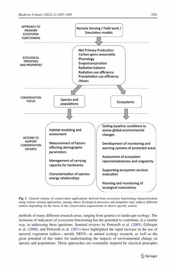
or ecosystems) (Fig. 1). In this section, we outline specific targets based on examples
drawn from the literature.
Conservation of populations and species diversity
The conservation of species populations and diversity has been the primary focus of
conservation biology studies since the emergence of the discipline. Key research goals
include understanding which habitat conditions (i.e. quantity and characteristics of the
habitat) are required to ensure species persistence; understanding the effects of environ-
mental variability on population parameters; and predicting how environmental change
may affect the distribution, demography and viability of populations. All of these objec-
tives involve diverse scales of biological organization requiring multidisciplinary
approaches to their study, which has prompted a gradual incorporation of the principles and
3290 Biodivers Conserv (2012) 21:3287–3305
123
methods of many different research areas, ranging from genetics to landscape ecology. The
inclusion of indicators of ecosystem functioning has the potential to contribute, in a similar
way, to addressing these questions. Seminal reviews by Pettorelli et al. (2005), Gillespie
et al. (2008), and Pettorelli et al. (2011) have highlighted the rapid increase in the use of
spectral vegetation indices—mostly NDVI—in animal ecology research, as well as the
great potential of this index for understanding the impacts of environmental change on
species and populations. These approaches are essentially inspired by classical principles
Fig. 1 General scheme of conservation applications derived from ecosystem functioning characterizationusing remote sensing approaches, among others. Ecological processes and properties may address differententities depending on the focus of the conservation requirements to derive specific actions
Biodivers Conserv (2012) 21:3287–3305 3291
123
concerning the relationships between energy availability and the size and distribution of
animal home ranges, vital rates of individuals, population size and density, and species
richness. However, applications using ecosystem functioning indices in species conser-
vation are still incipient. Here we discuss some representative examples illustrating the
importance of increasing efforts in this direction.
Habitat modelling and assessment
Understanding the characteristics and the spatial distribution of species habitats is critical
for assessing the conservation status of populations, designing reserves, predicting species
distributions and their responses to environmental change, and preserving and restoring the
ecological conditions required to sustain threatened populations. Species-environment
models have become some of the most widespread tools used to address these questions
(Guisan and Thuiller 2005), although they predominately rely on descriptors of spatial
environmental heterogeneity, while neglecting the effects of temporal variability (but see
e.g. Franklin 2010). Wiegand et al. (2008) showed that habitat assessment for an endan-
gered population of brown bears (Ursus arctos arctos) in a marginal population in Spain
was substantially improved by considering the effects of seasonal and inter-annual vari-
ability in ecosystem functioning. The species habitat quality was constrained by seasonal
pulses in primary production as defined by NDVI: those areas where bears exhibited higher
reproductive performance (i.e. high quality habitats) presented a stronger seasonality and a
narrower spatial variability in ecosystem functioning. Furthermore, models showed that
habitat quality can be ordered according to the dynamics of NDVI, consistent with the
evolutionary adaptations of brown bears to track pulsed food resources. High-quality areas
occurred under highly specialized and marginal ecosystem conditions which are important
to preserve in order to maintain the population. This approach based on the identification of
gradients of habitat quality, not just habitat suitability, helps to prioritize conservation
targets, and the analysis of NDVI revealed the disproportionate impact that alterations in
ecosystem functioning could have on species conservation.
In another example, habitat assessment for the Giant Panda (Ailuropoda melanoleuca)
emphasized the importance of considering ecosystem phenology for its ability to capture
information regarding both the distribution of food resources and human disturbances
(Tuanmu et al. 2011). Models based on the Wide Dynamic Range Vegetation Index
(WDRVI) facilitated the temporal transferability of model predictions and were appro-
priate for monitoring changes in wildlife habitat as reflected by changes in the phenology
of the land surface.
These insights, combined with the availability of continuous, extensive remote sensing
data, advocate the development of ecosystem monitoring protocols aimed at providing a
continuous assessment of the status of the habitats of species. However, few attempts have
been made in this area. Coops et al. (2009) proposed a Dynamic Habitat Index (DHI),
which included the minimum, the mean and the variability of fPAR, and suggested that the
regional analysis of DHI over time would help detect significant impacts on species and
predict how distributions and diversity may be affected by environmental change. The
successful incorporation of this or similar indices into conservation practice will require a
rigorous evaluation of their capacity to quantify species habitat loss and degradation. In
addition, practical issues such as the definition of species-specific thresholds of habitat
change need to be resolved before these tools can be transferred to managers.
3292 Biodivers Conserv (2012) 21:3287–3305
123
Population dynamics and viability
Species conservation planning requires a thorough consideration of the factors affecting the
size of populations and how this size varies in time and with environmental change (Boyce
1992). In essence, environmental factors affect population dynamics through their effects
on reproduction, mortality and population growth and movement patterns, with all of these
processes dependent on the ecosystem capacity to provide usable energy to organisms.
Recent remote sensing applications have shown, for example, that fecundity in a popu-
lation of Savanna elephants (Loxodonta Africana) was dependent on the seasonal levels of
primary production in such a way that NDVI was a reliable predictor of yearly differences
in population recruitment rates (Wittemyer et al. 2007). Furthermore, cycles in ecosystem
productivity synchronized reproduction across the population and were responsible for
population fluctuations, which have important implications for harvesting designs and
species recovery efforts. NDVI also correlates with offspring survival in elephants
(Wittemyer 2011) and other herbivores (Pettorelli et al. 2007), indicating that post-birth
surrogates of primary production are also an important indicator of breeding success.
The correlation between indicators of primary production and survival rate has also
revealed mechanisms of demographic synchronization among populations of migratory
species. Schaub et al. (2005) demonstrated that the annual survival of storks (Ciconiaciconia) that nest in different parts of Europe was correlated with NDVI dynamics at a
single wintering area in the Sahel, which appeared to affect the growth rate of breeding
populations throughout Central Europe. In the endangered Egyptian vulture (Neophronpercnopterus) a positive relationship has also been observed between NDVI measured
within breeding territories and juvenile survival, and between NDVI and survival of all age
classes in wintering areas (Grande et al. 2009).
Movements of individuals across the landscape have also been related to remotely-
sensed vegetation activity. Using evolutionary programming models in combination with
spatio-temporal patterns of NDVI, Boone et al. (2006) predicted the migratory trajectories
of wildebeest simulating the adjustment of evolutionary responses of animal movements to
forage optimization. The relationship between herbivore movements and the spatial and
temporal variability in primary production (Mueller et al. 2011) has important conservation
implications, such as predicting the location of large herbivore herds (Musiega and Kazadi
2004) and assessing the negative impacts of land-use and linear infrastructures on popu-
lation connectivity (Ito et al. 2005).
Ecosystem functioning can considerably help disentangle more complex questions such
as the interaction between density-dependent and environment-driven demographic pro-
cesses in determining population dynamics. Using the Enhanced Vegetation Index (EVI),
Bardsen and Tveraa (2012) recently showed how increased vegetation greenness in
summer compensated for negative density-dependence effects on individual reproduction
costs, reproductive allocation and breeding success in female reindeers (Rangifertarandus).
We expect that the opportunity to incorporate spectral indices of ecosystem func-
tioning will represent an important advance in the modeling of population dynamics for
species conservation. More traditional applications have demonstrated the importance of
considering the variability in weather phenology for predicting population demography
(e.g. Rodriguez and Bustamante 2003); however, the direct links between ecosystem
phenology and population parameters were not easy to assess until the development of
remote sensing applications. Vegetation indices have demonstrated their ability to out-
perform the predictive power of variables such as rainfall in population demography
Biodivers Conserv (2012) 21:3287–3305 3293
123
studies (Rasmussen et al. 2006), and they provide a more direct representation of the
underlying ecological regulators. In addition, conservation prospects under a changing
climate will require more careful consideration of the effects of environmental variability
on population dynamics, taking into account changes not only in temperature and
precipitation regimes (Verboom et al. 2010), but also in ecosystem-level processes.
Managing carrying capacity for herbivores
A major challenge for conservation practitioners is to devise management systems that
integrate goals related to wildlife and local livestock activities (Madhusudan 2004). An
objective and spatially-explicit quantification of aboveground net primary production
(ANPP) and its intra- and inter-annual variability would allow for the delineation of
sustainable stock densities and grazing areas and timing, based on the relationship between
ANPP and herbivore consumption (Oesterheld et al. 1998; Oesterheld et al. 1992). A pilot
system with domestic herbivores has already been implemented to support grazing mana-
gement based on monitoring ANPP (estimated from data provided by the MODIS sensor)
on extensive ranches in the Argentine Pampas (Grigera et al. 2007), and this system could
be directly applied to protected areas (Oyonarte et al. 2010). Tracking both herbivore stock
densities and ANPP can be used to monitor grazing impacts on grassland and savannas
(Manseau et al. 1996) or to assess the role of overgrazing on desertification processes
(Paruelo et al. 2008).
Species–energy relationships and conservation
Lastly, the conservation of biodiversity depends on our capacity to anticipate the effects of
environmental variability on the species composition of communities. For this, the char-
acterization of species–energy relationships on the basis of remote sensing has already
contributed to the understanding of both geographic and fine-scale patterns in species
diversity of birds, showing a direct relationship between seasonal species richness and
seasonal measures of NDVI (Hurlbert and Haskell 2003). However, Phillips et al. (2010)
noticed that sign and strength of the species–energy relationship in North America was
context-dependent, suggesting that bird species richness was positively affected by primary
production in low-energy areas but negatively affected in high-energy areas. They pointed
out that these differences should be taken into account in the design of specific manage-
ment strategies, including the manipulation of nutrients and vegetation and the manage-
ment of disturbances such as fires, logging and grazing in order to favor bird communities.
We must emphasize, however, that biodiversity management should focus on the main-
tenance and restoration of biodiversity, not maximizing species richness (Lindenmayer and
Hunter 2010). Therefore, species-energy approaches will require a deeper understanding of
the relationships between ecosystem energy and biodiversity values, such as the number of
rare species and species evenness, in order to better contribute to conservation practices.
Despite the increasing popularity of vegetation indices such as NDVI and EVI in
species ecology, the number of ecosystem functioning descriptors used in conservation
applications is limited in comparison to the possibilities offered by remote sensing (e.g. see
Pfeifer et al. 2012). A few studies have recently incorporated remote-sensing variables,
such as fPAR (Coops et al. 2009), Net Primary Production (NPP) and Gross Primary
Production (GPP) (Phillips et al. 2008; Phillips et al. 2010) in analyses of species richness.
These indices purportedly provide a more straightforward description of the ecosystem
variables of interest; however, there are a number of assumptions in their calculations as
3294 Biodivers Conserv (2012) 21:3287–3305
123
well as spatial and temporal accuracy differences that should be carefully considered. For
example, the accuracy of GPP estimates varies highly depending on factors such as vege-
tation type, and these estimates may not improve the predictive value of EVI in some
applications (Pfeifer et al. 2012). In addition to vegetation productivity, other ecosystem
functioning indices have great potential to address species conservation problems, such as
descriptors based on the energy balance of the land surface that provide information about
land degradation (Garcıa et al. 2008) and disturbances (Mildrexler et al. 2009), which can
be used to monitor impacts on species habitats.
Monitoring and selection of protected areas
Protected areas as points of reference for monitoring global environmental changes
Anthropogenic impacts can be monitored and assessed by comparing differences in eco-
system functioning of altered areas relative to areas less impacted by human activities
(Schonewald-Cox 1988). This approach constitutes a long-standing argument for the
conservation value of natural areas (Jenkins and Bedford 1973) and gives special impor-
tance to protected area networks, serving as reference systems across different environ-
mental conditions. Several studies have used NDVI attributes (Alcaraz-Segura et al. 2008a,
b, 2009b), surface temperature (Fernandez et al. 2010), and actual evapotranspiration
(Garbulsky and Paruelo 2004) to derive reference situations from protected area networks
and to monitor global environmental changes, by comparing protected ecosystems with
those subjected to greater human disturbance.
The availability of datarecords covering several decades (e.g. AVHRR/NOAA pro-
ducts) provides an opportunity to separate the effects on ecosystem functioning due to
climatic or atmospheric changes from those related to land-use changes. For example,
compared to protected areas, agriculture in temperate South America reduced C gains in
highly productive systems and increased them in those systems with low productivity
(Paruelo et al. 2001). These analyses also demonstrated that human modification resulted
in more seasonal systems.
Other analyses have provided quantitative evidence for the ecological effectiveness of
conservation policies at the national or global scale. Tang et al. (2011) provide a global
analysis of the role of protected areas in maintaining ecological processes. They used
NDVI dynamics as a measure of the variation over a 25 year period of plant production in
the core, boundary and surroundings of more than 1000 protected areas. At a national level,
Pelkey et al. (2000) assessed changes in vegetation condition with the aid of NDVI time-
series, observing that national parks and recreation areas in Tanzania presented signifi-
cantly better conservation status than the non-protected areas. The NDVI seasonal
dynamics were also used to detect differences in the phenological behavior of similar areas
due to their different management regimes in natural parks of Spain (Alcaraz-Segura et al.
2008a; Durante et al. 2009).
Development of monitoring and warning systems for protected areas
Incorporating satellite-based indicators of ecosystem functioning may substantially
improve monitoring and warning systems of protected areas (Duro et al. 2007). Ideally,
ecological indicators must be able to capture the spatial and temporal variability of eco-
system processes over extensive areas and in different regions, and should be capable of
tracking the integrity of ecological processes (Dale and Beyeler 2001). In addition,
Biodivers Conserv (2012) 21:3287–3305 3295
123

indicators should be sensitive to both long-term and rapid changes, particularly the latter
when the aim is to devise alarm systems. Indicators of ecosystem functioning derived from
spectral data match these criteria. For instance, a critical limitation to studying temporal
dynamics of NPP and its relationship with climatic variables is the lack of long-term data
(Jobbagy et al. 2002; Knapp and Smith 2001). Fortunately, this limitation may be mitigated
by the availability of NDVI or EVI time-series. Paruelo et al. (2005), working in protected
arid areas of southeastern Spain, found that attributes related to the spatial variability and
temporal dynamics of absorbed photosynthetically active radiation (APAR) in areas with
intense human modification (outside the protected area) displayed lower sensitivity to
changes in precipitation than those areas under protection. The description of such
differences in the response of APAR to water availability was proposed as the basis
of a system for monitoring desertification of drylands.
On the other hand, since many satellites provide data with a 1–20 day frequency,
monitoring satellite-derived functional indicators over time can be the basis of early-
warning systems that allow conservation managers to actively manage in the short term.
This approach was used in the Assessment of African Protected Areas project
(http://bioval.jrc.ec.europa.eu/APAAT/). Every 10 days, this alert system collects NDVI
and other satellite-derived data as indicators of ecosystem health (Hartley et al. 2007). By
comparing every new 10-day period with the same period in the historical record, sig-
nificant anomalies are quickly identified and ranked to produce a shortlist of environmental
events and protected areas that require further investigation and monitoring (Hartley et al.
2007). A similar idea has recently inspired a monitoring and warning system for the
Spanish Network of National Parks based on the use of NDVI-derived functional indicators
from MODIS images (http://www.magrama.gob.es/es/ministerio/organizacion/organis
mos-publicos/organismo-autonomo-parques-nacionales-oapn/plan-seg-ev-pn/seguimiento-
ecologico/). Furthermore, monitoring systems based on remote sensing can be extended to
ecological forecast systems through the incorporation of ancillary data and simulation
models. This is the case for the Terrestrial Observation and Prediction System of Yosemite
National Park (Nemani et al. 2009) that incorporates operational satellite data, microcli-
mate mapping, and ecosystem simulation models to characterize ecosystem status and
trends from a functional perspective.
All these monitoring approaches to ecosystem functioning allow for cost-efficient
monitoring schemes (Crabtree et al. 2009) and provide easy to interpret indicators of
ecosystem response to environmental changes (Pettorelli et al. 2005). In addition, their
implementation exhibits low impacts on ecosystems, a critical requirement for any
monitoring system (Havstad and Herrick 2003).
Assessment of ecosystem representativeness and selection of protected areas
At the ecosystem level, functional attributes may be particularly helpful in protected area
assessments to better represent the regional heterogeneity in geographic priority settings.
Gap analyses aim to determine how well the entire range of species, ecosystems, or
environmental conditions is protected by a reserve network. Despite such a clear goal,
identifying quantitative, general descriptors of representativeness and singularity (the
commonness or uniqueness of the ecosystems of a protected area in the regional context)
imposes a major challenge to reserve implementation (Overton and Leathwick 2001). Such
descriptors should be based on ecosystem properties that can not only be identified in a
particular site (e.g. National Parks or private reserves) but also be compared in the regional
context under a common protocol (Austin and Margules 1986; Mackey et al. 1989). To our
3296 Biodivers Conserv (2012) 21:3287–3305
123
knowledge, only one study has incorporated remote sensing indicators of ecosystem
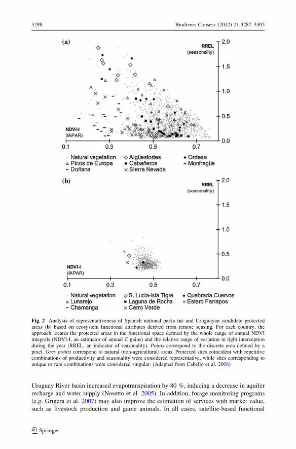
functioning to analyze the singularity and representativeness of protected areas. Cabello
et al. (2008) used the annual NDVI integral and relative range as surrogates of spatial
patterns in ecosystem carbon gains to evaluate the Spanish Network of National Parks and
to guide the implementation of the Uruguayan System of Protected Areas (Fig. 2). The
functional space defined by these two variables characterizes the regional heterogeneity of
ecosystem functioning in terms of productivity and seasonality (for details see Alcaraz-
Segura 2008; Alcaraz-Segura et al. 2009a). National Parks in Spain and candidate sites in
Uruguay were compared in this space with the rest of the natural ecosystems in each
country. Those parks or sites exhibiting combinations of productivity and seasonality that
were widespread in the regional context were considered representative, whereas sites
corresponding to unique or rare combinations of productivity and seasonality were con-
sidered singular. The Spanish Network showed that traditional protection criteria were able
to comprise the whole range of functional combinations, but were partially biased towards
singular sites. In Uruguay, results demonstrated low functional heterogeneity of the
extensive but homogeneous natural grasslands that dominate the country and revealed new
reserve candidates to protect both representative and singular ecosystems. In both cases,
the functional characterization of ecosystems allowed for the regional contextualization of
protected areas based on ecological processes. This approach can help in developing layers
in gap analyses for designing networks of protected areas in relation to ecosystem func-
tioning, in addition to biodiversity features (e.g. biomes, ecosystems, habitats, species).
Direct evaluation of ecosystem services
Quantification of the supply of ecosystem services and subsequent dissemination of
information to decision makers and the general public are critical for the sustainable
management of natural resources and to support conservation decisions and landscape
planning (Meyerson et al. 2005). However, in order to move forward, some limitations still
need to be addressed. First, evaluations of ecosystem services from plot-based and static
indicators do not provide complete coverage of a territory, and do not capture the rates of
service supply and demand (Carpenter and Folke 2006). Second, there is an urgent need for
quantifying changes in ecosystem dynamics, as well as their implications for ecosystem
service provision (Boyd and Banzhaf 2007; Egoh et al. 2007). Finally, the areas that supply
ecosystem services must be mapped to quantify the conservation benefits that they provide
(Naidoo et al. 2008).
The combination of satellite-derived attributes with environmental databases and field
data can be effectively used to estimate and monitor both the level of provision of eco-
system services over large areas (e.g. He et al. 2005; Nosetto et al. 2005) and their value
with regard to the conservation interest of protected areas (Haslett et al. 2010). For
example, He et al. (2005) presented a model for valuing ecosystem service in China based
on satellite-derived estimates of NPP. Volante et al. (2012) and Caride et al. (2012), using
remotely sensed data and modelling techniques, provided estimates of carbon-related
services for forests and grasslands of South America. In addition, regional quantification of
carbon gains in protected areas supports their protection given that they help address
ecological problems related to climate change issues (Dudley et al. 2010).
Other services can also be estimated through satellite-derived descriptors, such as
warming mitigation through evaporative cooling in tropical forests, or the effect of albedo
on climate regulation through changes in the duration of snow-pack in boreal forests
(Bonan 2008). Remote sensing data demonstrated that grassland afforestation in the
Biodivers Conserv (2012) 21:3287–3305 3297
123
Uruguay River basin increased evapotranspiration by 80 %, inducing a decrease in aquifer
recharge and water supply (Nosetto et al. 2005). In addition, forage monitoring programs
(e.g. Grigera et al. 2007) may also improve the estimation of services with market value,
such as livestock production and game animals. In all cases, satellite-based functional
Fig. 2 Analysis of representativeness of Spanish national parks (a) and Uruguayan candidate protectedareas (b) based on ecosystem functional attributes derived from remote sensing. For each country, theapproach locates the protected areas in the functional space defined by the whole range of annual NDVIintegrals (NDVI-I, an estimator of annual C gains) and the relative range of variation in light interceptionduring the year (RREL, an indicator of seasonality). Points correspond to the discrete area defined by apixel. Grey points correspond to natural (non-agricultural) areas. Protected sites coincident with repetitivecombinations of productivity and seasonality were considered representative, while sites corresponding tounique or rare combinations were considered singular. (Adapted from Cabello et al. 2008)
3298 Biodivers Conserv (2012) 21:3287–3305
123
attributes can be directly linked to ecosystem services, can be mapped, and allow for a
direct incorporation of ecosystem service information into conservation planning.
Planning and monitoring ecological restorations
Ecological restoration is an important component of conservation policies aimed to
re-establish the functioning of degraded ecosystems. The importance of planning resto-
ration by defining objectives at the ecosystem level, specifically focusing on water, energy,
and matter fluxes, is well recognized (Ehrenfeld 2000). Remote sensing techniques min-
imize the economic and logistic restrictions of monitoring programs (Korb and Fule 2008;
Malmstrom et al. 2009), which are the most common restrictions for devising reliable
monitoring systems in restoration plans (Ruiz-Jaen and Mitchell Aide 2005). Biophysical
variables such as NPP, evapotranspiration, and albedo help define quantifiable objectives
and actions that include ecosystem process dynamics. For example, biomass accumulation
rate has been used as an indicator of nutrient dynamics restoration in tropical secondary
forests (Feldpausch et al. 2004), while nutrient status has been evaluated from satellite
images to assess the restoration potential of eucalypt grassy woodlands in Australia (Zerger
et al. 2011). Tuxen et al. (2008) implemented a technique using NDVI to document
vegetation colonization in a restored salt marsh, while Leon et al. (2012) used NDVI time-
series to evaluate vegetation responses to wildfires in different pre-fire restoration regi-
mens. Evapotranspiration estimates derived from MODIS EVI and ground data (Nagler
et al. 2005) have been used to evaluate water use by invasive Tamarix stands compared to
native riparian species in the western United States (Nagler et al. 2008). This evaluation
revealed a cost-effective restoration strategy, which eliminated the need for the complete
removal and replacement of Tamarix.
Lastly, indicators of ecosystem functioning may also represent a valuable tool in pro-
active restoration initiatives, such as proposals to increase carbon sequestration (Harris
et al. 2006), assess wetland restoration (Melesse et al. 2006), or characterize trends,
memory effects, and resilience in large scale efforts (Walters 1986).
Conclusions and perspectives
The examples outlined in this article represent a sample of the applications of ecosystem
functional descriptions in conservation biology (Fig. 1). The potential for using these
ecosystem functioning attributes derives, on one hand, from the strong conceptual rela-
tionship between these attributes and the two central objectives of conservation practice,
biodiversity preservation and conservation of ecosystem processes, and, on the other hand,
from the possibility of using remotely sensed data to monitor them. The implementation of
conservation actions, as well as the evaluation of the results of management interventions,
requires information on functional aspects of different levels of organization (populations,
species, communities, and ecosystems). As we have demonstrated, satellite-derived
functional ecosystem variables can be used to better understand the abundance, distribu-
tion, and population dynamics of species of conservation concern, to assess the role of
protected areas in environmental conservation and monitoring of environmental changes,
to directly estimate the level of ecosystem services supply, and to design and monitor
ecological restorations. In addition, remote sensing products not only provide accurate
estimates of key functional variables, but also fulfill the key requirements of monitoring
systems.
Biodivers Conserv (2012) 21:3287–3305 3299
123
The incorporation of new variables with a clear relationship to the functioning dynamics
of ecosystems improves the possibility of diagnosing an ‘‘ill-functioning’’ ecosystem.
Nonetheless, no matter how sophisticated the diagnostic tool, it cannot replace an in-depth
analysis of the system, its natural history, and its environmental, socio-economic, geo-
political, and cultural context. Therefore, the approaches that we present in this study are
not intended to replace current conservation practices, but rather to complement them.
However, as in the field of medicine, a new analytical tool may help improve the diagnosis
by identifying problems previously hidden, and as a result allow for better-informed
decisions.
Acknowledgments We thank Jose Marıa Iriondo and Francisco Lloret for their helpful comments. Thispaper is the result of two symposiums supported by the Ministerio de Asuntos Exteriores (AECID) (Project‘‘Red tematica para la evaluacion del impacto de los cambios globales (vs locales) en el funcionamientoecosistemico’’). Financial support was also provided by FEDER funds, Junta de Andalucıa (projects RNM-6685 and SEGALERT P09-RNM-5048), Organismo Autonomo de Parques Nacionales (project 066/2007),Ministerio de Ciencia e Innovacion (Proyecto CGL2010-22314) and Fundacion MAPFRE (2008 call forprojects).
References
Alcaraz-Segura D (2008) Remote sensing of ecosystem functioning in the Iberian Peninsula. Groundworksfor biodiversity conservation in the face of global change effects. Universidad de Almerıa
Alcaraz-Segura D, Paruelo JM, Cabello J (2006) Identification of current ecosystem functional types in theIberian Peninsula. Glob Ecol Biogeogr 15:200–212
Alcaraz-Segura D, Baldi G, Durante P, Garbulsky MF (2008a) Analisis de la dinamica temporal del NDVIen areas protegidas: tres casos de estudio a distintas escalas espaciales, temporales y de gestion.Ecosistemas 17:108–117
Alcaraz-Segura D, Cabello J, Paruelo JM, Delibes M (2008b) Trends in the surface vegetation dynamics ofthe National Parks of Spain as observed by satellite sensors. Appl Veg Sci 11:431–440
Alcaraz-Segura D, Cabello J, Paruelo J (2009a) Baseline characterization of major Iberian vegetation typesbased on the NDVI dynamics. Plant Ecol 202:13–29
Alcaraz-Segura D, Cabello J, Paruelo JM, Delibes M (2009b) Use of descriptors of ecosystem functioningfor monitoring a national park network: a remote sensing approach. Environ Manage 43:38–48
Allen TFH, Hoekstra TW (1992) Toward a unified ecology. Columbia University Press, New York, pp 384Armsworth PR, Chan KMA, Daily GC, Ehrlich PR, Kremen C, Ricketts TH, Sanjayan MA (2007) Eco-
system-service science and the way forward for conservation. Conserv Biol 21:1383–1384Austin MP, Margules CR (1986) Assessing representativeness. In: Usher MB (ed) Wildlife conservation
evaluation. Chapman and Hall, London, pp 45–67Bala G, Caldeira K, Wickett M, Phillips TJ, Lobell DB, Delire C, Mirin A (2007) Combined climate and
carbon-cycle effects of large-scale deforestation. Proc Natl Acad Sci USA 104:6550–6555Bardsen BJ, Tveraa T (2012) Density-dependence vs. density-independence—linking reproductive alloca-
tion to population abundance and vegetation greenness. J Anim Ecol 81:364–376Bonan GB (2008) Forests and climate change: forcings, feedbacks, and the climate benefits of forests.
Science 320:1444–1449Boone RB, Thirgood SJ, Hopcraft JGC (2006) Serengeti wildebeest migratory patterns modeled from
rainfall and new vegetation growth. Ecology 87:1987–1994Boyce MS (1992) Population viability analysis. Annu Rev Ecol Syst 23:481–506Boyd J, Banzhaf S (2007) What are ecosystem services? The need for standardized environmental
accounting units. Ecol Econ 63:616–626Cabello J, Alcaraz-Segura D, Altesor A, Delibes M, Liras E (2008) Funcionamiento ecosistemico y eval-
uacion de prioridades geograficas en conservacion. Ecosistemas 17:53–63Callaghan TV, Bjorn LO, Chernov Y, Chapin T, Christensen TR, Huntley B, Ims RA, Johansson M, Jolly D,
Jonasson S, Matveyeva N, Panikov N, Oechel W, Shaver G (2004) Effects on the function of arcticecosystems in the short- and long-term perspectives. Ambio 33:448–458
Callicott JB, Crowder LB, Mumford K (1999) Current normative concepts in conservation. Conserv Biol13:22–35
3300 Biodivers Conserv (2012) 21:3287–3305
123
Caride C, Pineiro G, Paruelo JM (2012) How does agricultural management modify ecosystem services inthe argentine Pampas? The effects on soil C dynamics. Agric Ecosyst Environ 154:23–33
Carpenter SR, Folke C (2006) Ecology for transformation. Trends Ecol Evol 21:309–315Cleland EE, Chuine I, Menzel A, Mooney HA, Schwartz MD (2007) Shifting plant phenology in response to
global change. Trends Ecol Evol 22:357–365Coops NC, Wulder MA, Iwanicka D (2009) Demonstration of a satellite-based index to monitor habitat at
continental-scales. Ecol Ind 9:948–958Crabtree R, Potter C, Mullen R, Sheldon J, Huang S, Harmsen J, Rodman A, Jean C (2009) A modeling and
spatio-temporal analysis framework for monitoring environmental change using NPP as an ecosystemindicator. Remote Sens Environ 113:1486–1496
Dale VH, Beyeler SC (2001) Challenges in the development and use of ecological indicators. Ecol Ind1:3–10
Dudley N, Stolton S, Belokurov A, Krueger L, Lopoukhine N, MacKinnon K, Sandwith T, Sekhran N(2010) Natural Solutions: Protected areas helping people cope with climate change. IUCNWCPA,TNC, UNDP, WCS, The World Bank and WWF, Gland, Switzerland, Washington DC and New York,USA, p 130
Durante P, Oyonarte C, Valladares F (2009) Influence of land-use types and climatic variables on seasonalpatterns of NDVI in Mediterranean Iberian ecosystems. Appl Veg Sci 12:177–185
Duro DC, Coops NC, Wulder MA, Han T (2007) Development of a large area biodiversity monitoringsystem driven by remote sensing. Prog Phys Geogr 31:235–260
Egoh B, Rouget M, Reyers B, Knight AT, Cowling RM, van Jaarsveld AS, Welz A (2007) Integratingecosystem services into conservation assessments: a review. Ecol Econ 63:714–721
Ehrenfeld JG (2000) Defining the limits of restoration: the need for realistic goals. Restor Ecol 8:2–9Fang JY, Piao SL, Zhou LM, He JS, Wei FY, Myneni RB, Tucker CJ, Tan K (2005) Precipitation patterns
alter growth of temperate vegetation. Geophys Res Lett 32. doi:10.1029/2005GL024231Feldpausch TR, Rondon MA, Fernandes ECM, Riha SJ, Wandelli E (2004) Carbon and nutrient accumu-
lation in secondary forests regenerating on pastures in central Amazonia. Ecol Appl 14:164–176Fernandez N, Paruelo JM, Delibes M (2010) Ecosystem functioning of protected and altered Mediterranean
environments: a remote sensing classification in Donana, Spain. Remote Sens Environ 114:211–220Fischer DT, Still CJ, Williams AP (2009) Significance of summer fog and overcast for drought stress and
ecological functioning of coastal California endemic plant species. J Biogeogr 36:783–799Franklin J (2010) Moving beyond static species distribution models in support of conservation biogeo-
graphy. Divers Distrib 16:321–330Frid CLJ, Paramor OAL, Brockington S, Bremner J (2008) Incorporating ecological functioning into the
designation and management of marine protected areas. Hydrobiologia 606:69–79Garbulsky MF, Paruelo JM (2004) Remote sensing of protected areas to derive baseline vegetation func-
tioning characteristics. J Veg Sci 15:711–720Garcıa M, Oyonarte C, Villagarcıa L, Contreras S, Domingo F, Puigdefabregas J (2008) Monitoring land
degradation risk using ASTER data: the non-evaporative fraction as an indicator of ecosystem func-tion. Remote Sens Environ 112:3720–3736
Gillespie TW, Foody GM, Rocchini D, Giorgi AP, Saatchi S (2008) Measuring and modelling biodiversityfrom space. Prog Phys Geogr 32:203–221
Goldman RL, Tallis H, Kareiva P, Daily GC (2008) Field evidence that ecosystem service projects supportbiodiversity and diversify options. Proc Natl Acad Sci USA 105:9445–9448
Gower ST, Kucharik CJ, Norman JM (1999) Direct and indirect estimation of leaf area index, f(APAR), andnet primary production of terrestrial ecosystems. Remote Sens Environ 70:29–51
Grande JM, Serrano D, Tavecchia G, Carrete M, Ceballos O, Diaz-Delgado R, Tella JL, Donazar JA (2009)Survival in a long-lived territorial migrant: effects of life-history traits and ecological conditions inwintering and breeding areas. Oikos 118:580–590
Grigera G, Oesterheld M, Pacin F (2007) Monitoring forage production for farmers’ decision making. AgricSyst 94:637–648
Guisan A, Thuiller W (2005) Predicting species distribution: offering more than simple habitat models. EcolLett 8:993–1009
Hall FG, Huemmrich KF, Goetz SJ, Sellers PJ, Nickeson JE (1992) Satellite remote sensing of surfaceenergy balance: success, failures, and unresolved issues in FIFE. J Geophys Res Atmos97:19061–19089
Harris JA, Hobbs RJ, Higgs E, Aronson J (2006) Ecological restoration and global climate change. RestorEcol 14:170–176
Hartley AJ, Nelson A, Mayaux P, Gregoire J-M (2007) The assessment of african protected areas.Luxembourg, p 77
Biodivers Conserv (2012) 21:3287–3305 3301
123

Haslett JR, Berry PM, Bela G, Jongman RHG, Pataki G, Samways MJ, Zobel M (2010) Changing con-servation strategies in Europe: a framework integrating ecosystem services and dynamics. BiodiversConserv 19(10):2963–2977
Havstad KM, Herrick JE (2003) Long-term ecological monitoring. Arid Land Res Manag 17:389–400He H, Yang M, Pan Y, Zhu W (2005) Measurement of terrestrial ecosystem service value in China based on
remote sensing. In: International Geoscience and Remote Sensing Symposium (IGARSS),pp 2965–2968
Hooper DU, Chapin FS, Ewel JJ, Hector A, Inchausti P, Lavorel S, Lawton JH, Lodge DM, Loreau M,Naeem S, Schmid B, Setala H, Symstad AJ, Vandermeer J, Wardle DA (2005) Effects of biodiversityon ecosystem functioning: a consensus of current knowledge. Ecol Monogr 75:3–35
Horning N, Robinson JA, Sterling EJ, Turner W, Spector S (2010) Remote sensing for ecology andconservation. Oxford University Press, New York
Huete A, Didan K, Miura T, Rodriguez EP, Gao X, Ferreira LG (2002) Overview of the radiometric andbiophysical performance of the MODIS vegetation indices. Remote Sens Environ 83:195–213
Hurlbert AH, Haskell JP (2003) The effect of energy and seasonality on avian species richness and com-munity composition. Am Nat 161:83–97
Ito TY, Miura N, Lhagvasuren B, Enkhbileg D, Takatsuki S, Tsunekawa A, Jiang ZW (2005) Preliminaryevidence of a barrier effect of a railroad on the migration of Mongolian gazelles. Conserv Biol19:945–948
Jax K (2010) Ecosystem functioning. Cambridge University Press, CambridgeJenkins R, Bedford WB (1973) The use of natural areas to establish environmental baselines. Biol Conserv
5:168–174Jobbagy EG, Sala OE, Paruelo JM (2002) Patterns and controls of primary production in the Patagonian
steppe: a remote sensing approach. Ecology 83:307–319Julien Y, Sobrino JA (2009) The yearly land cover dynamics (YLCD) method: an analysis of global
vegetation from NDVI and LST parameters. Remote Sens Environ 113:329–334Kerr JT, Ostrovsky M (2003) From space to species: ecological applications for remote sensing. Trends Ecol
Evol 18(6):299–305Knapp AK, Smith MD (2001) Variation among biomes in temporal dynamics of aboveground primary
production. Science 291:481–484Korb JE, Fule PZ (2008) Intra- and interannual vegetation change: implications for long-term research.
Restor Ecol 16:5–11Kustas W, Anderson M (2009) Advances in thermal infrared remote sensing for land surface modeling.
Agric For Meteorol 149:2071–2081Leon JRR, van Leeuwen WJD, Casady GM (2012) Using MODIS-NDVI for the modeling of post-wildfire
vegetation response as a function of environmental conditions and pre-fire restoration treatments.Remote Sens 4:598–621
Liang S (2000) Narrowband to broadband conversions of land surface albedo. I Algorithms. Remote SensEnviron 76:213–238
Lindenmayer D, Hunter M (2010) Some guiding concepts for conservation biology. Conserv Biol24:1459–1468
Lyons EA, Jin Y, Randerson JT (2008) Changes in surface albedo after fire in boreal forest ecosystems ofinterior Alaska assessed using MODIS satellite observations. J Geophys Res G Biogeosci 113:G02012.doi:10.1029/2007JG000606
Mackey BG, Nix HA, Stein JA, Cork SE, Bullen FT (1989) Assessing the representativeness of the wettropics of Queensland world heritage property. Biol Conserv 50:279–303
Madhusudan MD (2004) Recovery of wild large herbivores following livestock decline in a tropical Indianwildlife reserve. J Appl Ecol 41(5):858–869
Malmstrom CM, Butterfield HS, Barber C, Dieter B, Harrison R, Qi J, Riano D, Schrotenboer A, Stone S,Stoner CJ, Wirka J (2009) Using remote sensing to evaluate the influence of grassland restorationactivities on ecosystem forage provisioning services. Restor Ecol 17:526–538
Manseau M, Huot J, Crete M (1996) Effects of summer grazing by caribou on composition and productivityof vegetation: community and landscape level. J Ecol 84:503–513
McNaughton SJ, Oesterheld M, Frank DA, Williams KJ (1989) Ecosystem-level patterns of primary pro-ductivity and herbivory in terrestrial habitats. Nature 341:142–144
Meine C, Soule M, Noss RF (2006) ‘‘A mission-driven discipline’’: the growth of conservation biology.Conserv Biol 20:631–651
Melesse AM, Oberg J, Nangia V, Beeri O, Baumgartner D (2006) Spatiotemporal dynamics of evapo-transpiration at the Glacial Ridge prairie restoration in northwestern Minnesota. Hydrol Process20:1451–1464
3302 Biodivers Conserv (2012) 21:3287–3305
123
Meyerson LA, Baron J, Melillo JM, Naiman RJ, O’Malley RI, Orians G, Palmer MA, Pfaff ASP, RunningSW, Sala OE (2005) Aggregate measures of ecosystem services: can we take the pulse of nature? FrontEcol Environ 3:56–59
Mildrexler DJ, Zhao MS, Running SW (2009) Testing a MODIS Global Disturbance Index across NorthAmerica. Remote Sens Environ 113:2103–2117
Monteith JL (1977) Climate and the efficiency of crop production in Britain. Philos Trans R Soc Lond B281:277–294
Moran MS, Jackson RD (1991) Assessing the spatial distribution of evapotranspiration using remotelysensed inputs. J Environ Qual 20:725–737
Mueller T, Olson KA, Dressler G, Leimgruber P, Fuller TK, Nicolson C, Novaro AJ, Bolgeri MJ, Wattles D,DeStefano S, Calabrese JM, Fagan WF (2011) How landscape dynamics link individual- to population-level movement patterns: a multispecies comparison of ungulate relocation data. Glob Ecol Biogeogr20:683–694
Musiega DE, Kazadi S-N (2004) Simulating the East African wildebeest migration patterns using GIS andremote sensing. Afr J Ecol 42:355–362
Naeem S (2002) Ecosystem consequences of biodiversity loss: the evolution of a paradigm. Ecology83:1537–1552
Nagler PL, Scott RL, Westenburg C, Cleverly JR, Glenn EP, Huete AR (2005) Evapotranspiration onwestern U.S. rivers estimated using the Enhanced Vegetation Index from MODIS and data from eddycovariance and Bowen ratio flux towers. Remote Sens Environ 97:337–351
Nagler PL, Glenn EP, Didan K, Osterberg J, Jordan F, Cunningham J (2008) Wide-area estimates of standstructure and water use of Tamarix spp. on the Lower Colorado River: implications for restoration andwater management projects. Restor Ecol 16:136–145
Naidoo R, Balmford A, Costanza R, Fisher B, Green RE, Lehner B, Malcolm TR, Ricketts TH (2008)Global mapping of ecosystem services and conservation priorities. Proc Natl Acad Sci USA105:9495–9500
Nemani R, Hashimoto H, Votava P, Melton F, Wang W, Michaelis A, Mutch L, Milesi C, Hiatt S, White M(2009) Monitoring and forecasting ecosystem dynamics using the Terrestrial Observation and Pre-diction System (TOPS). Remote Sens Environ 113:1497–1509
Nosetto MD, Jobbagy EG, Paruelo JM (2005) Land-use change and water losses: the case of grasslandafforestation across a soil textural gradient in central Argentina. Glob Change Biol 11:1101–1117
Oesterheld M, Sala OE, McNaughton SJ (1992) Effect of animal husbandry on herbivore-carrying capacityat a regional scale. Nature 356:234–236
Oesterheld M, DiBella CM, Kerdiles H (1998) Relation between NOAA-AVHRR satellite data and stockingrate in grasslands. Ecol Appl 8:207–212
Ollinger SV, Richardson AD, Martin ME, Hollinger DY, Frolking SE, Reich PB, Plourde LC, Katul GG,Munger JW, Oren R, Smith M-L, Paw UKT, Bolstad PV, Cook BD, Day MC, Martin TA, Monson RK,Schmid HP (2008) Canopy nitrogen, carbon assimilation, and albedo in temperate and boreal forests:functional relations and potential climate feedbacks. Proc Natl Acad Sci USA 105:19336–19341
Otterman J, Karnieli A, Brakke T, Koslowsky D, Bolle H-J, Starr D, Schmidt H (2002) Desert scrub opticaldensity and spectral-albedo ratios of impacted-to-protected areas by model inversion. Int J RemoteSens 23:3959–3970
Overton JM, Leathwick JR (2001) Measuring ecological distinctiveness. Department of Conservation,Wellington, New Zealand
Oyonarte C, Alcaraz-Segura D, Oyarzabal M, Paruelo JM, Cabello J (2010) Sistema de apoyo a la gestion dereservas de la biosfera basado en el monitoreo de la productividad primaria: ensayo en Cabo de Gata-Nıjar (Almerıa-Espana). In: Araya P, Clusener-Godt M (eds) Reservas de la Biosfera: Su contribuciona la provision de servicios de los ecosistemas. Experiencias exitosas en Iberoamerica, UNESCO, Paris,pp 119–140
Paruelo JM, Lauenroth WK, Burke IC, Sala OE (1999) Grassland precipitation-use efficiency varies across aresource gradient. Ecosystems 2:64–68
Paruelo JM, Jobbagy EG, Sala OE (2001) Current distribution of ecosystem functional types in temperateSouth America. Ecosystems 4:683–698
Paruelo JM, Pineiro G, Oyonarte C, Alcaraz-Segura D, Cabello J, Escribano P (2005) Temporal and spatialpatterns of ecosystem functioning in protected and areas in southeastern Spain. Appl Veg Sci 8:93–102
Paruelo JM, Putz S, Weber G, Bertiller M, Golluscio RA, Aguiar MR, Wiegand T (2008) Long-termdynamics of a semiarid grass steppe under stochastic climate and different grazing regimes: a simu-lation analysis. J Arid Environ 72:2211–2231
Pelkey NW, Stoner CJ, Caro TM (2000) Vegetation in Tanzania: assessing long term trends and effects ofprotection using satellite imagery. Biol Conserv 94:297–309
Biodivers Conserv (2012) 21:3287–3305 3303
123
Pereira HM, David Cooper H (2006) Towards the global monitoring of biodiversity change. Trends EcolEvol 21:123–129
Pettorelli N, Vik JO, Mysterud A, Gaillard JM, Tucker CJ, Stenseth NC (2005) Using the satellite-derivedNDVI to assess ecological responses to environmental change. Trends Ecol Evol 20:503–510
Pettorelli N, Pelletier F, von Hardenberg A, Festa-Bianchet M, Cote SD (2007) Early onset of vegetationgrowth vs. rapid green-up: impacts on juvenile mountain ungulates. Ecology 88:381–390
Pettorelli N, Ryan S, Mueller T, Bunnefeld N, Jedrzejewska B, Lima M, Kausrud K (2011) The NormalizedDifference Vegetation Index (NDVI): unforeseen successes in animal ecology. Clim Res 46:15–27
Pfeifer M, Disney M, Quaife T, Marchant R (2012) Terrestrial ecosystems from space: a review of earthobservation products for macroecology applications. Glob Ecol Biogeogr 21:603–624
Phillips LB, Hansen AJ, Flather CH (2008) Evaluating the species energy relationship with the newestmeasures of ecosystem energy: NDVI versus MODIS primary production (vol 112, p 3538, 2008).Remote Sens Environ 112:4380
Phillips LB, Hansen AJ, Flather CH, Robison-Cox J (2010) Applying species-energy theory to conservation:a case study for North American birds. Ecol Appl 20:2007–2023
Pineiro G, Oesterheld M, Paruelo JM (2006) Seasonal variation in aboveground production and radiation-use efficiency of temperate rangelands estimated through remote sensing. Ecosystems 9:357–373
Potter CS, Brooks V (1998) Global analysis of empirical relations between annual climate and seasonality ofNDVI. Int J Remote Sens 19:2921–2948
Rasmussen HB, Wittemyer G, Douglas-Hamilton I (2006) Predicting time-specific changes in demographicprocesses using remote-sensing data. J Appl Ecol 43:366–376
Reed BC, Brown JF, Vanderzee D, Loveland TR, Merchant JW, Ohlen DO (1994) Measuring phenologicalvariability from satellite imagery. J Veg Sci 5:703–714
Rodriguez C, Bustamante J (2003) The effect of weather on lesser kestrel breeding success: can climatechange explain historical population declines? J Anim Ecol 72:793–810
Rouget M, Cowling RM, Pressey RL, Richardson DM (2003) Identifying spatial components of ecologicaland evolutionary processes for regional conservation planning in the Cape Floristic Region, SouthAfrica. Divers Distrib 9:191–210
Ruimy A, Saugier B, Dedieu G (1994) Methodology for the estimation of terrestrial net primary productionfrom remotely sensed data. J Geophys Res 99:5263–5283
Ruiz-Jaen MC, Mitchell Aide T (2005) Vegetation structure, species diversity, and ecosystem processes asmeasures of restoration success. For Ecol Manage 218:159–173
Running SW, Nemani RR, Heinsch FA, Zhao M, Reeves M, Hashimoto H (2004) A continuous satellite-derived measure of global terrestrial primary production. Bioscience 54:547–560
Schaub M, Kania W, Koppen U (2005) Variation of primary production during winter induces synchrony insurvival rates in migratory white storks Ciconia ciconia. J Anim Ecol 74:656–666
Schonewald-Cox C (1988) Boundaries in the protection of nature reserves. Bioscience 38:480–486Soule ME, Wilcox B (1980) Conservation biology: an evolutionary-ecological perspective. Sinauer Asso-
ciates Inc, SunderlandTang Z, Fang J, Sun J, Gaston KJ (2011) Effectiveness of protected areas in maintaining plant production.
PLoS ONE 6(4):e19116Tuanmu MN, Vina A, Roloff GJ, Liu W, Ouyang ZY, Zhang HM, Liu JG (2011) Temporal transferability of
wildlife habitat models: implications for habitat monitoring. J Biogeogr 38:1510–1523Tucker CJ (1979) Red and photographic infrared linear combinations for monitoring vegetation. Remote
Sens Environ 8:127–150Turner DP, Ritts WD, Cohen WB, Gower ST, Running SW, Zhao M, Costa MH, Kirschbaum AA, Ham JM,
Saleska SR, Ahl DE (2006) Evaluation of MODIS NPP and GPP products across multiple biomes.Remote Sens Environ 102:282–292
Tuxen KA, Schile LM, Kelly M, Siegel SW (2008) Vegetation colonization in a restoring tidal marsh: aremote sensing approach. Restor Ecol 16:313–323
Verboom J, Schippers P, Cormont A, Sterk M, Vos CC, Opdam PFM (2010) Population dynamics underincreasing environmental variability: implications of climate change for ecological network designcriteria. Landsc Ecol 25:1289–1298
Virginia RA, Wall DH, Levin SA (2001) Principles of ecosystem function. Encyclopedia of biodiversity.Academic Press, San Diego, pp 345–352
Volante JN, Alcaraz-Segura D, Mosciaro MJ, Viglizzo EF, Paruelo JM (2012) Ecosystem functionalchanges associated with land clearing in NW Argentina. Agric Ecosyst Environ 154:12–22
Walters CJ (1986) Adaptive management of natural resources. McGraw-Hill, New YorkWiegand T, Naves J, Garbulsky MF, Fernandez N (2008) Animal habitat quality and ecosystem functioning:
exploring seasonal patterns using NDVI. Ecol Monogr 78:87–103
3304 Biodivers Conserv (2012) 21:3287–3305
123

Wittemyer G (2011) Effects of economic downturns on mortality of wild African Elephants. Conserv Biol25:1002–1009
Wittemyer G, Rasmussen HB, Douglas-Hamilton I (2007) Breeding phenology in relation to NDVIvariability in free-ranging African elephant. Ecography 30:42–50
Zerger A, McIntyre S, Gobbett D, Stol J (2011) Remote detection of grassland nutrient status for assessingground layer vegetation condition and restoration potential of eucalypt grassy woodlands. LandscUrban Plan 102:226–233
Biodivers Conserv (2012) 21:3287–3305 3305
123