the compactness of urban areas in vietnam. sustainable urban development and local mobility nodes
TRANSCRIPT
� reviewed paper
REAL CORP 008 Proceedings / Tagungsband
Vienna, May 19-21 2008 www.corp.at ISBN: 978-39502139-4-2 (CD-ROM); ISBN: 978-39502139-5-9 (Print)Editors: Manfred SCHRENK, Vasily V. POPOVICH, Dirk ENGELKE, Pietro ELISEI
447
The compactness of urban areas in Vietnam. Sustainable urban development and local mobility nodes.
Harry STORCH, Ronald ECKERT, Paul PFAFFENBICHLER
(Dr.-Ing. Harry STORCH, Brandenburg University of Technology Cottbus, Department of Environmental Planning, Erich-Weinert-Str. 1, D-03044 Cottbus, Germany, [email protected])
(Dipl. Ing. Ronald ECKERT, Brandenburg University of Technology Cottbus, Department of Urban Planning and Spatial Design, Konrad-Wachsmann-Allee 4, D-03044 Cottbus, Germany, [email protected])
(Univ. Ass. Dipl. Ing. Dr. Paul C. PFAFFENBICHLER, Vienna University of Technology, Institute for Transport Planning and Traffic, Gußhausstr. 30/231 A-1040 Wien, Austria, [email protected])
1 ABSTRACT
This paper presents significant results of an urban sustainability assessment research into housing policies at the urban planning level in Ho Chi Minh City (HCM City), Vietnam. The objective is to develop an integrated approach to the sustainable development of housing and settlement structures to balance urban growth and redevelopment in HCM City. The aim of this paper is to discuss the importance of densification and compactness as the most important efficiency indicator for urban land-use patterns, because they reduce sprawl. Further, the dense structure of the compact city provides the necessary economies of scale for an efficient infrastructure, and provisions for certain types of public urban services and an efficient use of mass transport systems. Yet, the innovations in global mobility nodes, information processing and telecommunications are accelerating the growth and dispersion of both business activities and population, moving towards the point where "geography is irrelevant". In Europe, at the same time, urban planners advocate "compact cities" as an ideal urban form, contrasting the reality of spread-out metropolitan development. The urban planning debate of the last decade was focused on the question how the form of cities – e.g. their building forms, site and densities - can contribute to overall urban sustainability. Urban planning strategies based on the compact city model promise to reduce the urban environmental footprint of megacities. Yet in heavily under-serviced urban areas in emerging Asian countries, densification can be detrimental. In HCM City traditional settlement structures of the inner-city districts are examples of areas of extremely high density living, but inadequate levels of service and infrastructure provision creating serious health problems and increased environmental impacts in these urban districts. Higher density is therefore not the only indicator for sustainable urban structures.
2 COMPACTNESS AND SUSTAINABILITY: URBAN FORMS OF ASIAN CITIES
The urban planning debate of the last decade was focused on the question how the form of cities – e.g. their building forms, site and densities - can contribute to overall urban sustainability. Yet, the innovations in global mobility nodes, information processing and telecommunications are accelerating the growth and dispersion of both business activities and population, moving towards the point where "geography is irrelevant" (Gordon and Richardson 1997). In Europe, at the same time, urban planners advocate "compact cities" as an ideal urban form, contrasting the reality of spread-out metropolitan development. The term "compact cities" can take on different meanings, each with different planning implications:
• compact cities are argued to be efficient for more sustainable modes of transport. The population densities are high enough to support public modes of transport and because compact cities are mixed use and high density, the theory is that people can live near to their work place
• compact cities are seen as a sustainable use of land. By reducing sprawl, land in the countryside is preserved.
• urban compactness and mixed uses are associated with social diversity and cultural development.
• compact cities are economically viable because public infrastructure, such as roads and urban transport networks, can be provided and operated cost-effectively per capita. Also, population densities are sufficient to support more local businesses and social services.
Settlement structure and its form of the built environment determine both the efficiency of resource uses and the quality of life of the inhabitants. Urban development planning of the last decades and the current discussion on sustainable spatial planning are characterised by contrasting and conflicting discussions about urban planning models that can combine high density in a sustainable urban form (Ewing et al. 2002). Cities in emerging countries in South-East Asia, like Ho Chi Minh City in Viet Nam, often already have an
The compactness of urban areas in Vietnam. Sustainable urban development and local mobility nodes.
448
REAL CORP 2008: Mobility Nodes as Innovation Hubs Verkehrsknoten als Innovations- und Wissensdrehscheiben
extremely compact urban form with vibrant mix of uses, not because of planning strategies, but because unregulated development has taken place that reflects the diversity of the social, cultural and economic activities that take place within urban areas.
2.1 Urban Development in Metropolitan Areas
Spatial development in metropolitan areas worldwide is characterised by the continuing use of mainly agricultural land, a finite resource, for settlement and traffic purposes. Most urbanised regions have been subject to population and employment decentralisation over the past decades resulting in an ongoing spread of urban peripheries, a growth in motorised transport modes and thus by pollution of the air, changes in the global climate and the loss and fragmentation of natural and cultural landscapes. These irreversible land use changes constitute an important issue for sustainability. In contrast to similar problems in Europe, urbanised areas in Asia are affected primarily by growth in employment and population. Other driving forces of land-use changes are mainly changing patterns of lifestyle, production and retail structures and transportation patterns. Land consumption in metropolitan regions is characterised by a continuous and high rate mainly caused by the construction of new housing projects and transportation infrastructure. Therefore, land consumption is, because of its persistence, one of the main unsolved environmental problem areas. Consequently it is important to analyse the possible strategies, instruments and measures of an indicator-based policy instrument to optimise the policies and instruments in urban and regional planning and traffic management to reduce and manage the demand for land use in a more sustainable way.
The achievement of sustainable regional development is dependent on a policy direction that integrates social, economic and environmental dimensions in a manner which reduces the ecological footprints of urbanised regions while offering quality of life for citizens and vital economic conditions. The sustainable use of land resources is an important indicator for the evaluation of settlement structures and transport infrastructures from the point of view of an efficient spatial development. In contrast, the ongoing urbanization shows that the available instruments, spatial planning assessment methods, and many measures on regional and urban planning levels used to establish a more efficient land-use management are highly ineffective in the final evaluation. This is observed in the increasing rates of land consumption for residential areas and the resulting urban sprawl into surrounding areas.
3 EFFICIENCY INDICATORS FOR URBAN LAND USE IN HO CHI MINH CITY
In the spatial planning debate regarding sustainability impacts and spatial consequences of poorly managed expansion of residential areas in the outskirts of urban agglomerations, there is a need to have an agreed upon method to measure and evaluate the dominant structural changes in the urban landscape on a regional level. Beyond that, it is important for environmental and spatial planners to be able to demonstrate how the monitored sprawl of residential areas has real implications for an efficient land-use management and real impacts on the environment.
In the field of spatial and urban planning research, the main impacts of an inefficient use of land for settlement development are described as a spatial development in which the spread of residential development across the rural landscape far outpaces population growth (Nechyba and Walsh 2004). The efficiency of the resulting regional and urban spatial structure that this spatial development process creates can be measured and analysed (Apel et al. 2000, Ewing et al. 2002, Flacke 2003) by the use of the following spatial and structural indicators:
• Population density,
• Variety of uses and mixed use,
• Strength of activity centres,
• Accessibility of urban transport and urban service infrastructures,
In the following sections, these core indicators are explained in more detail with their relevance for the urban area of HCM City and its impacts on efficiency of use of land resources.
Harry STORCH, Ronald ECKERT, Paul PFAFFENBICHLER
REAL CORP 008 Proceedings / Tagungsband
Vienna, May 19-21 2008 www.corp.at ISBN: 978-39502139-4-2 (CD-ROM); ISBN: 978-39502139-5-9 (Print)Editors: Manfred SCHRENK, Vasily V. POPOVICH, Dirk ENGELKE, Pietro ELISEI
449
3.1 Population Density of Ho Chi Min City – Profile and Structure
The spatial structure of a metropolitan region or agglomeration area is not always visible from the ground but it can be detected when analysing demographic and land-use related data. In spatial planning, the first step to analyse the basic spatial organisation is to describe the spatial pattern of population distribution within the built-up area. The focus can be separated into two main indicators: land consumption per resident (density) and the spatial distribution of these densities (density profile). Residential density is the most important indicator to evaluate the efficiency of residential development and land-use management (Apel et al. 2000/Ewing et al. 2002). Dispersed suburban residential areas are the spatial manifestation of urban sprawl. In general, these low density areas make it difficult to provide adequate and accessible public utilities, services and infrastructures, to establish activity centres, and to offer access to public transportation options. As HCM City and most of the older European cities are showing, higher residential density does not necessarily mean high-rise buildings. Residential density is an attempt to measure the efficiency of land use in a metropolitan area. If the residential density is declining, mainly due to a reduction in the size of households and an increase in the living space per person (Couch et al. 2005), the necessary technical and social urban infrastructure and other public service facilities must be funded by an ever lower number of residents. The preservation and restoration of a high, but socially acceptable and qualified, population density in the core urban areas of HCM City is a centrally important environmental and economic goal.
The total area of HCM City is about 2095 sq km, divided into 24 districts, hosting in 2004 an official population of more than 6 million (table 1). 5.2 million of which lives in the 17 urban districts occupying an area of 494 sq km, and the rest in the rural districts. However, the actual population could be more than 7 million if unregistered persons, who live, work, or study in HCM City, are included. The population of HCM City is also expected to continue to increase rapidly mainly due to rural-to-urban migration (Gubry and Le Thi Huoang 2002). The urban districts have an average population density of around 11,000, the inner-city urban areas 26.000, with peak values in inner-city informal settlements with up to 80.000 inhabitants per sq km (table 1). The transition of the economic system of Vietnamese cities (Boothroyd and Pham 2000) has brought about major transformations in the physical and functional urban structures over the last decades. Urban development strategies in HCM City have two interrelated perspectives: firstly urban growth, the evolving urban forms in the context of urbanisation, and secondly urban redevelopment within the inner urban area. HCM City is undergoing a rapid urbanisation to such that by 2020 the 17 inner city districts are expected to have a population of approximately 6 million, while the suburban area will have roughly 4 million residents (table 1).
Area
(km²)
Population
2004
Pop. Density 2004
(inh./sqkm)
Population
2020
Greenspace
per capita 2004
Floorspace
per capita 2004
Urban Districts (quan) 494 5.2 million 11.000 6 million 2 m2 7-8 m2
Urban areas 140 3.7 million 26.000 - - -
Rural Districts (huyen) 1,601 1.0 million 600 4 million 475 m2 -
Ho Chi Minh City 2,095 6.2 million 3.000 10 million 14 m2 10 m2
Tab. 1. Density-related Indicators of HCM City ,(Source: GSO-HCMC 2006)
3.2 The Compact Urban Structure of HCM City - Variety of Uses and Mixed Use
At the level of agglomeration areas the allocation of mixed land use with a variety of uses could lead to a spatial urban structure that generates less traffic. Securing dense structures with mixed land uses in settlement areas is therefore a priority for spatial planning. The mixed use of urban land implies a balance of housing, employment and facilities in each district of a city. This offers the potential for the more efficient use of urban land, while facilitating the use and maintenance of public transport, thereby contributing to energy efficiency and pollution reduction. In contrast, the important spatial structure of urban sprawl is the strict segregation of different land uses. In sprawling regions, settlement areas are typically separated from shopping, business districts and cultural activity centres (Ewing et al. 2002). Measuring the degree of mix is therefore an important descriptor of urban compactness (Storch and Eckert 2007).
Taking the colonial city of Saigon and the Chinese city Cholon as starting points, the urban development of HCM City since the mid-twentieth century can initially be described as a condensation of the two historical
The compactness of urban areas in Vietnam. Sustainable urban development and local mobility nodes.
450
REAL CORP 2008: Mobility Nodes as Innovation Hubs Verkehrsknoten als Innovations- und Wissensdrehscheiben
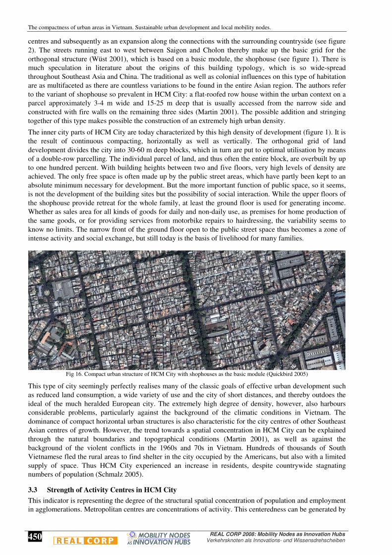
centres and subsequently as an expansion along the connections with the surrounding countryside (see figure 2). The streets running east to west between Saigon and Cholon thereby make up the basic grid for the orthogonal structure (Wüst 2001), which is based on a basic module, the shophouse (see figure 1). There is much speculation in literature about the origins of this building typology, which is so wide-spread throughout Southeast Asia and China. The traditional as well as colonial influences on this type of habitation are as multifaceted as there are countless variations to be found in the entire Asian region. The authors refer to the variant of shophouse so prevalent in HCM City: a flat-roofed row house within the urban context on a parcel approximately 3-4 m wide and 15-25 m deep that is usually accessed from the narrow side and constructed with fire walls on the remaining three sides (Martin 2001). The possible addition and stringing together of this type makes possible the construction of an extremely high urban density.
The inner city parts of HCM City are today characterized by this high density of development (figure 1). It is the result of continuous compacting, horizontally as well as vertically. The orthogonal grid of land development divides the city into 30-60 m deep blocks, which in turn are put to optimal utilisation by means of a double-row parcelling. The individual parcel of land, and thus often the entire block, are overbuilt by up to one hundred percent. With building heights between two and five floors, very high levels of density are achieved. The only free space is often made up by the public street areas, which have partly been kept to an absolute minimum necessary for development. But the more important function of public space, so it seems, is not the development of the building sites but the possibility of social interaction. While the upper floors of the shophouse provide retreat for the whole family, at least the ground floor is used for generating income. Whether as sales area for all kinds of goods for daily and non-daily use, as premises for home production of the same goods, or for providing services from motorbike repairs to hairdressing, the variability seems to know no limits. The narrow front of the ground floor open to the public street space thus becomes a zone of intense activity and social exchange, but still today is the basis of livelihood for many families.
Fig 16. Compact urban structure of HCM City with shophouses as the basic module (Quickbird 2005)
This type of city seemingly perfectly realises many of the classic goals of effective urban development such as reduced land consumption, a wide variety of use and the city of short distances, and thereby outdoes the ideal of the much heralded European city. The extremely high degree of density, however, also harbours considerable problems, particularly against the background of the climatic conditions in Vietnam. The dominance of compact horizontal urban structures is also characteristic for the city centres of other Southeast Asian centres of growth. However, the trend towards a spatial concentration in HCM City can be explained through the natural boundaries and topographical conditions (Martin 2001), as well as against the background of the violent conflicts in the 1960s and 70s in Vietnam. Hundreds of thousands of South Vietnamese fled the rural areas to find shelter in the city occupied by the Americans, but also with a limited supply of space. Thus HCM City experienced an increase in residents, despite countrywide stagnating numbers of population (Schmalz 2005).
3.3 Strength of Activity Centres in HCM City
This indicator is representing the degree of the structural spatial concentration of population and employment in agglomerations. Metropolitan centres are concentrations of activity. This centeredness can be generated by
Harry STORCH, Ronald ECKERT, Paul PFAFFENBICHLER
REAL CORP 008 Proceedings / Tagungsband
Vienna, May 19-21 2008 www.corp.at ISBN: 978-39502139-4-2 (CD-ROM); ISBN: 978-39502139-5-9 (Print)Editors: Manfred SCHRENK, Vasily V. POPOVICH, Dirk ENGELKE, Pietro ELISEI
451
concentrations of either population or employment. Urban compactness, as an efficiency parameter, is associated with centres of all types (business, shopping, leisure, culture). Urban sprawl, as inefficient land-use structure (Janssen-Jansen 2005), is defined with the absence of activity centres of any type. It can be distinguished between two types of spatial concentration. At the urban planning level, the strength of activity centres describes how centred it is near a central activity district. At the regional planning level it describes how activities are clustered in a more polycentric pattern.
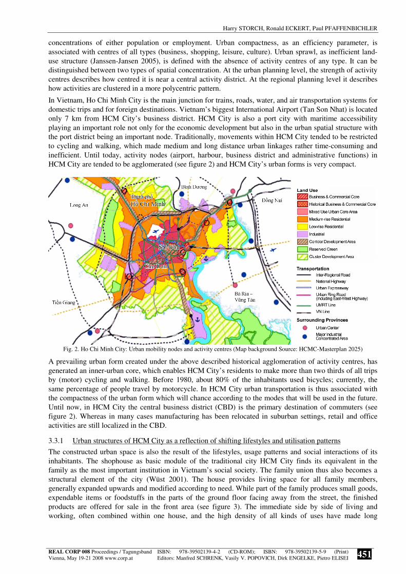
In Vietnam, Ho Chi Minh City is the main junction for trains, roads, water, and air transportation systems for domestic trips and for foreign destinations. Vietnam’s biggest International Airport (Tan Son Nhat) is located only 7 km from HCM City’s business district. HCM City is also a port city with maritime accessibility playing an important role not only for the economic development but also in the urban spatial structure with the port district being an important node. Traditionally, movements within HCM City tended to be restricted to cycling and walking, which made medium and long distance urban linkages rather time-consuming and inefficient. Until today, activity nodes (airport, harbour, business district and administrative functions) in HCM City are tended to be agglomerated (see figure 2) and HCM City’s urban forms is very compact.
Fig. 2. Ho Chi Minh City: Urban mobility nodes and activity centres (Map background Source: HCMC-Masterplan 2025)
A prevailing urban form created under the above described historical agglomeration of activity centres, has generated an inner-urban core, which enables HCM City’s residents to make more than two thirds of all trips by (motor) cycling and walking. Before 1980, about 80% of the inhabitants used bicycles; currently, the same percentage of people travel by motorcycle. In HCM City urban transportation is thus associated with the compactness of the urban form which will chance according to the modes that will be used in the future. Until now, in HCM City the central business district (CBD) is the primary destination of commuters (see figure 2). Whereas in many cases manufacturing has been relocated in suburban settings, retail and office activities are still localized in the CBD.
3.3.1 Urban structures of HCM City as a reflection of shifting lifestyles and utilisation patterns
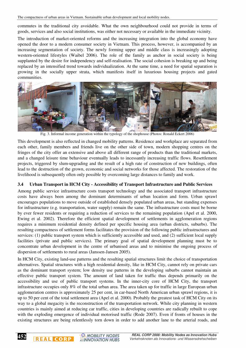
The constructed urban space is also the result of the lifestyles, usage patterns and social interactions of its inhabitants. The shophouse as basic module of the traditional city HCM City finds its equivalent in the family as the most important institution in Vietnam’s social society. The family union thus also becomes a structural element of the city (Wüst 2001). The house provides living space for all family members, generally expanded upwards and modified according to need. While part of the family produces small goods, expendable items or foodstuffs in the parts of the ground floor facing away from the street, the finished products are offered for sale in the front area (see figure 3). The immediate side by side of living and working, often combined within one house, and the high density of all kinds of uses have made long
The compactness of urban areas in Vietnam. Sustainable urban development and local mobility nodes.
452
REAL CORP 2008: Mobility Nodes as Innovation Hubs Verkehrsknoten als Innovations- und Wissensdrehscheiben
commutes in the traditional city avoidable. What the own neighbourhood could not provide in terms of goods, services and also social institutions, was either not necessary or available in the immediate vicinity.
The introduction of market-oriented reforms and the increasing integration into the global economy have opened the door to a modern consumer society in Vietnam. This process, however, is accompanied by an increasing segmentation of society. The newly forming upper and middle class is increasingly adopting western-oriented lifestyles (Waibel 2006). The role of the family as anchor in social society is being supplanted by the desire for independency and self-realisation. The social cohesion is breaking up and being replaced by an intensified trend towards individualization. At the same time, a need for spatial separation is growing in the socially upper strata, which manifests itself in luxurious housing projects and gated communities.
Fig. 3. Informal income generation within the typology of the shophouse (Photos: Ronald Eckert 2006)
This development is also reflected in changed mobility patterns. Residence and workplace are separated from each other, family members and friends live on the other side of town, modern shopping centres on the fringes of the city offer an extensive and above all different range of products than the traditional markets, and a changed leisure time behaviour eventually leads to incessantly increasing traffic flows. Resettlement projects, triggered by slum-upgrading and the result of a high rate of construction of new buildings, often lead to the destruction of the grown, economic and social networks for those affected. The restoration of the livelihood is subsequently often only possible by overcoming large distances to family and work.
3.4 Urban Transport in HCM City - Accessibility of Transport Infrastructure and Public Services
Among public service infrastructure costs transport technology and the associated transport infrastructure costs have always been among the dominant determinants of urban location and form. Urban sprawl encourages populations to move outside of established densely populated urban areas, but standing expenses for infrastructure (e.g. transportation, water supply) remain the same. The infrastructure costs must be borne by ever fewer residents or requiring a reduction of services to the remaining population (Apel et al. 2000, Ewing et al. 2002). Therefore the efficient spatial development of settlements in agglomeration regions requires a minimum residential density defined per specific housing area (urban districts, suburbs). The resulting compactness of settlement forms facilitates the provision of the following public infrastructures and services: (1) public transport system which is sufficiently accessible and used, and (2) sufficient local supply facilities (private and public services). The primary goal of spatial development planning must be to concentrate urban development in the centre of urbanised areas and to minimise the ongoing process of dispersion of settlements to rural areas (Janssen-Jansen 2005).
In HCM City, existing land-use patterns and the resulting spatial structures limit the choice of transportation alternatives. Spatial structures with a high residential density, like in HCM City, cannot rely on private cars as the dominant transport system; low density use patterns in the developing suburbs cannot maintain an effective public transport system. The amount of land taken for traffic thus depends primarily on the accessibility and use of public transport systems. In the inner-city core of HCM City, the transport infrastructure occupies only 8% of the total urban area. The area taken up for traffic in large European urban agglomeration centres is approximately 25 per cent, in car-based North American urban sprawl regions, it is up to 50 per cent of the total settlement area (Apel et al. 2000). Probably the greatest task of HCM City on its way to a global megacity is the reconstruction of the transportation network. While city planning in western countries is mainly aimed at reducing car traffic, cities in developing countries are radically rebuilt to cope with the exploding emergence of individual motorised traffic (Rode 2007). Even if fronts of houses in the existing structures are being relentlessly torn down in order to add another lane to the arterial roads, and
Harry STORCH, Ronald ECKERT, Paul PFAFFENBICHLER
REAL CORP 008 Proceedings / Tagungsband
Vienna, May 19-21 2008 www.corp.at ISBN: 978-39502139-4-2 (CD-ROM); ISBN: 978-39502139-5-9 (Print)Editors: Manfred SCHRENK, Vasily V. POPOVICH, Dirk ENGELKE, Pietro ELISEI
453
marginal settlements in the hinterland of HCM City are being forced to make way for motorway construction, these measures do not appear to be able to keep pace with the rapidly increasing traffic volume.
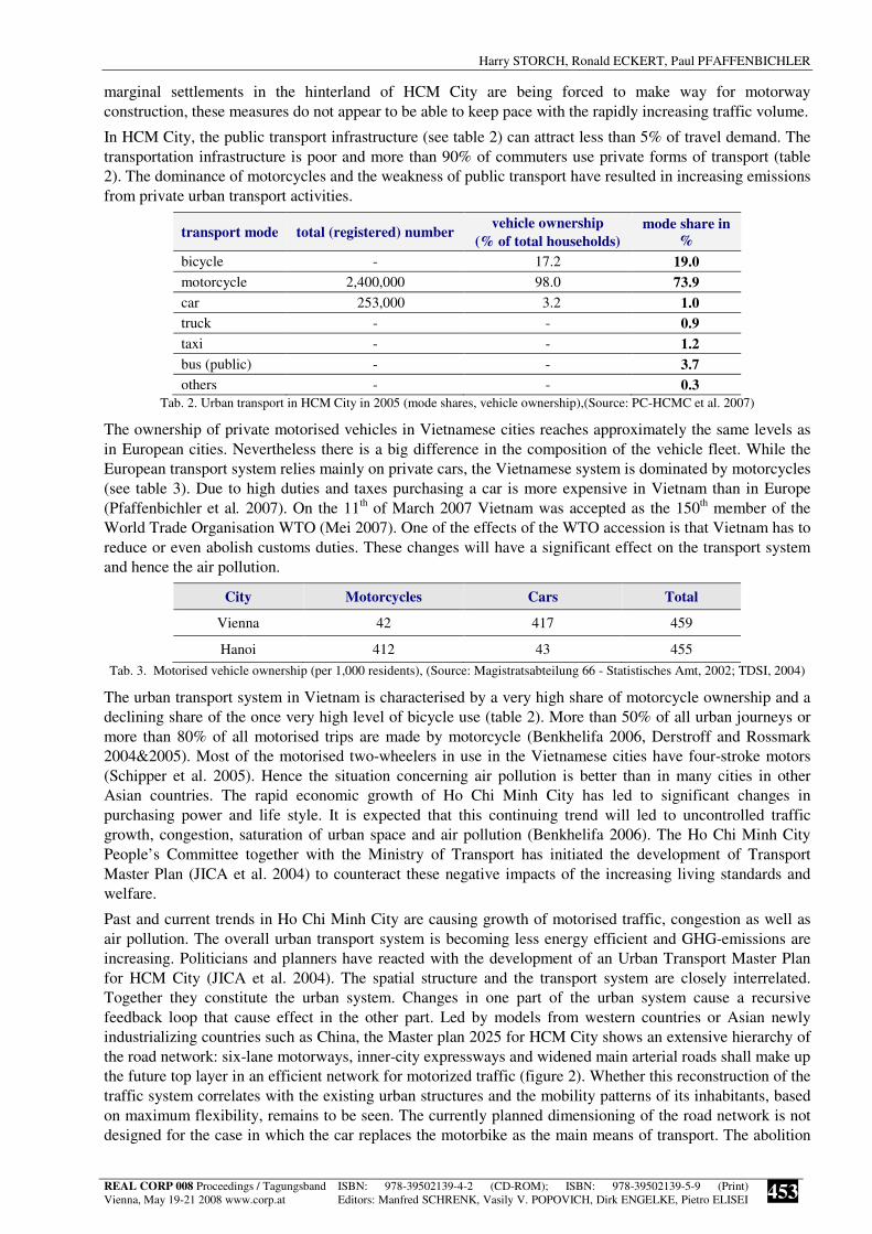
In HCM City, the public transport infrastructure (see table 2) can attract less than 5% of travel demand. The transportation infrastructure is poor and more than 90% of commuters use private forms of transport (table 2). The dominance of motorcycles and the weakness of public transport have resulted in increasing emissions from private urban transport activities.
transport mode total (registered) number vehicle ownership
(% of total households)
mode share in
%
bicycle - 17.2 19.0
motorcycle 2,400,000 98.0 73.9
car 253,000 3.2 1.0
truck - - 0.9
taxi - - 1.2
bus (public) - - 3.7
others - - 0.3 Tab. 2. Urban transport in HCM City in 2005 (mode shares, vehicle ownership),(Source: PC-HCMC et al. 2007)
The ownership of private motorised vehicles in Vietnamese cities reaches approximately the same levels as in European cities. Nevertheless there is a big difference in the composition of the vehicle fleet. While the European transport system relies mainly on private cars, the Vietnamese system is dominated by motorcycles (see table 3). Due to high duties and taxes purchasing a car is more expensive in Vietnam than in Europe (Pfaffenbichler et al. 2007). On the 11th of March 2007 Vietnam was accepted as the 150th member of the World Trade Organisation WTO (Mei 2007). One of the effects of the WTO accession is that Vietnam has to reduce or even abolish customs duties. These changes will have a significant effect on the transport system and hence the air pollution.
City Motorcycles Cars Total
Vienna 42 417 459
Hanoi 412 43 455
Tab. 3. Motorised vehicle ownership (per 1,000 residents), (Source: Magistratsabteilung 66 - Statistisches Amt, 2002; TDSI, 2004)
The urban transport system in Vietnam is characterised by a very high share of motorcycle ownership and a declining share of the once very high level of bicycle use (table 2). More than 50% of all urban journeys or more than 80% of all motorised trips are made by motorcycle (Benkhelifa 2006, Derstroff and Rossmark 2004&2005). Most of the motorised two-wheelers in use in the Vietnamese cities have four-stroke motors (Schipper et al. 2005). Hence the situation concerning air pollution is better than in many cities in other Asian countries. The rapid economic growth of Ho Chi Minh City has led to significant changes in purchasing power and life style. It is expected that this continuing trend will led to uncontrolled traffic growth, congestion, saturation of urban space and air pollution (Benkhelifa 2006). The Ho Chi Minh City People’s Committee together with the Ministry of Transport has initiated the development of Transport Master Plan (JICA et al. 2004) to counteract these negative impacts of the increasing living standards and welfare.
Past and current trends in Ho Chi Minh City are causing growth of motorised traffic, congestion as well as air pollution. The overall urban transport system is becoming less energy efficient and GHG-emissions are increasing. Politicians and planners have reacted with the development of an Urban Transport Master Plan for HCM City (JICA et al. 2004). The spatial structure and the transport system are closely interrelated. Together they constitute the urban system. Changes in one part of the urban system cause a recursive feedback loop that cause effect in the other part. Led by models from western countries or Asian newly industrializing countries such as China, the Master plan 2025 for HCM City shows an extensive hierarchy of the road network: six-lane motorways, inner-city expressways and widened main arterial roads shall make up the future top layer in an efficient network for motorized traffic (figure 2). Whether this reconstruction of the traffic system correlates with the existing urban structures and the mobility patterns of its inhabitants, based on maximum flexibility, remains to be seen. The currently planned dimensioning of the road network is not designed for the case in which the car replaces the motorbike as the main means of transport. The abolition
The compactness of urban areas in Vietnam. Sustainable urban development and local mobility nodes.
454
REAL CORP 2008: Mobility Nodes as Innovation Hubs Verkehrsknoten als Innovations- und Wissensdrehscheiben
of duties on imported cars and developments such as the Indian low-cost vehicle “Tata Nano” (Renner 2008), however, will accelerate just this trend. The necessary area for a “Car-City” is not available in HCM City or would mean the nearly complete loss of the current inner-city building structure.
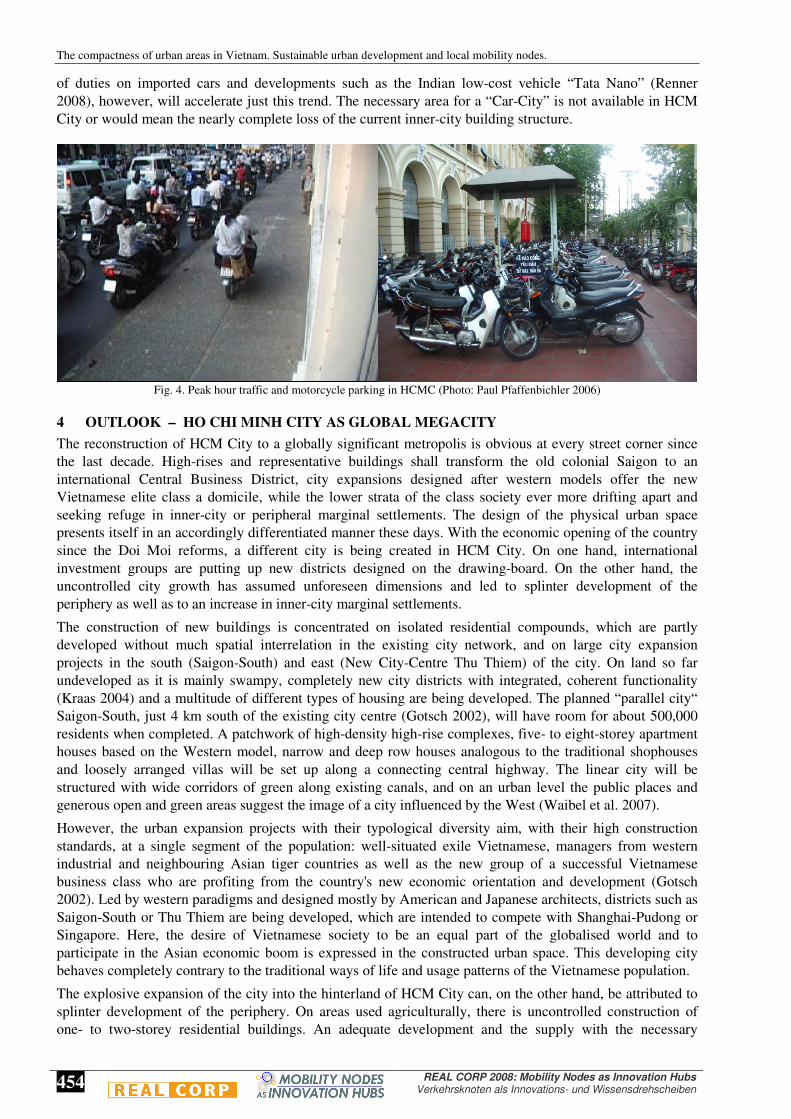
Fig. 4. Peak hour traffic and motorcycle parking in HCMC (Photo: Paul Pfaffenbichler 2006)
4 OUTLOOK – HO CHI MINH CITY AS GLOBAL MEGACITY
The reconstruction of HCM City to a globally significant metropolis is obvious at every street corner since the last decade. High-rises and representative buildings shall transform the old colonial Saigon to an international Central Business District, city expansions designed after western models offer the new Vietnamese elite class a domicile, while the lower strata of the class society ever more drifting apart and seeking refuge in inner-city or peripheral marginal settlements. The design of the physical urban space presents itself in an accordingly differentiated manner these days. With the economic opening of the country since the Doi Moi reforms, a different city is being created in HCM City. On one hand, international investment groups are putting up new districts designed on the drawing-board. On the other hand, the uncontrolled city growth has assumed unforeseen dimensions and led to splinter development of the periphery as well as to an increase in inner-city marginal settlements.
The construction of new buildings is concentrated on isolated residential compounds, which are partly developed without much spatial interrelation in the existing city network, and on large city expansion projects in the south (Saigon-South) and east (New City-Centre Thu Thiem) of the city. On land so far undeveloped as it is mainly swampy, completely new city districts with integrated, coherent functionality (Kraas 2004) and a multitude of different types of housing are being developed. The planned “parallel city“ Saigon-South, just 4 km south of the existing city centre (Gotsch 2002), will have room for about 500,000 residents when completed. A patchwork of high-density high-rise complexes, five- to eight-storey apartment houses based on the Western model, narrow and deep row houses analogous to the traditional shophouses and loosely arranged villas will be set up along a connecting central highway. The linear city will be structured with wide corridors of green along existing canals, and on an urban level the public places and generous open and green areas suggest the image of a city influenced by the West (Waibel et al. 2007).
However, the urban expansion projects with their typological diversity aim, with their high construction standards, at a single segment of the population: well-situated exile Vietnamese, managers from western industrial and neighbouring Asian tiger countries as well as the new group of a successful Vietnamese business class who are profiting from the country's new economic orientation and development (Gotsch 2002). Led by western paradigms and designed mostly by American and Japanese architects, districts such as Saigon-South or Thu Thiem are being developed, which are intended to compete with Shanghai-Pudong or Singapore. Here, the desire of Vietnamese society to be an equal part of the globalised world and to participate in the Asian economic boom is expressed in the constructed urban space. This developing city behaves completely contrary to the traditional ways of life and usage patterns of the Vietnamese population.
The explosive expansion of the city into the hinterland of HCM City can, on the other hand, be attributed to splinter development of the periphery. On areas used agriculturally, there is uncontrolled construction of one- to two-storey residential buildings. An adequate development and the supply with the necessary
Harry STORCH, Ronald ECKERT, Paul PFAFFENBICHLER
REAL CORP 008 Proceedings / Tagungsband
Vienna, May 19-21 2008 www.corp.at ISBN: 978-39502139-4-2 (CD-ROM); ISBN: 978-39502139-5-9 (Print)Editors: Manfred SCHRENK, Vasily V. POPOVICH, Dirk ENGELKE, Pietro ELISEI
455
technical infrastructure only follows years later, when these spontaneous settlements have further densified and manifested themselves. This process of urban sprawl is only made possible through the newly gained mobility of city dwellers. But it is partly caused by the eviction of inner-city slum dwellers, who are being pushed ever further towards the city outskirts. The current differentiation of the urban space in HCM City is also the result of changed lifestyles and usage patterns since the economic opening of the country. But the process must also be viewed from the other direction. The development of a broad spectrum of completely different forms of habitation and city structures further accelerates the segmentation of Vietnamese society and spatial segregation of the social layers which are drifting ever further apart.
5 CONCLUSION
In Vietnam, over the next decades the expansion of urban areas and populations is an underlying development imperative that will drive all policy formation. In order to understand the urban planning implications of this growth it is important to deconstruct the urban transformation process that is taking place and understand the challenges that arise. There is a need to better understand especially the urban transition processes from traditional societies to modern societies in emerging megacities like HCM City. Urban planners are now in a key position to assert their roles in minimising total travel in the urban system. The needs to preserve existing vital city centres and to protect liveable neighbourhoods are the key determinants of decision making.
Urban areas in Vietnam are demonstrating how important urban form is in helping to explain the dominant patterns of urban transportation. The role of motorcycles in urban transport, and their human and environmental impacts, is an important issue needed to be understood. In low-income Vietnamese cities, like HCM City and Hanoi, motorcycles average around 400 per 1000 people, and they form a significant part of the transport system. Motorcycles are the most affordable motorised private transport for moderate-income people in these cities. However, they are a major cause of environmental problems like air pollution and noise in these cities. But, as far as energy-efficiency is concerned, they are the best form of private motorised mobility available.
A compact urban form is a critical factor in creating energy efficient and sustainable urban transport systems. Lower income cities, especially those in Vietnam already have very dense structures and centralised patterns of urban land use, which places them in an optimal position to minimise their future dependence on private modes of transport (Kenworthy 2003). They are ideal environments for effective public transport, so in the field of urban and environmental planning concerted attention is needed to ensure that this inherent advantage of their compact urban form does not deteriorate. However their density combined with their mixed land uses, means that motorcycling will remain the most convenient mode for many due to the short trip lengths. This analysis points clearly to the advantages of compact, mixed land use cities, with centralisation of jobs in the central business district. To conserve and develop the compactness of urban areas in Vietnam; appears to be an effective strategy for sustainable urban development.
6 ACKNOWLEDGEMENT
The research project 'Sustainable Housing Policies for Megacities of Tomorrow. The Balance of Urban Growth and Redevelopment in Ho Chi Minh City' is financed as part of the research programme 'Sustainable Megacities of Tomorrow' by the German Federal Ministry of Education and Research (BMBF). The first phase of the project runs from July 2005 to March 2008 (BTU 2008). The research project SPARKLE (Sustainability Planning for Asian Cities making use of Research, Know-How and Lessons from Europe) was financed by the European Commission within the Asia Pro Eco Programme.
7 REFERENCES
APEL D., BÖHME C,. MEYER U., PREISLER-HOLL L. (2000) Szenarien und Potenziale einer nachhaltig flächensparenden und landschaftsschonenden Siedlungsentwicklung. UBA-Berichte 1/00, Erich Schmidt Verlag, Berlin.
BENKHELIFA F. (2006) Atmosheric pollution and sustainable transport in Ho Chi Minh City. Villes en développement (74), 6-7. BOOTHROYD, P., PHAM, X.N. (eds) (2000) Socio-economic Renovation in Viet Nam. The Origin, Evaluation, and Impact of Doi
Moi, Institute of Southeast Asian Studies, Singapore. BTU (Brandenburg University of Technology Cottbus) (2008) Megacities of Tomorrow Ho Chi Minh City/Vietnam. Sustainable
Housing Policies for Megacities of Tomorrow. The Balance of Urban Growth and Redevelopment in Ho Chi Minh City. BMBF-Research Programme. Website: www.megacity-hcmc.org.
The compactness of urban areas in Vietnam. Sustainable urban development and local mobility nodes.
456
REAL CORP 2008: Mobility Nodes as Innovation Hubs Verkehrsknoten als Innovations- und Wissensdrehscheiben
COUCH C., KARECHA J., NUISSL H., RINK D. (2005) Decline and sprawl: an evolving type of urban development – observed in Liverpool and Leipzig. European Planning Studies, vol. 13 (2005), no. 1, pp 117-136.
DERSTROFF T., ROSSMARK K. (2004) Public transport concepts for metropolises in their early phase of private motorisation - The case of Hanoi, Viet Nam. H. Topp, Fachgebiet Mobilität und Verkehr, Universität Kaiserslautern, Kaiserslautern.
DERSTROFF T., ROSSMARK, K. (2005) Individual-Mobilität und Massenmotorisierung in Hanoi - Vorbild für Entwicklungs-länder? PLANERIN - Fachzeitschrift für Stadt-, Regional- und Landesplanung (4), 46-47.
EWING R., PENDALL R., CHEN D. (2002) Measuring Sprawl and Its Impact. Smart Growth America. Available online: www.smartgrowthamerica.org/sprawlindex/MeasuringSprawl.pdf
FLACKE J. (2003) Nachhaltigkeit und GIS. Räumlich differenzierende Nachhaltigskeitsindikatoren in kommunalen Informations-instrumenten zur Förderung einer nachhaltigen Siedlungsentwicklung. In: Raumforschung und Raumordnung 3/2003 (61), pp 150-159.
GORDON P., RICHARDSON H. W. (1997) Are Compact Cities a Desirable Planning Goal? Journal of the American Planning Association, Vol. 63(1), pp. 95-106.
GOTSCH P. (2002) Saigon-Süd: Parallelstadt im Süden – Zu den Produktionsmechanismen und Typen einer neoliberalen Stadt. In: Trialog No. 75 04/2002, pp. 9- 13.
GSO HCMC (General Statistical Office of Ho Chi Minh City) (2006) Statistical Yearbook of Ho Chi Minh City 2006. GUBRY P., LE THI HUONG (2002) Ho Chi Minh City: A Future Megacity in Viet Nam. Proceedings of the IUSSP, Regional
Population Conference, Session S19: Mega-Cities, Bangkok, 10–13 June 2002. Available online: www.iussp.org/Bangkok2002/S19Gubry.pdf
JANSSEN-JANSEN L. B. (2005) Beyond Sprawl: Principles for achieving more Qualitative Spatial Development. In: DISP 41, pp 36-41.
JICA, MOT, HCMC-PC. (2004). The Study on Urban Transport Master Plan and Feasibility Study in Ho Chi Minh Metropolitan Area - HOUTRANS. Japan International Cooperation Agency (JICA), Ministry of Transport, Socialist Republic of Vietnam (MOT) and Ho Chi Minh City People's Committee (HCMC-PC), Hanoi. www.houtrans.org.
KENWORTHY J. (2003) Transport Energy Use and Greenhouse Gases in Urban Passenger Transport Systems: A Study of 84 Global Cities. Proceedings of the International Third Conference of the Regional Government Network for Sustainable Development, Notre Dame University, Fremantle, Western Australia.
KRAAS F. (2004) Aktuelle Urbanisierungsprozesse in Südostasien. In: Geographica Helvetica 01/2004 (59), pp. 30-43. MAGISTRATSABTEILUNG 66 - STATISTISCHES AMT.(2002). Statistisches Jahrbuch der Stadt Wien. Ausgabe 2002, City of
Vienna Statistical Yearbook. 2002 Issue. MARTIN V. (2001) Die Häuser von Saigon. In: Stadtbauwelt No. 151 36/2001, pp. 30-39. MEI M. (2007) Laute Freude und leise Sorgen über WTO-Beitritt in Vietnam. Der Standard. Wien. 12/01/2007. PC-HCMC (People’s Committee of Ho Chi Minh City), URBAN PLANNING INSTITUTE OF HCMC, NIKKEN SEKKEI (2007)
The Study on the Adjustment of the HCMC Master Plan up to 2025. Progress Report January 2007. PFAFFENBICHLER P., EMBERGER G., JAENSIRISAK S., TIMMS P. (2007) Decision making processes and their interaction
with transport energy consumption: A comparison between Europe and South-East-Asia. eceee 2007 Summer Study, La Colle Sur Loup.
RENNER M. (2008) Analysis: Nano Hypocrisy? January 16, 2008. Available online: http://www.worldwatch.org/node/5579 RODE P. (2007) Mumbai: Die kompakte Megacity – Anmerkungen zu einem effizienten, feinmaschigen Stadtsystem. In: archplus
No. 185 11/2007, pp. 86 – 87. SCHMALZ A. (2005) Ho Chi Minh Stadt. Vertiefungsarbeit zum Seminar: Außereuropäische Metropolen des 21. Jahrhunderts. TU
Dresden. SCHIPPER L., HUIZENGA C., NG W. (2005) Indicators: Reliable signposts on the road to sustainable transportation - The
partnership for sustainable transport in Asia. eceee 2005 Summer Study Proceedings, Mandelieu, France. STEINNOCHER K., TÖTZER T. (2001) Analyse von Siedlungsdynamik durch Verknüpfung von Fernerkundungs- und
demographischen Daten. In Umweltbundesamt Wien (ed) Versiegelt Österreich? Der Flächenverbrauch und seine Eignung als Indikator für Umweltbeeinträchtigungen. UBA Conference Papers, CP-030, Wien, pp 39-47.
STORCH H., ECKERT, R. (2007) GIS-based Urban Sustainability Assessment. In: Proceedings GGRS 2006 (Göttingen GIS and Remote Sensing Days) – Global Change Issues in Developing and Emerging Countries, Göttingen.
TDSI (2004) Partnership for Sustainable Urban Transport in Asia, Hanoi City, Vietnam. Better Air Quality Conference, Agra, India. VAN KHOA L. (2001) Air Quality Management in HO Chi Minh City. Department of Science, Technology and Environment.
(DOSTE) of HCMC - Viet Nam. Available online: http:/www.unescap.org/esd/environment/kitakyushu/urban_air/city_report/HoChiMinh2.pdf
VAN VLIET W. (2002) Cities in a globalizing world: from engines of growth to agents of change. Environment and Urbanization 14 (1), pp. 31-40.
VIET NAM REGISTER (2002) Integrated Action Plan to Reduce Vehicle Emissions in Viet Nam. Asian Develoment Bank, Manila. Available online: www.adb.org/Vehicle-Emissions/actionviet.asp
WAIBEL M. (2006) The Production of Urban Space in Vietnam’s Metropolis in the course of Transition – Internationalization, Polarisation and newly emerging Lifestyles in Vietnamese Society. In: Trialog No. 89 02/2006, pp. 43-48.
WAIBEL M., ECKERT R., BOSE M., MARTIN V. (2007) Housing for Low-income Groups in Ho Chi Minh City between Re-Integration and Fragmentation – Approaches to Adequate Urban Typologies and Spatial Strategies. In: Asien No. 103 04/2007, pp. 59-78.
WEILAND U. (2001) Planning Cycle for a Sustainable Development of Urban Regions. Raumforschung und Raumordnung Vol. 59, pp. 392-401.
WRBKA T., PETERSEIL J., SZERENCSITS E. (2001) Versiegelung, Zersiedelung, Zerschneidung und Fragmentierung – „Neue“ Indikatoren für die Belastung Österreichischer Landschaften? In: Umweltbundesamt Wien (ed) Versiegelt Österreich? Der Flächenverbrauch und seine Eignung als Indikator für Umweltbeeinträchtigungen. UBA Conference Papers, CP-030, Wien, pp 79-96.
WÜST S. (2001) Die Metropolisierung von Ho Chi Minh Stadt – Räumliche Entwicklung und ökologische Krise, Elendsquartiere und Zwangsumsiedlung. In: Stadtbauwelt No. 151 36/2001, pp. 40-49.