the cisterns of notion (aia 2016)
TRANSCRIPT
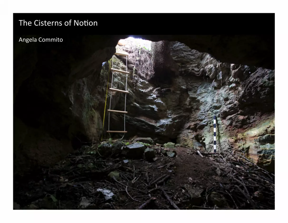
The$Cisterns$of$No.on$$Angela$Commito$
Aerial$view$of$No.on,$looking$northeast$

View$looking$up$cistern$sha<$

Satellite$view$of$No.on,$with$loca.ons$of$cisterns$

Views$inside$cistern$

Illegally$excavated$cistern,$looking$north$

Satellite$view$of$No.on,$with$loca.ons$of$cisterns$

Plot$of$geophysical$(magne.c$gradiometry)$survey$

Stone$“pipe$blocks”$

Aerial$view$of$No.on,$looking$northeast$

1
The Cisterns of Notion
Angela Commito
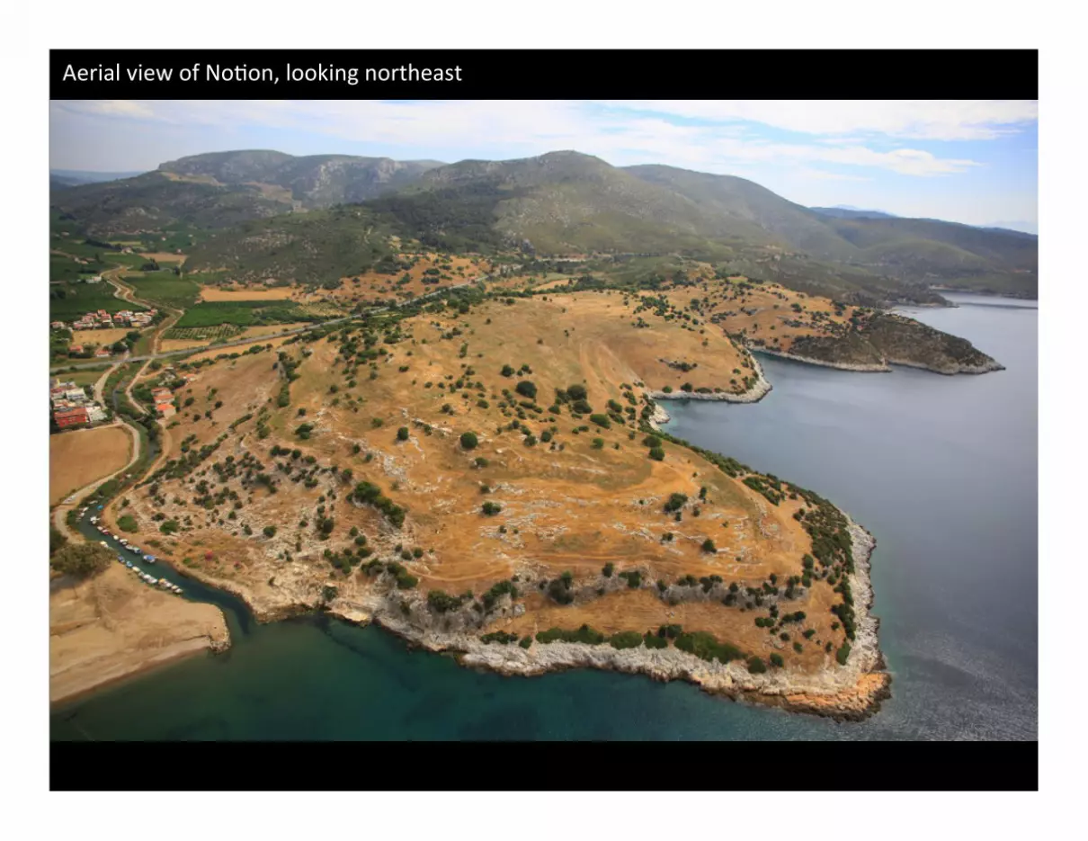
One of the joys of working at Notion is its proximity to the sparkling waters of the Aegean Sea. In
antiquity, this proximity brought the benefits of trade and connectivity, and seems to have been the
reason why a settlement called Notion was created here in the first place. As Christopher Ratté
discussed in the previous talk, the remains we see today on top of these twin promontories likely
belong to a re-founding of the original settlement, which was moved to this new location at some
point during the course of the 4th to 2nd centuries BCE. Despite its real or perceived advantages, this
new location had a major deficiency: a complete lack of fresh water. No springs have been found
on the site, and the nearest source of fresh water seems to have been the Hales River, located 85 m
below the high-point of the city. How did the builders of the new town address this problem? Was
this deficiency partly to blame for the large-scale abandonment of the city, which, as you heard in
the previous talk, may have taken place only a few centuries after its re-founding?
After two seasons of survey at the site, we have identified at least a dozen cisterns, along with a
number of stone pipe blocks, that demonstrate how the city’s inhabitants responded to this
challenge. In 2015 we documented 8 of the cisterns with photographs and basic drawings, and
created 3D models of two of these with a laser scanner. The reason why we are studying the
cisterns in detail is because they, along with other water features at the site, have the potential to
offer clues about the life cycle of this ancient city.
The 12 known cisterns are located throughout the site, in both public and private spaces: around the
Temple of Athena and the so-called Heroon, in and around the Agora, near the Bouleuterion, and
Theater, and on the southern slopes of the site in what appear to have been residential areas. As at
any site, the presence of a cistern need not relate to the use of the building above it; these cisterns
must have gathered rainwater from the roofs of public and private buildings alike.
The cisterns are generally bottle- or carafe-shaped in section, expanding from a diameter of 1-2 m at
the top to 3-4 m at the preserved bottom, and extending down to a depth of 5-7 m. They range in
capacity from about 4.5 to over 50 cubic meters. Because soil and debris have accumulated at the
bottom of these cisterns, our current calculations of volume may significantly underestimate their

2
original capacity. The cisterns are excavated from the two major types of bedrock on the site, schist
and limestone, and most are lined with hydraulic mortar, especially the schist surfaces. In several
cisterns the terracotta pipes for water intake remain in situ, laid above bedrock level below the large
stone slabs used to build up and cover the cistern opening. Carafe-shaped cisterns are found
throughout the Mediterranean from the 5th century BCE through the later Roman era, but they are
most common in the Hellenistic period, especially the 2nd and 1st centuries BCE.1 The construction
of the cisterns at Notion seems therefore to correspond in time with the period when the city was
re-founded and enjoyed its greatest occupation, as suggested by the identifiable surface pottery
examined so far, which dates to a very narrow window extending from the 2nd century BCE to the
1st century CE.
Only one cistern was originally excavated with a rectilinear rather than circular horizontal cross-
section. It is also the only one with an obviously different roofing system, consisting of at least two
arches that would have originally been masked by large cover slabs, like those of the cisterns at
Termessos, for example. Though this is the deepest cistern, at 9 m, it is also one of the most easily
entered because three years ago it was robbed out by would-be looters. Their harmful but
illuminating excavation efforts enabled us to bring a laser scanner down to the bottom of the cistern
and produce a 3D model of the subterranean structure. The volume of the scanned portion is about
35 cubic meters, but taking into account the lower portion currently covered by brush and debris,
the original capacity was likely closer to 50 cubic m or more.
In capacity the cisterns at Notion are comparable to those of other towns during the Hellenistic
period, such as Miletus, Priene, and Morgantina. At Morgantina, for example, the average capacity of
household cisterns is 30 cubic m, and practically every excavated house had at least one. The
frequency of cisterns at Notion based on the current evidence – that is, 12 cisterns across the 35 ha
of the city – really does not tell us much, since many more may remain undiscovered. In terms of
location, 11 of the 12 confirmed cisterns are situated across the relatively level, elevated east-west
spine of the city site, where bedrock is exposed in many places, and where the main public buildings
1 J. B. Connelly and A. I. Wilson, 2002, “Hellenistic and Byzantine cisterns on Geronisos Island,” Report of the Department of Antiquities, Cyprus 2002: 278-280, who list comparanda at Athens (5th c. BCE), Olynthus (4th c. BCE), Kourion (3rd c. BCE), Pergamon (prob. 3rd and 2nd c. BCE), Morgantina (2nd and 1st c. BCE), and Punic Carthage before 146 BCE. Comparanda for vaulted cisterns topped by large, flat cover slabs exist across the eastern Mediterranean, from the Hellenistic period (e.g., theater cistern on Delos) to the early Byzantine period (e.g., Syria, including Dehes on the limestone massif), including at sites across western Asia Minor

3
and spaces of the town were laid out.2 Only 1 confirmed and 1 possible cistern are located on the
slopes south of this spine. But rather than demonstrating any preferential siting of the cisterns, this
pattern is likely the result of erosion, which has caused the southern slopes to be partially buried by
soil and debris. Furthermore, the southern slopes seem to have comprised a residential area of the
city, and so there may be many more cisterns here, perhaps even one for each house. Preliminary
survey carried out in 2014 documented 47 in-situ threshold blocks across these residential areas, and
perhaps we should use this number to get a sense of the potential frequency of cisterns at the site, as
well, but continued research is needed to test this idea.
In any case, Notion would have needed many more than 12 cisterns if inhabitants relied
solely on these structures for their water needs. Though ancient towns could be supplied by cisterns
alone, it was far more common to have multiple sources of water, to guarantee supply should any
one of them fail, and to supply water of different qualities for different uses. At Morgantina, again,
residents used water piped in from springs, brought up from wells, and collected in cisterns. This
redundancy has been interpreted as a way to make sure the best-quality water was available for
drinking. In antiquity the quality of water collected in cisterns was considered inferior to that of
running water or even of water from wells, and ancient authors recommend boiling it or adding salt
before drinking it.3 Sources of running water were always preferred over standing water: at Priene,
for instance, a site with abundant natural springs, most houses used water from fountains or had a
piped-in supply; only houses located at the outer edge of the town plateau, out of the range of these
running sources, were equipped with cisterns.4 Though running water was available near Notion in
the form of the Hales River, it is located at an elevation too low to supply the city.
Did the residents of Notion have access to more salubrious waters? One hint that the city may have
had a running supply comes from what appear to be the remains of a monumental fountain in the
eastern portion of Agora, adjacent to a major east-west street that traversed this central public space,
as indicated by this linear anomaly revealed by geophysical prospection in 2014, perhaps a
subterranean drain. The possible fountain appears as a rectilinear anomaly with what may be drains
or channels radiating out from its corners. Materials preserved on the surface here include a block
with what looks like a cutting for a pipe.
2 Compare, e.g., the frequency and placement of cisterns in the water-poor islands of Thera and Delos; L. Mays et al., 2013, “History of water cisterns: legacies and lessons,” Water 5: 1921-22. 3 Pliny HN 31.21.34, Pausanias, Aristotle, Plato, Hippocrates. 4 Crouch 1996, 167.
4
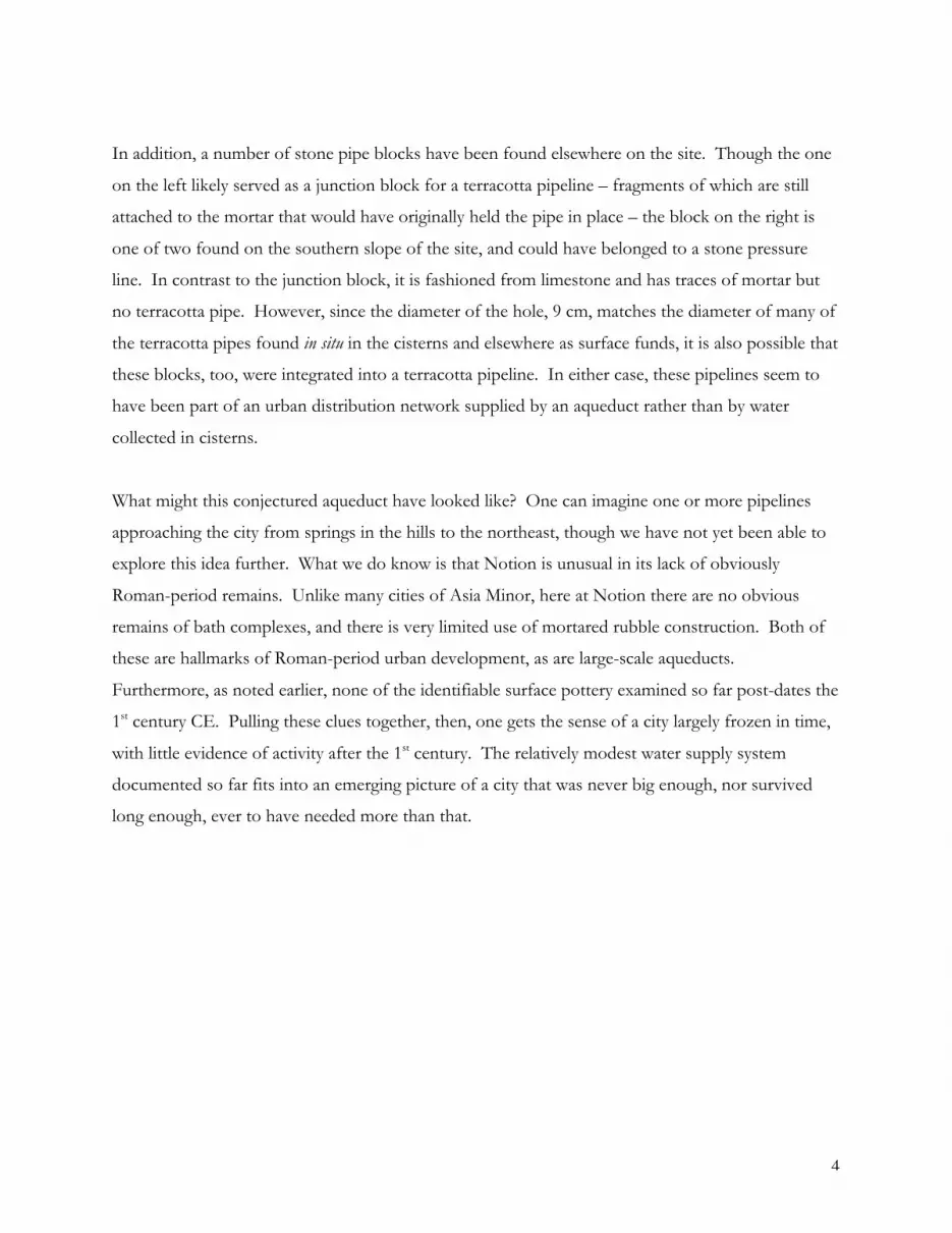
In addition, a number of stone pipe blocks have been found elsewhere on the site. Though the one
on the left likely served as a junction block for a terracotta pipeline – fragments of which are still
attached to the mortar that would have originally held the pipe in place – the block on the right is
one of two found on the southern slope of the site, and could have belonged to a stone pressure
line. In contrast to the junction block, it is fashioned from limestone and has traces of mortar but
no terracotta pipe. However, since the diameter of the hole, 9 cm, matches the diameter of many of
the terracotta pipes found in situ in the cisterns and elsewhere as surface funds, it is also possible that
these blocks, too, were integrated into a terracotta pipeline. In either case, these pipelines seem to
have been part of an urban distribution network supplied by an aqueduct rather than by water
collected in cisterns.
What might this conjectured aqueduct have looked like? One can imagine one or more pipelines
approaching the city from springs in the hills to the northeast, though we have not yet been able to
explore this idea further. What we do know is that Notion is unusual in its lack of obviously
Roman-period remains. Unlike many cities of Asia Minor, here at Notion there are no obvious
remains of bath complexes, and there is very limited use of mortared rubble construction. Both of
these are hallmarks of Roman-period urban development, as are large-scale aqueducts.
Furthermore, as noted earlier, none of the identifiable surface pottery examined so far post-dates the
1st century CE. Pulling these clues together, then, one gets the sense of a city largely frozen in time,
with little evidence of activity after the 1st century. The relatively modest water supply system
documented so far fits into an emerging picture of a city that was never big enough, nor survived
long enough, ever to have needed more than that.