the career of the indies
TRANSCRIPT
Research project on the theme: "The Career of the Indies"
March 2003
Introduction p. 031- Why a Portuguese expansion? p. 032- Importance of the Career of Indies p. 053- Conditions in which was held p. 06 a) Navigation p. 09 b) Instruments p. 11 c) Shipbuilding p. 15 d) Vessels p. 17 e) Weaponry p. 23 f) Life on board p. 254- Causes of its decline p. 325- O “País do Gelo” – the “Ice Country” p. 34Conclusion p. 40References p. 41Annex I - Explanatory Tables p. 43Annex II - Maps and Prints p. 45
FOREWORD
Given the vastness of subjects linked to the epic of the
Portuguese Discoveries, it was chosen, in this work, a
certain objectivity which resulted in an almost exclusive
1
emphasis on the impact of the Career of the Indies and
justification of its importance and the conditions it held,
with a brief allusion to something one could consider very
close to a predestination that drove the Portuguese world
out in the 15th and 16th centuries.
2
INTRODUCTION
The Career of the Indies was the culmination and
simultaneously turning point in Portuguese expansion.
Indeed, the Portuguese Discoveries were started with the
ultimate goal of reaching the mythical Indies, lands that
have always populated the European collective imagination
as a source of infinite riches, even though there was no
idea of its location.
When finally the Vasco da Gama's voyage set the sea route
to India, a new cycle started for the West, which ceased to
be focused on itself around the Mediterranean and realized
that there were other worlds beyond theirs. Portugal
overcame their geographical boundaries and became a world
power, and even dared to share the world with Spanish
rivals.
The fact that, as early as the second trip, having given
the "achamento" (finding) of Brazil, adds another important
element to the Career of the Indies joining the technical
innovations, cultural and mentality (to be discussed in
another paper) which provided.
The aim of this work is to analyze, first, the reason why
there was in the first place a Portuguese expansion when
nothing would predict, explain the importance of this route
for the birth of the first super power of History and with
the help of a theme by musician Rui Veloso, enrolled on the
album "Auto da Pimenta" edited to celebrate the 500th
anniversary of Discoveries, which will serve as a guide,
3
characterize this Career in its many aspects, from the
navigation to the way it was perceived in society.
A summary of the causes that led to its decline, between
internal and external factors, will complete this
exhibition, which is to contribute to portray as faithful
as possible the reality of what was the Career of the
Indies.
4
1- WHY A PORTUGUESE EXPANSION?1 2 3
No people would be so predisposed to an expansion at the
time it happened, as the Portuguese, although, currently,
this development seems a feat close to the impossible,
carried out by the last people who was hoped to ever get
it4.
The Crusades had awakened in Europe a spirit of conquest
and adventure that turned to the East, to be, from the
Greco-Roman antiquity, the site of all imaginable wealth, a
misunderstood but deep medieval myth. Thus towards the
Middle departed travellers like Marco Polo, when the war
finally had to stop with the final victory of the Arabs.
Now that the reports of these travellers did get a little
light in the darkness of limited knowledge of then Europe
would eagerly seek to probe the unknown around him.
The vastness of the western seas should be a source of
concern especially for people they bathed. This is how the
Vikings venture into the North Atlantic, reaching Greenland
and the Americas; intrepid navigators, met up yet with what
they had found, preferring the looting of Europe's coastal
cities to move further south. Other people who became
1 Manuel Joaquim Pinheiro Chagas, Os Descobrimentos Portugueses e os de Colombo– Tentativa de Coordenação Histórica, Lisboa, Academia Real das Ciências,1832 / Parede, Publicações Quipu, 2001, pp. 69-79.2 António Borges Coelho, Raízes da Expansão Portuguesa, Lisboa, Livros Horizonte, 1985.3 História dos Descobrimentos e Expansão Portuguesa, Lisboa, Universidade Abertan.º 173, 1999, pp. 101, 102.4 M. J. Akbar, The Shade of Swords – Jihad and the Conflict Between Islam & Christianity,London & New York, Routledge, 2002, p. 114: “(…) an impoverishEuropean nation surprised Rome, and probably itself, with the conquestof a Muslim bastion on the northern coast.” [Ceuta].
interested in across the Atlantic, were the Normans, but
more geared to the immediate profit than for scientific
research, preferred to pass the Strait of Gibraltar towards
the Mediterranean where they had many and fat preys. The
Italian peninsula had two maritime powers - Venice and
Genoa - whose navigators were in great demand for its
technical expertise; however, were more focused on trade
with the East through the ports of the Levant, not
exchanging a certain income and large profit by a more than
doubtful one.
So it remained the Iberian Peninsula.
However, the Hispanic kingdoms were still grappling with
the war against the Moors, which still occupied the
province of Granada. Only Portugal, which had unified its
territory in the previous two centuries expelling the
Arabs, was freed from constraints on the one hand, and had
the interest, on the other, to find new sources of income
that would provide a much needed economic development.
Moreover, in the beginning of the sixteenth century, were
to form two large blocks: one east, commercial and
terrestrial - the Ottoman Empire - and one in the west -
the great mass of Charles V's empire, with Portugal at risk
of being crushed between them. Also piracy of the Saracens
on the Algarve coast and the navigation, weapons smuggling
and African trade fleeing the control of the Crown, added
to the growing threat brought by the unification of the
Kingdom of Morocco, whose sheriffs preached holy war, and
finally, the creation of a bastion of Christendom in a
6
strategic position in the territory of the infidels, were
reasons that drove the conquest of Ceuta.
The consequent expansion trough African coast did gain
gradually momentum as the internal forces game that
fundamentally opposed a mercantile bourgeoisie - which had
an interest to establish strongholds at the confluence of
the caravan routes - to a feudal nobility - which had a
keen interest on the conquest of new territories to get
titles and income. Finally, would prevail expansion factor
over everything else, as a result both of the boosting of
the bourgeoisie over the profits, and the nobles looking
for a social position to their second sons, as the eldest
son inherited the title and the consequent social status.
2- IMPORTANCE OF CAREER OF INDIES
It was huge the commercial and political importance of the
Cape Route5, which established the Career of the Indies.
Linking Portugal to the mythical Indies, this route
performed the old dream of supplanting the Silk Road in
contacts between East and West, and stroked a blow on
Mediterranean trade, hitherto monopoly of the Italian
republics. 6
The Arab merchants, based in Calicut and often using the
same ships carrying pilgrims to Mecca, controlled the spice
trade up to the Levant ports; the next step being for the
account of Venetian merchants who made the connection with
5 Vide Annex I, Tables 1 and 2.6 Idem, Tables 3 and 4.
7
Europe. Thus, the value of a duchy (old Venetian currency)
purchased from Calicut spice, raised up to 60 to 100
dukedom in Venice and multiplied successively by the
intermediary to be exchanged for gold in Western Europe.
Pepper was the queen of this trade, for it was considered
useful in a wide range of purposes, as a seasoning and
preservative of food, being mixed with salt to preserve
meat stored for the winter or for long sea voyages, and
also had appreciated medicinal properties. The spice has
become a necessity for everything from cosmetics to
antidote against the plague. 7
Thus emerged an Atlantic trading power that in the period
between 1498 and 1635, made 916 departures from Tagus River
with destination to India and back, placing in Europe
spices in greater quantity and faster than by land8, with
consequent low price and increase demand, which would
translate into huge profits. For over eighty years, the
Portuguese army and the ships of spices can move around the
Cape Route9 without feeling any threat; only in return, to
come in Azorean waters (in the final stage of the route),
were attacked by pirates and enemy fleets. This supremacy
would only be disputed in the seventeenth century, when
Dutch and English began indeed to rival Portugal.
3- CONDITIONS IN WHICH WAS HELD
7 Cfr. M. J. Akbar, op. cit., p. 117.8 Vide Anenx II, Fig. 1.9 Idem, Fig. 3.
8
Routes10 11
The ships departed Lisbon between early March and the first
half of April, which allowed them to take advantage of the
favourable winds of the Atlantic and reach Indian Ocean in
time to benefit from the southwest monsoon that led to the
Hindustan west coast. From Lisbon, the fleets headed
towards the Cape Verde islands, moving away from the
African coast after a route arc that approached Brazil.
Normally, this route was made without scales, although some
ships end up docking in Brazilian soil for navigation
error, which allowed the repair of any deficiency in
vessels or resupplying of water or food. One of the
critical points due to frequent storms was the passage of
the Cape of Good Hope. In the Indian Ocean, the ships could
call at Mozambique, then heading towards Goa and Cochin.
The trip lasted, under normal circumstances, about six
months.
On the return trip to Lisbon (the turn-trip), departures
from India were made in December or January. After
departure, usually from the city of Goa, the vessels were
heading to the coast of Somalia under the action of the
favourable winds of the northeast monsoon, which hit the
Indian Ocean between October and March. Then followed or
the Mozambique Channel or through outline of St. Lawrence,
across the Indian Ocean. After passing the Cape of Good
10 Adapted from “Navegação – Rotas” in Navegar, [CD-ROM], Simonetta LuzAfonso, António Manuel Hespanha, et al, Paris, Editions Chandeigne /Sèvres, Oda Edition / Lisboa, Pavilhão de Portugal, Expo’98 / ComissãoNacional para as Comemorações dos Descobrimentos Portugueses, 1998.11 Vide Annex II, Fig. 2.
9
Hope sailed the boats towards the islands of St. Helena and
Ascension, after passing near the Cape Verde archipelago.
Then began the “turn by large” until they reached Azores
and then entering the last stage of the journey towards the
Portuguese coast. Only in the final phase of Career of the
India began to be frequent during the “turn-trip”, do scale
in Brazil to complete the loading of ships or make other
businesses that allow making more profitable travelling
around the Cape Route.
Ocean currents12
To navigate the South Atlantic and around the tip of
Africa, the Portuguese sailors began to take advantage of
the Guinea Current, but soon had to face two powerful ocean
currents13: the Agulhas current and Benguela one. The warm
Agulhas current flows southwest from the Indian Ocean,
pushing the almost frozen Antarctic waters, before finding
the cold Benguela current that travels from the Cape of
Good Hope. The second fastest current in all oceans of the
world, Agulhas, is more deadly than the fastest current,
the Gulf one - which originates in the Gulf of Mexico (in
the Northwest of Central America Sea) and heads of west to
north-east to northern Norway, bathing the European
Atlantic coasts - since one of its branches flowing through
a narrow passage between Madagascar and Mozambique14, from
north to south, exactly the opposite direction to which the
12 Cfr. “Ocean Currents and Tides: The Treacherous Agulhas” in http://tinyurl.com/jvpvzrt 13 Vide Annex II, Fig. 6.14 Idem, Fig. 4.
10
Portuguese ships needed navigate to circumvent the tip of
Africa and reaching India.
Swimming against the tide of Agulhas is much more
complicated to navigate in favour. The caravels would have
to walk back and forth to catch a favourable wind, a narrow
strip of water which abound pointed submerged rocks,
heading north through the current. High winds (about 180 km
/ h) are common between September and November, but even
more frightening is the deadly changes that occur when the
wind changes direction; when blowing from west to south-
west (the opposite direction of the current), monstrous
waves (up to the height of a fifth floor) occur, easily
swallowing a fragile ship.
After Bartolomeu Dias have successfully navigated the
treacherous intersection of currents Benguela and Agulhas
(Cape of Good Hope15), three separate trips were necessary,
between 1486 and 1497, so that the Portuguese learned to
navigate efficiently through the Agulhas Current,
travelling in the opposite direction.
Even today, in which ships use sophisticated navigation
equipment, there is no possibility of surviving these
occasional waves and is common wrecks happening in this
area, and even the larger vessels can disappear without a
trace.
Cargo16
15 Vide Annex II, Fig. 5.16 Adapted from “Navegação – Carregamento – Carga” in Navegar, op. cit.
11
The ships that left the kingdom to the East, despite
significant part of trade be made with currency or precious
metals bullion, were required to carry a certain amount of
other products which are then exchanged for spices and
other goods. Thus, the usual loading of ships with the
Career of the Indies luxury fabrics, metals such as copper
or lead, or mercury coral. The vast majority of these
products was acquired abroad (tissues, for example, were
purchased from producers Genoese, Florentine, Flemish or in
London), which entailed high costs. As for domestic
products, was boarded olive oil, some wine and salt.
Goods17
The route of the cable provided strong demand for products
in Europe.18 The Portuguese ships that came from Goa
towards Lisbon brought the main goods originating spices of
South India, Ceylon and the Moluccas: a significant
proportion of the total cargo loaded consisted of pepper,
accompanied in the background by cinnamon by clove and the
nutmeg. From the mid-sixteenth century, the revival of
traditional routes and the incursion of the Portuguese in
areas of the Far East, such as China and Japan, caused a
decrease in the weight of the spices trade. Then gained
importance silks and Chinese porcelain, as well as stones
and precious woods, the lacquer, camphor, musk and carpets,
obtained in several eastern regions. Also the transport of
17 Adapted from “Navegação – Carregamento – Mercadorias” in Navegar, op.cit.18 Vide Annex I, Table 2.
12
exotic animals was relatively common, with some ships
disembarking in Lisbon elephants, leopards and rhinos.
The excess and bad storage of the goods of the ships
returning to the kingdom were constant. The situation
reached such proportions that led, for example, the sinking
of a ship in Goa, when he was being loaded; to departures
with ships beginning the journey "sideway" due to poor
storage of goods; or to return to the place of departure,
shortly after the beginning of the trip. This caused
serious disorders during crossings or in case of storms or
in times of attack of enemy ships. In 1621, the ship
Conception, coming from the East, was attacked by 17
Turkish ships arriving in Lisbon; when the attack begins,
moving on deck becomes impossible given the enormous amount
of goods which had meanwhile been brought from the
basement. The ship quickly caught fire because the mountain
of boxes and bales on the deck was a great food for the
flames.
3- a) Navigation19 20
The former medieval cartography prior to the thirteenth
century did not follow any scientific principle. The known
world was in most cases presented in symbolic form, often
with a circular, or oblong21, and sometimes rectangular. It
has its earliest expression in the type known as T-O22
19 Adapted from “Navegação – Técnicas de navegação” in Navegar, op. cit.20 Inácio Guerreiro, “A Cartografia Portuguesa dos Séculos XV e XVI” inHistória dos Descobrimentos e Expansão Portuguesa, op. cit., pp. 239-263.21 Vide Annex II, Fig. 7.22 Idem, Fig. 8.
13
maps, where the sea-ocean formed a ring, setting the letter
O, involving the three continents that were the known
inhabited world, and rivers Don (or Tanais) and Nile
symbolically forming the letter T. On top of the map
stretched Asia, buoyed by said rivers and the ocean
semicircle, with an equivalent size to the whole of Europe
and Africa, which the Mediterranean divided into equal
parts.
Slowly, these very simple mapping schemes have evolved,
while obeying the traditional arrangement of continents,
with Asia, to the East, appearing always at the top of the
chart. Cities, rivers and most important places then began
to appear on maps; Jerusalem occupied almost invariably the
centre of the circle, conditioning the geographical
development of the composition. The biblical beliefs were
always included as well as information obtained for the
travel accounts of those who ventured on long voyages, by
land and sea, to demand the distant and fabulous stops, for
commercial purposes, or in obedience to religious and
diplomatic purposes. And these descriptions were not always
reliable, maps registered almost always the legendary news,
dictated by fantasy authors, along with the correct
information also contained in their testimonies. Gradually,
these maps will became more solid with the addition of real
and mythical data, but its geographical value remained low.
These cartographic traditions persist until the end of the
Middle Ages.
14
The Portolan 23
Also during this time was a new cartographic current and
distinct from the first, and with it has evolved in
parallel for two centuries. It was in the Mediterranean
that was born in the second half of the thirteenth century,
the new process of drafting charts, of a far more practical
nature, based on the art of navigating this sea of pilots
and technical elements within reach. It resulted from the
widespread use of the magnetic needle, set on a rose-of-
winds (twelfth and thirteenth centuries) and was closely
associated with the scripts, called “portulanos” by the
Italians.
These were descriptive texts, of very clear and direct
content, intended for sailors uneducated. With the
generalization of the magnetic needle started to record, in
addition to such descriptive elements, magnetic directions
and distances in miles between the coastal points. There
were created the conditions that led to the emergence of
new, more "scientific" mapping process.
Coastal navigation
During the Middle Ages the coastal navigation is the
predominant in Christian Europe, in the connections between
the various ports of the Mediterranean and the Atlantic
coast. In this type of navigation, ships rarely move away
from the coast and the orientation is made from the
observation of reference points on land. Thus, the
distances covered in each path are relatively small and are23 Vide Annex II, Fig. 9.
15
made frequent stopovers on earth. This practice continued
for a long time in the Mediterranean world, still being
used at first in the Portuguese voyages of discovery along
the African coast. With the advancement of Atlantic voyages
and the need for another route guidance method for several
days and weeks in the open ocean, the navigation based on
the observation of celestial bodies will be developing.
16
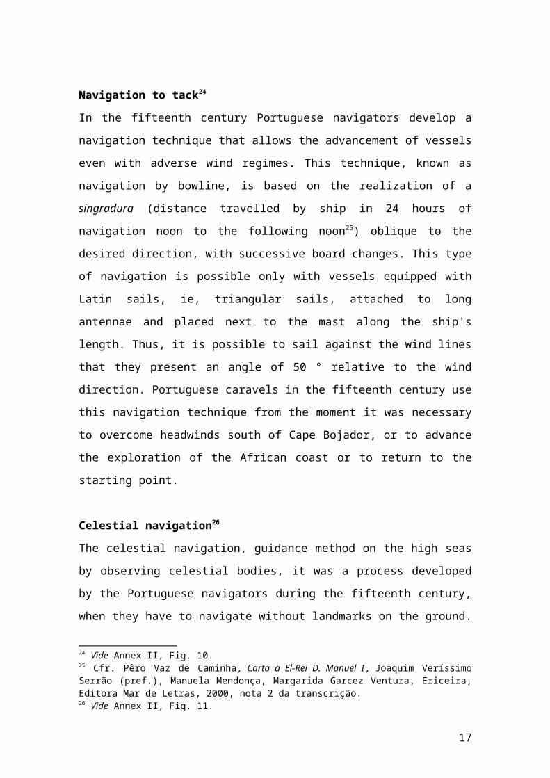
Navigation to tack24
In the fifteenth century Portuguese navigators develop a
navigation technique that allows the advancement of vessels
even with adverse wind regimes. This technique, known as
navigation by bowline, is based on the realization of a
singradura (distance travelled by ship in 24 hours of
navigation noon to the following noon25) oblique to the
desired direction, with successive board changes. This type
of navigation is possible only with vessels equipped with
Latin sails, ie, triangular sails, attached to long
antennae and placed next to the mast along the ship's
length. Thus, it is possible to sail against the wind lines
that they present an angle of 50 ° relative to the wind
direction. Portuguese caravels in the fifteenth century use
this navigation technique from the moment it was necessary
to overcome headwinds south of Cape Bojador, or to advance
the exploration of the African coast or to return to the
starting point.
Celestial navigation26
The celestial navigation, guidance method on the high seas
by observing celestial bodies, it was a process developed
by the Portuguese navigators during the fifteenth century,
when they have to navigate without landmarks on the ground.
24 Vide Annex II, Fig. 10.25 Cfr. Pêro Vaz de Caminha, Carta a El-Rei D. Manuel I, Joaquim VeríssimoSerrão (pref.), Manuela Mendonça, Margarida Garcez Ventura, Ericeira,Editora Mar de Letras, 2000, nota 2 da transcrição.26 Vide Annex II, Fig. 11.
17
Improving the process went through several phases. The
first consisted of comparing the meridian altitude of
Polaris at a certain point, with the height of that star in
a predetermined reference point. Given the limitations of
this method, it is developed another technique which
involves comparing the height of the North Star in eight
different positions of its apparent diurnal circle. This
process gives rise to the known "wheels", where the
coordinates of the various positions of the Polar Star are
indicated in determinate point or points of reference with
which the sailors may face the coordinates obtained from
the measurements made on board. With reference to the
positions of the Polar Star in Lisbon, navigators could
determine the latitude of a point on the high seas, by
establishing a few simple rules. From the point of the
measurement of that star at any given point, it will only
be sufficient that to this value, taken from a known
direction, will be added or subtracted certain constants.
In the last decades of the fifteenth century, in addition
to the Polar Star, sailors began to use the measurement of
the meridian altitude of the sun and its declination. When
the voyages of the Portuguese brought them beyond the
equator, causing them to lose the North Star as a reference
star, they sought to implement the same processes for the
Southern Cross. However, if the determination of the
meridian altitude allowed obtaining satisfactory results
the direct implementation of the rules used in the case of
the North Star to observe the eight positions of the
18
Southern Cross on its apparent diurnal motion, implied
notable errors.
3- b) Instruments27
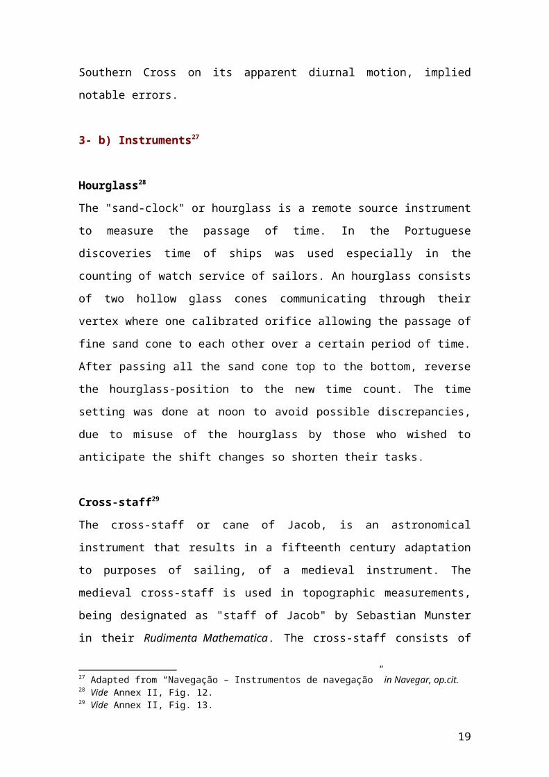
Hourglass28
The "sand-clock" or hourglass is a remote source instrument
to measure the passage of time. In the Portuguese
discoveries time of ships was used especially in the
counting of watch service of sailors. An hourglass consists
of two hollow glass cones communicating through their
vertex where one calibrated orifice allowing the passage of
fine sand cone to each other over a certain period of time.
After passing all the sand cone top to the bottom, reverse
the hourglass-position to the new time count. The time
setting was done at noon to avoid possible discrepancies,
due to misuse of the hourglass by those who wished to
anticipate the shift changes so shorten their tasks.
Cross-staff29
The cross-staff or cane of Jacob, is an astronomical
instrument that results in a fifteenth century adaptation
to purposes of sailing, of a medieval instrument. The
medieval cross-staff is used in topographic measurements,
being designated as "staff of Jacob" by Sebastian Munster
in their Rudimenta Mathematica. The cross-staff consists of
27 Adapted from “Navegação – Instrumentos de navegação” in Navegar, op.cit.28 Vide Annex II, Fig. 12.29 Vide Annex II, Fig. 13.
19
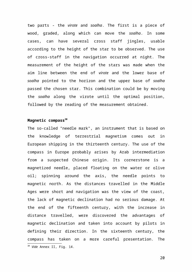
two parts - the virote and soalha. The first is a piece of
wood, graded, along which can move the soalha. In some
cases, can have several cross staff jingles, usable
according to the height of the star to be observed. The use
of cross-staff in the navigation occurred at night. The
measurement of the height of the stars was made when the
aim line between the end of virote and the lower base of
soalha pointed to the horizon and the upper base of soalha
passed the chosen star. This combination could be by moving
the soalha along the virote until the optimal position,
followed by the reading of the measurement obtained.
Magnetic compass30
The so-called "needle mark", an instrument that is based on
the knowledge of terrestrial magnetism comes out in
European shipping in the thirteenth century. The use of the
compass in Europe probably arises by Arab intermediation
from a suspected Chinese origin. Its cornerstone is a
magnetized needle, placed floating on the water or olive
oil; spinning around the axis, the needle points to
magnetic north. As the distances travelled in the Middle
Ages were short and navigation was the view of the coast,
the lack of magnetic declination had no serious damage. At
the end of the fifteenth century, with the increase in
distance travelled, were discovered the advantages of
magnetic declination and taken into account by pilots in
defining their direction. In the sixteenth century, the
compass has taken on a more careful presentation. The30 Vide Annex II, Fig. 14.
20
magnetic needle was suspended inside a graduated box on the
interior walls and a rose-of-winds in the background.
Astrolabe31
The planispheric astrolabe is an instrument of Greek
origin, used in the Middle Ages for astrological and
astronomical purposes. It is a graduate brass disk on the
periphery of the circle, a suspension ring and a mediclina
(axis spinning around the astrolabe) with perforated pínulas
(little holes). For use in astrology and surveying, the
faces are covered with lines and representations of various
stars and the zodiac. Its introduction navigation
astronomical probably occurred in the late fifteenth
century, although the earliest known depiction of a
nautical astrolabe dates of 1517. Gaspar Correia attributed
to Abraham Zacuto, a Jewish astrologer based in Portugal,
the proposal of its application for navigation purposes.
The first explicit reference to its use on board refers to
an Diogo de Azambuja trip in 1481. João de Barros states
that Vasco da Gama used a wooden, suspended by a cabrilha, a
support with three limbs tied at the top.
The nautical astrolabe is a simplified version of the
traditional. And a robust and heavy object, cast in bronze,
with about 2 Kg and 20 centimetres in diameter, which
should remain upright during measurements. The instrument
was suspended by the ring, while passing a ray of sunshine
through the hole of both pínulas. Like one could not look
directly, observers suspended the astrolabe and handled the31 Vide Annex II, Fig. 15.
21
mediclina until a ray of light enters the top hole and
became projected on the bottom. It was called this
operation "weighing" of the Sun, given the similarity with
the use of a scale. The reading was made on a scale from 0
° to 90 ° which gave the zenith distance, from which it was
possible to calculate the latitude of a place. The latitude
is found then from the formula X = (90 - a) + d, where "a"
is the height of the sun and "d" its declination. As the
complement of the height is the zenith distance (Z = 90 -
a), it was enough to make the pilot operation Z + d to find
the value of latitude X.
Compass32
This compass is a utensil formed by two legs articulated at
one end, used to draw circular lines or take measurements.
As an additional to boating, its use is to draw routes and
calculate distances on sea charts. In the fifteenth and
sixteenth centuries was also used in shipbuilding and in
the design of some parts of the vessels. One of his most
famous representations is in the Book of Woodworking
Designs (1616) by Manuel Fernandes where it is pictured in
the hands of the author, in the illustration in which he is
portrayed.
Quadrant33
The first instruments to be used in celestial navigation,
from the mid-fifteenth century, were the ones that were
32 Vide Annex II, Fig. 17.33 Idem, Fig. 17.
22
already known since the Middle Ages; The Quadrant, as the
plane astrolabe, was no exception, although initially its
use was linked to astrology. The medieval quarter, as the
astrologers and surveyors used to measure the height of the
stars or objects from the Earth's surface, includes
altimetry scales to address distance measuring problems
between inaccessible points and a cursor to allow calculate
the solar declination. The nautical quadrant is, however, a
much more streamlined instrument. It consists of a quarter
circle, form iron or wood, with two aim pínulas perforated at
one of its straight sides, a suspended plumb line from the
right angle of the triangle and a grading scale entered in
peripheral quarter circle.
The quadrant of use on board was simple: the user pointing
the quadrant the star he wants to see, until he can see
through the holes of both pínulas. The measurement was then
found through the value pointed to by run-of-plumb in the
quarter circle scale, where a graduation from 0 ° to 90 °.
Although its application in navigation is, of course,
previous, only there are only explicit references to its
use from the mid-fifteenth century, based on the testimony
of Diogo Gomes. The first iconographic representations date
back to the first half of the sixteenth century, lying in
some planispheres by Diogo Ribeiro, though still with
altimetry scale. It was used until the eighteenth century,
despite some criticism regarding the accuracy of the
measurements obtained by it.
23
The "tavoletas from India"34
The instrument known in Portugal as “tavoletas of Judea”,
“cross-staff of the Moor " or kamal was discovered in the
Indian Ocean during the first Vasco da Gama trip and was
intended to guidance on the high seas by observing the
stars. It consists of a board of square or rectangular
shape, with a full wire we suspended from its centre. The
user must hold the wire with the mouth by one of nods, or
hold it at eye level with one hand, while aimed at the star
chosen for guidance from one side of the board and the
skyline on the other. The nodes of the wire should be
positioned in accordance with the height of celestial
bodies used as reference. The first attempt to use the
kamal by the Portuguese occurred in Pedro Álvares Cabral's
trip but the lack of reference points used by the Indian
Ocean sailors and the exact correspondence between the
grades of Portuguese measurements and the eastern inches
(Isbas) prevented its proper use.
3- c) Shipbuilding35 36
To build the ships used in the Atlantic voyages of
exploration, in the fleets guarding the Portuguese coast
against existing pirate attacks and in commercial service
between Lisbon and the various overseas possessions, there
34 Vide Annex II, Fig. 18.35 Adaptado de “Navegação – Barcos – Construção naval” in Navegar, op. cit.36 Francisco Contente Domingues, “A Construção Naval Portuguesa(Séculos XV-XVI)” in História dos Descobrimentos e Expansão Portuguesa, op. cit., pp.215-231.
24
were created various facilities in Lisbon and elsewhere in
the country. Among these units had particular importance
the Ribeira das Naus, in Lisbon. By the reign of King
Manuel I, the shipyard was located at the waterfront, in
the current Campo das Cebolas, to the east of the Terreiro
do Paço. With the increasing demands of the empire, both in
new vessels for commercial careers as for the fleets that
should protect them, it becomes necessary to extend and
transfer these structures to more spacious place. The new
shipyard - New College - was to the west of that Terreiro,
very close to the Royal Palace that King Manuel ordered
built in the early years of the sixteenth century.
In times of increased activity, worked in Ribeira hundreds
of skilled workers, in which loomed the carpenters; while
numerous slaves performed the toughest jobs. The master
carpenter considered his work finished when concluding the
construction of the hull and the ship was launched in the
water. It was followed by the placing of the masts, the
yards and the canopy. In warships, the captain and the
bombers oversaw the placement of onboard weapons. The pace
of construction of vessels in Ribeira was sometimes
hampered by the lack of material available; to overcome
these difficulties there were woods and forests in some
areas of the country, where the logging was done just for
this purpose. The cork came from Beira Baixa and Alentejo,
while the pine came from Leiria and the south bank of the
Tagus. The felling was done under the guidance of master
25
carpenter and obeyed strict rules as to the time of year
and time of day of the cut.
The wood from cork-oaks and holm oaks was used in the bilge
(the ship's skeleton) 37, being the resistance to water and
the natural curves of holm oak useful for the manufacture
of parts of ships. In so-called "living works" (areas where
the water level reaches) as the keel (strong and long piece
that goes from bow to stern of the ship, which fixes the
timbers), the wheel of the bow and the cadaste (part the
stern where fixed the rudder axis), the wood used was the
resinous pine. In the dead works resorted to the wood stone
pine. The wood of oak and chestnut were only used in small
pieces, given their low water resistance to temperate and
warm seas. Some exotic woods such as teak, were also
occasionally used. The import of some woods of northern
Europe, designed specifically for the manufacture of
certain parts (such as the pine-of-Flanders, for masts),
was a common practice. The construction of a ship obeyed
strict rules on the size of each type of parts38, which
sometimes meant finding the right specimen for slaughter in
terms of age and time of year.
In Lisbon, in addition to the Ribeira, there were several
infrastructures to support shipbuilding. For metal parts
and for the manufacture of weapons there were blacksmiths
and foundries. The location of these establishments near
Ribeira das Naus was useful but too close to the economic
and housing centre, which had some drawbacks. Therefore,
37 Vide Annex II, Fig. 19.38 Idem, Fig. 20.
26
and due to the need to decongest the work, King Manuel
ordered the construction of new ironworks and "new
Teracenas" in the eastern city limits, near Cataquefarás
and the Cross Gate. Thus, there was a distinction between
the Navy Arsenal, still in the Ribeira das Naus, and
Arsenal of the Army, now to be located in the new Teracenas
Foundry. The House of Gunpowder was installed in a tower
about the enclosure ordered built by earlier King
Ferdinand, until be transferred to the area of Pampulha.
Apart from Lisbon, there were other places where
shipbuilding was of great importance in the 15th and 16th
centuries. In the period of infant Dom Henrique travels, it
was the Algarve that was prevalent at this level, but in
the sixteenth century, there were shipyards in various
parts of the country where they built boats used in the
Career of the Indies. In addition to the auxiliary Telha
yard, there were important sites in the north, in Porto,
Gaia, in Aveiro and Vila do Conde, and Setúbal, Lagos and
Tavira, in the south of the Tagus. In overseas possessions,
the largest shipyard was the Ribeira de Goa, in the estuary
of Mandovi. This structure existed at the beginning of the
sixteenth century, before the Portuguese conquest, when
Afonso de Albuquerque then took several dozen vessels and
it was in this Ribeira that were built some of the largest
ships of the sixteenth century.
Portugal was the meeting point of various shipbuilding
techniques (Arab, Mediterranean and Northern European),
which were perfecting hand in hand with the cartography and
27
nautical: in the end it was an interconnected process
better understudied as a whole that does not make much
sense realizing separately. It is incongruous to think of a
great development of shipbuilding without the same
succeeding in nautical terms, which would prevent - taking
the Portuguese case - a ship technically capable of
seagoing, which could not do it because of not having ways
of orientation.
Contrary to what happened in cartography or astronomy, the
process of synthesis of various shipbuilding practices
occurred mainly empirically, that is, by observation and
direct exchange of practical experience, as well as for
contacts and teachings of shipbuilders’ masters. A
Portuguese maritime tradition, forged in the art of fishing
and commerce, join will be solutions hitherto strange but
then effectively adopted by the emergence, by the mid-
fifteenth century, with appropriate vessels in particular
for ocean navigation in the concrete conditions that faced
the protagonists of the voyages of discovery.
And, contrary to what was thought, we can not state that
the Portuguese have created from scratch one or more types
of vessel intended specifically for voyages of Discovery,
completely ignoring everything that was already known. It
was rather the result of various adaptations, changes or
developments of certain technical solutions, giving rise to
different types of vessels that were suitable for
exploratory purposes in view. As with the process of
Discoveries in general, both men of sea and those who
28
ordered the trips did not have a concrete idea of what they
would face, nor the means to that end; was thus something
like walking in the dark, groping the way as it progresses,
trying to combine the need to what could be developed
3- d) Vessels39 40
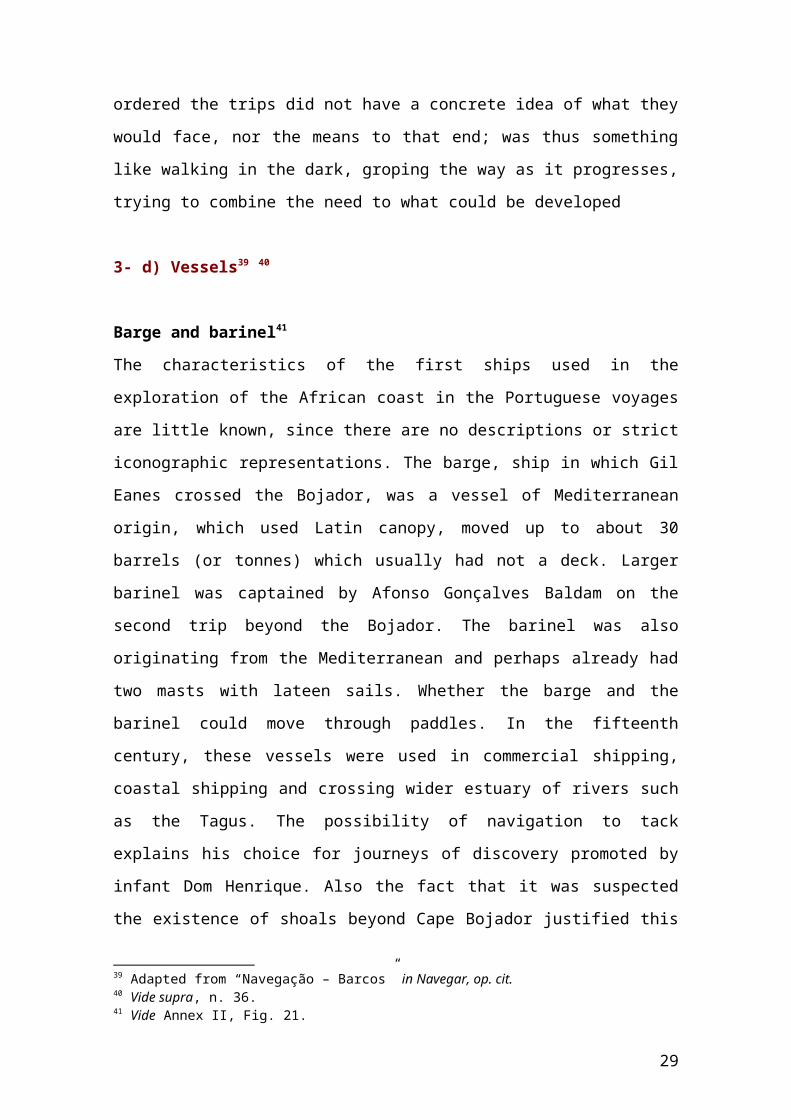
Barge and barinel41
The characteristics of the first ships used in the
exploration of the African coast in the Portuguese voyages
are little known, since there are no descriptions or strict
iconographic representations. The barge, ship in which Gil
Eanes crossed the Bojador, was a vessel of Mediterranean
origin, which used Latin canopy, moved up to about 30
barrels (or tonnes) which usually had not a deck. Larger
barinel was captained by Afonso Gonçalves Baldam on the
second trip beyond the Bojador. The barinel was also
originating from the Mediterranean and perhaps already had
two masts with lateen sails. Whether the barge and the
barinel could move through paddles. In the fifteenth
century, these vessels were used in commercial shipping,
coastal shipping and crossing wider estuary of rivers such
as the Tagus. The possibility of navigation to tack
explains his choice for journeys of discovery promoted by
infant Dom Henrique. Also the fact that it was suspected
the existence of shoals beyond Cape Bojador justified this
39 Adapted from “Navegação – Barcos” in Navegar, op. cit.40 Vide supra, n. 36.41 Vide Annex II, Fig. 21.
29
option, since a smaller ship displaces less draught, that
is, requires less water depth to float.
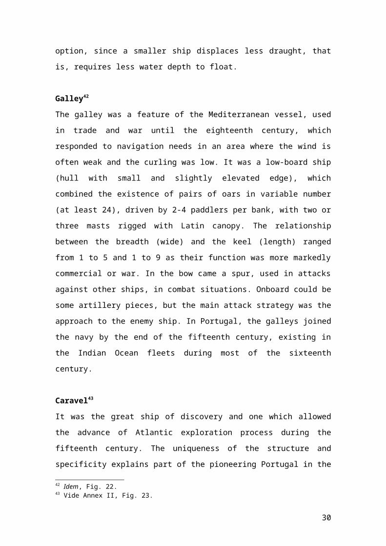
Galley42
The galley was a feature of the Mediterranean vessel, used
in trade and war until the eighteenth century, which
responded to navigation needs in an area where the wind is
often weak and the curling was low. It was a low-board ship
(hull with small and slightly elevated edge), which
combined the existence of pairs of oars in variable number
(at least 24), driven by 2-4 paddlers per bank, with two or
three masts rigged with Latin canopy. The relationship
between the breadth (wide) and the keel (length) ranged
from 1 to 5 and 1 to 9 as their function was more markedly
commercial or war. In the bow came a spur, used in attacks
against other ships, in combat situations. Onboard could be
some artillery pieces, but the main attack strategy was the
approach to the enemy ship. In Portugal, the galleys joined
the navy by the end of the fifteenth century, existing in
the Indian Ocean fleets during most of the sixteenth
century.
Caravel43
It was the great ship of discovery and one which allowed
the advance of Atlantic exploration process during the
fifteenth century. The uniqueness of the structure and
specificity explains part of the pioneering Portugal in the
42 Idem, Fig. 22.43 Vide Annex II, Fig. 23.
30
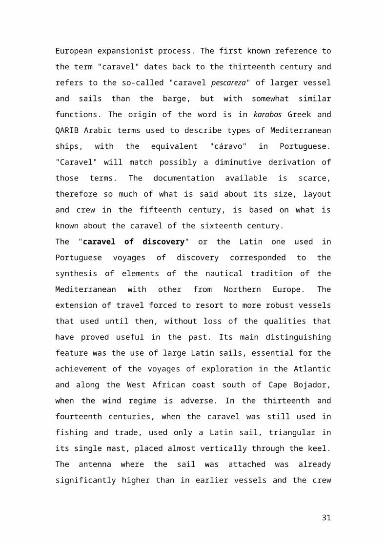
European expansionist process. The first known reference to
the term "caravel" dates back to the thirteenth century and
refers to the so-called "caravel pescareza" of larger vessel
and sails than the barge, but with somewhat similar
functions. The origin of the word is in karabos Greek and
QARIB Arabic terms used to describe types of Mediterranean
ships, with the equivalent "cáravo" in Portuguese.
"Caravel" will match possibly a diminutive derivation of
those terms. The documentation available is scarce,
therefore so much of what is said about its size, layout
and crew in the fifteenth century, is based on what is
known about the caravel of the sixteenth century.
The "caravel of discovery" or the Latin one used in
Portuguese voyages of discovery corresponded to the
synthesis of elements of the nautical tradition of the
Mediterranean with other from Northern Europe. The
extension of travel forced to resort to more robust vessels
that used until then, without loss of the qualities that
have proved useful in the past. Its main distinguishing
feature was the use of large Latin sails, essential for the
achievement of the voyages of exploration in the Atlantic
and along the West African coast south of Cape Bojador,
when the wind regime is adverse. In the thirteenth and
fourteenth centuries, when the caravel was still used in
fishing and trade, used only a Latin sail, triangular in
its single mast, placed almost vertically through the keel.
The antenna where the sail was attached was already
significantly higher than in earlier vessels and the crew
31
was around the dozen men. In the fifteenth century, as he
began to be used by Infant D. Henrique navigators, the
caravel already had two masts with Latin panel, the second
of which (mizzen) midway between the mainmast and the stern
of the ship, 40-60 barrels of tonnage (volume of space for
the load).
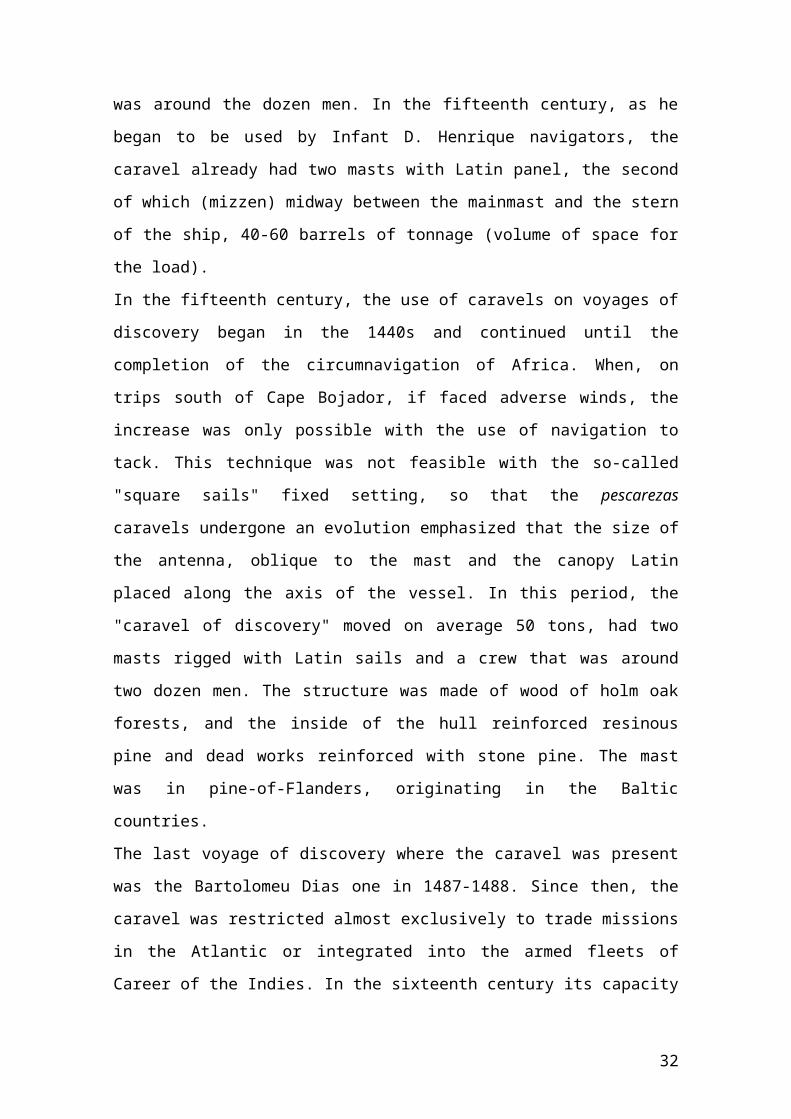
In the fifteenth century, the use of caravels on voyages of
discovery began in the 1440s and continued until the
completion of the circumnavigation of Africa. When, on
trips south of Cape Bojador, if faced adverse winds, the
increase was only possible with the use of navigation to
tack. This technique was not feasible with the so-called
"square sails" fixed setting, so that the pescarezas
caravels undergone an evolution emphasized that the size of
the antenna, oblique to the mast and the canopy Latin
placed along the axis of the vessel. In this period, the
"caravel of discovery" moved on average 50 tons, had two
masts rigged with Latin sails and a crew that was around
two dozen men. The structure was made of wood of holm oak
forests, and the inside of the hull reinforced resinous
pine and dead works reinforced with stone pine. The mast
was in pine-of-Flanders, originating in the Baltic
countries.
The last voyage of discovery where the caravel was present
was the Bartolomeu Dias one in 1487-1488. Since then, the
caravel was restricted almost exclusively to trade missions
in the Atlantic or integrated into the armed fleets of
Career of the Indies. In the sixteenth century its capacity
32
increased to carry larger amounts of goods. First there was
the three-masted caravel, which could exceed 100 barrels of
tonnage and had a castle on the stern with two floors,
overlay (part of the aft deck, higher, the mizzen mast to
the stern) and chapitéu (highest part the bow or stern);
however, this type was gradually replaced by the "round
caravel" with four masts, three with Latin sails and one on
the bow, with a round candle. Its tonnage ranged between
150 and 180 barrels, had between one and two decks two
houses in the castle of the stern and one in the bow,
having little in common with the "caravel of discovery"
being used in auxiliary functions integrated in a fleet of
larger vessels. The "caravelão", in turn, was a smaller
ship (40-50 barrels of tonnage) widely used in Brazilian
coast in support missions.
The caravel was of good sailing, that is, easily manoeuvred
by a small number of sailors, key feature when it was
necessary to embark lots of food and drinking water for
trips that would last months, and move a small draught,
allowing you both ocean shipping as coastal and the
exploring of coves or river courses.
Ship44
It was the vessel that dominated the Portuguese long
distance commercial shipping during the sixteenth century.
So-called "ships of India" were the main example of this
type of merchant ship of great span and distinct from the44 Vide Annex II, Fig. 24.
33
caravel by the type of canopy and hull structure and
transportable cargo volume. As for the canopy, the ships
used round sails in the large mast and foresail (mainsail
mast from the bow), while in the mizzen one uses the Latin
canopy to help manoeuvre the rudder. In the case of the
hull, the introduction of castles to the bow and stern was
aimed at creating space for rooms for passengers and most
important crew members. The size and the number of ships
decks increased during the sixteenth century, when it was
necessary to transport increasing amounts of goods from the
East.
The ships remained over a basic typology in the sixteenth
century, but the desire to increase the transport capacity
had implications for its internal structure. In the late
fifteenth century, the ships had only one or two decks, a
castle in the bow with lookout and a castle in the stern
with overlay and chapitéu. The deck (space found between
the castles) was often protected by xaretas - networks that
sheltered the fall of masts and spars and made it difficult
to approach. In the second half of the sixteenth century
increased the number of decks for three and four, as the
tonnage of the ship and the canopy necessary to move it.
Unlike the caravels, where the increase of scale usually
involved the increase in the number of rush in the case of
the ships the increase was felt in the size and number of
spars and sails by mast, keeping the existence of two masts
with round sails, the great and the foresail, and with
Latin canopy.
34
The number of crew needed to manoeuvre a ship depended on
their size and the canopy that equips; however, a ship of
medium size (about 400-500 barrels of tonnage) required a
crew with little more than a hundred sea men, including
officers, sailors and seamen. When piracy started to threat
was also shipped one bomber body headed by a constable and
the ship was equipped with artillery pieces (about two
dozen) and their ammunition, muskets and pikes (spears
ending in sharp points) among other missile weapons or
intended for hand-to-hand combat. The cost of preparing a
ship with these characteristics included the construction,
supply and wages of the crew; in the second half of the
sixteenth century all these components estimated in about
40 Contos de Réis (Rs 40,000$000), being between 25,000$000
and 28,000$000 for the construction and replacement
materials, 8,000$000 and 10,000$000 for groceries and the
rest, between 7,000$000 and 2,000$000, for six months
wages.
The "ships of India" were the main merchant vessels of the
Portuguese empire in the sixteenth century, highlighting in
particular in the Cape Route. The ships in the service of
Career of the Indies were "thick ships", with more than 300
barrels of tonnage and in mid-Five hundred reached the 800
and 1000 barrels, implying crews well above the hundred
sailors. The number of decks also increased with the
tonnage, reaching three and four, while the castles of the
stern and the bow grew in height with the inclusion of the
overguard (small high tower for shelter of watchmen) the
35
bow and the citadel (prison) to stern. The use of the ship
was fundamentally commercial, although this type of vessel
could also get weapons to defend against enemy attacks or
to participate in military operations. Between Vasco da
Gama trip and the late sixteenth century headed to the East
over seven hundred of these vessels, which returned about
four hundred and fifty and lost about one in six, remaining
the other Indian Ocean.
Galleon45
The identification of the galleon, as separate and distinct
typological the ship category, raises controversy because
of the very terminological confusion of the authors of the
time. The most peaceful way to distinguish these two types
of vessels is the functional nature. The ship was a vessel
with essentially commercial functions, while the galleon
had a stronger military vocation. On the other hand, the
Portuguese galleon is a ship distinct from Spanish galeón,
both in the architecture and function. Apparently, the term
"galleon" arises by analogy with the Italian galleons,
which were also high board warships (bulky and very high
hull). The differences between the ship and the Portuguese
galleon in the sizes, proportions and tonnage, although not
substantial in many cases, justify, however, a
terminological distinction. The galleon is a vessel with,
on average, lower tonnage that the ship and that rarely
exceeds 600-700 barrels.
45 Vide Annex II, Fig. 25.
36
The notion, current in the sixteenth century, that a
warship was to be shallow and lower than merchant ships, to
offer a smaller mass to opponents shots, led to the galleon
had a more elongated shape and a profile less flaring that
commercial vessels. In addition, the galleons did not
possess very prominent castles the main body of the hull;
both the bow and the stern castles had only two floors.
However, it is possible that some larger ships, when they
were unable to career of India, had been armed with
artillery and used as fleets sliding the coast and started
to be known as galleons, helping the existence of some
misconceptions regarding to its specific type. At the end
of sixteenth century the arms shipped were, in the case of
smaller galleons (200 barrels), equivalent to the large
ships, that is, about 20 artillery pieces. In larger
reached several dozen mouths-of-fire.
3- e) Weaponry46
The successful presence of the Portuguese in Africa and
Asia, in the fifteenth and sixteenth centuries, results
from the technical advantages of their weapons, defensive
and offensive, in relation to the local population. In the
fifteenth century, European arms were in a transition
period between the medieval weapons - mainly made up of the
so-called "white weapons", for close combat (spears, pikes,
chucks, forks, axes, halberds), and manual shooting weapons
(darts, javelins) and neurobalistics (bows and crossbows) -46 Adapted from “Cultura e Sociedade – Armamento” in Navegar, op. cit.
37

and pyrobalistics weapons that were in great development
and have become critical to success in war during the
sixteenth century, both in the artillery as in infantry
itself. This does not mean that even before one had not
resorted to artillery in siege situations of the
fortresses, and then continued to use many of the weapons
of medieval origin, with major or minor improvements.
White and neurobalistics weapons
During the period of Portuguese discovery travel, much of
the weaponry used on board ships and caravels was type
"conventional", ie formed by stem knives or handle for hand
to hand combat, by hand or thrown weapons by neurobalistics
weapons, projectiles which are powered by springs driven by
strings (bows and crossbows). These shot weapons were,
however, soon be replaced by portable firearms. As for
white weapons, swords are the most common, as well as
knives or daggers, of shorter blade, serving to arm
soldiers. Pikes and half-pikes were shipped in large
quantities during the sixteenth century in ships from India
to arm the seamen in the event of combat and approach in
open ocean.
38
Pyrobalistic weapons
The big news of the European arms in this period was the
improvement of firearms, both in artillery and in small
arms. In areas where these weapons were unknown (sub-
Saharan Africa, America) the Portuguese benefited from its
impact on local populations to impose their power. Even in
Asia, where the pyrobalistic weaponry was known, the
quality of Portuguese arms was decisive. Among the weapons
of shot by explosion of gunpowder it can be count the
arquebuses (whose projectiles reach the 120-150 meters),
muskets (longer and heavy, requiring a fork for the shooter
power support on the floor and take aim, but with a range
up to 200 meters) and carbines. For use with one hand,
began to emerge pistols and pistolettes. The trigger was
caused by inflammation of the powder in the chamber, or by
applying a murron or sparks produced by a rifle.
The arquebus
Among the weapons that the Portuguese used during the
expansion, the arquebus was the one that got most
successful, particularly in the East. It is a firearm
similar to the riffle with a barrel shorter than the
musket, muzzle loading, with the butt in wood and cast iron
pipe. Its use vulgarized up during the reign of King John
II, been gradually improved with the introduction of the
lever trigger and the coil closure, which become easier the
operations to aim and shoot. Before starting to be
39
manufactured in Portugal and in the conquered territories,
many lock of arquebuses were purchased in Bohemia. The
success of this type of weapon was huge, for example, in
Japan, where the Portuguese introduced for the first time,
the firearms.
Defensive armament
The defensive weaponry could be comprised by weapons the
warriors held protecting the body (buckler, shields,
adargas [leather shields]), made of wood or leather and
eventually reinforced with metal, or wearing it. In this
case are lorigas [skirt made of knitting covered with
blades or iron scales] and coats of arms, made with iron
rings during the Middle Ages, as well as armour from
wrought iron, especially useful against projectiles of
neurobalistic weapons. With the advancement of firearms,
the full armour became less useful and impractical; began
using up protection only in the trunk (armour) or chest
(pectoral, half-shell) as well as the helmet, or headgear,
which gained a simpler form, no longer resting on his
shoulders.
Naval artillery
The presence of firearms in Portuguese ships dates back to
the fifteenth century. They are the "troões", small calibre
firearms that have fallen into disuse in favour of cannons
(which appeared in Portugal in 1381 at Cambridge Earl
Fleet). In the fifteenth century, shipped weapons were
40
intended to support operations against enemy positions
ashore. In the sixteenth century, with the worsening of
maritime competition, became normal the use of artillery on
board. The pieces, despite the terminological variety, can
be grouped into three broad categories: the masons, shorter
but of great calibre, who throw stone balls at short
distances; the guns, medium length and calibre, who shoot
bullets of cast iron (pylorus) used in sieges and naval
battles; and colubrine, long pipe and medium calibre
pieces, used to engage targets at greater distances. These
were weapons that since the arrival of Vasco da Gama,
unbalanced in favour of the Portuguese the relation of
forces in the Indian Ocean.
3- f) Life on board47
Rules
For navigation to be made in safety it was necessary to
respect a well-defined set of rules. One related up with
"canned" navigation, ie, requiring the fleet ships to
travel together to lessening the dangers of enemy attacks.
On board, the daily was also heavily regulated. The crew
follows duty roster ensuring navigation in good condition,
being the hierarchy clearly established. Cases of justice
were resolved, ultimately, by the captain whether they were
about whether they were related to the crew or with the
passengers. The application of the resulting penalties fell
within the jurisdiction of the bailiff or mayor. In the47 Adapted from “Navegação – Vida a bordo” in Navegar, op. cit.
41
event of any prisoners, the most dangerous could be put in
irons, in the basement or near the pumps. The other could
be on the deck using boards with holes to arrest their
feet.
One of the greatest concerns to be taken during the trips
was related to anything that could cause a fire on board.
The bailiff or mayor was responsible for gunpowder, the
weapons and the use of stoves. During the crossings
crewmembers were appointed to monitor all potentially
hazardous situations, including those bound to the stoves
used in the preparation of meals. These stoves,
incidentally, were only lit on days of calm sea and of low
intensity wind. It was prohibited to use lighted candles in
the barracks at night, although sometimes some passengers
disregard the signs to manage to read. They were also
frequent recommendations for special care of firearms,
since the inadvertent handling could trigger fires,
especially when ships carrying highly inflammable loads
(such as gunpowder, tissues or spices).
The transport of female members on trips that could last
several months was always subject to specific rules. Their
boarding occurred for various reasons: they could be the
wives of other crew members (usually derived from the
nobility), of servants to accompany their ladies, "orphan
of the king" (girls who were destined to marry settlers in
Brazil or India), or clandestine women. The way to avoid
problems was to reduce at the maximum the contacts between
members of both sexes. Hence the isolation of women was
42
usual, getting these condemned to do the whole trip in
specific place, well guarded and inaccessible, as was the
case from the balcony stateroom, aft of the ships
(dangerous place which caused some falling overboard with
fatal consequences). Clandestine women, since travelling
hidden and not well provided with its own space, were
unprotected against the male harassment.
Spaces
The interior space of the caravels was very short, with few
living conditions for those who embarked in them. Besides
the basement, used to store supplies or any other load, the
enclosures were rare. In fact, by what is known of the
Portuguese caravels in this period, there were only two
offices in the lateral zones of the wheelhouse, in the
stern of the vessel. These offices were used by the captain
or any other of the more important members of the crew
(case of the clerk) or by a passenger of a higher social
status. Thus, the overwhelming majority of the crew (which,
on average, ranged from 20 to 40 members) had to settle on
the deck, at the mercy of climatic variations that occurred
during the trip.
On the other hand, the ships had much more clear space than
the caravels; but also had a higher crew and carried more
passengers and cargo. On deck there were the sailors and
below deck the soldiers. The captain and other officers
were entitled to chambers or cabins in the bow or stern
castles, as well as the more affluent passengers. In ships
43
of India, during the sixteenth century, the space available
was increased for the load by multiplying the number of
covered, but the living conditions worsened. The crew sold
part of its facilities to passengers, who then put their
goods in there. On trips to India there were many people to
want to embark, which raised the price of available space.
To Lisbon the number of passengers was lower, but the
demand remained because returning passengers wanted to
bring the greatest possible amount of goods. In some ships
the deck was flooded with volumes harming the very
operation of the ship.
Crew
During the fifteenth and sixteenth centuries put up often
the problem of finding enough people to embark on the
fleets. The preparation of an annual fleet to India, while
other ships patrolling the coast or were heading for
Africa, Brazil and the Atlantic islands, placed great
difficulties. In general, each Lisbon parish contributed
with a number of military men to serve; in lack of
sufficient volunteers, there were recruited compulsorily
the missing elements. For sailors difficulties repeated up.
In extreme cases boarded up prisoners and beggars. Many
ships needed hundreds of crew members, between sea people
and people of war. The reverse, however, could also happen.
In 1548, for example, the problem was to channel the offer:
many soldiers boarded without receiving pay and other did
44
so on condition to serve for free for a year, as military
in India.
Despite the various types of ships, the senior posts were
generally the same. In the fleets, the Captain General was
the supreme commander. On board, the captain was the most
responsible, being in charge of the administration of
justice (imprisonment or corporal punishment); the position
was usually assigned to nobles, as a reward for services
rendered. The pilot was directly responsible for
navigation, helped by sota pilot or second pilot. The
master headed sailors, helped by the foreman and the
guardian. The clerk recorded all instances, wrote the
necessary documents, oversaw the distribution of groceries
and kept the keys of where were stored. The master bomber
or constable headed the military contingent of the ship.
The bailiff or mayor executed justice and was responsible
for prisoners. The chaplain exercised religious and
assistance activities.
The daily tasks of navigation were made by sailors. Among
them, the trinqueiros played the specific task of taking care
of plugs and cables, ensuring that they were always in good
condition. The cabin boys were youngsters who played the
toughest tasks along the way: competing them to assist
sailors in the handling of the cables, clean the ship,
operate water pumps and do all the tasks that any other
member of the crew demanded them. It was normal that were
also embarked other crew members with the function of
performing specific offices, as cooks, carpenters, caulkers
45
or coopers, among others. Finally, it was often the
existence of stewards, who shared the food for the crew,
and pages, errand boys of the officers, who were
responsible for calling the personnel to service, dealing
with lights or make criers whenever occurred auction of the
property of the deceased.
Passengers
On several routes, ships carried large numbers of
passengers (several hundred in the case of larger vessels).
Among them were members of all social groups. From the
nobility came the staff of overseas administration and
military leadership, sometimes accompanied by family. From
the clergy were missionaries in the mission of
evangelization. From the lower classes were departing
traders for lucrative business and adventurers seeking
better living conditions. It was also common to find
orphans, young people in charge of the missionaries, or
"orphans of the king", girls protected by the king
belonging to the Gathering of Honoured Orphans of Lisbon,
founded by King John III in 1543. These girls had main
destinations for India and Brazil, there to contract
marriage with settlers. It was allowed foreign boarding,
although since the sixteenth century there were
restrictions on Jews boarding.
The boarding of stowaways was common in overseas travel.
This has generated delicate situations, in particular as
regards the distribution of food and water, because the
46
presence of stowaways, not being accounted for at the
outset, could endanger the survival of all. On the other
hand, irregular female onboard were a source of troubles
onboard, since they ended up being disturbing elements in
an environment almost completely male. In order to avoid
these situations was normal to carry out stringent checks-
vessels prior to departure. During the trips - especially
in the longer term, as the Indian career - when he
discovered clandestine elements on board, was sought that
they remained isolated (especially when it came to women)
until they were landed in the first scale it was made.
Food
In the Discoveries, the main food was the biscuit, product
made from wheat flour dough based baked twice. In India, it
was made a biscuit from flour extracted from palm tree
which, it is believed, could last about twenty years. Also
part of the embarked products was bread and cereals, salted
and smoked meat, dried and salted fish, cheese, butter,
dried fruit (such as raisins, figs or prunes), honey,
marmalade, sugar, rice, garlic and onions. As for beverages
stood out water, essential for the survival of all,
followed by the wine, olive oil and vinegar. Fresh foods
was rare, because there were considerable difficulties in
conservation. In any case, always looked to embark some
fruits and meat board and can also be embarked live
animals, such as chickens, rabbits, pigs or cows that were
47
killed along the crossing. Fresh fish, it was consumed only
the one who was caught while travelling.
The distribution of various foodstuffs did not follow
uniform rules on similar trips. A typical case was that of
India career: whether, in the way, passengers and crew were
entitled to receive certain amounts of food, when the ships
returned to the kingdom only the crew kept the privilege.
To the passengers it was only distributed bread and water,
and the rest of the food will be at their own risk. Water
and wine were normally distributed daily. Regarding other
foods such as, for example, the biscuit, the meat and
salted fish, onions or vinegar, there were more widely
spaced distributions, which may, for example, be a month.
In addition to the rations allocated to each, was allowed
to the shipped to take with them their own groceries. This
had the advantage of not becoming totally dependent on the
distribution, sometimes uneven, the feed vessels.
All food were distributed raw. Therefore, the
responsibility belonged to cook meals on board. And this
task was not always easy. In the days of rough seas or rain
and strong winds, was forbidden to fire on board, due to
fire hazard. On other days - and always with the greatest
caution - they could light up the stoves, made with wooden
boxes (material gradually replaced by iron) filled with
sand and placed in sheltered locations. Even on days when
the fire could be lit, to cook a meal was always an
adventure. The greatest difficulty was undoubtedly reach
stoves because the queues were endless. Usually worked one
48
or two stoves, which was too little to meet the needs of
several hundred people. Hence, many would eventually have
to be content to eat foods such as these they were
delivered: raw and cold.
Keep food in good condition was one of the hardest tasks
onboard. The groceries were usually stored in basements -
site often used by passengers to meet their physiological
needs - where abounded rats, fleas and cockroaches, which
took advantage of both the hot and humid climate of
basements or poor storage of foodstuffs, to develop. Dry
foods easily filled with worms and water began to gain
smell and a cloudy colour. The problems increased when
passing by very hot areas. Several cases were lengthy stay
in the equatorial waters due to calms that immobilized
vessels, completely spoiled embarked foodstuffs. But also
the intense cold - like what sometimes felt in the South
Atlantic - put great difficulties: the water froze as well
as the remaining food, making it very difficult for people
to ingest them.
Hygiene and health
The hygienic conditions in the vessel were not, in most
cases the best. The absence of appropriate spaces to ensure
the physiological needs of the crew and passengers had
serious consequences. Rats, fleas, cockroaches, lice and
bedbugs were regular travelling companions. Poor storage of
groceries, damp basement room (often used as bathroom), the
garbage that exist around everywhere, the need not to waste
49
fresh water in baths and laundry, made possible its rapid
reproduction. When the ships sailed overcrowded, which was
often, the lack of hygiene accentuated even more. So after
a few days of travel, the vessels transformed rapidly in
favourable places for diseases and epidemics.
Seafaring long term entailed plenty of risks to the health
of crew and passengers. It was enough the presence of
someone infected with any contagious disease, so that their
spread was inevitable and provoked several victims. Leaving
Lisbon appeared the first sickness. It was not serious, but
began to weaken people taking them more vulnerable to other
diseases. After a few days of travel, began to feel the
effects of the lack of fresh food. Meals based on dry and
salty food, low in vitamins, caused violent outbreaks of
scurvy. Crossing the equatorial zone, due to strong heat,
lead to the decay of many genera, while the water was
unbearable with aroma and flavour. The sunstroke was also
common. In the South Atlantic the main enemy was the cold.
Fevers and diseases of the respiratory and digestive
systems were quite frequent, but scurvy was the most common
disease on board.
Scurvy (also known as "mal de Luanda" or "bad gums") was a
disease caused by the lack of fresh food, rich in vitamin
C, such as fruit and vegetables. Her symptoms were rotting
and bleeding of the gums that, without treatment, caused a
painful death. This disease often arose between the
Portuguese sailors of the sixteenth century in the case of
longer trips. The impossibility of maintaining fresh food
50
on board and deterioration due to temperature changes were
some of the causes for the epidemic of scurvy. In the early
sixteenth century, an anonymous pilot concerns the
beneficial effect that the refreshments offered by the King
of Malindi had on Cabral's fleet of sailors affected by
scurvy. Indeed, just a diet based on foods rich in vitamin
C (orange, lemon, tomato) was enough to avoid the effects
of the disease.
The methods of treatment of diseases were scarce and
varied. Health care was usually provided by physical or
barbers; failing them appealed to members of the clergy.
The board of apothecaries piled up small pots with
ointments, plant leaves taken as medicinal and other
products and concoctions of dubious therapeutic utility. It
was common belief that diseases were caused by harmful
fluids that seeped blood and that healing was going through
his expulsion from the patient's body; hence many of the
treatments consisted in saddle cloth, bloodletting, purges
and enemas. Bloodletting was preferred, being considered as
a remedy for almost all ills. However, the frequency with
which they were made more caused the weakening than the
cure of the patient. Perhaps that is why, before any
treatment, patients were to first confess.
Religiousness
The presence of religious on board allowed a regular
spiritual assistance to travellers. The chaplain, who was
part of the crew of the ship, was responsible for all
51
religious nature activities. In his performance, he had the
help of missionaries when they were shipped. Sometimes also
followed trip senior members of the religious hierarchy -
bishops and archbishops - to take possession of overseas
dioceses; when this was the case, religious ceremonies were
generally more cared for and solemn, which contributed to
intensify the religious fervour. The dangers of life at sea
intensified religious practices. The actual hazards (such
as storms, shipwrecks or pirate attacks) and imaginary
fears (such as sea monsters) aproach to God those who
boarded. Hence a saying of the time claimed wisely, "If you
want to learn to pray, go into the sea."
Among the religious activities on board, the masses
occupied place of evidence. It were usually celebrated on
Sundays and holy days, and could be performed daily when
they were senior members of the clergy on board. They were
accompanied by preaching, being common the daily catechesis
sessions. There were several moments of prayer: the first
was at sunrise and the last was made at nightfall; the
middle were the recitations of the Salve Regina, litanies
of saints celebrations and eve. The holding of processions
was another usual practice; were moments of any
theatricality, where emotion and fervour were clearly
evident. One of the most important sacraments was the
confession. The regiment of the ship St. Pantaleon, for
example, that left for India in 1592, required all
travellers to plead, on pain of not receiving the food
52
ration; if they did before embarking, should show the
postscript with the confirmation.
The holding of processions during the trips was relatively
frequent. They were organized on feast days of the
religious calendar, but also on the occasion of
difficulties experienced onboard. They were regular
processions of thanksgiving to God after a thunderstorm, an
enemy attack, a prolonged lull or any other incident that
would endanger the lives of embarked, with the use of
crucifixes, relics and images of saints, and, chanting and
litanies. Sometimes could even watch to moments in which
participants self racked, as a form of sacrifice to God or
as act of penance. The immensity of the sea helped create a
high mysticism environment, more intense when the
processions held overnight; there, the darkness emphasized
the fragility of a man in front of Nature and created the
conditions for the existence of moments that would hardly
be forgotten by those who participated in them.
Amusement
Leisure time was filled in different ways and many of the
passengers were in more or less individual tasks in way to
occupy the leisure time. Learning the ship manoeuvre or
knowledge of the stars, with the help of some crew members
was a good way to pass the time. Fishing had hardcore fans.
Functioned as element of fun and allowed also get fresh
food, always welcome. Reading was another of the forms of
leisure time, not being, however, one of the favourite
53
pastimes, given the large number of illiterates. However,
between officers, passengers, religious and even sailors
were many who could read. Among the most appreciated works
found themselves the chivalric romances, which, however,
were criticized by the Church by a decree of about 1560
ordering to members of the clergy to confiscate such
volumes and to lend, in turn, more works edifying.
Religious ceremonies, music and singing, were some of the
most popular ways to occupy their free time. The games -
especially the gambling - occupied a prominent place,
despite the prohibitions that fell upon their practice.
Many were those who lost, on cards or dice, all they had.
The theatre also played an important role as occupation and
distraction; being the first news of the existence of
theatrical performances in India Career ships dating from
1574 and referring to the staging of several assessment on
board the ship Santa Barbara. There were other game-
oriented activities, such as simulations of bullfighting,
with blue sharks and sharks caught by sailors during the
lulls: after captured, they were blinded, threw on the deck
and sailors pretended to bullfighting them while they were
struggling. Finally, there were the auctions, which sell
fresh fish, water, groceries, as well as the goods of those
who died during the trip.
4- CAUSES OF ITS DECLINE48
48 Luís de Albuquerque, “As Dificuldades do Domínio Português noComércio Oriental” in Portugal no Mundo – Séculos XV-XVIII, Luís de Albuquerque(dir.), Selecções do Reader’s Digest, Lisboa, Publicações Alfa, 1989,pp. 22-36.
54
In truth, the Cape route itself only met some decline when,
in 1869, opened the Suez Canal, connecting the
Mediterranean to the Red Sea and greatly reducing the
travel time on routes between East and West. Still, its
importance was again recognized as the only alternative
route for oil supplies to the industrialized countries,
where, following the called Suez Crisis, Egypt closed the
canal to navigation between 1967 and 1975.
Until the mid-seventeenth century, however, Portugal
dominated this route through the development of the
techniques of shipbuilding, pilotage and war that had been
the scene in the fifteenth and sixteenth centuries, which
were set out above.
From the seventeenth century, the Dutch and the English,
who had benefited from the policy of "transport values"
carried out by the Iberian countries (where the spices of
India and the gold of Brazil were exchanged for products
manufactured in the Netherlands and England), have made
significant increases in their economies, culminating in
military capability improvement, in particular their fleets
of war and trade (concepts that at this time were often
confused) by adopting the techniques that the Portuguese
had developed to win hegemony in the following centuries.
On the other hand, Portugal tried to insert in the Eastern
trade to ensure the exclusive through complete mastery of
the routes of the Indian Ocean. But for this, it was
necessary a naval force capable of controlling not only the
55
hundreds of ships and as many ports, but also be the armed
implementation arm of Portuguese politics on the kings of
the region, persuading or coercing them to deliver the
hegemony of all commercial activity to the Portuguese
crown.
Now ships were just what were missing the Portuguese Navy,
which had yet to unfold in the surveillance of African and
Brazilian possessions. They had to be sent from the kingdom
and submit to the terrible conditions of the trip to India.
In 1500, King Manuel ordered the preparation of an armada
designed to submit the king of Calicut and ensure the entry
of Portugal in the Eastern trade, to be captained by Pedro
Álvares Cabral, consisting of thirteen ships and between
1200 and 1500 men; arrived to India only six vessels after
the unexplained disappearance of one off Cape Verde, the
other to return to give news of the "discovery" of Brazil,
the loss of four of them on a time in the South Atlantic
and another ship that was lost of the fleet never to join
it again. In addition, it was necessary money, which was
not always left after all expenses (purchase of goods, ship
repair, payment of wages to soldiers and royal officials in
increasing numbers).
Attempted to address this deficiency by building fortresses
in considered (sometimes wrongly) strategic points to
oversee navigation and support the Portuguese Navy. An
attempt was also impose so-called "posters", the granting
of which required that the ship thus authorized did not
carry prohibited products (to be monopoly of the Crown) and
56
submitted to a route that should be faithfully performed,
to avoid the risk of a seizure by the Portuguese Navy.
Although the transfer of the seat of government of Cochin
to Goa by Afonso de Albuquerque and his Portuguese fixing
policy in the East by marriage to women of local ethnic
groups, tried to prevent the shortcomings that became
obvious at each step of the way.
However, was never built enough number of fortresses and
although take advantage of Goa for the establishment of
shipyards for the fleet of the Indian Ocean, the chronic
lack of money prevented that could effectively strengthen
the Portuguese naval presence in India. The policy of
"posters" also did not have the desired effect, as well as
being relatively easy to deceive the authorities, the lack
of oversight, derived from the lack of ships, and meant the
denial of the desired monopoly of trade. Finally, in the
conflict between the interests of the Crown and those of
royal officials and private individuals that run their
lives in the various trading posts and forts, were often
the interests of the king of Portugal to become injured.
Although the formation of mixed populations had known great
success, these people, however, were concentrated along the
forts or trading posts, being the greater dependence on the
protection of Portuguese troops, than support for an
expansion by land from India they could eventually provide.
All this contributed to that, gradually, the Portuguese
presence was losing vitality, with the consequent decline
of the Career of the Indies.
57

58
5- THE "ICE COUNTRY"
It is well known that composers of songs enjoy some
creative liberties that are not acceptable in historical
research, since its function is only to combine the letter
with the music (which is no small feat) to create a
harmonious whole, while the historian is required accuracy
on information research and interpretation.
However, there are cases where what at first glance appears
to be merely the lyrics of a song, contains, however, a
vast amount of information on a particular historical theme
concentrated in the time it takes the musical theme. It is
the case with "Ice Country" theme inserted in album “Auto
da Pimenta” (“Drawn of Pepper”) by Rui Veloso, author of
the music (which purposely calls for a troubadour sound)
together with Carlos Tê, which also takes responsibility
for the letter.
How it will attempt to demonstrate, musicians can also to
some extent be historians and will be with this premise in
mind that it will described "The Career of the Indies" by
"Ice Country" (País do Gelo”), for which it was adopted a
division in simple blocks, rather than the prose poem
format that is presented in the booklet accompanying the
CD-Audio, and ultimately facilitate their interpretation
and integration in the historical context of Discoveries.
59

"(...) It's amazing to see the ease and frequency with which the Portuguese
embark for India (...) Every year leave Lisbon four or five carracks49 full of them;
and many of them embark as not departing farther than a mile of Lisbon,
taking just a shirt and two large loaves in hand, and carrying a cheese and a
jam jar, without any other provisions (...) "50
Alexandre Valignano, Italian Jesuit priest, the sixteenth
century
Pais do Gelo (Ice Country)
Cá vai a Nau Catrineta que tem tudo por contarOuvi só mais uma história que vos vai fazer pasmarEram mil e doze a bordo nas contas do escrivãoSem contar os galináceos, sete patos e um cão.
Here goes the Nau Catrineta that has everything to tellI hear one more story that will make you amazeThere were thousand and twelve on board the Register of accountsNot counting the chickens, seven ducks and a dog.
The poem Nau Catrineta was collected by Almeida Garrett
from a “xácara” , a kind of popular novel in verse, which
was sung to the sound of the viola and is still common in
Brazil. Garrett believed that the journey of Portuguese
ship that in 1565 transported Jorge de Albuquerque Coelho
de Olinda to Lisbon, have given rise to this “xácara”. 51
The ships demanded hundreds of crew members, among sailors
(for manoeuvre and carry) and soldiers (in the case of the
galleons, eminently with military function); to the
Register competed the registration of all occurrences, the
49 Note from the Author: Carrack was a long haul ship used by thePortuguese in the early trips to the East.50 Vide Annex II, Fig. 26.51 Cfr. “A Nau Catrineta” in http://www.angela-lago.com.br/2-Nau.html
60
drafting of documents, the Conference of groceries and
custody of the keys where they were stored. 52
Given the difficulty in having fresh food while travelling,
were often embarked live animals that would be killed later
to be some variation of the biscuits and other dry or salty
foods. 53
Era lista mui sortida de fidalgos passageirosDesde mulheres de má vida, a padres e mesteireirosIam todos tão airosos com seus farnéis e merendasMais parecia um piquenique do que a carreira das Índias.
It was very assorted list of gentlemen passengersSince women of bad life, priests and “mesteireiros”Were all so airy with their dairy cattle and snacksMore like a picnic than the career of the Indies.
The passengers, in the hundreds, were from all social
classes: clergy, nobility and commons. Women, however, were
subject to special care, for surely affect the discipline
of the crew (all-male) in a journey that lasted months by
travelling isolated and without contact with other
passengers or crew members; hence have "women of poor life"
(prostitutes) on board was a call for mutiny and there was
particular care that none enter illegal. 54
For “mesteireiros” should be understood artisans and
craftsmen who were embarked aboard to perform specific
functions. 55
For the general population, boarding would be a leap into
the unknown. As the matches to India took place in March
and April, it could happen time be hot, spring, so people52 Cfr. 3- f) Life on board – Crew, p. 24.53 Cfr. 3- f) Life on board – Food, p. 27.54 Cfr. 3- f) Life on board – Passengers, p. 27.55 Vide supra, n. 54.
61
would not see the need to take warm clothes (which most
likely did not even have) that would occupy precious space
they had bought with a high price56, and that certainly saw
the ship carrying huge amount of provisions and considered
be enough for everyone, forgetting how long was the trip.
Ao passarem Cabo Verde o mar deu em encresparLogo viram ao que vinham quando a nau deu em bailarVeio a cresta do Equador e o Cabo da Boa EsperançaOnde o velho Adamastor subiu o ritmo da dança.
As they passed Cape Verde the sea gave roughenSoon they saw the coming when the ship got into danceCame tanning Ecuador and the Cape of Good HopeWhere the old giant Adamastor increased the rhythm of the dance.
Cape Verde is at the intersection of the powerful Gulf
Stream with the Guinea Current57, just a place where
atmospheric disturbances are common, translating into a
chum and stormy sea at certain times of the year.
Then comes the Cape of Good Hope, formerly of Storms, the
southern tip of Africa that marks the meeting between the
Atlantic and Indian Oceans, beyond which was the Darken
sea, and where it is necessary to face the fierce Agulhas
Current58 on the way to India. The difficulties experienced
by navigators before Bartolomeu Dias have doubled this
Cape, were overwhelming and remained so even after they
have established the route; Luís de Camões in his
masterpiece The Lusiads (first printed in 1572), embodies
these torments in the figure of the giant Adamastor, which,
56 Cfr. 3- f) Life on board - Spaces, p. 26.57 Cfr. 3- Conditions in which was held – Sea currents, p. 6; vide Annex II, Fig. 6.58 Idem.
62
in Greek mythology, was one of the giants sons of the Earth
who rebelled against Zeus and were defeated. It is thought
that Camões has taken this name in the workshop of Revisio
Textor and has used it for, in Canto V, symbolize the
strength of the natural elements that were dominated by the
Portuguese in crossing the Cape of Storms, turning the
giant Adamastor in a synonymous of horror of the seas. 59
Foi tamanha a danação, foi puxado o bailaricoQuem sanfonava a canção era a mão do mafarricoTinha morrido o piloto e em febre o capitão ardiaEncantada pela corrente para Sul a nau se perdia.
It was such damnation, was animated the danceWho was playing the tune was the hand of the devilHad died the pilot and the captain was burning feverEnchanted by the current to South the ship was lost.
It must really have been a terrifying show a fragile vessel
being pushed from one side to the other at the mercy of
gigantic waves and wind, with its crew powerless to
anything else than clinging to their own lives and do the
impossible to keep a track.
Given the religiosity of the sailors60 (with valid reason,
considering the precariousness of their existence) would
not be surprising that to attribute to the will of an evil
59 Cfr. “Adamastor” in http://en.wikipedia.org/wiki/Adamastor; The nameAdamastor may have been made as either an adaptation for thePortuguese language from the Greek word for "Untamed" or "Untameable"(Adamastos) or an adaptation for the Portuguese language from the Latinword for "imitative rival of Adam" (Adamaster); vide Annex II, Fig. 27.60 Cfr. 3- f) Life on board - Religiousness, p. 30.
63
supernatural force the cause of their torment; after all,
still today it happens.
With the dead pilot and the captain incapacitated, then the
two main figures of the ship61, the vessel was really in a
bad situation, being like a nut shell at the surface,
drifting with the flow.
Subia a conta dos dias, ficavam podres os dentesEram tantas as sangrias, morriam da cura os doentesE o cheiro era tão mau e a fé tão vacilanteParecia que a pobre nau era o inferno de Dante.
Rose of the days, the teeth were rottenThere were so many bloodletting, died of healing the sickAnd the smell was so bad and so wavering faithIt seemed that the poor ship was the Hell of Dante.
The lack of fresh food was the most serious problem in
these trips. 62 A shortage of vitamin C was felt after a few
days causing the weakening of the people. Soon supervened
then scurvy, which caused swelling of the gums, falling
teeth and bleeding.
It was the belief of the time that the disease was caused
by harmful fluids infiltrated the person's body and that
the treatment was to expel these fluids bleeding the
patient, treatment which, incidentally, enjoyed great
popularity for any disease. Obviously, people who were
already weak, were even worse, eventually succumbing not
the disease but the attempt to cure it.
And in fact, enjoying varying degrees of sickness, from
scurvy and other diseases, along with the smell of rotting
61 Cfr. 3- f) Life on board - Crew, p. 26.62 Cfr. 3- f) Life on board - Food, p. 27.
64
food and human waste that came from the basement, would be
easy to recognize the various degrees of suffering in the
various Hells written by Dante Alighieri in the Divine
Comedy.
Com o leme sem governo e a derrota já perdidaFizeram auto-de-fé com as mulheres de má vidaE foram tirando à sorte quem havia de morrerPara que o vizinho do lado tivesse o que comer.
With the rudder without government and route already lostMade the women of bad life sentencedAnd they were taking the lucky who was to dieFor next fellow had anything to eat.
Being the rudder ungoverned for death or disability of the
pilots63, naturally that the route of the ship would be any
other than the established at first.
On the other hand, it is recognized in this passage some
creative freedom since, as noted above, would hardly
shipped prostitutes if the captain wanted to keep the
discipline of the crew.
Once at this point of suffering and despair, crew and
passengers would have no constraints to kill each other to
be able to eat if they were lost in the vastness of the
ocean.
No céu três meninas loiras cantavam um cantochãoTodas vestidas de tule para levar o capitãoNo meio do seu delírio mostrou a raça de bravoTeve ainda força na língua para as mandar ao diabo
In the sky three little blond girls sing a chantAll dressed in tulle to take the captainIn the midst of his delirium showed brave raceHad still strength in the language to send them to the devil
63 Cfr. 3- f) Life on board - Crew, p. 26.
65
Three little blonde girls may be understood three cherubs
in the form of angels or children with wings, singing
liturgical songs and dressed in a transparent silk fabric:
a medieval image of Paradise.
The captain, certainly an old wolf of the sea with
irascible temperament, could only curse who invited him to
abandon earthly life much earlier than he would wish.Neste martírio sem fim ficou o lenho a boiarAté que um vento gelado a terra firme o fez vararQue diria o escrivão se pudesse escrevinharEram mil e doze a bordo e doze haviam de chegar.
Ao grande País do Gelo com mil cristais a brilharOnde a paz era tão branca só se quiseram deitarNaqueles lençóis de linho e plumas acolchoadosE lá dormiram para sempre como meninos cansados.
In this endless martyrdom was the wood to floatUntil an icy wind made it strand into landWhat would the clerk say if he could scribbleThousand and twelve were on board and twelve had arrived.
To the large Ice Country with a thousand shining crystalsWhere peace was so white they only wanted to lie downIn those linen sheets and tufted feathersAnd there slept forever as tired boys.
Without helm, the wood or ship floated with the flow and
winds that would push for land, which, by the description,
it could be Antarctica. Mortality in these trips was very
high for the reasons given above64, so it is acceptable the
comparison proposed in the poem, though not strictly in
numbers.
64 Cfr. 3- f) Life on board - Food, p. 27; 3- f) Life on board – Hygiene and health, p. 29.
66
Covered in snow and cold, this Ice Country, probably
Antarctica was a white and intense cold landscape for
sailors who would not be prepared for those weather
conditions. Exposure to cold would reduce the body
temperature to critical levels, resulting in a fatal
numbness and sleepiness, because falling asleep in the
frozen ground they would not wake up again.
67
CONCLUSION
It can be said that the Career of the Indies was a turning
point in many ways, either for Portugal as for Europe in
general.
With the establishment of the Cape Route, the Portuguese
achieved a major source of income, which allowed them to
move from such a poor country that does not even have gold
to its own currency - at a time when this metal was the
only bargaining chip to obtain the much needed spices and
silks from the East - to a European potentate's monopoly
pepper.
It would be a concerted effort, with ups and downs, began
with the conquest of Ceuta and culminated with the arrival
of Vasco da Gama to India and that too was a milestone for
Western Europe, from which it will progressively take the
hegemonic position occupied until then by the East - a
result of the Levant trade decline for the Italian
republics - forcing her to look beyond the Mediterranean
and to expand in search of the wealth brought by Portugal.
This was also the role of Career India: that of giving "new
worlds to the World".
68
REFERENCES
AKBAR, M. J., The Shade of Swords – Jihad and the Conflict Between Islam& Christianity, London & New York, Routledge, 2002.
CHAGAS, Manuel Joaquim Pinheiro, Os Descobrimentos Portugueses eos de Colombo – Tentativa de Coordenação Histórica, Lisboa, AcademiaReal das Ciências, 1832 / Parede, Publicações Quipu, 2001.
COELHO, António Borges, Raízes da Expansão Portuguesa, Lisboa,Livros Horizonte, 1985.
OLIVEIRA, Aurélio de, CRUZ, Mª Augusta Lima, et al, Históriados Descobrimentos e Expansão Portuguesa, Lisboa, UniversidadeAberta n.º 173, 1999.
SUBRAHAMANYAM, Sanjay, O Império Asiático Português, 1500-1700 – UmaHistória Política e Económica, Lisboa, Ed. Difel, 1995.
VAZ DE CAMÕES, Luís, Os Lusíadas, Hernâni Cidade (prefácio enotas), Lima de Freitas (ilustrações), Lisboa, Círculo deLeitores, 1972.
VAZ DE CAMINHA, Pêro, Carta a El-Rei D. Manuel I, JoaquimVeríssimo Serrão (pref.), Manuela Mendonça, MargaridaGarcez Ventura, Ericeira, Mar de Letras Editora, s.d.
Dicionário Enciclopédico da História de Portugal, José Costa Pereira(coord.), Lisboa, Publicações Alfa, 1991, 2 vols.
Diciopédia 2003, [CD-ROM], Conceição Pinheiro, Jorge FerreiraSilva, Pedro Cunha Lopes, (coordenação editorial), Porto,Porto Editora Multimédia, s.d., [4 CD’s].
História Comparada – Portugal, Europa e o Mundo, António SimõesRodrigues (dir.), Lisboa, Círculo de Leitores, 1996, 2vols.
História dos Descobrimentos e Expansão Portuguesa, Lisboa,Universidade Aberta nº 173, 1999.
Navegar, [CD-ROM], Simonetta Luz Afonso, António ManuelHespanha, et al, Paris, Editions Chandeigne / Sèvres, Oda
69
Edition / Lisboa, Pavilhão de Portugal, Expo’98 / ComissãoNacional para as Comemorações dos DescobrimentosPortugueses, 1998.
O Novo Atlas do Mundo, Porto, Selecções do Reader’s Digest,1990
Pequena História das Grandes Nações – História de Portugal, Otto Zierer(dir.), José Hermano Saraiva, Lisboa, Círculo de Leitores,1981.
Portugal no Mundo – Séculos XV-XVIII, Luís de Albuquerque(dir.), Selecções do Reader’s Digest, Lisboa, PublicaçõesAlfa, 1989, 2 vols.
Musical theme "País do Gelo” (Ice Country), taken from thealbum “Auto da Pimenta”, Rui Veloso (voice and music), withthe participation of Carlos Tê (lyrics and music), MárioBarreiros (acoustic rhythm guitar), Zé Peixoto (acousticguitar nylon) Nani Teixeira (bass), Manuel Paulo (keys),Manuel Tentúgal (tin whistle), published in CD-Audio by EMI– Valentim de Carvalho in 1991.
Web References
http://www.ruf.rice.edu/~feegi/ocean.htmlhttp://www.angela-lago.com.br/2-Nau.htmlhttp://pt.wikipedia.org/wiki/Real_%28moeda_portuguesa%29http://www.ufjf.br/hqg/files/2009/10/Relat%C3%B3rio-de-pesquisa.pdfhttp://en.wikipedia.org/wiki/Adamastorhttp://en.wikipedia.org/wiki/Spice_trade#mediaviewer/File:Silk_route_copy.jpghttp://tinyurl.com
Picture References
70
Figure 1 selected from http://tinyurl.com/oo8revm Figure 2 scanned from Portugal no Mundo – Séculos XV-XVIII, Luís deAlbuquerque (dir.), Selecções do Reader’s Digest, Lisboa,Publicações Alfa, 1989, 2 vols., p. 16Figure 3 scanned from Portugal no Mundo, op. cit., p. 61Figure 4 selected from http://tinyurl.com/pkj52d2Figure 5 selected from http://tinyurl.com/nkm5dmdFigure 6 scanned from O Novo Atlas do Mundo, Porto, Selecçõesdo Reader’s Digest, 1990, pp. 38, 39Figure 7 scanned from O Novo Atlas do Mundo, op. cit., p. 64Figure 8 scanned from História dos Descobrimentos e ExpansãoPortuguesa, Lisboa, Universidade Aberta nº 173, 1999, p.241.Figure 9 selected from “Navegação – Técnicas de navegação”in Navegar, [CD-ROM], Simonetta Luz Afonso, António ManuelHespanha, et al, Paris, Editions Chandeigne / Sèvres, OdaEdition / Lisboa, Pavilhão de Portugal, Expo’98 / ComissãoNacional para as Comemorações dos DescobrimentosPortugueses, 1998.Figure 10 selected from “Navegação – Técnicas de navegação”in Navegar, op. cit.Figure 11 selected from “Navegação – Técnicas de navegação”in Navegar, op. cit.Figures 12 to 18 selected from “Navegação – Instrumentos”in Navegar op. cit.Figure 19 selected from “Navegação – Construção naval” inNavegar, op. cit.Figure 20 selected from “Navegação – Construção naval” inNavegar, op. cit.)Figure 21 to 25 selected from “Navegação – Barcos” inNavegar, op. cit.)Figure 26 scanned and adapted from Pequena História das GrandesNações – História de Portugal, Otto Zierer (dir.), José HermanoSaraiva, Lisboa, Círculo de Leitores, 1981, jacketFigure 27 scanned from Dicionário Enciclopédico da História dePortugal, José Costa Pereira (coord.), Lisboa, PublicaçõesAlfa, 1991, p. 18.
71
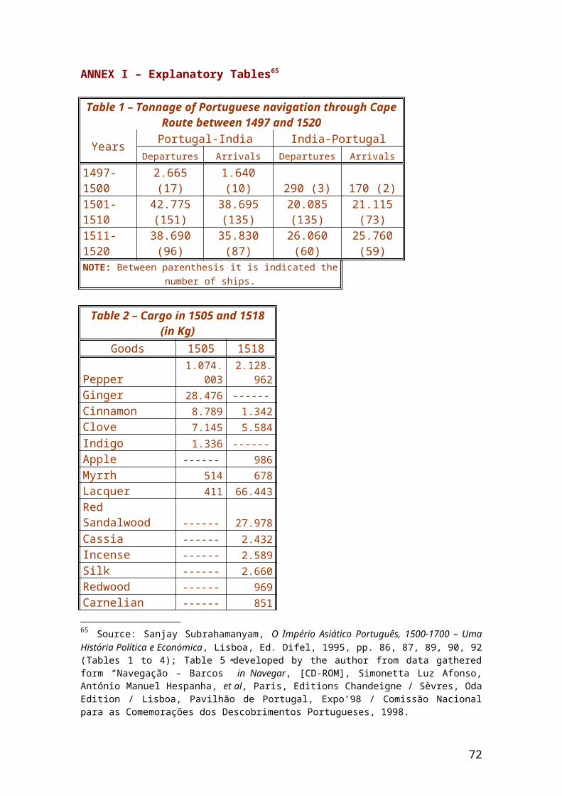
ANNEX I – Explanatory Tables65
Table 1 – Tonnage of Portuguese navigation through CapeRoute between 1497 and 1520
Years Portugal-India India-PortugalDepartures Arrivals Departures Arrivals
1497-1500
2.665(17)
1.640(10) 290 (3) 170 (2)
1501-1510
42.775(151)
38.695(135)
20.085(135)
21.115(73)
1511-1520
38.690(96)
35.830(87)
26.060(60)
25.760(59)
NOTE: Between parenthesis it is indicated thenumber of ships.
Table 2 – Cargo in 1505 and 1518(in Kg)
Goods 1505 1518
Pepper1.074.
0032.128.
962Ginger 28.476 ------Cinnamon 8.789 1.342Clove 7.145 5.584Indigo 1.336 ------Apple ------ 986Myrrh 514 678Lacquer 411 66.443Red Sandalwood ------ 27.978Cassia ------ 2.432Incense ------ 2.589Silk ------ 2.660Redwood ------ 969Carnelian ------ 851
65 Source: Sanjay Subrahamanyam, O Império Asiático Português, 1500-1700 – UmaHistória Política e Económica, Lisboa, Ed. Difel, 1995, pp. 86, 87, 89, 90, 92(Tables 1 to 4); Table 5 developed by the author from data gatheredform “Navegação – Barcos” in Navegar, [CD-ROM], Simonetta Luz Afonso,António Manuel Hespanha, et al, Paris, Editions Chandeigne / Sèvres, OdaEdition / Lisboa, Pavilhão de Portugal, Expo’98 / Comissão Nacionalpara as Comemorações dos Descobrimentos Portugueses, 1998.
72
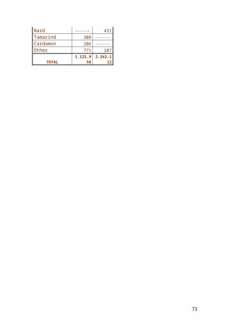
Nard ------ 431Tamarind 308 ------Cardamon 206 ------Other 771 207
TOTAL1.121.9
592.242.1
12
73
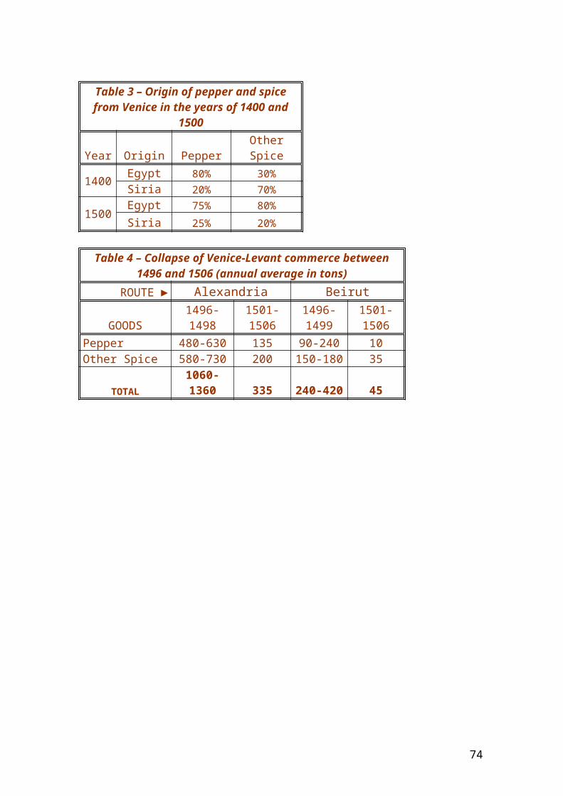
Table 3 – Origin of pepper and spicefrom Venice in the years of 1400 and
1500
Year Origin PepperOtherSpice
1400 Egypt 80% 30%Siria 20% 70%
1500 Egypt 75% 80%Siria 25% 20%
Table 4 – Collapse of Venice-Levant commerce between1496 and 1506 (annual average in tons)
ROUTE ► Alexandria Beirut
GOODS1496-1498
1501-1506
1496-1499
1501-1506
Pepper 480-630 135 90-240 10Other Spice 580-730 200 150-180 35
TOTAL1060-1360 335 240-420 45
74
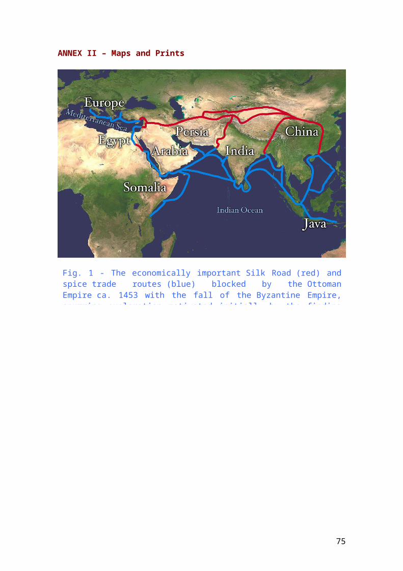
ANNEX II – Maps and Prints
Fig. 1 - The economically important Silk Road (red) andspice trade routes (blue) blocked by the OttomanEmpire ca. 1453 with the fall of the Byzantine Empire,spurring exploration motivated initially by the finding
75
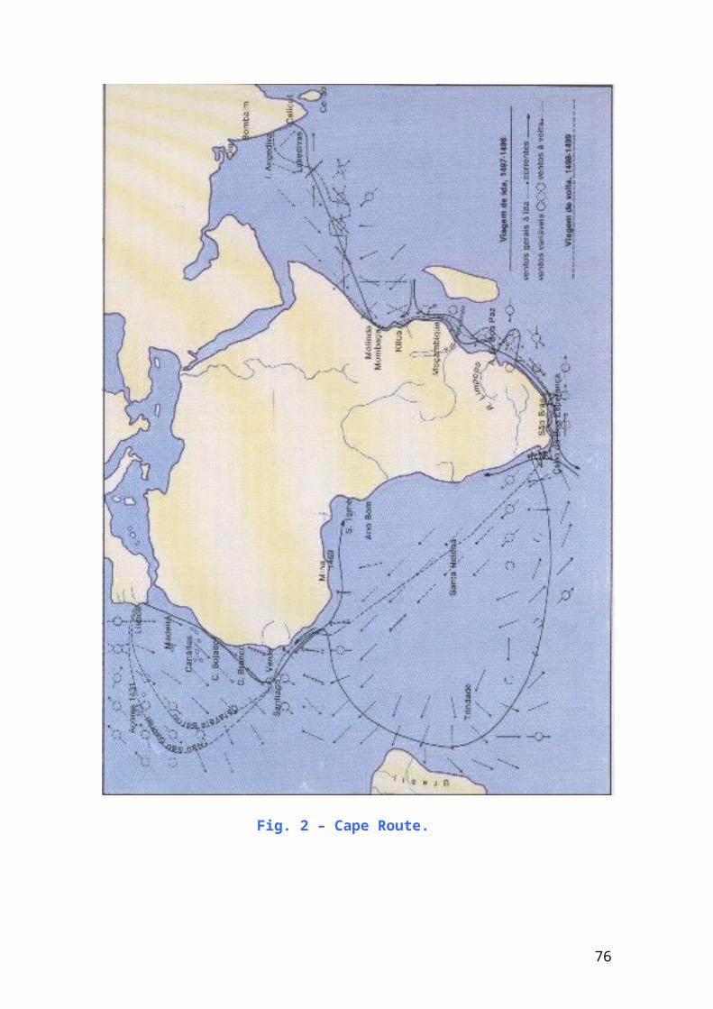
Fig. 2 – Cape Route.
76
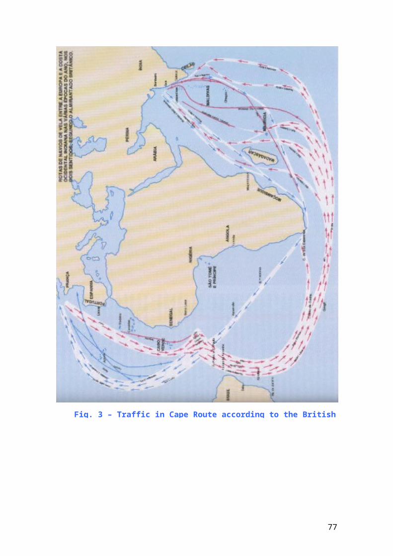
Fig. 3 – Traffic in Cape Route according to the British
77
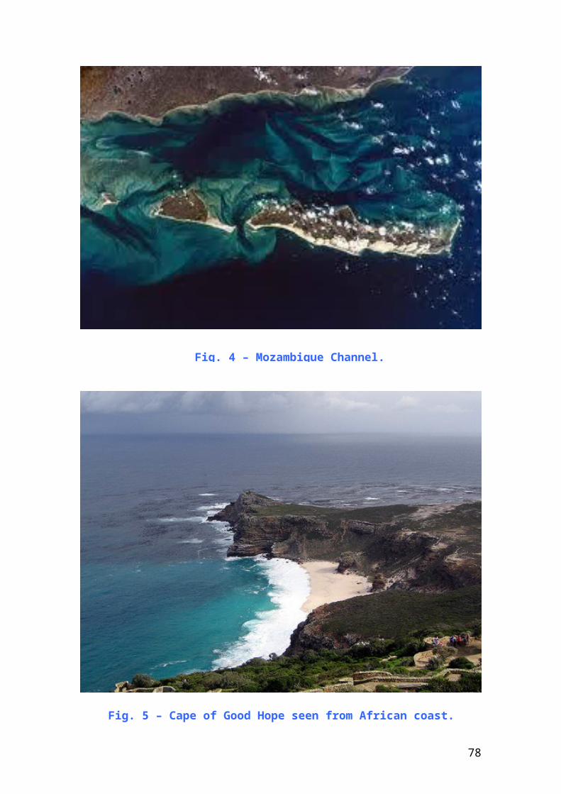
Fig. 4 – Mozambique Channel.
Fig. 5 – Cape of Good Hope seen from African coast.
78
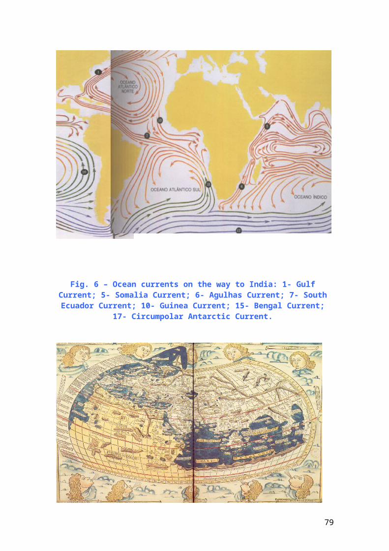
Fig. 6 – Ocean currents on the way to India: 1- GulfCurrent; 5- Somalia Current; 6- Agulhas Current; 7- SouthEcuador Current; 10- Guinea Current; 15- Bengal Current;
17- Circumpolar Antarctic Current.
79
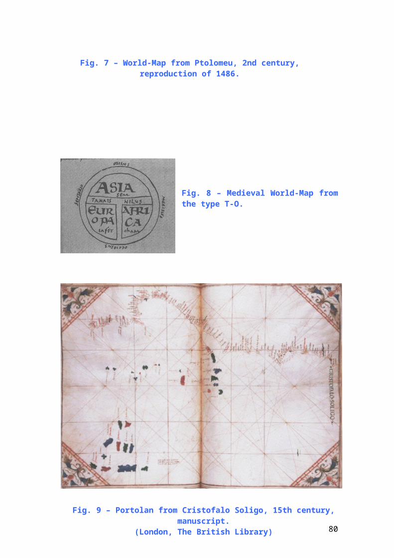
Fig. 8 – Medieval World-Map fromthe type T-O.
Fig. 7 – World-Map from Ptolomeu, 2nd century,reproduction of 1486.
Fig. 9 – Portolan from Cristofalo Soligo, 15th century,manuscript.
(London, The British Library) 80
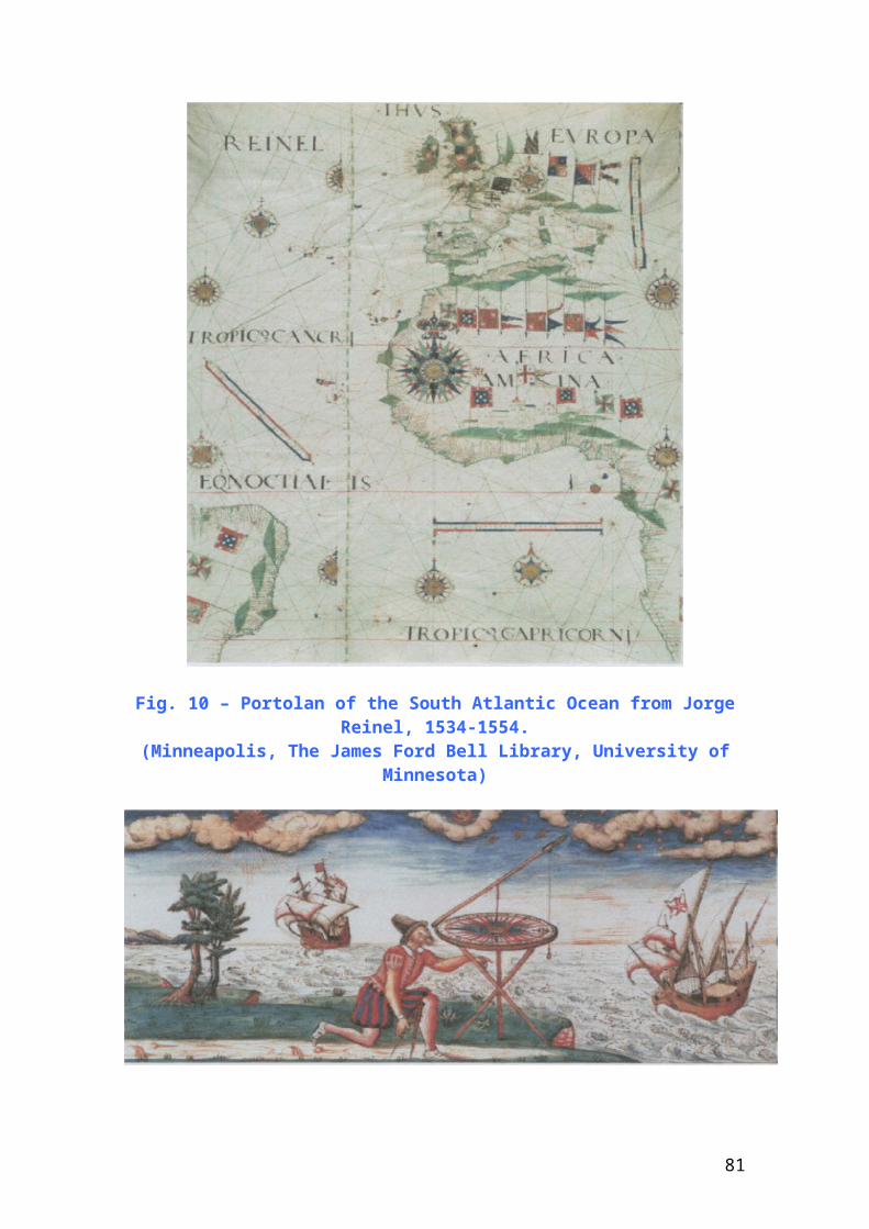
Fig. 10 – Portolan of the South Atlantic Ocean from JorgeReinel, 1534-1554.
(Minneapolis, The James Ford Bell Library, University ofMinnesota)
81
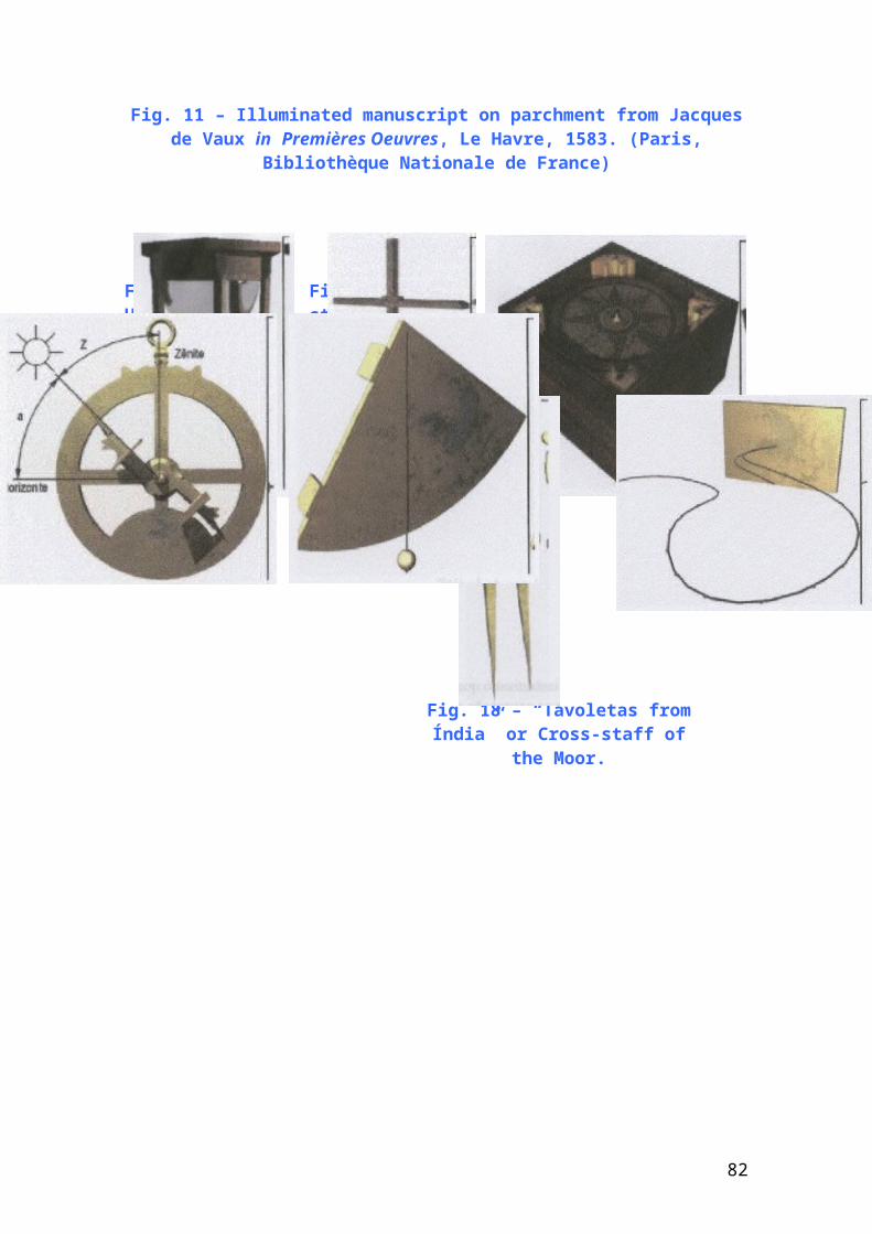
Fig. 11 – Illuminated manuscript on parchment from Jacquesde Vaux in Premières Oeuvres, Le Havre, 1583. (Paris,
Bibliothèque Nationale de France)
Fig. 14 – Magneticcompass.
Fig. 12 – Hourglass.
Fig. 13 – Cross-staff.
Fig. 16 – Quadrant.Fig. 15 – Astrolab.
Fig. 17 –Compass.
Fig. 18 – “Tavoletas fromÍndia” or Cross-staff of
the Moor.
82
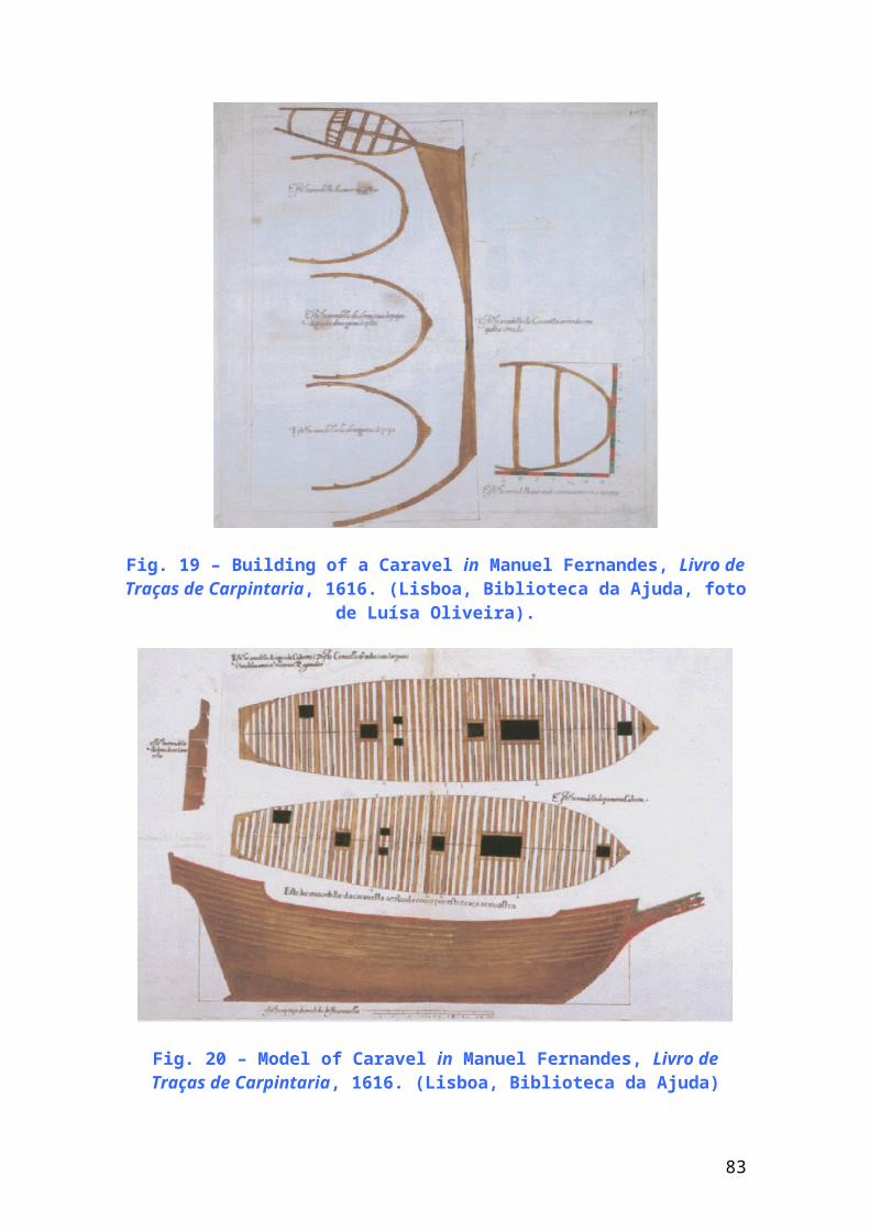
Fig. 19 – Building of a Caravel in Manuel Fernandes, Livro deTraças de Carpintaria, 1616. (Lisboa, Biblioteca da Ajuda, foto
de Luísa Oliveira).
Fig. 20 – Model of Caravel in Manuel Fernandes, Livro deTraças de Carpintaria, 1616. (Lisboa, Biblioteca da Ajuda)
83
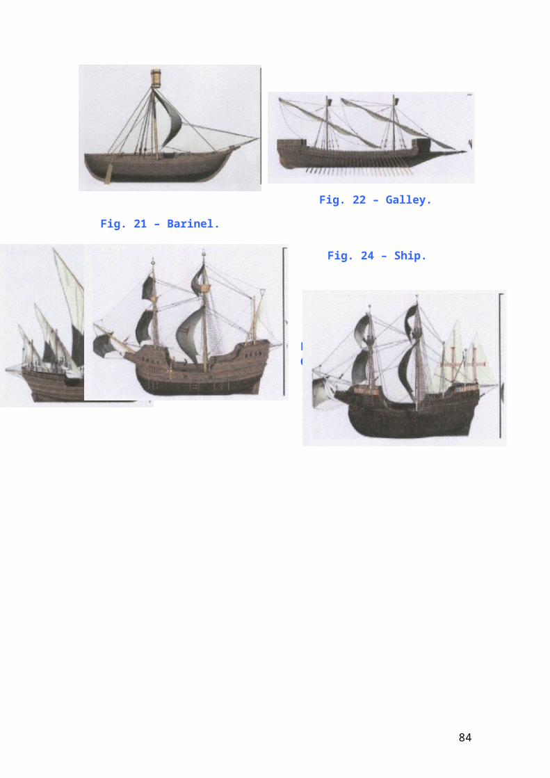
Fig. 22 – Galley.
Fig. 21 – Barinel.
Fig. 23 – Caravel. Fig. 24 – Ship.
Fig. 25 – Galleon.
84
Fig. 26 – Farewell of ships to India – engraving of the16th century.
Fig. 27 – The Adamastor,by Carlos Reis. (Museu
Militar, Lisboa)
85