tfc thesis chap. 1; palaikastro crete
TRANSCRIPT
3
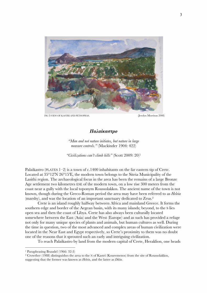
FIG 3:VIEW OF KASTRI AND PETSOPHAS. (Jerolyn Morrison 2008)
Παλαίκαστρο
“Man and not nature initiates, but nature in large measure controls.” (Mackinder 1904: 422)
“Civilizations can’t climb hills” (Scott 2009: 20)1
Palaikastro (PLATES 1–2) is a town of c.1400 inhabitants on the far eastern tip of Crete. Located at 35°12′N 26°15′E, the modern town belongs to the Siteia Municipality of the Lasithi region. The archaeological focus in the area has been the remains of a large Bronze Age settlement two kilometres ESE of the modern town, on a low rise 300 meters from the coast near a gully with the local toponym Roussolakkos. The ancient name of the town is not known, though during the Greco-Roman period the area may have been referred to as Heleia (marshy), and was the location of an important sanctuary dedicated to Zeus.2
Crete is an island roughly halfway between Africa and mainland Greece. It forms the southern edge and border of the Aegean basin, with its many islands; beyond, to the S lies open sea and then the coast of Libya. Crete has also always been culturally located somewhere between the East (Asia) and the West (Europe) and as such has provided a refuge not only for many unique species of plants and animals, but human cultures as well. During the time in question, two of the most advanced and complex areas of human civilization were located in the Near East and Egypt respectively, so Crete’s proximity to them was no doubt one of the reasons that it sprouted such an early and intriguing civilization. To reach Palaikastro by land from the modern capital of Crete, Heraklion, one heads 1 Paraphrasing Braudel (1966: 32-3) 2 Crowther (1988) distinguishes the area to the N of Kastri (Kouremenos) from the site of Roussolakkos, suggesting that the former was known as Heleia, and the latter as Dikta.
4
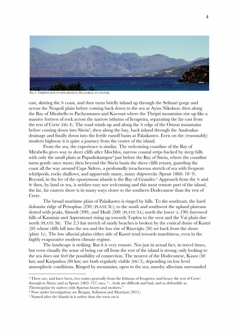
FIG 4. THRIPTI MOUNTAINS FROM W; HA GORGE AT CENTER. east, skirting the N coast, and then turns briefly inland up through the Selinari gorge and across the Neapoli plain before coming back down to the sea at Ayios Nikolaos; then along the Bay of Mirabello to Pachyammos and Kavousi where the Thripti mountains rise up like a massive fortress of rock across the narrow isthmus of Ierapetra, separating the far east from the rest of Crete (FIG 4). The road winds up and along the N edge of the Ornon mountains before coming down into Siteia3, then along the bay, back inland through the Analoukas drainage and finally down into the fertile runoff basin at Palaikastro. Even on the (reasonably) modern highway it is quite a journey from the center of the island.
From the sea, the experience is similar. The welcoming coastline of the Bay of Mirabello gives way to sheer cliffs after Mochlos, narrow coastal strips backed by steep hills with only the small plain at Papadiokampos4 just before the Bay of Siteia, where the coastline turns gentle once more; then beyond the Siteia basin the sheer cliffs return, guarding the coast all the way around Cape Sidero, a profoundly treacherous stretch of sea with frequent whirlpools, rocky shallows, and apparently many, many shipwrecks (Spratt 1866: 18–9). Beyond, in the lee of the eponymous islands is the Bay of Grandes.5 Approach from the N and W then, by land or sea, is neither easy nor welcoming and this most remote part of the island, the far, far eastern shore is in many ways closer to the southern Dodecanese than the rest of Crete.
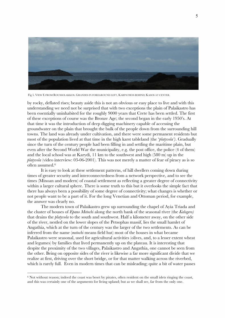
The broad maritime plain of Palaikastro is ringed by hills. To the southeast, the hard dolomite ridge of Petsophas (230) (PLATE 3C); to the south and southwest the upland plateaus dotted with peaks, Simodi (390), and Modi (500) (PLATE 3A); north the lower (c.190) furrowed hills of Kaminia and Aspromouri rising up towards Toplou to the west and the Vai plain due north (PLATE 3B). The 2.5 km stretch of sandy beaches is broken by the conical dome of Kastri (50) whose cliffs fall into the sea and the low rise of Risoviglo (30) set back from the shore (plate 1c). The low alluvial plains either side of Kastri tend towards marshiness, even in the highly evaporative modern climate regime. The landscape is striking. But it is very remote. Not just in actual fact, in travel times, but even visually the sense of being cut off from the rest of the island is strong; only looking to the sea does one feel the possibility of connection. The nearest of the Dodecanese, Kasos (50 km) and Karpathos (80 km) are both regularly visible (FIG 5), depending on low level atmospheric conditions. Ringed by mountains, open to the sea, marshy alluvium surrounded 3 There are, and have been, two routes generally from the Isthmus of Ierapetra (and hence the rest of Crete) through to Siteia; and as Spratt (1865: 157) says, “…both are difficult and bad, and as defensible as Thermopylae by natives with Spartan hearts and mothers.” 4 Now under investigation; see Brogan, Sofianou and Morrison (2011). 5 Named after the islands in it rather than the town on it.
5
Fig 5. VIEW E FROM ROUSSOLAKKOS. GRANDES IN FOREGROUND LEFT, KARPATHOS BEHIND; KASOS AT CENTER.
by rocky, deflated rises; beauty aside this is not an obvious or easy place to live and with this understanding we need not be surprised that with two exceptions the plain of Palaikastro has been essentially uninhabited for the roughly 9000 years that Crete has been settled. The first of these exceptions of course was the Bronze Age; the second began in the early 1950’s. At that time it was the introduction of deep digging machinery capable of accessing the groundwater on the plain that brought the bulk of the people down from the surrounding hill towns. The land was already under cultivation, and there were some permanent residents but most of the population lived at that time in the high karst tableland (the ‘platyvola’). Gradually since the turn of the century people had been filling in and settling the maritime plain, but even after the Second World War the municipality, e.g. the post office, the police (4 of them) and the local school was at Karydi, 11 km to the southwest and high (580 m) up in the platyvola (video interview: 03-06-2001). This was not merely a matter of fear of piracy as is so often assumed.6
It is easy to look at these settlement patterns, of hill dwellers coming down during times of greater security and interconnectedness from a network perspective, and to see the times (Minoan and modern) of coastal settlement as reflecting a greater degree of connectivity within a larger cultural sphere. There is some truth to this but it overlooks the simple fact that there has always been a possibility of some degree of connectivity; what changes is whether or not people want to be a part of it. For the long Venetian and Ottoman period, for example, the answer was clearly no. The modern town of Palaikastro grew up surrounding the chapel of Ayia Triada and the cluster of houses of Epano Metochi along the north bank of the seasonal river (the Kalogero) that drains the platyvola to the south and southwest. Half a kilometer away, on the other side of the river, nestled on the lower slopes of the Petsophas massif, lies the small hamlet of Angathia, which at the turn of the century was the larger of the two settlements. As can be inferred from the name (metochi means field hut) most of the houses in what became Palaikastro were seasonal, used for agricultural activities (olives, and, to a lesser extent wheat and legumes) by families that lived permanently up on the plateau. It is interesting that despite the proximity of the two villages, Palaikastro and Angathia, one cannot be seen from the other. Being on opposite sides of the river is likewise a far more significant divide that we realize at first, driving over the short bridge, or for that matter walking across the riverbed, which is rarely full. Even in modern times that can be misleading; quite a bit of water passes
6 Not without reason; indeed the coast was beset by pirates, often resident on the small islets ringing the coast, and this was certainly one of the arguments for living upland; but as we shall see, far from the only one.
6
through, just in short heavy bursts and flash floods. When these floods hit, (several times a year generally in today’s climate) the river’s strength as a barrier or border is beyond question and it seems unsurprising that the longest lived settlements would be on the mountain side of the river bed, and not in the broad flood plain.
The two villages have very distinct identities and their inhabitants, while they freely mingle, are very conscious of this. It is worth noting that this terrain so easily supports two distinct settlements that are yet so close together.
Further along from Angathia, east towards the sea, also on the low ridges spreading out from the base of Petsophas were the visible remnants of the large Bronze Age town that drew the attention of R. C. Bosanquet in 1902. The lower lands have always tended towards marsh; and each and every outcrop of bedrock that rises above this low plain shows signs of ancient use, for habitation or burial as the case may be. Barring some form of drainage, or a much more evaporative climate these low areas are essentially useless for agriculture or dwelling and prone to malaria as well. All the extant remains of ancient activity come from the higher ground and rocky southern stretch of coastline. Shatter zones:
“To the east of Praisos rises the bare butt-end of Crete, a limestone table-land dotted with small villages.” (Bosanquet, PKU II: 60–1)
The platyvola, the high, karstic tableland (or ‘polje’) that rises up to the S and SW, fissured and dolined, is a geologic ‘shatter zone’ with massive fractured channels forming the major drainage features down to the lower maritime plains (plate 2a). There are significant colluvial plains at Ziros and Chandras and many smaller ones as well. This area has been the most consistently (albeit thinly) settled part of the region. The term ‘shatter zone’ has been used more recently in a geopolitical sense to denote a region on the peripheries or margins of one or more overlapping states that absorbs refugees or cast-offs from larger political entities; or an area on the edges of a given culture zone where fragmentation occurs, or an area where several different cultural or political spheres overlap, as for example Crete for roughly a thousand years before the 19th century was between the Ottoman Empire and Christian Europe. Shatter zones are regions where ‘stateness’ breaks down; clan and tribal affiliations rule. Simple, mobile forms of sustenance such as foraging, hunting, swidden agriculture and pastoralism are common. Culturally and linguistically diverse, they are prone to egalitarianism, and violence in the form of feuds or vendettas. Geographically, they tend toward inaccessibility. (Scott 2009: 7) The standard narrative of civilised cultures tends to classify many of the characteristic features of shatter zones as ‘stages’ to be passed through over varying rates and at various times by different cultures unidirectionally, allowing for collapse but defining it as such – as a failed, rather than competing process. The reality of course is that groups of people are choosing all the time consciously and unconsciously how to live, whether to organize or not and to what degree; when these groups are within the geographic confines of a state they naturally come into immediate conflict with the state and must negotiate their status, and hence define themselves, both implicitly and explicitly vis-a-vis the state. But in the shatter zones, beyond their immediate reach, groups may develop, as adaptive strategies, ways of living that keep them from joining or forming states. Often such groups return to illiteracy, since the primary purpose of literacy is taxation. Mobile agriculture likewise inhibits taxation. Difficult, remote terrain protects against conscription and corveé labour. Loosely organised in
7
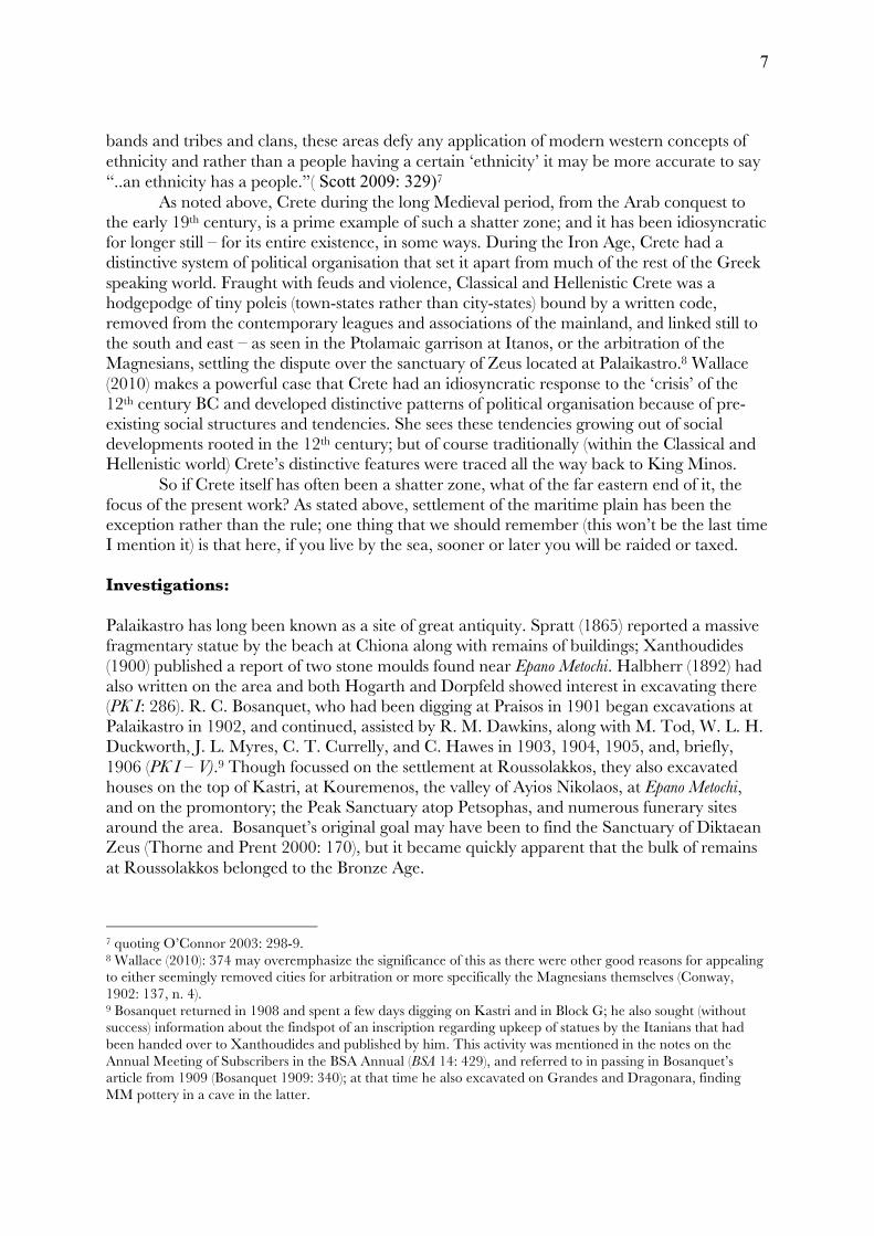
bands and tribes and clans, these areas defy any application of modern western concepts of ethnicity and rather than a people having a certain ‘ethnicity’ it may be more accurate to say “..an ethnicity has a people.”( Scott 2009: 329)7 As noted above, Crete during the long Medieval period, from the Arab conquest to the early 19th century, is a prime example of such a shatter zone; and it has been idiosyncratic for longer still – for its entire existence, in some ways. During the Iron Age, Crete had a distinctive system of political organisation that set it apart from much of the rest of the Greek speaking world. Fraught with feuds and violence, Classical and Hellenistic Crete was a hodgepodge of tiny poleis (town-states rather than city-states) bound by a written code, removed from the contemporary leagues and associations of the mainland, and linked still to the south and east – as seen in the Ptolamaic garrison at Itanos, or the arbitration of the Magnesians, settling the dispute over the sanctuary of Zeus located at Palaikastro.8 Wallace (2010) makes a powerful case that Crete had an idiosyncratic response to the ‘crisis’ of the 12th century BC and developed distinctive patterns of political organisation because of pre-existing social structures and tendencies. She sees these tendencies growing out of social developments rooted in the 12th century; but of course traditionally (within the Classical and Hellenistic world) Crete’s distinctive features were traced all the way back to King Minos. So if Crete itself has often been a shatter zone, what of the far eastern end of it, the focus of the present work? As stated above, settlement of the maritime plain has been the exception rather than the rule; one thing that we should remember (this won’t be the last time I mention it) is that here, if you live by the sea, sooner or later you will be raided or taxed. Investigations: Palaikastro has long been known as a site of great antiquity. Spratt (1865) reported a massive fragmentary statue by the beach at Chiona along with remains of buildings; Xanthoudides (1900) published a report of two stone moulds found near Epano Metochi. Halbherr (1892) had also written on the area and both Hogarth and Dorpfeld showed interest in excavating there (PK I: 286). R. C. Bosanquet, who had been digging at Praisos in 1901 began excavations at Palaikastro in 1902, and continued, assisted by R. M. Dawkins, along with M. Tod, W. L. H. Duckworth, J. L. Myres, C. T. Currelly, and C. Hawes in 1903, 1904, 1905, and, briefly, 1906 (PK I – V).9 Though focussed on the settlement at Roussolakkos, they also excavated houses on the top of Kastri, at Kouremenos, the valley of Ayios Nikolaos, at Epano Metochi, and on the promontory; the Peak Sanctuary atop Petsophas, and numerous funerary sites around the area. Bosanquet’s original goal may have been to find the Sanctuary of Diktaean Zeus (Thorne and Prent 2000: 170), but it became quickly apparent that the bulk of remains at Roussolakkos belonged to the Bronze Age.
7 quoting O’Connor 2003: 298-9. 8 Wallace (2010): 374 may overemphasize the significance of this as there were other good reasons for appealing to either seemingly removed cities for arbitration or more specifically the Magnesians themselves (Conway, 1902: 137, n. 4). 9 Bosanquet returned in 1908 and spent a few days digging on Kastri and in Block G; he also sought (without success) information about the findspot of an inscription regarding upkeep of statues by the Itanians that had been handed over to Xanthoudides and published by him. This activity was mentioned in the notes on the Annual Meeting of Subscribers in the BSA Annual (BSA 14: 429), and referred to in passing in Bosanquet’s article from 1909 (Bosanquet 1909: 340); at that time he also excavated on Grandes and Dragonara, finding MM pottery in a cave in the latter.
8
FIG 6. SKETCH MAP OF PALAIKASTRO AREA, 1902.
During the first season, Bosanquet found and excavated a series of Early and Middle Minoan ossuaries along a gravel ridge projecting out from Petsophas (‘tou galeti i kephala’), some later (LM IIIA2) larnax burials10, a possible LM IIIA2 tholos tomb,11 and two houses, one (House A) located on a low rise just back from the coast south of the promontory above the beach known as bodilaki.12 The modern dirt road runs directly over where this house was and no sign of it remains today (PK Survey: 140). From the description, it stood above an earlier structure, but itself dated to LM IB; and showed signs of ransacking, though not burning (PK I: 306-8). The second house (later Block B) belonged to the same period and proved to be at the center of the large town at Roussolakkos (FIG 6).
The first preliminary report covers these finds from a fairly broad and removed contextual perspective, as interesting ancient remains from a location (Crete) full of such remains and a time (the turn of the century) likewise full of people finding them – in Crete, Greece, Egypt, the Near East and Anatolia. Unlike the Hellenic period, or even the Bronze Age of the Mainland (for which there was Homer at least) there were no texts and no clear narrative, no existing pseudo-historical framework to put the Bronze Age remains into. The chronological terms used were ‘Mycenaean’ and ‘Kamares’ for the later and earlier periods respectively; the very concept of a distinct Cretan Bronze Age culture, the ‘Minoan’ civilisation, was only just being formalized. As a result there is no attempt made to connect the various remains with each other into a chronological or cultural progression; only when similar artifacts occur (such as ‘
10 The most spectacular of these, the painted larnax with the griffon/bird/fish/double axe flower panels, was found and removed in 1901 by J. H. Marshall, then working with Bosanquet at Praisos; for an account of this (which Hogarth termed ‘piracy’) see Gill 2000: 522–3). 11 The tomb had a dromos and seemed to have been intended as a tholos tomb but was poorly designed, with a dromos running downslope instead of cutting into a slope and bedrock restricting the size of the chamber; the roof seems to have collapsed prior to use and so it was left as it was, a circular chamber tomb with an unusually long dromos. See also Smee (1966). 12 Also known as ‘East Beach’ (PK 1984: 132).
9
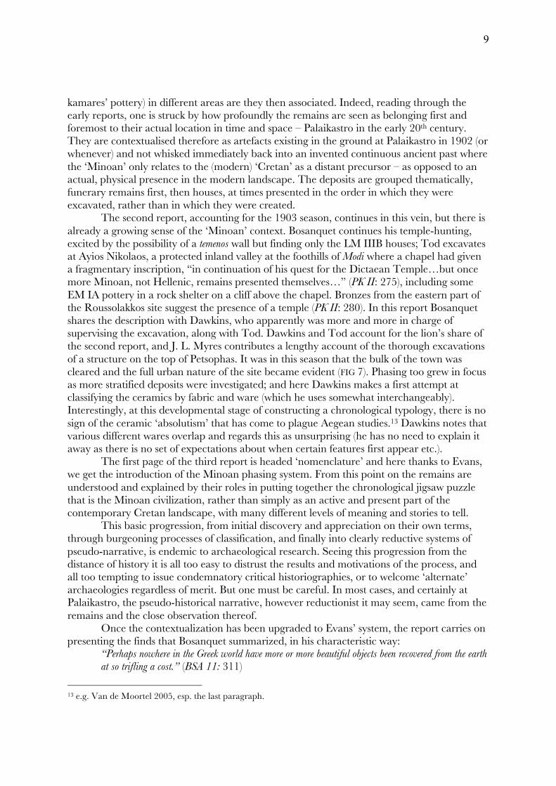
kamares’ pottery) in different areas are they then associated. Indeed, reading through the early reports, one is struck by how profoundly the remains are seen as belonging first and foremost to their actual location in time and space – Palaikastro in the early 20th century. They are contextualised therefore as artefacts existing in the ground at Palaikastro in 1902 (or whenever) and not whisked immediately back into an invented continuous ancient past where the ‘Minoan’ only relates to the (modern) ‘Cretan’ as a distant precursor – as opposed to an actual, physical presence in the modern landscape. The deposits are grouped thematically, funerary remains first, then houses, at times presented in the order in which they were excavated, rather than in which they were created. The second report, accounting for the 1903 season, continues in this vein, but there is already a growing sense of the ‘Minoan’ context. Bosanquet continues his temple-hunting, excited by the possibility of a temenos wall but finding only the LM IIIB houses; Tod excavates at Ayios Nikolaos, a protected inland valley at the foothills of Modi where a chapel had given a fragmentary inscription, “in continuation of his quest for the Dictaean Temple…but once more Minoan, not Hellenic, remains presented themselves…” (PK II: 275), including some EM IA pottery in a rock shelter on a cliff above the chapel. Bronzes from the eastern part of the Roussolakkos site suggest the presence of a temple (PK II: 280). In this report Bosanquet shares the description with Dawkins, who apparently was more and more in charge of supervising the excavation, along with Tod. Dawkins and Tod account for the lion’s share of the second report, and J. L. Myres contributes a lengthy account of the thorough excavations of a structure on the top of Petsophas. It was in this season that the bulk of the town was cleared and the full urban nature of the site became evident (FIG 7). Phasing too grew in focus as more stratified deposits were investigated; and here Dawkins makes a first attempt at classifying the ceramics by fabric and ware (which he uses somewhat interchangeably). Interestingly, at this developmental stage of constructing a chronological typology, there is no sign of the ceramic ‘absolutism’ that has come to plague Aegean studies.13 Dawkins notes that various different wares overlap and regards this as unsurprising (he has no need to explain it away as there is no set of expectations about when certain features first appear etc.). The first page of the third report is headed ‘nomenclature’ and here thanks to Evans, we get the introduction of the Minoan phasing system. From this point on the remains are understood and explained by their roles in putting together the chronological jigsaw puzzle that is the Minoan civilization, rather than simply as an active and present part of the contemporary Cretan landscape, with many different levels of meaning and stories to tell. This basic progression, from initial discovery and appreciation on their own terms, through burgeoning processes of classification, and finally into clearly reductive systems of pseudo-narrative, is endemic to archaeological research. Seeing this progression from the distance of history it is all too easy to distrust the results and motivations of the process, and all too tempting to issue condemnatory critical historiographies, or to welcome ‘alternate’ archaeologies regardless of merit. But one must be careful. In most cases, and certainly at Palaikastro, the pseudo-historical narrative, however reductionist it may seem, came from the remains and the close observation thereof.
Once the contextualization has been upgraded to Evans’ system, the report carries on presenting the finds that Bosanquet summarized, in his characteristic way:
“Perhaps nowhere in the Greek world have more or more beautiful objects been recovered from the earth at so trifling a cost.” (BSA 11: 311)
13 e.g. Van de Moortel 2005, esp. the last paragraph.
10
FIG 7. SITE PLAN1905.
And indeed, the finds remain the focus of these early explorations. While Bosanquet makes some architectural description and comment in the second preliminary report, thereafter his, and more especially Dawkins’ focus is on the pottery above all else. Even the subsequent supplementary publication (PKU) is the unpublished objects from Palaikastro; there is nowhere a detailed consideration of the architectural remains, styles and techniques; nor even an overview.
And there was no lack of comparanda – Boyd had begun digging at Gournia in 1901, uncovering an intriguingly different townscape, and Hogarth was working at Zakros. Indeed, although mention is made of Zakros, investigated in 1901 by Hogarth, there is no mention in the Palaikastro preliminary reports of Gournia until after the second season, and then only briefly; a further three mentions in PK III, the following year, and at no time in these first three reports is Harriet Boyd (Hawes) herself mentioned by name. Both Hogarth (1902: 168) and Evans (1902: 105; 1903: 53, 83) mention both the site and Miss Boyd prominently. After the 1905 season, by which time Edith Hall had published on the Gournia material (Hall 1905), Dawkins refers to Gournia,14 but only for ceramic comparanda. In any case, there is little analysis of the architecture itself and practically none of the organisation of the settlement as a whole.
Throughout the preliminary reports Bosanquet’s continued focus on the Hellenic
14 Dawkins also mentions Hall by name; but still not Boyd, who is only mentioned in that report by Charles Hawes while being thanked for letting him study some skeletal material from Gournia. Hawes was an anthropologist from Cambridge who had come out to work at Palaikastro and who went on to marry Boyd the following spring. Perhaps there was some bad blood between Dawkins and Boyd; certainly Boyd and Hawes were very taken with the popular pseudo-science of racial typing based on skull dimensions and while such work was carried out at Palaikastro (by Duckworth and Hawes himself) it was given only cursory mention by Bosanquet in the first report and no mention at all by Dawkins, except simply to note that Hawes was there to perform it. Some of their contemporaries, Evans, and perhaps especially Mackenzie, seemed rather concerned with working out which ‘races’ were implicated by their finds – but Dawkins never refers to this avenue of research nor even uses the word ‘race’ in any of the preliminary reports.
11
remains is clear; in the second season of work he excavates at Kouremenos where he had seen remains he thought might be a temenos wall of the sanctuary; and sends Tod to explore the Ayios Nikolaos valley, again, due to the find of an Hellenic inscription built into a wall of a small chapel there.15 Disappointed in both cases (the former proving to be ‘Mycenaean’; the latter Early Minoan) he tries at the island of Kouphonisi, identified with Leuke and known from an inscription as a source for ‘purple shell’ – the murex they find, but also “one more instance of the extraordinary predominance of Minoan over Hellenic remains in Crete”(PK II: 276). Eventually Bosanquet decides to seek a mainland site,16 and begins working at Sparta.17
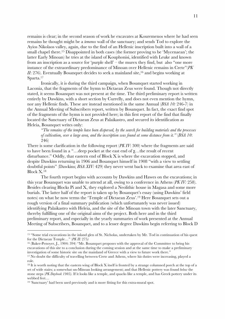
Ironically, it is during the third campaign, when Bosanquet started working in Laconia, that the fragments of the hymn to Dictaean Zeus were found. Though not directly stated, it seems Bosanquet was not present at the time. The third preliminary report is written entirely by Dawkins, with a short section by Currelly, and does not even mention the hymn, nor any Hellenic finds. These are instead mentioned in the same Annual (BSA 10: 246-7) in the Annual Meeting of Subscribers report, written by Bosanquet. In fact, the exact find spot of the fragments of the hymn is not provided here; in this first report of the find that finally located the Sanctuary of Dictaean Zeus at Palaikastro, and secured its identification as Heleia, Bosanquet writes only:
“The remains of-the temple have been dispersed, by the search for building materials and the processes of cultivation, over a large area, and the inscription was found at some distance from it.” (BSA 10: 246)
There is some clarification in the following report (PK IV: 300) where the fragments are said to have been found in a “…deep pocket at the east end of χ…the result of recent disturbance.” Oddly, that eastern end of Block X is where the excavation stopped, and despite Dawkins returning in 1906 and Bosanquet himself in 1908 “with a view to settling doubtful points” (Dawkins; BSA XIV: 429) they never went back to examine that area east of Block X.18 The fourth report begins with accounts by Dawkins and Hawes on the excavations; in this year Bosanquet was unable to attend at all, owing to a conference in Athens (PK IV: 258). Besides clearing Blocks Pi and X, they explored a Neolithic house in Magasa and some more burials. The latter half of the report is taken up by Bosanquet’s essay (using Dawkins’ field notes) on what he now terms the ‘Temple of Dictaean Zeus’.19 Here Bosanquet sets out a rough version of a final summary publication (which unfortunately was never issued) identifying Palaikastro with Heleia, and the site of the Minoan town with the later Sanctuary, thereby fulfilling one of the original aims of the project. Both here and in the third preliminary report, and especially in the yearly summaries of work presented at the Annual Meeting of Subscribers, Bosanquet, and to a lesser degree Dawkins begin referring to Block D 15 “Some trial excavations in the inland glen of St. Nicholas, undertaken by Mr. Tod in continuation of his quest for the Dictaean Temple…” (PK II: 275) 16 (Baker-Penoyer, J., 1904: 394) “Mr. Bosanquet proposes with the approval of the Committee to bring his excavations of this site to a conclusion during the coming session and at the same time to make a preliminary investigation of some historic site on the mainland of Greece with a view to future work there.” 17 No doubt the difficulty of travelling between Crete and Athens, where his duties were increasing, played a role. 18 It is worth noting that the eastern wing of Block X itself is fronted by a strange columned porch at the top of a set of wide stairs; a somewhat un-Minoan looking arrangement; and that Hellenic pottery was found below the stone steps (PK Daybook 1905). If it looks like a temple, and quacks like a temple, and has Greek pottery under its webbed feet… 19 ‘Sanctuary’ had been used previously and is more fitting for this extra-mural spot.
12
as a ‘palace’, though in fact they mean as regards the latest, LM III phase, and hence not a proper ‘Minoan Palace’ at all (at this time only Knossos and Phaistos were known and the term could be applied more loosely).20 Having cleared a large area of the Minoan town, with good stratigraphical evidence in many areas and good finds, and having settled the question on the location of the Sanctuary of Dictaean Zeus, and convinced that no more of it remained, the excavations were brought to a close. But, realizing they had no burial evidence for the LM I – II periods, one of the main periods of occupation in the town, they returned, Dawkins in 1906 and Bosanquet in 1908 to look for them. A brief report (PK V) followed the 1906 expedition, which found tombs (but none from the periods theretofore lacking) in Plako, on Kastri and at the base of Petsophas, at the extreme south of the town site. Of the 1908 trip only the Annual Report to Subscribers (BSA 14: 429) provides a glimpse; again, tombs on Kastri but none LM I. Bosanquet also explored the nearby islands at that time, Dragonara, Elassa and Grandes, but with little result save MM II pottery from a cave on the former. In 1909 Bosanquet published an article titled ‘The Palaikastro Hymn of the Kouretes’ (BSA XV: 339-356). Here he gives a fuller account of the find circumstances; two fragments close together and the third four days later, five feet (1.5 meters) away all in a “deep pocket of disturbed earth and stones.” (Bosanquet 1909: 340) This pit had “evidently been dug in some recent search for building-stones.”21 He gives a transcription and transliteration of the stele, and an analysis of its meaning. He claims for the cult at Palaikastro a “continuous existence” (351), based on the construction in LM III, “after the destruction of the palaces at Knossos, Phaistos, and Gournia,” “a palace of the Cretan type”; referring to Block D. Bosanquet has no qualms asserting continuity of cult, even without any cultic evidence from the Minoan town (he does not mention the dancing figures from a kernos found in Block D, speaking rather of its importance as the home of a ‘Cretan Prince’).
Whitley (2009) has recently questioned continuity of cult in E Crete, pointing out that the clear evidence of Bronze to Iron Age continuity in cultural and cultic practices, namely the continuous use of the shrine at Kato Symi and the appearance of bench shrines, was confined to the central part of the island and conspicuously absent from the far E. This of course jibes well with identification of E Crete as home of the Eteocretans – who might be supposed to have remained rather more Minoan for a longer time. But he misses the point, I think, about the Sanctuary. This is not a busy temple in a large town but a somewhat remote border sanctuary, popular (perhaps primarily) not merely with the local Eteocretans (who also see it as a source of revenue) but with pilgrims. And in honouring this very particular version of Zeus, with a very particular version of cult (Harrison 1909)22 it might in fact be a case not of a smoothly evolving cultic landscape of Minoan to Mycenaean to bench shrine to hearth temple and finally to temple; but rather a beachhead, a pilgrimage site, placing a kind of cultural flag to claim a kind of intersection point of two rather different trajectories – the Eteocretan and the Greek.
20 No palace has been found yet at Palaikastro, though they have been turning up with such frequency that it is difficult to imagine a town of the size of Palaikastro without one (Cunningham 2001: 83). Examples now include Knossos, Phaistos, Malia, Zakros, Petras, Galatas and Sissi, see also Monuments. Geophysical work at Palaikastro in 2001 (Boyd et al 2006) has suggested a possible location at Roussolakkos that will be investigated in future research at the site. 21 In a footnote (1) on page 340 Bosanquet locates the findspot as on the line between squares M6 and N6 on the plan in the BSA IX (i.e. PK IV) pl. X. Unfortunately this plan does not show the grid squares; but using the plan on pl. IV from PK III (BSA VII), this line runs through the second from left column base and doorway into Room 1 of Block X; putting the likely find spot either on or below the steps. 22 Alonge (2005) is right to suggest caution but ends up throwing the kouros out with the bathwater.
13
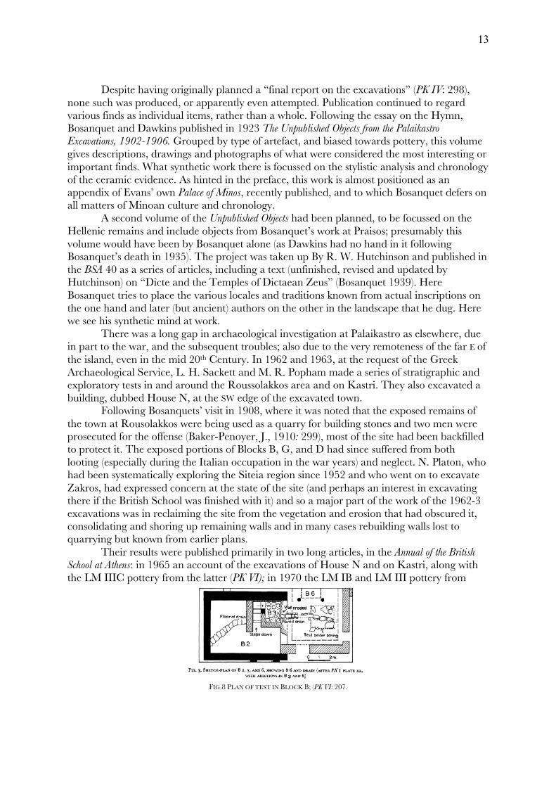
Despite having originally planned a “final report on the excavations” (PK IV: 298), none such was produced, or apparently even attempted. Publication continued to regard various finds as individual items, rather than a whole. Following the essay on the Hymn, Bosanquet and Dawkins published in 1923 The Unpublished Objects from the Palaikastro Excavations, 1902-1906. Grouped by type of artefact, and biased towards pottery, this volume gives descriptions, drawings and photographs of what were considered the most interesting or important finds. What synthetic work there is focussed on the stylistic analysis and chronology of the ceramic evidence. As hinted in the preface, this work is almost positioned as an appendix of Evans’ own Palace of Minos, recently published, and to which Bosanquet defers on all matters of Minoan culture and chronology. A second volume of the Unpublished Objects had been planned, to be focussed on the Hellenic remains and include objects from Bosanquet’s work at Praisos; presumably this volume would have been by Bosanquet alone (as Dawkins had no hand in it following Bosanquet’s death in 1935). The project was taken up By R. W. Hutchinson and published in the BSA 40 as a series of articles, including a text (unfinished, revised and updated by Hutchinson) on “Dicte and the Temples of Dictaean Zeus” (Bosanquet 1939). Here Bosanquet tries to place the various locales and traditions known from actual inscriptions on the one hand and later (but ancient) authors on the other in the landscape that he dug. Here we see his synthetic mind at work. There was a long gap in archaeological investigation at Palaikastro as elsewhere, due in part to the war, and the subsequent troubles; also due to the very remoteness of the far E of the island, even in the mid 20th Century. In 1962 and 1963, at the request of the Greek Archaeological Service, L. H. Sackett and M. R. Popham made a series of stratigraphic and exploratory tests in and around the Roussolakkos area and on Kastri. They also excavated a building, dubbed House N, at the SW edge of the excavated town. Following Bosanquets’ visit in 1908, where it was noted that the exposed remains of the town at Rousolakkos were being used as a quarry for building stones and two men were prosecuted for the offense (Baker-Penoyer, J., 1910: 299), most of the site had been backfilled to protect it. The exposed portions of Blocks B, G, and D had since suffered from both looting (especially during the Italian occupation in the war years) and neglect. N. Platon, who had been systematically exploring the Siteia region since 1952 and who went on to excavate Zakros, had expressed concern at the state of the site (and perhaps an interest in excavating there if the British School was finished with it) and so a major part of the work of the 1962-3 excavations was in reclaiming the site from the vegetation and erosion that had obscured it, consolidating and shoring up remaining walls and in many cases rebuilding walls lost to quarrying but known from earlier plans.
Their results were published primarily in two long articles, in the Annual of the British School at Athens: in 1965 an account of the excavations of House N and on Kastri, along with the LM IIIC pottery from the latter (PK VI); in 1970 the LM IB and LM III pottery from
FIG.8 PLAN OF TEST IN BLOCK B; (PK VI: 207.
14
FIG 9. Combined site plan, 1902–1965.
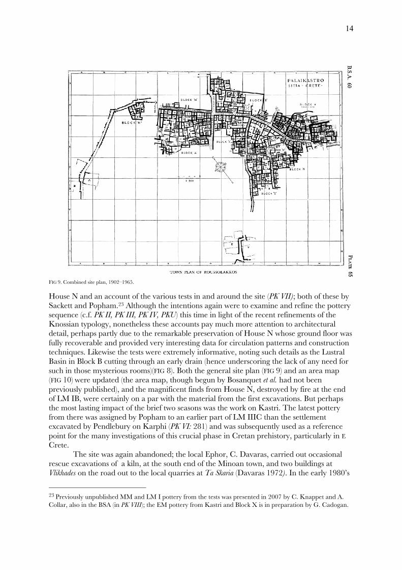
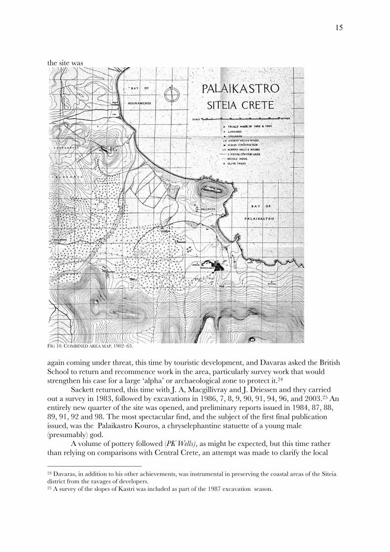
House N and an account of the various tests in and around the site (PK VII); both of these by Sackett and Popham.23 Although the intentions again were to examine and refine the pottery sequence (c.f. PK II, PK III, PK IV, PKU) this time in light of the recent refinements of the Knossian typology, nonetheless these accounts pay much more attention to architectural detail, perhaps partly due to the remarkable preservation of House N whose ground floor was fully recoverable and provided very interesting data for circulation patterns and construction techniques. Likewise the tests were extremely informative, noting such details as the Lustral Basin in Block B cutting through an early drain (hence underscoring the lack of any need for such in those mysterious rooms)(FIG 8). Both the general site plan (FIG 9) and an area map (FIG 10) were updated (the area map, though begun by Bosanquet et al. had not been previously published), and the magnificent finds from House N, destroyed by fire at the end of LM IB, were certainly on a par with the material from the first excavations. But perhaps the most lasting impact of the brief two seasons was the work on Kastri. The latest pottery from there was assigned by Popham to an earlier part of LM IIIC than the settlement excavated by Pendlebury on Karphi (PK VI: 281) and was subsequently used as a reference point for the many investigations of this crucial phase in Cretan prehistory, particularly in E Crete.
The site was again abandoned; the local Ephor, C. Davaras, carried out occasional rescue excavations of a kiln, at the south end of the Minoan town, and two buildings at Vlikhades on the road out to the local quarries at Ta Skaria (Davaras 1972). In the early 1980’s
23 Previously unpublished MM and LM I pottery from the tests was presented in 2007 by C. Knappet and A. Collar, also in the BSA (in PK VIII); the EM pottery from Kastri and Block X is in preparation by G. Cadogan.
15
the site was
FIG 10. COMBINED AREA MAP, 1902–65.
again coming under threat, this time by touristic development, and Davaras asked the British School to return and recommence work in the area, particularly survey work that would strengthen his case for a large ‘alpha’ or archaeological zone to protect it.24
Sackett returned, this time with J. A, Macgillivray and J. Driessen and they carried out a survey in 1983, followed by excavations in 1986, 7, 8, 9, 90, 91, 94, 96, and 2003.25 An entirely new quarter of the site was opened, and preliminary reports issued in 1984, 87, 88, 89, 91, 92 and 98. The most spectacular find, and the subject of the first final publication issued, was the Palaikastro Kouros, a chryselephantine statuette of a young male (presumably) god. A volume of pottery followed (PK Wells), as might be expected, but this time rather than relying on comparisons with Central Crete, an attempt was made to clarify the local
24 Davaras, in addition to his other achievements, was instrumental in preserving the coastal areas of the Siteia district from the ravages of developers. 25 A survey of the slopes of Kastri was included as part of the 1987 excavation season.
16
styles and progressions, which in the periods in question (LM IB – LM IIIA2) begin to deviate more and more from the rest of the island. Numerous articles, lectures, and final publications in press or process have worked to elucidate the particularities of this intriguing site. As might be expected, the recent programme has included much more of a focus not only on the architecture but also on the environmental remains and of course the social, political and economic implications of the finds. But what is it that makes Palaikastro important? Well, what makes archaeology important? That sort of justification, in Aegean archaeology at least, is forced upon us by the realities of academic finance. I think, generally, Lord Cromer got it well enough in 1908:
“My contention is that those studies, by stimulating classical learning, and those researches by giving a living interest to the history and monuments of the past, tend to foster an educational system of incalculable value to all who may be engaged in public life. (Cheers.)” (Baker-Penoyer, J., 1908: 433)
In fact, the importance of archaeology is the same as the importance of the broad naturalism that it grew out of; simply the attention to and observation of the world around us.26 Archaeology exists in the present, and, like the natural world should be studied, not as a means but as an end in itself. Few human endeavours serve any real practical purpose and if we were restricted to them our life would be interminable. All else is enrichment; all economic activity beyond bare sustenance; all medicine beyond critical life saving techniques and drugs; and all science, period. When we walk by a wall or a potsherd on the ground and want to know what it is and where it came from; or more broadly to speculate on the rise and fall of civilizations, or simply to marvel at their ways of living in this world; these are nothing if not endemic to the organism. Questions: At Palaikastro we find all the major elements of the Cretan Bronze Age urban settlements, town, harbour, quarries, road systems, Peak Sanctuary, refuge site, cemeteries and hinterlands. But while many Minoan sites are today covered by later, even modern, settlements, Palaikastro is not. The entire town site, right down to the coast (and into the water, which has risen since the Bronze Age) is available to the archaeologist, and not just the urban center, but the entire hinterland of the site. The opportunity for a comprehensive, regional approach incorporating excavation, survey, geophysics, even ethnography of such a major Bronze Age site is virtually unparalleled on the island. Beyond this simple fact of ease of access though lies the reason for that ease of access. Palaikastro is a marginal place. As strange as it may seem to the modern touristic visitor, this is not a hospitable land. Left to its own devices, the whole of the Palaikastro area would be as Spratt describes: “…all is wild and neglected over this far outlying land of the Cretans.” (Spratt 1865: 192) This is not a place that would, by itself, grow and nurture any human civilisation. Aside from the extraordinary circumstances of the last century the only significant remains are from the Bronze, or Minoan era. The central question of Minoan archaeology, namely, why did such an imposing early civilisation come into being there at that time, is one that can perhaps best be answered by looking at extremes, places where only at that moment
26 E. O. Wilson considers that negotiating the deep internal paradox created by the conflicting demands of individual fitness on the one hand and group fitness on the other requires the humanities, without which we would not survive (2012: 274–5).
17
in human time were people able to create and maintain a sizable, indeed arguably urban settlement. What kind of glorious human folly is it to plant a city next to a malarial swamp, in easy reach of marauders, away from the most regular sources of water and perhaps the best soils; what could possess and enable such a choice? And as a choice it must be seen. Even the only significant post-Minoan activity, the insertion of the sacred precinct and temple in the Greek and Roman times, is a kind of testament to the audacity of the mighty ruined city that they found there, ruins incorporated not only into the myth there enshrined (“remains of the city founded by Zeus”; Diodorus Siculus V.70.6) but into the fabric of their own monuments. If the archaeology of Palaikastro provides such an ideal window into the Cretan Bronze Age, what are the specific questions or issues that it can address? Given that the Minoan Civilisation had a beginning and an end, and given that it existed on an island once devoid of human life and later massively depopulated, who were these early Cretans, where did they come from, and where did they go? This becomes an especially pertinent question at the far eastern edge of the island, both because its population and eventual depopulation are so complete, and also because it is one of the most obvious and likely routes for any waves of immigration, connected as it is by strings of islands, each visible from the preceding, to the Anatolian mainland and beyond to Cyprus and eventually the Levantine coast. Once settled, as with much of Crete, the first evidence we have of the incipient Minoan culture is funerary, and for the earlier and later parts of the Bronze Age this remains the case – but oddly, during what is arguably the high point of the Bronze Age culture, in terms of sophistication, complexity, and unity – we have virtually no funeral evidence at all. The emergence of that culture, of that state of unity and complexity, materialized at Palaikastro by the well ordered layout of the town and the accoutrements of that civilisation remains a central question in such a place – by what means, with what incentives or coercion was such an effort accomplished, and by what social mechanisms was it maintained? It didn’t last, of course, and here again Palaikastro has much to offer. The decline of the Bronze Age civilisation of Crete includes a drawn out sequence of turning points of which the first was no doubt the eruption of Thera. Palaikastro seems to have suffered the brunt of the effects of this catastrophe, buried in ash and flooded, perhaps by tsunami. The wave of destructions that followed some 50-100 years later at the end of LM IB is also well captured by the evidence at Palaikastro, along with the underlying social pressures that might have caused them. And finally the desertion of the plain (and with it, the state) at the end of the 14th century and the following century of uncertain and intermittent use, followed by the establishment of a short lived refuge site on Kastri illustrate well the realities at the end of the Bronze Age. Finally, the presence of the Hellenic remains, their location among and interaction with the Minoan lead us to the question of continuity, and of connection, across the intervening years. Approach: The present work, if it is not already obvious, will be a dissertation, not a thesis. The words are distinguished, not only by meaning but by usage, which when carried across cultural and linguistic barriers can render them synonymous, each roughly meaning a lengthy written work presented to fulfil the requirements for the issuing of the doctoral degree.27 But the words are different, and mean different things, and the current offering will be not a ‘position’
27 Thesis, or ‘thése’ is used this way in Belgium; in the U.S. a thesis usually refers to the work submitted for a Masters degree while the Ph.D. work is called a dissertation.
18
(θέσις), but rather a ‘discourse’ (dissertātiō). The work is focused firstly in space, fixed on the area surrounding the modern day town of Palaikastro in far eastern Crete. Secondly it is focussed on the material remains from previous inhabitants of this area and to some degree the methods used to recover and explain these remains. This as much as is possible, fixes the subject and the location; the remaining variable is time. And in some ways time is the target of this research, time as measured, or more accurately, expressed, by these people in this place. As much as possible the various chapters herein are based on my original research and fieldwork conducted in Crete since 2001. These were three separate projects: a surface survey of the Plako peninsula, the study of the stratigraphy and pottery from the reoccupation (LM II-IIIB) phase of Building 1 at Palaikastro, and the study of the architecture and stratigraphy of Block M. The latter two I was responsible for publishing (along with a short report on the LM III pottery from Block M); the former resulted in a simple gazetteer submitted to the Ephoria.
For the Building 1 material I was working from a preliminary document prepared by S. Thorne, M. Prent and H. Sackett, the excavation notebooks and video diaries prepared by the various trenchmasters, and notes from preliminary pottery study (including my own, as I had worked on the material in 92 and 93). Pottery drawings are mostly by D. Cunningham, S. Giannikides helped with the scanning and layout. For Block M I worked with my own and others’ excavation notebooks, video diaries, and summaries from J. Driessen (architecture), and Macgillivray and Knappett (pottery). The plans were assembled by me from 1:20 originals by Driessen and various trenchmasters, and digitised by C. Roisson and myself; the sections were drawn by the trenchmasters with Sackett and compiled/combined and annotated by me; digitised by S. Goddard. Pot drawings for Block M by Freya Evanson. The original survey of the Plako area never got beyond the initial prospection stage, though I was able to revisit the area regularly over the years. Here I benefitted immensely from time spent accompanying K. Nowicki on various excursions in this and other areas. Errors of course remain my own.
The original intent of my Ph.D. had been to survey the entire area around Palaikastro, of which the Plako area was the starting point. After four weeks in the field, some preliminary research and a season of fieldwalking on the Kythera Island Project (to observe the methodology of a large scale survey project), I was asked if I would consider preparing the Building 1 material for publication. As I completed that task (in 2005) the schedule for publication of Block M, of which I was co-author, was moved up and so I worked at that until it was submitted (in August 2010).
At that point, given my long history of working at Palaikastro (since 1990), and the fact that I had personally worked on material (and in many cases published articles or given conference papers) covering various aspects of the site throughout the Minoan period, I decided to alter my focus and rather than a survey in the geographic sense of the hinterlands, make the survey rather of the archaeology of the Bronze Age of Palaikastro. As such I explicitly focus on the material remains uncovered or seen over the last century or so. I do not intend to write a history, and have not chosen a title such as the “Bronze Age of Palaikastro” – since my subject is not the Bronze Age directly, but rather the material we have recovered from that era. This is at times a subtle distinction and as the tendency to historicize is often unavoidable I will no doubt slip into it, but it remains an essential distinction to acknowledge. In a similar vein, I intend to avoid as much as possible the filling in and linking up that usually accompanies work with limited spatial focus. That is to say I do not intend to

19
issue reviews of Minoan settlements, trends, habits, scholarship etc, etc, from the rest of the island, nor to imaginatively fill in gaps in the record; rather to treat the archaeology of this place, the remains, the place they come from, and the means by which they were recovered as a unity, in and of themselves. Again, this is an impossible task and I will no doubt frequently refer to other sites, or engage in speculative reconstruction, but it will be a guiding principle nonetheless and I hope to avoid superfluous contextualization. The following chapters will take the form of essays aimed at linking the research discussed above with the essential questions set out in the previous section.