terrestrial wildlife - 4fri home
TRANSCRIPT
Chapter 3: Affected Environment and Environmental Consequences
392 Draft Environmental Impact Analysis
1
Terrestrial Wildlife 2
This section includes key effects and conclusions for terrestrial and plant threatened, 3 endangered, and proposed species and critical habitat listed under the Endangered Species Act 4 of 1973, as amended, Forest Service Southwestern Region Sensitive Species, forest management 5 indicator species, and migratory birds. The Terrestrial Wildlife Report (Schofer et al. 2018) and 6 Botany and Weeds Report (Crisp 2018) are incorporated by reference. Aquatic species were 7 analyzed separately in the Aquatics Report (Coleman 2018). 8
See the specialist reports (project record) for detailed information on methodology, analysis 9 assumptions, best available science and data, habitats, populations, and effects that are not 10 repeated in this section. 11
Affected Environment 12
Vegetation Cover Types Within the Project Area 13
The cover types in the Rim Country project area possess key habitat features outside of the 14 natural range of variation (NRV). These forests have less structural diversity due to more acres 15 occurring as even-aged forest compared to historical conditions (see Silviculture Report). 16 Structure is also limited by the abundance of young and mid-aged trees and the decrease in 17 mature and old-growth trees. These conditions do not meet forest plan direction for the ratio of 18 age-classes interspersed across the landscape. 19
Ponderosa pine commonly grows in pure stands and is currently found in even-aged and uneven-20 aged structural conditions across the area. The open park-like stands characteristic of the 21 reference conditions for ponderosa pine forests promoted greater diversity and fire resilience 22 than the dense stands of today. Ponderosa pine forests within the project are generally denser and 23 more continuous than in reference conditions and accumulations of forest litter and woody debris 24 are much higher than would have occurred under the historic disturbance regime (Brown et al, 25 2003). Lack of fire disturbance has led to increased tree density and fuel loads that increase the 26 risk of uncharacteristically intense wildfire and drought-related mortality. When fires occur 27 under current conditions, they tend to kill a lot of trees, including the large and old trees. These 28 trees take longer to replace, moving the forest further from desired conditions, and increasing the 29 time it would take to return to desired conditions. There is a high risk of insect and/or disease 30 outbreak, which is also a function of increased tree density. The abundance of younger, 31 continuous forest reduces canopy gaps. The loss of solar radiation reaching the forest floor, along 32 with infilling of meadows, savannas, and grasslands, reduces understory vegetation. Habitat 33 structure within the project area can determine the presence or absence of wildlife species. 34
Many wildlife species select habitat provided by large and old trees, including bark gleaners 35 (e.g., pygmy nuthatches and hairy woodpeckers which are both MIS), cavity nesters (e.g., MSO 36 which is a threatened species and can nest in cavities or other nest substrates), communal 37 roosting species (e.g., Allen’s lappet-browed bats, a sensitive species), and larger/heavier nesting 38 species (e.g., northern goshawks, a MIS and sensitive species). Simplifying structure and 39 declines of habitat features like aspen, Gambel oak, and the herbaceous community reduce 40 habitat for an array for wildlife species from multiple trophic levels, including invertebrate 41 communities and larger carnivores. 42
Chapter 3: Affected Environment and Environmental Consequences
Rim Country Project 393
Springs, Riparian Areas, and Stream Channels 43
Approximately 360 springs have been inventoried by the Spring Stewardship Institute within the 44 Rim Country Project analysis area. Of these 360 springs, 214 have survey information, 138 are 45 unverified, and 8 were verified. Information regarding historic flow or water quality from these 46 springs is minimal. 47
Many riparian streams in the Rim Country project area, particularly within the Rodeo-Chediski 48 Fire area, are currently non-functioning or functioning-at-risk, with accelerated erosion and 49 increased peak flows. 50
There are approximately 360 miles of fish-bearing streams in the Rim Country project area. 51 These streams provide habitat for 12 native fish and two gartersnakes, including seven federally-52 listed species and four Regional Forester sensitive species (see the Aquatics specialist report). 53
Desired conditions for riparian streams are that they are capable of filtering sediment, capturing 54 and/or transporting bedload (aiding floodplain development, improving flood-water retention, 55 improving or maintaining water quality), and providing ground water recharge within their 56 natural potential. Their necessary physical and biological components provide habitat for a 57 diverse community of plant and wildlife species including cover, forage, available water, 58 microclimate, and nesting/breeding/transport habitat. Stream habitats and aquatic species depend 59 upon perennial streams or reaches and their habitat is maintained by the watershed, soil, and 60 riparian conditions within the ecosystem. 61
All proposed riparian treatments would also improve or maintain stream habitat by restoring 62 watershed function or resiliency. Upland treatments in watersheds may also improve water 63 infiltration rates and increase subsurface flows higher in the stream system that provide cool 64 perennial water to streams and help to maintain stream temperatures. 65
Desired conditions for streams and aquatic habitats are to support native fish and other aquatic 66 species, providing the quantity and quality of aquatic habitat within the natural range of 67 variation. This includes increasing habitat complexity such as pools and large woody debris, 68 reducing downcutting and sedimentation, improving riparian areas that provide channel stability 69 and leaf litter, and providing stream shading to maintain water temperatures. 70
Assumptions and Methodology 71
Best Available Science 72
This analysis is based on best available scientific information. Data sources include research and 73 life history literature and technical reports (see Literature Cited section), forest plan standards 74 and guidelines, participation of researchers and managers from other agencies (as cited in this 75 report), approved survey protocols, professional judgment, and the integration of other specialist 76 reports for this project (Silviculture, Fire and Air Quality, Soils and Watershed, and 77 Transportation) to determine effects on wildlife species and their habitats (see project record for 78 additional information). The Rim Country interdisciplinary team developed spatially-defined 79 databases for use in a Geographic Information System (GIS) from which the majority of the data 80 and information contained in this report were derived. This database includes variables related to 81 forest structure and forest health (i.e., wildlife habitat such as snags, downed logs, tree density, 82 size classes, and species, old trees, wildlife habitat classifications, and understory biomass index 83 (see project record for additional information)). See the Silviculture and Fire Ecology and Air 84 Quality Reports for details on the metrics used in this report and their respective modeling 85 approaches, definitions, and assumptions. 86
Chapter 3: Affected Environment and Environmental Consequences
394 Draft Environmental Impact Analysis
Climate Change 87
The Climate Change Vulnerability Assessment (CCVA) for the Coconino National Forest and 88 Rim Country project area (USDAFS 2017) identifies that 60 percent of the Rim Country project 89 area is at moderate vulnerability, and 13 percent is at high vulnerability. At the ERU level, 50 90 percent of the mixed conifer was rated as very high vulnerability or risk of type conversion. 91 Eighty-eight percent of the ponderosa pine ERUs were rated as high vulnerability. 92
The change in understory structure and palatability affects a wide array of wildlife from elk to 93 arthropods, including a suite of prey species for goshawks and MSO. Climate change is predicted 94 to lead to changes in fire patterns, increased evaporation and drought stress, reduced snowpack, 95 and alters hydrologic timing and quantity (Marlon et al. 2009, NFWPCAP 2012). 96
Certain habitats are more vulnerable to a changing climate. For example, springs are a valuable 97 natural water source for a variety of birds and mammals, particularly in arid environments. These 98 areas may offer critical refugia for rare and narrow endemic species. However, many springs in 99 the Rim Country project area are sensitive to variable precipitation and likely to dry up during 100 prolonged drought. Along with increases in summer temperatures, climate change effects may 101 make it harder for some riparian and wetland species to survive and challenge efforts to 102 reintroduce some species into their historic range (Committee on Environment and Natural 103 Resources 2008). 104
Climate change represents a clear threat to the ponderosa pine forests of northern Arizona. The 105 uncharacteristic structure now common in these forests exacerbates these risks. By managing for 106 resistant and resilient ecosystems, promoting landscape connectivity, and implementing concepts 107 of adaptive management, land and resource managers can respond to new information and 108 changing conditions related to climate change (Furniss et al. 2010). Endangered, threatened, 109 candidate, and sensitive species in the Rim Country area are at particular risk. The Forest Service 110 Southwestern Region and the 4FRI National Forests have developed guidance for addressing 111 climate change which is broad and general in scope and which relies on adaptive management as 112 climate change science evolves. Recent work locally that focused on the 4FRI landscape 113 supported these findings. Implementation of the proposed Rim Country activities would be in 114 alignment with these recommendation. 115
Spatial and Temporal Scales 116
Effects on species and their habitats were evaluated at multiple scales. Depending on the species 117 and specific analysis, this could include the site (based on stand data), watershed, ERU, and/or 118 individual forest. Data used was generated from modeling identified in the Silviculture Report. 119 The timeframe for short-term effects is after treatment (2029), representing conditions after all 120 tree cutting and tree removal occurs, followed by prescribed fire in 2029 and 2039. The 121 timeframe for short-term effects associated with aspen treatment is 2019 (when tree cutting is 122 complete) and 2029 (when one prescribed fire has been conducted). The timeframe for long-term 123 effects is 30 years after treatment, or 2049. 124
Details on modeling to evaluate the potential for undesirable fire behavior and effects and the 125 departure from historical fire regimes can be found in the Fire Ecology and Air Quality Report. 126 Details regarding habitat associated with springs and riparian restoration are in the Soils and 127 Watershed Report. 128
Whenever possible, species-specific habitat and locality data were used. Additionally, data 129 queried by potential natural vegetation type (PNVT) and forest plan management area (Tonto 130
Chapter 3: Affected Environment and Environmental Consequences
Rim Country Project 395
NF) or desired conditions (Coconino and Apache Sitgreaves NF’s) were used to help with 131 analysis of effects on species’ habitats. 132
Data is typically rounded to the nearest 10 acres, mile, or percentage. Most values have been 133 rounded from their actual decimal values. Totals were calculated before any values were rounded 134 in order to give the most accurate sum. Any apparent inconsistency between the total values 135 reported in a table and a sum resulting from adding up individual values in a table typically 136 accounts for a discrepancy of about 1 percent in the case of rounding percentages or miles, and 137 fewer than 2 acres in the case of rounding acres. Similarly, rounding may have been applied to 138 text discussions and calculated variables reported in tables. 139
140
Analysis Methods to Evaluate Environmental Consequences from Alternatives on 141
Mexican Spotted Owl Habitat 142
Key features of MSO habitat described in the Recovery Plan include key habitat variables of 143 protected and recovery habitat important to the MSO such as: 144
1. A range of tree sizes and ages with a preponderance of trees greater than 12 inches in 145
diameter, 146
2. basal area and density of pine and Gambel oak, 147
3. Canopy cover and structure, 148
4. Tree sizes suggestive of uneven-aged management, and 149
5. Large dead trees (snags) with a diameter of 12 inches or greater. 150
MSO populations are influenced by prey availability. Key features of prey habitat include: 151
1. High volume of fallen trees (mid-point diameter of 12 inches or greater) and other woody 152
debris 153
2. Plant species richness, including woody species 154
3. Residual plant cover to maintain fruits, seeds, and regeneration to provide needs of MSO 155 prey species, and 156
4. Other improvements to prey habitat 157
5. Primary Constituent Elements Related to Canyon Habitat (one or more of the following): 158
6. Presence of water (often providing cooler air temperature and often higher humidity than 159 surrounding areas. 160
7. Clumps or stringers of mixed conifer, pine-oak, pinyon-juniper, and/or riparian 161
vegetation: 162
8. Canyon walls containing crevices, ledges, or caves: and. 163
9. High percentage of ground litter and woody debris. 164
From The MSO Recovery Plan Table C.2 Generalized description of key habitat variables 165 important to the MSO and their desired condition: 166
Patchsize heterogeneity 167
Horizontal and vertical habitat heterogeneity 168
Chapter 3: Affected Environment and Environmental Consequences
396 Draft Environmental Impact Analysis
Tree species diversity 169
diverse composition of vigorous native herbaceous and shrub species 170
Opening sizes between 0.04-1 ha (0.1-2.5 acres) 171
canopy cover (40%PO 60% MC) 172
diversity of tree sizes with a goal of having trees > 16” DBH contributing > 50 % of the 173
stand BA 174
These forest structure elements are reflected in the evaluation criteria and are used to describe 175 the existing condition of the habitat and the effects of the proposed activities according to FVS 176 modeling over a thirty-year period from the existing condition in 2019, to 2029 and 2049. 177
1. Acres treated and improved by habitat/vegetation type by alternative within MSO habitat 178 type (protected and recovery habitats (2 categories: nest-roost and foraging.dispersal), 179 and critical habitat). 180
2. Changes in basal area by tree size-classes to show effects from uneven-aged management 181 by alternative within MSO habitats. 182
3. Changes in Quadratic Mean Diameter in inches, trees per acre, Stand Density Index, 183
Canopy Cover, and Basal Area Average by alternative in MSO habitats. 184
To analyze the effects of alternatives on snags, downed logs, and coarse woody debris the 185 following habitat variables were modeled and reviewed: 186
1. Change in number of snags per acre with a diameter of 12 inches and greater by 187 alternative in MSO habitats (average number of snags 12-18 inches, 18-24 inches, and 188
greater than 24 inches in diameter). 189
2. Change in tons per acre of coarse woody debris surface fuel three inches or greater. 190
To analyze the effects of alternatives on understory to provide MSO prey habitat measures in 191 MSO Habitats the following variables were modeled and reviewed: 192
1. Snags per acre > 12” (average of snags 12-18”, 18-24”, and greater than 24”) and coarse 193
woody debris in MSO habitats. 194
2. Changes in tons per acre of shrub and herbaceous biomass (to maintain fruits, seeds, and 195
regeneration to provide needs of MSO prey species) in MSO habitats. 196
To analyze the effects of fire by alternative in MSO habitats the following variables were 197 modeled and reviewed: 198
1. Changes in tons per acre by alternative of total surface fuel. 199
2. Changes in potential fire behavior (fire hazard index) by alternative in MSO habitats. 200
3. Changes in risk of crown fire by alternative and MSO habitats. 201
Uncertainty and Risk 202
The practice of prescribed fire has evolved over time and it is commonly used as a tool to reduce 203 surface fuels while also maintaining forest structure/wildlife habitat components such as snags, 204 logs, and coarse woody debris. However, prescribed fire is not a precise tool and there is inherent 205 uncertainty and so potential risk with fire management. There is also risk and uncertainty in not 206 addressing uncharacteristic surface fuel loads in fire-adapted ecosystems. 207
Chapter 3: Affected Environment and Environmental Consequences
Rim Country Project 397
Monitoring data from the Coconino NF has documented loss of key habitat components from 208 prescribed fire. Microhabitat monitoring from burns implemented on the Happy Jack Urban 209 Interface Project on the Mogollon Rim Ranger District through late 2004 showed an eight 210 percent loss of trees greater than 18 inches in diameter, a 21 percent loss of snags, a 71 percent 211 loss of down logs, and a 47 percent loss of Gambel oak trees greater than five inches in diameter. 212 In addition, prescribed burns conducted along Highway 87 and Forest Highway 3 (2005-2006) 213 appear to have incurred loss of canopy cover and basal area. These projects did not include PACs 214 and did not have a list of design features developed to minimize loss of key habitat components. 215 Perhaps most important is that the projects being compared had a fuels reduction emphasis rather 216 than the comprehensive restoration goals in the Rim Country Project. 217
Prescribed burning is expected to reduce the risk of future high-severity fire by reducing 218 accumulations of fuels and raising canopy base height, both of which can benefit wildlife habitat 219 in both the short and long term. However, it can also remove key habitat components for 220 wildlife. Based upon the sheer number of acres proposed for burning each year, and because the 221 intention is to apply prescribed fire to nearly all PACs and nest/roost replacement recovery acres, 222 there is a likelihood that more key habitat components could be unintentionally lost to fire than 223 modeling indicates. Some degree of unintended fire behavior could improve wildlife habitat by 224 creating canopy gaps and enriching soils. However, effects on habitat could also create adverse 225 effects. 226
Wildlife Species Analyzed in This Report 227
A diverse assemblage of wildlife were identified for analysis for the proposed Rim Country 228 Project, including species listed under the ESA, Forest Service sensitive species, MIS, and 229 migratory birds. Species that are evaluated here are ones known to occur within or have habitat 230 within or adjacent to the project area. Each species from the above groups (i.e., ESA, MIS, etc.) 231 that occurs or has the potential to occur within the project area was analyzed according to the 232 applicable law, regulation, or policy. In some cases, surveys for these species have confirmed 233 their presence in or near the project area. In cases where a species has not been detected, the 234 presence of suitable habitat indicates they could be present and therefore their presence was 235 assumed under this analysis. Aquatic threatened, endangered, and sensitive species and MIS are 236 addressed in the Aquatics Report, except for frogs. Sensitive plant species are addressed in the 237 Botany Report. The effects on MSO are also analyzed in a separate Biological Assessment for 238 the purpose of ESA Section 7 consultation with the FWS. 239
The following list of federally threatened, endangered, and proposed species is adopted from the 240 USFWS web page (http://www.fws.gov/southwest/es/arizona), accessed on March 22, 2017). 241 This list includes all federally threatened, endangered, candidate, and proposed species in the 242 counties in the Rim Country project area. For the purpose of this analysis, only those federally-243 listed threatened, endangered, and candidate species and their critical habitat are analyzed. In 244 addition, Forest Service sensitive species that are known to or have the potential to occur within 245 the Rim Country project area are also analyzed. Species that are not present or do not have 246 potential habitat in the project area were dismissed from further analysis as the project would 247 have no effects on these species (Table 3-**). 248
Chapter 3: Affected Environment and Environmental Consequences
398 Draft Environmental Impact Analysis
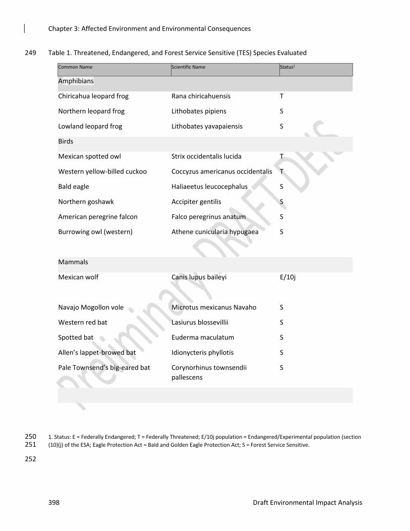
Table 1. Threatened, Endangered, and Forest Service Sensitive (TES) Species Evaluated 249
Common Name Scientific Name Status1
Amphibians
Chiricahua leopard frog Rana chiricahuensis T
Northern leopard frog Lithobates pipiens S
Lowland leopard frog Lithobates yavapaiensis S
Birds
Mexican spotted owl Strix occidentalis lucida T
Western yellow-billed cuckoo Coccyzus americanus occidentalis T
Bald eagle Haliaeetus leucocephalus S
Northern goshawk Accipiter gentilis S
American peregrine falcon Falco peregrinus anatum S
Burrowing owl (western) Athene cunicularia hypugaea S
Mammals
Mexican wolf Canis lupus baileyi E/10j
Navajo Mogollon vole Microtus mexicanus Navaho S
Western red bat Lasiurus blossevillii S
Spotted bat Euderma maculatum S
Allen’s lappet-browed bat Idionycteris phyllotis S
Pale Townsend’s big-eared bat Corynorhinus townsendii
pallescens
S
1. Status: E = Federally Endangered; T = Federally Threatened; E/10j population = Endangered/Experimental population (section 250 (10)(j) of the ESA; Eagle Protection Act = Bald and Golden Eagle Protection Act; S = Forest Service Sensitive. 251
252
Chapter 3: Affected Environment and Environmental Consequences
Rim Country Project 399
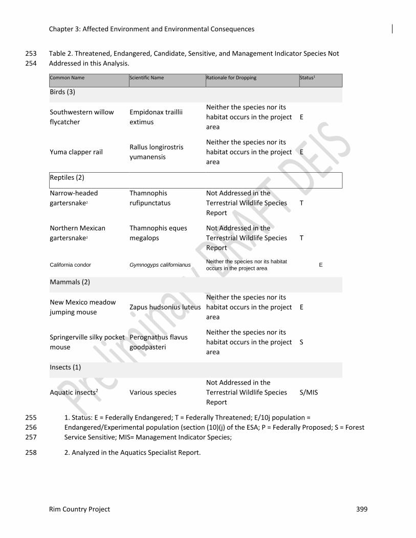
Table 2. Threatened, Endangered, Candidate, Sensitive, and Management Indicator Species Not 253
Addressed in this Analysis. 254
Common Name Scientific Name Rationale for Dropping Status1
Birds (3)
Southwestern willow
flycatcher
Empidonax traillii
extimus
Neither the species nor its
habitat occurs in the project
area
E
Yuma clapper rail Rallus longirostris
yumanensis
Neither the species nor its
habitat occurs in the project
area
E
Reptiles (2)
Narrow-headed
gartersnake2
Thamnophis
rufipunctatus
Not Addressed in the
Terrestrial Wildlife Species
Report
T
Northern Mexican
gartersnake2
Thamnophis eques
megalops
Not Addressed in the
Terrestrial Wildlife Species
Report
T
California condor Gymnogyps californianus Neither the species nor its habitat
occurs in the project area E
Mammals (2)
New Mexico meadow
jumping mouse Zapus hudsonius luteus
Neither the species nor its
habitat occurs in the project
area
E
Springerville silky pocket
mouse
Perognathus flavus
goodpasteri
Neither the species nor its
habitat occurs in the project
area
S
Insects (1)
Aquatic insects2 Various species
Not Addressed in the
Terrestrial Wildlife Species
Report
S/MIS
1. Status: E = Federally Endangered; T = Federally Threatened; E/10j population = 255
Endangered/Experimental population (section (10)(j) of the ESA; P = Federally Proposed; S = Forest 256
Service Sensitive; MIS= Management Indicator Species; 257
2. Analyzed in the Aquatics Specialist Report. 258
Chapter 3: Affected Environment and Environmental Consequences
400 Draft Environmental Impact Analysis
Federally-listed Threatened, Endangered, Proposed and Candidate 259
Species and Critical Habitat 260
Chiricahua Leopard Frog (CLF) 261
Listing Status 262
The Chiricahua leopard frog (Lithobates [Rana] chiricahuensis) was listed as threatened without 263 critical habitat on June 13, 2002 (USFWS 2002). A recovery plan for the species was finalized in 264 2007 (USFWS 2007). Critical habitat was determined in March, 2012. The Rim Country Project 265 Area occurs in Recovery Units 5 and 6. 266
Range and Life History 267
The historical range of the Chiricahua leopard frog included portions of west-central and 268 southwestern New Mexico, and central and southeastern Arizona (in addition to portions of 269 Mexico). The number of populations in much of the species’ range has declined drastically over 270 the past 20 years. 271
Within the species’ range, aquatic habitats historically and/or currently used by the frogs include 272 a variety of natural and human-constructed waters between elevations of 3,281 and 8,890 feet 273 (1,000 and 2,710 meters), including rivers, permanent streams and permanent pools in 274 intermittent streams, beaver ponds, cienegas (i.e., wetlands), springs, and earthen livestock tanks. 275 They are occasionally found in livestock drinkers, irrigation sloughs or acequias, wells, 276 abandoned swimming pools, ornamental ponds, and mine adits (USFWS 2007: 17). 277
Chiricahua leopard frogs have a complex life cycle consisting of eggs and larvae that are entirely 278 aquatic and adults that are primarily aquatic (USFWS 2007: 11). Each stage of the frogs’ life 279 history has its own set of environmental or habitat requirements that influence its susceptibility 280 to changes in its habitat, but in general Chiricahua leopard frogs need permanent to semi- 281 permanent water that is free, or nearly so, of non-native aquatic predators (USFWS 2007: 18, 282 50). However, frogs are known to move among aquatic sites and can be found in upland sites, 283 roadside puddles, and habitats that only hold water briefly during these movements. 284
Species Distribution in the Project Area 285
Chiricahua Leopard Frog (CLF) populations have been detected at various times and locations 286
since 1995 in the action area. Ellison and Lewis Creek in the Upper Verde Management Area 287 (MA) is NE of Payson, AZ. Crouch, Gentry, and Cherry Creeks, and Parallel Canyon in the 288 Gentry Creek MA is NE of Young, AZ. Both areas have CLF populations within and near these 289
drainages (Figure 4). During 2010-2016, observers detected frogs at 19 sites in the Upper East 290 Verde MA because of favorable monsoons, although water permanency has decreased. Also, 291 2011 had the most significant monsoon. Recovery activities by state and federal agencies 292 contributed to frog detections throughout those years. (Akins 2018, pers. Comm). Since then, 293 recent on-the-ground recovery actions by the Local Recovery Group and documentation of 294
natural dispersal to new sites have contributed to maintaining occupied sites across the 295 management area; this includes six populations in designated critical habitat locations. 296
In the Gentry Creek Management Area since 1982, 12 lentic or lotic sites within the action area 297 have been occupied by CLFs at one point in time, however, only eight are currently occupied or 298 have had frogs within the last five years. Further, there are numerous sites located just outside 299 the action area (project area); that make up the Naegelin-Cherry Creek metapopulation. 300
301
Chapter 3: Affected Environment and Environmental Consequences
Rim Country Project 401
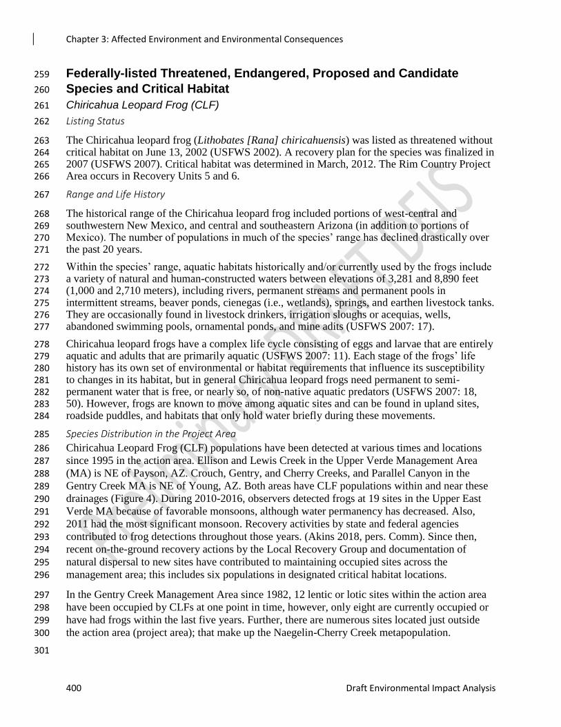
Figure 1. Occupied CLF Habitat Within the Project Area 302
303
The CLF Recovery Plan identifies suitable habitat to include all perennial waters within: 1) 304 elevational range of the frog (3,400 to 9,000 feet), 2) a mixture of aquatic and perimeter 305 vegetation to provide oviposition sites, thermoregulation, and refuge from predators, 3) absence 306 or low densities of nonnative aquatic species, and 4) a variety in substrate and range of shallow 307 to deeper water for potential hibernacula (USFWS 2007). 308
Critical Habitat and Primary Constituent Elements in the Project Area 309
To accommodate the various habitat requirements at each stage in the species’ life history the 310 following habitat features (Primary Constituent Elements are likely important to maintain a 311 reproducing population of Chiricahua leopard frogs (USFWS 2007: 18-19, 49-50, E-5). 312
1. Permanent or nearly permanent water that is free or relatively free from non-native predators 313
2. Within-site habitat diversity, including: 314
1. Shallow water with emergent and perimeter vegetation that provide egg deposition, 315 tadpole and adult thermoregulation sites, and foraging sites; 316
2. Deeper water, root masses, undercut banks that provide refuge from predators and 317 potential hibernacula during the winter; 318
3. Substrate that includes some mud that allows for the growth of alga and diatoms (food for 319 tadpoles) and to allow for hibernacula; 320
Chapter 3: Affected Environment and Environmental Consequences
402 Draft Environmental Impact Analysis
4. Relatively clean water not overly polluted by livestock excrement or chemical pollutants. 321
5. A diversity or complex of nearby aquatic sites including a variety of lotic and lentic 322 aquatic habitats, to provide habitat for breeding, post-breeding, and dispersing 323 individuals. In these situations, a metapopulation may be established, enhancing the 324
likelihood of the frogs’ continued existence. 325
Based on observations of various ranids in Arizona and New Mexico (USFWS 2007: 14-15), 326 reasonable dispersal distances for the species are: (1) one mile overland, (2) three miles along 327 intermittent drainages, and (3) five miles along permanent water courses (USFWS 2007: D-2, 3). 328 In 2012, the FWS designated 10,348 acres in Arizona, New Mexico, and Mexico as CLF critical 329 habitat. This critical habitat falls within eight recovery units (RUs) and is made of 39 units of 330 critical habitat. Two are in the project area. The Ellison and Lewis Creek Unit encompasses a 331 small portion of the westernmost portion of the A-S NFs and also portions of the Tonto and 332 Coconino NFs. The Crouch, Gentry and Cherry Creeks and Parallel Canyon Unit is on the Tonto 333 National Forest. 334
Mexican Spotted Owl (MSO) 335
Listing Status 336
The MSO was listed as a threatened species under the ESA in March 1993 (USDI FWS 1993). A 337 detailed account of the taxonomy, biology, and reproductive characteristics of the MSO is found 338 in the Final Rule listing the MSO as a threatened species (USDI FWS 1993), in the Recovery 339 Plan (USDI FWS 1995), and in the Revised Recovery Plan (USDI FWS 2012). Information on 340 MSO in the Upper Gila Mountain Recovery Unit (UGM) is also summarized in Ganey et al. 341 (2011). The information provided in these documents is incorporated here by reference as 342 summarized below. 343
The FWS recommends recovery actions concentrate on recovery units with the highest owl 344 populations (USDI FWS 2012). The UGM supports over half the known population of MSOs 345 (Ganey et al. 2011). Owls appear to be more continuously distributed in the UGM, relative to 346 other Recovery Units, and the central location of the UGM within the overall range of the MSO 347 facilitates gene flow across their range (Figure 8). Therefore this Ecosystem Management Unit is 348 important to the overall range-wide stability of MSOs. The FWS also recommends recovery 349 actions concentrate on recovery units where significant threats exist and that management should 350 emphasize alleviating the greatest threats and be tailored to the needs of the area under analysis 351 (USDI FWS 2012). The UGM is at significant risk of uncharacteristically high-severity wildfire 352 (USDI FWS 2012). Lands managed by the Forest Service account for 42 percent of the UGM, 353 putting the agency in a position to aid in the recovery of the species in part by decreasing the 354 threat of high-severity fire in MSO habitatModeling and Habitat Evaluation 355
The 2012 Revised Recovery Plan and individual forest plans describe the different levels of 356 MSO habitat management, including protected, recovery, and other forest and woodland types. 357 The stated objectives for managers are to ensure a sustained level of owl nest/roost habitat well 358 distributed across the landscape and create replacement owl nest/roost habitat where appropriate 359 while achieving a diversity of stand conditions across the landscape to ensure habitat for a 360 diversity of prey species. 361
Protected areas include: PACs established around all known MSO sites located during surveys 362 and management activities since 1989 and reserved lands which include wilderness, research 363 natural areas, wild and scenic rivers, and congressionally recognized wilderness study areas. 364 Prescribed fire is allowed in these areas where appropriate. PACs are 600 acres or more and 365
Chapter 3: Affected Environment and Environmental Consequences
Rim Country Project 403
typically include one or more nest sites. Core areas are 100 acres or larger, designated to 366 encompass known nest or roost sites or the best nesting and roosting habitat available within 367 PACs. In the absence of a known nest, the activity center should be defined as a roost grove 368 commonly used during breeding. In the absence of a known nest or roost, the activity center 369 should be defined as the best nest/roost habitat. 370
Recovery habitats include all mixed-conifer, pine-oak, and riparian forests outside of protected 371 areas. Recovery areas should be managed to ensure a sustained level of owl nest/roost habitat 372 well distributed across the landscape. Replacement nest/roost habitat should be created where 373 appropriate within recovery habitat while still providing a variety of stand conditions across the 374 landscape to ensure habitat for a diversity of prey species. 375
While the respective forest plans provide managers with guidelines for achieving the objectives 376 of designated MSO habitat, readers must turn to the Recovery Plan itself for the biological and 377 ecological intent of these designations. The latter provides the context for applying the guidelines 378 and informs management planners and decision makers as to the intended function of the habitat. 379 Treatments in MSO habitat under Rim Country were designed to meet Forest Plan direction, as 380 amended. Accordingly, much of the following discussion on existing conditions and the 381 environmental effects of proposed Rim Country activities in MSO habitat follow the detail and 382 context described in the Mexican Spotted Owl Recovery Plan; that is, forest plan direction would 383 be met by design, but the effects on owls are assessed relative to the biology and ecology of the 384 species as described in the Recovery Plan. 385
Species Distribution in the Project Area 386
Delineating MSO Habitat in the Rim Country Project Area 387
Following Recovery Plan direction, individual forest plans direct managers to conduct a 388 districtwide or larger landscape analysis to ascertain whether minimum recommendations for 389 nest/roost habitat exist across the forest. One of the strengths of landscape-scale planning is the 390 ability to compare habitat across ecological scales as encouraged in the Recovery Plan. 391
Working closely with the FWS and wildlife biologists from the three national forests, we 392 reviewed recovery habitats in the greater Rim Country area. Meetings held among wildlife 393 biologists from the FWS, each NF, and members of the Rim Country team began in October, 394 2016. We placed emphasis on developing future nesting and roosting habitat on all three of the 395 Rim Country NF’s, which support some of the highest numbers of resident owl pairs in the 396 Region. 397
A new recovery layer was created within the Rim Country project area, including designation of 398 recovery nest/roost and foraging habitat as described in the Recovery Plan. This landscape-scale 399 approach better meets the goal of providing continuous replacement nesting and roosting habitat 400 over space and time, as described in the Recovery Plan. 401
Pine-oak habitat on the Tonto contains mostly ponderosa pine-Gambel oak to the east and pine –402 evergreen oak to the west. PACs and recovery habitats on the Tonto NF could not all be 403 characterized as pine-oak or mixed conifer and so required queries using additional criteria. A 404 geophysical model (GM) was used to identify recovery habitats based on slope and aspect. We 405 also assumed that most canyons and drainages would contain some ponderosa pine. 406
The results of the queries were reviewed in meetings with biologists with on-the-ground 407 familiarity of the Tonto, Coconino and A-S NFs. This review was to ensure that stands also 408 provided the best functional habitat; for example, stands were dropped from consideration when: 409
Chapter 3: Affected Environment and Environmental Consequences
404 Draft Environmental Impact Analysis
Remotely-sensed data was found to misidentify juniper as oak in the understory (this was 410 a problem on the Payson Ranger District). 411
Small bubbles of isolated habitat were identified. 412
The strategy in designating recovery foraging and nest/roost habitat was to provide well-413 distributed habitat to aid in dispersal and seasonal movements of owls across the landscape, 414 including strategically located blocks that could potentially function as future PACs (i.e., “ensure 415 a sustained level of owl nest/roost habitat” and “[c]reate replacement owl nest/roost habitat 416 where appropriate” per the amended forest plans). Blocks of habitat were also designated with 417 the intent of providing “stepping-stones” to facilitate owl dispersal and connect areas capable of 418 supporting future nesting and roosting habitat, per the Recovery Plan, to support landscape 419 connectivity for MSOs. Some small, scattered stands of isolated habitat occurring in a matrix of 420 non-MSO habitat would not be expected to support nesting owls or provide connectivity and 421 were dropped from further consideration. In other words, results from the above criteria were 422 assessed in terms of ecological function in addition to meeting query criteria. 423
Proximity to PAC habitat was also an evaluation criterion. We sought to either augment PAC 424 habitat or designate recovery habitat in previously undesignated pine-oak stands. Fire potential 425 was also considered in developing the spatial configuration of MSO habitat on the landscape. 426 Predominant winds are from the southwest, so we rarely identified additional owl habitat 427 southwest of existing PACs unless stands were on northerly aspects. Because of the fire 428 potential, areas southwest of PACs were revaluated for treatments that would reduce the risk of 429 high-severity fires entering PACs. A final emphasis was placed on removing stands misclassified 430 as recovery habitat. 431
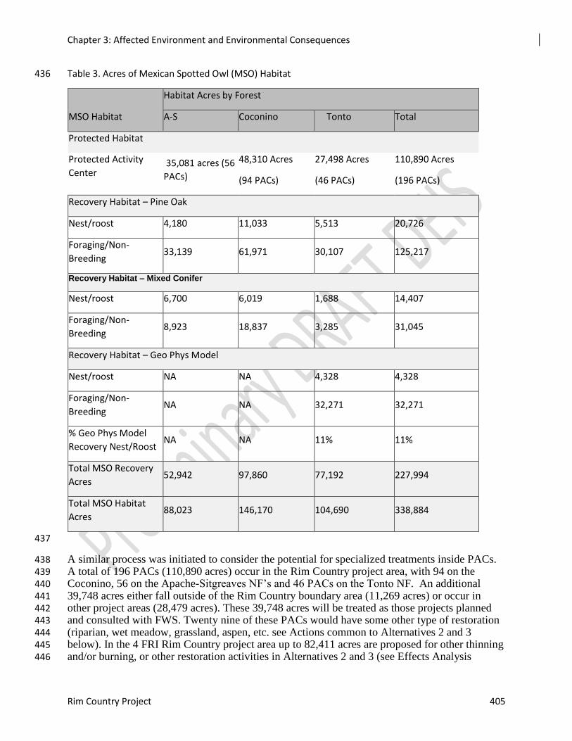
Habitat criteria for nest/roost habitat was met for 39,461acres and 188,533 acres was designated 432 as other recovery habitat as defined in the Recovery Plan (Table 49). All of the mixed conifer in 433 the project area is recovery habitat. 434
435
Chapter 3: Affected Environment and Environmental Consequences
Rim Country Project 405
Table 3. Acres of Mexican Spotted Owl (MSO) Habitat 436
MSO Habitat
Habitat Acres by Forest
A-S Coconino Tonto Total
Protected Habitat
Protected Activity
Center 35,081 acres (56
PACs)
48,310 Acres
(94 PACs)
27,498 Acres
(46 PACs)
110,890 Acres
(196 PACs)
Recovery Habitat – Pine Oak
Nest/roost 4,180 11,033 5,513 20,726
Foraging/Non-
Breeding 33,139 61,971 30,107 125,217
Recovery Habitat – Mixed Conifer
Nest/roost 6,700 6,019 1,688 14,407
Foraging/Non-
Breeding 8,923 18,837 3,285 31,045
Recovery Habitat – Geo Phys Model
Nest/roost NA NA 4,328 4,328
Foraging/Non-
Breeding NA NA 32,271 32,271
% Geo Phys Model
Recovery Nest/Roost NA NA 11% 11%
Total MSO Recovery
Acres 52,942 97,860 77,192 227,994
Total MSO Habitat
Acres 88,023 146,170 104,690 338,884
437
A similar process was initiated to consider the potential for specialized treatments inside PACs. 438 A total of 196 PACs (110,890 acres) occur in the Rim Country project area, with 94 on the 439 Coconino, 56 on the Apache-Sitgreaves NF’s and 46 PACs on the Tonto NF. An additional 440 39,748 acres either fall outside of the Rim Country boundary area (11,269 acres) or occur in 441 other project areas (28,479 acres). These 39,748 acres will be treated as those projects planned 442 and consulted with FWS. Twenty nine of these PACs would have some other type of restoration 443 (riparian, wet meadow, grassland, aspen, etc. see Actions common to Alternatives 2 and 3 444 below). In the 4 FRI Rim Country project area up to 82,411 acres are proposed for other thinning 445 and/or burning, or other restoration activities in Alternatives 2 and 3 (see Effects Analysis 446
Chapter 3: Affected Environment and Environmental Consequences
406 Draft Environmental Impact Analysis
sections below). Working closely with the FWS and wildlife biologists from all three national 447 forests, we reviewed each PAC for treatment needs. PACs were assessed in terms of dominant 448 forest type (e.g., pine-oak, mixed conifer, or canyons), habitat structure, available demographic 449 data (based on ongoing occupancy surveys or past research), topographic attributes (e.g., aspect 450 and slope), human access, designated wilderness boundaries, recent and ongoing projects 451 affecting PAC habitat, fire history, status of current habitat, and whether mechanical treatments 452 could move the habitat toward the desired conditions described in the Recovery Plan. It was 453 agreed no mechanical treatments would occur in core areas. 454
Once the status of the PAC was determined, potential mechanical treatments were considered in 455 terms of whether they could: 456
1. Decrease the amount of time required for growing/increasing tree height and diameter; 457
2. Decrease overall tree density while maintaining the density of large trees, and 458
3. Increase canopy base height to improve flight zone (i.e., improve owl foraging ability) 459
and also reduce the threat of surface fires becoming crown fires. 460
It was determined that 12 of the 196 PACs assessed did not need mechanical treatments, and that 461 mechanical treatments were possible in 22,306 acres of PACs. One hundred and seventy-one 462 (171) miles of stream restoration, 2,881 acres of riparian restoration, and 489 acres of 463 grassland/meadow restoration were identified in PACs. PACs were not considered for treatment 464 if they were treated in previous projects, or if their habitat was not suitable for Rim Country 465 treatments (some occur in designated wilderness or canyons, were previously burned, have 466 conditions inside and outside the PAC that do not need active management, or there is not 467 enough information to identify a need for treatment). Prescribed fire only was recommended for 468 49,930 acres in PACs, including using prescribed fire in core areas. 469
Chapter 3: Affected Environment and Environmental Consequences
Rim Country Project 407
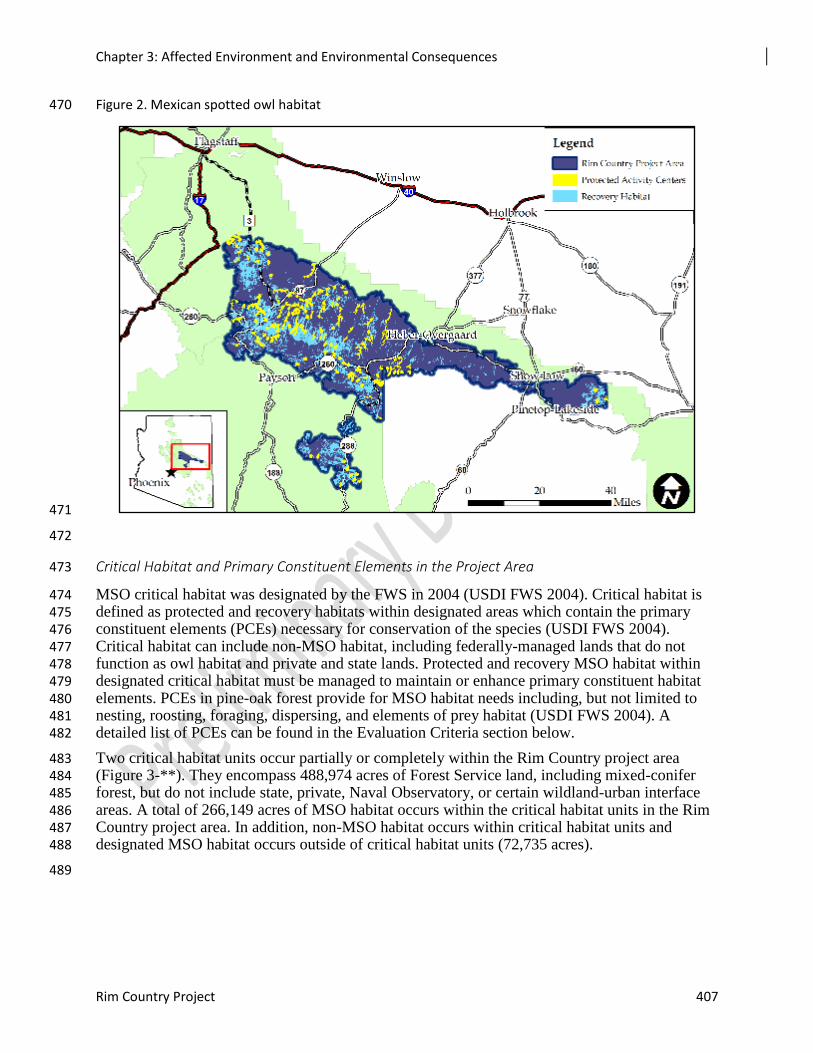
Figure 2. Mexican spotted owl habitat 470
471
472
Critical Habitat and Primary Constituent Elements in the Project Area 473
MSO critical habitat was designated by the FWS in 2004 (USDI FWS 2004). Critical habitat is 474 defined as protected and recovery habitats within designated areas which contain the primary 475 constituent elements (PCEs) necessary for conservation of the species (USDI FWS 2004). 476 Critical habitat can include non-MSO habitat, including federally-managed lands that do not 477 function as owl habitat and private and state lands. Protected and recovery MSO habitat within 478 designated critical habitat must be managed to maintain or enhance primary constituent habitat 479 elements. PCEs in pine-oak forest provide for MSO habitat needs including, but not limited to 480 nesting, roosting, foraging, dispersing, and elements of prey habitat (USDI FWS 2004). A 481 detailed list of PCEs can be found in the Evaluation Criteria section below. 482
Two critical habitat units occur partially or completely within the Rim Country project area 483 (Figure 3-**). They encompass 488,974 acres of Forest Service land, including mixed-conifer 484 forest, but do not include state, private, Naval Observatory, or certain wildland-urban interface 485 areas. A total of 266,149 acres of MSO habitat occurs within the critical habitat units in the Rim 486 Country project area. In addition, non-MSO habitat occurs within critical habitat units and 487 designated MSO habitat occurs outside of critical habitat units (72,735 acres). 488
489
Chapter 3: Affected Environment and Environmental Consequences
408 Draft Environmental Impact Analysis
Figure 3. Mexican Spotted Owl Critical Habit Units 490
491
492
Western Yellow-billed Cuckoo (WYBCU) 493
Listing Status 494
The western distinct population segment of the yellow-billed cuckoo was listed as a threatened 495 species under the ESA on October 3, 2014 (USFWS 2013, 2014b; 78 FR 61622, 79 FR 59992). 496 Within the population segment (see Figure 1 at 79 FR 59994, in the final listing rule (79 FR 497 59992; October 3, 2014)), the habitat areas used by the species for nesting are located from 498 southern British Columbia, Canada, to southern Sinaloa, Mexico, and may occur from sea level 499 to 7,000 feet (ft.) (2,154 meters (m)) in elevation (or slightly higher in western Colorado, Utah, 500 and Wyoming). Critical habitat for the yellow-billed cuckoo population segment was proposed 501 on August 15, encompassing 546,335 acres across the western United States (USFWS 2014a; 79 502 FR 48548). The discussions of the status of this species in these documents are incorporated 503 herein by reference. A revised proposed rule that may include additional proposed critical habitat 504 is under development. 505
Range and Life History 506
In Arizona, the species was a common resident in the (chiefly lower) Sonoran zones of southern, 507 central, and western Arizona (Phillips et al. 1964). The yellow-billed cuckoo now nests 508 primarily in the central and southern parts of the state, as well as at revegetation sites along the 509 lower Colorado River (MacFarland and Horst 2015; USFWS 2013, 2014a, 2014b, McNeil et al. 510 2013). In the Southwest, the Western yellow-billed cuckoo (WYBC) usually occurs in 511 association with large blocks of mature riparian cottonwood-willow woodlands and dense 512 mesquite associations (USFS 2011a). Habitat features of the WYBC indicate a preference for 513 areas with a closed canopy and a sub-canopy layer (USFS 2011a). Dense understory foliage 514
Chapter 3: Affected Environment and Environmental Consequences
Rim Country Project 409
appears to be an important factor in nest site selection, while cottonwood trees are an important 515 foraging habitat in areas where the species has been studied in California (USFS 2011a). Nesting 516 west of the Continental Divide occurs almost exclusively close to water (USFWS 2001). 517
Species Distribution in the Project Area 518
The western distinct population of the yellow-billed cuckoo is not known to occur in the project 519 area. No critical habitat areas have been identified within the Rim Country project area for the 520 cuckoo, though proposed critical habitat units are seven miles east and south of the project area. 521
There have been no systematic surveys for the WYBCU on the ASNFs; however, there are some 522 incidental known occurrences, all of them on the Apache side. The cottonwood-willow riparian 523 forest cover type occurrence on the Sitgreaves side of the ASNFs is not likely to provide habitat 524 extensive enough for nesting. On the Tonto NF, in previous years there have been detections of 525 cuckoos in Rye Creek on the Payson-Tonto Basin border near Rye and Gisela creeks. For 526 example there were several detections including protocol level surveys along Lower Tonto Creek 527 (2017, 2018) and it is feasible that birds may move up to the Gisela area as some suitable habitat 528 occurs there and the species has breeding pairs lower down on the creek (Tony Bush, personal 529 communication, 11/28/2018). Cuckoos have also been found along the Verde River and Cherry 530 Creek (Tonto Basin portion). It is possible that cuckoos could be present in some of the 531 drainages in the Rim Country footprint. While many of these riparian reaches are narrow, it is 532 possible that birds are using these areas. Narrow drainages with linear or scattered reaches of 533 riparian trees can be cuckoo habitat. Intermittent and ephemeral reaches with water for at least 534 part of the summer may also be cuckoo habitat (Susan Sferra USFWS, Personal Communication, 535 2018). 536
Proposed Critical Habitat and Primary Constituent Elements in the Project Area 537
The 4 FRI Rim Country Project area does not contain proposed critical habitat for Yellow-billed 538 Cuckoos, but it is likely that the species does occur here. Critical habitat Unit 19, Beaver Creek, 539 is approximately seven miles east of the project area and Unit 22 (Tonto Creek) is approximately 540 seven miles southeast of the project area. 541
1. Primary Constituent Element 1—Riparian woodlands. Riparian woodlands with mixed 542 willow cottonwood vegetation, mesquite-thorn forest vegetation, or a combination of these 543 that contain habitat for nesting and foraging in contiguous or nearly contiguous patches that 544
are greater than 325 ft. (100 m) in width and 200 ac (81 ha) or more in extent. These habitat 545 patches contain one or more nesting groves, which are generally willow dominated, have 546
above average canopy closure (greater than 70 percent), and have a cooler, more humid 547 environment than the surrounding riparian and upland habitats. 548
2. Primary Constituent Element 2—Adequate prey base. Presence of a prey base consisting of 549
large insect fauna (for example, cicadas, caterpillars, katydids, grasshoppers, large beetles, 550
dragonflies) and tree frogs for adults and young in breeding areas during the nesting season 551 and in post-breeding dispersal areas. 552
3. Primary Constituent Element 3—Dynamic riverine processes. River systems that are 553
dynamic and provide hydrologic processes that encourage sediment movement and deposits 554 that allow seedling germination and promote plant growth, maintenance, health, and vigor 555 (e.g. lower gradient streams and broad floodplains, elevated subsurface groundwater table, 556 and perennial rivers and streams). This allows habitat to regenerate at regular intervals, 557 leading to riparian vegetation with variously aged patches from young to old. Because the 558
Chapter 3: Affected Environment and Environmental Consequences
410 Draft Environmental Impact Analysis
species exists in disjunct breeding populations across a wide geographical and elevational 559
range and is subject to dynamic events, the river segments described below are essential to 560 the conservation of the western yellow-billed cuckoo, because they maintain stability of 561 subpopulations, provide connectivity between populations and habitat, assist in gene flow, 562
and protect against catastrophic loss. The occupied rivers and streams that are proposed for 563 designation contain physical and biological features that are representative of the historic and 564 geographical distribution of the species. All river segments proposed as western yellow-565 billed cuckoo critical habitat are within the geographical area occupied by the species as 566 defined by the species’ DPS at the time of listing (i.e., currently) and contain the features 567
essential to the conservation of the species. The features essential to the conservation of the 568 species and refined primary constituent elements are present throughout the river segments 569 selected, but the specific quality of riparian habitat for nesting, migration, and foraging will 570 vary in condition and location over time due to plant succession and the dynamic 571
environment in which they exist. 572
Mexican Wolf 573
Listing Status 574
The Mexican wolf, Canis lupus baileyi, is an endangered subspecies of gray wolf protected by 575 the Endangered Species Act (80 FR 2488, January 16, 2015) (ESA). On January 12, 1998, the 576 U.S. Fish and Wildlife Service published an Endangered Species Act section 10(j) rule for the 577 Mexican wolf that provided for the designation of specific populations of listed species in the 578 United States as “experimental populations”. The Mexican wolf has been reintroduced on 579 national forests in Arizona and New Mexico. These wolves have been designated as a non-580 essential experimental population, pursuant to section 10(j) of the Endangered Species Act as 581 amended. 582
Wording from the USFWS 2014 EIS for the proposed revision to the Regulations for the Non 583 essential experimental population of the Mexican Wolf. 584
Disturbance-causing land-use activity means any activity on Federal lands within a 1-mi (1.6-585 km) radius around release pens when Mexican wolves are in them, around active dens between 586 April 1 and July 31, and around active Mexican wolf rendezvous sites between June 1 and 587 September 30, that the Service determines could adversely affect reproductive success, natural 588 behavior, or persistence of Mexican wolves. Such activities may include, but are not limited to—589 timber or wood harvesting, prescribed fire, mining or mine development, camping outside 590 designated campgrounds, livestock husbandry activities (e.g. livestock drives, roundups, 591 branding, vaccinating, etc.), off-road vehicle use, hunting, and any other use or activity with the 592 potential to disturb wolves. The following activities are specifically excluded from this 593 definition: 594
(i) Lawfully present livestock and use of water sources by livestock; 595
(ii) Livestock drives if no reasonable alternative route or timing exists; 596
(iii) Vehicle access over established roads to non-Federal land where legally permitted activities are 597 ongoing if no reasonable alternative route exists; 598
(iv) Use of lands within the National Park or National Wildlife Refuge Systems as safety buffer zones for 599 military activities and Department of Homeland Security border security activities; 600
(v) Fire-fighting activities associated with wildfires; and 601
Chapter 3: Affected Environment and Environmental Consequences
Rim Country Project 411
(vi) Any authorized, specific land use that was active and ongoing at the time Mexican wolves chose to 602 locate a den or rendezvous site nearby. 603
Thinning and burning projects have the potential to affect wolves, especially when reproduction 604 and denning activities are disrupted. The Forest Service will work closely with the wolf field 605 team to identify sensitive areas and avoid temporal disruptions that could negatively affect 606 Mexican wolves. 607
Range and Life History 608
The Mexican wolf is a top predator native to the southwestern United States and Mexico that 609 lives in packs and requires large amounts of forested terrain with adequate ungulate (deer and 610 elk) populations to support the pack. Predator eradication programs in the mid to late 1800’s to 611 mid-1900’s resulted in the near extinction of the Mexican wolf. Extinction was averted with the 612 inception of a captive breeding program founded with seven Mexican wolves. 613
In the United States, Mexican wolves were reintroduced to the wild in 1998 in the Mexican Wolf 614 Experimental Population Area, an area designated for Mexican wolf reintroduction in Arizona 615 and New Mexico. The Mexican wolf population in this population area has exhibited robust 616 growth in recent years. As of December 31, 2016, a population of at least 113 wild Mexican 617 wolves inhabited the population area, the largest population size reached to date (USFWS 618 2017b). 619
The threats to the Mexican wolf have generally remained consistent over time, including human-620 caused mortality and related legal protections, extinction risk due to small population size, and 621 loss of genetic diversity (USFWS 2017). 622
Species Distribution in the Project Area 623
Figure 3-** shows areas of potential wolf habitat and includes parts of the Rim Country planning 624 area classified as high quality. Radio-collard wolves on the Black Mesa District of the Apache-625 Sitgreaves NF have recently been located within the Rim Country boundary (USFS 2017), before 626 returning to the east. In 2018, another lone male passed through Rim Country from the Gila 627 Wilderness in NM to the Kaibab NF west of Flagstaff. Also in 2018, uncollared wolves were 628 confirmed in the Heber/Overgaard area. Given wolves’ capacity for long-distance dispersals 629 (Mech et al 1995), we could reasonably predict that more individuals could occur within the Rim 630 Country project area during the planning and implementation of the project. Coordination 631 between the Forest Service and the Inter-Agency Field Team (IFT) will occur before phases of 632 implementation to verify wolf occurrences in projects area. 633
Chapter 3: Affected Environment and Environmental Consequences
412 Draft Environmental Impact Analysis
634
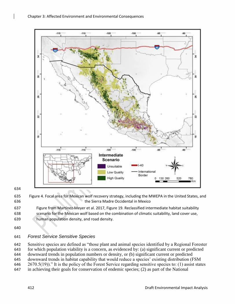
Figure 4. Focal area for Mexican wolf recovery strategy, including the MWEPA in the United States, and 635 the Sierra Madre Occidental in Mexico 636
Figure from Martínez-Meyer et al. 2017, Figure 19. Reclassified intermediate habitat suitability 637
scenario for the Mexican wolf based on the combination of climatic suitability, land cover use, 638
human population density, and road density. 639
640
Forest Service Sensitive Species 641
Sensitive species are defined as “those plant and animal species identified by a Regional Forester 642 for which population viability is a concern, as evidenced by: (a) significant current or predicted 643 downward trends in population numbers or density, or (b) significant current or predicted 644 downward trends in habitat capability that would reduce a species’ existing distribution (FSM 645 2670.5(19)).” It is the policy of the Forest Service regarding sensitive species to: (1) assist states 646 in achieving their goals for conservation of endemic species; (2) as part of the National 647
Chapter 3: Affected Environment and Environmental Consequences
Rim Country Project 413
Environmental Policy Act process, review programs and activities, through a biological 648 evaluation, to determine their potential effect on sensitive species; (3) avoid or minimize effects 649 on species whose viability has been identified as a concern; (4) if effects cannot be avoided, 650 analyze the significance of potential adverse effects on the population or its habitat within the 651 area of concern and on the species as a whole (the line officer, with project approval authority, 652 makes the decision to allow or disallow effects, but the decision must not result in loss of species 653 viability or create significant trends toward Federal listing); and (5) establish management 654 objectives in cooperation with the state when projects on National Forest System lands may have 655 a significant effect on sensitive species population numbers or distributions. Establish objectives 656 for Federal candidate species, in cooperation with the FWS and state of Arizona (FSM 2670.32). 657
The most recent Regional Forester’s Sensitive Species list was transmitted to Forest Supervisor’s 658 in September 2013 and is the basis for the species used for this analysis. If survey information 659 was not available, the assumption was made that potential habitat was occupied. The presence of 660 species carried forward for analysis was determined by consulting forest records, results of 661 surveys conducted on the forest, and use of the FAAWN database (Patton 2011). 662
Northern Goshawk (NOGO) 663
This analysis addresses policy requirements and responds to key issues raised by the public 664 including Issue 2, Treatments in Goshawk Habitat and Issue 3, Large Tree Retention. Indicators 665 include changes in the amount and/or quality of goshawk nesting and post-fledging family area 666 (PFA) habitat. Specific measures include: 667
1. Acres treated by habitat/vegetation type by alternative in PFAs and areas outside of 668
PFAs. 669
2. Changes in tree size-classes by alternative in PFAs and areas outside of PFAs. 670
3. Percent canopy cover by alternative in PFAs and areas outside of PFAs. 671
4. Number per acre of snags logs, and tons per acre coarse woody debris in PFAs and areas 672
outside of PFAs. 673
5. Changes in percent shrub and herbaceous biomass (to maintain fruits, seeds, and 674 regeneration to provide needs of goshawk prey species) in PFAs and areas outside of 675
PFAs. 676
6. Changes in potential fire behavior (Fire Hazard Index) by alternative in PFAs. 677
7. Changes in risk of crown fire by alternative in PFAs. 678
This report utilizes and incorporates by reference the vegetation cover type and vegetation 679 existing condition information provided in the Silviculture Report and the respective forestwide 680 MIS reports. 681
Forest Plan Compliance and Analysis Framework 682
Forest plan direction for northern goshawks applies to goshawk habitat outside of Mexican 683 spotted owl habitat. In ponderosa pine forest, one or the other set of guidance applies and 684 Mexican spotted owl guidance takes precedence in areas of overlap. 685
Habitat Strata and Scales of Analysis 686
PFAs are about 600 acres in size (including the nest areas, replacement nest areas, and habitat 687 most likely to be used by fledglings during early development). PFAs were considered occupied. 688
Chapter 3: Affected Environment and Environmental Consequences
414 Draft Environmental Impact Analysis
The Coconino Revised Forest Plan (2018), Tonto Forest Plan (1985), and A-S Revised Forest 689 Plan (2015) have direction to include a minimum of six nest areas and replacement nest areas 690 within each PFA. Nest areas would be about 25 to 30 acres in size (minimally 30 acres 691 (Coconino NF)), and based on active nest sites followed by the most recently used historical nest 692 sites. 693
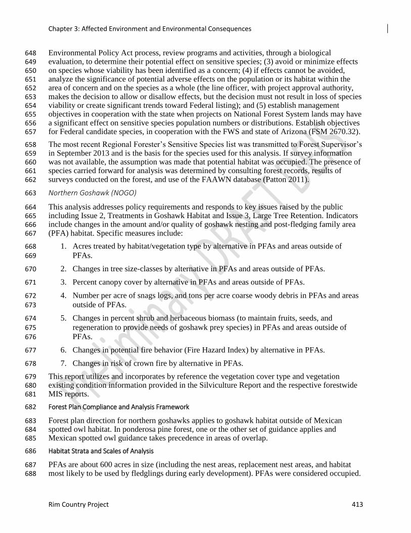
Goshawks and Rim Country 694
There are 106 PFAs on the Coconino, Tonto, and A-S National Forests, totaling 60,180 acres in 695 the Rim Country project area. Of these acres, 22,320 are within other project areas (Figure 3-**). 696 Approximately 37,860 acres of PFA habitat would be treated with mechanical thinning and/or 697 prescribed fire in the proposed action. A PFA was only counted once if a portion of that PFA 698 occurs on more than one forest. Figure 3-** shows the distribution of goshawk PFAs in the Rim 699 Country project area. The Rim Country Flexible Toolbox Approach for Mechanical Treatments 700 identifies PFAs as areas where special prescriptions will promote habitat variables needed by this 701 species. 702
Figure 5. Goshawk PFAs 703
704
Lowland Leopard Frog 705
The Lowland leopard frog shares habitats and threats similar to those of the Northern leopard 706 frog (see description below). 707
Lowland leopard frogs are only known to occur in Fossil Creek, Walker Creek, and possibly in 708 Oak Creek Canyon (only tadpoles observed) on the Coconino NF. Off the forest, lowland 709 leopard frogs are currently known to occur in Spring Creek but only on the private land parcel, 710 Josephine Tunnel (private land), Page Springs Fish Hatchery (state land), and Soda Springs 711 (private land). They are also located 10 miles south of the project area boundary on the Tonto NF 712 in House Spring adjacent to the Fort Apache Indian Reservation. T elevational range of the 713
Chapter 3: Affected Environment and Environmental Consequences
Rim Country Project 415
species is 1,810 meters. There are not numerous suitable habitat locations below the Mogollon 714 rim in 4FRI footprint. Historic records for lowland leopard frogs are from Spring Creek, Verde 715 River, Josephine Tunnel (private land), Oak Creek including the canyon, and Fossil Creek. 716 Unsurveyed but suitable locations below the rim are numerous and include perennial streams 717 (Red Tank Draw), various springs (Russell, Holly), and numerous earthen livestock tanks below 718 the rim. 719
Northern Leopard Frog (NLF) 720
The northern leopard frog is a smooth-skinned green, brown, or sometimes yellow-green frog 721 covered with large, oval dark spots, each of which is surrounded by a lighter halo. Adult body 722 lengths range from 2 to 4.5 inches. 723
The northern leopard frog requires a mosaic of habitats to meet the requirements of all of its life 724 stages, and breeds in a variety of aquatic habitats including slow-moving or still water along 725 streams and rivers, wetlands, permanent or temporary pools, beaver ponds, and human-726 constructed habitats such as earthen stock tanks and borrow pits. Subadult northern leopard frogs 727 typically migrate to feeding sites along the borders of larger, more permanent bodies of water, 728 and recently-metamorphosed frogs will move up and down drainages and across land in an effort 729 to locate new breeding areas. 730
Species Distribution in the Rim Country project area 731
Historically, the northern leopard frog was well-distributed across northern and central Arizona, 732 including wetlands in wooded areas and meadows above and below the Mogollon Rim, as well 733 as in more open and arid country on the Colorado Plateau. Northern leopard frogs have declined, 734 often dramatically, across the western United States and southwestern Canadian Provinces. 735 Arizona is no exception. On the Apache-Sitgreaves NF, historic sightings show observations 736 from the 1990s in various stock tanks five to 10 miles south of Heber. In 2004 a NLF was 737 observed in Black Canyon. This was the last NLF observed on the Black Mesa Ranger District of 738 the A-S NF. Northern leopard frogs were reintroduced by AZGFD to Turkey Creek on Black 739 Mesa September 2018. 740
The last known stronghold of the species in Arizona is a complex of cattle tanks (33 occupied by 741 NLF in 2017 in the project area) and a lake below the Mogollon Rim Ranger District of the 742 Coconino National Forest, approximately 5 miles north of the project area (Figure 3-**). 743
744
Chapter 3: Affected Environment and Environmental Consequences
416 Draft Environmental Impact Analysis
Figure 6. Occupied Northern leopard frog habitat 745
746
747
These occupied sites are within or near the northwest corner of the 4FRI Rim Country project area. Few 748 other populations exist. In 2006, it was reestablished to four refugia sites in the House Rock Valley. In the 749 White Mountains on and near the Apache-Sitgreaves National Forest, a refugia population was 750 established at the AZGFD office in Pinetop. Reintroduction efforts are underway using frogs from Lyman 751 Lake, a site where frogs were thought to be extirpated but were observed with a subset captured and 752 placed in the refugia in 2014. This population disappeared from the refugia in 2018. The AZGFD released 753 NLFs to Turkey Creek on the A-S in 2018. Historic sites lack any shoreline cover, are gone, or have 754 unacceptable water quality. Other sites being considered include the Double Cabin area and near Wiggins 755 Crossing. Other sites are also being considered and no final decision has been made. Northern 756 leopard frogs were reintroduced by AZGFD to Turkey Creek on the Black Mesa Ranger District 757 in September 2018. The biggest challenges are water availability and horse effects. Some tanks 758 that used to be suitable for frogs may have been impacted by horses but there are other sites in 759 the horse territory that have not been impacted and are still suitable. In 2018 frogs were 760 translocated from the House Rock Wildlife Area north of the Colorado River and east of the 761 Kaibab Plateau. AZGFD also translocated frogs to the Pinetop Wetlands in hopes they will 762 breed during the spring of 2019 (Groebner, personal communication, 12/13/2018). 763
Chapter 3: Affected Environment and Environmental Consequences
Rim Country Project 417
Bald Eagle 764
The FWS removed the bald eagle in the lower 48 States of the United States from the Federal 765 List of Endangered and Threatened Wildlife as of August 8, 2007 (USDI FWS 2007d). Eagles 766 are currently protected under the Golden and Bald Eagle Protection Act and are a Forest Service 767 sensitive species. 768
The FWS recommends using the Conservation Assessment and Strategy for Bald Eagles in 769 Arizona (Driscoll et al. 2006) in conjunction with the Bald Eagle National Management 770 Guidelines (USDI FWS 2007e) to protect bald eagles in Arizona. These guidelines were 771 incorporated into the Rim Country as design features or mitigation. 772
Bald eagles in central Arizona prefer to nest on cliff ledges or pinnacles or in tall trees (USDI 773 FWS 1982). Bald eagles are habitat generalists and opportunistic feeders, typically taking the 774 easiest and most abundant prey, regardless of whether it is dead or alive (Joshi 2009). They 775 mainly forage on waterfowl and fish found along major streams; however, they do hunt in the 776 uplands and forage on various mammal species, especially in the winter. 777
Nesting 778
Bald eagle numbers in Arizona have increased since 2008, with the number of breeding areas 779 recorded increasing from 56 in 2008 to 85 in 2017. Active breeding areas increased from 44 in 780 2008 to 60 in 2017. The number of young fledged has increased from 53 in 2008 to 63 in 2017. 781 Nesting success is partially attributed to the AZGFD Bald Eagle Nest Watch Program and to 782 Forest Service closures around nest sites (Show Low Lake and Chevelon Canyon on the Apache-783 Sitgreaves NF). 784
There are Seven nesting pairs of bald eagles within or near the project area. 785
Table 4. Bald eagle nests 786
Breeding Area Location: Forest/Ranger District Status in 2018/Recent Nesting
History
Fool Hollow Lake A-S, Lakeside Active Nest in 2018.
Chevelon Canyon Lake A-S, Black Mesa Unknown. Successful nest in 2016,
2 fledged.
76 Tonto, Tonto Basin RD Active. Successful nest in 2016, 2
fledged.
Silver Creek Private, Adjacent to Tonto NF, Payson Active. 2 fledged in 2015. Active
nest in 2018.
Show Low Lake A-S, Lakeside Active.
Woods Canyon A-S, Black Mesa
Active. 1 fledged in 2016, 1 fostered
from Show Low Lake. Fledged 1 in
2018.
O.W. / Canyon Creek Tonto, Pleasant Valley Unknown. First nest attempt in
2018, nest failed.
Chapter 3: Affected Environment and Environmental Consequences
418 Draft Environmental Impact Analysis
787
Wintering 788
Bald eagles occurring on the Coconino and Apache-Sitgreaves NFs are primarily winter visitors. 789 Bald eagles overwintering in northern Arizona are primarily migratory individuals that breed in 790 the northern U.S. and Canada (Grubb et al. 1989). There is a wintering population of eagles at 791 the Buckhead Mesa Landfill which is leased by the Tonto NF. They are often seen scavenging 792 on carrion, including large and small mammals, or around some of the waters supporting fish and 793 waterfowl. The AZGFD provided important wintering bald eagle habitat areas to consider for the 794 4FRI Rim Country analysis. These included the Lakeside Ranger District of the A-S’s various 795 lakes: Mogollon Plateau: Lower Lake Mary Road; Rattlesnake Canyon: Lake Mountain, Verde 796 River Valley, Wingfield Mesa, Mogollon Plateau, Jack’s Canyon; Mogollon Plateau: Slim Jim 797 Ridge; Mogollon Rim: West Chevelon Canyon; Chevelon Canyon Lake; Mogollon Rim: 798 Cottonwood Wash; Sierra Anchas: Dupont Canyon; Willow Springs Lake; and the Buckhead 799 Mesa Landfill. Small to moderate-sized groups of bald eagles (typically two to 48) roost in 800 clumps of large trees in protected locations such as drainages and hillsides (Grubb and Kennedy 801 1982, Dargan 1991, Grubb 2003). Bald eagle winter night roosts typically consist of clumps of 802 large (average d.b.h. of 30 inches) trees on steep slopes that tend to occur on east-facing aspects 803 (Joshi 2009). Group sites are typically in stands of ponderosa pine trees of less than an acre up to 804 43 acres, most often on north or northeast-facing slopes close to daytime foraging areas (Dargan 805 1991). Day roosts are often trees or snags near water or roadways. Bald eagles are highly mobile 806 in the winter and can fly great distances in search of aquatic or terrestrial prey and suitable 807 nighttime roosting habitat. 808
Golden Eagle 809
There is a golden breeding site observed in 2016, 0.3 miles from the project area in the Hells 810 Gate Wilderness on Pleasant Valley Ranger District of the Tonto NF. Golden Eagle nesting 811 within the Rim Country project area has also been recorded on the eastern boundary on the 812 Verde River, outside of the project area on Deadman’s Mesa and approximately 2 miles north of 813 the project area on the Tonto NF, Pleasant Valley Ranger District. South of the project area in 814 the Sierra Anchas, 7 Golden Eagle historic and active nest sites are within 1-3 miles of the 815 project area. Approximately three miles north of Rim Country on the A-S NF, Black Mesa 816 District there is an active nest site (2015) North of Heber, AZ. in Black Canyon and another NE 817 of Chevelon Crossing. There is a historic nest site from the late 1990s on the Lakeside Ranger 818 District. 819
American Peregrine Falcon 820
The essential habitat for peregrine falcons includes rock cliffs for nesting and a large foraging 821 area. Suitable nesting sites on rock cliffs have a mean height of 200 to 300 feet. The subspecies 822 anatum breeds on selected isolated cliff ledges and is a permanent resident in the project area. 823 Peregrines prey mainly on birds found in wetlands, riparian areas, meadows, parklands, 824 croplands, mountain valleys, and lakes within a 10 to 20-mile radius from the nest site. There are 825 25 confirmed nesting pairs of peregrine falcons within the project area Known nest locations, tall 826 cliffs, open waters, and meadows provide potential habitat within the project area. Forest plan 827 guidelines prohibit activities that can potentially disturb peregrine falcons in the vicinity of 828 occupied nesting habitat between March 1 and August 15. 829
Chapter 3: Affected Environment and Environmental Consequences
Rim Country Project 419
Western Burrowing Owl 830
Burrowing owls are found in flat, open, low-stature grasslands, sparsely vegetated desert shrub, 831 and edges of human disturbed land. These owls take over burrows of prairie dogs and ground 832 squirrels, and dens of coyote, fox and badger. They are also known to use artificial burrows. 833 These owls also need perches, such as mounds and fence posts. They primarily eat insects and 834 small mammals, but are known to take other small-sized species. Breeding Bird Atlas surveys 835 confirmed nesting from approximately 100 feet elevation near Gladsden to 6,600 feet elevation 836 in a prairie dog colony near Flagstaff however burrowing owls have not been confirmed within 837 the project area. Similar to prairie dogs, burrowing owls are associated with the Great 838 Basin/Colorado Plateau grassland and steppe, montane subalpine, and semi-desert grasslands. 839 There are 31,293 acres of grassland habitat within the project area that provide potential habitat 840 for prairie dogs and consequently, burrowing owls. There is no specific forest plan direction for 841 burrowing owls or prairie dogs; however, guidelines for mountain grassland are to evaluate the 842 need to maintain and improve meadows by eliminating competing conifers, stabilizing gullies to 843 restore waters tables, and reseeding with desirable species. 844
Sulphur-bellied Flycatcher 845
These flycatchers primarily nest (in snags) in the sky islands of SE AZ, but have been found as 846 far west as the Baboquivari Mountains and locally north to the Sierra Anchas. E-Bird shows one 847 record from Pine Creek, which is adjacent to the project area. There is a 1997 breeding record 848 from as far north as Oak Creek Canyon near West Fork. They typically nest from 4,500 to 6,000 849 feet in elevation (Corman and Wise-Gervais 2005). 850
Navajo Mogollon Vole 851
Hoffmeister (1986) delineated the range for this vole from the Navajo Mountain southward to the 852 western part of the Mogollon Plateau, extending from near Mormon Lake westward toward the 853 town of Williams and up to the Tusayan Ranger District. They live in a variety of habitats from 854 3,800 to 9,700 feet in elevation, including ponderosa pine forest and montane subalpine 855 grasslands. Whether or not Navajo Mogollon voles are found in forests, shrublands, or 856 grasslands, they are associated with grassy vegetation (Hoffmeister 1971). They select drier 857 habitats than long-tailed voles, which typically occupy moister habitats (Hoffmeister 1971). 858 They occur within open forests and in larger grassland areas such as Garland and Government 859 Prairies on the Williams Ranger District (Ganey and Chambers 2011). They typically nest 860 underground with runways leading from the burrow entrance out to their foraging areas. They 861 preferentially forage on cool season or C-3 photosynthesis grasses (Chambers and Doucett 2008, 862 Ganey and Chambers 2011). Other grasses can also provide food and voles rely on other 863 herbaceous species for cover. In a study evaluating understory vegetative cover, clumpy tree 864 distribution, decreased pine basal area and snags greater than 16 inches in diameter were 865 identified as strong drivers for Mogollon vole occupancy (Kalies et al. 2010). There are over 866 689,503 acres of ponderosa pine and 31,293 acres of grassland within the project area. 867
Western Red Bat 868
The western red bat is thought to be a summer resident of northern Arizona. It primarily occurs 869 along riparian corridors among oaks, sycamores, and cottonwoods at low elevations, but may 870 occur up to 7,200 feet where it roosts in dense clumps of foliage. In the Grand Canyon, 871 Hoffmeister (1971) reports they were only known from the bottom of the canyon near Phantom 872 Ranch and along Bright Angel Creek. Summer habitat associations include coniferous forest 873 (Western Bat Working Group 2005a). Although generally solitary, western red bats forage in 874 close association with one another in summer and may migrate in groups. They typically feed 875
Chapter 3: Affected Environment and Environmental Consequences
420 Draft Environmental Impact Analysis
along forest edges or in small openings. Large lepidopterons are considered main prey items, but 876
homopterans, coleopterans, hymenopterans, and dipterans have also been reported in their diets 877 (Western Bat Working Group 2005a). On rare occasion, red bats have been documented near 878 Kachina Village, upper West Clear Creek Wilderness, and Page Springs Fish Hatchery. The 879
latter two locations are outside of the project area. One bat was radio-tracked near Kachina 880 Village within the project area and roosted in a clump of Gambel oak in dry ponderosa pine 881 forest (Chambers personal comm. 2010). They roost primarily in the foliage of trees or shrubs 882 but occasionally use caves. Given they are an uncommon summer resident on the Coconino NF, 883 they could conceivably be a rare visitor on the Apache-Sitgreaves and Tonto NF as well. Recent 884
(2018) NaBAT data has confirmed red bat recordings on the Tonto inside the project area. 885
Forest plan guidelines state rare and unique features (e.g., talus slopes, cliffs, canyon slopes, 886 caves, fens, bogs, sinkholes) should be protected from damage or loss in order to retain their 887 distinctive ecological functions and maintain viability of associated species. 888
Both caves and abandoned mines are available for roosting bats, reducing the potential for 889 displacement, abandonment of young, and possible mortality. Caves and abandoned mines that 890 are used by bats should be managed to prevent disturbance to species and spread of disease (e.g., 891 white-nose syndrome).Potential foraging habitat within the project area includes 689,503 acres 892 of ponderosa pine and 31,923 acres of grassland. Roosting habitat may occur along the 777 miles 893 of riparian habitat. 894
Allen’s Lappet-browed Bat 895
Allen’s lappet-browed bat is known to occur in a wide variety of habitats in the southwestern 896 U.S. and Mexico. They are known to occur within the Rim Country area (Patton 2011). In 897 Arizona, Allen’s lappet-browed bats have been found in ponderosa pine, pinyon-juniper, 898 Mexican woodland, white-fir forests, and Mohave Desert scrub. They are often associated with 899 water. Hoffmeister (1986) documents Allen’s lappet-browed bats occupying mine shafts or rocky 900 areas and cliffs for roosts. A study conducted within the project area documented lappet-browed 901 bats using snags for maternity roosts. It appears that males segregate during the maternity season 902 and use cliff habitat, while females typically select taller snags with sloughing bark closer to 903 forest roads for raising their pups (Solvesky and Chambers 2009). While snags are not a long-904 lasting form of forest structure, snags with sloughing bark are even more ephemeral. Female 905 roosts were all within ponderosa pine forest. Allen’s lappet-browed bats feed on flying insects, 906 often over open waterbodies (including stock tanks) and wetlands where flying insects are 907 abundant. However, foraging habitat can be diverse and includes ponderosa pine forest, forest 908 openings, wet soils, and diverse herbaceous ground cover. They occur across the ponderosa pine 909 belt on the Tonto, Coconino and Apache-Sitgreaves NFs and have been documented in the 910 project area. Potential habitat within the project area is 689,503 acres of ponderosa pine and 911 114,753 acres of pinyon-juniper. 912
Pale Townsend’s Big-eared Bat 913
Townsend’s big-eared bat occurs across a broad range in western North America. A 2007 bat 914 roost inventory and monitoring project documented Townsend’s big-eared bats on both the 915 Apache-Sitgreaves and Coconino NFs (Solvesky and Chambers 2007). The Tonto NF has 916 records from the 1990s but they are outside the project area, and 2018 recordings from NaBAT 917 near the project area. Pale Townsends are known to occur near and likely within the project area. 918 They use a wide range of habitats, including ponderosa pine forest. Townsend’s big-eared bats 919 typically roost in rock structures (e.g., caves, mines, and lava tubes), and abandoned buildings, 920 but will also use hollow trees. Pale Townsend’s big-eared bats are apparently secure, although 921
Chapter 3: Affected Environment and Environmental Consequences
Rim Country Project 421
loss of cave and mine habitat may be causing a decline in numbers and there is concern over loss 922 of genetic variability within populations (Western Bat Working Group 2005b). Townsend’s big-923 eared bats are sensitive to disturbance and roost sites have been abandoned because of human 924 recreation. They feed on flying insects and often forage over waterbodies and wetlands where 925 flying insects are abundant. The species is a moth specialist with over 90 percent of their diet 926 composed of lepidopterans. They travel long distances while foraging and use edge habitat 927 adjacent to or within forest habitat (Western Bat Working Group 2005b). Habitat features 928 potentially benefiting prey species include pools, stock tanks, wet ground, herbaceous ground 929 cover, and edge habitat. Potential habitat includes 689,503 acres of ponderosa pine and 31,293 930 acres of grassland within the project area. 931
Spotted Bat 932
Historic records suggest that the spotted bats are widely distributed, rare across their range, but 933 can be locally abundant. The historic range of the spotted bat includes Mexico and the Southwest 934 and north up to Canada. In Arizona, spotted bats commonly roost singly in crevices in rocky 935 cliffs and they have also been found in caves (Chambers, pers. comm. 2009). Cliff habitat and 936 surface water are characteristic of localities where they occur. Spotted bats are lepidopteran 937 specialists and will forage in upland meadows. Meadows, openings, and open forests with 938 diverse herbaceous ground cover provide habitat for prey species. There are 689,503 acres of 939 ponderosa pine and 31,293 acres of grassland within the project area. 940
Forest Service Management Indicator Species 941
The current Tonto NF Plan identifies 28 wildlife MIS, with 18 species known or assumed to 942 occur within the Rim Country project area (Tonto NF MIS Report 2005). 943
944
The proposed project would affect ponderosa pine, mixed conifer, aspen, pinyon-juniper, 945 grassland/savannah, ephemeral streams, and spring habitats. MIS or their respective habitat 946 components that do not occur within the proposed Rim Country project area will not be analyzed 947 in this report. The presence of species carried forward for analysis was determined by surveys 948 conducted on the forests and the FAAWN (Forest Attributes and Wildlife Needs) database 949 (Patton 2011). 950
Eighteen MIS whose distribution across the Rim Country on the Tonto NF encompasses part or 951 all of the project area are included in the terrestrial effects analysis (Table 3-**). The analysis is 952 also based on forest plan direction and projected changes in quality habitat under the alternatives. 953
954
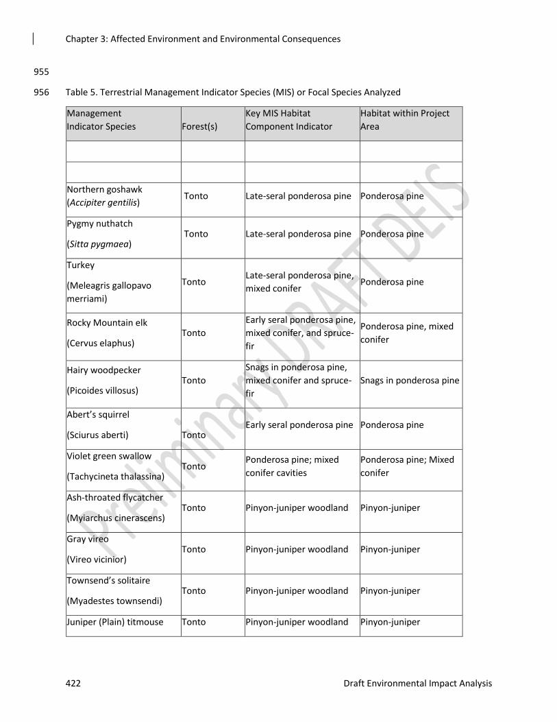
Chapter 3: Affected Environment and Environmental Consequences
422 Draft Environmental Impact Analysis
955
Table 5. Terrestrial Management Indicator Species (MIS) or Focal Species Analyzed 956
Management
Indicator Species Forest(s)
Key MIS Habitat
Component Indicator
Habitat within Project
Area
Northern goshawk
(Accipiter gentilis) Tonto Late-seral ponderosa pine Ponderosa pine
Pygmy nuthatch
(Sitta pygmaea) Tonto Late-seral ponderosa pine Ponderosa pine
Turkey
(Meleagris gallopavo
merriami)
Tonto Late-seral ponderosa pine,
mixed conifer Ponderosa pine
Rocky Mountain elk
(Cervus elaphus) Tonto
Early seral ponderosa pine,
mixed conifer, and spruce-
fir
Ponderosa pine, mixed
conifer
Hairy woodpecker
(Picoides villosus) Tonto
Snags in ponderosa pine,
mixed conifer and spruce-
fir
Snags in ponderosa pine
Abert’s squirrel
(Sciurus aberti)
Tonto Early seral ponderosa pine Ponderosa pine
Violet green swallow
(Tachycineta thalassina) Tonto
Ponderosa pine; mixed
conifer cavities
Ponderosa pine; Mixed
conifer
Ash-throated flycatcher
(Myiarchus cinerascens) Tonto Pinyon-juniper woodland Pinyon-juniper
Gray vireo
(Vireo vicinior) Tonto Pinyon-juniper woodland Pinyon-juniper
Townsend’s solitaire
(Myadestes townsendi) Tonto Pinyon-juniper woodland Pinyon-juniper
Juniper (Plain) titmouse Tonto Pinyon-juniper woodland Pinyon-juniper
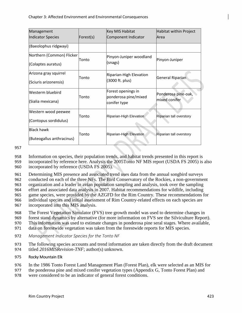
Chapter 3: Affected Environment and Environmental Consequences
Rim Country Project 423
Management
Indicator Species Forest(s)
Key MIS Habitat
Component Indicator
Habitat within Project
Area
(Baeolophus ridgwayi)
Northern (Common) Flicker
(Colaptes auratus) Tonto
Pinyon-Juniper woodland
(snags) Pinyon-Juniper
Arizona gray squirrel
(Sciuris arizonensis) Tonto
Riparian-High Elevation
(3000 ft. plus) General Riparian
Westerm bluebird
(Sialia mexicana) Tonto
Forest openings in
ponderosa pine/mixed
conifer type
Ponderosa pine-oak,
mixed conifer
Western wood peewee
(Contopus sordidulus) Tonto Riparian-High Elevation Riparian tall overstory
Black hawk
(Buteogallus anthracinus) Tonto Riparian-High Elevation Riparian tall overstory
957
Information on species, their population trends, and habitat trends presented in this report is 958 incorporated by reference here. Analysis the 2005Tonto NF MIS report (USDA FS 2005) is also 959 incorporated by reference (USDA FS 2005). 960
Determining MIS presence and associated trend uses data from the annual songbird surveys 961 conducted on each of the three NFs. The Bird Conservatory of the Rockies, a non-government 962 organization and a leader in avian population sampling and analysis, took over the sampling 963 effort and associated data analysis in 2007. Habitat recommendations for wildlife, including 964 game species, were provided by the AZGFD for the Rim Country. These recommendations for 965 individual species and initial assessment of Rim Country-related effects on each species are 966 incorporated into this MIS analysis. 967
The Forest Vegetation Simulator (FVS) tree growth model was used to determine changes in 968 forest stand dynamics by alternative (for more information on FVS see the Silviculture Report). 969 This information was used to estimate changes in ponderosa pine seral stages. Where available, 970 data on forestwide vegetation was taken from the forestwide reports for MIS species. 971
Management Indicator Species for the Tonto NF 972
The following species accounts and trend information are taken directly from the draft document 973 titled 2016MISRevision-TNF; author(s) unknown. 974
Rocky Mountain Elk 975
In the 1986 Tonto Forest Land Management Plan (Forest Plan), elk were selected as an MIS for 976 the ponderosa pine and mixed conifer vegetation types (Appendix G, Tonto Forest Plan) and 977 were considered to be an indicator of general forest conditions. 978
Chapter 3: Affected Environment and Environmental Consequences
424 Draft Environmental Impact Analysis
The Tonto NF relies on survey data collected by AZGFD for population numbers and trend 979 analysis of all game species (CFR 219.19(6)). The Forest Plan specifically states (p. 211) that, 980 for elk, turkey, and Abert’s squirrel, population trend will be established using AZGFD harvest 981 data records, hunter questionnaires, and supplemented by currently acceptable field sampling 982 techniques as necessary. AZGFD uses this data to set harvest regulations and population goals 983 for the species under their jurisdiction. 984
Tonto NF Population Trend: On the Tonto NF, populations of elk have increased since 985 implementation of the Forest Plan in 1985. Wintering populations have probably exceeded 986 expected increases, with populations continuing to expand into suitable habitat. 987
Merriam’s Turkey 988
In the Tonto Forest Plan, Merriam’s turkey was selected as an MIS for the ponderosa pine and 989 mixed conifer vegetation types (Appendix G, Tonto Forest Plan) and was considered to be an 990 indicator of vertical diversity and the general forest mix. In 1985, turkey were a popular, but not 991 necessarily widely spread, game species. Populations are influenced by weather (Wakeling 992 1991). For the most part, turkey numbers are currently held in check by hunting, both sport and 993 depredation. 994
Tonto NF Population Trend: Merriam turkey populations increased after 1985, but have 995 decreased overall since their peak due to drought. Based on the Breeding Bird Survey, AZGFD 996 harvest data, Audubon data, and habitat trends in the ponderosa pine and mixed conifer 997 vegetation types, the Merriam’s turkey population trend appear to be stable on the Tonto NF. 998 There is insufficient information to display any relationship between changes in habitat trend and 999 fluctuations in population changes. 1000
Abert’s Squirrel 1001
In the Tonto Forest Plan, Abert’s squirrel was selected as an MIS of successional stages within 1002 the ponderosa pine vegetation type (Appendix G, Tonto Forest Plan). Since other MIS were used 1003 as indicators of mature and old growth ponderosa pine, the Abert’s squirrel was selected because 1004 dense pole stands provide an important forage component for the species. The best squirrel 1005 habitat has some mature ponderosa pine trees with canopy cover exceeding 60 percent. Mature 1006 trees often produce the most cones, and abundant truffle foods are often associated with young 1007 pine stands with canopy cover greater than 65 percent. Patton (1984) and States et al. (1988) 1008 agree that prime habitat for this species comprises stands with a combination of tree age-classes 1009 whose size, density, and grouping provide all the necessary seasonal foods, cover and nesting 1010 sites needed. 1011
Tonto NF Population Trends: Population trends for the Abert squirrel on the Tonto NF based 1012 on AZGFD surveys indicates increases in some parts of the forest and decreases in others. On 1013 TNF there are three game management units that have viable populations of Abert squirrel and 1014 are hunted. With the warmer than average temperatures for the past several winter's, squirrel 1015 numbers are good. Abert squirrels can be found throughout the pine covered portion of Game 1016 Management Units 22 and 23 and, to a limited extent, 24A (AZGFD 2004). 1017
In addition, the data compiled from AZGFD surveys for Arizona show a stable to increasing 1018 trend from 1988-1999. AZGFD game surveys do not have survey count data for tree squirrels, 1019 just hunter harvest information. The data for tree squirrels include red squirrels, but the vast 1020 majority of the tree squirrels harvested are tassel-eared squirrels (Dodd, 2002). However, more 1021 recent information shows tassel-eared squirrel populations in the southwest to be quite depressed 1022 from several years of drought conditions that have reduced juvenile recruitment. This was 1023
Chapter 3: Affected Environment and Environmental Consequences
Rim Country Project 425
exacerbated by substantial snow-induced mortality during 2001- 2002. Densities from the North 1024 Kaibab, Camp Navajo, and northern New Mexico are all low. This situation is indicative of the 1025 current status of tassel-eared squirrels across the southwest (Dodd 2003). Population cycles may 1026 be related to cyclic variation in the biomass of the pine seed crops (Mejia 2001). There is no data 1027 specific to the Tonto NF but, based on drought conditions and sub-optimal habitat conditions, 1028 population trends are likely similar to the rest of the southwest and are in a declining trend. 1029
Arizona Gray Squirrel 1030
Arizona gray squirrel was selected as an MIS for general riparian condition of High Elevation 1031 (greater than 3,000 feet) Riparian (USDA FS 1985). 1032
Tonto NF Population Trends: Gray squirrels can be found on the Tonto NF in Game 1033 Management Units 22, 23, and 24A where they are limited to pines, mixed hardwoods, and high-1034 elevation riparian habitats. The population trend for the gray squirrel on the Tonto NF appears to 1035 be stable based on statewide AZGFD hunter harvest information and apparent trends in high-1036 elevation riparian habitat. Population trend at the forest level is not conducted by AZGFD due to 1037 difficulties in surveying this species. 1038
Common Black Hawk 1039
The common black hawk was selected as an MIS for streamside conditions for the cottonwood-1040 willow vegetation type in Low Elevation Riparian areas (less than 1,200 meter elevation) and the 1041 cottonwood-willow and mixed broadleaf vegetation types in High Elevation Riparian areas 1042 (greater than 1,100 meter elev.) (Appendix G, Tonto Forest Plan). On the Tonto NF, the common 1043 black hawk is an "obligate riparian nester." It is generally dependent on mature broadleaf trees 1044 along perennial streams for nest sites, although a few nests are situated along intermittent 1045 watercourses where small impoundments may persist through the breeding season. 1046
Tonto NF Population Trend: In a conservation assessment prepared for the Tonto NF, Boal 1047 and Mannan (1996) determined that the common black hawk appears to be stable in the 1048 Southwest. The rehabilitation and protection of many riparian areas has made the common black-1049 hawk population more secure, but it is at risk from a reversal of those management policies. 1050 Further degradation of riparian habitat would be detrimental to the species and place the 1051 population at increased risk. At least one known territory in the headwaters of Canyon Creek was 1052 lost during the Chediski Fire in 2002. It is also likely that one or more nest territories were lost in 1053 the Dude Fire, which burned several drainages under the Mogollon Rim. The drought appears to 1054 be killing large numbers of mature and over-mature cottonwoods along Tonto Creek and may be 1055 affecting perennial water and prey in other streams. No specific surveys have been conducted on 1056 the forest to locate active common black hawk nests. However, MIS surveys in 2003 on the 1057 Tonto Basin District detected common black hawks in three different survey points along Hardt 1058 Creek. 1059
No monitoring has been conducted by forest personnel to determine reproductive success or 1060 long-term nest territory fidelity. 1061
Ash-throated Flycatcher 1062
The Tonto Forest Plan Appendix G) designated the ash-throated flycatcher as an MIS for ground 1063 cover in the piñon-juniper woodland vegetation type (USDA FS 1985). In 2000, the Tonto NF 1064 and AZGFD conducted a review of the forest’s MIS species. In that process, it was felt that the 1065 ash-throated flycatcher was not a particularly good indicator of ground cover for the pinyon-1066 juniper vegetation type, since it doesn’t forage or nest on the ground, and it uses a wide variety 1067 of habitat other than simply pinyon-juniper. 1068
Chapter 3: Affected Environment and Environmental Consequences
426 Draft Environmental Impact Analysis
Tonto NF Population Trend: Two current Breeding Bird Survey transects on the Tonto NF 1069 indicate that this species is commonly counted during surveys. Regionally, this species continues 1070 to expand or remain at current levels according to the National Audubon Society 2005. Number 1071 of birds detected during surveys appears to have stabilized after 2000-2001 up to the present. 1072 Transects conducted in 2003 on the Tonto Basin District indicate that this species was observed 1073 256 times over approximately 20 visits at thirteen predetermined points. Based on this data it 1074 appears that this species is stable on the Tonto NF. 1075
Gray Vireo 1076
The gray vireo was selected as an MIS for the Tonto NF (Appendix G, Tonto Forest Plan) for 1077 tree density in the pinyon-juniper woodland type. 1078
Tonto NF Trend: Two current Breeding Bird Survey routes suggest that this species is 1079 uncommon in established survey routes. Statewide Christmas Bird Count surveys also indicate 1080 that this species is uncommon. On the Tonto Basin Ranger District in 2003, gray vireos were 1081 documented 54 times on 14 different days (Plank 2005). However, based on regional data 1082 population trends, it appears that this species’ population is declining due to drought-related 1083 effects on habitat. 1084
Hairy Woodpecker 1085
The hairy woodpecker was selected as an MIS for the Tonto NF for snags and cavities in 1086 ponderosa pine/mixed conifer and high-elevation riparian habitats. 1087
Tonto NF Population Trend: Potentially, due to large fires and a large number of acres killed 1088 by bark beetles in 2002, hairy woodpecker populations should increase significantly due to the 1089 availability of snags and nesting sites. The Tonto Village Breeding Bird Survey Route is the only 1090 transect on the forest that is located in hairy woodpecker habitat and documentation is 1091 inconsistent, but low. A statewide Christmas Bird Count survey suggests that population trends 1092 remain relatively unchanged since 1985. In 2003 on the Tonto Basin Ranger District, hairy 1093 woodpeckers were detected 12 times on seven different days (Plank 2005). Populations are 1094 considered stable on the Tonto NF. 1095
Juniper Titmouse 1096
The juniper titmouse was selected as an MIS (Appendix G, Tonto Forest Plan) for general 1097 woodland conditions in the pinyon-juniper woodland type. The juniper titmouse is most often 1098 associated with late-succession pinyon-juniper with open canopies and associated riparian 1099 woodlands. It can be found in all structural stages within the pinyon-juniper type, but old-growth 1100 pinyon-juniper appears to be the primary nesting habitat utilized (Towry 1984). 1101
Tonto NF Population Trend: Two Breeding Bird Survey routes indicate that this species is 1102 documented at very low densities on the forest. Statewide, the species is documented regularly in 1103 Christmas Bird Count surveys from 1997 to the present. In 2003 on the Tonto Basin Ranger 1104 District, this species was documented four times on two transects (Plank 2005). Habitat 1105 conditions for the pinyon-juniper habitat type remain relatively static since 1985 and therefore 1106 populations on the Tonto NF are considered stable. 1107
Northern Goshawk 1108
The northern goshawk was selected as an MIS for vertical diversity within the ponderosa pine 1109 and mixed conifer vegetation types (Appendix G, Tonto Forest Plan). It is a habitat generalist 1110 that uses a variety of forest types, forest ages, structural conditions, and successional stages. 1111
Chapter 3: Affected Environment and Environmental Consequences
Rim Country Project 427
Goshawks typically nest in larger trees that occur in clumps with fairly closed canopies, and 1112 forage over large areas to prey on a wide variety of small- to medium-sized birds and mammals. 1113
Tonto NF Population Trend: Forest Service biologists, technicians, contract biologists, and 1114 AZGFD biologists have conducted surveys for this species on the forest utilizing the protocol 1115 developed by Kennedy and Stahlecker (1991) for the Southwestern Region of the Forest Service. 1116 Inventory survey forms, maps, and reports are maintained at district offices. At present, the forest 1117 has established 13 management territories based on these surveys, but other data on population 1118 status is not available. Large stand-replacing fires since 1985 in the ponderosa pine and mixed 1119 conifer habitat types is likely contributing to declining habitat and population trends for this 1120 species. 1121
Northern Flicker 1122
The Northern flicker was selected as an MIS (Appendix G, Tonto Forest Plan) for snag 1123 conditions in the pinyon-juniper woodland type. A panel of biologists knowledgeable of forest 1124 conditions has suggested that the juniper titmouse may be a better indicator of snags in this 1125 vegetation type. 1126
Tonto NF Population Trend: There are three Breeding Bird Survey routes on the Tonto NF: 1127 Bartlett Reservoir, Tonto Village, and Aztec Peak. Survey results for Aztec Peak are included, 1128 although the dates of the surveys are prior to the completion of the 1986 Tonto Forest Plan. 1129 Drought conditions the last several years have increased the number of dead standing trees that 1130 are used for cavity nests and will likely improve nesting success and the snag component. Based 1131 on this information, populations on the Tonto NF are considered stable. 1132
Pygmy Nuthatch 1133
The Pygmy nuthatch was selected as an MIS for the ponderosa pine and mixed conifer 1134 vegetation types (Appendix G, Tonto Forest Plan), specifically the old growth component 1135 (USDA Forest Service 1985). It is found primarily in mature and old-growth ponderosa pine 1136 forest (Towry 1984) and lightly disturbed areas (Hall et al. 1997), preferring open parklike 1137 forests (Degraff et al. 1991). It has also been reported as using pinyon-juniper woodlands 1138 (Phillips et al. 1984), aspen, and cottonwoods (Thomas et al. 1979). 1139
Tonto NF Population Trend: The Tonto Village Breeding Bird Survey route is the only route 1140 that includes habitat for the Pygmy nuthatch. Christmas Bird Count survey results for the state of 1141 Arizona indicate that the population trend is stable. Due to modest declines in old-growth stands 1142 in the ponderosa pine and mixed conifer habitat types, populations on the Tonto NF are 1143 considered to be declining. 1144
Townsend’s Solitaire 1145
The Townsend’s solitaire was selected as an MIS for the pinyon-juniper woodland vegetation 1146 type, as an indicator of juniper berry production (see Appendix G, Tonto Forest Plan). 1147 Coniferous forest, with canopies dominated by pine (Pinus spp.), hemlock, (Tsuga), fir (Abies), 1148 and spruce (Picea), rocky cliffs, and adjacent brushy areas and thickets are considered typical 1149 habitat. Townsend’s solitaires prefer relatively open stands, including areas thinned by light 1150 burns or selective logging, usually with little shrub layer or ground cover (ibid.). Winter habitat 1151 includes piñon (Pinus edulis)-juniper woodland, which provides their main winter food, juniper 1152 berries. 1153
Tonto NF Population Trend: No Breeding Bird Survey routes detected this species during 1154 survey efforts on the Tonto NF. Statewide Christmas Bird Count indicates that this species is 1155
Chapter 3: Affected Environment and Environmental Consequences
428 Draft Environmental Impact Analysis
abundant throughout the state from 1985 to the present. In addition, statewide Breeding Bird 1156 Survey results that exclude routes on the Tonto NF suggest that populations are increasing over 1157 the last ten-year period. Because fire suppression has allowed the pinyon-juniper vegetation type 1158 to expand, it would be plausible that this species is stable on Tonto NF. 1159
Violet-green Swallow 1160
The violet-green swallow was selected as an MIS for cavity- nesting habitat in the ponderosa 1161 pine and mixed conifer vegetation types. Habitat consists of open deciduous, coniferous, and 1162 mixed woodlands, including ponderosa pine (Pinus ponderosa) and quaking aspen (Populus 1163 tremuloides). These swallows share breeding habitat with tree swallows (Tachycineta bicolor), 1164 but are usually in more open habitat, 1165
Tonto NF Population Trend: Only the Tonto Village Breeding Bird Survey route has 1166 documented this species on the forest. Statewide Christmas Bird Count surveys suggest that this 1167 species is well represented throughout the state and may have benefited from drought and 1168 increases in snags used for nest sites. On the Tonto Basin Ranger District in 2003, this species 1169 was documented on four occasions in one transect. Drought conditions and wildfire have led to 1170 increases in snag densities in the ponderosa pine and mixed conifer habitat types and have likely 1171 improved nesting habitat parameters. Based primarily on regional data, this species appears to be 1172 stable on the Tonto NF. 1173
Western Bluebird 1174
The western bluebird was selected as an MIS species for forest openings in the ponderosa pine 1175 and mixed conifer vegetation types. Western bluebirds normally occupy open woodland or edge 1176 habitat, with exposed perches and fairly sparse ground cover (Pinkowski 1979). They are 1177 frequent drifters in pinyon-juniper woodlands in winter; density depends on availability of 1178 mistletoe (Phoradendron spp.) and juniper berries. Szaro and Balda (1982) listed western 1179 bluebirds as preferring lightly or moderately-disturbed areas in northern Arizona ponderosa pine 1180 communities. 1181
Tonto NF Population Trend: The Tonto Village Breeding Bird Survey transect is the only 1182 location where this species is detected during survey efforts. Data suggest this species is 1183 encountered at low densities. Statewide Christmas Bird Counts suggests that this species is 1184 commonly documented during winter months. Based on this information, this species is 1185 considered stable on the Tonto NF. 1186
Western Wood Peewee 1187
The western wood pewee was selected as an MIS for the High Elevation (greater than 3,000 feet) 1188 Riparian vegetation type (Appendix G, Tonto Forest Plan) and was considered to be an indicator 1189 for medium riparian overstory. In 2000, the Tonto NF and AZGFD cooperatively conducted a 1190 review of the forest’s MIS. In that process, it was noted that this species is also common in pine 1191 stands adjacent to riparian corridors (Pollock, Tonto NF unpublished). “Important habitat 1192 components may include large tree diameters, open understory, edge characteristics, and dead 1193 trees or trees with dead limbs” (Kilgore 1971, Flack 1976, Ryser 1985). 1194
Tonto NF Population Trend: Breeding Bird Survey data for the Tonto Village route suggest 1195 that this species occurs at low densities. Other routes do not exhibit the necessary habitat 1196 parameters to support this species. Statewide Christmas Bird Counts suggest that this species 1197 occurs at low densities throughout the state. On the Tonto Basin Ranger District in 2003, this 1198 species was documented 55 times on seven different days on four survey routes (Plank 2005). 1199 Precipitous declines in this species may be related to declines in high-elevation riparian habitat 1200
Chapter 3: Affected Environment and Environmental Consequences
Rim Country Project 429
that is used for breeding habitat. Based on this information, populations for this species appear to 1201 be declining on the Tonto NF. 1202
Migratory Birds and Important Bird Areas 1203
Affected Environment 1204
For the 4FRI Rim Country project area three sources were used to identify priority species: (1) 1205 Partners in Flight Landbird Conservation Plan (Rosenberg et al. 2016), (2) Birds of Conservation 1206 Concern 2008 (U.S. Fish and Wildlife Service 2008), and (3) Arizona’s State Wildlife Action 1207 Plan: 2012-2022 (Arizona Game and Fish Department 2012). Life History of individual species 1208 used information from the Cornell lab of Ornithology web site: http://www.birds.cornell.edu/. 1209
This analysis considered high priority bird species from the Partners in Flight, U.S. Fish and 1210 Wildlife Service, and AZGFD birds of conservation concern. The Coconino, Apache-Sitgreaves, 1211 and Tonto NFs occur within two bird conservation regions (BCRs): the Southern 1212 Rockies/Colorado Plateau (BCR 16) and Sierra Madre Occidental (BCR 34). For the Tonto NF, 1213 the project area only occurs within BCR 34. 1214
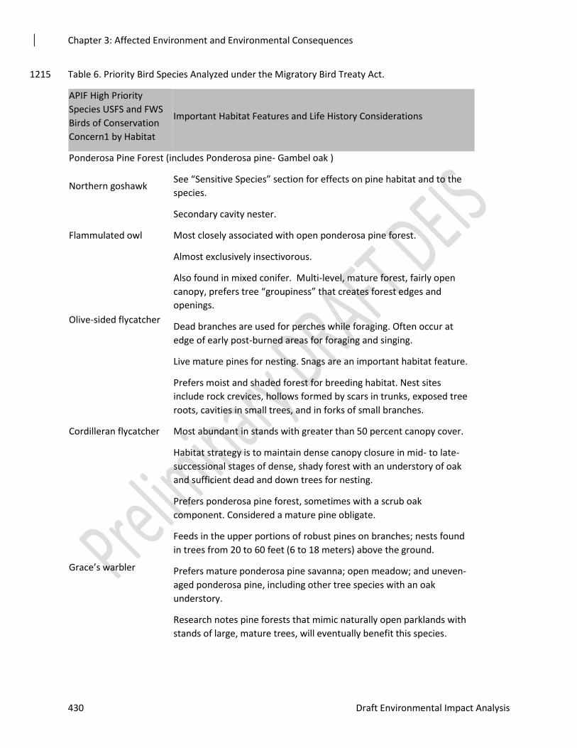
Chapter 3: Affected Environment and Environmental Consequences
430 Draft Environmental Impact Analysis
Table 6. Priority Bird Species Analyzed under the Migratory Bird Treaty Act. 1215
APIF High Priority
Species USFS and FWS
Birds of Conservation
Concern1 by Habitat
Important Habitat Features and Life History Considerations
Ponderosa Pine Forest (includes Ponderosa pine- Gambel oak )
Northern goshawk See “Sensitive Species” section for effects on pine habitat and to the
species.
Flammulated owl
Secondary cavity nester.
Most closely associated with open ponderosa pine forest.
Almost exclusively insectivorous.
Olive-sided flycatcher
Also found in mixed conifer. Multi-level, mature forest, fairly open
canopy, prefers tree “groupiness” that creates forest edges and
openings.
Dead branches are used for perches while foraging. Often occur at
edge of early post-burned areas for foraging and singing.
Live mature pines for nesting. Snags are an important habitat feature.
Cordilleran flycatcher
Prefers moist and shaded forest for breeding habitat. Nest sites
include rock crevices, hollows formed by scars in trunks, exposed tree
roots, cavities in small trees, and in forks of small branches.
Most abundant in stands with greater than 50 percent canopy cover.
Habitat strategy is to maintain dense canopy closure in mid- to late-
successional stages of dense, shady forest with an understory of oak
and sufficient dead and down trees for nesting.
Grace’s warbler
Prefers ponderosa pine forest, sometimes with a scrub oak
component. Considered a mature pine obligate.
Feeds in the upper portions of robust pines on branches; nests found
in trees from 20 to 60 feet (6 to 18 meters) above the ground.
Prefers mature ponderosa pine savanna; open meadow; and uneven-
aged ponderosa pine, including other tree species with an oak
understory.
Research notes pine forests that mimic naturally open parklands with
stands of large, mature trees, will eventually benefit this species.
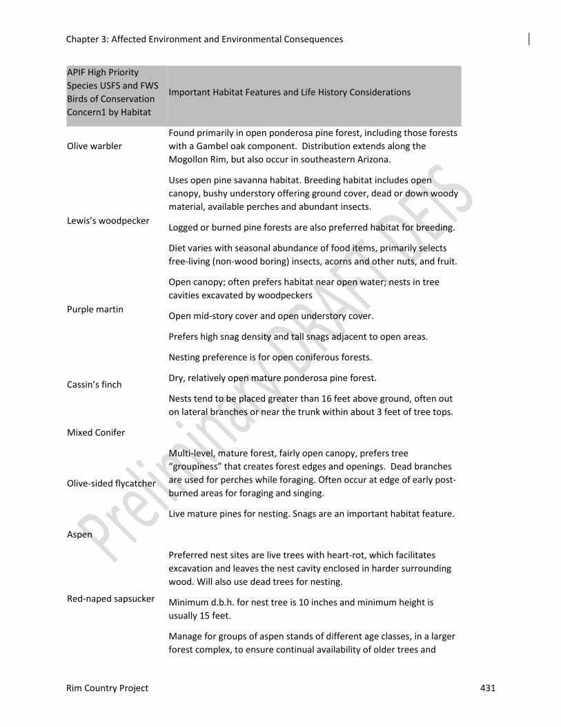
Chapter 3: Affected Environment and Environmental Consequences
Rim Country Project 431
APIF High Priority
Species USFS and FWS
Birds of Conservation
Concern1 by Habitat
Important Habitat Features and Life History Considerations
Olive warbler
Found primarily in open ponderosa pine forest, including those forests
with a Gambel oak component. Distribution extends along the
Mogollon Rim, but also occur in southeastern Arizona.
Lewis’s woodpecker
Uses open pine savanna habitat. Breeding habitat includes open
canopy, bushy understory offering ground cover, dead or down woody
material, available perches and abundant insects.
Logged or burned pine forests are also preferred habitat for breeding.
Diet varies with seasonal abundance of food items, primarily selects
free-living (non-wood boring) insects, acorns and other nuts, and fruit.
Purple martin
Open canopy; often prefers habitat near open water; nests in tree
cavities excavated by woodpeckers
Open mid-story cover and open understory cover.
Prefers high snag density and tall snags adjacent to open areas.
Cassin’s finch
Nesting preference is for open coniferous forests.
Dry, relatively open mature ponderosa pine forest.
Nests tend to be placed greater than 16 feet above ground, often out
on lateral branches or near the trunk within about 3 feet of tree tops.
Mixed Conifer
Olive-sided flycatcher
Multi-level, mature forest, fairly open canopy, prefers tree
“groupiness” that creates forest edges and openings. Dead branches
are used for perches while foraging. Often occur at edge of early post-
burned areas for foraging and singing.
Live mature pines for nesting. Snags are an important habitat feature.
Aspen
Red-naped sapsucker
Preferred nest sites are live trees with heart-rot, which facilitates
excavation and leaves the nest cavity enclosed in harder surrounding
wood. Will also use dead trees for nesting.
Minimum d.b.h. for nest tree is 10 inches and minimum height is
usually 15 feet.
Manage for groups of aspen stands of different age classes, in a larger
forest complex, to ensure continual availability of older trees and
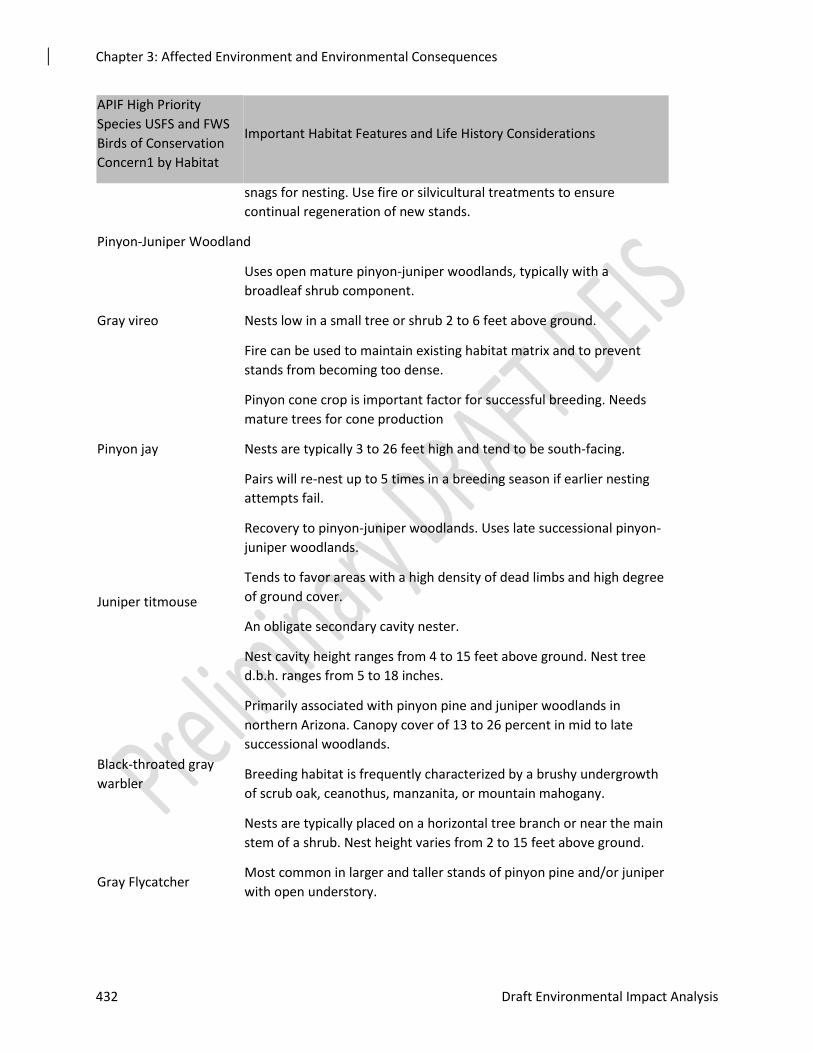
Chapter 3: Affected Environment and Environmental Consequences
432 Draft Environmental Impact Analysis
APIF High Priority
Species USFS and FWS
Birds of Conservation
Concern1 by Habitat
Important Habitat Features and Life History Considerations
snags for nesting. Use fire or silvicultural treatments to ensure
continual regeneration of new stands.
Pinyon-Juniper Woodland
Gray vireo
Uses open mature pinyon-juniper woodlands, typically with a
broadleaf shrub component.
Nests low in a small tree or shrub 2 to 6 feet above ground.
Fire can be used to maintain existing habitat matrix and to prevent
stands from becoming too dense.
Pinyon jay
Pinyon cone crop is important factor for successful breeding. Needs
mature trees for cone production
Nests are typically 3 to 26 feet high and tend to be south-facing.
Pairs will re-nest up to 5 times in a breeding season if earlier nesting
attempts fail.
Juniper titmouse
Recovery to pinyon-juniper woodlands. Uses late successional pinyon-
juniper woodlands.
Tends to favor areas with a high density of dead limbs and high degree
of ground cover.
An obligate secondary cavity nester.
Nest cavity height ranges from 4 to 15 feet above ground. Nest tree
d.b.h. ranges from 5 to 18 inches.
Black-throated gray
warbler
Primarily associated with pinyon pine and juniper woodlands in
northern Arizona. Canopy cover of 13 to 26 percent in mid to late
successional woodlands.
Breeding habitat is frequently characterized by a brushy undergrowth
of scrub oak, ceanothus, manzanita, or mountain mahogany.
Nests are typically placed on a horizontal tree branch or near the main
stem of a shrub. Nest height varies from 2 to 15 feet above ground.
Gray Flycatcher Most common in larger and taller stands of pinyon pine and/or juniper
with open understory.
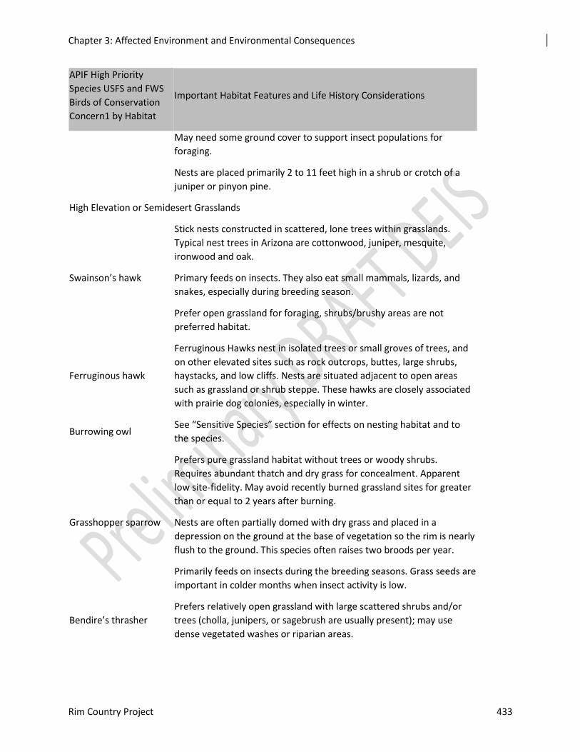
Chapter 3: Affected Environment and Environmental Consequences
Rim Country Project 433
APIF High Priority
Species USFS and FWS
Birds of Conservation
Concern1 by Habitat
Important Habitat Features and Life History Considerations
May need some ground cover to support insect populations for
foraging.
Nests are placed primarily 2 to 11 feet high in a shrub or crotch of a
juniper or pinyon pine.
High Elevation or Semidesert Grasslands
Swainson’s hawk
Stick nests constructed in scattered, lone trees within grasslands.
Typical nest trees in Arizona are cottonwood, juniper, mesquite,
ironwood and oak.
Primary feeds on insects. They also eat small mammals, lizards, and
snakes, especially during breeding season.
Prefer open grassland for foraging, shrubs/brushy areas are not
preferred habitat.
Ferruginous hawk
Ferruginous Hawks nest in isolated trees or small groves of trees, and
on other elevated sites such as rock outcrops, buttes, large shrubs,
haystacks, and low cliffs. Nests are situated adjacent to open areas
such as grassland or shrub steppe. These hawks are closely associated
with prairie dog colonies, especially in winter.
Burrowing owl See “Sensitive Species” section for effects on nesting habitat and to
the species.
Grasshopper sparrow
Prefers pure grassland habitat without trees or woody shrubs.
Requires abundant thatch and dry grass for concealment. Apparent
low site-fidelity. May avoid recently burned grassland sites for greater
than or equal to 2 years after burning.
Nests are often partially domed with dry grass and placed in a
depression on the ground at the base of vegetation so the rim is nearly
flush to the ground. This species often raises two broods per year.
Primarily feeds on insects during the breeding seasons. Grass seeds are
important in colder months when insect activity is low.
Bendire’s thrasher
Prefers relatively open grassland with large scattered shrubs and/or
trees (cholla, junipers, or sagebrush are usually present); may use
dense vegetated washes or riparian areas.
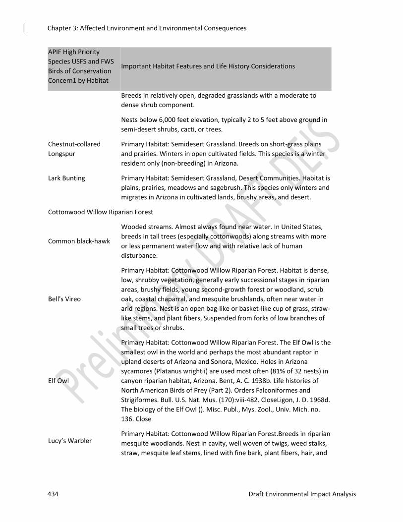
Chapter 3: Affected Environment and Environmental Consequences
434 Draft Environmental Impact Analysis
APIF High Priority
Species USFS and FWS
Birds of Conservation
Concern1 by Habitat
Important Habitat Features and Life History Considerations
Breeds in relatively open, degraded grasslands with a moderate to
dense shrub component.
Nests below 6,000 feet elevation, typically 2 to 5 feet above ground in
semi-desert shrubs, cacti, or trees.
Chestnut-collared
Longspur
Primary Habitat: Semidesert Grassland. Breeds on short-grass plains
and prairies. Winters in open cultivated fields. This species is a winter
resident only (non-breeding) in Arizona.
Lark Bunting Primary Habitat: Semidesert Grassland, Desert Communities. Habitat is
plains, prairies, meadows and sagebrush. This species only winters and
migrates in Arizona in cultivated lands, brushy areas, and desert.
Cottonwood Willow Riparian Forest
Common black-hawk
Wooded streams. Almost always found near water. In United States,
breeds in tall trees (especially cottonwoods) along streams with more
or less permanent water flow and with relative lack of human
disturbance.
Bell's Vireo
Primary Habitat: Cottonwood Willow Riparian Forest. Habitat is dense,
low, shrubby vegetation, generally early successional stages in riparian
areas, brushy fields, young second-growth forest or woodland, scrub
oak, coastal chaparral, and mesquite brushlands, often near water in
arid regions. Nest is an open bag-like or basket-like cup of grass, straw-
like stems, and plant fibers, Suspended from forks of low branches of
small trees or shrubs.
Elf Owl
Primary Habitat: Cottonwood Willow Riparian Forest. The Elf Owl is the
smallest owl in the world and perhaps the most abundant raptor in
upland deserts of Arizona and Sonora, Mexico. Holes in Arizona
sycamores (Platanus wrightii) are used most often (81% of 32 nests) in
canyon riparian habitat, Arizona. Bent, A. C. 1938b. Life histories of
North American Birds of Prey (Part 2). Orders Falconiformes and
Strigiformes. Bull. U.S. Nat. Mus. (170):viii-482. CloseLigon, J. D. 1968d.
The biology of the Elf Owl (). Misc. Publ., Mys. Zool., Univ. Mich. no.
136. Close
Lucy’s Warbler Primary Habitat: Cottonwood Willow Riparian Forest.Breeds in riparian
mesquite woodlands. Nest in cavity, well woven of twigs, weed stalks,
straw, mesquite leaf stems, lined with fine bark, plant fibers, hair, and
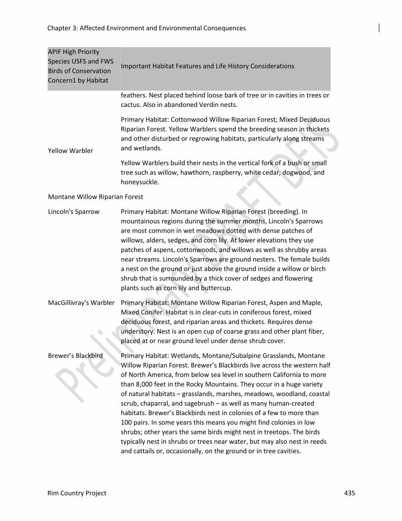
Chapter 3: Affected Environment and Environmental Consequences
Rim Country Project 435
APIF High Priority
Species USFS and FWS
Birds of Conservation
Concern1 by Habitat
Important Habitat Features and Life History Considerations
feathers. Nest placed behind loose bark of tree or in cavities in trees or
cactus. Also in abandoned Verdin nests.
Yellow Warbler
Primary Habitat: Cottonwood Willow Riparian Forest; Mixed Deciduous
Riparian Forest. Yellow Warblers spend the breeding season in thickets
and other disturbed or regrowing habitats, particularly along streams
and wetlands.
Yellow Warblers build their nests in the vertical fork of a bush or small
tree such as willow, hawthorn, raspberry, white cedar, dogwood, and
honeysuckle.
Montane Willow Riparian Forest
Lincoln's Sparrow Primary Habitat: Montane Willow Riparian Forest (breeding). In
mountainous regions during the summer months, Lincoln's Sparrows
are most common in wet meadows dotted with dense patches of
willows, alders, sedges, and corn lily. At lower elevations they use
patches of aspens, cottonwoods, and willows as well as shrubby areas
near streams. Lincoln's Sparrows are ground nesters. The female builds
a nest on the ground or just above the ground inside a willow or birch
shrub that is surrounded by a thick cover of sedges and flowering
plants such as corn lily and buttercup.
MacGillivray's Warbler Primary Habitat: Montane Willow Riparian Forest, Aspen and Maple,
Mixed Conifer. Habitat is in clear-cuts in coniferous forest, mixed
deciduous forest, and riparian areas and thickets. Requires dense
understory. Nest is an open cup of coarse grass and other plant fiber,
placed at or near ground level under dense shrub cover.
Brewer’s Blackbird Primary Habitat: Wetlands, Montane/Subalpine Grasslands, Montane
Willow Riparian Forest. Brewer’s Blackbirds live across the western half
of North America, from below sea level in southern California to more
than 8,000 feet in the Rocky Mountains. They occur in a huge variety
of natural habitats – grasslands, marshes, meadows, woodland, coastal
scrub, chaparral, and sagebrush – as well as many human-created
habitats. Brewer’s Blackbirds nest in colonies of a few to more than
100 pairs. In some years this means you might find colonies in low
shrubs; other years the same birds might nest in treetops. The birds
typically nest in shrubs or trees near water, but may also nest in reeds
and cattails or, occasionally, on the ground or in tree cavities.
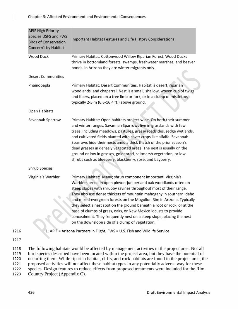
Chapter 3: Affected Environment and Environmental Consequences
436 Draft Environmental Impact Analysis
APIF High Priority
Species USFS and FWS
Birds of Conservation
Concern1 by Habitat
Important Habitat Features and Life History Considerations
Wood Duck Primary Habitat: Cottonwood Willow Riparian Forest. Wood Ducks
thrive in bottomland forests, swamps, freshwater marshes, and beaver
ponds. In Arizona they are winter migrants only.
Desert Communities
Phainopepla Primary Habitat: Desert Communities. Habitat is desert, riparian
woodlands, and chaparral. Nest is a small, shallow, woven cup of twigs
and fibers, placed on a tree limb or fork, or in a clump of mistletoe,
typically 2-5 m (6.6-16.4 ft.) above ground.
Open Habitats
Savannah Sparrow Primary Habitat: Open habitats project-wide. On both their summer
and winter ranges, Savannah Sparrows live in grasslands with few
trees, including meadows, pastures, grassy roadsides, sedge wetlands,
and cultivated fields planted with cover crops like alfalfa. Savannah
Sparrows hide their nests amid a thick thatch of the prior season’s
dead grasses in densely vegetated areas. The nest is usually on the
ground or low in grasses, goldenrod, saltmarsh vegetation, or low
shrubs such as blueberry, blackberry, rose, and bayberry.
Shrub Species
Virginia’s Warbler Primary Habitat: Many; shrub component important. Virginia's
Warblers breed in open pinyon-juniper and oak woodlands often on
steep slopes with shrubby ravines throughout most of their range.
They also use dense thickets of mountain mahogany in southern Idaho
and mixed-evergreen forests on the Mogollon Rim in Arizona. Typically
they select a nest spot on the ground beneath a root or rock, or at the
base of clumps of grass, oaks, or New Mexico locusts to provide
concealment. They frequently nest on a steep slope, placing the nest
on the downslope side of a clump of vegetation.
1. APIF = Arizona Partners in Flight; FWS = U.S. Fish and Wildlife Service 1216
1217
The following habitats would be affected by management activities in the project area. Not all 1218 bird species described have been located within the project area, but they have the potential of 1219 occurring there. While riparian habitat, cliffs, and rock habitats are found in the project area, the 1220 proposed activities will not affect these habitat types in any potentially adverse way for these 1221 species. Design features to reduce effects from proposed treatments were included for the Rim 1222 Country Project (Appendix C). 1223
Chapter 3: Affected Environment and Environmental Consequences
Rim Country Project 437
Mixed Conifer with Aspen and w/ Frequent Fire 1224
It is estimated that 1,216,300 acres of Mixed Conifer occur in New Mexico and Arizona. The 1225 Tonto (58,829 acres), A-S (325,900), and Coconino (86.738 acres) National Forests represent 1226 471,467 acres (1/3 of Mixed Conifer in NM and AZ). Priority breeding birds that use mixed 1227 conifer as primary habitats are Olive-sided Flycatcher, Evening Grosbeak, Red-faced Warbler, 1228 and Band-tailed Pigeon. Desired for mixed conifer conditions describe a mosaic of forest 1229 conditions, with old growth well-distributed throughout. Snags and downed logs are numerous. 1230 Composition, structure and function are resilient to disturbances and climate variability. MCFF 1231 is more open than MCA. The project area contains approximately 2,506 acres of MCA and 1232 47,993 acres of MCFF. Together these acres represent 50,549 acres or approximately 6 percent 1233 of the Mixed Conifer PNVT on the Coconino, Apache-Sitgreaves, and Tonto NFs. 1234
Ponderosa Pine Habitat Type 1235
In the context of Arizona Partners in Flight data, pine forest refers to northern Arizona ponderosa 1236 pine forests, including pure ponderosa pine and pine with Gambel oak (Latta et al. 1999). It is 1237 estimated that approximately 3,680,000 acres of ponderosa pine forest exists in Arizona, 1238 representing approximately five percent of the total land area of the state. It occupies much of the 1239 mountain and plateau country above 6,500 feet in elevation, replaced by mixed conifer forest 1240 above 8,500 feet (Latta et al. 1999). Priority birds for ponderosa pine are the Northern Goshawk, 1241 Flammulated Owl, Olive-sided Flycatcher, Cordilleran Flycatcher, Grace’s Warbler, Olive 1242 Warbler, Lewis’s Woodpecker, Purple Martin, Cassin’s Finch, Common Nighthawk, and 1243 Mexican Whip-poor-will. The project area contains approximately 689,503 acres of ponderosa 1244 pine habitat. The project area is approximately 14 percent of the ponderosa pine habitat in 1245 Arizona and 14 percent of the ponderosa pine forest cover type on both the Coconino and 1246 Apache-Sitgreaves NFs. 1247
Aspen Habitat Type 1248
In some areas, aspen forms extensive pure stands. In others, aspen is a minor component of the 1249 forest landscape, and can be found in ponderosa pine, and mixed conifer stands (Latta et al 1250 1999). It is estimated that approximately 79,000 acres of aspen exist in Arizona. Aspen stands 1251 typically have a maximum life span of 200 years. Without a substantial disturbance such as high-1252 severity fire or overstory removal to stimulate early seral renewal, the aspen will die out as it 1253 becomes dominated by conifers (Latta et al 1999). The priority bird for this habitat type is the 1254 red-faced Sapsucker. The project area contains approximately 1,436 acres of aspen habitat. The 1255 project area is approximately 2 percent of the aspen habitat in Arizona and 4 percent of the aspen 1256 on both the Coconino and Apache-Sitgreaves NFs 1257
Pinyon-Juniper Habitat Type 1258
It is estimated that there is approximately 13,167,460 acres of pinyon-juniper forest in Arizona. 1259 Pinyon-juniper is a cold-adapted evergreen woodland situated above desert or grassland 1260 vegetation and below ponderosa pine forests. The habitat is characterized by varying co-1261 dominance of juniper species and pinyon pine. Typically, pinyon-juniper exhibits an open 1262 woodland arrangement with well-spaced trees. However, depending on site variables, pinyon-1263 juniper may range from an openly spaced savanna to closed woodland (Latta et al. 1999). The 1264 priority birds for the pinyon-juniper habitat type are Gray Vireo, Pinyon Jay, Juniper Titmouse, 1265 Black-throated-gray Warbler, and Gray Flycatcher. The project area contains approximately 1266 114,753 acres of pinyon-juniper habitat. The project area is less than one percent of the pinyon-1267 juniper habitat on both the Coconino and Apache-Sitgreaves NFs. 1268
Chapter 3: Affected Environment and Environmental Consequences
438 Draft Environmental Impact Analysis
Chaparral 1269
Desired conditions describe chaparral as being in a constant state of transitions between young 1270 and old stages as a result of fires. Young stages have more of a grass and forb component. 1271 Older stages are very dense. Fire hazard is reduced in the wildland-urban interface. Ground 1272 cover protects soils from compaction and erosion, and biological soil crusts improve nutrient 1273 cycling. 1274
Desired conditions on the Coconino NF provide for habitat diversity within chaparral vegetation. 1275 Small amounts of this habitat type could be treated through facilitative operations. Therefore, 1276 there will be few effects, plus or minus, to Virginia’s warbler and black-chinned and sage 1277 sparrows and their habitat. The priority species for the chaparral habitat type is the Black-1278 chinned Sparrow. 1279
High Elevation Grasslands Habitat Type 1280
The high elevation grassland habitat type is defined by Arizona Partners in Flight as subalpine-1281 alpine grasslands/montane meadows and Plains/Great Basin grasslands. Upland grasslands in 1282 northern Arizona comprise all grass-dominated sites from the lower limits of the montane zone 1283 up to alpine tundra. There are an estimated 20,230 acres of upland grasslands in the state. 1284 Plains/Great Basin grasslands occur in northern Arizona; while they cover a much larger area 1285 than upland grasslands, there are no current estimates for acreage (Latta et al. 1999). Priority 1286 birds that use high elevation grasslands are Brewer’s Blackbird, Common Nighthawk, and 1287 Ferruginous Hawk. Priority species that use semi-desert grassland habitat for breeding are 1288 Bendire’s Thrasher and Phainopepla. Additionally, the Chestnut-collared Longspur, 1289 Grasshopper Sparrow, and Lark Bunting use these habitats for overwintering. The project area 1290 contains approximately 31,293 acres of grassland habitat. The project area is approximately 10 1291 percent of the grassland habitat on both the Coconino and Apache-Sitgreaves NFs. 1292
Riparian - High Elevation (Montane Willow and Mixed Broadleaf) and Low Elevation (Cottonwood Willow) 1293
It is estimated that less than 10 percent of Arizona’s original riparian acreage remains in its 1294 natural form. These habitats are considered Arizona’s most rare natural communities. Priority 1295 bird species that use high elevation riparian habitat are Brewer’s Blackbird, Common Black-1296 Hawk, Lincoln’s Sparrow, MacGillivray’s Warbler, Red-faced Warbler, and Yellow-Warbler. 1297 Species that use low elevation riparian are Bell’s Vireo, Elf Owl, Lucy’s Warbler, Wood Duck, 1298 and Yellow Warbler. The action alternatives propose to restore 14,730 acres of riparian areas for 1299 aquatic stream habitat. The action alternatives also propose to restore function and habitat in up 1300 to 777 miles of streams, including stream reaches with habitat for threatened, endangered, and 1301 sensitive aquatic species. 1302
Desert Communities and Semi-Desert Grasslands 1303
Priority species that use these habitats for breeding are Bendire’s Thrasher and Phainopepla. 1304 Additionally, the Chestnut-collared Longspur, Ferruginous Hawk, Grasshopper Sparrow, and 1305 Lark Bunting use these habitats for overwintering. This habitat type occurs in small numbers in 1306 the project area, with minimal or very low proposed treatments. 1307
Open Habitats 1308
A number of priority bird species that only occur in the project area in the winter can be found in 1309 open habitats in the Verde Valley (e.g. Chestnut-collared Longspur, Grasshopper Sparrow, 1310 Savannah Sparrow, and Lark Bunting). 1311
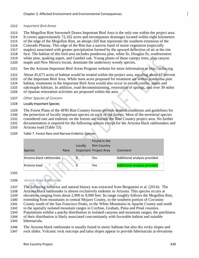
Chapter 3: Affected Environment and Environmental Consequences
Rim Country Project 439
Important Bird Areas 1312
The Mogollon Rim Snowmelt Draws Important Bird Area is the only one within the project area. 1313 It covers approximately 72,162 acres and encompasses drainages located within eight kilometers 1314 of the edge of the Mogollon Rim, an abrupt cliff that represents the southern extension of the 1315 Colorado Plateau. This edge of the Rim has a narrow band of moist vegetation (especially 1316 maples) associated with greater precipitation formed by the upward deflection of air at the rim 1317 face. The habitat of this bird area includes ponderosa pine, white fir, Douglas fir, southwestern 1318 white pine, quaking aspen, and Gambel oak. Young plants of these canopy trees, plus canyon 1319 maple and New Mexico locust, dominate the understory woody species. 1320
See the Arizona Important Bird Areas Program website for more information at http://aziba.org. 1321
About 45,673 acres of habitat would be treated within the project area, equaling about 61 percent 1322 of the Important Bird Area. While most acres proposed for treatment are within ponderosa pine 1323 habitat, treatments in the Important Bird Area would also occur in mixed conifer, aspen and 1324 oak/maple habitats. In addition, road decommissioning, restoration of springs, and over 30 miles 1325 of riparian restoration activities are proposed within the area. 1326
Other Species of Concern 1327
Locally Important Species 1328
The Forest Plans of the 4FRI Rim Country forests provide desired conditions and guidelines for 1329 the protection of locally important species on each of the forests. Most of the terrestrial species 1330 considered rare and endemic on the forests are outside the Rim Country project area. No further 1331 documentation is required for the following species except for the Arizona black rattlesnakes and 1332 Arizona toad (Table 53). 1333
Table 7. Forest Rare and Narrow Endemic Species 1334
Species Rare
Locally
Important
Found in the
Rim Country
Project Area Comment
Arizona black rattlesnake
X Yes Additional analysis provided
Arizona toad X Yes Additional analysis provided
1335
Arizona Black Rattlesnake 1336
The following behavior and natural history was extracted from Bergamini et al. (2014): The 1337 Arizona black rattlesnake is almost exclusively endemic to Arizona. This species occurs at 1338 elevations ranging from about 2,900 to 9,900 feet. Its range roughly follows the Mogollon Rim, 1339 extending from mountains in central Mojave County, to the southern portion of Coconino 1340 County south of the San Francisco Peaks, to the White Mountains in Apache County and south 1341 to the spatially isolated mountain ranges in Cochise, Graham, Pima and Pinal counties. 1342 Populations exhibit a patchy distribution in isolated canyons and mountain ranges; the patchiness 1343 of their distribution is likely associated concomitantly with favorable habitat and suitable 1344 hibernacula. 1345
The Arizona black rattlesnake is usually found in mesic habitats but also dry rocky slopes and 1346 rock slides. Volcanic rock outcrops and talus slopes appear to provide hibernacula at elevations 1347
Chapter 3: Affected Environment and Environmental Consequences
440 Draft Environmental Impact Analysis
between about 6,900 and 9,850 feet. The species is also strongly associated with downed woody 1348 debris, and this association may be more important than tree species associations 1349
Arizona black rattlesnakes individually or communally den in hibernacula during cold, winter 1350 months, but emerge from dens and become active from late April or May to October. Ingress into 1351 dens at these sites occur in early October; however, Arizona black rattlesnakes have been 1352 observed inside or near the opening of dens in March and in November. 1353
In Coconino County, home ranges for males averaged 67 acres with a range of 52 to 225 acres 1354 Schofer 2017). Females appear to have much smaller ranges than males, perhaps slightly less 1355 than 10 percent of a male’s range. 1356
Arizona Toad 1357
This species has been petitioned for listing under the Endangered Species Act. While AZGFD 1358 does not have population data, opportunistic data from AZGFD biologists and scientific 1359 collecting permits suggest that populations continue to persist across their historical range in 1360 Arizona. Within and adjacent to the Rim Country boundary, AZGFD has observational data of 1361 Arizona toads from 2003 to 2015 from Chevelon, East Clear, Cherry, Webber, Crouch and 1362 Canyon Creeks and some of their their tributaries, as well as the East Verde River. Additionally, 1363 several occurrences on the Tonto have been reported from earthen stock tanks. The species 1364 breeds in shallow springs and backwater areas void of fish. 1365
Environmental Consequences 1366
Environmental consequences consist of species analyses, beginning with federally threatened 1367 and endangered species followed by Forest Service sensitive species, management indicator 1368 species, migratory birds, and effects on Important Bird Areas. Following the analysis of direct 1369 and indirect effects for each species group is a review of cumulative effects. 1370
Effects from Climate Change 1371
Alternative 1 1372
Alternative 1 would not prevent, delay, or ameliorate predicted effects from climate change. The 1373 dense forest conditions resulting from Alternative 1 are at a high risk to density-related and bark 1374 beetle mortality and have limited resilience to survive and recover from potential large-scale fire 1375 events and the interactions of these influences with climate change. Under drier and warmer 1376 weather conditions, the potential effects of these risks on the ecosystem would be increased. 1377 Individual tree growth would be limited to the point of stagnation. As tree density increases, 1378 many areas would experience higher mortality. Species requiring closed canopy forest conditions 1379 or old or large tree, snag, and log structure would be negatively affected in the long term. Patches 1380 of open forest, savanna, and meadow and grassland habitats would potentially increase in the 1381 long term as groups of dense forest succumb to the above mortality agents. 1382
Alternatives 2 and 3 1383
Risks associated with dense forest conditions would be reduced and resilience to the effects from 1384 large-scale disturbance under drier and warmer conditions would be improved by implementing 1385 the proposed treatments. Individual tree growth rates would improve, creating and retaining more 1386 large and old trees. Habitat elements associated with closed canopy forest conditions would be 1387 reduced, but would be more sustainable. Risk from insects, fire, and their interactions with 1388 climate would be reduced. Because of law, regulation, and policy, more closed canopy habitat 1389 would be available than what likely occurred historically. Ensuring the growth and retention of 1390 large trees would maintain large snag and log structure across the forest over time. Open forest, 1391
Chapter 3: Affected Environment and Environmental Consequences
Rim Country Project 441
meadow, savanna, and grassland habitats would be enhanced and habitat effectiveness increased 1392 as encroaching trees were removed and habitat for grassland and pollinator species became less 1393 fragmented. These habitats would remain stable in the long term. The increased acres of 1394 mechanical and prescribed fire under Alternative 2 would realize the most benefit in terms of 1395 forest health and resiliency. The limited acres of treatment under Alternative 3 would be 1396 expected to maintain higher fuel loadings, resulting in more limited gains in forest resiliency due 1397 to increased flame lengths, lower canopy base height, and persistent ladder fuels. Alternative 3 1398 would retain the densest forests and therefore achieve the least in terms of large tree growth rates 1399 and resilience. 1400
Federally Listed Threatened, Endangered, Proposed, and Candidate Species and 1401
Critical Habitat 1402
Chiricahua Leopard Frog (CLF) 1403
Existing Condition 1404
Riparian and aquatic habitat in the project area is heavily affected by recreation and past 1405 management activities. The purpose and need of the 4FRI Rim Country Project includes 1406 improvement of aquatic species habitat and improvement of the condition and function of 1407 streams and springs. 1408
The Rim Country Project occurs within 142 subwatersheds. Of these, 38 have less than five 1409 percent of their total area inside the project boundary. Overall, ponderosa pine cover types are 1410 dominant in functional-at-risk 6th code watersheds (about 451,500 acres, or 46 percent of the 1411 project area), several impaired watersheds (about 316,800 acres, or 32 percent of the project 1412 area), and a few properly functioning watersheds (about 220,400 acres, or 22 percent of the 1413 project area). 1414
Alternative 1 (No Action) 1415
Under Alternative 1, habitat conditions for wildlife would largely remain in their current 1416 condition. Thinning and prescribed fire would still occur in RU 5 as a result of current and 1417 reasonably foreseeable projects. However, the landscape would continue to move away from 1418 desired conditions (see Affected Environment above and the Silviculture and Fire Ecology and 1419 Air Quality Reports). Alternative 1 would have no direct effect on Chiricahua leopard frogs; 1420 however there would be substantial indirect effects. Dense forest conditions would still occur and 1421 the high fire hazard potential would persist. Large crown-wildfires could adversely affect 1422 potential habitat by destroying understory and overstory vegetation. As a result, overland flow 1423 would increase, and soil erosion would increase, with potentially high sediment loads. Water 1424 quality and riparian conditions would be adversely affected on a wide-scale basis (see Water and 1425 Riparian Resource Report), resulting in indirect adverse effects. 1426
With Alternative 1, there would be no restoration of springs and riparian areas. These areas 1427 would continue to exhibit downward trends in functional condition or remain in static condition 1428 for the foreseeable future (see Water and Riparian Resource Report), resulting in degradation of 1429 potential habitat for frogs. 1430
Denser forest conditions produce lower values in understory biomass (pounds per acre). Under 1431 Alternative 1, understory biomass would continue to decline over the next 40 years. Limited 1432 cover around tanks and riparian areas, as well as the limited herbaceous understory across the 1433 project area, would continue to reduce the likelihood that frogs would successfully disperse and 1434 feed while traveling between waters. The limited cover would also leave frogs vulnerable to 1435 predation. 1436
Chapter 3: Affected Environment and Environmental Consequences
442 Draft Environmental Impact Analysis
Cumulative Effects 1437
The area analyzed for cumulative effects for northern leopard frogs is RU 5 within the project 1438 area and a 0.25-mile buffer outside of the project boundary, along RU 5 to include current and 1439 potential breeding sites. Cumulative effects include the effects from Alternative 1. This 1440 alternative would continue to result in indirect effects on Chiricahua leopard frogs. Degradation 1441 of habitat facilitated by this alternative would cumulatively combine with other forest activities, 1442 high-impact recreational use, livestock grazing, and habitat loss and degradation on private 1443 lands. Synergistic effects from climate change would continue to fragment key aquatic and 1444 dispersal habitat. 1445
Critical Habitat 1446
Two critical habitat management area units are within the action area: the Ellison and Lewis 1447 Creek management area and the Crouch, Gentry, Cherry Creeks, and Parallel Canyon 1448 management area (Figures 3-** and 3-** above). No change is expected to occur in these 1449 management area units under the no action alternative. 1450
Determination of Effect 1451
Alternative 1 may affect and is likely to adversely affect the Chiricahua leopard frog and its 1452 designated critical habitat. 1453
Effects Common to All Action Alternatives 1454
Alternatives 2 and 3 would allow discharge from springs to resume flow through their historic 1455 spheres of discharge. Restoration implementation would increase riparian vegetation increasing 1456 availability of food and reproductive sites for this species over the long term, resulting in direct 1457 beneficial effects on habitat. Restoration would improve cover and water flow that provides 1458 escape from predators and prevents water loss for migrating leopard frogs. 1459
Alternative 2 – Modified Proposed Action 1460
Direct and Indirect Effects 1461
Leopard frogs dispersing overland could be directly affected if they are inadvertently run over by 1462 mechanical equipment or if they could not find refugia during prescribed fire activities. All 1463 suitable habitat would be surveyed prior to restoration activities. Design features (see below and 1464 Appendix 5 of the wildlife specialist report) would reduce the likelihood of direct effects on 1465 frogs from mechanical thinning, temporary road construction, spring and riparian restoration, 1466 road decommissioning, and prescribed fire. 1467
Under the proposed action, dense forest conditions and surface fuel loading in RU 5 would be 1468 reduced. The likelihood of large crown wildfires adversely affecting potential habitat by 1469 destroying understory and overstory vegetation would be reduced from 327,867 acres (59 1470 percent) of all ponderosa pine to 129,762 acres (23 percent). Fire hazard index in grasslands 1471 would also be greatly reduced, from 5,000 acres to 138 acres). As a result, overland flow would 1472 be stable, and soil erosion would not have the high sediment loading potential. Water quality 1473 would not be adversely affected on a wide scale, resulting in indirect beneficial effects. 1474
Under Alternative 2, spring and riparian restoration is proposed only in unoccupied habitat or 1475 with coordination with USFW. An important consideration for restoration of springs is to restore 1476 discharge from the spring source except where prescribed by existing adjudicated water rights. 1477 Alternative 2 would allow discharge from springs to resume flow through their historic spheres 1478 of discharge. Restoration implementation would increase riparian vegetation increasing 1479
Chapter 3: Affected Environment and Environmental Consequences
Rim Country Project 443
availability of food and reproductive sites for this species over the long term, resulting in direct 1480 beneficial effects on habitat. Restoration would improve cover and water flow that provides 1481 escape from predators and prevents water loss for migrating leopard frogs. 1482
Decommissioning unauthorized roads in RU 5 would improve the quality of the habitat in those 1483 areas where the roads are decommissioned. While the physical structure and features of the 1484 habitat may not measurably change along the former road alignment, eliminating disturbance 1485 along the roadway would be expected to improve the quality of habitat and reduce the potential 1486 for frogs to be crushed by vehicles using these roads. With each mile of road affecting 1487 approximately three acres of habitat, many acres of forested habitat may be improved within 1488 Chiricahua leopard frog breeding and dispersal habitat. Long-term effects would include habitat 1489 improvements over current conditions. 1490
Constructing temporary roads would disturb vegetation and reduce habitat quality for leopard 1491 frogs. These effects may affect individuals but are expected to be short term, occurring only 1492 during project implementation. Temporary roads would be decommissioned to eliminate use and 1493 vegetation would be restored over the long term. 1494
Implementation of the proposed action could increase the risk of spread of Chytrid fungus across 1495 the project area. Machinery and equipment used during implementation could transfer Chytrid 1496 fungus between waterbodies, increasing the occurrence of the pathogen in leopard frog habitats 1497 across the project area. Potential effects from Chytrid fungus that is spread by machinery and 1498 equipment would be minimized by requiring decontamination procedures to be followed when 1499 activities take place within wetted areas or the moist perimeter of a tank or ephemeral stream and 1500 then immediately moving to another wetted area (see design features in Appendix C). Therefore, 1501 minimal potential for spread would exist. 1502
Under the proposed action, surface disturbance within proximity of suitable habitats would 1503 increase. The use of heavy machinery and increased levels of human activity and traffic are 1504 likely to increase sedimentation in the earthen livestock tanks in the vicinity, especially in those 1505 located downslope from treatment areas. Effects from sedimentation on leopard frog habitats are 1506 extensive and varied. They include alterations in water quality and vegetation structure that 1507 ultimately have detrimental effects on leopard frogs by decreasing rate of development, 1508 increasing vulnerability to predators, and reducing food availability. 1509
Prescribed burning direct impacts are not likely, as most often, short term indirect impacts could 1510 occur due to sedimentation and increased ash flow. Prescribed burns where the majority of 1511 critical breeding sites occur would be coordinated with a wildlife biologist to insure protections 1512 for migrating frogs.. In coordination with AZGFD, occupied, critical breeding, and potential 1513 breeding sites have been identified and mapped and will be included in the individual task order 1514 map with a protected water designation. Project design features (see below and Appendix 5 of 1515 the Wildlife Specialist Report) have been developed to reduce the potential effects on these 1516 important breeding sites and frogs using and moving between these sites. Implementation of best 1517 management practices would curtail soil erosion and minimize the potential for inflow into 1518 potential Chiricahua leopard frog habitat. 1519
Critical Habitat 1520
Effects on the primary constituent elements (PCE) of critical habitat are similar to the effects on 1521 suitable Chiricahua leopard frog habitat as described above. No long-term changes are expected 1522 to occur to any primary element from implementing the proposed action. Short-term effects on 1523 primary elements are possible related to water quality if precipitation follows directly after a 1524 burn, but these effects would be temporary and characteristics would return to pre-burn 1525
Chapter 3: Affected Environment and Environmental Consequences
444 Draft Environmental Impact Analysis
conditions. The proposed action would not significantly alter any of the characteristics of critical 1526 habitat primary constituent elements for the Chiricahua leopard frog. 1527
PCE 1 – Aquatic breeding habitat and immediately adjacent uplands: Thinning and 1528 prescribed fire would only occur in riparian areas or near important aquatic habitat with 1529 coordination with a wildlife biologist. Thinning and prescribed fire would not remove or reduce 1530 standing bodies of water within the action area. In the unlikely event that water is needed for fire 1531 abatement, it would not be drawn from any suitable or designated critical habitat but instead 1532 taken from an external source. Treatments under controlled conditions would reduce future 1533 sedimentation potential. Temporary roads needed to access areas for thinning would follow 1534 design features to mitigate soil and watershed damage. Prescribed fire would be managed to 1535 ensure lower-severity fire behavior, allowing for fuel reduction without soil damage. These 1536 actions would reduce the potential for sedimentation, ash accumulation, and the influx of 1537 pollutants that may degrade the water quality of important aquatic sites. It is unlikely for 1538 emergent or aquatic vegetation to be completely removed by back-burning fire because of 1539 moisture levels in riparian plants, burning techniques (back-burning), and the time in which 1540 prescribed burning would take place around frog populations. Some upland vegetation could be 1541 removed but this disturbance is expected to be short term and rebound during the following 1542 growing season. 1543
Any effects that may occur as a result of the proposed action are anticipated to be insignificant 1544 given design features to reduce effects from implementation have been added to the proposed 1545 action (see Appendix C). These measures are in place to ensure that the proposed action would 1546 not contribute to the spread of nonnative predators and chytridiomycosis. 1547
PCE 2 – Dispersal and nonbreeding habitat: Thinning and prescribed fire would only occur in 1548 riparian areas or near important aquatic habitat with coordination with a wildlife biologist. The 1549 proposed action would have no effect on CLF movement. Most structural features within 1550 dispersal habitat would be maintained (boulders, rocks, large downed logs, small mammal 1551 burrows); however, short-term effects on organic debris and leaf litter would occur. Overall, 1552 thinning, prescribed fire, and aquatic restoration implementation would have long-term 1553 beneficial effects by restoring habitat and protecting designated critical habitat from stand-1554 replacing wildfires. 1555
Cumulative Effects 1556
The area analyzed for cumulative effects for Chiricahua leopard frogs is RU 5 within the Rim 1557 Country project area and a 0.25-mile buffer outside of the project boundary along RU 5 to 1558 include current and potential breeding sites. This alternative would result in short-term direct and 1559 indirect effects on Chiricahua leopard frogs (see above). Restoration of aquatic habitats 1560 facilitated by this alternative would slow the combined cumulative effects from other forest 1561 activities, high-impact recreational use, livestock grazing, and habitat loss and degradation on 1562 private lands. Cumulatively, restoration implementation of key aquatic and dispersal habitat 1563 would link, rather than fragment, these habitats allowing for the needs of breeding and dispersing 1564 leopard frogs. 1565
Determination of Effect 1566
Implementation of Alternative 2 may affect, and is likely to adversely affect Chiricahua 1567 leopard frogs and its critical habitat. 1568
Chapter 3: Affected Environment and Environmental Consequences
Rim Country Project 445
Alternative 3 – Focused Alternative 1569
Direct and Indirect Effects 1570
Direct and indirect effects from Alternative 3 would be similar to Alternative 2. Alternative 3 1571 includes the same miles and acres of riparian restoration, while reducing the total number of 1572 acres thinned and treated with prescribed burning. Potential effects from chytrid fungus that is 1573 spread by machinery and equipment would be minimized by requiring decontamination 1574 procedures to be followed when activities take place within wetted areas or the moist perimeter 1575 of a tank or ephemeral stream. Therefore, minimal potential for spread would exist. 1576
Alternative 3 treats fewer forested acres in Rim Country. Additional meadow and grassland 1577 treatments are scattered throughout the project area and would occur in most of the area, 1578 increasing the likelihood that frogs would successfully forage around and migrate between 1579 available habitats due to decreased risk of predation. Project design features have been developed 1580 (see Appendix C) to reduce the potential of effects on important breeding sites and the frogs 1581 using and moving between these sites. 1582
Critical Habitat 1583
Same as Alternative 2. 1584
Cumulative Effects 1585
Same as Alternative 2. 1586
Determination of Effect 1587
Implementation of Alternative 3 may affect, and is likely to adversely affect the Chiricahua 1588 leopard frog and its critical habitat. 1589
Mexican Spotted Owl (Threatened) 1590
Existing Condition 1591
Fire 1592
Fire Hazard Index 1593
Changes in potential fire behavior (Fire Hazard Index) in MSO habitat types (Table 3-**), was 1594 modeled by the fire ecologist (see Fire Ecology and Air Quality Report) under existing 1595 conditions in 150 PACs. Forty-six (46) PACs were not modeled because they are in other project 1596 areas or in areas where no treatment is planned. Of this 120,976 acres modeled, 91,617 acres (76 1597 percent) are in need of treatment as they have a higher potential for high-severity wildfire. The 1598 High and Extreme Need for Treatment categories of Fire Hazard Index constitute 49,888 or 41 1599 percent of all PACs modeled in the project area, expected to experience high-severity wildfire. 1600
In Nest/Roost Recovery habitat, the fire hazard index modeled 10,288 acres, with 7,609 acres (74 1601 percent) in need of treatment as they have the potential of experiencing high-severity wildfire. 1602 The High and Extreme Need for Treatment categories of Fire Hazard Index constitute 4,174 1603 acres (41 percent) of all nest/roost recovery habitat in the project area are expected to experience 1604 high-severity wildfire. 1605
In Foraging/Non-Breeding Recovery habitat, the fire hazard index modeled 41,878 acres, with 1606 24,947 acres (59 percent) in need of treatment as they have the potential of experiencing high-1607 severity wildfire. The High and Extreme Need for Treatment categories of Fire Hazard Index 1608 constitute 10,717 acres (25 percent) of all foraging-other recovery habitat in the project area are 1609 expected to experience high-severity wildfire. 1610

Chapter 3: Affected Environment and Environmental Consequences
446 Draft Environmental Impact Analysis
The potential for wildfire activity that would result in more severe effects on ecosystem 1611 components than that which should occur in a natural fire regime is illustrated by this analysis. 1612 The fire hazard index would be greatly reduced in the action alternatives (see the Analysis for the 1613 MSO by Alternatives section). 1614
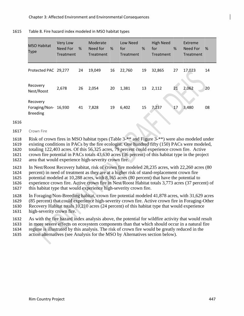
Chapter 3: Affected Environment and Environmental Consequences
Rim Country Project 447
Table 8. Fire hazard index modeled in MSO habitat types 1615
MSO Habitat
Type
Very Low
Need For
Treatment
%
Moderate
Need for
Treatment
%
Low Need
for
Treatment
%
High Need
for
Treatment
%
Extreme
Need For
Treatment
%
Protected PAC 29,277 24 19,049 16 22,760 19 32,865 27 17,023 14
Recovery
Nest/Roost 2,678 26 2,054 20 1,381 13 2,112 21 2,062 20
Recovery
Foraging/Non-
Breeding
16,930 41 7,828 19 6,402 15 7,237 17 3,480 08
1616
Crown Fire 1617
Risk of crown fires in MSO habitat types (Table 3-** and Figure 3-**) were also modeled under 1618 existing conditions in PACs by the fire ecologist. One hundred fifty (150) PACs were modeled, 1619 totaling 122,403 acres. Of this 56,325 acres, 79 percent could experience crown fire. Active 1620 crown fire potential in PACs totals 43,630 acres (36 percent) of this habitat type in the project 1621 area that would experience high-severity crown fire. 1622
In Nest/Roost Recovery habitat, risk of crown fire modeled 28,235 acres, with 22,260 acres (80 1623 percent) in need of treatment as they are at a higher risk of stand-replacement crown fire 1624 potential modeled at 10,288 acres, with 8,165 acres (80 percent) that have the potential to 1625 experience crown fire. Active crown fire in Nest/Roost Habitat totals 3,773 acres (37 percent) of 1626 this habitat type that would experience high-severity crown fire. 1627
In Foraging/Non-Breeding habitat, crown fire potential modeled 41,878 acres, with 31,629 acres 1628 (85 percent) that could experience high-severity crown fire. Active crown fire in Foraging-Other 1629 Recovery Habitat totals 10,210 acres (24 percent) of this habitat type that would experience 1630 high-severity crown fire. 1631
As with the fire hazard index analysis above, the potential for wildfire activity that would result 1632 in more severe effects on ecosystem components than that which should occur in a natural fire 1633 regime is illustrated by this analysis. The risk of crown fire would be greatly reduced in the 1634 action alternatives (see Analysis for the MSO by Alternatives section below). 1635
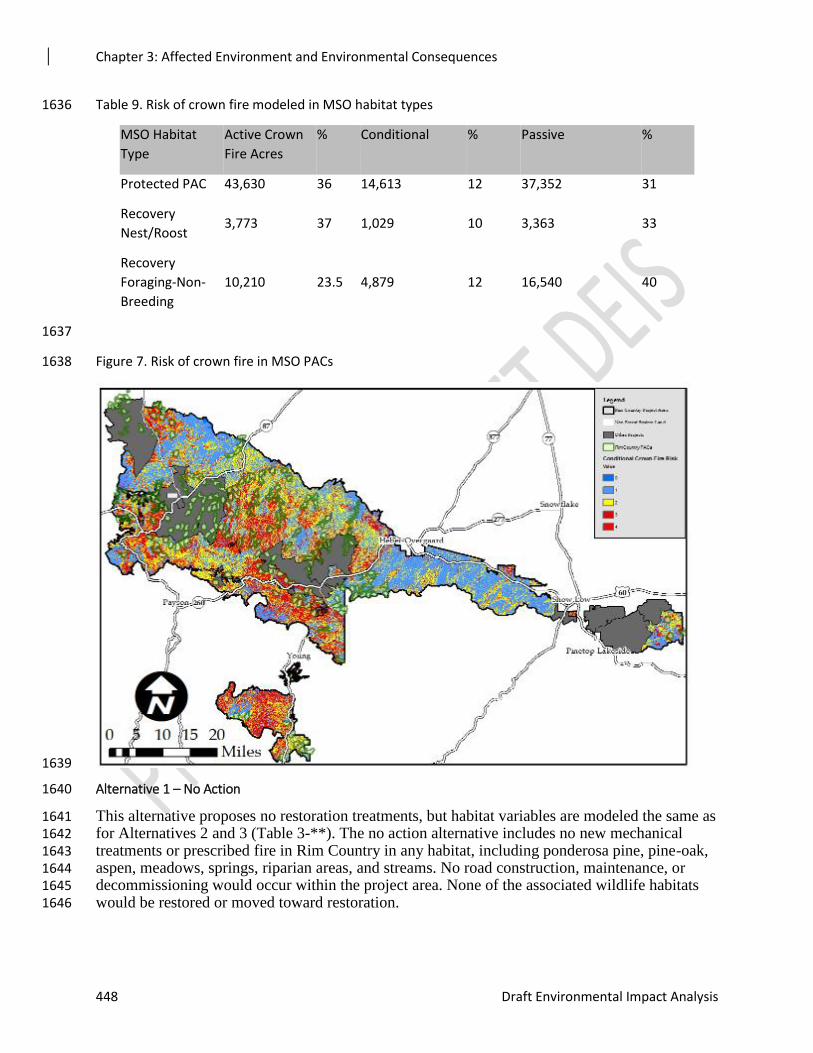
Chapter 3: Affected Environment and Environmental Consequences
448 Draft Environmental Impact Analysis
Table 9. Risk of crown fire modeled in MSO habitat types 1636
MSO Habitat
Type
Active Crown
Fire Acres
% Conditional % Passive %
Protected PAC 43,630 36 14,613 12 37,352 31
Recovery
Nest/Roost 3,773 37 1,029 10 3,363 33
Recovery
Foraging-Non-
Breeding
10,210 23.5 4,879 12 16,540 40
1637
Figure 7. Risk of crown fire in MSO PACs 1638
1639
Alternative 1 – No Action 1640
This alternative proposes no restoration treatments, but habitat variables are modeled the same as 1641 for Alternatives 2 and 3 (Table 3-**). The no action alternative includes no new mechanical 1642 treatments or prescribed fire in Rim Country in any habitat, including ponderosa pine, pine-oak, 1643 aspen, meadows, springs, riparian areas, and streams. No road construction, maintenance, or 1644 decommissioning would occur within the project area. None of the associated wildlife habitats 1645 would be restored or moved toward restoration. 1646

Chapter 3: Affected Environment and Environmental Consequences
Rim Country Project 449
Table 10. FVS Modeled Effects on Key Habitat Variables in PACs from No Action Alternative 1647
PACs MC = 16,481 Acres Modeled PO = 56,180
Acres Modeled
Existing Condition No Action 2029 No Action 2039
Avg of Trees per Acre MC 1291 1170 1057
Avg of Trees per Acre PO 1276 1130 990
Avg of Basal Area MC 173 185 196
Avg of Basal Area PO 144 155 163
Avg of Stand Density Index MC 398 414 425
Avg of Stand Density Index PO 339 353 362
Avg of Quadratic Mean Diameter in Inches MC 6 6 7
Avg of Quadratic Mean Diameter in Inches PO 6 6 7
Avg of SNAG 12-18 MC 4 3 3
Avg of SNAG 12-18 PO 2 3 3
Avg of SNAG 18-24 MC 2 1 1
Avg of SNAG 18-24 PO 1 1 1
Avg of SNAG > 24 MC 1 1 1
Avg of SNAG > 24 PO 0 0 0
Percent CANCOV Regression from BA MC 74 76 78
Percent CANCOV Regression from BA PO 69 71 73
Avg of Surface Fuel tons per acre MC 29 33 35
Avg of Surface Fuel tons per acre PO 20 23 25
Avg of Coarse Woody Debris 3”+ tons per acre MC 10 12 14
Avg of Coarse Woody Debris 3”+ tons per acre PO 8 9 10
Avg of Herbaceous tons per acre MC 0.21 0.21 0.20
Avg of Herbaceous tons per acre PO 0.21 0.21 0.21
Average of Shrubs tons per acre MC 0.40 0.37 0.34
Average of Shrubs tons per acre PO 0.23 0.23 0.23
Avg of ALL BA1 0-1” MC 1 1 1
Avg of ALL BA1 0-1” PO 1 1 1
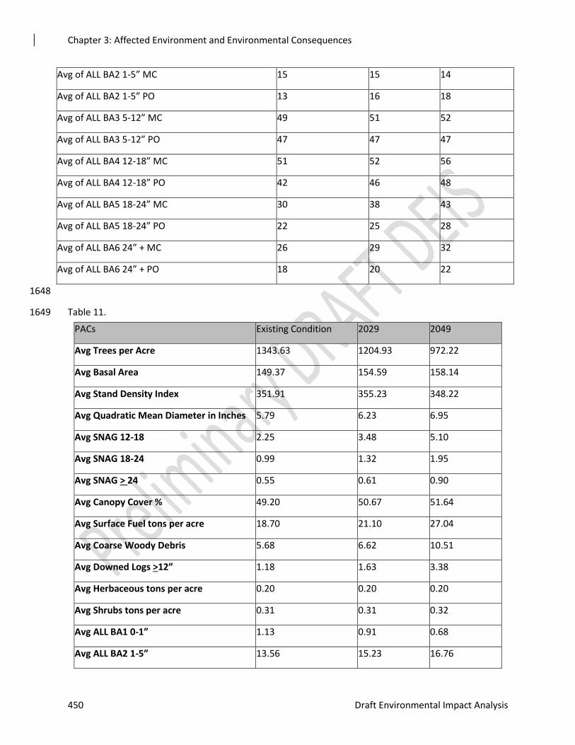
Chapter 3: Affected Environment and Environmental Consequences
450 Draft Environmental Impact Analysis
1648
Table 11. 1649
PACs Existing Condition 2029 2049
Avg Trees per Acre 1343.63 1204.93 972.22
Avg Basal Area 149.37 154.59 158.14
Avg Stand Density Index 351.91 355.23 348.22
Avg Quadratic Mean Diameter in Inches 5.79 6.23 6.95
Avg SNAG 12-18 2.25 3.48 5.10
Avg SNAG 18-24 0.99 1.32 1.95
Avg SNAG > 24 0.55 0.61 0.90
Avg Canopy Cover % 49.20 50.67 51.64
Avg Surface Fuel tons per acre 18.70 21.10 27.04
Avg Coarse Woody Debris 5.68 6.62 10.51
Avg Downed Logs >12” 1.18 1.63 3.38
Avg Herbaceous tons per acre 0.20 0.20 0.20
Avg Shrubs tons per acre 0.31 0.31 0.32
Avg ALL BA1 0-1” 1.13 0.91 0.68
Avg ALL BA2 1-5” 13.56 15.23 16.76
Avg of ALL BA2 1-5” MC 15 15 14
Avg of ALL BA2 1-5” PO 13 16 18
Avg of ALL BA3 5-12” MC 49 51 52
Avg of ALL BA3 5-12” PO 47 47 47
Avg of ALL BA4 12-18” MC 51 52 56
Avg of ALL BA4 12-18” PO 42 46 48
Avg of ALL BA5 18-24” MC 30 38 43
Avg of ALL BA5 18-24” PO 22 25 28
Avg of ALL BA6 24” + MC 26 29 32
Avg of ALL BA6 24” + PO 18 20 22
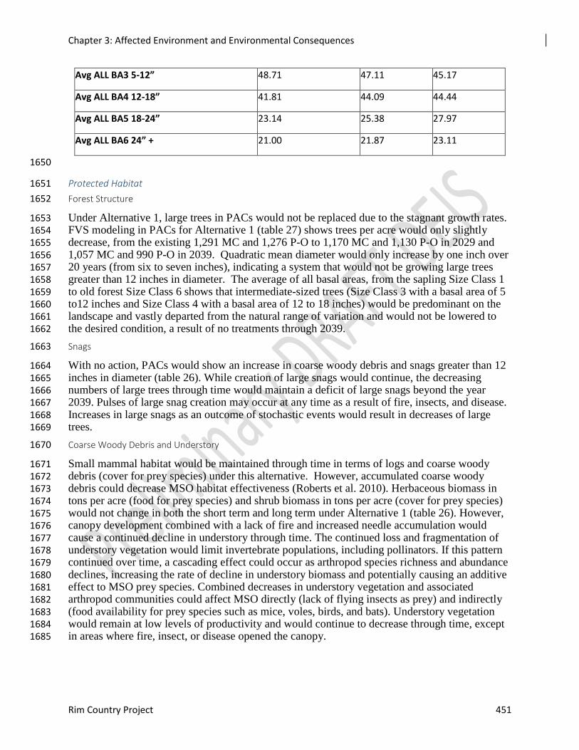
Chapter 3: Affected Environment and Environmental Consequences
Rim Country Project 451
Avg ALL BA3 5-12” 48.71 47.11 45.17
Avg ALL BA4 12-18” 41.81 44.09 44.44
Avg ALL BA5 18-24” 23.14 25.38 27.97
Avg ALL BA6 24” + 21.00 21.87 23.11
1650
Protected Habitat 1651
Forest Structure 1652
Under Alternative 1, large trees in PACs would not be replaced due to the stagnant growth rates. 1653 FVS modeling in PACs for Alternative 1 (table 27) shows trees per acre would only slightly 1654 decrease, from the existing 1,291 MC and 1,276 P-O to 1,170 MC and 1,130 P-O in 2029 and 1655 1,057 MC and 990 P-O in 2039. Quadratic mean diameter would only increase by one inch over 1656 20 years (from six to seven inches), indicating a system that would not be growing large trees 1657 greater than 12 inches in diameter. The average of all basal areas, from the sapling Size Class 1 1658 to old forest Size Class 6 shows that intermediate-sized trees (Size Class 3 with a basal area of 5 1659 to12 inches and Size Class 4 with a basal area of 12 to 18 inches) would be predominant on the 1660 landscape and vastly departed from the natural range of variation and would not be lowered to 1661 the desired condition, a result of no treatments through 2039. 1662
Snags 1663
With no action, PACs would show an increase in coarse woody debris and snags greater than 12 1664 inches in diameter (table 26). While creation of large snags would continue, the decreasing 1665 numbers of large trees through time would maintain a deficit of large snags beyond the year 1666 2039. Pulses of large snag creation may occur at any time as a result of fire, insects, and disease. 1667 Increases in large snags as an outcome of stochastic events would result in decreases of large 1668 trees. 1669
Coarse Woody Debris and Understory 1670
Small mammal habitat would be maintained through time in terms of logs and coarse woody 1671 debris (cover for prey species) under this alternative. However, accumulated coarse woody 1672 debris could decrease MSO habitat effectiveness (Roberts et al. 2010). Herbaceous biomass in 1673 tons per acre (food for prey species) and shrub biomass in tons per acre (cover for prey species) 1674 would not change in both the short term and long term under Alternative 1 (table 26). However, 1675 canopy development combined with a lack of fire and increased needle accumulation would 1676 cause a continued decline in understory through time. The continued loss and fragmentation of 1677 understory vegetation would limit invertebrate populations, including pollinators. If this pattern 1678 continued over time, a cascading effect could occur as arthropod species richness and abundance 1679 declines, increasing the rate of decline in understory biomass and potentially causing an additive 1680 effect to MSO prey species. Combined decreases in understory vegetation and associated 1681 arthropod communities could affect MSO directly (lack of flying insects as prey) and indirectly 1682 (food availability for prey species such as mice, voles, birds, and bats). Understory vegetation 1683 would remain at low levels of productivity and would continue to decrease through time, except 1684 in areas where fire, insect, or disease opened the canopy. 1685
Chapter 3: Affected Environment and Environmental Consequences
452 Draft Environmental Impact Analysis
Fire Effects 1686
Maintaining the current trajectory for forest conditions would maintain the increasing risk of 1687 uncharacteristic fire. Ponderosa pine ecosystems would become increasingly departed from 1688 desired conditions under Alternative 1, increasing risks to ecosystem structure, pattern, 1689 composition, and function. Fire hazard index and risk of crown fire (modeling shown in the 1690 existing condition section) are greatly increased in the No Action Alternative compared to the 1691 action alternatives. 1692
Surface fuel loading in protected habitat, including litter, duff, and coarse woody debris greater 1693 than three inches, would be high under Alternative 1, moving from an existing condition of 18.7 1694 tons per acre to 27.04 tons per acre in 2049 (Table 3-**. Fire Hazard Index Modeled in MSO 1695 Habitat Types). Crown fire would be more likely if surface fuel build-up continues, leading to 1696 increased flame lengths. High surface fuel loadings can negatively affect MSO prey populations 1697 by altering the understory vegetation response, negatively affecting food resources for prey 1698 species. 1699
Fire Hazard Index high and extreme need for treatment categories are increased under 1700 Alternative 1 from 49,889 acres (41 percent of the PACs in the project area in need of treatment) 1701 in existing condition to 57,191 acres (47 percent) of all PACs in the project area are expected to 1702 experience high-severity wildfire. In Recovery Nest/Roost habitat 4,175 acres (41 percent) of 1703 Nest/Roost Recovery habitat in the project area) with high and extreme need for treatment in the 1704 existing condition goes to 4,991 acres (49 percent) in Alternative 1. Foraging/Non-breeding 1705 Recovery habitat goes from 10,717 acres (26 percent) with high and extreme need for treatment 1706 in the existing condition to 14,337 acres (34 percent) in Alternative 1. 1707
1708
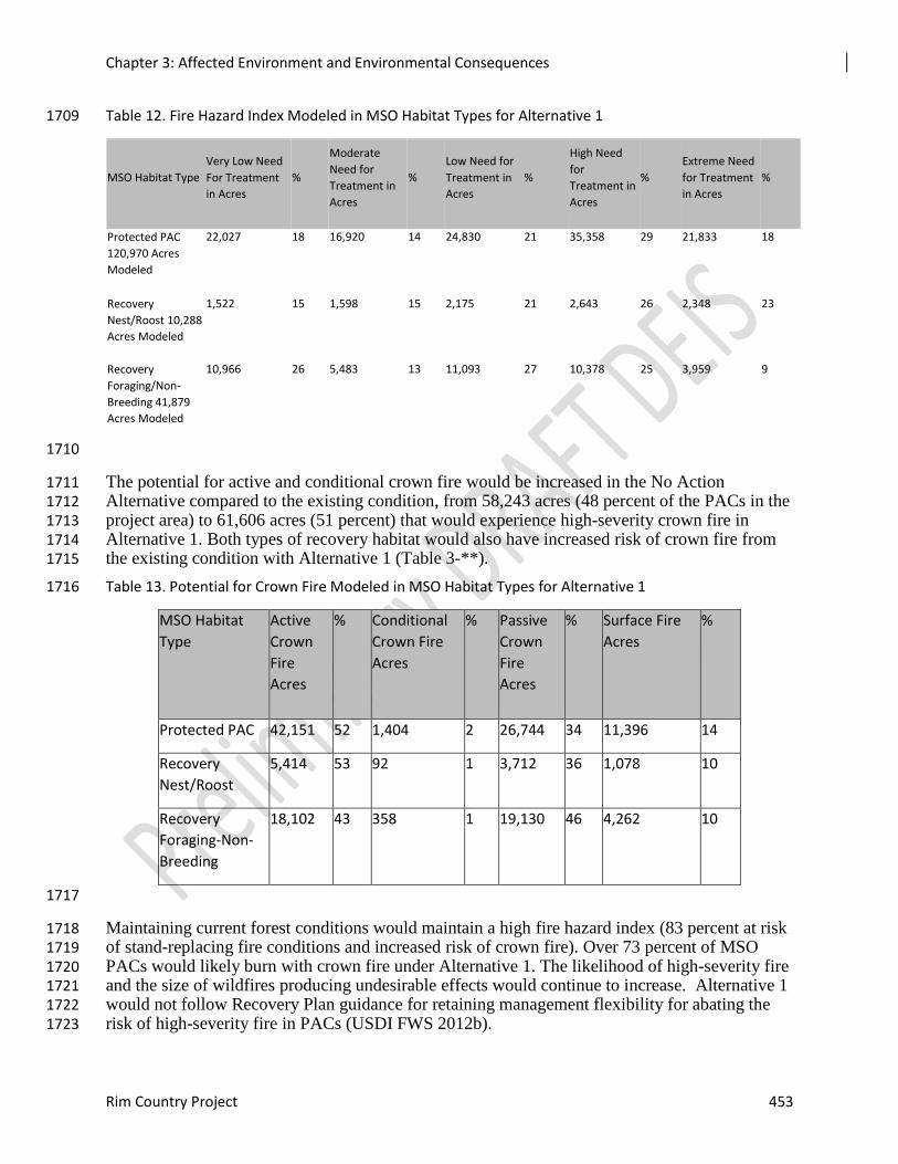
Chapter 3: Affected Environment and Environmental Consequences
Rim Country Project 453
Table 12. Fire Hazard Index Modeled in MSO Habitat Types for Alternative 1 1709
MSO Habitat Type
Very Low Need
For Treatment
in Acres
%
Moderate
Need for
Treatment in
Acres
%
Low Need for
Treatment in
Acres
%
High Need
for
Treatment in
Acres
%
Extreme Need
for Treatment
in Acres
%
Protected PAC
120,970 Acres
Modeled
22,027 18 16,920 14 24,830 21 35,358 29 21,833 18
Recovery
Nest/Roost 10,288
Acres Modeled
1,522 15 1,598 15 2,175 21 2,643 26 2,348 23
Recovery
Foraging/Non-
Breeding 41,879
Acres Modeled
10,966 26 5,483 13 11,093 27 10,378 25 3,959 9
1710
The potential for active and conditional crown fire would be increased in the No Action 1711 Alternative compared to the existing condition, from 58,243 acres (48 percent of the PACs in the 1712 project area) to 61,606 acres (51 percent) that would experience high-severity crown fire in 1713 Alternative 1. Both types of recovery habitat would also have increased risk of crown fire from 1714 the existing condition with Alternative 1 (Table 3-**). 1715
Table 13. Potential for Crown Fire Modeled in MSO Habitat Types for Alternative 1 1716
MSO Habitat
Type
Active
Crown
Fire
Acres
% Conditional
Crown Fire
Acres
% Passive
Crown
Fire
Acres
% Surface Fire
Acres
%
Protected PAC 42,151 52 1,404 2 26,744 34 11,396 14
Recovery
Nest/Roost
5,414 53 92 1 3,712 36 1,078 10
Recovery
Foraging-Non-
Breeding
18,102 43 358 1 19,130 46 4,262 10
1717
Maintaining current forest conditions would maintain a high fire hazard index (83 percent at risk 1718 of stand-replacing fire conditions and increased risk of crown fire). Over 73 percent of MSO 1719 PACs would likely burn with crown fire under Alternative 1. The likelihood of high-severity fire 1720 and the size of wildfires producing undesirable effects would continue to increase. Alternative 1 1721 would not follow Recovery Plan guidance for retaining management flexibility for abating the 1722 risk of high-severity fire in PACs (USDI FWS 2012b). 1723
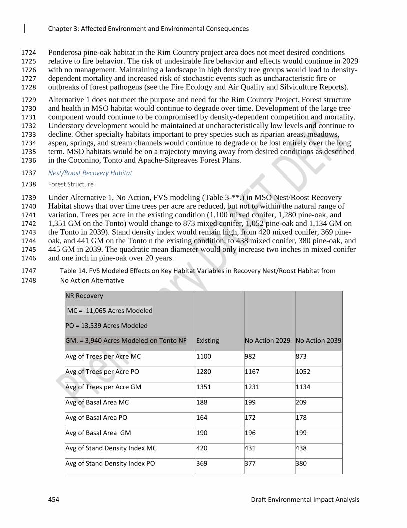
Chapter 3: Affected Environment and Environmental Consequences
454 Draft Environmental Impact Analysis
Ponderosa pine-oak habitat in the Rim Country project area does not meet desired conditions 1724 relative to fire behavior. The risk of undesirable fire behavior and effects would continue in 2029 1725 with no management. Maintaining a landscape in high density tree groups would lead to density-1726 dependent mortality and increased risk of stochastic events such as uncharacteristic fire or 1727 outbreaks of forest pathogens (see the Fire Ecology and Air Quality and Silviculture Reports). 1728
Alternative 1 does not meet the purpose and need for the Rim Country Project. Forest structure 1729 and health in MSO habitat would continue to degrade over time. Development of the large tree 1730 component would continue to be compromised by density-dependent competition and mortality. 1731 Understory development would be maintained at uncharacteristically low levels and continue to 1732 decline. Other specialty habitats important to prey species such as riparian areas, meadows, 1733 aspen, springs, and stream channels would continue to degrade or be lost entirely over the long 1734 term. MSO habitats would be on a trajectory moving away from desired conditions as described 1735 in the Coconino, Tonto and Apache-Sitgreaves Forest Plans. 1736
Nest/Roost Recovery Habitat 1737
Forest Structure 1738
Under Alternative 1, No Action, FVS modeling (Table 3-**.) in MSO Nest/Roost Recovery 1739 Habitat shows that over time trees per acre are reduced, but not to within the natural range of 1740 variation. Trees per acre in the existing condition (1,100 mixed conifer, 1,280 pine-oak, and 1741 1,351 GM on the Tonto) would change to 873 mixed conifer, 1,052 pine-oak and 1,134 GM on 1742 the Tonto in 2039). Stand density index would remain high, from 420 mixed conifer, 369 pine-1743 oak, and 441 GM on the Tonto n the existing condition, to 438 mixed conifer, 380 pine-oak, and 1744 445 GM in 2039. The quadratic mean diameter would only increase two inches in mixed conifer 1745 and one inch in pine-oak over 20 years. 1746
Table 14. FVS Modeled Effects on Key Habitat Variables in Recovery Nest/Roost Habitat from 1747
No Action Alternative 1748
NR Recovery
MC = 11,065 Acres Modeled
PO = 13,539 Acres Modeled
GM. = 3,940 Acres Modeled on Tonto NF Existing No Action 2029 No Action 2039
Avg of Trees per Acre MC 1100 982 873
Avg of Trees per Acre PO 1280 1167 1052
Avg of Trees per Acre GM 1351 1231 1134
Avg of Basal Area MC 188 199 209
Avg of Basal Area PO 164 172 178
Avg of Basal Area GM 190 196 199
Avg of Stand Density Index MC 420 431 438
Avg of Stand Density Index PO 369 377 380
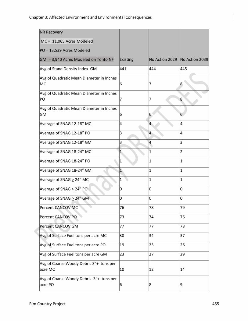
Chapter 3: Affected Environment and Environmental Consequences
Rim Country Project 455
NR Recovery
MC = 11,065 Acres Modeled
PO = 13,539 Acres Modeled
GM. = 3,940 Acres Modeled on Tonto NF Existing No Action 2029 No Action 2039
Avg of Stand Density Index GM 441 444 445
Avg of Quadratic Mean Diameter in Inches
MC 6 7 8
Avg of Quadratic Mean Diameter in Inches
PO 7 7 8
Avg of Quadratic Mean Diameter in Inches
GM 6 6 6
Average of SNAG 12-18” MC 4 4 4
Average of SNAG 12-18” PO 3 4 4
Average of SNAG 12-18” GM 3 4 3
Average of SNAG 18-24” MC 1 1 2
Average of SNAG 18-24” PO 1 1 1
Average of SNAG 18-24” GM 1 1 1
Average of SNAG > 24” MC 1 1 1
Average of SNAG > 24” PO 0 0 0
Average of SNAG > 24” GM 0 0 0
Percent CANCOV MC 76 78 79
Percent CANCOV PO 73 74 76
Percent CANCOV GM 77 77 78
Avg of Surface Fuel tons per acre MC 30 34 37
Avg of Surface Fuel tons per acre PO 19 23 26
Avg of Surface Fuel tons per acre GM 23 27 29
Avg of Coarse Woody Debris 3”+ tons per
acre MC 10 12 14
Avg of Coarse Woody Debris 3”+ tons per
acre PO 6 8 9
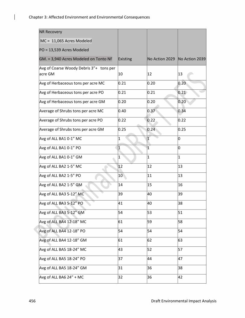
Chapter 3: Affected Environment and Environmental Consequences
456 Draft Environmental Impact Analysis
NR Recovery
MC = 11,065 Acres Modeled
PO = 13,539 Acres Modeled
GM. = 3,940 Acres Modeled on Tonto NF Existing No Action 2029 No Action 2039
Avg of Coarse Woody Debris 3”+ tons per
acre GM 10 12 13
Avg of Herbaceous tons per acre MC 0.21 0.20 0.20
Avg of Herbaceous tons per acre PO 0.21 0.21 0.21
Avg of Herbaceous tons per acre GM 0.20 0.20 0.20
Average of Shrubs tons per acre MC 0.40 0.37 0.34
Average of Shrubs tons per acre PO 0.22 0.22 0.22
Average of Shrubs tons per acre GM 0.25 0.24 0.25
Avg of ALL BA1 0-1” MC 1 1 0
Avg of ALL BA1 0-1” PO 1 1 0
Avg of ALL BA1 0-1” GM 1 1 1
Avg of ALL BA2 1-5” MC 12 12 13
Avg of ALL BA2 1-5” PO 10 11 13
Avg of ALL BA2 1-5” GM 14 15 16
Avg of ALL BA3 5-12” MC 39 40 39
Avg of ALL BA3 5-12” PO 41 40 38
Avg of ALL BA3 5-12” GM 54 53 51
Avg of ALL BA4 12-18” MC 61 59 58
Avg of ALL BA4 12-18” PO 54 54 54
Avg of ALL BA4 12-18” GM 61 62 63
Avg of ALL BA5 18-24” MC 43 52 57
Avg of ALL BA5 18-24” PO 37 44 47
Avg of ALL BA5 18-24” GM 31 36 38
Avg of ALL BA6 24” + MC 32 36 42
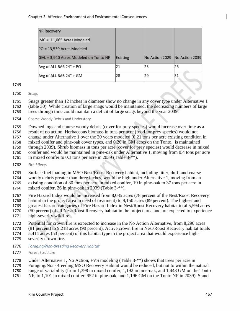
Chapter 3: Affected Environment and Environmental Consequences
Rim Country Project 457
NR Recovery
MC = 11,065 Acres Modeled
PO = 13,539 Acres Modeled
GM. = 3,940 Acres Modeled on Tonto NF Existing No Action 2029 No Action 2039
Avg of ALL BA6 24” + PO 21 23 25
Avg of ALL BA6 24” + GM 28 29 31
1749
Snags 1750
Snags greater than 12 inches in diameter show no change in any cover type under Alternative 1 1751 (table 30). While creation of large snags would be maintained, the decreasing numbers of large 1752 trees through time could maintain a deficit of large snags beyond the year 2039. 1753
Coarse Woody Debris and Understory 1754
Downed logs and course woody debris (cover for prey species) would increase over time as a 1755 result of no action. Herbaceous biomass in tons per acre (food for prey species) would not 1756 change under Alternative 1 over the 20 years modeled (0.21 tons per acre existing condition in 1757 mixed conifer and pine-oak cover types, and 0.20 in GM acres on the Tonto, is maintained 1758 through 2039). Shrub biomass in tons per acre (cover for prey species) would decrease in mixed 1759 conifer and would be maintained in pine-oak under Alternative 1, moving from 0.4 tons per acre 1760 in mixed conifer to 0.3 tons per acre in 2039 (Table 3-**). 1761
Fire Effects 1762
Surface fuel loading in MSO Nest/Roost Recovery habitat, including litter, duff, and coarse 1763 woody debris greater than three inches, would be high under Alternative 1, moving from an 1764 existing condition of 30 tons per acre in mixed conifer, 19 in pine-oak to 37 tons per acre in 1765 mixed conifer, 26 in pine-oak in 2039 (Table 3-**). 1766
Fire Hazard Index would be increased from 8,035 acres (78 percent of the Nest/Roost Recovery 1767 habitat in the project area in need of treatment) to 9,150 acres (89 percent). The highest and 1768 greatest hazard categories of Fire Hazard Index in Nest/Roost Recovery habitat total 5,594 acres 1769 (50 percent) of all Nest/Roost Recovery habitat in the project area and are expected to experience 1770 high-severity wildfire. 1771
Potential for crown fire is expected to increase in the No Action Alternative, from 8,290 acres 1772 (81 percent) to 9,218 acres (90 percent). Active crown fire in Nest/Roost Recovery habitat totals 1773 5,414 acres (53 percent) of this habitat type in the project area that would experience high-1774 severity crown fire. 1775
Foraging/Non-Breeding Recovery Habitat 1776
Forest Structure 1777
Under Alternative 1, No Action, FVS modeling (Table 3-**) shows that trees per acre in 1778 Foraging/Non-Breeding MSO Recovery Habitat would be reduced, but not to within the natural 1779 range of variability (from 1,398 in mixed conifer, 1,192 in pine-oak, and 1,443 GM on the Tonto 1780 NF, to 1,101 in mixed conifer, 952 in pine-oak, and 1,196 GM on the Tonto NF in 2039). Stand 1781
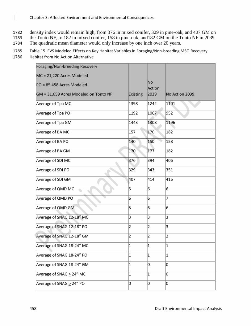
Chapter 3: Affected Environment and Environmental Consequences
458 Draft Environmental Impact Analysis
density index would remain high, from 376 in mixed conifer, 329 in pine-oak, and 407 GM on 1782 the Tonto NF, to 182 in mixed conifer, 158 in pine-oak, and182 GM on the Tonto NF in 2039. 1783 The quadratic mean diameter would only increase by one inch over 20 years. 1784
Table 15. FVS Modeled Effects on Key Habitat Variables in Foraging/Non-breeding MSO Recovery 1785
Habitat from No Action Alternative 1786
Foraging/Non-breeding Recovery
MC = 21,220 Acres Modeled
PO = 85,458 Acres Modeled
GM = 31,659 Acres Modeled on Tonto NF Existing
No
Action
2029 No Action 2039
Average of Tpa MC 1398 1242 1101
Average of Tpa PO 1192 1067 952
Average of Tpa GM 1443 1308 1196
Average of BA MC 157 170 182
Average of BA PO 140 150 158
Average of BA GM 170 177 182
Average of SDI MC 376 394 406
Average of SDI PO 329 343 351
Average of SDI GM 407 414 416
Average of QMD MC 5 6 6
Average of QMD PO 6 6 7
Average of QMD GM 5 6 6
Average of SNAG 12-18” MC 3 3 3
Average of SNAG 12-18” PO 2 2 3
Average of SNAG 12-18” GM 2 2 2
Average of SNAG 18-24” MC 1 1 1
Average of SNAG 18-24” PO 1 1 1
Average of SNAG 18-24” GM 1 0 0
Average of SNAG > 24” MC 1 1 0
Average of SNAG > 24” PO 0 0 0
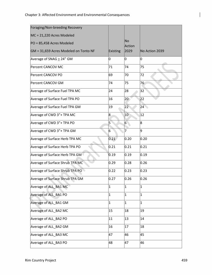
Chapter 3: Affected Environment and Environmental Consequences
Rim Country Project 459
Foraging/Non-breeding Recovery
MC = 21,220 Acres Modeled
PO = 85,458 Acres Modeled
GM = 31,659 Acres Modeled on Tonto NF Existing
No
Action
2029 No Action 2039
Average of SNAG > 24” GM 0 0 0
Percent CANCOV MC 71 74 75
Percent CANCOV PO 69 70 72
Percent CANCOV GM 74 75 76
Average of Surface Fuel TPA MC 24 28 32
Average of Surface Fuel TPA PO 16 20 22
Average of Surface Fuel TPA GM 19 22 24
Average of CWD 3”+ TPA MC 8 10 12
Average of CWD 3”+ TPA PO 5 6 8
Average of CWD 3”+ TPA GM 6 7 9
Average of Surface Herb TPA MC 0.21 0.20 0.20
Average of Surface Herb TPA PO 0.21 0.21 0.21
Average of Surface Herb TPA GM 0.19 0.19 0.19
Average of Surface Shrub TPA MC 0.29 0.28 0.26
Average of Surface Shrub TPA PO 0.22 0.23 0.23
Average of Surface Shrub TPA GM 0.27 0.26 0.26
Average of ALL_BA1 MC 1 1 1
Average of ALL_BA1 PO 1 1 1
Average of ALL_BA1 GM 1 1 1
Average of ALL_BA2 MC 15 18 19
Average of ALL_BA2 PO 11 13 14
Average of ALL_BA2 GM 16 17 18
Average of ALL_BA3 MC 47 46 45
Average of ALL_BA3 PO 48 47 46
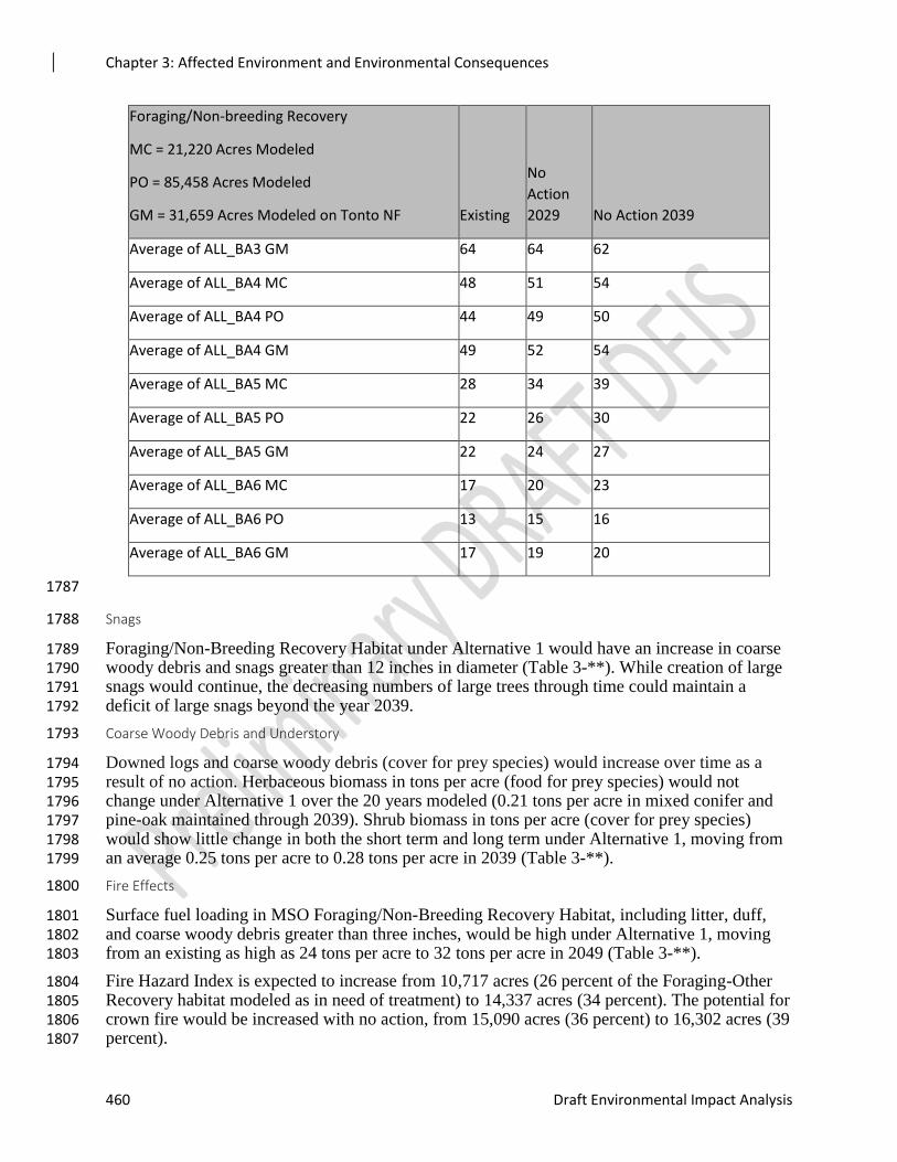
Chapter 3: Affected Environment and Environmental Consequences
460 Draft Environmental Impact Analysis
Foraging/Non-breeding Recovery
MC = 21,220 Acres Modeled
PO = 85,458 Acres Modeled
GM = 31,659 Acres Modeled on Tonto NF Existing
No
Action
2029 No Action 2039
Average of ALL_BA3 GM 64 64 62
Average of ALL_BA4 MC 48 51 54
Average of ALL_BA4 PO 44 49 50
Average of ALL_BA4 GM 49 52 54
Average of ALL_BA5 MC 28 34 39
Average of ALL_BA5 PO 22 26 30
Average of ALL_BA5 GM 22 24 27
Average of ALL_BA6 MC 17 20 23
Average of ALL_BA6 PO 13 15 16
Average of ALL_BA6 GM 17 19 20
1787
Snags 1788
Foraging/Non-Breeding Recovery Habitat under Alternative 1 would have an increase in coarse 1789 woody debris and snags greater than 12 inches in diameter (Table 3-**). While creation of large 1790 snags would continue, the decreasing numbers of large trees through time could maintain a 1791 deficit of large snags beyond the year 2039. 1792
Coarse Woody Debris and Understory 1793
Downed logs and coarse woody debris (cover for prey species) would increase over time as a 1794 result of no action. Herbaceous biomass in tons per acre (food for prey species) would not 1795 change under Alternative 1 over the 20 years modeled (0.21 tons per acre in mixed conifer and 1796 pine-oak maintained through 2039). Shrub biomass in tons per acre (cover for prey species) 1797 would show little change in both the short term and long term under Alternative 1, moving from 1798 an average 0.25 tons per acre to 0.28 tons per acre in 2039 (Table 3-**). 1799
Fire Effects 1800
Surface fuel loading in MSO Foraging/Non-Breeding Recovery Habitat, including litter, duff, 1801 and coarse woody debris greater than three inches, would be high under Alternative 1, moving 1802 from an existing as high as 24 tons per acre to 32 tons per acre in 2049 (Table 3-**). 1803
Fire Hazard Index is expected to increase from 10,717 acres (26 percent of the Foraging-Other 1804 Recovery habitat modeled as in need of treatment) to 14,337 acres (34 percent). The potential for 1805 crown fire would be increased with no action, from 15,090 acres (36 percent) to 16,302 acres (39 1806 percent). 1807
Chapter 3: Affected Environment and Environmental Consequences
Rim Country Project 461
Other Habitat Effects 1808
Springs, Riparian and Stream Habitat, Grasslands, Savannas, Meadows, and Aspen. No 1809 springs or riparian habitat would be restored. One hundred eighty-four (184) springs and 1810 associated prey habitat would remain in degraded condition within the project area, with many 1811 included in PACs. Similarly, wildlife habitat associated with almost 171 miles of riparian stream 1812 channels would remain in degraded condition within MSO habitat. The grasses, forbs, and shrubs 1813 that could potentially occupy these sites would remain absent or limited in both species richness 1814 and abundance. 1815
No grassland, savanna, or meadow treatments would occur, resulting in nearly 350 acres in 1816 PACs and over 60,390 acres (proposed in Alternative 2) of this important habitat continuing to 1817 degrade as a result of pine tree encroachment in MSO habitat. This would represent a decline in 1818 the quantity and quality of habitat for grassland associated species, including obligate migratory 1819 and sensitive avian species. As food and cover decline for small mammals, potential source 1820 populations of important MSO prey species would be expected to decline in the long term. 1821 Overall, the landscape would move toward homogeneity as ponderosa pine continued to 1822 compromise or eliminate these key sources of heterogeneity. 1823
Unique wildlife habitat features associated with 1,230 acres of aspen would decline or vanish as 1824 losses continued. Conifer trees would gradually succeed aspen trees through competition for 1825 space, light, and water, which is a major cause of aspen decline (Johnson 2010). Associated 1826 declines in regional avifauna would occur as a result of habitat loss (Griffis-Kyle and Beier 1827 2003). The rate of avian decline could increase as habitat changes favored nest predators 1828 (Johnson 2010). Understory biomass, which provides the food and cover to support MSO prey 1829 species (e.g., small mammals, birds, and arthropods), would decrease exponentially as conifer 1830 cover increased (Stam et al. 2008). 1831
The effects of these microhabitats are greater than their combined total acres. This is particularly 1832 relevant when these patches of heterogeneity occur in PACs where MSOs disproportionately 1833 forage during the nesting season. 1834
Roads. Under the no action alternative, no new restoration activities would take place and no 1835 additional use of existing roads would occur. Current rates of public and administrative use 1836 would continue. Maintenance to provide public and administrative access would continue, 1837 contingent upon funding. No increase in road maintenance to accommodate restoration activities 1838 would occur. No temporary roads would be constructed, but also no road decommissioning, 1839 unless they are analyzed under separate NEPA analysis. 1840
Direct and Indirect Effects 1841
With no treatments occurring, there would be no direct increase or decrease in habitat quality of 1842 MSO protected, recovery, or critical habitat in the short term. In the long term, MSO habitat 1843 quality would decrease as a result of declines in forest health and resiliency. 1844
The lack of mechanical thinning and low-severity prescribed fire would allow the current forest 1845 trajectory to continue. Dense forests would maintain closed canopy conditions but continue to 1846 exhibit reduced growth rates. The abundance of young and mid-aged forest would continue to 1847 dominate the landscape because of stagnating growth rates and competition-induced mortality of 1848 large trees. Gambel oak, aspen, and meadows would decline as pine encroachment continued. 1849 Spring function would decline as would reaches of riparian habitat channels. Competition for 1850 limited water and nutrients would continue and would increase in time as snow pack decreased 1851 with developing climate change. 1852
Chapter 3: Affected Environment and Environmental Consequences
462 Draft Environmental Impact Analysis
This alternative would not reduce the threat of high-severity fire, which is a primary concern for 1853 the recovery of this species. Surface fuels would continue to increase and understory vegetation 1854 decrease or remain the same. Alternative 1 would not contribute to improving forest health or 1855 vegetation diversity and composition, sustaining old forest structure over time, or moving forest 1856 structure toward the desired conditions. 1857
No additional disturbance from noise, smoke, or other aspects of implementation activities would 1858 occur under this alternative. 1859
Effects Common to Both Action Alternatives 1860
Environmental consequences are described by MSO habitat type (e.g., protected and recovery) 1861 and designated critical habitat. Proposed treatments are similar across MSO habitat types, 1862 although the degree to which they are implemented would vary depending on specific stand 1863 conditions. Modeled results are based on stand-specific outputs and represent the variability in 1864 treatment implementation. The objectives of the treatments are to increase tree growth rates, 1865 retain large pine and oak trees, and increase forest resiliency. Recovery nest/roost habitat would 1866 be managed to maintain or achieve nest/roost conditions sooner than if they were not treated. 1867 Forest conditions in nest/roost habitat would remain at or above nest/roost values after treatments 1868 as shown in Table C.3 of the Recovery Plan. 1869
The objective of the Rim Country treatments in MSO habitat is to improve forest structure for 1870 owls as defined in the Recovery Plan per the Flexible Toolbox Approach for Mechanical 1871 Treatments (Appendix 2). This is different from an emphasis on fuels reduction. Large trees 1872 would be retained, and targeting mid-aged trees would improve the health, growth rates, and 1873 sustainability of large trees. Certain habitat and stand structures warrant additional consideration. 1874 For example, some MSO habitat and certain stand conditions require consideration of additional 1875 management constraints before prescribing treatments. PACs exhibit a variety of topographic 1876 and forest conditions and occupied PACs can already be considered successful nesting habitat. 1877 Mechanical treatments in PACs would be designed to maintain or improve the characteristics 1878 that make each PAC effective at providing habitat while also making them resilient to 1879 disturbance. Consideration should be given to: 1880
1. increasing the number of large trees 1881
2. creating additional foraging habitat for MSO 1882
3. the fire hazard index in the PAC and whether it is in wildland-urban interface (WUI) 1883
4. restoration and protection of other resource values nearby, such as perennial water 1884
5. protecting other values at risk 1885
Treating areas near PACs should be considered in order to improve resiliency in the PACs 1886 themselves. PACs should be treated with consideration of the larger landscape and not just 1887 separate entities. Specific treatments in PACs would be determined prior to implementation and 1888 in coordination with U.S. Fish and Wildlife Service (FWS) personnel. In nest/roost recovery 1889 habitat, the Flexible Toolbox Approach for Mechanical Treatments (Appendix D) states that, 1890 though recovery nest/roost habitat is distinct from PACs, their management objectives are 1891 similar. Any treatment proposed in MSO nest/roost recovery habitat should be designed 1892 specifically to maintain or accelerate the trajectory of these stands towards desired habitat 1893 conditions in the foreseeable future. Achieving management objectives within MSO foraging or 1894 other recovery habitat can be addressed with the flexible toolbox approach. Stands in recovery 1895 habitat would be assigned a treatment using the decision matrices; however, additional 1896
Chapter 3: Affected Environment and Environmental Consequences
Rim Country Project 463
management direction would be applied such as maintaining increased basal area (40-110 BA for 1897 pine-oak and 40-135 BA for mixed conifer). This additional guidance is included in the project 1898 design features to ensure resource protection (see Appendix C). 1899
Habitat Restoration in MSO Habitat 1900
A total of 196 PACs (110,890 acres) occur in the Rim Country project area. An additional 1901 39,748 acres either fall outside of the Rim Country boundary area (11,269 acres) or occur in 1902 other project areas (28,479 acres). These 39,748 acres will be treated as those projects planned 1903 and consulted with FWS. Twenty-nine PACs would have some other type of restoration 1904 (riparian, wet meadow, grassland, aspen, etc. see Actions common to Alternatives 2 and 3 1905 below). In the 4FRI Rim Country project area, up to 82,411 acres of protected MSO habitat are 1906 proposed for thinning and/or burning, or other habitat restoration with Alternatives 2 and 3. 1907 Various restoration activities could occur under Alternatives 2 and 3 in MSO habitat. These 1908 activities include grassland and meadow restoration, spring restoration, riparian stream and 1909 stream channel restoration, stream habitat restoration, and aspen restoration. Acres and miles for 1910 other restoration activities were calculated for PACs (Table 3-**). Recommended design features 1911 to minimize effects on wildlife for all restoration activities proposed in PACs were reviewed and 1912 would not result in additional effects that are not already disclosed (Appendix 5). These activities 1913 would be implemented in recovery habitat types under both Alternatives 2 and 3: however, 1914 design features intended to improve stand and habitat quality would also be applied to achieve 1915 restoration success (see Appendix C). The restoration of these habitat types within recovery 1916 habitat would contribute to the mosaic treatment effect desired in the MSO Recovery and Forest 1917 Plans. 1918
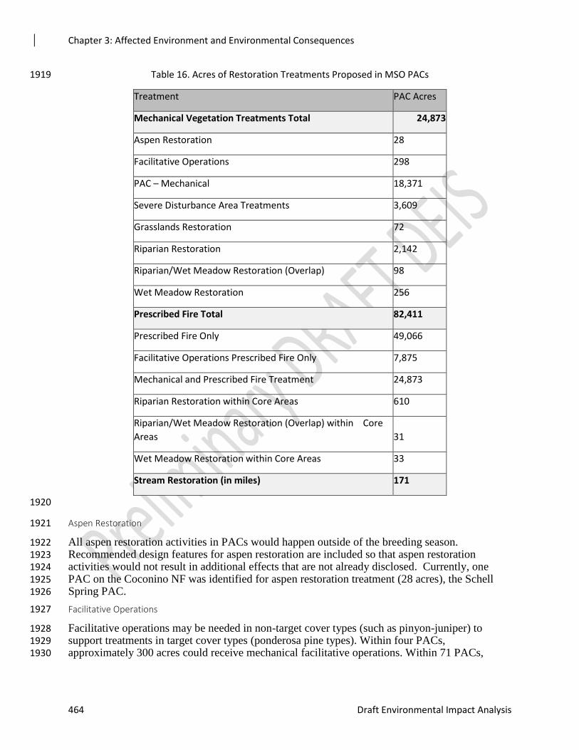
Chapter 3: Affected Environment and Environmental Consequences
464 Draft Environmental Impact Analysis
Table 16. Acres of Restoration Treatments Proposed in MSO PACs 1919
Treatment PAC Acres
Mechanical Vegetation Treatments Total 24,873
Aspen Restoration 28
Facilitative Operations 298
PAC – Mechanical 18,371
Severe Disturbance Area Treatments 3,609
Grasslands Restoration 72
Riparian Restoration 2,142
Riparian/Wet Meadow Restoration (Overlap) 98
Wet Meadow Restoration 256
Prescribed Fire Total 82,411
Prescribed Fire Only 49,066
Facilitative Operations Prescribed Fire Only 7,875
Mechanical and Prescribed Fire Treatment 24,873
Riparian Restoration within Core Areas 610
Riparian/Wet Meadow Restoration (Overlap) within Core
Areas 31
Wet Meadow Restoration within Core Areas 33
Stream Restoration (in miles) 171
1920
Aspen Restoration 1921
All aspen restoration activities in PACs would happen outside of the breeding season. 1922 Recommended design features for aspen restoration are included so that aspen restoration 1923 activities would not result in additional effects that are not already disclosed. Currently, one 1924 PAC on the Coconino NF was identified for aspen restoration treatment (28 acres), the Schell 1925 Spring PAC. 1926
Facilitative Operations 1927
Facilitative operations may be needed in non-target cover types (such as pinyon-juniper) to 1928 support treatments in target cover types (ponderosa pine types). Within four PACs, 1929 approximately 300 acres could receive mechanical facilitative operations. Within 71 PACs, 1930
Chapter 3: Affected Environment and Environmental Consequences
Rim Country Project 465
about 7,880 acres could be treated using prescribed fire facilitative operations. Design features 1931 have been added to mitigate disturbance to MSO from these activities. 1932
Severe Disturbance Areas 1933
Restoration treatments in severe disturbance areas would include combinations of reforestation, 1934 prescribed fire, lopping/scattering, mastication, and other mechanical methods, with the objective 1935 of identifying treatments that would be effective in restoring the fuel structure that produces the 1936 types of fire to which ponderosa pine is adapted. Thirty-three PACs (about 10,070 acres) could 1937 have severe disturbance restoration activities associated with them. Twelve PACs would have 1938 grassland restoration activities on approximately 72 acres. Twenty-seven PACs would have wet 1939 meadow restoration on approximately 420 acres. Design features (see Appendix 5, Appendix C) 1940 have been included to mitigate disturbances to MSO from these activities. 1941
Grassland and Wet Meadow Restoration 1942
Twelve PACs would have grassland restoration activities on approximately 72 acres. Twenty-1943 seven PACs would have wet meadow restoration on approximately 420 acres. Design features 1944 (see Appendix 5, Appendix C) have been included to mitigate disturbances to MSO from these 1945 activities. 1946
Stream and Riparian Restoration 1947
A total of nearly 171 miles of stream restoration, with approximately 2,880 acres of riparian 1948 restoration, could occur in 127 PACs in the Rim Country project area. All restoration activities in 1949 PACs would happen outside of the breeding season. Spring and riparian stream channel and 1950 habitat restoration would also occur in MSO recovery habitat across the project area. See the 1951 Flexible Toolbox Approach for Aquatic and Watershed Restoration Activities for a complete 1952 description of restoration activities proposed (Appendix 3). Design features have been included 1953 to minimize effects on MSO, to promote primary constituent elements in MSO habitat, and to 1954 avoid disturbance to MSO from implementation. 1955
Skid Trails, Excaline, and or Tracked Harvesters 1956
Skid trails could be needed in PACs and recovery habitats in order to accomplish thinning 1957 treatments; however, all would be rehabilitated after harvesting. Ground disturbance from skid 1958 trails can cause indirect effects from the loss of vegetation through compaction and rutting and 1959 exposure of bare mineral soil. Harvest activities with skid trails could adversely affect the prey 1960 base on a short-term basis by affecting individuals of prey species due to disturbance of prey 1961 species’ habitat. As analyzed by the Rim Country soil scientist, 1962
“Mechanical thinning of the ponderosa pine forests of Arizona has been occurring since the 1963 1980s mainly through whole tree harvesting on slopes less than 40 percent. Typical equipment 1964 used for such harvesting includes rubber-tired feller bunchers and rubber-tired skidders with 1965 tracked dozers used for piling of slash. The amount of disturbance as a percentage of a typical 1966 harvest unit (i.e., area included in a thinning contract) affected by compaction, rutting, and/or 1967 exposure of bare mineral soil from this type of harvesting has been estimated to be roughly 15 1968 percent associated with feller-buncher and skidding operations, three percent associated with 1969 machine piling of slash, three percent associated with landings, and three percent associated with 1970 temporary roads (MacDonald 2013).” 1971
Design features have been incorporated to minimize disturbance from heavy machinery 1972 operations, and thus would generally minimize compaction, rutting, and/or exposure of bare 1973 mineral soil in these areas. 1974
Chapter 3: Affected Environment and Environmental Consequences
466 Draft Environmental Impact Analysis
Of the 24,873 acres of ground-based harvest methods in MSO PAC habitat, 5,223 acres (21 1975 percent) could be affected by compaction, rutting, and/or exposure of bare mineral soil from 1976 mechanical thinning operations. No temporary roads are needed if skid trail lengths are increased 1977 as described in the roads section below, adding an additional 10 acres. This represents four 1978 percent of the total PAC acres (122,158 acres) in the 4FRI Rim Country project area. Effects are 1979 short term, dispersed across the landscape, with rehabilitation efforts incorporated through best 1980 management practices to reduce effects to MSO habitat. 1981
Roads 1982
Alternative 2 and 3 are the same in terms of roads proposed to haul material. The main difference 1983 is that in Alternative 3 temporary roads would be reduced from 330 to 170 miles. It is assumed 1984 that nearly all, if not all system roads within the project area could be utilized at some point in 1985 time to carry out restoration activities. 1986
Road Maintenance- Roads that would be utilized for restoration work and hauling of forest 1987 products would likely see pre-haul maintenance if needed to make the roads passable to truck 1988 traffic, as well as maintenance during hauling and post haul maintenance. This maintenance 1989 would be in additional to a forest’s regular schedule of maintenance. 1990
Road Decommissioning- Under this alternative up to 200 miles of system road on the Coconino 1991 and Apache-Sitgreaves NFs could be decommissioned. The Tonto NF Travel Management EIS 1992 has identified approximately 290 miles of road within the Rim Country project area for 1993 decommissioning. In addition to system road decommissioning, up to 800 miles of unauthorized 1994 roads on all three forests may be decommissioned under this alternative. 1995
Temporary Roads - Under Alternative 2 up to 330 miles of temporary road could be utilized to 1996 facilitate harvest activities. Under Alternative 3 up to 170 miles of temporary road could be 1997 utilized to facilitate harvest activities. These temporary roads may be new construction or also 1998 utilize existing unauthorized roads. Temporary roads would be decommissioned when harvesting 1999 and related restoration work is completed in the area that they access. 2000
On June 11 2018, the Forest Operation Specialist met with the 4FRI Wildlife Biologist and GIS 2001 Specialist to conduct analysis of the need for temporary roads to mechanically treat proposed 2002 acres in PACs. Of the 150 PACs in the 4FRI Rim Country project area, 111 of these have areas 2003 greater than 1,250 feet from an existing road. Twenty (20) of these (Table 3-**) have greater 2004 than 20 acres of habitat proposed for thinning. It was determined that, due to topography, 2005 ecological concerns (for the MSO, soils, and hydrology), and a small number of acres receiving 2006 treatment, these limited treatments would merit increased skidding lengths instead of temporary 2007 road construction. Therefore it was determined that no new temporary roads would be created in 2008 PACs in the 4FRI Rim Country project area. 2009
Increased skid trail lengths for these acres were calculated with the hydrologist’s 2010 recommendation to determine the acreage of these longer skid trails. As the table below shows, 2011 these increased skid trail lengths would affect an additional 10 acres of MSO Protected habitat. 2012
2013
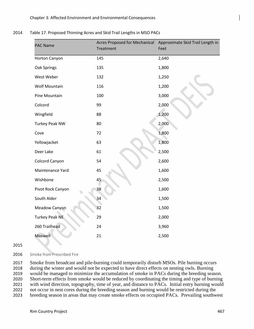
Chapter 3: Affected Environment and Environmental Consequences
Rim Country Project 467
Table 17. Proposed Thinning Acres and Skid Trail Lengths in MSO PACs 2014
PAC Name Acres Proposed for Mechanical
Treatment
Approximate Skid Trail Length in
Feet
Horton Canyon 145 2,640
Oak Springs 135 1,800
West Weber 132 1,250
Wolf Mountain 116 1,200
Pine Mountain 100 3,000
Colcord 99 2,000
Wingfield 88 1,200
Turkey Peak NW 80 2,000
Cove 72 1,800
Yellowjacket 63 1,800
Deer Lake 61 2,500
Colcord Canyon 54 2,600
Maintenance Yard 45 1,600
Wishbone 45 2,500
Pivot Rock Canyon 38 1,600
South Alder 34 1,500
Meadow Canyon 32 1,500
Turkey Peak NE 29 2,000
260 Trailhead 24 3,960
Maxwell 21 2,500
2015
Smoke from Prescribed Fire 2016
Smoke from broadcast and pile-burning could temporarily disturb MSOs. Pile burning occurs 2017 during the winter and would not be expected to have direct effects on nesting owls. Burning 2018 would be managed to minimize the accumulation of smoke in PACs during the breeding season. 2019 Short-term effects from smoke would be reduced by coordinating the timing and type of burning 2020 with wind direction, topography, time of year, and distance to PACs. Initial entry burning would 2021 not occur in nest cores during the breeding season and burning would be restricted during the 2022 breeding season in areas that may create smoke effects on occupied PACs. Prevailing southwest 2023
Chapter 3: Affected Environment and Environmental Consequences
468 Draft Environmental Impact Analysis
winds and the topography of the area typically act to lift smoke, carrying it away from ignitions 2024 sites. Areas selected to protect PACs by thinning and burning outside of the PAC were 2025 developed in conjunction with the 4FRI Rim Country team and with the USFWS. With this 2026 information in mind, along with the concept that the species presumably adapted and evolved 2027 with smoke from wildland fire, smoke-related effects from maintenance burning would not be 2028 substantial. 2029
The use of prescribed fire brings inherent uncertainty. While this would be minimized through 2030 the use of ignition and control techniques, the sheer number of acres and discrete applications of 2031 fire (i.e., all or parts of 156 different PACs) increases the risk of fire burning out of prescription. 2032 While individual trees or pockets of torching could improve habitat conditions by adding 2033 diversity in dense, relatively homogeneous stands of pine-oak, the same action in other stands or 2034 larger areas of torching could create long-term adverse effects on MSO habitat. Adverse effects 2035 would only happen if burning exceeded prescription, therefore the degree of risk is unknown, 2036 unquantifiable, but remains a risk. 2037
Smoke may have an adverse effect if predicted weather conditions change during burn 2038 operations. Smoke tends to settle into low-lying areas, including canyons which serve as owl 2039 habitat. Lung damage could occur if smoke settles into PACs with incubating adult or nestling 2040 MSOs for continuous days and nights. Lung damage could result from continuous exposure to 2041 high smoke levels. MSOs could be forced to alter foraging behavior as a result of extended 2042 smoke. Altered foraging behavior could leave owls vulnerable to predators. Under these 2043 circumstances, smoke settling into PACs could cause adverse effects. The risk of this is low due 2044 to the design features specifically developed to minimize this threat. However, some risk remains 2045 although it is considered low and is unquantifiable. 2046
Wildfire 2047
Fire hazard index and crown fire assessment was modeled for MSO and wildlife habitat types 2048 proposed for treatments. Fire modeling includes one treatment and two prescribed burns through 2049 the year 2029. After this period, maintenance burning is expected to maintain desired conditions 2050 across the project area or until further planning is needed. Fire hazard index and risk of crown 2051 fire was modeled for 120,975 acres in PACs, 10,288 acres in Nest/Roost recovery habitat, and 2052 41,878 acres in foraging/non-breeding MSO recovery habitat. Tables 3-** and 3-** show the 2053 amount of each habitat type with risk ratings of Low, High, and Extreme by alternative. The 2054 existing condition shows that 49,889 acres, or 41 percent of all PACs within the project area, are 2055 at risk of high-severity wildfire. Alternative 2 reduces this risk to 29 percent of PACs, six percent 2056 of Nest/Roost recovery habitat, and one percent of Foraging/non-breeding habitat. 2057
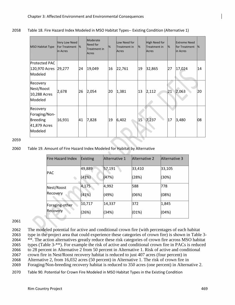
Chapter 3: Affected Environment and Environmental Consequences
Rim Country Project 469
Table 18. Fire Hazard Index Modeled in MSO Habitat Types-- Existing Condition (Alternative 1) 2058
MSO Habitat Type
Very Low Need
For Treatment
in Acres
%
Moderate
Need for
Treatment in
Acres
%
Low Need for
Treatment in
Acres
%
High Need for
Treatment in
Acres
%
Extreme Need
for Treatment
in Acres
%
Protected PAC
120,970 Acres
Modeled
29,277 24 19,049 16 22,761 19 32,865 27 17,024 14
Recovery
Nest/Roost
10,288 Acres
Modeled
2,678 26 2,054 20 1,381 13 2,112 21 2,063 20
Recovery
Foraging/Non-
Breeding
41,879 Acres
Modeled
16,931 41 7,828 19 6,402 15 7,237 17 3,480 08
2059
Table 19. Amount of Fire Hazard Index Modeled for Habitat by Alternative 2060
Fire Hazard Index Existing Alternative 1 Alternative 2 Alternative 3
PAC 49,889
(41%)
57,191
(47%)
33,410
(28%)
33,105
(30%)
Nest/Roost
Recovery
4,175
(41%)
4,992
(49%)
588
(06%)
778
(08%)
Foraging-other
Recovery
10,717
(26%)
14,337
(34%)
372
(01%)
1,845
(04%)
2061
The modeled potential for active and conditional crown fire (with percentages of each habitat 2062 type in the project area that could experience these categories of crown fire) is shown in Table 3-2063 **. The action alternatives greatly reduce these risk categories of crown fire across MSO habitat 2064 types (Table 3-**). For example the risk of active and conditional crown fire in PACs is reduced 2065 to 28 percent in Alternative 2 from 50 percent in Alternative 1. Risk of active and conditional 2066 crown fire in Nest/Roost recovery habitat is reduced to just 407 acres (four percent) in 2067 Alternative 2, from 16,032 acres (50 percent) in Alternative 1. The risk of crown fire in 2068 Foraging/Non-breeding recovery habitat is reduced to 350 acres (one percent) in Alternative 2. 2069
Table 90. Potential for Crown Fire Modeled in MSO Habitat Types in the Existing Condition 2070
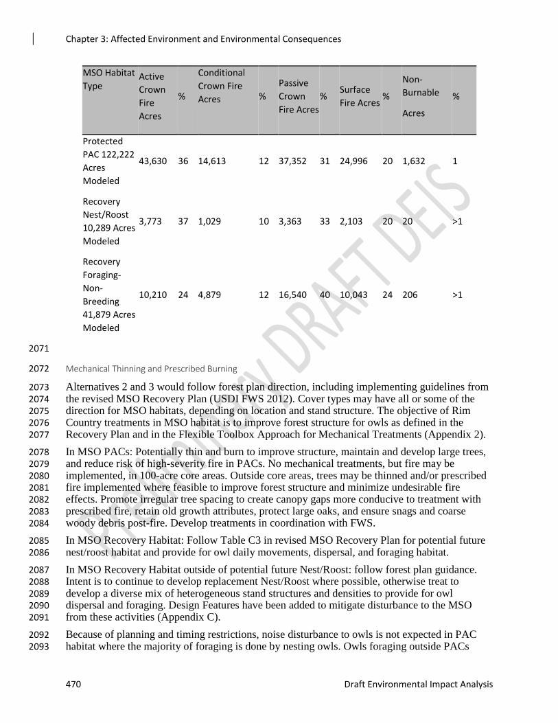
Chapter 3: Affected Environment and Environmental Consequences
470 Draft Environmental Impact Analysis
MSO Habitat
Type Active
Crown
Fire
Acres
%
Conditional
Crown Fire
Acres
%
Passive
Crown
Fire Acres
% Surface
Fire Acres %
Non-
Burnable
Acres
%
Protected
PAC 122,222
Acres
Modeled
43,630 36 14,613 12 37,352 31 24,996 20 1,632 1
Recovery
Nest/Roost
10,289 Acres
Modeled
3,773 37 1,029 10 3,363 33 2,103 20 20 >1
Recovery
Foraging-
Non-
Breeding
41,879 Acres
Modeled
10,210 24 4,879 12 16,540 40 10,043 24 206 >1
2071
Mechanical Thinning and Prescribed Burning 2072
Alternatives 2 and 3 would follow forest plan direction, including implementing guidelines from 2073 the revised MSO Recovery Plan (USDI FWS 2012). Cover types may have all or some of the 2074 direction for MSO habitats, depending on location and stand structure. The objective of Rim 2075 Country treatments in MSO habitat is to improve forest structure for owls as defined in the 2076 Recovery Plan and in the Flexible Toolbox Approach for Mechanical Treatments (Appendix 2). 2077
In MSO PACs: Potentially thin and burn to improve structure, maintain and develop large trees, 2078 and reduce risk of high-severity fire in PACs. No mechanical treatments, but fire may be 2079 implemented, in 100-acre core areas. Outside core areas, trees may be thinned and/or prescribed 2080 fire implemented where feasible to improve forest structure and minimize undesirable fire 2081 effects. Promote irregular tree spacing to create canopy gaps more conducive to treatment with 2082 prescribed fire, retain old growth attributes, protect large oaks, and ensure snags and coarse 2083 woody debris post-fire. Develop treatments in coordination with FWS. 2084
In MSO Recovery Habitat: Follow Table C3 in revised MSO Recovery Plan for potential future 2085 nest/roost habitat and provide for owl daily movements, dispersal, and foraging habitat. 2086
In MSO Recovery Habitat outside of potential future Nest/Roost: follow forest plan guidance. 2087 Intent is to continue to develop replacement Nest/Roost where possible, otherwise treat to 2088 develop a diverse mix of heterogeneous stand structures and densities to provide for owl 2089 dispersal and foraging. Design Features have been added to mitigate disturbance to the MSO 2090 from these activities (Appendix C). 2091
Because of planning and timing restrictions, noise disturbance to owls is not expected in PAC 2092 habitat where the majority of foraging is done by nesting owls. Owls foraging outside PACs 2093
Chapter 3: Affected Environment and Environmental Consequences
Rim Country Project 471
during nesting season could potentially be displaced by thinning activities and increased truck 2094 traffic. Owls could also be displaced by harvest activities and increased truck traffic outside the 2095 nesting season. Displaced owls could be more vulnerable to predation. 2096
Vehicular traffic would not simultaneously increase across the entire implementation area, but 2097 harvest-related traffic increases would occur in localized areas somewhere on the landscape for 2098 every year of implementation. Most traffic is expected to occur during diurnal hours when MSO 2099 activity would be minimal. However, hauling of materials from harvest locations to highways 2100 could occur at night when owls are active. Once harvest activities are complete, traffic is 2101 expected to return to pre-harvest levels. 2102
The amount of traffic increases the risk of collisions between owls and trucks. There have been 2103 documented instances of spotted owls being hit by vehicles on paved and unpaved roads. 2104 Although little information is available on the frequency or conditions related to the risk of 2105 collisions, the assumption is being made that, because of the scale of increase in truck traffic, the 2106 risk of collisions with owls would increase. The threat of collisions would be reduced below 2107 existing conditions in the long-term as a result of road decommissioning. 2108
Treatments in MSO habitat were modeled using FVS (see Vegetation Report). Tables 3-** to 3-2109 ** display the habitat variables important to the MSO and the modeled effects on them in 2019, 2110 2029, and 2039. 2111
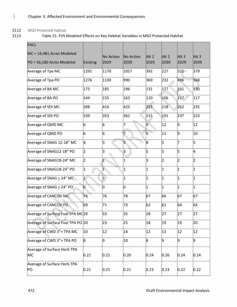
Chapter 3: Affected Environment and Environmental Consequences
472 Draft Environmental Impact Analysis
MSO Protected Habitat 2112
Table 21. FVS Modeled Effects on Key Habitat Variables in MSO Protected Habitat 2113
PACs
MC = 16,481 Acres Modeled
PO = 56,180 Acres Modeled Existing
No Action
2029
No Action
2039
Alt 2
2029
Alt 2
2039
Alt 3
2029
Alt 3
2039
Average of Tpa MC 1291 1170 1057 392 227 531 379
Average of Tpa PO 1276 1130 990 369 232 496 368
Average of BA MC 173 185 196 131 127 131 130
Average of BA PO 144 155 163 110 106 117 117
Average of SDI MC 398 414 425 253 218 262 235
Average of SDI PO 339 353 362 215 191 237 223
Average of QMD MC 6 6 7 9 12 9 12
Average of QMD PO 6 6 7 9 11 9 10
Average of SNAG 12-18” MC 4 3 3 8 5 7 5
Average of SNAG12-18” PO 2 3 3 5 5 5 4
Average of SNAG18-24” MC 2 1 1 3 2 2 2
Average of SNAG18-24” PO 1 1 1 1 1 1 1
Average of SNAG > 24” MC 1 1 1 1 1 1 1
Average of SNAG > 24” PO 0 0 0 1 1 1 1
Average of CANCOV MC 74 76 78 67 66 67 67
Average of CANCOV PO 69 71 73 62 61 64 64
Average of Surface Fuel TPA MC 29 33 35 28 27 27 27
Average of Surface Fuel TPA PO 20 23 25 18 19 19 20
Average of CWD 3”+ TPA MC 10 12 14 12 13 12 12
Average of CWD 3”+ TPA PO 8 9 10 8 9 9 9
Average of Surface Herb TPA
MC 0.21 0.21 0.20 0.24 0.26 0.24 0.24
Average of Surface Herb TPA
PO 0.21 0.21 0.21 0.23 0.23 0.22 0.22
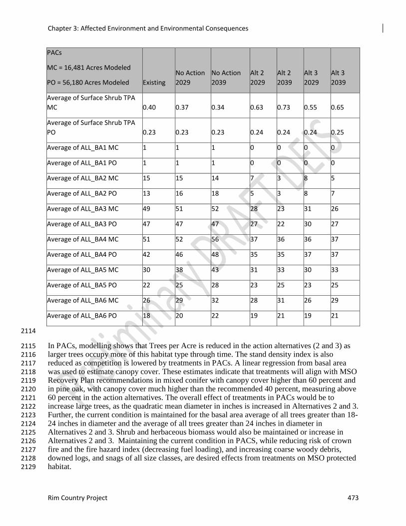
Chapter 3: Affected Environment and Environmental Consequences
Rim Country Project 473
PACs
MC = 16,481 Acres Modeled
PO = 56,180 Acres Modeled Existing
No Action
2029
No Action
2039
Alt 2
2029
Alt 2
2039
Alt 3
2029
Alt 3
2039
Average of Surface Shrub TPA
MC 0.40 0.37 0.34 0.63 0.73 0.55 0.65
Average of Surface Shrub TPA
PO 0.23 0.23 0.23 0.24 0.24 0.24 0.25
Average of ALL_BA1 MC 1 1 1 0 0 0 0
Average of ALL_BA1 PO 1 1 1 0 0 0 0
Average of ALL_BA2 MC 15 15 14 7 3 8 5
Average of ALL_BA2 PO 13 16 18 5 3 8 7
Average of ALL_BA3 MC 49 51 52 28 23 31 26
Average of ALL_BA3 PO 47 47 47 27 22 30 27
Average of ALL_BA4 MC 51 52 56 37 36 36 37
Average of ALL_BA4 PO 42 46 48 35 35 37 37
Average of ALL_BA5 MC 30 38 43 31 33 30 33
Average of ALL_BA5 PO 22 25 28 23 25 23 25
Average of ALL_BA6 MC 26 29 32 28 31 26 29
Average of ALL_BA6 PO 18 20 22 19 21 19 21
2114
In PACs, modelling shows that Trees per Acre is reduced in the action alternatives (2 and 3) as 2115 larger trees occupy more of this habitat type through time. The stand density index is also 2116 reduced as competition is lowered by treatments in PACs. A linear regression from basal area 2117 was used to estimate canopy cover. These estimates indicate that treatments will align with MSO 2118 Recovery Plan recommendations in mixed conifer with canopy cover higher than 60 percent and 2119 in pine oak, with canopy cover much higher than the recommended 40 percent, measuring above 2120 60 percent in the action alternatives. The overall effect of treatments in PACs would be to 2121 increase large trees, as the quadratic mean diameter in inches is increased in Alternatives 2 and 3. 2122 Further, the current condition is maintained for the basal area average of all trees greater than 18-2123 24 inches in diameter and the average of all trees greater than 24 inches in diameter in 2124 Alternatives 2 and 3. Shrub and herbaceous biomass would also be maintained or increase in 2125 Alternatives 2 and 3. Maintaining the current condition in PACS, while reducing risk of crown 2126 fire and the fire hazard index (decreasing fuel loading), and increasing coarse woody debris, 2127 downed logs, and snags of all size classes, are desired effects from treatments on MSO protected 2128 habitat. 2129
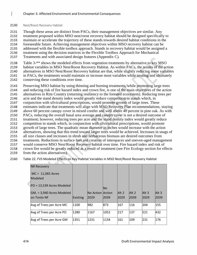
Chapter 3: Affected Environment and Environmental Consequences
474 Draft Environmental Impact Analysis
Nest/Roost Recovery Habitat 2130
Though these areas are distinct from PACs, their management objectives are similar. Any 2131 treatment proposed within MSO nest/roost recovery habitat should be designed specifically to 2132 maintain or accelerate the trajectory of these stands towards desired habitat conditions in the 2133 foreseeable future. Achieving management objectives within MSO recovery habitat can be 2134 addressed with the flexible toolbox approach. Stands in recovery habitat would be assigned a 2135 treatment using the decision matrices in the Flexible Toolbox Approach for Mechanical 2136 Treatments and with associated design features (Appendix C). 2137
Table 3-** shows the modeled effects from vegetation treatments by alternative to key MSO 2138 habitat variables in MSO Nest/Roost Recovery Habitat. As within PACs, the results of the action 2139 alternatives in MSO Nest/Roost Recovery habitat are that, while slightly reducing some variables 2140 in PACs, the treatments would maintain or increase most variables while treating and ultimately 2141 conserving these conditions over time. 2142
Preserving MSO habitat by using thinning and burning treatments, while promoting large trees 2143 and reducing risk of fire hazard index and crown fire, is one of the main objectives of the action 2144 alternatives in Rim Country (returning resiliency to the forested ecosystem). Reducing trees per 2145 acre and the stand density index would greatly reduce competition in stands which, in 2146 conjunction with silvicultural prescriptions, would promote growth of large trees. These 2147 estimates indicate that treatments will align with MSO Recovery Plan recommendations, staying 2148 above 60 percent canopy cover in mixed conifer and well above 40 percent in pine oak. As with 2149 PACs, reducing the overall basal area average and canopy cover is not a desired outcome of 2150 treatment; however, reducing trees per acre and the stand density index would greatly reduce 2151 competition in stands which, in conjunction with silvicultural prescriptions, would promote 2152 growth of large trees. The quadratic mean diameter in inches would increase with the action 2153 alternatives, showing that this trend toward larger trees would be achieved. Increases in snags of 2154 all size classes and increases in shrub and herbaceous biomass are desired outcomes from 2155 treatments. Reductions in surface fuel and creation of interspaces and uneven-aged management 2156 would conserve MSO Nest/Roost Recovery habitat over time. Fire hazard index and risk of 2157 crown fire would be greatly reduced as a result of treatment (see Fire Ecology section for effects 2158 from the action alternatives). 2159
Table 22. FVS Modeled Effects on Key Habitat Variables in MSO Nest/Roost Recovery Habitat 2160
NR Recovery
MC = 11,065 Acres
Modeled
PO = 13,539 Acres Modeled
GM. = 3,940 Acres Modeled
on Tonto NF Existing
No Action
2029
No
Action
2039
Alt 2
2029
Alt 2
2039
Alt 3
2029
Alt 3
2039
Avg of Trees per Acre MC 1100 982 873 167 116 204 155
Avg of Trees per Acre PO 1280 1167 1052 217 137 521 432
Avg of Trees per Acre GM 1351 1231 1134 161 109 231 176
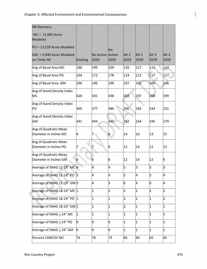
Chapter 3: Affected Environment and Environmental Consequences
Rim Country Project 475
NR Recovery
MC = 11,065 Acres
Modeled
PO = 13,539 Acres Modeled
GM. = 3,940 Acres Modeled
on Tonto NF Existing
No Action
2029
No
Action
2039
Alt 2
2029
Alt 2
2039
Alt 3
2029
Alt 3
2039
Avg of Basal Area MC 188 199 209 126 127 122 124
Avg of Basal Area PO 164 172 178 114 112 127 127
Avg of Basal Area GM 190 196 199 107 102 109 106
Avg of Stand Density Index
MC 420 431 438 208 197 208 199
Avg of Stand Density Index
PO 369 377 380 200 183 243 231
Avg of Stand Density Index
GM 441 444 445 182 164 195 179
Avg of Quadratic Mean
Diameter in Inches MC 6 7 8 14 16 13 15
Avg of Quadratic Mean
Diameter in Inches PO 7 7 8 12 14 11 13
Avg of Quadratic Mean
Diameter in Inches GM 6 6 6 12 14 12 6
Average of SNAG 12-18” MC 4 4 4 5 3 5 3
Average of SNAG 12-18” PO 3 4 4 5 4 5 4
Average of SNAG 12-18” GM 3 4 3 6 4 6 4
Average of SNAG 18-24” MC 1 1 2 2 2 2 2
Average of SNAG 18-24” PO 1 1 1 2 2 1 2
Average of SNAG 18-24” GM 1 1 1 2 1 1 1
Average of SNAG > 24” MC 1 1 1 1 1 1 1
Average of SNAG > 24” PO 0 0 0 1 1 1 1
Average of SNAG > 24” GM 0 0 0 1 1 1 1
Percent CANCOV MC 76 78 79 66 66 65 65
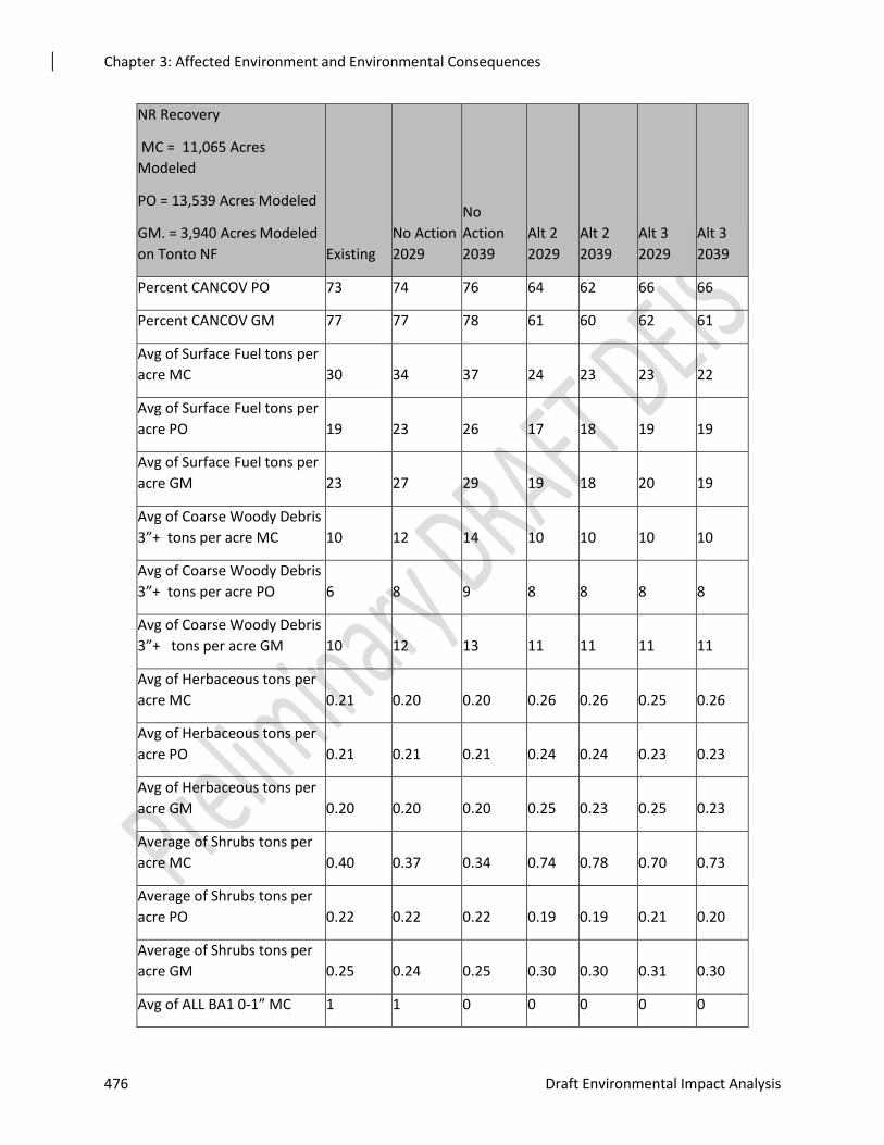
Chapter 3: Affected Environment and Environmental Consequences
476 Draft Environmental Impact Analysis
NR Recovery
MC = 11,065 Acres
Modeled
PO = 13,539 Acres Modeled
GM. = 3,940 Acres Modeled
on Tonto NF Existing
No Action
2029
No
Action
2039
Alt 2
2029
Alt 2
2039
Alt 3
2029
Alt 3
2039
Percent CANCOV PO 73 74 76 64 62 66 66
Percent CANCOV GM 77 77 78 61 60 62 61
Avg of Surface Fuel tons per
acre MC 30 34 37 24 23 23 22
Avg of Surface Fuel tons per
acre PO 19 23 26 17 18 19 19
Avg of Surface Fuel tons per
acre GM 23 27 29 19 18 20 19
Avg of Coarse Woody Debris
3”+ tons per acre MC 10 12 14 10 10 10 10
Avg of Coarse Woody Debris
3”+ tons per acre PO 6 8 9 8 8 8 8
Avg of Coarse Woody Debris
3”+ tons per acre GM 10 12 13 11 11 11 11
Avg of Herbaceous tons per
acre MC 0.21 0.20 0.20 0.26 0.26 0.25 0.26
Avg of Herbaceous tons per
acre PO 0.21 0.21 0.21 0.24 0.24 0.23 0.23
Avg of Herbaceous tons per
acre GM 0.20 0.20 0.20 0.25 0.23 0.25 0.23
Average of Shrubs tons per
acre MC 0.40 0.37 0.34 0.74 0.78 0.70 0.73
Average of Shrubs tons per
acre PO 0.22 0.22 0.22 0.19 0.19 0.21 0.20
Average of Shrubs tons per
acre GM 0.25 0.24 0.25 0.30 0.30 0.31 0.30
Avg of ALL BA1 0-1” MC 1 1 0 0 0 0 0
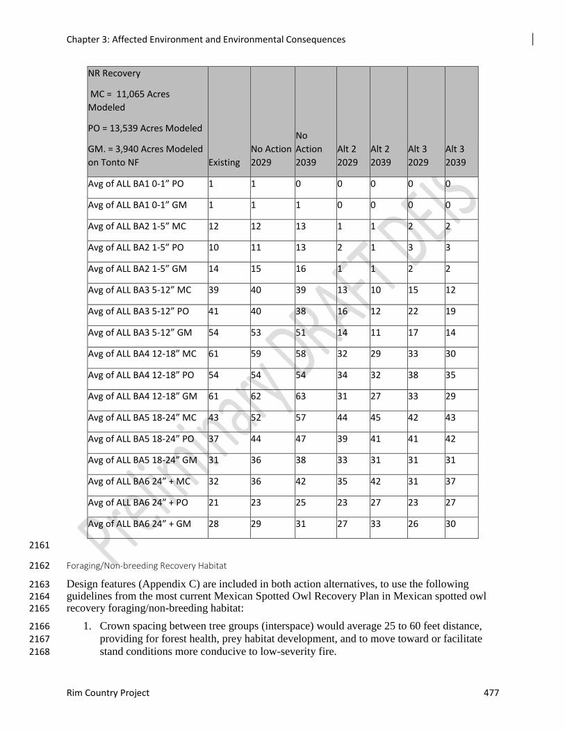
Chapter 3: Affected Environment and Environmental Consequences
Rim Country Project 477
NR Recovery
MC = 11,065 Acres
Modeled
PO = 13,539 Acres Modeled
GM. = 3,940 Acres Modeled
on Tonto NF Existing
No Action
2029
No
Action
2039
Alt 2
2029
Alt 2
2039
Alt 3
2029
Alt 3
2039
Avg of ALL BA1 0-1” PO 1 1 0 0 0 0 0
Avg of ALL BA1 0-1” GM 1 1 1 0 0 0 0
Avg of ALL BA2 1-5” MC 12 12 13 1 1 2 2
Avg of ALL BA2 1-5” PO 10 11 13 2 1 3 3
Avg of ALL BA2 1-5” GM 14 15 16 1 1 2 2
Avg of ALL BA3 5-12” MC 39 40 39 13 10 15 12
Avg of ALL BA3 5-12” PO 41 40 38 16 12 22 19
Avg of ALL BA3 5-12” GM 54 53 51 14 11 17 14
Avg of ALL BA4 12-18” MC 61 59 58 32 29 33 30
Avg of ALL BA4 12-18” PO 54 54 54 34 32 38 35
Avg of ALL BA4 12-18” GM 61 62 63 31 27 33 29
Avg of ALL BA5 18-24” MC 43 52 57 44 45 42 43
Avg of ALL BA5 18-24” PO 37 44 47 39 41 41 42
Avg of ALL BA5 18-24” GM 31 36 38 33 31 31 31
Avg of ALL BA6 24” + MC 32 36 42 35 42 31 37
Avg of ALL BA6 24” + PO 21 23 25 23 27 23 27
Avg of ALL BA6 24” + GM 28 29 31 27 33 26 30
2161
Foraging/Non-breeding Recovery Habitat 2162
Design features (Appendix C) are included in both action alternatives, to use the following 2163 guidelines from the most current Mexican Spotted Owl Recovery Plan in Mexican spotted owl 2164 recovery foraging/non-breeding habitat: 2165
1. Crown spacing between tree groups (interspace) would average 25 to 60 feet distance, 2166 providing for forest health, prey habitat development, and to move toward or facilitate 2167 stand conditions more conducive to low-severity fire. 2168

Chapter 3: Affected Environment and Environmental Consequences
478 Draft Environmental Impact Analysis
2. Tree thinning in pine-oak would target 40 to 110 basal area; thinning in mixed conifer 2169
would target 40 to 135 basal area. The goal is to manage for a sustainable range of 2170 density and structural characteristics. 2171
3. No trees greater than 24 inches in diameter would be cut and trees greater than 18 inches 2172
would be retained, unless overriding management situations require their removal. 2173
Table 3-** shows the modeled effects from vegetation treatments by alternative to key MSO 2174 habitat variables in pine-oak, mixed conifer, and using the geophysical model (Tonto NF) in 2175 MSO Foraging/Non-breeding Recovery Habitat. 2176
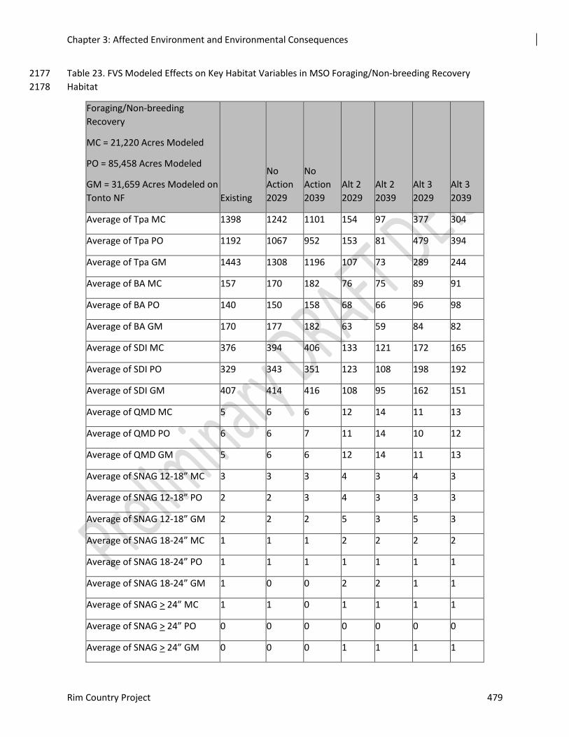
Chapter 3: Affected Environment and Environmental Consequences
Rim Country Project 479
Table 23. FVS Modeled Effects on Key Habitat Variables in MSO Foraging/Non-breeding Recovery 2177
Habitat 2178
Foraging/Non-breeding
Recovery
MC = 21,220 Acres Modeled
PO = 85,458 Acres Modeled
GM = 31,659 Acres Modeled on
Tonto NF Existing
No
Action
2029
No
Action
2039
Alt 2
2029
Alt 2
2039
Alt 3
2029
Alt 3
2039
Average of Tpa MC 1398 1242 1101 154 97 377 304
Average of Tpa PO 1192 1067 952 153 81 479 394
Average of Tpa GM 1443 1308 1196 107 73 289 244
Average of BA MC 157 170 182 76 75 89 91
Average of BA PO 140 150 158 68 66 96 98
Average of BA GM 170 177 182 63 59 84 82
Average of SDI MC 376 394 406 133 121 172 165
Average of SDI PO 329 343 351 123 108 198 192
Average of SDI GM 407 414 416 108 95 162 151
Average of QMD MC 5 6 6 12 14 11 13
Average of QMD PO 6 6 7 11 14 10 12
Average of QMD GM 5 6 6 12 14 11 13
Average of SNAG 12-18” MC 3 3 3 4 3 4 3
Average of SNAG 12-18” PO 2 2 3 4 3 3 3
Average of SNAG 12-18” GM 2 2 2 5 3 5 3
Average of SNAG 18-24” MC 1 1 1 2 2 2 2
Average of SNAG 18-24” PO 1 1 1 1 1 1 1
Average of SNAG 18-24” GM 1 0 0 2 2 1 1
Average of SNAG > 24” MC 1 1 0 1 1 1 1
Average of SNAG > 24” PO 0 0 0 0 0 0 0
Average of SNAG > 24” GM 0 0 0 1 1 1 1
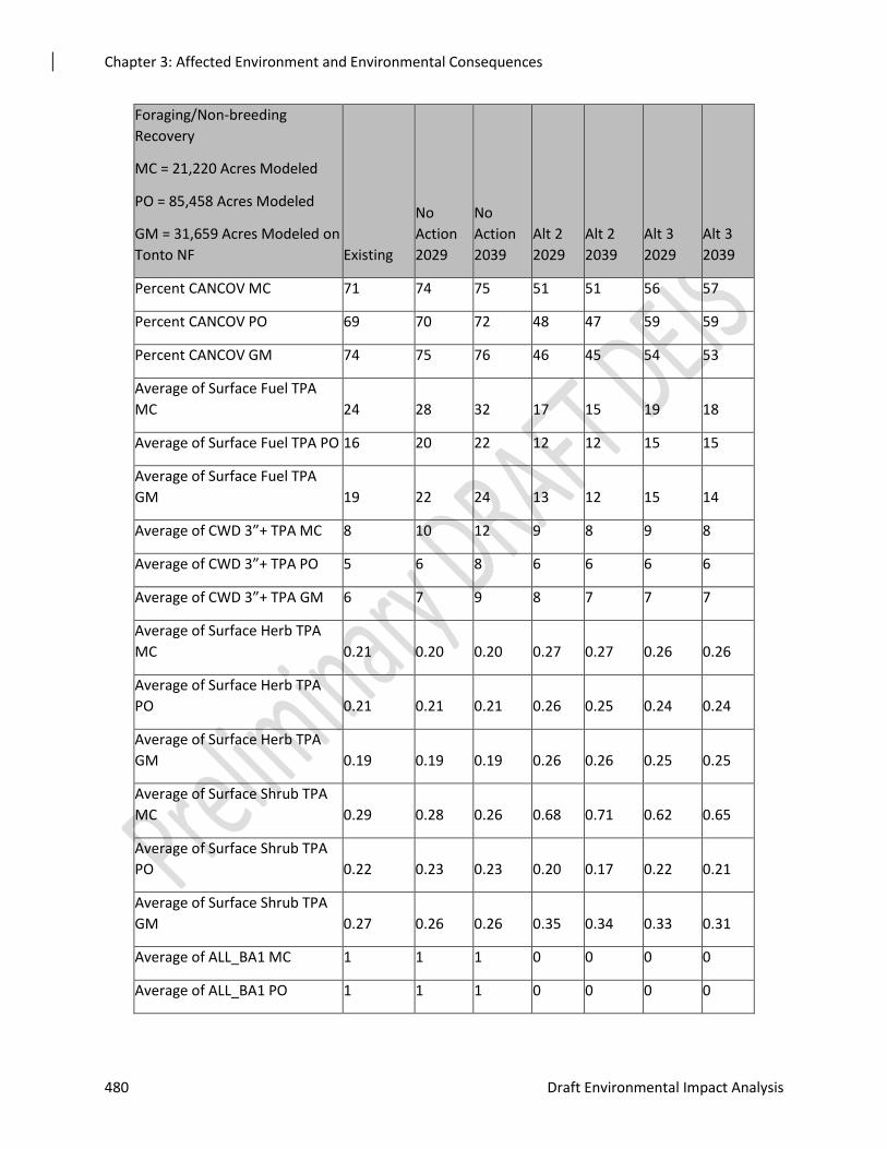
Chapter 3: Affected Environment and Environmental Consequences
480 Draft Environmental Impact Analysis
Foraging/Non-breeding
Recovery
MC = 21,220 Acres Modeled
PO = 85,458 Acres Modeled
GM = 31,659 Acres Modeled on
Tonto NF Existing
No
Action
2029
No
Action
2039
Alt 2
2029
Alt 2
2039
Alt 3
2029
Alt 3
2039
Percent CANCOV MC 71 74 75 51 51 56 57
Percent CANCOV PO 69 70 72 48 47 59 59
Percent CANCOV GM 74 75 76 46 45 54 53
Average of Surface Fuel TPA
MC 24 28 32 17 15 19 18
Average of Surface Fuel TPA PO 16 20 22 12 12 15 15
Average of Surface Fuel TPA
GM 19 22 24 13 12 15 14
Average of CWD 3”+ TPA MC 8 10 12 9 8 9 8
Average of CWD 3”+ TPA PO 5 6 8 6 6 6 6
Average of CWD 3”+ TPA GM 6 7 9 8 7 7 7
Average of Surface Herb TPA
MC 0.21 0.20 0.20 0.27 0.27 0.26 0.26
Average of Surface Herb TPA
PO 0.21 0.21 0.21 0.26 0.25 0.24 0.24
Average of Surface Herb TPA
GM 0.19 0.19 0.19 0.26 0.26 0.25 0.25
Average of Surface Shrub TPA
MC 0.29 0.28 0.26 0.68 0.71 0.62 0.65
Average of Surface Shrub TPA
PO 0.22 0.23 0.23 0.20 0.17 0.22 0.21
Average of Surface Shrub TPA
GM 0.27 0.26 0.26 0.35 0.34 0.33 0.31
Average of ALL_BA1 MC 1 1 1 0 0 0 0
Average of ALL_BA1 PO 1 1 1 0 0 0 0
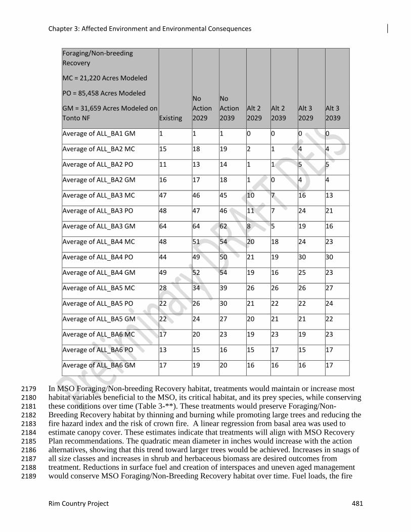
Chapter 3: Affected Environment and Environmental Consequences
Rim Country Project 481
Foraging/Non-breeding
Recovery
MC = 21,220 Acres Modeled
PO = 85,458 Acres Modeled
GM = 31,659 Acres Modeled on
Tonto NF Existing
No
Action
2029
No
Action
2039
Alt 2
2029
Alt 2
2039
Alt 3
2029
Alt 3
2039
Average of ALL_BA1 GM 1 1 1 0 0 0 0
Average of ALL_BA2 MC 15 18 19 2 1 4 4
Average of ALL_BA2 PO 11 13 14 1 1 5 5
Average of ALL_BA2 GM 16 17 18 1 0 4 4
Average of ALL_BA3 MC 47 46 45 10 7 16 13
Average of ALL_BA3 PO 48 47 46 11 7 24 21
Average of ALL_BA3 GM 64 64 62 8 5 19 16
Average of ALL_BA4 MC 48 51 54 20 18 24 23
Average of ALL_BA4 PO 44 49 50 21 19 30 30
Average of ALL_BA4 GM 49 52 54 19 16 25 23
Average of ALL_BA5 MC 28 34 39 26 26 26 27
Average of ALL_BA5 PO 22 26 30 21 22 22 24
Average of ALL_BA5 GM 22 24 27 20 21 21 22
Average of ALL_BA6 MC 17 20 23 19 23 19 23
Average of ALL_BA6 PO 13 15 16 15 17 15 17
Average of ALL_BA6 GM 17 19 20 16 16 16 17
In MSO Foraging/Non-breeding Recovery habitat, treatments would maintain or increase most 2179 habitat variables beneficial to the MSO, its critical habitat, and its prey species, while conserving 2180 these conditions over time (Table 3-**). These treatments would preserve Foraging/Non-2181 Breeding Recovery habitat by thinning and burning while promoting large trees and reducing the 2182 fire hazard index and the risk of crown fire. A linear regression from basal area was used to 2183 estimate canopy cover. These estimates indicate that treatments will align with MSO Recovery 2184 Plan recommendations. The quadratic mean diameter in inches would increase with the action 2185 alternatives, showing that this trend toward larger trees would be achieved. Increases in snags of 2186 all size classes and increases in shrub and herbaceous biomass are desired outcomes from 2187 treatment. Reductions in surface fuel and creation of interspaces and uneven aged management 2188 would conserve MSO Foraging/Non-Breeding Recovery habitat over time. Fuel loads, the fire 2189
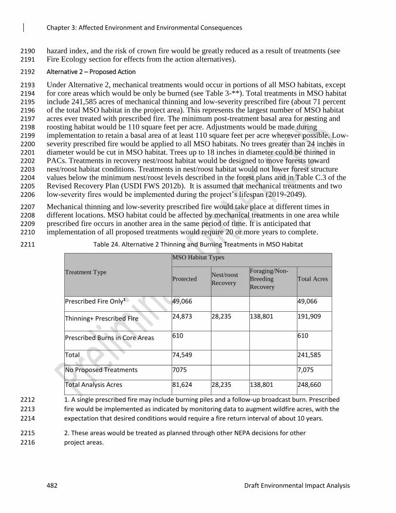
Chapter 3: Affected Environment and Environmental Consequences
482 Draft Environmental Impact Analysis
hazard index, and the risk of crown fire would be greatly reduced as a result of treatments (see 2190 Fire Ecology section for effects from the action alternatives). 2191
Alternative 2 – Proposed Action 2192
Under Alternative 2, mechanical treatments would occur in portions of all MSO habitats, except 2193 for core areas which would be only be burned (see Table 3-**). Total treatments in MSO habitat 2194 include 241,585 acres of mechanical thinning and low-severity prescribed fire (about 71 percent 2195 of the total MSO habitat in the project area). This represents the largest number of MSO habitat 2196 acres ever treated with prescribed fire. The minimum post-treatment basal area for nesting and 2197 roosting habitat would be 110 square feet per acre. Adjustments would be made during 2198 implementation to retain a basal area of at least 110 square feet per acre wherever possible. Low-2199 severity prescribed fire would be applied to all MSO habitats. No trees greater than 24 inches in 2200 diameter would be cut in MSO habitat. Trees up to 18 inches in diameter could be thinned in 2201 PACs. Treatments in recovery nest/roost habitat would be designed to move forests toward 2202 nest/roost habitat conditions. Treatments in nest/roost habitat would not lower forest structure 2203 values below the minimum nest/roost levels described in the forest plans and in Table C.3 of the 2204 Revised Recovery Plan (USDI FWS 2012b). It is assumed that mechanical treatments and two 2205 low-severity fires would be implemented during the project’s lifespan (2019-2049). 2206
Mechanical thinning and low-severity prescribed fire would take place at different times in 2207 different locations. MSO habitat could be affected by mechanical treatments in one area while 2208 prescribed fire occurs in another area in the same period of time. It is anticipated that 2209 implementation of all proposed treatments would require 20 or more years to complete. 2210
Table 24. Alternative 2 Thinning and Burning Treatments in MSO Habitat 2211
Treatment Type
MSO Habitat Types
Protected Nest/roost
Recovery
Foraging/Non-
Breeding
Recovery
Total Acres
Prescribed Fire Only1 49,066 49,066
Thinning+ Prescribed Fire 24,873 28,235 138,801 191,909
Prescribed Burns in Core Areas 610 610
Total 74,549 241,585
No Proposed Treatments 7075 7,075
Total Analysis Acres 81,624 28,235 138,801 248,660
1. A single prescribed fire may include burning piles and a follow-up broadcast burn. Prescribed 2212
fire would be implemented as indicated by monitoring data to augment wildfire acres, with the 2213
expectation that desired conditions would require a fire return interval of about 10 years. 2214
2. These areas would be treated as planned through other NEPA decisions for other 2215
project areas. 2216
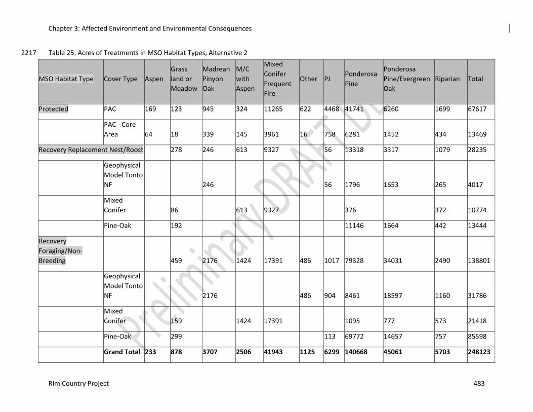
Chapter 3: Affected Environment and Environmental Consequences
Rim Country Project 483
Table 25. Acres of Treatments in MSO Habitat Types, Alternative 2 2217
MSO Habitat Type Cover Type Aspen
Grass
land or
Meadow
Madrean
Pinyon
Oak
M/C
with
Aspen
Mixed
Conifer
Frequent
Fire
Other PJ Ponderosa
Pine
Ponderosa
Pine/Evergreen
Oak
Riparian Total
Protected PAC 169 123 945 324 11265 622 4468 41741 6260 1699 67617
PAC - Core
Area 64 18 339 145 3961 16 758 6281 1452 434 13469
Recovery Replacement Nest/Roost
278 246 613 9327
56 13318 3317 1079 28235
Geophysical
Model Tonto
NF
246
56 1796 1653 265 4017
Mixed
Conifer
86
613 9327
376
372 10774
Pine-Oak
192
11146 1664 442 13444
Recovery
Foraging/Non-
Breeding 459 2176 1424 17391 486 1017 79328 34031 2490 138801
Geophysical
Model Tonto
NF 2176 486 904 8461 18597 1160 31786
Mixed
Conifer 159 1424 17391 1095 777 573 21418
Pine-Oak 299 113 69772 14657 757 85598
Grand Total 233 878 3707 2506 41943 1125 6299 140668 45061 5703 248123

Chapter 3: Affected Environment and Environmental Consequences
484 Draft Environmental Impact Analysis
2218
Chapter 3: Affected Environment and Environmental Consequences
Rim Country Project 485
Protected Habitat 2219
There are 196 PACs (110,890 acres) within the project area. Approximately 7,075 acres occur in 2220 other project areas that overlap with the Rim Country project area but would be treated as those 2221 projects were planned and consulted on with the FWS. Approximately 17, 500 acres that also 2222 occur in other overlapping project areas would have some other type of restoration (riparian, wet 2223 meadow, grassland, aspen). Under Alternative 2, 81,624 acres (73 percent) of protected MSO 2224 habitat are proposed for thinning and/or burning or other restoration activities. Therefore, most 2225 of the protected habitat of the PACs in the Rim Country project area not associated with other 2226 projects would have some type of vegetation treatment. Most vegetation treatments (greater than 2227 60 percent) would be prescribed fire only. Little change would occur in forest structure and MSO 2228 prey habitat from low-severity fire treatments. 2229
In PACs, Alternative 2 would allow cutting trees up to 18 inches in diameter. All stands 2230 identified for mechanical thinning would be marked by hand and marking would be coordinated 2231 with the FWS. No mechanical treatments would occur in core areas. Design features (Appendix 2232 C) were included to minimize effects on owls and to promote Primary Constituent Habitat 2233 Elements recommended by the MSO Recovery Plan and the forest plans. Mechanical treatments 2234 in PACs are summarized in the Effects Common to Both Action Alternatives section. The 2235 Mechanical Treatments Flexible Toolbox Approach contains the following language for 2236 treatments in PACs: 2237
PACs exhibit a variety of topographic and forest conditions and occupied PACs can already be 2238 considered successful nesting habitat. Mechanical treatments in PACs should be designed to 2239 maintain or improve the characteristics that make each PAC effective at providing habitat while 2240 also making them resilient to disturbance. Consideration should be given to 1) increasing the 2241 number of large trees; 2) creating additional foraging habitat for MSO; 3) the fire hazard index in 2242 the PAC and whether it is in wildland-urban interface (WUI); 4) restoration/protection of other 2243 resource values nearby, such as perennial water; and 5) protecting other values at risk. Treating 2244 areas near PACs should be considered in order in improve resiliency in the PACs themselves. 2245 PACs should be treated with consideration of the larger landscape and not just separate entities. 2246 Specific treatments in PACs would be determined prior to implementation and in coordination 2247 with U.S. Fish and Wildlife Service (FWS) personnel. 2248
2249
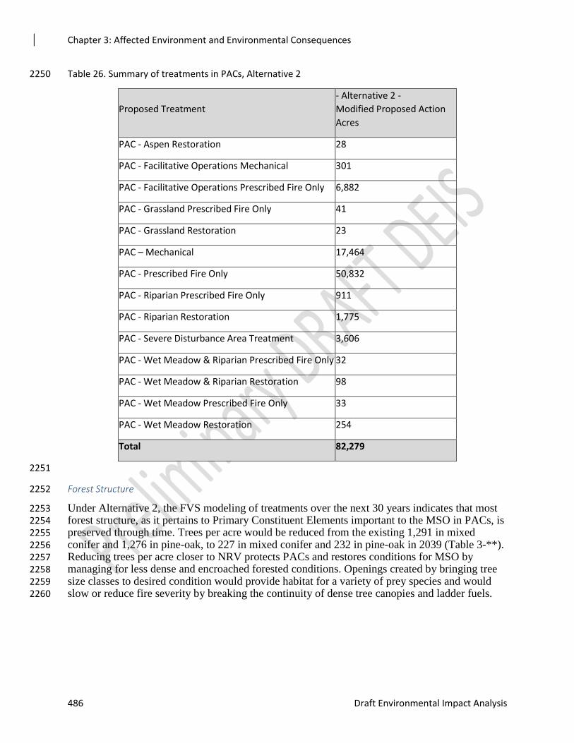
Chapter 3: Affected Environment and Environmental Consequences
486 Draft Environmental Impact Analysis
Table 26. Summary of treatments in PACs, Alternative 2 2250
Proposed Treatment
- Alternative 2 -
Modified Proposed Action
Acres
PAC - Aspen Restoration 28
PAC - Facilitative Operations Mechanical 301
PAC - Facilitative Operations Prescribed Fire Only 6,882
PAC - Grassland Prescribed Fire Only 41
PAC - Grassland Restoration 23
PAC – Mechanical 17,464
PAC - Prescribed Fire Only 50,832
PAC - Riparian Prescribed Fire Only 911
PAC - Riparian Restoration 1,775
PAC - Severe Disturbance Area Treatment 3,606
PAC - Wet Meadow & Riparian Prescribed Fire Only 32
PAC - Wet Meadow & Riparian Restoration 98
PAC - Wet Meadow Prescribed Fire Only 33
PAC - Wet Meadow Restoration 254
Total 82,279
2251
Forest Structure 2252
Under Alternative 2, the FVS modeling of treatments over the next 30 years indicates that most 2253 forest structure, as it pertains to Primary Constituent Elements important to the MSO in PACs, is 2254 preserved through time. Trees per acre would be reduced from the existing 1,291 in mixed 2255 conifer and 1,276 in pine-oak, to 227 in mixed conifer and 232 in pine-oak in 2039 (Table 3-**). 2256 Reducing trees per acre closer to NRV protects PACs and restores conditions for MSO by 2257 managing for less dense and encroached forested conditions. Openings created by bringing tree 2258 size classes to desired condition would provide habitat for a variety of prey species and would 2259 slow or reduce fire severity by breaking the continuity of dense tree canopies and ladder fuels. 2260
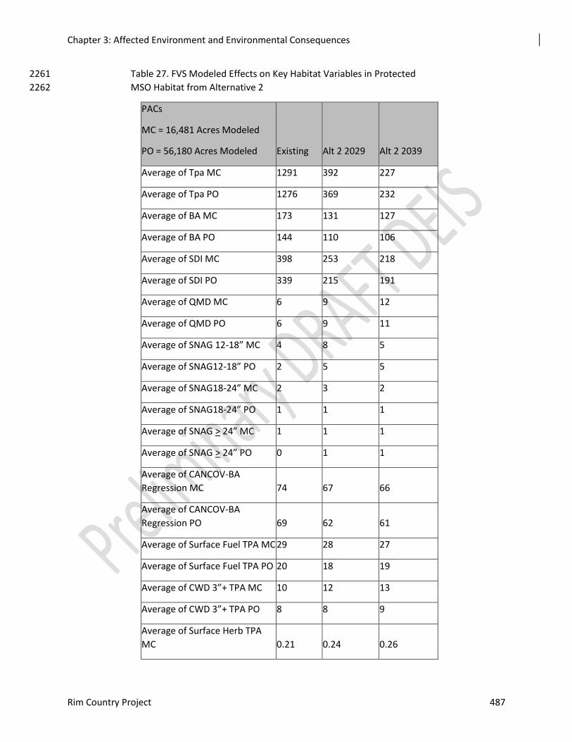
Chapter 3: Affected Environment and Environmental Consequences
Rim Country Project 487
Table 27. FVS Modeled Effects on Key Habitat Variables in Protected 2261
MSO Habitat from Alternative 2 2262
PACs
MC = 16,481 Acres Modeled
PO = 56,180 Acres Modeled Existing Alt 2 2029 Alt 2 2039
Average of Tpa MC 1291 392 227
Average of Tpa PO 1276 369 232
Average of BA MC 173 131 127
Average of BA PO 144 110 106
Average of SDI MC 398 253 218
Average of SDI PO 339 215 191
Average of QMD MC 6 9 12
Average of QMD PO 6 9 11
Average of SNAG 12-18” MC 4 8 5
Average of SNAG12-18” PO 2 5 5
Average of SNAG18-24” MC 2 3 2
Average of SNAG18-24” PO 1 1 1
Average of SNAG > 24” MC 1 1 1
Average of SNAG > 24” PO 0 1 1
Average of CANCOV-BA
Regression MC 74 67 66
Average of CANCOV-BA
Regression PO 69 62 61
Average of Surface Fuel TPA MC 29 28 27
Average of Surface Fuel TPA PO 20 18 19
Average of CWD 3”+ TPA MC 10 12 13
Average of CWD 3”+ TPA PO 8 8 9
Average of Surface Herb TPA
MC 0.21 0.24 0.26
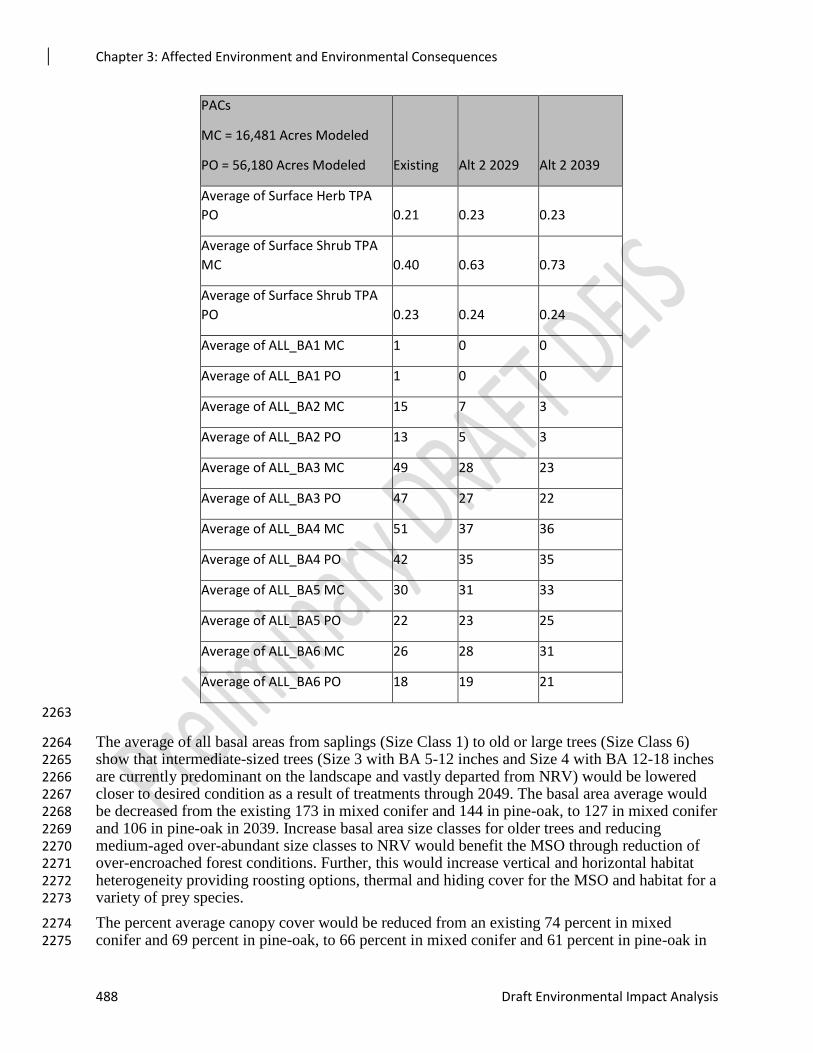
Chapter 3: Affected Environment and Environmental Consequences
488 Draft Environmental Impact Analysis
PACs
MC = 16,481 Acres Modeled
PO = 56,180 Acres Modeled Existing Alt 2 2029 Alt 2 2039
Average of Surface Herb TPA
PO 0.21 0.23 0.23
Average of Surface Shrub TPA
MC 0.40 0.63 0.73
Average of Surface Shrub TPA
PO 0.23 0.24 0.24
Average of ALL_BA1 MC 1 0 0
Average of ALL_BA1 PO 1 0 0
Average of ALL_BA2 MC 15 7 3
Average of ALL_BA2 PO 13 5 3
Average of ALL_BA3 MC 49 28 23
Average of ALL_BA3 PO 47 27 22
Average of ALL_BA4 MC 51 37 36
Average of ALL_BA4 PO 42 35 35
Average of ALL_BA5 MC 30 31 33
Average of ALL_BA5 PO 22 23 25
Average of ALL_BA6 MC 26 28 31
Average of ALL_BA6 PO 18 19 21
2263
The average of all basal areas from saplings (Size Class 1) to old or large trees (Size Class 6) 2264 show that intermediate-sized trees (Size 3 with BA 5-12 inches and Size 4 with BA 12-18 inches 2265 are currently predominant on the landscape and vastly departed from NRV) would be lowered 2266 closer to desired condition as a result of treatments through 2049. The basal area average would 2267 be decreased from the existing 173 in mixed conifer and 144 in pine-oak, to 127 in mixed conifer 2268 and 106 in pine-oak in 2039. Increase basal area size classes for older trees and reducing 2269 medium-aged over-abundant size classes to NRV would benefit the MSO through reduction of 2270 over-encroached forest conditions. Further, this would increase vertical and horizontal habitat 2271 heterogeneity providing roosting options, thermal and hiding cover for the MSO and habitat for a 2272 variety of prey species. 2273
The percent average canopy cover would be reduced from an existing 74 percent in mixed 2274 conifer and 69 percent in pine-oak, to 66 percent in mixed conifer and 61 percent in pine-oak in 2275
Chapter 3: Affected Environment and Environmental Consequences
Rim Country Project 489
2039. Retaining canopy cover allows for a thermal environment needed for nesting and roosting 2276 conditions for the MSO while allowing for prey base and for species that require interlocking 2277 crown habitat. Design features (Appendix C) would preserve the recommended habitat 2278 conditions in PACs wherever possible, while protecting this habitat from severe fire intensity or 2279 stand-replacing effects from crown fire (see the Fire Effects section for Alternative 2 below). 2280
Promotion of large tree growth would be achieved from proposed treatments in Alternative 2 as 2281 stand density index would change from the existing 398 in mixed conifer and 339 in pine-oak, to 2282 218 in mixed conifer and 191 in pine-oak in 2039. 2283
A reduction in SDI competition would increase the quadratic mean diameter from the existing 6 2284 inches in both mixed conifer and pine-oak, to 12 inches in mixed conifer and 11 inches in pine-2285 oak in 2039. By emphasizing large trees, this should also provide for MSO life history needs 2286 (nesting and roosting) and provide for large snags and logs (Gainey et al. 2003).in 2049. 2287
Snags 2288
In PACs, standing snags, coarse woody debris, and downed logs over 12 inches would all 2289 increase as a result of treatments under Alternative 2 (Table 3-**). These Primary Constituent 2290 Element habitat variables important to the MSO and MSO prey species would be preserved over 2291 time under this action alternative. 2292
Snags 12 to 18 inches in diameter would increase from four per acre in mixed conifer and two 2293 per acre in pine-oak to five per acre in both cover types in 2039. Snags 24 inches in diameter and 2294 greater would increase from one per acre in mixed conifer and 0 in pine-oak (existing) to one per 2295 acre in both cover types over 20 years. Retaining/increasing key habitat elements for the MSO 2296 such as snags of various sizes to provide for nesting and roosting and for prey habitat follows 2297 guidance from the MSO Revised Recovery Plan (2012). This is a long-term benefit to the MSO 2298 as a result of treatments in Alternative 2. 2299
Coarse Woody Debris and Understory 2300
In PACs, large downed logs 12 or more inches in size would increase from one to four tons per 2301 acre as a result of treatments over 30 years. Coarse woody debris would increase from the 2302 existing 5.68 tons per acre to 7.61 tons per acre in 2049. 2303
Herbaceous biomass in tons per acre would increase slightly over 20 years. The existing 0.2 tons 2304 per acre in both mixed conifer and pine-oak cover types would increase to 0.26 tons per acre in 2305 mixed conifer and 0.23 tons per acre in pine-oak in 2039. Treatments would move the existing 2306 shrub biomass from 0.40 tons per acre in mixed conifer to 0.73 in 2039. Increasing these Primary 2307 Constituent Elements important to prey base for the MSO would be an added benefit from 2308 treatments in PACs in this alternative. 2309
Fire Effects 2310
Surface fuel loading in MSO Protected Habitat would be reduced under Alternative 2, moving 2311 from an existing 29 tons per acre in mixed conifer and 20 tons per acre in pine-oak, to 27 tons 2312 per acre in mixed conifer and 19 in pine-oak in 2039. 2313
Fire modeling in PACs for Alternative 2 shows the least benefit from treatment compared to 2314 other habitat types, as the objective in PACs is to provide interlocking crowns with larger 2315 proportions of woody debris and snags which can serve as ladder fuels. This complicates 2316 quantifying effects from treatments showing fewer acres of protected habitat benefiting from 2317 treatment than in surrounding habitats (see Recovery Habitat analyses below). Further, by 2318 analyzing the highest hazard categories for Fire Hazard Index and potential for active crown fire, 2319
Chapter 3: Affected Environment and Environmental Consequences
490 Draft Environmental Impact Analysis
treatment in PACs shows greater differences/benefits for preserving existing protected habitat 2320 while treating surrounding habitats at a higher level. 2321
Fire Hazard Index would decrease from Alternative 2 from 91,697 acres (76 percent of the PACs 2322 in the project area in need of treatment) in existing condition to 83,832 acres (69 percent). The 2323 highest and extreme need for treatment categories of Fire Hazard Index from Alternative 2 in 2324 PACs would be 33,410 acres (27 percent) of all PACs in the project area expected to experience 2325 high-severity wildfire. This is decreased from 49,888 acres (41 percent) of all PACs in the 2326 existing condition. Reductions of this magnitude should preserve existing MSO habitat while 2327 encouraging conditions to create more over time through recovery habitats. 2328
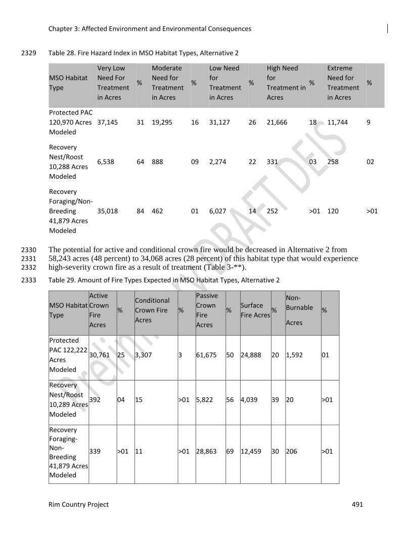
Chapter 3: Affected Environment and Environmental Consequences
Rim Country Project 491
Table 28. Fire Hazard Index in MSO Habitat Types, Alternative 2 2329
MSO Habitat
Type
Very Low
Need For
Treatment
in Acres
%
Moderate
Need for
Treatment
in Acres
%
Low Need
for
Treatment
in Acres
%
High Need
for
Treatment in
Acres
%
Extreme
Need for
Treatment
in Acres
%
Protected PAC
120,970 Acres
Modeled
37,145 31 19,295 16 31,127 26 21,666 18 11,744 9
Recovery
Nest/Roost
10,288 Acres
Modeled
6,538 64 888 09 2,274 22 331 03 258 02
Recovery
Foraging/Non-
Breeding
41,879 Acres
Modeled
35,018 84 462 01 6,027 14 252 >01 120 >01
The potential for active and conditional crown fire would be decreased in Alternative 2 from 2330 58,243 acres (48 percent) to 34,068 acres (28 percent) of this habitat type that would experience 2331 high-severity crown fire as a result of treatment (Table 3-**). 2332
Table 29. Amount of Fire Types Expected in MSO Habitat Types, Alternative 2 2333
MSO Habitat
Type
Active
Crown
Fire
Acres
%
Conditional
Crown Fire
Acres
%
Passive
Crown
Fire
Acres
% Surface
Fire Acres %
Non-
Burnable
Acres
%
Protected
PAC 122,222
Acres
Modeled
30,761 25 3,307 3 61,675 50 24,888 20 1,592 01
Recovery
Nest/Roost
10,289 Acres
Modeled
392 04 15 >01 5,822 56 4,039 39 20 >01
Recovery Foraging-Non-Breeding 41,879 Acres Modeled
339 >01 11 >01 28,863 69 12,459 30 206 >01
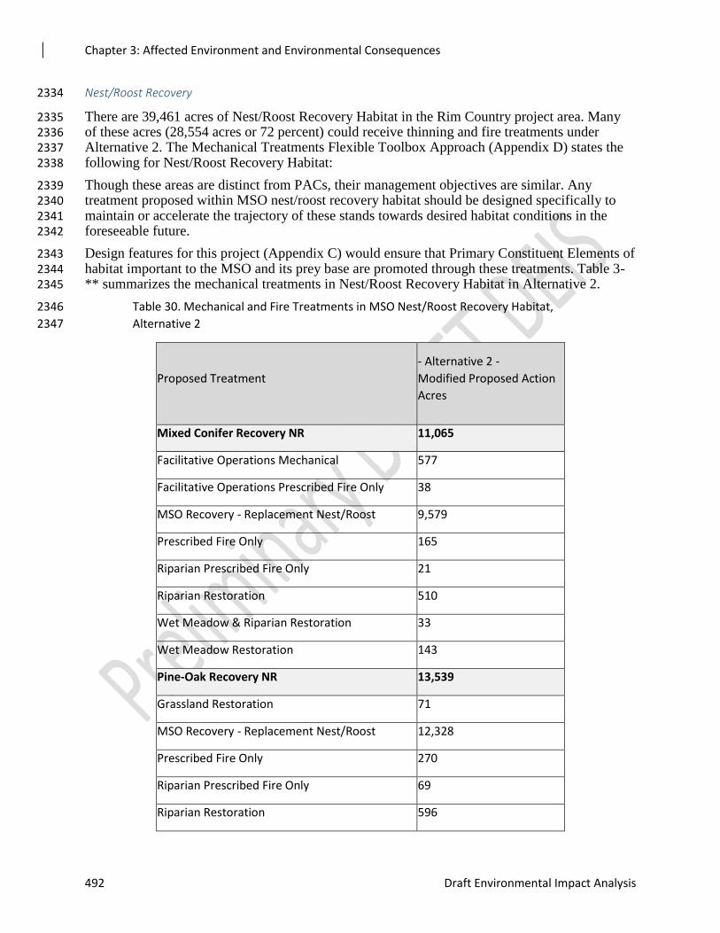
Chapter 3: Affected Environment and Environmental Consequences
492 Draft Environmental Impact Analysis
Nest/Roost Recovery 2334
There are 39,461 acres of Nest/Roost Recovery Habitat in the Rim Country project area. Many 2335 of these acres (28,554 acres or 72 percent) could receive thinning and fire treatments under 2336 Alternative 2. The Mechanical Treatments Flexible Toolbox Approach (Appendix D) states the 2337 following for Nest/Roost Recovery Habitat: 2338
Though these areas are distinct from PACs, their management objectives are similar. Any 2339 treatment proposed within MSO nest/roost recovery habitat should be designed specifically to 2340 maintain or accelerate the trajectory of these stands towards desired habitat conditions in the 2341 foreseeable future. 2342
Design features for this project (Appendix C) would ensure that Primary Constituent Elements of 2343 habitat important to the MSO and its prey base are promoted through these treatments. Table 3-2344 ** summarizes the mechanical treatments in Nest/Roost Recovery Habitat in Alternative 2. 2345
Table 30. Mechanical and Fire Treatments in MSO Nest/Roost Recovery Habitat, 2346
Alternative 2 2347
Proposed Treatment
- Alternative 2 -
Modified Proposed Action
Acres
Mixed Conifer Recovery NR 11,065
Facilitative Operations Mechanical 577
Facilitative Operations Prescribed Fire Only 38
MSO Recovery - Replacement Nest/Roost 9,579
Prescribed Fire Only 165
Riparian Prescribed Fire Only 21
Riparian Restoration 510
Wet Meadow & Riparian Restoration 33
Wet Meadow Restoration 143
Pine-Oak Recovery NR 13,539
Grassland Restoration 71
MSO Recovery - Replacement Nest/Roost 12,328
Prescribed Fire Only 270
Riparian Prescribed Fire Only 69
Riparian Restoration 596
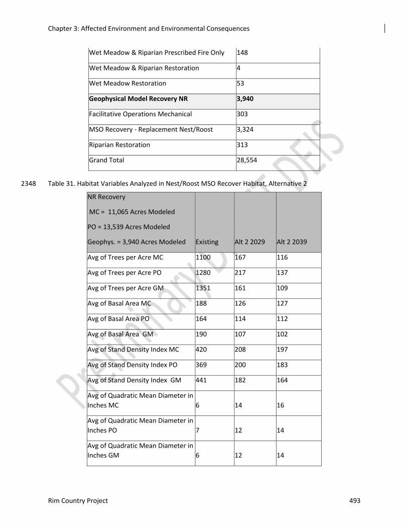
Chapter 3: Affected Environment and Environmental Consequences
Rim Country Project 493
Wet Meadow & Riparian Prescribed Fire Only 148
Wet Meadow & Riparian Restoration 4
Wet Meadow Restoration 53
Geophysical Model Recovery NR 3,940
Facilitative Operations Mechanical 303
MSO Recovery - Replacement Nest/Roost 3,324
Riparian Restoration 313
Grand Total 28,554
Table 31. Habitat Variables Analyzed in Nest/Roost MSO Recover Habitat, Alternative 2 2348
NR Recovery
MC = 11,065 Acres Modeled
PO = 13,539 Acres Modeled
Geophys. = 3,940 Acres Modeled Existing Alt 2 2029 Alt 2 2039
Avg of Trees per Acre MC 1100 167 116
Avg of Trees per Acre PO 1280 217 137
Avg of Trees per Acre GM 1351 161 109
Avg of Basal Area MC 188 126 127
Avg of Basal Area PO 164 114 112
Avg of Basal Area GM 190 107 102
Avg of Stand Density Index MC 420 208 197
Avg of Stand Density Index PO 369 200 183
Avg of Stand Density Index GM 441 182 164
Avg of Quadratic Mean Diameter in
Inches MC 6 14 16
Avg of Quadratic Mean Diameter in
Inches PO 7 12 14
Avg of Quadratic Mean Diameter in
Inches GM 6 12 14
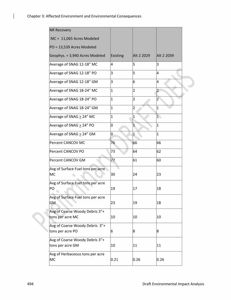
Chapter 3: Affected Environment and Environmental Consequences
494 Draft Environmental Impact Analysis
NR Recovery
MC = 11,065 Acres Modeled
PO = 13,539 Acres Modeled
Geophys. = 3,940 Acres Modeled Existing Alt 2 2029 Alt 2 2039
Average of SNAG 12-18” MC 4 5 3
Average of SNAG 12-18” PO 3 5 4
Average of SNAG 12-18” GM 3 6 4
Average of SNAG 18-24” MC 1 2 2
Average of SNAG 18-24” PO 1 2 2
Average of SNAG 18-24” GM 1 2 1
Average of SNAG > 24” MC 1 1 1
Average of SNAG > 24” PO 0 1 1
Average of SNAG > 24” GM 0 1 1
Percent CANCOV MC 76 66 66
Percent CANCOV PO 73 64 62
Percent CANCOV GM 77 61 60
Avg of Surface Fuel tons per acre
MC 30 24 23
Avg of Surface Fuel tons per acre
PO 19 17 18
Avg of Surface Fuel tons per acre
GM 23 19 18
Avg of Coarse Woody Debris 3”+
tons per acre MC 10 10 10
Avg of Coarse Woody Debris 3”+
tons per acre PO 6 8 8
Avg of Coarse Woody Debris 3”+
tons per acre GM 10 11 11
Avg of Herbaceous tons per acre
MC 0.21 0.26 0.26
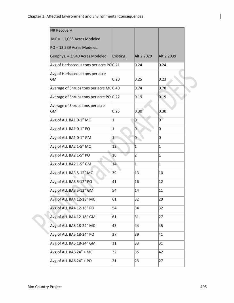
Chapter 3: Affected Environment and Environmental Consequences
Rim Country Project 495
NR Recovery
MC = 11,065 Acres Modeled
PO = 13,539 Acres Modeled
Geophys. = 3,940 Acres Modeled Existing Alt 2 2029 Alt 2 2039
Avg of Herbaceous tons per acre PO 0.21 0.24 0.24
Avg of Herbaceous tons per acre
GM 0.20 0.25 0.23
Average of Shrubs tons per acre MC 0.40 0.74 0.78
Average of Shrubs tons per acre PO 0.22 0.19 0.19
Average of Shrubs tons per acre
GM 0.25 0.30 0.30
Avg of ALL BA1 0-1” MC 1 0 0
Avg of ALL BA1 0-1” PO 1 0 0
Avg of ALL BA1 0-1” GM 1 0 0
Avg of ALL BA2 1-5” MC 12 1 1
Avg of ALL BA2 1-5” PO 10 2 1
Avg of ALL BA2 1-5” GM 14 1 1
Avg of ALL BA3 5-12” MC 39 13 10
Avg of ALL BA3 5-12” PO 41 16 12
Avg of ALL BA3 5-12” GM 54 14 11
Avg of ALL BA4 12-18” MC 61 32 29
Avg of ALL BA4 12-18” PO 54 34 32
Avg of ALL BA4 12-18” GM 61 31 27
Avg of ALL BA5 18-24” MC 43 44 45
Avg of ALL BA5 18-24” PO 37 39 41
Avg of ALL BA5 18-24” GM 31 33 31
Avg of ALL BA6 24” + MC 32 35 42
Avg of ALL BA6 24” + PO 21 23 27
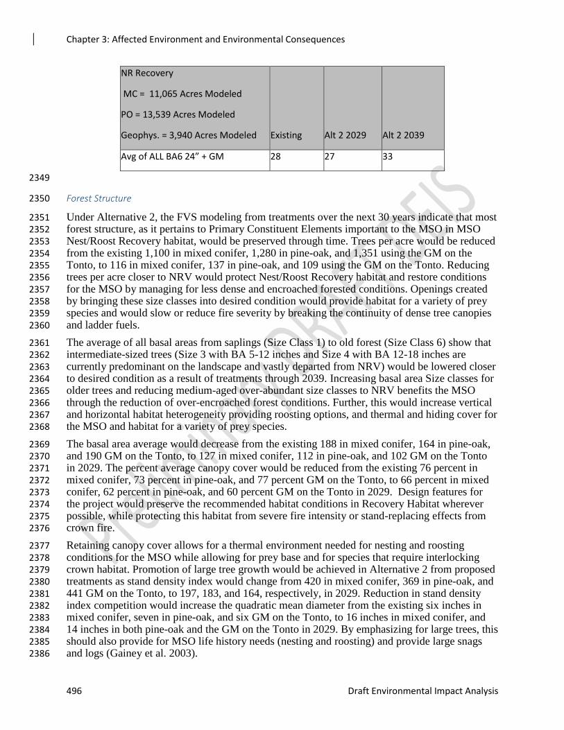
Chapter 3: Affected Environment and Environmental Consequences
496 Draft Environmental Impact Analysis
NR Recovery
MC = 11,065 Acres Modeled
PO = 13,539 Acres Modeled
Geophys. = 3,940 Acres Modeled Existing Alt 2 2029 Alt 2 2039
Avg of ALL BA6 24” + GM 28 27 33
2349
Forest Structure 2350
Under Alternative 2, the FVS modeling from treatments over the next 30 years indicate that most 2351 forest structure, as it pertains to Primary Constituent Elements important to the MSO in MSO 2352 Nest/Roost Recovery habitat, would be preserved through time. Trees per acre would be reduced 2353 from the existing 1,100 in mixed conifer, 1,280 in pine-oak, and 1,351 using the GM on the 2354 Tonto, to 116 in mixed conifer, 137 in pine-oak, and 109 using the GM on the Tonto. Reducing 2355 trees per acre closer to NRV would protect Nest/Roost Recovery habitat and restore conditions 2356 for the MSO by managing for less dense and encroached forested conditions. Openings created 2357 by bringing these size classes into desired condition would provide habitat for a variety of prey 2358 species and would slow or reduce fire severity by breaking the continuity of dense tree canopies 2359 and ladder fuels. 2360
The average of all basal areas from saplings (Size Class 1) to old forest (Size Class 6) show that 2361 intermediate-sized trees (Size 3 with BA 5-12 inches and Size 4 with BA 12-18 inches are 2362 currently predominant on the landscape and vastly departed from NRV) would be lowered closer 2363 to desired condition as a result of treatments through 2039. Increasing basal area Size classes for 2364 older trees and reducing medium-aged over-abundant size classes to NRV benefits the MSO 2365 through the reduction of over-encroached forest conditions. Further, this would increase vertical 2366 and horizontal habitat heterogeneity providing roosting options, and thermal and hiding cover for 2367 the MSO and habitat for a variety of prey species. 2368
The basal area average would decrease from the existing 188 in mixed conifer, 164 in pine-oak, 2369 and 190 GM on the Tonto, to 127 in mixed conifer, 112 in pine-oak, and 102 GM on the Tonto 2370 in 2029. The percent average canopy cover would be reduced from the existing 76 percent in 2371 mixed conifer, 73 percent in pine-oak, and 77 percent GM on the Tonto, to 66 percent in mixed 2372 conifer, 62 percent in pine-oak, and 60 percent GM on the Tonto in 2029. Design features for 2373 the project would preserve the recommended habitat conditions in Recovery Habitat wherever 2374 possible, while protecting this habitat from severe fire intensity or stand-replacing effects from 2375 crown fire. 2376
Retaining canopy cover allows for a thermal environment needed for nesting and roosting 2377 conditions for the MSO while allowing for prey base and for species that require interlocking 2378 crown habitat. Promotion of large tree growth would be achieved in Alternative 2 from proposed 2379 treatments as stand density index would change from 420 in mixed conifer, 369 in pine-oak, and 2380 441 GM on the Tonto, to 197, 183, and 164, respectively, in 2029. Reduction in stand density 2381 index competition would increase the quadratic mean diameter from the existing six inches in 2382 mixed conifer, seven in pine-oak, and six GM on the Tonto, to 16 inches in mixed conifer, and 2383 14 inches in both pine-oak and the GM on the Tonto in 2029. By emphasizing for large trees, this 2384 should also provide for MSO life history needs (nesting and roosting) and provide large snags 2385 and logs (Gainey et al. 2003). 2386
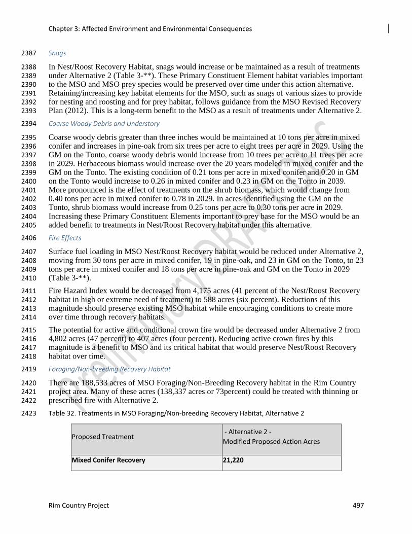
Chapter 3: Affected Environment and Environmental Consequences
Rim Country Project 497
Snags 2387
In Nest/Roost Recovery Habitat, snags would increase or be maintained as a result of treatments 2388 under Alternative 2 (Table 3-**). These Primary Constituent Element habitat variables important 2389 to the MSO and MSO prey species would be preserved over time under this action alternative. 2390 Retaining/increasing key habitat elements for the MSO, such as snags of various sizes to provide 2391 for nesting and roosting and for prey habitat, follows guidance from the MSO Revised Recovery 2392 Plan (2012). This is a long-term benefit to the MSO as a result of treatments under Alternative 2. 2393
Coarse Woody Debris and Understory 2394
Coarse woody debris greater than three inches would be maintained at 10 tons per acre in mixed 2395 conifer and increases in pine-oak from six trees per acre to eight trees per acre in 2029. Using the 2396 GM on the Tonto, coarse woody debris would increase from 10 trees per acre to 11 trees per acre 2397 in 2029. Herbaceous biomass would increase over the 20 years modeled in mixed conifer and the 2398 GM on the Tonto. The existing condition of 0.21 tons per acre in mixed conifer and 0.20 in GM 2399 on the Tonto would increase to 0.26 in mixed conifer and 0.23 in GM on the Tonto in 2039. 2400 More pronounced is the effect of treatments on the shrub biomass, which would change from 2401 0.40 tons per acre in mixed conifer to 0.78 in 2029. In acres identified using the GM on the 2402 Tonto, shrub biomass would increase from 0.25 tons per acre to 0.30 tons per acre in 2029. 2403 Increasing these Primary Constituent Elements important to prey base for the MSO would be an 2404 added benefit to treatments in Nest/Roost Recovery habitat under this alternative. 2405
Fire Effects 2406
Surface fuel loading in MSO Nest/Roost Recovery habitat would be reduced under Alternative 2, 2407 moving from 30 tons per acre in mixed conifer, 19 in pine-oak, and 23 in GM on the Tonto, to 23 2408 tons per acre in mixed conifer and 18 tons per acre in pine-oak and GM on the Tonto in 2029 2409 (Table 3-**). 2410
Fire Hazard Index would be decreased from 4,175 acres (41 percent of the Nest/Roost Recovery 2411 habitat in high or extreme need of treatment) to 588 acres (six percent). Reductions of this 2412 magnitude should preserve existing MSO habitat while encouraging conditions to create more 2413 over time through recovery habitats. 2414
The potential for active and conditional crown fire would be decreased under Alternative 2 from 2415 4,802 acres (47 percent) to 407 acres (four percent). Reducing active crown fires by this 2416 magnitude is a benefit to MSO and its critical habitat that would preserve Nest/Roost Recovery 2417 habitat over time. 2418
Foraging/Non-breeding Recovery Habitat 2419
There are 188,533 acres of MSO Foraging/Non-Breeding Recovery habitat in the Rim Country 2420 project area. Many of these acres (138,337 acres or 73percent) could be treated with thinning or 2421 prescribed fire with Alternative 2. 2422
Table 32. Treatments in MSO Foraging/Non-breeding Recovery Habitat, Alternative 2 2423
Proposed Treatment - Alternative 2 -
Modified Proposed Action Acres
Mixed Conifer Recovery 21,220
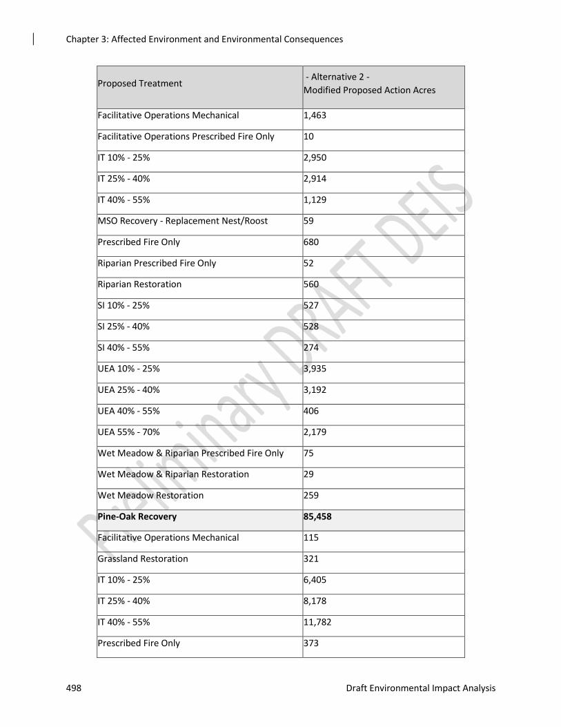
Chapter 3: Affected Environment and Environmental Consequences
498 Draft Environmental Impact Analysis
Proposed Treatment - Alternative 2 -
Modified Proposed Action Acres
Facilitative Operations Mechanical 1,463
Facilitative Operations Prescribed Fire Only 10
IT 10% - 25% 2,950
IT 25% - 40% 2,914
IT 40% - 55% 1,129
MSO Recovery - Replacement Nest/Roost 59
Prescribed Fire Only 680
Riparian Prescribed Fire Only 52
Riparian Restoration 560
SI 10% - 25% 527
SI 25% - 40% 528
SI 40% - 55% 274
UEA 10% - 25% 3,935
UEA 25% - 40% 3,192
UEA 40% - 55% 406
UEA 55% - 70% 2,179
Wet Meadow & Riparian Prescribed Fire Only 75
Wet Meadow & Riparian Restoration 29
Wet Meadow Restoration 259
Pine-Oak Recovery 85,458
Facilitative Operations Mechanical 115
Grassland Restoration 321
IT 10% - 25% 6,405
IT 25% - 40% 8,178
IT 40% - 55% 11,782
Prescribed Fire Only 373
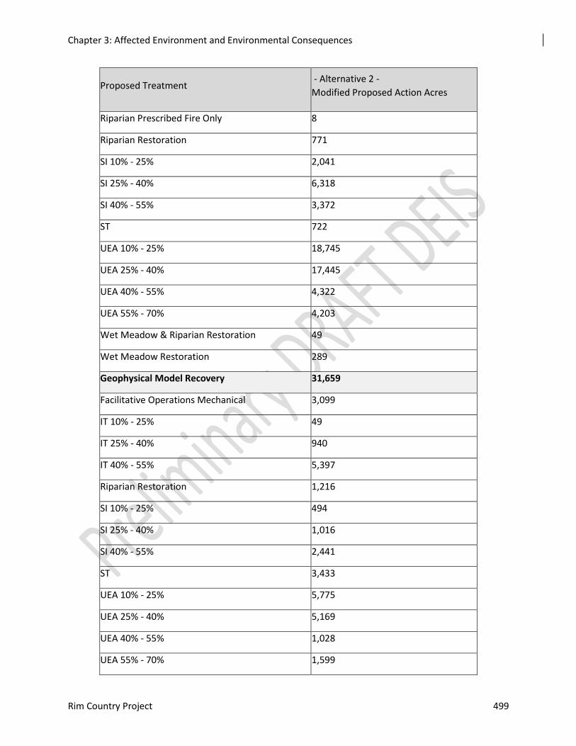
Chapter 3: Affected Environment and Environmental Consequences
Rim Country Project 499
Proposed Treatment - Alternative 2 -
Modified Proposed Action Acres
Riparian Prescribed Fire Only 8
Riparian Restoration 771
SI 10% - 25% 2,041
SI 25% - 40% 6,318
SI 40% - 55% 3,372
ST 722
UEA 10% - 25% 18,745
UEA 25% - 40% 17,445
UEA 40% - 55% 4,322
UEA 55% - 70% 4,203
Wet Meadow & Riparian Restoration 49
Wet Meadow Restoration 289
Geophysical Model Recovery 31,659
Facilitative Operations Mechanical 3,099
IT 10% - 25% 49
IT 25% - 40% 940
IT 40% - 55% 5,397
Riparian Restoration 1,216
SI 10% - 25% 494
SI 25% - 40% 1,016
SI 40% - 55% 2,441
ST 3,433
UEA 10% - 25% 5,775
UEA 25% - 40% 5,169
UEA 40% - 55% 1,028
UEA 55% - 70% 1,599
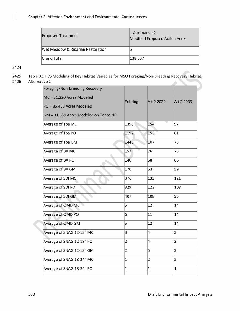
Chapter 3: Affected Environment and Environmental Consequences
500 Draft Environmental Impact Analysis
Proposed Treatment - Alternative 2 -
Modified Proposed Action Acres
Wet Meadow & Riparian Restoration 5
Grand Total 138,337
2424
Table 33. FVS Modeling of Key Habitat Variables for MSO Foraging/Non-breeding Recovery Habitat, 2425 Alternative 2 2426
Foraging/Non-breeding Recovery
MC = 21,220 Acres Modeled
PO = 85,458 Acres Modeled
GM = 31,659 Acres Modeled on Tonto NF
Existing Alt 2 2029 Alt 2 2039
Average of Tpa MC 1398 154 97
Average of Tpa PO 1192 153 81
Average of Tpa GM 1443 107 73
Average of BA MC 157 76 75
Average of BA PO 140 68 66
Average of BA GM 170 63 59
Average of SDI MC 376 133 121
Average of SDI PO 329 123 108
Average of SDI GM 407 108 95
Average of QMD MC 5 12 14
Average of QMD PO 6 11 14
Average of QMD GM 5 12 14
Average of SNAG 12-18” MC 3 4 3
Average of SNAG 12-18” PO 2 4 3
Average of SNAG 12-18” GM 2 5 3
Average of SNAG 18-24” MC 1 2 2
Average of SNAG 18-24” PO 1 1 1
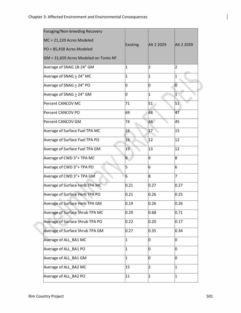
Chapter 3: Affected Environment and Environmental Consequences
Rim Country Project 501
Foraging/Non-breeding Recovery
MC = 21,220 Acres Modeled
PO = 85,458 Acres Modeled
GM = 31,659 Acres Modeled on Tonto NF
Existing Alt 2 2029 Alt 2 2039
Average of SNAG 18-24” GM 1 2 2
Average of SNAG > 24” MC 1 1 1
Average of SNAG > 24” PO 0 0 0
Average of SNAG > 24” GM 0 1 1
Percent CANCOV MC 71 51 51
Percent CANCOV PO 69 48 47
Percent CANCOV GM 74 46 45
Average of Surface Fuel TPA MC 24 17 15
Average of Surface Fuel TPA PO 16 12 12
Average of Surface Fuel TPA GM 19 13 12
Average of CWD 3”+ TPA MC 8 9 8
Average of CWD 3”+ TPA PO 5 6 6
Average of CWD 3”+ TPA GM 6 8 7
Average of Surface Herb TPA MC 0.21 0.27 0.27
Average of Surface Herb TPA PO 0.21 0.26 0.25
Average of Surface Herb TPA GM 0.19 0.26 0.26
Average of Surface Shrub TPA MC 0.29 0.68 0.71
Average of Surface Shrub TPA PO 0.22 0.20 0.17
Average of Surface Shrub TPA GM 0.27 0.35 0.34
Average of ALL_BA1 MC 1 0 0
Average of ALL_BA1 PO 1 0 0
Average of ALL_BA1 GM 1 0 0
Average of ALL_BA2 MC 15 2 1
Average of ALL_BA2 PO 11 1 1
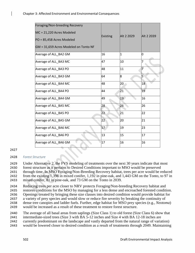
Chapter 3: Affected Environment and Environmental Consequences
502 Draft Environmental Impact Analysis
Foraging/Non-breeding Recovery
MC = 21,220 Acres Modeled
PO = 85,458 Acres Modeled
GM = 31,659 Acres Modeled on Tonto NF
Existing Alt 2 2029 Alt 2 2039
Average of ALL_BA2 GM 16 1 0
Average of ALL_BA3 MC 47 10 7
Average of ALL_BA3 PO 48 11 7
Average of ALL_BA3 GM 64 8 5
Average of ALL_BA4 MC 48 20 18
Average of ALL_BA4 PO 44 21 19
Average of ALL_BA4 GM 49 19 16
Average of ALL_BA5 MC 28 26 26
Average of ALL_BA5 PO 22 21 22
Average of ALL_BA5 GM 22 20 21
Average of ALL_BA6 MC 17 19 23
Average of ALL_BA6 PO 13 15 17
Average of ALL_BA6 GM 17 16 16
2427
Forest Structure 2428
Under Alternative 2, the FVS modeling of treatments over the next 30 years indicate that most 2429 forest structure as it pertains to Desired Conditions important to MSO would be preserved 2430 through time. In MSO Foraging/Non-Breeding Recovery habitat, trees per acre would be reduced 2431 from the existing 1,398 in mixed conifer, 1,192 in pine-oak, and 1,443 GM on the Tonto, to 97 in 2432 mixed conifer, 81 in pine-oak, and 73 GM on the Tonto in 2039. 2433
Reducing trees per acre closer to NRV protects Foraging/Non-breeding Recovery habitat and 2434 restores conditions for the MSO by managing for a less dense and encroached forested condition. 2435 Openings created by bringing these size classes into desired condition would provide habitat for 2436 a variety of prey species and would slow or reduce fire severity by breaking the continuity of 2437 dense tree canopies and ladder fuels. Further, edge habitat for MSO prey species (e.g., Neotoma) 2438 would be increased as a result of these treatment to restore forest structure. 2439
The average of all basal areas from saplings (Size Class 1) to old forest (Size Class 6) show that 2440 intermediate-sized trees (Size 3 with BA 5-12 inches and Size 4 with BA 12-18 inches are 2441 currently predominant on the landscape and vastly departed from the natural range of variation) 2442 would be lowered closer to desired condition as a result of treatments through 2049. Maintaining 2443
Chapter 3: Affected Environment and Environmental Consequences
Rim Country Project 503
basal area size classes for older trees and reducing medium-aged over-abundant size classes to 2444 NRV benefits the MSO as above through reduction of over encroached forest conditions. 2445 Further, in Foraging/Non-breeding Recovery habitat, this would increase vertical and horizontal 2446 habitat heterogeneity providing habitat for a variety of prey species. 2447
The basal area average would be decreased from the existing condition of 157 in mixed conifer, 2448 140 in pine-oak, and 170 GM on the Tonto, to 75 in mixed conifer, 66 in pine-oak, and 59 GM 2449 on the Tonto in 2039. The percent average canopy cover would be reduced from 71 percent in 2450 mixed conifer, 69 percent in pine-oak, and 74 percent GM on the Tonto, to 51 percent in mixed 2451 conifer, 47 percent in pine-oak, and 45 percent GM on the Tonto in 2039. The percent average 2452 canopy cover would be reduced from 50 percent to 26 percent in 2029 and 20 percent in 2049. 2453 Design features would preserve the recommended habitat conditions in Recovery Habitat 2454 wherever possible, while protecting this habitat from severe fire intensity or stand-replacing 2455 effects from crown fire. 2456
Promotion of large tree growth would be achieved with proposed treatments as the stand density 2457 index would change from 376 in mixed conifer, 329 in pine-oak, and 407 GM on the Tonto, to 2458 121 in mixed conifer, 108 in pine-oak, and 95 GM on the Tonto in 2039. A reduction in SDI 2459 competition would increase the quadratic mean diameter from the existing five in mixed conifer, 2460 six in pine-oak, and five GM on the Tonto, to 14 in all cover types in 2039. 2461
Snags 2462
In Foraging/Non-Breeding Recovery Habitat, snags greater than 12 inches in diameter would all 2463 increase slightly as a result of treatments under Alternative 2 (Table 3-**). These Primary 2464 Constituent Element habitat variables important to the MSO and MSO prey species would be 2465 preserved over time under this action alternative. 2466
Coarse Woody Debris and Understory 2467
Coarse woody debris greater than three inches would increase from the existing 8 tons per acre in 2468 mixed conifer, five tons per acre in pine-oak, and six tons per acre GM on the Tonto, to 8 tons 2469 per acre in mixed conifer, six tons per acre in pine-oak, and seven tons per acre GM on the Tonto 2470 in 2039. 2471
Herbaceous biomass in tons per acre would increase over 20 years. Shrub biomass would also 2472 increase in mixed conifer and GM on the Tonto in 2039. Shrub biomass would slightly decrease. 2473
Fire Effects 2474
Surface fuel loading in MSO Foraging/Non-breeding Recovery habitat would be reduced under 2475 Alternative 2, moving from 24 tons per acre in mixed conifer, 16 tons per acre in pine-oak, and 2476 19 tons per acre GM on the Tonto, to 15 tons per acre in mixed conifer, and 12 tons per acre in 2477 pine-oak and GM on the Tonto in 2039 (Table 3-**). 2478
Fire Hazard Index would be decreased from 10,717 acres (26 percent of the Foraging/Other 2479 Recovery habitat modeled in need of treatment) to 372 acres (one percent). Reductions of this 2480 magnitude should preserve existing MSO habitat while encouraging conditions to create more 2481 over time through recovery habitats. 2482
The potential for crown fire would be decreased under Alternative 2 from 15,090 acres (36 2483 percent) to 350 acres (one percent). Reducing active crown fires by this magnitude would be a 2484 benefit to the MSO and its critical habitat that would preserve Foraging/Other Recovery habitat 2485 over time. 2486
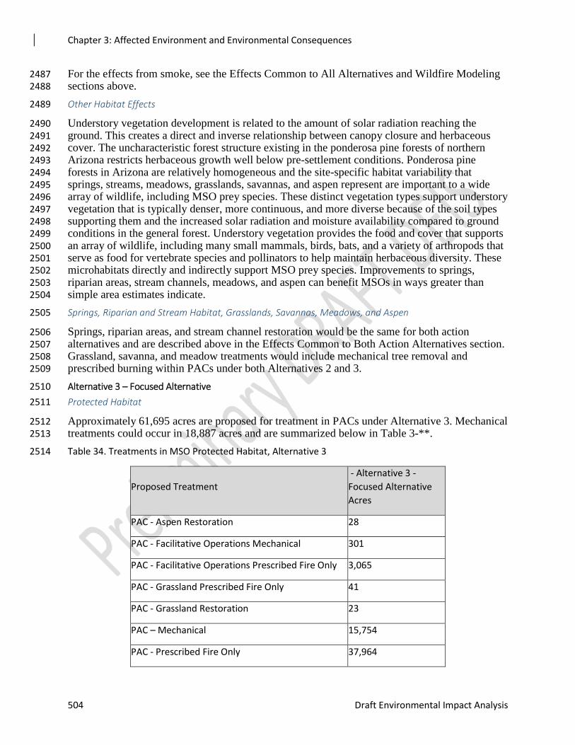
Chapter 3: Affected Environment and Environmental Consequences
504 Draft Environmental Impact Analysis
For the effects from smoke, see the Effects Common to All Alternatives and Wildfire Modeling 2487 sections above. 2488
Other Habitat Effects 2489
Understory vegetation development is related to the amount of solar radiation reaching the 2490 ground. This creates a direct and inverse relationship between canopy closure and herbaceous 2491 cover. The uncharacteristic forest structure existing in the ponderosa pine forests of northern 2492 Arizona restricts herbaceous growth well below pre-settlement conditions. Ponderosa pine 2493 forests in Arizona are relatively homogeneous and the site-specific habitat variability that 2494 springs, streams, meadows, grasslands, savannas, and aspen represent are important to a wide 2495 array of wildlife, including MSO prey species. These distinct vegetation types support understory 2496 vegetation that is typically denser, more continuous, and more diverse because of the soil types 2497 supporting them and the increased solar radiation and moisture availability compared to ground 2498 conditions in the general forest. Understory vegetation provides the food and cover that supports 2499 an array of wildlife, including many small mammals, birds, bats, and a variety of arthropods that 2500 serve as food for vertebrate species and pollinators to help maintain herbaceous diversity. These 2501 microhabitats directly and indirectly support MSO prey species. Improvements to springs, 2502 riparian areas, stream channels, meadows, and aspen can benefit MSOs in ways greater than 2503 simple area estimates indicate. 2504
Springs, Riparian and Stream Habitat, Grasslands, Savannas, Meadows, and Aspen 2505
Springs, riparian areas, and stream channel restoration would be the same for both action 2506 alternatives and are described above in the Effects Common to Both Action Alternatives section. 2507 Grassland, savanna, and meadow treatments would include mechanical tree removal and 2508 prescribed burning within PACs under both Alternatives 2 and 3. 2509
Alternative 3 – Focused Alternative 2510
Protected Habitat 2511
Approximately 61,695 acres are proposed for treatment in PACs under Alternative 3. Mechanical 2512 treatments could occur in 18,887 acres and are summarized below in Table 3-**. 2513
Table 34. Treatments in MSO Protected Habitat, Alternative 3 2514
Proposed Treatment
- Alternative 3 -
Focused Alternative
Acres
PAC - Aspen Restoration 28
PAC - Facilitative Operations Mechanical 301
PAC - Facilitative Operations Prescribed Fire Only 3,065
PAC - Grassland Prescribed Fire Only 41
PAC - Grassland Restoration 23
PAC – Mechanical 15,754
PAC - Prescribed Fire Only 37,964
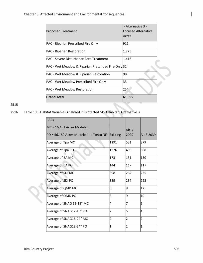
Chapter 3: Affected Environment and Environmental Consequences
Rim Country Project 505
Proposed Treatment
- Alternative 3 -
Focused Alternative
Acres
PAC - Riparian Prescribed Fire Only 911
PAC - Riparian Restoration 1,775
PAC - Severe Disturbance Area Treatment 1,416
PAC - Wet Meadow & Riparian Prescribed Fire Only 32
PAC - Wet Meadow & Riparian Restoration 98
PAC - Wet Meadow Prescribed Fire Only 33
PAC - Wet Meadow Restoration 254
Grand Total 61,695
2515
Table 105. Habitat Variables Analyzed in Protected MSO Habitat, Alternative 3 2516
PACs
MC = 16,481 Acres Modeled
PO = 56,180 Acres Modeled on Tonto NF Existing
Alt 3
2029 Alt 3 2039
Average of Tpa MC 1291 531 379
Average of Tpa PO 1276 496 368
Average of BA MC 173 131 130
Average of BA PO 144 117 117
Average of SDI MC 398 262 235
Average of SDI PO 339 237 223
Average of QMD MC 6 9 12
Average of QMD PO 6 9 10
Average of SNAG 12-18” MC 4 7 5
Average of SNAG12-18” PO 2 5 4
Average of SNAG18-24” MC 2 2 2
Average of SNAG18-24” PO 1 1 1
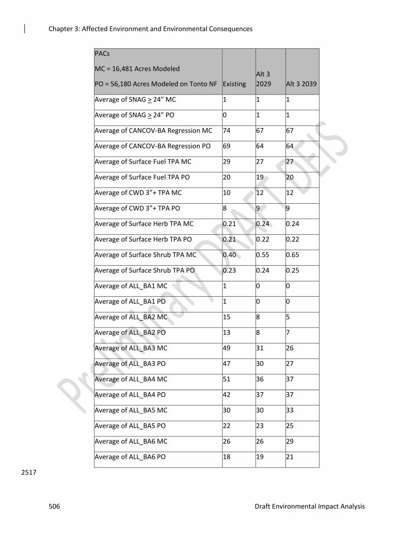
Chapter 3: Affected Environment and Environmental Consequences
506 Draft Environmental Impact Analysis
PACs
MC = 16,481 Acres Modeled
PO = 56,180 Acres Modeled on Tonto NF Existing
Alt 3
2029 Alt 3 2039
Average of SNAG > 24” MC 1 1 1
Average of SNAG > 24” PO 0 1 1
Average of CANCOV-BA Regression MC 74 67 67
Average of CANCOV-BA Regression PO 69 64 64
Average of Surface Fuel TPA MC 29 27 27
Average of Surface Fuel TPA PO 20 19 20
Average of CWD 3”+ TPA MC 10 12 12
Average of CWD 3”+ TPA PO 8 9 9
Average of Surface Herb TPA MC 0.21 0.24 0.24
Average of Surface Herb TPA PO 0.21 0.22 0.22
Average of Surface Shrub TPA MC 0.40 0.55 0.65
Average of Surface Shrub TPA PO 0.23 0.24 0.25
Average of ALL_BA1 MC 1 0 0
Average of ALL_BA1 PO 1 0 0
Average of ALL_BA2 MC 15 8 5
Average of ALL_BA2 PO 13 8 7
Average of ALL_BA3 MC 49 31 26
Average of ALL_BA3 PO 47 30 27
Average of ALL_BA4 MC 51 36 37
Average of ALL_BA4 PO 42 37 37
Average of ALL_BA5 MC 30 30 33
Average of ALL_BA5 PO 22 23 25
Average of ALL_BA6 MC 26 26 29
Average of ALL_BA6 PO 18 19 21
2517
Chapter 3: Affected Environment and Environmental Consequences
Rim Country Project 507
Forest Structure 2518
Under Alternative 3, the FVS modeling of treatments over the next 30 years indicates that most 2519 forest structure, as it pertains to Primary Constituent Elements important to the MSO in PACs, is 2520 preserved through time. Trees per acre would be reduced from the existing 1,291 in mixed 2521 conifer and 1,276 in pine-oak, to 379 in mixed conifer and 368 in pine-oak in 2029 (Table 3-**). 2522 Reducing trees per acre closer to NRV protects PACs and restores conditions for MSO by 2523 managing for less dense and encroached forested conditions. Openings created by bringing tree 2524 size classes to desired condition would provide habitat for a variety of prey species and would 2525 slow or reduce fire severity by breaking the continuity of dense tree canopies and ladder fuels. 2526
The average of all basal areas from saplings (Size Class 1) to old tree or large trees (Size Class 6) 2527 show that intermediate-sized trees (Size 3 with BA 5-12 inches and Size 4 with BA 12-18 inches 2528 are currently predominant on the landscape and vastly departed from NRV) would be lowered, 2529 but not to desired conditions, as a result of treatments through 2039. The basal area average 2530 would be decreased from the existing 173 in mixed conifer and 144 in pine-oak, to 130 in mixed 2531 conifer and 117 in pine-oak in 2039. These modeled results would align with the MSO Recovery 2532 Plan recommendations. Design features would preserve the recommended habitat conditions in 2533 PACs wherever possible, while protecting this habitat from severe fire intensity or stand-2534 replacing effects from crown fire. 2535
Promotion of large tree growth would be achieved in Alternative 3 as stand density index would 2536 change from the existing 398 in mixed conifer and 339 in pine-oak, to 235 in mixed conifer and 2537 223 in pine-oak in 2039. A reduction in SDI competition would increase the quadratic mean 2538 diameter from the existing six inches in both mixed conifer and pine-oak, to 12 inches in mixed 2539 conifer and 10 inches in pine-oak in 2039. 2540
Snags 2541
In PACs, standing snags, coarse woody debris, and downed logs over 12 inches would all be 2542 maintained or increase as a result of treatments under Alternative 3 (Table 3-**). These Primary 2543 Constituent Element habitat variables important to the MSO and MSO prey species would be 2544 preserved over time under this action alternative. Snags 12 to 18 inches in diameter would 2545 increase from two per acre to four per acre in 2039. The number of snags per acre, snags 24 2546 inches in diameter and greater would be maintained in PACs over the 20 years modeled. 2547 Retaining/increasing key habitat elements for the MSO such as snags of various sizes to provide 2548 for nesting and roosting and for prey habitat follows guidance from the MSO Revised Recovery 2549 Plan (2012). This is a long-term benefit to the MSO as a result of treatments in Alternative 3. 2550
Coarse Woody Debris and Understory 2551
In PACs, coarse woody debris three inches or greater would increase from 10 to 12 tons per acre 2552 in mixed conifer and from eight to nine tons per acre in pine-oak as a result of treatments over 2553 the 20 years modeled. Herbaceous biomass in tons per acre would increase slightly over 20 2554 years. Proposed treatments would change the amount of shrub biomass from the existing 0.4 tons 2555 per acre in mixed conifer to 0.65 in 2039. Shrub biomass would slightly increase in pine-oak as a 2556 result of treatments over the 20 years modeled. 2557
Fire Effects 2558
Surface fuel loading in MSO Protected Habitat would be slightly reduced under Alternative 3, 2559 moving from an existing 29 tons per acre in mixed conifer to 27 tons per acre in 2039. 2560

Chapter 3: Affected Environment and Environmental Consequences
508 Draft Environmental Impact Analysis
Fire Hazard Index would decrease from 49,889 acres (41 percent of the PACs in the project area 2561 in need of treatment) to 33,105 acres (30 percent). Reductions of this magnitude should preserve 2562 existing MSO habitat while encouraging conditions to create more over time through recovery 2563 habitats. 2564
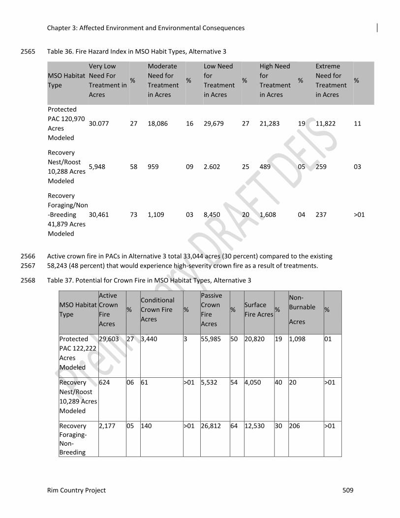
Chapter 3: Affected Environment and Environmental Consequences
Rim Country Project 509
Table 36. Fire Hazard Index in MSO Habit Types, Alternative 3 2565
MSO Habitat
Type
Very Low
Need For
Treatment in
Acres
%
Moderate
Need for
Treatment
in Acres
%
Low Need
for
Treatment
in Acres
%
High Need
for
Treatment
in Acres
%
Extreme
Need for
Treatment
in Acres
%
Protected
PAC 120,970
Acres
Modeled
30.077 27 18,086 16 29,679 27 21,283 19 11,822 11
Recovery
Nest/Roost
10,288 Acres
Modeled
5,948 58 959 09 2.602 25 489 05 259 03
Recovery
Foraging/Non
-Breeding
41,879 Acres
Modeled
30,461 73 1,109 03 8,450 20 1,608 04 237 >01
Active crown fire in PACs in Alternative 3 total 33,044 acres (30 percent) compared to the existing 2566
58,243 (48 percent) that would experience high-severity crown fire as a result of treatments. 2567
Table 37. Potential for Crown Fire in MSO Habitat Types, Alternative 3 2568
MSO Habitat
Type
Active
Crown
Fire
Acres
%
Conditional
Crown Fire
Acres
%
Passive
Crown
Fire
Acres
% Surface
Fire Acres %
Non-
Burnable
Acres
%
Protected
PAC 122,222
Acres
Modeled
29,603 27 3,440 3 55,985 50 20,820 19 1,098 01
Recovery
Nest/Roost
10,289 Acres
Modeled
624 06 61 >01 5,532 54 4,050 40 20 >01
Recovery Foraging-Non-Breeding
2,177 05 140 >01 26,812 64 12,530 30 206 >01
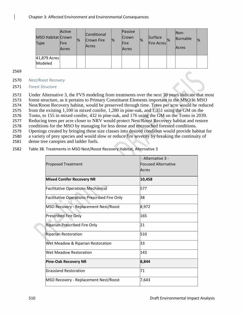
Chapter 3: Affected Environment and Environmental Consequences
510 Draft Environmental Impact Analysis
MSO Habitat
Type
Active
Crown
Fire
Acres
%
Conditional
Crown Fire
Acres
%
Passive
Crown
Fire
Acres
% Surface
Fire Acres %
Non-
Burnable
Acres
%
41,879 Acres Modeled
2569
Nest/Roost Recovery 2570
Forest Structure 2571
Under Alternative 3, the FVS modeling from treatments over the next 30 years indicate that most 2572 forest structure, as it pertains to Primary Constituent Elements important to the MSO in MSO 2573 Nest/Roost Recovery habitat, would be preserved through time. Trees per acre would be reduced 2574 from the existing 1,100 in mixed conifer, 1,280 in pine-oak, and 1,351 using the GM on the 2575 Tonto, to 155 in mixed conifer, 432 in pine-oak, and 176 using the GM on the Tonto in 2039. 2576 Reducing trees per acre closer to NRV would protect Nest/Roost Recovery habitat and restore 2577 conditions for the MSO by managing for less dense and encroached forested conditions. 2578 Openings created by bringing these size classes into desired condition would provide habitat for 2579 a variety of prey species and would slow or reduce fire severity by breaking the continuity of 2580 dense tree canopies and ladder fuels. 2581
Table 38. Treatments in MSO Nest/Roost Recovery Habitat, Alternative 3 2582
Proposed Treatment
- Alternative 3 -
Focused Alternative
Acres
Mixed Conifer Recovery NR 10,458
Facilitative Operations Mechanical 577
Facilitative Operations Prescribed Fire Only 38
MSO Recovery - Replacement Nest/Roost 8,972
Prescribed Fire Only 165
Riparian Prescribed Fire Only 21
Riparian Restoration 510
Wet Meadow & Riparian Restoration 33
Wet Meadow Restoration 143
Pine-Oak Recovery NR 8,844
Grassland Restoration 71
MSO Recovery - Replacement Nest/Roost 7,643
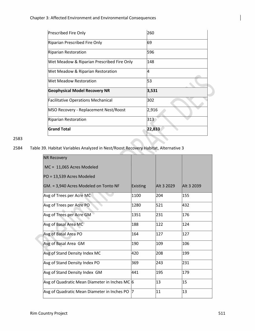
Chapter 3: Affected Environment and Environmental Consequences
Rim Country Project 511
Prescribed Fire Only 260
Riparian Prescribed Fire Only 69
Riparian Restoration 596
Wet Meadow & Riparian Prescribed Fire Only 148
Wet Meadow & Riparian Restoration 4
Wet Meadow Restoration 53
Geophysical Model Recovery NR 3,531
Facilitative Operations Mechanical 302
MSO Recovery - Replacement Nest/Roost 2,916
Riparian Restoration 313
Grand Total 22,833
2583
Table 39. Habitat Variables Analyzed in Nest/Roost Recovery Habitat, Alternative 3 2584
NR Recovery
MC = 11,065 Acres Modeled
PO = 13,539 Acres Modeled
GM. = 3,940 Acres Modeled on Tonto NF Existing Alt 3 2029 Alt 3 2039
Avg of Trees per Acre MC 1100 204 155
Avg of Trees per Acre PO 1280 521 432
Avg of Trees per Acre GM 1351 231 176
Avg of Basal Area MC 188 122 124
Avg of Basal Area PO 164 127 127
Avg of Basal Area GM 190 109 106
Avg of Stand Density Index MC 420 208 199
Avg of Stand Density Index PO 369 243 231
Avg of Stand Density Index GM 441 195 179
Avg of Quadratic Mean Diameter in Inches MC 6 13 15
Avg of Quadratic Mean Diameter in Inches PO 7 11 13
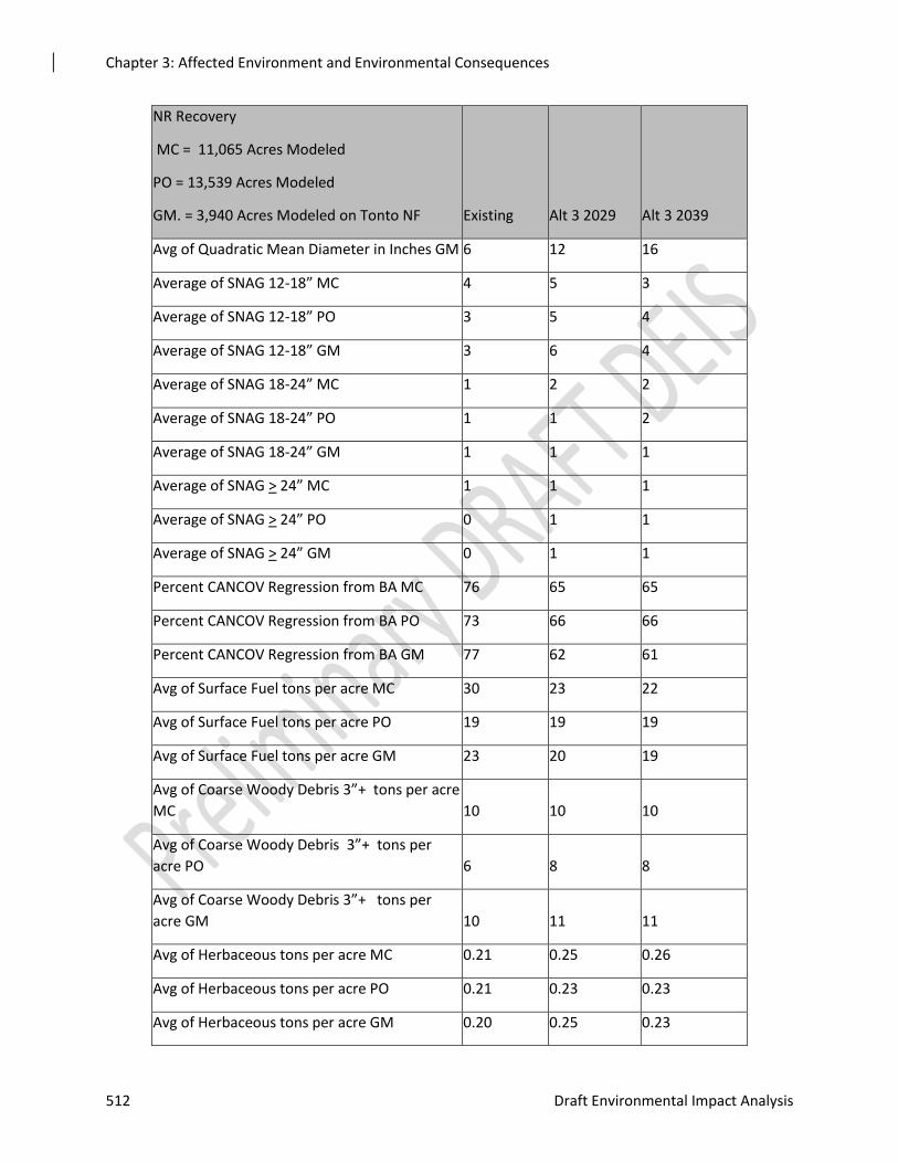
Chapter 3: Affected Environment and Environmental Consequences
512 Draft Environmental Impact Analysis
NR Recovery
MC = 11,065 Acres Modeled
PO = 13,539 Acres Modeled
GM. = 3,940 Acres Modeled on Tonto NF Existing Alt 3 2029 Alt 3 2039
Avg of Quadratic Mean Diameter in Inches GM 6 12 16
Average of SNAG 12-18” MC 4 5 3
Average of SNAG 12-18” PO 3 5 4
Average of SNAG 12-18” GM 3 6 4
Average of SNAG 18-24” MC 1 2 2
Average of SNAG 18-24” PO 1 1 2
Average of SNAG 18-24” GM 1 1 1
Average of SNAG > 24” MC 1 1 1
Average of SNAG > 24” PO 0 1 1
Average of SNAG > 24” GM 0 1 1
Percent CANCOV Regression from BA MC 76 65 65
Percent CANCOV Regression from BA PO 73 66 66
Percent CANCOV Regression from BA GM 77 62 61
Avg of Surface Fuel tons per acre MC 30 23 22
Avg of Surface Fuel tons per acre PO 19 19 19
Avg of Surface Fuel tons per acre GM 23 20 19
Avg of Coarse Woody Debris 3”+ tons per acre
MC 10 10 10
Avg of Coarse Woody Debris 3”+ tons per
acre PO 6 8 8
Avg of Coarse Woody Debris 3”+ tons per
acre GM 10 11 11
Avg of Herbaceous tons per acre MC 0.21 0.25 0.26
Avg of Herbaceous tons per acre PO 0.21 0.23 0.23
Avg of Herbaceous tons per acre GM 0.20 0.25 0.23
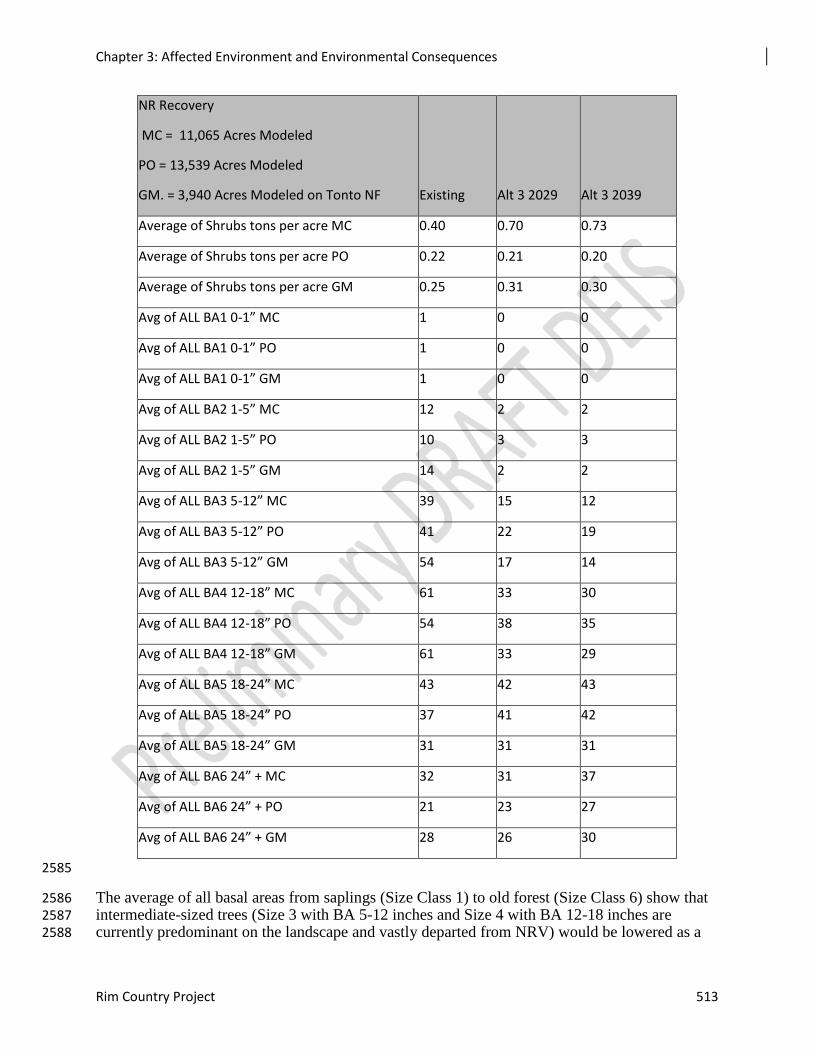
Chapter 3: Affected Environment and Environmental Consequences
Rim Country Project 513
NR Recovery
MC = 11,065 Acres Modeled
PO = 13,539 Acres Modeled
GM. = 3,940 Acres Modeled on Tonto NF Existing Alt 3 2029 Alt 3 2039
Average of Shrubs tons per acre MC 0.40 0.70 0.73
Average of Shrubs tons per acre PO 0.22 0.21 0.20
Average of Shrubs tons per acre GM 0.25 0.31 0.30
Avg of ALL BA1 0-1” MC 1 0 0
Avg of ALL BA1 0-1” PO 1 0 0
Avg of ALL BA1 0-1” GM 1 0 0
Avg of ALL BA2 1-5” MC 12 2 2
Avg of ALL BA2 1-5” PO 10 3 3
Avg of ALL BA2 1-5” GM 14 2 2
Avg of ALL BA3 5-12” MC 39 15 12
Avg of ALL BA3 5-12” PO 41 22 19
Avg of ALL BA3 5-12” GM 54 17 14
Avg of ALL BA4 12-18” MC 61 33 30
Avg of ALL BA4 12-18” PO 54 38 35
Avg of ALL BA4 12-18” GM 61 33 29
Avg of ALL BA5 18-24” MC 43 42 43
Avg of ALL BA5 18-24” PO 37 41 42
Avg of ALL BA5 18-24” GM 31 31 31
Avg of ALL BA6 24” + MC 32 31 37
Avg of ALL BA6 24” + PO 21 23 27
Avg of ALL BA6 24” + GM 28 26 30
2585
The average of all basal areas from saplings (Size Class 1) to old forest (Size Class 6) show that 2586 intermediate-sized trees (Size 3 with BA 5-12 inches and Size 4 with BA 12-18 inches are 2587 currently predominant on the landscape and vastly departed from NRV) would be lowered as a 2588
Chapter 3: Affected Environment and Environmental Consequences
514 Draft Environmental Impact Analysis
result of treatments through 2039. The basal area average would decrease from the existing 188 2589 in mixed conifer, 164 in pine-oak, and 190 GM on the Tonto, to 124 in mixed conifer, 127 in 2590 pine-oak, and 106 GM on the Tonto in 2029. The percent average canopy cover would be 2591 reduced from the existing 76 percent in mixed conifer, 73 percent in pine-oak, and 77 percent 2592 GM on the Tonto, to 65 percent in mixed conifer, 66 percent in pine-oak, and 61 percent GM on 2593 the Tonto in 2039. Design features for the project would preserve the recommended habitat 2594 conditions in Recovery Habitat wherever possible, while protecting this habitat from severe fire 2595 intensity or stand-replacing effects from crown fire. 2596
Promotion of large tree growth would be achieved in Alternative 3 as the stand density index 2597 changes from 420 in mixed conifer, 369 in pine-oak, and 441 GM on the Tonto, to 199, 231, and 2598 179, respectively, in 2039. Reduction in stand density index competition would increase the 2599 quadratic mean diameter from the existing six inches in mixed conifer, seven in pine-oak, and six 2600 GM on the Tonto, to 15 inches in mixed conifer, and 13 inches in pine-oak, and 16 inches GM 2601 on the Tonto in 2039. 2602
Snags 2603
In Nest/Roost Recovery Habitat, snags would be maintained or increase as a result of treatments 2604 under Alternative 3 (Table 3-**). These Primary Constituent Element habitat variables important 2605 to the MSO and MSO prey species would be preserved over time under the focused alternative. 2606
Coarse Woody Debris and Understory 2607
In Nest/Roost Recovery habitat, coarse woody debris greater than three inches would increase as 2608 a result of treatments through 2039. Herbaceous biomass would increase over the 20 years under 2609 Alternative 3. The existing 0.21 tons per acre in mixed conifer and pine-oak and the 0.20 tons per 2610 acre in GM on the Tonto would slightly increase. Shrub biomass would change from 0.40 tons 2611 per acre to 0.73 tons per acres in mixed conifer by 2039.Increasing these Primary Constituent 2612 Elements important to prey base for the MSO would be an added benefit to treatments in 2613 Nest/Roost Recovery habitat under this alternative. 2614
Fire Effects 2615
Surface fuel loading in MSO Nest/Roost Recovery habitat would be reduced under Alternative 3, 2616 moving from 30 tons per acre in mixed conifer, 19 in pine-oak, and 23 in GM on the Tonto, to 22 2617 tons per acre in mixed conifer, 19 in pine-oak, and 23 GM on the Tonto, to 22 in mixed conifer, 2618 19 in pine-oak, and 19 GM on the Tonto in 2039 (Table 3-**). 2619
Fire Hazard Index would be decreased from 4,175 acres (41 percent of the Nest/Roost Recovery 2620 habitat in high or extreme need of treatment) to 588 acres (six percent). Reductions of this 2621 magnitude should preserve existing MSO habitat while encouraging conditions to create more 2622 over time through recovery habitats. 2623
The potential for crown fire would be decreased under Alternative 3 from 4,802 acres (47 2624 percent) to 407 acres (four percent). Reducing active crown fires by this magnitude is a benefit to 2625 MSO and its critical habitat that would preserve Nest/Roost Recovery habitat over time. 2626
Foraging/Non-breeding Recovery 2627
Forest Structure 2628
Under Alternative 3, the FVS modeling of treatments over the next 30 years indicate that most 2629 forest structure as it pertains to Primary Constituent Elements important to MSO would be 2630 preserved through time. In MSO Foraging/Non-Breeding Recovery habitat, trees per acre would 2631 be reduced from the existing 1,398 in mixed conifer, 1,192 in pine-oak, and 1,443 GM on the 2632

Chapter 3: Affected Environment and Environmental Consequences
Rim Country Project 515
Tonto, to 304 in mixed conifer, 394 in pine-oak, and 244 GM on the Tonto in 2039. Reducing 2633 trees per acre closer to NRV protects Foraging/Non-breeding Recovery habitat and restores 2634 conditions for the MSO by managing for a less dense and encroached forested condition. 2635 Openings created by bringing these size classes into desired condition would provide habitat for 2636 a variety of prey species and would slow or reduce fire severity by breaking the continuity of 2637 dense tree canopies and ladder fuels. Further, edge habitat for MSO prey species (e.g., Neotoma) 2638 would be increased as a result of these treatment to restore forest structure. 2639
2640
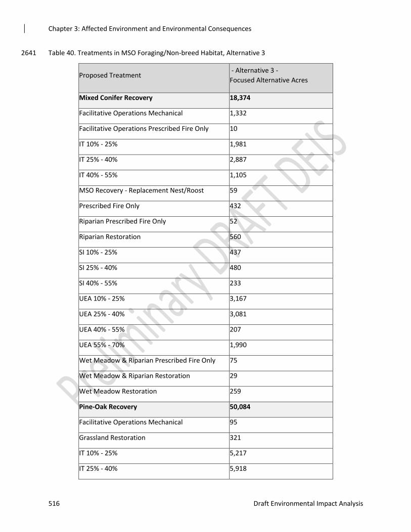
Chapter 3: Affected Environment and Environmental Consequences
516 Draft Environmental Impact Analysis
Table 40. Treatments in MSO Foraging/Non-breed Habitat, Alternative 3 2641
Proposed Treatment - Alternative 3 -
Focused Alternative Acres
Mixed Conifer Recovery 18,374
Facilitative Operations Mechanical 1,332
Facilitative Operations Prescribed Fire Only 10
IT 10% - 25% 1,981
IT 25% - 40% 2,887
IT 40% - 55% 1,105
MSO Recovery - Replacement Nest/Roost 59
Prescribed Fire Only 432
Riparian Prescribed Fire Only 52
Riparian Restoration 560
SI 10% - 25% 437
SI 25% - 40% 480
SI 40% - 55% 233
UEA 10% - 25% 3,167
UEA 25% - 40% 3,081
UEA 40% - 55% 207
UEA 55% - 70% 1,990
Wet Meadow & Riparian Prescribed Fire Only 75
Wet Meadow & Riparian Restoration 29
Wet Meadow Restoration 259
Pine-Oak Recovery 50,084
Facilitative Operations Mechanical 95
Grassland Restoration 321
IT 10% - 25% 5,217
IT 25% - 40% 5,918
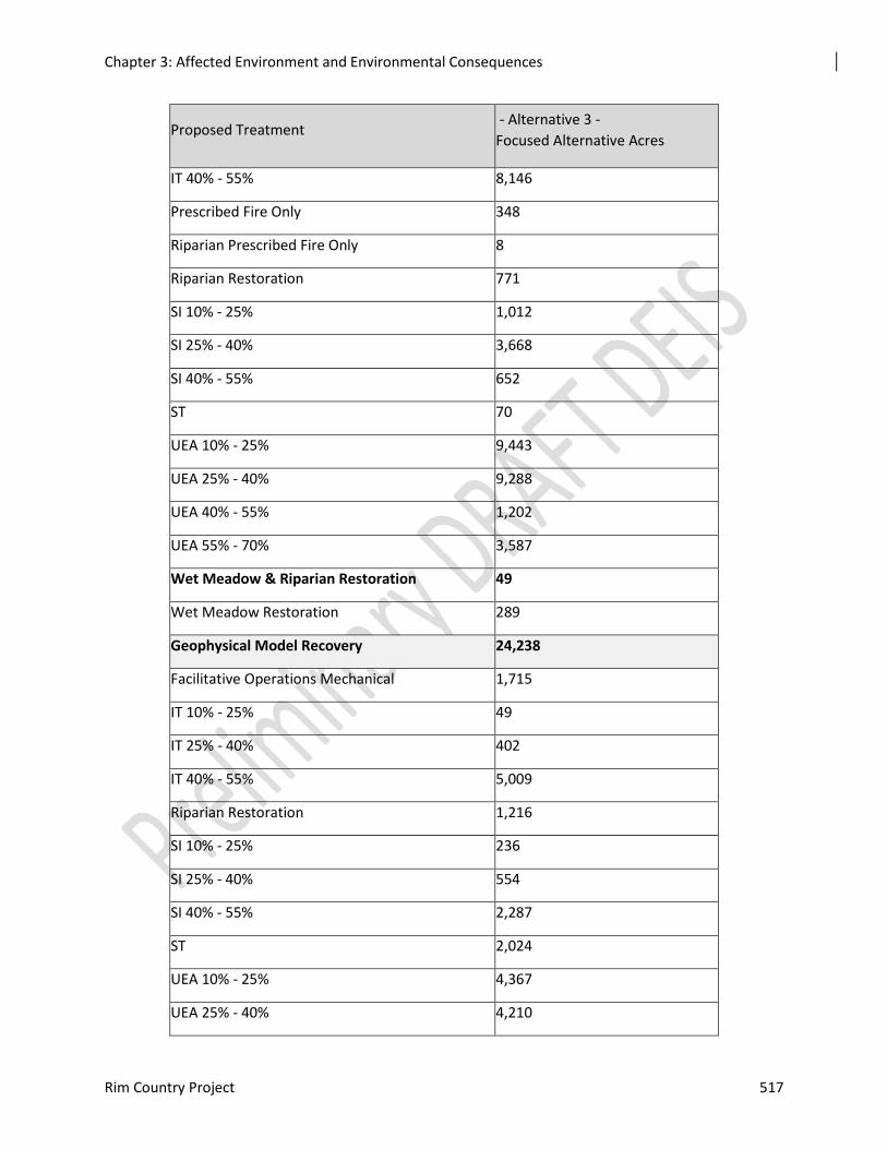
Chapter 3: Affected Environment and Environmental Consequences
Rim Country Project 517
Proposed Treatment - Alternative 3 -
Focused Alternative Acres
IT 40% - 55% 8,146
Prescribed Fire Only 348
Riparian Prescribed Fire Only 8
Riparian Restoration 771
SI 10% - 25% 1,012
SI 25% - 40% 3,668
SI 40% - 55% 652
ST 70
UEA 10% - 25% 9,443
UEA 25% - 40% 9,288
UEA 40% - 55% 1,202
UEA 55% - 70% 3,587
Wet Meadow & Riparian Restoration 49
Wet Meadow Restoration 289
Geophysical Model Recovery 24,238
Facilitative Operations Mechanical 1,715
IT 10% - 25% 49
IT 25% - 40% 402
IT 40% - 55% 5,009
Riparian Restoration 1,216
SI 10% - 25% 236
SI 25% - 40% 554
SI 40% - 55% 2,287
ST 2,024
UEA 10% - 25% 4,367
UEA 25% - 40% 4,210
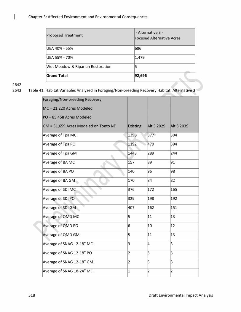
Chapter 3: Affected Environment and Environmental Consequences
518 Draft Environmental Impact Analysis
Proposed Treatment - Alternative 3 -
Focused Alternative Acres
UEA 40% - 55% 686
UEA 55% - 70% 1,479
Wet Meadow & Riparian Restoration 5
Grand Total 92,696
2642
Table 41. Habitat Variables Analyzed in Foraging/Non-breeding Recovery Habitat, Alternative 3 2643
Foraging/Non-breeding Recovery
MC = 21,220 Acres Modeled
PO = 85,458 Acres Modeled
GM = 31,659 Acres Modeled on Tonto NF Existing Alt 3 2029 Alt 3 2039
Average of Tpa MC 1398 377 304
Average of Tpa PO 1192 479 394
Average of Tpa GM 1443 289 244
Average of BA MC 157 89 91
Average of BA PO 140 96 98
Average of BA GM 170 84 82
Average of SDI MC 376 172 165
Average of SDI PO 329 198 192
Average of SDI GM 407 162 151
Average of QMD MC 5 11 13
Average of QMD PO 6 10 12
Average of QMD GM 5 11 13
Average of SNAG 12-18” MC 3 4 3
Average of SNAG 12-18” PO 2 3 3
Average of SNAG 12-18” GM 2 5 3
Average of SNAG 18-24” MC 1 2 2
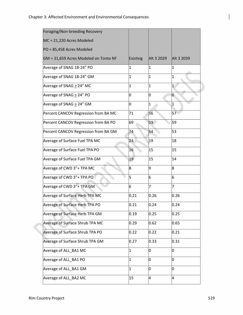
Chapter 3: Affected Environment and Environmental Consequences
Rim Country Project 519
Foraging/Non-breeding Recovery
MC = 21,220 Acres Modeled
PO = 85,458 Acres Modeled
GM = 31,659 Acres Modeled on Tonto NF Existing Alt 3 2029 Alt 3 2039
Average of SNAG 18-24” PO 1 1 1
Average of SNAG 18-24” GM 1 1 1
Average of SNAG > 24” MC 1 1 1
Average of SNAG > 24” PO 0 0 0
Average of SNAG > 24” GM 0 1 1
Percent CANCOV Regression from BA MC 71 56 57
Percent CANCOV Regression from BA PO 69 59 59
Percent CANCOV Regression from BA GM 74 54 53
Average of Surface Fuel TPA MC 24 19 18
Average of Surface Fuel TPA PO 16 15 15
Average of Surface Fuel TPA GM 19 15 14
Average of CWD 3”+ TPA MC 8 9 8
Average of CWD 3”+ TPA PO 5 6 6
Average of CWD 3”+ TPA GM 6 7 7
Average of Surface Herb TPA MC 0.21 0.26 0.26
Average of Surface Herb TPA PO 0.21 0.24 0.24
Average of Surface Herb TPA GM 0.19 0.25 0.25
Average of Surface Shrub TPA MC 0.29 0.62 0.65
Average of Surface Shrub TPA PO 0.22 0.22 0.21
Average of Surface Shrub TPA GM 0.27 0.33 0.31
Average of ALL_BA1 MC 1 0 0
Average of ALL_BA1 PO 1 0 0
Average of ALL_BA1 GM 1 0 0
Average of ALL_BA2 MC 15 4 4
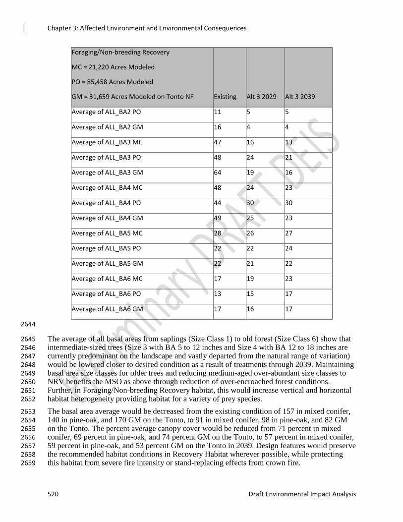
Chapter 3: Affected Environment and Environmental Consequences
520 Draft Environmental Impact Analysis
Foraging/Non-breeding Recovery
MC = 21,220 Acres Modeled
PO = 85,458 Acres Modeled
GM = 31,659 Acres Modeled on Tonto NF Existing Alt 3 2029 Alt 3 2039
Average of ALL_BA2 PO 11 5 5
Average of ALL_BA2 GM 16 4 4
Average of ALL_BA3 MC 47 16 13
Average of ALL_BA3 PO 48 24 21
Average of ALL_BA3 GM 64 19 16
Average of ALL_BA4 MC 48 24 23
Average of ALL_BA4 PO 44 30 30
Average of ALL_BA4 GM 49 25 23
Average of ALL_BA5 MC 28 26 27
Average of ALL_BA5 PO 22 22 24
Average of ALL_BA5 GM 22 21 22
Average of ALL_BA6 MC 17 19 23
Average of ALL_BA6 PO 13 15 17
Average of ALL_BA6 GM 17 16 17
2644
The average of all basal areas from saplings (Size Class 1) to old forest (Size Class 6) show that 2645 intermediate-sized trees (Size 3 with BA 5 to 12 inches and Size 4 with BA 12 to 18 inches are 2646 currently predominant on the landscape and vastly departed from the natural range of variation) 2647 would be lowered closer to desired condition as a result of treatments through 2039. Maintaining 2648 basal area size classes for older trees and reducing medium-aged over-abundant size classes to 2649 NRV benefits the MSO as above through reduction of over-encroached forest conditions. 2650 Further, in Foraging/Non-breeding Recovery habitat, this would increase vertical and horizontal 2651 habitat heterogeneity providing habitat for a variety of prey species. 2652
The basal area average would be decreased from the existing condition of 157 in mixed conifer, 2653 140 in pine-oak, and 170 GM on the Tonto, to 91 in mixed conifer, 98 in pine-oak, and 82 GM 2654 on the Tonto. The percent average canopy cover would be reduced from 71 percent in mixed 2655 conifer, 69 percent in pine-oak, and 74 percent GM on the Tonto, to 57 percent in mixed conifer, 2656 59 percent in pine-oak, and 53 percent GM on the Tonto in 2039. Design features would preserve 2657 the recommended habitat conditions in Recovery Habitat wherever possible, while protecting 2658 this habitat from severe fire intensity or stand-replacing effects from crown fire. 2659
Chapter 3: Affected Environment and Environmental Consequences
Rim Country Project 521
Promotion of large tree growth would be achieved with proposed treatments as the stand density 2660 index would change from the existing 376 in mixed conifer, 329 in pine-oak, and 407 GM on the 2661 Tonto. A reduction in SDI competition would increase the quadratic mean diameter from the 2662 existing five in mixed conifer, six in pine-oak, and five GM on the Tonto, to 13 inches in mixed 2663 conifer, 12 inches in pine-oak, and 13 inches GM on the Tonto in 2039. 2664
Snags 2665
In Foraging/Non-Breeding Recovery Habitat, snags greater than 12 inches in diameter would be 2666 maintained or increase slightly as a result of treatments under Alternative 3 (Table 3-**). These 2667 Primary Constituent Element habitat variables important to the MSO and MSO prey species 2668 would be preserved over time under this action alternative. 2669
Coarse Woody Debris and Understory 2670
Coarse woody debris greater than three inches would be maintained or increase slightly through 2671 2039. Herbaceous biomass in tons per acre would increase slightly over 30 years. Shrub biomass 2672 would also increase from 0.29 tons per acre in mixed conifer to 0.65 tons per acre in 2039. 2673
Fire Effects 2674
Surface fuel loading in MSO Foraging/Non-breeding Recovery habitat would be reduced under 2675 Alternative 3, moving from 24 tons per acre in mixed conifer, 16 tons per acre in pine-oak, and 2676 19 tons per acre GM on the Tonto, to 18 tons per acre in mixed conifer, 15 tons per acre in pine-2677 oak, and 19 tons per acre GM on the Tonto by 2039 (Table 3-**). 2678
Fire Hazard Index would be decreased from 10,717 acres (26 percent of the Foraging/Other 2679 Recovery habitat modeled in need of treatment) to 372 acres (one percent). Reductions of this 2680 magnitude should preserve existing MSO habitat while encouraging conditions to create more 2681 over time through recovery habitats. 2682
The potential for crown fire would be decreased under Alternative 3 from 15,090 acres (36 2683 percent) to 350 acres (one percent). Reducing active crown fires by this magnitude would be a 2684 benefit to the MSO and its critical habitat that would preserve Foraging/Other Recovery habitat 2685 over time. 2686
For the effects from smoke, see the Effects Common to All Alternatives and Wildfire Modeling 2687 sections above. 2688
Other Habitat Effects 2689
Understory vegetation development is related to the amount of solar radiation reaching the 2690 ground. This creates a direct and inverse relationship between canopy closure and herbaceous 2691 cover. The uncharacteristic forest structure existing in the ponderosa pine forests of northern 2692 Arizona restricts herbaceous growth well below pre-settlement conditions. Ponderosa pine 2693 forests in Arizona are relatively homogeneous and the site-specific habitat variability that 2694 springs, streams, meadows, grasslands, savannas, and aspen represent are important to a wide 2695 array of wildlife, including MSO prey species. These distinct vegetation types support understory 2696 vegetation that is typically denser, more continuous, and more diverse because of the soil types 2697 supporting them and the increased solar radiation and moisture availability compared to ground 2698 conditions in the general forest. Understory vegetation provides the food and cover that supports 2699 an array of wildlife, including many small mammals, birds, bats, and a variety of arthropods that 2700 serve as food for vertebrate species and pollinators to help maintain herbaceous diversity. These 2701 microhabitats directly and indirectly support MSO prey species. Improvements to springs, 2702
Chapter 3: Affected Environment and Environmental Consequences
522 Draft Environmental Impact Analysis
riparian areas, stream channels, meadows, and aspen can benefit MSOs in ways greater than 2703 simple area estimates indicate. 2704
Springs, Riparian and Stream Habitat, Grasslands, Savannas, Meadows, and Aspen 2705
Springs, riparian areas, and stream channel restoration would be the same for both action 2706 alternatives and are described above in the Effects Common to Both Action Alternatives section. 2707 Grassland, savanna, and meadow treatments would include mechanical tree removal and 2708 prescribed burning within PACs under both Alternatives 2 and 3 2709
2710
Cumulative Effects 2711
Because of the size of the 4FRI Rim Country project area and the large portion of the western 2712 Upper Gila Mountain Recovery Unit and a portion of the Basin and Range Recovery Unit that it 2713 occupies, the project area itself was considered adequate for assessing habitat effects on PACs. 2714 Due to the potential for disturbance to owls, the cumulative effects analysis boundary was 2715 extended 0.5 mile beyond the project area periphery to account for the spatial component of this 2716 analysis. Cumulative effects include the effects of Alternative 1. With this additional 0.5-mile 2717 buffer, there are 209 PACs in the cumulative effects analysis area (Table 3-**). The temporal 2718 component in this analysis was defined as 10 years for short-term effects and 30 years for long-2719 term effects. 2720
Table 42. MSO PACs Within or in Close Proximity to the Rim Country Project Area 2721
PAC Location Number of MSO PACs
Within Areas of Proposed Mechanical and Fire
Treatments1
156
Within the Rim Country Project Area2 196
Within 0.5 mile of the Project Area Boundary 209
1. The area where treatments are proposed in the Rim Country project area, a subset of the 2722
total project area. 2723
2. Total area including all vegetation cover-types and all projects managed by the Forest 2724
Service within the 4FRI boundary 2725
2726
The effects from projects before 2000 are incorporated into existing conditions. Aspects of 2727 existing conditions that are a result of these early projects include a deficit in large trees and 2728 snags and even-aged conditions. Pre-2000 projects also had heavy selection pressure for 2729 preferred tree genetics to provide healthy trees with good form. This latter effect resulted from 2730 harvested areas being regenerated from planting stock or from the selected reserve trees left in 2731 seed tree harvest units (Higgins, personal communications 2006). Wildlife habitat in the form of 2732 nesting, feeding, and loafing sites was reduced by selecting for disease-free trees with symmetric 2733 shapes, eliminating fork-top trees, trees with unusual branching patterns, and replanting with 2734 selected genetic stock from nurseries. 2735
Chapter 3: Affected Environment and Environmental Consequences
Rim Country Project 523
Alternative 1 – No Action 2736
Alternative 1 would not contribute to the improvement of either forest structure or prey habitat 2737 within MSO habitat. The contributions of past, ongoing, and reasonably foreseeable actions 2738 would affect habitat for MSO and their prey, but no cumulative effects would result from 4FRI 2739 Rim Country (i.e., no change would occur either spatially and temporally to alter these effects of 2740 other actions on the landscape). 2741
Maintaining existing conditions would extend the current deficit of trees greater than 24 inches 2742 in diameter. Current numbers of trees per acre greater than or equal to 18 inches in diameter, 2743 already below forest plan and Recovery Plan direction, would likely be maintained due to 2744 increases in mortality rates resulting from competition. Slow to stagnating tree growth rates 2745 would prolong the time required for mid-aged trees to grow into mature trees. Replacement of 2746 mid-aged trees by younger trees would occur at low rates because of current deficits in small size 2747 classes, delaying, limiting, or preventing the long-term attainment of desired conditions for 2748 mature and old-growth forest. Ponderosa pine is not a shade-adapted species. Therefore, 2749 consistently dense canopy cover would delay or prevent development of multi-storied and 2750 uneven-aged forest structure in the long term. Growth could be further suppressed and mortality 2751 rates increased if climate patterns continue toward hotter and drier growing conditions. Within-2752 stand mortality resulting from competition for rooting space, water, and nutrient availability, 2753 vulnerability to insects and disease, and fire could lead to patches of more open conditions. This 2754 could reduce potential nesting and roosting habitat even in locations where individual trees might 2755 benefit and eventually grow into larger size classes. 2756
Pine-oak habitat would remain outside the natural range of variation in terms of tree densities 2757 and age-class distribution under Alternative 1. Loss of large diameter oak would continue, as 2758 would the suppression of young oak by competing pine trees. Total basal area in oak may decline 2759 over time and would likely remain below desired conditions. Dense forest structure could 2760 increase the risk of insect and disease outbreaks occurring and increase the scale at which they 2761 occur. Stochastic events outside the natural range of variation could continue to slow or prevent 2762 development of new MSO nesting and roosting habitat. 2763
Limited road closures would allow continued access to most of the existing roads footprint and 2764 would maintain the same threat to large snag persistence. Ecosystem function would continue to 2765 decline with continued tree encroachment into spring, channel, meadow, and aspen habitats. 2766
The ability to retain sustainable and resilient ecosystems would be further compromised by 2767 vulnerability to high-severity fires. The overt threat of high-severity fire could limit options for 2768 treating uncharacteristic fuel loads through the use of unplanned ignitions, compounding the risk 2769 of high-severity fire through time. By not treating outside of MSO habitat, the risk of high-2770 severity fire remains high from ignitions starting outside of pine-oak habitats as well as fire 2771 igniting within MSO habitat. 2772
Determination of Effect 2773
Based on the above analysis, Alternative 1 of the 4FRI Rim Country Project may affect, is likely 2774 to adversely affect the Mexican spotted-owl. 2775
Alternative 2 – Modified Proposed Action 2776
Cumulatively, restoration treatments would contribute toward improving MSO forest health and 2777 vegetation diversity and composition under Alternative 2. This would aid in sustaining old forest 2778 structure over time and moving forest structure toward desired conditions. 2779
Chapter 3: Affected Environment and Environmental Consequences
524 Draft Environmental Impact Analysis
Projects with treatments occurring specifically in MSO habitat include prescribed fire and 2780 mechanical thinning with prescribed fire in protected habitat and restricted habitat (See 2781 Cumulative Effects Past Projects). Most projects in protected habitat used 18-inch diameter 2782 limits and some used up to 24-inch diameter limits in other recovery habitat. Treatments in MSO 2783 habitat in reasonably foreseeable projects include thinning and burning restoration and fuels 2784 reduction treatments, such as those being developed for the C.C. Cragin Watershed Protection, 2785 Rim Lakes Forest Restoration, Larson Forest Restoration, and the Upper Beaver Creek 2786 Watershed Fuels Reduction projects. For these projects, Gambel oak is not targeted for removal, 2787 but prescribed fire would likely top-kill small diameter oak, potentially decreasing oak basal area 2788 in the short term. However, design features should ensure retention of large-diameter oak and 2789 small oak commonly sprout vigorously after fire. The total basal area of Gambel oak is not 2790 expected to change substantially in the long term. 2791
Created canopy gaps should benefit MSO prey species, and the reduction in small trees should 2792 open the space between ground-level and canopy base height, improving MSO flight paths for 2793 foraging. However, diameter limits that retain mid-aged trees commonly prevent the 2794 development of complex forest structure and decrease inherent habitat heterogeneity. 2795
Changes would be expected in MSO prey habitat. Reductions would be expected in coarse 2796 woody debris, logs, and snags, commonly decreasing structure in prey habitat in the short term. 2797 Burn prescriptions and ignition techniques should limit these losses. Burned snags would fall and 2798 provide logs, and trees killed by fire would become snags. However, the longevity of fire-killed 2799 snags is less than that of snags formed by other processes. Maintenance burning should provide 2800 pulses of snags and logs through time. Less coarse woody debris would be expected in the short 2801 term as a result of prescribed fire. Thinning and burning should increase tree growth rates, and 2802 self-pruning of lower tree branches should replenish coarse woody debris in the long term. 2803 Improving growing conditions would decrease density-related mortality of larger and older trees. 2804 Improving recruitment into larger tree size classes would improve MSO habitat and the ability to 2805 provide large snags that remain on the landscape longer than smaller diameter or fire-created 2806 snags. The combination of thinning and burning should improve species richness in the 2807 herbaceous understory, increase plant abundance, and improve fruit and seed production. 2808
Current and reasonably foreseeable projects represent areas omitted from the Rim Country 2809 planning effort because some degree of planning was already in progress or they occur outside of 2810 ponderosa pine forest. Treatments in these areas would reduce the fire threat for MSO habitat 2811 within the respective project area, as well as reducing the threat of high-severity fire starting in 2812 these areas and burning habitat outside the project areas. Given the diameter limits employed and 2813 the generally low intensity of the treatments in MSO habitat, decreases in the risk of high-2814 severity fire and improvements to understory vegetation and prey habitat are expected to be short 2815 term, before canopies expand and intercept light, rain, and snow, thereby reducing understory 2816 response in the long term. 2817
Cumulative effects from reasonably foreseeable projects could include disturbance from noise 2818 and potentially from smoke. Implementation of the CC Cragin Watershed Restoration Project 2819 (on the Mogollon Rim Ranger District) and Flagstaff Watershed Protection Project (the San 2820 Francisco Peaks and Mormon Mountain), reopening or developing rock pits (Coconino and 2821 Apache-Sitgreaves), and other restoration work, such as in in the Beaver Creek Rim Lakes and 2822 Larsen projects (Mogollon Rim), could cumulatively degrade but retain MSO habitat, including 2823 PACs and recovery habitat, in the short and long terms. However, the risk of high-severity fire 2824 eliminating MSO habitat would be reduced in the short and long terms. 2825
Chapter 3: Affected Environment and Environmental Consequences
Rim Country Project 525
Because current and reasonably foreseeable projects represent areas omitted from the 4FRI Rim 2826 Country project area, overlap in the spatial component of cumulative effects would largely be 2827 avoided. Although smoke and noise can cross project boundaries, both largely disperse with 2828 distance. However, some areas where smoke settles could be at further risk of effects on owls. 2829 Other restoration projects such as the C.C. Cragin Watershed Protection Project could 2830 cumulatively increase effects on owls in PACs adjacent to shared boundaries. 2831
Many current and reasonably foreseeable projects would overlap temporally. All or most PAC 2832 treatments would have timing restrictions, preventing treatments during the breeding season. 2833 Also, the most common PAC treatment would be prescribed fire, which would be managed to be 2834 similar to the owl’s evolutionary environment. 2835
Given the various stages of planning and implementation, most project effects would be 2836 dispersed both spatially and temporally. Projects in MSO habitat are typically designed to 2837 improve habitat, or to degrade elements of habitat structure while retaining habitat function, 2838 resulting in a decrease in risk of high-severity fire. Cumulative effects would likely increase 2839 disturbance to individual MSOs from noise or smoke in the short term. Effects would not be 2840 expected on fecundity because of timing restrictions. Given restoration project objectives, the 2841 scale of the cumulative effects area, the distribution of MSO habitat across the project area, and 2842 the length of time over which treatments would be implemented (20 or more years), cumulative 2843 effects would not be expected to negatively affect MSO population in the long term. Overall, 2844 treatments in MSO habitat should move forest conditions toward desired conditions and decrease 2845 the risk of habitat loss to large-scale high-severity fire. 2846
Determination of Effect 2847
Based on the above analysis, Alternative 2 of the 4FRI Rim Country Project may affect, is 2848 likely to adversely affect the Mexican spotted owl. 2849
Alternative 3 – Focused Alternative 2850
Alternative 3 would treat fewer acres in Rim Country. The direct and indirect effects would be 2851 similar to Alternative 2. Alternative 3 includes the same number of miles and acres of riparian 2852 and other habitat restoration, while reducing the total number of acres thinned and treated with 2853 prescribed burning. In areas assigned treatments using the decision matrix, the acres to be treated 2854 would be reduced by 205,728 acres in Alternative 3. In MSO and goshawk habitat, the areas not 2855 assigned treatments using the decision matrix would be 218,670 less in Alternative 3 than in 2856 Alternative 2. In PACs, 14,640 fewer acres would be thinned and burned. In Recovery 2857 Nest/Roost habitat, 5,820 fewer acres would be treated in Alternative 3. Savannah treatments in 2858 Alternative 3 would be reduced by 15,190 acres, providing less restoration to benefit the MSO 2859 prey base. While short-term effects from disturbance would be lessened slightly with Alternative 2860 3, the long-term effects and risk of habitat degradation from stand-altering wildfire or insect 2861 infestations would be greater. 2862
Determination of Effect 2863
Based on the above analysis, Alternative 3 may affect, is likely to adversely affect the 2864 Mexican spotted owl. 2865
Western Yellow-billed Cuckoo 2866
Alternative 1 – No Action 2867
Under Alternative 1, habitat conditions for wildlife would largely remain in their current 2868 condition. Thinning and prescribed fire would still occur as a result of current and reasonably 2869
Chapter 3: Affected Environment and Environmental Consequences
526 Draft Environmental Impact Analysis
foreseeable projects. However, the landscape would continue to move away from desired 2870 conditions (see Affected Environment above and in the Silviculture and Fire Specialist reports). 2871 Alternative 1 would have no direct effect on the Yellow-billed Cuckoo; however there would be 2872 substantial indirect effects. Dense forest conditions would still occur and the high fire hazard 2873 potential would persist. Large crown-wildfires could adversely affect potential habitat by 2874 destroying understory and overstory vegetation. As a result overland flow would increase, and 2875 soil erosion would increase with potentially high sediment loads. Water quality and riparian 2876 conditions would be adversely affected on a wide-scale basis (See Hydrology Report), resulting 2877 in indirect adverse effects. 2878
Under Alternative 1, there would be no restoration of springs and riparian areas. These areas 2879 would continue to exhibit downward trends in functional condition or remain in static condition 2880 for the foreseeable future (See Hydrology Report), resulting in degradation of potential habitat 2881 for cuckoos. 2882
Denser forest conditions produce lower values in understory biomass (pounds per acre). Under 2883 Alternative 1, understory biomass would continue to decline over the next 40 years. Limited 2884 cover around tanks and riparian areas as well as the limited herbaceous understory across the 2885 project area, would continue to reduce the likelihood that cuckoos would successfully locate and 2886 nest in these areas. 2887
Determination of Effect 2888
Alternative 1 May affect, is Likely to Adversely Affectthe yellow-billed cuckoo and its 2889 proposed critical habitat. 2890
Alternative 2 – Modified Proposed Action 2891
Prescribed fire and mechanical thinning projects have occurred and are expected to continue in 2892 habitat used by western yellow-billed cuckoo on national forests where cuckoos occur. 2893 Therefore, proposed fire and non-fire treatments may directly and indirectly affect cuckoos by 2894 removing suitable habitat and displacing breeding or foraging birds, and/or by disturbing 2895 cuckoos where suitable habitat is not displaced, but within the vicinity of project activities. 2896
These kinds of projects could have short-term adverse effects on western yellow-billed cuckoo 2897 habitat by reducing cover, affecting water quality, and reducing prey abundance. Implementation 2898 of proposed activities and associated fire and smoke can alter cuckoo behavior by creating 2899 visual, noise, and physiological disturbance. Yellow-billed cuckoos may exhibit avoidance, 2900 ranging from less than a day where visual and noise disturbance is temporary to more than one 2901 breeding season where breeding and foraging habitat have been removed. If cuckoos are present 2902 at the time of thinning or prescribed burning activities, individuals could abandon their roosting 2903 and nesting sites. If nests are abandoned, young or eggs would be lost. Any individuals present in 2904 or adjacent to treated areas could also experience effects from the loss of prey availability, fire, 2905 and visual, noise, and smoke disturbance. The effects could range from habitat use changes, 2906 activity pattern changes, increased stress responses, decreased foraging efficiency and success, 2907 reduced reproductive success, increased predation risk, and intraspecific diminished 2908 communication (NoiseQuest n.d. [2012]; Pater et al. 2009). These responses could vary 2909 depending on the nature of the disturbance, but would be expected to decrease as the distance 2910 from the activity increases. 2911
Although design features are included in this alternative to mitigate effects from treatments, 2912 adverse effects on cuckoos and habitat are still likely to occur during migration and the early part 2913 of the breeding season. Prescribed burning just prior to arrival would reduce the available 2914
Chapter 3: Affected Environment and Environmental Consequences
Rim Country Project 527
foraging habitat and prey species to cuckoos. Cuckoo home ranges are large, usually at least 50 2915 acres in size. As such, effects on cuckoos and habitat from thinning and prescribed fire might 2916 occur within cuckoo riparian breeding habitat and adjacent foraging habitat up to 0.5 mile away. 2917
Prescribed fire, and to a lesser extent mechanical thinning, would also benefit cuckoos by 2918 maintaining long-term ecosystem function on these fire-adapted landscapes. Thinning and fire 2919 would promote seral stage diversity and reduce fuel build-up that might otherwise result in a 2920 stand-replacing, high-severity fire. The regenerating and resprouting trees, shrubs, and 2921 herbaceous vegetation resulting from fire would increase the insect production needed by 2922 cuckoos to raise young. 2923
Prescribed burning would occasionally use riparian drainages as control lines where no natural 2924 physical barriers, roads, trails, or openings can be used. Design features described above would 2925 ensure that effects on riparian habitat would be spread across the landscape and temporally 2926 separated. In this way, there would never be a case over the lifespan of the project that a single 2927 riparian drainage would be treated along its entire length. 2928
Determination of Effect 2929
Implementation of Alternative 2 May affect, is Likely to Adversely Affect the western yellow-2930 billed cuckoo and its proposed critical habitat. 2931
Alternative 3 – Focused Alternative 2932
Direct and indirect effects for Alternative 3 would be the same as with Alternative 2. Alternative 2933 3 includes the same number of miles and acres of riparian restoration, while reducing the total 2934 number of forested acres thinned and treated with prescribed burning. Alternative 3 would treat 2935 fewer acres in Rim Country. Project design features have been developed (included in 2936 Alternative 2 analysis for the Western yellow-billed cuckoo above) to reduce the potential of 2937 effects on nesting and foraging cuckoo habitat. 2938
Determination of Effect 2939
Implementation of Alternative 3 May affect, is Likely to Adversely Affect the Western yellow-2940 billed cuckoo and its proposed critical habitat. 2941
Cumulative Effects 2942
The area analyzed for cumulative effects for Yellow-billed Cuckoo is within the project area’s 2943 riparian corridors and a 0.5-mile buffer. Cumulative effects include effects of Alternative 1. This 2944 alternative would continue to result in indirect effects on the Yellow-billed Cuckoo. Degradation 2945 of habitat facilitated by this alternative would cumulatively combine with other forest activities, 2946 high-impact recreational use, livestock grazing, habitat loss and degradation on private lands. 2947 Synergistic effects of climate change would continue to fragment key riparian habitat. 2948
Climate change, in combination with drought cycles, is likely to exacerbate existing threats to the 2949 western yellow-billed cuckoo’s habitat in the southwestern United States, now and into the 2950 foreseeable future. Increased and prolonged drought associated with changing climatic patterns 2951 would result in continued warming and drying of riparian habitats, would likely alter vegetation 2952 structure and composition, and would reduce the amount and quality of nesting and foraging 2953 habitat for yellow-billed cuckoos in the action area. However, implementation of restoration 2954 projects such as Rim Country should help to mitigate some of the long-term effects from climate 2955 change on western yellow-billed cuckoo habitat. 2956
Chapter 3: Affected Environment and Environmental Consequences
528 Draft Environmental Impact Analysis
Mexican Grey Wolf 2957
Alternative 1 – No Action 2958
Under Alternative 1, habitat conditions for wildlife would largely remain in their current 2959 condition. Thinning and prescribed fire would still occur as a result of current and reasonably 2960 foreseeable projects. However, the landscape would continue to move away from desired 2961 conditions (see Affected Environment above and in the Silviculture and Fire Ecology and Air 2962 Quality Reports). Alternative 1 would have no direct effect on Mexican wolves. Dense forest 2963 conditions would still occur and the high fire hazard potential would persist. Large crown fires 2964 could adversely affect potential habitat by destroying understory and overstory vegetation. 2965
Under Alternative 1, there would be no restoration of springs and riparian areas. These areas 2966 would continue to exhibit downward trends in functional condition or remain in static condition 2967 for the foreseeable future (see Water and Riparian Resource Report), resulting in degradation of 2968 conditions for potential prey species. 2969
Determination of Effect 2970
Alternative 1 would have No Effect to the Mexican wolf. 2971
Alternative 2 – Modified Proposed Action 2972
The 4FRI Rim Country Project lies within the Blue Range Wolf Recovery Area where Mexican 2973 wolf denning has not occurred. The Mexican wolf has not been reported denning in or near the 2974 Rim Country project area, though dispersing adults have moved through the area and could 2975 potentially den in the project area in the future. 2976
If conflicts occur, the Forest Service would work with the Mexican Wolf Field Team to arrive at 2977 a solution. Actions taken on the other Ranger Districts where wolves occur included placing 2978 temporary restrictions around a wolf den site. 2979
Dispersing reintroduced Mexican wolves might be disturbed during implementation of thinning 2980 and prescribed fire. Due to the mobility of the species, reintroduced wolves are likely able to 2981 avoid areas receiving treatment. Direct effects from thinning operations would not be expected to 2982 affect denning wolves because of the added design feature to limit disturbance. 2983
Thinning and management-ignited fire alters prey species habitat to various degrees. Especially 2984 in areas that sustain low to moderate-intensity burns, there would be an eventual, relatively short-2985 term increase in forage and browse used by some prey species. 2986
Cumulative Effects 2987
The cumulative effects analysis area for the wolf is the project area and a 10-mile buffer outside 2988 of the project boundary to include dispersing animals. 2989
Cumulative effects would include the effects of Alternative 1. Degradation of habitat facilitated 2990 by this alternative would combine with other forest management activities, high-impact 2991 recreational use, livestock grazing, and habitat loss and degradation on private lands. Synergistic 2992 effects from climate change would continue to fragment habitat. 2993
Dispersing reintroduced Mexican wolves might be disturbed during implementation of thinning 2994 and prescribed fire. Due to the mobility of the species, reintroduced wolves are likely able to 2995 avoid areas receiving treatment. Direct effects from thinning operations would not be expected to 2996 affect denning wolves because of the added design feature to limit disturbance. 2997
Chapter 3: Affected Environment and Environmental Consequences
Rim Country Project 529
Thinning and management-ignited fire alters prey species habitat to various degrees. Especially 2998 in areas that sustain low to moderate-intensity burns, there would be an eventual, relatively short-2999 term increase in forage and browse used by some prey species. 3000
The proposed activities to reintroduce fire, and improve ecosystem/vegetation health, 3001 watersheds, and soils could potentially improve wolf prey habitat conditions related to forage 3002 and cover, although there could be associated short-term disturbance effects. While design 3003 features could limit effects, not all negative effects would be reduced or eliminated. 3004
Rangeland management and road work could disturb Mexican wolves through activities such as 3005 road use and herding of livestock, although authorized livestock grazing and trailing, and legally 3006 allowed vehicle use on established roads are specifically exempted from the definition of 3007 disturbance under the ESA Section 10(j) rule for the Mexican wolf. These associated activities 3008 could also expose Mexican wolves to harm by increasing motor vehicle traffic and the presence 3009 of vulnerable livestock. 3010
Project activities for lands and minerals, recreation and wilderness, and wildlife, fish, and rare 3011 plants have the potential to disturb wolves and their prey, primarily through short-term activities 3012 such as mineral exploration, special use facility maintenance, group recreational events, or 3013 wildlife surveys or monitoring. While standards and guidelines could limit disturbance effects 3014 (e.g., reduce the need to relocate dens), not all negative effects would be reduced or eliminated. 3015
Determination of Effect 3016
Potential effects on the Mexican wolf reintroduction project from the Rim Country Project have 3017 been analyzed and found to be insignificant and discountable. Wolves have long endured in fire-3018 adapted ecosystems and the implementation of this alternative would not adversely affect the 3019 reintroduction effort. Communication with the Interagency Field Team would allow project 3020 managers to avoid treatment in close proximity to dens, or during the wolf denning season. 3021
By definition, a non-essential experimental population is not crucial to the continued existence of 3022 the species. Therefore, no management activities associated with the Rim Country Project would 3023 affect this 10(j) population so designated that could lead to a jeopardy determination for the 3024 entire species. The management activities associated with the Rim Country Project in the 10(j) 3025 area with Mexican wolves are not likely to jeopardize the continued existence of the Mexican 3026 wolf. 3027
Alternative 3 – Focused Alternative 3028
The direct and indirect effects from Alternative 3 would be similar to those from Alternative 2. 3029 Alternative 3 includes the same number of miles and acres of riparian restoration, while reducing 3030 the total number of acres thinned and treated with prescribed burning. Alternative 3 treat fewer 3031 acres in the Rim Country project area. A design feature was included (see Alternative 2 analysis 3032 above) to reduce the potential of effects on denning wolves. 3033
Determination of Effect 3034
Implementation of Alternative 3 is not likely to jeopardize the continued existence of the 3035 Mexican wolf. 3036
Chapter 3: Affected Environment and Environmental Consequences
530 Draft Environmental Impact Analysis
Forest Service Sensitive Species 3037
Northern Goshawk 3038
Alternative 1 – No Action 3039
Vegetation Changes 3040
Under the no action alternative, most of the overall landscape would move toward desired 3041 conditions more slowly than the other alternatives, while some areas may not move toward 3042 desired conditions at all (Table 3-**). Post-fledging family areas (PFAs and lands outside PFAs 3043 (LOPFAs) would have less age-class diversity than either of the action alternatives. 3044
3045
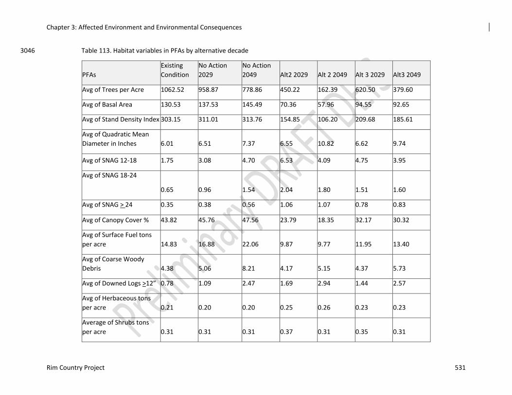
Chapter 3: Affected Environment and Environmental Consequences
Rim Country Project 531
Table 113. Habitat variables in PFAs by alternative decade 3046
PFAs
Existing
Condition
No Action
2029
No Action
2049 Alt2 2029 Alt 2 2049 Alt 3 2029 Alt3 2049
Avg of Trees per Acre 1062.52 958.87 778.86 450.22 162.39 620.50 379.60
Avg of Basal Area 130.53 137.53 145.49 70.36 57.96 94.55 92.65
Avg of Stand Density Index 303.15 311.01 313.76 154.85 106.20 209.68 185.61
Avg of Quadratic Mean
Diameter in Inches 6.01 6.51 7.37 6.55 10.82 6.62 9.74
Avg of SNAG 12-18 1.75 3.08 4.70 6.53 4.09 4.75 3.95
Avg of SNAG 18-24
0.65 0.96 1.54 2.04 1.80 1.51 1.60
Avg of SNAG > 24 0.35 0.38 0.56 1.06 1.07 0.78 0.83
Avg of Canopy Cover % 43.82 45.76 47.56 23.79 18.35 32.17 30.32
Avg of Surface Fuel tons
per acre 14.83 16.88 22.06 9.87 9.77 11.95 13.40
Avg of Coarse Woody
Debris 4.38 5.06 8.21 4.17 5.15 4.37 5.73
Avg of Downed Logs >12” 0.78 1.09 2.47 1.69 2.94 1.44 2.57
Avg of Herbaceous tons
per acre 0.21 0.20 0.20 0.25 0.26 0.23 0.23
Average of Shrubs tons
per acre 0.31 0.31 0.31 0.37 0.31 0.35 0.31
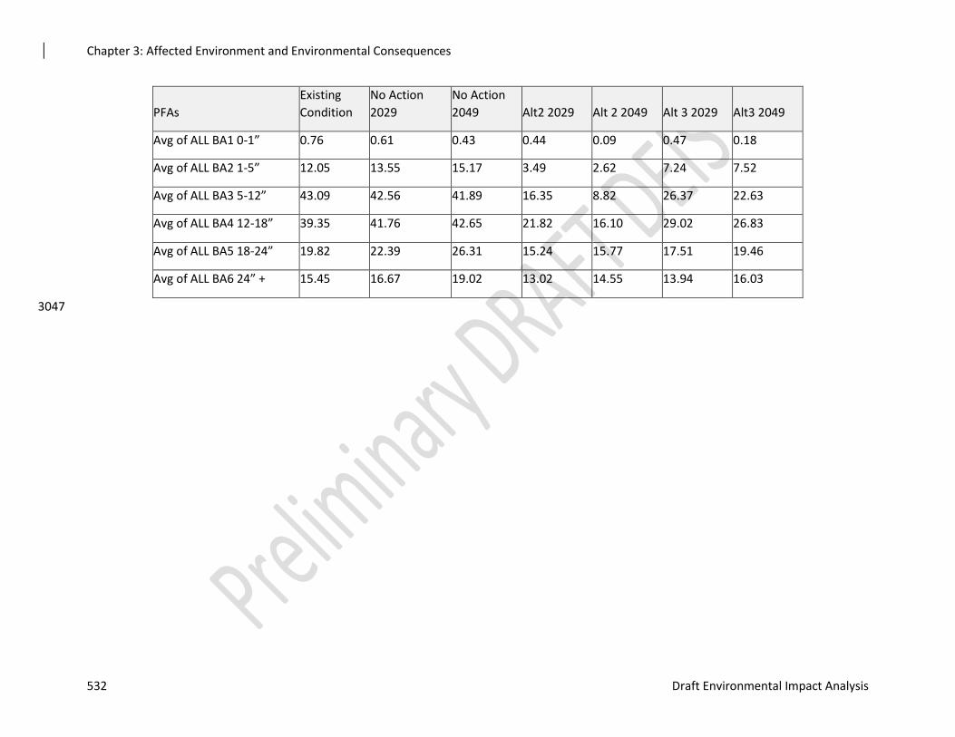
Chapter 3: Affected Environment and Environmental Consequences
532 Draft Environmental Impact Analysis
PFAs
Existing
Condition
No Action
2029
No Action
2049 Alt2 2029 Alt 2 2049 Alt 3 2029 Alt3 2049
Avg of ALL BA1 0-1” 0.76 0.61 0.43 0.44 0.09 0.47 0.18
Avg of ALL BA2 1-5” 12.05 13.55 15.17 3.49 2.62 7.24 7.52
Avg of ALL BA3 5-12” 43.09 42.56 41.89 16.35 8.82 26.37 22.63
Avg of ALL BA4 12-18” 39.35 41.76 42.65 21.82 16.10 29.02 26.83
Avg of ALL BA5 18-24” 19.82 22.39 26.31 15.24 15.77 17.51 19.46
Avg of ALL BA6 24” + 15.45 16.67 19.02 13.02 14.55 13.94 16.03
3047
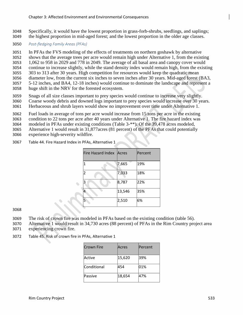
Chapter 3: Affected Environment and Environmental Consequences
Rim Country Project 533
Specifically, it would have the lowest proportion in grass-forb-shrubs, seedlings, and saplings; 3048 the highest proportion in mid-aged forest; and the lowest proportion in the older age classes. 3049
Post-fledging Family Areas (PFAs) 3050
In PFAs the FVS modeling of the effects of treatments on northern goshawk by alternative 3051 shows that the average trees per acre would remain high under Alternative 1, from the existing 3052 1,062 to 958 in 2029 and 778 in 2049. The average of all basal area and canopy cover would 3053 continue to increase slightly, while the stand density index would remain high, from the existing 3054 303 to 313 after 30 years. High competition for resources would keep the quadratic mean 3055 diameter low, from the current six inches to seven inches after 30 years. Mid-aged forest (BA3, 3056 5-12 inches, and BA4, 12-18 inches) would continue to dominate the landscape and represent a 3057 huge shift in the NRV for the forested ecosystem. 3058
Snags of all size classes important to prey species would continue to increase very slightly. 3059 Coarse woody debris and downed logs important to prey species would increase over 30 years. 3060 Herbaceous and shrub layers would show no improvement over time under Alternative 1. 3061
Fuel loads in average of tons per acre would increase from 15 tons per acre in the existing 3062 condition to 22 tons per acre after 40 years under Alternative 1. The fire hazard index was 3063 modeled in PFAs under existing conditions (Table 3-**). Of the 39,478 acres modeled, 3064 Alternative 1 would result in 31,877acres (81 percent) of the PFAs that could potentially 3065 experience high-severity wildfire. 3066
Table 44. Fire Hazard Index in PFAs, Alternative 1 3067
Fire Hazard Index Acres Percent
1 7,665 19%
2 7,033 18%
3 8,787 22%
4 13,546 35%
5 2,510 6%
3068
The risk of crown fire was modeled in PFAs based on the existing condition (table 56). 3069 Alternative 1 would result in 34,730 acres (88 percent) of PFAs in the Rim Country project area 3070 experiencing crown fire. 3071
Table 45. Risk of crown fire in PFAs, Alternative 1 3072
Crown Fire Acres Percent
Active 15,620 39%
Conditional 454 01%
Passive 18,654 47%
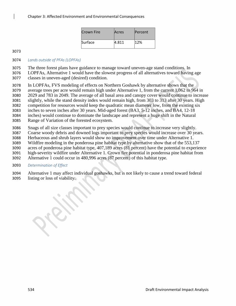
Chapter 3: Affected Environment and Environmental Consequences
534 Draft Environmental Impact Analysis
Crown Fire Acres Percent
Surface 4.811 12%
3073
Lands outside of PFAs (LOPFAs) 3074
The three forest plans have guidance to manage toward uneven-age stand conditions. In 3075 LOPFAs, Alternative 1 would have the slowest progress of all alternatives toward having age 3076 classes in uneven-aged (desired) condition. 3077
In LOPFAs, FVS modeling of effects on Northern Goshawk by alternative shows that the 3078 average trees per acre would remain high under Alternative 1, from the current 1,062 to 964 in 3079 2029 and 783 in 2049. The average of all basal area and canopy cover would continue to increase 3080 slightly, while the stand density index would remain high, from 303 to 313 after 30 years. High 3081 competition for resources would keep the quadratic mean diameter low, from the existing six 3082 inches to seven inches after 30 years. Mid-aged forest (BA3, 5-12 inches, and BA4, 12-18 3083 inches) would continue to dominate the landscape and represent a huge shift in the Natural 3084 Range of Variation of the forested ecosystem. 3085
Snags of all size classes important to prey species would continue to increase very slightly. 3086 Coarse woody debris and downed logs important to prey species would increase over 30 years. 3087 Herbaceous and shrub layers would show no improvement over time under Alternative 1. 3088 Wildfire modeling in the ponderosa pine habitat type by alternative show that of the 553,137 3089 acres of ponderosa pine habitat type, 407,189 acres (81 percent) have the potential to experience 3090 high-severity wildfire under Alternative 1. Crown fire potential in ponderosa pine habitat from 3091 Alternative 1 could occur in 480,996 acres (87 percent) of this habitat type. 3092
Determination of Effect 3093
Alternative 1 may affect individual goshawks, but is not likely to cause a trend toward federal 3094 listing or loss of viability. 3095
Chapter 3: Affected Environment and Environmental Consequences
Rim Country Project 535
Table 46. Habitat Variables in LOPFAs, Alternative 1 3096
LOPFA
Existing
Condition No Action 2029 No Action 2049 Alt2 2029 Alt 2 2049 Alt 3 2029 Alt3 2049
Avg of Trees per Acre 1069.14 964.77 783.26 451.07 162.65 626.16 383.92
Avg of Basal Area 130.36 137.32 145.24 70.21 57.71 94.74 92.84
Avg of Stand Density
Index 303.01 310.80 313.51 154.57 105.76 210.28 186.22
Avg of Quadratic Mean
Diameter in Inches 6.01 6.50 7.37 6.55 10.80 6.61 9.72
Avg of SNAG 12-18 1.75 3.10 4.69 6.57 4.08 4.76 3.95
Avg of SNAG 18-24 0.64 0.96 1.54 2.06 1.79 1.51 1.59
Avg of SNAG > 24 0.35 0.38 0.56 1.07 1.08 0.79 0.83
Avg of Canopy Cover % 43.76 45.71 47.53 23.76 18.30 32.24 30.41
Avg of Surface Fuel tons
per acre 14.81 16.86 22.06 9.87 9.78 11.97 13.46
Avg of Coarse Woody
Debris 4.35 5.03 8.19 4.17 5.16 4.37 5.75
Avg of Downed Logs
>12” 0.77 1.08 2.47 1.69 2.96 1.44 2.58
Avg of Herbaceous tons
per acre 0.21 0.20 0.20 0.25 0.26 0.23 0.23
Average of Shrubs tons
per acre 0.32 0.31 0.32 0.38 0.31 0.35 0.31
Chapter 3: Affected Environment and Environmental Consequences
536 Draft Environmental Impact Analysis
LOPFA
Existing
Condition No Action 2029 No Action 2049 Alt2 2029 Alt 2 2049 Alt 3 2029 Alt3 2049
Avg of ALL BA1 0-1” 0.77 0.62 0.44 0.44 0.09 0.48 0.18
Avg of ALL BA2 1-5” 11.98 13.52 15.24 3.48 2.63 7.27 7.60
Avg of ALL BA3 5-12” 42.96 42.42 41.71 16.30 8.78 26.44 22.71
Avg of ALL BA4 12-18” 39.36 41.71 42.58 21.78 16.04 29.10 26.90
Avg of ALL BA5 18-24” 19.79 22.36 26.26 15.23 15.74 17.53 19.47
Avg of ALL BA6 24” + 15.48 16.68 18.99 12.98 14.43 13.93 15.96
3097
Chapter 3: Affected Environment and Environmental Consequences
Rim Country Project 537
Effects Common to Both Action Alternatives 3098
Gambel oak, juniper and pinyon species greater than five inches in diameter at the root collar 3099 (diameter root collar) may be considered as residual trees in the target group spacing and 3100 stocking. 3101
Manage for large oaks (10 inch diameter at the root collar or larger) by removing ponderosa pine 3102 up to 18 inches in diameter that do not meet the “old tree” definition and do not have 3103 interlocking crown with oaks and occur within 30 feet of base of oak 10 inches in diameter at the 3104 root collar or larger. 3105
Mechanical Treatments 3106
Habitat features that appear to be important to a variety of goshawk prey species would be 3107 retained or improved with Alternatives 2 and 3 (see analysis under each alternative in this report 3108 and the Silviculture Report,). These habitat features include snags, downed logs, large trees, 3109 openings and associated herbaceous and shrubby vegetation, interspersion, and canopy cover 3110 (Reynolds et al. 1992, USDI FWS 1998, Squires and Kennedy 2006). 3111
Noise disturbance from logging trucks was monitored for nesting goshawks in a study on the 3112 Apache-Sitgreaves NF. The study was coordinated between the Apache-Sitgreaves NF, Rocky 3113 Mountain Research Station, U.S. Army, and a private sound consultant. Results from this field-3114 based, controlled experiment found no evidence of negative effects from truck noise. Observed 3115 goshawk response to logging truck noise was limited to, at most, looking in the direction of the 3116 hauling road (Grubb et al. 2012). 3117
A study on the Kaibab National Forest in Northern Arizona found no movement or flush 3118 responses from nesting northern goshawk from as near as 78 meters away from passing logging 3119 trucks (Grubb et al. 2013). 3120
Disturbance from hauling would vary based on which nest site is selected during the time that 3121 hauling occurs. Therefore, road disturbance, even with thousands of truck trips, may cause little 3122 or no disturbance. 3123
Road work and use of haul roads could increase the potential for goshawk collision with 3124 vehicles. Little information is available on how frequently collisions might occur and what 3125 conditions might increase or lessen the vulnerability of goshawks. 3126
A speed limit of 25 miles per hour would be implemented for vehicles passing through PFAs to 3127 reduce the hazard of collisions. Given the adult goshawk’s natural agility in flight and the size 3128 and noise of the large trucks and chip vans, adult goshawks would be expected to avoid colliding 3129 with log trucks passing through the PFA. Newly fledged goshawks still developing their flight 3130 skills may have a slightly higher potential for colliding with a large truck, but the reduced speed 3131 of the trucks and natural agility of goshawks should minimize this potential. Birds migrating or 3132 dispersing through unfamiliar terrain may be at higher risk than resident birds. 3133
Vehicle activity would alternate throughout the Rim Country landscape as different contracts are 3134 issued and would concentrate in particular areas while the work is being conducted. Activity 3135 would be expected to increase well above existing traffic levels for about two years until 3136 operations shift to other areas. 3137
In summary, hauling of wood products or road gravel would be unlikely to cause noise 3138 disturbance to nesting goshawks or result in collisions, but there is the potential to disrupt 3139 reproduction and rearing of young by, at most, one or two pair of goshawks and might result in 3140 the injury or death of one or more young. This risk would be lowered with a lower speed limit. 3141
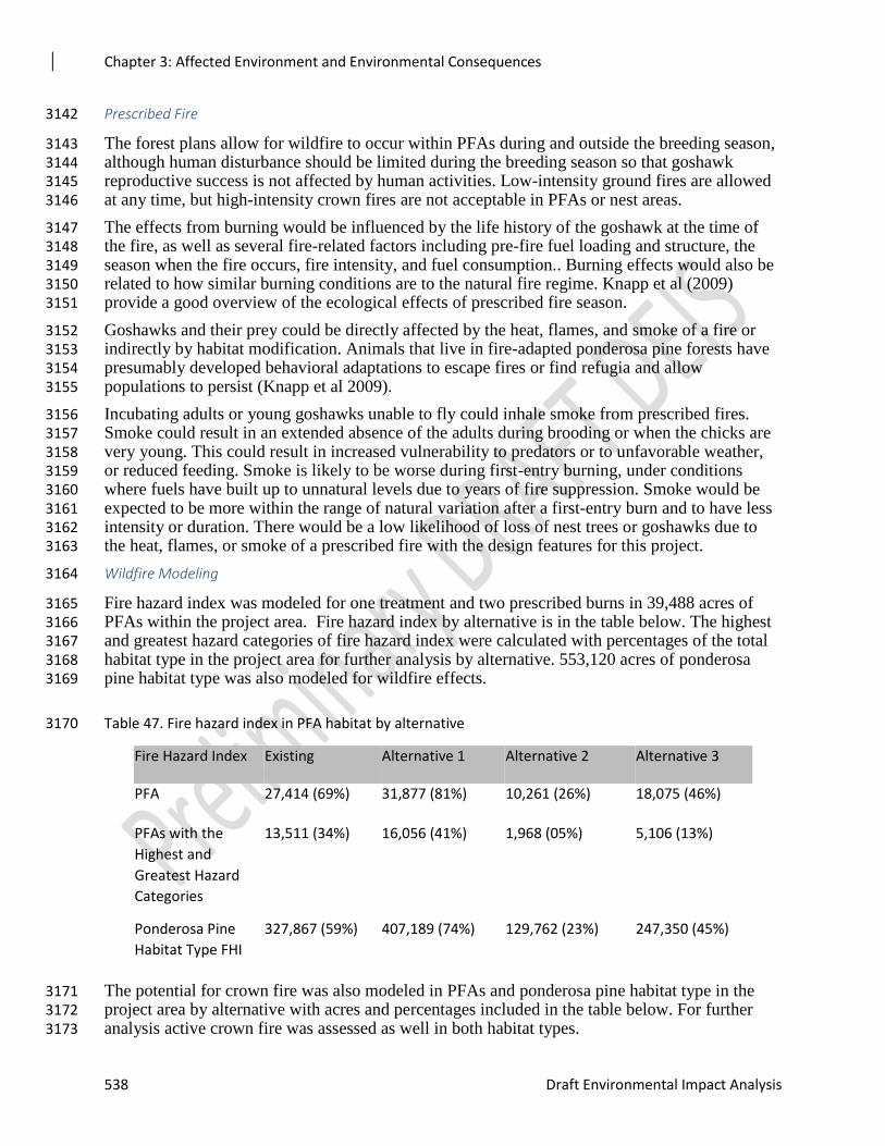
Chapter 3: Affected Environment and Environmental Consequences
538 Draft Environmental Impact Analysis
Prescribed Fire 3142
The forest plans allow for wildfire to occur within PFAs during and outside the breeding season, 3143 although human disturbance should be limited during the breeding season so that goshawk 3144 reproductive success is not affected by human activities. Low-intensity ground fires are allowed 3145 at any time, but high-intensity crown fires are not acceptable in PFAs or nest areas. 3146
The effects from burning would be influenced by the life history of the goshawk at the time of 3147 the fire, as well as several fire-related factors including pre-fire fuel loading and structure, the 3148 season when the fire occurs, fire intensity, and fuel consumption.. Burning effects would also be 3149 related to how similar burning conditions are to the natural fire regime. Knapp et al (2009) 3150 provide a good overview of the ecological effects of prescribed fire season. 3151
Goshawks and their prey could be directly affected by the heat, flames, and smoke of a fire or 3152 indirectly by habitat modification. Animals that live in fire-adapted ponderosa pine forests have 3153 presumably developed behavioral adaptations to escape fires or find refugia and allow 3154 populations to persist (Knapp et al 2009). 3155
Incubating adults or young goshawks unable to fly could inhale smoke from prescribed fires. 3156 Smoke could result in an extended absence of the adults during brooding or when the chicks are 3157 very young. This could result in increased vulnerability to predators or to unfavorable weather, 3158 or reduced feeding. Smoke is likely to be worse during first-entry burning, under conditions 3159 where fuels have built up to unnatural levels due to years of fire suppression. Smoke would be 3160 expected to be more within the range of natural variation after a first-entry burn and to have less 3161 intensity or duration. There would be a low likelihood of loss of nest trees or goshawks due to 3162 the heat, flames, or smoke of a prescribed fire with the design features for this project. 3163
Wildfire Modeling 3164
Fire hazard index was modeled for one treatment and two prescribed burns in 39,488 acres of 3165 PFAs within the project area. Fire hazard index by alternative is in the table below. The highest 3166 and greatest hazard categories of fire hazard index were calculated with percentages of the total 3167 habitat type in the project area for further analysis by alternative. 553,120 acres of ponderosa 3168 pine habitat type was also modeled for wildfire effects. 3169
Table 47. Fire hazard index in PFA habitat by alternative 3170
Fire Hazard Index Existing Alternative 1 Alternative 2 Alternative 3
PFA 27,414 (69%) 31,877 (81%) 10,261 (26%) 18,075 (46%)
PFAs with the
Highest and
Greatest Hazard
Categories
13,511 (34%) 16,056 (41%) 1,968 (05%) 5,106 (13%)
Ponderosa Pine
Habitat Type FHI
327,867 (59%) 407,189 (74%) 129,762 (23%) 247,350 (45%)
The potential for crown fire was also modeled in PFAs and ponderosa pine habitat type in the 3171 project area by alternative with acres and percentages included in the table below. For further 3172 analysis active crown fire was assessed as well in both habitat types. 3173
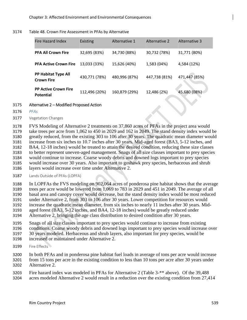
Chapter 3: Affected Environment and Environmental Consequences
Rim Country Project 539
Table 48. Crown Fire Assessment in PFAs by Alternative 3174
Fire Hazard Index Existing Alternative 1 Alternative 2 Alternative 3
PFA All Crown Fire 32,695 (83%) 34,730 (88%) 30,732 (78%) 31,771 (80%)
PFA Active Crown Fire 13,033 (33%) 15,626 (40%) 1,583 (04%) 4,584 (12%)
PP Habitat Type All
Crown Fire 430,771 (78%) 480,996 (87%) 447,738 (81%) 471,447 (85%)
PP Active Crown Fire
Potential 112,496 (20%) 160,879 (29%) 12,486 (2%) 45,680 (08%)
Alternative 2 – Modified Proposed Action 3175
PFAs 3176
Vegetation Changes 3177
FVS Modeling of Alternative 2 treatments on 37,860 acres of PFAs in the project area would 3178 take trees per acre from 1,062 to 450 in 2029 and 162 in 2049. The stand density index would be 3179 greatly reduced, from the existing 303 to 106 after 30 years. The quadratic mean diameter would 3180 increase from six inches to 10.7 inches after 30 years. Mid-aged forest (BA3, 5-12 inches, and 3181 BA4, 12-18 inches) would be treated to attain the desired condition, reducing these size classes 3182 to better represent uneven-aged management. Snags of all size classes important to prey species 3183 would continue to increase. Coarse woody debris and downed logs important to prey species 3184 would increase over 30 years. Also important to goshawk prey species, herbaceous and shrub 3185 layers would increase over time under Alternative 2. 3186
Lands Outside of PFAs (LOPFA) 3187
In LOPFAs the FVS modeling on 902,064 acres of ponderosa pine habitat shows that the average 3188 trees per acre would be lowered from 1,069 to 783 in 2029 and 451 in 2049. The average of all 3189 basal area and canopy cover would decrease, but the stand density index would be most reduced 3190 under Alternative 2, from 303 to 106 after 30 years. Lower competition for resources would 3191 increase the quadratic mean diameter, from six inches to nearly 11 inches after 30 years. Mid-3192 aged forest (BA3, 5-12 inches, and BA4, 12-18 inches) would be greatly reduced under 3193 Alternative 2, bringing the age class distribution to desired condition after 30 years. 3194
Snags of all size classes important to prey species would continue to increase from existing 3195 conditions. Coarse woody debris and downed logs important to prey species would increase over 3196 30 years modeled. Herbaceous and shrub layers, also important for prey species, would be 3197 increased or maintained under Alternative 2. 3198
Fire Effects 3199
In both PFAs and in ponderosa pine habitat fuel loads in average of tons per acre would increase 3200 from 15 tons per acre in the existing condition to less than 10 tons per acre after 30 years under 3201 Alternative 2. 3202
Fire hazard index was modeled in PFAs for Alternative 2 (Table 3-** above). Of the 39,488 3203 acres modeled Alternative 2 would result in a reduction over the existing condition from 27,414 3204
Chapter 3: Affected Environment and Environmental Consequences
540 Draft Environmental Impact Analysis
(69 percent) of all PFA acres in the project area to 10,261 acres (26 percent) that could 3205 experience high-severity wildfire. 3206
Risk of crown fire was modeled in PFAs for Alternative 2 (Table 3-** above). Alternative 2 3207 would result in 30,732 acres (78 percent) of PFAs in the Rim Country project area with the 3208 potential to experience crown fire. Active crown fire is reduced from 15,626 acres (40 percent) 3209 in alternative 1 to 1,583 (4 percent) acres that would experience active crowning under 3210 Alternative 2. 3211
Determination of Effect 3212
Considering direct, indirect, and cumulative effects, implementation of Alternative 2 may affect 3213 individual goshawks, but is not likely to cause a trend toward federal listing or loss of viability. 3214
Alternative 3 – Focused Alternative 3215
PFA 3216
Vegetation Changes 3217
Alternative 3 would change trees per acre from the existing 1,062 to 620 in 2029 and 379 in 3218 2049. The stand density index would be highly reduced, from 303 to 185 after 30 years. The 3219 quadratic mean diameter would increase, from six inches to nearly 10 inches after 30 years. Mid-3220 aged forest (BA3, 5-12 inches, and BA4, 12-18 inches) would be lowered, though not to the 3221 desired conditions. Snags of all size classes important to prey species would continue to increase. 3222 Coarse woody debris and downed logs important to prey species would increase over 30 years. 3223 Herbaceous and shrub layers would be maintained over time under Alternative 3. 3224
Lands Outside of PFAs (LOPFA) 3225
In LOPFAs, FVS modeling shows that the average trees per acre would be lowered under 3226 Alternative 3, from the existing 1,069 to 384 in 2049. The average of all basal area and canopy 3227 cover would decrease, but the stand density index would be reduced from 303 to 186 after 30 3228 years. Lower competition for resources would increase the quadratic mean diameter, from six 3229 inches to nearly 10 inches after 30 years. Mid-aged forest (BA3, 5-12 inches, and BA4, 12-18 3230 inches) would be greatly reduced under Alternative 3, bringing these age classes closer to desired 3231 conditions after 30 years. 3232
Snags of all size classes important to prey species would continue to increase. Coarse woody 3233 debris and downed logs important to prey species would increase over 30 years. Herbaceous and 3234 shrub layers, also important for prey species, would be increased or maintained under Alternative 3235 3. 3236
Fire Effects 3237
In both PFAs and in ponderosa pine habitat fuel loads in average of tons per acre increase from 3238 15 tons per acre in the existing condition to less than 13 tons per acre after 40 years under 3239 Alternative 3. 3240
Fire hazard index was modeled in PFAs for Alternative 3 (Table 3-** above). Of the 39,488 3241 acres modeled Alternative 3 would result in a reduction over the existing condition from 27,414 3242 (69 percent) of all PFA acres in the project area to 18,075 acres (46 percent) that could 3243 experience high-severity wildfire. 3244
Risk of Crown Fire was modeled in PFAs for alternative 3 (Table 3-** above). Alternative 3 3245 would result in 31,771 acres (80 percent) of PFAs in the Rim Country project area with the 3246 potential to experience crown fire. Active crown fire is reduced from 15,626 acres (40 percent) 3247
Chapter 3: Affected Environment and Environmental Consequences
Rim Country Project 541
in Alternative 1 to 4,584 acres (12 percent) that would experience active crowning under 3248 Alternative 3. 3249
Determination of Effect 3250
Considering direct, indirect, and cumulative effects, implementation of Alternative 3 may affect 3251 individual goshawks, but is not likely to cause a trend toward federal listing or loss of viability. 3252
Cumulative Effects 3253
The cumulative effects analysis boundary is defined as the project area and a one-half mile 3254 buffer around the outside of the project boundary, and includes effects for a period of 25 years 3255 beginning with implementation of the Rim Country Project. The No Action Alternative would 3256 maintain the current fire risk to northern goshawk habitat and adjacent forest lands. The 3257 cumulative effects of the No Action Alternative would be to increase the number of acres of 3258 National Forest System lands that are vulnerable to severe fire effects, as dense forest conditions 3259 would continue to place goshawk habitat and adjacent habitat at risk of stand-replacing fire. The 3260 fire hazard would increase over time as vegetation would continue to grow, fuels continue to 3261 accumulate, and the effects from climate change persist, thus continuing to have negative 3262 effects on northern goshawk. 3263
For Alternatives 2 and 3, the majority of acreage identified as part of the cumulative effects 3264 analysis occurs in LOPFA habitat. The majority of past, current, and foreseeable future treatment 3265 acres are prescribed fire only. However, most of the alternative treatments are mechanical 3266 thinning with prescribed fire. Alternative 2 cumulatively would have the most treatment acres 3267 whereas Alternative 3 would have the fewest. 3268
Restoration treatments would contribute toward improving forest health, vegetation diversity, 3269 and vegetation composition in goshawk habitat under Alternatives 2 and 3. This would aid in 3270 sustaining old forest structure over time and moving forest structure toward desired conditions. 3271
Project treatments would primarily decreased the number of trees less than 14 inches in diameter. 3272 The degree of treatment intensity is highly variable, with some projects not cutting trees greater 3273 than 12 inches in diameter and others looking to lower the threat of high-severity fire in goshawk 3274 habitat. The overall ratio of trees greater than 12 inches in diameter is likely to increase as a 3275 result of removing smaller trees and increasing the growth and survivability of larger trees. Total 3276 basal area of pine would decrease in the short term, but because the focus is on small trees, basal 3277 area might not substantially change. Overall basal area would be expected to increase in the long 3278 term. 3279
Gambel oak is not targeted for removal, but prescribed fire would likely top-kill small diameter 3280 oak, potentially decreasing oak basal area in the short term. However, design features should 3281 ensure retention of large diameter oak and small oak commonly sprout vigorously after fire. The 3282 total basal area of Gambel oak is not expected to change substantially in the long term. Created 3283 canopy gaps, interspaces, and tree groups should benefit prey species and thinning should hasten 3284 tree growth, improving goshawk habitat. 3285
Changes are expected in goshawk prey habitat. Decreases would occur in coarse woody debris, 3286 logs, and snags, commonly decreasing structure in prey habitat in the short term. Burn 3287 prescriptions and ignition techniques should limit these losses. Burned snags fall and provide 3288 logs, and trees killed by fire would become snags. However, the longevity of fire-killed snags is 3289 less than that of snags formed from other processes. However, maintenance burning should 3290 provide pulses of snags and logs through time. Less coarse woody debris is expected to be 3291 present in the short term as a result of prescribed fire. Thinning and burning should increase tree 3292
Chapter 3: Affected Environment and Environmental Consequences
542 Draft Environmental Impact Analysis
growth rates and self-pruning of lower tree branches should replenish coarse woody debris in the 3293 long term. Improving growing conditions should decrease density-related mortality of larger and 3294 older trees. Improving recruitment into the larger size classes would improve goshawk habitat 3295 and the ability to provide large snags that remain on the landscape longer than smaller diameter 3296 or fire-created snags. The combination of thinning and burning should improve species richness 3297 in the herbaceous understory, increase plant abundance, and improve fruit and seed production. 3298
Current and reasonably foreseeable projects represent areas omitted from the 4FRI planning 3299 effort because some degree of planning was already in progress or they occur outside of 3300 ponderosa pine forest. Treating within these areas would reduce fire threat for goshawk habitat 3301 within the respective project area as well as reducing the threat of high-severity fire starting in 3302 these areas and burning habitat outside the areas. In addition, improvements to understory 3303 vegetation and prey habitat are expected to occur in goshawk habitat and be more persistent in 3304 the long term compared to more conservative treatments in MSO habitat that are employed 3305 because MSOs have different habitat requirements than goshawks. 3306
Cumulative effects from reasonably foreseeable projects could include disturbance from noise 3307 and potentially from smoke but could collectively work to improve goshawk habitat, including 3308 PFAs, because the risk of high-severity fire eliminating goshawk habitat would be reduced in the 3309 short term and long term. Because current and reasonably foreseeable projects represent areas 3310 omitted from the 4FRI project area effort, overlap in the spatial component of cumulative effects 3311 would largely be avoided. Although smoke and noise can cross project boundaries, both largely 3312 disperse with distance. However, some areas where smoke settles could have longer duration 3313 short term effects. Other projects, such as the CC Cragin and Beaver Creek Watershed Protection 3314 and Fuels Reduction Projects could cumulatively increase effects on goshawks in PFAs adjacent 3315 to shared boundaries. 3316
Many current and reasonably foreseeable projects would overlap temporally. It is conceivable 3317 that actions would be occurring in PFAs in multiple locations within the 4FRI boundary. 3318 However, all or most PFA mechanical treatments or activities would have timing restrictions, 3319 postponing treatments until after the breeding season. Wild fire could occur at any time. Adult 3320 goshawks would be expected to adapt to fire because it inhabits ponderosa pine, which is a fire-3321 adapted vegetation type in the southwest. 3322
Given the various stages of planning or implementation, most project effects would be dispersed 3323 both spatially and temporally. Projects in goshawk habitat are typically designed to improve 3324 habitat, or to degrade elements of habitat structure while retaining habitat function, resulting in a 3325 decrease in risk of high-severity fire. Cumulative effects would likely increase disturbance to 3326 individual goshawks from noise or smoke in the short term. Effects are not expected to affect 3327 fecundity because of timing restrictions. Given typical project objectives, the spatial scale of the 3328 cumulative effects area, the distribution of goshawk habitat across the project area, and the 3329 length of time over which treatments would be implemented (10 or more years), cumulative 3330 effects are not expected to negatively affect the goshawk population in the long term. Overall, 3331 treatments in goshawk habitat should move forest conditions toward desired conditions and 3332 decrease the risk of habitat loss to large-scale high-severity fire. 3333
Northern Leopard Frog 3334
Alternative 1 – No Action 3335
Under Alternative 1, habitat conditions for wildlife would largely remain in their current 3336 condition. Thinning and prescribed fire would still occur as a result of current and reasonably 3337 foreseeable projects. However, the landscape would continue to move away from desired 3338
Chapter 3: Affected Environment and Environmental Consequences
Rim Country Project 543
conditions. Alternative 1 would have no direct effects on northern leopard frogs; however, there 3339 would be substantial indirect effects. Dense forest conditions would still occur and the high fire 3340 hazard potential would persist. Large crown wildfires could adversely affect potential habitat by 3341 destroying understory and overstory vegetation. As a result, overland flow would increase and 3342 soil erosion would increase, with the potential for high sediment loads. Water quality and 3343 riparian conditions would be adversely affected on a wide-scale basis, resulting in indirect 3344 adverse effects. 3345
Under Alternative 1, there would be no restoration of springs and riparian areas. These areas 3346 would continue to exhibit downward trends in functional condition or remain in static condition 3347 for the foreseeable future, resulting in degradation of potential habitat for frogs. 3348
Denser forest conditions produce lower values in understory biomass (pounds per acre). Under 3349 Alternative 1, understory biomass would continue to decline over the next 40 years. Limited 3350 cover around tanks and riparian areas, as well as the limited herbaceous understory across the 3351 project area, would continue to reduce the likelihood that frogs would successfully disperse and 3352 feed while traveling between waters. The limited cover would also leave frogs vulnerable to 3353 predation. 3354
Determination of Effect 3355
Alternative 1 would have no effect on Northern leopard frogs. 3356
Alternative 2 – Modified Proposed Action 3357
Dispersing leopard frogs could be directly affected if they collide with mechanical equipment or 3358 if they could not find refugia during prescribed fire activities. All springs and riparian reaches 3359 would be surveyed prior to restoration activities. Design features would reduce the likelihood of 3360 direct effects on frogs from mechanical thinning, temporary road construction, spring and 3361 riparian restoration, road decommissioning, and prescribed fire. 3362
Under the modified Proposed Action, dense forest conditions and surface fuel loading would be 3363 reduced. The likelihood of large crown wildfires adversely affecting potential habitat by 3364 destroying understory and overstory vegetation would be reduced from 327,867 acres (59 3365 percent) of all ponderosa pine in the project area, to 129,762 acres (23 percent) from Alternative 3366 2. Fire hazard index in grasslands would also be greatly reduced from treatments (from 5,000 3367 acres in the existing condition to 138 acres in Alternative 2). As a result, overland flow would be 3368 stable, and soil erosion would not have the high sediment-loading potential. Water quality would 3369 be not adversely affected on a wide-scale basis, resulting in indirect beneficial effects. 3370
Under Alternatives 2 and 3, springs, meadows, and aquatic habitat restoration would be 3371 implemented, benefiting NLFs. There would be short-term disturbance to vegetation during 3372 implementation of stream and spring restoration projects; however, restored vegetation would be 3373 expected to recover within one to three years. An important consideration for restoration of 3374 springs is to restore discharge from the spring source except where prescribed by existing water 3375 rights adjudicated. Alternatives 2 and 3 would allow discharge from springs to resume flow 3376 through their historic spheres of discharge. Spring and seep restoration would improve riparian 3377 vegetation increasing availability of food and reproductive sites for this species over the long 3378 term, resulting in direct beneficial effects on habitat. Restoration of aquatic habitats would 3379 improve cover and water flow that provides escape from predators and prevents water loss for 3380 migrating leopard frogs. 3381
Reconstructing 40 miles of temporary roads along their original alignments would generally have 3382 limited effects on the physical habitat features along the roads. About 30 miles of road 3383
Chapter 3: Affected Environment and Environmental Consequences
544 Draft Environmental Impact Analysis
reconstruction would address safety concerns for hauling. The remaining miles (about 10) would 3384 relocate roads out of drainage bottoms. Relocated roads would include rehabilitation of the 3385 abandoned road segment. Disturbance associated with road traffic is not expected to change 3386 because this represents improvements to segments of existing road, not new road construction. If 3387 each mile affects approximately three acres of habitat, then about 120 acres of breeding and 3388 dispersal habitat would be affected by road reconstruction. 3389
Constructing temporary roads would disturb vegetation and reduce habitat quality for leopard 3390 frogs. Use of these roads by machinery and equipment could crush animals moving across the 3391 road. These effects may affect individuals but are expected to be short-term, occurring only 3392 during project implementation. Temporary roads would be decommissioned to eliminate use and 3393 vegetation would be restored over the long term. 3394
Decommissioning roads would improve the quality of the habitat in those areas where the roads 3395 are decommissioned. While the physical structure and features of the habitat may not measurably 3396 change along the former road alignment, eliminating disturbance along the roadway would be 3397 expected to improve the quality of habitat and reduce the potential for frogs to be crushed by 3398 vehicles using these roads. 3399
Implementation of the modified proposed action could increase the risk of spread of Chytrid 3400 fungus across the project area. Machinery and equipment used during implementation could 3401 transfer Chytrid fungus between waterbodies, increasing the occurrence of the pathogen in 3402 leopard frog habitats across the project area. Potential effects from Chytrid fungus that is spread 3403 by machinery and equipment would be minimized by requiring decontamination procedures to 3404 be followed when activities take place within wetted areas or moist perimeter of a tank or 3405 ephemeral stream (see design features). Therefore, minimal potential for spread would exist. 3406
Under the modified proposed action, surface disturbance within proximity of suitable habitats 3407 would increase. Direct effects could result from crushing and trampling of migrating or basking 3408 individuals. The use of heavy machinery and increased levels of human activity and traffic are 3409 likely to increase sedimentation in the earthen livestock tanks in the vicinity, especially in those 3410 located downslope from treated areas. Effects from sedimentation on leopard frog habitats are 3411 extensive and varied. They include alterations in water quality and vegetation structure, that 3412 ultimately have detrimental effects on leopard frogs by decreasing rate of development, 3413 increasing vulnerability to predators, and reducing food availability. 3414
Prescribed burning may result in mortality of leopard frogs. Early fall prescribed fire has the 3415 highest likelihood of affecting leopard frogs, as this is a time of year when they are migrating 3416 between suitable habitats. Leopard frogs may migrate en masse, and large numbers may 3417 therefore be susceptible to fire at one time. Prescribed burns would be coordinated with a 3418 wildlife biologist to insure protections for migrating frogs. In coordination with AZGFD, 3419 occupied and potential breeding sites have been identified and mapped and would be included in 3420 individual contract maps with a special water designation. Project design features have been 3421 developed to reduce the potential effects on these important breeding sites and frogs using and 3422 moving between these sites (see Appendix 5 in the Wildlife Specialist Report). Implementation 3423 of best management practices would curtail soil erosion and minimize the potential for inflow 3424 into potential northern leopard frog habitat. 3425
Determination of Effect 3426
Implementation of Alternative 2 may affect individual northern leopard frogs, but is not likely to 3427 cause a trend toward federal listing or loss of viability. 3428
Chapter 3: Affected Environment and Environmental Consequences
Rim Country Project 545
Alternative 3 – Focused Alternative 3429
Alternative 3 treats fewer forest acres in Rim Country, but the direct and indirect effects would 3430 be similar to Alternative 2. Alternative 3 includes the same miles and acres of riparian and other 3431 habitat restoration, while reducing the total number of acres thinned and treated with prescribed 3432 burning. While short-term effects from disturbance would be slightly less in Alternative 3, the 3433 long-term effects on the risk of habitat degradation from stand-altering wildfire or insect 3434 infestations would be greater. 3435
Determination of Effect 3436
Implementation of Alternative 3 may affect individual northern leopard frogs, but is not likely to 3437 cause a trend toward federal listing or loss of viability. 3438
Cumulative Effects 3439
The cumulative effects analysis area for northern leopard frogs is the project area and a 0.25-mile 3440 buffer outside of the project boundary to include current and potential breeding sites. Cumulative 3441 effects include the effects of Alternative 1. This alternative would continue to result in indirect 3442 effects on northern leopard frogs. Degradation of habitat facilitated by this alternative would 3443 combine with other forest activities, high-impact recreational use, livestock grazing, and habitat 3444 loss and degradation on private lands. Synergistic effects from climate change would continue to 3445 fragment key aquatic and dispersal habitat. 3446
Alternatives 2 and 3 would result in short-term direct and indirect effects on Northern leopard 3447 frogs (see above). The restoration of aquatic habitats included in this alternative would slow the 3448 combined effects from other forest activities, high-impact recreational use, livestock grazing, 3449 habitat loss and degradation on private lands. Implementing restoration of key aquatic and 3450 dispersal habitat would link, rather than fragment, these habitats, allowing for the needs of 3451 breeding and dispersing leopard frogs. 3452
Bald Eagle 3453
Alternative 1 – No Action 3454
Under Alternative 1, current and reasonably foreseeable projects would still be implemented in 3455 the Rim Country project area. Wildfire modeling in the ponderosa pine habitat type by 3456 alternative show that of the 553,137 acres of ponderosa pine habitat type, 407,189 acres (81 3457 percent) have the potential to experience high-severity wildfire under Alternative 1. Crown fire 3458 potential in ponderosa pine habitat from Alternative 1 could occur in 480,996 acres (87 percent) 3459 of this habitat type. Dense forest conditions would still occur across the project area, and the high 3460 fire hazard potential would continue to place potential bald eagle nesting, roosting, and foraging 3461 habitat at risk with respect to stand-replacing fire. 3462
Tree densities would continue to be high, slowing or stagnating growth into larger diameter 3463 classes, thereby limiting the development of roosting and perching habitat. Meadows, grasslands, 3464 and savannas would continue to be encroached by trees, limiting potential foraging areas. 3465
Determination of Effect 3466
Alternative 1 would not result in take as defined in the Eagle Act for bald eagles. 3467
Effects Common to Both Action Alternatives 3468
Direct effects would be from activities that cause disturbances (smoke, auditory or visual) to bald 3469 eagles nesting or foraging within or adjacent to the project area. Under the action alternatives 3470
Chapter 3: Affected Environment and Environmental Consequences
546 Draft Environmental Impact Analysis
(the modified proposed action and the focused alternative), there would be no direct adverse 3471 effects on nesting eagles as project design features would eliminate disturbance near known 3472 nesting sites. No vegetation treatments would occur within 0.5 mile (2,500 feet), unless mitigated 3473 by topography, of an occupied bald eagle nest between March 1 and August 31. Drift smoke 3474 from prescribed fire would be expected. Concentrations of smoke that might settle in an area for 3475 more than one or two nights when a female is on the nest could have adverse effects on 3476 individuals. Prevailing southwest winds and the topography of the area typically act to lift 3477 smoke, carrying it away from ignition sites. Nests on cinder cones and other raised topographic 3478 features and in Sycamore and Oak Creek Canyons, or in canyons immediately adjacent to 3479 Sycamore and Oak Creek Canyons or the Mogollon Rim, are not expected to have smoke settle 3480 in them long enough to cause measurable effects on eagles because of the air movement in these 3481 landscape-scale features. Conversely, nests in small canyons or valleys might incur effects from 3482 dense smoke settling near nesting locations. 3483
When smoke settles into low-lying areas it typically does not last more than one or two nights. 3484 Limited smoke at nest locations would be expected to expose adult eagles to negligible effects as 3485 this would repeat an aspect of their evolutionary environment (Horton and Mannan 1988, Prather 3486 et al. 2008). However, on occasion dense smoke may settle into specific nest locations. Dense 3487 smoke settling into nest areas early in the season (January through June) could disturb brooding 3488 females. If the female is flushed long enough to affect incubation, this could result in loss of 3489 viability of the eggs. Dense smoke settling for multiple consecutive nights could affect the 3490 developing lungs of nestlings. Unlike mammals, damaged avian lungs do not repair themselves 3491 through time (Rombout et al. 1991). Triggering a female to discontinue incubating eggs or 3492 affecting the lung development of nestlings would constitute long-term adverse effects. Outside 3493 of these examples, smoke settling in nest locations would typically be short-term and not likely 3494 to cause adverse effects. 3495
Alternatives 2 and 3 would exclude mechanical thinning treatments within a 300-foot buffer 3496 around confirmed nest and roost sites. Additionally, timing restrictions during the winter roosting 3497 season would provide protection from disturbance to roosting eagles. Potential roost treatments 3498 would be designed to maintain and develop roost characteristics such as large trees and snags, 3499 while reducing surface fuel loading and crown fire potential within the roost, increasing roosting 3500 habitat for eagles in the project area. 3501
There would be no effect on nesting or roosting eagles; however, short-term disturbance to 3502 foraging bald eagles would occur during mechanical treatments, prescribed burning, hauling of 3503 wood products, and other project activities that may cause visual or auditory disturbance. 3504 Prescribed burning and mechanical treatment would occur annually; however, these are short-3505 term effects and would be minimized due to activities being temporally and spatially separated. 3506 Prescribed burning effects would dissipate over time as first-entry burns would consume 3507 accumulated surface fuels, raising crown bulk height and reducing crown bulk density. In 3508 maintenance or second-entry burns in ponderosa pine cover types, fuel loads would be 3509 significantly lower and produce low-severity effects with fewer emissions. Disturbances would 3510 be localized, of short duration, and might affect individual birds but would not affect the overall 3511 distribution or reproduction of the species. 3512
Indirect effects on the bald eagle include effects on eagle habitat, eagle prey species, or prey 3513 species habitat. No adverse effects on prey species or prey species habitat are anticipated. 3514 Indirect effects on habitat would occur from treatments that modify the number of trees in a 3515 group of suitable roost trees, as eagles prefer to roost in large trees in close proximity to each 3516 other. However, thinning would improve old tree longevity, resulting in beneficial effects. In 3517 RUs with documented bald eagle use, snags would slightly increase after treatment (2020) and 3518
Chapter 3: Affected Environment and Environmental Consequences
Rim Country Project 547
continue to increase in the long term. Ignition techniques and site preparation would reduce 3519 potential mortality in these components from burning activities. 3520
The modified proposed action (Alternative 2) would develop older larger tree size classes which 3521 could be used as future winter roost sites for bald eagles. 3522
Determination of Effect 3523
Because of the design features included for both action alternatives to mitigate disturbance to eagles, 3524
Alternatives 2 and 3 would not result in take as defined in the Eagle Act for bald eagles. Cumulative Effects 3525
The cumulative effects analysis area for bald eagles is the ponderosa pine habitat within the 3526 project area and a 0.5-mile buffer outside the project boundary. Cumulative effects include the 3527 effects from Alternative 1. Cumulative effects from Alternative 1 would be the greatest to 3528 wintering bald eagles. Continued dense forest conditions would limit the growth and 3529 sustainability of large trees, slowing development of potential winter roost areas. Other activities, 3530 including utility line and road construction and maintenance, high-impact recreation, and climate 3531 change, would combine to result in degradation of nesting and roosting habitat. 3532
Short-term effects added to similar effects from nearby projects were considered. 3533 Implementation of other project activities could occur simultaneously; however, it is not 3534 anticipated that effects from those activities would combine with the effects from the Rim 3535 Country Project to produce negative effects. Both action alternatives would improve and develop 3536 quality potential nesting and roosting habitat by developing groups of large trees and snags that 3537 are more fire resistant. This positive effect would combine with similar effects from activities 3538 such as the Travel Management Rule efforts, which may decrease the frequency of disturbance 3539 on the majority of potential roost sites, and slightly counteract the effects from utility line and 3540 road construction and maintenance as well as short-term disturbances from vegetation 3541 management and prescribed fire. 3542
Golden Eagle 3543
Alternative 1 – No Action 3544
There would be no direct effects on golden eagles as no habitat-altering activities or disturbance 3545 associated with project implementation would occur. Alternative 1 would not treat meadows, 3546 savannahs, or grasslands within the project area and trees would continue to encroach, reducing 3547 potential habitat for small mammals and consequently golden eagles. Tree densities would 3548 continue to be high, slowing growth into larger diameter classes and thereby limiting the 3549 development of larger diameter (18 inches or larger) trees important for nesting, roosting, and 3550 perching. Habitat conditions would remain in their current condition, notwithstanding natural 3551 processes. Dense forest conditions would still occur and the high fire hazard potential would 3552 continue to place potential golden eagle breeding, nesting, and foraging habitat at risk with 3553 respect to stand-replacing fire. 3554
Effects Common to Both Action Alternatives 3555
Both action alternatives would have the same effects on eagles, with Alternative 2 thinning and 3556 treating more acres, but with the same potential effects from restoration activities. Direct effects 3557 would be from activities that cause disturbances (smoke, auditory, or visual) to golden eagles 3558 nesting or foraging within or adjacent to the project. Under the modified proposed action or 3559 focused alternative, there would be no direct adverse effects on nesting eagles as project design 3560 features would eliminate disturbance near known nesting sites. No vegetation treatments would 3561 occur within 0.5 mile (2,500 feet) of an occupied golden eagle nest (unless mitigated by 3562 topography) between March 1 and August 31. Drift smoke from prescribed fire would be 3563
Chapter 3: Affected Environment and Environmental Consequences
548 Draft Environmental Impact Analysis
expected in most places; concentrations of smoke that might settle in an area for more than one 3564 or two nights when a female is on the nest could have adverse effects on individuals. Prevailing 3565 southwest winds and the topography of the area typically act to lift smoke, carrying it away from 3566 ignition sites. Nests on cinder cones and other raised topographic features on the Mogollon Rim 3567 are not expected to have smoke settle in them long enough to cause measurable effects on eagles 3568 because of the air movement in these landscape-scaled features. Conversely, nests in areas 3569 occurring in small canyons or valleys may have dense smoke settle in nesting locations. 3570
When smoke settles into low-lying areas, it typically does not last more than one or two nights. 3571 Limited smoke at nest locations would be expected to expose adult eagles to negligible effects as 3572 this would repeat an aspect of their evolutionary environment (Horton and Mannan 1988, Prather 3573 et al. 2008). However, on occasion dense smoke may settle into specific nest locations. Dense 3574 smoke settling into nest areas early in the season (March through June) could disturb brooding 3575 females. If the female is flushed long enough to affect incubation, this could result in loss of 3576 viability of the eggs. Dense smoke settling for multiple consecutive nights could affect the 3577 developing lungs of nestlings. Unlike mammals, damaged avian lungs do not repair themselves 3578 through time (Rombout et al. 1991). Causing the female to discontinue incubating eggs or 3579 affecting lung development of nestlings would result in long-term adverse effects. Outside of 3580 these examples, smoke settling in nest locations would typically be short-term and not likely to 3581 cause adverse effects. 3582
Under the modified proposed action, mechanical treatments, prescribed burning, road 3583 construction and decommissioning, hauling of wood products, and other restoration activities 3584 may cause visual or auditory disturbance to foraging golden eagles. This disturbance would be 3585 localized, of short duration and low intensity, and would not be expected to substantially 3586 interfere with normal feeding behavior. Up to 40,000 acres of prescribed burning and 45,000 3587 acres of mechanical treatment would occur annually; however, these would be short-term effects 3588 and would be minimized due to activities being spatially and temporally separated. Additionally, 3589 prescribed burning effects would dissipate over time, as first entry burns usually consume 3590 accumulated surface fuels, raising crown bulk height and reducing crown bulk density. In 3591 maintenance or second entry burns in ponderosa pine, fuel loads would be significantly lower 3592 and produce low-severity effects with fewer emissions. 3593
Indirect effects on the golden eagle include effects on eagle habitat, eagle prey species, or prey 3594 species habitat. There are no anticipated adverse effects on prey species or their habitats. 3595 Opening the canopy would provide improved visibility of and access to prey by golden eagles. 3596 Grassland and savanna treatments would maintain and improve foraging habitat on 36,340 acres 3597 of grassland and 17,590 acres of savanna habitat, improving prey species habitat by increasing 3598 availability of food for small mammals and resulting in an indirect beneficial effect. 3599
Determination of Effect 3600
Because of the design features included for both action alternatives to mitigate disturbance to 3601 eagles, the proposed treatments and activities would not result in take as defined in the Eagle 3602 Act for golden eagles. 3603
Cumulative Effects 3604
The cumulative effects analysis area for the golden eagle is the project area and within 0.5 mile 3605 of the project boundary. Continued pine tree encroachment into grasslands and private 3606 development in grasslands would result in cumulative effects with such activities as grazing and 3607 high-impact recreational use to limit meadow and grassland habitats. Prescribed burning in 3608 adjacent projects may result in short-term effects on habitat, but these are not expected to result 3609
Chapter 3: Affected Environment and Environmental Consequences
Rim Country Project 549
in long-term cumulative effects and are expected to be localized in nature. This alternative would 3610 result in the most stress on meadow and grassland habitats and thus would have the greatest 3611 negative contribution to potential golden eagle habitat. 3612
Under Alternatives 2 and 3, there would be no effect on nesting eagles; however, there is the 3613 potential for short-term disturbance to potential foraging habitat with long-term benefits. Short-3614 term disturbance to foraging eagles would occur during thinning, hauling, temporary and 3615 permanent road construction, and prescribed burning activities that may cause eagles to forage in 3616 nearby areas for the duration of the activity. Other activities planned that may have similar 3617 effects include temporary disturbances caused by prescribed fire and thinning in adjacent 3618 projects, or effects on roosting habitat from utility infrastructure development and maintenance. 3619 These short-term effects added to similar effects from other activities were considered. 3620 Implementation of other fuel reduction and restoration activities could occur simultaneously; 3621 however, it is not anticipated that effects from those activities would combine with effects from 3622 the Rim Country Project to cause negative effects. 3623
American Peregrine Falcon 3624
Alternative 1 – No Action 3625
In grasslands, savannas, and meadows, tree encroachment and surface litter accumulation would 3626 continue, continuing to negatively affect some prey habitats for peregrine falcons. Stability of 3627 key ecosystem components such as species composition, forest structure, soil characteristics, and 3628 hydrologic function would be at moderate to high risk of loss in the event of a disturbance such 3629 as a high-severity wildfire. This alternative would result in the most stress on meadow and 3630 grassland habitats and thus would have the greatest negative contribution to potential grassland 3631 habitat. 3632
Determination of Effect 3633
Under the No Action Alternative, there would be no direct or indirect effects on peregrines. There 3634
would be no change to the prey species base, and no change in falcon hunting patterns within 3635
associated forest structure. 3636
Effects Common to Both Action Alternatives 3637
Constructing and reconstructing roads along their original alignments, including temporary and 3638 relocated roads, would not have noticeable effects on the physical habitat features along the 3639 roads. Increased disturbance associated with the increased activity on the improved road 3640 conditions may decrease the habitat quality along the improved roads. Aquatic and other habitat 3641 restoration in Alternatives 2 and 3 would improve habitat. There would be short-term disturbance 3642 to vegetation during implementation of restoration projects. However, restored vegetation would 3643 be expected within one year following restoration activities. 3644
Decommissioning of roads in Alternatives 2 and 3 would improve the quality of the habitat in 3645 those areas where roads are decommissioned. The physical structure and features of habitat for 3646 falcons and their prey would be improved along the former road alignment, and disturbance 3647 along the roadway would largely be eliminated, thereby improving the quality of habitat in the 3648 long term. 3649
Constructing temporary roads would disturb vegetation and reduce available habitat for 3650 peregrine prey. This may affect individuals but is expected to be short term, occurring only 3651 during project implementation. Temporary roads would be obliterated to eliminate use and 3652 vegetation would be restored over the long term. 3653
Chapter 3: Affected Environment and Environmental Consequences
550 Draft Environmental Impact Analysis
Alternative 2 – Modified Proposed Action 3654
Under the modified proposed action, no direct effects from mechanical treatments, temporary 3655 road construction, prescribed burning, or spring, riparian habitat, and ephemeral stream 3656 restoration is expected. There are four peregrine eyries (nest locations) within the project area. 3657 All four are associated with one pair of peregrines. These eyries are located on cliff ledges in a 3658 rugged canyon. No thinning treatments are proposed in these areas though they often overlook 3659 woodlands, riparian areas, or other habitats supporting avian prey species in abundance, which describes 3660 most of the Mogollon Rim and Steeper canyons:a burn-only treatment is planned. Smoke from 3661 burning operations would be expected to drain away from the nest location, reducing the 3662 potential for birds to be exposed to heavy concentrations of smoke. This area is also designated 3663 as a Mexican spotted owl protected activity center; protection measures developed for the owl 3664 would also protect peregrines breeding in this area as their breeding season overlaps with the 3665 owl. 3666
Mechanical treatments prescribed burning, hauling of wood products, and other project activities 3667 may cause visual or auditory disturbance to foraging peregrine falcons. Approximately 40,000 3668 acres of prescribed burning and 45,000 acres of mechanical treatment would occur annually; 3669 however, these are short-term effects and would be minimized due to activities being temporally 3670 and spatially separated. This disturbance would be localized, of short duration and low intensity, 3671 and may affect individual birds, but would not affect the overall distribution or reproduction of 3672 the species. 3673
While peregrines do not nest or forage in ponderosa pine forest, active management in portions 3674 of the pine forest could potentially affect prey base habitat such as meadows, grasslands, and 3675 savannas, which are commonly encroached by pine trees as a result of fire exclusion. Restoring 3676 these habitats toward historic conditions and increasing water yield across the forest to improve 3677 marsh, pond, or lake habitat could increase prey base for peregrine falcons, resulting in an 3678 indirect beneficial effect. 3679
Determination of Effect 3680
Alternative 2 may affect individual peregrine falcons, but is not likely to cause a trend toward 3681 federal listing or loss of viability. 3682
Alternative 3 – Focused Alternative 3683
Alternative 3 treats fewer forest acres in Rim Country. The direct and indirect effects would be 3684 similar to Alternative 2. Alternative 3 includes the same miles and acres of riparian and other 3685 habitat restoration, while reducing the total number of acres thinned and treated with prescribed 3686 burning. While short term effects from disturbance would be lessened slightly in Alternative 3, 3687 long term effects of risk of habitat degradation from stand-altering wildfire or insect infestations 3688 are greater. 3689
Determination of Effect 3690
Alternative 3 may affect individual peregrine falcons, but is not likely to cause a trend toward 3691 federal listing or loss of viability. 3692
Cumulative Effects 3693
The cumulative effects analysis area for peregrine falcons is grassland, savanna, and riparian 3694 habitat within the project area and within 0.5 mile outside the project boundary. The cumulative 3695 effects analysis includes the effects from Alternative 1. This alternative would result in 3696 cumulative effects on peregrine falcons by a continued reduction in the quality of foraging 3697
Chapter 3: Affected Environment and Environmental Consequences
Rim Country Project 551
habitat due to a decrease in meadow, grassland, and savanna habitats. Additionally, the trend 3698 away from desired conditions in terms of tree numbers and densities would reduce water yield, 3699 potentially affecting marsh, pond, and lake habitats that are dependent upon seasonal 3700 precipitation. Increasing effects from climate change could add synergistic effects to decreasing 3701 water availability. 3702
Under all alternatives, there would be an additive indirect effect from activities that modify 3703 vegetation. Those projects where thinning and burning are implemented could affect the prey 3704 base on a short-term basis by affecting individuals of prey species, by disturbing or harming prey 3705 species’ habitat with fire. However, projects would be implemented at different times and in 3706 different locations, minimizing disturbances to the prey base. 3707
Other past, present, and ongoing projects have implemented thinning and prescribed burning 3708 (39,000 acres) in grasslands, which would improve habitats for peregrine prey species in the long 3709 term. 3710
Western Burrowing Owl 3711
There are no documented nesting burrowing owls on the project area; however, potential nesting 3712 habitat does exist. 3713
Alternative 1 – No Action 3714
Tree encroachment and canopy development of existing trees would largely continue under 3715 Alternative 1. Denser forest conditions would produce lower values in understory biomass 3716 (pounds per acre). Understory biomass would continue to decline over the next 40 years under 3717 Alternative 1. This in turn would lead to less available habitat for prairie dogs and, consequently, 3718 burrowing owls. Vegetation would continue to grow and fuel would continue to accumulate, 3719 continuing to have negative effects on prairie dog habitat and potential habitat for western 3720 burrowing owls. Acres of grassland in Fire Regime Condition Class 1 would decrease in the 3721 absence of any type of treatment, as woody species continue to encroach and species 3722 composition shifts in favor of less fire-adapted species. Grasslands in the project area are at high 3723 risk of losing key ecosystem components such as species composition, forest structure, soil 3724 characteristics, and hydrologic function in the event of high-severity fire. High fire severity 3725 potential would persist, and a large crown wildfire event would have the potential to affect many 3726 individuals. 3727
This alternative would result in the most stress on meadow and grassland habitats and thus would 3728 have the greatest negative effects on potential western burrowing owl habitat. 3729
Alternative 2 – Modified Proposed Action 3730
Alternative 2 would restore about 54,000 acres of historic grassland and savannahs. Indirect 3731 effects on burrowing owls would include effects on owl habitat, owl prey species, or prey species 3732 habitat. Active management in some areas of ponderosa pine forest could potentially affect their 3733 habitat (e.g., meadows and grasslands are commonly encroached by pine trees as a result of fire 3734 exclusion). Restoring these habitats toward historic conditions could increase potential nesting 3735 and foraging habitat for western burrowing owls. 3736
Meadow restoration treatments would improve and increase available habitat for prairie dogs, 3737 which would subsequently provide nesting habitat for burrowing owls. The modified proposed 3738 action would increase available habitat for prairie dogs with 54,000 acres of grassland, meadow, 3739 and savanna restoration treatments. Grassland treatments would not lead to a change in the 3740 percent of area with the potential for crown fire. Prescribed burning would result in the removal 3741
Chapter 3: Affected Environment and Environmental Consequences
552 Draft Environmental Impact Analysis
of cover and food; however, it is anticipated that meadows and open areas would rebound 3742 afterwards, with more vigorous herbaceous vegetation and healthier understory habitats for 3743 insects and small mammals, increasing food sources and resulting in an indirect beneficial effect 3744 for burrowing owls. 3745
Determination of Effect 3746
Alternative 2 would have no effect on burrowing owls but would improve potential future 3747 habitat for the species. It is not likely to cause a trend toward federal listing or loss of 3748 viability. 3749
Alternative 3 – Focused Alternative 3750
Direct, indirect, and cumulative effects from Alternative 3 would be the same as those from 3751 Alternative 2. 3752
Determination of Effect 3753
Alternative 3 would have no effect to burrowing owls. It is not likely to cause a trend toward 3754 federal listing or loss of viability. 3755
Cumulative Effects 3756
The cumulative effects analysis area for burrowing owls encompasses the project area and the 3757 associated prairie dog complexes. Cumulative effects include the effects from Alternative 1. 3758 Alternative 1 would maintain the current risk to burrowing owl habitat and adjacent forest lands. 3759 Alternative 1 would have a cumulative effect of reducing the number of grassland acres within 3760 the project area, as dense forest conditions would continue to place burrowing owl habitat and 3761 adjacent habitat at risk of tree encroachment. The fire hazard would increase over time as 3762 vegetation would continue to grow and fuel would continue to accumulate, continuing to have 3763 negative effects on burrowing owl habitat. 3764
Cumulative activities such as implementing the Travel Management Rule are likely to decrease 3765 motorized use in grasslands, thus decreasing effects on prairie dog populations. This, combined 3766 with forest thinning and prescribed burning activities, could open up more habitat and increase 3767 grassland habitat connectivity. Short-term and localized effects from mechanical thinning and 3768 prescribed burning would result in disturbance, and the potential for collapse of burrows and 3769 displacement of prairie dogs. This effect may be cumulative with short-term effects from 3770 localized dispersed camping, wildfire, and wildfire suppression activities to temporarily displace 3771 prairie dog populations (and potentially burrowing owls) in limited areas. 3772
Thinning 36,340 acres of grassland would add to treatment acres from this project to reduce tree 3773 densities in grasslands and connect open corridors across the project area, providing additional 3774 potential future habitat for burrowing owls. 3775
Navajo Mogollon Vole 3776
Alternative 1 – No Action 3777
In Alternative 1, grasslands, meadows, and savannahs would not be rehabilitated. At the 3778 landscape scale, there would be no benefits to vole habitat. Favorable habitat would decrease 3779 over time as conifers encroach into meadows and canopy closure increases. Acres of grassland 3780 would decrease in the absence of any type of treatment, as woody species continue to encroach 3781 and species composition shifts in favor of less fire-adapted species. Acres of ponderosa pine with 3782 the likelihood of high-severity wildfire would continue to increase. Ponderosa pine in the project 3783 area would be at a high risk of losing key ecosystem components, should there be a disturbance 3784
Chapter 3: Affected Environment and Environmental Consequences
Rim Country Project 553
event such as fire or extended drought (Fire Ecology and Air Quality Report). Ponderosa pine in 3785 the project area is at high risk of losing key ecosystem components such as species composition, 3786 forest structure, soil characteristics, and hydrologic function in the event of high-severity fire. 3787
Wildfire modeling in the ponderosa pine habitat type by alternative show that of the 553,137 3788 acres of ponderosa pine habitat type in the project area, 407,189 acres (81 percent) have the 3789 potential to experience high-severity wildfire under Alternative 1. Crown fire potential in 3790 ponderosa pine habitat from Alternative 1 could occur in 480,996 acres (87 percent) of this 3791 habitat type, affecting the surrounding grasslands, meadows, and savannahs. 3792
Vegetation would continue to grow and fuel would continue to accumulate, continuing to have 3793 negative effects on vole habitat. 3794
Determination of Effect 3795
Alternative 1 will have no effect on the Navajo Mogollon voles, and is not likely to cause a trend 3796 toward federal listing or loss of viability. 3797
Alternative 2 – Modified Proposed Action 3798
Under the modified proposed action, thinning and prescribed burning activities might disturb 3799 individual voles, resulting in direct adverse effects. Prescribed burning would result in the 3800 removal of cover and food; however it is anticipated that meadows and open areas would 3801 rebound afterwards, with more vigorous herbaceous vegetation and healthier understory habitats. 3802 Such activities would occur across the project area at different times; thereby reducing effects on 3803 this species. In addition, the effect would be short-term and would have no effect on the 3804 population viability of voles. However, fire exclusion has resulted in uncharacteristically dense 3805 forests and meadow and grassland encroachment. Forest treatments can indirectly affect potential 3806 vole habitat by restoring meadows and reducing uncharacteristic tree densities and patterns in 3807 ponderosa pine forest. Restoring meadows and creating openings in the forest would increase 3808 potential understory development, including bunch grasses and other plants with C3 3809 photosynthetic pathways, providing preferred food sources for voles. 3810
In addition to grassland, savannah, and meadow restoration treatments, Alternative 2 calls for a 3811 diverse range of mechanical treatments where canopy openness would vary from 10 to 90 3812 percent, depending on localized site conditions. Opening the canopy would provide both habitat 3813 connectivity and habitat stepping stones, facilitating landscape movements of dispersing voles. 3814 Reducing stand density could potentially reverse the declining trend in C3 plants and increase 3815 habitat quality for Mogollon voles. Prescribed fire and mechanical treatments would improve the 3816 stability of key ecosystem elements such as species composition, forest structure, soils, and 3817 hydrologic function. Moving these habitats toward historic conditions could increase potential 3818 habitat quality and quantity and reduce the risk of uncharacteristic, high-severity wildfire. The 3819 reduction of ponderosa pine basal area, increased growth in the understory vegetation on the 3820 forest floor, and increases in snags would result in indirect beneficial effects on the vole. 3821
Under Alternative 2, as many as 250 miles of closed roads could be decommissioned. Roads 3822 often encourage removal of snags as hazard trees and provide easy access for fuelwood cutting, 3823 potentially reducing snags along roadways. Ganey (personal communications 2012) found an 3824 inverse relationship between snags and roads, so the proposed decommissioning of roads means 3825 more snags would be available in the future within vole habitat. 3826
Fence design would allow access to small mammals. In addition, about 10 miles of road 3827 segments would be moved out of drainage bottoms, further enhancing vole habitat. 3828
Chapter 3: Affected Environment and Environmental Consequences
554 Draft Environmental Impact Analysis
Determination of Effects 3829
Alternative 2 may affect the Navajo Mogollon vole, but is not likely to cause a trend toward 3830 federal listing or loss of viability. 3831
Alternative 3 – Focused Alternative 3832
The effects from this alternative would be similar to those from Alternative 2. The same 3833 grassland restoration acres are proposed. Fewer acres are proposed for thinning and burning and 3834 15,000 fewer acres of savannah treatments are proposed. 3835
Determination of Effects 3836
Alternative 3 may affect the Navajo Mogollon vole, but is not likely to cause a trend toward 3837 federal listing or loss of viability. 3838
Cumulative Effects 3839
The cumulative effects analysis area for Navajo Mogollon voles is the project area. Cumulative 3840 effects include the effects from Alternative 1. Indirect effects on Navajo Mogollon vole habitat 3841 would continue under this alternative. Cumulative effects from indirect effects on voles would 3842 occur from increased tree densities. This would result in limited herbaceous understory, affecting 3843 the ability of voles to successfully forage around and migrate between habitats. At the landscape 3844 scale, overstory development would continue to shift understory composition toward less 3845 digestible species (appendix 6). Encroachment into openings and species composition changes 3846 would also favor less fire-adapted species. Degradation and fragmentation of habitat facilitated 3847 by this alternative would combine with other forest activities, including high-impact recreational 3848 use, livestock grazing, use of non-jurisdictional roads, and habitat loss and degradation on 3849 private lands. Climate change would continue to fragment key nesting and foraging habitat. 3850 Grazing may result in short-term effects on habitat, which are expected to be localized in nature 3851 but are not expected to result in long-term cumulative effects. This alternative would result in the 3852 most stress on meadow, grassland, and ponderosa pine habitats and thus would have the greatest 3853 negative effect on potential Mogollon vole habitat. 3854
Short-term effects added to similar effects from nearby projects were considered. 3855 Implementation of other project activities could occur simultaneously; however, it is not 3856 anticipated to cause cumulative negative effects. Both action alternatives would move these 3857 habitats toward historic conditions and could increase potential habitat quality and quantity, 3858 reducing the risk of uncharacteristic, high-severity wildfire. This positive effect, combined with 3859 similar effects from activities such as the Travel Management Rule efforts, may decrease the 3860 frequency of disturbance on the majority of potential breeding sites, slightly counteracting the 3861 effects from utility line and road construction and maintenance, and short-term disturbances from 3862 vegetation management and prescribed fire. 3863
Short-term and localized effects from mechanical thinning, temporary road construction, and 3864 prescribed burning would result in the reduction of understory vegetation and soil compaction. 3865 This effect may combine with short-term cumulative effects from localized dispersed camping, 3866 wildfire and wildfire suppression activities, ungulate grazing, and drought from climate change 3867 to alter availability of both food and cover for voles and temporarily displace voles in a limited 3868 area. Livestock are managed in systems designed to allow forage a chance to recover from 3869 livestock grazing, reducing the potential for cumulative effects from their grazing. However, 3870 wild ungulates would continue to reduce vegetative understory and affect plant composition. 3871 Cumulative activities such as the Travel Management Rule are likely to decrease motorized use 3872 in grasslands and meadows, thus decreasing effects on vole habitat. This, combined with forest 3873
Chapter 3: Affected Environment and Environmental Consequences
Rim Country Project 555
restoration activities, could open up more habitats or provide more contiguous swaths of 3874 grassland habitat key to supporting thriving vole populations. 3875
Western Red Bat 3876
Alternative 1 – No Action 3877
With no treatments for the Rim Country Project, habitat quality would deteriorate for this species 3878 as overtopping ponderosa pine would lead to a decline in Gambel oak roosting habitat. The high 3879 fire hazard potential would persist, and a large, uncharacteristically severe wildfire event would 3880 have the potential to affect individuals. Acres of grassland in Fire Regime Condition Class 1 3881 would decrease in the absence of treatments beyond the 13,440 acres of grassland thinning and 3882 burning resulting from current and reasonably foreseeable projects (see cumulative effects to all 3883 species section). At the landscape scale, woody species would continue to encroach into 3884 openings and species composition would shift in favor of less fire-adapted species. Ponderosa 3885 pine cover types in the project area would be at a high risk of losing key ecosystem components, 3886 should there be a large-scale disturbance event. In the event of high-severity fire, these key 3887 ecosystem components include species composition, forest structure, soil characteristics, and 3888 hydrologic function. High fire severity potential would persist, and a large crown wildfire event 3889 would have the potential to affect many individuals. 3890
Wildfire modeling in the ponderosa pine habitat type by alternative show that of the 553,137 3891 acres of ponderosa pine habitat type in the project area, 407,189 acres (81 percent) have the 3892 potential to experience high-severity wildfire under Alternative 1. Crown fire potential in 3893 ponderosa pine habitat from Alternative 1 could occur in 480,996 acres (87 percent) of this 3894 habitat type, affecting the surrounding grasslands, meadows, and savannahs. 3895
Although habitat would be provided for this species, most of the forested area within the project 3896 area is in a moderately closed or closed canopy condition. Favorable habitat would decrease over 3897 time as conifers encroach into meadows and canopy closure increases, resulting in indirect 3898 adverse effects. Under Alternative 1, limited acres of grasslands and forest opening would be 3899 restored, thus reducing foraging habitat for red bats. Gambel oak would continue to be 3900 overtopped by pine. Loss of mid- to large-diameter classes of oak from competition and from 3901 crown fire could reduce day roosts for red bats. 3902
Water quality and riparian conditions would be adversely affected on a wide-scale basis, 3903 resulting in indirect adverse effects. Under Alternative 1, there would no restoration of springs 3904 and no restoration of ephemeral channels. These areas would continue to exhibit downward 3905 trends in functional condition or remain in static condition for the foreseeable future, resulting in 3906 degradation of potential habitat for western red bats. 3907
Determination of Effect 3908
Alternative 1 may affect western red bats, but is not likely to cause a trend toward federal listing 3909 or loss of viability. 3910
Alternative 2 – Modified Proposed Action 3911
Prescribed burning in riparian areas will be coordinated with wildlife biologists to determine 3912 presence of federally listed or sensitive species (plants or animals) as well as mitigations needed 3913 for rare or sensitive species in/near the work areas. Thinning and prescribed burning activities 3914 could potentially disturb red bats if they are roosting in trees and caves, or hibernating among 3915 leaf litter within the ponderosa pine treated area. Prescribed burning occurring when bats are 3916 rearing young (April–July) or in deep hibernation (mid-winter) could have negative effects on 3917
Chapter 3: Affected Environment and Environmental Consequences
556 Draft Environmental Impact Analysis
local populations. However, most prescribed burning would occur in the spring and fall, and 3918 burn plans within 0.5 mile of known roosts or hibernacula would be designed to limit smoke at 3919 critical times (April–July and mid-winter). 3920
Prescribed burning might result in the loss of snags and Gambel oak which could affect roosting 3921 bats. However, mitigation including managing for retention of all snags 18 inches in diameter 3922 and ignition techniques would reduce the losses of these forest components. Recruitment snags 3923 would be provided by retaining trees 18 inches in diameter and greater with dead tops and 3924 lightning damage. Selective thinning designed to release oak from competition would help create 3925 and retain mid- to large-sized oak. The modified proposed action is expected to result in a slight 3926 short-term decrease in snags followed by an increase over the long term. This short-term loss of 3927 snags is not expected to affect the overall distribution of western red bats on the forest. 3928
Alternative 2 calls for a diverse range of mechanical treatments that would vary from 10 to 90 3929 percent open depending on site conditions. Prescribed burning after mechanical treatments would 3930 result in the removal of cover and food. However, it is anticipated that meadows and open areas 3931 would rebound afterwards, with more vigorous herbaceous vegetation and healthier understory 3932 habitats. The reduction of dense forest canopy and increased growth in the herbaceous vegetation 3933 on the forest floor would result in indirect beneficial effects on bats. Forest conditions after 3934 treatment would improve bat habitat within the project area by increasing diversity and the 3935 density of understory vegetation, which provides habitat for prey populations, as many 3936 invertebrates are tied to specific understory plant species. Indirect benefits could potentially 3937 result from restoring meadows encroached by pine trees, and reducing uncharacteristic tree 3938 densities and patterns in the ponderosa pine forest that resulted from fire exclusion. These efforts 3939 would aid in restoring openings and edge habitat within the forest and improving understory 3940 vegetation that would benefit western red bats and their prey. Moving these habitats toward 3941 historic conditions would also increase the resilience of these habitats and decrease the risk of 3942 uncharacteristic, high-severity wildfire. 3943
Under the modified proposed action, spring, seep, and ephemeral channel restoration would 3944 improve riparian vegetation, increasing availability of food for bats over the long term, resulting 3945 in indirect beneficial effects. 3946
Determination of Effect 3947
Alternative 2 may affect the western red bat, but is not likely to cause a trend toward federal 3948 listing or loss of viability. 3949
Alternative 3 – Focused Alternative 3950
The direct, indirect, and cumulative effects on the Western red bat from Alternative 3 would be 3951 the same as from Alternative 2. 3952
Determination of Effect 3953
Alternative 3 may affect the western red bat, but is not likely to cause a trend toward federal 3954 listing or loss of viability. 3955
Cumulative Effects 3956
The cumulative effects analysis area for western red bats is the project area; cumulative effects 3957 include the effects from Alternative 1. This alternative would continue to result in indirect effects 3958 on western red bats, which may combine with ongoing activities that have similar effects. 3959 Cumulative effects from indirect effects on western red bats would include increased ponderosa 3960 pine densities, resulting in fewer mid- to large-sized oak (i.e., a decrease in roosting habitat). 3961
Chapter 3: Affected Environment and Environmental Consequences
Rim Country Project 557
Herbaceous understory would limit the availability of insects and consequently reduce prey for 3962 bats. There would also be reduced tree growth resulting in limited large trees, affecting the 3963 ability of bats to successfully forage and locate roost sites. Degradation of habitat facilitated by 3964 this alternative would cumulatively combine with other forest activities including high-impact 3965 recreational use, livestock grazing, use of non-jurisdictional roads, habitat loss and degradation 3966 on private lands, and climate change, which would continue to fragment key roosting and 3967 foraging habitat. Prescribed burning treatments in adjacent projects and grazing may result in 3968 short-term effects on habitat, but these are not expected to result in long-term cumulative effects 3969 and are expected to be localized in nature. This alternative would result in the most stress on 3970 meadow, grassland and ponderosa pine habitats, and thus would have the greatest negative 3971 contribution to potential western red bat habitat. 3972
Short-term disturbance to bats would occur during thinning, hauling, and prescribed burning 3973 activities and may cause disturbance in nearby areas for the duration of the activity. These short-3974 term effects added to similar effects from other past, present, and reasonably foreseeable projects 3975 were considered. Implementation of other fuel reduction activities could occur simultaneously; 3976 however, it is not anticipated that effects from these projects would combine with effects from 3977 the Rim Country Project activities to cause a negative effect. Ungulate grazing within the project 3978 area would reduce understory vegetation, which would reduce plant availability to adult insects, 3979 a primary food source. Generally, grazing systems are managed on a rotation to allow forage a 3980 chance to recover from livestock grazing, reducing the potential for cumulative effects. 3981 However, wild ungulates would continue to reduce vegetative understory and affect plant 3982 composition in meadows and around waters. 3983
Pale Townsend’s Big-eared Bat 3984
Alternative 1 – No Action 3985
With no treatments for the Rim Country Project, habitat quality would deteriorate for this species 3986 as overtopping ponderosa pine would lead to a decline in roosting habitat. As tree densities 3987 increase, there would be less edge habitat, thereby reducing foraging opportunities. Seeps and 3988 springs would not be restored, which would continue to reduce the availability of riparian-3989 associated host plants for noctuid moths on which the bat preys. High fire severity potential 3990 would persist, and a large, uncharacteristically severe wildfire event would have the potential to 3991 affect many individuals. Wildfire modeling in the ponderosa pine habitat type by alternative 3992 show that of the 553,137 acres of ponderosa pine habitat type in the project area, 407,189 acres 3993 (81 percent) have the potential to experience high-severity wildfire under Alternative 1. Crown 3994 fire potential in ponderosa pine habitat from Alternative 1 could occur in 480,996 acres (87 3995 percent) of this habitat type, affecting the surrounding grasslands, meadows, and savannahs. 3996
Fire intensity would continue to increase over time as vegetation would continue to grow and 3997 fuel would continue to accumulate, continuing to have negative effects on bat habitat. Acres of 3998 grassland would decrease in the absence of any type of treatment, as woody species continue to 3999 encroach and species composition shifts in favor of less fire-adapted species. Ponderosa pine 4000 cover types in the project area would be at a high risk of losing key ecosystem components, 4001 should there be a disturbance event, such as fire or extended drought (Fire Ecology and Air 4002 Quality Report). Key ecosystem components such as species composition, forest structure, soil 4003 characteristics and hydrologic function would be at a high risk of loss in the event of high-4004 severity fire. High fire severity potential would persist, and a large crown wildfire event would 4005 have the potential to affect many individuals. Thirty-nine percent of the ponderosa pine and 12 4006 percent of grassland habitat would support a crown fire. Marginal foraging habitat would still 4007
Chapter 3: Affected Environment and Environmental Consequences
558 Draft Environmental Impact Analysis
exist for this species; however, the high fire hazard potential would persist, and a large crown 4008 wildfire event could have the potential to affect individuals, resulting in indirect adverse effects. 4009
Determination of Effect 4010
Alternative 1 may affect pale Townsend’s big-eared bats, but is not likely to cause a trend toward 4011 federal listing or loss of viability. 4012
Alternative 2 – Modified Proposed Action 4013
Forest management treatments potentially benefiting bats and their prey include group selection 4014 (small groups of trees removed for regeneration of new age classes resulting in a mosaic of 4015 roosting habitat, and small to medium gaps for foraging) and single tree selection (individual 4016 trees of all size classes removed fairly uniformly). These treatments maintain diverse forest 4017 structure and roost trees, create gaps that enhance edge habitat, and provide diverse vegetation 4018 structure increasing herbaceous vegetation important for bats’ insect prey (Taylor 2006). 4019
There are caves within 300 feet of the project boundary. Coconino Forest Plan guidelines 4020 recommend a 300-foot buffer around cave entrances, sinkhole rims and drainages leading to 4021 these features. This is a design feature for all known caves within the project area for 4022 Alternatives 2 and 3. Design features were added to the project to reduce effects on bat roosts. 4023 This would eliminate the potential for damage to the cave from mechanized equipment or 4024 increased sedimentation and would eliminate disturbance to Townsend’s bats if they are roosting 4025 in caves. This would eliminate the potential for damage to the cave from mechanized equipment 4026 or increased sedimentation, and would eliminate disturbance to Townsend’s bats if they are 4027 roosting in caves. 4028
Thinning and prescribed burning activities could potentially disturb Townsend’s bats if they are 4029 roosting in trees within the ponderosa pine treated area. Prescribed burning occurring when bats 4030 are rearing young (April–July) or in deep hibernation (mid-winter) can have negative effects on 4031 local populations. However, most prescribed burning would occur in the spring and fall, and 4032 burning within 0.5 mile of known roosts or hibernacula or unsurveyed caves and mine shafts 4033 would be designed to limit smoke at critical times (April–May and mid-winter). Prescribed 4034 burning could also result in the loss of individual snags/hollow logs, which could affect roosting 4035 bats; however, mitigation including managing for retention of all snags 18 inches diameter and 4036 greater prior to prescribed burning would reduce the effects. The modified proposed action 4037 would be expected to result in a slight short-term increase in snags followed by a continued 4038 increase over the long term. 4039
Prescribed burning would result in the removal of cover and food. However, it is anticipated that 4040 meadows and open areas would rebound afterwards, with more vigorous herbaceous vegetation 4041 and healthier understory habitats. Indirect effects would result from vegetation modification 4042 activities such as thinning and prescribed burning. These activities would disturb or remove 4043 understory vegetation, subsequently reducing availability of insects. These effects would be 4044 short-term and would be minimized due to activities being temporally and spatially separated. In 4045 contrast, reducing canopy closure, removing trees in and at the edges of meadows, restoring 4046 meadows, and prescribed burning would encourage the development of understory vegetation, 4047 and increase the amount of edge which would increase availability of food for the bat over the 4048 long term. Increasing diversity and density of understory vegetation provides habitat for prey 4049 populations. Many invertebrates are tied to specific understory plant species (Capinera 2010). 4050 Indirect benefits could potentially result from both restoring meadows encroached by pine trees 4051 and reducing uncharacteristic tree densities and patterns in the ponderosa pine forest that resulted 4052 from fire exclusion. These efforts would aid in restoring openings and edge habitat within the 4053
Chapter 3: Affected Environment and Environmental Consequences
Rim Country Project 559
forest and improving understory vegetation that would benefit pale Townsend’s big-eared bats 4054 and their prey. Moving these habitats toward historic conditions would also increase the 4055 resilience of these habitats and decrease the risk of uncharacteristic, high-severity wildfire. 4056
Under Alternative 2 there are up to 250 miles of closed roads that could be decommissioned. 4057 Roads often encourage removal of snags as hazard trees and provide easy access for fuelwood 4058 cutting potentially reducing snags along roadways. Ganey (personal communications, 2012) 4059 found an inverse relationship between snags and roads, so the proposed decommissioning of 4060 roads means more snags would be available in the future within Townsend’s big-eared bat 4061 habitat, providing more roosting structures. 4062
Under the proposed action, spring, seep, and channel restoration would improve riparian 4063 vegetation, increasing availability of food for noctuids and therefore Townsend’s big-eared bats 4064 over the long term, resulting in indirect beneficial effects. 4065
Determination of Effect 4066
Alternative 2 may affect pale Townsend’s big-eared bats, but is not likely to cause a trend toward 4067 federal listing or loss of viability. 4068
Alternative 3 – Focused Alternative 4069
The effects of Alternative 3 would be the same as Alternative 2. One documented cave roost is 4070 located within an AZGFD research site; however, these treatments are designed to provide tree 4071 groups up to 15 acres and can be designed to buffer cave locations as needed. Buffers are 4072 designed to eliminate potential sedimentation into the cave or damage from heavy machinery 4073 working over shallow passages. Alternative 3 has the same number of acres of grassland 4074 restoration treatments, while reducing savannah treatments by 15,000 acres. 4075
Determination of Effect 4076
Alternative 3 may affect pale Townsend’s big-eared bats, but is not likely to cause a trend toward 4077 federal listing or loss of viability. 4078
Cumulative Effects 4079
The cumulative effects analysis area for pale Townsend’s big-eared bats is the project area. 4080 Cumulative effects include the effects from Alternative 1. This alternative would continue to 4081 result in indirect effects on Townsend’s big-eared bats, which may combine with ongoing 4082 activities that have similar effects. Cumulative effects from indirect effects on Townsend’s big-4083 eared bats would be limited to increased tree densities resulting in limited herbaceous 4084 understory; this would limit the availability of insects and, consequently, reduce prey for bats. 4085 Tree growth would be reduced, resulting in limited large trees, and consequently recruitment 4086 snags, affecting the ability of bats to successfully forage and locate roost sites. Degradation of 4087 habitat facilitated by this alternative would combine with the effects from other forest activities, 4088 including high-impact recreational use, livestock grazing, use of non-jurisdictional roads, habitat 4089 loss and degradation on private lands, and climate change, which would continue to fragment 4090 key roosting and foraging habitat. Prescribed burning treatments and grazing may result in short-4091 term effects on habitat, but these are not expected to result in long-term cumulative effects and 4092 are expected to be localized in nature. This alternative would result in the most stress on 4093 meadow, grassland, and ponderosa pine habitats and thus would have the greatest negative 4094 contribution to potential Townsend’s big-eared bat habitat. 4095
Short-term disturbance to bats would occur during thinning, hauling, and prescribed burning 4096 activities and may cause disturbance in nearby areas for the duration of the activity. These short-4097
Chapter 3: Affected Environment and Environmental Consequences
560 Draft Environmental Impact Analysis
term effects added to similar effects from other past, present, and reasonably foreseeable projects 4098 were considered. Implementation of other fuel reduction project activities could occur 4099 simultaneously; however, they are not anticipated to combine with Rim Country activities to 4100 cause a negative effect. Ungulate grazing within the project area reduces understory vegetation, 4101 which reduces plant availability to adult insects, a primary food source. Generally, grazing 4102 systems are managed on a rotation to allow forage a chance to recover from livestock grazing, 4103 reducing the potential for cumulative effects. However wild ungulates would continue to reduce 4104 vegetative understory and affect plant composition in meadows and around waters. 4105 Implementation of the Travel Management Rule has reduced the number of roads near 4106 Townsend’s big-eared bat roost locations. 4107
Allen’s Lappet-browed Bat 4108
Alternative 1 – No Action 4109
Under Alternative 1, only current and reasonably foreseeable projects would continue. Habitat 4110 would still exist for this species; however, the high fire hazard potential would persist, and a 4111 large, uncharacteristically severe wildfire event could have the potential to affect individuals and 4112 long-term suitability of habitat. Most of the forested area within the project area is in a 4113 moderately closed or closed canopy condition. Under Alternative 1, grasslands and forest 4114 openings would not be restored, thus recruitment of large snags would not meet forest objectives 4115 in the long term. Large-diameter trees would not maintain the numbers and distribution that 4116 would support large-diameter snags distributed across forested areas. There would be reduced 4117 foraging habitat for Allen’s lappet-browed bats as conifers encroach into meadows and canopy 4118 closure increases, resulting in indirect adverse effects. High basal area and trees per acre counts 4119 would decrease or stagnate growth of large trees. Active competition-induced mortality would 4120 increase, decreasing future recruitment of large snags and decreasing future maternity roost sites. 4121
Determination of Effect 4122
Alternative 1 may affect Allen’s lappet-browed bats, but is not likely to cause a trend toward 4123 federal listing or loss of viability. 4124
Alternative 2 – Modified Proposed Action 4125
Forest management treatments potentially benefiting bats and their prey include group selection 4126 (small groups of trees removed for regeneration of new age classes, which results in a mosaic of 4127 roosting habitat, and small to medium gaps for foraging) and single tree selection (individual 4128 trees of all size classes removed fairly uniformly). This would ensure a consistent source of 4129 large-diameter snags by maintaining recruitment of trees into larger size classes. These 4130 treatments would maintain diverse forest structure, including snags and gaps that enhance edge 4131 habitat, create diverse vegetation structure, and increase herbaceous vegetation important for 4132 bats’ insect prey (Taylor 2006). 4133
Thinning and prescribed burning activities could potentially disturb Allen’s lappet-browed bats if 4134 they are roosting in trees within the ponderosa pine and pinyon juniper treated areas. Prescribed 4135 burning occurring when bats are rearing young (April–July) or in deep hibernation (mid-winter) 4136 can have negative effects on local populations. However, most prescribed burning would occur 4137 in the spring and fall and burning within 0.5 mile of known roosts/hibernacula or unsurveyed 4138 caves and mine shafts would be designed to limit smoke at critical times (April–May and mid-4139 winter). 4140
Prescribed burning could also result in the loss of individual snags which could affect roosting 4141 bats; however, mitigation including managing for retention of all snags 18 inches in diameter and 4142
Chapter 3: Affected Environment and Environmental Consequences
Rim Country Project 561
greater would reduce this effect. Recruitment snags would be provided by retaining and growing 4143 more trees 18 inches in diameter and greater. Selection of trees with dead tops and lightning 4144 damage would contribute to potential habitat. The modified proposed action is expected to result 4145 in a slight short-term increase in snags followed by a continuing increase over the long term, 4146 with incidental loss of snags greater than 18 inches in diameter. 4147
Prescribed burning would result in the removal of cover and food. However, it is anticipated that 4148 meadows and open areas would rebound afterwards, with more vigorous herbaceous vegetation 4149 and healthier understory habitats. The reduction of dense forest canopy and increased growth in 4150 the herbaceous vegetation on the forest floor would result in indirect beneficial effects on bats. 4151 Forest conditions after treatment would improve bat habitat within the project area. Increasing 4152 diversity and density of understory vegetation provides habitat for prey populations. Many 4153 invertebrates are tied to specific understory plant species (Capinera 2010). Indirect benefits could 4154 potentially result from restoring meadows encroached by pine trees, as well as reducing 4155 uncharacteristic tree densities and patterns in the ponderosa pine forest resulting from fire 4156 exclusion. These efforts would aid in restoring openings and edge habitat within the forest and 4157 improving understory vegetation that would benefit Allen’s lappet-browed bats and their prey. 4158 Moving these habitats toward historic conditions would also increase resilience of these habitats 4159 and decrease the risk of uncharacteristic, high-severity wildfire. 4160
Under Alternative 2 there are up to 250 miles of closed roads that could be decommissioned. 4161 Roads often encourage removal of snags as hazard trees and provide easy access for fuelwood 4162 cutting potentially reducing snags along roadways. Ganey (personal communications, 2012) 4163 found an inverse relationship between snags and roads, so the proposed decommissioning of 4164 roads means more snags would be available in the future within Allen’s lappet-browed bat 4165 habitat providing more roosting structures. 4166
Under the modified proposed action, spring, seep, and channel restoration would improve 4167 riparian vegetation, increasing availability of food for bats over the long term, resulting in 4168 indirect beneficial effects. 4169
Determination of Effect 4170
Alternative 2 may affect Allen’s lappet-browed bats, but is not likely to cause a trend toward 4171 federal listing or loss of viability. 4172
Alternative 3 – Focused Alternative 4173
Alternative 3 treats fewer forest acres in Rim Country, but the direct and indirect effects would 4174 be similar to Alternative 2. Alternative 3 includes the same miles and acres of riparian and other 4175 habitat restoration, while reducing the total number of acres thinned and treated with prescribed 4176 burning. The same grassland restoration acres are proposed as in Alternative 2, but 15,000 fewer 4177 acres in forest openings such as meadows and savannahs are proposed. While short-term effects 4178 from disturbance would be slightly less to Allen’s lappet-browed bats in Alternative 3, the long-4179 term effects on the risk of habitat degradation from stand-altering wildfire or insect infestations 4180 would be greater. 4181
Determination of Effect 4182
Alternative 3 may affect Allen’s lappet-browed bats, but is not likely to cause a trend toward 4183 federal listing or loss of viability. 4184
Chapter 3: Affected Environment and Environmental Consequences
562 Draft Environmental Impact Analysis
Cumulative Effects 4185
The cumulative effects analysis area for Allen’s lappet-browed bats is the project area; 4186 cumulative effects include the effects from Alternative 1. This alternative would continue to 4187 result in indirect effects on Allen’s lappet-browed bats, which may combine with ongoing 4188 activities that have similar effects. Indirect effects on Allen’s lappet-browed bats would be 4189 limited to increased tree densities and decreased tree growth rates. This would result in limited 4190 herbaceous understory, thereby limiting the availability of arthropod prey for bats. In addition, 4191 reduced tree growth would reduce large tree availability and, consequently, future recruitment of 4192 large snags. Combined, this would reduce foraging habitat and potential roost sites. Degradation 4193 of habitat under this alternative would be cumulative with other forest activities, including high-4194 impact recreational use, livestock grazing, use of non-jurisdictional roads, habitat loss and 4195 degradation on private lands, and climate change. These would continue to fragment key 4196 roosting and foraging habitat. Prescribed burning treatments and grazing may result in short-term 4197 effects on habitat, but these are not expected to result in long-term cumulative effects and are 4198 expected to be localized in nature. This alternative would result in the most stress on meadow, 4199 grassland, and ponderosa pine habitats and thus would have the greatest negative contribution to 4200 potential Allen’s lappet-browed bat habitat. 4201
There might be potential short-term disturbance to potential foraging and roosting habitat with 4202 long-term benefits from the action alternatives. Short-term disturbance to bats would occur 4203 during thinning, hauling, and prescribed burning activities and may cause disturbance in nearby 4204 areas for the duration of the activity. Roosting and foraging habitat may be reduced in some 4205 areas in the short term. The alternatives would be expected to result in a slight short-term 4206 increase in snags (greater than 12 inches diameter) followed by a continued increase over the 4207 long term of large snags (greater than 18 inches diameter). These short-term effects added to 4208 similar effects from other past, present, and reasonably foreseeable projects were considered. 4209
The Forest Plans calls for an average of two large snags per acre in ponderosa pine forests, with 4210 large snags defined as 18 inches or larger in diameter and 30 feet tall or higher. However, 4211 research completed well after the forest plan was signed suggests this specification may be 4212 unrealistic. Ganey (1999) found only 30 percent of ponderosa pine plots in unlogged sites met or 4213 exceeded Forest Service snag guidelines. Waskiewicz et al. (2007) found pine snag densities 4214 well below Forest Service guidelines in relatively undisturbed forests in northern Arizona. Fire 4215 promotes and beetles increase recruitment of large snags, but neither form of snag creation 4216 produces snags that remain a long time on the landscape compared to other snags (Chambers and 4217 Mast 2005, Chambers and Mast 2014). In 2011, Ganey and Vojta reported a 74 percent increase 4218 in ponderosa pine mortality from 2002 to 2007 compared to mortality between 1997 and 2002. 4219 This was likely the result of a drought-mediated pulse in tree mortality (Ganey and Vojta 2011), 4220 meaning fewer large trees survived the drought period. These stochastic events are likely to 4221 continue (see the Climate Change section) and combined may elevate snag numbers over time, 4222 benefiting Allen’s lappet-browed bats. However, these pulses in snag creation reduce the 4223 availability of large trees and reduce future large snag recruitment. 4224
Implementation of other fuel reduction and restoration activities could occur simultaneously; 4225 however, it is not anticipated that these effects would be additive to cause negative effects. Other 4226 fuel reduction and restoration projects might result in decreased large snags (greater than 18 4227 inches in diameter) into the future. However, decreasing the potential for large-scale wildfires, 4228 and designing projects to increase tree growth for more large trees and, consequently, more 4229 recruitment snags, would improve the ability of tree roosting bats to locate roost sites across the 4230 landscape. 4231
Chapter 3: Affected Environment and Environmental Consequences
Rim Country Project 563
Prescribed burning produces low-severity burns that would reduce surface fuels and cause 4232 periodic loss of snags. Other activities such as high-severity wildfire, construction and 4233 maintenance of utility corridors, management of snags along forest roads, and private land 4234 development would also reduce the number of snags available for roosting in the long term. 4235 Large snags would be preserved whenever possible and design features to maintain and, where 4236 possible, develop snags on the landscape are incorporated into all projects. Although individual 4237 trees may be lost, large snags would be maintained and developed across the landscape to 4238 provide roosting habitat for Allen’s lappet-browed bats. 4239
Ungulate grazing within the project area reduces understory vegetation, which reduces plant 4240 availability to adult insects, a primary food source. Generally grazing systems are managed on a 4241 rotation to allow forage a chance to recover from livestock grazing, reducing the potential for 4242 cumulative effects. However, wild ungulates would continue to reduce vegetative understory and 4243 affect plant composition in meadows and around water. 4244
Spotted Bat 4245
Alternative 1 – No Action 4246
Under Alternative 1, only current and reasonably foreseeable projects would continue, as 4247 discussed in the cumulative effects to all species section. However, the high fire hazard potential 4248 would persist, and a large, uncharacteristically severe wildfire event would have the potential to 4249 affect individuals. Ponderosa pine forest in the project area would be at a high risk of losing key 4250 ecosystem components, should there be a disturbance event such as fire or extended drought 4251 (Fire Ecology and Air Quality Report). Key ecosystem components in ponderosa pine forest 4252 include species composition, forest structure, soil characteristics, and hydrologic function. High 4253 fire severity potential would persist, and a large crown wildfire event would have the potential to 4254 affect many individuals. Although habitat would be provided for this species, most of the 4255 forested area within the project area is in a moderately closed or closed canopy condition. Under 4256 Alternative 1, grasslands and forest openings would not be restored, thus there would be no 4257 benefits to bats. Favorable habitat would decrease over time as conifers encroach into meadows 4258 and canopy closure increases, resulting in indirect adverse effects. Wildfire modeling in the 4259 ponderosa pine habitat type by alternative show that of the 553,137 acres of ponderosa pine 4260 habitat type, 407,189 acres (81 percent) have the potential to experience high-severity wildfire 4261 under Alternative 1. Crown fire potential in ponderosa pine habitat from Alternative 1 could 4262 occur in 480,996 acres (87 percent) of this habitat type. 4263
Determination of Effect 4264
Alternative 1 may affect spotted bats, but is not likely to cause a trend toward federal listing or 4265 loss of viability. 4266
Alternative 2 – Modified Proposed Action 4267
Forest management treatments potentially benefiting bats and their prey include group selection 4268 (small groups of trees removed for regeneration of new age classes resulting in a mosaic of 4269 roosting habitat, and small to medium gaps for foraging) and single tree selection (individual 4270 trees of all size classes removed fairly uniformly). These treatments maintain diverse forest 4271 structure and roost trees, create gaps that enhance edge habitat, and provide diverse vegetation 4272 structure increasing herbaceous vegetation important for bats’ insect prey (Taylor 2006). 4273
Under the modified proposed action, thinning and prescribed burning activities could potentially 4274 disturb spotted bats if they are roosting in rock crevices in the ponderosa pine treated area. 4275 Prescribed burning occurring when bats are rearing young (April–July) or in deep hibernation 4276
Chapter 3: Affected Environment and Environmental Consequences
564 Draft Environmental Impact Analysis
(mid-winter) could have negative effects on local populations. However, most prescribed 4277 burning would occur in the spring and fall and burning within 0.5 mile of caves, mines, or cliff 4278 habitats would be designed to limit smoke at critical times (April–May and mid-winter). 4279
Prescribed burning would result in the removal of cover and food; however, it is anticipated that 4280 meadows and open areas would rebound afterwards, with more vigorous herbaceous vegetation 4281 and healthier understory habitats. Indirect effects would result from vegetation modification 4282 activities such as thinning and prescribed burning. These activities would disturb or remove 4283 understory vegetation, subsequently reducing availability to insects. These effects would be 4284 short-term and would be minimized due to activities being temporally and spatially separated. In 4285 contrast, reducing canopy closure, removing trees in meadows, restoring meadows, and 4286 prescribed burning would encourage the development of understory vegetation, increasing 4287 availability of food for the bat over the long term. 4288
Increasing the diversity and density of understory vegetation provides habitat for prey 4289 populations. Many lepidopterans are tied to specific understory plant species (Waltz and 4290 Covington 2004). Indirect benefits could potentially result from restoring meadows encroached 4291 by pine trees and reducing uncharacteristic tree densities and patterns in the ponderosa pine 4292 forest, a result of fire exclusion. These efforts would aid in restoring openings and edge habitat 4293 within the forest and improving understory vegetation that would benefit spotted bats and their 4294 prey. Moving these habitats toward historic conditions would also increase the resilience of these 4295 habitats and decrease the risk of uncharacteristic, high-severity wildfire. Under the modified 4296 proposed action, spring, seep, and channel restoration would improve riparian vegetation, 4297 increasing availability of food for bats over the long term, resulting in indirect beneficial effects. 4298
Determination of Effect 4299
Alternative 2 may affect spotted bats, but is not likely to cause a trend toward federal listing or 4300 loss of viability. 4301
Alternative 3 – Focused Alternative 4302
Alternative 3 treats fewer forest acres in Rim Country, but the direct and indirect effects would 4303 be similar to Alternative 2. Alternative 3 includes the same miles and acres of riparian and other 4304 habitat restoration, while reducing the total number of acres thinned and treated with prescribed 4305 burning. The same grassland restoration acres are proposed as in Alternative 2, but 15,000 fewer 4306 acres in forest openings such as meadows and savannahs are proposed. While short-term effects 4307 from disturbance would be slightly less to spotted bats in Alternative 3, the long-term effects on 4308 the risk of habitat degradation from stand-altering wildfire or insect infestations would be 4309 greater. 4310
Determination of Effect 4311
Alternative 3 may affect spotted bats, but is not likely to cause a trend toward federal listing or 4312 loss of viability. 4313
Cumulative Effects 4314
The cumulative effects analysis area for spotted bat is the project area; cumulative effects include 4315 the effects from Alternative 1. The cumulative effects of Alternative 1 would be similar to the 4316 indirect effects discussed above. Alternative 1 would not create disturbance to roosting habitat 4317 nor would it improve foraging habitat within the project area. Therefore, there would be no 4318 cumulative effects from this alternative. 4319
Chapter 3: Affected Environment and Environmental Consequences
Rim Country Project 565
There could be potential short-term disturbance to potential foraging and roosting habitat with 4320 long-term benefits from the action alternatives. Short-term disturbance to bats would occur 4321 during thinning, hauling, and prescribed burning activities and may cause disturbance in nearby 4322 areas for the duration of the activity. These short-term effects, added to similar effects from other 4323 past, present, and reasonably foreseeable mechanical vegetation management and fuels reduction 4324 projects were considered. Implementation of these projects could occur simultaneously; 4325 however, it is not anticipated to accumulate to cause negative effects. Ungulate grazing in the 4326 project area reduces understory vegetation, which reduces plant availability to adult insects, a 4327 primary food source. Generally grazing systems are managed on a rotation to allow forage a 4328 chance to recover from livestock grazing, reducing the potential for cumulative effects. 4329 However, wild ungulates would continue to reduce vegetative understory and affect plant 4330 composition in meadows and around water. 4331
Forest Service Management Indicator Species 4332
Tonto NF Management Indicator Species 4333
Rocky Mountain Elk 4334
The Tonto NF estimated 283,200 acres of habitat occur on that forest for Elk (Tonto NF, 2005). 4335 No treatment or limited treatments as per previous years of acres accomplished in this forest type 4336 would leave nearly 220,000 acres of this (77 %) untreated. Alternative 1 would not result in an 4337 immediate change to the quantity or quality of habitat used by elk on the Tonto NF. 4338
Alternatives 2 and 3 would not result in a type conversion of mixed conifer or Ponderosa 4339 pine/mixed conifer habitat on the Tonto NF and therefore will have no effect to the population 4340 trend for elk. These alternatives will promote thinning trees and prescribed burning in ponderosa 4341 pine that would open the canopy and decrease fine fuels on the forest floor. The Tonto NF 4342 estimated 283,200 acres of habitat occur on that forest for Elk (Tonto NF, 2005). The action 4343 alternatives could treat up to approximately 226,416 of this habitat on the Tonto NF, maintaining 4344 or improving the habitat quality of 80% of the available habitat on the Tonto NF. The result 4345 would be increased growth of herbaceous and shrub-level vegetation on these treated acres, 4346 which would provide increased forage in the long term. Reducing tree densities and ladder fuels 4347 would reduce available thermal and hiding cover for elk. However, thermal protection for elk 4348 would continue to be available in areas maintained at higher BA and canopy density. 4349
Merriam’s Turkey 4350
The Tonto NF estimated 283,200 acres of ponderosa pine and mixed conifer habitat occur on that 4351 forest for turkey (Tonto NF, 2005). No treatment or limited treatments as per previous years of 4352 acres accomplished in this forest type would leave nearly 220,000 acres of this (77 %) untreated. 4353 Alternative 1 would not result in an immediate change to the quantity or quality of habitat used 4354 by turkey on the Tonto national forest in the project area. 4355
. 4356
Alternatives 2 and 3 would not result in a type conversion of mixed conifer or Ponderosa pine 4357 habitat on the Tonto NF and therefore will have no effect to the population trend for turkey. The 4358 Tonto NF estimated 283,200 acres of habitat occur on that forest for turkey (Tonto NF, 4359 2005). The action alternatives could treat up to approximately 226,416 of this habitat on the 4360 Tonto NF, maintaining or improving the habitat quality of 80% of the available habitat on the 4361 Tonto NF. The proposed treatments in Alternatives 2 and 3 would protect nesting and roosting 4362 habitat. The proposed thinning and burning activities would create tree groups that are favored 4363 by turkeys and would also increase the understory production. Increasing the understory would 4364
Chapter 3: Affected Environment and Environmental Consequences
566 Draft Environmental Impact Analysis
also increase plant and invertebrate abundance. Vegetation design features would protect most 4365 mast-producing Gambel oaks within the project area. Targeted removal of over-topping 4366 ponderosa pines would increase resiliency and persistence of large oaks. Design features also 4367 specifically address retaining medium to high canopy cover in stringers of large ponderosa pine 4368 trees in the pinyon-juniper transition zones. This is a habitat favored by roosting turkeys. Low- 4369 severity prescribed fire along ridges and slopes is expected to retain yellow pine and roosting 4370 cover above drainages in the pinyon- juniper transition zone. While turkeys are not grassland 4371 species, groups of large and old trees would be retained where they occur on mollic-integrade 4372 soils. The results of these treatments would be savanna conditions. This would add resilience to 4373 groups of large, old trees, potentially increasing turkey roost habitat. In addition, the open habitat 4374 conditions resulting from the grassland and savanna treatments would increase foraging habitat 4375 for adults and poults. 4376
Abert’s Squirrel 4377
The Tonto NF estimated 283,200 acres of habitat occur on that forest for Abert’s squirrels (Tonto 4378 NF, 2005). No treatment or limited treatments as per previous years of acres accomplished in this 4379 forest type would leave nearly 220,000 acres of this (77%) untreated. Alternative 1 would 4380 continue to provide large patches of trees with higher basal area, canopy density, and 4381 interlocking crowns, thereby providing wintering habitat for squirrels on national forests. 4382 However, Alternative 1 would threaten the long-term viability of squirrels. Under Alternative 1, 4383 the current unnatural stand densities would threaten the sustainability of squirrel habitat over 4384 time by reducing tree vigor and health, limiting pine cone production, and creating a risk for 4385 uncharacteristic, high-severity fire. Vigor and health of trees in the older age class categories are 4386 important for sustaining squirrel nesting habitat over time. Pine cone production is important for 4387 squirrel foraging and nutritional demands. Large-scale losses of squirrel habitat from 4388 uncharacteristically large, stand-replacing fire would affect squirrel populations across the 4389 project area. 4390
Alternatives 2 and 3 would not result in a type conversion of mixed conifer or Ponderosa pine 4391 habitat on the Tonto NF and therefore will have no effect to the population trend for Abert’s 4392 squirrells. The Tonto NF estimated 283,200 acres of habitat occur on that forest for Abert’s 4393 squirrells (Tonto NF, 2005). The action alternatives could treat up to approximately 226,416 of 4394 this habitat on the Tonto NF, maintaining or improving the habitat quality of 80% of the 4395 available habitat on the Tonto NF. 4396
Alternatives 2 and 3 call for a diverse range of mechanical treatments to maintain forest habitat. 4397 Forest habitats would vary from 10 to 70 percent open, outside of grassland and savanna habitat, 4398 with variable basal area, trees per acre, and stand density index depending on site-specific 4399 conditions. 4400
Arizona Gray Squirrel 4401
The Tonto NF estimated 10,232 acres of high elevation riparian habitat occur on that forest for 4402 Arizona gray squirrels (Tonto NF, 2005). No treatment or limited treatments as per previous 4403 years of acres accomplished in this forest type would leave this habitat largely untreated. 4404 Alternative 1, No action would have no effect to the population trend of this species as habitat 4405 quantity and quality will not be reduced forestwide. 4406
Alternatives 2 and 3 would not result in a type conversion of high elevation riparian habitat on 4407 the Tonto NF and therefore will have no effect to the population trend for Arizona gray 4408 squirrells. The Tonto NF estimated 10,232 acres of habitat occur on that forest for Arizona gray 4409
Chapter 3: Affected Environment and Environmental Consequences
Rim Country Project 567
squirrells (Tonto NF, 2005). The action alternatives could treat much this habitat on the Tonto 4410 NF, maintaining or improving the habitat quality of the available habitat on the Tonto NF. 4411
Common Black Hawk 4412
The Tonto NF estimated 10,232 acres of high elevation riparian habitat occur on that forest for 4413 the common Blackhawk (Tonto NF, 2005). No treatment or limited treatments as per previous 4414 years of acres accomplished in this forest type would leave this habitat largely untreated. 4415 Alternative 1, No action would have no effect to the population trend of this species as habitat 4416 quantity and quality will not be reduced forestwide. 4417
Alternatives 2 and 3 would not result in a type conversion of high elevation riparian habitat on 4418 the Tonto NF and therefore will have no effect to the population trend for common blackhawks. 4419 The Tonto NF estimated 10,232 acres of habitat occur on that forest for common blackhawks 4420 (Tonto NF, 2005). The action alternatives could treat much this habitat on the Tonto NF, 4421 maintaining or improving the habitat quality of the available habitat on the Tonto NF. 4422
Ash-throated Flycatcher 4423
The Tonto NF estimated 265,480 acres of Pinyon Juniper habitat occur on that forest for Ash-4424 throated flycatchers (Tonto NF, 2005). No treatment or limited treatments as per previous years 4425 of acres accomplished in this forest type would leave nearly 240,000 acres of this (90%) 4426 untreated. 4427
Alternatives 2 and 3 would not result in a type conversion of mixed conifer or Ponderosa pine 4428 habitat on the Tonto NF and therefore will have no effect to the population trend for Ash-4429 throated flycatchers. The Tonto NF estimated 265,480 acres of habitat occur on that forest for 4430 Ash-throated flycatchers (Tonto NF, 2005). The action alternatives could treat up to 4431 approximately 38, 251 acres of this habitat on the Tonto NF, maintaining or improving the 4432 habitat quality of 14% of the available habitat on the Tonto NF. 4433
Gray Vireo 4434
The Tonto NF estimated 265,480 acres of Pinyon Juniper habitat occur on that forest for gray 4435 vireos (Tonto NF, 2005). No treatment or limited treatments as per previous years of acres 4436 accomplished in this forest type would leave nearly 240,000 acres of this (90%) untreated. 4437
Alternatives 2 and 3 would not result in a type conversion of mixed conifer or Ponderosa pine 4438 habitat on the Tonto NF and therefore will have no effect to the population trend for gray vireos. 4439 The Tonto NF estimated 265,480 acres of habitat occur on that forest for gray vireos (Tonto NF, 4440 2005). The action alternatives could treat up to approximately 38, 251 acres of this habitat on 4441 the Tonto NF, maintaining or improving the habitat quality of 14% of the available habitat on the 4442 Tonto NF. 4443
Juniper Titmouse 4444
The Tonto NF estimated 265,480 acres of Pinyon Juniper habitat occur on that forest for the 4445 juniper titmouse (Tonto NF, 2005). No treatment or limited treatments as per previous years of 4446 acres accomplished in this forest type would leave nearly 240,000 acres of this (90%) untreated. 4447
Alternatives 2 and 3 would not result in a type conversion of mixed conifer or Ponderosa pine 4448 habitat on the Tonto NF and therefore will have no effect to the population trend for the juniper 4449 titmouse. The Tonto NF estimated 265,480 acres of habitat occur on that forest for the juniper 4450 titmouse (Tonto NF, 2005). The action alternatives could treat up to approximately 38, 251 acres 4451
Chapter 3: Affected Environment and Environmental Consequences
568 Draft Environmental Impact Analysis
of this habitat on the Tonto NF, maintaining or improving the habitat quality of 14% of the 4452 available habitat on the Tonto NF. 4453
Hairy Woodpecker 4454
The Tonto NF estimated 283,200 acres of habitat occur on that forest for Hairy woodpeckers 4455 (Tonto NF, 2005). No treatment or limited treatments as per previous years of acres 4456 accomplished in this forest type would leave nearly 220,000 acres of this (77%) untreated. 4457
Alternatives 2 and 3 would not result in a type conversion of mixed conifer or Ponderosa pine 4458 habitat on the Tonto NF and therefore will have no effect to the population trend for hairy 4459 woodpeckers. The Tonto NF estimated 283,200 acres of habitat occur on that forest for hairy 4460 woodpeckers (Tonto NF, 2005). The action alternatives could treat up to approximately 226,416 4461 of this habitat on the Tonto NF, maintaining or improving the habitat quality of 80% of the 4462 available habitat on the Tonto NF. 4463
Northern Goshawk 4464
The Tonto NF estimated 283,200 acres of habitat occur on that forest for goshawk (Tonto NF, 4465 2005). No treatment or limited treatments as per previous years of acres accomplished in this 4466 forest type would leave nearly 220,000 acres of this (77%) untreated. 4467
Alternatives 2 and 3 would not result in a type conversion of mixed conifer or Ponderosa pine 4468 habitat on the Tonto NF and therefore will have no effect to the population trend for goshawk. 4469 The Tonto NF estimated 283,200 acres of habitat occur on that forest for goshawk (Tonto NF, 4470 2005). The action alternatives could treat up to approximately 226,416 of this habitat on the 4471 Tonto NF, maintaining or improving the habitat quality of 80% of the available habitat on the 4472 Tonto NF. 4473
Alternatives 2 and 3 would produce the largest increase in the quantity of late seral ponderosa 4474 pine habitat as well as the most improvement in the quality of habitat for northern goshawks and 4475 their prey species as all elements move toward desired future conditions. Overall, Alternatives 2 4476 and 3 increase habitat quantity and improve habitat quality for northern goshawk and its prey 4477 species. 4478
Northern Flicker 4479
The Tonto NF estimated 265,480 acres of Pinyon Juniper habitat occur on that forest for the 4480 northern flicker (Tonto NF, 2005). No treatment or limited treatments as per previous years of 4481 acres accomplished in this forest type would leave nearly 240,000 acres of this (90%) untreated. 4482
Alternatives 2 and 3 would not result in a type conversion of mixed conifer or Ponderosa pine 4483 habitat on the Tonto NF and therefore will have no effect to the population trend for the northern 4484 flicker. The Tonto NF estimated 265,480 acres of habitat occur on that forest for the northern 4485 flicker (Tonto NF, 2005). The action alternatives could treat up to approximately 38, 251 acres 4486 of this habitat on the Tonto NF, maintaining or improving the habitat quality of 14% of the 4487 available habitat on the Tonto NF. 4488
Pygmy Nuthatch 4489
The Tonto NF estimated 283,200 acres of habitat occur on that forest for the pygmy nuthatch 4490 (Tonto NF, 2005). No treatment or limited treatments as per previous years of acres 4491 accomplished in this forest type would leave nearly 220,000 acres of this (77%) untreated. 4492
Alternative 1 would not result in an immediate change to the quantity or quality of habitat used 4493 by the pygmy nuthatch. 4494
Chapter 3: Affected Environment and Environmental Consequences
Rim Country Project 569
Alternatives 2 and 3 would not result in a type conversion of mixed conifer or Ponderosa pine 4495 habitat on the Tonto NF and therefore will have no effect to the population trend for the pygmy 4496 nuthatch. The Tonto NF estimated 283,200 acres of habitat occur on that forest for the pygmy 4497 nuthatch (Tonto NF, 2005). The action alternatives could treat up to approximately 226,416 of 4498 this habitat on the Tonto NF, maintaining or improving the habitat quality of 80% of the 4499 available habitat on the Tonto NF. 4500
4501
Townsend’s Solitaire 4502
The Tonto NF estimated 265,480 acres of Pinyon Juniper habitat occur on that forest for the 4503 Townsend’s solitaire (Tonto NF, 2005). No treatment or limited treatments as per previous years 4504 of acres accomplished in this forest type would leave nearly 240,000 acres of this (90%) 4505 untreated. 4506
Alternatives 2 and 3 would not result in a type conversion of mixed conifer or Ponderosa pine 4507 habitat on the Tonto NF and therefore will have no effect to the population trend for the 4508 Townsend’s solitaire. The Tonto NF estimated 265,480 acres of habitat occur on that forest for 4509 the Townsend’s solitaire (Tonto NF, 2005). The action alternatives could treat up to 4510 approximately 38, 251 acres of this habitat on the Tonto NF, maintaining or improving the 4511 habitat quality of 14% of the available habitat on the Tonto NF. 4512
Violet-green Swallow 4513
The Tonto NF estimated 283,200 acres of mixed conifer or Ponderosa pine habitat occurs on that 4514 forest for violet-green swallows (Tonto NF, 2005). No treatment or limited treatments as per 4515 previous years of acres accomplished in this forest type would leave nearly 220,000 acres of this 4516 (77%) untreated. 4517
Alternative 1 would not result in an immediate change to the quantity or quality of habitat used 4518 by Violet-green swallows. 4519
Alternatives 2 and 3 would not result in a type conversion of mixed conifer or Ponderosa pine 4520 habitat on the Tonto NF and therefore will have no effect to the population trend for violet-green 4521 swallows. The Tonto NF estimated 283,200 acres of habitat occur on that forest for violet-green 4522 swallows (Tonto NF, 2005). The action alternatives could treat up to approximately 226,416 of 4523 this habitat on the Tonto NF, maintaining or improving the habitat quality of 80% of the 4524 available habitat on the Tonto NF. 4525
Western Bluebird 4526
The Tonto NF estimated 283,200 acres of habitat occur on that forest for western blubirds (Tonto 4527 NF, 2005). No treatment or limited treatments as per previous years of acres accomplished in this 4528 forest type would leave nearly 220,000 acres of this (77%) untreated. 4529
Alternative 1 would not result in an immediate change to the quantity or quality of habitat used 4530 by western blubirds. 4531
Alternatives 2 and 3 would not result in a type conversion of mixed conifer or Ponderosa pine 4532 habitat on the Tonto NF and therefore will have no effect to the population trend for western 4533 blubirds The Tonto NF estimated 283,200 acres of habitat occur on that forest for western 4534 blubirds (Tonto NF, 2005). The action alternatives could treat up to approximately 226,416 of 4535 this habitat on the Tonto NF, maintaining or improving the habitat quality of 80% of the 4536 available habitat on the Tonto NF. 4537
Chapter 3: Affected Environment and Environmental Consequences
570 Draft Environmental Impact Analysis
Western Wood Peewee 4538
The Tonto NF estimated 10,232 acres of high elevation riparian habitat occur on that forest for 4539 the western wood peewee (Tonto NF, 2005). No treatment or limited treatments as per previous 4540 years of acres accomplished in this forest type would leave this habitat largely untreated. 4541 Alternative 1, No action would have no effect to the population trend of this species as habitat 4542 quantity and quality will not be reduced forestwide. 4543
Alternatives 2 and 3 would not result in a type conversion of high elevation riparian habitat on 4544 the Tonto NF and therefore will have no effect to the population trend for the western wood 4545 peewee. The Tonto NF estimated 10,232 acres of habitat occur on that forest for the western 4546 wood peewee (Tonto NF, 2005). The action alternatives could treat much this habitat on the 4547 Tonto NF, maintaining or improving the habitat quality of the available habitat on the Tonto NF. 4548
Cumulative Effects 4549
Some MIS are much more mobile than others. Therefore it is important to recognize habitat 4550 outside the project area as the affected environment for some animals. The cumulative effects 4551 analysis area varies by species (Table 3-**). The analysis includes the combined effects from all 4552 activities within the area as evaluated for each alternative. For example, the Abert’s squirrel 4553 typically does not travel far; they stay in ponderosa pine forest year-round instead of migrating to 4554 lower elevations for the winter. Therefore, its cumulative effects analysis area is the ponderosa 4555 pine habitat type within the project area. On the other hand, elk use much larger areas to mate, 4556 calve, graze, and overwinter, so the cumulative effects analysis area for elk includes habitat 4557 outside the project area. 4558
The effects from projects that have already been implemented were used to help describe current 4559 conditions in the project area and will not be discussed in this section. Cumulative effects can be 4560 an integral part of the effects analysis for wildlife and are discussed for each species. The 4561 cumulative effects discussed have occurred since 2001 and are considered changes in existing 4562 condition. The timeframe considered is approximately 10 years in the future, at which time the 4563 majority of the actions proposed will have been completed and the vegetation response to these 4564 actions will have occurred. 4565
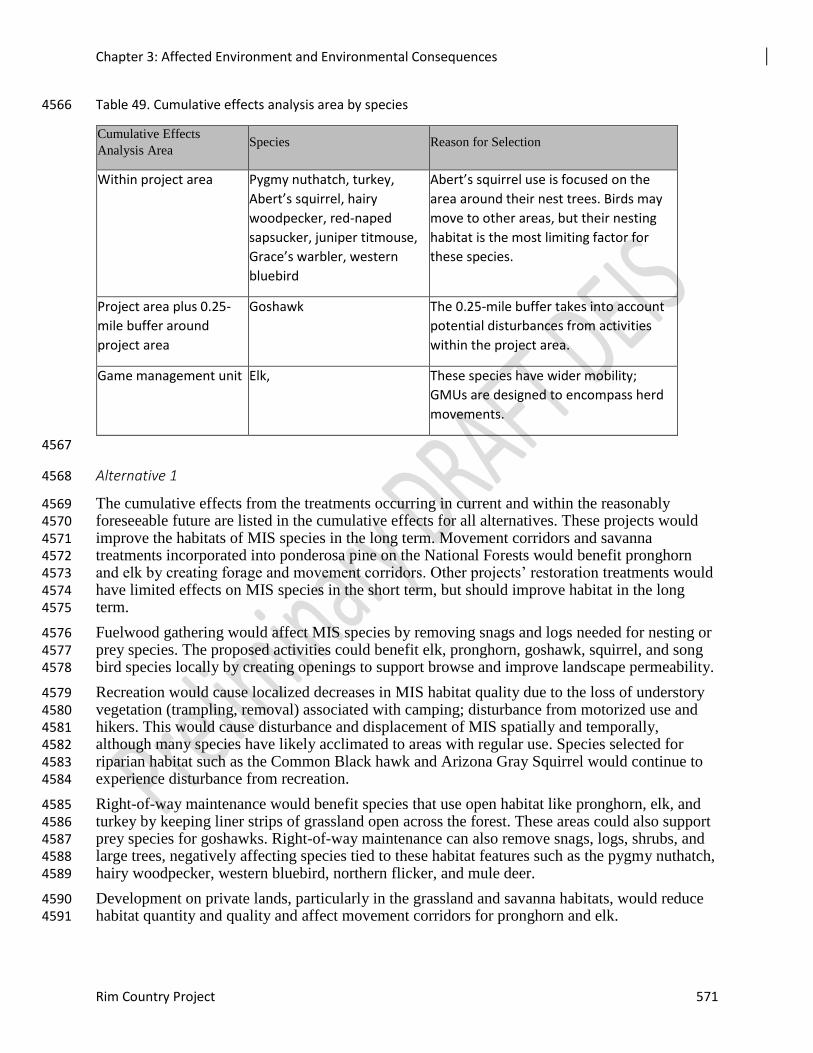
Chapter 3: Affected Environment and Environmental Consequences
Rim Country Project 571
Table 49. Cumulative effects analysis area by species 4566
Cumulative Effects
Analysis Area Species Reason for Selection
Within project area Pygmy nuthatch, turkey,
Abert’s squirrel, hairy
woodpecker, red-naped
sapsucker, juniper titmouse,
Grace’s warbler, western
bluebird
Abert’s squirrel use is focused on the
area around their nest trees. Birds may
move to other areas, but their nesting
habitat is the most limiting factor for
these species.
Project area plus 0.25-
mile buffer around
project area
Goshawk The 0.25-mile buffer takes into account
potential disturbances from activities
within the project area.
Game management unit Elk, These species have wider mobility;
GMUs are designed to encompass herd
movements.
4567
Alternative 1 4568
The cumulative effects from the treatments occurring in current and within the reasonably 4569 foreseeable future are listed in the cumulative effects for all alternatives. These projects would 4570 improve the habitats of MIS species in the long term. Movement corridors and savanna 4571 treatments incorporated into ponderosa pine on the National Forests would benefit pronghorn 4572 and elk by creating forage and movement corridors. Other projects’ restoration treatments would 4573 have limited effects on MIS species in the short term, but should improve habitat in the long 4574 term. 4575
Fuelwood gathering would affect MIS species by removing snags and logs needed for nesting or 4576 prey species. The proposed activities could benefit elk, pronghorn, goshawk, squirrel, and song 4577 bird species locally by creating openings to support browse and improve landscape permeability. 4578
Recreation would cause localized decreases in MIS habitat quality due to the loss of understory 4579 vegetation (trampling, removal) associated with camping; disturbance from motorized use and 4580 hikers. This would cause disturbance and displacement of MIS spatially and temporally, 4581 although many species have likely acclimated to areas with regular use. Species selected for 4582 riparian habitat such as the Common Black hawk and Arizona Gray Squirrel would continue to 4583 experience disturbance from recreation. 4584
Right-of-way maintenance would benefit species that use open habitat like pronghorn, elk, and 4585 turkey by keeping liner strips of grassland open across the forest. These areas could also support 4586 prey species for goshawks. Right-of-way maintenance can also remove snags, logs, shrubs, and 4587 large trees, negatively affecting species tied to these habitat features such as the pygmy nuthatch, 4588 hairy woodpecker, western bluebird, northern flicker, and mule deer. 4589
Development on private lands, particularly in the grassland and savanna habitats, would reduce 4590 habitat quantity and quality and affect movement corridors for pronghorn and elk. 4591
Chapter 3: Affected Environment and Environmental Consequences
572 Draft Environmental Impact Analysis
Alternatives 2 and 3 4592
The planned thinning and burning of ponderosa pine and mixed conifer habitat would help 4593 reduce small tree densities and help move habitat toward historical stand structures. These 4594 treatments would have the same benefits discussed in Alternative 1, but when added to the 4595 additional treatments in the alternatives, would provide for improvement across the landscape. 4596 These treatments would affect the MSO, Northern goshawk, Pygmy nuthatch, Rocky Mountain 4597 elk, Merriam’s turkey, Abert’s squirrel, Violet-green swallow, Hairy woodpecker, Western 4598 bluebird, and Western wood peewee by improving their habitats in the long term. These species’ 4599 forestwide habitat trends would be improved by thinning projects that retain and enhance the 4600 large tree component within the ponderosa pine forest and that help create and retain large snags. 4601
The 36,340 acres of grassland restoration, 17,600 acres of ponderosa pine savanna treatments, 4602 and 6,760 acres of meadow treatments would benefit pronghorn and elk by creating forage and 4603 corridors for movement between areas. 4604
Treatment is possible on up to 115,000 acres of pinyon-juniper habitat. Design features will 4605 preserve older trees in this habitat type so effects from treatments to these MIS populations (Ash-4606 throated flycatcher, Gray vireo, Juniper titmouse, Northern flicker and Townsend’s solitaire) are 4607 expected to be minimal. 4608
Fuelwood gathering and travel management requirements together help determine where the 4609 public can legally collect fuelwood. Since off road travel is only allowed in fuelwood areas, this 4610 would limit how far the public can travel to collect fuelwood. This would likely leave more dead 4611 and down woody material in areas farther from roads. There would likely be less dead woody 4612 material available within fuelwood areas closer to roads. This could prevent achieving forest plan 4613 requirements for snags, logs, and dead and down woody material near some roads. This would 4614 also limit how much fuelwood is removed away from roads and increase fuelwood removal 4615 along roads. Proposed treatments should help limit the amount of area not meeting forest 4616 requirements. This would affect the Northern goshawk, Pygmy nuthatch, Hairy woodpecker, 4617 Violet-green swallow, Northern flicker, and Juniper titmouse by removing snags that are needed 4618 for nesting or prey species. 4619
The effects on MIS from ongoing and foreseeable activities, along with the proposed activities in 4620 Alternatives 2 and 3, are as follows: For all of the MIS species, the cumulative effects from these 4621 projects would not adversely change the predicted forestwide habitat and population 4622 trends. 4623
Migratory Birds and Important Bird Areas 4624
In the Mogollon Rim Snowmelt Draw Important Bird Area, the Rim Country Project would 4625 affect approximately 45,673 acres of ponderosa pine, aspen, pinyon-juniper, grasslands and 4626 savannas, ephemeral streams, and spring habitats. Mexican spotted owl protected, recovery, and 4627 critical habitats occur in the Important Bird Area. All design features associated with these 4628 habitat types would be followed as discussed in previous sections of this report. 4629
Effects of the Proposed Activities on Migratory Birds 4630
Alternatives 2 and 3 would have short term negative with long term positive effects to migratory 4631 birds. The proposed treatments would have no population effects to migratory birds. 4632
Currently, many migratory birds depend on habitats or habitat elements related to canopy 4633 openings, snags, and early seral conditions. Existing closed canopy forests limit or eliminate 4634 many of the necessary habitat components needed by these species, such as understory 4635
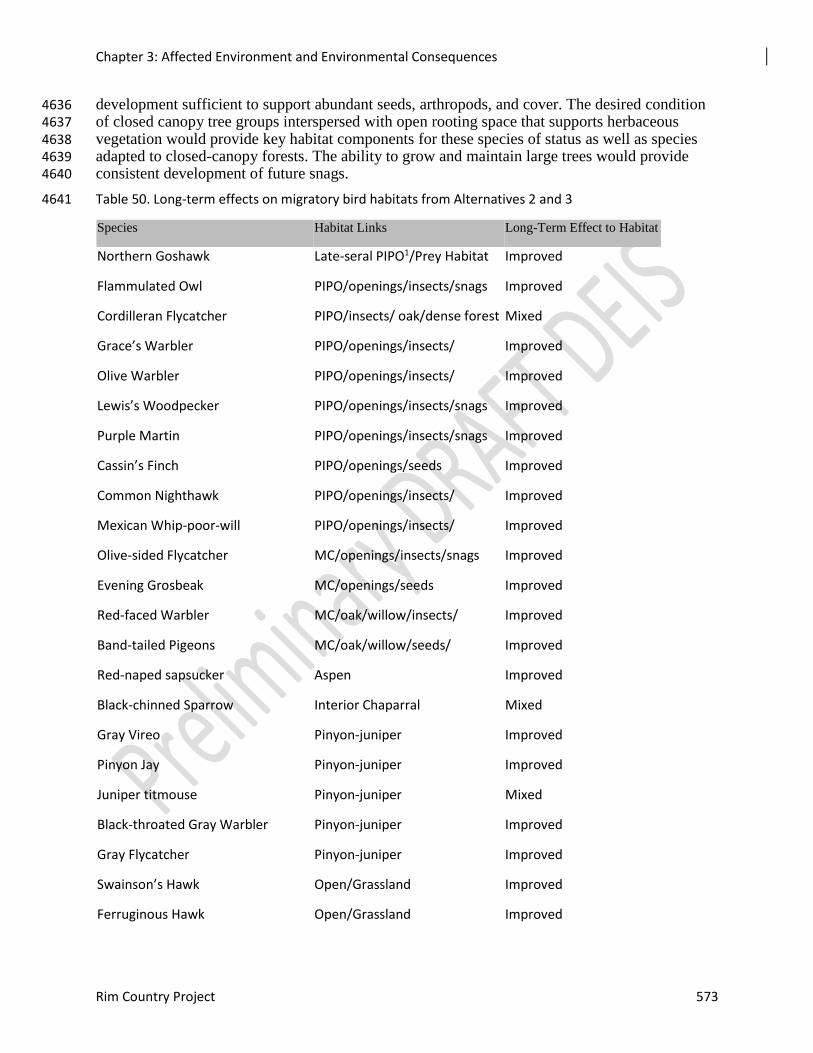
Chapter 3: Affected Environment and Environmental Consequences
Rim Country Project 573
development sufficient to support abundant seeds, arthropods, and cover. The desired condition 4636 of closed canopy tree groups interspersed with open rooting space that supports herbaceous 4637 vegetation would provide key habitat components for these species of status as well as species 4638 adapted to closed-canopy forests. The ability to grow and maintain large trees would provide 4639 consistent development of future snags. 4640
Table 50. Long-term effects on migratory bird habitats from Alternatives 2 and 3 4641
Species Habitat Links Long-Term Effect to Habitat
Northern Goshawk Late-seral PIPO1/Prey Habitat Improved
Flammulated Owl PIPO/openings/insects/snags Improved
Cordilleran Flycatcher PIPO/insects/ oak/dense forest Mixed
Grace’s Warbler PIPO/openings/insects/ Improved
Olive Warbler PIPO/openings/insects/ Improved
Lewis’s Woodpecker PIPO/openings/insects/snags Improved
Purple Martin PIPO/openings/insects/snags Improved
Cassin’s Finch PIPO/openings/seeds Improved
Common Nighthawk PIPO/openings/insects/ Improved
Mexican Whip-poor-will PIPO/openings/insects/ Improved
Olive-sided Flycatcher MC/openings/insects/snags Improved
Evening Grosbeak MC/openings/seeds Improved
Red-faced Warbler MC/oak/willow/insects/ Improved
Band-tailed Pigeons MC/oak/willow/seeds/ Improved
Red-naped sapsucker Aspen Improved
Black-chinned Sparrow Interior Chaparral Mixed
Gray Vireo Pinyon-juniper Improved
Pinyon Jay Pinyon-juniper Improved
Juniper titmouse Pinyon-juniper Mixed
Black-throated Gray Warbler Pinyon-juniper Improved
Gray Flycatcher Pinyon-juniper Improved
Swainson’s Hawk Open/Grassland Improved
Ferruginous Hawk Open/Grassland Improved
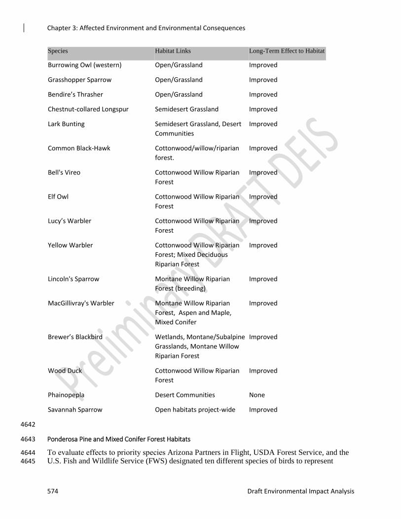
Chapter 3: Affected Environment and Environmental Consequences
574 Draft Environmental Impact Analysis
Species Habitat Links Long-Term Effect to Habitat
Burrowing Owl (western) Open/Grassland Improved
Grasshopper Sparrow Open/Grassland Improved
Bendire’s Thrasher Open/Grassland Improved
Chestnut-collared Longspur Semidesert Grassland Improved
Lark Bunting Semidesert Grassland, Desert
Communities
Improved
Common Black-Hawk Cottonwood/willow/riparian
forest.
Improved
Bell's Vireo Cottonwood Willow Riparian
Forest
Improved
Elf Owl Cottonwood Willow Riparian
Forest
Improved
Lucy’s Warbler Cottonwood Willow Riparian
Forest
Improved
Yellow Warbler Cottonwood Willow Riparian
Forest; Mixed Deciduous
Riparian Forest
Improved
Lincoln's Sparrow Montane Willow Riparian
Forest (breeding)
Improved
MacGillivray's Warbler Montane Willow Riparian
Forest, Aspen and Maple,
Mixed Conifer
Improved
Brewer’s Blackbird Wetlands, Montane/Subalpine
Grasslands, Montane Willow
Riparian Forest
Improved
Wood Duck Cottonwood Willow Riparian
Forest
Improved
Phainopepla Desert Communities None
Savannah Sparrow Open habitats project-wide Improved
4642
Ponderosa Pine and Mixed Conifer Forest Habitats 4643
To evaluate effects to priority species Arizona Partners in Flight, USDA Forest Service, and the 4644 U.S. Fish and Wildlife Service (FWS) designated ten different species of birds to represent 4645
Chapter 3: Affected Environment and Environmental Consequences
Rim Country Project 575
ponderosa pine habitat. These are the Northern goshawk, Flammulated owl, Olive-sided 4646 flycatcher, Cordilleran flycatcher, Grace’s warbler, Olive warbler, Lewis’s woodpecker, Purple 4647 martin, Cassin’s finch, Common nighthawk, and Mexican whip-poor-will. Four priority breeding 4648 birds that use mixed conifer as primary habitats are the Olive-sided flycatcher, Evening 4649 grosbeak, Red-faced warbler, and Band-tailed pigeon. 4650
Alternatives 2 and 3 propose restoration treatments for 471,811 to 424,431 acres of thinning and 4651 burning depending on alternative in ponderosa pine habitat. Approximately 50,500 acres of 4652 mixed conifer could be treated under the action alternatives. The action alternatives are designed 4653 to maintain or enhance late-seral ponderosa pine and mixed conifer trees and protect all MSO 4654 PACs, goshawk nesting areas, and PFAs. 4655
Unintentional take would be minimized through the application of breeding season timing 4656 restrictions in PACs and goshawk nest stands, deferral areas, and other design features described 4657 above. Long-term benefits to migratory birds would be the creation of openings and habitat 4658 heterogeneity where forests are currently dominated by homogenous conditions. Openings would 4659 support increased biomass development, including increased seed production, arthropods, and 4660 small mammals. Design features would protect existing snags and increase large tree growth. 4661 The risk of habitat loss from large-scale, high-severity fire would decrease after treatment. 4662
Aspen Habitat 4663
Alternatives 2 and 3 propose to mechanically thin and burn approximately 1,230 acres of aspen 4664 habitat to and protect treated aspen to prevent ungulate grazing of the new sprouts. Snag and 4665 burning requirements that are described in the ponderosa pine section would also apply to aspen 4666 treatments. Arizona Partners in Flight designated one species to represent aspen habitat, the Red-4667 naped sapsucker. Currently there is very little aspen regeneration and the overstory is dying or 4668 compromised by a variety of factors, including competition with conifers. The alternatives would 4669 stimulate aspen growth and protect ramets from browsing, creating multi-storied conditions over 4670 time. The risk of habitat loss from large-scale, high-severity fire would decrease after treatment. 4671 Unintentional take would be minimized through the application of breeding season timing 4672 restrictions in PACs and PFAs, deferral areas, and other design features described above. 4673
Pinyon-Juniper Habitat 4674
Both action alternatives include various levels of restoration implementation within pinyon-4675 juniper. The alternatives could mechanically thin and burn 114,753 acres of pinyon-juniper. 4676 Arizona Partners in Flight, the FS, and the FWS designated five different species of bird to 4677 represent pinyon-juniper habitat. These are the Black-throated gray warbler, Common 4678 Nighthawk, Juniper Titmouse, Pinyon Jay, and Gray Vireo. Long-term benefits would include 4679 increasing understory development, managing for snag retention, and increasing habitat 4680 heterogeneity. Areas with currently dense conditions would be more open, leading to mixed 4681 long-term results for some species of birds, such as the Juniper Titmouse. Unintentional take is 4682 would be minimized through the application of breeding season timing restrictions in PFAs, 4683 deferral areas, and other design features described above. 4684
High Elevation and Semi-desert Grassland Habitat 4685
The action alternatives would restore up to 36,320 acres of grassland, 6,720 acres of meadows, 4686 and 18,570 acres of savannahs (Alternative 2) or 2,470 acres of Savannah (Alternative 3). 4687 Priority birds that use high elevation grasslands are the Brewer’s blackbird, Common nighthawk, 4688 and Ferruginous hawk. Priority species that use semi-desert grassland habitat for breeding are 4689 Bendire’s thrasher and Phainopepla. Additionally, the Chestnut-collared longspur, Ferruginous 4690
Chapter 3: Affected Environment and Environmental Consequences
576 Draft Environmental Impact Analysis
hawk, Grasshopper sparrow, and Lark bunting use these habitats for overwintering. Burning 4691 would restore disturbances that work to maintain grasslands, meadows, and savannas. Low-4692 severity prescribed fire is expected to increase growth and diversity of herbaceous vegetation, 4693 which would provide increased forage in the long term. Expected benefits could occur as soon as 4694 one to two years following prescribed fire. However, most post-settlement trees would likely 4695 remain after grassland burn prescriptions. 4696
Habitat loss and fragmentation for grassland species has been an on-going issue both nationally 4697 and locally. Encroachment of this habitat has been a direct result of fire suppression in the Rim 4698 Country project area. Implementing the action alternatives would not only improve habitat 4699 effectiveness but also increase overall acres of habitat. Unintentional take would be minimized 4700 through the application of design features described above. 4701
Riparian Forests 4702
Alternatives 2 and 3 both propose 14,560 acres of riparian restoration. Improvement of stream 4703 function is proposed for 777 miles across the project area through the action alternatives. 4704
Priority breeding birds that use riparian forest habitats are the Common black-hawk, Bell’s vireo, 4705 Brewer’s blackbird, Elf owl, Lincoln’s sparrow, Lucy’s warbler, MacGillivray’s warbler, Red-4706 faced warbler, Wood duck, and Yellow warbler. Management of wildlife habitat is a key 4707 emphasis. Design features for restoration implementation in riparian habitat would minimize 4708 disturbance to migratory birds. 4709
Species-specific Effects 4710
The anticipated effects from proposed activities on priority species of migratory birds are 4711 presented in the table below. 4712
Important Bird Areas 4713
Most of the major vegetation cover types within the Mogollon Rim Snowmelt Draw IBA would 4714 be affected by Alternatives 2 and 3. The habitat of this IBA includes Ponderosa pine, white fir, 4715 Douglas fir, southwestern white pine, quaking aspen, and Gambel oak. Young plants of these 4716 canopy trees, plus canyon maple and New Mexico locust dominate the understory woody 4717 species. While most of the acres treated are within ponderosa pine and dry mixed conifer 4718 habitats, treatments would also occur in savannah, meadows, aspen, and pinyon juniper habitats. 4719 In addition, 53 miles of road decommissioning, restoration of six springs, and 7.5 miles of 4720 ephemeral stream channel restoration activities are proposed within the IBA in Alternatives 2 4721 and 3. Design features (Appendix 5) are included in the project to reduce effects on bird species. 4722
Overall, treatment objectives are to help restore forests to their natural range of variation. 4723
Project activities including road decommissioning and spring and stream channel restoration, 4724 would help restore the area to more natural conditions. This should improve habitat conditions 4725 for all bird species that use the project area. There could be some limited effects on the species 4726 due to activities that might occur during the breeding season. It is expected that the habitats for 4727 which the Important Bird Area was established would benefit from the proposed treatments. 4728
Cumulative Effects on Migratory Birds 4729
Because of their seasonal movement, the primary management concern for migratory birds is 4730 nesting habitat and, for bald eagles, winter roost sites and known nest sites. The cumulative 4731 effects analysis area for migratory birds is the project area. The effects from projects that have 4732 already been implemented were used to help describe current conditions of the project area and 4733
Chapter 3: Affected Environment and Environmental Consequences
Rim Country Project 577
will not be discussed in this section. Ongoing and reasonably foreseeable activities are listed in 4734 the cumulative effects for all alternatives section. .Cumulative effects discussed here include 4735 those that have occurred since 2001 and the effects of the Rim Country alternatives. The 4736 timeframe considered is approximately 20 years in the future, at which time the majority of the 4737 activities proposed will have been completed and the vegetation response to these actions will 4738 have occurred. 4739
There are many ongoing or planned projects that will thin ponderosa pine habitat. These thinning 4740 treatments vary greatly and include noncommercial thinning, group selection, sanitation 4741 thinning, and shelterwood cuts. Slash treatments associated with this thinning include lopping 4742 and scattering, hand and dozer piling and burning, and prescribed burning. There is an estimated 4743 122,468 acres of thinning from other projects already planned or reasonably foreseeable within 4744 the project area. 4745
Many of the thinning treatment areas include prescribed burning. There are also burn-only areas 4746 within the ponderosa pine habitat. There are also many areas that have planned maintenance 4747 burns occurring in 5- to 20-year cycles. There will be an estimated 195,405 acres of prescribed 4748 burns in the project area. There will also be 4,416 acres of ponderosa pine savanna restoration 4749 occurring on the Apache-Sitgreaves NF. 4750
Both the Apache-Sitgreaves and Coconino NFs are actively trying to restore aspen clones. The 4751 majority of the aspen on the Coconino NF is found within wilderness areas, whereas aspen is 4752 usually found in small patches scattered within the ponderosa pine forest on the Apache-4753 Sitgreaves NF. There are 683 acres of planned aspen restoration and subsequent barrier 4754 construction planned on the Apache-Sitgreaves NF, and 4,637 acres of planned aspen restoration 4755 with associated barriers on the Coconino NF. In total, 5,320 acres of aspen restoration are 4756 planned or ongoing within the Rim Country project area.The Coconino NF has begun 4757 implementing travel management within the project area. These efforts would change effects 4758 from fuelwood cutting, hunting, and recreational camping across both national forests. On the 4759 Coconino NF, the public is allowed to travel cross country to collect cut fuelwood with the 4760 proper permit. On the Apache-Sitgreaves NF, the public is only allowed to drive off-road to 4761 collect fuelwood within designated areas. While there are species-specific rules for cutting dead 4762 trees, it is not uncommon for larger snags to be cut. This generally occurs closer to roads and 4763 decreasing miles of open road should decrease the loss of the resource. 4764
The Apache-Sitgreaves NF allows for retrieval of elk during hunting season in all game 4765 management units, while the Coconino NF allows elk retrieval in all game management units 4766 except 5a and 5b. The Coconino NF designated 300-foot corridors on select roads for people to 4767 park vehicles away from roads. Parking along roads without camping corridors on the Coconino 4768 NF is allowed up to 30 feet away. The Apache-Sitgreaves NF allows parking up to 30 feet away 4769 from all open roads and does not have any designated areas for parking farther in from roads for 4770 camping. 4771
Pinyon-juniper thinning and burning is occurring on all three Rim Country forests. The Apache-4772 Sitgreaves and Coconino NFs have planned 7,040 acres within the project area. Grassland 4773 restoration treatments include removal of encroaching conifers and prescribed burning to 4774 rejuvenate grasses and forbs. Within the project areas there are 9,840 acres of planned grassland 4775 treatments. 4776
All three national forests have ongoing maintenance of rights-of-way for power and gas lines. 4777 This involves thinning and burning within the ROWs to keep them clear of trees and shrubs. 4778 ROWs comprise approximately 32,340 acres in the project area, with the majority on the 4779 Coconino NF. 4780
Chapter 3: Affected Environment and Environmental Consequences
578 Draft Environmental Impact Analysis
Grazing is occurring throughout the project area on all three national forests. Grazing is an 4781 ongoing activity and the timing of season of use varies by allotment. On average, 30 to 40 4782 percent of the forage is allowed for utilization by livestock and wildlife. There is no proposal to 4783 increase any livestock numbers within these allotments. Therefore there would be no additional 4784 effects. 4785
There are approximately 150,000 acres of lands in other ownership inside the project boundary. 4786 These areas include housing tracts, vacation homes, and ranchland. 4787
Alternative 1 4788
Resulting forest structure from planned thinning and burning of 195,405 acres of ponderosa pine 4789 habitat outside of the Rim Country boundary would result in habitat within the NRV. In the long 4790 term, wildlife species are less likely to be adversely affected by treatments that result in habitat 4791 conditions consistent with those of their evolutionary past and so are expected to respond 4792 positively to the ongoing and proposed thinning projects (Kalies et al. 2010). These treatments 4793 would improve habitat for most birds species associated with the ponderosa pine cover type in 4794 the long term (e.g., bark gleaners, woodpeckers, and flycatchers), but may negatively affect 4795 foliage gleaners in the short term (Patton and Gordon 1995, George et al. 2005). 4796
Aspen restoration is proposed for areas that are a high priority for restoration. These treatments 4797 would yield limited improvements for the red-naped sapsucker in the short term, but should 4798 improve about 5,200 acres of habitat in the long term. 4799
Fuelwood gathering and travel management requirements together help determine where the 4800 public collects fuelwood. The public would be limited in where they can travel off road to gather 4801 fuelwood on both the Coconino and Apache-Sitgreaves NFs. This would likely leave higher 4802 densities of dead and down woody material in areas farther from roads. Less dead woody 4803 material would be expected to remain in fuelwood areas and areas closer to roads. Designated 4804 fuelwood areas on the Apache-Sitgreaves NF might not always meet forest plan requirements 4805 once wood gathering activities are terminated. Areas adjacent to roads might be deficit on the 4806 Coconino NF. This could have a negative effect on species that use snags or down material in the 4807 ponderosa pine, aspen, and pinyon-juniper. In grasslands, the travel management requirements 4808 would benefit grassland species by preventing cross-country travel into their habitat. 4809
Pinyon-juniper thinning and burning has the potential to both remove habitat and improve habitat 4810 for the birds that use this habitat type. The proposed activities could result in loss of young of 4811 year depending on timing of activities. The effects on pinyon-juniper associated species are 4812 expected to be limited because only a small amount of this habitat is proposed for treatment 4813 within the cumulative effects analysis area. 4814
Right-of-way maintenance would help keep strips of land open and create the equivalent of 4815 relatively narrow, liner grasslands. While this might affect individual birds, there would not 4816 likely be an effect on any species because of the limited space and spatial configuration of this 4817 habitat. It would benefit some grassland species. 4818
Development on private land and other federal lands continue to remove habitat within and 4819 adjacent to the project area. The cover type with the most development occurring is within 4820 grasslands and savanna habitat. This would remove habitat and potentially cause some mortality 4821 of grassland species, particularly young-of-the-year, depending on the timing of the 4822 development. 4823
The Coconino NF has implemented an innovative management strategy to protect wetlands from 4824 grazing and prolonged drought within the Anderson Mesa Important Bird Area by regulating the 4825
Chapter 3: Affected Environment and Environmental Consequences
Rim Country Project 579
timing and duration of livestock grazing in permitted areas. Wetlands are being protected from 4826 livestock by constructing fences that still allow passage of wildlife. Habitat restoration, including 4827 the restoration of grasslands, is ongoing. Ranchers and conservation organizations are actively 4828 engaged through the Diablo Trust in achieving conservation objectives for the site. 4829
The cumulative effects on the migratory birds could result in some incidental mortality caused by 4830 implementation activities. How much mortality would be proportional to how many acres are 4831 treated during the spring nesting season of April, May, June, and July. Seasonal restrictions 4832 would limit project implementation activities between March 1 and September 30 in goshawk 4833 PFAs and MSO PACs, which would reduce the potential for loss for birds in ponderosa pine 4834 habitat. Prescribed fire could also occur in the fall, outside of the spring nesting season. Since 4835 only a small percentage of habitats would be treated at any one time, the loss of eggs or nestlings 4836 would not result in a measurable negative effect on the migratory birds populations listed above. 4837
Alternatives 2 and 3 4838
Resulting forest structure from planned thinning and burning of 195,405 acres of ponderosa pine 4839 habitat outside of the Rim Country boundary would be habitat within the natural range of 4840 variation. In the long term, wildlife species are less likely to be adversely affected by treatments 4841 that result in habitat conditions consistent with those of their evolutionary past and so are 4842 expected to respond positively to the ongoing and proposed thinning projects (Kalies et al. 2010). 4843 These treatments would improve habitat for most birds species associated with the ponderosa 4844 pine cover type in the long term (e.g., bark gleaners, woodpeckers, and flycatchers), but may 4845 negatively affect foliage gleaners in the short term (Patton and Gordon 1995, George et al. 2005). 4846 Cumulatively there would be approximately 700,000 acres of ponderosa pine habitat treated 4847 within the cumulative effects analysis area. 4848
The proposed aspen restoration would be in areas that are a high priority for restoration. 4849 Cumulatively, this would treat the aspen outside of wilderness that are at most risk of being lost 4850 in the near future. These treatments would yield limited improvements for the red-naped 4851 sapsucker in the short term, but should improve their habitat components in the long term. 4852
Fuelwood gathering and travel management effects would be similar to those for Alternative 1. 4853 However, cumulatively there would be approximately 800 miles of roads decommissioned that 4854 would reduce the opportunities for woodcutting along these roads (at least on the Coconino NF 4855 where woodcutters are allowed to collect fuelwood on closed roads). 4856
Pinyon-juniper thinning and burning has the potential to both remove habitat and improve habitat 4857 for the birds that use this habitat type. The proposed activities could result in loss of young of 4858 year depending on timing of activities. The effects on pinyon-juniper-associated species would 4859 be expected to be limited because only a small amount of this habitat would be treated within the 4860 cumulative effects analysis area, both cumulatively and within the proposed project. 4861
Right-of-way maintenance and development on private land would have the same effects as 4862 described above from Alternative 1. 4863
The Coconino NF has implemented an innovative management strategy to protect wetlands from 4864 grazing and prolonged drought within the Anderson Mesa Important Bird Area, by regulating the 4865 timing and duration of livestock grazing in permitted areas as described in Alternative 1. The 4866 proposed project would treat between 42,486 to 43,863 acres of habitat within the Important Bird 4867 Area. This would cumulatively improve habitat condition within a broader area of the Important 4868 Bird Area. 4869
Chapter 3: Affected Environment and Environmental Consequences
580 Draft Environmental Impact Analysis
The cumulative effects on migratory birds could result in some incidental mortality caused by 4870 project implementation activities. How much mortality would be proportional to how many acres 4871 are treated during the spring nesting season of April, May, June, and July. Seasonal restrictions 4872 would limit project implementation activities between March 1 and September 30 in goshawk 4873 nest areas and post-fledging family areas and within Mexican spotted owl protected activity 4874 centers, which would reduce the potential for loss of species in ponderosa pine habitat. 4875 Prescribed fire could also occur in the fall, outside of the spring nesting season. Since only a 4876 small percentage of habitats would be treated at any one time, the loss of eggs or nestlings would 4877 not result in a measurable negative effect on the migratory birds populations listed above. 4878
Locally Important Species 4879
Two locally important species that occur in the project area were identified by FS and USFW 4880 biologists. The Arizona toad and the Arizona Black Rattlesnake. 4881
The project could affect individual animals. Snakes or toads could be hit by vehicles associated 4882 with project implementation. Activities related to implementation could disturb individuals or 4883 interfere with hunting or foraging. However, overall there would not be a measurable negative 4884 effect on these two species populations. Long-term habitat improvements would include 4885 improved habitat and a decrease in potential disturbance from road decommissioning. 4886
Rare Plants 4887
Affected Environment and Environmental Consequences 4888
This section details the affected environment and environmental consequences for the threatened, 4889 endangered and Southwestern Region Regional Forester’s sensitive plants (hereafter 4890 Southwestern Region sensitive plants), within the project area. It establishes the baseline against 4891 which the decision maker and the public can compare the effects of the action alternatives. 4892
This section also describes the direct, indirect, and cumulative effects of implementing each 4893 alternative on threatened, endangered and Southwestern Region sensitive plants. It presents the 4894 scientific and analytical basis for the comparison of the alternatives presented in Alternatives 4895 section. The information presented here is part of the Botany and Noxious Weeds specialist report 4896 (Crisp 2018), which is incorporated by reference. 4897
Assumptions and Methodology 4898
Assumptions 4899
The environmental effects disclosed for rare plants are based on the following assumptions: 4900
All relevant laws, regulations, manual guidance and Forest Service policy relating to 4901 management of the resources discussed within are followed during analysis and 4902 implementation. 4903
Management will follow the guidance of the Forest Plans. 4904
Silviculture and prescribed burning treatments will be implemented as written and 4905 addressed in the Silviculture and Fire Ecology and Air Quality specialist reports and not 4906 substantially modified without review of the effects of such activities. 4907
Management activities related to roads and transportation as well as spring and channel 4908 restoration will be implemented as addressed in their respective reports and not 4909 substantially modified without review of the effects of such activities. 4910
Chapter 3: Affected Environment and Environmental Consequences
Rim Country Project 581
Prescribed fires will be of lower severity and intensity in any given area compared to 4911 large-scale wildfires in the same area so the amount of disturbance from prescribed 4912 burning is less than compared to wildfires. 4913
Fire effects to individual species vary depending on several factors including life cycle, 4914 time of burning and several biotic and abiotic factors (Pyke et al 2010). As a result, the 4915 responses of the plant species discussed in this report may vary in any given area or time. 4916 The effects of fire on these species will be mitigated through the burning prescription. 4917
Areas to be treated will be surveyed for Southwestern Region sensitive plants before and 4918 after treatments are implemented. These factors should be considered when identifying 4919 survey needs 4920
a) Target special features and microhabitat needed by the species of interest. This is 4921
generally only a small portion of the area, and is estimated to be 5 percent or less of 4922
any given area. 4923
b) Survey and mitigation will be based on the likelihood of any of the species addressed 4924
in this document occurring within the project area. Not all areas contain suitable 4925
habitat for a given species. 4926
c) The amount of disturbance predicted to occur during treatment. For example, surveys 4927
may not be needed in areas scheduled for prescribed burning if the treatments are 4928
scheduled to be of low intensity. 4929
d) Areas to be treated will be surveyed for noxious or invasive weeds before and after 4930
treatments are implemented. These factors should be considered when identifying 4931
survey needs 4932
e) Likelihood of any of the species addressed in this document occurring within the 4933
project area 4934
f) Amount of disturbance. For example, surveys may not be needed in areas scheduled 4935
for prescribed burning if the treatments are scheduled to be of low intensity. 4936
Application of the design features, BMPs, and mitigation and conservation measures 4937 discussed in the Rare Plants section of chapter 3 and in appendix C are included in 4938 analysis and project implementation. 4939
The acreage of potential disturbance in this project is much larger than generally 4940 analyzed in similar projects, necessitating more noxious or invasive weed treatments to 4941 control invasive species. This will lead to increases in personnel and budget to 4942 accomplish this need. 4943
Questions to Answer through Analysis 4944
How would proposed treatments affect Southwestern Region sensitive plant species? The 4945 indicators used to evaluate environmental consequences are: (1) a qualitative evaluation of 4946 whether populations are maintained or increased per FSM 2760. 5(19), (2) a qualitative 4947 evaluation of whether potential habitat is maintained or enhanced, (3) an evaluation of whether 4948 impacts to sensitive plants and their habitats are effectively minimized, and, (4) an evaluation on 4949 habitat and species resiliency to natural disturbances including fire and climate change. 4950
A unit of measure for Southwestern Region sensitive plant species is to maintain or increase the 4951 populations within the project area. Additionally, potential habitat for these species should be 4952 maintained or enhanced. 4953
Chapter 3: Affected Environment and Environmental Consequences
582 Draft Environmental Impact Analysis
How would project activities affect interactions between noxious or invasive weeds and 4954 Southwestern Region sensitive plants? 4955
Indicators/Topics of Analysis 4956
The indicators used to evaluate environmental consequences are: 4957
1. A qualitative evaluation of whether populations are maintained or increased per FSM 4958 2670.5(19) 4959
2. A qualitative evaluation of whether potential habitat is maintained or enhanced 4960
3. An evaluation of whether effects on sensitive plants and their habitats are effectively minimized 4961
4. An evaluation on habitat and species resiliency to natural disturbances including fire and climate 4962 change. 4963
Federally Listed Threatened or Endangered Plants 4964
The Rim Country project area does not include any locations or potential habitat for Threatened 4965 or Endangered plant species. 4966
Southwestern Region Regional Forester’s Sensitive Plants 4967
Table 95 displays the Southwestern Region sensitive plants occurring within the project area.4968
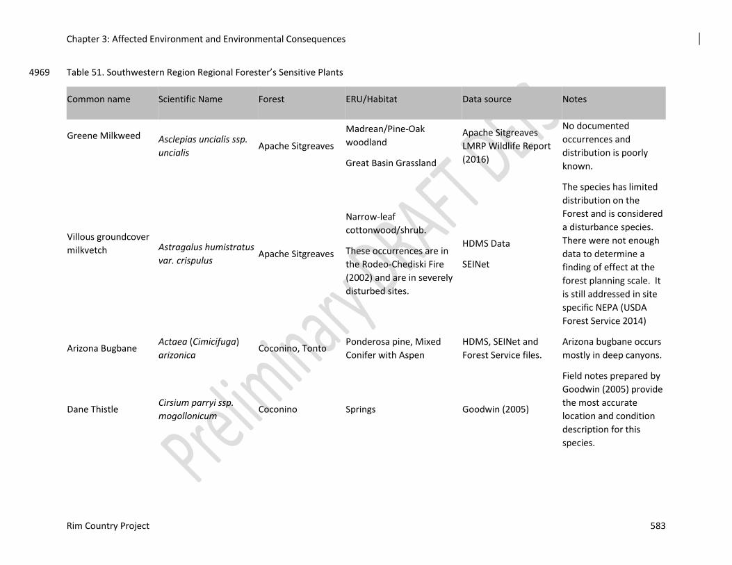
Chapter 3: Affected Environment and Environmental Consequences
Rim Country Project 583
Table 51. Southwestern Region Regional Forester’s Sensitive Plants 4969
Common name Scientific Name Forest ERU/Habitat Data source Notes
Greene Milkweed
Asclepias uncialis ssp.
uncialis Apache Sitgreaves
Madrean/Pine-Oak
woodland
Great Basin Grassland
Apache Sitgreaves
LMRP Wildlife Report
(2016)
No documented
occurrences and
distribution is poorly
known.
Villous groundcover
milkvetch
Astragalus humistratus
var. crispulus Apache Sitgreaves
Narrow-leaf
cottonwood/shrub.
These occurrences are in
the Rodeo-Chediski Fire
(2002) and are in severely
disturbed sites.
HDMS Data
SEINet
The species has limited
distribution on the
Forest and is considered
a disturbance species.
There were not enough
data to determine a
finding of effect at the
forest planning scale. It
is still addressed in site
specific NEPA (USDA
Forest Service 2014)
Arizona Bugbane Actaea (Cimicifuga)
arizonica Coconino, Tonto
Ponderosa pine, Mixed
Conifer with Aspen
HDMS, SEINet and
Forest Service files.
Arizona bugbane occurs
mostly in deep canyons.
Dane Thistle Cirsium parryi ssp.
mogollonicum Coconino Springs Goodwin (2005)
Field notes prepared by
Goodwin (2005) provide
the most accurate
location and condition
description for this
species.
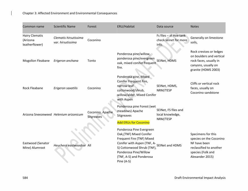
Chapter 3: Affected Environment and Environmental Consequences
584 Draft Environmental Impact Analysis
Common name Scientific Name Forest ERU/Habitat Data source Notes
Hairy Clematis
(Arizona
leatherflower)
Clematis hirsutissima
var. hirsutissima Coconino
Fs files – at Hoe tank
check seinet for more
info.
Generally on limestone
soils,
Mogollon Fleabane Erigeron anchana Tonto
Ponderosa pine/willow,
ponderosa pine/evergreen
oak, mixed conifer frequent
fire.
SEINet, HDMS
Rock crevices or ledges
on boulders and vertical
rock faces, usually in
canyons, usually on
granite (HDMS 2003)
Rock Fleabane Erigeron saxatilis Coconino
Ponderosa pine, Mixed
Conifer Frequent Fire,
narrow-leaf
cottonwood/shrub,
willow/alder, Mixed Conifer
with Aspen
SEINet, HDMS,
NRM/TESP
Cliffs or vertical rock
faces, usually on
Coconino sandstone
Arizona Sneezeweed Helenium arizonicum Coconino, Apache
Sitgreaves
Ponderosa pine Forest (wet
meadows) Apache
Sitgreaves
Add ERUs for Coconino
SEINet, FS files and
local knowledge,
NRM/TESP
Eastwood (Senator
Mine) Alumroot Heuchera eastwoodiae All
Ponderosa Pine Evergreen
Oak,(TNF) Mixed Conifer
Frequent Fire (TNF) Mixed
Conifer with Aspen (TNF, A-
S) Cottonwood Shrub (TNF),
Ponderosa Pine/Willow
(TNF, A-S) and Ponderosa
Pine (A-S)
SEINet and HDMS
Specimens for this
species on the Coconino
NF have been
reclassified to another
species (Folk and
Alexander 2015)
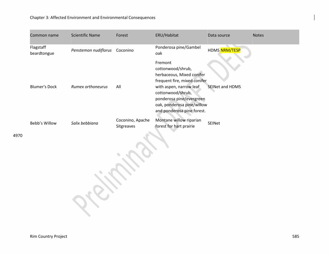
Chapter 3: Affected Environment and Environmental Consequences
Rim Country Project 585
Common name Scientific Name Forest ERU/Habitat Data source Notes
Flagstaff
beardtongue Penstemon nudiflorus Coconino
Ponderosa pine/Gambel
oak HDMS NRM/TESP
Blumer's Dock Rumex orthoneurus All
Fremont
cottonwood/shrub,
herbaceous, Mixed conifer
frequent fire, mixed conifer
with aspen, narrow leaf
cottonwood/shrub,
ponderosa pine/evergreen
oak, ponderosa pine/willow
and ponderosa pine forest.
SEINet and HDMS
Bebb’s Willow Salix bebbiana Coconino, Apache
Sitgreaves
Montane willow riparian
forest for hart prairie SEINet
4970
Chapter 3: Affected Environment and Environmental Consequences
586 Draft Environmental Impact Analysis
Greene Milkweed (Asclepias uncialis) 4971
Greene milkweed is a Region 3 sensitive species for the Apache-Sitgreaves NFs. The distribution 4972 of this small milkweed is poorly understood Greene milkweed is known from scattered locations 4973 in Arizona, Colorado, New Mexico, Nevada, western Oklahoma and Utah (Sundell 1994). 4974 Typical habitat for this species is level to gently sloping terrain on a variety of soil types except 4975 for pure sand. It is typically found in juniper woodland and savannas but within the grassland 4976 components of those systems (NatureServe 2017). Green milkweed occurs in small scattered 4977 clusters and tends to bloom earlier in the spring than many plants so may be overlooked during 4978 typical plant surveys (Decker 2006). 4979
Green milkweed was included in the Great Basin Grasslands and Madrean/Pine Oak Woodland 4980 ERUs during forest plan revision (USDA Forest Service 2016). There is one historical location 4981 from the White Mountains near Springerville in 1915 (Decker 2006). There are no documented 4982 for Greene milkweed in the analysis area. 4983
Villous groundcover milkvetch (Astragalus humistratus var. crispulus) 4984
Villous groundcover milkvetch is a Region 3 sensitive species for Apache Sitgreaves. It is a 4985 perennial species with prostrate, forking stems. Its distribution is limited to southeastern Apache 4986 County in Arizona and in neighboring Catron County in New Mexico where it grows on sandy 4987 soils of volcanic origin in dry pine forests (Spellenberg 2007). The occurrences on the forest are 4988 in narrow-leaf cottonwood/shrub ERUs. 4989
Occurrences were recorded by Glenn Rink and G. Clifton on July 23, 2014 for Bear Spring and 4990 July 24, 2014 for Black Canyon Lake (Arizona Game and Fish Department 2017). Both sites 4991 within the Rodeo-Chediski Fire (2002). This landscape scale event was a major driving force in 4992 defining the existing conditions on these sites which is now outside the natural range of variation 4993 (NRV). 4994
Arizona Bugbane (Cimicifuga arizonica) 4995
Arizona bugbane is endemic to northern Arizona, occurring on Coconino, Kaibab and Tonto 4996 National Forests where it occurs in mesic habitats, typically along the bottoms and lower slopes 4997 of steep, narrow canyons. The overstory often includes a combination of coniferous and 4998 deciduous tree species. Important overstory species include Douglas fir (Psuedotsuga menziesii), 4999 white fir (Abies concolor), big tooth maple (Acer saccharum ssp. grandidentatum), Arizona alder 5000 (Alnus oblongifolia) and red osier dogwood (Cornus stolonifera). 5001
Arizona bugbane is a Region 3 sensitive species for Kaibab, Coconino and Tonto National 5002 Forests. Almost all of the known occurrences are in wilderness areas including those known 5003 from West Clear Creek drainage (Arizona Game and Fish Department 2012). 5004
In this analysis occurrences of Arizona bugbane are limited to the Coconino National Forest. The 5005 area of known occurrence is in the Tom’s Creek Mexican Spotted Owl PAC and the treatment is 5006 listed as a potential PAC treatment. Because occupied PACs can already be considered 5007 successful nesting habitat, mechanical activity within PACs should be designed to protect the 5008 habitat characteristics that make each PAC effective at providing habitat. Consideration should 5009 be given to treating areas near PACs in order in improve resiliency within the PACs themselves. 5010 PACs should be treated with consideration of the larger landscape and not just separate entities. 5011 As a result, treatments within PACs will be determined separately and in coordination with 5012 appropriate FWS personnel (see the Implementation Plan in appendix D of this DEIS). 5013
Chapter 3: Affected Environment and Environmental Consequences
Rim Country Project 587
Dane (Mogollon) thistle (Cirsium parryi subsp. mogollicum) 5014
Dane thistle is a Region 3 sensitive species for Coconino National Forest. It is endemic to a few 5015 canyons on the Mogollon Rim Ranger District. 5016
Dane thistle was first “discovered” in 1987 and its description was published in 1990 (Schaack 5017 and Goodwin 1990). Dane thistle is distinguished from the more common Parry thistle by its 5018 white corollas and nearly entire leaves (Arizona Game and Fish Department) 2005). 5019
This rare thistle is known from only four locations on the Mogollon Rim Ranger District, 5020 Coconino National Forest where it is associated with springs or canyons including Dane, Dane 5021 Spring, and Yeager Canyons (Goodwin 2005). The data provided by Goodwin show the 5022 locations for the plants in Dane Canyon and Dane Spring Canyon but no accurate description for 5023 the occurrence in Yeager Canyon was found. These areas are proposed for aquatic habitat 5024 restoration. Non-native invasive species such as bull thistle (Cirsium vulgare) can compete with 5025 rare species such as Dane thistle for resources such as water and light. Mitigation to prevent 5026 infestations in these areas is especially important. 5027
One known occurrence is in a drainage below Dane Spring and is in MSO recovery habitat. 5028 Mechanical and prescribed fire are proposed for this area. The other two occurrences are within 5029 the Coyote Springs MSO PAC and will receive PAC treatment. Treatment at the first location 5030 may be guided by the MTFTA but treatment in MSO PACS will be negotiated separately with 5031 USFWS. 5032
All of the occurrences are near stream channels which will receive aquatic habitat restoration. 5033 Treatments for aquatic habitat restoration will be guided by the AWFTA (see appendix D). 5034 Design features (appendix C) will also be applied. 5035
Hairy Clematis (Arizona leatherflower) (Clematis hirsutissima var. hirsutissima) (syn. var. 5036
Arizonica) 5037
Hairy clematis is a Region 3 sensitive species for Coconino National Forest. 5038
A balance of shade and sun is important habitat components of hairy clematis. Intermediate 5039 amounts (approximately 50%) of light and shade provided the most beneficial conditions. Higher 5040 levels of light increased photosynthesis in adult plants, but resulted in lower reproductive 5041 success, and increased risk of desiccation. Low levels of light resulted in decreased 5042 photosynthesis, fewer stems per plant and lower seed production (Maschinski and others 1997). 5043 Juvenile plants benefit from the presence leaf litter. The litter provides a source of humidity 5044 around seedlings. However, heavy accumulation of litter can be detrimental to seedling survival 5045 and vegetative reproduction in adults. 5046
There is one location of hairy clematis near the proposed Iron Mine Draw Stream Channel 5047 Restoration in the area near Hoe Tank. 5048
Mogollon fleabane (Erigeron anchana) 5049
Mogollon fleabane is a Region 3 sensitive species for Tonto National Forest. Mogollon fleabane 5050 is one of four species identified by Nesom in 1990 in a revision of Erigeron pringlei. Prior to 5051 then, all were considered one species. All of the four species occur in various areas of northern 5052 Arizona where they are endemic. Mogollon fleabane is the only one of the four that occurs in 5053 the “sub-Mogollon” portion (below the Mogollon Rim) of the state with most occurrences in the 5054 Sierra Ancha Mountain range. Occurrences tend to be on rock cliffs (Arizona Game and Fish 5055
Chapter 3: Affected Environment and Environmental Consequences
588 Draft Environmental Impact Analysis
Department 2003) where it occurs in cliff crevices, ledges, soil pockets among boulders (Nesom, 5056 2006). 5057
There is one confirmed location of Mogollon fleabane in the project area. It is near Bear Flat 5058 Campground on the Tonto NF. The area where the plants are located is proposed for mechanical 5059 and prescribed fire treatment (goshawk foraging; meadow restoration), and is near a stream 5060 channel proposed for aquatic restoration. 5061
There is an occurrence of Mogollon fleabane in the Mogollon Rim Area (4D) Management Area 5062 (MA) of the Tonto NF LMRP. The management emphasis is for a variety of renewable resource 5063 outputs with primary emphasis on intensive, sustained yield timber management, timber resource 5064 protection, creation of wildlife habitat diversity, increased populations of emphasis harvest 5065 species, and recreation opportunity. Fire management objectives for this area include: providing 5066 a mosaic of age classes within the total type which would provide for a mix of successional 5067 stages, and to allow fire to resume its natural ecological role within ecosystems. A standard and 5068 guideline for the area states that habitat requirements for TES species would take precedence 5069 over other species. 5070
Rock (cliff) fleabane (Erigeron saxatilis) 5071
Rock fleabane is a Region 3 sensitive species for Coconino National Forest. All known 5072 occurrences are limited to the Coconino NF. 5073
Rock fleabane is a small daisy-like plant that tends to grow in erosion pockets on vertical cliff 5074 faces, most commonly Coconino sandstone. Generally, risks from management activities are 5075 confined to activities that would affect the cliff habitat on which it depends. Rock fleabane is an 5076 endemic species that occurs only in northern and central Arizona where it inhabits sheer canyon 5077 walls, moist north-facing slopes, steep solid rock and bedrock outcrops from 5,000 to 8,350 ft. 5078 (Arizona Game and Fish Department 2003). It is closely related to Mogollon fleabane and is one 5079 of the four species identified by Nesom in his 1990 revision of Erigeron pringlei. 5080
Arizona sneezeweed (Helenium arizonicum) 5081
Arizona sneezeweed is a Region 3 sensitive species for Coconino and Apache-Sitgreaves 5082 National Forests Arizona sneezeweed is a perennial herb that grows up to four feet tall with 5083 several stems. Flower heads consist of yellow to orange 3-lobed ray flowers and purplish-brown 5084 globular disk flowers and bloom July through September. Hundreds of individuals may exist in a 5085 single population. This endemic species ranges from the Mormon Lake area southeastward to the 5086 White Mountains area where it grows in drainages, near springs, ponds and other wet areas 5087 (Arizona Game and Fish Department 2005). 5088
Eastwood (Senator Mine) Alumroot (Heuchera eastwoodiae) 5089
Eastwood Alumroot is a Region 3 sensitive species for all three forests. Eastwood alumroot is 5090 endemic to central Arizona where it grows on moist shaded slopes in ponderosa pine forests and 5091 canyons. The typical substrate is crevices in basalt soil or basalt soil (Arizona Game and Fish 5092 Department 2005). Many of the previous occurrences of this species have been reclassified and 5093 are no longer included is this taxon (Folk and Alexander 2015). This has reduced the number of 5094 known occurrences of Eastwood alumroot on the forests and possibly within the project area. 5095
There are three occurrences of Eastwood alumroot within the analysis area documented in 5096 SEINet. Hendricks collected the species in 1930 from “Strawberry Hill”. The location falls 5097 within ponderosa pine/evergreen oak habitat. SEINet documents three collections of Eastwood 5098 alumroot on private land in 1966 in the Christopher Creek drainage. Lehto collected the species 5099
Chapter 3: Affected Environment and Environmental Consequences
Rim Country Project 589
on April 30, 1966 at Christopher Creek Campground and on October 1, 1966 on a mountainside 5100 near Christopher Creek. David Keil collected it near the mountainside location on April 30, 5101 1966. In addition to these areas, there are documented occurrences of Eastwood alumroot in the 5102 Hunter Creek and Christopher Creek drainages on the Tonto NF (Arizona Game and Fish 5103 Department 2017). All of these areas are proposed for riparian restoration as part of this project. 5104
Flagstaff beardtongue (Penstemon nudiflorus) 5105
Flagstaff beardtongue is a Region 3 sensitive species for Coconino NF. Flagstaff beardtongue 5106 grows in dry pine forests, pine/oak, pine/oak/ juniper and pinyon juniper forests. It occurs on dry 5107 slopes, in openings and along edges of openings and in forested areas. Documented locations for 5108 Flagstaff beardtongue include Anderson Mesa, near Lake Mary, Luke Mountain, Mormon Lake, 5109 Stoneman Lake, along the Schnebly Hill Road, along Oak Creek. In recent years, numerous 5110 locations have been found in proposed fuels reduction projects such as Upper Beaver Creek 5111 Watershed Fuels Reduction Project (2010) and in the Rocky Park Fuels Reduction Project 5112 (2001). 5113
Flagstaff beardtongue is endemic to northern and central Arizona where grows in dry pine forests 5114 (Arizona Game and Fish Department 2003). It tends to occur at elevations from 5100 to 7000 ft. 5115 in stony basaltic soil (Crosswhite, 1967). 5116
Blumer's Dock (Rumex orthoneurus) 5117
Blumer’s dock is a Region 3 sensitive species for all three forests. Blumer’s dock is a large, 5118 long-lived herbaceous perennial plant endemic to New Mexico and Arizona. Its range is from 5119 east-central to southeastern Arizona (depending on taxonomic interpretation). Habitat for 5120 Blumer’s dock includes mid- to high-elevation wetlands with moist, organic soil adjacent to 5121 perennial springs or streams in canyons or meadows (Arizona Game and Fish Department 2002. 5122 The species was proposed for federal listing in 1998 but the petition was rescinded in 1999. 5123
There are numerous occurrences of Blumer’s dock on the Apache-Sitgreaves NF. The Wildlife 5124 specialist report for forest plan revision on Apache-Sitgreaves NF identified the habitat for 5125 Blumer’s dock as All Riparian PVNTs. Healthy riparian condition and clean water are identified 5126 as the habitat elements (fine filter components) addressed in analyses for plan revision (USDA 5127 Forest Service 2015). 5128
Historically, there were both naturally occurring and introduced populations of Blumer’s dock on 5129 Tonto NF (USDA Forest Service 1985). The introductions occurred in the 1980’s. The 5130 introduced plants were cultivated from seeds collected from naturally occurring populations on 5131 the forest. The four naturally occurring populations include Reynolds Creek, Workman Creek, 5132 Rose Creek and Cold Springs Canyon. There are seventeen additional introduced populations 5133 including Canyon Creek, Haigler Creek, Pueblo Canyon, Bray Creek, Chase Creek, See Canyon, 5134 Nappa Spring, Dude Creek, East Verde River, Horton Springs, Pine Creek, Tonto Creek, Tonto 5135 Spring, Washington Park, Webber Creek, Ellison Creek, Christopher Creek, See Canyon and 5136 Horton Spring (USDA Forest Service 1993). 5137
The Tonto NF prepared a Conservation Strategy for Blumer’s dock in 1993. Directions in the 5138 Conservation Strategy included a series of mitigations including maintaining or improving 5139 suitable riparian condition and actions to reduce the effects of roads. These are: 5140
1. Locate new roads away from populations 5141
2. Minimize road maintenance and reconstruction of existing roads adjacent to populations 5142
3. Seek opportunities to obliterate and/or close roads adjacent to or impacting the population. 5143

Chapter 3: Affected Environment and Environmental Consequences
590 Draft Environmental Impact Analysis
The documented locations within the project area on the Coconino NF are in the East Clear 5144 Creek and Barbershop Canyon areas. 5145
Chapter 3: Affected Environment and Environmental Consequences
Rim Country Project 591
Bebb’s Willow (Salix bebbiana) 5146
Bebb’s willow is a Region 3 sensitive species for Coconino and Apache Sitgreaves National 5147 Forests. Bebb's willow (Salix bebbiana) is a large native shrub or a small bushy tree fifteen to 5148 twenty-five feet tall that ranges from Alaska south to British Columbia to east Newfoundland 5149 and in northeast United States and upper mid-western United States. Bebb’s willow plants can 5150 regenerate from root and basal stem sprouting. Stem and root fragments root naturally if buried 5151 in moist soil. Plants are dioecious; male and female flowers are borne on separate plants. Large 5152 quantities of seed may be produced but remain viable for only a few days. Bebb’s willow is 5153 drought and shade intolerant. Changes in water regime such as channel changes reduce 5154 successful germination from seed (Tesky 1992). 5155
Environmental Consequences 5156
Alternative 1 – No Action 5157
This discussion addresses the no action alternative for the Southwestern Region sensitive plants. 5158 The discussion of these species is grouped together because the effects of no action are the same. 5159 All of these species differ in location and habitat needs from each other. These topics are 5160 discussed below in each species section. 5161
Federally Listed Threatened or Endangered Plants 5162
The Rim Country project area does not include any locations or potential habitat for Threatened 5163 or Endangered plant species and therefore there would be no effects on them from a decision to 5164 choose the no action alternative. 5165
Southwestern Region Regional Forester’s Sensitive Plants 5166
Direct and Indirect Effects common to these species 5167
Alternative 1 is the no action alternative. Under this alternative, none of the management actions 5168 including tree removal, burning, spring restoration, channel restoration, aspen restoration or 5169 actions related to road reconstruction, or decommissioning would occur. There would be no 5170 direct effects from management actions to these Region 3 sensitive species. 5171
If the no action alternative were selected, none of the management actions would occur. There 5172 would be no tree cutting and no prescribed burning. As a result, tree density and canopy would 5173 not be reduced and stands would remain overstocked. Conditions associated with dense 5174 ponderosa pine stands result in physiologically stressful environments for understory plants. 5175 Stressors include increased shading, deep litter horizons, low soil moisture, low nutrient 5176 availability and contribute to a decline in species richness within the plant community. (Laughlin 5177 and others 2011). These factors affect all understory species including Region 3 sensitive plants. 5178 There would continue to be a reduction or loss of understory vegetation and therefore, a loss of 5179 understory services. 5180
With no treatment, fire hazard would continue to increase therefore increasing the risk of severe 5181 wildfire in many parts of the project area (see Vegetation and Fire Reports for more 5182 information). Factors that contribute to fire hazard ratings that would be reduced through 5183 management actions such as canopy cover, trees per acre and dead and down fuel loading would 5184 not be reduced. The risk of wildfire transitioning to crown fires would increase in many areas of 5185 the project area resulting in the increased risk of severe wildfire and degradation of potential 5186 habitat. Severe wildfires often result in short and long-term effects, which include removal of 5187 tree canopy, loss of the understory plant community and alteration of soil structure and nutrients 5188 (Pyke and others 2010). Fire affects plant communities in several ways including, removal of 5189
Chapter 3: Affected Environment and Environmental Consequences
592 Draft Environmental Impact Analysis
vegetation and litter, alteration of soil characteristics and redistribution or modification of 5190 nutrients (Raison 1979). Severe wildfires often result in deaths of all plants including Region 3 5191 sensitive plants, loss of seed banks (Korb and others 2004) and volatilization, alteration or 5192 removal of nutrients (Kaye and Hart 1998; Ballard 2000; Choromanska and DeLuca, 2002). 5193 These changes could adversely affect the habitat and populations of Region 3 sensitive plants by 5194 damaging soil, killing existing plants and by reducing or destroying the seed bank. Fire size may 5195 also increase, leading to largescale crown fires, which in turn may cause a permanent loss in 5196 understory diversity (Covington 2000). Primary fire effects such as deaths of individual plants or 5197 groups may recover in a matter of a few years. However, secondary effects such as permanent 5198 changes in biotic and abiotic factors can result in permanent changes in the post fire plant 5199 community (see Pyke and others 2010). 5200
With no action, dead and down fuels would continue to increase, which in turn could negatively 5201 affect the vigor of Region 3 sensitive plants by increasing the amount of shade and litter (see 5202 Vegetation Report). Noxious or invasive weeds such as Dalmatian toadflax (Crawford and others 5203 2001; Collins and others 2007, Dodge and others, 2008) and cheatgrass (McGlone and others 5204 2009; Pyke and others 2010) more easily invade areas of severe wildfires than unburned areas. 5205 Therefore, if a severe wildfire occurred in the habitat of Region 3 sensitive plants, noxious or 5206 invasive weeds would also increase and contribute to the degradation of the habitat and loss of 5207 individuals and groups of Region 3 sensitive plants. 5208
In the no action alternative, there would be no road reconstruction or decommissioning so there 5209 would be no direct or indirect risks such as deaths of individual plants and no risk of introduction 5210 of noxious or invasive weeds from management activities associated with road activities. 5211
No spring or channel restoration would occur. There would be no improvements to upland 5212 watershed conditions in areas near Arizona bugbane habitat. Opportunities to improve habitat for 5213 such species as Arizona sneezeweed, Bebb’s willow and Blumer’s dock would not occur and 5214 areas that might have historically provided habitat for these species and would remain degraded 5215 and unsuitable for these and other plant species that require mesic conditions for their survival. 5216
With no action, there would be no restoration of structure and function in the treatment areas, 5217 resulting in continued departure from the desired conditions for all resources in this project, 5218 including Region 3 sensitive plant species. 5219
Greene Milkweed (Asclepias uncialis) 5220
There is no effect to Greene milkweed from management actions since none is known to occur in 5221 the analysis area. 5222
Villous groundcover milkvetch (Astragalus humistratus var. crispulus) 5223
There are no direct effects to villous groundcover milkvetch from management actions since 5224 none will occur. 5225
The no action alternative would not move these areas toward the Desired Conditions for Forest-5226 wide Ecosystem Health or Desired Conditions for Riparian, Fine Scale Desired Conditions or 5227 Guidelines for Wildlife and Rare Plants or Desired Conditions and Guidelines for Landscape 5228 Scale disturbance. It will not meet the Purpose and Need of this project. Management actions 5229 that would improve the habitat for terrestrial and aquatic species would not occur and there 5230 would be no actions to improve the condition and function of these stream channels. 5231
Arizona Bugbane (Cimicifuga arizonica) 5232
There are no direct effects to Arizona bugbane from management actions since none will occur. 5233
Chapter 3: Affected Environment and Environmental Consequences
Rim Country Project 593
The no action alternative would not address the purpose and need of the project and would not 5234 move the area toward the desired conditions as defined in the Coconino LRMP (2018). The 5235 purpose of the Rim Country Project is to reestablish and restore forest structure and pattern, 5236 forest health, and vegetation composition and diversity in ponderosa pine ecosystems to 5237 conditions within the natural range of variation. Alternative 1 would not increase forest 5238 resiliency and sustainability or reduce the risk of undesirable fire effects. There would be no 5239 improvement in terrestrial habitat. There would be no treatments to restore the structure and 5240 function of the area the Arizona bugbane by reducing the risk of loss to disturbances such as 5241 uncharacteristic wildfire. The Desired Conditions and Guidelines that apply to the Arizona 5242 bugbane in this area include Desired Conditions All Ecosystems Soil, Terrestrial Ecosystems, or 5243 Wildlife, Fish and Plants. As a result, there would be no improvement of forest health, change in 5244 vegetation composition and diversity, resiliency would not be improved and Arizona bugbane 5245 plants in the project area would remain at a higher risk of loss from loss from undesirable fire 5246 effects if a wildfire were to occur within or near the Arizona bugbane population. 5247
Dane (Mogollon) thistle (Cirsium parryi subsp. mogollicum) 5248
There are no direct effects to Dane thistle from management actions since none will occur. 5249
The no action alternative would not address the purpose and need of the project and would not 5250 move the area toward the desired conditions as defined in the Coconino LRMP (2018). The 5251 purpose of the Rim Country Project is to reestablish and restore forest structure and pattern, 5252 forest health, and vegetation composition and diversity in ponderosa pine ecosystems to 5253 conditions within the natural range of variation. Alternative 1 would not increase forest 5254 resiliency and sustainability or reduce the risk of undesirable fire effects. There would be no 5255 improvement in terrestrial habitat. There would be no treatments to restore the structure and 5256 function of the area containing Dane thistle by reducing the risk of loss to disturbances such as 5257 uncharacteristic wildfire. The Desired Conditions and Guidelines that apply to Dane thistle 5258 include Desired Conditions All Ecosystems Soil, Terrestrial Ecosystems, or Watershed and 5259 Water, Springs or Wildlife, Fish and Plants. As a result, there would be no improvement of forest 5260 health, change in vegetation composition and diversity, resiliency would not be improved and 5261 Dane thistle plants in the project area would remain at a higher risk of loss from loss from 5262 undesirable fire effects if a wildfire were to occur within or near Dane thistle. 5263
Hairy Clematis (Arizona leatherflower) (Clematis hirsutissima var. hirsutissima) (syn. var. Arizonica) 5264
There are no direct effects to hairy clematis from management actions since none will occur. 5265
The no action alternative would not address the purpose and need of the project and would not 5266 move the area toward the desired conditions as defined in the Coconino LRMP (2018). The 5267 purpose of the Rim Country Project is to reestablish and restore forest structure and pattern, 5268 forest health, and vegetation composition and diversity in ponderosa pine ecosystems to 5269 conditions within the natural range of variation. Alternative 1 would not increase forest 5270 resiliency and sustainability or reduce the risk of undesirable fire effects. There would be no 5271 improvement in terrestrial habitat. There would be no treatments to restore the structure and 5272 function of the area containing hairy clematis by reducing the risk of loss to disturbances such as 5273 uncharacteristic wildfire. The Desired Conditions and Guidelines that apply to hairy clematis 5274 include Desired Conditions All Ecosystems Soil, Terrestrial Ecosystems, or Wildlife, Fish and 5275 Plants. As a result, there would be no improvement of forest health, change in vegetation 5276 composition and diversity, resiliency would not be improved and hairy clematis plants in the 5277 project area would remain at a higher risk of loss from loss from undesirable fire effects if a 5278 wildfire were to occur within or near hairy clematis. 5279
Chapter 3: Affected Environment and Environmental Consequences
594 Draft Environmental Impact Analysis
Mogollon fleabane (Erigeron anchana) 5280
There are no direct effects to Mogollon fleabane from management actions since none will 5281 occur. 5282
The no action alternative would not address the purpose and need of the project or the direction 5283 of the current Tonto NF LMRP (1985) for the area. The purpose of the Rim Country Project is 5284 to reestablish and restore forest structure and pattern, forest health, and vegetation composition 5285 and diversity in ponderosa pine ecosystems to conditions within the natural range of variation. 5286 Alternative 1 would not increase forest resiliency and sustainability or reduce the risk of 5287 undesirable fire effects. There would be no improvement in terrestrial habitat. There would be 5288 no treatments to restore the structure and function of the area surrounding Mogollon fleabane by 5289 reducing the risk of loss to disturbances such as uncharacteristic wildfire. 5290
Alternative 1 would not achieve the management emphasis for MA 4D. Specifically, there 5291 would be no management actions that would help protect timber resources by reducing the risk 5292 of uncharacteristic disturbances. The emphasis on using vegetation management to improve 5293 wildlife habitat and watershed condition would not occur. If Alternative 1 is selected there 5294 would be no reduction of the risk for uncharacteristic fire in the area surrounding this occurrence 5295 Mogollon fleabane. There would be no prescribed fire so there would be no opportunities to 5296 provide a mosaic of age classes or succession stages in the overstory component and no progress 5297 toward allowing fire to resume its natural ecological role. This could result in the adverse risks 5298 from wildfires to natural resources including the areas surrounding Mogollon fleabane should 5299 they occur, resulting in the need to suppress fire as directed in the Tonto NF LRMP. 5300
There would be no mechanical or prescribed fire, or facilitative operations in the area. 5301
If Alternative 1 is selected, there would be no activities associated with roads and transportation 5302 in this project so there would be no effects to Mogollon fleabane. 5303
There would be no stream or channel restoration in the area near Mogollon fleabane so there 5304 would be no effects to the documented occurrence shown in figure 8. 5305
There are no rock pits or in-woods processing areas near this occurrence of Mogollon fleabane 5306 so no effects will occur. 5307
Rock (cliff) fleabane (Erigeron saxatilis) 5308
The no action alternative would not address the purpose and need of the project and would not 5309 move the area toward the desired conditions as defined in the Coconino LRMP (2018). The 5310 purpose of the Rim Country Project is to reestablish and restore forest structure and pattern, 5311 forest health, and vegetation composition and diversity in ponderosa pine ecosystems to 5312 conditions within the natural range of variation. Alternative 1 would not increase forest 5313 resiliency and sustainability or reduce the risk of undesirable fire effects. There would be no 5314 improvement in terrestrial habitat. There would be no treatments to restore the structure and 5315 function of the area containing rock fleabane by reducing the risk of loss to disturbances such as 5316 uncharacteristic wildfire. The Desired Conditions and Guidelines that apply to rock fleabane 5317 include All Ecosystems Soil, Terrestrial Ecosystems, Geologic Features, Watershed and Water, 5318 and Wildlife, Fish and Plants. As a result, there would be no improvement of forest health, 5319 change in vegetation composition and diversity, resiliency would not be improved. 5320
If Alternative 1 is selected, there would be no activities associated with roads and transportation 5321 in this project so there would be no effects to rock fleabane. 5322
Chapter 3: Affected Environment and Environmental Consequences
Rim Country Project 595
There are no rock pits or in-woods processing areas near the occurrences of rock fleabane so no 5323 effects will occur. 5324
Arizona sneezeweed (Helenium arizonicum) 5325
There are no direct effects to Arizona sneezeweed from management actions since none will 5326 occur. 5327
The no action alternative would not address the purpose and need of the project and would not 5328 move the area toward the desired conditions, standards and guidelines, or management emphasis 5329 as defined in the Apache-Sitgreaves (2016), Coconino (2018) or Tonto (1985) LMRPs. . The 5330 purpose of the Rim Country Project is to reestablish and restore forest structure and pattern, 5331 forest health, and vegetation composition and diversity in ponderosa pine ecosystems to 5332 conditions within the natural range of variation. Alternative 1 would not increase forest 5333 resiliency and sustainability or reduce the risk of undesirable fire effects. There would be no 5334 improvement in terrestrial habitat. There would be no treatments to restore the structure and 5335 function of the area the Arizona sneezeweed by reducing the risk of loss to disturbances such as 5336 uncharacteristic wildfire. 5337
Alternative 1 would not be consistent with the LMRPs for the forests. As a result, there would be 5338 no improvement of forest health, change in vegetation composition and diversity, resiliency 5339 would not be improved and Arizona sneezeweed plants in the project area would remain at a 5340 higher risk of loss from loss from undesirable fire effects if a wildfire were to occur within or 5341 near an occurrence of Arizona sneezeweed. 5342
For the Apache-Sitgreaves NF, the forest wide desired conditions for overall forest health and 5343 the desired conditions and guidelines for soil, desired conditions for All PNVTs Landscape Scale 5344 and Mid-scale Desired Conditions would not be met. Guidelines for wildlife and rare plants, 5345 specifically the guideline that protect unique habitat features to retain their distinctive ecological 5346 functions and maintain viability of associated species and the guideline that considers and 5347 provides for the needs of localized species during project activities to ensure their limited or 5348 specialized habitats so they are not lost or degraded would not be followed 5349
For the Coconino NF, the desired conditions and guidelines that apply to Arizona sneezeweed 5350 include desired conditions all ecosystems soil, terrestrial ecosystems, or watershed and water, 5351 springs or wildlife, fish and plants. 5352
Alternative 1 would not comply with the Forest wide standards and guidelines for the Tonto NF 5353 that provide for consideration of the habitat requirements of sensitive species. 5354
There are four documented occurrences of Arizona sneezeweed on the Tonto NF, two in MA 4D 5355 and two in MA 4F. 5356
The management emphasis in MA 4D (Mogollon Rim) is for timber production, wildlife habitat 5357 improvement and recreation. The fire management objectives in the area include providing a 5358 mosaic of age classes with a mix of successional stages while allowing fire to resume its natural 5359 ecological role within ecosystems. This emphasis is complementary to the purpose and need of 5360 the project would not be met in Alternative 1. 5361
The management emphasis in MA 4F is on watershed protection, livestock grazing, non-5362 wilderness dispersed recreation, fuelwood production and wildlife habitat improvement. Fire 5363 management objectives for this area include: providing a mosaic of age classes within the total 5364 type which will provide for a mix of successional stages, and to allow fire to resume its natural 5365 ecological role within ecosystems. These objectives are complementary to the purpose and need 5366 of this project but would not be met in Alternative 1. 5367
Chapter 3: Affected Environment and Environmental Consequences
596 Draft Environmental Impact Analysis
Eastwood (Senator Mine) Alumroot (Heuchera eastwoodiae) 5368
There are no direct effects to Eastwood alumroot from management actions since none will 5369 occur. 5370
The no action alternative would not address the purpose and need of the project and would not 5371 move the area toward the desired conditions, standards and guidelines, or management emphasis 5372 as defined in the Apache-Sitgreaves (2016), Coconino (2018) or Tonto (1985) LMRPs. 5373 Alternative 1 would not increase forest resiliency and sustainability or reduce the risk of 5374 undesirable fire effects. There would be no improvement in terrestrial habitat. There would be 5375 no treatments to restore the structure and function of the area the Eastwood alumroot by reducing 5376 the risk of loss to disturbances such as uncharacteristic wildfire. 5377
Flagstaff beardtongue (Penstemon nudiflorus) 5378
There are no direct effects to Flagstaff beardtongue from management actions since none will 5379 occur. 5380
The no action alternative would not address the purpose and need of the project and would not 5381 move the area toward the desired conditions as defined in the Coconino LRMP (2018). The 5382 purpose of the Rim Country Project is to reestablish and restore forest structure and pattern, 5383 forest health, and vegetation composition and diversity in ponderosa pine ecosystems to 5384 conditions within the natural range of variation. Alternative 1 would not increase forest 5385 resiliency and sustainability or reduce the risk of undesirable fire effects. There would be no 5386 improvement in terrestrial habitat. There would be no treatments to restore the structure and 5387 function of the area containing Flagstaff beardtongue by reducing the risk of loss to disturbances 5388 such as uncharacteristic wildfire. The Desired Conditions and Guidelines that apply to Flagstaff 5389 beardtongue include Desired Conditions All Ecosystems Soil, Terrestrial Ecosystems, or 5390 Wildlife, Fish and Plants. As a result, there would be no improvement of forest health, change in 5391 vegetation composition and diversity, resiliency would not be improved and Flagstaff 5392 beardtongue plants in the project area would remain at a higher risk of loss from loss from 5393 undesirable fire effects if a wildfire were to occur within or near Flagstaff beardtongue. 5394
Blumer's Dock (Rumex orthoneurus) 5395
There are no direct effects to Blumer’s dock from management actions since none will occur. 5396
The no action alternative would not address the purpose and need of the project and would not 5397 move the area toward the desired conditions, standards and guidelines, or management emphasis 5398 as defined in the Apache-Sitgreaves (2016), Coconino (2018) or Tonto (1985) LMRPs. The 5399 portion of the purpose and need that addresses the need to improve terrestrial and aquatic 5400 habitats and the need to improve the condition of streams and springs. Alternative 1 would not 5401 improve terrestrial or aquatic habitats or improve the condition of streams and springs. 5402
There would be no improvement of forest health, change in vegetation composition and 5403 diversity, resiliency would not be improved and the habitats that support Blumer’s dock would 5404 not be restored or improved. There would be no improvement in aquatic habitats and there would 5405 be no opportunities to improve the conditions of stream channels and springs. 5406
For the Apache-Sitgreaves NF, the forest wide desired conditions for overall forest health and 5407 the desired conditions and guidelines for soil, desired conditions for All PNVTs landscape scale 5408 and mid-scale desired conditions would not be met. The landscape scale and midscale desired 5409 conditions for All Riparian Areas would not be addressed. Guidelines for wildlife and rare 5410 plants, particularly the guideline that protect unique habitat features to retain their distinctive 5411
Chapter 3: Affected Environment and Environmental Consequences
Rim Country Project 597
ecological functions and maintain viability of associated species and the guideline that considers 5412 and provides for the needs of localized species during project activities to ensure their limited or 5413 specialized habitats so they are not lost or degraded would not be followed. 5414
For the Coconino NF, the desired conditions and guidelines for All Ecosystems, soil, all riparian, 5415 riparian forests, wetlands, springs or wildlife, fish and plants would not be addressed and there 5416 would be no progress toward achieving the desired conditions. 5417
Alternative 1 would not comply with the forest wide standards and guidelines for the Tonto NF 5418 addressing the habitat requirements of sensitive species. Blumer’s dock occurs in MAs 4D and 5419 5D where plan direction related to riparian systems is limited to the establishment of buffer strips 5420 for protection of aquatic and riparian resources. This guidance would be applied only in areas 5421 identified by the ID team during planning and implementation. 5422
Bebb’s Willow (Salix bebbiana) 5423
There are no direct effects to Bebb’s willow from management actions since none will occur. 5424
The no action alternative would not address the purpose and need of the project and would not 5425 move the area toward the desired conditions, standards and guidelines, or management emphasis 5426 as defined in the Apache-Sitgreaves (2016) or Coconino (2018) LMRPs. Alternative 1 would 5427 not increase forest resiliency and sustainability or reduce the risk of undesirable fire effects. 5428 There would be no improvement in terrestrial habitat. There would be no treatments to restore 5429 the structure and function of the area to reduce the risk of loss to disturbances such as 5430 uncharacteristic wildfire. 5431
The no action alternative would not address the purpose and need of the project and would not 5432 move the area toward the desired conditions, standards and guidelines, or management emphasis 5433 as defined in the Apache-Sitgreaves (2016) or Coconino (2018) LMRPs. . The purpose of the 5434 Rim Country Project is to reestablish and restore forest structure and pattern, forest health, and 5435 vegetation composition and diversity in ponderosa pine ecosystems to conditions within the 5436 natural range of variation. 5437
Alternative 1 would not be consistent with the LMRPs for the forests. As a result, there would be 5438 no improvement of forest health, change in vegetation composition and diversity, resiliency 5439 would not be improved and Bebb’s willow in the project area would remain at a higher risk of 5440 loss from undesirable fire effects if a wildfire were to occur within or near an occurrence of 5441 Bebb’s willow. 5442
The portion of the purpose and need that addresses the need to improve terrestrial and aquatic 5443 habitats and the need to improve the condition of streams and springs. Alternative 1 would not 5444 improve terrestrial or aquatic habitats or improve the condition of streams and springs. 5445
The habitats that support Bebb’s willow would not be restored or improved. There would be no 5446 improvement in aquatic habitats and there would be no opportunities to improve the conditions 5447 of stream channels and springs. 5448
Short-term effects of prescribed fire include deaths of individual plants. The potential long-term 5449 effects include the loss of shade, increased risk of noxious or invasive weeds and an increased 5450 risk of erosion. This will be mitigated by burning at intensities in all entries low enough to limit 5451 mortality to trees (see design features BT003 and FE004). 5452
Opportunities to plant Bebb’s willow in existing locations or other suitable locations not 5453 currently occupied would not occur and the opportunities to construct protective barriers around 5454 Bebb’s willow would not occur. 5455
Chapter 3: Affected Environment and Environmental Consequences
598 Draft Environmental Impact Analysis
For the Apache-Sitgreaves NF, the forest wide desired conditions for overall forest health and 5456 the desired conditions and guidelines for soil, desired conditions for All PNVTs landscape scale 5457 and mid-scale desired conditions would not be met. The landscape scale and midscale desired 5458 conditions for All Riparian Areas would not be addressed. Guidelines for wildlife and rare 5459 plants, particularly the guideline that protect unique habitat features to retain their distinctive 5460 ecological functions and maintain viability of associated species and the guideline that considers 5461 and provides for the needs of localized species during project activities to ensure their limited or 5462 specialized habitats so they are not lost or degraded would not be followed. 5463
For the Coconino NF, the desired conditions and guidelines for all ecosystems, soil, all riparian, 5464 riparian forests, wetlands, springs or wildlife, fish and plants would not be addressed and there 5465 would be no progress toward achieving the desired conditions. 5466
Federally Listed Threatened or Endangered Plants 5467
The Rim Country project area does not include any locations or potential habitat for Threatened 5468 or Endangered plant species and therefore there would be no effects on them from 5469 implementation of the action alternatives. 5470
Southwestern Region Regional Forester’s Sensitive Plants 5471
Greene Milkweed (Asclepias uncialis) 5472
There is no effect to Greene milkweed from management actions since none are known to occur 5473 in the analysis area. 5474
The preliminary determination is that management actions proposed in the Rim Country EIS will 5475 not impact individuals of Greene milkweed and are not likely to result in a trend toward federal 5476 listing or loss of viability. 5477
Villous groundcover milkvetch (Astragalus humistratus var. crispulus) 5478
Known occurrences of villous ground cover milkvetch are in areas proposed for stream channel 5479 restoration. These actions would help move the treated areas toward the desired conditions as 5480 described in the Apache-Sitgreaves LRMP including mitigating the landscape scale disturbance 5481 that occurred as a result of the Rodeo-Chediski Fire in 2002. 5482
Management actions related to stream restoration could result in the damage or loss of individual 5483 plants or groups of plants at the two known locations. This can be mitigated by following the 5484 guidelines for wildlife and rare plants in the forest plans, stating that modifications, mitigations, 5485 or other measures should be incorporated to reduce negative impacts to plants, animals, and their 5486 habitats and to help provide for species needs, consistent with project or activity objectives. 5487 Design features AQ020 and BT007 will help to mitigate impacts to villous groundcover vetch. 5488
The management activities needed to restore the stream channels will be guided by the Aquatic 5489 Toolbox which will also mitigate the loss of plants. It is anticipated that the tools for improving 5490 the form and function of stream channels and floodplains (see AWFTA in appendix D) and the 5491 tools for improving spring outflows will be used at these sites. 5492
The plant locations were documented in 2014 so are present despite the disturbance from the fire. 5493 No scientific data or publications were found that document the effects of fire on the plant. 5494 Villous groundcover milkvetch has been observed growing in roadbeds so is assumed to tolerate 5495 disturbance (Spellenberg 2007) so will likely tolerate the burning treatments proposed for these 5496 areas. 5497
Chapter 3: Affected Environment and Environmental Consequences
Rim Country Project 599
The preliminary determination is that management actions proposed in the Rim Country EIS 5498 may impact individuals of villous groundcover milkvetch (Astragalus humistratus var. crispulus) 5499 but is not likely to result in a trend toward federal listing or loss of viability. 5500
Arizona Bugbane (Cimicifuga arizonica) 5501
See individual effects discussions related to alternatives 2 and 3, respectively, below. 5502
Dane (Mogollon) thistle (Cirsium parryi subsp. mogollicum) 5503
Two occurrences of Dane thistle are within the Coyote Springs Mexican Spotted Owl (MSO) 5504 PAC and will be treated using the PAC Mechanical, a treatment designed to reduce the risk of 5505 uncharacteristic wildfire in MSO PACs. Refer to the Silviculture Report for a complete 5506 description of the treatment. 5507
Mexican Spotted Owl habitat will be treated according to the direction provided in the revised 5508 MSO Recovery Plan (USDI FWS 2012). The treatment of this area will be negotiated with the 5509 US Fish and Wildlife Service and not by using the treatment matrix in the mechanical toolbox. 5510 Trees removed from areas in this treatment are generally smaller in diameter than those removed 5511 in other treatments. Canopy cover after treatment is generally higher as compared to those 5512 prescribed using the mechanical toolbox for areas outside MSO habitat. The third occurrence in 5513 figure 6 is within MSO recovery habitat. Vegetation treatment for this area will be developed 5514 using the Mechanical Toolbox and will follow guidance in the MSO Recovery Plan (2012). The 5515 most significant effect to Dane thistle from this treatment is direct losses of individuals from 5516 management actions but these can be mitigated by using design features and mitigations (BT001, 5517 BT005 BT007). 5518
Short-term effects of prescribed fire include deaths of individual plants. The potential long-term 5519 effects include the loss of shade, increased risk of noxious or invasive weeds and an increased 5520 risk of erosion. This will be mitigated by burning at intensities in all entries low enough to limit 5521 mortality to trees (BT003) 5522
The management actions would help move the treated areas toward the desired conditions as 5523 described in the Coconino NF LRMP. The effects of disturbance from vegetation treatments and 5524 prescribed fire include loss of individual plants. Disturbance may also increase the risk of 5525 invasion of noxious or invasive weeds. Invasion of non-native thistles such as bull thistle 5526 (Cirsium vulgare) are of particular concern due to the potential of hybridization. Therefore, 5527 mitigating the threat of noxious or invasive weeds in this area is needed (BT007, NW001, 5528 NW004 and NW009). 5529
Aquatic restoration may include site disturbing activities that would affect the occurrences of 5530 Dane thistle, especially the northernmost mapped occurrence in figure 6 which is less than 1/10th 5531 mile from the proposed restoration site. Ground disturbing activities such as moving soil would 5532 increase the risk of disturbance to individual plants and their habitat. These effects can be 5533 mitigated through design features and mitigations specifically BT007 to mitigate loss of mitigate 5534 loss of sensitive plants by avoiding them as much as possible. Design feature AQ020 also 5535 applies, stating that all federally listed or sensitive species will be identified during pre-planning 5536 on a site specific basis and mitigations for those species will be determined. 5537
There are no rock pits or in-woods processing areas near this occurrence of Dane thistle so no 5538 effects will occur. 5539
The locations of Dane thistle are not near any roads so there are no effects from management 5540 actions along roads. 5541
Chapter 3: Affected Environment and Environmental Consequences
600 Draft Environmental Impact Analysis
The preliminary determination is that management actions proposed in the Rim Country EIS 5542 may impact individuals of Dane thistle (Cirsium parryi subsp. mogollicum) but are not likely to 5543 result in a trend toward federal listing or loss of viability. 5544
Hairy Clematis (Arizona leatherflower) (Clematis hirsutissima var. hirsutissima) (syn. var. Arizonica) 5545
See individual effects discussions related to alternatives 2 and 3, respectively, below. 5546
Mogollon fleabane (Erigeron anchana) 5547
Treatments in the area of known occurrences of Mogollon fleabane include mechanical and 5548 prescribed fire treatment (goshawk foraging; meadow restoration). The area is also near a stream 5549 channel proposed for aquatic restoration. 5550
The vegetation and prescribed fire treatments would support the management emphasis for MA 5551 4D. The vegetation treatments would protect timber resources by reducing the risk of 5552 uncharacteristic disturbances and would improve watershed condition. The mechanical 5553 treatment emphases habitat for northern goshawk so would fulfill the emphasis for wildlife 5554 habitat. Prescribed fire would reduce the risk of uncharacteristic fire in the area surrounding this 5555 occurrence Mogollon fleabane and move toward allowing fire to resume its natural ecological 5556 role. The most significant risk to Mogollon fleabane is loss of individual plants or the group of 5557 plants at this location. 5558
Aquatic restoration may include site disturbing activities that would affect this occurrence of 5559 Mogollon thistle. Ground disturbing activities such as moving soil would increase the risk of 5560 disturbance to individual plants and their habitat. These effects can be mitigated through design 5561 features and mitigations specifically BT007 to mitigate loss of mitigate loss of sensitive plants by 5562 avoiding them as much as possible. Design feature AQ020 also applies, stating that all federally 5563 listed or sensitive species will be identified during pre-planning on a site specific basis and 5564 mitigations for those species will be determined. 5565
This occurrence of Mogollon fleabane appears to be near the roadway so may be affected if 5566 construction, maintenance or reconstruction of the road occurs, especially if the rocky areas 5567 favored by the species is affected. This can be mitigated by locating and avoiding the plants 5568 before activities occur. 5569
There are no rock pits or in-woods processing areas near this occurrence of Mogollon fleabane 5570 so no effects will occur. 5571
The preliminary determination is that management actions proposed in the Rim Country EIS 5572 may impact individuals of Mogollon fleabane (Erigeron anchana) but are not likely to result in a 5573 trend toward federal listing or loss of viability. 5574
Rock (cliff) fleabane (Erigeron saxatilis) 5575
Two areas containing rock fleabane are slated for mechanical treatment (goshawk foraging). The 5576 treatments will be developed using the mechanical treatment toolbox. The treatment will 5577 encompass considerations for the habitat of northern goshawk. The effects of mechanical 5578 treatment include loss of individual plants or groups of plants. These effects can be mitigated by 5579 using the design features in appendix C, specifically BT001, BT005, BT007. 5580
Prescribed fire will occur throughout the project area but rock fleabane tends to occur in rocky 5581 areas that are sheltered from most fire activities so effects to the species from burning are 5582 anticipated to be minimal. Management activities such as fireline construction are not likely to 5583 occur in these areas. Short-term effects of prescribed fire include deaths of individual plants. 5584
Chapter 3: Affected Environment and Environmental Consequences
Rim Country Project 601
The potential long-term effects include, increased risk of noxious or invasive weeds and an 5585 increased risk of erosion. 5586
There are two occurrences of rock fleabane in aquatic restoration areas. Management actions to 5587 accomplish this work will be guided by the Aquatic Toolbox. The risk to rock fleabane from 5588 these actions include loss or damage of plants or loss of habitat. These can be mitigated through 5589 using the design features AQ020, BT001, BT005, BT007 and SW001. Ground disturbing 5590 activities such as moving soil would increase the risk of disturbance to individual plants and their 5591 habitat. These effects can be mitigated through design features and mitigations specifically 5592 BT007 to mitigate loss of mitigate loss of sensitive plants by avoiding them as much as possible. 5593 Design feature AQ020 also applies, stating that all federally listed or sensitive species will be 5594 identified during pre-planning on a site specific basis and mitigations for those species will be 5595 determined. 5596
An indirect effect of management actions within the potential habitat of rock fleabane includes 5597 an increased risk of invasion from noxious or invasive weeds incorporation of the design 5598 features, best management practices, mitigation and conservation measures in appendix C would 5599 mitigate the effects of increased disturbance from management activities, and help to control the 5600 spread and introduction of weeds within the habitat of rock fleabane. See design features BT007, 5601 NW001, NW002, NW003, NW004 and NW009. 5602
Two occurrences of rock fleabane appears to be near roadways so may be affected if 5603 construction, maintenance or reconstruction of the road occurs, especially if the rocky areas 5604 favored by the species is affected. This can be mitigated by locating and avoiding the plants 5605 before activities occur (BT001) 5606
Factors contributing to the degradation of aquatic habitats that led to the decision to include the 5607 areas in this analysis may have also affected the habitat of Mogollon fleabane. Aquatic habitat 5608 restoration, depending on the actions taken could preserve or improve the habitat of rock 5609 fleabane in this area, depending on the actions taken by restoring the general area and reducing 5610 effects such as erosion in the long term. 5611
There are no rock pits or in-woods processing areas near this occurrence of rock fleabane so no 5612 effects will occur. 5613
The preliminary determination is that management actions proposed in the Rim Country EIS 5614 may impact individuals of rock fleabane (Erigeron saxatilis) but are not likely to result in a trend 5615 toward federal listing or loss of viability. 5616
Arizona sneezeweed (Helenium arizonicum) 5617
The action alternatives would better meet the purpose and need of the project and would better 5618 fulfill the direction of the forest LMRPs as compared to Alternative 1. 5619
Arizona sneezeweed occurs on all three forests included in this analysis and within several 5620 treatments (see existing condition). Vegetation treatments except those in MSO habitat will be 5621 developed using the flexible toolbox. Treatments within MSO habitat will be developed in 5622 cooperation with U.S. Fish and Wildlife Service. These effects can be mitigated by using the 5623 design features in Appendix C of the DEIS specifically BT001, BT005, BT007. 5624
Short-term effects of prescribed fire include deaths of individual plants. The potential long-term 5625 effects include the loss or damage of plants, increased risk of noxious or invasive weeds and an 5626 increased risk of erosion. These effects can be mitigated through the use of design features and 5627 mitigations (see design features BT003). 5628
Chapter 3: Affected Environment and Environmental Consequences
602 Draft Environmental Impact Analysis
An indirect effect of management actions within the potential habitat of Arizona sneezeweed 5629 includes an increased risk of invasion from noxious or invasive weeds Incorporation of the 5630 design features, best management practices, mitigation and conservation measures in appendix C 5631 would mitigate the effects of increased disturbance from management activities, and help to 5632 control the spread and introduction of weeds within the habitat of roc fleabane. See design 5633 features BT007, NW001, NW002, NW003, NW004 and NW009. 5634
Arizona sneezeweed is known to occur in the following aquatic restoration units; Woods Canyon 5635 Creek, Chevelon Lake and Canyon Creek but may be in additional sites as well. Aquatic 5636 restoration may include site disturbing activities that would affect this occurrence of Arizona 5637 sneezeweed. Ground disturbing activities such as moving soil would increase the risk of 5638 disturbance to individual plants and their habitat. These effects can be mitigated through design 5639 features and mitigations specifically BT007 to mitigate loss of mitigate loss of sensitive plants by 5640 avoiding them as much as possible. Design feature AQ020 also applies, stating that all federally 5641 listed or sensitive species will be identified during pre-planning on a site specific basis and 5642 mitigations for those species will be determined. 5643
Arizona sneezeweed near roadways may be affected if construction, maintenance or 5644 reconstruction of the road occurs, especially if the rocky areas favored by the species is affected. 5645 This can be mitigated by locating and avoiding the plants before activities occur (BT001, TR016, 5646 and TR011). 5647
Factors contributing to the degradation of aquatic habitats that led to the decision to include the 5648 areas in this analysis may have also affected the habitat of Arizona sneezeweed. Aquatic habitat 5649 restoration, depending on the actions taken could preserve or improve the habitat of Arizona 5650 sneezeweed in this area, depending on the actions taken by restoring the general area and 5651 reducing effects such as erosion in the long term. 5652
There are no rock pits or in-woods processing areas near this occurrence of Arizona sneezeweed 5653 so no effects will occur. 5654
Arizona sneezeweed may occur near roadways so may be affected if construction, maintenance 5655 or reconstruction of the road occurs and can be mitigated by locating and avoiding the plants 5656 before activities occur (BT001, TR011, TR016). 5657
The preliminary determination is that management actions proposed in the Rim Country EIS 5658 may impact individuals of Arizona sneezeweed (Helenium arizonicum) but are not likely to 5659 result in a trend toward federal listing or loss of viability. 5660
Eastwood (Senator Mine) Alumroot (Heuchera eastwoodiae) 5661
The occurrence of Eastwood alumroot documented in figure 10 is in an area that will be treated 5662 using the IT 10%-IT 25% prescription in both action alternatives. The treatment will be 5663 developed using the mechanical treatment toolbox. The effects of mechanical treatment include 5664 loss of individual plants or groups of plants. These effects can be mitigated by using the design 5665 features in appendix C of the DEIS, specifically BT001, BT005, BT007. 5666
Prescribed fire will occur in the project area. Short-term effects of prescribed fire include deaths 5667 of individual plants. The potential long-term effects include, increased risk of noxious or 5668 invasive weeds and an increased risk of erosion. 5669
Hunter and Christopher Creeks are slated for riparian restoration. Management actions to 5670 accomplish this work will be guided by the Aquatic Toolbox. The risk to Eastwood alumroot 5671 from these actions include loss or damage of plants or loss of habitat. These can be mitigated 5672 through using the design features AQ020, BT001, BT005 and BT007. Ground disturbing 5673
Chapter 3: Affected Environment and Environmental Consequences
Rim Country Project 603
activities such as moving soil would increase the risk of disturbance to individual plants and their 5674 habitat. These effects can be mitigated through design features and mitigations specifically 5675 BT007 to mitigate loss of sensitive plants by avoiding them as much as possible. Design feature 5676 AQ020 also applies, stating that all federally listed or sensitive species will be identified during 5677 pre-planning on a site specific basis and mitigations for those species will be determined. 5678
An indirect effect of management actions within the potential habitat of Eastwood alumroot 5679 includes an increased risk of invasion from noxious or invasive weeds Incorporation of the 5680 design Features, best management practices, mitigation and conservation measures in appendix 5681 C would mitigate the effects of increased disturbance from management activities, and help to 5682 control the spread and introduction of weeds within the habitat of Eastwood alumroot. See 5683 design features BT007, NW001, NW002, NW003, NW004 and NW009. 5684
There are no rock pits or in-woods processing areas near this occurrence of Eastwood alumroot 5685 so no effects will occur. 5686
Eastwood alumroot may occur near roadways so may be affected if construction, maintenance or 5687 reconstruction of the road occurs and can be mitigated by locating and avoiding the plants before 5688 activities occur (BT001, TR011, TR016). 5689
The preliminary determination is that management actions proposed in the Rim Country EIS 5690 may impact individuals of Eastwood alumroot (Heuchera eastwoodiae) but are not likely to 5691 result in a trend toward federal listing or loss of viability. 5692
Flagstaff beardtongue (Penstemon nudiflorus) 5693
See individual effects discussions related to alternatives 2 and 3, respectively, below. 5694
Blumer's Dock (Rumex orthoneurus) 5695
Most of the occurrences of Blumer’s dock occur in areas scheduled for riparian restoration, with 5696 some in areas where wet meadow restoration is planned. Management actions in riparian and wet 5697 meadow areas will be guided by the Aquatics and Watershed Flexible Toolbox Approach 5698 (AWFTA). These treatments will be prioritized based on the criteria in toolbox. Mechanical and 5699 fire treatments may occur in the uplands adjacent to these areas and will be guided by the 5700 Mechanical Treatments Flexible Toolbox Approach (MTFTA). 5701
The risk to Blumer’s dock from management actions to restore aquatic habitats and stream 5702 channels include loss or damage of plants or loss of habitat. These can be mitigated through 5703 using the design features AQ020, BT001, BT005, BT007, FE007 and SW001. Ground 5704 disturbing activities such as moving soil would increase the risk of disturbance to individual 5705 plants and their habitat. These effects can be mitigated through design features and mitigations 5706 specifically BT007 to mitigate loss sensitive plants by avoiding them as much as possible. 5707 Design feature AQ020 also applies, stating that all federally listed or sensitive species will be 5708 identified during pre-planning on a site specific basis and mitigations for those species will be 5709 determined. 5710
An indirect effect of management actions within the potential habitat of Blumer’s dock includes 5711 an increased risk of invasion from noxious or invasive weeds Incorporation of the Design 5712 Features, best management practices, mitigation and conservation measures in Appendix C 5713 would mitigate the effects of increased disturbance from management activities, and help to 5714 control the spread and introduction of weeds within the habitat of Blumer’s dock. See design 5715 features BT007, NW001, NW002, NW003, NW004 and NW009. 5716
Chapter 3: Affected Environment and Environmental Consequences
604 Draft Environmental Impact Analysis
Prescribed fire will occur in the project area. Short-term effects of prescribed fire include deaths 5717 of individual plants but these can be mitigated by using design features BT003, FE005. 5718
There are no rock pits or in-woods processing areas near the occurrences of Blumer’s dock so no 5719 effects will occur. 5720
Blumer’s dock may occur near roadways so may be affected if construction, maintenance or 5721 reconstruction of the road occurs and can be mitigated by locating and avoiding the plants before 5722 activities occur (BT001, TR011, TR016).The action alternatives would better address the 5723 purpose and need for aquatic and riparian habitats for the Apache Sitgreaves and Coconino NFs 5724 and would address the desired conditions and guidelines in the LMRPs. On the Tonto NF, the 5725 design features, mitigations and Aquatic Toolbox would provide better protection for riparian 5726 areas and stream courses as compared to the protections in Tonto NF LMRP (1985). 5727 Management actions would be guided by a comprehensive set of mitigations. The Aquatic 5728 Toolbox contains decision matrices and tools to address a series of conditions that affect the 5729 ecosystem health in aquatic systems. Examples include addressing the effects of erosion, noxious 5730 weeds, and soil disturbance or compaction that degrade all habitats including those occupied by 5731 Blumer’s dock. 5732
The preliminary determination is that management actions proposed in the Rim Country EIS 5733 may impact individuals of Blumer’s dock (Rumex orthoneurus) but are not likely to result in a 5734 trend toward federal listing or loss of viability. 5735
Bebb’s Willow (Salix bebbiana) 5736
Some of the areas containing Bebb’s willow will receive vegetation treatments. The treatments 5737 will be developed using the mechanical treatment toolbox. The effects of mechanical treatment 5738 include loss of individual plants or groups of plants. These effects can be mitigated by using the 5739 design features in appendix C of the DEIS, specifically BT001, BT005, BT007. 5740
Management actions in aquatic and riparian areas will be guided by the AWFTA. These 5741 treatments will be prioritized based on the criteria in toolbox. Mechanical and fire treatments 5742 may occur in the uplands adjacent to these areas and will be guided by the MFTFTA. 5743
The risk to Bebb’s willow from management actions to restore aquatic habitats and stream 5744 channels include loss or damage of plants or loss of habitat. These can be mitigated through 5745 using the design features AQ020, BT001, BT005, BT007, FE007 and SW001. Ground 5746 disturbing activities such as moving soil would increase the risk of disturbance to individual 5747 plants and their habitat. These effects can be mitigated through design features and mitigations 5748 specifically BT007 to mitigate loss sensitive plants by avoiding them as much as possible. 5749 Design feature AQ020 also applies, stating that all federally listed or sensitive species will be 5750 identified during pre-planning on a site specific basis and mitigations for those species will be 5751 determined. 5752
Prescribed fire will occur in the project area. Short-term effects of prescribed fire include deaths 5753 of individual plants but these can be mitigated by using design feature BT003 and FE005. 5754
An indirect effect of management actions within the potential habitat of Bebb’s willow includes 5755 an increased risk of invasion from noxious or invasive weeds Incorporation of the design 5756 Features, best management practices, mitigation and conservation measures in appendix C would 5757 mitigate the effects of increased disturbance from management activities, and help to control the 5758 spread and introduction of weeds within the habitat of Bebb’s willow. See design features 5759 BT007, NW001, NW002, NW003, NW004, and NW009. 5760
Chapter 3: Affected Environment and Environmental Consequences
Rim Country Project 605
There are no rock pits or in-woods processing areas near the occurrences of Bebb’s willow so no 5761 effects will occur. 5762
Bebb’s willow may occur near roadways so may be affected if construction, maintenance or 5763 reconstruction of the road occurs and can be mitigated by locating and avoiding the plants before 5764 activities occur (BT001, TR011, TR016).The action alternatives would better address the 5765 purpose and need for aquatic and riparian habitats for the Apache Sitgreaves and Coconino NFs 5766 and would address the desired conditions and guidelines in the LMRPs. The Aquatic Toolbox 5767 contains decision matrices and tools to address a series of conditions that affect the ecosystem 5768 health in aquatic systems. Examples include addressing the effects of erosion, noxious weeds, 5769 and soil disturbance or compaction that degrade all habitats including those occupied by Bebb’s 5770 willow. 5771
The preliminary determination is that management actions proposed in the Rim Country EIS 5772 may impact individuals of Bebb’s willow (Salix bebbiana) but are not likely to result in a trend 5773 toward federal listing or loss of viability. 5774
Forest Planning or “Other” Species 5775
Forest Planning Species (Apache Sitgreaves NF) and “Other” Species (Coconino NF) are those 5776 species which were used to evaluate Plan components during the revision on the respective 5777 LMRPs. Assuming that all management actions comply with the plan components of the forest 5778 plans, then viability for these species will be appropriately addressed and no further 5779 consideration is needed. 5780
There is no finding of effect for these species. 5781
Alternative 2 – Modified Proposed Action 5782
Southwestern Region Regional Forester’s Sensitive Plants 5783
Greene Milkweed (Asclepias uncialis) 5784
See the discussion of effects common to both action alternatives, above. 5785
Villous groundcover milkvetch (Astragalus humistratus var. crispulus) 5786
See the discussion of effects common to both action alternatives, above. 5787
Arizona Bugbane (Cimicifuga arizonica) 5788
The proposed management actions would help move the treated areas toward the desired 5789 conditions as described in the LRMP. The most significant effect to Arizona bugbane from 5790 management actions is direct losses of individuals from management actions but these would be 5791 mitigated by incorporating the components in appendix C of the DEIS – design features, best 5792 management practices, mitigation and conservation measures (BT001, BT005, and BT007). 5793
This occurrence of Arizona bugbane is within the Tom’s Creek Mexican Spotted Owl (MSO) 5794 PAC and will be treated using the PAC Mechanical, a treatment designed to reduce the risk of 5795 uncharacteristic wildfire in MSO PACs. Refer to the Silviculture Report for a complete 5796 description of the treatment. 5797
Mexican Spotted Owl habitat will be treated according to the direction provided in the revised 5798 MSO Recovery Plan (USDI FWS 2012). The treatment of this area will be negotiated with the 5799 US Fish and Wildlife Service and not by using the treatment matrix in the mechanical toolbox. 5800 Trees removed from areas in this treatment are generally smaller in diameter than those removed 5801 in other treatments. Canopy cover after treatment is generally higher as compared to those 5802
Chapter 3: Affected Environment and Environmental Consequences
606 Draft Environmental Impact Analysis
prescribed using the mechanical toolbox for areas outside MSO habitat. Shade for Arizona 5803 bugbane plants in this area may be affected but it will not be extensive. This could result in the 5804 loss of a few individuals but will not affect the entire population at this site. 5805
Short-term effects of prescribed fire include deaths of individual plants. The potential long-term 5806 effects include the loss of shade, increased risk of noxious or invasive weeds and an increased 5807 risk of erosion. This will be mitigated by burning at intensities in all entries low enough to limit 5808 mortality to trees (see design feature BT003). The current knowledge of fire effects on Arizona 5809 bugbane are based largely on observations on a local wildfire, the Fry Fire in 2003. No published 5810 data for fire effects to Arizona bugbane were found. A related species red baneberry (Actaea 5811 rubra) has been studied in the Northwestern U. S (Crane 1990). In that species, the tops of plants 5812 are removed by fire and then plants regenerate from thick underground caudices, but seedlings 5813 did not appear for several years post-fire. Another related species (Cimicifuga elata) grows in 5814 various habitats t habitats in the northwestern U.S. where it demonstrates fire tolerance. The lack 5815 of fire has been implicated as a factor in limiting population size and distribution in the 5816 northwestern U.S (Klinkenberg and Klinkenberg 2003). 5817
Activities associated with roads and transportation in this project would be limited those needed 5818 to accomplish the management actions that will occur in the area. No hauling is proposed in the 5819 immediate area of Arizona bugbane populations. Indirect effects from road use would be limited 5820 to dust from road maintenance but these will be minimal and inconsequential. 5821
An indirect effect of management actions within the potential habitat of Arizona bugbane 5822 includes an increased risk of invasion from noxious or invasive weeds. Incorporation of the 5823 design features would mitigate the effects of increased disturbance from management activities, 5824 and help to control the spread and introduction of weeds within the habitat of Arizona bugbane. 5825 See design features BT007, NW001, NW004 and NW009. 5826
No locations of Arizona bugbane occur within sites for spring or channel restoration were found, 5827 so there are no effects to the species. 5828
There are no rock pits or in-woods processing areas near this occurrence of Arizona bugbane so 5829 no effects will occur. 5830
Dane (Mogollon) thistle (Cirsium parryi subsp. mogollicum) 5831
See the discussion of effects common to both action alternatives, above. 5832
Hairy Clematis (Arizona leatherflower) (Clematis hirsutissima var. hirsutissima) (syn. var. Arizonica) 5833
The area containing hairy clematis is slated for mechanical treatment (goshawk foraging). The 5834 treatment will be developed using the mechanical treatment toolbox. The treatment will 5835 encompass considerations for the habitat of northern goshawk. The effects of mechanical 5836 treatment include loss of individual plants or groups of plants. These effects can be mitigated by 5837 using the design features specifically BT001, BT005, BT007. 5838
Short-term effects of prescribed fire include deaths of individual plants. The potential long-term 5839 effects include the loss of shade, increased risk of noxious or invasive weeds and an increased 5840 risk of erosion. This will be mitigated by burning at intensities in all entries low enough to limit 5841 mortality to trees (see design features BT003 and FE004). 5842
Activities associated with roads and transportation in this project would be limited those needed 5843 to accomplish the management actions that will occur in the area. The effects of road 5844 construction, maintenance, reconstruction and decommissioning can be mitigated by using the 5845
Chapter 3: Affected Environment and Environmental Consequences
Rim Country Project 607
design features in Appendix C, specifically BT009 and BT010. The effects of dust on plants 5846 from transportation can be mitigated by design feature TR016. 5847
An indirect effect of management actions within the potential habitat of hairy clematis includes 5848 an increased risk of invasion from noxious or invasive weeds. Incorporation of the design 5849 features, best management practices, mitigation and conservation measures in appendix C would 5850 mitigate the effects of increased disturbance from management activities, and help to control the 5851 spread and introduction of weeds within the habitat of hairy clematis. See design features 5852 BT007, NW001, NW002, NW003, NW004 and NW009. 5853
This occurrence of hairy clematis is near the proposed Iron Mine Draw. Stream channel 5854 restoration actions needed to restore the channel will be guided by the AWFTA. The risk to hairy 5855 clematis from these actions include loss or damage of plants or loss of habitat. These can be 5856 mitigated through using the design features AQ020, BT001, BT005, BT007 and SW001. 5857
There are no rock pits or in-woods processing areas near this occurrence of hairy clematis so no 5858 effects will occur. 5859
Mogollon fleabane (Erigeron anchana) 5860
See the discussion of effects common to both action alternatives, above. 5861
Rock (cliff) fleabane (Erigeron saxatilis) 5862
Four occurrences are in Mexican Spotted Owl habitat and will be treated according to the 5863 direction provided in the revised MSO Recovery Plan (USDI FWS 2012). The treatment of these 5864 areas will be negotiated with the US Fish and Wildlife Service and not by using the treatment 5865 matrix in the MTFTA. Trees removed from areas using this treatment are generally smaller in 5866 diameter than those removed in other treatments. Canopy cover after treatment is generally 5867 higher as compared to those prescribed using the mechanical toolbox for areas outside MSO 5868 habitat. The most significant effect to rock from this treatment is direct losses of individuals from 5869 management actions but these can be mitigated by using design features and mitigations (BT001, 5870 BT005 BT007). 5871
Arizona sneezeweed (Helenium arizonicum) 5872
See the discussion of effects common to both action alternatives, above. 5873
Eastwood (Senator Mine) Alumroot (Heuchera eastwoodiae) 5874
See the discussion of effects common to both action alternatives, above. 5875
Flagstaff beardtongue (Penstemon nudiflorus) 5876
Most of the areas containing Flagstaff beardtongue receiving vegetation treatments areas are 5877 proposed for mechanical treatment (goshawk foraging). The treatments will be developed using 5878 the mechanical treatment toolbox. The treatment will encompass considerations for the habitat 5879 of northern goshawk. The effects of mechanical treatment include loss of individual plants or 5880 groups of plants. These effects can be mitigated by using the design features in appendix C, 5881 specifically BT001, BT005, BT007. 5882
Prescribed fire will occur across the project area. Short-term effects of prescribed fire include 5883 deaths of individual plants. The potential long-term effects include the loss of shade, increased 5884 risk of noxious or invasive weeds and an increased risk of erosion. This will be mitigated by 5885 burning at intensities in all entries low enough to limit mortality to trees (see design features 5886 BT003). 5887
Chapter 3: Affected Environment and Environmental Consequences
608 Draft Environmental Impact Analysis
An indirect effect of management actions within the potential habitat of Flagstaff beardtongue 5888 includes an increased risk of invasion from noxious or invasive weeds. Incorporation of the 5889 design features, best management practices, mitigation and conservation measures in appendix C 5890 would mitigate the effects of increased disturbance from management activities, and help to 5891 control the spread and introduction of weeds within the habitat of Flagstaff beardtongue. See 5892 design features BT007, NW001, NW002, NW003, NW004 and NW009. 5893
Activities associated with roads and transportation in this project would be limited to those 5894 needed to accomplish the management actions that will occur in the area. The effects of road 5895 construction, maintenance, reconstruction and decommissioning can be mitigated by using the 5896 design features in Appendix C, specifically BT009 and BT010. The effects of dust on plants 5897 from transportation can be mitigated by design feature TR016. 5898
There are no rock pits or in-woods processing areas near the occurrences of Flagstaff 5899 beardtongue so no effects will occur. 5900
Blumer's Dock (Rumex orthoneurus) 5901
See the discussion of effects common to both action alternatives, above. 5902
Bebb’s Willow (Salix bebbiana) 5903
See the discussion of effects common to both action alternatives, above. 5904
Alternative 3 – Focused Alternative 5905
Southwestern Region Regional Forester’s Sensitive Plants 5906
Greene Milkweed (Asclepias uncialis) 5907
See the discussion of effects common to both action alternatives, above. 5908
Villous groundcover milkvetch (Astragalus humistratus var. crispulus) 5909
See the discussion of effects common to both action alternatives, above. 5910
Arizona Bugbane (Cimicifuga arizonica) 5911
Under alternative 3, no mechanical treatments would take place in the area where Arizona 5912 bugbane is known to occur, so the effects of mechanical treatment described in alternative 2 5913 above do not apply. The effects on Arizona bugbane of all other management actions are similar 5914 to those described above in the discussion of effects of alternative 2. 5915
Dane (Mogollon) thistle (Cirsium parryi subsp. mogollicum) 5916
See the discussion of effects common to both action alternatives, above. 5917
Hairy Clematis (Arizona leatherflower) (Clematis hirsutissima var. hirsutissima) (syn. var. Arizonica) 5918
In alternative 3, no mechanical or fire treatments are proposed in areas where hairy clematis is 5919 known to occur so the effects of those actions are similar to alternative 1, the no action 5920 alternative. The effects of transportation and channel restoration are the same as those discussed 5921 for alternative 2, above, including the threats of noxious or invasive weeds. 5922
Mogollon fleabane (Erigeron anchana) 5923
See the discussion of effects common to both action alternatives, above. 5924
Chapter 3: Affected Environment and Environmental Consequences
Rim Country Project 609
Rock (cliff) fleabane (Erigeron saxatilis) 5925
One occurrence of rock fleabane (in the Barbershop MSO PAC) will not receive mechanical and 5926 prescribed fire treatments in this alternative and would not move as quickly toward desired 5927 condition as compared to the potential MSO PAC treatment in Alternative 2. Two occurrences 5928 that would be treated as MSO habitat in alternative 2 will receive different mechanical treatments 5929 in this alternative. One area will receive an individual tree removal and the other will be treated 5930 using an uneven age thinning treatment. Both will receive some form of prescribed burning. The 5931 effects of these treatments may result in different overstory composition and structure but the 5932 effects to rock fleabane and its habitat are expected to be similar. 5933
Arizona sneezeweed (Helenium arizonicum) 5934
Fewer areas containing Arizona sneezeweed will be treated as compared to alternative 2. As a 5935 result, alternative 3 would not fulfill the purpose and need of the project as well as alternative 2 5936 and there would be less progress toward the desired conditions of the forest LMRPs, including 5937 those that apply to Region 3 sensitive plants such as Arizona sneezeweed. 5938
Eastwood (Senator Mine) Alumroot (Heuchera eastwoodiae) 5939
See the discussion of effects common to both action alternatives, above. 5940
Flagstaff beardtongue (Penstemon nudiflorus) 5941
Under alternative 3 few acres containing Flagstaff beardtongue would receive vegetation 5942 treatments (see the Botany and Noxious Weeds specialist report). Alternative 3 would not 5943 address the purpose and need to the extent that alternative 2 would. There would be less progress 5944 toward the desired conditions that affect Flagstaff beardtongue. Forest resilience and would be 5945 attained on fewer acres and the risk of undesirable fire effects would be reduced in fewer areas. 5946 Flagstaff beardtongue plants and habitat in these areas would remain at higher risk of loss or 5947 damage from undesirable fire effects. 5948
Blumer's Dock (Rumex orthoneurus) 5949
See the discussion of effects common to both action alternatives, above. 5950
Bebb’s Willow (Salix bebbiana) 5951
Fewer areas containing Bebb’s willow would receive vegetation or prescribed fire treatments as 5952 compared to alternative 2. As a result, it would not fulfill the purpose and need of the project to 5953 the extent that alternative 2 would and there would be less progress toward the desired conditions 5954 and guidelines in the forest LMRPs, including those that apply to Region 3 sensitive plants such 5955 as Bebb’s willow. 5956
Cumulative Effects 5957
The cumulative effects project area is the Rim Country project area. The timespan considered is 5958 from the year 2000 to the present. 5959
Past management actions within the project area have defined the existing conditions and set the 5960 stage for the current departure from reference condition and need for change. Past activities such 5961 as fire exclusion and heavy grazing have resulted in a shift in environmental conditions. 5962 Conditions in many western forests, including the ponderosa pine forests in northern Arizona 5963 have changed from an ecosystem regulated by frequent, low intensity ground fire to a system 5964 with fire exclusion and stand-replacing fire regimes. These changes have resulted in decreased 5965 understory vegetation and alteration of the hydrological systems (see Silviculture and Riparian 5966
Chapter 3: Affected Environment and Environmental Consequences
610 Draft Environmental Impact Analysis
and Watershed specialist reports). Other changes include shifts to more frequent occurrences of 5967 fire intolerant species, increases in litter, (Abella and others 2007), declines in species density 5968 and shrub cover (Bakker and Moore 2007), changes in species composition and functional 5969 groups including shifts toward more shade tolerant understory species under denser tree canopies 5970 (Laughlin and others 2011). 5971
Alternative 1 – No Action 5972
Federally Listed Threatened or Endangered Plants 5973
The Rim Country project area does not include any locations or potential habitat for Threatened 5974 or Endangered plant species and therefore there would be no additional cumulative effects on 5975 them from a decision to choose the no action alternative for the Rim Country Project. 5976
Southwestern Region Regional Forester’s Sensitive Plants 5977
If the “no action” alternative is selected management actions such as fuels reduction projects, 5978 prescribed fire, spring and channel restoration will be limited to those analyzed and implemented 5979 by the individual projects analyzed in other NEPA on each forest (see the Cumulative Effects 5980 section near the beginning of chapter 3). The effects of the no action would be continued survey, 5981 analysis and mitigation for Region 3 sensitive plant species on the Apache-Sitgreaves, Coconino 5982 and Tonto NFs based on project-level analyses. Opportunities for cooperation with external 5983 partners for such items as survey and monitoring would not occur. 5984
Forest Planning or “Other” Species 5985
Forest Planning Species (Apache-Sitgreaves NF) and “Other” Species (Coconino NF) are those 5986 species which were used to evaluate Plan components during the revision on the respective 5987 LMRPs. Standards and guidelines in the Apache-Sitgreaves (2016) and Coconino (2018) NF 5988 LRMPs would not be applied. There would be no additional progress toward the desired 5989 conditions and guidelines defined in the LRMPs. 5990
Cumulative Effects Common to Both Action Alternatives 5991
Federally Listed Threatened or Endangered Plants 5992
The Rim Country project area does not include any locations or potential habitat for Threatened 5993 or Endangered plant species and therefore there would be no additional cumulative effects on 5994 them from implementation of the action alternatives for the Rim Country Project. 5995
Southwestern Region Regional Forester’s Sensitive Plants 5996
Greene Milkweed (Asclepias uncialis) 5997
There are no effects to Greene milkweed from management actions so there are no cumulative 5998 effects. 5999
Villous groundcover milkvetch (Astragalus humistratus var. crispulus) 6000
The timeframe for analysis of cumulative effects on villous groundcover milkvetch is from 2002 6001 when the Rodeo-Chediski Fire burned through the area to 20 years in the future. The Rodeo 6002 Chediski Fire was a major disturbance that defined the existing conditions in the areas containing 6003 villous groundcover milkvetch. The LRMP addresses future landscape scale events stating 6004 actions to be taken by the forest. The guidance is mentioned here because it provides important 6005 insight into the long-lasting effects of landscape scale disturbance stating “These can lead to 6006 ecological succession away from desired conditions, which can be complicated by other factors 6007 like climate change and invasive species. When uncharacteristic outcomes occur, the landscape 6008
Chapter 3: Affected Environment and Environmental Consequences
Rim Country Project 611
can take hundreds of years or more to recover to some level of stability. Where outcomes are 6009 uncharacteristic and there are needs to accelerate recovery, additional direction is provided to 6010 protect existing resources and facilitate recovery of soil and vegetation components and improve 6011 ecosystem health.” (USDA Forest Service 2016). The degraded channels in the area may be 6012 attributed at least in part to the effects of the Rodeo-Chediski Fire in the areas around the 6013 occurrences of villous groundcover milkvetch as well as in the watersheds above and attributed 6014 to the need for action to restore these channels. 6015
The effects of recreation on the plants at Black Canyon Lake are not known but may attribute to 6016 the impacts to the villous groundcover milkvetch in the area. 6017
Both of the documented occurrences of villous groundcover milkvetch are within the Heber Wild 6018 Horse Territory, a special area designated in the LRMP. Desired conditions for this area include 6019 grazing that is in balance with the available forage. It is not known if horses or other grazers in 6020 the area utilize villous groundcover milkvetch as forage. 6021
Arizona Bugbane (Cimicifuga arizonica) 6022
The following past actions have affected the abundance of Arizona bugbane and have established 6023 baseline current condition for Arizona bugbane. Some impacts observed include grazing, 6024 recreation, wildfire and natural disturbances such as flooding, drought, tornados and mortality in 6025 overstory trees. Grazing impacts were addressed in the Conservation Assessment and Strategy 6026 for the Coconino and Kaibab National Forests and include fencing and monitoring in certain 6027 populations. This has led to a reduction in these conflicts. 6028
The Tram Fire burned in 2002 along the south side of West Clear Creek in an area above the 6029 Tram Trail where there is a known large group of Arizona bugbane. There were no direct effects 6030 to the plants. The Fry Fire in 2003 burned into Fry Canyon and into some populations of Arizona 6031 bugbane but did not appear to severely impact the Arizona bugbane populations in the canyon. 6032 The source of the fire was a lightning strike on August 9, 2003 near the south edge of Fry 6033 Canyon. The fire burned approximately 180 acres of ponderosa pine and mixed conifer forest in 6034 upland areas and canyons slopes. Activities during the suppression effort included but were not 6035 limited to fire line construction and felling of trees in the canyon. Additionally, some backfires 6036 were set in the upland areas to reduce fire spread and intensity. On subsequent visits after the 6037 fire, Arizona bugbane was observed growing along the fire line. 6038
Arizona bugbane occurs on the Tonto National Forest but there are no data that support its 6039 occurrence in the treatment areas for Rim Country. Arizona bugbane was previously managed 6040 using a Conservation Assessment (1993) and Agreement (1998). Most occurrences of Arizona 6041 bugbane are within the Sierra Anchas Experimental Forest. Others are in the Sierra Anchas 6042 Wilderness. The most recent survey of the area was by Glenn Rink, who recorded occurrences in 6043 three areas including Workman Creek, Pueblo Canyon and Cold Springs Canyon. He surveyed 6044 other canyons in the general area and reported finding no additional occurrences. The Juniper 6045 Fire (2016) burned in the experimental forest and in the wilderness. The Coon Fire (2000) 6046 burned within the experimental forest. The effects to Arizona bugbane and its habitat from these 6047 fires is unknown. 6048
In addition to the management actions in this analysis, the most likely foreseeable actions in area 6049 include recreation such as hiking, rock climbing and canyoneering. Grazing by cattle and 6050 wildlife will continue. Vegetation treatments and prescribed fire analyzed in this analysis will 6051 occur. Wildfires may also occur in the area. Singly none of these actions will extirpate the 6052 Arizona bugbane at the site. 6053
Chapter 3: Affected Environment and Environmental Consequences
612 Draft Environmental Impact Analysis
Dane (Mogollon) thistle (Cirsium parryi subsp. mogollicum) 6054
The area of this cumulative effects analysis includes the known range of Dane thistle, which 6055 includes the area described in the Affected Environment section above. The timeframe begins 6056 when Dane thistle was first described (Schaack and Goodwin 1990) to twenty years in the future. 6057 The known range of Dane thistle is a small portion of the overall project area. At least one 6058 occurrence of Dane thistle was protected with a small wire structure in the past but this area has 6059 not been revisited in several years so the fates of the plants and structure are unknown. 6060
There have been a variety of management activities in the uplands surrounding the known Dane 6061 thistle occurrences but few activities have occurred in the steep canyon areas. Grazing by cattle 6062 has occurred in the past but the allotment containing Dane thistle is not currently being used. 6063 Grazing by wildlife still occurs. A limited amount of recreational activities such as hiking may 6064 occur in the areas but there are no established trails in the canyon areas. 6065
There is a large dispersed camping area in the uplands above one occurrence. A fence restricts 6066 vehicle travel and camping near the canyon edge. Hikers from the camping area may 6067 occasionally venture into the area. At the same site, there is an historical cabin and spring 6068 diversion upslope. There are plans to rehabilitate the spring, allowing it to be free-flowing but 6069 management actions from this action are not anticipated to have any effect on Dane thistle. 6070
In addition to the management actions in this analysis, grazing by wildlife and recreation will 6071 continue in this area. 6072
Hairy Clematis (Arizona leatherflower) (Clematis hirsutissima var. hirsutissima) (syn. var. Arizonica) 6073
The area of this analysis is the project boundary. The time frame is from 2005 to 20 years in the 6074 future which is considered the length of the decision to be made by this analysis. 6075
One occurrence was detected in 2005 during a survey for the Bald Mesa Fuels Reduction Project. 6076 Since then there has been at least one entry of prescribed fire in this area. The effects were 6077 mitigated by locating and constructing hand line around the plants. Other activities include 6078 grazing and dispersed recreation in the uplands. 6079
In addition to the management actions in this analysis, the most likely foreseeable actions within 6080 the habitat of hairy clematis include recreation such as hiking and dispersed camping. Wildfires 6081 may burn in the area. Grazing by cattle and wildlife will continue. Singly none of these actions 6082 will extirpate the hairy clematis at the site. 6083
Mogollon fleabane (Erigeron anchana) 6084
The timeframe of this discussion of cumulative effects on Mogollon fleabane is from 1990 to 20 6085 years in the future. The area of this analysis is the project boundary. Many of the documented 6086 collections of Mogollon fleabane are in wilderness or remote areas and would not be affected by 6087 management actions such as those proposed in this analysis. 6088
The known occurrence in the project area is near the Bear Flat Campground, so past and future 6089 impacts from recreational activities have occurred and will continue to occur near the site. 6090 Recreational activities such as rock climbing could affect plants by crushing individuals and 6091 altering habitat. 6092
Factors contributing to the degradation of Tonto Creek that led to the decision to include it in this 6093 analysis may have also affected the habitat of Mogollon fleabane. Aquatic habitat restoration, 6094 depending on the actions taken, could preserve or improve the habitat of Mogollon fleabane in 6095 this area. 6096
Chapter 3: Affected Environment and Environmental Consequences
Rim Country Project 613
The past actions such as construction and maintenance of roads in the area could have 6097 contributed to the effects on habitat in this area, especially if rock formations were altered during 6098 construction and maintenance. 6099
In addition to the management actions in this analysis, the foreseeable actions in area include 6100 recreation and occupancy of nearby land. Grazing by cattle and wildlife may occur in the area. 6101 Wildfire may also occur in the area. These may affect the habitat or plants occurring at this 6102 location but are not likely to affect the entire species. 6103
Rock (cliff) fleabane (Erigeron saxatilis) 6104
The timeframe considered is from 1990 to 20 years in the future. The area of this analysis is the 6105 project boundary. 6106
Factors contributing to the degradation of areas scheduled for aquatic restoration that led to the 6107 decision to include it in this analysis may have also affected the habitat of rock fleabane. 6108 Aquatic habitat restoration, depending on the actions taken could preserve or improve the habitat 6109 of rock fleabane in this area. 6110
The past actions such as construction and maintenance of roads in the area could have 6111 contributed to the effects on habitat in this area, especially if rock formations were altered during 6112 construction and maintenance. 6113
In addition to the management actions in this analysis, grazing by cattle and wildlife may occur 6114 in the area. Wildfire may also occur in the area. These may affect the habitat or plants occurring 6115 at this location but are not likely to affect the entire species. 6116
Arizona sneezeweed (Helenium arizonicum) 6117
The timeframe considered is from 1999 when Arizona sneezeweed was added to the sensitive 6118 species list to 20 years in the future. The area of this analysis is the project boundary. 6119
On the Coconino NF, Arizona sneezeweed has been addressed in Upper Beaver Creek 6120 Watershed Fuel Reduction (2010), Clint’s Well Forest Restoration (2013) and the Cragin 6121 Watershed Protection Project (2018), in which effects were mitigated through design features 6122 and mitigations similar to those proposed in this project. 6123
Arizona sneezeweed tends to grow in drainages and open areas. These areas are also favored by 6124 dispersed recreationists who may crush plants and alter habitat during activities. Activities such 6125 as grazing and fuelwood gathering have occurred and will continue in these areas. 6126
Eastwood (Senator Mine) Alumroot (Heuchera eastwoodiae) 6127
The area of consideration for this discussion is the project area boundary. The timeframe 6128 includes 20 years past and future. Although this species occurs on all three forests within the 6129 project area, no data were found to document the effects of management on the species. Several 6130 of the areas where Eastwood alumroot occurs are in remote areas and/or in wilderness areas such 6131 as the Sierra Ancha, Red Rock Secret Mountain, and Mazatzal Mountains. Some of these areas 6132 have been affected by previous wildfires such as the Slide Fire in the Red Rock Secret Mountain 6133 Wilderness (2014). Past activities that have resulted in the need to restore Hunter and 6134 Christopher Creeks may have also affected Eastwood alumroot habitat. Past impacts to basalt 6135 soils and crevices, especially in canyons and drainage areas may have affected individuals, 6136 groups or habitat for Eastwood alumroot. Dispersed recreation, especially activities such as 6137 canyoneering and rock climbing occur in potential habitat for Eastwood alumroot. 6138
Chapter 3: Affected Environment and Environmental Consequences
614 Draft Environmental Impact Analysis
Flagstaff beardtongue (Penstemon nudiflorus) 6139
The area of consideration for this discussion includes the Coconino NF within the analysis area 6140 boundary. The timeframe includes 20 years past and future. 6141
Surveys have been conducted for Flagstaff beardtongue on several of past projects that addressed 6142 vegetation and prescribed fire treatments. These include Upper Beaver Creek Watershed Fuel 6143 Reduction (2011), Clint’s Well Forest Restoration, Lake Mary Road ROW Clearing (ADOT) 6144 (2016) and the 1st 4FRI EIS. Effects to Flagstaff beardtongue were mitigated with similar 6145 measures as those proposed in this DEIS. 6146
Management activities such as grazing have occurred and will continue to occur in the area of 6147 consideration. Other activities such as utility corridors have impacted individual plants or groups 6148 but has not substantially affected the species as a whole. Activities such as dispersed recreation 6149 and fuel wood cutting occur in the area of consideration. Flagstaff beardtongue is showy and is 6150 cultivated and offered for sale by local and regional wildflower vendors but the effects of these 6151 activities on wild populations is not known. 6152
Blumer's Dock (Rumex orthoneurus) 6153
The area of consideration for this discussion includes the portion of the project area containing 6154 Blumer’s dock plants and habitat, especially the drainages in the area. The timeframe is from 6155 1993 to 20 years in the future. The 1993 timeframe was chosen to allow inclusion of 6156 introductions of Blumer’s dock on the Apache Sitgreaves and Tonto NFs as documented in the 6157 Conservation Strategy. These introductions were implemented to supplement the numbers of 6158 plants and populations of this rare species. The fates of some of these introductions are unknown 6159 but are not thought to have persisted. This would affect the distribution of Blumer’s dock in the 6160 project area and could affect the mitigations and management actions for restoring these areas. 6161
There are a series of exclosures on the Apache Sitgreaves NF. Some of these contain or were 6162 designed to protect Blumer’s dock. The status of these are unknown. Some likely need repair. 6163
Several large fires have occurred in the project area. The largest of these is the Rodeo-Chediski 6164 (2002). It and other large fires have affected the terrestrial and aquatic habitats in the area 6165 containing Blumer’s dock by destroying or altering vegetation communities, creating landscape 6166 scale disturbance, contributing to the risk of invasion of noxious or invasive weeds and 6167 contribution to erosion. The extent of effects on Blumer’s dock is not known. 6168
Grazing by livestock and wildlife has occurred and will continue to occur in the area. Blumer’s 6169 dock is palatable to animals and small populations may be completely eaten in a single year. 6170 Activities such as dispersed recreation and firewood gathering have occurred and will continue 6171 to occur in the area. 6172
Bebb’s Willow (Salix bebbiana) 6173
The area of consideration for this discussion includes the portion of the project area containing 6174 Bebb’s willow and its habitat, especially the drainages in the area. The timeframe is 20 years past 6175 and in the future. 6176
There are a series of exclosures on the Apache Sitgreaves NF and Coconino NFs. Some of 6177 contain, or were designed to protect, Bebb’s willows. The status of these is unknown. Some 6178 likely need repair. 6179
Several large fires have occurred in the project area. The tops of Bebb’s willow may be removed 6180 by fire but the species is able to regenerate through basal sprouting. However, regeneration is 6181
Chapter 3: Affected Environment and Environmental Consequences
Rim Country Project 615
often targeted and eaten by domestic and wild grazers, leading to depletion of underground 6182 reserves ultimately leading to the death of individual plants. 6183
Grazing by livestock and wildlife has occurred and will continue to occur in the area. Bebb’s 6184 willow is palatable to animals and small populations may be completely eaten in a single year. 6185 Activities such as dispersed recreation and firewood gathering have occurred and will continue 6186 to occur in the area. 6187
Aquatics 6188
The analysis of aquatic biota and habitat, as well as the endangered, threatened, and sensitive 6189 aquatic species and their occupied, critical, and recovery habitats, that occur within the Rim 6190 Country project area is part of the Aquatics Report (Coleman 2018), which is incorporated by 6191 reference. 6192
Affected Environment 6193
Watershed Condition 6194
The proposed project occurs within portions of 142 different 6th HUC subwatersheds. Of these 6195 watersheds, thirty-eight have less than 5 percent of their total area within the project boundary. 6196 Overall, the project area is dominated by functional-at-risk subwatersheds (about 451,500 acres, 6197 or 46 percent of the project area); with several impaired subwatersheds (about 316,800 acres, or 6198 about 32 percent of the project area) and a few properly functioning subwatersheds (about 6199 220,400 acres, or about 22 percent of the project area). Thirty-six of the project area 6200 subwatersheds are part of species analysis areas throughout this document. 6201
Watershed Condition Framework (WCF) rankings were used to described the existing conditions 6202 for aquatic species analysis areas at this scale. Five indicators most relevant to water quality and 6203 aquatic species are discussed in more detail: aquatic habitat, aquatic biota, riparian/wetland 6204 vegetation, water quality, and roads and trails (Figure 1). A more comprehensive analysis of all 6205 Watershed Condition Framework scores for the Rim Country Project Area can be found in the 6206 Soils and Watershed Report (MacDonald 2018). 6207
For aquatic habitat, 8 subwatersheds were rated in good condition, 16 in fair condition and 12 6208 watersheds rated in poor condition based on habitat quality, fragmentation, and stream channel 6209 condition (Figure 1). Watersheds in ‘poor condition’ for aquatic habitat largely reflect past land 6210 uses (i.e. grazing, logging), including fragmentation by roads, lack of large wood in channels, 6211 and altered channel morphology. Many of these conditions continue to persist long after the 6212 original effect. 6213
For aquatic biota, 3 subwatersheds were rated in good condition, 16 in fair condition, and 17 6214 watersheds were rated in poor condition based on community structure (natives vs. 6215 nonnatives/invasives) and continuity of populations. 6216
For the riparian vegetation indicator, 6 subwatersheds were rated in good condition, 16 rated in 6217 fair condition, and 14 rated in poor condition based on relative condition and departure from 6218 potential. As with aquatic habitat, riparian conditions also reflect past land uses that are no 6219 longer active or allowed as well as current impacts (i.e. recreation, OHV). 6220
For water quality, 26 subwatersheds were rated in good condition, 6 fair condition, and 4 rated in 6221 poor condition. This attribute rating is based on 303(d) status (percent of miles listed) and other 6222 known water quality impairments. 6223
6224
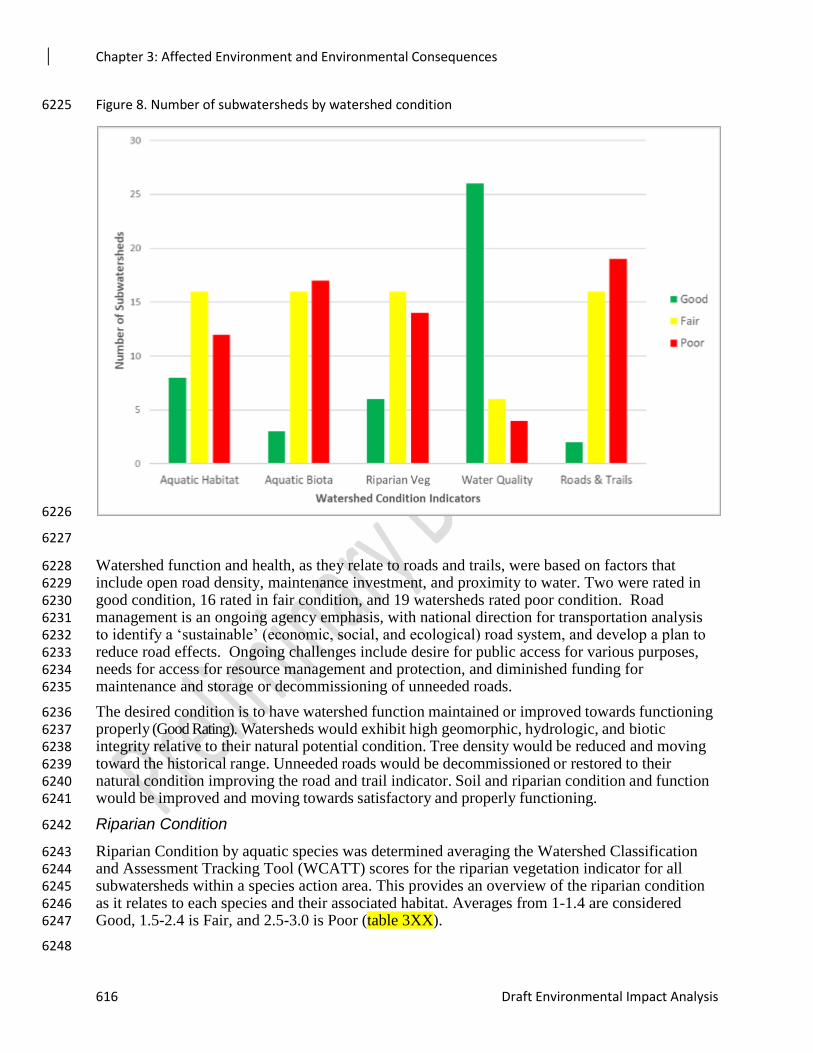
Chapter 3: Affected Environment and Environmental Consequences
616 Draft Environmental Impact Analysis
Figure 8. Number of subwatersheds by watershed condition 6225
6226
6227
Watershed function and health, as they relate to roads and trails, were based on factors that 6228 include open road density, maintenance investment, and proximity to water. Two were rated in 6229 good condition, 16 rated in fair condition, and 19 watersheds rated poor condition. Road 6230 management is an ongoing agency emphasis, with national direction for transportation analysis 6231 to identify a ‘sustainable’ (economic, social, and ecological) road system, and develop a plan to 6232 reduce road effects. Ongoing challenges include desire for public access for various purposes, 6233 needs for access for resource management and protection, and diminished funding for 6234 maintenance and storage or decommissioning of unneeded roads. 6235
The desired condition is to have watershed function maintained or improved towards functioning 6236 properly (Good Rating). Watersheds would exhibit high geomorphic, hydrologic, and biotic 6237 integrity relative to their natural potential condition. Tree density would be reduced and moving 6238 toward the historical range. Unneeded roads would be decommissioned or restored to their 6239 natural condition improving the road and trail indicator. Soil and riparian condition and function 6240 would be improved and moving towards satisfactory and properly functioning. 6241
Riparian Condition 6242
Riparian Condition by aquatic species was determined averaging the Watershed Classification 6243 and Assessment Tracking Tool (WCATT) scores for the riparian vegetation indicator for all 6244 subwatersheds within a species action area. This provides an overview of the riparian condition 6245 as it relates to each species and their associated habitat. Averages from 1-1.4 are considered 6246 Good, 1.5-2.4 is Fair, and 2.5-3.0 is Poor (table 3XX). 6247
6248
Chapter 3: Affected Environment and Environmental Consequences
Rim Country Project 617
Four species have riparian condition rated in good condition which equates to functioning 6249 properly. Proper functioning condition indicates adequate vegetation, landform, and/or large 6250 woody debris are present to: 6251
1. Dissipate stream energy associated with high waterflow, thereby reducing erosion and 6252 improving water quality. 6253
2. Capture sediment and aid floodplain development. 6254
3. Improve flood-water retention and ground-water recharge. 6255
4. Develop root masses that stabilize streambanks against erosion. 6256
5. Maintain channel characteristics. 6257
These watersheds have native vegetation in proper functioning condition throughout the stream 6258 corridor or along wetlands and water bodies. Native plant communities are vigorous, healthy and 6259 diverse in age, structure, cover and composition on >80% of the riparian/wetland areas in the 6260 watershed. Sufficient reproduction of native species is occurring to ensure sustainability. Mesic 6261 herbaceous plant communities occupy most of their site potential and vegetation is in a dynamic 6262 equilibrium appropriate to the system. 6263
Six species have riparian condition rated in fair condition, which is considered Functioning at 6264 Risk. These riparian areas are in limited functioning condition; however, existing hydrologic, 6265 vegetative, or geomorphic attributes make them susceptible to impairment. Disturbance partially 6266 compromises proper functioning condition of native vegetation attributes along stream corridors, 6267 wetlands, or water bodies. Native vegetation demonstrates a moderate loss of vigor, 6268 reproduction and growth, or changes in composition; particularly in areas most susceptible to 6269 human impact. Areas displaying light to moderate impact to structure, composition and cover 6270 may occupy 25 to 80% of the overall riparian area with only a few areas displaying significant 6271 impacts. Up to 25% of species cover or composition occurs from early seral species, but the 6272 communities across the watershed are still dominated by mid to late seral stages. Xeric 6273 herbaceous communities exist where water relationships have been altered but are relatively 6274 small, localized, and do not dominate across the watershed. 6275
Four species have riparian condition rated in poor condition, which are considered Impaired. 6276 These riparian areas clearly are not providing adequate vegetation, landform, or woody material 6277 to dissipate stream energy associated with moderately high flows, and thus are not reducing 6278 erosion, improving water quality, etc. large percentage of native vegetation attributes along 6279 stream corridors, wetlands, and water bodies are not in proper functioning condition. Native 6280 vegetation is vigorous, healthy and diverse in age, structure, cover and composition on <75% of 6281 the riparian/wetland areas in the watershed. Native vegetation demonstrates a noticeable loss of 6282 vigor, reproduction and growth, and changes in composition as compared with site potential 6283 communities. In these areas, cover and composition are strongly reflective of early seral species 6284 dominance although there will be late and mid seral species present in pockets. Mesic dependent 6285 herbaceous vegetation is limited in extent with many lower terraces dominated by xeric species 6286 most commonly associated with uplands. Reproduction of mid and late seral species is very 6287 limited. For much of the area, the water table is disconnected from the riparian area and the 6288 vegetation reflects this loss of available soil water. 6289
6290
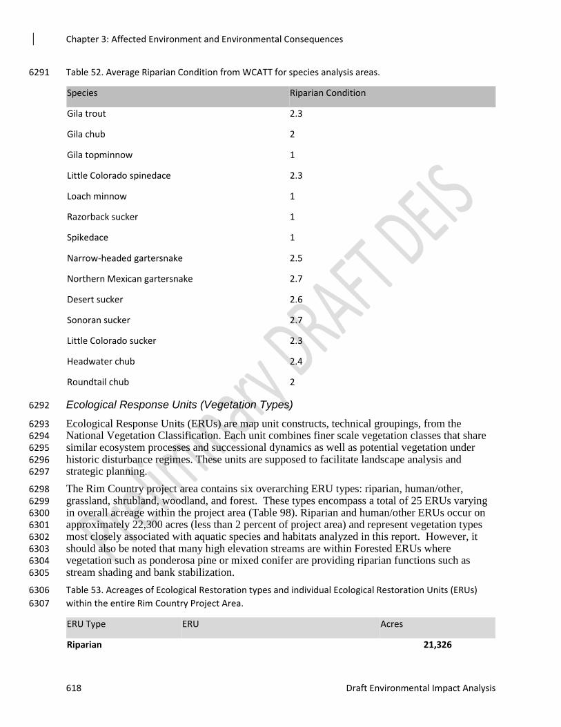
Chapter 3: Affected Environment and Environmental Consequences
618 Draft Environmental Impact Analysis
Table 52. Average Riparian Condition from WCATT for species analysis areas. 6291
Species Riparian Condition
Gila trout 2.3
Gila chub 2
Gila topminnow 1
Little Colorado spinedace 2.3
Loach minnow 1
Razorback sucker 1
Spikedace 1
Narrow-headed gartersnake 2.5
Northern Mexican gartersnake 2.7
Desert sucker 2.6
Sonoran sucker 2.7
Little Colorado sucker 2.3
Headwater chub 2.4
Roundtail chub 2
Ecological Response Units (Vegetation Types) 6292
Ecological Response Units (ERUs) are map unit constructs, technical groupings, from the 6293 National Vegetation Classification. Each unit combines finer scale vegetation classes that share 6294 similar ecosystem processes and successional dynamics as well as potential vegetation under 6295 historic disturbance regimes. These units are supposed to facilitate landscape analysis and 6296 strategic planning. 6297
The Rim Country project area contains six overarching ERU types: riparian, human/other, 6298 grassland, shrubland, woodland, and forest. These types encompass a total of 25 ERUs varying 6299 in overall acreage within the project area (Table 98). Riparian and human/other ERUs occur on 6300 approximately 22,300 acres (less than 2 percent of project area) and represent vegetation types 6301 most closely associated with aquatic species and habitats analyzed in this report. However, it 6302 should also be noted that many high elevation streams are within Forested ERUs where 6303 vegetation such as ponderosa pine or mixed conifer are providing riparian functions such as 6304 stream shading and bank stabilization. 6305
Table 53. Acreages of Ecological Restoration types and individual Ecological Restoration Units (ERUs) 6306
within the entire Rim Country Project Area. 6307
ERU Type ERU Acres
Riparian 21,326
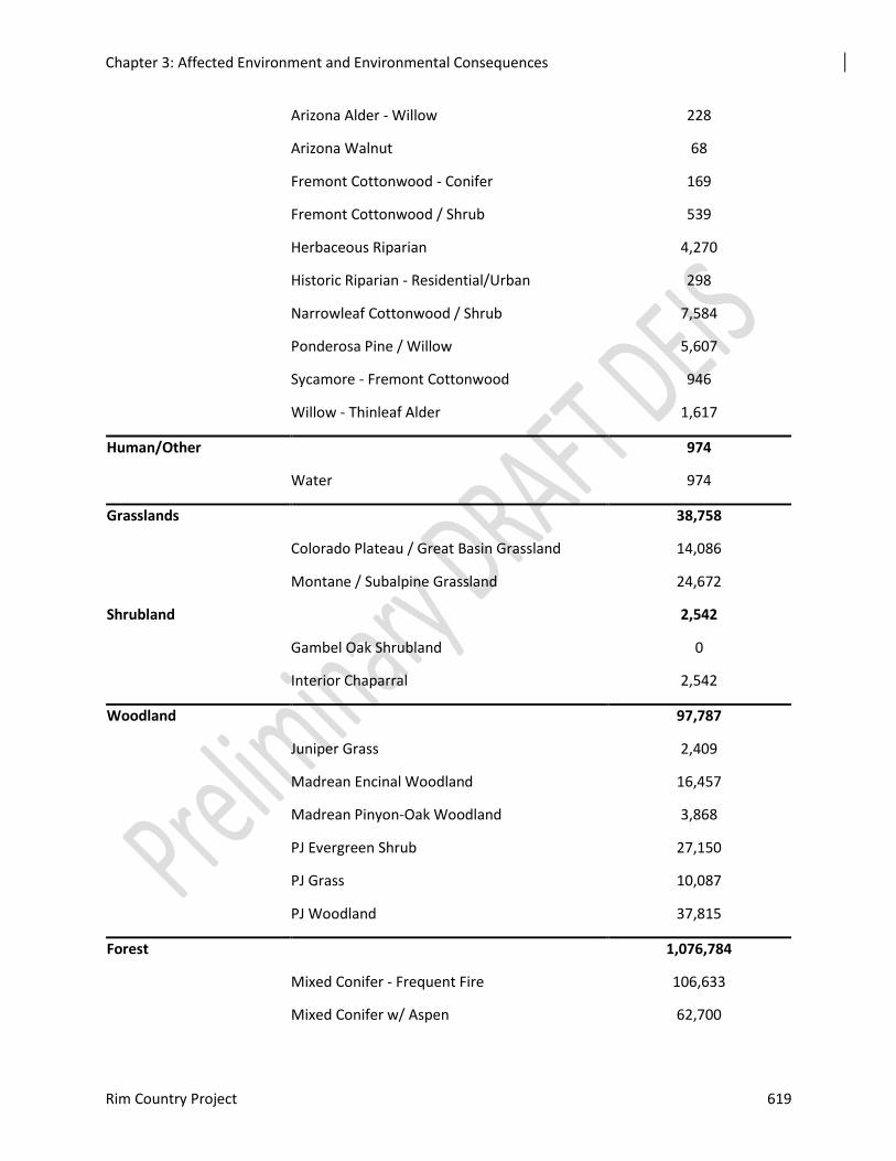
Chapter 3: Affected Environment and Environmental Consequences
Rim Country Project 619
Arizona Alder - Willow 228
Arizona Walnut 68
Fremont Cottonwood - Conifer 169
Fremont Cottonwood / Shrub 539
Herbaceous Riparian 4,270
Historic Riparian - Residential/Urban 298
Narrowleaf Cottonwood / Shrub 7,584
Ponderosa Pine / Willow 5,607
Sycamore - Fremont Cottonwood 946
Willow - Thinleaf Alder 1,617
Human/Other 974
Water 974
Grasslands 38,758
Colorado Plateau / Great Basin Grassland 14,086
Montane / Subalpine Grassland 24,672
Shrubland 2,542
Gambel Oak Shrubland 0
Interior Chaparral 2,542
Woodland 97,787
Juniper Grass 2,409
Madrean Encinal Woodland 16,457
Madrean Pinyon-Oak Woodland 3,868
PJ Evergreen Shrub 27,150
PJ Grass 10,087
PJ Woodland 37,815
Forest 1,076,784
Mixed Conifer - Frequent Fire 106,633
Mixed Conifer w/ Aspen 62,700
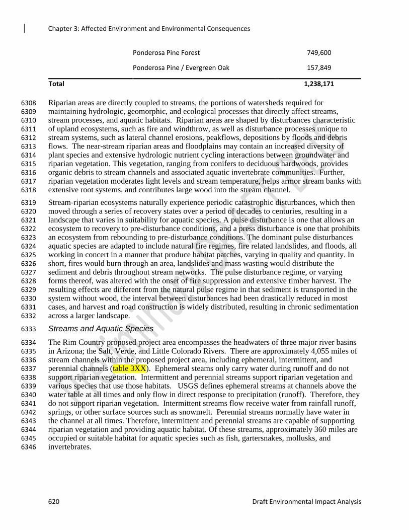
Chapter 3: Affected Environment and Environmental Consequences
620 Draft Environmental Impact Analysis
Riparian areas are directly coupled to streams, the portions of watersheds required for 6308 maintaining hydrologic, geomorphic, and ecological processes that directly affect streams, 6309 stream processes, and aquatic habitats. Riparian areas are shaped by disturbances characteristic 6310 of upland ecosystems, such as fire and windthrow, as well as disturbance processes unique to 6311 stream systems, such as lateral channel erosions, peakflows, depositions by floods and debris 6312 flows. The near-stream riparian areas and floodplains may contain an increased diversity of 6313 plant species and extensive hydrologic nutrient cycling interactions between groundwater and 6314 riparian vegetation. This vegetation, ranging from conifers to deciduous hardwoods, provides 6315 organic debris to stream channels and associated aquatic invertebrate communities. Further, 6316 riparian vegetation moderates light levels and stream temperature, helps armor stream banks with 6317 extensive root systems, and contributes large wood into the stream channel. 6318
Stream-riparian ecosystems naturally experience periodic catastrophic disturbances, which then 6319 moved through a series of recovery states over a period of decades to centuries, resulting in a 6320 landscape that varies in suitability for aquatic species. A pulse disturbance is one that allows an 6321 ecosystem to recovery to pre-disturbance conditions, and a press disturbance is one that prohibits 6322 an ecosystem from rebounding to pre-disturbance conditions. The dominant pulse disturbances 6323 aquatic species are adapted to include natural fire regimes, fire related landslides, and floods, all 6324 working in concert in a manner that produce habitat patches, varying in quality and quantity. In 6325 short, fires would burn through an area, landslides and mass wasting would distribute the 6326 sediment and debris throughout stream networks. The pulse disturbance regime, or varying 6327 forms thereof, was altered with the onset of fire suppression and extensive timber harvest. The 6328 resulting effects are different from the natural pulse regime in that sediment is transported in the 6329 system without wood, the interval between disturbances had been drastically reduced in most 6330 cases, and harvest and road construction is widely distributed, resulting in chronic sedimentation 6331 across a larger landscape. 6332
Streams and Aquatic Species 6333
The Rim Country proposed project area encompasses the headwaters of three major river basins 6334 in Arizona; the Salt, Verde, and Little Colorado Rivers. There are approximately 4,055 miles of 6335 stream channels within the proposed project area, including ephemeral, intermittent, and 6336 perennial channels (table 3XX). Ephemeral steams only carry water during runoff and do not 6337 support riparian vegetation. Intermittent and perennial streams support riparian vegetation and 6338 various species that use those habitats. USGS defines ephemeral streams at channels above the 6339 water table at all times and only flow in direct response to precipitation (runoff). Therefore, they 6340 do not support riparian vegetation. Intermittent streams flow receive water from rainfall runoff, 6341 springs, or other surface sources such as snowmelt. Perennial streams normally have water in 6342 the channel at all times. Therefore, intermittent and perennial streams are capable of supporting 6343 riparian vegetation and providing aquatic habitat. Of these streams, approximately 360 miles are 6344 occupied or suitable habitat for aquatic species such as fish, gartersnakes, mollusks, and 6345 invertebrates. 6346
Ponderosa Pine Forest 749,600
Ponderosa Pine / Evergreen Oak 157,849
Total 1,238,171
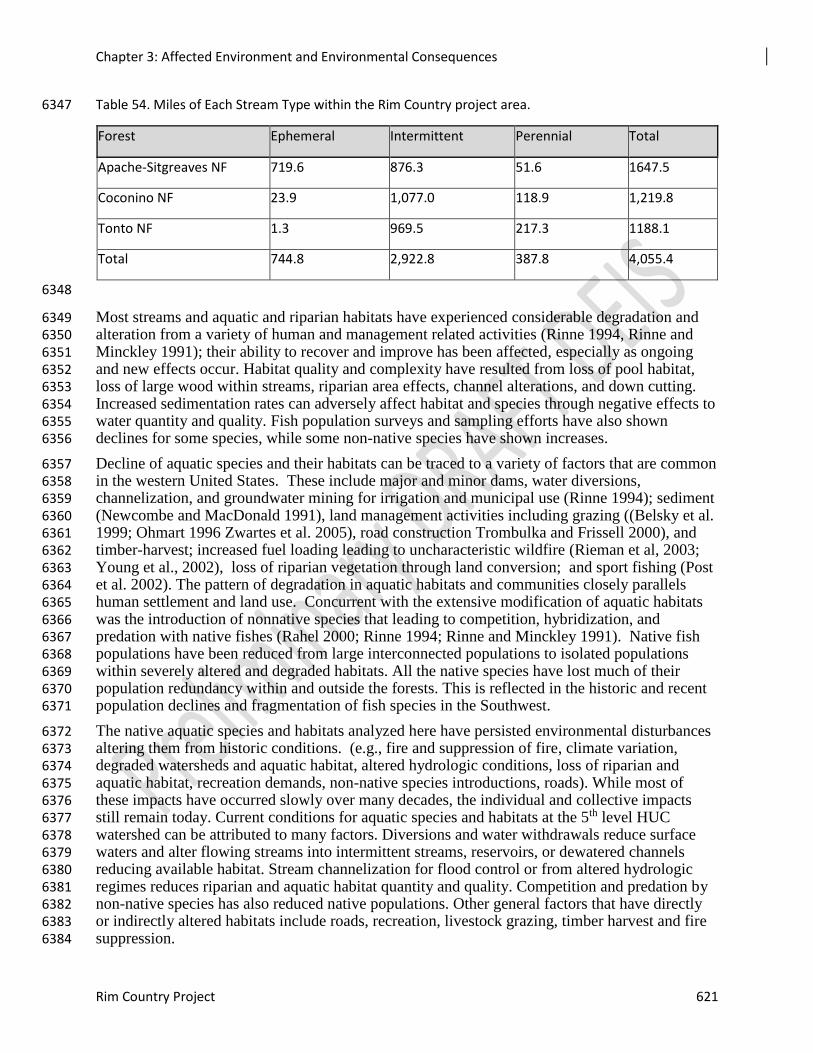
Chapter 3: Affected Environment and Environmental Consequences
Rim Country Project 621
Table 54. Miles of Each Stream Type within the Rim Country project area. 6347
Forest Ephemeral Intermittent Perennial Total
Apache-Sitgreaves NF 719.6 876.3 51.6 1647.5
Coconino NF 23.9 1,077.0 118.9 1,219.8
Tonto NF 1.3 969.5 217.3 1188.1
Total 744.8 2,922.8 387.8 4,055.4
6348
Most streams and aquatic and riparian habitats have experienced considerable degradation and 6349 alteration from a variety of human and management related activities (Rinne 1994, Rinne and 6350 Minckley 1991); their ability to recover and improve has been affected, especially as ongoing 6351 and new effects occur. Habitat quality and complexity have resulted from loss of pool habitat, 6352 loss of large wood within streams, riparian area effects, channel alterations, and down cutting. 6353 Increased sedimentation rates can adversely affect habitat and species through negative effects to 6354 water quantity and quality. Fish population surveys and sampling efforts have also shown 6355 declines for some species, while some non-native species have shown increases. 6356
Decline of aquatic species and their habitats can be traced to a variety of factors that are common 6357 in the western United States. These include major and minor dams, water diversions, 6358 channelization, and groundwater mining for irrigation and municipal use (Rinne 1994); sediment 6359 (Newcombe and MacDonald 1991), land management activities including grazing ((Belsky et al. 6360 1999; Ohmart 1996 Zwartes et al. 2005), road construction Trombulka and Frissell 2000), and 6361 timber-harvest; increased fuel loading leading to uncharacteristic wildfire (Rieman et al, 2003; 6362 Young et al., 2002), loss of riparian vegetation through land conversion; and sport fishing (Post 6363 et al. 2002). The pattern of degradation in aquatic habitats and communities closely parallels 6364 human settlement and land use. Concurrent with the extensive modification of aquatic habitats 6365 was the introduction of nonnative species that leading to competition, hybridization, and 6366 predation with native fishes (Rahel 2000; Rinne 1994; Rinne and Minckley 1991). Native fish 6367 populations have been reduced from large interconnected populations to isolated populations 6368 within severely altered and degraded habitats. All the native species have lost much of their 6369 population redundancy within and outside the forests. This is reflected in the historic and recent 6370 population declines and fragmentation of fish species in the Southwest. 6371
The native aquatic species and habitats analyzed here have persisted environmental disturbances 6372 altering them from historic conditions. (e.g., fire and suppression of fire, climate variation, 6373 degraded watersheds and aquatic habitat, altered hydrologic conditions, loss of riparian and 6374 aquatic habitat, recreation demands, non-native species introductions, roads). While most of 6375 these impacts have occurred slowly over many decades, the individual and collective impacts 6376 still remain today. Current conditions for aquatic species and habitats at the 5th level HUC 6377 watershed can be attributed to many factors. Diversions and water withdrawals reduce surface 6378 waters and alter flowing streams into intermittent streams, reservoirs, or dewatered channels 6379 reducing available habitat. Stream channelization for flood control or from altered hydrologic 6380 regimes reduces riparian and aquatic habitat quantity and quality. Competition and predation by 6381 non-native species has also reduced native populations. Other general factors that have directly 6382 or indirectly altered habitats include roads, recreation, livestock grazing, timber harvest and fire 6383 suppression. 6384
Chapter 3: Affected Environment and Environmental Consequences
622 Draft Environmental Impact Analysis
Federally-listed and Forest Service Sensitive Species lists for all three Forests were screened to 6385 determine species that occur or have suitable habitat with the project and action area. Eleven 6386 federally listed species and nineteen sensitive aquatic species occur within the three Forests. Of 6387 those, nine federally listed and 16 sensitive individual species will be analyzed in detail (Table 3-6388 **). Two of the species (gartersnakes) are both federally listed and sensitive species. 6389
Table 55. Federally-listed and Forest Service Sensitive Aquatic Species Expected in the Project Area 6390
Species Status Occurrence Notes
Gila trout
(Oncorhyncus gilae)
Federally Threatened Documented Occurrence Occurs within the Project
and Action areas
Little Colorado Spinedace
(Lepidomeda vittata)
Federally Threatened,
with designated Critical
Habitat
Documented Occurrence Occurs within the Project
and Action areas
Gila chub
(Gila intermedia)
Federally Endangered
with designated Critical
habitat
Documented Occurrence Does not occur within the
Project Area, but does
occur in watersheds
within the project
boundary.
Gila topminnow
(Poeciliopsis occidentalis
occidentalis)
Federally Endangered Documented Occurrence Does not occur within the
Project Area, but does
occur in watersheds
within the project
boundary.
Razorback sucker
(Xyrauchen texanus)
Federally Endangered
with designated Critical
habitat
Documented Occurrence Does not occur within the
Project Area, but does
occur in watersheds
within the project
boundary.
Loach minnow
(Tiaroga cobitis)
Federally Endangered
with designated Critical
habitat
Documented Occurrence Does not occur within the
Project Area, but does
occur in watersheds
within the project
boundary.
Spikedace
(Meda fulgida)
Federally Endangered
with designated Critical
habitat
Documented Occurrence Does not occur within the
Project Area, but does
occur in watersheds
within the project
boundary.
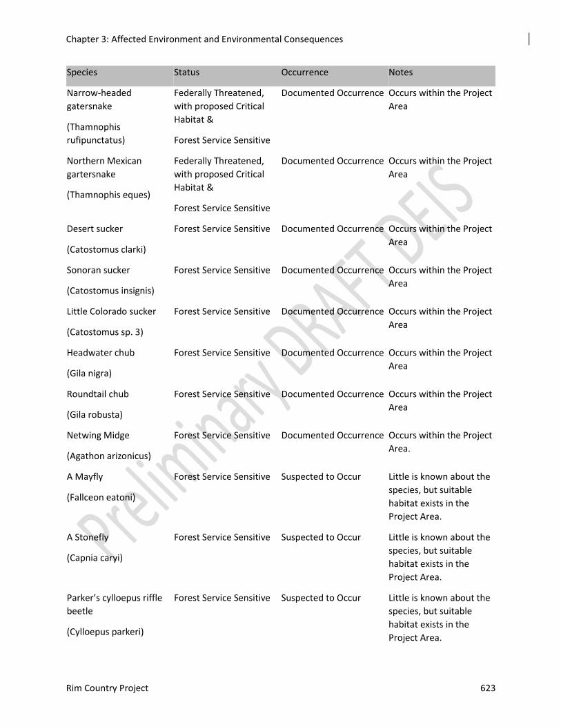
Chapter 3: Affected Environment and Environmental Consequences
Rim Country Project 623
Species Status Occurrence Notes
Narrow-headed
gatersnake
(Thamnophis
rufipunctatus)
Federally Threatened,
with proposed Critical
Habitat &
Forest Service Sensitive
Documented Occurrence Occurs within the Project
Area
Northern Mexican
gartersnake
(Thamnophis eques)
Federally Threatened,
with proposed Critical
Habitat &
Forest Service Sensitive
Documented Occurrence Occurs within the Project
Area
Desert sucker
(Catostomus clarki)
Forest Service Sensitive Documented Occurrence Occurs within the Project
Area
Sonoran sucker
(Catostomus insignis)
Forest Service Sensitive Documented Occurrence Occurs within the Project
Area
Little Colorado sucker
(Catostomus sp. 3)
Forest Service Sensitive Documented Occurrence Occurs within the Project
Area
Headwater chub
(Gila nigra)
Forest Service Sensitive Documented Occurrence Occurs within the Project
Area
Roundtail chub
(Gila robusta)
Forest Service Sensitive Documented Occurrence Occurs within the Project
Area
Netwing Midge
(Agathon arizonicus)
Forest Service Sensitive Documented Occurrence Occurs within the Project
Area.
A Mayfly
(Fallceon eatoni)
Forest Service Sensitive Suspected to Occur Little is known about the
species, but suitable
habitat exists in the
Project Area.
A Stonefly
(Capnia caryi)
Forest Service Sensitive Suspected to Occur Little is known about the
species, but suitable
habitat exists in the
Project Area.
Parker’s cylloepus riffle
beetle
(Cylloepus parkeri)
Forest Service Sensitive Suspected to Occur Little is known about the
species, but suitable
habitat exists in the
Project Area.

Chapter 3: Affected Environment and Environmental Consequences
624 Draft Environmental Impact Analysis
Species Status Occurrence Notes
A Mayfly
(Fallceon eatoni)
Forest Service Sensitive Suspected to Occur Little is known about the
species, but suitable
habitat exists in the
Project Area.
A Mayfly
(Moribaetis
mimbresaurus)
Forest Service Sensitive Suspected to Occur Little is known about the
species, but suitable
habitat exists in the
Project Area.
A Caddisfly
(Lepidostoma apache)
Forest Service Sensitive Suspected to Occur Little is known about the
species, but suitable
habitat exists in the
Project Area.
A Caddisfly
(Lepidostoma knulli)
Forest Service Sensitive Suspected to Occur Little is known about the
species, but suitable
habitat exists in the
Project Area.
A Caddisfly
(Limnephillus granti)
Forest Service Sensitive Suspected to Occur Little is known about the
species, but suitable
habitat of springs in
ponderosa pine exist.
A Caddisfly
(Wormaldia planae)
Forest Service Sensitive Documented Occurrence Occurs within the Action
area
Ferris’ Copper
(Lycaena ferrisi)
Forest Service Sensitive Suspected to Occur Little is known about the
species, but suitable
habitat of herbaceous
wetlands exist.
Nokomis Fritillary (aka
Great Basin Silverspot)
(Speyeria nokomis
nokomis)
Forest Service Sensitive Documented Occurrence Little is known about the
species, but suitable
habitat of herbaceous
wetlands and streams
exist.
Fossil springsnail
(Pyrgulopsis simplex)
Forest Service Sensitive Documented Occurrence Occurs within the Action
area
California floater
(Anodonta californiensis)
Forest Service Sensitive Documented Occurrence Occurs within the Project
and Action areas
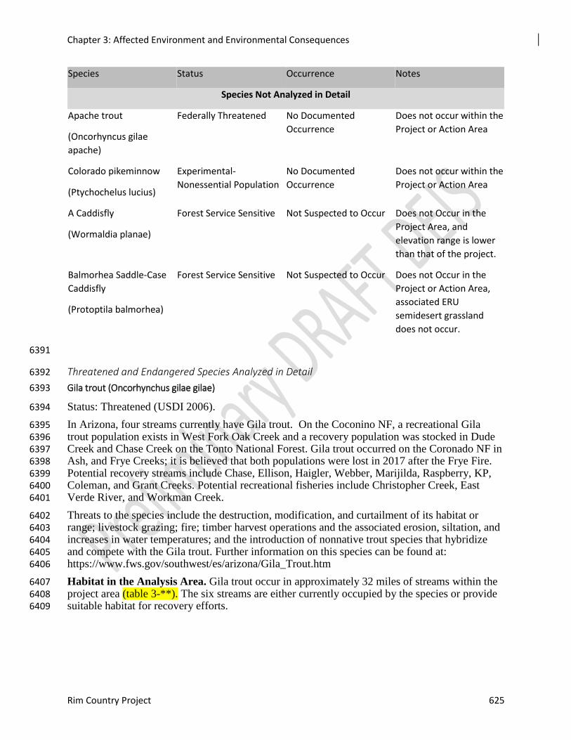
Chapter 3: Affected Environment and Environmental Consequences
Rim Country Project 625
Species Status Occurrence Notes
Species Not Analyzed in Detail
Apache trout
(Oncorhyncus gilae
apache)
Federally Threatened No Documented
Occurrence
Does not occur within the
Project or Action Area
Colorado pikeminnow
(Ptychochelus lucius)
Experimental-
Nonessential Population
No Documented
Occurrence
Does not occur within the
Project or Action Area
A Caddisfly
(Wormaldia planae)
Forest Service Sensitive Not Suspected to Occur Does not Occur in the
Project Area, and
elevation range is lower
than that of the project.
Balmorhea Saddle-Case
Caddisfly
(Protoptila balmorhea)
Forest Service Sensitive Not Suspected to Occur Does not Occur in the
Project or Action Area,
associated ERU
semidesert grassland
does not occur.
6391
Threatened and Endangered Species Analyzed in Detail 6392
Gila trout (Oncorhynchus gilae gilae) 6393
Status: Threatened (USDI 2006). 6394
In Arizona, four streams currently have Gila trout. On the Coconino NF, a recreational Gila 6395 trout population exists in West Fork Oak Creek and a recovery population was stocked in Dude 6396 Creek and Chase Creek on the Tonto National Forest. Gila trout occurred on the Coronado NF in 6397 Ash, and Frye Creeks; it is believed that both populations were lost in 2017 after the Frye Fire. 6398 Potential recovery streams include Chase, Ellison, Haigler, Webber, Marijilda, Raspberry, KP, 6399 Coleman, and Grant Creeks. Potential recreational fisheries include Christopher Creek, East 6400 Verde River, and Workman Creek. 6401
Threats to the species include the destruction, modification, and curtailment of its habitat or 6402 range; livestock grazing; fire; timber harvest operations and the associated erosion, siltation, and 6403 increases in water temperatures; and the introduction of nonnative trout species that hybridize 6404 and compete with the Gila trout. Further information on this species can be found at: 6405 https://www.fws.gov/southwest/es/arizona/Gila_Trout.htm 6406
Habitat in the Analysis Area. Gila trout occur in approximately 32 miles of streams within the 6407 project area (table 3-**). The six streams are either currently occupied by the species or provide 6408 suitable habitat for recovery efforts. 6409
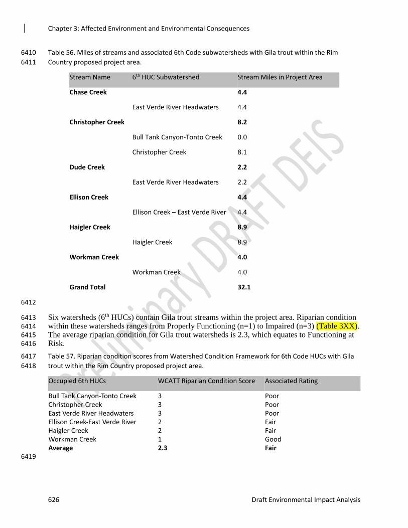
Chapter 3: Affected Environment and Environmental Consequences
626 Draft Environmental Impact Analysis
Table 56. Miles of streams and associated 6th Code subwatersheds with Gila trout within the Rim 6410
Country proposed project area. 6411
Stream Name 6th HUC Subwatershed Stream Miles in Project Area
Chase Creek 4.4
East Verde River Headwaters 4.4
Christopher Creek 8.2
Bull Tank Canyon-Tonto Creek 0.0
Christopher Creek 8.1
Dude Creek 2.2
East Verde River Headwaters 2.2
Ellison Creek 4.4
Ellison Creek – East Verde River 4.4
Haigler Creek 8.9
Haigler Creek 8.9
Workman Creek 4.0
Workman Creek 4.0
Grand Total 32.1
6412
Six watersheds (6th HUCs) contain Gila trout streams within the project area. Riparian condition 6413 within these watersheds ranges from Properly Functioning (n=1) to Impaired (n=3) (Table 3XX). 6414 The average riparian condition for Gila trout watersheds is 2.3, which equates to Functioning at 6415 Risk. 6416
Table 57. Riparian condition scores from Watershed Condition Framework for 6th Code HUCs with Gila 6417
trout within the Rim Country proposed project area. 6418
Occupied 6th HUCs WCATT Riparian Condition Score Associated Rating
Bull Tank Canyon-Tonto Creek 3 Poor Christopher Creek 3 Poor East Verde River Headwaters 3 Poor Ellison Creek-East Verde River 2 Fair Haigler Creek 2 Fair Workman Creek 1 Good Average 2.3 Fair 6419
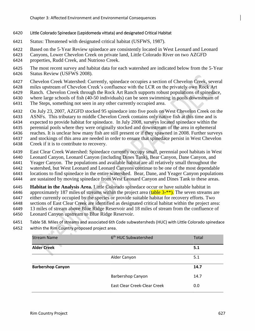
Chapter 3: Affected Environment and Environmental Consequences
Rim Country Project 627
Little Colorado Spinedace (Lepidomeda vittata) and designated Critical Habitat 6420
Status: Threatened with designated critical habitat (USFWS, 1987). 6421
Based on the 5-Year Review spinedace are consistently located in West Leonard and Leonard 6422 Canyons, Lower Chevelon Creek on private land, Little Colorado River on two AZGFD 6423 properties, Rudd Creek, and Nutrioso Creek. 6424
The most recent survey and habitat data for each watershed are indicated below from the 5-Year 6425 Status Review (USFWS 2008). 6426
Chevelon Creek Watershed: Currently, spinedace occupies a section of Chevelon Creek, several 6427 miles upstream of Chevelon Creek’s confluence with the LCR on the privately own Rock Art 6428 Ranch. Chevelon Creek through the Rock Art Ranch supports robust populations of spinedace, 6429 where large schools of fish (40-50 individuals) can be seen swimming in pools downstream of 6430 The Steps, something not seen in any other currently occupied area. 6431
On July 23, 2007, AZGFD stocked 95 spinedace into five pools on West Chevelon Creek on the 6432 ASNFs. This tributary to middle Chevelon Creek contains only native fish at this time and is 6433 expected to provide habitat for spinedace. In July 2008, surveys located spinedace within the 6434 perennial pools where they were originally stocked and downstream of the area in ephemeral 6435 reaches. It is unclear how many fish are still present or if they spawned in 2008. Further surveys 6436 and stockings of this area are needed in order to ensure that spinedace persist in West Chevelon 6437 Creek if it is to contribute to recovery. 6438
East Clear Creek Watershed: Spinedace currently occupy small, perennial pool habitats in West 6439 Leonard Canyon, Leonard Canyon (including Dines Tank), Bear Canyon, Dane Canyon, and 6440 Yeager Canyon. The populations and available habitat are all relatively small throughout the 6441 watershed, but West Leonard and Leonard Canyons continue to be one of the most dependable 6442 locations to find spinedace in the entire watershed. Bear, Dane, and Yeager Canyon populations 6443 are sustained by moving spinedace from West Leonard Canyon and Dines Tank to these areas. 6444
Habitat in the Analysis Area. Little Colorado spinedace occur or have suitable habitat in 6445 approximately 187 miles of streams within the project area (table 3-**). The seven streams are 6446 either currently occupied by the species or provide suitable habitat for recovery efforts. Two 6447 sections of East Clear Creek are identified as designated critical habitat within the project area: 6448 13 miles of stream above Blue Ridge Reservoir and 18 miles of stream from the confluence of 6449 Leonard Canyon upstream to Blue Ridge Reservoir. 6450
Table 58. Miles of streams and associated 6th Code subwatersheds (HUC) with Little Colorado spinedace 6451
within the Rim Country proposed project area. 6452
Stream Name 6th HUC Subwatershed Total
Alder Creek 5.1
Alder Canyon 5.1
Barbershop Canyon 14.7
Barbershop Canyon 14.7
East Clear Creek-Clear Creek 0.0
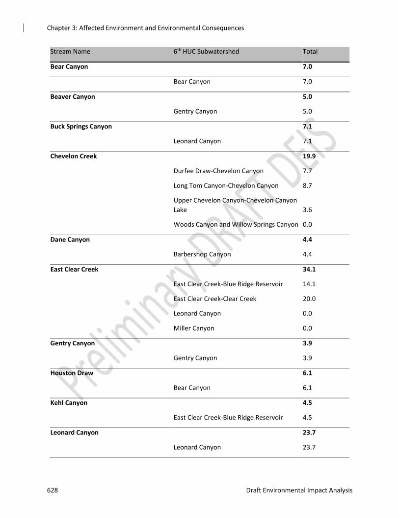
Chapter 3: Affected Environment and Environmental Consequences
628 Draft Environmental Impact Analysis
Stream Name 6th HUC Subwatershed Total
Bear Canyon 7.0
Bear Canyon 7.0
Beaver Canyon 5.0
Gentry Canyon 5.0
Buck Springs Canyon 7.1
Leonard Canyon 7.1
Chevelon Creek 19.9
Durfee Draw-Chevelon Canyon 7.7
Long Tom Canyon-Chevelon Canyon 8.7
Upper Chevelon Canyon-Chevelon Canyon
Lake 3.6
Woods Canyon and Willow Springs Canyon 0.0
Dane Canyon 4.4
Barbershop Canyon 4.4
East Clear Creek 34.1
East Clear Creek-Blue Ridge Reservoir 14.1
East Clear Creek-Clear Creek 20.0
Leonard Canyon 0.0
Miller Canyon 0.0
Gentry Canyon 3.9
Gentry Canyon 3.9
Houston Draw 6.1
Bear Canyon 6.1
Kehl Canyon 4.5
East Clear Creek-Blue Ridge Reservoir 4.5
Leonard Canyon 23.7
Leonard Canyon 23.7
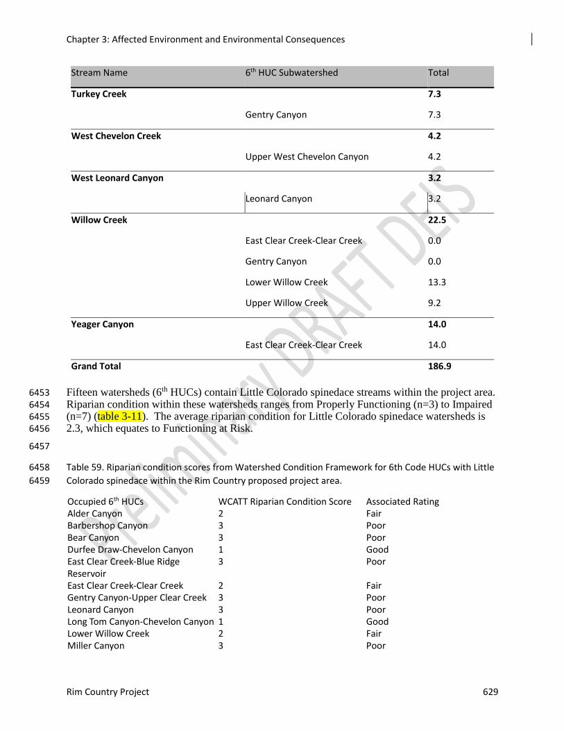
Chapter 3: Affected Environment and Environmental Consequences
Rim Country Project 629
Stream Name 6th HUC Subwatershed Total
Turkey Creek 7.3
Gentry Canyon 7.3
West Chevelon Creek 4.2
Upper West Chevelon Canyon 4.2
West Leonard Canyon 3.2
Leonard Canyon 3.2
Willow Creek 22.5
East Clear Creek-Clear Creek 0.0
Gentry Canyon 0.0
Lower Willow Creek 13.3
Upper Willow Creek 9.2
Yeager Canyon 14.0
East Clear Creek-Clear Creek 14.0
Grand Total 186.9
Fifteen watersheds (6th HUCs) contain Little Colorado spinedace streams within the project area. 6453 Riparian condition within these watersheds ranges from Properly Functioning (n=3) to Impaired 6454 (n=7) (table 3-11). The average riparian condition for Little Colorado spinedace watersheds is 6455 2.3, which equates to Functioning at Risk. 6456
6457
Table 59. Riparian condition scores from Watershed Condition Framework for 6th Code HUCs with Little 6458
Colorado spinedace within the Rim Country proposed project area. 6459
Occupied 6th HUCs WCATT Riparian Condition Score Associated Rating Alder Canyon 2 Fair Barbershop Canyon 3 Poor Bear Canyon 3 Poor Durfee Draw-Chevelon Canyon 1 Good East Clear Creek-Blue Ridge Reservoir
3 Poor
East Clear Creek-Clear Creek 2 Fair Gentry Canyon-Upper Clear Creek 3 Poor Leonard Canyon 3 Poor Long Tom Canyon-Chevelon Canyon 1 Good Lower Willow Creek 2 Fair Miller Canyon 3 Poor
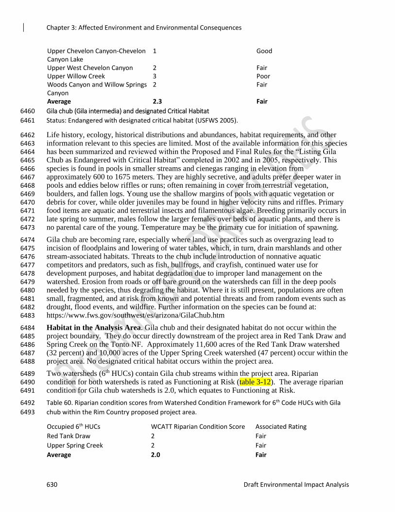
Chapter 3: Affected Environment and Environmental Consequences
630 Draft Environmental Impact Analysis
Upper Chevelon Canyon-Chevelon Canyon Lake
1 Good
Upper West Chevelon Canyon 2 Fair Upper Willow Creek 3 Poor Woods Canyon and Willow Springs Canyon
2 Fair
Average 2.3 Fair
Gila chub (Gila intermedia) and designated Critical Habitat 6460
Status: Endangered with designated critical habitat (USFWS 2005). 6461
Life history, ecology, historical distributions and abundances, habitat requirements, and other 6462 information relevant to this species are limited. Most of the available information for this species 6463 has been summarized and reviewed within the Proposed and Final Rules for the “Listing Gila 6464 Chub as Endangered with Critical Habitat” completed in 2002 and in 2005, respectively. This 6465 species is found in pools in smaller streams and cienegas ranging in elevation from 6466 approximately 600 to 1675 meters. They are highly secretive, and adults prefer deeper water in 6467 pools and eddies below riffles or runs; often remaining in cover from terrestrial vegetation, 6468 boulders, and fallen logs. Young use the shallow margins of pools with aquatic vegetation or 6469 debris for cover, while older juveniles may be found in higher velocity runs and riffles. Primary 6470 food items are aquatic and terrestrial insects and filamentous algae. Breeding primarily occurs in 6471 late spring to summer, males follow the larger females over beds of aquatic plants, and there is 6472 no parental care of the young. Temperature may be the primary cue for initiation of spawning. 6473
Gila chub are becoming rare, especially where land use practices such as overgrazing lead to 6474 incision of floodplains and lowering of water tables, which, in turn, drain marshlands and other 6475 stream-associated habitats. Threats to the chub include introduction of nonnative aquatic 6476 competitors and predators, such as fish, bullfrogs, and crayfish, continued water use for 6477 development purposes, and habitat degradation due to improper land management on the 6478 watershed. Erosion from roads or off bare ground on the watersheds can fill in the deep pools 6479 needed by the species, thus degrading the habitat. Where it is still present, populations are often 6480 small, fragmented, and at risk from known and potential threats and from random events such as 6481 drought, flood events, and wildfire. Further information on the species can be found at: 6482 https://www.fws.gov/southwest/es/arizona/GilaChub.htm 6483
Habitat in the Analysis Area. Gila chub and their designated habitat do not occur within the 6484 project boundary. They do occur directly downstream of the project area in Red Tank Draw and 6485 Spring Creek on the Tonto NF. Approximately 11,600 acres of the Red Tank Draw watershed 6486 (32 percent) and 10,000 acres of the Upper Spring Creek watershed (47 percent) occur within the 6487 project area. No designated critical habitat occurs within the project area. 6488
Two watersheds (6th HUCs) contain Gila chub streams within the project area. Riparian 6489 condition for both watersheds is rated as Functioning at Risk (table 3-12). The average riparian 6490 condition for Gila chub watersheds is 2.0, which equates to Functioning at Risk. 6491
Table 60. Riparian condition scores from Watershed Condition Framework for 6th Code HUCs with Gila 6492
chub within the Rim Country proposed project area. 6493
Occupied 6th HUCs WCATT Riparian Condition Score Associated Rating
Red Tank Draw 2 Fair
Upper Spring Creek 2 Fair
Average 2.0 Fair

Chapter 3: Affected Environment and Environmental Consequences
Rim Country Project 631
6494
Gila topminnow (Poeciliopsis occidentalis occidentalis) 6495
Status: Endangered (USFWS 1967). 6496
The Gila topminnow is a small, guppy-like, live-bearing fish. It occurs in small streams, springs, 6497 and cienegas below 4,500 ft. elevation, primarily in shallow areas with aquatic vegetation and 6498 debris for cover. It can tolerate relatively high water temperatures and low dissolved oxygen. 6499 Breeding occurs primarily during January through August, but in thermally constant springs 6500 young may be produced through the year. Gila topminnow are opportunistic omnivorous 6501 feeders. Primary food includes detritus, vegetation, amphipods, ostracods, and insect larvae. 6502
Historically, it was one of the most common fish throughout the Gila River drainage in Arizona, 6503 Mexico, and New Mexico. Currently, most of the remaining naturally occurring populations in 6504 are in the Santa Cruz River system. The species occurs in small streams, springs and cienegas in 6505 Gila, Pinal, Graham, Yavapai, Santa Cruz, Pima, Maricopa, and La Paz counties, Arizona. It has 6506 been released at almost 200 locations in efforts to reestablish populations. 6507
Effects on the species include introduction and spread of nonindigenous predatory and 6508 competitive fishes, water impoundments and diversions, water pollution, groundwater pumping, 6509 stream channelization, and habitat modification. Further information on this species can be 6510 found at: https://www.fws.gov/southwest/es/arizona/Gila_Top.htm 6511
Habitat in the Analysis Area. Gila topminnow does not occur within the project area, but does 6512 occur within the action area. The species occurs in Fossil Creek directly downstream of the 6513 project area in the Upper Fossil Creek subwatershed. Approximately, 12,300 acres of that 6514 watershed (48 percent) occur within the project area. 6515
Only one watershed (6th HUC) contains a Gila topminnow stream within the project area. 6516 Riparian condition for the watershed is rated as Functioning Properly (table 3-13). 6517
Table 61. Riparian condition score from Watershed Condition Framework for 6th Code HUCs with Gila 6518
topminnow within the Rim Country proposed project area. 6519
Occupied 6th HUCs WCATT Riparian Condition Score Associated Rating
Upper Fossil Creek 1 Good
Average 1.0 Good
6520
Razorback sucker (Xyrauchen texanus) and designated Critical Habitat 6521
Status: Endangered (USDI 1991) with designated critical habitat (USDI 1994) 6522
The razorback sucker, also known as the humpback sucker, is a member of the Catostomidae 6523 family. The species can grow more than 600mm (2 feet) in length, weigh more than 3kg (6 6524 pounds), and live over 40 years. The species is a bottom-feeder, whose diet includes planktonic 6525 crustaceans, diatoms, filamentous algae, and detritus. Spawning occurs in the lower Colorado 6526 River basin from January through April. Spawning occurs over mixed substrates that range from 6527 silt to cobble and at water temperatures ranging from 10.5 to 21º C (51 to 70º F). Razorback 6528 sucker inhabit riverine systems which provide a wide variety of habitats including backwaters, 6529 sloughs, oxbow lakes, and seasonally inundated flood plains, which are used to satisfy various 6530 life history requirements. Adult razorback suckers prefer shallow and swift waters of mid-6531 channel sandbars (less than 12 feet in depth) during the summer months and slow runs, slack 6532
Chapter 3: Affected Environment and Environmental Consequences
632 Draft Environmental Impact Analysis
waters, and eddies in the winter. The Razorback Sucker Recovery Plan describes the life history 6533 and habitat use for this species in detail. 6534
Detailed information relative to the distribution and abundance of the razorback sucker can be 6535 found in the Recovery Plan (USDI 1999). Razorback sucker occur in the Verde and Salt Rivers 6536 with designated critical habitat in both systems. Razorback sucker have been stocked in the 6537 Verde River on a regular basis since the 1980s. Stockings in the Salt River sub-basin have not 6538 occurred since the early 1990s. Surveys do detect the species in the Verde River. However, a 6539 viable population is not thought to be extant. 6540
Decline of the razorback sucker has been associated with major changes in its riverine ecosystem 6541 including water diversion, water depletion, and construction and operation of dams. The species 6542 decline is also attributed to predation by green sunfish, warmouth, channel catfish, flathead 6543 catfish, threadfin shad, smallmouth bass, and largemouth bass. Further information on this 6544 species can be found at: https://www.fws.gov/southwest/es/arizona/Razorback.htm 6545
Habitat in the Analysis Area. Razorback sucker does not occur within the project area, but does 6546 occur within the action area. The species occurs in Fossil Creek directly downstream of the 6547 project area in the Upper Fossil Creek subwatershed. Approximately, 12,300 acres of that 6548 watershed (48 percent) occur within the project area. No designated critical habitat occurs within 6549 the project area. 6550
Only one watershed (6th HUC) contains a Razorback sucker stream within the project area. 6551 Riparian condition for the watershed is rated as Functioning Properly (Table 108). 6552
Table 62. Riparian condition score from Watershed Condition Framework for 6th Code HUCs with 6553
Razorback sucker within the Rim Country proposed project area. 6554
Occupied 6th HUC WCATT Riparian Condition Score Associated Rating
Upper Fossil Creek 1 Good
Average 1.0 Good
6555
Loach minnow (Tiaroga cobitis) and designated Critical Habitat 6556
Status: Endangered with designated critical habitat (USDI 2012). 6557
Loach minnows are found in turbulent, rocky riffles of rivers and tributaries from approximately 6558 2,300 to 8,000 feet in elevation. Loach minnow are bottom-dwelling inhabitants of shallow, swift 6559 waters flowing over gravel and cobble substrates in mainstream rivers and tributaries. They use 6560 the spaces between, and the protective shelter of larger substrates for resting and spawning. The 6561 species is rare or absent from habitats where fine sediments fill the spaces between larger 6562 substrate. The first spawn of loach minnow generally occurs in their second year, primarily from 6563 March through May; and they may also spawn in the fall. Spawning occurs in the same riffles 6564 occupied by adults during the non-spawning season. The adhesive eggs of the loach minnow are 6565 attached under the downstream side of a rock that forms the roof of a small cavity in the 6566 substrate. Longevity is typically 15 months to two years, although loach minnow can live as long 6567 as three years. Loach minnow feed exclusively on aquatic insects; and they are opportunistic 6568 bottom-feeding insectivores, feeding primarily on riffle-dwelling larval mayflies and midges. 6569 They actively seek their food on bottom substrates, rather than pursuing food items in the drift. 6570
During the last century, both the distribution and abundance of the loach minnow has been 6571 greatly reduced throughout the species range. Competition and predation by nonnative fish and 6572 habitat destruction have reduced the historic range of the loach minnow by about 85 percent. 6573
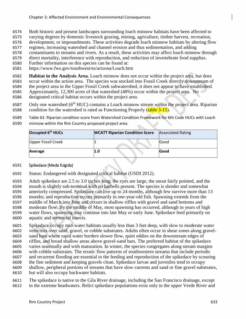
Chapter 3: Affected Environment and Environmental Consequences
Rim Country Project 633
Both historic and present landscapes surrounding loach minnow habitats have been affected to 6574 varying degrees by domestic livestock grazing, mining, agriculture, timber harvest, recreation, 6575 development, or impoundments. These activities degrade loach minnow habitats by altering flow 6576 regimes, increasing watershed and channel erosion and thus sedimentation, and adding 6577 contaminants to streams and rivers. As a result, these activities may affect loach minnow through 6578 direct mortality, interference with reproduction, and reduction of invertebrate food supplies. 6579 Further information on this species can be found at: 6580 https://www.fws.gov/southwest/es/arizona/Loach.htm 6581
Habitat in the Analysis Area. Loach minnow does not occur within the project area, but does 6582 occur within the action area. The species was stocked into Fossil Creek directly downstream of 6583 the project area in the Upper Fossil Creek subwatershed, it does not appear to have established. 6584 Approximately, 12,300 acres of that watershed (48%) occur within the project area. No 6585 designated critical habitat occurs within the project area. 6586
Only one watershed (6th HUC) contains a Loach minnow stream within the project area. Riparian 6587 condition for the watershed is rated as Functioning Properly (table 3-15). 6588
Table 63. Riparian condition score from Watershed Condition Framework for 6th Code HUCs with Loach 6589
minnow within the Rim Country proposed project area. 6590
Occupied 6th HUCs WCATT Riparian Condition Score Associated Rating
Upper Fossil Creek 1 Good
Average 1.0 Good
Spikedace (Meda fulgida) 6591
Status: Endangered with designated critical habitat (USDI 2012). 6592
Adult spikedace are 2.5 to 3.0 inches long; the eyes are large, the snout fairly pointed, and the 6593 mouth is slightly sub-terminal with no barbells present. The species is slender and somewhat 6594 anteriorly compressed. Spikedace can live up to 24 months, although few survive more than 13 6595 months; and reproduction occurs primarily in one-year-old fish. Spawning extends from the 6596 middle of March into June and occurs in shallow riffles with gravel and sand bottoms and 6597 moderate flow. By the middle of May, most spawning has occurred, although in years of high 6598 water flows, spawning may continue into late May or early June. Spikedace feed primarily on 6599 aquatic and terrestrial insects. 6600
Spikedace occupy mid-water habitats usually less than 3 feet deep, with slow to moderate water 6601 velocities over sand, gravel, or cobble substrates. Adults often occur in shear zones along gravel-6602 sand bars where rapid water borders slower flow, quiet eddies on the downstream edges of 6603 riffles, and broad shallow areas above gravel-sand bars. The preferred habitat of the spikedace 6604 varies seasonally and with maturation. In winter, the species congregates along stream margins 6605 with cobble substrates. The erratic flow patterns of southwestern streams that include periodic 6606 and recurrent flooding are essential to the feeding and reproduction of the spikedace by scouring 6607 the fine sediment and keeping gravels clean. Spikedace larvae and juveniles tend to occupy 6608 shallow, peripheral portions of streams that have slow currents and sand or fine gravel substrates, 6609 but will also occupy backwater habitats. 6610
The spikedace is native to the Gila River drainage, including the San Francisco drainage, except 6611 in the extreme headwaters. Relict spikedace populations exist only in the upper Verde River and 6612
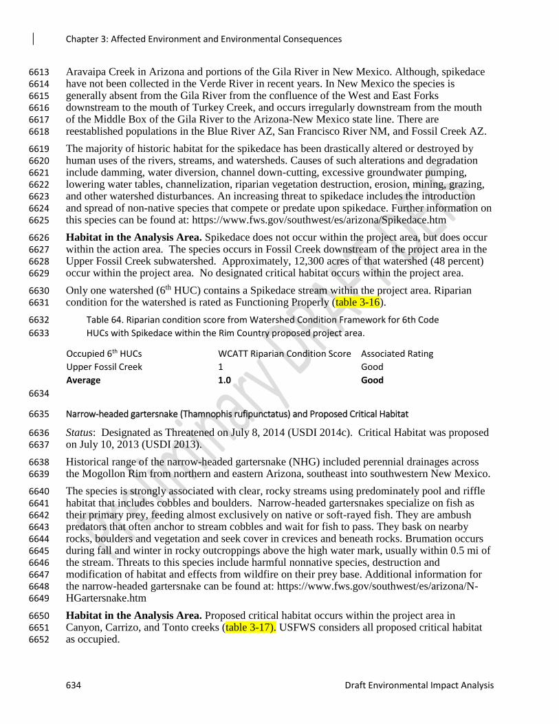
Chapter 3: Affected Environment and Environmental Consequences
634 Draft Environmental Impact Analysis
Aravaipa Creek in Arizona and portions of the Gila River in New Mexico. Although, spikedace 6613 have not been collected in the Verde River in recent years. In New Mexico the species is 6614 generally absent from the Gila River from the confluence of the West and East Forks 6615 downstream to the mouth of Turkey Creek, and occurs irregularly downstream from the mouth 6616 of the Middle Box of the Gila River to the Arizona-New Mexico state line. There are 6617 reestablished populations in the Blue River AZ, San Francisco River NM, and Fossil Creek AZ. 6618
The majority of historic habitat for the spikedace has been drastically altered or destroyed by 6619 human uses of the rivers, streams, and watersheds. Causes of such alterations and degradation 6620 include damming, water diversion, channel down-cutting, excessive groundwater pumping, 6621 lowering water tables, channelization, riparian vegetation destruction, erosion, mining, grazing, 6622 and other watershed disturbances. An increasing threat to spikedace includes the introduction 6623 and spread of non-native species that compete or predate upon spikedace. Further information on 6624 this species can be found at: https://www.fws.gov/southwest/es/arizona/Spikedace.htm 6625
Habitat in the Analysis Area. Spikedace does not occur within the project area, but does occur 6626 within the action area. The species occurs in Fossil Creek downstream of the project area in the 6627 Upper Fossil Creek subwatershed. Approximately, 12,300 acres of that watershed (48 percent) 6628 occur within the project area. No designated critical habitat occurs within the project area. 6629
Only one watershed (6th HUC) contains a Spikedace stream within the project area. Riparian 6630 condition for the watershed is rated as Functioning Properly (table 3-16). 6631
Table 64. Riparian condition score from Watershed Condition Framework for 6th Code 6632
HUCs with Spikedace within the Rim Country proposed project area. 6633
Occupied 6th HUCs WCATT Riparian Condition Score Associated Rating
Upper Fossil Creek 1 Good
Average 1.0 Good
6634
Narrow-headed gartersnake (Thamnophis rufipunctatus) and Proposed Critical Habitat 6635
Status: Designated as Threatened on July 8, 2014 (USDI 2014c). Critical Habitat was proposed 6636 on July 10, 2013 (USDI 2013). 6637
Historical range of the narrow-headed gartersnake (NHG) included perennial drainages across 6638 the Mogollon Rim from northern and eastern Arizona, southeast into southwestern New Mexico. 6639
The species is strongly associated with clear, rocky streams using predominately pool and riffle 6640 habitat that includes cobbles and boulders. Narrow-headed gartersnakes specialize on fish as 6641 their primary prey, feeding almost exclusively on native or soft-rayed fish. They are ambush 6642 predators that often anchor to stream cobbles and wait for fish to pass. They bask on nearby 6643 rocks, boulders and vegetation and seek cover in crevices and beneath rocks. Brumation occurs 6644 during fall and winter in rocky outcroppings above the high water mark, usually within 0.5 mi of 6645 the stream. Threats to this species include harmful nonnative species, destruction and 6646 modification of habitat and effects from wildfire on their prey base. Additional information for 6647 the narrow-headed gartersnake can be found at: https://www.fws.gov/southwest/es/arizona/N-6648 HGartersnake.htm 6649
Habitat in the Analysis Area. Proposed critical habitat occurs within the project area in 6650 Canyon, Carrizo, and Tonto creeks (table 3-17). USFWS considers all proposed critical habitat 6651 as occupied. 6652
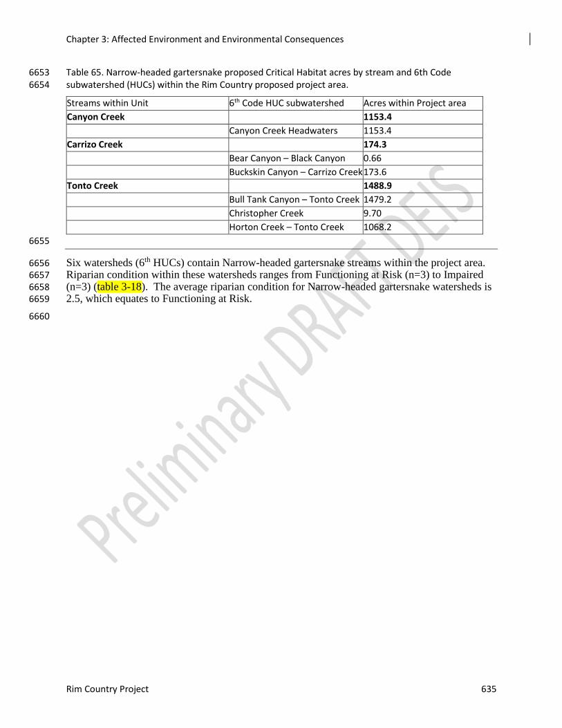
Chapter 3: Affected Environment and Environmental Consequences
Rim Country Project 635
Table 65. Narrow-headed gartersnake proposed Critical Habitat acres by stream and 6th Code 6653 subwatershed (HUCs) within the Rim Country proposed project area. 6654
Streams within Unit 6th Code HUC subwatershed Acres within Project area
Canyon Creek 1153.4
Canyon Creek Headwaters 1153.4
Carrizo Creek 174.3
Bear Canyon – Black Canyon 0.66
Buckskin Canyon – Carrizo Creek 173.6
Tonto Creek 1488.9
Bull Tank Canyon – Tonto Creek 1479.2
Christopher Creek 9.70
Horton Creek – Tonto Creek 1068.2
6655
Six watersheds (6th HUCs) contain Narrow-headed gartersnake streams within the project area. 6656 Riparian condition within these watersheds ranges from Functioning at Risk (n=3) to Impaired 6657 (n=3) (table 3-18). The average riparian condition for Narrow-headed gartersnake watersheds is 6658 2.5, which equates to Functioning at Risk. 6659
6660
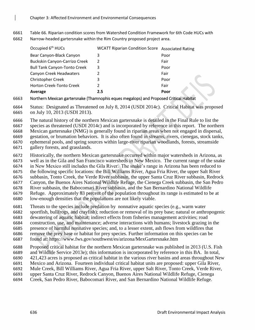
Chapter 3: Affected Environment and Environmental Consequences
636 Draft Environmental Impact Analysis
Table 66. Riparian condition scores from Watershed Condition Framework for 6th Code HUCs with 6661
Narrow-headed gartersnake within the Rim Country proposed project area. 6662
Occupied 6th HUCs WCATT Riparian Condition Score Associated Rating
Bear Canyon-Black Canyon 3 Poor
Buckskin Canyon-Carrizo Creek 2 Fair
Bull Tank Canyon-Tonto Creek 3 Poor
Canyon Creek Headwaters 2 Fair
Christopher Creek 3 Poor
Horton Creek-Tonto Creek 2 Fair
Average 2.5 Poor
Northern Mexican gartersnake (Thamnophis eques megalops) and Proposed Critical Habitat 6663
Status: Designated as Threatened on July 8, 2014 (USDI 2014c). Critical Habitat was proposed 6664 on July 10, 2013 (USDI 2013). 6665
The natural history of the northern Mexican gartersnake is detailed in the Final Rule to list the 6666 species as threatened (USDI 2014c) and is incorporated by reference in this report. The northern 6667 Mexican gartersnake (NMG) is generally found in riparian areas when not engaged in dispersal, 6668 gestation, or brumation behaviors. It is also often found in streams, rivers, cienegas, stock tanks, 6669 ephemeral pools, and spring sources within large-river riparian woodlands, forests, streamside 6670 gallery forests, and grasslands. 6671
Historically, the northern Mexican gartersnake occurred within major watersheds in Arizona, as 6672 well as in the Gila and San Francisco watersheds in New Mexico. The current range of the snake 6673 in New Mexico still includes the Gila River. The snake’s range in Arizona has been reduced to 6674 the following specific locations: the Bill Williams River, Agua Fria River, the upper Salt River 6675 subbasin, Tonto Creek, the Verde River subbasin, the upper Santa Cruz River subbasin, Redrock 6676 Canyon, the Buenos Aires National Wildlife Refuge, the Cienega Creek subbasin, the San Pedro 6677 River subbasin, the Babocomari River subbasin, and the San Bernardino National Wildlife 6678 Refuge. Approximately 83 percent of the population throughout its range is estimated to be at 6679 low-enough densities that the populations are not likely viable. 6680
Threats to the species include predation by nonnative aquatic species (e.g., warm water 6681 sportfish, bullfrogs, and crayfish); reduction or removal of its prey base; natural or anthropogenic 6682 dewatering of aquatic habitat; indirect effects from fisheries management activities; road 6683 construction, use, and maintenance; adverse interactions with humans; livestock grazing in the 6684 presence of harmful nonnative species; and, to a lesser extent, ash flows from wildfires that 6685 remove the prey base or habitat for prey species. Further information on this species can be 6686 found at: https://www.fws.gov/southwest/es/arizona/MexGartersnake.htm 6687
Proposed critical habitat for the northern Mexican gartersnake was published in 2013 (U.S. Fish 6688 and Wildlife Service 2013e); this information is incorporated by reference in this BA. In total, 6689 421,423 acres is proposed as critical habitat in the various river basins and areas throughout New 6690 Mexico and Arizona. Fourteen individual critical habitat units are proposed: upper Gila River, 6691 Mule Creek, Bill Williams River, Agua Fria River, upper Salt River, Tonto Creek, Verde River, 6692 upper Santa Cruz River, Redrock Canyon, Buenos Aires National Wildlife Refuge, Cienega 6693 Creek, San Pedro River, Babocomari River, and San Bernardino National Wildlife Refuge. 6694
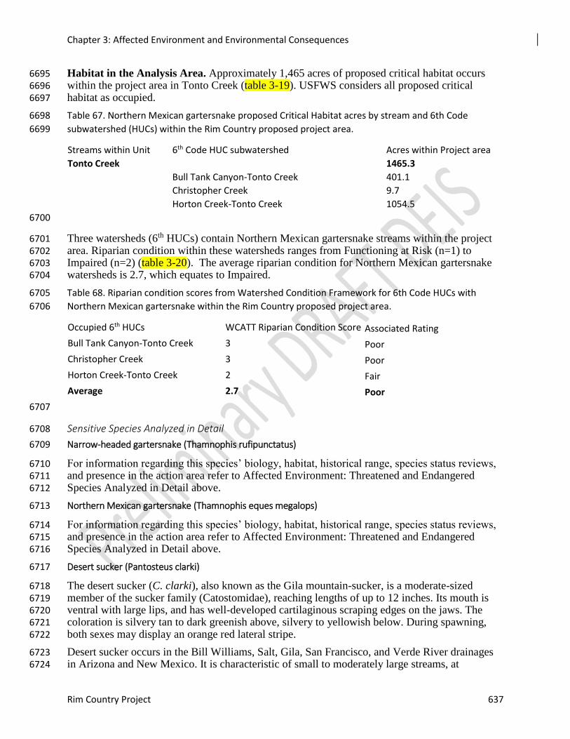
Chapter 3: Affected Environment and Environmental Consequences
Rim Country Project 637
Habitat in the Analysis Area. Approximately 1,465 acres of proposed critical habitat occurs 6695 within the project area in Tonto Creek (table 3-19). USFWS considers all proposed critical 6696 habitat as occupied. 6697
Table 67. Northern Mexican gartersnake proposed Critical Habitat acres by stream and 6th Code 6698
subwatershed (HUCs) within the Rim Country proposed project area. 6699
Streams within Unit 6th Code HUC subwatershed Acres within Project area
Tonto Creek 1465.3
Bull Tank Canyon-Tonto Creek 401.1
Christopher Creek 9.7
Horton Creek-Tonto Creek 1054.5
6700
Three watersheds (6th HUCs) contain Northern Mexican gartersnake streams within the project 6701 area. Riparian condition within these watersheds ranges from Functioning at Risk (n=1) to 6702 Impaired (n=2) (table 3-20). The average riparian condition for Northern Mexican gartersnake 6703 watersheds is 2.7, which equates to Impaired. 6704
Table 68. Riparian condition scores from Watershed Condition Framework for 6th Code HUCs with 6705
Northern Mexican gartersnake within the Rim Country proposed project area. 6706
Occupied 6th HUCs WCATT Riparian Condition Score Associated Rating
Bull Tank Canyon-Tonto Creek 3 Poor
Christopher Creek 3 Poor
Horton Creek-Tonto Creek 2 Fair
Average 2.7 Poor
6707
Sensitive Species Analyzed in Detail 6708
Narrow-headed gartersnake (Thamnophis rufipunctatus) 6709
For information regarding this species’ biology, habitat, historical range, species status reviews, 6710 and presence in the action area refer to Affected Environment: Threatened and Endangered 6711 Species Analyzed in Detail above. 6712
Northern Mexican gartersnake (Thamnophis eques megalops) 6713
For information regarding this species’ biology, habitat, historical range, species status reviews, 6714 and presence in the action area refer to Affected Environment: Threatened and Endangered 6715 Species Analyzed in Detail above. 6716
Desert sucker (Pantosteus clarki) 6717
The desert sucker (C. clarki), also known as the Gila mountain-sucker, is a moderate-sized 6718 member of the sucker family (Catostomidae), reaching lengths of up to 12 inches. Its mouth is 6719 ventral with large lips, and has well-developed cartilaginous scraping edges on the jaws. The 6720 coloration is silvery tan to dark greenish above, silvery to yellowish below. During spawning, 6721 both sexes may display an orange red lateral stripe. 6722
Desert sucker occurs in the Bill Williams, Salt, Gila, San Francisco, and Verde River drainages 6723 in Arizona and New Mexico. It is characteristic of small to moderately large streams, at 6724
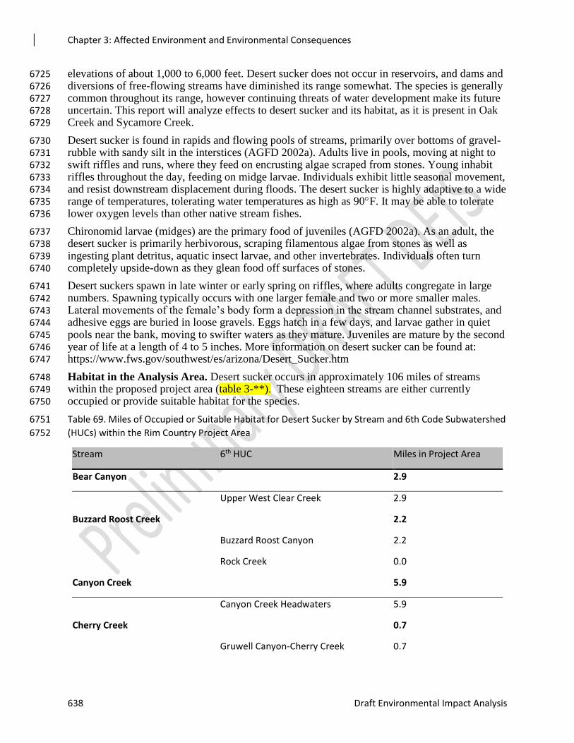
Chapter 3: Affected Environment and Environmental Consequences
638 Draft Environmental Impact Analysis
elevations of about 1,000 to 6,000 feet. Desert sucker does not occur in reservoirs, and dams and 6725 diversions of free-flowing streams have diminished its range somewhat. The species is generally 6726 common throughout its range, however continuing threats of water development make its future 6727 uncertain. This report will analyze effects to desert sucker and its habitat, as it is present in Oak 6728 Creek and Sycamore Creek. 6729
Desert sucker is found in rapids and flowing pools of streams, primarily over bottoms of gravel-6730 rubble with sandy silt in the interstices (AGFD 2002a). Adults live in pools, moving at night to 6731 swift riffles and runs, where they feed on encrusting algae scraped from stones. Young inhabit 6732 riffles throughout the day, feeding on midge larvae. Individuals exhibit little seasonal movement, 6733 and resist downstream displacement during floods. The desert sucker is highly adaptive to a wide 6734 range of temperatures, tolerating water temperatures as high as 90F. It may be able to tolerate 6735 lower oxygen levels than other native stream fishes. 6736
Chironomid larvae (midges) are the primary food of juveniles (AGFD 2002a). As an adult, the 6737 desert sucker is primarily herbivorous, scraping filamentous algae from stones as well as 6738 ingesting plant detritus, aquatic insect larvae, and other invertebrates. Individuals often turn 6739 completely upside-down as they glean food off surfaces of stones. 6740
Desert suckers spawn in late winter or early spring on riffles, where adults congregate in large 6741 numbers. Spawning typically occurs with one larger female and two or more smaller males. 6742 Lateral movements of the female’s body form a depression in the stream channel substrates, and 6743 adhesive eggs are buried in loose gravels. Eggs hatch in a few days, and larvae gather in quiet 6744 pools near the bank, moving to swifter waters as they mature. Juveniles are mature by the second 6745 year of life at a length of 4 to 5 inches. More information on desert sucker can be found at: 6746 https://www.fws.gov/southwest/es/arizona/Desert_Sucker.htm 6747
Habitat in the Analysis Area. Desert sucker occurs in approximately 106 miles of streams 6748 within the proposed project area (table 3-**). These eighteen streams are either currently 6749 occupied or provide suitable habitat for the species. 6750
Table 69. Miles of Occupied or Suitable Habitat for Desert Sucker by Stream and 6th Code Subwatershed 6751
(HUCs) within the Rim Country Project Area 6752
Stream 6th HUC Miles in Project Area
Bear Canyon 2.9
Upper West Clear Creek 2.9
Buzzard Roost Creek 2.2
Buzzard Roost Canyon 2.2
Rock Creek 0.0
Canyon Creek 5.9
Canyon Creek Headwaters 5.9
Cherry Creek 0.7
Gruwell Canyon-Cherry Creek 0.7
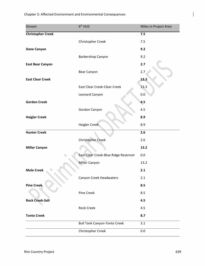
Chapter 3: Affected Environment and Environmental Consequences
Rim Country Project 639
Stream 6th HUC Miles in Project Area
Christopher Creek 7.5
Christopher Creek 7.5
Dane Canyon 9.2
Barbershop Canyon 9.2
East Bear Canyon 2.7
Bear Canyon 2.7
East Clear Creek 13.3
East Clear Creek-Clear Creek 13.3
Leonard Canyon 0.0
Gordon Creek 4.5
Gordon Canyon 4.5
Haigler Creek 8.9
Haigler Creek 8.9
Hunter Creek 2.6
Christopher Creek 2.6
Miller Canyon 13.2
East Clear Creek-Blue Ridge Reservoir 0.0
Miller Canyon 13.2
Mule Creek 2.1
Canyon Creek Headwaters 2.1
Pine Creek 8.5
Pine Creek 8.5
Rock Creek-Salt 4.5
Rock Creek 4.5
Tonto Creek 8.7
Bull Tank Canyon-Tonto Creek 3.1
Christopher Creek 0.0
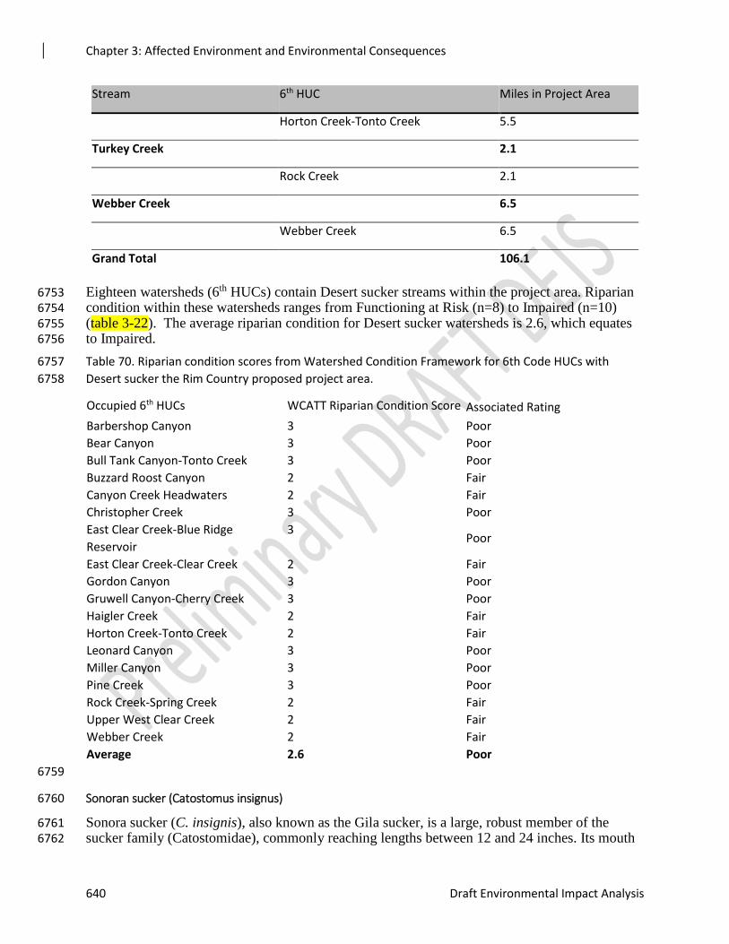
Chapter 3: Affected Environment and Environmental Consequences
640 Draft Environmental Impact Analysis
Stream 6th HUC Miles in Project Area
Horton Creek-Tonto Creek 5.5
Turkey Creek 2.1
Rock Creek 2.1
Webber Creek 6.5
Webber Creek 6.5
Grand Total 106.1
Eighteen watersheds (6th HUCs) contain Desert sucker streams within the project area. Riparian 6753 condition within these watersheds ranges from Functioning at Risk (n=8) to Impaired (n=10) 6754 (table 3-22). The average riparian condition for Desert sucker watersheds is 2.6, which equates 6755 to Impaired. 6756
Table 70. Riparian condition scores from Watershed Condition Framework for 6th Code HUCs with 6757
Desert sucker the Rim Country proposed project area. 6758
Occupied 6th HUCs WCATT Riparian Condition Score Associated Rating
Barbershop Canyon 3 Poor
Bear Canyon 3 Poor
Bull Tank Canyon-Tonto Creek 3 Poor
Buzzard Roost Canyon 2 Fair
Canyon Creek Headwaters 2 Fair
Christopher Creek 3 Poor
East Clear Creek-Blue Ridge
Reservoir
3 Poor
East Clear Creek-Clear Creek 2 Fair
Gordon Canyon 3 Poor
Gruwell Canyon-Cherry Creek 3 Poor
Haigler Creek 2 Fair
Horton Creek-Tonto Creek 2 Fair
Leonard Canyon 3 Poor
Miller Canyon 3 Poor
Pine Creek 3 Poor
Rock Creek-Spring Creek 2 Fair
Upper West Clear Creek 2 Fair
Webber Creek 2 Fair
Average 2.6 Poor
6759
Sonoran sucker (Catostomus insignus) 6760
Sonora sucker (C. insignis), also known as the Gila sucker, is a large, robust member of the 6761 sucker family (Catostomidae), commonly reaching lengths between 12 and 24 inches. Its mouth 6762
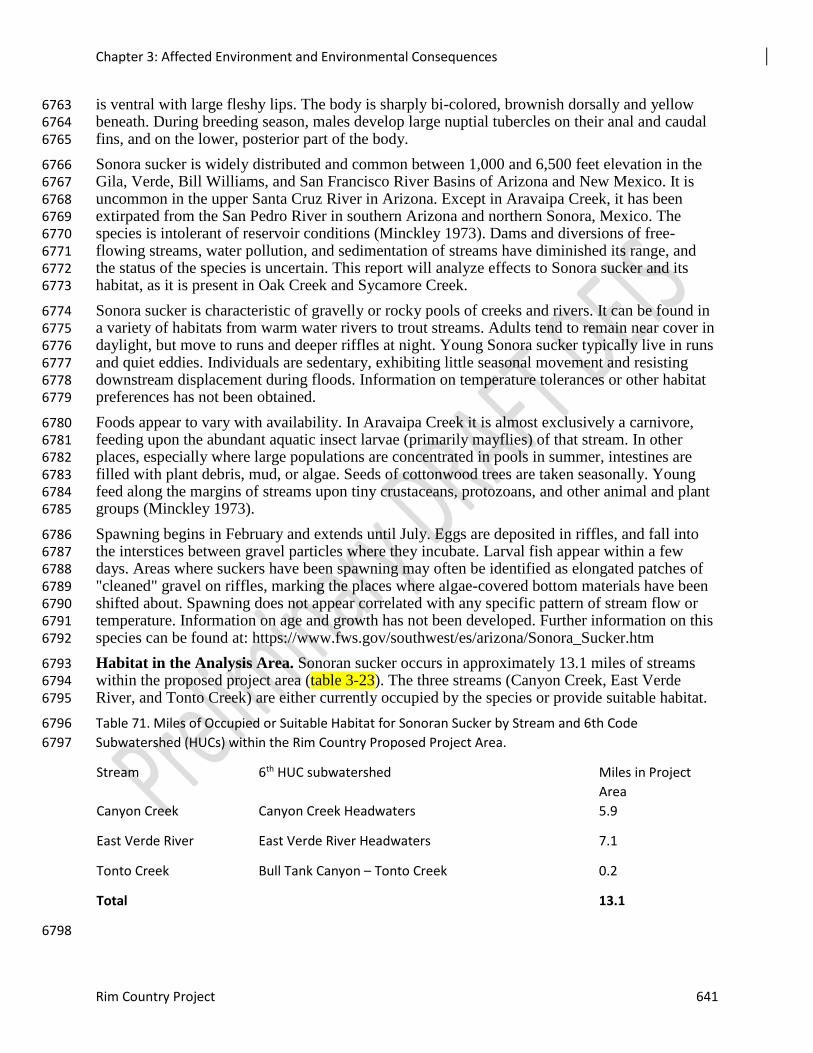
Chapter 3: Affected Environment and Environmental Consequences
Rim Country Project 641
is ventral with large fleshy lips. The body is sharply bi-colored, brownish dorsally and yellow 6763 beneath. During breeding season, males develop large nuptial tubercles on their anal and caudal 6764 fins, and on the lower, posterior part of the body. 6765
Sonora sucker is widely distributed and common between 1,000 and 6,500 feet elevation in the 6766 Gila, Verde, Bill Williams, and San Francisco River Basins of Arizona and New Mexico. It is 6767 uncommon in the upper Santa Cruz River in Arizona. Except in Aravaipa Creek, it has been 6768 extirpated from the San Pedro River in southern Arizona and northern Sonora, Mexico. The 6769 species is intolerant of reservoir conditions (Minckley 1973). Dams and diversions of free-6770 flowing streams, water pollution, and sedimentation of streams have diminished its range, and 6771 the status of the species is uncertain. This report will analyze effects to Sonora sucker and its 6772 habitat, as it is present in Oak Creek and Sycamore Creek. 6773
Sonora sucker is characteristic of gravelly or rocky pools of creeks and rivers. It can be found in 6774 a variety of habitats from warm water rivers to trout streams. Adults tend to remain near cover in 6775 daylight, but move to runs and deeper riffles at night. Young Sonora sucker typically live in runs 6776 and quiet eddies. Individuals are sedentary, exhibiting little seasonal movement and resisting 6777 downstream displacement during floods. Information on temperature tolerances or other habitat 6778 preferences has not been obtained. 6779
Foods appear to vary with availability. In Aravaipa Creek it is almost exclusively a carnivore, 6780 feeding upon the abundant aquatic insect larvae (primarily mayflies) of that stream. In other 6781 places, especially where large populations are concentrated in pools in summer, intestines are 6782 filled with plant debris, mud, or algae. Seeds of cottonwood trees are taken seasonally. Young 6783 feed along the margins of streams upon tiny crustaceans, protozoans, and other animal and plant 6784 groups (Minckley 1973). 6785
Spawning begins in February and extends until July. Eggs are deposited in riffles, and fall into 6786 the interstices between gravel particles where they incubate. Larval fish appear within a few 6787 days. Areas where suckers have been spawning may often be identified as elongated patches of 6788 "cleaned" gravel on riffles, marking the places where algae-covered bottom materials have been 6789 shifted about. Spawning does not appear correlated with any specific pattern of stream flow or 6790 temperature. Information on age and growth has not been developed. Further information on this 6791 species can be found at: https://www.fws.gov/southwest/es/arizona/Sonora_Sucker.htm 6792
Habitat in the Analysis Area. Sonoran sucker occurs in approximately 13.1 miles of streams 6793 within the proposed project area (table 3-23). The three streams (Canyon Creek, East Verde 6794 River, and Tonto Creek) are either currently occupied by the species or provide suitable habitat. 6795
Table 71. Miles of Occupied or Suitable Habitat for Sonoran Sucker by Stream and 6th Code 6796
Subwatershed (HUCs) within the Rim Country Proposed Project Area. 6797
Stream 6th HUC subwatershed Miles in Project
Area
Canyon Creek Canyon Creek Headwaters 5.9
East Verde River East Verde River Headwaters 7.1
Tonto Creek Bull Tank Canyon – Tonto Creek 0.2
Total 13.1
6798
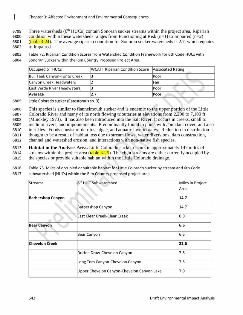
Chapter 3: Affected Environment and Environmental Consequences
642 Draft Environmental Impact Analysis
Three watersheds (6th HUCs) contain Sonoran sucker streams within the project area. Riparian 6799 condition within these watersheds ranges from Functioning at Risk (n=1) to Impaired (n=2) 6800 (table 3-24). The average riparian condition for Sonoran sucker watersheds is 2.7, which equates 6801 to Impaired. 6802
Table 72. Riparian Condition Scores from Watershed Condition Framework for 6th Code HUCs with 6803
Sonoran Sucker within the Rim Country Proposed Project Area. 6804
Occupied 6th HUCs WCATT Riparian Condition Score Associated Rating
Bull Tank Canyon-Tonto Creek 3 Poor
Canyon Creek Headwaters 2 Fair
East Verde River Headwaters 3 Poor
Average 2.7 Poor
Little Colorado sucker (Catostomus sp. 3) 6805
This species is similar to flannelmouth sucker and is endemic to the upper portion of the Little 6806 Colorado River and many of its north flowing tributaries at elevations from 2,200 to 7,100 ft. 6807 (Minckley 1973). It has also been introduced into the Salt River. It occurs in creeks, small to 6808 medium rivers, and impoundments. Predominantly found in pools with abundant cover, and also 6809 in riffles. Foods consist of detritus, algae, and aquatic invertebrates. Reduction in distribution is 6810 thought to be a result of habitat loss due to stream flows, water diversions, dam construction, 6811 channel and watershed erosion, and interactions with non-native fish species. 6812
Habitat in the Analysis Area. Little Colorado sucker occurs in approximately 147 miles of 6813 streams within the project area (table 3-25). The eight streams are either currently occupied by 6814 the species or provide suitable habitat within the Little Colorado drainage. 6815
Table 73. Miles of occupied or suitable habitat for Little Colorado sucker by stream and 6th Code 6816
subwatershed (HUCs) within the Rim Country proposed project area. 6817
Streams 6th HUC Subwatershed Miles in Project
Area
Barbershop Canyon 14.7
Barbershop Canyon 14.7
East Clear Creek-Clear Creek 0.0
Bear Canyon 6.6
Bear Canyon 6.6
Chevelon Creek 22.6
Durfee Draw-Chevelon Canyon 7.8
Long Tom Canyon-Chevelon Canyon 7.8
Upper Chevelon Canyon-Chevelon Canyon Lake 7.0
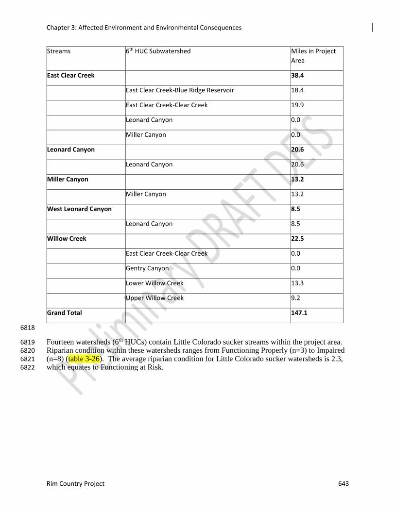
Chapter 3: Affected Environment and Environmental Consequences
Rim Country Project 643
Streams 6th HUC Subwatershed Miles in Project
Area
East Clear Creek 38.4
East Clear Creek-Blue Ridge Reservoir 18.4
East Clear Creek-Clear Creek 19.9
Leonard Canyon 0.0
Miller Canyon 0.0
Leonard Canyon 20.6
Leonard Canyon 20.6
Miller Canyon 13.2
Miller Canyon 13.2
West Leonard Canyon 8.5
Leonard Canyon 8.5
Willow Creek 22.5
East Clear Creek-Clear Creek 0.0
Gentry Canyon 0.0
Lower Willow Creek 13.3
Upper Willow Creek 9.2
Grand Total 147.1
6818
Fourteen watersheds (6th HUCs) contain Little Colorado sucker streams within the project area. 6819 Riparian condition within these watersheds ranges from Functioning Properly (n=3) to Impaired 6820 (n=8) (table 3-26). The average riparian condition for Little Colorado sucker watersheds is 2.3, 6821 which equates to Functioning at Risk. 6822
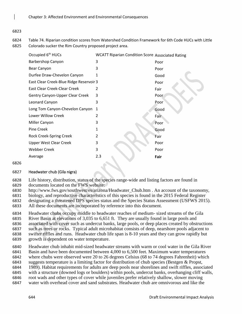
Chapter 3: Affected Environment and Environmental Consequences
644 Draft Environmental Impact Analysis
6823
Table 74. Riparian condition scores from Watershed Condition Framework for 6th Code HUCs with Little 6824
Colorado sucker the Rim Country proposed project area. 6825
Occupied 6th HUCs WCATT Riparian Condition Score Associated Rating
Barbershop Canyon 3 Poor
Bear Canyon 3 Poor
Durfee Draw-Chevelon Canyon 1 Good
East Clear Creek-Blue Ridge Reservoir 3 Poor
East Clear Creek-Clear Creek 2 Fair
Gentry Canyon-Upper Clear Creek 3 Poor
Leonard Canyon 3 Poor
Long Tom Canyon-Chevelon Canyon 1 Good
Lower Willow Creek 2 Fair
Miller Canyon 3 Poor
Pine Creek 1 Good
Rock Creek-Spring Creek 2 Fair
Upper West Clear Creek 3 Poor
Webber Creek 3 Poor
Average 2.3 Fair
6826
Headwater chub (Gila nigra) 6827
Life history, distribution, status of the species range-wide and listing factors are found in 6828 documents located on the FWS website: 6829 http://www.fws.gov/southwest/es/arizona/Headwater_Chub.htm . An account of the taxonomy, 6830 biology, and reproductive characteristics of this species is found in the 2015 Federal Register 6831 designating a threatened DPS species status and the Species Status Assessment (USFWS 2015). 6832 All these documents are incorporated by reference into this document. 6833
Headwater chubs occupy middle to headwater reaches of medium- sized streams of the Gila 6834 River Basin at elevations of 3,035 to 6,651 ft. They are usually found in large pools and 6835 associated with cover such as undercut banks, large pools, or deep places created by obstructions 6836 such as trees or rocks. Typical adult microhabitat consists of deep, nearshore pools adjacent to 6837 swifter riffles and runs. Headwater chub life span is 8-10 years and they can grow rapidly but 6838 growth is dependent on water temperature. 6839
Headwater chub inhabit mid-sized headwater streams with warm or cool water in the Gila River 6840 Basin and have been documented between 4,000 to 6,500 feet. Maximum water temperatures 6841 where chubs were observed were 20 to 26 degrees Celsius (68 to 74 degrees Fahrenheit) which 6842 suggests temperature is a limiting factor for distribution of chub species (Bestgen & Propst, 6843 1989). Habitat requirements for adults are deep pools near shorelines and swift riffles, associated 6844 with a structure (downed logs or boulders) within pools, undercut banks, overhanging cliff walls, 6845 root wads and other types of cover while juveniles prefer relatively shallow, slower moving 6846 water with overhead cover and sand substrates. Headwater chub are omnivorous and like the 6847
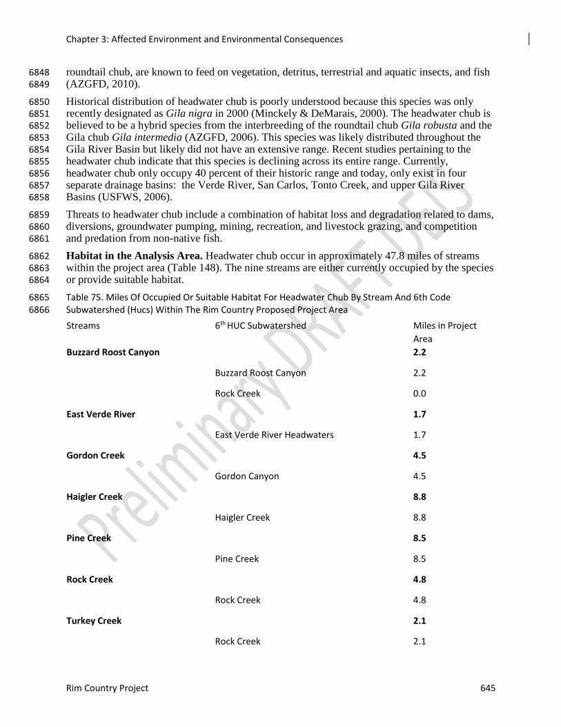
Chapter 3: Affected Environment and Environmental Consequences
Rim Country Project 645
roundtail chub, are known to feed on vegetation, detritus, terrestrial and aquatic insects, and fish 6848 (AZGFD, 2010). 6849
Historical distribution of headwater chub is poorly understood because this species was only 6850 recently designated as Gila nigra in 2000 (Minckely & DeMarais, 2000). The headwater chub is 6851 believed to be a hybrid species from the interbreeding of the roundtail chub Gila robusta and the 6852 Gila chub Gila intermedia (AZGFD, 2006). This species was likely distributed throughout the 6853 Gila River Basin but likely did not have an extensive range. Recent studies pertaining to the 6854 headwater chub indicate that this species is declining across its entire range. Currently, 6855 headwater chub only occupy 40 percent of their historic range and today, only exist in four 6856 separate drainage basins: the Verde River, San Carlos, Tonto Creek, and upper Gila River 6857 Basins (USFWS, 2006). 6858
Threats to headwater chub include a combination of habitat loss and degradation related to dams, 6859 diversions, groundwater pumping, mining, recreation, and livestock grazing, and competition 6860 and predation from non-native fish. 6861
Habitat in the Analysis Area. Headwater chub occur in approximately 47.8 miles of streams 6862 within the project area (Table 148). The nine streams are either currently occupied by the species 6863 or provide suitable habitat. 6864
Table 75. Miles Of Occupied Or Suitable Habitat For Headwater Chub By Stream And 6th Code 6865 Subwatershed (Hucs) Within The Rim Country Proposed Project Area 6866
Streams 6th HUC Subwatershed Miles in Project
Area
Buzzard Roost Canyon 2.2
Buzzard Roost Canyon 2.2
Rock Creek 0.0
East Verde River 1.7
East Verde River Headwaters 1.7
Gordon Creek 4.5
Gordon Canyon 4.5
Haigler Creek 8.8
Haigler Creek 8.8
Pine Creek 8.5
Pine Creek 8.5
Rock Creek 4.8
Rock Creek 4.8
Turkey Creek 2.1
Rock Creek 2.1
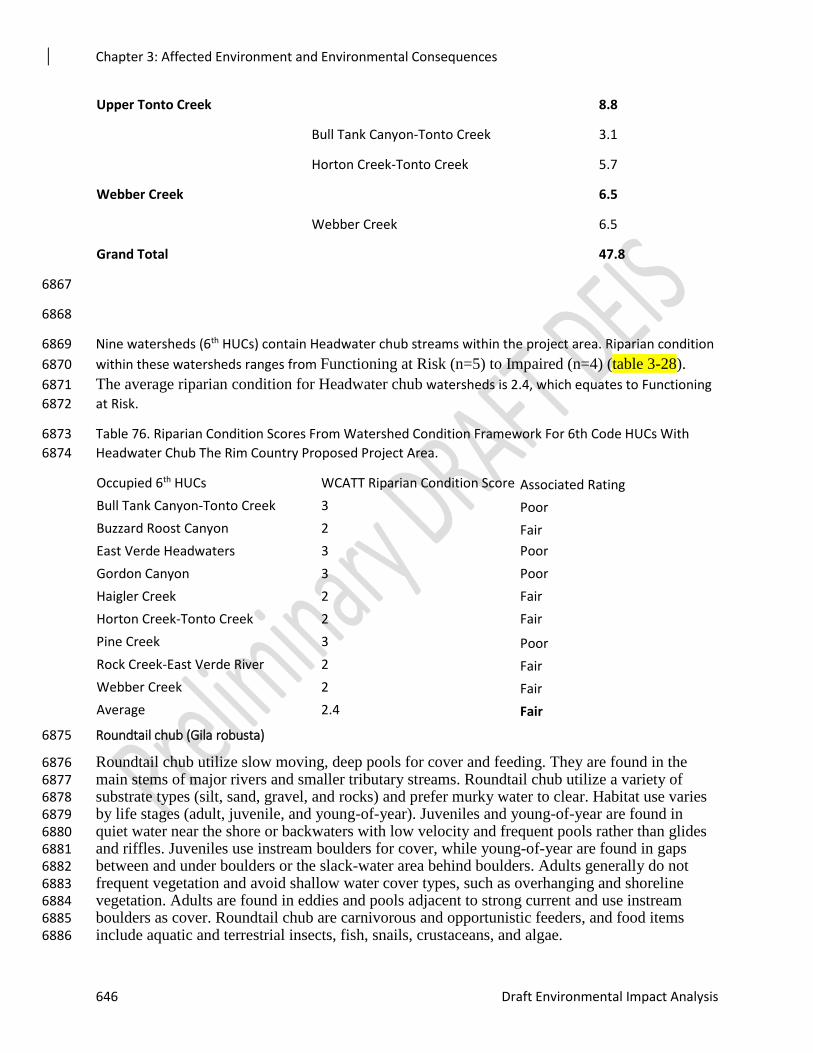
Chapter 3: Affected Environment and Environmental Consequences
646 Draft Environmental Impact Analysis
Upper Tonto Creek 8.8
Bull Tank Canyon-Tonto Creek 3.1
Horton Creek-Tonto Creek 5.7
Webber Creek 6.5
Webber Creek 6.5
Grand Total 47.8
6867
6868
Nine watersheds (6th HUCs) contain Headwater chub streams within the project area. Riparian condition 6869
within these watersheds ranges from Functioning at Risk (n=5) to Impaired (n=4) (table 3-28). 6870
The average riparian condition for Headwater chub watersheds is 2.4, which equates to Functioning 6871
at Risk. 6872
Table 76. Riparian Condition Scores From Watershed Condition Framework For 6th Code HUCs With 6873
Headwater Chub The Rim Country Proposed Project Area. 6874
Occupied 6th HUCs WCATT Riparian Condition Score Associated Rating
Bull Tank Canyon-Tonto Creek 3 Poor
Buzzard Roost Canyon 2 Fair
East Verde Headwaters 3 Poor
Gordon Canyon 3 Poor
Haigler Creek 2 Fair
Horton Creek-Tonto Creek 2 Fair
Pine Creek 3 Poor
Rock Creek-East Verde River 2 Fair
Webber Creek 2 Fair
Average 2.4 Fair
Roundtail chub (Gila robusta) 6875
Roundtail chub utilize slow moving, deep pools for cover and feeding. They are found in the 6876 main stems of major rivers and smaller tributary streams. Roundtail chub utilize a variety of 6877 substrate types (silt, sand, gravel, and rocks) and prefer murky water to clear. Habitat use varies 6878 by life stages (adult, juvenile, and young-of-year). Juveniles and young-of-year are found in 6879 quiet water near the shore or backwaters with low velocity and frequent pools rather than glides 6880 and riffles. Juveniles use instream boulders for cover, while young-of-year are found in gaps 6881 between and under boulders or the slack-water area behind boulders. Adults generally do not 6882 frequent vegetation and avoid shallow water cover types, such as overhanging and shoreline 6883 vegetation. Adults are found in eddies and pools adjacent to strong current and use instream 6884 boulders as cover. Roundtail chub are carnivorous and opportunistic feeders, and food items 6885 include aquatic and terrestrial insects, fish, snails, crustaceans, and algae. 6886
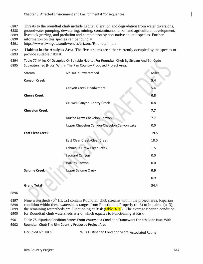
Chapter 3: Affected Environment and Environmental Consequences
Rim Country Project 647
Threats to the roundtail chub include habitat alteration and degradation from water diversions, 6887 groundwater pumping, dewatering, mining, contaminants, urban and agricultural development, 6888 livestock grazing, and predation and competition by non-native aquatic species. Further 6889 information on this species can be found at: 6890 https://www.fws.gov/southwest/es/arizona/Roundtail.htm 6891
Habitat in the Analysis Area. The five streams are either currently occupied by the species or 6892 provide suitable habitat. 6893
Table 77. Miles Of Occupied Or Suitable Habitat For Roundtail Chub By Stream And 6th Code 6894
Subwatershed (Hucs) Within The Rim Country Proposed Project Area. 6895
Stream 6th HUC subwatershed Miles
Canyon Creek 5.4
Canyon Creek Headwaters 5.4
Cherry Creek 0.8
Gruwell Canyon-Cherry Creek 0.8
Chevelon Creek 7.7
Durfee Draw-Chevelon Canyon 7.7
Upper Chevelon Canyon-Chevelon Canyon Lake 0.0
East Clear Creek 19.5
East Clear Creek-Clear Creek 18.0
Echinique Draw-Clear Creek 1.5
Leonard Canyon 0.0
Wilkins Canyon 0.0
Salome Creek Upper Salome Creek 0.9
0.9
Grand Total 34.4
6896
Nine watersheds (6th HUCs) contain Roundtail chub streams within the project area. Riparian 6897 condition within these watersheds ranges from Functioning Properly (n=3) to Impaired (n=3); 6898 the remaining watersheds are Functioning at Risk (table 3-30). The average riparian condition 6899 for Roundtail chub watersheds is 2.0, which equates to Functioning at Risk. 6900
Table 78. Riparian Condition Scores From Watershed Condition Framework For 6th Code Hucs With 6901
Roundtail Chub The Rim Country Proposed Project Area. 6902
Occupied 6th HUCs WCATT Riparian Condition Score Associated Rating
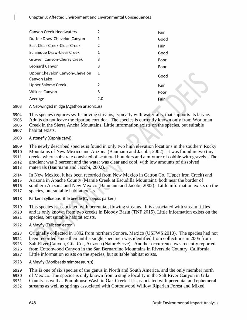
Chapter 3: Affected Environment and Environmental Consequences
648 Draft Environmental Impact Analysis
Canyon Creek Headwaters 2 Fair
Durfee Draw-Chevelon Canyon 1 Good
East Clear Creek-Clear Creek 2 Fair
Echinique Draw-Clear Creek 1 Good
Gruwell Canyon-Cherry Creek 3 Poor
Leonard Canyon 3 Poor
Upper Chevelon Canyon-Chevelon
Canyon Lake
1 Good
Upper Salome Creek 2 Fair
Wilkins Canyon 3 Poor
Average 2.0 Fair
A Net-winged midge (Agathon arizonicus) 6903
This species requires swift-moving streams, typically with waterfalls, that supports its larvae. 6904 Adults do not leave the riparian corridor. The species is currently known only from Workman 6905 Creek in the Sierra Ancha Mountains. Little information exists on the species, but suitable 6906 habitat exists. 6907
A stonefly (Capnia caryi) 6908
The newly described species is found in only two high elevation locations in the southern Rocky 6909 Mountains of New Mexico and Arizona (Baumann and Jacobi, 2002). It was found in two tiny 6910 creeks where substrate consisted of scattered boulders and a mixture of cobble with gravels. The 6911 gradient was 3 percent and the water was clear and cool, with low amounts of dissolved 6912 materials (Baumann and Jacobi, 2002). 6913
In New Mexico, it has been recorded from New Mexico in Catron Co. (Upper Iron Creek) and 6914 Arizona in Apache County (Mamie Creek at Escudilla Mountain); both near the border of 6915 southern Arizona and New Mexico (Baumann and Jacobi, 2002). Little information exists on the 6916 species, but suitable habitat exists. 6917
Parker’s cylloepus riffle beetle (Cylloepus parkeri) 6918
This species is associated with perennial, flowing streams. It is associated with stream riffles 6919 and is only known from two creeks in Bloody Basin (TNF 2015). Little information exists on the 6920 species, but suitable habitat exists. 6921
A Mayfly (Fallceon eatoni) 6922
Originally collected in 1892 from northern Sonora, Mexico (USFWS 2010). The species had not 6923 been recorded since then until a single specimen was identified from collections in 2005 from 6924 Salt River Canyon, Gila Co., Arizona (NatureServe). Another occurrence was recently reported 6925 from Cottonwood Canyon in the San Bernardino Mountains in Riverside Country, California. 6926 Little information exists on the species, but suitable habitat exists. 6927
A Mayfly (Moribaetis mimbresaurus) 6928
This is one of six species of the genus in North and South America, and the only member north 6929 of Mexico. The species is only known from a single locality in the Salt River Canyon in Gila 6930 County as well as Pumphouse Wash in Oak Creek. It is associated with perennial and ephemeral 6931 streams as well as springs associated with Cottonwood Willow Riparian Forest and Mixed 6932
Chapter 3: Affected Environment and Environmental Consequences
Rim Country Project 649
Broadleaf Riparian Forest, given that mayflies have a strictly aquatic larval stage (McCafferty 6933 2006). Little information exists on the species, but suitable habitat exists. 6934
A caddisfly (Lepidostoma apache) 6935
Limited information is known about this recently described species. It is found in freshwater 6936 habitat, but the larval habitat is unknown. It has only been found in the Blue River, on the ASNF 6937 (Houghton, 2001b). Little information exists on the species, but suitable habitat exists. 6938
A caddisfly (Lepidostoma knulli) 6939
This is a medium-sized caddisfly of the diverse Lepidostoma family, endemic to higher elevation 6940 southwestern United States watersheds ranging from 4500 to 8530 feet in elevation. It occurs in 6941 cool stream segments with swift flowing water, dominated by large cobbles with low 6942 embeddedness of interstitial gravels (Blinn and Ruiter 2009). Threats to the species include 6943 limited distribution or endemism in addition to threats to ecosystem or aquatic diversity. It is 6944 associated with Mixed Broadleaf Riparian Forest or Cottonwood Willow Riparian Forest. 6945
This species is uncommon in Arizona, Montana, New Mexico, and Mexico. It has been found in 6946 eastern Arizona in two sites on the ASNFs and in Pumphouse wash and Indian Gardens in Oak 6947 Creek Canyon on the COC. It has been listed in sites in Apache and Coconino County Arizona. 6948 Little information exists on the species, but suitable habitat exists. 6949
A caddisfly (Limnephilus granti) 6950
The species is extremely rare. All specimens have been collected from springs and their 6951 immediate outlets in the ponderosa pine region of eastern Arizona. It is known only from the 6952 type specimen and a few additional specimens found in Grant Creek in Graham County, 6953 Government Spring, south of Greer in Apache County, and Rosey Creek, near Greer also in 6954 Apache County (Blinn and Ruiter, 2009). Little information exists on the species, but suitable 6955 habitat exists within the project area. 6956
Ferris’ copper butterfly (Lycaena ferrisi) 6957
The species is the only one in its range that resembles the Ruddy copper butterfly. Its host plant 6958 in the larval stage is Arizona dock (also known as wild rhubarb) (Rumex hymenosepalus), while 6959 the adult feeds on nectar including that of yellow composites. Its primary habitat is open 6960 meadows and cienegas springs. Threats include fire suppression because it results in the 6961 invasion of meadow habitats by dense conifer forests and an understory of grasses (USFWS 6962 2009). 6963
This species has a very limited distribution, and is known only in the White Mountains of eastern 6964 Arizona. It is known to occur in the White Mountains of Apache County, near McNary and 6965 Maverick, and in Greer County, Arizona (USFWS 2009). It is critically imperiled globally and 6966 in Arizona. There may be only a single metapopulation, and there may be less than 20. Little 6967 information exists on the species, but suitable habitat exists. 6968
Nokomis Fritillary (aka Great Basin Silverspot) (Speyeria nokomis nokomis) 6969
This species is associated with permanent spring-fed meadows, seeps, marshes, and boggy 6970 streamside meadows with flowing water in arid country. Presence of its larval foodplant (bog 6971 violet [Viola nephrophylla]) is a critical habitat component. The species is only known from 6972 Apache Country, Arizona. There was a recently confirmed locality in Gila County. Little 6973 information exists on the species, but suitable habitat exists. 6974
Chapter 3: Affected Environment and Environmental Consequences
650 Draft Environmental Impact Analysis
California Floater (Anodonta californiensis) 6975
This mussel prefers shallow areas of clean, clear lakes, ponds and large rivers. It prefers lower 6976 elevations and soft, silty substrate to burrow into. The life cycle of California floater includes a 6977 parasitic larval stage during which it is dependent upon a host fish, usually a member of the Gila 6978 genus, for food and dispersal. The adult and juvenile phases are sedentary, filter-feeders. It is 6979 associated with perennial springs and streams in every riparian forest type. There are no 6980 occupied locations within the proposed project area, but suitable habitat does exist. 6981
Distribution used to range from southern British Columbia south to northern Baja California, and 6982 east to Wisconsin. Today, numbers have been depleted to the point that it is extinct throughout 6983 much of its former range, including Utah, the entire Sacramento River system, and most of 6984 Arizona. Specimens have been found in Chevelon Creek, East Clear Creek near the confluence 6985 of Leonard Canyon, and Show Low Creek. It is believed to have been present historically within 6986 the proposed project area in the Beaver Creek, Cherry Creek-Verde River, Fossil Creek-Verde 6987 River, Lower Clear Creek, Upper Clear Creek, and West Clear Creek 5th HUC watersheds. 6988 There are presently no known extant populations within the proposed project area. 6989
Assumptions and Methodology 6990
Assumptions 6991
Species occurrence geospatial layers utilized for analysis contain up-to-date information as of 6992 July 2018 and represent species current occurrence as well as potential suitable habitat. 6993
Species analysis areas represent the drainage network where direct and indirect effects could 6994 occur to species or habitat. 6995
Watershed Condition Framework assessments utilized for existing condition accurately reflect 6996 indicators for aquatic species and habitats. 6997
Analyzing mechanical vegetation and prescribed burning treatments across vegetation types will 6998 address the highest level of effects that may occur; therefore, effects less than that are inherently 6999 addressed. 7000
Project implementation will include all applicable Design Features, Best Management Practices, 7001 and Conservation Measures which are expected to minimize effects throughout the analysis. 7002
The Aquatic and Watershed Flexible Toolbox Approach is adaptive management and guidance 7003 within the document will be implemented, including circumstances on where treatments are 7004 applicable, which inherently minimize effects on aquatic species and habitats. 7005
Projects lists and acreages provided for Cumulative Effects analysis accurately represent past, 7006 current, and future activities within the project area. 7007
Methodology 7008
This analysis is for a total of 28 endangered, threatened, proposed, candidate, and sensitive 7009 aquatic species and their habitats. The species analyzed include twelve fish species, two 7010 mollusks, two gartersnakes, and twelve invertebrates. For analysis and discussion purposes, 7011 some of the species were grouped together, where appropriate, as this facilitates the comparison 7012 of changes between alternatives. Analyses compared and summarized the resource indicators and 7013 measures identified below (see table 3-XX). For invertebrate species, more qualitative analyses 7014 were required, primarily due to the unknown distributions of most of these species, limited 7015 distribution of these species, or the limited effects on these species associated with the proposed 7016 actions. Analyses included the changes (i.e., increase, decrease, or change from current 7017
Chapter 3: Affected Environment and Environmental Consequences
Rim Country Project 651
conditions) for the indicators or measures, and how they can affect aquatic species and their 7018 habitats. 7019
For the purposes of analysis, mechanical vegetation treatments were analyzed across vegetation 7020 type (Ecological Restoration Unit) within the project area. Intuitively, mechanical vegetation 7021 treatments in forested Ecological Restoration units (ERUs) would be more extensive to move 7022 towards desired conditions than treatments in savannas, grasslands, meadows, and riparian areas 7023 to reduce encroachment. Prescribed burning was similarly analyzed across the project area 7024 regardless of vegetation type (ERUs). 7025
The transportation system (roads) needed to implement Rim Country were analyzed 7026 quantitatively and qualitatively. Quantitative analysis was completed based on existing Forest 7027 Service roads (existing condition) and the number of ML-1 roads opened (action alternatives). 7028 While the analysis assumes all ML-1 roads would be opened for use, intuitively not all the roads 7029 would be opened or used at the same time across the project area. Therefore, the analysis is over 7030 estimating the potential effects of the action alternatives. The miles of roads (ML-1 thru 5) to be 7031 used is the same for both action alternatives as was therefore analyzed only once. Road 7032 relocation, decommissioning, and temporary roads were analyzed qualitatively for the action 7033 alternatives as the location of these activities is unknown. Miles proposed for each were based 7034 on averages across the three Forests over a given time period. Therefore, a more accurate 7035 analysis by species was not feasible. Miles of proposed road relocation and decommissioning 7036 were the same for both action alternatives and therefore only analyzed once. Mileage of 7037 temporary roads differed between the action alternatives and was analyzed as part of those 7038 alternatives. 7039
In-woods processing and storage sites, rock pits, and aquatic/watershed restoration activities do 7040 not differ in acreage or mileage between the action alternatives. For those reasons, these three 7041 portions of the action alternatives were analyzed only once as Effects Common to Both Action 7042 Alternatives. In-woods processing and storage sites were analyzed quantitatively for the 7043 Coconino and Tonto NFs where exact locations and acreages of proposed sites were available. A 7044 qualitative analysis was completed for the Apache-Sitgreaves NFs because the use of identified 7045 processing sites on those forests are not being proposed, only the in-woods drying of biomass as 7046 needed. The acres of rock pit use and expansion were analyzed quantitatively, as were miles of 7047 general and heavy mechanical stream restoration. 7048
Information Sources 7049
The basis of these effects analyses is the observations and professional judgement of the project 7050 fisheries biologist as well as the best available science. Species distribution and habitat data were 7051 created specifically for this project based on existing GIS datasets, survey reports, Federal 7052 Register listings, 5-Year Reviews, and local knowledge. Species occupied and potential habitat 7053 mapping was reviewed collaboratively by state and federal biologists in an effort to be as 7054 accurate as possible. The data are based primarily on information obtained from literature and 7055 inventory and monitoring conducted by the Arizona Game and Fish Department, U.S. Fish and 7056 Wildlife Service, Forest Service, and other agencies and cooperators. 7057
Incomplete and Unavailable Information 7058
The precise distribution of the aquatic organisms or the quality of their habitat is not well known 7059 throughout the entire analysis area. Therefore, species occurrence was extrapolated from existing 7060 survey information, then reviewed by Arizona Game and Fish Department Fisheries Managers 7061 and forest biologists to incorporate local knowledge. Similarly, recent stream habitat survey 7062
Chapter 3: Affected Environment and Environmental Consequences
652 Draft Environmental Impact Analysis
information were not available to determine the current habitat conditions for most streams 7063 within the project area. 7064
The aquatic macroinvertebrate species (i.e., sensitive species) have had very limited surveys 7065 across the project area, and known occurrences are very limited. Information was used from 7066 recent Forest level analyses such as Forest Plan Revision or Travel Management Planning in an 7067 effort to incorporate the most recent species or habitat distribution. For analyses proposed, these 7068 species were assumed to occur throughout the stream(s) where they have been documented. 7069
Because of these imprecisions, the analysis will rely heavily on the Watershed Condition 7070 Framework to define existing conditions and the implementation of the Design Features, Best 7071 Management Practices, Mitigation and Conservation Measures, and guidance in the Aquatics and 7072 Watershed Flexible Toolbox Approach (see Appendix D) to support conclusions and lay the 7073 framework for implementation. 7074
Spatial and Temporal Context for Effects Analysis 7075
The spatial analysis area includes the entire Rim Country project Area and adjacent areas that 7076 could be affected by activities occurring downstream of the proposed project area, or adjacent 7077 lands. The analysis area will vary by the species present within and downstream of Rim Country 7078 subwatersheds, and the extent and location of proposed activities within the various alternatives. 7079 For GIS quantitative analyses, areas for most of the aquatic species were developed to include all 7080 potential effects. Species analysis area boundaries were determined by including all of the 7081 subwatersheds within the project area that drain into occupied or suitable habitat, designated or 7082 proposed critical habitat, and identified recovery habitat. Additional spatial boundaries within 7083 each species analysis areas were defined specifically to delineate direct and indirect effects; these 7084 are described below. 7085
Miles of stream identified for general and heavy mechanical stream restoration were identified 7086 spatially using factors that promote successful treatments. Potential locations for general stream 7087 treatments were identified based on stream gradient. Stream gradient was mapped using LiDAR 7088 data and averaging within reaches. Reaches with low (0 to 2 percent) and moderate (2 to 4 7089 percent) stream gradient were used for general stream treatment identification based on Rosgen 7090 stream types and gradients where stream restoration is the most successful. Heavy mechanical 7091 stream reaches are a subset of the general stream dataset that were then filtered by the ability of 7092 machinery to access locations. These were identified by removing reaches with canyon slopes 7093 greater than 25 percent and further than 0.25 miles from roads. The canyon slope was used to 7094 be in alignment with existing Design Features. 7095
Direct/Indirect Effects Boundaries 7096
A 250-foot buffer on fish species habitat was used for analyzing acreage of direct effects on 7097 habitat, as this includes the stream and the adjacent riparian and upland areas that directly 7098 influence aquatic habitat and species. For indirect effects, all the analysis area that drains into 7099 the fish species habitat was included, as this captures all the potential indirect effects that could 7100 occur from any upstream area or activity. For the two gartersnake species a 600-foot buffer was 7101 used for analyzing acreage of direct effects because this covers the width of the stream, the width 7102 of proposed critical habitat, and the extent of habitat used by the species. For indirect effects, all 7103 the analysis area that drains into gartersnake habitat was included, similar to fish species. 7104 Percentage of areas affected by direct or indirect effects were calculated using the species 7105 analysis areas and the acres or miles proposed within those. 7106
Chapter 3: Affected Environment and Environmental Consequences
Rim Country Project 653
The temporal boundaries for analyzing direct and indirect effects to aquatic species will be 10-15 7107 years, given that habitat conditions and species occupancy can change over that timeframe. 7108 Direct effects to species are fairly immediate (e.g., harm or harassment), while indirect effects 7109 occur over a longer period as a result Short-term effects to habitat occur over a timeframe of a 7110 year to include a monsoon season and spring flow event. This is based on the assumption that 7111 monsoonal rain events (by their nature) increase erosion and sedimentation to aquatic habitats, 7112 while spring runoff tends to mobilize sediment downstream. Long-term effects to habitat can last 7113 for multiple years or seasons. 7114
Cumulative Effects Boundaries 7115
The spatial boundaries for cumulative effects are the combined areas of direct and indirect 7116 effects as described above. Additionally, for some species and some activities it can include 7117 private lands within the forest boundaries and lands adjacent to, or upstream and downstream of 7118 the project area. Temporal boundaries went back 30 years in time to include any activity with 7119 geospatial data on for quantitative analysis. Past management activities that did not have 7120 geospatial data were described by general resource area along with potential last effects going 7121 back further in time. 7122
Issues/Indicators/Topics of Analysis 7123
No issues identified through the scoping process are related to aquatic species or habitat. 7124
Other Resource Concerns 7125
Trout Unlimited and AZGFD have brought forth the concern for resilience of cold water streams 7126 to climate change in regards to water temperatures. These concerns are also part of desired 7127 conditions for the Forest Plans and are addressed by the purpose and need. 7128
Resource Indicators and Measures 7129
Resource measures were identified for those components that could be spatially defined and 7130 carried through the analysis of alternatives. Quantitative analyses were conducting for the 7131 following resource measures: 1) acres of mechanical thinning, 2) acres of prescribed burning, 3) 7132 miles of open ML-1, 4) acres of In Woods Processing Sites, 5) acres of rock pits use and 7133 expansion, 6) miles of general stream restoration, and 7) miles of heavy mechanical stream 7134 restoration. For some species (e.g., sensitive aquatic macroinvertebrates) quantitative evaluation 7135 is not possible, so the analyses will be more limited and/or qualitative for some species. 7136 Qualitative analyses were used for components that could not be spatially defined such as 7137 temporary roads, road relocation, and road decommissioning which are part of both action 7138 alternatives. Resource indicators will allow for the comparison between the existing condition 7139 and each alternative, and how they may directly or indirectly impact aquatic species and their 7140 habitats. Resource elements are larger in context and represented by the resource indicators for 7141 analysis. For example, riparian condition represents both aquatic habitat quality and quantity. 7142 Measures represent the amount effect to the resource indicators; therefore if acres or miles of 7143 measures increase then potential effects to resource indicators may increase. Impacts to 7144 indicators will be addressed on the temporal context described previously as well as by direct 7145 and indirect impacts. Additional information is provided later for each group of species (i.e., fish, 7146 frogs, snakes, and invertebrates) analyzed within the effects sections. The resource indicators, 7147 elements, and measures are listed in table 3-XX below. 7148
Several of the aquatic invertebrate sensitive species were not quantitatively analyzed using the 7149 resource indicators and measures. This was not possible primarily due to the species limited or 7150
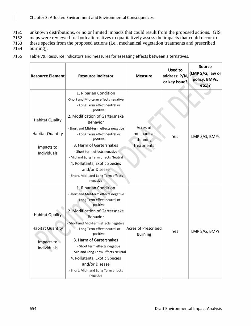
Chapter 3: Affected Environment and Environmental Consequences
654 Draft Environmental Impact Analysis
unknown distributions, or no or limited impacts that could result from the proposed actions. GIS 7151 maps were reviewed for both alternatives to qualitatively assess the impacts that could occur to 7152 these species from the proposed actions (i.e., mechanical vegetation treatments and prescribed 7153 burning). 7154
Table 79. Resource indicators and measures for assessing effects between alternatives. 7155
Resource Element Resource Indicator Measure
Used to
address: P/N,
or key issue?
Source
(LMP S/G; law or
policy, BMPs,
etc.)?
Habitat Quality
Habitat Quantity
Impacts to
Individuals
1. Riparian Condition
-Short and Mid-term effects negative
- Long Term effect neutral or
positive
2. Modification of Gartersnake
Behavior
- Short and Mid-term effects negative
- Long Term effect neutral or
positive
3. Harm of Gartersnakes
- Short term effects negative
- Mid and Long Term Effects Neutral
4. Pollutants, Exotic Species
and/or Disease
- Short, Mid-, and Long Term effects
negative
Acres of
mechanical
thinning
treatments
Yes LMP S/G, BMPs
Habitat Quality
Habitat Quantity
Impacts to
Individuals
1. Riparian Condition
- Short and Mid-term effects negative
- Long Term effect neutral or
positive
2. Modification of Gartersnake
Behavior
- Short and Mid-Term effects negative
- Long Term effect neutral or
positive
3. Harm of Gartersnakes
- Short term effects negative
- Mid and Long Term Effects Neutral
4. Pollutants, Exotic Species
and/or Disease
- Short, Mid-, and Long Term effects
negative
Acres of Prescribed
Burning Yes LMP S/G, BMPs
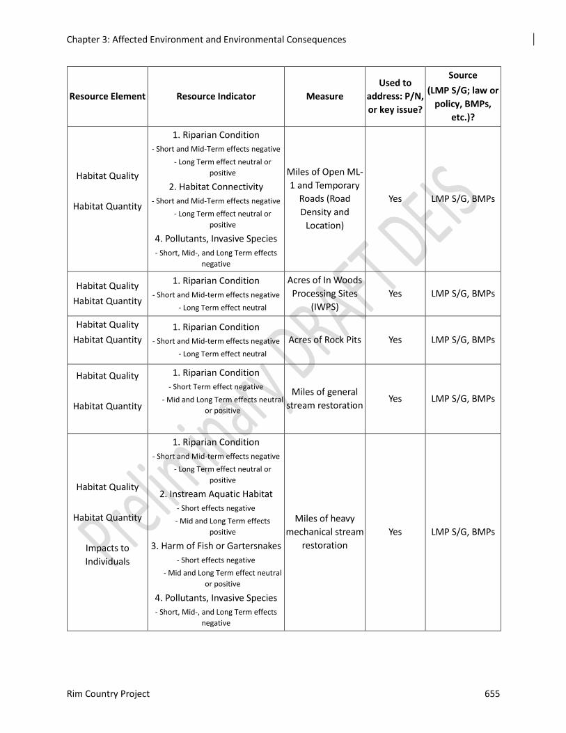
Chapter 3: Affected Environment and Environmental Consequences
Rim Country Project 655
Resource Element Resource Indicator Measure
Used to
address: P/N,
or key issue?
Source
(LMP S/G; law or
policy, BMPs,
etc.)?
Habitat Quality
Habitat Quantity
1. Riparian Condition
- Short and Mid-Term effects negative
- Long Term effect neutral or
positive
2. Habitat Connectivity
- Short and Mid-Term effects negative
- Long Term effect neutral or
positive
4. Pollutants, Invasive Species
- Short, Mid-, and Long Term effects
negative
Miles of Open ML-
1 and Temporary
Roads (Road
Density and
Location)
Yes LMP S/G, BMPs
Habitat Quality
Habitat Quantity
1. Riparian Condition
- Short and Mid-term effects negative
- Long Term effect neutral
Acres of In Woods
Processing Sites
(IWPS)
Yes LMP S/G, BMPs
Habitat Quality
Habitat Quantity
1. Riparian Condition
- Short and Mid-term effects negative
- Long Term effect neutral
Acres of Rock Pits Yes LMP S/G, BMPs
Habitat Quality
Habitat Quantity
1. Riparian Condition
- Short Term effect negative
- Mid and Long Term effects neutral
or positive
Miles of general
stream restoration Yes LMP S/G, BMPs
Habitat Quality
Habitat Quantity
Impacts to
Individuals
1. Riparian Condition
- Short and Mid-term effects negative
- Long Term effect neutral or
positive
2. Instream Aquatic Habitat
- Short effects negative
- Mid and Long Term effects
positive
3. Harm of Fish or Gartersnakes
- Short effects negative
- Mid and Long Term effect neutral
or positive
4. Pollutants, Invasive Species
- Short, Mid-, and Long Term effects
negative
Miles of heavy
mechanical stream
restoration
Yes LMP S/G, BMPs
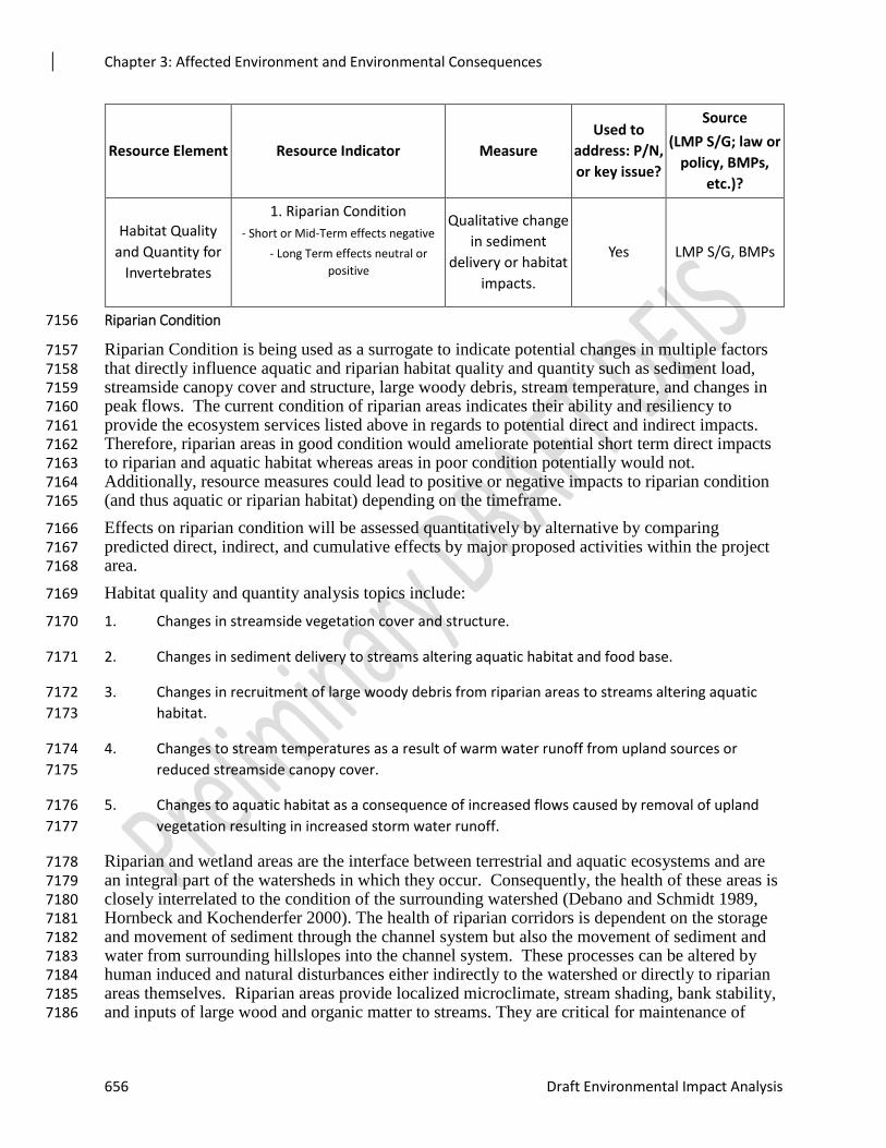
Chapter 3: Affected Environment and Environmental Consequences
656 Draft Environmental Impact Analysis
Resource Element Resource Indicator Measure
Used to
address: P/N,
or key issue?
Source
(LMP S/G; law or
policy, BMPs,
etc.)?
Habitat Quality
and Quantity for
Invertebrates
1. Riparian Condition
- Short or Mid-Term effects negative
- Long Term effects neutral or
positive
Qualitative change
in sediment
delivery or habitat
impacts.
Yes LMP S/G, BMPs
Riparian Condition 7156
Riparian Condition is being used as a surrogate to indicate potential changes in multiple factors 7157 that directly influence aquatic and riparian habitat quality and quantity such as sediment load, 7158 streamside canopy cover and structure, large woody debris, stream temperature, and changes in 7159 peak flows. The current condition of riparian areas indicates their ability and resiliency to 7160 provide the ecosystem services listed above in regards to potential direct and indirect impacts. 7161 Therefore, riparian areas in good condition would ameliorate potential short term direct impacts 7162 to riparian and aquatic habitat whereas areas in poor condition potentially would not. 7163 Additionally, resource measures could lead to positive or negative impacts to riparian condition 7164 (and thus aquatic or riparian habitat) depending on the timeframe. 7165
Effects on riparian condition will be assessed quantitatively by alternative by comparing 7166 predicted direct, indirect, and cumulative effects by major proposed activities within the project 7167 area. 7168
Habitat quality and quantity analysis topics include: 7169
1. Changes in streamside vegetation cover and structure. 7170
2. Changes in sediment delivery to streams altering aquatic habitat and food base. 7171
3. Changes in recruitment of large woody debris from riparian areas to streams altering aquatic 7172
habitat. 7173
4. Changes to stream temperatures as a result of warm water runoff from upland sources or 7174
reduced streamside canopy cover. 7175
5. Changes to aquatic habitat as a consequence of increased flows caused by removal of upland 7176
vegetation resulting in increased storm water runoff. 7177
Riparian and wetland areas are the interface between terrestrial and aquatic ecosystems and are 7178 an integral part of the watersheds in which they occur. Consequently, the health of these areas is 7179 closely interrelated to the condition of the surrounding watershed (Debano and Schmidt 1989, 7180 Hornbeck and Kochenderfer 2000). The health of riparian corridors is dependent on the storage 7181 and movement of sediment through the channel system but also the movement of sediment and 7182 water from surrounding hillslopes into the channel system. These processes can be altered by 7183 human induced and natural disturbances either indirectly to the watershed or directly to riparian 7184 areas themselves. Riparian areas provide localized microclimate, stream shading, bank stability, 7185 and inputs of large wood and organic matter to streams. They are critical for maintenance of 7186
Chapter 3: Affected Environment and Environmental Consequences
Rim Country Project 657
water quality and quantity, contribute to sediment retention and stream bank building and 7187 maintenance, and influence in-channel geomorphic processes. 7188
Streamside canopy cover and structure are important to riparian and aquatic habitat by providing 7189 riparian habitat for gartersnakes, stream shading, bank stability, and nutrients in the form of 7190 organic matter. Removal of trees and shrubs can reduce vegetation structure, canopy cover and 7191 stream shading. This can potentially lead to increased stream temperatures, reduced bank 7192 stability, and reduced organic matter (allochthonous material) reaching the stream. It can also 7193 lead to reduce habitat quality and quantity for riparian obligate species that are dependent upon 7194 streamside canopy and structure as part of their life history. 7195
While streams can process normal sediment levels, elevated levels can cause negative impacts. 7196 Most streams carry or move sediment and the amount varies seasonally. Sediment transport 7197 involves detachment and entrainment of particles, their transport, and their deposition. When 7198 additional fine sediments are transported, they can accumulate in relatively clean or porous 7199 substrate such as gravels and habitats such as pools. Increased levels of sedimentation can have 7200 adverse effects on aquatic species, habitats, and riparian ecosystems. Fine sediment deposited in 7201 spawning gravels can reduce egg survival (Hicks et al., 1991) by reducing the availability of 7202 dissolved oxygen in the gravel. Primary production, benthic macroinvertebrate abundance, and 7203 thus food availability for fish and gartersnakes (prey) may be reduced as sediment levels 7204 increase. Large wood in streams is an important roughness element influencing channel 7205 morphology, sediment distribution, and water routing. Common sources of large wood include 7206 falling of dead trees, wind-throw and breakage, and landslides. Large wood influences channel 7207 gradient by creating step pools and dissipating energy, lengthens streams by increasing sinuosity, 7208 and serves as an important agent in pool formation. In low order streams, in particular, large 7209 wood collects sediment and larger substrates during high flows events and can account for a 7210 large proportion of sediment/substrate storage sites. It is also instrumental in nutrient retention. 7211
Stream temperatures can affect the survival and production of fish throughout all life stages. 7212 Warm water temperatures can reduce survival of eggs as well as hatching success. For juveniles, 7213 growth can decline above certain temperatures, which differs by species, and is accompanied by 7214 decreased feeding, increased stress, and increased warm water diseases or parasites. Finally, at a 7215 certain point, temperatures become lethal for all fish. 7216
Alteration of flows can have major physical effects on aquatic ecosystems. Increases in peak 7217 flows or frequency can increase bed scour or accelerate bank erosion negatively impacting 7218 aquatic habitat. Small streams are the more easily altered as they are intimately associated with 7219 their riparian zones and are highly responsive to alterations in riparian vegetation and the 7220 surrounding watershed. These streams carry water, sediment, nutrients, and large wood from 7221 upper portions of the watershed which influence the quality of aquatic habitat downstream. 7222
Potential effects of Mechanical Vegetation Management 7223
Chamberlin et al. (1991) reviewed literature on timber harvest, silviculture and watershed 7224 processes, which are relative to potential impacts to riparian condition. Mechanical vegetation 7225 treatments can increase erosion, sedimentation, and alter peak streamflows via removal of 7226 vegetation and ground disturbance. Forest harvest activities can influence both upland erosional 7227 processes and the way that streams process sediment in their channels. The potential for surface 7228 erosion is related to the amount of bare compacted soil exposed to rainfall and runoff. If soil 7229 infiltration is sufficiently reduced, water runs off rather than through soil resulting in higher 7230 peaks flows and increased sediment transport. Therefore, features such as landings and skid 7231 trails can contribute large quantities of fine sediment and runoff to stream channels. Patterns of 7232
Chapter 3: Affected Environment and Environmental Consequences
658 Draft Environmental Impact Analysis
yarding and skidding can alter drainage paths and redirect water onto areas more likely to erode 7233 than natural channels. In addition to influencing soil structure, mechanical harvest can influence 7234 snow accumulation and melt rates as well as evapotranspiration and soil water which can also 7235 alter peak flows. 7236
Potential effects of Prescribed Fire on Riparian Condition 7237
Response of riparian condition and aquatic ecosystems to fire can be highly variable and 7238 dependant on fire attributes (e.g. severity, intensity, fire size), magnitude of subsequent storms 7239 and snowmelt events, amount of the watershed burned, stream size, and topography (Kerschner 7240 2004; Gresswell 1999). Indirect fire impacts can consist of altered peak flows and hydrologic 7241 processes (Minshall and Brock 1991), hillslope erosion and stream sedimentation (Swanson 7242 1981; Megahan 1991; Rinne 1996) (Bisson et al. 2003), disrupted nutrient cycling (Swanson 7243 1981; Megahan 1991; Bozek and Young 1994), loss of streambank vegetation leading to 7244 increased stream temperatures (Minshall and Brock 1991), decreased large woody debris, and 7245 fragmented aquatic habitat dynamics (Minshall and Brock 1991; Rieman and Clayton 1997; 7246 Swanson 1981; Megahan 1991; Bozek and Young 1994). Adverse changes in these attributes 7247 can negatively impact riparian condition, as well as aquatic habitat quality and quantity. 7248
Fire related erosion and sedimentation can occur chronically (fine sediment delivery over long 7249 periods) or episodically (post-fire ash or sediment pulses, landslides and debris flows). Levels 7250 above what a riparian areas and stream can process, based on condition, can lead to negative 7251 effects to aquatic habitat quality and quantity. Large increases in sediment can lower pool 7252 density, reduce intragravel dissolved oxygen and circulation leading to loss of fish eggs, cover 7253 food sources for benthic macroinvertebrates, and reduce the efficiency of filter feeding 7254 macroinvertebrates. 7255
Treatments in riparian areas change the vegetative structure, canopy cover, and reduce fuel 7256 continuity. This can potentially lead to increased stream temperatures, reduced bank stability, 7257 and reduced organic matter (allochthonous material) reaching the stream (Dwire et al. 2016). 7258 Reduced fuel continuity provides for resiliency of riparian areas during wildfires by potentially 7259 reducing fire intensity and severity. In general, effects of spring or fall prescribed burning on 7260 both upland and riparian species composition appear to be either negligible or similar in effects 7261 of low-severity wildfire and are generally neutral or beneficial (Dwire et al. 2016). There are 7262 indications that the effects of prescribed fires are much smaller and shorter-lived to the effects of 7263 wildfire. 7264
Fire also plays an important role in maintaining heterogeneity (riparian condition) in both 7265 terrestrial and aquatic habitats (Gresswell 1999). Periodic variations in the influx of sediment 7266 and coarse woody debris from riparian areas to the active stream channel contribute to aquatic 7267 habitat heterogeneity by creating complex stream morphology and can be reflected in a diverse 7268 fish community (Reeves et al. 1995; Rieman and Clayton 1997; Gresswell 1999; Rieman et al. 7269 2003; Robinson et al. 2005). 7270
Fire regimes in riparian areas relative to adjacent uplands vary. In drier areas, similar to the 7271 project area, historical fire frequencies in uplands and riparian areas are often comparable (Dwire 7272 et al. 2016). Dry ponderosa pine/Douglas-fir forest of central Idaho had similar fire return 7273 intervals for upland and riparian stands. Where the vegetation composition of riparian areas is 7274 similar to adjacent uplands, streamside areas are likely to burn as frequently as the surrounding 7275 uplands. Therefore, the suppression of fires for decades has likely altered riparian areas and 7276 made them more susceptible to uncharacteristic wildfire similar to uplands. 7277
Chapter 3: Affected Environment and Environmental Consequences
Rim Country Project 659
Potential effects of Roads on Riparian Condition 7278
Water runoff and sediment yield are key physical processes whereby roads have an impact on 7279 streams and other aquatic systems, and the distance of these effects can vary widely. Roads on 7280 upper hillslopes concentrate water flow, which can form channels higher on slopes. This process 7281 leads to smaller, more elongated first-order drainages and longer total length of the channel 7282 network. Water rapidly runs off relatively impervious road surfaces, especially in storm and 7283 snowmelt events, increasing runoff. Increased runoff associated with roads may increase the 7284 rates and extent of erosion, reduce percolation and aquifer recharge rates, alter channel 7285 morphology, and increase peak flows. Increased peak flows can degrade aquatic ecosystems by 7286 altering riparian conditions, channel morphology, or aquatic habitat. Surface erosion from forest 7287 roads affects the fine sediment budget and may impose a chronic condition of sediment inputs to 7288 streams affecting the stream substrate and the health of aquatic life (Luce et al. 2001). Chronic 7289 erosion from roads can greatly reduce an aquatic systems integrity, and in some cases can be the 7290 primary source of sediment input (Switalski et al. 2004). Sediment concerns are generally 7291 highest when roads are not sufficiently drained; with sufficient drainage, water and sediment 7292 from upland segments of roads can be diverted, filtered through forest vegetation, and not routed 7293 to streams. As such, upland segments of roads can generally be designed to mitigate sediment 7294 delivery concerns. 7295
Road density in a watershed affects the collection and transport of water out of the watershed 7296 (Burroughs and King 1989). The potential for increases in runoff rates increases with more 7297 miles of road. Road closures would be beneficial to water quality if the roads were properly 7298 decommissioned and well maintained after closure. A well-maintained, closed road system 7299 would result in less sediment from road surface erosion. Roads not proposed for use in the 7300 project area may have long-term adverse effects on water quality if they are not properly 7301 maintained. For this analysis, it is assumed that when a road is closed it will continue to have 7302 impacts on the aquatic system, and both of the action alternatives involve the closure of ML 1 7303 roads and temp roads to use by the public rather than the physical removal of roads. 7304
The primary concern is erosion and sediment delivery from roads that are near streams and that 7305 cross streams. Fine sediment is a key physical element to focus on when attempting to delineate 7306 land management impacts on aquatic habitat and biota (Rinne 1990). Excessive fine sediment 7307 input into a stream can fill pool habitat and reduce both summer and winter rearing habitat for 7308 juvenile fish (Heede and Rinne 1990). Stream crossings reduce riparian vegetation and widening 7309 of the channel which can also impact water temperature (Poole and Berman 2001, Beschta 1997, 7310 and Heede 1980). Not all species and ecosystems are equally affected by roads, but overall the 7311 presence of roads is highly correlated with changes in species composition, population sizes, and 7312 hydrologic and geomorphic processes that shape aquatic and riparian systems (Trombulak and 7313 Frissell 2000). 7314
Impacts to individuals 7315
Impacts to individuals are considered direct impacts and can include mortality and modification 7316 of behavior. Mortality would only occur from actions within species habitats. Modification of 7317 behavior can include factors such as disruption of social and feeding behavior that could reduce 7318 potential breeding or the health of individuals. It also includes displacement from an area 7319 temporarily which can also impact breeding or health. Therefore, increased acres or miles of 7320 treatments within the direct effects analysis area equates to an increase in potential impacts to 7321 individuals. 7322
Chapter 3: Affected Environment and Environmental Consequences
660 Draft Environmental Impact Analysis
Habitat Connectivity 7323
This was selected as a resource indicator specifically for roads as they can fragment aquatic or 7324 riparian habitat and impede or reduce movement. Therefore, increased miles of open roads 7325 equates to decreased habitat connectivity. 7326
Road density has been considered a useful index of several ecological effects of roads in a 7327 landscape. Effects are evident for faunal movement, population fragmentation, human access, 7328 hydrology, aquatic ecosystems, and fire patterns. Hydrologic effects, such as altered 7329 groundwater conditions and altered drainage upslope, are sensitive to road densities. Increased 7330 peak flows in streams and macroinvertebrate diversity may be impacted with increasing road 7331 densities. Road density is an overall index that averages patterns over an area; its effects 7332 probably are sensitive to road type and width, traffic density, and network connectivity. 7333
Pollutants and Invasive Species 7334
This was selected as resource indicator for habitat quality to address the potential for 7335 introduction into aquatic habitats. Pollutants and disease introduced into aquatic habitats reduces 7336 habitat quality. Use of mechanical equipment and storage of fuels in or around streams or other 7337 water bodies can also introduce contaminants. Equipment that is not cleaned or leaking can bring 7338 oils or fuel directly into water. 7339
Most chemical transport from roads occurs in storm water runoff through or over soil 7340 (Trombulak and Frissell 2000). Runoff pollutants alter soil chemistry, may be absorbed by 7341 plants, can affect stream ecosystems, where they are dispersed and diluted over considerable 7342 distances. Typical water-quality responses to road runoff include altered levels of heavy metals, 7343 salinity, turbidity, and dissolved oxygen. These water quality changes can be sporadic and 7344 localized due to fluctuations in water quantity. 7345
Similarly, roads promote the dispersal of exotic or invasive species by altering habitats, stressing 7346 native species, and providing movement corridors that further spread these species. Mechanical 7347 equipment can carry exotic species or aquatic invasive species from one water body to another. 7348 This can spread species such as Didymo (Didymosphenia geminata) and Eurasian milfoil which 7349 can reduce aquatic habitat quality. 7350
Environmental Consequences 7351
Alternative 1 – No Action 7352
There would be no direct effects on resource indicators for aquatic species and habitats as a 7353 result of the no action alternative, however there would be indirect effects by not moving these 7354 resources towards desired conditions. Existing conditions for watersheds would remained 7355 degraded and associated loss of habitat would continue which could potentially lead to 7356 reductions in populations over time. 7357
Under the No Action Alternative, current conditions within subwatersheds could potentially 7358 degrade over time. Overstocked and dense stands within the project area would not be treated, 7359 leaving a less healthy, less vigorous, and under productive forest. Encroachment of conifers into 7360 riparian areas and wetlands would continue which could decrease shrub and herbaceous ground 7361 cover as well as soil hydrologic function (Brown 2018). Decreased ground cover and soil 7362 function can lead to increased overland flow, erosion, and sedimentation reducing riparian 7363 condition and aquatic habitats. Therefore, there is a potential loss of water available for stream 7364 flow during dry summer months due to unusually high amounts of water that are lost to overland 7365 flow and/or evapotranspiration due to high canopy densities. If current conditions degrade in 7366
Chapter 3: Affected Environment and Environmental Consequences
Rim Country Project 661
reference to uplands, then associated riparian condition and aquatic habitat could also degrade, 7367 not meeting the need of protection and improvement of aquatic and riparian dependent species 7368 habitat. Furthermore, by perpetuating unusually high stand densities the probability for 7369 catastrophic fire increases. Uncharacteristic wildfire has the potential to greatly reduce riparian 7370 condition and aquatic resources by leaving no shade adjacent to streams (increased stream 7371 temperatures), denuding subwatersheds of vegetation thereby leaving exposed soils (increased 7372 sediment in streams) and resulting in ash flows. 7373
This alternative would result in no additional acres of ground disturbance or associated actions to 7374 riparian condition, habitat connectivity, aquatic habitat, individuals, or increase 7375 pollutants/introduced species. Sediment delivery to riparian areas, streams and wetlands would 7376 continue at current rates or gradually increase from poor upland conditions. Peak flows may also 7377 continue to be altered by reduced soil moisture storage and infiltration capacity producing high 7378 peak flows of short duration during high intensity summer precipitation events. Such peak flows 7379 can overwhelm riparian areas and streams altering associated riparian and aquatic habitat. 7380
Under the no action alternative, roads would not be decommissioned and the drainage network of 7381 a streams remains unnaturally higher. Roads can directly affect the channel morphology of 7382 streams by accelerating erosions and sediment delivery and by increasing the magnitude of peak 7383 flow. Indirectly, if current conditions degrade then habitat for aquatic species will also degrade. 7384 The more roads and stream crossings there are, the higher the probability of sediment delivery to 7385 streams, negatively affecting the hydrologic function. In addition, roads affect the hydrograph 7386 and drainage density, increasing peak flows and decreasing low flows. This alternative does not 7387 meet the need for improvement of aquatic habitat. 7388
The level of risk associated with riparian and watershed conditions as well as species and 7389 habitats would be higher with this alternative since the amount and intensity of aquatic 7390 restoration would be much less. Furthermore, federally listed native fish would also be at a 7391 higher risk of extirpation under current conditions (climate change, low viability, degraded 7392 baseline conditions) as it is assumed that minimal aquatic restoration would occur via other 7393 projects with the No Action Alternative. 7394
Since no treatments of any kind would be implemented, there would be no direct effects to 7395 aquatic resource indicators except for existing Forest Service Roads at road/stream crossings. 7396 (table 3-33). However, the potential for substantial indirect effects would exist through failure to 7397 reduce current fuel loading conditions that could result in uncharacteristic stand replacing 7398 wildfire. This could result in the reduction of riparian condition through loss of canopy cover 7399 and structure, increased sedimentation and ash, increased peak flows, and reduction or loss of 7400 large wood recruitment. These potential changes in riparian conditions would also result in 7401 decreases in food resources, habitat quality, and quantity. Uncharacteristic wildfire in within 7402 riparian areas and streams could harm or reduce species populations either directly or indirectly 7403 through alteration of habitat. 7404
Under this alternative, conditions in existing or potential habitat that provide for aquatic species 7405 would remain in their current condition, notwithstanding natural processes. No restoration of 7406 streams, floodplains, wetlands, or riparian areas would occur. Conifer encroachment would 7407 continue into wet and dry montane meadows. Riparian vegetation would reflect conditions that 7408 are suited towards a dryer climate such as grasses. Grass species have less root mass than 7409 riparian species and therefore do not have the ability to stabilize the incised streambanks. 7410 Current riparian and watershed conditions of Functioning at Risk or Impaired would continue to 7411 limit the quality of aquatic habitat and therefore species occupancy. Consequently, Alternative 1 7412 would not be beneficial for riparian condition, aquatic habitat quality or quantity. 7413
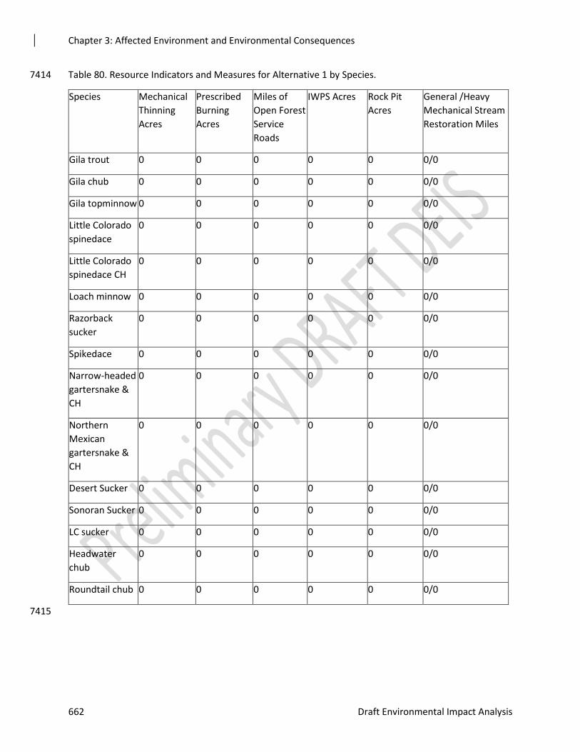
Chapter 3: Affected Environment and Environmental Consequences
662 Draft Environmental Impact Analysis
Table 80. Resource Indicators and Measures for Alternative 1 by Species. 7414
Species Mechanical
Thinning
Acres
Prescribed
Burning
Acres
Miles of
Open Forest
Service
Roads
IWPS Acres Rock Pit
Acres
General /Heavy
Mechanical Stream
Restoration Miles
Gila trout 0 0 0 0 0 0/0
Gila chub 0 0 0 0 0 0/0
Gila topminnow 0 0 0 0 0 0/0
Little Colorado
spinedace
0 0 0 0 0 0/0
Little Colorado
spinedace CH
0 0 0 0 0 0/0
Loach minnow 0 0 0 0 0 0/0
Razorback
sucker
0 0 0 0 0 0/0
Spikedace 0 0 0 0 0 0/0
Narrow-headed
gartersnake &
CH
0 0 0 0 0 0/0
Northern
Mexican
gartersnake &
CH
0 0 0 0 0 0/0
Desert Sucker 0 0 0 0 0 0/0
Sonoran Sucker 0 0 0 0 0 0/0
LC sucker 0 0 0 0 0 0/0
Headwater
chub
0 0 0 0 0 0/0
Roundtail chub 0 0 0 0 0 0/0
7415
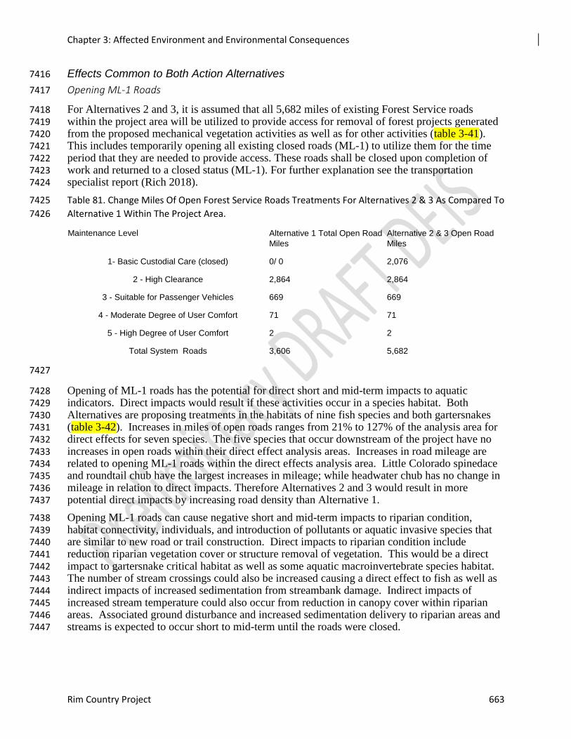
Chapter 3: Affected Environment and Environmental Consequences
Rim Country Project 663
Effects Common to Both Action Alternatives 7416
Opening ML-1 Roads 7417
For Alternatives 2 and 3, it is assumed that all 5,682 miles of existing Forest Service roads 7418 within the project area will be utilized to provide access for removal of forest projects generated 7419 from the proposed mechanical vegetation activities as well as for other activities (table 3-41). 7420 This includes temporarily opening all existing closed roads (ML-1) to utilize them for the time 7421 period that they are needed to provide access. These roads shall be closed upon completion of 7422 work and returned to a closed status (ML-1). For further explanation see the transportation 7423 specialist report (Rich 2018). 7424
Table 81. Change Miles Of Open Forest Service Roads Treatments For Alternatives 2 & 3 As Compared To 7425
Alternative 1 Within The Project Area. 7426
Maintenance Level Alternative 1 Total Open Road
Miles
Alternative 2 & 3 Open Road
Miles
1- Basic Custodial Care (closed) 0/ 0 2,076
2 - High Clearance 2,864 2,864
3 - Suitable for Passenger Vehicles 669 669
4 - Moderate Degree of User Comfort 71 71
5 - High Degree of User Comfort 2 2
Total System Roads 3,606 5,682
7427
Opening of ML-1 roads has the potential for direct short and mid-term impacts to aquatic 7428 indicators. Direct impacts would result if these activities occur in a species habitat. Both 7429 Alternatives are proposing treatments in the habitats of nine fish species and both gartersnakes 7430 (table 3-42). Increases in miles of open roads ranges from 21% to 127% of the analysis area for 7431 direct effects for seven species. The five species that occur downstream of the project have no 7432 increases in open roads within their direct effect analysis areas. Increases in road mileage are 7433 related to opening ML-1 roads within the direct effects analysis area. Little Colorado spinedace 7434 and roundtail chub have the largest increases in mileage; while headwater chub has no change in 7435 mileage in relation to direct impacts. Therefore Alternatives 2 and 3 would result in more 7436 potential direct impacts by increasing road density than Alternative 1. 7437
Opening ML-1 roads can cause negative short and mid-term impacts to riparian condition, 7438 habitat connectivity, individuals, and introduction of pollutants or aquatic invasive species that 7439 are similar to new road or trail construction. Direct impacts to riparian condition include 7440 reduction riparian vegetation cover or structure removal of vegetation. This would be a direct 7441 impact to gartersnake critical habitat as well as some aquatic macroinvertebrate species habitat. 7442 The number of stream crossings could also be increased causing a direct effect to fish as well as 7443 indirect impacts of increased sedimentation from streambank damage. Indirect impacts of 7444 increased stream temperature could also occur from reduction in canopy cover within riparian 7445 areas. Associated ground disturbance and increased sedimentation delivery to riparian areas and 7446 streams is expected to occur short to mid-term until the roads were closed. 7447
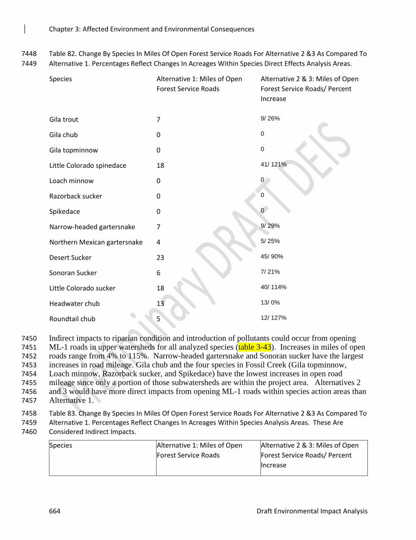
Chapter 3: Affected Environment and Environmental Consequences
664 Draft Environmental Impact Analysis
Table 82. Change By Species In Miles Of Open Forest Service Roads For Alternative 2 &3 As Compared To 7448
Alternative 1. Percentages Reflect Changes In Acreages Within Species Direct Effects Analysis Areas. 7449
Species Alternative 1: Miles of Open
Forest Service Roads
Alternative 2 & 3: Miles of Open
Forest Service Roads/ Percent
Increase
Gila trout 7 9/ 26%
Gila chub 0 0
Gila topminnow 0 0
Little Colorado spinedace 18 41/ 121%
Loach minnow 0 0
Razorback sucker 0 0
Spikedace 0 0
Narrow-headed gartersnake 7 9/ 29%
Northern Mexican gartersnake 4 5/ 25%
Desert Sucker 23 45/ 90%
Sonoran Sucker 6 7/ 21%
Little Colorado sucker 18 40/ 114%
Headwater chub 13 13/ 0%
Roundtail chub 5 12/ 127%
Indirect impacts to riparian condition and introduction of pollutants could occur from opening 7450 ML-1 roads in upper watersheds for all analyzed species (table 3-43). Increases in miles of open 7451 roads range from 4% to 115%. Narrow-headed gartersnake and Sonoran sucker have the largest 7452 increases in road mileage. Gila chub and the four species in Fossil Creek (Gila topminnow, 7453 Loach minnow, Razorback sucker, and Spikedace) have the lowest increases in open road 7454 mileage since only a portion of those subwatersheds are within the project area. Alternatives 2 7455 and 3 would have more direct impacts from opening ML-1 roads within species action areas than 7456 Alternative 1. 7457
Table 83. Change By Species In Miles Of Open Forest Service Roads For Alternative 2 &3 As Compared To 7458 Alternative 1. Percentages Reflect Changes In Acreages Within Species Analysis Areas. These Are 7459 Considered Indirect Impacts. 7460
Species Alternative 1: Miles of Open
Forest Service Roads
Alternative 2 & 3: Miles of Open
Forest Service Roads/ Percent
Increase
Chapter 3: Affected Environment and Environmental Consequences
Rim Country Project 665
Gila trout 232 324/ 40%
Gila chub* 61 63/ 4%
Gila topminnow* 63 70/ 11%
Little Colorado spinedace 917 1768/ 93%
Loach minnow* 63 70/ 11%
Razorback sucker* 63 70/ 11%
Spikedace* 63 70/ 11%
Narrow-headed gartersnake 170 372/ 119%
Northern Mexican gartersnake 86 142/ 65%
Desert Sucker 1034 1439/ 39%
Sonoran Sucker 112 240/ 115%
Little Colorado sucker 796 1412/ 77%
Headwater chub 354 438/ 24%
Roundtail chub 475 907/ 91%
*While the percentage is high for these species action areas, less than half of entire watershed is within 7461
the project area. 7462
Indirect impacts of opening ML-1 roads in the upper watershed could occur to riparian condition 7463 and by introduction of pollutants or invasive aquatic species. In general, roads compact soils and 7464 reduce infiltration of water leading to increased erosion and runoff. They increase the drainage 7465 network to riparian areas and streams and connect these areas to the uplands by altering surface 7466 water pathways. This converts dispersed surface runoff and sediment filtering through a riparian 7467 area to direct deliveries of accumulated runoff and sediment. Pollutants and aquatic invasive 7468 species can be transferred to aquatic systems from machinery or vehicles. Leaking fuels or 7469 lubricants can be transferred to aquatic systems from vehicles, machinery, or fuel storage areas. 7470 Aquatic invasive species can similarly be transferred from an infected water body to an 7471 uninfected waterbody through driving. 7472
Roads not only impact perennial and intermittent streams where aquatic species and riparian 7473 areas are present, but influence these habitats where they are located adjacent to or cross 7474 ephemeral channels in the watershed. Ephemeral streams indirectly support aquatic populations 7475 by providing required nutrients and other materials to the perennial streams (Levick et al. 2008). 7476
Potential indirect effects are expected to vary based on current riparian condition. Species with 7477 riparian conditions that are currently impaired are expected to have a higher level of indirect 7478 effects from sedimentation and peak flows. They are currently not capturing or processing 7479 sediment, indicating more could potentially reach stream from direct delivery. Stream energy 7480 from increased peak flows and concentrated flows would not be dissipated potentially altering 7481 instream habitats. Riparian areas that are functioning at risk or functioning properly would be 7482 capable of processing some levels of sediment and peak flows; however, the concentrated 7483
Chapter 3: Affected Environment and Environmental Consequences
666 Draft Environmental Impact Analysis
delivery from roads would still have negative impacts over the mid-term timeframe until they 7484 were closed. 7485
Opening ML-1 roads will also increase road density during the timeframe that proposed project 7486 activities are occurring. This will negatively impact the Roads and Trails indicator for 7487 Watershed Condition Framework in the interim impacting one of the five factors associated with 7488 aquatic species and habitats. 7489
Design features for roads are expected to reduce some of the potential impacts to aquatic species 7490 and habitats. Minimizing disturbance of existing vegetation in ditches and at stream crossings 7491 during maintenance. New cross drains will discharge to stable areas where the outflow will 7492 quickly infiltrate the soil and not develop a channel to a stream. Whenever possible, use existing 7493 stream crossings unless a new crossing would result in less resource damage. 7494
In Woods Processing Sites (IWPS) and Biomass Storage 7495
Twelve processing sites ranging in size from 2 to 21 acres are being proposed on the Coconino 7496 and Tonto NFs and analyzed for environmental effects for both Alternative 2 and 3 of Rim 7497 Country (table 3-44). Processing site location and siting considerations include: flat uplands less 7498 than 5% slope; more than 200 feet from perennial, intermittent, and ephemeral stream channels/ 7499 more than 300 feet from meadows, springs, and karst features; more than ¼ mile from Mexican 7500 spotted owl Protected Activity Centers, and outside of Northern goshawk Protected Family 7501 Areas; more than ¼ mile from system hiking trails, campgrounds, and group event recreation 7502 sites; more than ¼ mile from private lands, residences, or offices; and adjacent to roads that are 7503 open year-round for product removal. Processing sites were located to provide a buffer of 100 to 7504 300 feet from forest roads and state highways to provide for visual screening from Concern 7505 Level 1 and 2 travelways. Site boundaries are approximate and may be further modified during 7506 implementation and layout. 7507
The processing of wood at up to twelve different sites within or immediately adjacent to the 7508 project area may involve such tasks as drying and debarking of logs; chipping stems, bark, and 7509 limbs; cutting logs; sorting logs; producing wood cants (logs sawn flat on one to four sides); 7510 scaling and weighing logs; and creating poles from suitable sized logs. Equipment that may be 7511 used at processing sites includes circular or band saws, various sizes and types of front-end 7512 loaders, log loaders, chippers of several types, mechanized cut to length systems, associated 7513 conveyers and log sorting bunks for accumulation and storage of logs, as well as electric motors 7514 and gas or diesel generators to provide power. Aboveground fuel storage tanks may be necessary 7515 to provide on-site fuel to equipment. 7516
The twelve wood processing sites that have been proposed range in size from 4 to 21 acres. 7517 These sites were screened so as to be located outside of meadows where some of the most 7518 productive forest soils are found, and in relatively flat areas. The siting of processing sites in 7519 relatively flat areas would minimize the need for extensive site grading. 7520
In order to facilitate the types of tasks and equipment that may be used at these sites, they would 7521 typically have to be cleared and grubbed (i.e., vegetative cover and trees removed) resulting in 7522 displacement of top soil and exposure of subsoil. The operation of equipment on these sites 7523 would result in compaction of the soil, reducing the ability of soils to infiltrate water. Areas of 7524 exposed soil would have to be covered with aggregate to minimize erosion and facilitate use of 7525 the site. The aggregate surfacing would cover the surface soil where it is not graded, and would 7526 protect the soil productivity. Various permits would need to be obtained for fuel storage, 7527 industrial site use and stormwater pollution prevention. 7528
Chapter 3: Affected Environment and Environmental Consequences
Rim Country Project 667
Following completion of use of processing sites and removal of all equipment and materials, site 7529 rehabilitation would have to be accomplished including but not necessarily limited to removal of 7530 aggregate, restoration of pre-disturbance site grades, decompaction of soil for seedbed 7531 preparation, and seeding and mulching of the site with native grasses and forbs. 7532
Table 84. In woods processing sites and associated acreages 7533
Site Name Acres
FR 117, 1321 4
FR 137, 96 18
FR 145A, 9615X 7
FR 288, 2781 4
FR 294, 294D 18
3238, 512 20
FR 582, Hwy 87 5
FR 609, 1938 7
FR 74, 64 8
FR 81, 81E 7
9364L, FH 3 21
9731G, Hwy 87 9
Total (13) 142
7534
No direct effects to any aquatic indicators are expected to occur from IWPS (table 3-45). None 7535 of the proposed IWPS occur within 0.4 mile of occupied or suitable habitat. In addition, they 7536 occur within conifer ERUs (Ponderosa Pine, Ponderosa Pine-Evergreen Oak, Mixed Conifer w/ 7537 Aspen, and Mixed Conifer) and not within any riparian areas. 7538
Table 85. Change By Species In The Acres Of In Woods Processing Sites For Alternatives 2 & 3 As 7539
Compared To Alternative1. Percentages Reflect Changes In Acreages Within Species Direct Effects 7540
Analysis Areas. 7541
Species Alternative 1: Acres of In Woods
Processing
Alternatives 2 &3: Acre of In
Woods Processing/ Percentage of
Direct Effects Area
Gila trout 0 0/ 0%
Chapter 3: Affected Environment and Environmental Consequences
668 Draft Environmental Impact Analysis
Gila chub 0 0/ 0%
Gila topminnow 0 0/ 0%
Little Colorado spinedace 0 0/ 0%
Loach minnow 0 0/ 0%
Razorback sucker 0 0/ 0%
Spikedace 0 0/ 0%
Narrow-headed gartersnake 0 0/ 0%
Northern Mexican gartersnake 0 0/ 0%
Desert Sucker 0 0/ 0%
Sonoran Sucker 0 0/ 0%
Little Colorado sucker 0 0/ 0%
Headwater chub 0 0/ 0%
Roundtail chub 0 0/ 0%
7542
Indirect impacts from IWPS have the potential to occur to seven of the species based on their 7543 action areas. Two species (Gila trout and Sonoran Sucker) would have no indirect impacts. 7544 Acreages of IWPS range from 3.1 to 57.4 acres for both gartersnakes and desert sucker, 7545 respectively (table 3-46). Negative indirect impacts to riparian condition in the form of 7546 sedimentation are possible, but limited based on less than 0.5% of any species action area being 7547 impacted. In Woods Processing Sites would also have limited negative impacts to aquatic 7548 macroinvertebrates based on the very low percentage of IWPS acreage in any of the 7549 subwatersheds. For California floater, only two watersheds have the potential for any indirect 7550 impacts, with a total of approximately 72 acres of IWPS within those watersheds. The other 7551 aquatic macroinvertebrates share similar stream and riparian habitats with fish and gartersnakes; 7552 therefore, overall acreages of IWPS are still below 1% combined. 7553
The Apache-Sitgreaves NFs do not have any of the identified IWPS listed above; instead they 7554 will allow biomass (needles, tree tops and branches up to 5 inches) waiting to be processed to 7555 remain on forest during mechanical operations for up to 90 days. The timeframe allowed may be 7556 shortened based on conditions such as fire risk preparedness levels. 7557
Allowing biomass to stay on the Apache-Sitgreaves Forest should not directly impact aquatic 7558 species or habitats, but could have indirect impacts. Piling of any kind is not allowed within 7559 Aquatic Management Zones; therefore this action should not have any direct effects. Indirect 7560 effects could include soil disturbance from machinery moving material to and from the piles as 7561 well as hauling. Soil disturbance can lead to erosion and contribute fine sediment to streams 7562 negatively impacting aquatic habitat, species, and water quality; particularly eggs and early life 7563 stages that occur on or within substrate and aquatic macroinvertebrate community structure. 7564 Habitat can be negatively impacted by filling of pools and spawning substrates which can lead to 7565
Chapter 3: Affected Environment and Environmental Consequences
Rim Country Project 669
loss of habitat quality and reduced reproductive success. Excessive fine sediment can impact 7566 macroinvertebrate prey bases and other food sources such as algae. 7567
Similarly, leaving biomass should not directly impact sensitive invertebrates, but could have 7568 direct impacts. For aquatic invertebrate species, increased fine sedimentation can lead to 7569 physical effects as well as changes in habitat and food availability and quantity. Physical effects 7570 include abrasion, clogging of gills and filter-feeding apparatus, burial, and changes in substrate 7571 composition (Jones et al. 2012). Bivalve mollusks, such as California floater, are capable of 7572 expelling unwanted particles from their gulls but can also expend more energy doing so than is 7573 gain from feeding. Filter feeding caddisfly larvae are generally not present in streams receiving 7574 high inputs of fine sediment. Burial presents difficulties for sedentary animals, such as mollusks, 7575 but can affect motile invertebrates where rates of deposition are high. When inputs of fine 7576 sediment are increased in watersheds, interstices between large particles become filled which 7577 reduces refugia from predators or high-flow events. Most aquatic invertebrates are strongly 7578 associated with substrate composition; therefore increased fine sediment can alter habitat 7579 availability. Increased sedimentation can also decrease the nutritional quality of periphyton (the 7580 film of attaches algae, fungi, bacteria, organic matter, and sedimented material found on the 7581 surface of stones). Some caddisflies, stoneflies, and mayflies are particularly impacted by 7582 sedimentation (Harrison et al. 2007). 7583
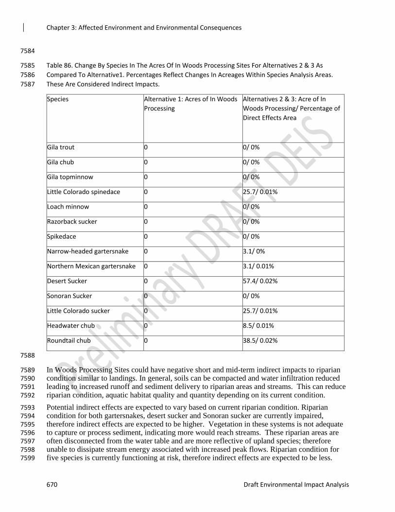
Chapter 3: Affected Environment and Environmental Consequences
670 Draft Environmental Impact Analysis
7584
Table 86. Change By Species In The Acres Of In Woods Processing Sites For Alternatives 2 & 3 As 7585
Compared To Alternative1. Percentages Reflect Changes In Acreages Within Species Analysis Areas. 7586
These Are Considered Indirect Impacts. 7587
Species Alternative 1: Acres of In Woods
Processing
Alternatives 2 & 3: Acre of In
Woods Processing/ Percentage of
Direct Effects Area
Gila trout 0 0/ 0%
Gila chub 0 0/ 0%
Gila topminnow 0 0/ 0%
Little Colorado spinedace 0 25.7/ 0.01%
Loach minnow 0 0/ 0%
Razorback sucker 0 0/ 0%
Spikedace 0 0/ 0%
Narrow-headed gartersnake 0 3.1/ 0%
Northern Mexican gartersnake 0 3.1/ 0.01%
Desert Sucker 0 57.4/ 0.02%
Sonoran Sucker 0 0/ 0%
Little Colorado sucker 0 25.7/ 0.01%
Headwater chub 0 8.5/ 0.01%
Roundtail chub 0 38.5/ 0.02%
7588
In Woods Processing Sites could have negative short and mid-term indirect impacts to riparian 7589 condition similar to landings. In general, soils can be compacted and water infiltration reduced 7590 leading to increased runoff and sediment delivery to riparian areas and streams. This can reduce 7591 riparian condition, aquatic habitat quality and quantity depending on its current condition. 7592
Potential indirect effects are expected to vary based on current riparian condition. Riparian 7593 condition for both gartersnakes, desert sucker and Sonoran sucker are currently impaired, 7594 therefore indirect effects are expected to be higher. Vegetation in these systems is not adequate 7595 to capture or process sediment, indicating more would reach streams. These riparian areas are 7596 often disconnected from the water table and are more reflective of upland species; therefore 7597 unable to dissipate stream energy associated with increased peak flows. Riparian condition for 7598 five species is currently functioning at risk, therefore indirect effects are expected to be less. 7599
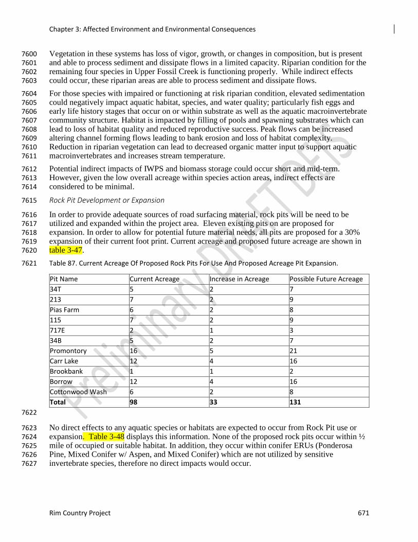
Chapter 3: Affected Environment and Environmental Consequences
Rim Country Project 671
Vegetation in these systems has loss of vigor, growth, or changes in composition, but is present 7600 and able to process sediment and dissipate flows in a limited capacity. Riparian condition for the 7601 remaining four species in Upper Fossil Creek is functioning properly. While indirect effects 7602 could occur, these riparian areas are able to process sediment and dissipate flows. 7603
For those species with impaired or functioning at risk riparian condition, elevated sedimentation 7604 could negatively impact aquatic habitat, species, and water quality; particularly fish eggs and 7605 early life history stages that occur on or within substrate as well as the aquatic macroinvertebrate 7606 community structure. Habitat is impacted by filling of pools and spawning substrates which can 7607 lead to loss of habitat quality and reduced reproductive success. Peak flows can be increased 7608 altering channel forming flows leading to bank erosion and loss of habitat complexity. 7609 Reduction in riparian vegetation can lead to decreased organic matter input to support aquatic 7610 macroinvertebrates and increases stream temperature. 7611
Potential indirect impacts of IWPS and biomass storage could occur short and mid-term. 7612 However, given the low overall acreage within species action areas, indirect effects are 7613 considered to be minimal. 7614
Rock Pit Development or Expansion 7615
In order to provide adequate sources of road surfacing material, rock pits will be need to be 7616 utilized and expanded within the project area. Eleven existing pits on are proposed for 7617 expansion. In order to allow for potential future material needs, all pits are proposed for a 30% 7618 expansion of their current foot print. Current acreage and proposed future acreage are shown in 7619 table 3-47. 7620
Table 87. Current Acreage Of Proposed Rock Pits For Use And Proposed Acreage Pit Expansion. 7621
Pit Name Current Acreage Increase in Acreage Possible Future Acreage
34T 5 2 7
213 7 2 9
Pias Farm 6 2 8
115 7 2 9
717E 2 1 3
34B 5 2 7
Promontory 16 5 21
Carr Lake 12 4 16
Brookbank 1 1 2
Borrow 12 4 16
Cottonwood Wash 6 2 8
Total 98 33 131
7622
No direct effects to any aquatic species or habitats are expected to occur from Rock Pit use or 7623 expansion. Table 3-48 displays this information. None of the proposed rock pits occur within ½ 7624 mile of occupied or suitable habitat. In addition, they occur within conifer ERUs (Ponderosa 7625 Pine, Mixed Conifer w/ Aspen, and Mixed Conifer) which are not utilized by sensitive 7626 invertebrate species, therefore no direct impacts would occur. 7627
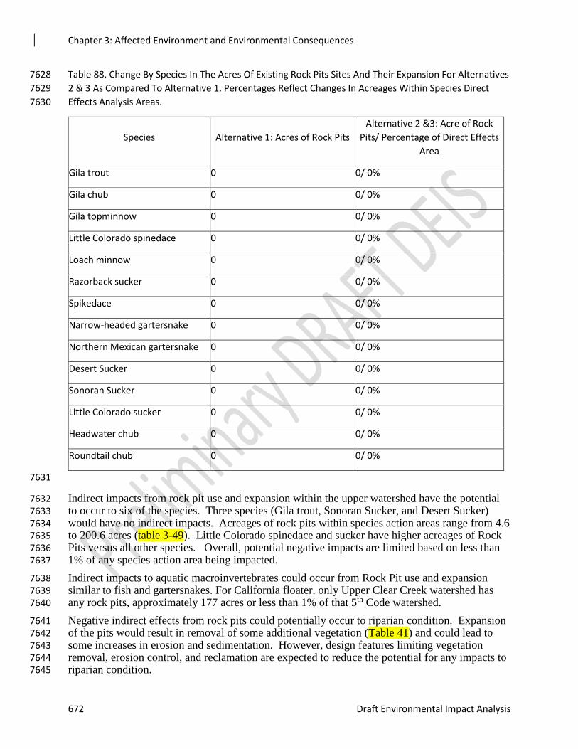
Chapter 3: Affected Environment and Environmental Consequences
672 Draft Environmental Impact Analysis
Table 88. Change By Species In The Acres Of Existing Rock Pits Sites And Their Expansion For Alternatives 7628
2 & 3 As Compared To Alternative 1. Percentages Reflect Changes In Acreages Within Species Direct 7629
Effects Analysis Areas. 7630
Species Alternative 1: Acres of Rock Pits
Alternative 2 &3: Acre of Rock
Pits/ Percentage of Direct Effects
Area
Gila trout 0 0/ 0%
Gila chub 0 0/ 0%
Gila topminnow 0 0/ 0%
Little Colorado spinedace 0 0/ 0%
Loach minnow 0 0/ 0%
Razorback sucker 0 0/ 0%
Spikedace 0 0/ 0%
Narrow-headed gartersnake 0 0/ 0%
Northern Mexican gartersnake 0 0/ 0%
Desert Sucker 0 0/ 0%
Sonoran Sucker 0 0/ 0%
Little Colorado sucker 0 0/ 0%
Headwater chub 0 0/ 0%
Roundtail chub 0 0/ 0%
7631
Indirect impacts from rock pit use and expansion within the upper watershed have the potential 7632 to occur to six of the species. Three species (Gila trout, Sonoran Sucker, and Desert Sucker) 7633 would have no indirect impacts. Acreages of rock pits within species action areas range from 4.6 7634 to 200.6 acres (table 3-49). Little Colorado spinedace and sucker have higher acreages of Rock 7635 Pits versus all other species. Overall, potential negative impacts are limited based on less than 7636 1% of any species action area being impacted. 7637
Indirect impacts to aquatic macroinvertebrates could occur from Rock Pit use and expansion 7638 similar to fish and gartersnakes. For California floater, only Upper Clear Creek watershed has 7639 any rock pits, approximately 177 acres or less than 1% of that 5th Code watershed. 7640
Negative indirect effects from rock pits could potentially occur to riparian condition. Expansion 7641 of the pits would result in removal of some additional vegetation (Table 41) and could lead to 7642 some increases in erosion and sedimentation. However, design features limiting vegetation 7643 removal, erosion control, and reclamation are expected to reduce the potential for any impacts to 7644 riparian condition. 7645
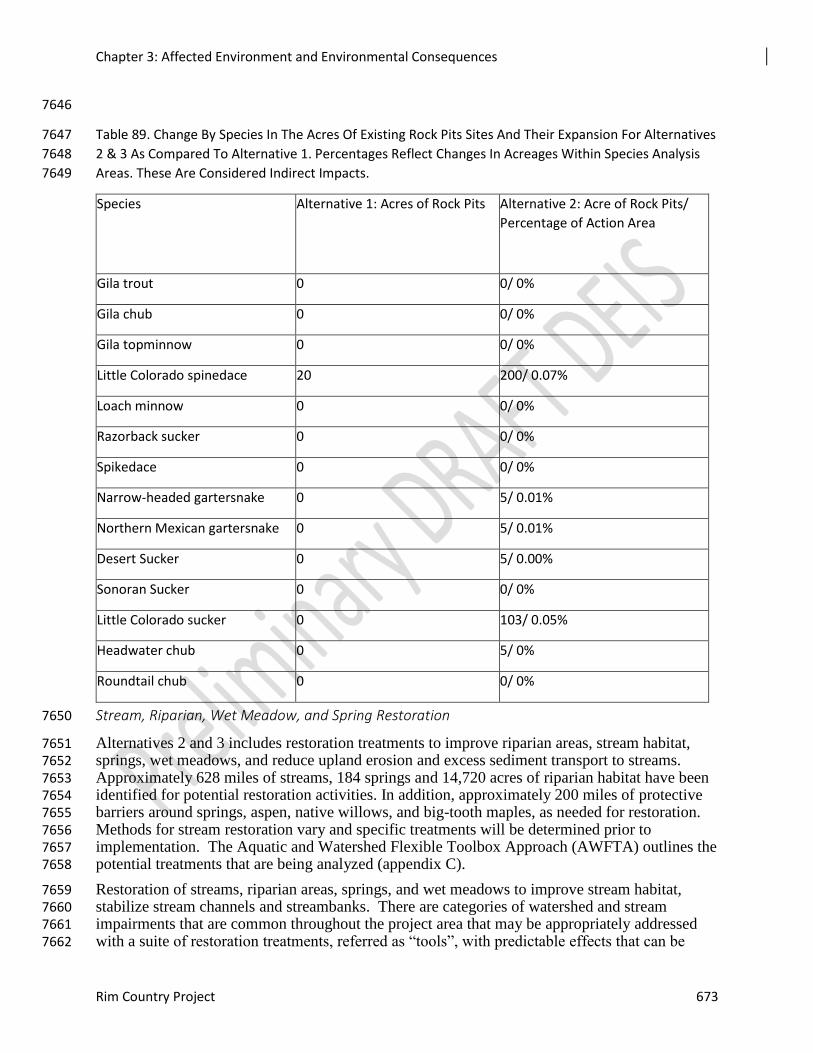
Chapter 3: Affected Environment and Environmental Consequences
Rim Country Project 673
7646
Table 89. Change By Species In The Acres Of Existing Rock Pits Sites And Their Expansion For Alternatives 7647
2 & 3 As Compared To Alternative 1. Percentages Reflect Changes In Acreages Within Species Analysis 7648
Areas. These Are Considered Indirect Impacts. 7649
Species Alternative 1: Acres of Rock Pits
Alternative 2: Acre of Rock Pits/
Percentage of Action Area
Gila trout 0 0/ 0%
Gila chub 0 0/ 0%
Gila topminnow 0 0/ 0%
Little Colorado spinedace 20 200/ 0.07%
Loach minnow 0 0/ 0%
Razorback sucker 0 0/ 0%
Spikedace 0 0/ 0%
Narrow-headed gartersnake 0 5/ 0.01%
Northern Mexican gartersnake 0 5/ 0.01%
Desert Sucker 0 5/ 0.00%
Sonoran Sucker 0 0/ 0%
Little Colorado sucker 0 103/ 0.05%
Headwater chub 0 5/ 0%
Roundtail chub 0 0/ 0%
Stream, Riparian, Wet Meadow, and Spring Restoration 7650
Alternatives 2 and 3 includes restoration treatments to improve riparian areas, stream habitat, 7651 springs, wet meadows, and reduce upland erosion and excess sediment transport to streams. 7652 Approximately 628 miles of streams, 184 springs and 14,720 acres of riparian habitat have been 7653 identified for potential restoration activities. In addition, approximately 200 miles of protective 7654 barriers around springs, aspen, native willows, and big-tooth maples, as needed for restoration. 7655 Methods for stream restoration vary and specific treatments will be determined prior to 7656 implementation. The Aquatic and Watershed Flexible Toolbox Approach (AWFTA) outlines the 7657 potential treatments that are being analyzed (appendix C). 7658
Restoration of streams, riparian areas, springs, and wet meadows to improve stream habitat, 7659 stabilize stream channels and streambanks. There are categories of watershed and stream 7660 impairments that are common throughout the project area that may be appropriately addressed 7661 with a suite of restoration treatments, referred as “tools”, with predictable effects that can be 7662
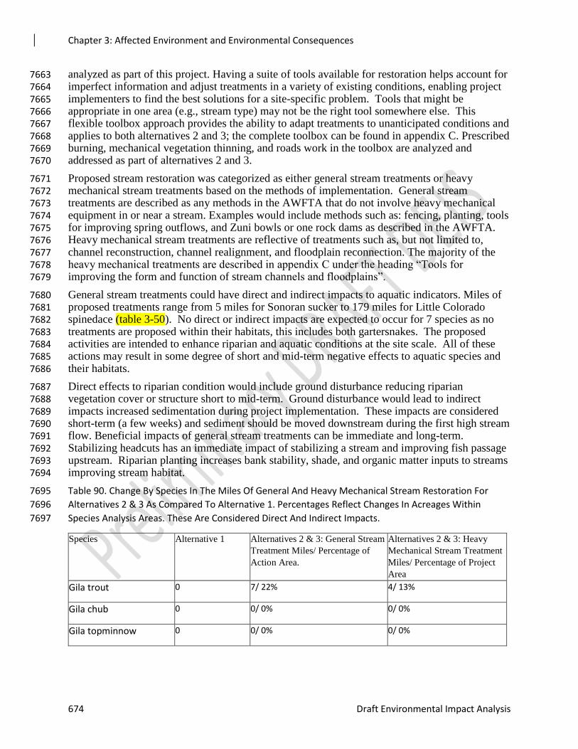
Chapter 3: Affected Environment and Environmental Consequences
674 Draft Environmental Impact Analysis
analyzed as part of this project. Having a suite of tools available for restoration helps account for 7663 imperfect information and adjust treatments in a variety of existing conditions, enabling project 7664 implementers to find the best solutions for a site-specific problem. Tools that might be 7665 appropriate in one area (e.g., stream type) may not be the right tool somewhere else. This 7666 flexible toolbox approach provides the ability to adapt treatments to unanticipated conditions and 7667 applies to both alternatives 2 and 3; the complete toolbox can be found in appendix C. Prescribed 7668 burning, mechanical vegetation thinning, and roads work in the toolbox are analyzed and 7669 addressed as part of alternatives 2 and 3. 7670
Proposed stream restoration was categorized as either general stream treatments or heavy 7671 mechanical stream treatments based on the methods of implementation. General stream 7672 treatments are described as any methods in the AWFTA that do not involve heavy mechanical 7673 equipment in or near a stream. Examples would include methods such as: fencing, planting, tools 7674 for improving spring outflows, and Zuni bowls or one rock dams as described in the AWFTA. 7675 Heavy mechanical stream treatments are reflective of treatments such as, but not limited to, 7676 channel reconstruction, channel realignment, and floodplain reconnection. The majority of the 7677 heavy mechanical treatments are described in appendix C under the heading “Tools for 7678 improving the form and function of stream channels and floodplains”. 7679
General stream treatments could have direct and indirect impacts to aquatic indicators. Miles of 7680 proposed treatments range from 5 miles for Sonoran sucker to 179 miles for Little Colorado 7681 spinedace (table 3-50). No direct or indirect impacts are expected to occur for 7 species as no 7682 treatments are proposed within their habitats, this includes both gartersnakes. The proposed 7683 activities are intended to enhance riparian and aquatic conditions at the site scale. All of these 7684 actions may result in some degree of short and mid-term negative effects to aquatic species and 7685 their habitats. 7686
Direct effects to riparian condition would include ground disturbance reducing riparian 7687 vegetation cover or structure short to mid-term. Ground disturbance would lead to indirect 7688 impacts increased sedimentation during project implementation. These impacts are considered 7689 short-term (a few weeks) and sediment should be moved downstream during the first high stream 7690 flow. Beneficial impacts of general stream treatments can be immediate and long-term. 7691 Stabilizing headcuts has an immediate impact of stabilizing a stream and improving fish passage 7692 upstream. Riparian planting increases bank stability, shade, and organic matter inputs to streams 7693 improving stream habitat. 7694
Table 90. Change By Species In The Miles Of General And Heavy Mechanical Stream Restoration For 7695
Alternatives 2 & 3 As Compared To Alternative 1. Percentages Reflect Changes In Acreages Within 7696
Species Analysis Areas. These Are Considered Direct And Indirect Impacts. 7697
Species Alternative 1 Alternatives 2 & 3: General Stream
Treatment Miles/ Percentage of
Action Area.
Alternatives 2 & 3: Heavy
Mechanical Stream Treatment
Miles/ Percentage of Project
Area
Gila trout 0 7/ 22% 4/ 13%
Gila chub 0 0/ 0% 0/ 0%
Gila topminnow 0 0/ 0% 0/ 0%
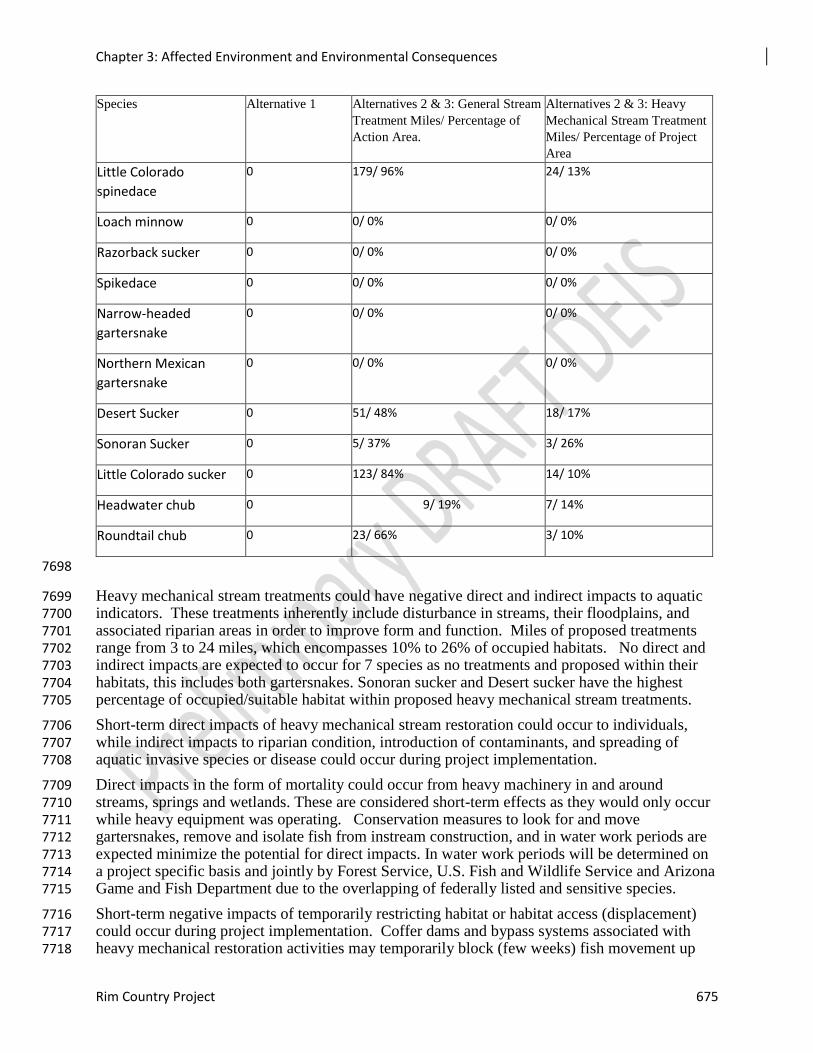
Chapter 3: Affected Environment and Environmental Consequences
Rim Country Project 675
Species Alternative 1 Alternatives 2 & 3: General Stream
Treatment Miles/ Percentage of
Action Area.
Alternatives 2 & 3: Heavy
Mechanical Stream Treatment
Miles/ Percentage of Project
Area
Little Colorado
spinedace
0 179/ 96% 24/ 13%
Loach minnow 0 0/ 0% 0/ 0%
Razorback sucker 0 0/ 0% 0/ 0%
Spikedace 0 0/ 0% 0/ 0%
Narrow-headed
gartersnake
0 0/ 0% 0/ 0%
Northern Mexican
gartersnake
0 0/ 0% 0/ 0%
Desert Sucker 0 51/ 48% 18/ 17%
Sonoran Sucker 0 5/ 37% 3/ 26%
Little Colorado sucker 0 123/ 84% 14/ 10%
Headwater chub 0 9/ 19% 7/ 14%
Roundtail chub 0 23/ 66% 3/ 10%
7698
Heavy mechanical stream treatments could have negative direct and indirect impacts to aquatic 7699 indicators. These treatments inherently include disturbance in streams, their floodplains, and 7700 associated riparian areas in order to improve form and function. Miles of proposed treatments 7701 range from 3 to 24 miles, which encompasses 10% to 26% of occupied habitats. No direct and 7702 indirect impacts are expected to occur for 7 species as no treatments and proposed within their 7703 habitats, this includes both gartersnakes. Sonoran sucker and Desert sucker have the highest 7704 percentage of occupied/suitable habitat within proposed heavy mechanical stream treatments. 7705
Short-term direct impacts of heavy mechanical stream restoration could occur to individuals, 7706 while indirect impacts to riparian condition, introduction of contaminants, and spreading of 7707 aquatic invasive species or disease could occur during project implementation. 7708
Direct impacts in the form of mortality could occur from heavy machinery in and around 7709 streams, springs and wetlands. These are considered short-term effects as they would only occur 7710 while heavy equipment was operating. Conservation measures to look for and move 7711 gartersnakes, remove and isolate fish from instream construction, and in water work periods are 7712 expected minimize the potential for direct impacts. In water work periods will be determined on 7713 a project specific basis and jointly by Forest Service, U.S. Fish and Wildlife Service and Arizona 7714 Game and Fish Department due to the overlapping of federally listed and sensitive species. 7715
Short-term negative impacts of temporarily restricting habitat or habitat access (displacement) 7716 could occur during project implementation. Coffer dams and bypass systems associated with 7717 heavy mechanical restoration activities may temporarily block (few weeks) fish movement up 7718
Chapter 3: Affected Environment and Environmental Consequences
676 Draft Environmental Impact Analysis
and/or downstream through the construction area. Up and downstream fish movement is 7719 provided by ditch bypass systems, downstream movement is provided with plastic-culvert bypass 7720 systems, and no fish movement is provided with pump bypass systems. Headcuts and existing 7721 structures to be repaired may serve as exiting fish-passage barriers; therefore, coffer dams and 7722 diversion structures may not be any more of a barrier than the pre-restoration baseline. 7723
Riparian condition could be negatively impacted short-term inputs of increased sedimentation 7724 from instream structure placement, opening of side channels, road crossing treatments, and other 7725 projects inside or near the bankfull channel. The sediment plume from activities will be most 7726 concentrated in the immediate project vicinity and should dissipate throughout the stream 7727 channel within a few hours. The amount, extent, and duration of fine sediment inputs and 7728 turbidity relate to the following: the type and duration of heavy machinery used within or near a 7729 bankfull channel; soil type; the amount of soil disturbance; whether restoration is in or out of the 7730 wetted channel; the sensitivity of the channel banks to erosion and other disturbances; the 7731 amount of time it takes for disturbed areas to revegetate and stabilize; and the probability of 7732 precipitation events before disturbed areas are re-vegetated or stabilized. 7733
The increased stream turbidity may deposit fine coats of sediment on channel substrate a short 7734 distance downstream, encourage fish and other aquatic species to move downstream, and alter 7735 fish behavior patterns for a short time. It is anticipated that all project related sediment will be 7736 flushed out during the first fall/winter/spring high flows after project completion, and site 7737 restoration conservation measures are expected to prevent future project related sediment inputs 7738 into the stream. Therefore, long-term negative impacts to substrate are not expected. 7739
Contaminants and aquatic invasive species or diseases could be introduced into the stream from 7740 large equipment causing negative indirect impacts to aquatic species. Chemical transport could 7741 be direct into streams from equipment or from storm water runoff through or over soil. 7742 Pollutants alter soil chemistry, may be absorbed by plants, can affect stream ecosystems, where 7743 they are dispersed and diluted over considerable distances. Typical water-quality responses to 7744 pollutants include altered levels of heavy metals, salinity, turbidity, and dissolved oxygen. These 7745 water quality changes can be sporadic and localized due to fluctuations in water quantity. 7746 Aquatic invasive species or diseases could similarly be introduced to streams or waterbodies. 7747 Best management practices and conservation measures requiring cleaning equipment, checking 7748 for leaks, storage of fuels, and staging areas for equipment of AMZs minimizes or precludes the 7749 likelihood of either occurring. 7750
Benefits from heavy mechanical stream restoration can be immediate and long-term by 7751 improving or restoring riparian condition via one of the following: stream structure/complexity, 7752 stream sinuosity and length, bank stability, floodplain connectivity. Such results will promote 7753 conditions that maintain or decrease stream temperature, reduce turbidity (via stable banks, 7754 improved sediment retention through increased channel structure, riparian areas, and 7755 floodplains), and improved nutrient input (via increases riparian organic input sources) and 7756 retention (via increased channel structure, sinuosity, and floodplain areas). It is anticipated that 7757 the project related sediment will be flushed out during the first spring high flows after project 7758 completion, and site restoration conservation measures are expected to prevent future project 7759 related sediment inputs into the stream. Therefore, long-term sediment impacts to sediment and 7760 turbidity are not expected. 7761
Human constructed or caused physical barriers within the stream channel such as culverts and 7762 headcuts can impair sediment and debris transport, migration routes, life history patterns, and 7763 population viability. First and second order streams are the sources of water, nutrients, woods, 7764 another vegetative material for streams inhabited by fish and other aquatic organisms. Fish 7765
Chapter 3: Affected Environment and Environmental Consequences
Rim Country Project 677
Passage Culvert Projects, Headcut stabilization and Associated Fish Passage, and Legacy 7766 Structure Removal treatments would result in benefits such as uninhibited stream access for 7767 migrating and rearing fish, restored or improved continuous paths for wood, nutrients, sediments, 7768 and other vegetative material essential for quality fish habitat. 7769
Upland soil restoration structures (e.g. Zuni bowls or native rock check dams) may be used to 7770 address site specific erosion/channelization resource issues within project watersheds. The 7771 number that may be installed will vary based on watershed needs. These structures will have a 7772 long term benefit of reducing erosion and sedimentation to stream by holding and stabilizing 7773 soils in the uplands and improving hydrologic condition and function. Riparian and rare plant 7774 planting and enclosures to protect existing or planted areas could occur where site-specific needs 7775 are identified in riparian areas, wet meadows, springs, and uplands areas such as where aspen or 7776 big-toothed maple occur. Riparian planting and enclosures along streams can improve bank 7777 stability, stream shading and aquatic habitat. 7778
Aquatic Macroinvertebrates 7779
Stoneflies, caddisflies, mayflies, midges, and riffle beetles are strongly associated with streams 7780 and riparian areas. Based on the biology and ecology of these four groups of species, stream and 7781 watershed restoration in accordance with the AWFTA could have negative direct and indirect 7782 impacts. Direct impacts to individuals and their habitats could occur short-term during project 7783 implementation. General stream treatments would have a low potential for direct and indirect 7784 impacts to these sensitive species given the methods included (e.g. fencing, planting). Heavy 7785 mechanical stream treatments have the potential for more direct effects as they include short-7786 term habitat alteration in streams and riparian areas that could also impact individuals. Indirect 7787 effects of sedimentation from the AWFTA restoration treatments would last as long as the first 7788 few flushing flow events. Beneficial effects would occur from improved stream habitats and 7789 riparian vegetation long term. 7790
Nokomis Fritillary is a sensitive species that utilizes meadows, seeps, and boggy streamside 7791 vegetation. General stream treatments would have a low potential for direct or indirect impacts 7792 to the species. Heavy mechanical stream treatments could have direct and indirect impacts. 7793 Short-term direct impacts to individuals and their habitat could occur during implementation. 7794 Indirect effects of habitat alteration would last until vegetation was restored or had regrown that 7795 supports the species. Beneficial effects would occur from improved stream-riparian interaction 7796 and riparian habitat. 7797
For California Floater, general stream restoration treatments would have a low potential for 7798 direct or indirect impacts. Fencing across streams could directly impact the species, but is 7799 unlikely. Indirect impacts of sedimentation from these methods would also be considered 7800 negligible. Heavy mechanical stream treatments are proposed in Upper Clear Creek (49 miles) 7801 and West Clear Creek (2.9 miles) where the species historically or currently occurs. Short-term 7802 direct impacts would occur during implementation of instream treatments that could also impact 7803 individuals. Indirect impacts of sedimentation are expected to persist until first few flushing 7804 flows mobilize any sedimentation downstream. Beneficial effects would occur from improved 7805 stream habitats long term. 7806
For all sensitive aquatic macroinvertebrates, streams and riparian areas could have short-term 7807 negative indirect impacts from proposed stream restoration as part of Alternatives 2 and 3. Short-7808 term indirect effects of heavy mechanical stream restoration include increased sedimentation and 7809 turbidity, introduction of contaminants, and spreading of aquatic invasive species or disease 7810 during project implementation. Project level best management practices and mitigations would 7811
Chapter 3: Affected Environment and Environmental Consequences
678 Draft Environmental Impact Analysis
minimize the potential for introduction of contaminants or spread of aquatic invasive species or 7812 disease. 7813
Road Relocation and Decommissioning 7814
Road relocation and decommissioning include restoring a road surface to a more natural state. 7815 Short-term negative impacts to individuals and riparian condition would be similar to those 7816 discussed above for aquatic restoration. Direct impacts to individuals could occur for any work 7817 within species habitats. Riparian condition could be negatively impacted short to mid-term by 7818 increased sediment delivery until vegetation reestablished. 7819
However, long term benefits of reducing road density have a cascade of effects: improved 7820 riparian condition from reduction in runoff and sedimentation, fewer roads crossings, and the 7821 ability for riparian vegetation to be restored, and decreased mortality or disturbance of species. 7822 Road density is a major factor in the current condition of most subwatersheds with aquatic 7823 species in the project area. Reducing road density by decommissioning roads could help 7824 improve that particular Watershed Condition Framework indicator. Relocating roads does not 7825 reduce overall road density, but can alleviate direct versus indirect impacts, particularly if move 7826 a road further from a stream or riparian area. 7827
Design features for road relocation are expected to reduce some of the potential impacts. 7828 Relocated roads should be constructed in a manner that does not hydrologically connect them to 7829 streams to extent practicable. They will also have sufficient drainage features to maintain the 7830 integrity of the travel, thereby reducing erosion and sedimentation. New cross drains will 7831 discharge to stable areas where the outflow will quickly infiltrate the soil and not develop a 7832 channel to a stream. When feasible, relocate roads out of drainage bottoms to upland locations; 7833 if this is not possible rock armor outfall of drainage features to dissipate water energy. 7834 Contaminants and aquatic invasive species or diseases could be introduced into the stream from 7835 large equipment causing negative indirect impacts to aquatic species. Chemical transport could 7836 be direct into streams from equipment or from storm water runoff through or over soil. 7837 Pollutants alter soil chemistry, may be absorbed by plants, can affect stream ecosystems, where 7838 they are dispersed and diluted over considerable distances. Typical water-quality responses to 7839 pollutants include altered levels of heavy metals, salinity, turbidity, and dissolved oxygen. These 7840 water quality changes can be sporadic and localized due to fluctuations in water quantity. 7841 Aquatic invasive species or diseases could similarly be introduced to streams or waterbodies. 7842 Best management practices and conservation measures requiring cleaning equipment, checking 7843 for leaks, storage of fuels, and staging areas for equipment of AMZs minimizes or precludes the 7844 likelihood of either occurring. 7845
Direct and Indirect Effects - Alternative 2 7846
Mechanical Vegetation Treatments 7847
For Alternative 2, acres of mechanical vegetation treatments has the potential for negative short 7848 and mid-term impacts to riparian condition and individuals. Direct negative short term impacts 7849 would result if these activities occur in a species habitat from actions such as yarding, skidding, 7850 or harm to gartersnakes during mechanical operations. Alternative 2 is proposing treatments 7851 within the habitats of seven fish species and both gartersnakes. Increases in acreages of 7852 treatments ranges from 203 to 3,891 acres which equates to 1% - 100% of the analysis area for 7853 direct effects for those species. Five fish species would not be directly impacted by mechanical 7854 vegetation treatments under Alternative 2. Table 3-34 displays this information for each species. 7855
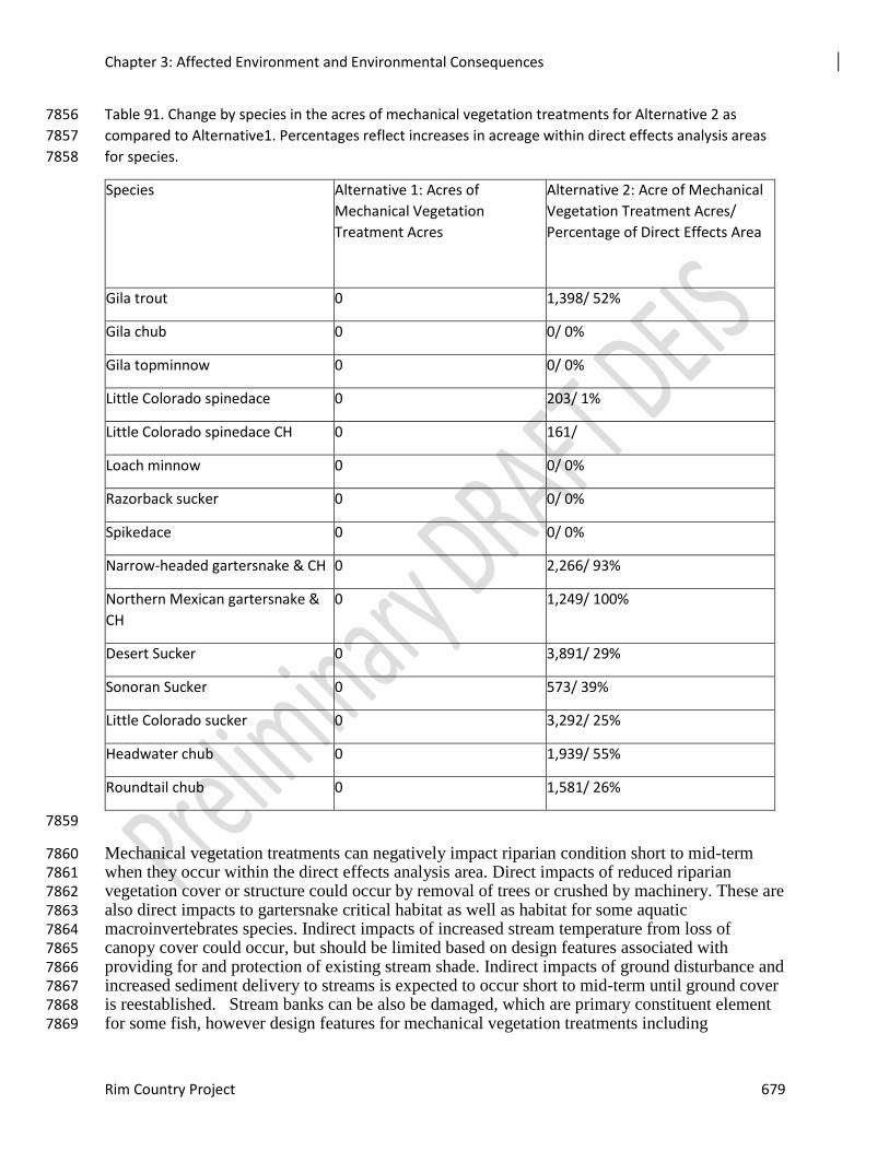
Chapter 3: Affected Environment and Environmental Consequences
Rim Country Project 679
Table 91. Change by species in the acres of mechanical vegetation treatments for Alternative 2 as 7856
compared to Alternative1. Percentages reflect increases in acreage within direct effects analysis areas 7857
for species. 7858
Species Alternative 1: Acres of
Mechanical Vegetation
Treatment Acres
Alternative 2: Acre of Mechanical
Vegetation Treatment Acres/
Percentage of Direct Effects Area
Gila trout 0 1,398/ 52%
Gila chub 0 0/ 0%
Gila topminnow 0 0/ 0%
Little Colorado spinedace 0 203/ 1%
Little Colorado spinedace CH 0 161/
Loach minnow 0 0/ 0%
Razorback sucker 0 0/ 0%
Spikedace 0 0/ 0%
Narrow-headed gartersnake & CH 0 2,266/ 93%
Northern Mexican gartersnake &
CH
0 1,249/ 100%
Desert Sucker 0 3,891/ 29%
Sonoran Sucker 0 573/ 39%
Little Colorado sucker 0 3,292/ 25%
Headwater chub 0 1,939/ 55%
Roundtail chub 0 1,581/ 26%
7859
Mechanical vegetation treatments can negatively impact riparian condition short to mid-term 7860 when they occur within the direct effects analysis area. Direct impacts of reduced riparian 7861 vegetation cover or structure could occur by removal of trees or crushed by machinery. These are 7862 also direct impacts to gartersnake critical habitat as well as habitat for some aquatic 7863 macroinvertebrates species. Indirect impacts of increased stream temperature from loss of 7864 canopy cover could occur, but should be limited based on design features associated with 7865 providing for and protection of existing stream shade. Indirect impacts of ground disturbance and 7866 increased sediment delivery to streams is expected to occur short to mid-term until ground cover 7867 is reestablished. Stream banks can be also be damaged, which are primary constituent element 7868 for some fish, however design features for mechanical vegetation treatments including 7869
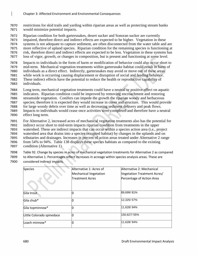
Chapter 3: Affected Environment and Environmental Consequences
680 Draft Environmental Impact Analysis
restrictions for skid trails and yarding within riparian areas as well as protecting stream banks 7870 would minimize potential impacts. 7871
Riparian condition for both gartersnakes, desert sucker and Sonoran sucker are currently 7872 impaired, therefore direct and indirect effects are expected to be higher. Vegetation in these 7873 systems is not adequate to capture sediment, are often disconnected from the water table and are 7874 more reflective of upland species. Riparian condition for the remaining species is functioning at 7875 risk, therefore direct and indirect effects are expected to be less. Vegetation in these systems has 7876 loss of vigor, growth, or changes in composition, but is present and functioning at some level. 7877
Impacts to individuals in the form of harm or modification of behavior could also occur short to 7878 mid-term. Mechanical vegetation treatments within gartersnake habitat could result in harm of 7879 individuals as a direct effect. Indirectly, gartersnakes may avoid or move out of these areas 7880 while work is occurring causing displacement or disruption of social and feeding behavior. 7881 These indirect effects have the potential to reduce the health or reproductive capability of 7882 individuals. 7883
Long term, mechanical vegetation treatments could have a neutral or positive effect on aquatic 7884 indicators. Riparian condition could be improved by removing encroachment and restoring 7885 streamside vegetation. Conifers can impede the growth the riparian woody and herbaceous 7886 species; therefore it is expected they would increase in cover and structure. This would provide 7887 for large woody debris over time as well as decreasing sediment delivery and peak flows. 7888 Impacts to individuals would cease once activities were completed and therefore have a neutral 7889 effect long term. 7890
For Alternative 2, increased acres of mechanical vegetation treatments also has the potential for 7891 indirect occur short to mid-term impacts riparian condition from treatments in the upper 7892 watershed. These are indirect impacts that can occur within a species action area (i.e., project 7893 watershed area that drains into a species occupied habitat) by changes in the uplands and on 7894 tributaries and drainages. Increases in percent of action areas treated under Alternative 2 range 7895 from 54% to 94%. Table 138 displays these species habitats as compared to the existing 7896 condition (Alternative 1). 7897
Table 92. Change by species in acres of mechanical vegetation treatments for Alternative 2 as compared 7898
to Alternative 1. Percentages reflect increases in acreage within species analysis areas. These are 7899
considered indirect impacts. 7900
Species Alternative 1: Acres of
Mechanical Vegetation
Treatment Acres
Alternative 2: Mechanical
Vegetation Treatment Acres/
Percentage of Action Area
Gila trout 0 89,699/ 81%
Gila chub* 0 12,325/ 57%
Gila topminnow* 0 11,628/ 94%
Little Colorado spinedace 0 150,627/ 55%
Loach minnow* 0 11,628/ 94%
Chapter 3: Affected Environment and Environmental Consequences
Rim Country Project 681
Razorback sucker* 0 11,628/ 94%
Spikedace* 0 11,628/ 94%
Narrow-headed gartersnake 0 65, 851/ 74%
Northern Mexican gartersnake 0 38,171/ 79%
Desert Sucker 0 207,340/ 65%
Sonoran Sucker 0 37,108/ 71%
Little Colorado sucker 0 121,732/ 54%
Headwater chub 0 117,548/ 83%
Roundtail chub 0 122,186/ 76%
*While the percentage is high for these species action areas, less than half of entire watershed is within 7901
the project area. 7902
Mechanical vegetation treatments in uplands can indirectly impact riparian condition short to 7903 mid-term from increased sediment delivery and peak flows via removal of vegetation and ground 7904 disturbance. Soils can be compacted and water infiltration reduced from landings and skid trails 7905 leading to increased overland flow and erosion. Yarding and skidding can redirect water onto 7906 areas more likely to erode than natural channels. In turn, increased sedimentation and peak flows 7907 can occur reducing riparian condition, aquatic habitat quality and quantity. 7908
Riparian condition for both gartersnakes, desert sucker and Sonoran sucker are currently 7909 impaired, therefore indirect effects are expected to be higher. Vegetation in these systems is not 7910 adequate to capture or process sediment, indicating more would reach streams. These riparian 7911 areas are often disconnected from the water table and are more reflective of upland species; 7912 therefore likely unable to dissipate stream energy associated with increased peak flows. Riparian 7913 condition for five species is currently functioning at risk, therefore indirect effects are expected 7914 to be less. Vegetation in these systems has loss of vigor, growth, or changes in composition, but 7915 is present and able to process sediment and dissipate flows in a limited capacity. Riparian 7916 condition for the remaining four species in Upper Fossil Creek is functioning properly. While 7917 indirect effects could occur, these riparian areas are able to process sediment and dissipate flows. 7918
For those species with impaired or functioning at risk riparian condition, elevated sedimentation 7919 could negatively impact aquatic habitat, species, and water quality; particularly fish eggs and 7920 early life history stages that occur on or within substrate as well as the aquatic macroinvertebrate 7921 community structure. Habitat is impacted by filling of pools and spawning substrates which can 7922 lead to loss of habitat quality and reduced reproductive success. Peak flows can be increased 7923 altering channel forming flows leading to bank erosion and loss of habitat complexity. 7924 Reduction in riparian vegetation can lead to decreased organic matter input to support aquatic 7925 macroinvertebrates and increases stream temperature. 7926
Design features related to mechanical vegetation treatments are expected to minimize the 7927 potential effects described above. The project includes spreading treatments in time and space 7928 within a watershed as well as for skid trails, yarding, and landings are expected to reduce these 7929 impacts. 7930
Chapter 3: Affected Environment and Environmental Consequences
682 Draft Environmental Impact Analysis
Pollutants in the form of fuels and lubricants have the potential to be introduced into aquatic 7931 systems from staging areas and equipment. Spills and leaks can introduce pollutants to soils and 7932 then to streams and riparian areas reducing riparian condition and habitat quality. Design 7933 features for storm water protections plans, staging areas, fuel storage and checking equipment for 7934 leaks minimizes the potential for introduction of pollutants. 7935
Long term, mechanical vegetation treatments are expected to improve overall watershed 7936 condition as well as riparian condition. Moving forests towards desired conditions of more a 7937 healthy, resilient state will provide for improved watershed function over time. It will also 7938 reduce the risk of uncharacteristic wildfire which can greatly impact all resource indicators and 7939 reduce aquatic habitat quality, quantity and populations. Alternative 2 will have more long term 7940 improvements to riparian condition than Alternatives 1 and 3 due to the increased overall 7941 acreage. 7942
Prescribed Burning 7943
For Alternative 2, acres of prescribed burning has the potential for negative short and mid-term 7944 impacts to riparian condition and harm to individuals. Direct short term impacts would result if 7945 these activities occur within species habitat from firelines, removal or reduction of vegetation 7946 due to burning or harm to gartersnakes. Alternative 2 is proposing treatments in the habitats of 7947 seven fish species and both gartersnakes (table 3-35). Increases in acreage of treatments ranges 7948 from 0 to 9,405 which equates to 0%-100% of the analysis area for direct effects for those 7949 species. Five fish species directly impacted by prescribed burning under Alternative 2. 7950
Prescribed burning can negatively impact riparian condition short to mid-term when it occurs in 7951 the direct effects analysis area. Direct impacts of reduced riparian vegetation cover or structure 7952 and decreases in large wood recruitment could occur from burning. Decreases in willows and 7953 other shrubby species reduces hiding and thermal cover for gartersnakes. This would be a direct 7954 alteration of gartersnake critical habitat as well as potentially impacting some aquatic 7955 macroinvertebrate species. This reduction is only expected to occur until vegetation recovers. 7956 Reduction in canopy cover also reduces stream shading and can increase stream temperatures. It 7957 also reduces organic matter inputs to streams which can alter food webs and prey base for fish 7958 and gartersnakes. Indirect impacts of increased stream temperature from loss of canopy cover 7959 could also occur, but should be limited based on design features associated with limiting high 7960 burn severity (mortality) and ignitions within riparian areas. 7961
Riparian condition for both gartersnakes, desert sucker and Sonoran sucker are currently 7962 impaired, therefore direct and indirect effects are expected to be higher. Vegetation in these 7963 systems is not adequate to capture sediment, are often disconnected from the water table and are 7964 more reflective of upland species. They already lack adequate streamside cover and structure, 7965 therefore those factors could be more susceptible to impacts. Riparian condition for the 7966 remaining species is functioning at risk, therefore direct and indirect effects are expected to be 7967 less as they have more cover and structure. Vegetation in these systems has loss of vigor, growth, 7968 or changes in composition, but is present and functioning at some level. 7969
Long term effects of prescribed burning are expected to be positive for riparian condition. 7970 Reduced fuel loading would protect these areas from uncharacteristic wildfire in the future. 7971 Large woody debris recruitment and streamside cover or structure can also improve with 7972 prescribed fire. Fire plays an important role in maintaining heterogeneity in riparian and aquatic 7973 systems that has been excluded similar to surrounding uplands (Gresswell 1999); therefore, 7974 restoring the fire regime would have some benefits to riparian condition. 7975
Chapter 3: Affected Environment and Environmental Consequences
Rim Country Project 683
Impacts to individual gartersnakes in the form of mortality or modification of behavior could 7976 also occur short to mid-term. Mortality could occur during prescribed burning; however, 7977 gartersnakes are mobile and design features of no burn piles within their habitat reduces that 7978 potential. While gartersnakes are more susceptible to exposure during a prescribed fire, it is more 7979 likely that harm or displacement would occur until the burns were completed. Long term impacts 7980 to individuals would be neutral or potentially positive if habitat improved and similarly increased 7981 social or feeding behavior. 7982
Table 93. Affected acres by species and the percent of change in the acres of prescribed burning for 7983
Alternative 2 as compared to Alternative 1. Percentages reflect changes in acreages within species direct 7984
effects analysis areas. 7985
Species Alternative 1: Acres of Prescribed
burning
Alternative 2: Acres of Prescribed
Burning/ Percent of Direct Effect
Area
Gila trout 0 1,541/ 57%
Gila chub 0 0/ 0%
Gila topminnow 0 0/ 0%
Little Colorado spinedace 0 9,405/ 70%
Loach minnow 0 0/ 0%
Razorback sucker 0 0/ 0%
Spikedace 0 0/ 0%
Narrow-headed gartersnake 0 2,437/ 100%
Northern Mexican gartersnake 0 1,249/ 100%
Desert Sucker 0 4,542/ 34%
Sonoran Sucker 0 630/ 43%
Little Colorado sucker 0 6,734/ 52%
Headwater chub 0 2,090/ 60%
Roundtail chub 0 1,900/ 31%
7986
Prescribed burning in uplands can indirectly impact riparian condition short to mid-term from 7987 increased sediment delivery and peak flows for all analyzed species. For Alternative 2, the 7988 increases in percentage of action areas treated range from 57% to 97%. Table 3-36 displays 7989 these species habitats as compared to the existing condition (Alternative 1). However, while the 7990 five species (denoted with an asterisk) show increases, it is important to note the overall acreage 7991 is small. This is due to less than half of their overall watershed occurring within the project. 7992 Therefore, while the percent increase is large the overall potential acres of impacts are much 7993
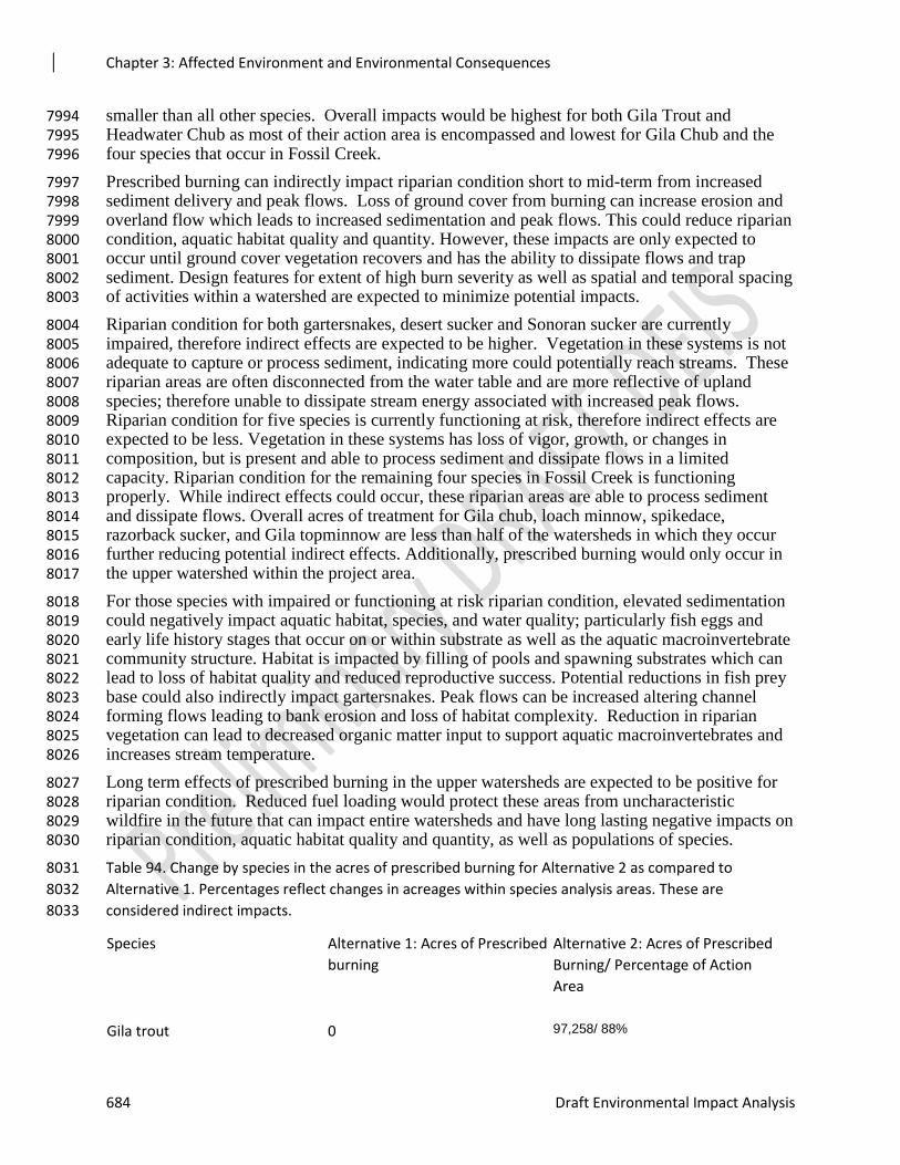
Chapter 3: Affected Environment and Environmental Consequences
684 Draft Environmental Impact Analysis
smaller than all other species. Overall impacts would be highest for both Gila Trout and 7994 Headwater Chub as most of their action area is encompassed and lowest for Gila Chub and the 7995 four species that occur in Fossil Creek. 7996
Prescribed burning can indirectly impact riparian condition short to mid-term from increased 7997 sediment delivery and peak flows. Loss of ground cover from burning can increase erosion and 7998 overland flow which leads to increased sedimentation and peak flows. This could reduce riparian 7999 condition, aquatic habitat quality and quantity. However, these impacts are only expected to 8000 occur until ground cover vegetation recovers and has the ability to dissipate flows and trap 8001 sediment. Design features for extent of high burn severity as well as spatial and temporal spacing 8002 of activities within a watershed are expected to minimize potential impacts. 8003
Riparian condition for both gartersnakes, desert sucker and Sonoran sucker are currently 8004 impaired, therefore indirect effects are expected to be higher. Vegetation in these systems is not 8005 adequate to capture or process sediment, indicating more could potentially reach streams. These 8006 riparian areas are often disconnected from the water table and are more reflective of upland 8007 species; therefore unable to dissipate stream energy associated with increased peak flows. 8008 Riparian condition for five species is currently functioning at risk, therefore indirect effects are 8009 expected to be less. Vegetation in these systems has loss of vigor, growth, or changes in 8010 composition, but is present and able to process sediment and dissipate flows in a limited 8011 capacity. Riparian condition for the remaining four species in Fossil Creek is functioning 8012 properly. While indirect effects could occur, these riparian areas are able to process sediment 8013 and dissipate flows. Overall acres of treatment for Gila chub, loach minnow, spikedace, 8014 razorback sucker, and Gila topminnow are less than half of the watersheds in which they occur 8015 further reducing potential indirect effects. Additionally, prescribed burning would only occur in 8016 the upper watershed within the project area. 8017
For those species with impaired or functioning at risk riparian condition, elevated sedimentation 8018 could negatively impact aquatic habitat, species, and water quality; particularly fish eggs and 8019 early life history stages that occur on or within substrate as well as the aquatic macroinvertebrate 8020 community structure. Habitat is impacted by filling of pools and spawning substrates which can 8021 lead to loss of habitat quality and reduced reproductive success. Potential reductions in fish prey 8022 base could also indirectly impact gartersnakes. Peak flows can be increased altering channel 8023 forming flows leading to bank erosion and loss of habitat complexity. Reduction in riparian 8024 vegetation can lead to decreased organic matter input to support aquatic macroinvertebrates and 8025 increases stream temperature. 8026
Long term effects of prescribed burning in the upper watersheds are expected to be positive for 8027 riparian condition. Reduced fuel loading would protect these areas from uncharacteristic 8028 wildfire in the future that can impact entire watersheds and have long lasting negative impacts on 8029 riparian condition, aquatic habitat quality and quantity, as well as populations of species. 8030
Table 94. Change by species in the acres of prescribed burning for Alternative 2 as compared to 8031
Alternative 1. Percentages reflect changes in acreages within species analysis areas. These are 8032
considered indirect impacts. 8033
Species Alternative 1: Acres of Prescribed
burning
Alternative 2: Acres of Prescribed
Burning/ Percentage of Action
Area
Gila trout 0 97,258/ 88%
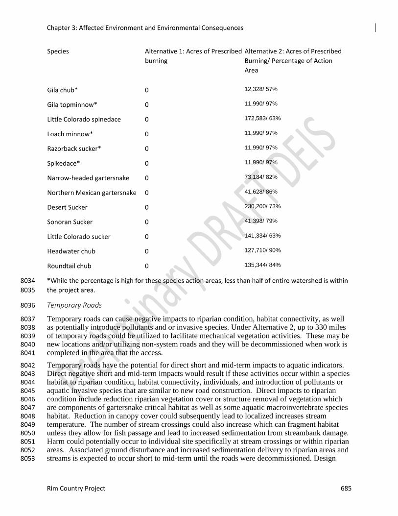
Chapter 3: Affected Environment and Environmental Consequences
Rim Country Project 685
Species Alternative 1: Acres of Prescribed
burning
Alternative 2: Acres of Prescribed
Burning/ Percentage of Action
Area
Gila chub* 0 12,328/ 57%
Gila topminnow* 0 11,990/ 97%
Little Colorado spinedace 0 172,583/ 63%
Loach minnow* 0 11,990/ 97%
Razorback sucker* 0 11,990/ 97%
Spikedace* 0 11,990/ 97%
Narrow-headed gartersnake 0 73,184/ 82%
Northern Mexican gartersnake 0 41,628/ 86%
Desert Sucker 0 230,200/ 73%
Sonoran Sucker 0 41,398/ 79%
Little Colorado sucker 0 141,334/ 63%
Headwater chub 0 127,710/ 90%
Roundtail chub 0 135,344/ 84%
*While the percentage is high for these species action areas, less than half of entire watershed is within 8034
the project area. 8035
Temporary Roads 8036
Temporary roads can cause negative impacts to riparian condition, habitat connectivity, as well 8037 as potentially introduce pollutants and or invasive species. Under Alternative 2, up to 330 miles 8038 of temporary roads could be utilized to facilitate mechanical vegetation activities. These may be 8039 new locations and/or utilizing non-system roads and they will be decommissioned when work is 8040 completed in the area that the access. 8041
Temporary roads have the potential for direct short and mid-term impacts to aquatic indicators. 8042 Direct negative short and mid-term impacts would result if these activities occur within a species 8043 habitat to riparian condition, habitat connectivity, individuals, and introduction of pollutants or 8044 aquatic invasive species that are similar to new road construction. Direct impacts to riparian 8045 condition include reduction riparian vegetation cover or structure removal of vegetation which 8046 are components of gartersnake critical habitat as well as some aquatic macroinvertebrate species 8047 habitat. Reduction in canopy cover could subsequently lead to localized increases stream 8048 temperature. The number of stream crossings could also increase which can fragment habitat 8049 unless they allow for fish passage and lead to increased sedimentation from streambank damage. 8050 Harm could potentially occur to individual site specifically at stream crossings or within riparian 8051 areas. Associated ground disturbance and increased sedimentation delivery to riparian areas and 8052 streams is expected to occur short to mid-term until the roads were decommissioned. Design 8053
Chapter 3: Affected Environment and Environmental Consequences
686 Draft Environmental Impact Analysis
features for limiting stream crossings, not creating new temporary roads in Aquatic Management 8054 Zones, and reducing impacts of crossings on existing temporary roads are expected to minimize 8055 the potential impacts discussed above. 8056
Indirect negative impacts of opening temporary roads in the upper watershed could also occur to 8057 riparian condition. In general, roads compact soils and reduce infiltration of water leading to 8058 increased erosion and runoff. They increase the drainage network to riparian areas and streams 8059 and connect these areas to the uplands by altering surface water pathways. This converts 8060 dispersed surface runoff and sediment filtering through a riparian area to direct deliveries of 8061 accumulated runoff and sediment. Decreases in riparian condition from increased in peak flows 8062 and sedimentation could occur, but would vary based on their current condition. 8063
Pollutants and aquatic invasive species can be introduced directly or indirectly to aquatic systems 8064 from machinery or vehicles creating or using temporary roads. Pollutants in the form of fuels and 8065 lubricants have the potential to be introduced into aquatic systems from staging areas and 8066 equipment. Spills and leaks can introduce pollutants to soils and then to streams and riparian 8067 areas reducing riparian condition and habitat quality. Design features for storm water protections 8068 plans, staging areas, fuel storage and checking equipment for leaks minimizes the potential for 8069 introduction of pollutants. Aquatic invasive species can similarly be transferred from an infected 8070 water body to an uninfected waterbody through driving or placement of materials from an 8071 infected source. However, design features for decontamination of equipment and not 8072 transferring water are expected to minimize potential introduction or spread of invasive species. 8073
Long term, potential direct and indirect negative impacts of temporary roads would cease as 8074 roads were decommissioned and revegetated. Therefore, long term effects are considered neutral 8075 to aquatic resource indicators. Overall, the potential short and mid-term negative impacts of 8076 temporary roads would be more than Alternatives 1 and 3. 8077
Sensitive Species not Covered by Resource Indicators and Measures 8078
Aquatic Macroinvertebrates 8079
Stoneflies, caddisflies, mayflies, midges, and riffle beetles have diverse diets and feeding 8080 strategies, occupy different trophic levels and functional feeding groups from predators to filter 8081 feeders. Nymphs of the four groups are aquatic while adults stay in the riparian areas for 8082 reproduction. 8083
Caddisflies are one of the largest groups of aquatic insects and are adapted to a wide range of 8084 microhabitats. Larval caddisflies have very diverse diets and feeding strategies, and occupy 8085 different trophic levels and functional feeding groups, including predators and filter feeders. 8086 Larvae are mainly herbivorous scavengers, feeding mainly on plant fragments and other living 8087 and dead organisms. Functionally, they can be collectors, shredders, scrapers, and predators. 8088 Feeding strategies may vary seasonally depending on items available and size of the caddisfly 8089 larvae. The larvae of most caddisfly species can be found in a variety of benthic habitats, 8090 including temperate lakes, streams, and ponds. Larvae of some species can tolerate low oxygen 8091 concentrations. Habitats can include benthic areas of streams, both cool and warm, lakes, 8092 marshes, and ponds. Caddisfly larvae are adapted to species-specific water temperatures and 8093 velocities, mineral and pollutant concentrations, and sunlight exposure. Because of this, many 8094 species can occur together in a single stream or river. Adult caddisflies are terrestrial, nocturnal, 8095 and hide in cool, moist habitats (e.g., riparian vegetation) during the day. 8096
Mayflies are relatively primitive insects and exhibit a number of ancestral trails that were likely 8097 present in the first flying insects. Nymphs live primarily in streams under rocks, in decaying 8098 vegetation, or in sediments (substrate). Larval mayflies are mostly herbivores or detritivores 8099
Chapter 3: Affected Environment and Environmental Consequences
Rim Country Project 687
feeding on algae, diatoms, or detritus but a few are predators. Adults do not feed, but stay near 8100 water for reproduction as eggs are laid in the water. 8101
Net-winged midge larvae live in clean, cool, well-oxygenated rapid streams (cascades, rapids, 8102 waterfalls) attached to rocks or other smooth hard substrate. Adults usually stay in the riparian 8103 zone and are often seen resting on the undersides of leaves on riparian trees or on wet 8104 overhanging rock faces. Larvae are highly specialized scapers, grazing on periphyton and other 8105 organic matter on submerged rocks; diatoms are a major component of their diet. 8106
Riffle beetles are frequent members of the invertebrate community of running water (streams). 8107 All species have aquatic larvae; some species adults are terrestrial but most are aquatic. Most 8108 species occur in well-aerated streams, but can occur on wave-washed lake shores. Little is 8109 known about the food of adults or larvae, but they appear to be collector-gathers and scrapers 8110 that feed chiefly on algae and detritus. 8111
Based on the biology and ecology of these four groups of species, streams and riparian areas 8112 could have negative direct and indirect impacts from Alternative 2. Mechanical vegetation 8113 treatments, prescribed burning, and roads can increase erosion and sedimentation, alter riparian 8114 vegetation, and alter stream habitats leading to impacts as described for fish and gartersnake 8115 species above. Alternative 2 would potentially having long-term benefits from reducing the risk 8116 of uncharacteristic wildfire and reduced road densities. 8117
Nokomis Fritillary is a sensitive species that utilizes meadows, seeps, and boggy streamside 8118 vegetation. Alternative 2 could have negative direct and indirect negative impacts to the species 8119 and its habitat. Mechanical vegetation treatments, prescribed burning, and roads can increase 8120 erosion and sedimentation, alter riparian vegetation, and alter stream habitats as described for 8121 fish and gartersnake species above. It could also reduce the availability of the butterflies host 8122 plant (Viola nephrophylla) short-term. Alternative 2 would potentially having long-term benefits 8123 from reducing encroachment into its habitat, reducing the risk of uncharacteristic wildfire and 8124 lowering road densities. 8125
The California Floater was once present in Fossil Creek, West Clear Creek, and Upper Clear 8126 Creek and it is possible that it may still occur within Chevelon Creek below Chevelon Dam. 8127 Direct and indirect negative impacts could occur in two of the watersheds, while only indirect 8128 impacts would likely occur in Chevelon Creek and Fossil Creek. Mechanical vegetation 8129 treatments, prescribed burning, and roads can increase erosion and sedimentation, alter riparian 8130 vegetation, and alter stream habitats as described for fish and gartersnake species above. 8131 Alternative 2 would potentially having long-term benefits from reducing the risk of 8132 uncharacteristic wildfire and reduced road densities. 8133
Direct and Indirect Effects - Alternative 3 8134
Mechanical Vegetation Treatments 8135
For Alternative 3, acres of mechanical vegetation treatments has the potential for negative short 8136 and mid-term impacts to riparian condition and individuals. Direct negative short term impacts 8137 would result during mechanical operations if these activities occur in a species habitat from 8138 yarding, skidding, or harm to gartersnakes. Alternative 3 is proposing treatments in the habitats 8139 of seven fish species and both gartersnakes. Increases in acreage of treatments ranges from 566 8140 to 4,881 which equates to 19% - 100% of the analysis area for direct effects for those species. 8141 The two gartersnakes have the highest percentage of potential area impacted. Five fish species 8142 will not be directly impacted by mechanical vegetation treatments under Alternative 3. Table 3-8143 37 displays this information for each species. 8144
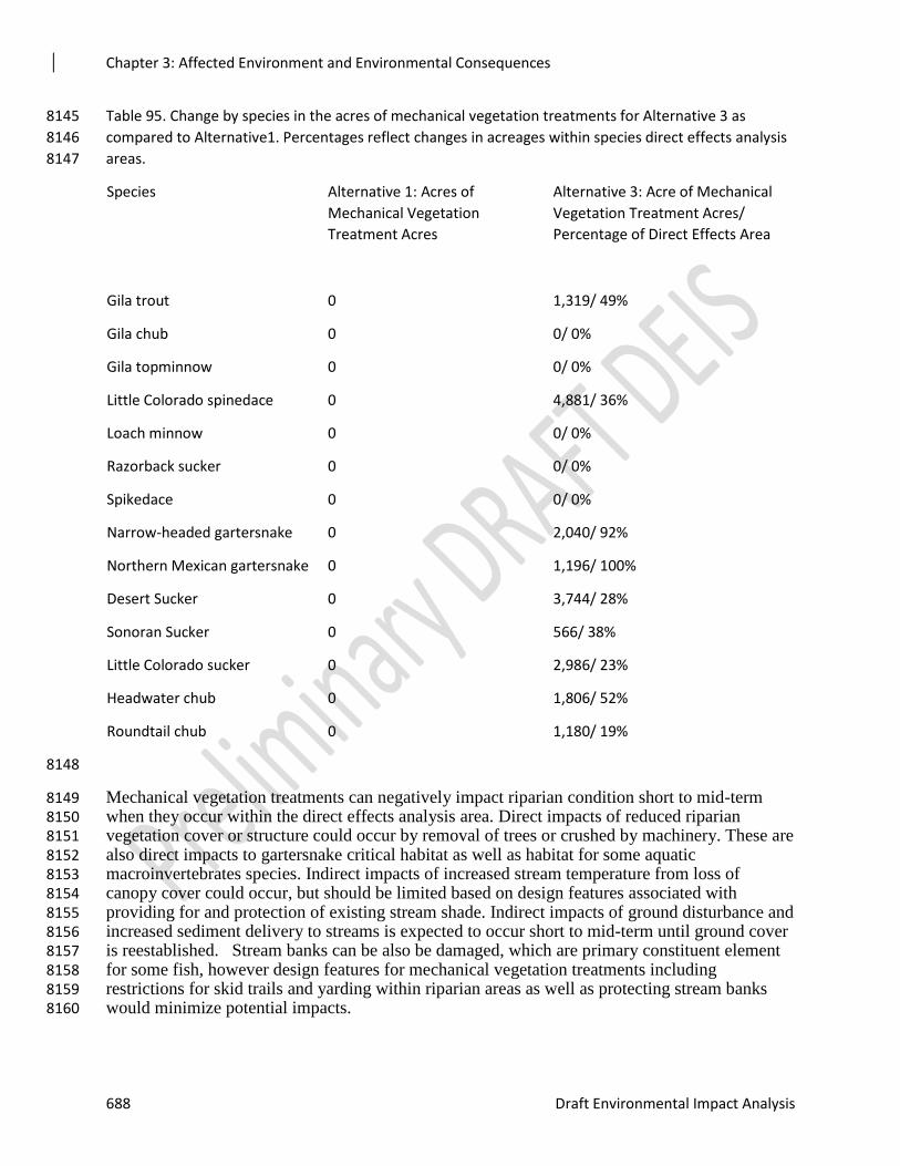
Chapter 3: Affected Environment and Environmental Consequences
688 Draft Environmental Impact Analysis
Table 95. Change by species in the acres of mechanical vegetation treatments for Alternative 3 as 8145
compared to Alternative1. Percentages reflect changes in acreages within species direct effects analysis 8146
areas. 8147
Species Alternative 1: Acres of
Mechanical Vegetation
Treatment Acres
Alternative 3: Acre of Mechanical
Vegetation Treatment Acres/
Percentage of Direct Effects Area
Gila trout 0 1,319/ 49%
Gila chub 0 0/ 0%
Gila topminnow 0 0/ 0%
Little Colorado spinedace 0 4,881/ 36%
Loach minnow 0 0/ 0%
Razorback sucker 0 0/ 0%
Spikedace 0 0/ 0%
Narrow-headed gartersnake 0 2,040/ 92%
Northern Mexican gartersnake 0 1,196/ 100%
Desert Sucker 0 3,744/ 28%
Sonoran Sucker 0 566/ 38%
Little Colorado sucker 0 2,986/ 23%
Headwater chub 0 1,806/ 52%
Roundtail chub 0 1,180/ 19%
8148
Mechanical vegetation treatments can negatively impact riparian condition short to mid-term 8149 when they occur within the direct effects analysis area. Direct impacts of reduced riparian 8150 vegetation cover or structure could occur by removal of trees or crushed by machinery. These are 8151 also direct impacts to gartersnake critical habitat as well as habitat for some aquatic 8152 macroinvertebrates species. Indirect impacts of increased stream temperature from loss of 8153 canopy cover could occur, but should be limited based on design features associated with 8154 providing for and protection of existing stream shade. Indirect impacts of ground disturbance and 8155 increased sediment delivery to streams is expected to occur short to mid-term until ground cover 8156 is reestablished. Stream banks can be also be damaged, which are primary constituent element 8157 for some fish, however design features for mechanical vegetation treatments including 8158 restrictions for skid trails and yarding within riparian areas as well as protecting stream banks 8159 would minimize potential impacts. 8160
Chapter 3: Affected Environment and Environmental Consequences
Rim Country Project 689
Riparian condition for both gartersnakes, desert sucker and Sonoran sucker are currently 8161 impaired, therefore direct impacts are expected to be higher. Vegetation in these systems is not 8162 adequate to capture sediment, are often disconnected from the water table and are more reflective 8163 of upland species. Riparian condition for the remaining species is functioning at risk, therefore 8164 direct and indirect effects are expected to be less. Vegetation in these systems has loss of vigor, 8165 growth, or changes in composition, but is present and functioning at some level. 8166
Impacts to individuals in the form of harm or modification of behavior could also occur short to 8167 mid-term. Mechanical vegetation treatments within gartersnake habitat could result in harm of 8168 individuals as a direct effect. Gartersnakes may avoid or move out of these areas while work is 8169 occurring causing displacement or disruption of social and feeding behavior. This could 8170 potentially reduce the health or reproductive capability of individuals. 8171
Long term, mechanical vegetation treatments could have a neutral or positive effect on aquatic 8172 indicators. Riparian condition could be improved by removing encroachment and restoring 8173 streamside vegetation. Conifers can impede the growth the riparian woody and herbaceous 8174 species; therefore it is expected they would increase in cover and structure. This would provide 8175 for large woody debris over time as well as decreasing sediment delivery and peak flows. 8176 Impacts to individuals would cease once activities were completed and therefore have a neutral 8177 effect long term. 8178
For Alternative 3, increased acres of mechanical vegetation treatments as compared to 8179 Alternative 1 also has the potential for indirect occur short to mid-term impacts to riparian 8180 condition from treatments in the upper watershed. These are indirect impacts that can occur 8181 within a species action area (i.e., project watershed area that drains into a species occupied 8182 habitat) by changes in the uplands and on tributaries and drainages. For Alternative 3 the 8183 increases in percentage of action areas treated range from 11% to 68%. Headwater chub and 8184 Gila trout have the highest percentage of potential area impacted. Table 3-38 displays these 8185 species habitats as compared to Alternative 1. Five species have increases of 11%, but it is 8186 important to note the overall acreage is comparatively small due to approximately half of the 8187 overall watersheds occurring within the project area. 8188
Table 96. Change by species in acres of mechanical vegetation treatments for Alternative 3 as compared 8189
to Alternative 1 within the species action area. Percentages reflect changes in acreages within species 8190
analysis areas. These are considered indirect impacts. 8191
Species Alternative 1: Acres of
Mechanical Vegetation
Treatment Acres
Alternative 3: Mechanical
Vegetation Treatment Acres/
Percentage of Action Area
Gila trout 0 71,921/ 65%
Gila chub* 0 2,489/ 11%
Gila topminnow* 0 1,327/ 11%
Little Colorado spinedace 0 121,836/ 44%
Loach minnow* 0 1,327/ 11%
Chapter 3: Affected Environment and Environmental Consequences
690 Draft Environmental Impact Analysis
Species Alternative 1: Acres of
Mechanical Vegetation
Treatment Acres
Alternative 3: Mechanical
Vegetation Treatment Acres/
Percentage of Action Area
Razorback sucker* 0 1,327/ 11%
Spikedace* 0 1,327/ 11%
Narrow-headed gartersnake 0 41,711/ 47%
Northern Mexican gartersnake 0 31,051/ 64%
Desert Sucker 0 169,502/ 54%
Sonoran Sucker 0 30,623/ 59%
Little Colorado sucker 0 95,251/ 42%
Headwater chub 0 97,295/ 68%
Roundtail chub 0 82,835/ 52%
*While the percentage is high for these species action areas, less than half of entire watershed is within 8192
the project area. 8193
Mechanical vegetation treatments in uplands can indirectly impact riparian condition short to 8194 mid-term from increased sediment delivery and peak flows via removal of vegetation and ground 8195 disturbance. Soils can be compacted and water infiltration reduced from landings and skid trails 8196 leading to increased overland flow and erosion. Yarding and skidding can redirect water onto 8197 areas more likely to erode than natural channels. In turn, increased sedimentation and peak flows 8198 can occur reducing riparian condition, aquatic habitat quality and quantity. 8199
Potential indirect effects are expected to vary based on current riparian condition. Riparian 8200 condition for both gartersnakes, desert sucker and Sonoran sucker are currently impaired, 8201 therefore indirect effects are expected to be higher. Vegetation in these systems is not adequate 8202 to capture or process sediment, indicating more would reach streams. These riparian areas are 8203 often disconnected from the water table and are more reflective of upland species; therefore 8204 unable to dissipate stream energy associated with increased peak flows. Riparian condition for 8205 five species is currently functioning at risk, therefore indirect effects are expected to be less. 8206 Vegetation in these systems has loss of vigor, growth, or changes in composition, but is present 8207 and able to process sediment and dissipate flows in a limited capacity. Riparian condition for the 8208 remaining four species in Upper Fossil Creek is functioning properly. While indirect effects 8209 could occur, these riparian areas are able to process sediment and dissipate flows. 8210
For those species with impaired or functioning at risk riparian condition, elevated sedimentation 8211 could negatively impact aquatic habitat, species, and water quality; particularly fish eggs and 8212 early life history stages that occur on or within substrate as well as the aquatic macroinvertebrate 8213 community structure. Habitat is impacted by filling of pools and spawning substrates which can 8214 lead to loss of habitat quality and reduced reproductive success. Peak flows can be increased 8215 altering channel forming flows leading to bank erosion and loss of habitat complexity. 8216
Chapter 3: Affected Environment and Environmental Consequences
Rim Country Project 691
Reduction in riparian vegetation can lead to decreased organic matter input to support aquatic 8217 macroinvertebrates and increases stream temperature. 8218
Design features related to mechanical vegetation treatments are expected to minimize the 8219 potential effects described above. The project includes spreading treatments in time and space 8220 within a watershed as well as for skid trails, yarding, and landings are expected to reduce these 8221 impacts. 8222
Pollutants in the form of fuels and lubricants have the potential to be introduced into aquatic 8223 systems from staging areas and equipment. Spills and leaks can introduce pollutants to soils and 8224 then to streams and riparian areas reducing riparian condition and habitat quality. Design 8225 features for storm water protections plans, staging areas, fuel storage and checking equipment for 8226 leaks minimizes the potential for introduction of pollutants. 8227
Long term, mechanical vegetation treatments are expected to improve overall watershed 8228 condition as well as riparian condition. Moving forests towards desired conditions of more a 8229 healthy, resilient state will provide for improved watershed function over time. It will also 8230 reduce the risk of uncharacteristic wildfire which can greatly impact all resource indicators and 8231 reduce aquatic habitat quality, quantity and populations. 8232
The direct and indirect negative impacts of Alternative 3 to resource indicators are expected to 8233 be higher than Alternative 1, but less than Alternative 2 due to fewer acres of treatment. 8234 However, Alternative 3 would have less potential improvement to riparian condition, watershed 8235 condition, and reduced risk of uncharacteristic wildfire than Alternative 2. 8236
Prescribed Burning 8237
For Alternative 3, acres of prescribed burning has the potential for negative short and mid-term 8238 impacts to riparian condition and individuals. Direct impacts would result if these activities 8239 occur in a species habitat from firelines, removal or reduction of vegetation due to burning or 8240 harm to gartersnakes. Alternative 3 is proposing treatments in the habitats of seven fish species 8241 and both gartersnakes. Increases in acreage of treatments ranges from 623 to 8,819 which 8242 equates to 24% to 100% of the analysis area for direct effects for those species (table 3-39). The 8243 two gartersnakes have the highest percentage of potential area impacted. Five fish species will 8244 not be directly impacted by prescribed burning under Alternative 3. 8245
Prescribed burning can negatively impact riparian condition short to mid-term when it occurs in 8246 the direct effects analysis area. Direct impacts of reduced riparian vegetation cover or structure 8247 and decreases in large wood recruitment could occur from burning. Decreases in willows and 8248 other shrubby species reduces hiding and thermal cover for gartersnakes. This would be a direct 8249 alteration of gartersnake critical habitat as well as potentially impacting some aquatic 8250 macroinvertebrate species. This reduction is only expected to occur until vegetation recovers. 8251 Reduction in canopy cover also reduces stream shading and can increase stream temperatures. It 8252 also reduces organic matter inputs to streams which can alter food webs and prey base for fish 8253 and gartersnakes. Indirect impacts of increased stream temperature from loss of canopy cover 8254 could also occur, but should be limited based on design features associated with limiting high 8255 burn severity (mortality) within riparian areas. 8256
Riparian condition for both gartersnakes, desert sucker and Sonoran sucker are currently 8257 impaired, therefore direct and indirect effects are expected to be higher. Vegetation in these 8258 systems is not adequate to capture sediment, are often disconnected from the water table and are 8259 more reflective of upland species. They already lack adequate streamside cover and structure, 8260 therefore those factors could be more susceptible to impacts. Riparian condition for the 8261
Chapter 3: Affected Environment and Environmental Consequences
692 Draft Environmental Impact Analysis
remaining species is functioning at risk, therefore direct and indirect effects are expected to be 8262 less as they have more cover and structure. Vegetation in these systems has loss of vigor, growth, 8263 or changes in composition, but is present. 8264
Long term effects of prescribed burning are expected to be positive for riparian condition. 8265 Reduced fuel loading would protect these areas from uncharacteristic wildfire in the future. 8266 Large woody debris recruitment and streamside cover or structure can also improve with 8267 prescribed fire. Fire plays an important role in maintaining heterogeneity in riparian and aquatic 8268 systems that has been excluded similar to surrounding uplands (Gresswell 1999); therefore, 8269 restoring the fire regime would have some benefits to riparian condition. 8270
Impacts to individual gartersnakes in the form of mortality or modification of behavior could 8271 also occur short to mid-term. Mortality could occur during prescribed burning; however, 8272 gartersnakes are mobile and design features of no burn piles within their habitat reduces that 8273 potential. While gartersnakes are more susceptible to exposure during a prescribed fire, it is more 8274 likely that harm or displacement would occur until the burns were completed. Long term impacts 8275 to individuals would be neutral or potentially positive if habitat improved and similarly increased 8276 social or feeding behavior. 8277
Table 97. Change By Species In The Acres Of Prescribed Burning For Alternative 3 As Compared To 8278
Alternative 1. Percentages Reflect Changes In Acreages Within Species Direct Effects Analysis Areas. 8279
Species Alternative 1: Acres of Prescribed
burning
Alternative 3: Acres of Prescribed
Burning/ Percent of Direct Effect
Area
Gila trout 0 1,462/ 54%
Gila chub 0 0/ 0%
Gila topminnow 0 0/ 0%
Little Colorado spinedace 0 8,819/ 65%
Loach minnow 0 0/ 0%
Razorback sucker 0 0/ 0%
Spikedace 0 0/ 0%
Narrow-headed gartersnake 0 2,211/ 100%
Northern Mexican gartersnake 0 1,196/ 100%
Desert Sucker 0 4,395/ 33%
Sonoran Sucker 0 623/ 42%
Little Colorado sucker 0 6,244/ 48%
Headwater chub 0 1,957/ 56%
Roundtail chub 0 1,470/ 24%
Chapter 3: Affected Environment and Environmental Consequences
Rim Country Project 693
8280
Short to mid-term negative indirect impacts from prescribed burning in uplands can occur within 8281 a species action area (i.e., watershed area that drains into a species occupied habitat) for all 8282 analyzed species. For Alternative 3 the increases in percentage of action areas treated range from 8283 11% to 100%. However, while the five species (denoted with an asterisk) show increases, it is 8284 important to note the overall acreage is small. Table 3-40 displays these species habitats as 8285 compared to Alternative 1. Impacts would be highest for both Narrow-headed gartersnake and 8286 lowest for four species in Fossil Creek outside the project area. 8287
Prescribed burning can indirectly impact riparian condition short to mid-term from increased 8288 sediment delivery and peak flows. Loss of ground cover from burning can increase erosion and 8289 overland flow which leads to increased sedimentation and peak flows. This could reduce riparian 8290 condition, aquatic habitat quality and quantity. However, these impacts are only expected to 8291 occur until ground cover vegetation recovers and has the ability to dissipate flows and trap 8292 sediment. Design features for extent of high burn severity as well as spatial and temporal spacing 8293 of activities within a watershed are expected to minimize potential impacts. 8294
Potential indirect effects from increased peak flows and sedimentation are expected to vary by 8295 riparian condition. Indirect effects are expected to be higher for the four species with riparian 8296 condition that is currently impaired. Vegetation in these systems is not adequate to capture or 8297 process sediment, indicating more could potentially reach streams. These riparian areas are often 8298 disconnected from the water table and are more reflective of upland species; therefore unable to 8299 dissipate stream energy associated with increased peak flows. Riparian condition for five species 8300 is currently functioning at risk, therefore indirect effects are expected to be less. Vegetation in 8301 these systems has loss of vigor, growth, or changes in composition, but is present and able to 8302 process sediment and dissipate flows in a limited capacity. Riparian condition for the remaining 8303 four species in Fossil Creek is functioning properly. While indirect effects could occur, these 8304 riparian areas are able to process sediment and dissipate flows. Overall acres of treatment for 8305 Gila chub, loach minnow, spikedace, razorback sucker, and Gila topminnow are less than half of 8306 the watersheds in which they occur further reducing potential indirect effects. Additionally, 8307 prescribed burning would only occur in the upper watershed within the project area. 8308
For those species with impaired or functioning at risk riparian condition, elevated sedimentation 8309 could negatively impact aquatic habitat, species, and water quality; particularly fish eggs and 8310 early life history stages that occur on or within substrate as well as the aquatic macroinvertebrate 8311 community structure. Habitat is impacted by filling of pools and spawning substrates which can 8312 lead to loss of habitat quality and reduced reproductive success. Potential reductions in fish prey 8313 base could also indirectly impact gartersnakes. Peak flows can be increased altering channel 8314 forming flows leading to bank erosion and loss of habitat complexity. Reduction in riparian 8315 vegetation can lead to decreased organic matter input to support aquatic macroinvertebrates and 8316 increases stream temperature. 8317
Long term effects of prescribed burning in the upper watersheds are expected to be positive for 8318 riparian condition. Reduced fuel loading would protect these areas from uncharacteristic 8319 wildfire in the future that can impact entire watersheds and have long lasting negative impacts on 8320 riparian condition, aquatic habitat quality and quantity, as well as populations of species. 8321
Overall, Alternative 3 would have less potential direct and indirect impacts from prescribed 8322 burning than Alternative 2, but more than Alternative 1. This alternative would also not improve 8323 riparian condition as much as Alternative 2 nor reduce the risk of uncharacteristic wildfire across 8324 as many acres. 8325
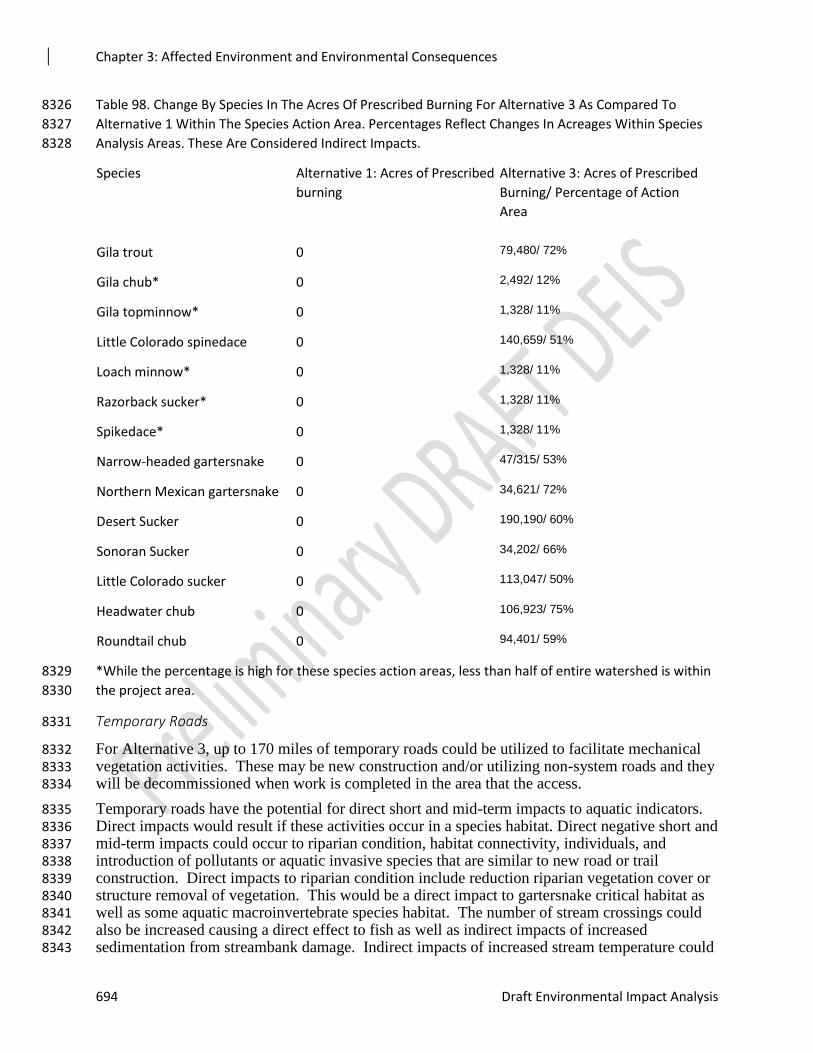
Chapter 3: Affected Environment and Environmental Consequences
694 Draft Environmental Impact Analysis
Table 98. Change By Species In The Acres Of Prescribed Burning For Alternative 3 As Compared To 8326
Alternative 1 Within The Species Action Area. Percentages Reflect Changes In Acreages Within Species 8327
Analysis Areas. These Are Considered Indirect Impacts. 8328
Species Alternative 1: Acres of Prescribed
burning
Alternative 3: Acres of Prescribed
Burning/ Percentage of Action
Area
Gila trout 0 79,480/ 72%
Gila chub* 0 2,492/ 12%
Gila topminnow* 0 1,328/ 11%
Little Colorado spinedace 0 140,659/ 51%
Loach minnow* 0 1,328/ 11%
Razorback sucker* 0 1,328/ 11%
Spikedace* 0 1,328/ 11%
Narrow-headed gartersnake 0 47/315/ 53%
Northern Mexican gartersnake 0 34,621/ 72%
Desert Sucker 0 190,190/ 60%
Sonoran Sucker 0 34,202/ 66%
Little Colorado sucker 0 113,047/ 50%
Headwater chub 0 106,923/ 75%
Roundtail chub 0 94,401/ 59%
*While the percentage is high for these species action areas, less than half of entire watershed is within 8329
the project area. 8330
Temporary Roads 8331
For Alternative 3, up to 170 miles of temporary roads could be utilized to facilitate mechanical 8332 vegetation activities. These may be new construction and/or utilizing non-system roads and they 8333 will be decommissioned when work is completed in the area that the access. 8334
Temporary roads have the potential for direct short and mid-term impacts to aquatic indicators. 8335 Direct impacts would result if these activities occur in a species habitat. Direct negative short and 8336 mid-term impacts could occur to riparian condition, habitat connectivity, individuals, and 8337 introduction of pollutants or aquatic invasive species that are similar to new road or trail 8338 construction. Direct impacts to riparian condition include reduction riparian vegetation cover or 8339 structure removal of vegetation. This would be a direct impact to gartersnake critical habitat as 8340 well as some aquatic macroinvertebrate species habitat. The number of stream crossings could 8341 also be increased causing a direct effect to fish as well as indirect impacts of increased 8342 sedimentation from streambank damage. Indirect impacts of increased stream temperature could 8343
Chapter 3: Affected Environment and Environmental Consequences
Rim Country Project 695
also occur from reduction in canopy cover within riparian areas. Associated ground disturbance 8344 and increased sedimentation delivery to riparian areas and streams is expected to occur short to 8345 mid-term until the roads were decommissioned. 8346
Indirect impacts of opening temporary roads in the upper watershed could occur to riparian 8347 condition and by introduction of pollutants or invasive aquatic species. In general, roads 8348 compact soils and reduce infiltration of water leading to increased erosion and runoff. They 8349 increase the drainage network to riparian areas and streams and connect these areas to the 8350 uplands by altering surface water pathways. This converts dispersed surface runoff and sediment 8351 filtering through a riparian area to direct deliveries of accumulated runoff and sediment. 8352 Pollutants and aquatic invasive species can be transferred to aquatic systems from machinery or 8353 vehicles. Leaking fuels or lubricants can be transferred to aquatic systems from vehicles, 8354 machinery, or fuel storage areas. Aquatic invasive species can similarly be transferred from an 8355 infected water body to an uninfected waterbody through driving. All of these impacts could 8356 occur and continue while the temporary roads were in use and continue for a short period of time 8357 after decommissioning. 8358
Long term, temporary roads would be decommissioned and revegetate. Therefore, direct and 8359 indirect effects would cease. Therefore, long term effects are considered to be neutral. 8360
The direct and indirect negative impacts of temporary roads would be more than alternative 1, 8361 but less than alternative 2. 8362
Sensitive Species not Covered by Resource Indicators and Measures 8363
Aquatic Macroinvertebrates 8364
Stoneflies, caddisflies, mayflies, midges, and riffle beetles are strongly associated with streams 8365 and riparian areas. Based on the biology and ecology of these four groups of species, streams and 8366 riparian areas could have negative direct and indirect impacts from Alternative 3, but less than 8367 Alternative 2. Mechanical vegetation treatments, prescribed burning, and roads can increase 8368 erosion and sedimentation, alter riparian vegetation, and alter stream habitats as described for 8369 fish and gartersnake species above. 8370
Nokomis Fritillary is a sensitive species that utilizes meadows, seeps, and boggy streamside 8371 vegetation. Alternative 3 could have negative direct and indirect negative impacts to the species 8372 and its habitat, but less than Alternative 2. Acres of riparian, grassland, and meadow treatments 8373 are the same between Alternatives 2 and 3, therefore direct impacts would be the same. Acres of 8374 upland mechanical treatments, prescribed fire, and miles of temporary roads are reduced in 8375 Alternative 3 leading to decreased indirect impacts. Mechanical vegetation treatments, prescribed 8376 burning, and roads can increase erosion and sedimentation, alter riparian vegetation, and alter 8377 stream habitats utilized by these sensitive species. 8378
The California Floater was once present in Fossil Creek, West Clear Creek, and Upper Clear 8379 Creek and it is possible that it may still occur within Chevelon Creek below Chevelon Dam. 8380 Direct and indirect negative cumulative impacts could occur in two of the watersheds, no direct 8381 impacts would occur in Fossil Creek or Chevelon Creek. Increases in mechanical vegetation 8382 treatments, prescribed burning, and roads could increase erosion and sedimentation, alter riparian 8383 vegetation, and alter stream habitats short- and long-term. 8384
For all sensitive aquatic macroinvertebrates, streams and riparian areas could have negative 8385 direct and indirect impacts from Alternative 3, but less than Alternative 2 given the decrease in 8386 acres treated. Direct and indirect negative impacts for road use, relocation and decommissioning 8387 would be the same for both Alternative 2 and 3. Direct and indirect impacts from temporary 8388
Chapter 3: Affected Environment and Environmental Consequences
696 Draft Environmental Impact Analysis
roads would be less in Alternative 3 than Alternative 2 given the reduction in proposed miles. 8389 Mechanical vegetation treatments, prescribed burning, and roads can increase erosion and 8390 sedimentation, alter riparian vegetation, and alter stream habitats that negatively impact these 8391 sensitive species as described for fish and gartersnake species above. Alternative 3 would 8392 potentially having long-term benefits from reducing the risk of uncharacteristic wildfire and 8393 reduced road densities. 8394
Cumulative Effects 8395
Past, Present, and Reasonably Foreseeable Activities Relevant to Cumulative Effects Analysis 8396
The cumulative effects analysis geographic boundary is the Rim Country project area boundary 8397 as this area includes all actions associated with implementation for this analysis. The following 8398 list summarizes the past, present, and future activities that would add to the total cumulative 8399 effects. Since the implementation of the Rim Country is so large, the activities will be discussed 8400 generally. 8401
1. Timber Harvest and Vegetation Management: These types of projects include timber 8402 harvest, vegetation treatments, fuel reductions and treatments, wildland urban interface 8403
treatments, salvage logging, forest restoration treatments, energy corridor maintenance, 8404 and fuelwood harvesting. Past timber harvest activities have resulted in substantial 8405
impacts to watersheds, hydrologic conditions, riparian and aquatic habitat, and fish 8406 species across the proposed project area (especially in vegetated areas with high timber 8407 resources (e.g., ponderosa pine, mixed-conifer, spruce-fir, etc.). This activity has resulted 8408
in most of the existing transportation system present today, especially management level 8409 1 and 2 roads. More recent vegetation treatments likely have had less impacts, but can 8410
still contribute cumulative effects, especially given resource conditions and ecological 8411 processes that have been highly altered from legacy impacts. Fuelwood collecting and 8412 harvesting is also a very widespread activity occurring across the project area. It occurs 8413
extensively within timber harvest areas, but also occurs as part of or within vegetation 8414
treatments in woodland areas as well. Projects such as Upper Beaver Creek, Larson, Rim 8415 Lakes, and Upper Rocky Arroyo have been occurring and will continue into the future; 8416 whereas CC Cragin is a future project. 8417
2. Recreation and Recreation Management: Recreational activities occur throughout the 8418
proposed project area, and are continuing to increase. Developed recreation sites, 8419 dispersed camping, hiking, fishing, hunting, driving, boating, wildlife viewing, and many 8420 other types of recreational activities occur across proposed project area. Riparian areas, 8421 lakes, and streams are very popular areas for recreational activities and dispersed 8422 camping; this can result in deteriorated resource conditions from the concentrated use 8423
(e.g. loss of vegetation and soil compaction), and can also impact water quality. 8424
3. Fire Suppression and Fire Management Projects: Fire suppression activities have been in 8425
place for decades, and have resulted in unnatural vegetative conditions and have altered 8426 ecological processes across most of the proposed project area. Suppression activities are 8427 ongoing and will continue well into the future, as vegetation structure and composition 8428 has been altered so that allowing it to burn will result in uncharacteristic and 8429 unacceptable resource impacts. Fire suppression activities can also impact water 8430
resources and species dependent upon them by removing water, which usually occurs 8431 during the driest part of the year. Prescribed fire and burns have been occurring for the 8432 last 10-20 years, and have increased considerably in their extent and impacts over the last 8433
Chapter 3: Affected Environment and Environmental Consequences
Rim Country Project 697
5-10 years. Fire management can have both short and long term impacts that are both 8434
positive and negative, and cumulatively these impacts will be dependent on the existing 8435 resource conditions and the future environmental conditions. It should also be noted that 8436 significant levels of wildfire activities have occurred across the proposed project area in 8437
the last 20-25 years, especially associated with large wildfires such as Rodeo-Chediski 8438 Fire (2002) that burned within the proposed project area. 8439
4. Livestock Grazing: Grazing livestock has likely occurred for over a century across the 8440 proposed project area. Historically unrestricted and unregulated resulted in overgrazing, 8441 especially within riparian areas, has likely contributed to the degraded riparian and 8442
aquatic habitat conditions that currently occur. Livestock grazing is continuing over most 8443 of the proposed project area, although some areas are excluded for resource recovery 8444 reasons. Infrastructure development and maintenance associated with livestock grazing 8445 allotments is substantial. Thousands of miles of fences and thousands of stock tanks 8446
occur throughout the proposed project area. Impacts to aquatic habitat and species, 8447 hydrologic conditions and processes, and riparian and upland conditions have occurred; 8448
and this will continue as long as livestock management and the associated infrastructure 8449 remains in place, and contributes cumulative effects to aquatic species and their habitats. 8450
5. Road and Trail Construction, Maintenance, and Closure: As previously stated past 8451 timber activities and harvest primarily accounted for road development and placement, 8452 and this is still reflected in the existing transportation system. Approximately 5,682 8453
miles of roads and almost many miles of hiking trails occur within Rim Country. While 8454 roads and trails are necessary for the use, enjoyment, and management, they also are 8455
responsible for considerable landscape scale changes to the functioning and maintaining 8456 of ecological processes and values. Maintenance activities for roads and trails are limited 8457 by available funding, and can result in both positive and negative benefits, depending on 8458
when it occurs and how often. These impacts will continue as long as the roads/trails are 8459
in place, and are a major contributor to cumulative effects. The Coconino NF has closed 8460 over 90 miles of roads as part of focused watershed restoration activities in the Little 8461 Colorado River watershed. 8462
6. Special Uses and Permits/Minerals Management/Land Exchanges: Hundreds of special 8463 uses permits have been issued across the proposed project area. These include permits 8464
for outfitter and guiding activities fuelwood and Christmas tree cutting, road easements, 8465 plant and minerals collection, church and youth camps, gravel and cinder pits, ditch bill 8466
easements, communications sites, and other uses as well. All of these activities can result 8467 in impacts to watersheds riparian areas, and aquatic habitat and species; and contribute to 8468 cumulative effects, especially water development and diversion projects. Land 8469 exchanges have resulted in the acquisition of riparian habitat (and in some cases 8470
associated water rights) that could help improve or maintain the status of some aquatic 8471 species. 8472
7. Dam and Reservoir Development/Water Developments and Diversions: These projects 8473
have resulted in considerable impacts to aquatic habitat and species both directly and 8474 indirectly. Dam and reservoir development began in the late 1800’s and continued into 8475 the 1960’s across the project area. Most of this activity was to provide for downstream 8476 (and off Forests) water use and irrigation, and to provide for recreational opportunities. 8477 Blue Ridge Reservoir is part of an interbasin transfer to the Verde River to provide water 8478
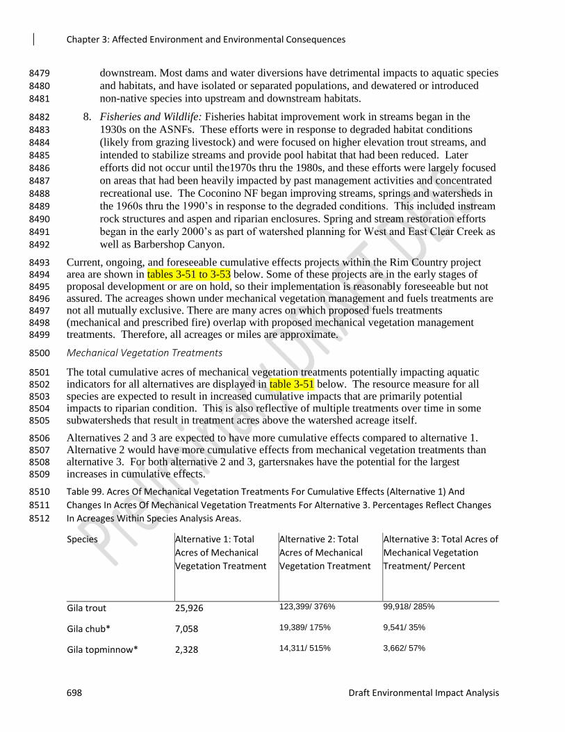
Chapter 3: Affected Environment and Environmental Consequences
698 Draft Environmental Impact Analysis
downstream. Most dams and water diversions have detrimental impacts to aquatic species 8479
and habitats, and have isolated or separated populations, and dewatered or introduced 8480 non-native species into upstream and downstream habitats. 8481
8. Fisheries and Wildlife: Fisheries habitat improvement work in streams began in the 8482
1930s on the ASNFs. These efforts were in response to degraded habitat conditions 8483 (likely from grazing livestock) and were focused on higher elevation trout streams, and 8484 intended to stabilize streams and provide pool habitat that had been reduced. Later 8485 efforts did not occur until the1970s thru the 1980s, and these efforts were largely focused 8486 on areas that had been heavily impacted by past management activities and concentrated 8487
recreational use. The Coconino NF began improving streams, springs and watersheds in 8488 the 1960s thru the 1990’s in response to the degraded conditions. This included instream 8489 rock structures and aspen and riparian enclosures. Spring and stream restoration efforts 8490 began in the early 2000’s as part of watershed planning for West and East Clear Creek as 8491
well as Barbershop Canyon. 8492
Current, ongoing, and foreseeable cumulative effects projects within the Rim Country project 8493 area are shown in tables 3-51 to 3-53 below. Some of these projects are in the early stages of 8494 proposal development or are on hold, so their implementation is reasonably foreseeable but not 8495 assured. The acreages shown under mechanical vegetation management and fuels treatments are 8496 not all mutually exclusive. There are many acres on which proposed fuels treatments 8497 (mechanical and prescribed fire) overlap with proposed mechanical vegetation management 8498 treatments. Therefore, all acreages or miles are approximate. 8499
Mechanical Vegetation Treatments 8500
The total cumulative acres of mechanical vegetation treatments potentially impacting aquatic 8501 indicators for all alternatives are displayed in table 3-51 below. The resource measure for all 8502 species are expected to result in increased cumulative impacts that are primarily potential 8503 impacts to riparian condition. This is also reflective of multiple treatments over time in some 8504 subwatersheds that result in treatment acres above the watershed acreage itself. 8505
Alternatives 2 and 3 are expected to have more cumulative effects compared to alternative 1. 8506 Alternative 2 would have more cumulative effects from mechanical vegetation treatments than 8507 alternative 3. For both alternative 2 and 3, gartersnakes have the potential for the largest 8508 increases in cumulative effects. 8509
Table 99. Acres Of Mechanical Vegetation Treatments For Cumulative Effects (Alternative 1) And 8510
Changes In Acres Of Mechanical Vegetation Treatments For Alternative 3. Percentages Reflect Changes 8511
In Acreages Within Species Analysis Areas. 8512
Species Alternative 1: Total
Acres of Mechanical
Vegetation Treatment
Alternative 2: Total
Acres of Mechanical
Vegetation Treatment
Alternative 3: Total Acres of
Mechanical Vegetation
Treatment/ Percent
Gila trout 25,926 123,399/ 376% 99,918/ 285%
Gila chub* 7,058 19,389/ 175% 9,541/ 35%
Gila topminnow* 2,328 14,311/ 515% 3,662/ 57%
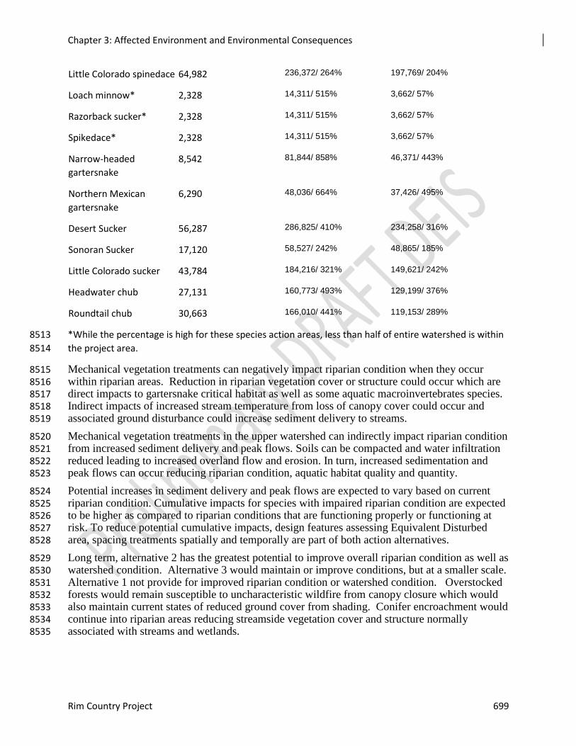
Chapter 3: Affected Environment and Environmental Consequences
Rim Country Project 699
Little Colorado spinedace 64,982 236,372/ 264% 197,769/ 204%
Loach minnow* 2,328 14,311/ 515% 3,662/ 57%
Razorback sucker* 2,328 14,311/ 515% 3,662/ 57%
Spikedace* 2,328 14,311/ 515% 3,662/ 57%
Narrow-headed
gartersnake
8,542 81,844/ 858% 46,371/ 443%
Northern Mexican
gartersnake
6,290 48,036/ 664% 37,426/ 495%
Desert Sucker 56,287 286,825/ 410% 234,258/ 316%
Sonoran Sucker 17,120 58,527/ 242% 48,865/ 185%
Little Colorado sucker 43,784 184,216/ 321% 149,621/ 242%
Headwater chub 27,131 160,773/ 493% 129,199/ 376%
Roundtail chub 30,663 166,010/ 441% 119,153/ 289%
*While the percentage is high for these species action areas, less than half of entire watershed is within 8513
the project area. 8514
Mechanical vegetation treatments can negatively impact riparian condition when they occur 8515 within riparian areas. Reduction in riparian vegetation cover or structure could occur which are 8516 direct impacts to gartersnake critical habitat as well as some aquatic macroinvertebrates species. 8517 Indirect impacts of increased stream temperature from loss of canopy cover could occur and 8518 associated ground disturbance could increase sediment delivery to streams. 8519
Mechanical vegetation treatments in the upper watershed can indirectly impact riparian condition 8520 from increased sediment delivery and peak flows. Soils can be compacted and water infiltration 8521 reduced leading to increased overland flow and erosion. In turn, increased sedimentation and 8522 peak flows can occur reducing riparian condition, aquatic habitat quality and quantity. 8523
Potential increases in sediment delivery and peak flows are expected to vary based on current 8524 riparian condition. Cumulative impacts for species with impaired riparian condition are expected 8525 to be higher as compared to riparian conditions that are functioning properly or functioning at 8526 risk. To reduce potential cumulative impacts, design features assessing Equivalent Disturbed 8527 area, spacing treatments spatially and temporally are part of both action alternatives. 8528
Long term, alternative 2 has the greatest potential to improve overall riparian condition as well as 8529 watershed condition. Alternative 3 would maintain or improve conditions, but at a smaller scale. 8530 Alternative 1 not provide for improved riparian condition or watershed condition. Overstocked 8531 forests would remain susceptible to uncharacteristic wildfire from canopy closure which would 8532 also maintain current states of reduced ground cover from shading. Conifer encroachment would 8533 continue into riparian areas reducing streamside vegetation cover and structure normally 8534 associated with streams and wetlands. 8535
Chapter 3: Affected Environment and Environmental Consequences
700 Draft Environmental Impact Analysis
Prescribed Burning 8536
The total cumulative acres of wildand fire (prescribed and wildfire) potentially impacting aquatic 8537 indicators for all alternatives are displayed in table 3-52 below. Increased resource measures for 8538 all species are expected to result in increased cumulative impacts to riparian condition and 8539 individuals. This is also reflective of how frequently some subwatersheds experience wildfire 8540 cumulatively adding acreages above the watershed acreage itself. 8541
Alternatives 2 and 3 are expected to have more cumulative effects compared to alternative 1. 8542 Alternative 2 would have more cumulative effects from prescribed burning than alternative 3. 8543 For alternative 2, Northern Mexican gartersnake and Headwater chub have the potential for the 8544 largest increases in cumulative effects, while Roundtail chub and Gila trout have the largest 8545 increases under alternative 3. 8546
Table 100. Acres Of Burning And Wildfire For Cumulative Effects (Alternative 1) And Changes In Acres Of 8547
Prescribed Burning For Alternative 3. Percentages Reflect Changes In Acreages Within Species Analysis 8548
Areas. 8549
Species Alternative 1:
Acres of Burning
Alternative 2: Acres of
Prescribed Burning/
Percent Increase
Alternative 3: Acres of
Prescribed Burning/
Percent Increase
Gila trout 60,777 158,250/ 160% 142,481/ 134%
Gila chub* 7,992 20,323/ 154% 10,485/ 31%
Gila topminnow* 8,043 12,726/ 58% 9,377/ 17%
Little Colorado spinedace 158,178 329,568/ 108% 308,616/ 95%
Loach minnow* 8,043 12,726/ 58% 9,377/ 17%
Razorback sucker* 8,043 12,726/ 58% 9,377/ 17%
Spikedace* 8,043 12,726/ 58% 9,377/ 17%
Narrow-headed gartersnake 99,508 172,810/ 74% 142,964/ 44%
Northern Mexican gartersnake 26,036 99,338/ 282% 60,774/ 133%
Desert Sucker 155,830 386,368/ 148% 355,831/ 128%
Sonoran Sucker 44,650 86,057/ 93% 80,117/ 79%
Little Colorado sucker 97,073 237,505/ 145% 219,583/ 126%
Headwater chub 50,610 184,252/ 264% 162,445/ 221%
Roundtail chub 71,229 206,576/ 190% 171,036/ 140%
*While the percentage is high for these species action areas, less than half of entire watershed is within 8550
the project area. 8551
Chapter 3: Affected Environment and Environmental Consequences
Rim Country Project 701
Wildfire can negatively impact riparian condition within species habitats. Riparian vegetation 8552 cover or structure can be reduced as well as large wood recruitment. Decreases in willows and 8553 other shrubby species reduces hiding and thermal cover for gartersnakes, which is an alteration 8554 of gartersnake critical habitat as well as some aquatic macroinvertebrate habitats. Prescribed fire 8555 would only cause these reductions until vegetation recovers, while wildfires can have a much 8556 greater impact due to moderate and high burn severity. Reduction in canopy cover also reduces 8557 stream shading and organic matter inputs to streams which can alter food webs and prey base for 8558 fish and gartersnakes. Indirect impacts of increased stream temperature from loss of canopy 8559 cover could also occur, but should be limited based on design features associated with limiting 8560 high burn severity (mortality) within riparian areas. 8561
Wildfires in the upper watershed can also cumulatively effect riparian to a greater extent due to 8562 increased sedimentation and peak flows. Prescribed fires generally limit moderate and high 8563 severity within watersheds; while wildfire does not. Therefore cumulative effects would vary 8564 depending on what type of fire occurred. In turn, increased sedimentation and peak flows can 8565 occur reducing riparian condition, aquatic habitat quality and quantity. 8566
Potential increases in sediment delivery and peak flows are expected to vary based on current 8567 riparian condition. Cumulative impacts for species with impaired riparian condition are expected 8568 to be higher as compared to riparian conditions that are functioning properly or functioning at 8569 risk. To reduce potential cumulative impacts, design features assessing Equivalent Disturbed 8570 area, spacing treatments spatially and temporally are part of both action alternatives. 8571
Impacts to individual gartersnakes in the form of mortality or modification of behavior could 8572 also occur from wildfire. Mortality is less likely to occur during prescribed burning than from 8573 wildfire. Wildfires tend to occur during the driest time of year, can move rapidly and have 8574 increased fire behavior. Riparian areas generally have high fuel loading and continuity from 8575 being buffered from any treatments for decades and can therefore carry wildfire leading to 8576 potential mortality. 8577
Long term effects of prescribed burning are expected to be positive for riparian condition for 8578 alternative 2 and 3. Reduced fuel loading would protect these areas from uncharacteristic 8579 wildfire in the future. Large woody debris recruitment and streamside cover or structure can also 8580 improve with prescribed fire. Alternative 1 could potentially lead to reduced riparian condition 8581 from the susceptibility to wildfire, particularly uncharacteristic wildfire. 8582
Stream, Riparian, and Wet Meadow Restoration 8583
The total cumulative miles of aquatic restoration potentially impacting aquatic indicators could 8584 not be identified spatially. Therefore, table 3-53 below reflects the restoration between the three 8585 alternatives. Aquatic restoration activities have been individual small efforts described above. In 8586 general, these activities have a small footprint and any negative effects are short-lived by their 8587 very nature. 8588
Table 101. A comparison of the total miles of general and heavy mechanical stream treatments for all 8589
three alternatives. 8590
Species Alternative 1 Alternative 2&3
General Stream
Treatments
Alternative 2&3 Heavy
Mechanical Stream
Treatments
Gila trout 0 7 4
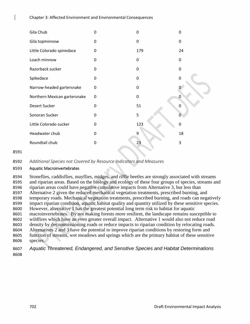
Chapter 3: Affected Environment and Environmental Consequences
702 Draft Environmental Impact Analysis
Gila Chub 0 0 0
Gila topminnow 0 0 0
Little Colorado spinedace 0 179 24
Loach minnow 0 0 0
Razorback sucker 0 0 0
Spikedace 0 0 0
Narrow-headed gartersnake 0 0 0
Northern Mexican gartersnake 0 0 0
Desert Sucker 0 51 0
Sonoran Sucker 0 5 0
Little Colorado sucker 0 123 0
Headwater chub 0 9 18
Roundtail chub 0 23 3
8591
Additional Species not Covered by Resource Indicators and Measures 8592
Aquatic Macroinvertebrates 8593
Stoneflies, caddisflies, mayflies, midges, and riffle beetles are strongly associated with streams 8594 and riparian areas. Based on the biology and ecology of these four groups of species, streams and 8595 riparian areas could have negative cumulative impacts from Alternative 3, but less than 8596 Alternative 2 given the reduced mechanical vegetation treatments, prescribed burning, and 8597 temporary roads. Mechanical vegetation treatments, prescribed burning, and roads can negatively 8598 impact riparian condition, aquatic habitat quality and quantity utilized by these sensitive species. 8599 However, alternative 1 has the greatest potential long term risk to habitat for aquatic 8600 macroinvertebrates. By not making forests more resilient, the landscape remains susceptible to 8601 wildfires which have an even greater overall impact. Alternative 1 would also not reduce road 8602 density by decommissioning roads or reduce impacts to riparian condition by relocating roads. 8603 Alternatives 2 and 3 have the potential to improve riparian conditions by restoring form and 8604 function of streams, wet meadows and springs which are the primary habitat of these sensitive 8605 species. 8606
Aquatic Threatened, Endangered, and Sensitive Species and Habitat Determinations 8607
8608
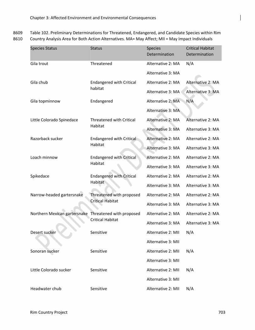
Chapter 3: Affected Environment and Environmental Consequences
Rim Country Project 703
Table 102. Preliminary Determinations for Threatened, Endangered, and Candidate Species within Rim 8609
Country Analysis Area for Both Action Alternatives. MA= May Affect; MII = May Impact Individuals 8610
Species Status Status Species
Determination
Critical Habitat
Determination
Gila trout Threatened
Alternative 2: MA
Alternative 3: MA
N/A
Gila chub Endangered with Critical
habitat
Alternative 2: MA
Alternative 3: MA
Alternative 2: MA
Alternative 3: MA
Gila topminnow Endangered Alternative 2: MA
Alternative 3: MA
N/A
Little Colorado Spinedace Threatened with Critical
Habitat
Alternative 2: MA
Alternative 3: MA
Alternative 2: MA
Alternative 3: MA
Razorback sucker
Endangered with Critical
Habitat
Alternative 2: MA
Alternative 3: MA
Alternative 2: MA
Alternative 3: MA
Loach minnow
Endangered with Critical
Habitat
Alternative 2: MA
Alternative 3: MA
Alternative 2: MA
Alternative 3: MA
Spikedace
Endangered with Critical
Habitat
Alternative 2: MA
Alternative 3: MA
Alternative 2: MA
Alternative 3: MA
Narrow-headed gartersnake
Threatened with proposed
Critical Habitat
Alternative 2: MA
Alternative 3: MA
Alternative 2: MA
Alternative 3: MA
Northern Mexican gartersnake Threatened with proposed
Critical Habitat
Alternative 2: MA
Alternative 3: MA
Alternative 2: MA
Alternative 3: MA
Desert sucker
Sensitive Alternative 2: MII
Alternative 3: MII
N/A
Sonoran sucker
Sensitive Alternative 2: MII
Alternative 3: MII
N/A
Little Colorado sucker
Sensitive Alternative 2: MII
Alternative 3: MII
N/A
Headwater chub Sensitive Alternative 2: MII N/A
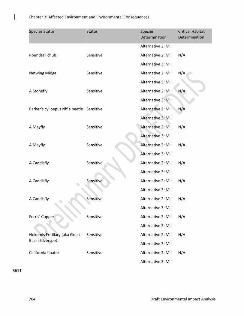
Chapter 3: Affected Environment and Environmental Consequences
704 Draft Environmental Impact Analysis
Species Status Status Species
Determination
Critical Habitat
Determination
Alternative 3: MII
Roundtail chub
Sensitive Alternative 2: MII
Alternative 3: MII
N/A
Netwing Midge
Sensitive Alternative 2: MII
Alternative 3: MII
N/A
A Stonefly
Sensitive Alternative 2: MII
Alternative 3: MII
N/A
Parker’s cylloepus riffle beetle
Sensitive Alternative 2: MII
Alternative 3: MII
N/A
A Mayfly
Sensitive Alternative 2: MII
Alternative 3: MII
N/A
A Mayfly
Sensitive Alternative 2: MII
Alternative 3: MII
N/A
A Caddisfly
Sensitive Alternative 2: MII
Alternative 3: MII
N/A
A Caddisfly
Sensitive Alternative 2: MII
Alternative 3: MII
N/A
A Caddisfly
Sensitive Alternative 2: MII
Alternative 3: MII
N/A
Ferris’ Copper
Sensitive Alternative 2: MII
Alternative 3: MII
N/A
Nokomis Fritillary (aka Great
Basin Silverspot)
Sensitive Alternative 2: MII
Alternative 3: MII
N/A
California floater
Sensitive Alternative 2: MII
Alternative 3: MII
N/A
8611
Chapter 3: Affected Environment and Environmental Consequences
Rim Country Project 705
Noxious and Invasive Weeds 8612
The noxious and invasive weed analysis is part of the Botany and Weeds Report (Crisp 2018), 8613 which is incorporated by reference. 8614
Assumptions and Methodology 8615
Assumptions 8616
This analysis is based on the following assumptions. 8617
1. All management activities will occur as analyzed in the various specialists reports and 8618 described in the FEIS. 8619
2. The mitigation measures, design features, and Best Management Practices will be 8620 incorporated into project design and implementation. See table 4 above for these features. 8621
3. Areas to be treated will be surveyed for noxious or invasive weeds before treatments are 8622 implemented. 8623
4. These factors should be considered when identifying survey needs: 8624
Likelihood of any of the species addressed in this document occurring within the 8625
treatment area 8626
Amount of disturbance. For example, surveys may not be needed in areas scheduled 8627
for prescribed burning if the treatments are scheduled to be of low intensity. 8628
5. The acreage of potential disturbance in this project is much larger than generally 8629
analyzed in similar projects, necessitating more noxious or invasive weed treatments to 8630 control invasive species. This will lead to increases in personnel and budget to 8631 accomplish this need. 8632
Affected Environment 8633
Each of the three forests has separate noxious or invasive weed treatment analyses. As a result, 8634 the targeted species and treatment methods may differ across forests. The Coconino NF was the 8635 first of the three forests to complete a noxious or invasive weed treatment analysis the Final 8636 Environmental Impact Statement for Integrated Treatment of Noxious or Invasive Weeds, 8637 Coconino, Kaibab, and Prescott National Forests; (USDA Forest Service 2005), analyzing 29 8638 species for treatment. The Apache-Sitgreaves NF completed the Environmental Assessment for 8639 the A-SNFs Integrated Forest-Wide Noxious or Invasive Weed Management Program (USDA 8640 Forest Service 2008). It analyzed 53 species and included a variety of treatments including 8641 chemical, cultural, mechanical/physical and biological control. . The Tonto NF completed the 8642 Environmental Assessment for Integrated Treatment of Noxious or Invasive Plants in 2012 and 8643 addressed 68 species. It includes manual, mechanical, prescribed burning, cultural, use of 8644 biological control agents, and use of herbicides. The noxious or invasive weeds throughout the 8645 Region have been rated on the basis of their known distributions and threats to ecosystems 8646 (USDA Forest Service 2014). There are four levels defined by regional guidance. 8647
Class A species are newly established or have the potential to become established in the area. 8648 These may pose an unacceptable threat to rare species, watershed condition, wilderness or other 8649 natural and economic resources. These species should receive the highest priority prevention, 8650 eradication, containment, control, and/or restoration. Management emphasis is to prevent and 8651 eradicate whenever possible or else use containment as a last resort. 8652
Chapter 3: Affected Environment and Environmental Consequences
706 Draft Environmental Impact Analysis
Class B species have limited distribution on the forest, district, or else within a particular 8653 watershed but still pose a substantial threat to rare species, watershed condition, wilderness or 8654 other natural and economic resources. Weed species in this classification receive a lower priority 8655 for eradication, control, or restoration as compared to Class A species. Management emphasis is 8656 to eradicate on a local basis or else control established infestations by using an adaptive 8657 management approach. 8658
Class C species are widely distributed but do not pose additional threats to rare species, 8659 watershed condition, wilderness or other natural and economic resources. (e.g., widely scattered 8660 cheatgrass infestations that do not unduly affect native vegetation or contribute to periodic fire 8661 cycles). Weed species in this classification generally receive the lowest priority for control or 8662 restoration as compared to species in other classes. Management emphasis is to use a control 8663 strategy with an adaptive management approach on a local basis only when necessary to achieve 8664 desired goals and/or objectives and to limit overall effects. 8665
Class E species are widely distributed across the forest, district, or else within a particular 8666 watershed and can cause overwhelming damage to natural resources. . These particular wide-8667 ranging species must be controlled continuously to prevent overwhelming damage to natural. 8668 Management emphasis is to control on a broad-scale basis by using a control strategy with an 8669 adaptive management approach to achieve desired goals and/or objectives and limit overall 8670 effects. 8671
Noxious or invasive weeds are present within all three forests in the project area. The presence 8672 of noxious or invasive weed species have been documented by various surveyors including 8673 Forest employees. Disturbances such as wildfires, management activities, roadways and 8674 activities by the general public but not regulated by the Forest Service have contributed the 8675 introduction and spread of various species. The following tables show the species present on 8676 each forest and the objectives by forest for each species. 8677
Table 103. Noxious or invasive weeds on Apache Sitgreaves NF 8678
Scientific name Common name Infested
acres
Management
goal/treatment objective
Regional
Ranking
Comment
Acroptilon repens Russian
knapweed
0.1 Prevent/eradicate A Within project
boundary but
not in
treatment units
Carduus nutans musk thistle 0.1 Prevent/control/eradicate A
Centaurea
solstitialis
yellow star-
thistle
100 Prevent/eradicate A
Centaurea
biebersteinii
spotted
knapweed
3.0 Prevent/eradicate A
Cirsium vulgare bull thistle 2.5 Prevent/control/eradicate B
Linaria vulgaris butter and eggs 25.0 Prevent/eradicate A

Chapter 3: Affected Environment and Environmental Consequences
Rim Country Project 707
Tamarix
ramosissima
salt cedar 250.0 Prevent/control/eradicate E
8679
Chapter 3: Affected Environment and Environmental Consequences
708 Draft Environmental Impact Analysis
Table 104. Noxious or invasive weeds on the Coconino NF 8680
Scientific name Common name Infested
acres
Management goal
/treatment objective
Regional
Ranking
Comment
Acroptilon repens Russian
knapweed
Contain/Control B Most
infestations are
along or near
highways
Alhagi maurorum camelthorn 2.7 Contain/Control B All infestations
are along
highways except
on FSR 316
which leads to
private property
Bothriochloa
ischaemum
yellow
bluestem
Not ranked* B All infestations
are along
Highway 260
Bromus arvensis Japanese
brome
Not ranked* B
Bromus tectorum cheatgrass Contain/control certain
populations
B
Carduus nutans musk thistle Eradicate A
Centaurea
biebersteinii
spotted
knapweed
Eradicate B Mostly along FH
3 and Highway
87
Centaurea diffusa Diffuse
knapweed
Contain/control B Mostly along
roadways
Cirsium vulgare Bull thistle Contain/control B Most infestation
are 1 acre or
less and are on
severely
disturbed sites.
Eleagnus
angustifolia
Russian olive Contain/control B Single location
along Highway
87
Euphorbia esula Leafy spurge Eradicate B
Chapter 3: Affected Environment and Environmental Consequences
Rim Country Project 709
Scientific name Common name Infested
acres
Management goal
/treatment objective
Regional
Ranking
Comment
Linaria dalmatica Dalmatian
toadflax
Contain/control B Widespread
weed in pine
type on
Coconino NF
Linaria vulgaris butter and eggs Not ranked* A One location
near Happy Jack
administrative
site.
Onopordum
acanthium
Scotch thistle Eradicate/control B
Tamarix
ramosissima
Salt cedar Contain/control B Along Rds. 316
and 625 from
Hwy 87 to
private land
Table 105. Noxious or invasive weeds on Tonto NF and within the project area boundary 8681
Scientific name Common name Infested
acres
Management goal
/treatment objective
Regional
Ranking Comment
Acroptilon repens Russian
knapweed A -Eradicate B
Alhagi maurorum Camelthorn A - Eradicate B
Arundo donax Giant reed
B –Contain
spread/reduce
population
B
Brassica
tournefortii Asian mustard
C – control outlying
populations with long
term goal of eradication
B
Bromus japonicus Japanese
brome
C – Strategic treatment
of certain populations. B
Bromus rubens Red brome C– Strategic treatment of
certain populations B
Bromus tectorum Downy brome C– Strategic treatment of
certain populations B
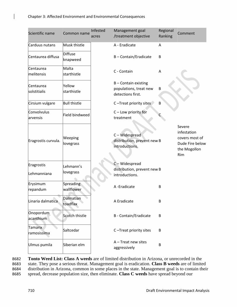
Chapter 3: Affected Environment and Environmental Consequences
710 Draft Environmental Impact Analysis
Scientific name Common name Infested
acres
Management goal
/treatment objective
Regional
Ranking Comment
Carduus nutans Musk thistle A - Eradicate A
Centaurea diffusa Diffuse
knapweed B – Contain/Eradicate B
Centaurea
melitensis
Malta
starthistle C - Contain A
Centaurea
solstitialis
Yellow
starthistle
B – Contain existing
populations, treat new
detections first.
B
Cirsium vulgare Bull thistle C –Treat priority sites B
Convolvulus
arvensis Field bindweed
C – Low priority for
treatment C
Eragrostis curvula. Weeping
lovegrass
C – Widespread
distribution, prevent new
introductions.
B
Severe
infestation
covers most of
Dude Fire below
the Mogollon
Rim
Eragrostis
Lehmanniana
Lehmann’s
lovegrass
C – Widespread
distribution, prevent new
introductions.
B
Erysimum
repandum
Spreading
wallflower A -Eradicate B
Linaria dalmatica Dalmatian
toadflax A Eradicate B
Onopordum
acanthium Scotch thistle B - Contain/Eradicate B
Tamarix
ramosissima Saltcedar C –Treat priority sites B
Ulmus pumila Siberian elm A – Treat new sites
aggressively B
Tonto Weed List: Class A weeds are of limited distribution in Arizona, or unrecorded in the 8682 state. They pose a serious threat. Management goal is eradication. Class B weeds are of limited 8683 distribution in Arizona, common in some places in the state. Management goal is to contain their 8684 spread, decrease population size, then eliminate. Class C weeds have spread beyond our 8685
Chapter 3: Affected Environment and Environmental Consequences
Rim Country Project 711
capability to eradicate them. Management goal is to contain spread to present size, then decrease 8686 the population, if possible. 8687
Environmental Consequences 8688
Alternative 1 – No Action 8689
There would be no effects to noxious or invasive weeds from management activities because 8690 none would occur. Alternative 1 would not increase forest resiliency and sustainability or reduce 8691 the risk of undesirable fire effects. 8692
There would be no improvement in terrestrial habitat. There would be no surveys for or 8693 treatments of noxious or invasive weeds. Survey and treatment would continue in other projects, 8694 as part of the forests’ noxious weed program, and by other entities such as Arizona Department 8695 of Transportation. 8696
For the Apache-Sitgreaves NF, the guidance of Environmental Assessment for the A-SNFs 8697 Integrated Forest-Wide Noxious or Invasive Weed Management Program would not be followed 8698 in this project. The guidelines for soil and high use developed recreation areas as they apply 8699 would not apply. 8700
For the Coconino NF, the guidance of the Final Environmental Impact Statement for Integrated 8701 Treatment of Noxious or Invasive Weeds, Coconino, Kaibab, and Prescott National Forests; 8702 (USDA Forest Service 2005). The guidelines for invasive species, guidelines for all recreation 8703 or desired conditions for developed recreation that apply to the management of noxious or 8704 invasive weeds would not apply, 8705
For the Tonto NF, the guidance of the Environmental Assessment for Integrated Treatment of 8706 Noxious or Invasive Plants (2012) would not apply. 8707
Weed infestations that would have been detected and treated would go unnoticed and continue to 8708 expand unless detected by other surveys or independent observations. Treatments that would 8709 have been part of the mitigating actions not be accomplished. As a result, treatment of weed 8710 infestations would not occur unless the locations are included in another project area or are 8711 treated by a cooperating agency. For example, treatments along highways or roadways in 8712 coordination other agencies would continue but would not expand outside of highway right of 8713 ways. 8714
The following design features and mitigations would not be used BT009, FE004, NW001, 8715 NW002, NW003, NW004, NW005, NW006, NW007, NW008, NW009, NW010, SU018, 8716 SW005 and SW102. These design features provide an integrated approach to noxious or 8717 invasive weed management but would not be incorporated into management activities on the 8718 forests if the no action alternative is selected. 8719
Effects Common to Both Action Alternatives 8720
The purpose of the Rim Country Project is to reestablish and restore forest structure and pattern, 8721 forest health, and vegetation composition and diversity in ponderosa pine ecosystems to 8722 conditions within the natural range of variation. Preventing, controlling, and eradicating noxious 8723 or invasive weeds is complementary to the purpose and need and would improve native 8724 vegetation composition. Management of noxious or invasive weeds is consistent with the 8725 purpose and need because management of them would contribute to the vegetation composition 8726 and diversity of the native plant community in the project area. 8727
The action alternatives would be consistent with the LRMPs and would move toward the desired 8728 conditions for native plant communities and noxious or invasive weed control. Noxious or 8729
Chapter 3: Affected Environment and Environmental Consequences
712 Draft Environmental Impact Analysis
invasive weed management would be guided by each forest’s weed management NEPA. Surveys 8730 for noxious or invasive weeds would be conducted before management activities areas and 8731 needed treatments would follow the guidance of each forest’s noxious or invasive weed 8732 assessment. Post implementation monitoring and treatment would occur. 8733
To prevent the introduction and spread of noxious or invasive weeds by vehicles used in 8734 management activities, vehicles and equipment would be washed to remove soil, seeds and other 8735 debris from them before entering the area or when moving from one area to the other. Ideally, 8736 this would occur before the equipment comes onto the forest but it can also be facilitated with 8737 the approval of the contracting officer or timber sale administrator. 8738
The direct effects of management activities on noxious or invasive weeds include ground-8739 disturbing activities that have the potential to increase the acreage and/or density of the existing 8740 infestations within the project area. Disturbance may contribute to the spread of weeds by 8741 eliminating competition from existing vegetation and creating bare ground that is more easily 8742 invaded than undisturbed areas. Severe disturbance removes competitive vegetation, alters 8743 nutrient composition, and creates bare soil making potential sites for the invasion or spread of 8744 noxious or invasive weeds. Examples of management activities that would create localized 8745 severe disturbance include burned areas from slash piles, creation of log decks, bare soil created 8746 through road reconstruction, decommissioning, temporary road construction, in woods 8747 processing areas and rock pits. 8748
Tree removal indirectly affects noxious or invasive weeds by reducing tree canopy and stand 8749 density. Treatments that reduce the tree canopy and lower the stand density would affect all 8750 understory plants, including noxious or invasive weeds by allowing more sunlight, increasing 8751 available nutrients and temporarily decreasing competition. The increased availability of 8752 resources and decrease in competition can also provide favorable conditions for noxious or 8753 invasive weeds and could increase the size and density of existing populations, especially in 8754 areas where weed infestations already exist. These effects are reduced to a non-significant level 8755 by incorporating the mitigation measures and design features and by incorporating survey and 8756 treatment in the project. Design features which limit the amount of soil disturbance permitted 8757 during timber sales and regulate the depth of rutting by vehicles when soil conditions are wet, 8758 minimizing soil disturbance, would help reduce the amount of disturbance during operations, 8759 reducing the amount of bare ground for noxious or invasive weeds to occupy. 8760
Burning can release nutrients, reduce plant competition, increase the amount of available 8761 sunlight and increase bare soil. Most prescribed burning would be of low severity with low soil 8762 heating, retention on most ground litter and little or no change in mineral soil. These assumptions 8763 are supported by the conclusions of Fowler et al (2008) who conducted a local study on the 8764 Coconino, Kaibab and Apache-Sitgreaves NFs and by Collins et al (2007). They concluded that 8765 low intensity fires in open ponderosa pine forest had minimal effects on the abundance of 8766 noxious or invasive weeds. McGlone and Egan (2009) found similar results in studies they 8767 reviewed. Prescribed or managed fires generally result in lower severity and result in lower 8768 levels of noxious or invasive weed invasion as compared to uncontrolled wildfire. In some 8769 situations, prescribed fire may result in moderate to higher severity (McGlone and Egan, 2009). 8770 The effects in these areas would be more severe and would be similar to slash pile burning or 8771 wildfire. The action alternatives would incorporate a series of design features and mitigations 8772 that would focus on reducing the risk of activities that would increase existing weed populations 8773 or introduce new weeds. Design features provide for collaboration between resources before the 8774 implementation of a prescribed fire. The purpose of this collaboration is to identify the 8775 appropriate mitigations and treatment of noxious or invasive weeds. Follow-up monitoring 8776 would be conducted in areas of heavy disturbance such as large slash piles. Design features 8777
Chapter 3: Affected Environment and Environmental Consequences
Rim Country Project 713
provide direction to conduct prescribed fires under conditions that promote native plant 8778 communities, hinder weed species germination, aid with controlling existing weed infestations, 8779 and prevent the spread of existing weeds. 8780
Direct and indirect effects of temporary road construction, road reconstruction and maintenance 8781 or road decommissioning include disturbance and increased risks of dispersal of existing weed 8782 species and populations and introduction of new species. These would be mitigated by following 8783 the mitigation measures and design features in Appendix C. Roads that are decommissioned as 8784 part of the Rim Country Project would be complementary to the goals of Travel Management 8785 objectives for the forests. Design features provide for the use of existing travel courses and 8786 stream crossings unless new construction would result in less disturbance. This would help to 8787 minimize disturbance from road construction and result in fewer disturbed areas where noxious 8788 or invasive weeds would be able to become established. . 8789
Management activities associated with aquatic and channel restoration would increase 8790 disturbance in the treated areas. Actions such as digging, soil disturbance and related activities 8791 associated with spring restoration would be the sources of this disturbance. These effects would 8792 be mitigated by following the mitigation measures and design features in Appendix C. Design 8793 features establish designated staging areas outside of aquatic management zones (AMZs). This 8794 reduces the risk of the spread of noxious or invasive weeds into AMZs while reducing the risk of 8795 aquatic diseases and petroleum contamination into aquatic systems and habitats. 8796
A series of rock or gravel pits would be needed to provide materials for road maintenance in the 8797 project area. The activities associated with the operation of these are sources of disturbance. A 8798 series of mitigations are provided in the action alternatives to reduce the risks of introducing or 8799 spreading noxious or invasive weeds in the project area. Design features provide for inspection 8800 of sites to assure they are weed-free before use or transport. Noxious or invasive weeds would 8801 be treated before use of the pits. If these treatments are not successful or possible then the 8802 operators would be informed of the weed locations and fill would be obtained from areas of the 8803 pit not near the weed infestation. Equipment used in the pit would be inspected and cleaned 8804 before entering the pit area. If pits are expanded soil and vegetation disturbance would be 8805 avoided to the extent possible and only the area needed would be cleared of vegetation. This 8806 would help minimize disturbance, reducing the amount of unoccupied sites that could then be 8807 invaded by noxious or invasive weeds. The risk of introducing noxious or invasive weeds from 8808 contaminated fill can be mitigated by maintaining stockpiled, weed-free material. 8809
Processing areas are likely to be locations where invasive weeds are established during their 8810 operation. These areas would be managed under the timber sale or special use permit. To 8811 minimize the potential for invasive species spread and transport, these would be treated as part of 8812 the reclamation once operations are complete. Implementation of the design features would 8813 reduce introduction and spread of noxious and invasive weeds. Thus, while these areas would 8814 result in localized weed populations, the spread is expected to be limited. Design features 8815 provides for rehabilitation of processing areas after they are no longer used including seeding of 8816 sites with native seed which would help re-establish native plant communities and reduce the risk 8817 if noxious or invasive weed infestations. Seed mixes of native species used for post-thinning 8818 erosion would be certified as weed-free in accordance with Region 3's guidance for weed-free 8819 materials (USDA 2018) with a minimum of five pounds of pure live seed per acre (USDA 2018). 8820
The action alternatives are expected to limit the establishment and spread of invasive species 8821 within and adjacent to the project area over the next several decades by decreasing the risk of 8822 high intensity wildfire. In the ponderosa and mixed conifer habitat types within the project area, 8823 nonnatives have been shown to increase with increasing fire intensity (McGlone and Egan 2009). 8824
Chapter 3: Affected Environment and Environmental Consequences
714 Draft Environmental Impact Analysis
By decreasing fire intensity, these alternatives would result in increased understory abundance 8825 and diversity which would be more resistant to invasive species over the next 10 to 20 years. 8826
Cumulative Effects 8827
The cumulative effects analysis area for noxious or invasive weeds includes the project area plus 8828 surrounding major arteries of transportation and utility corridors that enter the project area. 8829 Major roads and utility corridors were included because of their roles in providing corridors for 8830 dispersal of noxious or invasive weeds. The timeframe for cumulative effects on noxious or 8831 invasive weeds is twenty years prior and twenty years into the future. 8832
The distribution of noxious or invasive weeds on the project has been shaped by past 8833 management activities and natural disturbances in the project area. Activities such as firewood 8834 cutting have occurred in the past and would continue into the future. Fuel wood cutters can 8835 introduce weeds into the area through their actions. These actions occur under permit but the 8836 forests have limited control over where these activities would occur. 8837
Wildfires can be sources of high levels of disturbance depending on fire severity. Severely 8838 disturbed areas can be more easily invaded by noxious or invasive weeds than less severely 8839 disturbed or undisturbed areas. Numerous wildfires have occurred in the project area (see 8840 cumulative effects document). Some of these, such as the Rodeo-Chediski (2002), Juniper 8841 (2016) and Pot Fire (1996) have covered large acreages. These have resulted in large acreages of 8842 severe fire effects such as almost complete removal of the plant communities and soil erosion, 8843 leaving large areas of disturbance prone to noxious or invasive weed invasions. Some remedial 8844 actions for large fires have resulted in large acreages of non-native species that are now 8845 problematic and would be challenging to restore to native plant communities. An example of 8846 this is the large infestation of Lehmann’s lovegrass that now infests the Dude Fire (1990) on the 8847 Tonto National Forest. 8848
Fire exclusion has contributed to the risk of noxious or invasive weed invasion by promoting 8849 very dense forests with little or no resilient understory community. The lack of native vegetation 8850 to compete with noxious or invasive weeds increases the risk of weed invasion. Fire exclusion 8851 also increases the risk of severe stand replacing fires and its accompanying severe disturbance. 8852
There are numerous grazing allotments in the project boundary. The past effects of grazing and 8853 the associated activities are not completely known but may include temporary reduction of the 8854 native plant community in certain areas (especially near water sources) which would allow for 8855 plants such as the noxious or invasive weeds discussed above to enter the plant community and 8856 introduction of weeds through feed or manure. Human actions associated with range 8857 management such as driving in the area, constructing livestock improvements, and transporting 8858 livestock have also been part of the past actions. 8859
A wide variety of recreation activities occur within the boundary of the project area including 8860 hiking, camping, hunting and recreational driving. Users can introduce noxious or invasive 8861 weeds from other areas on vehicles and personal equipment. The effects of livestock such as 8862 horses or pack animals used in recreation are similar to those in grazing and include temporary 8863 reduction of the native plant community in localized areas where animals are allowed to graze 8864 and introduction of weeds through feed or manure. Trampling and compaction can also occur if 8865 the same campsites are used repeatedly. 8866
In the past there were few restrictions on off-road motorized travel whether for recreational or 8867 other purposes On the Coconino NF, most off-road motorized travel was prohibited with the 8868 implementation of the Travel Management Rule (TMR) in 2012. Implementation of the 2012 8869 travel plan also reduced the number of roads open to public motorized travel, reducing the risk of 8870
Chapter 3: Affected Environment and Environmental Consequences
Rim Country Project 715
dispersal of noxious or invasive weeds in some areas. The Tonto NF completed a similar analysis 8871 in 2016, restricting motor vehicle travel to roadways in some areas while allowing cross-country 8872 travel in other areas. The effects to noxious or invasive weeds were addressed in the analysis. 8873 The Apache-Sitgreaves NFs is currently in the process of analyzing travel management. A final 8874 EIS for the project is expected in October 2019. The effects of this project to resources such as 8875 noxious or invasive weeds are unknown. 8876
Major highways tend to be corridors for weed dispersal by providing a source to vector weeds 8877 into the area. Management activities associated with the highway can create disturbance and 8878 spread existing weeds. Examples include past activities such as blading of road ditches where 8879 equipment passed through existing weed infestations, spreading them along the road corridor. In 8880 2003, the Southwestern Region of the Forest Service completed the Environmental Assessment 8881 for Management of Noxious Weeds and Hazardous Vegetation on Public Roads on National 8882 Forest System Lands in Arizona. The decision, which followed in 2004, allowing treatment of 8883 noxious or invasive weeds along state and federal highway rights-of-way through all National 8884 Forests in Arizona. Some treatments have occurred along state and federal highways as a result 8885 but the extent of these treatments are not known. 8886
The Apache-Sitgreaves NF has surveyed and treated numerous infestations of noxious or 8887 invasive weeds within the project area since 2004. All of the treatments prior to the approval of 8888 the Environmental Assessment for the A-SNFs Integrated Forest-Wide Noxious or Invasive Weed 8889 Management Program (USDA Forest Service 2008) were mechanical treatments accomplished 8890 using hand tools. Herbicide use on the forest began in 2009 after the approval of the document. 8891 Some of the major areas of past treatment include Bison East, Bison West, Buckskin Wash, 8892 Decker Wash, and Hart Canyon. These and other areas would need repeated monitoring and 8893 treatment. The Coconino NF began weed survey and treatments in about 1995 and like the 8894 Apache-Sitgreaves, they relied on non-herbicide methods to control isolated occurrences using 8895 mechanical control and alternatives such as grazing. Using sheep to control leafy spurge was 8896 utilized before the approval of the Final Environmental Impact Statement for Integrated 8897 Treatment of Noxious or Invasive Weeds, Coconino, Kaibab, and Prescott National Forests; 8898 (USDA Forest Service 2005). The EIS allowed use of herbicide as well as biological control. 8899 Many of the treatments have been focused on particular species or areas of concern such as the 8900 leafy spurge, various species of knapweed and non-native thistles. 8901
There are records of surveys along roadways on the Tonto NF beginning in 1999. These surveys 8902 were generally by Arizona Department of Transportation. The forest began surveying for weeds 8903 in 2003. Many of the treatment prior to the approval of the Environmental Assessment for 8904 Integrated Treatment of Noxious or Invasive Plants (2012) were done using hand tools. 8905
The disturbance resulting from the management activities in this project would continue to be 8906 sources of disturbance that may contribute to the threat of noxious or invasive weed occurrences 8907 and would be additive to the activities discussed in this section of the report. 8908
Numerous management activities and wildfires have occurred in the project area in the past (see 8909 cumulative effects document). These activities have contributed to the existing condition of this 8910 analysis. Ground disturbing activities such as timber sales and large wildfires may have 8911 contributed to the introduction, spread or persistence of some noxious or invasive weed 8912 invasions. 8913
Heritage Resources 8914
A summary of the heritage resource analysis is presented here and the complete heritage 8915 specialist report (Hangan 2018) is incorporated by reference. 8916
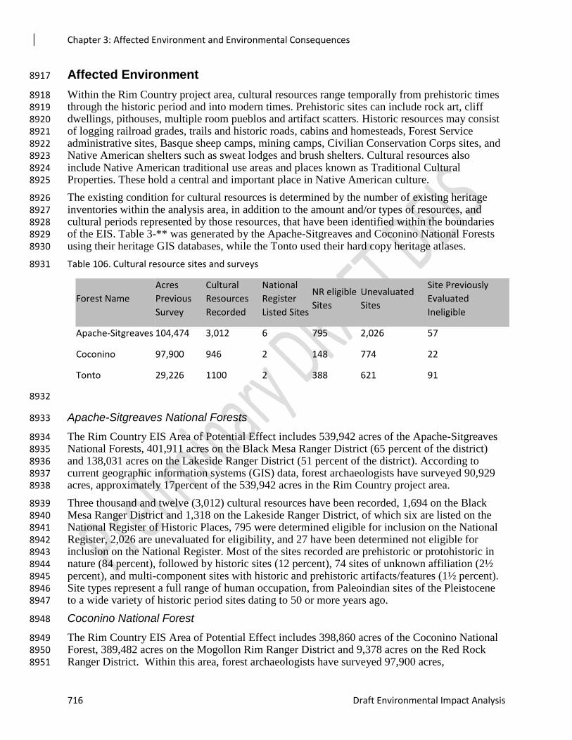
Chapter 3: Affected Environment and Environmental Consequences
716 Draft Environmental Impact Analysis
Affected Environment 8917
Within the Rim Country project area, cultural resources range temporally from prehistoric times 8918 through the historic period and into modern times. Prehistoric sites can include rock art, cliff 8919 dwellings, pithouses, multiple room pueblos and artifact scatters. Historic resources may consist 8920 of logging railroad grades, trails and historic roads, cabins and homesteads, Forest Service 8921 administrative sites, Basque sheep camps, mining camps, Civilian Conservation Corps sites, and 8922 Native American shelters such as sweat lodges and brush shelters. Cultural resources also 8923 include Native American traditional use areas and places known as Traditional Cultural 8924 Properties. These hold a central and important place in Native American culture. 8925
The existing condition for cultural resources is determined by the number of existing heritage 8926 inventories within the analysis area, in addition to the amount and/or types of resources, and 8927 cultural periods represented by those resources, that have been identified within the boundaries 8928 of the EIS. Table 3-** was generated by the Apache-Sitgreaves and Coconino National Forests 8929 using their heritage GIS databases, while the Tonto used their hard copy heritage atlases. 8930
Table 106. Cultural resource sites and surveys 8931
Forest Name
Acres
Previous
Survey
Cultural
Resources
Recorded
National
Register
Listed Sites
NR eligible
Sites
Unevaluated
Sites
Site Previously
Evaluated
Ineligible
Apache-Sitgreaves 104,474 3,012 6 795 2,026 57
Coconino 97,900 946 2 148 774 22
Tonto 29,226 1100 2 388 621 91
8932
Apache-Sitgreaves National Forests 8933
The Rim Country EIS Area of Potential Effect includes 539,942 acres of the Apache-Sitgreaves 8934 National Forests, 401,911 acres on the Black Mesa Ranger District (65 percent of the district) 8935 and 138,031 acres on the Lakeside Ranger District (51 percent of the district). According to 8936 current geographic information systems (GIS) data, forest archaeologists have surveyed 90,929 8937 acres, approximately 17percent of the 539,942 acres in the Rim Country project area. 8938
Three thousand and twelve (3,012) cultural resources have been recorded, 1,694 on the Black 8939 Mesa Ranger District and 1,318 on the Lakeside Ranger District, of which six are listed on the 8940 National Register of Historic Places, 795 were determined eligible for inclusion on the National 8941 Register, 2,026 are unevaluated for eligibility, and 27 have been determined not eligible for 8942 inclusion on the National Register. Most of the sites recorded are prehistoric or protohistoric in 8943 nature (84 percent), followed by historic sites (12 percent), 74 sites of unknown affiliation (2½ 8944 percent), and multi-component sites with historic and prehistoric artifacts/features (1½ percent). 8945 Site types represent a full range of human occupation, from Paleoindian sites of the Pleistocene 8946 to a wide variety of historic period sites dating to 50 or more years ago. 8947
Coconino National Forest 8948
The Rim Country EIS Area of Potential Effect includes 398,860 acres of the Coconino National 8949 Forest, 389,482 acres on the Mogollon Rim Ranger District and 9,378 acres on the Red Rock 8950 Ranger District. Within this area, forest archaeologists have surveyed 97,900 acres, 8951
Chapter 3: Affected Environment and Environmental Consequences
Rim Country Project 717
approximately 25 percent of the 398,860 acres in the Rim Country project area. Archaeologists 8952 have identified 946 cultural resources, of which two are listed on the National Register of 8953 Historic Places, 148 were determined eligible for inclusion on the National Register, 774 are 8954 unevaluated for eligibility, and 22 have been determined not eligible for inclusion on the 8955 National Register. 8956
Most of the sites recorded on the Coconino are prehistoric in nature (78 percent), followed by 8957 historic sites (20 percent), multi-component sites with historic and prehistoric artifacts/features 8958 (16 percent), and four sites of unknown affiliation. The majority of the prehistoric sites are lithic 8959 scatters (47 percent) and scatters with lithic artifacts and ceramics (21 percent). Other prehistoric 8960 sites include sites with house features: field houses, pueblos, pithouses, cliff dwellings, or other 8961 house features (20 percent), caves/rockshelters/cavates (3 percent), agricultural fields (3 percent), 8962 and rock art sites (4 percent). The 189 historic sites include those associated with national forest 8963 management (21 percent), logging or sawmills (7 percent), ranching (47 percent), historic trails 8964 or wagon roads (6 percent), mining (3 percent), military (3 percent), historic burials (3 percent), 8965 and trash dumps that may be related to one or several of these historic activities (10 percent). 8966
Tonto National Forest 8967
The Rim Country EIS Area of Potential Effect includes 290,090 acres on the Payson and 8968 Pleasant Valley Ranger Districts of the Tonto National Forest. Within this area, forest 8969 archaeologists have surveyed 29,226 acres, approximately 10 percent of the 290,090 acres in the 8970 Rim Country project area. Archaeologists have identified 1100 cultural resources, of which two 8971 are listed on the National Register of Historic Places, 388 were determined eligible for inclusion 8972 on the National Register, 621 are unevaluated for eligibility, and 91 have been determined not 8973 eligible for Assumptions and Methodology 8974
Assumptions and Methodology 8975
The primary assumption for this effects analysis is that the removal of fuel from archaeological 8976 sites and improving or decommissioning roads is a benefit to cultural resources. These activities 8977 could protect cultural resources from the effects of extremely hot, highly destructive wildfires by 8978 removing fuel from around and off of archaeological sites. Improving or decommissioning roads 8979 could protect archaeological sites by removing roads that go through sensitive sites. Improving 8980 rough, impassible roads could reduce the threats to archaeological sites from off-road driving. 8981 This would also encourage drivers to remain on roads rather than drive cross-country to avoid 8982 bad spots in roads. However, the methods for accomplishing these tasks, such as mechanical 8983 thinning or ripping of roads, also has the potential to adversely affect cultural resources. 8984
The secondary assumption is that cultural resources will be present at the proposed spring, 8985 riparian, or stream restoration locations. Cultural resources are frequently found in association 8986 with water sources such as springs, streams, and riparian areas. Water sources would have been 8987 exploited prehistorically and during historic periods. A reliable spring, for example, would likely 8988 have been developed to supply stock grazing, logging operations, or farming. 8989
The final assumption is that all activities proposed with the Rim Country EIS will meet the 8990 criteria of a No Adverse Effect determination as defined in the Programmatic Agreement and/or 8991 36 CFR 800.6 where appropriate. 8992
In consultation with the AZ SHPO, the forests are going to rely on multiple guidance documents 8993 and strategies to assist in reaching a No Adverse Effect determination. The primary guidance 8994 will be Appendix J of the Programmatic Agreement. Appendix J of that agreement outlines the 8995
Chapter 3: Affected Environment and Environmental Consequences
718 Draft Environmental Impact Analysis
consultation protocols and strategies for implementing large-scale fuels reduction, vegetation 8996 treatment, and habitat improvement projects. 8997
To supplement Appendix J, in consultation with the AZ SHPO and tribes, the Rim Country 8998 forests created a sample survey strategy specifically for vegetation projects that would involve 8999 mechanical treatments (Morgan et al 2017). Appendix J of the Programmatic Agreement 9000 provides guidance for mechanical treatment. However, it does not distinguish between the 9001 various types of mechanical treatment options, e.g., feller-buncher versus agra-ax, nor does it 9002 take into account existing site inventory data or identified high and low site densities areas. A 9003 model was created using terrestrial ecological unit strata and known site densities within the 9004 project area. The model, amount of existing inventory within a task area and the type of proposed 9005 mechanical treatment will all be taken into account when determining the amount of inventory 9006 necessary and any standard mitigation measures that need to be implemented to meet the criteria 9007 of No Adverse Effect. 9008
The Programmatic Agreement will guide the analysis for the remaining activities proposed in the 9009 Rim Country EIS. The one exception will be road improvement and decommissioning. Some 9010 Forest roads are known to cross archaeological sites and they often have exposed artifacts and 9011 cultural features in the road beds. Improving or decommissioning roads usually involves some 9012 level of mechanical work such as grading or ripping road beds. The forests, in consultation with 9013 the AZ SHPO and tribes, developed a road plating protocol. This protocol outlines procedures 9014 for “plating” or covering the portions of sites within road beds that have remaining features or 9015 intact cultural deposits. This would help to protect intact cultural remains in the roads from 9016 blading or other types of maintenance or decommissioning activities. 9017
Phased Section 106 Compliance 9018
Because of the size of the undertaking, implementation would be phased over several years. 9019 Appendix J, reviewed by the AZ, NM, TX and OK SHPOs, the ACHP, and tribes, allows for the 9020 phasing of the Section 106 compliance. Appendix J of the Programmatic Agreement and the Rim 9021 Country Sampling Strategy, developed in consultation with tribes and the AZ SHPO, describes 9022 the methods to be used to achieve a No Adverse Effect determination for the Rim County 9023 analysis as a whole, while providing a strategy for a phased Section 106 evaluation for individual 9024 task orders. 9025
Individual task orders, or undertakings, will be inventoried when each specific project area is 9026 identified. A Section 106 report will be produced for each proposed individual undertaking, and 9027 all consultation with the AZ SHPO and appropriate tribes will be completed prior to 9028 implementing the task order. 9029
Environmental Consequences 9030
Alternative 1 – No Action 9031
Under Alternative 1, existing fuels in and around archaeological sites would continue to increase. 9032 This could result in more frequent and intense wildfires which could result in site and artifact 9033 damage such as spalling of rock art and cracking of artifacts. Fire suppression actions, 9034 particularly bulldozer operations, could damage or completely destroy surface and subsurface 9035 (pit houses/kivas) archaeological sites, resulting in the loss of those resources and their research 9036 potential. 9037
Soil erosion due to uncharacteristic wildfires could have both direct and indirect effects on 9038 heritage resources. Rain and snow melt could cause channels to form within denuded sites, or 9039 mud slides from nearby slopes could deposit soil and debris within site boundaries, leading to the 9040
Chapter 3: Affected Environment and Environmental Consequences
Rim Country Project 719
loss of data potential and the characteristics that would make a heritage property eligible for the 9041 National Register of Historic Places. 9042
Archaeological sites located within open grass lands would be affected by an increased number 9043 of trees growing inside the site boundaries. The trees and their root systems might displace 9044 surface and subsurface artifacts and features. Also the trees would increase the amount of fuel on 9045 the sites. This might result in effects from intense wildfires. 9046
Forest system roads that cross archaeological sites would continue to affect the sites by 9047 degrading cultural deposits and features within road beds located inside site boundaries. Also, 9048 when roads are not well maintained, users may drive off existing roads to avoid “bad spots” and 9049 could affect cultural sites adjacent to the roads. 9050
No action might also result in the reduction over time of pre-European settlement-adapted native 9051 plants, some of which have been collected since historic times by Native Americans for food and 9052 medicine. Additionally, springs, seeps, and riparian areas are important locations to Native 9053 Americans and other members of the public, and increasingly overstocked forests might have 9054 some effects on those historic water sources. 9055
Effects Common to Both Action Alternatives 9056
Each of the alternatives recommends a substantial amount of ground disturbance, particularly 9057 mechanical treatments as part of thinning trees, grassland restoration, blading in new temporary 9058 roads, maintaining existing roads, or decommissioning roads. Other activities such as stream and 9059 riparian restoration, and the installation of barriers around springs, aspen, and other native trees 9060 may also include-ground disturbing activities. Riparian areas and water sources like streams and 9061 springs tend to be locations where the presence of cultural resources can be reliably predicted. 9062 All of these activities have the potential to adversely affect cultural resources. Effects could 9063 include rutting, erosion, dislocation, or breakage of artifacts and features, and destruction of sites 9064 and site stratigraphy. 9065
Prescribed burning also has the potential to affect sites. If the burning is low to moderate in heat 9066 intensity, and there is little fuel on the sites, most sites located inside the project area would be 9067 minimally affected, if at all, with the exception of sites that include wood elements or rock art. 9068 Sites within the project area with a significant amount of fuel in a prescribed burn area could be 9069 affected by heat damage in the same manner as a wildfire if the fuel is not removed prior to 9070 burning. Effects from heat damage would include breaking, pocking, and spalling of ground 9071 stone tools and architectural features. Excessive heat could alter obsidian hydration rinds, 9072 destroying their dating potential and the associated loss of scientific information. Effects on 9073 structural components such as rock walls or rock faces include discoloration, cracking, and 9074 spalling, making the rocks susceptible to accelerated deterioration. There is also the potential for 9075 effects from soil erosion due to the removal of vegetation. Rain and snow melt, for example, 9076 could cause channels to form within denuded sites. Mud slides from nearby slopes could deposit 9077 soil and debris inside site boundaries, leading to the loss of data potential and the characteristics 9078 that would make a heritage property eligible for the National Register of Historic Places. The 9079 majority of the effects listed above can be mitigated through project design, avoidance, removing 9080 fuel from sites prior to project implementation, and implementing site protection measures (see 9081 Appendix C). 9082
Thinning and prescribed burning should reduce unnatural fuel loading around and inside the 9083 boundary of National Register listed or eligible heritage resources. Uncharacteristic fire behavior 9084 should also be reduced by these treatments, which would help to prevent extensive heat damage 9085 from future wildfires. There would be less need for fire suppression activities during a wildfire, 9086
Chapter 3: Affected Environment and Environmental Consequences
720 Draft Environmental Impact Analysis
and consequently less of a threat from ground-disturbing activities, such as bulldozer fire-line 9087 construction. 9088
Initial reduction of heavy fuels may lead to an increase in site visibility, public visitation, and 9089 possible vandalism. Those issues are mitigated through management actions that include project-9090 specific as well as long-term monitoring. Initial entry prescribed burns should be periodically 9091 revisited and burned to reduce natural fuel accumulations, and archaeological site monitoring is 9092 part of that process. Road decommissioning can also assist in limiting access to some 9093 archaeological sites, thus minimizing post-burn visibility and visitation issues at those sites. 9094
The proposed temporary road construction, road maintenance, and road decommissioning do 9095 have the potential to affect cultural resources. The Programmatic Agreement includes mitigation 9096 measures that would help protect cultural resources affected by system roads identified for 9097 maintenance or decommission. The locations of temporary roads would be inventoried prior to 9098 implementation and any potential effects to sites would be mitigated through avoidance or 9099 project redesign. Decommissioning activities, if contained within the road beds and not inside 9100 site boundaries, should have no effects on cultural resources. In those cases where road 9101 maintenance or decommissioning might occur within National Register listed or eligible cultural 9102 resources, a site plating strategy should be used that has been developed in consultation with the 9103 AZ SHPO and tribes1. The protocol includes mitigation measures to protect any existing cultural 9104 deposits or features present within the road beds or along road cuts. 9105
Restoration activities for grasslands, riparian areas, and streams do have the potential to effect 9106 cultural resources. Grasslands tend to contain low densities of archaeological sites. Some 9107 restoration activities, such as the use of an agra-ax to remove encroaching trees, though a 9108 mechanical treatment, are known to disturb little of the ground surface. Therefore grassland 9109 restoration activities are less likely to adversely affect cultural resources. Where sites are present, 9110 mitigation measures listed in the Programmatic Agreement and design features in Appendix C 9111 will be implemented. 9112
Springs, streams, and riparian areas are known to be very sensitive for the presence of cultural 9113 sites and culturally important plants. Restoration activities that are highly ground-disturbing 9114 would affect cultural resources. The Programmatic Agreement lists mitigation measures that 9115 should be implemented to minimize effects on cultural sites. 9116
Project implementation may affect some Native American uses as tribal members commonly 9117 access forest lands for ceremonial activities and to gather forest products. Access concerns can 9118 be addressed through on-going consultation between the Forest Service and Native American 9119 groups. 9120
There is the possibility that cultural resources would be discovered during project 9121 implementation. These inadvertent discoveries would be handled, in consultation with AZ SHPO 9122 and tribes, following the guidance in Appendix J of the PA and 36 C.F.R 800.12., if appropriate. 9123
Effects Unique to Each Action Alternative 9124
The action alternatives propose essentially the same activities, ranging from various mechanical 9125 treatments, comprehensive restoration, and various types of road work. The major differences 9126 involve the amount of each activity being proposed. From a cultural resources stand point, there 9127 are no effects that are unique or different between the alternatives. Effects on cultural resources 9128 1 The region is in the process of working on adding this strategy as a protocol to the R3 PA. Until that
time, AZ SHPO agreed that this plating strategy can be used within the 4FRI Rim Country area.
Chapter 3: Affected Environment and Environmental Consequences
Rim Country Project 721
are highly dependent upon the proposed activity, its location, and the likelihood of the presence 9129 or absence of cultural resources in the proposed treatment area. Therefore, mechanically thinning 9130 *899,340 acres versus *474,930 acres only matters in that fewer acres proposed for mechanical 9131 treatment means less of a threat of effects on cultural resources from this activity. However, it 9132 also means less fuel removed, thus less protection to cultural resources from the effects of high 9133 intensity wildfires. 9134
Effects from Rock Pit Use and Expansion 9135
Approximately nine existing rock pits on the Coconino NF are being proposed for use within the 9136 Rim Country project area. On the Apache-Sitgreaves NF, 11 sites are proposed for use. 9137
The rock pits would be used as a source of gravel for various road maintenance activities. Their 9138 access roads might undergo some level of maintenance and the pits might be expanded in various 9139 directions to a maximum of 500 feet, where needed to increase their capacity to yield material. 9140 The rock pit locations on the Coconino were evaluated for Section 106 as part of the Rock Pits 9141 EA (USDA 2016). Unlike the pits on the Coconino, the rock pits on the Apache-Sitgreaves have 9142 not been evaluated for Section 106 compliance beyond their current operations. According to the 9143 forest’s cultural resource database, Carr Lake, Brookbank, Borrow, and Cottonwoods Wash pits 9144 all have cultural resources that would need to be mitigated before and expansion of the pits. 9145
Rock pit operations and expansions have the potential to affect cultural resource sites adjacent to 9146 the rock pits and their access road locations. Erosion by mass wastage, slope wash, and wind 9147 over many years can strip cultural deposits from archaeological sites, remove or displace 9148 artifacts, and undermine historical structures. Ground disturbances adjacent to cultural resource 9149 sites may accelerate erosion by damaging vegetation, loosening stable soil surfaces, or 9150 compacting soils, and thereby promote surface runoff. Vehicle tracks tend to channel surface 9151 runoff, causing down-cutting and increased soil erosion. These effects are expected to be avoided 9152 at cultural sites near rock pits through pit expansion design and avoidance measures such as 9153 erecting temporary fences around sites during periods of operation. 9154
It is possible that increased truck traffic to and from proposed rock pits could result in indirect 9155 erosion effects on a small number of sites that occur adjacent to access roads. Keeping these 9156 roads well maintained would be expected to limit these effects. 9157
The risk of unauthorized collection of artifacts would increase due to the presence of project 9158 personnel in areas where the locations of heritage resource sites are clearly marked. 9159 Unauthorized removal of materials from heritage resource sites could result in the loss of objects 9160 with cultural importance to Native American groups, or of artifacts needed to determine the age 9161 and nature of the occupation at prehistoric sites. This would be mitigated by requiring that sites 9162 identified near the pit operation areas are recorded in detail, then monitored after the operations 9163 are completed. 9164
Effects from Use of In-woods Processing and Storage Sites 9165
Twelve locations have been identified as potential processing and storage areas within the Rim 9166 Country project area on the Coconino and Tonto National Forests. 9167
The storage and processing areas located on the Coconino NF are within the Cragin Watershed 9168 Protection project area. These areas were assessed as part of the Cragin heritage evaluation. 9169 Mitigation measures and design features for the Cragin Environmental Assessment parallel those 9170 listed in the Programmatic Agreement and Appendix C of this Rim Country EIS and will be 9171 implemented prior to project implementation. If the proposed processing and storage areas are 9172 selected for use, the Mogollon Rim Ranger District archaeologist would review the existing 9173
Chapter 3: Affected Environment and Environmental Consequences
722 Draft Environmental Impact Analysis
inventory for that location and would ensure that mitigation measures for the Cragin Project are 9174 implemented, if needed. 9175
The potential locations on the Tonto NF would likely be utilized for task orders or contracts in 9176 those areas. The evaluation for all of the processing and storage locations would follow the 9177 processes outlined in the design features in Appendix C. Otherwise the guidance within the 9178 Programmatic Agreement would be used. Proposed mitigation measures would be implemented 9179 prior to the areas being used. With the implementation of standard mitigation measures and 9180 design features, there should be no adverse effects on cultural resources due to the use of these 9181 locations as storage and processing areas. 9182
Effects from Forest Plan Amendment(s) 9183
Three plan amendments were added to the Tonto National Forest Plan. They removed language 9184 restricting mechanical equipment on slopes of over 40 percent, amended Plan language and 9185 components to align with the Mexican Spotted Owl Recovery Plan, and redefined the treatment 9186 for ponderosa pine vegetation types. Of these three amendments, removing restrictions for 9187 mechanical equipment on slopes of less than 40 percent has the most potential to affect cultural 9188 resources and the methods for conducting Section 106 analysis. 9189
Sensitive cultural resources such as rock art and rock shelters tend to be located on 40 percent or 9190 greater slopes of small hills, rock out-croppings and mountain slopes. However, because steeps 9191 slopes are typically not treated mechanically, Appendix J includes provisions that would allow 9192 for exempting slopes 40 percent or greater from intensive archaeological inventory. The Rim 9193 Country alternatives will include treatment of slopes up to 40 percent. This increases the 9194 likelihood of impacts to the types of cultural resources found in those locations. It also means 9195 that the archaeological analysis will need to include an intensive inventory of the steep slope 9196 treatment locations. 9197
Cumulative Effects 9198
The cumulative effects analysis area is the Area of Potential Effect for the Rim Country EIS. 9199
Alternative 1 – No Action 9200
If this proposed large scale, landscape level forest health project is not implemented, there would 9201 still be some serious cumulative effects on heritage resources. High intensity wildfires and the 9202 construction of fire breaks using bulldozers during a wildfire could severely damage sites. 9203 Wildfires could also sterilize the soil or completely remove ground fuels, making the sites 9204 vulnerable to soil erosion. Also, because sites are more visible after a fire, they are much more 9205 susceptible to vandalism. Soil erosion from dry channels that are within or adjacent to sites could 9206 continue to affect a site’s cultural stratigraphy and displace much cultural material. Roads 9207 through sites would continue to degrade cultural deposits and features. Trees would continue to 9208 encroach into grasslands and displace artifacts and cultural deposits within sites. 9209
Effects Common to Both Action Alternatives 9210
Cumulative effects from mechanical treatments, temporary road construction, and other ground-9211 disturbing activities, as well as effects caused by prescribed burning, would be mitigated using 9212 site protection measures identified in Appendix C, Appendix J of the Programmatic Agreement, 9213 the Rim Country Sample Survey Strategy, and the Site Plating Strategy. These include 9214 archaeological monitors during mechanical activities, keeping ground-disturbing activities out of 9215 sites by flagging and avoiding the sites, and post prescribed burn site monitoring to assess the 9216 effects of the low-intensity burns. Covering cultural deposits and features in road beds within 9217
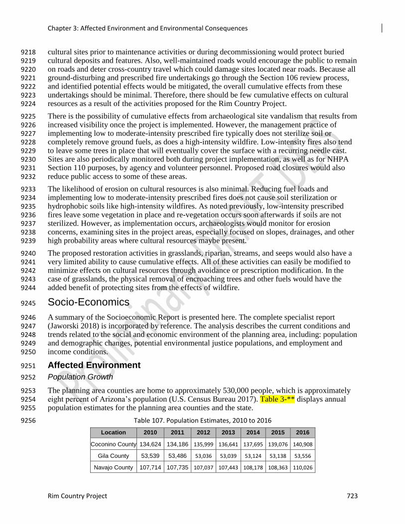
Chapter 3: Affected Environment and Environmental Consequences
Rim Country Project 723
cultural sites prior to maintenance activities or during decommissioning would protect buried 9218 cultural deposits and features. Also, well-maintained roads would encourage the public to remain 9219 on roads and deter cross-country travel which could damage sites located near roads. Because all 9220 ground-disturbing and prescribed fire undertakings go through the Section 106 review process, 9221 and identified potential effects would be mitigated, the overall cumulative effects from these 9222 undertakings should be minimal. Therefore, there should be few cumulative effects on cultural 9223 resources as a result of the activities proposed for the Rim Country Project. 9224
There is the possibility of cumulative effects from archaeological site vandalism that results from 9225 increased visibility once the project is implemented. However, the management practice of 9226 implementing low to moderate-intensity prescribed fire typically does not sterilize soil or 9227 completely remove ground fuels, as does a high-intensity wildfire. Low-intensity fires also tend 9228 to leave some trees in place that will eventually cover the surface with a recurring needle cast. 9229 Sites are also periodically monitored both during project implementation, as well as for NHPA 9230 Section 110 purposes, by agency and volunteer personnel. Proposed road closures would also 9231 reduce public access to some of these areas. 9232
The likelihood of erosion on cultural resources is also minimal. Reducing fuel loads and 9233 implementing low to moderate-intensity prescribed fires does not cause soil sterilization or 9234 hydrophobic soils like high-intensity wildfires. As noted previously, low-intensity prescribed 9235 fires leave some vegetation in place and re-vegetation occurs soon afterwards if soils are not 9236 sterilized. However, as implementation occurs, archaeologists would monitor for erosion 9237 concerns, examining sites in the project areas, especially focused on slopes, drainages, and other 9238 high probability areas where cultural resources maybe present. 9239
The proposed restoration activities in grasslands, riparian, streams, and seeps would also have a 9240 very limited ability to cause cumulative effects. All of these activities can easily be modified to 9241 minimize effects on cultural resources through avoidance or prescription modification. In the 9242 case of grasslands, the physical removal of encroaching trees and other fuels would have the 9243 added benefit of protecting sites from the effects of wildfire. 9244
Socio-Economics 9245
A summary of the Socioeconomic Report is presented here. The complete specialist report 9246 (Jaworski 2018) is incorporated by reference. The analysis describes the current conditions and 9247 trends related to the social and economic environment of the planning area, including: population 9248 and demographic changes, potential environmental justice populations, and employment and 9249 income conditions. 9250
Affected Environment 9251
Population Growth 9252
The planning area counties are home to approximately 530,000 people, which is approximately 9253 eight percent of Arizona’s population (U.S. Census Bureau 2017). Table 3-** displays annual 9254 population estimates for the planning area counties and the state. 9255
Table 107. Population Estimates, 2010 to 2016 9256
Location 2010 2011 2012 2013 2014 2015 2016
Coconino County 134,624 134,186 135,999 136,641 137,695 139,076 140,908
Gila County 53,539 53,486 53,036 53,039 53,124 53,138 53,556
Navajo County 107,714 107,735 107,037 107,443 108,178 108,363 110,026
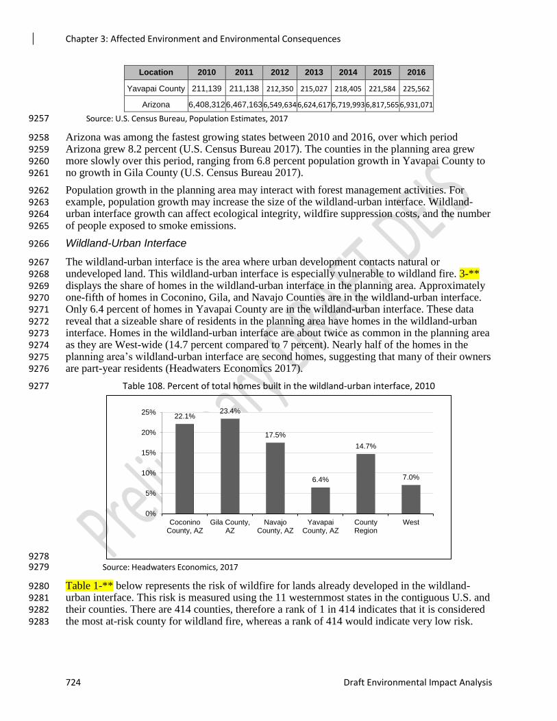
Chapter 3: Affected Environment and Environmental Consequences
724 Draft Environmental Impact Analysis
Location 2010 2011 2012 2013 2014 2015 2016
Yavapai County 211,139 211,138 212,350 215,027 218,405 221,584 225,562
Arizona 6,408,312 6,467,163 6,549,634 6,624,617 6,719,993 6,817,565 6,931,071
Source: U.S. Census Bureau, Population Estimates, 2017 9257
Arizona was among the fastest growing states between 2010 and 2016, over which period 9258 Arizona grew 8.2 percent (U.S. Census Bureau 2017). The counties in the planning area grew 9259 more slowly over this period, ranging from 6.8 percent population growth in Yavapai County to 9260 no growth in Gila County (U.S. Census Bureau 2017). 9261
Population growth in the planning area may interact with forest management activities. For 9262 example, population growth may increase the size of the wildland-urban interface. Wildland-9263 urban interface growth can affect ecological integrity, wildfire suppression costs, and the number 9264 of people exposed to smoke emissions. 9265
Wildland-Urban Interface 9266
The wildland-urban interface is the area where urban development contacts natural or 9267 undeveloped land. This wildland-urban interface is especially vulnerable to wildland fire. 3-** 9268 displays the share of homes in the wildland-urban interface in the planning area. Approximately 9269 one-fifth of homes in Coconino, Gila, and Navajo Counties are in the wildland-urban interface. 9270 Only 6.4 percent of homes in Yavapai County are in the wildland-urban interface. These data 9271 reveal that a sizeable share of residents in the planning area have homes in the wildland-urban 9272 interface. Homes in the wildland-urban interface are about twice as common in the planning area 9273 as they are West-wide (14.7 percent compared to 7 percent). Nearly half of the homes in the 9274 planning area’s wildland-urban interface are second homes, suggesting that many of their owners 9275 are part-year residents (Headwaters Economics 2017). 9276
Table 108. Percent of total homes built in the wildland-urban interface, 2010 9277
9278 Source: Headwaters Economics, 2017 9279
Table 1-** below represents the risk of wildfire for lands already developed in the wildland-9280 urban interface. This risk is measured using the 11 westernmost states in the contiguous U.S. and 9281 their counties. There are 414 counties, therefore a rank of 1 in 414 indicates that it is considered 9282 the most at-risk county for wildland fire, whereas a rank of 414 would indicate very low risk. 9283
22.1%23.4%
17.5%
6.4%
14.7%
7.0%
0%
5%
10%
15%
20%
25%
CoconinoCounty, AZ
Gila County,AZ
NavajoCounty, AZ
YavapaiCounty, AZ
CountyRegion
West
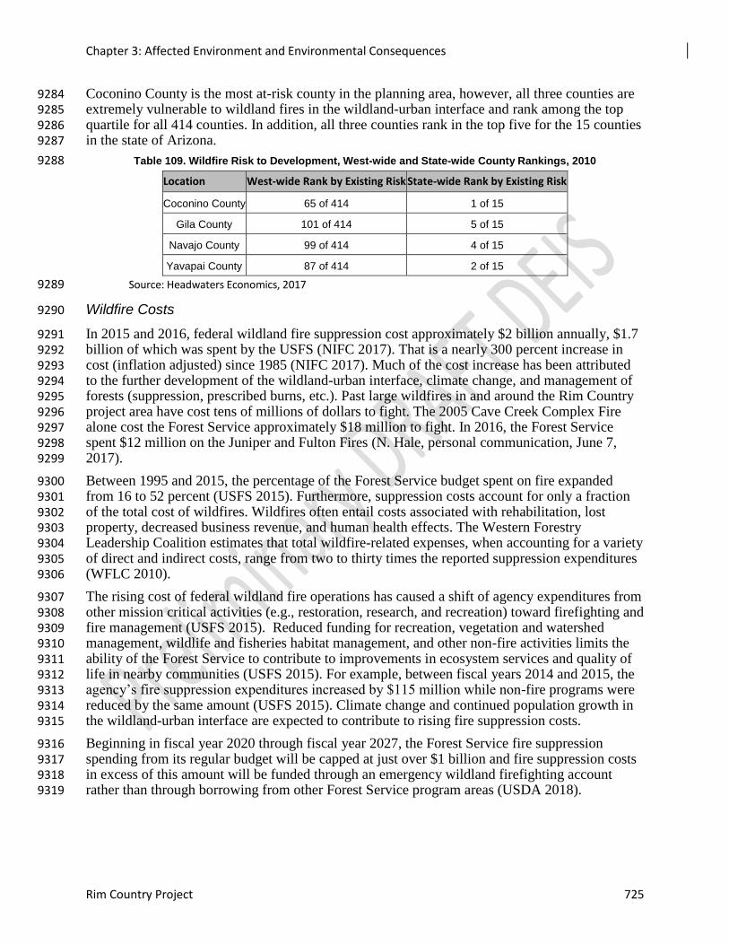
Chapter 3: Affected Environment and Environmental Consequences
Rim Country Project 725
Coconino County is the most at-risk county in the planning area, however, all three counties are 9284 extremely vulnerable to wildland fires in the wildland-urban interface and rank among the top 9285 quartile for all 414 counties. In addition, all three counties rank in the top five for the 15 counties 9286 in the state of Arizona. 9287
Table 109. Wildfire Risk to Development, West-wide and State-wide County Rankings, 2010 9288
Location West-wide Rank by Existing Risk State-wide Rank by Existing Risk
Coconino County 65 of 414 1 of 15
Gila County 101 of 414 5 of 15
Navajo County 99 of 414 4 of 15
Yavapai County 87 of 414 2 of 15
Source: Headwaters Economics, 2017 9289
Wildfire Costs 9290
In 2015 and 2016, federal wildland fire suppression cost approximately $2 billion annually, $1.7 9291 billion of which was spent by the USFS (NIFC 2017). That is a nearly 300 percent increase in 9292 cost (inflation adjusted) since 1985 (NIFC 2017). Much of the cost increase has been attributed 9293 to the further development of the wildland-urban interface, climate change, and management of 9294 forests (suppression, prescribed burns, etc.). Past large wildfires in and around the Rim Country 9295 project area have cost tens of millions of dollars to fight. The 2005 Cave Creek Complex Fire 9296 alone cost the Forest Service approximately $18 million to fight. In 2016, the Forest Service 9297 spent $12 million on the Juniper and Fulton Fires (N. Hale, personal communication, June 7, 9298 2017). 9299
Between 1995 and 2015, the percentage of the Forest Service budget spent on fire expanded 9300 from 16 to 52 percent (USFS 2015). Furthermore, suppression costs account for only a fraction 9301 of the total cost of wildfires. Wildfires often entail costs associated with rehabilitation, lost 9302 property, decreased business revenue, and human health effects. The Western Forestry 9303 Leadership Coalition estimates that total wildfire-related expenses, when accounting for a variety 9304 of direct and indirect costs, range from two to thirty times the reported suppression expenditures 9305 (WFLC 2010). 9306
The rising cost of federal wildland fire operations has caused a shift of agency expenditures from 9307 other mission critical activities (e.g., restoration, research, and recreation) toward firefighting and 9308 fire management (USFS 2015). Reduced funding for recreation, vegetation and watershed 9309 management, wildlife and fisheries habitat management, and other non-fire activities limits the 9310 ability of the Forest Service to contribute to improvements in ecosystem services and quality of 9311 life in nearby communities (USFS 2015). For example, between fiscal years 2014 and 2015, the 9312 agency’s fire suppression expenditures increased by $115 million while non-fire programs were 9313 reduced by the same amount (USFS 2015). Climate change and continued population growth in 9314 the wildland-urban interface are expected to contribute to rising fire suppression costs. 9315
Beginning in fiscal year 2020 through fiscal year 2027, the Forest Service fire suppression 9316 spending from its regular budget will be capped at just over $1 billion and fire suppression costs 9317 in excess of this amount will be funded through an emergency wildland firefighting account 9318 rather than through borrowing from other Forest Service program areas (USDA 2018). 9319
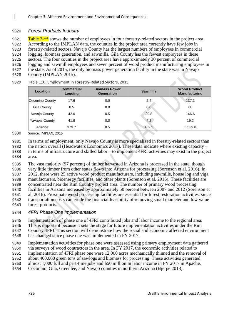
Chapter 3: Affected Environment and Environmental Consequences
726 Draft Environmental Impact Analysis
Forest Products Industry 9320
Table 3-** shows the number of employees in four forestry-related sectors in the project area. 9321 According to the IMPLAN data, the counties in the project area currently have few jobs in 9322 forestry-related sectors. Navajo County has the largest numbers of employees in commercial 9323 logging, biomass generation, and sawmills. Gila County has the fewest employees in these 9324 sectors. The four counties in the project area have approximately 30 percent of commercial 9325 logging and sawmill employees and seven percent of wood product manufacturing employees in 9326 the state. As of 2015, the only biomass power generation facility in the state was in Navajo 9327 County (IMPLAN 2015). 9328
Table 110. Employment in Forestry-Related Sectors, 2015 9329
Location Commercial
Logging
Biomass Power
Generation Sawmills
Wood Product
Manufacturing
Coconino County 17.6 0.0 2.4 137.1
Gila County 8.5 0.0 0.0 60
Navajo County 42.0 0.5 39.8 146.6
Yavapai County 41.9 0.0 4.2 19.2
Arizona 379.7 0.5 162.5 5,539.8
Source: IMPLAN, 2015 9330
In terms of employment, only Navajo County is more specialized in forestry-related sectors than 9331 the nation overall (Headwaters Economics 2017). These data indicate where existing capacity – 9332 in terms of infrastructure and skilled labor – to implement 4FRI activities may exist in the project 9333 area. 9334
The vast majority (97 percent) of timber harvested in Arizona is processed in the state, though 9335 very little timber from other states flows into Arizona for processing (Sorenson et al. 2016). In 9336 2012, there were 25 active wood product manufacturers, including sawmills, house log and viga 9337 manufacturers, bioenergy facilities, and other plants (Sorenson et al. 2016). These facilities are 9338 concentrated near the Rim Country project area. The number of primary wood processing 9339 facilities in Arizona increased by approximately 50 percent between 2007 and 2012 (Sorenson et 9340 al. 2016). Proximate wood processing facilities are essential for forest restoration activities, since 9341 transportation costs can erode the financial feasibility of removing small diameter and low value 9342 forest products. 9343
4FRI Phase One Implementation 9344
Implementation of phase one of 4FRI contributed jobs and labor income to the regional area. 9345 This is important because it sets the stage for future implementation activities under the Rim 9346 Country 4FRI. This section will demonstrate how the social and economic affected environment 9347 has changed since phase one was implemented in FY 2017. 9348
Implementation activities for phase one were assessed using primary employment data gathered 9349 via surveys of wood contractors in the area. In FY 2017, the economic activities related to 9350 implementation of 4FRI phase one were 12,000 acres mechanically thinned and the removal of 9351 about 400,000 green tons of sawlogs and biomass for processing. These activities generated 9352 almost 1,000 full and part-time jobs and $50 million in labor income in FY 2017 in Apache, 9353 Coconino, Gila, Greenlee, and Navajo counties in northern Arizona (Hjerpe 2018). 9354
Chapter 3: Affected Environment and Environmental Consequences
Rim Country Project 727
While these economic contributions from phase one 4FRI activities are substantial, the growth in 9355 contributions has been limited and are less than original project objectives (Hjerpe 2018). Hjerpe 9356 (2018) also found that “the main barrier to ramping up 4FRI mechanical thinning 9357 accomplishments is the lack of profitability in thinning and processing small diameter ponderosa 9358 pine.” Ways to boost the economic contributions from 4FRI activities include “to increase the 9359 scale of acres treated, which would result in greater thinning and wood utilization employment” 9360 and “to decrease the amount of contributions leaked from the region” (Hjerpe 2018). 9361 Contributions leave the region when there is inadequate infrastructure to process the harvested 9362 wood in the region. Any regional response to these barriers and solutions would affect how wood 9363 is processed and how the resulting economic contributions accrue to the region under this current 9364 Rim Country 4FRI. 9365
Ecosystem Services 9366
The economic value of Forest Service resources, uses, and management is not entirely captured 9367 in market transactions. Much of the value of national forests is “non-market” in nature – meaning 9368 that many of the benefits that forests provide to humans do not have a price. The lack of a price, 9369 however, should not be conflated with an absence of value. Indeed, non-market values from 9370 forests provide economic benefits to adjacent communities and forest visitors. 9371
Ecosystem services are “components of nature, directly enjoyed, consumed, or used to yield 9372 human well-being” (Boyd and Banzhaf 2007). Healthy forests provide numerous ecosystem 9373 services, including clean water and air, biodiversity, forest products, and many other goods and 9374 services. 9375
Wildfire has the potential to reduce ecosystem service values through: (1) destruction of wildlife 9376 habitat, (2) water quality and watershed impacts, (3) damage to cultural and archaeological sites, 9377 and (4) soil erosion and impacts to water quality (Morton et al. 2003). Furthermore, post-fire 9378 effects, such as flooding, can threaten life and property and further degrade ecosystem services. 9379
Socioeconomic Vulnerability 9380
Individuals, households, and communities have different abilities to adapt to changing 9381 environmental, social, and economic conditions. The same Forest Service management action 9382 may have different effects on individuals within the same community or on communities across 9383 the project area. A number of characteristics, such as wealth, education, and age affect 9384 households’ ability to adapt to change. Community characteristics, such as social networks, 9385 governance, and institutions also contribute to the ability of people to adapt to social, economic, 9386 and environmental change (Hand et al., forthcoming). 9387
A social vulnerability index for all counties in the Southwestern Region of the Forest Service 9388 reveals that Navajo County has among the lowest adaptive capacity of counties in the region. 9389 Households in Navajo County are likely to have fewer resources available to them. In contrast, 9390 Coconino and Yavapai counties have among the highest adaptive capacity of counties in the 9391 region. Households in these counties are likely to have many more resources available to them 9392 (Hand et al., forthcoming). Displacement due to wildfire, for instance, may be more difficult for 9393 households in Navajo County than households in Coconino and Yavapai counties. These 9394 findings reveal a great deal of socioeconomic diversity across the planning area. 9395
Environmental Justice 9396
In 1994, President Clinton issued Executive Order 12898. This order directs federal agencies to 9397 consider the human health and environmental conditions in minority and low-income 9398 communities. The purpose of Executive Order 12898 is to identify and address, as appropriate, 9399

Chapter 3: Affected Environment and Environmental Consequences
728 Draft Environmental Impact Analysis
disproportionately high and adverse human health or environmental effects on minority and low-9400 income populations (Executive Office of the President 1994). 9401
Environmental justice is the fair treatment and meaningful involvement of people of all races, 9402 cultures, and incomes, with respect to the development, implementation, and enforcement of 9403 environmental laws, regulations, and policies. The goal of environmental justice is for Federal 9404 agency decision-makers to identify impacts that are disproportionately high and adverse with 9405 respect to minority and low-income populations and identify alternatives that will avoid or 9406 mitigate those impacts. According to USDA DR5600-002 (USDA 1997), environmental justice, 9407 minority, minority population, low-income, and human health and environmental effects, are 9408 defined as follows: 9409
Environmental Justice means that, to the greatest extent practicable and permitted by law, all 9410 populations are provided the opportunity to comment before decisions are rendered on, are 9411 allowed to share in the benefits of, are not excluded from, and are not affected in a 9412 disproportionately high and adverse manner by, government programs and activities affecting 9413 human health or the environment. 9414
Minority means a person who is a member of the following population groups: American Indian 9415 or Alaskan Native; Asian or Pacific Islander; Black, not of Hispanic origin; or Hispanic. 9416
Minority Population means any readily identifiable group of minority persons who live in 9417 geographic proximity to, and, if circumstances warrant, migrant farm workers and other 9418 geographically dispersed/transient persons who will be similarly affected by USDA programs or 9419 activities. 9420
Low-Income Population means any readily identifiable group of low-income persons who live 9421 in geographic proximity to, and, if circumstances warrant, migrant farm workers and other 9422 geographically dispersed/transient persons who will be similarly affected by USDA programs or 9423 activities. Low-income populations may be identified using data collected, maintained and 9424 analyzed by an agency or from analytical tools such as the annual statistical poverty thresholds 9425 from the Bureau of the Census' Current Population Reports, Series P-60 on Income and Poverty. 9426
Human Health and/or Environmental Effects as used in this Departmental Regulation include 9427 interrelated social and economic effects. 9428
The emphasis of environmental justice is on health effects and/or the benefits of a healthy 9429 environment. The CEQ has interpreted health effects with a broad definition: “Such effects may 9430 include ecological, cultural, human health, economic or social impacts on minority communities, 9431 low-income communities or Indian Tribes …when those impacts are interrelated to impacts on 9432 the natural or physical environment” (CEQ 1997). 9433
According to U.S. Census Bureau (2016a) data reported in Table X, planning area counties differ 9434 substantially in their racial and ethnic composition. The table shows the percentage of residents 9435 who self-identify in each of the racial and ethnic categories. 9436
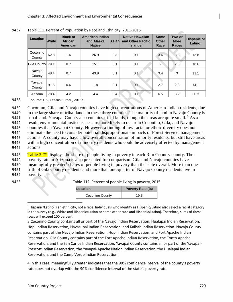
Chapter 3: Affected Environment and Environmental Consequences
Rim Country Project 729
Table 111. Percent of Population by Race and Ethnicity, 2011-2015 9437
Location
White
Black or
African
American
American Indian
and Alaska
Native
Asian
Native Hawaiian
and Other Pacific
Islander
Some
Other
Race
Two or
More
Races
Hispanic or
Latino2
Coconino
County 62.8 1.6 26.9 0.3 0.1 3.6 3.3 13.8
Gila County 79.1 0.7 15.1 0.1 0.1 2 2.5 18.6
Navajo
County 48.4 0.7 43.9 0.1 0.1 3.4 3 11.1
Yavapai
County 91.6 0.6 1.8 0.1 0.1 2.7 2.3 14.1
Arizona 78.4 4.2 4.4 0.4 0.1 6.5 3.2 30.3
Source: U.S. Census Bureau, 2016a 9438
Coconino, Gila, and Navajo counties have high concentrations of American Indian residents, due 9439 to the large share of tribal lands in these three counties. The majority of land in Navajo County is 9440 tribal land. Yavapai County also contains tribal lands, though the areas are quite small. 3 As a 9441 result, environmental justice issues are more likely to occur in Coconino, Gila, and Navajo 9442 counties than Yavapai County. However, a finding of low racial or ethnic diversity does not 9443 eliminate the need to consider potential disproportionate impacts of Forest Service management 9444 actions. A county may have a low overall concentration of minority residents, but still have areas 9445 with a high concentration of minority residents who could be adversely affected by management 9446 actions. 9447
Table 3-** displays the share of people living in poverty in each Rim Country county. The 9448 poverty rate in Arizona is also presented for comparison. Gila and Navajo counties have 9449 meaningfully greater4 shares of people living in poverty than the state overall. More than one-9450 fifth of Gila County residents and more than one-quarter of Navajo County residents live in 9451 poverty. 9452
Table 112. Percent of people living in poverty, 2015 9453
Location Poverty Rate (%)
Coconino County 19.5
2 Hispanic/Latino is an ethnicity, not a race. Individuals who identify as Hispanic/Latino also select a racial category in the survey (e.g., White and Hispanic/Latino or some other race and Hispanic/Latino). Therefore, sums of these rows will exceed 100 percent.
3 Coconino County contains all or part of the Navajo Indian Reservation, Hualapai Indian Reservation,
Hopi Indian Reservation, Havasupai Indian Reservation, and Kaibab Indian Reservation. Navajo County
contains part of the Navajo Indian Reservation, Hopi Indian Reservation, and Fort Apache Indian
Reservation. Gila County contains part of the Fort Apache Indian Reservation, the Tonto Apache
Reservation, and the San Carlos Indian Reservation. Yavapai County contains all or part of the Yavapai-
Prescott Indian Reservation, the Yavapai-Apache Nation Indian Reservation, the Hualapai Indian
Reservation, and the Camp Verde Indian Reservation.
4 In this case, meaningfully greater indicates that the 90% confidence interval of the county’s poverty
rate does not overlap with the 90% confidence interval of the state’s poverty rate.
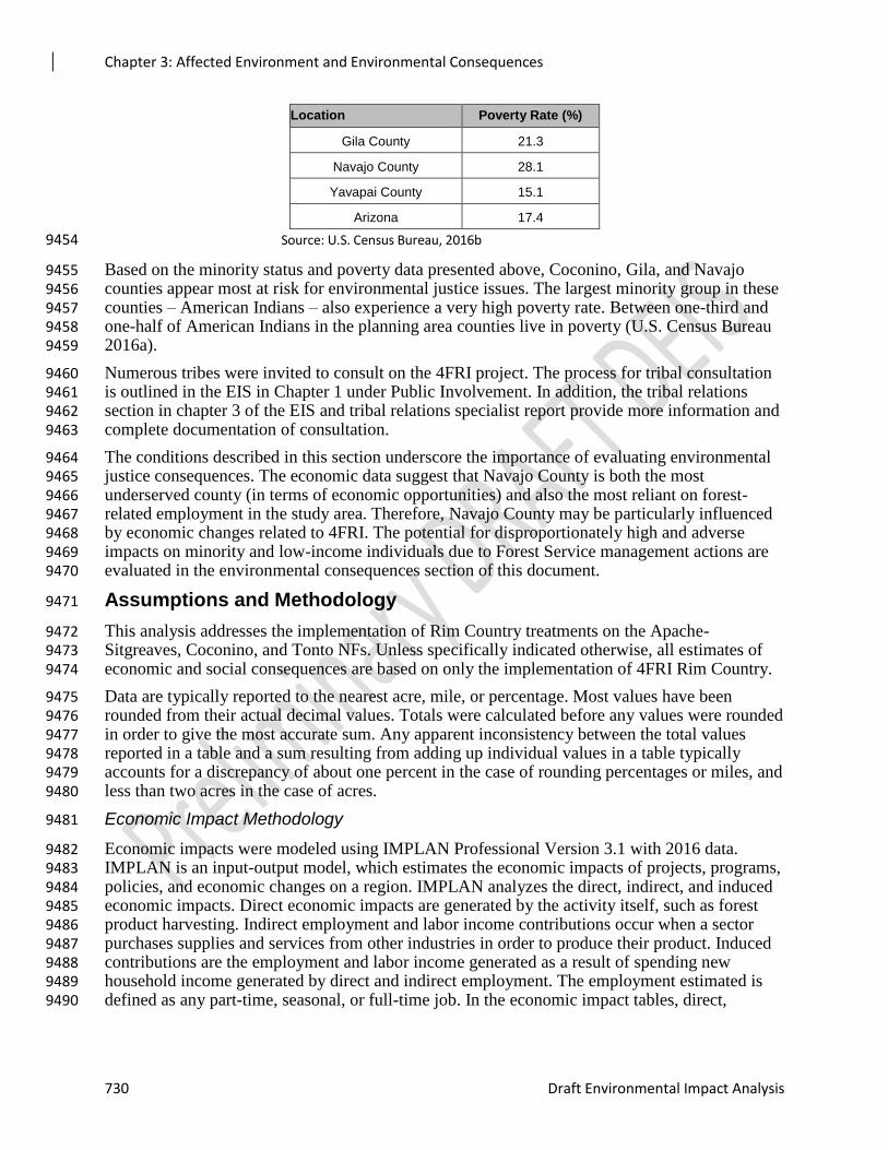
Chapter 3: Affected Environment and Environmental Consequences
730 Draft Environmental Impact Analysis
Location Poverty Rate (%)
Gila County 21.3
Navajo County 28.1
Yavapai County 15.1
Arizona 17.4
Source: U.S. Census Bureau, 2016b 9454
Based on the minority status and poverty data presented above, Coconino, Gila, and Navajo 9455 counties appear most at risk for environmental justice issues. The largest minority group in these 9456 counties – American Indians – also experience a very high poverty rate. Between one-third and 9457 one-half of American Indians in the planning area counties live in poverty (U.S. Census Bureau 9458 2016a). 9459
Numerous tribes were invited to consult on the 4FRI project. The process for tribal consultation 9460 is outlined in the EIS in Chapter 1 under Public Involvement. In addition, the tribal relations 9461 section in chapter 3 of the EIS and tribal relations specialist report provide more information and 9462 complete documentation of consultation. 9463
The conditions described in this section underscore the importance of evaluating environmental 9464 justice consequences. The economic data suggest that Navajo County is both the most 9465 underserved county (in terms of economic opportunities) and also the most reliant on forest-9466 related employment in the study area. Therefore, Navajo County may be particularly influenced 9467 by economic changes related to 4FRI. The potential for disproportionately high and adverse 9468 impacts on minority and low-income individuals due to Forest Service management actions are 9469 evaluated in the environmental consequences section of this document. 9470
Assumptions and Methodology 9471
This analysis addresses the implementation of Rim Country treatments on the Apache-9472 Sitgreaves, Coconino, and Tonto NFs. Unless specifically indicated otherwise, all estimates of 9473 economic and social consequences are based on only the implementation of 4FRI Rim Country. 9474
Data are typically reported to the nearest acre, mile, or percentage. Most values have been 9475 rounded from their actual decimal values. Totals were calculated before any values were rounded 9476 in order to give the most accurate sum. Any apparent inconsistency between the total values 9477 reported in a table and a sum resulting from adding up individual values in a table typically 9478 accounts for a discrepancy of about one percent in the case of rounding percentages or miles, and 9479 less than two acres in the case of acres. 9480
Economic Impact Methodology 9481
Economic impacts were modeled using IMPLAN Professional Version 3.1 with 2016 data. 9482 IMPLAN is an input-output model, which estimates the economic impacts of projects, programs, 9483 policies, and economic changes on a region. IMPLAN analyzes the direct, indirect, and induced 9484 economic impacts. Direct economic impacts are generated by the activity itself, such as forest 9485 product harvesting. Indirect employment and labor income contributions occur when a sector 9486 purchases supplies and services from other industries in order to produce their product. Induced 9487 contributions are the employment and labor income generated as a result of spending new 9488 household income generated by direct and indirect employment. The employment estimated is 9489 defined as any part-time, seasonal, or full-time job. In the economic impact tables, direct, 9490
Chapter 3: Affected Environment and Environmental Consequences
Rim Country Project 731
indirect and induced contributions are included in the estimated impacts. The IMPLAN database 9491 describes the economy in 536 sectors using federal data from 2016. 9492
The IMPLAN model area includes Coconino, Gila, Navajo, and Yavapai Counties. Maricopa 9493 County is also included in the economic impact model due to the economic linkages between 9494 Maricopa County and the project area. The firms and employees that will support Rim Country 9495 activities are located in these counties (both primary and supplier firms). 9496
Data on use levels under each alternative were collected from the forests’ resource specialists. In 9497 most instances, the precise change is unknown. Therefore, the changes are based on the 9498 professional expertise of the forests’ resource specialists. Regional economic impacts are 9499 estimated based on the assumption of full implementation of each alternative. The actual changes 9500 in the economy would depend on individuals taking advantage of the resource-related 9501 opportunities that would be supported by each alternative. If market conditions or trends in 9502 resource use were not conducive to developing some opportunities, the economic impact would 9503 be different from what is estimated in this analysis. 9504
Economic Efficiency Methodology 9505
Economic efficiency analysis follows Forest Service and Office of Management and Budget 9506 guidance. A four percent discount rate is commonly used for evaluations of long-term 9507 investments and operations in land and resource management by the Forest Service (FSM 9508 1971.21). This discount rate is used in the calculation of net present value (NPV). Inflation can 9509 affect NPV; however, due to the uncertainty of future inflation, OMB Circular A-94 9510 recommends avoiding assumptions about the inflation rate whenever possible. Thus, for the 9511 purposes of this analysis, inflation is left at zero. Data on program revenues and program 9512 expenditures were provided by the national forests’ resource specialists and budget staff. 9513
Assumptions 9514
1. The IMPLAN model assumes a static economy – in other words, the industry composition and 9515 trade linkages in the economy today will be the same in the future. 9516
2. The IMPLAN model does not impose supply constraints when estimating employment and labor 9517 income effects. It assumes that local industry will be able to harvest and process all of the forest 9518 product volume from the Rim Country project. If some of the forest product volume is harvested 9519 or processed by firms outside the model area, the employment and labor income effects would be 9520 lower than those estimated here. 9521
3. The economic analysis assumes that all project activities are implemented over a 20-year period. If 9522 the implementation period is longer, the average annual number of jobs and amount of labor 9523 income would be lower than estimated in this report. 9524
4. The economic analysis assumes that firms bid on 4FRI Rim Country contracts and that the activities 9525 are fully implemented. Full implementation relies on private sector interest in bidding on contracts. 9526 A slower pace and/or lower forest product volume removal would produce less economic activity 9527 than estimated in the analysis. 9528
5. The economic analysis uses forest product distribution data from the 4FRI implementation team 9529 to classify forest product types in the economic modeling program. The economic analysis 9530 assumes the following distribution: 30 percent sawn products, 6 percent poles, 4 percent firewood, 9531 and 60 percent other forest products (including biomass). 9532
6. The economic analysis assumes that forest products are harvested outside of protected activity 9533 centers (PACS) with mean slopes less than 40 percent. 9534
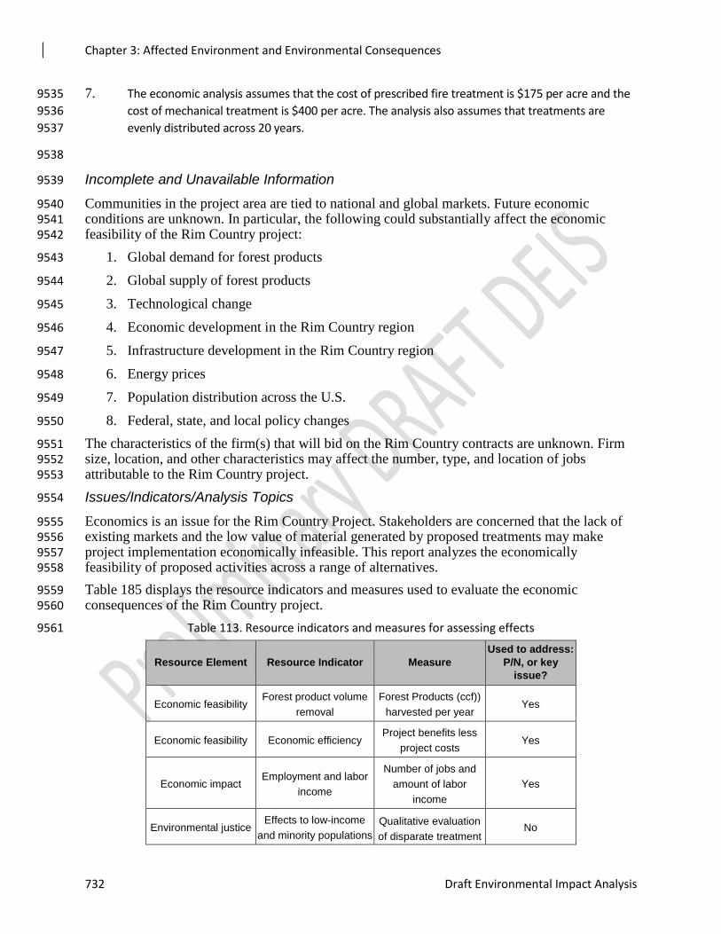
Chapter 3: Affected Environment and Environmental Consequences
732 Draft Environmental Impact Analysis
7. The economic analysis assumes that the cost of prescribed fire treatment is $175 per acre and the 9535
cost of mechanical treatment is $400 per acre. The analysis also assumes that treatments are 9536
evenly distributed across 20 years. 9537
9538
Incomplete and Unavailable Information 9539
Communities in the project area are tied to national and global markets. Future economic 9540 conditions are unknown. In particular, the following could substantially affect the economic 9541 feasibility of the Rim Country project: 9542
1. Global demand for forest products 9543
2. Global supply of forest products 9544
3. Technological change 9545
4. Economic development in the Rim Country region 9546
5. Infrastructure development in the Rim Country region 9547
6. Energy prices 9548
7. Population distribution across the U.S. 9549
8. Federal, state, and local policy changes 9550
The characteristics of the firm(s) that will bid on the Rim Country contracts are unknown. Firm 9551 size, location, and other characteristics may affect the number, type, and location of jobs 9552 attributable to the Rim Country project. 9553
Issues/Indicators/Analysis Topics 9554
Economics is an issue for the Rim Country Project. Stakeholders are concerned that the lack of 9555 existing markets and the low value of material generated by proposed treatments may make 9556 project implementation economically infeasible. This report analyzes the economically 9557 feasibility of proposed activities across a range of alternatives. 9558
Table 185 displays the resource indicators and measures used to evaluate the economic 9559 consequences of the Rim Country project. 9560
Table 113. Resource indicators and measures for assessing effects 9561
Resource Element Resource Indicator Measure
Used to address:
P/N, or key
issue?
Economic feasibility Forest product volume
removal
Forest Products (ccf))
harvested per year Yes
Economic feasibility Economic efficiency Project benefits less
project costs Yes
Economic impact Employment and labor
income
Number of jobs and
amount of labor
income
Yes
Environmental justice Effects to low-income
and minority populations
Qualitative evaluation
of disparate treatment No
Chapter 3: Affected Environment and Environmental Consequences
Rim Country Project 733
Resource Element Resource Indicator Measure
Used to address:
P/N, or key
issue?
and/or disparate
effects
9562
Environmental Consequences 9563
Alternative 1 – No Action 9564
Forest Products: Under Alternative 1, the three national forests would continue to provide 9565 forest products and support restoration activities. However, the scale of these activities would be 9566 substantially smaller than activities under the Rim Country Project. The provision of forest 9567 products unrelated to Rim Country treatments would be the same under all alternatives, and 9568 therefore are not described in detail in this EIS. 9569
Economic Efficiency: Under Alternative 1, wildfire suppression costs would, on average, 9570 increase due to fuel buildup and the expanding wildland-urban interface. The per-acre 9571 administrative burden (cost of time and other resources) of planning, implementing, and 9572 monitoring forest restoration activities would be highest under Alternative 1. The Rim Country 9573 Project benefits from economies of scale – a single environmental compliance document 9574 addresses more than one million acres. Furthermore, the large project area reduces cost to 9575 government through increased private sector interest in engaging in harvesting and restoration 9576 activities on the forests. In contrast, restoration activities under Alternative 1 would occur 9577 piecemeal – requiring numerous environmental compliance documents and increased 9578 administrative costs. 9579
Employment and Labor Income: The three national forests would continue to provide 9580 opportunities for forest product harvesting, livestock grazing, recreation, and other activities that 9581 support employment and labor income in communities in the project area. The extent of these 9582 contributions are not expected to differ from current conditions. Forestry-related sectors would 9583 remain a relatively minor part of the project area’s economy. 9584
Environmental Justice: The communities that surround the project area, particularly in Navajo 9585 County, have large minority populations, high poverty rates, and individuals vulnerable to 9586 smoke. Minority and low income residents may experience differential exposure to wildland fire, 9587 changes in employment opportunities, or changes in the provision of ecosystem services. None 9588 of the alternatives eliminates smoke – either from wildfire or prescribed burns. Alternative 1 9589 would treat the fewest acres with prescribed fire; however, it would also do the least to restore 9590 fire-adapted forests. As a result, smoke from uncharacteristic wildfire is most likely under 9591 Alternative 1. Smoke emissions from prescribed burning would be lower under Alternative 1. 9592 Smoke emissions resulting from wildfires and prescribed burns may produce health and quality 9593 of life consequences. Smoke is most likely to affect vulnerable populations – children, the 9594 elderly, and individuals in poor health. 9595
Alternative 1 would not affect the potential for wildland fire to threaten human safety and property 9596 in the project area. Low income individuals have fewer resources to engage in averting behavior 9597 (e.g., leaving town during a wildfire to avoid smoke emissions). However, since approximately 9598 half of homes in the wildland-urban interface in the project area are second homes, the individuals 9599 with the highest exposure to wildfire risk are expected to be relatively affluent (Headwaters 9600 Economics 2017). 9601
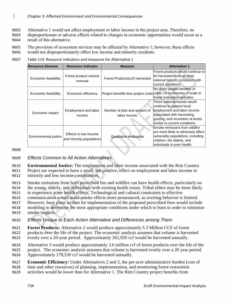
Chapter 3: Affected Environment and Environmental Consequences
734 Draft Environmental Impact Analysis
Alternative 1 would not affect employment or labor income in the project area. Therefore, no 9602 disproportionate or adverse effects related to changes in economic opportunities would occur as a 9603 result of this alternative. 9604
The provision of ecosystem services may be affected by Alternative 1; however, these effects 9605 would not disproportionately affect low income and minority residents. 9606
Table 114. Resource indicators and measures for Alternative 1 9607
Resource Element Resource Indicator Measure Alternative 1
Economic feasibility Forest product volume
removal Forest Products(ccf) harvested
Forest products would continue to
be harvested from all three
national forests, consistent with
current conditions
Economic feasibility Economic efficiency Project benefits less project costs
No direct project benefits or
costs; no economies of scale in
forest restoration activities
Economic impact Employment and labor
income
Number of jobs and amount of
labor income
Three national forests would
continue to support local
employment and labor income
associated with harvesting,
grazing, and recreation at levels
similar to current conditions
Environmental justice Effects to low-income
and minority populations Qualitative evaluation
Smoke emissions from wildfire
are most likely to adversely affect
vulnerable populations, including
children, the elderly, and
individuals in poor health
9608
Effects Common to All Action Alternatives 9609
Environmental Justice: The employment and labor income associated with the Rim Country 9610 Project are expected to have a small, but positive, effect on employment and labor income in 9611 minority and low income communities. 9612
Smoke emissions from both prescribed fire and wildfire can have health effects, particularly on 9613 the young, elderly, and individuals with existing health issues. Tribal elders may be more likely 9614 to experience acute health effects. Technological and cultural constraints to effective 9615 communication would make smoke effects more pronounced, as averting behavior is limited. 9616 However, burn plans written for implementation of the proposed prescribed fires would include 9617 modeling to determine the most appropriate conditions under which to burn in order to minimize 9618 smoke impacts. 9619
Effects Unique to Each Action Alternative and Differences among Them 9620
Forest Products: Alternative 2 would produce approximately 5.3 Million CCF of forest 9621 products over the life of the project. The economic analysis assumes that volume is harvested 9622 evenly over a 20-year period. Approximately 262,920 ccf would be harvested annually. 9623
Alternative 3 would produce approximately 3.6 million ccf of forest products over the life of the 9624 project. The economic analysis assumes that volume is harvested evenly over a 20 year period. 9625 Approximately 178,530 ccf would be harvested annually. 9626
Economic Efficiency: Under Alternatives 2 and 3, the per-acre administrative burden (cost of 9627 time and other resources) of planning, implementation, and monitoring forest restoration 9628 activities would be lower than for Alternative 1. The Rim Country project benefits from 9629
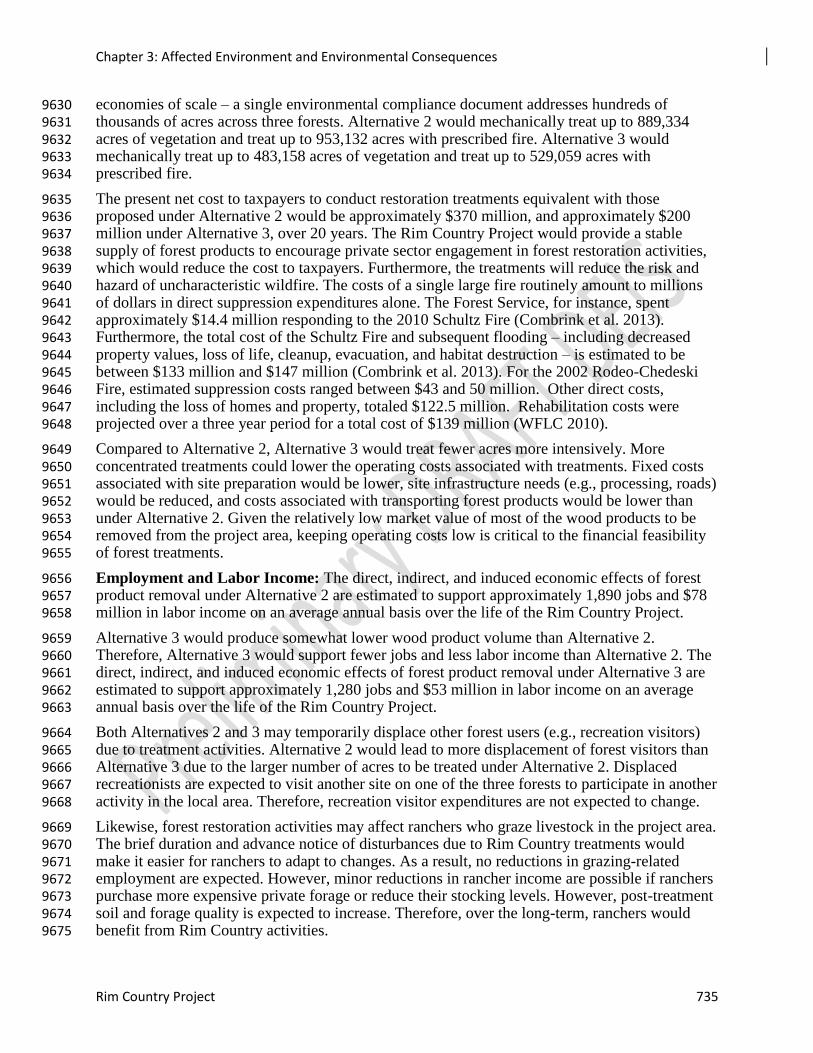
Chapter 3: Affected Environment and Environmental Consequences
Rim Country Project 735
economies of scale – a single environmental compliance document addresses hundreds of 9630 thousands of acres across three forests. Alternative 2 would mechanically treat up to 889,334 9631 acres of vegetation and treat up to 953,132 acres with prescribed fire. Alternative 3 would 9632 mechanically treat up to 483,158 acres of vegetation and treat up to 529,059 acres with 9633 prescribed fire. 9634
The present net cost to taxpayers to conduct restoration treatments equivalent with those 9635 proposed under Alternative 2 would be approximately $370 million, and approximately $200 9636 million under Alternative 3, over 20 years. The Rim Country Project would provide a stable 9637 supply of forest products to encourage private sector engagement in forest restoration activities, 9638 which would reduce the cost to taxpayers. Furthermore, the treatments will reduce the risk and 9639 hazard of uncharacteristic wildfire. The costs of a single large fire routinely amount to millions 9640 of dollars in direct suppression expenditures alone. The Forest Service, for instance, spent 9641 approximately $14.4 million responding to the 2010 Schultz Fire (Combrink et al. 2013). 9642 Furthermore, the total cost of the Schultz Fire and subsequent flooding – including decreased 9643 property values, loss of life, cleanup, evacuation, and habitat destruction – is estimated to be 9644 between $133 million and $147 million (Combrink et al. 2013). For the 2002 Rodeo-Chedeski 9645 Fire, estimated suppression costs ranged between $43 and 50 million. Other direct costs, 9646 including the loss of homes and property, totaled $122.5 million. Rehabilitation costs were 9647 projected over a three year period for a total cost of $139 million (WFLC 2010). 9648
Compared to Alternative 2, Alternative 3 would treat fewer acres more intensively. More 9649 concentrated treatments could lower the operating costs associated with treatments. Fixed costs 9650 associated with site preparation would be lower, site infrastructure needs (e.g., processing, roads) 9651 would be reduced, and costs associated with transporting forest products would be lower than 9652 under Alternative 2. Given the relatively low market value of most of the wood products to be 9653 removed from the project area, keeping operating costs low is critical to the financial feasibility 9654 of forest treatments. 9655
Employment and Labor Income: The direct, indirect, and induced economic effects of forest 9656 product removal under Alternative 2 are estimated to support approximately 1,890 jobs and $78 9657 million in labor income on an average annual basis over the life of the Rim Country Project. 9658
Alternative 3 would produce somewhat lower wood product volume than Alternative 2. 9659 Therefore, Alternative 3 would support fewer jobs and less labor income than Alternative 2. The 9660 direct, indirect, and induced economic effects of forest product removal under Alternative 3 are 9661 estimated to support approximately 1,280 jobs and $53 million in labor income on an average 9662 annual basis over the life of the Rim Country Project. 9663
Both Alternatives 2 and 3 may temporarily displace other forest users (e.g., recreation visitors) 9664 due to treatment activities. Alternative 2 would lead to more displacement of forest visitors than 9665 Alternative 3 due to the larger number of acres to be treated under Alternative 2. Displaced 9666 recreationists are expected to visit another site on one of the three forests to participate in another 9667 activity in the local area. Therefore, recreation visitor expenditures are not expected to change. 9668
Likewise, forest restoration activities may affect ranchers who graze livestock in the project area. 9669 The brief duration and advance notice of disturbances due to Rim Country treatments would 9670 make it easier for ranchers to adapt to changes. As a result, no reductions in grazing-related 9671 employment are expected. However, minor reductions in rancher income are possible if ranchers 9672 purchase more expensive private forage or reduce their stocking levels. However, post-treatment 9673 soil and forage quality is expected to increase. Therefore, over the long-term, ranchers would 9674 benefit from Rim Country activities. 9675
Chapter 3: Affected Environment and Environmental Consequences
736 Draft Environmental Impact Analysis
Table 115. Resource indicators and measures alternative comparison 9676
Resource
Element
Resource
Indicator Measure Alternative 2 Alternative 3
Economic
feasibility
Forest product
volume removal
Forest products (ccf)
harvested
Volume from trees < 5” =
278,440 CCF
Volume from trees 5” -
12”= 2,303,480 CCF
Volume from trees > 12”=
2,676,470 CCF
Volume from trees < 5” =
191,000 CCF
Volume from trees 5” -
12”= 1,467,810 CCF
Volume from trees > 12” =
1,911,750 CCF
Economic
feasibility
Economic
efficiency
Project benefits less
project costs
$370 million present net
cost; Avoided costs from
forest restoration and
reduced risk of high
intensity wildfire
$200 million present net
cost; Avoided costs from
forest restoration and
reduced risk of high
intensity wildfire; more
concentrated treatments
(compared to alternative
2) would lower operating
costs
Economic impact Employment and
labor income
Number of jobs and
amount of labor income
1,890 jobs and $78 million
in labor income
1,280 jobs and $53 million
in labor income
Environmental
justice
Effects to low-
income and
minority
populations
Qualitative evaluation
Employment and labor
income may have a small,
but positive, effect on
economic opportunities in
low-income and minority
communities; smoke
emissions may have a
disproportionate effect on
low-income and minority
communities
Same as alternative 2
9677
Effects from Rock Pit Use and Expansion 9678
The Rim Country Project would authorize the use and expansion of rock pits to supply material 9679 for road construction and improvement. Rock pits on the national forests provide a low cost 9680 source of material for road work. In particular, rock pits avoid the need to purchase and haul 9681 roadbed material from more distant sites. The 2016 Rock Pits Environmental Assessment for the 9682 Coconino and Kaibab National Forests found that haul costs were approximately four times 9683 higher for material purchased off-site than for on-forest rock pits. Rock pit use and expansion 9684 would increase the financial feasibility of road work needed to support Rim Country project 9685 activities. 9686
Effects from Use of In-woods Processing and Storage Sites 9687
The key barrier to the financial feasibility of forest restoration is that the costs of hauling raw 9688 material from the harvest site to mill locations may exceed the value of the timber harvested in 9689 the project area. To address this challenge, the Rim Country Project would authorize 13 in-9690
Chapter 3: Affected Environment and Environmental Consequences
Rim Country Project 737
woods sites (in addition to the eight sites analyzed in the Cragin Watershed Protection Project) 9691 for processing, sorting, storing, and the refinement of raw material. In-woods processing and 9692 storage sites would offset haul costs by increasing the value of material either by hauling dried 9693 material or secondary products. 9694
In-woods processing and storage site selection criteria – including at least ¼ mile from hiking 9695 trails, campgrounds, group recreation sites, and private property – would reduce the potential for 9696 effects on forest visitors and nearby residents. 9697
Cumulative Effects 9698
Past management activities, including mechanical vegetation treatments, fuels treatments, and 9699 prescribed fire, have affected economic activity in the communities in and around the project 9700 area. The socioeconomic consequences of these actions are captured in the baseline data 9701 presented in the affected environment section of this report. Therefore, these activities are not 9702 included in the cumulative effects analysis. 9703
Restoration activities would continue to occur in the region regardless of the Rim Country 9704 decision. Current and foreseeable activities include approximately 470,000 acres of mechanical 9705 vegetation treatments and approximately 650,000 acres of fuels treatments. The acreages of 9706 mechanical vegetation management and fuels are not all mutually exclusive. There are many 9707 acres on which proposed fuels treatments (mechanical and prescribed fire) overlap with proposed 9708 mechanical vegetation management treatments. Reasonably foreseeable actions on private, state, 9709 and other federally-managed lands include mechanical treatments, fuels treatments, and 9710 prescribed fire. These actions will occur regardless of the selected Rim Country alternative. 9711
The effect of past, present, and reasonably foreseeable treatment activities in the project area 9712 would improve forest health relative to existing conditions even without the implementation of 9713 the Rim Country Project. 9714
Forest Products: Forest products available for harvesting under the Rim Country Project would 9715 contribute to an increased supply of forest products available from national forests in the region. 9716 When harvest volumes are low, harvesting and processing industries are unlikely to locate in the 9717 region. However, the cumulative effects from both Alternative 2 and Alternative 3 would be to 9718 improve the financial viability of locating forest product industries - including logging firms, 9719 sawmills, and biomass facilities – in the project area. 9720
Economic Efficiency: Observational evidence and fire modeling indicates that large-scale fuel 9721 treatments are necessary to meaningfully reduce the risk of high intensity wildfire and produce 9722 fire suppression cost savings (Thompson et al. 2017). The proposed Rim Country treatments, in 9723 combination with the current and foreseeable mechanical and prescribed fire treatments, would 9724 conduct fuel treatments across a large landscape. The cumulative effects of Alternative 2 are 9725 most likely to reduce wildfire suppression costs in the project area. 9726
Employment and Labor Income: The increased forest product supply from Rim Country and 9727 other current and foreseeable projects would contribute to the development of a local forest 9728 products industry. The development of a local industry would have several economic effects, 9729 including (1) lower costs of transporting wood products for secondary processing thereby 9730 increasing the financial viability of treatments, (2) increase the probability that employment and 9731 labor income associated with forest restoration activities would occur in the local area, and (3) 9732 contribute to the growth of supporting industries (e.g., construction and retail trade). 9733
As described in the Affected Environment section above, there has been limited growth of jobs 9734 and income from 4FRI phase one implementation activities. With more acres treated from the 9735
Chapter 3: Affected Environment and Environmental Consequences
738 Draft Environmental Impact Analysis
Rim Country 4FRI project, this will add to the wood utilization employment. Cumulative effects 9736 of increasing wood volume could increase the amount of economic contributions that stay in the 9737 region if the activity boosts the infrastructure and capacity to process the harvested wood in the 9738 region. For example, if the wood produced from both phases of 4FRI implementation creates 9739 enough demand (or the funding mechanism is collaboratively resolved) for a company to install a 9740 biomass facility, the jobs and income from restoration activities are more likely to stay in the 9741 region. 9742
Environmental Justice: Ongoing and reasonably foreseeable prescribed fire treatments will 9743 contribute to smoke emissions, which may affect the health and quality of life of individuals who 9744 live near or visit the forests. Since the no action alternative would not prescribe additional 9745 treatments, it would not cause cumulative effects related to smoke emissions from prescribed 9746 fire. However, the risk of uncharacteristic wildfire and associated smoke emissions in the project 9747 area would be highest under this alternative. 9748
The proposed treatments under Alternatives 2 and 3, combined with other ongoing and 9749 foreseeable treatments, could increase exposure to smoke emissions, which could cause 9750 cumulative effects to health and quality of life for individuals who are sensitive to smoke. 9751 However, the cumulative effect of these treatments would be to decrease the risk of 9752 uncharacteristic wildfire, which would decrease the probability of smoke emissions associated 9753 with these events. 9754
Recreation 9755
A summary of the Recreation Report is presented here and the specialist report (Wright 2018) is 9756 incorporated by reference. The potential effects of the 4FRI Rim Country Project on recreational 9757 opportunities was not raised as a concern by the public. 9758
Affected Environment 9759
Recreation Trends 9760
The Apache-Sitgreaves, Coconino, and Tonto NFs provide diverse outdoor recreation 9761 opportunities connecting people with nature in a variety of settings. Forest users can hike, bike, 9762 drive motorized vehicles, camp, fish, view wildlife and scenery, and explore historic and 9763 prehistoric places. They enjoy opportunities for year-round recreation activities from birding and 9764 wild flower observing in the spring, hiking in summer months, fall color viewing and hunting, to 9765 cross country skiing in the winter. 9766
Recreation activities provide physical challenge, require development of skills and inspire 9767 wonder and curiosity about the natural world. Recreation contributes to the physical, mental, and 9768 spiritual health of individuals, families, and friends. Outdoor recreation has become a part of 9769 American culture (USDA 2010). 9770
Forest users may occasionally experience short-term or temporary disruptions in their recreation 9771 activities as a result of other groups currently occupying a preferred site, forest management 9772 activities such as current thinning or prescribed fire projects, fire restrictions or fire closures due 9773 to hot, dry weather and extreme fire danger, as well as natural occurrences such as fallen trees 9774 blocking a roadway or trail, and so on. When asked how visitors would react to such disruptions 9775 in their plans, they reported in the National Visitor Use Monitoring survey (NVUM) using 9776 substitution behaviors such as coming back another time, going elsewhere for a different activity, 9777 going elsewhere for the same activity, going to work, some other substitution or staying at home 9778 (USDA 2016- 2017). The number one response for all three Rim Country forests was by far 9779 going elsewhere for the same activity. 9780
Chapter 3: Affected Environment and Environmental Consequences
Rim Country Project 739
Over the last two decades, Arizona has seen a dramatic increase in population. The entire state of 9781 Arizona has grown almost 75 percent from 1990 to 2010 (U.S. Census Bureau, 2015), which is 9782 more than double the rate of the average population growth in the country. In addition, the last 9783 several decades have seen increases in the number of people participating in outdoor activities; 9784 between 2000 and 2007, these participants increased by 4.4 percent (Cordell, et al., 2008). 9785
Demographic shifts and lifestyle changes have affected the demand for recreation opportunities 9786 on national forests. Today about 80 percent of the population lives in urban settings and may not 9787 have the same values as rural residents who live closer to or may depend on natural resources for 9788 their livelihood (Forest Service 2010). In the West, growth of retirement communities and other 9789 population shifts have created urban settings close to public lands. Both of these trends have 9790 created challenges to Forest Service recreation managers to meet demands for an ever increasing 9791 number of recreation users as well as a diverse number of desired recreation activities. 9792
Arizona has a high percentage of public land compared to private lands. Private land is notably 9793 scarce in Arizona. Residents are more likely to rely on public land for recreation activities due to 9794 the lack of private facilities. In addition, public lands provide recreational, environmental and 9795 lifestyle amenities. Johnson and Stewart (2007) found that there is overlap between counties that 9796 contain national forests and those designated as recreational, high amenity, and retirement 9797 destinations. Increase in population density along the forest edge puts pressure on cultural and 9798 environmentally sensitive areas, increases the use of recreation facilities and complicates forest 9799 management and fire suppression. The researchers also found that counties with more than 10 9800 percent of their land in national forests (almost 39 percent of Coconino County) grew by 9801 significantly larger margins than other counties (Headwaters Economics 2012). 9802
Arizona’s population was one of the fastest growing in the United States from 2000 to 2010. 9803 The populations of Coconino and Yavapai Counties continue to grow steadily. These counties 9804 include attractive cities such as Flagstaff, Sedona and Prescott. As Arizona’s population grows, 9805 demand for recreation grows (Arizona State Parks 2008). Rapid development and infill of limited 9806 private land also places more pressure on public land agencies to provide open space and 9807 recreation opportunities. 9808
An increasing population, along with growing participation in outdoor activities, contributes to 9809 increased visitation to the Coconino National Forest according to the most recent NVUM data. 9810 However, the Apache-Sitgreaves National Forest shows a dramatic decrease in visits. This could 9811 possibly be attributed to staff changes in the implementation of the survey design and/or to the 9812 implantation of field interviews. The next NVUM data collection is scheduled for fiscal year 9813 2018, with results available in 2019. At that time, a better understanding of the trends for its 9814 national forest visits should be obtainable. National forest visits for the Tonto were similar for 9815 2013 and 2016. Population growth is expected to continue into the future and will increasingly 9816 affect national forest management activities, as well as ability to provide satisfying recreation 9817 opportunities. 9818
Table 3-** provides local recreation information available for the Apache-Sitgreaves, Coconino 9819 and Tonto NFs. All forests have been surveyed several times in the NVUM. NVUM estimates 9820 the volume of recreation visitation to national forests and grasslands and produces descriptive 9821 information about that visitation, including activity participation, demographics, visit duration, 9822 measures of satisfaction, and trip spending connected to the visit. 9823
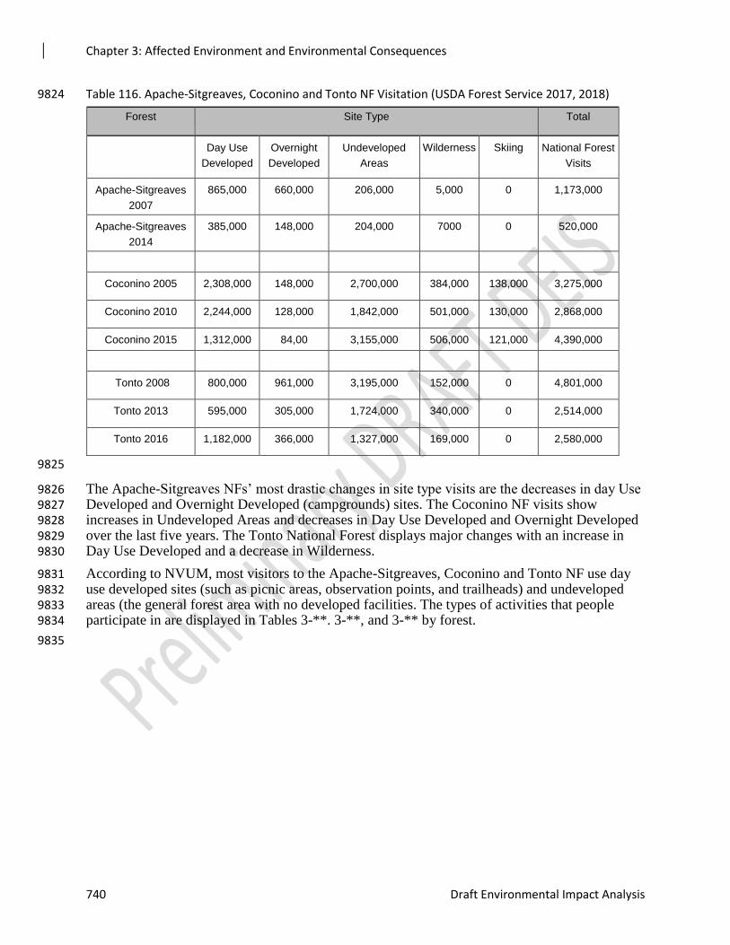
Chapter 3: Affected Environment and Environmental Consequences
740 Draft Environmental Impact Analysis
Table 116. Apache-Sitgreaves, Coconino and Tonto NF Visitation (USDA Forest Service 2017, 2018) 9824
Forest Site Type Total
Day Use
Developed
Overnight
Developed
Undeveloped
Areas
Wilderness Skiing National Forest
Visits
Apache-Sitgreaves
2007
865,000 660,000 206,000 5,000 0 1,173,000
Apache-Sitgreaves
2014
385,000 148,000 204,000 7000 0 520,000
Coconino 2005 2,308,000 148,000 2,700,000 384,000 138,000 3,275,000
Coconino 2010 2,244,000 128,000 1,842,000 501,000 130,000 2,868,000
Coconino 2015 1,312,000 84,00 3,155,000 506,000 121,000 4,390,000
Tonto 2008 800,000 961,000 3,195,000 152,000 0 4,801,000
Tonto 2013 595,000 305,000 1,724,000 340,000 0 2,514,000
Tonto 2016 1,182,000 366,000 1,327,000 169,000 0 2,580,000
9825
The Apache-Sitgreaves NFs’ most drastic changes in site type visits are the decreases in day Use 9826 Developed and Overnight Developed (campgrounds) sites. The Coconino NF visits show 9827 increases in Undeveloped Areas and decreases in Day Use Developed and Overnight Developed 9828 over the last five years. The Tonto National Forest displays major changes with an increase in 9829 Day Use Developed and a decrease in Wilderness. 9830
According to NVUM, most visitors to the Apache-Sitgreaves, Coconino and Tonto NF use day 9831 use developed sites (such as picnic areas, observation points, and trailheads) and undeveloped 9832 areas (the general forest area with no developed facilities. The types of activities that people 9833 participate in are displayed in Tables 3-**. 3-**, and 3-** by forest. 9834
9835
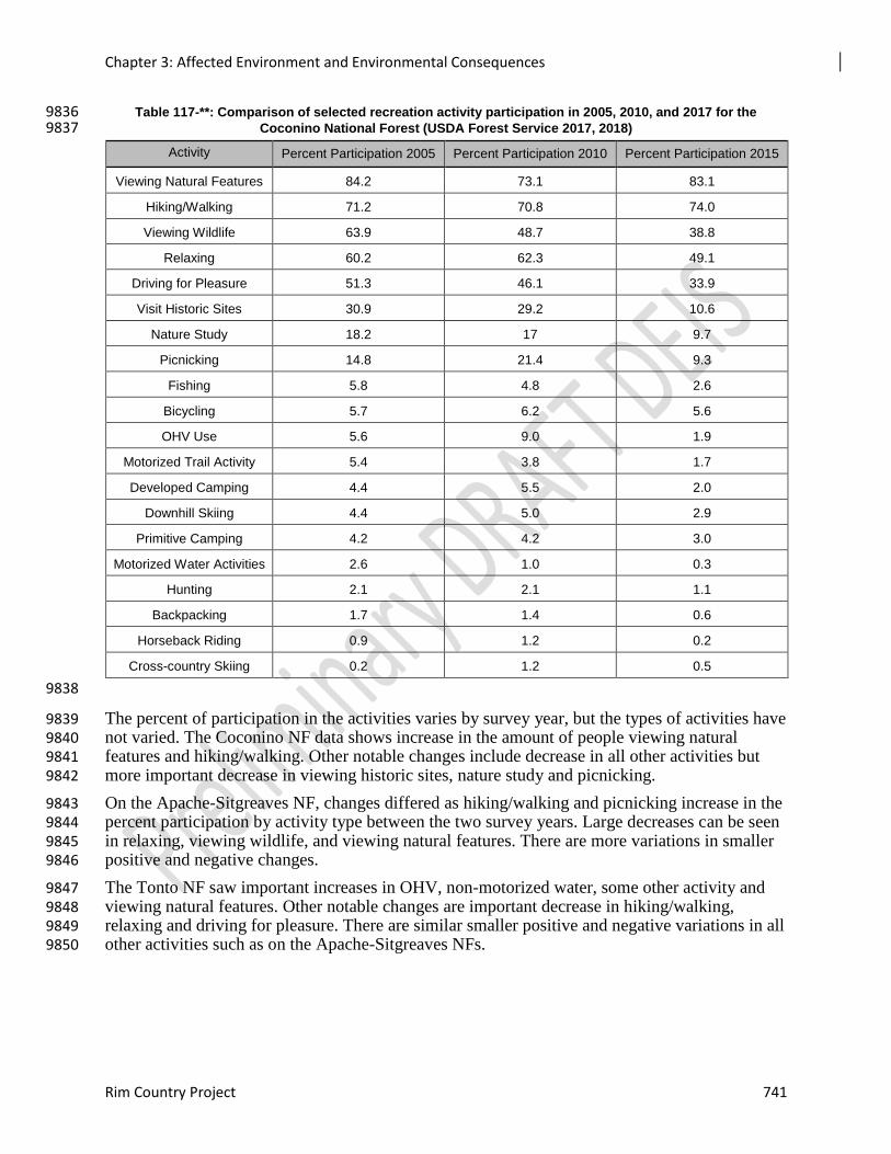
Chapter 3: Affected Environment and Environmental Consequences
Rim Country Project 741
Table 117-**: Comparison of selected recreation activity participation in 2005, 2010, and 2017 for the 9836 Coconino National Forest (USDA Forest Service 2017, 2018) 9837
Activity Percent Participation 2005 Percent Participation 2010 Percent Participation 2015
Viewing Natural Features 84.2 73.1 83.1
Hiking/Walking 71.2 70.8 74.0
Viewing Wildlife 63.9 48.7 38.8
Relaxing 60.2 62.3 49.1
Driving for Pleasure 51.3 46.1 33.9
Visit Historic Sites 30.9 29.2 10.6
Nature Study 18.2 17 9.7
Picnicking 14.8 21.4 9.3
Fishing 5.8 4.8 2.6
Bicycling 5.7 6.2 5.6
OHV Use 5.6 9.0 1.9
Motorized Trail Activity 5.4 3.8 1.7
Developed Camping 4.4 5.5 2.0
Downhill Skiing 4.4 5.0 2.9
Primitive Camping 4.2 4.2 3.0
Motorized Water Activities 2.6 1.0 0.3
Hunting 2.1 2.1 1.1
Backpacking 1.7 1.4 0.6
Horseback Riding 0.9 1.2 0.2
Cross-country Skiing 0.2 1.2 0.5
9838
The percent of participation in the activities varies by survey year, but the types of activities have 9839 not varied. The Coconino NF data shows increase in the amount of people viewing natural 9840 features and hiking/walking. Other notable changes include decrease in all other activities but 9841 more important decrease in viewing historic sites, nature study and picnicking. 9842
On the Apache-Sitgreaves NF, changes differed as hiking/walking and picnicking increase in the 9843 percent participation by activity type between the two survey years. Large decreases can be seen 9844 in relaxing, viewing wildlife, and viewing natural features. There are more variations in smaller 9845 positive and negative changes. 9846
The Tonto NF saw important increases in OHV, non-motorized water, some other activity and 9847 viewing natural features. Other notable changes are important decrease in hiking/walking, 9848 relaxing and driving for pleasure. There are similar smaller positive and negative variations in all 9849 other activities such as on the Apache-Sitgreaves NFs. 9850
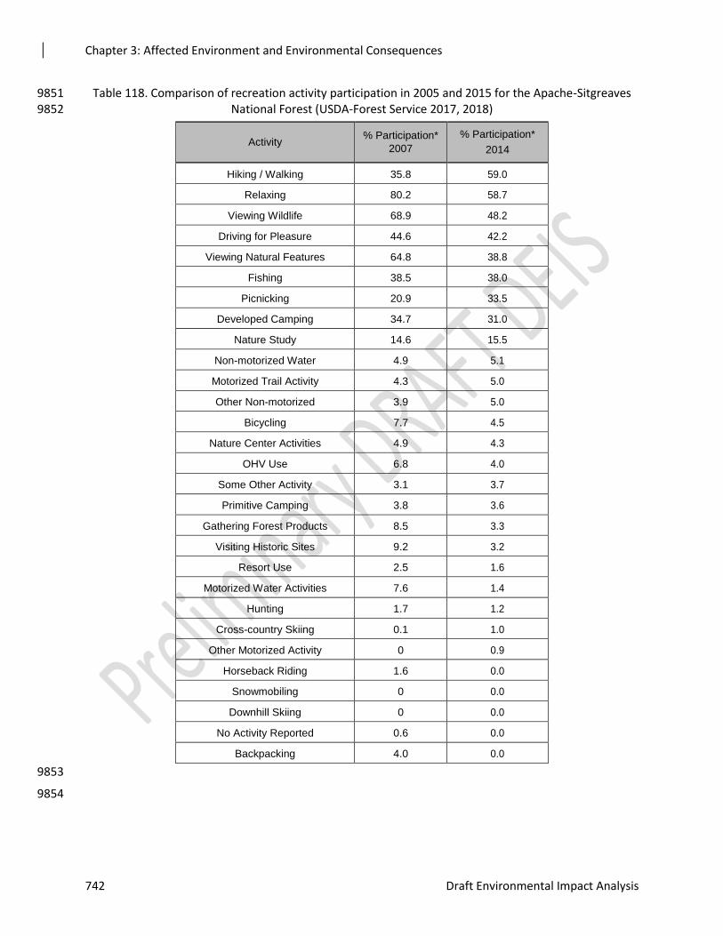
Chapter 3: Affected Environment and Environmental Consequences
742 Draft Environmental Impact Analysis
Table 118. Comparison of recreation activity participation in 2005 and 2015 for the Apache-Sitgreaves 9851 National Forest (USDA-Forest Service 2017, 2018) 9852
Activity % Participation*
2007
% Participation*
2014
Hiking / Walking 35.8 59.0
Relaxing 80.2 58.7
Viewing Wildlife 68.9 48.2
Driving for Pleasure 44.6 42.2
Viewing Natural Features 64.8 38.8
Fishing 38.5 38.0
Picnicking 20.9 33.5
Developed Camping 34.7 31.0
Nature Study 14.6 15.5
Non-motorized Water 4.9 5.1
Motorized Trail Activity 4.3 5.0
Other Non-motorized 3.9 5.0
Bicycling 7.7 4.5
Nature Center Activities 4.9 4.3
OHV Use 6.8 4.0
Some Other Activity 3.1 3.7
Primitive Camping 3.8 3.6
Gathering Forest Products 8.5 3.3
Visiting Historic Sites 9.2 3.2
Resort Use 2.5 1.6
Motorized Water Activities 7.6 1.4
Hunting 1.7 1.2
Cross-country Skiing 0.1 1.0
Other Motorized Activity 0 0.9
Horseback Riding 1.6 0.0
Snowmobiling 0 0.0
Downhill Skiing 0 0.0
No Activity Reported 0.6 0.0
Backpacking 4.0 0.0
9853
9854
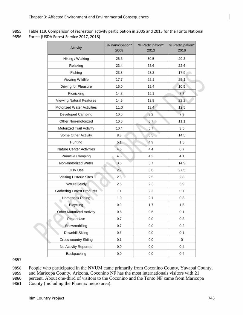
Chapter 3: Affected Environment and Environmental Consequences
Rim Country Project 743
Table 119. Comparison of recreation activity participation in 2005 and 2015 for the Tonto National 9855 Forest (USDA Forest Service 2017, 2018) 9856
Activity % Participation*
2008
% Participation*
2013
% Participation*
2016
Hiking / Walking 26.3 50.5 29.3
Relaxing 23.4 33.6 22.6
Fishing 23.3 23.2 17.9
Viewing Wildlife 17.7 22.1 25.1
Driving for Pleasure 15.0 19.4 10.5
Picnicking 14.8 15.1 7.7
Viewing Natural Features 14.5 13.8 22.2
Motorized Water Activities 11.0 13.4 12.5
Developed Camping 10.6 8.2 7.9
Other Non-motorized 10.6 6.7 11.1
Motorized Trail Activity 10.4 5.7 3.5
Some Other Activity 8.3 5.5 14.5
Hunting 5.1 4.9 1.5
Nature Center Activities 4.6 4.4 0.7
Primitive Camping 4.3 4.3 4.1
Non-motorized Water 3.5 3.7 14.9
OHV Use 2.9 3.6 27.5
Visiting Historic Sites 2.8 2.5 2.8
Nature Study 2.5 2.3 5.9
Gathering Forest Products 1.1 2.2 0.7
Horseback Riding 1.0 2.1 0.3
Bicycling 0.9 1.7 1.5
Other Motorized Activity 0.8 0.5 0.1
Resort Use 0.7 0.0 0.3
Snowmobiling 0.7 0.0 0.2
Downhill Skiing 0.6 0.0 0.1
Cross-country Skiing 0.1 0.0 0
No Activity Reported 0.0 0.0 0.4
Backpacking 0.0 0.0 0.4
9857
People who participated in the NVUM came primarily from Coconino County, Yavapai County, 9858 and Maricopa County, Arizona. Coconino NF has the most internationals visitors with 21 9859 percent. About one-third of visitors to the Coconino and the Tonto NF came from Maricopa 9860 County (including the Phoenix metro area). 9861
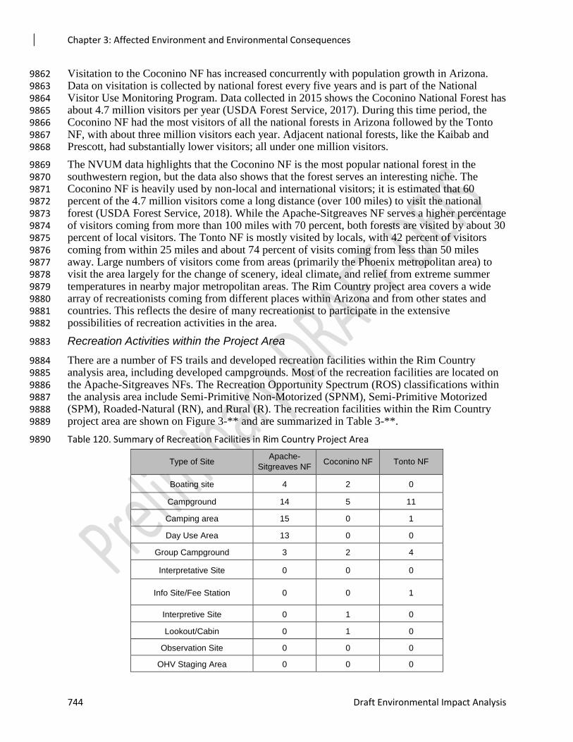
Chapter 3: Affected Environment and Environmental Consequences
744 Draft Environmental Impact Analysis
Visitation to the Coconino NF has increased concurrently with population growth in Arizona. 9862 Data on visitation is collected by national forest every five years and is part of the National 9863 Visitor Use Monitoring Program. Data collected in 2015 shows the Coconino National Forest has 9864 about 4.7 million visitors per year (USDA Forest Service, 2017). During this time period, the 9865 Coconino NF had the most visitors of all the national forests in Arizona followed by the Tonto 9866 NF, with about three million visitors each year. Adjacent national forests, like the Kaibab and 9867 Prescott, had substantially lower visitors; all under one million visitors. 9868
The NVUM data highlights that the Coconino NF is the most popular national forest in the 9869 southwestern region, but the data also shows that the forest serves an interesting niche. The 9870 Coconino NF is heavily used by non-local and international visitors; it is estimated that 60 9871 percent of the 4.7 million visitors come a long distance (over 100 miles) to visit the national 9872 forest (USDA Forest Service, 2018). While the Apache-Sitgreaves NF serves a higher percentage 9873 of visitors coming from more than 100 miles with 70 percent, both forests are visited by about 30 9874 percent of local visitors. The Tonto NF is mostly visited by locals, with 42 percent of visitors 9875 coming from within 25 miles and about 74 percent of visits coming from less than 50 miles 9876 away. Large numbers of visitors come from areas (primarily the Phoenix metropolitan area) to 9877 visit the area largely for the change of scenery, ideal climate, and relief from extreme summer 9878 temperatures in nearby major metropolitan areas. The Rim Country project area covers a wide 9879 array of recreationists coming from different places within Arizona and from other states and 9880 countries. This reflects the desire of many recreationist to participate in the extensive 9881 possibilities of recreation activities in the area. 9882
Recreation Activities within the Project Area 9883
There are a number of FS trails and developed recreation facilities within the Rim Country 9884 analysis area, including developed campgrounds. Most of the recreation facilities are located on 9885 the Apache-Sitgreaves NFs. The Recreation Opportunity Spectrum (ROS) classifications within 9886 the analysis area include Semi-Primitive Non-Motorized (SPNM), Semi-Primitive Motorized 9887 (SPM), Roaded-Natural (RN), and Rural (R). The recreation facilities within the Rim Country 9888 project area are shown on Figure 3-** and are summarized in Table 3-**. 9889
Table 120. Summary of Recreation Facilities in Rim Country Project Area 9890
Type of Site Apache-
Sitgreaves NF Coconino NF Tonto NF
Boating site 4 2 0
Campground 14 5 11
Camping area 15 0 1
Day Use Area 13 0 0
Group Campground 3 2 4
Interpretative Site 0 0 0
Info Site/Fee Station 0 0 1
Interpretive Site 0 1 0
Lookout/Cabin 0 1 0
Observation Site 0 0 0
OHV Staging Area 0 0 0
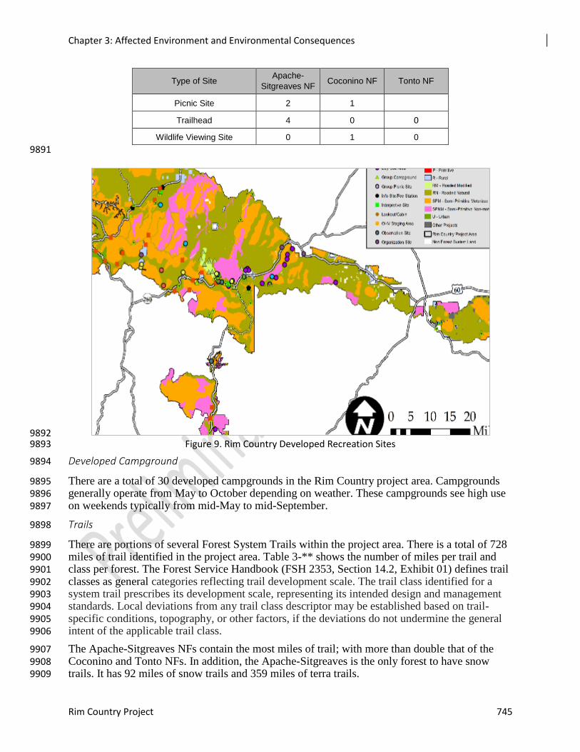
Chapter 3: Affected Environment and Environmental Consequences
Rim Country Project 745
Type of Site Apache-
Sitgreaves NF Coconino NF Tonto NF
Picnic Site 2 1
Trailhead 4 0 0
Wildlife Viewing Site 0 1 0
9891
9892 Figure 9. Rim Country Developed Recreation Sites 9893
Developed Campground 9894
There are a total of 30 developed campgrounds in the Rim Country project area. Campgrounds 9895 generally operate from May to October depending on weather. These campgrounds see high use 9896 on weekends typically from mid-May to mid-September. 9897
Trails 9898
There are portions of several Forest System Trails within the project area. There is a total of 728 9899 miles of trail identified in the project area. Table 3-** shows the number of miles per trail and 9900 class per forest. The Forest Service Handbook (FSH 2353, Section 14.2, Exhibit 01) defines trail 9901 classes as general categories reflecting trail development scale. The trail class identified for a 9902 system trail prescribes its development scale, representing its intended design and management 9903 standards. Local deviations from any trail class descriptor may be established based on trail-9904 specific conditions, topography, or other factors, if the deviations do not undermine the general 9905 intent of the applicable trail class. 9906
The Apache-Sitgreaves NFs contain the most miles of trail; with more than double that of the 9907 Coconino and Tonto NFs. In addition, the Apache-Sitgreaves is the only forest to have snow 9908 trails. It has 92 miles of snow trails and 359 miles of terra trails. 9909
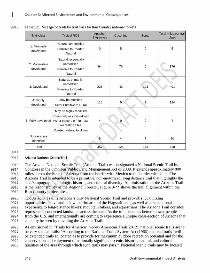
Chapter 3: Affected Environment and Environmental Consequences
746 Draft Environmental Impact Analysis
Table 121. Mileage of trails by trail class for Rim Country national forests 9910
Trail class Typical ROS Apache-
Sitgreaves Coconino Tonto
Total miles per trail
class
1: Minimally
developed
Natural, unmodified
Primitive to Roaded
Natural
0 5 0 5
2: Moderately
developed
Natural, essentially
unmodified
Primitive to Roaded
Natural
94 76 5 176
3: Developed
Natural, primarily
unmodified
Primitive to Roaded
Natural
235 43 123 401
4: Highly
developed
May be modified
Semi-Primitive to Rural 115 0 9 124
5: Fully developed
May be highly modified
Commonly associated with
visitor centers or high-use
recreation sites
Roaded Natural to Urban
4 0 0 4
No trail class
identified 9 4 7 20
Total 457 128 143 728
9911
Arizona National Scenic Trail 9912
The Arizona National Scenic Trail (Arizona Trail) was designated a National Scenic Trail by 9913 Congress in the Omnibus Public Land Management Act of 2009. It extends approximately 800 9914 miles across the State of Arizona from the border with Mexico to the border with Utah. The 9915 Arizona Trail is intended to be a primitive, non-motorized, long distance trail that highlights the 9916 state's topographic, biologic, historic, and cultural diversity. Administration of the Arizona Trail 9917 is the responsibility of the Regional Forester. Figure 3-** shows the trail alignment within the 9918 Rim Country project area. 9919
The Arizona Trail is Arizona’s only National Scenic Trail and provides local hiking 9920 opportunities above and below the rim around the Flagstaff area, as well as a recreational 9921 experience to long-distance hikers, mountain bikers, and equestrians. The Arizona Trail corridor 9922 represents a connected landscape across the state. As the trail becomes better known, people 9923 from the U.S. and internationally are coming to experience a unique cross-section of Arizona that 9924 can only be seen by traveling the Arizona Trail. 9925
As envisioned in "Trails for America" report (American Trails 2012), national scenic trails are to 9926 be very special trails: "According to the National Trails System Act (1968) national trails “will 9927 be extended trails so located as to provide for maximum outdoor recreation potential and for the 9928 conservation and enjoyment of nationally significant scenic, historic, natural, and cultural 9929 qualities of the area through which such trails may pass." National scenic trails may be located 9930
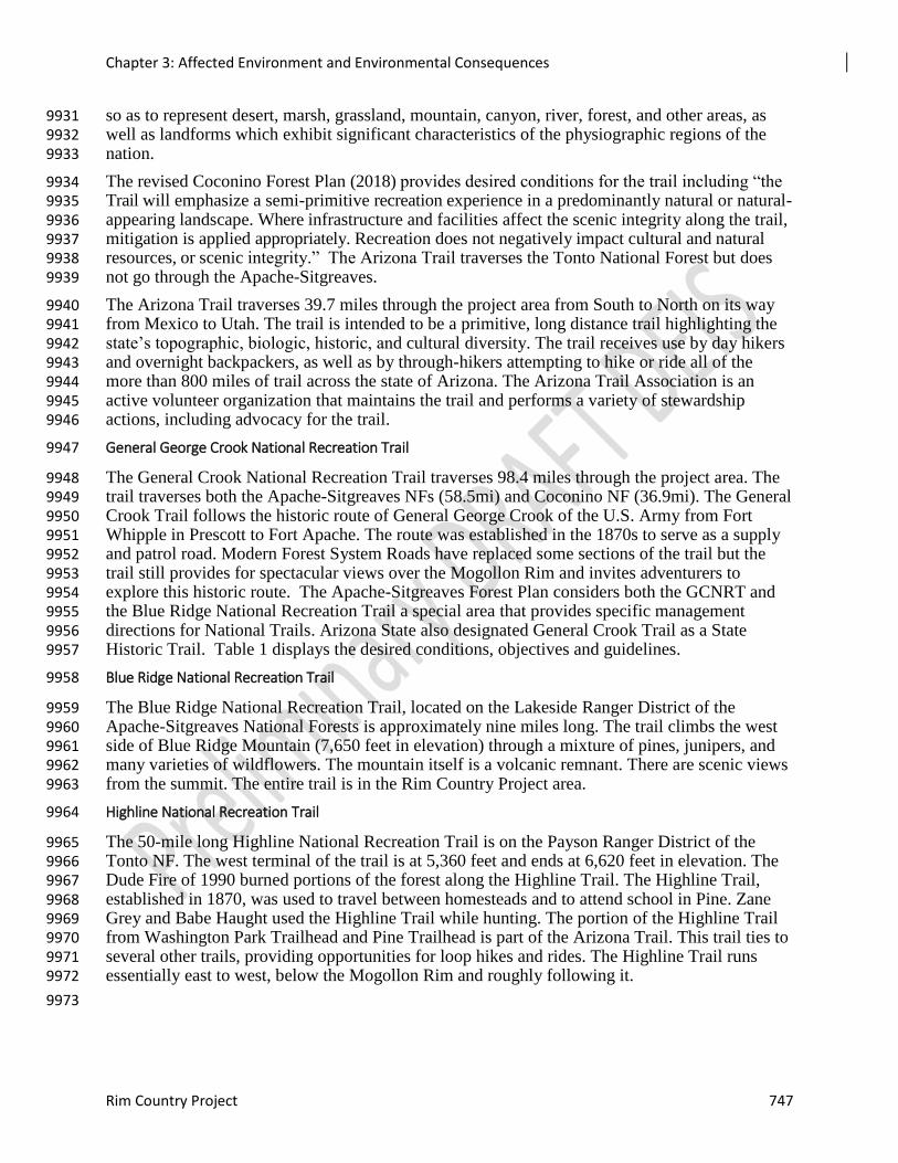
Chapter 3: Affected Environment and Environmental Consequences
Rim Country Project 747
so as to represent desert, marsh, grassland, mountain, canyon, river, forest, and other areas, as 9931 well as landforms which exhibit significant characteristics of the physiographic regions of the 9932 nation. 9933
The revised Coconino Forest Plan (2018) provides desired conditions for the trail including “the 9934 Trail will emphasize a semi-primitive recreation experience in a predominantly natural or natural-9935 appearing landscape. Where infrastructure and facilities affect the scenic integrity along the trail, 9936 mitigation is applied appropriately. Recreation does not negatively impact cultural and natural 9937 resources, or scenic integrity.” The Arizona Trail traverses the Tonto National Forest but does 9938 not go through the Apache-Sitgreaves. 9939
The Arizona Trail traverses 39.7 miles through the project area from South to North on its way 9940 from Mexico to Utah. The trail is intended to be a primitive, long distance trail highlighting the 9941 state’s topographic, biologic, historic, and cultural diversity. The trail receives use by day hikers 9942 and overnight backpackers, as well as by through-hikers attempting to hike or ride all of the 9943 more than 800 miles of trail across the state of Arizona. The Arizona Trail Association is an 9944 active volunteer organization that maintains the trail and performs a variety of stewardship 9945 actions, including advocacy for the trail. 9946
General George Crook National Recreation Trail 9947
The General Crook National Recreation Trail traverses 98.4 miles through the project area. The 9948 trail traverses both the Apache-Sitgreaves NFs (58.5mi) and Coconino NF (36.9mi). The General 9949 Crook Trail follows the historic route of General George Crook of the U.S. Army from Fort 9950 Whipple in Prescott to Fort Apache. The route was established in the 1870s to serve as a supply 9951 and patrol road. Modern Forest System Roads have replaced some sections of the trail but the 9952 trail still provides for spectacular views over the Mogollon Rim and invites adventurers to 9953 explore this historic route. The Apache-Sitgreaves Forest Plan considers both the GCNRT and 9954 the Blue Ridge National Recreation Trail a special area that provides specific management 9955 directions for National Trails. Arizona State also designated General Crook Trail as a State 9956 Historic Trail. Table 1 displays the desired conditions, objectives and guidelines. 9957
Blue Ridge National Recreation Trail 9958
The Blue Ridge National Recreation Trail, located on the Lakeside Ranger District of the 9959 Apache-Sitgreaves National Forests is approximately nine miles long. The trail climbs the west 9960 side of Blue Ridge Mountain (7,650 feet in elevation) through a mixture of pines, junipers, and 9961 many varieties of wildflowers. The mountain itself is a volcanic remnant. There are scenic views 9962 from the summit. The entire trail is in the Rim Country Project area. 9963
Highline National Recreation Trail 9964
The 50-mile long Highline National Recreation Trail is on the Payson Ranger District of the 9965 Tonto NF. The west terminal of the trail is at 5,360 feet and ends at 6,620 feet in elevation. The 9966 Dude Fire of 1990 burned portions of the forest along the Highline Trail. The Highline Trail, 9967 established in 1870, was used to travel between homesteads and to attend school in Pine. Zane 9968 Grey and Babe Haught used the Highline Trail while hunting. The portion of the Highline Trail 9969 from Washington Park Trailhead and Pine Trailhead is part of the Arizona Trail. This trail ties to 9970 several other trails, providing opportunities for loop hikes and rides. The Highline Trail runs 9971 essentially east to west, below the Mogollon Rim and roughly following it. 9972
9973
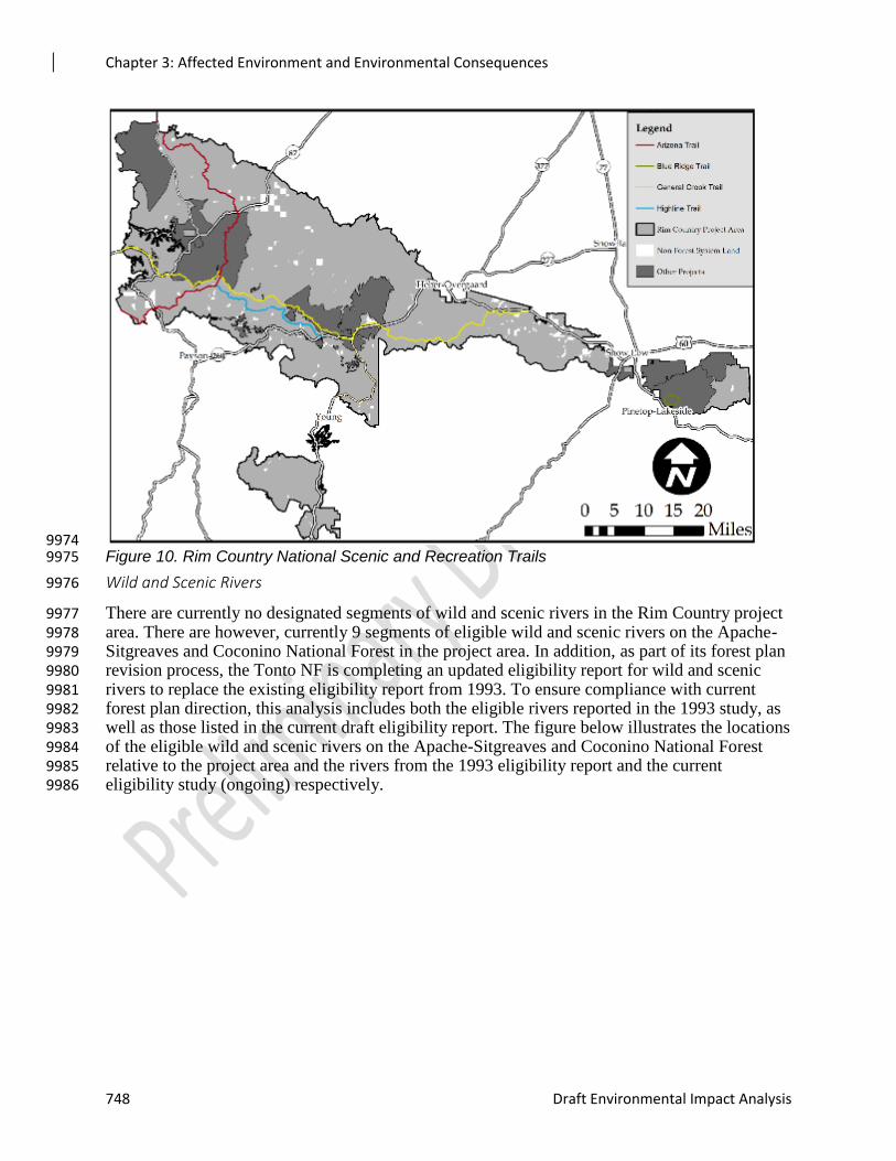
Chapter 3: Affected Environment and Environmental Consequences
748 Draft Environmental Impact Analysis
9974 Figure 10. Rim Country National Scenic and Recreation Trails 9975
Wild and Scenic Rivers 9976
There are currently no designated segments of wild and scenic rivers in the Rim Country project 9977 area. There are however, currently 9 segments of eligible wild and scenic rivers on the Apache-9978 Sitgreaves and Coconino National Forest in the project area. In addition, as part of its forest plan 9979 revision process, the Tonto NF is completing an updated eligibility report for wild and scenic 9980 rivers to replace the existing eligibility report from 1993. To ensure compliance with current 9981 forest plan direction, this analysis includes both the eligible rivers reported in the 1993 study, as 9982 well as those listed in the current draft eligibility report. The figure below illustrates the locations 9983 of the eligible wild and scenic rivers on the Apache-Sitgreaves and Coconino National Forest 9984 relative to the project area and the rivers from the 1993 eligibility report and the current 9985 eligibility study (ongoing) respectively. 9986
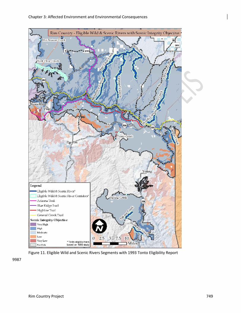
Chapter 3: Affected Environment and Environmental Consequences
Rim Country Project 749
9987
Figure 11. Eligible Wild and Scenic Rivers Segments with 1993 Tonto Eligibility Report
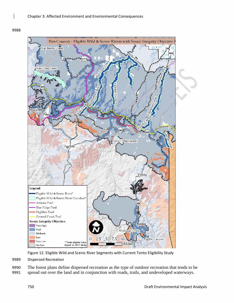
Chapter 3: Affected Environment and Environmental Consequences
750 Draft Environmental Impact Analysis
9988
Dispersed Recreation 9989
The forest plans define dispersed recreation as the type of outdoor recreation that tends to be 9990 spread out over the land and in conjunction with roads, trails, and undeveloped waterways. 9991
Figure 12. Eligible Wild and Scenic River Segments with Current Tonto Eligibility Study
Chapter 3: Affected Environment and Environmental Consequences
Rim Country Project 751
Activities are often day-use oriented and include hunting, fishing, gathering of forest products, 9992 boating, hiking, off-road vehicle use, cross-country skiing, mountain biking, and rock climbing. 9993
Dispersed Camping 9994
Dispersed recreation includes the full suite of outdoor non-motorized and motorized recreation 9995 opportunities available throughout the year. Visitors to the area camp using a variety of shelters, 9996 including large recreational vehicles (RVs), live-in toy haulers, and tents. Many campers come 9997 from the Phoenix metro area to escape extreme summer temperatures and enjoy the cool weather 9998 provided by the high elevation of the project area. 9999
Dispersed camping requires no additional facilities other than road or trail access, though the 10000 relatively unconstrained nature of dispersed camping can cause resource impacts such as soil 10001 compaction and erosion, loss of vegetation, increased fire risk, displacement of wildlife, and 10002 accumulation of trash and human waste. The number of dispersed campers in the analysis area is 10003 also difficult to estimate. 10004
Motor Vehicle Use 10005
As Arizona’s population has grown, the state has also seen a dramatic increase in ownership and 10006 use of personal off-highway vehicles (OHVs). Arizona Trails 2010 reported a 623 percent 10007 increase in sales of off-highway motorcycles and all-terrain vehicles (ATVs) in Arizona between 10008 the years 1995 to 2006 (McVay et al. 2010). NVUM indicates a particular great increase of OHV 10009 use to recreate from 3.6 percent to 27.5 percent activity participation for the Tonto National 10010 Forest. The Coconino and Apache Sitgreaves national forests show a slight decrease in OHV use. 10011 The growth in ownership and use of OHVs has greatly influenced how users recreate in the 10012 analysis area. 10013
The 2013 Arizona Statewide Comprehensive Outdoor Recreation Plan reports that, based on the 10014 Arizona Trails 2010 Plan, OHV users represent almost 22 percent of the Arizona population 10015 which includes residents who use motorized vehicles on trails for multiple purposes. Of that, 11 10016 percent of Arizona residents reported that motorized trail use accounted for the majority of their 10017 use and are considered “core users.” With Phoenix and surrounding communities being among 10018 the fastest growing populations in the state, adjacent forest areas can expect a large increase in 10019 visitation. 10020
Visitors are extremely mobile, require large areas for camping to accommodate trailers and toy 10021 haulers, and their recreating patterns directly relate to the road system in the project area. 10022
In November 2005, the Forest Service announced new federal regulations called the Travel 10023 Management Rule, requiring each national forest to establish a designated system of roads, trails, 10024 and areas by vehicle type and time of year. Designated roads, trails, and areas would then be 10025 identified on a Motor Vehicle Use Map, made available to the public for free (36 CFR 212.56). 10026
The travel management planning project prohibits cross country travel and restricts public 10027 motorized travel on the forests except on designated roads, trails, and areas per the final Travel 10028 Management Rule: http://www.fs.fed.us/recreation/programs/ohv/final.pdf. It does allow for 10029 emergency activities, and limited administrative motorized use of non-designated forest roads, 10030 trails, and areas. Travel management is regulated by each forest’s motorized vehicle use maps. 10031 These include information about authorized motorized activities including designated roads, 10032 trails and areas, corridors for dispersed camping, and motorized big game retrieval (USDA-10033 Forest Service 2011a). Non-motorized recreation activities are not included in the motorvehicle 10034 use maps. 10035
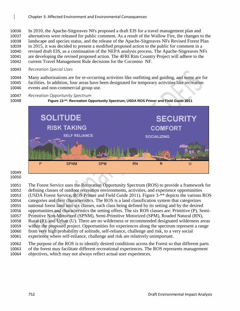
Chapter 3: Affected Environment and Environmental Consequences
752 Draft Environmental Impact Analysis
In 2010, the Apache-Sitgreaves NFs proposed a draft EIS for a travel management plan and 10036 alternatives were released for public comment. As a result of the Wallow Fire, the changes to the 10037 landscape and species status, and the release of the Apache-Sitgreaves NFs Revised Forest Plan 10038 in 2015, it was decided to present a modified proposed action to the public for comment in a 10039 revised draft EIS, as a continuation of the NEPA analysis process. The Apache-Sitgreaves NFs 10040 are developing the revised proposed action. The 4FRI Rim Country Project will adhere to the 10041 current Travel Management Rule decisions for the Coconino NF. 10042
Recreation Special Uses 10043
Many authorizations are for re-occurring activities like outfitting and guiding, and some are for 10044 facilities. In addition, four areas have been designated for temporary activities like recreation 10045 events and non-commercial group use. 10046
Recreation Opportunity Spectrum 10047 Figure 13-**: Recreation Opportunity Spectrum, USDA ROS Primer and Field Guide 2011 10048
10049 10050
The Forest Service uses the Recreation Opportunity Spectrum (ROS) to provide a framework for 10051 defining classes of outdoor recreation environments, activities, and experience opportunities 10052 (USDA Forest Service, ROS Primer and Field Guide 2011). Figure 3-** depicts the various ROS 10053 categories and their characteristics. The ROS is a land classification system that categorizes 10054 national forest land into six classes, each class being defined by its setting and by the desired 10055 opportunities and characteristics the setting offers. The six ROS classes are: Primitive (P), Semi-10056 Primitive Non-Motorized (SPNM), Semi-Primitive Motorized (SPM), Roaded Natural (RN), 10057 Rural (R), and Urban (U). There are no wilderness or recommended designated wilderness areas 10058 within the proposed project. Opportunities for experiences along the spectrum represent a range 10059 from very high probability of solitude, self-reliance, challenge and risk, to a very social 10060 experience where self-reliance, challenge and risk are relatively unimportant. 10061
The purpose of the ROS is to identify desired conditions across the Forest so that different parts 10062 of the forest may facilitate different recreational experiences. The ROS represents management 10063 objectives, which may not always reflect actual user experiences. 10064
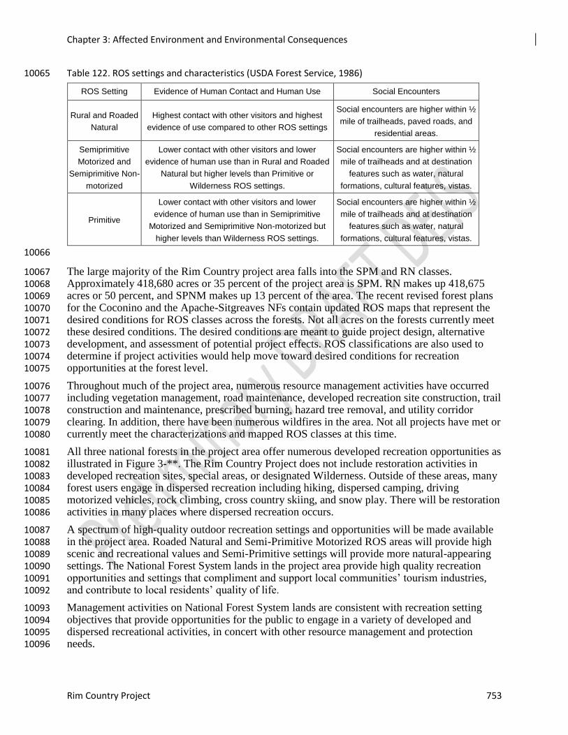
Chapter 3: Affected Environment and Environmental Consequences
Rim Country Project 753
Table 122. ROS settings and characteristics (USDA Forest Service, 1986) 10065
ROS Setting Evidence of Human Contact and Human Use Social Encounters
Rural and Roaded
Natural
Highest contact with other visitors and highest
evidence of use compared to other ROS settings
Social encounters are higher within ½
mile of trailheads, paved roads, and
residential areas.
Semiprimitive
Motorized and
Semiprimitive Non-
motorized
Lower contact with other visitors and lower
evidence of human use than in Rural and Roaded
Natural but higher levels than Primitive or
Wilderness ROS settings.
Social encounters are higher within ½
mile of trailheads and at destination
features such as water, natural
formations, cultural features, vistas.
Primitive
Lower contact with other visitors and lower
evidence of human use than in Semiprimitive
Motorized and Semiprimitive Non-motorized but
higher levels than Wilderness ROS settings.
Social encounters are higher within ½
mile of trailheads and at destination
features such as water, natural
formations, cultural features, vistas.
10066
The large majority of the Rim Country project area falls into the SPM and RN classes. 10067 Approximately 418,680 acres or 35 percent of the project area is SPM. RN makes up 418,675 10068 acres or 50 percent, and SPNM makes up 13 percent of the area. The recent revised forest plans 10069 for the Coconino and the Apache-Sitgreaves NFs contain updated ROS maps that represent the 10070 desired conditions for ROS classes across the forests. Not all acres on the forests currently meet 10071 these desired conditions. The desired conditions are meant to guide project design, alternative 10072 development, and assessment of potential project effects. ROS classifications are also used to 10073 determine if project activities would help move toward desired conditions for recreation 10074 opportunities at the forest level. 10075
Throughout much of the project area, numerous resource management activities have occurred 10076 including vegetation management, road maintenance, developed recreation site construction, trail 10077 construction and maintenance, prescribed burning, hazard tree removal, and utility corridor 10078 clearing. In addition, there have been numerous wildfires in the area. Not all projects have met or 10079 currently meet the characterizations and mapped ROS classes at this time. 10080
All three national forests in the project area offer numerous developed recreation opportunities as 10081 illustrated in Figure 3-**. The Rim Country Project does not include restoration activities in 10082 developed recreation sites, special areas, or designated Wilderness. Outside of these areas, many 10083 forest users engage in dispersed recreation including hiking, dispersed camping, driving 10084 motorized vehicles, rock climbing, cross country skiing, and snow play. There will be restoration 10085 activities in many places where dispersed recreation occurs. 10086
A spectrum of high-quality outdoor recreation settings and opportunities will be made available 10087 in the project area. Roaded Natural and Semi-Primitive Motorized ROS areas will provide high 10088 scenic and recreational values and Semi-Primitive settings will provide more natural-appearing 10089 settings. The National Forest System lands in the project area provide high quality recreation 10090 opportunities and settings that compliment and support local communities’ tourism industries, 10091 and contribute to local residents’ quality of life. 10092
Management activities on National Forest System lands are consistent with recreation setting 10093 objectives that provide opportunities for the public to engage in a variety of developed and 10094 dispersed recreational activities, in concert with other resource management and protection 10095 needs. 10096
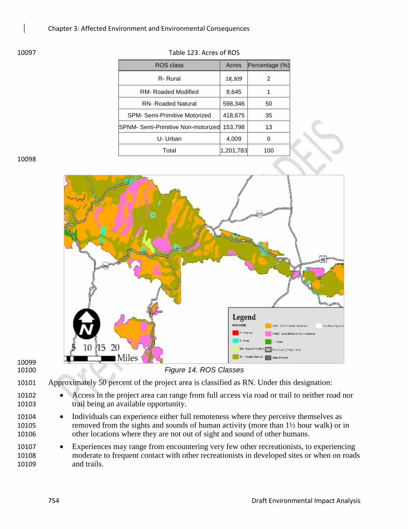
Chapter 3: Affected Environment and Environmental Consequences
754 Draft Environmental Impact Analysis
Table 123. Acres of ROS 10097
ROS class Acres Percentage (%)
R- Rural 18,309 2
RM- Roaded Modified 8,645 1
RN- Roaded Natural 598,346 50
SPM- Semi-Primitive Motorized 418,675 35
SPNM- Semi-Primitive Non-motorized 153,798 13
U- Urban 4,009 0
Total 1,201,783 100
10098
10099 Figure 14. ROS Classes 10100
Approximately 50 percent of the project area is classified as RN. Under this designation: 10101
Access in the project area can range from full access via road or trail to neither road nor 10102 trail being an available opportunity. 10103
Individuals can experience either full remoteness where they perceive themselves as 10104 removed from the sights and sounds of human activity (more than 1½ hour walk) or in 10105 other locations where they are not out of sight and sound of other humans. 10106
Experiences may range from encountering very few other recreationists, to experiencing 10107 moderate to frequent contact with other recreationists in developed sites or when on roads 10108 and trails. 10109
Chapter 3: Affected Environment and Environmental Consequences
Rim Country Project 755
Some locations will offer on-site information that is noticeable but is presented in a 10110 manner that harmonizes with the natural environment, and other locations may not offer 10111 any on-site information. 10112
Recreationists will find some sites that offer no facilities for user comfort while other 10113 sites may offer some facilities that are rustic and built out of native materials. These 10114 facilities offer some on-site protection from the natural elements. 10115
As mentioned, 35 percent of the analysis area is designated SPM. Under this designation: 10116
Access can include non-motorized and motorized trails, and primitive roads. 10117
Remoteness is more evident than in areas classified as RN. 10118
Human encounters can range from under 6, up to 15 parties met per day, or less than 3, 10119 up to 6 parties seen at a campsite per day. 10120
Information facilities provided on-site range from very limited to nonexistent. 10121
On-site protection facilities range from rustic or rudimentary to nonexistent. 10122
SPM management direction stipulates that limited to no site hardening occurs at / on 10123 recreation sites and locations that fall within this designation. 10124
Visitors’ impacts range from unnoticeable with no site hardening to subtle site hardening. 10125
As mentioned, 13 percent of the analysis area is designated SPNM- Semi-Primitive Non-10126 motorized. Under this designation: 10127
Access include non-motorized trails and existent primitive roads if usually closed to 10128 motorized use. Motorized roads are at least 0.5 mile but no further than 3 miles from the 10129 designated area. 10130
Remoteness is evident and the environment offers challenge and risk. 10131
Human encounters can range from under 6, up to 15 parties met per day, or less than 3, 10132 up to 6 parties seen at a campsite per day. 10133
On-site protection facilities range from rustic or rudimentary to nonexistent. 10134
SPM management direction stipulates that limited to no site hardening occurs at / on 10135 recreation sites and locations that fall within this designation. 10136
Visitors’ impacts range from unnoticeable with no site hardening to subtle site hardening. 10137
Assumptions and Methodology 10138
This assessment includes use of the best available science, based on relevant peer-reviewed 10139 literature, published reports from regulatory and land management agencies, existing resource 10140 inventories, field visits, and the professional judgment of interdisciplinary and cooperating 10141 agency team members. 10142
The Recreation Opportunity Spectrum (ROS) is the guiding system that forest plans direct be 10143 considered when planning projects to properly manage and balance recreation opportunities. The 10144 ROS provides a framework to assist managers in identifying different outdoor recreation 10145 environments, settings, activities, and experiences desired by the public, and deciding how to 10146 provide these different recreational opportunities over the landscape within the forest (USDA 10147 Forest Service, ROS Book, 1986). ROS classifications are identified to distinguish the desired 10148 conditions across the landscape. ROS classifications within the project area were referenced to 10149
Chapter 3: Affected Environment and Environmental Consequences
756 Draft Environmental Impact Analysis
determine if project activities would affect the potential for meeting or moving toward desired 10150 conditions identified in the ROS classifications. 10151
The Special Uses Database System was used to generate a list of all recreation special use 10152 authorizations within the project area. This report was sorted by status. The authorizations were 10153 considered part of the existing condition if they had statuses of application accepted, pending 10154 signature, or issued. 10155
Data and experiences from both the 4FRI 1st EIS and the Cragin Watershed Protection Project 10156 were used in this analysis because of proximity to the project area, probability that users would 10157 recreate in all these project areas, and the similarity of terrain and vegetation. 10158
The timeframes for direct and indirect effects include the potential for up to 20 years of project 10159 implementation. The thinning treatments may take up to 20 years to complete, with each thinning 10160 contract generally completed within a three-year timeframe. Implementation will include 10161 prescribed burning over a 20-year period of time, with multiple burn intervals of two to 10 years 10162 across the project area 10163
Issues/Indicators/Analysis Topics 10164
Analysis topics identified relative to recreation and lands management resources are based on 10165 Forest Plan desired conditions, management approaches, guidelines, and standards. There were 10166 very few public comments identifying issues or concerns related to recreation, except for 10167 potential effects from treatments on the Arizona National Scenic Trail and its users. 10168 Consequently, this resource area was determined to require cursory analysis. The primary issue 10169 of concern to recreation resources from the proposed activities is to minimize and mitigate 10170 impacts to recreation features (e.g., developed campgrounds, signs, trails, and trailheads) and 10171 recreation activities (e.g., driving for pleasure, dispersed camping, hiking, mountain biking, 10172 equestrian use, hunting, boating, special use events, and developed camping).. 10173
Environmental Consequences 10174
Alternative 1 – No Action 10175
Under this alternative, recreation resources would be managed as they are currently without any 10176 effects from vegetation treatments and prescribed burning proposed in the Rim Country project 10177 area. Although electing the no action alternative would not result in impacts to these resources 10178 from prescribed burning or thinning, this alternative would not reduce the risk of uncharacteristic 10179 wildfire that could cause important resource damage, damage to recreation and lands 10180 infrastructure, and subsequent flooding. Wildfires ignited by lightening could be managed for 10181 resource benefit given conditions allow; however, the use of this strategy to decrease future 10182 crown-fire risk is unpredictable and unlikely to affect a majority of the project area. Alternative 1 10183 is the point of reference for assessing action alternatives 2 and 3. 10184
Recreation Sites and Uses 10185
Recreation Resources 10186
The threat of uncharacteristically severe wildfire continues to increase with ongoing, unmanaged 10187 growth of vegetation. Uncharacteristic wildfire would severely impact recreation values and 10188 experiences in the analysis area. Research has demonstrated the negative effects wildfire can 10189 have on recreation activities. Vaux, et al. (1984) found that “intense fires may have detrimental 10190 effects on recreation values” (p.1). 10191
Recent wildfires in the Coconino NF (Schultz Fire in 2010 and Slide Fire in 2014) and Apache-10192 Sitgreaves NFs (Rodeo-Chediski Fire in 2002 and Wallow Fire in 2011) demonstrate the 10193
Chapter 3: Affected Environment and Environmental Consequences
Rim Country Project 757
significant impacts of uncharacteristic wildfire on recreation. In all cases, recreation facilities had 10194 to be closed to the public, with many remaining closed for months or even years. After the Slide 10195 Fire, Slide Rock State Park in Oak Creek Canyon was closed for several months during the 10196 period of highest visitation, and eventually opened after a very expensive early warning system 10197 for potential flash floods was installed. 10198
During NVUM, visitors were asked what they would do if they were unable to visit this national 10199 forest due, for example, to closures related to wildfire damage and rehabilitation. The majority of 10200 visitors responded that they would have gone elsewhere for the same activity. This suggests that 10201 if the Rim Country project area was closed due to wildfire or related effects, visitors would seek 10202 alternative locations to enjoy the same recreation activities. This could lead to overcrowding in 10203 nearby areas, resulting in resource damage and undesirable recreational experiences. 10204
Developed Recreation Facilities 10205
Developed recreation facilities, such as campgrounds and group event sites, could be negatively 10206 affected if there is no action to reduce the risk of uncharacteristic wildfire. The changes to 10207 landscape character and visual quality following a severe fire would considerably diminish the 10208 quality of recreation experiences and activities in affected areas. Effects from severe wildfire on 10209 other recreation-related infrastructure such as restrooms, kiosks, bulletin boards, and trail signs 10210 would be substantial and would result in high costs to repair or replace damaged facilities. 10211 Historic sites such as lookout towers and guard stations could not be replaced if destroyed. 10212
Trails 10213
While the Schultz Fire on the Coconino NF severely damaged several trails, subsequent flooding 10214 was more destructive and caused more substantial damage than the fire itself. Large debris flows 10215 caused by rainfall on the denuded slopes destroyed major sections of the Little Bear Trail. In 10216 other areas, trails sections were rendered unpassable and invisible due to large boulders and tree 10217 trunks transported by the floodwaters and debris flows. Much of this flood damage occurred on 10218 trails that cross steep slopes or drainages. The economic cost and effort to reopen these trails was 10219 immense. Little Bear Trail was closed from the fire in 2010 until October 2016. The Deer Hill 10220 Trail was also closed and only reopened at the end of November 2017. 10221
The Rim Country project area contains parts of four national trails: the Arizona National Scenic 10222 Trail (70 miles in the project area), the entire Blue Ridge National Recreation Trail (9.4 miles), 10223 the General Crook National Recreation Trail (95 miles in the project area), and the Highline 10224 National Recreation Trail (44 miles in the project area). Figure 3-** illustrates the locations of the 10225 national trails in the project area. The Rim Country project area contains 728 miles of trail, ranging 10226 from most primitive to fully developed. Some trails in the Rim Country project analysis area share 10227 characteristics with the trails that were damaged in the Schultz Fire. Wildfire or flood damage to 10228 segments of trails within the project area would require closures of affected sections until they 10229 could be properly repaired and determined safe for use. In the interim, potentially lengthy re-10230 routes would have to be established for visitors wishing to hike any affected trails, especially for 10231 the state-wide Arizona National Scenic Trail. 10232
Several research papers and lessons from the Schultz Fire reveal that the no action alternative, 10233 which has no vegetation management actions to reduce the risk of wildfire, could have negative 10234 and unpredictable effects on trails and trail users if an uncharacteristically severe wildfire 10235 occurred in the Rim Country project area. 10236
Overall, trail users respond negatively and show decreased short-term return rates to areas that 10237 have experienced uncharacteristic wildfire, such as the Schultz Fire and Slide Fire ( (Hesseln, 10238
Chapter 3: Affected Environment and Environmental Consequences
758 Draft Environmental Impact Analysis
Loomis, Gonzalez-Caban, & Alexander, 2003) (Starbuck, Berrens, & McKee, 2006) (Bawa, 10239 2017). In New Mexico, Hesseln, et al. (2003) found that visitation to areas recovering from 10240 crown fires, by both hikers and mountain bikers, decreased through time. Similarly, Starbuck et 10241 al. (2006) showed that unrestored areas in the five national forests of New Mexico that 10242 experienced uncharacteristic fire were unappealing to bikers and hikers. According to the study’s 10243 model, decreases in post-fire recreational visitation by hikers and bikers resulted in estimated 10244 losses of over $51 million in output, over $23 million in earnings, and a loss of 1,240 jobs. 10245
While short-term effects of uncharacteristic wildfires on recreation are almost uniformly 10246 negative, longer-term effects may differentially impact certain user groups. Fire-damaged trees 10247 can take many years to fall, and it is likely that any affected trail system would experience 10248 increased numbers of downed trees across trails for many years, despite routine maintenance. 10249 Crossing downed logs on trails is more burdensome for mountain bikers, who must stop, 10250 dismount, and lift their bikes over fallen trees, than it is for hikers, who may be able to simply 10251 step over these obstacles. Hesseln, et al. (2003) found that the value of net benefits for hikers 10252 increased during the 40 years following crown fire, whereas the net benefits for mountain bikers 10253 declined over the same period. This demonstrates that different intensity fires may impact groups 10254 engaged in different recreation activities in different ways. 10255
Overall trail users respond negatively and have a decreased return to forested areas that have 10256 experienced uncharacteristic wildfire. “The lack of mature trees and the large numbers of 10257 downed trees make the area unattractive to hikers and mountain bikers” (Starbuck et al. 2006, p. 10258 63). So the no action alternative which has no vegetation management activities or prescribed 10259 burning treatments to reduce the risk of wildfire could have negative effects on trails and trail 10260 users if an uncharacteristic wildfire was to occur in the Rim Country project area. 10261
Wild and Scenic River 10262
There would be no effect on the eligible Wild and Scenic Rivers as they would continue their 10263 management per the direction in the respective Forest Plans. 10264
Dispersed Recreation 10265
Following the Rodeo-Chediski Fire in 2002, dispersed camping in the burned area was 10266 prohibited for nearly seven years. The major reasons for this restriction was to protect visitors 10267 and property from damage due to falling trees and flooding, and to reduce recreation effects to 10268 fragile fire-damaged soils. The time it takes a fire-damaged tree to fall is unpredictable and 10269 depends on several factors including weather, topography, burn severity, and flooding. Trees that 10270 have been killed or damaged by fire may be unstable and parts or all of such trees can easily 10271 become dislodged and can fall onto forest visitors, vehicles, or camping equipment. 10272
Dispersed camping is popular in the Rim Country project area and an uncharacteristic wildfire 10273 could result in closing a fire area to camping and other activities. This would impact thousands 10274 of visitors every summer that visit the project area to camp in the desirable summer 10275 temperatures. Even after the initial threat of and hazards of fire-damaged trees has passed, 10276 visitors may avoid the area because it would be less appealing because of the loss of trees, shade, 10277 and desirable dispersed camping locations. Shelby et al. (Shelby, Thompson, Brunson, & 10278 Johnson, 2004) found that camping in areas affected by wildfire received universally lower 10279 quality levels than those same areas for hiking after the same period. Hence, the no action 10280 alternative could have adverse effects on dispersed camping. Should a wildfire result in large, 10281 long-term closures for safety or resource protection purposes, activities such as camping, 10282 hunting, and other recreational uses would be lost or severely degraded during both short-term 10283 (one to five years) and long-term (five years or more) timeframes. 10284
Chapter 3: Affected Environment and Environmental Consequences
Rim Country Project 759
Recreation Special Uses 10285
Although the no action alternative would not produce any effects from vegetation management 10286 or prescribed burning on recreation special use activities, the risk of uncharacteristic wildfire 10287 would not be reduced. Uncharacteristic wildfire could impact recreation special uses because 10288 sites (recreation events) would likely be unsafe and less appealing for recreation special use 10289 activities after such a fire and would likely result in closures (short-term and long-term) 10290 depending on severity. 10291
Motor Vehicle Use 10292
Motorized Travel Management implementation in combination with the no action alternative is 10293 expected to have no effects on recreation settings. Present and future activities may result in 10294 degradation along heavily used camping corridors, but these would be small and localized. 10295
Recreation Opportunity Spectrum 10296
ROS would remain within forest plan guidelines unless stand-replacement wildfire affects a large 10297 portion of the analysis area. Locations and results of unplanned fire ignitions are impossible to 10298 predict; however, it is fairly likely that an uncharacteristic wildfire would move conditions away 10299 from desired conditions for semi-primitive areas where the evidence of humans is meant to be 10300 limited (semi-primitive areas). Uncharacteristic wildfire would likely include a number of 10301 alterations to the forest environment such as cutting of dead roadside hazard trees, increased 10302 signage to warn of post-fire dangers, re-constructed roads, or recently constructed dozer or hand-10303 built fire line. All of these would result in short and some long-term effects that would move 10304 conditions away from desired conditions identified for semi-primitive areas. 10305
Effects Common to Both Action Alternatives 10306
Developed Sites 10307
Mechanical and prescribed fire treatments could negatively affect developed recreation sites by 10308 short closures of the sites during the operations. However, developed recreation sites would not 10309 be modified by any alternatives as design features have been developed to protect the sites from 10310 possible negative effects from proposed treatments in Alternatives 2 and 3. 10311
Recreation Special Use 10312
None of the alternatives would have any effects from vegetation management or prescribed 10313 burning on Recreation Special Use activities. There would be no effects on recreation residences 10314 at Diamond Point and Elison Creek, or organization camps including Camp Shadow Pines, Tall 10315 Timbers County Park, Arizona Cactus-Pine Girl Scout Camp, and Grand Canyon Council Boy 10316 Scout Camp. All permittees can execute their business as intended by their authorized special use 10317 permits. 10318
Effects Unique to Each Action Alternative and Differences among Them 10319
The no action alternative does not include any thinning or prescribed burning treatments in the 10320 project area, increasing the likelihood of uncharacteristic wildfire that may have lasting effects 10321 on recreation areas throughout the Rim Country project area. 10322
Alternatively, the Modified Proposed Action and the Focused Alternative, which include different 10323 amounts of thinning and prescribed burning, would reduce the risk of extensive crown fire and 10324 uncharacteristic wildfire. These alternatives would protect the developed campgrounds, lands 10325 infrastructure, trails, and dispersed recreation areas within the project area, maintaining open 10326 recreation areas and activities for users during and in the years following the project 10327
Chapter 3: Affected Environment and Environmental Consequences
760 Draft Environmental Impact Analysis
implementation. Shorter term impacts would occur to uses during implementation, including the 10328 potential impacts from larger processing sites near residences, highways, and dispersed 10329 recreation areas. 10330
In the long term, the Modified Proposed Action would support the health and safety of 10331 recreationalists and surrounding communities, as well as reduce potential effects on water 10332 supplies, utilities, and other infrastructure within and adjacent to the project area. 10333
Trails 10334
Overall, trail users respond negatively and have a decreased return to forested areas that have 10335 experienced uncharacteristic wildfire. Trail users would be minimally affected by the proposed 10336 treatments in both Alternatives 2 and 3 since design features are developed to mitigate any issues 10337 related to trails. Effects like visitor displacement and possible overcrowding of some areas where 10338 visitors choose to go instead of areas closed or disturbed by proposed treatments are difficult to 10339 estimate. However, all three alternatives present different possibilities of risks of uncharacteristic 10340 wildfires. The no action alternative presents the highest risk because of the lack of concentrated 10341 treatments on a large landscape scale. Consequently, Alternative 2 has the lowest risk because of 10342 its sizeable amount of acres treated. Alternative 3 would have lower risk than the no action 10343 alternative and higher risks than the Modified Proposed Action. The greatest effects on trails 10344 would result from uncharacteristic wildfires. This risk can be reduced with proposed treatments. 10345 Alternative 1 poses the greatest threat to the trail systems, followed by Alternative 3. The 10346 Modified Proposed Action (Alternative 2) offers the best possible outcome for the current and 10347 future use of the trail systems, treating the most acres of forest. 10348
Dispersed Recreation and Motor Vehicle Use 10349
Dispersed recreation and motor vehicle use display the same effects from Alternatives 2 and 3, 10350 while Alternative 1 would have no effects unless there is an uncharacteristic wildfire. 10351 Alternatives 2 and 3 might result in some reduction of recreation opportunities during active 10352 forest thinning and prescribed burning, and potentially longer slash treatment duration. Areas 10353 may be closed to the public due to hazardous conditions which would result in forest user 10354 displacement and user dissatisfaction. There could also be an increase in crowding in nearby 10355 open forest areas. 10356
Alternatives 2 and 3 propose to decommission 230 miles of existing system and unauthorized 10357 roads on the Coconino and Apache-Sitgreaves NFs and 20 miles on the Tonto NF. The Rim 10358 Country Project will adhere to the travel management decisions for the Coconino, Tonto, and 10359 Apache-Sitgreaves NFs. Design features would address any issues related to the construction of 10360 temporary roads for haul access, insuring decommissioning of all temporary roads after 10361 treatments are completed. Hence, both alternatives would reduce access or ease of access to 10362 recreate in certain areas on the forests. However, decommissioning unauthorized roads could 10363 positively affect recreation resources by protecting resources and removing access to motorized 10364 recreation where unlawful. 10365
Alternatives 2 and 3 would have similar effects, but would vary proportionally with treatment 10366 area size. Minor effects would be mitigated through design features. 10367
Recreation Opportunity Spectrum 10368
The no action alternative would allow ROS to remain within forest plan guidelines unless stand-10369 replacement wildfire affects a large proportion of the project area. Locations and results of 10370 unplanned fire ignitions are impossible to predict; however, it is fairly likely that an 10371 uncharacteristic wildfire would move conditions away from desired conditions for semi-10372
Chapter 3: Affected Environment and Environmental Consequences
Rim Country Project 761
primitive areas where the evidence of humans is meant to be limited (semi-primitive areas). 10373 Uncharacteristic wildfire would likely include a number of alterations to the forest environment 10374 such as cutting of dead roadside hazard trees, increased signage to warn of post-fire dangers, re-10375 constructed roads, or recently constructed dozer or hand-built fire line. All of these would result 10376 in short and some long-term effects that would move conditions away from desired conditions 10377 identified for semi-primitive areas. 10378
Alternatives 2 and 3 might cause temporary effects on recreation users at particular areas during 10379 implementation activities, mainly thinning operations and hauling. There would be longer term 10380 potential effects of increased traffic and noise near processing site locations. However, since 10381 most of the project area is located within Roaded Natural, Semi-Primitive Motorized, and to a 10382 lesser amount Semi-Primitive Non-Motorized ROS settings, these effects would be consistent 10383 with recreation opportunity objective settings for the majority of the project area. 10384
Alternative 2 – Modified Proposed Action 10385
Recreation Sites and Uses 10386
Developed Sites 10387
Any vegetation treatments or prescribed burning in developed recreation sites would generally 10388 occur in fall, winter, or spring, which are low-use recreational periods. All treatments in 10389 recreation sites would be designed to protect and enhance existing vegetative structure, while 10390 maintaining the character of the site. Proposed mechanical treatments and prescribed fire 10391 adjacent to developed recreation sites must be reviewed and approved by the district ranger. The 10392 district recreation staff will help determine boundaries or no treatment zones around constructed 10393 features that need to be protected in campgrounds. Treatments around the perimeter of 10394 campgrounds are encouraged. The timing of treatments must be worked out with districts. 10395 Treatments would generally avoid summer. Activity slash must be piled in agreed upon 10396 locations, and treated as soon as possible. If campgrounds remain open into fall and winter, 10397 provide information about upcoming closures and management activities on-site, at FS offices, 10398 and on FS websites (see recreation design features in Appendix C). 10399
Facilities at developed sites and campgrounds in the project area would be protected from 10400 adverse effects from management activities, and such treatments would protect the developed 10401 sites from any short or long-term risk of uncharacteristic wildfire. 10402
Trails 10403
Trail use level is not expected to change. The Modified Proposed Action includes prescribed 10404 burning and thinning activities adjacent to the Arizona National Scenic Trail, Highline 10405 Recreation Trail, and General Crook National Recreation Trail. Trails within the project area 10406 may be temporarily closed during prescribed burning activities but, throughout project 10407 implementation, trails and trail infrastructure would be considered and protected, and effects on 10408 scenic qualities minimized to the extent practicable. Damage to trails or necessary trail 10409 maintenance resulting from prescribed burning or mechanical treatments in the area would be 10410 rehabilitated as soon as possible. 10411
In the Modified Proposed Action, mechanical thinning activities would avoid national and forest 10412 system trails if possible. Coordination with district recreation planners, trails specialists, and 10413 local trail stewards would occur during prescription or burn plan development, layout, marking, 10414 thinning, and burning where any treatment would occur on, adjacent to, or near national and 10415 system trails. This is to ensure that trails and trail infrastructure are considered and protected and 10416 effects on scenic qualities are minimized to the extent practicable. If trails are temporarily closed 10417
Chapter 3: Affected Environment and Environmental Consequences
762 Draft Environmental Impact Analysis
due to thinning, trails would be returned to pre-treatment conditions (see recreation design 10418 features in Appendix C). 10419
Skidding of felled trees would avoid national and forest system trails, if possible, except where 10420 motorized use is already authorized (trails located on open system and administrative roads). If it 10421 is determined necessary that a trail must be used as a skid trail crossing, perpendicular trail 10422 crossings would be used. Trail crossing locations, including those on the Arizona National 10423 Scenic Trail and the General Crook and Highline National Recreation Trails would be designated 10424 and flagged with input from district trails specialists, recreation planners, or archaeologists. 10425 Trails would be restored to USFS standards (pre-project condition) following treatment. 10426
There would be no use of motorized equipment on national scenic and recreation trails, or other 10427 forest system trails. If these are used for control lines, the district recreation staff would help 10428 coordinate the implementation. Where new temporary roads intersect existing roads or trails, 10429 native materials such as logs, slash, and/or boulders would be placed along the temporary road to 10430 line-of-sight or first 300 feet, whichever is greater. 10431
Road closures, one-way traffic, and area closure restrictions would be implemented as deemed 10432 necessary by forest officials for health and safety concerns during any operation. Signs would be 10433 placed at major intersections on hauling routes during periods of active hauling. If it is necessary 10434 to close forest roads or areas of the forest, notices and signs would be posted at key locations 10435 adjacent to and within the project area, such as along major FS roads accessing the area or on 10436 kiosks at trailheads, bulletin boards, electronic sign boards. Closures due to operations would 10437 also be posted online and on social media as well as being publicized via news releases. 10438 Coordination is required with district recreation planners or trails specialists to ensure well 10439 marked and publicized detour routes for the Arizona Trail, General Crook Trail, Highline Trail, 10440 and system trails during operational closures. 10441
Dispersed Recreation 10442
Vegetation treatments, prescribed burning, and fuel treatments, occurring over time and space, 10443 would have little effect on the recreating public. Alternative 2 would support the re-integration of 10444 low-intensity fire as a regulatory process on the landscape. Several cases show low-intensity 10445 wildland fires yielding virtually no effects on recreational value and in some instances imparting 10446 positive social impacts. Both Sanchez et al. (Sanchez, 2016) and Starbuck et al. (2006) show 10447 visitations in California and New Mexico increasing under low-intensity fire scenarios. The only 10448 anticipated effect that the Modified Proposed Action would have on dispersed recreation is when 10449 prescribed burning coincides with hunting seasons, especially in the fall of the year, or during 10450 brief closures of campsites, roads, or trails. 10451
There may also be temporary area closures while prescribed burns are being implemented and, 10452 less often, closures for managed fire activities. Spring burning would affect fewer people using 10453 dispersed campsites. In total, the action alternatives are not expected to considerably affect 10454 dispersed recreation within the project area. Treatments would be planned to be staggered 10455 throughout the project area in both time and space, so that even during temporary closures from 10456 active treatments, there would be many other places to hunt, camp and recreate. Efforts would be 10457 taken to limit forest treatment activities within the project area during high-use weekends and 10458 holidays, such as Memorial Day, Independence Day, and Labor Day, especially in locations 10459 where concentrated use is expected to occur. 10460
Temporary closures from treatments would result in the temporary loss of recreational access or 10461 opportunities and could result in decreased satisfaction of nearby recreational sites where there is 10462 overcrowding. This is most likely to occur during high-traffic weekends from Memorial Day 10463
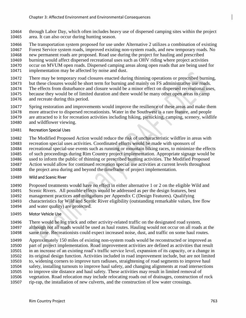
Chapter 3: Affected Environment and Environmental Consequences
Rim Country Project 763
through Labor Day, which often includes heavy use of dispersed camping sites within the project 10464 area. It can also occur during hunting season. 10465
The transportation system proposed for use under Alternative 2 utilizes a combination of existing 10466 Forest Service system roads, improved existing non-system roads, and new temporary roads. No 10467 new permanent roads are proposed. Road use during the project for hauling and prescribed 10468 burning would affect dispersed recreational uses such as OHV riding where project activities 10469 occur on MVUM open roads. Dispersed camping areas along open roads that are being used for 10470 implementation may be affected by noise and dust. 10471
There may be temporary road closures enacted during thinning operations or prescribed burning, 10472 but these closures would be short term for burning and mainly on FS administrative use roads. 10473 The effects from disturbance and closure would be a minor effect on dispersed recreational uses, 10474 because they would be of limited duration and there would be many other open areas to camp 10475 and recreate during this period. 10476
Spring restoration and improvements would improve the resilience of these areas and make them 10477 more attractive to dispersed recreationists. Water in the Southwest is a rare feature, and people 10478 are attracted to it for recreation activities including hiking, picnicking, camping, scenery, wildlife 10479 and wildflower viewing. 10480
Recreation Special Uses 10481
The Modified Proposed Action would reduce the risk of uncharacteristic wildfire in areas with 10482 recreation special uses activities. Coordinated efforts would be made with sponsors of 10483 recreational special-use events such as running or mountain biking races, to minimize the effects 10484 of such proceedings during Rim Country project implementation. Appropriate signage would be 10485 used to inform the public of thinning or prescribed burning activities. The Modified Proposed 10486 Action would allow for continued recreation special use activities at current levels throughout 10487 the project area during and beyond the timeframe of project implementation. 10488
Wild and Scenic River 10489
Proposed treatments would have no effect in either alternative 1 or 2 on the eligible Wild and 10490 Scenic Rivers. All possible effects would be addressed as per the design features, best 10491 management practices and mitigations per Appendix C (Design Features). Qualifying 10492 characteristics for Wild and Scenic River eligibility (outstanding remarkable values, free flow 10493 and water quality) are protected. 10494
Motor Vehicle Use 10495
There would be log truck and other activity-related traffic on the designated road system, 10496 although not all roads would be used as haul routes. Hauling would not occur on all roads at the 10497 same time. Recreationists could expect increased noise, dust, and traffic on some haul routes. 10498
Approximately 150 miles of existing non-system roads would be reconstructed or improved as 10499 part of project implementation. Road improvement activities are defined as activities that result 10500 in an increase of an existing road’s traffic service level, expansion of its capacity, or a change in 10501 its original design function. Activities included in road improvement include, but are not limited 10502 to, widening corners to improve turn radiuses, straightening of road segments to improve haul 10503 safety, installing turnouts to improve haul safety, and changing alignments at road intersections 10504 to improve site distance and haul safety. These activities may result in limited removal of 10505 vegetation. Road relocation may include relocating roads out of drainages, construction of rock 10506 rip-rap, the installation of new culverts, and the construction of low water crossings. 10507
Chapter 3: Affected Environment and Environmental Consequences
764 Draft Environmental Impact Analysis
There would be short-term disturbance and temporary changes in ROS classes and roadside 10508 recreation settings during road improvement activities. Recreation visitors may be 10509 inconvenienced and have to wait during some activities, or roads may be temporarily closed 10510 causing displacement. Road relocation would result in a safer road to travel on. It would also 10511 result in short-term disturbances such as increased bare ground and decreased roadside visual 10512 quality in scattered locations. Long-term effects would be improved water quality at stream 10513 crossings, and safer and better maintained roads for forest user enjoyment. 10514
Road decommissioning would occur on approximately 230 miles of existing system and 10515 unauthorized roads on the Coconino and Apache-Sitgreaves NFs and approximately 20 miles of 10516 unauthorized roads on the Tonto NF. Decommissioning includes applying various treatments, 10517 including one or more of the following: 10518
1. Reestablishing former drainage patterns, stabilizing slopes, and restoring vegetation; 10519
2. Blocking the entrance to a road or installing water bars; 10520
3. Removing culverts, reestablishing drainages, removing unstable fills, pulling back road 10521
shoulders, and scattering slash on the roadbed; 10522
4. Completely eliminating the roadbed by restoring natural contours and slopes; and 10523
5. Other methods designed to meet the specific conditions associated with the unneeded road. 10524
Short-term effects of road decommissioning would include ground disturbance and sedimentation 10525 and noise disturbance to recreationists. Short-term effects would last from three to 10 years as 10526 the project activities rotate across the landscape. There would be a long-term improvement of 10527 recreation settings as vegetation is established, soil erosion is minimized, and there is decreased 10528 disturbance from motorized vehicles. Once recovered, these former routes are often not apparent 10529 to the casual user. Decommissioning 860 miles of roads would improve recreation settings over 10530 time and would improve ROS classes, especially in the semi-primitive non-motorized ROS class 10531 where all 85 miles of haul routes would be decommissioned. 10532
About 350 miles of temporary roads for haul access would be constructed to support restoration 10533 activities. Construction may include tree removal, ground disturbance, and installation of 10534 drainage structures, road blading, and other disturbances. Following implementation, the 10535 temporary roads would be obliterated using techniques noted for road decommissioning. 10536 Temporary road construction would result in short-term disturbance. When possible, there would 10537 be relocation and reconstruction of existing open roads adversely affecting water quality and 10538 natural resources, or of concern to human safety. This would have long term-positive effects on 10539 water quality, natural resources, and human safety. 10540
There may be some increase in illegal motorized vehicle use of these roads until they are 10541 decommissioned. Once these roads have been decommissioned, they are usually not apparent to 10542 the casual user. Mitigation measures would be used to close off entrance and exit locations of 10543 these roads, as well as the use of Best Management Practices (BMPs) (see Appendix C). 10544
Recreation Opportunity Spectrum 10545
There may be temporary effects on recreation users at particular areas during implementation 10546 activities, mainly harvesting operations and hauling. There would be longer term potential effects 10547 from increased traffic and noise near processing site locations. However, since most of the 10548 project area is located within Roaded Natural and a small amount of Rural ROS settings, these 10549 effects would be consistent with recreation opportunity objective settings for the majority of the 10550 project area. 10551

Chapter 3: Affected Environment and Environmental Consequences
Rim Country Project 765
Construction of all new temporary roads would be similar to a primitive, native surface road that 10552 would be cleared and opened for short-term use during thinning and hauling operations. The 10553 construction and use would be consistent with the RN or SPM designations and, after use, the 10554 temporary road would be completely rehabilitated and would become naturalized within several 10555 years after use. The very slight encumbrance of the SPNM area would likely not result in long-10556 term effects to the ability of the area to meet SPNM characteristics over the long term. 10557
10558
Chapter 3: Affected Environment and Environmental Consequences
766 Draft Environmental Impact Analysis
10559 Figure 15. Treatments and ROS Designations 10560
Mechanical treatments would primarily occur in RN (50 percent) and SPM (35 percent) areas, 10561 with a lesser amount occurring in SPNM (13 percent) in the project area (Figure 3-**). 10562 Mechanical treatments would be expected to result in short-term effects (one to two years after 10563 treatment) where the sights and sounds of humans are more noticeable on the landscape. 10564 However, after a short period of time and subsequent treatments such as prescribed fire, the 10565 evidence of treatments would fade and is not expected to affect ROS designations. As a result 10566 none of the mechanical treatments would prevent an area from meeting or moving toward ROS 10567 classifications over the long term (greater than one year). 10568
Spring restoration and improvements would improve the resilience of these areas and make them 10569 more attractive to dispersed recreationists. The proposed improvements may cause short-term 10570 changes in the recreation settings, but would result in improvements in the setting characteristics 10571 and ROS classes over time. In both action alternatives, up to 184 springs would be improved. 10572 Mitigations to use native materials or natural-appearing materials appropriate to the ROS setting 10573 would result in natural-appearing improvements. The spring improvements would improve and 10574 meet ROS classes. 10575
The 777 miles of channel restoration proposed would improve recreation settings over time. 10576 Mitigations to use native materials or natural-appearing materials appropriate to the ROS setting 10577 and consultation with a landscape architect regarding project design would result in natural-10578 appearing improvements. The channel improvements would improve the settings and meet ROS 10579 classes. 10580
Aspen treatments would take longer for recreation settings to be natural-appearing in roaded 10581 natural and semi-primitive settings due to the need to fence or create barriers to ungulate grazing. 10582 Aspen groves are popular recreation settings for many users throughout the year, but especially 10583 for fall color viewing. The restoration activities would assure that aspen continue as a vital 10584
Chapter 3: Affected Environment and Environmental Consequences
Rim Country Project 767
component within the ponderosa pine forest. There would be short to moderate term changes in 10585 ROS settings where aspen are treated. Aspen restoration requires that ungulates be kept out of 10586 sprouting trees until they are large enough to withstand the browsing pressure. Fencing and 10587 jackstraw piling are both proposed methods for keeping the ungulates out. 10588
Up to 200 miles of protective barriers around springs, aspen, native willows, and big-tooth maples, as 10589 needed for restoration, would be constructed. This would cause temporary changes in the ROS class setting 10590 characteristics since the natural-appearing environment would be somewhat altered. More developed 10591 settings would appear altered for a shorter time period since human alterations may be visible in these 10592 settings. Since the barriers must stay in place for many years, the primitive ROS settings would be altered 10593 for at least 20 years or until the trees can survive browsing. When the protective barriers are removed or 10594 begin to break up and decompose, treatment areas would meet ROS classes. 10595
Alternative 3 – Focused Alternative 10596
Recreation Sites and Uses 10597
The effects from Alternative 3 would be the same as those described for Alternative 2 with the 10598 exception of the number of acres restored. The same design features would be applied for both 10599 Alternative 2 and Alternative 3. Alternative 3 would treat 47 percent fewer acres than Alternative 10600 2. Approximately 39 percent fewer acres would receive mechanical and prescribed fire 10601 restoration treatments, about 26 percent fewer prescribed fire-only. Additionally, the Severe 10602 Disturbance Area Treatments would be 78 percent less in Alternative 3. Alternative 3 would 10603 have less potential to reduce the risk of large-scale, high-severity fires in the project area. It 10604 would have less of a positive effect than Alternative 2 on protecting and maintaining high quality 10605 recreation settings over time. 10606
Developed Sites 10607
Any vegetation treatments or prescribed burning in developed recreation sites would follow the 10608 same design features as in Alternative 2. Consequently, the effects from management activities 10609 on developed sites would protect the developed sites from any short or long-term risk of 10610 uncharacteristic wildfire similarly to Alternative 2. However, facilities at developed sites and 10611 campgrounds in the project area would be less protected from adverse short and long term effects 10612 from the risk of uncharacteristic wildfire because of the fewer area treated. 10613
Trails, Dispersed Recreation, Recreation Special Uses, and Motor Vehicle Use 10614
The effects explained in Alternative 2 would be the same for the following areas: dispersed 10615 recreation, recreation special use, and motor vehicle use. 10616
Recreation Opportunity Spectrum 10617
Alternative provides for the long-term protection of recreational settings and facilities on 10618 474,930 acres where mechanical thinning and burning would occur, by improving stand 10619 conditions and reducing fuel loading, and would lower the risk of high-severity fire somewhat on 10620 316,580 acres of treatments. Maintaining healthy, green forests and reducing the risk of large-10621 scale, high-severity fires in the project area would have a positive effect on protecting and 10622 maintaining high quality recreation settings into the future. Effects from Alternative 3 would be 10623 similar to those from Alternative 2 although on an area almost half the size. 10624
10625
Chapter 3: Affected Environment and Environmental Consequences
768 Draft Environmental Impact Analysis
10626 Figure 16. Treatments in the project area and ROS designations 10627
Mechanical treatments would primarily occur in RN (50 percent) and SPM (35 percent) areas, 10628 with a lesser amount occurring in SPNM (13 percent) (Figure 3-**). Mechanical treatments are 10629 expected to result in short-term effects (one to two years after treatment) where the sights and 10630 sounds of humans are more noticeable on the landscape. However, after a short period of time 10631 and subsequent treatments such as prescribed fire, the evidence of treatments would fade and 10632 would not be expected to affect ROS designations. As a result, none of the mechanical 10633 treatments would prevent an area from meeting or moving toward ROS classifications over the 10634 long term (more than one year). 10635
Effects from Rock Pit Use and Expansion 10636
Effects Common to All Alternatives 10637
All alternatives would increase the level of noise, dust, and traffic in the project area. All 10638 alternatives would cause a temporary loss of access to desired recreation areas when rock pits are 10639 being used to mine and process roadbed material. There would also be potential safety issues 10640 when recreationists are using roads that are haul routes for roadbed material. 10641
There would be no direct or indirect effects on recreation special use permittees as they could 10642 continue their normal operations as directed in their permit. Motor vehicle use should not be 10643 affected as these rock pits would not add any access restrictions or modifications affecting 10644 recreationists. 10645
Figure 3-** displays the ROS in the areas where the pits are located in relation to major 10646 travelways and forest boundaries. Most rock pits are located in ROS in forested areas making 10647 them difficult to view. Under both action alternatives, design features would help mitigate the 10648 impact to recreation from rock pits. 10649
10650
Chapter 3: Affected Environment and Environmental Consequences
Rim Country Project 769
10651 Figure 17. Rim Country Rock Pits and ROS 10652
Alternative 1- No Action 10653
General Effects to Dispersed Recreation, Recreation Special Uses, Developed Recreation Sites, Trails and 10654
Motor Vehicle Use 10655
If Alternative 1 were to be implemented, there would be rock mining, processing, and hauling 10656 activities at the existing and currently operational rock pits. 10657
Alternative 1 could cause a short-term disruption of recreation uses and displacement of 10658 recreation users at and near the existing and operational pits during times when aggregate 10659 materials are being hauled. This would have the effect of concentrating operations and hauling to 10660 a relatively small number of locations, and as a result this alternative would concentrate rock 10661 mining, processing, and hauling at currently operating pits or on main hauling routes (when 10662 aggregate material is purchased from private sources and hauled onto the forests), increasing the 10663 amount of time spent in each location since fewer pits would be used. 10664
Alternative 1 would include dust and noise impacts to nearby trails and recreation areas. Portions 10665 of the trails and recreation areas in proximity to these rock pits would likely experience increased 10666 dust, noise, and perceptions of human activity when the pits are operational. These effects would 10667 be temporary and short term. 10668
Recreational Opportunity Spectrum 10669
Rock pits are located in Roaded Natural, Roaded Modified, and Semi-Motorized ROS setting. 10670 The pits developed in these settings would be in compliance with the setting characteristics. 10671
Chapter 3: Affected Environment and Environmental Consequences
770 Draft Environmental Impact Analysis
Since the pits are located away from or not in the viewshed of primary (sensitive) travel 10672 corridors, these would be in compliance with the setting characteristics. 10673
Effects Common to Both Action Alternatives 10674
General Effects to Dispersed Recreation, Recreation Special Uses, Developed Recreation Sites, Trails and 10675
Motor Vehicle Use 10676
Effects from Alternative 2 would include dust and noise effects on these resources. Portions of 10677 the trails and recreation areas that are in proximity to these trails would likely experience 10678 increased dust, noise, and perceptions of human activity. However, the maximum values of 10679 estimated noise levels for most of the heavy equipment associated with pit development would 10680 be in the 40-50 dB range for locations 0.5 miles away, or comparable to a running computer or 10681 refrigerator. 10682
Effects from Alternative 2 would include disruption of recreation use at and near pits where 10683 roadbed materials are being mined and processed, and along haul routes that provide recreational 10684 access. Access to desired recreation resources could be altered, requiring recreationists to use 10685 another route, or go to another recreation resource where access is not disrupted by hauling 10686 activities. 10687
There could also be safety impacts if recreationists are using the same roads as those used for 10688 hauling. Potential safety impacts to recreationists would be reduced by placing signs at major 10689 intersections on hauling routes during periods of active hauling. The effects at, and in proximity 10690 to, active pits would be temporary and short term. With the application of recreation design 10691 features, effects on trails and recreation areas would be temporary, short-term, and therefore less 10692 than significant. 10693
Recreational Opportunity Spectrum 10694
Most of the rock pits are located in Roaded Natural settings. One rock pit is located in the 10695 Roaded Modified and two rock pits are located in Semi-Motorized ROS setting. The pits 10696 developed in Roaded Natural, Roaded Modified, and Semi-Motorized settings would be in 10697 compliance with the setting characteristics. Since the pits are located away from or not in the 10698 viewshed of primary (sensitive) travel corridors, these would be in compliance with the setting 10699 characteristics. 10700
The pits are similar to a very small mechanical treatment area, which would generally be 10701 consistent with natural vegetation patterns. For example, rock pit development would occur at 10702 the scale of non-ponderosa pine inclusions such as aspen and meadows that naturally occur in 10703 northern Arizona forests. The development would meet the intent of the management direction in 10704 the Apache-Sitgreaves Forest Plan. 10705
Effects from Use of In-woods Processing and Storage Sites 10706
Figure 3-** displays the ROS and the areas where the proposed processing sites are located in 10707 relation to developed recreation sites. Most processing sites are located in forested areas making 10708 them difficult to view even from 300 feet to 0.5 miles. 10709
Chapter 3: Affected Environment and Environmental Consequences
Rim Country Project 771
Figure 18-**: Potential In-woods Processing Sites, ROS, and Developed Recreation Sites 10710
10711
Alternative 1 - No Action 10712
Alternative 1 does not propose in-woods processing sites and storage sites and would not initiate 10713 human-caused changes to the recreation resources within the project area. Alternative 1 would 10714 meet the ROS in both the Coconino and Tonto NFs. 10715
Alternative 2 – Modified Proposed Action 10716
The processing sites may be used as part of 4FRI Rim Country Project implementation. 10717 Following completion of use of processing sites and removal of all equipment and materials, site 10718 rehabilitation would have to be accomplished, including but not necessarily limited to removal of 10719 aggregate, restoration of pre-disturbance site grades, de-compaction of soil for seedbed 10720 preparation, and seeding and mulching of the site with native grasses and forbs. To hasten 10721 recovery and help eliminate unauthorized motorized and non-motorized use of skid trails and 10722 temporary roads, physical measures would be used such as re-contouring, pulling slash and rocks 10723 across the line, placing cull logs perpendicular to the route, and disguising entrances. 10724
Of the proposed 12 processing sites, nine are in Roaded Naturel ROS, three are in Semi-10725 Primitive Motorized and one overlaps Semi-Primitive Motorized and Semi-Primitive Non-10726 Motorized. Development and operation of the processing sites would not conflict with desired 10727 conditions for SPM and RN designations where there are occasional or regular sights and sounds 10728 of human influence. The processing sites could have a broader effect on ROS experience in the 10729 immediate area where operations can be heard and seen (0.14 to 2.4 miles around a site), but 10730 these would not be inconsistent with the RN, SPM, or SPNM settings. During use of a 10731
Chapter 3: Affected Environment and Environmental Consequences
772 Draft Environmental Impact Analysis
processing site, the appearance of the forest would change because most of any existing trees 10732 would be cleared on the site. The locations of the processing sites have been selected to limit the 10733 need for tree removal and would be designed so that there is visual screening from the main 10734 roads, thereby moderating the visual effects of the sites. Also, during use there would be 10735 increased traffic and interaction between log trucks, chip vans, or other vehicles and equipment 10736 in use at the site and public use of the forest. The time period of effects to ROS from the 10737 processing sites would be variable: smaller processing sites would be used over a shorter time 10738 period (5 to 10 years) than the larger sites which could be in use from 10 to20 years. After use, 10739 the areas would be completely rehabilitated and trees and vegetation would slowly be 10740 reestablished. 10741
All of the sites are located 100 to 300 feet from forest system roads to provide for visual 10742 screening. Effects on dispersed recreational use from the processing sites includes noise 10743 disturbance from equipment and increased truck traffic entering and leaving the site. These 10744 effects would range from temporary, over a few months when the mechanical operation are 10745 active, to several years for the large sites (10 to 15 acres) that would service as focal points for 10746 in-woods processing of logs, etc. 10747
There could be longer term use of some processing site locations under the larger 4FRI 10748 implementation effort. Therefore, the authorization of these sites may combine with the effects 10749 from other projects occurring within or adjacent to the Rim Country project area, or in the 4FRI 10750 footprint, resulting in longer term effects from their use. Those effects would be related to noise 10751 and traffic in the vicinity of some processing sites. 10752
Alternative 3 – Focused Alternative 10753
Effects on recreation resources would be of the same type as described for Alternative 2, as all 10754 proposed in-woods processing sites could potentially be utilized. 10755
Cumulative Effects 10756
Alternative 1 – No Action 10757
This alternative would mainly result in indirect effects of increasing risk of loss or degradation of 10758 recreational and lands infrastructure and opportunities. Uncharacteristic wildfire could impact 10759 recreation because sites (recreation events) would likely be unsafe and less appealing for 10760 recreation special use activities after such a fire and would likely result in closures (short term 10761 and long term) depending on severity. Such a fire would also have severe effects on permitted 10762 lands and could destroy infrastructure, limit access to private lands, and degrade water quality in 10763 the reservoir and other waters such as the eligible Wild and Scenic Rivers. 10764
This alternative would cumulatively contribute to these same risks identified as indirect effects. 10765 The increased risk of uncharacteristic wildfire resulting from this alternative would contribute to 10766 the issue of limited recreational access and opportunities on the national forests. Over the last 10767 several years, there have been a number of large high-intensity wildfires such as the Slide Fire, 10768 Wallow Fire, Schultz Fire, General Fire, which have resulted in area closures and loss of 10769 temporary access and recreational use. Given an increasing likelihood of wildfire and a greater 10770 likelihood of high-intensity wildfire throughout the southwest under predicted climate change 10771 scenarios, the increased risk of wildfire, this alternative would result in a cumulative increase of 10772 these effects of risk to permitted infrastructure, limited recreational access, and loss of 10773 recreational opportunities and access in project area and surrounding areas. This alternative 10774 would also cumulatively combine with the increasing risk of high intensity fire from climate 10775
Chapter 3: Affected Environment and Environmental Consequences
Rim Country Project 773
change and result in an elevated risk to lands and events managed under short-term or long-term 10776 special use permits. 10777
Increasing population growth is also expected to drive increasing recreational demand, which 10778 would further result in decreasing recreational access and opportunity. By 2020, the Coconino 10779 NF is expected to experience an addition 338,000 national forest visits per year compared to 10780 current use (English and others 2014). Closures resulting from wildfires within or near the 10781 project area would combine to further reduce the available supply of recreation opportunities and 10782 access compared to demand, and would result in fewer visits to the national forests in some 10783 cases, increased crowding, and degradation of user experiences in surrounding areas that forest 10784 users travel to as a substitute recreational experience. 10785
Alternative 2– Proposed Action 10786
The cumulative effects of Alternative 2 and past, present, and future projects would have short-10787 term and local negative cumulative effects on the provision of recreation opportunities and the 10788 associated recreation settings on the forests. Forest users seeking ponderosa pine recreation 10789 settings could be displaced or restricted, and the quality of recreation sites temporarily decrease 10790 during implementation of management activities for Rim Country and other current or future 10791 projects. Long distance hikers could have trips disrupted or be rerouted to different areas in the 10792 short term. 10793
Alternative 2 would restore the ponderosa pine forest health and sustainability on 899,340 acres; 10794 this combined with other restoration activities would decrease the risk of high-severity wildfire 10795 or large insect outbreaks. Increasing numbers of recreation users and demand for ponderosa pine 10796 recreation settings would continue to strain the agency’s capacity and, in some areas of 10797 concentrated use, the resource capacity. With increasing demand for ponderosa pine forest 10798 settings, the large scale improvements to forest health and sustainability of this project, as well as 10799 similar vegetation and burning projects such as Upper Beaver Creek Forest Restoration, Hart 10800 Prairie Forest Restoration, Marshall Forest Restoration, and Rim Lakes Forest Restoration, 10801 would be expected to result in cumulative retention of or improvement in the quality of 10802 recreation settings and an increase in the ability of the Apache-Sitgreaves, Coconino, and Tonto 10803 NFs to meet recreation demands over the long term. 10804
Past vegetation management activities resulted in an even-aged forest structure that is generally 10805 undesirable for recreation settings. It contributed to the scarcity of large, mature trees, and has 10806 not resulted in a forest with a more open structure, two setting characteristics (Ryan 2005) that 10807 have been identified as desirable to forest users. Past fire suppression activities have contributed 10808 to overstocked forest conditions, increased quantities of fuels, and decreased understory 10809 vegetation. 10810
The current and planned vegetation management treatments and burning projects on all three 10811 forests, as well as opportunities for managed wildfire, would cumulatively result in 10812 improvements in forest health and sustainability in the ponderosa pine that are large and 10813 widespread. In the event of a wildfire or insect infestation, the restored forest would likely 10814 experience more typical low-severity fire and smaller scale insect infestation. The cumulative 10815 effects on desired recreation settings and ROS class characteristics forest users seek would be to 10816 maintain and improve them. 10817
Alternative 2 is expected to have mostly positive effects on recreation settings due to the 10818 decommissioning of user-created routes and some existing forest roads. The quality of some 10819 recreation settings in ROS classes were declining due to unconfined motorized use. Present and 10820 future activities may result in additional degradation along camping corridors, but these would be 10821
Chapter 3: Affected Environment and Environmental Consequences
774 Draft Environmental Impact Analysis
short term and localized. There would be positive cumulative effects and an overall improvement 10822 in ROS classes as a result of these activities. 10823
No new road construction is proposed now or in the future in cumulative effects projects. 10824 Motorized trails projects include new construction, road to trail conversion, and route 10825 decommissioning in appropriate ROS classes. This would have positive cumulative effects in 10826 more primitive ROS classes when decommissioned routes naturalize, and expected 10827 characteristics are re-established. 10828
Desired recreation setting characteristics such as large, mature trees, healthy understory, and 10829 diversity of tree age classes, sizes, and species are also at high risk from the effects of climate 10830 change. While drought cycles are common in the Southwest, increasing temperatures and 10831 decreases in precipitation, in combination with overstocked forest conditions and high fuel loads, 10832 are predicted to result in an increase in high-severity wildfires (Westerling 2006) (Marlon 10833 2012)(CLIMAS. 2011). Unmanaged forests have shown increases in tree stress and mortality as 10834 a result of global warming, and old, mature trees are especially vulnerable(Ritchie and others 10835 2008.; Van Mantgem 2009.; Williams 2010). Alternative 2 and other restoration projects will 10836 cumulatively result in improved forest structure, composition and diversity, more resilient forest 10837 conditions, decreased tree stress, and the potential for decreased mortality. 10838
Over time, effects would lessen and the crown fire risk predicted for the project area as a result 10839 of climate change would decrease. Recreation structures and environment would be made more 10840 resilient to wildfire effects by mechanical thinning and prescribed fire treatments. Since direct or 10841 indirect effects resulting from project activities would be mitigated by project design features, 10842 there would be no cumulative effects on trails, recreation sites, other structures related to 10843 recreation, and recreationists’ experience. 10844
Ongoing or planned projects of a similar nature to Rim Country within the project boundary 10845 include the Cragin Watershed Protection Project (64,430 acres), Upper Beaver (49,210 acres), 10846 Timber Mesa Vernon (41, 162 acres), Upper Rocky Arroyo (33,436acres), Larson (30,041 10847 acres), Rim Lakes (33,770 acres) and Clint Wells (17,741 acres). These thinning and burning 10848 projects would have similar effects on recreation as Rim Country and resource impacts would be 10849 mitigated similarly. The Rim Country Project, in combination with ongoing and future projects, 10850 would not result in any detrimental cumulative effects to recreation. 10851
Alternative 3– Focused Alternative 10852
The focused alternative would have similar minor, short-term, and temporary negative direct and 10853 indirect effects on recreation sites and uses as Alternative 2. As noted, less area inside the project 10854 boundary would be affected by treatments. Consequently, the predicted crown fire risk as a result 10855 of climate change would menace more area in the project area than in Alternative 2. This would 10856 heighten the danger of disastrous consequence to recreation structures, sites, and recreation 10857 settings. 10858
Rock Pit Use and Expansion 10859
Alternative 1 – No Action 10860
This analysis includes the potential cumulative effects to recreation during the 20-year 10861 implementation of this project. There are numerous other projects that would require the use of 10862 the same roads that are used to access recreational resources on the three national forests. Other 10863 restoration projects would still result in a cumulative increase in hauling by heavy machinery on 10864 main forest travel corridors and concentrated hauling for periods of several weeks in project 10865 areas. 10866
Chapter 3: Affected Environment and Environmental Consequences
Rim Country Project 775
The cumulative effects would be an increase in potential safety hazards such as dust and truck 10867 traffic to motorized recreation users, especially during duplicate hauling periods (which includes 10868 hauling associated with road maintenance and hauling associated with tree and slash removal). 10869 However, this cumulative effect is considered less than significant because of the long time 10870 frame and large area for implementation of the future foreseeable actions. If any activity from a 10871 particular project in combination with actions associated with existing rock pit activity were to 10872 affect recreational access, recreationists could find other areas on the three national forests with 10873 similar recreation opportunities. 10874
The largest cumulative effect from this alternative would be the cumulative effect of hauling, 10875 causing traffic, noise, and dust in areas near recreation sites or on the main road system being 10876 used to access recreation opportunities. Under tis no action alternative, there would still be 10877 cumulative effects on the recreational experience for several thousand forest visitors over the 10878 next two decades. 10879
Effects Common to Both Action Alternatives 10880
The cumulative effects from both action alternatives (Alternatives 2 and 3) would be similar to 10881 those under Alternative 1, which include the effects of hauling, and causing traffic, noise, and 10882 dust in areas near recreation sites or on the main road system being used to access recreation 10883 opportunities. However, since more rock pits would be available for use, this would spread the 10884 effects to more areas while lessening the effects in areas where rock pits would be more 10885 intensively used without the addition of the new rock pits. The cumulative effects would be less 10886 for Alternative 3 since the treatment area is half the size of Alternative 2. 10887
Scenery 10888
A summary of the scenery report is presented here. The specialist report (Fargo 2018) is 10889 incorporated by reference. This analysis for the Rim Country Project is consistent with scenery-10890 related Apache-Sitgreaves, Coconino, and Tonto Forest Plan direction, USFS policies, and 10891 applicable elements of FS Scenery Management Systems. 10892
Affected Environment 10893
The 4FRI Rim Country Project area is important to many people for its unique scenic qualities. 10894 These scenic qualities are admired from the panoramic views of the Mogollon Rim and from the 10895 four national trails, developed recreation sites, and scenic roads that wind through the project 10896 area. Due to the high concentration of visitors to the project area, the scenic resources of this area 10897 are critical to their experiences and perceptions. The President's Commission on Americans 10898 Outdoors identified natural beauty as the most cited reason for choosing an outdoor recreation 10899 site (Rosenberger and Smith 1998). 10900
Project-level Scenic Inventory 10901
The Apache-Sitgreaves, Coconino, and Tonto National Forests’ natural, cultural, and historic 10902 resources provide diverse outdoor recreation opportunities that connect people with nature in a 10903 variety of settings. Forest users can hike, bike, drive motorized vehicles, camp, fish, view 10904 wildlife and scenery, and explore historic and prehistoric places. They enjoy opportunities for 10905 year-round recreation activities from birding and wild flower observing in the spring to hiking in 10906 summer months, fall color viewing and hunting, and cross country skiing in the winter. See the 10907 Recreation Report for more detail on developed recreation sites, the Recreation Opportunity 10908 Spectrum classifications, and other recreation information specific to the Rim Country project 10909 area. 10910
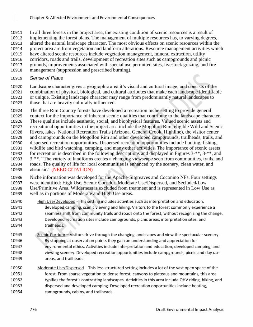
Chapter 3: Affected Environment and Environmental Consequences
776 Draft Environmental Impact Analysis
In all three forests in the project area, the existing condition of scenic resources is a result of 10911 implementing the forest plans. The management of multiple resources has, to varying degrees, 10912 altered the natural landscape character. The most obvious effects on scenic resources within the 10913 project area are from vegetation and landform alterations. Resource management activities which 10914 have altered scenic resources include vegetation management, mineral extraction, utility 10915 corridors, roads and trails, development of recreation sites such as campgrounds and picnic 10916 grounds, improvements associated with special use permitted sites, livestock grazing, and fire 10917 management (suppression and prescribed burning). 10918
Sense of Place 10919
Landscape character gives a geographic area it’s visual and cultural image, and consists of the 10920 combination of physical, biological, and cultural attributes that make each landscape identifiable 10921 or unique. Existing landscape character may range from predominantly natural landscapes to 10922 those that are heavily culturally influenced. 10923
The three Rim Country forests have developed a recreation niche setting to provide general 10924 context for the importance of inherent scenic qualities that contribute to the landscape character. 10925 These qualities include aesthetic, social, and biophysical features. Valued scenic assets and 10926 recreational opportunities in the project area include the Mogollon Rim, eligible Wild and Scenic 10927 Rivers, lakes, National Recreation Trails (Arizona, General Crook, Highline), the visitor center 10928 and campgrounds on the Mogollon Rim and other developed campgrounds, trailheads, trails, and 10929 dispersed recreation opportunities. Dispersed recreation opportunities include hunting, fishing, 10930 wildlife and bird watching, camping, and many other activities. The importance of scenic assets 10931 for recreation is described in the following descriptions and displayed in Figures 3-**, 3-**, and 10932 3-**. “The variety of landforms creates a changing viewscape seen from communities, trails, and 10933 roads. The quality of life for local communities is enhanced by the scenery, clean water, and 10934 clean air.” (NEED CITATION) 10935
Niche information was developed for the Apache-Sitgreaves and Coconino NFs. Four settings 10936 were identified: High Use, Scenic Corridor, Moderate Use/Dispersed, and Secluded/Low 10937 Use/Primitive Area. Wilderness is excluded from treatment and is represented in Low Use as 10938 well as in portions of Moderate and High Use areas. 10939
High Use/Developed - This setting includes activities such as interpretation and education, 10940
developed camping, scenic viewing and hiking. Visitors to the forest commonly experience a 10941
seamless shift from community trails and roads onto the forest, without recognizing the change. 10942
Developed recreation sites include campgrounds, picnic areas, interpretation sites, and 10943
trailheads. 10944
Scenic Corridor – Visitors drive through the changing landscapes and view the spectacular scenery. 10945
By stopping at observation points they gain an understanding and appreciation for 10946
environmental ethics. Activities include interpretation and education, developed camping, and 10947
viewing scenery. Developed recreation opportunities include campgrounds, picnic and day use 10948
areas, and trailheads. 10949
Moderate Use/Dispersed – This less structured setting includes a lot of the vast open space of the 10950
forest. From sparse vegetation to dense forest, canyons to plateaus and mountains, this area 10951
typifies the forest’s contrasting landscapes. Activities in this area include OHV riding, hiking, and 10952
dispersed and developed camping. Developed recreation opportunities include boating, 10953
campgrounds, cabins, and trailheads. 10954

Chapter 3: Affected Environment and Environmental Consequences
Rim Country Project 777
Secluded/Low Use/Primitive Area – Remote areas offer solitude and unconfined recreation. The 10955
area’s primeval character dominates and no permanent improvements exist. The forest has 10956
wilderness areas, not all of which are in this setting. Activities in low-use areas include hiking 10957
and backpacking and site types with trailheads and information boards. 10958
10959
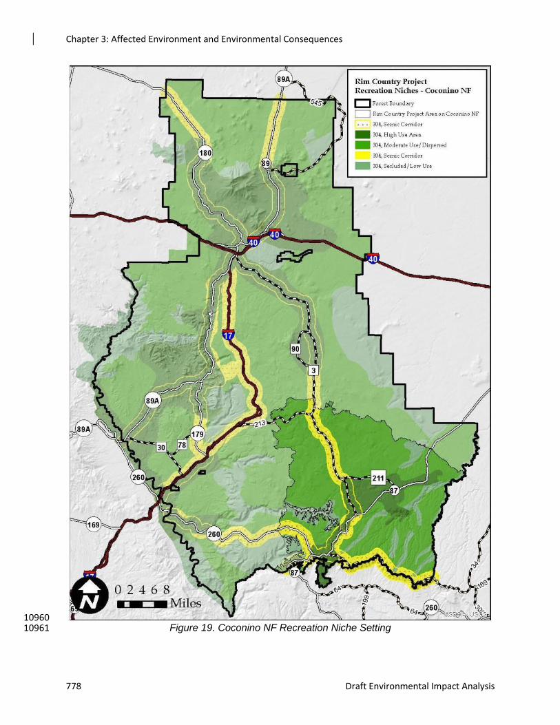
Chapter 3: Affected Environment and Environmental Consequences
778 Draft Environmental Impact Analysis
10960 Figure 19. Coconino NF Recreation Niche Setting 10961
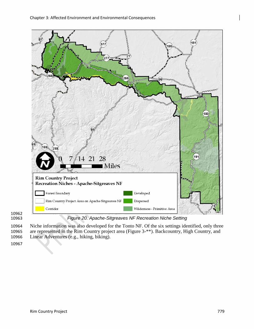
Chapter 3: Affected Environment and Environmental Consequences
Rim Country Project 779
10962 Figure 20. Apache-Sitgreaves NF Recreation Niche Setting 10963
Niche information was also developed for the Tonto NF. Of the six settings identified, only three 10964 are represented in the Rim Country project area (Figure 3-**). Backcountry, High Country, and 10965 Linear Adventures (e.g., hiking, biking). 10966
10967
Chapter 3: Affected Environment and Environmental Consequences
780 Draft Environmental Impact Analysis
10968 Figure 21. Tonto NF Recreation Niche Setting 10969
Scenic Character Description 10970
The 4FRI Rim Country project area includes land on the Mogollon Rim and Red Rock Ranger 10971 Districts of the Coconino NF, the Black Mesa and Lakeside Districts of the Apache-Sitgreaves 10972 NF, and the Payson and Pleasant Valley Districts of the Tonto NF, and includes portions of 10973 Coconino, Yavapai, Gila, and Navajo Counties. Major access routes include US Highways 87 10974 and 260, State Route 288, Roads 213, 3, 512 as well as the From the Desert to the Tall Pines 10975
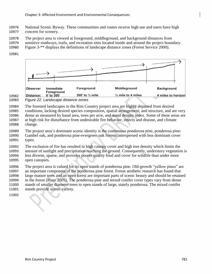
Chapter 3: Affected Environment and Environmental Consequences
Rim Country Project 781
National Scenic Byway. These communities and routes receive high use and users have high 10976 concern for scenery. 10977
The project area is viewed at foreground, middleground, and background distances from 10978 sensitive roadways, trails, and recreation sites located inside and around the project boundary. 10979 Figure 3-** displays the definitions of landscape distance zones (Forest Service 2000). 10980
10981
10982 Figure 22. Landscape distance zones 10983
The forested landscapes in the Rim Country project area are highly departed from desired 10984 conditions, lacking desired species composition, spatial arrangement, and structure, and are very 10985 dense as measured by basal area, trees per acre, and stand density index. Some of these areas are 10986 at high risk for disturbance from undesirable fire behavior, insects and disease, and climate 10987 change. 10988
The project area’s dominant scenic identity is the continuous ponderosa pine, ponderosa pine-10989 Gambel oak, and ponderosa pine-evergreen oak forests interspersed with less dominant cover 10990 types. 10991
The exclusion of fire has resulted in high canopy cover and high tree density which limits the 10992 amount of sunlight and precipitation reaching the ground. Consequently, understory vegetation is 10993 less diverse, sparse, and provides poorer quality food and cover for wildlife than under more 10994 open canopies. 10995
The project area is valued for its open stands of ponderosa pine. Old-growth “yellow pines” are 10996 an important component of the ponderosa pine forest. Forest aesthetic research has found that 10997 large mature trees and an open forest are important parts of scenic beauty and should be retained 10998 in the forest (Ryan 2005). The ponderosa pine and mixed conifer cover types vary from dense 10999 stands of smaller diameter trees to open stands of large, stately ponderosa. The mixed conifer 11000 stands provide scenic variety. 11001
11002
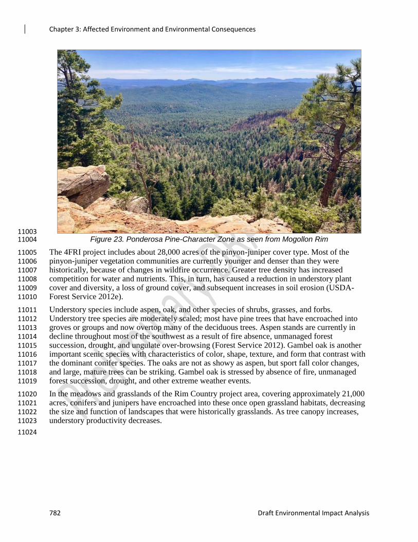
Chapter 3: Affected Environment and Environmental Consequences
782 Draft Environmental Impact Analysis
11003 Figure 23. Ponderosa Pine-Character Zone as seen from Mogollon Rim 11004
The 4FRI project includes about 28,000 acres of the pinyon-juniper cover type. Most of the 11005 pinyon-juniper vegetation communities are currently younger and denser than they were 11006 historically, because of changes in wildfire occurrence. Greater tree density has increased 11007 competition for water and nutrients. This, in turn, has caused a reduction in understory plant 11008 cover and diversity, a loss of ground cover, and subsequent increases in soil erosion (USDA-11009 Forest Service 2012e). 11010
Understory species include aspen, oak, and other species of shrubs, grasses, and forbs. 11011 Understory tree species are moderately scaled; most have pine trees that have encroached into 11012 groves or groups and now overtop many of the deciduous trees. Aspen stands are currently in 11013 decline throughout most of the southwest as a result of fire absence, unmanaged forest 11014 succession, drought, and ungulate over-browsing (Forest Service 2012). Gambel oak is another 11015 important scenic species with characteristics of color, shape, texture, and form that contrast with 11016 the dominant conifer species. The oaks are not as showy as aspen, but sport fall color changes, 11017 and large, mature trees can be striking. Gambel oak is stressed by absence of fire, unmanaged 11018 forest succession, drought, and other extreme weather events. 11019
In the meadows and grasslands of the Rim Country project area, covering approximately 21,000 11020 acres, conifers and junipers have encroached into these once open grassland habitats, decreasing 11021 the size and function of landscapes that were historically grasslands. As tree canopy increases, 11022 understory productivity decreases. 11023
11024
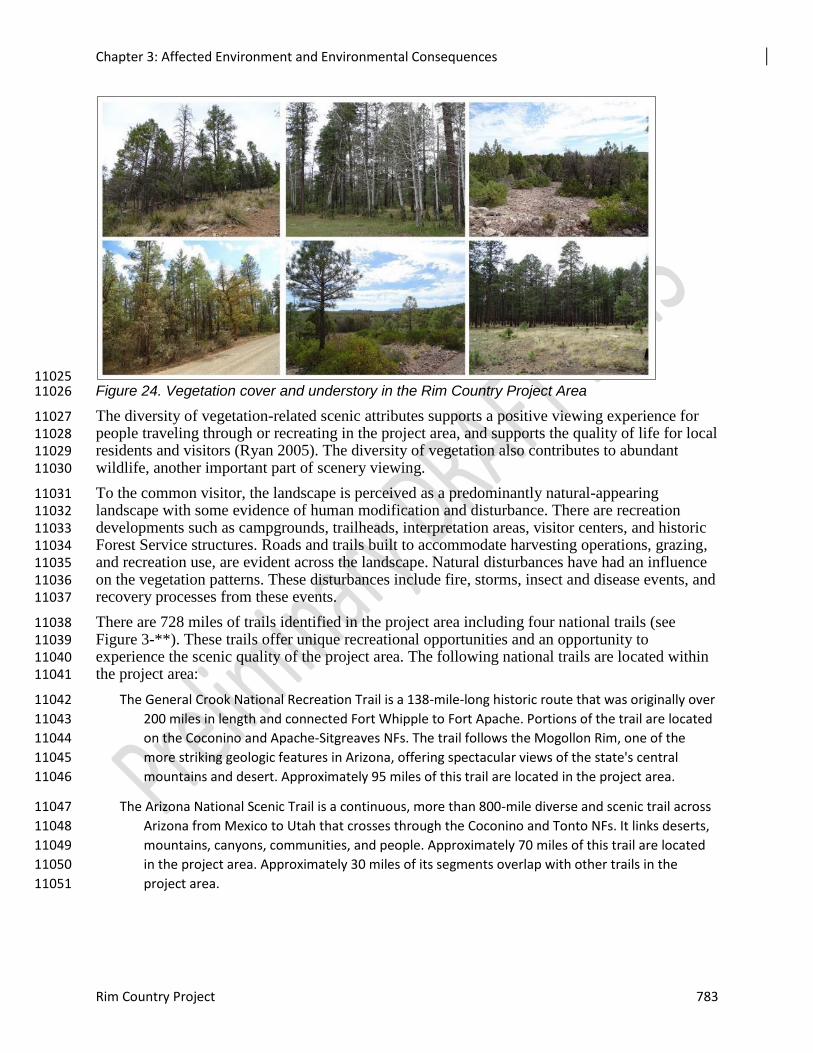
Chapter 3: Affected Environment and Environmental Consequences
Rim Country Project 783
11025 Figure 24. Vegetation cover and understory in the Rim Country Project Area 11026
The diversity of vegetation-related scenic attributes supports a positive viewing experience for 11027 people traveling through or recreating in the project area, and supports the quality of life for local 11028 residents and visitors (Ryan 2005). The diversity of vegetation also contributes to abundant 11029 wildlife, another important part of scenery viewing. 11030
To the common visitor, the landscape is perceived as a predominantly natural-appearing 11031 landscape with some evidence of human modification and disturbance. There are recreation 11032 developments such as campgrounds, trailheads, interpretation areas, visitor centers, and historic 11033 Forest Service structures. Roads and trails built to accommodate harvesting operations, grazing, 11034 and recreation use, are evident across the landscape. Natural disturbances have had an influence 11035 on the vegetation patterns. These disturbances include fire, storms, insect and disease events, and 11036 recovery processes from these events. 11037
There are 728 miles of trails identified in the project area including four national trails (see 11038 Figure 3-**). These trails offer unique recreational opportunities and an opportunity to 11039 experience the scenic quality of the project area. The following national trails are located within 11040 the project area: 11041
The General Crook National Recreation Trail is a 138-mile-long historic route that was originally over 11042
200 miles in length and connected Fort Whipple to Fort Apache. Portions of the trail are located 11043
on the Coconino and Apache-Sitgreaves NFs. The trail follows the Mogollon Rim, one of the 11044
more striking geologic features in Arizona, offering spectacular views of the state's central 11045
mountains and desert. Approximately 95 miles of this trail are located in the project area. 11046
The Arizona National Scenic Trail is a continuous, more than 800-mile diverse and scenic trail across 11047
Arizona from Mexico to Utah that crosses through the Coconino and Tonto NFs. It links deserts, 11048
mountains, canyons, communities, and people. Approximately 70 miles of this trail are located 11049
in the project area. Approximately 30 miles of its segments overlap with other trails in the 11050
project area. 11051
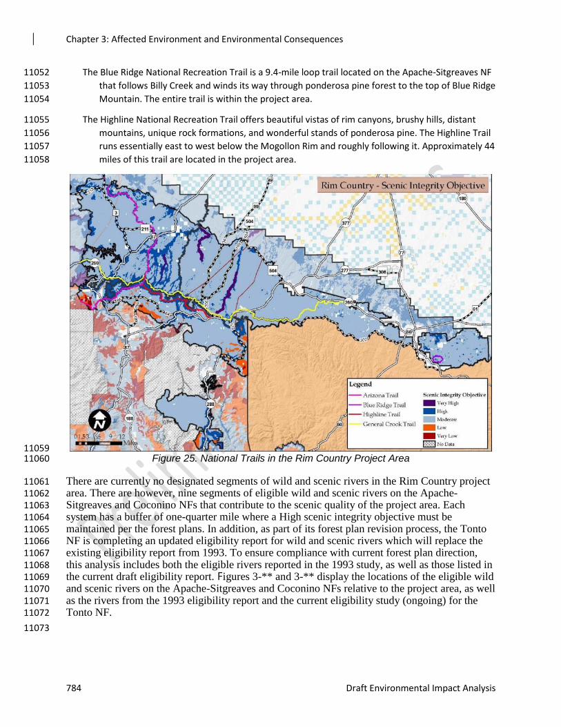
Chapter 3: Affected Environment and Environmental Consequences
784 Draft Environmental Impact Analysis
The Blue Ridge National Recreation Trail is a 9.4-mile loop trail located on the Apache-Sitgreaves NF 11052
that follows Billy Creek and winds its way through ponderosa pine forest to the top of Blue Ridge 11053
Mountain. The entire trail is within the project area. 11054
The Highline National Recreation Trail offers beautiful vistas of rim canyons, brushy hills, distant 11055
mountains, unique rock formations, and wonderful stands of ponderosa pine. The Highline Trail 11056
runs essentially east to west below the Mogollon Rim and roughly following it. Approximately 44 11057
miles of this trail are located in the project area. 11058
11059 Figure 25. National Trails in the Rim Country Project Area 11060
There are currently no designated segments of wild and scenic rivers in the Rim Country project 11061 area. There are however, nine segments of eligible wild and scenic rivers on the Apache-11062 Sitgreaves and Coconino NFs that contribute to the scenic quality of the project area. Each 11063 system has a buffer of one-quarter mile where a High scenic integrity objective must be 11064 maintained per the forest plans. In addition, as part of its forest plan revision process, the Tonto 11065 NF is completing an updated eligibility report for wild and scenic rivers which will replace the 11066 existing eligibility report from 1993. To ensure compliance with current forest plan direction, 11067 this analysis includes both the eligible rivers reported in the 1993 study, as well as those listed in 11068 the current draft eligibility report. Figures 3-** and 3-** display the locations of the eligible wild 11069 and scenic rivers on the Apache-Sitgreaves and Coconino NFs relative to the project area, as well 11070 as the rivers from the 1993 eligibility report and the current eligibility study (ongoing) for the 11071 Tonto NF. 11072
11073
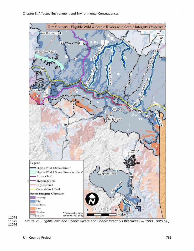
Chapter 3: Affected Environment and Environmental Consequences
Rim Country Project 785
11074 Figure 26. Eligible Wild and Scenic Rivers and Scenic Integrity Objectives (w/ 1993 Tonto NF) 11075
11076
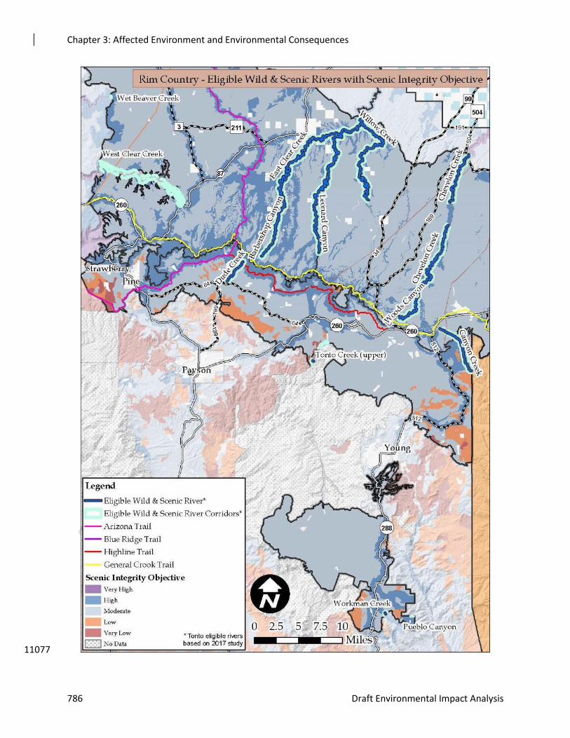
Chapter 3: Affected Environment and Environmental Consequences
786 Draft Environmental Impact Analysis
11077
Chapter 3: Affected Environment and Environmental Consequences
Rim Country Project 787
Figure 27. Eligible Wild and Scenic Rivers and Scenic Integrity Objectives (w/ Current Tonto 11078 NF) 11079
Landscape visibility describes the portions of landscapes visible from travelways and use areas 11080 important to constituents for their scenic quality, aesthetic values, and landscape merits. 11081 Travelways and use areas have identified sensitivity levels for viewing scenery. Concern Level 11082 1, the highest concern for scenery, is given to travelways or use areas that often lead to 11083 distinctive scenic features such as residential areas, resorts, and recreation areas, and attract a 11084 higher percentage of users having high concern for scenic quality, thus increasing the importance 11085 of those travelways for viewing natural-appearing scenery (Forest Service 2000). These areas 11086 most often have a High scenic integrity objective allocated to the foreground distance zone. 11087 Highway 87, Roads 3 and 512, and the From the Desert to Tall Pines Scenic Byway (288) are 11088 Concern Level 1 roads. The national trails are all examples of Concern Level 1 trails. Concern 11089 Level 2 is assigned to routes and places that are locally important, where people have a moderate 11090 to high concern for scenic quality. Forest Road 64 would be considered a Concern Level 2 route. 11091 The existing scenic integrity level ranges from Moderate to High along Concern Level 1 and 2 11092 routes. All routes with a High scenic integrity objective adjacent to them would be considered 11093 Concern Level 1 routes. 11094
Ecosystem Context 11095
The vegetation is the dominant scenic attribute in the Rim Country project area. There are 11096 substantial opportunities for improvement of the ecological function and for scenery attributes. 11097 The existing vegetation density and lack of high frequency, low-severity fires are inconsistent 11098 with the desired scenic character and its sustainability. 11099
Currently, the dense conifer vegetation often obscures views of existing scenic attributes within the 11100
forest canopy and understory, and greatly restricts viewing access to potential scenic attributes. 11101
Among the potential attributes are large mature trees; diverse species including aspen, 11102
evergreen oak, Gambel oak, and grasslands; as well as other understory shrubs, grasses, and 11103
forbs. 11104
Inter-tree spaces (interspaces) and openings have been filled with small and medium sized trees, 11105
where if these were opened up, sunlight would reach the forest floor, adding to the scenic 11106
quality as well as helping provide for greater understory vegetation composition and abundance. 11107
Fire has been suppressed for many years and this, in combination with overly dense forests, departs 11108
significantly from reference conditions. Currently there is a risk of large-scale, high-severity fire 11109
that could result in elimination of the vegetation scenic attributes that are desired. High 11110
frequency, low-severity fire helps to recycle nutrients, keep tree densities lower, and keep fuel 11111
accumulations lower. 11112
Seeps, springs, and ephemeral drainages have had conifers encroach and overtop other species, 11113
reducing their function over time. When these features are functioning properly, they provide 11114
high scenic quality and auditory, tactile, and visual features not found without the presence of 11115
water. 11116
Throughout the forests, unauthorized routes and redundant roads have been created. These detract 11117
from the scenic quality of the area by forming unnatural linear features that are uncharacteristic 11118
of the landscape. Decommissioning these roads would restore characteristic forest landscape 11119
features. 11120
Chapter 3: Affected Environment and Environmental Consequences
788 Draft Environmental Impact Analysis
Assumptions and Methodology 11121
Assumptions 11122
Scenery Management System terminology will be used in the tables, maps, and environmental 11123
consequences section of this report to more uniformly describe effects. 11124
Treatment location, in relation to terrain and elevation and other vegetative screening, can affect 11125
the visibility of management activities. Vegetation treatments on steep slopes, when other 11126
landforms do not block the view, can dominate the landscape. 11127
The duration of view or speed of travel through an area (i.e., walking or riding in a vehicle) 11128
determine how long a viewer has to study and pick out objects, forms, lines, colors, and patterns 11129
in the landscape. 11130
How well treatments transition from treated to untreated areas can also affect how evident a 11131
treatment is in all distance zones. 11132
Proposed activities, although they may have some short-term negative effects on scenery, also may 11133
begin to move the landscape toward the desired landscape character. Effects that would move 11134
the vegetation toward the desired landscape character are beneficial to scenic resources in the 11135
long term. These beneficial effects are often realized over a long period of time but lead to the 11136
lasting sustainability of valued scenery attributes. For example, tree thinning may have short-11137
term effects of ground disturbance, stumps, and slash, but in the long term, if properly 11138
mitigated for scenery, may provide visual access into the forest and promote large tree growth 11139
and a smooth herbaceous ground cover. In the long-term, the removal of some trees, 11140
dependent upon scale and intensity of treatment, may be a beneficial effect for scenery. 11141
Desired landscape character often includes and is linked to preferred visual settings. Gobster (1994) 11142
summarizes visually-preferred settings as having four common attributes: large trees, smooth 11143
herbaceous ground cover, an open midstory canopy with high visual penetration, and vistas with 11144
distant views and high topographic relief. 11145
Visual access, or how far one can see into a forest, is also a preferred scenic setting (Ryan 2005). The 11146
degree of visual access varies throughout the project area, depending on the amount of 11147
understory vegetation present in the forest. Younger ponderosa pine forests may have dense 11148
vegetation, which allows very little visual access into the forest. In the long term, scenic 11149
resources will have higher scenic quality if visual access is achieved or enhanced. 11150
Methodology 11151
This analysis applies current National Forest Scenery Management methodology in conjunction 11152 with existing Apache-Sitgreaves, Coconino, and Tonto National Forest Plan direction. ArcMap 11153 and GIS data layers were used to analyze the proposed activities in regards to recreation use, 11154 sensitive travel corridor locations, areas potentially seen from sensitive travel corridors and use 11155 areas, and visual quality objectives and scenic integrity objectives assigned to the area. The 11156 potential effects on scenic resources from this project were determined based on a site visit to the 11157 project area with members of the interdisciplinary team, review of photos of the project area, use 11158 and interpretation of GIS data and aerial imagery, and review of research and analysis of similar 11159
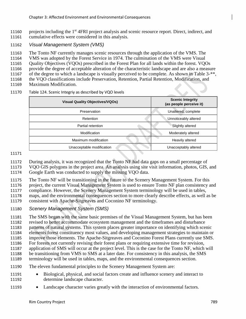
Chapter 3: Affected Environment and Environmental Consequences
Rim Country Project 789
projects including the 1st 4FRI project analysis and scenic resource report. Direct, indirect, and 11160 cumulative effects were considered in this analysis. 11161
Visual Management System (VMS) 11162
The Tonto NF currently manages scenic resources through the application of the VMS. The 11163 VMS was adopted by the Forest Service in 1974. The culmination of the VMS were Visual 11164 Quality Objectives (VQOs) prescribed in the Forest Plan for all lands within the forest. VQOs 11165 provide the degree of acceptable alteration of the characteristic landscape and are also a measure 11166 of the degree to which a landscape is visually perceived to be complete. As shown in Table 3-**, 11167 the VQO classifications include Preservation, Retention, Partial Retention, Modification, and 11168 Maximum Modification. 11169
Table 124. Scenic Integriy as described by VQO levels 11170
Visual Quality Objectives/VQOs) Scenic Integrity
(as people perceive it)
Preservation Unaltered, complete
Retention Unnoticeably altered
Partial retention Slightly altered
Modification Moderately altered
Maximum modification Heavily altered
Unacceptable modification Unacceptably altered
11171
During analysis, it was recognized that the Tonto NF had data gaps on a small percentage of 11172 VQO GIS polygons in the project area. An analysis using site visit information, photos, GIS, and 11173 Google Earth was conducted to supply the missing VQO data. 11174
The Tonto NF will be transitioning in the future to the Scenery Management System. For this 11175 project, the current Visual Management System is used to ensure Tonto NF plan consistency and 11176 compliance. However, the Scenery Management System terminology will be used in tables, 11177 maps, and the environmental consequences section to more clearly describe effects, as well as be 11178 consistent with Apache-Sitgreaves and Coconino NF terminology. 11179
Scenery Management System (SMS) 11180
The SMS began with the same basic premises of the Visual Management System, but has been 11181 revised to better accommodate ecosystem management and the timeframes and disturbance 11182 patterns of natural systems. This system places greater importance on identifying which scenic 11183 elements forest constituency most values, and developing management strategies to maintain or 11184 improve those elements. The Apache-Sitgreaves and Coconino Forest Plans currently use SMS. 11185 For forests not currently revising their forest plans or requiring extensive time for revision, 11186 application of SMS will occur at the project level. This is the case for the Tonto NF, which will 11187 be transitioning from VMS to SMS at a later date. For consistency in this analysis, the SMS 11188 terminology will be used in tables, maps, and the environmental consequences section. 11189
The eleven fundamental principles to the Scenery Management System are: 11190
Biological, physical, and social factors create and influence scenery and interact to 11191 determine landscape character. 11192
Landscape character varies greatly with the interaction of environmental factors. 11193
Chapter 3: Affected Environment and Environmental Consequences
790 Draft Environmental Impact Analysis
People have the ability to perceive landscape character and develop expected images. 11194
Through various activities, people have the ability to modify landscape character and 11195 scenic conditions and have often done so. 11196
Such changes in landscape character and scenic condition often modify, suppress, or 11197 replace the original landscape character. 11198
People value most highly the more scenic landscapes. 11199
Generally, natural-appearing landscapes are the most valued. 11200
Resource managers can design their activities to reduce adverse effects on landscape 11201 character and scenic integrity. 11202
People have the ability to establish goals to maintain or create desired landscape 11203 character. 11204
People have the ability to apply ecological, technical, and design knowledge to meet 11205 scenery management goals and objectives. 11206
In some situations, resource managers perpetuate or create desired scenic environments to 11207 provide an improved quality of life. 11208
The Scenic Integrity Objectives (SIOs) are used in the Scenery Management System in much the 11209 same way as VQOs are used in the Visual Management System. The scenic integrity or 11210 "intactness" of national forest lands is the means by which proposed alterations to the land are 11211 evaluated. Scenic integrity is produced from the combined inventory of scenic attractiveness, 11212 viewing distance from the observer, and concern level of forest visitors. Scenic integrity 11213 objectives are established for the forest and can be applied at the forest, management area, or 11214 project area level (USDA Forest Service 2000). They range from Very High, meaning the 11215 landscape character is unaltered, to Very Low, meaning the landscape character is highly altered. 11216 Intermediate levels include High (landscape character appears unaltered), Moderate (landscape 11217 character is slightly altered), and Low (landscape character is moderately altered). Scenic 11218 integrity objectives can be applied in two ways: (1) to describe a degree of existing scenic 11219 integrity or disturbance, or (2) to describe a minimum objective for future integrity. Another 11220 basic premise of the Scenery Management System is landscape character, which gives a 11221 geographic area its visual and cultural image. It consists of a combination of physical, biological, 11222 and cultural attributes that make each landscape identifiable and unique. Landscape character 11223 embodies distinct landscape attributes that exist throughout an area (USDA-Forest Service 11224 2000). Figure 3-** identifies the scenic integrity objectives for the Apache-Sitgreaves and 11225 Coconino NFs and the visual quality objectives for the Tonto NF. 11226
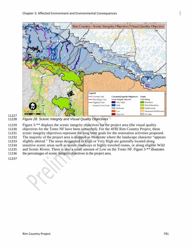
Chapter 3: Affected Environment and Environmental Consequences
Rim Country Project 791
11227 Figure 28. Scenic Integrity and Visual Quality Objectives 11228
Figure 3-** displays the scenic integrity objectives for the project area (the visual quality 11229 objectives for the Tonto NF have been converted). For the 4FRI Rim Country Project, these 11230 scenic integrity objectives represent the long term goals for the restoration activities proposed. 11231 The majority of the project area is mapped as Moderate where the landscape character “appears 11232 slightly altered.” The areas designated as High or Very High are generally located along 11233 sensitive scenic areas such as scenic roadways or highly traveled routes, or along eligible Wild 11234 and Scenic Rivers. There is also a small amount of Low on the Tonto NF. Figure 3-** illustrates 11235 the percentages of scenic integrity objectives in the project area. 11236
11237
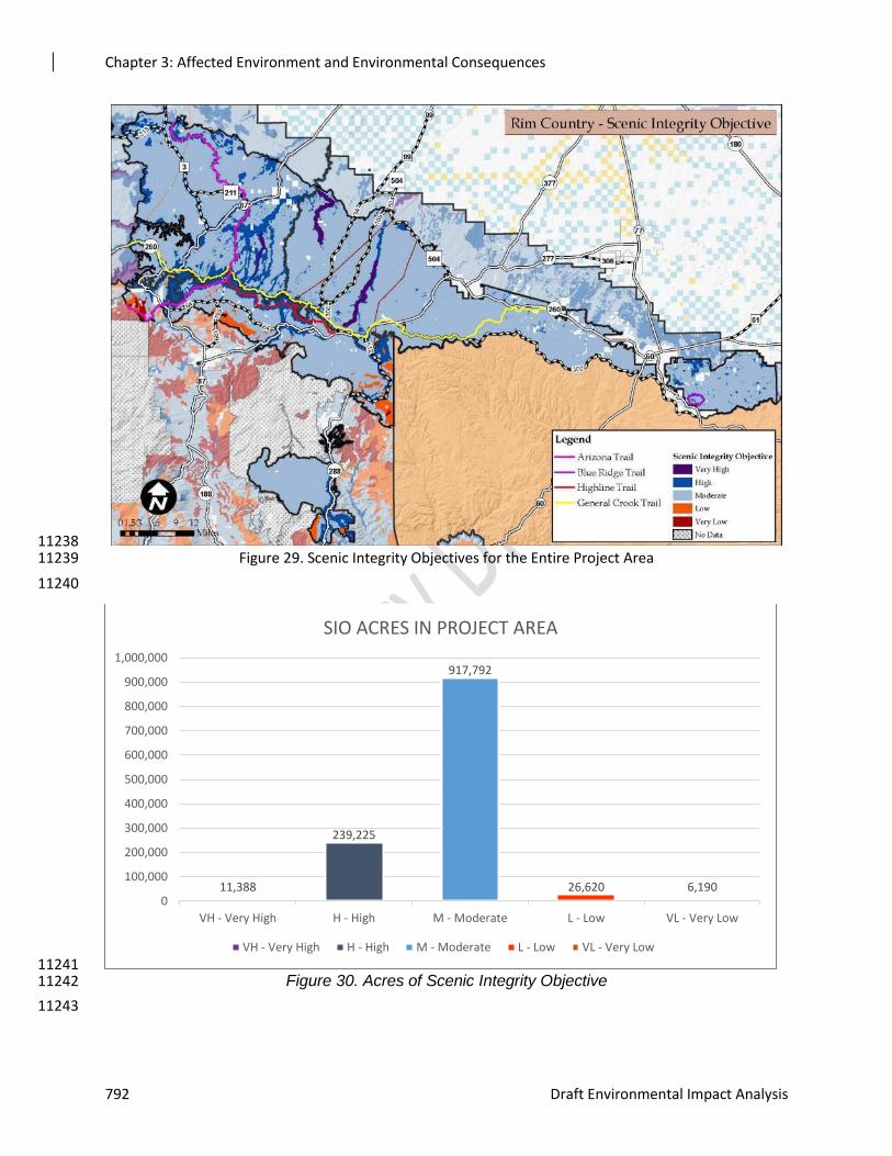
Chapter 3: Affected Environment and Environmental Consequences
792 Draft Environmental Impact Analysis
11238 Figure 29. Scenic Integrity Objectives for the Entire Project Area 11239
11240
11241 Figure 30. Acres of Scenic Integrity Objective 11242
11243
11,388
239,225
917,792
26,620 6,1900
100,000
200,000
300,000
400,000
500,000
600,000
700,000
800,000
900,000
1,000,000
VH - Very High H - High M - Moderate L - Low VL - Very Low
SIO ACRES IN PROJECT AREA
VH - Very High H - High M - Moderate L - Low VL - Very Low
Chapter 3: Affected Environment and Environmental Consequences
Rim Country Project 793
Spatial and Temporal Context for Effects Analysis 11244
The spatial boundaries for analyzing the direct and indirect effects on scenery are National Forest 11245 System lands within the project area boundary since the proposed activities would only occur on 11246 National Forest System lands. 11247
Short-term scenic effects from vegetation management are often the most noticeable until the 11248 growth of grasses, shrubs, and remaining trees begin to soften the effects of thinning operations. 11249 Short-term for this analysis refers to a three to five-year period after all vegetation treatments in 11250 an area are complete. Short-term effects are especially noticeable when the viewer has an up-11251 close view of the treatment site, usually in the foreground viewing distance. 11252
Long-term effects, which for this analysis is considered beyond five years, vary by the treatment 11253 and the method used. 11254
Past harvest of forested slopes is generally noticeable for 15 to 30 years, depending upon the 11255 treatment prescription, soil type, aspect, and vegetative species composition. At the end of this 11256 time period, the regrowth of vegetation begins to develop closed canopy characteristics and the 11257 area no longer appears altered. The cumulative effects analysis area consists of all lands, 11258 including other ownerships inside the 4FRI Rim Country project boundary. 11259
Environmental Consequences 11260
Alternative 1 – No Action 11261
Alternative 1 proposes no additional management activities in the project area and initiates no 11262 human caused changes to the scenic resources or visual quality objectives within the project area. 11263 In the short term, the scenic integrity would remain unchanged and the project area would 11264 continue to be mostly natural-appearing for several years. In the long term, important scenic 11265 attributes such as scattered groups of trees of all ages with grassy openings, evidence of frequent 11266 low-severity fire, large mature tree character, diverse understory, prominent Gambel oak and 11267 grasslands, functioning riparian systems and ephemeral channels that historically contributed to 11268 the attractiveness of the area would continue to decline along with scenic integrity. 11269
There is the potential, if dense stands foster beetle outbreaks, mistletoe infestation, or other forest 11270 health concerns, that tree vitality would decline and there would be a reduction of scenic 11271 integrity. If stand-replacing wildfire were to occur, this would also result in the loss of valued 11272 scenic character and would continue to be of concern to the Coconino, Apache-Sitgreaves, and 11273 Tonto NFs and residents of the surrounding communities. If a large fire or series of fires occur, 11274 views of a fire-altered landscape may begin to dominate. Effects on scenic quality include 11275 charred bark on standing trees and down logs, a blackened appearance to the ground plane, and 11276 burned understory plants. The visual effects would be reduced within two years, with the 11277 regeneration of ground cover plants and the deposition of forest litter over the burned sites. 11278 Charred bark, limbs, and other features may be visible for many years. The burned areas would 11279 likely regenerate in dense stands of shrubs and seedlings, particularly in moist sites at the bottom 11280 of drainages and where root stock and seed sources exist. 11281
These changes would be visible throughout the project area in the foreground of forest roads and 11282 trails, and as middle ground and background views from communities within the project area, 11283 and developed recreation sites. If a wildfire were to occur near a recreation site, those who use 11284 the sites may choose to go elsewhere, if they are sensitive to the appearance of a fire-altered 11285 landscape. 11286
Chapter 3: Affected Environment and Environmental Consequences
794 Draft Environmental Impact Analysis
Under this alternative there would be no opportunities to enhance and improve scenic resources 11287 or achieve the desired conditions, since there would be no thinning, prescribed fire, or other 11288 treatments related to restoration. The forests would continue to implement small-scale thinning 11289 and prescribed burning, but nothing on the scale of this project. As a result, very little progress 11290 would be made toward desired conditions. 11291
The No Action Alternative would not meet forest plan desired conditions or forest plan direction. 11292 It would not meet long-term scenic integrity objectives since these are dependent upon 11293 improving the condition of scenic attributes so that they are more resilient to ecological stressors. 11294 In addition, the No Action Alternative would continue the current condition outside of the 11295 natural range of variability. 11296
The comparison of effects from the No Action alternative indicates that the only positive effect 11297 or trend would be the cumulative effect of Motorized Travel Management. All other ongoing or 11298 reasonably foreseen actions would result in a decline in the vegetation, water, and land form that 11299 create the landscape character of the area; decreased long-term scenic attractiveness as the 11300 unique natural and cultural elements that combine to form the scenic beauty of the area decline; 11301 and a downward trend in the scenic integrity objectives as deviations from the valued landscape 11302 character become more pronounced. 11303
Effects Common to Both Action Alternatives 11304
The effects on scenery from Alternative 2 would be the same as those from Alternative 3 with 11305 the exception of the difference in treatment acres where the effects would occur. Alternative 3 11306 would treat 47 percent less area than Alternative 2, so the following effects can be expected to 11307 affect scenic resources in less of the project area with Alternative 3. 11308
Aspen, Native Willows, Big-Tooth Maple, Seep/Spring Protective Barriers 11309
Aspen, native willows, big-tooth maple, ephemeral drainage treatments and spring/seep areas 11310 require protective barriers to protect the areas from browsing. Both action alternatives require up 11311 to 200 miles of protective barriers. Barrier materials proposed include wire, wood and 11312 jackstrawing of trees. All would introduce unnatural linear features into the landscape that would 11313 not be natural appearing. Since these are isolated areas scattered around the over 1,000,000 acre 11314 project area, introduction of linear features would have minor effects. 11315
Wood fencing materials would have the least effect since they would be in scale, and have 11316 texture and color that would look most natural in the seep/spring and aspen settings. Many times 11317 wooden fencing is viewed as an attractive cultural feature. If the fences are maintained, wood 11318 fencing would have very low effects and would meet the SIO. If they fall into disrepair, this 11319 would detract from their appearance, but they would still meet the SIO. 11320
Wire fencing materials would be more noticeable than wooden fences. Wire and metal posts can 11321 be shiny and their color can contrast with the natural surroundings. Design features will be used 11322 to introduce the fewest contrasting elements where wire fencing is used and effort would be 11323 made to locate the fencing where it is least noticeable. Wire fencing would have low effects and 11324 would meet the SIO. 11325
Jackstrawing has been used to a limited extent on the Coconino NF in order to protect aspen 11326 restoration projects from ungulate browsing. It involves cutting and stacking high numbers of cut 11327 trees in an irregular manner to form a wide, tall barrier surrounding the aspen stand. While 11328 natural materials would be used to create the jackstraw, the shape and form created at this scale 11329 would not normally be found in the characteristic landscape. It would not be completely 11330 unnatural however, as it would be similar to large scale blow down events that may be caused by 11331
Chapter 3: Affected Environment and Environmental Consequences
Rim Country Project 795
weather related events. Placement of jackstraw treatment would not meet the requirements for 11332 foregrounds of Concern Level 1 roads or the National Trails in high SIO areas. Even if 11333 foreground sites were allowed to drop one SIO level, they would still not meet the basic 11334 definition of moderate SIO that “noticeable deviations must remain visually subordinate to the 11335 landscape character being viewed” (Forest Service 2000). Beyond the foreground, jack-straw 11336 piling may be suitable, and would be mitigated by carefully locating these barriers. As noted, the 11337 short term effects timeline for jackstrawing around aspen would be longer than for conifers, up to 11338 20 years. Design criteria will be implemented to avoid placement of jackstraw within the 11339 foreground of high concern level roads or National Trails. As jack-straw barrier begins to 11340 deteriorate, trees lose their brown needles, branches break off, and logs lose their bark and grey 11341 out, the jack-straw piles compress and become less noticeable. It is anticipated that the aspen 11342 would also be large enough to withstand ungulate browsing when the jack-stray piles deteriorate 11343 or are burned in follow up prescribed burning activities. These areas will improve over time to 11344 the mapped SIO. 11345
Landings and In-woods Processing and Storage Sites 11346
Landing sites, where logs are processed for removal, are a primary short term visual effect. 11347 These sites are cleared, and scraped and leveled. Slash, log decks, and equipment dominate the 11348 immediate foreground view, and will be evident from a foreground view. Ground disturbance 11349 occurs from trucks, loaders and skidders moving over the site. After harvest is complete and 11350 slash has been removed, the site disturbance will be evident for approximately five years 11351 following use of the site. Sometimes landing sites require additional tree clearing. 11352
Trails 11353
People are often more sensitive to changes in the landscape along trails, than along roads and 11354 recreation developments. This is because they travel at a slower pace, and are immersed in the 11355 environment, and tend to have an expectation for a natural appearing setting. Smaller details, 11356 such as stumps and slash, are more likely to be noticed. 11357
As a result, a decrease in the sense of solitude and diminished scenic quality will likely occur 11358 while traveling the trails within the project area. Most viewers will perceive diminished scenic 11359 quality along area trails until slash is reduced, and the remaining trees have matured. Temporary 11360 roads and skid trails will potentially cross the trails. There will be a reduction in the natural 11361 appearance of the forest as viewed from the trail. There will be increased encounters with people 11362 and machinery until the project is completed. Many of the trails provide access to unmanaged 11363 areas; this negatively affects visitor’s experience when they anticipated a more natural, 11364 unmanaged environment. This will be reduced over time, and should be a minimal effect over 11365 10 -15 years, once ground cover and understory are reestablished and the slash has been reduced. 11366
The Scenic Integrity will likely be reduced in the foreground and middleground, because viewers 11367 will more likely be aware of details as treatments. A decrease in the sense of solitude could lead 11368 to displacement of trail users in the short term (1 to 5 years.) They may opt to visit other areas 11369 where they will have the experience of a landscape that appears unmanaged. 11370
National Trails, specifically the Arizona, Highline and General Crook Trail will have similar 11371 short term effects on scenery as described above. However, additional design criteria specific to 11372 National Trails will help protect the scenic integrity, especially in the foreground of the trail, 11373 during project implementation. Ultimately, in the long term, the vegetation activities will move 11374 the vegetation adjacent to trails towards desired conditions outlined in the Forest Plan. 11375
Chapter 3: Affected Environment and Environmental Consequences
796 Draft Environmental Impact Analysis
Developed Recreation Sites 11376
Mechanical and prescribed fire treatments could negatively affect developed recreation sites. 11377 However, developed recreation sites will not be modified by any alternatives as design features 11378 have been developed to protect the sites from possible negative effects from proposed treatments 11379 in alternatives 2 and 3. 11380
For campsites, it is desirable to provide and retain privacy and screening, screen other 11381 constructed features such as restrooms, provide shade, retain unique character trees and so on. 11382 Per the design criteria for recreation campgrounds, these areas will be treated, but require 11383 coordination with the District Recreation Staff in order to determine places where no treatment 11384 will occur in order to protect constructed features. In addition prioritizing treatments, treatment 11385 timing and slash pile locations will be agreed upon. Immediate adjacent to the campgrounds 11386 (outside of fenced or otherwise delineated campground boundaries), prescribed burning or 11387 mechanical treatments and burning would be appropriate. 11388
For other developed recreation sites, it is appropriate to include burning or mechanical treatments 11389 and burning outside of an established boundary that will protect the constructed features at these 11390 sites. Per the mitigations for recreation, these boundaries will be established in conjunction with 11391 the District Recreation Staff prior to treatment. 11392
Effects of treatments in developed recreation sites would be similar to those analyzed for 11393 mechanical treatments and prescribed burning discussed in this report under Alternatives 2 and 3. 11394 There would be short term reductions in scenic quality as a result of treatments. In the long term, 11395 the treatments would help to reduce risks to scenic stability and would improve the overall scenic 11396 integrity. 11397
Eligible Wild and Scenic Rivers 11398
The overall objectives for management within the project area are to bring the landscape closer 11399 to the desired conditions outlined in the Forest Plan. Wild and scenic rivers are managed to 11400 protect the outstandingly remarkable values for which they were designated in the National Wild 11401 and Scenic River Preservation System and to protect their free-flowing nature. Rivers determined 11402 to be eligible for the System are also managed to protect the outstandingly remarkable values for 11403 which they are eligible. There are currently 9 eligible wild and scenic rivers on the Apache-11404 Sitgreaves and Coconino National Forest and additional segments on the Tonto National Forest 11405 from the 1993 eligibility study and the current eligibility study. A map illustrating the locations 11406 of the segments are in the Scenic Character Description portion of this report. The tables below 11407 show the classifications of each eligible wild and scenic river segment (including the Tonto 1993 11408 and current eligibility study) as well as the treatment type and acres affected for each alternative. 11409
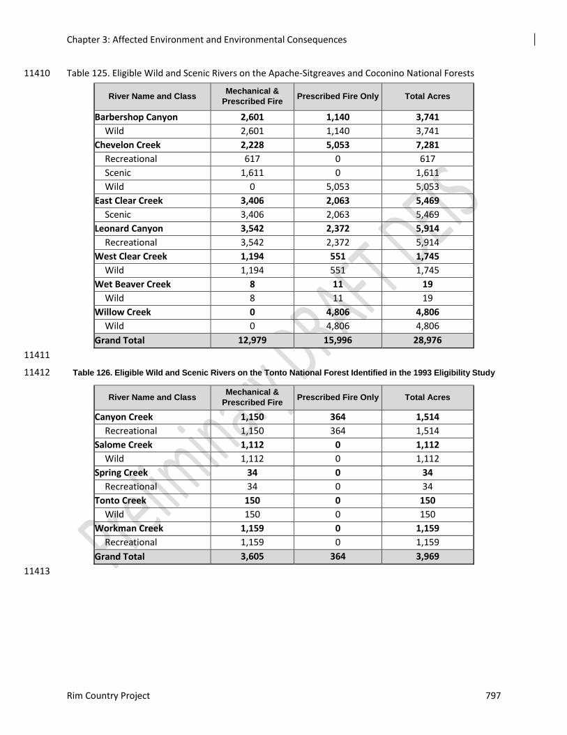
Chapter 3: Affected Environment and Environmental Consequences
Rim Country Project 797
Table 125. Eligible Wild and Scenic Rivers on the Apache-Sitgreaves and Coconino National Forests 11410
River Name and Class Mechanical &
Prescribed Fire Prescribed Fire Only Total Acres
Barbershop Canyon 2,601 1,140 3,741
Wild 2,601 1,140 3,741
Chevelon Creek 2,228 5,053 7,281
Recreational 617 0 617
Scenic 1,611 0 1,611
Wild 0 5,053 5,053
East Clear Creek 3,406 2,063 5,469
Scenic 3,406 2,063 5,469
Leonard Canyon 3,542 2,372 5,914
Recreational 3,542 2,372 5,914
West Clear Creek 1,194 551 1,745
Wild 1,194 551 1,745
Wet Beaver Creek 8 11 19
Wild 8 11 19
Willow Creek 0 4,806 4,806
Wild 0 4,806 4,806
Grand Total 12,979 15,996 28,976
11411
Table 126. Eligible Wild and Scenic Rivers on the Tonto National Forest Identified in the 1993 Eligibility Study 11412
River Name and Class Mechanical &
Prescribed Fire Prescribed Fire Only Total Acres
Canyon Creek 1,150 364 1,514
Recreational 1,150 364 1,514
Salome Creek 1,112 0 1,112
Wild 1,112 0 1,112
Spring Creek 34 0 34
Recreational 34 0 34
Tonto Creek 150 0 150
Wild 150 0 150
Workman Creek 1,159 0 1,159
Recreational 1,159 0 1,159
Grand Total 3,605 364 3,969
11413
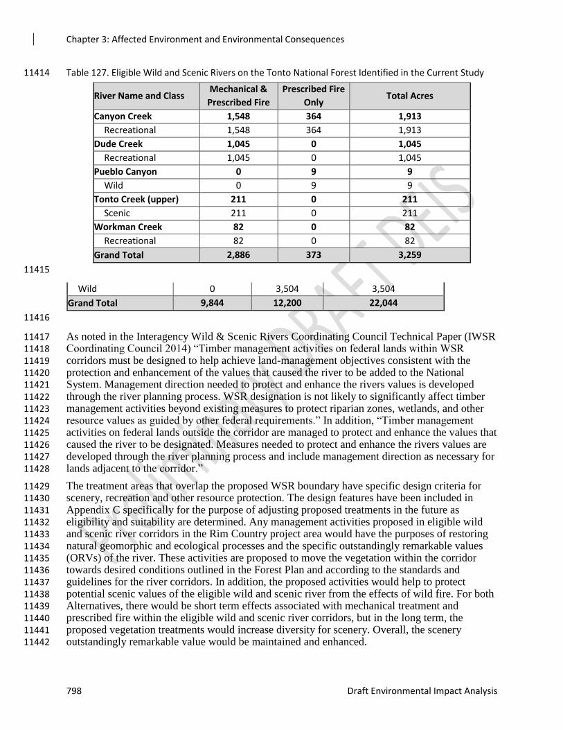
Chapter 3: Affected Environment and Environmental Consequences
798 Draft Environmental Impact Analysis
Table 127. Eligible Wild and Scenic Rivers on the Tonto National Forest Identified in the Current Study 11414
River Name and Class Mechanical &
Prescribed Fire
Prescribed Fire
Only Total Acres
Canyon Creek 1,548 364 1,913
Recreational 1,548 364 1,913
Dude Creek 1,045 0 1,045
Recreational 1,045 0 1,045
Pueblo Canyon 0 9 9
Wild 0 9 9
Tonto Creek (upper) 211 0 211
Scenic 211 0 211
Workman Creek 82 0 82
Recreational 82 0 82
Grand Total 2,886 373 3,259
11415
Wild 0 3,504 3,504
Grand Total 9,844 12,200 22,044
11416
As noted in the Interagency Wild & Scenic Rivers Coordinating Council Technical Paper (IWSR 11417 Coordinating Council 2014) “Timber management activities on federal lands within WSR 11418 corridors must be designed to help achieve land-management objectives consistent with the 11419 protection and enhancement of the values that caused the river to be added to the National 11420 System. Management direction needed to protect and enhance the rivers values is developed 11421 through the river planning process. WSR designation is not likely to significantly affect timber 11422 management activities beyond existing measures to protect riparian zones, wetlands, and other 11423 resource values as guided by other federal requirements.” In addition, “Timber management 11424 activities on federal lands outside the corridor are managed to protect and enhance the values that 11425 caused the river to be designated. Measures needed to protect and enhance the rivers values are 11426 developed through the river planning process and include management direction as necessary for 11427 lands adjacent to the corridor.” 11428
The treatment areas that overlap the proposed WSR boundary have specific design criteria for 11429 scenery, recreation and other resource protection. The design features have been included in 11430 Appendix C specifically for the purpose of adjusting proposed treatments in the future as 11431 eligibility and suitability are determined. Any management activities proposed in eligible wild 11432 and scenic river corridors in the Rim Country project area would have the purposes of restoring 11433 natural geomorphic and ecological processes and the specific outstandingly remarkable values 11434 (ORVs) of the river. These activities are proposed to move the vegetation within the corridor 11435 towards desired conditions outlined in the Forest Plan and according to the standards and 11436 guidelines for the river corridors. In addition, the proposed activities would help to protect 11437 potential scenic values of the eligible wild and scenic river from the effects of wild fire. For both 11438 Alternatives, there would be short term effects associated with mechanical treatment and 11439 prescribed fire within the eligible wild and scenic river corridors, but in the long term, the 11440 proposed vegetation treatments would increase diversity for scenery. Overall, the scenery 11441 outstandingly remarkable value would be maintained and enhanced. 11442
Chapter 3: Affected Environment and Environmental Consequences
Rim Country Project 799
Wilderness 11443
There are no treatments proposed in wilderness therefore there will be no effects on wilderness 11444 areas. However, at the viewpoint toward or from the Wilderness, there will be a change in the 11445 texture between the forested area that will be treated outside the Wilderness, and the untreated 11446 forest within the wilderness. There will be increased areas of ground seen between the 11447 remaining trees, giving a more coarse appearance to the landscape and slopes. In the case where 11448 the Wilderness boundary crosses on a slope, it is possible that this boundary may be evident to 11449 observers because of the change in the forest texture. Because of the increased dominance, the 11450 scenic integrity will likely be reduced in the short term. 11451
Large Mature Trees 11452
The proposed actions would meet forest plan requirements for large mature trees across the 11453 landscape. Some allocated acres will not meet all old growth characteristics, but will move 11454 conditions toward requirements for large trees, downed woody debris, and snags. The more 11455 open, groupy character of the conifer forest will help make the trees more visible and as a result, 11456 more prominent. Use of the old tree strategy will help recruit and retain large trees. The treated 11457 areas will have more of the desired landscape characteristics and will make progress toward 11458 meeting SIO. 11459
Proposed Activities for Mexican Spotted Owls 11460
As a result of the treatments proposed under this alternative, stands throughout most of the 11461 project area would appear more to have the desired conditions of open, groups of trees of all ages 11462 and sizes. In some areas, treatments are modified for Mexican spotted owls. These changes are 11463 designed to meet other laws, regulations and policies. 11464
MSO treatments proposed incorporate the need for “Improving habitat structure in addition to 11465 managing for fire risk abatement is consistent with the USFWS draft MSO recovery plan that 11466 focuses on desired conditions and provides for treating PACs to meet restoration and fuels 11467 reduction objectives. A key draft recovery objective is to maintain habitat conditions necessary 11468 to provide roosting and nesting habitat (pp. 84-85) (USDI 2012)”. This treatment would result in 11469 stands appearing slightly more open and more diverse over time when compared to the existing 11470 condition, although the difference may not be noticeable to the casual forest visitor, particularly 11471 when driving along the roads. The treatments proposed for MSO will move the habitat toward 11472 desired conditions, but scenic attributes in these areas will continue to be at risk from ecological 11473 stressors. 11474
Alternative 2 – Modified Proposed Action 11475
Mechanical Treatment and Burning 11476
Approximately 899,340 acres would be mechanically thinned or burned under this alternative. 11477 Mechanical treatments include but are not limited to the use of chainsaws or feller-bunchers to 11478 cut trees and lop slash, skidders to move material to landings, bulldozers to pile slash, and 11479 specialized equipment such as feller-bunchers or track-type hot saws, and tree shears to cut, 11480 chop, break, and lop fuel material. 11481
Hand thinning usually has little or no short-term effects on scenery. Trees are cut down, then cut 11482 into segments that can be treated. Effects may include slash from limbing and topping trees. 11483 Project mitigations require slash to be treated. 11484
Conventional mechanical treatments typically have moderate short-term effects on scenery. 11485 During implementation, in most cases whole trees are cut and moved to a “landing” near a haul 11486
Chapter 3: Affected Environment and Environmental Consequences
800 Draft Environmental Impact Analysis
road. At the landing, the limbs and tops are removed, and the clean logs are decked to be loaded 11487 and hauled away. After vegetation has been thinned, the slash is piled using bulldozers. Effects 11488 typically include trampling of vegetation where equipment is operating, creation of linear skid 11489 trails where vegetation is trampled or completely removed exposing bare soil, creation of linear 11490 log landings where vegetation has been removed and bare soil is exposed, and piles of cull logs 11491 not suitable for commercial uses. After logs or useable material is removed, slash would be 11492 treated as per mitigation measures. This may include bulldozers push slash into large piles (10-11493 20 foot wide piles, often 10 feet tall) which can trample vegetation and cause bare soil to be 11494 exposed, and hand piling. Design criteria would prioritize treatment of slash along high concern 11495 level roads (those in High SIO), require trails to be returned to pre-treatment conditions, and cull 11496 logs be removed from landings and potentially used to help close off entrances to 11497 decommissioned roads. 11498
There would be a low to moderate effect on scenic quality during and immediately following 11499 mechanical treatments. Stumps are typically left no more than six inches high and are often cut 11500 flush with the ground unless prevented by rocks or other natural features. The presence of skid 11501 trails, landings, and piled or scattered slash would also result in a moderate reduction of the 11502 scenic quality until harvesting activities are completed and design features are implemented. The 11503 effects in these areas would be short term (lasting one to five years after treatment) since skid 11504 trails would be rehabilitated and activity-generated slash would be treated or mostly removed to 11505 be utilized. The ground disturbance resulting from using machines to pile slash would be 11506 noticeable for one to three years after project completion, depending on how quickly the areas 11507 revegetate. Scraped trees would heal or scars would become less noticeable over time. 11508
Prescribed burning would likely result in short-term, moderate reduction in scenic quality, but 11509 with ground vegetation recovery, can enhance scenic beauty within five years. Where prescribed 11510 fire is limited to slash reduction, isolated areas of burned piles would be evident. Once these 11511 piles have been scattered there may be some short-term evidence of darkened litter and soil that 11512 would be reduced within five years and generally only be noticeable within the immediate 11513 foreground. Greater visual effects would occur in areas where prescribed fire is used as a tool to 11514 regenerate aspen or reintroduce fire. This includes charred bark of standing trees and down logs, 11515 and a blackened appearance to the ground plane and burned understory plants. The visual effects 11516 would be reduced within two years, with the regeneration of ground cover plants and the 11517 deposition of forest litter over the burned sites. Charred bark, limbs, and other features could be 11518 visible for many years. 11519
Smoke from prescribed burning would be heaviest during the initial burns, and would reduce 11520 visibility of the scenic landscape in the short term. Some residual smoke could be expected to 11521 continue in small localized areas where stumps or roots smolder for up to a few weeks. The 11522 residual smoke would have little if any effect on visibility of scenic attributes. 11523
The restoration treatment areas should be recovered and moving toward reference conditions 11524 after the first thinning and prescribed burning activities. These would be further improved after 11525 follow-up prescribed fire treatments. The restoration treatments would meet the purpose and 11526 need of the project and would help move the forest structure, pattern and composition toward 11527 reference conditions. 11528
Road Reconstruction and Decommissioning 11529
Approximately 150 miles of existing roads will be reconstructed with Alternative 2. There would 11530 be few to no effects from road improvements. Improvements may include, but are not limited to, 11531 drainage improvements, tree removal, slight realignments, and addition of surfacing materials. 11532
Chapter 3: Affected Environment and Environmental Consequences
Rim Country Project 801
Potential effects include exposure of bare soil, tree stumps, and contrasting color and texture of 11533 surfacing materials. These effects are usually short term (one to five years) and become less 11534 noticeable as natural vegetation is re- established and the surfacing material begins to be 11535 incorporated into the soil horizon. Road relocation would have more noticeable effects on 11536 scenery. Effects of the newly constructed road bed would include newly exposed bare ground, 11537 damaged vegetation, tree stumps, root wads, and contrasting color and texture of surfacing. 11538 There would also be effects associated with the old road bed. It would appear newly disturbed as 11539 well if associated drainage features such as culverts are pulled, new drainage ditches established, 11540 the surface roughened to promote vegetation establishment, and slash, brush, boulders or other 11541 devices are used to close off the entrance. There would be a strong contrast between the existing 11542 forest floor and the new and old road beds that would detract from scenic quality. Design 11543 features, best management practices, and mitigation measures would be used during road 11544 reconstruction. The old roads would naturalize over time and become less noticeable to the 11545 casual observer. 11546
Approximately 330 miles of temporary roads would be constructed for haul access. These would 11547 be decommissioned when treatments are finished. The new temporary roads would add new, 11548 unnatural linear features to the landscape on a temporary basis. Trees would be removed, soil 11549 exposed, and roadbeds constructed including minimal drainage features. This would have 11550 moderate effects on the mapped scenic integrity objectives. In High scenic integrity objective, 11551 the new temporary road construction would drop these areas one level to Moderate until the 11552 roads are decommissioned and begin to naturalize, about five years later. Design features and 11553 best management practices would be used to rehabilitate decommissioned roads and this would 11554 hasten their recovery. 11555
Under this alternative up to 200 miles of system road on the Coconino and Apache-Sitgreaves 11556 NFs could be decommissioned. The Tonto NF Travel Management EIS has identified 11557 approximately 290 miles of road within the Rim Country project area for decommissioning. In 11558 addition to system road decommissioning, up to 800 miles of unauthorized roads on all three 11559 forests could be decommissioned under this alternative. Following decommissioning, all roads 11560 would be allowed to naturalize. There would be short-term effects (up to five years) as the roads 11561 have drainage established, the surface area roughens, is seeded and mulched with pine needles 11562 and slash, and boulders and other devices are used to close off entrances to the roads. Design 11563 criteria and best management practices would be used to rehabilitate these roads. The existing 11564 closed roads would naturalize over time and become unnoticeable to the casual observer. 11565
Alternative 3 – Focused Alternative 11566
Mechanical Treatment and Burning 11567
Alternative 3 treats 47 percent less area than Alternative 2. Approximately 39 percent fewer 11568 acres would receive mechanical and prescribed fire restoration treatments, about 26 percent less 11569 prescribed fire only. Additionally, the Severe Disturbance Area Treatment area is 78 percent less 11570 in Alternative 3 than in Alternative 2. Approximately 474,930 acres would be mechanically 11571 thinned or burned with prescribed fire under Alternative 3. Figure 3-** provides the approximate 11572 locations of treatments for Alternative 3 and the Recreation Opportunity Spectrum 11573 classifications. For Alternative 3, there would be less prescribed burning activity that would 11574 likely result in less short-term, moderate reductions in scenic quality relative to Alternative 2. As 11575 a result, there would be fewer visual effects in the project area where prescribed fire is used as a 11576 tool to regenerate aspen or reintroduce fire, resulting in fewer areas of reduced visibility of the 11577 scenic landscape in the short term. However, Alternative 3 would treat significantly fewer acres 11578 of grasslands, savannah, and open canopy cover, resulting in fewer acres of improved understory 11579

Chapter 3: Affected Environment and Environmental Consequences
802 Draft Environmental Impact Analysis
species abundance and composition. Ultimately, this alternative would have less potential to 11580 reduce the risk of large-scale, high-severity fires in the project area. Since high-severity fire is a 11581 risk factor for most scenery attributes, the fewer proposed mechanical and prescribed fire 11582 treatments in Alternative 3 would result in fewer improvements to scenic quality in the long 11583 term. 11584
11585
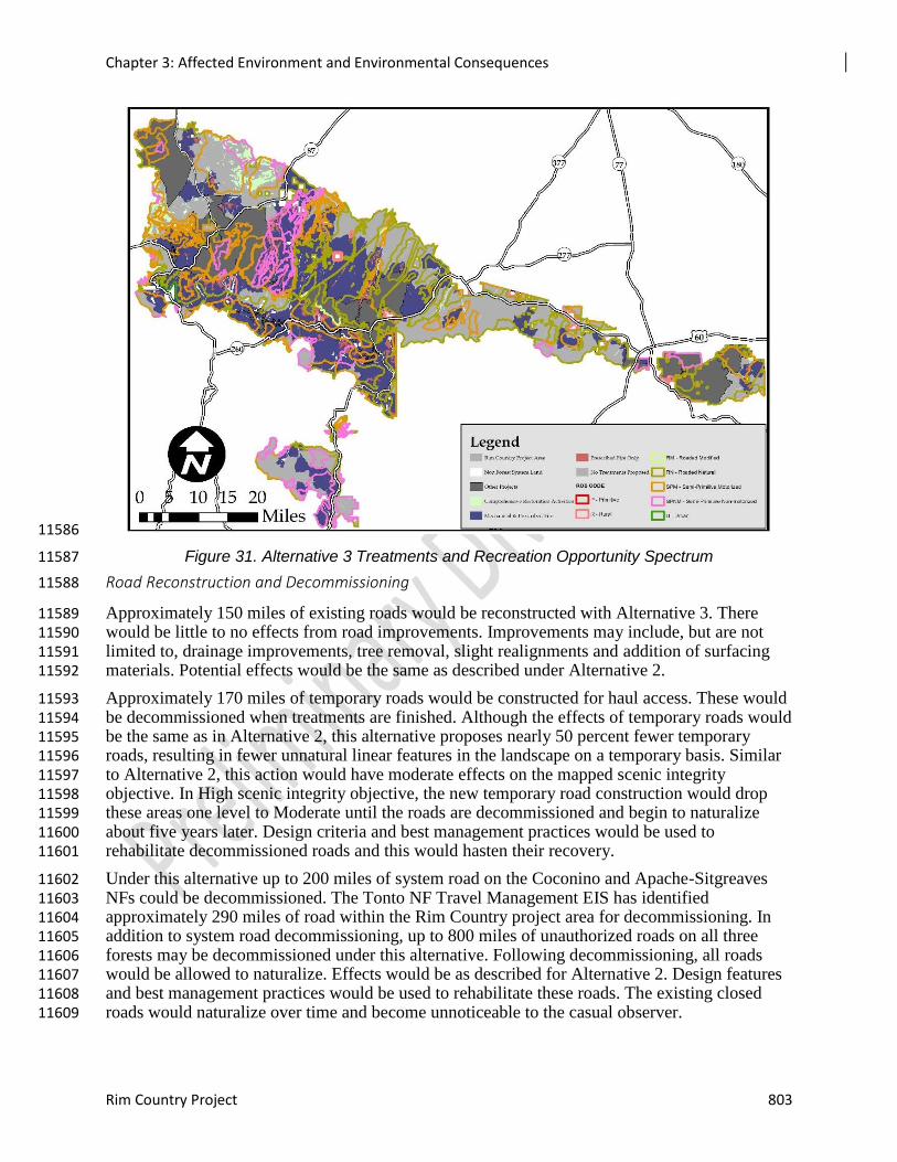
Chapter 3: Affected Environment and Environmental Consequences
Rim Country Project 803
11586
Figure 31. Alternative 3 Treatments and Recreation Opportunity Spectrum 11587
Road Reconstruction and Decommissioning 11588
Approximately 150 miles of existing roads would be reconstructed with Alternative 3. There 11589 would be little to no effects from road improvements. Improvements may include, but are not 11590 limited to, drainage improvements, tree removal, slight realignments and addition of surfacing 11591 materials. Potential effects would be the same as described under Alternative 2. 11592
Approximately 170 miles of temporary roads would be constructed for haul access. These would 11593 be decommissioned when treatments are finished. Although the effects of temporary roads would 11594 be the same as in Alternative 2, this alternative proposes nearly 50 percent fewer temporary 11595 roads, resulting in fewer unnatural linear features in the landscape on a temporary basis. Similar 11596 to Alternative 2, this action would have moderate effects on the mapped scenic integrity 11597 objective. In High scenic integrity objective, the new temporary road construction would drop 11598 these areas one level to Moderate until the roads are decommissioned and begin to naturalize 11599 about five years later. Design criteria and best management practices would be used to 11600 rehabilitate decommissioned roads and this would hasten their recovery. 11601
Under this alternative up to 200 miles of system road on the Coconino and Apache-Sitgreaves 11602 NFs could be decommissioned. The Tonto NF Travel Management EIS has identified 11603 approximately 290 miles of road within the Rim Country project area for decommissioning. In 11604 addition to system road decommissioning, up to 800 miles of unauthorized roads on all three 11605 forests may be decommissioned under this alternative. Following decommissioning, all roads 11606 would be allowed to naturalize. Effects would be as described for Alternative 2. Design features 11607 and best management practices would be used to rehabilitate these roads. The existing closed 11608 roads would naturalize over time and become unnoticeable to the casual observer. 11609
Chapter 3: Affected Environment and Environmental Consequences
804 Draft Environmental Impact Analysis
Cumulative Effects 11610
The cumulative effects analysis area is the ponderosa pine forest on the Coconino, Apache-11611 Sitgreaves and Tonto NFs within the Rim Country project area. The timeline for analysis is 20 to 11612 30 years because most long-term effects of the alternatives are assessed out to a 20-30 year 11613 timeframe (with the exception of large-scale high-severity wildfire which is more difficult to 11614 project). The following is a list of actions relating to scenic attributes, landscape character, and 11615 scenic integrity considered in the cumulative effects analysis for this project: 11616
Past activities that created the current conditions include grazing, the evolving forest management 11617
practices related to timber harvest and fire suppression, drought, disease and insect 11618
infestations, and dispersed recreational use. 11619
Present and future activities such as vegetation management, fire and fuels management, utility 11620
corridor clearing and new utility corridors, and other management activities (e.g., noxious 11621
weeds treatments). These activities could occur on private lands as well. 11622
The cumulative effects of past management activities are visible as the existing conditions. 11623 Vegetation management practices, fire suppression, and over grazing have resulted in the current 11624 overly dense forests, even-aged forest structure, and sparse understory trees, shrubs, grasses, and 11625 forbs. 11626
Alternative 1 – No Action 11627
The short-term cumulative effects (1 to 5 years) from the No Action Alternative, combined with 11628 similar current and future restoration treatments and prescribed burning projects, are expected to 11629 be negligible unless additional large-scale, high-severity wildfires occur in the ponderosa pine 11630 type in the project area. If wildfires burn large areas, the scenic quality would be decreased and 11631 there would be long-term negative changes in scenic character. The scenic attributes that 11632 contribute to high scenic integrity, such as an open forest with tree groups of varying ages, sizes 11633 and shapes; large, mature trees; and healthy, diverse understory would decline or not be present. 11634 The scenic effect of a high-severity wildfire would combine with scenic effects from adjacent 11635 land development, utility development and/or maintenance, and effects from dispersed recreation 11636 use to result in a cumulative effect so that scenic integrity is greatly diminished in areas burned 11637 for up to a decade or more. In some places there would be a chance that climate change could 11638 contribute to type changes in parts of the ponderosa pine forest so that these characteristics 11639 would be replaced with difference landscape characteristics, which would also cumulatively 11640 effect scenic attributes. 11641
In the absence of large, high-severity wildfires, long-term cumulative effects of the No Action 11642 Alternative and present and future vegetation management activities (Table 10) would be 11643 relatively small and localized. In the absence of large-scale treatment, the scale of treatments that 11644 are currently accomplished would not result in improvement to scenic integrity. The desired 11645 landscape character of an open forest with tree groups of varying sizes, shapes and ages; 11646 presence of large, mature trees; and healthy, diverse understory would not be met. 11647
Alternative 2 – Modified Proposed Action 11648
Vegetation management projects would alter the appearance of the landscape where ground-11649 disturbing activities are conducted. Similar to the action alternatives, activities that are very close 11650 (300 feet or less) to scenic highways, major travelways, and recreation resources, would have 11651 temporary adverse effects on visually sensitive areas. This would increase the chance that people 11652 would be exposed to evidence of fire and mechanical thinning activities. Once slash and/or the 11653

Chapter 3: Affected Environment and Environmental Consequences
Rim Country Project 805
evidence of fire are reduced, the forest would have a more managed appearance until understory 11654 shrubs and trees have provided a more varied appearance, which could be 30 to 40 years. 11655
Individuals who are sensitive to the visual changes of vegetation management and fire-altered 11656 landscapes would likely perceive diminished scenic quality. There would be an increased visual 11657 presence of roads. When roads are obliterated, the prism would remain for many years. 11658 However, once vegetation grows in the road prism, especially trees, it would be less noticeable, 11659 and probably only noticed by people walking across or near the road bed. The length of time for 11660 recovery ranges from two or three years, to over 50 years, depending on the effectiveness of the 11661 decommission at deterring travel by off-highway vehicles. 11662
Cumulative effects on scenery resources in the Rim Country project area are expected to meet 11663 the visual quality objectives of the forest plans in the short term. In High scenic integrity 11664 objective areas, it is expected that any human activities would not be visually evident. In 11665 Moderate scenic integrity objective areas, any deviations present would be expected to be 11666 subordinate to the characteristic landscape. In Low scenic integrity objective areas any 11667 deviations present may dominate the characteristic landscape but would utilize naturally 11668 established form, line, color, and texture, and appear natural or compatible to the natural 11669 surroundings. 11670
Alternative 2, along with the other past, ongoing, and reasonably foreseeable projects and 11671 activities, may have cumulative effects on scenery resources. However, these cumulative effects 11672 are expected to meet the visual quality objectives of the forest plans in the short term; no long-11673 term effects are anticipated if the scenery project design features are applied. 11674
Alternative 3 – Focused Alternative 11675
The cumulative effects from Alternative 3 would be similar to those from Alternative 2. There 11676 would be slightly fewer negative short-term cumulative effects in localized areas (areas with 11677 landings, temporary roads, ground-disturbing activities), since this alternative would 11678 mechanically treat and burn fewer acres and require fewer temporary roads. However, there 11679 would also be slightly fewer positive long-term cumulative effects in terms of, counteracting 11680 drought and insect damage likely to occur as a result of climate change, improved stand 11681 structure, and understory improvement, since there would be less mechanical treatment and 11682 burning to facilitate greater forest resiliency. 11683
Effects from Rock Pit Use and Expansion 11684
A total of 21 rock pits were identified for use and potential expansion up to 30 percent of their 11685 existing footprint. The material from the rock pits may be used for a variety of road maintenance 11686 activities, from general maintenance of primary roads to construction or rehabilitation of 11687 temporary roads. The proposed use and expansion of rock pits would include hauling of 11688 equipment and aggregate materials to and from the pits for use in road maintenance, road 11689 construction, and erosion control to aid in implementation of the 4FRI Rim Country project and 11690 other projects in the 4FRI footprint. 11691
Effects Common to All Alternatives 11692
Effects common to all alternatives include views of exposed soil at active rock pits locations, and 11693 removed vegetation. Active pits would also have processing and mining equipment, and trucks 11694 for hauling roadbed material to desired locations. In addition to space for processing equipment, 11695 pits requiring processing will also need space to store stockpiles of processed and partially 11696 processed materials. The space needed for processing equipment, stockpiling of materials, and 11697 loading is included in the footprint of each rock pit site. 11698
Chapter 3: Affected Environment and Environmental Consequences
806 Draft Environmental Impact Analysis
Most rock pits are located in Moderate scenic integrity objective in forested areas making them 11699 difficult to view even from a foreground distance (300 feet to 0.5 miles). Under both action 11700 alternatives, design features would help mitigate the effect on scenery from rock pits. 11701
Alternative 1 - No Action 11702
Under Alternative 1, for implementation of other projects and activities, rock pit activities would 11703 continue to mine and process roadbed materials from active existing pits either for maintenance 11704 of Forest Service roads, temporary road construction, or through permitted use. Direct effects on 11705 visually sensitive areas would be views of exposed soil, removed vegetation, and of trucks and 11706 other equipment used to mine and process roadbed material. The magnitude of these direct 11707 effects would vary depending on the duration of activities at each existing pit, the number of 11708 viewers that are able to see the exposed soil, removed vegetation, and equipment, and the 11709 distance from which viewers can observe these project-related activities. 11710
Indirect effects would include long–term views of the pits following mining activity and before 11711 re-vegetation efforts have been completed. 11712
Mining and processing activities that occur at any of the pits within 0.5 miles of scenic routes or 11713 major travelways, or within 0.5 miles of recreation resource areas, could cause adverse, 11714 temporary effects. The importance of these effects can be evaluated in terms of their consistency 11715 with scenic integrity objectives. Actively mined pits are consistent with the scenic integrity 11716 objective of Moderate since the landscape may appear slightly altered and the pits are visually 11717 subordinate when viewed from distances of greater than 0.5 mile, which is the breakpoint 11718 between the foreground and middle-ground distances (USDA FS 1996). 11719
Alternative 2 - Modified Proposed Action 11720
Due to the relatively small footprint and locations of the proposed rock pits on the landscape, 11721 most direct and indirect visual effects would be very limited to where the pit can be seen from 11722 forest roads. Out of the proposed 21 pits, there are 8 pits that are located within 0.5 miles of 11723 major travelways or trails. Most of the pits that are located next to a major roadway, recreation 11724 site, or trail were initially used to provide material to construct these same roadways, recreation 11725 site, or trail. Often the rock pit was built very near the road or trail but in an area not visible to 11726 provide for a convenient material source without affecting the viewshed. 11727
Mining and processing activities that occur at any of the pits within 0.5 miles of scenic routes or 11728 major travelways, or within 0.5 miles of recreation resource areas, could cause adverse, 11729 temporary effects. The importance of these effects can be evaluated in terms of their consistency 11730 with scenic integrity objectives. Actively mined pits are consistent with the a Moderate scenic 11731 integrity objective since the landscape may appear slightly altered and the pits are visually 11732 subordinate when viewed from distances of greater than 0.5 mile, which is the breakpoint 11733 between the foreground and middleground distances (USDA FS 1996). In situations where a 11734 proposal does not meet scenic integrity objectives or visual quality objectives, the Forest Plan 11735 allows for “one classification movement downward…“(USDA FS 1987, p. 60). 11736
Alternative 3 – Focused Alternative 11737
Effects on visually sensitive areas and consistency with scenic integrity objectives would be of 11738 the same type as described for Alternatives 1 and 2. As discussed for Alternative 2, these 11739 proposed activities would result in some adverse effects on scenic integrity objectives. 11740
Chapter 3: Affected Environment and Environmental Consequences
Rim Country Project 807
Effects from Use of In-woods Processing and Storage Sites 11741
A total of 12 in-woods processing sites are proposed for consideration in this project. Tasks that 11742 would be carried out at processing sites include drying, debarking, chipping stems and bark, 11743 cutting logs, manufacturing and sorting logs to size, producing wood cants, scaling and weighing 11744 logs, and creating poles from suitably sized logs. Equipment types commonly used at processing 11745 sites include circular or band saws, various sizes and types of front-end loaders, log loaders, and 11746 chippers of several types, and may include processors, planers and mechanized cut to length 11747 systems, and associated conveyers and log sorting bunks for accumulation and storage of logs. 11748 Electric motors and gas or diesel generators are also used to provide power. 11749
Eight processing sites were proposed and analyzed for environmental effects in the Cragin 11750 Watershed Protection Project. These sites are carried forward for potential use in implementing 11751 the Rim Country Project. An additional 12 processing sites are being analyzed that range in size 11752 from four to 21 acres. Most processing sites are located in forested areas making them difficult to 11753 view even from a foreground distance (300 feet to 0.5 miles). 11754
Potential sites were screened so as to be located outside of meadows, where some of the most 11755 productive forest soils are found, and in relatively flat areas. Other sites are located in existing 11756 clearings and flat areas. The siting of processing sites in relatively flat areas would minimize the 11757 need for extensive site grading. Processing sites were located to provide for a buffer of 100 to 11758 300 feet from forest roads and state highways to provide for visual screening from Concern 11759 Level 1 and 2 travelways. Site boundaries are approximate and may be further modified during 11760 implementation and layout. 11761
The processing sites may be used as part of the 4FRI Rim Country Project throughout 11762 implementation. Following completion of use of processing sites and removal of all equipment 11763 and materials, site rehabilitation would have to be accomplished, including removal of aggregate, 11764 restoration of pre-disturbance site grades, de-compaction of soil for seedbed preparation, and 11765 seeding and mulching of the site with native grasses and forbs. 11766
Alternative 1 - No Action 11767
Alternative 1 proposes no in-woods processing and storage sites and initiates no human-caused 11768 changes to the scenic quality within the project area. Alternative 1 would meet the adopted High, 11769 Moderate, and Low scenic integrity objectives throughout the project area as it does not create 11770 any unnaturally-appearing elements of form, line, color, or texture. 11771
Alternative 2 - Modified Proposed Action 11772
The scenic integrity objectives, adjacent scenic resources, and the visibility of the proposed 11773 processing sites were considered from foreground, middleground, and background perspectives. 11774 The highest level of detail would likely be perceived from the foreground perspective. However, 11775 due to the size and scale of the sites, particularly those of larger acreage, there is the potential for 11776 the proposed openings and associated infrastructure to be seen from a distance from sensitive 11777 viewing platforms. Thinning around the edges of the processing site boundaries will promote a 11778 more naturally-appearing landscape when these sites are seen from a distance. 11779
Low interim scenic integrity objectives would be assigned to these locations during 11780 implementation. During implementation, the proposed processing sites would likely be 11781 noticeable to the casual observer and, depending on the perspective of the viewer, may dominate 11782 the view. Visitors would notice the lack of vegetation and the aggregate surface. Built structures 11783 such as fencing, sanitation facilities, office trailers, fuel storage containers, or other temporary 11784 structures would likely be noticeable to the casual observer. Heavy equipment, such as circular 11785
Chapter 3: Affected Environment and Environmental Consequences
808 Draft Environmental Impact Analysis
or band saws, various sizes and types of front-end loaders, log loaders and chippers, processors, 11786 planers and mechanized cut to length systems, and associated conveyers and log sorting bunks 11787 for accumulation and storage of logs may be highly visible from sensitive viewing platforms. For 11788 safety, most of the equipment would likely be a yellow color to ensure visibility for the workers, 11789 which would create a notable contrast for visitors. The concentration of wood and slash for 11790 sorting and drying would be evident to visitors to the near vicinity. Design features would ensure 11791 that scenic integrity objectives are met post implementation and effects on scenery are 11792 minimized during implementation to the extent practicable. Due to the potential for the soils to 11793 be heavily compacted form the operations at these sites, recovery post-implementation may take 11794 up to 10 years, depending on the duration and extent of usage of the processing site. The scenic 11795 integrity objectives would be met after the sites have been reclaimed and restored to a naturally-11796 appearing landscape character, likely 10 years post treatment. 11797
Alternative 3 - Focused Alternative 11798
Effects on visually sensitive areas and consistency with scenic integrity objectives for 11799 Alternative 3 would be similar to those for Alternative 2, as all proposed in-woods processing 11800 sites could potentially be utilized. As discussed for Alternative 2, proposed activities would 11801 result in some adverse effects on scenic integrity objectives. 11802
Repeat burning would result in fewer effects than described above since fuel loadings would be 11803 reduced by initial prescribed burns. Effects are expected to be noticeable for a shorter duration, 11804 and within 2 to 3 years, the areas will be natural appearing. Smoke from repeat burning would 11805 not be as heavy as initial burns, and would be expected to be shorter in duration. 11806
Lands and Minerals 11807
Affected Environment 11808
Lands 11809
The acquisition and disposal of National Forest System lands are designed to consolidate interest 11810 and management of the federal estate to enhance public benefit, and to consolidate the 11811 management and ownership of federal, state, and private lands within the proclaimed forest 11812 boundary. The establishment of rights-of-way throughout the forest is needed to create easy 11813 accessibility to both public and private lands within the proclaimed boundary of the national 11814 forest. 11815
Land subdivision and development is increasing the need for accurate and reliable surveys. 11816 Numerous conflicts between past surveys have occurred, leading to an unknown number of 11817 unauthorized occupancies and use violations on national forest lands. Identification of property 11818 boundaries is an increasing expense to resource programs, especially fuel treatments. 11819 Increasingly, additional expenditures would be necessary in order to fully utilize national forest 11820 resources and to prevent claims against the federal government. Although land acquisition 11821 eliminates the need for land line location in some areas, many miles of property boundary still 11822 need to be surveyed and posted. 11823
Property boundary location involves all activities necessary to identify the boundaries of 11824 National Forest System lands, including the search for survey corners, surveying and marking of 11825 land lines, and maintenance of the same. Marking and posting boundaries identifies or locates 11826 National Forest System lands for public use and enjoyment and prevents and controls trespass 11827 upon the forests. 11828
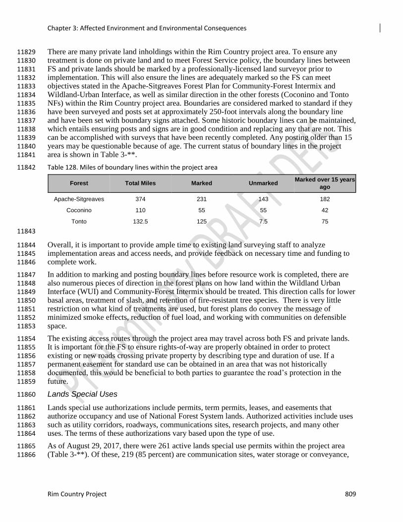
Chapter 3: Affected Environment and Environmental Consequences
Rim Country Project 809
There are many private land inholdings within the Rim Country project area. To ensure any 11829 treatment is done on private land and to meet Forest Service policy, the boundary lines between 11830 FS and private lands should be marked by a professionally-licensed land surveyor prior to 11831 implementation. This will also ensure the lines are adequately marked so the FS can meet 11832 objectives stated in the Apache-Sitgreaves Forest Plan for Community-Forest Intermix and 11833 Wildland-Urban Interface, as well as similar direction in the other forests (Coconino and Tonto 11834 NFs) within the Rim Country project area. Boundaries are considered marked to standard if they 11835 have been surveyed and posts set at approximately 250-foot intervals along the boundary line 11836 and have been set with boundary signs attached. Some historic boundary lines can be maintained, 11837 which entails ensuring posts and signs are in good condition and replacing any that are not. This 11838 can be accomplished with surveys that have been recently completed. Any posting older than 15 11839 years may be questionable because of age. The current status of boundary lines in the project 11840 area is shown in Table 3-**. 11841
Table 128. Miles of boundary lines within the project area 11842
Forest Total Miles Marked Unmarked Marked over 15 years
ago
Apache-Sitgreaves 374 231 143 182
Coconino 110 55 55 42
Tonto 132.5 125 7.5 75
11843
Overall, it is important to provide ample time to existing land surveying staff to analyze 11844 implementation areas and access needs, and provide feedback on necessary time and funding to 11845 complete work. 11846
In addition to marking and posting boundary lines before resource work is completed, there are 11847 also numerous pieces of direction in the forest plans on how land within the Wildland Urban 11848 Interface (WUI) and Community-Forest Intermix should be treated. This direction calls for lower 11849 basal areas, treatment of slash, and retention of fire-resistant tree species. There is very little 11850 restriction on what kind of treatments are used, but forest plans do convey the message of 11851 minimized smoke effects, reduction of fuel load, and working with communities on defensible 11852 space. 11853
The existing access routes through the project area may travel across both FS and private lands. 11854 It is important for the FS to ensure rights-of-way are properly obtained in order to protect 11855 existing or new roads crossing private property by describing type and duration of use. If a 11856 permanent easement for standard use can be obtained in an area that was not historically 11857 documented, this would be beneficial to both parties to guarantee the road’s protection in the 11858 future. 11859
Lands Special Uses 11860
Lands special use authorizations include permits, term permits, leases, and easements that 11861 authorize occupancy and use of National Forest System lands. Authorized activities include uses 11862 such as utility corridors, roadways, communications sites, research projects, and many other 11863 uses. The terms of these authorizations vary based upon the type of use. 11864
As of August 29, 2017, there were 261 active lands special use permits within the project area 11865 (Table 3-**). Of these, 219 (85 percent) are communication sites, water storage or conveyance, 11866

Chapter 3: Affected Environment and Environmental Consequences
810 Draft Environmental Impact Analysis
powerlines, roads/easements, or water or waste treatment facilities. These uses have direct 11867 effects on human populations and therefore carry greater risks from fire danger than other uses. 11868
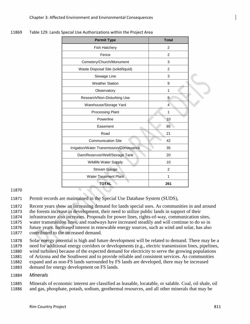
Chapter 3: Affected Environment and Environmental Consequences
Rim Country Project 811
Table 129. Lands Special Use Authorizations within the Project Area 11869
Permit Type Total
Fish Hatchery 2
Fence 2
Cemetery/Church/Monument 3
Waste Disposal Site (solid/liquid) 2
Sewage Line 3
Weather Station 9
Observatory 1
Research/Non-Disturbing Use 8
Warehouse/Storage Yard 4
Processing Plant 1
Powerline 10
Easement 85
Road 21
Communication Site 42
Irrigation/Water Transmission/Conveyance 35
Dam/Reservoir/Well/Storage Tank 20
Wildlife Water Supply 10
Stream Gauge 2
Water Treatment Plant 1
TOTAL 261
11870
Permit records are maintained in the Special Use Database System (SUDS), 11871
Recent years show an increasing demand for lands special uses. As communities in and around 11872 the forests increase in development, their need to utilize public lands in support of their 11873 infrastructure also increases. Proposals for power lines, rights-of-way, communication sites, 11874 water transmission lines, and roadways have increased steadily and will continue to do so in 11875 future years. Increased interest in renewable energy sources, such as wind and solar, has also 11876 contributed to the increased demand. 11877
Solar energy potential is high and future development will be related to demand. There may be a 11878 need for additional energy corridors or developments (e.g., electric transmission lines, pipelines, 11879 wind turbines) because of the expected demand for electricity to serve the growing populations 11880 of Arizona and the Southwest and to provide reliable and consistent services. As communities 11881 expand and as non-FS lands surrounded by FS lands are developed, there may be increased 11882 demand for energy development on FS lands. 11883
Minerals 11884
Minerals of economic interest are classified as leasable, locatable, or salable. Coal, oil shale, oil 11885 and gas, phosphate, potash, sodium, geothermal resources, and all other minerals that may be 11886
Chapter 3: Affected Environment and Environmental Consequences
812 Draft Environmental Impact Analysis
acquired under the Mineral Leasing Act of 1920, as amended, are referred to as leasable 11887 minerals. Common varieties of sand, stone, gravel, pumice, and clay that may be acquired under 11888 the Materials Act of 1947 are considered salable minerals. Any minerals that are not salable or 11889 leasable, such as gold, silver, copper, tungsten, and uranium, are referred to as locatable 11890 minerals. These mineral deposits include most metallic mineral deposits and certain nonmetallic 11891 and industrial minerals. Locatable minerals are subject to the Mining Act of 1872. 11892
Apache-Sitgreaves 11893
Mineral resource activity on the Apache-Sitgreaves NFs has historically been low. Mineral 11894 activity is presently concentrated in a few scattered areas. Commodity use and production have 11895 shown declines from the past. However, these forest uses contribute to sustaining the lifestyles 11896 and traditions of local communities. The potential for locatable minerals on Apache-Sitgreaves 11897 NFs lands may be much greater at depth than surface geology would otherwise suggest. The 11898 potential for leasable minerals on the Apache-Sitgreaves NFs is low because of the existing 11899 geology. There are no known leases on the forests for the following leasable mineral resources: 11900 oil and gas, oil shale, coal or geothermal (BLM 2009/2013). Should valid leasable mineral 11901 proposals be submitted, the Forest Service would respond as a cooperating agency when 11902 requested by the BLM, which acts as the lead agency for subsurface mineral extraction. There 11903 are no current leases for oil and gas, geothermal, or coal on the Apache-Sitgreaves NFs. 11904
Coconino 11905
The Coconino National Forest has very few locatable mineral resources, and no oil and gas 11906 leases or developments, but has potential geothermal resources (no current leases, no 11907 developments) associated with the San Francisco Volcanic Field. Locatable minerals with past 11908 or current production have included manganese, gypsum, flagstone and pumice. The forest has a 11909 small amount of common variety mineral materials production including cinders, crushed and pit 11910 run aggregate, rock and fill dirt, and landscape rock/decorative stone. Most of the use of mineral 11911 materials on the forest is by the Forest Service or authorized contractors or permittees for 11912 projects and by Coconino County under permits or other agreements. Aggregate production and 11913 salable minerals are anticipated to increase with future forest restoration activities. Some areas 11914 are withdrawn from locatable mineral entry. 11915
Tonto 11916
No leasable mineral authorizations or applications are currently located on the Tonto NF. The 11917 potential for development of leasable minerals in the planning area is low; the geologic 11918 depositional environment of the planning area is not conducive to hydrocarbon generation. The 11919 Tonto National Forest has a long history of mining across the national forest. 11920
Although numerous prospects on the Payson Ranger District were identified from the Arizona 11921 Department of Mines and Mineral Resources database, most of the gold and silver deposits were 11922 found within veins found fairly close to the surface with visible mineralization. Most of the 11923 metals could be extracted with minimal milling effort, usually with a stamp mill. Most if not all 11924 of the mineralization occurred within “quartz stringers” of a granodiorite intrusion (Botsford 11925 1933). Once these narrow dikes (bands) are mined out, only the “non-visible” or disseminated 11926 mineralization is left behind, which requires a much greater milling process and larger scale 11927 operation to be profitable. 11928
Arizona is well known for its large porphyry copper deposits, which are low-grade disseminated 11929 type deposits that require mining by large-scale, low-per-ton cost methods. The copper minerals 11930 are distributed uniformly through large sections or blocks of the deposit, that must be mined by 11931
Chapter 3: Affected Environment and Environmental Consequences
Rim Country Project 813
bulk methods, rather than selective or vein mining methods. These bulk mining methods consist 11932 of either open-pit or block caving mining methods. Gold and silver occur as secondary metals 11933 that are associated with porphyry-type deposits. Based on historic activity of this district, further 11934 exploration efforts may have merit. As a result, the favorability for mineral potential within the 11935 Green Valley Mining District and two other districts, the Polk and the Rye Creek, is determined 11936 to be moderate (USDI 1993). Although no exploration activity is currently taking place on the 11937 Payson Ranger District, the potential for such activities remains. 11938
Asbestos was mined from several large and numerous small workings of the Sierra Anchas Mining 11939
District of the Pleasant Valley Ranger District. Asbestos has not been mined in the United States since 11940
2002 (USGS 2014). Although asbestos is still a legal commodity, its use has declined considerably. 11941
Combined with the health and environmental concerns 11942
associated with asbestos use, as well as the decline in demand, the future potential of asbestos 11943 prospecting and development of the Sierra Anchas district is considered low (BOM 1993). 11944
Uranium was also developed within the Sierra Anchas region. Although during the years of 11945 1953-1960 over 122,000 lbs. of uranium oxide concentrate was produced from the Dripping 11946 Springs Quartzite in Gila County, the ore grade and extent were often disappointing. Uranium 11947 mining in Arizona today is concentrated within the Arizona Strip area of northern Arizona. There 11948 are currently no proposed exploration or development activities occurring within the district with 11949 regard to uranium production. Therefore, development potential for uranium mineral 11950 development within the Sierra Anchas district of Pleasant Valley Ranger District is determined 11951 to be low. 11952
Assumptions and Methodology 11953
Assumptions 11954
The following assumptions were made for this analysis: 11955
Forest Plan direction will be followed when planning or implementing site-specific 11956 projects and activities resulting from this decision. 11957
Applicable laws, regulations, and policies will be followed when planning or 11958 implementing site-specific projects and activities resulting from this decision. 11959
With population growth in the communities within and surrounding the forest, as well as 11960 throughout the State of Arizona, there will be increased demand for uses such as 11961 alternative energy development, utility corridors, and transportation systems. 11962
Community and public needs for use of federal land for services and infrastructure, 11963 including roads and energy corridors, will continue. 11964
Proposals for lands special uses, mineral exploration, and energy development on the 11965 national forests will increase in the foreseeable future. 11966
The primary assumption for the analysis of effects on lands, lands special uses, and minerals is 11967 that the number of acres treated under each alternative corresponds directly to a reduced risk of 11968 uncharacteristic wildfire behavior within the project area. This in turn corresponds to a reduced 11969 risk of damage to structures and facilities within the project area. Therefore, the greater the 11970 number of acres treated, the greater the reduction in uncharacteristic fire behavior, and therefore 11971 the greater positive effect to these resources. This correlation holds true regardless of the mix of 11972 treatment methods used (i.e., mechanical thinning, prescribed burning). 11973
Chapter 3: Affected Environment and Environmental Consequences
814 Draft Environmental Impact Analysis
Methodology 11974
The Special Uses Database System (SUDS) was used to generate a list of all special use 11975 authorizations within the project area. This report was sorted by use type; recreation special uses 11976 were then removed from the analysis. The remaining lands special use authorizations were then 11977 sorted by status. They were considered as part of the existing condition if they had statuses of 11978 application accepted, pending signature, or issued. 11979
Some inaccuracies are commonly known to exist in the SUDS. Permits are sometimes shown as 11980 “issued” even after they have expired, or sometimes are shown as expired when in fact they have 11981 been reissued and the activity continues. Where it was known or suspected that these permits 11982 were still in place and in the process of reissuance, they were considered in the analysis. 11983
Mineral resources were identified using the specialist reports and supporting materials for the 11984 Forest Land and Resource Management Plan Revisions for each forest in the project area. 11985
Issues/Indicators/Analysis Topics 11986
None of the significant issues for Rim Country relate to the potential effects on lands, lands special uses, or 11987 minerals, and therefore they do not serve as indicators for analyzing the effects of the project on these 11988 resources. However, the project would have an indirect effect in the form of reduced risk of 11989 uncharacteristic fire behavior. Uncharacteristic fire behavior presents a threat to the facilities authorized by 11990 special use permits and to any structures that may lie on non-forest lands within the project area. 11991 Therefore, the indicator used for this analysis is the reduced risk of uncharacteristic fire behavior, as 11992 represented by the number of acres treated under each alternative. 11993
Environmental Consequences 11994
Alternative 1 – No Action 11995
Under this alternative, no large-scale restoration activities would occur. Stand and vegetation 11996 structures would be improved only in accordance with each forest plan. With the data available 11997 at the time of this report, this would be occur on only 140,324 acres. This would make the 11998 landscape in the project area less resilient to disturbance and would provide increased fuels for 11999 wildland fires and uncharacteristic fire behavior. Increased fire danger would impact lands 12000 special uses by threatening the structures they authorize in both the short term (10 years) and 12001 long term (20 years and more). Any structures associated with active minerals sites and those 12002 located on non-NFS lands would be similarly threatened. Long-term effects could be the 12003 destruction of these facilities by fire, and possibly the closure of fire-damaged areas for 12004 rehabilitation. There may be short-term, temporary effects in the form of restricted access to sites 12005 during fire suppression activities or post-fire rehabilitation (see the Fire Ecology and Air Quality 12006 Report for detailed information on existing and foreseeable fire risk). 12007
Many of these authorized land uses serve and support local communities. If infrastructure is 12008 damaged by wildfire, there could be a delay in providing utilities such as power, phone, and 12009 water. Emergency service providers could be delayed in providing for health and safety if 12010 communication equipment is damaged. Private property has the potential to be impacted as a 12011 result of wildfires in the area as fires may burn at a higher intensity and severity and would be 12012 more difficult to control. Existing land uses would continue to be managed under the current 12013 forest plan direction and under the terms of their authorizations and other laws, policies, and 12014 regulations such as power line clearance requirements and vegetation management along 12015 highway corridors for safety purposes and utility reliability. 12016
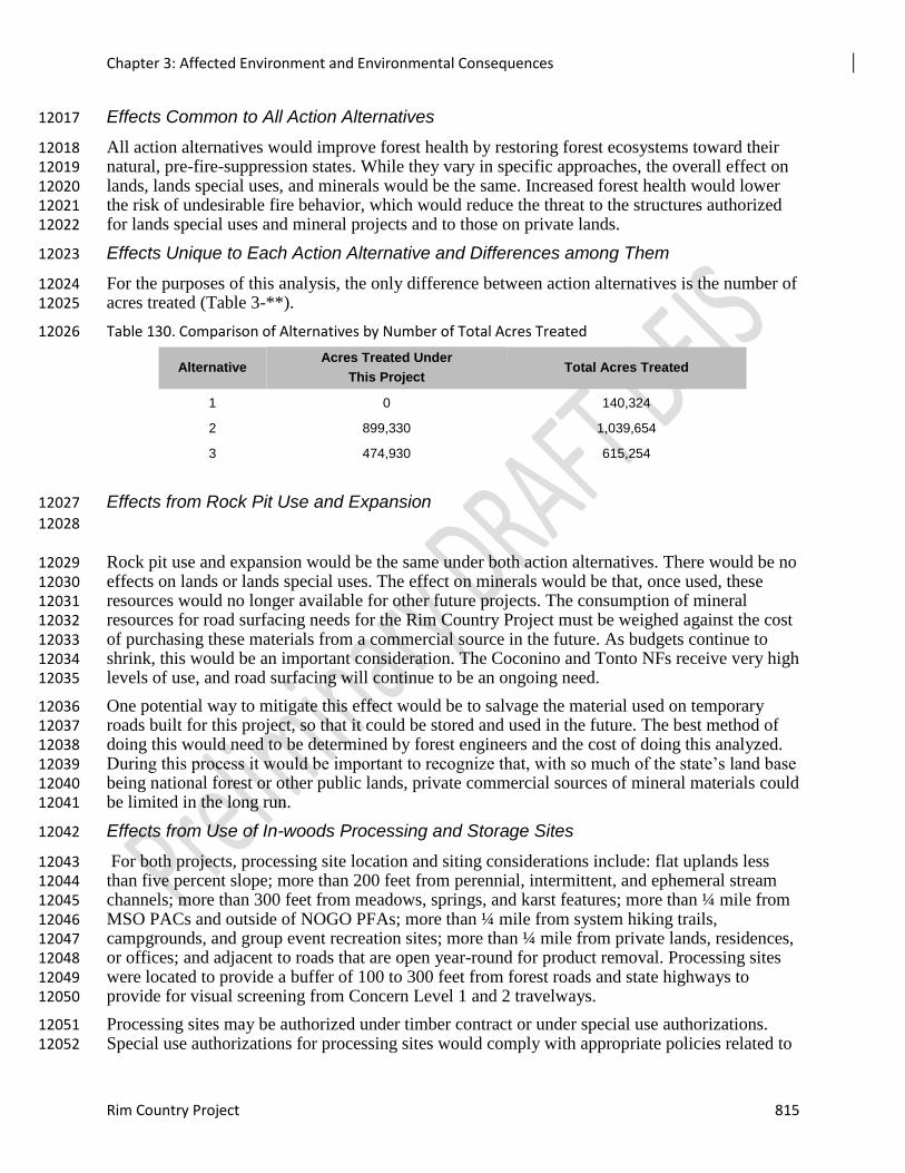
Chapter 3: Affected Environment and Environmental Consequences
Rim Country Project 815
Effects Common to All Action Alternatives 12017
All action alternatives would improve forest health by restoring forest ecosystems toward their 12018 natural, pre-fire-suppression states. While they vary in specific approaches, the overall effect on 12019 lands, lands special uses, and minerals would be the same. Increased forest health would lower 12020 the risk of undesirable fire behavior, which would reduce the threat to the structures authorized 12021 for lands special uses and mineral projects and to those on private lands. 12022
Effects Unique to Each Action Alternative and Differences among Them 12023
For the purposes of this analysis, the only difference between action alternatives is the number of 12024 acres treated (Table 3-**). 12025
Table 130. Comparison of Alternatives by Number of Total Acres Treated 12026
Effects from Rock Pit Use and Expansion 12027
12028
Rock pit use and expansion would be the same under both action alternatives. There would be no 12029 effects on lands or lands special uses. The effect on minerals would be that, once used, these 12030 resources would no longer available for other future projects. The consumption of mineral 12031 resources for road surfacing needs for the Rim Country Project must be weighed against the cost 12032 of purchasing these materials from a commercial source in the future. As budgets continue to 12033 shrink, this would be an important consideration. The Coconino and Tonto NFs receive very high 12034 levels of use, and road surfacing will continue to be an ongoing need. 12035
One potential way to mitigate this effect would be to salvage the material used on temporary 12036 roads built for this project, so that it could be stored and used in the future. The best method of 12037 doing this would need to be determined by forest engineers and the cost of doing this analyzed. 12038 During this process it would be important to recognize that, with so much of the state’s land base 12039 being national forest or other public lands, private commercial sources of mineral materials could 12040 be limited in the long run. 12041
Effects from Use of In-woods Processing and Storage Sites 12042
For both projects, processing site location and siting considerations include: flat uplands less 12043 than five percent slope; more than 200 feet from perennial, intermittent, and ephemeral stream 12044 channels; more than 300 feet from meadows, springs, and karst features; more than ¼ mile from 12045 MSO PACs and outside of NOGO PFAs; more than ¼ mile from system hiking trails, 12046 campgrounds, and group event recreation sites; more than ¼ mile from private lands, residences, 12047 or offices; and adjacent to roads that are open year-round for product removal. Processing sites 12048 were located to provide a buffer of 100 to 300 feet from forest roads and state highways to 12049 provide for visual screening from Concern Level 1 and 2 travelways. 12050
Processing sites may be authorized under timber contract or under special use authorizations. 12051 Special use authorizations for processing sites would comply with appropriate policies related to 12052
Alternative Acres Treated Under
This Project Total Acres Treated
1 0 140,324
2 899,330 1,039,654
3 474,930 615,254
Chapter 3: Affected Environment and Environmental Consequences
816 Draft Environmental Impact Analysis
cost recovery and land use fees and other special use regulations (36 CFR 251). A performance 12053 bond would be used to insure that all obligations are fulfilled by the contractor or permittee and 12054 would be used if needed to cleanup and rehabilitate the processing sites. 12055
Processing site locations and use are the same under both action alternatives. There would be no 12056 effects on minerals. There would, however, be potential effects on lands or lands special uses. 12057
Residents living within the project area boundaries could be impacted by the increased noise, 12058 traffic, and emissions produced by active operations at processing sites. These effects would be 12059 greater the closer processing sites are to any private lands or special use facilities with residents. 12060 These effects can be mitigated by advance communications with any residents and notifying 12061 them of potential active operation timeframes. 12062
Cumulative Effects 12063
The cumulative effects analysis area for lands, lands special uses, and minerals is the Rim 12064 Country project area. 12065
Alternative 1 – No Action 12066
Alternative 2 12067
Under this alternative, approximately 953,130 acres would receive vegetation treatments and 12068 restoration activities. This is a 60 percent increase over the no action alternative. Alternative 2 12069 would treat the greatest number of acres and therefore contribute the most toward the reduction 12070 of fire risk to lands, lands special uses, and mineral site structures. 12071
Alternative 3 12072
Under Alternative 3, approximately 529,060 acres would receive vegetation treatments and 12073 restoration activities. This represents 44 percent fewer acres than Alternative 2, but a **percent 12074 increase over alternative 1. Beneficial effects on lands, lands special uses, and mineral site 12075 structures would be greater than under Alternative 1 but less than under Alternative 2. 12076 12077
Tribal Relations 12078
Affected Environment 12079
All of the lands in the 4FRI Rim Country project area are the ancestral homelands of American 12080 Indian tribes. The archaeological resources in the project area demonstrate a high level of 12081 traditional uses which continue today (see the Cultural Resources section for more details 12082 concerning archaeological resources). In lands occupied by their ancestors, tribal members 12083 continue traditions of hunting, collecting medicinal plants, and conducting traditional 12084 ceremonies. This includes American Indian traditional use areas and places known as Traditional 12085 Cultural Properties (TCPs). TCPs are places traditionally used by cultural groups over 12086 generations. These TCPs hold a central and important place in American Indian culture. Through 12087 years of tribal consultation the forests have learned that many natural springs, prominent bodies 12088 of water, mountains, subsistence areas, prayer areas, shrines, clan origin locations, holy places, 12089 trails and shelters (ie. Sweat lodges and brush shelters) are considered TCPs by numerous tribes. 12090
Tribal members make pilgrimages to the Rim Country forests for ceremonial activities 12091 throughout the year. Springs in the project area and throughout the forest are valued as TCPs and 12092 sacred sites. Many plants gathered for ceremonial use are collected on or near TCPs. 12093
Chapter 3: Affected Environment and Environmental Consequences
Rim Country Project 817
Tribal Consultation 12094
The Forest Service and Tribes have legislative authority to partner under law, including but not 12095 limited to the Indian Financing Act of 1974, the Cooperative Funds and Deposits Act of 1975, 12096 the Forest and Rangeland Renewable Resources Research Act of 1978, the Federal Technology 12097 Transfer Act of 1986, the Department of Interior, Environment and Related Agencies 12098 Appropriations Act of 1992, the Tribal Forest Protection Act of 2004 (TFPA), the Culture and 12099 Heritage Cooperative Authority of 2008 (CHCA), and the Wyden Amendment (Public Law 109-12100 54, Section 434). These authorities provide opportunities to exchange technical expertise, 12101 funding, goods, and services to the mutual benefit of both parties. An effective government-to-12102 government relationship will provide for the identification of common goals and partnership 12103 opportunities. For additional guidance, see FSM 1563 (2015 draft). 12104
Assumptions and Methodology 12105
Assumptions made are as follows: no activities will adversely affect archaeological sites or 12106 traditional cultural properties; the removal of excess fuels is a benefit to cultural resources, 12107 traditional cultural properties, traditional use forest products, and adjacent tribal lands; low heat 12108 prescription wildfires can result in the regeneration of medicinal plants; mechanical thinning of 12109 specific species can protect other plant species of cultural importance (such as Emory oak 12110 groves); restoration activities will benefit natural springs which are of universal importance to 12111 Indian tribes; Indian tribes will be consulted at critical points before project activities. 12112
Issues/Indicators/Analysis Topics 12113
Traditional Collecting Areas - Dense tree growth and heavy ground fuels can have a negative 12114 effect on certain plant species; thinning the forest may provide a better habitat for these plants to 12115 thrive. Fire can also enhance certain plant species such as wild tobacco. Restoration activities 12116 could positively affect the sustainability and availability of traditionally important plant species 12117 and natural springs. 12118
Smoke Impacts - Increases in prescribed fire in all alternatives (no action, Alternative 2, and 12119 Alternative 3) create the potential for increased smoke impacts. Most of the smoke from 12120 prescribed fires on the Coconino and Tonto NFs would carry from the southwest to the northeast, 12121 potentially affecting the Havasupai Reservation and western portions of the Navajo Nation 12122 Reservation. Many people living in these areas are seniors with health conditions and are 12123 sensitive to smoke. The effects of limited communications (they cannot get on a website to check 12124 out where we’re burning, etc.), language barriers, and cultural differences make it difficult to get 12125 information to them and receive information in return about smoke impacts. There is a general 12126 lack of smoke monitoring data on the reservations. Therefore, those living on these reservations 12127 may be disproportionately affected by smoke from burning by the various agencies (especially 12128 from multiple fires on multiple jurisdictions). Coconino County has a significantly higher 12129 poverty rate than the other counties and the states of Arizona and Utah. The incidence of poverty 12130 in Coconino County is not evenly distributed among racial and ethnic groups. Approximately 50 12131 percent of American Indian residents in Coconino County live in poverty. The high proportion of 12132 American Indian residents in the county therefore increases the poverty rate relative to other 12133 study area counties and the state (Eichman and Jaworski 2011). 12134
Chapter 3: Affected Environment and Environmental Consequences
818 Draft Environmental Impact Analysis
Environmental Consequences 12135
Alternative 1 – No Action 12136
Direct effects as a result of the no action alternative would result in the loss of native plant 12137 species, an increase in springs drying up, and a greater threat of devastating wild fires. Also, with 12138 continued drying trends across the southwest, the forests would issue forest closures and fire 12139 restrictions thus effecting traditional uses and ceremonies. 12140
TCPs are at risk to catastrophic fire because it can destroy the setting of the TCP. Springs and 12141 plant collection areas are at risk to catastrophic fire because of excessive runoff from monsoon 12142 rain washing in ash and debris in a fire-devastated landscape. Overstocked stands are reducing 12143 the sunlight available for cultural and medicinal plants and catastrophic fire could destroy seed 12144 and habitat for native plants. A lack of low-intensity fire is reducing regeneration of plants 12145 collected by native people. 12146
Soil erosion due to uncharacteristic wildfires could have both direct and indirect effects on 12147 traditional collecting areas. Rain and snow melt could cause channels to form, or mud slides 12148 from nearby slopes could deposit soil and debris over traditional areas, leading to the loss of 12149 biological communities for both plant and animal species used by the tribes. 12150
The no action alternative may result in the possible reduction over time of pre-settlement adapted 12151 native plants, some of which have been collected since historical times by American Indians for 12152 food and medicine. Additionally, springs and seeps are important locations to American Indians 12153 and other members of the public; increasingly overstocked forests might affect those historic 12154 water sources. 12155
Effects Common to Both Action Alternatives 12156
The ground-disturbing activities associated with these two alternatives (2 and 3) are not 12157 significant enough to analyze separately. 12158
Alternatives 2 and 3 would increase the amount of ground-disturbing activities, including 12159 mechanical treatments, prescribed burning, temporary road construction, skidding, stream 12160 restoration, and fence construction. When considered together with the past, present, and 12161 reasonably foreseeable future actions, these activities have the potential to affect cultural 12162 resources such as traditional collecting, gathering, ceremonial use areas, and TCPs. All 12163 undertakings that have the potential to affect cultural resources would go through tribal 12164 consultation. In addition, protection measures such as the possibility of tribal monitors during 12165 mechanical activities, keeping ground-disturbing activities out of sensitive areas by flagging and 12166 avoiding the sensitive areas, and post-prescribed burn monitoring to assess the effects of the low-12167 intensity burns, would help to minimize the effects. The potential cumulative effects on cultural 12168 resources and TCPs such as springs from increased ground-disturbing activities and prescribed 12169 burning in these alternatives are therefore not considered to be adverse. 12170
Cumulative Effects to Both Action alternatives 12171
The cumulative effects on TCPs, and gathering and ceremonial areas resulting from any potential 12172 increase in erosion would also be minimal. Reducing fuel loads and implementing low to 12173 moderate-intensity prescribed fires do not cause soil sterilization or hydrophobic soils as high 12174 intensity wildfires do. Low-intensity prescribed fires leave some vegetation in place and re-12175 vegetation occurs soon afterwards if soils are not sterilized. However, as implementation occurs, 12176 monitors would check for erosion concerns by examining culturally sensitive locations like TCPs 12177 and ceremonial sites in the implementation areas, including focusing on slopes, drainages, and 12178
Chapter 3: Affected Environment and Environmental Consequences
Rim Country Project 819
other areas with a high probability of cultural resources. The cumulative effects on cultural 12179 resources caused by an increase in erosion are not considered to be adverse. An increase in these 12180 types of activities would not result in an adverse effect on cultural resources as long as tribal 12181 consultation is conducted prior to project implementation, protection measures are imposed, and 12182 post-project implementation monitoring is conducted when appropriate. 12183
Range 12184
A summary of the range specialist report is presented here and the complete report is 12185 incorporated by reference (Hughes 2018). Refer to the Range Report for additional information 12186 on methodology, the grazing history of the project area, and supporting information. This 12187 analysis incorporates questions designed to evaluate movement toward desired conditions and 12188 concerns brought up by the public during scoping: (1) How would project activities affect 12189 livestock grazing management in the project area? (2) How would project activities affect 12190 livestock forage in the project area? (3) Would livestock grazing affect the restoration of 12191 understory species? (4) How would livestock grazing affect the ability to return fire as a natural 12192 process to the project area? and (5) How would climate change affect the range resource and how 12193 would the project affect climate change (relative to range)? 12194
Affected Environment 12195
The affected environment for the range analysis is the Rim Country project area, approximately 12196 1,240,000 acres. Only allotments within the project area are considered. Within the project area, 12197 approximately 1,129,490 acres are within grazing allotments and 109,170 acres are not grazed by 12198 livestock. The majority of the understory vegetation within the grazing area is dominated by 12199 Arizona fescue, mountain muhly, pine dropseed, blue grama, and squirreltail grasses. 12200
Within the project area there are 70 livestock grazing allotments, with 69 active allotments and 12201 one vacant. Of these 70 allotments, 68 permit cattle grazing and two permit sheep grazing (one 12202 being a sheep driveway). The amount of each allotment lying within the project area varies from 12203 less than 1 percent to 100 percent. 12204
Grazing Effects from the 1860s to the Present 12205
There is a long livestock grazing history within the project area. The first pioneers settled in this 12206 area in the 1860s with their livestock. As more settlers moved in, they brought with them more 12207 and more livestock. Initially, livestock numbers were low but they increased quickly throughout 12208 the entire project area. The major factor contributing to the increase in cattle was when the 12209 Atlantic and Pacific Railroad connected Flagstaff to Albuquerque and the eastern U.S. markets in 12210 1882. 12211
Livestock numbers on the A-S, Coconino, and Tonto National Forests have generally declined 12212 since the 1890’s. One exception to this general trend was during WWII when numbers were 12213 temporary increased. In the early years, livestock reductions were generally made when 12214 allotments changed hands. Some of the reductions were made for range protection without a 12215 permit changing hands. 12216
On the A-S National Forests, livestock numbers have declined for more than 20 years, as the 12217 forests have balanced permitted numbers with the capacity of the land. In the 1980s, about 12218 236,000 AUMs were permitted on an annual basis, compared to 130,000 AUMs permitted in 12219 2011. 12220
Livestock grazing began on the area now known as the Tonto NF in the late 1800s. Heavy 12221 grazing was occurring in the 1880s and livestock numbers reached their peak in about 1900, with 12222
Chapter 3: Affected Environment and Environmental Consequences
820 Draft Environmental Impact Analysis
an estimated 1.5 to two million head grazing the area now known as the Tonto NF. Mostly cattle 12223 grazed on the Tonto, although some sheep, goats, and hogs have utilized the rangelands as well 12224 as native ungulates. 12225
From the 1920s until the early 1930s, individual allotments were fenced. After the allotments 12226 were fenced, the pastures started to be divided and water sources developed. By 1940, most dual 12227 use between cattle and sheep ended in this region as most of the permittees switched to cattle. All 12228 of these changes improved grazing management and reduced the effects from grazing on 12229 understory vegetation within the project area. 12230
12231
In summary, historic livestock effects on understory vegetation follow the history of livestock 12232 management within the project area. Range trends within the project area follow this grazing 12233 history. Unregulated grazing from the 1860s to the 1920s led to declines in grass, forb, and 12234 shrubs and an increase in trees. Since then, grazing management practices have evolved through 12235 time to limit overgrazing by livestock and to match conservative livestock utilization with forage 12236 production. With the improvement in grazing management, trends in understory vegetation have 12237 generally improved in areas where tree density does not limit recovery. Tree density limits the 12238 amount of understory vegetation since as tree densities increase, the understory vegetation 12239 declines. The direct relationship between tree basal area and understory production has been 12240 widely studied (Moore et al 2004, Arnold 1950, Cooper 1960, Pearson and Jameson 1967). In 12241 these studies, the direct relationship between tree density and understory vegetation was 12242 observed regardless of whether the study area was grazed by livestock, or whether the study area 12243 was excluded from livestock grazing. 12244
Assumptions and Methodology 12245
Annual planning occurs prior to the livestock grazing season. During this planning the livestock 12246 numbers and the grazing season are developed based on several factors including the previous 12247 year’s management plans and outcomes, current year’s predictions, and current resource 12248 conditions. During the grazing season, changes may be needed to the rotation or numbers, due to 12249 unexpected changes in conditions, such as those caused by drought or fire. This is a piece of the 12250 adaptive management cycle. Annual monitoring typically includes an assessment of current 12251 conditions, a measure of livestock usage and actual use. Long-term monitoring usually consists 12252 of condition and trend monitoring every five to 15 years measuring plant canopy cover, plant 12253 frequency, species composition, and/or ground cover. 12254
Design features, best management practices, mitigation and conservation measures have been 12255 developed to be used during implementation to protect range resources as well as other resources 12256 from grazing effects (see Appendix C). 12257
Environmental Consequences 12258
Direct and Indirect Effects from Livestock Grazing 12259
Livestock grazing can affect vegetation by reducing plant height, plant canopy cover, and ground 12260 cover, and can compact soils. Current grazing management systems on allotments within the 12261 project area are designed to mitigate these effects by rotating grazing so individual forage plants 12262 are not grazed at the same time each year. They are also designed so forage species can reach 12263 maturity and seed most years. Current allotment management plans generally have utilization 12264 guidelines of 25-40 percent by ungulates, which leaves 60-75 percent for ground cover, soils, fire 12265 spread, hiding cover, and forage for other animals and insects. Adaptive management for all 12266
Chapter 3: Affected Environment and Environmental Consequences
Rim Country Project 821
allotment grazing management systems in the project area is also mitigation to grazing. It is 12267 primarily used to match livestock numbers with annual available forage. 12268
In some areas managed livestock grazing can affect the spread of natural fire by the removal of 12269 fine herbaceous fuel until the plants regrow. Historic unregulated livestock management from the 12270 1860’s to the 1920’s removed a significant the amount of forage plants and did not allow for 12271 much regrowth. As range management practices were improved through the years, more forage 12272 plants became available to carry a fire. A likely factor in the increase in the amount of forest 12273 acres burned in recent history is a result of this improvement in range management practices. 12274
Current grazing management systems effects on fire within the project area is short lived and 12275 limited in area. The effect is normally limited to one pasture in an allotment, until that pasture 12276 can regrow, for typically between two to six weeks depending on climate conditions. It is also 12277 limited in scope because of conservative 25 to 40 percent utilization levels used in these grazing 12278 management systems in the project area, leaving 60 to 75 percent of the plants available for fire 12279 spread or mulch. The exceptions are generally always corrected the following year by resting the 12280 pasture, deferring use, reducing grazed periods, and/or reducing livestock numbers. Many fuels 12281 reduction and restoration projects have occurred within the project area and have been successful 12282 with livestock grazing. 12283
Grazing effects appear less important than abiotic and biotic factors in explaining the observed 12284 spatial variation in vegetation (Laughlin and Abella 2007). The model results imply that ungulate 12285 (cattle, sheep, deer, and elk) grazing might directly influence plant community composition. 12286 Heavy grazing can shift the community toward greater abundance of unpalatable species 12287 (Westoby et al., 1989; O’Connor, 1991). A few unpalatable species, including broom snakeweed 12288 (Gutierrezia sarothrae (Pursh, Britt. & Rusby) and spreading fleabane (Erigeron divergens Torr. 12289 & Gray), were most abundant in the heavily grazed plots (Abella and Covington, 2006). It is 12290 likely that the unregulated grazing in the 1860s to 1920s in the project area likely led to 12291 temporary changes in vegetation. As heavy grazing was eliminated over time the plant 12292 composition responded. 12293
Livestock grazing can affect riparian and aspen areas similarly to upland areas. However, 12294 livestock can be more attracted to riparian and aspen areas because of the increased water and/or 12295 forage. Riparian plants and aspen can be reduced by grazing these species. Special livestock 12296 management techniques have been employed within the project area to reduce effects including 12297 livestock exclosures, deferred grazing, herding, and alternative water sources with adjustments in 12298 Allotment Management Plans over the years. These practices have limited the amount of 12299 livestock grazing on riparian vegetation and aspen. Additional adjustments in management may 12300 be necessary to reduce effects on these areas, especially if riparian and aspen regeneration areas 12301 would be expanded with new management practices. 12302
Domestic cattle grazing has the potential to affect soil and hydrologic functions that are 12303 important in the maintenance of long-term productivity and favorable conditions of water flow. 12304 Specifically, changes in the soil's surface structure and its ability to accept, hold, and release 12305 water may be affected by compaction caused by trampling. The nutrient cycling function of the 12306 soil may be interrupted by removal of vegetation that affects above ground nutrient inputs into 12307 the system. Finally, the soil's resistance to erosion is affected by changes in plant density, 12308 composition, and protective vegetative ground cover that are part of the organic components in 12309 the soil. 12310
The effects of livestock grazing on soil and hydrologic function is limited within the project area 12311 because of the current management in place that limits utilization, maintains forage plants, and 12312 limits compaction with deferred and rest rotational grazing systems. 12313
Chapter 3: Affected Environment and Environmental Consequences
822 Draft Environmental Impact Analysis
Alternative 1 12314
Direct and Indirect Effects 12315
In Alternative 1, there would be no management activities occurring within the project area as a 12316 result of the Rim Country Project. Because no activities would occur, tree densities and canopy 12317 cover would remain high and understory plant cover would stay the same. Over time, tree 12318 densities and canopy cover would continue to increase, under which understory vegetative cover 12319 and production would decline. Understory species would also be reduced because of the buildup 12320 of pine needles and the lack of nutrient cycling. 12321
The reduction in understory vegetation over time would reduce the amount of forage available to 12322 livestock. Over time, livestock numbers may need to be reduced. This reduction in forage and 12323 decrease in livestock numbers has been recorded throughout the project area. There is no reason 12324 to believe that this trend would not continue under Alternative 1. 12325
Under Alternative 1, additional prescribed fire would not occur in the project area. Without these 12326 acres of prescribed burning, no pasture rest periods would be necessary after burning. 12327
Since no treatments are planned in Alternative 1, grazing management would continue as has 12328 generally been planned and actually carried out in the past. However, this alternative would not 12329 adequately reduce the increased risk of uncharacteristic wildfire. 12330
Uncharacteristic wildfires can burn with high severity and burn through multiple pastures, 12331 burning fences and other structural range improvements. Uncharacteristic wildfire would have an 12332 adverse effect on livestock grazing management and forage until the area recovers and structural 12333 improvements are replaced. See the Fire Ecology and Air Quality Report for additional 12334 information (Haas 2018). 12335
Effects Common to Both Action Alternatives 12336
The environmental consequences for Alternatives 2 and 3 are based upon the application of 12337 design features and other resource protection measures, and are based upon the environmental 12338 consequences in the Silviculture, Fire and Air Quality, and Wildlife Reports. See the range 12339 section in Appendix C, the Range section, of this FEIS for the complete list of resource 12340 protection measures. 12341
Tree thinning and prescribed burning would increase understory vegetation. Understory species 12342 and composition would change primarily by increasing shade-intolerant understory species and 12343 decreasing shade-tolerant species. Understory species would also be increased because of the 12344 reduction of pine needles and the increase in nutrient cycling provided by burning. All these 12345 factors would improve forage production for livestock within the areas treated. 12346
Both Alternatives 2 and 3 would directly decrease tree density by mechanical tree thinning and 12347 prescribed burning. Overall stand tree basal area may not measurably change in areas treated, but 12348 an increase in the groupy/clumpy arrangement would substantially increase herbaceous species 12349 production by creating openings between these groups. The indirect effect of cutting trees in a 12350 groupy/clumpy arrangement would increase herbaceous vegetation because of the overall 12351 increase in sunlight reaching the soil. The increase in forage would have short-term (within three 12352 years) and long-term 10-year beneficial effects on livestock grazing. In research near the project 12353 area, herbaceous production dropped from greater than 650 pounds per acre to 100 pounds per 12354 acre when basal area increased above 50 square feet/acre (Pearson and Jameson 1967). In 12355 another study, grasses increased by more than 470 percent cover in high-intensity harvest units 12356 compared to a 53 percent increase in pre-treatment control units (Stoddard et al. 2011). Griffis et 12357
Chapter 3: Affected Environment and Environmental Consequences
Rim Country Project 823
al. (2001) also found that the abundance of native grasses increased significantly along with 12358 treatment intensity throughout thinned and burned stands. 12359
The increase in forage within treatment areas would improve allotment conditions and allow for 12360 more flexibility in grazing management systems. Livestock distribution would improve because 12361 forage is more available in uplands than in more typical grazing areas like meadows. The 12362 increase in forage would either drop utilization rates within a pasture or increase pasture graze 12363 periods. An increase in pasture graze periods would allow for additional pasture rest or 12364 deferment in other pastures within an individual allotment. 12365
Prescribed burning would have an adverse effect on livestock grazing by removing forage 12366 available to livestock. This effect would be short term until the forage plants regrow, typically 12367 within one year. This effect would be offset by the long-term increase in forage after burning. 12368 The prescribed burning would be phased throughout the project area to minimize effects on 12369 individual allotments. Pastures would be rested prior to prescribed burning, in coordination with 12370 the range specialist, but it would not be a requirement to reach burning objectives. The 12371 allotments in the project area have the ability to rest a main pasture for one year after a burn with 12372 little effect on overall allotment grazing management. However, livestock numbers or season of 12373 use might have to be reduced in some allotments because of the combined effects from 12374 prescribed burns and other factors like wildfire and drought. If the burned areas do not recover 12375 within a year, then livestock would likely continue to run in the same pastures, reducing the 12376 amount of rotational grazing on an allotment. This might also lead to a temporary reduction in 12377 livestock numbers or a reduction in length of grazing season to maintain the health of the grazed 12378 pastures until the treatment area recovers and rotational grazing is restored. Adaptive 12379 management would continue to be used to adjust livestock numbers to meet annual forage 12380 production, with or without the burns. 12381
Restrictions in grazing of livestock after prescribed fires are a mitigation to reduce effects on 12382 forage species. These mitigations have shown to maintain static understory conditions in grazed 12383 areas. An estimate of this restriction is not available because each pasture’s response to ground-12384 disturbing treatments (including mechanical thinning and prescribed fire) is unique. Climatic 12385 conditions, soils, vegetation, the severity of fire effects, burn amount, intensity of vegetation 12386 treatments, and pasture management may vary greatly from year to year or from pasture to 12387 pasture. 12388
The removal of trees during mechanical thinning operations would have little effect on livestock 12389 grazing. Mitigations would be implemented to maintain structural range improvements and keep 12390 livestock within designated pastures during these operations. Pastures may be deferred during 12391 operations to minimize equipment and livestock conflicts, but it is not mandatory. Mechanical 12392 thinning has been conducted throughout the project area for many years with few effects on 12393 livestock grazing operations, although post-treatment inspections may result in changes to annual 12394 pasture rotations (such as deferment). 12395
Mechanical and fire treatments (Intermediate Thin, Stand Improvement, and Uneven-aged) 12396 would leave tree groups with differing sizes of interspaces between the tree groups. Treatments 12397 in the 40 to 55 percent and the 55 to 70 percent interspace ranges would result in an increase in 12398 herbaceous cover and production, and the treatments in 10 to 25 percent, 10 to 40 percent, and 25 12399 to 40 percent interspace ranges would still result in an increase in herbaceous cover and 12400 production, but less of an increase than the higher interspace treatments.. 12401
Single-tree selection treatments leave fewer tree groups and more randomly spaced trees. They 12402 are designed to increase or maintain age class diversity and reduce understory brush and shrub 12403 response, creating small openings less than or equal to 1/4 acre in size. This type of treatment 12404
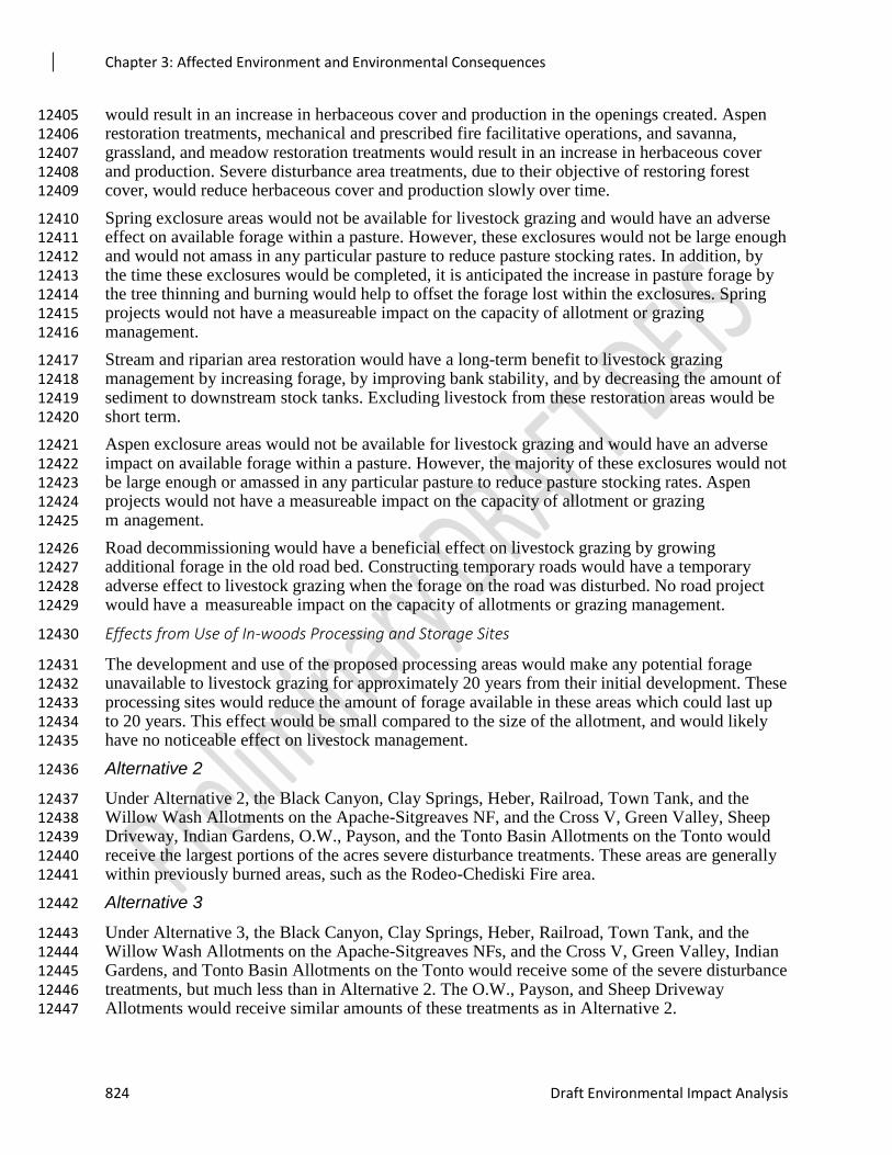
Chapter 3: Affected Environment and Environmental Consequences
824 Draft Environmental Impact Analysis
would result in an increase in herbaceous cover and production in the openings created. Aspen 12405 restoration treatments, mechanical and prescribed fire facilitative operations, and savanna, 12406 grassland, and meadow restoration treatments would result in an increase in herbaceous cover 12407 and production. Severe disturbance area treatments, due to their objective of restoring forest 12408 cover, would reduce herbaceous cover and production slowly over time. 12409
Spring exclosure areas would not be available for livestock grazing and would have an adverse 12410 effect on available forage within a pasture. However, these exclosures would not be large enough 12411 and would not amass in any particular pasture to reduce pasture stocking rates. In addition, by 12412 the time these exclosures would be completed, it is anticipated the increase in pasture forage by 12413 the tree thinning and burning would help to offset the forage lost within the exclosures. Spring 12414 projects would not have a measureable impact on the capacity of allotment or grazing 12415 management. 12416
Stream and riparian area restoration would have a long-term benefit to livestock grazing 12417 management by increasing forage, by improving bank stability, and by decreasing the amount of 12418 sediment to downstream stock tanks. Excluding livestock from these restoration areas would be 12419 short term. 12420
Aspen exclosure areas would not be available for livestock grazing and would have an adverse 12421 impact on available forage within a pasture. However, the majority of these exclosures would not 12422 be large enough or amassed in any particular pasture to reduce pasture stocking rates. Aspen 12423 projects would not have a measureable impact on the capacity of allotment or grazing 12424 m anagement. 12425
Road decommissioning would have a beneficial effect on livestock grazing by growing 12426 additional forage in the old road bed. Constructing temporary roads would have a temporary 12427 adverse effect to livestock grazing when the forage on the road was disturbed. No road project 12428 would have a measureable impact on the capacity of allotments or grazing management. 12429
Effects from Use of In-woods Processing and Storage Sites 12430
The development and use of the proposed processing areas would make any potential forage 12431 unavailable to livestock grazing for approximately 20 years from their initial development. These 12432 processing sites would reduce the amount of forage available in these areas which could last up 12433 to 20 years. This effect would be small compared to the size of the allotment, and would likely 12434 have no noticeable effect on livestock management. 12435
Alternative 2 12436
Under Alternative 2, the Black Canyon, Clay Springs, Heber, Railroad, Town Tank, and the 12437 Willow Wash Allotments on the Apache-Sitgreaves NF, and the Cross V, Green Valley, Sheep 12438 Driveway, Indian Gardens, O.W., Payson, and the Tonto Basin Allotments on the Tonto would 12439 receive the largest portions of the acres severe disturbance treatments. These areas are generally 12440 within previously burned areas, such as the Rodeo-Chediski Fire area. 12441
Alternative 3 12442
Under Alternative 3, the Black Canyon, Clay Springs, Heber, Railroad, Town Tank, and the 12443 Willow Wash Allotments on the Apache-Sitgreaves NFs, and the Cross V, Green Valley, Indian 12444 Gardens, and Tonto Basin Allotments on the Tonto would receive some of the severe disturbance 12445 treatments, but much less than in Alternative 2. The O.W., Payson, and Sheep Driveway 12446 Allotments would receive similar amounts of these treatments as in Alternative 2. 12447
Chapter 3: Affected Environment and Environmental Consequences
Rim Country Project 825
Cumulative Effects 12448
The area considered for cumulative effects analysis includes 100 percent of the acres within 12449 allotments that occur within the project area. This is a logical boundary because changes to 12450 grazing management in one pasture of an allotment affect the management in the entire 12451 allotment. 12452
The time frame for these combined effects is 10 years, 10 years in the future because changes in 12453 condition and trend in the vegetation depend on the presence of favorable growing conditions 12454 after cattle leave the pasture. If growing conditions are favorable, plant height and canopy cover 12455 would completely recover from the effects of the proposed forest management activities within 12456 one year. If growing conditions are not favorable, plant recovery would occur more slowly (up to 12457 two to three years). Vegetation recovery from the other activities and natural events may take 12458 this long depending on annual weather conditions particularly annual precipitation. 12459
Continuation of current management, absent the proposed treatments in the Rim Country project 12460 area, would result in further reductions in forage production over time with the increase in tree 12461 density. Past restoration projects within and close to the project area have increased forage and 12462 understory vegetation. Forest Service policy and forest plan direction is to manage for uneven-12463 aged stands and allow fire to return to its nature role in ecosystems. Current grazing management 12464 uses adaptive management to meet objectives established in existing allotment management 12465 plans. Past vegetation and prescribed fire projects have resulted in the current resource 12466 conditions. 12467
The cumulative effects on livestock grazing management and livestock forage from Alternative 1 12468 would be no change in the short term, but would result in a long-term decrease in forage with the 12469 increase in tree density. The 4FRI Rim Country project area would not be treated with the 12470 additional activities proposed. When other current and foreseeable projects are considered, 12471 282,291 acres would be treated (168,416 acres of mechanical thinning and 113,875 acres of 12472 burning). Livestock grazing management would be affected by these treatments; pastures would 12473 be rested and deferred as these treatments are completed. With fewer treatment acres, there 12474 would be fewer effects on pasture rotations. 12475
The treatments proposed in Alternatives 2 and 3 would overlap with the other current and 12476 reasonably foreseeable projects in the project area. Any overlap would produce a short term 12477 effect, with a typical duration of one year after burning. In the long term, forage would increase 12478 on the acres treated throughout the cumulative effects analysis area (allotments throughout the 12479 project area). In terms of grazing management, even though forage would be reduced for a 12480 period of one year, design features applied in implementation of all projects would mitigate any 12481 effects on grazing management. Coordination between fire, silviculture, and range specialists as 12482 part of an implementation interdisciplinary team would result in minor adjustments to grazing 12483 management. 12484
Transportation 12485
A summary of the transportation report is presented here. The specialist report (Rich 2018) is 12486 incorporated by reference. 12487
Affected Environment 12488
Forest system roads within the analysis area are managed in accordance with current 12489 management objectives that are based on a variety of needs for access and use of forest 12490 resources. The system of roads ranges from primitive, unsurfaced roads (maintained for resource 12491
Chapter 3: Affected Environment and Environmental Consequences
826 Draft Environmental Impact Analysis
protection and not user comfort), aggregate surfaced roads (maintained for varying degrees of 12492 user comfort), and double-lane asphalt-surfaced state highways. These roads form a 12493 transportation system that provides access to the area for a variety of uses, including vegetation 12494 treatments, fuel treatments, fire suppression, and recreation. The majority of these system roads 12495 were planned and constructed during past commercial timber harvest activities and are not 12496 accessible year-round by all types of vehicles. These roads were designed for primary use by a 12497 standard log truck. In addition to passenger vehicles and high clearance vehicles, many of these 12498 roads are used by off-highway vehicles, hikers, mountain bikers, and horseback riders. 12499
Some roads within the project area are poorly located. They may be overly steep and difficult to 12500 drain, located in drainages, too close to streams, or a number of other situations. Many of these 12501 roads are difficult to maintain and are causing soil and water resource damage. 12502
The number of miles of county, state, and federal highways within the project area and that 12503 provide access to the project area and link it with potential wood processing facilities is not 12504 estimated. Since the location of potential future processing facilities is unknown it is not possible 12505 to designate all public roads which may or may not be used for accessing the area. 12506
Current National Forest System Roads within Rim Country 12507
Currently there are approximately 5,682 miles of FS roads within the project area on FS lands. Table 3-** 12508 displays the miles of road by operational maintenance level. 12509
Table 131. Summary of existing road mileage 12510
Maintenance Level A-S Coconino Tonto Total
1- Basic Custodial Care (closed) 1,747 189 140 2,076
2 - High Clearance 856 1,417 591 2,864
3 - Suitable for Passenger Vehicles 347 240 82 669
4 - Moderate Degree of User Comfort 22 11 38 71
5 - High Degree of User Comfort 0 0 2 2
Total System Roads 2,972 1,857 853 5,682
12511
Assumptions and Methodology 12512
The Rim Country project area consists of 1.24 million acres on the Apache-Sitgreaves, 12513 Coconino, and Tonto NFs. Within this area, several other environmental analyses have been 12514 conducted in recent years. These previous analyses affect the type of transportation analysis 12515 conducted in this document. 12516
Two environmental assessments, totaling 61,101 acres, were recently analyzed for transportation 12517 needs for mechanical thinning and also for road decommissioning. No additional transportation 12518 analysis was conducted in these areas within the Rim Country EIS project area. These projects 12519 are: 12520
Larson- 29,921 acres- Apache-Sitgreaves NFs 12521
Upper Rocky Arroyo- 31,180 acres- Apache-Sitgreaves NFs 12522
Chapter 3: Affected Environment and Environmental Consequences
Rim Country Project 827
Six other environmental assessments totaling 192,187 acres, analyzed only for transportation 12523 needs for timber harvesting and did not analyze for any road decommissioning. These projects 12524 are: 12525
Upper Beaver Creek- 48,245 acres- Coconino NF 12526
Clints Well- 16,825acres- Coconino NF 12527
CC Cragin- 63,867 acres- Coconino NF 12528
Rim Lakes- 33,746 acres- Apache-Sitgreaves NFs 12529
Show Low South- 4,624 acres- Apache-Sitgreaves NFs 12530
Timber Mesa-Vernon- 24,880 acres- Apache-Sitgreaves NFs 12531
On the Coconino NF, 212,720 acres are identified for mechanical treatment as part of the Rim 12532 Country EIS. On the Apache-Sitgreaves NFs, 243,995 acres are identified for mechanical 12533 treatments. On these two forests, all mechanical treatments are assumed to require adequate road 12534 access to facilitate the removal of forest product resulting from forest restoration work. 12535
On the Tonto NF, 210,251 acres have been identified for mechanical treatment as part of Rim 12536 Country; however, many of these acres are dominated by chaparral, juniper, or other vegetation 12537 with less ponderosa pine present. While these areas may be mechanically treated, it is unlikely 12538 that mechanical thinning would be carried out on all of these acres due to the small amount of 12539 merchantable material present. 12540
Areas not proposed for mechanical treatments with wood products removal would not need the 12541 same level of access as those areas where forest products would be utilized. A minimum of 100 12542 square feet of basal area per acre of ponderosa pine was used to determine which acres would 12543 likely need adequate road access to remove forest products. Based on this analysis, 80,561 acres 12544 on the Tonto were analyzed for temporary road construction needs. The remaining 129,690 acres 12545 on the Tonto were not analyzed for temporary road construction needs, as removal of forest 12546 products is considered to be unlikely. 12547
As a result of the previous analyses in the 4FRI footprint, and the basal area threshold of 100 12548 square feet per acre on the Tonto NF, temporary road needs are only analyzed for 243,995 acres 12549 of the Apache-Sitgreaves NF, 212,720 acres of the Coconino NF, and 80,561 acres of the Tonto 12550 NF, for a total of 537,276 acres within the Rim Country project area. 12551
Road decommissioning is analyzed for 1,080,341 acres within the Rim Country EIS project area. 12552 This represents the entire project area outside of the Larson and Upper Rocky Arroyo analysis 12553 areas, which have already been analyzed for road decommissioning. 12554
Issues/Indicators/Analysis Topics 12555
The following significant issue was identified for the Rim Country Project: 12556
The miles of temporary roads in the proposed action may negatively affect watershed and stream 12557 conditions, and wildlife habitat and connectivity. Commenters asked that the Forest Service limit road 12558 networks to those roads needed for access and management. Commenters requested an alternative that 12559 dramatically reduces temporary road mileage. 12560
Indicators/Measures: 12561
Indicators will include the range of temporary roads that may be needed in each of the alternatives, 12562 measured by the approximate number of miles of temporary roads proposed in each alternative. 12563
Chapter 3: Affected Environment and Environmental Consequences
828 Draft Environmental Impact Analysis
Environmental Consequences 12564
Alternative 1 – No Action 12565
Use of Existing Roads 12566
Under Alternative 1, no new restoration activities would take place and no additional use of 12567 existing roads would occur. Current rates of public and administrative use would continue. 12568
Road Maintenance 12569
Under Alternative 1, maintenance to provide public and administrative access would continue, 12570 contingent upon funding. No increase in road maintenance to accommodate restoration activities 12571 would occur. 12572
Road Decommissioning 12573
Under Alternative 1, no road decommissioning would occur within the project area unless it is 12574 analyzed under separate NEPA analysis. 12575
Temporary Roads 12576
Under Alternative 1, no new temporary roads would be constructed, unless constructed under 12577 separate NEPA analysis 12578
Rock Pit Use and Expansion 12579
Under Alternative 1, there would be no expansion of existing pits. Current use of existing and 12580 new pits analyzed under separate NEPA would continue. 12581
Use of In-woods Processing and Storage Sites 12582
Under Alternative 1, no in-woods processing and storage sites would be created or used; 12583 therefore there would be no effects resulting from them. 12584
Effects Common to Both Action Alternatives 12585
An adequate transportation system to provide access for restoration work and for removal of 12586 forest products generated from restoration activities is critical for accessing stands identified for 12587 mechanical treatment. Listed in the following paragraphs are practices that are common to all 12588 action alternatives. 12589
Use of Existing System Roads 12590
It is assumed that nearly all of the existing roads within the Rim Country analysis area may be 12591 used to provide access for a variety of restoration activities, including hauling of forest products 12592 resulting from mechanical treatments. Nearly all of the forest system roads within the project 12593 area are ML 1, 2, or 3 roads. This analysis addresses temporarily opening existing closed roads 12594 (ML 1) to utilize them for the time period they are needed to provide access for restoration work. 12595 These roads would be closed upon completion of work in the area they access and returned to a 12596 closed status (ML 1). 12597
The preferred alternative in the Tonto Travel Management EIS proposes that 354 miles of ML 2 12598 roads be converted to motorized trails. These roads have received minimal maintenance over the 12599 years and their current condition is not anticipated to improve (narrowing, roughening up, or 12600 otherwise modifying the road as it’s redefined to a motorized trail). Full size vehicles would be 12601 authorized to use these routes under Tonto Travel Management and they would be managed as 12602
Chapter 3: Affected Environment and Environmental Consequences
Rim Country Project 829
motorized trails. It’s anticipated that pre-haul maintenance is all that would be needed in the 12603 future to prepare the motorized trails for use to access mechanical treatment areas. 12604
Roads used for hauling of forest products under this analysis would be maintained or improved 12605 in order to meet road management standards under National Best Management Practices for 12606 Water Quality Management on National Forest System lands. 12607
Road Maintenance 12608
Road maintenance is defined as, “The upkeep of the entire transportation facility including 12609 surface and shoulders, parking and side areas, structures, and such traffic-control devices as are 12610 necessary for its safe and efficient utilization. This work includes brushing of roadside 12611 vegetation, falling danger trees, road blading, cleaning ditches, cleaning culvert inlets and 12612 outlets, etc.” (36 CFR 212.1) 12613
Road maintenance on roads that receive substantial use by the public are maintained by the FS 12614 on a regular basis as funding allows. When there is a substantial increase in use of a road by a FS 12615 contractor for uses such as hauling, this contractor is usually required to perform maintenance 12616 both during and after their use of the road commensurate with their use. This maintenance is 12617 often blading and reshaping of the road surface. Road maintenance on roads that are closed to the 12618 public would be performed by the logging contractor. 12619
Roads used for hauling of forest products under Rim Country would generally be maintained by 12620 contactors. This maintenance would likely be done while the road is being used and at the 12621 completion of hauling. All maintenance performed by contractors would be in accordance with 12622 FS maintenance standards. 12623
Road Decommissioning 12624
Road decommissioning is defined as: "Activities that result in the stabilization and restoration of 12625 unneeded roads to a more natural state." (36 CFR 212.1, FSM 7705 – Transportation System) 12626 The Forest Service Manual (7712.11- Exhibit 01) identifies five levels of treatments for road 12627 decommissioning which can achieve the intent of the definition. These include: 12628
Block entrance 12629
Revegetation and water barring 12630
Remove fills and culverts 12631
Establish drainage ways and remove unstable road shoulders 12632
Full decommissioning, recontouring and restoring natural slopes 12633
These five treatments provide a wide range of options to stabilize and restore unneeded roads. In 12634 some cases restoration may be achieved by blocking the entrance. In other situations, more 12635 extensive actions may be called for. 12636
This analysis does not identify specific road segments for decommissioning. Rather it would 12637 provide the NEPA decision to decommission roads and road segments at the time that task orders 12638 or other projects are implemented. Roads would be evaluated for decommissioning at that time. 12639
Roads may be decommissioned for a variety of reasons, including but not limited to roads that 12640 are: 12641
No longer needed for future management 12642
To protect cultural resources 12643
Chapter 3: Affected Environment and Environmental Consequences
830 Draft Environmental Impact Analysis
Causing soil or water resource damage 12644
Not useable without significant investment beyond current and future funding levels 12645
An ongoing road maintenance challenge 12646
An unauthorized road (an unauthorized roads is defined as road that is not a forest road or 12647 a temporary road and that is not included in a forest transportation atlas). 12648
Other unique situations 12649
Under this alternative both National Forest Systems roads and unauthorized roads could be 12650 decommissioned. When a system road is decommissioned it is also removed from the National 12651 Forest Road System. 12652
Transportation Analysis Process (TAP) reports for the Coconino, Apache-Sitgreaves, and Tonto 12653 NFs and site-specific on-the-ground evaluations would be considered in selecting roads for 12654 decommissioning. 12655
On the Tonto NF, decommissioning of system roads is being analyzed as part of the Tonto 12656 Travel Management EIS and roads for decommissioning are identified. Roads identified for 12657 decommissioning under the Tonto Travel Management EIS could be physically decommissioned 12658 as part of restoration work undertaken to implement the Rim Country EIS. Additional roads on 12659 the Tonto could also be identified for decommissioning as needed in the project area. 12660
Unless already identified for decommissioning under the Tonto Travel Management, roads on all 12661 three Rim Country forests that are needed to provide reasonable skidding distances for future 12662 harvesting would not be decommissioned. Also, roads that are needed to provide access to leases 12663 and other special uses on National Forest System lands would not be decommissioned unless 12664 other suitable access is provided. If these roads are needed for future management, but are a 12665 problem for soil and water resources, they would instead be relocated. 12666
Unauthorized roads within the project area on all forests could be decommissioned under this 12667 decision. Roads currently designated as open on a forest’s Motor Vehicle Use Map would not be 12668 decommissioned or closed under this alternative. 12669
Road Relocation 12670
Road relocation is defined as moving an existing road from its current location and re-locating it 12671 to a new location. Unfortunately many roads within the project area are poorly located and were 12672 never properly designed. As a result these roads are in need of relocation. Roads that could be 12673 considered for relocation include those that are: 12674
Too steep, resulting in significant erosion 12675
Below the level of the surrounding land and are difficult to drain. 12676
Are too close to a seasonal or perennial waterbody and contributing sediment to the 12677 waterbody 12678
Other unique situations 12679
Any combination of the reasons listed above 12680
When roads are relocated, their former location would be decommissioned. This would result in 12681 little if any net gain or loss in road mileage in most cases. Road relocation of a system road is not 12682 considered construction of a new permanent road. It is considered a relocation of an existing 12683 road. 12684
Chapter 3: Affected Environment and Environmental Consequences
Rim Country Project 831
This analysis does not identify specific road segments for relocation. Rather it provides the basis 12685 to relocate roads and road segments at the time that task orders or other projects are 12686 implemented. Roads would be evaluated for relocation at that time. 12687
Temporary Roads 12688
The Collaborative Forest Landscape Restoration Act (CFLRA), does not allow for the 12689 construction of new permanent roads in CFLR projects. Any new road constructed under 12690 CFLRA must be a temporary road and cannot be added to the national forest road system. All 12691 new road construction in this project will be considered temporary. 12692
A temporary road is defined as: “A road or trail necessary for emergency operations or 12693 authorized by contract, permit, lease, or other written authorization that is not a forest road, or 12694 trail and that is not included in the transportation atlas.” (36 CFR 212.1) 12695
In order to provide adequate access to the project area for timber removal, temporary roads 12696 would need to be constructed in some locations. Temporary roads for this project are intended to 12697 provide short-term access to a specific area for wood products removal and/or follow up 12698 treatments, such as prescribed burning. Temporary roads are often used to provide economically 12699 feasible skidding distances in harvest operations. Following completion of work in the area they 12700 serve, temporary roads would be decommissioned and made impassable to vehicles. 12701 Decommissioning would be accomplished with one or more of the five levels of treatments 12702 described above. 12703
Temporary roads might be either new construction or utilize existing road prisms of 12704 unauthorized roads. 12705
Rock Pit Use and Expansion 12706
Rock pit use and expansion could require a limited amount of temporary road. This mileage is 12707 included in the estimated temporary road mileage under each action alternative. 12708
Use of In-woods Processing and Storage Sites 12709
In-woods processing and storage sites could require a limited amount of temporary road. This 12710 mileage is included in the estimated temporary road mileage under each action alternative. 12711
Effects Unique to Each Action Alternative and Differences among Them 12712
Alternative 2 – Modified Proposed Action 12713
Use of Existing Roads 12714
It is assumed that nearly all, if not all, system roads within the project area could be utilized at 12715 some point in time to carry out restoration activities. 12716
Road Maintenance 12717
Roads that would be utilized for restoration work and hauling of forest products would likely see 12718 pre-haul maintenance if needed to make the roads passable to truck traffic, as well as 12719 maintenance during hauling and post haul maintenance. This maintenance would be in addition 12720 to a forest’s regular schedule of maintenance. 12721
Road Decommissioning 12722
Under this alternative, up to 200 miles of system road on the Coconino and Apache-Sitgreaves 12723 NFs could be decommissioned. The Tonto NF Travel Management EIS has identified 12724 approximately 290 miles of road within the Rim Country project area for decommissioning. In 12725
Chapter 3: Affected Environment and Environmental Consequences
832 Draft Environmental Impact Analysis
addition to system road decommissioning, up to 800 miles of unauthorized roads on all three 12726 forests may be decommissioned under this alternative. 12727
Road Relocation 12728
Roads might be relocated as needed under this alternative in order to reduce adverse resource 12729 effects, to facilitate use for restoration activities, and improve public safety. 12730
Temporary Roads 12731
Under this alternative up to 330 miles of temporary road could be utilized to facilitate 12732 mechanical treatments. These temporary roads might be new construction or utilize existing 12733 unauthorized roads. Temporary roads would be decommissioned when thinning and related 12734 restoration work is completed in the areas that they access. 12735
Alternative 3 – Focused Restoration 12736
Use of Existing Roads 12737
It is assumed that nearly all, if not all roads within the project area could be utilized at some 12738 point in time to carry out restoration activities. 12739
Road Maintenance 12740
Roads that would be utilized for restoration work and hauling of forest products would likely see 12741 pre-haul maintenance if needed to make the roads passable to truck traffic, as well as 12742 maintenance during hauling and post haul maintenance. This maintenance would be in addition 12743 to a forest’s regular schedule of maintenance. 12744
Road Decommissioning 12745
Under this alternative up to 200 miles of system road on the Coconino and Apache-Sitgreaves 12746 NFs could be decommissioned. The Tonto NF Travel Management EIS has identified 12747 approximately 290 miles of road within the Rim Country project area for decommissioning. In 12748 addition to system road decommissioning, up to 800 miles of unauthorized roads on all three 12749 forests could be decommissioned under this alternative. 12750
Road Relocation 12751
Roads might be relocated as needed under this alternative in order to reduce adverse resource 12752 effects, to facilitate use for restoration activities, and improve public safety. 12753
Temporary Roads 12754
Under this alternative up to 170 miles of temporary road could be created and utilized to 12755 facilitate mechanical treatments. These temporary roads might be new construction or utilize 12756 existing road prisms of non-systems roads already present. Temporary roads would be 12757 decommissioned when thinning and related restoration work is completed in the areas that they 12758 access. 12759
Cumulative Effects 12760
Alternative 1 – No Action 12761
Under Alternative 1, there are no proposed activities so there would be no additional cumulative 12762 effects in the project area from; use of existing roads, road maintenance, road decommissioning, 12763 temporary roads, rock pit use and expansion, and use of in-woods processing and storage sites. 12764
Chapter 3: Affected Environment and Environmental Consequences
Rim Country Project 833
Alternative 2 – Modified Proposed Action 12765
Use of Existing Roads 12766
Use of existing roads under this alternative would be in addition to current use by both the public 12767 and contractors and permittees for other authorized projects on national forest lands. 12768
Road Maintenance 12769
Road maintenance performed under this alternative would be in addition to road maintenance 12770 performed currently under a forest regular program of road maintenance 12771
Road Decommissioning 12772
Road decommissioning performed under this alternative would be in addition to 12773 decommissioning of national forest system roads and unauthorized roads that has been 12774 performed in the past. 12775
Road Relocation 12776
Any roads relocated under this alternative would be in addition to roads relocated on other 12777 projects within the Rim Country project area. 12778
Temporary Roads 12779
Temporary roads that are constructed and then decommissioned would be in addition to 12780 temporary roads that have been constructed and utilized for vegetation and fuels reduction 12781 projects in the past. 12782
Alternative 3 – Focused Alternative 12783
Use of Existing Roads 12784
Use of existing roads under this alternative would be in addition to current use by both the public 12785 and contractors and permittees of other authorized projects on national forest lands. 12786
Road Maintenance 12787
Road maintenance performed under this analysis would be in addition to road maintenance 12788 performed currently under a forest regular program of road maintenance. 12789
Road Decommissioning 12790
Road decommissioning performed under this alternative would be in addition decommissioning 12791 of national forest system roads and unauthorized roads that has been performed in the past. 12792
Road Relocation 12793
Any roads relocated under this alternative would be in addition to roads relocated on other 12794 projects within the Rim Country project area. 12795
Temporary Roads 12796
Temporary roads that are constructed and then decommissioned would be in addition to 12797 temporary roads that have been constructed and utilized for harvesting and fuels reduction 12798 projects in the past. 12799
Unavoidable Adverse Effects 12800
Though both action alternatives (Alternatives 2 and 3) were designed to move resources toward 12801 desired conditions, implementation of either one would result in some unavoidable, short-term, 12802
Chapter 3: Affected Environment and Environmental Consequences
834 Draft Environmental Impact Analysis
adverse effects. At the same time, implementation of Alternative 1, the no action alternative, 12803 would also result in some unavoidable, short-term, adverse effects from forest management 12804 activities that are part of other projects and from wildfires that may occur within or near the Rim 12805 Country project area. 12806
Adverse effects from implementation of either of the action alternatives would be limited in 12807 extent and duration by ensuring that management activities are consistent with standards and 12808 guidelines from the forest plans and proposed amendments. Project design features, found in 12809 Appendix C, along with mitigations and protocols in Appendix J of the Programmatic 12810 Agreement between the Southwestern Region of the Forest Service, the Arizona, New Mexico, 12811 Texas and Oklahoma State Historic Preservation Offices and the Advisory Council on Historic 12812 Preservation, would apply to both action alternatives and would provide additional means and 12813 mitigations to avoid or minimize adverse effects while still meeting the purpose and need of the 12814 project. 12815
Implementation of activities in both action alternatives could result in some of the following 12816 unavoidable, short-term, adverse effects (further details can be found in the respective resource 12817 sections of this chapter): 12818
1. Individuals of some threatened and endangered species, as well as some sensitive species, 12819 may be harmed. Habitat for certain species may be temporarily adversely affected. 12820
2. Short-term disturbances to grasses, forbs, shrubs, and small trees may occur. 12821
3. Air quality may temporarily decrease. 12822
4. Erosion and soil compaction may temporarily increase. 12823
5. Water quality may be temporarily affected. 12824
6. Cultural artifacts, features, and sites may be disturbed or damaged. 12825
7. Tribal access to Traditional Cultural Properties and forest products may be temporarily 12826
hindered during implementation of treatments. 12827
8. Temporary decreases in access to recreation opportunities and deviations from scenic 12828 integrity objectives may occur. 12829
9. Forage availability may decrease temporarily. 12830
10. Noxious weed infestation may increase. 12831
None of the alternatives has expected energy requirements or conservation potential (40 CFR 12832 1502.16(e)). 12833
Natural or depletable resource requirements and conservation potential of various alternatives 12834 and mitigation measures, as well as means to mitigate adverse environmental effects are 12835 discussed in the resource sections of this chapter and in Appendix C (40 CFR 1502.16(f)). 12836
None of the alternatives would affect the design of the built environment. The effects of 12837 implementing the alternatives on urban quality and historic and cultural resources (40 CFR 12838 1502.16(g)) are displayed in the Fire Ecology and Air Quality, Tribal Relations, and Heritage 12839 Resources Reports and the corresponding sections of this chapter. 12840
Short-term Uses and Long-term Productivity 12841
NEPA requires consideration of “the relationship between short-term uses of man’s environment 12842 and the maintenance and enhancement of long-term productivity” (40 CFR 1502.16). As 12843
Chapter 3: Affected Environment and Environmental Consequences
Rim Country Project 835
declared by the Congress, this includes using all practicable means and measures, including 12844 financial and technical assistance, in a manner calculated to foster and promote the general 12845 welfare, to create and maintain conditions under which man and nature can exist in productive 12846 harmony, and fulfill the social, economic, and other requirements of present and future 12847 generations of Americans (NEPA Section 101). Consistent with the Multiple-Use Sustained-12848 Yield Act of 1960 (16 U.S.C. 528-531), the Forest Service manages each national forest to 12849 sustain the multiple use of its renewable resources in perpetuity while maintaining the long-term 12850 health and productivity of the land. Land management plans (forest plans) guide sustainable, 12851 integrated management of the resources within the plan area in the context of the broader 12852 landscape, giving due consideration to the relative values of the various resources in particular 12853 areas (36 CFR 219.1(b)). By ensuring that proposed treatment activities and design features in 12854 both action alternatives move resources towards desired conditions in a manner consistent with 12855 forest plan direction, the long-term productivity of the land would not be impaired by short-term 12856 uses associated with implementation of either action alternative. All potential short-term 12857 disturbances would be evaluated and mitigated at a site-specific level prior to implementation. 12858 This disclosure focuses on soils, water, and vegetation resources. More detailed discussions 12859 related to short-term uses and long-term productivity can be found in the effects analysis sections 12860 for the individual resources earlier in this chapter and in individual resource specialist reports. 12861
Soils and Water 12862
Implementation of Alternative 1, the no action alternative, would not directly affect soil and 12863 water productivity and quality, though it would result in continued loss of soil productivity on, 12864 and erosion from, roads that would be decommissioned by implementation of either of the action 12865 alternatives. It would do nothing to avoid or decrease undesirable effects on soils and water 12866 quality from future wildfires. 12867
Restoration treatments and associated activities, including prescribed fire, in Alternatives 2 and 3 12868 would result in some ground disturbance and would produce short-term, localized effects to soil 12869 productivity and water quality. Long-term benefits of treatments in both alternatives would 12870 include avoiding or decreasing undesirable effects on soils and water quality from future 12871 wildfires and improving overall soil retention and water quality in degraded watersheds. Because 12872 of the larger area over which mechanical thinning and prescribed fire treatments would be 12873 implemented in Alternative 2, both the short-term effects and long-term benefits to productivity 12874 would be greater than those from activities in Alternative 3. Both action alternatives would 12875 decommission equal mileages of forest system and unauthorized roads, leading to positive long-12876 term benefits on soil productivity and water quality in the areas around those roads under either 12877 alternative. 12878
Vegetation 12879
Alternative 1 would not directly result in short-term effects on the productivity of vegetation. At 12880 the same time, it would not address the problems of stagnant tree growth and mortality, or 12881 susceptibility to fire and insect or disease outbreaks. Thus it would be expected to lead to 12882 declining productivity, if not outright losses of over- and understory species from stand-replacing 12883 wildfires and insect or disease outbreaks over the long term. 12884
Implementation of either action alternative would lead to short-term effects on and mortality of 12885 vegetation from disturbances associated with implementing restoration treatments. However, 12886 restoration treatments would reduce inter-tree competition, improve growth and vigor of residual 12887 trees, and increase understory productivity and diversity, including of shade-intolerant species. 12888 These treatments would also improve resistance and resilience to wildfires, climate change, and 12889
Chapter 3: Affected Environment and Environmental Consequences
836 Draft Environmental Impact Analysis
insect and disease outbreaks, thus maintaining or enhancing the long-term productivity of 12890 restored ecosystems. 12891
Irreversible and Irretrievable Commitments of Resources 12892
Irreversible commitments of resources are those that cannot be undone, such as the extinction of 12893 a species or the removal of mined ore. Irretrievable commitments are those that are lost for a 12894 period of time, but are reversible, such as the temporary loss of canopy cover in forested areas 12895 that are kept clear for use as a power line right-of-way or road. See discussions of environmental 12896 consequences for individual resources earlier in this chapter for more detail. 12897
A likely outcome of Alternative 1 would be one or more high-intensity, stand-replacing wildfires 12898 in the project area. Post-fire effects on resources that require decades or longer to recover would 12899 constitute irretrievable commitments of those resources in the short term and potentially the long 12900 term. For example, topsoil, which is critical to healthy surface vegetation, would take centuries 12901 to fully recover. Likewise, the loss of old and large trees would be irretrievable and would 12902 require many decades, if not centuries, to recover. Given uncertainties of the effects of climate 12903 change and the possibility of post-fire vegetation type conversions from forest to non-forest, the loss of 12904 entire stands to wildfires could represent an irreversible commitment of those resources. Cultural 12905 resources are non-renewable, and direct damage from high-intensity wildfires, such as spalling of 12906 rock art or cracking of artifacts, would represent an irreversible commitment of those resources. 12907 In addition, indirect effects of high-intensity wildfires on cultural resources, such as damage 12908 from bulldozers used during suppression operations, or exposure following post-fire erosion, can 12909 lead to irreversible degradation or losses of cultural resources. 12910
Alternative 1 would not result in additional road decommissioning within the project area 12911 beyond what may occur as part of other projects or management activities. Relative to the action 12912 alternatives, both of which would include decommissioning of up to 490 miles of existing system 12913 roads and 800 miles of unauthorized roads, the lost soil and vegetation productivity associated 12914 with continued use of these roads in Alternative 1 would represent an irretrievable commitment 12915 of these resources. 12916
Alternatives 2 and 3 include mechanical thinning and prescribed burning on approximately 12917 953,130 and 529,060 acres, respectively. Potential cultural resource damage from thinning, 12918 burning, and related activities would represent an irreversible commitment of these resources. 12919 Design features and established mitigation measures and protocols would help avoid and 12920 minimize potential negative effects on cultural resources. 12921
Alternatives 2 and 3 include the construction of up to 330 and 170 miles of temporary roads, 12922 respectively. Decreases in soil and vegetation productivity while these roads are used would 12923 represent irretrievable commitments of resources. Inadvertent damage to cultural resources from 12924 construction and use of temporary roads would be an irreversible commitment of these resources. 12925 Design features, along with established mitigation measures and protocols to protect cultural 12926 resources, would help avoid and minimize potential negative effects of construction and use of 12927 temporary roads. Temporary roads would be decommissioned when restoration work is 12928 completed in the areas to which they provide access. 12929
Alternatives 2 and 3 include the proposed expansion of 11 existing rock pits to provide adequate 12930 sources of road surfacing material for project-related activities. The expansion of these pits 12931 would represent an irretrievable commitment of resources due to the removal of developed soils 12932 needed for vegetative growth on approximately 27 acres. The differences in soil productivity 12933 within the pit and in the surrounding area would be distinct and unavoidable, though effects on 12934 other resources would be mitigated by using design features. The loss of productive topsoil from 12935
Chapter 3: Affected Environment and Environmental Consequences
Rim Country Project 837
rock pit expansion would be offset by decreases in soil erosion on and along roads from the 12936 proper maintenance of road surfaces to manage runoff. 12937
Alternatives 2 and 3 include the potential for creation of up to 12 in-woods processing and 12938 storage sites to facilitate more utilization of forest resources, increase transportation efficiencies, 12939 and reduce implementation costs. The surface area for all 12 processing sites would be 127 acres, 12940 with individual sites ranging in size from four to 21 acres. Sites were chosen to minimize 12941 potential effects on soils and water quality, and design features were developed to further 12942 mitigate potential effects on these and other resources. Nonetheless, the clearing and preparation 12943 for use of any of these sites would result in irretrievable commitments of vegetation and soil 12944 productivity resources, since vegetation would be cleared and topsoil displaced and compacted if 12945 any of these sites are used. 12946
Other Required Disclosures 12947
NEPA at 40 CFR 1502.25(a) directs “To the fullest extent possible, agencies shall prepare draft 12948 environmental impact statements concurrently with and integrated with… other environmental 12949 review laws and executive orders.” 12950
1. Implementation of restoration activities, temporary road construction, and road 12951 decommissioning may require Section 404 permits from the U.S. Army Corps of 12952
Engineers and/or Section 401 permits from the Arizona Department of Environmental 12953 Quality (ADEQ) or tribes, as required by the Clean Water Act, if they involve dredging 12954 or discharging fill into waters of the U.S., or if they may result in discharges to state or 12955
tribal waters. 12956
2. In-woods processing and storage sites would likely be regulated as industrial sites subject 12957
to permitting under ADEQ’s Multi-Sector General Permit program. This permit program 12958 requires that certain industrial facilities implement control measures and develop site-12959
specific stormwater pollution prevention plans to comply with Arizona Pollutant 12960 Discharge Elimination System (AZPDES) requirements. 12961
3. All operators at rock pit sites must have or obtain coverage under an AZPDES permit and 12962
establish and implement a stormwater pollution prevention plan, if required, to comply 12963 with state water requirements based on the magnitude of the specific rock pit operation. 12964
4. Permits for installation of aboveground storage tanks at in-woods processing sites, and 12965 for temporary fuel storage tanks used to implement restoration treatments would have to 12966 be obtained through the Arizona State Fire Marshall’s Office. 12967
5. Petroleum storage in aboveground containers with a total aggregate capacity of 1,320 12968 gallons or more, would be subject to the Spill Prevention, Countermeasures, and 12969 Contingency (SPCC) Rule and an SPCC plan would be required (40 CFR Part 112). 12970
6. Best management practices would be implemented and monitored for all activities with 12971
the potential to impair water quality in accordance with the intergovernmental agreement 12972 between ADEQ and the Forest Service Southwestern Regional Office to control and 12973 manage nonpoint source pollution. 12974
7. All prescribed burning would be coordinated daily with ADEQ to comply with state and 12975 federal regulatory requirements and to ensure ADEQ is aware of potential smoke impacts 12976 to receptors. Burning would not take place without prior approval from ADEQ. 12977
Chapter 3: Affected Environment and Environmental Consequences
838 Draft Environmental Impact Analysis
8. The U.S. Fish and Wildlife Service, in accordance with the Endangered Species Act 12978
regulations for projects with threatened or endangered species, provided informal project 12979 design input as the alternatives were developed. Formal consultation will begin after the 12980 official DEIS comment period. 12981
9. Current denning/rendezvous site locations of Mexican gray wolves and any necessary 12982 changes to planned restoration activities due to proximity to those sites would be 12983 determined through coordination with the Mexican Wolf Interagency Field Team. 12984
10. If cultural sites are found during pre-implementation surveys or during activity 12985 implementation, the Forest Service will follow guidance found at 36 CFR 800.12 and in 12986
the Programmatic Agreement between the Southwestern Region of the Forest Service, the 12987 Arizona, New Mexico, Texas and Oklahoma State Historic Preservation Offices and the 12988 Advisory Council on Historic Preservation. Implementation of this guidance is done in 12989
consultation with the AZ State Historic Preservation Office and tribes, if appropriate, and 12990 an effort is made to minimize effects to the discovery. 12991
11. In accordance with the National Historic Preservation Act (NHPA), Executive Order 12992
13175, the Programmatic Agreement, and other regulations and policies, the Tonto Tribal 12993 Liaison has begun government-to-government consultation for the Rim Country project. 12994
Consultation with Native American tribes on the Rim Country project was initiated on 12995 August 16, 2016 and will continue throughout the project’s 10- to 20-year life span. 12996
12. Appendix J of the Programmatic Agreement is a protocol for large-scale fuels reduction, 12997
vegetation treatment, and habitat improvement projects developed in consultation with 12998 and signed by the Regional Forester, all four State Historic Preservation Offices, and the 12999
Advisory Council. Appendix J describes the methods to be used to achieve a No Adverse 13000 Effect determination for the Rim County analysis as a whole, while providing a strategy 13001
for a phased NHPA Section 106 evaluation for individual task orders. 13002
13. Individual task orders, or undertakings, will be inventoried when each specific project 13003
area is identified. A NHPA Section 106 report will be produced for each proposed 13004 individual undertaking, and all consultation with the AZ State Historic Preservation 13005 Office and appropriate tribes will be completed prior to implementing the task order. 13006
See the Law, Regulation, and Policy section earlier in this chapter for more information on 13007 applicable laws, regulations, and policies. 13008
Chapter 4: List of Preparers and Consultants
Rim Country Project 839
Chapter 4. List of Preparers and Consultants 13009
The following personnel were involved in preparation of the draft environmental impact 13010 statement (DEIS). 13011
Table 132. Rim Country DEIS preparers and contributors 13012
Name Title DEIS Contribution Education and Experience
Aaron Fargo Landscape Architect,
Enterprise Program
Scenery M.L.A., University of Michigan, 2013.
Years of Experience: 6
Annette Fredette 4FRI Planning Coordinator,
Interdisciplinary Team (IDT)
Leader
IDT Leadership,
NEPA/Planning
B.S., Forest Management, Northern
Arizona University, 1978. Years of
Experience: 27
Bernadette
Barthelenghi
(Former) Recreation
Program Manager,
Apache-Sitgreaves NFs
Recreation and Scenery B.S., Environmental Planning & Design,
Rutgers University, 1991. Years of
Experience: 27
Bill Noble (Former) 4FRI Wildlife
Biologist
Wildlife M.S., Wildlife Sciences and Forest
Sciences, Oregon State University, 1994;
B.S., Wildlife Biology, University of
Montana, 1985. Years of Experience: 26
Brady VanDragt Recreation Planner,
Mogollon Rim Ranger
District,
Coconino NF
Recreation B.S., Geography, Western Michigan
University, 1996. Years of Experience: 21
Cary Thompson Wildlife Biologist, Flagstaff
Ranger District, Coconino
NF
Wildlife B.S., Biology (fish and wildlife emphasis),
Northern Arizona University, 1995. Years
of Experience: 22
Charlotte Minor (Former) Landscape
Architect, Coconino NF
Recreation and Scenery M.L.A., University of Arizona; B.S.,
Forestry, Northern Arizona University.
Years of Experience: 26
Christopher Nelson (Former) Watershed
Program Manager,
Apache-Sitgreaves NFs
Hydrology and Riparian
Resources, Air Quality
B.S., Watershed Management,
University of Arizona. Years of
Experience: 39
Christopher Welker North Zone Recreation
and Lands Staff, Tonto NF
Recreation and Lands B.S., Forest Management and Spatial
Information Management Systems,
Colorado State University, 2002. Years of
Experience: 15
Clint Dalton Archeologist, Tonto NF Heritage Resources M.A., Cultural Resource Management,
Adams State University, ongoing; B.A,
Anthropology, Metropolitan State
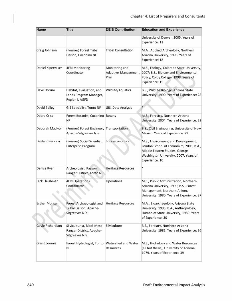
Chapter 4: List of Preparers and Consultants
840 Draft Environmental Impact Analysis
Name Title DEIS Contribution Education and Experience
University of Denver, 2005. Years of
Experience: 11
Craig Johnson (Former) Forest Tribal
Liaison, Coconino NF
Tribal Consultation M.A., Applied Archeology, Northern
Arizona University, 1998. Years of
Experience: 18
Daniel Kipervaser 4FRI Monitoring
Coordinator
Monitoring and
Adaptive Management
Plan
M.S., Ecology, Colorado State University,
2007; B.S., Biology and Environmental
Policy, Colby College, 1998. Years of
Experience: 15
Dave Dorum Habitat, Evaluation, and
Lands Program Manager,
Region I, AGFD
Wildlife/Aquatics B.S., Wildlife Biology, Arizona State
University, 1990. Years of Experience: 28
David Bailey GIS Specialist, Tonto NF GIS, Data Analysis *
Debra Crisp Forest Botanist, Coconino
NF
Botany M.S., Forestry, Northern Arizona
University, 2004. Years of Experience: 32
Deborah MacIvor (Former) Forest Engineer,
Apache-Sitgreaves NFs
Transportation B.S., Civil Engineering, University of New
Mexico. Years of Experience: 29
Delilah Jaworski (Former) Social Scientist,
Enterprise Program
Socioeconomics M.S., Environment and Development,
London School of Economics, 2008; B.A.,
Middle Eastern Studies, George
Washington University, 2007. Years of
Experience: 10
Denise Ryan Archeologist, Payson
Ranger District, Tonto NF
Heritage Resources *
Dick Fleishman 4FRI Operations
Coordinator
Operations M.S., Public Administration, Northern
Arizona University, 1990; B.S., Forest
Management, Northern Arizona
University, 1980. Years of Experience: 37
Esther Morgan Forest Archaeologist and
Tribal Liaison, Apache-
Sitgreaves NFs
Heritage Resources M.A., Bioarchaeology, Arizona State
University, 1995; B.A., Anthropology,
Humboldt State University, 1989. Years
of Experience: 30
Gayle Richardson Silviculturist, Black Mesa
Ranger District, Apache-
Sitgreaves NFs
Silviculture B.S., Forestry, Northern Arizona
University, 1981. Years of Experience: 36
Grant Loomis Forest Hydrologist, Tonto
NF
Watershed and Water
Resources
M.S., Hydrology and Water Resources
(all but thesis), University of Arizona,
1979. Years of Experience 39
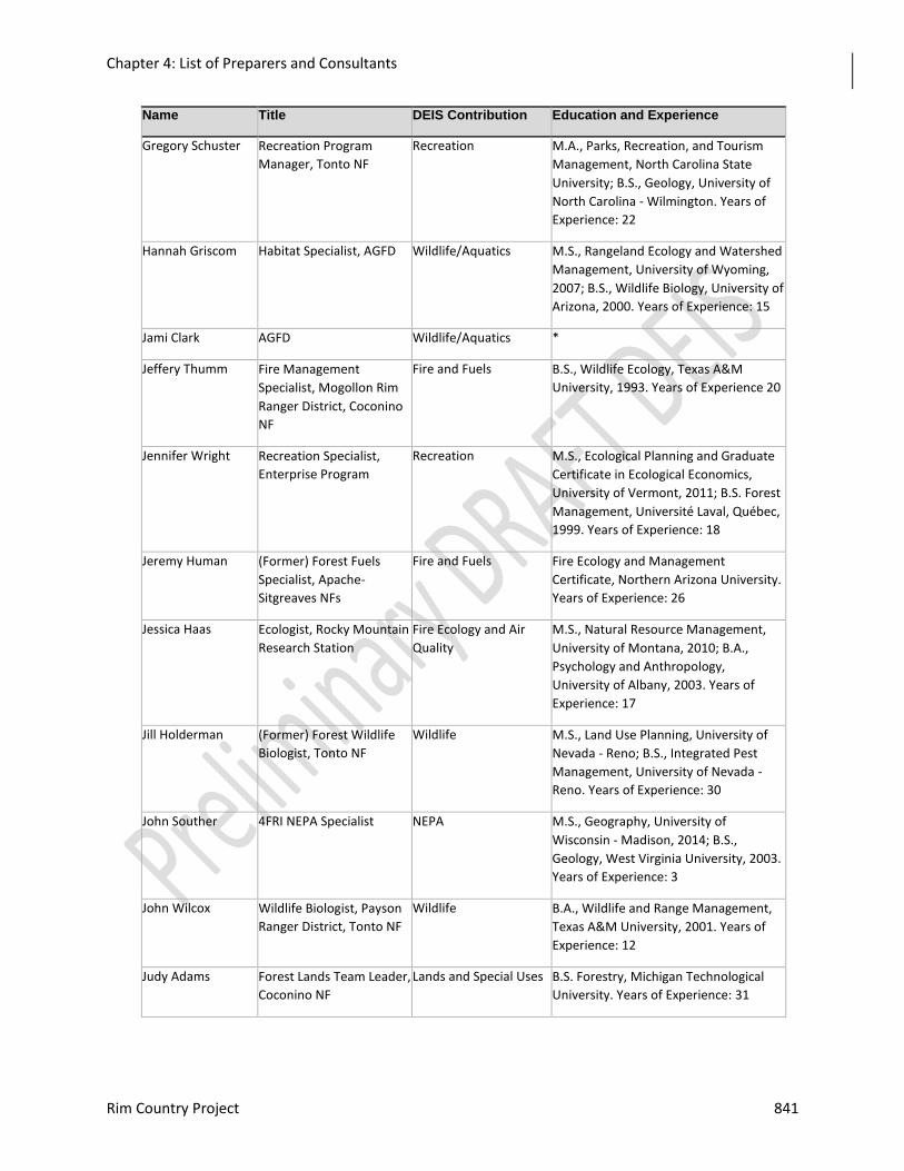
Chapter 4: List of Preparers and Consultants
Rim Country Project 841
Name Title DEIS Contribution Education and Experience
Gregory Schuster Recreation Program
Manager, Tonto NF
Recreation M.A., Parks, Recreation, and Tourism
Management, North Carolina State
University; B.S., Geology, University of
North Carolina - Wilmington. Years of
Experience: 22
Hannah Griscom Habitat Specialist, AGFD Wildlife/Aquatics M.S., Rangeland Ecology and Watershed
Management, University of Wyoming,
2007; B.S., Wildlife Biology, University of
Arizona, 2000. Years of Experience: 15
Jami Clark AGFD Wildlife/Aquatics *
Jeffery Thumm Fire Management
Specialist, Mogollon Rim
Ranger District, Coconino
NF
Fire and Fuels B.S., Wildlife Ecology, Texas A&M
University, 1993. Years of Experience 20
Jennifer Wright
Recreation Specialist,
Enterprise Program
Recreation M.S., Ecological Planning and Graduate
Certificate in Ecological Economics,
University of Vermont, 2011; B.S. Forest
Management, Université Laval, Québec,
1999. Years of Experience: 18
Jeremy Human (Former) Forest Fuels
Specialist, Apache-
Sitgreaves NFs
Fire and Fuels Fire Ecology and Management
Certificate, Northern Arizona University.
Years of Experience: 26
Jessica Haas Ecologist, Rocky Mountain
Research Station
Fire Ecology and Air
Quality
M.S., Natural Resource Management,
University of Montana, 2010; B.A.,
Psychology and Anthropology,
University of Albany, 2003. Years of
Experience: 17
Jill Holderman (Former) Forest Wildlife
Biologist, Tonto NF
Wildlife M.S., Land Use Planning, University of
Nevada - Reno; B.S., Integrated Pest
Management, University of Nevada -
Reno. Years of Experience: 30
John Souther 4FRI NEPA Specialist NEPA M.S., Geography, University of
Wisconsin - Madison, 2014; B.S.,
Geology, West Virginia University, 2003.
Years of Experience: 3
John Wilcox Wildlife Biologist, Payson
Ranger District, Tonto NF
Wildlife B.A., Wildlife and Range Management,
Texas A&M University, 2001. Years of
Experience: 12
Judy Adams Forest Lands Team Leader,
Coconino NF
Lands and Special Uses B.S. Forestry, Michigan Technological
University. Years of Experience: 31
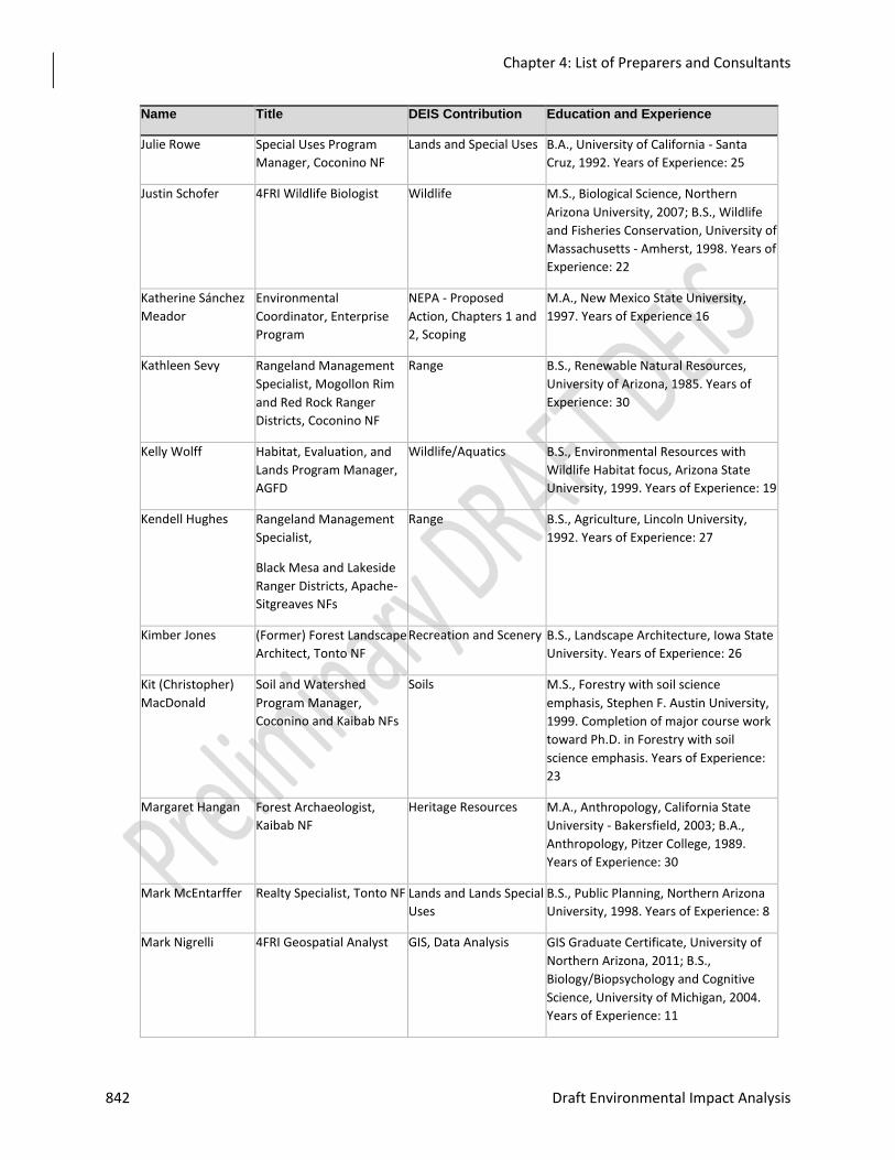
Chapter 4: List of Preparers and Consultants
842 Draft Environmental Impact Analysis
Name Title DEIS Contribution Education and Experience
Julie Rowe Special Uses Program
Manager, Coconino NF
Lands and Special Uses B.A., University of California - Santa
Cruz, 1992. Years of Experience: 25
Justin Schofer 4FRI Wildlife Biologist Wildlife M.S., Biological Science, Northern
Arizona University, 2007; B.S., Wildlife
and Fisheries Conservation, University of
Massachusetts - Amherst, 1998. Years of
Experience: 22
Katherine Sánchez
Meador
Environmental
Coordinator, Enterprise
Program
NEPA - Proposed
Action, Chapters 1 and
2, Scoping
M.A., New Mexico State University,
1997. Years of Experience 16
Kathleen Sevy Rangeland Management
Specialist, Mogollon Rim
and Red Rock Ranger
Districts, Coconino NF
Range B.S., Renewable Natural Resources,
University of Arizona, 1985. Years of
Experience: 30
Kelly Wolff Habitat, Evaluation, and
Lands Program Manager,
AGFD
Wildlife/Aquatics B.S., Environmental Resources with
Wildlife Habitat focus, Arizona State
University, 1999. Years of Experience: 19
Kendell Hughes Rangeland Management
Specialist,
Black Mesa and Lakeside
Ranger Districts, Apache-
Sitgreaves NFs
Range B.S., Agriculture, Lincoln University,
1992. Years of Experience: 27
Kimber Jones (Former) Forest Landscape
Architect, Tonto NF
Recreation and Scenery B.S., Landscape Architecture, Iowa State
University. Years of Experience: 26
Kit (Christopher)
MacDonald
Soil and Watershed
Program Manager,
Coconino and Kaibab NFs
Soils M.S., Forestry with soil science
emphasis, Stephen F. Austin University,
1999. Completion of major course work
toward Ph.D. in Forestry with soil
science emphasis. Years of Experience:
23
Margaret Hangan Forest Archaeologist,
Kaibab NF
Heritage Resources M.A., Anthropology, California State
University - Bakersfield, 2003; B.A.,
Anthropology, Pitzer College, 1989.
Years of Experience: 30
Mark McEntarffer Realty Specialist, Tonto NF Lands and Lands Special
Uses
B.S., Public Planning, Northern Arizona
University, 1998. Years of Experience: 8
Mark Nigrelli 4FRI Geospatial Analyst GIS, Data Analysis GIS Graduate Certificate, University of
Northern Arizona, 2011; B.S.,
Biology/Biopsychology and Cognitive
Science, University of Michigan, 2004.
Years of Experience: 11
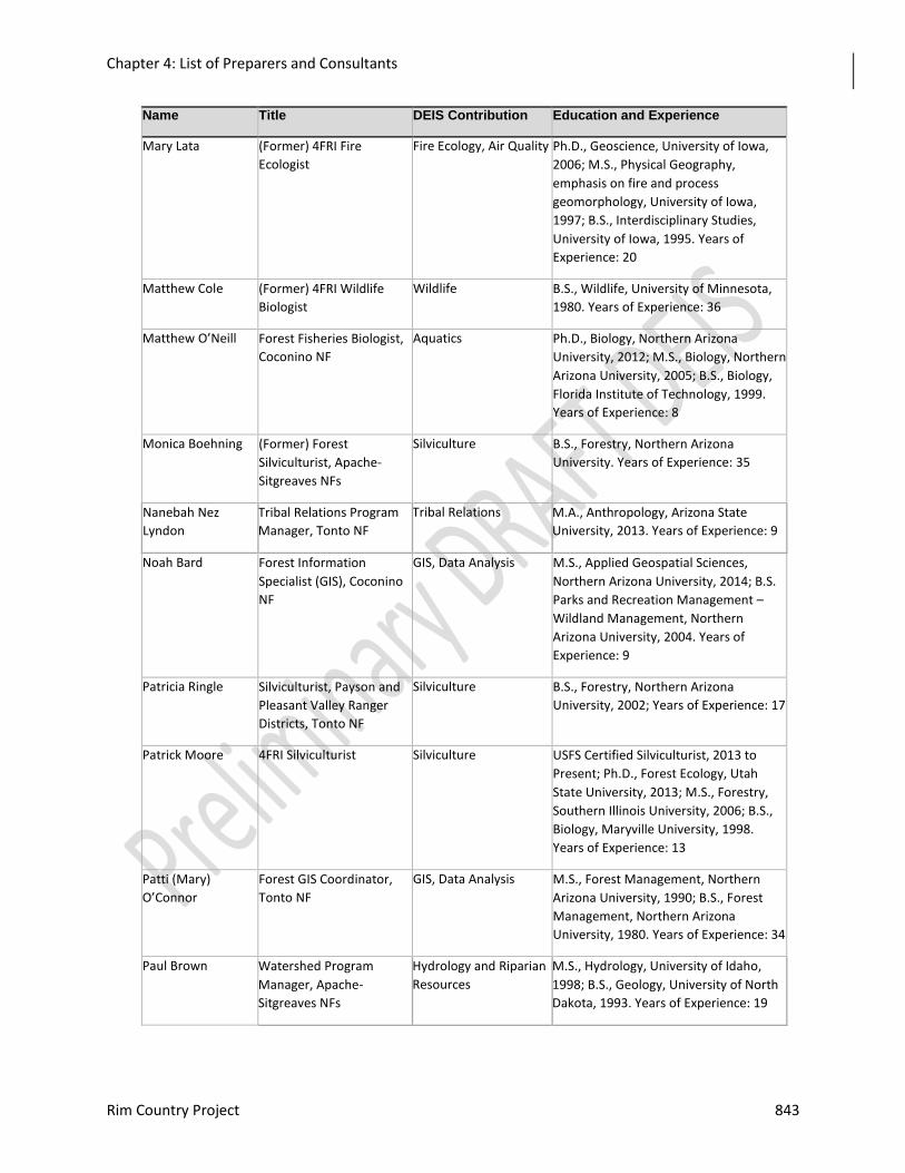
Chapter 4: List of Preparers and Consultants
Rim Country Project 843
Name Title DEIS Contribution Education and Experience
Mary Lata (Former) 4FRI Fire
Ecologist
Fire Ecology, Air Quality Ph.D., Geoscience, University of Iowa,
2006; M.S., Physical Geography,
emphasis on fire and process
geomorphology, University of Iowa,
1997; B.S., Interdisciplinary Studies,
University of Iowa, 1995. Years of
Experience: 20
Matthew Cole (Former) 4FRI Wildlife
Biologist
Wildlife B.S., Wildlife, University of Minnesota,
1980. Years of Experience: 36
Matthew O’Neill Forest Fisheries Biologist,
Coconino NF
Aquatics Ph.D., Biology, Northern Arizona
University, 2012; M.S., Biology, Northern
Arizona University, 2005; B.S., Biology,
Florida Institute of Technology, 1999.
Years of Experience: 8
Monica Boehning (Former) Forest
Silviculturist, Apache-
Sitgreaves NFs
Silviculture B.S., Forestry, Northern Arizona
University. Years of Experience: 35
Nanebah Nez
Lyndon
Tribal Relations Program
Manager, Tonto NF
Tribal Relations M.A., Anthropology, Arizona State
University, 2013. Years of Experience: 9
Noah Bard Forest Information
Specialist (GIS), Coconino
NF
GIS, Data Analysis M.S., Applied Geospatial Sciences,
Northern Arizona University, 2014; B.S.
Parks and Recreation Management –
Wildland Management, Northern
Arizona University, 2004. Years of
Experience: 9
Patricia Ringle Silviculturist, Payson and
Pleasant Valley Ranger
Districts, Tonto NF
Silviculture B.S., Forestry, Northern Arizona
University, 2002; Years of Experience: 17
Patrick Moore 4FRI Silviculturist Silviculture USFS Certified Silviculturist, 2013 to
Present; Ph.D., Forest Ecology, Utah
State University, 2013; M.S., Forestry,
Southern Illinois University, 2006; B.S.,
Biology, Maryville University, 1998.
Years of Experience: 13
Patti (Mary)
O’Connor
Forest GIS Coordinator,
Tonto NF
GIS, Data Analysis M.S., Forest Management, Northern
Arizona University, 1990; B.S., Forest
Management, Northern Arizona
University, 1980. Years of Experience: 34
Paul Brown Watershed Program
Manager, Apache-
Sitgreaves NFs
Hydrology and Riparian
Resources
M.S., Hydrology, University of Idaho,
1998; B.S., Geology, University of North
Dakota, 1993. Years of Experience: 19
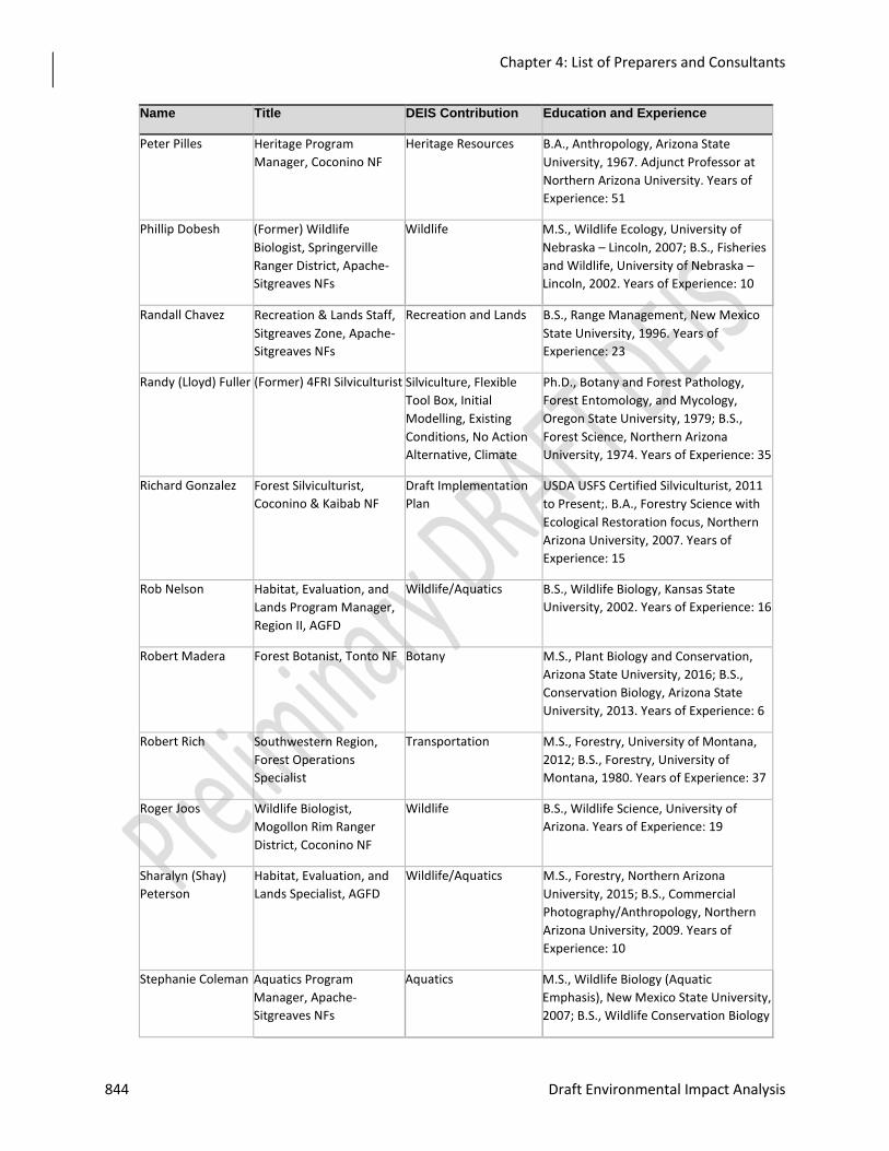
Chapter 4: List of Preparers and Consultants
844 Draft Environmental Impact Analysis
Name Title DEIS Contribution Education and Experience
Peter Pilles Heritage Program
Manager, Coconino NF
Heritage Resources B.A., Anthropology, Arizona State
University, 1967. Adjunct Professor at
Northern Arizona University. Years of
Experience: 51
Phillip Dobesh (Former) Wildlife
Biologist, Springerville
Ranger District, Apache-
Sitgreaves NFs
Wildlife M.S., Wildlife Ecology, University of
Nebraska – Lincoln, 2007; B.S., Fisheries
and Wildlife, University of Nebraska –
Lincoln, 2002. Years of Experience: 10
Randall Chavez Recreation & Lands Staff,
Sitgreaves Zone, Apache-
Sitgreaves NFs
Recreation and Lands B.S., Range Management, New Mexico
State University, 1996. Years of
Experience: 23
Randy (Lloyd) Fuller (Former) 4FRI Silviculturist Silviculture, Flexible
Tool Box, Initial
Modelling, Existing
Conditions, No Action
Alternative, Climate
Ph.D., Botany and Forest Pathology,
Forest Entomology, and Mycology,
Oregon State University, 1979; B.S.,
Forest Science, Northern Arizona
University, 1974. Years of Experience: 35
Richard Gonzalez Forest Silviculturist,
Coconino & Kaibab NF
Draft Implementation
Plan
USDA USFS Certified Silviculturist, 2011
to Present;. B.A., Forestry Science with
Ecological Restoration focus, Northern
Arizona University, 2007. Years of
Experience: 15
Rob Nelson Habitat, Evaluation, and
Lands Program Manager,
Region II, AGFD
Wildlife/Aquatics B.S., Wildlife Biology, Kansas State
University, 2002. Years of Experience: 16
Robert Madera Forest Botanist, Tonto NF Botany M.S., Plant Biology and Conservation,
Arizona State University, 2016; B.S.,
Conservation Biology, Arizona State
University, 2013. Years of Experience: 6
Robert Rich Southwestern Region,
Forest Operations
Specialist
Transportation M.S., Forestry, University of Montana,
2012; B.S., Forestry, University of
Montana, 1980. Years of Experience: 37
Roger Joos Wildlife Biologist,
Mogollon Rim Ranger
District, Coconino NF
Wildlife B.S., Wildlife Science, University of
Arizona. Years of Experience: 19
Sharalyn (Shay)
Peterson
Habitat, Evaluation, and
Lands Specialist, AGFD
Wildlife/Aquatics M.S., Forestry, Northern Arizona
University, 2015; B.S., Commercial
Photography/Anthropology, Northern
Arizona University, 2009. Years of
Experience: 10
Stephanie Coleman Aquatics Program
Manager, Apache-
Sitgreaves NFs
Aquatics M.S., Wildlife Biology (Aquatic
Emphasis), New Mexico State University,
2007; B.S., Wildlife Conservation Biology
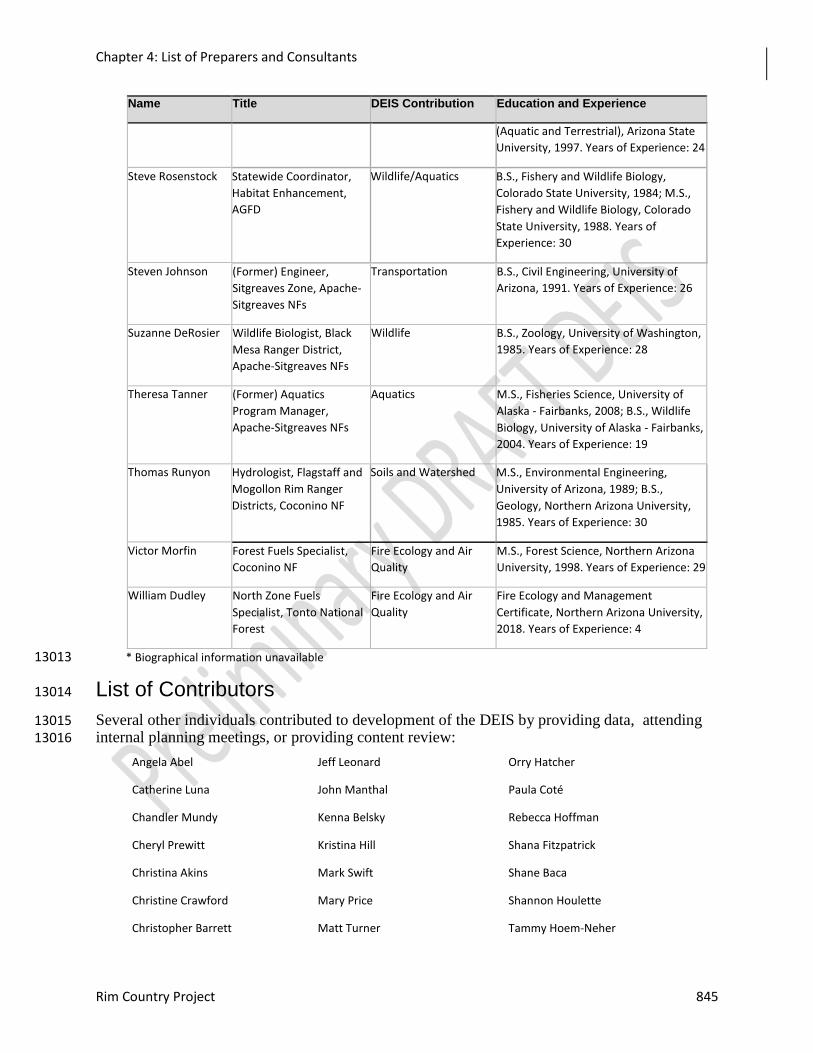
Chapter 4: List of Preparers and Consultants
Rim Country Project 845
Name Title DEIS Contribution Education and Experience
(Aquatic and Terrestrial), Arizona State
University, 1997. Years of Experience: 24
Steve Rosenstock Statewide Coordinator,
Habitat Enhancement,
AGFD
Wildlife/Aquatics B.S., Fishery and Wildlife Biology,
Colorado State University, 1984; M.S.,
Fishery and Wildlife Biology, Colorado
State University, 1988. Years of
Experience: 30
Steven Johnson (Former) Engineer,
Sitgreaves Zone, Apache-
Sitgreaves NFs
Transportation B.S., Civil Engineering, University of
Arizona, 1991. Years of Experience: 26
Suzanne DeRosier Wildlife Biologist, Black
Mesa Ranger District,
Apache-Sitgreaves NFs
Wildlife B.S., Zoology, University of Washington,
1985. Years of Experience: 28
Theresa Tanner (Former) Aquatics
Program Manager,
Apache-Sitgreaves NFs
Aquatics M.S., Fisheries Science, University of
Alaska - Fairbanks, 2008; B.S., Wildlife
Biology, University of Alaska - Fairbanks,
2004. Years of Experience: 19
Thomas Runyon Hydrologist, Flagstaff and
Mogollon Rim Ranger
Districts, Coconino NF
Soils and Watershed M.S., Environmental Engineering,
University of Arizona, 1989; B.S.,
Geology, Northern Arizona University,
1985. Years of Experience: 30
Victor Morfin Forest Fuels Specialist,
Coconino NF
Fire Ecology and Air
Quality
M.S., Forest Science, Northern Arizona
University, 1998. Years of Experience: 29
William Dudley North Zone Fuels
Specialist, Tonto National
Forest
Fire Ecology and Air
Quality
Fire Ecology and Management
Certificate, Northern Arizona University,
2018. Years of Experience: 4
* Biographical information unavailable 13013
List of Contributors 13014
Several other individuals contributed to development of the DEIS by providing data, attending 13015 internal planning meetings, or providing content review: 13016
Angela Abel Jeff Leonard Orry Hatcher
Catherine Luna John Manthal Paula Coté
Chandler Mundy Kenna Belsky Rebecca Hoffman
Cheryl Prewitt Kristina Hill Shana Fitzpatrick
Christina Akins Mark Swift Shane Baca
Christine Crawford Mary Price Shannon Houlette
Christopher Barrett Matt Turner Tammy Hoem-Neher

Chapter 4: List of Preparers and Consultants
846 Draft Environmental Impact Analysis
Christopher Miller Melanie Lawrence Thomas Greene
David Johnson Michael Martinez Timothy Gilloon
Dawnee Burson Mike Dechter Vernon Keller
13017
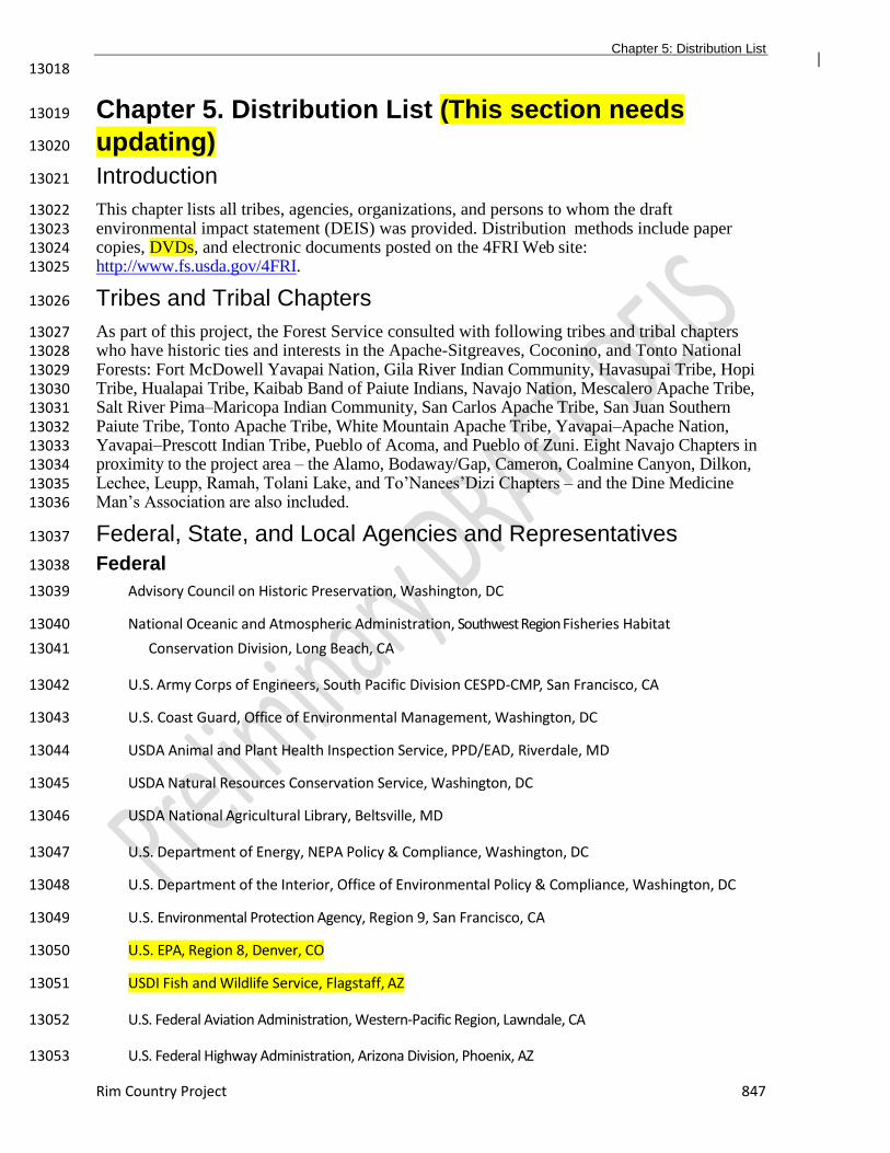
Chapter 5: Distribution List
Rim Country Project 847
13018
Chapter 5. Distribution List (This section needs 13019
updating) 13020
Introduction 13021
This chapter lists all tribes, agencies, organizations, and persons to whom the draft 13022 environmental impact statement (DEIS) was provided. Distribution methods include paper 13023 copies, DVDs, and electronic documents posted on the 4FRI Web site: 13024 http://www.fs.usda.gov/4FRI. 13025
Tribes and Tribal Chapters 13026
As part of this project, the Forest Service consulted with following tribes and tribal chapters 13027 who have historic ties and interests in the Apache-Sitgreaves, Coconino, and Tonto National 13028 Forests: Fort McDowell Yavapai Nation, Gila River Indian Community, Havasupai Tribe, Hopi 13029 Tribe, Hualapai Tribe, Kaibab Band of Paiute Indians, Navajo Nation, Mescalero Apache Tribe, 13030 Salt River Pima–Maricopa Indian Community, San Carlos Apache Tribe, San Juan Southern 13031 Paiute Tribe, Tonto Apache Tribe, White Mountain Apache Tribe, Yavapai–Apache Nation, 13032 Yavapai–Prescott Indian Tribe, Pueblo of Acoma, and Pueblo of Zuni. Eight Navajo Chapters in 13033 proximity to the project area – the Alamo, Bodaway/Gap, Cameron, Coalmine Canyon, Dilkon, 13034 Lechee, Leupp, Ramah, Tolani Lake, and To’Nanees’Dizi Chapters – and the Dine Medicine 13035 Man’s Association are also included. 13036
Federal, State, and Local Agencies and Representatives 13037
Federal 13038
Advisory Council on Historic Preservation, Washington, DC 13039
National Oceanic and Atmospheric Administration, Southwest Region Fisheries Habitat13040
Conservation Division, Long Beach, CA 13041
U.S. Army Corps of Engineers, South Pacific Division CESPD-CMP, San Francisco, CA 13042
U.S. Coast Guard, Office of Environmental Management, Washington, DC 13043
USDA Animal and Plant Health Inspection Service, PPD/EAD, Riverdale, MD 13044
USDA Natural Resources Conservation Service, Washington, DC 13045
USDA National Agricultural Library, Beltsville, MD 13046
U.S. Department of Energy, NEPA Policy & Compliance, Washington, DC 13047
U.S. Department of the Interior, Office of Environmental Policy & Compliance, Washington, DC 13048
U.S. Environmental Protection Agency, Region 9, San Francisco, CA 13049
U.S. EPA, Region 8, Denver, CO 13050
USDI Fish and Wildlife Service, Flagstaff, AZ 13051
U.S. Federal Aviation Administration, Western-Pacific Region, Lawndale, CA 13052
U.S. Federal Highway Administration, Arizona Division, Phoenix, AZ 13053
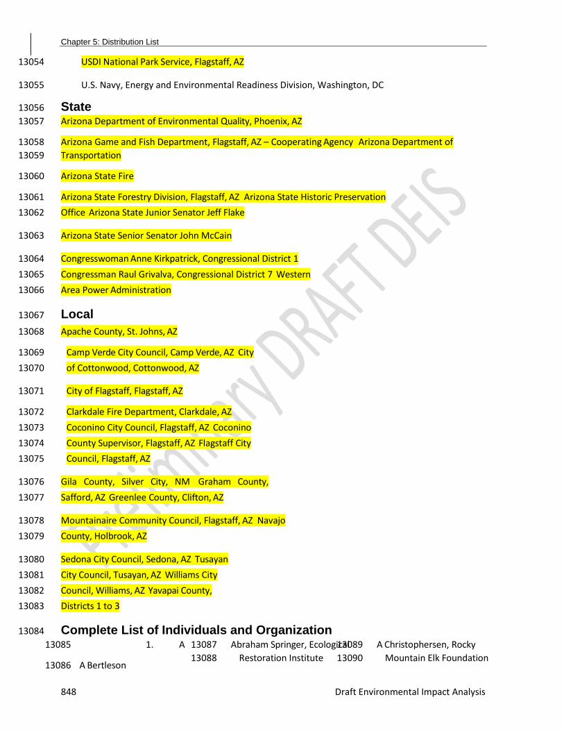
Chapter 5: Distribution List
848 Draft Environmental Impact Analysis
USDI National Park Service, Flagstaff, AZ 13054
U.S. Navy, Energy and Environmental Readiness Division, Washington, DC 13055
State 13056
Arizona Department of Environmental Quality, Phoenix, AZ 13057
Arizona Game and Fish Department, Flagstaff, AZ – Cooperating Agency Arizona Department of 13058
Transportation 13059
Arizona State Fire 13060
Arizona State Forestry Division, Flagstaff, AZ Arizona State Historic Preservation 13061
Office Arizona State Junior Senator Jeff Flake 13062
Arizona State Senior Senator John McCain 13063
Congresswoman Anne Kirkpatrick, Congressional District 1 13064
Congressman Raul Grivalva, Congressional District 7 Western 13065
Area Power Administration 13066
Local 13067
Apache County, St. Johns, AZ 13068
Camp Verde City Council, Camp Verde, AZ City 13069
of Cottonwood, Cottonwood, AZ 13070
City of Flagstaff, Flagstaff, AZ 13071
Clarkdale Fire Department, Clarkdale, AZ 13072
Coconino City Council, Flagstaff, AZ Coconino 13073
County Supervisor, Flagstaff, AZ Flagstaff City 13074
Council, Flagstaff, AZ 13075
Gila County, Silver City, NM Graham County, 13076
Safford, AZ Greenlee County, Clifton, AZ 13077
Mountainaire Community Council, Flagstaff, AZ Navajo 13078
County, Holbrook, AZ 13079
Sedona City Council, Sedona, AZ Tusayan 13080
City Council, Tusayan, AZ Williams City 13081
Council, Williams, AZ Yavapai County, 13082
Districts 1 to 3 13083
Complete List of Individuals and Organization 13084
1. A 13085
A Bertleson 13086
Abraham Springer, Ecological 13087
Restoration Institute 13088
A Christophersen, Rocky 13089
Mountain Elk Foundation 13090

Chapter 5: Distribution List
Rim Country Project 849
Adams 13091 Alan Anderson 13092
Allen 13093
Alicyn Gitlin, Sierra Club 13094
Amanda Rose 13095
Amy Larson 13096 Amy Waltz, Ecological 13097
Restoration Institute 13098
Andy Stahl Angela 13099
Culver 13100
Angela Loscalzo 13101
Anja Blat 13102
Annemarie Weibel 13103
Annie McMahon 13104
Ann Rogers 13105
Ann Steinhardt 13106
Antonia Lamb 13107
A Tobin 13108
Andrew Wilder 13109
Absolute Bikes 13110
Arianna Kukuk 13111
Areil Larsen 13112
Arthur Firstenberg 13113
Avelina Bardwell 13114
AZ Patty 13115
B 13116
Barbara Cook, AGFD 13117
PEP Barbara Warren 13118
Barry 13119
Hatfield B 13120
Burnside 13121
[email protected] 13122
Bethany Hicks 13123
Bettina Bickrel 13124
Bill Bunger 13125
B Chrisman Bill Gow 13126
Billie Hughes, Great Broads 13127
for Wilderness 13128
Bill Kusner 13129
Bob Lee Tree 13130
Service B Nargessi 13131
B Pribil, Coconino County Bob 13132
Taylor, Circle T Ranch Bowen 13133
Brad Busby, ADEQ Bren 13134
Bacon 13135
Brenda Burman, The Nature 13136
Conservancy 13137
Bryan Dykstra, USFS 13138
B Towler, Coconino County 13139
Bruce Buttrey, Camp Navajo 13140
Bruce Fox 13141
Bruce Greco, ERI Bruce 13142
Moehlman Bruce R. 13143
McCreary Bruce Rogers 13144
13145
2. C 13146
Caleb Laieski Cara 13147
Jablonsky Carol 13148
Parker Carolyn 13149
Beste Cate Moses 13150
Caylie De Souza 13151
Celina T. Ramirez 13152
Chad Hanson, John Muir 13153
Project of Earth Island 13154
Institute and Center for 13155
Biological Diversity 13156
Charles Strickfaden, National 13157
Park Service 13158
Charlie Ester, Salt River Project 13159
Charles Barnes 13160
Charles Warner Charly 13161
Drobeck Cheryl Welckle 13162
Chris Love 13163
Ching-Hsun Huang, 13164
Northern Arizona 13165
University 13166
Cindy Cole, Arizona Daily 13167
Sun 13168
C. Lee Beaty 13169
Clifford Provost 13170
Clint Chandler 13171
Clyde Rockwell 13172
Connie Gannon 13173
Craig Gibson 13174
Cutter Goode 13175
C Taylor, Coconino County 13176
D 13177
Danielle Bower 13178
Dave Asselin 13179
Dave Hendricks 13180
D Bartosh, City 13181
of 13182
Cottonwood Deborah Chase 13183
D Walker 13184
Dave Laplander 13185
Dale Kerkvliet, Rocky 13186
Mountain Elk Foundation 13187
Dave Dorum, Arizona Game 13188
and Fish Department 13189
David Eagan, Northern 13190
Arizona University 13191
David Gronlund 13192
Dave Mauer, US Forest 13193
Service 13194
David Huffman, Ecological 13195
Restoration Institute 13196
David Staub 13197
David Tenney, Navajo 13198
County Debbie Miley, NEFA 13199
Debby Lenz 13200
Debra 13201
Beckett 13202
Chapter 5: Distribution List
850 Draft Environmental Impact Analysis
Debrianna Mansini Forlano 13203
Denise Boggs, Conservation 13204
Congress 13205
Denise Williams 13206
Denise 13207
Romesburg 13208
Dennis Rayner 13209
Diana Lehan 13210
Diane Chung, NPS 13211
Diane Joens 13212
Diane Vosick, Ecological 13213
Restoration Institute 13214
Dick Artley 13215
Don Berry 13216
Don Steuter 13217
Dorothy Holasek 13218
Douglas Conwell 13219
Doug Pickrell 13220
Douglas Stewart 13221
Doug Van Gausig 13222
Duke Schoonmaker 13223
13224
3. E 13225
Ed Smith, The Nature 13226
Conservancy 13227
Elaine Pinckard 13228
Elizabeth Barris 13229
Elizabeth Millard 13230
Ellen Grossman 13231
Ellen Jesse 13232
Erik Nielson, Bellemont 13233
Homeowners Association 13234
Erik Ryberg, Western 13235
Watersheds Project 13236
Eryn Cook 13237
Ethan Aumack, Grand 13238
Canyon Trust 13239
4. F 13240
Four-Forest Restoration 13241
Initiative (4FRI) 13242
Stakeholders 13243
Frank Welsh 13244
Fred Amator 13245
Frederick Martinez 13246
Friends of Walnut 13247
Canyon 13248
5. G 13249
Gail Brooks Gari Basham 13250
Garrett Bennett Gary 13251
Beverly Gary Gumbel Gayle 13252
Mabery Gene Leach Glen 13253
Conway 13254
Glen Dickens, Arizona 13255
Antelope Foundation 13256
Greater Flagstaff Forest 13257
Partnership 13258
Gregory Terry 13259
Greg Preston 13260
Gurleen Singh, USDI Office of 13261
Environmental Policy and 13262
Compliance 13263
6. H 13264
H Ainardi 13265
Harrison Barritt 13266
H Hildebrand 13267
Hannah Telle 13268
Herb Hopper 13269
7. I 13270
Iris Smith 13271
8. J 13272
Jaina Moan James Fowler 13273
James Starkey 13274
James Weiss Jan Boyer 13275
Jane Odin 13276
Jay Lininger, Center for 13277
Biological Diversity 13278
JCH 13279
J Driscoll 13280
Jeff Williamson 13281
Jeremy Harrell 13282
Jennifer Page Jenny 13283
Roberts Jerry Payne 13284
Jessica Pyne Jill 13285
Rundall 13286
Jim and Glenda Reid Jim 13287
Hall 13288
J Keene J 13289
Moore 13290
J Nabours John 13291
Cain 13292
Johnathon Nez, Navajo 13293
County 13294
John DeLuca, John 13295
Davison 13296
John Drew, Graham County 13297
John Holmes 13298
John Ingold John 13299
Mitchell John 13300
Murphy John 13301
Rehrman John 13302
Ritchie John 13303
Ryberg Joseph 13304
Cardone Joseph 13305
Seals 13306
Joshua Hall, Arizona 13307
Department of 13308
Environmental Quality 13309
Judy Springer Jose 13310
Ineguez 13311
[email protected] June 13312
Curley 13313
Justina Boyle 13314
Chapter 5: Distribution List
Rim Country Project 851
9. K 13315
Karen Harwood Keith 13316
Lenard Karen 13317
Moskiman Karleen 13318
Vollherbst 13319
Kathleen Martyn Goforth, 13320
Environmental Protection 13321
Agency, Region IX 13322
Kathleen Smaluk-Nix 13323
Kathy Duke 13324
KE Gold 13325
Kelly Burke, Grand Canyon 13326
Wildlands Council 13327
Keith Pajkos 13328
K.E. Moore Kenny 13329
Schipper Kevin 13330
Boness K 13331
Hemenway Kim 13332
Caringer, Kim 13333
Crumbo Kit Metzger 13334
Korina Riggin K Ott 13335
Krista Coquia 13336
10. L 13337
Lance McMillon L 13338
Andreani Laura 13339
Clair 13340
L Archuleta Laurie 13341
Petersen Larry 13342
Stephenson L Fowler 13343
Leigh Kuwanwisiwma, The 13344
Hopi Tribe 13345
Leonard Baric Leonardo 13346
Alfonso Lina Clair 13347
Liz Hildebrand 13348
L Morales, Rio Radio Lorrie 13349
Dysart 13350
Louise Aubin Lucy 13351
Murfitt 13352
Lynda Locke, Coconino County 13353
11. M 13354
Margaret Watson 13355
Martha Williamson 13356
Mary McLean Mary 13357
Westcott Martha 13358
Winsten 13359
M. Hughes, Keystone Org. 13360
Mandy Metzger, Coconino 13361
County Marcus 13362
Selig Maricruz Lopez 13363
Marlyn Coy Mark 13364
Brehl 13365
Mark Herrington, Graham 13366
County 13367
Mark Herron 13368
Mark Sensibaugh, 13369
Northern Arizona 13370
University, Ecological 13371
Restoration Institute 13372
Marlin Johnson 13373
Marsha Honn-13374
Wiedle Mary Fish 13375
Mary Lou Fairweather 13376
Matt Ryan 13377
Matthew 13378
Stuckey Matt 13379
Williamson 13380
Melina Honn 13381
Merry 13382
Kuharksy M 13383
Hughes 13384
Michael Beste 13385
Michael 13386
Ghiglieri 13387
Michael 13388
Worsham 13389
Michelle 13390
Morris 13391
Michelle 13392
Richard 13393
Mike and Beth 13394
Talbot Mike Cooley 13395
Mike Lopker Mike Cooley Mike 13396
Lopker Mike Smith 13397
Mireya Landin-Erdei 13398
Monte Cook 13399
Mottek Consulting 13400
12. N 13401
Nancy Hilding 13402
Nancy Santori 13403
Nathan 13404
Sullenberger 13405
Nayda Cruz 13406
Nelson 13407
Nina 13408
Beety N 13409
Matiella 13410
13. P 13411
Pascal Berlioux, Eastern 13412
Arizona Counties 13413
Organization 13414
Pat Shaw Patrice Kerr 13415
Patricia Sanderson Port, 13416
USDI Office of 13417
Environmental Policy 13418
and Compliance 13419
Patrick Graham, The Nature 13420
Conservancy 13421
Pauline Wolf Paul 13422
Summerfelt 13423
Paul Whitefield, National Park 13424
Service – Wupatki, Sunset 13425
Crater, Walnut Canyon 13426
Chapter 5: Distribution List
852 Draft Environmental Impact Analysis
Penny Pew Pete Fule Pete 13427
Hancock 13428
P. Fisher, Gila County 13429
P. Hellenberg 13430
14. R 13431
Rael Nidess 13432
Ralph Baierlein, Friends of 13433
Northern Arizona Forests 13434
Randy Strom Reynold Thomas 13435
R Lunt 13436
Richard Causer Richard Welker 13437
Rich Libbey 13438
Rich Van Demark Rick Ermanz 13439
Ricky Thurman Rob Adams 13440
Rob Smith Robert Tohe Rocky 13441
Smith Rod Ross Ron Draxler 13442
Russell Winn, White Mountain 13443
Conservation League 13444
15. S 13445
Sally Blakemore 13446
Sandy Bahr, Sierra Club Scott 13447
Bushbaum 13448
Scott Harger, Coconino 13449
County NRCD 13450
Scott Hunt, Arizona State 13451
Forestry Division 13452
Scott Lerich Shane 13453
Cummings Sharon 13454
Cosentino 13455
Sharon Galbreath, Sierra 13456
Club Sharon Masek Lopez, 13457
Ecological Restoration 13458
Institute 13459
Sharon Wachsler Shastina 13460
Free Shawn Mccrohan 13461
Sheldon Krevit Shirley 13462
Cupani 13463
S Hurteau, The Nature 13464
Conservancy 13465
S Potts S Rose 13466
Stephen Campbell 13467
Stephanie Beninato 13468
Stephanie Hildreth 13469
Stephen Dewhurst, 13470
Northern Arizona, School 13471
of Earth Sciences and 13472
Environmental 13473
Sustainability 13474
Steve Clark, Arizona Elk 13475
Society 13476
Steve Gatewood, Greater 13477
Flagstaff Forest 13478
Partnership and 13479
Wildwood Consulting 13480
Steve Rosenstock, Arizona 13481
Game and Fish 13482
Department 13483
Steven 13484
Webber 13485
Sue Sitko 13486
Sun Cho Susan Decosse 13487
Susan Dietrich Susan 13488
Gunst Susan Mackay 13489
Steven Webber 13490
Susan 13491
Starcevich 13492
Suzy Burnside 13493
Steve Webber 13494
Sybil Smith, Arizona 13495
Department of 13496
Environmental Quality 13497
13498
T 13499
Taylor McKinnon, Center for 13500
Biological Diversity and 13501
Grand Canyon Trust 13502
Ed Wolff, Coconino County 13503
T Ernster 13504
Terre Ramirez Terry Inch 13505
Thelma Shaw Thomas 13506
Sisk Thomas Wolslegel 13507
Tim Bowden 13508
Tim Skarupa Todd 13509
Chaudry 13510
Todd Schulke, Center for 13511
Biological Diversity 13512
Tom Blondell Tom 13513
Finholt Tom Mackin 13514
Tom McGuire 13515
Tommie Cline Martin, Gila 13516
County 13517
Tom White, Apache County 13518
16. U 13519
USA Citizen 1 13520
17. V 13521
Valerie Horncastle 13522
18. W 13523
Wallace Covington, Northern 13524
Arizona University 13525
Ecological Restoration 13526
Institute 13527
Wendy LeStarge 13528
Wili Gavin 13529
19. Y 13530
Yolanda Sanchez 13531
Yvonne Pearson, Greenlee 13532
County13533

Chapter 5: Distribution List
Rim Country Project 853
13534

Appendix F: Glossary
854 Draft Environmental Impact Analysis
13535
13536