summarizing textual information about locations - cmu
TRANSCRIPT
Summarizing Textual Information about LocationsCongxing Cai, Eduard Hovy
{ ccai, hovy}@isi.eduInformation Science Institute
University of Southern CaliforniaMarina del Rey, California, USA 90292-6695
ABSTRACTThis paper describes the summarization of textual material aboutlocations in the context of a geo-spatial information display sys-tem. Both structured data and unstructured web pages are linkedto maps. When the amount of associated textual data is large, itis organized and summarized before display. A hierarchical sum-marization framework, conditioned on the small space available fordisplay, has been fully implemented. A case study is conducted ona fully implemented system to show how users interact with text inan integration context. Eye-tracking results are presented to illus-trate and verify the observations in case study.
1. INTRODUCTIONGeospatial display systems are increasingly gaining attention,
given the large amounts of geospatial data and services1 availableonline that provide images and maps of various regions. In theprocess of conflation (aligning different geospatial datasets, suchas street maps and other geospatial imagery), the imagery may re-quire some alteration from the original satellite photo to ensure ithas the geometric properties of a map [5]). Still, although geospa-tial imagery and maps show geometric relations among entities,they cannot be used to present other kinds of knowledge about thetemporal, topic, and other conceptual relations and entities. Givenan entity on a map, a description of what happened there, in whatorder in time, when, and why, requires additional types of informa-tion, typically contained in text (both in structured form, such astables and lists, and in unstructured free form), in order to supportvaried search and decision tasks.
In this paper, we describe the integration of maps and geospatialimages with potentially large amounts of textual data, and the waysone can organize this material for optimal display. Since much tex-tual data on the web is geographically specific or geo-referenced(containing place names, addresses, real objects with geographi-cal features, etc.), such resources can be treated as a large geospa-tial database, ready for integration with both static geospatial im-agery and dynamically growing information. Effective solutions to1The National Map, ESRI, Map Service, MapQuest, Google MapService etc. [5]
Permission to make digital or hard copies of all or part of this work forpersonal or classroom use is granted without fee provided that copies arenot made or distributed for profit or commercial advantage and that copiesbear this notice and the full citation on the first page. To copy otherwise, torepublish, to post on servers or to redistribute to lists, requires prior specificpermission and/or a fee.Copyright 20XX ACM X-XXXXX-XX-X/XX/XX ...$10.00.
multi-modal integration and display desiderata will benefit a vari-ety of applications, including Intelligent Geographic Search (IGS)and Complex Decision Support (CDS), for example:
IGS: Geospatial search systems are quite popular on the webnowadays, and include Google Map, Google Earth, etc. Users canissue a location name or an exact address to locate the place on themap. Efforts are also spent to link the place to the web by jumpingto a general web search page2. However, with the help of integratedtext data, more intelligent queries like “MJ’s memorial ceremonyplace in LA" can be supported, even when it requires additionalknowledge from web resources.
CDS: Geospatial systems are often used as decision support toolsfor business and other analysis tasks. Business decisions are madebased on the collection and integration of multiple kinds of dataabout some area, including market reports, salary distribution, lo-cal activities and big events, etc. An integrated display offeringdifferent types of data can speed up decision processes.
1.1 ChallengesOf the many different types of text-oriented resources available
online, some are structured (e.g., yellow pages or business catalogsextracted from the web), and others unstructured (e.g., news sto-ries, blogs, etc). Some of them can be geocoded accurately, such asbusiness catalogs; others cannot, although they may be geographi-cally specific in some aspects. For example, a news story may referto an event at some location, or introduce a place with its historyand important people. Appropriately linking the specific aspect ofthe textual information to the exactly relevant pixel of geospatialimage is a challenging task.
A second challenge stems from the huge amounts and diversityof web material related to some geographical objects. For example,one may find millions of pages for a famous place or event at aspecific map location. To textually elaborate the imagery and mapseffectively, instead of simply importing masses of data, one hasto organize and summarize the textual information concisely andrelevantly. And given the common limitations of display space inmost geospatial display systems, one must also design the interfaceto support dynamic browsing and search.
1.2 ContributionsIn this paper, we introduce a hierarchical summarization system
to organize and present large amounts of text data in GeoXray3 anintegrated geo-spatial information system. A case study is con-ducted to learn how users interact with the text (summaries at dif-ferent levels) in an integration context. Observations are furtherillustrated in a preliminary eye-tracking experiment. The work de-
2Google Map, http://maps.google.com3A product developed by GeoSemble Inc.

scribed in this paper makes the following contributions:
1. a hierarchical summarization framework to reduce displayedtext and fully utilize the small display space available for tex-tual information,
2. summarization of news pages to present both informationabout the location and the relation between the news and thelocation,
3. demonstration of a real integrated geospatial/text display sys-tem deployed on the business domain,
4. a case study to show how users interact with text in an inte-gration context
5. eye-tracking experiments illustrate and verify the findings incase study
The remainder of the paper is organized as follows. Section 2describes the related work. Section 3 proposes a hierarchical sum-marization framework to enable organization and presentation ofthe linked web page content. Section 4 demonstrates our designof the integrated geospatial system to support search and browsing.Section 5 presents various evaluations of the system, and analyzesthe evaluation results. Section 6 concludes with future plans.
2. RELATED WORK
2.1 Problems to be addressedMost existing multimodal geospatial/text display systems [19, 6]
present news based on geographical region by identifying the loca-tion mentioned in the news, aggregating the news found, and dis-playing the results over a map interface. [19] identifies the locationsmentioned in text using Natural Language Processing (NLP) tech-niques and then employes a gazetteer list to identify the locationfocus of each location. However, this method usually applies onlyat the area level, such as city or suburb presented in [19]; it cannotbe used to annotate specific features (buidlings, etc.) in satelliteimages. The problem of smaller granularity requires more-focusedgeoreference.
A second problem relates to scale. Associating each news pageindividually to its location(s) may overwhelm the amount of infor-mation displayable at any point and thereby limit the scalability ofthe system. Since frequently the associated news contents overlapat least in part, a natural solution is to aggregate the content some-how to remove duplication. A fairly common solution, exemplifiedin [19] and GeoTracker [6], organizes material (at the area level)by time instead of somehow aggregating over larger numbers ofrelated content.
The system described in this paper integrates geospatial imagerywith both structured web data and unstructured news pages rightdown to the level of individual buildings. It includes technologyfor text clustering and summarization. It supports keyword searchover the text collections. Taken overall, the system provides a moreintegrated view of the imagery, with associated complex searchand decision functionality over the text as well. The geospatialmanagement and display component of our system is developed byGeoSemble Inc.
2.2 Clustering and Summarizing TextWithin geospatial display systems, the space for textual infor-
mation is often quite limited. We therefore need to summarizethe most important and relevant information about each location,
drawing from all the web pages linked to it. When several differentevents have occurred at a location, more than one distinct summarymay be needed. It is therefore important to deploy topic recognition[23, 1, 4] and/or topic clustering [18] to identify and group relevantpieces of each text into single-topic ‘chunks’.
However, given the complexity of many geographic objects, theremay be numerous quite different types of associated structured andunstructured information. For example, text pages may be linkedto City Hall for a number of reasons. Some pages may providethe history of City Hall as a building; others may describe eventsoccurring there; others may describe its operation as a civic orga-nization. Users typically want to understand the reason a page islinked to an object. Hence it is necessary to provide more than just(simple summaries of) the page contents. It is also necessary tosummarize the linking itself, supporting queries like “MJ’s memo-rial places", “fun places in Culver City", etc. Little research hasbeen devoted to this problem to date, although some related workcan be found in generating link snippets for web search results [20,11]. The common strategy (adopted by web search engines, forexample) of generating a snippet for each search result by extract-ing a document fragment that contains the keywords along with thesurrounding texts as a ‘summary’ does not work, given the limitedspace in our system. We need to generate smaller snippets and bemore descriptive about the linking.
In our system, all topics and events are detected from the textualinformation associated with each location. All relevant pages arethen clustered based on the topic. Then ‘topic signatures’ [13] canbe used as top-level summary for each event associated with thelocation, and displayed at various levels of elaboration. We discussour approach in more detail below.
3. TEXT SUMMARIZATION
3.1 Content Extraction and SegmentationMulti-webpage summarization is different from traditional multi-
document summarization. First, most web pages are much morecomplex than pure text documents. Additional information, includ-ing layout and multimedia sources, and more noise, such as adver-tisements and additional information, all add unnecessary distrac-tion. Since the web contains a combination of types of information—static text, image, videos, dynamic layout, etc.—even a single pagecan be treated as multiple documents. Current search functions arebased on keywords, making the relevant content of each relevantweb page only a limited block within the page. Second, our task isoriented to locations, and hence differs from general content sum-marization. Hence, we need to identify and extract the essentialpart(s) of the webpage linked to the geospatial imagery for summa-rization and display. In our work, we utilize two important features,layout and semantics, to identify and extract the relevant content.
By rendering each web page into a DOM4 tree, it is relativelyeasy to segment the page into large blocks based on its layout,including header, footer, left bar, right bar, advertisements, mainblock, etc. We implemented a rule-based extractor to extract themost relevant block from the web page. However, the layout fea-tures can only be used to separate major blocks without semanticsegmentation. Getting the smaller blocks, such as figure headings,right is very hard, and we know of no satisfactory solution.
3.2 ClusteringGiven a list of text blocks relevant to a local point of interest, one
can employ traditional text summarization techniques [15, 14, 13]
4http://www.w3.org/TR/DOM-Level-2-Core/introduction.html
to produce a short summary for each one. This solution may notbe helpful, however, since a long list of pages associated with eachpoint of interest would be very hard for users to browse. Especiallywhen the space allocated to text display by the geospatial system isalso limited, a high compression ratio is typically required for thesummarization system.
The solution we adopt is to deploy cluster-based multi-documentsummarization [8, 13]. Clustering must observe two criteria: first,the location of interest, and second, the text topic. (Clustering textsfirst by topic and then displaying for each topic all its relevant lo-cations over an area is also of course possible, but requires a radi-cally different display and interaction strategy.) Different clusteringmethods can be employed. To delimit topics, a simple heuristic isto introduce as additional criterion the event/article date: when thedifference in document dates within a topical cluster is (far) largerthan the actual duration of the topic event, we are probably dealingwith multiple separate events at the same location. Better perfor-mance is obtained by using a topic and event detection module first,and then clustering documents based on the topics identified [18,13].
Unfortunately, documents usually contain multiple locations andmultiple topics. A single document may pertain to several differ-ent events (it is not unusual, for example, for a news article abouta robbery to refer to previous robberies at the same location). Theproblem of ‘topic drift’ can cause confusion in a short summary.One approach is to segment each document into one or more ‘mini-documents’, each one devoted to a single topic, and then to per-form location- and topic-based clustering over the (now larger) setof mini-documents. Several NLP techniques are available to per-form such segmentation, including Latent Dirichlet Allocation [3],which, given a set of documents, simultaneously identifies the prin-cipal clusters of topics (word collections) and computes for eachdocument the (set of) cluster(s) it ‘belongs to’.
For the system, we deployed existing text segmentation tech-niques [10, 21] to convert the text block(s) extracted for each pageinto a list of paragraphs, each devoted to a single topic. The para-graphs are then selected based on their relevance to the cluster topicand local interest in question and are treated as independent mini-documents for summarization.
3.3 Hierarchical Summary GenerationTo generate a summary, there are primarily two types of models:
extraction and abstraction. In the extraction model, each sentencein the text(s) is assigned a score for each of several features. TheNsentence(s) with the highest merged scores are extracted, arranged,compressed, and returned as summary. These features typically in-clude the presence of certain cue phrases, the absence of certainpenalty phrases, the position of the sentence in the text, the pres-ence of headline words in the sentence, and so on [15, 14, 13]. [2]considers generating query relevant summaries by combining twotypes of scores: relevance to the query and fidelity to represent theoriginal documents. In contrast, the abstraction model produces thesummary by “translating" the text into a more concise formulation.The summary is computed as the product of the likelihood of (i)the terms selected for the summary, (ii) the length of the resultingsummary, and (iii) the most likely sequencing of the terms in thecontent set. The extraction model cannot generate short summarieslike headlines, but the abstraction model requires large amounts oftraining data.
Whatever the clustering approach, the result is a potentially ratherlarge set of individual topics associated with each location. Sincescreen space for the summaries may be very limited next to themaps / imagery, they have to be formatted and presented for maxi-
mal interpretability and browsability. To address this problem, weadopt a hierarchical structure to display incrementally longer sum-maries for each location of interest. At present we have found threelevels of incrementally longer summaries to be most useful. Thishierarchical structure can help users find and select the materials ofinterest quickly, even within very limited display space.
Thumbnail: a very short ‘summary’ that characterizes the (clus-ters of) documents or segments associated with each location. Wepresent essentially one or two single keywords — the most infor-mative words for each cluster. We implemented a new version ofour topic signature technology [13], one that uses tf.idf instead ofthe entropy ratio λ, as scoring measure to rank each cluster’s words.
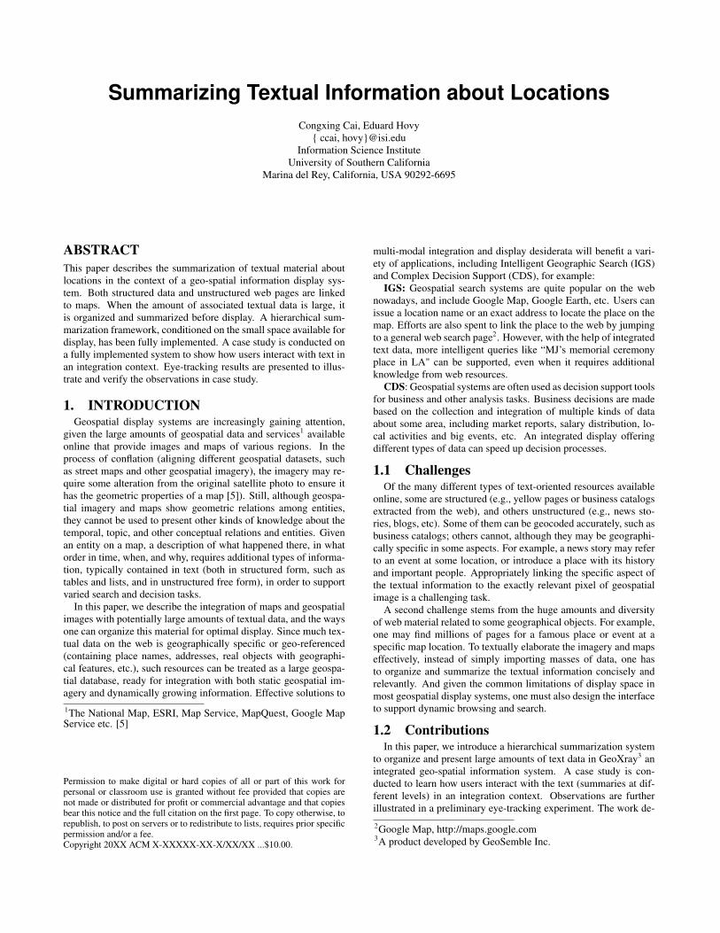
Title: a headline-length phrase or short sentence (or two). Theoriginal titles of the web pages are often noisy or even unrelated tothe current topic cluster (mostly when the cluster is not the principaltopic of the document). Sometimes, the title may be meaningless (itmight for example contain the website’s name “Pr Newswire"), ortwo different web pages may share the same title as shown in Figure1. We implemented a topic-related headline generator based on ourprevious work [22] by incorporating a topic-based selector [2].
Snippet: a paragraph-length excerpt characterizing the clus-ter. To produce paragraph-length summaries, we implemented anextraction-based text summarizer. We built a new version of previ-ously investigated technology [14], implementing several sentencescoring techniques and a score combination function. In addition,since high-rated sentences may be extracted from the middle of adocument, we investigated the need in this domain for includingso-called ‘introducer segments’ that may be rated lower but thatare required to establish the context (by for example providing thenames of people, organizations, and places).
Figure 1: Original Titles of Web Pages
Unfortunately directly applying these summary techniques to webpages often produces unreadable summaries. Unlike coherent text,web pages are often more like a loose combination of different seg-ments. Also, each web page may be linked to the location for dif-ferent reasons. Hence, identifying the location-related segmentsand eliminating unnecessary noise is essential to the success of thesystem. This is a topic of ongoing research.
3.4 Summarizing the LinkingA web page can be linked to a location of interest for various
reasons. For example, an online food review may be linked to therestaurant it reviews, to another location which is the author’s con-tact address, and even to a third that provides other restaurants ofthe same chain or the same chef. Different user interests and taskswill require different (types of) linkage. We must therefore sum-marize the relation between the web page and the interest in theimagery. Hence, neither the most representative summary of thetext nor the most relevant summary for the interest is enough. Inorder to capture the reason why this web page is linked to the in-terest, we need to capture the discourse structure between the maintopic of the news (which necessitated mentioning the location) andthe current specific topic of interest to the user.
Inferring from the text the semantic relationship between the textand each location it is linked to is in general beyond the scope ofNLP, and certainly beyond the scope of this paper. But we can getpartway there by providing:
• the principal initial topic of the text,
• the user’s interest / topic,
• the location and its role in the text.
From these three facts, the user may be able to infer the reasonhim- or herself.
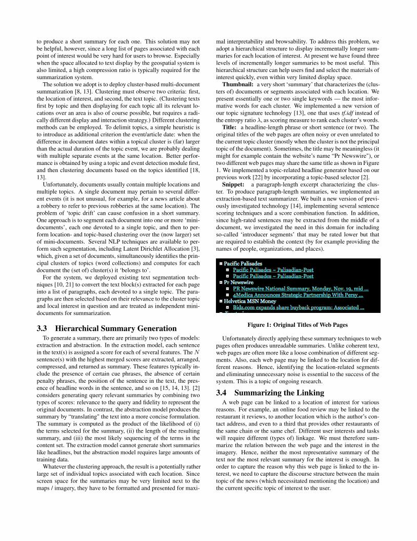
To achieve this, we first use the extraction model to find boththe sentence most representative of the current text and the sen-tence most relevant to the query. Assuming the original text itselfis drafted in a coherent way, the text segment between these twosentences should be informative enough to express the relation(s)between them, and hence between the topic of the text and the cur-rent topic of interest. (Ideally, a discourse-level abstract would beused to provide the relation, as illustrated in [17].) In our work, weemploy the introducer segments [15] to generate a discourse-levelabstract for the linking as shown in Figure 2.
Figure 2: The Summary of Linkings
This type of linkage summary can be also useful in supporting in-telligent geographic search, such as “MJ’s memorial places", “greatrestaurants in Culver City", etc. These queries cannot be handleddirectly by searching through the business knowledge bases. Butthey can be issued to the text collection using IR techniques. Theresults are linked back into the geospatial imagery, and these pointsof interest on the imagery identify all relevant result pages, includ-ing perhaps ones not initially found by the IR query. A short sum-mary can be generated from the linked pages and associated to eachitem of interest, for example “Michael Jackson’s funeral memorialservice place Staples Center Los Angeles", “Culver City’s restau-rant row gained yet another hip eatery when the new M Cafe deChaya lifted its plywood and opened its doors on Sunday", etc.Such summaries provide a quick description of these locations andhelp users find their targets quickly. We do not address geographi-cal queries here; this topic is left for future work.
4. SYSTEM DEMONSTRATIONIn this section, we describe our design of the integrated system
and demonstrate it.
4.1 Geospatial Interaction
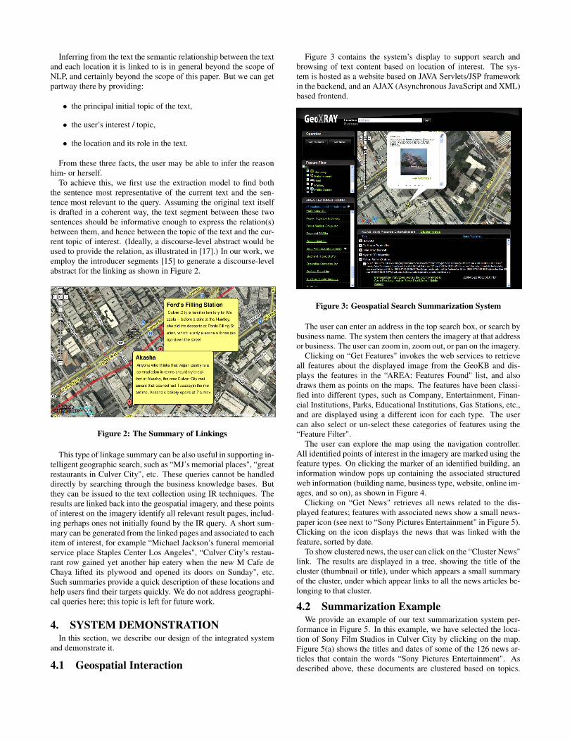
Figure 3 contains the system’s display to support search andbrowsing of text content based on location of interest. The sys-tem is hosted as a website based on JAVA Servlets/JSP frameworkin the backend, and an AJAX (Asynchronous JavaScript and XML)based frontend.
Figure 3: Geospatial Search Summarization System
The user can enter an address in the top search box, or search bybusiness name. The system then centers the imagery at that addressor business. The user can zoom in, zoom out, or pan on the imagery.
Clicking on “Get Features" invokes the web services to retrieveall features about the displayed image from the GeoKB and dis-plays the features in the “AREA: Features Found" list, and alsodraws them as points on the maps. The features have been classi-fied into different types, such as Company, Entertainment, Finan-cial Institutions, Parks, Educational Institutions, Gas Stations, etc.,and are displayed using a different icon for each type. The usercan also select or un-select these categories of features using the“Feature Filter".
The user can explore the map using the navigation controller.All identified points of interest in the imagery are marked using thefeature types. On clicking the marker of an identified building, aninformation window pops up containing the associated structuredweb information (building name, business type, website, online im-ages, and so on), as shown in Figure 4.
Clicking on “Get News" retrieves all news related to the dis-played features; features with associated news show a small news-paper icon (see next to “Sony Pictures Entertainment" in Figure 5).Clicking on the icon displays the news that was linked with thefeature, sorted by date.
To show clustered news, the user can click on the “Cluster News"link. The results are displayed in a tree, showing the title of thecluster (thumbnail or title), under which appears a small summaryof the cluster, under which appear links to all the news articles be-longing to that cluster.
4.2 Summarization ExampleWe provide an example of our text summarization system per-
formance in Figure 5. In this example, we have selected the loca-tion of Sony Film Studios in Culver City by clicking on the map.Figure 5(a) shows the titles and dates of some of the 126 news ar-ticles that contain the words “Sony Pictures Entertainment". Asdescribed above, these documents are clustered based on topics.
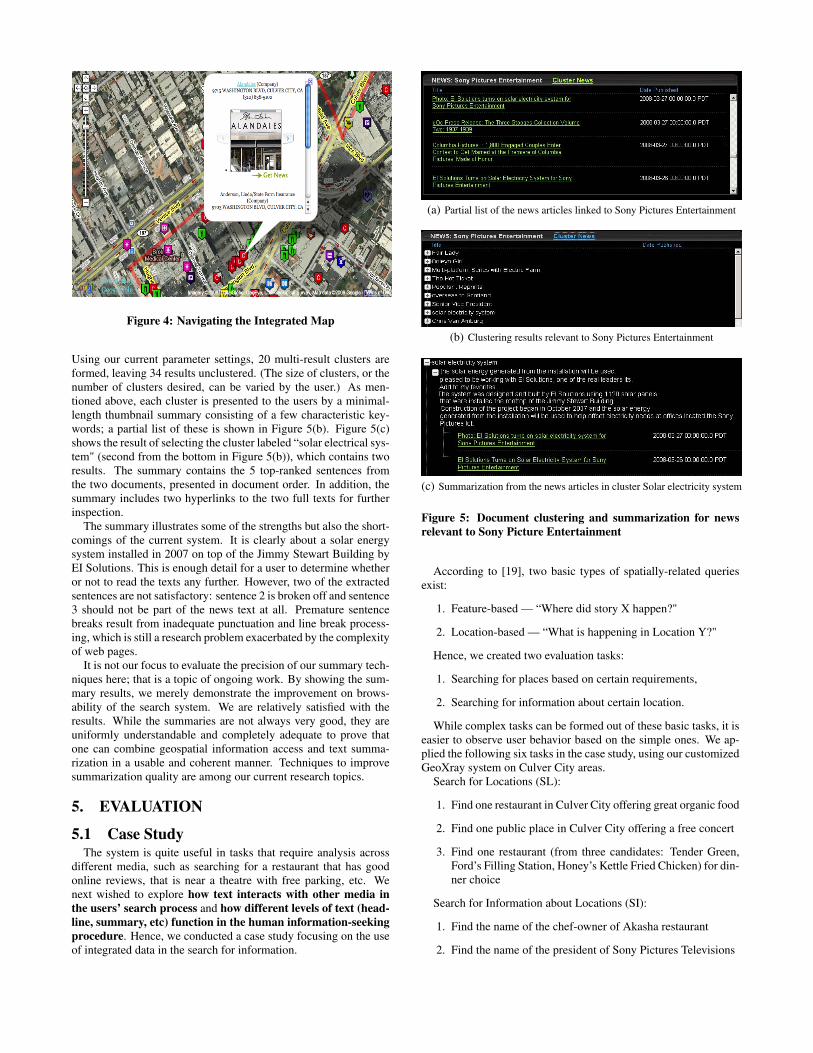
Figure 4: Navigating the Integrated Map
Using our current parameter settings, 20 multi-result clusters areformed, leaving 34 results unclustered. (The size of clusters, or thenumber of clusters desired, can be varied by the user.) As men-tioned above, each cluster is presented to the users by a minimal-length thumbnail summary consisting of a few characteristic key-words; a partial list of these is shown in Figure 5(b). Figure 5(c)shows the result of selecting the cluster labeled “solar electrical sys-tem" (second from the bottom in Figure 5(b)), which contains tworesults. The summary contains the 5 top-ranked sentences fromthe two documents, presented in document order. In addition, thesummary includes two hyperlinks to the two full texts for furtherinspection.
The summary illustrates some of the strengths but also the short-comings of the current system. It is clearly about a solar energysystem installed in 2007 on top of the Jimmy Stewart Building byEI Solutions. This is enough detail for a user to determine whetheror not to read the texts any further. However, two of the extractedsentences are not satisfactory: sentence 2 is broken off and sentence3 should not be part of the news text at all. Premature sentencebreaks result from inadequate punctuation and line break process-ing, which is still a research problem exacerbated by the complexityof web pages.
It is not our focus to evaluate the precision of our summary tech-niques here; that is a topic of ongoing work. By showing the sum-mary results, we merely demonstrate the improvement on brows-ability of the search system. We are relatively satisfied with theresults. While the summaries are not always very good, they areuniformly understandable and completely adequate to prove thatone can combine geospatial information access and text summa-rization in a usable and coherent manner. Techniques to improvesummarization quality are among our current research topics.
5. EVALUATION
5.1 Case StudyThe system is quite useful in tasks that require analysis across
different media, such as searching for a restaurant that has goodonline reviews, that is near a theatre with free parking, etc. Wenext wished to explore how text interacts with other media inthe users’ search process and how different levels of text (head-line, summary, etc) function in the human information-seekingprocedure. Hence, we conducted a case study focusing on the useof integrated data in the search for information.
(a) Partial list of the news articles linked to Sony Pictures Entertainment
(b) Clustering results relevant to Sony Pictures Entertainment
(c) Summarization from the news articles in cluster Solar electricity system
Figure 5: Document clustering and summarization for newsrelevant to Sony Picture Entertainment
According to [19], two basic types of spatially-related queriesexist:
1. Feature-based — “Where did story X happen?"
2. Location-based — “What is happening in Location Y?"
Hence, we created two evaluation tasks:
1. Searching for places based on certain requirements,
2. Searching for information about certain location.
While complex tasks can be formed out of these basic tasks, it iseasier to observe user behavior based on the simple ones. We ap-plied the following six tasks in the case study, using our customizedGeoXray system on Culver City areas.
Search for Locations (SL):
1. Find one restaurant in Culver City offering great organic food
2. Find one public place in Culver City offering a free concert
3. Find one restaurant (from three candidates: Tender Green,Ford’s Filling Station, Honey’s Kettle Fried Chicken) for din-ner choice
Search for Information about Locations (SI):
1. Find the name of the chef-owner of Akasha restaurant
2. Find the name of the president of Sony Pictures Televisions
3. Find the name of the Indian art event at Western Project
Ten graduate students with similar background performed thecase study. We compared their behaviors on three different sys-tems: one pure text search system with summarization5 (TSSM),one integrated geospatial search system without summarization (GS),and one integrated geospatial search system with summarization(GSSM).
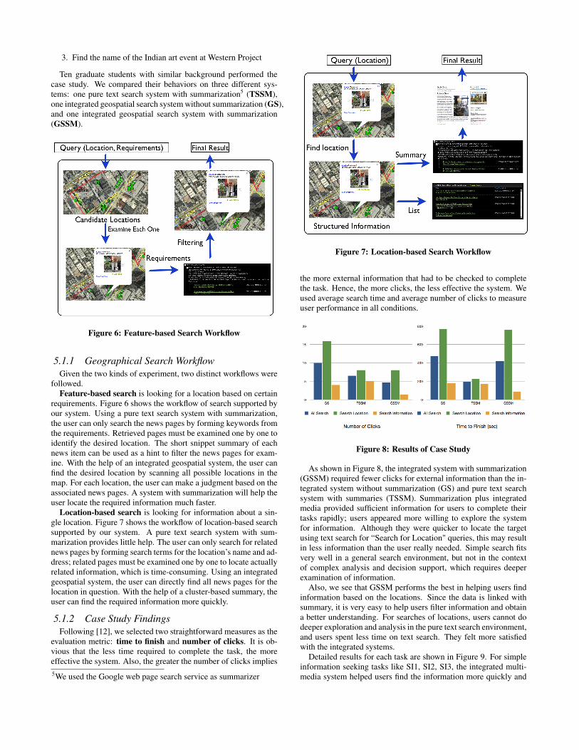
Figure 6: Feature-based Search Workflow
5.1.1 Geographical Search WorkflowGiven the two kinds of experiment, two distinct workflows were
followed.Feature-based search is looking for a location based on certain
requirements. Figure 6 shows the workflow of search supported byour system. Using a pure text search system with summarization,the user can only search the news pages by forming keywords fromthe requirements. Retrieved pages must be examined one by one toidentify the desired location. The short snippet summary of eachnews item can be used as a hint to filter the news pages for exam-ine. With the help of an integrated geospatial system, the user canfind the desired location by scanning all possible locations in themap. For each location, the user can make a judgment based on theassociated news pages. A system with summarization will help theuser locate the required information much faster.
Location-based search is looking for information about a sin-gle location. Figure 7 shows the workflow of location-based searchsupported by our system. A pure text search system with sum-marization provides little help. The user can only search for relatednews pages by forming search terms for the location’s name and ad-dress; related pages must be examined one by one to locate actuallyrelated information, which is time-consuming. Using an integratedgeospatial system, the user can directly find all news pages for thelocation in question. With the help of a cluster-based summary, theuser can find the required information more quickly.
5.1.2 Case Study FindingsFollowing [12], we selected two straightforward measures as the
evaluation metric: time to finish and number of clicks. It is ob-vious that the less time required to complete the task, the moreeffective the system. Also, the greater the number of clicks implies5We used the Google web page search service as summarizer
Figure 7: Location-based Search Workflow
the more external information that had to be checked to completethe task. Hence, the more clicks, the less effective the system. Weused average search time and average number of clicks to measureuser performance in all conditions.
Figure 8: Results of Case Study
As shown in Figure 8, the integrated system with summarization(GSSM) required fewer clicks for external information than the in-tegrated system without summarization (GS) and pure text searchsystem with summaries (TSSM). Summarization plus integratedmedia provided sufficient information for users to complete theirtasks rapidly; users appeared more willing to explore the systemfor information. Although they were quicker to locate the targetusing text search for “Search for Location" queries, this may resultin less information than the user really needed. Simple search fitsvery well in a general search environment, but not in the contextof complex analysis and decision support, which requires deeperexamination of information.
Also, we see that GSSM performs the best in helping users findinformation based on the locations. Since the data is linked withsummary, it is very easy to help users filter information and obtaina better understanding. For searches of locations, users cannot dodeeper exploration and analysis in the pure text search environment,and users spent less time on text search. They felt more satisfiedwith the integrated systems.
Detailed results for each task are shown in Figure 9. For simpleinformation seeking tasks like SI1, SI2, SI3, the integrated multi-media system helped users find the information more quickly and
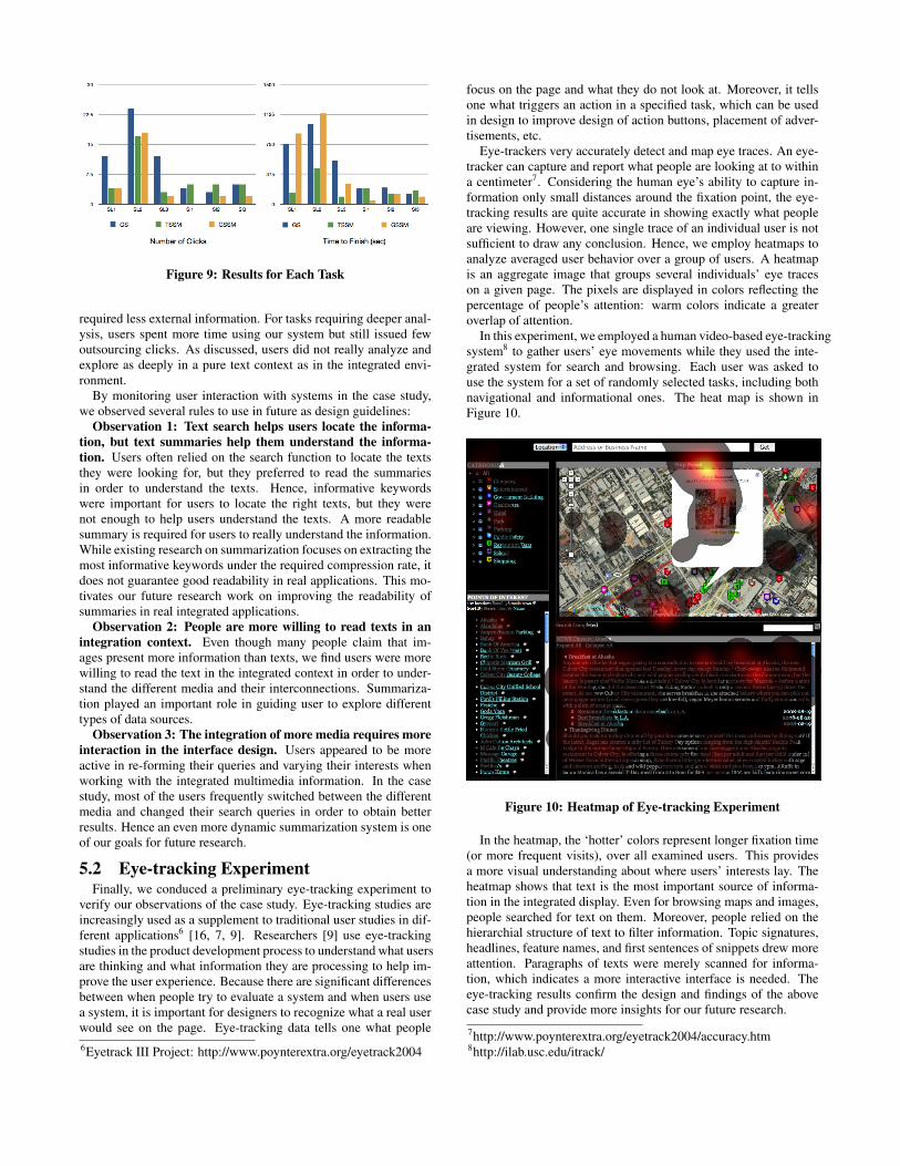
Figure 9: Results for Each Task
required less external information. For tasks requiring deeper anal-ysis, users spent more time using our system but still issued fewoutsourcing clicks. As discussed, users did not really analyze andexplore as deeply in a pure text context as in the integrated envi-ronment.
By monitoring user interaction with systems in the case study,we observed several rules to use in future as design guidelines:
Observation 1: Text search helps users locate the informa-tion, but text summaries help them understand the informa-tion. Users often relied on the search function to locate the textsthey were looking for, but they preferred to read the summariesin order to understand the texts. Hence, informative keywordswere important for users to locate the right texts, but they werenot enough to help users understand the texts. A more readablesummary is required for users to really understand the information.While existing research on summarization focuses on extracting themost informative keywords under the required compression rate, itdoes not guarantee good readability in real applications. This mo-tivates our future research work on improving the readability ofsummaries in real integrated applications.
Observation 2: People are more willing to read texts in anintegration context. Even though many people claim that im-ages present more information than texts, we find users were morewilling to read the text in the integrated context in order to under-stand the different media and their interconnections. Summariza-tion played an important role in guiding user to explore differenttypes of data sources.
Observation 3: The integration of more media requires moreinteraction in the interface design. Users appeared to be moreactive in re-forming their queries and varying their interests whenworking with the integrated multimedia information. In the casestudy, most of the users frequently switched between the differentmedia and changed their search queries in order to obtain betterresults. Hence an even more dynamic summarization system is oneof our goals for future research.
5.2 Eye-tracking ExperimentFinally, we conduced a preliminary eye-tracking experiment to
verify our observations of the case study. Eye-tracking studies areincreasingly used as a supplement to traditional user studies in dif-ferent applications6 [16, 7, 9]. Researchers [9] use eye-trackingstudies in the product development process to understand what usersare thinking and what information they are processing to help im-prove the user experience. Because there are significant differencesbetween when people try to evaluate a system and when users usea system, it is important for designers to recognize what a real userwould see on the page. Eye-tracking data tells one what people6Eyetrack III Project: http://www.poynterextra.org/eyetrack2004
focus on the page and what they do not look at. Moreover, it tellsone what triggers an action in a specified task, which can be usedin design to improve design of action buttons, placement of adver-tisements, etc.
Eye-trackers very accurately detect and map eye traces. An eye-tracker can capture and report what people are looking at to withina centimeter7. Considering the human eye’s ability to capture in-formation only small distances around the fixation point, the eye-tracking results are quite accurate in showing exactly what peopleare viewing. However, one single trace of an individual user is notsufficient to draw any conclusion. Hence, we employ heatmaps toanalyze averaged user behavior over a group of users. A heatmapis an aggregate image that groups several individuals’ eye traceson a given page. The pixels are displayed in colors reflecting thepercentage of people’s attention: warm colors indicate a greateroverlap of attention.
In this experiment, we employed a human video-based eye-trackingsystem8 to gather users’ eye movements while they used the inte-grated system for search and browsing. Each user was asked touse the system for a set of randomly selected tasks, including bothnavigational and informational ones. The heat map is shown inFigure 10.
Figure 10: Heatmap of Eye-tracking Experiment
In the heatmap, the ‘hotter’ colors represent longer fixation time(or more frequent visits), over all examined users. This providesa more visual understanding about where users’ interests lay. Theheatmap shows that text is the most important source of informa-tion in the integrated display. Even for browsing maps and images,people searched for text on them. Moreover, people relied on thehierarchial structure of text to filter information. Topic signatures,headlines, feature names, and first sentences of snippets drew moreattention. Paragraphs of texts were merely scanned for informa-tion, which indicates a more interactive interface is needed. Theeye-tracking results confirm the design and findings of the abovecase study and provide more insights for our future research.
7http://www.poynterextra.org/eyetrack2004/accuracy.htm8http://ilab.usc.edu/itrack/
6. CONCLUSIONS AND FUTURE WORKIn this paper, we describe our work on integrating geospatial
(map and satellite) imagery, structured text (tables, etc.), and un-structured text (news articles from the web) into a single multime-dia display system designed to support browsing and search. Toenable wide-ranging coverage of large amounts of text despite verylimited display space, we developed and deployed text clusteringand three levels of text summarization technology. We evaluatedthe effectiveness of the system to support search, conducted a casestudy with several query types, and used eye-tracking to obtain aheat map that shows the averaged behavior and preferences of peo-ple performing geospatially oriented search within a multimediadisplay system.
We conclude that multi-level summarization is very helpful insuch tasks; that users prefer to read shorter summaries rather thanlonger ones, and prefer to issue additional textual queries that gen-erate new clusters and summaries rather than explore the geospa-tial context of the locations of interest. This work suggests thatresearch focus on the length, placement, interactivity, content, andplacement of different types of summary within a geospatial dis-play system.
7. ACKNOWLEDGMENTSThanks to GeoSemble Inc. for providing the geographic inte-
gration support to the system. This work was performed with par-tial support from DARPA grant with contract No. W31P4Q-09-C-0313.
8. REFERENCES[1] J. Allan, R. Papka, and V. Lavrenko. On-line new event
detection and tracking. In SIGIR’98: Proceedings of the 21stAnnual International ACM SIGIR Conference on Researchand Development in Information Retrieval, 1998.
[2] A. Berger and V. O. Mittal. Query-relevant summarizationusing FAQs. In ACL ’00: Proceedings of the 38th AnnualMeeting on Association for Computational Linguistics, 2000.
[3] D. M. Blei, A. Y. Ng, and M. I. Jordan. Latent dirichletallocation. J. Mach. Learn. Res., 3:993–1022, March 2003.
[4] T. Brants, F. Chen, and A. Farahat. A system for news eventdetection. In SIGIR ’03: Proceedings of the 26th AnnualInternational ACM SIGIR conference on Research andDevelopment in Informaion Retrieval, 2003.
[5] C.-C. Chen, C. A. Knoblock, C. Shahabi, Y.-Y. Chiang, andS. Thakkar. Automatically and accurately conflatingorthoimagery and street maps. In GIS ’04: Proceedings ofthe 12th Annual ACM International Workshop onGeographic Information Systems, 2004.
[6] Y.-F. R. Chen, G. Di Fabbrizio, D. Gibbon, S. Jora,B. Renger, and B. Wei. Geotracker: Geospatial and temporalrss navigation. In WWW ’07: Proceedings of the 16thInternational Conference on World Wide Web, 2007.
[7] J. H. Goldberg, M. J. Stimson, M. Lewenstein, N. Scott, andA. M. Wichansky. Eye tracking in web search tasks: designimplications. In ETRA ’02: Proceedings of the 2002symposium on Eye tracking research & applications, 2002.
[8] J. Goldstein, V. Mittal, J. Carbonell, and J. Callan. Creatingand evaluating multi-document sentence extract summaries.In CIKM ’00: Proceedings of the ninth internationalconference on Information and knowledge management,2000.
[9] L. Granka and K. Rodden. Incorporating eyetracking intouser studies at google. In Proceedings of ACM CHI 2006
workshop on Getting a Measure of Satisfaction fromEyetracking in Practice, 2006.
[10] M. A. Hearst. Texttiling: Segmenting text intomulti-paragraph subtopic passages. ComputationalLinguistics, 23(1):33–64, 1997.
[11] Y. Huang, Z. Liu, and Y. Chen. Query biased snippetgeneration in XML search. In SIGMOD ’08: Proceedings ofthe 2008 ACM SIGMOD international conference onManagement of data, 2008.
[12] Z. Li, S. Shi, and L. Zhang. Improving relevance judgment ofweb search results with image excerpts. In WWW ’08:Proceeding of the 17th International Conference on WorldWide Web, 2008.
[13] C.-Y. Lin and E. Hovy. The automated acquisition of topicsignatures for text summarization. In Proceedings of the 18thConference on Computational Linguistics, 2000.
[14] C.-Y. Lin and E. Hovy. From single to multi-documentsummarization: A prototype system and its evaluation. InACL ’02: Proceedings of the 40th Annual Meeting onAssociation for Computational Linguistics, 2002.
[15] C.-Y. Lin and E. Hovy. The potential and limitations ofautomatic sentence extraction for summarization. InProceedings of the HLT-NAACL 03 on Text SummarizationWorkshop, 2003.
[16] L. Lorigo, M. Haridasan, H. Brynjarsdóttir, L. Xia,T. Joachims, G. Gay, L. Granka, F. Pellacini, and B. Pan. Eyetracking and online search: Lessons learned and challengesahead. J. Am. Soc. Inf. Sci. Technol., 59(7):1041–1052, 2008.
[17] D. Marcu. From discourse structures to text summaries. In InProceedings of the ACL Workshop on Intelligent ScalableText Summarization, 1997.
[18] S. Osinski and D. Weiss. Carrot2: Design of a flexible andefficient web information retrieval framework. InProceedings of the Third International Atlantic WebIntelligence Conference, AWIC-2005, 2005.
[19] B. E. Teitler, M. D. Lieberman, D. Panozzo,J. Sankaranarayanan, H. Samet, and J. Sperling. Newsstand:a new view on news. In GIS ’08: Proceedings of the 16thACM SIGSPATIAL international conference on Advances ingeographic information systems, 2008.
[20] A. Turpin, Y. Tsegay, D. Hawking, and H. E. Williams. Fastgeneration of result snippets in web search. In SIGIR ’07:Proceedings of the 30th annual international ACM SIGIRconference on Research and development in informationretrieval, 2007.
[21] M. Utiyama and H. Isahara. A statistical model fordomain-independent text segmentation. In ACL ’01:Proceedings of the 39th Annual Meeting on Association forComputational Linguistics, pages 499–506, 2001.
[22] L. Zhou and E. Hovy. Headline summarization at ISI. InProceedings of the Document Understanding Conference(DUC-2003), 2003.
[23] X. Zhou, X. Hu, and X. Zhang. Topic signature languagemodels for ad hoc retrieval. IEEE Transactions onKnowledge and Data Engineering, 19(9):1276–1287, 2007.