status of coral reefs of the pacific and outlook: 2011
TRANSCRIPT

StatuS of Coral reefS of the PaCifiC and outlook: 2011
andrew Chin, thierry liSon de loma, katie reytar, Serge PlaneS, karin gerhardt, eriC Clua, lauretta Burke, Clive wilkinSon
Statu
S of C
or
al r
eefS of th
e Pa
CifiC a
nd o
utlo
ok: 2011
an
dr
ew C
hin et a
l.
The World Bank

AcknowledgementsThis report is based on the information collected by hard working scientists, managers, conservation organisations and non-governmental organisations working tirelessly across the Pacific. We owe a debt of gratitude to those people who have collected information about coral reefs, their use and management. This project has also benefited greatly from the efforts of those who have collected, managed and synthesised a huge range of information so that we could locate and retrieve this information. We say “thank you” to the authors of the previous synthesis reports and risk assessments, and also to the custodians of this knowledge in libraries and data systems such as ReefBase Pacific and the Pacific Environmental Information Network.
We wish to thank the following organisations which have contributed funds so that this report could be produced and distributed free-of-charge to developing countries around the world: US Department of State; National Oceanographic and Atmospheric Administration of USA; French contributors; the Japanese Ministry of the Environment. The U.S. Department of the Interior, Office of Insular Affairs provided support to the World Resources Institute to prepare materials for this report.
We also extend our thanks to all the reviewers from across the Pacific who gave up their time to ‘ground truth’ this report. Thanks to Tim Adams, Maria Berger, Tim Clark, Monte Depaune, Doug Fenner, Jeremy Goldberg, Yimnang Golbuu, Bob Halstead, Marion Henry, Cherie Morris, Nicolas Pascal, Kelvin Passfield and Helen Sykes. Special thanks go to Chiara Pisapa for her assistance in pulling information together during the final stages of the project. We gratefully acknowledge Jaclyn Davies for preparing the early drafts of the Hawaiian Islands chapter, which included input from Ivor Williams, Jill Zimzow and Bob Shroeder. We thank staff of the Great Barrier Reef Marine Park Authority for their advice in developing this report, and acknowledge the Great Barrier Reef Outlook Report 2009 as an excellent model and approach for future efforts to synthesis knowledge and assess the risks facing coral reef ecosystems. We eventually thank Carole Manry, Enelio Liufau and Atoloto Malau from the ‘Service de l’Environnement de Wallis et Futuna’ for their central contribution to the Wallis and Futuna chapter.
We dedicate this report to the Peoples of the Pacific who are facing existing and increasing challenges on numerous fronts. It is our hope that this report will help to drive action that makes a real difference in the health and well being of the Pacific community, and in ensuring the protection and wise-use of their coral reefs and resources.
GCRMN Management Group IOC-UNESCO – Intergovernmental Oceanographic Commission of UNESCO UNEP – United Nations Environment Programme IUCN – International Union for Conservation of Nature (Chair) The World Bank, Environment Department CBD – Convention on Biological DiversityGBRMPA – Great Barrier Reef Marine Park Authority WorldFish Center and ReefBase ICRI Secretariat – Governments of France, Samoa and Monaco RRRC – Reef and Rainforest Research Centre, Ltd (Australia) as host GCRMN Major Supporters and Operational PartnersUS Department of State and NOAA – National Oceanic and Atmospheric Administration of USA National Fish and Wildlife Foundation of USAGCRMN SocMon (Socioeconomic Monitoring Initiative for Coastal Management) at NOAAReef Check Foundation, Los AngelesReefBase and WorldFish Center, Penang CRISP - Coral Reef Initiatives for the Pacific,World Resources Institute, Washington DC
Note: The conclusions and recommendations of this book are solely the opinions of the authors, contributors and editors and do not consti-tute a statement of policy, decision, or position on behalf of the participating organisations, including those represented on the cover.
Photographs on the Front and Back Cover are explained and credited inside the back cover.
Citation: Chin, A., Lison De Loma, T., Reytar, K., Planes, S., Gerhardt, K., Clua, E., and Burke, L., Wilkinson, C. (2011). Status of Coral Reefs of the Pacific and Outlook: 2011. Publishers Global Coral Reef Monitoring Network. 260 P.
ISBN 0 642 322228 7
© Global Coral Reef Monitoring Networkwww.gcrmn.org
Authors [see on the back page]
Cover photographs© CNRS / Thomas Vignaud1. © CNRS / Thomas Vignaud2. © Eric Clua3. © CRIOBE / Yannick Chancerelle4. © CRIOBE / Yannick Chancerelle5. © Eric Clua6. © CNRS / Thomas Vignaud7. © Eric Clua8. © CNRS / Thomas Vignaud9. © Charlie Veron10.
Authors
Andrew Chin has been working in marine research in the Great Barrier Reef since the 1990s. Andrew worked for the Great Barrier Reef Marine Park Authority (GBRMPA) in the research and monitoring section on reef monitoring and reporting, and impact assessment projects. He was also the editor of the State of the Great Barrier Reef Report and helped to develop the framework and structure of the GBRMPA’s 2009 Outlook Report. He has also authored several chapters for GCRMN publications including the Australia and Papua New Guinea chapter of the 2008 GCRMN status report. Andrew is currently working at James Cook University in Queensland, Australia, focusing on the biology, ecology, conservation and management of sharks and rays. He is one of the founding members of the Oceania Chondrichthyan Society, a scientific society supporting research, management and conservation of sharks and rays in the Pacific.
Thierry Lison de Loma is the associate Director of the Institute for the Coral Reefs of the Pacific (IRCP). He holds a PhD in Marine Environmental Sciences from the University of Aix-Marseille (France), with a focus on biogeochemistry and ecology in coral reefs. He started to work on coral reefs by studying coral ecology in 1993, in the tropical island of La Réunion (Indian Ocean). He is now a specialist in coral reef fish ecology in French Polynesia, based at CRIOBE (CRNS-EPHE) in Moorea. He mainly focuses on the effects of specific disturbances/factors (global change, fishing pressure and MPAs) on long-term fish community dynamics. For the past 19 years, Thierry has been diving extensively in the islands of the South Pacific and Indian Oceans (from Pitcairn to Madagascar), for field work and for his own enjoyment. He is in charge of the GCRMN Pacific Node.
Katie Reytar is a Research Associate at the World Resources Institute. She is a co-author of WRI’s Reefs at Risk Revisited report and specializes in GIS and data analysis. Katie has a M.E.S.M. in Coastal Marine Resources Management from the University of California, Santa Barbara and a B.S. in Environmental Engineering from the Johns Hopkins University.
Serge Planes has been involved in the study of population genetics of marine fish since the beginning of his career that started with his PhD in 1989. Over the past 20 years, he has published about 65 papers in international journals dealing with the population genetics of coral reef fishes and an additional 50 papers dealing with ecology, ecology of marine protected areas and recruitment of marine fishes. Such international recognition led to him being invited to participate as a member of the Australian Centre of Excellence on Coral Reefs and he has recently been incorporated into the scientific committee of the 12th International Coral Reef Symposium. Serge Planes is directing the LABEX “CORAIL” awarded in 2011 for 10 years, this being the major structural framework for research on coral reef ecology in France. He is also the Director of the Centre for Island Research and Observatory of the Environment (CRIOBE) and of the Institute for the Coral Reefs of the Pacific (IRCP), both based in Moorea, French Polynesia.
Karin Gerhardt has a decade of experience in marine park management, specializing in the Great Barrier Reef. Her work at the Great Barrier Reef Marine Park Authority has included marine park management, permit assessment, policy development and impact assessment. One of Karin’s specialties is in Knowledge Management – specifically the acquisition, management and effective utilization of knowledge and information for managing marine areas. Her expertise in this area was instrumental in managing the information processes that were used to develop this report. Her current focus is on working with the Traditional Owners of the Great Barrier Reef in the management of Sea Country and capturing and evaluating the outcomes of the Reef Rescue Land and Sea Country Indigenous Partnership Program.
Eric Clua is a scientist based at the Secretariat of the Pacific Community (SPC Noumea, New Caledonia), where he is the coordinator of the Coral Reef InitiativeS for the Pacific (CRISP) programme. Eric holds a PhD in Marine Ecology from the Practical School of High Studies (Ecole Pratique des Hautes Etudes – EPHE), Perpignan, France. His interest in coral reef ecology, conservation and sharks has taken him to many islands across the South Pacific. He has developed, over the years, an intimate knowledge of the Pacific region, its coral reefs and its peoples. His role in promoting the sustainable development of coral reef related activities in the Pacific has been crucial.
Lauretta Burke is a Senior Associate at the World Resources Institute. Lauretta leads WRI’s work on coastal ecosystems, including the Reefs at Risk project and Coastal Capital series on valuation of coral reefs. She has an M.A. in Environment and Resource Policy from the George Washington University and an M.A. in Geography from the University of California, Santa Barbara.
Clive Wilkinson has been the Coordinator of the Global Coral Reef Monitoring Network since 1996. He was formerly the Chief Technical Advisor for a coastal resource research program in 5 ASEAN countries and for an Australian project in Thailand after the massive tsunami of December 2004. He was an active field scientist on the ecology of the Great Barrier Reef at the Australian Institute of Marine Science with more than 100 papers pub-lished. He received BSc and PhD training in marine microbiology and ecology from the University of Queensland. He is based with the Reef and Rainforest Research Centre in Townsville Australia and now provides advice to governments on effects of global climate change on coastal ecosystems and potential adaptation policies.

i
Foreword For the PaciFic rePort
Many of us were introduced to the coral reefs of the Pacific through the books and films of that famous French diver, Jacques Yves Cousteau. He was able to bring the beauty and pristine nature of Pacific coral reefs to people around the world.
Since the time of Captain Cousteau, however, large areas of the world’s coral reefs have declined due to the many pressures put on them by global changes and human activities. Reefs have been damaged by destructive fishing practices, terrestrial and marine pollution, siltation from land clearing, poor agricultural practices, urban development, and, more recently, as a result of global climate change, which is causing ocean warming and increasing acidification. It has been estimated by the Global Coral Reef Monitoring Network that the world has effectively lost 19% of productive reef area, with another 15% under immediate threat of loss. This means that millions of people are being deprived of the goods and services provided by coral reefs, such as food from fish, molluscs and algae, tourism benefits and shoreline protection.
Fortunately, recent studies have found that the reefs of the Pacific are faring better than reefs in other parts of the world – almost 52% of Pacific reefs were recently assessed as being at “low risk”; however, for the other 48%, there is no room for complacency. This means that the Pacific holds a wealth of healthy reefs that must be maintained for the peoples of the Pacific and for the world.
Throughout the Pacific, there are literally thousands of islands that range from large mountains surrounded by fringing coral reefs to tiny coral atolls that are all that remains of collapsed volcanoes. Reefs are critically important to Pacific peoples and form an integral part of their livelihood and cultures. People living on small coral islands have developed rich cultural traditions to conserve the resources of their reefs for future use. For example, many communities declare part of their reef as temporary notake areas (tabu or tambu or ra’ui) to guarantee larger fish catches for special feasts. We now recognise the value of this traditional knowledge and it is essential to include the best aspects into management methods.
In 2010 and 2011, the Governments of France and Samoa, in conjunction with Monaco, chaired the International Coral Reef Initiative. ICRI was launched in 1994 as the only global entity devoted solely to coral reefs. Its aim is to preserve coral reefs and related ecosystems by implementing Chapter 17 of Agenda 21 of the United Nations Convention on the Law of the Sea, and other relevant international conventions and agreements. At the same time, the Global Coral Reef Monitoring Network (GCRMN) was established as an operati ng network of ICRI, which assists in the development of coral reef monitoring and data man agement, with equal emphasis on ecological and socioeconomic information, and compiles reports on the global status of coral reefs worldwide.
For the last decade, our governments have been very concerned about the health of coral reef ecosystems. In that regard, France, in 1999, launched the French Coral Reef Initiative, and have funded several regional programs, including the very successful Coral Reef Initiatives for the Pacific (CRISP). In Samoa, one of the most advanced Pacific small island States in coastal management, traditional culture and management methods are still alive for the benefits of its people and environment. For the past 2 years, France and Samoa have highlighted the threats to the ocean environment, including ocean acidification, pollution, and illegal and destructive fishing.

ii
We also have urged the international community to work towards better management of coral reefs and related ecosystems, and have been pushing to bring the Ocean back into the next UN Earth Summit at Rio+20. Indeed Rio+20 is the opportunity to effectively tackle the international gov ernance of the world’s oceans and, in the context of sustainable development, recognize and address the possibilities of a “blue economy”, which is vital for so many island and coastal States. We were also very successful in having ICRI recognized in the United Nations Report of the SecretaryGeneral entitled “Protection of coral reefs for sustainable livelihoods and develop-ment” as the only global entity devoted solely to coral reef conservation.
We are very pleased to endorse this report, which provides the first comprehensive assessment on the status of all coral reefs throughout the Pacific, but particularly to emphasise the current management capacity and the outlook of these reefs in the face of increasing local pressures and climate change.
Perina Sila JeanPierre ThébaultDeputy CEO Ambassadeur délégué à l’Environnement Ministry of Foreign Affairs FranceSamoa

iii
Contents
Executive Summary . . . . . . . . . . . . . . . . . . . . . . . . . . . . . . . . . . . . . . . . . . . . . . . . . . . . . . . . . . . . . . 1Introduction . . . . . . . . . . . . . . . . . . . . . . . . . . . . . . . . . . . . . . . . . . . . . . . . . . . . . . . . . . . . . . . . . . . 23I . Country reports SouthWest Pacific (Melanesia), Micronesia, Polynesia Mana . . . . . . . . . . 32
SouthWest Pacific . . . . . . . . . . . . . . . . . . . . . . . . . . . . . . . . . . . . . . . . . . . . . . . . . . . . . . . . . . . 33Fiji . . . . . . . . . . . . . . . . . . . . . . . . . . . . . . . . . . . . . . . . . . . . . . . . . . . . . . . . . . . . . . . . . . . . . 33Nauru . . . . . . . . . . . . . . . . . . . . . . . . . . . . . . . . . . . . . . . . . . . . . . . . . . . . . . . . . . . . . . . . . . 42New Caledonia . . . . . . . . . . . . . . . . . . . . . . . . . . . . . . . . . . . . . . . . . . . . . . . . . . . . . . . . . . . 48Papua New Guinea . . . . . . . . . . . . . . . . . . . . . . . . . . . . . . . . . . . . . . . . . . . . . . . . . . . . . . . . 56Solomon Islands . . . . . . . . . . . . . . . . . . . . . . . . . . . . . . . . . . . . . . . . . . . . . . . . . . . . . . . . . . 65Tuvalu . . . . . . . . . . . . . . . . . . . . . . . . . . . . . . . . . . . . . . . . . . . . . . . . . . . . . . . . . . . . . . . . . . 74Vanuatu . . . . . . . . . . . . . . . . . . . . . . . . . . . . . . . . . . . . . . . . . . . . . . . . . . . . . . . . . . . . . . . . . 80
Micronesia . . . . . . . . . . . . . . . . . . . . . . . . . . . . . . . . . . . . . . . . . . . . . . . . . . . . . . . . . . . . . . . . . 90Commonwealth of the Northern Mariana Islands . . . . . . . . . . . . . . . . . . . . . . . . . . . . . . 90Federates States of Micronesia . . . . . . . . . . . . . . . . . . . . . . . . . . . . . . . . . . . . . . . . . . . . . 100Guam . . . . . . . . . . . . . . . . . . . . . . . . . . . . . . . . . . . . . . . . . . . . . . . . . . . . . . . . . . . . . . . . . . 108Palau . . . . . . . . . . . . . . . . . . . . . . . . . . . . . . . . . . . . . . . . . . . . . . . . . . . . . . . . . . . . . . . . . . 118Republic of the Marshall Islands . . . . . . . . . . . . . . . . . . . . . . . . . . . . . . . . . . . . . . . . . . . . 128
Polynesia Mana . . . . . . . . . . . . . . . . . . . . . . . . . . . . . . . . . . . . . . . . . . . . . . . . . . . . . . . . . . . . 137American Samoa . . . . . . . . . . . . . . . . . . . . . . . . . . . . . . . . . . . . . . . . . . . . . . . . . . . . . . . . 137Cook Islands . . . . . . . . . . . . . . . . . . . . . . . . . . . . . . . . . . . . . . . . . . . . . . . . . . . . . . . . . . . . 146French Polynesia . . . . . . . . . . . . . . . . . . . . . . . . . . . . . . . . . . . . . . . . . . . . . . . . . . . . . . . . 154Republic of Kiribati . . . . . . . . . . . . . . . . . . . . . . . . . . . . . . . . . . . . . . . . . . . . . . . . . . . . . . . 165Niue . . . . . . . . . . . . . . . . . . . . . . . . . . . . . . . . . . . . . . . . . . . . . . . . . . . . . . . . . . . . . . . . . . . 175Samoa . . . . . . . . . . . . . . . . . . . . . . . . . . . . . . . . . . . . . . . . . . . . . . . . . . . . . . . . . . . . . . . . . 181Tokelau . . . . . . . . . . . . . . . . . . . . . . . . . . . . . . . . . . . . . . . . . . . . . . . . . . . . . . . . . . . . . . . . 190Tonga . . . . . . . . . . . . . . . . . . . . . . . . . . . . . . . . . . . . . . . . . . . . . . . . . . . . . . . . . . . . . . . . . . 197Wallis and Futuna . . . . . . . . . . . . . . . . . . . . . . . . . . . . . . . . . . . . . . . . . . . . . . . . . . . . . . . 206
Hawaiian Islands . . . . . . . . . . . . . . . . . . . . . . . . . . . . . . . . . . . . . . . . . . . . . . . . . . . . . . . . . . . 214II . Information Management in the Pacific . . . . . . . . . . . . . . . . . . . . . . . . . . . . . . . . . . . . . . . . 224
Australia – Great Barrier Reef . . . . . . . . . . . . . . . . . . . . . . . . . . . . . . . . . . . . . . . . . . . . . . . . . 224The SPREP Pacific Environmental Information Network (PEIN) and Information Resource Centre (IRC) . . . . . . . . . . . . . . . . . . . . . . . . . . . . . . . . . . . . . . . . . 226ReefBase Pacific: a new information system for the Pacific’s coral reefs . . . . . . . . . . . . . . 228Case studies: Sustainable development of reef resources . . . . . . . . . . . . . . . . . . . . . . . . . . 230
Post-larval capture and culture (PCC) . . . . . . . . . . . . . . . . . . . . . . . . . . . . . . . . . . . . . . . . 230Reef Rehabilitation . . . . . . . . . . . . . . . . . . . . . . . . . . . . . . . . . . . . . . . . . . . . . . . . . . . . . . . 232Reef sharks in Palau: Business partners or dinner guests? . . . . . . . . . . . . . . . . . . . . . . . 235
Case studies: Management of Coral Reefs . . . . . . . . . . . . . . . . . . . . . . . . . . . . . . . . . . . . . . . 238Locally Managed Marine Areas (LMMAs) in the Pacific . . . . . . . . . . . . . . . . . . . . . . . . . 238Integrating LMMAs into policy and legislation . . . . . . . . . . . . . . . . . . . . . . . . . . . . . . . . 240Tetepare Conservation Area: Solomon Islands . . . . . . . . . . . . . . . . . . . . . . . . . . . . . . . . 241
iv
III . Summary and Conclusions . . . . . . . . . . . . . . . . . . . . . . . . . . . . . . . . . . . . . . . . . . . . . . . . . . . 243Appendix 1 – Details of descriptive themes . . . . . . . . . . . . . . . . . . . . . . . . . . . . . . . . . . . . . . . . 252Appendix 2 – Information, agencies and programs . . . . . . . . . . . . . . . . . . . . . . . . . . . . . . . . . . 256

1
ExEcutivE Summary
SynopsisCoral reefs are integral to the cultures and nutrition of many Pacific peoples; this report • was developed to assist reef conservation for those peoples;
Most coral reefs in the Pacific remain generally healthy, with strong potential for recovery • of coral, fish and invertebrate populations after damaging events;
There are, however, many signs of decline, especially on reefs around population centres • and in lagoons;
The main drivers of changes in coral cover at larger scales include major ‘natural’ stresses • in storms and cyclones, outbreaks of crown-of-thorns seastars (COTS) and coral bleaching driven by climate change;
The trends in coral cover vary considerably from country to country. Current reef status is • a reflection of recent damaging events, predominantly ‘natural’, and most damaged reefs appear to be recovering. While trends in reefs can be detected for individual countries and territories, no strong Pacific-wide or regional trend is evident;
At more localised scales, coral reefs are driven by the interactions between many, environ-• mental and human factors. These damaging human factors include: over-exploitation of fishes and invertebrates; sedimentation from poor land-use such as agriculture; mining of coral and sand; urban and tourism developments; and pollution from domestic and farm-ing wastes;
Fishing and harvesting have definitely affected coral reef communities across the Pacific, • especially in close proximity of towns, but the magnitude of these effects varies consider-ably between countries and islands;
Traditional management practices, such as permanent or temporary closure of fishing ar-• eas or bans on catching some species, remain particularly strong in the Pacific and are a major force for coral reef conservation;
Many countries and territories have sound legislation to manage coral reef resources, but • lack the capacity, logistic resources and sometimes the political will to enforce these laws. However, many countries and territories are making efforts to improve capacity for en-forcement and raise awareness of the need for reef conservation; and
Our conclusions are that • the longer-term outlook for the coral reefs of the Pacific is con-sidered to be Poor due to threats posed by climate change.
SummaryThe coral reefs of the Pacific are in better condition than those in other reef regions in the world, and remain the less stressed compared to reefs elsewhere. This is encouraging consider-ing that recent global reports paint a gloomy picture of the status (and likely future prospects) of large areas of the world’s coral reefs. However, the longer term outlook for Pacific reefs is

2
not encouraging with increasing human-induced threats and global climate change predicted to result in considerable damage in coming decades. This constitutes our conclusion, while many of the reefs in the Pacific appear healthy and resilient now, the outlook is poor.
Most Pacific reefs are in reasonable to good condition with either healthy or recovering coral communities and reasonably intact coral reef fish and invertebrate populations. There are large numbers of coral reefs spread over vast areas of the Pacific that are remote from human pres-sures; these remain among the best preserved reefs in the world. Many of these reefs grow around low lying and uninhabited atolls with few human pressures and no runoff from the land. Recently, there have been active processes to declare many of these reefs as protected areas with considerable success.
In contrast, coral reefs adjacent to larger population centres show clear evidence of over-fish-ing, pollution from nutrients and sewage, damage from coastal and catchment developments, and increasing damage from land-sourced sediments washing off high volcanic islands. Most of the high islands in the Pacific are steep and recent in origin, such that they contain readily erodible soils. Unsustainable exploitation of forest timbers is a major cause of severe sediment damage to downstream coral reefs.
Human population growth is generally very high in the Pacific, which will result in increasing fishing, pollution and development pressures. There is already clear evidence of damage arising from global climate change with erosion and inundation of shorelines of coral atolls from sea level rise, increasing temperatures resulting in coral bleaching and death, rising ocean acidifica-tion reducing coral growth, and predictions for more very damaging tropical cyclones.
This Pacific Status and Outlook report summarises all the readily available and accessible infor-mation about the coral reef ecosystems of the Pacific. This report has two objectives: provide an overview of the status of coral reefs of Pacific Island Countries and Territories (PICTs) by collating and synthesising recent regional summaries and national reports; and organise and standardise this information to develop a preliminary assessment of the future outlook for coral reefs of the Pacific. The report seeks to identify and describe the main trends and patterns for each of 5 themes: coral reef condition; coral reef health with emphasis on resilience; use of reef resources; factors affecting coral reefs; and governance and management.
In assembling this report, we identified many gaps and uncertainties in the available data and information. These gaps are not uniform throughout the Pacific, as some PICTs have assembled considerable data and information for many of their reefs; however, most PICTs have under-taken limited monitoring and assessment, therefore the level of ‘confidence’ used to describe each theme is often very low. The low level of information reflects the social, cultural, economic and political circumstances of many PICTs, which have inadequate resources and capacity for effective monitoring and follow-up assessment of management effectiveness.
Some PICTs have conducted long-term monitoring programs that assist in describing trends in coral reef communities, resources and use patterns. Other PICTs have started monitoring recently that will provide a critical baseline to assess trends and patterns in the future. The ongoing problem for reporting on reef status throughout the Pacific is that many of the island groups are scattered across vast stretches of ocean, making monitoring particularly difficult and expensive. This is also a challenge for management to gather fisheries catch and effort data, to enforce fisheries regulations and address illegal and/or unreported fishing, such as fish poach-ing and shark finning.
This report follows two previous global reports (1, 2) that had similar findings, in summary:
coral reef condition. • The condition of most reefs in the Pacific is stable to healthy, with either good coral growth or recovering communities, and relatively healthy fish and invertebrate populations. The condition of the reefs is usually a direct reflection of recent

3
major disturbances in the past 2 decades, especially major coral bleaching events, crown-of-thorns seastar (COTS) outbreaks, and major tropical cyclones. There is, however, clear evidence of damage resulting from over-exploitation and pollution on reefs near the major centres of human activity;
coral reef health and resilience. • In general, most Pacific reefs retain strong resilience to damage and demonstrate the ability of coral communities and fish populations to recover after major damaging events such as cyclones, coral bleaching and COTS outbreaks. However those reefs adjacent to population centres or major developments have lost much of their resilience and long-term decline in status is evident; these reefs are either not recovering or recovering slowly;
use of reef resources. • Pacific peoples are highly dependent on coral reef resources and have amongst the highest per capita consumptions of fisheries products in the world. However this dependence is resulting in over-exploitation near population centres with more people fishing and using more advanced and efficient technology. Destructive fishing practices are also reported from a few locations. The Secretariat for the Pacific Com-munity has calculated that a 46% increase of fish production will be required to meet requirements to feed the growing populations in the next 20 years. The predictions are that Melanesia + Micronesia + Polynesia will require an increase from 245,000 to 369,000 tonnes in the annual supply of fisheries products (3). Coral reefs are also mined for sand and rock for construction which results in localised damage; this is particularly serious in the face of rising sea levels. Tourism is a major use of coral reefs in some locations, and while delivering substantial economic benefits, poorly managed tourism can damage reefs through inappropriate coastal development and recreational overuse;
factors affecting coral reefs. • Reefs in the Pacific are threatened by the same stresses that damage reefs elsewhere in the world. The major factors (aside from direct extractive use) include nutrient pollution and eutrophication (from sewage, runoff of fertilizer and livestock waste), sediment pollution from poor land development including deforestation, agriculture and tourism resort construction, urban coastal development and dredging, destructive COTS outbreaks, and the more global threats of climate change resulting in coral bleaching, ocean acidification and increases in storm severity that all damage coral communities. The ameliorating factor in the Pacific is that most reefs are growing on the sides of seamounts in very deep water, such that pollution from the land is usually rapidly dissipated, except where it is retained in coral reef lagoons; and
governance and management• . Pacific Island Countries and Territories are acutely aware of the need for effective management of their coral reefs which are vital for their cultures and economies. However, few of these island states have the capacity and logistic resources to effectively manage their coral reefs that are often spread over vast distances. Most PICTs have effective legislation for reef management, but few have the capacity for effective enforcement of the regulations, and in some cases there is inadequate political will to enforce the laws. It is encouraging that most PICTs are increasing their efforts at reef conservation and there has been the recent declaration of very large areas of the Pacific Ocean with no-take protection aimed at conserving the coral reefs. The re-invigoration of community-based and traditional management in some locations is another promising development in managing reefs in the Pacific
The 2011 Reefs at Risk Revisited report identified slightly less than 50% of Pacific reefs as being threatened by local activities, of which only 20% are at high or very high threat. Overfishing and destructive fishing is the most widespread threat, followed by watershed-based pollution, coastal development, and marine-based pollution and damage (1). However, 52 % of reefs were rated at a low risk level, which makes it the least threatened region, after Australia. Reefs at

4
Reefs at Risk Revisited - Integrated Local Threat Results by country ( grouped by GCRMN 2011 Nodes in this report)
Region / CountryArea of Reefs
(sq km)
Reefs at Low Threat
Reefs at Medium Threat
Reefs at High Threat
Reefs at Very High
Threat
Total Reefs Threatened (Medium or Higher) by
Local Threats
Southwest Pacific Summary 38,460 43% 31% 19% 6% 57%
Fiji 6,704 34% 34% 21% 10% 66%
Nauru 15 0% 0% 20% 80% 100%
New Caledonia 7,450 63% 30% 6% 0% 37%
Papua New Guinea 14,535 45% 26% 22% 7% 55%
Solomon Islands 6,743 29% 42% 24% 6% 71%
Tuvalu 1,210 84% 12% 4% 0% 16%
Vanuatu 1,803 8% 37% 41% 14% 92%
Micronesia Summary 9,855 70% 21% 6% 3% 30%
CN Mariana Islands 182 10% 6% 18% 66% 90%
FS Micronesia 4,925 70% 23% 6% 1% 30%
Guam 225 54% 1% 16% 29% 46%
Palau 966 69% 26% 3% 1% 31%
Marshall Islands 3,558 74% 20% 5% 1% 26%
Polynesia Mana Summary 12,588 58% 27% 12% 3% 42%
American Samoa 129 13% 32% 44% 11% 87%
Cook Islands 528 51% 39% 9% 1% 49%
French Polynesia 5,981 76% 15% 7% 2% 24%
Kiribati 3,041 29% 55% 16% 0% 71%
Niue 45 2% 71% 26% 0% 98%
Samoa 402 0% 6% 43% 51% 100%
Tokelau 155 55% 45% 0% 0% 45%
Tonga 1,662 63% 26% 9% 2% 37%
Wallis And Futuna 646 68% 12% 19% 1% 32%
Hawaiian Islands Summary 3,834 83% 3% 6% 9% 17%
TOTAL - PACIFIC REGIONS 64,736 52% 27% 15% 5% 48%
Australia (Pacific Coast) 36,834 86% 13% 1% <1% 14%
Global Total 249,713 39% 34% 17% 10% 61%
Table 1a. These estimates of current threats to coral reefs from local pressures illustrate that Pacific reefs (and on the GBR of Australia) are under less pressure from local threats than reefs elsewhere in the world. Global climate change remains the largest single threat to Pacific reefs exceeding these local impacts. Pre-dictions that include climate change effects out to 2030 and 2050 are included in the more detailed country assessments from Reefs at Risk Revisited section in each country chapter (from Reefs at Risk Revisited) (1) .
Status 2008Regions
Reef Area (km-2)Reefs effectively
lostReefs at critical
stageReefs at
threatened stageReefs healthy
Southwest Pacific 27,060 3% 17% 35% 44%
Micronesia 12,700 8% 7% 15% 70%
Polynesia Mana 6,733 3% 2% 5% 90%
Hawaii & islands 1,200 2% 4% 8% 86%
Australia & PNG 62,800 3% 4% 10% 83%
Pacific Total 110,493 4% 7% 16% 72%
World Total 284,803 19% 15% 20% 45%
Table 1b. These assessments and predictions were assembled using predominantly expert opinion and anecdotal data in Status of Coral Reefs of the World: 2008 (2). While the assessments in Tables 1a and 1b vary in methodology groupings of countries, and the area of reef listed per country, they do illustrate that the Pacific reefs (including all those of Australia) are in a far healthier state than most reefs elsewhere in the world. Global climate change remains the largest single threat to Pacific reefs far exceeding local impacts.

5
Risk Revisited results, grouped according to the regions used in this report, are presented in Table 1a.
Monitoring assessments combined with anecdotal reports gathered by the Global Coral Reef Monitoring Network listed 11% of reefs as either effectively lost or critically threatened, with 72% of reefs at a healthy stage (BUT excluding the threats of climate change) (2). These assessments (Table 1b) point to the Pacific reefs being amongst the most healthy in the world, but both reports emphasise that this is no reason for complacency (2).
Major threats to the coral reefs of the PacificThe major threats to the region can be categorised into two major classes:
larger-scale, mostly global threats, some of which are truly natural and others linked to hu-• man activities operating at a global scale; and
localised stresses that predominantly result from direct human activities.•
The major medium to long-term threats are from global climate change. Rising sea surface temperatures inducing coral bleaching and mortality, probable increases in very destructive cyclones/typhoons, and increasing ocean acidification pose threats to all reefs in the Pacific. The specific nature of these threats at the local scale will vary considerably, particularly as most Pacific reefs are surrounded by deep ocean waters that will buffer some of the temperature and acidification rises. But unless the emissions of greenhouse gases decrease markedly, the future prospects for all coral reefs, including those in the Pacific, is bleak. Sea level rise poses a severe threat to low lying coral islands in the Pacific, particularly those sitting on seamounts that are sinking. There is a real threat that nations such as Kiribati, the Marshall Islands, Tokelau and Tuvalu will become uninhabitable in coming decades; they are already suffering significant erosion.
The other major larger scale threat is posed by outbreaks of COTS which have devastated coral communities on many Pacific reefs. Generally, reefs retain a latent capacity to regrow the corals after such devastating coral predation, however reefs under chronic local stress and bleaching damage may have much lower recovery potential.
The major local threats are from over-fishing and destructive fishing; this particularly threatens many reefs near human populations, particularly via the removal of herbivorous fishes. Reef damage is occurring from coastal development for urban infrastructure and tourist resorts, from local pollution by untreated or poorly treated sewage, and from some minor industries such as fish processing and sugar refining industries. Most reefs around high islands and atolls are sur-rounded by deep water which can rapidly dilute such pollution; whereas pollution is retained in lagoons and over broad reef flats, thereby damaging these reefs. These threats, however, are at a much lower level than in most other parts of the world, especially in nearby East Asia.
Pacific Island countries and territories face increasing pressures and challenges from population growth and globalization that will result in increases in local threats; and most of these will be exacerbated by global climate change. These threats and likely impacts are summarised in the 2005 UNEP/SOPAC Environmental Vulnerability Index (4).
Major conservation activities and initiativesThere have been a series of major conservation initiatives in the region over the past 5 years; the main ones being the:
Coral Triangle Initiative, which includes Papua New Guinea and the Solomon Islands;•

6
The parallel ‘Pacific Coral Triangle Initiative’, which includes Fiji and Vanuatu; •
Micronesia Challenge which was launched by the leaders of Federated States of Micronesia, • Guam, Palau, Northern Mariana Islands and the Marshall Islands with a commitment to have 30% of coastal waters and 20% of the land area under active conservation management by 2020;
World Heritage Listing of the Lagoons of New Caledonia to protect large areas of coastal • habitat;
Man and and Biosphere Reserve (UNESCO) Listing of Fakarava in French Polynesia, which • includes seven atolls in the Tuamotu archipelago;
World Heritage Listing project of the Marquesas Islands in French Polynesia;•
Phoenix Islands Protected Area launched by the government of Kiribati with assistance • from major NGOs;
The major extension of protected area status with the designation and World Heritage • Listing of the Papahānaumokuākea Marine National Monument covering the Northwest Hawaiian Islands; and
The Declaration of the • Marianas Trench Marine National Monument and the U.S. Pacific Remote Island Areas conserves many remote islands with extensive and healthy coral reefs.
On 25 November 2011, Australia proposed that about 1 million km• 2 of the Coral Sea be granted greater protection under the ‘Coral Sea Commonwealth Marine Reserve’. This is proposal is open for public consultation.
Unlike elsewhere in the world, the Pacific retains many of the traditional management philoso-phies and activities. These were developed over hundreds of years to conserve scarce coastal resources, especially coral reef fish and invertebrate stocks. Traditional societies had a system of temporary closures of some of their reef area (called ‘tabu’, or ‘ra’ui/rahui’) to increase re-sources for special feasts. These have been incorporated in a rapidly expanding system of Lo-cally Managed Marine Areas, driven largely by initiatives from Fiji. There is also a strong move-ment for co-management of coral reefs between communities and government. One particular example is the incorporation of local fisheries reserves into the national legislation in Samoa. Another is the management plan of Moorea’s coral reefs (PGEM), voted in the local legislation of French Polynesia, and serving as a model for the management of several other islands (Bora Bora, Tahaa).
Recommendations for Action Be part of a global campaign to urgently combat Climate Change by reducing emissions of • greenhouse gases;
Maximise coral reef resilience by reducing overfishing and habitat degradation;•
Address excess population growth and unsustainable resource use;•
Develop national adaptation strategies for the social, cultural and economic impacts of • climate change;
Stop destructive fishing and manage coastal fisheries to ensure sustainable use;•
Improve catchment management to reduce downstream pollution and control damaging • coastal development;
Provide advice on reducing sediment and nutrient pollution in coastal areas; •

7
Improve sewage treatment and waste management;•
Develop alternative livelihoods to ease pressures on fisheries resources, including aqua-• culture;
Develop more MPAs, link them into networks and strengthen enforcement;•
Train people in communities, NGOs and within governments in reef and socioeconomic • monitoring and management;
Support community-based management efforts through training and recognising tradition-• al management methods; and
Raise awareness of coral reef problems and possible solutions.•
These recommendations are presented in more detail in ‘Concluding remarks and recommen-dations’ section on Page 250.
Knowledge gapsThere was insufficient information for some themes chosen in this ‘outlook’ process to ad-equately describe trends and patterns with a high level of confidence:
Reef health and resilience• : this requires long-term data from several locations over dec-adal time spans on disturbance and recovery cycles, and reef processes such as coral re-cruitment, changes in species composition, grazing by herbivores, calcification rates etc. This information is used to understand reef responses to pressures, to provide early warn-ing before catastrophic changes, and to assess management effectiveness, and also for adaptive management;
Reef resource use• : trend analyses require long-term data on catch and fishing effort at the species level. Risk assessments, preferably collected over long periods for subsistence and commercial fisheries are especially useful in adaptive management;
Factors affecting reef health• : there were anecdotal reports describing damage to coral reefs with indications of worsening trends (e.g. increases in pollution and erosion), but detailed monitoring programs were rarely available to understand how coral reefs respond to management initiatives.
Governance and management• : There was little information on the effectiveness of man-agement arrangements, plans, policies, laws and regulations, and little information on implementation. Socioeconomic monitoring of reef users to determine compliance and acceptance of these rules is used to support ‘on-ground’ monitoring of the reefs.
Country profiles: Southwest Pacific NodeThe country and territorial profiles are clustered in the Nodes used by the Global Coral Reef Monitoring Network (GCRMN). The 3 main Nodes are Southwest Pacific Node which contains predominantly Melanesian islands coordinated out of the University of the South Pacific in Fiji; Micronesia Node coordinated through the Palau International Coral Reef Center (PICRC); and Polynesia Mana Node coordinated by CRIOBE in Moorea, French Polynesia.
The Southwest Pacific Node contains Fiji, Nauru, New Caledonia, Papua New Guinea, Solomon Islands, Tuvalu and Vanuatu. The reefs have high coral diversity (some of these countries/territories are in the Coral Triangle) and are predominantly in good condition with strong recovery capacity after major disturbances from coral bleaching, COTS and cyclones. The larger island archipelagos of Fiji, New Caledonia, Papua New Guinea, Solomon Islands and Vanuatu

8
have many remote coral reefs with healthy commercial fish and invertebrate populations. Those reefs in close proximity to population centres, show evidence of stress and decline.
Fiji has reliable and consistent monitoring data that report reefs in good condition and strong resilience and recovery potential after coral bleaching, COTS outbreaks and cyclones. Human pressures from fishing, sedimentation, pollution from land-based sources, coastal development and population growth are all increasing around the more populated islands. Reef management is largely driven through traditional communities establishing their own MPAs; recent political disturbances have slowed progress.
Little information is available about the small reef area of Nauru. There is intensive reef re-source use, and phosphate mining has caused localised damage to the reefs. Effective manage-ment is needed to ensure sustainable resource use.
Good long-term data from around Noumea in New Caledonia show stable reefs that recover from disturbances, although coral recruitment may be naturally low; data are more sparse else-where. Reef resources appear stable, but giant clams and sea cucumbers are depleted and sedi-ment runoff and pollution, especially from nickel mining, has damaged some reefs. Manage-ment is improving with increases in MPAs and enforcement capacity, and the listing as a World Heritage site will help further improvements.
Vast areas of reefs in Papua New Guinea appear to be healthy with strong ability to recover after disturbances. There is some damage from sediments, pollution, and overfishing; harvest pressures are increasing and rapid population growth will further increase pressures. Legisla-tion is strong, but management is limited by low capacity and political will, and poor access to remote reefs.
Only the Western Province of the Solomon Islands has been monitored and this shows reefs with high coral cover and relatively low pollution, but exploitation is increasing in some areas. There are growing pressures around the populated islands with deforestation a major threat. Locally Managed Marine Areas and other community efforts are promising management tools.
Occasional monitoring in Tuvalu suggests that reefs are stable. There is over-harvesting of fish and invertebrates around the main island, along with pollution and coastal development dam-age in the lagoon of Funafuti. Sea level rise is causing shoreline erosion. Community-based management appears to be the best mechanism for reef conservation.
Baseline data for Vanuatu indicate generally healthy reefs but declines in some harvested stocks, such as sea cucumbers, green snail, triton and some fish stocks. The government and communi-ties have banned some exploitation, often through periodic closures. Community-based man-agement shows positive results, when government enforcement is less effective.
Country profiles: Micronesia Node This Node, coordinated from the Palau International Coral Reef Center (PICRC) with support from Japan and the USA, supports Commonwealth of the Northern Mariana Islands (CNMI), Federated States of Micronesia (FSM), Guam, Republic of the Marshall Islands (RMI) and Palau. These reefs have high biodiversity as they border the Coral Triangle diversity ‘hot spot’. Most reefs are healthy with strong recovery potential following bleaching, COTS outbreaks and major storms. All countries have formed the Micronesia Challenge to protect 30% of their marine ter-ritory and 20% of their land, and there has been an increase in monitoring and management activity. Reefs around population centres are being polluted and over-exploited.
Long-term data from the CNMI indicate that reefs near more populated southern regions have reduced coral cover, altered species composition and reduced biomass of some reef fishes; whereas reefs in the north are relatively unstressed. Fish catches have declined and water pol-

9
lution, coastal development and sedimentation have increased around populated islands. Reef management programs are showing positive results.
Most reefs in FSM have high coral cover and strong recovery potential, although reefs near population centres (especially Pohnpei) show damage from sedimentation, pollution, coastal development, and growing population pressures. Fish populations have declined and sea cu-cumber and trochus fisheries have collapsed. Reef management initiatives are expanding under the Micronesia Challenge.
Reliable long-term monitoring data from Guam show some reefs in good condition while others have declined from pollution and COTS outbreaks, with decreased fish stocks in high use areas. Tourism and rapid military expansion will increase sedimentation, land-based pollution, coastal development and recreational use. Enhanced management will be required by Guam and USA, especially to control overfishing.
Long-term data report that coral reefs in the Marshall Islands are relatively healthy with high coral cover and abundant fish populations, especially on remote reefs. There is damage to reefs around populated islands from overfishing, coastal development and pollution, along with COTS and storms. Involvement in the Micronesia Challenge will improve capacity for management.
Substantial monitoring around Palau started after massive coral bleaching in 1998 and shows that damaged reefs are recovering with strong resilience, but some fish and invertebrate stocks have declined. Increased sedimentation from coastal development, road construction, defor-estation, land-based pollution, and increasing pressure from population growth are damaging reefs. Palau is combating overfishing and actively protecting shark populations.
Country profiles: Polynesia Mana Node The Polynesian islands of American Samoa, Cook Islands, French Polynesia, Kiribati, Niue, Sa-moa, Tokelau, Tonga and Wallis and Futuna are assisted by the French CRIOBE centre in French Polynesia. Most of these islands are remote from human impacts and in good health, however overfishing, over-development and excessive sediment flows are damaging reefs around inhab-ited islands. Management effectiveness is variable with some particularly active through better capacity and resources.
Long-term data suggest that coral reefs in American Samoa are relatively stable and healthy with good long-term recovery potential. Fish catches and biomass have declined around the main island, Tutuila. Reefs have been damaged by pollution and sediment flows from coastal development and pig farms. Management efforts are weakened by inadequate fisheries man-agement, enforcement and poor awareness.
Reefs around Rarotonga in the Cook Islands show strong coral reef recovery from COTS out-breaks in the 1990s. Target fish species, especially parrotfish, have declined. Damage has been caused by COTS, storms and cyclones, land-based pollution, coastal development, sedimenta-tion, and declining water quality. Reef management varies considerably especially where tradi-tional management exists.
The extensive monitoring in French Polynesia has documented many cycles of damage and recovery, especially on Moorea. Reef threats vary considerably from mild overfishing on re-mote atolls to over-exploitation, coastal development, land-based pollution on the populated high islands, in parallel with coral bleaching and COTS outbreaks. Reef management is actively improving with more MPAs, including some co-managed with communities.
Limited data are available from Kiribati, but most reefs are relatively healthy, with damage from coastal development and pollution around Tarawa. Resources have declined around towns,

10
while the unpopulated Phoenix Islands are relatively pristine and protected as the Phoenix Is-lands Protected Area; there is little effective management elsewhere.
Monitoring on Niue after Cyclone Heta in 2004 shows reef recovery; but there is over-exploita-tion of several species, and pollution and sedimentation from land-based sources, inadequate waste management and contamination by agricultural chemicals. Niue has launched 3 new MPAs, but capacity is low.
Reefs in Samoa are recovering after Cyclone Heta in 2004 and now are relatively healthy with strong resilience. The abundance and size of some fish populations, especially parrotfish, is low around urban developments. Damage from pollution, sedimentation, as well as from COTS outbreaks, cyclones and from climate change related coral bleaching, has been observed. Com-munity-Based Fisheries Management shows positive results.
Anecdotal reports of reefs in Tokelau indicate damage from cyclones and COTS with low coral cover evident. Target fish species have declined through over-harvesting with more efficient fishing practices. Continued traditional management will prove the most effective method for reef conservation.
The occasional surveys of reefs in Tonga show relatively low coral cover, with some increases between 2002 and 2008. Overfishing is a significant threat to fish and invertebrate stocks. Other threats are pollution, declining water quality, sedimentation and coastal development, severe storms, COTS outbreaks, tsunamis and volcanic activity. Community-based and government management actions are needed to conserve the reefs and resources.
Wallis & Futuna is a territory of France where monitoring started recently. The reefs are threat-ened by forest clearing, coastal development, pollution, over-fishing and destructive fishing. This has led to bans on some practices and actions by the French government to improve man-agement on these 3 remote islands (Wallis, Futuna and Alofi).
The coral reefs of the Hawaiian Archipelago vary considerably. There is well documented dam-age from pollution and over-exploitation of reefs around the ‘main’ Hawaiian Islands (MHI) with relatively large human populations; whereas the remote Northwestern Hawaiian Islands (NWHI) are virtually unpopulated and under strict protection with virtually no exploitation and pollution. The MHI coral reefs are particularly important for tourism which is the major eco-nomic activity and recognition of this is stimulating stronger and more cooperative manage-ment activity. Declaration of the Papahānaumokuākea Marine National Monument has meant that an enormous area of relatively pristine coral reefs is now given even greater protection, especially for the many endemic, rare, threatened and endangered species.
A short summary on the Great Barrier Reef of Australia is included in this report. The recent Outlook report was used as the model for this larger-scale report on the wider Pacific (5). The final conclusion of that report was that the future outlook of the GBR was poor, even though this reef system is regarded as the best researched, monitored and managed in the world. The poor assessment was based on some land-based pollution and fishing pressures, but especially on predicted threats from climate-related threats of warming and acidifying seas that could overwhelm the inherent resilience of these extensive reefs.
Caveats: This report was prepared as a contribution to the International Coral Reef Initiative by a partnership of people from the Global Coral Reef Monitoring Network, the World Resources Institute, the Institute for the Coral Reefs of the Pacific (IRCP) and the Centre de Recherches Insulaires et Observatoire de L’Environnement de Polynésie Francaise (CRIOBE), and the Coral Reef InitiativeS for the Pacific (CRISP). The conclusions and recommendations within this report are solely those of the authors and contributors and do not necessarily represent the official positions of these organisations.

11
Stab
leEv
iden
ce o
f ch
ange
Alte
red
Hig
h
confi
denc
eM
ediu
m
confi
denc
eLo
w
confi
denc
e
D
irecti
ons
of
curr
ent t
rend
Situ
ation
ove
r lo
ng te
rm ti
me
scal
es
Coun
try
Reef
Con
diti
onRe
ef H
ealt
h an
d Re
silie
nce
Reef
Res
ourc
e U
seFa
ctor
s A
ffec
ting
Ree
f H
ealt
hM
anag
emen
t and
G
over
nanc
e
Fiji
The
relia
ble
and
cons
iste
nt m
onito
ring
dat
a fo
r Fi
ji in
dica
tes
that
mos
t cor
al re
efs
are
in g
ood
cond
ition
and
cur
rent
ly re
cove
ring
from
pr
evio
us d
istu
rban
ces
(cor
al b
leac
hing
, CO
TS a
nd c
yclo
nes)
. The
re is
litt
le e
vide
nce
of p
ersi
sten
t dec
lines
in re
ef c
ondi
tion
and
heal
th, a
nd
reco
very
rate
s in
dica
te g
ood
resi
lienc
e. H
owev
er, o
ther
reef
s sh
ow s
igns
of c
hron
ic s
tres
s an
d im
pact
s fr
om fi
shin
g, s
edim
enta
tion
and
pollu
tion
from
land
-bas
ed s
ourc
es, c
oast
al d
evel
opm
ent a
nd p
opul
ation
gro
wth
. Clim
ate
chan
ge, t
hrou
gh c
oral
ble
achi
ng a
nd s
ea le
vel r
ise,
co
uld
have
ser
ious
ram
ifica
tions
. The
201
1 Re
efs
at R
isk
Revi
site
d re
port
esti
mat
es th
at a
ll Fi
jian
reef
s w
ill b
e th
reat
ened
by
2030
, with
mor
e th
an 6
5% a
t hig
h, v
ery
high
or
criti
cal t
hrea
t lev
els.
Fiji
has
the
legi
slati
ve b
ase
for
effec
tive
man
agem
ent,
but
mos
t cor
al re
ef m
anag
emen
t is
at th
e co
mm
unity
leve
l; m
ore
info
rmati
on is
nee
ded
to a
sses
s eff
ectiv
enes
s of
man
agem
ent e
ffort
s.
Nau
ruTh
e fe
w s
urve
y da
ta fr
om N
auru
sug
gest
som
e di
ffere
nces
in re
efs
arou
nd th
e is
land
, but
the
info
rmati
on is
insu
ffici
ent t
o de
scri
be s
tatu
s or
tren
ds. L
ong-
term
mon
itori
ng s
tart
ed in
200
4 an
d sh
ould
be
conti
nued
. Soc
ial a
nd e
cono
mic
dat
a sh
ow in
tens
ive
use
of re
ef re
sour
ces,
w
ith in
crea
sing
effo
rt c
oupl
ed w
ith d
ecre
asin
g re
sour
ces;
ther
e ar
e an
ecdo
tal r
epor
ts o
f ove
r-ex
ploi
tatio
n. N
auru
’s re
efs
have
bee
n da
mag
ed
from
pre
viou
s ph
osph
ate
min
ing
and
coas
tal d
evel
opm
ent.
Ris
k as
sess
men
ts id
entif
y N
auru
as
vuln
erab
le to
dam
age
from
clim
ate
chan
ge
and
popu
latio
n gr
owth
. Few
man
agem
ent t
ools
and
logi
stic
reso
urce
s ex
ist t
o ad
dres
s th
ese
issu
es; t
hus
man
agem
ent n
eeds
to im
prov
e to
en
sure
sus
tain
able
use
of N
auru
’s re
efs.

12
Stab
leEv
iden
ce o
f ch
ange
Alte
red
Hig
h
confi
denc
eM
ediu
m
confi
denc
eLo
w
confi
denc
e
D
irecti
ons
of
curr
ent t
rend
Situ
ation
ove
r lo
ng te
rm ti
me
scal
es
Coun
try
Reef
Con
diti
onRe
ef H
ealt
h an
d Re
silie
nce
Reef
Res
ourc
e U
seFa
ctor
s A
ffec
ting
Ree
f H
ealt
hM
anag
emen
t and
G
over
nanc
e
New
Cal
edon
iaTh
e lo
ng-t
erm
dat
a fr
om 1
0 si
tes
arou
nd N
oum
ea s
how
sta
ble
tren
ds a
nd li
ttle
evi
denc
e of
dec
line.
The
re is
str
ong
abili
ty to
reco
ver
from
di
stur
banc
es, a
lthou
gh c
oral
recr
uitm
ent a
ppea
rs to
be
natu
rally
low
whi
ch re
duce
s re
cove
ry p
oten
tial.
Info
rmati
on is
insu
ffici
ent t
o de
term
ine
tren
ds in
reef
reso
urce
use
alth
ough
mos
t ree
f res
ourc
es a
ppea
r st
able
, with
som
e de
clin
es in
a fe
w s
peci
es s
uch
as c
lam
s an
d bê
ch-d
e-m
er. T
here
is a
lso
little
info
rmati
on o
n fa
ctor
s aff
ectin
g co
ral r
eefs
; ris
k as
sess
men
ts s
ugge
st th
reat
s fr
om s
edim
ent r
unoff
and
po
llutio
n fo
r so
me
reef
s, a
nd c
once
rn o
ver
pote
ntial
effe
cts
of fu
ture
pop
ulati
on g
row
th a
nd c
limat
e ch
ange
. Man
agem
ent i
s im
prov
ing
with
in
crea
ses
in M
PAs
and
inve
stm
ent i
n m
anag
emen
t and
enf
orce
men
t.
Papu
a N
ew G
uine
aTh
e fe
w s
urve
y da
ta fo
r PN
G in
dica
te th
at th
e re
efs
are
heal
thy
with
str
ong
abili
ty to
reco
ver
from
dis
turb
ance
s. H
owev
er, s
ome
coas
tal
reef
s sh
ow d
amag
e fr
om s
edim
ent,
pol
lutio
n an
d ov
erfis
hing
. The
re a
re in
crea
sing
pre
ssur
es o
n re
ef re
sour
ces
from
har
vesti
ng w
ith d
eclin
es
of s
ome
spec
ies
in s
peci
fic a
reas
. Man
y re
efs,
how
ever
, are
rem
ote
with
low
leve
ls o
f har
vesti
ng. A
necd
otal
repo
rts
and
risk
ass
essm
ents
in
dica
te th
at P
NG
’s re
efs
are
affec
ted
by p
ollu
tion
and
sedi
men
tatio
n, m
inin
g an
d po
or la
nd-u
se p
racti
ces.
Hig
h po
pula
tion
grow
th w
ill
incr
ease
pre
ssur
e on
reef
s. P
NG
has
str
ong
legi
slati
ve m
echa
nism
s, b
ut m
anag
emen
t is
limite
d by
a la
ck o
f res
ourc
es, c
apac
ity a
nd p
oliti
cal
will
, and
abi
lity
to a
cces
s to
rem
ote
loca
tions
.

13
Stab
leEv
iden
ce o
f ch
ange
Alte
red
Hig
h
confi
denc
eM
ediu
m
confi
denc
eLo
w
confi
denc
e
D
irecti
ons
of
curr
ent t
rend
Situ
ation
ove
r lo
ng te
rm ti
me
scal
es
Coun
try
Reef
Con
diti
onRe
ef H
ealt
h an
d Re
silie
nce
Reef
Res
ourc
e U
seFa
ctor
s A
ffec
ting
Ree
f H
ealt
hM
anag
emen
t and
G
over
nanc
e
Solo
mon
Isla
nds
Surv
ey d
ata
from
the
Solo
mon
Isla
nds
are
limite
d to
200
6-07
in th
e W
este
rn p
rovi
nce.
The
se re
efs
have
hig
h co
ral c
over
, with
nat
ural
eve
nts
bein
g th
e m
ain
driv
ers
of c
hang
e. T
here
is in
suffi
cien
t inf
orm
ation
to d
escr
ibe
tren
ds in
reef
hea
lth a
nd re
ef re
sour
ce u
se; b
ut th
ere
is lo
w
dens
ity a
nd a
bund
ance
of h
arve
sted
fish
and
inve
rteb
rate
s in
som
e ar
eas,
and
som
e sp
ecie
s su
ch a
s se
a cu
cum
bers
and
aqu
ariu
m s
peci
es
appe
ar d
eple
ted.
The
pri
mar
y fa
ctor
s aff
ectin
g re
efs
are
land
-bas
ed p
ollu
tion,
tsun
amis
and
ear
thqu
akes
; pop
ulati
on g
row
th w
ill p
ose
an
addi
tiona
l str
ess.
Man
agem
ent t
rend
s ar
e un
know
n al
thou
gh s
ever
al c
halle
nges
are
iden
tified
. Loc
ally
Man
aged
Mar
ine
Are
as a
nd o
ther
co
mm
unity
effo
rts
are
prom
isin
g m
anag
emen
t too
ls.
Tuva
luCo
ral r
eef m
onito
ring
in T
uval
u ha
s be
en s
pora
dic
and
limite
d to
the
mai
n is
land
of F
unaf
uti. T
he re
efs
appe
ar s
tabl
e, b
ut th
e lo
ng-t
erm
tr
ends
, patt
erns
of r
eef r
esou
rce
use
are
unkn
own.
Ane
cdot
al re
port
s su
gges
t ove
r-ha
rves
ting
of s
ome
fish
stoc
ks a
nd s
ea c
ucum
bers
. Oth
er
dam
agin
g fa
ctor
s in
clud
e po
llutio
n an
d co
asta
l dev
elop
men
t (es
peci
ally
aro
und
Funa
futi)
; pop
ulati
on g
row
th w
ill in
crea
se th
ese
stre
sses
. Tu
valu
is p
artic
ular
ly a
t ris
k of
clim
ate
chan
ge. T
here
is le
gisl
ation
to m
anag
e th
e re
efs,
but
effe
ctive
ness
is u
nkno
wn.
Com
mun
ity b
ased
m
anag
emen
t cou
ld b
e an
effe
ctive
mec
hani
sm to
add
ress
spe
cific
thre
ats.

14
Stab
leEv
iden
ce o
f ch
ange
Alte
red
Hig
h
confi
denc
eM
ediu
m
confi
denc
eLo
w
confi
denc
e
D
irecti
ons
of
curr
ent t
rend
Situ
ation
ove
r lo
ng te
rm ti
me
scal
es
Coun
try
Reef
Con
diti
onRe
ef H
ealt
h an
d Re
silie
nce
Reef
Res
ourc
e U
seFa
ctor
s A
ffec
ting
Ree
f H
ealt
hM
anag
emen
t and
G
over
nanc
e
Vanu
atu
Valu
able
bas
elin
e da
ta w
ere
colle
cted
for
shal
low
reef
s in
Van
uatu
from
200
5 to
200
7, b
ut th
ese
wer
e in
suffi
cien
t to
desc
ribe
long
-ter
m
tren
ds a
nd h
ealth
sta
tus.
Ree
f res
ourc
e us
e da
ta in
dica
tes
som
e ha
rves
ted
stoc
ks h
ave
decl
ined
, whi
ch h
as le
d to
ban
s on
trad
e in
som
e sp
ecie
s (s
ea c
ucum
bers
, gre
en s
nail,
trito
n), a
nd lo
w d
ensi
ties
of ta
rget
ed fi
nfish
and
inve
rteb
rate
s in
som
e lo
catio
ns. T
he p
rim
ary
fact
ors
affec
ting
reef
s ar
e na
tura
l dis
aste
rs (e
.g. c
yclo
nes,
tsun
amis
), la
nd-b
ased
pol
lutio
n, s
edim
enta
tion
and
popu
latio
n gr
owth
. The
re is
legi
slati
on
for
the
man
agem
ent o
f cor
al re
efs,
but
man
agem
ent e
ffecti
vene
ss is
not
wel
l doc
umen
ted;
how
ever
, com
mun
ity b
ased
man
agem
ent e
ffort
s ha
ve s
how
n po
sitiv
e re
sults
.
Com
mon
wea
lth
of t
he
Nor
ther
n M
aria
na Is
land
sTh
e hi
stor
ical
dat
a on
cor
al re
efs
in th
e CN
MI s
ugge
st th
at re
efs
in th
e m
ore
popu
late
d so
uthe
rn re
gion
s ha
ve re
duce
d co
ral c
over
, al
tere
d sp
ecie
s co
mpo
sitio
n an
d re
duce
d bi
omas
s of
som
e re
ef fi
shes
; thi
s in
clud
es d
ecre
ased
hea
lth a
nd re
silie
nce
arou
nd S
aipa
n. F
ish
catc
hes
have
dec
lined
with
low
er b
iom
ass
arou
nd p
opul
ated
isla
nds
com
pare
d to
rem
ote
area
s. D
eclin
ing
wat
er q
ualit
y, p
ollu
tion,
coa
stal
de
velo
pmen
t and
sed
imen
tatio
n ar
e da
mag
ing
som
e re
efs
arou
nd th
e po
pula
ted
isla
nds.
In c
ontr
ast,
the
reef
s in
less
pop
ulat
ed a
nd re
mot
e no
rthe
rn is
land
s ar
e re
lativ
ely
heal
thy.
Clim
ate
chan
ge is
pre
dict
ed to
hav
e si
gnifi
cant
effe
cts
on th
e re
efs.
The
re a
re p
rogr
ams
to m
anag
e th
e re
efs
with
pos
itive
resu
lts fr
om s
ome
initi
ative
s. H
owev
er, m
ore
data
are
nee
ded
in o
rder
to d
escr
ibe
man
agem
ent e
ffecti
vene
ss.

15
Stab
leEv
iden
ce o
f ch
ange
Alte
red
Hig
h
confi
denc
eM
ediu
m
confi
denc
eLo
w
confi
denc
e
D
irecti
ons
of
curr
ent t
rend
Situ
ation
ove
r lo
ng te
rm ti
me
scal
es
Coun
try
Reef
Con
diti
onRe
ef H
ealt
h an
d Re
silie
nce
Reef
Res
ourc
e U
seFa
ctor
s A
ffec
ting
Ree
f H
ealt
hM
anag
emen
t and
G
over
nanc
e
Fede
rate
d St
ates
of
Mic
rone
sia
Long
-ter
m re
ef m
onito
ring
in th
e FS
M o
ccur
s a
few
site
s an
d sh
ows
reef
s w
ith h
igh
cora
l cov
er, b
ut w
ith d
amag
e fr
om h
uman
acti
vitie
s (e
spec
ially
thos
e ne
ar P
ohnp
ei).
The
long
-ter
m tr
ends
in re
ef h
ealth
and
reef
reso
urce
use
is u
ncer
tain
. Ane
cdot
al re
port
s su
gges
t dec
linin
g fis
h po
pula
tions
and
col
laps
es o
f sea
cuc
umbe
r an
d tr
ochu
s fis
heri
es. D
estr
uctiv
e fis
hing
occ
urs
in s
ome
area
s; o
ther
dam
agin
g fa
ctor
s in
clud
e se
dim
enta
tion
and
pollu
tion
arou
nd p
opul
ated
isla
nds,
coa
stal
dev
elop
men
t, a
nd in
crea
sing
pre
ssur
es fr
om g
row
ing
popu
latio
ns.
FSM
will
als
o be
affe
cted
by
clim
ate
chan
ge. S
ome
rece
nt re
ef m
anag
emen
t ini
tiativ
es a
re p
rom
isin
g; b
ut th
e eff
ectiv
enes
s of
thes
e m
easu
res
is u
nkno
wn.
Gua
mLo
ng-t
erm
mon
itori
ng o
f Gua
m’s
cor
al re
efs
has
rece
ntly
beg
un, b
ut th
ere
are
data
from
the
last
40
year
s. S
ome
reef
s ar
e in
goo
d co
nditi
on
whi
le o
ther
reef
s sh
ow s
igns
of l
ong-
term
dec
line
from
the
stat
us in
the
1960
s. T
here
are
cle
ar s
igns
of d
eclin
ing
reef
hea
lth in
som
e ar
eas.
Th
ere
are
good
dat
a on
reef
reso
urce
use
and
som
e fis
h co
mm
uniti
es th
at s
how
dec
lines
in s
ome
fish
stoc
ks, a
nd d
amag
e fr
om to
uris
m
and
recr
eatio
nal u
se in
hig
h us
e ar
eas.
Som
e of
Gua
m’s
cor
al re
efs
have
bee
n aff
ecte
d by
sed
imen
tatio
n, la
nd-b
ased
pol
lutio
n an
d co
asta
l de
velo
pmen
t; th
ese
pres
sure
s w
ill in
crea
se w
ith m
ore
popu
latio
n an
d ex
pand
ed m
ilita
ry b
ases
. Gua
m’s
reef
s ar
e al
so a
ffect
ed b
y st
orm
s,
COTS
, and
are
at r
isk
from
clim
ate
chan
ge. G
uam
has
man
agem
ent t
ools
and
str
ateg
ies
to a
ddre
ss s
ome
of th
e pr
essu
res
faci
ng c
oral
reef
s,
with
effo
rts
show
ing
sign
s of
suc
cess
. How
ever
, the
re a
re fe
w e
ffecti
ve fi
shin
g re
gula
tions
, and
man
agem
ent c
halle
nges
are
incr
easi
ng.

16
Stab
leEv
iden
ce o
f ch
ange
Alte
red
Hig
h
confi
denc
eM
ediu
m
confi
denc
eLo
w
confi
denc
e
D
irecti
ons
of
curr
ent t
rend
Situ
ation
ove
r lo
ng te
rm ti
me
scal
es
Coun
try
Reef
Con
diti
onRe
ef H
ealt
h an
d Re
silie
nce
Reef
Res
ourc
e U
seFa
ctor
s A
ffec
ting
Ree
f H
ealt
hM
anag
emen
t and
G
over
nanc
e
Repu
blic
of t
he M
arsh
all
Isla
nds
Lim
ited
long
-ter
m s
urve
y da
ta fo
r th
e RM
I pro
vide
val
uabl
e ba
selin
e in
form
ation
, and
sho
w re
efs
that
are
rela
tivel
y he
alth
y w
ith h
igh
cora
l co
ver
and
abun
dant
fish
, esp
ecia
lly in
rem
ote
loca
tions
. How
ever
, the
re a
re d
eclin
es in
sta
tus
arou
nd th
e po
pula
ted
isla
nds.
The
dat
a ar
e in
suffi
cien
t to
desc
ribe
tren
ds in
reef
hea
lth, p
atter
ns o
f res
ourc
e us
e an
d eff
ects
on
reef
s. A
necd
otal
repo
rts
indi
cate
that
fish
ing
and
harv
estin
g ha
ve re
duce
d re
ef re
sour
ces
mor
e ar
ound
pop
ulat
ed th
an re
mot
e is
land
s. In
crea
sing
pre
ssur
es fr
om p
opul
ation
gro
wth
, coa
stal
de
velo
pmen
t, p
ollu
tion,
cro
wn-
of-t
horn
s se
asta
rs a
nd s
torm
s ar
e da
mag
ing
the
reef
s; a
nd c
limat
e ch
ange
will
exa
cerb
ate
thes
e de
clin
es.
Repu
blic
of P
alau
The
long
-ter
m d
ata
from
Pal
au s
how
that
the
reef
s se
riou
sly
dam
aged
by
cora
l ble
achi
ng in
199
8 ar
e re
cove
ring
. Thi
s in
dica
tes
long
-ter
m
stab
ility
and
goo
d he
alth
and
resi
lienc
e. F
ishe
ries
cat
ch d
ata,
ane
cdot
al re
port
s an
d ri
sk a
sses
smen
ts s
ugge
st d
eclin
es in
som
e fis
hes
and
inve
rteb
rate
s, b
ut m
ore
data
are
nee
ded.
Oth
er fa
ctor
s aff
ectin
g Pa
lau’
s co
ral r
eefs
incl
ude
sedi
men
tatio
n fr
om d
evel
opm
ent a
nd
defo
rest
ation
, lan
d-ba
sed
pollu
tion,
coa
stal
dev
elop
men
t, a
nd in
crea
sing
pre
ssur
es fr
om p
opul
ation
gro
wth
; clim
ate
chan
ge w
ill a
dd to
th
ese
stre
sses
. Pal
au h
as m
any
prom
isin
g pr
ogra
ms
to m
anag
e co
asta
l res
ourc
es, i
nclu
ding
ban
s on
har
vesti
ng s
ome
spec
ies.
How
ever
, Pal
au
still
face
s m
anag
emen
t iss
ues,
suc
h as
ille
gal fi
shin
g an
d m
ore
info
rmati
on is
requ
ired
to d
escr
ibe
man
agem
ent e
ffecti
vene
ss.

17
Stab
leEv
iden
ce o
f ch
ange
Alte
red
Hig
h
confi
denc
eM
ediu
m
confi
denc
eLo
w
confi
denc
e
D
irecti
ons
of
curr
ent t
rend
Situ
ation
ove
r lo
ng te
rm ti
me
scal
es
Coun
try
Reef
Con
diti
onRe
ef H
ealt
h an
d Re
silie
nce
Reef
Res
ourc
e U
seFa
ctor
s A
ffec
ting
Ree
f H
ealt
hM
anag
emen
t and
G
over
nanc
e
Am
eric
an S
amoa
Long
-ter
m d
ata
from
Am
eric
an S
amoa
sug
gest
that
the
cora
l ree
fs a
re re
lativ
ely
stab
le (i
.e. t
hey
reco
ver
from
dis
turb
ance
s) a
nd h
ealth
y. T
he
tren
d an
d re
crui
tmen
t dat
a su
gges
t res
ilien
ce, a
lthou
gh s
ome
reef
s ha
ve n
ot re
cove
red
to th
e 19
70s
base
lines
, sug
gesti
ng s
ome
dam
age,
es
peci
ally
aro
und
Tutu
ila w
here
fish
cat
ches
hav
e al
so d
eclin
ed. T
here
are
als
o ch
ange
s in
reef
fish
and
cor
al c
ompo
sitio
n; w
ith re
duce
d fis
h bi
omas
s ar
ound
pop
ulat
ed is
land
s co
mpa
red
with
rem
ote
loca
tions
. Ree
fs h
ave
expe
rien
ce lo
calis
ed p
ollu
tion
and
sedi
men
t dam
age,
and
ar
e al
so th
reat
ened
by
coas
tal d
evel
opm
ent,
incr
easi
ng p
opul
ation
s, s
torm
s, C
OTS
and
the
emer
ging
effe
cts
of c
limat
e ch
ange
. The
re is
a
legi
slati
ve b
asis
and
cap
acity
to a
ddre
ss s
ome
issu
es, b
ut fi
sher
ies
man
agem
ent a
nd e
nfor
cem
ent r
emai
n ch
alle
nges
.
Cook
Isla
nds
Long
-ter
m d
ata
for
the
Cook
Isla
nds
is re
stri
cted
to th
e m
ain
isla
nd o
f Rar
oton
ga, b
ut th
is s
how
s st
rong
cor
al re
ef re
cove
ry fr
om C
OTS
ou
tbre
aks
in th
e 19
90s.
Ree
f fish
com
mun
ity c
hang
es a
ppea
r to
be
expl
aine
d by
nat
ural
var
iatio
n, b
ut th
e da
ta a
re in
suffi
cien
t to
desc
ribe
re
ef h
ealth
and
resi
lienc
e. T
arge
ted
reef
spe
cies
, esp
ecia
lly p
arro
tfis
h, h
ave
decl
ined
and
the
long
-ter
m tr
ends
are
unc
erta
in. T
he re
efs
have
be
en d
amag
ed b
y CO
TS, s
torm
s an
d cy
clon
es, a
nd c
limat
e ch
ange
will
incr
ease
this
vul
nera
bilit
y. S
ome
reef
s ar
e th
reat
ened
by
land
-bas
ed
pollu
tion,
coa
stal
dev
elop
men
t, s
edim
enta
tion,
and
dec
linin
g w
ater
qua
lity.
Ree
f man
agem
ent v
arie
s co
nsid
erab
ly b
etw
een
isla
nds;
ther
e ar
e m
any
trad
ition
al m
anag
emen
t arr
ange
men
ts. H
owev
er, t
rend
s in
man
agem
ent a
nd e
ffect
s on
cor
al re
efs
are
uncl
ear.

18
Stab
leEv
iden
ce o
f ch
ange
Alte
red
Hig
h
confi
denc
eM
ediu
m
confi
denc
eLo
w
confi
denc
e
D
irecti
ons
of
curr
ent t
rend
Situ
ation
ove
r lo
ng te
rm ti
me
scal
es
Coun
try
Reef
Con
diti
onRe
ef H
ealt
h an
d Re
silie
nce
Reef
Res
ourc
e U
seFa
ctor
s A
ffec
ting
Ree
f H
ealt
hM
anag
emen
t and
G
over
nanc
e
Fren
ch P
olyn
esia
Fren
ch P
olyn
esia
’s re
efs
have
a lo
ng h
isto
ry o
f res
earc
h an
d m
onito
ring
, foc
used
mai
nly
on th
e So
ciet
y Is
land
s w
ith s
ome
stud
ies
done
on
the
mor
e re
mot
e re
efs.
Ree
fs a
re g
ener
ally
hea
lthy,
esp
ecia
lly th
ose
expo
sed
to fe
w h
uman
pre
ssur
es. T
he re
efs
are
dam
aged
by
COTS
ou
tbre
aks,
sto
rms
and
cycl
ones
, and
cor
al b
leac
hing
, but
the
reef
s us
ually
reco
ver.
Som
e re
efs
arou
nd th
e m
ain
popu
late
d is
land
s ha
ve
decl
ined
, with
cha
nged
cor
al a
nd fi
sh c
omm
uniti
es a
nd in
shor
e re
efs
lost
from
pol
lutio
n an
d co
asta
l dev
elop
men
t. O
ver-
harv
estin
g oc
curs
ar
ound
pop
ulat
ed a
reas
. Tou
rism
is a
maj
or n
on-e
xtra
ctive
use
of r
eefs
, but
tour
ism
incr
ease
s co
asta
l dev
elop
men
t and
dem
and
for
reef
re
sour
ces.
The
re is
a s
tron
g ba
sis
and
capa
city
for
man
agem
ent t
hat i
s al
read
y im
plem
ente
d, b
ut c
ompl
ianc
e an
d en
forc
emen
t nee
ds
impr
ovem
ent i
n so
me
area
s al
ong
with
mea
sure
s to
det
erm
ine
man
agem
ent e
ffecti
vene
ss.
Kiri
bati
Mon
itori
ng in
Kir
ibati
is fo
cuse
d on
the
Gilb
ert I
slan
ds s
uch
as T
araw
a, a
nd th
e Ph
oeni
x Is
land
s, a
lthou
gh m
onito
ring
has
beg
un in
Kir
itim
ati
(Lin
e Is
land
s). T
he d
ata
indi
cate
rela
tivel
y he
alth
y re
efs,
with
som
e hu
man
-indu
ced
dam
age
arou
nd th
e ca
pita
l Tar
awa
and
cora
l ble
achi
ng
on N
orth
Tar
awa
and
the
Phoe
nix
Isla
nds.
The
long
-ter
m tr
ends
in re
ef h
ealth
and
resi
lienc
e ar
e un
cert
ain,
but
new
mon
itori
ng h
as s
tart
ed.
Reso
urce
s ar
ound
tow
ns o
n Ta
raw
a an
d Ki
ritim
ati h
ave
decl
ined
, whi
le th
e un
popu
late
d Ph
oeni
x Is
land
s ar
e re
lativ
ely
pris
tine.
Cor
al
blea
chin
g ha
s da
mag
ed m
any
reef
s, a
nd lo
w-ly
ing
isla
nds
are
vuln
erab
le to
sea
leve
l ris
e. C
oast
al d
evel
opm
ent a
nd p
ollu
tion
caus
e lo
cal
dam
age
to re
efs,
and
ther
e ar
e fe
w e
ffecti
ve m
anag
emen
t mea
sure
s in
ope
ratio
n, d
emon
stra
ting
sign
ifica
nt m
anag
emen
t cha
lleng
es. T
he
esta
blis
hmen
t of t
he P
hoen
ix Is
land
s Pr
otec
ted
Are
a w
as a
maj
or s
tep
in p
rote
cting
Kir
ibati
’s c
oral
reef
s.

19
Stab
leEv
iden
ce o
f ch
ange
Alte
red
Hig
h
confi
denc
eM
ediu
m
confi
denc
eLo
w
confi
denc
e
D
irecti
ons
of
curr
ent t
rend
Situ
ation
ove
r lo
ng te
rm ti
me
scal
es
Coun
try
Reef
Con
diti
onRe
ef H
ealt
h an
d Re
silie
nce
Reef
Res
ourc
e U
seFa
ctor
s A
ffec
ting
Ree
f H
ealt
hM
anag
emen
t and
G
over
nanc
e
Niu
eM
onito
ring
on
the
wes
t coa
st o
f Niu
e sh
owed
a d
eclin
e in
cor
al c
over
aft
er C
yclo
ne H
eta
in 2
004,
but
with
som
e si
gns
of re
cove
ry s
ince
. The
da
ta a
re in
suffi
cien
t to
desc
ribe
tren
ds in
reef
hea
lth, r
esili
ence
, and
the
use
of re
ef re
sour
ces,
alth
ough
ther
e ar
e si
gns
of o
ver-
expl
oita
tion
of s
ever
al s
peci
es. O
ther
fact
ors
dam
agin
g fa
ctor
s ar
e po
llutio
n an
d se
dim
enta
tion
from
land
-bas
ed s
ourc
es, i
nade
quat
e w
aste
man
agem
ent
and
cont
amin
ation
by
agri
cultu
ral c
hem
ical
s. N
iue
has
impl
emen
ted
a ra
nge
of c
oral
reef
man
agem
ent p
rogr
ams,
incl
udin
g 3
new
MPA
s w
ith
fishi
ng re
stri
ction
s; th
ese
are
prom
isin
g si
gns.
Sam
oaM
onito
ring
in S
amoa
sta
rted
in th
e 19
80s;
but
sys
tem
atic
long
-ter
m m
onito
ring
onl
y be
gan
in 2
002.
The
se s
urve
ys in
dica
te h
ealth
y co
ral
reef
s th
at a
re re
cove
ring
aft
er C
yclo
ne H
eta
in 2
004.
Thi
s re
cove
ry s
ugge
sts
stro
ng re
silie
nce,
but
mor
e da
ta a
re n
eede
d to
des
crib
e tr
ends
in
reef
sta
tus
and
heal
th. P
atch
y da
ta o
n re
ef re
sour
ce u
se s
ugge
st d
eclin
es in
div
ersi
ty a
nd a
bund
ance
of s
ome
fish
grou
ps, e
spec
ially
pa
rrotf
ish,
and
dec
reas
ed fi
sh s
ize.
Som
e re
efs
have
bee
n aff
ecte
d by
pol
lutio
n an
d se
dim
enta
tion,
as
wel
l as
COTS
, cyc
lone
s an
d co
ral
blea
chin
g; th
e bl
each
ing
is li
nked
to in
crea
sing
sea
tem
pera
ture
s fr
om c
limat
e ch
ange
. A v
arie
ty o
f man
agem
ent i
nitia
tives
hav
e be
en
esta
blis
hed
and
the
Com
mun
ity-B
ased
Fis
heri
es M
anag
emen
t Pro
gram
sho
ws
posi
tive
resu
lts.
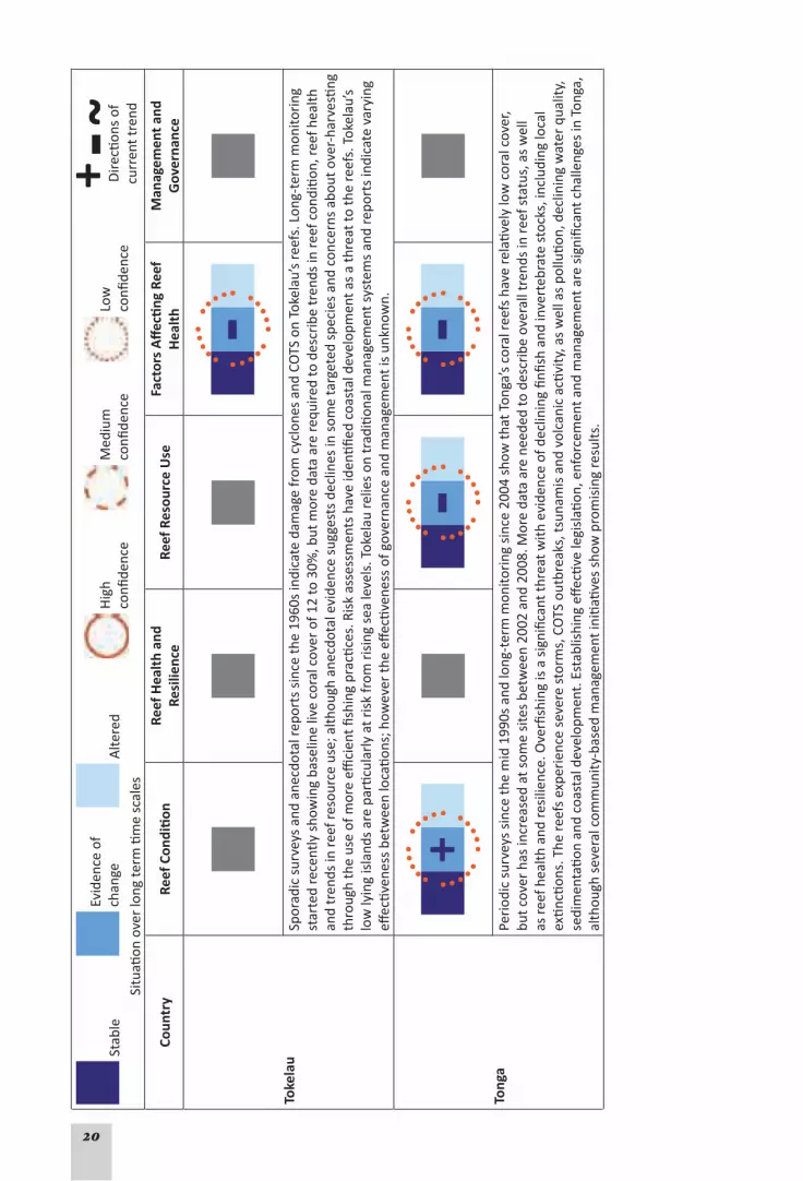
20
Stab
leEv
iden
ce o
f ch
ange
Alte
red
Hig
h
confi
denc
eM
ediu
m
confi
denc
eLo
w
confi
denc
e
D
irecti
ons
of
curr
ent t
rend
Situ
ation
ove
r lo
ng te
rm ti
me
scal
es
Coun
try
Reef
Con
diti
onRe
ef H
ealt
h an
d Re
silie
nce
Reef
Res
ourc
e U
seFa
ctor
s A
ffec
ting
Ree
f H
ealt
hM
anag
emen
t and
G
over
nanc
e
Toke
lau
Spor
adic
sur
veys
and
ane
cdot
al re
port
s si
nce
the
1960
s in
dica
te d
amag
e fr
om c
yclo
nes
and
COTS
on
Toke
lau’
s re
efs.
Lon
g-te
rm m
onito
ring
st
arte
d re
cent
ly s
how
ing
base
line
live
cora
l cov
er o
f 12
to 3
0%, b
ut m
ore
data
are
requ
ired
to d
escr
ibe
tren
ds in
reef
con
ditio
n, re
ef h
ealth
an
d tr
ends
in re
ef re
sour
ce u
se; a
lthou
gh a
necd
otal
evi
denc
e su
gges
ts d
eclin
es in
som
e ta
rget
ed s
peci
es a
nd c
once
rns
abou
t ove
r-ha
rves
ting
thro
ugh
the
use
of m
ore
effici
ent fi
shin
g pr
actic
es. R
isk
asse
ssm
ents
hav
e id
entifi
ed c
oast
al d
evel
opm
ent a
s a
thre
at to
the
reef
s. T
okel
au’s
lo
w ly
ing
isla
nds
are
parti
cula
rly
at r
isk
from
ris
ing
sea
leve
ls. T
okel
au re
lies
on tr
aditi
onal
man
agem
ent s
yste
ms
and
repo
rts
indi
cate
var
ying
eff
ectiv
enes
s be
twee
n lo
catio
ns; h
owev
er th
e eff
ectiv
enes
s of
gov
erna
nce
and
man
agem
ent i
s un
know
n.
Tong
aPe
riod
ic s
urve
ys s
ince
the
mid
199
0s a
nd lo
ng-t
erm
mon
itori
ng s
ince
200
4 sh
ow th
at T
onga
’s c
oral
reef
s ha
ve re
lativ
ely
low
cor
al c
over
, bu
t cov
er h
as in
crea
sed
at s
ome
site
s be
twee
n 20
02 a
nd 2
008.
Mor
e da
ta a
re n
eede
d to
des
crib
e ov
eral
l tre
nds
in re
ef s
tatu
s, a
s w
ell
as re
ef h
ealth
and
resi
lienc
e. O
verfi
shin
g is
a s
igni
fican
t thr
eat w
ith e
vide
nce
of d
eclin
ing
finfis
h an
d in
vert
ebra
te s
tock
s, in
clud
ing
loca
l ex
tincti
ons.
The
reef
s ex
peri
ence
sev
ere
stor
ms,
CO
TS o
utbr
eaks
, tsu
nam
is a
nd v
olca
nic
activ
ity, a
s w
ell a
s po
llutio
n, d
eclin
ing
wat
er q
ualit
y,
sedi
men
tatio
n an
d co
asta
l dev
elop
men
t. E
stab
lishi
ng e
ffecti
ve le
gisl
ation
, enf
orce
men
t and
man
agem
ent a
re s
igni
fican
t cha
lleng
es in
Ton
ga,
alth
ough
sev
eral
com
mun
ity-b
ased
man
agem
ent i
nitia
tives
sho
w p
rom
isin
g re
sults
.

21
Stab
leEv
iden
ce o
f ch
ange
Alte
red
Hig
h
confi
denc
eM
ediu
m
confi
denc
eLo
w
confi
denc
e
D
irecti
ons
of
curr
ent t
rend
Situ
ation
ove
r lo
ng te
rm ti
me
scal
es
Coun
try
Reef
Con
diti
onRe
ef H
ealt
h an
d Re
silie
nce
Reef
Res
ourc
e U
seFa
ctor
s A
ffec
ting
Ree
f H
ealt
hM
anag
emen
t and
G
over
nanc
e
Wal
lis a
nd F
utun
aTh
e av
aila
ble
info
rmati
on a
bout
reef
s in
Wal
lis a
nd F
utun
a su
gges
ts th
ere
is h
igh
cora
l cov
er a
nd d
iver
sity
, alth
ough
som
e fr
ingi
ng
reef
s ar
ound
Alo
fi an
d Fu
tuna
sho
w s
igns
of l
ocal
str
ess.
Mos
t ree
fs a
ppea
r to
sho
w re
cove
ry a
nd re
crui
tmen
t of n
ew c
oral
s fo
llow
ing
dist
urba
nces
, sug
gesti
ng g
ood
heal
th a
nd re
silie
nce,
but
the
long
-ter
m tr
ends
are
unk
now
n. T
he a
vaila
ble
data
sug
gest
dec
lines
in re
ef
reso
urce
s an
d st
ress
es a
ffecti
ng th
e co
ral r
eefs
incl
ude
sedi
men
tatio
n, p
ollu
tion
and
coas
tal d
evel
opm
ent.
Clim
ate
chan
ge is
pre
dict
ed to
ha
ve s
igni
fican
t effe
cts
on th
ese
reef
s. M
anag
emen
t arr
ange
men
ts h
ave
been
dev
elop
ed b
ut h
ave
not b
een
com
plet
ely
impl
emen
ted,
and
th
e effi
cacy
is n
ot k
now
n.
Haw
aiia
n Is
land
sTh
ere
is g
ood
info
rmati
on a
bout
cor
al re
efs
of th
e H
awai
ian
Isla
nds.
Ree
fs in
the
mor
e re
mot
e N
orth
wes
tern
Haw
aiia
n Is
land
s (N
WH
I) ar
e in
goo
d co
nditi
on, w
hile
the
cond
ition
of r
eefs
in th
e M
ain
Haw
aiia
n Is
land
s (M
HI)
vari
es w
ith s
ome
reef
s sh
owin
g si
gns
of s
tres
s an
d de
crea
sed
heal
th a
nd re
silie
nce.
Fis
h po
pula
tions
in th
e re
mot
e N
WH
I are
rela
tivel
y pr
istin
e co
mpa
red
to th
e M
HI,
with
fish
ing
impa
cts
incr
easi
ngly
evi
dent
in m
ore
acce
ssib
le fi
shin
g gr
ound
s. T
ouri
sm is
a m
ajor
indu
stry
in th
e M
HI a
nd m
ay c
ause
loca
lised
impa
cts.
Som
e re
efs
in th
e M
HI a
re a
lso
affec
ted
by p
ollu
tion,
sed
imen
tatio
n, in
vasi
ve s
peci
es a
nd c
oast
al d
evel
opm
ent.
Mar
ine
debr
is is
an
issu
e in
bot
h th
e M
HI a
nd N
WH
I, an
d cl
imat
e ch
ange
cou
ld h
ave
sign
ifica
nt im
pact
s on
reef
s th
roug
hout
the
arch
ipel
ago.
Man
agem
ent p
lann
ing,
cap
acity
and
im
plem
enta
tion
are
gene
rally
str
ong,
esp
ecia
lly w
ith th
e de
sign
ation
of l
arge
MPA
s. H
owev
er, t
here
is ro
om to
impr
ove
coor
dina
tion
and
enfo
rcem
ent,
par
ticul
arly
in th
e M
HI.

22
References1. Burke L, Reytar K, Spalding M et al. (2011). Reefs at Risk Revisited. Washington DC: World Resources
Institute, 114 p. http://www.wri.org/project/reefs-at-risk.
2. Wilkinson C (2008). Status of Coral Reefs of the World: 2008. Global Coral Reef Monitoring Network & Reef and Rainforest Research Centre, Townsville, 304 p.
3. Bell JD, Kronen M, Vunisea A et al. (2009). Planning the use of fish for food security in the Pacific. Ma-rine Policy, 33: 64-76
4. UNEP/SOPAC (2005). Environmental Vulnerability Index. United Nations Environment Programme/Pa-cific Islands Applied Geoscience Commission. http://www.vulnerabilityindex.net/
5. Great Barrier Reef Outlook Report (2009). www.gbrmpa.gov.au/corp_site/about_us/great_barrier_reef_outlook_report.

23
IntroductIon
The island countries and territories of the vast Pacific Ocean are scattered across 180 million square kilometers, a third of the earth’s surface. There are approximately 200 high islands and 2500 low islands or coral atolls that are home to more than 9 million people (1). These people live in independent countries and dependent or semi-dependent territories of larger countries. These Pacific countries and territories, however, have a combined land area of just over 550 000 km2, while they lay claim a wide expanse of ocean with a combined Economic Exclusion Zone (EEZs) of just under 30 million km2 (Fig. 1).
While the Pacific is vast, it is coming under increasing pressure. The population of Pacific Island Countries and Territories (PICTs) is projected to double to more than 18 million by 2050 (1), and numerous threats have already been identified ranging from localised effects of fishing and pollution, to regional and global threats arising from geo-physical forces, oceanography and climate change (2, 3).
This report covers 22 island countries and territories of the tropical Pacific, commonly referred to as the Pacific Island Countries and Territories (PICTs) of predominantly Melanesian, Micro-
Fig. 1. This map from the World Resources Institute (WRI) illustrates the immense area of the Pacific Ocean and the location of the 22 countries and territories in this report. The map illustrates the current level of threat to coral reefs in each ‘country’ as found in the WRI 2011 report, Reefs at Risk Revisited. Each country chapter contains a more detailed analysis of that information and predictions for these reefs out to 2030 and 2050. These analyses and predictions were synthesised from the key available information on the status of coral reefs in each country, the present threats to coral reefs from local activities, and projected threats due to climate change.

24
nesian and Polynesian peoples. Also included in this report is a report on Hawai‘i and a short summary of the Great Barrier Reef of Australia.
This report focuses specifically on coral reefs, and associated ecosystems and all their marine species, especially corals, fishes, and other valuable resources for Pacific peoples. This report complements existing reports that are part of the Global Coral Reef Monitoring Network’s (GCRMN) publication series (Status of Coral Reefs of the World.). The PICTs are arranged in a semi-geographical manner that represents the current managing Node structure of the GCRMN: Micronesia; Southwest Pacific; and Polynesia Mana (explained on P. 33).
This report was produced under the guidance of the International Coral Reef Initiative (ICRI) and the Global Coral Reef Monitoring Network, which is an operational unit of ICRI (www.icriforum.org). The focus of ICRI is the conservation and management of coral reefs and related ecosys-tems, such as mangrove forests and seagrass beds. ICRI is a partnership among governments, international organizations, and non-government organizations that was established in 1995 to implement Chapter 17 of Agenda 21 from the 1992 UN Conference on Environment and Devel-opment. ICRI and the GCRMN were formed with the recognition that multi-agency and multi-disciplinary cooperative approaches are required to reverse the declining trends in the status of the world’s coral reefs and resources. As such, the managing secretariat has been shared among participating countries; it is currently shared by the governments of France and Samoa with a strong emphasis on seeking mechanisms to conserve the reefs of the Pacific.
More than a ‘Status Report’Organisations such as the GCRMN and the World Resources Institute (WRI) have a long history of producing status reports and risk assessments on the world’s coral reefs. The most recent GCRMN global status report was released in 2008 (4)., and the next global status report is due in 2012. The WRI published Reefs at Risk Revisited in early 2011 which analyses and summarises threats to reefs throughout the world, including those in the Pacific. We have built on these published reports to produce a synthesis report that combines the material into national sum-maries and seeks to present the future Outlook for these island states and their coral reefs. Thus the report about coral reefs in the Pacific was written to meet four aims:
To collate and synthesise information from a diverse range of sources on Pacific coral reefs 1. into standardised, concise accounts of the status and trends for each country or territory;
To help readers locate key information sources and products;2.
Using the collected information, to present a synthesis of the key threats identified for coral 3. reefs in the Pacific and to develop preliminary predictions about the long-term outlook for Pacific reefs; and
To locate and describe case studies of projects and programs implemented across the Pa-4. cific that address these issues, and may help to secure the future of the Pacific’s coral reefs and the people who depend upon them.
To meet these aims, this report is divided into two main strategies:
Strategy 1 • starts with a synthesis table of the main trends in the status, use and manage-ment of coral reefs of the Pacific presented at the end of the Executive Summary. This sum-marises the main issues and threats identified from existing risk and threat assessments for Pacific coral reefs, and what these threats might mean for the future outlook of Pacific coral reefs. The countryprofiles for 22 Pacific island countries and territories follow as separate chapters; and
Strategy 2 • contains a brief selection of case studies and examples that illustrate the variety of approaches and programs implemented throughout the Pacific by various organisations to address some of the issues identified in Strategy 1.

25
Country reports: information sourcesThis report is based entirely on data gathered by dedicated coral reef scientists, managers and specialists working across the Pacific. Each country summary in Strategy 1 contains a synthesis of information for specific Pacific Island Countries and Territories. The main information sources used include:
ReefBase Pacific, WorldFish Center and Coral Reef InitiativeS for the Pacific (CRISP);•
The Pacific Environmental Information Network (PEIN), Secretariat of the Pacific Regional • Environment Programme (SPREP);
The SPC (Secretariat for the Pacific Community) Statistics and Demography database and • website;
GCRMN status reports, particularly those from 2004 and 2008;•
Status reports (2004, 2007) on the Southwest Pacific, University of the South Pacific and the • GCRMN through the CRISP and Canadian (South Pacific Ocean Development) programs;
Reefs at Risk Revisited, World Resources Institute (2011);•
The Pacific Ocean Synthesis Report 2009 (Centre for Ocean Solutions);•
Data collected by research agencies such as the Centre de Recherches Insulaires et Obser-• vatoire de L’Environnement de Polynésie Française (CRIOBE) and the INSU ‘CORAIL’ Obser-vatory;
The Institute for the Coral Reefs of the Pacific (IRCP);•
Environmental Vulnerability Index country profiles – United Nations Environment Pro-• gramme (UNEP) and SPC Applied Geoscience and Technology Division (SOPAC).
Fig. 2. This map of the Pacific clearly illustrates the gradient of hard coral biodiversity as the number of distinct species, from the world’s highest concentration in the Western Pacific and Southeast Asia towards the far east where diversity drops dramatically. This gradient is a clear reflection of the large distances between island ‘stepping stones’ which limit the successful ocean transfer and settlement of coral larvae to new islands. This map was developed under the CRISP programme.

26
These sources are standard sources used for each Pacific country or territory. Other information sources such as scientific papers and technical reports were used, especiallyreportsthatarereadilyavailable to the reader.
An important feature of coral reefs in the Pacific is the high level of biodiversity on these reefs. However, this is not a uniform feature across the Pacific as there is a distinct gradient of bio-diversity, especially for corals, from west to east. Reefs on the western side of the Pacific are within, and adjacent to, the ‘Coral Triangle’ which has the highest marine diversity in the world; this diversity drops rapidly to the Eastern Pacific as is illustrated in Figure 2 below.
Country reports: Synthesising status and trendsThis report aims to describe trends in the status, health, pressures and management of coral reefs, and use this information to attempt a synthesis of the future outlook for the coral reefs of the Pacific. The report presents a rapid, preliminary synthesis of readily available information from a wide range of sources to identify common threats, and provides an initial indication of the future outlook. However, for many of the PICTs, the resource information was sparse, lead-ing to limitations in statements or predictions.
The approach used in this report has been modelled on the ‘outlook’ report process implement-ed in the Great Barrier Reef over 3 years, culminating in the publication of the Great Barrier Reef (GBR) Outlook Report in 2009. This Report is recognised as setting a new benchmark in state of the environment reporting, and is now the cornerstone of future management and planning for the Great Barrier Reef (5).
Each country chapter synthesises the key available information on the status of coral reefs in that country, and the chapters include maps and statistics derived from the World Resources In-stitute’s 2011 report, Reefs at Risk Revisited, which is a global assessment of the present threats to coral reefs worldwide and projected threats due to climate change.
Reefs at Risk Revisited - Data and MethodsEach ‘country’ chapter contains maps and data analyses that are considerably expanded ver-sions of what was published in the Reefs at Risk Revisited report released in February 2011. The analyses included in that report categorised threats to coral reefs into two broad categories: 1. human activities near reefs that have a direct and relatively localised impact (called ‘local’ threats); and 2. activities that have an indirect impact, such as increased greenhouse gas emis-sions that cause changes to global climate and ocean chemistry (called ‘global’ threats). The assessment included the following specific types of local and global threats:
Local threats:
Coastal development: including coastal engineering; land filling; runoff from coastal con-• struction; sewage discharge; and impacts from unsustainable tourism.
Watershed-based pollution: focusing on erosion and nutrient fertilizer runoff from agricul-• ture delivered by rivers to coastal waters.
Marine-based pollution and damage, including: discharge of waste and pollutants from • ships; toxins from oil and gas installations; and physical damage from anchors and ship groundings.
Overfishing and destructive fishing: representing unsustainable harvesting of fish or inver-• tebrates, and damaging fishing practices such as the use of explosives or poisons.

27
Global threats:
Thermal stress, including: warming sea temperatures, which can induce widespread or • ‘mass’ coral bleaching. Two types of thermal stress data are employed: past thermal stress, which includes coral bleaching observations and satellite-detected above-average sea surface temperatures between 1998 and 2007; and future thermal stress, which includes modeled projections of above-average sea surface temperatures in the 2030s and 2050s based on a business-as-usual CO2 emissions scenario.
Ocean acidification: driven by increased CO• 2, which alters ocean chemistry and can reduce coral growth rates (indicator data are modeled projections of aragonite saturation levels in 2030 and 2050 based on a business-as-usual CO2 emissions scenario.)
Each threat was modeled independently, as well as combined into various indices to assess the cumulative impact of multiple stressors on reef ecosystems. There are two indices of present threat to coral reefs (integrated local threats, and integrated local threats + past thermal stress), as well as two indices of future threat to reefs (integrated local threats + future thermal stress + future ocean acidification in 2030 and 2050). All individual threat indicators have grades of ‘low’, ‘medium’ or ‘high’, both to simplify the findings and to enable comparison between find-ings for different threats. The integrated local threat indices include an additional category of ‘very high’ and the future indices include categories of ‘very high’ and ‘critical’ to capture the increased risk associated with compound threats. The future threat indices incorporate present local threats as a base. As such, they are likely to be conservative estimates; they assume no in-crease in local pressure on reefs, but also assume no reduction in local threats due to improved policies and management.
Each country chapter contains a national map of coral reefs classified according to the inte-grated local threat index, as well as bar charts summarizing the estimated threat level for each type of local threat and each of the integrated threat indices for present and future threat to 2030 and 2050.
Limitations, caveats and uncertaintyThis Pacific report presents information from across Pacific island countries and territories in a standardised format, and provides a rapid overview of the factors that may affect the future outlook for the coral reefs. Nevertheless, these descriptions are preliminary assessments that qualitatively synthesise data from specific information sources. Consequently, a number of limitations must be recognised:
This report only considered information readily available from ReefBase, the SPREP Pacific • Environmental Information Portal, the GCRMN and GCRMN node coordinators, Reefs at Risk Revisited, and easily accessible and reliable information from web based sources. Con-sequently, the information used to describe each criterion is focused on these sources;
The criteria are used to• describe the trends evident from the available information, thus they are not thorough and comprehensive risk assessments;
This report presents a preliminary synthesis• of available data and may be regarded as a starting point for a thorough and comprehensive Outlook Report for each country of the Pacific;
In many instances, the limited amount of data and information available results in uncer-• tainty in describing trends and risk assessments. We asked expert reviewers in each country and across the Pacific to assess these assessments; in the case of differing interpretations, we have presented both views (see Dealing with Uncertainty); and
In many countries, it is physically impossible to survey every reef. Countries have selected • a small number of monitoring sites, frequently the more accessible reefs. Most remote or

28
uninhabited reef islands have not been surveyed. Where possible, we have included details about the number of sites, location and depth (reef-slope etc.), and survey methods used. In many cases, however, these details were not available from the source documents. This increased uncertainty in describing reef status and health.
This report summarises data and information in the listed references for each country; readers are advised to examine these references for more detailed information.
The 5 Descriptive ThemesThe 5 descriptive themes used in this report describe trends in: 1. the current condition of reefs; 2. their health and resilience; 3. trends in reef resource use; 4. factors affecting coral reefs; and 5. management and governance. For each ‘country’, the 5 themes were assigned a descriptive rank based on the trends as evident in the available data. The descriptive ranks are: (1) Stable; (2) Evidence of change; and (3) Altered.
Stable reflects that at present, the data indicate no sign of decline or changes occur-ring that might threaten coral reefs. The example is ‘a pristine reef system in stable condition with no emerging threats or signs of unsustainable or destructive use’.
Evidence of change reflects that conditions are changing. An example could be ‘a damaged reef that may be recovering and reef condition is still changing as it continues to re-cover’; or ‘a healthy reef showing signs of decline that may need further investigation and pat-terns of reef use may be changing indicating emerging threats’; or ‘the impacts of reef use are reducing, indicating that management efforts are succeeding and need to be maintained. Changes may require further investigation or consideration of management response’.
Alteredreflects that reef resources are in an altered state, or that changes in reef use patterns or other factors have occurred that may threaten the long-term stability of coral reefs. This also indicates that management response may be required.
NotConsidered is used where there was insufficient information to allow trends in a criterion to be described.
Plus and minus signs were used to indicate the direction of the change, i.e., whether the trends indicated have, positive, negative or unknown outcomes for coral reefs.
A full description of each of the 5 criteria is included in Appendix 1.
Variations on the ‘traffic lights’Many reports have used a ‘traffic light’ system of green, yellow and red circles to represent the condition of the entity. However, there are potential drawbacks with this system. Firstly, the colours green, yellow and red, and the traffic light system itself, are powerful symbols with strong meanings. There is a risk that readers will form interpretations based only on the colours instead of reading the associated text that explains the rationale for the given rating. Addition-ally, in traffic light systems, the colour yellow strongly suggests that conditions have deterio-rated from good (green) to moderate (yellow). However, in describing the condition of natural systems, a reef could also be ‘yellow’ because it is recovering, i.e., it has changed from poor condition (red) to moderate condition (yellow) which is a positive change. However, readers

29
who see yellow may instinctively interpret yellow to mean that the reef has deteriorated when in fact, it is improving. Consequently, this report uses shades of blue which are neutral, ‘cool’ colours without a positive or negative meaning. This approach mirrors the approach used in the Great Barrier Reef Outlook Report.
TerminologyThis report uses terminology to describe the trends evident from the information. These de-scriptions are not assessments of risk. The language has been specifically chosen to be emo-tionally ‘neutral’ so that the reader needs to read the text instead of forming interpretations based on single, emotive words such as ‘excellent’, ‘poor’, or ‘high risk’. Additionally, the termi-nology is intended to clearly identify where there is a need for closer examination and scrutiny, and that the issue being ranked is of higher priority. Hence the use of the term ‘Evidence of change’ (indicating that conditions are changing) instead of more commonly used terms such as ‘moderate’, ‘acceptable’, ‘satisfactory’, which actually mean that conditions are ‘good’.
Dealing with uncertaintyThe level of confidence or certainty needs careful consideration. In this report, certainty is mainly considered in terms of ‘value uncertainty’ which reflects the amount of information available, and the accuracy and reliability of this information. Certainty increases when high quality information is regularly collected over many years in numerous locations. Certainty fur-ther increases when the information is collected by trained and capable persons in a structured monitoring program that uses appropriate methods, adequately manages the data, analyses the data appropriately, and where findings are reviewed by independent experts. However, where this information is not available, this uncertainty must be acknowledged. This report uses three ratings for certainty which are based on the guide for authors developed by the In-tergovernmental Panel on Climate Change (6).
Certainty is represented by the ‘line weight’ of the circle that is used to indicate the criteria ranking.
Highconfidence: Good information from a number of years and locations indicating that the stated trends, occurrences or effects are highly likely. Information is detailed, reliable, collected using appropriate techniques, and has been independently reviewed by experts in the field.
Mediumconfidence: Good information is available for some years and locations indi-cating that the stated trends, occurrences or effects are likely. A range of information is avail-able, only some of which is detailed. Reliable data from trained and experienced observers are only available for some regions. Some data have been independently reviewed by experts in the field.
Lowconfidence: Information covering several years and locations is not available, indi-cating that the stated trends, occurrences or effects are possible. Most of the data are patchy, consisting of pieces of information collected from a range of locations at random times, and at a low level of detail. Data have been collected opportunistically by persons with limited or un-

30
known training and capability, and data have not been independently reviewed by experts in the field.
A note for coral reef managers about uncertaintyCoral reefs are dynamic ecosystems that can differ greatly from place to place, and from time to time. Reefs are influenced by an enormous range of environmental, chemical, physical and biological factors, and may experience catastrophic disturbance events which are then followed by recovery. Uncertainty is unavoidable in studying such dynamic ecosystems. Additionally, the coral reefs, islands and atolls of the Pacific are scattered over vast areas of ocean which cannot be regularly accessed by survey teams. As a consequence, many of the 5 themes presented in Strategy 1 are described as being of low certainty. Nevertheless, this uncertainty does not indicate that further action is not necessary. In many cases, the threats facing coral reefs are well known. A description stating that effects of sedimentation on coral reefs in one specific country have not been studied (i.e. low confidence) does not mean that sedimentation is not an issue. On the contrary, it indicates that sedimentation is a potential issue that requires further attention to assess the risk and if necessary, develop a management response.
Presenting the information: icons and symbolsA system of coloured boxes and circles is used to describe the trends emerging from the avail-able information. Three boxes of different shades of blue appear next to each criterion and a sign inside an orange circle represents the trend suggested by the information, while the circle represents the certainty about the information suggesting that trend. Each descriptive theme has accompanying text which explains the rationale for the rating.
This is an example for the descriptive theme Reef Condition for a hypothetical country.
Reef Condition – Evidence of change (low confidence)Signs of deterioration in coral cover and diversity at a number of sites. How-
ever, the causes are unclear. Data are only available at a few sites and there is no regular monitoring program in place. Scientific survey information is only available for two years (2000 and 2004) at 3 sites, which showed declining coral cover. Remaining observations of historic declines in the last 5 years are from recreational SCUBA divers, and anecdotal reports from local fishermen suggest loss of coral cover.
Country reports: review and local inputReview and input from local experts was vital to ensure the accuracy of the report. The country summaries were based on reports and publications written by local experts, and the following process was used to collate, check and review the summaries for each country:
Report editors collected and synthesised information for each ‘country’ from published • material, including previous status reports;
Country summaries and case studies were sent to the Institute for the Coral Reefs of the • Pacific (IRCP), WRI, GCRMN Node Coordinators, and local experts for review and additional material;
The revised chapters and case studies were revised by the editors and sent to key agencies • involved in the Pacific and on the Management Group of the GCRMN;
The revised material was proofed by the GCRMN Coordinators and WRI; •

31
The final version was proofed a second time by IRCP, and the authors, after formatting in • the report style; and
This was printed in France for distribution around the world using funds supplied by • generous donor countries and organisations.
Information, agencies and programsThere are many agencies and organisations working in the Pacific. These include government agencies representing national interests, inter-governmental agencies working across national boundaries, non-governmental organisations and privately owned organisations and interests. The information presented in this report was collected through programs and efforts carried out through the following agencies and programs, arranged in alphabetical order, with expand-ed details on these in Appendix 2.
Centre de Recherches Insulaires et Observatoire de L’Environnement de Polynésie Fran-• caise (CRIOBE);
Conservation International (CI); •
Coral Reef InitiativeS for the Pacific (CRISP); •
Global Coral Reef Monitoring Network (GCRMN); •
Global Environment Facility, Coral Reef Targeted Research and Capacity Building for Man-• agement (CRTR);
Institute for the Coral Reefs of the Pacific (IRCP) ;•
National Oceanic and Atmospheric Administration (NOAA), USA; •
Secretariat of the Pacific Community (SPC); •
Secretariat of the Pacific Regional Environment Programme (SPREP); •
University of the South Pacific (USP) – Institute of Marine Resources; •
WorldFish Center, Penang Malaysia and Solomon Islands;•
World Resources Institute (WRI), Reefs at Risk Revisited project; and•
WWF South Pacific. •
References (Introduction)1. Secretariat of the Pacific Community (2010). SPC Statistics and Demography Webpage. [cited 2010
Nov 18]; SPC Statistics and Demography Programme. http://www.spc.int/sdp/.
2. Caldwell M, Churcher Hoffmann T, Palumbi S et al. (2009). Pacific Ocean Synthesis: Scientific literature review of coastal and ocean threats, impacts and solutions, California: The Woods Center for the Environment, Stanford University, 170 p. http://www.centerforoceansolutions.org/PacificSynthesis.pdf.
3. Burke L, Reytar K, Spalding M et al. (2011). Reefs at Risk Revisited, Washington DC: World Resources Institute, 114 p. http://www.wri.org/project/reefs-at-risk.
4. Wilkinson C (2008). Status of Coral Reefs of the World: 2008. Global Coral Reef Monitoring Network & Reef and Rainforest Research Centre, Townsville, 304 p.
5. GBRMPA (2009). Great Barrier Reef Outlook Report 2009, Townsville: Great Barrier Reef Marine Park Authority. http://www.gbrmpa.gov.au/corp_site/about_us/great_barrier_reef_outlook_report.
6. IPCC (2005). Guidance notes for lead authors of the IPCC fourth assessment report on addressing un-certainties: Intergovernmental Panel on Climate Change. http://ipcc-wg1.ucar.edu/wg1/Report/AR4_UncertaintyGuidanceNote.pdf.
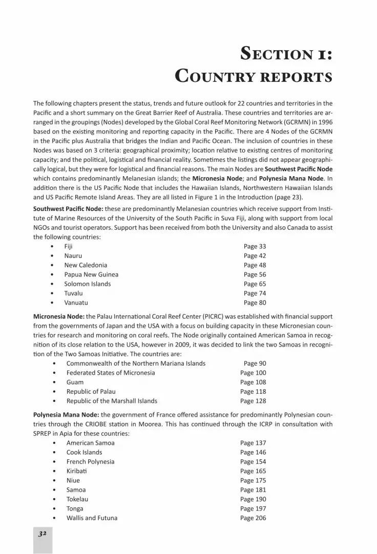
32
Section 1: country reportS
The following chapters present the status, trends and future outlook for 22 countries and territories in the Pacific and a short summary on the Great Barrier Reef of Australia. These countries and territories are ar-ranged in the groupings (Nodes) developed by the Global Coral Reef Monitoring Network (GCRMN) in 1996 based on the existing monitoring and reporting capacity in the Pacific. There are 4 Nodes of the GCRMN in the Pacific plus Australia that bridges the Indian and Pacific Ocean. The inclusion of countries in these Nodes was based on 3 criteria: geographical proximity; location relative to existing centres of monitoring capacity; and the political, logistical and financial reality. Sometimes the listings did not appear geographi-cally logical, but they were for logistical and financial reasons. The main Nodes are Southwest Pacific Node which contains predominantly Melanesian islands; the Micronesia Node; and Polynesia Mana Node. In addition there is the US Pacific Node that includes the Hawaiian Islands, Northwestern Hawaiian Islands and US Pacific Remote Island Areas. They are all listed in Figure 1 in the Introduction (page 23).
Southwest Pacific Node: these are predominantly Melanesian countries which receive support from Insti-tute of Marine Resources of the University of the South Pacific in Suva Fiji, along with support from local NGOs and tourist operators. Support has been received from both the University and also Canada to assist the following countries:
Fiji Page 33• Nauru Page 42• New Caledonia Page 48• Papua New Guinea Page 56• Solomon Islands Page 65• Tuvalu Page 74• Vanuatu Page 80•
Micronesia Node: the Palau International Coral Reef Center (PICRC) was established with financial support from the governments of Japan and the USA with a focus on building capacity in these Micronesian coun-tries for research and monitoring on coral reefs. The Node originally contained American Samoa in recog-nition of its close relation to the USA, however in 2009, it was decided to link the two Samoas in recogni-tion of the Two Samoas Initiative. The countries are:
Commonwealth of the Northern Mariana Islands Page 90• Federated States of Micronesia Page 100• Guam Page 108• Republic of Palau Page 118• Republic of the Marshall Islands Page 128•
Polynesia Mana Node: the government of France offered assistance for predominantly Polynesian coun-tries through the CRIOBE station in Moorea. This has continued through the ICRP in consultation with SPREP in Apia for these countries:
American Samoa Page 137• Cook Islands Page 146• French Polynesia Page 154• Kiribati Page 165• Niue Page 175• Samoa Page 181• Tokelau Page 190• Tonga Page 197• Wallis and Futuna Page 206•
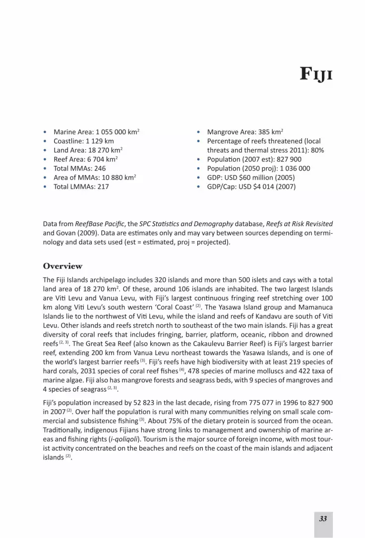
33
Fiji
• Marine Area: 1 055 000 km2
• Coastline: 1 129 km• Land Area: 18 270 km2
• Reef Area: 6 704 km2
• Total MMAs: 246• Area of MMAs: 10 880 km2
• Total LMMAs: 217
• Mangrove Area: 385 km2
• Percentage of reefs threatened (local threats and thermal stress 2011): 80%
• Population(2007est):827900• Population(2050proj):1036000• GDP: USD $60 million (2005)• GDP/Cap: USD $4 014 (2007)
Data from ReefBase Pacific, the SPC Statistics and Demography database, Reefs at Risk Revisited andGovan(2009).Dataareestimatesonlyandmayvarybetweensourcesdependingontermi-nologyanddatasetsused(est=estimated,proj=projected).
OverviewTheFijiIslandsarchipelagoincludes320islandsandmorethan500isletsandcayswithatotalland area of 18 270 km2.Ofthese,around106islandsareinhabited.ThetwolargestIslandsareVitiLevuandVanuaLevu,withFiji’s largestcontinuous fringing reef stretchingover100kmalongVitiLevu’ssouthwestern‘CoralCoast’ (2).TheYasawaIslandgroupandMamanucaIslandslietothenorthwestofVitiLevu,whiletheislandandreefsofKandavuaresouthofVitiLevu.Otherislandsandreefsstretchnorthtosoutheastofthetwomainislands.Fijihasagreatdiversityofcoralreefsthat includesfringing,barrier,platform,oceanic,ribbonanddrownedreefs (2, 3).TheGreatSeaReef(alsoknownastheCakaulevuBarrierReef)isFiji’slargestbarrierreef,extending200kmfromVanuaLevunortheasttowardstheYasawaIslands,andisoneoftheworld’slargestbarrierreefs (3).Fiji’sreefshavehighbiodiversitywithatleast219speciesofhardcorals,2031speciesofcoralreeffishes (4), 478 species of marine molluscs and 422 taxa of marinealgae.Fijialsohasmangroveforestsandseagrassbeds,with9speciesofmangrovesand4 species of seagrass (2, 3).
Fiji’spopulationincreasedby52823inthelastdecade,risingfrom775077in1996to827900in 2007 (2).Overhalfthepopulationisruralwithmanycommunitiesrelyingonsmallscalecom-mercialandsubsistencefishing (3).About75%ofthedietaryproteinissourcedfromtheocean.Traditionally,indigenousFijianshavestronglinkstomanagementandownershipofmarinear-easandfishingrights(i-qoliqoli).Tourismisthemajorsourceofforeignincome,withmosttour-istactivityconcentratedonthebeachesandreefsonthecoastofthemainislandsandadjacentislands (2).

34
Status, health and resilience of coral reefsFiji’s reefshavea richhistoryofmonitoring throughmanyprojectsbyvariousorganisationsandinstitutions.TheUniversityoftheSouthPacific(USP)hascollectedconsiderabledata,andhasco-coordinatedtheGlobalCoralReefMonitoringNetwork(GCRMN)NodefortheSouthWestPacificsince1999,inpartnershipwithMarineEcologyConsulting,FijiLtd.(2). Regular moni-toringismaintainedthroughavolunteernetworkconsistingmostlyofaprivatesectorconsul-tancyanddivetourismoperators,andtheFijiLocallyManagedMarineAreaNetwork(FLMMA);thesedataarereportedhere.Long-termmonitoringsurveysestablishedin1999usePointIn-terceptTransects(PIT)andBeltTransects(BT).Thereare13corelocationsthataremonitoredannually,aswellasothersitessurveyedopportunistically.Moredetailedsurveymethodsde-velopedbytheAustralianInstituteofMarineScienceareemployedonsomesitestocollectde-taileddataoncoralcommunitiesandfishpopulations.Anetworkofwatertemperatureloggerswasdeployedin1996,andby2006hadexpandedtoinclude15loggersinvariouslocations (2).
Fiji’s reefshaveanaverage live coral coverof45% (range8% to60%).Monitoringbetween1997and2007showedconsiderablevariability incoralcover,reflectingthediversityofFiji’sreefsbetweendifferentareas,andchangesovertimeduetoepisodicdisturbances (2).However,therewasaclearsignalofdecliningcoralcoverbetween1999and2001atthescaleofallsur-veyedsites,followedbyrelativelyrapidrecoveryto2007 (2).Warmwatertemperaturesin2000resultedinmortalityof40%to80%ofhardcorals;therewascoralbleachingin2002and2006,althoughtheseeventsweremorelocalisedandlesssevere.Analysisofwatertemperatureandcoralcovershowedableaching‘threshold’whereexposureofcoralstotemperature>29oC for morethan60consecutivedaysleadstocoralbleaching (2, 3). Much of the decline in hard coral coverisattributedtodeclinesoffastergrowingAcroporacorals.However,therapidrecolonisa-tionandgrowthofacroporid coralsonaffectedreefshasledtoincreasinghardcoralcoverinsomelocationsthatreachedpre-disturbancelevelsby2007(Fig.1),withsomesitesshowing80%livecoralcoverby2006.ThisrecoveryindicatedthatFiji’sreefsareinrelativelygoodcondi-tionandexhibitstrongresilience (2).
Fiji’scoralreefsarealsoaffectedbycrown-of-thornsseastars(COTS)andDrupella snails,whichfromtimetotimereachhighpopulationdensitiesandcanconsumelargeamountsoflivecoral.
© E
ric C
lua

35
TherehasbeenaslightincreaseinCOTSdensitybetween2002and2007,withlocalisedout-breaks of COTS recorded in 2005-2006. A COTS control program at dive sites in the Mamanuca IslandsshowsadecreasingtrendinCOTSnumbersbetween2006and2007;thiscouldbeduetothesuccessofactiveCOTScontrolmeasures.Interestingly,whilevillageeldersrecallanin-tensiveCOTSoutbreakduringthe1920sand1930s,theyperceivethatCOTSoutbreakshavebecomemorefrequentinrecentyears (3).CorallineLethalOrangeDiseasewasobservedafterthebleachingeventof2000buthasbeenseenlessfrequentlysince (3).Whitesyndromedis-easewasalsoreportedin2007.CyclonesalsoaffectFiji’scoralreefswithcyclonesin2001and2004causinglocaliseddamage.Overall,thetrendincoralcoveronFiji’scoralreefsoverthelastdecadeisdominatedbytheeffectsof,andrecoveryfrom,the2000coralbleachingevent,withdamagebyCOTS,Drupella,cyclonesandotherfactorsbeinglocalisedtospecificareasatspecifictimes.However,thereareindicationsthatsomereefs,particularlyfringingreefsandreefflats,arebeingaffectedbyland-basedpollution,leadingtoeutrophicationandphaseshiftsfromcoraldominatedtoalgaldominatedsystems (2, 3).
Surveysoffishpopulationsbetween2000and2007showednoobvioustrendsovertime.Somefish species, particularly those dependent on specific coral communities, declined after the2000 coral bleaching event, but their numbers appear to have recovered (2).Exceptforasuddenincreaseinthedensityofsnappersin2006duetoaverylargeschoolappearingatonesite,surveysshowedthatnumbersoflargefoodfish(wrasse,largeparrotfish,groupers,sweetlips)werelow,particularlyatsitesnearvillagessuggestingsignificantlocalfishingdepletion (2). There isalsoanecdotalevidenceofdeclinesinlargepelagicfishessuchastuna,mackerelandsharks,potentiallyduetofishingbylargercommercialfishingvessels,particularlylong-linevessels (3). Thenumberofseacucumbersandgiantclamswasalsolowclosetovillages (2, 3).
Fig . 1. Average coral cover across core survey sites at 2 depths. There is a clear trend showing a decline in coral cover in 2000-2001 resulting from coral bleaching and COTS outbreaks, followed by recovery. The trend line is a polynomial statistical analysis showing trends in coral cover. The number of monitoring sites is shown in parentheses below the year (from Morris and Mackay 2008 (1)).
Status of coral reefs – STABLE (high confidence)There is good information about some of Fiji’s coral reefs. Long-term sur-
veys from many sites show that, while reefs are affected by a variety of disturbance events, live coral cover has been increasing to pre-disturbance levels, suggesting relatively stable coral cover over the long-term. There is little evidence of widespread and prolonged stress, damage, or loss of coral cover at the reefs surveyed.

36
Coral reef health and resilience – EVIDENCE OF CHANGE (medium confidence)Good, long-term information on Fiji’s coral reefs shows rapid recovery (within
5 years) from significant declines in coral cover, indicating strong resilience. Reefs appear to be rela-tively intact with little evidence of widespread, long-term changes in reef communities or processes. However, some coastal fringing reefs are exhibiting signs of degradation, potentially due to impacts from land-based pollution. Reefs near to villages also showed low numbers of exploited species.
Use of reef resourcesMorethanhalfofFiji’spopulationisrural,withmanycommunitiesdependentonmarinere-sources.TheInstituteofAppliedScienceattheUSPhascompletedsocioeconomicsurveysat29locationsshowingthatvillagesaveraged312peoplein54households,averagingmorethan5perhousehold.AveragevillagemonthlyincomewasFJD$636(USD$400)mainlyfromsellingrootcrops(kava,yaqona,taro,etc.),marineresources(fish,seacucumbers),andotherpaidemployment (2).Mosthouseholdsharvestmarineresourcesfordomesticconsumptionwithasmallamountsold,whileasmallproportionofthecommunitiesarecommercialfishers.Menusenetsandspearstofishwhilewomenusenetsandfishinglines,andalsogleanthereef.Nearshorecoralreefsarethemostheavilyexploitedwithsurveysrevealing lownumbersoffoodfishandinvertebrates.Morerecently,theInstituteofAppliedScienceandFLMMAintroducedalogbookforfishingcommunitiesin60villages.ThedatashowthatnearshorefisheriesinFijiare threatened (5).Ofthetwomostcommontargetfish,74%and88%ofindividualfishestakenwerebelowsizeofmaturity,meaningthattheyhadnotspawnedbeforebeingremovedfromthereef.Additionally,thesefisheriesarebecomingincreasinglycommercializedwith70%ofthecatchoffishandinvertebratessold (5).Growingpopulationsandimprovedfishingtechnologyareleadingtoincreasingpressureonfishstocks (2).
Intermsoftrade,commercialfisheriesareFiji’s4thlargestexportindustryaftertourism,gar-ments and sugar (3). Fresh tuna and trade in trochus shells (Trochus niloticus) are the highest sourcesofforeigncurrencyfromfishing.Fijialsohasanactiveaquariumtrade industrythatexportssmallfish,invertebrates,coralsand‘liverock’(coralrubbleusedinaquaria)collectedmainly fromthecoastofVitiLevu (2, 3, 6).Thetrade issubjecttotheCITESconvention,and ismonitoredandassessedbytheFijiMinistryofPrimaryIndustries.Fortunately,destructivefish-ingpractices(bomb,cyanide,otherfishpoisons)arerarelyusedinFiji (2, 3), although the tradi-tionalplantbasedpoisonextractedfromthe‘Duva’or‘Derris’vineisstillusedtostunfishinrock pools (2, 3).
The UNEP/SOPAC Environmental Vulnerability Index (7)indicatesthatfishingposessomerisktoFiji’smarineresources.ThePacific Ocean Synthesis Report (6) also indicates that commercial andsubsistencefishingmayposeseverethreatstoFiji,andthatcollectingfortheaquariumtrademayposeamoderaterisk.
Tourism is Fiji’smainearnerof foreign currency, and the largestnon-extractiveuseof coralreefs.In2004,morethan438000touristsvisitedFiji (6)with75%oftheseparticipatinginsomeformofmarineactivity (2).Surveysin2005showedthat12%oftouristsdivedwithSCUBAwhile,60%snorkelledduringtheirstay.RecentestimatesarethattourismgeneratesFD$212million(USD$115million)annually (6).TheeconomicvalueofmarineresourceusebytouristsmaybeworthbetweenFD$74million(USD$40million)andFD$335million(USD$181million)ayear,orequivalent toFD$171-778pervisitorperyear (basedon2003Touristdata) (8). The main island,VitiLevu,catersformosttourists,buttherearemanyresortsonsmallerislandsintheMamanucaandYasawaislandgroups.ManyresortsandtourismoperationsinFijiappeartobeworkingtowardsimprovingtheirsustainabilitywithallFijiIslandsHotelAssociationmembers

37
nowworkingtowardsTourismFiji’s‘GreenMe’policy.TheUNEP/SOPAC assessment (7) indicates thattourismdoesnotappeartoposearisktoFiji’smarineresources.
Use of reef resources – EVIDENCE OF CHANGE (medium confidence)There is some information available that suggests that human use of Fiji’s cor-
al reefs has depleted some resources, and may threaten the long-term sustainability of these extractive activities. The activities of most concern include subsistence and commercial fishing, and potentially collecting for the marine aquarium trade.
Factors affecting reef health and conditionThe vulnerability of Fiji’s coral reefs to external pressureshasbeenassessed in a varietyofways.The2011globalReefsatRiskRevisitedassessmentestimatesthatabouthalfofFiji’sreefsareunderpressurefromfishingandwatershedpollution(sediment,nutrientsandotherland-basedpollutants),anda thirdofFiji’s reefsare threatenedby impactsassociatedbycoastaldevelopment.ArefinedReefsatRiskassessmentfor15locationsinFijibasedonananalysisoflocalthreats,includingcoastaldevelopment,pollution,sediment,overfishing,anddestructivefishing(Table1)suggeststhatlandbasedpollutionandoverfishingarethemainlocalthreatsfacingFiji’sreefs,withthemainislands,VitiLevuandVanuaLevu,beingunderthemostpres-sure (2).FringingreefsontheseislandsincludingtheCoralCoasthavebeenaffectedbyeutrophi-cationcausedbysedimentandnutrientrunoff,probablyassociatedwithagriculture,especiallysugar cane (2, 3).Thesefactorsmaybedrivingtheshiftfromcoral-dominatedtoalgal-dominatedreefsintheseareas,aswellasseasonalalgalbloomsintheMamanucaandYasawaIslands (2). ThesethreatsarealsoidentifiedinthePacific Ocean Synthesis Report 2009 (6).Asmentionedabove,Fiji’scoralreefsarealsoaffectedbycyclones,outbreaksofCOTSandwarmwaterlead-ingtocoralbleachingevents.TsunamishavenotcausedmajordamagetocoralreefsinFijiinrecentyears.
Table 1. An integrated threat index for 15 regions in Fiji (from Sykes and Morris 2009).
INTEGRATED THREAT INDEX
Reef AreaCoastal
DevelopmentPollution
SedimentDamage
Over-fishingDestructive
FishingOverall Threat
Index Score
VitiLevu,Suva Medium VeryHigh High High Medium VeryHighVitiLevu,CoralCoast Medium Medium High High High HighVitiLevu,MomiBay Medium High High High Medium HighVitiLevu,Lautoka Medium VeryHigh High High Medium VeryHighVanua Levu, Savusavu Medium VeryHigh High High Medium VeryHighVanua Levu, Namena VeryLow VeryLow Medium Low VeryLow MediumVatu-i-Ra VeryLow VeryLow VeryLow Low VeryLow LowLomaiviti Low VeryLow Medium Medium Low MediumKadavu Low VeryLow Medium High Low MediumBeqa Low VeryLow Medium High Low HighMamanucaIs Low Medium Medium High Low HighYasawaIs Low Low Medium High Medium HighTaveuni, Somosomo VeryLow Low VeryLow Low VeryLow LowTaveuni, Waitabu Low VeryLow Medium Low VeryLow MediumRotuma Low High Medium High Medium High

38
FijiisexpectedtoexperiencesignificantpopulationgrowthwhichposesriskstoFiji’sreefs.TheUNEP/SOPAC 2005assessment listedFiji’senvironmentasHighly Vulnerable,mainlyduetofactorsassociatedwith the land-basedpollutionand runoff,populationgrowthanddensity,and coastal development. This assessment also noted that spills of oils or other toxins, and the volumeof international trade (which createspotential for introducing invasive species) alsopresent risks toFiji’smarineenvironment.The2011ReefsatRiskRevisitedassessmentalsonotesthatmanyofFiji’sreefsareprojectedtobethreatenedbywarmwatereventsandoceanacidification.By2030,allFijianreefsareestimatedtobethreatenedbyacombinationoflocalandglobalpressures,withsealevelrisebeingapotentialissuefortheislandsandparticularlyforFiji’smangroves (6).
Factors affecting coral reefs – EVIDENCE OF CHANGE (medium confidence)Changes have already occurred in some reef areas of Fiji, based on available
information on the many risks and their effects; some of these risks are increasing. The main factors are pollution and runoff from land-based sources, coastal development, with increasing pressure from population growth and the potential effects of climate change.
Governance and management FijihasanumberoflegislativemeasuressuchastheFisheries Act (1996) and the Environment Management Act (2005),whichareadministeredbytheDepartmentofFisheriesandtheDe-partmentofEnvironmentrespectively (2).FijiisalsoasignatorytotheConventiononInterna-tionalTradeinEndangeredSpecies(CITES)andtheConventiononBiologicalDiversity,andman-agementandplanninginstrumentsareinplacetohelpFijimeetitsinternationalobligations.TheNationalBiodiversityStrategyandActionPlan forms thebasis for futureenvironmentalprotection (2).Therearealso legislativeactsand impactassessmentprocessestocontrolandmonitorpollutionfromdevelopmentandports (3).
Fijihasmadeacommitmentthatby2020,30%ofthemarineenvironmentwithinitsEEZwillbeincludedinacomprehensiveandecologicallyrepresentativenetworkofMarineProtectedAr-eas(MPAs)thatiseffectivelymanagedandenforced (2). Nevertheless, much of the actual man-
agement of marine areas and coral reefs is implemented through Lo-callyManagedMarineAreas (LM-MAs) or community-based man-agement, with increasing interestand growth in community-basedmanagement of marine areas in the last decade (9). Currently, Fijihas 410 i qoliqoli areas(traditionalfisheries management areas) thattogether cover about 28 588 km2
(9). There are also 217 tabu areas whichareanotherformofLMMA,205ofwhicharewithin114ofthei qoliqoli. LMMAs in Fiji cover 10816 km2andhaveanaveragesizeof 9.6 km2 (2, 9), and have a range of restrictionsfromno-taketospeciesspecific and seasonal closures (2).
© Eric Clua

39
Reefs at Risk Revisited (10): Fiji
The Reefs at Risk Revisited analysisshowsthatcurrently,Fiji’scoralreefsaremostthreatenedbyoverfishingandthe impactsof landbasedsedimentandpollution,whichthreatenabouthalfofFiji’scoralreefs.CoastaldevelopmentthreatensaboutathirdofFiji’scoralreefs.ThereefsaroundthetwomainislandsofVitiLevuandVanuaLevu,andthoseintheYasawaIslandsare assessed as being most at risk (see map). When the recent impacts of thermal stress and coralbleachingoverthepast10yearsareintegratedwithlocalrisks,almost80%ofFiji’sreefsareconsideredatrisk.Futureprojectionsofthermalstressandoceanacidification(basedonabusiness-as-usualscenario)andlocalpressuresarethatby2030allofFiji’sreefswillbethreat-ened.Thefullreport,methodsandfullsizemapsareon:http://www.wri.org/reefs.

40
Altogether,Fiji’sLMMAshave593km2protectedasno-takezones (9). The 217 LMMAs are part oftheFLMMAnetwork,whichisworkingtowardsimprovingcoordinationoftheseareas.WhiletheLMMAsarenotformallyrecognisedthroughlegislation,171havemanagementplansthatcouldbeclassedasCommunityConservationAreas (9).Governmentrecognitionofi qoliqoli is limited,butmanyLMMAsarerecognisedbylocalcouncilsandtraditionalleaders (2).Inmanycases,thecommunityperceivesbenefitsfromLMMAs,andthesecommunity-basedmanage-ment systemshave resulted inhabitat recovery, increases inexploitedfishand invertebratepopulationsandimprovedeconomicconditionssuchasinWaitabu (9) and Navakavu (6). Unfor-tunately,thereislittleformalsupportandintegrationofLMMAsintonationalprotectionmea-suresandthisisacontentiousissue.TheQoliqoli Billwasoneofthefactorsleadinguptothe2006militarycoup (9);theunstablepoliticalsituationhasslowedprogressinFiji’senvironmentalmanagement. Reefs at Risk Revisiteddataestimatethatofthe32%ofFiji’sreefsthatarepro-tected,managementiseffectivefor0.3%ofreefs,partiallyeffectivefor21%,noteffectivefor0.2%,witheffectivenesslevelsunknownfortheremaining11%.IllegalfishingmaybeaprobleminpartsofFiji,andtherearelimitedresourcesandcapacityforenforcementoffisheriesregula-tions (6).
Governance and management – EVIDENCE OF CHANGE (low confidence)While Fiji has a number of national planning and legislative acts, most man-
agement appears to be implemented through local community-based management. The growing num-ber of LMMAs is a positive sign, as are efforts to improve coordination and to formalise these arrange-ments; however, there are ongoing challenges to management. Some LMMAs are perceived to be delivering benefits to the reefs and local communities. Reefs at Risk Revisited 2011 data suggest that management is partially effective in many managed areas. However, there are few detailed data on the effectiveness and enforcement of existing management arrangements, or their adequacy in protecting coral reef ecosystems and sustaining reef resources.
References (Fiji)1. MorrisC,MackayK(2008).Status of the coral reefs in the south west Pacific: Fiji, New Caledonia, Sa-
moa, Solomon Islands, Tuvalu and Vanuatu. InWilkinsonC(ed)Status of the coral reefs of the world: 2008.GlobalCoralReefMonitoringNetworkandReefandRainforestResearchCentre:Townsville,p298.www.gcrmn.org/status2008.aspx.
2. SykesH,MorrisC (2009).Status of Coral Reefs in the Fiji Islands. InWhippy-MorrisC (ed),South-west Pacific Status of Coral Reefs report 2007.CRISP,SecretariatofthePacificRegionalEnvironmentProgram:Noumea.www.crisponline.net/CRISPPRODUCTS/Reefknowledgeandmonitoring/tabid/311/Default.aspx.
3. LovellE,SykesH(2007).Fiji. In Sulu R (ed) Status of Coral Reefs in the SouthWest Pacific 2004. IPSPublications,UniversityoftheSouthPacific:Fiji.
4. SeetoJ,BaldwinWJ(2010).A Checklist of the Fishes of Fiji and a Bibliography of Fijian Fishes. Division of Marine Studies Technical Report 1/2010,Suva,Fiji:TheUniversityoftheSouthPacific,102p.
5. ComleyJ(2008).Village based catch survey in Fiji.InReef fisheries management in the pacific, success stories, ICRI/CRISP/SPC: Noumea. www.crisponline.net/CRISPPRODUCTS/Integratedcoastalmanage-ment/tabid/312/Default.aspx.
6. CaldwellM,ChurcherHoffmannT,PalumbiS,TeischJ,TuC(2009).Pacific Ocean Synthesis: Scientific literature review of coastal and ocean threats, impacts and solutions, California: The Woods Center for theEnvironment,StanfordUniversity,170p.http://www.centerforoceansolutions.org/PacificSynthe-sis.pdf.

41
7. UNEP/SOPAC(2005).Environmental Vulnerability Index - Fiji. UnitedNationsEnvironmentProgram/PacificIslandsAppliedGeoscienceCommission.www.vulnerabilityindex.net/
8. Korovulavula I,O’GarraT, FongP,RatuniataR (2008).Economic Valuation Iqoliqoli - Tourism study support,Noumea:CRISP/SPREP/USP.www.crisponline.net/CRISPPRODUCTS/Economicsandsocioeco-nomicsofcoralreefs/tabid/309/Default.aspx.
9. Govan H (2009). Status and potential of locally-managed marine areas in the South Pacific: meeting nature conservation and sustainable livelihood targets through wide-spread implementation of LM-MAs,Noumea:SPREP/WWF/WorldFish-Reefbase/CRISP,95p.www.crisponline.net/CRISPPRODUCTS/Economicsandsocioeconomicsofcoralreefs/tabid/309/Default.aspx.
10.BurkeL,ReytarK,SpaldingMet al. (2011). Reefs at Risk Revisited, Washington DC: World Resources Institute,114p.http://www.wri.org/project/reefs-at-risk.

42
Nauru
• Marine Area: 300 000 km2
• Coastline: 19 km• Land Area: 21 km2
• Reef Area: 10 km2
• Total MPAs: None• Mangrove Area: 1 km2
• Percentage of reefs threatened (local threats and thermal stress 2011): 100%
• Population (2006 est): 9 233 • Population (2050 proj): 16 280 • Population growth (annual): 2.3% (1)
• Urban population (2003): 100% (2)
• GDP: USD $60 million (2005)• GDP/Cap: USD $5 000 (2007)
Data from ReefBase Pacific, Reefs at Risk Revisited 2011 and the SPC Statistics and Demog-raphy database unless indicated with a reference number. Data are estimates only and may vary between sources depending on terminology and data sets used (est = estimate, proj = projected).
OverviewThe country of Nauru consists of a single raised atoll island with a circumference of 19 km and a total land area of 21 km2. The island is an ancient submerged volcano with a central plateau that forms 80% of the island. The remaining land area consists of a flat coastal terrace 300-1000 m wide, with a mean elevation of about 3 m above sea level. Nauru has no permanent freshwater and limited arable land. All land is held by private tenure with no public lands. The population density of 593 persons/km2 is one of the highest of the Pacific islands. While it is a small island, Nauru has a very large EEZ of some 300,000 km2, however the EEZ boundaries with Kiribati and the Marshall Islands have not been fully resolved. Nauru has approximately 10 km2 of coral reef area and 1 km2 of mangrove forest.
The oceanic fishery within this EEZ, specifically the access to revenue from foreign tuna vessels fishing, is the mainstay of the Nauru economy. Nauru is a Party to the Nauru Agreement (PNA) which aims to implement sustainable and precautionary transboundary management for this fishery (4). Nauru’s reef fisheries are minuscule by comparison as there is no real lagoon, but the reef and nearshore fisheries are extremely important in local subsistence nutrition.
The island had extensive phosphate deposits that have supported significant mining opera-tions since 1906. Mining led to increasing affluence in the local community up to the mid 1990s when a decline in phosphate prices and financial pressures led to the collapse of the economy in 1999 (5). Phosphate prices increased in 2007, leading to a limited resumption of mining, and a degree of economic recovery. However, phosphate mining has significantly altered the cen-tral plateau, leading to widespread losses and changes of vegetation and topsoil over 70% of the land area (5). Since the economic collapse of 1999, subsistence fishing and agriculture have become increasingly important. Nauru is critically dependent on supplies from other countries, particularly Australia (5).

43
Status, health and resilience of coral reefsIn March 2000, a snorkeling, dive and manta tow survey covered 50% of the reef and showed relatively low coral diversity, with 80% of coral growth being Pocillopora, Montipora and Acrop-ora species (6). The highest coral cover was found on the northern side of the island while the western side had less coral and more algae. The north-east side, which is subject to strong hydrodynamic conditions, had the lowest coral cover and the substrate was dominated by sand and coral rubble (6).
In 2004, the Nauru Coral Reef Monitoring Network started monitoring using funding and sup-port from the Institute of Marine Resources at the University of the South Pacific and the Can-ada-South Pacific Ocean Development fund (7). Live coral cover at 7 sites ranged from 44% to 78% in 2004. In general, most reefs show high coral cover, although sites near coastal devel-opments (Nibok and Yaren) show a higher percentage of dead corals and algal growth (7). The 2004 surveys found the lowest abundance of finfish at Anibare Bay, a popular site for fishing, swimming and reef gleaning (7). The UNEP/SOPAC Environmental Vulnerability Index indicates that Nauru’s aquatic environments are at high risk due to disruptions in marine communities caused by fishing (8).
The SPC COFISH project survey in 2005, and a subsequent aquarium fishery assessment with COFISH methodology, also estimated coral cover and substrate type at numerous stations around the reef, and produced very detailed ‘snapshots’ of the abundance, density, size and species composition of reef fish and invertebrates (1).
Status of coral reefs – NOT CONSIDEREDStudies have not included sufficient information to identify trends in reef status. While initial baseline information has been collected, more information is needed to determine the status of these reefs.
Coral reef health and resilience – NOT CONSIDEREDSimilarly there is insufficient information to describe trends in reef health and resilience. Additionally, there is no information on long-term cycles of disturbance and recovery, community structure and composition, or about reef processes, to adequately assess the health and resilience of these reefs.
Use of reef resourcesThe main use of reef resources is through subsistence fishing, which has become increasingly important to Nauruans since the late 1990s. Fishing was also important to foreign mine workers in recent decades until these workers departed in 2007-2008 (T. Adams pers. comm.). People have a high consumption of fish (> 46 kg per person/year) (5), and fish are a vital source of pro-tein (9). Subsistence fishing is concentrated on the 50-300 m wide belt of coral reef around the island, and has significantly increased in recent years. Extensive social and economic surveys in 2005 showed an average of 3.7 fishers per household, with half the population being active fishers (5). In 2005, about 420 tonnes of fish and 230 tonnes of invertebrates were harvested (5). Harvested species include a variety of finfish, crustaceans, octopus, shellfish, sea cucumbers and other invertebrates, and algae. Most of the fish taken are for personal or family consump-tion and little is resold. Fishing patterns are changing with women, men and children all increas-ingly fishing. All sizes of fish are consumed, and a much wider range of species is now being harvested (5, 9). Significant local SCUBA spearfishing began in the 1980s with noticeable effects on fish stocks (T. Adams pers. comm.)

44
There is little information on the status of reef fish stocks, but surveys in 1994 and 2005 com-bined with daily catch sampling by the Nauru Fisheries and Marine Resources Authority (NF-MRA) indicate declines in fish stocks. The average size of fish also appears to be decreasing and the use of SCUBA, especially at night, is a significant concern (5). Species showing evidence of over-exploitation include shallow-water snapper (Lutjanidae), rock cod and grouper (Ser-ranidae), and coral trout (Plectropomus spp.), squirrelfish and soldierfish (Holocentridae), lined bristletooth (Acanthuridae) and large moray eels. Daily reef gleaning activities have led to over-exploitation of turban shell (or emwari), lobster and octopus (5). Anecdotal reports sug-gest declining catches and fishers having to walk further to find fish (9). Giant clams appear to have disappeared during the 1980s, and other commercially valuable invertebrates such as sea cucumbers were at low densities. Anecdotal evidence also suggests declines in lobster (5).
There is a small scale, nearshore fishery for tuna that involves local fishermen in powered skiffs who troll for skipjack and yellowfin tuna. Three fish attracting devices (FADs) have been main-tained since 2005 to assist local fishermen increase their income during the economic down-turn. However, increases in fuel costs prevented some fishers, except those fishing from canoes, from using these FADs. This has reduced the amount of pelagic fish available for local consump-tion (1, 5).
Use of reef resources – ALTERED (medium confidence)While there are few trend data on catch and effort, and no fishery stock as-
sessments, the 2005 socio-economic surveys covered a significant part of the population (1). Ecological surveys suggest significant declines in targeted species from reef resource use, and patterns of resource use have changed, increasing pressure on Nauru’s coral reefs.
Other factors affecting coral reefsThere is insufficient information on the stresses affecting Nauru’s coral reefs to assess threats and effects (10). Available information suggests that phosphate dust from phosphate mining has damaged corals near the main phosphate crushing and loading areas (7). Reefs appear to be af-fected by effluent from sewerage and desalination plants, with little live coral near these sites (7). The development of the airport and the Anibare boat harbour also damaged the reefs (5, 7). There are anecdotal reports of significant coral bleaching during 1997/1998, and island wide bleach-ing was observed again in 2003 (7). The UNEP/SOPAC Environmental Vulnerability Index rates Nauru’s environment as being extremely vulnerable due to weather and climate change, small size and isolation, mining, vehicles, population density and population growth, and resource ex-ploitation. Nauru’s isolation will result in reduced recruitment of corals, fishes and invertebrates from other areas, increasing the vulnerability of resources to intensive exploitation (5) and dis-turbances. Because 39% of the population is under 19 there is significant potential for increased demand for land and resources. The coastal strip is low lying and potentially susceptible to sea level rise (10). The Reefs at Risk Revisited report notes that marine-based pollution is a threat in Nauru, and rates Nauruan reefs as highly threatened with up to 80% of Nauru’s reefs predicted to be at a critical state by 2030.

45
Factors affecting coral reefs – ALTERED (low confidence)Information on trends in risk factors and their effects suggest that changes
have occurred, and Nauru’s small size makes localised impacts nationally significant. However, this information is patchy and anecdotal. Nevertheless, Nauru is exposed to numerous threats that can po-tentially alter the reefs, and there is clear evidence of increasing pressures from growing populations.
Governance and Management Nauru’s inshore marine resources are open access and there are no customary or community management regimes (5, 7). Unlike oceanic fisheries legislation, NFMRA has inadequate legis-lation to protect and manage coastal marine resources since the repeal of the 1978 Marine Resources Act. There are plans, based on extensive consultations with each District to develop community-based fisheries and ecosystem management. There are no MPAs in Nauru, but the government has plans for their development within the next 5 years with assistance from the Global Environment Facility (11).
Governance and management – ALTERED (medium confidence)While coastal management is currently under development, there are no
indications that management had been finalized or implemented. Management faces serious chal-lenges due to inadequate legislation, finances and capacity.

46
Reefs at Risk Revisited (12): Nauru
The Reefs at Risk Revisited analysis shows that Nauru’s coral reefs are severely threatened, with the majority of the reefs at high risk due to overfishing and coastal development, with marine based pollution being an additional threat. When the local threats are combined, 100% of Nauru’s reefs are threatened. By 2030, projections for the effects of thermal stress and ocean acidification together with local threats suggest that all of Nauru’s coral reefs will be threat-ened, and up to 80% of reefs in a critical state. The full report, methods and full size maps are on: http://www.wri.org/reefs.

47
References (Nauru)
1. PROCFish/C and CoFish Team (2007). Pacific Regional Coastal Fisheries Development Programme (CoFish) Nauru Country Report: profile and results from in-country survey work (October and Novem-ber 2005), Noumea, New Caledonia: Secretariat of the Pacific Community, 151 p. http://www.spc.int/DigitalLibrary/Doc/FAME/Reports/PROCFish/PROCFish_2008_NauruReport.pdf.
2. Govan H (2009). Status and potential of locally-managed marine areas in the South Pacific: meet-ing nature conservation and sustainable livelihood targets through wide-spread implementation of LMMAs, Noumea: SPREP/WWF/WorldFish-ReefBase/CRISP, 95 p. http://www.crisponline.net/CRISP-PRODUCTS/Economicsandsocioeconomicsofcoralreefs/tabid/309/Default.aspx.
3. United Nations Economic and Social Commission for Asia and the Pacific (2006). State of the Environ-ment Asia and the Pacific 2005, Bangkok: United Nations. http://www.unescap.org/esd/environment/soe/2005/mainpub/
4. Adams T (2011). Pacific Islands: new bold steps, in SAMUDRA Report, No. 58, March 2011, K.G. Kumar, (ed), International Collective in Support of Fishworkers: Chennai, India, p 56. http://icsf.net/icsf2006/uploads/publications/samudra/pdf/english/issue_58/art05.pdf.
5. Vunisea A, Pinca S, Friedman K et al. (2008). Nauru country report: profile and results from in-country survey work, Noumea, 68 pp. http://www.spc.int/coastfish/Countries/nauru/nfmra/information.htm.
6. Jacob P (2000). The status of marine resources and coral reefs of Nauru, Noumea, New Caledonia: Coral reefs in the Pacific: status and monitoring, resources and management, ICRI - International Coral Reef Initiative, Regional Symposium. http://www.spc.int/coastfish/Countries/nauru/nfmra/informa-tion.htm.
7. Deiye M (2007). Nauru, in Status of Coral Reefs in the SouthWest Pacific 2004, R. Sulu, (ed), IPS Publica-tions, University of the South Pacific: Fiji.
8. UNEP/SOPAC (2005). Environmental Vulnerability Index. United Nations Environment Programme/Pa-cific Islands Applied Geoscience Commission. http://www.vulnerabilityindex.net/
9. Vunisea A (2007). Fishing to sustain livelihoods in Nauru, in SPC Women in Fisheries Information 22 Bulletin #16 – March 2007, Secretariat of the Pacific Community, Noumea, New Caledonia. http://www.spc.int/coastfish/Countries/nauru/nfmra/information.htm.
10. Caldwell M, Churcher Hoffmann T, Palumbi S et al. (2009). Pacific Ocean Synthesis: Scientific literature review of coastal and ocean threats, impacts and solutions, California: The Woods Center for the Envi-ronment, Stanford University, 170 p. http://www.centerforoceansolutions.org/PacificSynthesis.pdf.
11. Anon (2009). Pacific Adaptation to Climate Change – Nauru, report of in country consultations: Global Environment Facility/UNEP/SPC, 31 p. http://www.sprep.org/publication/pein_nauru.asp
12. Burke L, Reytar K, Spalding M et al. (2011). Reefs at Risk Revisited, Washington DC: World Resources Institute, 114 p. http://www.wri.org/project/reefs-at-risk.

48
New CaledoNia
• Marine Area EEZ: 1 740 000 km2
• Shelf area: 46 257km2 (1)
• Coastline: 2 254 km (1)
• Land Area: 18 575 km2 • Reef Area: 7 284 km2 (2)
• Total MPAs: 13• Mangrove Area: 456 km2
• Reefs at Risk (local threats and thermal stress 2011): 57 %
• Population(2009est):245000• Population(2050proj):359000• Populationgrowth:1.5%(1)
• Urbanpopulation(2010):57%(3)
• GDP(2003est.):USD$3.1billion• GDP/Capita(2003est):USD$1500
Data mainly from ReefBase Pacific, Reefs at Risk Revisited, and the SPC Statistics and Demog-raphydatabase,unless indicatedwithareferencenumber.Dataareestimatesonlyandmayvarybetweensourcesdependingonterminologyanddatasetsused; (est=estimate,proj=projected).
OverviewThe New Caledonia Archipelago isdominated by the main island of Grande Terre and smaller islands and atolls to the north including the îles des Bélep, the D’Entrecasteaux Reefs, Huon Atoll and SurpriseAtoll;whichareallsurroundedbyreefs.TothesoutheastofGrandeTerre,theshelfcontinuestotheîledesPins.MostofNewCaledonia’s islandsandreefssitonashallowshelfplatformringedbytheworld’ssecond longest barrier reef (1 300 km long),whichenclosesalargelagoonabout40 000 km2 in area (2)withmany platformreefs. Fringing reefs are also widespreadinmanyareas.DueeastofGrandeTerreisthe low-lyingchainof theupliftedLoyaltyIslands that includes Maré, Lifou and Ou-
véaislandsandtheirreefs,andtothenorth,thesmallatollofBeautemps-BeaupréandtheAs-trolabeReefs.About550kilometerswestofGrandeTerrearetwoverylargeshallowreefareas;theChesterfieldIslandswhicharecoralcaysontheperimeterofalargeatoll(3500km2);andBellonaAtollwhichconsistsofshallowreefsandafewcoralislandsaroundtheperimeter (2).
NewCaledonia’spopulationisconcentratedinthesouthernprovinceofGrandeTerre(71%ofthepopulation),particularlyinNouméawith40%ofthepopulation (2).NewCaledoniaisamajorglobalsourceofnickelwhichaccountsfor90-95%ofNouméa’sexporttrade (2).
© E
ric C
lua

49
In July2008, the lagoonsofNewCaledoniawere listedontheUNESCOWorldHeritageList,covering an area of 15 743 km2thatincludes60%ofNewCaledonia’stotalreefarea.TheListingrecognizedtheoutstandingvalueanddiversityoftheLagoons,notingthatthesereefswereofglobalsignificancewithmanyspecies:350hardcorals;650othercnidarians(jellyfishandsoftcorals);1695fishes;841crustaceans;802molluscs;254echinoderms(starfish,seacucumbers,etc.);220ascidians(seasquirts);203worms;151sponges;14seasnakes;4turtles;and22ma-rine mammals (4).TheWorldHeritageAreaalsocontains9majorreeftypes,includingfringingreefs,singlereefbarrierreefs,veryraredoublebarrierreefs,atollswithlagoons,raisedatollsandcoralislets.Therearealsoextensivemangroveforests,andseagrassandalgalbeds,whichcontain 12 seagrass species and 322 recorded species of algae from 46 families (2, 5). Recentstudies conclude that New Caledonian waters include at least 401 species of scleractiniancorals (6).
Status, health and resilience of coral reefs RegularmonitoringofNewCaledonianreefsaspartoftheGCRMNbeganin1997usingmodi-fiedReefCheckmethods,focusingonsomereeffishspecies,commerciallyharvestedspecies,invertebrates(suchasgiantclams,trochus,lobsters)andsubstrateandcoraltype.SixstationsaroundNouméa,thecapitalcity,havebeenregularlysurveyedsince1997,withafurther24sta-tionsaroundNewCaledoniamonitoredsince2003;thecurrenttotalis31monitoringstationswithin10sites.Asof2006-2007,averagelivecoralcoveracrossthese10siteswas27% (2) (range
5-48%)withsomevariationbetweensites.Whilesomesiteshaveshownchangesincoralcoverovertimedueto the impacts of crown-of-thornsstarfish(COTS)andcyclones(i.e.Cy-clone Erica in 2003), coral cover and fish and invertebrate density haveremainedstableatmostsites.
Hard coral cover around Nouméa (1997 to 2007), has generally re-mainedrelativelystable(Fig.1).Cor-alsdeclinedattwostations(Ricaudyand Maitre) due to COTS, but by 2005coralcoverhadincreased.Fishdensities generally remained stablebut significantly increased in 2007(mainlybutterflyfishandparrotfish).Invertebrate density also showedsome increase in 2007 (2).
For the other 9 sites around NewCaledoniamonitoredbetween2003and 2007, overall live coral cover wassimilartothelong-termaveragewithmoststationsandsitesshowingstable trends.However, coral coverdecreased at Santal2, Hiengabat and DongaHienga,while it improvedatQanono and Récif Intérieur (2).
Fig. 1. Coral cover and the density of targeted fish species has remained relatively stable at sites around Nouméa. How-ever, fish density increased in 2007. Figure from Wantiez et al. 2009.

50
ARapidBiodiversitySurveyofreefsinthenorthernprovincefoundthathalfwerein‘verygood’or‘good’condition.However,otherreefsshowedevidenceofsedimentrelatedstressoncoralreefs,andthefirstobservationofwhitesyndromecoraldiseaseinNewCaledonia (7).Asurveyin2009-2010ofcoralandcorallinealgaediseases/lesionsinthelagoonofNewCaledoniawasconductedunderCRISPwithfundingfromIRDinpartnershipwithHawaiianscientists.Itfound23typesof lesionsanddiseasesaffecting92%ofsurveyedreefs,but in lowabundance.Themostcommonweregrowthanomalies inPoritesandwhitesyndrome in Acropora.ThisfirstsurveyshowedthatthereefsinNewCaledonia’slagoonhaduniformlylow(<3%)prevalenceof lesions (8).Overall,thereefswererelativelyhealthy,basedonthehighscleractinianspeciesdiversityandgeneralconditionofcorals.
ThespatialpatternsofcoralcommunitiesandlarvalrecruitmentonreefsinsouthwesternNewCaledonia varied between different habitat types. Community composition and coral abun-dance appeared to be driven by factors such as substrate type and recruitment processes (9).Therewaslittleevidenceofwaterqualityorpollutiondamage,suggestingthatthesereefswererelativelyhealthy.However,recruitmentratesappeartobereduced,whichmeansthattheca-pacityofthesereefstorecoverfromdisturbanceeventsmaybenaturallyquitelow(9).
Status of coral reefs – STABLE (medium confidence)Trends in coral cover and reef species are mostly stable, with some sites
showing increases or decreases. There were no signs of widespread, long-term, persistent declines, however, long-term data from a wide range of sites are not available, reducing the confidence of this assessment
Coral reef health and resilience – STABLE (medium confidence)While there are few data on spatial and temporal coverage, there are no
worrying signs and many examples of recovery following disturbance. Coral health and resilience is reasonably good New Caledonia.
Use of reef resources ThreemaintypesoffisheriesoccurinNewCaledonia:commercial(small-scale);recreational;and traditional. The commercial fishery includes about 288 boats targeting inshore speciesacrossallprovinces.Catchesofreeffisheshavebeenrelativelystablesince1989,with1212tonnes landed in 2001 (2).Fishwerethemaincatch(690.5tonnes),followedbyspinylobstersand mud crabs (2).Crabsprovidesignificantincomeforfishers.Thecommercialfisheryincludescatchinglivefishfortheaquariumtrade,whichlanded7tonnesoffishin2001 (2, 5),andthefish-eryisnotcurrentlyregardedasposingsignificantthreatsforstockdepletionordestructivefish-ing (2).Catchdatain2003forseacucumberandtrochusexportswererespectively69tonnes(dryweight)and100tonnes(shells).Fishingtrendsfrom2000-2003appearfairlystable,butthereareindicationsofincreasingfishingeffortfurtherawayfromGrandeTerreintheChesterfieldIslands, about 700 km from Nouméa (2).Theissuesofgreatestconcerntocommercialfishersappear to be reduced stocks of trochus and sea cucumber (5).ARapidBiodiversityAssessmentofreefsintheNorthernProvincefoundextremelylowdensitiesoftargetedseacucumbers (7).Nodestructivefishing(i.e.blastorpoisonfishing)hasbeenreportedinNewCaledonia.

51
Recreational and traditionalfishing is an important activityin New Caledonia with 50% ofthe population participating infishing 1-3 times per week us-ing hand lines and spear guns.While widespread declines infishstocksarenotevident,thereare concerns about overfishingnear urban centres; the expan-sion and development of mines andindustrialactivitiesinsouth-ernNewCaledonia is increasingpopulations adjacent to the ur-bancentres.
The 2005 UNEP/SOPAC Environ-mental Vulnerability Index sug-gestedthatfishingisnotamajorthreattoNewCaledonia’secosys-tems (10), but more recently, the Pacific Ocean Synthesis Report identified that fishing could beanemergingissueforNewCale-doniathatrequiresattention (11).Additionally,aRapidBiodiversityAssessment of northern NewCaledonia in 2007 found greater diversityandabundanceoftargetedfish,whichsuggeststhatfishingimpactsweremorepro-nounced on the more populated southern reefs (7).However,fishingactivityappearstobecom-mononthesenorthernreefswith38%ofsurveyedreefsfoundwithlostfishinggear (7).
TourismisnotcurrentlyamajoreconomicactivityinNewCaledonia.In2000,therewere100000touristarrivals,whichincludesstop-overvisitsfromcruiseliners.Mostreefrelatedtourismoc-curs around Nouméa (2).WhiletourismimpactsacrossNewCaledoniamayberelativelysmall,therearelocalizedimpactsonsomesmallisletsofthesouthwestlagoon.Boatmooringshavebeeninstalledinhigh-useareastoreduceanchordamage,butthereisconsiderabledamageinareaswithoutmoorings,especiallyonreefsnearNouméa and to a lesser extent, Bourail, Koné and Koumac (2).TheUNEP/SOPACassessmentindicatesthattourismisnotcurrentlyconsideredtobeamajorthreattoNewCaledonia’secosystems (10).
A2009studyoftheeconomicvalueofecosystemservicesfromcoralreefsinNewCaledoniavaluedtheservicesasUS$250to420millionperyear.Themajorcontributionsare:protectionagainsterosion(67%);fisheries(22%);andtourism(9%).Reeffisheriesvaluesaresharedbe-tweenrecreational(40%),subsistence(32%)andcommercial(28%)fishing (12).
Datafromthe1990s (13)suggestthatNewCaledonia’smangroveforestscover539km2.Somemangrovesareaffectedbycoastaldevelopment, butthereisincreasingawarenessforprotec-tionaroundNouméa (5).Mangrovesarealsodamagedbysedimentationfromminingactivitiesinsomeestuaries,especiallynearoldminesthathaveclosed.
© Eric Clua

52
Use of reef resources – STABLE WITH SOME EVIDENCE OF CHANGE (low confidence)The available information suggests that reef resource use is not causing wide-
spread or significant damage to reef resources. However, there are concerns over trochus, sea cucum-ber and giant clams (Tridacna spp. and Hippopus hippopus). There was little detailed information about reef use trends in the sources used for this report, hence there is low confidence for this ranking.
Factors affecting coral reefs and conditionThecoralreefsofNewCaledoniaareaffectedbyanumberoflarge-scaledriversandprocess-es (2, 5, 10, 11).Biologicalandgeophysicalfactorsincludecyclones,outbreaksofCOTS,andtsuna-mis.Human-relatedfactorsincludepopulationgrowth,coastaldevelopment,marinebasedpol-lution,andsedimentrunofffromcoastalareas,especiallyfromminingactivitiesthatincludesclosedminesthatcontinuetoactaspollutantsources.AreasofsouthernNewCaledoniaareconsideredtobeespeciallyatriskfromnickelminingandagriculturalpollution,aswellasfromlocalisedimpactsfromtourismuseandpopulationgrowth.PronyBayisparticularlyatriskfromminingdevelopments,althoughstepshavebeentakentomitigatethesethreats.Additionally,upto24%ofreefssurveyedinthelesspopulatedNorthernProvinceappeartobeaffectedbysedimentrunofffromminingactivities (7).TheReefs at Risk Revisited assessment suggests that landbasedpollutionisoneoftheleadingthreatstoNewCaledonianreefs.
CoralbleachinghasnotaffectedNewCaledoniainrecentyears,butisapotentialthreatinthefuture. LikeallPacific reefs, climatechangemaycausesignificantdamage throughchangingtemperatureregimesresultingincoralbleaching,increasingoceanacidityandstrongerstormsandcyclones.TheReefs at Risk Revisited assessment predicts that by 2050, all of the coral reefs inNewCaledoniawillbethreatenedbyacombinationoflocalimpactsandclimatechange,withabout35%ofreefsathigh,veryhigh,orcriticalthreatlevels.
Like many Pacific islands, New Caledonia is expected to experience significant populationgrowth,whichwillincreasepressureoncoralreefs (5, 10).TheUNEP/SOPAC 2005 Environmental VulnerabilityIndexassessedNewCaledonia’senvironmentasbeingVulnerable, mainly due to populationgrowth,climate/weatherchangesandthethreattotheecosystemduetotheloss(recordedextinctions)andpotentialloss(endangeredspecies)ofbiodiversityfromthedevelop-ment of nickel mining in the Southern province (Goro site) and the Northern province (Konia-mbosite).
Factors affecting coral reefs – EVIDENCE OF CHANGE (low confidence)The available information indicates that sediment runoff, pollution, and the
potential for future impacts from increased population pressure and climate change can, and already are affecting coral reefs in New Caledonia.
Governance and managementThedeclarationof largeareasofNewCaledonian lagoonas serialWorldHeritage Sites is apositivesignforthefuturemanagementofthesecoralreefs,withnewrequirementsforas-sessment, reportingandmanagementassociatedwith the listing.AreviewbyGovan (2009)foundthatNewCaledoniais“withinreach”ofprotecting1.5%oftheirEEZ,whichistheglobalaverage,andhasmorethan25%ofcontinentalshelfwatersincludedinMarineManagedAreas(MMAs) (1). In theSouthernProvince,wheremostofNewCaledonia’sMPAsare concentrat-

53
ed, management capacity has increased from 5 rangers and 2 boats in 2007 (for managing 10 MPAs),to16personsand6boatsin2011(formanaging24MPAsand2marineparks).Regionalofficesoftheenvironmentdepartmentwereestablishedin3locationsoutsideNoumea.TheincreaseinthenumberofMPAsandthecreationof2newparksincreasedtheprotectedareatorespectively45000haand320000ha,representing17%ofthezoneundertheSouthernprovincejurisdiction(upto12milesoffNewCaledonia’sbarrierreef;C.Chevillonpers.comm.).IntheNorthernProvince,asignificantpositivetrendwasalsoevidentwiththefinalisationofanewregulationforprotectingiconicmarinespeciessuchasmarineturtles,sharksandseacucumbers (holothuroids).A ‘code for theenvironment’wasdeveloped in2008anda teamof11rangers,equippedwith3boats,wasestablishedin2009tomonitortheentireprovincialmarinearea.Duringthesameperiod,3MPAswereestablishedonthenorth-easterncoast(be-tweenHiengheneandPouebo)withacombinedareasof11455ha(N.Cornuet,pers.comm.).Between2009and2011,managementcommitteesfortheseMPAsweredeveloped,andtheseembracedacommunity-basedapproachbasedonexistingtraditionalKanak(Melanesian)man-agement systems, therebyincorporatingtheprinciplesofcommunitybasedMPAswithintheMPA system (4, 14).
Governance and management – EVIDENCE OF CHANGE (low confidence)The available information suggests an increasingly positive trend in marine
management and governance in New Caledonia, with greater MPA coverage and investment in en-forcing management arrangements. Discrepancies in the number and status of MPAs exist, partly due to the lack of a global and reliable assessment at the level of the country.
© E
ric C
lua

54
Reefs at Risk Revisited (14): New Caledonia
The Reefs at Risk RevisitedanalysisfoundthatNewCaledoniancoralreefsarecurrentlymostthreatenedbyoverfishingandtheimpactsofland-basedpollution.ThereefsonthesouthwestandwesterncoastsofGrandeTerrearemostatrisk(seemap).Whentheimpactsofthermalstressoverthepast10yearsareintegratedwithlocalthreats,nearly60%ofthecoralreefsarecurrentlyatrisk.By2050,projectionsforthermalstressandoceanacidificationsuggestthatallofNewCaledonianreefswillbethreatened,withabout35%athigh,veryhigh,orcriticalthreatlevels.Thefullreport,methodsandfullsizemapsareon:http://www.wri.org/reefs.

55
References (New Caledonia)1. GovanH (2009).Status and potential of locally-managed marine areas in the South Pacific: meet-
ing nature conservation and sustainable livelihood targets through wide-spread implementation of LMMAs,Noumea:SPREP/WWF/WorldFish-ReefBase/CRISP,95p.http://www.crisponline.net/CRISP-PRODUCTS/Economicsandsocioeconomicsofcoralreefs/tabid/309/Default.aspx.
2. WantiezL,GarrigueC,VirlySet al.(2009).New Caledonia, in South West Pacific Status of Coral Reefs Report 2007,C.Whippy-Morris,(editor),CRISP,SecretariatofthePacificRegionalEnvironmentPro-gramme : Noumea. http://www.crisponline.net/CRISPPRODUCTS/Reefknowledgeandmonitoring/ta-bid/311/Default.aspx.
3. CIA(2011).The World Factbook.[Database][cited22April2011];CentralIntelligenceAgency.Avail-ablefrom:https://www.cia.gov/library/publications/the-world-factbook/geos/pp.html.
4. Yves-PionP(2008).World Heritage listing of the lagoons of New Caledonia, in Status of Coral Reefs of the World 2008,C.Wilkinson,(ed),GlobalCoralReefMonitoringNetworkandReefandRainforestResearchCentre:Townsville,p298.
5. WantiezL,GarrigueC,VirlyS(2007).New Caledonia, in Status of Coral Reefs in the SouthWest Pacific 2004,R.Sulu,(ed),IPSPublications,UniversityoftheSouthPacific:Fiji.
6. CluaE,GardesL,McKennaSAet al.(2011).Contribution to the biological inventory and resource as-sessment of the Chesterfield reefs.CRISPprogrammetechnicalreport,Apia,Samoa:SecretariatofthePacificRegionalEnvironmentProgramme,300p.
7. McKennaSA,BaillonN,SpaggiariJ(2009).A Rapid Marine Biodiversity Assessment of the Coral Reefs of the Northwest Lagoon between Komac and Yandé, Province Nord, New Caledonia, Arlington: Centre forAppliedBiodiversityScience,ConservationInternational,186p.
8. TribolletA,AebyG,WorkT(2011).Survey and determination of coral and coralline algae diseases/le-sions in the lagoon of New Caledonia.CRISPtechnicalreport,Noumea,NewCaledonia:SecretariatofthePacificCommunity,13p.http://www.crisponline.net/CRISPPRODUCTS/Reefknowledgeandmoni-toring/tabid/311/Default.aspx.
9. AdjeroudM,Fernandez JM,CarrollAGet al. (2010).Spatial patterns and recruitment processes of coral assemblages among contrasting environmental conditions in the southwestern lagoon of New Caledonia.MarinePollutionBulletin.61(7-12):375-386pp.
10.UNEP/SOPAC(2005).Environmental Vulnerability Index.UnitedNationsEnvironmentProgramme/Pa-cificIslandsAppliedGeoscienceCommission.http://www.vulnerabilityindex.net/
11.CaldwellM,ChurcherHoffmannT,PalumbiSet al.(2009).Pacific Ocean Synthesis: Scientific literature review of coastal and ocean threats, impacts and solutions,California:TheWoodsCenterfortheEnvi-ronment,StanfordUniversity,170p.http://www.centerforoceansolutions.org/PacificSynthesis.pdf
12.PascalN(2010).Valeur financière des services écosystémiques fournis par les écosystèmes coralliens de Nouvelle-Calédonie.Rapporttechnique IFRECOR,Nouvelle-Calédonie,Noumea: IFRECOR,164p.http://www.crisponline.net/CRISPPRODUCTS/Economicsandsocioeconomicsofcoralreefs/tabid/309/Default.aspx.
13.WRI(2003).Earth Trends Country Profile , Coastal and Marine Ecosystems, in Earth Trends Environ-mental Information Portal.2003,WorldResourcesInstitute.http://earthtrends.wri.org/country_pro-files/index.php?theme=1.
14.BurkeL,ReytarK,SpaldingMetal.(2011).Reefs at Risk Revisited,WashingtonDC:WorldResourcesInstitute,114p.http://www.wri.org/reefs.

56
PaPua New GuiNea
• Marine Area: 3 120 000 km2
• Coastline: 20 197 km (1)
• Land Area: 462 840 km2 (1)
• Reef Area: 13 840 km2
• Total LMMAs: 86 (1)
• Area of MMAs: 59.4 km2 (1)
• Mangrove Area: 5 509 km2 (2)
• Percentage of reefs threatened (local threats and thermal stress 2011): 78%
• Population(2007est):6332750 (1) • Population(2050proj):13271000• Populationgrowth:2.2% (1)
• Urbanpopulation(2003):13.2% (3) • GDP: USD $14.93 billion (2010 est) (4)
• GDP/Capita: USD $2 500 (2010 est) (4)
Data from ReefBase Pacific, the SPC Statistics and Demography database and Reefs at Risk Re-visited2011unlessindicatedwithareferencenumber.Dataareestimatesonlyandmayvarybetween sourcesdependingon terminologyanddata setsused (est=estimate,proj =pro-jected).
OverviewPapuaNewGuinea (PNG) is the largestPacificIslandnation (5), and comprises the easternpartof the islandofNewGuin-ea and numerous smaller islands to the north and east. These islands and their reefsliewithinthe‘CoralTriangle’ofbio-diversity,whichcontainsthehighestma-rinebiodiversityintheworld.Thesmallerislands include Manus to the north of the mainisland,NewBritainandNewIrelandtothenortheast,andBougainvilletotheeast.PNGhasadiversityofecosystemsincluding high alpine ranges and plateaus tolowlandforestsandswamps,andveryrichbiodiversity (6). Much of the main is-landisveryruggedandinaccessible,thusmany areas are sparsely populated andisolated from government services (6). Most of the people live on coastal land that is accessible and suitable for devel-opment; these populations are growingrapidly (6).
Most of PNG reefs are fringing reefs or patch reefs which dominate the north-
© Eric Clua

57
ern coast and islands; barrier reefs occur along the south coast, the Louisiade Archipelago and around to East Cape on the eastern coast (6).Thesereefsareextremelyrichanddiverse (6, 7), for example860speciesofreeffishand400speciesofhardcoralhavebeenrecordedfromKimbeBay(onthenorthcoastofNewBritain) (8).SurveysinMilneBayProvinceforConservationInter-nationalin1998reportedmorethan429coralspecies,including10newspecies (6).Whilefewreefshavebeensurveyed,reportsindicatethatthereareatleast:198crustaceans;700corals;950+ mollusks; 700 nudibranchs; 177 echinoderms; and 25 marine mammals (5).
Thepopulationgrowth rate is rapidatmore than2%peryear,withmostof thepopulationbeingrural.Upto85%ofthepopulationisreliantonsubsistenceagriculture,fisheries,forestharvestingandhuntingtosupplydailyneeds (5).Customarytenureandmanagementareveryimportantwith97%ofthelandunderprivateandcustomaryownership (5, 6).ThelinksbetweenPNGpeopleandtheirlandareverystrong,andlanduseanddevelopmentmustbeapprovedbylocalgovernmentsandcommunities (6).
Status, health and resilience of coral reefsLimited long-term reefmonitoring inPNGhasbeencarriedoutbyNGOs (9). The monitoring datareportedbytheGlobalCoralReefMonitoringNetworkarelargelyfromsurveysconductedbyTheNatureConservancy(TNC)andtheWildlifeConservationSociety(WCS)atKimbeBay(NewBritain),Madang(onthenorthcoastofthemainisland),NewIrelandandManus.Thesesurveysindicatethatthecoralreefsaregenerallyhealthywith40%to50%livecoralcoverandstablepopulationsof corals and reeffishes (9). Anecdotal evidence suggests that coral cover hasdeclinedfromoutbreaksofcrown-of-thornsseastars(COTS)andcoralbleaching,andthenfollowedbyrecovery (8).Reefsinspecificlocationshavealsobeendamagedbyminingwastes,sedimentation,nutrientpollutionandfishing (9).
New Britain
Monitoring inNewBritain (KimbeBay) began in 1996 through TNC and includes nearshorefringingreefs.Livecoralcoverdecreasedatsurveysitesfrom66%coverin1996to7%coverin2002,duetocoralbleaching,COTSoutbreaksandsedimentation (8, 9);thesereefsnowappearto be recovering (8).Fishbiodiversityalsodecreasedbetween1997and2002,beforealmostfullrecoveryby2007 (8).Someinshorereefswerealsoaffectedbycoralbleachingin2008,andsedi-mentlevelsandmacroalgalgrowthhavebeenincreasingatsomesitesoverthelast10years (8). Incontrast,anecdotalreportssuggestthatreefsfurtheroffshoreinKimbeBaycontinuetobeingoodcondition.FourMarineProtectedAreas(MPAs)wereestablishedinKimbeBayin1999andappeartohavecontributedtoanincreasedabundanceofsomereeffishessuchassurgeon-fish(Acanthuridae) (8).TheRabaulLagoon(alsoinNewBritain)experiencedamassivevolcanicexplosionin1994whichdevastatedthecoralreefs;thereefsarereportedtoberecovering (9).
New Ireland
TheWCSandthePNGLocallyManagedMarineArea(LMMA)networkmonitoredsomereefsinNewIrelandprovincethatshoweddeclinesincoralsandreeffishesinprecedingyears.Livecoralcover(averagedacross6sites)declinedfrom40%in2006to30%in2007.In2008,3sitesshoweda20%declineincoralcover,whilethecoverofmacroalgaeincreased (8, 9).
Manus Province
WCSmonitoringsitesatAndraandAhusislands5kmoffthenortherncoastofManusshowedthatcoralcoverhasdecreasedslightlyfrom30%in2004 (9) to about 25% in 2008 (8). The cover

58
of AcroporacoralsislowatAndra(~5%),probablyduetocoralharvestingtosupplylimetothelocalmarketsandprovincialcapitalforbetelnutchewing (8).
Madang Province
This is on the north coast of the main island and includes the Madang lagoon, the largest and mostecologicallydiverselagoononthenorthcoast.Thereefshavebeenmonitoredsincethemid-1990sbytheChristensenResearchInstitute,WetlandsInternational,andrecentlybytheWorldWildlifeFund(WWF).Surveys(2004)recordedrelativelyhighcoralcover(35%to40%),butthereweresignsofdeclinesinsometoppredatorssuchassharks,andanincreaseinmac-roalgae (9).
Reef fishes
Surveysofmarinefishessuggestincreasingfishingpressure.FishabundancesofsomereeffishappeartobehigherinmarinereservesinKimbeBayandNewIreland.SomesurveyedreefsinNewIrelandappeartohavehealthypopulationsoffishessuchasbumpheadparrotfish(Bol-bometopon muricatum),humpheadwrasse(Cheilinus undulatus) and reef sharks (8, 9), and high reeffishbiomassisreportedatsitesinMadang (9).However,therearealsoreportsofdeclinesinsomespeciessuchasgiantclam,bêche-de-mer(seacucumbers),shellfish,anddeclinesofsharksthataresuspectedtobeduetofishingpressurefromlong-linevessels (8, 9).
Status of coral reefs – STABLE WITH SOME EVIDENCE OF CHANGE (low confidence)PNG’s coral reefs are biologically very rich and diverse, but long-term moni-
toring data are only available from a few locations. These data and anecdotal evidence suggest that PNG reefs are in good condition with effective recovery following disturbance events. However, some coastal fringing reefs show evidence of damage from sediment runoff, pollution and fishing.
Coral reef health and resilience – STABLE WITH SOME EVIDENCE OF CHANGE (low confidence)The little information available suggest that damage from disturbance events
is followed by effective recovery, indicating good reef resilience. However, some inshore reefs show signs of persistent stress such as increasing sediments and macroalgae cover. More information is required to better understand the resilience of these reefs.
Use of reef resourcesManycommunitiesinPNGareveryreliantonnaturalresourcesforfoodsecurityandincome,withanestimated85%ofthepopulationreliantonsubsistenceactivitiestomeetdailyneeds (5). LocalcommunitiesinPNGhaveparticularlystrongtiestotheirsurroundingenvironment,andthisisoftenreflectedintheiruseandmanagementofnaturalresources (10).Fisheryresourcesprovidethemajorsourceofanimalproteinforcoastalpopulationsandcontributetothestaplediet and local economies (6).PNGhascommercial,artisanalandsubsistencefisheries;thecom-mercialfocusisonharvestingtuna,prawns,lobsters,andseacucumbers,withtunabeingthemain revenue earner (6, 10). The government gains revenues from more than 300 licenses issued toforeignfishingfleetsandfromsaleoffishproducts (10).StockassessmentsbytheSecretariatforthePacificCommunity(SPC)showcauseforconcernforyellowfin(Thunnus albacares) and

59
bigeyetuna(Thunnus obesus)althoughtheharvestofskipjacktuna(Katsuwonus pelamis) is probablywithinsustainable limits (10).More information isneededon thecatchandsustain-abilityofthesefisheries,includingthecontentofbycatch (6).PrawnsandlobstersaretrawledmainlyfromtheGulfofPapua.Collectingofseacucumbersbycommercialfishersandsmallscaleartisanalfishermenoccursthroughoutcoastalareas,andmanagementplanshavebeendeveloped to avoid collapses in stocks of these species (6, 10).
Thesubsistenceandartisanalsectorsoperateincoastalandnearshorewaters,andprovidemostofthefishforthedomesticmarket,andfornichemarketssuchasshellfishandseacucumbers.Communitiesfishforpelagicandreeffishesfromlagoonsandfringingreefs,andthereisalsoactivereefgleaningatlowtide (10).Dataonthesefisheriesissparse,butestimatessuggestanannual subsistence harvest of 70 000 tonnes (10).Growingpopulationsanddemandsareincreas-ingpressureonthesestocks,especiallyforvaluableexportspeciessuchasseacucumbersandsomeshellfish,suchastrochusandgiantclams (6).DeclineshavealreadybeenreportedfromMilneBaywith villagers reporting reduced stocks (9), and assessments indicate serious over-exploitationforsomespeciesofseacucumbersinthisregion (6). There are also reports of the collapseofseacucumbersinNewIreland (8).Declinesintoppredators,particularlysharks,havebeenreportedinMadangandLae;thisisprobablyduetotargetedlonglinefishingtosupplythesharkfintrade (9).InNewIreland,therearereportsthatsomefishstockshavedeclinedwithincreasingfishingpressuretosupplyaprocessingplantinKavieng (8).DeepwaterfisheriesneartheLihirIslandgrouparereportedtobeatriskofoverfishing (11).CollectingfortheaquariumtradehasalsobeensuggestedasposingsomerisktocoralreefsinPNG.Fortunately,destructivefishingpractices(dynamiteandcyanide)appeartoberelativelyuncommonalthoughtheystilloccur and some reef damage has been reported (5). Corals are harvested around Andra island (Manus)tosupplylimeforbetelnutchewingandthishasledtosignificantlossofAcropora corals (9).MangroveshavealsobeenharvestedforfirewoodnearurbancentressuchasPortMoresbyleadingtolossofmangrovehabitats (2, 5).
The 2005 UNEP/SOPAC Environmental Vulnerability Index (12) indicatesthatfishingposessomerisks to PNG. The Pacific Ocean Synthesis Report (11) identifiessubsistenceandartisanalfishingas posing a severe threat. The Reefs at Risk Revisited 2011 assessment suggests that about half ofPNG’scoralreefsareunderthreatfromoverfishing,withcoastalandnear-shorefisheriesap-
© E
ric C
lua
60
pearingtobeunderincreasingthreatsofoverexploitation (5, 6, 8, 9, 10, 11),butmoreinformationisneededtoadequatelyassessthesestocksandfisheries,andimprovemanagement (6).
Large-scale consumer tourismsuchas that seen inVanuatuandFijidoesnotoccur inPNG,wheretourismappearstobegearedmoretowardssnorkelling/divingandgeneralsightseeing
(10).Divingmaybetheonlytourismindustrysectorthatisbeingwelldeveloped,andaccountsfor68%ofPNG’stouristvisitors (5). A number of challenges to developing tourism have been identified,includinglimitedtransportation,inadequateinfrastructureandpersonalsecurity (10). The 2005 UNEP/SOPAC Environmental Vulnerability Index (12) indicatesthattourismisa lowenvironmental threat in PNG, and impacts are believed to be negligible (5).
Use of reef resources – EVIDENCE OF CHANGE (low confidence)There is limited information (e.g. stock assessments, catch surveys) to assess
the trends and effects of reef resource use. While many areas of PNG are remote and potentially near-pristine, anecdotal information or location specific surveys suggest that the pressure on reef resources is increasing and has caused declines in stocks in some areas. Some stocks (e.g. sea cucumbers and giant clams) have been seriously depleted as well as some finfish species and sharks; more information is needed for a definitive assessment.
Factors affecting reef health and conditionPNG’scoralreefsareunderthreatsotherthanfromdirectuse.Amajorthreattotheenviron-mentisfrompopulationgrowthwhichwillincreaseresourceexploitation,landuseandpollu-tion (10). The UNEP/SOPAC 2005EnvironmentalVulnerabilityIndexidentifiespopulationgrowthas the greatest risk facing the PNG environment (12).
Thecoralreefsarealsothreatenedbyland-basedsourcesofpollution.Degradationofcatch-mentsanddecliningwaterqualityandpollutionwererankedasthetoppriorityenvironmentalissuesina2004nationalassessment (6),andaresignificantriskfactorsidentifiedintheUNEP/SOPACassessment (12)andthePacificOceanSynthesisReport (11). The 2011 Reefs at Risk Revis-itedassessmentindicatesthatapproximately25%ofPNGreefsarethreatenedbyland-basedpollution,deforestation,loggingandpoorland-usepracticesresultinginincreasederosionandsedimentrunoffinsomeareas.Theinadequatedisposalofsewage,andincreasinguseoftoxicmaterialsandwastesarealsothreatsasthesepollutantsarefrequentlydisposeddirectlyintonaturalwatersor inappropriatesites (6).Solidwastesarenotadequatelymanagedandcausepollution (5, 6).Mininghascausedsignificantpollutioninsomeareaswithseriousenvironmentalimpactsfromerosionandsedimentationfromminingactivities,anddirectpollutionfromminedischarges (tailings,slurry).Thesepollutantsmaycontain toxicheavymetalcontaminants (6); examplesincludedamagefromtheBougainvillePangunacoppermine,theOkTedicopperandgold mine, the Porgera gold mine (5), the Lihir gold mine, and Misima gold and silver mine. The disposalofminingwastes(tailings)intodeepwatersoffshorehasbeenpromotedasasaferwaytoreduceminepollution;however,significantconcernshavebeenraisedaboutthelong-termenvironmentalimpactsindeepwaterhabitatsandpollutiondriftintoshallowwaters.
Collectively,thesefactorshavecausedlocaliseddamagetosomeofPNG’scoralreefs.IncreasedsedimentationhasbeennotedininshorefringingreefsofKimbeBay,probablyfromoilpalmplantations,miningactivityandlogging (9).Oilpalmplantationsandsedimentationarealsore-portedtohavedamagedsomecoastalfringingreefsinMilneBay.GoldminingonMisimaIslandresultedinwidespreadcoralmortalitybetween1989and1994,althoughtheaffectedreefsarereportedtoberecoveringwellsinceminingceasedin2001.GoldminingonLihirIsland(NewIreland)causedlocalisedmortalityon7kmofsurroundingreefsthroughsedimentation;the

61
mine has introduced steps to reduce these impacts (9).Aswellasimmediateimpacts,thereareconcernsaboutheavymetalcontaminationandtoxicpollutantssuchascyanidewhichhavekilledmarinelife,bioaccumulationofheavymetalsinfoodfish,andexampleswherepollutionhasseverelyaffectedsubsistencefisheries.
Nevertheless,thesereportsarelocalisedandthereisalackofinformationonthelong-termaf-fectsthroughoutPNG;anintegratedmonitoringprogrammeisrequiredtoevaluatetheeffectsofthesefactorsonPNG’scoralreefs.
VolcanicactivitiesandseismiceventshavealsodamagedPNG’scoralreefs.TheUNEP/SOPAC 2005 assessmentassessedPNGasbeingvulnerabletovolcanicactivity,andvolcaniceruptionshavebeenrecordedtohavepreviouslydamagedcoralreefs(e.g.Rabaulin1994).
CoralbleachingandCOTSoutbreakshaveaffectedsomecoralreefsaroundPNG.Coastalfring-ing reefswere affectedbyoutbreaksof COTS and coral bleachingbetween1996and2003,butappeartohavesincerecovered.COTShavealsobeenrecordedinNewIreland,aswellasminimal coral bleaching and coral disease (8, 9).ThereislittleinformationonthepotentialeffectsofclimatechangeonPNG’scoralreefs,althoughclimatechangeismentionedinseveralriskassessmentsparticularlyforinundationoflowlyingareas,increasingextremesofdroughtandflood,andincreasedseverityofstormevents (5, 10).SomecommunitiesinPNGhavealreadybeenseverelyaffectedbyrisingsealevelsandinundation,suchasthecommunityonTakuuAtoll(250kmnortheastofBougainville).Climatechangesmayalsoaffectfisheriesandagriculturalpro-duction,causingchangesinresourceuse (10). The Reefs at Risk Revisited assessment indicates thatby2050,allofPNG’sreefsmaybethreatenedtosomeextent,withmorethan40%atveryhighorcriticalthreatlevels.
Factors affecting coral reefs – EVIDENCE OF CHANGE (low confidence)Anecdotal reports and risk assessments suggest various factors threaten the
reefs, however, there is insufficient information on trends and demonstrated effects on the environ-ment. This reduces confidence in describing these trends. The available information suggests that PNG’s coral reefs have been affected by numerous risks and these risks are increasing or very likely to increase. There is some evidence that changes have already occurred in some areas. The main lo-cal factors of immediate concern include land-based pollution and sedimentation from poor land-use practices, mining, deforestation, and pressures from population growth.

62
Reefs at Risk Revisited: Papua New Guinea (14)
TheReefsatRiskRevisitedanalysisindicatesthatPNG’scoralreefsarecurrentlymostthreat-enedbyland-basedpollutionandoverfishing.Thesefactorsthreaten33%and51%ofthereefs,respectively.Whilethesepercentagesaresignificant,theyarelowerthanmanyotherPacificis-landnations.Whenthermalstressoverthepast10yearsisintegratedwithlocalthreats,about78%ofthereefsarethreatened,anditisprojectedthatby2050,allofthecoralreefsinPNGwillbethreatenedbyacombinationoflocalhumanactivitiesandclimatechange,withmorethan40%atveryhighorcriticalthreatlevels.Thefullreport,methodsandfullsizemapsareon:http://www.wri.org/reefs.

63
Governance and management PNGhasanumberoflegislativeactsthatprovideforenvironmentalprotectionandmanagement;themain legislation for natural resourcemanagement is theEnvironment Act (2000)whichbecamefullyoperationalin2004 (5).ThisActreplacesthreepreviousarticlesoflegislationandis intended to streamline and strengthen environmental management (5, 10). The Act covers planning, environmental impact assessment, development permits, and management of pollutionandwaterquality.Therearefiveseparateactsfocusedonconservationtocoverfaunaprotection,conservationareas,nationalparks,internationaltradeandcrocodileprotection.TheFisheries Act (1994)regulatesfishingactivitythroughlicensingandgearrestrictions,andbansthe use of explosives, and the Forestry Act (1991) manages and regulates forest resources (10). Whiletheseactscoversomeoftheissuesaffectingcoralreefs,thereisnolegislationspecificallyfor coral reefmanagement.There is little scope fordirectgovernment involvement in land-usemanagementas97%ofthelandistraditionallyowned (5). The Organic Law on Provincial Governments and Local Level Governments (1996)provideslegallyrecognizedpathwaysforlo-calenvironmentalmanagementandhasbeenusedtoestablishtraditional,community-basedmarine managed areas (1).
TherearemanychallengesfacingenvironmentalmanagementinPNG;whilethereisgoodleg-islationforenvironmentalmanagement,itisdifficulttoaccessremoteareastomonitorcompli-anceorundertakeenforcement,andthereisaseverelackofcapacityandfundstoimplementandenforce legislation (5, 6, 10).TheDepartmentofEnvironmentandConservation (DEC) lacksfundingtoconducteventhemostbasicregulatoryfunctions (10). A lack of government trans-parencyandpoliticalwillisreportedinsomeareastotacklemajorenvironmentalissues (5, 9, 10). Additionally,thereisalackofawarenessandunderstandinginlocalcommunitiesthatmakesthem vulnerable to unfair agreements to exploit their natural resources (5), or leads them to engageinpoorresourceusepracticesthemselves (6). There are reports of illegal and poor log-gingpractices,aswellasreportsofillegal,unregulatedandunreportedfishinginPNGwatersbyforeignfishingvessels (5).TheselogisticgapshavemeantthatNGOsplayafargreaterroleinenvironmental management (5, 9, 10).
The relianceof local communitiesonnatural resourcesmeans that environmentalmanage-mentistightlyintertwinedwithsocialandeconomiccircumstances (5).Traditionalmanagementandcustomarytenureareincrediblyimportantinnaturalresourcemanagementinmostareasof PNG; thus environmental monitoring, management and compliance are driven at the local governmentandcommunitylevel (10).However,thereisadisconnectbetweenenvironmentalpolicyandactionsatthelocallevel (10).Thusenvironmentalmanagementisregionallyvariable,dependingmoreon thestakeholders involved (local communities,privatecompanies,NGOsetc).Thereareanestimated86CommunityConservedAreas(CCAs)withmarinecomponents.ThesecanbeconsideredasLocallyManagedMarineAreas(LMMAs) (1),andfrequentlytheseincludepermanentorperiodic‘tambu’(no-take)zones.ThebestknownMPAsandLMMAsareinKimbeBay,MilneBay,Kavieng,ManusandMadang.TNCisworkingwithlocalcommunitiesandthelocalNGOMahoniaNaDaritoestablishanetworkofMPAsinKimbeBay (9). Reserves in KimbeBayandNewIrelandhaveresultedinincreasesinabundanceandbiomassofsomereeffishes (8).Giventhechallengestocentralisedgovernmentmanagement,thetiesbetweencom-munitiesandtheirenvironment,andthepracticalitiesofon-groundcomplianceandmanage-ment,themosteffectivemanagementofPNGscoralreefsmaybethroughcommunitybasedinitiatives (9).

64
Governance and management – EVIDENCE OF CHANGE (low confidence)PNG has a strong legislative base for environmental management for some
issues affecting coral reefs, however, there are significant limitations in implementing this legislation and government compliance and enforcement appear to be extremely limited. Effective ‘on ground’ management relies on local-level initiatives which vary from place to place. A number of LMMAs are in operation and some display positive trends. Non-compliance and poor environmental management have reportedly resulted in damage to coral reefs in some areas. The increasing number of LMMAs point to positive progress, but more information is needed to determine the effectiveness of environ-mental management in PNG.
References (Papua New Guinea)1. Govan H, (2009). Status and potential of locally-managed marine areas in the South Pacific: meet-
ing nature conservation and sustainable livelihood targets through wide-spread implementation of LMMAs,Noumea:SPREP/WWF/WorldFish-Reefbase/CRISP,95p.http://www.crisponline.net/CRISP-PRODUCTS/Economicsandsocioeconomicsofcoralreefs/tabid/309/Default.aspx.
2. Sabuin T (2001). Papua New Guinea country report, in Pacific regional workshop on mangrove wet-lands protection and sustainable use: The University of the South Pacific, Marine Studies Facility, Suva, Fiji, June 12-16:SouthPacificRegionalEnvironmentProgram,p250.
3. UnitedNationsEconomicandSocialCommissionforAsiaandthePacific(2006).State of the Environ-ment Asia and the Pacific 2005,Bangkok:UnitedNations.http://www.unescap.org/esd/environment/soe/2005/mainpub/
4. CIA(2011).The World Factbook.[Database][cited22April2011];CentralIntelligenceAgency.Avail-ablefrom:https://www.cia.gov/library/publications/the-world-factbook/geos/pp.html.
5. MWH (2006). Country Environment profile Papua New Guinea: Report for the Government of Papua New Guinea and the European Commission, 80 p. http://www.sprep.org/att/IRC/eCOPIES/Countries/Papua_New_Guinea/31.pdf.
6. Nicholls S (2004). The priority environmental concerns of Papua New Guinea, IWP-Pacific Technical Report (International Waters Project) no. 1, Apia, Samoa: SouthPacificRegional EnvironmentPro-gramme, 115 p. http://www.sprep.org/att/publication/000367_PNG_PEC_Report.pdf.
7. ManiwavieT,SweatmanH,MarshallP,MundayP,ReiV(2000).Status of the coral reefs of Australasia: Australia and Papua New Guinea, in Status of the coral reefs of the world: 2000, C. Wilkinson, (ed), AustralianInstituteofMarineScience:Townsville,p363.http://www.gcrmn.org/publications.aspx.
8. ChinA,SweatmanH,ForbesS,PerksH,WalkerR,JonesG,WilliamsonD,EvansR,HartleyF,ArmstrongS, Malcolm H, Edgar G (2008). Status of coral reefs in Australia and Papua New Guinea, in Status of the coral reefs of the world: 2008,C.Wilkinson,(ed),GlobalCoralReefMonitoringNetworkandReefandRainforestResearchCentre:Townsville,p296.http://www.gcrmn.org/status2008.aspx.
9. MillerI,SweatmanH(2004).Status of coral reefs in Australia and Papua New Guinea in 2004, in Status of the coral reefs of the world: 2004 (Vol. 2),C.Wilkinson,(ed),AustralianInstituteofMarineScience:Townsville,p557.http://www.gcrmn.org/publications.aspx.
10.BerdachJT,MandeakaliL(2004).Papua New Guinea country environmental analysis: Asian Develop-mentBank,165pp.http://www.sprep.org/publication/pein_PNG.asp.
11.CaldwellM,ChurcherHoffmannT,PalumbiS,TeischJ,TuC(2009).Pacific Ocean Synthesis: Scientific literature review of coastal and ocean threats, impacts and solutions, California: The Woods Center for theEnvironment,StanfordUniversity,170p.http://www.centerforoceansolutions.org/PacificSynthe-sis.pdf.
12.UNEP/SOPAC(2005).Environmental Vulnerability Index - PapuaNewGuinea.UnitedNationsEnviron-mentProgram/PacificIslandsAppliedGeoscienceCommission.http://www.vulnerabilityindex.net/

65
Solomon ISlandS
• Marine Area: 1 377 100 km2
• Coastline: 9 880 km• Land Area: 28 370km2
• Reef Area: 5 750 km2
• Total MMAs: 127• Area of MMAs: 1 380 km2
• Mangrove Area: 642 km2
• Percentage of reefs threatened (local threats and thermal stress 2011): 82%
• Population (2010 proj): 549 574 • Population (2050 proj): 1 245 700• Population growth (2007): 2.68% (1)
• Urban population (2003): 16.5% (2) • GDP: USD $948 million (2007 est)• GDP/Capita: USD $1 900 (2007 est)
Data from ReefBase Pacific, the SPC Statistics and Demography database, Reefs at Risk Revisited and Govan (2009) (3). Data are estimates only and may vary between sources depending on ter-minology and data sets used (est = estimate, proj = projected).
OverviewThe Solomon Islands archipelago is the third largest island nation in the South Pacific, with a land area of 28 370 km2. The archipelago stretches 1700 km southeast to northwest between Bougainville to the east of Papua New Guinea and to the northern-most islands of Vanuatu. The 6 main islands are Choiseul, Santa Isabel, New Georgia, Guadalcanal, Malaita and Makira. These islands are volcanic in origin and rise steeply from the sea with high central peaks on each island; they periodically experience volcanic and seismic events, like the major earthquake and tsunami disaster of April 2007 (1). The epicentre of that earthquake was near Gizo Island and measured magnitude 8.1; it generated a tsunami between 2 and 10 meters high. The Solomon Islands lie in the far east of the ‘Coral Triangle’ region, which contains the highest levels of marine biodiversity in the world. Surveys in the Solomons have recorded 497 species of hard corals, 1020 coral reef fishes, 10 species of seagrass and 26 species of mangroves (4).
The population of the Solomon Islands is largely rural with a relatively rapid population growth rate of 2.7% (1). A large proportion (80%) of the population is coastal living mainly on the 6 main islands (1). Solomon Islanders rely heavily on marine resources for subsistence as well as income, with one of the world’s highest per capita consumption rates of seafood (4). There is concern about the future health of coral reefs in the Solomon Islands due to pressures from other fac-tors such as logging, mining and plantation development, (1, 5). Ethnic tension in the early 2000s affected reef monitoring efforts (1), and had far reaching social and economic effects with losses of services, displacement of people and communities, and closures of businesses. However, security and stability have greatly improved since 2003 (4).

66
Status, health and resilience of coral reefsCoral reefs in the Solomon Islands have been periodically monitored through independent sur-veys from the 1960s to the 1990s (4), and more recently through collaborative programs in-cluding NGOs such as The Nature Conservancy (TNC) and World Wildlife Fund (WWF) together with community and government organisations. The Solomon Islands Coral Reef Monitoring Network (SICRMN) was formed in 2002 and in 2003-2004 it established 5 permanent monitor-ing locations: 4 in the western province in the New Georgia Islands (Gizo, Munda, Tetepare, Marovo); and 1 in Isabel Province (Arnarvon Islands) (1, 4). At each location, 4 stations (reefs) are monitored with 2 sites per station. Each site has 8 by 50 m transects on the reef slope; 4 at 3-5 m depth and 4 at 8-10 m depth (1). Survey sites included fringing, barrier and patch reefs, although most reefs at Tetepare were fringing reefs (1). Surveys are based on the standard Global Coral Reef Monitoring Network (GCRMN) monitoring protocols: substrate surveys use point intercept transects while fish are surveyed using underwater visual census (UVC). Substrate composition is recorded using 6 life form categories (Acropora, hard coral, soft coral, macroal-gae, abiotic and other) based on the protocol developed by the Australian Institute of Marine Science (1). These sites are part of the GCRMN and the data from 2006 to 2007 are reported here. Logistical constraints (costs and difficulty to access to survey locations) mean that surveys are dependent on assistance from local dive operators and these constraints, together with weather and events such as the 2007 tsunami, have reduced monitoring efforts (1). In 2006, two temperature loggers were deployed at two sites in Gizo to provide temperature data at survey sites. Average live coral cover (pooled across monitoring sites) was 30%, with a range of 20% to 38% live coral cover (6). However, long-term data are not available and the following descrip-tions provide ‘snapshot’ overviews of benthic cover and fish life at each of the 4 locations in the Western Province from 2006-2007. Monitoring in the Arnarvon Island sites was incomplete due to weather conditions, so these data are not reported here.
Gizo: In 2006, there was an average live hard coral cover of 43% on deep transects and 37% on shallow transects at the 4 monitored reefs in Gizo. The highest cover recorded was 61% (1). Macroalgae covered 32.7% of the bottom. Acropora cover was low (< 5%) at most stations (except for Nijara with 22.8% cover), as was soft coral cover (< 10%). Major changes in the benthic community occurred after the 2007 earthquake and tsunami. Coral cover across deep sites decreased to 10%, Acropora cover dropped to 7%, and macroalgae decreased to 13%. In contrast, the amount of substrate covered by dead coral, coral rock and sand increased from 9% (shallow transects) and 16% (deep transects) in 2006 to averages of 37% (shallow transects) and 60% (deep transects) in 2007; this showed a significant loss of live benthic organisms (1).
Tetepare: In 2006, live coral cover was approximately 20-30% at most stations on Tetepare. Acropora cover ranged between 15% and 45%, and was generally higher at shallow transects. Hard corals and macroalgae were more prevalent at deeper transects compared to shallow transects. In 2007, overall Acropora cover and hard coral cover decreased slightly at some survey sites. Across all sites, Acropora cover ranged between 13% and 20%, with total hard coral cover ranging from 17% to 35% (1).
Marovo: In 2006, stations around Marovo were dominated by dead coral, coral rock and sand, ranging from 39% cover (shallow transects) to 29% cover (deep transects). Marovo had relatively high levels of live coral cover, from 34% (shallow) to 33% (deep), but Acropora cover was low with <5% across all sites. Macroalgal cover ranged from 21% to 45% early in 2006. In 2007 there were some changes in hard coral, Acropora and macroalgae. Hard coral cover increased at the Lumalihe and Muliana stations, reaching up to 50% cover. Acropora cover increased slightly at Lumalihe but was still low. Macroalgae showed an overall decrease across all sites, from a range of 21%-45% cover in 2006 to 12%-18% cover in 2007.

67
Munda: In 2006, hard coral and macroalgae were the main features at all 4 stations; coral cover reached 39% at shallow and deep transects, while macroalgae varied much more (from 15% to 43%). The cover of Acropora corals also varied between sites and transects, ranging from 4% to 19%. Non-living categories accounted for 8%-20% cover, but were generally higher on deeper transects (1). The 2007 surveys recorded an increase in hard coral cover at some stations and decreases at others. Nevertheless, coral cover remained high across all stations ranging from 35% to 50%. Meanwhile, the cover of macroalgae generally declined across all sites, comprising between 4% and 19% cover.
Fish populations: Surveys of fish populations showed similar results amongst the 5 locations between 2006 and 2007. The most commonly recorded fishes included damselfishes (Pomacentridae), fusiliers (Caesionidae) and surgeonfishes (Acanthuridae). The abundance of food fishes such as snappers (Lutjanidae) and groupers (Serranidae) was relatively low, and there was a lack of large (>50 cm) parrotfish in the Gizo fish markets (4). The 2007 earthquake and tsunami appear to have decreased abundances of fishes around Gizo, compared to 2006. Fishes tended to be larger in the Arnarvon Marine Conservation Area compared to other locations, especially bumphead parrotfish (Bolbometopon muricatum) and humphead (Maori) wrasse (Cheilinus undulatus). However, the abundance of bumphead parrotfish was highest at Tetepare. Across the Solomon islands, the abundance of algal eating parrotfish is estimated at 32 individuals per 100m2 (6). These herbivores play a crucial role in maintaining healthy coral ecosystems.
Status of coral reefs – STABLE (low confidence)Information is only available for the Western Province for 2006-2007; this
reduces the ability to assess reef status. The data from 5 monitored locations show relatively high coral cover; changes between 2006 and 2007 appear to be within the range expected from natural variation and the effects of the 2007 earthquake and tsunami. However, more monitoring is needed to adequately assess coral reef status in the Solomon Islands.
Coral reef health and resilience – NOT ASSESSEDInsufficient information is available to assess the resilience of coral reefs in the Solomon Islands; but the general health indicates potentially high resilience. Future monitoring of disturbed sites (such as those around Gizo) would provide information on the ability of coral reefs to recover and confirm this indication of strong resilience.
Use of reef resourcesA large proportion of Solomon Islanders live in rural villages with high reliance on marine re-sources for food and income (1, 4). The ethnic crisis between 1999 and 2002 resulted in the clo-sure of prawn, pig, poultry and cattle farms, which increased pressure on marine resources (7). Exploited marine resources include fishes, shellfish, lobsters, turtles and sea cucumbers (bêche-de-mer). Fish are collected by net and line, night diving, trolling; with high fishing pressure at some locations (1). A survey of subsistence fishing in Vavanga village showed that the main component (by weight) of the catch was jacks (Carangidae), snappers (Lutjanidae), parrotfishes (Scaridae), sweetlips (Lethrinidae) and mullets (Mugilidae) (4). While there is inadequate infor-mation on the impacts of fishing and effectiveness of management to assess the sustainability of these activities, there are reports of over-exploitation (4, 7, 8). Some areas of the Solomon Islands have been fished for the live reef fish export trade, which included targeting spawning

68
aggregations of groupers and coral trout (Serranidae). Declines in catch per unit effort, fish size, and scarcity of once-abundant species have been reported in Rovianna and Marovo (4, 8). These concerns led to a suspension of live fish trade licenses in 1999, but the fishery was re-opened in 2000 following financial pressures from the ethnic tensions. However, the fishery stalled and no new licenses were issued up to 2003 (4). In some areas, night spearfishing for bumphead par-rotfish has reportedly decimated populations, and fish aggregations have also been targeted by subsistence and artisanal fishers, leading to declines of species such as groupers (4). The Solomon Islands also have an active marine aquarium trade which accounted for 12% of all aquarium fish entering the international market between 1997 and 2002 (4). While productivity appears to be stable, the aquarium trade has been assessed as a potential risk to fish stocks (9) and some tour-ism resort operators report localised depletions of anemone fish (8). Destructive fishing practices (bomb fishing) are reported as being used by artisanal fishers who sell to local markets (4). While this practice may have decreased (7), it still threatens some reefs (1, 4, 8). Coral reefs in the Solomon Islands are also actively mined for coral lime, with an estimated 10 million kg of live Acropora corals taken per year for use with betel nut chewing (4). In some areas, Acropora corals are se-verely depleted (4) and surveys show low levels of Acropora cover at monitored sites. Corals are also mined in some areas for building material and to maintain artificial islands. This coral min-ing poses a significant risk to reefs in the Solomon Islands (4, 8).
Marine resources (such as bait fish for tuna fisheries) are harvested from the shallow waters of mangrove forests, and the mangroves themselves are used for firewood and building ma-terial (4). Mangroves have been cleared for development in some areas and this is a growing problem in provincial areas (7). Commercial tuna vessels taking baitfish have been blamed for depleting baitfish and damaging coral reefs (8).
Sea cucumbers have been commercially harvested in the Solomon Islands since 1845. A stock assessment in 2000 showed that sea cucumber density was very low (5 individuals per hect-are). Other studies also show low abundance of other valuable marine invertebrates such as giant clams, black lip pearl oyster and trochus (4). There are reports of declining catch rates and changes in the diversity of sea cucumber species in Isabel Province due to over-exploitation.
© E
ric C
lua

69
Almost all commercially valuable crustaceans, echinoderms and molluscs have been depleted to the extent that the government has banned further commercial harvest, and the only allow-able sea cucumber catch is artisanal (4, 8).
The 2005 UNEP/SOPAC Environmental Vulnerability Index (10) indicates that fishing poses some risk to the marine resources of the Solomon Islands. The Pacific Ocean Synthesis Report (9) also identifies fishing as an issue of concern, with artisanal fishing potentially being a severe threat, and moderate threats posed by commercial fishing and the aquarium trade. The Reefs at Risk Revisited assessment found that up to 66% of coral reefs in the Solomon Islands as threatened by overfishing.
There is little information on the effects of tourism on the reef resources of the Solomon Is-lands, although the UNEP/SOPAC assessment (10) indicates that tourism is not a major threat.
Use of reef resources – ALTERED (low confidence)The available information suggests that reef resource use has changed and
is resulting in damage to the reefs and resource stocks. Social tensions and natural disasters in the last decade have increased pressure on marine resources such that some stocks (such as sea cucumbers) have been depleted. Densities of some fish and invertebrates are low or declining in some areas. The activities of most concern are subsistence and artisanal fishing, commercial fishing, coral mining, and collecting for the marine aquarium trade.
Factors affecting coral reefs Assessments suggest that coral reefs in the Solomon Islands face a variety of pressures. The Reefs at Risk Revisited assessment reported approximately 72% of coral reefs as threatened by local factors with fishing and land-based pollution being the main factors. The risk assess-ment of the 5 SICRMN monitoring sites by Kere (2009) (1) showed similar trends with pollution, overfishing and destructive fishing as the key threats, followed by sedimentation and coastal development (Table 1). Logging, in particular, has been reported as a driver of sedimentation and increased turbidity that has caused coral reef damage. In Marovo Lagoon (New Georgia Islands), semi-permanent sediment plumes are attributed to logging activities and coral growth has declined. Fishers in the Isabel Province have reported difficulties in finding target species due to increased turbidity (4). Erosion from deforestation is also considered as a significant threat to coastal waters, and land clearing for oil palm plantations is a major threat (8). The 2009 Pacific Ocean Synthesis Report 2009 (9) lists sediment increases as causing severe impacts to the reefs, along with runoff of untreated sewage, litter and rubbish, particularly around higher density urban settlements (4). In 2007, a Canadian company was granted rights to 10 641 km2 of the EEZ
Table 1. An integrated threat index for 5 locations in the Solomon Islands (from Kere 2009).
INTEGRATED THREAT INDEX
Reef Area
Coastal Development
Marine Pollution
SedimentDamage
Over-fishingDestructive
FishingOverall Threat
Index Score
Gizo Medium High Medium High High High
Munda Medium High Low High High High
Tetepare Low Medium Medium Medium Low Medium
Marovo Medium High Medium High Medium High
Arnavon Low Low Medium Low Low Medium

70
southwest of the New Georgia Islands to prospect for sea floor deposits of gold, silver, zinc and copper, and interest by foreign companies in mining land based minerals is increasing (8).
Natural disasters are significant factors that periodically affect coral reefs in the Solomon Islands. The UNEP/SOPAC 2005 assessment regarded the Solomon Islands as vulnerable to volcanoes, earthquakes and tsunamis (10). The April 2007 earthquake and tsunami had profound effects on many coral reefs. Corals were dislodged, overturned and broken and underwater landslides removed corals from some reef slopes (6). This has reduced the area available for fishing and reef gleaning, although catches of fish do not appear to have been affected (6).
One of the biggest issues facing marine resources in the Solomon Islands is rapid population growth (4, 8) with one of the highest population growth rates in the world (4). Population growth is assessed as a major risk factor in the UNEP/SOPAC 2005 assessment (10). Given the high reli-ance on marine resources for food and income, population increases are highly likely to result in greater pressures on these resources (4).
Coral bleaching and outbreaks of crown-of-thorns seastars (COTS) have been reported from some islands, with widespread bleaching reported in 2000 around Gizo, Marovo and Ngella. COTS outbreaks have also been reported in the western Solomon Islands, Guadalcanal and Malaita (7). While widespread and persistent bleaching events or outbreaks have not been re-ported since long-term monitoring commenced. Projected increases in sea temperature and acidity are predicted to cause significant long-term damage to reefs throughout the region, and the Reefs at Risk Revisited assessment predicts that all coral reefs in the Solomon Islands will be threatened by 2050, with 85% at high, very high, or critical threat levels. Some areas of the Solomon Islands may also be highly vulnerable to sea level rise, which could submerge some low-lying islands and atolls (5, 9).
Factors affecting coral reefs – EVIDENCE OF CHANGE (low confidence)Risk assessments and reports from various locations suggest that coral reefs
in the Solomon Islands are affected by many risks, and that some of these risks are increasing or very likely to increase. Some changes have already occurred from the main factors of land-based pollution and the effects of population growth, and the potential effects of climate change.
Governance and management At least 3 legislated acts provide an important legal framework for the management of Solomon Islands coral reefs. The Wildlife Protection and Management Act (1998) of 2003 is the primary mechanism to meet the requirements of the Convention on International Trade in Endangered Species of Wild Fauna and Flora (CITES). Fisheries resources are managed through the Fisher-ies Act (1988) and a draft management plan was produced in 2003 to manage the live reef fish trade in response to concerns over the impacts and sustainability of the trade (4). Pollution and solid wastes are managed through the Environment Act 1998 and other acts are pertinent to land development, management at the local government level, protection for rivers and birds, etc. (8). There are also specific policies and guidelines, and agreements relating to logging, fishing, and protection of species such as turtles (4, 8). Unfortunately, these laws are not fully effective because of inconsistent compliance and enforcement of legislation, and weak link-ages between institutions, government and local communities (8). Furthermore, management is affected by a lack of capacity, and natural resources have been “over used with little benefit to the country” (8). Sulu et al. (2000) noted that legislation has seldom been enforced in remote areas in spite of government support and the best intentions (6). Many problems remain regard-

71
Reefs at Risk Revisited (11): Solomon Islands
The 2011 Reefs at Risk Revisited analysis found the major issues facing the coral reefs of the Solomon Islands are overfishing and land based pollution (e.g. sediments). Together, these fac-tors threaten more than half the coral reefs. The reefs around the central islands of Malaita, Guadacanal and San Cristobel are the most threatened. By 2030, projections for thermal stress and ocean acidification suggest that all coral reefs in the Solomon Islands will be threatened, with more than 70% at high, very high, or critical threat levels. The full report, methods and full size maps are on: http://www.wri.org/reefs.

72
ing financial investment, capacity and infrastructure(5); for example, Sebetian and Afzal (2007) report many breaches of the logging code of conduct.
Traditional management arrangements of tenure and ownership are very important for coral reef management, and these traditional arrangements are acknowledged in the Solomon Islands Constitution (5). Sulu et al. (2000) noted that the success of coral reef management and conser-vation measures depend largely on local communities, similar to many other Pacific islands (3). Research suggests that customary management regimes could help reduce or halt overfishing of sea cucumbers and help identify alternative paths for local communities (9). There are current-ly 127 Marine Managed Areas (MMAs) in the Solomon Islands: 22 are recorded on the World Database of Protected Areas (3); 113 are Locally Managed Marine Areas (LMMAs) with about 90 being active; 109 LMMAs can be classified as Community Conserved Areas (CCAs); while the remaining 4 are co-managed with communities. There are an estimated 155 no-take areas within these LMMAs, but some may be periodically opened for extractive use. Two of the best know MPAs in the Solomon Islands are the Arnarvon Islands MPA and Tetepare, which is the largest uninhabited island in the South Pacific containing the last intact lowland tropical forests in Melanesia(4). Tetepare is managed through the Tetepare Descendents Association together with the WWF, the Solomon Islands LLMA Network and the Solomon Islands Government (8). Govan (2009) cites an increasing number of CCAs in recent years due to concerted efforts in the Western and Isabel Provinces.
Cultural and religious beliefs may also regulate the use of marine resources by specifying times of the year when certain foods are not eaten. In Ngella, it is believed that eating turtles leads to whooping cough and respiratory problems; while turtles are still eaten, consumption rates are much lower than elsewhere in the Solomon Islands (5).
© E
ric C
lua

73
Governance and management – NOT CONSIDEREDWhile the Solomon Islands has national planning and legislative acts, there is little information on the effectiveness of these in managing coral reef resources. However, local reports suggest there are sub-stantial challenges in enforcing management arrangements, with most direct management being im-plemented through LMMAs and community driven management. More studies are required on these traditional management arrangements because communities depend heavily on these resources.
References (Solomon Islands)1. Kere N (2009). Solomon Islands (Western Province) Coral Reef Monitoring report for 2006-2007. In
C. Whippy-Morris (ed), Southwest Pacific Status of Coral Reefs report 2007. CRISP, Secretariat of the Pacific Regional Environment Programme : Noumea. http://www.crisponline.net/CRISPPRODUCTS/Reefknowledgeandmonitoring/tabid/311/Default.aspx.
2. United Nations Economic and Social Commission for Asia and the Pacific (2006). State of the Environ-ment Asia and the Pacific 2005, Bangkok: United Nations. http://www.unescap.org/esd/environment/soe/2005/mainpub/
3. Govan H (2009). Status and potential of locally-managed marine areas in the South Pacific: meet-ing nature conservation and sustainable livelihood targets through wide-spread implementation of LMMAs, Noumea: SPREP/WWF/WorldFish-ReefBase/CRISP, 95 p. http://www.crisponline.net/CRISP-PRODUCTS/Economicsandsocioeconomicsofcoralreefs/tabid/309/Default.aspx.
4. Sabetian A, Afzal DC (2007). Solomon Islands. In R. Sulu (ed), Status of Coral Reefs in the SouthWest Pacific 2004. IPS Publications, University of the South Pacific: Fiji.
5. Sulu R, Hay C, Ramohia P et al. (2000). The status of Solomon Islands coral reefs, Noumea, New Caledo-nia: Coral reefs in the Pacific: status and monitoring, resources and management, ICRI - International Coral Reef Initiative, Regional Symposium.
6. Morris C, Mackay K (2008). Status of the coral reefs in the south west Pacific: Fiji, New Caledonia, Sa-moa, Solomon Islands, Tuvalu and Vanuatu. In C. Wilkinson (ed), Status of the coral reefs of the world: 2008. Global Coral Reef Monitoring Network and Reef and Rainforest Research Centre: Townsville, p 298. http://www.gcrmn.org/status2008.aspx.
7. Lovell E, Sykes H, Deiye M et al. (2004). Status of coral reefs in the south west Pacific: Fiji, Nauru, New Caledonia, Samoa, Solomon Islands, Tuvalu and Vanuatu. In C. Wilkinson (ed), Status of the coral reefs of the world: 2004. Global Coral Reef Monitoring Network and Reef and Rainforest Research Centre: Townsville, p 296. http://www.gcrmn.org/status2008.aspx.
8. Ministry of Environment Conservation and Meteorology, 2008. Solomon Islands State of the Environ-ment Report 2008, Honiara: Ministry of Environment, Conservation and Meteorology.
9. Caldwell M, Churcher Hoffmann T, Palumbi S et al. (2009). Pacific Ocean Synthesis: Scientific literature review of coastal and ocean threats, impacts and solutions, California: The Woods Center for the Envi-ronment, Stanford University, 170 p. http://www.centerforoceansolutions.org/PacificSynthesis.pdf.
10. UNEP/SOPAC (2005). Environmental Vulnerability Index. United Nations Environment Programme /Pacific Islands Applied Geoscience Commission. http://www.vulnerabilityindex.net/
11. Burke L, Reytar K, Spalding M et al. (2011). Reefs at Risk Revisited, Washington DC: World Resources Institute, 114 p. http://www.wri.org/project/reefs-at-risk.

74
Tuvalu
• Marine Area: 757 000 km2
• Coastline: 24 km• Land Area: 26 km2
• Reef Area: 872 km2
• Total MMAs: 10 (1) • Percentage of reefs threatened (local
threats and thermal stress 2011): 31%
• Population(2002est):9561• Population(2050proj):13800• Populationgrowth(2004-05):0.5% (2)
• Urbanpopulation(2003):55.2% (2)
• GDP(2002est):US$14.94million• GDP/capita (2007 est): US$ 2 811
Data from ReefBase Pacific, Reefs at Risk, and the SPC Statistics and Demography database unless referencedwitha referencenumber.Dataareestimatesonlyandmayvarybetweensourcesdependingonterminologyanddatasetsused(est=estimated,proj=projected).
OverviewTuvalu(formerlyknownastheElliceIslands)isanarchipelagoof9islands,5ofwhicharetruecoral atolls (3).Theislandshaveanaverageelevationof3metersabovesealevelandthelowly-ingislandsofthearchipelagoareatriskfromrisingsealevels (2, 4)andmaybethefirstsovereignnationtobecometotallyuninhabitableduetosealevelrise (4, 5).Ofthe26km2oflandinTuvalu,20 km2 is used for agriculture (6).ThemostdenselyinhabitedislandisFunafutiwithapopulationdensityof1610peopleperkm2 (3).
Tuvalu’scoralreefsincludefringingreefsandplatform‘patchreefs’.Thefringingreefsaregen-erallynarrowandwaterdepthrapidlyincreasestoover1000mwithinafewkmoftheshore(3).Theouterslopesoftheatolllagoonsarereportedtohaverichcoralcover.Therearealsoseveralseamountswhichmayreachwithin30mofthesurface.Smallstandsofmangroveforestoccuron5ofthe9islands,with2speciesofmangroverecorded (5).Tuvalu’scoralreefsandoffshorewatershavearichbiodiversitywithsome532speciesoffishes,411speciesofmacroinverte-brates (molluscs, decapods, arthropods, crustaceans), and 365 hard coral species recorded (5).However,moresurveysareneededtofullydescribeTuvalu’smarinebiodiversity (5).
Status, health and resilience of coral reefsMostof the coralmonitoringhasoccurred around themain island atoll of Funafuti,with6sitesatFunafutistartedin1995inassociationwiththeestablishmentoftheFunafutimarinereserve.These siteswere re-surveyed in1997and1999. In2001-2002,TuvalubecamepartoftheGlobalCoralReefMonitoringNetwork(GCRMN)andthesiteswererevisitedbysurveyteams in 2002/2003 and 2007 (3).Monitoringmethodsincludebelttransectsandlineintercepttransectswithsurveysconductedat3depthzones–reefcrest,reefslopeandreef‘floor’.GCRMNmonitoringiscarriedoutbytheFisheriesDepartmentwithassistancefromtheFunafutiKaupule

75
(IslandCouncil)whenopportu-nities arise, although logisticaldifficultieshavehinderedmon-itoring efforts (3). Three sitesdo not have fishing pressure(Fualopa, Fuafatu and Tefala),whiletheotherthreesitesarefished (Tepuka, Teafualiku andFualefeke). Data from 2007are not available for one site(Tefala).
The amount of live hard coralcover did not change signifi-cantlybetween1997and2007;Poulasi (2007) (7) and (2009) (3) report average live hard coralcover (across all 3 depths andall 5 sites) at approximately20%in1997;18%in1999;28%in2002;25%in2003;and23%in 2007. Data from 2003 and2007 show that coral cover ishighest on the slope with upto74%coverin2003,and72%in 2007. However, significant
coralcoverdeclinesoccurredbetween2003and2007atFualefekeandTeafualiku,onthereefcrest,slopeandfloor.In2007,bleachedcoralswererecordedonthereefslopeatFuafatu,andatallhabitatsatTeafualiku.However,bleachingwasveryminor(1-2%ofthelivecoralcover)andconsideredtobehavebeencausedbycoral-eatingmolluscs (3).
Fish surveys on Tuvalu focus on important food fish species such as unicornfishes and sur-geonfishes(Acanthuridae),rabbitfishes(Siganidae),emperors(Lethrinidae)andsnappers(Lut-janidae),andindicatorspeciessuchasbutterflyfishes(Chaetodontidae)thatreflectcoralreefhealth.Between2003and2007,foodfishesshowedanincreasingtrend(acrossallsites)withthe striped bristletooth Ctenochaetus striatus beingthemostcommonfoodfishobserved.Thehumpback snapper (Lutjanus gibbus)isaparticularlyfavouredfoodfish (3, 7),butwasonlyre-cordedatrelativelylownumbersat2stationsin2007.Anecdotalinformationsuggestsdeclin-ingcatchesoffoodfishesaroundthemainislandofFunafuti.Theabundanceofindicatorfishesshowedlargeincreasesbetween2003and2007atallsitesexceptforFualopa.Thecauseofthispotentialincreaseisnotknown,butcouldbeduetofactorssuchasvariationsinlarvalsurveyandenvironmentalconditions (3).ThenumberofparrotfishinTuvaluappearstobereasonablyhealthycomparedtootherlocationsinMelanesia,withdensitiesof36parrotfishper100m2 recorded (8).
Status of coral reefs – STABLE (low confidence)While there is some information about Tuvalu’s coral reefs, monitoring has
been patchy and only occurs around the main island of Funafuti. These surveys show relatively stable coral cover, although potential declines at some sites should be monitored further. The information available shows little evidence of widespread and prolonged stress, damage or loss of live coral cover.
© CNRS / Thomas Vignaud

76
However, the limited time frame and spatial scale of monitoring mean that more work is required to assess the status of Tuvalu’s coral reefs.
Coral reef health and resilience – NOT CONSIDEREDThere is insufficient long-term trend data from sufficient sites about reef health, status of communi-ties and community structure, or on cycles of disturbance and recovery to adequately describe reef resilience.
Use of reef resourcesTuvalu’s population has a high dependence on marine resources, with a mean seafoodconsumptionof113kgperpersonperyear (3).Mostofthefishingisforsubsistence,targetinga varietyof finfish species, but there is also a small amountof commercial fishing for localconsumption (7).A2001censusfoundthat900familiesharvestandconsumetheirownfish,while140householdsengage in commercialfishing (7). Finfishare caughtusinggill netsandhandlines,althoughnightspearfishingiscommonandmaybedrivingpopulationsoftargetfoodfishtoverylowlevels (7).Giantclams(Tridacna spp.)andspidershellsareharvestedforspecial occasions (3, 7),andtherearereportsofincreasingharvestofturtlesaroundFunafutiwithanecdotalreportsestimatingthat15-20turtlesaretakenpermonth (3).Collectingseashellsforsale isan importantsourceof incomeforsomefamilies,andsomereefsareover-exploited,especially thoseonFunafuti (7). Thegovernmenthas concerns that changingattitudesandachangefromsubsistenceusetoagrowingcasheconomyisputtingincreasingpressureonTu-valu’snaturalresources(9).
Seacucumbershavebeenharvestedsince1978,butthemaincommercialfisheriesclosedin1982 (7).Recent reports suggest thatseacucumbersareagainbeingharvested forexportbyfishersfromthecommunitiesonFunafuti,NukulaelaeandNukufetau;thesestocksappeartobeseverelydepleted (3).ThePacific Ocean Synthesis Report (4)identifiessubsistencefishingasathreattomarineresourcesoninTuvalu.
Use of reef resources – EVIDENCE OF CHANGE (low confidence)There is little long-term trend information on exploited resources and stock
assessments have not been completed. However, anecdotal evidence strongly suggests that fishing has depleted stocks of some coral reef species, with significant declines in some food fish and sea cucum-bers. Nevertheless, more information is required to adequately assess reef resource use in Tuvalu.
Factors affecting reef health and conditionTuvalu’scoralreefsareaffectedbyvariousimpactsandprocesses.Poorwaterqualityandeu-trophicationhavebeenreportedaroundtheislandofFogafalefrompigandchickenfarms (3).Theuseoffertilisertoimprovesoilsandsewagepollutionhaveincreasednutrientlevelsanddegradedwaterqualityaroundinhabitedislandsandinlagoons (7, 10).Therehasalsobeenpollu-tionfromlandfills,anderosionandsedimentationdamageresultingfromcoastaldevelopment.However,trialsofdrysanitationtechniquestoprotectgroundwaterhavehadsomesuccess,somesubstandardlandfillsanddumpshavebeenclosed,andotherwastefacilitiesimproved (2).Substantialamountsofsandandcoralarealsoextractedforbuildingmaterial,exposingcoastalzonestoincreasederosion.OnFunafuti,constructionofseawallshasapparentlyalteredhydro-

77
dynamicpatterns,leadingtoerosionelsewhereontheisland (7).ThesethreatsareechoedinthePacific Ocean Synthesis Report 2009 (4) and 2005 UNEP/SOPAC Environmental Vulnerability Index (10)whichnotetherisksposedbycoastaldevelopment.TheReefs at Risk Revisited assess-mentalsonotesthatcoastaldevelopmentalongwithfishingarethemajorpressurescurrentlyaffectingcoralreefsinTuvalu.
CoralbleachingwasobservedinTuvaluduring2002,butdamagedcoralsappeartohaverecov-ered (7).Tuvaluisextremelyvulnerabletosealevelrise(2,4,9,10)withariseof2mm±1mmperyearrecordedbetween1950and2001 (4).TheTuvaluGovernmenthasannouncedcontingencyplansforclimatechangeimpactsincludingtheevacuationofcitizens (2).Climatechangeimpactsmayalsoresultinsevereweathereventssuchascyclonesandstormsurge (4, 10).
LikeothernationsinthePacific,Tuvaluisexperiencingsignificantpopulationgrowth.Thelimitedavailablelandareaalsomeansthatpopulationdensitywillrisewithincreasingpopulationsandurbandrift, increasingpressuresonTuvalu’senvironment(9,10). TheTuvalu National Strategy for Sustainable Development: 2005-2015describesTuvaluasoneofthemostenvironmental-lyvulnerablecountriesintheregion.Keyrisksinclude:sealevelrise(associatedwithclimatechange);risingpopulationdensityinFunafuti;adeclineintraditionalresourcemanagement;unsustainableuseofnaturalresources;andpoorwastemanagementandpollutioncontrol(9).
Factors affecting coral reefs – EVIDENCE OF CHANGE (low confidence)The available information outlines many direct and indirect threats to Tuvalu’s
coral reefs, and indicates that these threats are likely to increase, especially as populations grow and the impacts from climate change become more prevalent. The other main threats are: pollution and run-off from land based sources and coastal development due to increasing pressure from population growth. However, more information is required to understand how these factors will affect Tuvalu’s coral reefs.
Governance and managementTuvaluanmain legislative instruments formanagingmarine resources are the Fisheries Act (1990)formanagingfishingactivitiesandfisheries,andtheFalekaupule (Local Government) Act (1997)thatempowerslocalcouncilstoregulatefishingandreefmanagementontheirislands (7).However,theConservation Act (1999)prohibitsthekillingofanimalsinsideareserveandthus,alsoprovidessomemeansforcoralreefmanagement (7).Onseveralislands,thecouncilofchiefs(Maneapa)exercisespowersthatregulatefishingintheircommunities,includingclosuresandrestrictions.Forexample,thecentrallagoonofVaitupuAtollisclosedtofishingforallspeciesexceptformilkfish(Chanos chanos),andonlyonepersondesignatedbythechiefsisallowedtofishinthislocationwiththeproceedsgoingtothecommunity (7).TheNational Strategy for Sustainable Development 2005-2015listsanumberofgoalsandpolicydirectionsforthegover-nanceandmanagementoffisheriesandtheenvironmentacrossdifferentlevelsofgovernmentandlegislation.Despitethesemanagementtools,therearereportsthatfishingcontinuestobelargelyunregulatedandunmanaged (3, 7),alongwithconcernsaboutthedeclineoftraditionalmanagement arrangements(9).
TheWorldDatabaseofProtectedAreaslistsoneMarineManagedArea(MMA)inTuvalu,theFunafutiConservationArea,whichcovers35.95km2.Thisarea isco-managedwiththe localcommunityandcanbeconsideredaLocallyManagedMarineArea(LMMA).Afurther9LocallyManagedMarineAreas(LMMAs)havebeenrecordedacrossotherislandsincludingtheislandsofNukulaelae,VaitapuandNui (1, 3),bringingthetotalareaofmarinemanagedareasinTuvalu

78
Reefs at Risk Revisited (11): Tuvalu
The Reefs at Risk RevisitedanalysisshowsthatTuvalu’scoralreefsarecurrentlymostthreatenedbyover-fishingandcoastaldevelopment.However,thesethreatsappeartobequitelocalised(particularlyaroundFunafuti)andmostreefsarecurrentlyassessedasbeingatlowrisk.Whenthe thermal stressover thepast10years is integratedwith local threats, thepercentageofthreatenedreefsinTuvaluincreasesfromabout15%tomorethan30%.By2030,projectionsforthermalstressandoceanacidificationsuggestthatallofTuvalu’scoralreefswillbethreatened.Thefullreport,methodsandfullsizemapsareon:http://www.wri.org/reefs.

79
to75.6km2,withapproximately50km2ofthislistedasno-takeareas (1).AlltheLMMAsareoc-casionallyopenedtoharvestingforimportantceremoniesandevents (1).
Governance and management – NOT CONSIDEREDTuvalu has some legislation to protect and manage coral reefs; however, the extent to which this is implemented and the effects of management on the use and health of coral reefs is not known. There are reports of inadequate regulation and management of fisheries. The existence of traditional man-agement arrangements and LMMAs are positive signs, but reports of declines in traditional manage-ment systems are a cause for concern, as are reports of over exploitation and declines of food fishes. More information is required to understand the effects of management on Tuvalu’s coral reefs.
References (Tuvalu)1. GovanH (2009).Status and potential of locally-managed marine areas in the South Pacific: meet-
ing nature conservation and sustainable livelihood targets through wide-spread implementation of LMMAs,Noumea:SPREP/WWF/WorldFish-ReefBase/CRISP,95p.http://www.crisponline.net/CRISP-PRODUCTS/Economicsandsocioeconomicsofcoralreefs/tabid/309/Default.aspx.
2. UnitedNationsEconomicandSocialCommissionforAsiaandthePacific(2006).State of the Environ-ment Asia and the Pacific 2005,Bangkok:UnitedNations.http://www.unescap.org/esd/environment/soe/2005/mainpub/
3. PoulasiT(2009).Status of coral reefs in Tuvalu 2007, in South West Pacific Status of Coral Reefs Re-port 2007,C.Whippy-Morris,(ed),CRISP,SecretariatofthePacificRegionalEnvironmentProgramme:Noumea. http://www.crisponline.net/CRISPPRODUCTS/Reefknowledgeandmonitoring/tabid/311/Default.aspx.
4. CaldwellM,ChurcherHoffmannT,PalumbiSet al.(2009).Pacific Ocean Synthesis: Scientific literature review of coastal and ocean threats, impacts and solutions,California:TheWoodsCenterfortheEnvi-ronment,StanfordUniversity,170p.http://www.centerforoceansolutions.org/PacificSynthesis.pdf.
5. JobS(2009).Tuvalu Marine Life Project,Noumea:CRISP,SecretariatofthePacificRegionalEnviron-mentProgramme.http://www.crisponline.net/CRISPPRODUCTS/Biodiversityknowledgeandconserva-tion/tabid/317/Default.aspx.
6. FoodandAgriculturalOrganisationoftheUnitedNations(FAO)Database(2009).Agricultural land. http://faostat.fao.org/default.aspx.
7. PoulasiT(2007).Tuvalu, in Status of Coral Reefs in the SouthWest Pacific 2004,R.Sulu,(ed),IPSPubli-cations,UniversityoftheSouthPacific:Fiji.
8. MorrisC,MackayK (2008).Status of the coral reefs in the south west Pacific: Fiji, New Caledonia, Samoa, Solomon Islands, Tuvalu and Vanuatu, in Status of the coral reefs of the world: 2008,C.Wilkin-son,(ed),GlobalCoralReefMonitoringNetworkandReefandRainforestResearchCentre:Townsville,p298.http://www.gcrmn.org/status2008.aspx.
9. Ministry of Finance Economic Planning and Industries (2005).Te Kakeega II: National Strategy for Sustainable Development 2005-2015, Funafuti: TuvaluGovernment, EconomicResearch andPolicyDivision28p.http://www.sprep.org/att/IRC/eCOPIES/Countries/Tuvalu/42.pdf.
10.UNEP/SOPAC (2005).Environmental Vulnerability Index.UnitedNations EnvironmentProgramme /PacificIslandsAppliedGeoscienceCommission.http://www.vulnerabilityindex.net/
11.BurkeL,ReytarK,SpaldingMet al. (2011).Reefs at Risk Revisited, Washington DC: World Resources Institute,114p.http://www.wri.org/reefs.

80
Vanuatu
• Marine Area: 680 000 km2
• Coastline: 2 528 km• Land Area: 12 190 km2 (1)
• Reef Area: 4 110 km2
• Total MMAs: 55 (2)
• Area of MMAs: 1 380 km2
• Mangrove Area: 30 km2 (1)
• Percentage of reefs threatened (local threats and thermal stress 2011): 92%
• Population(2009):234023 (3) • Population(2050proj):538707• Populationgrowth(2007):2.3% (3)
• Urbanpopulation(2003):24.4% (3) • GDP:USD$1.137billion(2009) (3)
• GDP/Capita: USD $510 (2009) (3)
Data from ReefBase Pacific, the SPC Statistics and Demography database and Reefs at Risk Revis-itedunlessindicatedwithareferencenumber.Dataareestimatesonlyandmayvarybetweensourcesdependingonterminologyanddatasetsused(est=estimated.,proj=projected).
OverviewVanuatuconsistsof80islandsasaY-shapedarchipelagonortheastofNewCaledoniaandwestofFiji,thatcontinuesnorthwardstotheSantaCruzIslandsoftheSolomonIslands;12arelargeislandsand67areinhabited (1).Geopolitically,Vanuatuisdividedinto6provincesthatarelarge-ly self governingandable tomanage the coastalwaters (Provincialwaters) to6miles fromthe coast (1).Vanuatu liesonthewesternmarginsofthePacificplateandisvolcanicallyveryactive.OfVanuatu’s16volcanoes,9areactive,andearthquakesanderuptionshaveoccurredrecently (1).Vanuatualso lieswithinthetropicalcyclonebeltand isaffectedbytwocyclonesonaverageperyear (1).SeismiceventsandcyclonesperiodicallycausesignificantdamagetoVanuatu’scoralreefs.
Vanuatuhasavarietyofreeftypesincludingfringing,platformandoceanicribbonreefs,andvolcanic atolls (4).Thereefscontainsignificantbiodiversitywithrecordsof:295hardcoralspe-cies;469reeffishes;4speciesofmarineturtles;atleast4speciesofmarinemammals;and18speciesofseacucumbers,aswellasmanyothermarinespecies(e.g.molluscs,crustaceans,algae, echinoderms) (4).
VanuatuhasoneofthehighestpopulationgrowthratesinthePacific(2.6%perannum) (1, 2, 5) withthepopulationbeingpredominantlyrural.Mostvillagesareonthecoast,suchthatthereisheavyrelianceonagricultureandmarineresources forsubsistenceand local income.Thedomesticfisheryisveryimportanttofoodsecurity,supplyingproteinto60%ofhouseholds (1).However,theurbanpopulationincreasedbymorethan40%between1999and2009 (3).Moni-toring of coral reefs and reef resources has been sporadic and numerous challenges to monitor-ingeffortsexist (1).

81
Status, health and resilience of coral reefsGlobal Coral Reef Monitoring Network (GCRMN) activitieswere initiated in Vanuatu in1998,butthefirstsurveysdidnotoccuruntil2002withfund-ing and support from the Can-ada South Pacific Ocean De-velopment program (CSPOD)andtheUniversityoftheSouthPacific (4). Two monitoringsites were established on themain island of Efate in 2002, andmoresiteswereaddedatEfate, and the islands of Epi and Espiritu Santo between2003 and 2004 (1, 4).TheVanu-atu Coral Reef Monitoring Pro-gram is coordinated through the Vanuatu Fisheries Depart-ment (VFD) and in 2005, Reef CheckVanuatuwasestablishedincollaborationwiththePeaceCorpsandfundingfromAusAID(1). Surveys use modified ReefCheck protocols that include target species such as rabbit-fishandsurgeonfish(whicharetaken for local consumption),
andinvertebratessuchasturbanshells,trochus,greensnailsandcowries (1).MonitoringeffortsareoftenlimitedbylogisticalconstraintssuchasaccesstositesandSCUBAequipment,somostsurveysareconductedbyvillage-basedReefCheckteamsinshallowwater(<6mdepth) (1).
Between2000and2007,some57sitesin11regionsweresurveyed.Whilemanyofthesesitesweresurveyedassinglebaselinesurveys,some33sitesarepermanentsitesthatmaybeusedfor long-term monitoring (1).SurveysitesaroundthemainislandofEfatewereestablishedtomonitortheeffectsofgrowingurbanpopulationsanddevelopment,fishingpressure,andes-peciallytheaquariumtrade(4).
Between2000and2004,sitessurveyedaroundEfateshowedvaryinglevelsoflivehardcoralcoverthatrangedfrom58%atBakurato6%atIfira,withameancoralcoveracrossallsitesof27% (4). Surveysbetween2006and2007across11 regions inVanuatu reportedadiverserangeofcoralcover:sitesatNorthEfateshowed49%coralcoverandLuganvillehad<5%cover(Fig.1) (1, 6).Mostofthesubstratewasrecordedashardsubstrate(rock,recentlydeadcoral),withlivehardcoralcoveraveraging26%andloosesubstratebeing20% (1).NorthEfatehadthehighestcoralcover,followedbyEpi(40%);Malekula(37%)andGaua(35%) (1).
ThereareindicationsthatthecoralreefsofEfatehaveexperiencedpreviousmortalityeventsthatcouldbeduetocoralbleachingorcrown-of-thornsseastars(COTS) (1, 4).However,thereefsappeartoberecovering,andtherearecurrentlyfewsignsofbleachedcoralsandonlylowper-centages of nutrient indicator algae recorded (1).
© Eric Clua

82
Surveysbetween2005and2007showtheprobableeffectsoffishingonreeffishesandoth-ervaluablespecies.Butterflyfishes (Chaetodontidae)andsurgeonfishes (Acanthuridae)werethemostcommonlyobservedfishes,whilebarramundicod(Cromileptes altivelis), humphead (Maori) wrasse (Cheilinus undulatus) and bumphead parrotfish (Bolbometopon muricatum) wereonlyobservedatseveralsites (1).Amongsttheinvertebratespeciesmonitored,edibleseacucumbershadthehighestrecordeddensities(38per100m2atAneityum).Tritonandgreensnailswererarelyobserved.SurveysalsodetectedCOTSin6oftheregionsandatdensitiesof>0.2per100m2whichcouldindicatethepotentialfordamagingoutbreaks (1).
Status of coral reefs – NOT CONSIDEREDTrend information at permanent sites is only available for 2005-2007, many sites have only been visited once, and surveys are generally restricted to shallow water (< 6 m depth). While there is good coral cover on Vanuatu’s reefs, the data are insufficient to determine long-term trends.
Coral reef health and resilience – NOT CONSIDEREDInsufficient information is available to assess the reef resilience in Vanuatu. While there is evidence of coral recovery in reefs around Efate, the extent of the initial decline and subsequent recovery are not known. Future monitoring of disturbed sites and monitoring of community structure would provide better information on resilience of Vanuatu’s coral reefs.
Use of reef resourcesAbout80%ofthepopulationofVanuatuisdirectlyorindirectlyreliantonmarineresourcesforfood and income (4).Subsistenceandartisanalfishingarethemainfishingactivitiesonthereefs.A2006censusindicatedthat72%ofhouseholdsinVanuatuengagedinfishingactivities (1) using
Fig. 1. Survey data from 57 sites in 11 regions of Vanuatu in 2006–2007 show that total live coral cover (hard and soft corals) varies considerably from less than 5% at Luganville to more than 50% at North Efate. The number of monitoring sites in each region is as follows: Aneityum (3); Mele Bay (3); North Efate (13); Malekula (7); Maskelynes (2); Mataso (2); Epi (3); Luganville (1); Malo (2); Mota Lava (3); Gaua (19); (Fig-ure extracted from Morris and Mackay 2008 (6)).

83
awidevarietyoffishinggearandtechniques, includingreefgleaning,handlines,gillnetting,spearfishing,trapping,andinsomeareas,traditionalfishingmethods(bowandarrow,spears,trapsandtraditionalpoisons) (1).Destructivefishingpractices(bombs,cyanide,coralbreakage)are uncommon (1, 4).Thesubsistencefisheryoccursmainly in thereef lagoonsand inter-tidalzone,targetingavarietyoffinfishandshellfish (1, 4).Althoughconsolidatednationalcatchdataarenotavailable,somerecentestimatesshowanaveragecatchof3.2tonnesperkm2peryear(SD±1.4) in semi-urbanareas (NorthEfate) (7). Subsistencefishing appears tobeextremelyimportanttolocalcommunitiesandisamajorcomponentofruralfoodsecurity (4).Recentdatasuggestthattheartisanalfisherymainlysuppliesproductsfordomesticmarkets.Thefisheryextendsfromtheforeshoretothe12nauticalmilezone.Inshallowerwatersaroundreefsandreeflagoons,fisherstargetcoralreeffinfishandinvertebratessuchastrochus,greensnail,seacucumbers (bêche-de-mer), lobsters, giant clams and octopus, and collect live species for the aquariumtrade (1).
Coral reef foodfishesarecomingunder increasingpressureswiththedevelopmentofcom-mercialexploitation,particularlyaroundpopulatedregionsofEfateandEspirituSanto (4).Over-exploitationmaybecomeaseriousissueinallregionswherecommercialfishingisdeveloping(e.g.closetourbancentresandtransportinfrastructure)(Table1).Whilestockassessmentsandcatchsurveyshavenotbeencompleted,thedatasuggestthatreeffoodfishesappeartobeatmoderatelevelsofabundancewiththepotentialriskoffutureover-exploitation (4, 5, 8),especiallygivenincreasinglocaldemandandimprovementsinfishinggear (1, 9).Thegovernmenthasinvest-edinimprovedinfrastructureandtrainingtodevelopfisheriesinordertomeetgrowingurbandemand (4).Trochusandseacucumbersarethemainexportfisheriesfrominshoreareas,butexportshavebeendecreasingandstockshavebeenseverelydepleted inmanyareas(1).Giantclamshavebeentakenformeatandfortheaquariumtrade,andsomespeciesareconsideredtobelocallyextinct.Exportofclamsfortheaquariumtradewasbannedin2000 (4).Theharvestandexportofgreensnailwasprohibitedin2005,andharvestandexportofseacucumberwasprohibitedin2008for5years (1, 9).CoconutcrabsareharvestedinsomeareasofVanuatuandareatraditionallocaldelicacy,butsignificantamountsarealsosoldtohotels.Crabpopulationshavebeensoseriouslydepleted insomeareasthatharvesting isnowbanned (4).Exportsofaquariumspecieshaveincreaseddramaticallysincethefisherybeganintheearly1990s(Fig.2),andthisfisheryiscurrentlythelargestearningexportfisheryfrominshorewaters (1).Exportsareprimarilyornamentalfishes,corals,invertebratesandgiantclams.Whilethereareconcernsthattheaquariumfisheryisdepletingstocks (10),especiallyinreportsfromtourismoperatorsandrecreationaldivers,thetradegeneratesoverUS$500000peryearinexportearningsand
Fig. 2. Exports of specimens for the aquarium trade have dramatically increased from some 36 000 pieces in 2000 to 216 446 pieces in 2007 (Figure from Raubani 2009 (1)).

84
providesincomeforsomelocalcommunities (1).Preliminaryassessmentsin2004indicateahighvarietyanddensityofnon-foodfishatdifferentsites,howevermoreinformationisrequiredtoadequatelyassessstocksofaquariumfishes (4).Concertedeffortshavebeenmadetoreducethedependenceonwildcaughtspeciesthroughthedevelopmentofaquaculture (4).
Mostcommercialfishingisinoffshorewaterstargetingpelagicspeciessuchasalbacoretuna(Thunnus alalunga), bigeye tuna (Thunnus obesus), yellowfin tuna (Thunnus albacares) and skipjacktuna(Katsuwonus pelamis).Thisfisheryisdominatedbyforeignlong-linefishingves-selsthatprovideVanuatuwithanaverageofUS$1millionperyearthroughlicensesandac-cess fees (1).Vanuatualsohasadeep-waterfisherythattargetsvaluablegroupersandsnappers(‘poulet’)forfishmarketsandhotels;however,thefisheryhasbeensporadicovertheyearsduetodifficultiesinprocessingandmarketingtheproducts (9).Currentcommercialfishingeffortisrelativelysmallbutis increasing (1), and catches appear to be sustainable, although there are concernsaboutthelevelssetforsustainableyield.Moreinformationisrequired (1).
Tourism is an important source of income for Vanuatu, and contributes up to 40% of the GDP (1).TourismactivityiscenterednearPortVila(Efate)andLuganville(EspirituSanto),andcoralreefsareamongthemainattractions (1).Divetourismisrelativelysmall,butincreasingnumbersofdiversareaddingpressuretoreefs,andthiswill require furtherattentiontodeterminesus-tainablelevelsofaccessandensurethatbenefitsaresharedwithlocalcommunities (1, 4).Localhotelsandcommunityguesthousescangenerateincomeinruralzones,butmayalsoaddpres-suresthroughincreasedwaste,anddemandforresourcessuchasfish,lobstersandcoconutcrabs (1, 4).However, tourismcanalsobenefit local resourceuse; forexampleonMystery Is-land,Aneityum,touristspayaccessfeesdirectlytosupportamarinereserve,whichhasshownincreasedabundanceof stocks, including species thatare scarceelsewhere (2). There is littleinformationontheoveralleffectsoftourismonVanuatu’sreefresources,althoughtheUNEP/SOPAC Environmental Vulnerability Index (11) indicatesthattourismisnotamajorthreat (1, 4, 12).
MangrovesarerelativelysparseinVanuatuandonlycoversome30km2,mostofwhichareineastern Malekula (12).However,mangrovesareanimportantsourceofwoodforfuelandbuild-ingmaterials,formedicine,andashabitatsforfish,crabsandshellfish,whichareimportantinsubsistencediets.Whilemangrovesarenotcommerciallyexploited,firewoodcollectionposesathreatandinMalekulaandEfate,mangrovesarethreatenedbytourismandinfrastructuredevelopments (1, 4, 12).
The UNEP/SOPAC assessment (12) indicatesthatfishingposessomeriskstoVanuatu’smarineresources.ThisisechoedinthePacific Ocean Synthesis Report (10) which identifiessubsistence,artisanalandcommercialfishingasposingamoderatethreat,whiletheaquariumtradeisas-sessedas lowthreat. Incontrast, theReefs at Risk Revisited assessment suggests that more than80%ofVanuatu’scoralreefsareunderthreatfromoverfishing.Thelackofdataandsub-sequentuncertaintymayaccountforsomeofthesediscrepancies.
Use of reef resources – EVIDENCE OF CHANGE (low confidence)The limited information (e.g. long term stock assessments and catch surveys)
is insufficient to assess the trends and effects of reef resource use; resource use has changed and may be causing negative trends. Some stocks (e.g. sea cucumbers, triton, green snail) have been seriously depleted and required bans on harvesting and export. Densities of some fish and invertebrates are low with declines reported in some areas. The activities of most concern include subsistence and artisanal and commercial fishing, coral mining, and potentially the collection for the marine aquarium trade.

85
Factors affecting reef health and conditionVanuatu’srapidpopulationgrowthandthedependenceonmarineresourcesareputting in-creasing pressures on reef resources and the environment (1).Populationgrowthisassessedasamajorthreatinthe2005 UNEP/SOPAC Environmental Vulnerability Index for Vanuatu (11).
Raubani(2009)evaluatedthreatstocoralreefswithinthe11GCRMNsurveyregionsandre-vealed similar trends to those found in Reefs at Risk Revisited (Table 1) (1). This assessmentshowedthatoverfishingisthemostsignificantissue,butthatland-basedpollutionandsedi-mentsalsoposethreatstoVanuatu’scoralreefs.ThePacific Ocean Synthesis Report 2009 (10) also lists sedimentationashavingmoderate impacts onVanuatu’smarineenvironment.Ac-tivitiessuchasagricultureanddeforestationhavealteredthelandscapesuchthat landslidesandfloodsresultingfromheavyrainsorearthquakescarrysedimentandnutrientsintowater-ways(1, 4).
Coastaldevelopmentisalsoanissuenearpopulationcentres.PortVilaandLuganvilleareareasforparticularconcern;waterqualitymonitoringsince2001showsseriouswaterpollutionnearPortVila,mostlikelyduetoinadequatesewagetreatment (4, 5).Disposalofsolidwasteisalsoanissueformanycommunities (5).
VolcanicandseismicactivitiescanalsodamageVanuatu’scoralreefs.TheUNEP/SOPAC 2005 assessmentlistedVanuatuas‘vulnerable’, withvolcanoesandearthquakesposingsignificantrisks (11).ThereareupliftedcoralreefsinSantoandMalekula,andanearthquakein2002causedsevere landslides (4).Othernaturaldisasterssuchascyclones,floods,landslidesandtsunamisalso pose threats to the people and the environment (5, 11). In1999,a10mhightsunamihitPentecostIslandcausingconsiderableinjuryandlossoflife (4).Cycloneshavecausedsignificantdamage toVanuatu’s coral reefs;CycloneDanny (2003)damaged80%of coralsonexposedreefsonsouthwestEfate (4),andthreecycloneshavepassedthroughVanuatusince2005 (1).
CoralbleachingandCOTSoutbreakshaveaffectedsomecoralreefsaroundVanuatu.In2001-2002,warmwatertemperaturesresultedinmasscoralbleachingonseveralreefsaroundEfate,with some coralmortality (4). Coral bleachingwasalso reported in 2004 (4) but no bleaching events have been recorded since then (1). Therearemore recent reportsofCOTSoutbreaks
Table. 1. A threat assessment shows that overfishing is the main threat across all Vanuatu’s coral reefs, with land based pollution and sedimentation threatening some areas (from Raubani 2009 (1)).
INTEGRATED THREAT INDEX
Reef AreaCoastal
DevelopmentPollution
SedimentDamage
Over-fishingDestructive
FishingOverall Threat
Index Score
Aneityum Medium Medium High Medium Low MediumMaleBay High High High High Low HighN.Efate Medium Medium Medium High Medium MediumMalekula Low Low Medium Medium Low MediumMaskelynes Low Low Low Medium Low LowMatasso Low Low Low Medium Low LowEpi Low Low Medium Medium Low MediumLuganville High Medium High Medium Low MediumMalo Medium Low Low Medium Low MediumMota Lava Low Low Low Medium Low LowGaua Low Low Medium Medium Low Low

86
aroundMeleBayandNorthEfate,withdensitiesof2to10COTSpersquaremeter (1).Aslong-termmonitoringofcoralreefshasonlyrecentlybegun,itisdifficulttodescribetheimpactsofCOTSandcoralbleachingacrossVanuatu.
Vanuatuisparticularlythreatenedbysealevelriseasmanyroadsandsettlementsareclosetothe coast (5);3islandshavealreadybeensubmergedandatleastonevillage(Lateu)hasbeenrelocated (10).Projectedincreasesinseasurfacetemperaturesandacidityarepredictedtohavesignificantlong-termeffectsoncoralreefsthroughouttheregion.TheReefs at Risk Revisited assessmentpredictsthatallcoralreefsinVanuatuwillbethreatenedby2030,withmorethan50%atveryhighorcriticalthreatlevels.
Factors affecting coral reefs – EVIDENCE OF CHANGE (low confidence)While there have been several risk assessments, long-term information is
sparse on risks, and affects on the environment. Available information suggests that Vanuatu’s coral reefs are affected by numerous risks and some risks are increasing or very likely to increase. There is some evidence that changes have already occurred in some areas. The main factors related to hu-man activities include land-based pollution, increased sedimentation, population growth and sea level rise.
Governance and management The Fisheries Act No. 55 (2005) and the Environmental Management and Conservation Act (2000)arethemainlegislativetoolstomanageVanuatu’smarineresources (1).TheFisheries Act facilitatestheestablishmentofmarinereserves,theprohibitionoffishingformarinemammals,bansondestructivefishingpractises(bombsandpoisons),andregulationsonfishinggear (1).Therearealsorestrictionsorbansonharvestingsomespecies(e.g.greensnailsandseacu-cumbers),livecoralscannotbecollectedindesignatedmarinereserves,andtheexportofwildcollectedlivecoralisbanned.TheEnvironmental Management and Conservation Act provides fortherecognitionandprotectionofCommunityConservationAreas(CCAs),andassessmentofcoastal development (1, 2).VanuatuisasignatorytoCITES,thereforecoralexportsarecontrolled.Wildcollectedcoralscannotbeexportedandexportofculturedcoralsrequiresapermit (1).The
© E
ric C
lua

87
Decentralization Act (1991)providessomepowerstoprovincialauthoritiesincludingmanage-mentofmarineresources;butunfortunatelythisactconflictswiththeFisheries Act and there havebeenproblemsworkingcollaborativelybetweenthefisheriesdepartmentandlocalcom-munities (4).Additionally,alackofresourcesisaffectingtheimplementationoftheEnvironmen-tal Management and Conservation Act (5).
Traditionalmanagementandcustomarytenureareveryimportantcomponentsofenvironmentalmanagement in Vanuatu (2, 5).TheWorldDatabaseofMarineProtectedAreaslists26MPAsinVanuatu,includingthewellknownPresidentCoolidgeandMillionDollarReefMarineReserve.TraditionallymanagedLocallyManagedMarineAreas(LMMAs)or‘tabu’areasarerecognizedas beingwidespread,with estimates that asmany as 80 villagesmanagemarine resourcesthroughthesetraditionalarrangements(thephotographaboveshowsatabuareamarkedwithcoconut fronds) (2).Thenationalconstitutionrecognizesthateachvillagehasthecustomaryten-ureovertheirfishinggrounds(fromtheshorelinetotheedgeofthereef) (14),andthisisactivelysupportedbyfisheriesofficers,governmentorganizationsandNGOs (2, 5).However,manymoreLMMAsandCCAsareunrecordedsuchthatthecurrentfiguresarelikelytobeunderestimates.ThereisevidencethatanumberofLMMAsinVanuatuhavebeeneffective(4,7),withincreasedsizeandabundanceoftargetspeciessuchastrochus,mulletandparrotfishwithinprotectedar-eas,andsomerecordsofspill-overeffectsintoadjacentareas(2,7).AregisterofProtectedAreasandCommunityConservedAreasismaintainedbytheEnvironmentDepartment,butisnotcur-rentlyavailableandconcertedeffortsatdocumentingMMAcoverageareurgentlyneeded (2).
TheVanuatuFisheriesDepartmenthasworkedtorehabilitateareasdepletedofreefspeciesbysupplyingculturedtrochusjuvenilestocommunities.Inturn,communitiesarerequiredtomeetseveralcriteriaincludingacceptingfishingclosuresfortrochusandsizerestrictions.Theseproj-ectshaveresultedinincreasedharvestsandhavetriggeredtherevivaloftraditionalmanage-mentinanumberofcommunitiesandmanagementofothermarineresources (2).Theprogramisexpandingto includemorespeciessuchasgreensnail, seacucumbers, lobstersandgiantclams.Theprogramhasre-introducedthegiantclam(Tridacna gigas)toVanuatu,whichwasbelievedtohavepreviouslybeenlocallyextinct.
Governance and management – EVIDENCE OF CHANGE (low confidence)Vanuatu has several national planning and legislative acts, but there is little
information on whether existing management arrangements are effective in managing coral reef eco-systems and sustaining reef resources. Reports suggest there are substantial challenges in enforcing management arrangements. On-ground management appears to be dependent on local communities and LMMAs, and there are positive trends in some areas. Efforts to restore heavily exploited species are also reported to be positive. However, many resources remain under pressure and some species have not recovered from previous exploitation.

88
Reefs at Risk Revisited (13): Vanuatu
The Reefs at Risk RevisitedreportfoundthatVanuatu’scoralreefsarecurrentlymostthreat-enedbyland-basedpollutionandoverfishing.Thesefactorsthreatenabout75%and90%ofVanuatu’scoralreefs,respectively.Whenpastthermalstress is integratedwith localthreats,almost95%ofVanuatu’scoralreefsarethreatened.Currently,thereefsmostatriskaresitu-atedaroundEfate,EspirituSantoandMalekula.By2030,projections for thermal stressandoceanacidificationsuggestthatallcoralreefsinVanuatuwillbethreatened,withmorethan50%atveryhighorcriticalthreat levels.Thefullreport,methodsandfullsizemapsareon: http://www.wri.org/reefs.

89
References (Vanuatu)1. Raubani J (2009).The status of coral reefs in Vanuatu 2007, in South West Pacific Status of Coral
Reefs Report 2007, C.Whippy-Morris, (ed), CRISP, Secretariat of the Pacific Regional EnvironmentProgramme:Noumea,p167-208.http://www.crisponline.net/CRISPPRODUCTS/Reefknowledgeand-monitoring/tabid/311/Default.aspx.
2. GovanH (2009).Status and potential of locally-managed marine areas in the South Pacific: meet-ing nature conservation and sustainable livelihood targets through wide-spread implementation of LMMAs,Noumea:SPREP/WWF/WorldFish-ReefBase/CRISP,95p.http://www.crisponline.net/CRISP-PRODUCTS/Economicsandsocioeconomicsofcoralreefs/tabid/309/Default.aspx.
3. VanuatuNationalStatisticsOffice(2009).2009 National Census of Population and Housing, Port Vila, Vanuatu:MinistryofFinanceandEconomicManagement.
4. PakoaKM(2007).Vanuatu, in Status of Coral Reefs in the SouthWest Pacific 2004,R.Sulu,(ed),IPSPublications,UniversityoftheSouthPacific:Fiji.
5. MinistryofFinanceandEconomicManagement(2006).Priorities and Action Agenda 2006-2015: An educated, healthy and wealthy Vanuatu (DRAFT),PortVila:GovernmentoftheRepublicofVanuatu.http://www.sprep.org/publication/pein_vanuatu.asp.
6. MorrisC,MackayK (2008).Status of the coral reefs in the south west Pacific: Fiji, New Caledonia, Samoa, Solomon Islands, Tuvalu and Vanuatu, in Status of the coral reefs of the world: 2008,C.Wilkin-son,(ed),GlobalCoralReefMonitoringNetworkandReefandRainforestResearchCentre:Townsville,p298.http://www.gcrmn.org/status2008.aspx.
7. PascalN (2011).Cost-Benefit analysis of community-based marine protected areas: 5 case studies in Vanuatu, South Pacific.Research report,Moorea,FrenchPolynesia:CRISP-CRIOBE (EPHE/CNRS),107p.
8. BellJD,KronenM,VuniseaAet al.(2009).Planning the use of fish for food security in the Pacific. Ma-rinePolicy:33(64).
9. AmosMJ(2007).Vanuatu fishery resource profiles (IWP-Pacific Technical report, no.49), Apia, Samoa: SPREP.SecretariatofthePacificRegionalEnvironmentProgrammeandtheGovernmentofVanuatu.http://www.sprep.org/att/publication/000557_IWP_PTR49.pdf.
10.CaldwellM,ChurcherHoffmannT,PalumbiSet al. (2009).Pacific Ocean Synthesis: Scientific literature review of coastal and ocean threats, impacts and solutions,California:TheWoodsCenterfortheEnvi-ronment,StanfordUniversity,170p.http://www.centerforoceansolutions.org/PacificSynthesis.pdf.
11.UNEP/SOPAC(2005).Environmental Vulnerability Index.UnitedNationsEnvironmentProgramme/Pa-cificIslandsAppliedGeoscienceCommission.http://www.vulnerabilityindex.net/
12.TariT,NavitiW(2001).Vanuatu, in Pacific regional workshop on mangrove wetlands protection and sustainable use: The University of the South Pacific, Marine Studies Facility, Suva, Fiji, June 12-16: SouthPacificRegionalEnvironmentProgramme,p250.
13.BurkeL,ReytarK,SpaldingMet al.(2011).Reefs at Risk Revisited,WashingtonDC:WorldResourcesInstitute,114p.http://www.wri.org/project/reefs-at-risk.
14.HickeyFR(2008).Nearshore fisheries and human development in Vanuatu and other parts of Melane-sia.SPCTraditionalMarineResourceManagementandKnowledgeInformationBulletin(24December2008).

90
Commonwealth of the northern mariana islands
• Marine Area: 1 823 000 km2
• Coastline: 1 482 km• Land Area: 477 km2
• Reef Area: 102 km2
• Total MPAs: 9 (1)
• Area of MPAs: ?• Mangrove Area: 7 km2
• Reefs at Risk (local threats and thermal stress 2011): 90%
• Population(2008est):86616• Populationgrowth:?(-4.0 (2);+2.7 (3))• Urbanpopulation(2010):91% (2)
• GDP: USD $900 million (2000 est)• GDP/Cap: USD $12 500 (2000 est)
Data from ReefBase Pacific, the SPC Statistics and Demography database, Reefs at Risk Revisited unlessdenotedbyareferencenumber.Dataareestimatesonlyandmayvarybetweensourcesdependingonterminologyanddatasetsused;(est=estimated;proj=projected).
OverviewTheMariana Islandsareanarchipelagoof15 islandsstretching480kmnorth tosouth.Theislandsareabout2660kmeastofManilainthePhilippines,and2100kmnorthofPapuaNewGuinea.ThesouthernmostislandoftheMarianachainisGuamwhichisanindependentUSterritoryandisaseparatepoliticalentity.Theother14islandsconstitutetheCommonwealthoftheNorthernMarianaIslands(CNMI)whichhasacombinedlandareaof477km2 (4).Therearealsosubmergedbanks,shoalsandseamounts(e.g.StingrayshoalandPathfinderReef)alongtheWesternMarianaRidgeonanorth-southarc145to170kmwestofthemainarchipelago (1).There are also several submerged banks closer to the islands such as Tatsumi Reef (2 km from Tinian Island)andMarpiBank(28kmnorthfromSaipan).Since1976,theCNMIhasbeenaselfgovernedcommonwealth inpoliticalunionwiththeUS,meaningithasa locallyelectedgovernorandlegislature,butUSfederallawappliesthroughoutthecommonwealth (2).Mostofthepopulationisurbanandisconcentratedatthesouthernendofthearchipelagoonthemainislands of Saipan, Rota and Tinian (1, 4).Saipanisthelargestisland(122km2) and is the centre of governmentandadministration (1).
Thearchipelagocanbedivided intotwo islandgroups: the9northern islands include (fromsouth to north) An atahan, Sarigan, Guguan, Alamagan, Pagan, Agrihan, Asuncion, Maug, and FarallondePajartosandareyoungervolcanicislandswhicharelargelyuninhabited (4, 5).The5southern islands are Rota,Aguijan,Tinian,Saipan,andFarallondeMedinilla,andwhiletheseislands also have volcanic origins, they are older than the northern islands and are covered in upliftedlimestone (4).Thesouthernislandshavetheoldestandmostdevelopedcoralreefs,withthemostextensivereefsonthewestern(leeward)sideoftheislands (4).Approximately256spe-ciesofcoralsfrom56generaand41octocoralsin20generahavebeenidentifiedintheCNMI(6). Coral reef ecosystems are reasonably healthy across thewholeof theCNMI (4), but there is evidencethathumanpressureshaveaffectedreefsaroundthepopulatedsouthernislands (4).Saipan has the greatest diversity of reef types and associated habitats in the archipelago but as themostdenselypopulatedisland,thesereefsareaffectedbyhumanpressures (4).Themain

91
issues facing thecoral reefsof theCNMI include land-basedpollution (sediments,nutrientsetc.);over-exploitationoffishresources;coastaldevelopment(e.g.theexpansionofmilitaryactivities);andclimatechangeandoceanacidification (1).
Status, health and resilience of coral reefsCoralsreefsintheCNMIhavebeenperiodicallystudiedsincethe1940s (1).Morerecently,thereefshavebeenmonitoredbymanyorganizations suchas theUSNationalOceanic andAt-mosphericAdministration(NOAA)PacificIslandsFisheriesScienceCenter(PIFSC)–CoralReefEcologyDivision(CRED),andCNMIagenciessuchastheDepartmentofEnvironmentalQual-ity (DEQ),DivisionofFishandWildlife (DFW)and theCoastalResourceManagementOffice(CRM) (1).
ThePIFSC-CREDhasmonitoredbenthicandfishcommunities,andarangeofenvironmentalvariables on coral reefs throughout the archipelago since 2003 as part of the Marianas Archi-pelago Reef Assessment and Monitoring Program (MARAMP) (1, 5).Thisprogramsurveysmanysites across the archipelago and includes towed diver surveys at ~15m depth on fore-reefslopes,SCUBAsurveyson25mlongtransectsfrom10-20mdepth,andcollectstemperatureand salinity data (1, 5, 7). TheCNMIgovernmentmonitoringprogramsare focusedaround themainpopulated islands:waterquality is regularlymonitoredat83 locationsaroundpopula-tioncentres(Saipan,TinianandRota)bytheDEQ;fishpopulationsandbenthiccommunitiesinmarinereserveshavebeenmonitoredeveryyearbytheDFWFisheriesResearchSectionsince2000;andfish,invertebratesandbenthiccommunitieshavebeenmonitoredat36sitesacrossTinian,Saipan,AguijanandRotathroughtheCNMIMarineMonitoringTeam(MMT)withdatareported from 2000 (1).TheMMTisacollaborativeeffortthatinvolvesstafffromtheCRM,DEQand DFW (1, 8).MostoftheMMTandDEQmonitoringprogramsarefocusedonSaipan Lagoon andnear-shorecoralreefsaroundRota,Aguijan,TinianandSaipan,whiletheNOAAMARAMPand reefmappingprojectssurveyreefsacrosstheentirearchipelago (1).
TheCNMI’s coral reefsdifferbetween thenorthernand southern islandgroups. Thenorth-ernislandshavelowercoraldiversityandcolonysurfacearea(62speciespersite,colonysize206cm2 ) compared to southern islands (82 species per site, colony size 312 cm2), but that coral densitywassimilarbetweenislands (1).Thissuggestssimilarrecruitmentbetweenregions,andfactorssuchaswaveexposure,volcanicashanderuptions,bathymetry,waterqualityandtheavailabilityofsuitablesubstrateheavilyinfluencecoralgrowthinthenorthernislands (1).
TheMARAMPsurveysof2003-2007showedvaryinglevelsofcoralcoveracrossthearchipel-ago.Coralcoverin2007rangedfrom34%atMaug(northernislands)to3.6%atFarallondePajaros (northern islands) (5). The reefsof thenorthern islandshavegenerallymorevariablecoralcover,whilesouthernislandsshowedsimilarcoralcoverbetweenislands (5).Thenorth-ernreefsgenerallyhadhighercoralcoverandlowermacro-algal(1, 5); the Archipelagic Benthic Condition Indexfromtoweddiversurveysin2005and2007suggeststhatcoralcommunitiesinthenorthernislandsare‘healthier’comparedtothesouthern,populatedislands (5).ThereefsaroundMaug,Almagan,GuganandSariganislandswerethebestinthearchipelago,whilethesouthernislandsofSaipan,Tinia,AguijanandRotahadlowordecreasingcoralcoverbetween2005 and 2007 (5)duetorelativelyhighlevelsofstress(5).Therewasmorecoralbleachingandcoraldisease,andhigherdensitiesofcrown-of-thornsseastars(COTS)inthesouthernislands (5).Therelativelypoorconditionofthesouthernislandsappearstobeduetohumanimpactssuchaspollutionandoverfishing,butsometrendsmaybedrivenbynaturalvariationinenvironmen-talconditionsbetweentheislands (5).Continuedmonitoringwillprovideaclearerindicationofthe health and resilience of these reefs (5).
The status and health of reefs in the populated southern islands has also been monitored by theCNMIMMTsince2000.COTSoutbreakscausedthemostsignificantdamageonthereefs

92
surveyed and resulted in a decline in coral cover on Saipan from about 32% in 2003 to <15% by 2004 (1).Thesereefsarerecoveringwith20%coralcoverin2007. (1)OnRota,meancoralcoverdeclinedfromabout13%in2003to7%in2004,andrecoveredto~17%in2007 (1).RecoveryhasbeenmainlyduetoregrowthoffastgrowingAcropora and Pocillopora corals,however,trendsvarybetweensites.Forexample,coralcoveratWingBeachonSaipandeclinedfrom~30%in2001to~20%in2004,beforerecoveringto~37%in2007 (1).Incontrast,CoralOceanPointonSaipandeclinedfrom~47%in2001to~12%in2006,withnorecoveryobserved.Thedifferentrecoveryratescouldbecausedbydifferencesinoceanographyorimpactsfromsedimentsandpollutionfromadjacentwatersheds (1).
ComparisonswithearlierrecordssuggestthathumanimpactshaveaffectedsomecoralreefsintheCNMI.DEQwaterqualitymonitoringin2006identifieddegradedwaterqualityat37%ofmonitoredlocations,including47%ofSaipan’sbeaches (1).InSaipanlagoon,therehasbeena decline from the data collected 50 years ago in the occurrence and extent of coral habitats (particularlyAcropora staghorn corals) (1).MMTdatashowthatcoralcommunitiesonreefsex-posed topoorwaterquality (e.g. Lau LauBayonSaipan Island)exhibitedworrying signsofdecreasedresiliencesuchasdecreasedspeciesrichnessandlowercoralrecruitmentcomparedtohealthysites(e.g.WingBeachonSaipanIsland) (1, 8).Atdegradedsites,Montipora, Acropora and Pocillopora corals are being replaced by more resilient Porites corals (1).Meanwhile, themoreremote,northern islandsappeartohavecoralcommunitiesthataredrivenbynaturalprocesses (1).
TheeffectsofhumanactivitiesarealsoevidentindataonreeffishpopulationsandcommercialfishlandingscollectedthroughMARAMPandDFWsurveysthroughoutthearchipelagoandattwosanctuarysitessince2000;theManagahaMarineConservationArea(MMCA)onSaipan,and the Sasanhaya Bay Fish Reserve (SBFR) on Rota (1).
Thegreatestbiomassof largefish(>50cm)wasfound inthenorthern islandsandbiomassdecreasedwithproximity to thepopulated southern islands (Fig. 1). In 2005and2007, thehighestbiomasswasrecordedaroundthenorthernFarallondePajarosandAsuncionIslands (5).Thedensityoffishestargetedbyfisherssuchasjacks(Carangidae),snappers(Lutjanidae)and
Fig. 1. The MARAMP surveys found that the biomass of large (> 50 cm long) fishes significantly increased with distance from the heavily populated southern islands. This pattern suggests that fishing pressure has reduced the abundance of large fish around populated islands (figure from Goldberg et al. 2008).

93
groupers(Serranidae)waslowerinthesouthernislands,especiallyforfishlargerthan20cm (1).North-southdifferencesacrosstheentirearchipelago(includingGuam)weremostevidentinpiscivore(fishesthateatotherfishes)biomassinthenorthernislands(4.04kg/100m2) being morethan13timesgreaterthaninthesouthernislands(0.30kg/100m2) (5).Similarly,the den-sityofsharksencounteredwasnearly10timeshigheraroundthenorthernislandswithsight-ingsof174.5individuals/km2comparedto17.6individuals/km2 in the southern islands (5).These patternsoffishbiomassandabundancemayreflecthumanfishingpressures,whichalsooccursinotherareassuchasFrenchPolynesiaandtheMarshallIslands.
FisherieslandingsdatafromDFWsuggestthatlocalizeddepletionmayhaveoccurred,withageneraldeclineinreeffishlandingsandCPUEsincethe1990s (8),however,thelandingsdataarenotseparatedbyspecies,makingitdifficultidentifytrendsinfishpopulations (8).Monitoringofthetwosanctuariesshowspositiveresultswithincreasingfishpopulationsovertime.Surveysalsoshowpositiveeffectsofothermanagementmeasuressuchasrestrictionsonfishinggear.
Status of coral reefs – STABLE/EVIDENCE OF CHANGE (high confidence) While long-term monitoring of coral reefs commenced in the last decade,
detailed surveys at many sites across the archipelago allow comparisons with historical data across hu-man population gradients. Reefs in the north are healthier than the main populated southern islands, with signs of stress and decline including reduced cover of some coral species near population centres. Reef fish communities also show signs of fishing pressure with remote reefs showing greater biomass of larger fish than those near population centres, suggesting that the southern reefs have declined. Further data are needed clarify the extent of decline attributable to human factors compared to natu-ral variability.
Coral reef health and resilience – EVIDENCE OF CHANGE (low confidence)While CNMI’s coral reefs show the ability to recover from disturbance events
such as COTS outbreaks, there are signs that reef resilience may be declining. Changes in community structure and coral recruitment at degraded sites around Saipan suggest a decline of reef resilience in affected areas. Reefs in more remote areas of the archipelago appear to be functioning normally, nevertheless, further research and monitoring is required to fully describe reef resilience across the archipelago.
Use of reef resourcesThecoralreefsoftheCNMIareanimportantnaturalresource,withthosearoundSaipanvaluedatUS$61.2millionperyear (9).ReeftourismonSaipanisvaluedat$42.3millionperyear,fisher-iesat$1.3million,coastalprotectionat$8million,anddivingandsnorkelingat$5.8million (9).
Fishingisthemainextractiveuseofthereefswiththreemainfisheriesoperating:reefbased;pelagic; anddeepwaterbottomfisheries. Pelagicfish comprise thebulkof the commercialcatch(byweight),followedbyreeffishandthenbottomfish (1, 10).Tunasdominatethepelagiccatch (10)whilethebottomfisherymainlytakesemperors(Lethrinidae),snappers,groupersandjacks (10).
CatchdatacollectedbyDFWsuggestthatlandingsofreeffisheshavedeclinedslightlyfrom68060kgand90750kgbetween1990and2002,toabout45400kgin2006.Datafrom2003showthatthemainreeffishspecies include‘mixedreeffish’(32450kg),followedbyrabbitfishes

94
(2745kg)andparrotfishes(730kg) (10).Catch-per-unit-effort(CPUE)forreeffishhasdeclinedsince 1994 (8),andmaybelinkedtolocalizeddepletionoffishstocksaroundthesouthernis-lands (8).Therehavebeen‘considerablechanges’toreeffish inSaipanlagoonbetween1979and1996,indicatingthatlocalizeddepletionhadoccurredinthesouthernislands (8).Changesinreeffishesareevident inpopulatedsouthern islandscomparedtomoreremotenorthernislands.However,theintroductionofnewfisheriesmanagementarrangementsaroundSaipanlagoonappeartobeincreasingfishstocks (1).Collectingfisheriesdataiscomplicatedbyalackoffundingandcapacity,thecomplexityofthetargetspeciesandfisheryandfishers,includingagrowinganddiversecontractworkerpopulation(6,8).MoreinformationisneededtounderstandthestatusandtrendsinreeffisheriesintheCNMI (9).The2009PacificOceanSynthesisReport (9) identifiedcommercialfishingasaseverethreattothecoralreefsoftheCNMI,whileReefs at Risk Revisited suggested that 90% of coral reefs are threatened (moderate risk or higher) by overfishing (11).
ReefinvertebratesarealsoanimportantresourceintheCNMI.Thetopshell(trochus)wasintro-ducedin1938bytheJapanese,withspecimensintroducedtoSaipan,Rota,TinianandAgrihan.Theshellsprovided incomeandthemeatwasconsumed locally(6);howeverover-harvestingleadtoamoratoriumontrochusharvestin1983.Therearealso9speciesofedibleseacucum-ber inSaipan lagoon, thesewereharvestedonSaipanandRotabetween1995and1996(6).,howevercatchesalsodeclinedandthefisherywasclosedin1997 (9).Destructivefishingmeth-ods(explosives,chemicalsorpoisons)areillegalintheCNMI;thereisnoevidenceofexplosivesor electroshock devices, but poison has been reported but the prevalence is unclear (8). ThetradeincoralorlivereefspeciesisbannedandnotconsideredathreatintheCNMI (1).
TourismisasignificanteconomicuseofCNMI’scoralreefs (9), and the CRM manages marine tourismactivitiesthroughpermits (1, 8).Thereisevidenceofdamagetoseagrassbedsfromtour-ismactivities, and somehotel operators are seekingpermission to remove seagrasses fromdesignatedswimmingzones (1).The2005UNEP/SOPAC Environmental Vulnerability Index (12) indicatesthattourismposesaseriousenvironmentalrisktotheCNMI.
Use of reef resources – EVIDENCE OF CHANGE (medium confidence)Data on fisheries catch CPUE, fish populations across gradients of human
pressure, and site specific studies indicate that some reef fishes have declined around the populated southern islands with decreasing CPUE and reduced biomass of large fishes. The commercial take of bêche-de-mer and trochus has been banned due to sustainability issues. Tourism is ranked as a serious threat although the available information is limited.
Factors affecting reef health and conditionThe coral reefs of the CNMI are affected by numerous factors including pollution and sedi-mentation,coastaldevelopment,stormsandcyclones,andCOTSoutbreaks.ThePacificOceanSynthesis Report and Reefs at Risk Revisitedsuggestedthatcoastaldevelopment,watershedpollutionandmarine-basedpollutionposesignificantriskstothecoralreefsandtheirdepen-dent economies (1, 9).WhilewaterqualitythroughoutmostofthearchipelagomeetsthehighwaterqualitystandardssetbytheDEQ (8),surfaceandgroundwaterqualityinpopulatedareashasbeenpollutedbypointsourceandnon-pointsources (1).Theurbandevelopmentboomofthe1980sandearly1990sledtooverburdenedandfailingwastemanagementsystems,andincreasedsedimentation (1, 8).Pollutionsourcesalsoincludefailingsewagetreatment,sedimen-tationfromroadsandconstructionactivities,dischargefromdesalinationplantsandurbanpol-lution (1, 9).MarinewaterqualityhasdeclinedneardevelopedareassuchasGarapan(thelargest

95
villageonSaipan),andwithinmarinasandaroundportsonSaipan (8).Waterqualitymonitoringaroundthemainislandsin2006showedthat37%ofmonitoringsiteshadexcessivebacterialand nutrient levels (1).
ErosionandsedimentationhasalsodamagedcoralreefsaroundSaipan,resultinginchangedreefcommunitiesanddecreasedresilienceataffectedsites (1, 9).Sedimentationeventsarere-portedfromconstructionworks(e.g.theNikkohotelandLauLauBayresortonSaipan)thathavedamagedadjacentreefs (8).ErosiononthesoutherncoastofRotaiscausingsedimentationproblemsonadjacentreefs (8). In2005,nearlyallmajorhotelswerefoundtobeillegallydis-charginghypersalineandnutrientricheffluentintodrains,affectingthewaterqualityofSaipanLagoon (1).TheUSEnvironmentalProtectionAgencyintervenedandthesesystemsarenowdis-chargingeffluentintodeepinjectionwells,resultinginshorttermimprovementofwaterqual-ity,butthelongtermeffectsofwastewaterinjectionareunknown (1).Tourismandpopulationgrowthcould increasethesepressuresoncoralreefs,however,thereareconflictingdataonpopulationtrends,potentiallyduetochanginglevelsofemigrationandimmigration (2, 13) ; thus reliablepredictionsaredifficult.
Erosionandsedimentationalsoaffectcoralreefsinthemoreremotecentralandnorthernis-lands.Overgrazinganderosionfromferalgoats,pigsandcattleareaparticularconcernonAnatahan, Alamagan and Agrihan (8),andonlyGugunandFarallondePajarosarecompletelyfree of feral animals (5).ThereefsatAlamaganaresignificantly lessdevelopedthanthoseonnearbyGugunIsland,potentiallyduetotheeffectsoferosionandsedimentation (8).TheuseofFarallondeMendinillabytheUSNavyasabombingrangehasalsoreportedlyincreasedero-sion rates (8).
Anchordamageandshipgroundingsarealsoanissueathighusesites.Thereare36mooringsaroundpopulardivesites inSaipan,RotaandTinian,withmostofbeinginstalledandmain-tainedbyprivatecompanies;additionalmooringsareneeded (1, 8).Anchoringofnavalandcom-mercialshipsonanextensivereefplatformwestofSaipanhasbeenanissuesincethe1990s,withsurveysfindingreducedcoralcoverinanchoringsites (8).MARAMPsurveyshaveidentifiedhighcoralcoveratsitesproposedfornewanchorages (1).Therearealsosomegroundedandderelictshipsthataremovedbywavesorstorms,causingsignificantlocalizedreefdamage (8).Ofthe42abandonedvesselsassessedduringa2003survey,19wereidentifiedashavingahighpriority for removal (1).
Thecoralreefsarealsoaffectedbyvolcanicactivity,climateandweatherandCOTSoutbreaks.Volcaniceruptionshavedamagedreefsinthenorthernislands,andvolcanicashmaybealimit-ing factor in the development of some reefs (1, 8).AmajorvolcaniceruptiononPaganin1981requiredtheevacuationofresidentsanddamagedadjacentcoralreefs (8).ThevolcaniceruptiononAnatahanin2003coveredsurroundingreefswithalayerofash;thelongtermeffectsareun-known (8).TheMarianaarchipelagoalsoliesinanareaoftropicalstormactivitysometimesre-ferredtoas‘Typhoonalley’ (1).Thepowerfulwavesdamagecoralreefs,andstormsurgecausessignificantinundationoflowlyingcoastalareasthatincreaseserosionandwashespollutantsanddebrisontoreefs.The2005UNEP/SOPACassessmentconsideredtheCNMItobeextremelyvulnerabletoinundation (12).Theveryheavyrainfallduringcyclonesincreaseserosionandrunoffofsediments,pollutionanddebris,aswellasaddinglowsalinitywater (1).CoralbleachingfromwarmerthannormalseatemperaturesoccurredduringtheLaNinaphaseoftheENSOcycleintheCNMIin1994,andalsoin1995,1997,2001and2003 (1, 8).Thesebleachingeventsvariedinseverity and impact; the 2001 event resulted in coral bleaching to 18 m depth on reefs around Saipan,RotaandTinian,withsignificantmortalityofAcropora and Montipora corals (8).How-ever,therearenoquantitativeassessmentsavailableonthelong-termimpacts.Climatechangecouldleadtoincreasedfrequencyandintensityofcoralbleachingandtropicalstorms,aswellasincreasedoceanacidification (14).TheReefs at Risk Revisited assessment predicts that rising seatemperaturesandoceanacidificationwillthreatenalloftheCNMI’scoralreefsby2050 (11).

96
COTSoutbreakswererecordedinlate1960s,the1980sand1990s,andcontrolprogramswereestablishedatsomesites.Asof2005,COTSnumbersappeartoberelativelylow,although3areasaroundSaipanandTinianhavepersistentanddenseCOTSpopulations (8).
Factors affecting coral reefs – EVIDENCE OF CHANGE (medium confidence) There is information the effects of pollution and sedimentation on coral reefs
of the CNMI. Water quality and reef monitoring data show that pollution and sedimentation have damaged the reefs adjacent to human populations. The main factors affecting coral reefs in the CNMI are sedimentation and pollution, and the potential effects of climate change.
Governance and management AsastateinfreeassociationwiththeUS,thecoralreefsaremanagedthrougharangeofor-ganizationsincludingUSfederalagenciesandlocalgovernmentagencies,withparticipationbyNGOs,communityandindustrygroups.AsaUSterritory,CNMIresidentsareUScitizensandtheislandsaregenerallysubjecttoUSlaw,andthelocalgovernmentincludesalocallyelectedgovernor, lieutenant governor and legislature (2).CNMIcapacitytoeffectivelymanageitscoralreefshassignificantlygrownsince2001throughincreasesinresources,capacityandmanage-ment tools (1).TheCNMIactivelyparticipatesintheUSCoralReefInitiativethroughtheCNMICoralReefInitiativewhichdevelopsandcoordinatesstrategiesandactionstoconservecoralreefs throughout the archipelago (1).In2010,thegrouplisted4managementprioritiesforcoralreefmanagementintheCNMI:addressingland-basedpollution(sediments,nutrientsetc);im-provingcoralreeffishresources;monitoringandassessingtheexpansionofmilitaryactivities;andmonitoringandadaptingtoclimatechangeandoceanacidification (15).InteragencyeffortstomanagecoralreefsintheCNMIarecoordinatedandimplementedthroughthe2003LocalActionStrategy(LAS),whichcoversfisheriesmanagement,land-basedpollution,publicuseandmisuse,publicawarenessandcoralreefmanagement (15).
Therearecurrently9MPAsintheCNMI:theManagahaMarineConservationArea(MMCA)inSaipanLagoonisthebestknownasitisapopulartouristarea (1) and an important part of the traditionalculturalhistory (1).Thereservewasestablishedin2000,buteffectiveenforcementdidnotcommenceuntil2002withtheprovisionofthenecessaryfunds,staffandequipment,aswellaseducationandawarenessprograms (1).Surveyshaveshownincreasedsizeandabun-danceoffishesintheMMCA,exceptforsnappersandunicornfishes(Nasinae) (1).Theno-takeSasanhayaBayFishReserve(SBFR)onRotaisalsowellknown,buttherehasbeenrelativelylittleenforcementandmanagementattention (1).Whilesurveyshaverevealedanincreaseintheabundancesomereeffishessuchassnappers,unicornfish,groupers(Serranidae),surgeonfish(Acanthuridae),goatfish(Mullidae)andparrotfish(Scaridae),fishsizedoesnotappeartohaveincreased.These trendscouldbea resultofdiffering levelsofcomplianceandenforcementbetweenthetworeserves (1).
Some of the LAS strategies and programs address pollution and land use in prioritywater-sheds (1).InTalakaya(RotaIsland),students,communityvolunteersandstafffromtheDEQandDepartmentof LandsandNaturalResourcesare revegetating162hectares (400acres)with25 000 grass and tree seedlings (1).Theentirewatershedisnowaconservationareaandpro-tectedfromextractiveandillegalactivities (1). InLauLauBay(Saipan),plansareunderwaytoimprove road crossings to reduce sediment runoff, and to revegetate erodedanddegraded‘badlands’ (1).OnSarigan,theeradicationofferalanimalsin1997and1998hasledtodramaticrecoveryofvegetationwhichisreducingerosion (8).OnObyanBeach(Saipan),thereareplanstobuildsettlementpondstotrapsediments indrainagewatersbeforetheyreachthecoast.

97
Reefs at Risk Revisited (11): Commonwealth of the Northern Mariana Islands
Reefs at Risk RevisitedreportsthatmanyofthecoralreefsintheCNMIareassessedasthreat-ened(mediumriskorhigher).Coastaldevelopment,watershedbasedpollutionandover-fish-ingareallsignificantthreats,andthermalstressfromwarmseatemperaturesisanadditionalstressfactor.Whenallthesefactorsarecombined,90%ofreefsareassessedasthreatened.ThereefsaroundthepopulatedsouthernislandsofSaipan,TinianandRotaaremostatrisk.By2030,projectionsforthermalstressandoceanacidificationsuggestthatallcoralreefs intheCNMIwillbethreatened,with66%assessedasbeingincriticalcondition.Thefullreport,methods and full size maps are on: http://www.wri.org/reefs.

98
WaterqualitymonitoringbytheDEQwillassesstheeffectsoftheselocalactionsinimprovingwaterquality (1).Campaignstoeducatethecommunityaboutenvironmentaldamagecausedbydrivingoffroad(4X4)vehiclesonbeachesaroundSaipanhavebeensuccessful (1).Theclosuresoftwobeachestovehicletraffichasresultedinbeachrecoveryandincreasednestingsuccessof green sea turtles (1).TheCommonwealthUtilityCorporationisalsoupgradingandrepairingsewerageinfrastructuretoimprovewaterquality (1, 7).
Restrictionsonsomefishingactivitieshavealsoresultedinincreasingfishpopulations.Restric-tionsontheuseofgillnets,dragnetsandsurroundnetsin2003appeartohavecontributedtoincreases infishabundanceintheMMCA,andprobablythroughouttheentireSaipanLa-goon (1, 8).ThebanonspearfishingwithSCUBAhasalsocontributedtoanincreaseinthenumberof target species such as emperors (1)whichwereheavilytargetedbyspearfishers.Thetradeonlivecoralsandreeffishesisbanned,asisthecommercialharvestoftrochusandbêche-de-mer (1).
TheCNMIarealsoasignatorytotheMicronesiaChallengewhichcommitstheislandstoef-fectivelyconserve30%ofthemarineresourcesand20%ofterrestrialresourcesbytheyear2020 (1).
Governance and management – EVIDENCE OF CHANGE (low confidence)Agencies and organisations in the CNMI have implemented coordinated ac-
tions and strategies to address issues facing coral reefs. The increase in research and monitoring, planning and management in the last decade is promising, and some positive trends result from these efforts (increased fish abundance, improved infrastructure, revegetation, pollution control). Never-theless, long-term monitoring is required to determine the effectiveness of management measures. There is continuing concern that some reefs have continued to decline. Additionally, the reefs face increasing pressures from development and climate change which present considerable challenges.
References (CNMI)1. StarmerJ,Asher,J,CastroFet al.(2008).The State of Coral Reef Ecosystems in the Commonwealth of
the Northern Mariana Islands, in The State of Coral Reef Ecosystems of the United States and Pacific Freely Associated States: 2008. NOAA Technical Memorandum NOS NCCOS 73,J.Waddell,AMClarke,(eds),NOAA/NCCOSCenterforCoastalMonitoringandAssessment’sBiogeographyTeam:SilverSpringMD,p569.http://ccma.nos.noaa.gov/ecosystems/coralreef/coral2008/welcome.html
2. CIA (2011). The World Factbook. [Database] [cited 22 April 2011]; Central Intelligence Agency. https://www.cia.gov/library/publications/the-world-factbook/geos/pp.html.
3. GovanH (2009).Status and potential of locally-managed marine areas in the South Pacific: meet-ing nature conservation and sustainable livelihood targets through wide-spread implementation of LMMAs,Noumea:SPREP/WWF/WorldFish-Reefbase/CRISP,95pp.http://www.crisponline.net/CRISP-PRODUCTS/Economicsandsocioeconomicsofcoralreefs/tabid/309/Default.aspx
4. NOAA(2011).Coral Reef Information System (CoRIS).[cited2011May6];NOAACoralReefConser-vationProgram,NationalOceanicandAtmosphericAdministration,U.S.DepartmentofCommerce.http://coris.noaa.gov/portals/.
5. PacificIslandsFisheriesScienceCenter(2010).Coral reef ecosystems of the Mariana Archipelago: a 2003–2007 overview. PIFSC Special Publication, SP-10-002,Honolulu,Hawaii:NOAAPacific IslandsFisheriesScienceCenter,38pp.http://www.pifsc.noaa.gov/cred/mariana_overview.php

99
6. Starmer J, TrianniMS,HoukP (2002).Status of coral reefs of the Commonwealth of the Northern Mariana Islands, in The State of Coral Reef Ecosystems of the United States and Pacific Freely Associ-ated States: 2002,DDTurgeonetal.(eds),NationalOceanicandAtmosphericAdministration/NationalOceanService/NationalCentersforCoastalOceanScience:SilverSprinMD.,p265.http://www.sprep.org/att/IRC/eCOPIES/Pacific_Region/136.pdf
7. GoldbergJ,AdamsK,AlbertJet al.(2008).Status of coral reef resources in Micronesia and American Samoa: 2008, in Status of coral reefs of the world: 2008,C.Wilkinson(ed),GlobalCoralReefMoni-toringNetworkandReefandRainforestResearchCentre:Townsville,p298.http://www.gcrmn.org/publications.aspx
8. StarmerJ,BeardenC,BrainardRetal.(2005).The state of coral reef ecosystems of the Commonwealth of the Northern Mariana islands, in The State of Coral Reef Ecosystems of the United States and Pacific Freely Associated States: 2005. NOAA Technical Memorandum NOS NCCOS 11,JEWaddell(ed),NOAA/NCCOSCenterforCoastalMonitoringandAssessment’sBiogeographyTeam:SilverSpringMD,p522.http://ccma.nos.noaa.gov/ecosystems/coralreef/coral_report_2005/CNMI_Ch15_C.pdf
9. CaldwellM,ChurcherHoffmannT,PalumbiSetal.(2009).Pacific Ocean Synthesis: Scientific literature review of coastal and ocean threats, impacts and solutions, California: The Woods Center for the Envi-ronment,StanfordUniversity,170p.http://www.centerforoceansolutions.org/PacificSynthesis.pdf
10.DivisionofFishandWildlife(2004).Secretariat of the Pacific Community, Fourth Heads of Fisheries Meeting, Country statement of the Commonwealth of the Northern Mariana Islands: Department of Lands and Natural Resources. http://www.spc.int/DigitalLibrary/Doc/FAME/Meetings/HOF/4/IP20.pdf
11.BurkeL,ReytarK,SpaldingMet al.(2011).Reefs at Risk Revisited, Washington DC: World Resources Institute,114pp.http://www.wri.org/project/reefs-at-risk
12.UNEP/SOPAC(2005).Environmental Vulnerability Index.UnitedNationsEnvironmentProgram/PacificIslandsAppliedGeoscienceCommission.http://www.vulnerabilityindex.net/
13.GovanH(2009).Status and potential of Locally-Managed Marine Areas in the South Pacific: meeting nature conservation and sustainable livelihood targets through wide-spread implementation of LM-MAs, Noumea,NewCaledonia: SPC/CRISP, 47 p. http://www.crisponline.net/CRISPPRODUCTS/Eco-nomicsandsocioeconomicsofcoralreefs/tabid/309/Default.aspx
14.BurdickD,BrownV,AsherJetal.(2008).The State of Coral Reef Ecosystems of Guam, in The State of Coral Reef Ecosystems of the United States and Pacific Freely Associated States: 2008. NOAA Tech-nical Memorandum NOS NCCOS 73, JEWaddell,AMClarke,(eds),NOAA/NCCOSCenterforCoastalMonitoringandAssessment’sBiogeographyTeam:SilverSpringMD,p569.http://ccma.nos.noaa.gov/ecosystems/coralreef/coral2008/welcome.html
15.TheCommonwealthof theNorthernMariana IslandsandNOAACoralReefConservationProgram(2010).Commonwealth of the Northern Mariana Islands’ Coral Reef Management Priorities, Silver SpringMD:TheCoralReefInitiativeoftheCommonwealthoftheNorthernMarianaIslands.http://www.cnmicoralreef.net/

100
Federated StateS oF MicroneSia
• Marine Area: 2 980 000 km2
• Coastline: 6 112 km• Land Area: 702 km2
• Reef Area: 14 517 km2 (1)
• Total MPAs: 57 (2)
• Area of MPAs: 2 041 km2 (2)
• Mangrove Area: 86 km2
• Percentage of reefs threatened (local threats and thermal stress 2011): 52%
• Population(2011est):106836(3) • Population(2050proj):unknown• Populationgrowth(2011est):0.3%(3)
• Urbanpopulation(2010):23%(3)
• GDP:USD$238.1million(2008est)(3)
• GDP/Cap: USD $2 200 (2008 est)
Data from ReefBase Pacific, the SPC Statistics and Demography database, Reefs at Risk Revisited unlessdenotedbyareferencenumber.Dataareestimatesonlyandmayvarybetweensourcesdependingonterminologyanddatasetsused;(est=estimate,proj=projected).
Overview
The Federated States of Micronesia (FSM) lie to the north and northeastofPapuaNewGuinea,andsouthofGuamandtheMari-anaIslands.TheMarshallIslandslietotheeast,andPalautothewest. TheFSM includes607 islandsandatolls spreadacross2.9million square kilometers of ocean, but the total land area is only 708 km2.AspartoftheCompactofFreeAssociation,theFSMandthe United States have arrangements to share access, services and defensearrangements.TheFSMisdividedinto4states:Yap;Chuuk(formerlyknownasTruk);Pohnpei(formerlyPonape);andKosrae.
YapisthemostwesternandborderstheterritoryofPalau,andconsistsof4‘main’volcanicis-landsand19inhabited‘outer’islandsandatolls.TheclusterofvolcanicislandsinwesternYap(‘Yapproper’)ismoreheavilypopulatedthanthe‘Outerislands’(predominantlyatolls)whichstretcheasttowardsChuuk (4).SomeislandsofYapwerepreviouslyknownastheCarolineIs-lands.ChuukStatehas290islandsconsistingofthevolcanic islandsofChuuklagoonand24outerislands.ChuukcontainsthemostpopulatedislandsinFSMandthelagoonisarenownedSCUBAdivingdestination.PohnpeiStateistotheeastofChuukandconsistsofthelargevolca-nicislandofPohnpeiand6inhabitedatolls.Pohnpeiislandhasanareaof345km2 (almost half thetotallandmassoftheFSM)andisthenationalcapitalofFSM.TheeasternmoststateisKosraewithonlyonevolcanicisland.RainfallisextremelyhighonthehighvolcanicislandsofKosrae,PohnpeiandChuuk,andcanexceed10mofrainperyear (1).
Eachislandgrouphasitsownuniquelanguage,culture,localgovernmentandtraditionalsys-tems for managing natural resources, and islanders are heavily reliant coral reefs and marine
© D
arre
n Ca
mer
on

101
resources (4, 5).Fortunately,thecoralreefsoftheFSMappeartobegenerallyhealthy.However,reefsinsomeareasareaffectedbythreatssuchaswaterquality,coastaldevelopmentandde-structivefishingpractices (4).
Status, health and resilience of coral reefsSeveral groups and organizations monitor the coral reefs of the FSM. Each state has tworegulatory organisations that manage coral reefs, a Marine Resources Division (MRD) andan Environmental ProtectionAgency (EPA). In addition,manyNGOs play important roles inmonitoring and management, and include groups such as Yap Community Action Program(YapCAP),ChuukConservationSociety(CCS),ConservationSocietyofPohnpei(CSP)andKosraeConservationandSafetyOrganization(KCSO).RegionalandinternationalorganisationssuchasSPREP,theU.S.NationalOceanicandAtmosphericAdministration(NOAA)andthePalauInter-nationalCoralReefCenter(PICRC)andNGOs(e.g.TheNatureConservancyandPeaceCorps)also support coral reef research, monitoring and management (1).RapidEcologicalAssessments(REAs)havebeenconductedinall4states,withsurveysconcludingin2008.
Thelongestrunninglong-termmonitoringprogramisbasedinKosraestateandhasusedReefCheckprotocolstomonitorcorals,fishesandinvertebratessince1994.Othermonitoringpro-gramshavecommencedsince2000.Commercialfishstockshavebeenmonitored inKosraesince2000;fish,coralsandMPAsinPohnpeihavebeensurveyedsince2003;baselinecoralreefdatahavebeencollectedinYapsince2006,andmonitoringprogramsarebeingdevelopedinChuuk (1).
Kosraehas5permanentmonitoringsitesthataresurveyedannuallyusingReefCheckmethods.CoralreefsinKosraearerelativelyhealthywithhighcoralcover,rangingfrom47%to60% (1, 5).However, these reefs are under pressure from coastal development and sedimentation (1).Foodfishrecordedincludedblacktailsnapper(Lutjanus fulvus), blackspot emperor (Lethrinus harak),multibarredgoatfish(Parupeneus multifasciatus),bulletheadparrotfish(Chlorurus sor-didus), swarthyparrotfish (Scarus niger),bluebandedsurgeonfish (Acanthurus lineatus) and whitecheeksurgeonfish(A. nigricans) (1). A Rapid Ecological Assessment (REA) in 2006 indicated that somefish such as groupers (Serranidae), snappers (Lutjanidae), jacks (Carangidae) andemperors(Lethrinidae)wereabsentcomparedtoprevioussurveysin1986.Afewhumphead(MaoriorNapoleon)wrasse(Cheilinus undulatus)wererecorded,butnobumpheadparrotfish(Bolbometopon muricatum).ThesetwospeciesarereportedtobeveryrareinKosrae (1).
InPohnpei,grouperspawningaggregations,MPAeffectiveness,benthiccommunitiesandsedi-mentationhavebeenmonitoredsince2004.Benthiccommunitiesandsedimentaccumulationaremonitoredat16sites,withthedatacurrentlybeinganalyzed (1).However,preliminaryanaly-sessuggestthatPohnpei’scoralreefshavebeendamagedbysedimentrunoff,dredging,andcrown-of-thorns seastars (COTS) (1). These factorshaveaffected thespeciescompositionandstructureofcoralreefcommunitiesandhinderedrecovery (1, 5).Theabundance of target species ofreeffishessuchasemperorsandsnapperswaslowinmanyareas,indicatingprobablelocaloverfishing (1).Market-basedanalyseshavealsobeenconductedinPohnpeitogaugefisheriesmanagementversusfisherypractices(11).
InYap,long-termsurveyshaverevealedsignsofcoralbleaching,damagefromCOTSandde-structivefishingfrompoachers,andphysicaldamagefromstormsandshipgroundings.Base-linesurveysin2005at5MPAsitesshowed11%to56%livecoralcover (1).Longtermmonitoringsiteswereestablishedat6sitesinYapin2006,andREAswereperformedat47sitesat3atollsin2007.Collectively,thesesurveyssuggestthatcoralreefsinYapareinrelativelygoodcondition,especially at remote Ngulu Atoll (1).Humpheadwrasse(Cheilinus undulatus)wereobservedat50%ofthesurveysites,butestimatedaveragetotallengthforobservedindividualswasonly

102
48cm.Furthermore,fewersharksthanexpectedwereseenatNguluAtollwhichmayindicatethepresenceofforeignfishersengagedinillegalshark-finningoperations (1).
Status of coral reefs – STABLE/EVIDENCE OF CHANGE (low confidence)Long-term monitoring has only recently begun and is restricted to a few sites.
The limited data suggest many reefs are in relatively good condition, but some show signs of stress from sedimentation, especially around Pohnpei. Some reef fish communities also show signs of over-fishing.
Coral reef health and resilience – NOT CONSIDEREDWhile there are independent studies that suggest that reefs around Pohnpei have declined, there was insufficient information available to describe the resilience of coral reefs across the FSM.
Use of reef resourcesMarineresourcesareusedforsubsistenceandcommercialpurposes,butinthelast30years,therehasbeenashiftfromsubsistenceusetocommercialuse (1).Coastalfisheriesincludein-shorefisheries(inmangroves,reefareas,andlagoons),nearshorefisheriesforlargerpelagicspecies(includingtunas)andbottomfisheries(forsnappers,groupersandotherdemersalspe-cies) (6).Avarietyofcrabs,lobstersandotherinvertebratessuchasseacucumber(bêche-de-mer) and trochus are also harvested (6).Targetedcoralreeffoodfishincludesnappers,emper-ors,goatfish,parrotfishandsurgeonfish.SurveysestimatethetotalcoastalfisheryproductionofPohnpei Island tobeabout1780metric tonnes (75% reef/inshore,25%pelagic).Of this,780 tonneswereattributed to subsistencecatchand1000 tocommercialeffort (6). Theshifttofishingforincome (6),abreakdownoftraditionalmanagementsystemsandagrowingpop-ulationareputting increasingpressureon theFSM’smarine resources (1, 6).Overfishing fromcommercialandsubsistencefishingisaseverethreattothesecoralreefs (1).The2009Pacific Ocean Synthesis Report (7) identifiescommercialandsubsistencefishingasaseverethreattothemarineenvironmentoftheFSM,whiletheReefs at Risk Revisited assessment suggests that 30%ofreefsintheFSMarethreatened(mediumthreatorhigher)byoverfishing (8).However,therearefewavailablefisheriesdataandstockassessments(6).
InKosrae,destructivefishingmethodsusinglocally-madepoisonshavereportedlykilledlargenumbersoffishwithinthelagoon,butbombfishingisuncommon (1).SurveysatKosraein2006alsonotedtheapparentabsenceofsomefishspeciesthathadbeenrecordedinsurveysfrom1986 (1, 5).InPohnpei,fishersmainlytargetunicornfish,snappers,jacksandparrotfish (1).Marketbased analyses and biological surveys in 2006 suggest that current catch rates are unsustainable
(1, 11),withover4000lbs(1800kg)ofreeffishtakeneverydayfromPohnpei’sreefs,includingim-maturefishas70%ofthecatch.FishersalsousespeargunsandSCUBAgearatnight;althoughaveryefficientfishingmethod,thishasledtoseriousdeclinesinfishstocksinotherMicronesiancountries and has been banned in other countries (5).OverfishingandbombfishinghavebeenreportedonChuukasthegreatestthreatstocoralreefs,especiallynearpopulationcentres (1).InYap,surveysshowedthattheaveragesizeofhumpheadwrassewasonly48cm,andthereweresignsofshark-finoperations (1).YaphasasmallerpopulationandlargerresourcebaseaswellasstrongtraditionalmanagementcomparedtootherStates.Asaresult,over-exploitationisnotassevereastheotherstates.Nevertheless,stocksofgiantclamsandseacucumbershavebeenseriouslyover-exploited in thepast,especiallynear thestatecapitalofColonia (1).This

103
fisherywasclosedinthe1990s (9).The2007REAatYapfoundbrokenanddeadcoralsatNguluwhichshowedevidenceofillegalcyanidefishing.Thestockstructureofthehumpheadwrasseobservedsuggestedthatthisareahadbeenfishedillegallyforthelivefishtrade (1).
TourismisnotamajoreconomicactivityintheFSM.Touristvisitationgenerallyrangesbetween15000and20000visitorsayear,andhasremainedstablebetween2003and2006 (1).Tourismdevelopment in the FSM faces numerous challenges including airline access, cost, and a lack of tourism infrastructure and services (6),andcurrenttourismislimitedtohighendorboutiquediveandsnorkeltourism.
Use of reef resources – EVIDENCE OF CHANGE (low confidence)The limited information on reef fisheries and their impacts on reef fish stocks
suggest that some fisheries have declined, with some food fish becoming smaller and rare in some lo-cations, and previous collapses of sea cucumber and trochus fisheries. While widespread fisheries de-clines have yet to appear, the data suggest that pressures on reef fishes are increasing and are unlikely to be sustainable in the long-term. Destructive fishing occurs in some locations, and fishing practices that are potentially very damaging to fish stocks are still permitted.
Factors affecting reef health and conditionThecoralreefsoftheFSMareaffectedbylocalfactorssuchascoastaldevelopment,sedimen-tationanderosion.Adevelopmentboomoverthelast20yearshasincreasedcoastaldevelop-mentanddredging, landclearingandroadconstruction (1).Coastaldevelopment is themainsourceoferosionandsedimentationinKosrae,andconstructionofanewroadlinkingregionaltownshasexacerbatedthesethreats (1).CoastaldevelopmentisalsoaffectingreefsinPohnpei,withmorethan50sitesbeingdredgedorclearedofmangroves.Sandmininganddredgingaresignificantissuesinsomeareas (6),anddredgingassociatedwithairportandportconstructionhas destroyed some reefs (9).InYap,significantamountsofcoralrockandsandweredredgedforconstruction.Sedimentationanderosionalsoresultfromunsustainableagricultureandlandclearing;alreadymorethan70%ofPohnpei’snaturalforesthasbeenclearedforagriculture(6).Coastaldevelopment,erosionandsedimentationhaveaffectedcoralreefsinall4statesoftheFSM (1), and the Pacific Ocean Synthesis Report and the UNEP/SOPAC Environmental Vulner-ability Indexconsidersedimentation,pollutionandcoastaldevelopmentareposingsignificantriskstothemarineenvironmentandcoralreefsintheFSM.
SomecoralreefsnearpopulationcentresintheFSMarealsoaffectedbypollutionfromsewageeffluentandsolidwaste;thesearelistedassignificantthreatstothemarineenvironment (7, 10).RunoffofeffluentfrompigfarmsandthepoorlocationofsewerageoutfallshaveaffectedsomereefsinKosrae (1).Solidwastemanagementisalsoanissue,withmangroveforestsconvertedintolandfillsites.Inadequatewastemanagementhasresultedinaccumulationofsolidwasteon shorelines and lagoons (1).InPohnpei,thereislocalizedpollutionatrivermouthsandestu-aries (1).Populationgrowthand immigration,and the increasedenvironmentalpressuresaresignificantissuesfortheFSM (6, 9).
TheFSMlieinatropicalstormbeltandexperiencefrequentandintensetropicalstorms.Suchstormscausephysicaldamagetocoralreefsthroughwaveaction,andassociatedheavyrainfallalso increasessedimentation.Tropicalstormsandtyphoonshavedamagedreefs inPohnpei,YapandChuukinthepast,butthereislittleinformationonthedirecteffects (1, 9).Thelackoflong-termmonitoring data alsomeans that the effects of other stress factors such as coralbleachingcannotbeassessed.In2004,coralbleachingwasrecordedinKosrae(2004),andmi-nor,localizedbleachingwasreportedinPohnpei;bleachedcoralsonPohnpeiappeartohavere-

104
covered by 2005 (1).COTShavealsobeenrecordedinindependentstudiesofcoralreefsinFSM;anoutbreakin1994causedcoralmortalityinwesternKosrae.MorerecentsurveysinPohnpeifoundwidespreadCOTSapproachingoutbreakdensities (1).TheFSMhasmanylowlyingatollsandislandsthatareextremelyvulnerabletoinundation,floodingandstormsurgewhichcouldseverelyaffectcoastalcommunitiesandtheirresourceuse (7, 10).
Factors affecting coral reefs – EVIDENCE OF CHANGE (low confidence)There is little information on risks and their effects on coral reefs in the FSM.
The information and risk assessments available suggest that the FSM is vulnerable to numerous risk factors, and that these have resulted in some reef decline. The main issues currently affecting the FSM’s coral reefs, particularly those around populated islands, include sedimentation and pollution from land-based sources and coastal development. Increases in population, the demand for resources and climate change will place further pressures on the marine environment.
Governance and management Coral reef management in the FSM involves a range of government agencies, community groups,regionalorganisationsandNGOs,suchasYapCAP,CCS,CSP,KCSO,TheNatureConser-vancy(TNC)andPeaceCorps.AspartoftheCompactofFreeAssociation,theFSMhasclosetieswiththeUSAinaccess,fundinganddefence.Whilethenationalgovernmentsetsnationallegislations,the4stategovernmentsimplementlocalgovernmentlawsandregulations.EachstatehasaMarineResourcesManagement(MRM)agencyandanEnvironmentalProtectionAgency (EPA) (9).
New initiativesandagreementshavebeendeveloped in the last10years that lay thebasisforsignificantimprovementsincoralreefmanagementintheFSM.TheNationalBiodiversityStrategyandActionPlan(2003)providesa‘blueprint’forsustainablemanagementofthecoun-try’secosystemsandbiodiversityconservation.ThePlan identified130‘AreasofBiodiversitySignificance’(ABS)including86marineandcoastalsites.ThePlanalsoplacesahighpriorityonthedevelopmentofanationalnetworkofprotectedareas(1).EachStateisatadifferentstageinimplementingthePlan.TheFSMisalsoasignatorytotheConventiononBiologicalDiversity.InDecember2004,stateandnationalgovernmentagenciessignedtheNationalImplementa-tionSupportPartnershiptoestablishanationwidenetworkofprotectedareastohelpmeettheFSM’sobligationsundertheConvention (1).TheFSMisalsoasignatorytotheMicronesiaChal-lengeandhaspledgedtoeffectivelyconserve30%ofnearshoremarineresourcesand20%ofterrestrialresourcesby2020.Collectively,theseagreementsandinitiativeshaveledtoarangeofcapacitybuilding,planningandcoordinationactivities,projectsandagreementswhichwillstrengthen management capacity in the FSM (1).
InKosraeandPohnpei,theStateMarineResourcesactsregulatemarineresourceuse (1, 7).Ko-sraecurrentlyhas5MPAsthataremanagedbythegovernmentorlocalcommunities.Theseareashavedifferinglevelsofprotectionwithsomeprotectedasno-takereserves(e.g.theUtweBiosphere Reserve), and others implemented to conserve specific habitats (mangroves) orcommercially important species (trochus) (1).TraditionallifestylesarestillstronginChuuk,andcustomarychiefsusuallyimplementtraditionalmanagementsuchasprotectingturtlenestingbeaches.CommunitiesinChuukhavebegunconservationplanningandprogramstoestablishfutureMPAs,howevermorescientificinformationisneededtoinformtheseefforts (1); there is atleastonetraditionallyimplementedno-takearea (1, 7).InYap,atleastoneMPAismanagedby the local community and is considered as a LocallyManagedMarineArea (LMMA). TheYapCommunityActionProgramisworkingwithothercommunitiestoestablishtwomoreLM-

105
Reefs at Risk Revisited (8): Federated States of Micronesia
The 2011 Reefs at Risk Revisited report estimates that aboutone-thirdof coral reefs in theFSMarethreatenedbylocalpressures,particularlycoastaldevelopmentandoverfishinganddestructivefishing.Unusuallywarmseatemperaturesoverthepast10yearshaveaddedad-ditionalstress,increasingthenumberofthreatenedreefstoabout50%.ThereefsaroundthemostheavilypopulatedislandsofPohnpei,Chuuk,YapandKosraearemostatrisk.By2030,projectionsforthermalstressandoceanacidificationsuggestthatallFSMreefswillbethreat-enedwithabout50%athigh,veryhigh,orcriticalthreatlevels.Thefullreport,methodsandfullsizemapsareon:http://www.wri.org/reefs.

106
MAs (1).Therearereportedtobe20MPAsinPohnpei (6)with9ofthembeingco-managedbycommunitiesformingthePohnpeiLMMANetwork.AntAtoll,ontheotherhand,becameFSM’ssecondUNESCOBiosphereReservein2007.Thereare4core(no-take)zonesintheAntBio-sphereReserve,whichwererecognizedintoPohnpei’sMarineSanctuaryandWildlifeRefugeActviaexecutiveorderbyGovernorJohnEhsaofPohnpeiState.ThisatollisoneofthemostbiologicallysignificantareasinPohnpeiState,andBiosphereReservestatusprovidesadditionalprotectionfortheatoll (1).
Whiletheseinitiativesarepromising,implementingmanagementintheFSMfacessignificantchallenges.Alackofcapacityandresourcesmeansthatmanagementmaynotbeimplementedor effectively enforced. Compliance levelswith currentmanagement are unknown (7).Otherchallengesincludeconflictsbetweenagencies,lackofdata,poorawarenessandunderstandingoftheneedtomanagemarineresources(whichincludessomestaffinmanagementagencies),andinadequateknowledgeaboutengagingcommunitiesincommunitybasedmanagement (6).Additionally,itisdifficulttodescribetheeffectsofthesemanagementinitiativesgiventhelimi-tations,andthatcoordinatedlong-termmonitoringactivitieshaveonlyrecentlybegun.
Governance and management – NOT CONSIDEREDThere are some management initiatives in the FSM, and the recent initiatives to improve planning and management are promising. However, there are reports of significant challenges to implementing management ‘on the ground’. There is little available information about the effects of coral reef and fisheries management, and whether these efforts are adequate to sustain and preserve the coral reefs of the FSM. The recent activity in monitoring and management may be able to provide some of this information in the future.
References (Federated States of Micronesia)1. GeorgeA,LuckymisM,PalikSet al. (2008).The State of Coral Reef Ecosystems in the Federated States
of Micronesia, in The State of Coral Reef Ecosystems of the United States and Pacific Freely Associated States: 2008. NOAA Technical Memorandum NOS NCCOS 73, JEWaddell, AMClarke (eds),NOAA/NCCOSCenterforCoastalMonitoringandAssessment’sBiogeographyTeam:SilverSpringMD,p569.http://ccma.nos.noaa.gov/ecosystems/coralreef/coral2008/welcome.html.
2. Anon(2010).Moving Toward Measuring Our Effectiveness: the 2nd Meeting of the Micronesia Chal-lenge Measures Working Group and PICRC-JICA Coral Reef Monitoring Project Meeting: Palasia Hotel, Koror, Republic of Palau,p104.http://www.reefresilience.org/pdf/Final_MC_Measures_PICRC-JICA_Project_Meeting_Report.pdf.
3. CIA(2011).The World Factbook.[Database][cited22April2011];CentralIntelligenceAgency.Avail-able from: https://www.cia.gov/library/publications/the-world-factbook/geos/pp.html.
4. NOAA(2011).Coral Reef Information System (CoRIS).[cited2011May6];NOAACoralReefConser-vationProgram,NationalOceanicandAtmosphericAdministration,U.S.DepartmentofCommerce.Available from: http://coris.noaa.gov/portals/
5. GoldbergJ,AdamsK,AlbertJet al.(2008).Status of coral reef resources in Micronesia and American Samoa: 2008, in Status of coral reefs of the world: 2008,CWilkinson(ed),GlobalCoralReefMoni-toringNetworkandReefandRainforestResearchCentre:Townsville,p298.http://www.gcrmn.org/publications.aspx.
6. Anon(2004).Federated States of Micronesia Strategic Development Plan 2004-2023: Government of theFederatedStatesofMicronesia,479p.http://www.sprep.org/att/IRC/eCOPIES/Countries/FSM/21.pdf.

107
7. CaldwellM,ChurcherHoffmannT,PalumbiSet al.(2009).Pacific Ocean Synthesis: Scientific literature review of coastal and ocean threats, impacts and solutions,California:TheWoodsCenterfortheEnvi-ronment,StanfordUniversity,170p.http://www.centerforoceansolutions.org/PacificSynthesis.pdf.
8. BurkeL,ReytarK,SpaldingMet al.(2011).Reefs at Risk Revisited,WashingtonDC:WorldResourcesInstitute,114p.http://www.wri.org/project/reefs-at-risk.
9. BirkelandCE,EdwardA,GolbuuYet al.(2005).The Status of the coral reefs in the Pacific Freely Associ-ated States, in The State of Coral Reef Ecosystems of the United States and Pacific Freely Associated States: 2005. NOAA Technical Memorandum NOS NCCOS 11,inJEWaddell(ed),NOAA/NCCOSCenterforCoastalMonitoringandAssessment’sBiogeographyTeam:SilverSpringMD,p522.http://ccma.nos.noaa.gov/ecosystems/coralreef/coral_report_2005/CNMI_Ch15_C.pdf.
10.UNEP/SOPAC (2005).Environmental Vulnerability Index.UnitedNations EnvironmentProgramme /PacificIslandsAppliedGeoscienceCommission.http://www.vulnerabilityindex.net/
11.RhodesKL,TupperMH(2007).Apreliminarymarket-basedanalysisofthePohnpei,Micronesia,grou-per(Serranidae:Ephinephelinae)fisheryrevealsunsustainablefishingpractices.CoralReefs26:335-344.

108
Guam
• Marine Area: 218 000 km2
• Coastline: 125.5 km• Land Area: 560 km2 (1)
• Reef Area: 183 km2
• Total MPAs: 5 (2)
• Area of MPAs: 36.12 km2 (2)
• Mangrove Area: 0.94 km2
• Percentage of reefs threatened (local threats and thermal stress 2011): 60%
• Population(2009est):182207 (3) • Population(2050proj):267800• Populationgrowthrate:1.9% (4)
• Urbanpopulation(2003):93% (5)
• GDP: USD $2.5 billion (2005 est) (6)
• GDP/Cap:USD$15000(2007)
Data from ReefBase Pacific, the SPC Statistics and Demography database, Reefs at Risk Revisited unlessdenotedbyareferencenumber.Dataareestimatesonlyandmayvarybetweensourcesdependingonterminologyanddatasetsused;(est=estimate,proj=projected).
OverviewThe island of Guam is a United States territory located approximately 2 400 km southeast of Tokyo and 2 400 km east of Manila (1). Guam is the southern-most island of the Mariana Islands archipelagobutasaUSterritory,itispoliticallydistinctfromtherestoftheMarianaIslands.Guam has a land area of 560 km2 making it the largest island in Micronesia. It is also the most heavilypopulatedislandinMicronesia,andhasnumerousurbansettlementsandamajorhar-bour (Apra Harbour) (1, 5).The islandhasasignificantUSmilitarypresencewithair forceandnaval bases, and more land set aside for the US Department of Defense. Guam is surrounded by fringingreefsandarelativelynarrowreefplatformandlagoon(<1kmwide)alongthewestern/leewardshore,withacombinedareaofcoastalreefandlagoonofabout108km2 (2). Other ma-rine habitats around Guam include patch, submerged and barrier reefs and mangroves (2).How-ever, mangrove habitats are restricted to Apra Harbour and only cover an area of 0.94 km2 (2). Guam is close to the Indo-Pacific centreof biodiversity and is oneof themost species richmarineecosystemsamongstUSjurisdictions,withabout5000marinespeciesrecordedfromGuamincluding~1000fishspeciesand300corals(2,7).
Tourismisamajoractivitythatcontributesupto30%oftheannualGDPandgeneratesupto15000jobs (2).WhilepopulationgrowthislowerthanotherPacificislandssuchasPapuaNewGuineaortheSolomonIslands,Guam’spopulationisprojectedtoincreasebyabout38%overthe next 10 years, to reach 230 000 (2).Muchofthisisdrivenbyimmigrationandtheexpansionofmilitaryinfrastructure,withthenumberofmilitarypersonalanddependentsprojectedtoincrease by 160% from 15 000 in 2009 to more than 39 000 by 2020 (3).
TheconditionofGuam’scoralreefsandreefresourcesvariesconsiderably,andisaffectedbygeology (northernGuamand southernGuamare very different), ocean circulationpatternsandwaveexposure,disturbanceevents(e.g.storms,coralbleaching,earthquakes,outbreaksofcrown-of-thornsseastars(COTS)),humanpressures(e.g.nutrientrunoffandsedimentation)

109
andresourceuse(e.g.fishing) (2, 3).Thetop5humanthreatsasidentifiedbytheGuamCoralReefInitiative Coordinating Committee (GCRICC) include: overfishing; sedimentation/land-based pollution;lackofpublicawareness;recreationalmisuseandoveruse;andclimatechange/coralbeaching/disease (2).
Status, health and resilience of coral reefsThereisconsiderablecoralreefmonitoringdataandresearchactivityonGuambyanumberofinstitutions,includingtheUniversityofGuamMarineLaboratory(UOGML),theNationalOce-anicandAtmosphericAdministration(NOAA)PacificIslandsFisheriesScienceCenter(PIFSC),theGuamDivisionofAquaticandWildlifeResources(DAWR),theGuamEnvironmentalPro-tectionAgency (EPA), theNationalParksService (NPS),and theUSFishandWildlifeService(USFWS).Collectively,theseagenciesandorganisationsassessandmonitormarineandcoastalecosystemresourcesaroundGuam,includingcoralreeffishpopulationsandbenthiccommuni-ties(coral,algal,andmacro-invertebratecomponents).Otherprogramsincluderesearchandmonitoringfocusedonmarineparkeffectiveness,larvalconnectivity,sedimentationanditsef-fectsonreefs,monitoringfishandmacro-invertebratestudies,ReefChecksurveysandwaterqualitysurveys.Someprograms,suchasfisheriesmonitoring,havebeenoperatingformorethan 20 years (2).
WhileGuam’scoralreefshavebeenstudiedsincethe1970s,regularlong-termmonitoringpro-grams only began in 2003 (2).Islandwideecologicalassessmentswereconductedin2003,2005,2007,2009,and2011,aspartofNOAA’sPIFSCCoralReefEcosystemDivision’songoingPacificReef Assessment and Monitoring Program (RAMP) to collect data on benthic cover, coral stress andfishcommunitiesaswellasenvironmentaldatasuchastemperature,nutrientsandcon-ductivity(3,7).SurveysincludetoweddiverandSCUBAsurveysonfore-reefslopesofislandsandbanks at ~15 m depth (3).TheUOGMLalsoestablishedalong-termmonitoringprogrambetween2005and2006at5permanentsitesof4x50mtransectsbetween3and10mdepthandmoni-tored using video transect surveys (2). Since 2006, the UOGML has also monitored coral health (disease,predation,benthiccomposition,speciesrichnessetc.)at10reefsusing20x2mbeltintercepttransectsbetween2and7mdepth,andalsocollectcoralhealthandenvironmentaldatabydiverobservations,photographsandtemperatureloggers (2).
ThecurrentconditionofGuam’scoralreefsvariesbetweendifferentlocationsduetonaturalvariationsaswellashumanimpacts (1, 3).Surveysin2005showedanaveragelivecoralcoverof23%islandwide,withsimilarlevelsofcoverinthewest/northwest,east/northeast,andeast/southeastregionsoftheisland(25%,26%,and26%,respectively) (2). However,RAMPsurveysin2005and2007showlowercoralcoveronsouth-westerncornerreefs(0-5%)comparedtoelsewhere;thiscouldbeduetostressfromsedimentandpoorwaterqualityandlackofsuitablesubstrate (3).Datafrom5UOGMLpermanentmonitoringsitesin2006alsoshowvaryinglevelsoflivecoralcoverofupto80%attheWesternShoalssiteinApraHarbour,whilethePagoBaysite (on the central east coast) had less than 10% cover(2,7).ThelowcoralcoverinPagoBayisprobably due to COTS outbreaks over previous years (2);coveratFouhaBay(SouthernGuam)wasalsolow(~25%)comparedtoothersites,probablyduetostressfromland-basedsedimentsand nutrients (2).
Thelong-termmonitoringdataonGuam’scoralreefsshowsevidenceofdeclinesincoralhealthandreeffishcommunitiesoverthelast40years(1,7,8). Data from the 1960s reported coral cover on fore-reef slopes of around 50%, but by the 1990s this cover had declined to less than 25%, withonlyafewsitesshowingmorethan50%cover(7).Thisdeclinewasattributedtodegrada-tionofwaterquality,chronicCOTSoutbreaksandlowabundanceofherbivorousfishes(7). Coral recruitmentalsohasdeclinedontheleewardreefsoverthelastfewdecades,withrecruitmentrates falling from0.53recruitspersettlementpanel in1979, to0.004 in1989,and0.009 in

110
1992 (2, 9).Thisdeclinecouldbeduetosedimentation,freshwaterrunoffandalgalovergrowth (9). SedimentationduringheavyrainappearstohavealteredcoralcommunitiesinFouhaBay,withadeclineincoraldiversityfrom>100speciesinthe1970sto<50in2003(2,7).Sedimentationratesin2005inAsanBay(westernGuam)wasbetween0.045g/cm3/day to more than 2.0 g/cm3/day; these are amongst the highest levels recorded in literature(7). Coral disease may also bealocalisedissueinGuam;UOGMLfoundrelativelyhighincidence(>10%prevalence)ofcoraldisease at 3 of 10 sites (2).Whileseveraltypesofdiseasewererecorded,whitesyndromewasthemostprevalentandcausedthegreatesttissuemortality (2).Nevertheless,coraldiseasedoesnotappeartobeawidespreadproblemacrossallofGuam’scoralreefs (8);thelong-termeffectshave yet to be determined.
Therearelong-termfisheriesdata(20+years)fromDAWR,andmoredetaileddataonreeffishcommunitiesfromRAMPsurveysfrom2003to2011includingUOGMLsurveysin2006 (2). The fisheriesdatarevealdecliningcatchperuniteffort(CPUE)inmostinshoreandoffshorefisher-ies (gill net, cast net, hook and line, spear)(2,7).Smallscalefisherieshavedeclinedbyupto86%since1950andcreelsurveysshowthatfisherieshavenotrecoveredfromasharpdeclineinthe1980s(7).Fishlargerthan25cmwereuncommontorareinmanyareasandfishesgreaterthan50cmwereuncommoninmostareas (2).Thebiomassoflargefish(>50cm)washigheronthenorthernreefsthanelsewhere,butisstillverylow(0.01tonnesha-1) compared to other islands in the Mariana Archipelago (0.13 to 0.25 tonnes ha-1)with lowerfishingpressure (2) (Fig.1).Datafrom2006showedthatmajorlargetargetfishes,suchasgroupers(Serranidae),snappers(Lutjanidae),andemperors(Lethrinidae)werefoundinlownumbersatmostsites,andgrou-perswereabsentfromonesite (2).ThesetrendsinCPUE,fishabundanceandbiomasssuggestthatoverfishingisoccurringonGuam’scoralreefs.Nevertheless,RAMPsurveysfoundthattheabundanceofsomefishes,includingsnappersandemperors,appearedtobehigherinMPAs (2), andfishbiomassalsoappearstobeincreasinginsidethe5MPAssinceenforcementbeganin2001(2,7).
Fig. 1. Biomass of large fishes (> 50 cm total length) was substantially lower on the populated southern islands of the Mariana Archipelago such as Guam, compared to the more remote middle and northern islands (data from Burdick et al. 2008, Fig. from Goldberg et al. 2008).
Status of coral reefs – EVIDENCE OF CHANGE (high confidence)While long-term monitoring of coral reefs has only recently begun, surveys
around Guam over the last 40 years report that while some reefs appear be in good condition, others show signs of stress and long-term decline, potentially from sedimentation, poor water quality and chronic COTS outbreaks. Reef fish communities also show signs of overfishing. Collectively, there is clear evidence that many of Guam’s reefs are changing from conditions recorded in the 1960s.

111
Coral reef health and resilience – EVIDENCE OF CHANGE/ALTERED (medium confidence)While Guam’s coral reefs have shown the ability to recover from disturbances
in the past, current data suggest a decline of reef resilience in some areas. Evidence includes long-term declines in coral cover, chronic stresses, altered reef fish and coral communities, and declines in coral recruitment. Coral disease could also have localized effects. Collectively, these trends suggest that the health and resilience of Guam’s coral reefs is changing, and in some areas, has already changed.
Use of reef resourcesGuam’s coral reef resources are socially, culturally and economically important (2). The local Chamorrocommunityhavetraditionally takenfinfish, invertebratesandseaturtles for food,andGuam’s residents stilluse themarineenvironment for recreationandfishing.Reeffish,sea cucumbers (bêche-de-mer), sea urchins, crustaceans, molluscs and algae are consumed locally (2, 8).A2007economicvaluation indicated thatGuam’scoral reef resourcesareworthaboutUS$127millionperyear (2),withtourismaccountingforabout75%ofthisvalue (2, 10).
Guam’sreefssupportanumberoffisheriesthatusehookandline,castnet(talaya),spearfish-ing,gillnets(tekken),dragnets,jigging,spincastingandbottomfishing (2).Targetfishesincludesurgeonfishes(Acanthuridae),jacks/trevallies(Carangidae),rabbitfishes(Siganidae),goatfishes(Mullidae),snappers(Lutjanidae)andemperors(Lethrinidae)takenbyshore-basedfishingandfromsmallboats(<14mlength).Long-termcatchdatafromthe1980sbyDAWRsurveysshowdecliningtrendsincatch-per-unit-effort(CPUE)formostshoreandboat-basedfisheries,evenwithincreasedfishingeffortandimprovementsinfishinggear (2). The RAMP and UOGML sur-veysalsoreportdecliningstocks,whichismatchedbytheperceptionoflong-timefishermen (2). A survey of 400 Guam residents in 2005-2006 recorded that the most commonly cited concerns weredeclinesinfishabundanceandwaterquality (2).Bottomfishingisthemostpopulargearused,butfisheryCPUEhasdeclinedfromlevelsrecordedin1982 (2). In the mid to late 2000s, fishingeffortalsodeclined,potentiallyduetopoorcatchesandrisingfuelcosts (2). While the remainingfishershavereportedaslightrecentincreaseinCPUE,whichisstillmuchlowerthat1982 levels (2).Guamdoesnotexportaquariumfishesorlivereeffish,butcollectionforlocaluse does occur (2). Various reef invertebrates including octopus and trochus are commercially targeted,withoctopusbeingtheprimarytarget (2).
ReeffisharealsoharvestedbyspearfishersusingSCUBA,withthemaintargetsbeing largegroupers(Serranidae),wrasses(Labridae)andparrotfishes(Scaridae).Spearfishingexpandedtoamajorfishery inthe1990s,withveryhighCPUE(ashighas9kgperhour)withharvestpeaking at > 50 000 kg in 2000 (2).Thisfisheryhasshiftedtotargetingsmaller,fastergrowingspeciessuchassurgeonfish (2);buttheCPUEinthisfisheryhasalsodeclined (2).SpearfishingwithSCUBAandartificiallightsandthecontinueduseofgillnetsareof‘particularconcern’;thesemethodshavebeenbannedorheavilyrestrictedinothercountriesinthePacificsuchasPalau,theCNMI,theCookIslandsandAmericanSamoaduetotheirimpactsonfishpopulations (2). Lo-calfisheriesbiologistssuggestthatthesefishingmethodshavegivenrisetoa‘boomandbust’harvestoflargehumpheadMaoriwrasse(Cheilinus undulatus,‘tangisan’inChamorro) (2) and thedepletionoflargegroupers,aswellasdeclinesinthecatchofotherlargewrasses,snappersandgroupersinotherfisheries(2,7).
Overall,fisheriesdataandreeffishsurveyssuggestthatfishingpracticesandtheconditionofGuam’sfisheriesresourceshavechanged.The2009Pacific Ocean Synthesis Report (10) identi-fiedcommercialfishingasaseverethreattoGuam’smarineenvironment,whileReefs at Risk Revisited suggest that 46% of Guam’s coral reefs are threatened (moderate risk or higher) by overfishing.

112
There is also a sizeable tourist industry on Guam. In 2006, 1.21 million tourists visited Guam, withanestimated300000SCUBAdivesoccurringonGuam’sreefs (2). Tourists and residents also gosnorkelling,swimming,boatingandusejetskis (2).Reefusewillincreasewithmoremilitarypersonal and their families moving to Guam (2).Whiletourismandrecreationaluseprovideasizeableeconomiccontribution,thereareconcernsabouttheimpactsinhigh-useareas.The2005 UNEP/SOPAC Environmental Vulnerability Index (11) indicated that tourism poses a seri-ousenvironmental risk toGuam.Populardivesitesshowevidenceofphysicaldamagefromdiversbreakingandphysicallydamagingcorals,andmanydiveoperatorsalloworencouragepoorenvironmentalpracticessuchastouchingorgrabbingcoralsandfishfeeding (2). Tourism alsocontributestocoastaldevelopmentwithassociatedpointandnon-pointsourcesofpollu-tion (2).
Use of reef resources – EVIDENCE OF CHANGE (high confidence)Long-term data on fisheries landings, effort and fish populations across a gra-
dient of fishing pressure suggest declines in reef fish resources. Some fishing practices lead to rapid over-exploitation of fish stocks, shifts to different target species and adjusted fishing practices follow-ing declines in catches. Reef tourism could be a significant and sustainable use of Guam’s coral reefs, but current visitation levels and practices are resulting at damage at popular dive sites. The increases in visitation and recreation will require careful management to protect dive sites and preserve the quality of tourist experiences and visitor satisfaction.
Factors affecting reef health and conditionGuam’scoralreefsareaffectedbystorms,sedimentation,pollution,marinedebris,andCOTSoutbreaks.Themostsignificantfactors includepollutionandsedimentationfromland-basedsources, and coastal development (2, 8, 10).ThePacificOceanSynthesisReport (10) and Reefs at Risk Revisited (12) analysisreportthatsedimentation,pollutionandcoastaldevelopmentposesignificantriskstoGuam’smarineenvironmentandcoralreefs.Coastaldevelopmentsuchasconstructionofnewroads,buildings,supportinfrastructureandtheexpansionoftheharbour,will increasewiththeplannedexpansionofmilitarybases (2, 8).The increasedpopulationwillincreasepressureonGuam’senvironment,andtheUNEP/SOPAC2005assessmentlistspopula-tionincreases,populationdensityandcoastaldevelopmentasmajorthreats (11).NewtourismdevelopmentsareplannedalongsidetheTumonBaymarinereserve (2),whichwillincreasesedi-mentationofnearshorewaters,anddevelopmentsforAlpha,BravoandKilowharvesaroundinApraharbourwillincludedredgingofupto12hectaresofcoralreefhabitat (2).
Severeuplanderosion and the resulting sedimentationalsopose a significant threat to thereefs.SedimentationismostprevalentinsouthernGuamwheresteepslopes,underlyingvolca-nicrockandexposedordegradedareasresultinhighsedimentationratesincoastalwaters (2). Thisparticulatematerialcombineswithorganicmatterincoastalwaterstoform‘marinesnow’whichsmotherscoralsandothersessileorganisms.Erosionandsedimentmonitoringstudieshavefoundveryhigh levelsofsedimentation inpartsofGuam. Illegalburningofvegetationbypoachers(burningcreateshabitatfordeer),deforestation,inappropriateroadconstruction,recreationaloff-roadvehicleuse,andgrazingbyferalanimalshaveacceleratederosionratesinsouthernGuamtotheextentthattheyhavenowexceededthesedimenttoleranceofcoralcommunities in theseareas (2, 10). Surveys suggest that biodiversity and recruitment on these reefshasdeclinedsince1979 (2).

113
Guam’sreefsarealsoaffectedbysewagedischarges,solidwasteandmarinedebris (10). Three sewerageoutfallsaresituatedwithin200mofshallowreefs,andleakingandagingpipesal-lowmoresewagetoentercoastalwatersduringheavyrains (2). This leads to increased nutrient inputsintolocalwaters (10),withevidencethatincreasednutrientshaveleadtoalgalblooms (2). Pollutionfromsepticsystems,animalwastes,chemicals,fertilisersandpesticides (8) in concen-trationsthatexceedwaterqualitystandardsoccursinspringsandaquifers (2).Additionally,thereareresidualcontaminantsremainingfromWorldWarIIandtheUSNavyisrestoring15sitesaround Guam (2).MarinedebrisalsoaffectsGuam’scoralreefsthroughphysicaldamage(e.g.abrasionfromlostfishingnets)andentanglementofmarineanimals (8). While marine debris is notamajorthreattoGuam’sreefs,itisanoticeableissue;a2007coastalcleanupremoved12tonnes of debris from around the island (2).Asamajorportwithahighvolumeoftraffic,Guam’sreefsareaffectedbyshipgroundingswhichcauselocalizeddamage;3shipgroundingswerereportedbetween2004and2008 (2).
Guamlieswithinanactivetropicalstormareaandthereefsareperiodicallydamagedbycy-clonesandstormwaves.Cyclonescancauseseverephysicaldamagetocoralreefs,andheavyrainfallincreaseserosionandrunoffofsediments,pollutionanddebrisontoreefs.Stormsurgescanincreasewaveheightsby40%,leadingtoinundationofcoastalareasthatalsoincreaseserosionandwashingofdebrisandpollutantsontoreefs (2).FourmajorcycloneshaveaffectedGuamsince1994andcombinedwithotheranthropogenicstresses,havetriggeredlong-termdeclinesincoralcoverandbiodiversitywheredegradedreefsareunabletorecover (2, 10).
Climatechangecouldleadtoincreasedfrequencyandintensityofcoralbleachingandtropi-calstormsandcyclones,aswellasincreasedoceanacidification (2).Whilecoralbleachingwasobservedin1994,1996,2006and2007,Guam’sreefshaveescapedmajorcoralmortalityfromcoral bleaching (2, 8).GuamhasalsobeenaffectedbywidespreadCOTSoutbreakssince2004,withassociatedhighlevelsofcoralmortality(2); the corals preferred by COTS such as Acropora and Monitpora were‘almostwipedout’in2006atsomesites,andCOTShadbeguntoconsumeless preferred corals such as Porites and Goniopora (2).
Factors affecting coral reefs – EVIDENCE OF CHANGE (medium confidence)Information on risks and affects on Guam’s coral reefs, including the mag-
nitude and effects of these factors, indicate that many risk factors damage the reefs. These have in-creased and are likely to increase further, potentially resulting in long-term changes to Guam’s reef habitats. The main stresses are sedimentation and pollution from land-based sources, coastal develop-ment and population growth. There is potential for damage from tropical storms, climate change and ongoing COTS outbreaks.
Governance and management Management of Guam’s coral reefs involves a broad range of organisations includinggovernmentagencies(localandUSfederalagencies),NGOs,communitygroupsandindustryorganisations.ProjectsarelinkedtotheUSNationalActionPlantoConserveCoralReefs(2000)andimplementedthroughtheLocalActionStrategyInitiative(LAS) (2). In 2002, the Guam Coral ReefInitiativeCoordinatingCommittee(GCRICC)identifiedthetop5threats:sedimentation/land-basedpollution;overfishing;lackofpublicawareness;recreationalmisuseandoveruse;and climate change/coral beaching/disease (2). By 2003, LASwere drafted for each of thesethreats,andactionsimplementedthrougharangeofprogramsandlegislation (2).

114
Reefs at Risk Revisited (12): Guam
The Reefs at Risk Revisited analysisshowsthatalmosthalfofGuam’scoralreefsarethreatened(mediumriskorhigher)bycoastaldevelopment,watershedbasedpollutionandoverfishing.Thermalstressfromwarmseatemperaturesaddsadditionalstress,increasingthenumberofthreatened reefs to about 60%. The reefs at the southern end of Guam are assessed as being mostatrisk.By2030,projectionsforthermalstressandoceanacidificationsuggestthatallofGuam’sreefswillbethreatened,including29%ofreefsassessedasbeingincriticalcondition.The full report, methods and full size maps are on: http://www.wri.org/reefs.

115
TheLASforsedimentation/landbasedpollutionincludespollutioncontrolprograms(Guam’sNon-PointSourcePollutionControlProgram)undertheUSCoastalZoneAct,re-vegetationef-forts,publicandindustryeducationcampaignsandoutreachprograms,extensionofsewerageoutfalls,plansforanewmunicipalsolidwastelandfillandclosingtheoldpublicdump (2).
TheLASforfisheriesincludesmeasurestoimprovecomplianceandenforcement;increaseedu-cationandawareness;andtoassesstheeffectsofMPAs.Newvehiclesandjetskisforpatrolshavebeenpurchased,legalcapacityhasbeenincreased,statutorylawsstrengthened,andpub-licinformationandoutreachprogramsimplemented (2).Guam’sfisherieslawsandregulations(Title16,Chapter2)placerestrictionsoncertaintypesofgearandfishingactivities(e.g.prohib-itingtheuseofgillnetsorhorizontalsetlonglinesforcommercialharvest),andlimitsoncertainspecies such as trochus and lobsters. The take of giant clams is prohibited, as is the commercial takeofgastropodsotherthantrochus.Exportofmarineinvertebratesisprohibited;however,otherhighriskfishingpractices(e.g.spearfishingonSCUBA)arestillpermitted.
Thelackofpublicawarenessisbeingaddressedthroughcommunity‘IslandPride’events,com-munitycoastalclean-updays,a‘GuardiansoftheReef’program,whichwasrolledoutinlocalschoolsin2007,anddevelopmentofreefeducationprogramsintheschoolcurriculum (2). Public participationinIslandPrideeventshas‘grownconsiderablyinrecentyears’,potentiallyindict-ingincreasedcommunityenvironmentalawarenessandstewardship.Educationandoutreachprogramsarealsobeingdeliveredtotouristsandotherreefusersthroughinformationkiosks,in-flightvideosandon-siteprojects (2).
TheRecreationalMisuseandOveruseLAScontainsseveralinitiativestoaddresstheimpactsofrecreationalactivitiessuchasSCUBAdivingonGuam’scoralreefs (2).TheRecreationalWaterUseMasterPlanisbeingupdatedtoimprovemanagementofpersonalwatercraft (2), and edu-cationprogramshavebeenlaunchedtoeducatetouristsandvisitorsaboutthenaturalvaluesofareassuchasTumonBay,andhowtominimisetheirimpacts (2).TheCoralBleachingandDiseaseLAS is focused on research and monitoring of coral disease and coral bleaching to collect base-lineinformation,andacoralbleachingresponseplanisbeingdeveloped (2).
ThemilitaryexpansiononGuamwillalsoposeasignificantthreat,andaLASisbeingdevelopedtohelpmanageandmitigatethepotential impacts (2). Guam is a signatory to the Micronesia Challengewhichmakesacommitmenttoeffectivelyprotect30%ofnearshorecoastalresourc-esby2020;amajorsteptowardsmanagementofGuam’scoralreefs (2).
ThereislittlepublishedinformationoncustomarymarinetenureinGuam (4). Guam has 5 rec-ognized MPAs covering 36 km2thatwereestablishedin1997torestorefisheriesresources (2). In2006,thegovernmentexpandedthegoaloftheseMPAstoincludeconservationpurposes.Theseareasarenowclosedtoallbutcertaintypesoffishingusingspecificgearorspecies,incertainareasandatcertaintimes (2, 13).Surveysindicateasignificantincreaseintheabundanceoffoodfishwithinthereserves,andresearchsuggeststhatbeneficialeffectsarebeingexpe-rienced outside reserve boundaries (2).However,illegalfishingwithinthesereserveshasbeenreported,andeducationandenforcementactivitieshavebeenimplementedtoimprovecom-pliance (2).
TheActionPlansandLocalActionStrategieshaveimprovedthemanagementofGuam’scoralreefs,anddeliveredsomebenefits.Therehasbeenanapparentincreaseincommunitypartici-pationandinvolvementinclean-upsanderosioncontrol,andincreasingpublicawareness(2,7). TheincreaseinfishabundanceinMPAsisalsoapromisingsign,asarepublicworkstorelocatesewerageoutfallsandimprovemanagementofsolidwaste.Nevertheless,managementishin-dered by a lack of resources and capacity; the limited resources are being further stretched by increasingpressures,developmentsandresponsibilities,especiallythoserelatedtothemilitaryexpansionandeffectsofclimatechange(2,7).

116
Governance and management – EVIDENCE OF CHANGE/ALTERED (low confidence)Guam has implemented plans and legislation to manage fisheries resources
and coral reefs, including arrangements linking high-level policy to local actions. The increase in re-search and monitoring, planning and management efforts in the last decade is promising, as are the positive trends from these efforts (enforcement of MPAs, increasing fish abundance in MPAs, im-proved public awareness). However, some of Guam’s reefs and resources have been degraded (e.g. coral reefs in southwest Guam), and pressures are growing which will require increased management efforts. Furthermore, some management measures are still being planned or implemented, thus the effectiveness is unknown.
References (Guam)1. NOAA(2011).Coral Reef Information System (CoRIS).[cited2011May6];NOAACoralReefConser-
vationProgram,NationalOceanicandAtmosphericAdministration,U.S.DepartmentofCommerce.Available from: http://coris.noaa.gov/portals/
2. BurdickD,BrownV,AsherJet al. (2008). The State of Coral Reef Ecosystems of Guam, in The State of Coral Reef Ecosystems of the United States and Pacific Freely Associated States: 2008. NOAA Technical Memorandum NOS NCCOS 73.JEWaddell,AMClarke(eds),NOAA/NCCOSCenterforCoastalMonitor-ingandAssessment’sBiogeographyTeam:SilverSpringMD,p569.http://ccma.nos.noaa.gov/ecosys-tems/coralreef/coral2008/welcome.html.
3. Pacific Islands Fisheries Science Center (2010).Coral reef ecosystems of the Mariana Archipelago: a 2003-2007 overview.PIFSCSpecialPublication,SP-10-002,Honolulu,Hawaii:NOAAPacificIslandsFisheriesScienceCenter,38p.http://www.pifsc.noaa.gov/cred/mariana_overview.php.
4. Govan H (2009). Status and potential of locally-managed marine areas in the South Pacific: meet-ing nature conservation and sustainable livelihood targets through wide-spread implementation of LMMAs,Noumea:SPREP/WWF/WorldFish-ReefBase/CRISP,95p.http://www.crisponline.net/CRISP-PRODUCTS/Economicsandsocioeconomicsofcoralreefs/tabid/309/Default.aspx.
5. UnitedNationsEconomicandSocialCommissionforAsiaandthePacific(2006).State of the Environ-ment Asia and the Pacific 2005,Bangkok:UnitedNations.http://www.unescap.org/esd/environment/soe/2005/mainpub/
6. CIA (2011). The World Factbook.[Database][cited22April2011];CentralIntelligenceAgency.https://www.cia.gov/library/publications/the-world-factbook/geos/pp.html.
7. GoldbergJ,AdamsK,AlbertJet al. (2008). Status of coral reef resources in Micronesia and American Samoa: 2008. In C Wilkinson (ed), Status of coral reefs of the world: 2008. Global Coral Reef Moni-toringNetworkandReefandRainforestResearchCentre:Townsville,p298.http://www.gcrmn.org/publications.aspx.
8. NOAA(2011).Coral Reefs Ecosystems Essays: Guam (Guahan).CoralReefInformationSystem(CoRIS)[cited2011Sept15];NOAACoralReefConservationProgram,NationalOceanicandAtmosphericAd-ministration,U.S.DepartmentofCommerce.http://coris.noaa.gov/about/eco_essays/guam/.
9. KeltyR,KuartiJ,AbrahamTet al. (2004). Status of coral reefs in Micronesia and American Samoa. In C Wilkinson (ed), Status of the coral reefs of the world: 2004.GlobalCoralReefMonitoringNetworkandReefandRainforestResearchCentre:Townsville,p296.http://www.gcrmn.org/status2008.aspx.
10.CaldwellM,ChurcherHoffmannT,PalumbiSet al. (2009). Pacific Ocean Synthesis: Scientific literature review of coastal and ocean threats, impacts and solutions.California:TheWoodsCenterfortheEnvi-ronment,StanfordUniversity,170p.http://www.centerforoceansolutions.org/PacificSynthesis.pdf
11.UNEP/SOPAC(2005).Environmental Vulnerability Index.UnitedNationsEnvironmentProgram/PacificIslands Applied Geoscience Commission. http://www.vulnerabilityindex.net/

117
12.BurkeL,ReytarK,SpaldingMet al. (2011). Reefs at Risk Revisited, Washington DC: World Resources Institute,114p.http://www.wri.org/project/reefs-at-risk
13.DivisionofAquaticandWildlifeResources,Summary of Laws and Regulations Applicable to Guam’s Marine Preserves. [cited 2011 Sept 17];GuamDepartment of Agriculture. http://www.marinepre-serves.com/files/R1_MPA_Regulations.pdf.

118
Palau
• Marine Area: 629 000 km2
• Coastline: 1 519 km• Land Area: 456 km2 (1)
• Reef Area: 525 km2 (1)
• Total MPAs: 32 (2)
• Area of MPAs: ~1 314 + km2 (3)
• Mangrove Area: 47 km2
• Percentage of reefs threatened (local threats and thermal stress 2011): 94%
• Population(2008est):21903• Population(2050proj):22400• Populationgrowth(2011):0.36% (4)
• Urbanpopulation(2003):68% (5)
• GDP: USD $1 24 500 000 (2004 est)• GDP/Cap: USD $7 600 (2007)
Data from ReefBase Pacific, the SPC Statistics and Demography database, Reefs at Risk Revisited unlessdenotedbyareferencenumber.Dataareestimatesonlyandmayvarybetweensourcesdependingonterminologyanddatasetsused;(est=estimate,proj=projected).
OverviewTheRepublicofPalau is thewesternmostnationofMicronesia, locatednorthofNewGuin-eaandeastofthesouthernPhilippines.Palauincludesmorethan586islandsspreadacross629 000 km2ofocean,thatarevolcanicinorigin.ThemainislandofBabeldaob(334km2) ac-counts for most of Palau’s land area (total 456 km2) (1). TheRock Islandswith iconicmarinelakesandtheraisedplatformislandofPeleliustretchsouthwestfromBabeldaob’ssoutherntip.BabeldaobandthenearbyislandssuchastheRockIslands,PeleliuandKayangelcomprisethemainislands,andincludethecapitalMelekeok.AgroupofsmalloceanicisletsandHelenReefatollareknownastheSouthwest Islands,andare339to599kmsouthwestofPalau’smainislands.Theislandsaredividedinto16statesthatconstitutetheRepublicofPalau (6).
Palauhasadiversityofrichcoralreefswhichincludefringing,barrierandatollreefs;upwellingsofcolddeepoceanicwateroftenoccur,providingnutrientsaltsandcalciumrichwatersforreefgrowth (1).Satelliteimageryin2007classifiedmarinehabitatsfor1,478km2andestimatedthatcoralreefandhardbottomareascover892km2 (7).Palauhasiconicreeflagoons,‘rockislands’and inland marine lakes (1, 6).Palau’sreefshavethemostdiversecoralreeffaunainMicronesiawith425coralspecies,1700fishes,302molluscsand234crustaceansrecorded(1,8).Thisdiver-sity of species and marine environments play an important part in Palau’s economy, as tourism isamajorcomponentoftheeconomywithmorethan80%ofPalau’svisitorscomingtodiveon coral reefs (7).Thesereefsarealsoimportanttoadiversemixofartisanal,subsistenceandcommercialfisheries (7).Palau’scoralreefswereseverelyaffectedbythe1998coralbleachingevent,andthisservedas‘awake-upcall’foranincreasedawarenessandfocusoncoralreefconservationandmanagement (3, 6).

119
Status, health and resilience of coral reefsSeveralgovernmentagenciesandorganisationsmonitorcoralreefenvironmentsinPalau.Whileadhocreefsurveyshavebeenconductedsincethe1960s,thefirstcomprehensivesurveyofPalau’scoralreefswastheRapidEcologicalAssessment(REA)in1992 (9).Reefswerereportedasbeingingenerally“goodconditionwithhighcoralcover”priortothe1998eventwhenwarmwatertemperaturesandresultingcoralbleachingseverelyaffectedcoralreefsacrossallislands
(7, 9).Datafrom‘spotcheck’surveysbetween2001and2003werecomparedwiththe1992REAsurveydatatoexaminetheeffectsofthe1998bleachingevent.Thisanalysissuggestedthatthebleachingwasverysevereandreducedcoralcoverfrom50%-70%to14%-23%acrosssurveysites (9).Othersurveysin2001showedsimilarhighlevelsofbleachingandveryhighmortality(90% to 100%) of bleached corals(8,9),especiallyofacroporidcorals.
Mostofthecurrentlong-termmonitoringisconductedthroughthePalauInternationalCoralReefCenter(PICRC)whichbeganmonitoringcoastalecosystemsin2001 (7).Therearecurrently22permanentmonitoringsitesaroundthemainislands:Babeldaob;theRockIslands;Peleliu;Angaur;andKayangel(anatolltothenorthofBabeldaob).Benthiccompositionismonitoredusing video transects while fish surveys use underwater visual census along five 50 x 5mtransects (7, 9).PICRCmonitoringhasshownthatPalau’sreefsarerecoveringwellfromthe1998bleachingevent,withlivecoralcoverincreasingat~2.9%peryearfrom2001to2004.Atsitessurveyed in all 3 years, mean live coral cover across all sites increased from 17% in 2001 to 26% in 2004 (9).Surveysin2006and2007showcontinuedincreasesinlivecoralcover (7)(Fig.1).Coralrecruitmentwasmeasuredbetween2001and2004andfoundnewcoralrecruitsinallyears,withdensity(recruitsperm2)varyingbetween3.6±0.2and7.3±0.5.Overall,Palau’scoralreefsappeartoberecoveringwell(8,9).
Fishsurveysalsoshowincreasingtrends,withabundance(measuredasnumbersobservedper250 m2 transect)of21surveyedspeciesincreasingatmostsitesbetween2001and2005.Fishabundancetotalsareforallobservedfishes,thusnospecies-specifictrendsareavailable(7).The
Fig. 1. Average coral cover at 3 m depth at western exposed reefs (WE), eastern exposed reefs (EE), patch reefs (P) and reefs around the rock islands (Bay) show continued recovery from the 1998 bleaching event from 2001 to 2005 (Figure extracted from Marino et al. 2008, original figure from Golbuu etal. 2007).

120
lackofbaselinedataandlongtimeseriesmakesitdifficulttointerpretthesetrends,however,fishershaveexpressedconcernthatfishstocksaredeclining,andcontinuedmonitoringofreeffishesandspecieslevelanalyseswillberequiredtodeterminelong-termtrends (7).
ReefsattheremoteHelenReefatollhavealsobeensurveyed,withperiodicsurveysin1998,2000and2002.Thesesurveys,carriedoutbyHatohobeiStateandthecommunitywithsup-portfromtheCommunityConservationNetwork,formpartoftheBelauLocallyManagedAreaNetwork.Thedatashowmoderatelivecoralcoverin2002(24%to39%),whichappearstobeincreasingsincethe1998bleachingevent (10).Manycoralrecruitswerealsoobservedwhichalsosuggestsrecovery.Largehumphead(Maori)wrasse(Cheilinus undulatus)werealsofrequentlyobserved.Bumpheadparrotfish(Bolbometopon muricatum)werealsoobservedbutmostwere<1m in length.Anumberof invertebratessuchasgiantclams,trochusandseacucumbers(bêche-de-mer)werealsorecorded.Unfortunately,changesinsurveysitesandmethodshavemadeitdifficulttoidentifylong-termtrends;the2002surveyshavebeenproposedasbaselinedatafromwhichtocontinuelong-termmonitoring (10).
Status of coral reefs – EVIDENCE OF CHANGE (medium confidence)There are some long-term data on Palau’s coral reefs from different surveys
focused on reefs around the main islands. These data show widespread declines during the 1998 coral bleaching event, followed by general recovery, suggesting that long-term coral cover across Palau is relatively stable, with little evidence of widespread, prolonged and consistent stresses, damage, or loss of live coral cover. However, changes in land-use are reducing coral cover and diversity on adjacent inshore reefs (see below). Trends in reef fishes are difficult to interpret.
Coral reef health and resilience – STABLE (low confidence)Counts of coral recruits provide indication on the resilience of Palau’s coral
reefs. Substantial recruitment has followed disturbance events, such that coral cover has increased at most sites since 1998. These trends suggest that Palau’s reefs have the resilience to recover from disturbance. While these signs are promising, more information about recruitment and community structure are needed to fully describe the resilience of the reefs, and to determine whether resilience is changing over time.
Use of reef resourcesPalauhasdiversefisheries includingsubsistence,artisanalandcommercialfishing,however,there is limited informationonfishingeffort, catch,andstatusofexploitedstocks.Fisheriesproductionbetween1989and1998wasestimatedat2155metrictonnes,19%ofwhichwasexportedand81%consumed locally (7). TheBureauofMarineResourcescollectsfishexportdataandlandingsatlocalmarkets.Unfortunately,nearlyathirdofthespeciesarelumpedintoan‘assortedfish’category,makingitdifficulttodeterminespecies-specifictrends (7).Datafrom2000to2005showthatreeffishesdominatefisherieslandings,withtunaandmackerels,crabs,lobstersandtrochusrecorded insmalleramounts.Between1992and2005,bumpheadpar-rotfish,(Bolbometopon muricatum; ‘kemedukl’),groupersandrabbitfish(Siganus fuscescens) werethetopcommercialspecies (7).However,bansonthecatchofbumpheadparrotfishandseasonalclosuresonthecatchofgroupersandrabbitfishhaveresultedinachangeoffishingef-forttowardsunregulatedfishessuchasthebluespineunicornfish(Naso unicornis).Thisspecies

121
hasbeenthetopcommercialspeciesoverthelast10yearsandinspectionsoflandingshaverevealedmanyundersizedfish(7).
Palauhasalsoexperiencedcommercial‘pulsefishing’wherelargescalecommercialventuresintensivelyfishoneareabeforemovingontoanother.PulsefishingforlivereeffishatHelenAtoll(HatohobeiState)overatwoyearperiodresultedina‘drasticdrop’infisheriesproduc-tion (4). The local community alsoperceived changesoccurring from impacts of foreignfish-ingandpoachingbetween1970and2000 (10).Inresponsetotheseconcerns,HatohobeiStatestoppedtheoperation (4).HelenReefwasdeclaredasaStateMarineProtectedAreain2001withbansonallformsoffishing (10).
Fisheries landings data show reducing yields from 9 states between 1992-1997 and 1998-2001.Thesedeclinesareattributed to largescalepulsefishing, coralbleaching,habitat lossandsedimentation.Thedeclinescouldalsobeexplainedthroughchangesinthefisheryduetoincreased management (4, 7).Patternsofresourceusealsoappeartobechanging.Fishersareus-ingnewerandmoreeffectivefishinggear,useisshiftingfromsubsistencefishingtofishingforincome (4),andmostfishersarereportedtohaveabandonedtraditionalmethodsthattendedtolimitcatches.Surveyssuggestthatfishersareconcernedaboutthestatusanduseofmanyfishresources includingreeffish,especiallybluespineunicornfish,humpheadwrasse,bumpheadparrotfish,seacucumbers,seaurchins,crabs,giantclams,tunas,andaquariumfish (4, 7).Thecommunityperceivedthatcatchesareatleast3timeslessthanadecadeago.Totallandingsofthe top shell, Trochus niloticus have dropped by 72% (4).Destructivefishingpractices(e.g.bombandcyanide)appeartooccurlessfrequentlythaninpastdecades,butarestillanissueofcon-cernaboutoccasionaldestructivefishing(11).
The 2005 UNEP/SOPAC Environmental Vulnerability Index (12)indicatesthatfishingposessomerisktoPalau’smarineresources.Likewise,the2009Pacific Ocean Synthesis Report (13) identi-fiesfishing as an issueof significant concern in Palau,with both commercial and artisanal/subsistencefishingpotentiallybeingaseverethreat.Likemanyothernations,thereportalsoindicatessomeconcernsabouttheimpactsofcollectingfortheaquariumtrade (13).
TourismmakesthelargestcontributiontoPalau’sGDPandisavitaleconomicactivity (4, 7). In2005,more than80000 tourists (mostly from JapanandTaiwan) visitedPalauand tourismappearstobegrowing (7).ThemajorityoftouristsdiveandsnorkeloncoralreefsandvisittheiconicRockIslands (7).CommunitiesonthemainislandofBabeldaobhaveopenedanewroadtodevelop land-based tourism. In2007,a riverboat tourismoperationbegan,andvisits towaterfallsandotherhistoric siteshave increased (7). Sharksarean importantdiveattractionandthevalueofsharkstothePalauaneconomyhasbeenestimatedasUS$18millionperyear,accountingforapproximately8%ofthegrossdomesticproductofPalau.EachindividualsharkhadanestimatedannualvalueofUS$179000anda life-timevalueofUS$1.9milliontothetourism industry (14).
Nevertheless,increasingtourismcouldposeathreattoPalau’scoralreefs (7).In2006,PeleliuStateinstalledmooringbuoystoreduceanchordamageatdivesites.TheintroductionofaseaanemoneintoJellyfishlakein2003promptedKororStatetoimplementspatialmanagementzoningfortheRockIslandsandestablishanewfeescheduletohelpmanagetourismsites (7).The2005UNEP/SOPACEnvironmentalVulnerabilityIndex(12) indicates that tourism could pose someriskstoPalau’senvironment.

122
Use of reef resources – EVIDENCE OF CHANGE (low confidence)While there are good data on fisheries landings, long-term data on catch com-
position, fishing effort and stock assessments are not available. Nevertheless, fisheries landings data, many risk assessments, anecdotal reports and community surveys suggest declines in some marine resources including reef fish and invertebrates. The main risks include subsistence and commercial fishing, and potentially collecting for the marine aquarium trade, although increases in tourism could also lead to significant impacts. More data are required to fully understand current patterns and trends of reef resource use.
Factors affecting reef health and conditionSeveral factorsother thandirectuse (i.e.fishingandtourism)alsoaffectPalau’scoral reefs.Theseincludecoastaldevelopmentandlandrunoff,land-basedpollution,tropicalstormsandclimatechange.TheReefs at Risk Revisited assessment suggests around 30% of Palau’s reefs arethreatened(mediumthreatorhigher),mainlyfromfishingandcoastaldevelopment (15).His-torically,mostcoastalcoralreefareasaroundBabeldaob’smainwatersheds(whichhavesteepslopesandsoilthatispronetoerosion)haveexperiencedincreasedsedimentation (16).Inthe1940s,agricultureandminingwerethemainsourcesofsedimentpollution,howeverdevelop-mentsincethe1980sand1990shasacceleratedsedimentation (16).Morerecently,changesinpopulationdistribution,construction,roadbuildingandland-usehavealsoaffectedthecoastalenvironment (7).Manyof theseactivitiesareassociatedwith the recentmoveof thecentralgovernmentfromKorortoBabeldaob,andtheconstructionofanewroad(the53km‘CompactRoad’) encircling the island (4, 7).Theseactivitieshaverequireddevelopmentof infrastructureandlandtosupportthesechanges,resultinginincreasederosionandsedimentation (7).Somemangroveareashavealsobeencutandfilledfordevelopment(4).Landandforestsarealsobe-ingclearedinAirai(thesouthernmoststateonBabeldaob)forroads,farmsandhousingdevel-opments,leadingtosedimentationofcoastalwaters (7).Poorfarmingpracticesalsocontributetosedimentpollution.Studies indicate largesedimentationrates inmanyareas, resulting inburiedcoralreefs,alteredcoastalandestuarinehabitatprofilesandaffectedcoastalmarinere-sources (16).Overall,sedimentationisconsideredtohaveasignificantimpactonPalau’scoastalhabitats (7, 13, 16).
Therearealsonumerouspointsourcesofpollutionincludingdischargesfromfishingcompanies(brine, oil, trash) and hotels (7).TheKororlandfillisalsoleachingpollutionintonearbywaters (7).Additionally,theseweragesystemisoldandhasdeterioratedduetoalackofmaintenance,andsewageoverflowsareregularly reported (7).Thiscontaminatesadjacentwaterswithbacteriaandincreasesnutrientloads.The2005 UNEP/SOPAC Environmental Vulnerability Index lists treatmentofwasteandsanitationasmoderatetohighriskstoPalau’senvironment (12).
OtherthreatsalsoaffectPalau’scoralreefs;debrisiscommonlyfoundonbeachesaroundPalauaswellasdiscardedorlostfishingnetsandlines.GiventhatPalauimportsalargeamountofmaterial, it is difficult todetermine if thisdebrisoriginated locallyor fromoutsidePalau (7).Invasive specieshavealsobeen recorded inPalau,mostly invertebrates thatwereprobablyintroducedonshiphullsorinballastwater.Whilethesespeciesappeartohaveonlyhadlowimpact in Palau thus far (7, 13),invasivespeciescanbecomeaseriesthreatandmoreinformationisrequired (7).TheUNEP/SOPAC2005assessmentlistsinvasivespeciesasahighrisk (12), and the spread of the invasive anemone Aiptasia sp.intoJellyfishLakeisofparticularconcern (7).ManyshipgroundingshaveoccurredinPalaucausingphysicaldamagetothereefsandcontaminationwithtoxicanti-foulingpaint.Theseeventshavecausedlocaliseddamage (7).

123
Palau’scoral reefsarealsoaffectedby tropical stormswhichcausesignificantphysicaldam-age;however,therehavebeennodirectstudiesonlong-termeffectsofstorms (7).Asevidentfromthe1998bleachingevent,Palau’sreefsarevulnerabletoabove-averageseatemperatureswhichhavecaused significantbleachingandmortality. Elevated seawater temperaturesandcoralbleachinghavealsoaffectedfisheriesandtourism,withreductionsinvisitornumbersandvisitorsatisfaction (13). Increasingstormsandwarmwatereventsarisingfromclimatechangecouldincreasetheimpactsfromthesefactors,withtheReefs at Risk Revisited assessment sug-gestingthatallofPalau’scoralreefswillbethreatenedby2030.
There is little informationavailableontheeffectsofcrown-of-thornsseastars (COTS)onthereefs.Surveysconductedbetween1969and1979identifiedoutbreaksinmanyareas (17).Ac-cordingtoIdip(2007),earlyCOTScontrolprogramswereinitiatedinseveralplacesbutnofur-therdatawereavailableuntilcoralreefsurveysbeganin2000.Alsoin2000,alocaldiveopera-torbeganacontrolprogramatpopulardivesitesaroundthesouthernendofBabeldaobandtheRockIslands (17).WhilethereappeartobesignificantnumbersofCOTSatafewareas,Idip(2007)doesnotreportwidespreadoutbreaksorseriousimpactsaroundPalau.
While there are controls on immigrationandefforts arebeingmade tomanagepopulationgrowth (4), Palau is expected toexperience significantpopulationgrowthwhichwill increasepressureon theenvironment.TheUNEP/SOPAC 2005 report assessed Palau as being highly vulnerabletopopulationgrowth (12).
© E
ric C
lua

124
Factors affecting coral reefs – EVIDENCE OF CHANGE (low confidence)There is some information on risks and their affects on Palau’s coral reefs,
which suggests that changes have occurred on some coral reefs, and some risks are increasing. The main issues are sedimentation and pollution from land-based sources, coastal development and popu-lation growth. There are also the potential effects of climate change. However, better information is needed to fully describe the long-term trends in these risk factors.
Governance and management Palau has a number of legislative acts and initiatives to manage and protect coral reefs.TheMinistry of Resources and Development has overlapping jurisdictionwith the 16 StateGovernments inwaters out to 12 nauticalmiles from the highwatermark (7). The nationaland state governments, as well as NGOs and other institutions, have implemented plansandprograms toaddress issues suchasfishing, land-useand sedimentpollution (7). Palau isasignatorytoseveralinternationalagreementssuchastheUNConventionontheLawoftheSea,theRamsarConventiononwetlandsandtheConventiononBiologicalDiversity (4).PalauisalsoasignatorytotheMicronesiaChallengethataimstoeffectivelyconserveatleast30%ofthe near-shore marine resources and 20% of the terrestrial resources by 2020 (see Micronesia ChallengeCaseStudy).Palaualsohasmanymanagementplansforfisheriessuchastuna (4).The Marine Protection Act (1994)was introduced tomanagefisheriesand includesbansontheharvestofspeciessuchasmangrovecrabsandsomespeciesofseacucumbers. There are alsoregulationsoncatchinggroupers(Serranidae),rabbitfish(Siganidae),bumpheadparrotfish,humpheadwrasse, lobsters, coconut crab, clams, trochus,blacklippearloyster,dugongandmarine turtles (4, 7).TakingfishusingSCUBAorhookahdiving,ordestructivefishingpractices(e.g. explosives) are all banned, and there are restrictions on fishing nets (4). In 2009, PalaudeclaredthatitwasasharksanctuaryandprotectedallsharkswithinitsEEZfromfishing (14).
LikemanyotherPacific Islandnations,Palaufacesnumerousmanagementchallenges,theseinclude: insufficientcapacityandresourcesto implementmanagementandenforceplansatboth the state and national levels; inconsistencies between state and national governmentmanagement;andalackofcohesiveinformationnetworkbetweenagencies (4).Illegalfishingandpoachinghavebeenreported,includingpoachingfromforeignfishingvessels (4).Legislative attempts to implement totalbansonharvestingcertain speciesandextendmoratoriumsofendangeredspecieshavebeenmetwithlimitedsuccess (7).CommunitysurveysoftheNgelukesconservationarearevealedthatsomecommunitymembersperceivethatpoachingstilloccurs,althoughtheywereawareofthedifficultiesinenforcingtheclosure (3).
Palauanshavealonghistoryoftraditionalmanagementofmarineareas,andcurrentmanage-mentisimplementedthroughamixofcustomary,stateandnationalauthorities (3).Thereare28MPAs inPalau,butonly2are recognisedasnationalmarineparks (3).AlmostallMPAs inPalauhavebeenestablishedfor localresourcemanagementandwerenotdesignedtoforma comprehensive, inter-connected national network ofMPAs. TheProtected Areas Network Actcameintoeffectin2003andprovidesforgovernmentadministrationandcoordinationofPalau’sMPAs.Underthesearrangements,on-groundmanagementisdeliveredatthestateandcommunity level,with supportandcoordination from thenational government (3, 4). SurveysoflocalcommunitiessuggestsupportforMPAswithperceivedbenefitssuchasincreasedfishabundancewithintheMPAs,andevidenceforspill-overeffects (3).Surveysofreeffishesin2003and2004alsoreportedincreasedfishabundance (3, 7).

125
Reefs at Risk Revisited (15): Palau
The Reefs at Risk Revisited analysis found that about a third of Palau’s coral reefs are threatened bylocalpressures,withthegreatestpressuresposedbyoverfishingandcoastaldevelopment.Whenthermalstressoverthepast10yearsisincluded,94%ofPalau’sreefsarethreatened.ThereefsatthesouthernendofBabeldaobaroundKororareassessedasbeingmostatrisk.By2030,projectionsforthermalstressandoceanacidificationsuggestthatallofPalau’sreefswillbethreatened,withabout35%athigh,veryhigh,orcriticalthreatlevels.Thefullreport,methodsandfullsizemapsareon:http://www.wri.org/reefs.

126
Governance and management – EVIDENCE OF CHANGE (low confidence)Palau has many legislative tools for managing fisheries resources and coral
reefs, including measures to coordinate management efforts. Palau is also committed to continued en-vironmental management which is a positive sign. Some MPAs are perceived to be delivering benefits to coral reef ecosystems and local communities. However, many challenges to effective management have been identified including limited capacity, funding and enforcement issues. Poaching has been recorded. More information is needed to fully describe the effectiveness of existing management ar-rangements in protecting coral reef ecosystems and sustaining reef resources.
References (Palau)1. YukihiraH,ShimoikeK,GolbuuYet al.(2007).Coral reef communities and other marine biotopes in
Palau, in Coral Reefs of Palau,HKayanneet al. (eds),Palau InternationalCoralReefCenter:Koror,RepublicofPalau,p231.
2. Anon(2010).Moving Toward Measuring Our Effectiveness: the 2nd Meeting of the Micronesia Chal-lenge Measures Working Group and PICRC-JICA Coral Reef Monitoring Project Meeting: Palasia Hotel, Koror, Republic of Palau,p104.http://www.reefresilience.org/pdf/Final_MC_Measures_PICRC-JICA_Project_Meeting_Report.pdf.
3. VerheijE,AitaroJ(20070.Marine protected areas within the context of a nationwide protected areas network in Palau, in Coral Reefs of Palau,HKayanneet al.(eds),PalauInternationalCoralReefCenter:Koror,RepublicofPalau,p231.
4. MinistryofResourcesandDevelopment(2005).Republic of Palau National Assessment Report: Barba-dos Programme of Action + 10 Review,Mauritius:MinistryofResourcesandDevelopmentinPartner-shipwithotherMinistries,AgenciesandOrganizations.www.sprep.org/att/IRC/eCOPIES/Countries/Palau/6.pdfandCIA(2011).The World Factbook.[Database][cited22April2011];CentralIntelligenceAgency.Availablefrom:https://www.cia.gov/library/publications/the-world-factbook/geos/pp.html.
5. UnitedNationsEconomicandSocialCommissionforAsiaandthePacific(2006).State of the Environ-ment Asia and the Pacific 2005,Bangkok:UnitedNations.http://www.unescap.org/esd/environment/soe/2005/mainpub/
6. KayanneH,OmoriM,FabriciusKet al.(2007).Coral Reefs of Palau,Koror,RepublicofPalau:PalauInternationalCoralReefCenter,231p.
7. MarinoS,BaumanA,MilesJet al.(2008).The State of Coral Reef Ecosystems of Palau, in The State of Coral Reef Ecosystems of the United States and Pacific Freely Associated States: 2008. NOAA Technical Memorandum NOS NCCOS 73,JEWaddell,AMClarke(eds),NOAA/NCCOSCenterforCoastalMonitor-ingandAssessment’sBiogeographyTeam:SilverSpringMD,p569.http://ccma.nos.noaa.gov/ecosys-tems/coralreef/coral2008/welcome.html.
8. GoldbergJ,AdamsK,AlbertJet al.(2008).Status of coral reef resources in Micronesia and American Samoa: 2008, in Status of coral reefs of the world: 2008,CWilkinson,(ed),GlobalCoralReefMonitor-ingNetworkandReefandRainforestCentre:Townsville,p298.http://www.gcrmn.org/publications.aspx.
9. GolbuuY,FabriciusK,OkajiK(2007).Status of Palau’s coral reefs in 2005, and their recovery from the 1998 bleaching event., in Coral Reefs of Palau,HKayanneet al. (eds),PalauInternationalCoralReefCenter:Koror,RepublicofPalau,p231.
10.AndrewW(2007).Long-term monitoring at Helen Reef Atoll, Palau, in Coral Reefs of Palau,HKayanneet al.(eds),PalauInternationalCoralReefCenter:Koror,RepublicofPalau,p231.
11.KitalongA,KitalongC(2007).Destructive fishing practices in the Republic of Palau, in Coral Reefs of Palau,HKayanneet al.(eds),PalauInternationalCoralReefCenter:Koror,RepublicofPalau,p231.

127
12.UNEP/SOPAC(2005).Environmental Vulnerability Index.UnitedNationsEnvironmentProgramme/Pa-cificIslandsAppliedGeoscienceCommission.http://www.vulnerabilityindex.net/
13.CaldwellM,ChurcherHoffmannT,PalumbiSet al.(2009).Pacific Ocean Synthesis: Scientific literature review of coastal and ocean threats, impacts and solutions,California:TheWoodsCenterfortheEnvi-ronment,StanfordUniversity,170p.http://www.centerforoceansolutions.org/PacificSynthesis.pdf.
14.ViannaG,MeekanMG,PannellDet al.(2010).WANTED DEAD OR ALIVE? The relative value of reef sharks as a fishery and an ecotourism asset in Palau,Perth:AustralianInstituteofMarineScienceandUniversity of Western Australia. http://naturefilmsnetwork.com/blog/2011/05/shark-conservation-in-palau-is-worth-millions/
15.BurkeL,ReytarK,SpaldingMet al.(2011).Reefs at Risk Revisited,WashingtonDC:WorldResourcesInstitute,114p.http://www.wri.org/project/reefs-at-risk.
16.VictorS(2007).Effects of sedimentation on Palau’s coral reefs, in Coral Reefs of Palau,H.Kayanneet al.(eds),PalauInternationalCoralReefCenter:Koror,RepublicofPalau,p231.
17. IdipDJ(2007).Crown of thorns starfish, Acanthaster planci, in Coral Reefs of Palau,H.Kayanneet al.(eds),PalauInternationalCoralReefResearchCentre:Koror,RepublicofPalau,p231.

128
Republic of the MaRshall islands
• Marine Area: 2 131 000 km2
• Coastline: 370.4 km• Land Area: 181.3 km2
• Reef Area: 1 995 km2
• Total MPAs: 41 (1) • Area of MPAs: 5 892+ km2 (1)
• Percentage of reefs threatened (local threats and thermal stress 2011): 29%
• Population(2011est):67812 (2) • Population(2050proj):NoData• Populationgrowth(2011est):1.9% (2)
• Urbanpopulation(2010):72% (2)
• GDP:USD$133millions(2008est) (2)
• GDP/Cap:USD$2500(2008est) (2)
DatafromReefBase Pacific, the SPC Statistics and Demography database, Reefs at Risk Revisited unlessdenotedbyareferencenumber.Dataareestimatesonlyandmayvarybetweensourcesdependingonterminologyanddatasetsused;(est=estimate,proj=projected).
OverviewThe Republic of theMarshall Islands (RMI) has been an independent state since 1986, butmaintainsclosetieswiththeUSAundertheCompactofFreeAssociationwhichprovidesforjointaccess,servicesanddefenceagreements.TheMarshallIslandshosttheUSArmyKwaja-leinAtollReaganMissileTestSite,akeyinstallationintheUSmissiledefensenetwork (2). The islands are approximately 3 800 km southwestofHawaiiand4500kmsoutheastofTokyo.TheRMI consists of 1 225 small islands and islets. The islands are grouped into 29 coral atolls and 5 low-lyingcoralislandswhichlieintwoislandchains:Ratak(sunrise)chainintheeastandRalik(sunset)chain inthewest (3).The isolatedatollsofEnewetakandUjelangaretothewestofthesemainchains.WakeAtollisapproximately1430kmtothenorthnortheastofMajuro,themainisland,butisadministeredbytheUSA.TwothirdsofthepopulationliveonMajuroandEbeye.Theatollsarenarrowstripsoflandenclosinglargecentrallagoons,andonlyabout2mabovesealevel (4, 5).The1000islandsandisletsareverysmallsuchthattheRMItotallandareais only 181 km2, or only 0.01% of the EEZ.
BikiniandEnewetakatollswereusedasnucleartestsitesinthe1940sand1950s,andthelo-calcommunitieswererelocated.Thelong-termeffectsofthesetestsarestillunknown (4).Sincenucleartestingceased,therehasbeenminimalhumanuseoftheaffectedatolls,resultinginsignificantincreasesinsomefishgroupssuchassharksandjacks(Carangidae);thereforetheyareamongstthemostpristinereefcommunitiesintheregion(6).
ThecoralreefsoftheRMIsupportadiverseassemblageofmarineandcoralreefspeciesinclud-ing:macroalgae,222species;seagrasses,3;mangroves,5;corals,362;molluscs,1655;crusta-ceans,728;echinoderms,126;andreeffishes,860 (4). The coral reefs are generally in excellent condition, andmost reefs are less affectedbyoverfishing,pollutionanddisease thanotherreefsinSEAsiaandthePacific (5).However,thereareincreasinglocalisedpressuresfromfishing,

129
pollutionandcoastaldevelopmentonreefsaroundpopulationcentres.Additionally,climatechangewillpresentsignificantchallengestothereefsandpeopleoftheRMI (5).
Status, health and resilience of coral reefsSince2000,monitoringhasbeenconductedbytheCollegeoftheMarshallIslands(CMI),theMarshallIslandsMarineResourcesAuthority(MIMRA),theSecretariatofthePacificCommunity(SPC),NGOsandseveralAustralianuniversities.ManyofthesewerespecificNaturalResourceAssessmentSurveys(NRAS)assnapshotsofreefdiversityandhealthatvariousatolls (5). These dataprovidevaluablebaselinedataforfuturemonitoring.Long-termmonitoringbeganin2006and2007atRongelap,Ailuk,Likiep,MajuroandArnoAtolls (5).
TheNRAS surveysbetween2000and2007at7 atolls (Likiep, 2001;Bikini, 2002;Rongelap,2002-2003;Mili, 2003;Namu,2004;Majuro, 2004; andAiluk, 2006), includedtimed swims,beltandlineintercepttransectsusingSCUBA,andquadrats(5).TheNRASsurveysalsoincludedbaselinedataonfishes,sharks,corals, invertebratesandmarinealgae.Datareportedbelownotethat6oftheatollshavegenerallyhealthyreefswithrelativelyhighcoralcover.
Atoll Year surveyed
No. of reef sites % live coral cover Range in % coral cover
on reef sitesBikini 2002 6 25.7 6.03 – 40.6Rongelap 2002-03 7 40 26.4 – 59.2Mili 2003 6 29 11 – 54 Namu 2004 6 23.3 13.7 – 50.6Majuro 2004 7 54.1 44.3 – 73 Ailuk 2006 6 29.5 15.9 – 44.1
Table. 1. Live coral cover (% average across all reef sites) at 6 atolls surveyed during the NRAS surveys between 2000 and 2007. Surveys showed relatively healthy reefs with relatively high levels of coral cover (data from Beger et al. 2008).
Ingeneral, coral reefson theouter islandsandatollshavenotexperiencedmajormortalityeventsordegradation (5, 7).RongelapatthenorthernendoftheRalik(western)chainhasbeenlargelyuninhabitedsinceresidentswererelocatedinthe1950sduetoatomictesting(RongelapisdueeastofBikiniAtoll).SurveysatRongelapAtollfoundlargefish,healthycoralsandabun-dantmegafaunasuchasturtlesandhumphead(Maori)wrasse(Cheilinus undulatus).SurveysatRongelapalsofoundanewScleractiniancoralspecies,andrecordedrangeextensionsforafurther7coralspecies.MiliAtollwasalsoinexcellentconditionwithabundantfish,coralsandalgae (5).NamuAtollhadahighabundanceoffishandsharks (5). Bikini Atoll also had high coral cover,showingrelativelyhealthycommunitiesandtheirabilitytorecoverfromdisturbances.However,anumberofcoralspeciesappeartohavebecomelocallyextinctonBikini,mostlikelyduetotheeffectsofatomictesting (8). At Bikini Atoll, the nuclear tests created craters up to 73 mdeepandalteredsedimentmovementpatterns (5).Otheratollsalsoshowedsignsofhumanimpacts.WhileMajurostillhadhighoverallcoralcover,somesiteshavebeenaffectedbycoraldiseasesuchaswhitesyndromeandcorallethalorangedisease(CLOD),aswellasoutbreaksofcrown-of-thornsseastars(COTS) (7). Goldberg et al. (2008) reported that 30-50% of the corals in thelagoonhaverecentlybeendevastatedbyaCOTSoutbreak,andthat30%ofMajuro’soce-anicreefssufferedhighdiseaserelatedmortality (7).SomereefsaroundthemainatollofMajurohavealsobeendirectlyaffectedbydredging, coralmining, sedimentationandpollution (5, 7). Therearelimiteddataontrendsovertimeastherehasbeennolong-termmonitoring.

130
NRASsurveysshowarichanddiversefishfaunaacrosstheMarshallIslands.Rongelaphadhighabundanceoffoodfishessuchassurgeonfish,snappers,wrassesandgroupers,andrelativelyhighabundanceoflargecoraltrout(Serranidae)comparedwithotheratolls (5). Most RMI atolls andreefsappeartohavehealthypopulationsoftoplevelpredatorssuchassharks,althoughsomelocaliseddeclineshavebeenreported (5, 9). Rongelap and Bikini support higher shark abun-dances compared to other atolls in the RMI (5).FishpopulationsareconsideredtobedecreasinginMajurofromsurveysbylocalresidents.However,fisheriesdataarelimitedandthestatusoffishpopulationsisunknown (7).
Status of coral reefs – STABLE (low confidence)Although there are valuable baseline data, more surveys are needed to iden-
tify reef status, long term trends and coral health. Nevertheless, the data available do suggest that many atolls in the RMI have high coral cover and abundant food fishes, especially on more remote atolls such as the uninhabited Rongelap and Bikini atolls. However, localised pressures have caused degradation of reefs around heavily populated atolls such as Majuro; this will require more monitoring to identify the long term effects of human activities.
Coral reef health and resilience – NOT CONSIDERED There was insufficient information to describe the resilience of coral reefs. More information on long-term trends in status and recovery, community composition and ecological processes is needed to adequately describe the resilience of these reefs.
Use of reef resourcesArtisanalfishing,includingsmallscalecommercialfishing,isstillveryimportanttotheMarshall-eseandcurrentregulationsallowfisherstouseallnon-destructiveformsoffishingapartfromgillnetting (7).Thereisalsoanactiveaquariumfishery(6).However,mostcommercialfishingisbyforeignfishingvesselslicensedtotargettunainRMIwaters.TheRMIMinistryofResourcesandDevelopmenthasfishingagreementswithJapan,KoreaandTaiwan,andfishinglicensesareasignificantsourceofforeignincome;andafishprocessingplantonMajuroprovidesadditionalincomeandeconomicdevelopment (5).Althoughthesefisheriestargetpelagicfishresources,theycanalsoaffectcoralreefs.Manyreefsharksaretakenbylong-linevesselsintheRMI,eventhoughlong-linefishingforsharksisprohibited (5, 9).SharksarelikelytargetedtosupplysharkfintoAsianmarkets (7).Therehavebeenreportsofillegalsharkfishingusingtrapsandlonglinesin Likiep and Mili atolls (9),andNRASsurveysin2003reportedlownumbersofsharksonMiliAtollwherelocalshadpreviouslyreportedhighsharknumbers (5, 9).SharknumbersatMiliwerealsonotablylowerthanatmoreremoteatollssuchasRongelapandBikini,eventhoughtheseremoteatollshavebeenaffectedbysomefishing.Forexample,asinglespateoflonglinefishingcausedasignificantdeclineinthepopulationofgreyreefsharksatSharkPass,aniconicdivedestinationonBikiniAtoll (5).Theseanecdotalreportsindicatethatsharkpopulationsmaybeaffected,andbettermonitoringoffisheriescatch,effortandofsharkpopulationsisneededtodeterminetheextentofsharkfishinganditseffectsintheRMI.
Fisheriesdataareverylimitedandtherearenodataonfisheriescatchandeffort,stockassess-mentsorfisherysurveys (7). Targetedreeffishspecies includethebignoseunicornfish(Naso vlamingii),bigeyeemperorfish(Monotaxis grandoculis),forktailrabbitfish(Siganus argenteus), peacock groupers (Cephalopholis argus) and giant coral groupers (Plectropomus laevis). Abun-danceofthesefishes ishigheratmoreremoteatollssuchasNamucomparedtopopulated

131
atollslikeMajuro (5),andanecdotalevidencealsosuggeststhatfishpopulationshavedeclinedaroundpopulatedatollssuchasMajuroandArno (7). The current take of grouper, reef shark, and humpheadwrassemaynotbesustainable (3).
SomespeciesofgiantclamshavealsobecomemorerareinRMIwaters (5) although some outer atollshavehealthypopulationsofclams(Tridacna gigas)thatmaybesubjecttosomepoaching.TherearefewgiantclamsnearhumanpopulationcentressuchasMajuro.Greenturtlesmaybetakenforsubsistenceuse.Therearehealthypopulationsofseacucumbers(bêche-de-mer)insomeareasalthoughtheyarenotexploitedaroundMajuro (7).
Anactiveaquariumfishtradeexportstensofthousandsoflivefisheveryyear,especiallytheprizedflameangelfish(Centropyge loricula) (7).WildcaughtaquariumfisharemostlytakenfromreefsaroundMajuro,ArnoandMili (5);however,declinesinaquariumfishhavebeenreportedsuchthatsomebusinessessupport theestablishmentofno-takemarinereservestoprotectbreeding stocks (7).Therearesmallaquaculturefarmsfocusedonclams(fortheaquariumtrade),pearl oysters and trochus(6),andcoralfragmentsarealsoculturedfortheaquariumtrade (5). The MIMRAoperatedaquacultureventuresonMajuro,Likiep,ArnoandMiliareprobablythemostsuccessfuloperations (5).
The2009PacificOceanSynthesisReport (10) identifiescommercialfishingaspotentiallyposingaseverethreattotheMarshallIsland’smarineenvironment,withsomethreatalsoposedbyaquariumcollectionandartisanal/subsistencefishing.The2011Reefs at Risk Revisited assess-ment indicated that 23% of coral reefs in the Marshall Islands are threatened (medium risk or higher)byfishingactivities.
TourismisfairlylimitedcomparedtootherMicronesianislandssuchasGuam,SaipanandPalau.About1200touristsvisittheRMIeachyear,mostlyfromtheUSAandJapan,withmostvisitingforSCUBAdiving,sportfishing,ortovisithistoricalsitesfromWorldWarII (5). Coral reef related tourism is focusedaroundMajuro’snorthern lagoonwhichhas small-scale resorts anddiveshops.BikiniAtollwasoncearenownedSCUBAdivingdestinationduetothecollectionofwrecksandSharkPasswhichhadalargepopulationofsharks (5).Long-rangeSCUBAdivingoperationstakediversonexpeditiontripstodiveBikini.However,difficultiesinaccessingtheatollreduceopportunitiesforgeneraltourism.AnewresortisalsobeingdevelopedonRongelapAtollwhichhasbeenvirtually inaccessible since thenuclear tests in the1950s.While themore remoteatollshaverenownedSCUBAdivingsites,theirremotenesspresentsasignificantchallengetodeveloping tourism in these locations (5). The2005UNEP/SOPACEnvironmentalVulnerabilityIndex (11) indicatesthattourismcouldposesomeriskstotheRMI’smarineenvironment.
Use of reef resources – EVIDENCE OF CHANGE (low confidence)There are few data on human uses and resulting impacts on the coral reefs
of the Marshall Islands. Anecdotal evidence and comparisons of fish populations between populated and remote atolls indicate that some fish species are declining, including top predators such as sharks. Risk assessments also suggest that commercial fishing and collecting for the marine aquarium trade pose medium to severe risks to the reefs. Nevertheless, more data are needed about fisheries catch and effort, and long term monitoring at both exploited and pristine sites needs to be maintained to understand levels of use, impacts and sustainability.
Factors affecting reef health and conditionThecoralreefsoftheRMIarealsoaffectedbystorms,volcanicactivity,pollutionandclimate.The 2011 Reefs at Risk Revisited global assessment suggests thatabout26%of reefs in the

132
Marshall Islands are threatened (medium risk or higher), mainly from fishing and coastaldevelopment.SomereefsaroundMajuroareaffectedbysedimentrunoffandpollutionfromcoastaldevelopment.Thedemandforcoralrockandsandforconstructionisresultinginongoingdredging inMajuro lagoon, aswell as small-scale sandmining on other beaches (7). Coastal erosionisongoingwithsignificantamountsofbeacharea lost in the southern lagoon area of Majuro(7).Whilerecoveryhasbeenobservedinsomequarryareas,otherareashavefilledwithloosesedimentsthatpreventcoralsettlement.Quarryinganddredginghasalsoalteredwaterflow,resultinginsevereerosionatplacesaroundMajuro (5).Theuseofdrag-linedredgingwasbannedbytheRMIEnvironmentalprotectionAgency(EPA)in2008,andhasbeenreplacedbysuctiondredgingofdeeperlagoonsediments.
Majuro’scoastalwatershavebeenaffectedbypollutionfrommunicipallandfillsandsewage.Thebreakdownofwastecollectionandsewagetreatmentbetween2004and2007resultedindumpingofrubbishandsewagedirectlyontheshoreline (5).Thelackofaseawallallowedsolidwastetoescapefromthemunicipallandfilldirectlyintocoastalwaters,blanketingdown-currentreefswithgarbage (5).Thesolidwastelandfillisnearingcapacity,andleachatecontinuestoentercoastalwaters fromthefill.Wastemanagementwasplacedunder thecontrolofasingleauthorityin2007whichhasfortifiedtheseawallandstabilisedthelandfillwithsandfromthelagoon.However,wastemanagementandpollutioncontinuestobeseriousenvironmentalissues in the RMI (5, 11).TheUNEP/SOPAC2005EnvironmentalVulnerabilityIndex lists land-based pollution,wastesandcoastaldevelopmentasthemajorriskfactors(11).Inadditiontodomesticwaste,theRMIreceivesalargeamountofmarinedebrisfromsourcesasfarawayasCentralandSouthAmerica.Somereefshavesignificantlevelsofaccumulatedplasticrubbishanddebrisfrom local and foreign sources (5). Likemanyother Pacific islands there is a high populationgrowth rate on theMarshall Islands; while 2050 projections are not available, increases inpopulationarelikelytoputmorepressureontheenvironmentandresources,suchasfisheries.TheUNEP/SOPAC2005Assessment indicatesthattheRMI ishighlyvulnerabletopopulationgrowth (11).
TheislandsandatollsoftheMarshallIslandsareextremelyvulnerabletosealevelrisebecausetheyareonlyfewmetersabovesealevel(5).Theprojectedriseinsealevelof80cmcouldinun-datetwothirdsoftheislands (10).Thiswouldcauseimmensechangestothecoastline,threatenwatersupplies,severelydisruptagriculture,anddestroycoastaldevelopmentandinfrastruc-ture (10). The resulting changeswould severely affect coastal communities, resourceuse andpotentially,jeopardisetraditionalhistoryandculture.TheeffectsofrisingsealevelsarealreadyevidentintheRMIduringextremehightides,andthenationalgovernmentisveryconcernedaboutpredictedsealevelrisesassociatedwithclimatechange (5).TheUNEP/SOPAC2005 assess-mentandthePacificSynthesis reportsuggeststhattheMarshallIslandsareextremelyvulner-abletosealevelriseandtheresultingeffectsfromflooding,inundationandstormsurge (11).
ThereefsoftheMarshallIslandshavenotexperiencedthewidespreadandseverecoralbleach-ingeventsseenelsewhereinMicronesia.However,coralbleachinghasbeenobservedonmanyoccasionsaroundMajuro,usuallyinshallowintertidaldepths.However,coralbleachingdownto10mdepthoccurredin2003; in2006extensivebleachingandmortalityofAcropora cor-alswererecordeddownto3mdepth (5). While bleaching is rarely reported from other reefs, monitoringatthesesitesislimitedsotheactualfrequencyandseverityofbleachingeventsisunknown (5).Nevertheless,mostbleachingrecordedtodatehasbeenofshallowcoralsandhasnotsignificantlyloweredtherelativelyhighcoralcoveronmostreefs.CoraldiseasehasbeenrecordedintheRMI,particularonreefsaroundMajuro.Theincidenceofdiseaseappearstobelinkedtowarmseawatertemperatures,anddiseasehascausedsignificantmortalityofsomecoralsaroundMajuro (5, 7).
TheRMI is periodically affected by typhoons. The low elevationof the islandsmakes themparticularlyvulnerabletotyphoonsandtsunamis,andrecenteventshavedevastatedpartsof

133
Majuro,Mili,Arno,Jaluit,Likiepandotheratolls(5).Aseverestormin2007destroyedinfrastruc-turearoundMajuroanddamagedreefs.StormwavesalsoexacerbateerosionwhichisalreadyasignificantissuearoundMajuro (5).
Severaloutbreaksofcrown-of-thornsseastars(COTS)havebeenrecordedonreefsintheMar-shallIslands.Inthe1970s,alargeCOTSoutbreakledtothedevelopmentofaCOTScontrolpro-gram.In2004,severallarge,denseaggregationsofCOTSwereobservedatsomereefsaroundMajuro.Theseoutbreakscausedsignificantimpactwith90%mortalityofAcropora corals, and in some areas, up to 75% mortality of Poritescorals.Theseobservationsindicatethattheout-breakwassevere;manyofthePorites coralswereupto100yearsoldandPorites are generally notpreferredfoodforCOTS (5).OutbreakshavealsocausedsignificantcoralmortalityinEbonlagoon during the 1980s and 1990s (5).
Factors affecting coral reefs – EVIDENCE OF CHANGE (low confidence)There are many reports and observations of factors affecting the coral reefs of
the RMI, but there are insufficient long-term data to quantify the impacts on coral reefs. Neverthe-less, the available information suggests that changes have occurred on some coral reefs, and that the factors driving these changes are increasing, or are likely to increase. The main issues identified are coastal development, waste management and pollution from land-based sources, as well as population growth, erosion, sea level rise and storm activity.
Governance and management TheMarshallIslandshaveawidelegislativebasisformanagingresourceuseandprotectingcor-alreefs.AspartoftheUSFreelyAssociatedStates,coralreefmanagementintheRMIinvolvesbothFederalUS lawand local regulations,aswellasFederalUSagencies, localgovernmentagencies,NGOsandcommunitygroups.TheCompactof FreeAssociation includesapledgebetweentheUSAandtheRMIto“promoteeffortstopreventoreliminatedamagetotheen-vironmentandbiosphereandtoenrichunderstandingofthenaturalresourcesoftheMarshallIslands” (4).ThecompactobligestheRMItodevelopandenforceenvironmentalmanagementstandardscomparabletothoseoftheUSA (4).TheUSlawsenforceableintheRMIincludetheMarine Mammal Protection Act, the National Environmental Protection Act, the Coastal Con-servation Act and the Planning and Zoning Act.Theselawscontainprovisionsforspeciespro-tection, research, enforcing regulations topreserve the environment, andmanaging coastaldevelopment (4).LocallawsandmanagementtoolsincludeprovisionsintheRMIconstitutiontorecognisetraditionaltenure,andthePublic Lands and Resources Act (1988) aims to protect mangrovesandbeaches.TheMarshall Islands Marine Authority Act (1988) regulates foreign fishingandvesselactivitiesinRMIwaters,regulatesdomesticfisheries(e.g.fishinglicenses,pro-hibitionongillnetsanddestructivefishingmethods),andprotectssomemarinespeciessuchas marine turtles (4). The Marshall Islands Marine Resources Authority Act prohibits the use and possessionofdriftnetsinRMIwaters,andregulatestheharvestoftopshell(Trochus) through closedseasons,sizelimitsandaccesstothefishery.TheRMIEnvironmentalProtectionAgencyhasregulationsonconstructionanddevelopmentactivities,coastaldevelopment,sedimenta-tionanderosion,wastemanagement andwaterquality (4). In addition to these Federal andnationallaws,locallawsexistonatollsthatregulatethetakeofmarineresourcesandprotectturtles.TheRMIisalsoasignatorytotheMicronesiaChallengewhichcommitstheRMItoeffec-tivelyconserving30%ofmarineresourcesand20%ofterrestrialresourcesby2020.Anactionplanforthesystematicprotectionofmarineareaswascompletedbythenationalgovernmentin 2008 (7).NineatollsandonelowreefislandhavebeennominatedforWorldHeritagelisting (7).

134
Reefs at Risk Revisited (12): Republic of the Marshall Islands
Reefs at Risk Revisited reports that about 25% the coral reefs of the Marshall Islands are threat-enedbylocalpressures,primarilybyoverfishingandcoastaldevelopment.Unusuallywarmseasurfacetemperaturesoverthepast10yearshavecausedsomeadditionalstress,increasingtheproportionofreefscurrentlythreatenedtonearly30%.Thereefsaroundthepopulationcen-tresofMajuroandArnoaremostatrisk.Projectionsforthermalstressandoceanacidificationfromclimatechangesuggestthatby2030,allcoralreefsintheRMIwillbethreatened,withaboutaquarterathigh,veryhigh,orcriticalthreatlevels.Thefullreport,methodsandfullsizemaps are on: http://www.wri.org/reefs.

135
Whilethesemanagementtoolsprovideamanagementframework,therearefewdetailedregu-lationstomanagefisheriessuchascatchandeffortlimits,sizelimits,protectedspecies;andthere is littlemonitoringoffisheries (7).Whilegillnetsanddestructivefishingarebanned,allotherformsoffishing,includingnightspearfishingonSCUBA,arestillpermitted (7). This form of fishinghascausedsignificantdeclinesinexploitedstocksinmanyotherlocationsofthePacific.Someaquariumcollectionbusinessessupportthecreationofno-takemarinereservestopro-tectstocks,butthegovernmentprocesseshavestalled (7).Additionally,enforcementofregula-tionsisdifficultandcostlyduetothesizeoftheRMIandtheremotenessofmanyatollsandfisheriesresources (5, 7).EnforcementagenciesintheRMIdonothavethecapacityandresourcesneededtopoliceRMIwaters.Therearemanyreportsofillegalfishingactivitiesatvariousatolls,particularlyofillegalsharkfinfishing (5, 7).
TheMarshallIslandshavealonghistoryoftraditionalmarineresourcemanagement.Custom-arychiefshadpowerstoestablisha ‘mo’,atraditionalmarinereservewherefishingwasre-strictedorbannedtopreservemarineresources (5, 13).Traditionalmanagementalso includedseasonalclosuresandrestrictions.Forexample,therewasaminimumsizelimitimposedontheharvestofcoconutcrabonWotjeAtoll (5).Unfortunately,thesetraditionalarrangementshavebeensignificantlyerodedduring150yearsofcolonization (5) and further eroded at some atolls bytheforcedmovementofpeopleduringnucleartesting (4).Erosionofthesepracticeshasbeenincreasedwiththetransitiontoamoderncash-basedeconomyandglobalization(5); thus some naturalresourceshavedeclinedasaresult (5).Nevertheless,traditionalmoappeartostillbeactiveonsomeatolls,andsomelocalcommunitieshaveaskedforassistanceinre-establishingmoandothertraditionalfisheriesmanagementpractices (5).Since2000,severalnationalandatoll levelplansandstrategieshavebeendeveloped tohelpmanagemarine resources,andcoordinatemanagementactivitiesbetweendifferentgovernmentdepartments,organisationsand the community (5).MPAshavebeenestablished inBikini,Ailuk,Ailinginae,RongelapandRongerikatollsunderlocalgovernmentordinances,andfisheriesand/ormanagementplansforMili,Likiep,Arno,AilukandMajuroatollsarebeingdeveloped (5). There are many MPAs across theRMI and theseoperate as co-managed areasbetweenagencies and local communities.Most of these MPAs are small and intended to protect habitats and enhance food security, but unfortunately, these MPAs are not currently being monitored (1).In2003,JaluitwasdeclaredasaRamsarwetlandconservationsite (5)andBikiniAtollbecametheMarshallIsland’sfirstWorldHeritagesiteon31July2010.TheRMIEPA,CMIandvariouslocalagenciesandtraditionalor-ganisationsareworkingcloselywiththePacificIslandsMarineProtectedAreaCommunityinMPA planning (5).Thesemeasuresarepromisingdevelopmentsbuteffortswillneedtobemain-tainedtocompletemanagementplans,toeffectively implementthem,andtomonitortheireffectiveness.
Governance and management – NOT CONSIDEREDTheMarshallIslandshaveasubstantiallegislativebasisformanagingmarineresources,how-ever,thereisinsufficientinformationavailableonwhethertheseareadequateandeffective.Somemarineresourcesarereportedtohavedeclinedandthereispoachingandillegalfishing,particularlyinremotelocations.Fisheriesmanagementarrangementsneedtobeassessedandwherenecessary, revised topreventdegradationoffisheries resources.Monitoring is beingstrengthenedandtheRMIgovernmentandcommunitieshavemadecommitmentstoimproveenvironmentalmanagement,includingrevivingtraditionalmanagementsystemsandestablish-ingMPAs.Whilethesearepositivesigns,significantchallengesremainduetolimitedcapacity,fundingandenforcement.Moreinformationisneededtoadequatelydescribetheeffectivenessofmanagementinprotectingcoralreefecosystems.

136
References (Republic of the Marshall Islands)1. Anon (2010). Moving Toward Measuring Our Effectiveness: the 2nd Meeting of the Micronesia Chal-
lenge Measures Working Group and PICRC-JICA Coral Reef Monitoring Project Meeting: Palasia Hotel, Koror, Republic of Palau,p104.http://www.reefresilience.org/pdf/Final_MC_Measures_PICRC-JICA_Project_Meeting_Report.pdf.
2. CIA (2011). The World Factbook.[Database][cited22April2011];CentralIntelligenceAgency.Avail-ablefrom:https://www.cia.gov/library/publications/the-world-factbook/geos/pp.html.
3. NOAA(2011).Coral Reef Information System (CoRIS).[cited2011May6];NOAACoralReefConser-vationProgram,NationalOceanicandAtmosphericAdministration,U.S.DepartmentofCommerce.Availablefrom:http://coris.noaa.gov/portals/.
4. BirkelandCE,EdwardA,GolbuuY,etal.(2005).The Status of the coral reefs in the Pacific Freely As-sociated States. InJEWaddell(ed),The State of Coral Reef Ecosystems of the United States and Pacific Freely Associated States: 2005. NOAA Technical Memorandum NOS NCCOS 11,NOAA/NCCOSCenterforCoastalMonitoringandAssessment’sBiogeographyTeam:SilverSpringMD,p522.http://ccma.nos.noaa.gov/ecosystems/coralreef/coral_report_2005/CNMI_Ch15_C.pdf.
5. BegerM,JacobsonD,PincaSetal.(2008).The State of Coral Reef Ecosystems of the Republic of the Marshall Islands. In JEWaddell,AMClarke (eds),The State of Coral Reef Ecosystems of the United States and Pacific Freely Associated States: 2008. NOAA Technical Memorandum NOS NCCOS 73, NOAA/NCCOSCenterforCoastalMonitoringandAssessment’sBiogeographyTeam:SilverSpringMD,p569.http://ccma.nos.noaa.gov/ecosystems/coralreef/coral2008/welcome.html.
6. SpaldingMD,RaviliousC,GreenEP(2001).World Atlas of Coral Reefs,Berkeley,USA:UNEPWorldCon-servationMonitoringCentre,UniversityofCaliforniaPress.http://www.reefbase.org/resource_cen-ter/publication/main.aspx?refid=11752.
7. GoldbergJ,AdamsK,AlbertJet al. (2008). Status of coral reef resources in Micronesia and American Samoa: 2008. In C Wilkinson (ed), Status of coral reefs of the world: 2008, Global Coral Reef Moni-toringNetworkandReefandRainforestResearchCentre:Townsville,p298.http://www.gcrmn.org/publications.aspx.
8. Anon (2008). Bikini corals recover from atomic blast.[cited2011May20];ARCCentreofExcellenceforCoralReefStudies.Availablefrom:http://www.coralcoe.org.au/news_stories/bikini.html.
9. KeltyR,KuartiJ,AbrahamTetal.(2004).Status of coral reefs in Micronesia and American Samoa. In C Wilkinson (ed), Status of the coral reefs of the world: 2004.GlobalCoralReefMonitoringNetworkandReefandRainforestResearchCentre:Townsville,p296.http://www.gcrmn.org/status2008.aspx.
10.CaldwellM,ChurcherHoffmannT,PalumbiS,etal.(2009).Pacific Ocean Synthesis: Scientific literature review of coastal and ocean threats, impacts and solutions.California:TheWoodsCenterfortheEnvi-ronment,StanfordUniversity,170p.http://www.centerforoceansolutions.org/PacificSynthesis.pdf
11.UNEP/SOPAC(2005).Environmental Vulnerability Index.UnitedNationsEnvironmentProgramme/Pa-cificIslandsAppliedGeoscienceCommission.http://www.vulnerabilityindex.net/
12.BurkeL,ReytarK,SpaldingMet al. (2011). Reefs at Risk Revisited.WashingtonDC:WorldResourcesInstitute,114p.http://www.wri.org/reefs.
13.GovanH (2009).Status and potential of locally-managed marine areas in the South Pacific: meet-ing nature conservation and sustainable livelihood targets through wide-spread implementation of LMMAs,Noumea:SPREP/WWF/WorldFish-ReefBase/CRISP,95p.http://www.crisponline.net/CRISP-PRODUCTS/Economicsandsocioeconomicsofcoralreefs/tabid/309/Default.aspx.

137
AmericAn SAmoA
• Marine Area: 390 000 km2
• Coastline: 116 km• Land Area: 200 km2 (1)
• Reef Area: 220 km2 (1)
• Total MPAs: 19 (1)
• Area of MPAs: 174 km2 (1)
• Mangrove Area: 57 km2
• Percentage of reefs threatened (local threats and thermal stress 2011): 95%
• Population(2011est):67242 (2) • Populationgrowth(2011est):1.2% (2)
• Urbanpopulation(2010):93% (2)
• GDP: USD $575 million(2007 est) (2)
• GDP/Cap: USD $8 000 (2007 est) (2)
Data from ReefBase Pacific, the SPC Statistics and Demography database, Reefs at Risk Revisited unlessdenotedbyareferencenumber.Dataareestimatesonlyandmayvarybetweensourcesdependingonterminologyanddatasetsused;(est=estimate,proj=projected).
OverviewAmericanSamoaconsistsofagroupof5volcanicislandsand2atolls(RoseAtollandSwainsIsland)locatedabout4200kmsouthoftheMainHawaiianIslands.AmericanSamoaisaTerri-toryoftheUSAandthusfallsunderUSfederallawandadministration.Thelocalgovernmentconsistsofanelectedgovernor,senateandahouseofrepresentatives (2).ThemainislandofTutuila is the largest island (138 km2)andhousesthecentreofgovernment,alongwith60000residents,whichismostoftheAmericanSamoanpopulation (2).TheislandsofOfu,OlosegaandTa’u(collectivelycalledtheManu’aIslands)aretotheeastofTutuila,andRoseAtollisfurthereast from the Manu’a Islands (3). Swains Island is very remote, approximately 350 kmnorthnorthwestofTutuila.Theatollsaresmallandlowlying;RoseAtollhasanareaof4km2,SwainsIsland is 2 km2.
AmericanSamoa’sreefsconsistofshallowfringingreefsgrowingaroundthevolcanicislands,andatollreefswhicharelessexpansiveandhavesteeplyslopingsides (4).Approximately2705marine species have been recorded from reefs around American Samoa; this is probably a sig-nificantunderestimate (5).Therearecurrently276speciesofhardcoral,700molluscs,167crus-taceansand945fishesrecordedfromreefandshorehabitats (5).
AmericanSamoancoralreefshaveexperiencedmajordisturbancesinrecentdecadesinclud-ingcoralbleaching,outbreaksofcrown-of-thornsseastars(COTS)andcyclones.InSeptember2009, a tsunami struck American Samoa causing severe damage to some coastal areas and loss oflife;damagewasreportedtosomereefsaroundTutuila (6).Therearealsoreportsofdamagingfishingpracticesandcoraldisease,erosionandsedimentation,degradationofcoastalhabitats,andpollutionfromsolidandhazardouswastes (3, 4).Inspiteofthesedisturbances,manyreefsshowstrongabilitytorecover,whichindicatesthattheyarerelativelyresilient (4, 5).Neverthe-less,somedatasuggestthatcoralcoverislowernowthanrecordedinthe1970s (5).

138
Status, health and resilience of coral reefsAwiderangeofmonitoringprogramsoperate inAmericanSamoa,someprogramscoveringseveraldecades.BenthiccoverandcoralcommunitiesfromtheshoretothereefcrestalongtheAuaTransectinPagoPagoharbourhavebeenperiodicallymonitoredsince1917.Benthiccover,coralreefsandfisherieshavealsobeenmonitoredwithfisheriessurveysrecordingfishlandings since 1978, and long term monitoring of corals from 1982 (on Tutuila and Manu’a) and 1985(atFagateleBay,Tutuila).Afurther9programsbeganbetween2002and2007monitoringbeaches,waterquality,marineparks,coralreefsandreeffisheriesatweeklytoyearlyintervals
(5).ThecombinedeffortsofthesesurveysmeanthatalloftheislandsofAmericanSamoahaveseveralsitesthatareregularlysurveyed.
Thesesurveyshaverecordednumerouscyclesofdisturbanceandrecoveryonthecoralreefs.Thoseinlate1970srecordedanaveragelivehardcoralcoverof40%to63%,withreefcom-munitiesprimarilycomposedofAcropora corals (5).Soonafter,AmericanSamoanreefswereaffectedbyasevereCOTSoutbreak(1978)resultinginsignificantcoralmortality.Furtherdis-turbances included hurricanes (1987, 1990, 1991, 2004, 2005 and 2011), coral bleaching (1994, 2002and2003),andextreme lowtides (1998,2005and2006).Recentsurveys (2005-2007)showthatmanyreefsarerecoveringfromthesedisturbances,with28%livecoralcoveratsitesaroundTutuila(Fig.1).Coralcoverontheotherislandsin2006variedfrom18%(RoseAtoll)to42%(SwainsIsland),withtheManu’aIslandshavingaround30%livecoralcover (5).Surveysalsoshowedhighlevelsofcrustosecorallinealgae,whichplayacriticalroleinstabilisingthesubstrateandprovidingagoodsurfacefornewcoralsettlement.TherecentsurveysalsoshowthatthedominantcoralcommunityhasshiftedfromAcroporatoencrustingandmassivecoralssuch as Montipora, Pavona and Porites (5).Insummary,reefsinAmericanSamoaappeartohaverecoveredfrommanydisturbancestoreachlevelsofabout30%livecoralcover.However,coralcoverhasnotreachedthelevelsreportedinthe1970s,andcoralcommunitieshavechangedfromreefswithhighcoverofAcropora, to reefsdominatedbyencrustingandmassive typecorals (5).However,arecruitmentpulseofAcroporacoralswasreportedatseveralsitesaroundTutuilain2007,whichcouldresultinincreasedcoverofAcropora corals and total coral cover in the future (5).
Some monitoring programs in American Samoa have been established for long enough to iden-tifylong-termchangesincoralcondition.TheAuatransectinPagoPagoharbourhasrecord-edchangesincoralcommunitiesover90years (4).In1917,thetransectshowedhighcoverofbranchingcoralsfromtheshoretothereefslope.ButurbandevelopmentafterWorldWarII,includingdredgingandindustrialpollution,causedcoralcovertodecline.Surveysin1973re-portedthatthereefflathadbeenreducedtocoralrubble.However,aftereffluentoutfallsfromtunacanneriesweremovedfurtheroffshore,coralsbegantorecover.Whiletheinnerreefflatisstillpredominantlyrubble,somecoralshavebegungrowingthereandcoralcoveronthereefflatandslopeisbetween18%and53%.Speciesrichnesshasalsoincreased (4).
Surveys of fish communities at various locations around American Samoa have recordedmajorchanges inthecommunities.Reeffishcommunitiesaroundthemain islandofTutuilaarecurrentlydominatedbyherbivoresanddetritivoressuchassurgeonfishes(Acanthuridae),small parrotfishes (Scaridae), and damselfishes (Pomacentridae) (5).While the abundance offishes does not appear to have changed over the last 30 years (5), biomass has significantlydeclined.FishpopulationsaroundTutuilahavechangedsincethe1970ssuchthatsurgeonfishnowhave higher biomass than parrotfish. SCUBA spearfishing could be responsible for thisshift.Thefishery,whichtargetedparrotfishatnight,operatedfrom1994untilnight-timeSCUBAspearfishingwasbannedin2001 (5).SurveysofreeffishesacrossAmericanSamoain2002,2004and2006showedthatfishbiomasswashigheratsitesfurtherawayfromthemainpopulatedislands,suggestingnegativeimpactsfromnearshorefishing.Fishbiomasswashighestattheremote Swains Island andRoseAtoll (1.3 to 1.4 tonnes per hectare), compared to only 0.5

139
tonnes per hectare in Tutuila (5).Thisdeclinewasgreatestforlargefish(>50cm).Morerecentsurveysbetween2008and2010 in5areasofAmericanSamoafoundsignificantdifferencesinthesizestructureofreeffishcommunitiesbetweenpopulatedandremoteareas,withre-motereefshavingarounddoubleormorebiomassofgroupers,snappers,jacks,andoffishsizeclasses larger than 40 cm in length (7).
Status of coral reefs – STABLE/SOME EVIDENCE OF CHANGE (high confidence)There are reliable long-term data indicating that the status of coral reefs in
American Samoa is relatively stable (decade plus time scales), with disturbances followed by recovery. Nevertheless, coral cover and communities have not returned to levels recorded in the 1970s, and declines have been recorded in a few shallow reef flats in some parts of Tutuila. These trends indicate some level of decline.
Coral reef health and resilience – STABLE/EVIDENCE OF CHANGE (medium confidence)Surveysshowthatreefshavemadesomerecoveryfromaseriesofseveredis-
turbanceeventsbetween1987and2005.Therecentrecruitmentpulsesofcoralsandfishobservedcouldfurtherenhancerecovery,indicatingstrongreefresilience.Nevertheless,coralandfishcommunitieshavechangedinsomeareas,withchanges insizestructureandcommunitycomposition.Theabundanceoflargefishhasdeclinedaroundmorepopulatedislands.
Use of reef resourcesThe coral reefsofAmericanSamoaare important for commercial and subsistencefisheries.Severaltypesoffishingtechniquesandfishinggearareallowed,althoughtherearerestrictions
Fig. 1. Coral communities around the main island of Tutuila appear to have recovered from recent distur-bances, with total live coral cover (hard and soft coral cover combined) remaining at about 30% between 2005 and 2007. However, cover is still lower than historically reported levels (From Goldberg etal. 2008)

140
and limitationsonsomegeartypes (e.g.sizeofgillnetsand limitsonSCUBAspearfishing).ThereisnotradeinliveaquariumfishinAmericanSamoa (5).Dataaboutfishingandfisheriesincludefishery-basedcatchsurveysanddatafromin-watersurveysofreeffishes.Long-termfisheriescatchdata(>30years)showthatcommerciallandingshavevariedgreatly.Declinesintheearly1990swerelikelyduetohurricaneswhichcausedsignificantdamagetocoralreefs,butalsotofishingboats (5).TheintroductionofSCUBAspearfishinginthemid1990sledtosharpincreasesincatchandover-exploitationofparrotfish,especiallythebumpheadparrotfish,re-sulting indecliningcatchesbythe late1990s (5).NightspearfishingonSCUBAwasbanned in2001.Overall,fishlandingsandfishingeffortinboththecommercialandsubsistencefisherieshasdeclinedsincethe1980s,inspiteofcontinuingpopulationgrowth (4, 5).Partofthistrendisduefisherschangingfromsubsistencetocash-basedfishing (5).Whilefishing isstillregardedasanimportantpartofcultureandtradition,manyAmericanSamoansnowpurchaselocallycaughtorimportedfish (4, 5).Inadditionsomefishershavechangedfromsubsistencetocash-basedfishing(5).
Catchrecordssuggestthatfishlandingsarecloselylinkedtofishingeffort,andthatfishdensi-tiesdonotappeartohavesignificantlydeclinedoverthelast30years,inspiteoffishingactivi-tiesandnaturaldisturbanceevents (5).However,recentsurveysandreportssuggestsignificantfishing impacts inAmericanSamoa.Officialcatchstatisticshavebeenfoundtounder-reportcatch, and reconstructed catches reveal declining catches since the 1950s (8).Whiledensitymaynothavesignificantlychanged,fishbiomasshasdeclined.Whilepopulationsofsmallandme-diumsizedfishappear tobe relativelyhealthy, largerfish (>50cm)arenowuncommon torare,includingspeciessuchassharks,thehumphead(Maori)wrasse(Cheilinus undulatus), the bumpheadparrotfish(Bolbometopon muricatum), the giant grouper (Epinephelus lanceolatus) and the giant trevally (Caranx ignobilis) (5).TherelativelylowstandingstocksandsizestructureoffishesonthemainislandofTutuilacomparedwiththemoreremoteRoseAtollandSwainsIslandarefurtherevidenceoffishingimpacts (4).Additionally,recentsurveys(2008-2010)showsignificantdifferencesinthenumbersofsomelargefishbetweenpopulatedandremoteareasofAmericanSamoa,suggestingsignificantimpactsoffishingonthesecommunities (7).
The PacificOcean Synthesis Report (9) and the 2005UNEP/SOPAC Environmental Vulnerabil-ity Index (10) identify commercial and subsistencefishing as posing low tomoderate threatstoAmericanSamoa.However,recentassessmentsandtheLocalActionStrategysuggestthatoverfishingisasignificantissueinAmericanSamoa.The2011Reefs at Risk Revisited assessment found that 86% of coral reefs in American Samoa are threatened (medium risk or higher) by fishingactivities. This informationsuggeststhatfishinghascausedchangestoreeffishcom-munities,butmoredataareneededtounderstandwhatthesechangesmeanforthelongtermhealthofthereefsandfisheries.
ThereislittletourisminAmericanSamoa,with7027to7762touristsvisitingin2005and2006.MosttouristsarefromtheUSAorNewZealand.The2005UNEP/SOPACassessment(10) indicates thattourismcouldposesomeriskstoAmericanSamoa’smarineenvironment.
Use of reef resources – EVIDENCE OF CHANGE (low confidence)Recent data suggest that some fish populations in American Samoa have been
significantly affected by fishing, especially through the use of SCUBA. There are documented changes in fish populations between populated and remote islands, with declines in biomass of large fishes (> 40 cm), and declining catches. There has been over-exploitation due to spearfishing which has been banned. More data are needed to determine the ecological significance of these declines, and whether current fishing levels are sustainable.

141
Factors affecting reef health and conditionCoral reefs inAmericanSamoaareaffectedbymanyother factors suchas coastal develop-ment,poor land-usepractices,pollutionand severe stormsandwaves. Themajor concernsarefocusedoncoastaldevelopmentandpollution.Thesehighvolcanicislandshaveverysteepslopesthaterodeduringheavyrainfall.Fortunately,mostofthedensevegetationisintact (5), andflushingbyoceaniccurrentsgenerallyprovidesgoodwaterclarity (11).However,clearedlandareasarepronetoerosion,andresultinincreasedsedimentflowsintocoastalwaters.Themainisland of Tutuila has only 26 km2offlatlandinthecoastalfringewhichisdenselypopulated
(5).TheDepartmentofMarineandWildlifeResources(DMWR)monitoredsedimentationratesat12sitesonTutuilafrom2006to2007andfoundthatsedimentationrateswerehighestatstreamsites,wheresedimentsaretransferredtothecoralreefs.Sedimentationrateswithinthebaysandheadlandscausedmoderatetoslighteffectsoncoralreefsasthesedimentisquicklydispersed (5).However,sedimentationcausesmoredamageinshelteredbayswithlessflushing.TheAmericanSamoanpopulationisgrowingrapidly;40%ofthepopulationisunder14 (2).Thispopulationgrowthisplacingincreaseddemandsforland,developmentandresources,whichareaddingpressuresinthecoastalzone.PopulationgrowthhasbeenidentifiedbytheAmeri-can Samoa Coral Reef Advisory Group (CRAG) as a very serious issue facing resource manage-ment.
Non-pointsourcepollution(i.e.runofffromthe landandotherdiffusesources) isaprimaryissuefacingcoastalwatersinAmericanSamoa,withpollutionfrompigfarms,septictanks,sew-age,andcontaminatedsediments.Thereareover1000piggeriesinAmericanSamoawithanestimated9000pigs;approximately82%ofthesepiggerieschannelhighnutrienteffluentintoinadequatetreatmentsystemswhichthendischargepollutionintowetlandsandwaterways (5).ThewatersofPagoPagoharbourperiodicallyexperiencehighbacterialloadsduringheavyrains,andthepublicareadvisedagainsteatingfishfromtheinnerharbourduetoheavymetalandchemicalcontamination (5).ThePacificOceanSynthesisReport listscoastaldevelopmentandpollutionasseverethreatstoAmericanSamoa (9).Fortunately,pollutionisgenerallyrestrictedtospecificpartsoftheheavilypopulatedislands.Solidwaste,includingmarinedebris,hasnotbeen reported as a serious environmental problem for the reefs (5),butlitterandmarinedebrisdoaccumulateinsomeareas(T.Clark,pers comm.)
In September 2009, a tsunami hit American Samoa causing severe damage to the southern partsoftheTerritoryandlossoflife.Arapidassessmentof13reefs(mostlyreefflats)aroundTutuila found varying levels of damage (6);halfthesiteshad‘high’to‘major’levelsofdamage,withoverturnedcoralsandbrokencorals.Futuremonitoringwillidentifythelong-termimpactsof the event (6).
CoralreefsinAmericanSamoahavealsobeenaffectedbyclimatechangeandstorms.Severalcycloneshavepassedthroughtheislandsinthelast20yearsresultinginsignificantimpactsoncoral reefs (5).TheElNiño-SouthernOscillation(ENSO)periodicallycausessignificantchangesinwind,currentsandupwellings,andbringscoolerwatertemperaturesduringElNiñocycles,andwarmerwatertemperaturesduringLaNiñacycles (5).MasscoralbleachingwasrecordedinAmericanSamoain1994,2002and2003,andlocalizedbleachingregularlyaffectssmallpoolsintheshelteredreeflagoonaroundTutuilawherewatertemperaturesgethigher.Whiletheseeventshavenotcausedwidespreadcoralmortality,coralsexposedtoregularbleachingmaybeexperiencingchronicstress (5).Futurechangesinclimateandoceanacidificationmaycausesignificantlong-termdamagetocoralreefsthroughoutthePacific,includingreefsinAmericanSamoa (5, 12).
OtherpotentialstressorstoreefsinAmericanSamoaincludecoraldiseasesandoutbreaksofsomespecies.CoraldiseaseappearstobewidespreadanddiversethroughoutAmericanSa-moa,butonlyappearstoaffectafewcoralsateachoftheselocations (5).Outbreaksofascidians

142
haveovergrownlargepatchesofreefinSwainsIsland (4)butdisappearedwithin2years.Out-breaksofCOTShavecausedsignificantdamagetomanyreefsinAmericanSamoa,butmanyofthesereefshavelargelyrecovered.
Factors affecting coral reefs – STABLE/EVIDENCE OF CHANGE (low confidence)Some factors have damaged coral reefs in American Samoa. The available in-
formation suggests that pollution and sedimentation cause localised damage to some islands and reefs, however, most reefs have largely recovered from disturbance events and are currently in relatively good health. There is insufficient information to fully describe trends and long-term impacts on af-fected coral reefs. The greatest human impact to the reefs has been overfishing; coastal development and pollution, population growth, storm activity, and the potential effects of climate change are the other major current threats.
Governance and management
AsaUSterritory,coralreefsandmarineresourcesinterritorialwatersofAmericanSamoafallunderterritorialmanagementwith federalassistance(almostallcoral reefsare in territorialwaters).Specificlegislationandpolicieshavebeenenactedthroughlocalgovernmentlegisla-tivecodesandLocalActionStrategies,andtheDepartmentofMarineandWildlifeResources(DMWR)isresponsibleformarineresources,includingfishingregulations.AmericanSamoahaslawsgoverningwaterqualitystandards,land-use,wastedisposal,fisheries,habitatprotection,endangeredspecies,protectedareasandpollution (11).TheAmericanSamoaCoralReefAdvisoryGroup (CRAG) has a mandate from the Governor of American Samoa to help plan and coordi-natemanagementeffortsbetweendifferentagencies suchas theDMWR, theAmericanSa-moaEnvironmentalProtectionAgency(EPA),theUSDepartmentofCommerce(whichincludesNOAA), theAmericanSamoaCommunityCollegeand theNationalParkofAmericanSamoawhichismanagedbytheNationalParkServicewithintheUSDepartmentoftheInterior (5).
CRAGhasdevelopedLocalActionStrategiesforpopulationpressures,fisheriesmanagement,land-basedpollutionandclimatechange,buthasnopowertoenforcethese.Therehavebeensomesuccessesinaddressingpollution;forexample,theEPAimplementedprogramstoedu-catecommunitiesandimprovepigfarmoperations,resultinginsignificantlyreducedthelevelsof nutrient entering coastalwaters,with bacterial contaminationdecreasing by 90% in onewatershed (4, 13).CommunityprogramsrunbyNGOshavehelpedsomevillagesreducetheuseofhighphosphatedetergentsandimprovewastewatertreatment,resultinginsignificantlyre-ducedlocalizedpollutionandpreventionofchronicalgalblooms (13).Importationofhighphos-phatedetergentwasbannedin2007,butthishasnotbeenenforcedbyCustoms (13).
TheAmericanSamoaAdministrativeCodecontainsfishingregulationsontheuseandconfigu-rationoffishinggearsuchasgillnetsandfishingwithSCUBA,andonfishingzones.TheCodeplacesrestrictionsonspearfishingonSCUBAincludingbanningSCUBAspearfishingatnight.Itisillegaltocollectorharvestlivingcoralsinshallowwaters,ortoharvestseaturtlesormarinemammals.Therearealsorestrictionsonthetakeofgiantclams(Tridacnidae),mangroveandcoconutcrabsandornamentalshells.Whiletheseprogramsandmanagementtoolsprovideamanagementframework,thereappeartobefewdetailedregulationsformanagingfisheries,suchascatchandeffortlimitsorspeciesspecificsizelimits.
Whileagencieshaveannouncedtheintenttoprotectparticularspeciessuchasthehumpeadwrasse,thebumpheadparrotfish,thegiantgrouper,thegianttrevallyandsharks (4), these in-tentionshavenotbeenimplementedseveralyearsaftertheannouncement.

143
AmericanSamoanshavestrongtraditionaltiestomarineresourcesandsomecommunitiesareactivelyengagedinmarinemanagement.Manyvillageshaveretainedvirtuallyalltheirtradi-tionalmarineandlandtenuresystems (5).TheDMWRcoordinatesaCommunity-basedFisheriesManagementProgramwherebytheagencyandcommunitiesdevelopjointmanagementplansfor use ofmarine resources. The program includes 10 community-basedmarine reserves (1) whichareintendedtosupportcontinuedextractionanduseoflivingresources,suchasfishandshellfish.Reservesmayincludeno-takeareas,butthesemaybeperiodicallyopenedtofishingattimesagreedbyvillageeldersandsetoutinthemanagementplan.TheDMWRisdiscussingtheoptionsforestablishinglongtermorpermanentclosureswithcommunities (5).ThevillageofFagamaloisestablishingapermanentno-takeareawhichwillbethefirstonaninhabitedisland(D.Fenner,pers comm.).Somecommunitieshavealsoplayedanactiveroleinenforcingrestric-tionsonSCUBAspearfishing,withlocalauthoritiessuccessfullymonitoringfisherycatchesandreeffishpopulations (9).TheDMWRhasalsodraftedacompendiumofvillageby-lawsthatregu-late the use of a village MPA to help improve enforcement (5).
AswellasthecommunitybasedMPAs,thereareafurther9MPAsinAmericanSamoainclud-ing theRoseAtollNationalWildlifeRefuge, theNationalParkofAmericanSamoa,3 specialmanagementareas,2NationalNaturalLandmarks,aterritorialmarineparkandtheFagateleBayNationalMarineSanctuary (1).TheseMPAsbringthetotalnumberinAmericanSamoato19MPAswithanareaof173.5km2 (1).RoseAtollwasthefirstno-takeareainAmericanSamoaandcovers 159 km2,butitsremotelocationmakesenforcementdifficult.TheotherMPAsaremuchsmallerandhavevaryingarrangementsthatallowdifferentlevelsofuse.The2004LocalActionStrategysetsatargetforestablishinganMPAnetworkthatcovers20%oftheterritory’scoralreefecosystems,andanMPANetworkStrategywasreleasedin2007.
WhileAmericanSamoaappearstohaveabroadlegislativebasisformanagingcoralreefs,en-forcementisanissue.Violationshavebeendetectedandprosecuted,butenforcementisnotwidespreadandproblemspersist (11).The2004LocalActionStrategyclearlystatedthatenforce-mentwaslacking,andthereappearstobelittleinformationontheeffectivenessofmanage-mentarrangements. It ishopedthatthis informationwillbecomeavailableasnewmanage-ment initiatives, suchas theestablishmentofanationalMPAnetworkand revisedfisheriesmanagementarrangementscomeintoforce,andmonitoringactivitiescontinue.
Governance and management – EVIDENCE OF CHANGE (low confidence)American Samoa has legislative basis for managing marine resources, and there
are instances where management appears to have delivered tangible benefits (e.g. pollution reduction). However, management needs to be improved in order to ensure the protection and sustainable use of marine resources. There are relatively few regulations for reef-based fisheries, and enforcement of some environmental policies is lacking. Management is difficult to implement at remote locations where some marine resources appear to have declined, and there are isolated reports of illegal fishing. More information is needed to adequately describe the effectiveness of management arrangements to protect coral reef ecosystems and resources.

144
Reefs at Risk Revisited (12): American Samoa
The Reefs at Risk Revisited assessment found about 87% the coral reefs in American Samoa are threatenedbylocalstressors,especiallyoverfishingandcoastaldevelopment.Thermalstressfromunusuallywarmseasurfacetemperaturesoverthepast10yearshasaddedtotheselo-calstressors,increasingthepercentageofthreatenedreefsinAmericanSamoatoabout95%.ThereefsaroundthemainislandofTutuilaareassessedasbeingmostatrisk.Projectionsofthermalstressandoceanacidificationfromclimatechangesuggestthatby2030,allcoralreefsinAmericanSamoawillbethreatened,witharound10%incriticalcondition.Thefullreport,methodsandfullsizemapsareon:http://www.wri.org/reefs.

145
References (American Samoa)1. GovanH (2009).Status and potential of locally-managed marine areas in the South Pacific: meet-
ing nature conservation and sustainable livelihood targets through wide-spread implementation of LMMAs,Noumea:SPREP/WWF/WorldFish-ReefBase/CRISP,95p.http://www.crisponline.net/CRISP-PRODUCTS/Economicsandsocioeconomicsofcoralreefs/tabid/309/Default.aspx
2. CIA(2011).The World Factbook.[Database][cited22April2011];CentralIntelligenceAgency.Avail-ablefrom:https://www.cia.gov/library/publications/the-world-factbook/geos/pp.html.
3. NOAA(2011).Coral Reef Information System (CoRIS).[cited2011May6];NOAACoralReefConser-vationProgram,NationalOceanicandAtmosphericAdministration,U.S.DepartmentofCommerce.Availablefrom:http://coris.noaa.gov/portals/.
4. GoldbergJ,AdamsK,AlbertJet al. (2008).Status of coral reef resources in Micronesia and American Samoa: 2008, in Status of coral reefs of the world: 2008,CWilkinson(ed),GlobalCoralReefMoni-toringNetworkandReefandRainforestResearchCentre:Townsville,p298.http://www.gcrmn.org/publications.aspx/
5. FennerD,SpeicherM,GulickS(2008).The State of Coral Reef Ecosystems of American Samoa, in The State of Coral Reef Ecosystems of the United States and Pacific Freely Associated States: 2008. NOAA Technical Memorandum NOS NCCOS 73,JEWaddell,AMClarke(eds),NOAA/NCCOSCenterforCoastalMonitoringandAssessment’sBiogeographyTeam:SilverSpringMD,p569.http://ccma.nos.noaa.gov/ecosystems/coralreef/coral2008/welcome.html.
6. CoralReefAdvisoryGroup(2009).Post-tsunami impact and damage assessment, Tutuila, American Samoa, October 2009,PagoPago,AmericanSamoa:Governor’sCoralReefAdvisoryGroup.http://crag.as/EnvLit/CoastalResourceAssessment.pdf
7. WilliamsID,RichardsBL,SandinSAet al.(2011).Differences in Reef Fish Assemblages between Pop-ulated and Remote Reefs Spanning Multiple Archipelagos Across the Central and Western Pacific. JournalofMarineBiology:1-14.http://www.nceas.ucsb.edu/~baum/Julias_NCEAS_Website/publica-tions_files/Williamsetal2011_JMarBiol.pdf.
8. ZellerD,BoothS,PaulyD(2006).Fisheries Contributions to the Gross Domestic Product: Understand-ing Small-scale Fisheries in the Pacific. MarineResourceEconomics,21(4):355-374.http://www.com.univ-mrs.fr/~boudouresque/Publications_FLUC_2009_2010/Zeller_et_al_2007_Mar_Res_Econ.pdf.
9. CaldwellM,ChurcherHoffmannT,PalumbiSet al.(2009).Pacific Ocean Synthesis: Scientific literature review of coastal and ocean threats, impacts and solutions,California:TheWoodsCenterfortheEnvi-ronment,StanfordUniversity,170p.http://www.centerforoceansolutions.org/PacificSynthesis.pdf
10.UNEP/SOPAC (2005).Environmental Vulnerability Index.UnitedNations EnvironmentProgramme /PacificIslandsAppliedGeoscienceCommission.http://www.vulnerabilityindex.net/
11.CraigP(2005).Status of the coral reefs in American Samoa, in The State of Coral Reef Ecosystems of the United States and Pacific Freely Associated States: 2005. NOAA Technical Memorandum NOS NC-COS 11,JEWaddell(ed),NOAA/NCCOSCenterforCoastalMonitoringandAssessment’sBiogeographyTeam:SilverSpringMD,p522.http://ccma.nos.noaa.gov/ecosystems/coralreef/coral_report_2005/CNMI_Ch15_C.pdf.
12.BurkeL,ReytarK,SpaldingMet al.(2011).Reefs at Risk Revisited,WashingtonDC:WorldResourcesInstitute,114p.http://www.wri.org/project/reefs-at-risk.
13.WilkinsonC,BrodieJ(2011).Catchment management and coral reef conservation, Global Coral Reef MonitoringNetworkandReefandRainforestResearchCentre:Townsville,p120.http://www.crispon-line.net/CRISPPRODUCTS/Integratedcoastalmanagement/tabid/312/Default.aspx.

146
Cook Islands
• Marine Area: 1 830 000 km2
• Coastline: 120 km• Land Area: 237 km2
• Reef Area: 220 km2 (1)
• Total MPAs: 24 (1)
• Area of MPAs: 18.9 km2 (1)
• Mangrove Area: 0 km2
• Percentage of reefs threatened (local threats and thermal stress 2011): 61%
• Population(2011est):11124 (2) • Population(2050proj):?• Populationgrowth(2011est):-3.2% (2)
• Urbanpopulation(2008):75% (2)
• GDP:USD$183.2million(2005est) (2)
• GDP/Cap:USD$9100(2005est) (2)
Data from ReefBase Pacific, the SPC Statistics and Demography database, Reefs at Risk Revisited unlessdenotedbyareferencenumber.Dataareestimatesonlyandmayvarybetweensourcesdependingonterminologyanddatasetsused;(est=estimate,proj=projected).
OverviewTheCookIslandsconsistof15islandsspreadoutacrossanextensiveEEZof1.8millionkm2; howeverthetotallandareaisonly237km2. The volcanic high island of Rarotonga is the cen-tre of government and commerce, and comprises 28% of the total land area. The islands are particularlyremotebeingapproximately3000kmnortheastofAuckland,NewZealand,about4500kmsouthofHawaii,1130kmtothewestofTahiti,and1000kmeastofNiue.
TherearetwogroupsintheCookIslands:anortherngroupof5islands;andasoutherngroupof9islands,whichincludesthemainislandsofRarotongaandAitutaki.ThemainindustriesintheCookIslandsincludetourism,pearlaquacultureandtunafisheries.TheCookIslandshasbeenself-governingsince independencefromNewZealand in1965,butCook Islandersstill retainNewZealandcitizenship.CookIslandersareMaoriofPolynesiandescent,andthelanguageisMaoributEnglishiswidelyspoken.TheCookIslands’populationhasbeendecliningsince1965duetoemigration(mostlytoNewZealandandAustralia),withsomeislandsexperiencingpopu-lationdeclinesof30%between1996and2002 (3).
Therearebetween550and600speciesoffinfishintheCookIslands,about1500invertebratesincluding11speciesofsea-cucumber(rori),and100kindsofseaweed (4). Recent published re-portslist178speciesofhardcorals,70molluscs,butthediversityofcrustaceans,hydrozoaandotherinvertebratesisunknown(5).
Status, health and resilience of coral reefsCoralreefsaroundRarotongahavebeensurveyedsince1995 (6).Outbreaksofcrown-of-thornsseastars (COTS)were recordedbetween1995/96and2001which causeda ‘shift towards acoraldepauperatestate’ (6),compoundedbycoralbleachingin1991and1994whichreducedcoral cover (6).Surveysbetween2001and2009fortheCookIslandsEnvironmentServicefound

147
lowlivecoralcover,with<5%coverbetween2001and2005,<2%coveronfore-reefsin2006,andanaverageof5%coverin2009 (6).DatapublishedinGlobalCoralReefMonitoringNetwork(GCRMN)statusreports indicatethattheouterreefsaroundRarotonga’sreefsappeartobedeclining,duetoCOTSpredationandcyclones (7, 8), and live coral cover has declined from about 40%in2000to15%in2003 (7).WhentheGCRMN2004reportwaspublished,coralcoveranddiversitywerelowatsurveysites,buttherewaslittlerecentcoralmortalityandCOTSnumberswerealsorelativelylow,presumablyduetoalackofavailablefood.Nevertheless,recoveryap-pearedtobeslow (7),andsubsequentsurveysaroundRarotongashowanapparentphaseshiftfromcoraldominatedreefstoalgaldominatedcommunities.Theabundanceofseaurchinshassignificantlyincreasedwiththeproliferationofalgaesince2003,butnumbersarenowdeclin-ingwithadeclineinalgalcover (8).
Recentsurveysshowthatthesereefsareintheearlystagesofrecovery,withincreasesinthecoverofsoftcoralsandcorallinealgae,andlargerpopulationsofherbivores.Mostcoralsaresmallwith86%ofcoloniesonthefore-reefslopebeingnewrecruits (8). Moreover, 82% of these recruitswerespeciesthataremoreresilienttocoralbleachingandstormdamage.Thisearlystagerecoverycontainsfewofthebleachingsensitivecorals(8).
Long-termmonitoringwasestablished in2008ontheouterslopeofwestRarotongabytheCNRS(FrenchNationalCentreforScientificResearch)andtheIRCP(InstituteforPacificCoralReefs)throughtheFrenchPolynesianCRIOBE(CentreforIslandResearchandObservatoryoftheEnvironment) incollaborationwiththeCook IslandsMinistryofMarineResources.Theymonitor20permanentphotographicquadratsforcoralsand50mx4mtransectsforfishcom-munitiesaspartofthePolynesiaManaGCRMNnode;theyrecordedonly4%coralcover.
Ashift inreeffishcommunitiesoccurredaroundRarotongabetween1999and2006,withageneraldecreaseintheabundanceofplanktivoresandcorallivores,anincreaseinherbivores,and a general increase in omnivores (8).ThemostrecentCRIOBEsurveysconfirmedthis,withfishbiomass in2009and2011dominatedbyherbivores (mainlysurgeonfishandparrotfish)and omnivores.
Whilethesesurveyshaveprovidedsomeinformation,thelackofsurveydata,monitoringpro-gramsandmonitoringcapacitywasidentifiedasaproblem (9).
Status of coral reefs – EVIDENCE OF CHANGE (low confidence)There are some long-term data, but most is limited to survey reefs around
Rarotonga, which appear to be recovering from declines caused by COTS outbreaks in the late 1990s. Trends in reef fishes appear to reflect changes in benthic cover (corals and algae), but are difficult to interpret. There is insufficient information to adequately describe the condition and trends of reefs in the Cook Islands.
Coral reef health and resilience – NOT CONSIDEREDThe appearance of recruits in more recent coral reef surveys suggests that the reefs around Rarotonga are showing signs of recovery. However, there is not enough information available to describe the resilience of coral reefs in the Cook Islands.

148
Use of reef resourcesCookIslandershavealongtraditionofharvestingmarineresources,basedoninshorefisheries(reeffishandinvertebrates),offshorefisheriesharvestingtuna,wahooandflyingfish,anddeepwaterbottomfisheriesespeciallytargetingsnapper(4,5).Subsistencefishingisanimportantac-tivity,especiallyinthenorthernislands.SimilarlysubsistenceandartisanalfishingonRarotongaandAitutakisupplyurbanpopulationsandtouristresorts (4). Some islands have no commercial fishing.SeafoodisanimportantpartofthedietwithCookIslandersconsuminganaverageof47 kg of seafood per person per year (4).Manydifferentfishingmethodsareused, includingnets,traps,hooksandlines,andspears.Awidevarietyofreeffishareeatenincludingparrotfish(Scaridae),surgeonfish(Acanthuridae),squirrelfish(Holocentridae),rabbitfish(Siganidae),mul-let(Mugilidae),bonefish(Albulidae)andmilkfish(Chanos chanos) (4). The Cook Islands have high incidenceoftoxicciguaterafishpoisoning,especiallyinlargepredatoryfishsuchasgroupers(Serranidae).Furtheroffshore,verticallong-linesandfishaggregationdevices(FADs)areusedtofishfortuna (4).Destructivefishingtechniques(poisonandbombs)wereusedinthepastbuthave since been banned (4).
Thereislimitedinformationontrendsinfishingandfisheries,butthereiscauseforconcern.Someinshorefishspecieshavebeenheavilyexploited,especiallythroughtheuseofsmallmeshgill nets (4).Amajordeclineinparrotfishpopulationshasbeenreportedonmanyislandsinclud-ing Rarotonga, Aitutaki and Palmerston islands (4),andthemeansizeoffishdecreasedbetween1998and2007,indicatingthatharvestingis‘unsustainable’(5). Increasing demand and use of modern,moreefficientfishinggearandmethodshaveincreasedfishingimpactsonRaroton-ga (4). There are reports from Penrhyn Island that it is becoming harder to catch black trevally (Rui),andthereareconcernsaboutfisherstargetingspawningaggregationsofgrouper (4).
Invertebratesarealsoanimportantmarineresource.TrochusareharvestedinAitutakiforex-port, giant clams (pa’ua)areconsideredadelicacybymanyislandcommunities,andthecul-tureofblacklippearloyster(especiallyonManihikiAtoll)isthesecondlargestindustryaftertourism (4). Cook Islanders also take coconut crabs (Birgus latro)andlobstersfordomesticcon-sumption.Over-harvestingofgiantclamshasbeenreportedfromAitutakiinpreviousdecades,withstocksgreatlydepletedcomparedto25yearsago(5).However,somepopulationsmayberecoveringduetoreserves,andaquacultureandhatcheryoperations (4). Reduced stocks have also led to bans on taking clams in Manihiki and Tongareva(5).TrochuspopulationsonPenrhyn,Manihiki,RarotongaandPalmerstonIslandsalsoappeartobeincreasingandapproaching‘har-vestable’numbers (4).Nevertheless,populationsofclamsandmusselsappeartobedecliningon Rarotonga. Coconut crabs also appear to have declined in many areas, especially on heavily populated islands (4).The2005UNEP/SOPACEnvironmentalVulnerabilityIndex(10) and the 2009 PacificOceanSynthesisReport (11) bothidentifyfishingasposingalowlevelofrisktotheCookIslands.
TourismisaveryimportanteconomicactivityintheCookIslands.ThenumberofvisitorstotheCookIslandsgrewby6.3%peryearonaveragebetween1987and2000 (3).ThecontributionoftourismtoannualGDPgrewfrom27%to51%duringthesameperiod.Between1997and2000,anestimated60000touristsvisitedtheCookIslands (9). Tourism is centered on Rarotonga and Aitutaki,butthereareplanstoexpandtourismtootherislands.WhileSCUBAdivingisaverypopularactivity,thereislittleinformationontheuseofmarineresourcesbythetourismindus-try (9).Nevertheless,the2005UNEP/SOPACassessment(10) indicates that tourism and associated pressures and resource use could pose some risks to the Cook Islands.

149
Use of reef resources – NOT CONSIDEREDThere is little information on trends in resource use and the status of resources in the Cook Islands. Some species are under increasing pressure, with declines of parrotfish and giant clams. However, fish-ing and fisheries data, long-term monitoring and survey data, and risk assessments are not available. Accordingly, trends in marine resources and resource use are not described here, and more data are required to understand current patterns and trends of reef resource use.
Factors affecting reef health and conditionCoralreefsintheCookIslandsareaffectedbycoastaldevelopment,run-offofsedimentsandnutrientsfromcoastalwatershedsandsolidwastes (4,5,9). The development of tourism infra-structureandresortsisamajorcauseofdegradationanderosionofforeshoreenvironmentson Rarotonga (5,9). Specificproblemsassociatedwith thesedevelopments includeclearingofcoastalvegetation,buildingtooclosetothesea,anddisposalofsewageandwastefrompig-geries(5).DemandforlandhasalsoseensomecoastalwetlandsaroundRarotongareclaimed
(9).Theconstructionofseawallshasalteredlagoonhydrologicalpatternsandcausedfore-shorescouringandlong-shoredriftinsomeareas(5).
Thedisposalofsolidandliquidwasteisalsoanissue.Currently,all12inhabitedislandslackadequatefacilitiesforsolidwastedisposal (9). The problem is compounded by the increase in theconsumercultureanddemandforimportedgoods.OnMauke,Mitiaro,AtiuandMangaiaislands,solidwasteisdiscardedintolimestonepits,whileonotherislands,wasteisdiscardedintocoastalwetlandsorexcavatedpitsontheforeshore (9).Frequentlythissolidwaste,espe-ciallyplastics,flowintomarinehabitatsandcoralreefs.Liquidwastemanagementsystemsarealsolacking.Forexample,septictanksareusedbutthereareimproperdesigns,constructionand maintenance (9).Thesecouldcauseeutrophicationandcontaminationofadjacentwaters.However, coastal water qualitymonitoring has only recently started, so the environmentalriskshavenotbeenquantified.Nevertheless,villagersinTakitumuLagoon(southRarotonga)perceivedthatlagoonwaterqualityhaddeteriorated,withsuspectedalgalblooms,highlevelsofciguateratoxinsinsomelagoonfishes,andincreasedsedimentandmudthathassmotheredcoralsandbenthichabitats,andmadethelagoonshallower (12).Otherpollutionsourcessuchaspigeffluent,agriculture,septictanksandsedimentrunoffwerethesuspectedcausesoftheseproblems (8, 12).
Developmentonslopinglandcanalsoleadtosoilerosionandpollutionofcoastalwaters;thisisasignificantproblemonRarotongaandthesouthernislands (9). This erosion stems from ag-riculture(e.g.pineapples,fruittrees,coconuts),residentialdevelopmentsonslopinglandandroad constructionanddrainage. Poor land-usepracticesand cultivation techniques, the im-proper use of heavy machinery and poor maintenance has resulted in increased erosion (5,9). Fernforestsaresometimesburntandvegetationclearedforagricultureanddevelopment,andexcessfertilisersinsedimentrunoffhasleadtoeutrophicationofcoastalwaters,especiallyinlagoons (9).
Whiletheseissuesdoaffectcoastalwaterqualityandcoralreefs,thereareinsufficientdatatoquantifythetrends,orassesstheireffectsonthemarineenvironment.The2011Reefs at Risk Revisited assessment suggests that coastal development only threatens 14% of reefs in the CookIslands,andthatwatershed-basedpollutionisnotamajorissue.The2009PacificOceanSynthesis Report (11)suggeststhatwastes,andpollutionfromnutrientsandsedimentationarealsolow-levelthreats,althoughcoastaldevelopmentwasassessedasamoderatethreat.
Climatechangecouldhavesignificanteffectsonthereefs,islandsandmarineresourcesoftheCook Islands.SevencyclonesaffectedtheCook Islandsbetween2001and2010,andsevere

150
damagewascausedbysome(e.g.inFebruary2010CyclonePatseverelydamaged90%ofthehousesonAitutaki).Therearealsomany low lyingareas in theCook Islandswhicharevul-nerable to sea level rise, increased erosion, inundationof coastal foreshores,andsaltwaterintrusion into inland taro (5,11,13).Changingenvironmentalconditionscouldalsoaffectthepearlculture industry and agriculture (13). The Reefs at Risk Revisited 2011 analysis suggests that ther-mal stress fromrising sea temperatures,andoceanacidification,willdouble thenumberofthreatenedreefsintheCookIslandstonearly90%by2030.Theseeffectscouldalsochangepatternsofresourceuse,thusincreasingpressureonthemarineenvironment.
Thereareenormousquantitiesofmanganesenodulesindeepwaters(around5000m)aroundthe Cook Islands (4).Thesenodulescontaincobalt,nickelandcopper,withcobaltbeingmostvaluablemineral.Miningoftheseisnotcurrentlyviable,butcouldbeextractedinthefuture (4), however,thepotentialimpactsonthecoralreefsarenotknown.
Factors affecting coral reefs – EVIDENCE OF CHANGE (low confidence)There are many factors damaging the coral reefs of the Cook Islands, such as
poor land use, coastal development, erosion and waste management. Surveys indicate that environ-mental conditions have declined in Takitumu Lagoon on Rarotonga, and global pressures (i.e. climate change) are likely to increase. However, information is insufficient to describe trends and effects on the marine environments. The reefs are also affected by storms, COTS, and are at risk to the potential effects of climate change.
Governance and management ThereareanumberofenvironmentalpoliciesandactsoflegislationtomanagemarineresourcesandtheenvironmentintheCookIslands,butthesecanvaryamongstthedifferentislands.TheCook Islands Environment Act (2003)empowerseachislandtodevelopitsownregulationsandby-laws for environmentalmanagement, and recognises theunique traditions and situationofeachisland.TheNationalEnvironmentServiceadministerstheActandworkscloselywiththe Aronga Mana(traditionaltribalcouncils),theIslandCouncilsandNGOs.Forexample,gov-ernmentagencies, localcouncils,NGOsandthecommunitydevelopedtheTakitumuLagoonManagementPlanwhichaddressesissuesaffectingthelagoon (12). In 2006, government agen-ciesandthecommunityfinalisedamanagementplan for theTakuvainewatershed,amajorwatershedonRarotongathatsuppliesdrinkingwater(15).InRarotonga,thePublicHealth(Sew-age)Regulations(2008)providethebasisforimprovingwaterqualityinthelagoon(5). There are alsoisland-specificmanagementplansfortunafisheries,managingblack-lippedpearloysters,andonAitutaki,aplantomanagetheemergingbonefishorKiokio (Albula glossodonta) for the tourismindustryhasbeensubmittedtothegovernment(5).Therearealsoactstoregulatewastedisposal,landdevelopment,marinepollution,fisheriesandpesticides (9). The Cook Islands are also a signatory to theConventiononBiologicalDiversity (3) and have established plans and policies to conserve biodiversity(5).
Underthesearrangements,eachislandmayhavespecificlawsregardingfishingandharvest-ing.Forexample,Aitutakihasrestrictedtheuseofgillnetsandhassizeandcatch limitsontrochus (4).PalmerstonIslandhasplacedshort-termbansonharvestingparrotfish,andcommu-nitiesonPukapukahavebannedthetakeofgroupersbyspearfishing,andplacedrestrictionsonthe take of coconut crabs and seabirds (4).SCUBAspearfishinghasbeenbannedonmostislands,buttherearefewercontrolsontheuseofgillnets (4).
There are reports of significant problems in implementing environmentalmanagement; de-velopmentactivitiesareneitheradequatelymonitorednorenforced (9). The lack of support,

151
fundsandcapacityforenvironmentalmonitoringarerestrictionsforeffectiveenvironmentalmanagement,asagenciesdonothavethecapacitytomonitorandassessactivitiesundertheircontrol(5,9).Thereisonlyonepatrolboat,thereforelargeareasoftheEEZareopentoillegalfishing(5).Environmentalandbiodiversityconservationplanshavenotbeentranslatedintoef-fectiveimplementationontheground(5).
ManycommunitiesintheCookIslandspracticetraditionalformsofmanagement,whichincludetraditionalmarinereservesknownasra’ui(1,5,9). In 1998, the Aronga Mana of Rarotonga and Aitutakiestablished5marine ra’ui,with2moredeclaredon the islandsby2000.Ra’ui also manage the take of clam (paua) on Mauke Island, and manage commercial stocks of trochus on Aitutaki (9)whichincludesapermanenttrochusreserve(5).Currently,thereareapproximately39marinemanagedareasintheCookIslandsofwhich24appeartobeactive (1). Most of these are Locally Managed Marine Areas (LMMAs) or ra’ui,althoughtherearestatenationalparkssuchastheSuwarrowNationalPark.Thesera’uiLMMAsmayimposetotalbansonaccesstoparticularresources,butareusuallyperiodicclosures.However,traditionalmanagementsystemsmaybeerodedbychangingcommunityattitudesonislandssuchasAitutaki (4).Nevertheless,thelackofsystematicdatameansthattherecouldbeotherMPAsthathavenotbeenidentified(5).
Governance and management – NOT CONSIDEREDThe Cook Islands has a mix of national and island specific management arrangements for the envi-ronment and fisheries resources. There are also many traditionally managed marine areas; however, many problems have been reported. There is little information available about the adequacy of these measures or their effectiveness, thus trends in governance and management are not described.
References (Cook Islands)1. GovanH (2009).Status and potential of locally-managed marine areas in the South Pacific: meet-
ing nature conservation and sustainable livelihood targets through wide-spread implementation of LMMAs,Noumea:SPREP/WWF/WorldFish-ReefBase/CRISP,95p.http://www.crisponline.net/CRISP-PRODUCTS/Economicsandsocioeconomicsofcoralreefs/tabid/309/Default.aspx.
2. CIA (2011). The World Factbook. [Database] [cited 22 April 2011]; Central Intelligence Agency. Avail-ablefrom:https://www.cia.gov/library/publications/the-world-factbook/geos/pp.html.
3. Anon (2002). Cook Islands: national report to the world summit on sustainable development: Govern-mentoftheCookIslands,41p.http://www.sprep.org/att/IRC/eCOPIES/Countries/Cook_Islands/28.pdf.
4. MinistryofMarineResources(yearunknown).Basic Information on the Marine Resources of the Cook Islands:GovernmentoftheCookIslands/SecretariatofthePacificCommunity-withassistancefromFrance,66p.http://www.sprep.org/att/IRC/eCOPIES/Countries/Cook_Islands/28.pdf.
5. PassfieldK,RongoT(2011).Cook Islands 4th National Report to the Convention on Biological Diversity: CookIslandsNationalEnvironmentService,140p.http://www.cbd.int/doc/world/ck/ck-nr-04-en.pdf
6. Rongo T, van Woesik R (2011). Ciguatera poisoning in Rarotonga, southern Cook Islands.HarmfulAlgae10:345-355.
7. VieuxC,AubanelA,AxfordJet al. (2004). A century of change in coral reef status in southeast and central Pacific: Polynesia Mana node, Cook Islands, French Polynesia, Kiribati, Niue, Tokelau, Tonga, Wallis and Futuna. In C Wilkinson (ed), Status of the coral reefs of the world: 2004 (Vol. 2). Australian InstituteofMarineScience:Townsville,p557.http://www.gcrmn.org/publications.aspx.

152
Reefs at Risk Revisited (14): Cook Islands
The Reefs at Risk Revisited analysis found the main threats currently facing coral reefs in the Cook Islandsareoverfishingandcoastaldevelopment.Whenall local threatsarecombined,approximately50%ofreefsareatrisk.Integratingthesethreatswithobservedthermalstressover the past 10 years, increases the percentage of threatened reefs to more than 60%. The reefs around Rarotonga and Rakahanga are currentlymost at risk. By 2030, projections forthermalstressandoceanacidificationsuggestnearly90%ofreefsintheCookIslandswillbethreatened,withmore than35%athigh, veryhigh,or critical threat levels. The full report,methodsandfullsizemapsareon:http://www.wri.org/reefs.

153
8. VieuxC,SalvatB,ChancerelleYet al. (2008). Status of coral reefs in Polynesia Mana node countries: Cook Islands, French Polynesia, Niue, Kiribati, Tonga, Tokelau and Wallis and Futuna. In C Wilkinson (ed), Status of the coral reefs of the world: 2008.GlobalCoralReefMonitoringNetworkandReefandRainforestResearchCentre:Townsville,p296.http://www.gcrmn.org/status2008.aspx.
9. IslandFriendsLtd(2004).Cook Islands priority environmental problems (PEC) report: a review and as-sessment of the priority environmental concerns. IWP-PacificTechnicalReport(InternationalWatersProject)no.11,Apia,Samoa:SPREP.http://www.sprep.org/att/publication/000460_IWP_PTR11.pdf.
10.UNEP/SOPAC(2005).Environmental Vulnerability Index.UnitedNationsEnvironmentProgramme/Pa-cificIslandsAppliedGeoscienceCommission.http://www.vulnerabilityindex.net/
11.CaldwellM,ChurcherHoffmannT,PalumbiSetal.(2009).Pacific Ocean Synthesis: Scientific literature review of coastal and ocean threats, impacts and solutions,California:TheWoodsCenterfortheEnvi-ronment,StanfordUniversity,170p.http://www.centerforoceansolutions.org/PacificSynthesis.pdf.
12.TakitumuLagoonSteeringCommittee,DewsG,KingM(2011).Building capacity for better manage-ment of the Takitumu Lagoon, Rarotonga, Cook Islands: How Study Tours can Build Knowledge and Experience, in Catchment management and coral reef conservation. InCWilkinson, JBrodie (eds),GlobalCoralReefMonitoringNetworkandReefandRainforestResearchCentre:Townsville,p120.http://www.crisponline.net/CRISPPRODUCTS/Integratedcoastalmanagement/tabid/312/Default.aspx
13. Carruthers P (2002). Cook Islands coastal vulnerability assessments: a small Pacific island nation’s ex-perience. Rarotonga,Cook Islands: Pacific IslandClimateChangeAssistanceProgram,EnvironmentService, 7 p. http://www.pacificdisaster.net/pdnadmin/data/original/research_materials_cooks_is-lands_coastal.pdf.
14.BurkeL,ReytarK,SpaldingMet al. (2011). Reefs at Risk Revisited, Washington DC: World Resources Institute,114pp.http://www.wri.org/project/reefs-at-risk.
15.MarshD,RaeaT(2011).Traditional catchment management in Takuvaine, Cook Islands, in Catchment management and coral reef conservation. InCWilkinson,JBrodie(eds),GlobalCoralReefMonitoringNetwork andReef andRainforest ResearchCentre: Townsville, p 120. http://www.crisponline.net/CRISPPRODUCTS/Integratedcoastalmanagement/tabid/312/Default.aspx.

154
French Polynesia
• Marine Area: 5 030 000 km2
• Coastline: 2 525 km• Land Area: 3 660 km2
• Reef Area: 6 000 km2 (1)
• Total MMAs: 10 (1)
• Area of MMAs: 2 837 km2 (1)
• Percentage of reefs threatened (local threats and thermal stress 2011): 33%
• Population(2011est):294935 (2) • Population(2050proj):NoData• Populationgrowth(2011est):1.2% (2, (3)
• Urbanpopulation(2010):51% (2)
• GDP:US$4.718billion(2004est) (2)
• GDP/Cap:US$18000(2004est) (2)
DatafromReefBase Pacific, the SPC Statistics and Demography database, Reefs at Risk Revisited unlessotherwise indicatedwith a referencenumber.Data areestimatesonly andmay varybetweensourcesdependingonterminologyanddatasetsused;(est=estimated,proj=pro-jected).
OverviewFrench Polynesia consists of 118 islands scattered across a vast ocean area of over 5 mil-lion km2(4).While84oftheseislandsarelow-lyingatolls,mostofthelandareainFrenchPoly-nesiaisconcentratedinthehighvolcanicislands(4).The118islandsareclusteredinto5mainislandgroupsorarchipelagos.TheSocietyIslandslieinthecentreandincludethemainhighislandsofTahitiandMooreaintheWindwardgroupandBoraBoraandRaiateaintheLeewardgroup.AfewatollssuchasTetiaroaalsobelongtotheSocietyIslands.PapeeteonTahitiisthecapitalcityandcentreofgovernment,andisapproximately6100kmeastofSydney,4100kmsouthofHawaii,andabout8000kmwestofSantiago,Chile.TheAustralislandsaremainlyhighislandsandapproximately650kmsouthofTahiti,whiletotheeastarethenumerousatollsoftheTuamotuarchipelago(300kmeastofTahiti).TheremoteGambierarchipelagois1600kmsouthsoutheastofTahiti,whiletheMarquesasarchipelagois1300kmnortheastofTahiti.
While76islandsareinhabited,abouthalfthepopulationlivesinafewurbancentresonthemain islandsof Tahiti andMoorea (75%of FrenchPolynesianpopulation;with 34% inPap-eete) (3).Mostofthepeopleontheotherinhabitedislandslivealongnarrowcoastalstripsonvolcanichighislandsoroncoralatolls(4).Thepopulationhasincreasedoverthepastfewde-cades,butthegrowthratehasslowedfrom1.9%between1988and2002to1.2%between2002 and 2007 (3).FrenchPolynesiaisaFrenchTerritorybuthasautonomyinallareasexceptforpoliceand justice,monetarypolicy, tertiaryeducation, immigration,defenseand foreignaffairs (2).Consequently,environmentalmanagementistheresponsibilityoftheterritorialgov-ernment.
FrenchPolynesiahasfringing,lagoonalandouterbarrierreefs,andthesehavelowerlevelsofbiodiversitythanreefstothewestinthePacific;thereareabout500speciesofmolluscs,170corals,800fishspecies,346speciesofalgaeand30echinoderms(4).

155
Status, health and resilience of coral reefsThecoralreefsofFrenchPolynesiahavebeenstudiedovermanyyears,withmanycoralreefresearchprojectscarriedoutbyscientistsworking frominstitutionssuchastheAntenneduMuséum National d’Histoire Naturelle et de L’École Pratique des Hautes Études (AntenneMuseum-EPHE), and theMooreabasedCentredeRecherches Insulaires etObservatoiredel’Environnement-ÉcolePratiquedesHautesÉtudes(CRIOBE-EPHE).Morerecently,scientistsfromtheUniversityofCaliforniaatSantaBarbaraandatBerkeley,alongwithotherU.S.univer-sitieshaveestablishedtheLongTermEcologicalResearch(LTER)siteattheGumpSouthPacificResearchstationonMoorea.ReefCheckhasalsoestablishedsurveysites.MostreefstudieshavebeenaroundMooreaandTahiti(SocietyIslands),buttherehavebeenstudiesonmanyother islands in the 5 archipelagos(4,5).TheTiahuraOuterReefSector(TORS)onthenorthcoastofMooreahasbeenmonitoredsince1971.TheTiahurasectorisoneoftheoldestlong-termreefmonitoringsitesintheworldandincludesshallow(0-5m)anddeeperreefslopesites(10-70 m) (6).Incontrast,thecoralreefsoftheGambier,MarquesasandAustralarchipelagosarelessstudied(4),butrecenteffortslikeCORALSPOT,aCRIOBEprogram,arebridgingknowledgegapsinremoteareas.TheCRIOBE-EPHEmonitoringprogramofPolynesiaManahasmonitoredsitesat14locationsacrossFrenchPolynesiasince1992,includingsitesat5locationsintheSocietyIslands;5locationsintheTuamotuArchipelago;2intheGambierArchipelago,andoneeachin theAustrals andMarquesas.Reefs aremonitoredusingpermanent1m2 photo-quadrats,landscapephotographsandatscales>100musing‘mantatows’.Reeffishcommunitiesaresurveyedusingunderwatervisualcensus (UVC)on200m2belt-transects.Environmentalpa-rameters(temperature,pH,dissolvedoxygen,salinity,sealevelandwaveactivity)arealsore-cordedonautomaticloggers.
TheFrenchPolynesiancoralreefsexperiencefrequentdisturbanceevents,andseveralcyclesofdisturbanceandrecoveryhavebeenrecorded.Between1979and2009,northwestMooreawasaffectedby11disturbanceeventsincludingoutbreaksofcrown-of-thornsseastars(COTS)from1979-1986and2006-2009 (5); cyclones in1983,1991and2009,andcoralbleaching in1983,1987,1991,1997,2002and2003 (6);adisturbanceeventevery2.7years (7).Theseeventshavehaddifferingeffectsoncoralcoveratthesesites.COTSoutbreakshavecausedthegreatestcoral loss (7)andreducedlivecoralcoverfrom~49%(in1979)to~12%(in1982) (6, 7);acyclonein1991reducedcoralcoveronreefslopesitesfrom50%to24% (7).WhiletherehasbeenanoveralldeclineincoralcoveratTiahurafrom49%in1979to17%in2009 (7),thecurrentlevelofcoralcoverreflectstheeffectsofthemostrecentCOTSoutbreak,andthesereefsareexpectedtorecoverastheyhaveinthepast.However,therearesignsoflong-termchangesintheTiahuracoralcommunity,withadeclineinAcropora species and increased dominance of Pocillopora and Porites corals (7).Thisshiftcould indicatedisruptionof thecoralcommunityby frequentdisturbancesthathaveexceededthereef’scapacitytorecoveroverthistime.
OthercoralreefsacrossFrenchPolynesiahavealsoexperiencedperiodicbleachingevents,cy-clonesandCOTSoutbreaks.Coralbleachingin1991,1994,2003and2007hascausedsignifi-cantcoralmortalityatarangeofgeographicscales (8).ACOTSoutbreakkilledcoralsonmanyreefslopesandlagoonsfrom1978-1982,andanewoutbreakhasbeenreportedonreefsintheSocietyIslandssince2006 (8).Asof2008,majorCOTSoutbreakswerereportedatHuahine,BoraBora,Tahaa,RaiateaandTahiti(SocietyIslands),andonRurutuintheAustrals(9).How-ever,therehasbeengoodcoralrecoveryonsomereefsonMooreaandRaiatea(intheSocietyIslands)frompreviousCOTSoutbreaks(9).MonitoringandresearchsuggestthatcoralreefsinFrenchPolynesiahaveanoptimumcoralcoverofabout50-60%,althoughthismaybereducedtolessthan10%bydisturbanceevents (8).Inmostcasesthesedisturbanceswerefollowedbytherecoveryofmanyofthedamagedouterreefslopes (6, 10).Intheabsenceofmorefrequentdisturbances,FrenchPolynesiancoralreefsshouldrecoverinabout12years (8).

156
Coralrecruitmenthasbeenstudiedat9locationsonTiahura,VaipahuandHaapiti(onMoorea)between2000and2003,andshowedthattrends inrecruitmentwerelargelydrivenbysea-sonalpatternsandbythecommunitycompositionandhealthofsurroundingreefs (11).However,coralrecruitmenthasbeenrelativelylowonthesereefsindicatingthatpost-disturbancerecov-erymaybeslow (11).
Overall,most reefs in FrenchPolynesiaare in relatively good condition(8,9), especially thoseinthemoreremoteTuamotu,GambierandMarquesasarchipelagos(9),whereanthropogenicstressesaremuchlower,althoughclimatechangecontinuestobeamajorthreat(9).Trendsincoralcoveronmostreefsappeartobedrivenbylarge-scaledisturbanceevents,butthereisevidenceofimpactsfromhumanpressuresinsomeareas,especiallyonreefsaroundthemostpopulatedislandsofTahitiandMoorea(8,9),andparticularlyonfringingreefs (5).
Reef fish communities in FrenchPolynesiahavebeenmonitored at 14 locations since2003byCRIOBE-EPHE for theGCRMNPolynesiaManaNode,although some locationshavebeenmonitoredoverlongertimescales.ReeffishsurveysatTikehau(intheTuamotuArchipelago)beganin1987(ajointprogramwithInstitutdeRecherchepourleDéveloppement)andshoweddecreasesinreeffishdensityanddiversitybetween1987and2003,withthegreatestdecreasesoccurringnearvillageslinkedtofishingpressure (12).Thefishcommunityshowsanincreasingdominanceofsmall,site-attachedspeciessuchasdamselfishes(Pomacentridae)withaparalleldecrease intargetspecies,suchassurgeonfishes(Acanthuridae),groupers(Serranidae),par-rotfishes(Scaridae)andwrasses(Labridae) (12).Similarly,reeffishcommunitiesalongagradientoffishingpressureintheSocietyIslandsshowdecreasesduetofishing.AcomparisonbetweenTahitiandMoorea(higherfishingpressure)andRaiateaandMaupiti(lowerfishingpressure)foundthatthedensity,biomassandmeansizeofcommerciallyvaluablefishesdecreasedwithfishingpressure (13);reeffishcommunitieshavealsochanged.
Status of coral reefs – STABLE (medium confidence)Reliable long-term data are available for many coral reefs in French Poly-
nesia; however, many remote areas are relatively poorly known. This reduces the confidence in de-scribing the condition of all reefs. Nevertheless, available information suggests that French Polynesian reefs are in good condition, with decreases in coral cover in some areas, stable trends in other areas, and increasing coral cover elsewhere after disturbance events. There is little evidence of widespread
© Y
anni
ck C
hanc
erel
le.

157
and prolonged stress, damage, or loss of coral cover. However, fringing reefs show damage from loca-lised stresses around Tahiti and Moorea.
Coral reef health and resilience – STABLE/EVIDENCE OF CHANGE (medium confidence)The high quality, long-term data from French Polynesia suggest that most
reefs are generally healthy and show resilience (i.e. reefs have consistently recovered after distur-bance). Coral recruitment reflects normal seasonal and spatial patterns, and does not appear to be reduced. Nevertheless, there are signs of alterations to some reef communities, with changes in coral assemblages in Moorea, and altered reef fish communities due to fishing pressure. The trends appear to be restricted to the populated islands.
Use of reef resourcesFrenchPolynesianreefshavebeenexploitedforcoralmining,commercial,subsistenceandarti-sanalfishing,andcollectionofaquariumfishformanydecades (5, 8).Thecoralreefs,islandsandreeflagoonssupporttourismandthecultureofblackpearls,bothofwhichareFrenchPolyne-sia’smaineconomicresourcesandarevitalsourcesofincome(8,9,14).In2006,FrenchPolynesiaproduced6.4metrictonnesofblackpearlworthUSD$100million(9).Thepearlindustryalsoemploysupto5000peopleacrossmorethan50islands(9).
Subsistenceandcommercialfishingareparticularlyimportantwiththemainfisheriestarget-ing lagoonal species and pelagic tunas(4,5).Thetotalfishcatchhasfluctuatedbetween10000and15000tonnesperyearsince1997.Annual landingsofcoral reeffishesarereportedto
bearound4000tonnes,ofwhich3500tonnes are kept for domestic consump-tion,while the remainder is sold (4, 5). In2006, the total reef fish catch was es-timated at 4 300 tonnes consisting of:coral reef fishes, 3 400 tonnes; smallpelagicfishes (captured in lagoons),700tonnes; and other coral reef resourcessuch as molluscs, crustaceans, and echi-noderms, 200 tonnes. The Tuamotu ar-chipelagosupplied38%oftotalreeffishcatch; followed by 27% from theWind-ward Islands in the Society Archipelago(wheremostpeople live);17%fromtheLeeward Islands;10%fromtheAustrals;and8%fromtheMarquesas.Commercialfishing in the Tuamotu Archipelago ap-pearstobestableforthepast20yearsataround1200tonnesperyear.Theatollsof Tikehau, Kaukura and Arutua (in the TuamotuArchipelago)supplyabout80%of the commercial catch that is the sole incomesourceformanycommunities(4,5).Thedistinctionbetweensubsistenceandcommercialfishersishardtodefine,butitisestimatedthat3000to4000people©
Yan
nick
Cha
ncer
elle
.

158
fishregularlyoncoralreefs.Reeffishconsumptionvariesfrom50kg/person/yearinTahitito150kg/person/yearinTikehau,amongthehighestfishconsumptionratesinthePacific (5).
Fishing is a major component of the local culture, and techniques include spearfishing,handlines,nets,cages,andfishtraps(102fishtraplicencesreportedfor2006).Themaintargetsare Carangidae (jacks), Lethrinidae (emperors), Lutjanidae (snappers),Mullidae (goatfishes),Acanthuridae (surgeonfishes), Holocentridae (squirrelfishes and soldierfishes), Scaridae(parrotfishes)andSiganidae(rabbitfishes)families.Otherexploitedresourcesarethetrochusshell (Trochus niloticus) and green snail (Turbo marmoratus),whichwereintroducedfromVan-uatuinthelate1950sand60s(4).Theseshellsareusedtomakejewelryandprovidealternativeincome to someouter island communities (4); theflesh is alsoeaten. Theblackpearl oyster(Pinctada margaritifera)isalsoexploitedforitsshell,andexportsincreaseddramaticallyfrom1998to2005(850to2878tonnes).Conversely,themeanshellpricehasdecreasedby30%duetoover-productionofpearlsandpearloysters.Giantclams(Tridacna maxima)areatraditionaldelicacy,andhavebeenincreasinglyharvestedtomeetanever-increasingdemand.EastTua-motuandtheAustralssupplymostofthegiantclamfleshtoPapeete(70tonnesin2006)(4,5).
Fishinghasaffectedreeffishcommunitiesinsomelocations,withevidenceofdeclinesindiver-sity,biomassandsizeoftargetfishesintandemwithincreasingfishingeffort.InTikehau,thehumanpopulationincreasedby23%between1988and2002,whichtogetherwithincreasingtourism,hasincreasedthedemandforfish (12).Additionally,fishershavechangedfrompassive,non-selectivefishtrapstoselectivespearfishingandhandlinefishing (12),whichmayexplainthedisappearance of the grouper Epinephelus microdon from the Tikehau lagoon (12).Sharkfinningisalsoarecentissuewithreportsofrapidanddrasticdeclinesinreefsharkpopulationsatsev-eralatolls;thishasledtoprotestsfromdiveandtourismcentres.Asaresult,thegovernmenthaspassedlegislationprotectingallsharksfromfishing,excepttheMakoshark(Arrétédu28avril2006,Codedel’EnvironnementdelaPolynésieFrançaise).TheUNEP/SOPAC Environmen-tal Vulnerability Index (15), Reefs at Risk Revisited (16) and the Pacific Ocean Synthesis Report(14) indicatethatfishingposesmoderateriskstoFrenchPolynesian’senvironment.
Over-exploitationoftrochusandsnailshellshasthreatenedpopulations(4);whilethesewereregularlyfishedbetween1990and1994(upto355tonnesoftrochusand50tonnesofsnailsin1990),thefisherieswereclosedin2000,withoccasionalopeningsbytheFisheriesService.StocksofTridacna maximaareclosetocollapseinmanylagoonsoftheSocietyIslands(4,5).
Tourismisawell-developedandimportanteconomicactivityinFrenchPolynesia.Visitornum-bersreachedapeakof222000internationalvisitorsin2006,andalthoughnumbershavere-centlydeclined,tourismremainsamajoractivitywith160000internationalvisitorsarrivingin2009 (17).TherearemanytouristresortsonTahiti,MooreaandBoraBoraintheSocietyIslands,where visitorsuse reef resources; for example, sharkwatchingat a feeding siteonMooreabringsinUSD$5.4millionperyear (18).However,theseactivitiesmayaltersharkandraybehav-iourandthelong-termimplicationsareunknown(19,20).The2005UNEP/SOPAC Environmental Vulnerability Index (15) indicatesthattourismcouldposeriskstotheenvironment,mostlikelythroughcoastaldevelopmentfortourisminfrastructure.
Severalsocialandeconomicassessmentshavebeenmadeofnon-extractiveusesofthecoralreefs.Mooreaistheoneofthemostdenselypopulatedisland(15000inhabitants)andtour-ismandrecreationaccountfor58%ofthetotal‘goodsandservices’providedbythereefs,withaestheticvaluesbeing28%andcoastalprotection7%.Only2%ofthevaluewasattributedtofishing;thishighlightstheeconomicimportanceofnon-extractiveuse(9).

159
Use of reef resources – STABLE/EVIDENCE OF CHANGES (low confidence)Reef resource use has had localised effects on some reefs in French Polynesia
with the most significant impacts being changes in reef fish communities from increased fishing pres-sure, and lesser effects from tourism. The immense size of French Polynesia suggests that direct use damage to reef resources across the territory is probably low, with localised impacts in a few areas. Nevertheless, patterns of resource use are not well documented on remote reefs, which reduces con-fidence in describing these trends.
Factors affecting reef health and conditionTherearemanydirectandindirectpressuresonthereefsandlagoonsofFrenchPolynesia,in-cludingpollutionandsedimentation,poorland-usepractices,storms,outbreaksofdestructivespeciesandtheemergingthreatsofclimatechange.Thetwomaincategoriesare:broad-scalefactors thataffectmany locations (e.g. coralbleaching); andmore localised impacts,mainlyfromhumanactivities,atspecificlocationsandislands.
Broad-scalefactorsincludeepisodicdisturbancessuchasstormsandcyclones,COTSoutbreaksandcoralbleachingevents.SucheventshavecausedsignificantdamagetocoralreefsinFrenchPolynesia,butimpactsvarybetweenreefcommunitiesandlocations.Forexample,masscoralbleachingdamageinMooreain2002variedwithdepth,thetypesofcoralsandthelocationofthereefrelativetotheisland (21).Inmostcases,affectedreefshaverecoveredfromthesedistur-bances,however,climatechangeisanemergingissuethatcouldmagnifydisturbanceeffectsandleadtolong-termreefdegradation.Climatechangeispredictedtochangethefrequencyandseverityofcyclonesandcoralbleachingevents,andincreaseoceanacidity;allofwhichwillresultinsignificantchangestoreefsthroughoutthePacific(8,14,16).By2050,projectionsarethat98%ofFrenchPolynesianreefswillbethreatenedby increasingseatemperatureandoceanacidification (16).
WhilemostreefsandatollsinFrenchPolynesiaarerelativelyfreeofhumanimpacts,reefshavebeendamagedaroundthemoreheavilypopulatedislandsofTahitiandMooreaduetocoastaldevelopment, coralmining, pollution from sewage, and run-off from the land (4, 8, 9). Coastaldevelopmentboomedinthe1950sand1960saroundMooreaandTahitiandincludeddevelop-ment of Faaa airport and Papeete harbour(4).DevelopmentboomswerealsoassociatedwithnucleartestingprogramsonMururoaandFangataufa(intheTuamotuArchipelago)duringthe1960s.Otherdevelopmentsincludeddredgingandcoralmining,andtheconstructionofsea-walls,resortsandairports(4).Hotelconstructionofbungalowsandjettiesinlagoonwaters,orreclamationofthelagoonitselfhaveaddedtothedamage(4).By1999,about50%oftheshore-lineofthemainSocietyIslandshadbeenmodified(4);seawallsandreclaimedlandcovered33%ofthecoastin1993,butincreasedto53%in2009,and12%ofthebeachesin1993havesincevanished(4,22).
Pollutionhasalsodamagedsomereefsaseffectivesewagetreatmentisnotavailableinallplaces.Systemsrangefromprivateseptictankstosmall-scalesewerageplantsforapartmentblocksand hotels(4).Althoughhotelsandresortsarerequiredtotreatwastewaterandsewage,studiesonMooreaintheearly1990sfoundthatnutrientsstillreachedthelagoon(4).EutrophicationofcoastalwatersnearFaaaairportonTahitiwasshowntohaveincreasedalgalcoverandtheabundanceofseaurchinsin1998.Theseurchinsgreatlyreducesurvivalratesofcoralrecruits,whichinturn,leadstogradualerosionofthefringingreef(4).DisturbancefromdredgingandconstructionwaslinkedtooutbreaksofthetoxicbenthicdinoflagellateGambierdiscus toxicus in theGambierArchipelagobetween1965 and 1974 (4)which resulted in ongoing ciguaterapoisoning.Waterqualityisstillconsideredtobepooraroundthemainpopulatedislands(9), and

160
studiesofciguateraoutbreaksinTahitiin2005suggestalinkbetweenalgalbloomsandlocalciguatera poisoning(14).
CoastalwatersaroundTahitiandMooreaarealsoaffectedbysedimentationandpollutionfromland-basedrunoff.Landclearinganddevelopmentontheslopesofthevolcanichigh islandshasledtoincreasedsoilerosion,withabout1000tonnesofsedimentestimatedtowashintoTahiti’slagoonseveryyear(4)carryingpesticidesandfertilisers(4,5).Forexample,pesticideshavebeendetectedinmusselsaroundTahiti(4).SedimentcoresfromPapeeteharbour(themostpol-lutedareainFrenchPolynesia)show10to20timesincreasesinorganiccarbon,nitrogenandphosphorussincethe1960s,aswellasincreasesinheavymetalsandhydrocarbons(4).
The developments, pollution and land-based runoffhave affected fringing reefs around themainpopulated islands.While theouter slope reefsaroundMooreaappear tobe relativelyhealthy, significant changes have been reported on inshore reefs between 1971 and 1992,withinshorereefsshiftingfromcoral-dominatedcommunitiestothosedominatedbymacro-algae (10).Reportsfrom1998indicatethat20%offringingreefsnearTahiti(about15%ofthecoastline)hadbeendestroyed(4).IntherestoftheSocietyIslands,about6%offringingreefsintheLeewardIslandshavebeendestroyed,andafurther17%damagedbycoralextractionandreclamation.OnBoraBora,upto75%offringingreefswerereportedtobemoderatelytoseverelydisturbed(4).
While these are localisedexamplesof damage, they illustrate thepotential threats to reefsaroundheavilypopulatedislandssuchasTahiti,MooreaandBoraBora (10).The2011Reefs at Risk Revisitedassessmentfoundthat13%ofFrenchPolynesia’scoralreefsarethreatenedbycoastaldevelopment,andboththeUNEP/SOPAC Environmental Vulnerability Index (15) and the Pacific Ocean Synthesis Report(14)listcoastaldevelopmentasasignificantthreattothemarineenvironment.Furthermore,theimpactsfromcoastaldevelopmentandpollutionmayincreasewithpopulationgrowthandincreasedtourism (15).
TwoatollsandsurroundingreefsofMururoaandFangataufa(southeasternTuamotuArchipel-ago)havebeenaffectedbynucleartesting.Shorthalf-liferadioactiveelementsarenotdetect-ableandlevelsoflongerhalf-lifeelementsare‘verylow’(9).
Factors affecting coral reefs – STABLE/EVIDENCE OF CHANGE (medium confidence)Broad-scale factors such as cyclones and coral bleaching are part of a normal
cycle of coral reef disturbance and recovery in French Polynesia. However, global climate change is predicted to increase the frequency and severity of these events, resulting in long-term degradation of coral reefs. Most reefs are remote and unlikely to be exposed to human impacts such as coastal de-velopment, sedimentation and pollution. However, these impacts are damaging coastal fringing reefs near population centres, particularly in the Society Islands. These pressures are likely to increase with future population growth.
Governance and management AsanautonomousFrenchTerritory,theterritorialgovernmentisresponsibleforenvironmentalmanagement. In 1985, the ‘Délégation à l’Environnement’, nowknownas the ‘Directiondel’Environnement’,wasformedandisresponsibletotheMinisterofEnvironment(4).However,otherdepartmentsthatmanagetourism,researchandlandmanagement,haveenvironmen-talresponsibilitiesthataffectcoralreefs(4).Severalinternationalconventionsandagreementsalsoapply includingtheRamsarConventiononwetlandconservation,theConventiononIn-ternationalTrade inEndangeredSpecies (CITES), theBonnConventiononmigratory species

161
Reefs at Risk Revisited (16): French Polynesia
The Reefs at Risk RevisitedanalysisfoundthatrelativelyfewreefsinFrenchPolynesiaarecur-rentlythreatenedduetotheirremoteness,andthemostthreatenedreefsarearoundthepop-ulatedSociety Islands.Local threatsaffectnearly25%ofFrenchPolynesia’scoral reefs,withtheprimarylocalpressuresbeingoverfishingandcoastaldevelopment.Whenobservationsofthermalstressoverthepast10yearsarecombinedwiththeselocalthreats,approximately33%ofFrenchPolynesia’sreefsareatrisk.Whileprojectionsofthermalstressandoceanacidifica-tionillustratelittlenear-termeffectinthisterritory,thesethreatsescalatesignificantlyby2050,suchthat98%ofcoralreefswillbethreatenedbythisdecade.Thefullreport,methodsandfullsizemapsareon:http://www.wri.org/reefs.

162
andtheRioConventiononbiodiversity.FrenchPolynesiaisalsopartytoregionalconventionssuch as the Convention on the Conservation of Nature in the South Pacific(theApiaConvention1990)(4).
Thereef,lagoon,andshorelinesofFrenchPolynesiaarewell-coveredbymanagement;forex-ample,thePlandeGestiondesEspacesMaritimes(PGEM)coversspatialplanningoflagoons,whileregulations(DeliberationNo.95-257ATofDecember14th1995)coverconservationplan-ning.Theselatterregulationsprovideforthecreationofprotectedareasandprotectionoffau-naandflora.ProtectedareascorrespondwiththeIUCNprotectedareascategoriesandincludeNatureReserves,Wildernessareas,Monumentareas,TerritorialParks,Managementareasforhabitats and species, Marine or Terrestrial Landscapes, and Management areas for natural re-sources (23). APGEMmanagementplan is beingdeveloped forBoraBora tomanagemarineactivities(4),andanotherisunderdiscussionforRaiateaandTahaa.
Some species are protected in French Polynesia under the local act ‘Arrêté N°1300 CM du30/08/2007’andnationallaw‘N°2008-3du06/02/2008’,aswellasinternationalandregionalagreements.Protectedspeciesincludeblackcoral,marineturtles,seabirds,invertebratesandcrustaceans(4)andcomeunderdifferentlevelsofprotection:speciesinCategoryA(vulnerabletoendangeredspecies),include4molluscs(Charonia tritonis, Cassis cornuta, Cypaecassis rufa, Atrina vexillum),mantaraysandtheseaturtles(Lepidochelys olivacea and Caretta caretta).Ma-rinemammalsandsharksbelongtoCategoryB(rarespeciesorspeciesofspecialinterest).Thelocalact‘ArrêtéN°622CMdu13/05/2002’declaredFrenchPolynesia’swatersasanctuaryformarinemammals.Whalewatchingactivitiesarealsocloselyregulated.SharkswerespeciallyaddedtoCategoryBunderthelocalact‘ArrêtéN°396CMdu28/04/2006’.
Environmental ImpactAssessmentsare required fordevelopmentprojects;and ‘someprog-ress’hasbeenmadetowardsimprovingland-usepracticesandmanagementofpigeffluents,whichhas improvedriverwaterquality(4).However,the2006StatusoftheEnvironmentRe-port (5)underlinesthattheseissuesstillrequirecloseattention.ReefrestorationprojectshavebeenimplementedatsitesinBoraBora,TahitiandMoorea(4),especiallyathotelsitesorincoraldredgingareas,withvariablesuccessrates.
TheFrenchPolynesiangovernmenthasimprovedplanningandmanagementofhigh-biodiver-sityareasandthreatenedecosystemssincetheearly1970s,especiallyonTahiti,Moorea,Hua-hine,andRaiateaintheSocietyIslands (10).ThenumbersandsizesofMPAsvaries (1);previousGCRMNreportssuggestthefollowingnumbers:
TwoMPAsestablishedin1971inthewesternreachesoftheSocietyIslandsattheuninhabitedManuae(Scilly)andMotuOne(Bellinghausen)atolls(4,10);
FourMPAsestablishedin1971inthemoreremoteMarquesasArchipelagoatEiao,Hatutaa,MotuOneandMohotaneislands (10);
In1977,TaiaroatollintheTuamotuswasdeclaredasaUNESCO‘ManandBiosphere’reserve(4,10);andexpanded to include7 atolls (including Taiaro) covering2564km2 (1) and knownas theFakaravaBiosphereReservewith1098km2ofno-takezones (1);and
ReservesandMPAsestablishedforMoorea’sreefsandlagoon(thePGEM-PlandeGestiondel’EspaceMaritimedeMoorea,Polynésiefrançaise)andimplementedtoresolveuserconflictsand manage use of the reef(9).Thereare5‘no-take’areas,andanother3MPAswherefishingisregulatedinthePGEM,inanareaof9.38km2 (1).
TraditionallymanagedmarineareasinFrenchPolynesiaareknownasrahui (1), and 5 rahui are integratedintotheFakaravaBiosphereReserveintheTuamotus (1).Theserahuicover430km2 althoughitislikelythatotherrahuiexist(particularlyonRapaintheAustrals),andthereareeffortstoreviveadditionalrahui (1).ThetotalofFrenchPolynesianmarinemanagedareas(in-cludingformalmarineparksaswellasrahui) is 2 837 km2;but,thisisarelativelysmallareaof

163
theexpansiveEEZ,andthereserves“donotadequatelycoverthediversityofcoralreefhabitatspresent in the region”(4).
Thereisevidencethatsomeofthesemarinereservesarehavingpositiveeffectsonfishcom-munities.AcomprehensivemonitoringprogramtoexploretheeffectsofthePGEMinMooreafoundincreaseddensityandabundanceofcommercially-exploitedfishesin2004and2006at7ofthe8monitoredlocations(24).Thesebenefits,however,maybethreatenedbypoachingasenforcementeffectivenessoftheseareashasbeenextremelyvariableovertime.
Despitethemanymanagementinitiatives,numerouschallengesremainincludingtheenormousdistancesthatmakemonitoringandenforcementdifficult.Similarly,enforcementofprotectedspeciesis‘unsatisfactory’inMPAsatManuae(Scilly)andMotuOne(Bellinghausen)atolls(4).
Governance and management – EVIDENCE OF CHANGE (low confidence)French Polynesia has management systems and legislative acts in place that
provide a strong basis for managing coral reefs. The establishment and expansion of MPAs and the Moorea PGEM are positive signs; as are positive trends in fish populations within MPAs. However, enforcement is lacking in some areas. There are few long-term data to quantify the effects of manage-ment programs and MPAs across French Polynesia, other than on Moorea; it is unknown whether current management is sufficient to ensure sustainable use and preservation of coral reefs across the territory. These factors reduce confidence in describing trends in governance and management.
References (French Polynesia)1. GovanH (2009).Status and potential of locally-managed marine areas in the South Pacific: meet-
ing nature conservation and sustainable livelihood targets through wide-spread implementation of LMMAs,Noumea:SPREP/WWF/WorldFish-ReefBase/CRISP,95p.http://www.crisponline.net/CRISP-PRODUCTS/Economicsandsocioeconomicsofcoralreefs/tabid/309/Default.aspx.
2. CIA(2011).The World Factbook.[Database][cited22April2011];CentralIntelligenceAgency.https://www.cia.gov/library/publications/the-world-factbook/geos/pp.html.
3. Bodet C,Monchois X (2008).Recensement de la population en Polynésie française, 260 000 habi-tants au 20 août 2007, Points Forts de la Polynésie française n° 2/2008 InstitutdelastatistiquedelaPolynésiefrançaise:Papeete,Tahiti.http://www.ispf.pf/ispf/publications/pfetudes/08-04-07/Points_Forts_Etudes_n°2_2008_-_Résultat_du_recensement_de_la_population_2007.aspx.
4. SalvatB,HutchingsP,AubanelAet al.(2000).The status of the coral reefs and marine resources of French Polynesia. InC.R.C.Sheppard(ed),Seas at the Millennium: An Environmental Evaluation.El-sevier,p2422.www.reefbase.org.
5. GabriéC,YouH,FargetP(2006).Etat de l’Environnement en Polynésie française 2006. Publication du ministère du développement et de l’environnement de Polynésie française,Papeete,FrenchPolynesia,368p.http://www.reefbase.org/pacific/pub_A0000004433.aspx.
6. AdjeroudM,MichonneauF,EdmundsPJet al.(2009).Recurrentdisturbances,recoverytrajectories,andresilienceofcoralassemblagesonaSouthCentralPacificreef. Coral Reefs,28:775-780.
7. TraponM,PratchettMS,PeninL (2011).Comparativeeffectsofdifferentdisturbances incoralreefhabitatsinMoorea,FrenchPolynesia. Journal of Marine Biology.2011:1-11.
8. SalvatB,AubanelA,AdjeroudMet al.(2008).Lesuividel’étatdesrécifscoralliensdePolynésieFran-çaiseetleurrécenteévolution(MonitoringofFrenchPolynesiacoralreefsandtheirrecentdevelop-ment).Revue d’Ecologie de la Terre et de la Vie,63(1-2):145-177.
9. VieuxC,SalvatB,ChancerelleYet al. (2008).Status of coral reefs in Polynesia Mana node countries: Cook Islands, French Polynesia, Niue, Kiribati, Tonga, Tokelau and Wallis and Futuna.InCWilkinson

164
(ed), Status of the coral reefs of the world: 2008.GlobalCoralReefMonitoringNetworkandReefandRainforestResearchCentre:Townsville,p296.http://www.gcrmn.org/status2008.aspx.
10.VieuxC,AubanelA,AxfordJet al.(2004).A century of change in coral reef status in southeast and central Pacific: Polynesia Mana node, Cook Islands, French Polynesia, Kiribati, Niue, Tokelau, Tonga, Wallis and Futuna.InCWilkinson(ed),Status of the coral reefs of the world: 2004 (Vol. 2).AustralianInstituteofMarineScience:Townsville,p557.http://www.gcrmn.org/publications.aspx.
11.AdjeroudM,Fernandez JM,CarrollAGet al. (2010).SpatialpatternsandrecruitmentprocessesofcoralassemblagesamongcontrastingenvironmentalconditionsinthesouthwesternlagoonofNewCaledonia. Marine Pollution Bulletin,61:375-386.
12.LisondeLomaT,ChabanetP,FerrarisJet al. (2009).Long-termspatiotemporalvariationsincoral-reeffishcommunitystructureandfishingataSouthPacificatoll. Aquatic Living Resources.22:281-290.
13.LisondeLomaT(2009).Commercial coral reef fish community structure along an island gradient of contrasting habitat and fishing pressure in the Society Archipelago (French Polynesia), in Proceedings of the Pacific Science Inter Congress: Papeete, Tahiti.http://intellagence.eu.com/psi2009/output_di-rectory/cd1/Data/index.html.
14.CaldwellM,ChurcherHoffmannT,PalumbiSet al.(2009).Pacific Ocean Synthesis: Scientific literature review of coastal and ocean threats, impacts and solutions,California:TheWoodsCenterfortheEnvi-ronment,StanfordUniversity,170p.http://www.centerforoceansolutions.org/PacificSynthesis.pdf
15.UNEP/SOPAC(2005).Environmental Vulnerability Index.UnitedNationsEnvironmentProgram/PacificIslandsAppliedGeoscienceCommission.http://www.vulnerabilityindex.net/
16.BurkeL,ReytarK,SpaldingMet al.(2011).Reefs at Risk Revisited,WashingtonDC:WorldResourcesInstitute,114p.http://www.wri.org/project/reefs-at-risk.
17.WorldBank (2010).Development Indicators Database. [cited2010August10];WorldBank.http://data.worldbank.org/topic.
18.CluaE,BurayN,LegendrePet al.(2011).Business partner or simple catch? The economic value of the sicklefin lemon shark in French Polynesia. Marine and Freshwater Research,62:764-770.
19.GasparC,ChateauO,GalzinR(2008).FeedingsitesfrequentationbythepinkwhiprayHimanturafaiinMoorea(FrenchPolynesia)asdeterminedbyacoustictelemetry. Cybium,32:153-164.
20.CluaE,BurayN,LegendrePet al.(2010).BehaviouralresponseofsicklefinlemonsharksNegaprionacutidenstounderwaterfeedingforecotourismpurposes. Marine Ecology-Progress Series,414:257-266.
21.PeninL,AdjeroudM,SchrimmMet al. (2007).HighspatialvariabilityincoralbleachingaroundMoorea(FrenchPolynesia):patternsacrosslocationsandwaterdepths.Comptes Rendus Biologies.330:171-181.
22.BenetA(2009).Évolution des zones côtières en milieu insulaire et impact du changement global: Per-spectives 2100, PhDthesis,Univ.dePolynésieFrançaise.
23.BrugneauxS,LagouyE,AlloncleNet al. (2010).Analyse écorégionale de Polynésie française,138p.http://www.crisponline.net/Portals/0/New%20reports/FR%202010%20Analyse%20ecoregionale%20PF%20Document%20de%20synthese.pdf.
24.KernaléguenL,ChancerelleY,GalzinRet al.(2009).Les aires marine protégées de Moorea, 6 années de suivis (2004-2009), Rapport CRIOBE-DIREN-SPE, RA 166,58pageset3annexespp.

165
Republic of KiRibati
• Marine Area: 3 600 000 km2
• Coastline: 1 143 km• Land Area: 811 km2
• Reef Area: 1 967 km2
• Total MPAs: 14• Area of MPAs:• Percentage of reefs threatened (local
threats and thermal stress 2011): 95%
• Population(2011est):100743 (1) • Population2050(proj):163200• Populationgrowth(2011est):1.25% (1) • Urbanpopulation(2010):44% (1)
• GDP(2010est):USD$619.5million (1) • GDP/Cap (2010 est): USD $6 200 (1)
Data are from ReefBase Pacific, the SPC Statistics and Demography database and Reefs at Risk Revisited unlessdenotedbyareferencenumber.Dataareestimatesonlyandmayvarybetweensourcesdependingonterminologyanddatasetsused;(est=estimate,proj=projected).
OverviewTheRepublicofKiribati(pronouncedKiri-bas) consists of 3 island groups that straddle the equa-tor.Kiribati’sEEZcoverssome3.6millionkm2ofocean,makingKiribatithelargestatollnationintheworld.ThewesternGilbertIslandsgrouphas17islandswithTuvalutothesouth,andtheMarshallIslandstothenorth (2).Anestimated96%ofthepopulationlivesintheGilbertIslandsgroup (3).TarawaisthemainislandintheGilbertgroup,andthecityofBairikionSouthTarawaistheRepublic’scentreofgovernmentandadministration.SouthTarawaisthemostpopulatedlocationinKiribatiandhouses43%ofthenationalpopulation (2).ThePhoenixIslandsarethecentralgroupwith8islandsand2submergedreefsystems,formingamostlyuninhabitedarchi-pelagoseveralhundredkilometreslong.Theareaiscoveredbyanexpansivemarineprotectedarea (410 500 km2) (4)whichcontainssomeoftheworld’smostisolatedandpristinetropicalma-rineenvironments.TheeasternLineIslandsgroupconsistsof9islandsandasubmergedreef;theyaredividedintotheNorthernLineislandsandtheSouthernLineIslands.KiritimatiIsland(alsoknownasChristmasIsland)isinthenorthernLineIslandsandlikeSouthTarawa,functionsasacentreofgovernmentandadministrationforthePhoenixandLineIslands (2).ThreeoftheislandsoftheLineIslands(Palmyra,KingmanandJarvis)areUSdependenciesandnotpartofKiribati (5).
AlmostallofKiribati’sislandsarelowlyingcoralatollsthatarerarelymorethan3mabovesealevel (2).Additionally,mostoftheislandsareverynarrowandconsequently,Kiribatiisvulnerabletocoastalerosion,stormsurges,tsunamisandsealevelrise (2).ThegeographyoftheislandsalsomeansthatKiribatihaslimitedland,near-shoreandshallowlagoonresources,buthasavastexpanseofdeepoceanicwaterswhicharedifficulttouseandmanage (2).
ThecoralreefsofKiribatigrowmostlyaroundatollrims,whichthendropdowntodepthsof4000 to 6000 meters (5).Surveyshaveidentified115coralspeciesinTarawaandAbaiangatollsin theGilbert Islands (5).Marine biodiversity in the Phoenix Islands includesmore than 200

166
coralspecies,520fishspecies,18marinemammalsand44birds.Largenumbersoftoplevelpredators(e.g.sharksandjacks)andthreatenedreeffishsuchashumphead(Maori)wrasse(Cheilinus undulatus) also occur (4).
Status, health and resilience of Coral ReefsThe coral reefs and atolls of Kiribati have been studied by various organisations since the1950s (6). TheAtoll Researchprogramsupportedby theUniversityof theSouthPacific is lo-catedinTarawa,andtheFisheriesDivisionalsoconductssurveys (5).Morerecently,reefsandbiodiversityhavebeensurveyedinthePhoenixIslandsbyConservationInternational,theNewEnglandAquariumandtheKiribatiGovernment,andin2005,long-termmonitoringsiteswereestablishedonTarawaaspartoftheGlobalCoralReefMonitoringNetwork(GCRMN)(4,7). In2010,along-termmonitoringsitehasbeenimplementedontheouterslopeofthewestcoastofKiritimati(ChristmasIsland)bytheCNRS(FrenchNationalCentreforScientificResearch)andtheIRCP(InstituteforPacificCoralReefs)throughtheCRIOBE(CentreforIslandResearchandObservatoryoftheEnvironment)basedinMoorea–FrenchPolynesia,incollaborationwiththeKiribatiFisheriesDivision.Twentypermanentquadratsarephotographedforcoralandbenthosmonitoring,andtotalreeffishcommunitiesaremonitoredalong50mx4mtransects.ThissitealsobelongstothePolynesiaManaGCRMNnode.
Surveysfromthe1970sand1980sgenerallyrecordedmoderatelevelsoflivecoralcover,withhalfthesitesonTarawa(in1982)showing26%to50%coralcover,andtheothersites0%to25% (5). Surveys fromthePhoenix Islands in1978 reported thatmost reefshad25%to50%cover (5).Surveysintheearly2000susinglinetransectandmantatowmethodsat3mand9mdepthsfoundmoderatetohigh levelsofcoralcover,withathirdofthesitesonTarawaandAbaianghaving51-75%livecoralcover,andmostremainingsiteshaving21-50%coralcover (5).
© T
hier
ry L
ison
de
Lom
a

167
However,thesesurveysnotedthatcoralcoveranddiversitywasloweratsitesinthesouthernportionofTarawaAtollwhichisthemostdenselypopulatedregionofKiribati (6).Recentmoni-toringinKiritimatithroughtheCRIOBEfoundlivecoralcoverpercentagesof54%.
Gilbert Islands
Six long-term photoquadratmonitoring sites at 6m depth were established in the GilbertIslandsin2004(2onKuria,3onTarawaand1onAbemama) (8).Therewerevaryinglevelsofcoralcover:13%and31%livecoralcoveratthe2sitesonKuria;48%coverattheAbemamasite;21%coverat‘Hospitalsite’(SouthTarawa),22%atTeaoraereke(SouthTarawa),and55%atNorthTarawa (8).TheSouthTarawaandKuriasiteshadlowestcoralcoverandthehighestdeadcoral‘pavement’,althoughtherewaslittlerecentlydeadcoral.Thesesitesappeartohavebeenaffectedbyhumanactivities (8).Similartofindingsfromsurveysintheearly2000s,thecoveroffastergrowingbutmorevulnerableAcroporacoralswaslowacrossallsites intheGilbertIslands(5,8).
TherewascoralbleachingonTarawaAtoll in late2004; theNorthTarawasitewas theonlysitesignificantlyaffectedofthethreeTarawasites,decliningfromabout55.2%coralcoverto30.9% (7).WhiletheNorthTarawasiteappearstobe‘recovering’ (4),coralcoverwassimilartotheSouthTarawasitesandcoralcommunitycompositionhaschangedwithadecreaseinPocil-lopora corals,andPorites corals being the dominant species (4).ThesitesatSouthTarawa(Hos-pitalsiteandTeaoraereke)areclosetopopulationcentresandareaffectedbycoastaldevelop-ment,pollution,eutrophication,sedimentation,andoverharvesting(6,9),while thedegradedsiteatKuriamaybeaffectedbytheblastingofachannel (8).FishhavenotbeensurveyedattheGCRMNmonitoringsites,butsomefishmonitoringwasperformedaspartoftheSPCPROCFishprogram (8).
Phoenix Islands
ThefirstcomprehensivesurveysofthePhoenixIslandsin2000and2002foundthatreefswerenear-pristine,probablyduetotheirisolation.ThereefsatKantonIsland(alsoknownasCantonorAbariringaIsland)weredescribedashaving‘probablythemosthighlydevelopedAcropora speciescommunityintheworld’(4,6).Otherreefsweredominatedbyencrustingandmassivecorals.Thereefssurveyedhad20%to40%livecoralcover,andtherewasconsiderablephysicalbreakageandcoral rubble.However, this ishighly likely to result fromwaveactionandnothuman impacts (6).FishpopulationsinthePhoenixIslandscontainedlargenumbersofpredatorssuchasjacks(Carangidae)andsnappers(Lutjanidae),sharks,andothertargetedreefspeciessuchassurgeonfish(Acanthuridae)andparrotfish(Scaridae) (6).In2002and2003,reefsinthePhoenixGroupwereaffectedby coral bleaching; surveys in2004atKanton Island reportedmassivecoralmortalitywiththeonlylivingcoralsbeingapatchofPavona corals (4).However,subsequentsurveysreported‘exceptionalrecovery’ (4).
Status of coral reefs – EVIDENCE OF CHANGE (low confidence)Long-term monitoring of coral reefs in Kiribati only began in the last decade,
and repeated surveys are only available from Tarawa and the Phoenix Islands. While some reefs ap-pear to be generally healthy, reefs close to population centres of South Tarawa have been significantly degraded. Coral bleaching has also affected reefs in North Tarawa and the Phoenix Islands with sig-nificant declines in coral cover and changes in community composition. No data from Kiribati’s Line Islands have been reported.

168
Coral reef health and resilience – NOT CONSIDEREDThe lack of long-term monitoring data from Kiribati makes it difficult to describe reef health and resilience. The start of monitoring in the Gilbert and Phoenix Islands is a positive sign, particularly as these will collect data on coral recruitment and community composition. Continuation of these surveys over longer time scales will help describe reef resilience.
Use of reef resourcesMarine resources are incredibly important to theKiribatipeople. Theeconomy is basedonmarineproducts,andthepoorsoilfertilitymeansthatmostproteinissourcedfromthesea(2,5).Thepeoplehavesomeofthehighestlevelsofseafoodconsumptionintheworld;wholefishconsumptionof656g/person/dayonruralatollsand320g/person/dayonurbanSouthTara-wa (5).Allnon-toxicfishoverafewcentimetersinlengthareeaten,aswellasmanyspeciesofshellfish (5).Othermarineproductssuchasshellsandteethareusedforhandicraftsorculturalpurposes (2).Kiribatialsohasactiveaquacultureof resources suchas seaweeds forbothdo-mesticconsumptionandforexport (6).Therearealsoeffortstocultureblackpearloystersandtrochus (2).
Themainfishingactivities inKiribati includesubsistenceandartisanal inshore/lagoonal reeffisheries,offshorefisheries,aquariumfisheriesandaquaculture.Between300and400finfishspecieshavebeenreportedfromKiribati (2),andthemainfinfishspeciestakenininshoreandreeffisheriesincludesnappers(Lutjanidae),codsandgroupers(Serranidae),coraltrout(Plectropomus sp.),emperors(Lethrinidae),goatfish(Mullidae),mullet(Mugilidae),milkfish(Chanos chanos, although there are several milkfish farms supplying fish), trevallies (Carangidae), bonefish(Albula glossodonta) and herrings (2,6).Fishinggear includeshookand line,reefgleaning,gillnetsforschoolingfish(e.g.bonefishandmullet),spearfishingandtrolling (6).However,fishinggear isbeingmodernisedwiththe introductionof improvedfishingtackle,outboardmotorsand ice boxes, particularly around South Tarawa (6). Other reef resources harvested includemarine turtles, crabs, shrimp, lobsters, bivalves, gastropods, sea cucumbers (bêche-de-mer)and molluscs (6).Offshorefisheriestargetdeepwaterspeciessuchassnappers,flyingfishandbillfish,andpelagicspeciessuchastunas(Scombridae),wahooandtrevally (6).Sharksarealsoreportedtobeanincreasinglyimportantresourceforexportofsharkfin,andseacucumbershavebeenalucrativeexportfishery (2).Kiribati’sEEZisreportedtohave‘considerablepotential’tofurtherdeveloppelagicfisheriesfortuna,flyingfish,andtoalesserextent,fordeepwaterfish,sharksanddeepwatercorals (2).
Severalspeciesofgrouper,coraltroutandwrassearealsotargetedforlivefishexporttoAsianmarkets.Exportsdeclinedfromabout80000fishin1996tojustover10000fishin1998 (2).Surveysinearly2000foundonlylownumbersofthetargetspeciesat3LineIslandswithhighlevelsoflivefishexportsfromTabuaeran,TerainaandKiritimati (5).SurveysattargetedislandsintheGilbertIslandsshowedsimilartrends(2,5).AtOnotoaatoll(intheGilbertIslands),numbersoftargetspecieshaddecreasedtotheextentthatlocalfishersvoluntarilyreducedfishingeffortduetotheirconcernsoverdeclinesinfishstocks (2).
Kiribatialsohasanactiveaquariumfishtradethatbeganinthe1980sinSouthTarawabutwasrelocatedtoKiritimatitoaccessmarketsinHonolulu.Themainexportspeciesincludeangelfish(Pomacanthidae), damselfish (Pomacentridae),wrasse and butterflyfish (Chaetodontidae) (6).ThenumberoffishexportedfromKiritimati increasedfromaround15000 in1996tomorethan 100 000 in 1998 (6),andincreasedfurthertomorethan160000fishin2003 (2).Overhalfthenumbersoffishexportedarethehighlyprizedflameangelfish(Centropyge loricula) (2);nowthere are concerns that the aquariumfishery is depleting stocks of some species, and thatfishersusedestructiveanddamagingfishingtechniquessuchascrowbarstocollectfish (6).The

169
FisheriesAuthorityhasbeenmonitoringexportsandcheckingaquariumfishdiverstoimprovemanagementofthefishery (6).
Fishingpressureonreefresources is intense insomeareas.Subsistencefishingharvestsareseveraltimes larger thatartisanalandsmall-scalecommercial reeffisheries (5),withharvestsbetween6and25tonnesperkm2 per year (3).ThetakeofreeffishesandresourcesfromSouthTarawaissubstantiallyhigherthanonotherislandsinKiribati (3).Highpopulationdensityandpressures,andimprovedfishingtechnologysuchascoldstorage,communicationsandmecha-nisation (5)appeartohavecontributedtoover-harvestingofspecies (3).Datafrom1977to1993suggestthatbonefishhavebeendepletedwithlong-termevidenceofdecliningCPUEandsizes,particularlyaroundKiritimati(LineIslands),andofover-exploitationofsardines,clams,finfish,coconutcrabsandshellfish,particularlyaroundSouthTarawa(2,6).Speciessuchasgoatfishandmulletappeartohave‘disappeared’fromSouthTarawalagoon,andreeffishsuchassnappers(te morikoi),werelessabundantinthisareathaninthemoreexposedwesternlagoon (6).Sev-eralspeciesofsmallbaitfishsuchasthegoldspotherringhave‘becomerare’.Thesedeclinesareconsideredtobedrivenbyfishingpressure,mainlyfromtheoverpopulatedSouthTarawa,buttheeffectsofcoastaldevelopmentalsoneedtobeconsidered.Over-harvestingisconsideredtocontinuetoaffectotheralreadydepletedstockssuchas:bonefish,paddletail(Lutjanus gib-bus),spangledemperor(Lethrinus nebulosus),lobstersandseacucumbers(mainlythewhiteteatfishHolothuria fuscogilva) (6).Thegiantclamte kima (Tridacna gigas)isalmostlocallyex-tinct insomeareasandotherclamsarerare (6),andthecoconutcrab isprobablyextinctonTeraina(orWashington)IslandintheLineIslands (5).Seacucumbersalsoappeartohavebeendepletedinsomeareas,withharvestspeakingintheearly1990sbutthensignificantlydeclin-ing by 1996 (6).TheFisheriesDivisionoftheMinistryofNaturalResourcesDevelopmentiscur-rentlyengagedineffortsto‘regenerateheavilyfishedbêche-de-merstocksinatolllagoons’ (2).Destructiveanddamagingfishingpracticesarealsoused,suchastheuseofcrowbarstoextractcrustaceans from corals (5),aswell‘frequentuses’ofpoisonsandexplosives,fishingofspawningaggregations,andtheuseofverysmallmeshgillnetsthatcapturesmallandundersizedfish (2).Incontrast,moredistantvillages,deeperwatersandlocationswithstrongwaveactionarenotexploitedtothesameextent,andoutbreaksofciguateramayleadtotheselocationsbeingleftunfishedforseveralyears (5).ThePhoenixIslandsappeartoberelativelyuntouchedbyharvest-ingandfishingandmarineresourcesthereappeartoberelativelypristine (4).
BoththePacific Ocean Synthesis Report (10) and the UNEP/SOPAC Environmental Vulnerability Index identifyfishingasposingathreattoKiribati’smarineenvironment,whileReefs at Risk Revisitedsuggestthat71%ofcoralreefsarethreatened(moderateriskorhigher)byfishing.
TourismisstilldevelopinginKiribatiwithrelativelysmallvisitornumbers(1712visitorstoKir-itimati,1471visitorstoTarawain1999) (5).SomelocationssuchasthePhoenixandLineIslandshavegainedareputationforbeingpristinemarineecosystemswhichcouldattractvisitors (5).ReeftourismalsoattractsvisitorstoNorthTarawa (2),andsportanglersfromtheUnitedStatesandJapanvisitKiritimatispecificallytocatchandreleasebonefish (6).The2005UNEP/SOPAC assessment (11) indicatesthattourismcurrentlyposesalowthreattoKiribati’senvironment.
Use of reef resources – EVIDENCE OF CHANGE (medium confidence)There are some fisheries catch data and resource surveys that show declines
in marine resources around populated atolls of South Tarawa and Kiritimati. Declining stocks include sea cucumbers, some fish species targeted for live export, and other fish species. There is increasing pressure due to destructive fishing practices to collect aquarium fishes. Some species are considered to be close to local extinction. This suggests that reef resources around Tarawa and Kiritimati have

170
changed due to human use, whereas, other areas such as the Phoenix Islands are in relatively pristine condition.
Factors affecting reef health and conditionKiribati’s coral reefs andmarine environment are affected by pollution,waste disposal andcoastal development; these habitats are also at risk from the long-term affects of climatechange2,5,6).PollutionisasignificantissuearoundpopulatedregionssuchasTarawa.Therearerealconcernsoverbacterialcontaminationofnear-shorewatersofTarawalagoon(2,6),andpoorsanitationhasledtohighincidenceofillnessanddiseaseinthepopulation,includingoutbreaksof cholera (6).In2000,54%ofhouseholdsacrossKiribatihadinadequatesanitation,andabouthalfthepopulationisreportedtousebeachesaslavatories (6).ThereisaseweragesystemthatservicessomehouseholdsonTarawa,however,thesystemrequiresurgentmaintenancetore-pairleakageofrawsewage.Impactassessmentshavefoundthatsewerageoutfallshavecausedlocalisedchangesincoastalhabitats,includingreefdegradation(6) in areas such as the Hospital outfallonsoutheastTarawa.Theexistingsewerageoutfallswereinappropriatelydesignedandsewagecanwashbackintothelagoon (6).Lagoonreefflatshavehighlevelsofbacterialcontami-nationwhichexceedstandards.Studiesintheearly1990sfoundthatshellfishcollectedwith25mofshorewerenotsafetoeat (6).LagoonwaterscanalsobepollutedbyeffluentfrompigfarmsonthecoastlineofSouthTarawa,andfrominadequatestorageanddisposalofchemicalwaste
(6).Furtheroffshore,thereareconcernsoverpollutionfromradioactivesources (2); atmospheric nucleartestingoccurredoverKiritimatiandMaldenislandsafterWWII (5).
Coralreefsandcoastalhabitatsarealsoaffectedbycoastaldevelopmentsuchasdredgingandblastingofboatchannels,miningofsandandcoralforconstruction,buildingofcausewaysandseawalls,landreclamationanddevelopmentprojects(2,5,6).Thereisevidencethatcoastalero-sionhasincreasedinareasofSouthTarawawherecoralmininghasoccurred(2,6).Coralmininghas also directly damaged some coral reef habitats (6).Thecausewaysthatlinktheatollislandsandisletshavealteredlagoonwatercirculationpatternsandblockedfishmovements (5).InCu-taritariandTarawa,causewayshaveobstructedrecruitmentoflarvalfishfromtheoceanintothelagoon,andmaycontributetodeclinesofgoatfishandmullet(5,6).Landreclamation,chan-nelblastingandpoorlydesignedseawallshavealsoalteredcoastalhydrodynamicsandcausedincreased erosion(2,3).Miningofsandandgravel,anddredgingandconstructionofportsandincreasedshippingmayalsoresult in increases insedimentationofcoastaland lagoonhabi-tats(5,6).Coastalvegetationandmangroveshavealsobeenclearedaroundurbanareasfornewconstruction.Ballastwaterfromvisitingships isalsoconsideredtohave introducedanalienspeciesofcatfish (2).
Wastedisposalproblemshave‘…increasedatanalarmingrate’inKiribati,especiallyinSouthTarawa (6).Theincreaseinimportedgoodsandgrowingpopulationhasledtolargevolumesofsolidandliquidwaste,andwastemanagementsystemsareinadequate.Aroundlargevillages,wasteisdepositedalongroadsides(oftenwithoutadequatecontainers)forcollectionbylocalcouncils,butintherestofSouthTarawaandKiribati,wasteisburnt,buriedordumpedatsea (6).Collectedwasteisdumpedatdesignateddumpsitesalongthecoast (6); but these sites are peri-odicallyinundatedathightidewithwastewashingintolagoonsandontobeaches (6).Therearenowastedisposalfacilitiesforpotentiallyhazardoussubstances,suchwasteoil.Thesewastesarestockpiledindrumsuntiltheycanbeexported (6),increasingtheriskofchemicalsleachingintogroundwaterandcoastalhabitats.Therearealsonofacilitiesfordisposingof,orexporting,batteries.
Pollutionandcoastaldevelopmentmayresultinincreasesinciguaterapoisoning (5).InMarakeiIsland(GilbertIslands),ciguaterahasbecome‘common’sinceacausewayalteredcirculationpatternsinthelagoon,andthefirstreportedcasesofciguateraonMaianaIslandoccurredafter

171
aboatchannelwasexcavated (5).Interviewswithlocalcommunitiesfoundthatmanylocalsbe-lievethatshipwrecks,sewage,dumpingandreefdamagecontributetociguaterapoisoning (5).Therewasamassivefishkill in someatollsof theGilbert Islands inNovember2003 (4). Fishincludedsmallherbivorestolargecarnivores,morayeelsandevensomedolphins.Atoxicalgaloutbreakwassuspected,butnotconfirmed (4).
ThePacificOceansynthesisreportandthe2011Reefs at Risk Revisited analysis suggest that coastaldevelopmentthreatensabout37%ofKiribati’scoralreefs,andanimalwastefromfarms,poorsanitationandsewagearelistedasaseriousenvironmentalthreats inthe2005UNEP/SOPAC Environmental Vulnerability Index (11).
Kiribati is threatenedby theeffectsof climatechange suchas coralbleachingand sea levelrise(2,5,6,11).Thelowlyingatollsareextremelyvulnerabletostormsurge,inundationandflood-ing (2,6).TidaldatafromKiribatishowsealevelrisesof4mmperyear (6).Climatechangeisalsopredictedtohaveseriouseffectsoncoralreefs,andtheReefs at Risk Revisited analysis suggest thatalmostallofKiribati’sreefswillbethreatenedby2030.Increasedstormsurgesandsealev-elrisecouldincreaseerosion,inundatelandanddamagethelimitedagriculturallands (6),whichinturn,couldincreasepressureonthemarineenvironmentfromsedimentationandfishing (6).
Factors affecting coral reefs – EVIDENCE OF CHANGE (low confidence)The major risks facing Kiribati’s coral reefs are unsustainable development
(e.g. causeways, pollution), overfishing and coral bleaching; however, most of the information is from Tarawa. The lack of information reduces confidence in describing these trends. Pressures on coral reefs around Tarawa and South Tarawa have increased damage to coral reefs and coastal habitats. Pol-lution and coastal development are the main issues across Tarawa, while climate change is an emerging issue.
Governance and management Kiribatihassomelegislationandplanninginstrumentstomanagethemarineenvironment;theEnvironment Act(1999)controlsdevelopmentandpollution,andthereareordinancesandlo-callawscoveringissuessuchasprotectedspecies,fishing,andmarinereserves.TheFisheries Ordinance (1957)prohibitstheuseofexplosivesandpoisons (5),butdifferentatollsandlocalcouncilshavedifferinglawsonenvironmentalmanagementandharvestingmarineresources (6) andthere isnooverarchingenvironmentalpolicy tocoordinateenvironmentalmanagementacrossdifferentgovernmentdepartmentsorpolicies (2).KiribatiisasignatorytotheConventiononBiologicalDiversitywhichrequirestheGovernmenttotakestepstoconserveitsbiodiversity,thisstimulatedtheimplementationofKiribati’sNationalBiodiversityStrategyandActionPlan(NBSAP)in1999 (6).
Coastal development and pollution aremanaged through the Environment Act and variousplanningpolicies.Someplansandresearchprojectshavebeencompletedtotackleissuessuchascoastalerosionanddestructionofcoastalhabitats (2).TheuseofcoraltoconstructwallsisnowillegalinTarawa (6).Therearepublicawarenesscampaignstoreducetheamountofsew-ageandrubbishenteringcoastalwaters,minimisewastegenerationandincreaserecycling(2,6).Therearealsoplanstorelocatesewerageoutfallsfurtheroffshoreandtorepairelementsoftheseweragesystem (6).However,manyplansandrecommendationshaveyettobeimplemented,forexample,planstomodifycausewaystore-introducenaturalwatercirculationpatternshavebeentooexpensivetoimplement (6).Enforcementofpollutioncontrolsandregulationsisham-peredbyalackoffundsandcapacity,resultinginpoormanagementofland-basedpollutionand‘uncontrolled’coastaldevelopment(6).

172
Reefs at Risk Revisited: Republic of Kiribati
The Reefs at Risk Revisitedanalysisfoundthatabout70%ofKiribati’scoralreefsarecurrentlythreatenedbylocalactivities,particularlycoastaldevelopment,overfishingandmarine-basedpollution.Watershed-basedpollution isnotasignificant issueduepartlytothe limitedagri-cultureontheislands.Thermalstressfromincreasedsea-surfacetemperaturesinthepast10yearshascausedadditionalstress,increasingthepercentageofthreatenedreefstoabout95%.ThereefsaroundTarawa,Beru,TerainaandKiritimatiaremostatrisk.Projectionsforthermalstressandoceanacidificationsuggestthatby2030,about99%ofKiribati’sreefswillbethreat-ened.Thefullreport,methodsandfullsizemapsareon:http://www.wri.org/reefs.

173
TherearefewprovisionsintheEnvironment Actthatspecificallyprotectordirectsustainableuseofbiodiversity (2).UndertheNBSAPandfisheriespolicy,theFisheriesDivisionismonitoringfishcatchandexports(especiallyforthelivefishtrade),andhasintroducedrestrictionsonthemeshsizeandthenumberofnetsfisherscanpurchase (6).TheDepartmenthasinstigatedpublicawarenessprogramsaboutdestructivefishing,andiscontinuingfishmonitoringprogramsin-cludingfishsurveysandfisheriesresearch.Coraltradinghasbeenbanned,ashasfishingusingSCUBAequipment,andtheuseofcyanide,explosivesandfishtraps (6).
FisheriesandenvironmentalprotectioninKiribatifacenumerouschallenges.Thedifferentlocalby-lawscanintroduceconfusionandlimiteffectiveness.Forexample,targetingspawningrunsofbonefishhasbeenbannedintheNorthTarawaConservationArea,buttheserestrictionsdonotapplytofishersinadjacentSouthTarawa (6).Kiribatihadtraditionalmanagementsystemssuchas‘temwaneaba’and‘teunimwane’butthesehavedeterioratedsincecolonizationbytheBritishwhointroducedtheconceptof‘openaccess’tofisheriesandmarineresources(2,5).AroundSouthTarawa,theopenaccessarrangementshaveledtoover-exploitationbysubsis-tence and commercial fishers (2). Nevertheless, some communities and atolls have retainedsomelocallawsandcustomswhichlimitfishingseason,gearandcatch (5).Forexample,Abe-mamaprohibitsthetakingofgiantclamsbyvisitors,NikunaulimitsfishingclosetovillagesandTamanabannedfishingbyvisitorsoninter-islandboats (5).TheKiribatiGovernmentisactivelypromotingtheinvolvementoflocalcommunitiesinmarinemanagement (2).
Thereareatleast14marineprotectedareas(MPAs)inKiribati;withmostestablishedbetween1960and1980,andmostarerelativelysmall(<100hectares).TheexceptionsbeingKiritimatiandStarbuck(intheLineIslands)andPhoenixIslands (6).ManyoftheMPAswereestablishedtoprotectandenhancestocksofimportantmarinespeciestopreservefoodsecurityandfishingactivities.However,theLineandPhoenixIslandsarerelativelypristineareasofhighconserva-tionvalueand in2008, thePhoenix IslandsProtectedArea (PIPA)wasdeclared.This covers410 500 km2and isoneof theworld’s largestMPAs (4),andalso theworld’s largestUNESCOWorldHeritageSite.PIPAincludes8atolls,2submergedreefsystems,underwaterseamountsanddeepwaterhabitats,andawiderangeofterrestrialandmarinebiodiversity.Commercialfishingisbanned,butsubsistencefishingisallowedforthefewinhabitantsofKantonIsland (4).Kiribati’slossofpotentialrevenuefromfishinglicensesinthePhoenixIslandsisbeingoffsetbyanendowmentfundestablishedbytheNewEnglandAquarium,ConservationInternationalandtheKiribatiGovernment.ThefundwillalsosupportcostsofmanagingPIPA(4,5).
TheKiribatiGovernmentandotherpartnersarealsoexploringaquacultureventures.SeaweedcultureisanimportantactivityinKiribati,andeffortsarebeingmadetoculturesponges,pearloystersandseacucumber.Aquaculturecouldprovidealternativeincomestreamsandhelpre-storeandreducepressureonwildcapturefisheries (2).Coralrestorationprojectsarealsobeingtrialed (2).
Governance and management – EVIDENCE OF CHANGE (low confidence) Many of the plans and management tools have not been implemented, and
there is a need for a more coordinated approach to environmental and fisheries management. There are problems with enforcement due to limited funding and capacity, with many knowledge gaps about marine resource status and use. The effectiveness of management on resource use, behaviour and habitat status has not been assessed. Nevertheless, the establishment of PIPA is a very significant step in improving management and conservation of Kiribati’s coral reefs. Continued monitoring of PIPA, other MPAs and fished areas could provide the necessary information on effectiveness of manage-ment arrangements.

174
References (Kiribati)1. CIA(2011).The World Factbook.[Database][cited22April2011];CentralIntelligenceAgency.Avail-
ablefrom:https://www.cia.gov/library/publications/the-world-factbook/geos/pp.html.
2. EnvironmentandConservationDivision(2007).Kiribati Country Report to The Conference of Parties (COP) of The Convention on Biological Diversity (CBD):MinistryofEnvironment,LandsandAgriculturalDevelopment,67p.http://www.sprep.org/att/IRC/eCOPIES/Countries/Kiribati/93.pdf.
3. LovellER,PalakiA(2002).National coral reef status report Tonga:InternationalOceanInstitute-SouthPacific,KiribatiFisheriesDivisionforICRI),SPREP.http://www.sprep.org/att/IRC/eCOPIES/Countries/Tonga/5.pdf.
4. VieuxC,SalvatB,ChancerelleYet al.(2008).Status of coral reefs in Polynesia Mana node countries: Cook Islands, French Polynesia, Niue, Kiribati, Tonga, Tokelau and Wallis and Futuna.InCWilkinson(ed),Status of the coral reefs of the world: 2008.GlobalCoralReefMonitoringNetworkandReefandRainforestResearchCentre:Townsville,p296.http://www.gcrmn.org/status2008.aspx.
5. LovellER,KirataT,TekinaitiT(2000).Kiribati coral reefs: national status report.InBSalvat(ed),Sta-tus of Coral Reefs 2000 in the Southeast and Central Pacific.FondationNaturaliaPolynesia:Papeete,FrenchPolynesia,p61-91.www.reefbase.org.
6. EnvironmentandConservationDivision(2004).Kiribati State of the Environment Report: 2000-2002: MinistryofEnvironment,LandsandAgriculturalDevelopment,GovernmentoftheRepublicofKiribati,167p.http://www.sprep.org/publication/pein_kiribati.asp.
7. VieuxC(2006).Global Coral Reef Monitoring Network - Polynesia Mana node - Monitoring activities in Kiribati in 2005: results and comparison with 2004,Moorea,FrenchPolynesia:CRIOBEResearchCentre/CRISP.www.reefbase.org.
8. VieuxC (2004).Establishment of a coral reef monitoring program in Kuria, Abemama and Tarawa, Gilbert Group, Republic of Kiribati, May 7th-23rd, 2004,Moorea,FrenchPolynesia:CRIOBEResearchCentre/CRISP,19p.www.reefbase.org.
9. VieuxC,AubanelA,AxfordJet al.(2004).A century of change in coral reef status in southeast and central Pacific: Polynesia Mana node, Cook Islands, French Polynesia, Kiribati, Niue, Tokelau, Tonga, Wallis and Futuna.InCWilkinson(ed),Status of the coral reefs of the world: 2004 (Vol. 2).AustralianInstituteofMarineScience:Townsville,p557.http://www.gcrmn.org/publications.aspx
10.CaldwellM,ChurcherHoffmannT,PalumbiSet al.(2009).Pacific Ocean Synthesis: Scientific literature review of coastal and ocean threats, impacts and solutions,California:TheWoodsCenterfortheEnvi-ronment,StanfordUniversity,170p.http://www.centerforoceansolutions.org/PacificSynthesis.pdf.
11.UNEP/SOPAC(2005).Environmental Vulnerability Index.UnitedNationsEnvironmentProgram/PacificIslandsAppliedGeoscienceCommission.http://www.vulnerabilityindex.net/

175
Niue
• Marine Area: 390 000 km2
• Coastline: 64 km• Land Area: 260 km2
• Reef Area: 170 km2 (1)
• Total MMAs: 3 (1)
• Area of MPAs: 31 km2 (1)
• Percentage of reefs threatened (local threats and thermal stress 2011): 100%
• Population(2011est):1311 (2)
• Populationgrowth(2011est):-0.03% (2) • Urbanpopulation(2010):38% (2)
• GDP: USD $10 million (2003 est) (2)
• GDP/Cap:USD$5800(2003est) (2)
Data from ReefBase Pacific, the SPC Statistics and Demography database, Reefs at Risk Revisited unlessdenotedbyareferencenumber.Dataareestimatesonlyandmayvarybetweensourcesdependingonterminologyanddatasetsused;(est=estimate,proj=projected).
OverviewThesmallislandnationofNiueconsistsofasingleupliftedcoralatollthatreachesupto70mabovesealevel.Withanareaof260km2,theislandisprobablythelargestupliftedatollintheworld (3).Niueissurroundedbyareefplatformupto5kmwide,whichthendropsofftomorethan 1000 m depth (4).Thereisanotherreefsystem,BeveridgeReef,200kmsouthwestofNiue,whichsitsatopalargeseamountwithapermanentsandcaybutnovegetation.
Niueliesapproximately2500kmnortheastfromNewZealand,andabout4500kmsouthsouth-eastfromHawai’i.TongaistothewestofNiue,whiletheAmericanSamoaandSamoaaretothenorth,andtheCookIslandsaretotheeast.NiueisaselfgoverningstateinfreeassociationwithNewZealand,andresidentshaveNewZealandcitizenshipalthoughthemajority live inNewZealand (2, 3).ThecapitalofNiueisAlofi,butmostpeopleinNiueliveoutsidethemaincityinsettlementsalongthecoast.Niue’spopulationhasdeclinedduetoemigrationandwhilethisreducessomepopulationpressures,thesedeclinesmakeitdifficulttomaintaininfrastructurerequiredforsustainabledevelopment (5).FishingandtourismareimportanteconomicactivitiesinNiuewithcommercialfishingfocusedmostlyonoffshoreandpelagicspecies(i.e.tuna).How-ever,agriculture,fisheriesandforestryareimportantforsustaininglocalcommunities (5).Thereareconcernsaboutover-fishingofinshorestocks,pollution,sedimentation,andalackofdataonresourcecondition,useandsustainability (5).
Little isknownaboutthemarinebiodiversityofNiue.Therearereportedtobe2speciesofmarinereptiles,243fishand25marinemacro-invertebrates,and45coralgenera (3, 4), although thesefiguresarealmostcertainlyunderestimates.

176
Status, health and resilience of coral reefsThereislimitedinformationavailableonthecoralreefsofNiue.Spalding(2001)reportedthatcoralcoveronBeveridgeReefwasreportedtobe‘high’andfishpopulations‘diverseandun-fished’.SpaldingalsoreportedthatCycloneOfastruckNiuein1990and‘causedconsiderabledamagetocoralreefs,particularlyonthewesterncoast’.Acoralbleachingeventin2003alsodamagedNiue’sreefsalthoughdetailsweresparse (6).
InJanuary2004,CycloneHetapassedbyNiueandcausedsignificantdamagetocoralreefs.Sur-veyswereconducted3weeksafterthecycloneat11sitesonthenorthandwestcoast.Thesesurveysdocumentedsignificantreductionsinlivecoralcovertolessthan10%fromanecdotallevelsofupto70%beforethecyclone.Thewavesreducedexposedreefstobarecoral‘pave-ment’ (7);however,reefsinmoreshelteredlocationshadlessdamage,with2surveysitesstillshowingupto75%coralcover (7).
In2005,reefmonitoringsiteswereestablishedonNiuefortheGlobalCoralReefMonitoringNetwork(GCRMN)throughthesupportfromSPREP,CNRS(FrenchNationalScienceResearchCentre),IFRECOR(theFrenchcoralreefinitiative)andAFD(theFrenchdevelopmentagency).Reefswere surveyedusing randomphotoquadratsat6mdepth, andbypermanentphotoquadrats along a 20 m long transect on the reef slope at 10 – 13 m depth (6).Photoswereanaly-sedtodocumentcommunitycompositionandchangeovertime.Foursites(Tavala,Makefu,TamakautogaandAvatele)wereestablishedaslong-termmonitoringsites,andtoalsodocu-mentrecoveryfromCycloneHeta.Monitoring in2005and2006showedlittlechangein livecoral coverbetweenyears,andcoverwas still very low in2006, ranging from13%coveratTamakautoga, to 1% at Makefu(8).However,therearesignsofrecoveryatsomesitessuchasthedecreaseinfilamentousgreenalgaeandturfalgae,andincreasesincorallinealgaewhichpro-videagoodfoundationforcoralrecruitmentandrecovery(8).Nevertheless,recoveryatthesesiteshasbeenslow (9).
Status of coral reefs – EVIDENCE OF CHANGE (low confidence)There were significant decreases in live coral cover in Niue after Cyclone Heta;
there are some indications of recovery with new coral settlement, but full recovery is not evident. Monitoring only started 5 years ago on the west coast, and continuation and expansion is necessary to provide good information on the status and trends of Niue’s coral reefs.
Coral reef health and resilience – NOT CONSIDERED There is currently insufficient information to describe the health and resilience of these coral reefs. Monitoring after Cyclone Heta will provide good baseline to document recovery.
Use of reef resourcesNiuedoesnotappeartohaveabundantreeffisheriesresources (4, 10).Thenarrowreefflatde-scendsto1000mdepthwithin5kmfromshore,restrictinghabitatforreefspecies,however,thisfringingreefdoesprovidemolluscs,fish,seaweedandotherresourceswhicharemainlyharvestedbywomen (10).Reeffishingisusuallyforsubsistencewiththecatcheitherconsumedor sold locally (10).Fisherscollectreefspeciesusingspears,hookandlineandbyreefgleaning,butinmorerecentyears,malefishershavebegancommercialfishingfordeepseasnapperandpelagicfish (10).Fishaggregationsdevices(FADs)wereinstalledinnear-shorehabitatstoattract

177
fish (11).Reeffishingoccursmainlyonthewesternsideoftheislandwherethereiseasierac-cesstofishinggrounds.TheNiueDepartmentofAgriculture,ForestryandFisheries(DAFF)hasexpressedconcernabouttheincreasingimprovementinfishingtechnologyandfishingeffort,andsubsequentincreasesinfishingpressureoninshoremarineresources.Thereisevidenceofover-harvestingoflobsters,giantclams,turbanshells,seaurchins,seacucumbers(bêche-de-mer), octopus and some species of crab (10).Therearealsoreportsfromtheearlytomid1990sofdestructivefishingpracticesandillegalexportofcorals (5).Concernsaboutover-harvesting,ciguaterapoisoningandalackofdataaboutfisheriesresourceshavealsobeenrepeatedlyex-pressed since the early 1990s (5).
There is very littleavailable informationabout reeffisheriesandfishingactivities.The2011 Reefs at Risk Revisited analysissuggeststhat96%ofNiue’scoralreefsarethreatenedbyover-fishing (moderateriskorhigher),andthe2005 UNEP/SOPACEnvironmentalVulnerability In-dex (12)suggeststhatfishingposessomethreat.Nevertheless,thelackofinformationincreasesuncertaintyandmoreinformationisneededinordertodescribethecurrentstatus,trendsandsustainabilityofNiue’sreeffisheries.
TourismislimitedinNiue,butplaysasignificantroleinthenationaleconomy (5).Atthetimeofpublication,AirNewZealandhadaweeklyservicetoNiue.Tourismmarketing isdirectedtowardsdiving,fishing,sports,peopleandculture,andeco-tourism,primarilyforvisitorsfromNew Zealand and Australia (5). The 2005 UNEP/SOPAC assessment (12) indicates that tourism posesalowenvironmentalrisktoNiue.
Use of reef resources – NOT CONSIDEREDThere is little information on trends in reef resource use, effects on species and habitats, or sustain-ability. There are concerns of over-exploitation over the limited resource area, but more information is needed.
Factors affecting reef health and conditionThefactorsdamagingcoralreefsinNiueincludepollutionandsedimentationfromland-basedsources,inadequatewastemanagementandcontaminationofwatersourceswithagriculturalchemicals (5).TherewerereportsthatcoralreefsinthevicinityofAlofiharbour(westcoastofNiue)werebeingaffectedbysedimentationintheearly1990s,andconcernsaboutoilspillsandpollutionfromtheharbour (5).Therearealsoaccountsofpooragriculturalactivities,dam-agefromtheuseofheavymachinery,pooruseofherbicidesandpesticides,impactsfromtheconstructionof‘bushroads’,lossofsoilsandlandclearinganddeforestationdatingfromthe1960s, throughout the 1990s and up to 2001 (5).Theseactivitiescanleadtoincreasedsedimen-tationandpollutionof adjacent coastalwaters.Pollutionand contaminationof somewatersources from inadequateseptictanksandpiggerieshavealsobeenreported (5).Additionally,concernshavealsobeenraisedaboutthedisposalofmunicipalwaste(includingproblemswithwastegeneratedbyincreasingimportsofgoods)withinadequatelandfillsandthepotentialforcoastalfillstocontaminatecoastalwaters.
Anincreaseinseverestormsassociatedwithclimatechangecouldincreaseerosionofthecoast-lineanddamagecoastalinfrastructure,andcausesignificantdamagetocoralreefs (5).Impactsoncropsandlivestockfromdroughtsorfloodscouldincreasepressureonmarineresources.Climatechangecouldalsodirectlyaffectfishstocksandpotentially,increasetheriskofciguat-erapoisoningwhichhasbeenlinkedtoreefdisturbance (5).The2011Reefs at Risk Revisited as-sessmentindicatesthatmostNiue’sreefsarethreatenedbythepotentialeffectsofincreasing

178
seatemperaturesandoceanacidification,withallreefslistedasthreatened(mediumriskorhigher)by2030.
Factors affecting coral reefs – NOT CONSIDEREDThe factors affecting Niue’s coral reefs are similar to those damaging other areas of the Pacific. Nev-ertheless, few data are available to quantify these risks and measures their effects.
Governance and management Niuehasseveralactsoflegislation,plansandpoliciesformanagingthemarineenvironment.These include the Environment Act (2003), the Coastal Management Policy (2008),theForest Policy and Forest Bill, the Integrated Coastal Management Plan, the National Waste Manage-ment Plan and the National Tuna Fishery Management and Development Plan (4).TheNiue Do-mestic Fisheries Regulations (1996)includesizeandcatchlimitsonafewmarinespeciessuchasgiant clams, lobsters, and coconut crab, and prohibit the take of marine mammals, moray eels, rays,livecoralsand‘giantwrasse’.Therearealsoplanstoreducepollution,protectwaterre-sources,developtourism,andcombatlanddegradationanddrought (4).ThereisalsoaNationalBiodiversityStrategicActionPlan whichencompassesallterrestrialandmarinebiodiversityonNiue (4). TheseplansproviderecommendationsandsomelegislativelevelcontrolsthatcouldpromotethehealthofNiue’scoralreefs.Therearesomepromisingsignsofimprovingagricul-turalpracticeswithbettercontrolofpesticidesandshiftstomoresuitablecropsandfarmingmethods (5).Thiscouldreducesoillossandsubsequentcoastalsedimentation.
There are currently 3 marine managed areas in Niue with a combined area of 30.5km2.Mostof thisconsistsof themarinecomponentof theHuvalaForestConservationArea (1, 3). TheAnonoMarineReserveswas established in 1998. Traditionalmarinemanage-mentsystemsinNiueincludefono or tapuwhichareclosuresthatrestrictharvest.In2004,theSPREPInternationalWatersProgramembarkedonapilotprojecttoestablishcommunitybasedmarinereservesinthevillagesofMakefuandAklofiNorth (11).Fourtemporaryclosureswereestablishedandarebeingmonitoredtoassesseffectsonfishstocks (1).TherearealsoreportsthattheAlofiNorthcommunitywasconsideringtightercontrolsovernettingandspearfishing,methodswhichsignificantlyreducefishstocks (11).IthasalsobeenreportedthatBeveridgeReefisa‘declared’protectedarea,althoughitslegalstatusisunclearandthereisnoactivemanage-ment (3).
While legislation,planningandmarinereservesexistandarepromisingsigns, thereare fewdataavailableontheeffectsofmanagement.Thereareconcernsthatmanagementisnotcoor-dinated,withreportsofasignificantlackoftrainedstafftoimplementmanagement (5).Delaysinfinalising theEnvironment Bill and the Environment Planning Actaremaking itdifficult tocoordinateenvironmentalmanagement (5).Thereisalsoalackofmonitoringandinformation (5), andthelackofdataonfishingeffortandharvestpressureisasignificantchallengeinmakinginformed management decisions (11).
Governance and management – NOT CONSIDEREDThe planning instruments and management tools to establish MPAs with communities are promising signs, however, there is insufficient information to determine their effectiveness. Continued monitor-ing and future work will help to document the effects of these management actions.

179
Reefs at Risk Revisited: Niue
Reefs at Risk RevisitedfoundthatnearlyallofNiue’scoralreefsarecurrentlythreatened,mainlyfromoverfishing,coastaldevelopmentandmarine-basedpollution.Unusuallywarmseasur-facetemperaturesoverthepast10yearshavecausedadditionalstress,increasingthenumberofthreatenedreefsto100%.ThereefsonthewesternsideofNiuearemostatrisk.By2030,projectionsforthermalstressandoceanacidificationsuggestthatthenumberofreefsunderhigh,veryhigh,orcriticalriskwillincreasefrom30%(current)to99%.Thefullreport,methodsandfullsizemapsareon:http://www.wri.org/reefs.

180
References (Niue)1. GovanH (2009).Status and potential of locally-managed marine areas in the South Pacific: meet-
ing nature conservation and sustainable livelihood targets through wide-spread implementation of LMMAs,Noumea:SPREP/WWF/WorldFish-Reefbase/CRISP,95pp.http://www.crisponline.net/CRISP-PRODUCTS/Economicsandsocioeconomicsofcoralreefs/tabid/309/Default.aspx.
2. CIA(2011).The World Factbook.[Database][cited22April2011];CentralIntelligenceAgency.https://www.cia.gov/library/publications/the-world-factbook/geos/pp.html.
3. SpaldingMD,RaviliousC,GreenEP(2001).World Atlas of Coral Reefs,Berkeley,USA:UNEPWorldCon-servationMonitoringCentre,UniversityofCaliforniaPress.http://www.reefbase.org/resource_cen-ter/publication/main.aspx?refid=11752.
4. TongatuleS,NemaiaJ(2010).Fourth National Report to the Convention on Biological Diversity: Niue: DepartmentofEnvironment,GovernmentofNiue.http://www.sprep.org/att/IRC/eCOPIES/Countries/Niue/44.pdf.
5. ButlerDJ(2004).National assessment of the priority environmental concerns of Niue, Apia, Samoa: SPREP,64pp.http://www.sprep.org/att/publication/000368_Niue_PEC_Report.pdf.
6. VieuxC (2005).Global Coral Reef Monitoring Network - Polynesia Mana node - Establishment of a coral reef monitoring program in Niue, May 26th to June 13th, 2005,Moorea,FrenchPolynesia:CRI-OBEResearchCentre/CRISP.www.reefbase.org.
7. VieuxC(2004).Ecologic expertise of the damages caused by Cyclone Heta on coral reefs of Niue - Janu-ary 26-27 2004,Moorea,FrenchPolynesia:CRIOBEResearchCentre.www.reefbase.org.
8. VieuxC(2006).Coral reef monitoring network - Polynesia Mana node - Monitoring activities in Niue in 2006, recovery of coral reefs after Cyclone Heta,Moorea,FrenchPolynesia:CRIOBEResearchCentre/CRISP.www.reefbase.org.
9. VieuxC,SalvatB,ChancerelleY,KirataT,RongoT,CameronE(2008).Status of coral reefs in Polynesia Mana node countries: Cook Islands, French Polynesia, Niue, Kiribati, Tonga, Tokelau and Wallis and Futuna, in Status of the coral reefs of the world: 2008,CWilkinson(ed),GlobalCoralReefMonitor-ingNetworkandReefandRainforestResearchCentre:Townsville,p296.http://www.gcrmn.org/sta-tus2008.aspx.
10.TuaraP(2000).An assessment of the role of women in fisheries in Niue.FieldreportNo.1,Noumea,NewCaledonia:CommunityFisheriesSection,SecretariatofthePacificCommunity.http://wwwx.spc.int/coastfish/countries/Niue/niue.htm.
11.FiskD(2007).Niue sustainable coastal fisheries pilot project: Community-based monitoring.IWP-Pacif-icTechnicalReport(InternationalWatersProject)no.40,Apia,Samoa:SPREP.http://www.sprep.org/att/publication/000546_IWP_PTR40.pdf.
12.UNEP/SOPAC(2005).Environmental Vulnerability Index - Niue.UnitedNationsEnvironmentProgram/PacificIslandsAppliedGeoscienceCommission.http://www.vulnerabilityindex.net/

181
Samoa
• Marine Area: 120 000 km2
• Coastline: 403 km• Land Area: 2 934 km2
• Reef Area: 490 km2 (1)
• Total MMAs: 84 (1)
• Area of MMAs: 209 km2 (1)
• Mangrove Area: 7 km2
• Percentage of reefs threatened (local threats and thermal stress 2011): 100%
• Population(2011est):193161 (2) • Population(2050proj):NoData• Populationgrowth(2011est):0.6% (2)
• Urbanpopulation(2010):20% (2)
• GDP:USD$1.002billion(2010est) (2)
• GDP/Cap:USD$5200(2010est) (2)
DatafromReefBase Pacific, the SPC Statistics and Demography database, Reefs at Risk Revisited unlessotherwise indicatedwith a referencenumber.Data areestimatesonly andmay varybetweensourcesdependingonterminologyanddatasetsused;(est=estimated,proj=pro-jected).
OverviewSamoa(previouslyknownasWesternSamoa)consistsofthe2volcanichighislandsofUpoluandSavai’i,andafewsmallerislandsnearby.Samoa’scoralreefsaremainlyfringingreefsthatsurroundtheislands,andextendto3kmoffthenorthwesterncoastofUpolu (3).Samoaisap-proximately4000kmsouthsouthwestofHawaii,and100kmtothewestofAmericanSamoa.TheSamoanpopulationismoredispersedthanAmericanSamoawithonly20%livinginurbancentres.ThepopulationofthecapitalApiawasabout36000in2009(2).Agriculturalproduction(e.g.copra,coconutcream,coconutoil)employstwothirdsoftheworkforceandcomprises90% of exports (2),althoughtourismisagrowingsector.
ThediversityofSamoa’scoralreefshasyettobeextensivelystudied (3).Surveyshaverecordedupto124hardcoralspecies,991fishspecies,287algaespecies,5turtlespecies,4giantclamspecies, 3 mangrove species and 2 seagrass species (3).CoralreefsinSamoahavebeenmoni-toredsincetheInternationalYearoftheReefin1997,andalsoaspartoftheGlobalCoralReefMonitoringNetwork(GCRMN)since2002 (3, 4).ReefsinSamoaareaffectedbyeventssuchascyclonesandoutbreaksofcrown-of-thornsseastars(COTS),butarealsoaffectedbyhumanim-pactssuchasfishing,pollutionandcoastaldevelopment,andoutbreaksofintroducedinvasivespecies.
Status, health and resilience of coral reefsSamoa’scoralreefshavebeenassessedandsurveyedsincethemid1980sbyvariousagenciesandorganisations (3).ThemainmonitoringprogramscurrentlyoperatinginSamoainclude:an-nualmonitoringofmarineprotectedareas(MPAs)setupthroughSamoa’scommunity-basedmanagementprogramrunbytheSamoanFisheriesDivision(FD);annualsurveysofcoralreef
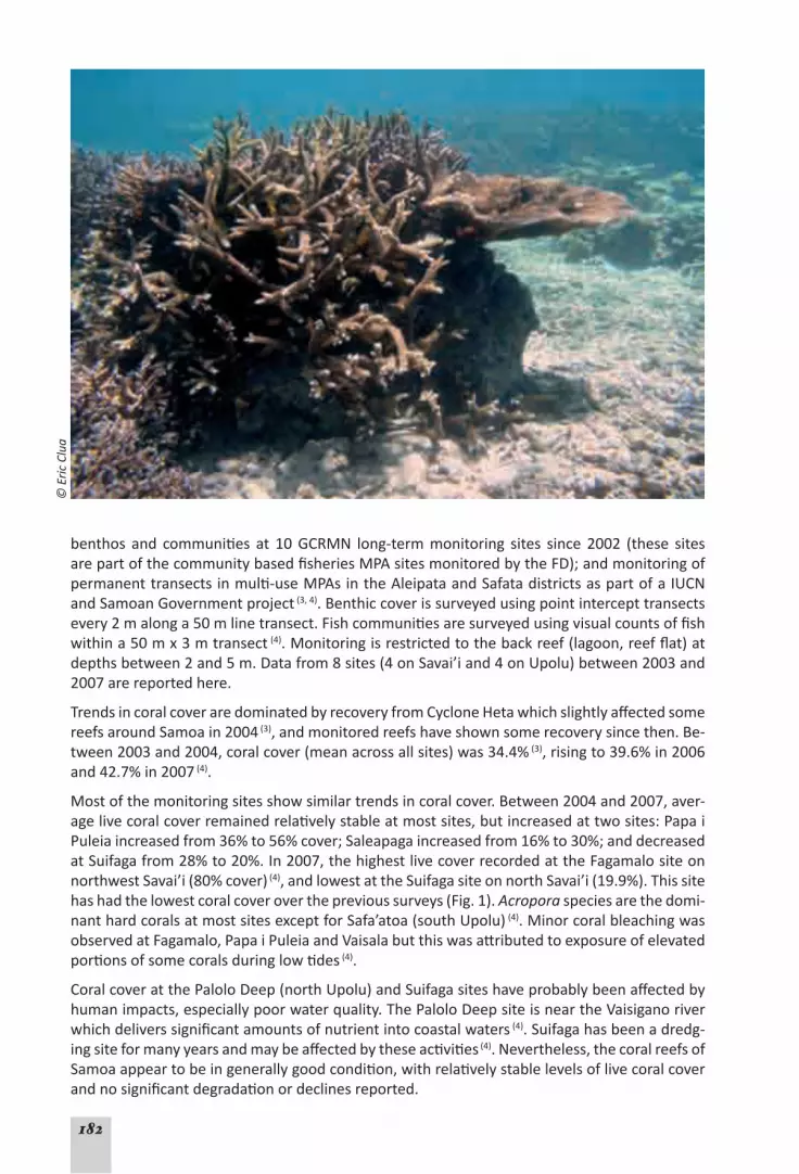
182
benthos and communities at 10GCRMN long-termmonitoring sites since 2002 (these sitesarepartofthecommunitybasedfisheriesMPAsitesmonitoredbytheFD);andmonitoringofpermanenttransectsinmulti-useMPAsintheAleipataandSafatadistrictsaspartofaIUCNandSamoanGovernmentproject (3, 4).Benthiccoverissurveyedusingpointintercepttransectsevery2malonga50mlinetransect.Fishcommunitiesaresurveyedusingvisualcountsoffishwithina50mx3mtransect (4).Monitoringisrestrictedtothebackreef(lagoon,reefflat)atdepthsbetween2and5m.Datafrom8sites(4onSavai’iand4onUpolu)between2003and2007arereportedhere.
TrendsincoralcoveraredominatedbyrecoveryfromCycloneHetawhichslightlyaffectedsomereefsaroundSamoain2004 (3),andmonitoredreefshaveshownsomerecoverysincethen.Be-tween2003and2004,coralcover(meanacrossallsites)was34.4% (3),risingto39.6%in2006and42.7%in2007 (4).
Mostofthemonitoringsitesshowsimilartrendsincoralcover.Between2004and2007,aver-agelivecoralcoverremainedrelativelystableatmostsites,butincreasedattwosites:PapaiPuleiaincreasedfrom36%to56%cover;Saleapagaincreasedfrom16%to30%;anddecreasedatSuifagafrom28%to20%.In2007,thehighestlivecoverrecordedattheFagamalositeonnorthwestSavai’i(80%cover) (4),andlowestattheSuifagasiteonnorthSavai’i(19.9%).Thissitehashadthelowestcoralcoverovertheprevioussurveys(Fig.1).Acropora species are the domi-nanthardcoralsatmostsitesexceptforSafa’atoa(southUpolu) (4).MinorcoralbleachingwasobservedatFagamalo,PapaiPuleiaandVaisalabutthiswasattributedtoexposureofelevatedportionsofsomecoralsduringlowtides (4).
CoralcoveratthePaloloDeep(northUpolu)andSuifagasiteshaveprobablybeenaffectedbyhumanimpacts,especiallypoorwaterquality.ThePaloloDeepsiteisneartheVaisiganoriverwhichdeliverssignificantamountsofnutrientintocoastalwaters (4).Suifagahasbeenadredg-ingsiteformanyyearsandmaybeaffectedbytheseactivities (4).Nevertheless,thecoralreefsofSamoaappeartobeingenerallygoodcondition,withrelativelystablelevelsoflivecoralcoverandnosignificantdegradationordeclinesreported.
© E
ric C
lua

183
Fishsurveysrecordtheabundanceofseveralspecies,includingspeciesthatareindicatorsofreefhealthoraretargetedfoodfish.Thesespeciesincludebutterflyfish(Chaetodontidae), dam-selfish (Pomacentridae), rabbitfish (Siganidae), surgeonfish (Acanthuridae), parrotfish (Scari-dae),triggerfish(Balistidae),goatfish(Mullidae), groupers (Serranidae), emperors (Lethrinidae) andwrasse(Labridae) (4).Surveysbetween2003and2007showthatthemostabundantreeffisharedamselfish,surgeonfish,wrasseandparrotfish (3, 4).Mostfishobservedwerereportedtobejuveniles,andlargefishsuchassnappers(Lutjanidae),emperorsandgrouperswereonlyobservedinlownumbersandhadanaveragesizeofabout30cm(5).Surveyssuggestthatfishabundanceanddiversityarehigheronmoreexposedouterslopes(5).
Status of coral reefs – STABLE (low confidence)The information available suggests that Samoa’s coral reefs have moderate
to high levels of live coral cover, and that they are recovering from damage experienced during Cy-clone Heta in 2004. There is little evidence of widespread and prolonged stress, damage, or loss of live coral cover. However, systematic long-term monitoring of coral reefs in Samoa is relatively new with few available data; this reduces the confidence of this assessment.
Coral reef health and resilience – NOT CONSIDEREDThere is insufficient information to describe the health and resilience of Samoa’s coral reefs. Further monitoring of reef processes (e.g. recruitment, reproduction) is required on disturbance and recovery, and trends in coral cover and community composition.
Fig. 1. Percent live coral cover recorded at 8 sites around Samoa from 2004 to 2007. Most sites had rela-tively high coral cover with little change over the years (Fig. from data in Samuelu and Sapatu 2009.

184
Use of reef resourcesSubsistenceandartisanalfishingininshoreareasisaveryimportantactivity (4),withmorethan70% of villages located on the coastal fringe(5).In2006,asocioeconomicsurveybytheSamoanFisheriesDivisionof939householdsin49villageswith7778individualsdocumentedtheim-portanceoffishingforincomeandfoodsecurity.Fishingcomprised41%ofthemeanhouseholdincome,andover20%ofhouseholdswereheavilydependentonfishingforincome.Averagefinfishconsumptionwasabout60kgperpersonperyear(163gperday);substantiallyhigherthattheworldaverageof12kgperpersonperyear (3).Peopleinvillageswithfisheriesmanage-mentplanstendedtohavehigherconsumptionoffish.ThiscouldindicatesomesuccessesinSamoa’sCommunityBasedFisheriesManagementProgram(CBFMP)withparticipatingvillagesexperiencinghighercatchperuniteffortandincreasedqualityoffishing (4).VillagesclosertoApia(thecapitalofSamoa)atelessfreshfishthanthosefurtheraway.
TheFisheriesDivisionalsoconductsweeklymonitoringoffisheries landingsatselectedout-lets (3).Finfisharethedominantgroupharvestedandincludespeciessuchasunicornfish(Ume), parrotfish(Fuga),surgeonfish(Pone, Alogo) and mullet (Anae) (3).Therehasbeenaslowchangefromsubsistencetoartisanalfishingwiththegrowingcasheconomy,andthishas increasedpressureoninshorefisheriesresourcesthroughoverfishinganddestructivefishingpractices (4).However,subsistencefishingstillaccountsforthevastmajorityofthecatch,with13666metrictonneslandedinsubsistencefisheriesin2006/07,comparedto126tonneslandedandsoldfordomesticconsumption (4). Increasedpublicawarenesshas reduced the incidenceofdestruc-tivefishing,howeverthereareisolatedcasesofdestructivefishing(useofbombsandDerrispoisons)reportedamongstsubsistencefishers (4).Samoaalsohasahistoryofexportingwild-caughtaquariumfish, livecorals, liverockandotherreeforganismsfortheaquariumtrade,particularlybetweenthelate1980sandmid1990s.In1992,morethan65000aquariumfishwereexported(5),however,exportshavedeclinedwithonly183fishexportedin1996 (3) and the aquariumfisheryiscurrentlynotactive (4).
Surveysinthe1990sreportedreducedfishbiomassinmoreheavilyfishedareas,anddramaticdeclinesoffisheriesstocks,attributed tohabitatdestruction,overfishing,destructivefishingand improvedfishing technology(5).Manyof thefishwerevery small,with themostof thepredatorspeciesfromreefsandlagoonsbeingbetween16and20cminlength,thesearebe-lowtheminimumlegalsizesetbyfisheriesregulations(5).Aspreviouslydiscussed,morerecentsurveysshowthatmostfishesappeartobejuvenilesandmanyarealsorelativelysmallinsize.The2006socioeconomicsurveysreportedthat66%ofrespondentsfeltthattherewerefewerfishthan10yearsago (4).Thereisalsoanapparentlong-termdeclineinspeciessuchasgiantclams (Tridacna spp.),milkfish(Chanos chanos), mullet (Mugil cephalus) and giant triton (Cha-ronia tritonis) (3);manyotherspeciesareconsideredthreatenedbyover-harvesting(6).Thisinfor-mationsuggeststhatSamoa’sfisheriesresourceshavechangedsignificantly.TheUNEP/SOPACEnvironmentalVulnerability Index (7), Reefs at Risk Revisited and thePacificOceanSynthesisReport (8) indicatethatfishingposesasignificantthreat toSamoa’smarineenvironmentandcoral reefs.Unsustainablefishing inmanyareashas threatened tounderminenutritionandstandard of living in villages (9).
TourisminSamoaisincreasing,withtouristnumbersincreasingby7.5%in2005andby20%in2006,potentiallyduetoincreasedairlineaccess (9).In2007,tourismgeneratedarecordUS$108millionandisasectorthathassignificantpotentialforfutureeconomicgrowth (4, 9).TheUNEP/SOPAC assessment (7)indicatesthattourismcouldposesomerisktoSamoa’smarineenviron-ment,mostlikelythroughcoastaldevelopmentfortourisminfrastructure.

185
Use of reef resources – EVIDENCE OF CHANGE (low confidence)The available information suggests that Samoa’s marine resources have degraded
due to direct human use, especially fishing. Fish abundance and diversity is lower, and fish sizes are rela-tively small. Villagers perceive that the resource has declined; however, fish consumption is relatively high indicating that fishing is still a viable activity. Community-based fisheries plans may improve sustainability, however, more information is needed on trends in fishing activities, production and sustainability.
Factors affecting reef health and conditionSamoa’scoralreefsandmarineenvironmentareaffectedbyindirectpressuresincludingpol-lution,poorland-usepractices,invasivespecies,stormsandclimatechange.Thevulnerabilityof reefshasbeenassessedthrough focusedriskassessmentsdeveloped inSamoa(Table1),whichidentifiedcoastaldevelopmentasthemainissueat5sites,withland-basedpollutionandsedimentationaffectingsomesites (4).Themajorcoastaldevelopmentsincludeconstructionofseawallsintendedtoreducecoastalerosion,reclamationforbusinessandresidentialdevelop-ments,roadconstruction,anddevelopmentofhotels,resorts,andothertouristinfrastructure
(3, 4).ThedevelopmentofanewmarineslipwaycouldaffecttheAleipataMPA(6).Reclamationanddevelopmenthasdamagedseagrassbedsandcoastalvegetation,wetlandsandothernatu-ralecosystems (3).Mangroveshavebeenclearedanddamagedthoughdumpingofrubbish,landreclamationandpollution(4,6).Sandminingandcoraldredgingoccurnationwidetosupplybuild-ing material (3), and uncontrolled sand mining is a concern (9).
While 48%of Samoa’smain islands remain forested, deforestation and habitat degradationhaveincreasedsoilerosioninmanyareas(4,6,9).ThewidespreaddiebackofcoralonnorthernUpolubetween1970and1985was likely due to sedimentationandeutrophication (3). Poorland-usepracticesassociatedwithagriculture,forestry,housingandroadconstructionarecaus-ing eutrophicationnear rivermouths and in lagoons. TheVaisiganoRiver is amajor source
© E
ric C
lua

186
of nutrients and bacteria (3), andsewageandwastewaterarepersistent issuesof concern inApia (9).Drainageandwastetreatmentsystemsare inadequate,withmanyhouseholdsusingpoorlymaintainedseptictanks (4).Thedisposalofmunicipalwasteisunsustainable,withsomecommunities continuing to burnwaste or to discard it into the surround area, directly intowaterways,wetlandsor intocoastalwaters (3, 4).Chemicalwasteandrunoffofpesticidesandfertilisersthreatentocontaminatecoastalwaters (3, 4, 9).Collectively,thesepollutantscompriseasignificantthreattoSamoa’smarineenvironment.The2005UNEP/SOPACEnvironmentalVul-nerabilityIndex (7)suggestthatfarming,fertilisers,coastaldevelopmentandpopulationdensityandsignificantthreatstoSamoa’senvironment.Thisisechoedfindinginthe2011Reefs at Risk Revisitedassessment.
Samoa’scoralreefsarealsoaffectedbycyclones,outbreaksofcrown-of-thornsseastars(COTS),coral disease and warm water leading to coral bleaching events. There were 12 cyclonesbetween1950and2004whichaffected42%ofthepopulation (9).CycloneHetaaffected13%ofSamoa’scoralreefsin2004 (3).COTSoutbreakshavealsopreviouslydamagedreefsaroundSamoabuttherehavebeennorecentwidespreadoutbreaks.However,thespreadofintroducedinvasive algae (Codium arenicola and C. prostratum)fromApiaharbourintonearbyreef-slopeenvironments is a cause for concern (4, 9).Samoa’scoralreefshavenotexperiencedwidespreadcoralbleaching in recentyears;however,climatechangepredictions indicatemore frequentandintensebleachingevents,strongwindsandstorms,rainfallanddrought,andsealevelrise.ManySamoansandtheireconomicactivitiesareconcentratedinnarrow,lowlyingcoastalareasthatarevulnerabletofloodingandsealevelrise (7, 8).
Factors affecting coral reefs – EVIDENCE OF CHANGE (low confidence)Many indirect factors threaten Samoan coral reefs, and some of these risks have
increased recently or are likely to increase in the future. Some coral reefs have been damaged, principally from overfishing, coastal development, pollution and run-off from land-based sources; however, the infor-mation is insufficient to quantify trends.
Governance and management Samoahas several legislativeacts,policiesandprograms tomanageand sustainmarine re-sources.TheNationalParksandReservesAct(1974)providesfortheestablishmentofparksandreservesandregulatestheuseofthoseareas.TheFisheriesAct(1988)regulatesfishingactivitiesaswellasmarinepollution,andtheLands,SurveysandEnvironmentAct(1989)covers
Table 1. Integrated Threat Analysis for 5 sites around Samoa shows that coastal development is the major issue affecting these sites. Note that fishing pressure is low as these sites are all marine reserves; (Table from Samuelu and Sapatu 2009).
OVERALL:INTEGRATEDTHREATINDEX
Reef AreaCoastal
Development
Marine Based
Pollution
PollutionandSedimentation
ArtisanalOver-fishing
DestructiveFishing
OverallThreat Index
ScoreNUpolu Medium High High Low Low MediumSEUpolu Medium Low Low Low Low LowSWUpolu Medium Low Medium Low Low LowNSavaii Medium Low Low Low Low LowSESavaii Medium Low Low Low Low Low

187
Reefs at Risk Revisited: Samoa
The Reefs at Risk RevisitedanalysisfoundthatalmostallofSamoa’scoralreefsarethreatened,primarilybyoverfishing,land-basedpollutionandcoastaldevelopment.Whenaddinginther-malstressoverthepast10years,80%ofreefsareveryhighlythreatened.Projectionsforther-malstressandoceanacidificationsuggestthatpressureswillincreasetotheextentthathalfofSamoa’sreefswillbeinacriticalstateby2030.Thefullreport,methodsandfullsizemapsareon: http://www.wri.org/reefs.

188
environmental impactassessment,environmentalplanningandpolicy,pollutioncontrolandconservationofnaturalresourcesandtheenvironment (3).SamoaisasignatorytotheConven-tiononBiologicalDiversity(6)andin2002,SamoadeclareditsEEZasasanctuaryforallwhales,turtles and sharks(6).
In1995,theCommunityBasedFisheriesManagementProgram(CBFMP)waslaunchedtoad-dressconcernsoverdecliningfisheries.ThisacollaborativeeffortbetweentheFisheriesDivi-sionandlocalcommunitiesthatassistsvillagesineffectivelymanagingandprotectingtheirma-rine resources (4).Undertheprogram,eachvillagedevelopsafisheriesmanagementplanthatistailoredtotheneedsofthecommunity.TheCBFMPnowincludes89villagesfromacrossSavai’iandUpolu,andconstitutemorethan25%ofall thevillages inSamoa (9).Thesevillageshaveby-lawsthatarelegallyrecognisedbySamoa’slegalsystem (3, 4).Theprogramhasestablished51communitybasedMPAswithacombinedareaof38.8km2, include50no-takezonesthatcover9.4km2 (1).TheSamoanDepartmentofEnvironmentandConservation(DEC)recognisesafurther8MPAsincludingtheAleipataandSafataMarineprotectedAreaswhichcover81.1km2
(1) and includes 20 villages (4).Theremaining6protectedareasincludeMPAscoveringapproxi-mately89km2butthiscouldbeanoverestimate (1).BoththeFDandtheDECaimtoimprovecollaborationandestablishmoreMPAsinSamoa.
VillagesthathavedevelopedfisheriesmanagementplansthroughtheCBFMParereportedtohavesubstantiallyhigherfishcatchandconsumption,suchthattheCBFMPisviewedasacru-cialmanagementtoolinsupportingsustainablelivelihoodsfortheruralpopulation (4, 9).Howev-er,long-termmonitoringandsurveydataarenotreadilyavailableforallMPAsandmonitoringhasonlyrecentlybegunforsome.Thustrendsinmanagementoflanduseandpollutionaredifficulttodetermine.Someachievementshavebeenreported(forexample,improvedcompli-ancewithdumpingandpollutionregulationsbyvesselsattheFisheriesWharf (3)), but monitor-ingandenforcementisdifficultduetolimitedresourcesanddifficultiesinregularlyaccessingmore remote areas (3).Non-compliancewiththebanondestructivefishinghasbeenreported,andconcernshavebeenraisedabouttheadequacyandeffectivenessofenvironmentalimpactassessment processes (9).
Governance and management – EVIDENCE OF CHANGE (low confidence)Samoa has several planning instruments and legislative acts to manage the
marine environment, and the community based program is reported to be improving the status of fisheries through a strong commitment to maintain and expand these MPAs. However, there are few long-term data available that quantify the status and trends of fish populations and management ef-fectiveness, although monitoring is now being expanded.

189
References (Samoa)1. GovanH (2009).Status and potential of locally-managed marine areas in the South Pacific: meet-
ing nature conservation and sustainable livelihood targets through wide-spread implementation of LMMAs,Noumea:SPREP/WWF/WorldFish-Reefbase/CRISP,95p.http://www.crisponline.net/CRISP-PRODUCTS/Economicsandsocioeconomicsofcoralreefs/tabid/309/Default.aspx.
2. CIA(2011).The World Factbook.[Database][cited22April2011];CentralIntelligenceAgency.https://www.cia.gov/library/publications/the-world-factbook/geos/pp.html.
3. SamueluJI,SolofaA(2007).Samoa.InRSulu(ed),Status of Coral Reefs in the SouthWest Pacific 2004.IPSPublications,UniversityoftheSouthPacific:Fiji.
4. SamueluJA-L,SapatuM(2009).Status of Coral Reefs in Samoa 2007.InCWhippy-Morris(ed),South West Pacific Status of Coral Reefs Report 2007.CRISP,SecretariatofthePacificRegionalEnvironmentProgram: Noumea. http://www.crisponline.net/CRISPPRODUCTS/Reefknowledgeandmonitoring/ta-bid/311/Default.aspx.
5. Anon(2002).World summit on sustainable development assessment report: Samoa: Government of Samoa,78p.http://www.sprep.org/att/IRC/eCOPIES/Countries/Samoa/44.pdf.
6. Anon(2009).Convention on Biological Diversity: Samoa’s 4th national report.http://www.sprep.org/att/IRC/eCOPIES/Countries/Samoa/187.pdf.
7. UNEP/SOPAC,2005.Environmental Vulnerability Index - Samoa.UnitedNationsEnvironmentProgram/PacificIslandsAppliedGeoscienceCommission.http://www.vulnerabilityindex.net/
8. CaldwellM,ChurcherHoffmannT,PalumbiS,TeischJ,TuC(2009).Pacific Ocean Synthesis: Scientific literature review of coastal and ocean threats, impacts and solutions,California:TheWoodsCenterfortheEnvironment,StanfordUniversity,170p.http://www.centerforoceansolutions.org/PacificSynthe-sis.pdf.
9. MinistryofFinance(2008).Strategy for the development of Samoa 2008-2012: ensuring sustainable economic and social progress, Apia: Government of Samoa, 72 p. http://www.sprep.org/att/IRC/eCOPIES/Countries/Samoa/104.pdf.

190
Tokelau
• Marine Area: 290 000 km2
• Coastline: 101 km• Land Area: 12 km2
• Reef Area: 97 km2
• Total MPAs: 3• Area of MPAs: 1 km2
• Percentage of reefs threatened (local threats and thermal stress 2011): 71%
• Population(2011est):1384 (1) • Population(2050proj):NoData• Populationgrowth(2011est):-0.01% (1)
• Urbanpopulation(2010):0% (1)
• GDP:USD$1.5million(1993est) (1)
• GDP/Cap:USD$1000(1993est) (1)
Data from ReefBase Pacific, the SPC Statistics and Demography database, Reefs at Risk Revisited unlessdenotedbyareferencenumber.Dataareestimatesonlyandmayvarybetweensourcesdependingonterminologyanddatasetsused(est=estimated;proj=projected).
OverviewTokelauconsistsof3smallcoralatollswithinanexpansiveEEZofsome290000km2.Thecentralatoll,Nukunonu,isthelargestwithanareaof4.7km2 (3).Atafuatollis92kmnorthwestfromNukunonu;andthesouthernatoll,Fakaofo,is64kmsoutheastofNukunonu.Theatollsareonly3-5metersabovesealevel,makingTokelauveryvulnerabletotheeffectsofclimatechange (3).These coral sand atolls do not support food crops apart from breadfruit, coconut, pandanus, bananaandgiantswamptaro,althoughbananaandtaroarerarelycultivatednow (3).
TokelauisaNewZealandTerritoryandTokelauanshaveNewZealandcitizenshipwiththenear-estneighbourbeingSamoa,480kmtothesouth.TheseislandsareisolatedandtransporttoTokelauisbyshipsdepartingfromSamoa.Thereare4villagesinTokelau,oneeachonAtafuandNukunonu,andtwoonFakaofo.Tokelau’spopulationisonly1466permanentresidents.Atoll leveladministrativeand legislativepowersresidewiththe3Taupulega (Village Council ofElders)whilenational interests residewiththeGeneralFono (parliament).Throughthesearrangements, themajorityofkeypublic services remainwithnational leveladministration,whichisbasedinSamoa (3).
ThelittleavailableinformationonTokelau’scoralreefsindicatesthatthereefsareperiodicallyaffectedbyoutbreaksofcrown-of-thornsseastars(COTS),cyclonesandcoralbleaching(3,4).ThepotentialeffectsofclimatechangeareagrowingandsignificantconcerntoTokelau (3).
Status, health and resilience of coral reefsTokelau’scoralreefshavebeensurveyedperiodicallysincethe1960s.Briefsurveysin1969and1971reportedthatcoralgrowthinthelagoonswaslimitedtotheupperportionsofoldcoralmassifs.ThereareanecdotalreportsofCOTSbeingpresentduringthelate1960sbutfewCOTSwereobservedduringsurveysin1971.ExtensivecoralmortalityinreefshallowsaroundNuku-
191
nonuwasreportedinearly1983duetoasuddendropinsealevelofabout60cm,whichmayhavebeenassociatedwithanabnormalElNinoevent(4).
SurveysoftheeffectsofCycloneTusionthe3atollsin1987notedthatcoralgrowthwasdi-verse,butnot‘luxuriant’atunaffectedsitesbeforethecyclone(4).Therewaswidespreadcoraldamagebymassivestormwavesonouterreefslopesatexposedsites.Coralmortalityvariedbetweensites,butwasupto90%insomeareas.NodamagewasevidentinFakaofolagoonalthoughlargequantitiesofrubbishweredepositedbythecyclone;theother2lagoonswerenot inspected(4).SurveysatAtafubeforethecyclone(andalsoin1987)reported90-100%coralmortalityonthenorth-westernouterreefslopes;thiswasprobablyduetothegroundingofaKoreanshipwhichwassubsequently‘blownup’withexplosivesin1981toremoveit(4).
Long-termmonitoringsiteswereestablishedin2003bytheSecretariatofthePacificRegionalEnvironmentProgramme(SPREP),andrecordedameanlivecoralcoverof66%onthereef-slopesat 10 to 12 m depth (2).In2005,3long-termmonitoringsitesonFakaofoatollwereestablishedaspartofthePolynesiaMananodeoftheGlobalCoralReefMonitoringNetwork(GCRMN),withsupport fromSPREP,CNRS (FrenchNationalSciencificResearchCenter), IFRECOR(theFrenchcoralreefinitiative)andAFD(theFrenchdevelopmentagency).Thereefsweresurveyedusingrandomphotoquadratsat6mdepth (2).ThismethodwaschoseninrecognitionofthelimitedcapacityandlogisticalconstraintsformonitoringbycommunitymembersinTokelau (2).
Threesurveysiteswereselectedin2005inconsultationwiththeFakaofoTaupulega:the‘ship-wreck’site;theFakaofoconservationarea;and‘GraveyardMotu’.Livecoralcoverwaslowatall3sites,rangingfrom30.3%to12.0%cover(Table1).Thesurveysshowedhighincidencesofcoraldisease,withdiseasedcoralsoutnumberinghealthycoralsat2of the3sites (2); thereasonforhighdiseaseprevalencewasnotclear (2).Manyfeedingscarsonlivecoralswerealsoobserved,probablyfromthecoraleatingsnailDrupella sp.The2003SPREPsurveysfoundevi-denceofcoralbleachingintheprevious2years.Norecoverywasevidentinthe2005surveysandcoralbleachingisreportedtohavebecomeanannualeventinthelagoonsandontheouterreefs,anddamagingfishcommunities (3).Concernshavealsobeennotedaboutthespreadofblackalgaefromtheshipwrecksite (2).
Status of coral reefs – NOT CONSIDEREDThere are reports of past damage to Tokelau’s coral reefs from cyclones and COTS. There are particu-lar concerns about climate change and coral bleaching, however, recent long-term monitoring is insuf-ficient to describe coral reef status and trends. Continued monitoring will provide better information on status and trends.
Sites surveyed in 2005
% live coral cover (total)
live coral cover (healthy or diseased)
% cover algae
% cover dead coral
Comments
Shipwreck 14.7 4.7% cover healthy10% cover diseased 24.2 59.0
Almost all algae were pink coralline algae; dead corals were not recent
Fakaofo conservation area 30.3 11.5% cover healthy
18.8% cover diseased 22.0 44.0Almost all algae were coralline algae; dead corals were not recent
Graveyard motu 12 7.6% cover healthy4.4% cover diseased 51.0 35.0
Almost all algae were coralline algae; dead corals were not recent
Table. 1. Benthic composition of sites surveyed in 2005 showed low coral cover and a high incidence of coral disease. Algal cover was dominated by coralline algae which are a good settlement platform for new corals (data from Vieux 2005 (2)).

192
Coral reef health and resilience – NOT CONSIDERED Monitoring is insufficient to describe the health and resilience of these coral reefs. More monitoring is required to determine reef recovery from disturbances.
Use of reef resourcesTokelau’scoralreefsandmarineenvironmentareveryimportantforfoodsecurity,especiallysincepoorsoilqualitylimitsagriculturalproduction (3).In2003,75%ofthehouseholdsacrossthe3atollsweresurveyed(5)withsurveysshowingthatalmostallwereactivelyinvolvedinfish-ing,demonstrating thehighdependenceofTokelauansonmarine resources.Peoplefishonthereefandlagoonsusinggillnets,spearfishing,diving,reefgleaningandbaitfishing.Fishingoutsidethereefswasbytrollingforpelagicfish(e.g.tunas)orbottomfishing(5).Fishingeffortisdividedfairlyevenlybetweenthereeflagoonsandoutsideforpelagicordeepwaterspecies.Thesurveysfoundthatfishershavechangedfromcanoestoaluminumdinghieswithoutboardmotorswhichisimprovingefficiencyandexpandingcatches(5).
Tokelaugainssignificantrevenuethroughagreementswithforeignfishingvesselstocatchtunain itsEEZ (3).However, thereareconcernsover theeffectivenessofexistingmanagementar-rangementsforthisfishery (3).Therearealsoconcernsaboutthelossoftraditionalskillsandfishingmethods,morerecent‘aggressive’fishingpractices,andthreatssuchasCOTSthatcouldthreatenthesustainabilityoffishresources (3).Advancesinfishingtechnologysuchaspowereddinghies,mono-filamentgillnets,steelfishinghooksandfishaggregationdevices,couldgreatlyincreasefishingefficiencywhichcouldthreatensustainability(6).Therehavebeenreportsofde-clines in the number of turtles, giant clams, black pearl oysters and coconut crabs(4,6,7).Surveysin2003alsorevealedcommunityconcernsoverperceiveddeclinesoffishsuchasatule (yellow-tail scad), maeava(rabbitfish),tonu (red coral trout), uluakata(gianttravally)andatu(skipjacktuna) (3).Communitiesalsobelievedthatdeclinesinfishstocksmaybelinkeddegradationofcoralreefhabitatsfrompollution (3).However,fisharegenerallystillreportedtobeabundant,withpeoplecatchingfishforsport,ortofeedtopigs (7).Theunnecessarywastageofcaughtfishwasraisedasaconcern,withreportsthatlargeamountsoffishwere‘thrownaway’ (7).
TherearefewdataavailableonfishingandfisheriesinTokelau,whichintroducessignificantun-certaintyindescribingthestatusandtrendsofreefresources.The2009PacificOceanSynthesisReport(8) didnotassessfishinginTokelau,the2005 UNEP/SOPACEnvironmentalVulnerabilityIndex (9) identifiedfishingasarelativelyminorriskwhilethe2011Reefs at Risk Revisited report suggests that 45% of Tokelau’s reefs are threatened (medium risk or higher) from fishingactivities.
ThereisverylittletourisminTokelauduetolimitedaccessandinfrastructure (3).However,ef-fectsofanypotentialtourism(suchascoastaldevelopment,pollution,andincreaseddemandformarineresources)anddevelopmentwillneedcarefulmanagement (3).Small-scale,lowim-pact,boutiqueecotourismisbeingconsideredforfurtherdevelopmentofthetourismindus-try (10).
Use of reef resources – NOT CONSIDEREDThe few data on fishing and fisheries report declines, and improved fishing technology could dramati-cally increase fishing efficiency; the potential effects of this on sustainability in Tokelau are unknown. More information and monitoring is required.

193
Factors affecting reef health and conditionTokelau’senvironmentandcoralreefsmaybeaffectedbyseveralfactors.Themainissuesofconcernareclimatechange,sealevelrise,droughts,cyclones,tsunamis,pollutionandwastemanagement (3, 10).Asa small country,disasterscancauseproportionallygreaterdamageonanationalscalethanto largercountries (10)andparticularlychangetheavailabilityofmarineresources.Cyclonesareasignificantfactor,with3cyclonesaffectingTokelauinthelate1980sandearly1990s(Tusi1987,Ofa1990andVal1991),withCycloneOfabeingtheworstinlivingmemory.Thesecyclonesandstormsurgescausecoastalerosion,damagefreshwatersupplies,increase soil salinity and destroy crops (10).The2005UNEP/SOPAC assessment (9) listsTokelau’sisolationandthelowlyingtopographyassevereenvironmentalrisks.
ClimatechangesarereportedtobeaffectingTokelau’senvironment,withreportsofincreasedfrequency of cyclones and storm surgeswithmore intense impacts. These have reportedlyerodedcoastalareas,somesmallisletshavedisappeared,andsomespeciesofplantshavedis-appeared due to increased soil salinity (3).Coralsaredecliningfromregularcoralbleachingandwarmtemperatures,whichhavealsocausedchangesinthequantityandqualityoffishcaughtin the lagoons (3).The2011Reefs at Risk Revisited suggests that by 2030, rising temperatures andoceanacidificationcouldthreatenallofTokelau’sreefs.
PollutionisalsoanissueinTokelau;in2002,morethanhalfthehouseholdsinTokelauhad‘sealatrines’withsewagedisposeddirectlyintothelagoon,andotherhouseholdshadseptictanks.Drainageisinadequatesochemicalssuchasbleach,disinfectantanddetergentaredischargeddirectly into the ground, and able to flowdirectly into adjacent reef lagoons. The lack of ajettymeansthatcargofromsupplyshipsisoffloadedoverwaterintosmalldinghies,includingchemicals and oil drumswhich sometimes, are ‘floated’ between the ship and beach. Thisexposesthesereefstospillsofoilandotherchemicalpollutants (3, 10).Asignificantpesticidespillin1969killedallthecoralsina2kmsectionalongMotuTeKakaiinNukunonulagoon,andtherehadbeen little coral recoveryby1975(4). Furthermore, the reef lagoonshave lowexchangerateswiththeoceanandconsequently,solidwaste,sewageandpollutionremaininthelagoonforextendedperiods,exacerbatingtheireffectsonthemarineenvironment (3).Therearealsoconcernsthatpollutionfromthe20yearoldrustingshipwreckoftheAi SukulaonFakaofoiscontributingtoalgalbloomsand increasingciguaterapoisoning (2, 3, 7).However, therearenoquantitativestudiesordatatoestablishthislink(6).
Disposalofsolidwasteisalsoanissue (3, 7, 10).Whileorganicwasteisoftencomposted,othergarbageisburntorburiedinsecludedlocationsontheatollsandislets,butwasteissometimesdumped into the lagoon (10).Therearenoadequatefacilitiestodisposeofchemicalorhazardouswaste.TheincreaseinimportedgoodsfromSamoaalsointroducesnon-biodegradablewastetotheatolls.
Coastaldevelopment inTokelauhas includedreef-blastingtobuildboatchannels toprovidedeepwateraccesstothe3atolls(4),andtheconstructionofseawallsnearvillagestomitigatethestormsurgesandrisingsealevels (3).Seawallconstructionisreportedlydrivingunsustainablesand and coral mining (3).ThePacificOceanSynthesisReportlistscoastaldevelopment,oilspillsandchemicalpollutionandsealevelriseasthreatstoTokelau’smarineenvironment(8).CoastaldevelopmentisalsolistedasapotentialthreatintheReefs at Risk Revisited analysis and the UNEP/SOPACassessment.

194
Factors affecting coral reefs – STABLE (low confidence)The factors affecting Tokelau’s coral reefs include those associated with cli-mate change (sea level rise and coral bleaching), pollution, and coastal devel-
opment. However, there is insufficient information to quantify these risks.
Governance and management Tokelauhassomelegislationandplanningtoprotectandmanageitsmarineresourcesandcoralreefs.However,thejudicialsystemisnotfullydeveloped (3)andauthorityrestslargelywiththevillageleaders(Taupulega) oneachatoll.Inshorecoastalmanagementplansweredevelopedforeachvillage,andanationalwastemanagementplanwasfinalisedin2007whichledtoeachvillagedevelopingitsownwastemanagementplan (3).AnagreementwithSamoawasalsofina-lisedtosendrecyclablematerialtoSamoa (3).Nukunonuhasarubbishcollectionservicewhichhashelpedtoreducetheamountofwasteenteringthemarineenvironment (10).
Theneedforadditionalmanagementhasbeenidentified.Thereisapushtoimprovemanage-mentoftunafisheriesinTokelau’sEEZ (3),andcommunitieshaveexpressedinterestinaddingspecificfishingregulationstoexistingby-laws (7).Legislationisalsoneededtopreventfurtherdamagefromindiscriminatesandandcoralmining,andtoregulateimportsofnon-biodegrad-ablegoodstoreducetheamountofsolidwaste (3).
Composting toilets have been trialled to replace sea latrines and septic tanks. These couldreduceseepageofnutrientsintothelagoon,conserverainwater(byreplacingflushingtoilets),andproducemuchneedednaturalfertiliser (10).
Most of the land and sea in Tokelau is under customary tenure and there are lafuinplace,whicharetraditionalbansorclosuresonthetakeofmarineresources (7, 11).Lafuhavebeenincorporat-edintocommunity-basedfisheriesmanagementplansdevelopedin2004 (7).Therearecurrently3 managed lafu areasinTokelau,whichcover1.7km2 (11).Thesecouldbeconsideredaslocallymanagedmarineareasthatrelyoncommunityengagementandenforcement.
ThereareindicationsofinadequateenforcementandcompliancewithfisheriesregulationsandlafuinTokelau.Communitieshaveexpressedconcernthatrestrictionsonthemeshsizeofgillnetsarenotenforced,andthereisalackofawarenessaboutfishingrulesandregulations (7).However,communitiesonNukunonufeltthattherewasgoodcompliancewiththeirlafu, whichhadmanygiantclamsandshowedsignsof‘regeneration’ (7).Oneofthechallengestomanage-mentidentifiedbycommunitiesandtheTokelaugovernmentisthelackofresourcesandcapac-ity.TherearemoreTokelauanslivingoverseasthanontheislands,andalackofskilledperson-nelinfisheriesandmarineresourcemanagementisasignificantproblem (3, 7).TokelaualsohasalimitedcapacitytomanageitsEEZ,exposingTokelau’swaterstoillegalcommercialfishing (3).
Governance and management – NOT CONSIDEREDTokelau has some legislation and regulations to manage marine resources and protect coral reefs, but the need for additional management is evident. Management relies heavily on community commit-ment to implement and enforce rules and regulations, with evidence of inadequate compliance, en-forcement, and capacity in marine and fisheries management. However, there is currently insufficient information to assess the effectiveness of existing management.

195
Reefs at Risk Revisited: Tokelau
The Reefs at Risk Revisitedassessmentestimatesthatabout45%theTokelau’scoralreefsarethreatenedbylocalfactors,primarilyoverfishingandcoastaldevelopment.Thermalstressoverthe past 10 years adds to these local stressors, increasing the number of threatened reefs in Tokelautoabout70%.Projectionsforthermalstressandoceanacidificationfromclimatechangesuggestthatby2030,allcoralreefsinTokelauwillbethreatened.Thefullreport,methodsandfullsizemapsareon:http://www.wri.org/reefs.

196
References (Tokelau)1. CIA(2011).The World Factbook.[Database][cited22April2011];CentralIntelligenceAgency.https://
www.cia.gov/library/publications/the-world-factbook/geos/pp.html.
2. VieuxC(2005).Establishment of a coral reef monitoring program in Tokelau, July 14th - 29th, 2005, Moorea,FrenchPolynesia:CRIOBEResearchCentre/CRISP,19p.www.reefbase.org.
3. OfficeoftheongoingGovernment(2010).Tokelau: National Strategic Plan 1July 2010 – 30 June 2015, Apia, Samoa: Government of Tokelau, 72 p. http://www.sprep.org/att/irc/ecopies/countries/toke-lau/22.pdf.
4. WellsSM,JenkinsMD(2000).Tokelau coral reefs, in Status of Coral Reefs 2000 in the Southeast and Central Pacific, B Salvat (ed), FondationNaturalia Polynesia: Papeete, French Polynesia, p 97-100.www.reefbase.org.
5. Chapman L,Des Rochers K, PelasioM (2005).Survey of fishing activities in Tokelau. SPC FisheriesNewsletter. 115(October/December): 36-40. http://wwwx.spc.int/coastfish/news/Fish_News/115/Fisheries_Newsletter_115.pdf
6. VieuxC,AubanelA,AxfordJet al. (2004).A century of change in coral reef status in southeast and central Pacific: Polynesia Mana node, Cook Islands, French Polynesia, Kiribati, Niue, Tokelau, Tonga, Wallis and Futuna.InCWilkinson(ed),Status of the coral reefs of the world: 2004 (Vol. 2).AustralianInstituteofMarineScience:Townsville,p557.http://www.gcrmn.org/publications.aspx.
7. VuniseaA(2004).Community-based fisheries management plans for Tokelau.SPCFisheriesNewsletter108(January/March):30-31.http://wwwx.spc.int/coastfish/News/Fish_News/accueil-fish-news.htm.
8. CaldwellM,ChurcherHoffmannT,PalumbiSet al.(2009).Pacific Ocean Synthesis: Scientific literature review of coastal and ocean threats, impacts and solutions,California:TheWoodsCenterfortheEnvi-ronment,StanfordUniversity,170p.http://www.centerforoceansolutions.org/PacificSynthesis.pdf.
9. UNEP/SOPAC(2005).Environmental Vulnerability Index.UnitedNationsEnvironmentProgramme/Pa-cificIslandsAppliedGeoscienceCommission.http://www.vulnerabilityindex.net/
10.Anon(2002).Report on the National Assessment for the World Summit on Sustainable Development to the Tokelau Islands December 10, 2001-February 15, 2002:GovernmentofTokelau.http://www.sprep.org/att/IRC/eCOPIES/Countries/Tokelau/7.pdf.
11.GovanH (2009).Status and potential of locally-managed marine areas in the South Pacific: meet-ing nature conservation and sustainable livelihood targets through wide-spread implementation of LMMAs,Noumea:SPREP/WWF/WorldFish-Reefbase/CRISP,95p.http://www.crisponline.net/CRISP-PRODUCTS/Economicsandsocioeconomicsofcoralreefs/tabid/309/Default.aspx.

197
Tonga
• Marine Area: 700 000 km2
• Coastline: 419 km• Land Area: 718 km 2
• Reef Area: 1 500 km2 (1)
• TotalMMAs:18(6active) (1)
• Area of MMAs: 10 009 km2 (1)
• Percentage of reefs threatened (local threats and thermal stress 2011): 75%
• Population(2011est):105916 (2)
• Populationgrowth(2011est):0.2% (2) • Urbanpopulation(2010):23% (2)
• GDP: USD $767 million (2010 est) (2)
• GDP/Cap:USD$6300(2010est) (2)
Data from ReefBase Pacific, the SPC Statistics and Demography database, Reefs at Risk Revisited unlessdenotedbyareferencenumber.Dataareestimatesonlyandmayvarybetweensourcesdependingonterminologyanddatasetsused;(est=estimate,proj=projected).
OverviewTheKingdomofTongaconsistsof174 islandsspreadover4main islandgroups:Tongatapu;Ha’apai;Vava’u;andNiua.Although37islandsareinhabited,mostofthepopulationlivesontheislandofTongatapuwherethecapitalNuku’alofaislocated(3).Mostofthepopulationisen-gagedinsubsistencefarmingandfishing.Tonga’sislandsincludebothvolcanic,includingactivevolcanoes,andupliftedcoralislandsandreefswhichemergefromtwosubmarineridgesthanrunnorthnortheastfromTongataputowardsSamoa(3).Fijiliesabout740kmtothenorthwest,andNiueisapproximately600kmtothenortheast.TheTonganarchipelagocontainsfringing,barrierandsubmergedpatchreefs.Althoughthecoralreefsextendalongthefringesofalltheislands,therehasbeenlittlescientificmonitoringandassessmentofmostreefareasandmanyislandshavenotbeenmappedandsurveyed(3).
Surveysof11reefsfromaroundTongatapurecorded192hardcoralspecies,and1993surveysinmarineparksaroundTongatapurecorded229speciesoffinfishfrom39families,themostcom-monbeingwrasses(Labridae)anddamselfish(Pomacentridae).Some55speciesofbivalves,83gastropodspecies,and13seacucumbers(bêche-de-mer)havealsobeenrecorded(3).Thesefiguresareprobablyunderestimates,withprobablymorethan300coralspeciesconsideredtooccur in Tonga (4).
Tonga’s coral reefsandmarineecosystems facenumerouspressures includingpollutionandsedimentationfromland-basedsources,over-harvestingofmarineresources,destructivefish-ing,lossofmangrovesandwetlandsandmarinebasedpollutants (4).
Status, health and resilience of coral reefsThere is limited informationon Tonga’s coral reefs (3). Previous studies from1996 and 1997reportcoralcoverrangingfrom2%atMounafereefto50%atHakaumama’oreefreserve.Sur-

198
veysin1996foundamixofhealthy,degradedandrecoveringcoralcommunitiesfrom36sitessampledaroundVava’u. Thepresenceof crown-of-thorns seastars (COTS)wasevident fromfeeding scars(3).The2004GlobalCoralReefMonitoringnetwork(GCRMN)statusreportnotedeffortstoestablishmonitoringprogramstocollectbaselinedataandreviewexistinginforma-tioninseveralareas (5).GCRMNsurveyswereconductedinconjunctionwiththeEnvironmentDepartment,with3transectsestablishedateachof2sitesinVava’uin2005.Thesepreliminarysurveysfoundrelativelylowlivecoralcover,withameancoverof15%nearTefisiVillage,and13%nearToulaVillage (6).SeveralothermonitoringsiteswererecommendedforTongataputomonitortrendsinreefsthatcouldbeaffectedbycoralharvestingfortheaquariumtradeandtourism, and to monitor marine protected areas (MPAs) (6).
In2009,anewlong-termmonitoringsitewasestablishedontheouterslopeofthewestcoastof Tongatapu, atHa’atafu,by theCNRS (FrenchNationalCentre for ScientificResearch) andtheIRCP(InstituteforPacificCoralReefs)throughtheCRIOBE(CentreforIslandResearchandObservatoryoftheEnvironment)basedinFrenchPolynesia,incollaborationwiththeTonganMinistryofFisheries.Twentypermanentquadratswerephotographedforcoralandbenthosmonitoring,andtotalreeffishcommunitiesaremonitoredalong50mx4mtransects.ThissitealsobelongstothePolynesiaManaGCRMNnode.Thissurveyfoundrelativelylowpercentagesofcoralcover(14%)andhighcoverofsoftcorals(31%).
Somereefmonitoringdataarealsoavailablefromsocio-economicsurveysconductedbetween2002and2008by theSPCReefFisheriesObservatoryPROCFishprogram.Thisprogramsur-veyed6locationsinTongaduring2001and2002,and4locationsaroundTongain2008.TheselocationswereHa’atafuandManukaonTongatapu(12transectsineachlocation),andKouloandLofangaonHa’apai(13transectsineachlocation) (7).Comparisonsofsitessurveyedinboth2002and2008showedincreasingcoralcoveratallsites:Ha’afatu(increasedfrom17%to28%);Manuka(21.4%to28%);Koulo(16%to32%);andLofanga(16%to25%) (7).
However, thesesurveysalsohighlightedsignificantconcernsoverthestatusof reeffishandinvertebrates,withseveredropsinabundanceidentifiedforseveralspecies (7).FinfishresourceswerepoortoverypooratHa’atafu,ManukaandKoulo,butbetteratLofanga,althoughvaluesherewerestill lowercompared to regionalvalues.Herbivores,especially surgeonfish (Acan-thuridae)werethedominantfishgroup,followedbyparrotfish(Scaridae)althoughthesewereatmuchlowerdensityandbiomassthansurgeonfish.Similarobservationsweremadeontheouterreef-slopeduringthesurveysbyCRIOBEin2009.Fishcommunitiesweredominatedbysmallfish,withmeansizesofseveralfishfamiliesbelow50%ofthemaximumvalues,indicatingsignificantfishingpressure (7).Fishsizeandbiomasshasdecreasedinsomeareassince2002.Size,biomassandabundanceofpredatorssuchasemperors(Lethrinidae)andgroupers(Ser-ranidae)wereespeciallylow.Twotofourspeciesofgiantclamswererecorded,butsomespe-ciessuchasthebearclaworhorseclam(Hippopus hippopus)appeartohavebecomelocallyextinct since themid1970s (7).Giant clamdistributionacross the study siteswasnoticeablyirregular,withveryfewclamsclosetositessuchasHa’atafu.Seacucumbernumberswerevari-able,withmoderatenumbersofsomespeciessuchastheleopardfishortigerfish(Bohadschia argus),butveryfewofotherspeciessuchastheblackteatfish(Holothuria nobilis), in spite of thecompletebanoncommercialharvestingofholothuriansfor7-10years (7).
Coralbleachingwasreported inTongaaroundTongatapuandtheHa’apaigroup inFebruary2000(3).Bleachingwaswidespreadonthereefslopesandlagoon,andwasreportedtobesimi-lartothatobservedinFijiwithcoralsshowingvaryinglevelsofbleaching.Inthelagoons,thedominant Montiporacoralshowedonlyminorbleaching,whilespeciessuchasGoniastrea re-tiformis, Platygyra sinensis and P. daedalea showed80-100%bleaching(3).Onthereefslopes,corymbose Acropora coralswere themostaffectedwhile tabulatecoralswerenotseriouslyaffected.Fortunately,therewaslittlecoralmortality(<5%)fromthisbleachingevent(3)

199
Thefewavailabledataarefromasmallnumberofsitesandyears,thustrendestimatesincoralcoveraredifficultduetothepaucityofdata.Forexample, the2010reportonTongatotheConventiononBiologicalDiversityreportsthatcoralcoverisdecliningacrossTonga (4)(page36),contradictingtheProcFishsurveyfindings.NocoralcoverdataforTongawerereportedinthe2008GCRMNstatusreport.
Status of coral reefs – NOT CONSIDEREDThere is limited information available for Tonga, with the only data being from 4 sites which show increasing coral cover. Trends across the Kingdom are unclear. Early GCRMN reef monitoring and continued PROCFish monitoring will provide better information in future, but monitoring on other islands is required.
Coral reef health and resilience – NOT CONSIDERED The available data are insufficient to describe the health and resilience of these reefs. Regular moni-toring at existing sites and expansion to additional sites is required.
Use of reef resourcesCoralreefresourcesareveryimportanttothepeopleofTongaforincomeandfoodsecurity.Themainwild-capturefisheriesinTongaareoffshoretunaandpelagicfish,deepseafisheriesforsnappersandgroupersand inshoreartisanalandsubsistencefisheriesforreefspecies (4).The PROCFish surveys found high rates of seafood consumption in coastal communities ofup to 92 kg/person/year for finfish and 21 kg/person/year for invertebrates (7). Shallow-wa-terfisheriesareavitalcomponentofthesubsistencefisheryandareanimportantsourceofincomewithchangestoacashbasedeconomy(7).Fisharemainlycaughtusinghandlinesandspearfishing,althoughgillnetting,castnettingandtrollingarealsousedinsomeareassuchasHa’atafu.Invertebratessuchasseacucumbers,strombusshells,clams,octopusandlobstersarecollectedbyfreedivingusinglow-costequipment.Giantclammeatisadelicacytakenmainlyfordomesticconsumption (7).UnlikeotherPacificislands,reefresourcesare‘openaccess’al-lowingmultipleusergroupstofishacrossTonga. Destructivefishingpracticesstillappeartobepracticed,forexample,bombfishingisreportedtobecommonlyusedinFanga’utalagoontotarget mullet (4).
Reeffishesconstitutemostoftheinshorecatch,supplyingmorethan70%ofthetotalannualcatch in Ha’apai (7).LandingsofreeffishinNuku’alofain1993madeup70%(200mt)oftheto-talartisanalfinfishlandings,withparrotfishes(Scaridae)beingthemaintarget.ThePROCFishsurveysshowedthatcatchvariedfromplacetoplace,butthatthemainfinfishspecieslandedincludedemperors,snappers (Lutjanidae),surgeonfish,parrotfish, rabbitfish (Siganidae),andgroupers (7).Humphead(Maori)wrasse(Cheilinus undulatus)hasrecentlybeentargetedforlivefishexportstoHongKongafteranexploratorycommercial licensewasissuedin2009 (4).Ap-proximately300specimenswerereportedasbeingexportedbuttheillegallandingsfromnightdiversisunknown,promptingcallsformoreprotectionforthisspeciesinTonga (4).
Reeffishandothermarineresourcesappeartohavebeenmoderatelytoseriouslyoverexploit-ed in Tonga(3,4,7,8).Blackcoralsandmolluscswerereportedtobedepletedinsomeareas,andthehorseclamisprobablylocallyextinct(3,7).Asdescribedabove,clamsandsomeseacucum-bershavesignificantlydeclinedandarenowinverylownumbers (7).Reeffisheshavedecreasedinsize,andlargepredatoryfishesappeartobeuncommonorrare.Onespeciesofmullet,Mugil

200
cephalus,usedtocompriseupto70%ofthecommercialmulletlandingsbutisnowbelievedtobe‘onthevergeofbecominglocallyextinct’ (7).Catchesofdeepwaterfishhavealsodramati-callydeclined,promptingcallsforincreasedcontrolstomanagethesestocks (4).Thegiantclam(Tridacna derasa)isseverelyoverfishedandTridacna tevoroa(endemictoTonganwaters)hasbeenoverfishedintheHa’apaigroup(3).Thecockle(Gafrarium tumidum)isextinctincertainpartsofTongaandisveryrareinmarkets (4).Aquacultureventuresandprotectedareashavebeensetupforspeciessuchasclams(e.g.community-basedgiantclamsanctuaries– ‘clamcircles)tohelpreversedeclinesinwild-capturefisheries(3,4).
Seacucumberexportsweredevelopedduringthemid1980sandpeakedin1992.Declinesinharvestsfrom1992ledtoharvestingbeingbannedin1997 (7).Politicalpressurehasledtotheoverturningoflong-timebansonharvestingseacucumbers.The2009harvesttargetedspeciessuch as Holothuria nobilis, H. fuscogilva and H. scabra fortheAsianmarket.Thesespeciesareknowntobevulnerabletofishingpressureandstrictermanagementofthesespeciesisneed-ed (4).Duringthe1990s,trochusshellsTrochus niloticuswereintroducedfromFijiandthegreensnail Turbo marmoratuswereintroducedfromVanuatuandJapan.Bothspecieshavebecomeestablishedandbaselineassessmentshavebeenconductedtoinvestigatestockstatus(3,7).TwospeciesofgiantclamshavealsobeenintroducedtoTonga (7).
ThereisanactivemarineaquariumtradeinTonga.Fishusedtobethemaintargets,buthar-vestsofliverockandinvertebrateshaveincreasedsignificantlysincethelate1990s (7). Inver-tebratesandliverocktogetheraccountedfor89%ofmarineaquariumexportsin2004.Otherspeciestakenincludegiantclams(suppliedbytheTongaFisheriesmariculturecentre)andhardandsoftcorals (7).TherehavebeennumerouscomplaintstotheDepartmentofFisheriesfromthepublicaboutthefishery,andin2008,theDepartmentbannedtheexportofliverockfromTonga (4).Thereareallocatedharvestingareas for the industry,andamanagementplanandregulationsarenowinplace.However,fisheriesmonitoringandenforcementhavesuffereddueto lack of funding (4).
ThedemandformarineresourcesispredictedtoincreaseduetoTonga’sgrowingpopulation,achangeindiettowardsanimalproteinandproducts,andcontinueddemandformarineprod-uctsoverseas, particularly fromAsian countries (4). The2011Reefs at Risk Revisited analysis suggeststhatoverathirdofTonga’scoralreefsarethreatenedbyoverfishing(moderateriskorhigher),andthe2005UNEP/SPOACEnvironmentalVulnerabilityIndex (9)and2009PacificOceanSynthesis report (10) alsosuggestthatfishingposesathreat.
TourismisarelativelysmallindustrycomparedtoothercountriessuchasFiji,with25139tour-istsvisitingTonga in2003.Nevertheless, tourismmakesasignificantcontributiontoTonga’seconomy,accountingfor$17millionin1997,andgenerating$12millioninlocalincomeand2200jobs (8);althoughdated,thesestatisticsprovideanindicationoftheactualandpotentialeconomic impacts (8).ThelaunchofservicesbetweenTongaandAustraliaandNewZealandviaPacificBluehasincreasedtouristaccess.Tongaalsohasoneoftheworld’sfewswimwithwhaletourismoperations,withtouristsswimmingandsnorkellingwithseasonallymigratinghump-backwhales.Tourismcanincreasefishingpressuretosupplyreeffishordelicacieslikelobster,and increase physical damage to coral reefs from indiscriminate anchoring(3).Tourismcanalsodrivecoastaldevelopment,leadingtodegradationofcoastalhabitats.The2005UNEP/SOPAC assessment (9) indicatesthattourismposesasignificantenvironmentalrisktoTonga (9).
Use of reef resources – EVIDENCE OF CHANGE (low confidence)There are some data on trends in resource status, use and sustainability, and
numerous reports and accounts consistently suggest that reef resources have noticeably declined. The
201
reports include localised extinctions, declines in abundance and size of targeted species, and collapses of stocks such as sea cucumbers. Predators are uncommon and small. There is also active invest-ment in projects and activities to restore depleted stocks. While there are reports suggest significant changes, the extent of declines are not well understood.
Factors affecting reef health and conditionThemostdisturbedareasinTongain2002and2004,were:Faga’utaLagooninTongatapu(eu-trophication,coralmortality,fisheriescollapse);Nuku’alofaandadjacentnorthernTongatapu(physicaldisturbances,habitatloss,overfishing,eutrophicationandcoralmortality);innerNeia-fuharbourinVava’u(sedimentation,COTSoutbreaksandcoralmortality);andPangueharbouronLifukaIslandinHa’apai(eutrophication,highcoralmortality)(3,5).TheseissueshavepersistedandremainpotentialstressorsforcoralreefsinTonga.
Themarineenvironment isperiodicallyaffectedbycyclones, tsunamis,andvolcanicactivity.CycloneshavecausedsignificantdamagetothecoralreefsinTongainthepast,andatsunamiinOctober2009affectedseveralTongancommunities,especiallyonNiuatoputauIsland.Thetsunamigenerated15mhighwavesthatwashedfishontobeachesand‘smothered’thecoralreefsaroundtheislandwithsediment (4).InFebruary2009,avolcaniceruptiondestroyedmarineecosystems around Hunga Tonga (4).The2005UNEP/SOPACEnvironmentalVulnerabilityIndex (9) listsnaturalhazardsassignificantriskstoTonga’senvironment.
Pollution and eutrophication also affect Tonga’s coastalwaters and reefs (4). Tonga does nothaveadequateseweragesystemsandeutrophicationhasbeenreported,particularlyaroundNuku’alofa.InFanga’utaLagoon,Tongatapu,urbanrunoffandeutrophicationarethesuspectedcausesoflossofhardcorals,withsepticsystemstheprobablysourceofincreasednutrients(3).However,farmingmayalsocauseeutrophication,andrunoffoffertilizersfromsquashfarmingin the 2000s has been linked to algal blooms (4).Therearealsoconcernsoverwastefromboatsandships,withregulararrivalsanddeparturesofcontainershipsandinter-islandferries.About500yachtsarriveinthePortofRefugeharbourinVava’ueveryyear,buttherehasbeennoef-fectiveregulationofwastedumpedoffthesevessels (8).EutrophicationandalgalbloomshavealsobeensuggestedasfactorscontributingtoCOTSoutbreaks.Theincreasinguseofpesticidesandfertilizers inagriculture,andchemicalsused inpowersupplyandconstructionmayalsoenterthemarineenvironmentandgroundwater,affectingmarineorganismsandcompromisinghuman health (4, 8).Pollutionfromsolidwasteisalsoanissue,especiallyinurbanareas.Thereareonlytwomunicipalwastedumps(oneonTongatapuandoneonVava’u),sowaste,includingoldvehicles,diapers,industrialanddomesticwaste,isoftendumpedonbeachesandvacantland (8).
Poorland-usepracticesmayalsoleadtoincreasedsedimentrunoff.Commercialfarmingwithmachinerycanover-worksoils,andlandtillageonslopesincreasestherisksofsoilerosion (4).Deforestationisalsoasignificantissuewithanestimateddecreaseinforestareaof26%be-tween 2006 and 2010 (4), such that slopes have become unstable with increased sedimentrunoff.Coastaldevelopmentalsohasthepotentialtoaffectthecoralreefs.UrbanisationnearNuku’alofa andNeiafuhas increaseddemand for land, resources and infrastructure (4). Con-structionandquarryingactivities,andminingsandandgravel,haveincreasedsedimentationanddamagedcoastalhabitats. Siltation fromconstructionsitesandquarriesandcausewayshasdamagedreefsinNuku’alofa,NeiafuinVava’u.CausewayconstructionintheHa’apaiandVava’ugroupshavealsocausedsiltationanddamagetoreefs(3),andovertime,disruptednatu-ralwaterflowsandcausedabuildupofmud(3).TheconstructionofVunaWharfinNuku’alofais considered to havedamagedadjacentcoralreefsthroughdredgingandsedimentation (4).InTongatapulagoon,illegallandreclamationisasignificantthreattomangroves (4),andextraction

202
fromsanddunesandbeachesisalso‘amajorproblem’(3).Populationgrowthandcoastaldevel-opmentareassessedasposingsignificantriskstoTonga’senvironment (9, 10).
Climate change is alsoa threat andTongaexperienced coral bleaching in2000, and severalrecentcycloneshavedamagedTonga’s reefs(3).Climatechangemayalter the frequencyandseverityoftheseevents,causingincreasedcoastalerosion(3),andrisingsealevelswillincreaseinundationandareconsideredasignificantrisk (4, 10).ThewesterndistrictofTongatapuisalreadyvulnerabletoseawaterintrusionandthecoastisreceding (4).Damagetocropsandlivestockfromdroughtsorfloodscould increasepressureonmarineresources for food.TheReefs at Risk assessmentindicatesthatby2030,allofTonga’sreefswillbethreatenedbythepotentialeffectsofincreasingseatemperaturesandoceanacidification.
Use of reef resources – EVIDENCE OF CHANGE (low confidence)Reports and risk assessments have identified threats to Tonga’s coral reefs, ,
and suggest these factors and their effects have increased, or are likely to increase. However, informa-tion is insufficient to quantify trends and links to coral reef health and resilience.
Governance and management Tongahaslegislation,policiesandplanninginstrumentstosupportthemanagementandsus-tainable use of marine resources including: the Fisheries Management Act (2002); the Fisheries Management and Conservation Regulation (2008); the Environment Act (2003);theParks and Reserves Act(1976);andplanninginstrumentssuchastheNationalBiodiversityStrategyandActionPlan(2006) (1, 4).EnvironmentalsustainabilityalsofeaturesinTonga’snationalStrategicDevelopmentPlans (8), andTonga isalsoa signatory to theConventiononBiologicalDiversi-ty (4).
The Fisheries Management Act provides protection forwhales, green andhawksbill turtles,andplacesrestrictionsonthetakeofotherturtlespecies (4).TheActalsoregulatesthecatchofsomespecies(mostlyinvertebrates)withsizelimitsandseasonalclosures.FishingonSCUBAisbannedwithoutwrittenpermission.TheActandregulationsprovidesthelegalbasistoes-tablish Special Management Areaswhicharecommunity-basedfisheriesmanagementareas
(1).Pilotprojectshavebeenimplementedtodevelopcommunitybasedfisheriesmanagementplans for inshorefisheries (8). Clamcircles are community-based sanctuaries toprotect clamstocks,andnumerousclamcircleshavebeenestablishedrecentlyusinggovernmentsuppliedjuveniles(3).Projectstoimprovewastemanagementanddisposalhavebeenimplemented,andthereareseveralprogramstoincreaseenvironmentalawarenessandstewardshipbylocalcom-munities (4, 8).Theseincludelocalisedcommunity-basedeffortstoreplantforestsandconservewetlandsandcoastalhabitats,andpublicawarenesscampaigns.Environmentaleducationhasbeen integrated into the school curriculum (4).
UnlikemostPacific islandnations, there isno recenthistoryof customarymarine tenure inTonga,andmarineareashavebeen‘openaccess’since1887(1,3,4).However,thereareanumberofdesignatedreserveswith18officialmarineprotectedareas (MPAs) reported forTonga (4).However,mostoftheseappeartobe inactive (1), and monitoring and enforcement has been lacking (4),but6newspecialmanagementareashaverecentlybeenestablishedaroundTonga:Tongatapu (2), Ha’apai (3)andVava’u(1).A7th specialmanagementareaisbeingdevelopedatNo-muka (4).Theseco-managementarrangementsarereportedtobe‘workingwell’withimprovedknowledgeamongststakeholdersofconservationandsustainability,anda33%increaseintheareabeingmanagedandconserved (4).WhiletheprogramwasoriginallyfundedthroughAusAID

203
Reefs at Risk Revisited: Tonga
The Reefs at Risk Revisited analysisestimatesthatnearly40%ofTonga’scoralreefsarecurrentlythreatened(mediumriskorhigher),mainlyfromtheeffectsofoverfishingandpollution.Whencombinedwithobservationsofthermalstressoverthepast10years,thenumberofthreatenedreefsincreasesto75%.ThereefsaroundTongatapuandVava’u,themainpopulatedislandsinTonga,arethemostatrisk.By2030,projectionsforthermalstressandoceanacidificationsug-gestthatthenumberofreefsassessedasbeingatthehighestriskwillincreasefrom10%tonearly40%.Thefullreport,methodsandfullsizemapsareon:http://www.wri.org/reefs.

204
(Australianaidagency),theprocessisnowfundedthroughtheTonganDepartmentofFisher-ies (8).
Whiletheexistenceoflegislation,planningandmarinereservesisapromisingsign,thereareconcerns that management approaches and sustainability issues are not coordinated across government departments, plans and legislation (4). There are also problems reported aboutfundingandcapacity,long-termfinancingofconservationandmanagementinitiatives,alackofpoliticalwill,lackofadequatelegislationandalackofcapacityandskills (4).Therearealsoreportedcomplianceissues;forexample,destructivefishingisbanned,butstillappearstobepracticed (4).Previouseffortstoreplenishstocksthroughre-introductionsofspecies,maricul-tureandre-seedingduringthe1980shavebeenunsuccessfulduetolackofenforcementandpoaching(3,7).The2002NationalCoralReefStatusReportforTongacitesseriousproblemswithalackofenforcement,non-compliance,alackoffisheriesmanagementplansforreeffisheries,andalackofpoliticalwilltoactofrecommendations(3).Thereisalsonooveralllandusepolicyfor Tonga (4).Lastly,thelackofmonitoringdataandinformationonthestatusandtrendsofcoralreefsandmarineresources,arefrequentlymentionedaschallengestomanagement(3,4,8).
Governance and management – NOT CONSIDEREDThere are planning instruments and management tools in place in Tonga, and more recent projects to establish community based management initiatives are promising signs. However, there are also numerous problems in coordinating and implementing marine and environmental management. The lack of data and monitoring make it difficult to describe trends in management activities and resource use and status.
References (Tonga)1. GovanH (2009).Status and potential of locally-managed marine areas in the South Pacific: meet-
ing nature conservation and sustainable livelihood targets through wide-spread implementation of LMMAs,Noumea:SPREP/WWF/WorldFish-ReefBase/CRISP,95p.http://www.crisponline.net/CRISP-PRODUCTS/Economicsandsocioeconomicsofcoralreefs/tabid/309/Default.aspx.
2. CIA(2011).The World Factbook.[Database][cited22April2011];CentralIntelligenceAgency.https://www.cia.gov/library/publications/the-world-factbook/geos/pp.html.
3. LovellER,PalakiA(2002).National coral reef status report Tonga:InternationalOceanInstitute-SouthPacific,KiribatiFisheriesDivisionforICRI),SPREP.http://www.sprep.org/att/IRC/eCOPIES/Countries/Tonga/5.pdf.
4. Anon(2010).Fourth report: review of Tonga National Biodiversity Strategy and Action Plan,Nuku’alofa:MinistryofEnvironmentandClimateChange,KingdomofTonga,157p.http://www.sprep.org/att/IRC/eCOPIES/Countries/Tonga/63.pdf.
5. VieuxC,AubanelA,AxfordJetal.(2004).A century of change in coral reef status in southeast and central Pacific: Polynesia Mana node, Cook Islands, French Polynesia, Kiribati, Niue, Tokelau, Tonga, Wallis and Futuna.InCWilkinson(ed),Status of the coral reefs of the world: 2004 (Vol. 2).AustralianInstituteofMarineScience:Townsville,p557.http://www.gcrmn.org/publications.aspx.
6. VieuxC(2005).Coral reef surveys in Vava’u, Kingdom of Tonga, September 26th-October 7th 2005, Moorea,FrenchPolynesia:CRIOBEResearchCentre/CRISP.www.reefbase.org.
7. FriedmanK,PincaS,KronenMet al.(2009).Tonga country report: profiles and results from surevy workl at Ha’atafu, Manuka, Koulo and Lofanga,Noumea,NewCaledonia:PacificRegionalOceanicandCoastalFisheriesDevelopmentProgramme(PROCFish/C/CoFish)/SecretariatofthePacificCom-munity).www.spc.int/DigitalLibrary/.../PROCFish/PROCFish_2009_TongaReport.pdf.

205
8. Anon(2006).Kingdom of Tonga Strategic Development Plan 8: 2006/07-2008/09: Looking to the Fu-ture, building on the past:MinistryofFinance,KingdomofTonga,202p.http://www.sprep.org/att/IRC/eCOPIES/Countries/Tonga/13.pdf.
9. UNEP/SOPAC(2005).Environmental Vulnerability Index.UnitedNationsEnvironmentProgram/PacificIslandsAppliedGeoscienceCommission.http://www.vulnerabilityindex.net/
10.CaldwellM,ChurcherHoffmannT,PalumbiSet al.(2009).Pacific Ocean Synthesis: Scientific literature review of coastal and ocean threats, impacts and solutions,California:TheWoodsCenterfortheEnvi-ronment,StanfordUniversity,170p.http://www.centerforoceansolutions.org/PacificSynthesis.pdf.

206
Wallis and Futuna
• Marine Area: 300 000 km2
• Coastline: 129 km• Land Area: 274 km2
• Reef Area: 940 km2 (1)
• Total MPAs: 0 (1)
• Area of MPAs: 0 km2 (1)
• Total LMMAs: 0 (1)
• Mangrove Area: ND
• Percentage of reefs threatened (local threats and thermal stress): 66%
• Population(2011est):15398 (2)
• Population(2050proj):ND• Populationgrowth(2011est):0.35%• Urbanpopulation(2008):0% (2)
• GDP: USD $60 million (2004 est) (2)
• GDP/Cap:USD$3800(2004est) (2)
Data from ReefBase Pacific, the SPC Statistics and Demography database, Reefs at Risk Revisited andGovan(2009).Dataareestimatesonlyandmayvarybetweensourcesdependingontermi-nologyanddatasetsused(est=estimated,proj=projected,ND=dataunavailable).
OverviewTheterritoryofWallisandFutunaconsistsof3highvolcanicislands:Wallis(Uvea),FutunaandAlofi, and are anoverseas territory of France andoperateunder French law (2). Subsistenceagricultureisthemaineconomicactivityintheterritory,withabout80%oflabourforceearn-ingscomingfromprimaryindustriessuchascoconutplantations,vegetablegardens,livestockraisingandfishing (2).RevenuealsocomesthroughFrenchGovernmentsubsidiesandfromtunalicensing fees from Japan and South Korea (2).ThemaincityofMatā-UtuonWallisIslandisap-proximately780kmnortheastofFiji.TheislandsofAlofiandFutuna(sometimesreferredtoastheHornArchipelago)areapproximately230kmsouthwestofWallis;whereasAlofiisnotinhabitedpermanentlyandisonly1.8kmawayfromFutuna(3).
WallisIslandhasfringingreefsaroundmostofthecoastline,andanencirclingbarrierreefsev-eral kilometers off the coast (3, 4). In contrast, the reefs around Futuna andAlofi are narrowfringing reefs (4),withnooffshorebarrierreef (3).Althoughmonitoringactivityhasincreasedinthelast10years,relativelyfewscientificstudieshavebeenconductedonWallisandFutuna.Spalding (2001) reported ‘moderate’ reef diversitywith 30 coral genera and 330 species ofbenthicfishes.
Status, health and resilience of coral reefsMonitoringbeganin1999withcoralcoverrecordedat3sites:WallisWest;FutunaWest;andAlofiWest.In2002,monitoringwasexpandedtoanadditional3sites:WallisEast;FutunaEast;andAlofiSouth-West,withmoresurveysin2005and2010/11atall6monitoringsites.Moni-toringisconductedbytheCRIOBE(CentreforResearchandEnvironmentObservatory)basedinFrenchPolynesia.Since2010,fishcommunitieshavebeenmonitoredatthesesitesbytheterritorialserviceoftheenvironmentofWallisandFutunaincollaborationwithCRIOBE.These

207
programsprovidedatatothePolynesiaManaNodeoftheGlobalCoralReefMonitoringNet-work(GCRMN),andcontributetoprogramsrunthroughtheIFRECOR(FrenchInitiativeforCoralReefs)andtheICRI(InternationalCoralReefInitiative).
Monitoring at the 6 sites involves 1 m2 permanent photoquadrats along a 20 m² belt-transect (20mx1m).Photographsareanalysedtodeterminelivecoralcover,withcoralsidentifiedtogenus,andsometimestospecieslevel.A‘mantatow’surveyprovidescoralcoverandcommu-nitycompositiondataatalargerscale.Reeffisharemonitoredon3belt-transectsof200m²(50mx4m)persite.Thesesurveysarecarriedoutinthevicinityofthecoralmonitoringsitesandatthesametime.Allfishspeciesobservedintransectsareidentified,theabundanceoffishisrecorded,andsizesofindividualsareestimated.
Wallis
ThecoralreefsaroundWallisareingoodcondition.The2monitoringsitesonthebarrierreefhavelittleexposuretoland-basedhumandisturbance,suchthatcoralcoveratWallisWesthasincreasedsince1999,withthe2010surveyreporting52%livecoralcover(5).Fishingandrec-reationalsportsarethemainsourcesofdisturbancesonthesereefs.AtWallisEast,coralcoverhasremainedstablesince2002,with26%livecoralcoverreportedin2011(5).
In2010,theaverageabundanceofreeffishesatWallisWestwas447individualspertransect(averagedensityof2.2individualsperm2).ReeffishcommunitiesatWallisweredominatedby
Fig. 2. Mean abundance of fish communities (per 200 m2 transect) at Wallis, Futuna and Alofi in 2010-2011 (Figure modified from Chancerelle 2010 (5)).
Fig . 1. Average coral cover across survey sites at Wallis, Futuna and Alofi. There is a clear trend of an in-crease in coral cover at Wallis West and Alofi South-West, while some decreases are evident at Futuna East and Alofi West. Other sites show variable cover percentages (Figure modified from Chancerelle 2010 (5)).
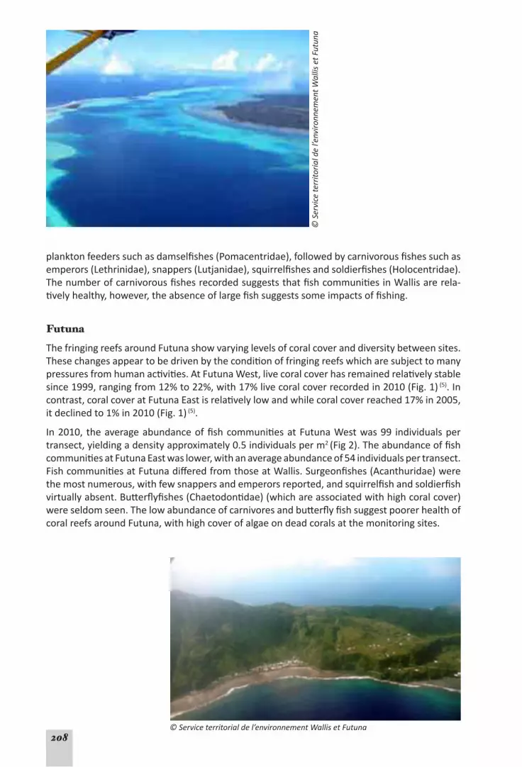
208
planktonfeederssuchasdamselfishes(Pomacentridae),followedbycarnivorousfishessuchasemperors(Lethrinidae),snappers(Lutjanidae),squirrelfishesandsoldierfishes(Holocentridae).ThenumberofcarnivorousfishesrecordedsuggeststhatfishcommunitiesinWallisarerela-tivelyhealthy,however,theabsenceoflargefishsuggestssomeimpactsoffishing.
Futuna
ThefringingreefsaroundFutunashowvaryinglevelsofcoralcoveranddiversitybetweensites.Thesechangesappeartobedrivenbytheconditionoffringingreefswhicharesubjecttomanypressuresfromhumanactivities.AtFutunaWest,livecoralcoverhasremainedrelativelystablesince1999,rangingfrom12%to22%,with17%livecoralcoverrecordedin2010(Fig.1)(5).Incontrast,coralcoveratFutunaEastisrelativelylowandwhilecoralcoverreached17%in2005,itdeclinedto1%in2010(Fig.1)(5).
In2010, theaverageabundanceoffishcommunitiesatFutunaWestwas99 individualspertransect,yieldingadensityapproximately0.5individualsperm2 (Fig2).TheabundanceoffishcommunitiesatFutunaEastwaslower,withanaverageabundanceof54individualspertransect.FishcommunitiesatFutunadifferedfromthoseatWallis.Surgeonfishes(Acanthuridae)werethemostnumerous,withfewsnappersandemperorsreported,andsquirrelfishandsoldierfishvirtuallyabsent.Butterflyfishes(Chaetodontidae)(whichareassociatedwithhighcoralcover)wereseldomseen.ThelowabundanceofcarnivoresandbutterflyfishsuggestpoorerhealthofcoralreefsaroundFutuna,withhighcoverofalgaeondeadcoralsatthemonitoringsites.
© S
ervi
ce te
rrito
rial d
e l’e
nviro
nnem
ent W
allis
et F
utun
a
© Service territorial de l’environnement Wallis et Futuna

209
Alofi
ThefringingreefsaroundAlofihavehad10%to20%livecoralcoversince2002,withhighestlivecoralcoveronthesouthwestcoast(Fig.1)(5).CoralcoveratAlofiWesthasdeclinedfromabout20% in1999, toabout10% in2010 (Fig. 1), a similar trend to thatatnearbyFutunaWest(5).AtAlofiSouthwest, coral coverhasbeenconstantly increasing,and reached19% in2010.Theabundanceoffishis96individualspertransectforAlofiWestand121individualspertransectforAlofiSouthwest.ThesevaluesaresimilartoFutunaWest.
Cyclone Tomas
InMarch2010,cycloneTomasstruckthenorth-eastcoastofFutunacausingextensivedamagetoa coastal road,andwater,electricityandcommunication infrastructure.Thecyclonealsopartiallydestroyedvillagesanddepositedlargeamountsofcoraldebrisinsome areas.CycloneTomasalsodamagedsomereefsonnearbyAlofibuttoalesserextentthanreefsaroundFu-tuna;therewerelimitedimpactsonWallis.
TheabilityofcoralreefsinWallis,FutunaandAlofitorecoverfromdisturbanceevents,suchascyclones,suggestsgoodresilience.SurveysofreefsaroundFutunaandAlofiin2010revealedactivecoral recovery,withmanysmallcoloniesdevelopingonthebaresubstratecreatedbycycloneTomas.Moreover,atWallisWestandAlofiSouthwest,coralcoverhasbeenincreasingoverthelast10years.This increasemaybeduetothecessationofdestructivefishingtech-niques(fishpoisoning)aswellasrecoveryfrommajordisturbanceeventspriorto1999.Indeed,thereefsofWallisandFutunahaveexperiencednumerousdisturbanceeventswith6cyclonesandsignificant impactssince1958 (6).Nevertheless,understandingreefhealthandresiliencewillrequirefurtherinformationaboutdisturbanceandrecoverycyclesoverlongertimeframes,aswellasinformationaboutreefprocessessuchascoralrecruitmentandrecovery,diseaseandcommunitystructure.
Status of coral reefs – STABLE (low confidence)There is limited long-term information about reefs in Wallis and Futuna;
most reefs are relatively healthy, with high coral cover and diversity. There is little evidence of wide-spread and prolonged stress, damage, or loss of coral cover, although there are signs that some fringing reefs around Futuna and Alofi may be affected by human activities, and the absence of large fish from Wallis is notable. Nevertheless, more information is needed to confidently describe reef status.
Coral reef health and resilience – STABLE (low confidence)There is little information on the health and resilience of coral reefs in
Wallis and Futuna; most surveyed reefs appear to be able to recover from disturbance events, and disturbed reefs show active recruitment of new corals. Similarly more information is needed.
Use of reef resourcesCoastalfishing is an important subsistenceactivity inWallis andFutuna,and reef resourcesconstituteanimportantpartofthediet (3).However,demandforfisheriesproductsmayoutstripsupply,andthesmallweeklymarketonWallis(revivedin2010)oftencannotsourceenough

210
producttosupplydemand.Itisunclearwhetherthelackofsupplyiscausedbyover-exploita-tionofexistingstock,orlimitedfishingeffort.
Only15fishermensaytheirmainactivityisfishing,buttheiremploymentstatusasprofessionalfishersallowsthemtobenefitfromsubsidiesforfishingequipment.Fishingtechniquesincludenets,lines,traditionalfishingbywomen(nowrare)andhand-spears.Awiderangeoffisharetaken by artisanal subsistence fishers including surgeonfishes (Acanthuridae), triggerfishes(Balistidae),butterflyfishes(Chaetodontidae),hawkfishes (Cirrhitidae),stingrays(Dasyatidae),wrasses(Labridae),emperors(Lethrinidae),snappers(Lutjanidae),tilefishes(Malachanthidae),mullets (Mugilidae),goatfishes (Mullidae),morayeels (Muraenidae),boxfishes (Ostraciidae),angelfishes (Pomacanthidae), damselfishes (Pomacentridae), parrotfishes (Scaridae), grou-pers(Serranidae)andpufferfishes(Tetraodontidae) (3).OnFutuna,fishingpressure ishighonreefflatsastheseflatsareeasilyaccessibleandmanypeoplefishtheseareas,especiallywhenroughweatherrestrictsaccesstooffshorefishinggrounds.Theoffshorefishery isnotdevel-oped,andthelong-termviabilityofrecentattempts(2010)todeveloptunafishingoperationsisunknown.
Smallshellsareharvestedtosupplyatradeinjewelleryandhandicrafts,andshellfish(clams,‘grisettes’,oysters)arealsoconsumedbylocalfamilies.Thequantitiestakenareunknownforthesesmallfisheries;monitoringisneededtoensuresustainableresourceuse.
Trochusandseacucumber(bêche-de-mer)arealsoharvested.Theamountofexportedtrochusshellshasremainedfairlyconstantat37tonnesperyear.Theseacucumberfisherywasclosedin2005followingscientificrecommendations (7),butthefisheryre-openedin2010withaquotaof10tonnesofdriedseacucumberproductperyear.
FishingregulationsinWallisandFutunaprohibitcertainpractices.DestructivefishingpracticeswerecausingsignificantreefdegradationinareasaroundFutunaandAlofiduringthe1980s (3).Destructivefishingmethodssuchasusingsteelbarstobreakopenthereef,naturalorsyntheticpoisonsandexplosiveshavenowbeenbanned.Additionally,othertechniquesthatcan leadtoover-fishingsuchasspearfishingusingSCUBAandusingspeargunsatnighthavealsobeenbanned.
ThereislittleinformationavailableontrendsandpatternsinreefresourceuseinWallisandFu-tuna.TheUNEP/SOPAC Environmental Vulnerability Index (8) indicatesthatfishingposeslittlerisk, but Reefs at Risk Revisited assessed that up toone-thirdof reefs inWallis and Futunaarethreatenedbyover-fishingordestructivefishing.Thelackofdataaboutfishingactivitiesincreasesuncertaintyindescribingthesetrends.
Use of reef resources – EVIDENCE OF CHANGE (low confidence)There is very little information on trends and patterns of reef resource use.
The only scientific assessment suggested that sea cucumber stocks had declined and the fishery needed to be closed. More information is needed to describe trends and sustainability of current fishing practices.
Factors affecting reef health and conditionThecoralreefsofWallisandFutunaareaffectedbyanumberofindirectpressuresincludinganthropogenicfactorssuchaspollutionandsedimentation,andmajordisturbanceeventssuchas cyclones. The 2005 UNEP/SOPAC Environmental Vulnerability Index (8) identified coastaldevelopmentandpopulationdensityaspotentialenvironmentalrisks forWallisandFutuna.OnWallis,coastaldevelopmentanderosionarethemainfactorsaffectinginshorereefsinthe

211
lagoon,andcauseincreasedturbidityandsedimentation.Duringtherainyseason,theWallislagoonandcoastalwatersaroundFutunabecometurbid,andmuddysedimentshaveaccumu-latednearpoorlybuiltroads (3).Recentuncontrolledsandmining,cyclonesandrisingsealevelshavecausedextensivecoastalerosiononbothWallisandFutuna.Unfortunately,theconstruc-tionof inappropriatecoastalprotectionmeasuressuchasseawallshaveexacerbatedcoastalerosion,totheextentthatsomebeacheshavebeenlostfromaroundWallis (3).Furtheroffshore,thebarrierreefsaroundWallislagoonmaysufferfromlocalizedimpactsfromanchordamage.
Futuna’s coastal fringing reefs are affected by numerous pressures. Inappropriate farmingpracticesanddevelopmenthaveclearedvegetationonsteepslopesthatarepronetoerosion,leadingtoincreasedsedimentrunoffovernearbyreefs (3).PollutionfromsolidwasteisalsoaparticularissueonFutuna.Thenear-shorelandfillisinadequateandwassupposedtobeclosedandthesiterehabilitated,however,thishasnothappenedduetolackoffunds.
Coralreefs insomeareasofWallisandFutunaarealsothreatenedbysewagepollutionandeffluentfrompigfarms.Manyhouseholdsuseinadequateseptictanksandtankdischargesdonot meet environmental standards (3).Thereareabout30000pigsonWallisandFutuna.Mostarehousedinsmallpiggeriesalongthecoast,buteffluenttreatmentisinadequate.Thesepres-suresaregreatestarounddenselypopulatedareasofbothislands.
WallisandFutuna’s coral reefsarealsoaffectedbydisturbances suchas cyclones,however,coral bleaching has not been recorded (3),andnocrown-of-thornsseastaroutbreakshavebeenreported.Climatechangeprojections,however,suggestthatrisingseatemperaturesandoceanaciditymaythreatencoralreefsthroughoutWallisandFutuna,withallreefsassessedasbeingatmedium,high,veryhighorcriticalthreatlevelsby2030.
Factors affecting coral reefs – EVIDENCE OF CHANGE (low confidence) The main factors affecting Wallis and Futuna’s coral reefs are land-based pol-
lution, coastal development, erosion and sedimentation. Climate change will also affect these reefs. However, there is insufficient information available to quantify trends and pressures.
Governance and ManagementTheEnvironmentalCode,adoptedin2007,hasonlybeenpartiallyimplementedandimprove-mentsneedtobemadetodelivereffectivemanagement.Therolesandresponsibilitiesofthestate (French administration), Territory and traditional chiefs need to be clarified to ensurecomplianceandtheenforcementofenvironmentalregulationsincoastal,reefandlagoonar-eas. Landownership issues also complicate the coordination anddelivery of environmentalmanagement.
Specificresourceprotectionmeasureshavebeenimplementedthroughlegislationintroducedin1994.Destructivefishingtechniques(e.g.explosives,ironbars,poisonfishing)arebanned(Arrêtén°94-200)andfishingaroundfishaggregationdevicesisprohibited(Arrêtén°94-201),asisspearfishingusingSCUBAorspearfishingatnight(Arrêtén°94-202).Fishingforcoconutcrabsor crayfish is regulated (Arrêtén° 94-203). Thereare also restrictionson the size andnumbersoftrochuscollected(Arrêtén°94-204).Minimumandmaximummeshsizesfornetsaredefinedby regulations, aswell asminimumandmaximumcatch sizes for some species(mudcrabs,coconutcrabs,lobsters,trochus).However,someoftheserestrictionsonlyapplytoexportedproducts(e.g.trochus),andtherearenocontrolsoverthedomesticuseofmostoftheseproducts.Illegalfishingpractices(e.g.poisonfishingor‘futu’)havedeclinedoverthe

212
Reefs at Risk Revisited (9): Wallis and Futuna
The Reefs at Risk Revisitedassessmentreports that thecoral reefsofWallisandFutunaarecurrentlymostthreatenedbyoverfishingandcoastaldevelopment.Whentheimpactofthermalstress is integratedwith local threats, 66%of coral reefs inWallis and Futuna are assessedasbeingatrisk.Futureprojectionsofoceanwarmingandacidification(basedonseasurfacetemperaturesoverthepast10years)suggestthatby2030allreefsinWallisandFutunawillbethreatenedwithathirdofreefsathigh,veryhighorcriticalthreatlevels.Thefullreport,methods and full size maps are on: http://www.wri.org/reefs.

213
last4years.However,activemanagementandenforcement isstillrequiredastherearestillincidencesofnon-compliance.
TheprotectionofreefsinWallisandFutunaissupportedbynationalFrenchlegislation(décretdu7juillet2000)whichhasgivenpowertotheFrenchInitiativeforCoralReefs(IFRECOR)todevelopanationalstrategyforcoralreefs,formulaterecommendationstoensuretheprotec-tionandsustainabledevelopmentofcoralreefs,andtoraisepublicawarenessofcoralreefis-sues.WallisandFutunahasalocalIFRECORcommitteebutthecommitteehasnoenforcementpowers.Thecommitteehaslaunchedandimplementedsomeprogramssuchasinitiatingpublicconsultationin2009forthecreationofaManagementPlanforMaritimeAreas(PGEM)foreachisland.Whilethisplanmayprovideanadaptiveframeworkformanagingmarineareas(includ-ingcoralreefs)aroundWallisandFutuna,implementationwillbeverydifficult.Scientificstud-iesareunderwaytoidentifypotentialmarinemanagedareas(MMAs)andmarineprotectedareas(MPAs),andwillprovideinformationtohelpdevelopthePGEM.However,therearenoMMAs,MPAsorreservesinWallisandFutuna.CustomarymarineareaspreviouslyexistedonWallisbuttheyarenolongeractive.
Governance and management – NOT CONSIDEREDWallis and Futuna has several legislative acts and regulations that provide for management of coral reefs, but many of these have not been fully implemented. There is insufficient information to de-scribe their effectiveness in ensuring conservation of coral reefs and marine resources.
References (Wallis and Futuna)1. GovanH (2009).Status and potential of locally-managed marine areas in the South Pacific: meet-
ing nature conservation and sustainable livelihood targets through wide-spread implementation of LMMAs,Noumea:SPREP/WWF/WorldFish-ReefBase/CRISP,95p.http://www.crisponline.net/CRISP-PRODUCTS/Economicsandsocioeconomicsofcoralreefs/tabid/309/Default.aspx.
2. CIA(2011).The World Factbook.[Database][cited22April2011];CentralIntelligenceAgency.https://www.cia.gov/library/publications/the-world-factbook/geos/pp.html.
3. VanaiP(2000).Wallis et Futuna, in Status of Coral Reefs 2000. In BSalvat(ed),The Southeast and Cen-tral Pacific.FondationNaturaliaPolynesia:Papeete,FrenchPolynesia,p131-145.http://www.sprep.org/att/irc/ecopies/countries/wallis_and_futuna/3.pdf.
4. SpaldingMD,RaviliousC,GreenEP(2001).World Atlas of Coral Reefs,Berkeley,USA:UNEPWorldCon-servationMonitoringCentre,UniversityofCaliforniaPress.http://www.reefbase.org/resource_cen-ter/publication/main.aspx?refid=11752.
5. ChancerelleY(2010). Suivi récifal Polynesia Mana - Wallis, Campagne de prospection 2010 suivis ben-thiques et ichtylogiques, mai 2010 :CRIOBE,Serviceterritorialdel’environnementdeWallisetFutuna12+annexespp.
6. ThulliezF(2005).Tempêtes et cyclones à Wallis et Futuna, service météorologique des îles Wallis et Futuna:MétéoFrance.
7. ChauvetC,LemouellicS(2005).Première étude du peuplement d’Holothuries des zones récifo-lago-naires de l’île de Wallis. Rapport de mission juil. 2005,UNC-LERVEM/PréfecturedeWallis&Futunap37.
8. UNEP/SOPAC(2005).Environmental Vulnerability Index.UnitedNationsEnvironmentProgramme/Pa-cificIslandsAppliedGeoscienceCommission.http://www.vulnerabilityindex.net/
9. BurkeL,ReytarK,SpaldingMet al.(2011).Reefs at Risk Revisited,WashingtonDC:WorldResourcesInstitute,114p.http://www.wri.org/reefs.

214
Hawaiian islands
• Marine Area: 1 823 000 km2
• Coastline: 1 482 km• Land Area: 464 km2
• Reef Area: 3 834 km2
• Total MPAs: 19• Area of MPAs: 362 600 km2
• Mangrove Area: 7 km2
• Percentage of reefs threatened (local threats and thermal stress 2011): 28%
• Population(2011est):1.36million• Population(2035proj):1.6million • Populationgrowth(2010est):1.2%• Urbanpopulation(2000): 92%• GDP: USD $900 million(2000 est)• GDP/Cap: USD $12 500 (2000 est)
Data from ReefBase and Reefs at Risk Revisited and Hawaii CensusData (http://hawaii.gov/dbedt/info/census) unlessdenotedbyareferencenumber.Dataareestimatesonlyandmayvarybetweensourcesdependingonterminologyanddatasetsused(est=estimated;proj=projected).
OverviewTheHawaiian archipelago includes both the ‘main’ Hawaiian Islands (MHI) and the remoteNorthwesternHawaiianIslands(NWHI),whichareseparatedbyapproximately250kmofopenocean;theseareallwithintheStateofHawai‘ioftheUSA (1).Theseislandsandatollsstretchina2900kmchaininthenorthcentralPacific,andcomprisenearly25%ofthecoralreefsinUSwaters (including statesand territories) (1). TheMHIare recent,highvolcanic islandsandinclude8populatedlargeislands,includingHawaii(alsocalledtheBigIsland),O‘ahuandMaui.Thecoralreefsaroundtheseislandsaremainlyfringingreefs,buttherearealsotwobarrierreefs and reef slopes and patch reefs (2). Incontrast,the124 islandsoftheNHWIaremostlysmall islands and low-lying atolls, reefs and submergedbanks (1).Most of the islands in theNWHIareuninhabited.InJune2006,theNWHIweredeclaredasaNationalMonument,thePapahānaumokuākeaMarineNationalMonument,covering362600km2.ThecoralreefsoftheNWHIareprobablythemostundisturbedandpristinecoralreefsinUSwaters.
TheHawaiianarchipelagocontainsmore than7000marinespecies,withaboutonequartertoonehalfofthesespeciesfoundexclusivelyintheNWHI.Theremotelocationofthesereefshas stimulated a diversity of flora and fauna including many endemic, rare, threatened orendangeredspeciessuchasthegreen,leatherback,andhawksbillseaturtlesandtheHawai-ian monk seal (1).Thefloraand faunacontainsomeof thehighest levelsofendemicspeciesfortropicalecosystemsworldwide,thusthisarchipelagoisanimportantbiodiversityhotspot
(3).Thereare366describedalgalspecies, includingseveralendemicspeciesnotfoundintheMHI (1).Thereare57hardcoralspecies,including11newspeciesand29rangeextensionsintheNWHI (4).Thehighrateofcoralendemism(30%)ispredominatelyattributedtotheNWHI,withjust3generaaccountingfor88percentoftheendemiccoralspecies(1,4).

215
Status, health and resilience of coral reefs
Hawai‘i’scoralreefshavebeenextensivelystudiedsincethe1970s,althoughmostofthelarge-scalemonitoringprogramsstartedinthelate1990s.ResearchandmonitoringareconductedthroughstateandfederalagenciesincludingtheUSFishandWildlifeService,NationalOceanicandAtmosphericAdministration(NOAA),theHawai‘iDivisionofAquaticResources(DAR),USGeological Survey,USEnvironmental ProtectionAgency,Hawai‘i Coastal ZoneManagement,NationalFishandWildlifeFoundation,NationalMarineSanctuaryProgram,NationalParkSer-vice,andotherorganizationsincludingtheNatureConservancy,theUniversityofHawai‘iandtheHawai‘iInstituteofMarineBiology (3).
NOAA’sPacificIslandsFisheriesScienceCenter-CoralReefEcosystemDivision’songoingPacificReefAssessmentandMonitoringProgram(RAMP)conductsregularwaterqualityandcoralreefmonitoring in theMainHawaiian Islands.NOAA’sNorthwesternHawaiian IslandsCoralReefAssessmentandMonitoringProgram(NOWRAMP)conductedresearchcruisesin2000,2002,2004 and 2005 (5).Theseprogramsmonitor,assessandmapreefhabitatswithintheHawaiianIslandsusingRapidEcologicalAssessments(REA),toweddiversurveys,andsurveylargeareasofhabitatandcollectenvironmental information(e.g. temperature,nutrients,salinity)usingdataloggersandTOAD(TowedOpticalAssessmentDevice) (3).
TheaveragelivecoralcoverintheMHIwasreportedtobe~19%in2008 (6).Ameta-analysisby the DAR Coral Reef Assessment andMonitoring Program (CRAMP), the PIFSC-CRED, theFishHabitatUtilizationsStudy(FHUS)andtheWestHawai‘iAquariumProject(WHAP)identi-fiedbroad-scalepatternsofcoralreefswithintheMHI (3).TheCRAMPusedfixedtransectsandphotoquadratsat30sitesinshallow(1-3m)anddeep(7-10m)water,whilethePIFSC-CREDsurveyed108sitesusing2or3x25-mtransectlinesateachsite (3).TheFHUSexaminedfishas-semblagesandbenthiccharacteristicsinmarineprotectedareasandtheWHAPprojectfocusedonreefsmanagedfortheaquariumtradeinWestHawai‘i (3).Analysisof1682independentsitesacrosstheMHI,revealedaverage livecoralcoverof19.9%withthedominantspeciesbeingPorites lobata (8.5%),Porites compressa (3.8%),Pocillopora meandrina (2.5%),Montipora capi-tata (2.3%),M. patu la (1.6%),M. flabellata (0.3%),andPavona varians (0.3%) (3).Coralcoverwasgreateronislandstowardsthesouth(Molokini,45%andKahoolawe,49%)andlowerinthenorthernpart(e.g.Ni‘ihau,4%) (6).StormwavesarethepredominantphysicalforcesstructuringexposedreefsintheMHI,withtheexceptionofshelteredsiteswhereanthropogenicactivitiesand variable recruitment levels are the main structuring factors (3).Reefsadjacenttopopulatedcoastsgenerallydisplaylowerlivecoralcover,withreefsnearhighly-populatedHonoluluandWaikikihavingconsiderablyreducedcoralcover (3).
AveragecoralcoverintheNWHIin2008was19% (6),withthehighestbeingfromMaroReefintheEasttothelowestatNeckerIslandintheWest (1).Trendsincoralabundanceanddiversityaresimilar,beinghighestinthelargecoralatolls(FrenchFrigateShoals,MaroReef,Lisianski/NevaShoals)anddecreasinginreefsextendingtothenorthwest (1).Astudyfoundnosignificantdifferencesincoralcoverat27permanentsitesbetween2000-2002and2006corroboratingreportsofhealthyreefswithintheNWHI (3).
ThestatusofmanymarineresourcesintheMHIhasdeclinedinthelast20yearswhilethoseinthemoreisolatedandprotectedNWHIremainingoodcondition (2).Long-termmonitoring(more than30 years) of 10 sites in theMHI indicates that coral coverhasdeclinedby12%onaverage,whileanotherstudyreports70%ofsitesmonitoredformorethan10yearshaveshownatotalaveragedeclineof8% (6).Meanwhile,reportsofveryold,singlecoralcoloniesintheNWHIindicatelong-termstabilityofthesereefs (1).Inaddition,avarietyofcoralgrowthformsfoundintheNWHIseemtobeuncommonintheMHI,indicatingpossiblerecentchangesbetweenthesetworegionsofthearchipelago (1).ShipstravelingtotheMHIhaveintroduced

216
several invasive invertebrate species (1).Incontrast,surveysintheNWHIhavefoundnomarineinvasiveinvertebrateswiththeexceptionofinhabitedMidwayAtoll (1).
Thereare indicationsthatreeffisheries inHawai‘ihavebeendecliningoverthe lastcentury
(2,3).WhilefishpopulationsintheNWHIappeartobestableandwith indicationsofastabletrophicstructureandlargepopulationsofapexpredators (6),fishpopulationsnearpopulationcentresinthesouthernHawaiianIslandsappeartohavebeenalteredduetofishingpressures.Trends in reeffishbiomassofcommonreeffishesbetweentheNWHIandMHI reveal starkdifferences,especiallyforcommerciallyimportantspeciesandhigh-levelpredatorsinthetwoareas (1).Theabundance,density,size,biomassandspeciescompositionofshallow-waterreeffishesweredramaticallylowerintheMHIthanintheNWHI (2),wherethereisasubstantiallyhigherfishstandingstock(nearly300%greater)thancorrespondinghabitatsintheMHI;thesedifferencesareattributedtooverfishing(1,6).TrendsinfishbiomassonshallowreefsintheMHIappeartocorrespondtothesizeofnearbyhumanpopulations;thedenselypopulatedislandofO‘ahu(withmorethan70%ofHawai‘i’s1.3millionresidents)hasverylownumbersofhighlevelpredatorsandthelowestoverallfishbiomass(2,3)(Fig.1).Assessmentsof55fishspeciestargetedincommercial,recreationalandornamentalfisheriesshowthatnearlythreequartersofthesehavebeendepleted,withlargemobilepredatorsparticularlyaffected (3).About75%oftheMHIfishspeciesarebelowover-fishingthresholds(25%ofvirginstockbiomass) (6).ThusfishingactivitieshavehadnoticeableimpactsonshallowwaterreefcommunitiesintheHawai-ian islands(3,11).
Therearelow,butwidespreadoccurrencesof8coraldiseaseswithintheMHI,withthehigh-estprevalenceofdiseasesbeingonO‘ahu,MauiandHawai‘i (3).Thereisenhancedprevalenceof Porites growth anomalies in theMHI (59.7% of sites surveyed) comparedwith those oftheNWHI(4.9%ofsitessurveyed),whichappearrelatedtolargerhumanpopulationsintheMHI(3,7).TheMontipora whitesyndromewasfirstdocumentedin2004onO‘ahuandhassincebeenreportedthroughouttheMHI;thiscouldbeanotherindicatorofdeclininghealthofMHIcoral reefs (3).Reef-fishdiseasessuchasskintumorshavebeenattributedtocontaminantsinMaui,aswellasdiseasetransmissionfromintroducedblue-linedsnapper(Lutjanus kasmira) to nativegoatfish(Mulloidicthys spp.) (3).
Fig. 1. Graph of fish biomass for apex predators and other fishes around the remote US Pacific Remote Island Areas, the NWHI and the MHI which has almost no apex predators (from Friedlander etal. 2008).

217
Status of coral reefs –STABLE/EVIDENCE OF CHANGE (high confidence)The reefs of Hawai‘i are among the best studied reefs in the Pacific. Most
reefs in the NWHI appear stable, while reefs in the MHI vary from good condition to reefs showing signs of deterioration from anthropogenic stress, seen as declining coral cover and reef-fish popula-tions. The main threats in the MHI are land-based pollution, coastal development, invasive species and overfishing, with reefs around densely populated islands showing the most change.
Coral reef health and resilience – STABLE/EVIDENCE OF CHANGE (high confidence)While the more remote NWHI coral reefs show good health and resilience,
reefs near populated centres have been damaged by human activities, with decreased coral cover, reef fish and other reef resources. Local fishing pressures have reduced fish populations. Low levels of widespread coral disease are attributed to anthropogenic stresses. Most reefs in the MHI appear in reasonably good condition; however some appear to lack the ability to recover from frequent stress. These trends suggest the health and resilience of Hawai‘i’s reefs are relatively stable, with evidence of localised changes.
Use of reef resourcesCoralreeffisheriesareaculturallysignificantpartoftraditionalHawaiianlife,contributingtorecreation,commerceandculture (2).Asurveyof1600households in2004-05reported that31%and10%ofHawaiianhouseholdsparticipateinrecreationalandsubsistencefishing,re-spectively (3).Therearealsosmall-scalecommercialfisheriesandcollectionofspeciesfortheaquariumtrade (6).RiskassessmentssuggestvaryinglevelsofthreatposedbydifferentfisheriesinHawai‘i.ThePacific Ocean Synthesis reportsuggeststhattheaquariumtradeposesamoder-atethreat,whileartisanal,recreationandsubsistencefishing,by-catchanddischarge,andcom-mercialfishingposeseverethreats (8).Reefs at Risk RevisitedalsosuggeststhatoverfishingisathreattocoralreefsaroundthepopulatedMHI.Incontrast,thereisverylittlefishingpressureonthemoreremoteandprotectedNWHI.Fishingpressurehasreducedsincethedeclarationof thePapahānaumokuākeaMarineNationalMonument (PMNM),with thebottomfish linefisheryclosinginmid-2011andthelobstertrapfisheryclosingpriorto2008 (6).ThereisalsonocollectionoflivefishorcoralsfortheaquariumtradeintheNWHI (6).
In theMHI,annualfisheries landingsdata fromDARfrom1966for the4maincoastalcom-mercialfisheries(seinenet,handline,spear/diveandgillnet)showthatthereportedcatchinthehandlinefisheryhasdeclinedsincetheearly1990s,whilespearfishingcatcheshaverisenandgillnetfishingremainedconstant (3);butcatch-per-unit-effort(CPUE,asfishweightpertrip)showrelativelystabletrends,suggestingthatlandingsreflectchangesinfishingpatternsanduseofmoreefficientgear.SeinenetsarethemostefficientwiththehighestrecordedCPUE,followedbygillnet,spearandhandlines (3).However,theCPUEoftheseinenetfisheryhasde-creasedduring40years,andfishcompositionhasshiftedfromjacks,bonefish,andthreadfintospeciesoflowercommercialvaluesuchassurgeonfishesandgoatfishes(3,6).
Recreationalandsubsistencefishersdonotrequirefishinglicensesortoreporttheircatch,yetthesefisherstakeahighercatchinHawai‘i(3,6).Adramaticrecentincreaseintheregistrationofrecreationalvesselscoincideswithaspikeinrecreationalreeffishing (3).In2001theHawai‘iMarineRecreationalFishingSurveyrevealedthatgoatfishes,surgeonfishesandjackstopthecatchintermsofnumberscaught,butthefullextentcannotbedeterminedduetovariationsinfishingmethods,multiplelandingsitesandhundredsoftargetedreeffishspecies (3).Keymea-

218
surestoreduceintensefishingpressureshavebeenidentified:increasedrestrictionsofefficientgeartypessuchasgillnetsandSCUBAparticularlyatnight;increaseduseofareaclosures;andbag limits (3).
Commerciallandingsdatafrom1980to1990showadeclineinCPUEwithasimultaneousin-creaseinthenumberoffisherman (2).SimilarCPUEdropswereseenforrecreationalandsub-sistencefishers despite innovations in fishing technology (2). A 1997DAR surveyof ‘kūpuna’(elders),and‘kama‘aina’(localresidents),revealedthatHawaiianresidentsalsohaveperceivedatrendofdecliningfisheriesoverthelastfewdecades (2).
Thecommercialaquariumfisheryisasignificanteconomicactivityininshorewaterswithland-ingsof990000specimensvaluedat$1.93millionin2006 (6);thetotalvalueis3-6timesgreaterwhenthecollectorsandwholesalersareincluded (3).Thefisherytargets203fishspeciesand54invertebrates,withtheprimaryspeciestargetedarejuvenileyellowtang(Zebrasoma flave-scens) (3).Severalyearsofhighrecruitmentandincreasednumbersofcollectorsnearlydoubledthe catch and value of this industry from 2000 to 2006 (3).ThefisheryonO‘ahu,however,hasde-clinedwhileHawai‘iIslandhasbecomeanincreasinglyimportantsourceofspecimenscontrib-utingover75%ofthereportedvalueofthefisheryin2006 (3).Althoughthecollectionandtradeoflivecoralandmarinerockarestrictlyprohibited,someillegalactivityreportedlyoccurs (3).
TourismisHawai‘i’smain industry,withcontinuedgrowthsincethe1970s;therewasa59%increase from 1990 to 2007(2,3).Visitornumbersareprojectedtocontinueincreasingasmoreservices become available and the outer islands become more accessible (3).Withthedeclineofagricultureanddevelopmentofseveralworld-classresorts,islandswhichpreviouslyreceivedfewervisitorssuchasLana‘iaregainingmorefromtourism (3).Morethan82%oftouriststotheHawaiianIslandsparticipateinsomeformofoceanactivity,alsothereis increasingpressurefromcoastaldevelopment,pollutionandrecreationaluse.Hightouristnumbersandlevelsofuse have reduced the amenity of some areas to locals (3).
Use of reef resources – STABLE/EVIDENCE OF CHANGE (medium confidence)Long-term data on commercial fisheries combined with anecdotal informa-
tion from the larger recreational fishery sector, suggest that fish resources have declined in the MHI with declining CPUE and fishers targeting less valuable species. Fishers also perceive that fish stocks have declined. Tourism is also a major activity and continued expansion may damage some reefs. How-ever, the reef resources of the NWHI appear to be relatively pristine and reduced fishing has been enforced with the establishment of the PMNM.
Factors affecting reef health and conditionHawai‘i’scoral reefsexperienceotherpressuresandenvironmentalstressorssuchascoastaldevelopment,pollution,sedimentation,marinedebris,invasivespecies,aswellasstormsandcyclones,outbreaksof crown-of-thorns seastars (COTS), and thepotential effectsof climatechange (3, 6, 9). These pressures were identified in the Pacific Ocean Synthesis report whichhighlighted pollution, anchor damage, invasive species, land-based sedimentation, coastaldevelopment,marinedebrisandtheeffectsofclimatechange (8).TheReefs at Risk Revisited analysis also suggests that watershed pollution, coastal development and potential climatechangeeffectsposesignificantthreatstosomereefsintheMHI.Incontrast,therearevirtuallynolocalpressures(e.g.coastaldevelopment)thatthreatenthecoralreefsofthelargelyunin-habitedNWHI (2).

219
CoastaldevelopmentinHawai‘icontinues,althoughataslowerpaceduetorecenteconomicdeclines.Sugarcaneandpineapplefarmsarebeingconvertedintoresidentialandcommercialuse (3),whichisincreasingthesedimentflowsintocoastalhabitats,especiallybecausewetlandsandfloodplainshavebeenfilledanddevelopedwithstormdrainsandconcretechannelizedstreams(2,3).SomeinappropriatecoastalconstructionsitesonKauaiandHawai‘ihaveresultedincostlylawsuitsaftercausingdamagetonearbycoralreefs (3).Shippingchannelshavebeendredgedandwidenedtoaccommodatelargecontainerships,cruiseships,inter-islandferriesandexpandcommercialandrecreationalfacilities.InMaui,twoexpandedharborsitesarepro-posed,possiblyreplacing6haofcoralreeftoprovideeasyaccessforcommercialandrecre-ationalboats (3).Itisestimatedthatcruiseshipportcallswillincreaseby3timesinthenextfewyears,therebyaddingtothepotentialforincreasedpollution,accidentalanchordamageandship groundings (3).
WhilecoastalwaterqualityintheMHIisgenerally‘verygood’ (3),land-basedpollutantssuchassedimentsandnutrientsrepresentahighthreattosomereefs.Sediment-loadingfromnear-shore developments remains one of the top threats to the reefs and probably the leading cause ofreefalterationintheMHI,despiteseveralmeasurestakentoreduceerosionandsedimenta-tionincludingcullingofferalanimals,closureofmilitarylivefiringrangesandreducinglargeag-riculturalplantationsonsomeislands(2,3).Thereare7wastewatertreatmentcentersinHawai‘iwith5dischargingviadeep-wateroutfallsbelow40m (3).However,asmanyas200-300spillsperyearwerereportedduring2000-2004andtheserepresentaproblembyintroducingpol-lutantstonear-shorecoralreefhabitats (3).AstudyonMauifoundthatsewagedischargemaybewashedbackintonear-shorehabitatsduetowatercirculationpatternsandgroundwater,therebyaidinginovergrowthbymarinealgae (6).Anestimated100000cesspoolsintheMHIcontribute to nutrient and pathogen seepage onto coral reefs(2,3).Outdatedorinadequatesew-agetreatmentsystemsondenselypopulatedcoastsofO‘ahuandMauicontinuallyraise‘con-cern’fromthepublic (3).
Marinedebriscontinuestobeaproblemasbothcommunityandgovernmentgroupsengageinclean-upeffortswithsomecommunitiesengaginginmonthlycleanupactivities (3).From2005-2006,5formalandcommunityclean-upeffortswereinitiatedforatleast7islands,includingO‘ahu,Maui,Lana‘i,‘BigIsland’,Molokai,KauaiandKaho‘olawewithasmuchas88%ofrecov-ereddebrisbeingderelictfishinggear (3).PacificOceancurrentsdepositanestimated52tonsofmarinedebrisandfishinggearontothereefsandatollsoftheNWHIeveryyear(6,9).Thisdebriscausesphysicaldamagetoreefs,spreadsinvasivespeciestonewareas,andtrapsandentanglesmarineanimals,especiallyendangeredturtlesandseals(3,9).
TherehasbeenalonghistoryofshipsvisitingHawai‘i,suchthatmanyspecieswereintroducedviafoulingonvessels.Inaddition,therehavebeenmanydeliberateintroductions (3).Ithasbeenestimatedthat287specieshavebeenintroducedintotheMHIwhileonly5areknownintheNWHI (6).Ofparticularconcernandhighpublicawarenessareinvasivealgae,andseveralcom-munity-basedgroupsareattemptingtoeradicatethesespecies (3).Fishessuchasthepeacockgrouper (Cephalopholis argus)andblue-linedsnapper(Lutjanus kasmira)wereintentionallyin-troducedinthe1950sand60stoaugmentdecliningfoodandgamefishes,andhavesincebe-comeestablishedinabouthalfoftheHawaiianArchipelagoreefs.However,thePeacockgrouperhavenotbecometargetsforfishersduetoconcernsoverciguaterapoisoning (3),andtheymaybecontributingtodeclinesinaquariumfishes,invertebratesandsomefoodfishes (3).ThespreadofinvasivespeciesisoneofthemajorrisksidentifiedforcontinuedconservationoftheNWHI (6).
OutbreaksofCOTShavecausedseveredeclinesinlivecoralcoverwithsurveysrevealinglowabundances (3.4COTSperhectare)ofCOTS throughoutHawai‘i. Several localizedoutbreakshavebeenreportedincludingtheJuly2005outbreakonthenorthshoreofO‘ahuwithhun-dreds of individuals per km2 area of reef (3).Storms,cyclonesandtidalsurgesalsocauseperiodicdisturbances to the coral reefs(3,9).Yetonlytwomajorcycloneshavestrucktheislandsinrecent

220
Reefs at Risk Revisited (10): Hawaiian Islands
Reefs at Risk Revisitedfoundthatmost(83%)thecoralreefsintheHawaiianIslandsareatlowlevelsofriskfromlocalstressors.Overfishingandcoastaldevelopmentaretheprimarylocalthreats.Thermalstressfromabove-averageseatemperaturesoverthepast10yearsaddstotheselocalstressors,bringingthepercentageofthreatenedreefsintheHawaiianIslandsfrom17%toabout28%.ThereefsaroundthemainislandssuchasO‘ahu,Kauai,MauiandMolokaiaremostat risk.Projections for thermal stressandoceanacidification fromclimate changesuggestthatby2030,over40%ofcoralreefsintheHawaiianIslandswillbethreatened,witharound9%beingincriticalcondition.Thefullreport,methodsandfullsizemapsareon:http://www.wri.org/reefs.

221
decades(1982,1992)alongwithapproximately5tropicalstormswithinthesametime-frame,andtheseeventshavenotcausedwidespreadorsignificantdamage (3).
Hawaiianwatershavebecomewarmerwithan increase inseasurfacetemperature (SST)of0.8oCsince1956; this is consistentwithpredictionsassociatedwith climatechange (3).Coralbleachingdoesnotappeartohavecausedlong-termdamagetoHawai‘i’scoralreefs,andonly3bleachingeventshavebeenrecorded(O‘ahuin1996;andtheNWHIin2002and2004)(2,3).Recoveryfrombleachingeventsappearstobedrivenbypatternsofrecruitmentpulsesof10to 15 years for some coral species (3).Nevertheless,projectionsofSSTandoceanacidificationsuggestthatclimatechangeposesasignificantthreattoHawai‘i’smarineenvironment (8),withallthereefspotentiallyatriskby2050.
Factors affecting coral reefs –STABLE/EVIDENCE OF CHANGE (medium confidence)The data available indicate that the Main Hawaiian Islands coral reefs are
coming under increasing pressure from overfishing, pollution and sedimentation, coastal develop-ment and invasive species, with damage to some reefs clearly evident near highly populated coastlines. There are many fewer threats to the more remote Northwestern Hawaiian Islands. Marine debris is affecting all reefs and the potential impacts of climate change could be severe.
Governance and management TheStateofHawai‘iDepartmentofLandandNaturalResources,DivisionofAquaticResources(DAR)isthemainagencyresponsibleforthecoordinationofreefmanagementeffortswithin0-3nauticalmilesoftheMainHawaiianIslands(MHI) (2).However,ineffectivecoordinationofstate, federal, academic,NGOs, andother groupshasbeenanongoingproblem.TheDAR’sHawai‘iCoralReefStrategy:PrioritiesforManagementintheMainHawaiianIslands2010–2020attemptstocoordinatemanagementefforts,andkeystateandfederalpartnerscomprisetheCoralReefWorkingGroupwhichadvisesthedevelopmentofthestrategy (2).TheDARalsocom-piledthemarinecomponentoftheComprehensiveWildlifeConservationStrategyaswellasadraftMarineProtectedAreas (MPA) framework (2).TheCoralReefWorkingGrouphasalsodeveloped6LocalActionStrategies(LAS)withinthelastdecadetoaddressthekeypressuresaffecting coral reefs: land-based pollution; aquatic invasive species; recreational impacts onreefs; coral reeffisheries; climate changeand coral disease; and lackofpublic awareness (2,3).ProjectsimplementedthroughtheLASstrategiesinclude:improvingland-usemanagementthroughtraditionalpracticesatthe‘ahupua’a’(watershed)level;increasingpublicawarenessaboutappropriate land-usepractices;developing cost-effectivemethods to remove invasivespecies;agencyandcommunity-basedprojectstoremoveinvasivealgae;hullinspectionpro-gramstopreventthespreadofinvasivespecies(especiallytotheNWHI);installingmooringstoreduceanchordamage;trainingtourismoperatorsinenvironmentalstewardship;supportingcommunity-basedmanagementoffisheries;anddevelopingrapidresponseprotocolstomoni-tor coral bleaching and disease(2,3).
WithintheMHI,thestategovernmentmanages34near-shoreareasthatrestrictfishingactivi-ties,including11MarineLifeConservationDistricts(MLCD),20FisheriesManagementAreas(FMAs),and3othermanagedareas.TherearealsoareasonO‘ahuandKauaiwithrestrictedaccess due to military and security reasons (3).However,thecombinedareaofallnotakeandnegligible-takeareasandrestrictedaccessreservescomprisesonly4.8%ofnearshorewatersintheMHI,andtheseareasaremostlyaroundO‘ahuandKauaiorwithintheKahoolaweIslandReserve (3).Asaresult,mostotherislandshavefewcontrolsonfishingandtheremaining95.2%ofnearshorewatersareopentofishing (3).Amendmentstostatelegislationin2006introduced

222
requirementsforlay-netregistration,attendanceandinspection,placedlimitsondimensionsandsoaktimes,andprohibitionsontheuseinstreamsandstreammouthsaswellasaroundtheentiretyofMauiandseveralsectionsofwateroffO‘ahu (3).However, therehasbeen in-adequatecomplianceandenforcementoffishingrestrictions,andcurrent regulations fail toprotectmanyspeciesfromharvestbeforetheyreachreproductiveage (3).Furthermore,thereisinadequaterecreationalfishinginformationandmanagement,whichisprobablythemajorfisheriesintheMHI (3).AdditionalrestrictionsonoverlyefficientgeartypessuchasgillnetsandSCUBAfishing(particularlyatnight)mayneedtobeconsidered,aswellasrevised,baglimits,and larger area closures (3).
The11MLCDsintheMHIwereinitiallydesignatedforlocalconservationofmarinespeciesandtoaidinreplenishmentofthesurroundingareas.Extensivebiologicalsurveysanddigitalben-thichabitatmapsbyNOAAassessedtheefficacyoftheseMPAsandfoundthatindicatorssuchasspeciesdiversity,speciesrichnessandbiomassweresignificantlyhigherinMLCDsthaninun-protectedadjacentwaters,regardlessofhabitattype (3).Overallfishbiomassandthenumberoflargefishes(>20cm)was200%and150%greater,respectively,inprotectedareasthanadjacentwatersopentofishing.ApexpredatorsandotherresourcespecieswerenotedtobelargerandmoreabundantwithintheMLCDs (3).However,thesepositivechangesappeartobeconfinedwithintheboundariesoftheMLCDs,asall11MLCDsappeartobeofinadequatescopeandsizetopositivelybenefitadjacentfishingareasthroughtheexportoffishes (3).
Toaddressdecliningstocksofspeciestargetedfortheaquariumtrade,anetworkof9FishRe-plenishmentAreas(FRA)whichprohibitaquariumfishcollectionwereestablishedaroundWestHawai‘iin2000 (3).Overthefollowing7years,thedensityofaquariumfishincreasedwithinre-serves for 8 of the 10 most heavily collected species (3).Thenumberofaquariumfishcollectorshasalsoincreased,ashasthetotalnumberoffishcollectedandtheassociatedtotalvalueofthefishery (3).CompliancewiththeFRAsisreportedtobegenerallygoodandthelevelsofcon-flictbetweencollectorsandotheroceanusershasdecreased (3).Moreover,evidenceindicatesthatadultstocksofthetoptarget,theyellowtang,arehighernotonlyinthereserves,butalsoin adjacent areas (3).
NativeHawaiianshavedevelopedanintimateknowledgeoflocaloceanresourcesandhaveahistoryofmanagingtheseresourcestoensurelong-termsustainableuse.Throughthe‘kapu’system,chiefswould restrictfishingatparticular sitesduringcertainperiods, suchas in thespawningseason (2).Community-basedstewardshiphasbecome increasinglyprevalent in re-cent years. TheCommunityConservationNetwork joinsover32 communities to coordinateactiveparticipationinlocalmanagementofcoralreefs(2,3).Thesegroupshavebeeneffectiveinremovingmorethan100tonnesofmarinedebrisfromMHIbeachesfrom2005to2007 (2).Locally-managedmarineareasincorporatingtraditionalmarinestewardshippracticesaidintheeffectivenessofreefmanagementandcompliancewithregulations (6).
CoralreefmanagementintheNWHIispredominantlyadministeredthroughtheNorthwesternHawaiianIslandsCoralReefEcosystemReservecreatedinDecember2000,whichleadtothecreationofthePapahānaumokuākeaMarineNationalMonument(PMNM)in2006asthelargestnaturereserveintheUnitedStates(3910squarenauticalmiles) (9).ThePMNMisco-managedby3agencies(NOAA,theU.S.FishandWildlifeService,andtheStateofHawai‘i’sDepartmentofLandandNaturalResources)whichdevelopedacomprehensiveMonumentManagementPlanthat included more than 65 000 public comments over 9 years (2).Biologicallysignificantareashavebeensetasideas5136squarenauticalmilesofSpecialPreservationAreaswithadditionalconditions,restrictionsandprohibitions (9).Forexample,thecommercialbottomfishfisheryandassociatedpelagicfisheryhasbeenprohibitedandanyvesselsfishinglegallywithintheareasare prohibited from anchoring on corals (9).TraditionalHawaiianpracticesareallowedprovidedtheycomplywiththeconditionsstipulated intheProclamation (9)andrecreationalactivities,includingdivingarerestrictedtotheMidwayAtollSpecialManagementArea (9).

223
Governance and management – EVIDENCE OF CHANGE (medium confidence)Many management plans, strategies and regulations are in place to protect
Hawai‘i’s coral reefs, with large variations between the NWHI, where comprehensive management is aimed at protecting these reef resources, and the MHI where a mix of management arrangements are implemented through many agencies and programs. There has been improved coordination, planning, community engagement, and stronger fish management in some reserves in the MHI. The declara-tion of the PMNM and improved management in the MHI are strong positive trends. Nevertheless, further management action is required to ensure the sustainable use of Hawai‘i’s coral reefs, such as improving coordination of research and management; improving fisheries regulations, compliance and enforcement; ensuring that a sufficient area of MHI waters is successfully managed to conserve coral reefs; and effective ‘on ground’ implementation of management arrangements.
References (Hawaiian Islands)1. NOAA(2011).Coral Reef Information System (CoRIS).[cited2011May6];NOAACoralReefConser-
vationProgram,NationalOceanicandAtmosphericAdministration,U.S.DepartmentofCommerce.http://coris.noaa.gov/portals/
2. TheStateofHawai‘iandNOAACoralReefConservationProgram(2010).Priorities for Coral Reef Man-agement in the Hawai‘ian Archipelago: 2010-2020,SilverspringMD:NOAA,36p.http://docs.lib.noaa.gov/noaa_documents/HawaiianCRMP_2010.pdf.
3. FriedlanderAM,AebyG,BrainardRSet al.(2008).The State of Coral Reef Ecosystems of The Main Ha-waiian Islands.InJEWaddell,AMClarke(eds),The State of Coral Reef Ecosystems of the United States and Pacific Freely Associated States: 2008, NOAA Technical Memorandum NOS NCCOS 73.NOAA/NC-COSCenter forCoastalMonitoringandAssessment’sBiogeographyTeam:Silverspring,MD,p219.http://ccma.nos.noaa.gov/ecosystems/coralreef/coral2008/welcome.html.
4. NOAA(2011).Coral Reefs Ecosystems Essays: Northwestern Hawaiian Islands.CoralReefInformationSystem(CoRIS)[cited2011Sept30];NOAACoralReefConservationProgram,NationalOceanicandAt-mosphericAdministration,U.S.DepartmentofCommerce.http://coris.noaa.gov/about/eco_essays/nwhi/
5. LaboratoryofInteractiveLearningTechnologies(2005).Northwestern Hawaiian Islands Multiagency Education Project,[cited2011Sept28];UniversityofHawaii.http://www.hawaiianatolls.org/research/index.php.
6. FriedlanderAM,MaragosJE,BrainardRSet al.(2008).Status of coral reefs in Hawaii and United States Pacific Remote Island Areas: 2008.InCWilkinson(ed),Status of coral reefs of the world: 2008.GlobalCoralReefMonitoringNetworkandReefandRainforestResearchCentre:Townsville,p213.http://www.gcrmn.org/publications.aspx.
7. AebyGS,WilliamsGJ, Franklin ECet al. (2011). Patterns of CoralDisease across theHawaiianAr-chipelago: RelatingDisease to Environment. Plos One, 6(5): 13 p. http://www.plosone.org/article/info%3Adoi%2F10.1371%2Fjournal.pone.0020370.
8. CaldwellM,ChurcherHoffmannT,PalumbiSet al.(2009).Pacific Ocean Synthesis: Scientific literature review of coastal and ocean threats, impacts and solutions,California:TheWoodsCenterfortheEnvi-ronment,StanfordUniversity,170p.http://www.centerforoceansolutions.org/PacificSynthesis.pdf.
9. OfficeofNationalMarineSanctuaries(2011).The Papahānaumokuākea Marine National Monument.[cited2011Sept6];NOAA.http://www.papahanaumokuakea.gov/tenth/welcome.html.
10.BurkeL,ReytarK,SpaldingMet al.(2011).Reefs at Risk Revisited,WashingtonDC:WorldResourcesInstitute,114p.http://www.wri.org/project/reefs-at-risk.
11.Williams ID,WalshWJ,SchroederREet al. (2008).Assessing the importanceoffishing impactsonHawaiiancoralreeffishassemblagesalongregional-scalehumanpopulationgradients.Environmental Conservation35:261-272.

224
Australia has extensive coral reef systems; however, the Great Barrier Reef (GBR) is Australia’s main coral reef ecosystem in the Pacific. The Great Barrier Reef Marine Park Authority recently completed a major program to assess the current status and future outlook for the GBR. The Great Barrier Reef Outlook Report 2009, published in July 2009, describes the values of the GBR, the status and trends of individual components of the ecosystem, pressures and threats, current management and man-agement effectiveness, and projections for the future. The project took more than 3 years to complete and in-volved extensive consultation with local communities, government agencies, scientists and risk assessment professionals to develop the mechanisms and processes used in the report. The Outlook Report assessed 90 indi-vidual components of the biological, physical, chemical, ecological, social, cultural and economic aspects of the GBR in the assessment process. These principles and approaches, although very greatly simpli-fied, were used to develop the descriptive criteria used in this report on the Pacific coral reefs. Below are the main findings of the Great Barrier Reef Outlook Report 2009.
The future outlook for the Great Barrier ReefThe Outlook for the GBR is ‘at a crossroad’. Climate change is one of the main issues facing the future of reefs, and its effects on the GBR will be determined by the nature and extent of fu-ture global climatic changes as well as the resilience of the GBR ecosystem itself. Nevertheless,
OutlOOk RepORts fOR a pacific cORal Reef system: austRalia - GReat BaRRieR Reef
• Marine Area: 344 400 km2*
• Coastline: 2 300 km• Land Area: 21 km2
• Reef Area: 24 838 km2
• Total MPAs: 1 (whole GBR is an MPA)
• GBR Population: 1.11 million• GBR popln annual growth: 2% • GBR popln (2026 proj): 1.57 million • GBR economic value (2005/06):
AUD $5.4 billion
Data from the Great Barrier Reef Outlook Report 2009 (proj = projected) * Area of the Great Barrier Reef Marine Park
sectiOn ii: infORmatiOn manaGement in
the pacific

225
the GBR also faces pressures from declining water quality, pollution from land-based sources (catchment runoff), loss of coastal habitats and coastal development, as well as remaining pres-sures from fishing (e.g. such as targeting of predators, bycatch, and illegal fishing). Some areas of the GBR continue to be exposed to increased levels of sediments, nutrients and pesticides which have caused mangrove die back and affected some inshore reefs. Some of these pres-sures are predicted to increase in the future, especially with ongoing population growth in the catchments adjacent to the GBR.
There is reliable information available for many components of the GBR, and the most of these appear to be relatively good condition. However, the GBR has experienced some declines since European settlement of Australia some 200 years ago. There are concerns over declines of some species such as dugongs, marine turtles, seabirds, some species of sea cucumber (bêche-de-mer) and sharks. While the coral reefs appear to be in generally good health, some inshore reefs have deteriorated. In contrast, some species and habitats appear to be recovering. For example, humpback whales are increasing due to the cessation of commercial whaling, and parts of the GBR Lagoon which were damaged by bottom trawling are recovering. More remote areas are recognised as being in very good condition. While there is a strong research capacity and expertise focused on the GBR, there are also many knowledge and information gaps, par-ticularly about the resilience of the GBR ecosystem, and best practice management of cumula-tive impacts.
The management of the GBR has significantly improved in recent years, and the GBR Marine Park is often cited as being one of the best managed marine areas in the world. Recent achieve-ments include introduction of by-catch reduction devices and new controls on fishing effort and closures. Management of non-extractive uses such as tourism, shipping and defence were assessed as being ‘more effectively managed’ and a lower risk to the GBR environment. The rezoning of the GBR Marine Park in 2003-2004 increased the area of no-take marine reserves to 33% of the total area of the Park. The rezoning provides greatly improved protection for the
Fig. 9.4.1. Outlook for the Great Barrier Reef Ecosystem, from page 180 of the Great Barrier Reef Outlook Report 2009. In spite of management efforts, the future outlook for the GBR is Poor. However, the report urges action to build the resilience of the GBR to allow it to adapt to and recover from increasing pressures and future impacts.

226
range of habitats and biodiversity of the GBR. Recovery of targeted fish populations in some areas has been recorded due to these management actions.
Given the strength of current management of the GBR, it appears likely that the GBR ecosystem is better situated to survive future threats than most other reefs around the world. Neverthe-less, management of the GBR faces numerous challenges. The main issues facing the GBR (cli-mate change, catchment runoff and coastal development) originate from outside the GBR, and these cross-boundary issues complicate management efforts. In spite of management success-es, the future outlook for the GBR is assessed as Poor, and catastrophic damage to the GBR may not be averted, especially from climate change. The Executive Summary of the report states:
Ultimately, if changes in the world’s climate become too severe, no management actions will be able to climate-proof the GBR ecosystem.
However, this is not a mandate to cease efforts to manage the GBR. The concluding paragraph of the Executive Summary states:
Further building the resilience of the GBR by improving water quality, reducing the loss of coast-al habitats and increasing knowledge about fishing and its effects, will give it the best chance of adapting to and recovering from the serious threats ahead, especially from climate change.
The Outlook Report summaries, fact sheets, data, and the complete Great Barrier Reef Outlook Report 2009 are available online at:
http://www.gbrmpa.gov.au/corp_site/about_us/great_barrier_reef_outlook_report
There are particular problems within the Pacific to gain access to, and share information. This problem is exacerbated because most of the Pacific Countries and Territories are small and lack the necessary resources to generate, access and store environmental information on their own marine resources as well as learn from adjacent countries. Below are two Case Studies devel-oped to resolve these access problems and assist Pacific peoples gain access to environmental information:
The Pacific Environmental Information Network; • ReefBase Pacific•
the spRep pacific enviROnmental infORmatiOn netwORk (pein) and infORmatiOn ResOuRce
centRe (iRc)
The management and transfer of knowledge amongst the nations and territories, organisations and communities across the Pacific is a chal-lenging task. In many cases, knowledge gained from research, data col-
lection, status reports and information about projects are not effectively shared, making this information difficult to locate, and may not be stored effectively. As far back as 1992, SPREP (Secretariat of the Pacific Regional Environment Programme) recommended enhancing its role as an information hub and ‘clearing house’ for environmental information about the Pacific.
The SPREP Library Information Resource Centre (IRC) and Pacific Environmental Information Network (PEIN) programs were designed to increase and improve the flow of high quality en-vironmental information between SPREP headquarters (in Samoa) and environment depart-

227
ments and organisations throughout the Pacific. The PEIN program was established in 2001 with funding from SPREP and the European Commission to address the lack of environmental information about Pacific island countries and territories. PEIN is part of the Information Re-source Centre (IRC) and linked to an extensive network of international and regional informa-tion networks. Countries can also request IRC and PEIN to assist in gathering difficult to find environmental information.
The objectives of IRC/PEIN are to:collect, store and disseminate scientific and technical information on environmental and • development concerns in Pacific island countries and territories; liaise and co-ordinate with other national, regional and international organisations to circu-• late information and publications in the region; assist other SPREP projects and programs by disseminating appropriate information to spe-• cific groups in the region; disseminate SPREP publications upon requests from outside the region on a fee-recovery • basis; andprovide technical assistance and advice on the establishment of National Environmental • Information Centres (NEICs) through the EU/SPREP PEIN Project
The IRC webpage provides access to over 34,000 environmental records of 20 Pacific island states and territories, available in National Environmental Information Centres (NEICs) estab-lished by the PEIN in American Samoa, Cook Islands, Federated States of Micronesia, Fiji, Kiri-bati, the Marshall islands, Nauru, Niue, Palau, Papua New Guinea, Samoa, Solomon Islands, Tonga, Tuvalu and Vanuatu.
Visit the IRC and PEIN at: www.sprep.org/publication/pub_top.asp

228
The PEIN contains country profiles (see example below) with links to economic, demographic and environmental information and reports, and links to databases and videos; users can sub-scribe to in-line digests and RSS feeds. The IRC/PEIN won the Stockholm Challenge Environment Category in 2004. The IRC and PEIN have proved to be an invaluable resource in the preparation of this report.
ReefBase pacific: a new infORmatiOn system fOR the pacific’s cORal Reefs
The global distribution, breadth and diversity of coral reefs means that coral reef research, management and conservation is con-ducted by a large and diverse group of organisations and agen-cies around the world. Together, these organisations produce an immense amount of information on the world’s coral reefs. Some of this information is published as scientific papers which are stored and maintained in scientific journals and publications da-
tabases. However, there is a substantial amount of grey literature about coral reefs; reports, data, information and assessments that are not produced for scientific journals, but are in-tended for specific purposes such as project progress reports, stock assessments or policy doc-uments. This information is spread across the dozens of institutions and agencies working on coral reefs, making it difficult to locate and access this information.
ReefBase Pacific and ReefBase are information systems that are designed to help organise and make available information on coral reefs. ReefBase is a global system, while ReefBase Pacific is the first regionally-focused product from the global ReefBase system. Launched in 2008, Reef-Base Pacific is part of the Coral Reef InitiativeS for the Pacific (CRISP) programme, and is man-aged through the WorldFish Center and funded through the Agence Française de Développe-ment (AFD) and the United Nations Foundation. The core objectives of ReefBase Pacific are:
To develop a collaborative and region-wide network of profes-• sionals involved in reef fisheries and coral reef research, con-servation, and management in the Pacific that will effectively share data, information, and experienceTo assemble an unprecedented knowledge-base on reef fisher-• ies and coral reef resources monitoring, conservation and man-agement in the Pacific To utilize the network and knowledge-base to establish an eas-• ily accessible information system which provides researchers, managers and local stakeholders with instant access to relevant information for the sustainable use of coral reef resources in the Pacific; andTo widen the scope, impact, and effectiveness of current reef • fisheries and coral reef management, conservation and infor-mation sharing activities.
ReefBase Pacific is intended to improve the quality and accessibilid-ty of data and information on coral reefs, reef associated livelihoods and resource use. It contains a unique collection of information for

229
those interested in the coral reefs of the Pacific. The system also contains GIS data: spatial data that allows users to view and build customised maps that show monitoring sites, grey literature (many reports downloadable as PDF documents), and images, project details and project con-tacts. The website is available in either English or French, and contains information in a variety of languages spoken by the peoples of the Pacific.
ReefBase Pacific currently holds in excess of:2 507 publications (• 2 163 English, 308 French, 1331 in full text PDFs)1232 photos• 694 monitoring sites• 77 project details• 176 contacts• 85 organizations• 2021 species profiles• 22 country profiles•
ReefBase Pacific users can search for information on particular Pacific coral reefs species by searching through the species guides, or search for reef monitoring programs. ReefBase Pacific also includes a ToolBox for reef managers that contains species profiles, manuals, guidelines and advice for managing coral reefs. Users can also view country profiles that present summary information for Pacific countries, or search the database for publications, reports, images, etc. (Fig. 1).
In addition, ReefBase Pacific has produced a stand-alone version of the system on DVD to make it accessible to users without reliable high speed internet connections. ReefBase Pacific has proved to be an invaluable resource in the preparation of this report.
View data and information available from ReefBase Pacific at: www.sprep.org/publication/pub_top.asp
Contact ReefBase Pacific at: [email protected]

230
Case studies:
sustainable development of reef resourCes
There is a recognised need for information, tools, ideas and options to help Pacific communities ensure that reef resources are used sustainably. Many organisations and projects are working towards these goals with projects that focus on management of resource use and monitoring of industries to ensure current practices are sustainable (e.g. fisheries management and moni-toring programs), education and outreach programs, and projects that develop opportunities for alternative, environmentally and economically sustainable livelihoods (e.g. eco-tourism, aquaculture). These Case Studies illustrate is recent work to develop alternative livelihoods for Pacific communities:
Post Larval Capture and Culture (PCC)•
Reef Restoration•
Reef sharks and tourism•
Bio-prospecting•
post-larval Capture and Culture (pCC)
Post-larval capture and culture (PCC) projects are being explored and trialled in several loca-tions throughout the Pacific by several organisations and programs. These PCC projects capital-ise on the opportunity to capture larval reef fishes, molluscs and crustaceans as they enter reef lagoons, and then ‘grow out’ these larvae to sell as higher-value aquaculture products such as high value food fishes, fish for the aquarium trade, or to provide stock for re-seeding degraded reefs. The aquarium trade in particular, has been a major industry in the Pacific for more than 30 years, exporting product to the United States and Europe, and increasingly, to Asia.
In natural coral reefs, larval fishes, corals, molluscs, crustaceans, and many other reef organ-isms, spend variable amounts of their larval life developing in the open ocean before settling onto coral reefs. While reef organisms may produce hundreds of thousands of larvae, most of these larvae and post-larvae are consumed by predators, and very few survive to adulthood. Consequently, harvesting larvae at early life stages before these extremely high mortality rates will have minimal effect on natural levels of recruitment and settlement, and an insignificant
impact on the reefs. Consequently, PCC projects can mitigate pressures on exploited coral reef resources and may be able to provide alternative livelihoods for Pacific communities.
Post-larvae need to be captured using specific tech-niques such as crest nets or light traps, and once cap-tured, the larval species need to be identified to select the targets for culturing. The selected larvae are reared in conditions selected to ensure their health and sur-

231
vival during ‘grow out’. Transport and marketing systems need to be developed if the goal is an export industry. Successful PCC requires research and field trials to develop the methods before being introduced into communities. CRISP has undertaken research projects to address these knowledge gaps. PCC projects have been implemented in several Pacific countries to support this potential industry. These include:
Researching the factors affecting the culture of coral reef fishes;• Investigating the factors influencing recruitment of reef fishes, pearl oysters and crusta-• ceans; Developing guides to identify larval fish and crustaceans;• Exploring methods to capture, identify and culture coral reef fish larvae in French Polynesia • and Fiji;Exploring the effects of culture conditions on survival of released fish (Fiji); • Exploring economically viable PCC techniques in French Polynesia (Bora Bora);• Feasibility studies of PCC for the aquarium trade in the Federated States of Micronesia; • andExploring the effects of reef degradation on the recruitment success of crustaceans and • molluscs.
Joint ventures have been established to trial PCC techniques in Bora-Bora, in Kiribati and in the Federated States of Micronesia to market and export PCC products. A preliminary evaluation found that the Federated States of Micronesia could be suitable for a PCC industry.
Importantly, the economic viability and the man-agement and legal issues involved in PCC are being explored. These include discussions on the poten-tial for eco-certification of suppliers, resorts and developments using PCC to re-seed coral reefs, and the implications of international agreements such as CITES and import conditions applied by importers such as the European Union. Meetings and conferences have been held to discuss the potential development and issues involved in the trade of marine ornamental fishes.
Currently, only Vanuatu and Tonga have legal ar-rangements to manage the aquarium fish trade. Papua New Guinea has a draft management plan and management options have been identified for Fiji. Thus, PCC has potential and further work is required to develop the technology for success
Post-larval capture and Culture (French Polynesia)Bora Bora Eco-fish is a small company operating in French Polynesia that is trialling PCC tech-niques in Bora Bora and the Marquesas islands. The company is collaborating with a major inter-national marine ornamental wholesaler based in Hawaii, but also supplies PCC mantis shrimps (a gourmet delicacy) to local restaurants and hotels. The companies will trial export of PCC product to Hawaii and from there, to the wider international market. This industrial trial could demon-strate the feasibility of PCC to replace wild captured aquarium species that are currently shipped to Asian and American markets.
Exploring legal issues involved with the aquarium trade in FijiThe marine aquarium trade is a signifi-cant industry in Fiji, providing 16% of all fisheries revenue; second only to tuna. The legal framework for managing trade of aquarium fish in Fiji has been ex-plored, revealing a number of challenges and issues with the existing legislation. A range of legal options have been identi-fied that could help address these issues including: 1. introducing a new legisla-tive act to cover all aspects of the marine aquarium fishery; 2. introducing amend-ments to Fiji’s Fisheries Act to regulate the trade; and 3. to introduce new regulations under the Fisheries Act. This last option was the preferred option and draft Regu-lations have been prepared for consider-ation by stakeholders and the Depart-ment of Fisheries.
232
in the industry; it is important to ensure that PCC projects and the wider aquaculture and ma-rine ornamental trade are appropriately managed for economic viability, as well as social and environmental sustainability.
More information of PCC activities: http://www.crisponline.net/CRISPPRODUCTS/Postlarval-CaptureandCulturePCC/tabid/308/Default.aspx
reef rehabilitation
Reef rehabilitation aims to enhance or restore reefs, and is one tool used to manage human impacts in Pacific reef areas. Despite considerable advances in reef rehabilita-tion over the last 35 years, it must be noted that coral reef rehabilitation is still in its infancy as a discipline. Ac-tive reef rehabilitation includes direct interventions, for example, activities to re-seed, re-introduce or enhance species, populations or ecological processes by using methods such as aquaculture, coral transplantation, spe-cies introductions or removing macroalgae (seaweeds) and/or consolidating the substrate to enhance successful coral settlement and recruitment. Passive rehabilitation includes indirect measures that protect reef functions and biodiversity and thus, enhance coral reefs. Passive rehabilitation could include management activities to re-duce overfishing or pollution, and support the reefs’ ca-pacity to recover naturally.
The aims of reef rehabilitation may vary considerably between communities and projects. Reef rehabilitation projects may be focused on rebuilding or enhancing fisheries, or may be focused on restoring benthic biodiversity, or increasing shoreline protection. These different aims re-quire different approaches to administering the programs. Additionally, active reef rehabilita-tion should be viewed as just one option within a broader integrated coastal management plan, and should not be considered as an alternative to management.
Putting resources into implementing effective management is generally considerably cheaper than diverting them into active rehabilitation measures such as coral transplantation, and usu-ally more efficient. Furthermore, at sites where there are already significant local human im-pacts affecting coral reefs, some form of management needs to be implemented to reduce these impacts, before any attempt at active rehabilitation is made. If this is not done, active reef rehabilitation projects and interventions have a high risk of failure and may waste valuable resources.
The Reef Rehabilitation manual (2010) provides a overview of reef rehabilitation work that is occurring around the world, and provides detailed, ‘hands on’ advice, based on lessons learnt from previous projects on how to carry out coral rehabilitation in a responsible and cost effec-tive manner. The reef rehabilitation manual and more case studies and reports are available on-line at:
www.crisponline.net/CRISPPRODUCTS/Reefrestoration/tabid/310/Default.aspx

233
Reef Restoration Case Study 1
Transplantation of coral colonies to create new patch reefs on Funafuti Atoll, Tuvalu
This collaborative project was conducted by the Founda-tion of the peoples of the South Pacific International (FSPI) and Tuvalu Association of NGOs (TANGO), and was initiated as part of the Coral Reef InitiativeS for the Pacific Programme (CRISP). The project was driven by local con-cerns about declining fish catches in the lagoon, believed to be caused by the loss of extensive branching coral thickets due to macro-algal overgrowth and predation by the corallivorous snail Drupella sp.
In addition to ecological outcomes, the project also as-sessed the cost-benefits of engaging a local NGO, fishers, school children and others in the local community to carry out low-tech reef restoration efforts. The social implica-tions of the project were also considered and formed an integral part of the overall project methodology.
The aims of the Tuvalu reef rehabilitation project were:
To create suitable habitats for juvenile fish in areas with currently low fish abundance; •
To recreate branching coral thickets on sandy substrate where there was no harmful mac-• ro-algae and Drupella sp.;
To increase community awareness of the importance of healthy reef habitats for sustain-• able fisheries;
To assess the cost-benefits of engaging local communities to carry out low-tech reef resto-• ration efforts; and
To demonstrate that current disturbance factors (presence of high abundances of • Stegastes spp. territorial fish possibly due to overfishing of predators, macro algae overgrowth, cor-allivorous gastropod infestations) are major contributors to the reduction in fringing reef fisheries biomass.
At the end of the project, awareness raising was conducted with the community about the causes of reef degradation and the importance of coral reefs. The community’s knowledge of coral reefs and of the sources of local impacts were considered to have increased. There was a gradual increase in both the number and diversity of fish species at the restored reef patches. Many of these fish were juveniles of species targeted by local fisheries.

234
Reef Restoration Case Study 2
Transplantation of corals to a traditional no-fishing area affected by coral bleaching in Fiji
In 2000 and 2002, Fijian reefs within a traditional (or tabu) area were damaged by a coral bleaching event. Restora-tion was undertaken at Ucuiledi Reef, Moturiki Island Fiji, at the request of the local communities in order to help restore fish populations. The aim of the project was to improve food security and consequently, community live-lihoods. The project was also intended to test low-cost restoration methods which emphasised local community involvement, for use in shallow, low-energy reef areas.
The project consisted of collecting coral colonies and frag-ments in areas adjacent or close to the tabu area, trans-porting them by boat to the tabu area and transplanting them at a density of one colony or fragment per square
meter. Although monitoring was planned for an 18 month period, it was only undertaken for 9 months as most of the corals died. The rehabilitation covered approximately 2000 m2 within a 1 hectare patch reef and about 2000 coral colonies and fragments were transplanted in total. Although 12-16% of colonies showed 50% partial mortality at 1, 3 and 6 months, by 9 months, 75% of the transplants were completely dead and about 20% were severely damaged due to a coral bleaching event in May. Coral bleaching was observed in naturally occurring colonies of Acropora and other genera in the reef restoration site, at the control reef and the donor reef, indicating that the bleaching was unrelated to the transplantation.
So what could have been done differently? Donor and transplant sites should be as similar as possible with respect to environmental conditions (wave, current, depth, temperature light and disturbance). Although corals sourced from the outer lagoon reef survived well initially, in the longer term they seemed poorly adapted to the more extreme conditions experienced the res-toration site. The branching Acropora sp. used as transplants were not common on patch reef tops such as the rehabilitation site. It has been suggested that it may have been better to choose growth forms and genera more suited to the mid-lagoon habitat or the restoration site.

235
reef sharks in palau: business partners or dinner guests?
Contributed by Gabriel Vianna (University of Western Australia) and Mark Meekan (Austra-lian Institute of Marine Science); photos by Peter Verhoog, Save Our Seas Foundation
Reef sharks are one of the principal attractions that draw dive tourists to Micronesian reefs. Palau has taken the lead in shark conservation in the Western Pacific by declaring a total ban on shark fishing in their waters, creating a nation-wide shark sanctuary. However, illegal fishing for the shark fin trade still threatens the future of these animals, and we lack data on the status and movement patterns to develop the best strategies for enforcement and management. Collabo-ration between the Australian Institute of Marine Science, Micronesian Shark Foundation, Uni-versity of Western Australia and the Save Our Seas Foundation seeks to provide these vital data, create links among community and ecotourism groups, and raise awareness of the value and threats to these animals. To achieve effective conservation, programs combining tagging, com-munity monitoring, socio-economic studies and education programs have been implemented.
Photo-identification, acoustic telemetry and community monitoring by dive operators is used to track sharks around the popular dive sites on Palau. Over 3 years these methods have produced an extensive library of shark photos, records of shark-sightings by dive masters during 1600 dives and more than 1.5 million acoustic detections of tagged sharks at the main dive sites. The highest abundances of sharks occur at the popular dive sites of Blue Corner, Siaes Corner and Ulong Channel. Sharks in Palau have strong patterns of site fidelity and residency, with most remaining at the same sites over many months or years and tagged sharks producing an average of 243 detections per day.
Reef sharks are iconic marine species that are tourist attractions, especially to the SCUBA diving industry. Research in Palau has shown that sharks are resident to certain locations and may remain there for years. Reef shark tourism generates approximately US $18 million in tourism related revenue every year.

236
Our work not only focuses on biology, but also on the socio-economic value of reef sharks. In partnership with the Pew Charitable Trust, we examined the value of shark-diving tourism to the economy of Palau and it accounts for up to 8% of the gross domestic product, generating approximately US$18 million per year. This income has important social implications, not only by providing money for the dive industry, but also by contributing a significant amount of em-ployment, taxes and income to other sectors of the community and the Palauan Government.
To raise awareness of the importance of sharks to the ecology of reefs and their plight world-wide, the Micronesian Shark Foundation, in collaboration with the Palau Conservation Society, has led a shark education and awareness program in all schools in Palau.
Reef sharks are in decline throughout much of their range in the tropics. Our study takes a multi-faceted approach to address this problem to ensure that sharks retain their role as key-stone predators within the reefs of Palau. Beyond Micronesia, we believe that Palau offers a powerful example of the potential value of reef sharks, not only as an intrinsic part of the ecology of reefs, but also as a renewable source of income, rather than a targeted fishery from which local people receive little value.
Bio-prospectingBio-prospecting refers to research that seeks to identify active ingredients in marine organisms. These active marine substances (AMS) are chemical compounds isolated from various marine organisms that may have therapeutic or agricultural potential. Isolating AMS can be a complex process involving basic stages of harvesting organisms (e.g. algae and sponges), sorting and identifying them. The AMS are extracted and analysed to identify and isolate active substances, and further activity tests need to be carried out to identify potential uses such as anti-inflam-matory or anti-malarial properties. If successful, these steps may culminate in industrial-scale manufacture and application 12-15 years after the organisms have been harvested.
There is growing interest in commercially useful genetic resources and biochemical processes in the Pacific region, reflected in the development of a rising number of industrial applications being developed and patents being filed. Given the potential commercial benefits and length of the process, it is important to support the development of legal frameworks in countries that own the natural resources to ensure that financial benefits are equitably shared, particularly where long lead-in times may apply. In many cases, bio-prospecting activities are not governed under the same legal rules and management restrictions that apply to accessing fisheries re-sources, even though both involve exploitation of natural resources.
Various bio-prospecting projects have been carried out in the Pacific, including:
The results of the first bio-prospecting mission con-• ducted by IRD Noumea in Vanuatu, Fiji and the Solo-mon Islands, focused on algal taxonomy and the iso-lation of AMS are being released. Similar efforts have been carried out in French Polynesia in the past cou-ple of years by IRD Papeete and CRIOBE (Moorea);
Knowledge of algae taxonomy was presented in an • article describing the genus Turbinaria, and two ar-ticles on Rhodophyta have been published;
Legal protection measures for marine biodiversity • were published by Professor Jean-Pierre Beurier. This work links with efforts to improve the legal

237
framework in Fiji, Vanuatu and the Solomon Islands which are all involved in developing AMS through the Coral Reef Initiatives of the Pacific programme.
Bio-prospecting in the Pacific is still in its early stages, and no chemicals derived from Pacific marine organisms have been developed into marketable drugs or substances. But several com-pounds are showing promise. A district in Fiji has licensed plants and marine organisms for testing in Japan and set up a conservation trust fund of US$30 000 with the proceeds. An or-ange sponge (Jaspis coriacea) from Fiji has produced chemicals for medical research and the US company involved is giving 2-5% of the proceeds from sales to support further research in Fiji. Chemicals from the sea hare (Dolabella auriculata) and another orange sponge (Jaspis johnstoni) are in advanced human trials for anti-cancer activity. A red alga from Fiji has recently yielded a new class of chemicals that is active in killing cancer cells and in treating HIV.
The Universities of the South Pacific (USP) and Papua New Guinea (UPNG) are playing leading roles in the sustainable development of bio-prospecting, having set up local enterprises to in-crease local ability to perform the work.
For more information about bio-prospecting research and activities in the Pacific, visit:
www.crisponline.net/CRISPPRODUCTS/BioprospectionandABS/tabid/314/Default.aspx•
www.islandsbusiness.com/islands_business/index_dynamic/containerNameToReplace=M• iddleMiddle/focusModuleID=5504/overideSkinName=issueArticle-full.tpl

238
Case studies:
ManageMent of Coral reefs
loCally Managed Marine areas (lMMas) in the PaCifiC
Many Pacific Island communities have long practiced traditional mechanisms to manage their natural resources such as seasonal bans and temporary no-take areas (tabu) (1). Com-munities often have a concept of community marine tenure that is recognised at the com-munity level and in some cases, by national laws. These traditional systems can be adapted for modern use to help ensure that marine conservation efforts will benefit local commu-nities (4).
Community-based or locally managed marine areas (LMMAs) are increasingly being imple-mented by many Pacific Island communities. The main driver in most cases is a desire in the community to maintain or improve livelihoods, often in connection with perceived threats to food security or income. In the Pacific, conser-vation and sustainable use are often seen as inseparable parts of traditional environmental stewardship (1).
Today, many communities and local leaders are working with governments and NGOs to de-velop management plans based on traditional practices to address major problems facing their marine areas (4). A regional gathering of Pacific Island community members and practi-tioners in 2000 coined the phrase Locally Man-aged Marine Area as most applicable to the types of marine resource management being undertaken or envisaged in the region (1).
There has been a remarkable increase of Ma-rine Managed Areas (MMAs) in the Pacific in the last 10 years; with more than 500 commu-nities from more than 15 independent coun-tries and territories being involved in estab-lishing MMAs including many LMMAs. This is a unique global achievement (1).
What is an LMMA?An LMMA is an area of near-shore waters and coastal resources that is largely or wholly man-aged at a local level by the coastal com munities, land owning groups, partner organi sa tions, and/or collaborative government repre sentatives who reside or are based in the immediate area (1).
Expanding LMMAs in FijiFiji has shown an impressive rate of expansion of locally managed marine areas known as the FLMMA, supported by a national network of NGOs and government organisations (2). More than 200 villages across the 14 provinces have established some form of community-based management and the numbers have increased steadily every year over the last decade. Part of this increase can be attributed to the commu-nity-to-community exchange of knowledge and skills (1).
Navakavu LMMA in Vitu Levu Island, FijiThe Navakavu LMMA is the fishing ground for four villages (Nabaka, Namakala, Muaivuso and Waiqanake) which are on the Muaivuso Penin-sula, 13 km southwest of Suva. The local com-munities have exclusive rights to extract fish and other resources from their fishing grounds. In 2002, the communities responded to concerns about declining fish catches and set up a no-take zone with a number of resource use regula-tions. They were supported by the Fiji LMMA network and University of the South Pacific (3). A study of finfish catches between 2002-2006, suggests that there has been an average increase of 3% in finfish catch, most likely due to the es-tablishment of the LMMA (5).

239
LMMAs are generally considered to be a com-plementary and sometimes more culturally appropriate approach to marine protection and management in the Pacific Islands than centrally-managed MPAs; that is, areas that are largely or wholly controlled by a central government body or an outside organisation, sometimes from afar. The area of each LMMA
can vary widely. Large LMMAs (around 50 km2) include Kia in the Solomon Islands, Aleipata and Sfata MPA in Samoa and Pere in PNG. The largest LMMAs are Macuata and Yadua Taba in Fiji being more than 1 000 km2 (1).
Conservation tools employed within an LMMA may involve a combination of management ap-proaches that include species-specific reserves, temporary or shifting reserves, and/or harvest effort limitations (such as gear or seasonal restrictions) (4). A fully protected no-take area may be one such tool; however, a LMMA differs from a typical MPA in that LMMAs are characterised by local ownership and/or control, whereas MPAs are frequently designated by levels of manage-ment via a top down approach (4).
The community can decide upon many different management actions that for their LMMA; part of the process is for the community to identify what threats they face before suggesting man-agement actions that are suitable and locally applicable. Actions can range from limiting com-mercial fishing licenses and/or use of gillnets or poisons used to kill fish, to identifying no-take areas or species. Other actions may include banning mangrove and coral extraction, replanting and rehabilitating mangrove areas, establishing village health committees to organise beach and water clean-ups, and overseeing toilet construction and rubbish dumps (2).
There are many benefits of LMMAs and community-based resource management. Not least, some communities report rapid increases of marine resources within closed areas. Other ben-efits include improved food security, increased economic opportunities, improved governance, better access to information and services, improved security of tenure, cultural recovery and strengthening community organisations. The spread and endurance of LMMAs is attribut-able in great part to the perception by communities that benefits are, or are very likely to be, achieved (1).
The LMMA Network of conservation practitioners with similar conservation aims was launched in 2000 and has operated since in Fiji, Palau, PNG, the Federated States of Micronesia, Indone-sia, Philippines and the Solomon Islands. More recently, Vanuatu has joined and other countries are becoming involved, including Samoa, Cook Islands, Tuvalu, French Polynesia, Hawai’i and New Zealand. The main activities of the Network include formal learning through monitoring based on a structured guide, informal learning through exchanges and meetings, training and support of national networks (1).
There has been a large increase in Melanesia and Polynesia in the number of conservation and managed areas over the last decade. The application of community-based coastal resource
LMMAs in SamoaSamoa has benefited greatly from government investment in community-based fisheries man-agement. In the late 1990s, it resulted in a na-tional network of many village fisheries manage-ment areas, of which at least 50 appear to be ac-tive today (with numbers still increasing) (1).
LMMAs in Vanuatu and the Cook IslandsMany communities in Vanuatu have preserved traditional management in the form of ‘tabu’ areas and in others this tradition has been revived with the support of fisheries officers, other govern-ment organisations and NGOs. About 80 villages are estimated to actively manage their marine resources in this manner in Vanuatu. The Cook Islands also have a number of traditional taboos known as ‘ra’ui’ that have been maintained, and ra’ui were reintroduced on the main island of Rarotonga in 1998, 6 of which remain at present (1). These areas usually consist in temporary fish-eries closures.

240
management is the common theme. Traditional knowledge and resource ownership combined with a local awareness of the need for immediate action are frequently the starting points for these initiatives (1).
Community initiatives such as those found in Fiji, Samoa, Cook Islands and Vanuatu are not based solely on traditional mechanisms, as communities find ways of adapting traditional practices to modern times and integrating community governance into wider national contexts. In some in-stances communities undertaking local management arrangements may approach governments and NGOs for scientific knowledge to complement their traditional knowledge base (1).
integrating lMMas into PoliCy and legislation
The different ways that communities approach the establishment of LMMAs results in the de-velopment of different roles for national or local legal frameworks. Fundamentally there are two extreme positions that communities may take; some communities may not be interested in, or may actively oppose developing formal legal mechanisms to support management of the LMMA. This could be due to:
belief that legislation will not result in any actual enforcement benefits;• complex, slow, bureaucratic or even costly processes;• poor matching of the existing legal structures to the actual needs of the community;• fear that such formal state or provincial involvement will reduce local resource rights or • even ownership; and/orfear that the results will be less flexible than the entirely community driven approach, for • instance for rotating or opening a closed area, or changing management objectives (1).
In contrast, other communities may activity seek to have their LMMAs integrated with formal legislation in local bylaws, or state and national legislation. These communities may pursue this because the community feels that this will provide:
formal support for their traditional management systems, especially enforcement and legal • support for the most serious infringements;more authoritarian or rigid support for the enforcement of rules within the community;• a tool to enforce community rules on outsiders not necessarily subject to local traditional • authority; andan obligation by governments to provide more enforcement• (1).
Traditional use of marine resources agreements in the Great Barrier Reef, AustraliaWhile not formally recognised as LMMAs, there are many marine areas in the Great Barrier Reef that have some form of traditional tenure. Traditional Owners of the Great Barrier Reef have been working with the government to formalise a different sort of traditional marine manage-ment arrangement in the Great Barrier Reef Marine Park. Traditional Use of Marine Resources Agree-ments (TUMRAs) are developed with Traditional Owners and accredited under State and National legislation. For Traditional Owners, the legislative basis of the TUMRA is an important aspect. Having an accredited and legally recognized agreement in place lets everybody know what ‘sea country’ means to the relevant Traditional Owners, clearly records their sea country boundaries, and provides information on how they are looking after their sea country both in keeping with traditions and through contemporary co-management with government agencies. A TUMRA im-plementation plan may describe ways to educate the public about traditional connections to sea country areas, and to inform other members of a Traditional Owner group about the conditions of the TUMRA. From a management perspective, TUMRAs provide an agreed basis for Traditional Owners and marine park managers to work together to protect cultural values and to manage culturally important species in accordance with traditional lore and to ensure sustainability.

241
tetePare Conservation area: soloMon islands
Contributed by Gillian Goby
Tetepare Island, in the Western Province of the Solomon Islands, is one of the conservation jewels of the South Pacific. This is the largest uninhabited (for 150 years) tropical island in the Southern Hemisphere, and is home to one of the Solomon Islands’ leading conservation proj-ects and a unique, locally-owned and managed eco-lodge that attracts visitors from around the world. What makes Tetepare extraordinary is that the forests remain totally intact in a country, which has lost a very large area of forests to commercial logging. Some 73 bird species, 24 reptile, 4 frog and 13 mammal species have been recorded on Tetepare, including several rare and endemic species. However, this represents only a small portion of the island’s biodiversity. In recent years, researchers have discovered 3 new species of fish, one new fish genus and one potential new fish family in Tetepare’s freshwater rivers. The coral reefs of the region support some of the highest diversity of fishes and corals in the world, second only to Raja Ampat in Indonesia. Green snail populations still occur on Tetepare although they have disappeared from most of the Solomon Islands.
Tetepare Island is protected and managed by the Tetepare Descendants Association (TDA). The entire island has been set aside for conservation, and the TDA has also established a 13 km long no-take MPA. This permanent closure also includes the land area from the low water mark to 500 m inland. The MPA protects Tetepare’s reefs, lagoons and coastal waters from all harvesting and is the largest MPA in the Solomon Islands.
TDA employs rangers to patrol the island and the MPA. Signs have been installed and are main-tained at each end of the MPA; TDA rangers have enforced this closed area since 2003. The aim of this MPA is to provide habitats to protect the reproduction of marine species and gives TDA the opportunity to preserve a portion of Tetepare’s pristine ecosystem in its natural state.
In June 2010, Descendant members of the TDA and their communities also decided to create and patrol two more temporary MPAs around Tetepare, to help stocks recover from a recent increase in harvesting. The temporary MPAs will operate on a one-year-on, one-year-off rolling basis. The TDA runs numerous monitoring programs to supports conservation work, including:
The TDA runs a community based turtle tagging and nest monitoring program on Tetepare Island
242
Marine and resource harvest monitoring (fish, green snail, sea cucumbers, clams); •
Fish biomass surveys;•
Seagrass surveys;•
Basic water quality monitoring;•
Forest surveys; and•
Turtle tagging and nest monitoring.•
References (Locally Managed Marine Areas)1. Govan H (2009). Status and potential of Locally-Managed Marine Areas in the South Pacific: meeting
nature conservation and sustainable livelihood targets through wide-spread implementation of LM-MAs, Noumea, New Caledonia: SPC/CRISP, 47 p. http://www.crisponline.net/CRISPPRODUCTS/Eco-nomicsandsocioeconomicsofcoralreefs/tabid/309/Default.aspx.
2. Veitayaki J, Aalbersberg W, Tawake A et al. (2003). Mainstreaming resource conservation: The Fiji Locally Managed Marine Area Network and its influence on national policy development. Resource Management in the Asia-Pacific Program Working paper No. 42, Canberra: Research School of Pa-cific and Asian Studies, Australian National University, 10 p. https://digitalcollections.anu.edu.au/handle/1885/40990.
3. O’Garra T (2007). Estimating the total economic value (TEV) of the Navakavu LMMA (Locally Managed Marine Area) in Vitu Levu Island (Fiji), Noumea, New Caledonia: SPC/CRISP, 138 p. http://www.crisp-online.net/CRISPPRODUCTS/Economicsandsocioeconomicsofcoralreefs/tabid/309/Default.aspx.
4. Govan H, Aalbersberg W, Tawake A et al. (2008). Locally-managed marine areas: a guide for practitio-ners: The Locally-Managed Marine Area Network, 63 p. www.LMMAnetwork.org.
5. IUCN (2009). Navakavu Locally Managed Marine Area, Viti Levu Island, Fiji. Marine Protected Areas Case Studies: International Union for Conservation of Nature, 2 p. http://cmsdata.iucn.org/down-loads/marine_protected_areas_navakavu.pdf.

243
Section iii: Summary and concluSionS
confidence and information gapS
This report has summarised the current status and future outlook for the coral reefs of 22 Pa-cific Island Countries and Territories (PICTs). Our findings are that the coral reefs of the Pacific are predominantly in good health with relatively low levels of direct damaging stresses. Global climate change is the most serious threat to their future outlook, as underlined previously in the 2009 Pacific Ocean Synthesis report (1), the 2011 Reefs at Risk Revisited (2), the 2005 UNEP/SOPAC Environmental Vulnerability Index (3) and the 2008 GCRMN global status report (4). There are, however, many caveats.
In this report, we have used available information to describe trends and patterns for each of the 5 themes, acknowledging gaps and uncertainties in the information. A level of ‘confidence’ is used to describe each theme (see Introduction and Appendix A for information sources and confidence levels). Unfortunately, there is insufficient information for many PICTs to make defi-nite statements; this was also a conclusion of the Pacific Ocean Synthesis Report (1) and GCRMN reports (4). The low level of information reflects the social, cultural, economic and political cir-cumstances of these PICTs, which may have limited resources and capacity for effective moni-toring. In contrast, other Pacific countries have more resources and capacity and have a long history of monitoring, which improves confidence in describing reef trends. Elsewhere, long-term monitoring programs have only recently been established and thus cannot provide infor-mation about trends and patterns. However, these recent surveys provide critical baseline data which will enable the description of coral reef trends and patterns in the face of climate change. Because many of the island groups are scattered across vast stretches of ocean, it is particularly difficult to monitor remote reefs on a regular basis, and assess fisheries catches and effort data. These issues have been recognised in assessing status and confidence levels.
Knowledge gapsFor some themes, there was insufficient information to adequately describe trends and pat-terns with a high level of confidence:
Describing reef health and resilience• : assessing reef health and resilience requires long-term data from several locations over decadal time spans with emphasis on disturbance and recovery cycles. This also requires information on processes such as coral recruitment, changes in species composition, grazing by herbivores, calcification rates, etc. These vari-ables can be difficult to measure and require considerable technical expertise. Thus reef health and resilience could not be described for many countries. Nevertheless, this infor-mation is essential to understand how reefs respond to pressures and provide early warn-ing before catastrophic changes occur. This information is also essential to assess manage-ment effectiveness and for adaptive management;
Use of reef resources• : most descriptions of patterns in reef resource use were assessed as low confidence. This is because there are few detailed long-term catch and fishing effort
244
data at the species level across all fishery types, and lack of species level stock assessments or risk assessments. This information can be difficult to collect over long periods, especially for subsistence and artisanal fisheries, and in remote areas. These uncertainties result in discrepancies over trends and risks between some sources, but these data are crucial to detecting trends in reef resource use and status of fisheries and exploited species;
Factorsaffectingcoralreefs• : the description of these trends was assessed with low confi-dence for most countries. While risk assessments identify many risk factors, and anecdotal reports describe impacts on coral reefs, in most cases there was insufficient quantitative information to measure the trends (e.g. amount of erosion over time) and confidently link trends to impacts on coral reefs. Collecting these data may require integrated monitoring programs which are resource intensive and require high level technical expertise. However, this information assists managers understand how coral reefs respond to management ini-tiatives.
Governance and management• : this theme was assessed with the least amount of informa-tion and the lowest confidence level. There was often information on existing management arrangements, plans, policies, laws and regulations, but there was little information on im-plementation and management effectiveness. For example, there was little information on whether reef users were aware of the regulations, the level of compliance and acceptance of these rules, the level of enforcement, the effectiveness of administrative planning and review procedures, and the actual ‘on-ground’ effects of these on coral reefs. Governance and management are very challenging to monitor, and would require government and community support, integrated monitoring programs, and multidisciplinary approaches with biologists, fisheries managers, business process analysts, social scientists, economists and other technical specialists involved. The need for better integration was identified in the Pacific Ocean Synthesis Report (1).
Throughout this report we have concentrated on using information sources that are freely avail-able and accessible to readers throughout the Pacific. This includes a large amount of grey literature accessed mainly through ReefBase Pacific and the SPREP Pacific Environmental Infor-mation Network (see Case studies: knowledge management). These information depositories have been invaluable. We encourage those interested in the Pacific to become familiar with these resources, and we stronglyurge thoseworking in thePacific to lodge theirmaterialwithin these knowledge management systems to ensure that those working in the Pacific have access to this information.
the StatuS and health of coral reefS in the pacific
Trends in coral cover vary from country to country. While trends in reefs can be detected • for individual countries, a strong regional trend is not evident;
Many reefs appear to be generally healthy, but there are also many signs of decline, espe-• cially around population centres;
The main drivers of coral cover at larger scales include storms and cyclones, outbreaks of • crown-of-thorns seastars and coral bleaching;
At more localised scales, coral reefs are driven by the interactions between many natural, • environmental and human factors. The main human factors affecting reefs are overfishing, coastal development, urban and agricultural pollution and especially increased sedimenta-tion from deforestation and unsustainable agriculture; and

245
Fishing and harvesting constitute a special category as these are critical nutritional and cul-• tural activities, but increases in these activities have affected coral reef communities across the Pacific. The magnitude of these effects varies between countries and islands
The trends and patterns in reef condition and health vary between countries. This is not surpris-ing given the dynamic nature and complexity of coral reef ecosystems, and how rapidly they can change between years and locations. Every region (Southwest Pacific -Melanesia, Micronesia and Polynesia Mana) showed evidence of increases and decreases in coral cover; thus regional comparisons should be avoided because of inadequate comparative and quantitative data. Of the island and archipelago states where trends could be described: 3 showed increasing trends in coral cover; 7 had both increases and decreases; and 8 showed evidence of declining coral cover.
At larger scales (i.e. island chains in an archipelago), the main drivers of patterns in reef com-munities are cyclones, outbreaks of COTS and coral bleaching. These disturbances have affected all the countries considered in this report at some time, but fortunately, most reefs appear to have strong capacity to recover. This recovery suggests that Pacific reefs are faring better than reefs elsewhere in the world, a conclusion supported by the 2011 Reefs at Risk Revisited report which assessed about 50% of Pacific reefs at ‘Low risk’ (2). Nevertheless, this also means that half of the Pacific’s reefs are threatened (medium risk or higher) which clearly indicates that there is no room for complacency. Additionally, the number of threatened reefs has increased by 60% since the first Reefs at Risk assessment in 1998 (2). Although coral cover may have increased af-ter disturbances in many locations, the condition and integrity of the ecological processes that sustain coral reefs and would allow them to recover from future disturbances is not known for most reefs.
At the local scale, the condition of coral reefs is driven by complex interactions between many natural variables and human influences. There were many reports of adverse changes in reef fish populations, such as declining fish biomass, smaller fish and altered fish communities, es-pecially near populated areas. The magnitude of reported declines varied between countries, but more data are needed to describe such patterns with confidence.
threatS and challengeS facing coral reefS in the pacific
The Pacific Island countries and territories face increasing pressures and challenges;•
The main threats include overfishing, coastal development, land-based and marine-based • pollution, and sedimentation;
Population growth and globalization are underlying issues that contribute to these pres-• sures; and
Global climate change is already affecting some Pacific societies and their coral reefs. The • predictions pose serious threats to Pacific coral reefs and island communities
In spite of the ecological and societal differences between the islands, nations and territories of the Pacific, most communities face similar challenges.
OverfishingFishing and harvesting of marine species have affected coral reefs across the Pacific. While there are few detailed stock assessments or long-term coastal fisheries datasets, a wealth of anecdotal reports and proxy datasets suggest that fishing activities have damaged reef fish and invertebrate communities, with declines in abundance, diversity and biomass reported from

246
many locations. For the 19 countries that had sufficient information to describe trends in reef resource use, all showed evidence of negative changes in patterns of reef resource use and sta-tus of target species. The threats to Pacific coral reefs posed by fishing are highlighted in Reefs at Risk Revisited which lists overfishing, including destructive fishing, as the greatest local threat facing the Pacific’s coral reefs (2). Likewise, the Pacific Ocean Synthesis Report lists overfishing as having severe impacts in 40 of the assessed countries, including many countries included in this report. A literature review for the 2010 Outlook Report on the State of Marine Biodiversity in the Pacific Island Region reported that coastal fisheries resources are over-exploited in 55% of the Pacific islands (5), although there was high uncertainty due to limited data (3).
Pollution and coastal developmentDevelopment, modification and intensive use of coast-al areas is leading to increased pollution, habitat loss and degradation from coastal development, and sedi-mentation of inshore waters; all have affected coral reefs on the populated islands of the Pacific and also affect mangroves and seagrasses (4, 6). All of the PICTs considered in this report showed some impacts from increased runoff of nutrient and sediment rich water resulting from deforestation, overgrazing, poor farm-ing and land-use practices, or development. These polluted waters result in eutrophication and sedimen-tation of lagoon waters, smothering reefs and pro-moting algal growth. These threats are higher around volcanic ‘high islands’ with intensive agriculture and heavy seasonal rainfall. Pesticides and other toxins leach into ground water and accumulate in lagoonal sediments such that fish in some locations are con-taminated at levels above health standards. Unusual fish kills have also been linked to pollution, and some communities perceive that increasing incidences of ciguatera poisoning are linked to pollution.
The coral reefs in many countries in the Pacific show damage from coastal development such as the construction of ports, roads, seawalls, tourist resorts, commercial and residential properties. On some islands, corals, coral rock and coral sediments have been dredged for building material, resulting in smothering of nearby reefs and direct physical damage. Poorly constructed roads lead to erosion and sedimentation; for example, road development in Palau has resulted in considerable reef damage. Modification of coastlines by building seawalls, reclaiming land and dredging ports has altered water circulation patterns around reefs and lagoons, causing erosion in some areas and accumulation of sedi-ments in others.
Coastal and urban development result in intensive human activities in restricted areas which can result in increased pollution. There is inadequate treatment of sewage and municipal and industrial waste on many islands. Waste management is especially challenging on smaller is-lands and atolls due to the limited space to develop adequate landfill areas. Many reports in-dicate that inadequate waste management and sewage treatment has led to degradation of water quality and the accumulation of waste and debris on shorelines and reefs. Pollution has become a serious community health issue on some islands. Moreover, accumulated plastic rub-bish and marine debris is a significant problem on some islands, with large amounts of plastic debris washing up on beaches. Increased development of tourism resorts and military bases
A 2011 synthesis of catchment man-agement issues and case studies of coral reefs (6) is available online at: www.crisponline.net/CRISPPROD-UCTS/Integratedcoastalmanagement/tabid/312/Default.aspx

247
has resulted in more demand for fish and invertebrate resources, and have caused physical damage through recreational overuse of reefs. For example, the increases in military personnel and tourists on Guam are increasing pressures on waste management infrastructure and reef health.
Marine-based pollution, including wastes from ships, spills of oils and other chemicals, can re-sult in major pollution events, or more chronic pollution from daily operations of ships and ports (e.g. refueling, transferring cargo). The 2005 UNEP/SOPAC Environmental Vulnerability Index (3) identified spills as being significant risks for some of the countries. Cruise ships often carry thousands of passengers and can release large volumes of sewage and grey water (2). Ship anchoring, groundings and accidents have caused physical damage to some reefs; if the wrecks are not removed, they continue to cause damage over many years and continually leach pollut-ants, including iron into iron-depleted waters, that is thought to generate “black reefs” at some atolls of the Pacific.
Increasing populations and globalizationThe Pacific population is rapidly growing, with an estimated population of 10 million people in 2011, and growing to 15 million by 2035 (7). These extra numbers and increasing urban migration from rural areas and remote islands add pressures on reef resources and threaten food security near the larger towns (1). This increasing population also places further pressure on essential ser-vices and increases the volume of sewage and waste generated. There are reports from some is-lands of changes from subsistence and artisanal fishing towards fishing within the cash economy, leading to adoption of more efficient technology that increases fishing pressures. Globalisation, changes to cash-based economies and consumer culture have increased pressures on resources in some countries, and placed additional strain on waste management facilities due to the ad-ditional volume of wastes such as plastic packaging.
Global climate changeClimate change poses serious immediate and fu-ture threats to PICTs. This report relied heavily on the projections of climate-related threats to 2030 and 2050 from Reefs at Risk Revisited, and other re-ports. Rising sea temperatures that result in more coral bleaching are arguably the most highly visible impact of climate change on Pacific reefs. Major bleaching episodes throughout the region were recorded in 1998 and 2002, with more localised bleaching events over subsequent years. Some bleaching events caused significant coral mortal-ity; while many reefs have shown good recovery, an increase in the frequency or severity of bleaching events could lead to long-term reef degradation (2).
Ocean acidification arising from increased dissolu-tion of carbon dioxide in seawater probably poses a more serious long-term threat to coral reefs (2). Rising acidity will at first reduce coral growth rates, and weaken existing coral skeletons, but as acid-ity increases, the stony corals may be incapable of forming calcareous skeletons and maintaining reef structure and growth. Recent research investigating
Reefs at Risk Revisited assessed the risks cli-mate change posed to coral reefs through thermal stress and ocean acidification up to 2050. This report and more information is at: www.wri.org/reefs
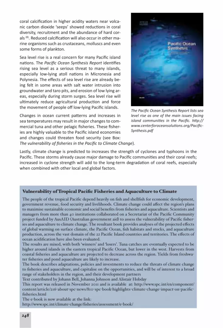
248
coral calcification in higher acidity waters near volca-nic carbon dioxide ‘seeps’ showed reductions in coral diversity, recruitment and the abundance of hard cor-als (8). Reduced calcification will also occur in other ma-rine organisms such as crustaceans, molluscs and even some forms of plankton.
Sea level rise is a real concern for many Pacific island nations. The Pacific Ocean Synthesis Report identifies rising sea level as a serious threat to many islands, especially low-lying atoll nations in Micronesia and Polynesia. The effects of sea level rise are already be-ing felt in some areas with salt water intrusion into groundwater and taro pits, and erosion of low lying ar-eas, especially during storm surges. Sea level rise will ultimately reduce agricultural production and force the movement of people off low-lying Pacific islands.
Changes in ocean current patterns and increases in sea temperatures may result in major changes to com-mercial tuna and other pelagic fisheries. These fisher-ies are highly valuable to the Pacific island economies and changes could threaten food security (see Box: The vulnerability of fisheries in the Pacific to Climate Change).
Lastly, climate change is predicted to increases the strength of cyclones and typhoons in the Pacific. These storms already cause major damage to Pacific communities and their coral reefs; increased in cyclone strength will add to the long-term degradation of coral reefs, especially when combined with other local and global factors.
The Pacific Ocean Synthesis Report lists sea level rise as one of the main issues facing island communities in the Pacific. http://www.centerforoceansolutions.org/Pacific-Synthesis.pdf
Vulnerability of Tropical Pacific Fisheries and Aquaculture to Climate The people of the tropical Pacific depend heavily on fish and shellfish for economic development, government revenue, food security and livelihoods. Climate change could affect the region’s plans to maximise sustainable economic and social benefits from fisheries and aquaculture. Scientists and managers from more than 40 institutions collaborated on a Secretariat of the Pacific Community project funded by AusAID (Australian government aid) to assess the vulnerability of Pacific fisher-ies and aquaculture to climate change. The resultant book provides analyses of the projected effects of global warming on surface climate, the Pacific Ocean, fish habitats and stocks, and aquaculture production, across the vast domain of the 22 Pacific Island countries and territories. The effects of ocean acidification have also been evaluated.The results are mixed, with both ‘winners’ and ‘losers’. Tuna catches are eventually expected to be higher around islands in the eastern tropical Pacific Ocean, but lower in the west. Harvests from coastal fisheries and aquaculture are projected to decrease across the region. Yields from freshwa-ter fisheries and pond aquaculture are likely to increase.The book describes adaptations, policies and investments to reduce the threats of climate change to fisheries and aquaculture, and capitalise on the opportunities, and will be of interest to a broad range of stakeholders in the region, and their development partnersText contributed by Johann Bell, Johanna Johnson and Alistair HobdayThis report was released in November 2011 and is available at: http://www.spc.int/en/component/content/article/216-about-spc-news/810-spc-book-highlights-climate-change-impact-on-pacific-fisheries.htmlThe e-book is now available at the link:http://www.spc.int/climate-change/fisheries/assessment/e-book/

249
Additional information on the impacts of global climate change on Pacific marine ecosystems is available in Reefs at Risk Revisited, the Pacific Ocean Synthesis Report and The Vulnerability of Fisheries in the Pacific to Climate Change report, which are available on-line.
management of coral reefS in the pacific
While many nations have a legislative basis for coastal management, evidence suggests that in many countries, enforcement of laws and implementation of management is either weak or mostly lacking. However, there have been many positive developments. The expansion and success of community based management in the form of Locally Managed Marine Areas (LM-MAs) is an encouraging sign that communities recognize the need to protect and manage reef resources. The initiative of the governments of Micronesia to form the Micronesia Challenge (www.micronesiachallenge.org/) with the aim of applying effective management to at least 30% of near-shore resources and 20% of terrestrial resources by 2020 represents a significant commitment to improved management. The declaration of the Pacific’s largest MPA as the Phoenix Islands Protected Area (PIPA) in Kiribati (www.phoenixislands.org) is another signifi-cant achievement in managing coral reefs in the Pacific. PIPA was added to the UNESCO World Heritage list in 2010. Projects that explore alternative livelihoods and sustainable uses of reef resources are being implemented in many countries; several examples are described in case studies in the final section of this report.
the future outlook for pacific coral reefS
This report synthesises information about the Pacific’s coral reefs in a structured manner to provide a preliminary outlook for these coral reefs, using the 2009 Outlook Report of the Great Barrier Reef Marine Park Authority (GBRMPA) as a model. Four descriptive scenarios of the future are used to identify the future outlook options for the coral reefs of the Pacific, based on the 5 themes used throughout this report.
Scenario 1
Outlook – Very Good
The coral reefs of the Pacific are highly likely to remain healthy and resilient over the foreseeable future. Most reefs will remain in good condition and damaged reefs are highly likely to recover in almost all instances, and reef resources are highly likely to be sustained, rebuilt (if depleted) and managed sustainably. Additional stresses on reefs will be reduced to the extent that they have negligible effects on coral reefs. Additional management action is not required.
Scenario 2
Outlook – Good
With some management intervention, most of coral reefs in the Pacific are likely to remain healthy and resilient for the foreseeable future. Most damaged reefs are likely recover, and reef resources are likely to be sustained, rebuilt (if depleted) and managed sustainably. Signs of degradation will be localised to a few areas in the Pacific. Additional stresses on reefs (e.g. pollution, climate change) will be addressed with regular successes in reducing impacts on coral reefs. Pressures on reefs will be manageable.

250
Scenario 3
Outlook – Poor
Significant management interventions are required to keep pace with the pressures affecting reefs, or to attempt to halt and reverse declines. Pressures on reefs and resulting impacts will be common in most countries, and likely to increase in the next 20 years, presenting significant management challenges. Some damaged reefs are likely recover but other reefs show signs of long-term decline. Reef resources will continue to decline with collapses of some stocks. Additional stresses on reefs (e.g. pollution, climate change) will have significant impacts on coral reefs.
Scenario 4
Outlook – Very Poor
Without massive management intervention, the coral reefs of the Pacific will likely experience widespread degradation and loss over the next 50 years. Damaged reefs will experience phase shifts into persistent alternative states, and many fisheries stocks will be exhausted. Impacts from factors such as pollution push reefs into these persistent alternative states, and result in widespread losses of coral reef biodiversity and ecosystem function.
Future Outlook: Based on these scenarios, the outlook for the coral reefs of thePacific isconsidered to be Poor. While many reefs are still in relatively good condition, some reefs show evidence of declines including chronic declines and changes. Increasing local pressures on reefs pose serious risks. While remote reefs are generally not exposed to the same level of pressure, global climate change presents a serious region-wide pressure that will affect both accessible and remote coral reefs. Significant management intervention will be required to overcome the many challenges to maintain the resilience of coral reefs to adequately resist pressures and threats; special efforts are required to manage the use of reef resources.
concluding remarkS and recommendationS
The ‘Outlook – Poor’ assessment for Pacific coral reefs is neither a criticism, nor a justification for inaction, but a ‘CallforAction’. The cultures, identities and livelihoods of people in the Pa-cific are intricately linked to the health of coastal and ocean ecosystems and resources; this is a key point. There are promising signs of action and improvements throughout the Pacific, and Pacific reefs are in better condition and at lower risk than many other coral reefs around the world. Pacific reefs are under lower population pressure than areas such as Asia, are generally remote from the large land masses, and most are surrounded by very deep water. This situa-tion provides greater impetus to implement urgent management action to tackle the threats facing reefs of the Pacific. In particular, Reefs at Risk Revisited and the Pacific Ocean Synthesis Report contain a detailed list of recommendations for further action. Below is a shortened list of recommendations for further action that reflect calls from the Chapters above. If these actions are implemented effectively, the future outlook for the Pacific’s valuable and unique coral reefs could be considerably improved:
Climate Change:1. Address climate change at its source by reducing emissions of carbon dioxide and other greenhouse gases. This will require actions at the global scale initiated through global forums, and includes actions implemented at national and local levels;
Reef Resilience:2. Maximise coral reef resilience to the effects of climate change by reducing local pressures such as overfishing, pollution and habitat degradation;
Socioeconomics:3. Address social and economic issues such as population growth and un-sustainable commercial use of resources;
Adaptation:4. Identify and plan for the potential impacts of climate change on the social, cultural and economic circumstances of Pacific communities;

251
Coastal Fisheries:5. Improve management of coastal fisheries to ensure sustainable use of reef resources, and to halt destructive fishing practices;
Catchment Management:6. Improve management of the coastal zone to conserve coastal habitats, reduce erosion, plan for and manage coastal development;
Reduce Pollution:7. Reduce sediment and nutrient pollution through improved land-use practices in adjacent catchments;
Waste Management:8. Address pollution issues by improving and ensuring long-term main-tenance of sewerage systems and waste management infrastructure;
AlternativeLivelihoods:9. Explore alternative solutions to issues of overfishing, land-use and management (see Case Studies);
Develop and maintain MPAs:10. Maintain support for management initiatives such as estab-lishing, maintaining, monitoring and enforcing networks of MPAs;
Management Support and Resources11. : Build capacity in reef monitoring and management within local government agencies and communities, secure long-term funding and support for these efforts and mainstream environmental considerations into decision making;
Reef Co-Management:12. Foster community-based management efforts ranging from educa-tion and outreach programs to the expansion of Locally Managed Marine Areas, and inte-grate these with formal management arrangements; and
Raise Awareness:13. Make a conscious effort to raise awareness of the problems facing cor-al reefs and the need for effective management with decision makers and all community members, demonstrating that all have a role in conserving coral reefs.
References: Summary and Conclusions1. Caldwell M, Churcher Hoffmann T, Palumbi S et al. (2009). Pacific Ocean Synthesis: Scientific literature
review of coastal and ocean threats, impacts and solutions, California: The Woods Center for the Envi-ronment, Stanford University, 170 p. http://www.centerforoceansolutions.org/PacificSynthesis.pdf
2. Burke L, Reytar K, Spalding M et al. (2011). Reefs at Risk Revisited, Washington DC: World Resources Institute, 114 p. http://www.wri.org/project/reefs-at-risk
3. UNEP/SOPAC (2005). Environmental Vulnerability Index. United Nations Environment Programme/Pa-cific Islands Applied Geoscience Commission. http://www.vulnerabilityindex.net/
4. Wilkinson C (2008). Status of Coral Reefs of the World: 2008. Global Coral Reef Monitoring Network & Reef and Rainforest Research Centre, Townsville, 304 p.
5. Kinch J, Anderson P, Richards E et al. (2010). Outlook Report on the State of the Marine Biodiversity in the Pacific Islands Region, Apia, Samoa: Secretariat of the Pacific Regional Environment Programme, 44 p.
6. Wilkinson C, Brodie J (2011). Catchment management and coral reef conservation. Global Coral Reef Monitoring Network and Reef and Rainforest Research Centre: Townsville, 120 p. http://www.crispon-line.net/CRISPPRODUCTS/Integratedcoastalmanagement/tabid/312/Default.aspx.
7. Secretariat of the Pacific Community (2011). SPC Statistics and Demography Webpage. [cited 2011 August 1st]; SPC Statistics and Demography Programme. http://www.spc.int/sdp/
8. Fabricius KE, Langdon C, Uthicke S et al. (2011). Losers and winners in coral reefs acclimatized to elevated carbon dioxide concentrations. Nature Climate Change, 1(3): 165-169. <Go to ISI>://WOS:000293718300020.

252
Appendix 1: detAils of descriptive themes
Status of coral reefs This theme describes the current condition of coral reef ecosystems, but also the associated habitats such as mangroves which may be closely linked with coral reefs in some locations. Coral reef condition is usually expressed as a percentage of living coral cover of communities at monitored sites. Coral reefs are dynamic systems that experience periodic disturbances and declines that are usually followed by recovery in following years. This theme provides an indica-tion of the current status of coral reefs compared to long-term trends.This theme was described using status and trend information on coral reefs sourced from Reef-Base Pacific, the GCRMN Status of Coral Reefs of the World 2004 and 2008, the Status of Coral Reefs in the South West Pacific 2004, and specific scientific publications and reports.
Stable: Coral cover is generally high and has been stable or increasing at most sites. No evidence of widespread and prolonged degradation of coral cover, or signs of stress or
damage.
Evidence of change: Coral cover is high and stable at some sites, is increasing at other sites, but some sites are showing continued long-term declines. Signs of damage or
stress evident at some sites.
Altered: Coral reef resources are at an altered state compared to previous conditions, including long-term declines in coral cover at many sites. Widespread signs of coral
stress or damage.
Coral reef health and resilienceIn this report, the health and resilience of coral reefs has been described by the level to which their ecological processes and community structure remain undisturbed, and by examining evidence of their ability to recover from disturbances. This relies on data such as trends in coral recruitment, and surveys of reef associated animals and plants such as macroalgae and fishes (predators, herbivores, fished species) to determine the level of disruption to reef com-munities. Further, long-term monitoring data provide information about cycles of disturbance and recovery. Collectively, these data provide important information about the state of the reef’s ecological infrastructure, that is, the underlying ecological processes (e.g. recruitment, reproduction, nutrient cycling, predation, competition etc.) and community structures (e.g. abundance of predators, herbivorous fishes, macroalgae, invasive species) that are necessary to maintain coral reef ecosystems. These indices are available for a few countries in the Pacific, and cover some of the main variables recommended by the IUCN resilience assessment proto-col for assessing coral reef resilience (1).This theme was described using information on reef health and processes, and from trend data for patterns of disturbance and recovery of coral reefs. These data were sourced from ReefBase Pacific; the GCRMN Status of Coral Reefs of the World 2004, 2008 reports; the Status of Coral Reefs in the South West Pacific 2004, 2009; and scientific publications and reports specific to each country.
Stable: coral reef community structures appear to be stable and relatively intact com-pared to available baseline data or pristine reference sites, with good representation of
key reef organisms such as predators and herbivores. Little evidence of altered or degraded reef ecosystem processes (e.g. recruitment failures, phase shifts in coral communities, losses of bio-diversity), or major disruptions to reef communities (e.g. outbreaks of invasive species, mass mortality events, altered community structure). After disturbance events (e.g. coral bleaching,

253
cyclones, crown-of-thorns starfish outbreaks), reefs recover to pre-disturbance state within ex-pected time-frames.
Evidence of change: emerging evidence of changes in coral reef community structures at some sites, e.g. changes in the density or abundance of organisms such as large reef
fishes between fished and unfished areas, changes in density of herbivores (e.g. parrotfish or urchins). Emerging evidence of changes in reef ecosystem processes (e.g. recruitment failures, phase shifts in coral communities, losses of biodiversity, increased recruitment following pro-tection of spawning sites), evidence of disruptions to reef communities (e.g. spread of invasive species, population explosions of certain species, mass mortality events, altered community structure). Reefs show some recovery after disturbances, but recovery may be slower than ex-pected or incomplete.
Altered: evidence of widespread changes in, and disruptions to, reef community struc-tures. For example, altered community composition, reduced abundance, density or
diversity of key species groups, clear evidence of widespread changes in reef ecosystem pro-cesses (e.g. recruitment failures, phase shifts in coral communities, losses of biodiversity), ma-jor disruptions to reef communities (e.g. outbreaks of invasive species or population explosions, mass mortality events, altered community structure). Reefs do not show signs of expected re-covery after disturbances.
Use of reef resourcesThe theme describes trends in the use of coral reefs and other coastal resources such as man-groves that may help to sustain healthy reef ecosystems. This includes commercial uses such as fishing, aquaculture, tourism and aquarium collecting, as well as traditional and artisanal uses of coastal resources. This theme also includes information on emerging threats. Patterns of use may affect the health and resilience of coral reefs (1).This theme was described using information available on the use of reef resources. Data were sourced from ReefBase Pacific; the GCRMN Status of Coral Reefs of the World 2004, 2008 re-ports; the Status of Coral Reefs in the South West Pacific 2004, 2009; the UNEP/SOPAC Environ-mental Vulnerability Index 2005; the Pacific Ocean Synthesis Report 2009; Reefs at Risk Revis-ited 2011, the FAO Fisheries Database; and publications and reports specific to each country.
Stable: Resource use appears to be stable with no evidence of significant damage or long-term impacts to reef condition, health or resilience. Trends in resource use do not
appear to threaten long-term sustainability of exploited resources. If such changes are evident, they occur on a very small scale, and are localised to a handful of reefs or locations. Destructive use of reefs and resources (e.g. cyanide or bomb fishing, coral mining, mangrove destruction) is extremely rare or non-existent.
Evidence of change: resource use patterns are changing that may be increasing or de-creasing pressure on coral reefs. Evidence that resource use is causing changes in the
condition and health of some exploited resources and habitats. Trends in resource use may threaten the long-term sustainability of exploited resources or the health of habitats. These changes and effects are evident in several reefs and locations. Destructive use of reefs and re-sources (e.g. cyanide or bomb fishing, coral mining, mangrove destruction) known to occur in a few locations.
Altered: resource use patterns have changed, and current resource uses have increased pressure on reef resources and threaten the long term sustainability. Evidence of nega-
tive changes in the condition and health of resources and habitats. These changes and effects may operate across numerous reefs and locations. Destructive use of reefs and resources (e.g.

254
cyanide or dynamite fishing, coral mining, mangrove destruction) occurs in a number of loca-tions.
Factors affecting reef health and conditionThis theme describes large-scale factors and processes that affect coral reef condition and health, and may present risks to coral reef ecosystems. These ‘risk factors’ may operate at local, regional and global scales. Localised factors are specific to individual locations or countries, and tend to be related to human use and ecological impacts such as the effects of land use, popula-tion growth, coastal development, pollution and mining, and losses of biodiversity. Regional and global factors operate over larger areas and include factors such as geophysical forces and events (earthquakes, tsunamis), oceanography, climate and climate change, and severe weather events. Many of these factors are specifically considered in the Reefs at Risk Revisited assessment process, and are recommended for assessment by the IUCN coral reef resilience assessment protocol (Obura and Grimsditch, 2009)This theme was described using information available on the environmental risks, patterns and trends, and existing risk assessments. Data was sourced from ReefBase Pacific; the GCRMN Sta-tus of Coral Reefs of the World 2004, 2008; the Status of Coral Reefs in the South West Pacific 2004, 2009; and the United Nations Population Division, and publications and reports specific to each country. Particular use was made of the UNEP/SOPAC Environmental Vulnerability Index 2005, the Pacific Ocean Synthesis Report 2009, and the Reefs at Risk 2011.
Stable: There are few risk factors identified that are likely to cause significant changes in reef condition and health. Little evidence of change in the frequency, intensity, or num-
ber of risk factors. Little evidence that these factors have caused long-term changes in reef condition or health. Population growth is not predicted to change coral reef condition or health.
Evidence of change: Some risk factors identified have caused, or could cause, significant changes in reef condition and health. The frequency and/or intensity or number of ex-
isting risk factors is changing, new risk factors may be emerging. There is evidence that these factors have caused significant changes in reef condition or health in some locations. Population growth is likely to increase pressure on the natural environment.
Altered: Many risk factors are identified that have significantly changed reef condition and health. The frequency and/or intensity of these risk factors has changed or is pro-
jected to rise, increasing the degree of impact on coral reefs. There have been numerous im-pacts on coral health from these risk factors with little evidence of recovery. Population growth is placing significant pressures on the environment, projected population growth is likely to re-sult in significant degradation of the environment.
Governance and managementThe theme attempts to provide a brief overview and description of the governance and man-agement of Pacific coral reefs. Management is a very complex issue; for example, the IUCN framework for assessing management effectiveness includes assessment of 3 areas of manage-ment: 1. design/planning; 2. adequacy/appropriateness of planning; and 3. delivery/implemen-tation of management (2). This theme provides only a brief synthesis and description of each these 3 areas, focusing specifically on the design and implementation of MPAs, and manage-ment of coral reef fisheries. This theme was assessed using information available on the management of reef resources. Data were sourced from ReefBase Pacific; the GCRMN Status of Coral Reefs of the World 2004, 2008; the Status of Coral Reefs in the South West Pacific 2004, 2009; and any publications and reports specific to each country. Particular use was made of the UNEP/SOPAC Environmental

255
Vulnerability Index 2005, the Pacific Ocean Synthesis Report 2009, and the Reefs at Risk Revis-ited 2011.
Stable: Comprehensive and appropriate management has been developed for coral reefs, and can potentially ensure long-term protection and sustainable use of reef re-
sources. There is sufficient funding, support, capacity and infrastructure to implement and maintain management efforts, and management plans and programs are effectively imple-mented. There is little evidence of non-compliance with management, and management effec-tiveness is being assessed and improved where necessary.
Evidence of change: Some management plans and programs have been developed for coral reefs. While management may be bringing about positive changes in patterns of
use and resource condition, long-term protection and sustainable use of reef resources has not been achieved. There is insufficient funding, support, capacity and infrastructure to fully imple-ment the management plan, which is only partly operational. There is evidence of non-compli-ance in some areas. Management effectiveness has only partly been assessed.
Altered: Management plans or programs have not been developed for coral reefs, or if developed, are limited in scale, or have not been effectively implemented. This has led
to alteration and degradation of coral reefs in many locations. There is a lack of resources, sup-port, capacity and infrastructure to develop or implement management. There is evidence of non-compliance in many areas, or the level of compliance is unknown, and is not measured. The effectiveness of management is not assessed.
References (Appendix 1)1. Obura DO, Grimsdith G (2009). Resilience Assessment of coral reefs – Assessment protocol for coral
reefs, focusing on coral bleaching and thermal stress, IUCN, Gland, Switzerland: IUCN working group on Climate Change and Coral Reefs, 70 pp. http://www.iucn.org/cccr/publications/
2. Hockings M, Stolton S, Leverington F et al. (2006). Evaluating effectiveness: a framework for assessing management effectiveness of protected sites., Gland, Switzerland: IUCN. http://www.iucn.org/cccr/publications/

256
Appendix 2: informAtion, Agencies And progrAms
This is a summary reports some of the agencies and organisations working towards coral reef monitoring and management in the Pacific, and which have assisted with this report (either directly or via obtaining data and information from their reports). This includes government agencies, inter-governmental agencies, NGOs and private organisations.
Centre de Recherches Insulaires et Observatoire de l’Environnement de Polynésie Française (CRIOBE)The CRIOBE is a research centre located in Moorea, French Polynesia, and part of the Centre National de la Recherche Scientifique (CNRS) French marine stations national network. It is also connected with the Practical School of High Studies (EPHE). With a staff of more than 50 including technicians and researchers, CRIOBE provides a research base for visiting research-ers, undertakes theoretical and applied research, and supports education and training for post-graduate students. The CRIOBE coordinates ReefBase Pacific and coral reef monitoring efforts throughout Polynesia including long-term monitoring of reefs in French Polynesia and neighbor Pacific Islands Countries and Territories (PICTS). http://www.criobe.pf/
Conservation International (CI)Conservation International was founded in 1987 as an NGO based in Virginia, USA, but with regional offices across the world including Fiji, Papua New Guinea, New Caledonia and Samoa in the Pacific. The CI mission is: Building upon a strong foundation of science, partnership and field demonstration, CI empowers societies to responsibly and sustainably care for nature, our global biodiversity, for the well-being of humanity. CI’s Pacific projects include marine planning in New Caledonia, marine parks in Kiribati and Fiji, and sustainability projects. http://www.conservation.org/explore/asia-pacific/pacific_islands/pages/overview.aspx
Coral Reef InitiativeS for the Pacific (CRISP)CRISP is diverse program that aims to develop a vision for the future of coral reefs and the com-munities that depend on them. Through the CRISP, strategies and projects to conserve coral reef biodiversity, while developing the economic and environmental services that they provide are being explored and implemented. The CRSIP also helps to help foster collaboration and co-ordination between developed countries (Australia, New Zealand, Japan, USA), French overseas territories and Pacific Island developing countries. The CRISP funded through the French Devel-opment Agency (AFD) and comprises three major components: (1) Integrated Coastal Manage-ment and watershed management; (2) development of coral ecosystems; and (3) program co-ordination and development (including institutional support, technical support and extension). The CRISP is hosted by the SPC in Noumea, and has provided reports and information used in this report, including many of the case studies of projects and initiatives highlighted in Section 2 of this report.http://www.crisponline.net/Home/tabid/36/Default.aspx
Global Coral Reef Monitoring NetworkThe Global Coral Reef Monitoring Network (GCRMN) is an operational network of the Inter-national Coral Reef Initiative. Its programs are supported by a range of organizations, working to improve management and conservation of coral reefs by providing manuals, equipment, databases, training, problem solving. A major function of the GCRMN is to help facilitate, co-ordinate and support coral reef monitoring efforts around the world. The GCRMN also helps secure funding for reef monitoring, and all these activities are coordinated in a global network. One of the most important features of the GCRMN is its publication series on the status of coral

257
reefs around the world. These publications are one of the main information sources used in this report.The core objectives of GCRMN are:
To link existing organisations and people to monitor ecological and social, cultural and eco-• nomic aspects of coral reefs within interacting regional networks.To strengthen the existing capacity to examine reefs by providing a consistent monitoring • program, that will identify trends in coral reefs and discriminate between natural, anthro-pogenic, and climatic changes.To disseminate results at local, regional, and global scales on coral reef status and trends, to • assist environmental management agencies implement sustainable use and conservation of reefs.
The GCRMN monitoring coordination is organised around GCRMN nodes which coordinate and facilitate monitoring efforts in participating countries. Experienced marine institutes assist in training, establishing of databases and problem resolution. The GCRMN Pacific nodes are cur-rently located at the University of the South Pacific (Fiji), CRIOBE (Moorea, French Polynesia) and the Palau International Coral Reef Center (PICRC). The GCRMN encourages the use of Reef-Base at WorldFish Center to store data, especially metadata.http://www.gcrmn.org/
Global Environment Facility, Coral Reef Targeted Research and Capacity Building for Management (CRTR)The Coral Reef Targeted Research & Capacity Building for Management (CRTR) Program is an international coral reef research initiative that provides a coordinated approach to credible, fac-tual and scientifically-proven knowledge for improved coral reef management. CTFR partners include the Global Environment Facility, the World Bank and the University of Queensland, and 50 other organisations around the world. The CRTR goal is to address key gaps in the world’s knowledge and understanding of coral reefs, and put new knowledge and technology into the hands of decision-makers and reef managers where it can make a difference. By addressing these knowledge gaps, the program can identify management options to address pressures on coral reefs.The CRTR Program is coordinated through Centres of Excellence in the Philippines, Mexico, Zan-zibar and Australia, which reflect the regional distribution of coral reefs and the management initiatives underway to conserve them. These centres are the focal points for research carried out by international scientists. Major areas of research include coral bleaching, ecological con-nectivity and processes, coral disease, modeling and decision support, remote sensing and reef restoration and remediation. CTFR projects provide some of the case studies used in section 2 of this report.http://www.gefcoral.org/Home/tabid/2967/language/en-US/Default.aspx
Institute for the Coral Reefs of the Pacific (IRCP)The IRCP, a scientific institute of the EPHE, works closely with CRIOBE on information and aware-ness raising activities, and actively participates in research and management of coral reefs in the South and Central Pacific.The IRCP has 4 main objectives:
To facilitate monitoring and observations of South and Central Pacific coral reefs;• To provide a base that facilitates and promotes research on the environments, habitats and • ecosystems of the Pacific, and establish a link between fundamental research, conservation and training on coral reef issues;To promote social and human sciences as complementary tools for coral reef sustainable • management; and
To enhance communication, awareness raising about Pacific coral reefs, and provide high level advice and expertise on coral reef issues in multidisciplinary projects aimed at coral reefs con-

258
servation in the context of sustainable development, thus contributing to the future of coral reefs and the people that depend on them.http://www.ircp.pf
Ministry of the Environment, Japan (MOEJ)The Ministry of the Environment coordinates Japan’s coral reef management, and it has sup-ported coral reef monitoring and MPA networking in the East Asian Seas Region. http://www.env.go.jp/en/ & http://www.coremoc.go.jp/english/top_e.html
National Oceanic and Atmospheric Administration (NOAA), USANOAA’s Coral Reef Conservation Program (CRCP) supports effective management and sound science to preserve, sustain and restore valuable coral reef ecosystems for future generations. CRCP is a cross-cutting program that brings together expertise from a wide array of NOAA of-fices. CRCP works in strong partnership with coral reef managers to reduce harm to, and restore the health of, coral reefs (including deep-water corals) by addressing top national threats and local management priorities through conservation activities.http://coralreef.noaa.gov
Secretariat of the Pacific Community (SPC)The SPC has a long history of working with communities across the Pacific. It is an intergovern-mental organisation that provides technical and policy advice and assistance to its Pacific Island members. SPC was established as an international organisation in 1947 and has 26 member countries and territories including American Samoa, Australia, Cook Islands, Federated States of Micronesia, Fiji Islands, France, French Polynesia, Guam, Kiribati, Marshall Islands, Nauru, New Caledonia, New Zealand, Niue, Northern Mariana Islands, Palau, Papua New Guinea, Pitcairn Islands, Samoa, Solomon Islands, Tokelau, Tonga, Tuvalu, United States of America, Vanuatu and Wallis and Futuna. The main SPC headquarters is in Nouméa, New Caledonia, but it has regional offices in Suva (Fiji), and Pohnpei (Federated States of Micronesia). The SPC also has country offices in Papua New Guinea, Solomon Islands and Vanuatu.
The SPC’s mission is to help Pacific Island people position themselves effectively to respond • to the challenges they face and make informed decisions about their future and the future they wish to leave for the generations that follow.The SPC’s vision is a secure and prosperous Pacific Community, whose people are educated • and healthy and manage their resources in an economically, environmentally and socially sustainable way.
http://www.spc.int
Secretariat of the Pacific Regional Environment Programme (SPREP)SPREP is a regional organisation established by the governments and administrations of the Pacific region. It is based in Apia, Samoa, with over 70 staff, and is the Pacific region’s major intergovernmental organisation charged with protecting and managing the environment and natural resources. SPREP also manages the pacific Environmental Information Network which was a major source of the information used in this report. SPREP’s mandate is to promote cooperation in the Pacific islands region and to provide assis-tance in order to protect and improve the environment and to ensure sustainable development for present and future generations. SPREP has 21 Pacific island member countries and four countries with direct interests in the regionhttp://www.sprep.org
University of the South Pacific (USP) – Institute of Marine ResourcesThe University of the South Pacific (USP) Institute of Marine Resources (IMR) is based in Fiji. The Institute provides scientific and technical skills, and capacity-building, in aquaculture, marine resource assessments, marine surveying, coral reef monitoring/ database maintenance, and

259
socio-economic analysis for fisheries and aquaculture. Current activities centre on aquaculture, on coral reef monitoring, and on marine biodiversity assessment. The Institute also coordinates the South-West Pacific node of the Global Coral Reef Monitoring Network (GCRMN), providing much of the information on the SW Pacific coral reefs used in this report. http://www.usp.ac.fj/index.php?id=imr
U.S. Department Of State The Department of State is the foreign policy arm of the United States Government. The Depart-ment is dedicated to creating a more secure, democratic and prosperous world for the benefit of the American people and the international community. Within the Department, the Bureau of Oceans and International Environmental and Scientific Affairs is responsible for advancing sustainable development and natural resource conservation, including aspects related to coral reefs and coral reef ecosystems, through a wide variety of international treaties, organizations, initiatives and public-private partnerships. http://www.sdp.gov/sdp/initiative/icri
WorldFish Center The WorldFish Center is an international, nonprofit research organization dedicated to reducing poverty and hunger by improving fisheries and aquaculture. WorldFish is one of 15 members of the Consortium of International Agricultural Research Centers supported by the Consultative Group on International Agricultural Research (CGIAR). The CGIAR is a global partnership that unites organizations engaged in research for sustainable development with the funders of this work. The funders include developing and industrialized country governments, foundations, and international and regional organizations. The WorldFish Center is committed to meeting two key development challenges: 1) improving the livelihoods of those who are especially poor and vulnerable in places where fisheries and aquaculture can make a difference, and 2) achiev-ing large scale, environmentally sustainable increases in supply and access to fish at afford-able prices for poor consumers in developing countries. WorldFish maintains FishBase (www.fishbase.org), and ReefBase (www.reefbase.org) and was instrumental in developing ReefBase Pacific (www.pacific.reefbase.org) that was a major source of information for this report. WFC also maintains the GCRMN website (www.gcrmn.org). http://www.worldfishcenter.org
The World Resources Institute (WRI)The World Resources Institute is an environmental think tank that goes beyond research to cre-ate practical ways to protect the earth and improve people’s lives. WRI’s work in coastal ecosys-tems includes the Reefs at Risk series, which uses geographic spatial analysis to model threats to coral reefs, as well as the Coastal Capital project, which supports sustainable management of coral reefs and mangroves by quantifying their economic value. Reefs at Risk Revisited (2011) is the latest publication in WRI’s Reefs at Risk series, which be-gan in 1998 with the release of the first global analysis, Reefs at Risk: A Map-Based Indicator of Threat to the World’s Coral Reefs, and was followed by two regional reports for Southeast Asia (2002) and the Caribbean (2004). Reefs at Risk Revisited is a high-resolution update of the original global report that draws upon the improved methodology of the regional studies, more detailed global data sets, and new developments in mapping technology and coral reef science. It was a multi-year, collaborative effort that involved more than 25 partner institutions.The Reefs at Risk Revisited project consolidates global data sets into a geographic informa-tion system (GIS) to model threats to coral reefs and map where reefs are at greatest risk of degradation or loss. The threats examined include local threats from human activities (coastal development, land-based and marine-based pollution, and overfishing) and global threats from a changing climate (ocean warming and acidification). In the absence of complete global infor-mation on reef condition, this analysis represents a pragmatic hybrid of monitoring observa-

260
tions and modeled predictions of reef condition. Data and maps from the Reefs at Risk Revisited project are presented in the country profiles in Section 1 of this report.http://www.wri.org/reefs & http://www.wri.org/project/reefs-at-risk
WWF South PacificSince 1995, WWF South Pacific has been working with governments and communities to sup-port Pacific Island people in conserving and sustainably managing their natural inheritance for present and future generations. The WWF South Pacific program promotes the development and implementation of sound policies and strategies that lead to sustainable marine resource management and biodiversity conservation, and also empower key stakeholders to implement them effectively. WWF South Pacific has a shared vision of Supporting Pacific Island people to conserve and sustainably manage our natural inheritance for present and future generations.WWF South Pacific is managed from a regional base in Suva, Fiji, where conservation field proj-ects, policy reviews, and campaigns are coordinated for many projects across the region. In 2004, WWF South Pacific had more than 100 staff. http://www.wwfpacific.org.fj

AcknowledgementsThis report is based on the information collected by hard working scientists, managers, conservation organisations and non-governmental organisations working tirelessly across the Pacific. We owe a debt of gratitude to those people who have collected information about coral reefs, their use and management. This project has also benefited greatly from the efforts of those who have collected, managed and synthesised a huge range of information so that we could locate and retrieve this information. We say “thank you” to the authors of the previous synthesis reports and risk assessments, and also to the custodians of this knowledge in libraries and data systems such as ReefBase Pacific and the Pacific Environmental Information Network.
We wish to thank the following organisations which have contributed funds so that this report could be produced and distributed free-of-charge to developing countries around the world: US Department of State; National Oceanographic and Atmospheric Administration of USA; French contributors; the Japanese Ministry of the Environment. The U.S. Department of the Interior, Office of Insular Affairs provided support to the World Resources Institute to prepare materials for this report.
We also extend our thanks to all the reviewers from across the Pacific who gave up their time to ‘ground truth’ this report. Thanks to Tim Adams, Maria Berger, Tim Clark, Monte Depaune, Doug Fenner, Jeremy Goldberg, Yimnang Golbuu, Bob Halstead, Marion Henry, Cherie Morris, Nicolas Pascal, Kelvin Passfield and Helen Sykes. Special thanks go to Chiara Pisapa for her assistance in pulling information together during the final stages of the project. We gratefully acknowledge Jaclyn Davies for preparing the early drafts of the Hawaiian Islands chapter, which included input from Ivor Williams, Jill Zimzow and Bob Shroeder. We thank staff of the Great Barrier Reef Marine Park Authority for their advice in developing this report, and acknowledge the Great Barrier Reef Outlook Report 2009 as an excellent model and approach for future efforts to synthesis knowledge and assess the risks facing coral reef ecosystems. We eventually thank Carole Manry, Enelio Liufau and Atoloto Malau from the ‘Service de l’Environnement de Wallis et Futuna’ for their central contribution to the Wallis and Futuna chapter.
We dedicate this report to the Peoples of the Pacific who are facing existing and increasing challenges on numerous fronts. It is our hope that this report will help to drive action that makes a real difference in the health and well being of the Pacific community, and in ensuring the protection and wise-use of their coral reefs and resources.
GCRMN Management Group IOC-UNESCO – Intergovernmental Oceanographic Commission of UNESCO UNEP – United Nations Environment Programme IUCN – International Union for Conservation of Nature (Chair) The World Bank, Environment Department CBD – Convention on Biological DiversityGBRMPA – Great Barrier Reef Marine Park Authority WorldFish Center and ReefBase ICRI Secretariat – Governments of France, Samoa and Monaco RRRC – Reef and Rainforest Research Centre, Ltd (Australia) as host GCRMN Major Supporters and Operational PartnersUS Department of State and NOAA – National Oceanic and Atmospheric Administration of USA National Fish and Wildlife Foundation of USAGCRMN SocMon (Socioeconomic Monitoring Initiative for Coastal Management) at NOAAReef Check Foundation, Los AngelesReefBase and WorldFish Center, Penang CRISP - Coral Reef Initiatives for the Pacific,World Resources Institute, Washington DC
Note: The conclusions and recommendations of this book are solely the opinions of the authors, contributors and editors and do not consti-tute a statement of policy, decision, or position on behalf of the participating organisations, including those represented on the cover.
Photographs on the Front and Back Cover are explained and credited inside the back cover.
Citation: Chin, A., Lison De Loma, T., Reytar, K., Planes, S., Gerhardt, K., Clua, E., and Burke, L., Wilkinson, C. (2011). Status of Coral Reefs of the Pacific and Outlook: 2011. Publishers Global Coral Reef Monitoring Network. 260 P.
ISBN 0 642 322228 7
© Global Coral Reef Monitoring Networkwww.gcrmn.org
Authors [see on the back page]
Cover photographs© CNRS / Thomas Vignaud1. © CNRS / Thomas Vignaud2. © Eric Clua3. © CRIOBE / Yannick Chancerelle4. © CRIOBE / Yannick Chancerelle5. © Eric Clua6. © CNRS / Thomas Vignaud7. © Eric Clua8. © CNRS / Thomas Vignaud9. © Charlie Veron10.
Authors
Andrew Chin has been working in marine research in the Great Barrier Reef since the 1990s. Andrew worked for the Great Barrier Reef Marine Park Authority (GBRMPA) in the research and monitoring section on reef monitoring and reporting, and impact assessment projects. He was also the editor of the State of the Great Barrier Reef Report and helped to develop the framework and structure of the GBRMPA’s 2009 Outlook Report. He has also authored several chapters for GCRMN publications including the Australia and Papua New Guinea chapter of the 2008 GCRMN status report. Andrew is currently working at James Cook University in Queensland, Australia, focusing on the biology, ecology, conservation and management of sharks and rays. He is one of the founding members of the Oceania Chondrichthyan Society, a scientific society supporting research, management and conservation of sharks and rays in the Pacific.
Thierry Lison de Loma is the associate Director of the Institute for the Coral Reefs of the Pacific (IRCP). He holds a PhD in Marine Environmental Sciences from the University of Aix-Marseille (France), with a focus on biogeochemistry and ecology in coral reefs. He started to work on coral reefs by studying coral ecology in 1993, in the tropical island of La Réunion (Indian Ocean). He is now a specialist in coral reef fish ecology in French Polynesia, based at CRIOBE (CRNS-EPHE) in Moorea. He mainly focuses on the effects of specific disturbances/factors (global change, fishing pressure and MPAs) on long-term fish community dynamics. For the past 19 years, Thierry has been diving extensively in the islands of the South Pacific and Indian Oceans (from Pitcairn to Madagascar), for field work and for his own enjoyment. He is in charge of the GCRMN Pacific Node.
Katie Reytar is a Research Associate at the World Resources Institute. She is a co-author of WRI’s Reefs at Risk Revisited report and specializes in GIS and data analysis. Katie has a M.E.S.M. in Coastal Marine Resources Management from the University of California, Santa Barbara and a B.S. in Environmental Engineering from the Johns Hopkins University.
Serge Planes has been involved in the study of population genetics of marine fish since the beginning of his career that started with his PhD in 1989. Over the past 20 years, he has published about 65 papers in international journals dealing with the population genetics of coral reef fishes and an additional 50 papers dealing with ecology, ecology of marine protected areas and recruitment of marine fishes. Such international recognition led to him being invited to participate as a member of the Australian Centre of Excellence on Coral Reefs and he has recently been incorporated into the scientific committee of the 12th International Coral Reef Symposium. Serge Planes is directing the LABEX “CORAIL” awarded in 2011 for 10 years, this being the major structural framework for research on coral reef ecology in France. He is also the Director of the Centre for Island Research and Observatory of the Environment (CRIOBE) and of the Institute for the Coral Reefs of the Pacific (IRCP), both based in Moorea, French Polynesia.
Karin Gerhardt has a decade of experience in marine park management, specializing in the Great Barrier Reef. Her work at the Great Barrier Reef Marine Park Authority has included marine park management, permit assessment, policy development and impact assessment. One of Karin’s specialties is in Knowledge Management – specifically the acquisition, management and effective utilization of knowledge and information for managing marine areas. Her expertise in this area was instrumental in managing the information processes that were used to develop this report. Her current focus is on working with the Traditional Owners of the Great Barrier Reef in the management of Sea Country and capturing and evaluating the outcomes of the Reef Rescue Land and Sea Country Indigenous Partnership Program.
Eric Clua is a scientist based at the Secretariat of the Pacific Community (SPC Noumea, New Caledonia), where he is the coordinator of the Coral Reef InitiativeS for the Pacific (CRISP) programme. Eric holds a PhD in Marine Ecology from the Practical School of High Studies (Ecole Pratique des Hautes Etudes – EPHE), Perpignan, France. His interest in coral reef ecology, conservation and sharks has taken him to many islands across the South Pacific. He has developed, over the years, an intimate knowledge of the Pacific region, its coral reefs and its peoples. His role in promoting the sustainable development of coral reef related activities in the Pacific has been crucial.
Lauretta Burke is a Senior Associate at the World Resources Institute. Lauretta leads WRI’s work on coastal ecosystems, including the Reefs at Risk project and Coastal Capital series on valuation of coral reefs. She has an M.A. in Environment and Resource Policy from the George Washington University and an M.A. in Geography from the University of California, Santa Barbara.
Clive Wilkinson has been the Coordinator of the Global Coral Reef Monitoring Network since 1996. He was formerly the Chief Technical Advisor for a coastal resource research program in 5 ASEAN countries and for an Australian project in Thailand after the massive tsunami of December 2004. He was an active field scientist on the ecology of the Great Barrier Reef at the Australian Institute of Marine Science with more than 100 papers pub-lished. He received BSc and PhD training in marine microbiology and ecology from the University of Queensland. He is based with the Reef and Rainforest Research Centre in Townsville Australia and now provides advice to governments on effects of global climate change on coastal ecosystems and potential adaptation policies.

StatuS of Coral reefS of the PaCifiC and outlook: 2011
andrew Chin, thierry liSon de loma, katie reytar, Serge PlaneS, karin gerhardt, eriC Clua, lauretta Burke, Clive wilkinSon
Statu
S of C
or
al r
eefS of th
e Pa
CifiC a
nd o
utlo
ok: 2011
an
dr
ew C
hin et a
l.
The World Bank