spatial organisation of the alcalar copper age settlement (algarve, portugal)
TRANSCRIPT
UNION INTERNATIONALE DES SCIENCES PRÉHISTORIQUES ET PROTOHISTORIQUES INTERNATIONAL UNION FOR PREHISTORIC AND PROTOHISTORIC SCIENCES
PROCEEDINGS OF THE XV WORLD CONGRESS (LISBON, 4-9 SEPTEMBER 2006)
ACTES DU XV CONGRÈS MONDIAL (LISBONNE, 4-9 SEPTEMBRE 2006)
Series Editor: Luiz Oosterbeek !
VOL.!3'!
!
Session C11: Ancient Cultural Landscapes in South Europe –
their Ecological Setting and Evolution
Session C22: Gardeners from South America
Session S04:
Agro-Pastoralism and Early Metallurgy Sessions
Session WS29: The Idea of Enclosure in Recent Iberian Prehistory
Session C88:
Rhytmes et causalites des dynamiques de l'anthropisation en Europe entre 6500 ET 500 BC:
Hypotheses socio-culturelles et/ou climatiques
Edited by !
José Eduardo Mateus and Paula Queiroz (C11) Angela Buarque (C22) Ana Rosa Cruz (S04)
António Carlos Valera and Lucy Shaw Evangelista (WS29)!Laurent Carozza, Didier Galop, Michel Magny and J. Guilaine (C88)
Cláudia Fidalgo and Luiz Oosterbeek (Volume Editing)
BAR International Series 2124 2010
T"i$ &i&le )ubli$"e, b- Arc"aeo)re$$ Publi$"er$ o4 5ri&i$" Arc"aeolo6ical Re)or&$ Gor,on Hou$e 2<= 5anbur- Roa, O?4or, O@2 <ED En6lan, barCarc"aeo)re$$Dcom FFFDarc"aeo)re$$Dcom 5AR S212I Procee,in6$ o4 &"e @V Worl, Con6re$$ o4 &"e In&erna&ional Union 4or Pre"i$&oric an, Pro&o"i$&oric Science$ Ac&e$ ,u @V Con6rO$ Mon,ial ,e lQUnion In&erna&ionale ,e$ Science$ PrR"i$&oriSue$ e& Pro&o"i$&oriSue$ Ou&6oin6 Pre$i,en&T VU&or OliVeira Jor6e Ou&6oin6 Secre&ar- GeneralT Jean 5our6eoi$ Con6re$$ Secre&ar- GeneralT LuiY Oo$&erbeeZ (Serie$ E,i&or) Incomin6 Pre$i,en&T Pe,ro I6nacio S"mi&Y Incomin6 Secre&ar- GeneralT LuiY Oo$&erbeeZ Jo$R E,uar,o Ma&eu$ an, Paula QueiroY (C11)^ An6ela 5uarSue (C22)^ Ana Ro$a CruY (S0I)^ An&ónio Carlo$ Valera an, Luc- S"aF EVan6eli$&a (WS29) ^ Lauren& CaroYYa, Di,ier Galo), Mic"el Ma6n- an, JD Guilaine (Ccc)^ Cldu,ia Fi,al6o an, LuiY Oo$&erbeeZ (Volume E,i&in6) Se$$ion C11T Ancien& Cul&ural Lan,$ca)e$ in Sou&" Euro)e f &"eir Ecolo6ical Se&&in6 an, EVolu&ion Se$$ion C22T Gar,ener$ 4rom Sou&" America Se$$ion S0IT A6rofPa$&orali$m an, Earl- Me&allur6- Se$$ion$ Se$$ion WS29T T"e I,ea o4 Enclo$ure in Recen& Iberian Pre"i$&or- Se$$ion Ccc T R"-&me$ e& cau$ali&e$ ,e$ ,-namiSue$ ,e lgan&"ro)i$a&ion en Euro)e en&re =h00 ET h00 5CT H-)o&"e$e$ $ociofcul&urelle$ e&/ou clima&iSue$ j UISPP / IUPPS an, au&"or$ 2010 IS5N 9<c 1 I0<l 0==h 0 Si6ne, )a)er$ are &"e re$)on$ibili&- o4 &"eir au&"or$ aloneD Le$ &e?&$ $i6nR$ $on& ,e la $eule re$)on$abili&R ,e $e$ au&eur$D Con&ac&$ T Secre&ar- o4 UDIDSDPDPD m In&erna&ional Union 4or Pre"i$&oric an, Pro&o"i$&oric Science$ In$&i&u&o Poli&Rcnico ,e Tomar, AVD DrD Cnn,i,o Ma,ureira 1l, 2l00 TOMAR EmailT ui$))Ci)&D)& FFFDui$))Di)&D)& Prin&e, in En6lan, b- 5len"eim Colour L&, All 5AR &i&le$ are aVailable 4romT Ha,rian 5ooZ$ L&, 122 5anbur- Roa, O?4or, O@2 <5P En6lan, barC"a,rianbooZ$DcoDuZ T"e curren& 5AR ca&alo6ue Fi&" ,e&ail$ o4 all &i&le$ in )rin&, )rice$ an, mean$ o4 )a-men& i$ aVailable 4ree 4rom Ha,rian 5ooZ$ or ma- be ,oFnloa,e, 4rom FFFDarc"aeo)re$$Dcom
161
SPATIAL ORGANISATION OF THE ALCALAR COPPER AGE SETTLEMENT (ALGARVE, PORTUGAL)
María Elena MORÁN HERNÁNDEZ Archaeologist in the Direcção de Projecto Municipal do Centro Histórico e Património, Lagos Municipality (Portugal) Member of the Associação Arqueológica do Algarve.
Email: [email protected]
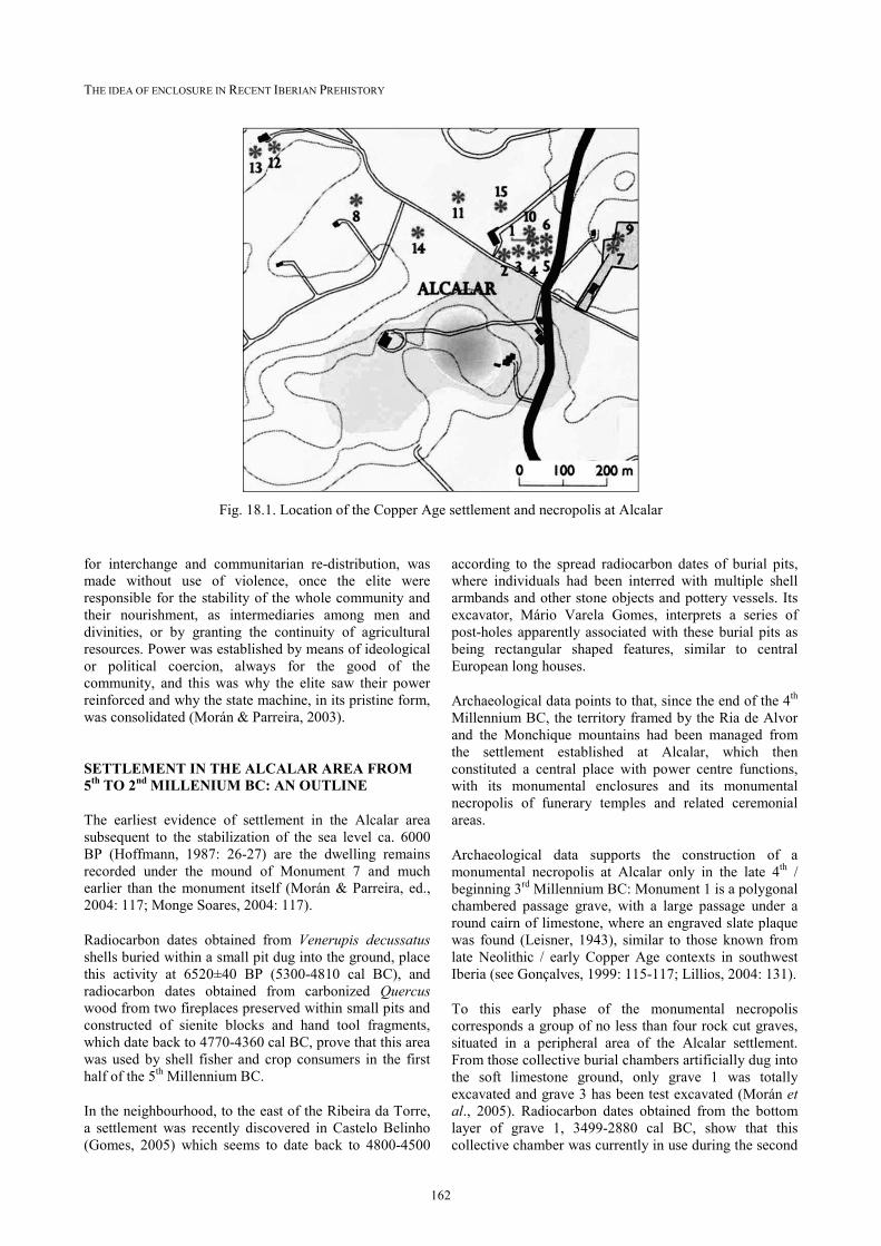
Abstract: In the western side of the Algarve (South Portugal), the Copper Age site of Alcalar was occupied during the 4th and almost the whole 3rd Millennium BC and includes the «power centre» of the territory that stretches out between the Alvor sand bar and the Monchique mountains. The site includes a huge settlement of about 20 hectares and is directly connected with a monumental megalithic necropolis with some two dozen round barrows. The results of the researches we have been carrying on the settlement site, using geophysical surveys and archaeological test excavations, allow us to interpret the remains. The dwelling areas seem to be organised by the use of ditches, around the inhabited surface, presumably used by an elite ruling over the territory, whose resources were centralised within the settlement area by means of tributes. Other areas, also defined by a system of concentric ditches, included a large number of storage pits dug into the ground. Extending the dwelling area to the north to the limit of the mound clusters, a multiple linear, straight ditch bounds a lower settlement area. A similar system was observed to the west side of the upper plateau, where an external ditch, connecting the southwest slope with the oriental cluster of barrows, also bound the lower area of the settlement.
Resumo: Situado no Barlavento do Algarve, o sítio calcolítico de Alcalar, cuja ocupação abrange os finais do IV e quase todo o 3º milénio antes da nossa era, corresponde ao «centro de poder» do território que se estende entre a barra de Alvor e a Serra de Monchique. O sítio compreende um vasto povoado, com uma área de cerca de 20 hectares, e uma necrópole monumental megalítica, com ele directamente conotada, constituída por cerca de duas dezenas de mamoas. Os resultados da investigação que temos vindo a realizar, com recurso a procedimentos geofísicos, permitemnos interpretar as estruturas detectadas. O espaço doméstico parece organizarse mediante o uso de trincheiras, que ordenam uma superfície habitada presumivelmente reservada a uma elite dirigente do território, cujos recursos o povoado calcolítico centralizava mediante tributo. Outras áreas, também definidas por fossos concêntricos, albergaram inúmeros silos de armazenagem escavados na rocha. Alargando a área doméstica para norte, até ao limite da área tumular megalítica, estendese um fosso múltiplo, de traçado rectilíneo, que parece albergar na sua parte interna um povoado baixo. O mesmo se comprova do a nascente da área amesetada do povoado calcolítico, onde também parece existir um povoado baixo delimitado por um fosso exterior, ligando o sopé sueste do povoado com o núcleo oriental da necrópole.
THE 3rd MILLENNIUM BC IN SOUTHWEST IBERIA: THE HISTORICAL PROCESS
In Southwest Iberia, in the transition from the 4th to the 3rd Millennium BC, landuse economy was intensified with increasing crop production and cattle raising, a process known as Secondary Products Revolution (Sherratt, 1981; Harrison, 1985). Regional economies consolidated with a specialised copper mining and metallurgy stressing social differences, and the first forms of political organisation took place, when power based on territorial control of the production forces, requiring an increasingly centralisation (Nocete, 2001; Nocete, 2006).
Along with a specialised craftsmanship, the division of labour allowed not only to fix the population in stable settlements but also consolidated the power centres, macrosettlements to an increasing extent. The exploitation of the territories included their management from these settlements by a political elite, ruling over communities and land, and accumulating power, this being inherited along with the maintenance of parental links with the members of the communities. These huge settlements were also barn zone for planned production, redistribution places for a variety of products obtained by tributes from the productive sites, thus allowing the whole
society to access the consumption of a wide range of products, different from those themselves could produce.
The production reserves accumulated in the power centres allowed the elite to sustain a trading network, intra and interregional, giving place to transactions among the big power centres established in the valleys of the Guadalquivir, upper Sado and middle Guadiana and their peripheries, allowing the widest circulation of prestige items among the elite, such as African ivory or Baltic amber.
Occupying a peripheral position in relation to the biggest power centre located in the Guadalquivir valley — Valencina de la Concepción —, the Copper Age settlement of Alcalar is situated in the Western Algarve, dominating a territory framed by the Ria de Alvor and the mountains of Monchique, where it seems to have reproduced the same relations and contradictions that took place in Valencina, at the same time period. Thus, the ruling elite of Alcalar sustained political relations with the Valencina ones, promoting them socially by using sumptuary items, weapons and idols (Morán, 2001).
The role of these elite, specifically in the management of territory and resources, along with the control of products
THE IDEA OF ENCLOSURE IN RECENT IBERIAN PREHISTORY
162
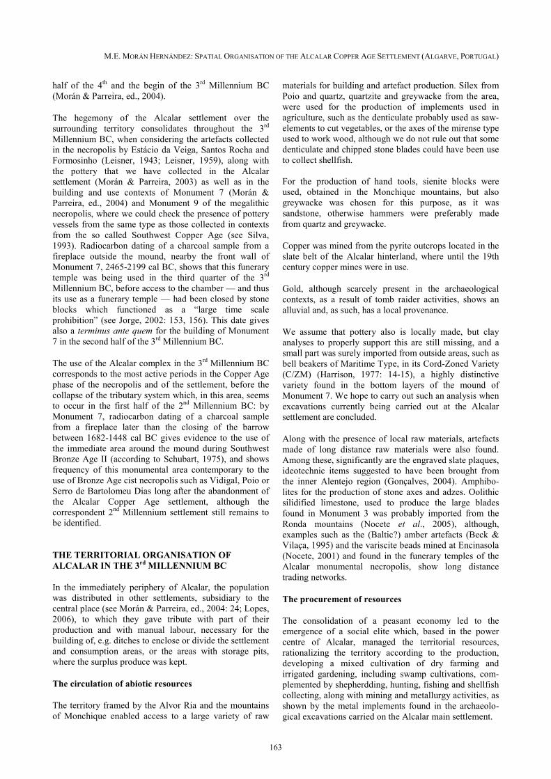
Fig. 18.1. Location of the Copper Age settlement and necropolis at Alcalar
for interchange and communitarian redistribution, was made without use of violence, once the elite were responsible for the stability of the whole community and their nourishment, as intermediaries among men and divinities, or by granting the continuity of agricultural resources. Power was established by means of ideological or political coercion, always for the good of the community, and this was why the elite saw their power reinforced and why the state machine, in its pristine form, was consolidated (Morán & Parreira, 2003).
SETTLEMENT IN THE ALCALAR AREA FROM 5th TO 2nd MILLENIUM BC: AN OUTLINE
The earliest evidence of settlement in the Alcalar area subsequent to the stabilization of the sea level ca. 6000 BP (Hoffmann, 1987: 2627) are the dwelling remains recorded under the mound of Monument 7 and much earlier than the monument itself (Morán & Parreira, ed., 2004: 117; Monge Soares, 2004: 117).
Radiocarbon dates obtained from Venerupis decussatus shells buried within a small pit dug into the ground, place this activity at 6520±40 BP (53004810 cal BC), and radiocarbon dates obtained from carbonized Quercus wood from two fireplaces preserved within small pits and constructed of sienite blocks and hand tool fragments, which date back to 47704360 cal BC, prove that this area was used by shell fisher and crop consumers in the first half of the 5th Millennium BC.
In the neighbourhood, to the east of the Ribeira da Torre, a settlement was recently discovered in Castelo Belinho (Gomes, 2005) which seems to date back to 48004500
according to the spread radiocarbon dates of burial pits, where individuals had been interred with multiple shell armbands and other stone objects and pottery vessels. Its excavator, Mário Varela Gomes, interprets a series of postholes apparently associated with these burial pits as being rectangular shaped features, similar to central European long houses.
Archaeological data points to that, since the end of the 4th Millennium BC, the territory framed by the Ria de Alvor and the Monchique mountains had been managed from the settlement established at Alcalar, which then constituted a central place with power centre functions, with its monumental enclosures and its monumental necropolis of funerary temples and related ceremonial areas.
Archaeological data supports the construction of a monumental necropolis at Alcalar only in the late 4th / beginning 3rd Millennium BC: Monument 1 is a polygonal chambered passage grave, with a large passage under a round cairn of limestone, where an engraved slate plaque was found (Leisner, 1943), similar to those known from late Neolithic / early Copper Age contexts in southwest Iberia (see Gonçalves, 1999: 115117; Lillios, 2004: 131).
To this early phase of the monumental necropolis corresponds a group of no less than four rock cut graves, situated in a peripheral area of the Alcalar settlement. From those collective burial chambers artificially dug into the soft limestone ground, only grave 1 was totally excavated and grave 3 has been test excavated (Morán et al., 2005). Radiocarbon dates obtained from the bottom layer of grave 1, 34992880 cal BC, show that this collective chamber was currently in use during the second
M.E. MORÁN HERNÁNDEZ: SPATIAL ORGANISATION OF THE ALCALAR COPPER AGE SETTLEMENT (ALGARVE, PORTUGAL)
163
half of the 4th and the begin of the 3rd Millennium BC (Morán & Parreira, ed., 2004).
The hegemony of the Alcalar settlement over the surrounding territory consolidates throughout the 3rd Millennium BC, when considering the artefacts collected in the necropolis by Estácio da Veiga, Santos Rocha and Formosinho (Leisner, 1943; Leisner, 1959), along with the pottery that we have collected in the Alcalar settlement (Morán & Parreira, 2003) as well as in the building and use contexts of Monument 7 (Morán & Parreira, ed., 2004) and Monument 9 of the megalithic necropolis, where we could check the presence of pottery vessels from the same type as those collected in contexts from the so called Southwest Copper Age (see Silva, 1993). Radiocarbon dating of a charcoal sample from a fireplace outside the mound, nearby the front wall of Monument 7, 24652199 cal BC, shows that this funerary temple was being used in the third quarter of the 3rd Millennium BC, before access to the chamber — and thus its use as a funerary temple — had been closed by stone blocks which functioned as a “large time scale prohibition” (see Jorge, 2002: 153, 156). This date gives also a terminus ante quem for the building of Monument 7 in the second half of the 3rd Millennium BC.
The use of the Alcalar complex in the 3rd Millennium BC corresponds to the most active periods in the Copper Age phase of the necropolis and of the settlement, before the collapse of the tributary system which, in this area, seems to occur in the first half of the 2nd Millennium BC: by Monument 7, radiocarbon dating of a charcoal sample from a fireplace later than the closing of the barrow between 16821448 cal BC gives evidence to the use of the immediate area around the mound during Southwest Bronze Age II (according to Schubart, 1975), and shows frequency of this monumental area contemporary to the use of Bronze Age cist necropolis such as Vidigal, Poio or Serro de Bartolomeu Dias long after the abandonment of the Alcalar Copper Age settlement, although the correspondent 2nd Millennium settlement still remains to be identified.
THE TERRITORIAL ORGANISATION OF ALCALAR IN THE 3rd MILLENNIUM BC
In the immediately periphery of Alcalar, the population was distributed in other settlements, subsidiary to the central place (see Morán & Parreira, ed., 2004: 24; Lopes, 2006), to which they gave tribute with part of their production and with manual labour, necessary for the building of, e.g. ditches to enclose or divide the settlement and consumption areas, or the areas with storage pits, where the surplus produce was kept.
The circulation of abiotic resources
The territory framed by the Alvor Ria and the mountains of Monchique enabled access to a large variety of raw
materials for building and artefact production. Sílex from Poio and quartz, quartzite and greywacke from the area, were used for the production of implements used in agriculture, such as the denticulate probably used as sawelements to cut vegetables, or the axes of the mirense type used to work wood, although we do not rule out that some denticulate and chipped stone blades could have been use to collect shellfish.
For the production of hand tools, sienite blocks were used, obtained in the Monchique mountains, but also greywacke was chosen for this purpose, as it was sandstone, otherwise hammers were preferably made from quartz and greywacke.
Copper was mined from the pyrite outcrops located in the slate belt of the Alcalar hinterland, where until the 19th century copper mines were in use.
Gold, although scarcely present in the archaeological contexts, as a result of tomb raider activities, shows an alluvial and, as such, has a local provenance.
We assume that pottery also is locally made, but clay analyses to properly support this are still missing, and a small part was surely imported from outside areas, such as bell beakers of Maritime Type, in its CordZoned Variety (C/ZM) (Harrison, 1977: 1415), a highly distinctive variety found in the bottom layers of the mound of Monument 7. We hope to carry out such an analysis when excavations currently being carried out at the Alcalar settlement are concluded.
Along with the presence of local raw materials, artefacts made of long distance raw materials were also found. Among these, significantly are the engraved slate plaques, ideotechnic items suggested to have been brought from the inner Alentejo region (Gonçalves, 2004). Amphibolites for the production of stone axes and adzes. Oolithic silidified limestone, used to produce the large blades found in Monument 3 was probably imported from the Ronda mountains (Nocete et al., 2005), although, examples such as the (Baltic?) amber artefacts (Beck & Vilaça, 1995) and the variscite beads mined at Encinasola (Nocete, 2001) and found in the funerary temples of the Alcalar monumental necropolis, show long distance trading networks.
The procurement of resources
The consolidation of a peasant economy led to the emergence of a social elite which, based in the power centre of Alcalar, managed the territorial resources, rationalizing the territory according to the production, developing a mixed cultivation of dry farming and irrigated gardening, including swamp cultivations, complemented by shepherdding, hunting, fishing and shellfish collecting, along with mining and metallurgy activities, as shown by the metal implements found in the archaeological excavations carried on the Alcalar main settlement.
THE IDEA OF ENCLOSURE IN RECENT IBERIAN PREHISTORY
164
THE SPATIAL ORGANISATION OF THE ALCALAR SETTLEMENT
Geophysical surveys and archaeological excavations carried out on the Alcalar copper age settlement, one of the largest settlements of the 3rd Millennium BC found in Portugal (Kunst, 2001), allow us to approach the evidence of architectonical complexity and space occupation strategy of this site.
The settlement is located on a NESW lengthened hill, standing out over the surrounding fertile plains. But the surface inhabited in the Copper Age extends to lower heights reaching the mortuary area, whose monumental buildings and related ceremonial places act like a boundary at the northern side of the habitat.
A look at the plotted magnetograms (see Morán, 2001), along with the evidence resulting from archaeological test excavations, shows a zoned organisation of this vast settlement: a large dwelling zone was revealed on the highest plateau, with domestic units each of them apparently including a house building, which sheltered the resting places and the food preparation and eating areas, and around which were spread the areas for catching and preserving water (rockcut channels and tanks) and a wide variety of pits —features dug into the limestone ground mainly designed for storage but also used for other different purposes over time, lastly for the disposal of refuse. This dwelling zone occupies an outstanding position within the central area of the settlement and is surrounded by a strip, showing a large amount of pits, thought to be storage pits and thus revealing a huge barn zone. The whole dwellingstorage complex is bounded by multiple ditches, dug into the ground and interrupted by narrow causeways, and once provided with earth banks, palisades and stonewalls. The regular concentric plan of these boundaries gives to the inhabited surface almost the appearance of an «urban» organised hillfort.
Diverging from these concentric enclosures, and extending from the northern slope of the hill to the lower heights where the funerary temples are located, there is evidence for a multiple linear, straight ditch boundary of the lower settlement area, thus complementing the strip of barrows. Geophysical data, with characteristic anomalies similar to those shown by the internal structure of the tholos tombs, indicates that this enclosure was also provided with a slate made rampart, the collapsed material of which was deposited inside the ditch dug into the ground. The same system was observed to the west side of the upper plateau: there, an external ditch, connecting the southwest slope with the oriental cluster of barrows, also surrounds the lower area of the settlement. Similar features, separating settlement and production areas from funerary ones, were detected in other sites of south Iberia, specifically in the large settlement of Valencina de la Concepción (Vargas 2004), near Sevilla
Aspects of the privileged dwelling zone
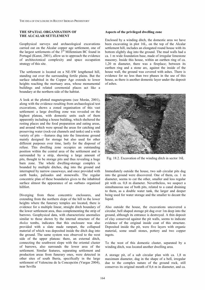
Enclosed by a winding ditch, the domestic area we have been excavating in plot 16L, on the top of the Alcalar settlement hill, includes an elongated round house with its bottom slightly dug into the ground. The mud walls had a ca. 1 m wide foundation base, made of irregular limestone masonry. Inside this house, within an earthen ring of ca. 1,20 m diameter, there was a fireplace; between its earthen ring and a stone arc, against the inside of the house wall, the ground was covered with ashes. There is evidence for no less than two phases in the use of this house, as there is another domestic layer under the deposit of ashes.
Fig. 18.2. Excavation of the winding ditch in sector 16L
Immediately outside the house, two sub circular pits dug into the ground were discovered. One of them, ca. 1 m diameter, seems to cut the other, smaller and less regular pit with ca. 0,8 m diameter. Nevertheless, we suspect a simultaneous use of both pits, related to a canal draining to them, as a double water tank, the larger and deeper being used for water storage and the smaller to decant the liquid.
Also outside the house, the excavations uncovered a circular, bell shaped storage pit dug over 1m deep into the ground, although its entrance is destroyed. A thin deposit of clay conserved against the pit walls, seems to indicate evidence of the original inside coat of this structure. Deposited inside the pit, were five layers with organic material, some small stones, pottery and two copper ingots.
To the west of this domestic cluster, separated by a winding ditch, was located another dwelling area.
A storage pit, of a sub circular plan with ca. 1,8 m maximum diameter, dug in the shape of a bell, irregular due to the complex nature of the ground rock, still conserves its original mouth of 0,6 m in diameter, and ca.
M.E. MORÁN HERNÁNDEZ: SPATIAL ORGANISATION OF THE ALCALAR COPPER AGE SETTLEMENT (ALGARVE, PORTUGAL)
165
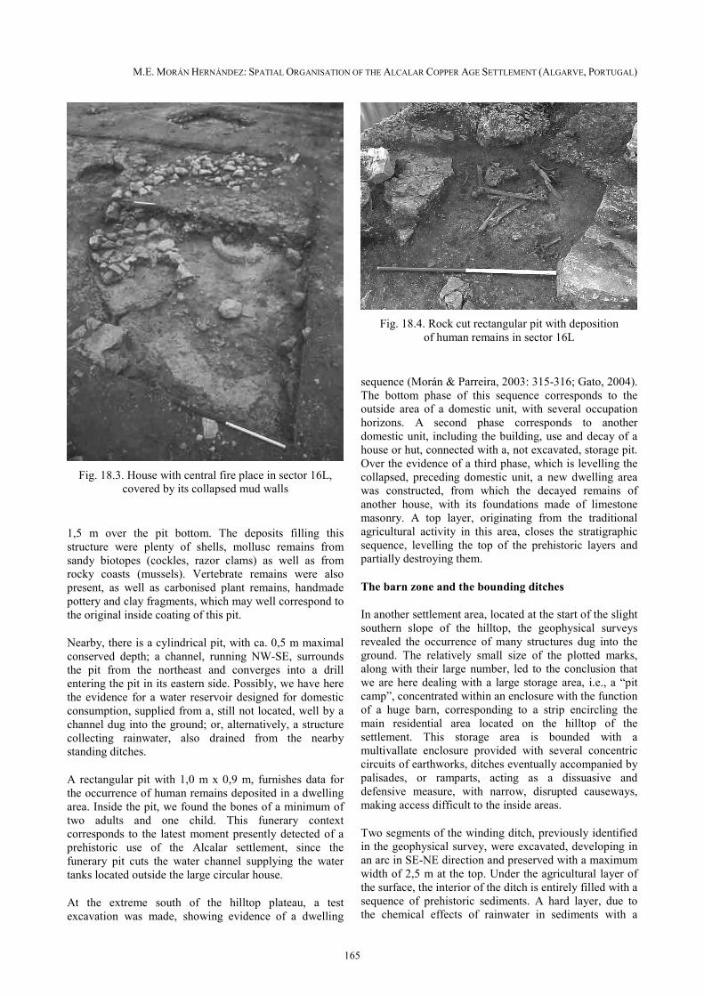
Fig. 18.3. House with central fire place in sector 16L,
covered by its collapsed mud walls
1,5 m over the pit bottom. The deposits filling this structure were plenty of shells, mollusc remains from sandy biotopes (cockles, razor clams) as well as from rocky coasts (mussels). Vertebrate remains were also present, as well as carbonised plant remains, handmade pottery and clay fragments, which may well correspond to the original inside coating of this pit.
Nearby, there is a cylindrical pit, with ca. 0,5 m maximal conserved depth; a channel, running NWSE, surrounds the pit from the northeast and converges into a drill entering the pit in its eastern side. Possibly, we have here the evidence for a water reservoir designed for domestic consumption, supplied from a, still not located, well by a channel dug into the ground; or, alternatively, a structure collecting rainwater, also drained from the nearby standing ditches.
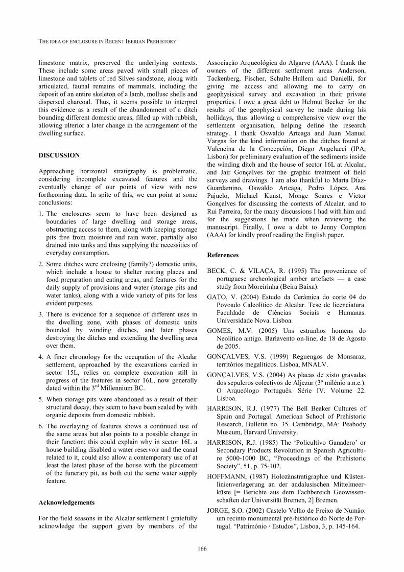
A rectangular pit with 1,0 m x 0,9 m, furnishes data for the occurrence of human remains deposited in a dwelling area. Inside the pit, we found the bones of a minimum of two adults and one child. This funerary context corresponds to the latest moment presently detected of a prehistoric use of the Alcalar settlement, since the funerary pit cuts the water channel supplying the water tanks located outside the large circular house.
At the extreme south of the hilltop plateau, a test excavation was made, showing evidence of a dwelling
Fig. 18.4. Rock cut rectangular pit with deposition
of human remains in sector 16L
sequence (Morán & Parreira, 2003: 315316; Gato, 2004). The bottom phase of this sequence corresponds to the outside area of a domestic unit, with several occupation horizons. A second phase corresponds to another domestic unit, including the building, use and decay of a house or hut, connected with a, not excavated, storage pit. Over the evidence of a third phase, which is levelling the collapsed, preceding domestic unit, a new dwelling area was constructed, from which the decayed remains of another house, with its foundations made of limestone masonry. A top layer, originating from the traditional agricultural activity in this area, closes the stratigraphic sequence, levelling the top of the prehistoric layers and partially destroying them.
The barn zone and the bounding ditches
In another settlement area, located at the start of the slight southern slope of the hilltop, the geophysical surveys revealed the occurrence of many structures dug into the ground. The relatively small size of the plotted marks, along with their large number, led to the conclusion that we are here dealing with a large storage area, i.e., a “pit camp”, concentrated within an enclosure with the function of a huge barn, corresponding to a strip encircling the main residential area located on the hilltop of the settlement. This storage area is bounded with a multivallate enclosure provided with several concentric circuits of earthworks, ditches eventually accompanied by palisades, or ramparts, acting as a dissuasive and defensive measure, with narrow, disrupted causeways, making access difficult to the inside areas.
Two segments of the winding ditch, previously identified in the geophysical survey, were excavated, developing in an arc in SENE direction and preserved with a maximum width of 2,5 m at the top. Under the agricultural layer of the surface, the interior of the ditch is entirely filled with a sequence of prehistoric sediments. A hard layer, due to the chemical effects of rainwater in sediments with a
THE IDEA OF ENCLOSURE IN RECENT IBERIAN PREHISTORY
166
limestone matrix, preserved the underlying contexts. These include some areas paved with small pieces of limestone and tablets of red Silvessandstone, along with articulated, faunal remains of mammals, including the deposit of an entire skeleton of a lamb, mollusc shells and dispersed charcoal. Thus, it seems possible to interpret this evidence as a result of the abandonment of a ditch bounding different domestic areas, filled up with rubbish, allowing ulterior a later change in the arrangement of the dwelling surface.
DISCUSSION
Approaching horizontal stratigraphy is problematic, considering incomplete excavated features and the eventually change of our points of view with new forthcoming data. In spite of this, we can point at some conclusions:
1.!The enclosures seem to have been designed as boundaries of large dwelling and storage areas, obstructing access to them, along with keeping storage pits free from moisture and rain water, partially also drained into tanks and thus supplying the necessities of everyday consumption.
2.!Some ditches were enclosing (family?) domestic units, which include a house to shelter resting places and food preparation and eating areas, and features for the daily supply of provisions and water (storage pits and water tanks), along with a wide variety of pits for less evident purposes.
3.!There is evidence for a sequence of different uses in the dwelling zone, with phases of domestic units bounded by winding ditches, and later phases destroying the ditches and extending the dwelling area over them.
4.!A finer chronology for the occupation of the Alcalar settlement, approached by the excavations carried in sector 15L, relies on complete excavation still in progress of the features in sector 16L, now generally dated within the 3rd Millennium BC.
5.!When storage pits were abandoned as a result of their structural decay, they seem to have been sealed by with organic deposits from domestic rubbish.
6.!The overlaying of features shows a continued use of the same areas but also points to a possible change in their function: this could explain why in sector 16L a house building disabled a water reservoir and the canal related to it, could also allow a contemporary use of at least the latest phase of the house with the placement of the funerary pit, as both cut the same water supply feature.
Acknowledgements
For the field seasons in the Alcalar settlement I gratefully acknowledge the support given by members of the
Associação Arqueológica do Algarve (AAA). I thank the owners of the different settlement areas Anderson, Tackenberg, Fischer, SchulteHullern and Danielli, for giving me access and allowing me to carry on geophysisical survey and excavation in their private properties. I owe a great debt to Helmut Becker for the results of the geophysical survey he made during his hollidays, thus allowing a comprehensive view over the settlement organisation, helping define the research strategy. I thank Oswaldo Arteaga and Juan Manuel Vargas for the kind information on the ditches found at Valencina de la Concepción, Diego Angelucci (IPA, Lisbon) for preliminary evaluation of the sediments inside the winding ditch and the house of sector 16L at Alcalar, and Jair Gonçalves for the graphic treatment of field surveys and drawings. I am also thankful to Marta DíazGuardamino, Oswaldo Arteaga, Pedro López, Ana Pajuelo, Michael Kunst, Monge Soares e Victor Gonçalves for discussing the contexts of Alcalar, and to Rui Parreira, for the many discussions I had with him and for the suggestions he made when reviewing the manuscript. Finally, I owe a debt to Jenny Compton (AAA) for kindly proof reading the English paper.
References
BECK, C. & VILAÇA, R. (1995) The provenience of portuguese archeological amber artefacts — a case study from Moreirinha (Beira Baixa).
GATO, V. (2004) Estudo da Cerâmica do corte 04 do Povoado Calcolítico de Alcalar. Tese de licenciatura. Faculdade de Ciências Sociais e Humanas. Universidade Nova. Lisboa.
GOMES, M.V. (2005) Uns estranhos homens do Neolítico antigo. Barlavento online, de 18 de Agosto de 2005.
GONÇALVES, V.S. (1999) Reguengos de Monsaraz, territórios megalíticos. Lisboa, MNALV.
GONÇALVES, V.S. (2004) As placas de xisto gravadas dos sepulcros colectivos de Aljezur (3º milénio a.n.e.). O Arqueólogo Português. Série IV. Volume 22. Lisboa.
HARRISON, R.J. (1977) The Bell Beaker Cultures of Spain and Portugal. American School of Prehistoric Research, Bulletin no. 35. Cambridge, MA: Peabody Museum, Harvard University.
HARRISON, R.J. (1985) The ‘Policultivo Ganadero’ or Secondary Products Revolution in Spanish Agriculture 50001000 BC, “Proceedings of the Prehistoric Society”, 51, p. 75102.
HOFFMANN, (1987) Holozänstratigraphie und Küstenlinienverlagerung an der andalusischen Mittelmeerküste [= Berichte aus dem Fachbereich Geowissenschaften der Universität Bremen, 2] Bremen.
JORGE, S.O. (2002) Castelo Velho de Freixo de Numão: um recinto monumental préhistórico do Norte de Portugal. “Património / Estudos”, Lisboa, 3, p. 145164.
M.E. MORÁN HERNÁNDEZ: SPATIAL ORGANISATION OF THE ALCALAR COPPER AGE SETTLEMENT (ALGARVE, PORTUGAL)
167
KUNST, M. (2001) Die Kupferzeit der Iberischen Halbinsel. In “Hispania Antiqua: Denkmäler der Frühzeit” (Ulbert, T., ed.), Mainz. von Zabern, p. 6799.
LEISNER, G. & V. (1943) Die Megalithgräber der Iberischen Halbinsel: Der Süden, 1 [= RömischGermanische Forschungen, 17]. Berlin: de Gruyter.
LEISNER, G. & V. (1959) Die Megalithgräber der Iberischen Halbinsel: Der Westen, 2 [= Madrider Forschungen, 1/2]. Berlin: de Gruyter.
LILLIOS, K. (2004) Lives of Stone, Lives of People: Reviewing the engraved plaques of late Neolithic and Copper Age Iberia. “European Journal of Archaeology”, vol. 7(2), p. 125158.
LOPES, S.M. da T. (2006) Estudo do conjunto artefactual cerâmico da fossa nº 40 do sítio arqueológico de Barradas. Tese de licenciatura. Faculdade de Ciências Humanas e Sociais. Universidade do Algarve. Gambelas/Faro.
MONGE SOARES, A.M. (2004) Variabilidade do ‘upwelling’ costeiro durante o holocénico nas margens atlânticas ocidental e meridional da Península Ibérica. Universidade do Algarve, Faculdade de Ciências do Mar e o Ambiente. Faro.
MORÁN, E. (2001) Aproximación al estudio geoarqueológico de Alcalar (Portimão, AlgarvePortugal) en el III milénio a.n.e.: Evidencias arqueológicas de la existencia de una sociedad clasista inicial, “Revista AtlánticoMediterránea de Prehistoria y Arqueología Social”, Cádiz, 4, p. 169205.
MORÁN, E. & PARREIRA, R. (2003) O povoado calcolítico de Alcalar (Portimão) na paisagem cultural do Alvor no III milénio antes da nossa era. In “Recintos Murados da PréHistória Recente” (Jorge, S.O., ed.), PortoCoimbra, p. 307327.
MORÁN, E. & PARREIRA, R., ed., (2004) Alcalar 7: Estudo e Reabilitação de um Monumento Megalítico [= Cadernos, 6]. Lisboa: IPPAR.
MORAN, E. et al. (2005) Monte Canelas (Alcalar, Portimão): Trabalhos arqueológicos de salvamento de um habitat da época islâmica no Barrocal Algarvio. “Xelb”, Silves, 5, p. 133156.
NOCETE, F. (2001) Tercer milenio antes de nuestra era: Relaciones y contradicciones centro/periferia en el Valle del Guadalquivir. Barcelona: Ediciones Bellaterra.
NOCETE, F., R. SÁEZ, J.M. NIETO, R. CRUZ, R. CABRERO, E. ALEX & M.R. BAYONA (2005) Circulation of silicified oolitic limestone blades in SouthIberia (Spain and Portugal) during the third millennium B.C.: an expression of a core/periphery framework. “Journal of Anthropological Archaeology”, 24, p. 6281.
NOCETE, F. (2006) The first specialised copper industry in the Iberian peninsula: Cabezo Juré (29002200 BC). “Antiquity”, 80, p. 646–657.
SCHUBART, H. (1975) Die Kultur der Bronzezeit im Südwesten der Iberischen Halbinsel [= Madrider Forschungen, 9]. Berlim: de Gruyter.
SILVA, C. TAVARES da (1993) Calcolítico. In “PréHistória de Portugal” (Silva, A.C.F. da, ed.), Lisboa: Universidade Aberta, p. 195233.
SHERRATT, A. (1981) Plough and Pastoralism: Aspects of the Secondary Products Revolution. In “Pattern of the Past” (Hodder, I. Et al., ed.) [= Festschrift David Clarke]. Cambridge: University Press.
VARGAS, J.M. (2004) Valencina de la Concepción. Carta Arqueológica Municipal. Arqueologia Monografias. Junta de Andalucia.