south east coastal adaptation (seca): coastal urban climate futures in se australia from wollongong...
TRANSCRIPT

South East Coastal Adaptation (SECA):Coastal urban climate futures in SE Australia from Wollongong to Lakes Entrance-
Final Report
Barbara Norman, Will Steffen, Bob Webb, Tony Capon, Bill Maher,Colin Woodroffe, Kerrylee Rogers, Rob Tanton, Yogi Vidyattama, Jacqui Lavis, Hamish Sinclair and Brian Weir


SOUTH EAST COASTAL ADAPTATION
Coastal Urban Climate Futures in South East Australia from Wollongong to Lakes Entrance
University of Canberra
SECA Project Team
Chief Investigator Barbara Norman – University of Canberra
Principal Investigators Will Steffen – The Australian National University Bob Webb – The Australian National University
Tony Capon – University of Canberra Bill Maher – University of Canberra
Colin Woodroffe – University of Wollongong Kerrylee Rogers – University of Wollongong
Researchers Rob Tanton – NATSEM, University of Canberra
Yogi Vidyattama – NATSEM, University of Canberra Jacqui Lavis – Adjunct Professor, University of Canberra Hamish Sinclair – PhD candidate, University of Canberra
Brian Weir – PhD candidate, University of Canberra

ii South East Coastal Adaptation
Published by the National Climate Change Adaptation Research Facility 2013 ISBN: 978-1-921609-94-7 NCCARF Publication 23/13
Australian copyright law applies. For permission to reproduce any part of this document, please approach the authors.
Please cite this report as: Norman, B, Steffen, W, Webb, R, Capon, A, Maher, W, Woodroffe, C, Rogers, K, Tanton, R, Vidyattama, Y, Lavis, J, Sinclair, H & Weir, B 2013, South East Coastal Adaptation (SECA): Coastal urban climate futures in SE Australia from Wollongong to Lakes Entrance, National Climate Change Adaptation Research Facility, Gold Coast, 130 pp.
Acknowledgement: This work was carried out with financial support from the Australian Government (Department of Climate Change and Energy Efficiency) and the National Climate Change Adaptation Research Facility (NCCARF).
The role of NCCARF is to lead the research community in a national interdisciplinary effort to generate the information needed by decision-makers in government, business and in vulnerable sectors and communities to manage the risk of climate change impacts.
We wish to acknowledge the valuable contribution of Alison Foulsham in providing excellent editing and publication advice during the production phase of the final report.
Disclaimer:
The views expressed herein are not necessarily the views of the Commonwealth or NCCARF, and neither the Commonwealth nor NCCARF accept responsibility for information or advice contained herein.
Report photos: Attributable to Barbara Norman or Kerrylee Rogers, unless otherwise specified.
Cover image: © John Reid

South East Coastal Adaptation iii
Table of contents ABSTRACT .................................................................................................................... 1
EXECUTIVE SUMMARY................................................................................................ 2
1. Introduction ........................................................................................................ 81.1 Purpose of research ...................................................................................... 81.2 Coastal development, coastal planning and adaptation ............................ 81.3 Climate change and adaptation .................................................................... 91.4 Study area: Wollongong to Lakes Entrance .............................................. 101.5 Coastal settlements and communities ....................................................... 10
2. Project Aims and Method ................................................................................ 122.1 Project aim .................................................................................................... 122.2 An interdisciplinary approach .................................................................... 122.3 Approach ...................................................................................................... 122.4 Case Studies and Focus Groups ................................................................ 152.4.1 Case studies ................................................................................................. 15 2.4.2 Focus groups ................................................................................................ 15
2.5 An integrated approach to coastal urban futures ..................................... 16
3. Themes ............................................................................................................. 183.1 Climate and water ........................................................................................ 183.2 Coastal landscapes ...................................................................................... 21
3.3 Settlements and infrastructure ................................................................... 263.4 Health and wellbeing ................................................................................... 274.1 Victoria .......................................................................................................... 314.1.1 State planning policies .................................................................................. 31
4.1.2 Regional coast and catchment strategies .............................................. 324.1.3 Related plans and research .......................................................................... 34
4.2 New South Wales South Coast ................................................................... 344.2.1 State planning policies .................................................................................. 34 4.2.2 Coast and catchment strategies for NSW south coast ................................. 35 4.2.3 Related plans and research .......................................................................... 36 4.2.4 Summary ...................................................................................................... 37
5 Findings from Case Studies and Focus Groups .......................................... 375.1 Seven case studies ...................................................................................... 375.2 Focus groups ............................................................................................... 425.3 Implications for coastal adaptation in the south east region .................. 44
6. Small coastal towns future scenarios ........................................................... 456.1 Integrated scenarios .................................................................................... 456.2 Integration across change drivers and impacts ....................................... 486.3 Integration with local and regional policy and strategies ........................ 486.4 Higher-level integration ............................................................................... 496.5 Small coastal towns integrated scenario ................................................... 50
7. Potential strategies for adapting small coastal towns ................................. 567.1 An integrated regional approach ................................................................ 567.2 Adaptive planning and risk management for 2030 and beyond .............. 56

iv South East Coastal Adaptation
7.3 Strategies for climate-adapted coastal communities................................ 56
8. Small coastal town futures .............................................................................. 598.1 Key messages ............................................................................................... 598.2. Principles for a climate-adapted small coastal town 2030 ....................... 608.3 Conclusion .................................................................................................... 61
References ................................................................................................................. 612
Appendix 1 Case studies ....................................................................................... 69Case Study: Wollongong ........................................................................................ 70Case Study: Sussex Inlet ........................................................................................ 76Case Study: Batemans Bay .................................................................................... 82Case Study: Narooma ............................................................................................. 90Case Study: Eden .................................................................................................... 96Case Study: Mallacoota ........................................................................................ 101Case Study: Lakes Entrance ................................................................................ 108
Case Study references ............................................................................................. 114
Appendix 2 Focus Group questions .................................................................. 121
Appendix 3 Focus Group Minutes ...................................................................... 122
Appendix 4 School of Art Environment Studio ................................................. 130

South East Coastal Adaptation v
List of figures Figure 1. Study Area Wollongong, NSW and Lakes Entrance, Victoria ............ 10
Figure 2. Ladder of opportunity ......................................................................... 11
Figure 3. Extract of case study for Eurobodalla Shire ....................................... 14
Figure 4. Methodology for integrated coastal adaptation .................................. 17
Figure 5. Damage of sea wall in Batemans Bay CBD from coastal inundation (2012) .............................................................................................................. 178
Figure 6. The principle climate drivers that influence coastal systems ............. 22
Figure 7. Mangrove expanding up slope into saltmarsh at Wagonga inlet ....... 25
Figure 8. Principal types of estuary in southern NSW ....................................... 25
Figure 9. Putative pathways between climate change and health impacts ....... 28
Figure 10 Health risks from climate change in South East Australia* ............... 30
Figure 11. Co-benefits of health from action on climate change ....................... 30
Figure 12. East Gippsland Coastal Environment, Bastion Point Beach, Mallacoota ......................................................................................................... 33
Figure 13. Coastal climate adaptation: an integrated system ........................... 47
Figure 14. Climate and non-climate drivers within the region to 2030. ............. 51
Figure 15. Coastal adaptation scenarios matrix ................................................ 52
Figure 16. Barbara Norman discussing research findings with ANU School of Art Field Studies students, Eden, NSW ............................................................. 61
List of Tables Table 1. Rationale for case study selection ....................................................... 15
Table 2 Primary climate drivers and secondary process variables influencing coastal and estuarine environments ................................................... 23
Table 3. Key findings from seven case studies, from Wollongong to Lakes Entrance .............................................................................................. 39
Table 4. Features of Scenario 1 and 2 .............................................................. 55

vi South East Coastal Adaptation
Glossary
ABS: Australia Bureau of Statistics ACT: Australian Capital Territory AEP: Annual Exceedance Probability AFAC: Australian Fire and Emergency Services Authorities Council AHD: Australian Height Datum AMI: Advanced Manufacturing Industries BOM: Bureau of Meteorology, BRHS: Bairnsdale Regional Health Service CAP: Catchment Action Plan CBD: Central Business District CMA: Catchment Management Authority CSIRO: Commonwealth Scientific and Industrial Research Organisation DCCEE Department of Climate Change and Energy Efficiency DPCD: Department of Planning & Community Development DSE: Department of Sustainability and Environment (Vic) DSWE: Department of Sustainability, Water and Energy EEC: Endangered Ecological Communities FPRMP: Flood Plain Risk Management Plan GFDI: Grass Fire Danger Index GILUP: Gippsland Integrated land Use Plan GLGN Gippsland Local Government Network GRP: Gippsland Regional Plan ICOLLS: Intermittently Closed and Open Lakes and Lagoons IPCC: Intergovernmental Panel on Climate Change LEP: Local Environmental Plan LGA: Local Government Authority LPPF: Local Planning Policy Framework MDHSS: Mallacoota District Health and Support Service NCCOE National Committee on Coastal and Ocean Engineering NCCARF: National Climate Change Adaptation Research Facility NLWRA: National Land and Water Resources Audit NRM: Natural Resource Management NSW: New South Wales POM: Plan of Management RCP: Regional Conservation Plan RCS: Regional Catchment Strategy RDA: Regional Development Australia RMF: Regional Management Forum SEACI: South East Australian Climate Initiative SECA: South East Coastal Adaptation SEIFA: Socio-Economic Indexes for Areas SEPP: State Environmental Planning Policy SLEP: Shoalhaven Local Environmental Plan SRCMA: Southern Rivers Catchment Management Authority SRP: Strategic Regional Plan TAFE: Technical and Further Education VCS: Victorian Coastal Strategy VPPF: Victorian Planning Policy Framework WCC: Wollongong City Council WSUD: Water Sensitive Urban Design

South East Coastal Adaptation vii
Acknowledgements
This project team would like to acknowledge contributions made to the success of the project by:
“... it seems like some people want to change the environment to suit them, but in this part of the world, you have to change yourself to suit the environment.” Focus
Group
Paul Anderson (Eurobodalla Shire) Laura Babian (SRCMA) Kim Bray (Kiama) Janis Collings (DRALGAS) Elizabeth Dixon (Shoalhaven Shire) Amy Dougherty (University of Wollongong) Susan Edwards (Shoalhaven Shire) David Farmer (Wollongong City) Scott Ferraro (Gippsland CCN) Mick Fields (Shellharbour Council) Michael Forsyth (Kiama Municipal Council) David George (NCCARF) Pam Green (SRCMA) David Griggs (Monash University) Ashley Hall (DSWE) Terry Houge (Ambulance Victoria) Norm Lenehan (Eurobodalla Shire) Carole Macmillan (DSE)
Brian Martin (Shearwater Assoc) Helen Martin (East Gippsland Coastal Board) Richard McKellar (NCCARF) Tony Miskiewicz (Wollongong City) Daniel Murphy (Bega Valley Shire) Tia Navanteri (DSE) Kate Nelson (East Gippsland Shire) Catherine Pirrie (East Gippsland Shire) Russ Pigg (Shoalhaven City) John Reid (ANU School of Art) Janet Stanley (Monash University) Kate Sullivan (University of Canberra) Peter Teggart (Bega Valley Shire) Lindsay Usher (Eurobodalla Shire) Derek Van Bracht (Bega Valley Shire) Natasha Vasey (Gippsland Coastal Board) Michael Willis (Shellharbour Council)
Image: Workshop at Mallacoota, October 2012 - photo Barbara Norman

viii South East Coastal Adaptation

South East Coastal Adaptation 1
ABSTRACT
Coastal Urban Climate Futures in South East Australia from Wollongong to Lakes Entrance is an investigation into possible coastal urban futures to 2030 and beyond. The study focus is on coastal adaptation in the context of climate change. It is broad in its scope by considering environmental, social and economic change in the south east coastal region. It has a multi-disciplinary approach to the spatial and temporal dimension in considering action on the ground. It involves seven local government areas (Wollongong, Shellharbour, Kiama, Shoalhaven, Eurobodalla, Bega and East Gippsland), two states and several regional organisations and explores some of the critical governance issues. The research uses a range of methods, including a review of peer-reviewed journal articles and government reports, local case studies, targeted focus groups and fieldwork. The time horizon is to 2030 but longer time frames have been considered where appropriate. An important dimension is the interdisciplinary approach. The outcome is an integrated framework for describing what a climate-adapted coastal community may be like in 2030.

2 South East Coastal Adaptation
EXECUTIVE SUMMARY
Coastal Urban Climate Futures in South East Australia from Wollongong to Lakes Entrance is an investigation into possible coastal urban futures in 2030 and beyond. The study is focussed on coastal adaptation in the context of climate change. It is broad in its scope by considering environmental, social and economic change in the south east coastal region. It has a spatial and temporal dimension in considering action on the ground. It involves seven local government areas, two states and several regional organisations. It explores some of the critical governance issues.
For this research, the south east coastal region comprises the local government areas of Wollongong, Shellharbour, Kiama, Shoalhaven, Eurobodalla, Bega and East Gippsland. The population is 408,496 with 0.8 per cent annual growth rate. It is a diverse coastal landscape with a range of urban settlements and coastal communities from significant towns to villages and hamlets. It is a coastal region already adapting to change.
This research uses a range of methods, including a review of peer-reviewed journal articles and government reports, local case studies, targeted focus groups and fieldwork. The time horizon is to 2030 but longer time frames have been considered where appropriate. An important dimension is the interdisciplinary approach.
A key component of the research was seven case studies of a diverse range of coastal settlements in the region from Wollongong to Lakes Entrance and two workshops with local decision-makers were a key part of the research. A final discussion with local government representatives on the draft report provided valuable feedback. The forums and discussions provided significant data to inform potential strategies for coastal urban futures in 2030.
The outcome is an integrated framework for describing what a climate-adapted coastal community may be like in 2030.
Research findings
The research has found that current coastal planning regulations used to assess future development address only one part of the urban future. The planning system is not well equipped to encourage or regulate the ‘retrofitting’ of the existing built environment for a climate-adapted future and mechanisms for this risk response are required.
The mapping of urban capable land can also be inconsistent with coastal or inundation risk mapping, with the continuing possibility of coastal development in high-risk areas. Constraint mapping is not currently applied consistently across each local government jurisdiction. Urban capable land should correlate with the risk assessment. However, responses that reduce or remove land areas from the urban-capable land bank can create compensatory problems for local government.
Infrastructure assets, including transport, water, sewerage and power supply investments and social infrastructure such as schools and health care facilities, should be subject to vulnerability assessments. These assessments should also include potential damage and cost of repairs from intermittent inundation. Infrastructure investment strategies could be estimated at scenario points [2030, 2070] for replacement and adaptation options.
The above suggests that, at a local level, an adapted coastal community will have adopted a risk assessment approach with respect to land use planning for both existing

South East Coastal Adaptation 3
and new coastal development. Non-climate drivers identified include planning regulation/decision-making and demand for urban and developable land.
The findings from the case studies indicated that action has commenced on coastal adaptation and the decision-makers are aware of the current science. There is general desire for data to be presented in a more community-friendly way that will assist councils and regional organisations to communicate the impacts of climate change on coastal communities. There is consideration of some of the broader environmental risks including coastal inundation, flooding, bushfire and heat and the consequences for critical local infrastructure and services.
Socio-economic factors are significant concerns. These include an ageing population and isolation of communities with lack of access to public transport and health facilities exacerbating the overall vulnerability of some of the smaller communities. There is an identified need for improved coordination of policy, particularly on climate change action between State Government and local councils.
Opportunities for the future include green growth in coastal and marine industry, regional food production, tourism, education and research. There is also a desire for more ‘adaptable’ approaches to the built environment – housing, infrastructure, urban design – that will be able to adapt to environmental change over time. Similarly, it was expressed that more guidance could be provided to developers on options for adaptation.
There was a distinction between the concerns expressed between the first and second workshops. During that time, the climate change and coastal management policies of the Victorian and NSW Governments changed, particularly with regards to planning for sea level rise. The decision-makers at the workshop expressed concern that with less guidance from the State Governments, and more responsibility devolved to the local level, there was a policy gap that made it difficult for consistent and coordinated action at a regional scale in preparing for climate change.
Image: Life Saving platform built well above sea level at Lakes Entrance, Victoria (2013) - photo Barbara Norman

4 South East Coastal Adaptation
Integrated scenarios and strategies
The diverse range of issues identified has been integrated into a first pass ‘whole of system’ view of how impacts and responses can influence community outcomes. This demonstrates the many interdependencies that need to be taken into account in adaptation planning.
What is evident is that to be climate-adapted, a community requires effective planning, decision-making and implementation of responses to current and emerging climate impacts and risks – effective governance with an adaptive decision-making process to planning for climate change.
At the same time, effective adaptation, planning and decision-making, whether by government, business or the community, needs to incorporate an integrated perspective in several dimensions. This includes integration across change drivers with related policies (climate and non-climate), across sectors, impacts and responses, across spatial and temporal scales, and across institutions (including levels of government).
Further, it is critical that science is informed by and responsive to local circumstances that can affect a community’s preparedness for a changing environment and long-term climate change.
From these likely determinants of successful adaptation the project has identified a small number of contrasting 2030 scenarios based on various levels of governance and integration effectiveness. The outcomes for the community may be significantly different under the alternative scenarios even by 2030, and starkly different by 2070, as they reflect substantially different capacities to manage the more significant and less predictable impacts beyond 2030. Proposed strategies to facilitate a move to the preferred ‘well-adapted settlement’ scenario are identified.
The findings can be summarised by seven key messages that have emerged from the research:
i. Recent experience indicates that the region is already living with an environment of extreme events including floods, coastal storms and inundation, drought and bushfires.
ii. The science indicates that by 2030 the region may experience increased temperatures (virtually certain), changes in the pattern of rainfall (likely), further sea-level rise (virtually certain), an increasing risk of coastal inundation and erosion (highly likely) and an increasing risk of bushfires (highly likely).
iii. There are a number of small settlements with ageing communities that are vulnerable, due to physical isolation with limited access to public transport, health and other community facilities. This vulnerability will be exacerbated in the future with additional urban development in these settlements coupled with the impacts of climate change. Significant seasonal population fluctuations during summer months exacerbate the challenge of planning effectively for emergency management.
iv. The region has experienced significant economic change, resulting in relatively high youth unemployment in some locations and out-migration of young people. This may affect community resilience over time with less people able to contribute to services such as emergency management and community services. New employment and education opportunities need to be developed to retain young people in these coastal settlements.

South East Coastal Adaptation 5
v. Green growth opportunities have been highlighted, including smart infrastructure for the built environment (water and energy) in adapting to extreme weather and climate change; coastal and marine initiatives in tourism, education and research building on the region’s natural assets and the national broadband network; carbon farming and renewable energy initiatives.
vi. There is a strong need for improved governance mechanisms for better coordination and integrated decision-making that considers immediate and longer time frames to support sustainable coastal planning and adapting to climate change. Past planning mistakes have led to more vulnerable coastal communities, compounding maladaptive practice. Adaptive planning and management (i.e. learning by doing) is core to improving coastal decision-making.
vii. There is demand for information that better connects data at a regional level to support evidence-based regional planning (for example, a regional knowledge portal). Emphasis is required on communication and knowledge sharing of information and leading practice in coastal adaptation between local councils, regional organisations, and the wider community. Ongoing collaborative research will be critical to maintain current knowledge for on-the-ground decision-making.
Overall a climate-adapted coastal community in the south east region by 2030 will have experienced environmental, social and economic change. This change will be incremental, although there will continue to be extreme events. Some aspects of extreme weather such as heatwaves and coastal flooding events are likely to have increased in severity and/or frequency by 2030. External drivers such as global economic change will impact employment and rates of growth. Planning will also need to be able to respond to possible co-incidences of events (floods, storm surge). Governance, integration and engagement processes will also need to be increasingly effective by 2030 in order to prepare for the greater and less predictable climate and other changes as the century progresses.
Opportunities to adapt to change are possible with enhanced communication networks, educational opportunities, research, and decision-making processes that facilitate more collaborative responses. Green growth opportunities supported by improved coastal governance arrangements (intergovernmental cooperation and integration of policy) could provide the basis for developing more resilient coastal communities. Evidence based integrated regional planning with active engagement by the regional communities could provide that framework.
In summary, the research indicates that the process of decision-making and the effectiveness of integrated governance arrangements supported by community engagement will be the successful determining factors of a well-adapted coastal community in 2030. The design and construction of coastal settlements will flow from that and respond to local circumstances drawing upon a regional sharing of knowledge and leading practice in coastal adaptation.
The research has identified the following principles as a framework for a climate-adapted small coastal settlement in 2030. The principles have potential application in other coastal regions in Australia, while recognising the importance of guiding principles for coastal urban futures that acknowledge local differences – a key conclusion of this research.

6 South East Coastal Adaptation
Principle 1 An integrated approach should be adopted for sustainable regional and local planning (social, economic, environmental and cultural). The approach should consider the catchment–to coast–to marine continuum and the different levels of government and stakeholders involved in planning and implementation.
Principle 2 The precautionary principle to decision making should be applied to the location of new and redeveloped urban settlement and infrastructure and other relevant decisions, particularly where environmental risk currently or potentially exists. Open space should be a key consideration to allow for adaptation (coastal retreat, heat absorption, green infrastructure).
Principle 3 Risk management approaches should be incorporated into local and regional strategies for coastal settlements responding to climate and environmental change including progressive learning from experience to ensure adaptability. This should be underpinned by the best science on climate change, socio-economic trends and an understanding of local community circumstances.
Principle 4 Appropriate forums should be established at the regional level to enable collaboration across institutions at the local and regional level. Governance mechanisms that facilitate intergovernmental agreement on policy directions (shared vision) and integration of policy decisions (implementation) are fundamental to coastal adaptation. This aligns with the findings of the recommendations of the House of Representatives report – Managing our coastal zone in a changing climate: the time to act is now.
Principle 5 There should be an ongoing process of community engagement. This needs to be informed by the latest science, in developing and regularly reviewing coastal urban plans to gain community support, and where possible support by all levels of government and across government agencies.
Principle 6 The skills and knowledge of regional and local communities should be connected by relevant organisations to provide a foundation for long-term research, co-production of knowledge and monitoring of coastal urban futures. Regional communities and practitioners could engage on a periodic basis with Australia’s leading scientific research organisations to discuss the most up-to-date scientific knowledge on the risks of climate change and its implications for adaptation strategies.
Principle 7 A process of continuous monitoring, evaluation and reporting of adaptation actions should be implemented to ensure ‘learning by doing’ and to avoid past mistakes. The impacts of climate change on the coastal environment will require more attention to evaluating impacts of adaptation measures over time.

South East Coastal Adaptation 7
Conclusion
The seven key messages and seven key principles arising from this research strongly indicate that regional governance which enables implementation of a shared vision will be a hallmark of what an adapted climate community will look like in 2030. An evidence-based shared vision that can take a long-term view and allow for local interpretation and circumstance will provide the framework for appropriate local decision making. Adaptation actions in coastal communities will require the cooperation and agreement from all levels of government who own and manage infrastructure and services in the coastal environment.
The overall finding of this research is that a prescriptive approach to settlement and infrastructure for coastal communities is less important than a decision-making process that is open, transparent, inclusive and adaptive, involving all levels of government and the community. This is an important finding and is consistent with the recommendations of the House of Representatives report – Managing our coastal zone in a changing climate: the time to act is now (House of Representatives 2009). This finding suggests recent devolution of coastal planning and climate change decisions to local government will not be sustainable in the immediate or longer term as actions on major coastal infrastructure and development requires support and investment from state and national governments. In contrast, a more collaborative regional approach with wide representation may be the best pathway forward for adapting to climate change on the coast.

8 South East Coastal Adaptation
1. INTRODUCTION
1.1 Purpose of research The project objective is:
To identify what a climate-adapted Australian settlement would look like from the perspective of future climate-adapted coastal small town communities to 2030.
The south east region of Australia provides a unique opportunity to examine small town coastal communities in the context of climate change. Coastal pressures are apparent but still of a scale such that strategic intervention could make a long-term difference to coastal urban futures.
1.2 Coastal development, coastal planning and adaptation Australia’s coast has been shaped at a range of spatial and temporal scales by severe events, and climate change is now increasing the frequency and intensity of these hazards (Kenchington et al. 2012).
Australia is predominantly a coastal urban nation. Over 80 per cent of the Australian population lives in the coastal zone. Internal migration to the coastal environment is expected to continue over the next 30 years (Australian Government 2011a). Additional socio-economic trends include an ageing population and variable employment futures, particularly for young people (Australian Government 2011b). These trends are present in the south coast of NSW and east coast of Victoria as discussed later in this report.
While this study is centred on a climate-adapted coastal community, by necessity much of the discussion also involves climate change, coastal development, coastal planning and regional planning. For the purposes of this research the following definitions are adopted:
i. Coastal settlement can include a regional centre, district town, town, village, hamlet.
ii. Coastal planning is the suite of plans, policies and instruments developed to respond to coastal pressures and provide for sustainable urban growth.
iii. Regional planning is the suite of plans, policies and instruments developed to respond to regional pressures and provide for sustainable development.
iv. Climate change refers to the change in long-term (30 years or longer) drivers of weather patterns and to the projections of future climate and its consequences within the timeframes relevant to this study. One of the most prominent ways the Earth’s climate is changing is through increases in global temperatures, or ‘global warming’ (Climate Commission 2011), but changes in other aspects of the climate system (e.g. sea-level rise) are relevant to this project.
v. Climate change adaptation is ‘action by households, firms, other organisations and governments to respond to the impacts of climate change that cannot be avoided through climate change mitigation efforts’ (Productivity Commission 2012).
vi. Climate-adapted refers to the changes in actions or planning undertaken to reduce the risks associated with observed or projected climate change.
Managing our coastal zone in a changing climate (House of Representatives 2009) comprehensively assessed coastal management and planning in Australia with 47 recommendations to Parliament. These covered key issues such as climate change, land use planning, insurance and legal liability, environmental impacts and governance

South East Coastal Adaptation 9
arrangements. A key recommendation was ‘the need to develop regional climate change adaptation policies and plans and integrate them into coastal and marine bioregional planning processes’ (House of Representatives 2009 Rec 33).
Since that report, considerable research has been undertaken to assess regional and local coastal climate risks by the CSIRO Climate Change Adaptation Flagship, and NCCARF. However, research into adapted coastal urban futures is relatively new and generally focussed on hot spots experiencing rapid urban growth (such as the Sydney Coastal Councils Group, Preston et al.). The unique contribution of this research is an integrated approach to understanding change in an environmentally sensitive region experiencing incremental urban growth, structural economic change and climate change. Through understanding the dynamics of such change, we can begin to explore possible coastal urban futures for adapted small town coastal communities.
1.3 Climate change and adaptation Climate change is a key driver in this research and adaptation a key outcome. Adapting to climate change at the regional and local level is core to the research question.
The Climate Commission Report, The Critical Decade Climate Science, Risks and Responses (Climate Commission 2011), outlines a national statement on climate change. The key messages are:
i. ‘There is no doubt that the climate is changing. The evidence is overwhelming and clear;
ii. We are already seeing the social, economic and environmental impacts of a changing climate;
iii. It is beyond reasonable doubt that human activities – the burning of fossil fuels and deforestation – are triggering the changes we are witnessing in the global climate; and
iv. This is the critical decade. Decisions we make from now to 2020 will determine the severity of climate change our children and grandchildren experience.’
As background for this research and related NCCARF projects, a regional assessment of climate change has been undertaken – Climate futures for the south east Australian coast (Griggs, Kesten & Steffen 2012). The findings of this assessment are outlined in Chapter 3 and are also drawn upon, as appropriate, throughout this report.
Four other national reports provide context for this research:
i. Climate change risks to Australia’s coasts: a first pass national assessment,(Department of Climate Change 2009);
ii. Developing a national coastal adaptation agenda: a report on the national coastal climate change forum (Australian Government 2010);
iii. Barriers to effective climate change adaptation (Productivity Commission 2012); iv. The angry summer (Steffen, Climate Commission 2013).
The Productivity Commission report specifically recognises the need for down-scaled climate projections, flexible planning regulations and applying a risk management approach to urban growth. All of these aspects are referred to in this report as part of exploring the broader question of coastal urban futures.

10 South East Coastal Adaptation
1.4 Study area: Wollongong to Lakes Entrance Within the study area, from Wollongong to Lakes Entrance, there lies a rich tapestry of coastal environments accommodating a range of urban settlements (Figure 1). The study encompasses the south east corner of mainland Australia covering the south coast of NSW and the east Gippsland coast of Victoria.
In addition to the role of the Commonwealth, there are seven local government authorities in the study area, Wollongong City Council, Shellharbour City Council, Kiama Municipal Council, Shoalhaven City Council, Eurobodalla Shire Council, Bega Valley Shire Council and East Gippsland Shire Council; two State Governments and a number of regional organisations covering catchments and the coast.
Figure 1. Study Area Wollongong, NSW and Lakes Entrance, Victoria Source: Imagery provided by BING Maps, accessed 22 March 2013
1.5 Coastal settlements and communities The research focus is coastal settlements and communities. It builds on research reports by Gurran and her colleagues for the National Seachange Taskforce. Those reports surveyed coastal councils and, in particular, the impacts of population migration (sea change) and planning for climate change (Gurran et al. 2005, 2006, 2008, 2011). Key trends affecting local councils and planning, and then specifically, leading local practice in planning for climate change and climate change adaptation were identified.

South East Coastal Adaptation 11
The key findings of the most recent research are summarised in Climate change adaptation in coastal Australia: an audit of planning practice (Gurran, Norman & Hamin 2012). This audit of planning practice was based on a survey of decision-makers in coastal planning at the local government level. The key findings included:
i. Beyond Australia’s capital cities, urban growth pressures focus on the coastal zone.
ii. While some coastal areas have climate adaptation strategies, few actions have been completed.
iii. Few local authorities have incorporated climate risk in planning frameworks. iv. State planning law on coastal climate risk is complex and inconsistent,
undermining action. v. Rising community scepticism towards climate change has eroded political
commitment in some areas (Gurran et al. 2012).
The audit also indicates that ‘some areas are well underway towards holistic adaptation strategies but, others have neither engaged, nor anticipate, adaptation planning activities; of the strategies that have commenced, few are yet completed; and, despite ongoing development pressure, few councils have yet developed their planning controls for climate risk’ (Gurran et al. 2012 p1).
Gurran and her colleagues developed a ‘ladder of opportunity’ in adaptation action to assist local decision-makers in preparing for climate change that provides an important point for this investigation into south east coastal adaptation. This suggested a sequence of adaptation actions along a continuum that commenced with easily achieved results to more complex solutions involving cost and political commitment.
Figure 2. Ladder of opportunity Source: Gurran et al. 2012
Figure 2 illustrates that local input is critical in developing coastal urban futures and climate change adaptation actions. This is recognised in this research, with the inclusion of two stakeholder workshops involving a range of local leaders and decision-makers in coastal planning and management.

12 South East Coastal Adaptation
2. PROJECT AIMS AND METHOD
2.1 Project aim The project aim is to study a coastal region that contains a hierarchy of coastal settlements and a range of coastal governance arrangements. This includes a number of local government areas, two state jurisdictions (NSW and Victoria) and the Australian Government. In this way the research seeks to explore coastal urban futures from a range of perspectives.
2.2 An interdisciplinary approach This project seeks to extend the knowledge on climate change adaptation by applying an interdisciplinary approach to ‘coastal urban futures’ experiencing climate change. The case studies and the interdisciplinary approach provide the basis for an integrated approach to scenarios and strategy. The interdisciplinary approach is made possible by taking a thematic approach both within the research team and to the research question.
The research themes are:
i. Climate and water – to explore the impacts of climate change and possible scenarios for south east Australia.
ii. Coastal landscapes – to explore the coastal geomorphology, estuaries and lakes and the types of changes they may experience by 2030.
iii. Settlements and infrastructure – to explore the urban hierarchy, its key characteristics and likely scenarios for 2030.
iv. Health and wellbeing – to explore the health dimension in a changing coastal environment for 2030.
The themes provide an overall framework for the research for the case studies. They also provide the basis for disciplinary findings as well as interdisciplinary outcomes. The theme leaders for the research are:
Climate – Professor Will Steffen
Coastal landscapes – Professor Colin Woodroffe
Settlements and infrastructure – Professor Barbara Norman, and
Health and wellbeing – Professor Tony Capon.
2.3 Approach The projections for climate change in Australia include increasing land and sea surface temperatures, likely (but less certain) changes to rainfall and rainfall patterns, continuing sea-level rise, and likely increases in storm surge and extreme weather events. The nature and extent of these varies, depending on the regional location. The coincidence of events is also an important consideration in planning for coastal climate change (Australian Government 2010, Steffen 2009 and Climate Commission 2011).
The combined consequences of climate change over the next 20 years and urban coastal settlements patterns suggest increasing risk to coastal communities from a range of perspectives. These may include impacts on housing and infrastructure, water resources, natural resource management (including biodiversity), health and economic futures. The impact may vary according to the size and nature of coastal settlement.

South East Coastal Adaptation 13
Similarly, the adaptive capacity of coastal communities may differ according to scale, demography and other local characteristics.
The overall approach of the research is to examine a number of case studies of different coastal communities to gain an understanding of issues that are in common and issues that may be points of difference between settlements, and what that might mean for adaptation.
The case studies outlined below were selected based on a range of population sizes, economic functions and coastal environments. The process of selecting the case studies involved interdisciplinary discussions and feedback from the first focus group of coastal decision-makers at Batemans Bay. An important decision was that each case study extends across at least two themes and some case studies cut across all themes. The case studies were also selected so as to span the urban hierarchy, and to include a range of coastal landscapes and socio-economic differences, a point emphasised by the focus group discussion (Batemans Bay, April 2012). Observations of climate and projections of future climate changes were not significantly different across the study region, so a common climatic scenario was applied to all of the case studies (Griggs et al 2012). However, that scenario – of a transient climate that would continue to change beyond the time period of this study – would have different consequences for the individual case studies depending on their geomorphology, socio-economic characteristics, and extent of forward-looking planning.
The study also crosses the NSW-Victorian state boundary to enable an analysis under two different coastal planning regimes. Analysis takes account of the legislative and governance differences associated with these jurisdictions.
Steps in research methodology:
Phase 1: Desktop research; selection and confirmation of case studies in the study region; first workshop on the south coast of NSW (Batemans Bay) with local decision-makers across the study area.
Phase 2: Analysis of workshop outcomes; feedback from reference group; more specific desktop research including the national and international research/projects/analogues; follow up interviews as needed; contact with other relevant Australian and international experience.
Phase 3: Second workshop in coastal Victoria (Mallacoota) with the same stakeholders to review and further develop interim findings and feedback from local councils and regional organisations.
Phase 4: Review of draft findings with stakeholders including further site visits and discussions with stakeholders and a third workshop in Wollongong (research team and local/regional officers); final desktop research; and production of the final report
The selected settlements are flanked by two regional centres, Wollongong and Lakes Entrance, and comprise a range of coastal townships (Batemans Bay, Narooma and Eden) to several small hamlets (Sussex Inlet and Mallacoota). Many of these urban centres share similar socio-economic characteristics, such as ageing populations and coastal tourism. However, their roles in the urban hierarchy, local history and sense of place also bring some distinctive differences. An example of this is shown in (Figure 3) for the local government area of Eurobodalla Shire, centrally located in the study area. This study is interested in both overall patterns and local differences.

14 South East Coastal Adaptation
Figure 3. Extract of case study for Eurobodalla Shire
Eurobodalla (A)
Population:35,012 persons (ABS Census 2006, Place of Usual Residence)
Main industries of employment: Retail Trade (17.4%), Accommodation and Food Services (12.1%), Health Care and Social Assistance (11.8%).
Figure 1 Age distribution of Eurobodalla (A), 2006 and 2021
Data source: ABS Census and NSW Department of Planning.
Table 1 Main Industries of employment, Eurobodalla 2006 Urban Centre and Locality
Main industry of employment
Second industry of employment
Third industry of employment
Batemans Bay Retail Trade (20.8%) Accommodation and Food Services (15.4%)
Health Care and Social Assistance (10.1%)
Long Beach Retail Trade (18.5%) Construction (16.5%)
Health Care and Social Assistance (10.5%)
Durras (L) Accommodation and Food Services (23.9%)
Retail Trade (10.9%)
Education and Training (9.8%)
Nelligen (L) Retail Trade (17.5%) Construction (15.5%)
Health Care and Social Assistance (13.4%)
Malua Bay Retail Trade (18.7%) Health Care and Social Assistance (10.8%)
Education and Training (10.7%)
Mossy Point-Broulee Construction (14.8%) Retail Trade
(14.5%) Education and Training (14%)
Tomakin (L) Accommodation and Food Services (18.2%)
Retail Trade (14.7%)
Health Care and Social Assistance (12.9%)
Moruya Health Care and Social Assistance (17%)
Retail Trade (16.5%)
Accommodation and Food Services (9.9%)
Moruya Heads (L) Retail Trade (16.7%)
Health Care and Social Assistance (16.7%)
Education and Training (14.5%)
Mogo (L) Retail Trade (18.5%) Manufacturing (12.3%)
Accommodation and Food Services (9.9%)
Tuross Heads Health Care and Social Assistance (15.6%)
Retail Trade (14.5%)
Accommodation and Food Services (12.6%)
Dalmeny Retail Trade (17.9%) Health Care and Social Assistance (14.5%)
Education and Training (11.1%)
Narooma Retail Trade (16.8%) Accommodation and Food Services (16.3%)
Construction (11.2%)
Bodalla (L) Retail Trade (18.9%) Accommodation and Food Services (16.7%)
Agriculture, Forestry and Fishing (14.4%)
Source: ABS Census.
Table 2 Other indicators, Eurobodalla 2006 Other Indicators
Fair or Poor health (%), 2007-2008 17.38 Voluntary work (%), 2006 22.74
Source: ABS Census and PHIDU estimate.
Projection of Eurobodalla: Table 3 Population structure, Eurobodalla 2011 and 2021
Population Per cent, 2011
Per cent, 2021
Annual growth, 2011-2021
Structure Females Total 50.20 50.08 2.03 Males Total 49.80 49.92 2.35 Persons 0-14 16.17 15.07 0.98 Persons 15-24 9.32 8.04 0.97 Persons 25-34 7.95 7.67 2.28 Persons 35-54 24.91 22.04 0.66 Persons 55-64 17.32 17.15 2.79 Persons 65-79 17.75 22.38 4.94 Persons 80 + 6.59 7.66 4.85
Family type Couples with children 17.12 Couples with no children 37.71 Lone Persons 28.79 Sole Parents 6.76
Source: NATSEM’s Spatial Microsimulation Model.
Table 4 Economic status, Eurobodalla 2011 and 2021
Equity and Inequality 2011 2021 Annual growth, 2011-2021
Gini (ratio) 0.29 0.33 Household equivalised income (median, $) 490.7 689.6 3.42% Poverty (%) 21.0 34.1 Unemployment (%) 9.0 Youth Unemployment (%) 15.8
Source: NATSEM’s Spatial Microsimulation Model.
6,000 4,000 2,000 0 2,000 4,000 6,000
80 and more
65-79
55-64
35-54
25-34
15-24
0-14
Males Females
Age
Age Distribution, Eurobodalla (A) 2006 and Projected 2021
2006 2021

South East Coastal Adaptation 15
2.4 Case Studies and Focus Groups 2.4.1 Case studies
“... it’s worth thinking through why communities are similar and different – though in the end it’s all about people and their interactions.” Focus Group
There are seven case studies in the study area: Wollongong, Sussex Inlet, Batemans Bay, Narooma, Eden, Mallacoota and Lakes Entrance. The selection of the case studies was based on discussions within the interdisciplinary research team, and confirmed following further discussion with end users at the Batemans Bay Research Workshop in April 2012. Study site selection is rationalised in Table 1.
Table 1. Rationale for case study selection
Case study Reasons for selection
Wollongong Regional coastal centre NSW
Sussex Inlet Small relatively isolated coastal hamlet NSW
Batemans Bay Growing coastal town
Narooma Coastal town on a significant estuary
Eden Significant coastal fishing port and township
Mallacoota Small isolated coastal community with a relatively pristine coastal environment
Lakes Entrance Significant coastal tourism destination in Victoria
2.4.2 Focus groups The research involved two focus groups of key regional and local decision-makers in the public sector. The research design of the focus group is based on a methodology developed by Hay (2000) for focus group, place-based research in environment and urban planning and applied by Norman (2010). Key elements include having structured conversations (key questions) with targeted small groups (Appendix 2).
The selection process involved inviting senior decision-makers of the seven local councils and relevant significant regional organisations, particularly catchment and coastal advisory bodies, to the workshop. The method of the focus group involved recorded discussion led by the Chief Investigator. The nature of the questions provided significant opportunity for decision-makers to contribute their ideas at an early stage of the process (April 2012), to respond to initial findings at a later stage (October 2012) and to be involved in the final report presentation (March 2013). This ensured that key end-users were both formally and informally involved for the duration of the research project.
The evidence from the focus groups is presented in general terms throughout the report supplemented by ‘well chosen’ quotes to emphasise a particular point (Cameron 2000 p 100). As part of the ethics approval, the participants gave approval for recording their contributions and consent for selected quotes, subject to validation from affected participants. The questions for both focus groups are found in Appendix 2.

16 South East Coastal Adaptation
The focus groups were intentionally highly targeted to public bodies and advisory groups to provide an insight into perceptions on climate change, impediments to coastal adaptation and possible opportunities for coastal urban futures. The contribution of the focus groups was important to further inform the desktop research and case studies.
2.5 An integrated approach to coastal urban futures The interdisciplinary research team committed to developing a ‘new approach’ to integration so as to effectively examine the question of coastal urban futures for adapted small town coastal communities. This approach is outlined below and underpins the overall approach used for South East Coastal Adaptation.
Key characteristics of the approach include: i. An inductive approach drawing on a number of carefully selected case
studies, chosen to represent a range of distinctive features of coastal settlements in south east Australia. This allows the project to establish to what extent alternative and preferred responses to climate change are common or else differentiated according to these features. This in turn provides a basis to extend the insights to other settlements both inside and outside the study region.
ii. An integrated approach, so that climate change adaptation responses are positioned in a holistic context. This means integrating across:
a. Research (climate, water, coastal, urban and regional planning, health); b. Space (positioning the local settlement case studies with respect to their
geographic interactions with the surrounding and broader regions); c. Governance (horizontally by comparing context and responses across
adjoining local government areas and states, and vertically by reflecting the potential contributions from local, regional, state and federal institutions and policies); and
d. Temporal (considering implications for the present, 2030, 2070 and beyond, where appropriate).
iii. It is descriptive in that it identifies drivers and scenarios to discuss futures for coastal settlements and is also normative in that it identifies a range of desirable or preferred strategic responses that will characterise a ‘well-adjusted settlement’.
iv. It explores three time frames – 2030 is the primary horizon at which to describe the ‘well-adjusted settlement’; longer time frames of 2070 and beyond test the extent to which the well-adjusted settlement of 2030 is well positioned to handle the increased risks associated with climate change over longer periods; and today (2012/13) identifies the strategies and actions that would need to be underway or planned to ensure a settlement is positioning itself for these futures.

South East Coastal Adaptation 17
Figure 4. Methodology for integrated coastal adaptation
The insights from each of these themes have been integrated through the development of the future scenarios that included analysis and description of how various decision-makers (at local and at broader levels) are responding to preparing for climate change. This is informed by focus groups with present-day coastal decision-makers.

18 South East Coastal Adaptation
3. THEMES
A key element to the research design was to adopt a thematic approach that could provide an integrated representation of adaptation in coastal urban environments. The themes adopted are outlined below.
3.1 Climate and water Climate information useful for adaptation is organised around climate-related risks or hazards faced by coastal communities rather than around the climatic parameters used by the scientific community. The risks of most concern considered in this report are:
Coastal flooding and erosion
Water supplies
Bushfires
Heat.
Figure 5. Damage of sea wall in Batemans Bay CBD from coastal inundation (2012) - photo Barbara Norman
Although high temperature events such as heat waves are a risk in many parts of Australia, the risk is less for coastal communities: the rise in average temperature is anticipated to be less near the coast where moderating sea breezes will reduce the incidence of high temperature extremes. However higher and extreme temperatures will still have some human health impacts as well as ecosystem and primary industry impacts in the region
Local land-use/cover changes may also modulate shifts in local climate, especially rainfall, although local influences will likely be less important along the coast than in inland areas. For longer timescales, scenarios of global greenhouse gas emissions

South East Coastal Adaptation 19
become important. In general, the climate scenarios are considered as exogenous to the coastal region but their expression in terms of risks is highly dependent on a number of local factors.
An integrated scenario developed for this project for the south east coast of Australia shows that there will be climate change impacts that affect the whole coastal region from Wollongong to Lakes Entrance. These include:
i. Temperature. There has been an observed increase in the average temperature over the past 40 years of 0.4 to 0.8 C. Although there has been no trend in the number of very hot days (>35 C) over that period, the maximum temperature of the hottest day has increased from 0.8 to 3.2 C, depending on the location. The projected increase in the average temperature by 2070 compared to the 1990 baseline is from 1.5 to 4 C. The temperature of the surface ocean water (sea surface temperature) has increased by about 0.8 C over the past 40 years, and the projected increase by 2070 compared to the 1990 baseline is from 0.3 to 4.0 C.
ii. Rainfall. Over the past 40 years there has been a strong drying trend, with a decline of 40-60 mm per decade. The drying trend is especially strong in autumn, and somewhat less pronounced but still clear in summer and spring. Over the past 40 years, extreme rainfall has declined in line with the decline in total rainfall, as shown by (i) the number of days with heavy rainfall, and (ii) the highest daily precipitation each year. The number of consecutive dry days (dry periods, or droughts) has slightly decreased along the coast (shorter periods of dry weather), but has increased inland (longer periods of dry weather). The range of projected rainfall changes in 2070 is high (from an increase of 10 per cent to a decline of up to 40 per cent), indicating a high level of uncertainty in both the future direction and magnitude of rainfall trends. Model projections indicate an increase in the number of consecutive dry days in south east Australia by 2090. However, projected decreases of soil moisture are less consistent for the same region, suggesting low confidence in future drought projections.
iii. Sea-level rise. The average global sea-level has risen by about 210 mm (21 cm or 0.21 m) from 1880 to 2011, owing both to thermal expansion from the warming of the ocean and the additional water provided by melting glaciers and ice caps. The trend from1993 to 2011 as measured by satellites is about 3 mm per year, compared to the longer term average of 1.7 mm per year. For our study area, the observed sea-level rise from 1993 to 2011 is close to the global average of 3 mm year. Projections for global average sea-level rise for 2100, compared to the 1990 value, show a large range, from an additional 20 cm to a maximum of 80 cm, although larger values cannot be ruled out. For our study area, the projections show a further increase of 5.0–7.5 cm for 2070 on top of the global average sea-level rise, due to regional variability.
iv. Coastal inundation and erosion. Coastal inundation events (‘high sea-level events’) are usually associated with high tides, low barometric pressure events and storm surges, with changes in sea-level playing a role over longer periods of time. A rise of 0.5 m (50 cm) in sea-level is projected to increase the frequency of high sea-level events for both Sydney and Melbourne by a factor of 100 to 1000, suggesting a similar increase in frequency for our study area. A multiplying factor of 100 means that a flooding event that currently occurs once in every hundred years would occur every year with a 0.5 m sea-level rise. Many coastal flooding events

20 South East Coastal Adaptation
are associated with simultaneous high sea-level events and heavy rainfall events in the catchments inland of the coastal settlements. Little research has yet been done to connect these two phenomena and produce an overall change in risk factor for these ’double whammy’ coastal flooding events.
v. Bushfires. The IPCC Fourth Assessment Report analysed the climate-related factors that influence fire danger, and noted that an increase in fire danger is likely to be associated with a reduced interval between fires, increased fire intensity, faster fire spread and a decrease in fire extinguishments. In our study areas, the frequency of very high and extreme fire danger days is likely to rise 4-25 per cent by 2020 and 15-70 per cent by 2050.
Coastal flooding and erosion
The climatic factors that influence coastal flooding and erosion are sea-level rise, storm surges and wave climatology, and heavy rainfall events over coastal catchments. The direction of sea-level change – to higher levels – is well understood (IPCC 2007; Church et al. 2011). We also have a good understanding of regional variations around Australia so that the projected changes in global average sea level can be interpreted for regional conditions (NTC 2011; Church et al. 2011; Hunter et al. 2013). Much of the uncertainty around sea-level rise concerns the rate at which it will increase through this century and beyond. Best estimates for 2030, 2070 and 2100 are provided (IPCC 2007), along with a description of the factors that underpin the larger uncertainties at longer time scales (e.g. Rignot et al. 2011).
Less is known about possible changes in storm surges, often associated with intense east coast lows. Also, little is known about possible changes in wave heights. Nevertheless, assuming that storm surges and wave heights do not change significantly, estimates of frequency of coastal flooding events can be made based on the addition of projected changes in sea-level to current storm surge and wave height regimes (Hunter 2012).
An additional factor affecting coastal flooding is heavy rainfall over coastal catchments, which can deliver floodwaters to coastal communities. Often heavy rainfall is associated with intense east coast lows, the same systems that drive storm surges and deliver high water levels from the seaward direction – in effect, flooding for coastal communities (noted by John Hunter – see the background paper to this study – Griggs, Steffen & Kestin 2012). Thus, the potential for a change in the frequency and/or intensity of heavy rainfall events is included in the analysis (IPCC 2012).
Water supplies
The climatic factors that affect water supplies are the pattern of rainfall and the rate of evapo-transpiration. The link between observed rainfall changes and global climate change for the south coast of NSW is not clear (in contrast to south west Western Australia) and projections for future changes in rainfall exhibit very large uncertainties. That said, higher temperatures lead to greater evapo-transpiration rates, which is factored into the analysis of changes in water availability. Changes in rainfall-related extremes – such as heavy rainfall events and extended dry periods – are also included in the analysis. Despite the uncertainties in the nature of future changes in rainfall patterns and water availability, some discussion around the need to enhance the resilience of water supply systems and promote practices that conserve water is undertaken.

South East Coastal Adaptation 21
Bushfires
Climate factors are critical for the incidence and severity of bushfires. These include temperature, humidity, wind speed and the antecedent rainfall patterns in the months and years leading up to the bushfire season. An analysis of these environmental factors – both observed changes over the past few decades as well as projections for the future are considerations in the scenarios and planning strategies (Norman & Nakanishi 2011, Norman & Sullivan 2011). Of particular importance is the availability of potable water. Regeneration of trees after bushfires can significantly reduce water infiltration and water flows.
3.2 Coastal landscapes Coastal landscapes and ecosystems occur at the interface between marine and terrestrial environments, and are subsequently exposed to the full range of climate change impacts that may occur in marine and terrestrial ecosystems (Figure 6). However, the exposure of coastal landscapes, ecosystems and settlements to these impacts is variable. Beach systems are largely influenced by marine-related climate change impacts such as altered sea-level, waves and storm intensity and frequency. Estuarine landscapes and ecosystems are exposed to marine-related climate change impacts, though the contribution of waves and storms to morphological change may be limited. Terrestrial-related climate change impacts, such as altered catchment run-off, are also important drivers of morphological change. Non-climatic drivers of change, such as invasive species and land use change or modification, compound the influence of climate change on coastal ecosystems and may significantly impact the capacity of coastal landscapes and ecosystems to adapt (Nicholls et al. 2007).

22 South East Coastal Adaptation
Figure 6. The principle climate drivers that influence coastal systems Source: After Nicholls et al. 2007, emphasising how these may affect beach systems and estuary systems differently. The most prominent drivers are shown in capitals.
Important climate drivers of coastal landscape change in south east Australia include mean sea-level, ocean currents and temperature, wind climate, wave climate rainfall/runoff, air temperature and atmospheric carbon dioxide (National Committee on Coastal and Ocean Engineering 2012). These drivers may interact with each other or existing processes causing secondary influences on drivers and processes (Table 2).
Sea-level rise and extreme events pose the greatest threat to coastal landscapes. Relative mean sea-level rise can have multiple impacts, but the simplest effect is that low-lying lands are increasingly inundated and may become permanently submerged (Department of Climate Change 2009). However, coastal processes driving shoreline elevations are complex and links between sediment budgets, inundation frequency, and duration mean that the impact of relative sea-level rise on shorelines may be variable (Cahoon et al. 2006, Rogers et al. 2006).
In the case of coastal hazards, it is necessary to consider both mean trends and fluctuating constituents of coastal change, termed recession and erosion, respectively. On a section of open coast there are four components that should be identified: long-term trend, short-term storm-cut, an additional component due to sea-level rise, and a ‘zone’ of reduced foundation-load bearing capacity (Woodroffe et al. 2012).

South East Coastal Adaptation 23
Table 2. Primary climate drivers and secondary process variables influencing coastal and estuarine environments
Primary climate drivers Secondary process variables Mean sea-level Ocean currents and temperature Wind climate Wave climate Rainfall/runoff Air temperature
Local sea-level Local currents Local winds Local waves Effects on structures Groundwater Coastal flooding Beach response Foreshore stability Sediment transport Estuary hydraulics Water quality Ecology
Source: NCCOE 2012
The response of shorelines to sea-level rise is further compounded by the influence of extreme events such as cyclones, low-pressure systems (including east coast lows and mid-latitude lows) and storms. When these events are coupled with sea-level rise there is an increase in the water level at which these events occur, thereby exacerbating any inundation, flood or erosion risk associated with extreme events. The effects of altered intensity and frequency of extreme events is primarily related to altered wave climates, strong winds, large storm surges, and heavy rainfall (Department of Climate Change 2009).
The coast of south east Australia is unique and consists of a series of embayments which are flanked by headlands, dividing the coast into discrete coastal compartments (Davies 1974) which consist of a sandy beach backed by foredunes, or in some cases by an extensive beach ridge plain or large dunefields. These features are termed sand barriers and may be classified as receding, prograding, transgressive or stationary (Chapman et al. 1982).
Estuaries and coastal lakes are a dominant feature in the region and they have been classified into four types: coastal embayments (e.g. Jervis Bay), drowned river valleys (e.g. Clyde River), barrier estuaries (e.g. Lake Illawarra) and saline coastal lakes or lagoons (e.g. Lake Tabourie) (Roy 1984, Roy et al. 2001). Coastal lakes/lagoons are commonly referred to as intermittently closed and open lakes and lagoons, or ICOLLs (Haines et al. 2006). Barrier estuaries dominate between Wollongong and Lakes Entrance. These estuaries exhibit strong geomorphic zonation. Zones includes a ‘marine zone’ consisting of an entrance barrier and marine tidal delta largely composed of marine sand; a low energy ‘estuarine zone’ consisting of a central mud basin that is an unfilled (or partially unfilled) portion of the previously incised bedrock valley; a ‘fluvial zone’ where estuarine and marine processes converge as tributary channels enter the central mud basin; and a largely freshwater dominated ‘alluvial zone’ which is composed of alluvial floodplains derived from terrigenous sediment delivered from the catchment (Roy et al. 2001).
As sediment is delivered to estuaries they gradually infill, the fluvial and flood-tide deltas merge and the central mud basin diminishes in size. The stage of estuary evolution influences the role of wave, tide and river power on estuarine hydrology, sedimentology and ecology. Estuary entrance morphology, particularly for ICOLLs (i.e. opening and closing) is particularly vulnerable to climate change (Haines and Thom,

24 South East Coastal Adaptation
2007). Changes in patterns of opening and closing will have major repercussion for processes operating in ICOLLs (Maher et al. 2011).
Coastal compartments and estuaries in the region have experienced a similar history of climate and sea-level change, but differ in terms of sediment budget and evolutionary stage, which reflects local variations in topography, catchment, rainfall and wave characteristics. Understanding the geomorphic behaviour of coastal estuaries and barriers to climate drivers is essential when considering optimal adaptation options for settlements and infrastructure.
Coastal ecosystems and ecology exhibit a strong relationship with coastal geomorphology, and estuaries are considered important refugia and essential for conserving biodiversity. Estuarine ecosystems including mangrove, saltmarsh, seagrass, melaleuca and swamp-oak forests are largely situated upon sedimentary deposits within estuaries and are restricted to low-energy environments where river, wave and tide power is baffled (Roy et al. 2001). These ecosystems are structured in zones that broadly correlate with elevation, inundation and salinity: seagrass is located at the lowest elevations, followed by mangrove, saltmarsh, and melaleuca or swamp oak forests at the highest elevations. Estuarine ecosystems are generally associated with depositional environments including fluvial deltas, flood-tide deltas and the infilled margins of the central mud basin, and their extent, particularly for mangrove and saltmarsh, tends to increase as an estuary is infilled with sediment (Roy et al. 2001).
Due to their close association with water levels and salinity, these communities are particularly susceptible to climate change. The response of mangrove and saltmarsh to changes in atmospheric carbon dioxide, climate and sea-level is complex and their resilience will depend upon numerous factors (McKee et al. 2012). Strong relationships have been found between relative sea-level rise and the retreat of mangrove to higher elevations in south eastern Australia (Rogers et al. 2006), and sea-level rise has been implicated in the regional trend of mangrove encroachment of saltmarsh (Saintilan and Williams 1999) (Figure 7). The flow-on effect of climate change from ecosystems to their ecology is likely to be significant and highly dependent upon coastal geomorphology (Gillanders et al. 2011). The ecological response will include: shifts in zonation patterns and biogeographical ranges of species; changes in species composition, diversity and community structure; changes in primary and secondary production; and population dynamics and evolution (Harley et al. 2006).
Improvements in our understanding of the response of ecosystems and ecology to climate change are essential for the long-term management and conservation of coastal ecology.

South East Coastal Adaptation 25
Figure 7. Mangrove expanding up slope into saltmarsh at Wagonga inlet Source: Burrell 2010
Settlements are viewed in terms of their geomorphological settings, which modulate how a change in climate is experienced in various communities and will affect the quantity and quality of water resources. To illustrate this Rogers & Woodroffe (2012) present three possible scenarios (Figure 8).
Figure 8. Principal types of estuary in southern NSW Source: Figure adapted from Roy 1984
a) drowned river valley, b) barrier estuary and c) ICOLL, and the location of different settlements: A on the sand barrier, B on the bedrock margin of the estuary, and C on the fluvial delta. The relative exposure to impacts from different climate drivers can be identified for towns in these different settings, under different future scenarios.

26 South East Coastal Adaptation
3.3 Settlements and infrastructure“... continuing to provide services and infrastructure – will Councils be able to cope?”
Focus Group
There are two conceptual frameworks regarding settlement and infrastructure that are used in this report.
The first concerns the identification of coastal amenity communities and capacity for adaptive action. Case study communities selected for detailed scenario development reference a broad typology of Australian coastal communities affected by amenity driven population change (Gurran et al. 2008):
Coastal getaways – small to medium coastal settlements and groupings of settlements within three hours drive of a capital city (Sussex Inlet);
Coastal townships situated beyond the State capitals (Wollongong, Batemans Bay);
Coastal lifestyle destinations – predominantly tourism and leisure communities, located more than three hours drive from a capital city (Lakes Entrance, Eden, Narooma); and
Coastal hamlets – small, remote coastal communities often surrounded by protected natural areas, with populations below 1500 people and situated more than three hours drive from a capital city (Mallacoota).
Each category of settlement will demonstrate differing adaptive capacities.
The second conceptual framework refers to the capacity for adaptive action. This is outlined in the first pass national assessment of Climate Change Risks to Australia’s Coast (Department of Climate Change 2009) that discusses a ‘continuum’ from:
protect – accommodate (e.g. build up housing and other structures’ floor levels, raise buildings etc.); to
retreat – do nothing (though often not an option e.g. Nicholls et al. 2007).
For example, climate change adaptation options for locally identified coastal structures could be identified as follows:
The extent of ‘protection’ that can be developed – physical and infrastructure interventions including sea walls, buffering etc;
The extent of planned ‘retreat’ [abandonment and resettlement] that is feasible and how this can be funded e.g. Grantham Reconstruction which provides for ‘resettlement’ areas in the flood-affected Lockyer Valley; and
Whether settlements can be adapted at settlement building scale – increase in floor levels, ‘water flow through’ design for flood prone dwellings /demountable dwellings etc. See the Rebuilding in storm tide prone areas: Tully Heads and Hull Heads (Building Guidelines issued after Cyclone Yasi, North Queensland, Queensland Reconstruction Authority, 2011).
In this research, State-level planning policies are examined, particularly a range of strategic planning tools that address coastal impacts arising from and adapting to climate change, sea-level rise, inundation, erosion and flooding. At a regional or LGA level, vulnerable coastal and estuarine locations are identified and mapped with sea-level rise, erosion risk and inundation frequency [from flooding and storm surge]

South East Coastal Adaptation 27
estimated at scenario points (e.g. 2050, 2070 etc.) for these vulnerable locations (Department of Climate Change 2009).
What is apparent is that current coastal planning regulations used to assess future development address only one part of the urban future. The planning system is not well equipped to encourage or regulate the ‘retrofitting’ of the existing built environment for a climate-adapted future and mechanisms for this risk response are required.
The mapping of urban capable land can also be inconsistent with coastal or inundation risk mapping, with the continuing possibility of coastal development in high-risk areas. Constraint mapping is not currently applied consistently across each local government jurisdiction. Urban capable land should correlate with the risk assessment. However, responses that reduce or remove land areas (rezoning or exclusionary zones) from the urban capable land bank create compensatory problems for local government. This varies across different jurisdictions (Blake Dawson 2011).
Infrastructure assets, particularly roads, water, sewerage and power supply investment, should be subject to vulnerability assessments. These assessments should also include damage and cost of repairs from intermittent inundation. Infrastructure investment strategies could be estimated at scenario points [2030, 2070] for replacement and adaptation options.
The above suggests that, at a local level, an adapted coastal community will have adopted a risk assessment approach with respect to land use planning for both existing and new coastal development. Non-climate drivers identified include planning regulation/decision-making and demand for urban and developable land. A more detailed examination of this approach is undertaken in the case studies.
3.4 Health and wellbeing “... extremes of temperature – what do they mean for local people?” Focus Group
Climate change will affect health in many ways. Although there may be some modest positive health consequences (for example, reduced extreme cold weather events in some locations), climate change will mostly have negative impacts on health. Climate change will affect health by changing the frequency and distribution of existing health problems. The health impacts of climate change will be greater in low-income communities – those who have contributed least to climate change will be affected the most (St Louis and Hess 2008).
Figure 9 illustrates the spectrum of putative health impacts of climate change. Direct impacts (1) include the health impacts of extreme weather events such as floods, bushfires and storms. Indirect impacts (2) include changes to physical systems such as levels of aeroallergens, changes to biological processes such as crop yields during prolonged droughts, and changes to broader ecosystem structure and function such as fisheries and forests. There will also be flow-on health impacts from social, economic and demographic disruptions such as impacts on livelihoods, household incomes and community wellbeing.

28 South East Coastal Adaptation
Figure 9. Putative pathways between climate change and health impacts Source: Capon and Hanna 2009
Coastal communities can be particularly vulnerable to climate change impacts for both structural (their location, design, materials) and social (concentrations of people, poverty, inequalities) reasons (Bambrick et al. 2011). Some coastal communities are already experience flooding, inundation or bushfires.
Until recently, models of temperature effects on health have usually focussed on counting the projected number of days above 35°C. However, it is now understood, from Australian and international modelling, that health effects are frequently apparent at much lower maximum temperatures, depending on location, and that night-time minimum temperatures are at least as important as daily maximum (McMichael et al.2008; Nicholls et al, 2008). Not only does excessive ambient heat increase mortality and hospital admissions for diagnoses related to chronic disease, but increased admissions for mental health diagnoses and injuries resulting from assault have also been observed (Nitschke et al, 2007).
Thermal stress impacts will be felt beyond that which is measured by hospital visits or mortality. The economic impact of lost workdays from these events will be further augmented by reduced workplace productivity on a day to day basis as the weather warms due to increased worker fatigue (Kjellstrom et al. 2009). Industries most affected would be those that conduct their activities largely outdoors, such as the building sector, agriculture, and tourism. Increased temperatures are also likely to lead to reduced recreational physical activity, contributing to Australia’s already growing burden of chronic disease (Townsend et al. 2003).
Warmer ambient temperatures are likely to increase the incidence of bacterial gastroenteritis. There is strong evidence of a relationship between ambient temperature and Salmonella infection in Australia. Modelling for Australia suggests that cases of Salmonella infection may increase by approximately 3 per cent by 2020 and 14 per cent by 2050 with unmitigated global warming (Bambrick et al. 2008).
While motor vehicle emissions have important health impacts in large urban areas, smoke from bushfires can also affect air quality and health in small coastal communities. The increased intensity and frequency of bushfires may not only have

South East Coastal Adaptation 29
health consequences due to their impact on air quality, but also endanger lives and property (Bambrick et al. 2011). There is also potential for health impacts from increased allergens from plants (Beggs 2004). Prolonged drought affecting major food producing regions could reduce the availability of fresh produce and drive up costs, with implications for food security (McMichael et al. 2006). These impacts will be felt most strongly among more disadvantaged groups with high rates of chronic disease living in expanding urban areas with little access to local produce or opportunities to grow food themselves.
Mental health and wellbeing in small coastal communities may be affected by climate change through impacts on livelihoods and other stresses (Berry et al. 2011). Climate change is also expected to increase the burden on health services and emergency transport as demand for secondary and tertiary care is likely to rise in response to acute events such as extreme weather events, especially through emergency admissions. Demand could also increase in the primary health care sector also (i.e. general practice and community health centres) in response to greater population need for management of chronic conditions.
The health impacts of climate change will not be evenly distributed. Community vulnerabilities are highly variable and depend on specific geographic, demographic, health and social contexts (Bambrick et al. 2011). Existing disease burden and social characteristics of the population are especially important in driving health outcomes. With the proportion of people aged over 65 years projected to substantially increase by 2030 in these small coastal communities, population ageing will act as a multiplier making future population especially vulnerable. For example, air pollution effects from bushfires are more severe among those suffering chronic disease.
The social isolation and relative disadvantage of some sub-populations increase their vulnerability to climate change health impacts, such as storms, floods and bushfires (Bambrick et al. 2011). Lack of mobility and independence among the elderly have been highlighted as risk factors, as has poor housing quality. Vulnerability is also linked to perceptions of the surrounding neighbourhood as unsafe. The increasing costs of fresh food and domestic energy will have a disproportionately greater impact on more disadvantaged groups, reducing food security and potentially enhancing exposure to the elements through inadequate access to heating and cooling. Figure 10 summarises likely health risks from climate change in south east Australia.

30 South East Coastal Adaptation
Changes in climatic and environmental conditions are likely to result in the following health impacts: Direct effects Increased risk of injury or death from extreme weather events such as
floods, bushfires or storms; Waterborne disease (i.e. bacterial, viral and parasitic infections) from
contamination of water supplies by heavy precipitation and prolonged reductions in river flows.
Indirect effects Dietary impacts from impaired/failed agricultural production and increases
in fresh food prices; Exacerbation of asthma and allergic conditions from regional increases in
pollens and spores; Increased mental health risks associated with extreme weather events or
depression/suicide risk associated with loss of livelihood/displacement; Environmental refugees and the associated health risks posed to them,
and host communities.
Figure 10. Health risks from climate change in South East Australia*Source: *Adapted from Blashki et al, 2007
A co-benefit is an additional benefit arising from an action that is undertaken for a different principal purpose. Putative co-benefits from action on climate change (i.e. additional benefits beyond greenhouse gas reductions) include reduced air pollution, increased levels of physical activity, a healthier diet, improved energy security through a more diverse energy supply and less dependency on oil, and new employment opportunities (Haines et al. 2009).
Figure 51. Co-benefits of health from action on climate changeSource: Adapted from Nature and Society Forum, 2010
Figure 11 is a diagrammatic representation of the concept of co-benefits for health. Human activities have potential direct human health impacts via direct pathways including nutrition and level of physical activity, and indirect human health impacts via the health of planetary systems, including the climate system (Capon and Rissel 2010). It follows that there can be co-benefits for health from actions to address climate change. For clarity, the arrows are presented as uni-directional, however there are relationships in both directions.

South East Coastal Adaptation 31
4 STRATEGIC PLANNING CONTEXT“... the interlinking and mutual impacts of all levels of government and their agencies,
creates a very complex working environment.” Focus Group
Regional strategic planning frameworks and related regional strategies such as catchment and coastal plans set the future directions for local government coastal land use decisions. Local plans determine effective implementation on the ground. The Victoria and NSW systems are reasonably similar: both have a hierarchy of plans guided by State policy, regional strategies and local plans.
The following is information about key strategic regional planning documents affecting the coastal settlements on the south east coast informing this research. These plans provide an important regional planning context for the case studies.
4.1 Victoria 4.1.1 State planning policies The Victorian State Planning Policy Framework (SPPF) sets out the Victorian Government’s principles for settlement planning and managing urban growth. For example, the regional planning strategy (Clause 11.05-4) aims to ‘direct growth to locations where utility, transport, commercial and social infrastructure and services are available or can be provided in the most efficient and sustainable manner’.
The methodology for establishing growth capacity is a ‘role and function’ table that builds up a matrix of services and utilities, and then checks the availability of these services in each settlement across a region. There tends to be a correlation between the number of services available and the hierarchical place of the settlement within its local network. Such an approach was used to determine the role and function of Gippsland’s settlements in the Gippsland Regional Plan 2010.
The SPPF has regard to the Victorian Coastal Strategy (VCS), 2008, which includes policy statements on the planning for the future impacts of climate change:
i. Plan for sea-level rise of not less than 0.8 metres by 2100 (taking account of the combined effects of tides, storm surges, coastal processes and local conditions, such as topography and geology, when assessing risks and impacts associated with climate change).
ii. Apply the precautionary principle to planning and management decision-making when considering the risks associated with climate change; also prioritise planning and management responses and adaptation strategies to vulnerable areas (protect, redesign, rebuild, elevate, relocate and retreat);
iii. Ensure that new development is located and designed so that it can be appropriately protected from climate change’s risks and impacts and coastal hazards;
iv. Avoid development within primary sand dunes and in low-lying coastal areas; v. Encourage the revegetation of land abutting coastal Crown land using local
provenance indigenous species to build the resilience of the coastal environment and to maintain biodiversity;
vi. New development that may be at risk from future sea-level rise and storm surge events will not be protected by the expenditure of public funds;
vii. Ensure that climate change should not be a barrier to investment in minor coastal public infrastructure provided the design-life is within the timeframe of potential impact; and
viii. Ensure planning and management frameworks are prepared for changes in local conditions as a result (VCS 2008).

32 South East Coastal Adaptation
It is important to note that in July 2012, the Victorian Government gave local councils discretion to apply a lesser sea-level rise increase of 0.2 metres over current 1 in 100 year flood levels by 2040 for new development in close proximity to existing development (urban infill) (SPFF 13.01). This revised policy applies to all coastal land in Victoria, including land abutting the Gippsland Lakes and Lakes Entrance. The new state policy does not define urban infill. To fill that void, East Gippsland Shire has developed its own definition including that large parcels of land already zoned residential would not be treated as urban infill as there is the ability for large parcels to be developed in a way that can accommodate future impacts of climate change. This policy change has significant implications for planning for coastal inundation and the impacts of sea level rise.
The Victorian Coastal Hazard Guide 2012 is another higher-level document that is relevant to this research. It sets out to provide a consistent State-wide risk-based approach to planning and development assessment in coastal areas, including through producing coastal hazard maps. There are four local hazard assessments that form part of the Future Coasts project across Victoria, including 90 Mile Beach and the Gippsland Lakes. The East Gippsland Shire's project will take the hazard assessment information from the Future Coasts local assessment and use it to explore adaptation pathways for Gippsland Lakes. This will go well beyond the hazard assessment methodology described in the Coastal Hazard Assessment Guide:
i. Gippsland Lakes/ 90 mile Beach Coastal Hazard Assessment – to broadly identify key coastal processes and coastal hazard issues for the Gippsland Lakes and Ninety Mile Beach coastal system. This includes assessing and modelling the potential physical impact of these hazards in detail, using specified critical locations and modelling scenarios. As well as providing a clearer understanding of the coastal hazards and their physical impacts for the Gippsland Lakes/Ninety Mile Beach environment, the work will assist in planning for and managing the projected impacts of climate change in the South East Coastal Adaptation area. It will allow management agencies to identify and define triggers as the basis for short, medium and long-term management responses. The work is scheduled for completion in April 2013.
ii. Gippsland Lakes Inundation and Adaptation Management Plan, Lakes Entrance Pilot Project – to develop a comprehensive adaptation management plan for the township of Lakes Entrance incorporating a Coastal Hazard Assessment model; quantification of current risks and costs associated with inundation in Lakes Entrance as a base case or do nothing scenario; identification of the community value of land use in flood prone areas of Lakes Entrance; identification and evaluation of options for risk reduction in flood prone areas of Lakes Entrance; and an integrated communication and engagement plan and materials.
4.1.2 Regional coast and catchment strategies Gippsland Lakes and Coast Regional Coastal Board (known as the Gippsland Coastal Board)provides overall strategic advice to the Victorian Government on coastal planning and management. It is established under the Victorian Coastal Management Act 1995. The Coastal Board prepares ‘coastal action plans’ (CAPS) to guide regional and local decision-making. The most recent plan is a draft Boating CAP 2012. The Gippsland Coastal Board has pioneered innovative coastal climate change research in partnership with CSIRO over the last decade (discussed below).

South East Coastal Adaptation 33
Regional catchment authorities are appointed under the Catchment and Land Protection Act (1994) and the East Gippsland Catchment Management Authority (EGCMA) covers both Lakes Entrance and Mallacoota. RCS & EGCMA's role as a floodplain management authority (under the Water Act) and a referral authority under the Planning and Environment Act.The Regional Catchment Strategy (RCS) is the primary integrated planning framework for land, water and biodiversity management for the ten catchment management regions of Victoria. It is also the overarching strategic framework for action, under which are found a range of sub-strategies and action plans for each region. The East Gippsland Catchment Management Authority (EGCMA) is the appointed Flood Plain Manager in East Gippsland Shire (Water Act). It is a Referral Authority for planning applications (Planning & Environment Act 1987) made to East Gippsland Council. It provides advice to the East Gippsland Council (and Wellington Shire further West) about the appropriateness of development occurring in areas subject to catchment flooding in the Shire.
The Gippsland Regional Plan 2010 is a regional strategy developed by a collaboration involving local government in partnership with Regional Development Australia. Identified priorities for the region include: the need to address population growth including changes to land use and infrastructure development; establishing urban residential growth areas based on each area’s growth potential; improving the function, capacity and amenity of the region’s commercial centres; and identifying the region’s natural resources including coal and high value agricultural land. A Gippsland Integrated Land Use Plan is also under development by the State Government and ‘provides broad direction for regional land use and development as well as detailed planning frameworks for key regional centres’ (DPCD 2013). It supports implementation of the Victorian Coastal Strategy through managing coastal hazards, the coastal impacts of climate change and implementing coastal settlement boundaries.
Figure 12. East Gippsland Coastal Environment, Bastion Point Beach, Mallacoota (2013) - photo Barbara Norman

34 South East Coastal Adaptation
4.1.3 Related plans and research Since 1995 a series of research projects has advanced understanding of the risks climate change poses to the morphology of the Gippsland coast. Key documents have been the CSIRO report Climate Change in Eastern Victoria – Stage 3 Report: The effect of climate change on extreme sea-levels in Corner Inlet and the Gippsland Lakes(CSIRO 2006), and the Department of Sustainability and Environment Future Coastsproject.
These documents make clear that a changing climate in the future is expected to have impacts on Gippsland’s coastal settlements including sea-level rise, increased intensity of storm surges which may cause damaging waves, wind and flooding, coastal erosion, and damage to infrastructure. There are significant implications for existing coastal urban centres that may be vulnerable to these impacts. Damage to homes, commercial areas, roads and transport infrastructure poses risks for the population, and may result in high reconstruction and recovery costs to councils and other levels of government.
The draft Gippsland Integrated Land Use Plan mentioned above identifies constraints for growth in the Gippsland region as water availability and fire risk. Climate change induced risk is not specifically mentioned as a constraint, although higher temperatures are already influencing both water availability and fire risk. Assessment and planning for urban water supply is done through the water supply-demand strategy of each water corporation every five years. It will be important to closely integrate urban growth and economic development with water supply infrastructure. The Gippsland Region Sustainable Water Strategy has recently been released and identifies the long-term risks for future water availability, ways to improve the reliability and quality of supply, and ways to improve and protect the environmental water reserve.
The Victorian planning system was recently amended to include new State policy to strengthen community resilience to bushfire. The new policy provides guidance on how bushfire considerations are to be applied in planning schemes and decisions. Planning controls such as the Bushfire Management Overlay will guide the development of land in areas of high bushfire hazard (Weir & Norman 2012).
4.2 New South Wales South Coast The NSW South Coast has a number of relevant strategic and local planning documents that significantly influence coastal planning on the south coast.
4.2.1 State planning policies The NSW South Coast Strategy seeks to protect sensitive coastal areas, productive agricultural land and natural resources, including water resources and threatened flora and fauna, at the same time as providing for the population and new dwelling growth identified above.
It sees this being achieved through growth of existing centres rather than any new towns or villages, with well-located employment sites to support jobs growth, particularly in the tourism and aged care sectors and to protect the unique character of the South Coast – its rural and coastal towns and villages and pristine natural landscapes. Future development will be focused in-and-around existing towns and settlement, such as Bega, Batemans Bay, Eden and Nowra, and away from environmentally sensitive areas.
Other relevant State planning policies providing over-arching direction to Councils include:

South East Coastal Adaptation 35
State Environmental Planning Policy 71: Coastal Protection – Councils must consider the impact of coastal processes and coastal hazards when preparing LEPs and assessing development in the NSW Coastal Zone.
Draft LEPs need to be consistent with the NSW Coastal Policy, the Coastal Design Guidelines (2010) for NSW and theGuidelines for Preparing Coastal Zone Management Plans (2010). All development consent authorities within the NSW Coastal Zone must consider the effect of coastal processes and coastal hazards and potential impacts, including sea-level rise, on proposed development. Also required to be taken account are the Floodplain Development Manual (Department of Infrastructure, Planning and Natural Resources 2005) and the NSW Flood Prone Land Policy, to ensure that a LEP on flood liable land takes account flood hazard/potential flood impacts.
Significant changes are underway in NSW concerning coast and catchment management. A recent change includes removing state wide sea-level rise planning benchmarks. Local councils can now adopt sea-level rise projections relevant to their local area. Other recent measures include providing clarity to councils on the preparation of Section 149 certificates where there is a need to notify current and future landowners about coastal hazards; and making it easier for coastal landholders to install temporary coastal protection works to reduce the impacts of erosion on their properties. It should also be noted that there is a wider current review underway of the NSW planning system (NSW Government 2012).
4.2.2 Coast and catchment strategies for NSW south coast Catchment Management Authorities, established under the NSW Catchment Management Authorities Act 2003, manage natural resources at a catchment level in partnership with local communities. Each CMA must have a catchment action plan (CAP), which includes discrete and realistic natural resource condition targets for implementing national and State natural resource management (NRM) objectives and best practice.
The Southern Rivers Catchment Management Authority (SRCMA) covers the local government areas covered by this research project. Through its CAP, government–community partnerships address the most important land and water management issues that drive the ecological health of the South Coast Region. The CAP is not legally binding or enforceable but is a focal point for all environmental work in the region, being a primary source of funding for priority actions and a support base for NRM partnerships and collaborations.
SRCMA’s CAP identifies that the impact of human activities is the main determinant of the quality of ecosystem services in the region. These include settlement patterns, land-use practices, impacts of industrial and recreational use on natural resources, and the introduction of pest species. Human-induced climate change is seen as a major threat to the natural resource base of the South Coast region. The SRCMA’s long-term response to this is a commitment to improve landscape habitat connectivity and develop over time a regional habitat corridor system that may allow habitat change without drastic loss of biodiversity. A draft CAP 2023 is currently under consideration by the NSW Government. It is based on three pillars – people, governance and natural resources. It has a landscape approach that incorporates resilience thinking and priority actions to assist coastal communities adapt to climate change (SRCMA 2013a&b).
The NSW Coastal Regional Strategies are regional scale strategic plans that seek to ensure future urban development is not located in areas of high risk from natural

36 South East Coastal Adaptation
hazards including sea-level rise, coastal recession, rising water tables and flooding. They state councils will undertake investigations of lands with the potential to be affected by sea-level rise and inundation to ensure that risks to public and private assets are minimised; and specify that local environmental plans (LEP) will provide adequate setbacks in areas at risk from coastal erosion and/or ocean-based inundation in accordance with coastal management plans.
As part of recent coastal management reforms, the NSW Government no longer prescribes statewide sea-level rise projections for use by councils. Therefore, councils have the flexibility to determine their own sea-level rise projections to suit their local conditions, meaning the former (2009) NSW Sea-level Rise Policy Statement is no longer NSW Government policy. Given limited resources and available skills, local councils are finding it a challenge to meet these new demands (discussed later in the report).
4.2.3 Related plans and research Regional Development Australia’s Far South Coast Strategic Regional Plan 2012-2017(Regional Development Australia 2010) presents a regional vision as a guideline for the future of the South Coast. The goals of the plan are to broaden the economic base; build infrastructure capacity; preserve and nurture the natural environment; and improve quality of life; and engage the community.
The Far South Coast Strategic Regional Plan indicates there is an in-migration of retirees to the South Coast seeking a coastal lifestyle (‘sea changers’) and an out-migration of youth has resulted in an ageing population (current median age of 42 years compared to 35 years for NSW) (ABS, 2010). The population aged 65 years and over is expected to increase in the region from 20 per cent to 35 per cent by 2031 (NSW State Plan, 2009). This will increase the demand for appropriate housing as well as local services and amenities such as public transport, recreation, sporting facilities, cultural amenities, shopping, health care and medical services. While this regional plan is a guideline only, it is closely aligned with the NSW Government’s South Coast Regional Strategy concerning population growth, housing and jobs.
Other related plans and strategies include the Illawarra Regional Plan, which identifies strengths, weaknesses and potential opportunities in the Illawarra and the NSW Department of Trade and Investment’s Regional Business Growth Plans that outline actions designed to address barriers to business investment and stimulate economic growth. The Illawarra Regional Strategy was developed by the NSW Department of Planning to ensure that adequate land is available and appropriately located to sustainably accommodate the projected housing and employment needs of the region’s population over the next 25 years. One significant environmental challenge for the plan is considered to be the need for better understanding and management of natural hazards namely flooding, coastal erosion and inundation including the impacts of climate change on these, land instability, bushfire hazards and acid sulphate soils.
The South Coast Regional Conservation Plan (RCP) (2010) guides implementation of the conservation objectives of the South Coast Regional Strategy through key objectives identifying areas of high conservation value that will be protected as the Strategy directs new residential, rural residential, industrial and commercial zonings away from these areas; verifying important wildlife corridors across the region and providing a consistent approach to their protection and enhancement across local government areas; and identifying coastal lakes and estuaries that the Strategy will protect by ensuring further residential or rural residential zonings are allowed only if a neutral or beneficial effect on water quality can be demonstrated (South Coast Regional Conservation Plan (2010).

South East Coastal Adaptation 37
4.2.4 Summary There are a number of land use plans that guide and influence coastal planning in the study area of the south east coastal region (Wollongong to Lakes Entrance). NSW and Victoria both have a range of regional strategies and local plans guided by overall state planning policy. Key differences relate to governance arrangements such as the Gippsland Coastal Board in Victoria. Approaches to sea level rise also differ with NSW devolving such decisions to local government and Victorian still retaining planning direction on such matters at the State level. In both jurisdictions there are a number of overlapping strategies at the regional level – coastal, catchment, regional development – that provide a level complexity for local decision-makers. Governance is a significant issue raised in the focus group discussions (see section 5). The overall trend in both jurisdictions over the last 12 months has been to reduce the level of regulation on coastal planning, related catchment management and planning for climate change. This has significant implications for managing risk for coastal communities in the context of climate change and planning for coastal urban futures.
5 FINDINGS FROM CASE STUDIES AND FOCUS GROUPS
5.1 Seven case studies The seven case studies along the south east coastline reflect the diversity of settlements in scale, urban character and demography. The purpose of the case studies is to gain a deeper understanding of the issues that are common across the settlements and the issues that are distinctive to each settlement and will require localised adaptation strategies. Table 3 summarises the key findings for coastal adaptation from each of the case studies.
These findings can be categorised into two aspects:
factors that are similar across the coastal case studies; and factors that show local difference.
This is an important distinction and should be considered when developing appropriate coastal adaptation responses for a range of coastal settlements.
The factors that are similar include:
Climate change projections for the south east region (as outlined in the background report by Griggs, Steffen & Kesten, 2012);
A coastal tourism destination for the national capital, southern region of NSW and Eastern Victoria;
An ageing population;
An overall lack of public transport and potential isolation;
Urban lands subject to flooding from rivers, estuaries and coastal inundation;
Dependency on nature resources; and
Significant youth unemployment.

38 South East Coastal Adaptation
The factors that are different include:
Variable rates of urban growth with larger centres growing and some smaller centres declining and/or experiencing economic structural change;
Variable rates of unemployment;
Access to health services and transport facilities, with significant service facilities predominantly in the larger centres;
Local infrastructure requirements between larger centres and smaller isolated centres e.g. smart infrastructure solutions adapted to local circumstances; and
Green growth opportunities, with some centres better placed with natural resources and skilled workforce/educational facilities e.g. Eden Port and Eden Marine Studies Centre.
The above indicates that in considering appropriate actions for adapting coastal communities to 2030, it is critical that science and planning is informed by local circumstances that can affect a community’s preparedness for planning for a changing environment and long-term climate change. This issue is further explored below in the key points arising from the focus group discussions.

Sout
h E
ast C
oast
al A
dapt
atio
n
39
Tabl
e 3.
Key
find
ings
from
sev
en c
ase
stud
ies,
from
Wol
long
ong
to L
akes
Ent
ranc
e
Cas
e st
udie
s
findi
ngs
Key
cha
ract
eris
tics
Cha
lleng
es a
nd o
ppor
tuni
ties
Po
ssib
le a
dapt
atio
n st
rate
gies
Wol
long
ong
G
eogr
aphy
: Ca.
60
km o
f coa
stlin
e, c
atch
men
t is
high
ly
deve
lope
d fo
r urb
an la
nd u
se a
nd s
ome
area
s vu
lner
able
to
flood
ing;
sho
relin
es u
nder
gone
rece
ssio
n an
d st
orm
cut
, but
ex
hibi
t var
iabl
e ra
tes
of re
cove
ry th
roug
h ac
cret
ion
Fu
ture
urb
an d
evel
opm
ent a
nd e
xist
ing
com
mun
ity
infra
stru
ctur
e su
bjec
t to
coas
tal i
nund
atio
n
Indu
stry
/ em
ploy
men
t: Si
gnifi
cant
, tho
ugh
dim
inis
hing
, he
avy
man
ufac
turin
g; la
rge
educ
atio
n an
d m
inin
g se
ctor
s
Urb
an c
hara
cter
istic
s: S
igni
fican
t urb
an g
row
th c
entre
, th
ough
issu
es in
clud
e flo
od ri
sk
C
halle
nges
:
Barr
ier b
each
es a
nd fl
oodp
lain
s vu
lner
able
to c
oast
al in
unda
tion
and
flood
ing
H
ousi
ng &
com
mun
ity fa
cilit
ies
at
risk
of in
unda
tion
O
ppor
tuni
ties:
Subs
tant
ial t
ertia
ry e
duca
tion
sect
or
Si
gnifi
cant
regi
onal
tran
spor
t and
te
leco
mm
unic
atio
ns in
frast
ruct
ure
Fu
rther
tour
ism
dev
elop
men
t
In
vest
ing
in th
e sk
illed
wor
kfor
ce to
war
ds a
gr
een
econ
omy
Bu
ild o
n ex
istin
g pl
anni
ng s
trate
gies
:
Con
solid
atio
n of
urb
an d
evel
opm
ent w
ay
from
risk
are
as
R
eloc
atio
n of
com
mun
ity a
sset
s
Incl
usio
n of
coa
stal
impa
cts
of c
limat
e ch
ange
into
coa
stal
and
recr
eatio
nal l
and
plan
ning
to p
rote
ct a
ssoc
iate
d fa
cilit
ies
Pl
anne
d co
asta
l ret
reat
Suss
ex In
let
G
eogr
aphy
: Low
lyin
g w
ith h
igh
risk
of fl
oodi
ng a
nd b
ushf
ire
So
cio-
econ
omic
: nea
rly h
alf o
f the
pop
ulat
ion
over
age
60
Urb
an c
hara
cter
istic
s: d
etac
hed
hous
ing
dom
inan
t; si
gnifi
cant
hol
iday
hou
sing
; lim
ited
infra
stru
ctur
e ca
paci
ty;
limite
d ac
cess
and
tran
spor
t opt
ions
C
halle
nges
:
Aged
com
mun
ity
Po
or p
ublic
tran
spor
t
Iden
tifyi
ng s
uita
ble
land
for u
rban
de
velo
pmen
t or r
eset
tlem
ent
Po
pula
tion
plan
ned
to g
row
si
gnifi
cant
ly
C
onsi
der m
ore
smar
t inf
rast
ruct
ure
solu
tions
Opp
ortu
nitie
s
Furth
er d
evel
opm
ent o
f tou
rism
in
dust
ry
A
grea
ter m
ix o
f ada
ptab
le h
ousi
ng c
hoic
es
A
risk
man
agem
ent p
lan
for i
nund
atio
n
Enco
urag
ing
youn
ger r
esid
ents
Dev
elop
ing
effe
ctiv
e tra
nspo
rt op
tions
for
a hi
ghly
dep
ende
nt c
omm
unity
in a
n is
olat
ed
loca
tion
Bat
eman
s B
ay
G
eogr
aphy
: bea
ches
and
bar
riers
exp
osed
to w
ave
actio
n an
d pa
rticu
larly
vul
nera
ble
to s
torm
cut
, ero
sion
, slo
pe
inst
abili
ty, g
eote
chni
cal h
azar
d an
d in
unda
tion
R
egio
nal g
row
th c
entre
exp
erie
ncin
g to
uris
m, s
econ
d ho
mes
an
d re
tirem
ent
C
halle
nges
:
Hea
lth s
ervi
ce re
quire
d to
res
pond
to
stro
ng v
aria
tions
in s
easo
nal
dem
and
Com
mer
cial
pro
perti
es a
t ris
k fro
m
sea-
leve
l ris
e
D
eclin
ing
non-
resi
dent
pop
ulat
ion
as p
eopl
e re
tire
to th
e co
ast
Yo
uth
unem
ploy
men
t
Opp
ortu
nitie
s
Reg
iona
l cen
tre
U
rban
des
ign
solu
tions
in
corp
orat
ing
coas
tal a
dapt
atio
n
C
ity c
entre
and
infra
stru
ctur
e pr
otec
tion
will
be
requ
ired
In
crea
sing
resi
dent
pop
ulat
ion
and
high
leve
l of
vol
unte
erin
g im
prov
es c
omm
unity
resi
lienc
e
C
onsi
der r
eloc
atio
n of
indu
stry
and
co
mm
erci
al p
rem
ises

40
Sou
th E
ast C
oast
al A
dapt
atio
n
Cas
e st
udie
s
findi
ngs
Key
cha
ract
eris
tics
Cha
lleng
es a
nd o
ppor
tuni
ties
Poss
ible
ada
ptat
ion
stra
tegi
es
Nar
oom
a
Geo
grap
hy: t
he fl
oodp
lain
s of
the
low
er c
atch
men
t hav
e be
en d
evel
oped
. Nar
oom
a Fl
ats
will
be
parti
cula
rly
vuln
erab
le to
inun
datio
n
Popu
latio
n gr
owth
mar
gina
l; hi
gher
than
Shi
re a
vera
ge
retir
ees,
age
d po
pula
tion
(70-
84),
olde
r wor
kers
C
halle
nges
Empl
oym
ent /
resi
dent
ial
deve
lopm
ent a
reas
hig
hly
vuln
erab
le to
inun
datio
n
M
ajor
floo
ds 2
010,
201
1
N
eed
for h
ealth
and
tran
spor
t fa
cilit
ies
O
ppor
tuni
ties:
Wha
le w
atch
ing
and
rela
ted
tour
ism
Lo
nger
term
pro
tect
ion
for r
esid
entia
l, co
mm
erci
al a
nd in
frast
ruct
ure
from
floo
ding
Dev
elop
men
t of e
mpl
oym
ent o
ppor
tuni
ties
for
youn
ger r
esid
ents
to im
prov
e co
mm
unity
re
silie
nce
Furth
er d
evel
opm
ent o
f loc
al tr
ansp
ort a
nd
heal
th fa
cilit
ies
Eden
Geo
grap
hy: P
arts
of E
den
are
situ
ated
upo
n lo
w-ly
ing
allu
vial
an
d es
tuar
ine
plai
ns; p
artic
ular
ly o
n th
e m
argi
ns o
f Lak
e C
ural
o. B
each
es a
roun
d Tw
ofol
d Ba
y m
ay b
e vu
lner
able
to
eros
ion
and
stor
m c
ut. T
he P
ort o
f Ede
n is
situ
ated
upo
n th
e re
lativ
ely
eros
ion
resi
stan
t Tw
ofol
d Ba
y fo
rmat
ion,
thou
gh
som
e in
frast
ruct
ure
may
be
expo
sed
to in
unda
tion
So
cio-
econ
omic
cha
ract
eris
tics:
age
ing
and
decl
inin
g po
pula
tion
C
halle
nges
:
Coa
stal
infra
stru
ctur
e in
pla
ces
at
risk
of in
unda
tion
Opp
ortu
nitie
s:
D
evel
opin
g gr
een
grow
th o
ptio
ns
for f
utur
e em
ploy
men
t
Suita
ble
loca
tions
for i
ndus
trial
la
nd
In
vest
men
t in
mar
ine
scie
nce
Fu
rther
dev
elop
ing
the
Eden
Mar
ine
Dis
cove
ry C
entre
Ex
pand
ing
the
wha
rf fo
r mul
ti ac
tivity
Sust
aina
ble
plan
s fo
r nei
ghbo
urin
g co
asta
l ha
mle
ts, B
oyd
Tow
n
Mal
laco
ota
G
eogr
aphy
: Cat
chm
ent i
s la
rgel
y fo
rest
ed a
nd u
rban
de
velo
pmen
t is
limite
d to
the
sout
hern
sho
relin
e of
M
alla
coot
a In
let.
C
oast
al d
istri
ct to
wn
adja
cent
to M
alla
coot
a in
let;
a si
gnifi
cant
tour
ist d
estin
atio
n
La
rge
coas
tal n
atio
nal p
ark
Inte
rmitt
ent e
stua
ries
and
stre
ams
Des
igna
ted
as a
hig
h fir
e ris
k ar
ea
C
halle
nges
:
Inun
datio
n al
ong
inle
t
Poss
ible
impa
ct o
n oc
ean
acce
ss
In
frast
ruct
ure
capa
city
for
se
ason
al to
uris
m
Pr
otec
tion
of o
ne ro
ad a
cces
s an
d ai
rstri
p fro
m e
xtre
me
wea
ther
in
clud
ing
fire
and
flood
Opp
ortu
nitie
s
Nat
ure
base
d re
crea
tion
En
viro
nmen
tal e
duca
tion
and
rese
arch
Su
ppor
t for
loca
l dec
isio
n m
akin
g to
incr
ease
co
mm
unity
resi
lienc
e in
an
isol
ated
coa
stal
en
viro
nmen
t
Loca
l sm
art i
nfra
stru
ctur
e le
ss d
epen
dent
on
the
mai
n gr
id in
ext
rem
e w
eath
er
A
netw
orke
d co
ast a
nd m
arin
e hu
b fo
r re
crea
tion
and
educ
atio
n

Sout
h E
ast C
oast
al A
dapt
atio
n
41
Cas
e st
udie
s
findi
ngs
Key
cha
ract
eris
tics
Cha
lleng
es a
nd o
ppor
tuni
ties
Poss
ible
ada
ptat
ion
stra
tegi
es
Lake
s En
tran
ce
So
cio-
econ
omic
:
Tour
ism
des
tinat
ion
Seco
nd h
omes
, ret
irem
ent p
opul
atio
n gr
owth
C
omm
erci
al a
nd re
crea
tiona
l fis
hing
C
halle
nges
:
Low
lyin
g na
ture
of t
own
cent
re w
ill
need
long
term
ada
ptiv
e pl
anni
ng
C
oast
al e
rosi
on
O
ppor
tuni
ties:
Gre
ater
com
mun
ity a
ccep
tanc
e of
fu
ture
nee
d fo
r rel
ocat
ions
Sign
ifica
nt to
uris
t acc
omm
odat
ion
Lake
s En
tranc
e fis
hing
coo
pera
tive
A
high
leve
l of a
dapt
ive
mea
sure
s to
min
imis
e ris
k to
the
coas
tal c
omm
unity
and
ass
ets
A
loca
l ada
ptiv
e de
cisi
on m
akin
g pr
oces
s to
br
idge
the
gap
with
Sta
te p
olic
y

42 South East Coastal Adaptation
5.2 Focus groups The project involved two focus group discussions, one early in the project at Batemans Bay and the second at Mallacoota. The focus groups enabled exploration of a range of issues with stakeholders involved in decision-making in coastal planning and management in the research area. A record of the two workshops including the responses to six key questions is found in Appendix 3. The same six questions were asked at the beginning (Batemans Bay, NSW) and end of the project (Mallacoota, Victoria), separated by six months. During that time the political landscape changed with state and local elections.
A summary of the key responses to the six focus group questions follows.
1. What types of climate information would be most useful to you in supporting your strategies and approaches to adapting to a warming climate?
Rainfall data and flooding risk with more certainty for decision making;
Information at the right scale for practical use at the regional and local levels;
Human health impacts of climate change e.g. risk of extreme temperatures;
Translation of climate data to the real world;
A consistent narrative for communication of the science – greater clarity of what risk management is; also simplified language around the science being communicated.
An understanding of what data can be used at what scale;
Regional data that can be used to develop scenarios; and
Need to stop talking about two dates of 2050 and 2100, it’s more useful to talk about now.
2. What are the current and emerging issues for your community in the context of climate change?
Loss of public land due to erosion and multiple use –what is the role of public land and what is the role in relation to the freehold land behind it;
Devolving of responsibility from State to local level without resources and supportive policies for planning;
Impacts of private and community investments decisions due to uncertainty;
Need for better advice to developers; and
Increasing polarisation at the local level on coastal climate change issues.
3. In selecting our case studies, which townships do you think we should be focusing on to gain a better understanding of coastal urban futures?
Bushfire risk in and around coastal settlements;
Port and boating facilities in a changing coastal landscape;

South East Coastal Adaptation 43
Coincidence of extreme weather events e.g. floods and coastal storms;
Environmental risks for coastal caravan parks and low level housing;
Inundation of local critical infrastructure; and
Coordination of agencies on adapting and preparing for climate change.
4. What do you understand by the term ‘coastal adaptation’? What are your current and future priorities? Why?
Living with climate change – understanding the ‘new normal’;
Move from changing the environment to suit people to changing people to suit the environment – future settlements that are part of the environment, not outside it;
Local councils using the term ‘risk management ‘ instead of adaptation;
Understanding the ‘new normal’; and
The impact of insurance companies on local decisions and land use activity – liability as an emerging issue.
5. What do you see are the key impediments to implementing your coastal urban strategies?
Difficult to get a clear and consistent understanding of State position on climate change – councils are dealing with issues today not yet considered by State governments;
Councils are dealing with issues today not yet considered by State governments;
National level needs to focus more on implementation not just research;
Need more evidence that communicates issues already being experienced such as significant coastal erosion;
Need to go beyond just providing information – co-production of knowledge;
Need to affirm that we can make decisions even with uncertainty; and
Understanding of generational equity – preserving options for the future.
6. What would you like to see coming out of this research that could assist you in implementing change?
A better understanding of economic and design life of coastal infrastructure – better cost analysis;
Adaptable design for coastal built environment;
Planning on a landscape scale not jurisdictional;
Less sophisticated not more complicated infrastructure;

44 South East Coastal Adaptation
Need for education and sharing of knowledge across local councils and jurisdictions generally;
Comparison of frameworks of future trends e.g. ‘best practice’;
Break the ‘just build sea walls’ mentality; and
Better cost benefit analysis of adaptation actions.
5.3 Implications for coastal adaptation in the south east region The seven case studies and two workshops provide significant data to inform potential strategies for coastal urban futures 2030. The case studies and the workshop add to the material on planning (Chapter 4), climate (Griggs, Steffen and Kesten 2012), water and ecosystems (Cross et al. 2012) and coastal landscapes (Rogers & Woodroffe 2012).
The findings indicate that action has commenced on coastal adaptation and the decision-makers are aware of the current science. There is general desire for data to be presented in a more community-friendly way that will assist councils and regional organisations to communicate the impacts of climate change on coastal communities. There is consideration of some of the broader environmental risks including bushfire and heat and the consequences for critical local infrastructure.
Socio-economic factors are significant concerns. These include an ageing population and isolation of communities with lack of access to public transport and health facilities exacerbating the overall vulnerability of some of the smaller communities. There is an identified need for improved coordination of policy, particularly on climate-change action between State Government and local councils.
Opportunities for the future include green growth in coastal and marine industry, tourism, education and research (e.g. Eden), and regional food production. There is also a desire for more ‘adaptable’ approaches to the built environment – housing, infrastructure, urban design – that will be able to adapt to environmental change over time (e.g. Smart Infrastructure Facility, University of Wollongong). Similarly, it was expressed that it would be better if more guidance could be given to developers on options for adaptation.
There was a distinction between the concerns expressed between the first and second workshops. During that time the climate change and coastal management policies of the Victorian and NSW Governments changed, particularly with regards to planning for sea-level rise. The decision-makers at the workshop expressed concern that with less guidance from the State Government and more responsibility devolved to the local level, there was a policy gap that made it difficult for consistent and coordinated action in preparing for climate change

South East Coastal Adaptation 45
6. SMALL COASTAL TOWNS FUTURE SCENARIOS
A significant element of this project is to develop scenarios to explore what a climate-adapted coastal town might look like in 2030 and beyond. A key outcome is a ‘small coastal town’s future scenario’. Integrated urban and regional planning strategies already exist within Australia and often have a time horizon of 2030 (City of Melbourne, Sydney, Canberra, South East Queensland, Geelong). These planning strategies are interdisciplinary, multi-sectored and usually involve a significant community consultation process (e.g. the ACT Government’s “Time to Talk Canberra 2030”consultation).
This report provides the opportunity to build upon these processes. It integrates climate, water, ecosystems, coastal landscapes, urban planning, emergency management and health and wellbeing with a focus on coastal adaptation. An outline of the process is discussed below and there is also a discussion of alternative small coastal towns future scenarios. This is followed in more detail by strategies (Chapter 7) and principles (Chapter 8).
6.1 Integrated scenarios This project places strong emphasis on integration of scenarios, both within the project and more broadly, in terms of integrating climate adaptation with other policy and management strategies. Thus, there are several levels of integration or interaction that are relevant to the project:
i. Integration within the project across the research themes. This is typically at the level of external drivers (including climate) and related impacts, which especially draws on Chapters 3 (research themes) and 5 (case studies) to develop an integrated view of climate impacts and risks (see 6.2 below).
ii. Integration of climate and impact scenarios with local and regional policy and management strategies which especially draws on Chapters 4 (strategic planning context) and 5 (case studies). This is typically at the level of responses to drivers and impacts. Integration needs to address effective governance and decision-making, including strategies that might enhance adaptive capacity and resilience, and significant interdependencies between responses in order to take advantage of synergies or avoid maladaptation (see Chapter 6.3).
iii. Higher-level human-environment system integration at the level of overall community outcomes, which provides the opportunity to rise above individual sector or location specific perspectives and address significant synergies and trade-offs between outcomes (see Chapter 6.4).
iv. An ongoing, adaptive and iterative process through effective governance, engagement and collaboration. This reflects the need for ongoing integration of the above views and related activities across stakeholders and institutions.
These levels of integration are represented schematically in the integrated systems diagram at Figure 13. It draws on the insights and inter-dependencies identified in each of the earlier chapters, especially the findings from the four research themes and related project research reports, and is also informed by the case studies, focus groups and other recent reports relevant to adaptation in the study region (NSW Office of Environment and Heritage 2012, SRCMA 2013). Some key features of this chart include:
It is a ‘work-in-progress’ but provides a preliminary representation of some of the key influences (from climate on one side and responses on the other) on the community outcomes that help define a well-adapted settlement.
46 South East Coastal Adaptation
The range of issues and the many interdependencies are evidently quite complex. Nevertheless the content merely reflects the findings of the research team and the inputs from stakeholders as set out elsewhere in the report – so it is a valid reflection of the intrinsic complexity of some of the climate driven issues. Whilst some appreciation of the overall 'system' is necessary for overall strategy development and planning, many individual climate risk related decisions will only need to deal with a subset of the issues and interdependencies. However even then some appreciation of the overall system is valuable to ensure that at least first order connections are accounted for.
Some of the key features are further discussed below (Chapters 6.2-6.4), which then leads to a descriptive scenario that captures the essence of what a climate adapted coastal settlement could look like in 2030 (Chapter 6.5).

Sout
h E
ast C
oast
al A
dapt
atio
n
47
Figu
re 1
3. C
oast
al c
limat
e ad
apta
tion:
an
inte
grat
ed s
yste
ms
CLI
MA
TED
RIV
ERS
CO
MM
UN
ITY
OU
TCO
MES
CLI
MA
TEIM
PAC
TSA
DA
PTA
TIO
NR
ESP
ON
SES
DEC
ISIO
NM
AK
ERS
OT
HER
DR
IVE
RS
OF
CH
AN
GE
(e.g
. val
ues,
dem
ogra
phic
, tec
hnol
ogy,
econ
omic
)
OT
HE
R R
ESP
ON
SES
(cur
rent
pol
icy,
inve
stm
ent,
oper
atin
g de
cisi
ons)
CLIM
ATE
DRI
VERS
: sto
rm, w
ind,
extre
me ra
in +
SLR
, win
d an
d wa
vecli
mate
erso
ion,
sedi
men
t (m
arin
e/flu
vial
) /C,
N,P
nutri
ents
/met
als/t
oxin
s/ ac
id su
lpha
te so
iltra
nspo
rt, co
asta
l inu
ndat
ion,
rive
r and
flash
floo
ding
CLIM
ATE
DRI
VERS
: war
ming
,ev
apor
atio
n, se
ason
al/to
tal r
ainfa
llch
ange
heat
, dry
ness
,dr
ough
t, so
il ch
ange
s
bush
fire
and
burn
offs
/clea
ranc
e
CLIM
ATE
DRI
VERS
: mar
ine
chan
ges (
EAC
stre
ngth
enin
g, S
STwa
rmin
g, st
ratif
icatio
n ch
ange
s,ac
idity
)
SECU
RE A
ND S
USTA
INA
BLE
SETT
LEM
ENTS
(hou
sing,
comm
ercia
l), IN
FRA
STRU
CTUR
E(tr
ansp
ort/r
oads
/por
ts; s
torm
wate
r/sew
age w
aste
;ele
ctric
ity/c
ommu
nica
tions
; hos
pita
ls) A
NDRE
SOUR
CE U
SAGE
(wat
er,en
ergy
)
inte
grat
ed w
ater
man
agem
ent
(regu
l'd/u
nreg
ul'd
rive
rs, d
ams,
aqui
fers
,sto
rmwa
ter,
recy
cled
), riv
er m
odifi
catio
n,flo
odpl
ain
drai
nage
(sul
phat
e aci
ds?)
, haz
ard
miti
gatio
n str
uctu
res
envi
ronm
ent -
veg
etat
ion
(GPP
/NPP
);be
ach/
dune
s; e
stua
rine
(sea
gras
s,m
angr
ove,
saltm
arsh
, swa
mpo
ak);
catc
hmen
t,rip
aria
n, w
etla
nd a
nd la
nd (f
ores
t/tre
em
orta
lity)
ECON
OMIC
HEA
LTH
surfa
ce a
ndgr
ound
wate
rav
aila
bilit
y
soil
and
wate
r qua
lity
(eg
salin
ity,
acid
ifica
tion,
turb
idity
,eu
troph
icatio
n/al
gae,
low
diss
olve
dO
2), p
atho
gens
aqua
cultu
re ri
sks
fishe
ries z
one
shift
s
fore
stry
,ag
ricul
ture
tour
ism (d
epen
dant
on
othe
rva
riabl
es e
g ex
trem
e ev
ents
,te
mpe
ratu
res,
ecos
yste
ms)
ECOS
YSTE
MS
HEA
LTH
(stru
ctur
e and
func
tion,
serv
ices,
habi
tats
, fau
na,
biod
iver
sity)
inva
sives
- we
eds,
pest
s, di
seas
e
HUM
AN
HEA
LTH
food
loca
tion,
des
ign,
mat
eria
ls (b
itum
en,
conc
rete
(aci
ds),
steel
(cor
rosio
n),
timbe
r); p
rote
ct, a
ccom
mod
ate,
retre
at/re
loca
te
natu
ral c
apita
l: va
luin
g na
tura
l ass
ets
(inc r
ural
and
urb
an w
ater
usa
ge,
carb
on),
cons
erva
tion,
NRM
/agr
icpr
actic
es, c
onne
ctiv
ity heal
th se
rvic
es
soci
al ca
pita
l
phys
ical
capi
tal:
(dev
elop
men
t,in
vestm
ent a
nd a
sset
mai
nten
ance
deci
sions
; ser
vice
del
iver
y lev
els)
plan
ning
(nat
iona
l/reg
iona
l/loc
al st
rate
gy a
ndde
velo
pmen
t pla
nnin
g, in
tegr
ated
regi
onal
/land
scap
e sca
le p
lann
ing,
inte
grat
edLU
P, u
rban
form
and
func
tion,
com
mun
ityen
gage
men
t)
beac
h/du
ne ch
arac
teris
tics;
est
uary
/lake
char
acte
ristic
s (em
baym
ent,
drow
ned
river
valle
y, b
arrie
r est
uary
, ICO
LL);
fore
shor
est
abili
ty; c
atch
men
t cha
ract
erist
ics
emer
genc
y man
agem
ent
(pre
para
rtion
, war
ning
,m
anag
emen
t, re
cove
ry)
finan
cial
and
hum
an ca
pita
l
priv
ate s
ecto
r ada
ptat
ion
resp
onse
s, ne
wop
portu
nitie
s
GOVE
RNA
NCE
AND
INTE
GRA
TION
(ins
titut
iona
lali
gnme
nt an
d co
llabo
ratio
n)
BUSI
NESS
COM
MUN
ITY
GOVE
RNM
ENT
(loca
l,re
gion
al, st
ate,
fede
ral)
GEOM
ORPH
OLOG
Y an
dLA
ND U
SE/C
OVER
(whi
chmo
dera
te cl
imat
e imp
acts
)
extre
me
even
ts(s
torm
, flo
od, f
ire,
heat
)

48 South East Coastal Adaptation
6.2 Integration across change drivers and impacts Climate, land use and geomorphology drivers and consequential impacts for hazards, water, landscapes, ecosystems, settlements and infrastructure are considered together, to facilitate development of coherent and internally consistent pictures of possible futures, including major risks and opportunities. These and some related impacts on economic and human health are represented on the left hand side of Figure 13. Underlying assumptions include:
i. Climate change scenarios over the next two decades are largely pre-determined by the greenhouse gas emissions that have already occurred, interacting with patterns of natural variability.
ii. Settlements are viewed in terms of their geomorphological setting that modulates how a change in climate is experienced in various communities and will affect the quantity and quality of water resources.
iii. Changes to natural resources and ecosystems structure and function are influenced by various aspects of climate. For example, water resources are influenced by changes in rainfall but also temperature, and are constrained by the geomorphology of the regions in which the various communities are set. A number of socio-economic and local management issues will also influence the scenarios for water resources and other issues over the next two decades.
iv. Other drivers of change have strong external components beyond local control. These include social values and perspectives, demographic changes, technology developments, national and global economic trends, and institutional factors, though as with most climate impacts, these will be open to some influence at the local level. These other issues – important for this project but not a central part of the research itself – are also crucial for future evolution of the coastal regions of south east Australia.
6.3 Integration with local and regional policy and strategies “… there are difficulties for councils in implementing change when federal/ state
guidelines are vague.” Focus Group
Integrated scenarios need to reflect a wide range of local and regional management strategies into which the responses to climate change will desirably be ‘mainstreamed’. An important aspect of integration within this project is the establishment of a coherent framework within which this mainstreaming can occur.
Strategic urban and regional plans deal with a range of critical issues affecting people and place. In Victoria and NSW these can be at the State, regional and local level, as discussed in Chapter 4, and drawn upon where relevant in the case studies. These strategies can include:
spatial planning and development (regional planning, development controls, standards and guidelines)
natural resource management including biodiversity conservation; preservation of heritage values and local character; preservation of local character, diversification of agriculture); community development (inclusiveness, art, culture, events, leisure activities,
indigenous cultures); diversification of agriculture and economic development (e.g. new industries and businesses; carbon farming
and biodiversity projects; renewable energy; and transport).

South East Coastal Adaptation 49
Spatial planning is the quintessential integrator at regional scales, as it incorporates economic, environmental and social factors. It is often only when factors are considered in a spatially explicit way that synergies and trade-offs become more apparent.
The project integrates at this level by reviewing the range of local and regional strategies and responses available to decision-makers for coastal settlements. This includes the extent to which local institutions (especially local governments) on the one hand, and higher-level institutions (especially state and federal governments) on the other, take a strategic and proactive approach to addressing the issues. The value of drawing on focus groups specifically targeted at decision-makers is that they provide ‘insight’ into whether these strategies are effective and capable of on the ground implementation.
The range of strategic responses is represented in the right hand side of Figure 13. Some of these are framed in terms of how adaptive capacity and resilience can be enhanced through focus on developing each of the ‘five capitals’ (natural, physical, social, human and financial capitals after Ellis 2000) as well as on effective institutional and governance arrangements.
6.4 Higher-level integration This project includes high-level integration at the level of overall human-environment systems outcomes. This reflects the core of what it means to be a ‘well–adapted’ settlement. A practical way in which this is often represented for planning purposes is by delivering on a sustainable Triple Bottom Line (economic – social – environmental) or sometimes Quadruple Bottom Line (economic – social – environmental – cultural/spiritual outcomes). The cultural/ spiritual dimension can usefully include developing a sustainable sense of ‘place’ that can be especially important for many of the communities in the study region.
Developing and sustaining a desirable balance of outcomes usually involves a combination of synergistic outcomes and difficult trade-offs. This project uses a scenario approach to describing how the intended outcomes for coastal towns might be achieved, based on the findings from the research themes and input from the individual case studies.
Some components of the ‘well adapted’ outcomes include:
i. Human health and wellbeing as an integrator of climate impacts as it must encompass a very wide range of climate risks – heatwaves (premature death), rainfall changes (flooding, drought – leading to injury and death, homelessness, mental illness), extreme events (e.g. bushfires, cyclones, with obvious implications for human health) and a wide range of indirect determinants of human health (e.g. ecological control of disease vectors, nutritional quality and availability of food, etc.).
ii. Environmental health – there are many climate and non-climate impacts on environmental systems that need to managed in conjunction with and as part of the well-adapted settlement.
iii. Economic health – although not a primary focus of the project, several potential climate impacts on key coastal industries have been identified as well as potential new economic and industry opportunities that might provide growth and employment and enhance community adaptive capacity and resilience.
iv. People and place – an integrating view on how people value and respond to place, including secure, viable and liveable characteristics, culture and amenity,

50 South East Coastal Adaptation
as well as how place, including settlements and infrastructure, can be developed and looked after sustainably.
These outcomes are represented in the central section of Figure 13, indicating how they are potentially influenced both by climate impacts and by government, business and community responses.
6.5 Small coastal towns integrated scenario “You need to go beyond just providing information, you need to include interpretation
and raising questions about the future.” Focus Group
The following paints a scenario in response to the primary research question: ‘Toidentify what a climate-adapted Australian settlement would look like from the perspective of future climate-adapted coastal small town communities in 2030’. Inreviewing the desktop research, planning strategies, the case studies and input from the focus groups, the research team consciously refrains from locking into one particular ‘climate scenario’.
To be well climate-adapted, a community requires planning, decision-making and implementation of responses to current and emerging climate impacts and risks – in other words effective governance that incorporates uptake of knowledge and community engagement. A clear message particularly from the focus group discussions was the importance of an adaptive decision-making process for ‘risk management’ (Batemans Bay April, Mallacoota October 2012).
At the same time, the above analysis (Chapters 6.2-6.4 and Figure 13) indicates that to support effective adaptation, this planning and decision-making, whether by government, business or the community, needs to incorporate an integrated perspective in several dimensions. This includes integration across change drivers (climate and non-climate), across sectors, impacts and responses, across space and time dimensions, and across institutions (including levels of government).
We do have some certainty about the change drivers (climate and non-climate) operating in the region in the period to 2030 (Figure 14). Specifically, a) climate will continue to change and will have foreseeable impacts; b) the socio-economics of the region will continue to change with increasing urban growth and in some locations an ageing population, and c) planning will operate within these constraints and will largely be mediated by the effectiveness of governance and its integration within the planning system. What a climate adapted settlement will look like in 2030 in the region will be dependent upon variance in these drivers.

South East Coastal Adaptation 51
Figure 64. Climate and non-climate drivers within the region to 2030.
There is some certainty that climate will influence the coastal landscape, however socio economic changes will place increasing impact on the coastal landscape and effective planning will be required to mediate the impact of these climate and non-climate drivers.
It was therefore decided to analyse future scenarios from the perspective of the effectiveness of planning, which in turn is mediated by effective governance and effective integration. A common practice in scenario development is to position scenarios in the context of alternative outcomes for selected dimensions of change (e.g. Low Choy et al. 2012; Newell 2013). Drawing on the preceding analysis, the final project workshop developed the matrix at Figure 15 where four possible scenarios are identified, based on alternative outcomes for the effectiveness of governance and integration in planning for the southeast coastal region and settlements.

52 South East Coastal Adaptation
Figure 15. Coastal adaptation scenarios matrix
To explore what a well-adapted community of 2030 might look like this section describes:
The current baseline characteristics of the region, and the external change pressures (including climate) that are likely to continue into the future;
The ‘well adapted settlement’ at 2030, based on effective response to these pressures (the preferred scenario);
The ‘poorly adapted settlement’ at 2030, with ineffective response to those pressures (by way of contrast); and
Possible variations on these scenarios (which are not further explored here) could include:
o The ‘maladapted settlement’ where firm decisions are taken by governments, but on a siloed basis, leading to potential maladaptation or (at best) sub-optimal outcomes. In this case active government decisions are taken to address climate and other drivers, but without taking account of the many interdependencies.
o The ‘analysed but paralysed’ settlement where the issues including integration needs are well researched and understood, but resolve and decision-making is inadequate to the task. For example, in this scenario institutions may have commissioned, analysed and consolidated the necessary knowledge base to understand the issues in an integrated way, but decision-making is effectively paralysed. In the climate arena the intrinsic complexity of, and uncertainties related to certain issues, can become a ‘reason’ for inaction, even if some form of response may be necessary and quite possible.
o A subset of the well-adapted settlement where local governments and regional bodies collaborate to make progress in spite (or because) of lack of effective state and federal guidance and support.

South East Coastal Adaptation 53
Baseline characteristics and change pressures
There are key characteristics of the coastal communities in the south east region that in some respects make it distinctive from other coastal regions (such as the rapidly growing northern regions of NSW and south east Queensland) and which reflect distinctive trends and current adaptive capacities.
These include:
Incremental urban growth of settlements with most slightly growing and some declining in the 2011 census;
Lack of transport and health services in the south east region generally; An ageing population overall and very significantly in some locations,
leading to increasing burden of disease, demand for health and public transport services and risk of social isolation;
Limited employment opportunities for a younger workforce putting a resilient community at risk;
A range of economic and industry bases across the region (tourism, agriculture, forestry and wood-chipping, aquaculture, commercial and recreation fishing complemented by marine studies) but with most locations dependent on a relatively narrow base and, in some cases a vulnerable base;
Lack of appropriate institutional mechanisms for joined up policy for implementing coastal planning over the long term;
Significant financial cost of coastal protection measures; and Cost of relocation of residential, commercial and industrial business.
The key changes (drivers and impacts) that in many cases are already becoming evident, and that are likely to become more evident between now and 2030 and beyond include:
Continued economic and technology change placing existing industries under pressure whilst at the same time creating new opportunities;
Continued gradual movement of people to the coast creating increased settlement and infrastructure pressures;
Continuing global warming with consequential impacts including: o Coastal residential and commercial settlements and community
infrastructure subject to increased flooding, inundation and/or erosion; o Coastal erosion and flooding in some parts reducing space for
relocation; o Increased bushfire risk; and o Increased temperature and changing rainfall patterns causing water
supply and quality and environmental issues. o
The well adapted settlement by 2030 (the preferred scenario)
In the period to 2030, climate will continue to change with foreseeable impacts within a reasonably certain range, and with gradual settlement growth and pressures continuing. The biggest need for change will be in effective planning to respond to the combination of these and other pressures (see Figure 15).
Planning responses are the most critical to reflect in scenarios, in order to respond to actual change pressures to 2030 and to more significant pressures and vulnerabilities beyond 2030. The preferred scenario, therefore, especially stresses the need for good
54 South East Coastal Adaptation
governance and an integrated approach to planning with the following desirable features:
Adopting a risk management approach in strategic and statutory planning controls that can be readily adapted to a changing environment;
An urban growth management approach that provides ‘suitable’ land for potential abandonment or resettlement and more compact communities in areas with low inundation, erosion and bushfire risk;
Identifying suitable infill land for future urban growth or resettlement; Long term coastal buffers provided on the coastal edge for coastal lands
protection; Enhancement of both terrestrial and marine reserve system, and
development of corridors/stepping stones in terrestrial systems to support adaptation of biodiversity and ecosystems;
An informed and more resilient community through an ongoing public information and education program and enhanced social infrastructure;
A more localised and resilient approach to the built environment to established risks including inundation, fire and heat; and
An adaptive decision-making process that understands the probabilities and risks in locating future urban development in the context of climate change.
This not only reduces vulnerabilities and losses to 2030, but also positions settlements much better to handle the more significant and less predictable climate changes beyond 2030.
This effective planning and decision-making scenario will also support economic development opportunities for adaptation in the south east region including:
State and federal policies and/or support for development of the region – renewable energy, transport, etc.;
Employment growth opportunities in coastal and marine businesses, including education and research attracting younger people to towns, tourism, health and community services for an ageing population;
Designing and building smart local infrastructure solutions in partnership with research institutions in the region, including opportunities associated with the National Broadband Network; and
Development of renewable energy industries in the region, which could stimulate employment.
The poorly adapted settlement by 2030
By contrast, ineffective governance and integration leads to: Inappropriate planning development and asset management decisions and
ill-prepared responses to climate risks that cause excessive loss of human and natural assets and poor availability of climate-impacted resources for planning and business development. Some of these increasing losses will be evident by 2030, and the vulnerability to more significant climate change beyond 2030 is very significant;
Consequential implications for both environmental, economic and human health; and
Gradual decline in the attraction and amenity of the coastal settlements.
This scenario can be compared with the well-adapted settlement by a number of contrasting features as in Table 4.

South East Coastal Adaptation 55
Table 4. Features of Scenario 1 and 2
Issue Scenario 1:Well adapted settlement
Scenario 2: Poorly adapted settlement
GOVERNANCEGovernment coordination Federal, state and local
government policies aligned and mutually supportive
Policies fragmented and unaligned between levels of government
Regional governance Strong coordination across agencies at regional level
Little or no regional coordination or governance
Adaptation mainstreaming Adaptation mainstreamed in ongoing planning and decision-making
Ignored or treated in isolation
Adaptive risk management Climate drivers included in formal risk management, regularly revisited
Climate not included in risk management or treated as one off exercise
Stakeholder engagement and participation
Highly participative between government, community and business, with progressive social learning
Low participation and buy-in
Adaptive capacity and resilience
Components of adaptive capacity and drivers of resilience explicitly addressed
Vulnerabilities aggravated by poor capacity and resilience not being addressed
Synergies and trade-offs Synergies gained and trade-off conflicts actively addressed and balanced
Synergies lost and difficult choices avoided or unbalanced
Incrementalism and transformation
Need or opportunity for transformation recognised and addressed, when incremental changes not enough
Never moves beyond incrementalism, opportunities lost
Public vs private rights (e.g. housing in inundation or bushfire prone locations; perpetual property titles; ‘selfish’ mitigation action)
Public rights given proper weight
Private rights dominate
INTEGRATION Across drivers, impacts, sectors and responses
Managed as an integrated system
Silo management of issues
Across relevant spatial extents
Regional and local perspectives inform decisions
Little or no regional view
Across time horizons Decisions aligned across short, medium and long term
Unaligned and mostly short term
Across objectives and outcomes
Quadruple bottom line in balance and actively managed
Ineffective QBL balance
Some of the related cross-sectoral and sectoral strategies that would be consistent with the above ‘well adapted settlement’ are referred to in Chapter 7.
This Chapter has provided a summary of the issues likely to be faced and what these might mean for an adapted small town coastal community by 2030 and beyond. Alternative scenarios have been provided to illustrate the range of possible outcomes when planning for climate change. Effective governance and integration have emerged as key determinants of a well-adapted coastal community in 2030. Local differences and circumstances will then shape the physical responses. Intergovernmental cooperation and agreement and an integrated approach to policy will be fundamental to providing a more resilient future for coastal communities.

56 South East Coastal Adaptation
7. POTENTIAL STRATEGIES FOR ADAPTING SMALL COASTAL TOWNS
This research has taken an integrated approach involving a range of disciplines to better understand the key issues and possible scenarios for adapted small coastal towns in 2030.
The above sections have outlined an interdisciplinary research approach based on four themes, seven case studies and ‘integrated scenarios’ for the south east coast of mainland Australia. Collectively these provide the basis for some recommendations that could be considered in a small coastal towns strategy.
Taking the scenario outline in Chapter 6, the following discusses possible strategies that could be undertaken on the south east coast for a climate-adapted settlement including regional and local actions and pathways.
7.1 An integrated regional approach “... there is a compartmentalisation in place through councils’ focusing on their
own patch.” Focus Group
Coastal planning in Australia has a history of ‘regional approaches’ to land use planning and management (Norman 2010). The National Coasts and Climate Change Inquiry (House of Representatives 2009) recognised this and outlined some of the benefits of taking a more regional approach that could consider issues that cross-jurisdictional boundaries. The complex governance arrangements (catchment–coast–marine continuum) affecting the coastline require a more integrated approach that enables a strategic regional view of the challenges and the opportunities of coastal urban futures in the context of climate change.
7.2 Adaptive planning and risk management for 2030 and beyond A long-term adaptive approach to coastal planning will be necessary, including coastal protection for biodiversity, coastal ecosystems and open space for adaptation. Many of the actions that a local council or regional organisation would undertake in preparing for climate change reflect actions for sustainable development. This includes increasing resource efficiency (water, energy), compact coastal development, effective and efficient public transport to reduce car use and meet the demand of an ageing community, conservation of biodiversity and coastal lands protection.
The important new element in regional and local planning is an increased emphasis on a risk management approach responding to more dynamic environmental change with social and economic consequences. Regional and local governance that effectively includes community engagement will facilitate adapting to change that can be implemented on the ground in an integrated manner (i.e. make the connections that matter to people and place). This is an essential part of a climate-adapted coastal community in 2030.
7.3 Strategies for climate-adapted coastal communities This section identifies possible strategies for climate-adapted communities. Several strategies have already been identified throughout this report, summarising the findings of the case studies and focus groups in identifying responses to risks necessary for effective adaptation. Strategies are grouped by the four themes underpinning the research. These are suggested in the context of the scenario discussed in Chapter 6.

South East Coastal Adaptation 57
Key cross cutting strategies including integrated regional planning and adaptive management will be critical to effective implementation.
Climate and water
Water supplies – demand management to ‘make less water go further’. In a water-constrained environment, planning future development should include water sensitive urban design. Increased local storage capacity to deal with increased variability may be required but environmental and locational considerations may make this difficult.
Bushfires – integrate risk management into planning regulations to better manage habitation and building in bushfire prone areas. This should be supported with appropriate early warning systems, emergency response plans and systems that improve evacuation procedures and emergency health care in the event of a fire.
Coastal landscapes and ecosystems
Coastal landscapes – coastal landscapes will be exposed to flooding, inundation and erosion and some areas will be particularly sensitive to impact. Consideration should always be given to appropriate adaptation options which are selected using a risk based framework. Appropriate adaptation options may include: i) avoiding future developments in areas that are vulnerable to climate change impacts (e.g. use environmental sensitivity zoning to exclude development from land likely to be inundated or eroded); ii) planned or managed retreat of developments from vulnerable areas (e.g. removal of structures as they become at risk by coastal hazards); iii) accommodation of hazards within vulnerable areas (e.g. modification of structures as they become at risk by coastal hazards); and iv) protecting vulnerable areas from risk using hard or soft engineering options (e.g. beach and foreshore nourishment or replenishment).
Ecosystems – alter existing governance to facilitate appropriate adaptation strategies that consider ecosystems; allow appropriate buffers around ecosystem to enable migration to higher elevations; build appropriate connectivity to allow species to self-adapt; reduce existing stressors on biodiversity (e.g. introduced species); remove impediments to ecosystem adaptation (e.g. reinstate tidal exchange, remove floodgates); ensure that all future development puts high priority on biodiversity conservation; plant long-lived ecological infrastructure (e.g. trees) allowing for a changing climate; ensure that important ecological refugia are maintained and new refugia are protected as they develop under a shifting climate.
Coastal landscape and ecosystem adaptation – adaptation can prevent or delay shorelines from reaching thresholds of change by attempting to maintain coastal geomorphology or minimise morphological change. Coastal adaptation may also be directed towards maintaining ecosystem function and quality. Some adaptation options may meet multiple management goals e.g. enhanced sediment budgets will maintain landforms and ecosystems and maintain the status quo for settlements and infrastructure. However, caution should be taken selecting adaptation options for management goals, as adaptation to meet one management goal may be maladaptive for another.

58 South East Coastal Adaptation
Settlements and infrastructure
Adapted coastal built environment – extreme weather, inundation, bushfire will significantly impact current and future coastal communities. The built environment should incorporate coastal urban design adaptation principles responding to these risks. These principles will need to adapt to local variation in geography and landscape. Integrated transport system – a public transport system that better connects communities (ageing, youth) reducing journey to work and social isolation. This is even more important in the context of more extreme weather events. The seasonal fluctuation of population adds a further dimension to providing an integrated transport strategy. Space for coastal adaptation – sea level rise and storms resulting in increased coastal erosion will require a range of strategies including planning for coastal retreat. A coastal buffer will be important where there is coastal erosion. Protection of and continued provision of community recreational assets on the coastal edge should be included in planning for settlements. Smart infrastructure solutions - improving community resilience in the context of extreme weather and climate change. Regional and local planning needs to provide pathways for enabling a transition to more local smart infrastructure solutions. Isolated communities may need to explore off grid energy options that improve safety during extreme events. Integration of climate change adaptation into long term asset management and infrastructure delivery. Active coast and marine research cluster – ongoing evidence based coastal adaptation research and education. Coastal communities experiencing continuous change will need the support of the best science and decision-making tools to provide effective and timely advice on coastal urban futures. A skilled workforce for a green economy – diversity in green growth opportunities including skills in developing smart infrastructure (renewable energy, and adaptive smart environments, and tourism and knowledge hubs).
Health and wellbeing
Enhanced access to health services - in isolated and vulnerable communities through national broadband network and enhanced digital network that improves communication. This includes during health emergencies. This will reduced the need for health-related transport and unnecessary hospitalisations. Building resilience - through community development focusing on locally-relevant priorities. This could include neighbour support networks that assist in extreme events and address social isolation among the elderly. Appropriate adapted community infrastructure may need to be provided.
The integration of these strategies through a more regional approach can provide such a framework for adapting small coastal towns. Adaptation actions in coastal communities will require the cooperation and agreement of all levels of government to provide more certainty and support for coastal communities.
South East Coastal Adaptation 59
8. SMALL COASTAL TOWN FUTURES
This Chapter draws upon the findings of all the above sections. It aims to present a framework or set of principles that could be applied both within the study area and more broadly in similar coastal towns. The principles are necessarily at a high level, recognising the importance of local differences – a key conclusion of this research.
This research is interdisciplinary and emphasises the importance of understanding the connection between climate, people, process and place. It has adopted a thematic approach informed by a range of case studies and targeted focus groups with key decision-makers. Literature reviews and fieldwork have deepened understandings of the challenges and opportunities for coastal urban futures in the south east coastal region.
The following outlines ‘key messages’ from the research and a set of principles that could guide decision-making and planning for small coastal towns in 2030. Together they form a platform for considering coastal urban futures that enable planning for increased risks overall as well as recognising local circumstances in the wide diversity of coastal environments and communities around Australia.
8.1 Key messages The findings can be summarised by seven key messages that have emerged from the research:
i. Recent experience indicates that the region is already living with an environment of extreme events including floods, coastal storms and inundation, drought and bushfires.
ii. The science indicates that by 2030 the region may experience increased temperatures (virtually certain), changes in the pattern of rainfall (likely), further sea-level rise (virtually certain), an increasing risk of coastal inundation and erosion (highly likely) and an increasing risk of bushfires (highly likely).
iii. There are a number of small settlements with ageing communities that are vulnerable, due to physical isolation with limited access to public transport, health and other community facilities. This vulnerability will be exacerbated in the future with additional urban development in these settlements coupled with the impacts of climate change. Significant seasonal population fluctuations during summer months exacerbate the challenge of planning effectively for emergency management.
iv. The region has experienced significant economic change, resulting in relatively high youth unemployment in some locations and out-migration of young people. This may affect community resilience over time with less people able to contribute to services such as emergency management and community services. New employment and education opportunities need to be developed to retain young people in these coastal settlements.
v. Green growth opportunities have been highlighted, including smart infrastructure for the built environment (water and energy) in adapting to extreme weather and climate change; coastal and marine initiatives in tourism, education and research building on the region’s natural assets and the national broadband network; carbon farming and renewable energy initiatives.
vi. There is a strong need for improved governance mechanisms for better coordination and integrated decision-making that considers immediate and

60 South East Coastal Adaptation
longer time frames to support sustainable coastal planning and adapting to climate change. Past planning mistakes have led to more vulnerable coastal communities, compounding maladaptive practice. Adaptive planning and management (i.e. learning by doing) is core to improving coastal decision-making.
vii. There is demand for information that better connects data at a regional level to support evidence-based regional planning (for example, a regional knowledge portal). Emphasis is required on communication and knowledge sharing of information and leading practice in coastal adaptation between local councils, regional organisations, and the wider community. Ongoing collaborative research will be critical to maintain current knowledge for on-the-ground decision-making.
8.2. Principles for a climate-adapted small coastal town 2030 Drawing on the research overall and the key messages identified above, the following principles are suggested for consideration as a framework for a climate-adapted small coastal town 2030:
Principle 1 An integrated approach should be adopted for sustainable regional and local planning (social, economic, environmental and cultural). The approach should consider the catchment–to coast–to marine continuum and the different levels of government and stakeholders involved in planning and implementation.
Principle 2 The precautionary principle to decision making should be applied to the location of new and redeveloped urban settlement and infrastructure and other relevant decisions, particularly where environmental risk currently or potentially exists. Open space should be a key consideration to allow for adaptation (coastal retreat, heat absorption, green infrastructure).
Principle 3 Risk management approaches should be incorporated into local and regional strategies for coastal settlements responding to climate and environmental change including progressive learning from experience to ensure adaptability. This should be underpinned by the best science on climate change, socio-economic trends and an understanding of local community circumstances.
Principle 4 Appropriate forums should be established at the regional level to enable collaboration across institutions at the local and regional level. Governance mechanisms that facilitate intergovernmental agreement on policy directions (shared vision) and integration of policy decisions (implementation) are fundamental to coastal adaptation. This aligns with the findings of the recommendations of the House of Representatives report – Managing our coastal zone in a changing climate: the time to act is now.
Principle 5 There should be an ongoing process of community engagement. This needs to be informed by the latest science, in developing and regularly reviewing coastal urban plans to gain community support, and where possible support by all levels of government and across government agencies.

South East Coastal Adaptation 61
Principle 6 The skills and knowledge of regional and local communities should be connected by relevant organisations to provide a foundation for long-term research, co-production of knowledge and monitoring of coastal urban futures. Regional communities and practitioners could engage on a periodic basis with Australia’s leading scientific research organisations to discuss the most up-to-date scientific knowledge on the risks of climate change and its implications for adaptation strategies.
Principle 7 A process of continuous monitoring, evaluation and reporting of adaptation actions should be implemented to ensure ‘learning by doing’ and to avoid past mistakes. The impacts of climate change on the coastal environment will require more attention to evaluating impacts of adaptation measures over time.
8.3 Conclusion A climate-adapted coastal community in the south east region by 2030 will have experienced environment, social and economic change. Overall this change will be incremental, although there will continue to be extreme weather (and some aspects of extreme weather are likely to have increased in severity by 2030) and external drivers such as global economic change, may impact employment and the rate of growth.
The opportunities to adapt to change are possible with enhanced communication networks, educational opportunities, research and decision-making processes that facilitate more collaborative responses. Smart infrastructure and coastal and marine related activities are two possibilities that could provide green growth opportunities as a basis for developing more resilient coastal communities.
An important conclusion is the need to better connect and communicate research and policy outcomes with the regional community. As a next step, this research collaboration is working with the ANU School of Art Field Studies program as part of the communication strategy of the research findings. It is hoped that this initiative will again contribute to building a stronger collaborative approach to understanding coastal adaptation in the south east coast of Australia.
Figure 16. Barbara Norman discussing research findings with ANU School of Art Field Studies students, Eden, NSW (2013) - photo by Catherine Pirrie

62 South East Coastal Adaptation
REFERENCES
Australian Bureau of Statistics 2006, Batemans Bay (Urban centre/Locality). Accessed 6 August 2012, http://www.censusdata.abs.gov.au/ABSNavigation/prenav/LocationSearch?collection=Census&period=2006&areacode=UCL105400&producttype=QuickStats&breadcrumb=PL&action=401
Australian Government 2010, Developing a national coastal adaptation agenda: a report on the national coastal climate change forum, Department of Climate Change and Energy Efficiency, Canberra, Australia.
Australian Government 2011a, Sustainable Australia – Sustainable Communities: A Sustainable Population Strategy for Australia, Department of Sustainability, Environment, Water, Population and Communities, Canberra, Australia.
Australian Government 2011b, Our Cities, Our Future – A National Urban Policy for a Productive, Sustainable and Liveable Future, Department of Infrastructure and Transport, Canberra, Australia.
Bambrick H J, Capon A G, Barnett G B, Beaty R M, Burton A J 2011, Climate change and health in the urban environment: adaptation opportunities in Australian cities. Asia Pacific Journal of Health 23, 67S-79S.
Bambrick H, Dear K, Woodruff R, Hanigan I, McMichael A. The impacts of climate change on three health outcomes: Temperature-related mortality and hospitalisations, salmonellosis and other bacterial gastroenteritis, and population at risk from dengue: Garnaut Climate Change Review;2008.
Beggs P J 2004, Impacts of climate change on aeroallergens: past and future. Clinical Experiment Allergy 34, 1365-2222.
Berry H L, Hogan A, Owen J, Rickwood D, Fragar L 2011, Climate change and farmers’ mental health: risks and responses. Asia Pacific Journal of Public Health 23, 119S-132S.
Blake Dawson 2011, Coastal Climate Change Risk, Legal and Policy Responses in Australia, report for the Department of Climate Change and Energy Efficiency.
Blashki G, McMichael A, Karoly D. Climate change and primary health care. Australian Family Physician 2007; 36:986-989.
Bureau of Meteorology 2012, Climate data Online. Accessed on 10 December 2012, http://www.bom.gov.au/climate/data/
Burrell A 2012, Mapping changes in saltmarsh and mangrove communities in Wagonga Inlet, NSW South Coast. Honours thesis thesis, University of Wollongong.
Cahoon D R, Hensel P F, Spencer T, Reed D J, McKee K L, Saintilan N 2006, Coastal wetland vulnerability to relative sea-level rise: Wetland elevation trends and process controls. In Wetlands and natural resource management, ed. J.T.A. Verhoeven, B. Beltman, R. Bobbink and D.F. Whigham, 271-292: Springer Berlin Heidelberg.
Cameron J 2000, ‘Focussing on the focus group’, in Hay, I (ed.), Qualitative research methods in human geography, Oxford University Press, Oxford.

South East Coastal Adaptation 63
Capon A G, Hanna E G 2009, Climate change: an emerging health issue. NSW Public Health Bulletin 20, 1–4.
Capon A G, Rissel C E 2010, Chronic disease and climate change: understanding co-benefits and their policy implications. NSW Public Health Bulletin 21, 109–113.
Chapman D, Geary M, Roy P S, Thom B G 1982, Coastal Evolution and Erosion in New South Wales: Coastal Council of New South Wales.
Church J, Gregory J, White N, Platten S, Mitrovica J (2011) Understanding and projecting sea level change. Oceanography 24(2):130{143, DOI 10.5670/oceanog.2011.33
Climate Commission 2011, The Critical Decade Climate Science, Risks and Responses, Australian Climate Commission, Canberra.
Coastal Risk Management Guide- Incorporating sea-level rise benchmarks in coastal risk assessments, Accessed 6th November 2012, http://www.environment.nsw.gov.au/climatechange/sealevel.htm.
Cross Y, D’arcy R, Higgisson W, Hurley-Ley J, Maher W, Morgan E, Pearson J 2012, Effects of Climate Change on Coastal Australia Water quantity and quality related issues, student field report for South East Coastal Adaptation NCCARF Research Project Report, Canberra.
CSIRO 2006, Climate Change in Eastern Victoria – Stage 3 Report: The effect of climate change on extreme sea-levels in Corner Inlet and the Gippsland Lakes.CSIRO, Canberra.
Davies J L 1974, The coastal sediment compartment. Australian Geographical Studies12: 139-151.
Department of Climate Change 2009, Climate Change Risks to Australia’s Coasts: A First Pass National Assessment. Department of Climate Change, Canberra.
Department of Planning, Sydney, Accessed 6th November 2012, www.planning.nsw.gov.au/southcoast/p/sc_draftregionalstrategy.pdf.
Department of Planning 2007, Illawarra Regional Strategy: 2006–31. Department of Planning, Sydney.
Department of Planning 2010, NSW Coastal Planning Guideline – Adapting to Sea-level Rise.
Department of Planning 2007, South Coast Regional Strategy. NSW Department of Planning, Sydney. Accessed 6th November 2012, http://www.planning.nsw.gov.au/southcoast/p/southcoast_regionalstrategy.pdf
Department of Sustainability and Environment, Victoria 2011, Gippsland Lakes/90 mile Beach Coastal Hazard Assessment. Victorian Department of Sustainability and Environment Melbourne. Accessed 2nd November 2012, http://coastalresearch.csiro.au
East Gippsland Catchment Management Authority and the State of Victoria 2012, East Gippsland Regional Catchment Strategy 2012 –2018: Draft For Consultation. East Gippsland Catchment Management Authority and the State of Victoria, Melbourne.

64 South East Coastal Adaptation
East Gippsland Shire Council 2006, East Gippsland Planning Scheme.
Gillanders B M, Elsdon T S, Halliday I A, Jenkins G P, Robins J B, Valesini F J 2011, Potential effects of climate change on Australian estuaries and fish utilising estuaries: a review. Marine and Freshwater Research 62: 1115-1131.
Gippsland Integrated Land Use Plan Draft Issues Paper May 2012, Accessed 2nd
November 2012, http://www.dpcd.vic.gov.au/__data/assets/pdf_file/0020/108740/Gippsland-Integrated-Land-Use-Plan-Draft-Issues-Paper.pdf
Gippsland Local Government Network, the Gippsland Regional Managers Forum, Regional Development Australia and East Gippsland Shire Council 2010, Gippsland Regional Plan. Accessed 2nd November 2012, http://www.rdv.vic.gov.au/__data/assets/pdf_file/0011/67844/GRP_V10.4.1_pp1-111.pdf
Gippsland Region Sustainable Water Strategy Department of Sustainability and Environment 2012, Accessed 2nd November 2012, http://www.water.vic.gov.au/initiatives/sws/gippsland/final-gippsland-region-sustainable-water-strategy
Gillanders B M, Elsdon T S, Halliday I A, Jenkins G P, Robins J B, Valesini F J 2011, Potential effects of climate change on Australian estuaries and fish utilising estuaries: A review. Marine and Freshwater Research 62, 1115-1131.
Griggs D, Steffen W, Kestin T 2012, Climate Futures for the South east Australian Coast, background paper for the South East Coastal Adaptation Report, NCCARF, Brisbane.
Gurran N, Squires C, Blakely E 2005, Meeting the Sea Change Challenge: Sea Change Communities in Coastal Australia, Report for the National Sea Change Task Force, Planning Research Centre, University of Sydney.
Gurran N, Squires C, Blakely E 2006, Meeting the sea change challenge: best practice models of local and regional planning for sea change communities, Report for the National Sea Change Task Force, Planning Research Centre, University of Sydney.
Gurran N, Hamin E, Norman B 2008, Planning for climate change: Leading practice principles and models for sea change communities in coastal Australia,prepared for the National Sea Change Taskforce, Planning Research Centre, University of Sydney, Sydney.
Gurran N, Norman B, Gilbert C, Hamin E 2011, Planning for climate change adaptation in Coastal Australia: State of practice, report no 4 for the National Sea Change Taskforce, University of Sydney, Sydney.
Gurran N, Norman B, Hamin E 2012, Climate change adaptation in coastal Australia: an audit of planning practice, Ocean and Coastal Management, Elsevier.
Haines P E, Tomlinson R B, Thom B G 2006, Morphometric assessment of intermittently open/closed coastal lagoons in New South Wales, Australia. Estuarine, Coastal and Shelf Science 67: 321-332.
Haines P E, Thom B G 2007, Climate change impacts on entrance processes of intermittently open/closed coastal lagoons in New South Wales, Australia

South East Coastal Adaptation 65
Journal of Coastal Research, SI 50 (Proceedings of the 9th International Coastal Symposium), 242 – 246. Gold Coast, Australia.
Haines A, Wilkinson P, Tonne C, Roberts I 2009, Aligning climate change and public health policies. Lancet 374: 2035-8.
Harley C D G, Randall Hughes A, Hultgren K M, Miner B G, Sorte C J B, Thornber C S, Rodriguez L F, Tomanek L, Williams S L 2006, The impacts of climate change in coastal marine systems. Ecology Letters 9: 228-241.
Hay I (ed.) 2000, Qualitative research methods in human geography, Oxford University Press, Oxford.
House of Representatives 2009, Managing our coastal zone in a changing climate: the time to act is now, House of Representatives Committee Report, Canberra.
Hunter J 2012, A simple technique for estimating an allowance for uncertain sea level rise. Climatic Change 113:239{252, DOI 10.1007/s10584-011-0332-1.
Hunter J, Church J, White N, Zhang X 2013, Towards a global regionally varying allowance for sea-level rise. Ocean Engineering (published online), DOI 10.1016/j.oceaneng.2012.12.041.
Intergovernmental Panel on Climate Change 2007: Climate Change 2007: Synthesis Report. Contribution of Working Groups I, II and III to the Fourth Assessment Report of the Intergovernmental Panel on Climate Change [Core Writing Team, Pachauri, R.K and Reisinger, A. (eds.)]. IPCC, Geneva, Switzerland, 104 pp.
IPCC (Intergovernmental Panel on Climate Change) 2007, Contribution of Working Group I to the Fourth Assessment Report of the Intergovernmental Panel on Climate Change. Solomon S, Qin D, Manning M, Chen Z, Marquis M, Averyt K B, Tignor M, Miller H L (eds.). Cambridge University Press: Cambridge, United Kingdom and New York, NY, USA.
IPCC 2012, Managing the Risks of Extreme Events and Disasters to Advance Climate Change Adaptation. A Special Report of Working Groups I and II of the Intergovernmental Panel on Climate Change. Field C B, Barros V, Stocker T F, Qin D, Dokken D J, Ebi K L, Mastrandrea M D, Mach K J, Plattner G K, Allen S K, Tignor M, Midgley P M (eds.). Cambridge University. Press: Cambridge, UK, and New York, USA.
Kenchington R, Stocker K, Wood D 2012, Sustainable coastal management and climate adaptation: Global lessons from regional approaches in Australia. CSIRO Publishing, Collingwood, Victoria.
Kjellstrom T, Holmer I, Lemke B. Workplace heat stress, health and productivity - an increasing challenge for low and middle-income countries during climate change. Global Health Action. 2009;2.
Maher W, Mikac K M, Foster S, Spooner D, Williams D 2011, Form and functioning of micro size intermittent closed open lake lagoons (ICCOLs) in NSW, Australia, Lagoons: Biology, Management and Environmental Impact Ed Friedman, A.G 119-151. USA: Nova Science Publishers.
McKee K, Rogers K, Saintilan N 2012, Response of Salt Marsh and Mangrove Wetlands to Changes in Atmospheric CO2, Climate, and Sea Level. In Global Change and the Function and Distribution of Wetlands, ed. B.A. Middleton, 63-96: Springer Netherlands.

66 South East Coastal Adaptation
McMichael A J, Woodruff R E, Hales S 2006, Climate change and human health: Present and future risks. Lancet 367: 859–69.
McMichael A J, Wilkinson P, Kovats R S, et al. International study of temperature, heat and urban mortality: the 'ISOTHURM' project. Int J Epidemiol. 2008; 37:1121-1131.
National Committee on Coastal and Ocean Engineering 2012, Guidelines for responding to the effects of climate change in coastal and ocean engineering. Barton, ACT: National Committee on Coastal and Ocean Engineering.
NTC (National Tidal Centre Bureau of Meteorology) 2011, The Australian Baseline Sea Level Monitoring Project, Annual Sea Level Summary Report, July 2010 – June 2011.
New South Wales Government, n.d, State Environmental Planning Policy No. 71 - Coastal Protection, Accessed 11 December 2012, http://www.legislation.nsw.gov.au/maintop/view/inforce/epi+816+2002+cd+0+N?
New South Government 2012, New Planning System for NSW, Green Paper.
New South Government 2012, South East NSW Regional Action Plan, Regional Action Plan. Premier and Cabinet, NSW Government.
Newell, B., 2013. Personal Communications re use of scenarios in Project 7 (Accounting for the links) of the CSIRO Urbanism, Climate Adaptation and Health Cluster.
Nicholls R J, Wong P P, Burkett V R., Codignotto J O, Hay J E, McLean R F, Ragoonaden S, Woodroffe C D 2007, Coast systems and low-lying areas. Climate Change 2007: Impacts, Adaptation and Vulnerability, Contribution to Working Group II to the Fourth Assessment Report of the Intergovernmental Panel on Climate Change. Parry M L, Canziani O F, Palutikoff J P, van der Linden P J, Hanson C E, eds Cambridge University Press, Cambridge UK. Pp 315 – 356.
Nicholls N, Skinner C, Loughnan M, Tapper N. A simple heat alert system for Melbourne, Australia. Int J Biometeorol. 2008; 52:375-384.
Nitschke M, Tucker G R, Bi P. Morbidity and mortality during heatwaves in metropolitan Adelaide. Med J Aust. 2007; 187:662-665.
Norman, B, 2009, Planning for Coastal Climate Change: an insight into international and national approaches, report for the Department of Planning and Community Development, Victoria
Norman B, 2010, Sustainable coastal planning for urban growth and climate change,keynote speech for NSW Coastal Conference, Batemans Bay, NSW.
Norman B, Nakanishi H 2011, Planning for extreme weather events and climate change: innovative regional planning responses in Australia, paper presented at 11th International Congress of Asian Planning Schools Association, Tokyo, Japan, 19 – 22 September, 2011.
Norman B, Steffen W 2011, Canberra Urban and Regional Futures: an innovative regional platform for building resilience CURF paper no. 1, Canberra.

South East Coastal Adaptation 67
Norman B, Sullivan K 2011, Planning for risk and uncertainty: new approaches for managing urban growth. Paper presented at the Australasian Fire and Emergency Service Authorities Council (AFAC) and Bushfire CRC Conference 2011, Sydney, 29 August-1 September 2011.
Norman B 2012, World Bank calls for greater climate preparedness- in Australia, planning unravels, The Conversation, November 2012, Melbourne.
Preston B, Jones R 2006, Climate Change Effects on Australia and the Benefits of Early Action to Reduce Global Greenhouse Gas Emissions, CSIRO consultancy report, 2-41.
Productivity Commission 2012, Barriers to Effective Climate Change Adaptation, Draft Report, Canberra.
Regional Development Australia 2010, Far South Coast Strategic Regional Plan 2012-2017 - South Coast Regional Conservation Plan. Regional Development Australia, Canberra.
Regional Development Australia 2010, Illawarra Regional Plan 2010 -2015. RDA Illawarra, Wollongong.
Rignot E, Velicogna I, van den Broeke M R, Monaghan A, Lenaerts J (2011) Acceleration of the contribution of the Greenland and Antarctic ice sheets to sea level rise. Geophysical Research Letters 38(L05503), DOI 10.1029/2011GL046583
Rogers K, Wilton K M, Saintilan N 2006, Vegetation change and surface elevation dynamics in estuarine wetlands of southeast Australia. Estuarine, Coastal and Shelf Science 66: 559-569.
Rogers K, Woodroffe C 2012, Incorporating estuaries as a source or sink of sediment within assessments of coastline risk and adaptation to climate change, paperpresented to NSW Coastal Conference, Kiama, NSW.
Roy P S 1984, New South Wales Estuaries: Their origin and evolution. In Coastal geomorphology in Australia, ed. B.G. Thom, 99-121. Sydney, Australia: Academic Press.
Roy P S, Williams R J, Jones A R, Yassini I, Gibbs P J, Coates B, West R J, Scanes P R, Hudson, J P, Nichol S 2001, Structure and Function of South-east Australian Estuaries. Estuarine, Coastal and Shelf Science 53, 351-384.
Saintilan N, Williams R J 1999, Mangrove transgression into saltmarsh environments in eastern Australia, Global Ecology & Biogeography, 8 117-124.
South Coast Regional Conservation Plan 2010, http://www.environment.nsw.gov.au/resources/biodiversity/101000scrcp.pdf
Southern Rivers Catchment Management Authority 2013a, Catchment Action Plan 2013-2023.
Southern Rivers Catchment Management Authority 2013b, CAP 2023 Paper – description of the far south coast landscape.
Steffen W 2009, Climate Change 2009: Faster Change & More Serious Risks.Department of Climate Change, Canberra, Australia.
68 South East Coastal Adaptation
Steffen W, 2013, The Angry Summer, The Climate Commission, Canberra.
St. Louis M E, Hess J J 2008, Climate change: impacts on and implications for global health. American Journal of Preventative Medicine 35: 527–38.
Townsend M, Mahoney M, Jones J A, Ball K, Salmon J, Finch C F. Too hot to trot? Exploring potential links between climate change, physical activity and health. JSci Med Sport. 2003; 6:260-265.
Victoria Department of Sustainability and Environment 2012, Victorian Coastal Hazard Guide. Victoria Department of Sustainability and Environment, Melbourne.
Victorian Coastal Council 2008, Coastal Strategy 2008. Accessed 15 August 2012, http://www.vcc.vic.gov.au/resources/VCS2008/home.htm
Victoria State Government, Accessed 15 August 2012, http://www.dpcd.vic.gov.au/home/publications-and-research/urban-and-regional-research
Victoria State Government 2013, Victorian Climate Change Adaptation Plan.
Victorian State Planning Policy Framework, Accessed 2nd November 2012, http://planningschemes.dpcd.vic.gov.au/vpps/
Weir J, Norman B 2012, Bushfires, Planning and Contrasting Landscapes, poster for the AFAC Conference 2012, Perth.
Woodroffe C, Cowell P, Callaghan D, Ranasinghe R, Wainwright J R D, Barry S, Rogers K, Dougherty A 2012, A model framework for assessing risk and adaptation to climate change on Australian coasts. Gold Coast: National Climate Change Adaption Research Facility.

South East Coastal Adaptation 69
APPENDIX 1 CASE STUDIES
There are seven case studies described below that are a key part this research. It is a first pass assessment that provides a broad description of some of the key characteristics, issues, challenges and opportunities. Collectively the case studies provide an insight into coastal adaptation from Wollongong to Lakes Entrance. The new research collaboration established through this research involving the University of Canberra, ANU and University of Wollongong with seven local coastal councils provides the foundation for more detailed studies into each location and others in the region in the future.
The seven case studies are Wollongong, Sussex Inlet, Batemans Bay, Narooma, Eden, Mallacoota and Lakes Entrance. The rationale for selecting these case studies is outlined in Chapter 2 and the relevant key local and regional planning strategies and plans in Chapter 4. A range of tools has been used for analysis (Chapter 2) including the SEIFA index (Socio-Economic Indexes for Areas) by the ABS, to provide a preliminary indication of socio economic disadvantage in each case study. As previously discussed in the report, a range of social, economic and environmental factors may contribute to a community’s capacity to respond to the impacts of climate change. It is also recognised that each case study presents some opportunities, some similar to all and some specialised to one or more. This provides an insight into some of the possibilities for the future.
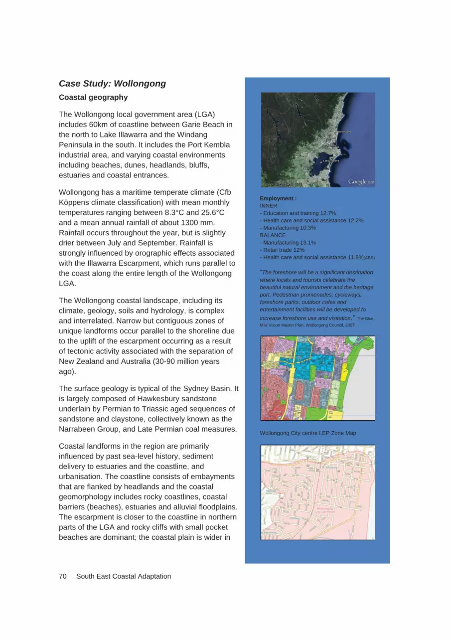
70 South East Coastal Adaptation
Case Study: Wollongong Coastal geography
The Wollongong local government area (LGA) includes 60km of coastline between Garie Beach in the north to Lake Illawarra and the Windang Peninsula in the south. It includes the Port Kembla industrial area, and varying coastal environments including beaches, dunes, headlands, bluffs, estuaries and coastal entrances.
Wollongong has a maritime temperate climate (Cfb Köppens climate classification) with mean monthly temperatures ranging between 8.3°C and 25.6°C and a mean annual rainfall of about 1300 mm. Rainfall occurs throughout the year, but is slightly drier between July and September. Rainfall is strongly influenced by orographic effects associated with the Illawarra Escarpment, which runs parallel to the coast along the entire length of the Wollongong LGA.
The Wollongong coastal landscape, including its climate, geology, soils and hydrology, is complex and interrelated. Narrow but contiguous zones of unique landforms occur parallel to the shoreline due to the uplift of the escarpment occurring as a result of tectonic activity associated with the separation of New Zealand and Australia (30-90 million years ago).
The surface geology is typical of the Sydney Basin. It is largely composed of Hawkesbury sandstone underlain by Permian to Triassic aged sequences of sandstone and claystone, collectively known as the Narrabeen Group, and Late Permian coal measures.
Coastal landforms in the region are primarily influenced by past sea-level history, sediment delivery to estuaries and the coastline, and urbanisation. The coastline consists of embayments that are flanked by headlands and the coastal geomorphology includes rocky coastlines, coastal barriers (beaches), estuaries and alluvial floodplains. The escarpment is closer to the coastline in northern parts of the LGA and rocky cliffs with small pocket beaches are dominant; the coastal plain is wider in
Employment : INNER - Education and training 12.7% - Health care and social assistance 12.2% - Manufacturing 10.3% BALANCE - Manufacturing 13.1% - Retail trade 12% - Health care and social assistance 11.8%(ABS)
“The foreshore will be a significant destination where locals and tourists celebrate the beautiful natural environment and the heritage port. Pedestrian promenades, cycleways, foreshore parks, outdoor cafes and entertainment facilities will be developed to increase foreshore use and visitation.” The Blue Mile Vision Master Plan, Wollongong Council, 2007
Wollongong City centre LEP Zone Map

South East Coastal Adaptation 71
the south, thereby accommodating Lake Illawarra and long sandy beaches.
The barrier beaches of Wollongong (Coledale, Austinmer, Thirroul, Sandon Point, Bulli, Woonona, Corrimal, North Wollongong, Coniston/Wollongong and Perkins Beach) have retreated landward during the Holocene in response to sea-level rise. Photogrammetric analysis of the recent history of these barriers (~1960-2010) indicates they are vulnerable to erosion from storm cut, though most exhibit recovery through the delivery of sediment.
Sites most exposed to erosion associated with storm-cut have little wave protection from headlands/outcrops or are oriented east-south-east, which is the prevailing direction of storm-propagated waves. Accretion and beach recovery appears to be associated with sediment supply and obstructions to supply. The future of barrier beaches in Wollongong depends on the degree of shoreline recession associated with sea-level rise and storm-cut erosion. ENSO (El Niño and La Niña southern oscillation) events and associated changes to sediment delivery and transport patterns may cause beach rotation and alter beach morphology.
The size of coastal waterways in the Wollongong LGA is largely influenced by the catchment area and width of the coastal plain. As a consequence, the catchments drain to: a series of small coastal creeks in the north (e.g. Hargraves Creek, Stanwell Creek, Stoney Creek, Flanagans Creek, Slacky Creek, Whartons Creek, Collins Creek); small lagoons in the central parts of the LGA (e.g. Bellambi Creek/Lagoon, Towradgi Lagoon, Fairy lagoon, Tom Thumb lagoon); and Lake Illawarra, a large barrier estuary at the southern end of the LGA. All these estuaries (except Tom Thumb Lagoon, which is highly developed and has been extensively reclaimed) are Intermittently Closed/Open Lakes or Lagoons (ICOLLs) – the entrance sand barrier and small catchment size causes the entrance to close for periods (although the entrance to Lake Illawarra is now permanently maintained by training walls). The smaller northern estuaries have infilled with catchment sediment and are regarded as mature. Lake Illawarra has undergone some infilling, particularly in association with catchment development and sediment delivery, but is still regarded as relatively immature due to the size of the waterway (~36 km2).
Alluvial floodplains in the area are relatively low-lying near the estuaries and barriers, and are vulnerable to back-barrier coastal inundation and flooding of estuarine shorelines. Due to the favourable topography, much of these floodplains has been developed for urban landuse; only small areas remain for agricultural purposes. Natural ecosystems, such as saltmarsh and tidal flats, have been maintained around many of the estuaries, but may be regarded as highly altered or degraded.
A recent risk assessment identified 947 land parcels in the Wollongong LGA that are projected to be at risk of coastal influenced geotechnical hazards by 2100 (Cardno Lawson Treloar 2010).

72 South East Coastal Adaptation
Current population profile and trends
Population, June 2008: 198,324 Forecast population 2031: 245,083 Average annual percentage change to 2031: 0.97% Total percentage change between 2012 and 2031: 20.13%
Source: ABS
Socio-demographic features
Wollongong has a SEIFA index of disadvantage of 983.8, indicating slight more disadvantaged than the national average (the Wollongong Community Profile (2012)). Overall Wollongong is probably the least socially vulnerable of the case study communities although some of its suburbs have a SEIFA index as low as 817 (close to NSW’s lowest index score of 765).
In terms of the LGA demographics, in 2011, 11.11 per cent of the population was aged 65-79, projected to rise to 13.09 per cent in 2021 and 5 per cent was aged 80+, projected to rise to 5.04 per cent in 2021. Other key socio-economic indicators include: a median household income of $683, compared to Shoalhaven at $500; 15 per cent of the LGA population lives at or below the poverty line and by 2021, this is expected to increase to 18 per cent; unemployment is 6.9 per cent (the same rate as Eurobodalla); and 18.8 per cent of the population identify as engaging in voluntary work (comparatively low against other case study areas).
Urban planning and infrastructure
The Wollongong Coastal Management Plan (2012) frames the managing of coastal risks for existing developments. The approach of ‘protect’ through engineering solutions, ‘accommodate’ by redesign or retrofit or ‘retreat’ from the risk is to be applied to development and is integrated with asset management cycles to enable infrastructure, firstly, to accommodate and, subsequently, to retreat at the end of life cycle.
Climate Temperate maritime climate, no distinct wet season (Cfb)
Geology Primarily Hawkesbury sandstone. Width of the coastal plain and catchment size controlled by the proximity of the escarpment to the coastline
Barriers Undergone shoreline recession and storm-cut, recovery through accretion. Vulnerability based on orientation to waves and sediment transport and protection provided by headlands.
Estuaries Barrier estuaries (ICOLLs), varying maturity. Small estuaries in the north, large estuaries in the south
Alluvial floodplains/ catchment development
Highly developed for urban land use, many properties vulnerable to inundation

South East Coastal Adaptation 73
The Wollongong Local Environment Plan 2009 (LEP) aims to guide the use and development of land in Wollongong, including ‘to ensure that significant landscapes are conserved, including…the coastline’. Most land in the Wollongong coastal zone is zoned for recreation (mostly public and some private), environmental conservation or management or residential. There is no rural land, little industrial land and only small areas of commercial land, typically for restaurants, kiosks and cafes, in the coastal zone.
Under the Wollongong Development Control Plan 2009 (DCP) key sections of relevance to managing the coastal zone include Geotechnical Assessment (although coastal processes - waves, sea-level rise - are not specifically stated to be included in the geotechnical hazard investigation); and Floodplain Management, which sets development controls for low, medium and high risk floodplain areas. It includes prescriptive standards for development applying to those floodplains where flood studies have been completed, i.e. Towradgi / Hewitts / Slacky / Woodlands / Tramway/ Thomas Gibson Creeks, Minnegang Creek, Allans Creek, with Lake Illawarra and Mullet Creek due to be added shortly. Coastal inundation boundaries are broadly congruent with flooding hazard extent.
There is no specific DCP chapter providing guidance and development controls for coastal hazards, such as erosion and recession or coastal inundation. The DCP chapter for Residential Development (Chapter B01) contains a brief section (11.6) on development near the coastline. It provides limited guidance for different development types and / or controls to manage the impacts of coastal hazards. The remaining DCP chapters for developments such as Business Zones (B04), Industrial Development (B05) and Residential Subdivisions (B02) do not specifically reference controls for development in the coastal zone.
The Blue Mile Master Plan has more detail about improvements proposed within the Wollongong City Foreshore Plan of Management (POM). Planning People Places (Wollongong City Council 2005) provides the strategic framework to guide provision, development and management of open space and key recreation and community facilities in Wollongong over the next 20 years. The document also provides guidance to developers and State agencies considering developments that provide open space, recreation and community facilities, with a focus on enhancing existing important coastline recreational nodes, and improving connection between these nodes.
Analysis of People Planning Places, Wollongong’s POMs and the Blue Mile Master Plan indicates that all documents, except one, do not outline the relationship between recreational land use and development, and the need to plan for or manage coastal hazards impacts when planning uses and facilities. The plans provide for a range of improvements to community facilities, but do not indicate whether planning for coastal erosion or other hazards has been incorporated into decision-making regarding improvement works. Coastal hazards and engineering assessments are being undertaken for the proposed Blue Mile Master Plan works, however decisions regarding location, type and improvement to facilities was made prior to determining the feasibility of these decisions with respect to coastal hazards impacts.

74 South East Coastal Adaptation
Only the Coledale Beach Reserve POM provides a strategy directly relating to the incorporation of coastal hazards in future planning. It requires new development and activities to be located behind the 50 year hazard line and structural protection to protect existing assets seaward of the 50 year hazard line (the type of structural protection, or any costs or benefits associated with such protection is not indicated). Earlier POMs do not contain hazard line definition.
Impacts
The interaction of natural coastal processes and the built environment results in hazards and associated risks along the Wollongong coastline. The Wollongong Coastal Zone Study (Cardno Lawson Treloar 2010) identified the coastal hazards and the areas potentially impacted by 2100. Coastal hazards include storm-based beach erosion, longer-term shoreline recession, backwater inundation and overtopping due to elevated sea-levels and waves during storms, and instability of cliffs and coastal headlands. Overprinted on these hazards are the potential impacts of future climate change, particularly sea-level rise. Cardno Lawson Treloar produced coastal hazard lines (representing the combined effects of erosion, recession and sea-level rise) for the years 2010, 2050 and 2100. The hazard assessment adopted the NSW Government’s previously adopted standard sea-level rise projections of 0.06m by 2010, 0.4m by 2050 and 0.9m by 2100 above the 1990 mean sea-level.
The Wollongong Coastal Zone Management Plan (2012) identifies land and assets determined to have the highest levels of risk along the coastline including: beaches themselves (in terms of amenity and social value) and associated coastal dunes; Wollongong’s ocean (rock) pools; various surf club buildings, amenities and pavilions (some of which are heritage-listed); existing seawalls and promenades; stormwater infrastructure; beach access and carparks, local roads servicing residential properties, and a couple of arterial roads (including Lawrence Hargrave Drive); the coastal cycleway that extends from Thirroul to City Beach; infrastructure, such as Bellambi and Austinmer Boat Harbours, Bellambi STP and WIN stadium; important habitat areas (such as EECs) and coastal vegetation; and residential properties (some potentially affected by coastal erosion and recession, and others potentially affected by coastal inundation).
Challenges and opportunities
Growth drivers include research development in the education and mining technology sectors, and health services. The region has a substantial tertiary education sector, with the internationally reputable and heavily research-focussed University of Wollongong and a robust TAFE institute. This will drive regional transport and telecommunications infrastructure upgrades, along with tourism and creative industries growth, and increase the importance of environmental factors and environmental industries (Wollongong Futures 2025).
The primary housing market of the city in recent decades has been people from overseas and from areas along the South Coast (many of whom are students and young people), as well as upgrade opportunities for second and third home buyers in the foothills areas and for young families along the northern coastal strip. The city has tended to lose young couples and families to Shellharbour. Infill density in the CBD and

South East Coastal Adaptation 75
new greenfield development opportunities are identified at West Dapto Study Area (Horsley, Rural Balance, Unanderra-Kembla Grange and Dapto-Penrose-Brownsville small areas.
Wollongong is a regional centre and ‘As a regional city for the Illawarra, Wollongong will be a vibrant centre for jobs, key regional services, cultural activity, entertainment and tourism. Jobs will focus on high growth industries that build the city’s strengths in business services, health, education, retail, tourism and cultural activities’ (Wollongong City Centre Plan Vision 2007, p 14).
Possible and preferred strategies include planning for climate risk in strategic and statutory plans/controls; managing urban growth; coastal spaces for adaptation buffers; building adaptation (increase in floor levels, ’water flow through’ design for flood); coastal protection (physical and infrastructure interventions including sea walls) and infrastructure issues (adaptation and/or replacement).
2030 and beyond
Advanced Manufacturing Industry (AMI) includes high technology companies providing goods and services to traditional mining and metallurgical industries, and entrepreneurial driven enterprises producing innovative products in mining technology. The Green Economy and the Green Jobs Illawarra Action Plan indicate the region has considerable expertise and credentials in this sector, due to many existing sustainability-focused enterprises, employees, facilities and infrastructure.
Mining, largely underground coal mining, continues to be an important industry, employing approximately 3000 people (ABS 2010). The resurrection of mining has been on the back of the minerals boom, with an Indian company buying up some of the region’s older mines. Industrial land supply and business tourism accommodation is required.
Population growth, along with an ageing population, is driving changes in patterns of demand (including health, community services, retail, recreation and cultural services). Anticipated demand for education, manufacturing, health and transport land uses (Hill PDA) will require new green field and brown field development sites.

76 South East Coastal Adaptation
Case Study: Sussex Inlet Coastal geography
Sussex Inlet is on the southern shoreline of the entrance channel to St Georges Basin with the township about 1.5 km from the coastline. It includes the beaches of Bherwerre and Cudmirrah and is bounded by the prominent headlands of Bherewerre Peninsula to the north and Bendalong Point to the south. It has a temperate maritime climate (Cfb Köppens climate classification), with mean temperatures ranging between 9.8 and 24.7°C; mean annual rainfall is approximately 1200 mm and occurs throughout the year with peaks in May to July and February. The coastline is unique: the Bherwerre Barrier is swash aligned and prominent transgressive dunes have developed over the Holocene. These dunes are the largest south of Myall lakes. Other features include the extended entrance channel to St Georges Basin, known as Sussex Inlet Beach, and the rocky reef on the coastline near the channel entrance.
The geology of Sussex Inlet and the St Georges Basin catchment largely consists of Permian aged sandstones and siltstones typical of the Sydney Basin, including Wandrawandian Siltstone and the Snapper Point formation. Much of the catchment remains forested (~80%), with grazing and urban areas making up the remaining landuse. Sediment delivered from the catchment to St Georges Basin is similar to pre-European levels, reflecting the low level of catchment modification. However, sediment delivered over the past 100 years at the margins of urban areas is relatively high and is concentrated such as it creates a barrier at the entrance of the antecedent Pleistocene valley (Slosset al. 2011). This barrier is described as ‘the largest and most complex single barrier system in the region’ (Thom 1987); it reaches to heights over 60 m. The beach is oriented perpendicular to the prevailing wave direction in the south southeast and receives full exposure to wind and waves, facilitating the extensive barrier and dune development. The barrier is up to 3.5 km wide and 7 km long and long-walled transgressive dunes are on the fluvial deltas of Wandandian, Tullarwalla, Cow and Tomerong Creeks (Sloss et al. 2011). An active dune is located along the present coastline and similarly active
Draft Shoalhaven Environmental Plan
Employment 2006 Construction, 11.2 %, Retail trade, 13.3 %, Accommodation and food services, 14.6 %, Health care and social assistance, 12.8 %.
Badgee Lagoon Development Precincts

South East Coastal Adaptation 77
dunes extend up to 1.6 km inland and to heights of 30 m.
The extensive barrier development has blocked two freshwater lakes, Lake MacKenzie and Lake Windermere. Cudmirrah Beach is south of the St Georges Basin entrance channel.
St Georges Basin is on the tidal channel that dissects the western end of the Bherwerre barrier and connects the estuary of St Georges Basin to Wreck Bay. It is a relatively immature barrier estuary; permanently open to the sea. It has a surface area of approximately 40 km2, average depth of approximately 5 m and drains a catchment of approximately 315 km2.. The lake constitutes 11 per cent of the catchment area. Tributaries to St Georges Basin include Cow, Tullarwalla, Wandandian, Pats, Home, Tomerong, Erowal and Stony Creeks. Much of the Sussex Inlet urban area is located upon Holocene aged barrier sands. Canal development, which commenced in 1971, has exposed underlying floodtide delta deposits. This low-lying area is particularly prone to flooding, and has been identified as ‘high hazard flood storage’ or ‘high hazard floodway’ (Webb McKeown and Associates Pty Ltd 2006). Mechanisms for this flooding include localised and regional rainfall within the catchment, elevated sea levels associated with low pressure systems and storm activity, and fetch-related wave setup within the basin.
Climate Temperate maritime climate, no distinct wet season (Cfb), annual rainfall ~1200 mm, mean monthly temp range of 9.8-24.7°C
Geology Permian aged sandstones and siltstones typical of the Sydney Basin
Barriers Barrier oriented normal to wave direction, receives full exposure to wind and waves. Extensive barrier and dune development including transgressive and active dunes.
Estuaries Sussex Inlet lies on the entrance channel of St Georges Basin, a prominent barrier estuary that is regarded s relatively immature.
Floodplains and catchment development
Catchment remains largely forested. Much of the Sussex Inlet urban area is located on low-lying Holocene aged barrier and floodtide delta sands and is identified as high hazard flood storage and floodway
Current population profile and trends
Population as at 2011 Census (ABS) 3191 Forecast population 2030: 4100
Change between 2012 and 2031: 909
Average annual percentage change to 2031: 1.26% Total percentage change between 2012 and 2031: 28.4%
Source: ABS

78 South East Coastal Adaptation
Socio-demographic features
Sussex Inlet has a SEIFA index of disadvantage of 916.3 and Sussex Inlet-Cudmirrah and surrounds has a SEIFA index of 920.5, compared with Shoalhaven City at 964 and Eurobodalla Shire at 961. It is, therefore, more socially disadvantaged than the national average (SEIFA 1000). It has a significantly higher than average proportion of seniorresidents as well as a lower than average proportion of younger people. This has been an incremental change over time. This includes 42.6 per cent of residents are aged 60 years p lus , compared to an average of 31.9 per cent for other coastal towns in Shoalhaven LGA and 15.7 per cent for the Sydney statistical district (the median age for the Sussex Inlet area is 55.3 years old); 2006 Census data showed that 30.4 per cent of the population was aged 65-84 age. In 2011, as a proportion of LGA total population, Sussex Inlet had 6.35 per cent of the population was aged 80+, projected to rise to 7.36 per cent in 2021; 18.87 per cent was aged 65-79, projected to rise to 23.11 per cent in 2021. Such ageing is projected at higher proportions than elsewhere in Eurobodalla Shire.
Socio-economic indicators include: a median household income of $500; 20.6 per cent of the LGA population live at or below the poverty line, with 6.9 per cent unemployment, both indicators slightly lower than Eurobodalla. By 2021, 33 per cent of the LGA population is expected to live at or below the poverty line. Home ownership levels are relatively high at Sussex Inlet with 77.2 percent of dwellings being owned outright or being purchased, 84.6 per cent of the 1,792 occupied dwellings within the Sussex Inlet area are separate houses compared with Shoalhaven as a whole at 88.1 per cent. This difference is primarily due to the large proportion of dwellings under the ‘caravan, cabin, houseboat’ census category at 7.9 per cent, compared to 3.0 per cent for Shoalhaven as a whole.
The total number of medium density (semi- detached, row or terrace house, townhouse etc) is lower within Sussex Inlet and surrounding villages and towns (2.1 per cent) compared to Shoalhaven (3.1 per cent) and NSW (9.3 per cent). Similarly, the total number of ‘flats, units or apartments’ is lower (4.3 per cent) when compared to Shoalhaven (4.7 per cent) and NSW (17.9 per cent). ABS Census data for 2001 indicates that a relatively high proportion of dwellings in the area were unoccupied (36.7 per cent), compared to 26.1 per cent for Shoalhaven, and 8.9 per cent for NSW. Thelow occupancy rates in Sussex Inlet and surrounding coastal villages reflect the high incidence of holiday houses / weekenders. According to recent research, this trend of holiday home ownership is likely to continue in coming years. Of all the Shoalhaven planning areas, the Sussex Inlet area has the lowest proportion of family households (69.0 per cent compared to 72.7 per cent for Shoalhaven), and the highest proportion of lone person households (29.1 per cent compared to 25.0 per cent for Shoalhaven). Housing demand could be met within the development area of Badgee and Bedarra (small land area). Some residents will seek to move from high maintenance rural residential blocks to medium density options.
Urban planning and infrastructure
The Draft Shoalhaven Local Environmental Plan 2009 (draft SLEP 2009) went on exhibition in 2011. Land use zonings in Sussex Inlet include General Residential (R1)

South East Coastal Adaptation 79
with a 500m2 minimum lots size, Environmental Conservation (E2) and Rural Landscape (RU2) with a 40 ha minimum lot size. Commercial zoned land within the Sussex Inlet Town Centre is bounded by River Road, Nielson Road, Ellmoos Avenue and Gordon Street, the Inlet and Jacobs Drive. The town centre land is highly flood-prone (Webb et al. 2006). Development Control Plan 50 for the town centre includes an objective for ‘(d) Establishing footpath levels which provide total access to buildings and account for flood heights required on new developments’.
Image: New coastal subdivision in Sussex Inlet - photo Barbara Norman
Various locations in Sussex Inlet are subject to ecological constraints and include Endangered Ecological Communities (EECs) and SEPP14 Wetland areas. They are considered to be of high conservation value, within which new urban development is constrained under the South Coast Regional Strategy. Setbacks or buffers to sensitive areas of 100m to SEPP 14 wetlands and 50m to EECs are required. An Environmental Impact Statement for the Planning Proposal for the Badgee Lagoon Urban Release Area identifies there will be need for a flood free access road from the existing Badgee Area through to Sussex Inlet Road.
At the local level, the Shoalhaven Shire Council has developed a number of policies and strategies relevant to the site and Sussex Inlet. These include: Sussex Inlet Settlement Strategy; Shoalhaven Housing Strategy; and A Place for Ageing: Social Impacts of an Ageing Population in the Shoalhaven. These documents recognise the potential for extension of the Sussex Inlet township, and a need for a small mixed-use centre as a focal point for the new development area to the north-west of the current town centre.
The Draft Shoalhaven Local Environmental Plan 2009 includes Clause 7.11 Coastal risk planning [local]. The objectives of this clause are:
(a) To maintain existing coastal processes and to avoid significant adverse impacts from those coastal processes;
(b) To enable safe evacuation of coastal risk areas in an emergency;

80 South East Coastal Adaptation
(c) To avoid significant adverse effects on the environment; and
(d) To ensure uses are appropriate and compatible with coastal risks including projected sea-level rise.
The Plan also notes this clause applies to land shown as ‘coastal risk area’ on the Shoalhaven Council Local Environmental Plan Natural Resources Sensitivity-Land Map, and that ‘consent must not be granted to development on land to which this clause applies unless the consent authority is satisfied that the development:
(a) Will avoid, minimise or mitigate exposure to coastal processes;
(b) Will not adversely affect coastal processes resulting in detrimental increases in coastal risk exposure of other development or properties; and
(c) Will not significantly alter coastal processes to the detriment of the environment; and
(d) Will make provision for safe evacuation of the land; and
(e) Make provision for relocation or modification if required to adapt to coastal processes and projected sea-level rise’.
Impacts
Future development in Sussex Inlet catchments will need to demonstrate no net impact on the hydrology including for Badgee Lagoon, a small, shallow, tidal backwater adjoining the upper section of the Sussex Inlet and connected to St Georges Basin. The majority of the broader Badgee Lagoon wetland system is in SEPP 14 Coastal Wetland 304. St Georges Basin is an estuarine inlet that supports large areas of seagrasses, mangroves and saltmarsh and is listed on the Australian Government’s Directory of Important Wetlands in Australia. It is considered to be a representative example of estuarine wetland on the South Coast due to the relatively large area of seagrasses. The DNR Estuary Vulnerability Assessment has determined St Georges Basin has a medium vulnerability ranking to long-term degradation from the effects of catchment development. The lagoon is surrounded by low-lying terrain, much of it comprising wetlands. The low elevation of the Badgee Lagoon wetland area results in a hydrological sump for all catchment run-off and ground water discharge.
Flooding is a significant constraint and large parts of the central area of Sussex Inlet are below the 1 per cent Annual Exceedance Probability (AEP, the 1 in 100 year) flood line. At present the road bridge connecting the town centre to the Badgee residential area is flood-prone. There is an opportunity, as part of rezoning and development investigations associated with land to the west of the Badgee residential area, to investigate an alternative flood-free access. This opportunity is also identified in the St Georges Basin Floodplain Risk Management Plan (December 2006): a second alternative route would improve traffic access early in an evacuation and ensure nearly 400 properties are notcompletely isolated during flood events.
Historically, the St Georges Basin floodplain has experienced flood events. They arise from various factors, including catchment runoff, high ocean conditions and/or wind waves with Sussex Inlet one of the worst affected areas (St Georges Basin Floodplain Risk Management Plan 2006). The Sussex Inlet channel, the tributaries and their

South East Coastal Adaptation 81
immediate adjoining area are classified as high hazard floodways; the Basin and the low lying developed areas of Sussex Inlet are defined as high hazard flood storage areas. Flooding in Sussex Inlet is of a longer duration and is influenced by the overall catchment inflows to the Basin, the prevailing ocean conditions in Wreck Bay and the conditions in the channel.
The Shoalhaven council completed a Flood Study in September 2001 to define flood behavior across the floodplain. A Floodplain Risk Management Study was then undertaken. The St Georges Basin Floodplain Risk Management Plan is the basis for the management of flood prone lands in the settlement area. It uses information from the Floodplain Risk Management Plan to inform future planning decisions. Council has adopted the 1 per cent AEP or 1 in 100 year flood as the current design flood for the area, and the flood studies will establish appropriate Flood Planning Levels (FPL) for the area in the future. It is not proposed to rezone land below the flood planning level for new residential development.
Challenges and opportunities for settlement growth
The Sussex Inlet Settlement Strategy (2006) initially planned for an increase of 1,300-1,400 dwellings over 20 years, with greater housing diversity for an ageing population sought. However, the Independent Review Panel for the South Coast Sensitive LandReview (Department of Planning 2006) and the recommendations of the South Coast Regional Strategy found that only two small areas of the site in the north-western and south-western corners were suitable for residential development.
Other settlement expansion options are to increase the range of housing choice within the established areas of Sussex Inlet, focussed on flood-free areas. This has been estimated by the Council to yield about 300 additional dwellings, including potential development of Crown Land sites, limited infill development adjacent to established areas of Sussex Inlet, particularly in the southern areas of the town and limited additional development at Swanhaven, Cudmirrah and Berrara, incorporating bushfire perimeter roads. Future upgrading of the existing sewage treatment plant serving the Sussex Inlet area will be required.
Possible and preferred strategies include planning for climate risk (such as statutory controls), and enhanced emergency management, particularly evacuation routes; managing urban growth that accommodates planned retreat; coastal spaces for adaptation (buffers); building adaptation – increase in floor levels, water flow through designs against floods and inundation; coastal protection – physical and infrastructure interventions including sea walls; and Infrastructure issues i.e. flood free evacuation routes, power supply.
Beyond 2030
Sussex Inlet has an aged population that will increasingly require adaptable housing choices and access to community services. This will also have implications for emergency services and evacuation procedures for extreme events.

82 South East Coastal Adaptation
Case Study: Batemans Bay Coastal geography
The Eurobodalla Shire Council local government area includes approximately 112 km of coastline, with major settlements at Batemans Bay, Moruya and Narooma (another of the Case Studies). The township of Batemans Bay lies at the convergence of Batemans Bay, a marine embayment; the Clyde River, a drowned valley estuary; and Cullendulla Creek, a smaller barrier estuary. The region also includes a number of coastal environments, rocky shorelines, beaches, dunes, and shallow intertidal and sub-tidal environments including sand flats, mangrove and saltmarsh, and seagrass. Batemans Bay has a maritime temperate climate (Cfb Köppens climate classification) with mean monthly temperatures ranging between 3.7°C and 25.7°C (BOM 2012); and a mean annual rainfall of approximately 900 mm. Rainfall occurs throughout the year, with a bias to drier conditions between March and September (BOM 2012). The Clyde River has a catchment area of 1380 km2 with 880km2 located within the coastal LGA of Eurobodalla Shire (Cavanagh et al. 2004). The catchment largely remains forested with less than 5 per cent being cleared for urban and rural land uses (Cavanagh et al. 2004). Batemans Bay township, Catalina, Batehaven and Denhams Beach are all on the southern shore of the Bay; North Batemans Bay and other smaller settlements, such as Surfside and Long Beach, are on the northern shore.
The Batemans Bay catchment area largely consists of sandstone, mudstone, shale, quartz and quartzite from the Adaminaby Superterrane, a division of the Lachlan foldbelt with the Narooma cherts, siltstones, sandstones and some volcanics associated with the Narooma Terrane are located along the coastal zone. Quaternary sediments have infilled low-lying margins of the Clyde River and Batemans Bay (Troedson et al. 2004).
Batemans Bay is the only marine embayment between Jervis Bay and Twofold Bay. It has a water area of 5.3 km2 (Roy et al. 2001) and the shoreline includes rocky reefs and sandy barriers. These barriers formed as sea-level rose approximately 700 years ago and wave action deposited marine material in exposed embayments. As a consequence of the wide, funnel shape of the bay and its eastern orientation, shorelines within the bay are particularly vulnerable to coastal hazards associated with exposure to wave action. A recent coastal hazards scoping study identified short term hazards, including storm erosion and storm cut, slope instability, and geotechnical hazards within the bay, particularly the Holocene barriers at Maloneys Beach, Long
Batemans bay Image: http://projects.umwelt.com.au/Batemans-Bay/
Employment: - Cafes, restaurants, takeaway services 6.5% - Accommodation 5.1% - Supermarket and grocery stores 5.0% - School education 4.2% - Residential care services 3.4%
Eurobodalla Local Environmental Plan 2012

South East Coastal Adaptation 83
Beach, Cullendulla Beach and Surfside Beach, North Batemans Bay at Wharf Road, the Batemans Bay Central Business District, Catalina and Batehaven (Glatz 2010). Exposure to waves, and hence storm cut erosion, is particularly high at Maloneys Beach, Long Beach, Surfside Beach, Corrigans Beach, Casey Beach, Surf Beach and Denhams Beach. Longer-term issues relate to shoreline recession, beach rotation and sea-level rise increase the coastal hazard risk for exposed low-lying properties and those located near beaches fronting Batemans Bay.
Clyde River is one of the largest rivers on the NSW South Coast and is classified as a drowned river valley. The estuary is relatively immature (Type 2B; Roy et al. 2001) and is navigable for a distance of 38 km from the entrance. Exchange of water between the estuary and the ocean is assisted by training walls on the southern shore, though considerable shoaling is evident on the northern shore. Estuarine wetland communities, consisting of mangrove and saltmarsh, largely occur on sediments associated with fluvial delta deposits where tributaries join the Clyde River and smaller cut-off embayments. The most extensive of these is located on McLeods Creek and in the embayment near Pelican Island. Seagrass communities are associated with estuarine deposits in these areas. Sedimentation has been identified as an issue, though limited catchment development and the immature stage of the estuary implies that the rate of sediment delivery is not high.
Cullendulla Creek is a mature barrier estuary (Type 3D; Roy et al. 2001) that enters Batemans Bay on its northern shore. The barrier at the entrance of Cullendulla Creek is actively eroding, though existing development and infrastructure are not currently at risk. As the estuary is largely infilled, coastal wetlands are relatively extensive in the estuary and occupy marine and fluvial sediment that now occupy the bedrock valley.
Climate Temperate maritime climate, bias towards spring-summer rainfall. Annual rainfall ~900 mm, mean monthly temperature range of 3.7-25.7°C
Geology Narooma Terrane (cherts, siltstones, sandstones and some volcanics) in the coastal zone; Adaminaby Superterrane (sandstone, mudstone, shale, quartz and quartzite in the mid-lower catchment
Barriers Barriers on the shores of Batemans Bay exposed to wave action and particularly vulnerable to storm cut, erosion, slope instability, geotechnical hazard and inundation
Estuaries Convergence of a marine embayment (Batemans Bay); drowned valley estuary (Clyde River) and barrier estuary (Cullendulla Creek). The Clyde River is relatively immature, Cullendulla Creek is completely infilled
Floodplains and catchment development
Development is largely limited to the shores and coastal plains surrounding Batemans Bay. The Clyde River catchment remains largely forested. Urban development around Batemans Bay is exposed to numerous coastal hazards including erosion, inundation and long-term recession

84 South East Coastal Adaptation
Current population profile and trends
Population as at October 2006 16,601
Forecast population 2031: 23,178
Average annual percentage change to 2031: 0.8%
Total percentage change between 2006 and 2031: 71.62%
Source: ABS
The NSW South Coast Regional Strategy (2006) identifies Batemans Bay as the only regional growth centre in Eurobodalla. It estimates 10,700 new dwellings will be required in the Shire by 2031; 70 per cent of them on vacant urban zoned land, the majority of which is located in Batemans Bay, Moruya and Narooma.
Socio-demographic features
Eurobodalla Shire has a SEIFA index of 961, the lowest level of the case study settlements, with Batemans Bay (906) being the most disadvantaged compared to Narooma [SEIFA 942.] In terms of LGA demographics, in 2011: 17.75 per cent of people were aged 65-79, projected to rise to 22.38 per cent in 2021; and 6.59 per cent were aged 80+, projected to rise to 7.66 per cent in 2021. Age related vulnerability is therefore potentially higher than other case study communities. Socio-economic indicators include: a median household income of $490, with 21 per cent of the LGA population living at or below the poverty line and projected to rise to 34 per cent by 2021; and 9 per cent unemployment – there is significant economic stress.
Eurobodalla’s static population is around 40,000 but peak period population rises beyond an estimated 140,000. The resident population growth rate (2006-2010) for Eurobodalla is 3.1 per cent with a resident population of 50,287 for the region by 2031(RDA). The population of Greater Batemans Bay is expected to increase by 40 per cent by 2031 (Eurobodalla Settlement Strategy 2006-2031).
Increasing demand for aged care facilities in response to the ageing population presents challenges in finding suitable development locations. Some residential facilities serving the older age groups are in vulnerable locations. Private rental capacity is declining (47 per cent in 1996 down to 20 per cent by 2031) as people retire to the coast and second homes become less affordable. Increasing demand for affordable housing alternatives with access to facilities suitable for older age groups will be ongoing. Demographic changes such as ageing population and the sea change phenomenon also impact on community and social infrastructure capacity and provision.
Urban planning and infrastructure
The Eurobodalla Local Environmental Plan (26 July 2012) (part 5.5) sets stringent standards but does not prohibit coastal development. Coastal risks have been mapped and provided to the community for consideration of site specific implications for future development. Longer term protection of road infrastructure has been assessed using flooding levels calculated with a sea-level rise of 0.20 m by 2050, which should be replaced by the value of 0.40 m from the NSW Sea-level Rise Policy.

South East Coastal Adaptation 85
Image: Damage of sea wall in Batemans Bay CBD from coastal inundation (2012) - photo Barbara Norman
In planning for climate change impacts, the focus is on understanding the impacts through continued study and monitoring to establish baselines. Community responses target further research and improving accessibility and aesthetics of public spaces, indicating a contrary position to the LEP and strategies relating to coastal hazards that seek to limit development or retreat from hazards areas.
The structure planning for Batemans Bay is divided between the Town Centre Structure Plan for the Batemans Bay CBD and Greater Batemans Bay (GBB) Structure Plan, which applies to 12 settlements. The Greater Batemans Bay plan develops a hierarchy of settlements that identifies both Batemans Bay and Narooma as ‘Coastal Towns’ as distinct from Moruya being an ‘Inland Coastal Centre (Town)’. The GBB plan integrates outcomes from the Batemans Bay and Clyde Estuary Plan and seeks to ensure recreational, commercial and environmental objectives are considered in a triple bottom line matrix approach to development cognisant of coastal foreshore hazards and ocean impacts. In particular, water quality and protection of the oyster industry are strong drivers along with intensification of the town centre through increased residential development capacity associated with increasing building heights. Consistent with the South Coast Regional Strategy, substantial development potential is identified around the under developed marina area and Hanging Rock with the redevelopment of the marina considered a key activator for this urban growth.

86 South East Coastal Adaptation
Image: Recent sale of coastal land already partially submerged, Batemans Bay (2013) - photo Barbara Norman
Impacts
Eurobodalla Shire has undertaken a significant number of flood and coastal hazard studies. The coastal hazards mapping for Batemans Bay town centre and adjacent residential areas indicate significant impacts by 2050. The aim to increase residential and commercial development within these areas (focused on Bateman Bay CBD as a future regional centre), conflicts with the anticipated coastal hazard impacts of both sea-level rise and wave ride up. Master planning of the town centre and foreshore acknowledges the potential for these impacts through strategies out to 2031 that adopt a ‘wait and see’ approach while the commercial core and residential density is built up. Current strategic and master planning provides for the continued access and enjoyment of the coast as a recreational space. Existing sea wall and marina infrastructure are well constructed and maintained and, along with the advantage of coastal geomorphology providing some buffering of wave impacts, development of the CBD in the short to midterm is expected to continue. However potential for inundation towards 2100 provides significant challenges for the centre in protecting existing assets.
In listing the main challenges facing the Greater Batemans Bay area there is no mention of climate change, inundation or sea-level rise. The community’s main concerns are focused on sense of place, protection from inappropriate development scale and retaining the character of the settlements. However, the direction and response of the strategy to flooding and inundation require development that is ‘compatible with and respect the level of hazard risk acceptable to the community’ and place the onus on applicants to provide ‘research to determine the extent of the flood risk and potential impact’ on flood behaviour to the Council. In protecting the coastline a key action (NE13) is to establish minimum setbacks from mean high water mark for coastal development that take into account sea-level rise.

South East Coastal Adaptation 87
Image: Visible bank erosion near McLeod Street Bridge, Surfside, Batemans Bay (12 October 2012) - photo Kerrylee Rogers
Under Batemans Bay Coastline Hazard Management Plan (Webb et al. 2001), the major hazard identified for the inner bay areas (the CBD, Beach Road and Wharf Road), was ocean inundation as a result of high astronomic tides combined with storm surge (wind stress and barometric effects during major storms), some minor Clyde River flooding effects, plus wave setup, runup and overtopping of the foreshore. The main coastal hazards affecting the CBD are: inundation from wave overtopping of the training wall; and wave impacts along the immediate foreshore during major storm/tide events (with a frequency around 1 in 20 years). Local catchment runoff was not found to be a major part of the problem except along Hanging Rock Creek in the Beach Road area. In the Wharf Road area sediment movements were also found to be a potential problem. The major hazards for the northern zone beaches were found to differ from beach to beach.
Challenges and opportunities
Growth drivers include tourism, second homes and retirement population growth, with new business start ups exceeding closures, particularly in the areas of accommodation and food services, construction, retail trade, rental hiring and real estate services; and business closures in agriculture, forestry, fishing, manufacturing and education. Some employment sectors will show seasonal response. Health services need capacity to respond to seasonal and emergency situations.
Between 118 and 140 commercial properties in Eurobodalla are potentially at risk from sea-level rise (Greater Batemans Bay Structure Plan 2006).
Continuing high dependency levels resulting from an ageing population and a small workforce can lead to labour force shortages and service deficiencies.
Batemans Bay has a number of challenges in responding to long term sea-level rise impacts: the ageing demographic, road access, the physically constrained CBD and main street location, maintenance of the connection to the waterfront and the existing urban built form.

88 South East Coastal Adaptation
Opportunities to redevelop the town centre to provide for the increased residential and commercial growth associated with being the regional growth node required by the Regional Strategy are being considered in the context of the latest estimates for sea level rise and climate change science
A number of difficulties with the low lying CBD’s capacity to respond to growth are offset by land development to the north on higher ground that is unlikely to be subject to the impacts of sea-level rise. Maintaining connectivity between these locations as they compete for the commercial and aged care sector growth will be a challenge.
Protecting the rental and affordable housing sector from displacement to those existing residential and commercial locations at risk will also be a challenge both to tourism and community sense of place.
There are competing policy objectives between the NSW Government and Eurobodalla Council. The growth targets anticipate a rise in building heights and increased urban densities, designed to facilitate tourism investment and associated employment drivers. Competing growth drivers from the age care and related community servicing sectors are likely to trigger increased values for appropriate development sites, further exacerbating the accommodation affordability issues. Employment sector shortages for personal service personnel may occur, impacting on both the aged care and tourism businesses.
Council master planning provides for a program of improvements to the community foreshore infrastructure that, while accessible, is at most risk from sea-level rise. Responses to the risk are likely to take the form of sea wall protection. This typology of constructed unnatural barriers is at odds with the naturalness, connectivity and accessibility that are most valued by the community. On-water infrastructure (wharves, boats ramps jetties) has design capacity to provide for sea-level rise, however existing urban capable zoned land use locations do not currently have the same design flexibility. It will require the Council to seek adaptive capacity in design response that is bench marked to existing hazard studies from developers. In addition, the desire to recover lost opportunity (ground floor space) will drive demand from developers for compensatory additional floor and storey height limits. This built form response is likely to change the scale of development from a low level sea side built form typology to the stepped high rise form as can be seen in larger urban conurbations around Sydney and Wollongong.
Possible and preferred strategies include planning for climate risk in strategic and statutory plans/controls; managing urban growth; coastal spaces for adaptation buffers; building adaptation (increase in floor levels, ’water flow through’ design for flood); coastal protection (physical and infrastructure interventions including sea walls) and infrastructure issues (adaptation and/or replacement). Possible relocation of industry and commercial premises for better protection from extreme events.
2030 and beyond
The Settlement Strategy identifies the need for rural land to be used for industrial activities in order to accommodate above average growth in the construction, transport and storage sectors. The Strategy is aligned with the South Coast Regional Strategy

South East Coastal Adaptation 89
2006-2031, prepared by the Department of Planning, which targets 6,200 new jobs in Eurobodalla by 2031, with Batemans Bay the major regional centre identified as a significant employment generator for finance, business services health aged care and tourism sectors. Tourism is a key growth and opportunity sector particularly in nature based accommodation.
The bulk of commercial jobs are targeted for the northern precinct in and around Batemans Bay and the future industrial land provision. The Eurobodalla 2030 Community Strategy (April 2012) recognises increasing traffic congestion issues for the Batemans Bay with the need to invest in truck bypass and highway upgrades. These constraints on local economic growth and employment opportunities warrant the listing of the Batemans Bay Link Road as a strategic infrastructure priority.

90 South East Coastal Adaptation
Case Study: Narooma Coastal geography
Narooma is on the southern shoreline of Wagonga Inlet and the northern shoreline of Little Lake within Eurobodalla Shire. The smaller townships of North Narooma and Kianga are on the northern shoreline. Narooma has a temperate maritime climate (Cfb Köppens climate classification) with mean monthly temperatures ranging between 7.3°C and 23.5°C; mean annual rainfall is approximately 870 mm and occurs throughout the year, with a slight bias towards higher rainfall in summer and autumn (BOM 2012). The coastal landscape includes the estuaries of Little Lake and Wagonga Inlet, the rocky shoreline of Wagonga Heads is directly east of Narooma and there are barriers on the northern side of the Wagonga Inlet entrance and east of Little Lake.
The catchment area of Wagonga Inlet is approximately 94 km2. It is relatively small and steep: slopes exceed 10° throughout much of the catchment, with gentle slopes near the inlet (Nelson Consulting 2001). The catchment is largely regarded as non-arable and remains forested (Bodalla State Forest) with grazing limited to the gentle slopes near the estuary. The underlying geology consists of the Narooma Terrane (Narooma chert, basalt, and mudstone) in the lower catchment and Adaminaby Superterrane (sequences of sandstone, mudstone, slate and quartzite) in the upper catchment. The lower catchment has accumulated sediments within the floodplain region, including significant quartz deposits associated with deposition in the flood-tide delta; and clays, silts and muds within the central mud basin of Wagonga Inlet and the fluvial deltas where tributaries enter the inlet. The small catchment of Little Lake (2 km2) lies entirely on Narooma Terrance, and has been largely infilled with marine sands associated with the flood tide delta and barrier evolution.
Narooma Beach is the small barrier located at the entrance of Little Lake and immediately south of Wagonga Heads. This beach is about 770 m long and, although there is little evidence to confirm
Narooma Investigation Areas - Interim Coastal Policy - Narooma Flat Lands d to be assessed on merit
Employment: Retail trade 20% Accommodation, cafés restaurants 14% Education 8% Health 8% Construction 7% Agriculture, forestry and fishing 6% Manufacturing 6%.
Land Use Zone Map
Coastal Flooding and Inundation Map

South East Coastal Adaptation 91
this, a recent study suggests it may be receding. Bar Beach lies north of the entrance to Wagonga Inlet and has an east northeast orientation and length of 850 m. A recent analysis projected shoreline recession of approximately 30 m for both barriers by 2100 and storm cuts in the order of 134 m3/m for Bar Beach and 157 m3/m for Narooma Beach (SMEC 2010).
Wagonga Inlet is somewhat unusual for this region of south east Australia in that the estuary is largely within a drowned river valley and the ingress of marine sediment over the past 6000 years has developed a barrier at the estuary entrance and extensive shoaling. It is classified as an immature barrier estuary (type 3A; Roy et al. 2001) with an open entrance (though this is maintained through training). In an attempt to maintain a navigable channel, training walls were installed in the 1920s along the easternmost kilometre of the entrance channel, and breakwaters were established on the oceanside of the entrance in 1977 (MHL 2000). Wagonga Inlet is one of only six estuaries that have been trained between Wollongong and Lakes Entrance. The overriding influence of marine processes on the entrance is evident through the well-developed flood tide delta, and a somewhat smaller ebb tide delta extending seawards of the training walls. As a consequence, small-scale dredging works have been undertaken to improve navigation through the entrance of Wagonga Inlet (Peter Spurway & Associates Pty Ltd 2006). Much of the township, particularly in the Narooma Flats area, is low lying and situated upon a mature part of the flood tide delta, and was identified as vulnerable to submergence under a 100 year average return interval storm event (SMEC 2010). The main estuary body is relatively deep (average depth about 6 m). Steep shoreline slopes elsewhere within the estuary prevent extensive development of tidal flats, except where the tributaries of Burrimbidgee Creek and Bilba Bilba Creek to the northwest and Punkally Creek to the south deliver sediment to fluvial deltas. Little Lake is an ICOLL (Intermittent Closed/Open Lake or Lagoon) that adjoins the Narooma Beach barrier. Development on the northern shoreline may be prone to wave overtopping of dunes in storm events by 2100 (SMEC 2010).

92 South East Coastal Adaptation
Climate Temperate maritime climate, no distinct wet season (Cfb), annual rainfall ~870 mm, mean monthly temp range of 7.3-23.5°C
Geology Narooma terrane in lower catchment overlain by Holocene marine sands and alluvial muds, clays and silts. Estuary regarded as drowned river valley with Holocene barrier development
Barriers Bar Beach is the barrier of Wagonga Inlet; Narooma Beach is the barrier at Little Lake. Both barriers may be prone to recession and storm-cut by 2100
Estuaries Wagonga Inlet is an immature barrier estuary with a trained entrance. Marine processes dominate at the entrance and small fluvial contributions have caused minor infilling of the mud basin. Development on Narooma Flats is vulnerable to submergence. Little Lake is an ICOLL
Floodplains and catchment development
Wagonga Inlet catchment is largely forested but the floodplains of the lower catchment have been developed; Narooma Flats may be vulnerable to inundation. Development on the northern shoreline of Little Lake may be vulnerable to inundation from wave overtopping of dunes
Current population profile and trends
Population as at June 2006 3,100 Forecast population 2030: 3,360 Change between 2006 and 2031: 260 Average annual percentage change to 2031: 0.32% Total percentage change between 2012 and 2031 8.4% Source: ABS
Socio-demographic features
The SEIFA index of disadvantage for Eurobodalla Shire is at 961, the lowest level of the case study settlements, with Batemans Bay and Narooma being the most disadvantaged.
In terms of the LGA demographics, in 2011 17.75 per cent of people were in the 65-79 age group, projected to rise to 22.38 per cent in 2021; and 6.59 per cent were aged 80 +, projected to rise to 7.66 per cent in 2021. Age related vulnerability is therefore potentially higher than other case study communities.
Socio-economic indicators include: a median household income of $490, with 21 per cent of the LGA population living at or below the poverty line [rising to 34 per cent by 2021]; 9 per cent unemployment – there is significant economic stress; 40.6 per cent of the Narooma population was aged 60 years and over in the 2011 census compared

South East Coastal Adaptation 93
with 35.2 per cent for Eurobodalla Shire; and 24 per cent of the population reported doing some form of volunteering.
The major differences between the age structure of Narooma - North Narooma - Kianga and Eurobodalla Shire were a larger percentage of 'Seniors' (70-84) at Narooma (18.0 per cent compared to 14.6 per cent), a larger percentage of 'Older workers & pre-retirees' (50-59) (17.9 per cent compared to 15.6 per cent) and a largerpercentage of 'Empty nesters and retirees' (60-69) (19.6 per cent compared to 17.5 per cent). It is expected that based on experiences elsewhere on the South Coast, holiday homes would account for up to 25 per cent of dwellings in Narooma - North Narooma – Kianga.
In the Social Assessment Report for Southern Region NSW, undertaken as part of the NSW Comprehensive Regional Assessments (2000), Narooma is identified as a coastal town that is almost completely surrounded by the waters of the Wagonga Inlet, the estuary and the Pacific Ocean. Whilst its earlier history was developed around the port for the transport of local produce, a ship building centre, a timber cutting and sawmilling area and commercial fishing, it also developed as a holiday destination early (from when a bridge was built across the river in 1931 and a steamship service started along the south coast). Today it is a popular tourist destination offering clear water, beaches, and boating, aquatic sports, whale watching and big game fishing. Surf beaches, golf courses and the Montague Island wildlife / marine life sanctuary / flora reserve are close by.
From the early 1970s to 1985, economic and social change saw closure of the cannery and sawmills. There was significant building activity including the breakwater, expansion of the golf course, construction of the High School and Narooma Plaza built. This dislocated the town into three centres of activity – the development of community infrastructure continued into the early 1990s but since then there has been decline in investment and reduced house prices. Whale watching and tours to Montague Island were established and now take up to 6000 tourists per year.
Urban planning and infrastructure
Under the Narooma Township Development Control Plan (2012), the Flat Main Streetis to become the main tourist area for the town with a good mix of retail, tourist and permanent accommodation. The Princes Highway is to remain the commercial, retail and tourist focus, with its role reinforced with new specialty retail shops, small scale shopfronts and street and footpath improvements, with parking behind the shops. This area is vulnerable to inundation and it is perhaps unusual that no minimum finished floor level, including an appropriate freeboard level, has been defined. Major flood events were experienced in February 2010 and March 2011. The Hill Main Street(Campbell and Wagonga Streets) is to be designed to attract tourists by offering a range of accommodation options, as well as entertainment, eating and shopping opportunities. This area is not at risk from flooding. Within the Narooma R3 Medium Density Residential Zone, the Flat Accommodation is to provide a range of integrated housing opportunities, for tourists and permanent residents. Controls ensure that development in this precinct complements the existing urban/village character of the Narooma Township. However, as it is noted that the Interim Sea-level Rise Adaptation
94 South East Coastal Adaptation
Policy states that there should be no net increase of residential densities in high risk areas, the compatibility of these controls is unclear.
Impacts
Narooma Flats are a highly vulnerable location with extreme risk of inundation. Longer term protection of infrastructure from flooding will be required. The Princes Highway is to remain the commercial, retail and tourist focus and business area but will be severely affected in flood situations.
The Eurobodalla 2030 Community Strategic Plan Community Consultation identifies that protection of the natural environment from development and water supply and management were considered the key environmental issues in Eurobodalla. Health facilities and services were considered the highest priority social issue. The availability of public transport, limited courses available locally at tertiary educational facilities, and adequate planning for expected population growth were also considered social issues of high priority. All respondents ranked a single regional hospital as the most important infrastructure priority, followed by upgrading of the Kings and Princes Highways and an expanded tertiary education centre.
Within the Eurobodalla Shire Coastal Hazards Scoping Study (2010), the 112km of coastline was studied and the different coastal hazards and risks were identified. Different types of hazard were described, including determination of the storm cut and long-term recession rate where data were available, mapping of the hazard lines for these locations, calculation of the tail water and run-up levels at several locations along the coast, assessment of the impacts of sea-level rise and mapping of the inundation levels. The coastal hazard risks were prioritised as a function of the likelihood and consequences of each hazard. Coastal hazard is considered high risk at Dalmeny along Mummuga Lake (risk of inundation) and Narooma Flats (risk of inundation).
The NSW Government has made funds available under the Floodplain Risk Management Grants Scheme and a flood study for districts of the Narooma Township, including Wagonga Inlet, Dalmeny and Kianga will be prepared. These districts are significant flood-affected areas with over 200 residential lots and 40 commercial properties below the 2.2 m Australian Height Datum flood levels. The number of habitable buildings including detached residential buildings, medium-density buildings, affordable housing and tourism accommodation exceeds 450. The area will be significantly impacted on by sea-level rise with the same flood-affected properties being inundated by daily tides within a 50-year planning period.
Challenges and opportunities
Growth drivers include tourism, second homes and retirement population growth. Narooma Flats are a highly vulnerable location with extreme risk of inundation. Planning strategies in the Local Environmental Plan do not account for this risk with the Flat Main Street and the Flat Accommodation precinct designated for future growth.

South East Coastal Adaptation 95
Possible and preferred strategies include planning for climate risk (through statutory controls, emergency management (evacuation routes); managing urban form to accommodate demand for health services and planned retreat (abandonment and resettlement); coastal spaces for adaptation (buffers); building adaptation (increase in floor levels, water flow through designs against floods and inundation); coastal protection (such as physical and infrastructure interventions including sea walls). A long term coastal plan is required for Narooma that is in harmony with its dynamic physical environment.
2030 and beyond
In 2011, the total population of Narooma - North Narooma – Kianga was estimated at 3,213 people. It is expected to increase to 3,361 by 2031 (an increase of approximately 140 households). Feedback into the Regional Forest Assessment processes suggested that the town needs social/economic/environmental development to attract people 35–50 years old achieving a better community cohesion, age range and commercial experience and skills. As noted above, the outcomes of the flood study for districts of the Narooma township, including Wagonga Inlet, Dalmeny and Kianga, may have significant impacts given issues already identified around buildings in at risk areas.

96 South East Coastal Adaptation
Case Study: Eden Coastal geography
Eden is on the shoreline of the marine embayment of Twofold Bay, which is bounded by Worang Point and Red Point in the south. The township extends around the shoreline of Lake Curalo. Eden has a temperate maritime climate (Cfb Köppens climate classification) with mean monthly temperatures ranging between 4.6°C and 24.6°C; mean annual rainfall is approximately 750 mm and occurs throughout the year, though there is a marked peak in February. As the eastern highlands are within proximity of the coast, much of the shoreline of the region is rugged. The landscape of Eden is characterised by the prominent rocky headlands of Worang Point and Lookout Point that bound the sandy barrier lying at the entrance of Lake Curalo, and the pocket barriers south of Lookout Point towards Nullica Bay.
Eden is almost entirely upon the Twofold Bay formation, which largely consists of Late-Devonian thin-bedded fluvial sandstone, siltstone and mudstone, with some Tertiary undifferentiated sediments in the vicinity of Lake Curalo and its floodplain. The remainder of the Twofold Bay catchment largely consists of the Adaminaby Superterrane (sequences of sandstone, mudstone, slate and quartzite) and some volcanics. The river valley of Lake Curalo has been infilled with sediments during the Holocene delivered by alluvial and marine processes. The catchment of Lake Curalo is approximately 28km2 and some of the township of Eden lies upon alluvial and estuarine plains. The remainder of the catchment is largely forested and is contained within Nullica State Forest and Ben Boyd National Park. The catchment is characterised by short, steep bedrock valleys with slopes ranging between 5° and 20°.
The Holocene sand barrier and dune system at Lake Curalo is known as Aslings Beach. It is 2.3 km long and oriented east southeast. The barrier is relatively exposed to stormwave erosion as the headlands of Worang Point and Red Point afford little protection from the southeast wave direction. An extensive back barrier flat is associated with this barrier system and there is evidence of storm wave wash. Smaller coastal barriers are located at Yallumgo Cove and Cattle Bay (Cattle Bay Beach and Cocora Beach). Cocora Beach has formed at the entrance of Cocora Lagoon (5 ha catchment).
Employment : - Log sawing and dressing 5.2% - Cafes, restaurants, takeaway services 4.8% - Accommodation 4.8% - School education 4.7% - Supermarket and grocery 4.3% (ABS)
Land Use Zones Map
South East Coastal Adaptation 97
Lake Curalo is the prominent estuary on which Eden lies. The Holocene barrier formed at the entrance approximately 6000 years ago, restricting fluvial flows from entering Twofold Bay. The estuary is regarded as a relatively mature (type iv/c Roy et al. 2001) ICOLL, with the central mud basin exhibiting an average depth of less than 1 m. The entrance is typically closed, and is currently managed so that it is opened for flood mitigation purposes (using excavators) when water levels within the lake reach 1.2 m; there is scope to raise the entrance opening threshold to 1.5 m. There is some development (Eden Tourist Park, Eden High School, playing fields, Emblem St, Lakeside Drive) upon barrier and alluvial plain sediments at the margins of Lake Curalo. This development may be vulnerable to flooding when water-levels within the lake are elevated.
Climate Temperate maritime climate, no distinct wet season (Cfb), annual rainfall ~870 mm, mean monthly temp range of 7.3-23.5°C
Geology Largely consists of Late-Devonian thin-bedded fluvial sandstone, siltstone and mudstone, with some Tertiary undifferentiated sediments in the vicinity of Lake Curalo and its floodplain
Barriers Sand barrier and dune system associated with Lake Curalo, known as Aslings Beach, is prone to storm wave erosion and washover is evident. Smaller barriers are located south of Red Point
Estuaries Eden lies on the shores of Lake Curalo, a relatively mature barrier estuary. The entrance is typically closed and managed to maintain lake water levels <1.2 m
Floodplains and catchment development
The catchment of Lake Curalo is largely forested. Parts of Eden are situated upon low-lying Holocene aged alluvial and estuarine plains; particularly on the margins of Lake Curalo
Current population profile and trends
Population 2011 Census (ABS): 3044 Forecast population 2031: 3806 Change between 2011 and 2031 762 Average annual percentage change to 2031: 1.12% Total percentage change between 2006 and 2031: 25% Source: ABS
Socio-demographic features
Eden scores 892.6 on the SEIFA index of disadvantage, compared to 976.9 Bega Shire, thus showing a pocket of disadvantage within the Shire. In terms of the LGA demographics, in 2011: 15.51 per cent of the population was aged 65-79, projected to rise to 20.79 per cent in 2021: 4.96 per cent were aged 80+, projected to rise to 6.16

98 South East Coastal Adaptation
per cent in 2021. There is comparatively less age related vulnerability than other case study localities. Other key socio-economic indicators include: a median household income of $530; 18 per cent of the LGA population living at or below the poverty line, with this projected to increase to 27.2 per cent by 2021; 6.7 per cent unemployment; the largest population age groups are 10–19 years old (15.4 per cent) coming into the area and 40-64 years old (36.1 per cent), suggesting an ageing family and retiree population; and about 11 per cent of Eden households had no vehicles, with most having one (41 per cent) or two (34 per cent).
The District Health and Support Service programs are targeted at promoting, enhancing and maintaining people’s independence, health and well-being. Noteworthy is that 72 per cent of Eden residents had lived in the same locality for more than five years and 56 per cent had lived in the same house for more than five years (Bega Valley Shire Council Eden Community Portrait). The time that residents have lived in a community affects the extent to which they develop relationships and networks with other residents, and build social capital. The longer that more residents have lived in a place, the stronger their community networks are likely to be.
Urban planning and infrastructure
The current planning scheme is the Bega Valley LEP 2002 and a draft LEP 2012 under consideration by the Minister. The 2002 LEP identifies three zones that address coastal development: the Environmental Protection General Zone (7d), the Coastal lands protection zone (7f1), and Coastal land acquisition areas Zone (7f2). Clause 49 of the current LEP includes the requirement to consider sea-level rise and the impacts of climate change by the Council when it’s granting development approval.
The council finalised a Structure Report for Eden and Boydtown in 2006. The Eden local commercial centre has been the subject of a recent planning exercise resulting in the adoption of DCP 40. The new LEP proposes some minor rationalisation of the commercial zone but generally there is currently sufficient land. However, there is a shortage of physically suitable land for industrial uses. The Structure Report identified land as having some potential to support industrial supply for the Eden district and some employment land for the emerging settlement of Boydtown.

South East Coastal Adaptation 99
Image: Coastal environment, Eden NSW - photo Barbara Norman
Impacts
The 2003 Crown Land Assessment identified coastal zone attack and flash flooding as greater than a one in 20 year risks to lower lying land in the vicinity of Cocora lagoon and Lake Curalo. Similarly Aslings beach and public infrastructure located along the dunes will be subject to future storm event and risk of significant erosion.
Image: Protecting significant community facilities on the coastal edge, cemetery, Eden, NSW - photo Barbara Norman
Challenges and opportunities
The growth drivers are tourism and immigration for retirement. Residents new to Eden came from within NSW (7.4 per cent) or other states (8.8 per cent), however the largest

100 South East Coastal Adaptation
tourist group came from Victoria (42 per cent). Net migration to Bega shire is primarily from Sydney (710), overseas (270) and then Melbourne.
The town centre is an integral part of the Port of Eden and is the southernmost service centre for tourists in NSW. As with the other larger towns, Eden needs to increase its living opportunities in and close to the town centre. Eden in particular has some of the most spectacular coastal views from a commercial area and lends itself to quality shop top housing. Eden has Australia’s first woodchip mill, set up in 1969 by the Daishowa Paper Manufacturing – the Australian subsidiary changed its name from Harris-Daishowa to SEFE in 2003.
Possible and preferred strategies include planning for the ageing demography and urban built form, combined with a tired public realm and lack of infrastructure, high end accommodation facilities and minimal tourism facilities provides a number of challenges for Eden compounded by the transitional nature of the statutory planning framework.
Access to the ocean, landscape and natural resources and commanding ridgeline and slope setting provides opportunities for development without significant threat from sea-level rise and climate change impacts that affect development and urban form for almost all other coastal settlements. There are existing land uses, such as a caravan parks currently located on lands zoned 7f1 coastal lands protection.
The Structure Plan for Eden, while silent on climate change and sea-level rise, identifies nine objectives to guide development till 2030 and key among them are: land based and Bay based aquaculture; maximising use of harbour and wharves; expanding tourism opportunities; and adjustments for emerging trends in agriculture, fishing and forestry.
The Council 20 Year Plan uses five themes to address strategies and actions based on a swot analysis. The plan identifies potential economic roles for Eden as: an emerging tourist and seniors focus, port harbour and aquaculture related industries, hub of Shire forestry and fishing, Marine education/ research / tourism, and developing Boydtown as a premium market for tourism and lifestyle. The plan, while superseded by a land use planning strategy in 2008, states the challenges for Eden as replacing lost unskilled and semi-skilled employment; finalising industrial land supply at the four nominated sites; expanded use of the Multi-Purpose Wharf; progression of Marine Discovery Centre; and strategic answers and actions for Snug Cove, Cattle Bay, and Boydtown. These challenges are recognised in the land use planning strategy that informed the draft 2010 LEP.
Possible and preferred strategies include planning for climate risk in strategic and statutory plans/controls; managing urban growth; coastal spaces for adaptation (buffers; building adaptation), increase in floor levels, ’water flow through’ design for flood); coastal protection (physical and infrastructure interventions including sea walls) and infrastructure issues (adaptation and/or replacement). Active support for coast and marine education and multi-activity and research networks. Adaptable reuse of existing port infrastructure.

South East Coastal Adaptation 101
2030 and beyond
The Boydtown area has the potential to grow into a tourism and satellite residential settlement of several hundred permanent residents and peak season tourist population in excess of 2,000 over the next 20 years. The role of any commercial development at Boydtown needs to complement that of Eden and target local tourist and resident daily and holiday needs. Further master planning of Boydtown is underway and will refine the location of additional commercial lands. The council has also identified potential employment lands for industrial / business park development west of the highway.
One of the possible export sites for ore produced in the Nowa Nowa region of East Gippsland is Twofold Bay at Eden and Eastern Iron and South East Fibre Exports (SEFE) have begun discussions on possible future use of the SEFE export facility at Jews Head with Twofold Bay as a deep water port facility ’to support the loading of an additional 10-12 ships per year.
Image: Elevation survey at Eden Harbour (10 October 2012) - photo Kerrylee Rogers

102 South East Coastal Adaptation
Case Study: Mallacoota
Coastal geography
The Mallacoota township lies within the East Gippsland Shire, immediately adjacent to Mallacoota Inlet, 240 km east of Bairnsdale. Mallacoota Inlet is the estuary of the Genoa River, which has a largely forested catchment of approximately 1950 km2.Mallacoota has a temperate maritime climate (Cfb Köppens climate classification) with mean monthly temperatures ranging between 6.2°C and 24.1°C; mean annual rainfall is approximately 1400 mm and occurs throughout the year, with a slight bias towards lower rainfall in summer. The Mallacoota region has unique coastal geomorphology, including extensive barriers on the northern coastline of Mallacoota Inlet, smaller pocket beaches/barriers on the southern coastline that are interrupted by cliffs and bluffs, the estuaries of Genoa River (known as Mallacoota Inlet) and Betka River, and surrounding alluvial floodplains.
Most of the Genoa catchment is underlain by Devonian granitoid plutons and to a lesser extent metasediments and coarse clastics. Weathering of these geologies contribute to the sediments of Mallacoota Inlet and influence water quality and hydrology. Coastal landforms in the region are influenced by sediment delivery from the catchment and marine sources, and Quaternary sea-level rise.
The extensive barrier and spit system at the mouth of Mallacoota Inlet, known as Mallacoota Spit or Big Beach developed during the Holocene when sea-level stabilised. It has a length of 7-8 km, depending on the location of the entrance of the inlet, which may shift over time in response to large fluvial flows. Betka Beach is approximately 3km long and is on the coastline south of Mallacoota Inlet. Bastion Point, with its steep cliffs on the southern shore of the inlet entrance, marks the northern boundary of this barrier. South Betka Beach is characterised by small pocket beaches that are enclosed by bluffs and protruding rock outcrops. The east-south-east orientation of Mallacoota Spit, perpendicular to the prevailing direction of longshore drift, has promoted the build-up of sediments on the barrier. In contrast, South Betka Beach is oriented in a more southerly direction, tending to align with longshore drift; sediments
Employment : - Education and training 12.3% - Accommodation 9.5% - Fishing 7.3% - Sea food processing 6.4% - Retail trade 3.6% (ABS) 2006
Zoning
Aerial

South East Coastal Adaptation 103
transported by longshore drift are more likely to bypass this barrier.
As sea-level rose and stabilised during the Holocene, low-lying areas in the region were flooded. The current estuary formed through the subsequent development of an extensive sand barrier at the river entrance (Mallacoota Spit). As a consequence, the Genoa River is regarded as a drowned river valley (depths in the mud basin generally range between 1.5-6 m, with channels exceeding 6 m) with a wave dominated barrier estuary. There is extensive flood tide delta development at the mouth with sand bars making navigation of the entrance difficult; fluvial deltas have formed where tributaries enter the inlet. The nearby freshwater Lake Barracoota exhibits evidence of once being marine; and connection with Lake Mallacoota appears to have been severed by extensive development of Mallacoota Spit and sedimentation within the estuary. Low-lying land behind Mallacoota Spit, including Mallacoota Inlet and associated estuarine and freshwater wetlands between the two lakes, now forms an extensive back-barrier swamp. Intermittent estuaries and streams drain the catchment south of Mallacoota Inlet including the Betka River, Horse Trap Creek, Davis Creek, Shady Creek and Mullet Creek. The Betka River floodplain, on the southern shores of the river, is relatively low lying and flat, and is now occupied by Mallacoota airport.
Climate Temperate maritime climate, no distinct wet season (Cfb), annual rainfall ~1400 mm, mean monthly temp range of 6.2-24.1°C
Geology Granitoid plutons, metasediments and coarse clastics. Estuary regarded to be a drowned river valley
Barriers Mallacoota Spit is an extensive barrier formed by sediment accumulation; sedimentation is enhanced as the barrier is oriented perpendicular to longshore drift. Barriers south of Mallacoota are smaller and beaches tend to be pocketed as the shoreline is oriented more parallel to longshore drift
Estuaries Wave-dominated barrier estuaries. Small intermittent estuaries south of Mallacoota (ICOLLs), varying maturity
Alluvial floodplains/ catchment development
Catchment is largely forested and urban development is limited to the southern shoreline of Mallacoota Inlet. Mallacoota Airport occupies the Betka River floodplain
Current population profile and trends
Population 2011 Census 1030 Forecast population 2031 1129 Change between 2011 and 2031 99 Average annual percentage change to 2031 0.46% Total percentage change between 2011 and 2031 9.6% Source: ABS

104 South East Coastal Adaptation
Socio-demographic features
The SEIFA index of disadvantage for East Gippsland Shire is 962.9 and for the Mallacoota District it is 938.9, demonstrating an area of comparatively greater disadvantage within East Gippsland Shire. Other demographic information, 2011: 15.62 per cent of people in the Mallacoota District (East Gippsland LGA) were aged 65-79, with this projected to rise to 20.39 per cent in 2021 (a lower percentage than both Shoalhaven and Eurobodalla); and 3.83 per cent of people were aged 80+, projected to rise to 5.72 per cent in 2021. Age related vulnerability is therefore lower than both Shoalhaven and Eurobodalla.
Socio-economic indicators include: a median household income of $502; 21 per cent of the LGA population living at or below the poverty line; 6 per cent unemployment; and 31.2 per cent of the population (Orbost sub region) identified as engaging in voluntary work – a significant degree of social innovation and cohesion is demonstrated at community level in Mallacoota.
In summary, there is slightly less economic stress than both Shoalhaven and Eurobodalla. Mallacoota is an isolated coastal community that is defined as a large or district town (greater than 500 residents - DPCD) and with 16 per cent of its workforce employed in accommodation and food services. An example of a successful commercial seafood enterprise is the abalone industry. A local co-operative with a staff of over 30 is strategically sited close to the product source. Twenty-one licence holders run a multi-million dollar industry processing locally harvested abalone for the lucrative export industry and with excellent highway links to Melbourne and Sydney transportation is viable and efficient.
The Mallacoota District Health and Support Service (MDHSS) programs are targeted at promoting, enhancing and maintaining people’s independence, health and well-being. MDHSS promotes a social model of health, using an integrated approach with Bairnsdale Regional Health Service (BRHS) and other health agencies and networks in East Gippsland.

South East Coastal Adaptation 105
Image: East Gippsland Coastal Environment, Bastion Point Beach, Mallacoota (2013) - photo Barbara Norman
Urban planning and infrastructure
The Local Planning Policy Framework (LPPF) outlines strategies regarding housing choice and diversity broadly mirroring the direction of State Planning Policy Framework (SPPF) The vision for East Gippsland is to be recognised throughout Australia and beyond as a region combining outstanding environmental quality with a vibrant and expanding economy, whilst providing a rewarding lifestyle, employment and educational opportunities and community supports for both its residents and visitors.
Specific objectives for Mallacoota include: enhancing Mallacoota’s role and character within a wilderness setting; creating a cohesive and active town centre; improving pedestrian circulation and safety; improving the design and siting of buildings; and protecting and reinforcing Mallacoota's aboriginal cultural heritage.
The township of Mallacoota forms part of the Lakes & Coastal subregion within the Municipal strategic statement. Part of the visioning for Mallacoota includes the creation of a cohesive and active town centre and the encouragement of infill development of vacant sites. Strategies also include the preservation and enhancement of the village atmosphere of a cohesive and active town centre (Coastal Towns Design Framework2007).
Impacts
The Mallacoota Water Supply Demand Strategy (AECOM 2010) describes future population growth as follows: Mallacoota is likely to grow in population and age significantly over the next 30 years as retirees move to Mallacoota; the projected average annual rate of population increase in East Gippsland is 0.32 per cent; and over the past 15 years Mallacoota has been growing at 2.2 times higher than the East Gippsland average.

106 South East Coastal Adaptation
The greatest concern for Mallacoota’s water supply system relating to climate change is a significant reduction in the volume of surface water available for extraction from the Betka River. A report titled Future Runoff Projections (~2030) for South East Australia by the South Eastern Australian Climate Initiative (SEACI) (2008) identifies stream flow reduction figures. Any continued logging will impact upon the streamflow within the Betka River. Similarly, groundwater is susceptible to climate change and increasingly drier conditions may result in a significant reduction in the volume of water available for extraction. The risk of bushfires in East Gippsland is also predicted to increase with climate change with projections of a hotter and drier environment in southern Australia. The East Gippsland Catchment Management Authority has provided initial advice on predicted flood level rises for the Mallacoota area. In summary, the advice states that if the weather event that creates the storm tide levels also produces significant catchment rainfall, then the levels of inundation in Mallacoota are likely to exceed the CSIRO predictions (McInnes).
Challenges and opportunities
Growth drivers include tourism, second homes and retirement population growth. Employment sectors such as accommodation and domestic support services, automotive repairs etc. will show seasonal response. Health services need capacity to respond to seasonal and emergency situations. Though the population can increase to about 3500 in the peak holiday season, the resident population of 972 has declined slightly with limited dwelling construction and the average household numbers per dwelling reducing. Adjacent rural lands are used mainly for for grazing and fishing. There is a proposed East Gippsland Wild Coastal Walk – a tourism infrastructure project identified in the Destination Gippsland Strategic Plan. The Mallacoota Foreshore Holiday Park provides an attractive low-cost camping option for visitors to the area due to its prime location on the foreshore of Mallacoota and within the Croajingalong National Park.
The industry structure of Mallacoota highlights the importance of tourism-related sectors including retail, accommodation and food services to the local economy, with one-in-four local workers employed in these sectors. Of the 120 or so businesses located in Mallacoota, approximately 30 per cent are associated with providing accommodation, food and retail services. Most of these businesses are small operators. Mallacoota has relatively high levels of unemployment and comparatively low levels of full-time employment with the permanent resident population characterised by a high proportion of retirement-aged residents and households with relatively low incomes compared with municipal, regional and state averages.
The Mallacoota Foreshore Holiday Park attracted approximately 116,700 visitor nights in 2010-11, and occupancy rates increased from 16 per cent to 20 per cent between 2007-08 and 2010-11. The Park injects approximately $5.1 million into the local economy per year. This equates to approximately $45 spent in the community per night per site (excluding accommodation fees). The Park supports 52 jobs (directly and indirectly) in the wider economy through its operations and visitor spending. A Mallacoota Foreshore Holiday Park Master Plan 2011 is currently under consideration.
South East Coastal Adaptation 107
There are currently discussions between the Mallacoota community and the East Gippsland Shire Council on developing great self-sufficiency in local energy supply. This issue was highlighted particularly after a significant storm during 2012 which cut off power supply to Mallacoota for a number of days.
Possible and preferred strategies include planning for climate risk and emergency management (evacuation routes); local energy self sufficiency to mitigate against the impacts of extreme weather; managing urban growth that accommodates planned retreat; coastal spaces for adaptation (buffers); building adaptation into structures in low lying areas (increase in floor levels, water flow through design for flood); infrastructure issues; local power supply.
2030 and beyond
Mallacoota is a classic coastal hamlet – a small, remote coastal community surrounded by protected natural areas, with population of approximately 1000 people, situated more than three hours drive of a capital city. The draft Gippsland Regional Growth Plan(July 2012) identifies Mallacoota as a tourism and recreational area with transit links to Lakes Entrance and cross border to the port of Eden. A visitor centre for East Gippsland, opportunities for commercial flights from Mallacoota and boutique tourism accommodation were identified in the Gippsland Regional Tourism Development Plan 2006.
A proposed ocean access, dredging and the impacts on the marine environment are` currently being considered by the local council with the preparation of an Environmental Management Plan.

108 South East Coastal Adaptation
Case Study: Lakes Entrance Coastal geography
Lakes Entrance is within the East Gippsland Shire on the northern shores of the Gippsland Lakes, and as the name suggests, near the lake’s entrance. The township is restricted to the foreshores of the North Arm and Cunningham Arm of the Gippsland Lakes, which are a series of interconnected lakes separated from the sea by sandy barriers (Thom et al. 1983). Lakes Entrance has a temperate maritime climate (Cfb Köppens climate classification) with mean monthly temperatures ranging between 2.0°C and 25.9°C; mean annual rainfall is approximately 850 mm and occurs throughout the year (BOM 2012). The upper catchment of the Gippsland Lakes remains forested, though extensive areas of the lower slopes and surrounding the lakes are used for agricultural purposes. Lakes Entrance is one of a number of large population centres located within the catchment, although the footprint of these settlements remains relatively small.
The present-day Gippsland Lakes have a long history of evolution, which is described by Thom et al. (1983). Depositional evidence indicates that hydrological flows were confined by barriers at least three times in association with marine transgressions occurring in the Pleistocene and Holocene. These barriers developed sequentially, with the ‘prior’ barrier confining the tributaries to Lakes Victoria, Lake King and Lake Wellington during the Pleistocene; the ‘inner’ barrier forming the seaward boundary of the lakes during the Pleistocene, and the ‘outer’ barrier forming seaward of the inner barrier during the Holocene marine transgression to create an extensive network of shallow lagoons, sandflats and saltmarshes.
Lakes Entrance is partly situated upon the Pleistocene aged ‘inner’ barrier, though some of the material has been reworked or deposited during the Holocene. The outer barrier now comprises Main Beach, located seaward of Lakes Entrance, and 90 Mile Beach, which extends from the entrance of the Gippsland Lakes to Corner Inlet. The geology of the region surrounding Lakes Entrance largely consists of marine sandstones, clays and limestones of Tertiary age, including the Seaspray Group, Gippsland Limestone Formation, the Tambo River Formation, and Jemmys Point formation,
Employment: accommodation and food services (19.5%), Retail trade (15.6%), Health care / social assistance 10.8%
Zoning
Coastal Flooding and Inundation map
Water level Lakes Entrance @ 1m AH

South East Coastal Adaptation 109
which includes the sandstone outcrop that confines the Eastern Beach barrier, known as Red Bluff.
The Gippsland Lakes are extensive, with a catchment area of 20 449 km2 and open water area of 185 km2 (Geosciences Australia 2011). It is classified as a wave-dominated estuary and supports extensive saltmarsh and seagrass communities, including approximately 600 km2 of internationally significant wetlands recognised in the Ramsar treaty (BMT WBM 2011). As a consequence of wave action, marine sediment is delivered to the barriers of the Gippsland Lakes. Prior to 1889, an ephemeral natural entrance was located to the northeast of the current entrance near Red Bluff. An artificial entrance was created in 1889 and the Gippsland Port facilities developed on Bullock Island since this time (Wheeler et al. 2010). Flood and ebb tide deltas have developed near the entrance and maintenance dredging has progressively increased to maintain navigable channels to depths of 4.5-5.5 m (Gippsland Ports 2012). Currently a sand transfer system is employed: dredge spoil extracted using a cutter suction dredge is pumped from the flood-tide delta via fixed pipes to the beach face of Eastern Beach, approximately 1 km from the artificial entrance (Wheeler et al.2010).
The low-lying nature of much of the foreshore of Lakes Entrance has attracted considerable planning attention. Flooding has occurred in association with high rainfall events in the catchment, and high ocean king tides or storm surges (Spencer and Sjerp 2011). Currently a 1 in 100 year flood event is predicted to inundate most of the Lakes Entrance commercial area and future sea-level rise and increases in the frequency and intensity of storms is projected to exacerbate flood impacts (Spencer and Sjerp 2011). The situation of the township on the inner barrier ensures that the outer barrier buffers the township from shoreline recession and erosion driven by storms and oceanic waves, though natural habitats on the outer barrier may be impacted. Shoreline retreat, in the order of 350 m approximately 1.5 km south of the entrance and 100 m near Ocean Grange, may have occurred between 1879 and 1968 (Bird 1978). Erosion around the lake foreshore is reportedly associated with increased salinity of the Gippsland Lakes and dieback of saline sensitive foreshore vegetation, also adding to wake wind and wave chop. Seawalls have been constructed around sections of the foreshore to stabilise banks, particularly along The Esplanade and on Bullock Island. Continued erosion is causing some sections to be undermined; a process that is likely to continue with sea-level rise and altered wind and wave climates (Spencer and Sjerp 2011).
Water level Lakes Entrance @ 2m AHD
Such flood levels would be unusual at present (the floods in 2007 reached about 1.2 m AHD) Climate change experts predict that the 1 in 100 year storm level of 1.9 metres will become a more frequent occurrence.
Water level Lakes Entrance photos developed by M.L.F Coller, P.J Wheeler, J. Kunapo, J.A Peterson, and M.McMahon (source: http://sahultime.monash.edu.au/LakesEntrance/)

110 South East Coastal Adaptation
Image: Life Saving platform built well above sea level at Lakes Entrance, Victoria (2013) - photo Barbara Norman
Climate Temperate maritime climate, no distinct wet season (Cfb), annual rainfall ~850 mm, mean monthly temp range of 2.0-25.9°C
Geology Tertiary aged marine sandstones, clays and limestones, some Holocene sediments on the barriers and in estuarine environments
Barriers At least three barriers formed in association with marine transgressions: Pleistocene aged prior barrier, Pleistocene aged inner barrier and Holocene aged outer barrier. 90 Mile Beach and Eastern Beach located on the outer barrier
Estuaries Wave-dominated barrier estuaries. Artificial entrance maintained by training walls and dredging of flood-tide delta. Dredge spoil deposited on beach face on Eastern Beach. Seawalls established in the estuary to stabilise banks and stop erosion
Floodplains and catchment development
The upper catchment is largely forested, lower catchment used for agricultural purposes, numerous urban centres, though their extent is limited. Gippsland Port facilities located on Bullock Island
Current population profile and trends
Population 2011 Census 5956 Forecast population 2031: 8306 Change between 2011 and 2031: 2350 Average annual percentage change to 2031: 1.68% Total percentage change between 2011 and 2031: 39.5% Source: ABS

South East Coastal Adaptation 111
Socio-demographic features
The SEIFA index of disadvantage for East Gippsland Shire is 962.9 with Lakes Entrance’s index of disadvantage of being 917.8, demonstrating an area of significantly greater disadvantage within East Gippsland Shire. In terms of demographics, East Gippsland has an increasing ageing population: 27 per cent of all people are 60 years and older, with projections showing a rise to 44 per cent by 2021; overall population growth is more than 1.5 per cent per annum but the number of people in the 70+ age group is projected to grow steeply over the next 20 years (Figure 14); and 22.7 per cent of the population in East Gippsland Shire identify as engaging in voluntary work a comparatively low percentage compared to other case study settlements.
Figure: Population projections in East GippslandSource: East Gippsland Positive Ageing Strategy 2010-2013 Key Directions Statement
Data source: DHS LGA Statistical Profile, 2007
The East Gippsland Strategic Tourism Plan Report 2006 – 2011 (2006) identifies the tourism sector in Lakes Entrance as the dominant employer. Visitor accommodation options are varied and include hotels (14), bed and breakfast and inns (11), other accommodation including caravan parks (24) and holiday rentals, identified as 35. In 2010, East Gippsland attracted 1.1 million visitors (492,652 domestic daytrip visitors, 591,334 domestic overnight visitors and 31,344 international visitors). Tourism has not, however, recovered to its pre-2008 levels. Despite this, Lakes Entrance would still sustain a (summer) seasonal population increase of approximately 1800 people on average, nightly in peak periods. With the Yellow Pages (2012) detailing 84 accommodation options (plus private rental dwellings), the accommodation sector is potentially bigger than formally identified.
An average of 360 dwellings have been built in East Gippsland Shire each year since 2001. There is limited demand for new residential subdivisions. The Urban Design Strategy anticipates development in the Tourist Precinct bounded by the Lakes Entrance Visitors Centre, Marine Parade, Carstairs Avenue and The Esplanade as providing tourist related uses including holiday accommodation, restaurants and improved public spaces and recreation activities. It suggests that in the longer term, the

112 South East Coastal Adaptation
Business 3 Zone should be replaced with a zoning that supports this visitor accommodation/residential focus.
Urban planning and infrastructure
The low lying nature of Lakes Entrance is requiring some careful planning for the future. This has also attracted the attention of the Courts. For example, in Taip v East Gippsland Shire Council, pursuant to the Victorian Civil and Administrative Tribunal Act 1998; the decision of the Responsible Authority is set aside. The decision states that from various studies it is clear that the low lying commercial centre of Lakes Entrance has a very high level of vulnerability to the impacts of not only sea-level rise but other effects of climate change, such as an increased frequency of storm surges and wind driven flood events. A combined wind and high tide inundation event occurred in September 2009. In this event, wind driven piling of lake water toward Lakes Entrance during a high tide resulted in inundation via flow up and out of the town’s drainage system. The rise in levels attributed to this effect was of the order of 0.5m above the high tide, resulting in a peak level of 0.9m AHD, equivalent to around a 30 per cent AEP event (or approximately between a 1 in 2 year and 1 in 3 year AEP event). New sea level planning controls have since been introduced in Victoria (discussed in Chapter 4).
Image: Coastal development close to sea level, Lakes Entrance, Victoria - photo Barbara Norman
Challenges and opportunities
Growth drivers include tourism, second homes and retirement population growth. The construction sector still shows strong performance in the East Gippsland Shire.
The vision for Lakes Entrance within the Coastal Towns Design Framework (2007) states:
Lakes Entrance will continue its role as the largest coastal town in the Gippsland area, with a strong focus on commercial fishing and recreational boating activities.

South East Coastal Adaptation 113
The protection and enhancement of environmental and landscape values will be a key priority. The town will remain popular with visitors, offering a range of quality accommodation and attractions. The maritime theme will be strengthened to provide a unique tourist experience and give the town a strong identity.
The foreshore and esplanade precinct will be the focal point for the town providing an attractive, safe and pedestrian friendly environment. Bullock Island will remain a centre for industry and research and will also be an important recreational/tourist destination.
The major future residential area consists of undulating open farmland immediately behind Lakes Entrance. The landform is often steep with several deep drainage lines that drain to the North Arm. The local vulnerability to flooding is not mentioned although it is recommended that drainage lines and steep land should be revegetated.
Employment sectors such as accommodation and domestic support services, automotive repairs etc. will show seasonal response. Lakes Entrance Fishing Co-operative Ltd (LEFCOL) processes and transports fish for the markets and operate a retail outlet and chandlery in Lakes Entrance. LEFCOL services between 80 to100 vessels and handles approximately 4.5 million kilos of fish annually. It has two blast freeze tunnels with 32 tonne capacity and a large holding room with product capacity of 100 tonnes. Opportunities exist for heavy and light industry support to the fleet, including in the areas of computerised communications, fish detection and navigation systems.
Further development for the Port of Lakes Entrance could provide for additional commercial and recreational berthing facilities. Investigations on behalf of the Gippsland Coastal Board (2008) indicated that more berthing opportunities, jetties and marine support infrastructure could be provided at North Arm, Cunninghame Arm and Drew’s Jetty. The potential level of investment would depend on the security of commercial fishery access and its sustainability and recreational boating demand projections.
The commercial fishery is, however, unlikely to have growth potential. Future demand for recreational boating is likely to increase over time. Health and emergency services need additional capacity to respond to seasonal and emergency situations.
Possible and preferred strategies include planning for climate risk through strategic statutory controls, emergency management (evacuation routes); resettlement to accommodate planned retreat; coastal spaces for adaptation (buffers); building adaptation (increase in floor levels, water flow through designs against flooding and inundation); and infrastructure issues (power supply).
2030 and beyond
Lakes Entrance is already significantly vulnerable to coastal inundation and flooding. A resettlement strategy is required for now and beyond 2030. Ongoing community engagement in this process will be critical to determining appropriate adaptation options.

114 South East Coastal Adaptation
CASE STUDY REFERENCES
AECOM 2010, Mallacoota Water Supply Demand Strategy.
Bega Valley Shire Council Eden Community Portrait, Bega Valley Shire Council website, Accessed 2nd August 2012, available at http://www.begavalley.nsw.gov.au/cp_content/resources/Community_Portrait_Eden_1P.pdf
Bird E C F 1978, The geomorphology of the Gippsland Lakes region. Ministry for Conservation, Melbourne Victoria.
BMT WBM 2011, Ecological Character Description of the Gippsland Lakes Ramsar Site – Final Report. Prepared for the Australian Government Department of Sustainability, Environment, Water, Population and Communities, Canberra.
Cardno LawsonTreloar 2010, Wollongong City Council Coastal Zone Study.
Cavanagh D, Spurway P, McAlister, T 2004, Batemans Bay and Clyde River Estuary Management Study: Final report. Prepared by WBM Oceanics Australia for Eurobodalla Shire Council. WBM Oceanics Australia, Spring Hill Qld.
Department of Planning 2006, Independent Review Panel Report of the South Coast Sensitive Lands Review. Report to the NSW Planning Minister, available at www.nsw.planning.gov.au/planningsystem/... /irp.sc.report.Oct06. pdf. Accessed on 19 March 2013.
Destination Gippsland Strategic Plan 2009-12.
East Gippsland Shire Council (2010) East Gippsland Positive Ageing Strategy 2010-2013. Key Directions Statement, Bairnsdale, Gippsland.
Eurobodalla Shire Council, Greater Batemans Bay Structure Plan 2006. Accessed 24 October 2012, available at http://www.esc.nsw.gov.au/site/planning/StructurePlans/GreaterBBay/GBB_Plan_Web.pdf
Eurobodalla Shire Council 2012, Eurobodalla Local Environmental Plan (ELEP) 2012.
Eurobodalla Shire Council 2012, Eurobodalla 2030 Community Strategic Plan.Accessed 24 October 2012, available at http://yoursay.esc.nsw.gov.au.
Eurobodalla Shire Council 2012, Eurobodalla 2030 Community Strategic Plan Community Consultation, Accessed 22 November 2012, available at http://yoursay.esc.nsw.gov.au/
Eurobodalla Shire Council, Eurobodalla Settlement Strategy; Directions for Eurobodalla Shire 2006-2031, Accessed 23 October 2012, available at http://www.esc.nsw.gov.au/media/399434/Eurobodalla_Settlement_Strategy.pdf
Geosciences Australia 2006, Ozcoasts: Australian online coastal information.Geosciences Australia: Canberra, Accessed 11 December 2012, available at http://www.ozcoasts.gov.au/climate/risks.jsp
Gippsland Coastal Board 2008, Gippsland Lakes Boating Amenity and Sustainable Infrastructure Study.

South East Coastal Adaptation 115
Gippsland Ports 2012, History of dredging the entrance to Gippsland Lakes.
Glatz M 2010, Eurobodalla Shire Coastal Hazards Scoping Study, prepared by SMEC for Eurobodalla Shire Council, North Sydney, NSW.
Hill PDA Consulting 2006, Wollongong Local Government Area Employment Lands Study Available at (http://www.wollongong.nsw.gov.au/development/planningforthefuture/Documents/Wollongong%20Employment%20Lands%20Study.pdf), accessed 30 October 2012.
McInnes K L, Macadam I, Hubbert G D, Abbs D J, Bathols J 2005, Climate change in Eastern Victoria, stage II report: The effect of climate change on storm surgesCSIRO Atmospheric Research, Aspendale.
McKenzie F, Frieden J 2010, Regional Victoria Trends and Prospects, Department of Planning and Community Development, Melbourne.
Narooma Township Development Control Plan, Accessed 21 November 2012, available at http://www.esc.nsw.gov.au/media/403999/narooma_township_dcp_2012.pdf
NSW Comprehensive Regional Assessments 2000, Resource and Conservation Assessment Council (RACAC).
NSW Department of Planning 2007, Wollongong City Centre Plan Vision 2007, available at http://www.wollongong.nsw.gov.au/services/majorprojects/Documents/City%20Centre%20-%20Vision.pdf), accessed 21 November 2012.
NSW Department of Planning 2007, South Coast Regional Strategy 2006-2031,Accessed 25 October 2012, available at www.planning.nsw.gov.au/southcoast/p/southcoast_regionalstrategy.pdf
NSW Government 2012, Integrated Regional Vulnerability Assessment: South East New South Wales Pilot Study 2012, State of NSW, Office of Environment and Heritage.
Peter Spurway & Associates Pty Ltd 2006, Wagonga Inlet entrance channel - Options for navigation management. Review of environmental factors. Report prepared for Eurobodalla Shire Council.
Regional Development Australia Illawarra 2000, Green Jobs Illawarra Action Plan Action Plan.
Roy P S, Williams R J, Jones A R, Yassini I, Gibbs P J, Coates B, West R J, Scanes P R, Hudson J P, Nichol S 2001, Structure and Function of South-east Australian Estuaries. Estuarine, Coastal and Shelf Science 53, 351-384.
Shoalhaven City Council 2006, St Georges Basin Floodplain Risk Management Plan.
Sloss C, Jones B, Brooke B, Heijnis H, Murray-Wallace C 2011, Contrasting sedimentation rates in Lake Illawarra and St Georges Basin, two large barrier estuaries on the southeast coast of Australia. Journal of Paleolimnology 46, 561-577.
SMEC Australia 2010, Eurobodalla Shire Coastal Hazards Scoping Study.' Report prepared for Eurobodalla Shire Council, available at

116 South East Coastal Adaptation
http://www.esc.nsw.gov.au/media/274862/part%204%20-%20web%20-%20coastal%20hazards%20scoping%20study.pdf.
South Eastern Australian Climate Initiative 2008, Future Runoff Projections (~2030) for South East Australia.
Spencer K, Sjerp E 2011, Lakes Entrance foreshore management plan. Prepared by EthosNRM for the Department of Sustainability and Environment and East Gippsland Shire Council, Bairnsdale, Victoria.
Thom B G 1987, Coastal geomorphology of the Jervis Bay area. Wetlands (Australia)6, 19-21.
Thom B, Short A and Hobday D 1983, Modern coastal deposition in Gippsland. Report prepared by The Earth Resources Foundation and The University of Sydney.
Tourism Destination Management Pty Ltd and Quercus Marketing 2006, East Gippsland Strategic Tourism Plan Report 2006 – 2011.
Troedson A, Hashimoto T R, Jaworska J, Malloch K and Cain L 2004, New South Wales Coastal Quaternary Geology. Prepared for the Comprehensive Coastal Assessment by the NSW Department of Primary Industries, Mineral Resources, Maitland.
Urban Initiatives Pty Ltd 2007, Coastal Towns Design Framework.
Webb, McKeown & Associates Pty Ltd 2006, St. Georges Basin Floodplain Risk Management Study, for Shoalhaven City Council.
Wheeler P J, Peterson J A, Gordon-Brown L N 2010, Channel Dredging Trials at Lakes Entrance, Australia: A GIS-Based Approach for Monitoring and Assessing Bathymetric Change. Journal of Coastal Research, 6, 1085-1095.
Wollongong City Council 2007, Revitalising Wollongong City Centre Plan.
Wider reading
Australian Bureau of Statistics 2006, Narooma Urban Centre/Locality, Accessed 6 August 2012, available at http://www.censusdata.abs.gov.au/ABSNavigation/prenav/LocationSearch?collection=Census&period=2006&areacode=UCL159000&producttype=QuickStats&breadcrumb=PL&action=401
Bega Valley Shire Council 2006, Bega Valley Shire 2025 20 Year Plan, Accessed 3 August 2012, available at http://www.begavalley.nsw.gov.au/CLEP_info/info/20_year_plan.pdf
Bega Valley Shire Council 2008, Bega Valley Shire Land Use Planning Strategy.Accessed 2nd August 2012, available at http://www.begavalley.nsw.gov.au/CLEP_info/info/land_use_planning_strategyPT1.pdf
Bega Valley Shire Council 2012, Draft Bega Valley 2030 Community Strategic Plan,Accessed 21 October 2012, available at http://www.begavalley.nsw.gov.au/Your_Council/Management_Plan/mplan.htm

South East Coastal Adaptation 117
Bega Valley Shire and Eden Chamber of Commerce 2006, Port of Eden: Urban Design – Blue Print and Principles, Accessed 3 August 2012, available at http://www.begavalley.nsw.gov.au/Planning_Development/planning_reports/eden_blueprint_report.pdf
Bega Valley Shire Council 2006, Eden Structure Report, Preferred Land Use Elements and Actions April 2006, Accessed 3 August 2012, available at http://www.begavalley.nsw.gov.au/CLEP_info/info/1_Eden_Structure_Report_adopted.pdf
Bega Valley Shire Council 2007, Eden Foreshore Reserves Plan of Management, 25 October 2012, available at http://www.begavalley.nsw.gov.au/Your_Council/gipa/POM_eden_foreshore_%20Reserve_07(2).pdf
Bega Valley Shire 2012 Eden Community Profile 2012, derived from Census data for 2006. Accessed 20 November 2012, available at http://profile.id.com.au/eden/seifa-disadvantage
BMT WBM 2006, Wollongong Coastal Zone Management Plan: Management Study Final Draft Report.
BMT WBW 2012, Wollongong Coastal Zone Management Plan: Management Study, AQ), accessed 21 November 2012.
Buchan, 2003, Wollongong Economic Development Road Map Final Report.
Bureau of Meteorology 2012, Climate data online, Accessed 31 October 2012, available at http://www.bom.gov.au/climate/data/
Campbell, B D, Stafford Smith, D M, and McKeon, G M 1997, Elevated CO2 and water supply interactions in grasslands: a pastures and rangelands management perspective. Global Change Biology, 3 (3), 177-197.
Dews C, Furber S, Gray E, Tranter D, Harris-Roxas B, Goldie A, Wallace C, Thackway S. 2006, Health Impact Assessment: Wollongong Foreshore Precinct Project.Prepared for the South Eastern Sydney and Illawarra Area Health Service, and Wollongong City Council.
Department of Health 2010, Closing the Health Gap Plan 2009-13 Victorian Government, Melbourne.
Department of Planning and Community Development, Gippsland Integrated Land Use Plan Draft Issues Paper May 2012.
Department of Sustainability and Environment 2005, Victorian Greenhouse Strategy Action Plan Update 2005. Victorian Department of Sustainability and Environment, Melbourne.
Department of Sustainability and Environment 2008, Climate Change in West Gippsland and Climate Change in East Gippsland . Victorian Government, Melbourne.
Department of Sustainability and Environment 2012, Gippsland Lakes/90 Mile Beach Coastal Hazard Assessment, available at http://www.tenders.vic.gov.au/tenders/contract/view.do?id=18597 accessed 1 December 2012.

118 South East Coastal Adaptation
Drake B G, Gonzalez-Meler M A 1997, More efficient plants: A consequence of rising CO2? Annual Review of Plant Physiology and Plant Molecular Biology, 48 (1), 609-639.
East Gippsland Shire Tourism Snapshot 2011.
Eurobodalla Shire Council 2011, Economic Development and Employment Lands Strategy 2011. Eurobodalla Shire Council Moruya NSW.
Eurobodalla Shire Council, Batemans Bay Waterway Infrastructure Strategy, DRAFT2002, Accessed 25 October 2012, available at www.esc.nsw.gov.au/site/Publications/Reports/wharves.pdf
Forecast.id ,Wollongong City Council Population and Drivers of Change data online(http://forecast2.id.com.au/Default.aspx?id=302&pg=5520), accessed 24 July 2012.
FSMA Architecture 2011, Mallacoota Foreshore Holiday Park Masterplan Final Draft Issues and Opportunities Report.
GHD 2007, Wollongong City Council Estuary Management Plan for Several Wollongong Creeks and Lagoons: Estuary Processes Study. Downloaded 1 November 2012.
Gippsland Lakes Inundation and Adaptation Management Plan - Lakes Entrance PilotProject, available at http://coastalresearch.csiro.au/?q=node/170, accessed 1 December 2012.
Gippsland Region Economic Profiles and Outlook 2011, Street Ryan.
Gippsland Regional Plan 2010, available at (http://www.rdv.vic.gov.au/__data/assets/pdf_file/0011/67844/GRP_V10.4.1_pp1-111.pdf and http://www.rdv.vic.gov.au/__data/assets/pdf_file/0003/67845/GRP_V10.4.1_pp112-155.pdf ), accessed 25 October 2012.
Hennessy K, Lucas C, Nicholls N, Bathols J, Suppiah R, Ricketts J 2005a. Climatechange impacts on fire-weather in south-east Australia. Climate Impacts Group, CSIRO Atmospheric Research and the Australian Government Bureau of Meteorology, Aspendale.
Kelly-Hope L A, Purdie D M, Ky B H 2004, Ross River virus disease in Australia, 1886-1998, with analysis of risk factors associated with outbreaks. Journal of Medical Entomology, 41(2), 133-150.
Kothavala Z 1999, The duration and severity of drought over eastern Australia simulated by a coupled ocean-atmosphere GCM with a transient increase in CO2. Environmental Modelling and Software, 14(4), 243-252.
Lakes Entrance Community Profile 2012 derived from Census data for 2006. Available at http://profile.id.com.au/lakesentrance/seifa-disadvantage accessed 20 November 2012
M H L 2000, Wagonga Inlet estuary processes study: Summary Report. NSW Department of Public Works and Services: Manly Hydraulics Laboratory in association with The Ecology Lab; Coastal and Marine Geosciences; ESE Pty Ltd; Nelson Consulting Pty Ltd, Manly Vale.

South East Coastal Adaptation 119
MH L 2000, Wagonga Inlet estuary processes study: Summary Report. NSW Department of Public Works and Services: Manly Hydraulics Laboratory in association with The Ecology Lab; Coastal and Marine Geosciences; ESE Pty Ltd; Nelson Consulting Pty Ltd, Manly Vale NSW.
Nelson Consulting 2001, Wagonga Inlet Estuary Management Plan and Study. Report prepared for Eurobodalla Shire Council by Nelson Consulting.
NSW Department of Health 2012, available at http://www.sesiahs.health.nsw.gov.au/index1.asp, accessed 20 November 2012.
Nicholas Graham Higgs 2005, Mallacoota Foreshore Holiday Park Management Plan.East Gippsland Shire Council, Bairnsdale.
Nicholls N 2004, The changing nature of Australian droughts Climatic Change, 63(3), 323-336.
NLWRA (unpublished). Australian Natural Resources Atlas v 2.0. National Land and Water Resources
NSW Department of Planning 1997, NSW Coastal Policy 1997, Available at www.planning.nsw.gov.au/plansforaction/pdf/CPPARTA.PDF, accessed 21 November 2012.
O'Hara T D 2002, Endemism, rarity and vulnerability of marine species along a temperate coastline. Invertebrate Systematics, 16(4), 671-684.
O'Meara P F, Kendall D, Kendall L 2004, Working together for a sustainable urgent care system: a case study from south eastern Australia. Rural and Remote Health 4: 312.
Profile.id @012, Wollongong Community Profile 2012 derived from Census data for 2006. Available at http://profile.id.com.au/wollongong/seifa-disadvantage,accessed 20 November 2012.
Regional Development Australia 2012, Far South Coast Strategic Regional Plan 2012-2017. Accessed 24 October 2012, available at http://www.rdafsc.com.au/publication/
Reinson G 1975, Geochemistry of muds from a shallow restricted estuary, Australia. Marine Geology 19, 297-314.
Reinson G 1976, Hydrogeochemistry of the Genoa River basin, New South Wales-Victoria. Marine and Freshwater Research 27, 165-186.
Review today Pty Ltd, Profile of Wollongong City Council, available at http://www.reviewtoday.com.au/WCC_Profile.pdf, accessed 15 August 2012.
Shoalhaven City Council Sussex Inlet–Cudmirrah & Surrounds population and household forecasts, Accessed 25 November 2012, available at http://forecast2.id.com.au/templates/forecast2/Clients/312Shoa/PDF/1270.pdf
Timms B V 1973, A limnological survey of the freshwater coastal lakes of east Gippsland, Victoria. Marine and Freshwater Research 24, 1-20.

120 South East Coastal Adaptation
Tourism Research Australia 2008, Batemans Bay Visitor Profile and Satisfaction Survey. Accessed 6 August 2012, available at http://www.eurobodalla.com.au/docs/Batemans-Bay-Profile.pdf
Victorian Government Coastal Climate Change Advisory Committee, 2010, Final Report. Victorian Government, Melbourne, Victoria.
Whetton P H, Suppiah R, McInnes K L, Hennessey K J, Jones R N 2002, Climate change in Victoria: High resolution regional assessment of climate change impacts. Undertaken for the Victorian Department of Natural Resources and Environment. CSIRO, Melbourne Vic.
Wray M 2011, Eurobodalla Destination Management Plan 2011-2020, Eurobodalla Shire Council. Accessed, 2 August 2012, available at http://www.esc.nsw.gov.au/media/414709/o11_270_tourism_review.pdf.

South East Coastal Adaptation 121
APPENDIX 2 FOCUS GROUP QUESTIONS
These are the questions used in the two Focus Groups.
Focus Group 1: Batemans Bay NSW, April 2012
Focus question 1: What types of climate information would be most useful to you in supporting your strategies and approaches to adapting to a warming climate?
Focus question 2: What are the emerging issues in relation to coastal urban futures in your region?
Focus question 3: In selecting our case studies, which townships do you think we should be focusing on to gain a better understanding of coastal urban futures?
Focus question 4: What do you understand by the term ‘coastal adaptation’? What are your current and future priorities? Why?
Focus question 5: What do you see are the key impediments to implementing your coastal urban strategies?
Focus question 6: What would you like to see coming out of this research that could assist you in implementing change?
Focus Group 2: Mallacoota Victoria, April 2012
Focus question 1: What types of climate information would be most useful to you in supporting your strategies and approaches to adapting to a warming climate?
Focus question 2: What are the current and emerging issues for your community in the context of climate change?
Focus question 3: (What are the) Particular locations in case study area that are of concern to you?
Focus question 4: What do you understand by the term ‘coastal adaptation’? What are your current and future priorities? Why?
Focus question 5: What do you see are the key impediments to implementing your coastal urban strategies?
Focus question 6: What would you like to see coming out of this research that could assist you in implementing change?

122 South East Coastal Adaptation
APPENDIX 3 FOCUS GROUP MINUTES
As noted above, the project undertook two Research Workshops, one in Batemans Bay in April 2012, and a second in Mallacoota in October 2012.
As part of these workshops, focus groups were run with decision-makers from local, state and federal government authorities and agencies. The questions put to these groups are set out in Appendix 3. This Appendix provides notes on the comments made by participants at the two focus groups.
Focus Group 1: Batemans Bay April 2012
Focus question 1: What types of climate information would be most useful to you in supporting your strategies and approaches to adapting to a warming climate?
The most useful would be rainfall (volume, intensity and frequency) data; this seems to be the least certain, with implications for flooding, water supply and infrastructure planning;
Risk of flooding drives up perceived risk levels and so insurance costs; Interactions with tidal projections; Catchment information also important; Existing LIDAR information gives better models, but needs to be provided at the
right spatial level; Projected impacts on beachfronts; Human health impacts – extremes of temperature will mean what for local
people? The ‘period of consideration’ (=timescale used for planning) is crucial; not
enough focus going into consideration of long term issues, like climate change; Almost need a ‘graphical example’ (= catastrophe) to demonstrate change is
happening; Community (= individuals and businesses) probably more convinced that
governments; We are losing knowledge of the past – ‘forgetfulness’ – means we forget what
has happened previously e.g. beach erosion; Need to stop talking about ‘two dates’ in considering climate change (i.e. now
and say 2100).
Focus question 2: What are the emerging issues in relation to coastal urban futures in your region?
Changes in land zoning; Related to this was the issue of advice to developers; some effort going in to
this via DCPs, but developers see the issue as ‘too hard’. There is also a perception that the force of DCPs depends on the vigour of council enforcement;
The difficulty for councils in implementing change when Federal / State guidelines are vague – or there is the risk of legal action against councils;

South East Coastal Adaptation 123
Continuing provision of services and community / business infrastructure – will councils be able to cope?
Impacts on existing infrastructure, especially water and sewerage – often on low lying ground and gravity fed;
Impacts on private and community investment decisions, due to uncertainty; Impacts on rural productivity, already being seen now; Water issues – community and commercial supply, environmental flows; Impacts on natural environment e.g. vegetation, beach erosion; Need for more and better data to establish viability of development
opportunities – how long would specific initiatives ‘have’ before impacted? Interlinking / mutual impacts of all levels of government and agencies in
economic development – creates a very complex working environment.
Focus question 3: In selecting our case studies, which townships do you think we should be focusing on to gain a better understanding of coastal urban futures?
Is this about what types of settlement – form and type? Would one approach be samples from the hierarchy of coastal settlements? What existing work is there? Could identify the most conflicted case study; Could try to include examples of the types of settlement e.g. Burril Lakes (the
community there is not very cohesive) and Lake Conjola (community is more cohesive);
Worth thinking through why communities are different – ‘in the end, it’s all about people and their interaction’;
Could consider tenure – owners and renters; Could consider demographic change and expectations – what infrastructure /
services required as changes occur.
Focus question 4: What do you understand by the term ‘coastal adaptation’? What are your current and future priorities? Why?
This region contains very many small towns and villages – with many issues e.g. public transport, ageing, isolation, vulnerable residents;
Balancing needs for development and agriculture in selection; Issues around split between state government approved development and
impacts on council (eg to service and maintain developments). It was noted that state government can approve residential development even if councils haven’t planned for / wouldn’t allow under their own regulations such developments – including the isolation, quality and density of developments;
Tourism as an issue On the coast, tourism is focused on natural areas, boating and boating
facilities (e.g. boat ramps); Tourism also tends to be focused on a few short periods each year –
Christmas and Easter; How to retain the unique ‘coastal character’ of the region in the face of
growing use pressures and climate change?

124 South East Coastal Adaptation
Pressure from tourism operators to maintain and extend infrastructure and services, but the council then wears the cost;
Legal and state government impacts on councils Policy and regulations tend to be vague, and left to councils to interpret
e.g. a NSW government focus on ‘sustainable housing’ but there is now BCA ‘sustainable housing’ code to guide councils;
Property law issues around retreat from beach and sea front erosion; Confusion about climate change leads to a loss of community and business
confidence, which in turn leads to reduced investment.
Focus question 5: What do you see are the key impediments to implementing your coastal urban strategies?
Need to build resilience in communities so as to be able to respond when disasters come;
Need to ensure councils can continue to provide current services into the future e.g.
Secure land for recreation services if there is coastal retreat; On roads – need a ‘big re-think’; councils can’t maintain current roads to
required standards now, how to cope in the future? Perhaps scenario work could assist decision-making on which roads etc
to ‘save’, and which to close / abandon; Planning time frame e.g. water and energy – need 20 year strategy; There is a ‘compartmentalisation’ in place through councils focusing on their
own areas of geographical responsibility, though there are also some inter-council initiatives e.g. Wollongong / Shellharbour / Kiama council Adaptation Plan;
Plans also tend to be to high level – not able to guide action on the ground; Hard to justify investment if you can’t show impacts – especially quantitative
impacts – what / where / when to convince ‘bean counters’ and to argue effectively for funding;
Differences in State and Australian Government funding for re-establishment after disasters – Australian Government provides funding to replace lost infrastructure to current standard, while the State Government provides funding only for like for like replacement;
Resourcing further planning – how? Insurance companies are a source; Need better models for planning and to argue for resources; start with risk
assessments; Planning
Planning is hard if communities can’t visualise impacts; Councils can’t ask communities their opinions if they don’t understand; There tends to be a strong community focus on a few areas e.g. lakes
Entrance, but community may not understand the bigger picture; Often a very local view of impacts e.g. ‘I’m located on a hill, so have no
interest in flooding / inundation impacts’ Given this, how to engage with ‘non-coastal’ communities – they still use
/ rely on the coast;

South East Coastal Adaptation 125
Maybe this is due to an over focus on sea-level rise – but what about flooding?
Community tends to understand disasters, but maybe not gradual change?
Different rules in Victoria and NSW / Queensland – Victoria requires building to 2100 levels now, which is good because we are then ready for 2100 now, but not so good because we can’t afford it now;
Generational equity: Build infrastructure with flexibility to deal with change? Preserve options for future generations; Go beyond ‘two dates’ (=now and say 2100) and use existing asset / risk
management approaches e.g. don’t need to build to 2100 standard unless the asset life goes that far;
Work to mainstream required changes into existing frameworks; ‘Political timeframe’ is ca 5 years – how to incorporate this? Focus on incremental responses to match incremental change? Communicating with the community; Media impacts; Need to go beyond just providing information – need to include
interpretation and raising questions about the future e.g. where do we want to be in 30 years?
Need to include uncertainty too, but affirm that we can still make decisions even with uncertainty;
Model could be co-production of knowledge.
Focus question 6: What would you like to see coming out of this research that could assist you in implementing change?
Comparison of frameworks on future trends – looking for ‘best practice’; Demonstrating impacts now e.g. on beaches; say using a local icon and
demonstrating what will happen and how this will impact the local economy e.g. tourism;
Break the ‘just build sea walls’ mentality; people don’t understand all the consequences (including flow on effects) of possible responses;
Explore how state and local government can work together more effectively; Raise awareness of and engage with other Commonwealth agencies involved
in this field; Cost benefit analysis of actions; Assistance with utility planning – water, sewerage and electricity (especially
electricity – there is only one line supplying the south coast); How to enable us to consider matters we don’t know about e.g. health, social
impacts; Social equity and adaptation – the ability to adapt by individuals, families and
communities will depend on capacity impacted by age, wealth and isolation; Revisiting projected demographic changes; NBN – impacts? Part of the solution?

126 South East Coastal Adaptation
Transport links – impacts on business; Change in role of regional centres – changing from dormitories to places to live;
but how will rising costs impact e.g. transport, utilities? Food security – impacts of rising transport costs; Food diversity – dependent on rainfall e.g. dairy / meat production from cattle; Connectedness of community; Leadership – need to further develop, ‘but this may threaten existing power
structure’.
Focus Group 2: Mallacoota October 2012
Focus question 1: What types of climate information would be most useful to you in supporting your strategies and approaches to adapting to a warming climate?
Geographic scale of data – what information can be used at what scale? We have information – where and what can it be used for Need to also develop means to effectively present such data to the
community Need a consistent definition of ‘region’ to have consistent scale for comparing
types of data; Translation of climate change data to the ‘real’ world; Need to understand ‘reliability’ in such data; Also, issues around different data sets ‘talking ‘ to one another: we have data,
but how to bring it together into a consistent story; Different experts / sources – different data sets – different agencies with
different data; Challenge of scenarios – different agencies / different data bases – different
uses; Climate modeling – general public don’t understand ‘uncertainty’ e.g. for
beachfront properties, all they want to know is ‘am I on the right side of the line?’
Uncertainty about confidence in predictions e.g. rainfall – less certain; sea-level – more certain: community can’t understand the difference;
More importantly, once we introduce uncertainty, community loses confidence – looks like we don’t know what we’re talking about;
What uncertainty means in scientific terms needs to be communicated.
Focus question 2: What are the current and emerging issues for your community in the context of climate change?
Loss of public land: Erosion; Losing public land to ‘protect’ private property; What is the ‘role’ of public land – and relationship to private land – is
public land a buffer for private land? Public values and public perception of the value of public land; How land is used e.g. park, tip, cemetery – different impacts;

South East Coastal Adaptation 127
LGA planning – go beyond public land as separate to ‘environment’: future settlements as part of ‘environment’, not separate from it;
Ability of local interest groups to project values into debate – can be both positive and negative:
The megaphone is getting louder Whose vision will win out?
Movement of responsibility from state go to LGAs; But state government would say it has given LGAs what they asked for –
freedom of action; Sandbagging coastal residences:
Only if ‘asset protection’; Used to be only in front of residential / commercial buildings, now in
front of land; Issues around political movement to more conservative path:
Degree of conflict on issues rising; No middle path – more polarised; Community not sure what they’re being asked to do; Small special interests take all resources.
Focus question 3: Particular locations in case study areas which are of concern to you?
To what extent are we looking at issues beyond direct climate change impacts, e.g. bushfires?
Victoria – new requirements for bushfire protection to be released soon – will impact on house prices – buyers / owners won’t have factored these additional costs in, which is yet another ‘risk’ in itself;
Eden port facilities – extending breakwater for cruise ships; Mallacoota – Bastion Point; not fully resolved but if climate change brings a
permanent opening to the inlet, won’t need the breakwater proposed for the point;
Coordination of agencies for planning and action – requires time and processes meshing;
Mitigation / adaptation: Risks – heat impacts – deaths; Heat – buy air conditioners – but is this mal adaptation? Electricity fails,
then deaths? Effects of an ageing population; Hospitals – need to classify these by facilities e.g. CAT scanner – brings
with it requirements; Cross border issues with health facilities and access to these, e.g.
Mallacoota; Tides and sea-level rising - erosion / infrastructure capacity impacted; Coincident events – high tide / storm surge AND higher seal level; Flooding – e.g. West Dapto at Wollongong – flood plain, but developed for
housing; Lake Illawarra – caravan parks and low level housing.

128 South East Coastal Adaptation
Focus question 4: What do you understand by the term ‘coastal adaptation’? What are your current and future priorities? Why?
Integrating mitigation with adaptation – living with climate change; But mal adaptation is mitigation too? AND mal mitigation in adaptation? Move from changing environment to suit people, to change people to suit
environment; Community not used to terms like ‘adaptation’ – just the sort of terms that
encourages communities to dismiss the debate, issues and information; But just because we’re not sure is nor a reason not to act; LGA planning mostly focused on risk management; Develop resilience in community to deal with more frequent events?
No correlation between community size and resilience – different communities have different characteristics
Noted that through history, less sophisticated communities have been more successful at adapting to change
Develop capacity and information / understanding in community so communities can plan for the future they want
Issues around how we feel about the environment Communities that are more isolated from the environment / more
prosperous – can lead to a stronger feeling of independence; Communities that are more prosperous – higher level lifestyle – want to
retain this; Less prosperous – already used to change and modest means – won’t
need to ‘adapt’ to this; Is there a good community understanding of ‘risk’; often use history or
personal experience as reference points; Understanding the ‘new normal’ – what would this ‘normal’ be like on a day to
day basis? Impacts of insurance companies becoming more concerned / involved:
New approaches, highlighting risk element e.g. reports such as ‘Climate change risk owners’ adaptation report’
Assists getting all areas of councils involved (as owners of risk) and as having to pay for higher insurance premiums
Encourages use of ‘risk mgt’ as a lever to encourage adaptation planning.
Focus question 5: What do you see are the key impediments to implementing your coastal urban strategies?
In Victoria, hard to get an understanding of what the state government’s coordinated position is, if there is one;
At the ‘coal face’, councils are dealing with issues not yet considered by state government – but without policy advice / direction: what to do?
Councils can undertake planning, but policy development? Councils – over tasked / under resources - ‘localism without resources’;

South East Coastal Adaptation 129
This can extend to just answering emails / phone calls – never get to the real work;
Loss of capability and skills as staff leave / are let go; Impact of staff turnover generally – loss of corporate memory / skills; Councils – how to do long term planning, and implement this, with all this
change happening? Linked to ambiguity around scope of responsibility – who is responsible for
what? Worry that Commonwealth is focusing its resources in this area on research,
not implementation; When change comes, resources go on reaction to problems (squeaky wheel),
not necessarily on most important issues; Need more telling evidence – photos of house falling into the sea perhaps; now
just have to rely on imagination, and it’s difficult to imagine the effects for most people.
Focus question 6: What would you like to see coming out of this research that could assist you in implementing change?
Big question - what is the economic life of an identified risk? Infrastructure assets – what to do? Design life is ~ 50 years; maybe this is time enough to plan for / budget for our
next infrastructure investment? Develop more adaptable designs – then it won’t matter if they are vulnerable,
still able to adapt to change? Planning on an appropriate scale: landscape scale, not LGA scale / not on
jurisdictional scale; Scales of sophistication – aim for less sophisticated, not more sophisticated
infrastructure / design? Aim to better understand community values – what matters to the community? This discussion is focused on ‘coasts’, but what about ‘inland’ cities and
communities attitudes to the coast? Will they support adaptation? Need for education – sharing information and approaches between LGAs /
across jurisdictions generally.

130 South East Coastal Adaptation
APPENDIX 4 SCHOOL OF ART ENVIRONMENT STUDIO

