singapore high speed rail (hsr) project - enviro
TRANSCRIPT
ENVIRONMENTAL IMPACT ASSESSMENT REPORT
FEBRUARY 2018
SECOND SCHEDULE
MYHSR CORPORATION SDN BHD
KUALA LUMPUR – SINGAPORE HIGH SPEED RAIL (HSR) PROJECT
VOLUME 2b: MAIN TEXT
CHAPTERS 7 TO 10

ENVIRONMENTAL IMPACT ASSESSMENT (SECOND SCHEDULE) FOR THE KUALA LUMPUR – SINGAPORE HIGH SPEED RAIL (HSR) PROJECT
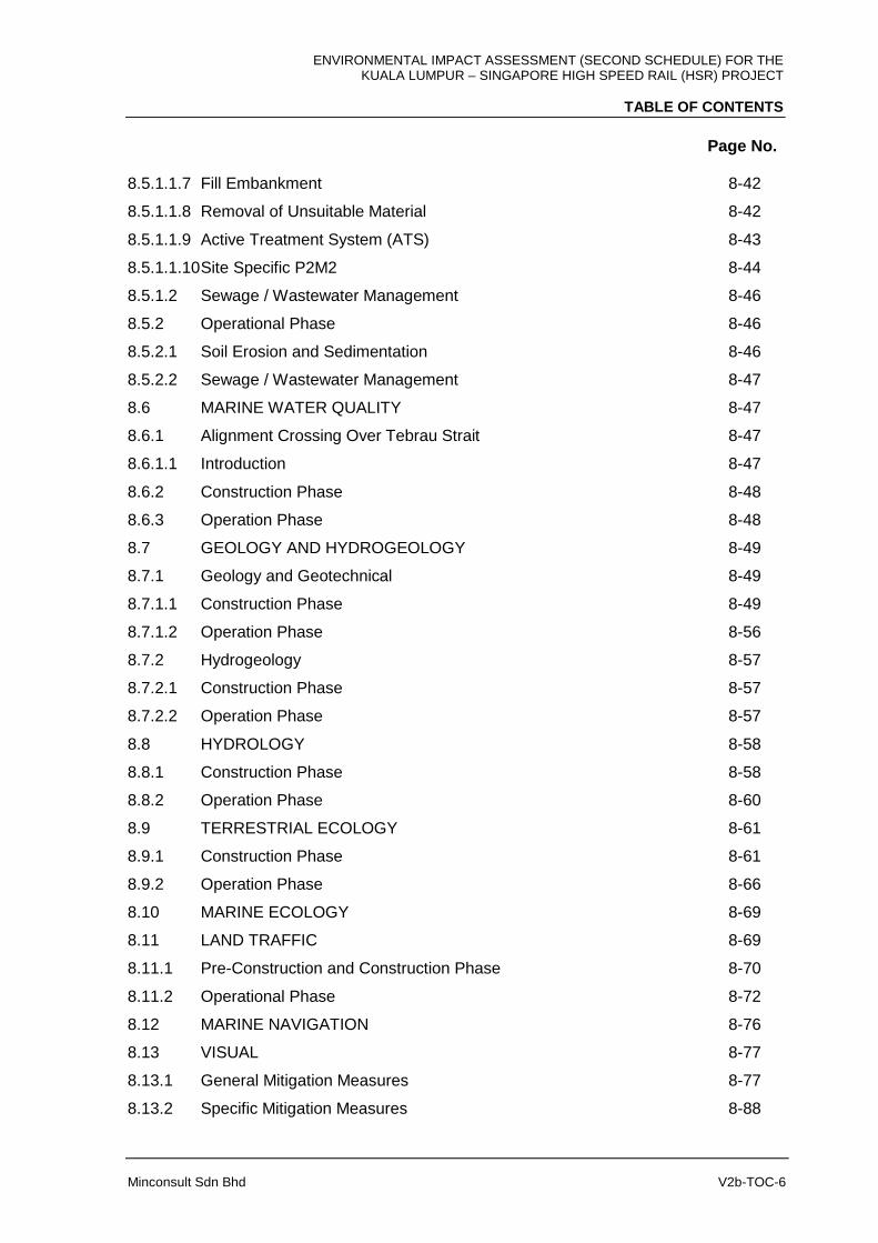
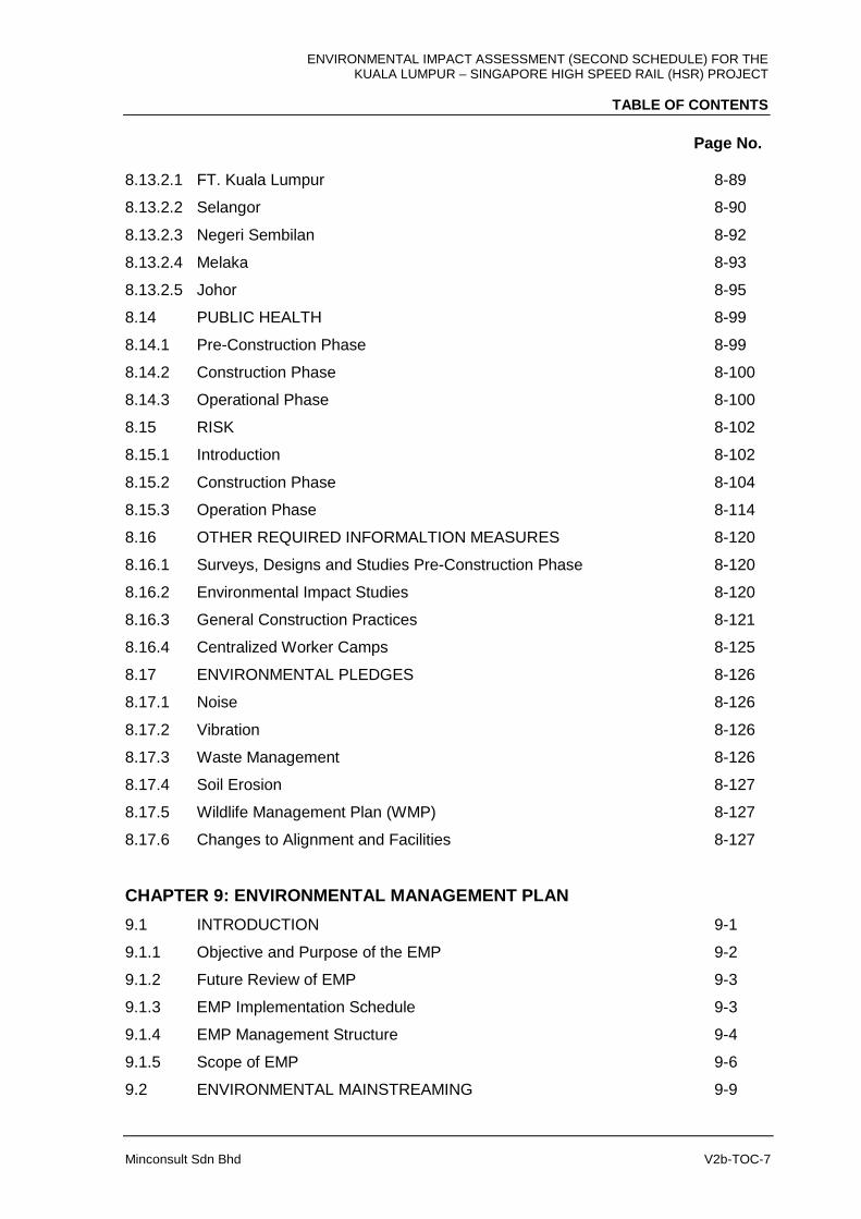
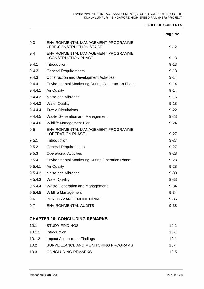
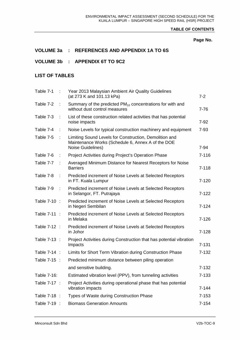
TABLE OF CONTENTS
Page No.
Minconsult Sdn Bhd V2b-TOC-1
VOLUME 1 : EXECUTIVE SUMMARY AND RINGKASAN EKSEKUTIF
VOLUME 2a : MAIN TEXT: CHAPTER 1 TO CHAPTER 6
Chapter 1 : Introduction
Chapter 2 : Terms of Reference of EIA Study
Chapter 3 : Statement of Need
Chapter 4 : Project Options
Chapter 5 : Project Description
Chapter 6 : Existing Environment
VOLUME 2b : MAIN TEXT: CHAPTER 7 TO CHAPTER 10
CHAPTER 7: EVALUATION OF IMPACTS
7.1 INTRODUCTION 7-1
7.2 AIR QUALITY IMPACTS 7-1
7.2.1 Construction Phase 7-1
7.2.1.1 Particulate Matter PM10 Emission Rates 7-3
7.2.1.2 Impact Assessment 7-6
7.2.1.3 Construction Access Roads 7-82
7.2.2 Operational Phase 7-89
7.3 NOISE IMPACTS 7-92
7.3.1 Noise Impacts During Construction 7-92
7.3.2 Operational Phase 7-116
7.4 VIBRATION IMPACTS 7-131
7.4.1 Construction Phase 7-131
7.4.2 Operational Phase 7-144
7.5 WASTE MANAGEMENT IMPACTS 7-151
7.5.1 Construction Phase 7-151
7.5.1.1 Introduction 7-151
7.5.1.2 Nature and Type of Waste Materials 7-152
7.5.1.3 Biomass Clearing Operations 7-154
7.5.1.4 Soil Materials 7-155
7.5.1.5 Construction and Demolition Wastes 7-158
ENVIRONMENTAL IMPACT ASSESSMENT (SECOND SCHEDULE) FOR THE KUALA LUMPUR – SINGAPORE HIGH SPEED RAIL (HSR) PROJECT
TABLE OF CONTENTS
Page No.
Minconsult Sdn Bhd V2b-TOC-2
7.5.1.6 Scheduled Waste 7-158
7.5.1.7 Operational Phase 7-159
7.6 SURFACE WATER QUALITY 7-162
7.6.1 Water Quality 7-162
7.6.1.1 Construction Phase 7-162
7.6.1.2 Operational Phase 7-168
7.6.2 Soil Erosion and Sedimentation 7-171
7.6.2.1 Construction Phase 7-171
7.6.2.1.1 Scope of Assessment 7-171
7.6.2.1.2 Soil Erosion Rate 7-175
7.6.2.1.3 Result of Soil Erosion Assessment 7-179
7.6.2.1.4 Sedimentation Risk Assessment 7-207
7.6.2.1.5 Result of Sediment Yield Assessment 7-208
7.6.2.2 Operational Phase 7-216
7.6.3 Sewage Effluent 7-217
7.6.3.1 Construction Phase 7-217
7.6.3.2 Operational Phase 7-217
7.7 MARINE WATER QUALITY IMPACTS 7-219
7.7.1 Construction Phase 7-219
7.7.1.1 Transportation of Materials and Equipment by Barges 7-219
7.7.1.2 Piling Works 7-220
7.7.1.3 Construction of Elevated Structures/Bridges 7-226
7.7.2 Operational Phase 7-226
7.7.2.1 Footprint of Piers 7-226
7.7.3 Cumulative Impact Assessment 7-239
7.8 GEOLOGY AND HYDROGEOLOGY 7-244
7.8.1 Geology 7-244
7.8.1.1 Pre-Construction Phase 7-244
7.8.1.1.1 Detailed Site Investigation 7-244
7.8.1.2 Construction Phase 7-245
7.8.1.2.1 Slopes 7-255
7.8.1.2.2 Ground Treatment 7-257
7.8.1.3 Operational Phase 7-252
7.8.2 Hydrogeology 7-258
ENVIRONMENTAL IMPACT ASSESSMENT (SECOND SCHEDULE) FOR THE KUALA LUMPUR – SINGAPORE HIGH SPEED RAIL (HSR) PROJECT
TABLE OF CONTENTS
Page No.
Minconsult Sdn Bhd V2b-TOC-3
7.8.2.1 Pre-Construction Phase 7-258
7.8.2.2 Construction Phase 7-258
7.8.2.3 Operational Phase 7-259
7.9 HYDROLOGY 7-260
7.9.1 Pre-Construction Phase 7-260
7.9.2 Construction Phase 7-260
7.9.2.1 FT. Kuala Lumpur 7-261
7.9.2.2 Selangor and FT. Putrajaya 7-263
7.9.2.3 Negeri Sembilan 7-264
7.9.2.4 Melaka 7-267
7.9.2.5 Johor 7-269
7.9.3 Operational Phase 7-272
7.10 TERRESTRIAL ECOLOGY IMPACTS 7-274
7.10.1 Construction Phase 7-274
7.10.2 Operational Phase 7-280
7.11 MARINE ECOLOGY 7-282
7.11.1 Construction Phase 7-282
7.11.1.1 Transportation of Materials and Equipment by Barges 7-282
7.11.1.2 Piling Works 7-283
7.11.2 Operational Phase 7-285
7.11.2.1 Footprint of Piers 7-285
7.11.2.2 Repair and Maintenance Work on Track 7-285
7.12 LAND TRAFFIC 7-286
7.12.1 Pre-construction Phase 7-286
7.12.2 Construction Phase 7-287
7.12.3 Land Traffic Impact during Operation 7-297
7.13 MARINE TRAFFIC 7-303
7.13.1 Construction Phase 7-303
7.13.1.1 Transportation of Materials and Equipment by Barges 7-303
7.13.1.2 Piling Works 7-304
7.13.1.3 Construction of Elevated Structures/Bridges 7-304
7.13.2 Operational Phase 7-304
7.13.2.1 Footprint of Piers 7-305
7.13.2.2 Repair and Maintenance Work on Track 7-305

ENVIRONMENTAL IMPACT ASSESSMENT (SECOND SCHEDULE) FOR THE KUALA LUMPUR – SINGAPORE HIGH SPEED RAIL (HSR) PROJECT
TABLE OF CONTENTS
Page No.
Minconsult Sdn Bhd V2b-TOC-4
7.14 VISUAL IMPACT 7-306
7.14.1 General Impacts Assessment 7-306
7.14.2 Detail Impact Assessment 7-311
7.15 PUBLIC HEALTH IMPACTS 7-319
7.15.1 Pre-Construction Phase 7-319
7.15.2 Construction Phase 7-319
7.15.3 Operational Phase 7-320
7.16 RISK AND HAZARD IMPACTS 7-321
7.16.1 Introduction 7-321
7.16.2 Objective of Risk Assessment 7-322
7.16.3 Scope of Study 7-322
7.16.4 Construction Phase 7-323
7.16.5 Study Procedures 7-323
7.16.6 Identification of Hazards during Construction & Installation 7-323
7.16.7 Exposed Population 7-324
7.16.8 Accident Rates and Frequencies 7-324
7.16.9 Individual Risk and Acceptability 7-326
7.16.10 Risk Assessment of the High Speed Rail 7-328
7.16.11 Risk Control Measures 7-332
7.16.12 Risk and Hazard Assessment for Construction Phase 7-334
7.16.13 Operational Phase 7-338
7.17 ECONOMIC VALUATION OF ENVIRONMENTAL IMPACTS 7-344
7.17.1 Introduction 7-344
7.17.2 Objective 7-345
7.17.3 Methodology 7-345
7.17.4 Identification of Incremental Costs and Benefits 7-347
7.17.5 Valuation of Costs and Benefits 7-347
7.17.5.1 Removal of Mangrove Forest Area 7-352
7.17.5.2 Loss of Non-Forested Area - Oil Palm 7-358
7.17.5.3 Loss of Non-Forested Area – Rubber 7-362
7.17.5.4 Reduction in Green House Gas Emission from Modal Shift 7-367
7.17.5.5 Overall assessment 7-355
7.18 PRE-CONSTRUCTION STAGE 7-382
7.18.1 Surveys, Designs and Studies 7-382
ENVIRONMENTAL IMPACT ASSESSMENT (SECOND SCHEDULE) FOR THE KUALA LUMPUR – SINGAPORE HIGH SPEED RAIL (HSR) PROJECT
TABLE OF CONTENTS
Page No.
Minconsult Sdn Bhd V2b-TOC-5
7.18.2 Land acquisition 7-383
CHAPTER 8: MITIGATION MEASURES
8.1 INTRODUCTION 8-1
8.2 AIR QUALITY 8-1
8.2.1 Construction Phase 8-1
8.2.2 Operational Phase 8-3
8.3 NOISE AND VIBRARION 8-4
8.3.1 Noise 8-4
8.3.1.1 Construction Phase 8-4
8.3.1.2 Operational Phase 8-11
8.3.2 Vibration 8-16
8.3.2.1 Construction Phase 8-16
8.3.2.2 Operational Phase 8-16
8.4 WASTE MANAGEMENT 8-21
8.4.1 Introduction 8-21
8.4.1.1 Construction Phase 8-21
8.4.1.1.1 Biomass Management 8-21
8.4.1.1.2 Soil Materials 8-24
8.4.1.1.3 Construction and Demolition Wastes 8-26
8.4.1.1.4 Domestic Wastes 8-30
8.4.1.1.5 Scheduled Wastes 8-30
8.4.1.2 Operation Phase 8-28
8.4.1.2.1 Domestic Wastes 8-31
8.4.1.2.2 Scheduled Wastes 8-32
8.5 SURFACE WATER QUALITY 8-34
8.5.1 Construction Phase 8-34
8.5.1.1 Soil Erosion and Sedimentation 8-34
8.5.1.1.1 Stations, Depots and Maintenance Bases 8-35
8.5.1.1.2 Construction and Storage Yard 8-36
8.5.1.1.3 Alignment Crossings Over Rivers 8-37
8.5.1.1.4 Road Crossing 8-38
8.5.1.1.5 Tunnel Portals 8-40
8.5.1.1.6 Slope Cutting 8-41
ENVIRONMENTAL IMPACT ASSESSMENT (SECOND SCHEDULE) FOR THE KUALA LUMPUR – SINGAPORE HIGH SPEED RAIL (HSR) PROJECT
TABLE OF CONTENTS
Page No.
Minconsult Sdn Bhd V2b-TOC-6
8.5.1.1.7 Fill Embankment 8-42
8.5.1.1.8 Removal of Unsuitable Material 8-42
8.5.1.1.9 Active Treatment System (ATS) 8-43
8.5.1.1.10 Site Specific P2M2 8-44
8.5.1.2 Sewage / Wastewater Management 8-46
8.5.2 Operational Phase 8-46
8.5.2.1 Soil Erosion and Sedimentation 8-46
8.5.2.2 Sewage / Wastewater Management 8-47
8.6 MARINE WATER QUALITY 8-47
8.6.1 Alignment Crossing Over Tebrau Strait 8-47
8.6.1.1 Introduction 8-47
8.6.2 Construction Phase 8-48
8.6.3 Operation Phase 8-48
8.7 GEOLOGY AND HYDROGEOLOGY 8-49
8.7.1 Geology and Geotechnical 8-49
8.7.1.1 Construction Phase 8-49
8.7.1.2 Operation Phase 8-56
8.7.2 Hydrogeology 8-57
8.7.2.1 Construction Phase 8-57
8.7.2.2 Operation Phase 8-57
8.8 HYDROLOGY 8-58
8.8.1 Construction Phase 8-58
8.8.2 Operation Phase 8-60
8.9 TERRESTRIAL ECOLOGY 8-61
8.9.1 Construction Phase 8-61
8.9.2 Operation Phase 8-66
8.10 MARINE ECOLOGY 8-69
8.11 LAND TRAFFIC 8-69
8.11.1 Pre-Construction and Construction Phase 8-70
8.11.2 Operational Phase 8-72
8.12 MARINE NAVIGATION 8-76
8.13 VISUAL 8-77
8.13.1 General Mitigation Measures 8-77
8.13.2 Specific Mitigation Measures 8-88
ENVIRONMENTAL IMPACT ASSESSMENT (SECOND SCHEDULE) FOR THE KUALA LUMPUR – SINGAPORE HIGH SPEED RAIL (HSR) PROJECT
TABLE OF CONTENTS
Page No.
Minconsult Sdn Bhd V2b-TOC-7
8.13.2.1 FT. Kuala Lumpur 8-89
8.13.2.2 Selangor 8-90
8.13.2.3 Negeri Sembilan 8-92
8.13.2.4 Melaka 8-93
8.13.2.5 Johor 8-95
8.14 PUBLIC HEALTH 8-99
8.14.1 Pre-Construction Phase 8-99
8.14.2 Construction Phase 8-100
8.14.3 Operational Phase 8-100
8.15 RISK 8-102
8.15.1 Introduction 8-102
8.15.2 Construction Phase 8-104
8.15.3 Operation Phase 8-114
8.16 OTHER REQUIRED INFORMALTION MEASURES 8-120
8.16.1 Surveys, Designs and Studies Pre-Construction Phase 8-120
8.16.2 Environmental Impact Studies 8-120
8.16.3 General Construction Practices 8-121
8.16.4 Centralized Worker Camps 8-125
8.17 ENVIRONMENTAL PLEDGES 8-126
8.17.1 Noise 8-126
8.17.2 Vibration 8-126
8.17.3 Waste Management 8-126
8.17.4 Soil Erosion 8-127
8.17.5 Wildlife Management Plan (WMP) 8-127
8.17.6 Changes to Alignment and Facilities 8-127
CHAPTER 9: ENVIRONMENTAL MANAGEMENT PLAN
9.1 INTRODUCTION 9-1
9.1.1 Objective and Purpose of the EMP 9-2
9.1.2 Future Review of EMP 9-3
9.1.3 EMP Implementation Schedule 9-3
9.1.4 EMP Management Structure 9-4
9.1.5 Scope of EMP 9-6
9.2 ENVIRONMENTAL MAINSTREAMING 9-9
ENVIRONMENTAL IMPACT ASSESSMENT (SECOND SCHEDULE) FOR THE KUALA LUMPUR – SINGAPORE HIGH SPEED RAIL (HSR) PROJECT
TABLE OF CONTENTS
Page No.
Minconsult Sdn Bhd V2b-TOC-8
9.3 ENVIRONMENTAL MANAGEMENT PROGRAMME - PRE-CONSTRUCTION STAGE 9-12
9.4 ENVIRONMENTAL MANAGEMENT PROGRAMME - CONSTRUCTION PHASE 9-13
9.4.1 Introduction 9-13
9.4.2 General Requirements 9-13
9.4.3 Construction and Development Activities 9-14
9.4.4 Environmental Monitoring During Construction Phase 9-14
9.4.4.1 Air Quality 9-14
9.4.4.2 Noise and Vibration 9-16
9.4.4.3 Water Quality 9-18
9.4.4.4 Traffic Circulations 9-22
9.4.4.5 Waste Generation and Management 9-23
9.4.4.6 Wildlife Management Plan 9-24
9.5 ENVIRONMENTAL MANAGEMENT PROGRAMME - OPERATION PHASE 9-27
9.5.1 Introduction 9-27
9.5.2 General Requirements 9-27
9.5.3 Operational Activities 9-28
9.5.4 Environmental Monitoring During Operation Phase 9-28
9.5.4.1 Air Quality 9-28
9.5.4.2 Noise and Vibration 9-30
9.5.4.3 Water Quality 9-33
9.5.4.4 Waste Generation and Management 9-34
9.5.4.5 Wildlife Management 9-34
9.6 PERFORMANCE MONITORING 9-35
9.7 ENVIRONMENTAL AUDITS 9-38
CHAPTER 10: CONCLUDING REMARKS
10.1 STUDY FINDINGS 10-1
10.1.1 Introduction 10-1
10.1.2 Impact Assessment Findings 10-1
10.2 SURVEILLANCE AND MONITORING PROGRAMS 10-4
10.3 CONCLUDING REMARKS 10-5
ENVIRONMENTAL IMPACT ASSESSMENT (SECOND SCHEDULE) FOR THE KUALA LUMPUR – SINGAPORE HIGH SPEED RAIL (HSR) PROJECT
TABLE OF CONTENTS
Page No.
Minconsult Sdn Bhd V2b-TOC-9
VOLUME 3a : REFERENCES AND APPENDIX 1A TO 6S VOLUME 3b : APPENDIX 6T TO 9C2
LIST OF TABLES
Table 7-1 : Year 2013 Malaysian Ambient Air Quality Guidelines (at 273 K and 101.13 kPa) 7-2
Table 7-2 : Summary of the predicted PM10 concentrations for with and without dust control measures 7-76
Table 7-3 : List of these construction related activities that has potential noise impacts 7-92
Table 7-4 : Noise Levels for typical construction machinery and equipment 7-93
Table 7-5 : Limiting Sound Levels for Construction, Demolition and Maintenance Works (Schedule 6, Annex A of the DOE Noise Guidelines) 7-94
Table 7-6 : Project Activities during Project’s Operation Phase 7-116
Table 7-7 : Averaged Minimum Distance for Nearest Receptors for Noise Barriers 7-118
Table 7-8 : Predicted increment of Noise Levels at Selected Receptors in FT. Kuala Lumpur 7-120
Table 7-9 : Predicted increment of Noise Levels at Selected Receptors in Selangor, FT. Putrajaya 7-122
Table 7-10 : Predicted increment of Noise Levels at Selected Receptors in Negeri Sembilan 7-124
Table 7-11 : Predicted increment of Noise Levels at Selected Receptors in Melaka 7-126
Table 7-12 : Predicted increment of Noise Levels at Selected Receptors in Johor 7-128
Table 7-13 : Project Activities during Construction that has potential vibration Impacts 7-131
Table 7-14 : Limits for Short Term Vibration during Construction Phase 7-132
Table 7-15 : Predicted minimum distance between piling operation
and sensitive building. 7-132
Table 7-16: Estimated vibration level (PPV), from tunneling activities 7-133
Table 7-17 : Project Activities during operational phase that has potential vibration impacts 7-144
Table 7-18 : Types of Waste during Construction Phase 7-153
Table 7-19 : Biomass Generation Amounts 7-154
ENVIRONMENTAL IMPACT ASSESSMENT (SECOND SCHEDULE) FOR THE KUALA LUMPUR – SINGAPORE HIGH SPEED RAIL (HSR) PROJECT
TABLE OF CONTENTS
Page No.
Minconsult Sdn Bhd V2b-TOC-10
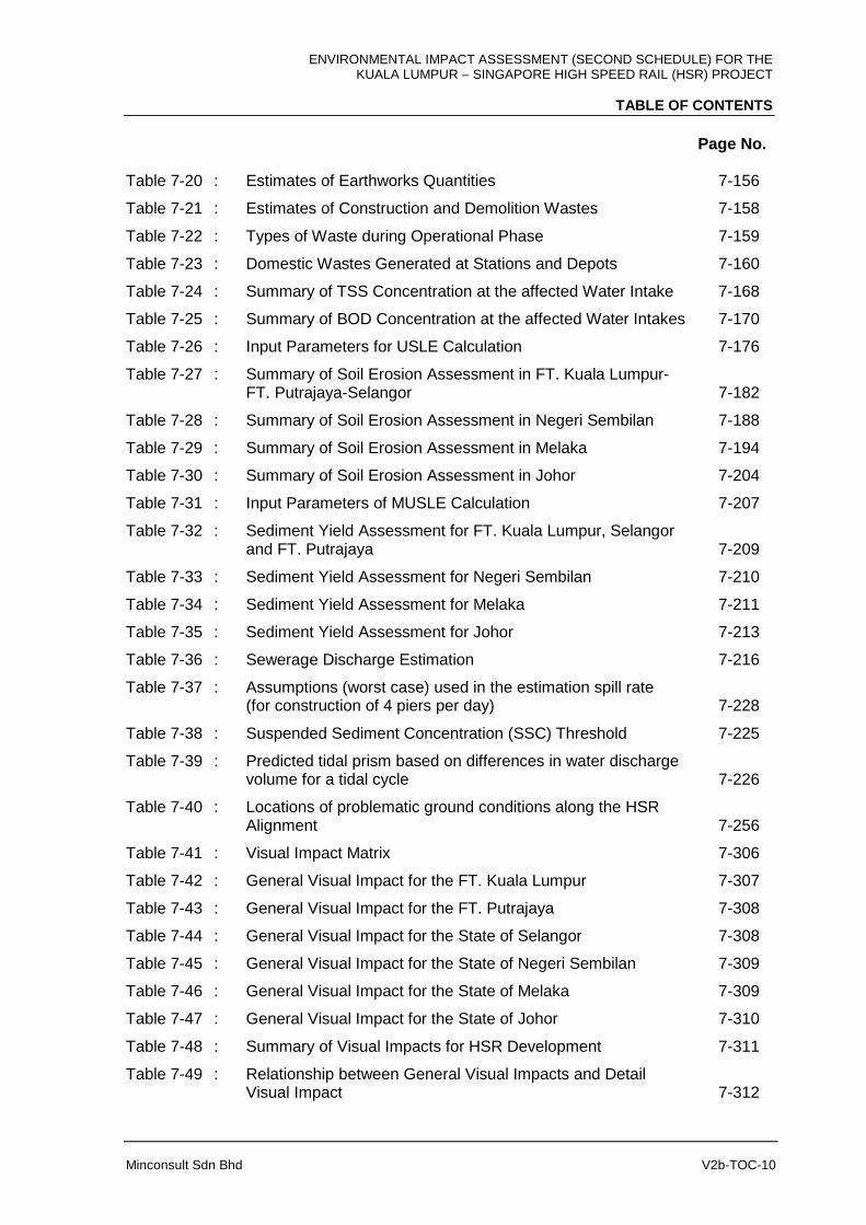
Table 7-20 : Estimates of Earthworks Quantities 7-156
Table 7-21 : Estimates of Construction and Demolition Wastes 7-158
Table 7-22 : Types of Waste during Operational Phase 7-159
Table 7-23 : Domestic Wastes Generated at Stations and Depots 7-160
Table 7-24 : Summary of TSS Concentration at the affected Water Intake 7-168
Table 7-25 : Summary of BOD Concentration at the affected Water Intakes 7-170
Table 7-26 : Input Parameters for USLE Calculation 7-176
Table 7-27 : Summary of Soil Erosion Assessment in FT. Kuala Lumpur- FT. Putrajaya-Selangor 7-182
Table 7-28 : Summary of Soil Erosion Assessment in Negeri Sembilan 7-188
Table 7-29 : Summary of Soil Erosion Assessment in Melaka 7-194
Table 7-30 : Summary of Soil Erosion Assessment in Johor 7-204
Table 7-31 : Input Parameters of MUSLE Calculation 7-207
Table 7-32 : Sediment Yield Assessment for FT. Kuala Lumpur, Selangor and FT. Putrajaya 7-209
Table 7-33 : Sediment Yield Assessment for Negeri Sembilan 7-210
Table 7-34 : Sediment Yield Assessment for Melaka 7-211
Table 7-35 : Sediment Yield Assessment for Johor 7-213
Table 7-36 : Sewerage Discharge Estimation 7-216
Table 7-37 : Assumptions (worst case) used in the estimation spill rate (for construction of 4 piers per day) 7-228
Table 7-38 : Suspended Sediment Concentration (SSC) Threshold 7-225
Table 7-39 : Predicted tidal prism based on differences in water discharge volume for a tidal cycle 7-226
Table 7-40 : Locations of problematic ground conditions along the HSR Alignment 7-256
Table 7-41 : Visual Impact Matrix 7-306
Table 7-42 : General Visual Impact for the FT. Kuala Lumpur 7-307
Table 7-43 : General Visual Impact for the FT. Putrajaya 7-308
Table 7-44 : General Visual Impact for the State of Selangor 7-308
Table 7-45 : General Visual Impact for the State of Negeri Sembilan 7-309
Table 7-46 : General Visual Impact for the State of Melaka 7-309
Table 7-47 : General Visual Impact for the State of Johor 7-310
Table 7-48 : Summary of Visual Impacts for HSR Development 7-311
Table 7-49 : Relationship between General Visual Impacts and Detail Visual Impact 7-312
ENVIRONMENTAL IMPACT ASSESSMENT (SECOND SCHEDULE) FOR THE KUALA LUMPUR – SINGAPORE HIGH SPEED RAIL (HSR) PROJECT
TABLE OF CONTENTS
Page No.
Minconsult Sdn Bhd V2b-TOC-11
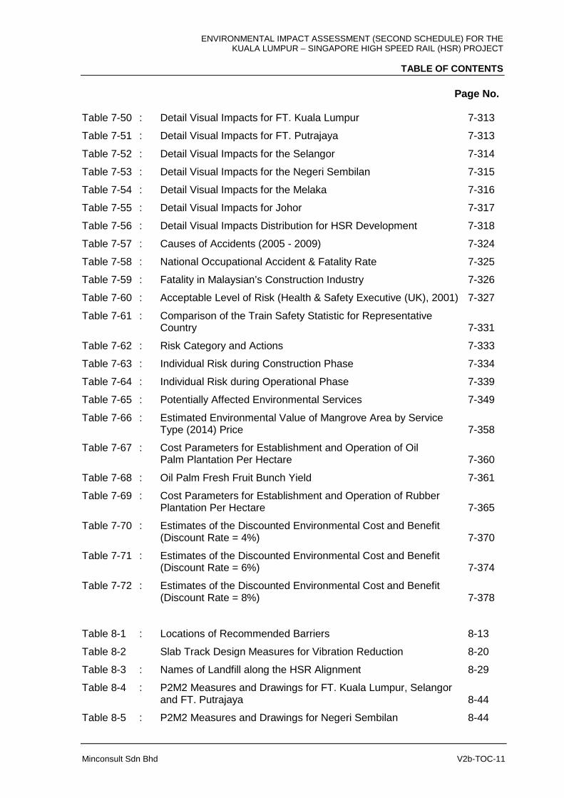
Table 7-50 : Detail Visual Impacts for FT. Kuala Lumpur 7-313
Table 7-51 : Detail Visual Impacts for FT. Putrajaya 7-313
Table 7-52 : Detail Visual Impacts for the Selangor 7-314
Table 7-53 : Detail Visual Impacts for the Negeri Sembilan 7-315
Table 7-54 : Detail Visual Impacts for the Melaka 7-316
Table 7-55 : Detail Visual Impacts for Johor 7-317
Table 7-56 : Detail Visual Impacts Distribution for HSR Development 7-318
Table 7-57 : Causes of Accidents (2005 - 2009) 7-324
Table 7-58 : National Occupational Accident & Fatality Rate 7-325
Table 7-59 : Fatality in Malaysian’s Construction Industry 7-326
Table 7-60 : Acceptable Level of Risk (Health & Safety Executive (UK), 2001) 7-327
Table 7-61 : Comparison of the Train Safety Statistic for Representative Country 7-331
Table 7-62 : Risk Category and Actions 7-333
Table 7-63 : Individual Risk during Construction Phase 7-334
Table 7-64 : Individual Risk during Operational Phase 7-339
Table 7-65 : Potentially Affected Environmental Services 7-349
Table 7-66 : Estimated Environmental Value of Mangrove Area by Service Type (2014) Price 7-358
Table 7-67 : Cost Parameters for Establishment and Operation of Oil Palm Plantation Per Hectare 7-360
Table 7-68 : Oil Palm Fresh Fruit Bunch Yield 7-361
Table 7-69 : Cost Parameters for Establishment and Operation of Rubber Plantation Per Hectare 7-365
Table 7-70 : Estimates of the Discounted Environmental Cost and Benefit (Discount Rate = 4%) 7-370
Table 7-71 : Estimates of the Discounted Environmental Cost and Benefit (Discount Rate = 6%) 7-374
Table 7-72 : Estimates of the Discounted Environmental Cost and Benefit (Discount Rate = 8%) 7-378
Table 8-1 : Locations of Recommended Barriers 8-13
Table 8-2 Slab Track Design Measures for Vibration Reduction 8-20
Table 8-3 : Names of Landfill along the HSR Alignment 8-29
Table 8-4 : P2M2 Measures and Drawings for FT. Kuala Lumpur, Selangor and FT. Putrajaya 8-44
Table 8-5 : P2M2 Measures and Drawings for Negeri Sembilan 8-44
ENVIRONMENTAL IMPACT ASSESSMENT (SECOND SCHEDULE) FOR THE KUALA LUMPUR – SINGAPORE HIGH SPEED RAIL (HSR) PROJECT
TABLE OF CONTENTS
Page No.
Minconsult Sdn Bhd V2b-TOC-12
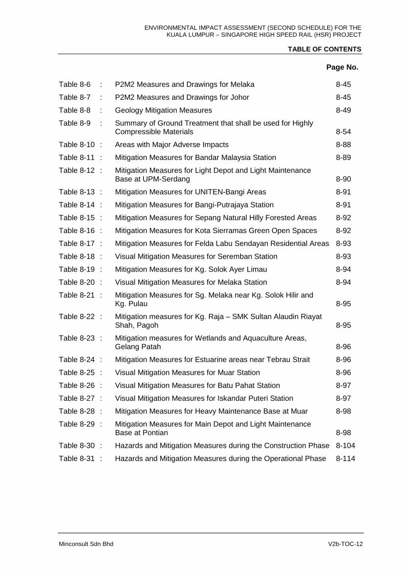
Table 8-6 : P2M2 Measures and Drawings for Melaka 8-45
Table 8-7 : P2M2 Measures and Drawings for Johor 8-45
Table 8-8 : Geology Mitigation Measures 8-49
Table 8-9 : Summary of Ground Treatment that shall be used for Highly Compressible Materials 8-54
Table 8-10 : Areas with Major Adverse Impacts 8-88
Table 8-11 : Mitigation Measures for Bandar Malaysia Station 8-89
Table 8-12 : Mitigation Measures for Light Depot and Light Maintenance Base at UPM-Serdang 8-90
Table 8-13 : Mitigation Measures for UNITEN-Bangi Areas 8-91
Table 8-14 : Mitigation Measures for Bangi-Putrajaya Station 8-91
Table 8-15 : Mitigation Measures for Sepang Natural Hilly Forested Areas 8-92
Table 8-16 : Mitigation Measures for Kota Sierramas Green Open Spaces 8-92
Table 8-17 : Mitigation Measures for Felda Labu Sendayan Residential Areas 8-93
Table 8-18 : Visual Mitigation Measures for Seremban Station 8-93
Table 8-19 : Mitigation Measures for Kg. Solok Ayer Limau 8-94
Table 8-20 : Visual Mitigation Measures for Melaka Station 8-94
Table 8-21 : Mitigation Measures for Sg. Melaka near Kg. Solok Hilir and Kg. Pulau 8-95
Table 8-22 : Mitigation measures for Kg. Raja – SMK Sultan Alaudin Riayat Shah, Pagoh 8-95
Table 8-23 : Mitigation measures for Wetlands and Aquaculture Areas, Gelang Patah 8-96
Table 8-24 : Mitigation Measures for Estuarine areas near Tebrau Strait 8-96
Table 8-25 : Visual Mitigation Measures for Muar Station 8-96
Table 8-26 : Visual Mitigation Measures for Batu Pahat Station 8-97
Table 8-27 : Visual Mitigation Measures for Iskandar Puteri Station 8-97
Table 8-28 : Mitigation Measures for Heavy Maintenance Base at Muar 8-98
Table 8-29 : Mitigation Measures for Main Depot and Light Maintenance Base at Pontian 8-98
Table 8-30 : Hazards and Mitigation Measures during the Construction Phase 8-104
Table 8-31 : Hazards and Mitigation Measures during the Operational Phase 8-114
ENVIRONMENTAL IMPACT ASSESSMENT (SECOND SCHEDULE) FOR THE KUALA LUMPUR – SINGAPORE HIGH SPEED RAIL (HSR) PROJECT
TABLE OF CONTENTS
Page No.
Minconsult Sdn Bhd V2b-TOC-13
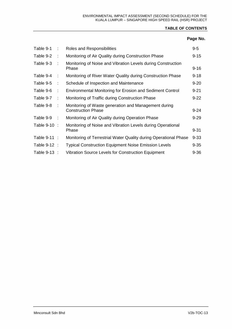
Table 9-1 : Roles and Responsibilities 9-5
Table 9-2 : Monitoring of Air Quality during Construction Phase 9-15
Table 9-3 : Monitoring of Noise and Vibration Levels during Construction Phase 9-16
Table 9-4 : Monitoring of River Water Quality during Construction Phase 9-18
Table 9-5 : Schedule of Inspection and Maintenance 9-20
Table 9-6 : Environmental Monitoring for Erosion and Sediment Control 9-21
Table 9-7 : Monitoring of Traffic during Construction Phase 9-22
Table 9-8 : Monitoring of Waste generation and Management during Construction Phase 9-24
Table 9-9 : Monitoring of Air Quality during Operation Phase 9-29
Table 9-10 : Monitoring of Noise and Vibration Levels during Operational Phase 9-31
Table 9-11 : Monitoring of Terrestrial Water Quality during Operational Phase 9-33
Table 9-12 : Typical Construction Equipment Noise Emission Levels 9-35
Table 9-13 : Vibration Source Levels for Construction Equipment 9-36
ENVIRONMENTAL IMPACT ASSESSMENT (SECOND SCHEDULE) FOR THE KUALA LUMPUR – SINGAPORE HIGH SPEED RAIL (HSR) PROJECT
TABLE OF CONTENTS
Page No.
Minconsult Sdn Bhd V2b-TOC-14
LIST OF FIGURES
Figure 7-1 : Maximum 24-hour Average PM10 Incremental Concentration (ug/m3) With Control Measures: Bandar Malaysia Station 7-8
Figure 7-2 : Annual Average PM10 Incremental Concentration (µg/m3) With Control Measures: Bandar Malaysia Station 7-9
Figure 7-3 : Maximum 24-hour Average PM10 Concentration (µg/m3) Without control measures: Bandar Malaysia Station 7-10
Figure 7-4 : Annual Average PM10 Incremental Concentration (µg/m3) Without Control Measures: Bandar Malaysia Station 7-11
Figure 7-5 : Maximum 24-hour Average PM10 Incremental Concentration (ug/m3) With Control Measures: Bangi-Putrajaya Station 7-14
Figure 7-6 : Annual Average PM10 Incremental Concentration (ug/m3) With Control Measures: Bangi-Putrajaya Station 7-15
Figure 7-7 : Maximum 24-hour Average PM10 Incremental Concentration (ug/m3) Without Control Measures: Bangi-Putrajaya Station 7-16
Figure 7-8 : Annual Average PM10 Incremental Concentration (ug/m3) Without Control Measures: Bangi-Putrajaya Station 7-17
Figure 7-9 : Maximum 24-hour Average PM10 Incremental Concentration (ug/m3) With Control Measures: Light Depot + Light 7-20 Maintenance Base
Figure 7-10 : Annual Average PM10 Incremental Concentration (ug/m3) With Control Measures: Light Depot + Light Maintenance Base 7-21
Figure 7-11 : Maximum 24-hour Average PM10 Incremental Concentration (ug/m3) Without Control Measures: Light Depot + Light Maintenance Base 7-22
Figure 7-12 : Annual Average PM10 Incremental Concentration (ug/m3) Without Control Measures: Light Depot + Light Maintenance Base 7-23
Figure 7-13 : Maximum 24-hour Average PM10 Incremental Concentration (ug/m3) With Control Measures: Seremban Station 7-29
Figure 7-14 : Annual Average PM10 Incremental Concentration (ug/m3) With Control Measures: Seremban Station 7-30
Figure 7-15 : Maximum 24-hour Average PM10 Incremental Concentration (ug/m3) Without Control Measures: Seremban Station 7-31
Figure 7-16 : Annual Average PM10 Incremental Concentration (ug/m3) Without Control Measures: Seremban Station 7-32
Figure 7-17 : Maximum 24-hour Average PM10 Incremental Concentration (ug/m3) With Control Measures: Melaka Station 7-37
Figure 7-18 : Annual Average PM10 Incremental Concentration (ug/m3) With Control Measures: Melaka Station 7-38

ENVIRONMENTAL IMPACT ASSESSMENT (SECOND SCHEDULE) FOR THE KUALA LUMPUR – SINGAPORE HIGH SPEED RAIL (HSR) PROJECT
TABLE OF CONTENTS
Page No.
Minconsult Sdn Bhd V2b-TOC-15
Figure 7-19 : Maximum 24-hour Average PM10 Incremental Concentration (ug/m3) Without Control Measures: Melaka Station 7-39
Figure 7-20 : Maximum 24-hour Average PM10 Incremental Concentration (ug/m3) Without Control Measures: Melaka Station 7-40
Figure 7-21 : Maximum 24-hour Average PM10 Incremental Concentration (ug/m3) With Control Measures: Muar Station 7-45
Figure 7-22 : Annual Average PM10 Incremental Concentration (ug/m3) With Control Measures: Muar Station 7-46
Figure 7-23 : Maximum 24-hour Average PM10 Incremental Concentration (ug/m3) Without Control Measures: Muar Station 7-47
Figure 7-24 : Annual Average PM10 Incremental Concentration (ug/m3) Without Control Measures: Muar Station 7-48
Figure 7-25 : Maximum 24-hour Average PM10 Incremental Concentration (ug/m3) With Control Measures: Heavy Maintenance Base 7-50
Figure 7-26 : Annual Average PM10 Incremental Concentration (ug/m3) With Control Measures: Heavy Maintenance Base 7-51
Figure 7-27 : Maximum 24-hour Average PM10 Incremental Concentration (ug/m3) Without Control Measures: Heavy Maintenance Base 7-52
Figure 7-28 : Annual Average PM10 Incremental Concentration (ug/m3)\ Without Control Measures: Heavy Maintenance Base 7-53
Figure 7-29 : Maximum 24-hour Average PM10 Incremental Concentration (ug/m3) With Control Measures: Batu Pahat Station 7-56
Figure 7-30 : Annual Average PM10 Incremental Concentration (ug/m3) With Control Measures: Batu Pahat Station 7-57
Figure 7-31 : Maximum 24-hour Average PM10 Incremental Concentration (ug/m3) Without Control Measures: Batu Pahat Station 7-58
Figure 7-32 : Annual Average PM10 Incremental Concentration (ug/m3) Without Control Measures: Batu Pahat Station 7-59
Figure 7-33 : Maximum 24-hour Average PM10 Incremental Concentration (ug/m3) With Control Measures: Iskandar Puteri Station 7-62
Figure 7-34 : Annual Average PM10 Incremental Concentration (ug/m3) With Control Measures: Iskandar Puteri Station 7-63
Figure 7-35 : Maximum 24-hour Average PM10 Incremental Concentration (ug/m3) Without Control Measures: Iskandar Puteri Station 7-64
Figure 7-36 : Annual Average PM10 Incremental Concentration (ug/m3) Without Control Measures: Iskandar Puteri Station 7-65
Figure 7-37 : Maximum 24-hour Average PM10 Incremental Concentration (ug/m3) With Control Measures: Main Depot and Light Maintenance Base 7-68
Figure 7-38 : Annual Average PM10 Incremental Concentration (ug/m3) With Control Measures: Main Depot and Light Maintenance
ENVIRONMENTAL IMPACT ASSESSMENT (SECOND SCHEDULE) FOR THE KUALA LUMPUR – SINGAPORE HIGH SPEED RAIL (HSR) PROJECT
TABLE OF CONTENTS
Page No.
Minconsult Sdn Bhd V2b-TOC-16
Base 7-69
Figure 7-39 : Maximum 24-hour Average PM10 Incremental Concentration (ug/m3) Without Control Measures: Main Depot and Light Maintenance Base 7-70
Figure 7-40 : Annual Average PM10 Incremental Concentration (ug/m3) Without Control Measures: Main Depot and Light Maintenance Base 7-71
Figure 7-41 : Maximum 24-hour Average PM10 Incremental Concentration (µg/m3) With Dust Control Measures 7-85
Figure 7-42 : Annual Average PM10 Incremental Concentration (µg/m3) With Dust Control Measures 7-86
Figure 7-43 : Maximum 24-hour Average PM10 Incremental Concentration (µg/m3) Without Dust Control Measures 7-87
Figure 7-44 : Annual Average PM10 Incremental Concentration (µg/m3) Without Dust Control Measures 7-88
Figure 7-45 : Predicted noise contours during the tunnelling construction
phase at Kg Baru Salak Selatan (noise limit of 65 dBA shown
by red lines) 7-98
Figure 7-46 : PPV levels for various train types on at grade structure 7-145
Figure 7-47 : Location of Bandar Malaysia Station 7-179
Figure 7-48 : Location of Light Depot & LMB and Bangi-Putrajaya Station 7-180
Figure 7-49 : Location of Alignment Crossings at Sg. Langat and Sg. Semenyih 7-181
Figure 7-50 : Location of Alignment Crossings at Seremban Station and Crossings of Sg. Labu 7-184
Figure 7-51 : Location of Alignment Crossing Sg. Batang Labu 7-185
Figure 7-52 : Location of Alignment Crossing Sg. Lukut Besar 7-186
Figure 7-53 : Location of Alignment Crossing Sg. Linggi 7-187
Figure 7-54 : Location of Melaka Station, Alignment Crossings of Sg. Durian Tunggal and Sg. Melaka 7-189
Figure 7-55 : Location of Alignment Crossing Sg. Linggi 7-191
Figure 7-56 : Location of Alignment Crossing Sg. Ayer Panas and Sg. Bemban 7-192
Figure 7-57 : Location of Alignment Crossing Sg. Kesang 7-193
Figure 7-58 : Location of Muar Station, HMB and Sg. Muar Crossing 7-196
Figure 7-59 : Location of Batu Pahat Station, Alignment Crossings of Sg. Simpang Kanan and Sg. Simpang Kiri 7-197
Figure 7-60 : Location of Iskandar Puteri Station 7-198
Figure 7-61 : Location of Main Depot & LMB, Alignment Crossings of
ENVIRONMENTAL IMPACT ASSESSMENT (SECOND SCHEDULE) FOR THE KUALA LUMPUR – SINGAPORE HIGH SPEED RAIL (HSR) PROJECT
TABLE OF CONTENTS
Page No.
Minconsult Sdn Bhd V2b-TOC-17
Sg. Ulu Choh, Sg. Pulai, Sg. Jelutong and Sg. Gelang Patah 7-199
Figure 7-62 : Location of Alignment Crossing at Sg. Kesang 7-200
Figure 7-63 : Location of Alignment Crossings at Sg. Pontian Besar and Sg. Ayer Hitam Besar 7-201
Figure 7-64 : Predicted difference in mean current speed during construction phase (Inter-monsoon) 7-221
Figure 7-65 : Predicted difference in maximum current speed during construction phase (Inter-monsoon) 7-221
Figure 7-66 : Predicted difference in mean current speed during construction Phase 7-222
Figure 7-67 : Predicted difference in maximum current speed during construction phase (Northeast Monsoon) 7-222
Figure 7-68 : Predicted difference in mean current speed during construction phase (Southwest monsoon) 7-223
Figure 7-69 : Predicted difference in maximum current speed during construction phase (Southwest monsoon) 7-223
Figure 7-70 : Maximum excess TSS levels for inter (top), northeast (middle) and southwest (bottom) monsoon conditions 7-225
Figure 7-71 : Transect line L1 and L2 for calculation of tidal prism 7-227
Figure 7-72 : Predicted Difference in Annual Bed Level Change During Operational Phase 7-228
Figure 7-73 : Predicted difference in maximum water levels during operational phase (Inter-monsoon). 7-230
Figure 7-74 : Predicted difference in maximum water levels during operational phase (Northeast monsoon) 7-230
Figure 7-75 : Predicted difference in mean current speed during operational phase (Inter-monsoon) 7-231
Figure 7-76 : Predicted difference in maximum current speed during operational phase (Inter-monsoon) 7-232
Figure 7-77 : Predicted difference in mean current speed during operational phase (Northeast monsoon) 7-232
Figure 7-78 : Predicted difference in maximum current speed during operational phase (Northeast monsoon) 7-233
Figure 7-79 : Predicted difference in mean current speed during operational phase (Southwest monsoon) 7-233
Figure 7-80 : Predicted difference in maximum current speed during operational phase Southwest monsoon) 7-234
Figure 7-81 : Predicted difference in maximum water levels during operational phase (Southwest monsoon) 7-234
Figure 7-82 : Predicted difference in mean significant wave height during operational phase (inter-monsoon) 7-235
ENVIRONMENTAL IMPACT ASSESSMENT (SECOND SCHEDULE) FOR THE KUALA LUMPUR – SINGAPORE HIGH SPEED RAIL (HSR) PROJECT
TABLE OF CONTENTS
Page No.
Minconsult Sdn Bhd V2b-TOC-18
Figure 7-83 : Predicted difference in maximum significant wave height during operational phase (inter-monsoon) 7-236
Figure 7-84 : Predicted difference in mean significant wave height during operational phase (Northeast monsoon) 7-236
Figure 7-85 : Predicted difference in maximum significant wave height during operational phase (Northeast monsoon) 7-237
Figure 7-86 : Predicted difference in mean significant wave height during operational phase (Southwest monsoon) 7-237
Figure 7-87 : Predicted difference of maximum significant wave height during operational phase (Southwest monsoon) 7-238
Figure 7-88 : Projects considered in the cumulative impact assessment 7-240
Figure 7-89 : Predicted differences in mean current speed for cumulative layout compared to baseline. Without HSR alignment (top) and with HSR alignment (bottom) 7-242
Figure 7-90 : Predicted differences in maximum current speed for cumulative layout compared to baseline. Without HSR alignment (top) and with HSR alignment (bottom) 7-243
Figure 7-91 : Karstic features of limestone 7-246
Figure 7-92 : The tunnel route along the HSR alignment will be constructed mainly in karstic Kuala Lumpur Limestone (JMG, 2010) 7-247
Figure 7-93 : The tunnel excavation in Kuala Lumpur will be constructed laterally at lower surface topography (Elevation 50 m) 7-248
Figure 7-94 : A second tunnel in Selangor with a length of 2.3 km cutting hill at the highest magnitude of 182 m 7-249
Figure 7-95 : First tunnel in Negeri Sembilan with a length of 0.4 km and elevation 101 m 7-250
Figure 7-96 : Second tunnel in Negeri Sembilan with a length of 0.4 km and elevation 110 m 7-251
Figure 7-97 : A proposed tunnel location in Pagoh, Johor with a length of 2.16 m and terrain elevation of 190 m 7-255
Figure 7-98 : Construction proposed and HSR alignment structures type with
hydrology aspect in FT. Kuala Lumpur 7-261
Figure 7-99 : Construction proposed and HSR alignment structures type with
hydrology aspect in Selangor and FT. Putrajaya 7-264
Figure 7-100 : Construction proposed and HSR alignment structures type with
hydrology aspect in Negeri Sembilan 7-266
Figure 7-101 : Construction proposed and HSR alignment structures type with
hydrology aspect in Melaka 7-268
ENVIRONMENTAL IMPACT ASSESSMENT (SECOND SCHEDULE) FOR THE KUALA LUMPUR – SINGAPORE HIGH SPEED RAIL (HSR) PROJECT
TABLE OF CONTENTS
Page No.
Minconsult Sdn Bhd V2b-TOC-19
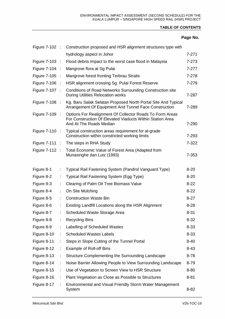
Figure 7-102 : Construction proposed and HSR alignment structures type with
hydrology aspect in Johor 7-271
Figure 7-103 : Flood debris impact to the worst case flood in Malaysia 7-273
Figure 7-104 : Mangrove flora at Sg Pulai 7-277
Figure 7-105 : Mangrove forest fronting Terbrau Straits 7-278
Figure 7-106 : HSR alignment crossing Sg. Pulai Forest Reserve 7-279
Figure 7-107 : Conditions of Road Networks Surrounding Construction site During Utilities Relocation works 7-287
Figure 7-108 : Kg. Baru Salak Selatan Proposed North Portal Site And Typical Arrangement Of Equipment And Tunnel Face Construction 7-289
Figure 7-109 : Options For Realignment Of Collector Roads To Form Areas For Construction Of Elevated Viaducts Within Station Area And At The Roads Median 7-290
Figure 7-110 : Typical construction areas requirement for at-grade Construction within constricted working limits 7-293
Figure 7-111 : The steps in RHA Study 7-322
Figure 7-112 : Total Economic Value of Forest Area (Adapted from Munasinghe dan Lutz (1993) 7-353
Figure 8-1 : Typical Rail Fastening System (Pandrol Vanguard Type) 8-20
Figure 8-2 : Typical Rail Fastening System (Egg Type) 8-20
Figure 8-3 : Clearing of Palm Oil Tree Biomass Value 8-22
Figure 8-4 : On Site Mulching 8-22
Figure 8-5 : Construction Waste Bin 8-27
Figure 8-6 : Existing Landfill Locations along the HSR Alignment 8-28
Figure 8-7 : Scheduled Waste Storage Area 8-31
Figure 8-8 : Recycling Bins 8-32
Figure 8-9 : Labelling of Scheduled Wastes 8-33
Figure 8-10 : Scheduled Wastes Labels 8-33
Figure 8-11 : Steps in Slope Cutting of the Tunnel Portal 8-40
Figure 8-12 : Example of Roll-off Bins 8-43
Figure 8-13 : Structure Complementing the Surrounding Landscape 8-78
Figure 8-14 : Noise Barrier Allowing People to View Surrounding Landscape 8-79
Figure 8-15 : Use of Vegetation to Screen View to HSR Structure 8-80
Figure 8-16 : Plant Vegetation as Close as Possible to Structures 8-81
Figure 8-17 : Environmental and Visual Friendly Storm Water Management System 8-82
ENVIRONMENTAL IMPACT ASSESSMENT (SECOND SCHEDULE) FOR THE KUALA LUMPUR – SINGAPORE HIGH SPEED RAIL (HSR) PROJECT
TABLE OF CONTENTS
Page No.
Minconsult Sdn Bhd V2b-TOC-20
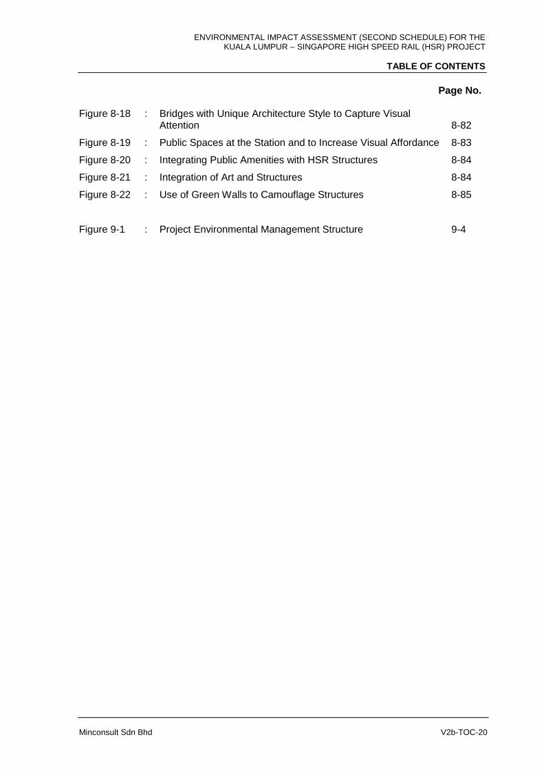
Figure 8-18 : Bridges with Unique Architecture Style to Capture Visual Attention 8-82
Figure 8-19 : Public Spaces at the Station and to Increase Visual Affordance 8-83
Figure 8-20 : Integrating Public Amenities with HSR Structures 8-84
Figure 8-21 : Integration of Art and Structures 8-84
Figure 8-22 : Use of Green Walls to Camouflage Structures 8-85
Figure 9-1 : Project Environmental Management Structure 9-4
ENVIRONMENTAL IMPACT ASSESSMENT (SECOND SCHEDULE) FOR THE KUALA LUMPUR – SINGAPORE HIGH SPEED RAIL (HSR) PROJECT
TABLE OF CONTENTS
Minconsult Sdn Bhd V2b-TOC-21
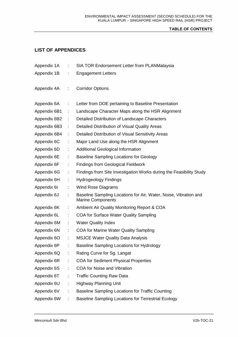
LIST OF APPENDICES
Appendix 1A : SIA TOR Endorsement Letter from PLANMalaysia
Appendix 1B : Engagement Letters
Appendix 4A : Corridor Options
Appendix 6A : Letter from DOE pertaining to Baseline Presentation
Appendix 6B1 : Landscape Character Maps along the HSR Alignment
Appendix 6B2 : Detailed Distribution of Landscape Characters
Appendix 6B3 : Detailed Distribution of Visual Quality Areas
Appendix 6B4 : Detailed Distribution of Visual Sensitivity Areas
Appendix 6C : Major Land Use along the HSR Alignment
Appendix 6D : Additional Geological Information
Appendix 6E : Baseline Sampling Locations for Geology
Appendix 6F : Findings from Geological Fieldwork
Appendix 6G : Findings from Site Investigation Works during the Feasibility Study
Appendix 6H : Hydrogeology Findings
Appendix 6I : Wind Rose Diagrams
Appendix 6J : Baseline Sampling Locations for Air, Water, Noise, Vibration and Marine Components
Appendix 6K : Ambient Air Quality Monitoring Report & COA
Appendix 6L : COA for Surface Water Quality Sampling
Appendix 6M : Water Quality Index
Appendix 6N : COA for Marine Water Quality Sampling
Appendix 6O : MSJCE Water Quality Data Analysis
Appendix 6P : Baseline Sampling Locations for Hydrology
Appendix 6Q : Rating Curve for Sg. Langat
Appendix 6R : COA for Sediment Physical Properties
Appendix 6S : COA for Noise and Vibration
Appendix 6T : Traffic Counting Raw Data
Appendix 6U : Highway Planning Unit
Appendix 6V : Baseline Sampling Locations for Traffic Counting
Appendix 6W : Baseline Sampling Locations for Terrestrial Ecology
ENVIRONMENTAL IMPACT ASSESSMENT (SECOND SCHEDULE) FOR THE KUALA LUMPUR – SINGAPORE HIGH SPEED RAIL (HSR) PROJECT
TABLE OF CONTENTS
Minconsult Sdn Bhd V2b-TOC-22
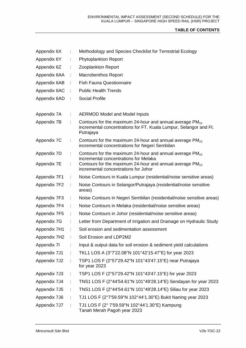
Appendix 6X : Methodology and Species Checklist for Terrestrial Ecology
Appendix 6Y : Phytoplankton Report
Appendix 6Z : Zooplankton Report
Appendix 6AA : Macrobenthos Report
Appendix 6AB : Fish Fauna Questionnaire
Appendix 6AC : Public Health Trends
Appendix 6AD : Social Profile
Appendix 7A : AERMOD Model and Model Inputs
Appendix 7B : Contours for the maximum 24-hour and annual average PM10 incremental concentrations for FT. Kuala Lumpur, Selangor and Ft. Putrajaya
Appendix 7C : Contours for the maximum 24-hour and annual average PM10 incremental concentrations for Negeri Sembilan
Appendix 7D : Contours for the maximum 24-hour and annual average PM10 incremental concentrations for Melaka Appendix 7E : Contours for the maximum 24-hour and annual average PM10 incremental concentrations for Johor
Appendix 7F1 : Noise Contours in Kuala Lumpur (residential/noise sensitive areas)
Appendix 7F2 : Noise Contours in Selangor/Putrajaya (residential/noise sensitive areas)
Appendix 7F3 : Noise Contours in Negeri Sembilan (residential/noise sensitive areas)
Appendix 7F4 : Noise Contours in Melaka (residential/noise sensitive areas)
Appendix 7F5 : Noise Contours in Johor (residential/noise sensitive areas)
Appendix 7G : Letter from Department of Irrigation and Drainage on Hydraulic Study
Appendix 7H1 : Soil erosion and sedimentation assessment
Appendix 7H2 : Soil Erosion and LDP2M2
Appendix 7I : Input & output data for soil erosion & sediment yield calculations
Appendix 7J1 : TKL1 LOS A (3°7'22.08"N 101°42'15.47"E) for year 2023
Appendix 7J2 : TSP1 LOS F (2°57'29.42"N 101°43'47.15"E) near Putrajaya for year 2023
Appendix 7J3 : TSP1 LOS F (2°57'29.42"N 101°43'47.15"E) for year 2023
Appendix 7J4 : TNS1 LOS F (2°44'54.61"N 101°49'28.14"E) Sendayan for year 2023
Appendix 7J5 : TNS1 LOS F (2°44'54.61"N 101°49'28.14"E) Siliau for year 2023
Appendix 7J6 : TJ1 LOS F (2°7'59.59"N 102°44'1.30"E) Bukit Naning year 2023
Appendix 7J7 : TJ1 LOS F (2° 7'59.59"N 102°44'1.30"E) Kampung Tanah Merah Pagoh year 2023
ENVIRONMENTAL IMPACT ASSESSMENT (SECOND SCHEDULE) FOR THE KUALA LUMPUR – SINGAPORE HIGH SPEED RAIL (HSR) PROJECT
TABLE OF CONTENTS
Minconsult Sdn Bhd V2b-TOC-23
Appendix 7K : Raw Data for Traffic Impact during Construction
Appendix 7L1 : TKL1 LOS F (3°7'22.08"N 101°42'15.47"E) for year 2030
Appendix 7L2 : TKL1 LOS F (3°7'22.08"N 101°42'15.47"E) for year 2060
Appendix 7L3 : TSP1 LOS F (2°57'29.42"N 101°43'47.15"E) for year 2030
Appendix 7L4 : TSP1 LOS F (2°57'29.42"N 101°43'47.15"E) for year 2060
Appendix 7L5 : TNS1 LOS F (2°44'54.61"N 101°49'28.14"E) for year 2060
Appendix 7L6 : TNS1 LOS F (2°44'54.61"N 101°49'28.14"E) for year 2030
Appendix 7L7 : TM1 LOS F (2°17'47.73"N 102°18'32.98"E) year 2030
Appendix 7L8 : TM1 LOS F (2°17'47.73"N 102°18'32.98"E) year 2060
Appendix 7L9 : TJ1 LOS F (2° 7'59.59"N 102°44'1.30"E) year 2030
Appendix 7L10 : TJ1 LOS F (2° 7'59.59"N 102°44'1.30"E) year 2060
Appendix 7L11 : TJ2 LOS F (1°51'16.47"N 103° 1'22.50"E) year 2030
Appendix 7L12 : TJ2 LOS F (1°51'16.47"N 103° 1'22.50"E) year 2060
Appendix 7L13 : TJ3 LOS F (1°26'50.01" N103°35'23.48"E) year 2030
Appendix 7L14 : TJ3 LOS F (1°26'50.01" N103°35'23.48"E) year 2060
Appendix 7M : General visual impacts
Appendix 7N : Detailed visual impacts
Appendix 7O1 : FT. Kuala Lumpur visual impact maps
Appendix 7O2 : FT. Putrajaya visual impact maps
Appendix 7O3 : Selangor visual impact maps
Appendix 7O4 : Negeri Sembilan visual impact maps
Appendix 7O5 : Melaka visual impact maps
Appendix 7O6 : Johor visual impact maps
Appendix 7P : Water Quality Modeling
Appendix 8A : Landfill Locations and Details
Appendix 8B : Mangrove
Appendix 8C : Specific Mitigation Measures for Federal Territories and States
Appendix 9A : Air Quality Monitoring Locations
Appendix 9B1 : Noise and Vibration Monitoring Points (Construction)
Appendix 9B2 : Noise and Vibration Monitoring Points (Operational)
Appendix 9C1 : Water Quality Monitoring Locations (Construction)
Appendix 9C2 : Water Quality Monitoring Locations (Operational)
ENVIRONMENTAL IMPACT ASSESSMENT (SECOND SCHEDULE) FOR THE KUALA LUMPUR – SINGAPORE HIGH SPEED RAIL (HSR) PROJECT
TABLE OF CONTENTS
Minconsult Sdn Bhd V2b-TOC-24
LIST OF ABBREVIATION
11MP Eleventh Malaysia Plan AHP Analytical Hierarchy Process ARI Average Recurrence Interval BOD Biochemical Oxygen Demand BP Bored Piling CBD Central Business Districts CF Carbon Footprint CFSR Climate Forecast System Reanalysis CGSO Chief Government Security Office CHSR Conventional High Speed Rail CIQ Customs, Immigration and Quarantine CO2 Carbon Dioxide COD Chemical Oxygen Demand CSO Customer Service Office DGPS Differential Global Positioning System DID Department of Irrigation and Drainage DOE Department of Environment EIA Environmental Impact Assessment E-P Employment-population EPB Earth Pressure Balance EPP Entry Point Projects ERL Express Rail Link ESA Environmental Sensitive Areas ESI Environmental Scoping Information ETP Economic Transformation Programme FHTS Futuristic Hyperloop Train System FT Federal Territory GAQM Guideline on Air Quality Models GBI Green Building Index GDP Gross Domestic Product GEV General Extreme Value GHG Green House Gasses GIS Geographic Information System GNI Gross National Income Greater KL / KV Greater Kuala Lumpur / Klang Valley HIA Heritage Impact Assessment HMB Heavy Maintenance Base HPU Highway Planning Unit HSR High Speed Rail IKBN Institut Kemahiran Belia Negara INFRA Institut Kemajuan Desa INSPEN Institut Penilaian Negara

ENVIRONMENTAL IMPACT ASSESSMENT (SECOND SCHEDULE) FOR THE KUALA LUMPUR – SINGAPORE HIGH SPEED RAIL (HSR) PROJECT
TABLE OF CONTENTS
Minconsult Sdn Bhd V2b-TOC-25
IRDA Iskandar Regional Development Authority ITCZ Intertropical Convergence Zone ITD Integrated Transport District JBIA Johor Bahru International Airport JKR Public Works Department JMG Department of Mineral and Geoscience Malaysia JUPEM Department of Survey and Mapping Malaysia Kg. Kampung KKM Kementrian Kesihatan Malaysia, Ministry of Health KTM Keretapi Tanah Melayu LIDAR Light Detection and Ranging LMB Light Maintenance Base LOS Level of service LTA Land Transport Authority MAAQG Malaysian Ambient Air Quality Guidelines MHST Maglev High Speed Train System MSJCE Malaysian-Singapore Joint Committee on the Environment MSL Mean Sea Level MVV Malaysia Vision Valley secretariat MY - SG Malaysia - Singapore MyHSR Corp MyHSR Corporation Sdn Bhd NATM New Austrian Tunneling Method NKEA National Key Economic Area NSE North-South Expressway NTU NephelometricTurbidity Unit NWQS National Water Quality Standard OCS Overhead Catenary System OHLE Overhead Line Electrification ORR Office of Rail and Road PDP Project Delivery Partner PE Population Equivalent PERHILITAN Department of Wildlife and National Parks Peninsular Malaysia PERKESO Pertubuhan Keselamatan Sosial Malaysia PLANMalaysia Federal Department of Town and Country Planning PM Particulate Matter PM10 Particulate Matter 10 micrometers or less in diameter PM2.5 Particulate Matter 2.5 micrometers or less in diameter PPV Peak Particle Velocity PVS Peak Vector Sum R&D Research and Development RDC Reference Design Consultants ROW Right Of Way (30 m to 100 m) RPZ Railway Protection Zone SDF Strategic Development Framework SEL Sound Exposure Level
ENVIRONMENTAL IMPACT ASSESSMENT (SECOND SCHEDULE) FOR THE KUALA LUMPUR – SINGAPORE HIGH SPEED RAIL (HSR) PROJECT
CHAPTER 7: EVALUATION OF IMPACTS
Minconsult Sdn Bhd Chapter 7-1
7.1 INTRODUCTION
In this Chapter, impacts which Project activities could induce on adjacent environmental
resources and receptors, during its pre-construction, construction and operational phase, are
elucidated. The impact assessment that has been conducted has relied on the nature and
scope of Project activities as described in Chapter 5, as well as on the information presented
in Chapter 6 on the current status of environmental receptors and resources that have been
signaled out as having the potential to be impacted upon by the HSR Project.
The scope, intensity and temporal and spatial characteristics of each impact are elaborated
in this Chapter. Mitigation measures which are recommended to be adopted, in addition to
those already inculcated in preliminary designs, so as to reduce adverse impacts to tolerable
levels are described in Chapter 8. The assessment matrix for the Project can be found at
the end of this chapter.
7.2 AIR QUALITY IMPACTS
7.2.1 Construction Phase
Air pollution is a significant environmental perturbation that will occur during the construction
phase of the HSR Project. Suspended Particulate Matter (SPM) is expected to be generated
during site preparation activities and during earthworks operations; especially during clearing
of project areas when ground areas are laid bare. Earthwork operations will churn up soil
layers and thereby exacerbate tendencies for particles to become airborne as dust particles.
Stockpiles of topsoil, uncovered loads on construction vehicles and unprotected cleared
areas are other potential SPM sources. In addition, SPM could be generated during
unsealed road use by construction traffic. SPM emissions often vary substantially from day
to day, depending on the level of activity, the specific operations, and prevailing
meteorological conditions.
For this study the SPM parameter which will be employed to predict dust impacts on the
environment is PM10; i.e. particulate matter less than 10 microns. The reasons being that
firstly this parameter is the one of only two SPM components assigned a baseline ambient
regulatory standard under the Year 2013 Malaysian Ambient Air Quality Guidelines
ENVIRONMENTAL IMPACT ASSESSMENT (SECOND SCHEDULE) FOR THE KUALA LUMPUR – SINGAPORE HIGH SPEED RAIL (HSR) PROJECT
CHAPTER 7: EVALUATION OF IMPACTS
Minconsult Sdn Bhd Chapter 7-2
(MAAQG); the other parameter being PM2.5. These two particle sizes are capable of being
drawn into a person’s lungs and thereby induce health hazards. The parameter PM2.5 is not
considered in this study as its presence in dusts associated with earthworks is minute.
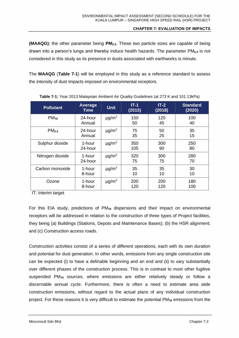
The MAAQG (Table 7-1) will be employed in this study as a reference standard to assess
the intensity of dust impacts imposed on environmental receptors.
Table 7-1: Year 2013 Malaysian Ambient Air Quality Guidelines (at 273 K and 101.13kPa)
Pollutant Average
Time Unit
IT-1 (2015)
IT-2 (2018)
Standard (2020)
PM10 24-hour Annual
µg/m3 150 50
120 45
100 40
PM2.5 24-hour Annual
µg/m3 75 35
50 25
35 15
Sulphur dioxide
1-hour 24-hour
µg/m3 350 105
300 90
250 80
Nitrogen dioxide
1-hour 24-hour
µg/m3 320 75
300 75
280 70
Carbon monoxide
1-hour 8-hour
µg/m3 35 10
35 10
30 10
Ozone
1-hour 8-hour
µg/m3 200 120
200 120
180 100
IT: Interim target
For this EIA study, predictions of PM10 dispersions and their impact on environmental
receptors will be addressed in relation to the construction of three types of Project facilities,
they being (a) Buildings (Stations, Depots and Maintenance Bases); (b) the HSR alignment;
and (c) Construction access roads.
Construction activities consist of a series of different operations, each with its own duration
and potential for dust generation. In other words, emissions from any single construction site
can be expected (i) to have a definable beginning and an end and (ii) to vary substantially
over different phases of the construction process. This is in contrast to most other fugitive
suspended PM10 sources, where emissions are either relatively steady or follow a
discernable annual cycle. Furthermore, there is often a need to estimate area wide
construction emissions, without regard to the actual plans of any individual construction
project. For these reasons it is very difficult to estimate the potential PM10 emissions from the
ENVIRONMENTAL IMPACT ASSESSMENT (SECOND SCHEDULE) FOR THE KUALA LUMPUR – SINGAPORE HIGH SPEED RAIL (HSR) PROJECT
CHAPTER 7: EVALUATION OF IMPACTS
Minconsult Sdn Bhd Chapter 7-3
sources. However, it can be said that the quantity of PM10 emissions from construction
operations are (i) proportional to the area of land being worked and to the level of
construction activity, (ii) positively correlated with the silt content of the soil, (iii) dependant
on the speed and weight of the average vehicle and (iv) negatively correlated with the soil
moisture content. A more significant potential cause of increased PM10 levels during
construction will be inappropriate disposal of vegetation during site clearance and
preparation.
Based on these limitations and a set of field studies which attempts to relate the emissions
from construction directly to an emission factor, the approximate emission factor for
construction activity operations is (USEPA, 1995):
E = 2.69 megagrams (Mg)/hectare/month of activity
This value is most useful for developing estimates of overall emissions from construction
activity scattered throughout a geographical area. The value is most applicable to
construction operations with: (i) medium activity level, (ii) moderate silt contents, and (iii)
semi-arid climate which is applicable in this assessment study.
7.2.1.1 Particulate Matter PM10 Emission Rates
The HSR Project is to be developed over four (4) states and two (2) federal territories. For
purposes of assessing air quality impacts, the Project Area is divided into four (4) sectors,
namely (i) FT. Kuala Lumpur/ FT. Putrajaya / Selangor, (ii) Negeri Sembilan, (iii) Melaka and
(iv) Johor. The amount of PM10 emitted for each construction activity at each location is
computed based on the size of the construction area and the duration of the construction
activity using the above formula, E = 2.69 megagrams (Mg)/hectare/month of activity. As the
construction area for each facility is different, the following are the emission rates of PM10 for
each facility.

ENVIRONMENTAL IMPACT ASSESSMENT (SECOND SCHEDULE) FOR THE KUALA LUMPUR – SINGAPORE HIGH SPEED RAIL (HSR) PROJECT
CHAPTER 7: EVALUATION OF IMPACTS
Minconsult Sdn Bhd Chapter 7-4
i) Sepang-Putrajaya, Seremban, Melaka, Muar and Batu Pahat Stations
Site areas demarcated for the Sepang-Putrajaya, Seremban, Melaka, Muar and Batu Pahat
Stations are all similar in size i.e. 13 ha. Expected construction period for the stations is 36
months. The gross amount of particulate emission per station site is estimated to be
1,258.92 Mg (2.69 X 13 X 36). The corresponding temporal emission rates are (a) 34.97
Mg/month (1,258.92 / 36); (b) 1,166 kg/day (assuming there are 30 days in a month); and
97.1 kg/hr (1,166 /12) or 26.98 g/s assuming that construction activities are conducted only
during a period of 12 hours a day. The estimated PM10 uncontrolled emission rate of 26.98
g/s is derived from USEPA’s assumption that fifty percent of construction related suspended
particulate matter is made of PM10 particles (page 13.2.5-14, A.P. -42, USEPA 1995).
However, in the case when there are control measures such as keeping exposed surfaces
moist, covered and paved, the emission rate can be reduced by as much as 98 to 99
percent. For modeling purposes, the PM10 emission rate was assumed to be reduced by 98
percent; as such the emission rate employed in the modeling is 0.27 g/s for the with control
measure scenario.
ii) Bandar Malaysia and Iskandar Puteri Station
The Bandar Malaysia and Iskandar Puteri Station are each 26 ha in area; with an expected
construction period of 36 months.
The gross amount of particulate emission per station site is estimated to be 2517.84 Mg
(2.69 X 26 X 36). The corresponding temporal emission rates are (a) 69.94 Mg/month
(2517.84/36); (b) 2331 kg/day (assuming there are 30 days in a month); and 194 kg/hr
(2,331 /12 ) or 54.9 g/s assuming that construction activities are conducted only during a
period of 12 hours a day. The estimated PM10 uncontrolled emission rate of 54.9 g/s is
derived from USEPA’s assumption that fifty percent of construction related suspended
particulate matter is made of PM10 particles (page 13.2.5-14, A.P. -42, USEPA 1995).
However, in the case when there are control measures such as keeping exposed surfaces
moist, covered and paved, the emission rate can be reduced by as much as 98 to 99
percent. For modeling purposes, the PM10 emission rate was assumed to be reduced by 98
percent; as such the emission rate employed in the modeling is 0.55 g/s for the with control
measure scenario.

ENVIRONMENTAL IMPACT ASSESSMENT (SECOND SCHEDULE) FOR THE KUALA LUMPUR – SINGAPORE HIGH SPEED RAIL (HSR) PROJECT
CHAPTER 7: EVALUATION OF IMPACTS
Minconsult Sdn Bhd Chapter 7-5
iii) Light Depot and Light Maintenance Base, Serdang
The Light Depot and Light Maintenance Base (LMB) is located in Serdang, Selangor
covering an area of 70 ha. By the same method of calculations as above, the PM10 emission
rate when there are dust control measures taken is estimated at 1.48 g/s; and for the without
control measures case, the emission rate is predicted to be 74.03 g/s.
(iv) Heavy Maintenance Base, Muar
For the Heavy Maintenance Base (HMB) located in Muar, covering an area of 10 ha, the
PM10 emission rate when there are dust control measures in place is predicted to be 0.21
g/s; and for the case without control measures, the PM10 emission rate is predicted to be
10.6 g/s.
(v) Main Depot and Light Maintenance Base, Pontian
The size of the Main Depot and Light Maintenance Base, Pontian is 110 ha. The PM10
emissions from the construction of this facility are expected to be large and significant. The
PM10 emission rate is predicted to be 2.32 g/s for the with control measure scenario, and
116.3 g/s for the without control measures scenario.
(vi) HSR Alignment
Construction of the HSR alignment will entail the construction of columns, bridges, tunnels
and other structures including the alignment itself. For construction of the alignment, the
width of the alignment is taken as 50 m and construction area of 2 ha. With this area, the
PM10 emission rate is 0.042 g/s for the with control scenario and 2.07 g/s for the without
control measures scenario.
ENVIRONMENTAL IMPACT ASSESSMENT (SECOND SCHEDULE) FOR THE KUALA LUMPUR – SINGAPORE HIGH SPEED RAIL (HSR) PROJECT
CHAPTER 7: EVALUATION OF IMPACTS
Minconsult Sdn Bhd Chapter 7-6
7.2.1.2 Impact Assessment
The air quality impact assessment is conducted in accordance with USEPA Guideline on Air
Quality Models (GAQM; as incorporated in Appendix W of 40 CFR Part 51). The guideline
recommends a three (3) phase approach which is as follows;
Phase 1. Apply a simple screening procedure to determine if either (i) the source clearly
poses no air quality problem or (ii) the potential for an air quality problem exists.
Phase 2. If the simplified screening results indicate a potential threat to air quality, further
analysis is warranted, and the detailed screening (basic modelling) procedures should be
applied.
Phase 3. If the detailed screening results or other factors indicate a problem, then a more
refined analysis is necessary.
As this assessment involves fugitive emissions, a refined analysis was conducted. It should
be noted that the USEPA promulgated a revision to the Guideline on Air Quality Models
(GAQM) on November 9, 2005 and the revised version of GAQM adopts AERMOD as the
preferred dispersion model.
Dispersion modeling for this EIA study was conducted employing the USEPA’s AERMOD
model (Version 15181, July 2015) together with one year of meteorological data generated
by the Mesoscale Meteorological Model (MM5) for each Project sector. This one-year data
set is processed with AERMET, the meteorological processor for AERMOD, in accordance
with guidelines provided by USEPA in the recently revised AERMOD Implementation Guide
(AIG; USEPA, March 19, 2009). Details of the AERMOD Model are presented in Appendix
7A.
Air quality impact assessments carried out for the HSR Project were spread over four (4)
sectors, namely (i) the FT. Kuala Lumpur / FT. Putrajaya / Selangor sector, (ii) the Negeri
Sembilan sector, (iii) the Melaka sector, and (iv) the Johor sector. Within each sector dust
dispersions induced by the construction of stations, depots/maintenance bases and the HSR
alignment itself were modeled.
ENVIRONMENTAL IMPACT ASSESSMENT (SECOND SCHEDULE) FOR THE KUALA LUMPUR – SINGAPORE HIGH SPEED RAIL (HSR) PROJECT
CHAPTER 7: EVALUATION OF IMPACTS
Minconsult Sdn Bhd Chapter 7-7
A) FT. Kuala Lumpur / FT. Putrajaya / Selangor
Construction of the Bandar Malaysia Station, the Sepang-Putrajaya Station, the Light Depot
and Light Maintenance Base (LMB), Serdang and the HSR alignment will take place within
the FT. Kuala Lumpur / FT. Putrajaya / Selangor sector. Their construction activities could
impact on the air quality status in the vicinity of these respective sites.
Bandar Malaysia Station
The maximum 24-hour average PM10 incremental concentrations predicted to be imposed on
areas surrounding the Station site, arising from construction activities conducted within the
Station site when there are dust control measures being implemented, is depicted in Figure
7-1. The affected areas are at the construction site itself and areas surrounding it. The
increase in PM10 concentration varies between a low of 1 µg/m3 at distances of
approximately 2 km away and 20 µg/m3 at the boundary of the project site, with the highest
level of 30 µg/m3 occurring within project site. Even with the additional PM10 concentrations
that are predicted to be imposed at the locality of Receptor A1 (existing monitored baseline
PM10 concentration of 35 µg/m3), and at the existing Station site boundaries, the resulting
absolute ambient air PM10 concentration will still be below the corresponding 24 hour PM10
Malaysian Ambient Air Quality Guideline (MAAQG) 2020 target standard of 100 µg/m3 at
these areas. Similarly, elsewhere, the maximum 24-hour average PM10 concentration is also
predicted to be below the MAAQG limit.

ENVIRONMENTAL IMPACT ASSESSMENT (SECOND SCHEDULE) FOR THE KUALA LUMPUR – SINGAPORE HIGH SPEED RAIL (HSR) PROJECT
CHAPTER 7: EVALUATION OF IMPACTS
Minconsult Sdn Bhd Chapter 7-8
Figure 7-1: Maximum 24-hour Average PM10 Incremental Concentration (µg/m3)
With Control Measures: Bandar Malaysia Station
On an annual average basis, the incremental PM10 annual average concentration is
predicted to be between 0.1 µg/m3 at 1.5 km away from the station site and approximately 1
µg/m3 at the project site boundary as shown in Figure 7-2. These incremental
concentrations are insignificant and expected to be below the annual average MAAQG 2020
PM10 target standard of 40 µg/m3.

ENVIRONMENTAL IMPACT ASSESSMENT (SECOND SCHEDULE) FOR THE KUALA LUMPUR – SINGAPORE HIGH SPEED RAIL (HSR) PROJECT
CHAPTER 7: EVALUATION OF IMPACTS
Minconsult Sdn Bhd Chapter 7-9
Figure 7-2: Annual Average PM10 Incremental Concentration (µg/m3)
With Control Measures: Bandar Malaysia Station
In the event that there are no dust control measures being adopted to reduce dust emissions
during the station’s construction phase, the maximum 24-hour average PM10 incremental
concentrations that will be imposed at the edge of the receptor grid, at the project site
boundary and within the project site are predicted to be of the order of 20 µg/m3, more than
500 µg/m3 and be about 1,000 µg/m3 respectively. The contours of the predicted incremental
concentration are shown in Figure 7-3. Based on an existing PM10 baseline concentration of
between 35 µg/m3 and 41 µg/m3 measured at Receptors A1 and A2 respectively, the
resulting cumulative predicted ambient air PM10 concentration will be well above the MAAQG
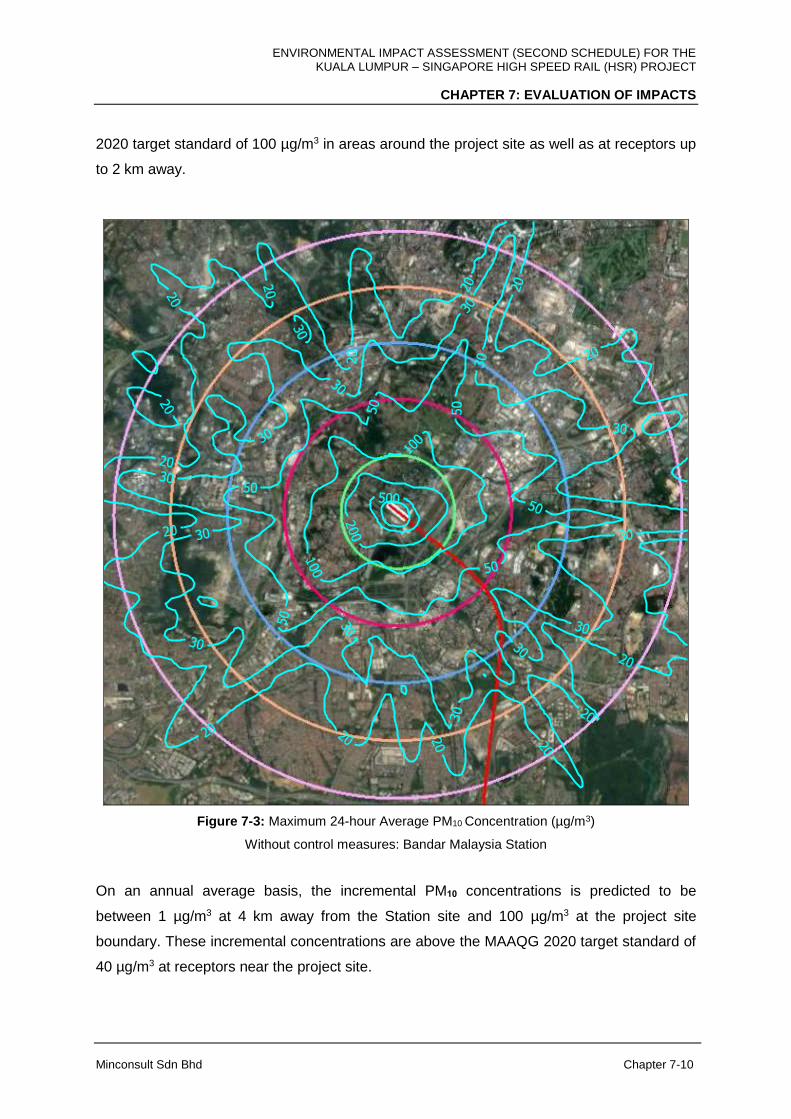
ENVIRONMENTAL IMPACT ASSESSMENT (SECOND SCHEDULE) FOR THE KUALA LUMPUR – SINGAPORE HIGH SPEED RAIL (HSR) PROJECT
CHAPTER 7: EVALUATION OF IMPACTS
Minconsult Sdn Bhd Chapter 7-10
2020 target standard of 100 µg/m3 in areas around the project site as well as at receptors up
to 2 km away.
Figure 7-3: Maximum 24-hour Average PM10 Concentration (µg/m3)
Without control measures: Bandar Malaysia Station
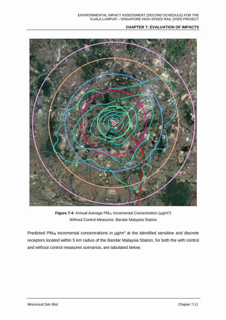
On an annual average basis, the incremental PM10 concentrations is predicted to be
between 1 µg/m3 at 4 km away from the Station site and 100 µg/m3 at the project site
boundary. These incremental concentrations are above the MAAQG 2020 target standard of
40 µg/m3 at receptors near the project site.
ENVIRONMENTAL IMPACT ASSESSMENT (SECOND SCHEDULE) FOR THE KUALA LUMPUR – SINGAPORE HIGH SPEED RAIL (HSR) PROJECT
CHAPTER 7: EVALUATION OF IMPACTS
Minconsult Sdn Bhd Chapter 7-11
Figure 7-4: Annual Average PM10 Incremental Concentration (µg/m3)
Without Control Measures: Bandar Malaysia Station
Predicted PM10 incremental concentrations in µg/m3 at the identified sensitive and discrete
receptors located within 5 km radius of the Bandar Malaysia Station, for both the with control
and without control measures scenarios, are tabulated below;

ENVIRONMENTAL IMPACT ASSESSMENT (SECOND SCHEDULE) FOR THE KUALA LUMPUR – SINGAPORE HIGH SPEED RAIL (HSR) PROJECT
CHAPTER 7: EVALUATION OF IMPACTS
Minconsult Sdn Bhd Chapter 7-12
i) With control measures
Receptor Existing baseline (µg/m3)
Incremental concentration (µg/m3)
Ambient air concentration (µg/m3)
24-hour average
Annual average
24-hour average
Annual average
Bandar Malaysia Station, A1
35 21.6 3.4 56.6 -
Bandar Sri Permaisuri, A2
41 1.0 0.1 42.0 -
MAAQG 2020 Target 100 40
ii) Without control measures
Receptor Existing baseline (µg/m3)
Incremental concentration (µg/m3)
Ambient air concentration (µg/m3)
24-hour average
Annual average
24-hour average
Annual average
Bandar Malaysia Station, A1
35 1,079 172 1,104 -
Bandar Sri Permaisuri, A2
41 48 3 89 -
MAAQG 2020 Target 100 40
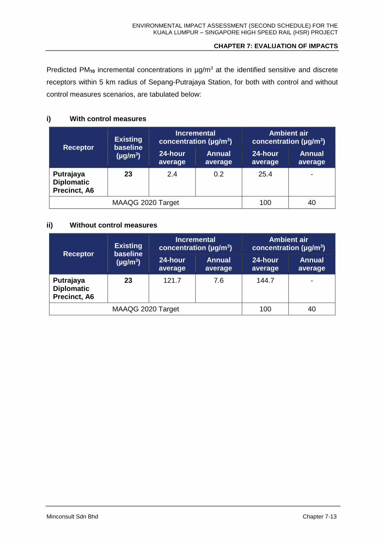
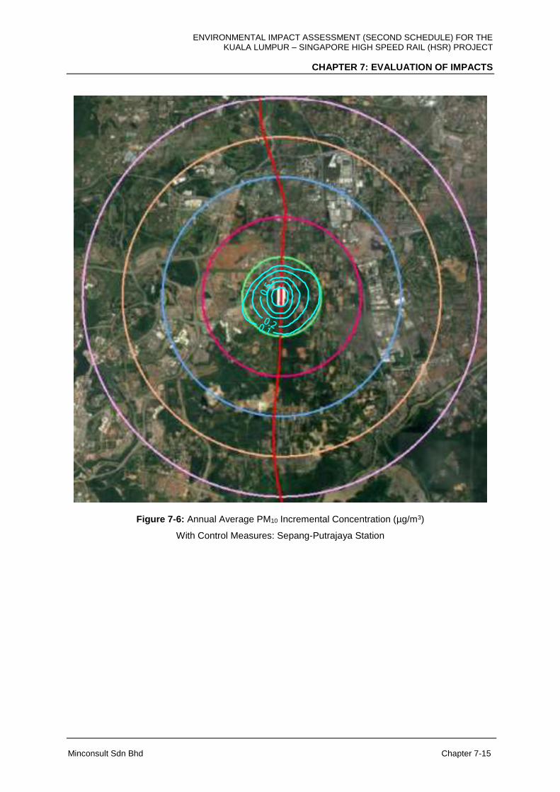
Sepang-Putrajaya Station
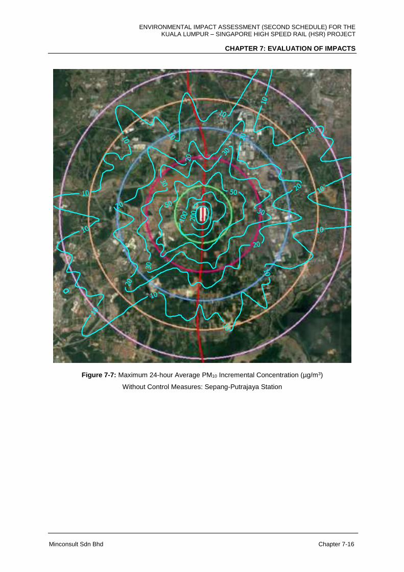
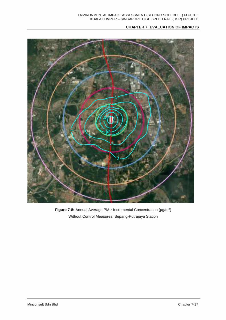
Air quality impacts that could be induced by the construction of the Sepang-Putrajaya Station
are similar in scope to that predicted for the Bandar Malaysia Station as discussed above.
However the impacted areas are smaller in size, and predicted PM10 imposed concentrations
are lower, as the size of the construction area is smaller. When there are no dust control
measures being adopted at the construction site, areas which will exceed the MAAQG limits
for PM10 concentrations will be located within approximately 1 km from the Project site.
Contours of the predicted maximum 24-hour average and annual average PM10 incremental
concentrations, for both with and without control measures scenarios, are shown in Figures
7-5 to 7-8 respectively.
ENVIRONMENTAL IMPACT ASSESSMENT (SECOND SCHEDULE) FOR THE KUALA LUMPUR – SINGAPORE HIGH SPEED RAIL (HSR) PROJECT
CHAPTER 7: EVALUATION OF IMPACTS
Minconsult Sdn Bhd Chapter 7-13
Predicted PM10 incremental concentrations in µg/m3 at the identified sensitive and discrete
receptors within 5 km radius of Sepang-Putrajaya Station, for both with control and without
control measures scenarios, are tabulated below:
i) With control measures
Receptor Existing baseline (µg/m3)
Incremental concentration (µg/m3)
Ambient air concentration (µg/m3)
24-hour average
Annual average
24-hour average
Annual average
Putrajaya Diplomatic Precinct, A6
23 2.4 0.2 25.4 -
MAAQG 2020 Target 100 40
ii) Without control measures
Receptor Existing baseline (µg/m3)
Incremental concentration (µg/m3)
Ambient air concentration (µg/m3)
24-hour average
Annual average
24-hour average
Annual average
Putrajaya Diplomatic Precinct, A6
23
121.7 7.6 144.7 -
MAAQG 2020 Target 100 40

ENVIRONMENTAL IMPACT ASSESSMENT (SECOND SCHEDULE) FOR THE KUALA LUMPUR – SINGAPORE HIGH SPEED RAIL (HSR) PROJECT
CHAPTER 7: EVALUATION OF IMPACTS
Minconsult Sdn Bhd Chapter 7-14
Figure 7-5: Maximum 24-hour Average PM10 Incremental Concentration (µg/m3)
With Control Measures: Sepang-Putrajaya Station
ENVIRONMENTAL IMPACT ASSESSMENT (SECOND SCHEDULE) FOR THE KUALA LUMPUR – SINGAPORE HIGH SPEED RAIL (HSR) PROJECT
CHAPTER 7: EVALUATION OF IMPACTS
Minconsult Sdn Bhd Chapter 7-15
Figure 7-6: Annual Average PM10 Incremental Concentration (µg/m3)
With Control Measures: Sepang-Putrajaya Station
ENVIRONMENTAL IMPACT ASSESSMENT (SECOND SCHEDULE) FOR THE KUALA LUMPUR – SINGAPORE HIGH SPEED RAIL (HSR) PROJECT
CHAPTER 7: EVALUATION OF IMPACTS
Minconsult Sdn Bhd Chapter 7-16
Figure 7-7: Maximum 24-hour Average PM10 Incremental Concentration (µg/m3)
Without Control Measures: Sepang-Putrajaya Station
ENVIRONMENTAL IMPACT ASSESSMENT (SECOND SCHEDULE) FOR THE KUALA LUMPUR – SINGAPORE HIGH SPEED RAIL (HSR) PROJECT
CHAPTER 7: EVALUATION OF IMPACTS
Minconsult Sdn Bhd Chapter 7-17
Figure 7-8: Annual Average PM10 Incremental Concentration (µg/m3)
Without Control Measures: Sepang-Putrajaya Station

ENVIRONMENTAL IMPACT ASSESSMENT (SECOND SCHEDULE) FOR THE KUALA LUMPUR – SINGAPORE HIGH SPEED RAIL (HSR) PROJECT
CHAPTER 7: EVALUATION OF IMPACTS
Minconsult Sdn Bhd Chapter 7-18
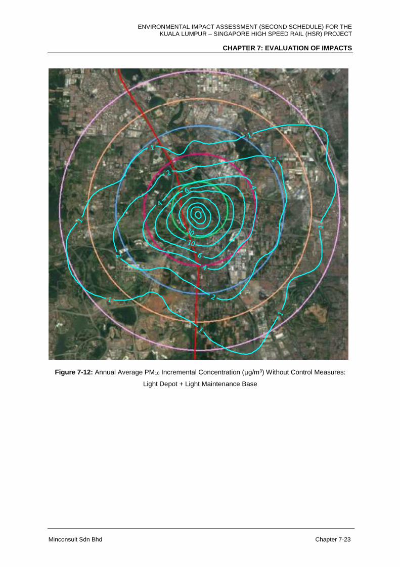
Light Depot and Light Maintenance Base, Serdang
The Light Depot and Light Maintenance Base (LMB), Serdang is to be located within a larger
area in comparison to the Bandar Malaysia Station and Sepang-Putrajaya Station. As such
the scope of land clearing activities will be comparatively more intensive. Predictive air
quality modeling results indicate that higher PM10 incremental concentrations will be imposed
on surrounding areas compared to the development of the two (2) Stations discussed above.
However if dust control measures are inculcated in construction activities, the imposed
additional PM10 concentrations will not raise ambient PM10 levels above the MAAQG target
limits. The imposed PM10 concentration profiles around the Depot when there dust control
measures in place are as shown in Figures 7-9 to 7-10. However, in a worst case scenario,
when there are no dust control measures adopted during earthwork operations, the
predicted maximum 24-hour average PM10 concentrations imposed on surrounding areas
will raise the current ambient 24 hour average PM10 concentrations to be above the
corresponding MAAQG target limits in areas up to 2 km from the project site; and up to 1 km
from the project site if annual average PM10 concentrations are considered (Figures 7-11 to
7-12).
Predicted PM10 incremental concentrations in µg/m3 at the identified sensitive and discrete
receptors located within 5 km radius of the Light Depot and Light Maintenance Base,
Serdang for both the with control and without control measures scenarios are tabulated
below:

ENVIRONMENTAL IMPACT ASSESSMENT (SECOND SCHEDULE) FOR THE KUALA LUMPUR – SINGAPORE HIGH SPEED RAIL (HSR) PROJECT
CHAPTER 7: EVALUATION OF IMPACTS
Minconsult Sdn Bhd Chapter 7-19
i) With control measures
Receptor Existing baseline (µg/m3)
Incremental concentration (µg/m3)
Ambient air concentration (µg/m3)
24-hour average
Annual average
24-hour average
Annual average
Seri Kembangan Medical Clinic, A4
40 0.4 0.1 40.4 -
Light Depot and LMB, A5
20 9.2 0.2 29.2 -
Putrajaya Diplomatic Precinct, A6
23 0.4 0.1 23.4 -
MAAQG 2020 Target 100 40
ii) Without control measures
Receptor Existing baseline (µg/m3)
Incremental concentration (µg/m3)
Ambient air concentration (µg/m3)
24-hour average
Annual average
24-hour average
Annual average
Seri Kembangan Medical Clinic, A4
40 16.4 0.4 46.4 -
Light Depot and LMB, A5
20 417.1 12.3 437.1 -
Putrajaya Diplomatic Precinct, A6
23 20.1 0.5 43.1 -
MAAQG 2020 Target 100 40

ENVIRONMENTAL IMPACT ASSESSMENT (SECOND SCHEDULE) FOR THE KUALA LUMPUR – SINGAPORE HIGH SPEED RAIL (HSR) PROJECT
CHAPTER 7: EVALUATION OF IMPACTS
Minconsult Sdn Bhd Chapter 7-20
Figure 7-9: Maximum 24-hour Average PM10 Incremental Concentration (µg/m3)
With Control Measures: Light Depot + Light Maintenance Base

ENVIRONMENTAL IMPACT ASSESSMENT (SECOND SCHEDULE) FOR THE KUALA LUMPUR – SINGAPORE HIGH SPEED RAIL (HSR) PROJECT
CHAPTER 7: EVALUATION OF IMPACTS
Minconsult Sdn Bhd Chapter 7-21
Figure 7-10: Annual Average PM10 Incremental Concentration (µg/m3) With Control Measures: Light
Depot + Light Maintenance Base

ENVIRONMENTAL IMPACT ASSESSMENT (SECOND SCHEDULE) FOR THE KUALA LUMPUR – SINGAPORE HIGH SPEED RAIL (HSR) PROJECT
CHAPTER 7: EVALUATION OF IMPACTS
Minconsult Sdn Bhd Chapter 7-22
Figure 7-11: Maximum 24-hour Average PM10 Incremental Concentration (µg/m3) Without Control
Measures: Light Depot + Light Maintenance Base
ENVIRONMENTAL IMPACT ASSESSMENT (SECOND SCHEDULE) FOR THE KUALA LUMPUR – SINGAPORE HIGH SPEED RAIL (HSR) PROJECT
CHAPTER 7: EVALUATION OF IMPACTS
Minconsult Sdn Bhd Chapter 7-23
Figure 7-12: Annual Average PM10 Incremental Concentration (µg/m3) Without Control Measures:
Light Depot + Light Maintenance Base
ENVIRONMENTAL IMPACT ASSESSMENT (SECOND SCHEDULE) FOR THE KUALA LUMPUR – SINGAPORE HIGH SPEED RAIL (HSR) PROJECT
CHAPTER 7: EVALUATION OF IMPACTS
Minconsult Sdn Bhd Chapter 7-24
HSR Alignment, FT. Kuala Lumpur/ FT. Putrajaya/Selangor
Construction of the HSR alignment and associated structures (At-Grade, Elevated structres,
Bridges and Tunnels) involve smaller working areas and, as expected, potential dust related
impacts are minimal especially when there are dust control measures being adopted during
construction; and moderate when there are no control measures adopted. Contours
representing the maximum 24-hour and annual average PM10 incremental imposed
concentrations are shown in Appendix 7B.
Predicted PM10 incremental concentrations in µg/m3 at the identified sensitive and discrete
receptors located within 5 km radius of the HSR alignment placed within FT. Kuala Lumpur /
FT. Putrajaya / Selangor for both the with control and without control measures scenario are
tabulated below;
i) With control measures
Receptor Existing baseline (µg/m3)
Incremental concentration (µg/m3)
Ambient air concentration (µg/m3)
24-hour average
Annual average
24-hour average
Annual average
Taman Serdang Pertama, A3
37 1.7 0.2 38.7 -
Seri Kembangan Medical Clinic, A4
40 6.5 1.5 46.5 -
Sekolah Menengah Teknik Sepang, A7
26 0.8 0.1 26.8 -
SMA Majlis Agama Islam Wilayah Persekutuan
- 1.72 0.25 - -
Kg. Baru Salak Selatan
- 8.30 3.05 - -
Sekolah Kebangsaan Desa Petaling, Masjid Al-Khasyiin
- 8.48 3.05 - -

ENVIRONMENTAL IMPACT ASSESSMENT (SECOND SCHEDULE) FOR THE KUALA LUMPUR – SINGAPORE HIGH SPEED RAIL (HSR) PROJECT
CHAPTER 7: EVALUATION OF IMPACTS
Minconsult Sdn Bhd Chapter 7-25
Receptor Existing baseline (µg/m3)
Incremental concentration (µg/m3)
Ambient air concentration (µg/m3)
24-hour average
Annual average
24-hour average
Annual average
Lakefields Phase 1
- 8.34 2.85 - -
DJZ Building - 5.39 1.23 - -
UNITEN - 8.51 3.03 - -
Sekolah Kebangsaan Sri Serdang
- 4.08 0.90 - -
SJK (C) Kung Man
- 1.85 0.28 - -
Kg Dato' Abu Bakar Baginda
- 8.53 3.02 - -
Sekolah Kebangsaan Desa Putra
- 3.32 0.72 - -
Kg. Jenderam Hulu
- 2.05 0.34 - -
MAAQG 2020 Target 100 40
ii) Without control measures
Receptor Existing baseline (µg/m3)
Incremental concentration (µg/m3)
Ambient air concentration (µg/m3)
24-hour average
Annual average
24-hour average
Annual average
Taman Serdang Pertama, A3
37 83.2 11.8 120.2 -
Seri Kembangan Medical Clinic, A4
40 321.2 74.6 361.2 -
Sekolah Menengah Teknik Sepang, A7
26 39.7 2.4 65.7 -
SMA Majlis Agama Islam Wilayah Persekutuan
- 84.77 12.18 - -
ENVIRONMENTAL IMPACT ASSESSMENT (SECOND SCHEDULE) FOR THE KUALA LUMPUR – SINGAPORE HIGH SPEED RAIL (HSR) PROJECT
CHAPTER 7: EVALUATION OF IMPACTS
Minconsult Sdn Bhd Chapter 7-26
Receptor Existing baseline (µg/m3)
Incremental concentration (µg/m3)
Ambient air concentration (µg/m3)
24-hour average
Annual average
24-hour average
Annual average
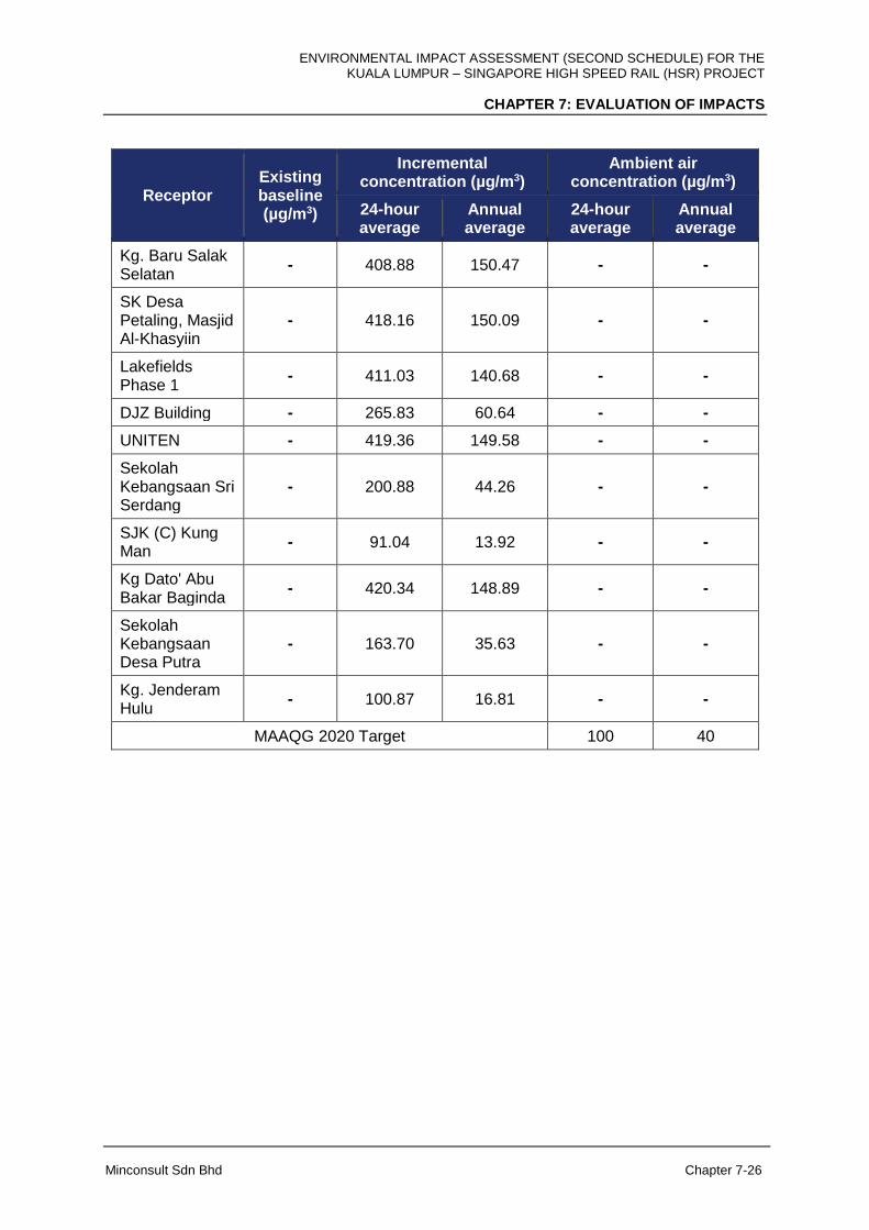
Kg. Baru Salak Selatan
- 408.88 150.47 - -
SK Desa Petaling, Masjid Al-Khasyiin
- 418.16 150.09 - -
Lakefields Phase 1
- 411.03 140.68 - -
DJZ Building - 265.83 60.64 - -
UNITEN - 419.36 149.58 - -
Sekolah Kebangsaan Sri Serdang
- 200.88 44.26 - -
SJK (C) Kung Man
- 91.04 13.92 - -
Kg Dato' Abu Bakar Baginda
- 420.34 148.89 - -
Sekolah Kebangsaan Desa Putra
- 163.70 35.63 - -
Kg. Jenderam Hulu
- 100.87 16.81 - -
MAAQG 2020 Target 100 40
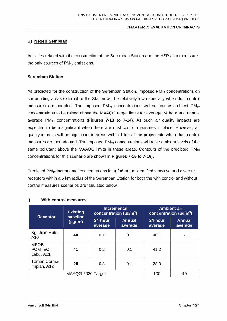
ENVIRONMENTAL IMPACT ASSESSMENT (SECOND SCHEDULE) FOR THE KUALA LUMPUR – SINGAPORE HIGH SPEED RAIL (HSR) PROJECT
CHAPTER 7: EVALUATION OF IMPACTS
Minconsult Sdn Bhd Chapter 7-27
B) Negeri Sembilan
Activities related with the construction of the Seremban Station and the HSR alignments are
the only sources of PM10 emissions.
Seremban Station
As predicted for the construction of the Seremban Station, imposed PM10 concentrations on
surrounding areas external to the Station will be relatively low especially when dust control
measures are adopted. The imposed PM10 concentrations will not cause ambient PM10
concentrations to be raised above the MAAQG target limits for average 24 hour and annual
average PM10 concentrations (Figures 7-13 to 7-14). As such air quality impacts are
expected to be insignificant when there are dust control measures in place. However, air
quality impacts will be significant in areas within 1 km of the project site when dust control
measures are not adopted. The imposed PM10 concentrations will raise ambient levels of the
same pollutant above the MAAQG limits in these areas. Contours of the predicted PM10
concentrations for this scenario are shown in Figures 7-15 to 7-16).
Predicted PM10 incremental concentrations in µg/m3 at the identified sensitive and discrete
receptors within a 5 km radius of the Seremban Station for both the with control and without
control measures scenarios are tabulated below;
i) With control measures
Receptor Existing baseline (µg/m3)
Incremental concentration (µg/m3)
Ambient air concentration (µg/m3)
24-hour average
Annual average
24-hour average
Annual average
Kg. Jijan Hulu, A10
40 0.1 0.1 40.1 -
MPOB POMTEC, Labu, A11
41 0.2 0.1 41.2 -
Taman Cermai Impian, A12
28 0.3 0.1 28.3 -
MAAQG 2020 Target 100 40
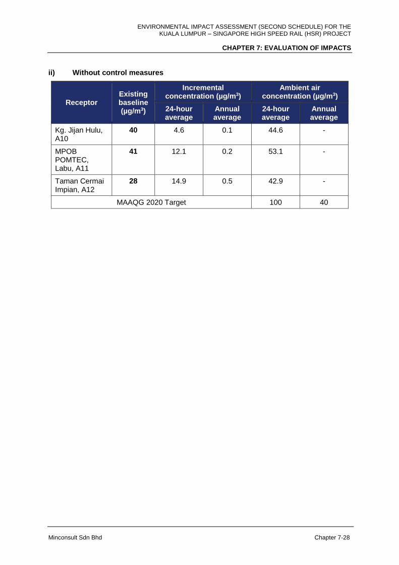
ENVIRONMENTAL IMPACT ASSESSMENT (SECOND SCHEDULE) FOR THE KUALA LUMPUR – SINGAPORE HIGH SPEED RAIL (HSR) PROJECT
CHAPTER 7: EVALUATION OF IMPACTS
Minconsult Sdn Bhd Chapter 7-28
ii) Without control measures
Receptor Existing baseline (µg/m3)
Incremental concentration (µg/m3)
Ambient air concentration (µg/m3)
24-hour average
Annual average
24-hour average
Annual average
Kg. Jijan Hulu, A10
40 4.6 0.1 44.6 -
MPOB POMTEC, Labu, A11
41 12.1 0.2 53.1 -
Taman Cermai Impian, A12
28 14.9 0.5 42.9 -
MAAQG 2020 Target 100 40

ENVIRONMENTAL IMPACT ASSESSMENT (SECOND SCHEDULE) FOR THE KUALA LUMPUR – SINGAPORE HIGH SPEED RAIL (HSR) PROJECT
CHAPTER 7: EVALUATION OF IMPACTS
Minconsult Sdn Bhd Chapter 7-29
Figure 7-13: Maximum 24-hour Average PM10 Incremental Concentration (µg/m3)
With Control Measures: Seremban Station

ENVIRONMENTAL IMPACT ASSESSMENT (SECOND SCHEDULE) FOR THE KUALA LUMPUR – SINGAPORE HIGH SPEED RAIL (HSR) PROJECT
CHAPTER 7: EVALUATION OF IMPACTS
Minconsult Sdn Bhd Chapter 7-30
Figure 7-14: Annual Average PM10 Incremental Concentration (µg/m3)
With Control Measures: Seremban Station

ENVIRONMENTAL IMPACT ASSESSMENT (SECOND SCHEDULE) FOR THE KUALA LUMPUR – SINGAPORE HIGH SPEED RAIL (HSR) PROJECT
CHAPTER 7: EVALUATION OF IMPACTS
Minconsult Sdn Bhd Chapter 7-31
Figure 7-15: Maximum 24-hour Average PM10 Incremental Concentration (µg/m3)
Without Control Measures: Seremban Station
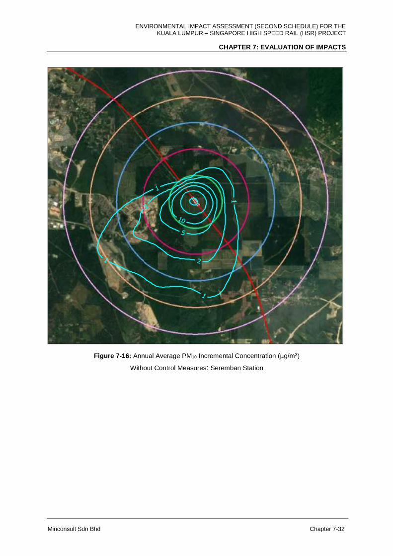
ENVIRONMENTAL IMPACT ASSESSMENT (SECOND SCHEDULE) FOR THE KUALA LUMPUR – SINGAPORE HIGH SPEED RAIL (HSR) PROJECT
CHAPTER 7: EVALUATION OF IMPACTS
Minconsult Sdn Bhd Chapter 7-32
Figure 7-16: Annual Average PM10 Incremental Concentration (µg/m3)
Without Control Measures: Seremban Station
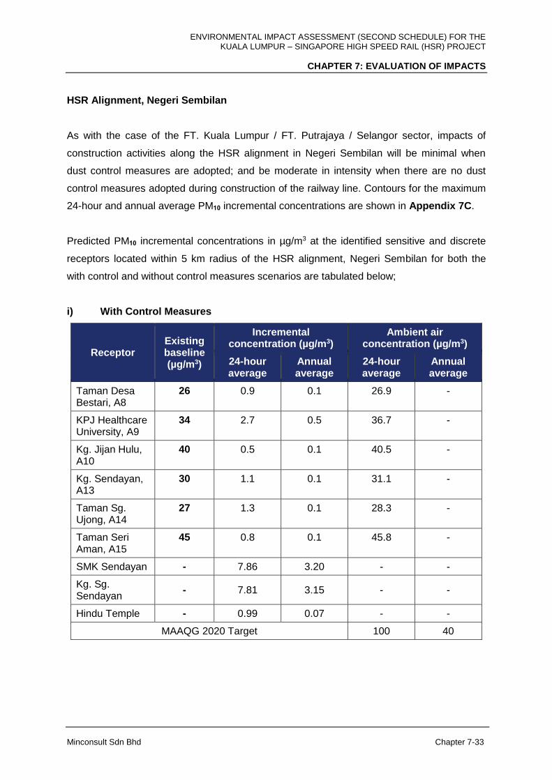
ENVIRONMENTAL IMPACT ASSESSMENT (SECOND SCHEDULE) FOR THE KUALA LUMPUR – SINGAPORE HIGH SPEED RAIL (HSR) PROJECT
CHAPTER 7: EVALUATION OF IMPACTS
Minconsult Sdn Bhd Chapter 7-33
HSR Alignment, Negeri Sembilan
As with the case of the FT. Kuala Lumpur / FT. Putrajaya / Selangor sector, impacts of
construction activities along the HSR alignment in Negeri Sembilan will be minimal when
dust control measures are adopted; and be moderate in intensity when there are no dust
control measures adopted during construction of the railway line. Contours for the maximum
24-hour and annual average PM10 incremental concentrations are shown in Appendix 7C.
Predicted PM10 incremental concentrations in µg/m3 at the identified sensitive and discrete
receptors located within 5 km radius of the HSR alignment, Negeri Sembilan for both the
with control and without control measures scenarios are tabulated below;
i) With Control Measures
Receptor Existing baseline (µg/m3)
Incremental concentration (µg/m3)
Ambient air concentration (µg/m3)
24-hour average
Annual average
24-hour average
Annual average
Taman Desa Bestari, A8
26 0.9 0.1 26.9 -
KPJ Healthcare University, A9
34 2.7 0.5 36.7 -
Kg. Jijan Hulu, A10
40 0.5 0.1 40.5 -
Kg. Sendayan, A13
30 1.1 0.1 31.1 -
Taman Sg. Ujong, A14
27 1.3 0.1 28.3 -
Taman Seri Aman, A15
45 0.8 0.1 45.8 -
SMK Sendayan - 7.86 3.20 - -
Kg. Sg. Sendayan
- 7.81 3.15 - -
Hindu Temple - 0.99 0.07 - -
MAAQG 2020 Target 100 40
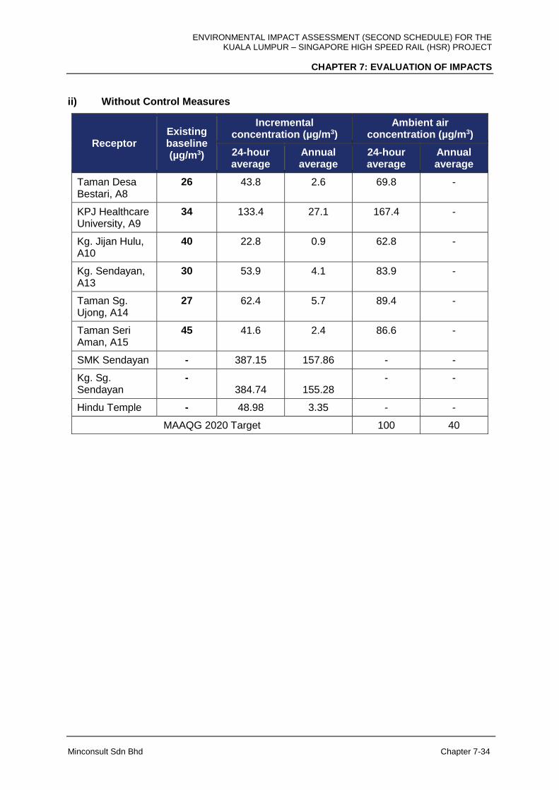
ENVIRONMENTAL IMPACT ASSESSMENT (SECOND SCHEDULE) FOR THE KUALA LUMPUR – SINGAPORE HIGH SPEED RAIL (HSR) PROJECT
CHAPTER 7: EVALUATION OF IMPACTS
Minconsult Sdn Bhd Chapter 7-34
ii) Without Control Measures
Receptor Existing baseline (µg/m3)
Incremental concentration (µg/m3)
Ambient air concentration (µg/m3)
24-hour average
Annual average
24-hour average
Annual average
Taman Desa Bestari, A8
26 43.8 2.6 69.8 -
KPJ Healthcare University, A9
34 133.4 27.1 167.4 -
Kg. Jijan Hulu, A10
40 22.8 0.9 62.8 -
Kg. Sendayan, A13
30 53.9 4.1 83.9 -
Taman Sg. Ujong, A14
27 62.4 5.7 89.4 -
Taman Seri Aman, A15
45 41.6 2.4 86.6 -
SMK Sendayan - 387.15 157.86 - -
Kg. Sg. Sendayan
- 384.74 155.28
- -
Hindu Temple - 48.98 3.35 - -
MAAQG 2020 Target 100 40
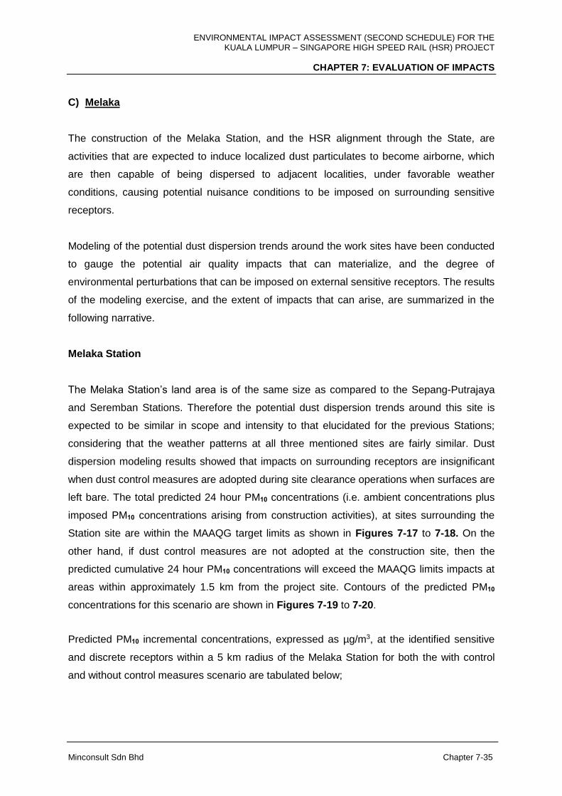
ENVIRONMENTAL IMPACT ASSESSMENT (SECOND SCHEDULE) FOR THE KUALA LUMPUR – SINGAPORE HIGH SPEED RAIL (HSR) PROJECT
CHAPTER 7: EVALUATION OF IMPACTS
Minconsult Sdn Bhd Chapter 7-35
C) Melaka
The construction of the Melaka Station, and the HSR alignment through the State, are
activities that are expected to induce localized dust particulates to become airborne, which
are then capable of being dispersed to adjacent localities, under favorable weather
conditions, causing potential nuisance conditions to be imposed on surrounding sensitive
receptors.
Modeling of the potential dust dispersion trends around the work sites have been conducted
to gauge the potential air quality impacts that can materialize, and the degree of
environmental perturbations that can be imposed on external sensitive receptors. The results
of the modeling exercise, and the extent of impacts that can arise, are summarized in the
following narrative.
Melaka Station
The Melaka Station’s land area is of the same size as compared to the Sepang-Putrajaya
and Seremban Stations. Therefore the potential dust dispersion trends around this site is
expected to be similar in scope and intensity to that elucidated for the previous Stations;
considering that the weather patterns at all three mentioned sites are fairly similar. Dust
dispersion modeling results showed that impacts on surrounding receptors are insignificant
when dust control measures are adopted during site clearance operations when surfaces are
left bare. The total predicted 24 hour PM10 concentrations (i.e. ambient concentrations plus
imposed PM10 concentrations arising from construction activities), at sites surrounding the
Station site are within the MAAQG target limits as shown in Figures 7-17 to 7-18. On the
other hand, if dust control measures are not adopted at the construction site, then the
predicted cumulative 24 hour PM10 concentrations will exceed the MAAQG limits impacts at
areas within approximately 1.5 km from the project site. Contours of the predicted PM10
concentrations for this scenario are shown in Figures 7-19 to 7-20.
Predicted PM10 incremental concentrations, expressed as µg/m3, at the identified sensitive
and discrete receptors within a 5 km radius of the Melaka Station for both the with control
and without control measures scenario are tabulated below;
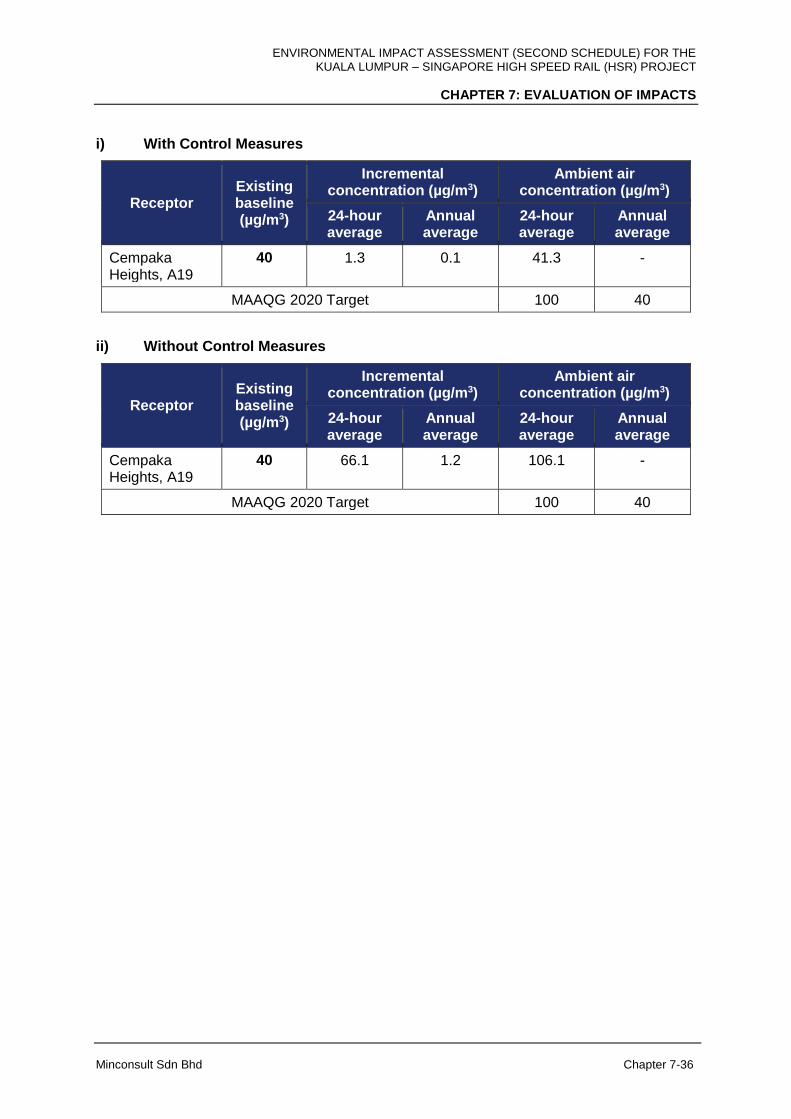
ENVIRONMENTAL IMPACT ASSESSMENT (SECOND SCHEDULE) FOR THE KUALA LUMPUR – SINGAPORE HIGH SPEED RAIL (HSR) PROJECT
CHAPTER 7: EVALUATION OF IMPACTS
Minconsult Sdn Bhd Chapter 7-36
i) With Control Measures
Receptor Existing baseline (µg/m3)
Incremental concentration (µg/m3)
Ambient air concentration (µg/m3)
24-hour average
Annual average
24-hour average
Annual average
Cempaka Heights, A19
40 1.3 0.1 41.3 -
MAAQG 2020 Target 100 40
ii) Without Control Measures
Receptor Existing baseline (µg/m3)
Incremental concentration (µg/m3)
Ambient air concentration (µg/m3)
24-hour average
Annual average
24-hour average
Annual average
Cempaka Heights, A19
40 66.1 1.2 106.1 -
MAAQG 2020 Target 100 40

ENVIRONMENTAL IMPACT ASSESSMENT (SECOND SCHEDULE) FOR THE KUALA LUMPUR – SINGAPORE HIGH SPEED RAIL (HSR) PROJECT
CHAPTER 7: EVALUATION OF IMPACTS
Minconsult Sdn Bhd Chapter 7-37
Figure 7-17: Maximum 24-hour Average PM10 Incremental Concentration (µg/m3)
With Control Measures: Melaka Station
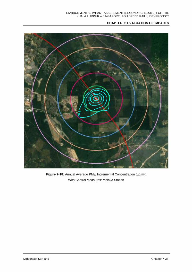
ENVIRONMENTAL IMPACT ASSESSMENT (SECOND SCHEDULE) FOR THE KUALA LUMPUR – SINGAPORE HIGH SPEED RAIL (HSR) PROJECT
CHAPTER 7: EVALUATION OF IMPACTS
Minconsult Sdn Bhd Chapter 7-38
Figure 7-18: Annual Average PM10 Incremental Concentration (µg/m3)
With Control Measures: Melaka Station

ENVIRONMENTAL IMPACT ASSESSMENT (SECOND SCHEDULE) FOR THE KUALA LUMPUR – SINGAPORE HIGH SPEED RAIL (HSR) PROJECT
CHAPTER 7: EVALUATION OF IMPACTS
Minconsult Sdn Bhd Chapter 7-39
Figure 7-19: Maximum 24-hour Average PM10 Incremental Concentration (µg/m3)
Without Control Measures: Melaka Station
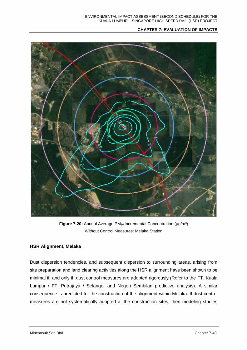
ENVIRONMENTAL IMPACT ASSESSMENT (SECOND SCHEDULE) FOR THE KUALA LUMPUR – SINGAPORE HIGH SPEED RAIL (HSR) PROJECT
CHAPTER 7: EVALUATION OF IMPACTS
Minconsult Sdn Bhd Chapter 7-40
Figure 7-20: Annual Average PM10 Incremental Concentration (µg/m3)
Without Control Measures: Melaka Station
HSR Alignment, Melaka
Dust dispersion tendencies, and subsequent dispersion to surrounding areas, arising from
site preparation and land clearing activities along the HSR alignment have been shown to be
minimal if, and only if, dust control measures are adopted rigorously (Refer to the FT. Kuala
Lumpur / FT. Putrajaya / Selangor and Negeri Sembilan predictive analysis). A similar
consequence is predicted for the construction of the alignment within Melaka. If dust control
measures are not systematically adopted at the construction sites, then modeling studies

ENVIRONMENTAL IMPACT ASSESSMENT (SECOND SCHEDULE) FOR THE KUALA LUMPUR – SINGAPORE HIGH SPEED RAIL (HSR) PROJECT
CHAPTER 7: EVALUATION OF IMPACTS
Minconsult Sdn Bhd Chapter 7-41
have predicted that moderate to severe PM10 impacts will be imposed on surrounding nearby
sensitive receptors.
Contours for the average 24-hour and annual average PM10 incremental concentrations are
shown in Appendix 7D.
Predicted PM10 incremental concentrations in µg/m3 at the identified sensitive and discrete
receptors within a 5 km radius of the HSR alignment, for both the with control and without
control measures scenarios, are tabulated below;
i) With Control Measures
Receptor Existing baseline (µg/m3)
Incremental concentration (µg/m3)
Ambient air concentration (µg/m3)
24-hour average
Annual average
24-hour average
Annual average
Kg. Solok Air Limau, A16
41 1.9 0.1 42.9 -
Kg. Durian Daun, A17
49 4.6 1.4 53.6 -
1 Krubong Residence, A18
56 2.0 0.1 58.0 -
Taman Bemban Baru, A20
57 4.5 1.0 61.5 -
Open space / palm oil plantation, A21,
28 1.9 0.1 29.9 -
Kg. Seri Mendapat, A22
44 1.3 0.1 45.3 -
IKBN Alor Gajah
- 5.65 1.69 - -
Taman Paya Rumput Indah
- 7.40 2.06 - -
Pusat Rehabilitasi Perkeso
- 3.53 0.63 - -
Masjid Nurul Iman
- 7.26 2.04 - -
MAAQG 2020 Target 100 40

ENVIRONMENTAL IMPACT ASSESSMENT (SECOND SCHEDULE) FOR THE KUALA LUMPUR – SINGAPORE HIGH SPEED RAIL (HSR) PROJECT
CHAPTER 7: EVALUATION OF IMPACTS
Minconsult Sdn Bhd Chapter 7-42
ii) Without Control Measures
Receptor Existing baseline (µg/m3)
Incremental concentration (µg/m3)
Ambient air concentration (µg/m3)
24-hour average
Annual average
24-hour average
Annual average
Kg. Solok Air Limau, A16
41 94.3 2.6 135.3 -
Kg. Durian Daun, A17
49 225.9 68.5 247.9 -
1 Krubong Residence, A18
56 96.5 2.8 152.5 -
Taman Bemban Baru, A20
57 222.4 49.6 279.4 -
Open space / palm oil plantation, A21,
28 94.2 2.6 122.2 -
Kg. Seri Mendapat, A22
44 65.6 1.0 109.6 -
IKBN Alor Gajah
- 278.44 83.18 - -
Taman Paya Rumput Indah
- 364.82 101.63 - -
Pusat Rehabilitasi Perkeso
- 190.91 34.54 - -
Masjid Nurul Iman
- 357.78 100.34 - -
MAAQG 2020 Target 100 40
ENVIRONMENTAL IMPACT ASSESSMENT (SECOND SCHEDULE) FOR THE KUALA LUMPUR – SINGAPORE HIGH SPEED RAIL (HSR) PROJECT
CHAPTER 7: EVALUATION OF IMPACTS
Minconsult Sdn Bhd Chapter 7-43
D) Johor
Suspended Particulate (Dust) Impact assessment for the Johor sector encompasses the
construction of the following facilities, especially during the land clearing and earthworks
stages, viz: (i) two (2) stations at Muar and Batu Pahat, (ii) Heavy Maintenance Base (HMB),
Muar (iii) Iskandar Puteri Station, (iv) Main Depot and LMB, Pontian and (v) the HSR
alignment.
Muar Station
Muar Station which is of similar size to the Seremban and Melaka Stations is predicted to
induce similar scope and degree of dust impacts on surrounding Receptors as the other two
stations. With dust control measures implemented during construction of the Station, the
predicted maximum 24-hour average, and annual average, cumulative PM10 concentrations
(i.e. imposed plus ambient concentrations) fall within the MAAQG limits for these two
parameters. Contours of the predicted maximum 24-hour average and annual average PM10
incremental concentrations are shown in Figures 7-21 and 7-22 respectively. However
when there are no dust control measures adopted during construction activities, the
predicted cumulative PM10 concentrations are above the maximum 24-hour average limit of
100 µg/m3 in areas up to approximately 1.5 km from the project site; and above the annual
average limit of 40 µg/m3 in areas up to approximately 500 m from the project site. Contours
of the predicted maximum 24-hour average and annual average PM10 incremental
concentrations for the no control measures scenario are shown in Figures 7-23 and 7-24
respectively.
The predicted PM10 incremental concentrations in µg/m3 at the identified sensitive and
discrete receptors within a 5 km radius of Muar Station for both the with control and without
control measures scenarios for are tabulated below;
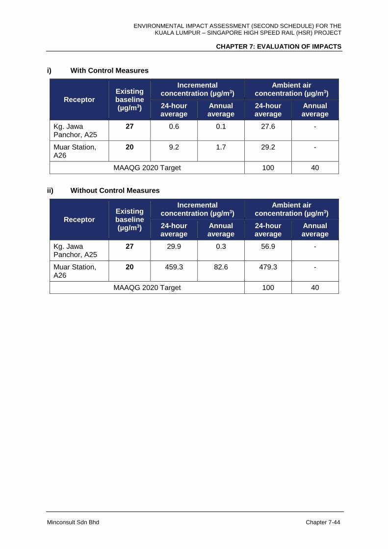
ENVIRONMENTAL IMPACT ASSESSMENT (SECOND SCHEDULE) FOR THE KUALA LUMPUR – SINGAPORE HIGH SPEED RAIL (HSR) PROJECT
CHAPTER 7: EVALUATION OF IMPACTS
Minconsult Sdn Bhd Chapter 7-44
i) With Control Measures
Receptor Existing baseline (µg/m3)
Incremental concentration (µg/m3)
Ambient air concentration (µg/m3)
24-hour average
Annual average
24-hour average
Annual average
Kg. Jawa Panchor, A25
27 0.6 0.1 27.6 -
Muar Station, A26
20 9.2 1.7 29.2 -
MAAQG 2020 Target 100 40
ii) Without Control Measures
Receptor Existing baseline (µg/m3)
Incremental concentration (µg/m3)
Ambient air concentration (µg/m3)
24-hour average
Annual average
24-hour average
Annual average
Kg. Jawa Panchor, A25
27 29.9 0.3 56.9 -
Muar Station, A26
20 459.3 82.6 479.3 -
MAAQG 2020 Target 100 40

ENVIRONMENTAL IMPACT ASSESSMENT (SECOND SCHEDULE) FOR THE KUALA LUMPUR – SINGAPORE HIGH SPEED RAIL (HSR) PROJECT
CHAPTER 7: EVALUATION OF IMPACTS
Minconsult Sdn Bhd Chapter 7-45
Figure 7-21: Maximum 24-hour Average PM10 Incremental Concentration (µg/m3)
With Control Measures: Muar Station

ENVIRONMENTAL IMPACT ASSESSMENT (SECOND SCHEDULE) FOR THE KUALA LUMPUR – SINGAPORE HIGH SPEED RAIL (HSR) PROJECT
CHAPTER 7: EVALUATION OF IMPACTS
Minconsult Sdn Bhd Chapter 7-46
Figure 7-22: Annual Average PM10 Incremental Concentration (µg/m3)
With Control Measures: Muar Station

ENVIRONMENTAL IMPACT ASSESSMENT (SECOND SCHEDULE) FOR THE KUALA LUMPUR – SINGAPORE HIGH SPEED RAIL (HSR) PROJECT
CHAPTER 7: EVALUATION OF IMPACTS
Minconsult Sdn Bhd Chapter 7-47
Figure 7-23: Maximum 24-hour Average PM10 Incremental Concentration (µg/m3)
Without Control Measures: Muar Station
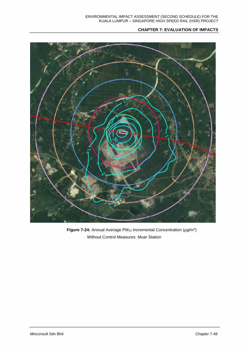
ENVIRONMENTAL IMPACT ASSESSMENT (SECOND SCHEDULE) FOR THE KUALA LUMPUR – SINGAPORE HIGH SPEED RAIL (HSR) PROJECT
CHAPTER 7: EVALUATION OF IMPACTS
Minconsult Sdn Bhd Chapter 7-48
Figure 7-24: Annual Average PM10 Incremental Concentration (µg/m3)
Without Control Measures: Muar Station
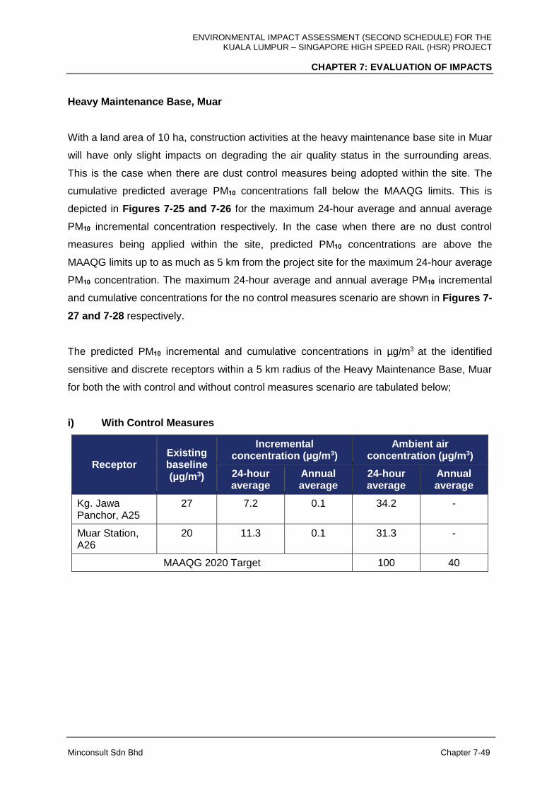
ENVIRONMENTAL IMPACT ASSESSMENT (SECOND SCHEDULE) FOR THE KUALA LUMPUR – SINGAPORE HIGH SPEED RAIL (HSR) PROJECT
CHAPTER 7: EVALUATION OF IMPACTS
Minconsult Sdn Bhd Chapter 7-49
Heavy Maintenance Base, Muar
With a land area of 10 ha, construction activities at the heavy maintenance base site in Muar
will have only slight impacts on degrading the air quality status in the surrounding areas.
This is the case when there are dust control measures being adopted within the site. The
cumulative predicted average PM10 concentrations fall below the MAAQG limits. This is
depicted in Figures 7-25 and 7-26 for the maximum 24-hour average and annual average
PM10 incremental concentration respectively. In the case when there are no dust control
measures being applied within the site, predicted PM10 concentrations are above the
MAAQG limits up to as much as 5 km from the project site for the maximum 24-hour average
PM10 concentration. The maximum 24-hour average and annual average PM10 incremental
and cumulative concentrations for the no control measures scenario are shown in Figures 7-
27 and 7-28 respectively.
The predicted PM10 incremental and cumulative concentrations in µg/m3 at the identified
sensitive and discrete receptors within a 5 km radius of the Heavy Maintenance Base, Muar
for both the with control and without control measures scenario are tabulated below;
i) With Control Measures
Receptor Existing baseline (µg/m3)
Incremental concentration (µg/m3)
Ambient air concentration (µg/m3)
24-hour average
Annual average
24-hour average
Annual average
Kg. Jawa Panchor, A25
27 7.2 0.1 34.2 -
Muar Station, A26
20 11.3 0.1 31.3 -
MAAQG 2020 Target 100 40
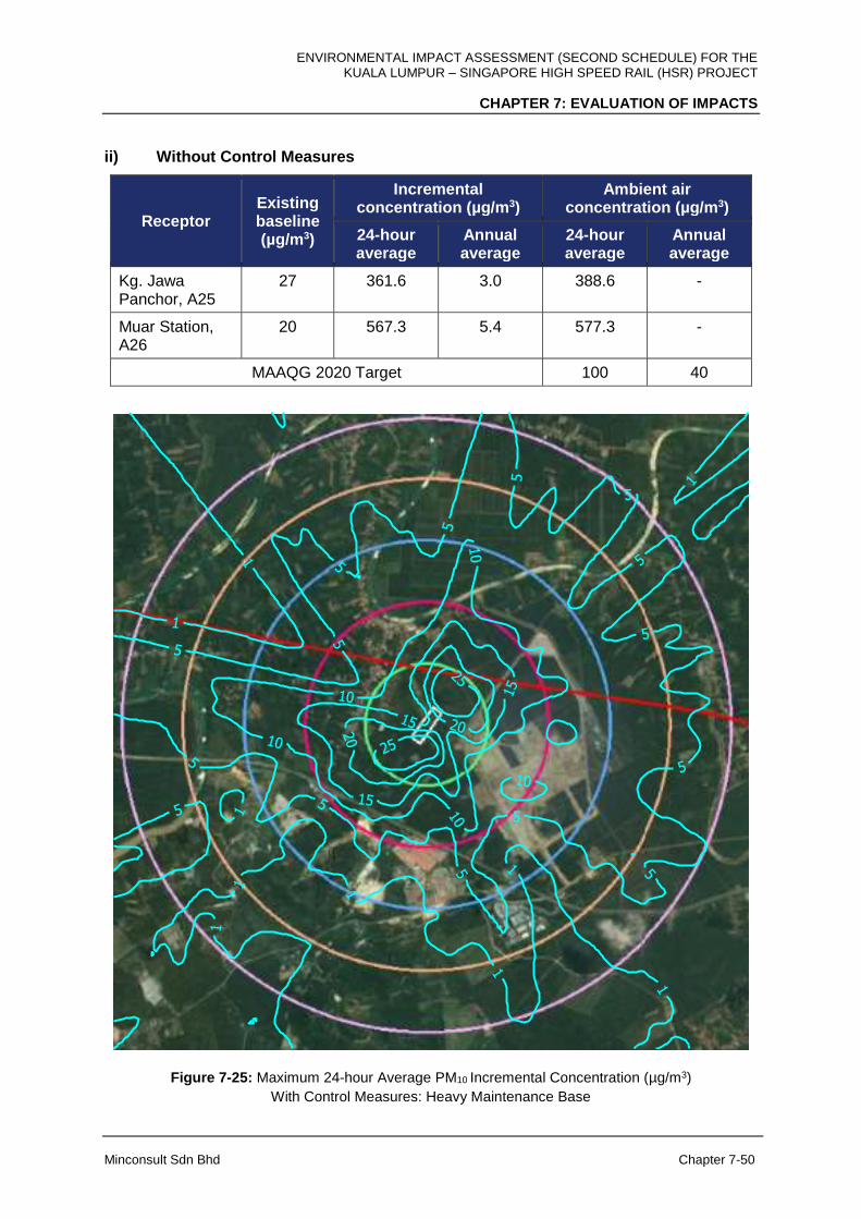
ENVIRONMENTAL IMPACT ASSESSMENT (SECOND SCHEDULE) FOR THE KUALA LUMPUR – SINGAPORE HIGH SPEED RAIL (HSR) PROJECT
CHAPTER 7: EVALUATION OF IMPACTS
Minconsult Sdn Bhd Chapter 7-50
ii) Without Control Measures
Receptor Existing baseline (µg/m3)
Incremental concentration (µg/m3)
Ambient air concentration (µg/m3)
24-hour average
Annual average
24-hour average
Annual average
Kg. Jawa Panchor, A25
27 361.6 3.0 388.6 -
Muar Station, A26
20 567.3 5.4 577.3 -
MAAQG 2020 Target 100 40
Figure 7-25: Maximum 24-hour Average PM10 Incremental Concentration (µg/m3)
With Control Measures: Heavy Maintenance Base
ENVIRONMENTAL IMPACT ASSESSMENT (SECOND SCHEDULE) FOR THE KUALA LUMPUR – SINGAPORE HIGH SPEED RAIL (HSR) PROJECT
CHAPTER 7: EVALUATION OF IMPACTS
Minconsult Sdn Bhd Chapter 7-51
Figure 7-26: Annual Average PM10 Incremental Concentration (µg/m3)
With Control Measures: Heavy Maintenance Base
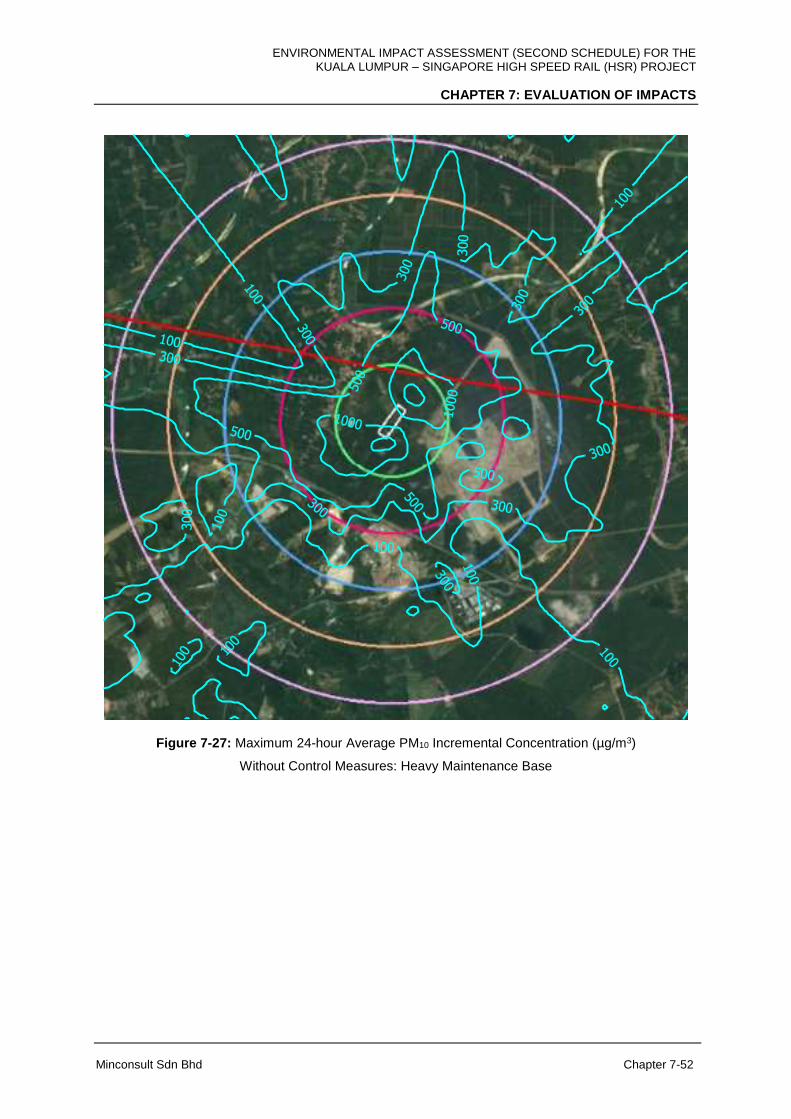
ENVIRONMENTAL IMPACT ASSESSMENT (SECOND SCHEDULE) FOR THE KUALA LUMPUR – SINGAPORE HIGH SPEED RAIL (HSR) PROJECT
CHAPTER 7: EVALUATION OF IMPACTS
Minconsult Sdn Bhd Chapter 7-52
Figure 7-27: Maximum 24-hour Average PM10 Incremental Concentration (µg/m3)
Without Control Measures: Heavy Maintenance Base
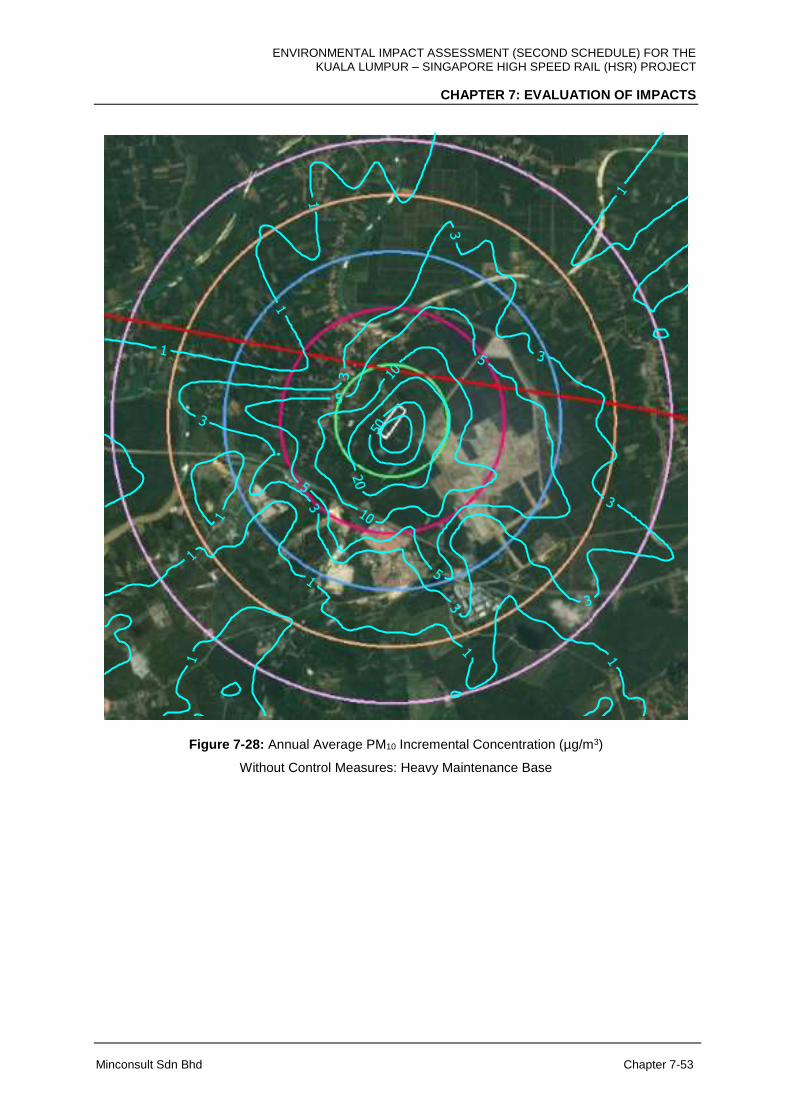
ENVIRONMENTAL IMPACT ASSESSMENT (SECOND SCHEDULE) FOR THE KUALA LUMPUR – SINGAPORE HIGH SPEED RAIL (HSR) PROJECT
CHAPTER 7: EVALUATION OF IMPACTS
Minconsult Sdn Bhd Chapter 7-53
Figure 7-28: Annual Average PM10 Incremental Concentration (µg/m3)
Without Control Measures: Heavy Maintenance Base
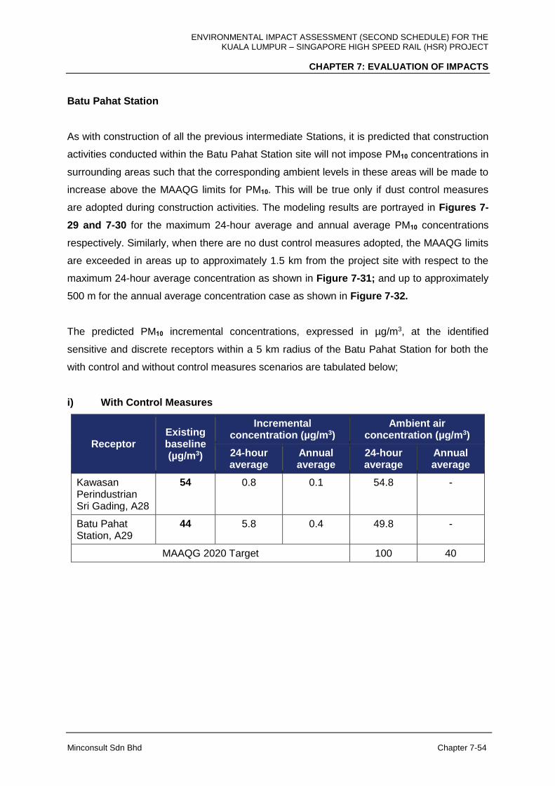
ENVIRONMENTAL IMPACT ASSESSMENT (SECOND SCHEDULE) FOR THE KUALA LUMPUR – SINGAPORE HIGH SPEED RAIL (HSR) PROJECT
CHAPTER 7: EVALUATION OF IMPACTS
Minconsult Sdn Bhd Chapter 7-54
Batu Pahat Station
As with construction of all the previous intermediate Stations, it is predicted that construction
activities conducted within the Batu Pahat Station site will not impose PM10 concentrations in
surrounding areas such that the corresponding ambient levels in these areas will be made to
increase above the MAAQG limits for PM10. This will be true only if dust control measures
are adopted during construction activities. The modeling results are portrayed in Figures 7-
29 and 7-30 for the maximum 24-hour average and annual average PM10 concentrations
respectively. Similarly, when there are no dust control measures adopted, the MAAQG limits
are exceeded in areas up to approximately 1.5 km from the project site with respect to the
maximum 24-hour average concentration as shown in Figure 7-31; and up to approximately
500 m for the annual average concentration case as shown in Figure 7-32.
The predicted PM10 incremental concentrations, expressed in µg/m3, at the identified
sensitive and discrete receptors within a 5 km radius of the Batu Pahat Station for both the
with control and without control measures scenarios are tabulated below;
i) With Control Measures
Receptor Existing baseline (µg/m3)
Incremental concentration (µg/m3)
Ambient air concentration (µg/m3)
24-hour average
Annual average
24-hour average
Annual average
Kawasan Perindustrian Sri Gading, A28
54 0.8 0.1 54.8 -
Batu Pahat Station, A29
44 5.8 0.4 49.8 -
MAAQG 2020 Target 100 40

ENVIRONMENTAL IMPACT ASSESSMENT (SECOND SCHEDULE) FOR THE KUALA LUMPUR – SINGAPORE HIGH SPEED RAIL (HSR) PROJECT
CHAPTER 7: EVALUATION OF IMPACTS
Minconsult Sdn Bhd Chapter 7-55
ii) Without Control Measures
Receptor Existing baseline (µg/m3)
Incremental concentration (µg/m3)
Ambient air concentration (µg/m3)
24-hour average
Annual average
24-hour average
Annual average
Kawasan Perindustrian Sri Gading, A28
54 39.8 0.7 93.8 -
Batu Pahat Station, A29
44 289.0 21.9 333.0 -
MAAQG 2020 Target 100 40

ENVIRONMENTAL IMPACT ASSESSMENT (SECOND SCHEDULE) FOR THE KUALA LUMPUR – SINGAPORE HIGH SPEED RAIL (HSR) PROJECT
CHAPTER 7: EVALUATION OF IMPACTS
Minconsult Sdn Bhd Chapter 7-56
Figure 7-29: Maximum 24-hour Average PM10 Incremental Concentration (µg/m3)
With Control Measures: Batu Pahat Station
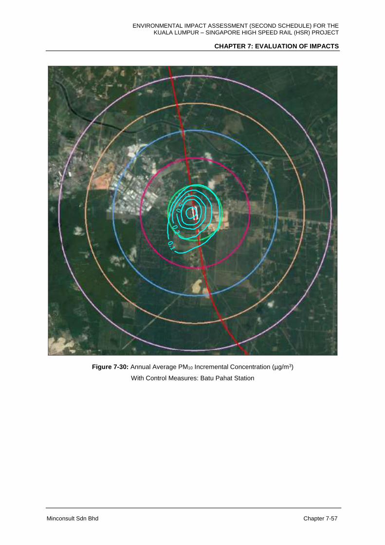
ENVIRONMENTAL IMPACT ASSESSMENT (SECOND SCHEDULE) FOR THE KUALA LUMPUR – SINGAPORE HIGH SPEED RAIL (HSR) PROJECT
CHAPTER 7: EVALUATION OF IMPACTS
Minconsult Sdn Bhd Chapter 7-57
Figure 7-30: Annual Average PM10 Incremental Concentration (µg/m3)
With Control Measures: Batu Pahat Station
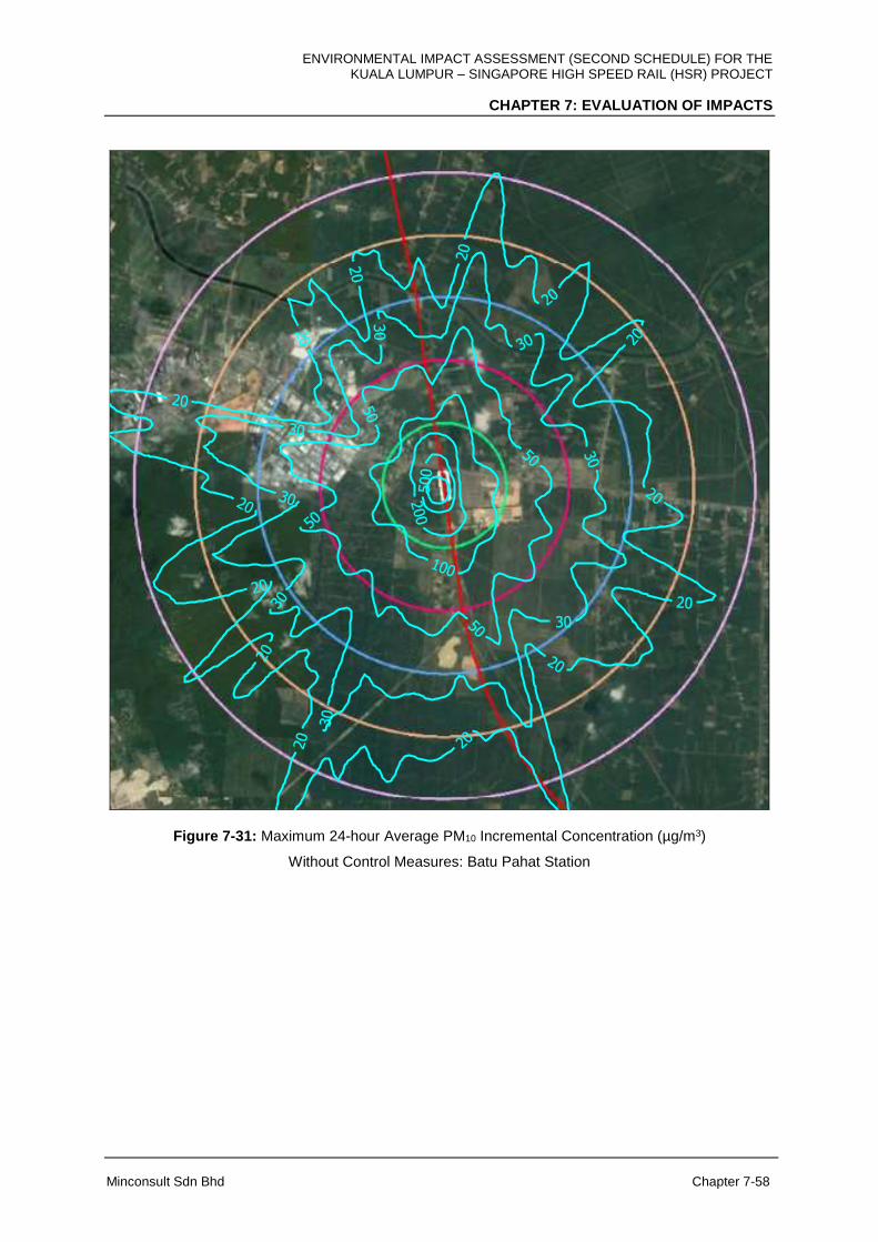
ENVIRONMENTAL IMPACT ASSESSMENT (SECOND SCHEDULE) FOR THE KUALA LUMPUR – SINGAPORE HIGH SPEED RAIL (HSR) PROJECT
CHAPTER 7: EVALUATION OF IMPACTS
Minconsult Sdn Bhd Chapter 7-58
Figure 7-31: Maximum 24-hour Average PM10 Incremental Concentration (µg/m3)
Without Control Measures: Batu Pahat Station

ENVIRONMENTAL IMPACT ASSESSMENT (SECOND SCHEDULE) FOR THE KUALA LUMPUR – SINGAPORE HIGH SPEED RAIL (HSR) PROJECT
CHAPTER 7: EVALUATION OF IMPACTS
Minconsult Sdn Bhd Chapter 7-59
Figure 7-32: Annual Average PM10 Incremental Concentration (µg/m3)
Without Control Measures: Batu Pahat Station
ENVIRONMENTAL IMPACT ASSESSMENT (SECOND SCHEDULE) FOR THE KUALA LUMPUR – SINGAPORE HIGH SPEED RAIL (HSR) PROJECT
CHAPTER 7: EVALUATION OF IMPACTS
Minconsult Sdn Bhd Chapter 7-60
Iskandar Puteri Station
Although the Iskandar Puteri Station Site area is larger relative to the intermediate Stations,
the predicted PM10 concentrations that will be imposed on surrounding areas resulting from
construction activities conducted at this Station site will not raise the ambient PM10
concentrations in surrounding areas above the MAAQG limits; but on the condition that dust
control measures are adopted. Contours of the predicted maximum 24-hour average and
annual average PM10 incremental concentrations are shown in Figure 7-33 and 7-34
respectively. Without dust control measures being adopted, the surrounding 24 hour PM10
cumulative concentrations will exceed the MAAQG limits at areas up to approximately 2 km
from the project site as shown in Figure 7-35; and up to approximately 500 m in the case of
annual average concentrations as shown in Figure 7-36.
The predicted PM10 incremental concentrations, expressed in units of µg/m3, at the identified
sensitive and discrete receptors located within a 5 km radius of the Iskandar Puteri Terminus
site, for both the with control and without control measures scenarios, are tabulated below;
i) With Control Measures
Receptor Existing baseline (µg/m3)
Incremental concentration (µg/m3)
Ambient air concentration (µg/m3)
24-hour average
Annual average
24-hour average
Annual average
Iskandar Puteri Station, A36
57 58.0 7.9 115.0 -
Sultan Abu Bakar CIQ, A37
40 0.3 0.1 40.3 -
MAAQG 2020 Target 100 40
ENVIRONMENTAL IMPACT ASSESSMENT (SECOND SCHEDULE) FOR THE KUALA LUMPUR – SINGAPORE HIGH SPEED RAIL (HSR) PROJECT
CHAPTER 7: EVALUATION OF IMPACTS
Minconsult Sdn Bhd Chapter 7-61
ii) Without Control Measures
Receptor Existing baseline (µg/m3)
Incremental concentration (µg/m3)
Ambient air concentration (µg/m3)
24-hour average
Annual average
24-hour average
Annual average
Iskandar Puteri Station, A36
57 2,901 392.8 2,958 -
Sultan Abu Bakar CIQ, A37
40 15.1 0.8 55.1 -
MAAQG 2020 Target 100 40
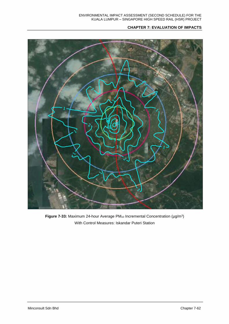
ENVIRONMENTAL IMPACT ASSESSMENT (SECOND SCHEDULE) FOR THE KUALA LUMPUR – SINGAPORE HIGH SPEED RAIL (HSR) PROJECT
CHAPTER 7: EVALUATION OF IMPACTS
Minconsult Sdn Bhd Chapter 7-62
Figure 7-33: Maximum 24-hour Average PM10 Incremental Concentration (µg/m3)
With Control Measures: Iskandar Puteri Station
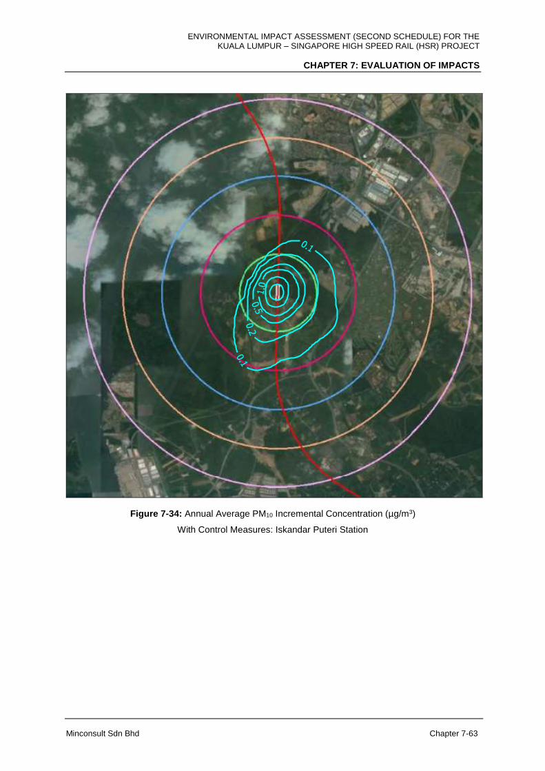
ENVIRONMENTAL IMPACT ASSESSMENT (SECOND SCHEDULE) FOR THE KUALA LUMPUR – SINGAPORE HIGH SPEED RAIL (HSR) PROJECT
CHAPTER 7: EVALUATION OF IMPACTS
Minconsult Sdn Bhd Chapter 7-63
Figure 7-34: Annual Average PM10 Incremental Concentration (µg/m3)
With Control Measures: Iskandar Puteri Station
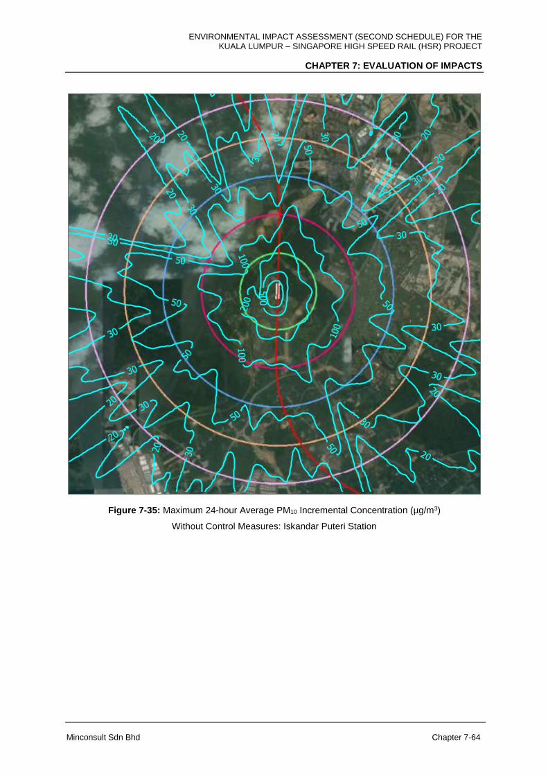
ENVIRONMENTAL IMPACT ASSESSMENT (SECOND SCHEDULE) FOR THE KUALA LUMPUR – SINGAPORE HIGH SPEED RAIL (HSR) PROJECT
CHAPTER 7: EVALUATION OF IMPACTS
Minconsult Sdn Bhd Chapter 7-64
Figure 7-35: Maximum 24-hour Average PM10 Incremental Concentration (µg/m3)
Without Control Measures: Iskandar Puteri Station

ENVIRONMENTAL IMPACT ASSESSMENT (SECOND SCHEDULE) FOR THE KUALA LUMPUR – SINGAPORE HIGH SPEED RAIL (HSR) PROJECT
CHAPTER 7: EVALUATION OF IMPACTS
Minconsult Sdn Bhd Chapter 7-65
Figure 7-36: Annual Average PM10 Incremental Concentration (µg/m3)
Without Control Measures: Iskandar Puteri Station
Main Depot and Light Maintenance Base, Pontian
The site area identified for the Main Depot and Light Maintenance Base is the largest
amongst all HSR facilities. As such it can be assumed that dust dispersions from the
construction of this facility will impact on a greater scale on surrounding receptors than that
predicted for the other facilities. However, with dust control measures being adopted during
construction, and if construction of this facility is carried out in stages, the predicted PM10
concentrations imposed on the surrounding areas will not raise the ambient concentration of
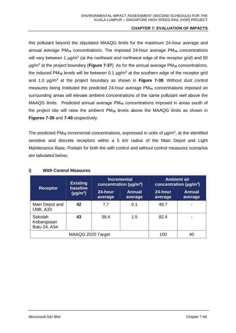
ENVIRONMENTAL IMPACT ASSESSMENT (SECOND SCHEDULE) FOR THE KUALA LUMPUR – SINGAPORE HIGH SPEED RAIL (HSR) PROJECT
CHAPTER 7: EVALUATION OF IMPACTS
Minconsult Sdn Bhd Chapter 7-66
this pollutant beyond the stipulated MAAQG limits for the maximum 24-hour average and
annual average PM10 concentrations. The imposed 24-hour average PM10 concentrations
will vary between 1 µg/m3 (at the northeast and northwest edge of the receptor grid) and 50
µg/m3 at the project boundary (Figure 7-37). As for the annual average PM10 concentrations,
the induced PM10 levels will be between 0.1 µg/m3 at the southern edge of the receptor grid
and 1.0 µg/m3 at the project boundary as shown in Figure 7-38. Without dust control
measures being instituted the predicted 24-hour average PM10 concentrations imposed on
surrounding areas will elevate ambient concentrations of the same pollutant well above the
MAAQG limits. Predicted annual average PM10 concentrations imposed in areas south of
the project site will raise the ambient PM10 levels above the MAAQG limits as shown in
Figures 7-39 and 7-40 respectively.
The predicted PM10 incremental concentrations, expressed in units of µg/m3, at the identified
sensitive and discrete receptors within a 5 km radius of the Main Depot and Light
Maintenance Base, Pontain for both the with control and without control measures scenarios
are tabulated below;
i) With Control Measures
Receptor Existing baseline (µg/m3)
Incremental concentration (µg/m3)
Ambient air concentration (µg/m3)
24-hour average
Annual average
24-hour average
Annual average
Main Depot and LMB, A33
42 7.7 0.1 49.7 -
Sekolah Kebangsaan Batu 24, A34
43 39.4 1.5 82.4 -
MAAQG 2020 Target 100 40
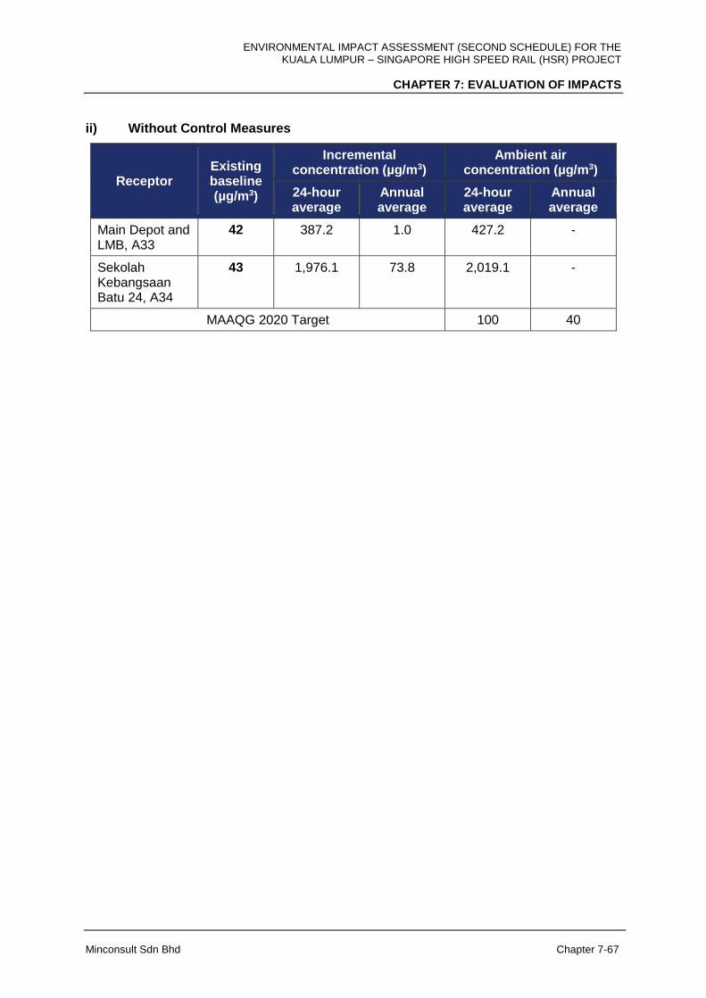
ENVIRONMENTAL IMPACT ASSESSMENT (SECOND SCHEDULE) FOR THE KUALA LUMPUR – SINGAPORE HIGH SPEED RAIL (HSR) PROJECT
CHAPTER 7: EVALUATION OF IMPACTS
Minconsult Sdn Bhd Chapter 7-67
ii) Without Control Measures
Receptor Existing baseline (µg/m3)
Incremental concentration (µg/m3)
Ambient air concentration (µg/m3)
24-hour average
Annual average
24-hour average
Annual average
Main Depot and LMB, A33
42 387.2 1.0 427.2 -
Sekolah Kebangsaan Batu 24, A34
43 1,976.1 73.8 2,019.1 -
MAAQG 2020 Target 100 40

ENVIRONMENTAL IMPACT ASSESSMENT (SECOND SCHEDULE) FOR THE KUALA LUMPUR – SINGAPORE HIGH SPEED RAIL (HSR) PROJECT
CHAPTER 7: EVALUATION OF IMPACTS
Minconsult Sdn Bhd Chapter 7-68
Figure 7-37: Maximum 24-hour Average PM10 Incremental Concentration (µg/m3)
With Control Measures: Main Depot and Light Maintenance Base

ENVIRONMENTAL IMPACT ASSESSMENT (SECOND SCHEDULE) FOR THE KUALA LUMPUR – SINGAPORE HIGH SPEED RAIL (HSR) PROJECT
CHAPTER 7: EVALUATION OF IMPACTS
Minconsult Sdn Bhd Chapter 7-69
Figure 7-38: Annual Average PM10 Incremental Concentration (µg/m3)
With Control Measures: Main Depot and Light Maintenance Base

ENVIRONMENTAL IMPACT ASSESSMENT (SECOND SCHEDULE) FOR THE KUALA LUMPUR – SINGAPORE HIGH SPEED RAIL (HSR) PROJECT
CHAPTER 7: EVALUATION OF IMPACTS
Minconsult Sdn Bhd Chapter 7-70
Figure 7-39: Maximum 24-hour Average PM10 Incremental Concentration (µg/m3)
Without Control Measures: Main Depot and Light Maintenance Base
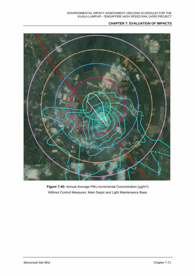
ENVIRONMENTAL IMPACT ASSESSMENT (SECOND SCHEDULE) FOR THE KUALA LUMPUR – SINGAPORE HIGH SPEED RAIL (HSR) PROJECT
CHAPTER 7: EVALUATION OF IMPACTS
Minconsult Sdn Bhd Chapter 7-71
Figure 7-40: Annual Average PM10 Incremental Concentration (µg/m3)
Without Control Measures: Main Depot and Light Maintenance Base

ENVIRONMENTAL IMPACT ASSESSMENT (SECOND SCHEDULE) FOR THE KUALA LUMPUR – SINGAPORE HIGH SPEED RAIL (HSR) PROJECT
CHAPTER 7: EVALUATION OF IMPACTS
Minconsult Sdn Bhd Chapter 7-72
HSR Alignment, Johor
Impacts of construction activities along the HSR alignment in Johor are no different from
those in the other sectors. Impacts are minimal when there are dust control measures
adopted, and will be moderate when there are no control measures taken. Contours for the
maximum 24-hour average and annual average PM10 incremental concentrations are shown
in Appendix 7E.
The predicted PM10 incremental concentrations, expressed in units of µg/m3, at the identified
sensitive and discrete receptors located within a 5 km radius of the HSR alignment, Johor for
both the with control and without control measures scenarios are tabulated below;
i) With Control Measures
Receptor Existing baseline (µg/m3)
Incremental concentration (µg/m3)
Ambient air concentration (µg/m3)
24-hour average
Annual average
24-hour average
Annual average
Paya Buloh, A23
38 2.9 0.4 40.9 -
Kg. Parit Zing, A24
45 2.3 0.2 47.3 -
Kg. Paya Redan, A27
26 12.4 2.9 38.4 -
Jalan Parit Botak, A30
31 2.1 0.1 33.1 -
SMK Dato Ismail, Majid, A31
28 2.9 0.5 30.9 -
Kg. Melayu Raya, A32
47 1.2 0.1 48.2 -
Main Depot and LMB, A33
42 2.2 0.1 44.2 -
Sekolah Kebangsaan Batu 24, A34
43 2.1 0.1 45.1 -
Gelang Patah, A35
52 2.9 0.5 54.9 -
Kg. Serom 4 - 5.23 1.12 - -
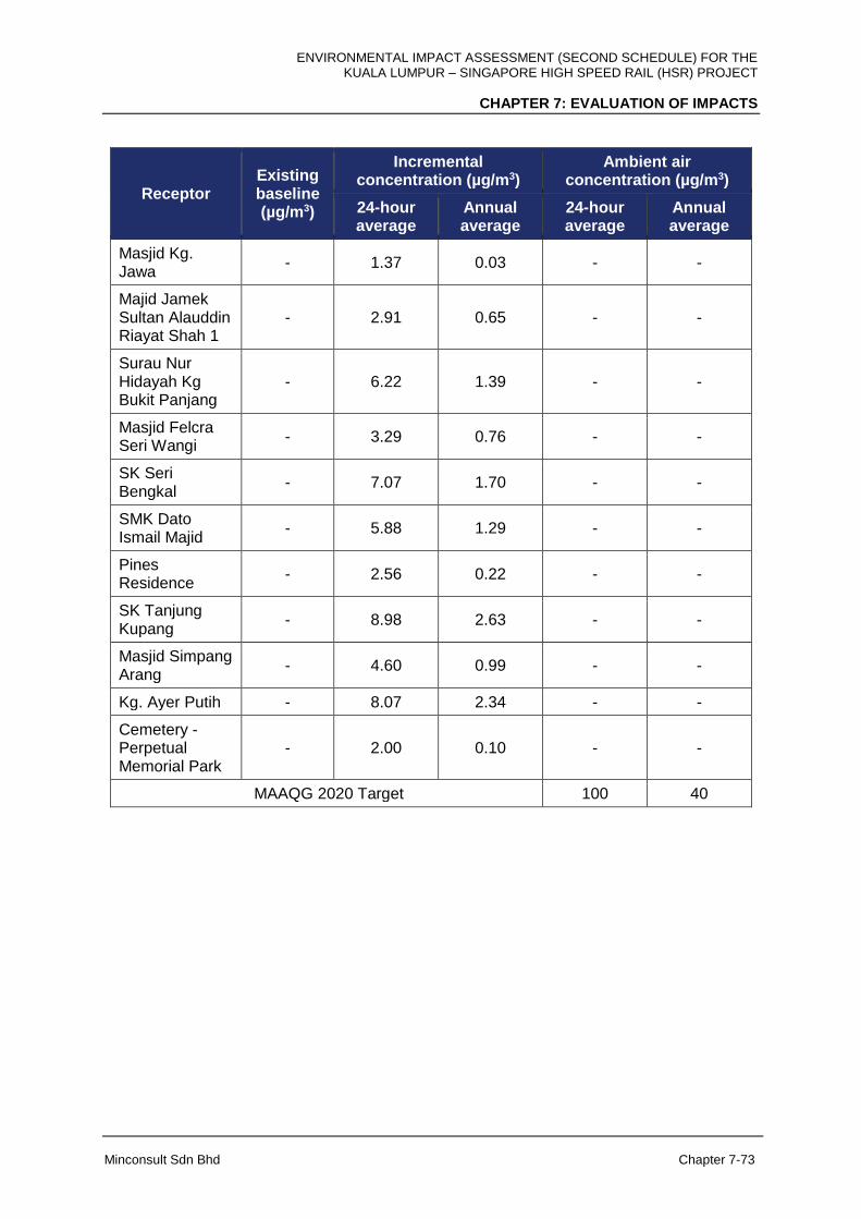
ENVIRONMENTAL IMPACT ASSESSMENT (SECOND SCHEDULE) FOR THE KUALA LUMPUR – SINGAPORE HIGH SPEED RAIL (HSR) PROJECT
CHAPTER 7: EVALUATION OF IMPACTS
Minconsult Sdn Bhd Chapter 7-73
Receptor Existing baseline (µg/m3)
Incremental concentration (µg/m3)
Ambient air concentration (µg/m3)
24-hour average
Annual average
24-hour average
Annual average
Masjid Kg. Jawa
- 1.37 0.03 - -
Majid Jamek Sultan Alauddin Riayat Shah 1
- 2.91 0.65 - -
Surau Nur Hidayah Kg Bukit Panjang
- 6.22 1.39 - -
Masjid Felcra Seri Wangi
- 3.29 0.76 - -
SK Seri Bengkal
- 7.07 1.70 - -
SMK Dato Ismail Majid
- 5.88 1.29 - -
Pines Residence
- 2.56 0.22 - -
SK Tanjung Kupang
- 8.98 2.63 - -
Masjid Simpang Arang
- 4.60 0.99 - -
Kg. Ayer Putih - 8.07 2.34 - -
Cemetery - Perpetual Memorial Park
- 2.00 0.10 - -
MAAQG 2020 Target 100 40

ENVIRONMENTAL IMPACT ASSESSMENT (SECOND SCHEDULE) FOR THE KUALA LUMPUR – SINGAPORE HIGH SPEED RAIL (HSR) PROJECT
CHAPTER 7: EVALUATION OF IMPACTS
Minconsult Sdn Bhd Chapter 7-74
ii) Without Control Measures
Receptor Existing baseline (µg/m3)
Incremental concentration (µg/m3)
Ambient air concentration (µg/m3)
24-hour average
Annual average
24-hour average
Annual average
Paya Buloh, A23
38 141.3 19.9 179.3 -
Kg. Parit Zing, A24
45 112.7 7.9 157.7 -
Kg. Paya Redan, A27
26 610.1 1437 636.1 -
Jalan Parit Botak, A30
31 104.1 6.6 135.1 -
SMK Dato Ismail, Majid, A31
28 144.2 26.0 172.2 -
Kg. Melayu Raya, A32
47 57.0 1.0 104.0 -
MainDepot and LMB, A33
42 106.4 7.1 148.4 -
Sekolah Kebangsaan Batu 24, A34
43 102.3 6.1 145.3 -
Gelang Patah, A35
52 143.1 22.5 195.1 -
Kg. Serom 4 - 257.62 55.34 - -
Masjid Kg. Jawa
- 67.67 1.51
- -
Majid Jamek Sultan Alauddin Riayat Shah 1
-
143.49 31.79
- -
Surau Nur Hidayah Kg Bukit Panjang
-
306.52 68.51
- -
Masjid Felcra Seri Wangi
- 162.19 37.61
- -
SK Seri Bengkal
- 348.57 83.97
- -
SMK Dato Ismail Majid
- 289.90 63.60
- -
Pines Residence
- 126.18 10.95
- -
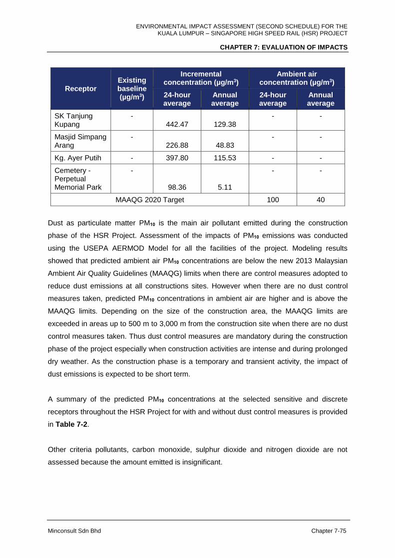
ENVIRONMENTAL IMPACT ASSESSMENT (SECOND SCHEDULE) FOR THE KUALA LUMPUR – SINGAPORE HIGH SPEED RAIL (HSR) PROJECT
CHAPTER 7: EVALUATION OF IMPACTS
Minconsult Sdn Bhd Chapter 7-75
Receptor Existing baseline (µg/m3)
Incremental concentration (µg/m3)
Ambient air concentration (µg/m3)
24-hour average
Annual average
24-hour average
Annual average
SK Tanjung Kupang
- 442.47 129.38
- -
Masjid Simpang Arang
- 226.88 48.83
- -
Kg. Ayer Putih - 397.80 115.53 - -
Cemetery - Perpetual Memorial Park
-
98.36 5.11
- -
MAAQG 2020 Target 100 40
Dust as particulate matter PM10 is the main air pollutant emitted during the construction
phase of the HSR Project. Assessment of the impacts of PM10 emissions was conducted
using the USEPA AERMOD Model for all the facilities of the project. Modeling results
showed that predicted ambient air PM10 concentrations are below the new 2013 Malaysian
Ambient Air Quality Guidelines (MAAQG) limits when there are control measures adopted to
reduce dust emissions at all constructions sites. However when there are no dust control
measures taken, predicted PM10 concentrations in ambient air are higher and is above the
MAAQG limits. Depending on the size of the construction area, the MAAQG limits are
exceeded in areas up to 500 m to 3,000 m from the construction site when there are no dust
control measures taken. Thus dust control measures are mandatory during the construction
phase of the project especially when construction activities are intense and during prolonged
dry weather. As the construction phase is a temporary and transient activity, the impact of
dust emissions is expected to be short term.
A summary of the predicted PM10 concentrations at the selected sensitive and discrete
receptors throughout the HSR Project for with and without dust control measures is provided
in Table 7-2.
Other criteria pollutants, carbon monoxide, sulphur dioxide and nitrogen dioxide are not
assessed because the amount emitted is insignificant.
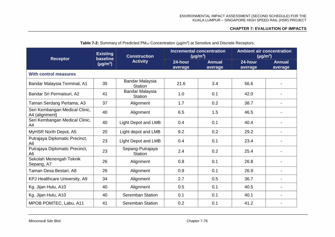
ENVIRONMENTAL IMPACT ASSESSMENT (SECOND SCHEDULE) FOR THE KUALA LUMPUR – SINGAPORE HIGH SPEED RAIL (HSR) PROJECT
CHAPTER 7: EVALUATION OF IMPACTS
Minconsult Sdn Bhd Chapter 7-76
Table 7-2: Summary of Predicted PM10 Concentration (µg/m3) at Sensitive and Discrete Receptors.
Receptor Existing baseline (µg/m3)
Construction Activity
Incremental concentration (µg/m3)
Ambient air concentration (µg/m3)
24-hour average
Annual average
24-hour average
Annual average
With control measures
Bandar Malaysia Terminal, A1 35 Bandar Malaysia
Station 21.6 3.4 56.6 -
Bandar Sri Permaisuri, A2 41 Bandar Malaysia
Station 1.0 0.1 42.0 -
Taman Serdang Pertama, A3 37 Alignment 1.7 0.2 38.7 -
Seri Kembangan Medical Clinic, A4 (alignment)
40 Alignment 6.5 1.5 46.5 -
Seri Kembangan Medical Clinic, A4
40 Light Depot and LMB 0.4 0.1 40.4 -
MyHSR North Depot, A5 20 Light depot and LMB 9.2 0.2 29.2 -
Putrajaya Diplomatic Precinct, A6
23 Light Depot and LMB 0.4 0.1 23.4 -
Putrajaya Diplomatic Precinct, A6
23 Sepang-Putrajaya
Station 2.4 0.2 25.4 -
Sekolah Menengah Teknik Sepang, A7
26 Alignment 0.8 0.1 26.8 -
Taman Desa Bestari, A8 26 Alignment 0.9 0.1 26.9 -
KPJ Healthcare University, A9 34 Alignment 2.7 0.5 36.7 -
Kg. Jijan Hulu, A10 40 Alignment 0.5 0.1 40.5 -
Kg. Jijan Hulu, A10 40 Seremban Station 0.1 0.1 40.1 -
MPOB POMTEC, Labu, A11 41 Seremban Station 0.2 0.1 41.2 -

ENVIRONMENTAL IMPACT ASSESSMENT (SECOND SCHEDULE) FOR THE KUALA LUMPUR – SINGAPORE HIGH SPEED RAIL (HSR) PROJECT
CHAPTER 7: EVALUATION OF IMPACTS
Minconsult Sdn Bhd Chapter 7-77
Receptor Existing baseline (µg/m3)
Construction Activity
Incremental concentration (µg/m3)
Ambient air concentration (µg/m3)
24-hour average
Annual average
24-hour average
Annual average
Taman Cermai Impian, A12 28 Seremban Station 0.3 0.1 28.3 -
Kg Sendayan, A13 30 Alignment 1.1 0.1 31.1 -
Taman Sungai Ujong, A14 27 Alignment 1.3 0.1 28.3 -
Taman Seri Aman, A15 45 Alignment 0.8 0.1 45.8 -
Kg. Solok Air Limau, A16 41 Alignment 1.9 0.1 42.9 -
Kg. Durian Daun, A17 49 Alignment 4.6 1.4 53.6 -
1 Krubong Residence, A18 56 Alignment 2.0 0.1 58.0 -
Cempaka Heights, A19 40 Melaka Station 1.3 0.1 41.3 -
Taman Bemban Baru, A20 57 Alignment 4.5 1.0 61.5 -
Open space / palm oil plantation, A21,
28 Alignment 1.9 0.1 29.9 -
Kg. Seri Mendapat, A22 44 Alignment 1.3 0.1 45.3 -
Paya Buloh, A23 38 Alignment 2.9 0.4 40.9 -
Kg. Parit Zing, A24 45 Alignment 2.3 0.2 47.3 -
Kg. Jawa Panchor, A25 27 Muar Station 0.6 0.1 27.6 -
Kg. Jawa Panchor, A25 27 HMB 7.2 0.1 34.2 -
Muar Station, A26 20 Muar Station 9.2 1.7 29.2 -
Muar Station, A26 20 HMB 11.3 0.1 31.3 -
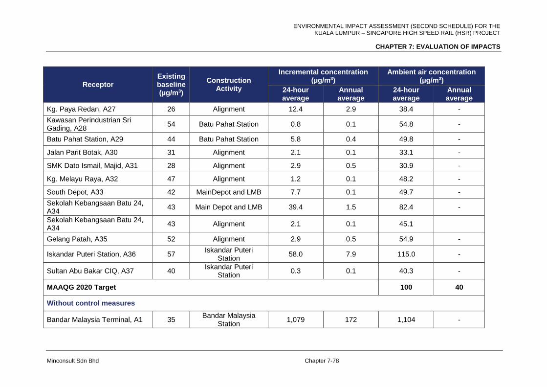
ENVIRONMENTAL IMPACT ASSESSMENT (SECOND SCHEDULE) FOR THE KUALA LUMPUR – SINGAPORE HIGH SPEED RAIL (HSR) PROJECT
CHAPTER 7: EVALUATION OF IMPACTS
Minconsult Sdn Bhd Chapter 7-78
Receptor Existing baseline (µg/m3)
Construction Activity
Incremental concentration (µg/m3)
Ambient air concentration (µg/m3)
24-hour average
Annual average
24-hour average
Annual average
Kg. Paya Redan, A27 26 Alignment 12.4 2.9 38.4 -
Kawasan Perindustrian Sri Gading, A28
54 Batu Pahat Station 0.8 0.1 54.8 -
Batu Pahat Station, A29 44 Batu Pahat Station 5.8 0.4 49.8 -
Jalan Parit Botak, A30 31 Alignment 2.1 0.1 33.1 -
SMK Dato Ismail, Majid, A31 28 Alignment 2.9 0.5 30.9 -
Kg. Melayu Raya, A32 47 Alignment 1.2 0.1 48.2 -
South Depot, A33 42 MainDepot and LMB 7.7 0.1 49.7 -
Sekolah Kebangsaan Batu 24, A34
43 Main Depot and LMB 39.4 1.5 82.4 -
Sekolah Kebangsaan Batu 24, A34
43 Alignment 2.1 0.1 45.1
Gelang Patah, A35 52 Alignment 2.9 0.5 54.9 -
Iskandar Puteri Station, A36 57 Iskandar Puteri
Station 58.0 7.9 115.0 -
Sultan Abu Bakar CIQ, A37 40 Iskandar Puteri
Station 0.3 0.1 40.3 -
MAAQG 2020 Target 100 40
Without control measures
Bandar Malaysia Terminal, A1 35 Bandar Malaysia
Station 1,079 172 1,104 -

ENVIRONMENTAL IMPACT ASSESSMENT (SECOND SCHEDULE) FOR THE KUALA LUMPUR – SINGAPORE HIGH SPEED RAIL (HSR) PROJECT
CHAPTER 7: EVALUATION OF IMPACTS
Minconsult Sdn Bhd Chapter 7-79
Receptor Existing baseline (µg/m3)
Construction Activity
Incremental concentration (µg/m3)
Ambient air concentration (µg/m3)
24-hour average
Annual average
24-hour average
Annual average
Bandar Sri Permaisuri, A2 41 Bandar Malaysia
Station 48 3 89 -
Taman Serdang Pertama, A3 37 Alignment 83.2 11.8 120.2 -
Seri Kembangan Medical Clinic, A4 (alignment)
40 Alignment 321.2 74.6 361.2 -
Seri Kembangan Medical Clinic, A4
40 Light depot and LMB 16.4 0.4 46.4 -
Light Depot and LMB, A5 20 Light depot and LMB 417.1 12.3 437.1 -
Putrajaya Diplomatic Precinct, A6
23 Lightdepot and LMB 20.1 0.5 43.1 -
Putrajaya Diplomatic Precinct, A6
23 Sepang-Putrajaya
Station 121.7 7.6 144.7 -
Sekolah Menengah Teknik Sepang, A7
26 Alignment 39.7 2.4 65.7 -
Taman Desa Bestari, A8 26 Alignment 43.8 2.6 69.8 -
KPJ Healthcare University, A9 34 Alignment 133.4 27.1 167.4 -
Kg. Jijan Hulu, A10 40 Alignment 22.8 0.9 62.8 -
Kg. Jijan Hulu, A10 40 Seremban Station 4.6 0.1 44.6 -
MPOB POMTEC, Labu, A11 41 Seremban Station 12.1 0.2 53.1 -
Taman Cermai Impian, A12 28 Seremban Station 14.9 0.5 42.9 -

ENVIRONMENTAL IMPACT ASSESSMENT (SECOND SCHEDULE) FOR THE KUALA LUMPUR – SINGAPORE HIGH SPEED RAIL (HSR) PROJECT
CHAPTER 7: EVALUATION OF IMPACTS
Minconsult Sdn Bhd Chapter 7-80
Receptor Existing baseline (µg/m3)
Construction Activity
Incremental concentration (µg/m3)
Ambient air concentration (µg/m3)
24-hour average
Annual average
24-hour average
Annual average
Kg. Sendayan, A13 30 Alignment 53.9 4.1 83.9 -
Taman Sungai Ujung, A14 27 Alignment 62.4 5.7 89.4 -
Taman Seri Aman, A15 45 Alignment 41.6 2.4 86.6 -
Kg. Solok Air Limau, A16 41 Alignment 94.3 2.6 135.3 -
Kg. Durian Daun, A17 49 Alignment 225.9 68.5 247.9 -
1 Krubong Residence, A18 56 Alignment 96.5 2.8 152.5 -
Cempaka Heights, A19 40 Melaka Station 66.1 1.2 106.1 -
Taman Bemban Baru, A20 57 Alignment 222.4 49.6 279.4 -
Open space / palm oil plantation, A21,
28 Alignment 94.2 2.6 122.2 -
Kg. Seri Mendapat, A22 44 Alignment 65.6 1.0 109.6 -
Paya Buloh, A23 38 Alignment 141.3 19.9 179.3 -
Kg. Parit Zing, A24 45 Alignment 112.7 7.9 157.7 -
Kg. Jawa Panchor, A25 27 Muar Station 29.9 0.3 56.9 -
Kg. Jawa Panchor, A25 27 Heavy Maintenance
Base 361.6 3.0 388.6 -
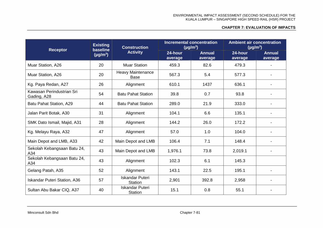
ENVIRONMENTAL IMPACT ASSESSMENT (SECOND SCHEDULE) FOR THE KUALA LUMPUR – SINGAPORE HIGH SPEED RAIL (HSR) PROJECT
CHAPTER 7: EVALUATION OF IMPACTS
Minconsult Sdn Bhd Chapter 7-81
Receptor Existing baseline (µg/m3)
Construction Activity
Incremental concentration (µg/m3)
Ambient air concentration (µg/m3)
24-hour average
Annual average
24-hour average
Annual average
Muar Station, A26 20 Muar Station 459.3 82.6 479.3 -
Muar Station, A26 20 Heavy Maintenance
Base 567.3 5.4 577.3 -
Kg. Paya Redan, A27 26 Alignment 610.1 1437 636.1 -
Kawasan Perindustrian Sri Gading, A28
54 Batu Pahat Station 39.8 0.7 93.8 -
Batu Pahat Station, A29 44 Batu Pahat Station 289.0 21.9 333.0 -
Jalan Parit Botak, A30 31 Alignment 104.1 6.6 135.1 -
SMK Dato Ismail, Majid, A31 28 Alignment 144.2 26.0 172.2 -
Kg. Melayu Raya, A32 47 Alignment 57.0 1.0 104.0 -
Main Depot and LMB, A33 42 Main Depot and LMB 106.4 7.1 148.4 -
Sekolah Kebangsaan Batu 24, A34
43 Main Depot and LMB 1,976.1 73.8 2,019.1 -
Sekolah Kebangsaan Batu 24, A34
43 Alignment 102.3 6.1 145.3
Gelang Patah, A35 52 Alignment 143.1 22.5 195.1 -
Iskandar Puteri Station, A36 57 Iskandar Puteri
Station 2,901 392.8 2,958 -
Sultan Abu Bakar CIQ, A37 40 Iskandar Puteri
Station 15.1 0.8 55.1 -

ENVIRONMENTAL IMPACT ASSESSMENT (SECOND SCHEDULE) FOR THE KUALA LUMPUR – SINGAPORE HIGH SPEED RAIL (HSR) PROJECT
CHAPTER 7: EVALUATION OF IMPACTS
Minconsult Sdn Bhd Chapter 7-82
7.2.1.3 Construction Access Roads
The predominant activity that is capable of inducing air quality impacts relates to the
movement of construction vehicles over access roads leading to construction sites.
Generally as access roads are temporary in nature, they are unpaved. Dust emissions occur
mainly from the transport of construction material to, and waste from, the project sites. Two
(2) scenarios namely, with control and without control measures, were simulated based on
this activity. With dust the air pollutant of concern, the applicable parameter in this
assessment is PM10.
Predicted Emission Rates
Dust plumes trailing behind vehicles travelling on unpaved roads are a familiar sight in most
exposed sites. The quantity of dust emissions from a given segment of unpaved road varies
linearly with the traffic volume. Field investigations have also shown that the rate of dust
emissions depend on factors that characterize the condition of particular road and
associated vehicle traffic. These include average vehicle speed, average vehicle weight,
average number of wheels per vehicle, road surface texture, and road surface moisture.
Dust emissions from unpaved roads have been found to vary in direct proportion to the
fraction of silt (particles smaller than 75 micrometers in diameter) in the road surface
material. The silt content of an unpaved dirt road will vary with location. Unpaved roads have
a hard, generally nonporous surface that usually dries quickly after a rainfall. The temporary
reduction in emissions caused by precipitation may be accounted for by not considering
emissions on "wet" days.
The following empirical expression may be used to estimate the quantity of size-specific
particulate emissions from an unpaved road, per vehicle kilometer travelled (VKT) (USEPA,
1995).
Emission, E = k(0.17) [s/12] [S/48] [W/2.7] 0.7 [w/4] 0.5 [(365-p)/365] kg/VKT

ENVIRONMENTAL IMPACT ASSESSMENT (SECOND SCHEDULE) FOR THE KUALA LUMPUR – SINGAPORE HIGH SPEED RAIL (HSR) PROJECT
CHAPTER 7: EVALUATION OF IMPACTS
Minconsult Sdn Bhd Chapter 7-83
In this case study, the following values were used to compute emissions from unpaved
roads:-
k, particulate multiplier = 0.5 for PM10
s, silt content = 20%
S, mean vehicle speed = 15 kmph
W, mean vehicle weight = 15 tons (Mg)
w, mean number of wheels = 6
p, mean number of rain days = 200
Based on the values above, the emission factor is computed to be:-
E = 0.5 (0.17) [20/12] [15/48] [15/2.7] 0.7 [6/4] 0.5 [(365-200)/365] kg/VKT
E = 0.5 X 0.17 X 1.666 X 0.3125 X 3.332 X 1.224 X 0.452 kg/VKT
E = 0.082 kg/VKT
For each construction site and an estimated 300 lorry trips per day is expected to transport
materials to and from the construction site. Assuming a vehicle weight of 15 tons, the peak
emission rate of particulate matter per kilometer travelled is estimated to be 369 kg/day
(0.082 X 300 X 1.0 X 15). Assuming that construction activity occur 12 hours in a day the
corresponding peak particulate emission rate is calculated to be 30.75 kg/hour (i.e. 369 / 12),
or 8.54 g/s (30.75 X 1,000 / (60 X 60)).
With control measures such as keeping the roads wet and moist using water trucks and
sprinklers and good housekeeping measures, the amount of dust emitted can easily be
reduced significantly. Dust emissions can be reduced by as much as 99 percent. However
for modeling purposes, the amount of dust removed is assumed at 95 percent. Thus the
emission rate when there are dust control measures is calculated to be 0.427 g/s (8.54 X
(100-95) / 100).
Impact Assessment
Air quality impact assessment associated with trucks travelling access roads has been
conducted through dispersion modeling employing the universally recognized USEPA
AERMOD Model. Data inputs to the model include source information, receptor grid,
ENVIRONMENTAL IMPACT ASSESSMENT (SECOND SCHEDULE) FOR THE KUALA LUMPUR – SINGAPORE HIGH SPEED RAIL (HSR) PROJECT
CHAPTER 7: EVALUATION OF IMPACTS
Minconsult Sdn Bhd Chapter 7-84
sensitive and discrete receptors, meteorology, dispersion options, model output and output
parameters.
Output Parameters
The following parameters were predicted;
i). Maximum 24-hour average PM10 concentration
ii). Annual average PM10 concentration
for two (2) scenarios, the first when there are control measures to reduce dust emissions
and the second, a worst case scenario when there are no control measures.
Results
As mentioned above, two (2) scenarios were simulated to assess the impacts of access road
activities on surrounding air quality; i.e. with and without dust control measures being
adopted. The worst case scenario is when dust control measures are not adopted.
With dust control measures routinely taken to control emissions generated by motor vehicles
on access roads, the predicted maximum 24-hour average PM10 incremental concentration
in the receptor grid of 3-km radius area was between a low of 10 µg/m3 at approximately 3
km away in most directions and the highest incremental concentration of 60 µg/m3 at the
boundary of the road itself. Figure 7-41 shows the predicted maximum 24-hour average
PM10 incremental concentration contours. With the adoption of dust control measures, the
predicted PM10 concentrations in ambient air are expected to fall below the new MAAQG
limit of 100 µg/m3. In the case of the annual average PM10 concentration levels, the
predicted PM10 incremental concentration is mainly below 5.0 µg/m3 and deemed
insignificant and below the new guideline limit of 40 µg/m3. The results of the modelling for
this parameter are shown in Figure 7-42.
Without any adoption of dust control measures, dust dispersions from the access road will
result in induced 24 hour PM10 concentrations that vary between 100 µg/m3 at the edge of
the receptor grid and 1,000 µg/m3 at the road boundary. Predicted 24 hour PM10
concentrations will be above the guideline limit of 100 µg/m3 throughout the receptor grid.
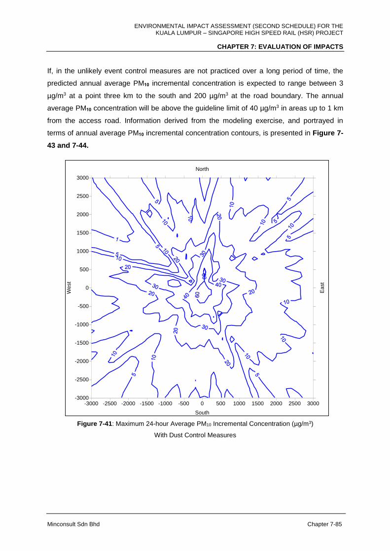
ENVIRONMENTAL IMPACT ASSESSMENT (SECOND SCHEDULE) FOR THE KUALA LUMPUR – SINGAPORE HIGH SPEED RAIL (HSR) PROJECT
CHAPTER 7: EVALUATION OF IMPACTS
Minconsult Sdn Bhd Chapter 7-85
If, in the unlikely event control measures are not practiced over a long period of time, the
predicted annual average PM10 incremental concentration is expected to range between 3
µg/m3 at a point three km to the south and 200 µg/m3 at the road boundary. The annual
average PM10 concentration will be above the guideline limit of 40 µg/m3 in areas up to 1 km
from the access road. Information derived from the modeling exercise, and portrayed in
terms of annual average PM10 incremental concentration contours, is presented in Figure 7-
43 and 7-44.
-3000 -2500 -2000 -1500 -1000 -500 0 500 1000 1500 2000 2500 3000
South
North
-3000
-2500
-2000
-1500
-1000
-500
0
500
1000
1500
2000
2500
3000
We
st
Ea
st
Figure 7-41: Maximum 24-hour Average PM10 Incremental Concentration (µg/m3)
With Dust Control Measures

ENVIRONMENTAL IMPACT ASSESSMENT (SECOND SCHEDULE) FOR THE KUALA LUMPUR – SINGAPORE HIGH SPEED RAIL (HSR) PROJECT
CHAPTER 7: EVALUATION OF IMPACTS
Minconsult Sdn Bhd Chapter 7-86
-3000 -2500 -2000 -1500 -1000 -500 0 500 1000 1500 2000 2500 3000
South
North
-3000
-2500
-2000
-1500
-1000
-500
0
500
1000
1500
2000
2500
3000
We
st
Ea
st
Figure 7-42: Annual Average PM10 Incremental Concentration (µg/m3)
With Dust Control Measures
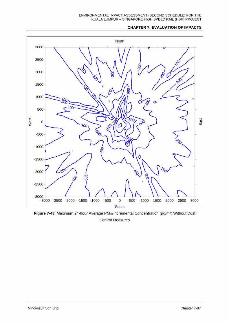
ENVIRONMENTAL IMPACT ASSESSMENT (SECOND SCHEDULE) FOR THE KUALA LUMPUR – SINGAPORE HIGH SPEED RAIL (HSR) PROJECT
CHAPTER 7: EVALUATION OF IMPACTS
Minconsult Sdn Bhd Chapter 7-87
-3000 -2500 -2000 -1500 -1000 -500 0 500 1000 1500 2000 2500 3000
South
North
-3000
-2500
-2000
-1500
-1000
-500
0
500
1000
1500
2000
2500
3000
We
st
Ea
st
Figure 7-43: Maximum 24-hour Average PM10 Incremental Concentration (µg/m3) Without Dust
Control Measures
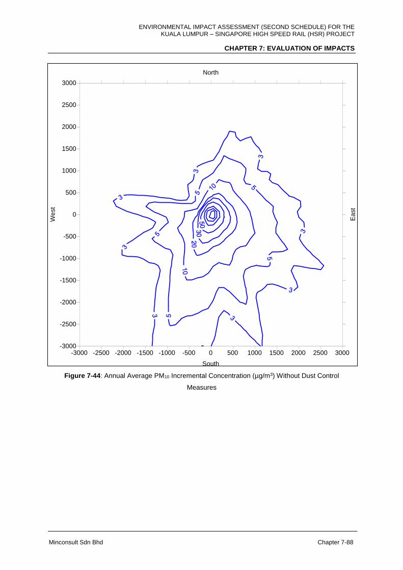
ENVIRONMENTAL IMPACT ASSESSMENT (SECOND SCHEDULE) FOR THE KUALA LUMPUR – SINGAPORE HIGH SPEED RAIL (HSR) PROJECT
CHAPTER 7: EVALUATION OF IMPACTS
Minconsult Sdn Bhd Chapter 7-88
-3000 -2500 -2000 -1500 -1000 -500 0 500 1000 1500 2000 2500 3000
South
North
-3000
-2500
-2000
-1500
-1000
-500
0
500
1000
1500
2000
2500
3000
We
st
Ea
st
Figure 7-44: Annual Average PM10 Incremental Concentration (µg/m3) Without Dust Control
Measures
ENVIRONMENTAL IMPACT ASSESSMENT (SECOND SCHEDULE) FOR THE KUALA LUMPUR – SINGAPORE HIGH SPEED RAIL (HSR) PROJECT
CHAPTER 7: EVALUATION OF IMPACTS
Minconsult Sdn Bhd Chapter 7-89
This modeling assessment predicted that the intensity of dust dispersions from access road
activities when there are dust control measures in place will be moderate at the access
roads, and a low impact away from the road. Predicted PM10 concentrations are within the
new Malaysian Ambient Air Quality Guideline limits of 100 µg/m3 for the maximum 24-hour
average concentration and 40 µg/m3 for the annual average concentration.
In cases when dust control measures are not adopted, predicted imposed PM10
concentrations are likely to be well above the new Malaysian Ambient Air Quality Guideline
limits. Thus, it is recommended that dust control measures be always implemented.
7.2.2 Operational Phase
During the operational phase of the HSR Project there are insignificant amount of air
pollutants released but as train units are powered by electricity, greenhouse gases (GHG)
are released indirectly by its operation.
However, this GHG emission is expected to be offset by the reduction in the number of
motor vehicles and aircraft usage as users switch to HSR. With this switch in transportation
mode, it is anticipated that there will be a positive impact of this project in terms of GHG
emissions although the amount of reduction depends on transportation activities and fuel
efficiency. This assessment aims to quantify the potential reduction in GHG through modal
shift from motor vehicles and aircrafts to HSR. The only greenhouse gas of concern in this
assessment is carbon dioxide (CO2) as other GHG such as methane and nitrous oxide are
released in insignificant amounts or not at all.
The GHG inventory is computed based on a simple offset formula with certain assumptions
and projected data of the operation of the HSR. The nett amount of CO2 avoided from modal
shift of the HSR is computed based on the formula below;
Nett CO2 avoided = calculated amount of CO2 released avoided by motor vehicles
(cars/buses), rail and aircraft – calculated amount of CO2 resulting from HSR operation.
ENVIRONMENTAL IMPACT ASSESSMENT (SECOND SCHEDULE) FOR THE KUALA LUMPUR – SINGAPORE HIGH SPEED RAIL (HSR) PROJECT
CHAPTER 7: EVALUATION OF IMPACTS
Minconsult Sdn Bhd Chapter 7-90
The following assumptions were made in the calculations of CO2 emissions.
i) Modal split for air, cars, buses and rail based on impact of HSR on other modes
(reference: Exhibit 50: Other Modes, Page 3-58, Chapter 3, Demand and Revenue) :
46%, 10%, 25% and 23%;
ii) Average number of occupants for cars: 2.5 (reference: Exhibit 14: Vehicle Occupancy
and Assumptions, Page 3-19, Chapter 3, Demand and Revenue);
iii) CO2 emission factor for private car: 193.28 g/ vehicle km (GEF, 2010);
iv) CO2 emission factor for bus passengers: 135.52 g/km pp (DEFRA, 2012);
v) CO2 emission factor for aircraft passengers (short haul; flight distance <785 km):
172.71 g/km pp (DEFRA, 2012);
vi) Emission factor for normal passenger train: 50.0 g/km pp (Britain’s Transport
Infrastructure Rail Electrification, 2009); for high speed trains 40g/km.pp
vii) Distance covered: 350 km, (length of HSR)
viii) Ridership of HSR for year 2030 projection: 15,220,000 passengers
Based upon the above assumed criteria, the amount of avoided release of CO2 induced by
the HSR Project as a result of capturing commuters who otherwise would have travelled to
Singapore from Kuala Lumpur by air, cars, bus and by KTM trains is estimated as follows:
i) Aircraft ridership avoided because of HSR: 15,220,000 X 46/100= 7,001,200 per
annum.
ii) Amount of CO2 avoided: (7,001,200 X 172.71 X 300) / (1,000,000) = 362, 753.18
tons per annum. (Flight distance between KLIA and Changi is taken as 300 km)
iii) Car ridership avoided because of HSR: 15,220,000 X 10/100= 1,522,000 per annum.
Number of car trips avoided: 1,522,000 / 2.5 = 608,800 trips per annum.
ENVIRONMENTAL IMPACT ASSESSMENT (SECOND SCHEDULE) FOR THE KUALA LUMPUR – SINGAPORE HIGH SPEED RAIL (HSR) PROJECT
CHAPTER 7: EVALUATION OF IMPACTS
Minconsult Sdn Bhd Chapter 7-91
iv) Amount of CO2 avoided: (608,800 X 193.28 X 365) / (1,000,000) = 42,949.14 tons
per annum.
v) Bus ridership avoided because of HSR: 15,220,000 X 25/100= 3,805,000 per annum
Amount of CO2 avoided: (3,805,000 X 135.52 X 365) / (1,000,000) = 188,213.56 tons
per annum.
vi) Train ridership avoided because of HSR: 15,220,000 X 23/100 = 3,500,600 per
annum
vii) Amount of CO2 avoided: (3,500,600 X 50.0 X 365) / (1,000,000) = 63,885.95 tons per
annum.
viii) Total amount of CO2 released avoided by aircrafts, cars, buses and trains 362,753.18
+ 42,949.14 + 188,213.56 + 63,885.95 = 657,801.82 tons per annum.
ix) Total amount of CO2 released by ridership on HSR: (15,220,000 X 40.0 X 365) /
(1,000,000) = 222,212.0 tons per annum.
x) Nett CO2 avoided: 657.801.82 – 222,212.00 = 435,589.82 tons per annum.
This assessment showed that the HSR would reduce 435,590 tons of CO2 per year of
operation based on enticing passengers travelling by private motor vehicles, buses, KTM
train and aircraft to use the HSR service. Besides the amount of CO2 avoided, there are
health benefits in the modal shift from private cars and buses to electrified trains although
health benefits are difficult to be quantified. A study recently by Kwan (Kwan, et. al. 2017)
“The Carbon Savings and Health Co-benefits from the Introduction of Mass Transit System
in Greater Kuala Lumur, Malaysia” showed that there are health benefits in such a switch. In
addition, travelling by HSR transport could lead to lowering the rate of vehicular accidents,
and resulting morbidity and mortality rates.

ENVIRONMENTAL IMPACT ASSESSMENT (SECOND SCHEDULE) FOR THE KUALA LUMPUR – SINGAPORE HIGH SPEED RAIL (HSR) PROJECT
CHAPTER 7: EVALUATION OF IMPACTS
Minconsult Sdn Bhd Chapter 7-92
7.3 NOISE IMPACTS
7.3.1 Construction Phase
The assessment and evaluation of noise impacts are predicated on the potential activities
that will be executed to construct the Project components. The list of these construction
related activities that has potential noise impacts are summarised in Table 7-3:
Table 7-3: List of the Construction related Activities that has Potential Noise Impacts
Main Project Activities Sub-Project Activities
Stations, Depots and Maintenance Bases
Land Clearing
Demolition
Construction of Access Roads
Earthworks
Transportation of Materials / Equipment
Vehicle Movement
Traffic Diversion
Piling
Construction of Stations / Depots / Maintenance Bases
Construction of Elevated Structures
Construction of At-Grade Structures
Utilities Relocation
Tracks Work (At-grade, Elevated, Tunnel and Bridge)
Land Clearing
Demolition
Construction of Access Roads
Earthworks
Transportation of Materials / Equipment
Vehicle Movement
Traffic Diversion
Piling
Construction of Elevated Structures / Bridges
Construction of At-grade Structures
Tunnelling
Installation of Track
Utilities Relocation
The use of machines, equipment and vehicles for the construction of Project facilities will
generate noise and vibrations; the intensity of which reduces as a function of distance away
from their known position. The level of noise that will be generated at source depends on the

ENVIRONMENTAL IMPACT ASSESSMENT (SECOND SCHEDULE) FOR THE KUALA LUMPUR – SINGAPORE HIGH SPEED RAIL (HSR) PROJECT
CHAPTER 7: EVALUATION OF IMPACTS
Minconsult Sdn Bhd Chapter 7-93
type, number and power rating of the machineries employed. Noise levels of typical
construction machinery and equipment, measured at specific distances away from its
position are listed in Table 7-4. For example, the noise level (Leq) measured within 10 m
from an excavator is 83.3 dBA, which is then attenuated by 6 dB for every doubling of
distance with potential for additional reduction in levels due to ground and atmospheric
attenuations.
Table 7-4: Noise Levels for Typical Construction Machinery and Equipment
Machinery / Equipment Involved
Sound Power Level (dBA)
Sound Pressure Level* (dBA)
10 m 25 m 50 m 100 m 500 m
Impact pile driver: - Pre-cast concrete pile - H-section steel pile
120 129
90.3 99.3
82.1 91.1
75.7 84.7
69.3 78.3
53.4 62.4
Bulldozer 112 82.3 74.1 67.7 61.3 45.4
Excavator 113 83.3 75.1 68.7 62.3 46.4
Tractor 108 78.3 70.1 63.7 57.3 41.4
Truck / lorry 120 90.3 82.1 75.7 69.3 53.4
Grader 120 90.3 82.1 75.7 69.3 53.4
Generator (250 kVA) 120 90.3 82.1 75.7 69.3 53.4
Pump (Diesel) 119 89.3 81.1 74.7 68.3 52.4
* Based on typical Malaysian climate (ambient temperature 30, humidity 80%) and with 0.5 ground
factor.
The allowable noise limits during the construction phase is specified by the DOE Noise
Guidelines as per Table 7-5, where prediction of the sound pressure level is based on ISO
9316-1:1993 (Acoustics: Attenuation of sound during propagation outdoors – Part 1:
Calculation of the absorption of sound by the atmosphere) and ISO 9316-2:1996 (Acoustics:
Attenuation of sound during propagation outdoors – Part 2: General method of calculation).
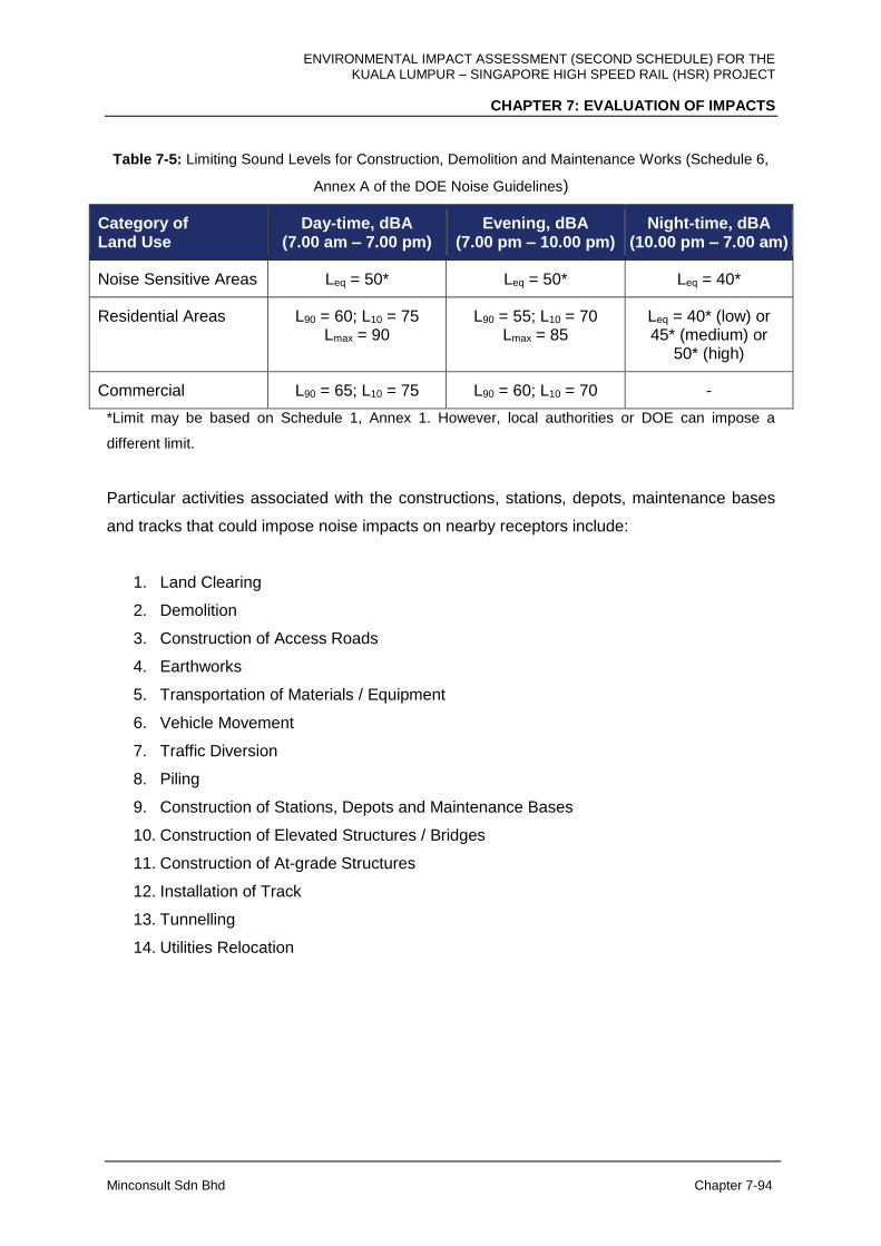
ENVIRONMENTAL IMPACT ASSESSMENT (SECOND SCHEDULE) FOR THE KUALA LUMPUR – SINGAPORE HIGH SPEED RAIL (HSR) PROJECT
CHAPTER 7: EVALUATION OF IMPACTS
Minconsult Sdn Bhd Chapter 7-94
Table 7-5: Limiting Sound Levels for Construction, Demolition and Maintenance Works (Schedule 6,
Annex A of the DOE Noise Guidelines)
Category of Land Use
Day-time, dBA (7.00 am – 7.00 pm)
Evening, dBA (7.00 pm – 10.00 pm)
Night-time, dBA (10.00 pm – 7.00 am)
Noise Sensitive Areas Leq = 50* Leq = 50* Leq = 40*
Residential Areas L90 = 60; L10 = 75 Lmax = 90
L90 = 55; L10 = 70 Lmax = 85
Leq = 40* (low) or 45* (medium) or
50* (high)
Commercial L90 = 65; L10 = 75 L90 = 60; L10 = 70 -
*Limit may be based on Schedule 1, Annex 1. However, local authorities or DOE can impose a
different limit.
Particular activities associated with the constructions, stations, depots, maintenance bases
and tracks that could impose noise impacts on nearby receptors include:
1. Land Clearing
2. Demolition
3. Construction of Access Roads
4. Earthworks
5. Transportation of Materials / Equipment
6. Vehicle Movement
7. Traffic Diversion
8. Piling
9. Construction of Stations, Depots and Maintenance Bases
10. Construction of Elevated Structures / Bridges
11. Construction of At-grade Structures
12. Installation of Track
13. Tunnelling
14. Utilities Relocation

ENVIRONMENTAL IMPACT ASSESSMENT (SECOND SCHEDULE) FOR THE KUALA LUMPUR – SINGAPORE HIGH SPEED RAIL (HSR) PROJECT
CHAPTER 7: EVALUATION OF IMPACTS
Minconsult Sdn Bhd Chapter 7-95
A) FT. Kuala Lumpur
During the construction of station at Bandar Malaysia, construction activities may cause
adverse noise impacts to nearby residents located near the Bandar Malaysia Station such as
in Taman Desa Seputeh located 300 m to the west of the site.
For construction of tracks (At-Grade, on Elevated structures and tunnel), the construction
activities may also cause adverse impacts to nearby residents and noise sensitive areas
located adjacent to the HSR alignment, where the tracks and tunnel are to be constructed.
Based on the current measured noise levels at specific receptors located within 30-50 m to
the HSR alignment, and taking due cognizance of the noise limits listed in Table 7-5, noise
impacts imposed on receptors along Jalan JKR Salak Selatan and JKR Quarters (NK2) and
Kg. Baru Salak Selatan (NK3) could be significant.
In general, residential areas and noise sensitive areas located less than 30 m or less than
50 m, respectively, from the alignment could be adversely impacted, in that L10 levels within
such areas are predicted to increase by more than 10 dB from existing baseline values due
to construction activities. Noise related impacts that can be imposed on surrounding
receptors by the above-mentioned list of Project activities are described herewith.
I. Noise from Land Preparation, Earthworks and Demolition Activities
Land preparation and earthworks for construction of Bandar Malaysia Station and
construction of tracks from Bandar Malaysia to the tunnel portal at Kg. Baru Salak Selatan
involve the use of many noisy machinery and vehicles including bulldozers, excavators,
graders and trucks. Demolition of old building and structures may also involve excavators
and/or bulldozers. Depending on the type and number of machinery used in the working site,
the noise level received by the receptors within 25 m and 50 m of the site are expected to
reach maximum levels of 82 dBA and 76 dBA, respectively, as indicated in Table 7-4. These
activities can be a nuisance to residents and noise sensitive receptors near Bandar Malaysia
Station at Taman Desa Seputeh, buildings along Jalan JKR Salak Selatan and at Kg. Baru
Salak Selatan.
ENVIRONMENTAL IMPACT ASSESSMENT (SECOND SCHEDULE) FOR THE KUALA LUMPUR – SINGAPORE HIGH SPEED RAIL (HSR) PROJECT
CHAPTER 7: EVALUATION OF IMPACTS
Minconsult Sdn Bhd Chapter 7-96
II. Noise induced by Vehicle Movements and Transportation of Materials and
Equipment
Vehicle movement and transportation of construction materials and equipment to the site will
involve the use of noisy vehicles such as trucks. In addition, construction of tunnel from Kg.
Baru Salak Selatan to Serdang produces excavated materials that need to be transported
out from the excavated sites using local roads in Kg. Baru Salak Selatan and/or Jalan UPM.
Depending on the type and number of vehicle used, the noise level received by the
receptors within 25 m and 50 m of the site are expected to reach maximum levels of 82 dBA
and 76 dBA, respectively, as indicated in Table 7-4. These activities can be a nuisance to
residents and noise sensitive receptors near Bandar Malaysia Station at Taman Desa
Seputeh, buildings along Jalan JKR Salak Selatan and at Kg. Baru Salak Selatan.
III. Noise from Construction of Access Roads
Construction of access roads for access to the sites, i.e., Station and sites for tracks involve
the use of many noisy machinery and vehicles including bulldozers, excavators, graders and
trucks. The noise level generated by these machineries and vehicles received by the
receptors within 25 m and 50 m of the site are expected to reach maximum levels of 82 dBA
and 76 dBA, respectively, as indicated in Table 7-4. These activities can be a nuisance to
residents and noise sensitive receptors near Bandar Malaysia Station at Taman Desa
Seputeh, buildings along Jalan JKR Salak Selatan and at Kg. Baru Salak Selatan.
IV. Noise from Piling Activities
Noise generated by piling activities are impulsive in nature and are relatively more annoying
than steady-state noise. The impact is going to be significant if conventional piling method
were to be used. Depending on the pile used, noise from pile drivers can reaches up to 82-
91 dBA at 25 m and 76-85 dBA at 50 m from the construction site as indicated in Table 7-4.
These activities can be a nuisance to nearby residential and noise sensitive areas especially
for piling locations that are close residential areas, where the alignment transverses high
density populations such as around Bandar Malaysia, at Taman Desa Seputeh, buildings
along Jalan JKR Salak Selatan and at Kg. Baru Salak Selatan.
ENVIRONMENTAL IMPACT ASSESSMENT (SECOND SCHEDULE) FOR THE KUALA LUMPUR – SINGAPORE HIGH SPEED RAIL (HSR) PROJECT
CHAPTER 7: EVALUATION OF IMPACTS
Minconsult Sdn Bhd Chapter 7-97
V. Noise from Construction of Station
Noise generated due to construction of the Station at Bandar Malaysia involve piling and use
of heavy machinery at the site and its access roads. Noise from heavy machinery in the
construction site may involve generators, grinders and metal cutters. Depending on the type
and number of machinery used in the working site, the noise level for the receivers within 25
m and 50 m of the site are expected to reach maximum levels of 82 dBA and 76 dBA,
respectively, as indicated in Table 7-4. These activities can be a nuisance to nearby
residential and noise sensitive areas in the vicinity of Bandar Malaysia Station such as at
Taman Desa Seputeh.
VI. Noise from Construction of Elevated Structures and Bridges
Noise generated due to constructions of the elevated structures and bridges along the HSR
alignment involve piling and use of heavy machinery at the site and its access roads.
Depending on the type and number of machinery used in the working site, the noise level for
the receivers within 25 m and 50 m of the site are expected to reach maximum levels of 82
dBA and 76 dBA, respectively, as indicated in Table 7-4. These activities can be a nuisance
to nearby residential and noise sensitive areas as identified above, particularly at areas
where the alignment transverses high density populations such as near Bandar Malaysia, at
Taman Desa Seputeh, buildings along Jalan JKR Salak Selatan and at Kg. Baru Salak
Selatan.
VII. Noise from Tunnelling
Noise generated due to tunnelling activities for tunnels along the HSR alignment involve use
of TBM for tunnel location from Kg. Baru Salak Selatan to Jalan UPM, Serdang. In addition
to tunnelling activities, high noise level can also be caused by movement of heavy vehicles
carrying excavated materials and construction equipment from the tunnel portals in the
construction site. These may cause nuisance to receptors located or residents living near
tunnel portals such as at Kg. Baru Salak Selatan. The predicted sound level during
tunnelling activity in Kg. Baru Salak Selatan is depicted in Figure 7-45, assuming that the
vehicle carrying excavated materials and construction equipment travels at a speed of
40 km/hr along the existing road in the existing residential areas as shown. The noise
propagation result shows that the noise contour of 65 dB represent the limit during

ENVIRONMENTAL IMPACT ASSESSMENT (SECOND SCHEDULE) FOR THE KUALA LUMPUR – SINGAPORE HIGH SPEED RAIL (HSR) PROJECT
CHAPTER 7: EVALUATION OF IMPACTS
Minconsult Sdn Bhd Chapter 7-98
construction activities is generally located at a 15 m distance from the tunnel portal and 5 m
from the road. Hence, any receptors located nearer from these distances will be affected by
these activities.
Figure 7-45: Predicted noise contours during the tunnelling construction phase at Kg Baru Salak
Selatan (noise limit of 65 dBA shown by red lines)
VIII. Noise from Installation of Tracks
Noise generated due to installation of tracks at the elevated structures along the HSR
alignment in Kuala Lumpur involves use of noisy machinery at the site and equipment, which
can generate impulsive noise, such as impact hammers, grinders and metal cutters.
Depending on the type and number of machinery used in the working site, the noise level for
the receivers within 25 m and 50 m of the site are expected to reach maximum levels of
82 dBA and 76 dBA, respectively, as indicated in Table 7-4. These activities can be a
nuisance to nearby residential and noise sensitive areas in Bandar Malaysia, Taman Desa
Seputeh, Jalan JKR Salak Selatan and Kg. Baru Salak Selatan.

ENVIRONMENTAL IMPACT ASSESSMENT (SECOND SCHEDULE) FOR THE KUALA LUMPUR – SINGAPORE HIGH SPEED RAIL (HSR) PROJECT
CHAPTER 7: EVALUATION OF IMPACTS
Minconsult Sdn Bhd Chapter 7-99
IX. Noise from Utilities Relocation
Utility relocation involves the use of several equipment and vehicles, which can emit high-
level sound such as generators and lorries. The noise levels for the receivers within 50 m
and 100 m of the site are expected to reach maximum levels of 72 dBA and 67 dBA,
respectively, as indicated in Table 7-4. These activities can be a nuisance to nearby
residential and noise sensitive areas in Bandar Malaysia, Taman Desa Seputeh, Jalan JKR
Salak Selatan and Kg. Baru Salak Selatan.
B) Selangor / FT. Putrajaya
During the construction of Sepang-Putrajaya Station and Light Depot and LMB in Serdang,
construction activities may cause adverse noise impacts to nearby residents located near
the Sepang-Putrajaya Station and Light Depot and LMB, such as near Kg. Dato’ Abu Bakar
Baginda and Kg. Sg. Merab Luar in Selangor and Diplomatic Precinct in FT. Putrajaya.
For construction of tracks (At-Grade, on Elevated structures and bridges), the construction
activities may also cause adverse impacts to nearby residents and noise sensitive areas
located adjacent to the HSR alignment, where the tracks are to be constructed. Based on
the current measured noise levels at specific receptors located within 30-50 m to the HSR
alignment, and taking due cognizance of the noise limits listed in Table 7-5, noise impacts
imposed on receptors along Jalan UPM (NS4), along Persiaran Madani in UNITEN and
Jalan Ayer Hitam (NS6), in Kg. Dato Abu Bakar Baginda (NS7), Kg. Sg. Merab Hulu (NS9),
Persiaran Vista, Sepang (NS10) and Desa Bestari, Sepang (NS11) could be significant.
In general, residential areas and noise sensitive areas located less than 30 m or less than
50 m, respectively, from the alignment could be adversely impacted, in that L10 levels within
such areas are predicted to increase by more than 10 dB from existing baseline values due
to construction activities. Noise related impacts that can be imposed on surrounding
receptors by the above-mentioned list of Project activities are described herewith.
I. Noise from Land Preparation, Earthworks and Demolition Activities
Land preparation and earthworks for construction of Stations, Depots and Maintenance Base
as well as construction of tracks involve the use of many noisy machinery and vehicles

ENVIRONMENTAL IMPACT ASSESSMENT (SECOND SCHEDULE) FOR THE KUALA LUMPUR – SINGAPORE HIGH SPEED RAIL (HSR) PROJECT
CHAPTER 7: EVALUATION OF IMPACTS
Minconsult Sdn Bhd Chapter 7-100
including bulldozers, excavators, graders and trucks. Demolition of old building and
structures may also involve excavators and/or bulldozers. Depending on the type and
number of machinery used in the working site, the noise level received by the receptors
within 25 m and 50 m of the site are expected to reach maximum levels of 82 dBA and 76
dBA, respectively, as indicated in Table 7-4. These activities can be a nuisance to nearby
residential and noise sensitive areas in medium and high-density population near Sepang-
Putrajaya Station, along Jalan UPM, Kg. Dato’ Abu Bakar Baginda and Desa Bestari,
Sepang as well as at higher education institutions and training centres along Jalan UPM,
Jalan Sg. Besi and Jalan Ayer Hitam.
II. Noise induced by Vehicle Movements and Transportation of Materials and
Equipment
Vehicle movement and transportation of construction materials and equipment to the sites
will involve the use of noisy vehicles such as trucks. In addition, construction of tunnels at
several locations in Selangor, namely part of the tunnel connecting Kg. Baru Salak Selatan
and Serdang and the other two tunnels in Kg. Sg. Merab Hulu and Kg. Bukit Piatu, Dengkil,
produces excavated materials that need to be transported out from the excavated sites.
Depending on the type and number of vehicle used, the noise levels received by the
receptors within 25 m and 50 m of the site are expected to reach maximum levels of 82 dBA
and 76 dBA, respectively, as indicated in Table 7-4. These activities can be a nuisance to
nearby residential and noise sensitive areas as identified above, particularly along several
state and federal routes, such as Jalan UPM, Jalan Sg. Besi, Jalan Ayer Hitam, Jalan Kg.
Sg. Merab Hulu and Jalan Kajang-Dengkil.
III. Noise from Construction of Access Roads
Construction of access roads for access to the sites, at Sepang-Putrajaya Station and the
Light Depot and LMB in Serdang as well as the tracks along the HSR alignment in Selangor
/ FT. Putrajaya, involves the use of many noisy machinery and vehicles including bulldozers,
excavators, graders and trucks. The noise levels generated by these machineries and
vehicles received by the receptors within 25 m and 50 m of the site are expected to reach
maximum levels of 82 dBA and 76 dBA, respectively, as indicated in Table 7-4. These
activities can be a nuisance to nearby residential and noise sensitive areas as identified
earlier.
ENVIRONMENTAL IMPACT ASSESSMENT (SECOND SCHEDULE) FOR THE KUALA LUMPUR – SINGAPORE HIGH SPEED RAIL (HSR) PROJECT
CHAPTER 7: EVALUATION OF IMPACTS
Minconsult Sdn Bhd Chapter 7-101
IV. Noise from Traffic Diversions
Traffic diversion involves alteration of normal traffic routes temporarily, which may bring
traffic closer to the residential and noise sensitive areas due to this diversion. This results in
higher noise level experienced by the receptors living nearby the diverted routes. The
affected roads include Jalan UPM, Jalan Sg. Besi, Jalan Ayer Hitam, Jalan Kg. Sg. Merab
Hulu and Jalan Kajang-Dengkil. Depending on the traffic using the diverted routes, the noise
levels for the receivers within 25 m and 50 m of the site are expected to reach maximum
levels of 82 dBA and 76 dBA, respectively, as indicated in Table 7-4. These activities can be
a nuisance to nearby residential and noise sensitive areas as identified earlier.
V. Noise from Piling Activities
Noise generated by piling activities are impulsive in nature and are relatively more annoying
than steady-state noise. The impact is going to be significant if conventional piling method
were to be used. Depending on the pile used, noise from pile drivers can reaches up to 82-
91 dBA at 25 m and 76-85 dBA at 50 m from the construction site as indicated in Table 7-4.
These activities can be a nuisance to nearby residential and noise sensitive areas especially
for piling locations that are close residential areas, where the alignment transverses high
density populations such as near higher education institutions (UPM and UNITEN), training
centres along Jalan Ayer Hitam, Kg. Dato’ Abu Bakar Baginda, Persiaran Vista and Desa
Bestari, Sepang.
VI. Noise from Construction of Stations, Depots and Maintenance Bases
Noise generated due to constructions of Sepang-Putrajaya Station and Light Depot and LMB
will involve piling and use of heavy machinery at the site and its access roads. Noise from
heavy machinery in the construction site may involve generators, grinders and metal cutters.
Depending on the type and number of machinery used in the working site, the noise levels
for the receivers within 25 m and 50 m of the site are expected to reach maximum levels of
82 dBA and 76 dBA, respectively, as indicated in Table 7-4. These activities can be a
nuisance to nearby residential and noise sensitive areas in the vicinity of Light Depot and
LMB and Sepang-Putrajaya Station.
ENVIRONMENTAL IMPACT ASSESSMENT (SECOND SCHEDULE) FOR THE KUALA LUMPUR – SINGAPORE HIGH SPEED RAIL (HSR) PROJECT
CHAPTER 7: EVALUATION OF IMPACTS
Minconsult Sdn Bhd Chapter 7-102
VII. Noise from Construction of Elevated Structures and Bridges
Noise generated due to construction of the elevated structures and bridges along the HSR
alignment involve piling and use of heavy machinery at the site and its access roads.
Depending on the type and number of machinery used in the working site, the noise levels
for the receivers within 25 m and 50 m of the site are expected to reach maximum levels of
82 dBA and 76 dBA, respectively, as indicated in Table 7-4. These activities can be a
nuisance to nearby residential and noise sensitive areas as identified above, particularly at
areas where the alignment transverses high density populations and noise sensitive areas
such as higher education institutions (UPM and UNITEN), training centres along Jalan Ayer
Hitam, Kg. Dato’ Abu Bakar Baginda, Persiaran Vista and Desa Bestari, Sepang.
VIII. Noise from Construction of At-grade Structures
Noise generated due to construction of At-grade structures for the HSR alignment at Kg. Sg.
Merab Hulu and Kg. Bukit Piatu involves use of heavy machinery at the site and its access
roads, such as tractors and graders. Depending on the type and number of machinery used
in the working site, the noise levels for the receivers within 25 m and 50 m of the site are
expected to reach maximum levels of 82 dBA and 76 dBA, respectively, as indicated in
Table 7-4. These activities can be a nuisance to residential and noise sensitive areas as
identified earlier such as Kg. Sg. Merab Hulu, Kg. Bukit Piatu, Jalan Kajang-Dengkil and
near Bandar Baru Salak Tinggi.
IX. Noise from Tunnelling
Noise generated due to tunnelling activities for tunnels along the HSR alignment involve use
of tunnels boring machines (TBM) for tunnel location from Kg. Baru Salak Selatan to
Serdang and application of the New Austrian Tunnelling Method (NATM) for constructing the
other two tunnels in Kg. Sg. Merab Hulu and Kg. Bukit Piatu, Dengkil. In locations of the
tunnels where NATM is employed, the tunnelling method involves blasting which may cause
sound waves to propagate in one dimension towards each of the tunnel portals. In addition
to tunnelling activities, high noise level can also be caused by movement of heavy vehicles
carrying excavated materials and construction equipment from the tunnel portals in the
construction site. These may cause nuisance to receptors located or residents living near
ENVIRONMENTAL IMPACT ASSESSMENT (SECOND SCHEDULE) FOR THE KUALA LUMPUR – SINGAPORE HIGH SPEED RAIL (HSR) PROJECT
CHAPTER 7: EVALUATION OF IMPACTS
Minconsult Sdn Bhd Chapter 7-103
tunnel portals at Taman Sri Serdang or Jalan UPM, Kg. Sg. Merab Hulu and Kg. Bukit Piatu,
Dengkil. However, for receptors at another tunnel portal near Jalan UPM, Serdang, the area
recorded a high baseline Leq representing high noise climate due to heavy traffic from the
nearby North-South (PLUS) highway. Hence, the impact at Jalan UPM, Serdang is not as
significant as in other areas.
X. Noise from Installation of Tracks
Noise generated due to installation of tracks along the HSR alignment involves use of noisy
machinery at the site and equipment, which can generate impulsive noise, such as impact
hammers, grinders and metal cutters. Depending on the type and number of machinery used
in the working site, the noise levels for the receivers within 25 m and 50 m of the site are
expected to reach maximum levels of 82 dBA and 76 dBA, respectively, as indicated in
Table 7-4. These activities can be a nuisance to nearby residential and noise sensitive areas
as identified above particularly that involve high pitch sound and impulsive noise.
XI. Noise from Utilities Relocation
Utility relocation involves the use of several equipment and vehicles, which can emit high-
level sound such as generators and lorries. The noise levels for the receivers within 50 m
and 100 m of the site are expected to reach maximum levels of 72 dBA and 67 dBA,
respectively, as indicated in Table 7-4. These activities can be a nuisance to nearby
residential and noise sensitive areas Jalan UPM, Kg. Dato’ Abu Bakar Baginda and Desa
Bestari, Sepang as well as at higher education institutions (UPM and UNITEN) and training
centres along Jalan Ayer Hitam.
C) Negeri Sembilan
During the construction of Seremban Station, construction activities may cause adverse
noise impacts to nearby residents located near the Station. For construction of tracks (At-
Grade, on Elevated Structures and Bridges), the construction activities may also cause
adverse impacts to nearby residents and noise sensitive areas located adjacent to the HSR
alignment, where the tracks are to be constructed. Based on the current measured noise
levels at specific receptors located within 30-50 m to the HSR alignment, and taking due
cognizance of the noise limits listed in Table 7-5, noise impacts imposed on receptors at
ENVIRONMENTAL IMPACT ASSESSMENT (SECOND SCHEDULE) FOR THE KUALA LUMPUR – SINGAPORE HIGH SPEED RAIL (HSR) PROJECT
CHAPTER 7: EVALUATION OF IMPACTS
Minconsult Sdn Bhd Chapter 7-104
Desa Cempaka, Nilai (may be represented by NS11), Sendayan (NN4), Siliau (NN6) and
Taman Sungai Ujong (NN7) could be significant.
I. Noise from Land Preparation, Earthworks and Demolition Activities
Land preparation and earthworks for construction of Seremban Station as well as
construction of tracks along the HSR alignment in Negeri Sembilan involve the use of many
noisy machinery and vehicles including bulldozers, excavators, graders and trucks.
Demolition of old building and structures may also involve excavators and/or bulldozers.
Depending on the type and number of machinery used in the working site, the noise levels
received by the receptors within 25 m and 50 m of the site are expected to reach maximum
levels of 82 dBA and 76 dBA, respectively, as indicated in Table 7-4. These activities can be
a nuisance to nearby residential and noise sensitive areas such as in Desa Cempaka and
Kota Seriemas in Nilai, Taman Gadong Putra and Taman Cermat Utama in Labu and Felda
Sri Sendayan.
II. Noise induced by Vehicle Movements and Transportation of Materials and
Equipment
Vehicle movement and transportation of construction materials and equipment to the site will
involve the use of noisy vehicles such as trucks. In addition, construction of two (2) tunnels
of less than 500 m long in Siliau, produces excavated materials that need to be transported
out from the excavated sites. Depending on the type and number of vehicle used, the noise
levels received by the receptors within 25 m and 50 m of the site are expected to reach
maximum levels of 82 dBA and 76 dBA, respectively, as indicated in Table 7-4. These
activities can be a nuisance to nearby residential and noise sensitive areas along Federal
Route 53 and State Route N6 (Jalan Siliau).
III. Noise from Construction of Access Roads
Construction of access roads for access to the sites at Seremban Station and the HSR
alignment in Negeri Sembilan involves the use of many noisy machinery and vehicles
including bulldozers, excavators, graders and trucks. The noise levels generated by these
machineries and vehicles received by the receptors within 25 m and 50 m of the site are
expected to reach maximum levels of 82 dBA and 76 dBA, respectively, as indicated in
ENVIRONMENTAL IMPACT ASSESSMENT (SECOND SCHEDULE) FOR THE KUALA LUMPUR – SINGAPORE HIGH SPEED RAIL (HSR) PROJECT
CHAPTER 7: EVALUATION OF IMPACTS
Minconsult Sdn Bhd Chapter 7-105
Table 7-4. These activities can be a nuisance to nearby residential and noise sensitive areas
in Desa Cempaka and Kota Seriemas in Nilai, Taman Gadong Putra and Taman Cermat
Utama in Labu, Felda Sri Sendayan and Taman Sg. Ujong, Siliau.
IV. Noise from Traffic Diversions
Traffic diversion involves alteration of normal traffic routes temporarily, which may bring
traffic closer to the residential and noise sensitive areas due to this diversion. This results in
higher noise level experienced by the receptors living nearby the diverted routes. Depending
on the traffic using the diverted routes, the noise levels for the receivers within 25 m and 50
m of the site are expected to reach maximum levels of 82 dBA and 76 dBA, respectively, as
indicated in Table 7-4. These activities can be a nuisance to nearby residential and noise
sensitive areas in Desa Cempaka and Kota Seriemas in Nilai, Taman Gadong Putra and
Taman Cermat Utama in Labu, Felda Sri Sendayan and Taman Sg. Ujong, Siliau.
V. Noise from Piling Activities
Noise generated by piling activities are impulsive in nature and are relatively more annoying
than steady-state noise. The impact is going to be significant if conventional piling method
were to be used. Depending on the pile used, noise from pile drivers can reaches up to 82-
91 dBA at 25 m and 76-85 dBA at 50 m from the construction site as indicated in Table 7-4.
These activities can be a nuisance to nearby residential and noise sensitive areas especially
for piling locations that are close to residential areas, where the alignment transverses
medium- and high-density populations in Desa Cempaka and Kota Seriemas in Nilai, Taman
Gadong Putra and Taman Cermat Utama in Labu, Felda Sri Sendayan and Taman Sg.
Ujong, Siliau.
VI. Noise from Construction of Station
Noise generated due to construction of Seremban Station involves piling and use of heavy
machinery at the site and its access roads. Noise from heavy machinery in the construction
site may involve generators, grinders and metal cutters. Depending on the type and number
of machinery used in the working site, the noise levels for the receivers within 25 m and 50
m of the site are expected to reach maximum levels of 82 dBA and 76 dBA, respectively, as
indicated in Table 7-4. These activities can be a nuisance to nearby residential and noise
ENVIRONMENTAL IMPACT ASSESSMENT (SECOND SCHEDULE) FOR THE KUALA LUMPUR – SINGAPORE HIGH SPEED RAIL (HSR) PROJECT
CHAPTER 7: EVALUATION OF IMPACTS
Minconsult Sdn Bhd Chapter 7-106
sensitive areas in the vicinity of Seremban Station. However, since the nearest receptor from
Seremban Station is at Bandar Baru Enstek which is located about 1.2 km, the impact to the
nearest receptor is negligible.
VII. Noise from Construction of Elevated Structures and Bridges
Noise generated due to constructions of the Elevated Structures and Bridges along the HSR
alignment involve piling and use of heavy machinery at the site and its access roads.
Depending on the type and number of machinery used in the working site, the noise levels
for the receivers within 25 m and 50 m of the site are expected to reach maximum levels of
82 dBA and 76 dBA, respectively, as indicated in Table 7-4. These activities can be a
nuisance to nearby residential and noise sensitive areas as identified above, particularly at
areas where the alignment transverses medium- and high-density populations in Desa
Cempaka and Kota Seriemas in Nilai, Taman Gadong Putra and Taman Cermat Utama in
Labu, Felda Sri Sendayan and Taman Sg. Ujong, Siliau.
VIII. Noise from Construction of At-Grade Structures
Noise generated due to construction of At-Grade Structures for the tracks along the HSR
alignment involves use of heavy machinery at the site and its access roads, such as tractors
and graders. Depending on the type and number of machinery used in the working site, the
noise levels for the receivers within 25 m and 50 m of the site are expected to reach
maximum levels of 82 dBA and 76 dBA, respectively, as indicated in Table 7-4. These
activities can be a nuisance to nearby residential and noise sensitive areas as identified
above. However, since none of At-Grade tracks is near the populated areas, the noise
impact to the nearest receptors from At-Grade Structures is neglible.
IX. Noise from Tunnelling
Noise generated due to tunnelling activities for tunnels along the HSR alignment involve
application of NATM for constructing two tunnels of less than 500 m long in Siliau. As NATM
involves blasting, it may cause sound waves to propagate in one dimension towards each of
the tunnel portals. However, since the nearest receptor is at least 850 m away from any of
the tunnel portals, this impact is negligible.

ENVIRONMENTAL IMPACT ASSESSMENT (SECOND SCHEDULE) FOR THE KUALA LUMPUR – SINGAPORE HIGH SPEED RAIL (HSR) PROJECT
CHAPTER 7: EVALUATION OF IMPACTS
Minconsult Sdn Bhd Chapter 7-107
X. Noise from Installation of Tracks
Noise generated due to installation of tracks along the HSR alignment involves use of noisy
machinery at the site and equipment, which can generate impulsive noise, such as impact
hammers, grinders and metal cutters. Depending on the type and number of machinery used
in the working site, the noise levels for the receivers within 25 m and 50 m of the site are
expected to reach maximum levels of 82 dBA and 76 dBA, respectively, as indicated in
Table 7-4. These activities can be a nuisance to residential and noise sensitive areas in
Desa Cempaka and Kota Seriemas in Nilai, Taman Gadong Putra and Taman Cermat
Utama in Labu, Felda Sri Sendayan and Taman Sg. Ujong, Siliau, particularly that involve
high pitch sound and impulsive noise.
XI. Noise from Utilities Relocation
Utility relocation involves the use of several equipment and vehicles, which can emit high-
level sound such as generators and lorries. The noise levels for the receivers within 50 m
and 100 m of the site are expected to reach maximum levels of 72 dBA and 67 dBA,
respectively, as indicated in Table 7-4. These activities can be a nuisance to nearby
residential and noise sensitive areas in Desa Cempaka and Kota Seriemas in Nilai, Taman
Gadong Putra and Taman Cermat Utama in Labu, Felda Sri Sendayan and Taman Sg.
Ujong, Siliau.
D) Melaka
During the construction of Melaka Station, construction activities may cause adverse noise
impacts to nearby residents located near the Melaka Station. For construction of tracks (At-
Grade, on Elevated Structures and Bridges), the construction activities may also cause
adverse impacts to nearby residents and noise sensitive areas located adjacent to the HSR
alignment, where the tracks are to be constructed. Based on the current measured noise
levels at specific receptors located within 30-50 m to the HSR alignment, and taking due
cognizance of the noise limits listed in Table 7-4, noise impacts imposed on receptors near
IKBN Alor Gajah (NM2), near Masjid Air Limau, Masjid Tanah (NM3), Taman Paya Rumput
Indah (NM5), 1 Krubong Residence (NM6), Kolej Yayasan Saad in Bemban (NM9), Pusat
Rehabilitasi PERKESO Melaka (NM10) and Kg. Solok Hilir (NM11) and Taman Bemban
Baru (NM12) could be significant.
ENVIRONMENTAL IMPACT ASSESSMENT (SECOND SCHEDULE) FOR THE KUALA LUMPUR – SINGAPORE HIGH SPEED RAIL (HSR) PROJECT
CHAPTER 7: EVALUATION OF IMPACTS
Minconsult Sdn Bhd Chapter 7-108
In general, residential areas and noise sensitive areas located less than 30 m or less than
50 m, respectively, from the HSR alignment could be adversely impacted, in that L10 levels
within such areas are predicted to increase by more than 10 dB from existing baseline
values due to construction activities. Noise related impacts that can be imposed on
surrounding receptors by the above-mentioned list of Project activities are described
herewith.
I. Noise from Land Preparation, Earthworks and Demolition Activities
Land preparation and earthworks for construction of Melaka Station as well as construction
of tracks involve the use of many noisy machinery and vehicles including bulldozers,
excavators, graders and trucks. Demolition of old building and structures may also involve
usage of heavy machineries such as excavators and/or bulldozers. Depending on the type
and number of machinery used in the working site, the noise levels received by the receptors
within 25 m and 50 m of the site are expected to reach maximum levels of 82 dBA and 76
dBA, respectively, as indicated in Table 7-4. These activities can be a nuisance to residents
in Masjid Tanah, Taman Paya Rumput Indah, 1 Krubong Residence, Durian Tunggal, Kg.
Ulu Duyung, Taman Bemban Jaya Taman Bemban Baru and Kg. Bemban, as well as in
noise sensitive areas, namely IKBN Alor Gajah, Kolej Yayasan Saad and Pusat Rehabilitasi
PERKESO Melaka.
II. Noise induced by Vehicle Movements and Transportation of Materials and
Equipment
Vehicle movement and transportation of construction materials and equipment to the site will
involve the use of noisy vehicles such as trucks. Depending on the type and number of
vehicle used, the noise levels received by the receptors within 25 m and 50 m of the site are
expected to reach maximum levels of 82 dBA and 76 dBA, respectively, as indicated in
Table 7-18. These activities can be a nuisance to residens in Masjid Tanah, Taman Paya
Rumput Indah, 1 Krubong Residence, Durian Tunggal, Kg. Ulu Duyung, Taman Bemban
Jaya, Taman Bemban Baru and Kg. Bemban, as well as in noise sensitive areas, namely
IKBN Alor Gajah, Kolej Yayasan Saad and Pusat Rehabilitasi PERKESO Melaka.

ENVIRONMENTAL IMPACT ASSESSMENT (SECOND SCHEDULE) FOR THE KUALA LUMPUR – SINGAPORE HIGH SPEED RAIL (HSR) PROJECT
CHAPTER 7: EVALUATION OF IMPACTS
Minconsult Sdn Bhd Chapter 7-109
III. Noise from Construction of Access Roads
Construction of access roads for access to the sites, i.e., Station as well as sites for tracks
involve the use of many noisy machinery and vehicles including bulldozers, excavators,
graders and trucks. The noise levels generated by these machineries and vehicles received
by the receptors within 25 m and 50 m of the site are expected to reach maximum levels of
82 dBA and 76 dBA, respectively, as indicated in Table 7-4. These activities can be a
nuisance to residents in Masjid Tanah, Taman Paya Rumput Indah, 1 Krubong Residence,
Durian Tunggal, Kg. Ulu Duyung, Taman Bemban Jaya Taman Bemban Baru and Kg.
Bemban, as well as in noise sensitive areas, namely IKBN Alor Gajah, Kolej Yayasan Saad
and Pusat Rehabilitasi PERKESO Melaka.
IV. Noise from Traffic Diversions
Traffic diversion involves alteration of normal traffic routes temporarily, which may bring
traffic closer to the residential and noise sensitive areas due to this diversion. This results in
higher noise levels experienced by the receptors living nearby the diverted routes.
Depending on the traffic using the diverted routes, the noise levels for the receivers within 25
m and 50 m of the site are expected to reach maximum levels of 82 dBA and 76 dBA,
respectively, as indicated in Table 7-4. These activities can be a nuisance to residents in
Masjid Tanah, Taman Paya Rumput Indah, 1 Krubong Residence, Durian Tunggal, Kg. Ulu
Duyung, Taman Bemban Jaya and Taman Bemban Baru, as well as in noise sensitive
areas, namely IKBN Alor Gajah, Kolej Yayasan Saad and Pusat Rehabilitasi PERKESO
Melaka.
V. Noise from Piling Activities
Noise generated by piling activities are impulsive in nature and are relatively more annoying
than steady-state noise. The impact is going to be significant if conventional piling method
were to be used. Depending on the pile used, noise from pile drivers can reaches up to 82-
91 dBA at 25 m and 76-85 dBA at 50 m from the construction site as indicated in Table 7-4.
These activities can be a nuisance to nearby residential and noise sensitive areas especially
for piling locations that are close residential areas, where the alignment transverses
medium- and high-density populations in Masjid Tanah, Taman Paya Rumput Indah, 1
Krubong Residence, Durian Tunggal, Kg. Ulu Duyung, Taman Bemban Jaya and Taman
ENVIRONMENTAL IMPACT ASSESSMENT (SECOND SCHEDULE) FOR THE KUALA LUMPUR – SINGAPORE HIGH SPEED RAIL (HSR) PROJECT
CHAPTER 7: EVALUATION OF IMPACTS
Minconsult Sdn Bhd Chapter 7-110
Bemban Baru, as well as noise sensitive areas, namely IKBN Alor Gajah, Kolej Yayasan
Saad and Pusat Rehabilitasi PERKESO Melaka.
VI. Noise from Construction of Station
Noise generated due to construction of Melaka Station involve piling and use of heavy
machinery at the site and its access roads. Noise from heavy machinery in the construction
site may involve generators, grinders and metal cutters. Depending on the type and number
of machinery used in the working site, the noise levels for the receivers within 25 m and 50
m of the site are expected to reach maximum levels of 82 dBA and 76 dBA, respectively, as
indicated in Table 7-4. These activities can be a nuisance to nearby residents and noise
sensitive receptors in the vicinity of Melaka Station.
VII. Noise from Construction of Elevated Structures and Bridges
Noise generated due to constructions of the Elevated Structures and Bridges along the HSR
alignment involve piling and use of heavy machinery at the site and its access roads.
Depending on the type and number of machinery used in the working site, the noise levels
for the receivers within 25 m and 50 m of the site are expected to reach maximum levels of
82 dBA and 76 dBA, respectively, as indicated in Table 7-4. These activities can be a
nuisance to nearby residential and noise sensitive areas as identified above, particularly at
areas where the alignment transverses medium- and high-density populations in Masjid
Tanah, Taman Paya Rumput Indah, 1 Krubong Residence, Durian Tunggal, Kg. Ulu Duyung,
Taman Bemban Jaya and Taman Bemban Baru, as well as in noise sensitive areas, namely
IKBN Alor Gajah, Kolej Yayasan Saad and Pusat Rehabilitasi PERKESO Melaka.
VIII. Noise from Construction of At-Grade Structures
Noise generated due to construction of At-Grade structures for the tracks along the HSR
alignment involves use of heavy machinery at the site and its access roads, such as tractors
and graders. Depending on the type and number of machinery used in the working site, the
noise levels for the receivers within 25 m and 50 m of the site are expected to reach
maximum levels of 82 dBA and 76 dBA, respectively, as indicated in Table 7-4. These
activities can be a nuisance to residents in Masjid Tanah, Durian Tunggal, Taman Bemban
Jaya and Kg. Bemban.

ENVIRONMENTAL IMPACT ASSESSMENT (SECOND SCHEDULE) FOR THE KUALA LUMPUR – SINGAPORE HIGH SPEED RAIL (HSR) PROJECT
CHAPTER 7: EVALUATION OF IMPACTS
Minconsult Sdn Bhd Chapter 7-111
IX. Noise from Installation of Tracks
Noise generated due to installation of tracks along the HSR alignment involves use of noisy
machinery at the site and equipment, which can generate impulsive noise, such as impact
hammers, grinders and metal cutters. Depending on the type and number of machinery used
in the working site, the noise level for the receivers within 25 m and 50 m of the site are
expected to reach maximum levels of 82 dBA and 76 dBA, respectively, as indicated in
Table 7-4. These activities can be a nuisance to residents in Masjid Tanah, Taman Paya
Rumput Indah, 1 Krubong Residence, Durian Tunggal, Taman Bemban Jaya and Taman
Bemban Baru and Kg. Bemban, as well as in noise sensitive receptors, namely IKBN Alor
Gajah, Kolej Yayasan Saad and Pusat Rehabilitasi PERKESO Melaka, particularly that
involve high pitch sound and impulsive noise.
X. Noise from Utilities Relocation
Utility relocation involves the use of several equipment and vehicles, which can emit high-
level sound such as generators and trucks. The noise level for the receivers within 50 m and
100 m of the site are expected to reach maximum levels of 72 dBA and 67 dBA,
respectively, as indicated in Table 7-4. These activities can be a nuisance to residents in
Masjid Tanah, Taman Paya Rumput Indah, 1 Krubong Residence, Durian Tunggal, Kg. Ulu
Duyung, Taman Bemban Jaya and Taman Bemban Baru and Kg. Bemban, as well as in
noise sensitive receptors, namely IKBN Alor Gajah, Kolej Yayasan Saad and Pusat
Rehabilitasi PERKESO Melaka.
E) Johor
During the construction of Muar Station, Batu Pahat Station, Iskandar Puteri Station, Heavy
Maintenance Base (HMB) in Muar and Main Depot and Light Maintenance Base (LMB) in
Pekan Nenas, Pontian, construction activities may cause adverse noise impacts to nearby
residents located near the Stations, Depot and Maintenance Bases. For construction of
tracks (At-Grade, on Elevated Structure, Bridges and Tunnels), the construction activities
may also cause adverse impacts to nearby residents and noise sensitive areas located
adjacent to the HSR alignment, where the tracks are to be constructed. Based on the current
measured noise levels at specific receptors located within 30-50 m to the HSR alignment,
ENVIRONMENTAL IMPACT ASSESSMENT (SECOND SCHEDULE) FOR THE KUALA LUMPUR – SINGAPORE HIGH SPEED RAIL (HSR) PROJECT
CHAPTER 7: EVALUATION OF IMPACTS
Minconsult Sdn Bhd Chapter 7-112
and taking due cognizance of the noise limits listed in Table 7-5, noise impacts imposed on
receptors at the following locations could be significant:
Noise sensitive receptors
o NJ15 (Pertubuhan Kebajikan Warga Emas Pontian);
o NJ4 (SK Pekan Pagoh);
o NJ11 (SMK Dato’ Ibrahim Majid, Simpang Renggam);
o NJ20 (SK Tanjung Kupang).
Receptors in medium- and high-populated areas
o NJ1 (along Jalan Bukit Gambir);
o NJ2 (Kg. Jawa);
o NJ7 (Kg. Parit Yaani Tengah);
o NJ9 (Kg. Seri Menanti Laut);
o NJ10 (Kg. Parit Lapis Kadir Darat);
o NJ13 (Kg. Melayu Raya).
In general, residential areas and noise sensitive areas located less than 30 m or less than
50 m, respectively, from the HSR alignment could be adversely impacted, in that L10 levels
within such areas are predicted to increase by more than 10 dB from existing baseline
values due to construction activities. Noise related impacts that can be imposed on
surrounding receptors by the above-mentioned list of Project activities are described
herewith.
I. Noise from Land Preparation, Earthworks and Demolition Activities
Land preparation and earthworks for construction of stations, depots and maintenance base
as well as construction of tracks involve the use of many noisy machinery and vehicles
including bulldozers, excavators, graders and trucks. Demolition of old building and
structures may also involve heavy machineries such as excavators and/or bulldozers.
Depending on the type and number of machinery used in the working site, the noise levels
received by the receptors within 25 m and 50 m of the site are expected to reach maximum
levels of 82 dBA and 76 dBA, respectively, as indicated in Table 7-4. These activities can be
a nuisance to nearby residential and noise sensitive areas in Bukit Gambir, Panchor, Pagoh,
Parit Yaani, Parit Sulong, Simpang Renggam, Pekan Nenas, Gelang Patah and Tanjung
Kupang.
ENVIRONMENTAL IMPACT ASSESSMENT (SECOND SCHEDULE) FOR THE KUALA LUMPUR – SINGAPORE HIGH SPEED RAIL (HSR) PROJECT
CHAPTER 7: EVALUATION OF IMPACTS
Minconsult Sdn Bhd Chapter 7-113
II. Noise induced by Vehicle Movements and Transportation of Materials and
Equipment
Vehicle movement and transportation of construction materials and equipment to the site will
involve the use of noisy vehicles such as trucks. In addition, construction of two (2) tunnels
near Kg. Tanah Merah Pagoh, produces excavated materials that need to be transported out
from the excavated sites. Depending on the type and number of vehicle used, the noise level
received by the receptors within 25 m and 50 m of the site are expected to reach maximum
levels of 82 dBA and 76 dBA, respectively, as indicated in Table 7-4. These activities can be
a nuisance to nearby residential and noise sensitive areas as identified above, particularly
along local roads in Kg. Tanah Merah Pagoh and Jalan Pagoh.
III. Noise from Construction of Access Roads
Construction of access roads for access to the sites, i.e., the three stations in Muar, Batu
Pahat and Iskandar Puteri, depot and maintenance bases in Muar and Pontian as well as
sites for tracks involve the use of many noisy machinery and vehicles including bulldozers,
excavators, graders and trucks. The noise levels generated by these machineries and
vehicles received by the receptors within 25 m and 50 m of the site are expected to reach
maximum levels of 82 dBA and 76 dBA, respectively, as indicated in Table 7-4. These
activities can be a nuisance to nearby residential and noise sensitive areas in Bukit Gambir,
Panchor, Pagoh, Parit Yaani, Parit Sulong, Simpang Renggam, Pekan Nenas, Gelang Patah
and Tanjung Kupang.
IV. Noise from Traffic Diversions
Traffic diversion involves alteration of normal traffic routes temporarily, which may bring
traffic closer to the residential and noise sensitive areas due to this diversion. This results in
higher noise levels experienced by the receptors living nearby the diverted routes.
Depending on the traffic using the diverted routes, the noise levels for the receivers within 25
m and 50 m of the site are expected to reach maximum levels of 82 dBA and 76 dBA,
respectively, as indicated in Table 7-4. These activities can be a nuisance to nearby
residential and noise sensitive areas in Bukit Gambir, Panchor, Pagoh, Parit Yaani, Parit
Sulong, Simpang Renggam, Pekan Nenas, Gelang Patah and Tanjung Kupang.

ENVIRONMENTAL IMPACT ASSESSMENT (SECOND SCHEDULE) FOR THE KUALA LUMPUR – SINGAPORE HIGH SPEED RAIL (HSR) PROJECT
CHAPTER 7: EVALUATION OF IMPACTS
Minconsult Sdn Bhd Chapter 7-114
V. Noise from Piling Activities
Noise generated by piling activities are impulsive in nature and are relatively more annoying
than steady-state noise. The impact is going to be significant if conventional piling method
were to be used. Depending on the pile used, noise from pile drivers can reaches up to 82-
91 dBA at 25 m and 76-85 dBA at 50 m from the construction site as indicated in Table 7-4.
These activities can be a nuisance to nearby residential and noise sensitive areas especially
for piling locations that are close residential areas, where the alignment transverses
medium- and high-density populations and noise sensitive receptors in Bukit Gambir,
Panchor, Pagoh, Parit Yaani, Parit Sulong, Simpang Renggam, Pekan Nenas, Gelang Patah
and Tanjung Kupang.
VI. Noise from Construction of Stations, Depots and Maintenance Bases
Noise generated due to constructions of the stations, depots and maintenance bases involve
piling and use of heavy machinery at the sites and its access roads. Noise from heavy
machinery in the construction sites may involve generators, grinders and metal cutters.
Depending on the type and number of machinery used in the working site, the noise levels
for the receivers within 25 m and 50 m of the site are expected to reach maximum levels of
82 dBA and 76 dBA, respectively, as indicated in Table 7-4. For Muar and Iskandar Puteri
Stations and HMB at Muar, as the sites are located more than 500 m away from nearest
residents or noise sensitive receptors, noise impact is generally minimal. However, for Batu
Pahat Stations and Main Depot and LMB, Pontian, its construction activities can be a
nuisance for receptors in the nearby residential areas, namely Taman Pura Kencana and
Pekan Nenas, which are respectively located less than 200 m from the sites.
VII. Noise from Construction of Elevated structures and Bridges
Noise generated due to constructions of the Elevated structures and Bridges along the HSR
alignment involve piling and use of heavy machinery at the site and its access roads.
Depending on the type and number of machinery used in the working site, the noise levels
for the receivers within 25 m and 50 m of the site are expected to reach maximum levels of
82 dBA and 76 dBA, respectively, as indicated in Table 7-4. These activities can be a
nuisance to nearby residential and noise sensitive areas as identified above, particularly at
areas where the alignment transverses medium- and high-density populations and noise

ENVIRONMENTAL IMPACT ASSESSMENT (SECOND SCHEDULE) FOR THE KUALA LUMPUR – SINGAPORE HIGH SPEED RAIL (HSR) PROJECT
CHAPTER 7: EVALUATION OF IMPACTS
Minconsult Sdn Bhd Chapter 7-115
sensitive receptors in Bukit Gambir, Panchor, Pagoh, Parit Yaani, Parit Sulong, Simpang
Renggam, Pekan Nenas, Gelang Patah and Tanjung Kupang.
VIII. Noise from Construction of At-Grade Structures
Noise generated due to construction of At-Grade structures for the tracks along the HSR
alignment involves use of heavy machinery at the site and its access roads, such as tractors
and graders. Depending on the type and number of machinery used in the working site, the
noise level for the receivers within 25 m and 50 m of the site are expected to reach
maximum levels of 82 dBA and 76 dBA, respectively, as indicated in Table 7-4. These
activities can be a nuisance to nearby residents and noise sensitive receptors in Bukit
Gambir, Panchor, Pagoh, Parit Yaani, Parit Sulong, Simpang Renggam, Pekan Nenas,
Gelang Patah and Tanjung Kupang.
IX. Noise from Tunnelling
Noise generated due to tunnelling activities for tunnels along the HSR alignment involve
employing NATM for constructing two (2) tunnels of 700-900 m long near Kg. Tanah Merah
Pagoh. As NATM involves blasting, it may cause sound waves to propagate in one (1)
dimension towards each of the tunnel portals. This may cause nuisance to receptors located
or residents living near tunnel portals at Kg. Tanah Merah Pagoh. However, as the nearest
receptors is about 1.8 km from the nearest tunnel portal, the noise impact is negligible.
X. Noise from Installation of Tracks
Noise generated due to installation of tracks along the HSR Alignment involves use of noisy
machinery in the project site and equipment, which can generate impulsive noise, such as
impact hammers, grinders and metal cutters. Depending on the type and number of
machinery used in the working site, the noise levels for the receivers within 25 m and 50 m
of the site are expected to reach maximum levels of 82 dBA and 76 dBA, respectively, as
indicated in Table 7-4. These activities can be a nuisance to nearby residents and noise
sensitive receptors in Bukit Gambir, Panchor, Pagoh, Parit Yaani, Parit Sulong, Simpang
Renggam, Pekan Nenas, Gelang Patah and Tanjung Kupang, particularly that involve high
pitch sound and impulsive noise.
ENVIRONMENTAL IMPACT ASSESSMENT (SECOND SCHEDULE) FOR THE KUALA LUMPUR – SINGAPORE HIGH SPEED RAIL (HSR) PROJECT
CHAPTER 7: EVALUATION OF IMPACTS
Minconsult Sdn Bhd Chapter 7-116
XI. Noise from Utilities Relocation
Utility relocation involves the use of several equipment and vehicles, which can emit high-
level sound such as generators and lorries. The noise levels for the receivers within 50 m
and 100 m of the site are expected to reach maximum levels of 72 dBA and 67 dBA,
respectively, as indicated in Table 7-4. These activities can be a nuisance to nearby
residents and noise sensitive receptors in Bukit Gambir, Panchor, Pagoh, Parit Yaani, Parit
Sulong, Simpang Renggam, Pekan Nenas, Gelang Patah and Tanjung Kupang.
7.3.2 Operational Phase
The main activities that will be carried out by the Project Proponent during the operational
phase are listed in Table 7-6.
Table 7-6: Project Activities during Operational Phase
Main Project Activities Sub-Project Activities
Stations, Depots and Maintenance Bases
Road Traffic Flow
Movement of Trains
Stations / Depots / Maintenance Bases Activities
Tracks Work (At-grade, Elevated, Tunnel and
Bridge)
Movement of Trains at High Speed
Repair and Maintenance Works on Tracks
During operations, noise is emitted from the trains due to its high speed movement, which
may be more significant when their operating frequencies increases and when travelling
velocities are greater than 300 km/hr. Apart from train operations, noise can be generated
from associated activities such as road diversions which may result in roads being closer to
certain receptors than previously, as well as any repair and maintenance works that are
required in the events of train derailment and collision. The latter events will require
deployment and the operation of heavy machinery and equipment. The intensity of noise
impacts transmitted to surrounding receptors due to the Project activities depends on the
relative distance separating the receptors from the train. Baseline noise levels and their tone
characteristics will influence the degree of annoyance felt by humans and surrounding
communities.
ENVIRONMENTAL IMPACT ASSESSMENT (SECOND SCHEDULE) FOR THE KUALA LUMPUR – SINGAPORE HIGH SPEED RAIL (HSR) PROJECT
CHAPTER 7: EVALUATION OF IMPACTS
Minconsult Sdn Bhd Chapter 7-117
Movement of trains at high speed inevitably increases the sound pressure levels along and
perpendicular to its pathway particularly when passing a certain area several times. This
noise typically originates from the train’s propulsion system that includes traction motors,
cooling fans, gears, auxiliary equipment, rolling noise from wheel-rail interaction and the
train’s aerodynamic sources, such as vortex shedding from the wheels, pantograph, train
nose and tail, edges and cavities. In addition to these sources, noise can also be generated
at the tunnel exits due to rapid propagation of micro-pressure waves within tunnel portals. As
the speed increases, the sound level increases and the component of noise sources which
becomes more significant at higher speed is the aerodynamic noise component. However,
when approaching a Station, depending on the type of service, the train will decelerate to a
speed limit of either 170 km/h for an express Kuala Lumpur-Singapore service, or to a
complete stop for a domestic interstate service. This will result in lower sound levels
generated due to train movements. When leaving the Station, the train gradually accelerates
until it reaches a specified speed limit (normally 200 km/h) at certain areas in FT. Kuala
Lumpur, Selangor and Singapore or a maximum operating speed of 320 km/h.
In order to quantitatively predict the increment of noise levels along the HSR alignment, a
computer simulation was performed, employing the universally recognised Sound Plan
software. The model and standards used included the Schall 03 (2006) version for
correlation for the train noise sources; ISO 3095:2005 (Acoustics: Railway applications –
Measurement of noise emitted by rail bound); and ISO 9316-2 for sound propagation in the
environment due to other factors. The Schall 03 (2006) model takes into account
aerodynamic noise, propulsion noise and equipment noise as well as any identified gradients
and track curvatures leading to the increment or decrement of sound levels.
The Sound Exposure Level (SEL) was estimated for every 20 m segment along the HSR
alignment employing information provided by the Project Proponent. These included (a) the
train speed table, (b) train lengths and configuration, (c) projected train frequencies in years
2030 and 2060, (d) the latest HSR alignment and track vertical layout, and (e) the land
topography along the HSR alignment. Based on the average train speed derived from the
train speed table and train frequency, SEL represents the cumulative exposure over an
event including sound 10 dB down from the maximum normalised to 1 second. The resulting
SEL generated by this model has been verified with high speed trains operating in many
countries in Europe such as France and Germany as well as in East Asia such as South
Korea and Japan. Since the train only operates from 06:00 to 00:00 hours, the simulation
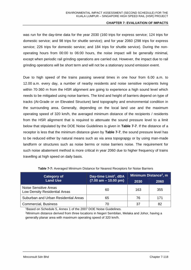
ENVIRONMENTAL IMPACT ASSESSMENT (SECOND SCHEDULE) FOR THE KUALA LUMPUR – SINGAPORE HIGH SPEED RAIL (HSR) PROJECT
CHAPTER 7: EVALUATION OF IMPACTS
Minconsult Sdn Bhd Chapter 7-118
was run for the day-time data for the year 2030 (160 trips for express service; 124 trips for
domestic service; and 98 trips for shuttle service); and for year 2060 (298 trips for express
service; 226 trips for domestic service; and 184 trips for shuttle service). During the non-
operating hours from 00:00 to 06:00 hours, the noise impact will be generally minimal,
except when periodic rail grinding operations are carried out. However, the impact due to rail
grinding operations will be short term and will not be a stationary sound emission event.
Due to high speed of the trains passing several times in one hour from 6.00 a.m. to
12.00 a.m. every day, a number of nearby residents and noise sensitive recipients living
within 70-360 m from the HSR alignment are going to experience a high sound level which
needs to be mitigated using noise barriers. The kind and height of barriers depend on type of
tracks (At-Grade or on Elevated Structure) land topography and environmental condition in
the surrounding area. Generally, depending on the local land use and the maximum
operating speed of 320 km/h, the averaged minimum distance of the recipients / residents
from the HSR alignment that is required to attenuate the sound pressure level to a limit
below that stipulated by the DOE Noise Guidelines is given in Table 7-7. If the distance of a
receptor is less that the minimum distance given by Table 7-7, the sound pressure level has
to be reduced either by natural means such as via area topograpgy or by using man-made
landform or structures such as noise berms or noise barriers noise. The requirement for
such noise abatement method is more critical in year 2060 due to higher frequency of trains
travelling at high speed on daily basis.
Table 7-7: Averaged Minimum Distance for Nearest Receptors for Noise Barriers
Category of Land Use
Day-time Limit1, dBA (7.00 am – 10.00 pm)
Minimum Distance2, m
2030 2060
Noise Sensitive Areas Low Density Residential Areas
60 163 355
Suburban and Urban Residential Areas 65 76 171
Commercial, Business 70 37 82 1Based on Schedule 5, Annex 1 of the 2007 DOE Noise Guidelines. 2Minimum distance derived from three locations in Negeri Sembilan, Melaka and Johor, having a
generally planar area with maximum operating speed of 320 km/h.

ENVIRONMENTAL IMPACT ASSESSMENT (SECOND SCHEDULE) FOR THE KUALA LUMPUR – SINGAPORE HIGH SPEED RAIL (HSR) PROJECT
CHAPTER 7: EVALUATION OF IMPACTS
Minconsult Sdn Bhd Chapter 7-119
Particular activities associated with the operation of trains, stations, depots and maintenance
bases that could impose noise impacts on nearby receptors include:
1. Road Traffic Flow
2. Movement of Trains
3. Stations / Depots / Maintenance Bases operational activities
4. Repair and Maintenance Work on Tracks
These activities have the potential to induce adverse noise impacts on nearby residents, and
noise sensitive areas, located near to the HSR alignment where the tracks will be placed;
especially for those receptors located 30-50 m from the tracks, given that the existing noise
originating from other sources in the surrounding area such as road traffic is relatively low.
The anticipated increase in sound levels at potential receptors is discussed in the following
narrative according to states, including noise modelling results from software simulation.
A) FT. Kuala Lumpur
I. Noise from Movement of Trains at High Speed and Approaching / Leaving
Station
Movement of trains at high speed will increase the sound pressure levels along and the
sound waves propagate perpendicular to its pathway particularly when passing a certain
area several times. However, noise impact in FT. Kuala Lumpur area is not as significant as
the other states mainly due to enforcement of certain speed limit of 200 km/h between
Bandar Malaysia Station and Sepang-Putrajaya Station and a large part of the HSR
alignment is underground, i.e., from Kg. Baru Salak Selatan to Serdang.
In order to predict noise impact due to train movement, noise modelling has been carried out
over the HSR alignment in FT. Kuala Lumpur based on methodology described above.
Arising from the computer simulation, the predicted noise level increments deduced at
selected receptors located adjacent to the HSR alignment are summarised in following
Table 7-8:

ENVIRONMENTAL IMPACT ASSESSMENT (SECOND SCHEDULE) FOR THE KUALA LUMPUR – SINGAPORE HIGH SPEED RAIL (HSR) PROJECT
CHAPTER 7: EVALUATION OF IMPACTS
Minconsult Sdn Bhd Chapter 7-120
Table 7-8: Predicted Increment of Noise Levels at Selected Receptors in FT. Kuala Lumpur
Receptor
Ref
(a)
Leq*
(dBA)
Limit**
(dBA)
Distance
from
Track
(m)
Simulated
2030
(dBA)
Simulated
2060
(dBA)
Increment
2030
(dBA)
Increment
2060
(dBA)
Remarks
NK1 58.3 70 44 59.0 60.2 0.7 1.9 Train at station
NK2 59.8 65 14 60.8 64.4 1.0 4.6 Station exit
NK3 59.6 65 20 63.7 67.3 4.1 7.7 Computed at
25 m
NK4 58.4 65 25 58.4 58.4 0.0 0.0 Train in tunnel
NK5 59.1 61.1 5 59.1 59.1 0.0 0.0 Train in tunnel
NK6 66.5 68.5 57 66.5 66.5 0.0 0.0 Train in tunnel
NK7 62.5 65 69 62.5 62.5 0.0 0.0 Train in tunnel
NK8 63.0 65 81 63.0 63.0 0.0 0.0 Train in tunnel
* Leq from baseline monitoring
** Noise limit is derived from combination of Schedule 2, Schedule 3 and Schedule 5 of the 2007 DOE
Noise Guidelines.
Comparing the simulated noise levels denoted in Table 7-8 (labelled as “Simulated 2030”
and “Simulated 2060”) with the limits specified under the DOE noise guidelines, the
magnitude of noise level increments at the receptor locations can be gauged. The predicted
sound levels are computed at residential or noise sensitive areas located in the vicinity of the
Project’s noise and vibration sampling stations (herewith re-designated as receptors), either
closer to or farther from the HSR alignment as indicated in the columns labelled as “Distance
from Track” or “Remark” in the same table, assuming that the measured Leq can still reflect
the baseline sound levels in those areas. The results of the computer simulation are also
presented in detail in Appendix 7F according to states.
II. Noise due to Activities at Station and Repair and Maintenance Work on Tracks
Noise generated due to Station activities performed at Bandar Malaysia Station as well as
repair and maintenance works on the tracks involve use of heavy machinery and equipment
at the Bandar Malaysia Station and/or its tracks. The repair works may also include repairs
after any train derailment and collision events. Noise from heavy machinery and equipment

ENVIRONMENTAL IMPACT ASSESSMENT (SECOND SCHEDULE) FOR THE KUALA LUMPUR – SINGAPORE HIGH SPEED RAIL (HSR) PROJECT
CHAPTER 7: EVALUATION OF IMPACTS
Minconsult Sdn Bhd Chapter 7-121
such as generators, grinders and metal cutters at the site and at the tracks would increase
the sound pressure levels from its existing ambient values. Depending on the type and
number of machinery used in the work site, the noise levels for the receivers within 25 m and
50 m of the site are expected to reach maximum levels of 82 dBA and 76 dBA, respectively,
as indicated in Table 7-4. These activities can be a nuisance to nearby residential and noise
sensitive areas along Jalan JKR Salak Selatan, in Taman Desa Seputeh and in Kg. Baru
Salak Selatan.
B) Selangor / FT. Putrajaya
I. Noise from Movement of Trains at High Speed and Approaching / Leaving
Station
Movement of trains at high speed will increase the sound pressure levels along and the
sound waves propagate perpendicular to its pathway particularly when passing a certain
area several times. Noise impact for areas between FT. Kuala Lumpur and Sepang-
Putrajaya Station is not as significant as the other states and other parts of Selangor which
is mainly due to the application of speed limit of 200 km/h between both destinations. In
addition, a large part of the HSR alignment is underground, i.e., from Kg. Baru Salak Selatan
to Serdang. However, from Sepang-Putrajaya Station towards Negeri Sembilan border, train
speed may reach its maximum operating speed of 320 km/h in Dengkil and Salak Tinggi,
which leads to significant noise impact.
In predicting noise impact due to train movement, noise modelling has been carried out over
the HSR alignment in Selangor / FT. Putrajaya based on methodology described above.
Arising from the computer simulation, the predicted noise level increments deduced at
selected receptors located adjacent to the HSR alignment are summarised in Table 7-9
below:
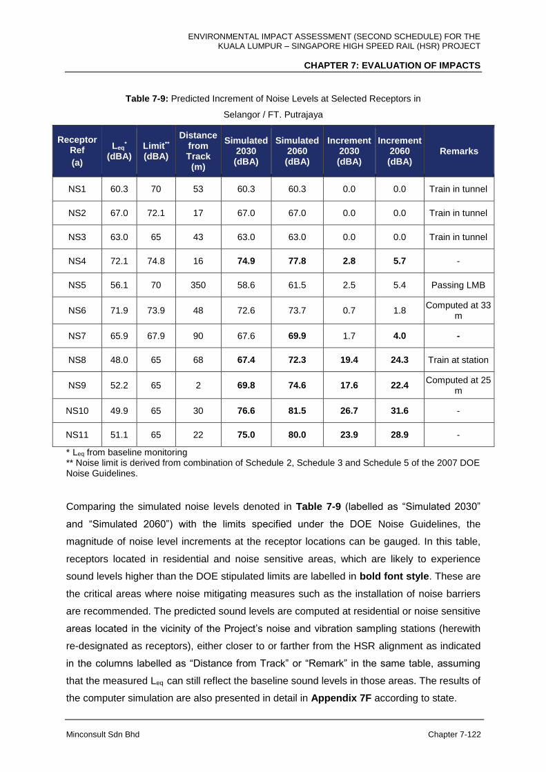
ENVIRONMENTAL IMPACT ASSESSMENT (SECOND SCHEDULE) FOR THE KUALA LUMPUR – SINGAPORE HIGH SPEED RAIL (HSR) PROJECT
CHAPTER 7: EVALUATION OF IMPACTS
Minconsult Sdn Bhd Chapter 7-122
Table 7-9: Predicted Increment of Noise Levels at Selected Receptors in
Selangor / FT. Putrajaya
Receptor Ref
(a)
Leq*
(dBA) Limit** (dBA)
Distance from Track
(m)
Simulated 2030
(dBA)
Simulated 2060
(dBA)
Increment 2030
(dBA)
Increment 2060
(dBA) Remarks
NS1 60.3 70 53 60.3 60.3 0.0 0.0 Train in tunnel
NS2 67.0 72.1 17 67.0 67.0 0.0 0.0 Train in tunnel
NS3 63.0 65 43 63.0 63.0 0.0 0.0 Train in tunnel
NS4 72.1 74.8 16 74.9 77.8 2.8 5.7 -
NS5 56.1 70 350 58.6 61.5 2.5 5.4 Passing LMB
NS6 71.9 73.9 48 72.6 73.7 0.7 1.8 Computed at 33
m
NS7 65.9 67.9 90 67.6 69.9 1.7 4.0 -
NS8 48.0 65 68 67.4 72.3 19.4 24.3 Train at station
NS9 52.2 65 2 69.8 74.6 17.6 22.4 Computed at 25
m
NS10 49.9 65 30 76.6 81.5 26.7 31.6 -
NS11 51.1 65 22 75.0 80.0 23.9 28.9 -
* Leq from baseline monitoring ** Noise limit is derived from combination of Schedule 2, Schedule 3 and Schedule 5 of the 2007 DOE Noise Guidelines.
Comparing the simulated noise levels denoted in Table 7-9 (labelled as “Simulated 2030”
and “Simulated 2060”) with the limits specified under the DOE Noise Guidelines, the
magnitude of noise level increments at the receptor locations can be gauged. In this table,
receptors located in residential and noise sensitive areas, which are likely to experience
sound levels higher than the DOE stipulated limits are labelled in bold font style. These are
the critical areas where noise mitigating measures such as the installation of noise barriers
are recommended. The predicted sound levels are computed at residential or noise sensitive
areas located in the vicinity of the Project’s noise and vibration sampling stations (herewith
re-designated as receptors), either closer to or farther from the HSR alignment as indicated
in the columns labelled as “Distance from Track” or “Remark” in the same table, assuming
that the measured Leq can still reflect the baseline sound levels in those areas. The results of
the computer simulation are also presented in detail in Appendix 7F according to state.

ENVIRONMENTAL IMPACT ASSESSMENT (SECOND SCHEDULE) FOR THE KUALA LUMPUR – SINGAPORE HIGH SPEED RAIL (HSR) PROJECT
CHAPTER 7: EVALUATION OF IMPACTS
Minconsult Sdn Bhd Chapter 7-123
II. Noise from Road Traffic Flow
New road traffic flow may change noise propagation in the affected areas. In this case, the
establishment of Sepang-Putrajaya Station may change the road layout around Kg. Dato’
Abu Bakar Baginda and Kg. Sg. Merab Luar. Depending on the new traffic volume and
pattern occupying the diverted routes, the noise level for the receivers within 25 m and 50 m
of the site may reach a level higher level that is stipulated by the DOE Noise Guidelines,
which can be a nuisance to the affected residential areas in Kg. Dato’ Abu Bakar Baginda
and Kg. Sg. Merab Luar.
III. Noise due to Activities at Station, Depots and Maintenance Base and Repair and
Maintenance Work on Tracks
Noise generated due to activities performed at Sepang-Putrajaya Station and Light Depot
and LMB as well as repair and maintenance works on the tracks involve use of heavy
machinery and equipment at the site and/or its tracks. The repair works may also include
repairs after any train derailment and collision events. Noise from heavy machinery and
equipment such as generators, grinders and metal cutters at the site and at the tracks would
increase the sound pressure levels from its existing ambient values. Depending on the type
and number of machinery used in the work site, the noise levels for the receivers within 25 m
and 50 m of the site are expected to reach maximum levels of 82 dBA and 76 dBA,
respectively, as indicated in Table 7-4. However, the noise impact on these activities is
minimal as trains normally reduce the speed when entering the station. In addition, the
location of Light Depot and LMB in Serdang is far enough to cause any significant impact to
the residents along Jalan UPM and noise sensitive receptors in UPM campus.
C) Negeri Sembilan
I. Noise from Movement of Trains at High Speed and Approaching / Leaving
Station
Movement of trains at high speed will increase the sound pressure levels along and the
sound waves propagate perpendicular to its pathway particularly when passing a certain
area several times. Noise impact for affected areas in Negeri Sembilan is significant as the
train speed is expected to reach its maximum operating speed of 320 km/h within Negeri
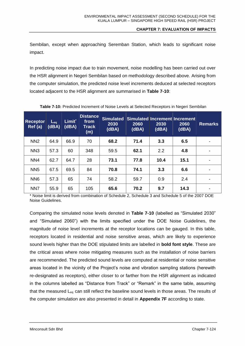
ENVIRONMENTAL IMPACT ASSESSMENT (SECOND SCHEDULE) FOR THE KUALA LUMPUR – SINGAPORE HIGH SPEED RAIL (HSR) PROJECT
CHAPTER 7: EVALUATION OF IMPACTS
Minconsult Sdn Bhd Chapter 7-124
Sembilan, except when approaching Seremban Station, which leads to significant noise
impact.
In predicting noise impact due to train movement, noise modelling has been carried out over
the HSR alignment in Negeri Sembilan based on methodology described above. Arising from
the computer simulation, the predicted noise level increments deduced at selected receptors
located adjacent to the HSR alignment are summarised in Table 7-10:
Table 7-10: Predicted Increment of Noise Levels at Selected Receptors in Negeri Sembilan
Receptor Ref (a)
Leq (dBA)
Limit* (dBA)
Distance from Track
(m)
Simulated 2030
(dBA)
Simulated 2060
(dBA)
Increment 2030
(dBA)
Increment 2060
(dBA) Remarks
NN2 64.9 66.9 70 68.2 71.4 3.3 6.5 -
NN3 57.3 60 348 59.5 62.1 2.2 4.8 -
NN4 62.7 64.7 28 73.1 77.8 10.4 15.1 -
NN5 67.5 69.5 84 70.8 74.1 3.3 6.6 -
NN6 57.3 65 74 58.2 59.7 0.9 2.4 -
NN7 55.9 65 105 65.6 70.2 9.7 14.3 -
* Noise limit is derived from combination of Schedule 2, Schedule 3 and Schedule 5 of the 2007 DOE Noise Guidelines.
Comparing the simulated noise levels denoted in Table 7-10 (labelled as “Simulated 2030”
and “Simulated 2060”) with the limits specified under the DOE Noise Guidelines, the
magnitude of noise level increments at the receptor locations can be gauged. In this table,
receptors located in residential and noise sensitive areas, which are likely to experience
sound levels higher than the DOE stipulated limits are labelled in bold font style. These are
the critical areas where noise mitigating measures such as the installation of noise barriers
are recommended. The predicted sound levels are computed at residential or noise sensitive
areas located in the vicinity of the Project’s noise and vibration sampling stations (herewith
re-designated as receptors), either closer to or farther from the HSR alignment as indicated
in the columns labelled as “Distance from Track” or “Remark” in the same table, assuming
that the measured Leq can still reflect the baseline sound levels in those areas. The results of
the computer simulation are also presented in detail in Appendix 7F according to state.

ENVIRONMENTAL IMPACT ASSESSMENT (SECOND SCHEDULE) FOR THE KUALA LUMPUR – SINGAPORE HIGH SPEED RAIL (HSR) PROJECT
CHAPTER 7: EVALUATION OF IMPACTS
Minconsult Sdn Bhd Chapter 7-125
II. Noise due to Activities at Station and Repair and Maintenance Work on Tracks
Noise generated due to activities performed at Seremban Station as well as repair and
maintenance works on the tracks involve use of heavy machinery and equipment at the site
and/or its tracks. The repair works may also include repairs after any train derailment and
collision events. Noise from heavy machinery and equipment such as generators, grinders
and metal cutters at the site and at the tracks would increase the sound pressure levels from
its existing ambient values. Depending on the type and number of machinery used in the
work site, the noise levels for the receivers within 25 m and 50 m of the site are expected to
reach maximum levels of 82 dBA and 76 dBA, respectively, as indicated in Table 7-4.
However, the noise impact on these activities is minimal as trains normally reduce the speed
when entering the station.
D) Melaka
I. Noise from Movement of Trains at High Speed and Approaching / Leaving
Station
Movement of trains at high speed will increase the sound pressure levels along and the
sound waves propagate perpendicular to its pathway particularly when passing a certain
area several times. Noise impact for affected areas in Melaka is significant as the train
speed is expected to reach its maximum operating speed of 320 km/h within Melaka, except
when approaching Melaka Station, which leads to significant noise impact.
Noise propagation simulation has been carried out over the HSR alignment in Melaka based
on methodology described above. Arising from this numerical simulation, the predicted noise
level increments deduced at selected receptors located adjacent to the HSR alignment
stations are summarised in Table 7-11.

ENVIRONMENTAL IMPACT ASSESSMENT (SECOND SCHEDULE) FOR THE KUALA LUMPUR – SINGAPORE HIGH SPEED RAIL (HSR) PROJECT
CHAPTER 7: EVALUATION OF IMPACTS
Minconsult Sdn Bhd Chapter 7-126
Table 7-11: Predicted Increment of Noise Levels at Selected Receptors in Melaka
Receptor Ref (a)
Leq*
(dBA) Limit** (dBA)
Distance from Track
(m)
Simulated 2030
(dBA)
Simulated 2060
(dBA)
Increment 2030
(dBA)
Increment 2060
(dBA) Remarks
NM1 51.9 60 36 83.0 87.9 31.1 36.0 -
NM2 57.7 60 2 72.5 77.3 14.8 19.6 Computed at
25 m
NM3 54.4 65 401 57.7 61.0 3.3 6.6 Computed at
25 m
NM4 68.6 70.6 7 73.8 77.8 5.2 9.2 Computed at
25 m
NM5 53.9 65 9 71.9 76.8 18.0 22.9 Computed at
25 m
NM6 53.8 65 21 71.3 76.1 17.5 22.3 Computed at
25 m
NM7 63.9 65.9 230 64.8 66.1 0.9 2.2 Computed at
25 m
NM8 67.1 70 41 70.8 74.2 3.7 7.1 Train at station
NM9 49.3 60 182 58.5 63.1 9.2 13.8 -
NM10 47.5 60 86 66.6 71.5 19.1 24.0 -
NM11 56.9 65 14 73.9 78.8 17.0 21.9 -
NM12 66.0 68 31 74.5 78.9 8.5 12.9 -
* Leq from baseline monitoring ** Noise limit is derived from combination of Schedule 2, Schedule 3 and Schedule 5 of the 2007 DOE Noise Guidelines.
Comparing the simulated noise levels denoted in Table 7-11 (labelled as “Simulated 2030”
and “Simulated 2060”) with the limits specified under the DOE Noise Guidelines, the
magnitude of noise level increments at the receptor locations can be gauged. In this table,
receptors located in residential and noise sensitive areas, which are likely to experience
sound levels higher than the DOE stipulated limits are labelled in bold font style. These are
the critical areas where noise mitigating measures such as the installation of noise barriers
are recommended. The predicted sound levels are computed at residential or noise sensitive
areas located in the vicinity of the Project’s noise and vibration sampling stations (herewith
re-designated as receptors), either closer to or farther from the HSR Alignment as indicated
in the columns labelled as “Distance from Track” or “Remark” in the same table, assuming
ENVIRONMENTAL IMPACT ASSESSMENT (SECOND SCHEDULE) FOR THE KUALA LUMPUR – SINGAPORE HIGH SPEED RAIL (HSR) PROJECT
CHAPTER 7: EVALUATION OF IMPACTS
Minconsult Sdn Bhd Chapter 7-127
that the measured Leq can still reflect the baseline sound levels in those areas. The results of
the computer simulation are also presented in detail in Appendix 7F according to state.
II. Noise due to Activities at Station and Repair and Maintenance Work on Tracks
Noise generated due to activities performed at Melaka Station as well as repair and
maintenance works on the tracks involve use of heavy machinery and equipment at the site
and / or its tracks. The repair works may also include repairs after any train derailment and
collision events. Noise from heavy machinery and equipment such as generators, grinders
and metal cutters at the site and at the tracks would increase the sound pressure levels from
its existing ambient values. Depending on the type and number of machinery used at the
work site, the noise level for the receivers within 25 m and 50 m of the site are expected to
reach maximum levels of 82 dBA and 76 dBA, respectively, as indicated in Table 7-4.
However, the noise impact on these activities is minimal as trains normally reduce the speed
when entering the station.
E) Johor
I. Noise from Movement of Trains at High Speed and Approaching / Leaving
Stations
Movement of trains at high speed will increase the sound pressure levels along and the
sound waves propagate perpendicular to its pathway particularly when passing a certain
area several times. Noise impact for areas between Iskandar Puteri Station and Jurong East
Station in Singapore is not as significant as the other States and other parts of Johor which
is mainly due to the application of speed limit of 200 km/h between both destinations.
However, from Iskandar Puteri Station towards Melaka border, train speed may reach its
maximum operating speed of 320 km/h, which leads to significant noise impact.
In predicting noise impact due to train movement, noise modelling has been carried out over
the HSR alignment in Johor based on methodology described above. Arising from this
computer simulation, the predicted noise level increments deduced at selected receptors
located adjacent to the HSR alignment are summarised in Table 7-12.

ENVIRONMENTAL IMPACT ASSESSMENT (SECOND SCHEDULE) FOR THE KUALA LUMPUR – SINGAPORE HIGH SPEED RAIL (HSR) PROJECT
CHAPTER 7: EVALUATION OF IMPACTS
Minconsult Sdn Bhd Chapter 7-128
Table 7-12: Predicted Increment of Noise Levels at Selected Receptors in Johor
Receptor Ref
(a)
Leq*
(dBA) Limit** (dBA)
Distance from Track
(m)
Simulated 2030
(dBA)
Simulated 2060
(dBA)
Increment 2030
(dBA)
Increment 2060
(dBA) Remarks
NJ1 57.0 60 16 71.9 76.7 14.9 19.7 Computed at 25
m
NJ2 52.1 65 26 74.2 79.2 22.1 27.1 -
NJ3 51.1 70 8 73.5 78.5 22.4 27.4 Train at station
NJ4 64.5 66.5 15 72.8 77.2 8.3 12.7 Computed at 25
m
NJ5 58.3 60.3 52 71.4 76.2 13.1 17.9 -
NJ6 61.4 63.4 58 69.7 74.2 8.3 12.8 -
NJ7 57.4 60 128 63.5 67.6 6.1 10.2 -
NJ8 46.0 70 12 75.0 79.9 29.0 33.9 Train at station
NJ9 59.3 61.3 25 74.4 79.2 15.1 19.9 -
NJ10 58.6 60.6 12 72.3 77.1 13.7 18.5 Computed at
25 m
NJ11 63.8 65.8 48 70.9 75.1 7.1 11.3 -
NJ12 57.0 70 2,340 57.0 57.1 0.0 0.1 -
NJ13 64.0 66 31 72.2 76.6 8.2 12.6 -
NJ14 66.8 68.8 85 68.7 71.1 1.9 4.3 -
NJ15 48.2 60 65 69.5 74.4 21.3 26.2 -
NJ16 52.2 75 1,840 52.4 52.9 0.2 0.7 Quarry at 1.8
km
NJ17 53.3 60 275 59.1 63.2 5.8 9.9 -
NJ18 50.7 65 101 66.4 71.3 15.7 20.6 -
NJ19 49.1 60 3 59.7 64.4 10.6 15.3 Train at station
NJ20 52.9 60 22 60.2 62.5 7.3 9.6 Computed at
25 m
NJ21 47.8 75 870 50.0 52.6 2.2 4.8 Passing HMB
* Leq from baseline monitoring ** Noise limit is derived from combination of Schedule 2, Schedule 3 and Schedule 5 of the 2007 DOE Noise Guidelines.
ENVIRONMENTAL IMPACT ASSESSMENT (SECOND SCHEDULE) FOR THE KUALA LUMPUR – SINGAPORE HIGH SPEED RAIL (HSR) PROJECT
CHAPTER 7: EVALUATION OF IMPACTS
Minconsult Sdn Bhd Chapter 7-129
Comparing the simulated noise levels denoted in Table 7-12 (labelled as “Simulated 2030”
and “Simulated 2060”) with the limits specified under the DOE Noise Guidelines, the
magnitude of noise level increments at the receptor locations can be gauged. In this table,
receptors located in residential and noise sensitive areas, which are likely to experience
sound levels higher than the DOE stipulated limits are labelled in bold font style. These are
the critical areas where noise mitigating measures such as the installation of noise barriers
are recommended. The predicted sound levels are computed at residential or noise sensitive
areas located in the vicinity of the Project’s noise and vibration sampling stations (herewith
re-designated as receptors), either closer to or farther from the HSR alignment as indicated
in the columns labelled as “Distance from Track” or “Remark” in the same table, assuming
that the measured Leq can still reflect the baseline sound levels in those areas. The results of
the computer simulation are also presented in detail in Appendix 7F according to state.
II. Noise from Road Traffic Flow
New road traffic flow may change noise propagation in the affected areas. In this case, the
establishment of Batu Pahat Station may change the road layout around Taman Pura
Kencana. This leads to certain recipients experiencing higher noise levels as the road is
diverted closer to their locations in making way to Station and tracks. Depending on the new
traffic volume and pattern occupying the diverted routes, the noise levels for the receivers
within 25 m and 50 m of the site may reach a level higher level that is stipulated by the DOE
Noise Guidelines, which can be a nuisance to the affected residents in Taman Pura
Kencana.
III. Noise due to Activities at Stations, Depots and Maintenance Bases and Repair
and Maintenance Work on Tracks
Noise generated due to activities performed at Muar, Batu Pahat and Iskandar Puteri
Stations, HMB and Main Depot and LMB as well as repair and maintenance works on the
tracks involve use of heavy machinery and equipment at the site and / or its tracks. The
repair works may also include repairs after any train derailment and collision events. Noise
from heavy machinery and equipment such as generators, grinders and metal cutters at the
site and at the tracks would increase the sound pressure levels from its existing ambient
values. Depending on the type and number of machinery used at the work site, the noise
levels for the receivers within 25 m and 50 m of the site are expected to reach maximum
ENVIRONMENTAL IMPACT ASSESSMENT (SECOND SCHEDULE) FOR THE KUALA LUMPUR – SINGAPORE HIGH SPEED RAIL (HSR) PROJECT
CHAPTER 7: EVALUATION OF IMPACTS
Minconsult Sdn Bhd Chapter 7-130
levels of 82 dBA and 76 dBA, respectively, as indicated in Table 7-4. These activities can be
a nuisance to nearby residential and noise sensitive areas, particularly in the vicinity of Batu
Pahat Station and Main Depot and LMB where the nearest receptors are less than 200 m
compared to the other Stations and HMB which has the nearest receptors at least 500 m or
more.
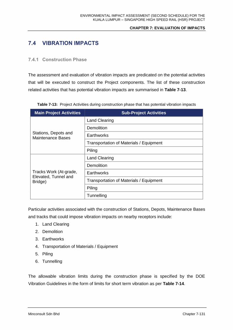
ENVIRONMENTAL IMPACT ASSESSMENT (SECOND SCHEDULE) FOR THE KUALA LUMPUR – SINGAPORE HIGH SPEED RAIL (HSR) PROJECT
CHAPTER 7: EVALUATION OF IMPACTS
Minconsult Sdn Bhd Chapter 7-131
7.4 VIBRATION IMPACTS
7.4.1 Construction Phase
The assessment and evaluation of vibration impacts are predicated on the potential activities
that will be executed to construct the Project components. The list of these construction
related activities that has potential vibration impacts are summarised in Table 7-13.
Table 7-13: Project Activities during construction phase that has potential vibration impacts
Main Project Activities Sub-Project Activities
Stations, Depots and Maintenance Bases
Land Clearing
Demolition
Earthworks
Transportation of Materials / Equipment
Piling
Tracks Work (At-grade, Elevated, Tunnel and Bridge)
Land Clearing
Demolition
Earthworks
Transportation of Materials / Equipment
Piling
Tunnelling
Particular activities associated with the construction of Stations, Depots, Maintenance Bases
and tracks that could impose vibration impacts on nearby receptors include:
1. Land Clearing
2. Demolition
3. Earthworks
4. Transportation of Materials / Equipment
5. Piling
6. Tunnelling
The allowable vibration limits during the construction phase is specified by the DOE
Vibration Guidelines in the form of limits for short term vibration as per Table 7-14.
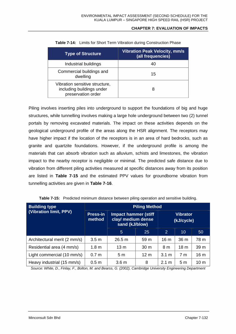
ENVIRONMENTAL IMPACT ASSESSMENT (SECOND SCHEDULE) FOR THE KUALA LUMPUR – SINGAPORE HIGH SPEED RAIL (HSR) PROJECT
CHAPTER 7: EVALUATION OF IMPACTS
Minconsult Sdn Bhd Chapter 7-132
Table 7-14: Limits for Short Term Vibration during Construction Phase
Piling involves inserting piles into underground to support the foundations of big and huge
structures, while tunnelling involves making a large hole underground between two (2) tunnel
portals by removing excavated materials. The impact on these activities depends on the
geological underground profile of the areas along the HSR alignment. The receptors may
have higher impact if the location of the receptors is in an area of hard bedrocks, such as
granite and quartzite foundations. However, if the underground profile is among the
materials that can absorb vibration such as alluvium, schists and limestones, the vibration
impact to the nearby receptor is negligible or minimal. The predicted safe distance due to
vibration from different piling activities measured at specific distances away from its position
are listed in Table 7-15 and the estimated PPV values for groundborne vibration from
tunnelling activities are given in Table 7-16.
Table 7-15: Predicted minimum distance between piling operation and sensitive building.
Building type (Vibration limit, PPV)
Piling Method
Press-in method
Impact hammer (stiff clay/ medium dense
sand (kJ/blow)
Vibrator
(kJ/cycle)
5 25 2 10 50
Architectural merit (2 mm/s) 3.5 m 26.5 m 59 m 16 m 36 m 78 m
Residential area (4 mm/s) 1.8 m 13 m 30 m 8 m 18 m 39 m
Light commercial (10 mm/s) 0.7 m 5 m 12 m 3.1 m 7 m 16 m
Heavy industrial (15 mm/s) 0.5 m 3.6 m 8 2.1 m 5 m 10 m
Source: White, D., Finlay, F., Bolton, M. and Bearss, G. (2002), Cambridge University Engineering Department
Type of Structure Vibration Peak Velocity, mm/s
(all frequencies)
Industrial buildings 40
Commercial buildings and dwelling
15
Vibration sensitive structure, including buildings under
preservation order 8

ENVIRONMENTAL IMPACT ASSESSMENT (SECOND SCHEDULE) FOR THE KUALA LUMPUR – SINGAPORE HIGH SPEED RAIL (HSR) PROJECT
CHAPTER 7: EVALUATION OF IMPACTS
Minconsult Sdn Bhd Chapter 7-133
Table 7-16: Estimated vibration level (PPV), from tunneling activities
Distance (m) from tunneling activity
Vibration peak velocity, (mm/s)
10 9.02
20 3.66
30 2.16
Source: BS 5228-2:2009 (Code of practice for noise and vibration control on construction and open sites – Part 2: Vibration)
In general, residential areas and vibration sensitive areas located less than 30 m or less than
50 m, respectively, from the alignment could be adversely impacted. In addition, impact from
piling and tunnelling activities could be extended to 100 m, depending on the geological
profile of foundation of the area. Vibration related impacts that can be imposed on
surrounding receptors by the above-mentioned list of project activities are described
herewith according to states.
In the absence of detailed soil information along the HSR alignment, prediction ground borne
vibration impacts and propagation to surrounding receptors will be inaccurate and cannot be
reliably predicted. Therefore, a more detailed vibration impacts analysis will be performed by
the PDP during the Detailed Design stage of the Project, the details of which will be
submitted to the DOE.
A) FT. Kuala Lumpur
Construction activities may cause adverse impacts to be imposed on nearby residents and
vibration sensitive areas located adjacent to the HSR alignment where the tracks and station
are to be constructed. For piling and tunnelling activities, the potential impacts imposed on
the following habitats could be adverse in areas of granite foundations and high-rise
buildings, i.e., around Kg. Baru Salak Selatan (VK4); Desa Petaling (VK5) and Kg. Malaysia
Tambahan (VK6).
Other construction activities, such as land clearing, demolition and transportation of
machinery and excavated materials may cause adverse impacts to be imposed on nearby
residents and vibration sensitive areas located adjacent to the HSR alignment where the
tracks and station are to be constructed since these activities may increase ambient ground
vibration which may be passed to nearby receptors, particularly high density populations,

ENVIRONMENTAL IMPACT ASSESSMENT (SECOND SCHEDULE) FOR THE KUALA LUMPUR – SINGAPORE HIGH SPEED RAIL (HSR) PROJECT
CHAPTER 7: EVALUATION OF IMPACTS
Minconsult Sdn Bhd Chapter 7-134
education institutions, training centres and areas with large buildings close to the HSR
alignment. Removal of excavated materials from tunnel construction may increase frequency
of trucks used to transport the materials in areas around the tunnel portals. Based on these
conditions and taking into consideration the current measured vibration levels at specific
receptors located near Bandar Malaysia Station (VK1), Jalan JKR Salak Selatan (VK2) and
Kg. Baru Salak Selatan (VK3), where increased ground vibration impacts could be
significant.
I. Vibration from Land Preparation, Earthworks and Demolition Activities
Land preparation and earthworks for construction of Stations as well as construction of
tracks involve the use of many heavy machinery and vehicles including bulldozers,
excavators, graders and trucks, which may cause ambient ground vibration to increase.
Demolition of old building and structures using excavators and/or bulldozers would also
generate ground vibration in addition to operation of the existing machinery and vehicles.
These activities can cause disturbance and annoyance to residents living within 100 m from
the construction sites in Bandar Malaysia Station such as Taman Desa Seputeh and along
the HSR alignment at Jalan JKR Salak Selatan and Kg. Baru Salak Selatan.
II. Vibration induced by Vehicle Movements and Transportation of Materials and
Equipment
Vehicle movement and transportation of construction materials and equipment to the site will
involve the use of noisy vehicles such as trucks, which may cause ambient ground vibration
to increase. In addition, construction of tunnel for part of the HSR alignment from Kg. Baru
Salak Selatan and Serdang, produces excavated materials that need to be transported out
from the excavated sites. Depending on the type and number of vehicle used, the vehicle
movement and the loads carried by the vehicle may increase the ground vibration if the
receiving buildings and structures are located less than 30 m from the vehicle pathway.
These activities can cause disturbance and annoyance to within 30-50 m from the access
roads and states and federal routes used by the trucks carrying machinery and materials
from and to the construction sites in Bandar Malaysia Station and along the HSR alignment
at Jalan JKR Salak Selatan as well as around the tunnel portal at Kg. Baru Salak Selatan.
ENVIRONMENTAL IMPACT ASSESSMENT (SECOND SCHEDULE) FOR THE KUALA LUMPUR – SINGAPORE HIGH SPEED RAIL (HSR) PROJECT
CHAPTER 7: EVALUATION OF IMPACTS
Minconsult Sdn Bhd Chapter 7-135
III. Vibration from Piling Activities
Vibration generated by piling activities are impulsive in nature and are relatively more
annoying than steady-state noise and vibration. Ground vibration signal can be dampened
and absorbed by certain soil profiles such as schists and limestones, which are the dominant
geological profile along the HSR alignment. These activities can cause disturbance and
annoyance to nearby residents and impact vibration sensitive structures especially for part of
alignment located in granite based foundation and bedrocks such as in some parts of Kuala
Lumpur, namely in Salak Selatan and Sri Petaling. Vibration impact from piling may also be
significant for piling locations that are close residential areas, where the HSR alignment
traverses high density populations and vibration sensitive structures and buildings such as
near Bandar Malaysia Station.
IV. Vibration from Tunnelling
Vibration generated due to tunnelling activities for Tunnel along the HSR alignment involve
use of TBM for construction of tunnel from Bandar Malaysia to Serdang. Hence, this impact
may be significant for areas having granite foundation around Salak Selatan and Sri Petaling
and for areas of large or high-rise buildings where underground Tunnel are to be constructed
such as apartments in Kg. Malaysia Tambahan and near Terminal Bersepadu Selatan in
Bandar Tasik Selatan.
B) Selangor
Construction activities may cause adverse impacts to be imposed on nearby residents and
vibration sensitive areas located adjacent to the HSR alignment where the tracks, Stations,
Depots and Maintenance Bases are to be constructed. For piling and tunnelling activities,
the potential impacts imposed on the following habitats could be adverse in areas of granite
foundations and high-rise buildings, i.e., around South City Condo (VS2); Univ360 Place
(VS3); UPM campus (near VS4).
Other construction activities, such as land clearing, demolition and transportation of
machinery and excavated materials may cause adverse impacts to be imposed on nearby
residents and vibration sensitive areas located adjacent to the HSR alignment where the
tracks, Stations, Depots and Maintenance Bases are to be constructed since these activities
ENVIRONMENTAL IMPACT ASSESSMENT (SECOND SCHEDULE) FOR THE KUALA LUMPUR – SINGAPORE HIGH SPEED RAIL (HSR) PROJECT
CHAPTER 7: EVALUATION OF IMPACTS
Minconsult Sdn Bhd Chapter 7-136
may increase ambient ground vibration which may be passed to nearby receptors,
particularly high density populations, education institutions, training centres and areas with
large buildings close to the HSR alignment. Removal of excavated materials from tunnel
construction may increase intensity of trucks used to transport the excavated materials in
areas around the tunnel portals. Based on these conditions and taking into consideration the
current measured vibration levels at specific receptors located near UPM campus (near
VS3); UNITEN campus and training centres along Jalan Ayer Hitam (VS5), Kg. Dato’ Abu
Bakar Baginda (VS6), Persiaran Vista, Sepang (VS8) and Desa Bestari, Sepang (VS9),
where increased ground vibration impacts could be significant.
I. Vibration from Land Preparation, Earthworks and Demolition Activities
Land preparation and earthworks for construction of Stations, Depots and Maintenance Base
as well as construction of tracks involve the use of many heavy machinery and vehicles
including bulldozers, excavators, graders and trucks, which may cause ambient ground
vibration to increase. Demolition of old building and structures using excavators and/or
bulldozers would also generate ground vibration in addition to operation of the existing
machinery and vehicles. These activities can cause disturbance and annoyance to residents
living within 30-50 m from the construction sites at Sepang-Putrajaya Station and along
Jalan UPM, Kg. Dato’ Abu Bakar Baginda, Kg. Sg. Merab Hulu, Kg. Jenderam Hulu, Kg.
Bukit Piatu and Desa Bestari, Sepang, as well as at higher education institutions and training
centres along Jalan UPM, Jalan Sg. Besi and Jalan Ayer Hitam.
II. Vibration induced by Vehicle Movements and Transportation of Materials and
Equipment
Vehicle movement and transportation of construction materials and equipment to the site will
involve the use of noisy vehicles such as trucks, which may cause ambient ground vibration
to increase. In addition, construction of tunnels at two (2) locations, namely near Puncak
Pinggiran Putra and Bukit Unggul Golf and Country, produces excavated materials that need
to be transported out from the excavated sites. Depending on the type and number of
vehicle used, the vehicle movement and the loads carried by the vehicle may increase the
ground vibration if the receiving buildings and structures are located less than 30 m from the
vehicle pathway. These activities can cause disturbance and annoyance to residents living
within 30-50 m from the access roads and states and federal routes used by the trucks

ENVIRONMENTAL IMPACT ASSESSMENT (SECOND SCHEDULE) FOR THE KUALA LUMPUR – SINGAPORE HIGH SPEED RAIL (HSR) PROJECT
CHAPTER 7: EVALUATION OF IMPACTS
Minconsult Sdn Bhd Chapter 7-137
carrying machinery and materials from and to the construction sites at Sepang-Putrajaya
Station and along Jalan UPM, Jalan Sg. Besi and Jalan Ayer Hitam, as well as at Kg. Dato’
Abu Bakar Baginda, Kg. Sg. Merab Luar, Kg. Sg. Merab Hulu, Kg. Jenderam Hulu, Kg. Bukit
Piatu, Bandar Salak Tinggi and Desa Bestari, Sepang.
III. Vibration from Piling Activities
Vibration generated by piling activities are impulsive in nature and are relatively more
annoying than steady-state noise and vibration. Ground vibration signal can be dampened
and absorbed by certain soil profiles such schists and limestones profiles, which are the
dominant geological profile along the HSR alignment in Selangor. However, these activities
may still cause disturbance to nearby residents and impact vibration sensitive structures
especially that are close to medium- and high-density populations and vibration sensitive
structures and buildings such as near higher education institutions (UPM and UNITEN),
training centres along Jalan Ayer Hitam, Kg. Dato’ Abu Bakar Baginda, Persiaran Vista and
Desa Bestari, Sepang.
IV. Vibration from Tunnelling
Vibration generated due to tunnelling activities for tunnels along the HSR alignment involve
use of TBM for tunnel location from Bandar Malaysia to Serdang in Kuala Lumpur and
Selangor and NATM for two tunnels at Puncak Pinggiran Putra and Bukit Unggul Golf and
Country. However, the geological profile for most of the affected areas are covered with
either alluvium and peat soil profiles, that can absorb most of the ground vibration signal
generate from the sites. Hence, this impact is negligible except for areas having granite
foundation around Salak Selatan and Bandar Tasik Selatan (in FT. Kuala Lumpur). In parts
of tunnels where NATM is used, blasting is part of the construction process in NATM which
may cause vibration signals propagated to the structures and recipients on the ground. This
may cause nuisance to recipients located or residents living on shallow tunnels and near
tunnel portals in Puncak Pinggiran Putra, Bukit Unggul Golf and Country, Kg. Sg. Merab
Hulu, Kg. Bukit Piatu and Bandar Salak Tinggi.
ENVIRONMENTAL IMPACT ASSESSMENT (SECOND SCHEDULE) FOR THE KUALA LUMPUR – SINGAPORE HIGH SPEED RAIL (HSR) PROJECT
CHAPTER 7: EVALUATION OF IMPACTS
Minconsult Sdn Bhd Chapter 7-138
C) Negeri Sembilan
Construction activities may cause adverse impacts to be imposed on nearby residents and
vibration sensitive areas located adjacent to the HSR alignment where the tracks and
stations are to be constructed. For piling and tunnelling activities, the potential impacts could
be adverse in areas of granite foundations and high-rise buidings, i.e., Seremban Station
(VN1), Taman Gadong Putra, Labu (VN2), along Seremban-Bukit Nenas Highway (VN3) and
Felda Seri Sendayan (VK4).
Other construction activities, such as land clearing, demolition and transportation of
machinery and excavated materials may cause adverse impacts to be imposed on nearby
residents and vibration sensitive areas located adjacent to the HSR alignment where the
tracks and stations are to be constructed since these activities may increase ambient ground
vibration which may be passed to nearby receptors, particularly high-density populations,
education institutions, training centres and areas with large buildings close to the HSR
alignment. Removal of excavated materials from tunnel construction may increase intensity
of trucks used to transport the materials in areas around the tunnel portals. Based on these
conditions and taking into consideration the current measured vibration levels at specific
receptors located near to the proposed alignment, increased ground vibration impacts could
be significant in Felda Seri Sendayan (VN4).
I. Vibration from Land Preparation, Earthworks and Demolition Activities
Land preparation and earthworks for construction of stations as well as construction of tracks
involve the use of many heavy machinery and vehicles including bulldozers, excavators,
graders and trucks, which may cause ambient ground vibration to increase. Demolition of old
building and structures using excavators and/or bulldozers would also generate ground
vibration in addition to operation of the existing machinery and vehicles. These activities can
cause disturbance and annoyance to residents living within 30-50 m from the construction
sites at Desa Cempaka and Kota Seriemas in Nilai, Taman Gadong Putra and Taman
Cermat Utama in Labu, Felda Sri Sendayan and Taman Sg. Ujong, Siliau.
ENVIRONMENTAL IMPACT ASSESSMENT (SECOND SCHEDULE) FOR THE KUALA LUMPUR – SINGAPORE HIGH SPEED RAIL (HSR) PROJECT
CHAPTER 7: EVALUATION OF IMPACTS
Minconsult Sdn Bhd Chapter 7-139
II. Vibration induced by Vehicle Movements and Transportation of Materials and
Equipment
Vehicle movement and transportation of construction materials and equipment to the site will
involve the use of noisy vehicles such as trucks, which may cause ambient ground vibration
to increase. In addition, construction of two tunnels near Kg. Baharu Jimah to Bandar Spring
Hill and Bandar Spring Hill to Ladang Salak, Sime Darby Plantation, produces excavated
materials that need to be transported out from the excavated sites. Depending on the type
and number of vehicle used, the vehicle movement and the loads carried by the vehicle may
increase the ground vibration if the receiving buildings and structures are located less than
30 m from the vehicle pathway. These activities can cause disturbance and annoyance to
receptors along Federal Route 53 and State Route N6 (Jalan Siliau) which may be used by
the trucks carrying machinery and materials from and to the construction sites.
III. Vibration from Piling Activities
Vibration generated by piling activities are impulsive in nature and are relatively more
annoying than steady-state noise and vibration. Ground vibration signal can be dampened
and absorbed by certain soil profiles such as schists and limestones, which are the dominant
geological profile along the HSR alignment. These activities can cause disturbance and
annoyance to nearby residents and impact vibration sensitive structures especially for part of
alignment located in granite based foundation and bedrocks such as in some parts of in
Negeri Sembilan, namely in Labu and Sendayan. Impact from piling may also be significant
for piling locations that are close residential areas, where the HSR alignment transverses
medium- and high-density populations and vibration sensitive structures and buildings such
as in Desa Cempaka and Kota Seriemas in Nilai, Taman Gadong Putra and Taman Cermat
Utama in Labu, Felda Sri Sendayan and Taman Sg. Ujong, Siliau.
IV. Vibration from Tunnelling
Vibration generated due to tunnelling activities for tunnels along the HSR alignment involve
application of NATM near Sendayan and Siliau. Since NATM involves blasting as part of the
construction process, this may generate vibration signals propagated to the structures and
recipients on the ground and may cause nuisance to recipients located or residents living on
ENVIRONMENTAL IMPACT ASSESSMENT (SECOND SCHEDULE) FOR THE KUALA LUMPUR – SINGAPORE HIGH SPEED RAIL (HSR) PROJECT
CHAPTER 7: EVALUATION OF IMPACTS
Minconsult Sdn Bhd Chapter 7-140
shallow tunnels and near tunnel portals near Kg. Baharu Jimah, Bandar Spring Hill and
Ladang Salak.
D) Melaka
Construction activities may cause adverse impacts to be imposed on nearby residents and
vibration sensitive areas located adjacent to the HSR alignment where the tracks and
stations are to be constructed. For piling and tunnelling activities, the potential impacts could
be adverse in the areas of granite foundations in Bemban, such as near Pusat Rehabilitasi
PERKESO Melaka (VM9) and Taman Bemban Baru (VM10).
Other construction activities, such as land clearing, demolition and transportation of
machinery and excavated materials may cause adverse impacts to be imposed on nearby
residents and vibration sensitive areas located adjacent to the HSR alignment where the
tracks and stations are to be constructed since these activities may increase ambient ground
vibration which may be passed to nearby receptors, particularly high-density populations,
education institutions, training centres and areas with large buildings close to the HSR
alignment. Based on these conditions and taking into consideration the current measured
vibration levels at specific receptors located near to the HSR alignment, increased ground
vibration impacts could be significant on the receptors at IKBN Alor Gajah (VM1), Taman
Paya Rumput Indah (VM4), 1 Krubong Residence (VM5), Pusat Rehabilitasi PERKESO
Melaka (VM9) and Taman Bemban Baru (VM10).
I. Vibration from Land Preparation, Earthworks and Demolition Activities
Land preparation and earthworks for construction of Stations as well as construction of
tracks involve the use of many heavy machinery and vehicles including bulldozers,
excavators, graders and trucks, which may cause ambient ground vibration to increase.
Demolition of old building and structures using excavators and/or bulldozers would also
generate ground vibration in addition to operation of the existing machinery and vehicles.
These activities can cause disturbance and annoyance to residents living within 30-50 m
from the construction sites, such as in Masjid Tanah, Taman Paya Rumput Indah, 1 Krubong
Residence, Durian Tunggal, Kg. Ulu Duyung, Taman Bemban Jaya Taman Bemban Baru
and Kg. Bemban, as well as in vibration sensitive areas, namely Kolej Yayasan Saad and
Pusat Rehabilitasi PERKESO Melaka.

ENVIRONMENTAL IMPACT ASSESSMENT (SECOND SCHEDULE) FOR THE KUALA LUMPUR – SINGAPORE HIGH SPEED RAIL (HSR) PROJECT
CHAPTER 7: EVALUATION OF IMPACTS
Minconsult Sdn Bhd Chapter 7-141
II. Vibration induced by Vehicle Movements and Transportation of Materials and
Equipment
Vehicle movement and transportation of construction materials and equipment to the site will
involve the use of noisy vehicles such as trucks, which may cause ambient ground vibration
to increase. Depending on the type and number of vehicle used, the vehicle movement and
the loads carried by the vehicle may increase the ground vibration if the receiving buildings
and structures are located less than 30 m from the vehicle pathway. These activities can
cause disturbance and annoyance to within 30-50 m from the access roads and states and
federal routes used by the trucks carrying machinery and materials from and to the
construction sites near Masjid Tanah, Taman Paya Rumput Indah, 1 Krubong Residence,
Durian Tunggal, Kg. Ulu Duyung, Taman Bemban Jaya, Taman Bemban Baru and Kg.
Bemban, as well as near vibration sensitive areas, namely Kolej Yayasan Saad and Pusat
Rehabilitasi PERKESO Melaka.
III. Vibration from Piling Activities
Vibration generated by piling activities are impulsive in nature and are relatively more
annoying than steady-state noise and vibration. Ground vibration signal can be dampened
and absorbed by certain soil profiles such as schists and limestones, which are the dominant
geological profile along the HSR alignment. These activities can cause disturbance and
annoyance to nearby residents and impact vibration sensitive structures especially for part of
alignment located in granite based foundation and bedrocks such as around Bemban.
Impact from piling may also be significant for piling locations that are close residential areas,
where the HSR alignment transverses medium- and high-density populations and vibration
sensitive structures and buildings such as Kg. Ulu Duyung, Kg. Bemban, Taman Bemban
Jaya, Taman Bemban Baru, Kolej Yayasan Saad and Pusat Rehabilitasi PERKESO Melaka.
E) Johor
Construction activities may cause adverse impacts to be imposed on nearby residents and
vibration sensitive areas located adjacent to the HSR alignment where the tracks, stations,
depots and maintenance bases are to be constructed. Other construction activities, such as
land clearing, demolition and transportation of machinery and excavated materials may
ENVIRONMENTAL IMPACT ASSESSMENT (SECOND SCHEDULE) FOR THE KUALA LUMPUR – SINGAPORE HIGH SPEED RAIL (HSR) PROJECT
CHAPTER 7: EVALUATION OF IMPACTS
Minconsult Sdn Bhd Chapter 7-142
cause adverse impacts to be imposed on nearby residents and vibration sensitive areas
located adjacent to the HSR alignment where the tracks, stations, depots and maintenance
bases are to be constructed since these activities may increase ambient ground vibration
which may be passed to nearby receptors, particularly high-density populations, education
institutions, training centres and areas with large buildings close to the HSR alignment.
Removal of excavated materials from tunnel construction may increase intensity of trucks
used to transport the materials in areas around the tunnel portals. Based on these conditions
and taking into consideration the current measured vibration levels at specific receptors
located near to the HSR alignment, increased ground vibration impacts could be significant
on the receptors at SK Pekan Pagoh (VJ4), at SMK Dato’ Ibrahim Majid, Simpang Renggam
(VJ7), near Pertubuhan Kebajikan Warga Emas Pontian (VJ8) and at SK Tanjung Kupang
(VJ12).
I. Vibration from Land Preparation, Earthworks and Demolition Activities
Land preparation and earthworks for construction of stations, depots and maintenance base
as well as construction of tracks involve the use of many heavy machinery and vehicles
including bulldozers, excavators, graders and trucks, which may cause ambient ground
vibration to increase. Demolition of old building and structures using excavators and/or
bulldozers would also generate ground vibration in addition to operation of the existing
machinery and vehicles. These activities can cause disturbance to nearby residential and
vibration sensitive areas in Bukit Gambir, Panchor, Pagoh, Parit Yaani, Parit Sulong,
Simpang Renggam, Pekan Nenas, Gelang Patah and Tanjung Kupang, that are located
within 30-50 m from the construction sites.
II. Vibration induced by Vehicle Movements and Transporation of Materials and
Equipment
Vehicle movement and transportation of construction materials and equipment to the site will
involve the use of noisy vehicles such as trucks, which may cause ambient ground vibration
to increase. In addition, construction of tunnels at Bukit Naning in Johor, produces excavated
materials that need to be transported out from the excavated sites. Depending on the type
and number of vehicle used, the vehicle movement and the loads carried by the vehicle may
increase the ground vibration if the receiving buildings and structures are located less than
ENVIRONMENTAL IMPACT ASSESSMENT (SECOND SCHEDULE) FOR THE KUALA LUMPUR – SINGAPORE HIGH SPEED RAIL (HSR) PROJECT
CHAPTER 7: EVALUATION OF IMPACTS
Minconsult Sdn Bhd Chapter 7-143
30 m from the vehicle pathway. These activities can cause disturbance and annoyance to
residents living within 30-50 m from the access roads and states and federal routes in Bukit
Gambir, Panchor, Pagoh, Parit Yaani, Parit Sulong, Simpang Renggam, Pekan Nenas,
Gelang Patah and Tanjung Kupang, that are to be used by the trucks carrying machinery
and materials from and to the construction sites.
III. Vibration from Piling Activities
Vibration generated by piling activities are impulsive in nature and are relatively more
annoying than steady-state noise and vibration. Ground vibration signal can be dampened
and absorbed by certain soil profiles such as alluvium, limestones and peat soil profiles,
which are the dominant geological profile along the HSR alignment. However, impact from
piling may also be significant for piling locations that are close residential areas, where the
HSR alignment transverses medium- and high-density populations such as near Taman
Pura Kencana which is close to the site for Batu Pahat Station, as well as several vibration
sensitive buildings such as SK Pekan Pagoh, SMK Dato’ Ibrahim Majid in Simpang
Renggam, Pertubuhan Kebajikan Warga Emas Pontian in Pekan Nenas which is close to
Main Depot and LMB and SK Tanjung Kupang.
IV. Vibration from Tunnelling
Vibration generated due to tunnelling activities for tunnels along the HSR alignment involve
application of NATM for construction of two (2) tunnels near Bukit Naning. As NATM
employs blasting as part of the construction process, it may cause vibration signals
propagated to the structures and recipients on the ground. This may cause nuisance to
residents in Bukit Naning, Pagoh. However, considering the soil profile of the area which can
absorb ground vibration and with the nearest residents is more than 1.2 km away from the
construction site, the impact is negligible.
ENVIRONMENTAL IMPACT ASSESSMENT (SECOND SCHEDULE) FOR THE KUALA LUMPUR – SINGAPORE HIGH SPEED RAIL (HSR) PROJECT
CHAPTER 7: EVALUATION OF IMPACTS
Minconsult Sdn Bhd Chapter 7-144
7.4.2 Operational Phase
The main activities that will be carried out by the Project Proponent during the operational
phase that have vibration impacts are listed in Table 7-17:
Table 7-17: Project Activities during operational phase that has potential vibration impacts
Main Project Activities Sub-Project Activities
Stations, Depots and Maintenance Bases
Movement of Trains
Stations / Depots / Maintenance Bases operational activities
Tracks Work (At-grade, Elevated, Tunnel and Bridge)
Movement of Trains at High Speed
Repair and Maintenance Works on Tracks
During operations, vibration is generated from the trains due to its high speed movement,
which may be more significant when their operating frequency and speed increases and
when the trains travels through a smaller radius curvature. As an indication, the kind
vibration level to be anticipated during operation can be referred to a field testing undertaken
by Connolly, et al. (2014) on the Belgian high speed rail network when they investigated
vibration propagation characteristics of three different train types, namely the Eurostar, TGV
and Thalys services. Figure 7-46 shows the PPV level for train at-grade condition are still
lower than 3 mm/s and the PPV levels for a 5.5 m high embankment condition at 13 m from
the track are less than 3 mm/s, which conform with the limits stipulated by the DOE
guidelines.
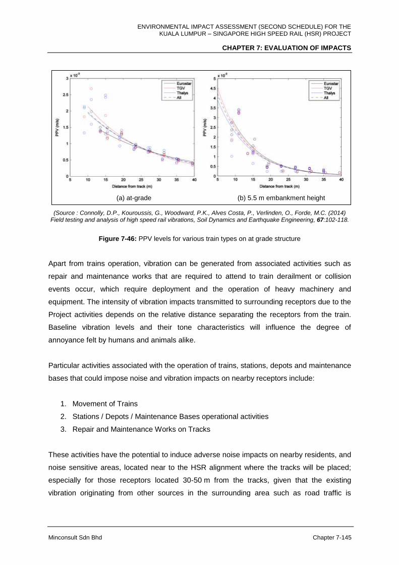
ENVIRONMENTAL IMPACT ASSESSMENT (SECOND SCHEDULE) FOR THE KUALA LUMPUR – SINGAPORE HIGH SPEED RAIL (HSR) PROJECT
CHAPTER 7: EVALUATION OF IMPACTS
Minconsult Sdn Bhd Chapter 7-145
(a) at-grade (b) 5.5 m embankment height
(Source : Connolly, D.P., Kouroussis, G., Woodward, P.K., Alves Costa, P., Verlinden, O., Forde, M.C. (2014)
Field testing and analysis of high speed rail vibrations, Soil Dynamics and Earthquake Engineering, 67:102-118.
Figure 7-46: PPV levels for various train types on at grade structure
Apart from trains operation, vibration can be generated from associated activities such as
repair and maintenance works that are required to attend to train derailment or collision
events occur, which require deployment and the operation of heavy machinery and
equipment. The intensity of vibration impacts transmitted to surrounding receptors due to the
Project activities depends on the relative distance separating the receptors from the train.
Baseline vibration levels and their tone characteristics will influence the degree of
annoyance felt by humans and animals alike.
Particular activities associated with the operation of trains, stations, depots and maintenance
bases that could impose noise and vibration impacts on nearby receptors include:
1. Movement of Trains
2. Stations / Depots / Maintenance Bases operational activities
3. Repair and Maintenance Works on Tracks
These activities have the potential to induce adverse noise impacts on nearby residents, and
noise sensitive areas, located near to the HSR alignment where the tracks will be placed;
especially for those receptors located 30-50 m from the tracks, given that the existing
vibration originating from other sources in the surrounding area such as road traffic is

ENVIRONMENTAL IMPACT ASSESSMENT (SECOND SCHEDULE) FOR THE KUALA LUMPUR – SINGAPORE HIGH SPEED RAIL (HSR) PROJECT
CHAPTER 7: EVALUATION OF IMPACTS
Minconsult Sdn Bhd Chapter 7-146
relatively low. The anticipated increase in sound levels at potential receptors is discussed in
the following narrative based on states.
These activities have the potential to induce adverse vibration impacts on nearby residents,
and vibration sensitive areas, located near to the HSR alignment where the tracks will be
placed; especially for those receptors located 30-50 m from the tracks, given that the
existing vibration originating from other sources in the surrounding area such as road traffic
is relatively low. The anticipated increase in sound levels at potential receptors is discussed
in the following narrative based on states.
A) FT. Kuala Lumpur
I. Vibration from Movement of Trains at High Speed and Approaching / Leaving
Station
During the operational phase, movement of high speed trains generate additional vibration
from the train to the tracks. The vibration generated by train movement and contact between
wheel and rail can be more dominant at higher speed and track curvature at smaller radius.
This will be added to the ambient ground vibration level. If not isolated properly via sleepers
or elevated structure, it could propagate to and cause disturbance and annoyance to the
nearest recipients, i.e., residential areas along Jalan JKR Salak Selatan and at Kg. Baru
Salak Selatan.
II. Vibration due to Activities at Station and Repair and Maintenance Work on
Tracks
Vibration generated due to activities performed at Bandar Malaysia Station as well as repair
and maintenance works on the tracks involve use of heavy machinery and equipment at the
site and/or its tracks. This includes repair required in the event of train derailment and
collision. Impulsive activities may generate forced vibration which may add to the ambient
ground vibration. These activities can be a nuisance to nearby residential and noise
sensitive areas, such as to residents in Taman Desa Seputeh which is about 200-300 m
from Bandar Malaysia Station. However, if the vibration signal is properly isolated via
sleepers or elevated structure, it could be prevented from propagate to and cause
disturbance to the receptors in the residential areas and business properties.

ENVIRONMENTAL IMPACT ASSESSMENT (SECOND SCHEDULE) FOR THE KUALA LUMPUR – SINGAPORE HIGH SPEED RAIL (HSR) PROJECT
CHAPTER 7: EVALUATION OF IMPACTS
Minconsult Sdn Bhd Chapter 7-147
B) Selangor / FT. Putrajaya
I. Vibration from Movement of Trains at High Speed and Approaching / Leaving
Station
During the operational phase, movement of high speed trains generate additional vibration
from the train to the tracks. The vibration generated by train movement and contact between
wheel and rail can be more dominant at higher speed and track curvature at smaller radius.
This will be added to the ambient ground vibration level. If not isolated properly via sleepers
or elevated structure, it could propagate to and cause disturbance and annoyance to the
nearest recipients, i.e., residential areas and business community along Jalan UPM, Kg.
Dato’ Abu Bakar Baginda and Desa Bestari, Sepang as well as at higher education
institutions and training centres along Jalan UPM, Jalan Sg. Besi and Jalan Ayer Hitam.
II. Vibration due to Activities at Station, Depot and Maintenance Base and Repair
and Maintenance Work on Tracks
Vibration generated due to activities performed at the Station, Depot and Maintenance Base
as well as repair and maintenance works on the tracks involve use of heavy machinery and
equipment at the site and/or its tracks. This includes repair required in the event of train
derailment and collision. Impulsive activities may generate forced vibration which may add to
the ambient ground vibration. These activities can be a nuisance to nearby residential and
noise sensitive areas, particularly in the vicinity of Sepang-Putrajaya Station and Light Depot
and LMB. However, if the vibration signal is properly isolated via sleepers or elevated
structure, it could be prevented from propagate to and cause disturbance to the receptors in
the residential areas and business properties.
C) Negeri Sembilan
I. Vibration from Movement of Trains at High Speed and Approaching / Leaving
Station
During the operational phase, movement of high speed trains generate additional vibration
from the train to the tracks. The vibration generated by train movement and contact between
wheel and rail can be more dominant at higher speed and track curvature at smaller radius.
ENVIRONMENTAL IMPACT ASSESSMENT (SECOND SCHEDULE) FOR THE KUALA LUMPUR – SINGAPORE HIGH SPEED RAIL (HSR) PROJECT
CHAPTER 7: EVALUATION OF IMPACTS
Minconsult Sdn Bhd Chapter 7-148
This will be added to the ambient ground vibration level. If not isolated properly via sleepers
or elevated structure, it could propagate to and cause disturbance and annoyance to the
nearest recipients, i.e., residential areas and business community in Desa Cempaka and
Kota Seriemas in Nilai, Taman Gadong Putra and Taman Cermat Utama in Labu and Felda
Sri Sendayan.
II. Vibration due to Activities at Station and Repair and Maintenance Work on
Tracks
Vibration generated due to activities performed at Seremban Station as well as repair and
maintenance works on the tracks involve use of heavy machinery and equipment at the site
and/or its tracks. This includes repair required in the event of train derailment and collision.
Impulsive activities may generate forced vibration which may add to the ambient ground
vibration. As Seremban Station is situated on a granite foundation, vibration signals
generated from the station may be propagated to nearby receptors. However, since the
nearest receptor is 800 m away, the vibration impact from station activities is minimal.
D) Melaka
I. Vibration from Movement of Trains at High Speed and Approaching / Leaving
Station
During the operational phase, movement of high speed trains generate additional vibration
from the train to the tracks. The vibration generated by train movement and contact between
wheel and rail can be more dominant at higher speed and track curvature at smaller radius.
This will be added to the ambient ground vibration level. If not isolated properly via sleepers
or Elevated Structure, it could propagate to and cause disturbance and annoyance to the
nearest recipients, i.e., residential areas and business community in Masjid Tanah, Taman
Paya Rumput Indah, 1Krubong Residence, Durian Tunggal, Kg. Ulu Duyung, Taman
Bemban Jaya Taman Bemban Baru and Kg. Bemban, as well as in vibration sensitive
receptors in IKBN Alor Gajah and Pusat Rehabilitasi PERKESO Melaka.
ENVIRONMENTAL IMPACT ASSESSMENT (SECOND SCHEDULE) FOR THE KUALA LUMPUR – SINGAPORE HIGH SPEED RAIL (HSR) PROJECT
CHAPTER 7: EVALUATION OF IMPACTS
Minconsult Sdn Bhd Chapter 7-149
II. Vibration due to Activities at Station and Repair and Maintenance Work on
Tracks
Vibration generated due to activities performed at Melaka Station as well as repair and
maintenance works on the tracks involve use of heavy machinery and equipment at the site
and/or its tracks. This includes repair required in the event of train derailment and collision.
Impulsive activities may generate forced vibration which may add to the ambient ground
vibration. These activities can be a nuisance to nearby residential and noise sensitive areas,
particularly in the vicinity of Melaka Station. However, if the vibration signal is properly
isolated via sleepers or Elevated Structure, it could be prevented from propagate to and
cause disturbance to the nearest recipients, i.e., residential areas and business community
such as INB Resort Hotel Ayer Keroh located about 100 m from the Melaka Station.
E) Johor
I. Vibration from Movement of Trains at High Speed and Approaching / Leaving
Stations
During the operational phase, movement of high speed trains generate additional vibration
from the train to the tracks. The vibration generated by train movement and contact between
wheel and rail can be more dominant at higher speed and track curvature at smaller radius.
This will be added to the ambient ground vibration level. If not isolated properly via sleepers
or Elevated Structure, it could propagate to and cause disturbance and annoyance to the
nearest recipients, i.e., residential areas and business community in Bukit Gambir, Panchor,
Pagoh, Parit Yaani, Parit Sulong, Simpang Renggam, Pekan Nenas, Gelang Patah and
Tanjung Kupang.
II. Vibration due to Activities at Stations, Depots and Maintenance Bases and Repair
and Maintenance Work on Tracks
Vibration generated due to activities performed at Muar, Batu Pahat and Iskandar Puteri
Stations, HMB and Main Depot and LMB as well as repair and maintenance works on the
tracks involve use of heavy machinery and equipment at the site and/or its tracks. This
includes repair required in the event of train derailment and collision. Many of these facilities
are situated by soil profiles that are able to absorb ground vibration such as alluvium,
ENVIRONMENTAL IMPACT ASSESSMENT (SECOND SCHEDULE) FOR THE KUALA LUMPUR – SINGAPORE HIGH SPEED RAIL (HSR) PROJECT
CHAPTER 7: EVALUATION OF IMPACTS
Minconsult Sdn Bhd Chapter 7-150
limestones and peat soil profiles. These types of ground profile can absorb most of the
ground vibration signal generate from the project site. Hence, the impact is minimal except at
Batu Pahat Station and Main Depot and LMB which are respectively close to residential
areas (Taman Pura Kencana) and sensitive receptors (Pertubuhan Kebajikan Warga Emas
Pontian). However, if the vibration signal is properly isolated via sleepers or Elevated
Structure, it could be prevented from propagate to and cause disturbance to these receptors.
ENVIRONMENTAL IMPACT ASSESSMENT (SECOND SCHEDULE) FOR THE KUALA LUMPUR – SINGAPORE HIGH SPEED RAIL (HSR) PROJECT
CHAPTER 7: EVALUATION OF IMPACTS
Minconsult Sdn Bhd Chapter 7-151
7.5 WASTE MANAGEMENT IMPACTS
Waste arisings induced by Project activities can occur during both the construction and
operation phases; especially during the construction Phase. The type and quantities of
wastes that can be generated have been summarized in Table 7-16 to 7-21. They require
appropriate means of disposal without incurring adverse environmental impacts. Potential
impacts that can occur with waste disposals are described herewith.
7.5.1 Construction Phase
7.5.1.1 Introduction
Site preparation followed by earthworks operations for this Project shall have the ability to
exert significant impacts on the environment as well as on human habitats. Wastes created
by these two (2) main activities have been identified, and their potential for inducing
environmental impacts is described.
Site clearing operations include removing from the HSR alignment all standing and ground
based vegetation, a layer of organic surficial soil layer; and any structures that are present
(e.g. buildings).
The disposal strategy proposed is based upon the waste management principle of reducing
the amount of waste requiring final disposal through the development of outline plans for
waste avoidance, material re-use, and recycling.
The overall objectives for the waste management assessment are summarized below:
assess the construction activities involved for the proposed works and determine the
type, nature and where possible estimate the volume and weight of waste that can be
generated;
identify any potential environmental impacts from the generation of waste associated
with the works;
ENVIRONMENTAL IMPACT ASSESSMENT (SECOND SCHEDULE) FOR THE KUALA LUMPUR – SINGAPORE HIGH SPEED RAIL (HSR) PROJECT
CHAPTER 7: EVALUATION OF IMPACTS
Minconsult Sdn Bhd Chapter 7-152
categorise waste materials where practical, i.e. suitability for re-use/recycling,
disposal to public filling areas, disposal to landfill and any pre-treatment requirements
prior to disposal
recommend appropriate waste management options (including waste minimization
on-site, re-use or recycling opportunities and off-site disposal options);
identify site management/mitigation measures that should be implemented to
minimise any potential adverse impacts from the generation, handling, storage and
disposal of waste, in accordance with the current legislative and administrative
requirements.
Excavated materials and residual wastes may give rise to impacts during their handling,
temporary stockpiling, or storage on site, transportation and final disposal. In order to
determine the most appropriate methods of treatment, handling and disposal, it is important
to comprehend the nature and composition of wastes produced; in particular whether the
waste materials are inert, putrescible or contaminated.
7.5.1.2 Nature and Type of Waste Materials
Wastes which will be generated during the construction phase include the following:
(i) Vegetation and demolition waste from site clearance;
(ii) Excavated materials from earthworks (e.g. cuttings, pile foundations, regrading
works);
(iii) General construction waste (e.g. wood, scrap metal, concrete);
(iv) Chemical wastes generated by general site practices (e.g. vehicle and plant
maintenance/servicing); and
(vi) Municipal wastes generated by site workers.
The main sources of solid wastes and construction wastes from the HSR alignment are as
follows:
1) Centralized Labour Quarters (CLQ) – mainly domestic waste, packaging,
containers, and domestic waste/rubbish.
2) Fabrication yard – scrap metals, machinery parts, used tires, containers, and
packaging.
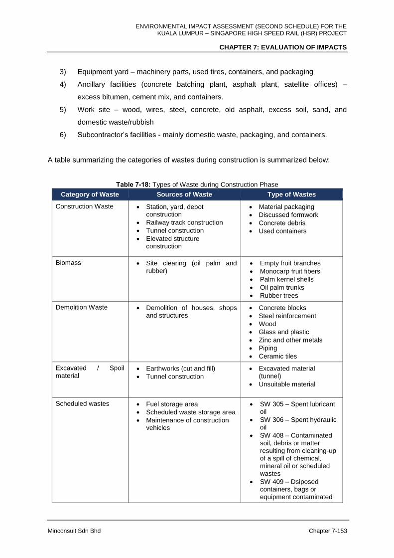
ENVIRONMENTAL IMPACT ASSESSMENT (SECOND SCHEDULE) FOR THE KUALA LUMPUR – SINGAPORE HIGH SPEED RAIL (HSR) PROJECT
CHAPTER 7: EVALUATION OF IMPACTS
Minconsult Sdn Bhd Chapter 7-153
3) Equipment yard – machinery parts, used tires, containers, and packaging
4) Ancillary facilities (concrete batching plant, asphalt plant, satellite offices) –
excess bitumen, cement mix, and containers.
5) Work site – wood, wires, steel, concrete, old asphalt, excess soil, sand, and
domestic waste/rubbish
6) Subcontractor’s facilities - mainly domestic waste, packaging, and containers.
A table summarizing the categories of wastes during construction is summarized below:
Table 7-18: Types of Waste during Construction Phase
Category of Waste Sources of Waste Type of Wastes
Construction Waste Station, yard, depot construction
Railway track construction
Tunnel construction
Elevated structure construction
Material packaging
Discussed formwork
Concrete debris
Used containers
Biomass Site clearing (oil palm and rubber)
Empty fruit branches
Monocarp fruit fibers
Palm kernel shells
Oil palm trunks
Rubber trees
Demolition Waste Demolition of houses, shops and structures
Concrete blocks
Steel reinforcement
Wood
Glass and plastic
Zinc and other metals
Piping
Ceramic tiles
Excavated / Spoil material
Earthworks (cut and fill)
Tunnel construction
Excavated material (tunnel)
Unsuitable material
Scheduled wastes Fuel storage area
Scheduled waste storage area
Maintenance of construction vehicles
SW 305 – Spent lubricant oil
SW 306 – Spent hydraulic oil
SW 408 – Contaminated soil, debris or matter resulting from cleaning-up of a spill of chemical, mineral oil or scheduled wastes
SW 409 – Dsiposed containers, bags or equipment contaminated
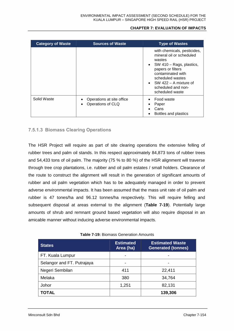
ENVIRONMENTAL IMPACT ASSESSMENT (SECOND SCHEDULE) FOR THE KUALA LUMPUR – SINGAPORE HIGH SPEED RAIL (HSR) PROJECT
CHAPTER 7: EVALUATION OF IMPACTS
Minconsult Sdn Bhd Chapter 7-154
Category of Waste Sources of Waste Type of Wastes
with chemicals, pesticides, mineral oil or scheduled wastes
SW 410 – Rags, plastics, papers or filters contaminated with scheduled wastes
SW 422 – A mixture of scheduled and non-scheduled waste
Solid Waste Operations at site office
Operations of CLQ
Food waste
Paper
Cans
Bottles and plastics
7.5.1.3 Biomass Clearing Operations
The HSR Project will require as part of site clearing operations the extensive felling of
rubber trees and palm oil stands. In this respect approximately 84,873 tons of rubber trees
and 54,433 tons of oil palm. The majority (75 % to 80 %) of the HSR alignment will traverse
through tree crop plantations, i.e. rubber and oil palm estates / small holders. Clearance of
the route to construct the alignment will result in the generation of significant amounts of
rubber and oil palm vegetation which has to be adequately managed in order to prevent
adverse environmental impacts. It has been assumed that the mass unit rate of oil palm and
rubber is 47 tones/ha and 96.12 tonnes/ha respectively. This will require felling and
subsequent disposal at areas external to the alignment (Table 7-19). Potentially large
amounts of shrub and remnant ground based vegetation will also require disposal in an
amicable manner without inducing adverse environmental impacts.
Table 7-19: Biomass Generation Amounts
States Estimated Area (ha)
Estimated Waste Generated (tonnes)
FT. Kuala Lumpur - -
Selangor and FT. Putrajaya - -
Negeri Sembilan 411 22,411
Melaka 380 34,764
Johor 1,251 82,131
TOTAL 139,306

ENVIRONMENTAL IMPACT ASSESSMENT (SECOND SCHEDULE) FOR THE KUALA LUMPUR – SINGAPORE HIGH SPEED RAIL (HSR) PROJECT
CHAPTER 7: EVALUATION OF IMPACTS
Minconsult Sdn Bhd Chapter 7-155
In the past, resort to open burning of tree crops was the main solution adopted, especially if
plantations were to be converted into urban type developments, or when replanting activities
occurred. However this type of activity creates significant adverse air quality impacts which
can have detrimental health consequences on surrounding communities, both locally and
regionally. Open burning can lead to significant emissions of gaseous pollutants, not only
particulate matter but also oxides of nitrogen, volatile organic compounds, carbon dioxide
and carbon monoxide. Besides this, incomplete combustion often leaves a large amount of
residual matter (ashes) for disposal which may be re-suspended by strong winds, thus
further contributing to dust emissions. Overall open burning of the vegetation may lead
significant worsening of the air quality at the project site. However in this case, as there will
be no open burning of vegetation during site clearance activities thus abiding with
regulations forbidding open burning to dispose of felled tree crops. Resort to other less
environmental intimidating measures are being carried out currently.
Potential adverse environmental impacts can materialize as a result of improper disposal of
large amounts of tree stumps, shrubs and ground vegetation. Indiscriminate disposal
practices can lead to (a) significant degradation in air quality, albeit over a short term period;
if practice of uncontrolled burning the biomass is adopted, (b) impede surface drainage
systems and rivers leading to localized flooding episodes (potential long term impact) and
degradation in water quality; (c) formation of pest breeding and feeding grounds and hence
spread of diseases in neighboring human habitats potentially a long term impact); (d) reduce
the economic value of the land mass, or eliminate opportunities to productively make use of
the land area which are used to receive the waste loads (potential long term impact); and (e)
creation of unaesthetic visual impacts thereby reducing the amenity value of surrounding
areas.
There are alternative methods for proper management of the biomass which results from
felling both oil palm and rubber trees. Such methods are reviewed and discussed in the
following Mitigation Measures Chapter.
7.5.1.4 Soil Materials
The total amount of excess excavated soils that have to be disposed away from the HSR
alignment amounts to about 1,111,403 m3 (Table 7-20). Construction of the HSR alignment
within FT. Kuala Lumpur, Melaka and the Selangor per se will not require any fill materials
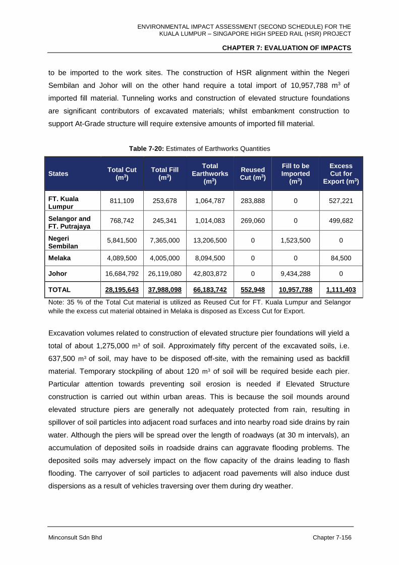
ENVIRONMENTAL IMPACT ASSESSMENT (SECOND SCHEDULE) FOR THE KUALA LUMPUR – SINGAPORE HIGH SPEED RAIL (HSR) PROJECT
CHAPTER 7: EVALUATION OF IMPACTS
Minconsult Sdn Bhd Chapter 7-156
to be imported to the work sites. The construction of HSR alignment within the Negeri
Sembilan and Johor will on the other hand require a total import of 10,957,788 m3 of
imported fill material. Tunneling works and construction of elevated structure foundations
are significant contributors of excavated materials; whilst embankment construction to
support At-Grade structure will require extensive amounts of imported fill material.
Table 7-20: Estimates of Earthworks Quantities
States Total Cut
(m3) Total Fill
(m3)
Total Earthworks
(m3)
Reused Cut (m3)
Fill to be Imported
(m3)
Excess Cut for
Export (m3)
FT. Kuala Lumpur
811,109 253,678 1,064,787 283,888 0 527,221
Selangor and FT. Putrajaya
768,742 245,341 1,014,083 269,060 0 499,682
Negeri Sembilan
5,841,500 7,365,000 13,206,500 0 1,523,500 0
Melaka 4,089,500 4,005,000 8,094,500 0 0 84,500
Johor 16,684,792 26,119,080 42,803,872 0 9,434,288 0
TOTAL 28,195,643 37,988,098 66,183,742 552,948 10,957,788 1,111,403
Note: 35 % of the Total Cut material is utilized as Reused Cut for FT. Kuala Lumpur and Selangor
while the excess cut material obtained in Melaka is disposed as Excess Cut for Export.
Excavation volumes related to construction of elevated structure pier foundations will yield a
total of about 1,275,000 m3 of soil. Approximately fifty percent of the excavated soils, i.e.
637,500 m3 of soil, may have to be disposed off-site, with the remaining used as backfill
material. Temporary stockpiling of about 120 m3 of soil will be required beside each pier.
Particular attention towards preventing soil erosion is needed if Elevated Structure
construction is carried out within urban areas. This is because the soil mounds around
elevated structure piers are generally not adequately protected from rain, resulting in
spillover of soil particles into adjacent road surfaces and into nearby road side drains by rain
water. Although the piers will be spread over the length of roadways (at 30 m intervals), an
accumulation of deposited soils in roadside drains can aggravate flooding problems. The
deposited soils may adversely impact on the flow capacity of the drains leading to flash
flooding. The carryover of soil particles to adjacent road pavements will also induce dust
dispersions as a result of vehicles traversing over them during dry weather.

ENVIRONMENTAL IMPACT ASSESSMENT (SECOND SCHEDULE) FOR THE KUALA LUMPUR – SINGAPORE HIGH SPEED RAIL (HSR) PROJECT
CHAPTER 7: EVALUATION OF IMPACTS
Minconsult Sdn Bhd Chapter 7-157
At this juncture, in the absence of confirmatory soil data along the HSR alignment, it is not
possible to come to a conclusion as to whether all, or part of, the cut volumes generated in
FT. Kuala Lumpur and Selangor can be deployed for use in areas where fill material is
required along other areas of the alignment. This is because the majority of cut soils
generated in FT. Kuala Lumpur and Selangor is from tunnel excavation works in geological
formations which yield materials (schist and Kenny Hill formation) that are not suitable for
embankment construction. As such it is anticipated that only a fraction of the soil material
excavated from tunnels can be reutilized as fill material at other sectors of the alignment.
Therefore, especially within the State of Johor, fill material has to be imported to the work
sites along the HSR alignment from existing or newly developed burrow sites. The opening
of new burrow sites, and their operations, will entail significant environmental impacts to
occur in itself; inducing potentially adverse air and water impacts as well as noise and
vibration impacts. The intensity of impacts will be dependent on the location of the burrow
area(s) in relation to human habitats.
Furthermore the required fill material has to be transported to the work sites along the
alignment. The normal method is to employ 15 m3 dump trucks to transport the fill material.
Considering the large amounts of fill required it is estimated that a total of 100,000 dump
trucks will be required to operate over a time period of 30 to 36 months assuming that
earthworks for all sectors of the alignment are carried out simultaneously. Assuming an
average round trip distance of 40 km from burrow area to work site and back the total truck
mileage incurred would be of the order of 4 million truck/ km. The associated carbon dioxide
emissions from this rate of travel are estimated at approximately 30 tons over a 30 to 36
months period; which translates to 30 to 45 kg/day.
Transportation routes have to be selectively chosen in order to avoid imposing adverse
dust, noise and vibration impacts on surrounding habitual areas; and avoid disrupting traffic
circulation patterns along public roads, and inducing higher incidences of vehicular
accidents. Transportation routes across rural zones should be located at least 100 m away
from residential abodes.

ENVIRONMENTAL IMPACT ASSESSMENT (SECOND SCHEDULE) FOR THE KUALA LUMPUR – SINGAPORE HIGH SPEED RAIL (HSR) PROJECT
CHAPTER 7: EVALUATION OF IMPACTS
Minconsult Sdn Bhd Chapter 7-158
7.5.1.5 Construction and Demolition Wastes
The amounts of construction and demolition wastes that could be generated by Project
activities are summarized in Table 7-21.
Table 7-21: Estimates of Construction and Demolition Wastes
State
Construction Waste Demolition Waste
Area (m2) Estimated Waste
Generated (tonnes)
Built-Up Area (m2)
Estimated Waste Generated (tonnes)
FT. Kuala Lumpur
26 3 68,650 71,945
Selangor and FT. Putrajaya
83 9 252,100 264,200
Negeri Sembilan
13 1 96,950 101,603
Melaka 13 1 84,600 88,660
Johor 172 20 184,800 193,670
TOTAL 307 34 687,100 720,078
Preliminary estimates indicate that there could be large amounts of demolition wastes that
can be generated through the removal of structures within the HSR alignment. More
detailed surveys are required to inventorize the nature and type of buildings and other
structures that require removal. On the other hand construction wastes arising from the
construction of stations, maintenance depots and elevated structure are comparatively low.
These types of wastes if disposed indiscriminately can induce significant impacts. Recycling
and reuse of residual material can lower significantly the amount of such wastes requiring
ultimate disposal. It is therefore proposed that Contractors formulate a plan of action to
reduce the amount of wastes that are required to be disposed to the environment.
7.5.1.6 Scheduled Wastes
The amount of scheduled wastes that can be generated through Project activities is deemed
manageable. It is essential that the Contractor closely follow the Environmental Quality
(Scheduled Works) Regulation 2005 Act and its schedules regarding storage, collection,
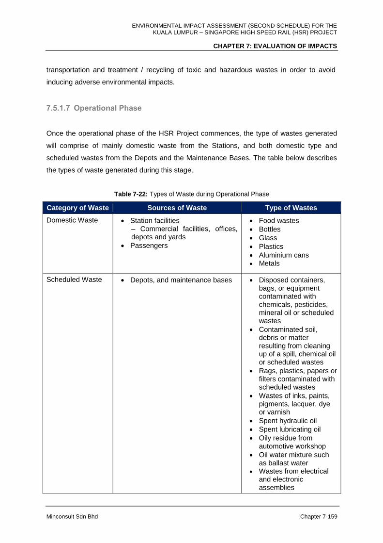
ENVIRONMENTAL IMPACT ASSESSMENT (SECOND SCHEDULE) FOR THE KUALA LUMPUR – SINGAPORE HIGH SPEED RAIL (HSR) PROJECT
CHAPTER 7: EVALUATION OF IMPACTS
Minconsult Sdn Bhd Chapter 7-159
transportation and treatment / recycling of toxic and hazardous wastes in order to avoid
inducing adverse environmental impacts.
7.5.1.7 Operational Phase
Once the operational phase of the HSR Project commences, the type of wastes generated
will comprise of mainly domestic waste from the Stations, and both domestic type and
scheduled wastes from the Depots and the Maintenance Bases. The table below describes
the types of waste generated during this stage.
Table 7-22: Types of Waste during Operational Phase
Category of Waste Sources of Waste Type of Wastes
Domestic Waste Station facilities – Commercial facilities, offices, depots and yards
Passengers
Food wastes
Bottles
Glass
Plastics
Aluminium cans Metals
Scheduled Waste Depots, and maintenance bases Disposed containers, bags, or equipment contaminated with chemicals, pesticides, mineral oil or scheduled wastes
Contaminated soil, debris or matter resulting from cleaning up of a spill, chemical oil or scheduled wastes
Rags, plastics, papers or filters contaminated with scheduled wastes
Wastes of inks, paints, pigments, lacquer, dye or varnish
Spent hydraulic oil
Spent lubricating oil
Oily residue from automotive workshop
Oil water mixture such as ballast water
Wastes from electrical and electronic assemblies
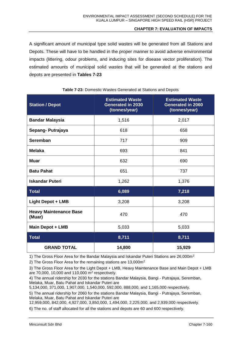
ENVIRONMENTAL IMPACT ASSESSMENT (SECOND SCHEDULE) FOR THE KUALA LUMPUR – SINGAPORE HIGH SPEED RAIL (HSR) PROJECT
CHAPTER 7: EVALUATION OF IMPACTS
Minconsult Sdn Bhd Chapter 7-160
A significant amount of municipal type solid wastes will be generated from all Stations and
Depots. These will have to be handled in the proper manner to avoid adverse environmental
impacts (littering, odour problems, and inducing sites for disease vector proliferation). The
estimated amounts of municipal solid wastes that will be generated at the stations and
depots are presented in Tables 7-23
Table 7-23: Domestic Wastes Generated at Stations and Depots
Station / Depot Estimated Waste
Generated in 2030 (tonnes/year)
Estimated Waste Generated in 2060
(tonnes/year)
Bandar Malaysia 1,516 2,017
Sepang- Putrajaya 618 658
Seremban 717 909
Melaka 693 841
Muar 632 690
Batu Pahat 651 737
Iskandar Puteri 1,262 1,376
Total 6,089 7,218
Light Depot + LMB 3,208 3,208
Heavy Maintenance Base (Muar)
470 470
Main Depot + LMB 5,033 5,033
Total 8,711 8,711
GRAND TOTAL 14,800 15,929
1) The Gross Floor Area for the Bandar Malaysia and Iskandar Puteri Stations are 26,000m2
2) The Gross Floor Area for the remaining stations are 13,000m2
3) The Gross Floor Area for the Light Depot + LMB, Heavy Maintenance Base and Main Depot + LMB are 70,000, 10,000 and 110,000 m2 respectively.
4) The annual ridership for 2030 for the stations Bandar Malaysia, Bangi - Putrajaya, Seremban, Melaka, Muar, Batu Pahat and Iskandar Puteri are 5,134,000, 371,000, 1,907,000, 1,540,000, 592,000, 888,000, and 1,165,000 respectively.
5) The annual ridership for 2060 for the stations Bandar Malaysia, Bangi - Putrajaya, Seremban, Melaka, Muar, Batu Pahat and Iskandar Puteri are 12,959,000, 842,000, 4,927,000, 3,850,000, 1,494,000, 2,225,000, and 2,939,000 respectively.
6) The no. of staff allocated for all the stations and depots are 60 and 600 respectively.
ENVIRONMENTAL IMPACT ASSESSMENT (SECOND SCHEDULE) FOR THE KUALA LUMPUR – SINGAPORE HIGH SPEED RAIL (HSR) PROJECT
CHAPTER 7: EVALUATION OF IMPACTS
Minconsult Sdn Bhd Chapter 7-161
These wastes would need to be appropriately disposed or otherwise environmental hazards
could materialize and potentially endangering public health status within the surrounding
area. These impacts comprise of the following:
Improper management of domestic wastes resulting in the formation of garbage piles
will induce odour and nuisance impacts, and create suitable habitats for pests and
vermin. These issues can cause spread of diseases among the public.
The leachate from the garbage piles can seep into waterways and soil to cause water
and soil pollution.
Blockage of drainage and waterways from the illegal dumping of garbage wastes.
Water and soil contamination due to the spillage and improper management of
scheduled wastes.
There are well established services available to collect domestic type solid wastes as well
as toxic and hazardous wastes and to transport the wastes to a facility for proper treatment
and disposal. It is therefore concluded that no significant impacts will materialize from the
generation of solid wastes at the Depots and Stations. However, vigilance and control over
fly litter wastes needs to be exercised at the Stations and Depots, and at peripheral areas,
in order to prevent occurrences of adverse environmental impacts that could lead to flooding
episodes arising from clogging of peripheral drainage systems.

ENVIRONMENTAL IMPACT ASSESSMENT (SECOND SCHEDULE) FOR THE KUALA LUMPUR – SINGAPORE HIGH SPEED RAIL (HSR) PROJECT
CHAPTER 7: EVALUATION OF IMPACTS
Minconsult Sdn Bhd Chapter 7-162
7.6 SURFACE WATER QUALITY
7.6.1 Water Quality
7.6.1.1 Construction Phase
The main activities during construction that will impact water quality were listed below:
Project Activities
Land Clearing
Demolition
Construction Of Access Roads
Earthwork
Drainage
Transportation Of Materials / Equipment
Vehicle Movement
Disposal Of Unsuitable Material
Waste / Wastewater Generation
Disposal Of Solid And Construction Waste / Biomass
Establishment Of Site Office, Storage Areas
Establishment Of Workers Camp
Piling
Construction Of Station / Depots / Maintenance Base
Construction Of Elevated Structures
Construction Of At-Grade Structures
Abandonment
Every state traverses by the HSR alignment will have their specific activities that may impact
the water quality of nearby water bodies namely rivers.
Land clearing and earthworks operations promote devegetation and dislodgement of soil
particles which may then be transported to surrounding drainage systems by surface water
flows. Drainage impedances (blockages) could occur resulting in localized flooding episodes
that could impact adversely on surrounding habitats.

ENVIRONMENTAL IMPACT ASSESSMENT (SECOND SCHEDULE) FOR THE KUALA LUMPUR – SINGAPORE HIGH SPEED RAIL (HSR) PROJECT
CHAPTER 7: EVALUATION OF IMPACTS
Minconsult Sdn Bhd Chapter 7-163
A) FT. Kuala Lumpur
The main activities in the FT. Kuala Lumpur that will affect water quality will be the
earthworks for the construction of Bandar Malaysia development and at Bandar Malaysia
Station. Other activities such as land clearing, demolition and construction of access roads
were minimal and were expected to create little impacts on water quality. Erosion from the
open space or earthworks will bring sediment through drainage and eventually into Sg.
Klang especially during wet season. This will inflate the levels of TSS in the river water.
The HSR alignment that will traverse Sg. Kerayong will be an Elevated Structure. During
pilling (for the construction of pillars) for the Elevated Structures, it will disturb the relevant
soil and if not adequately protected will introduce sediments into Sg. Kerayong thus inflating
the turbidity and TSS levels of the river water. This is especially so if the piling is close to the
river bank.
B) Selangor
Activities expected to create impacts on water quality were as follows:
1. Construction of Sepang-Putrajaya Station.
2. Land Clearing
3. Earthworks
4. Construction of Serdang Depot
5. Construction of tunnels
Construction of the Sepang-Putrajaya Station will not involve major land clearing and
earthworks. The potential impact to water quality would be if the activities were carried out
during monsoon season. Erosion from the land clearing and earthworks will bring sediment
through drainage and eventually into Sg. Langat, thus inflating the levels of TSS in the river
water.
The HSR alignment will traverse crossing Sg. Semenyih and Sg. Batang Labu, where it is an
upstream of intake points for Sg. Semenyih WTP and Sg. Labu WTP, respectively. Although
the alignment will be elevated, the piling activities for the crossing the rivers will disturb soil
at the area if it is not properly protected. The water quality of streams and rivers could be

ENVIRONMENTAL IMPACT ASSESSMENT (SECOND SCHEDULE) FOR THE KUALA LUMPUR – SINGAPORE HIGH SPEED RAIL (HSR) PROJECT
CHAPTER 7: EVALUATION OF IMPACTS
Minconsult Sdn Bhd Chapter 7-164
degraded by uncontrolled wash out of soil particles and vegetative matter, and as a
consequence diminish their resource capability to support downstream socio-economic
activities
There is tunnel from Kg Baru Salak Selatan to Taman Sri Serdang and within Kg. Jenderam
Hilir. During the tunnel construction, there will be impacts on water quality of the rivers
namely from the slurry produced and from the leaching of rock and soil which may contain
solids as well as dissolved metals.
The construction of Light Depot and LMB at Serdang will affect water quality of Sg. Ramal
which will eventually affecting Sg. Langat. However with proper measures such as avoiding
construction during monsoon/ wet season, constructing sediment pond or trap, these
impacts are expected to be minimal.
C) Negeri Sembilan
Similar activities listed above are also expected to affect water quality in Negeri Sembilan.
Site clearing for the constructions of Seremban Station and the HSR alignment will expose
the soil for erosion especially during monsoon/ wet season if not compacted immediately.
This will also lead to increase runoff and sediment flow into nearby rivers namely Sg. Jijan,
Sg. Anak Ayer Sebong, Sg. Gadong, Sg. Lukut Besar, Sg. Jimah, Sg. Putting, Sg. Siliau, Sg.
Salak Leigh, Sg. Ayer Hitam and Sg. Linggi particularly those downstream of the alignment
and if adequate drainage system was not built.
Since all intake points for WTPs were located upstream of the alignment, there will be no
issue of water quality to the treatment plants. Although the HSR alignment traverses Sg.
Linggi, the alignment crossing is located downstream which means that it will not affect the
Sg. Linggi WTP where the intake point is located at Kuala Sawah.
D) Melaka
In Melaka, construction activities which may affect water quality includes those related to the
construction of the HSR alignment and Melaka Station i.e. land clearing and associated
ENVIRONMENTAL IMPACT ASSESSMENT (SECOND SCHEDULE) FOR THE KUALA LUMPUR – SINGAPORE HIGH SPEED RAIL (HSR) PROJECT
CHAPTER 7: EVALUATION OF IMPACTS
Minconsult Sdn Bhd Chapter 7-165
earthworks. Biomass produced from the site clearing will contaminate the water quality
through the decomposing, if they were not disposed properly at disposal site.
The construction of Melaka Station, which will be elevated, will not pose significant impact to
water quality since it is not located near to the river. However, earthworks and land clearing
activities for the station will promote surface erosion thus generating runoff containing high
solids especially during wet season. Through series of drains and small streams, the solids
will eventually flow into Sg. Melaka.
Land clearing and earthworks for the construction of the HSR alignment particularly within
the catchment of Sg. Melaka will have a serious impact due to the presence of a water
intake point for the Durian Tunggal WTP. Any deterioration of quality of this segment of Sg.
Melaka due to earthworks and land clearing will jeopardize the operation of Durian Tunggal
WTP and thus water supply to the community.
E) Johor
Similar activities associated with the construction of the HSR alignment, construction of
Stations (at Muar, Batu Pahat and Iskandar Puteri), construction of HMB and Main Depot (at
Muar and Pontian), the related earthworks and land clearings were expected to create
impacts on water quality of relevant water bodies (rivers and drains).
All earthworks, land clearings and piling activities for the HSR alignment, if carried out during
monsoon/ wet season and without adequate protective measures, will cause erosion and
surface runoff containing high suspended solids that will contaminate water bodies with TSS.
The affected water bodies would mainly be Sg. Kesang, Sg. Belemang Besar, Sg. Muar, Sg.
Pagoh, Parit Ayer Putih, Sg. Simpang Kiri, Sg. Simpang Kanan, Sg. Senggarang, Parit Lapis
Seri Dalam, Parit Lapis Sempadan, Sg. Benut, Sg. Sanglang, Sg. Pontian Besar, Sg. Ulu
Choh, Sg. Pulai and Sg. Gelang Patah.
There are two (2) tunnels located in the HSR alignment in Johor namely Bukit Naning 1 and
Bukit Naning 2. During the tunnel constructions, there will be impacts on water quality to the
nearby water bodies (Sg. Pagoh and Parit Ayer Putih) from the slurry produced and from the
leaching of rock and soil which may contain solids as well as dissolved metals. Protective
measure is important at this area in order to avoid any pollution to occur.
ENVIRONMENTAL IMPACT ASSESSMENT (SECOND SCHEDULE) FOR THE KUALA LUMPUR – SINGAPORE HIGH SPEED RAIL (HSR) PROJECT
CHAPTER 7: EVALUATION OF IMPACTS
Minconsult Sdn Bhd Chapter 7-166
Earthworks and land clearings for the construction of Muar Station will create solid pollutions
that will flow into Sg. Pagoh and eventually into Sg. Muar. For Batu Pahat Station, the solids
will flow into Sg. Simpang Kanan and for the construction of Iskandar Puteri Station, the solid
pollution will contaminate Sg. Pulai and eventually the estuary area.
Related earthworks and land clearing for the construction of HMB at Muar and Main Depot
and LMB at Pontian which will involve large area of land (especially at Pontian), will definitely
cause solid pollution from surface runoff which will pollute nearby water bodies namely Sg.
Muar and Sg. Ulu Choh, respectively. This impact will be enhanced when the construction
activities were carried out during wet season and no effective protective measures were
taken.
Water Quality Modeling
For this study, the simulation for Total Suspended Solids (TSS) was undertaken where ever
the HSR alignment crossing at upstream of any water intakes to predict level of TSS before
reach water intake point during construction phase. The followings are the objectives for this
study:-
i. To simulate the concentration of TSS during the construction phase along the river
stretch and before reaching water intake point. The level of TSS from simulation shall
be compared with the National Water Quality Standard (NWQS).
The study has taken into considerations the following conditions:
1. Existing Conditions (due to the external inputs such as tributaries)
2. Inputs at loading points
Potential Point Source and Selected Scenarios
i. Potential Point Source
Potential point source is a point where pollutant load namely TSS, BOD and COD
confluence or discharge point to the river. The point sources referred in this study represent
discharge from river-crossing, depot or station either during construction phase or during
operation phase. Detailed point source information is shown in the following table.
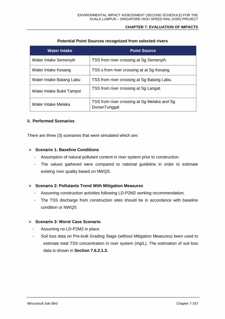
ENVIRONMENTAL IMPACT ASSESSMENT (SECOND SCHEDULE) FOR THE KUALA LUMPUR – SINGAPORE HIGH SPEED RAIL (HSR) PROJECT
CHAPTER 7: EVALUATION OF IMPACTS
Minconsult Sdn Bhd Chapter 7-167
Potential Point Sources recognized from selected rivers
Water Intake Point Source
Water Intake Semenyih TSS from river crossing at Sg Semenyih.
Water Intake Kesang TSS s from river crossing at at Sg Kesang.
Water Intake Batang Labu TSS from river crossing at Sg Batang Labu.
Water Intake Bukit Tampoi TSS from river crossing at Sg Langat.
Water Intake Melaka TSS from river crossing at Sg Melaka and Sg
DurianTunggal
ii. Performed Scenarios
There are three (3) scenarios that were simulated which are:
Scenario 1: Baseline Conditions
- Assumption of natural pollutant content in river system prior to construction.
- The values gathered were compared to national guideline in order to estimate
existing river quality based on NWQS.
Scenario 2: Pollutants Trend With Mitigation Measures
- Assuming construction activities following LD-P2M2 working recommendation.
- The TSS discharge from construction sites should be in accordance with baseline
condition or NWQS
Scenario 3: Worst Case Scenario
- Assuming no LD-P2M2 in place.
- Soil loss data on Pre-bulk Grading Stage (without Mitigation Measures) been used to
estimate total TSS concentration in river system (mg/L). The estimation of soil loss
data is shown in Section 7.6.2.1.3.

ENVIRONMENTAL IMPACT ASSESSMENT (SECOND SCHEDULE) FOR THE KUALA LUMPUR – SINGAPORE HIGH SPEED RAIL (HSR) PROJECT
CHAPTER 7: EVALUATION OF IMPACTS
Minconsult Sdn Bhd Chapter 7-168
Table 7-24: Summary of TSS Concentration at the Respective Water Intakes
Water Intake Existing*
(mg/L) Worst Case
(mg/L) With Mitigation
Measures (mg/L)
Water Intake Semenyih
80 (Class III) 215 82 (Class III)
Water Intake Batang Labu
60 (Class III) 18,956 64 (Class III)
Water Intake Sg Kesang
63 (Class III) 7212 65 (Class III)
Durian Tunggal water intake
108 (Class III) 1224 116 (Class III)
Water Intake Bukit Tampoi
42 (Class II) 9963 47 (Class II)
* The existing value of TSS was re-sampled for the Water Quality Modelling Study
Table 7-23 shows the summary of the simulation at all affected water intakes. In conclusion,
if LD-P2M2 is in place, the concentration of TSS at the water intake remains unchanged,
based on the NWQS.
7.6.1.2 Operational Phase
The Biochemical Oxygen Demand (BOD) and Chemical Oxygen Demand (COD) were
simulated to predict impact of Sewage Treatment Plant (STP) from the proposed station and
depot to predict level of both parameter in river system during operational stage.
The objective of this study:-
i. To simulate the concentration of BOD and COD as a result of discharged from the
Serdang Depot and Melaka Station during operational stage. Discharge of BOD and
COD from the STP should adhere to Standard A of EQA, 1974; Environmental
Quality (Sewage) Regulation 2009.

ENVIRONMENTAL IMPACT ASSESSMENT (SECOND SCHEDULE) FOR THE KUALA LUMPUR – SINGAPORE HIGH SPEED RAIL (HSR) PROJECT
CHAPTER 7: EVALUATION OF IMPACTS
Minconsult Sdn Bhd Chapter 7-169
Potential Point Source and Selected Scenarios
i. Potential Point Source
Potential point source is a point where pollutant load namely BOD and COD confluence or
discharge point to the river. The point sources referred in this study represent discharge from
river-crossing, depot or station during operation phase. Detailed point source information is
shown in the following table.
Potential Point Sources recognized From Sg. Langat and Sg. Melaka
Water Intake Point Source
Water Intake Bukit Tampoi BOD and COD from Serdang Depot which will flow to Sg Ramal and then finally to Sg Langat.
Water Intake Melaka BOD and COD from Melaka Station which will flow to Sg Durian Tunggal and finally to Sg Melaka.
ii. Performed Scenarios for BOD and COD Simulation
There are three (3) scenarios that were simulated which are:
Scenario 1: Baseline Conditions
- Assumption of natural BOD and COS pollutants content in river system prior to
construction.
- The values gathered were compared to Standard A of EQA, 1974; Environmental
Quality (Sewage) Regulation 2009.
Scenario 2: Treated Effluent
- BOD and COD to be discharged from STP in accordance to Standard A of EQA,
1974; Environmental Quality (Sewage) Regulation 2009.
Scenario 3: Worst Case Scenario (Untreated Effluent)
- The maximum concentration of BOD and COD flow into the river system based on
Malaysian Industry Sewerage Guidelines, Untreated Domestic Sewage Design
Values, Volume 4.

ENVIRONMENTAL IMPACT ASSESSMENT (SECOND SCHEDULE) FOR THE KUALA LUMPUR – SINGAPORE HIGH SPEED RAIL (HSR) PROJECT
CHAPTER 7: EVALUATION OF IMPACTS
Minconsult Sdn Bhd Chapter 7-170
Table 7-25 summarizes the results for the modeling of BOD and COD at the respective
water intakes.
Table 7-25: Summary of BOD and COD Concentration at the Respective Water Intakes
Parameter Water Intake Existing*
(mg/L)
Worst Case (Untreated
Effluent) (mg/L)
Treated Effluent (mg/L)
BOD Sg Melaka 1.9 (Class II) 13.8 2.7 (Class II)
Sg Langat 1.8 (Class II) 6 2.17 (Class II)
COD Sg Melaka 15 (Class I) 38 19 (Class II)
Sg Langat 15 (Class II) 28 17 (Class II)
* The existing value of BOD and COD were re-sampled for the Water Quality Modelling Study
During operation of the HSR Project, the impact of water quality to the water bodies along
the alignment from Bandar Malaysia to Iskandar Puteri is expected to minimal. However the
following aspects of the operation will be of significant to water quality:
1. Maintenance of drain pipes at all pillars for the elevated structures. Inadequate or
improper maintenance of drain pipes will promote the growth of fungus or mosses
that may clogged the pipes thus render them ineffective to drain the water.
2. Operation of depots especially the HMB at Muar will produce solid and liquid wastes.
These will include garbage and other solid wastes, sewage and oil & grease. Some
of them were categorised as scheduled waste and should be handled properly.
3. Leaking fuel from Skid Tanks, together with discharge of lubricants, paint residues
and solvents could be discharged to water courses resulting in the degradation of
water qualities that could upset Wastewater Treatment Plant operations and have
negative impacts on aquatic fauna and flora, and on subsistence fisheries and cage
culture / aquaculture projects.
ENVIRONMENTAL IMPACT ASSESSMENT (SECOND SCHEDULE) FOR THE KUALA LUMPUR – SINGAPORE HIGH SPEED RAIL (HSR) PROJECT
CHAPTER 7: EVALUATION OF IMPACTS
Minconsult Sdn Bhd Chapter 7-171
7.6.2 Soil Erosion and Sedimentation
7.6.2.1 Construction Phase
Development of Stations, Maintenance Depots and the HSR alignment shall require land
clearing and earthworks in order to establish adequate platform levels for construction of
structures. Land Disturbance activities will induce soil dislodgement and translocation to the
receiving water bodies, where the eroded soil particles will either increase the turbidity level
of the receiving waters or settle out at the bottom of the watercourse. Deposition of solids in
waterways can reduce their carrying capacities over time and possibly lead to bank
overflows and resulting flooding of neighboring areas. Increase in turbidity levels can disrupt
the operations of economic activities dependant on the waterway (for example the operation
of water treatment plants) and induce negative impact on the aquatic ecology of the
waterways as well as induce adverse impact on aquaculture practices.
An exercise has been carried out in this EIA study to assess the soil erosion and
sedimentation risks which project facilities under construction can impact on the
environment. Universally recognized soil erosion and sedimentation models have been
employed to assess the extent of these rates.
7.6.2.1.1 Scope of Assessment
General Constraints
Soil erosion and sedimentation risk of the HSR alignment, Stations and Depot are largely
influenced by the land use, soil type, rainfall, physical terrain and structure type of the
alignment.
The constraints faced for the assessment in soil erosion and sedimentation are listed as as
follows:
(a) The Project site and alignment is based on preliminary design concept. Structure type of
the alignment has been identified. However, the exact location of Elevated Structure
piers is not available during the time of study.

ENVIRONMENTAL IMPACT ASSESSMENT (SECOND SCHEDULE) FOR THE KUALA LUMPUR – SINGAPORE HIGH SPEED RAIL (HSR) PROJECT
CHAPTER 7: EVALUATION OF IMPACTS
Minconsult Sdn Bhd Chapter 7-172
(b) The layout of station is available but the earthwork details such as platform levels, cut
and fill volume, disposal and borrow sites, etc. are not available. Specific engineering
application of slope stability, retaining wall, etc. is not available at this stage.
(c) The chainage numbers of the alignment used in the study are subject to change during
the detailed design stage.
(d) The actual construction method will only be available during the detailed design stage.
(e) The cut and fill slope profiles of the at-grade segments are based on preliminary design
and are subject to further refinement during detailed design stage.
(f) The HSR alignments for construction work provided in the plans are indicative only. The
actual width and shape of HSR alignment may vary during the detailed design stage.
(g) Very limited number of soil test has been carried out. The detailed soil investigation will
only be conducted during the detailed design stage.
(h) Surveyor’s contours are not available at this stage. LiDAR contours are used in the
assessment of the slope steepness and slope length. Spot levels at flat areas are not
available to determine accurately the lowest points and terrain characteristic. Some
segments do not have LiDAR contours due to changes of the alignment during the
course of study.
(i) Details and layout of the tunnel portals are not available during the time of study
(j) For alignment with At-Grade Structure, the detailed cut and fill slope profiles are not
available during the time of study.
In view of the constraint above, the focus of erosion and sedimentation assessment for this
project is at the Stations, Depots, HMB and crossing of the alignment segments over major
river systems, which are considered to be the most environmentally sensitive in terms of soil
erosion and sedimentation.
A) FT. Kuala Lumpur, Selangor & FT. Putrajaya
Soil erosion and sedimentation risk of the HSR alignment, Stations and Depot are largely
influenced by the land use, soil type, physical terrain and structure type of the alignment.
The alignment traverses through approximately 37.7 km across FT. Kuala Lumpur-FT.
Putrajaya-Selangor states from Bandar Malaysia Station (north) to Kg. Salak Tinggi (south).
A total of 56% of the alignment is on Elevated, 31% in Tunnel and 13% is At-Grade
structure. There is one (1) station at FT. Kuala Lumpur (Bandar Malaysia Station), and one

ENVIRONMENTAL IMPACT ASSESSMENT (SECOND SCHEDULE) FOR THE KUALA LUMPUR – SINGAPORE HIGH SPEED RAIL (HSR) PROJECT
CHAPTER 7: EVALUATION OF IMPACTS
Minconsult Sdn Bhd Chapter 7-173
(1) at FT. Putrajaya-Selangor area (Sepang-Putrajaya Station). The Light Depot and LMB is
located at Serdang, Selangor.
The following areas are quantitatively assessed:
(a) Bandar Malaysia Station
(b) Sepang-Putrajaya Station
(c) Light Depot and LMB at Serdang
(d) Alignment crossing at Sg. Kerayong
(e) Alignment crossing at Sg. Langat
(f) Alignment crossing at Sg. Semenyih
B) Negeri Sembilan
Soil erosion and sedimentation risk of the HSR alignment and station are largely influenced
by the land use, soil type, physical terrain and structure type of the alignment.
The alignment traverses through approximately 51.8 km across Negeri Sembilan from Kg.
Salak Tinggi (north) to Sg. Linggi (south). A total of 27% of the alignment is on Elevated, 2%
in Tunnel and 71% is At-Grade Structure. There is one (1) station (Seremban Station)
located in the state of Negeri Sembilan.
The following areas are quantitatively assessed:
(a) Seremban Station
(b) Alignment crossing at Sg. Batang Labu (which shares the catchment with Selangor
state)
(c) Alignment crossing at Sg. Lukut Besar
(d) Alignment crossing at Sg. Linggi (which shares the catchment with Melaka state)
C) Melaka
Soil erosion and sedimentation risk of the HSR alignment and Station are largely influenced
by the land use, soil type, physical terrain and structure type of the alignment.

ENVIRONMENTAL IMPACT ASSESSMENT (SECOND SCHEDULE) FOR THE KUALA LUMPUR – SINGAPORE HIGH SPEED RAIL (HSR) PROJECT
CHAPTER 7: EVALUATION OF IMPACTS
Minconsult Sdn Bhd Chapter 7-174
The alignment traverses through approximately 56.5 km across Melaka state from Sg. Linggi
(north) to Sg. Kesang (south). A total of 34% of the alignment is on elevated and 66% is at-
grade structure. There is one (1) station (Melaka Station) allocated for the state of Melaka.
The following areas are quantitatively assessed:
(a) Melaka Station
(b) Alignment crossing at Sg. Linggi (which shares the catchment with Negeri Sembilan
state)
(c) Alignment crossing at Sg. Durian Tunggal and Sg. Melaka
(d) Alignment crossing at Sg. Ayer Panas
(e) Alignment crossing at Sg. Bemban
(f) Alignment crossing at Sg. Kesang (which shares the catchment with Johor state)
D) Johor
Soil erosion and sedimentation risk of the HSR alignment and station are largely influenced
by the land use, soil type, physical terrain and structure type of the alignment.
The alignment traverses through approximately 181.7 km across Johor state from Sg.
Kesang (north) to the Straits of Johor (south). A total of 55% of the alignment is Elevated,
1% in Tunnel and 44% is At-Grade structure. There are three (3) stations (Muar, Batu Pahat
and Iskandar Puteri Stations) allocated for the state of Johor. Main Depot and LMB is
located at Pekan Nenas, Pontian while HMB is located near Muar Station.
The following areas are quantitatively assessed:
(a) Muar Station
(b) Batu Pahat Station
(c) Iskandar Puteri Station
(d) Main Depot & LMB
(e) HMB
(f) Alignment crossing at Sg. Kesang (which shares the catchment with Melaka)
(g) Alignment crossing at Sg. Muar
(h) Alignment crossing at Sg. Simpang Kiri
ENVIRONMENTAL IMPACT ASSESSMENT (SECOND SCHEDULE) FOR THE KUALA LUMPUR – SINGAPORE HIGH SPEED RAIL (HSR) PROJECT
CHAPTER 7: EVALUATION OF IMPACTS
Minconsult Sdn Bhd Chapter 7-175
(i) Alignment crossing at Sg. Simpang Kanan
(j) Alignment crossing at Sg. Pontian Besar
(k) Alignment crossing at Sg. Ayer Hitam Besar
(l) Alignment crossing at Sg. Ulu Choh
(m) Alignment crossing at Sg. Pulai
(n) Alignment crossing at Sg. Jelutong
(o) Alignment crossing at Sg. Gelang Patah
7.6.2.1.2 Soil Erosion Rate
Methodology
Topography of the study area is based on LiDAR survey due to the massive area involved.
At the time of this study, detailed ground survey plans are not available.
The soil erosion and sediment risk assessment is carried based on manual assessment of
the plan and profile with the LiDAR contour plan of 1 m interval. The Project site is divided
into smaller parcels based on chainage distance and HSR alignment of 50 m width. In
addition, any erosion and sedimentation control measures recommended shall be proposed
to cover a considerable area size with similar erosion risk factors in consideration of practical
implementation on the ground.
Assessment of soil erosion impact is carried out by using the Universal Soil Loss Equation
(USLE). The USLE equation is shown below:
A = R*K*LS*C*P
where A = mean annual soil loss (tonnes/ha/yr)
R = rainfall erosivity factor (MJmm/ha/hr)
K = soil erodibility factor [tonnes/ha/(MJmm/ha/hr)]
LS = combined index of slope length and slope steepness
C = crop cover factor
P = soil management practice factor
ENVIRONMENTAL IMPACT ASSESSMENT (SECOND SCHEDULE) FOR THE KUALA LUMPUR – SINGAPORE HIGH SPEED RAIL (HSR) PROJECT
CHAPTER 7: EVALUATION OF IMPACTS
Minconsult Sdn Bhd Chapter 7-176
Soil erosion assessments were carried out for various stages of development, i.e.:
(a) Pre-development (existing environment);
(b) During Pre-bulk Grading / Land Clearing (without erosion & sediment control
measures);
(c) During Pre-bulk Grading / Land Clearing (with erosion & sediment control measures);
(d) During Post Bulk Grading / Construction (with erosion & sediment control measures);
(e) Post-development / Operational.
The input parameters for USLE and the sources of information are summarised in Table 7-
26:
Table 7-26: Input Parameters of USLE Calculation
Label Parameter Reference Source
R Factor Rainfall Erosivity
Factor
Based on Rainfall Erosivity Map for Peninsular
Malaysia in Guidelines for Erosion and Sediment
Control in Malaysia (DID, 2010).
K Factor Soil Erodibility Factor Based on Soil Reconnaissance Map (Agriculture Dept,
2002) and Guidelines for Erosion and Sediment
Control in Malaysia (DID, 2010) for the K Factor with
the corresponding Soil Series. Where K Factor is
absent in certain soil series, K Factor of another soil
series which has the nearest characteristic and soil
composition is used. Limited soil test results for the
project site are referred. Borehole data is used to
determine K Factor. K Factor is calculated based on
Tew Equation as stated in Guidelines for Erosion and
Sediment Control in Malaysia (DID, 2010).
LS Factor Combined index of
Slope Length and
Slope Steepness
Based on LIDAR contour plans and Guidelines for
Erosion and Sediment Control in Malaysia (DID,
2010).
C Factor Crop Management
Factor
Based on site visit, land use map, Google map and
Guidelines for Erosion and Sediment Control in
Malaysia (DID, 2010).
P Factor Soil Conservation Based on site visit, land use map, Google map and

ENVIRONMENTAL IMPACT ASSESSMENT (SECOND SCHEDULE) FOR THE KUALA LUMPUR – SINGAPORE HIGH SPEED RAIL (HSR) PROJECT
CHAPTER 7: EVALUATION OF IMPACTS
Minconsult Sdn Bhd Chapter 7-177
Label Parameter Reference Source
Practice Factor Guidelines for Erosion and Sediment Control in
Malaysia (DID, 2010).
Input data and result of the soil erosion assessment is shown in Appendix 7H1.
Soil Erosion Risk
Categorisation of the Erosion Rate (tonne/ha/year) is based on the Ministry of Agriculture
(Pelan Hakisan Tanah Semenanjung Malaysia, 2002)
Soil Erosion Class Potential Soil Loss (Tonne/ha/year)
Low < 10
Moderate 10 – 50
Moderately High >50 – 100
High >100 – 150
Very High > 150
Area Existing Erosion Rate
(tonne/ha/year) Soil Erosion Class
FT. KUALA LUMPUR, SELANGOR AND FT. PUTRAJAYA
Bandar Malaysia Station 0.5 – 33 Low to Moderate
Sepang– Putrajaya Station 4 – 381 Low to Very High
Light Depot and LMB, Serdang 18 – 623 Moderate to Very
High
Alignment crossing at Sg. Kerayong 0.4 Low
Alignment crossing at Sg. Langat 19 Moderate
Alignment crossing at Sg. Semenyih 10 – 26 Moderate
NEGERI SEMBILAN
Seremban Station 21 – 174 Moderate to Very
High
Alignment crossing at Sg. Batang Labu 49 – 189 Moderate to Very
High
Alignment crossing at Sg. Lukut Besar 36 Moderate
Alignment crossing at Sg. Linggi 16 – 164 Moderate to Very
High
MELAKA

ENVIRONMENTAL IMPACT ASSESSMENT (SECOND SCHEDULE) FOR THE KUALA LUMPUR – SINGAPORE HIGH SPEED RAIL (HSR) PROJECT
CHAPTER 7: EVALUATION OF IMPACTS
Minconsult Sdn Bhd Chapter 7-178
Area Existing Erosion Rate
(tonne/ha/year) Soil Erosion Class
Melaka Station 14 – 759 Moderate to Very
High
Alignment crossing at Sg. Linggi 17 – 164 Moderate to Very
High
Alignment crossing at Sg. Durian Tunggal and Sg. Melaka
17 Moderate
Alignment crossing at Sg. Ayer Panas 59 Moderately High
Alignment crossing at Sg. Bemban 39 Moderate
Alignment crossing at Sg. Kesang 13 – 130 Moderate to High
JOHOR
Muar Station 6.5 Low
Batu Pahat Station 19 Moderate
Iskandar Puteri Station 13 – 145 Moderate to High
Main Depot and LMB 16 – 29 Moderate
HMB 5 – 7 Low
Alignment crossing at Sg. Kesang 13 – 130 Moderate to High
Alignment crossing at Sg. Muar 6 – 147 Low to High
Alignment crossing at Sg. Simpang Kiri
15 Moderate
Alignment crossing at Sg. Simpang Kanan
6 Low
Alignment crossing at Sg. Pontian Besar
69 – 85 Moderately High
Alignment crossing at Sg. Ayer Hitam Besar
14 – 115 Moderate to High
Alignment crossing at Sg. Ulu Choh 3 – 12 Low to Moderate
Alignment crossing at Sg. Pulai 8 Low
Alignment crossing at Sg. Jelutong 16 Moderate
Alignment crossing at Sg. Gelang Patah
5.7 Low
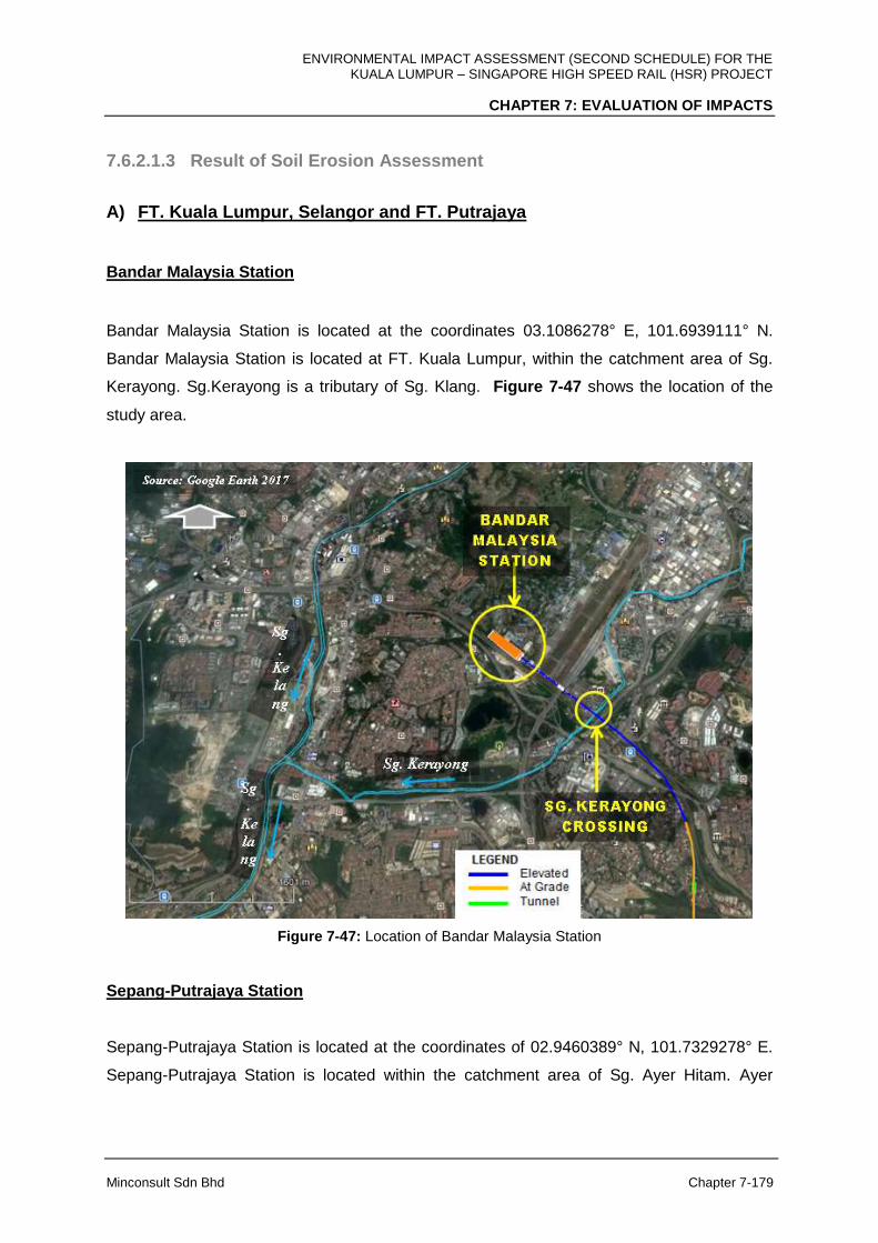
ENVIRONMENTAL IMPACT ASSESSMENT (SECOND SCHEDULE) FOR THE KUALA LUMPUR – SINGAPORE HIGH SPEED RAIL (HSR) PROJECT
CHAPTER 7: EVALUATION OF IMPACTS
Minconsult Sdn Bhd Chapter 7-179
7.6.2.1.3 Result of Soil Erosion Assessment
A) FT. Kuala Lumpur, Selangor and FT. Putrajaya
Bandar Malaysia Station
Bandar Malaysia Station is located at the coordinates 03.1086278° E, 101.6939111° N.
Bandar Malaysia Station is located at FT. Kuala Lumpur, within the catchment area of Sg.
Kerayong. Sg.Kerayong is a tributary of Sg. Klang. Figure 7-47 shows the location of the
study area.
Figure 7-47: Location of Bandar Malaysia Station
Sepang-Putrajaya Station
Sepang-Putrajaya Station is located at the coordinates of 02.9460389° N, 101.7329278° E.
Sepang-Putrajaya Station is located within the catchment area of Sg. Ayer Hitam. Ayer
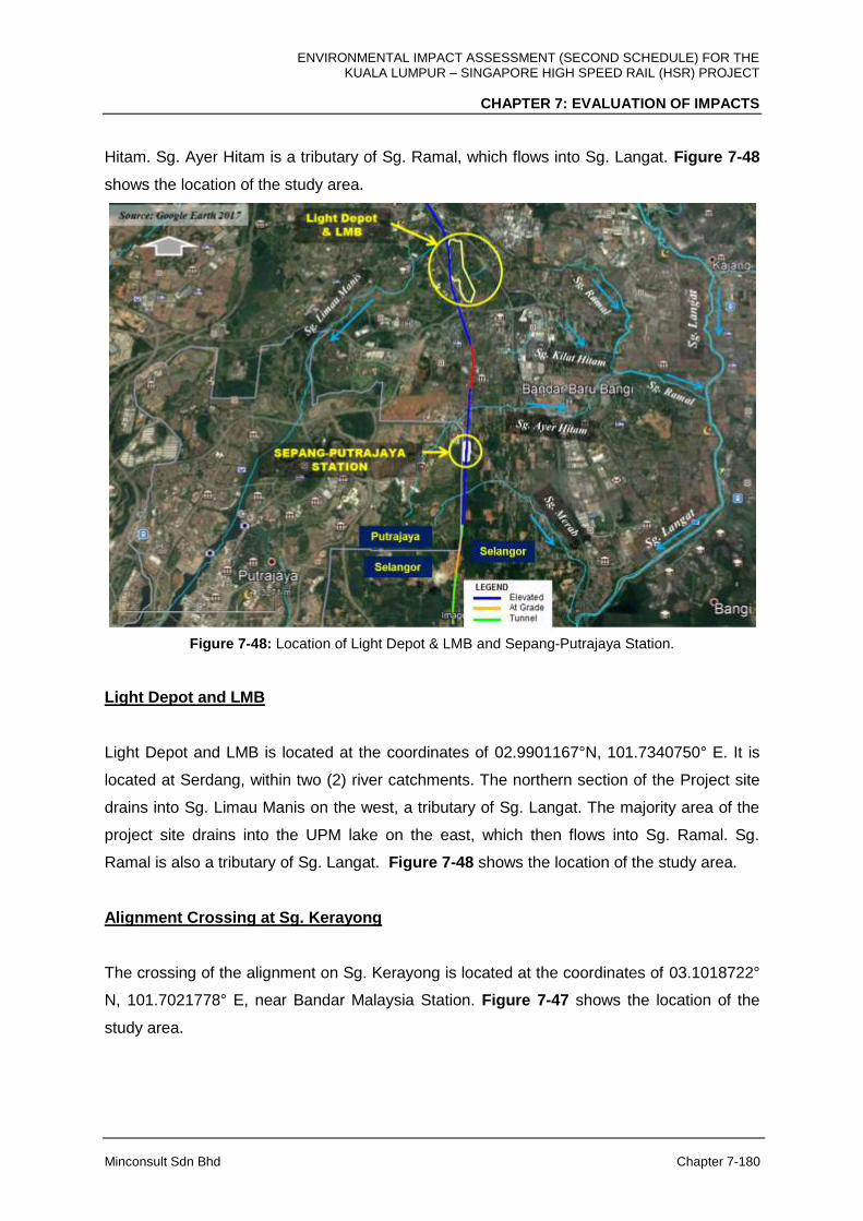
ENVIRONMENTAL IMPACT ASSESSMENT (SECOND SCHEDULE) FOR THE KUALA LUMPUR – SINGAPORE HIGH SPEED RAIL (HSR) PROJECT
CHAPTER 7: EVALUATION OF IMPACTS
Minconsult Sdn Bhd Chapter 7-180
Hitam. Sg. Ayer Hitam is a tributary of Sg. Ramal, which flows into Sg. Langat. Figure 7-48
shows the location of the study area.
Figure 7-48: Location of Light Depot & LMB and Sepang-Putrajaya Station.
Light Depot and LMB
Light Depot and LMB is located at the coordinates of 02.9901167°N, 101.7340750° E. It is
located at Serdang, within two (2) river catchments. The northern section of the Project site
drains into Sg. Limau Manis on the west, a tributary of Sg. Langat. The majority area of the
project site drains into the UPM lake on the east, which then flows into Sg. Ramal. Sg.
Ramal is also a tributary of Sg. Langat. Figure 7-48 shows the location of the study area.
Alignment Crossing at Sg. Kerayong
The crossing of the alignment on Sg. Kerayong is located at the coordinates of 03.1018722°
N, 101.7021778° E, near Bandar Malaysia Station. Figure 7-47 shows the location of the
study area.

ENVIRONMENTAL IMPACT ASSESSMENT (SECOND SCHEDULE) FOR THE KUALA LUMPUR – SINGAPORE HIGH SPEED RAIL (HSR) PROJECT
CHAPTER 7: EVALUATION OF IMPACTS
Minconsult Sdn Bhd Chapter 7-181
Alignment Crossing at Sg. Langat
The crossing of the alignment on Sg. Langat is located at the coordinates of 02.8968556° N,
101.7352917° E, at Dengkil, Selangor. Figure 7-49 shows the location of the study area.
Figure 7-49: Location of Alignment Crossings at Sg. Langat and Sg. Semenyih
Alignment Crossing at Sg. Semenyih
The crossing of the alignment on Sg. Semenyih is located at the coordinates of 02.8902472°
N, 101.7378889° E. Sg. Semenyih joins with Sg. Langat immediately downstream of the
alignment crossing. Sg. Semenyih water intake is located just beside (downstream) of the
alignment crossing. Figure 7-49 shows the location of the study area.
Results of the soil erosion assessment in FT. Kuala Lumpur- FT. Putrajaya – Selangor are
summarised in Table 7-27.
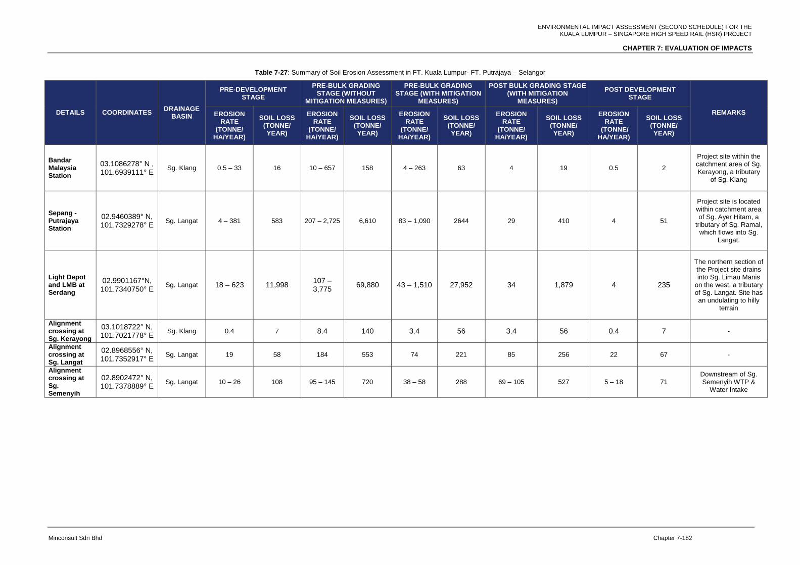
ENVIRONMENTAL IMPACT ASSESSMENT (SECOND SCHEDULE) FOR THE KUALA LUMPUR – SINGAPORE HIGH SPEED RAIL (HSR) PROJECT
CHAPTER 7: EVALUATION OF IMPACTS
Minconsult Sdn Bhd Chapter 7-182
Table 7-27: Summary of Soil Erosion Assessment in FT. Kuala Lumpur- FT. Putrajaya – Selangor
DETAILS COORDINATES DRAINAGE
BASIN
PRE-DEVELOPMENT STAGE
PRE-BULK GRADING STAGE (WITHOUT
MITIGATION MEASURES)
PRE-BULK GRADING STAGE (WITH MITIGATION
MEASURES)
POST BULK GRADING STAGE (WITH MITIGATION
MEASURES)
POST DEVELOPMENT STAGE
REMARKS EROSION RATE
(TONNE/ HA/YEAR)
SOIL LOSS (TONNE/ YEAR)
EROSION RATE
(TONNE/ HA/YEAR)
SOIL LOSS (TONNE/ YEAR)
EROSION RATE
(TONNE/ HA/YEAR)
SOIL LOSS (TONNE/ YEAR)
EROSION RATE
(TONNE/ HA/YEAR)
SOIL LOSS (TONNE/ YEAR)
EROSION RATE
(TONNE/ HA/YEAR)
SOIL LOSS (TONNE/ YEAR)
Bandar Malaysia Station
03.1086278° N , 101.6939111° E
Sg. Klang 0.5 – 33 16 10 – 657 158 4 – 263 63 4 19 0.5 2
Project site within the catchment area of Sg. Kerayong, a tributary
of Sg. Klang
Sepang - Putrajaya Station
02.9460389° N, 101.7329278° E
Sg. Langat 4 – 381 583 207 – 2,725 6,610 83 – 1,090 2644 29 410 4 51
Project site is located within catchment area of Sg. Ayer Hitam, a
tributary of Sg. Ramal, which flows into Sg.
Langat.
Light Depot and LMB at Serdang
02.9901167°N, 101.7340750° E
Sg. Langat 18 – 623 11,998 107 – 3,775
69,880 43 – 1,510 27,952 34 1,879 4 235
The northern section of the Project site drains into Sg. Limau Manis
on the west, a tributary of Sg. Langat. Site has an undulating to hilly
terrain
Alignment crossing at Sg. Kerayong
03.1018722° N, 101.7021778° E
Sg. Klang 0.4 7 8.4 140 3.4 56 3.4 56 0.4 7 -
Alignment crossing at Sg. Langat
02.8968556° N, 101.7352917° E
Sg. Langat 19 58 184 553 74 221 85 256 22 67 -
Alignment crossing at Sg. Semenyih
02.8902472° N, 101.7378889° E
Sg. Langat 10 – 26 108 95 – 145 720 38 – 58 288 69 – 105 527 5 – 18 71 Downstream of Sg. Semenyih WTP &
Water Intake

ENVIRONMENTAL IMPACT ASSESSMENT (SECOND SCHEDULE) FOR THE KUALA LUMPUR – SINGAPORE HIGH SPEED RAIL (HSR) PROJECT
CHAPTER 7: EVALUATION OF IMPACTS
Minconsult Sdn Bhd Chapter 7-183
For Bandar Malaysia Station construction, during post bulk grading, soil loss volume is
estimated to be 19 tonne/year. Upon completion, the soil loss is reduced to 2 tonne/year
while for Sepang-Putrajaya Station construction, during post bulk grading, soil loss volume is
estimated to decrease to 410 tonne/year and is expected to be reduced to 51 tonne/year
upon completion. Upon completion of Light depot and LMB construction, the the soil loss is
reduced to 235 tonne/year from 1,879 tonne/year.
For the alignment crossing at Sg. Kerayong, the soil loss volume is expected to be the same
during post bulk grading stage due to the relatively flat terrain and upon completion, the soil
loss is reduced to 7 tonne/year. Meanwhile for the alignment crossing at Sg. Langat, soil loss
volume is estimated to increase to 256 tonne/year due to higher K Factor (soil erodibility
factor) during post bulk grading. Upon completion, the soil loss is reduced to 67 tonne/year.
The soil loss is reduced from 527 tonne/year due to higher K Factor, to 71 tonne/year for the
crossing at Sg. Semenyih.
B) Negeri Sembilan
Seremban Station
Seremban Station is located at the coordinates of 02.7436750° N, 101.8041583° E.
Seremban Station is located within the catchment area of Sg Jijan. Sg. Jijian joins with Sg.
Serdang and then flows into Sg. Chinchang, which then merges with Sg. Batang Labu into
Sg. Labu. Sg. Labu is a tributary of Sg. Langat. There is a water intake point at Sg. Labu.
Figure 7-50 shows the location of the study area.
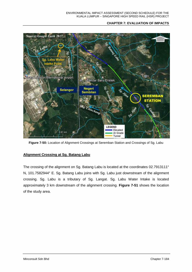
ENVIRONMENTAL IMPACT ASSESSMENT (SECOND SCHEDULE) FOR THE KUALA LUMPUR – SINGAPORE HIGH SPEED RAIL (HSR) PROJECT
CHAPTER 7: EVALUATION OF IMPACTS
Minconsult Sdn Bhd Chapter 7-184
Figure 7-50: Location of Alignment Crossings at Seremban Station and Crossings of Sg. Labu
Alignment Crossing at Sg. Batang Labu
The crossing of the alignment on Sg. Batang Labu is located at the coordinates 02.7913111°
N, 101.7582944° E. Sg. Batang Labu joins with Sg. Labu just downstream of the alignment
crossing. Sg. Labu is a tributary of Sg. Langat. Sg. Labu Water Intake is located
approximately 3 km downstream of the alignment crossing. Figure 7-51 shows the location
of the study area.
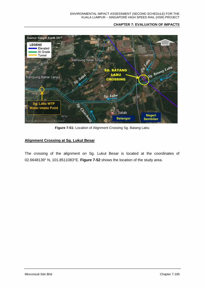
ENVIRONMENTAL IMPACT ASSESSMENT (SECOND SCHEDULE) FOR THE KUALA LUMPUR – SINGAPORE HIGH SPEED RAIL (HSR) PROJECT
CHAPTER 7: EVALUATION OF IMPACTS
Minconsult Sdn Bhd Chapter 7-185
Figure 7-51: Location of Alignment Crossing Sg. Batang Labu
Alignment Crossing at Sg. Lukut Besar
The crossing of the alignment on Sg. Lukut Besar is located at the coordinates of
02.6648139° N, 101.8511083°E. Figure 7-52 shows the location of the study area.
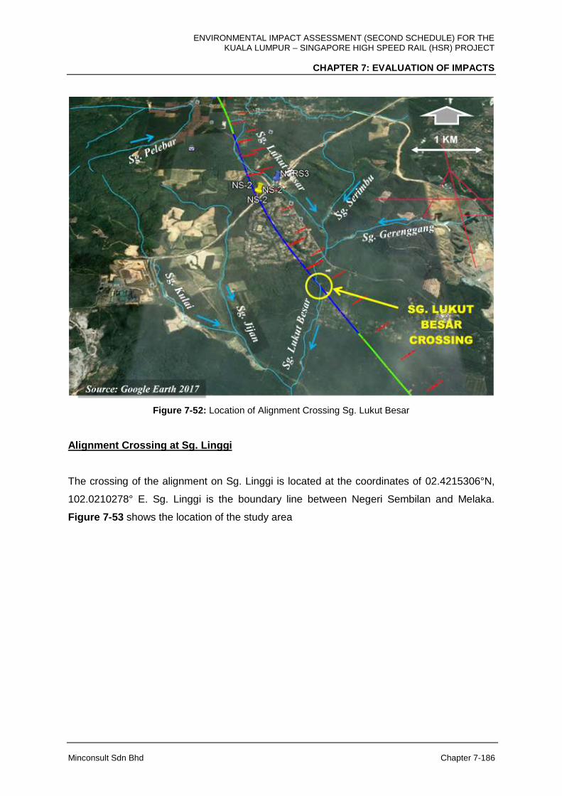
ENVIRONMENTAL IMPACT ASSESSMENT (SECOND SCHEDULE) FOR THE KUALA LUMPUR – SINGAPORE HIGH SPEED RAIL (HSR) PROJECT
CHAPTER 7: EVALUATION OF IMPACTS
Minconsult Sdn Bhd Chapter 7-186
Figure 7-52: Location of Alignment Crossing Sg. Lukut Besar
Alignment Crossing at Sg. Linggi
The crossing of the alignment on Sg. Linggi is located at the coordinates of 02.4215306°N,
102.0210278° E. Sg. Linggi is the boundary line between Negeri Sembilan and Melaka.
Figure 7-53 shows the location of the study area
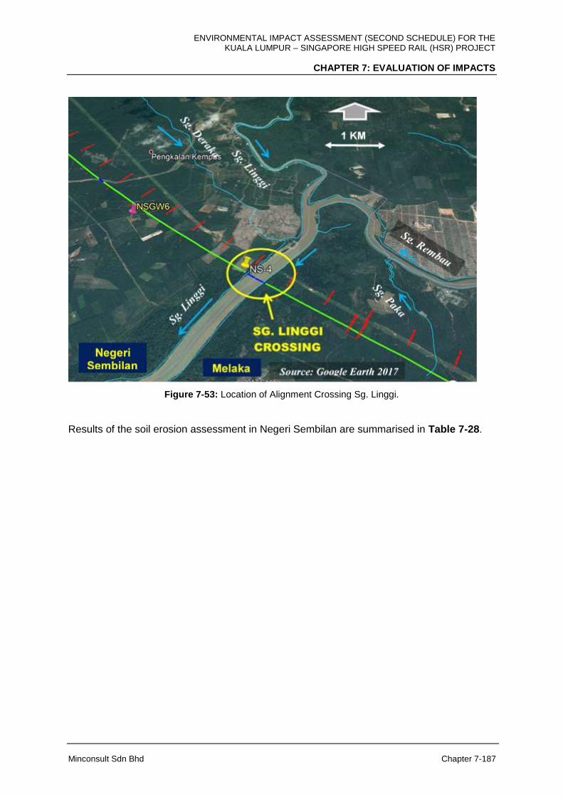
ENVIRONMENTAL IMPACT ASSESSMENT (SECOND SCHEDULE) FOR THE KUALA LUMPUR – SINGAPORE HIGH SPEED RAIL (HSR) PROJECT
CHAPTER 7: EVALUATION OF IMPACTS
Minconsult Sdn Bhd Chapter 7-187
Figure 7-53: Location of Alignment Crossing Sg. Linggi.
Results of the soil erosion assessment in Negeri Sembilan are summarised in Table 7-28.
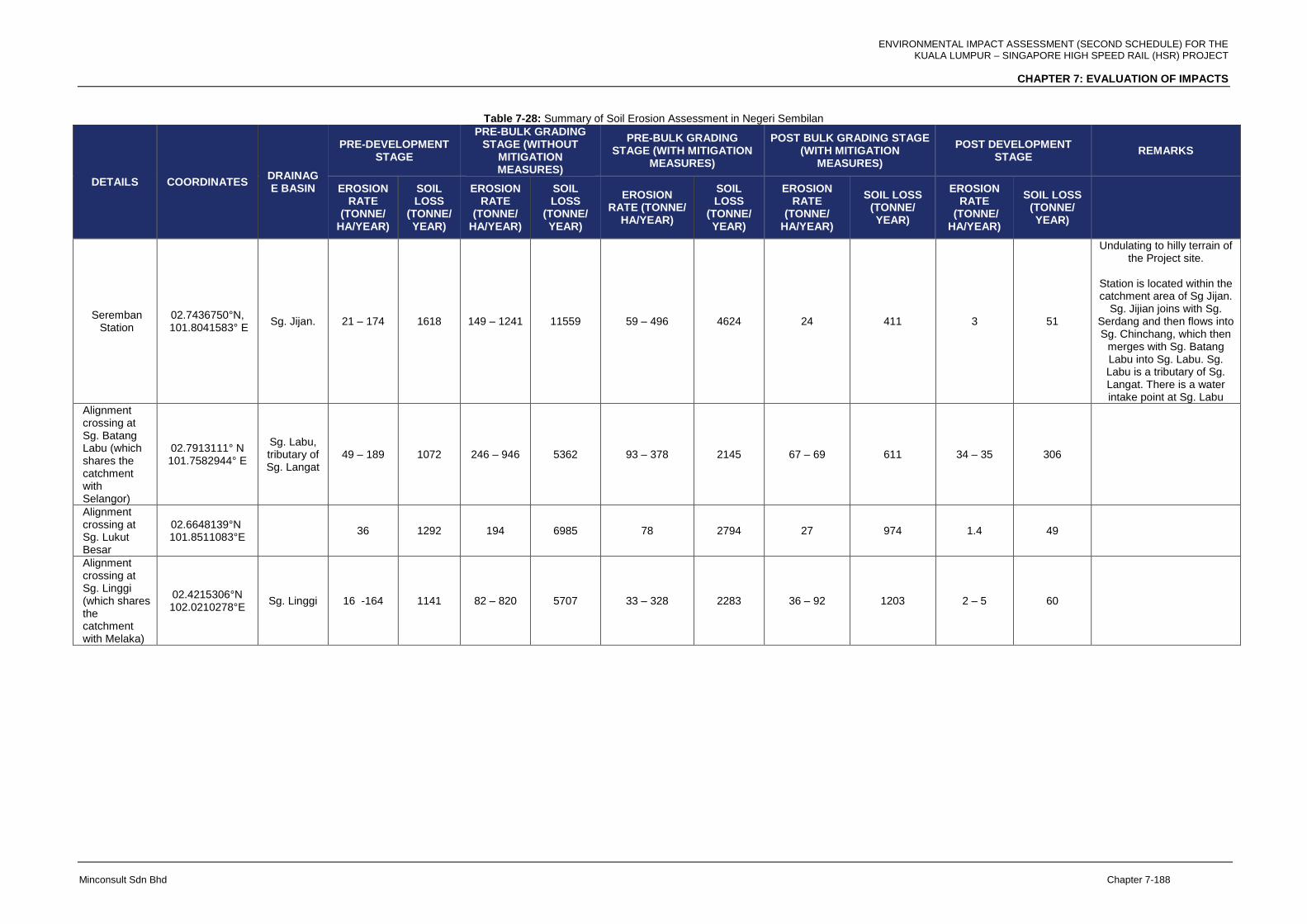
ENVIRONMENTAL IMPACT ASSESSMENT (SECOND SCHEDULE) FOR THE KUALA LUMPUR – SINGAPORE HIGH SPEED RAIL (HSR) PROJECT
CHAPTER 7: EVALUATION OF IMPACTS
Minconsult Sdn Bhd Chapter 7-188
Table 7-28: Summary of Soil Erosion Assessment in Negeri Sembilan
DETAILS COORDINATES DRAINAGE BASIN
PRE-DEVELOPMENT STAGE
PRE-BULK GRADING STAGE (WITHOUT
MITIGATION MEASURES)
PRE-BULK GRADING STAGE (WITH MITIGATION
MEASURES)
POST BULK GRADING STAGE (WITH MITIGATION
MEASURES)
POST DEVELOPMENT STAGE
REMARKS
EROSION RATE
(TONNE/ HA/YEAR)
SOIL LOSS
(TONNE/ YEAR)
EROSION RATE
(TONNE/ HA/YEAR)
SOIL LOSS
(TONNE/ YEAR)
EROSION RATE (TONNE/
HA/YEAR)
SOIL LOSS
(TONNE/ YEAR)
EROSION RATE
(TONNE/ HA/YEAR)
SOIL LOSS (TONNE/ YEAR)
EROSION RATE
(TONNE/ HA/YEAR)
SOIL LOSS (TONNE/ YEAR)
Seremban Station
02.7436750°N, 101.8041583° E
Sg. Jijan. 21 – 174 1618 149 – 1241 11559 59 – 496 4624 24 411 3 51
Undulating to hilly terrain of the Project site.
Station is located within the catchment area of Sg Jijan.
Sg. Jijian joins with Sg. Serdang and then flows into Sg. Chinchang, which then
merges with Sg. Batang Labu into Sg. Labu. Sg. Labu is a tributary of Sg. Langat. There is a water intake point at Sg. Labu
Alignment crossing at Sg. Batang Labu (which shares the catchment with Selangor)
02.7913111° N 101.7582944° E
Sg. Labu, tributary of Sg. Langat
49 – 189 1072 246 – 946 5362 93 – 378 2145 67 – 69 611 34 – 35 306
Alignment crossing at Sg. Lukut Besar
02.6648139°N 101.8511083°E
36 1292 194 6985 78 2794 27 974 1.4 49
Alignment crossing at Sg. Linggi (which shares the catchment with Melaka)
02.4215306°N 102.0210278°E
Sg. Linggi 16 -164 1141 82 – 820 5707 33 – 328 2283 36 – 92 1203 2 – 5 60
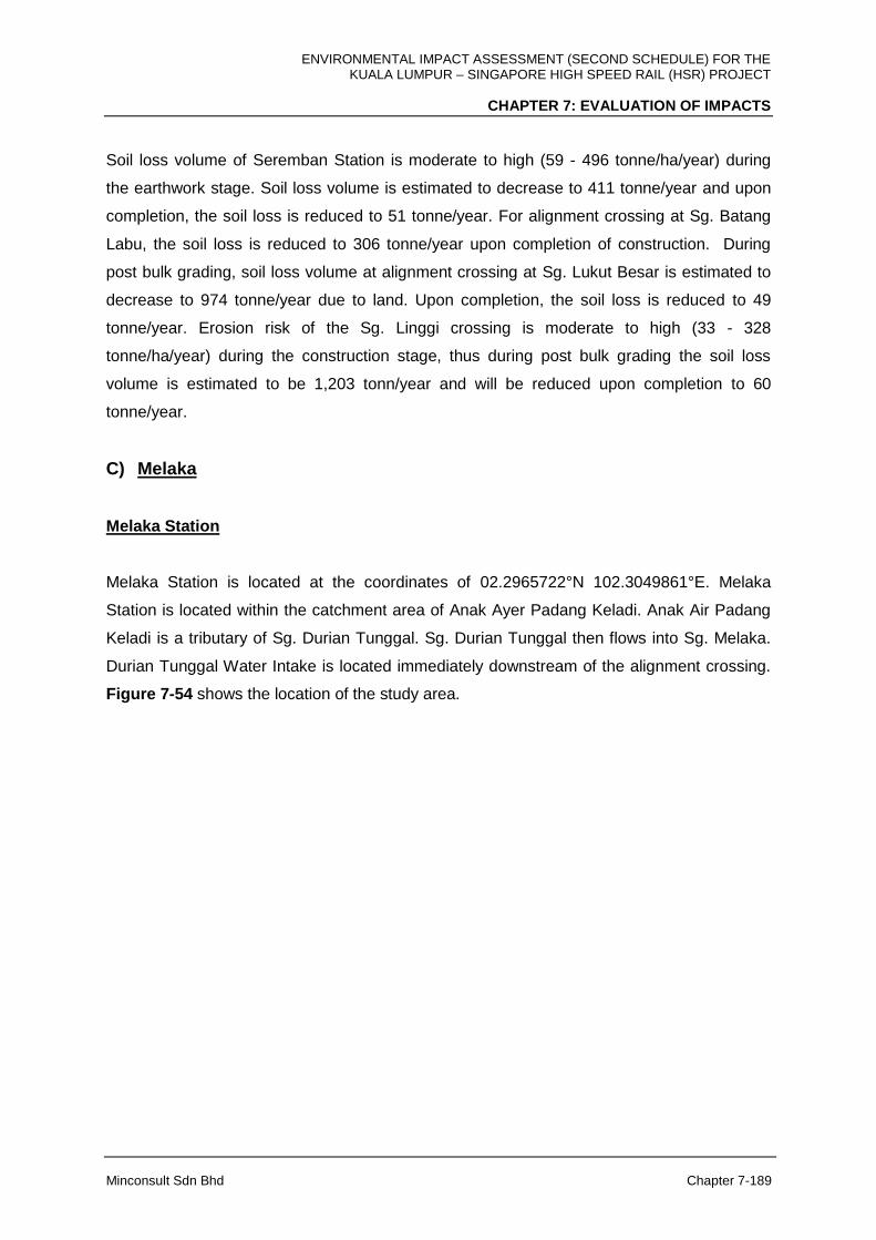
ENVIRONMENTAL IMPACT ASSESSMENT (SECOND SCHEDULE) FOR THE KUALA LUMPUR – SINGAPORE HIGH SPEED RAIL (HSR) PROJECT
CHAPTER 7: EVALUATION OF IMPACTS
Minconsult Sdn Bhd Chapter 7-189
Soil loss volume of Seremban Station is moderate to high (59 - 496 tonne/ha/year) during
the earthwork stage. Soil loss volume is estimated to decrease to 411 tonne/year and upon
completion, the soil loss is reduced to 51 tonne/year. For alignment crossing at Sg. Batang
Labu, the soil loss is reduced to 306 tonne/year upon completion of construction. During
post bulk grading, soil loss volume at alignment crossing at Sg. Lukut Besar is estimated to
decrease to 974 tonne/year due to land. Upon completion, the soil loss is reduced to 49
tonne/year. Erosion risk of the Sg. Linggi crossing is moderate to high (33 - 328
tonne/ha/year) during the construction stage, thus during post bulk grading the soil loss
volume is estimated to be 1,203 tonn/year and will be reduced upon completion to 60
tonne/year.
C) Melaka
Melaka Station
Melaka Station is located at the coordinates of 02.2965722°N 102.3049861°E. Melaka
Station is located within the catchment area of Anak Ayer Padang Keladi. Anak Air Padang
Keladi is a tributary of Sg. Durian Tunggal. Sg. Durian Tunggal then flows into Sg. Melaka.
Durian Tunggal Water Intake is located immediately downstream of the alignment crossing.
Figure 7-54 shows the location of the study area.
ENVIRONMENTAL IMPACT ASSESSMENT (SECOND SCHEDULE) FOR THE KUALA LUMPUR – SINGAPORE HIGH SPEED RAIL (HSR) PROJECT
CHAPTER 7: EVALUATION OF IMPACTS
Minconsult Sdn Bhd Chapter 7-190
Figure 7-54: Location of Melaka Station, Alignment Crossings of Sg. Durian Tunggal and Sg. Melaka
Alignment Crossing at Sg. Linggi
The crossing of the alignment on Sg. Linggi is located at the coordinates of 02.4215306° N,
102.0210278°E. Sg. Linggi is the boundary line between Negeri Sembilan and Melaka.
Figure 7-55 shows the location of the study area.
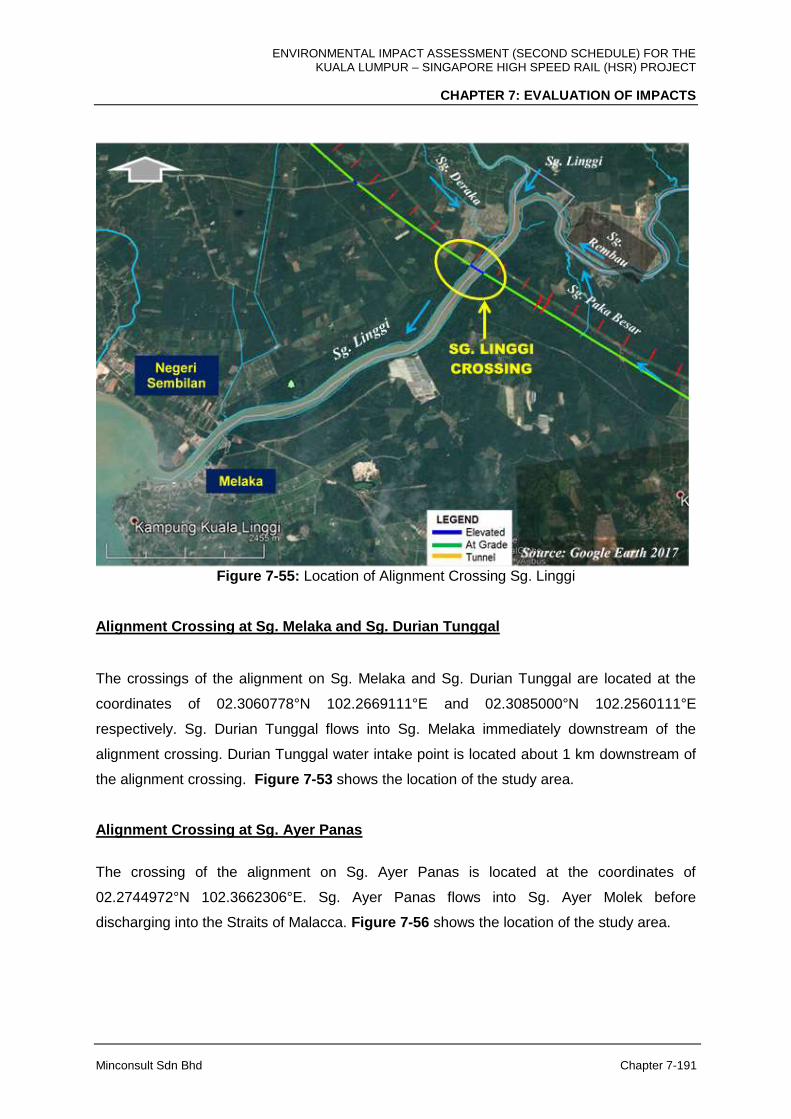
ENVIRONMENTAL IMPACT ASSESSMENT (SECOND SCHEDULE) FOR THE KUALA LUMPUR – SINGAPORE HIGH SPEED RAIL (HSR) PROJECT
CHAPTER 7: EVALUATION OF IMPACTS
Minconsult Sdn Bhd Chapter 7-191
Figure 7-55: Location of Alignment Crossing Sg. Linggi
Alignment Crossing at Sg. Melaka and Sg. Durian Tunggal
The crossings of the alignment on Sg. Melaka and Sg. Durian Tunggal are located at the
coordinates of 02.3060778°N 102.2669111°E and 02.3085000°N 102.2560111°E
respectively. Sg. Durian Tunggal flows into Sg. Melaka immediately downstream of the
alignment crossing. Durian Tunggal water intake point is located about 1 km downstream of
the alignment crossing. Figure 7-53 shows the location of the study area.
Alignment Crossing at Sg. Ayer Panas
The crossing of the alignment on Sg. Ayer Panas is located at the coordinates of
02.2744972°N 102.3662306°E. Sg. Ayer Panas flows into Sg. Ayer Molek before
discharging into the Straits of Malacca. Figure 7-56 shows the location of the study area.
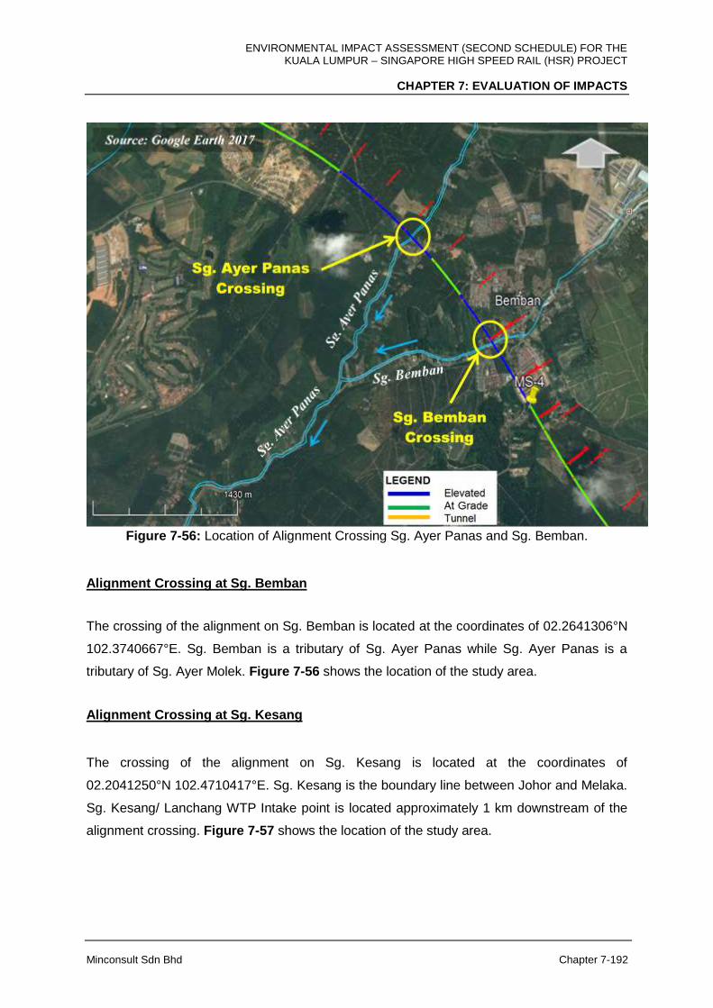
ENVIRONMENTAL IMPACT ASSESSMENT (SECOND SCHEDULE) FOR THE KUALA LUMPUR – SINGAPORE HIGH SPEED RAIL (HSR) PROJECT
CHAPTER 7: EVALUATION OF IMPACTS
Minconsult Sdn Bhd Chapter 7-192
Figure 7-56: Location of Alignment Crossing Sg. Ayer Panas and Sg. Bemban.
Alignment Crossing at Sg. Bemban
The crossing of the alignment on Sg. Bemban is located at the coordinates of 02.2641306°N
102.3740667°E. Sg. Bemban is a tributary of Sg. Ayer Panas while Sg. Ayer Panas is a
tributary of Sg. Ayer Molek. Figure 7-56 shows the location of the study area.
Alignment Crossing at Sg. Kesang
The crossing of the alignment on Sg. Kesang is located at the coordinates of
02.2041250°N 102.4710417°E. Sg. Kesang is the boundary line between Johor and Melaka.
Sg. Kesang/ Lanchang WTP Intake point is located approximately 1 km downstream of the
alignment crossing. Figure 7-57 shows the location of the study area.

ENVIRONMENTAL IMPACT ASSESSMENT (SECOND SCHEDULE) FOR THE KUALA LUMPUR – SINGAPORE HIGH SPEED RAIL (HSR) PROJECT
CHAPTER 7: EVALUATION OF IMPACTS
Minconsult Sdn Bhd Chapter 7-193
Figure 7-57: Location of Alignment Crossing Sg. Kesang.
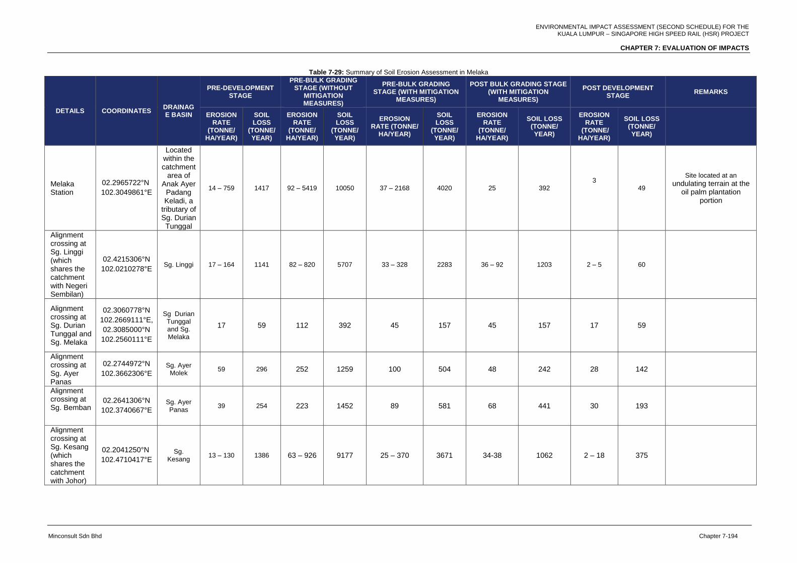
ENVIRONMENTAL IMPACT ASSESSMENT (SECOND SCHEDULE) FOR THE KUALA LUMPUR – SINGAPORE HIGH SPEED RAIL (HSR) PROJECT
CHAPTER 7: EVALUATION OF IMPACTS
Minconsult Sdn Bhd Chapter 7-194
Table 7-29: Summary of Soil Erosion Assessment in Melaka
DETAILS COORDINATES DRAINAGE BASIN
PRE-DEVELOPMENT STAGE
PRE-BULK GRADING STAGE (WITHOUT
MITIGATION MEASURES)
PRE-BULK GRADING STAGE (WITH MITIGATION
MEASURES)
POST BULK GRADING STAGE (WITH MITIGATION
MEASURES)
POST DEVELOPMENT STAGE
REMARKS
EROSION RATE
(TONNE/ HA/YEAR)
SOIL LOSS
(TONNE/ YEAR)
EROSION RATE
(TONNE/ HA/YEAR)
SOIL LOSS
(TONNE/ YEAR)
EROSION RATE (TONNE/
HA/YEAR)
SOIL LOSS
(TONNE/ YEAR)
EROSION RATE
(TONNE/ HA/YEAR)
SOIL LOSS (TONNE/ YEAR)
EROSION RATE
(TONNE/ HA/YEAR)
SOIL LOSS (TONNE/ YEAR)
Melaka Station
02.2965722°N
102.3049861°E
Located within the catchment
area of Anak Ayer
Padang Keladi, a
tributary of Sg. Durian Tunggal
14 – 759 1417 92 – 5419 10050 37 – 2168 4020 25 392 3
49
Site located at an
undulating terrain at the oil palm plantation
portion
Alignment crossing at Sg. Linggi (which shares the catchment with Negeri Sembilan)
02.4215306°N
102.0210278°E Sg. Linggi 17 – 164 1141 82 – 820 5707 33 – 328 2283 36 – 92 1203 2 – 5 60
Alignment crossing at Sg. Durian Tunggal and Sg. Melaka
02.3060778°N
102.2669111°E,
02.3085000°N
102.2560111°E
Sg Durian Tunggal and Sg. Melaka
17 59 112 392 45 157 45 157 17 59
Alignment crossing at Sg. Ayer Panas
02.2744972°N
102.3662306°E
Sg. Ayer Molek
59 296 252 1259 100 504 48 242 28 142
Alignment crossing at Sg. Bemban
02.2641306°N
102.3740667°E
Sg. Ayer Panas
39 254 223 1452 89 581 68 441 30 193
Alignment crossing at Sg. Kesang (which shares the catchment with Johor)
02.2041250°N
102.4710417°E Sg.
Kesang 13 – 130 1386 63 – 926 9177 25 – 370 3671 34-38 1062 2 – 18 375

ENVIRONMENTAL IMPACT ASSESSMENT (SECOND SCHEDULE) FOR THE KUALA LUMPUR – SINGAPORE HIGH SPEED RAIL (HSR) PROJECT
CHAPTER 7: EVALUATION OF IMPACTS
Minconsult Sdn Bhd Chapter 7-195
The erosion risk of Melaka Station is moderate to high (37 – 1,268 tonne/ha/year) during
land clearing and earthwork stage due to the undulating terrain at the oil palm plantation
portion. However, upon completion of the construction the soil loss is estimated to be
resuced to 49 tonne/year. Meanwhile for Sg. Linggi, the soil loss volume is expected to be
reduced to 60 tonne/year compared to 1,203 during the post bulk grading.
For alignment crossing at Sg. Melaka and Sg. Durian Tunggal the soil loss is expected to be
9 tonne/year as the erosion risk at the river crossings is expected to be moderate (45
tonne/ha/year).
For alignment crossing at Sg. Ayer Panas, during post bulk grading, soil loss volume is
estimated to increase to 242 tonne/year and upon completion, the soil loss is reduced to 142
tonne/year. Soil loss volume is estimated to decrease to 441 tonne/year and upon
completion, the soil loss is reduced to 193 tonne/year for crossing at Sg. Bemban. During
post bulk grading, soil loss volume at the alignment crossing at Sg. Kesang is estimated to
be 1,062 tonne/year. Upon completion of the viaduct construction, the soil loss is reduced to
375 tonne/year.
D) Johor
Muar Station
Muar Station is located at the coordinates of 02.1640556° N 102.7310083° E. It is located
within the catchment area of Sg. Muar. Figure 7-58 shows the location of the study area.

ENVIRONMENTAL IMPACT ASSESSMENT (SECOND SCHEDULE) FOR THE KUALA LUMPUR – SINGAPORE HIGH SPEED RAIL (HSR) PROJECT
CHAPTER 7: EVALUATION OF IMPACTS
Minconsult Sdn Bhd Chapter 7-196
Figure 7-58: Location of Muar Station, HMB and Sg. Muar Crossing.
Batu Pahat Station
Batu Pahat Station is located at the coordinates of 01.8496472°N, 103.0191972°E. Batu
Pahat Station is located within the catchment area of Sg. Simpang Kanan, which flows into
Sg. Simpang Kiri that then flows into the Straits of Malacca. Figure 7-59 shows the location
of the study area.

ENVIRONMENTAL IMPACT ASSESSMENT (SECOND SCHEDULE) FOR THE KUALA LUMPUR – SINGAPORE HIGH SPEED RAIL (HSR) PROJECT
CHAPTER 7: EVALUATION OF IMPACTS
Minconsult Sdn Bhd Chapter 7-197
Figure 7-59: Location of Batu Pahat Station, Alignment Crossings of Sg. Simpang Kanan and Sg.
Simpang Kiri.
Iskandar Puteri Station
Iskandar Puteri Station is located at the coordinates of 01.4149611°N, 103.5798556°E.
Iskandar Puteri Station is located within the catchment area of Sg. Arang, which flows into
Sg. Tiram Duku. Sg. Tiram Duku is a small tributary of Sg. Pulai at the lower reach. Figure
7-60 shows the location of the study area.
BATU PAHAT
STATION
Sg
.
Si
m
pa
ng
Ki
ri
Sg. Simpang Kanan
Sg. Simpang Kiri
SG. SIMPANG
KANAN
CROSSING
SG. SIMPANG
KIRI CROSSING
Source: Google Earth 2017
Sg. Sembrong
Sg. Terusan
Sg
.
Be
ko
k
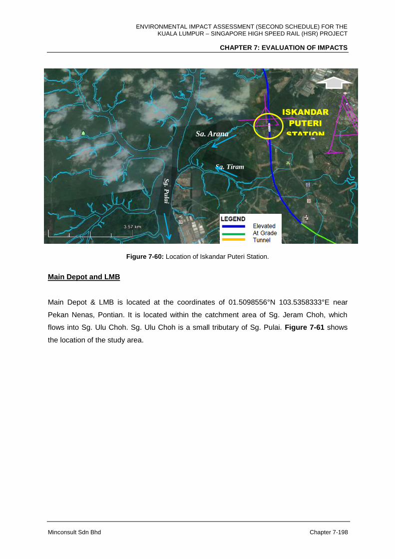
ENVIRONMENTAL IMPACT ASSESSMENT (SECOND SCHEDULE) FOR THE KUALA LUMPUR – SINGAPORE HIGH SPEED RAIL (HSR) PROJECT
CHAPTER 7: EVALUATION OF IMPACTS
Minconsult Sdn Bhd Chapter 7-198
Figure 7-60: Location of Iskandar Puteri Station.
Main Depot and LMB
Main Depot & LMB is located at the coordinates of 01.5098556°N 103.5358333°E near
Pekan Nenas, Pontian. It is located within the catchment area of Sg. Jeram Choh, which
flows into Sg. Ulu Choh. Sg. Ulu Choh is a small tributary of Sg. Pulai. Figure 7-61 shows
the location of the study area.
ISKANDAR
PUTERI
STATION
Sg
. Pu
lai
Sg. Tiram
Duku
Sg. Arang
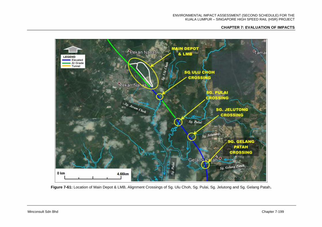
ENVIRONMENTAL IMPACT ASSESSMENT (SECOND SCHEDULE) FOR THE KUALA LUMPUR – SINGAPORE HIGH SPEED RAIL (HSR) PROJECT
CHAPTER 7: EVALUATION OF IMPACTS
Minconsult Sdn Bhd Chapter 7-199
Figure 7-61: Location of Main Depot & LMB, Alignment Crossings of Sg. Ulu Choh, Sg. Pulai, Sg. Jelutong and Sg. Gelang Patah.
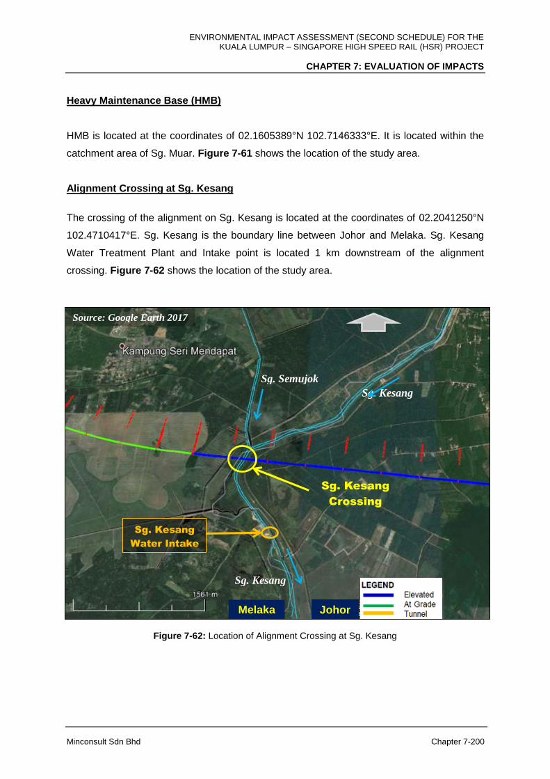
ENVIRONMENTAL IMPACT ASSESSMENT (SECOND SCHEDULE) FOR THE KUALA LUMPUR – SINGAPORE HIGH SPEED RAIL (HSR) PROJECT
CHAPTER 7: EVALUATION OF IMPACTS
Minconsult Sdn Bhd Chapter 7-200
Heavy Maintenance Base (HMB)
HMB is located at the coordinates of 02.1605389°N 102.7146333°E. It is located within the
catchment area of Sg. Muar. Figure 7-61 shows the location of the study area.
Alignment Crossing at Sg. Kesang
The crossing of the alignment on Sg. Kesang is located at the coordinates of 02.2041250°N
102.4710417°E. Sg. Kesang is the boundary line between Johor and Melaka. Sg. Kesang
Water Treatment Plant and Intake point is located 1 km downstream of the alignment
crossing. Figure 7-62 shows the location of the study area.
Figure 7-62: Location of Alignment Crossing at Sg. Kesang
Sg. Kesang
Crossing
Sg. Kesang
Sg. Semujok
Sg. Kesang
Melaka Johor
Source: Google Earth 2017
Sg. Kesang
Water Intake
ENVIRONMENTAL IMPACT ASSESSMENT (SECOND SCHEDULE) FOR THE KUALA LUMPUR – SINGAPORE HIGH SPEED RAIL (HSR) PROJECT
CHAPTER 7: EVALUATION OF IMPACTS
Minconsult Sdn Bhd Chapter 7-201
Alignment Crossing at Sg. Muar
The crossing of the alignment on Sg. Muar is located at the coordinates of 02.1753278°N
102.6683028°E via viaduct. Sg. Muar flows directly into the Straits of Malacca. Figure 7-58
shows the location of the study area.
Alignment Crossing at Sg. Simpang Kiri
The crossing of the alignment on Sg. Simpang Kiri is located at the coordinates of 1° 35’
01.5898194°N 103.4889306°E via viaduct near Batu Pahat. Sg. Simpang Kiri joins with Sg.
Simpang Kanan downstream and flows to the Straits of Malacca. Figure 7-59 shows the
location of the study area.
Alignment Crossing at Sg. Simpang Kanan
The crossing of the alignment on Sg. Simpang Kanan is located at the coordinates of
01.8807556°N 103.0137139°E via viaduct near Batu Pahat. Sg. Simpang Kanan is the
tributary of Sg. Simpang Kiri. Figure 7-59 shows the location of the study area.
Alignment Crossing at Sg. Pontian Besar
The crossing of the alignment on Sg. Pontian Besar is located at the coordinates of
01.6636167°N 103.4751944°E. The rest of the alignment is At-Grade (fill). Ulu Sg. Pontian
Besar merges with Sg. Pontian Besar immediately upstream of the alignment crossing.
Figure 7-63 shows the location of the study area.
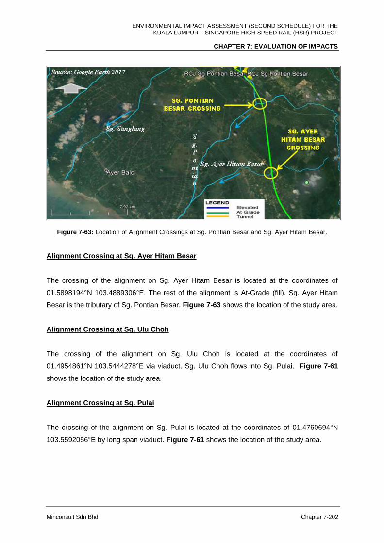
ENVIRONMENTAL IMPACT ASSESSMENT (SECOND SCHEDULE) FOR THE KUALA LUMPUR – SINGAPORE HIGH SPEED RAIL (HSR) PROJECT
CHAPTER 7: EVALUATION OF IMPACTS
Minconsult Sdn Bhd Chapter 7-202
Figure 7-63: Location of Alignment Crossings at Sg. Pontian Besar and Sg. Ayer Hitam Besar.
Alignment Crossing at Sg. Ayer Hitam Besar
The crossing of the alignment on Sg. Ayer Hitam Besar is located at the coordinates of
01.5898194°N 103.4889306°E. The rest of the alignment is At-Grade (fill). Sg. Ayer Hitam
Besar is the tributary of Sg. Pontian Besar. Figure 7-63 shows the location of the study area.
Alignment Crossing at Sg. Ulu Choh
The crossing of the alignment on Sg. Ulu Choh is located at the coordinates of
01.4954861°N 103.5444278°E via viaduct. Sg. Ulu Choh flows into Sg. Pulai. Figure 7-61
shows the location of the study area.
Alignment Crossing at Sg. Pulai
The crossing of the alignment on Sg. Pulai is located at the coordinates of 01.4760694°N
103.5592056°E by long span viaduct. Figure 7-61 shows the location of the study area.
ENVIRONMENTAL IMPACT ASSESSMENT (SECOND SCHEDULE) FOR THE KUALA LUMPUR – SINGAPORE HIGH SPEED RAIL (HSR) PROJECT
CHAPTER 7: EVALUATION OF IMPACTS
Minconsult Sdn Bhd Chapter 7-203
Alignment Crossing at Sg. Jelutong
The crossing of the alignment on Sg. Jelutong is located at the coordinates of 01.4628639°N
103.5685417°E. Sg. Jelutong is a tributary of Sg. Gelang Patah which flows into Sg. Pulai.
Figure 7-61 shows the location of the study area.
Alignment Crossing at Sg. Gelang Patah
The crossing of the alignment on Sg. Gelang Patah is located at the coordinate of
01.4433417°N 103.5792139° E with Viaduct structure. It is a tributary of Sg. Pulai. Figure 7-
61 shows the location of the study.
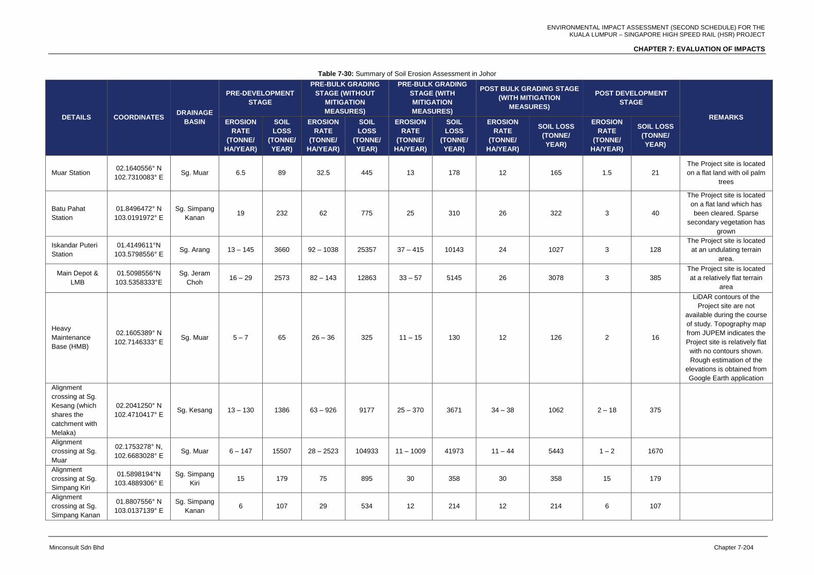
ENVIRONMENTAL IMPACT ASSESSMENT (SECOND SCHEDULE) FOR THE KUALA LUMPUR – SINGAPORE HIGH SPEED RAIL (HSR) PROJECT
CHAPTER 7: EVALUATION OF IMPACTS
Minconsult Sdn Bhd Chapter 7-204
Table 7-30: Summary of Soil Erosion Assessment in Johor
DETAILS COORDINATES DRAINAGE
BASIN
PRE-DEVELOPMENT
STAGE
PRE-BULK GRADING
STAGE (WITHOUT
MITIGATION
MEASURES)
PRE-BULK GRADING
STAGE (WITH
MITIGATION
MEASURES)
POST BULK GRADING STAGE
(WITH MITIGATION
MEASURES)
POST DEVELOPMENT
STAGE
REMARKS EROSION
RATE
(TONNE/
HA/YEAR)
SOIL
LOSS
(TONNE/
YEAR)
EROSION
RATE
(TONNE/
HA/YEAR)
SOIL
LOSS
(TONNE/
YEAR)
EROSION
RATE
(TONNE/
HA/YEAR)
SOIL
LOSS
(TONNE/
YEAR)
EROSION
RATE
(TONNE/
HA/YEAR)
SOIL LOSS
(TONNE/
YEAR)
EROSION
RATE
(TONNE/
HA/YEAR)
SOIL LOSS
(TONNE/
YEAR)
Muar Station 02.1640556° N
102.7310083° E Sg. Muar 6.5 89 32.5 445 13 178 12 165 1.5 21
The Project site is located
on a flat land with oil palm
trees
Batu Pahat
Station
01.8496472° N
103.0191972° E
Sg. Simpang
Kanan 19 232 62 775 25 310 26 322 3 40
The Project site is located
on a flat land which has
been cleared. Sparse
secondary vegetation has
grown
Iskandar Puteri
Station
01.4149611°N
103.5798556° E Sg. Arang 13 – 145 3660 92 – 1038 25357 37 – 415 10143 24 1027 3 128
The Project site is located
at an undulating terrain
area.
Main Depot &
LMB
01.5098556°N
103.5358333°E
Sg. Jeram
Choh 16 – 29 2573 82 – 143 12863 33 – 57 5145 26 3078 3 385
The Project site is located
at a relatively flat terrain
area
Heavy
Maintenance
Base (HMB)
02.1605389° N
102.7146333° E Sg. Muar 5 – 7 65 26 – 36 325 11 – 15 130 12 126 2 16
LiDAR contours of the
Project site are not
available during the course
of study. Topography map
from JUPEM indicates the
Project site is relatively flat
with no contours shown.
Rough estimation of the
elevations is obtained from
Google Earth application
Alignment
crossing at Sg.
Kesang (which
shares the
catchment with
Melaka)
02.2041250° N
102.4710417° E Sg. Kesang 13 – 130 1386 63 – 926 9177 25 – 370 3671 34 – 38 1062 2 – 18 375
Alignment
crossing at Sg.
Muar
02.1753278° N,
102.6683028° E Sg. Muar 6 – 147 15507 28 – 2523 104933 11 – 1009 41973 11 – 44 5443 1 – 2 1670
Alignment
crossing at Sg.
Simpang Kiri
01.5898194°N
103.4889306° E
Sg. Simpang
Kiri 15 179 75 895 30 358 30 358 15 179
Alignment
crossing at Sg.
Simpang Kanan
01.8807556° N
103.0137139° E
Sg. Simpang
Kanan 6 107 29 534 12 214 12 214 6 107

ENVIRONMENTAL IMPACT ASSESSMENT (SECOND SCHEDULE) FOR THE KUALA LUMPUR – SINGAPORE HIGH SPEED RAIL (HSR) PROJECT
CHAPTER 7: EVALUATION OF IMPACTS
Minconsult Sdn Bhd Chapter 7-205
DETAILS COORDINATES DRAINAGE
BASIN
PRE-DEVELOPMENT
STAGE
PRE-BULK GRADING
STAGE (WITHOUT
MITIGATION
MEASURES)
PRE-BULK GRADING
STAGE (WITH
MITIGATION
MEASURES)
POST BULK GRADING STAGE
(WITH MITIGATION
MEASURES)
POST DEVELOPMENT
STAGE
REMARKS EROSION
RATE
(TONNE/
HA/YEAR)
SOIL
LOSS
(TONNE/
YEAR)
EROSION
RATE
(TONNE/
HA/YEAR)
SOIL
LOSS
(TONNE/
YEAR)
EROSION
RATE
(TONNE/
HA/YEAR)
SOIL
LOSS
(TONNE/
YEAR)
EROSION
RATE
(TONNE/
HA/YEAR)
SOIL LOSS
(TONNE/
YEAR)
EROSION
RATE
(TONNE/
HA/YEAR)
SOIL LOSS
(TONNE/
YEAR)
Alignment
crossing at Sg.
Pontian Besar
01.6636167° N
103.4751944° E
Sg. Pontian
Besar 69 – 85 2005 492 – 605 14324 197 – 242 5730 31 – 43 812 1 – 2 30
Alignment
crossing at Sg.
Ayer Hitam
Besar
01.5898194° N
103.4889306° E
Sg. Ayer
Hitam Besar 14 – 115 839 70 – 577 4196 28 - 231 1679 26 – 37 590 1 – 2 30
Alignment
crossing at Sg.
Ulu Choh
01.4954861° N
103.5444278° E Sg. Ulu Choh 3 – 12 130 16 – 79 846 7 - 31 339 7 – 22 244 3 – 8 95
The existing land use is oil
palm plantation
Alignment
crossing at Sg.
Pulai
01.4760694°N
103.5592056° E Sg. Pulai 8 76 80 721 32 288 32 283 8 74
Alignment
crossing at Sg.
Jelutong
01.4628639° N
103.5685417° E
Sg. Gelang
Patah 16 36 80 180 32 72 31 71 16 35
Alignment
crossing at Sg.
Gelang Patah
01.4433417° N
103.5792139° E
Sg. Gelang
Patah 5.7 21 38 142 15 57 22 82 8 31

ENVIRONMENTAL IMPACT ASSESSMENT (SECOND SCHEDULE) FOR THE KUALA LUMPUR – SINGAPORE HIGH SPEED RAIL (HSR) PROJECT
CHAPTER 7: EVALUATION OF IMPACTS
Minconsult Sdn Bhd Chapter 7-206
Erosion risk of HMB is low to moderate (11 – 15 tonne/ha/year) and for Muar Station is 13
tonne/ha/year during land clearing and earthwork stage. For Muar Station, during post bulk
grading, soil loss volume is estimated to reduce marginally to 165 tonne/year and upon
completion, the soil loss is reduced to 21 tonne/year and for HMB the soil loss is reduced to
16 tonne/year upon completion.
For Batu Pahat Station, the soil loss is reduced to 40 tonne/year while for Iskandar Puteri
Station, the soil loss is reduced to 128 tonne/year. The erosion risk of Main Depot & LMB is
moderate (33 – 57 tonne/ha/year) during land clearing and earthwork stage as the terrain is
relatively flat. During post bulk grading, soil loss volume is estimated to reduce to 3,078
tonne/year and upon completion, the soil loss is reduced to 385 tonne/year.
The soil loss for alignment crossing Sg. Kesang, it is the soil loss is the same as stated in
the soil and erosion assessment in Melaka. For Sg. Muar, during post bulk grading, soil loss
volume is estimated to be 5,443 tonne/year and upon completion, the soil loss is reduced to
1,670 tonne/year.
Soil loss at Sg. Simpang Kiri is expected to be 179 tonne/year from 358 tonne/year during
post bulk grading and for Sg. Simpang Kanan, the soil loss is reduced to 107 tonne/year
upon completion from 214 tonne/year during the post bulk grading.
Erosion risk of the Sg. Pontian Besar crossing is high (197 – 242 tonne/ha/year) during the
earthwork stage. However, upon completion, the soil loss is expected to reduce to 30
tonne/year. For Sg. Ayer Hitam Besar, soil loss volume is estimated to be 590 tonne/year
during post bulk grading and reduced to 30 tonne/year upon completion. During post bulk
grading, soil loss volume is estimated to be 244 tonne/year for Sg. Ulu Choh and upon
completion, the soil loss is reduced to 95 tonne/year. Erosion risk of the Sg. Pulai crossing is
moderate (32 tonne/ha/year) during the construction stage and during post bulk grading, soil
loss volume is estimated to be 283 tonne/year is reduced to 74 tonne/year upon completion.
Th soil loss volume for both Sg. Jelutong and Sg. Gelang Patah is expected to reduce to 35
tonne/ year and 31 tonne/year upon completion.
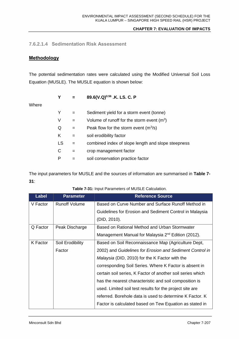
ENVIRONMENTAL IMPACT ASSESSMENT (SECOND SCHEDULE) FOR THE KUALA LUMPUR – SINGAPORE HIGH SPEED RAIL (HSR) PROJECT
CHAPTER 7: EVALUATION OF IMPACTS
Minconsult Sdn Bhd Chapter 7-207
7.6.2.1.4 Sedimentation Risk Assessment
Methodology
The potential sedimentation rates were calculated using the Modified Universal Soil Loss
Equation (MUSLE). The MUSLE equation is shown below:
Y = 89.6(V.Q)0.56 .K. LS. C. P
Where
Y = Sediment yield for a storm event (tonne)
V = Volume of runoff for the storm event (m3)
Q = Peak flow for the storm event (m3/s)
K = soil erodibility factor
LS = combined index of slope length and slope steepness
C = crop management factor
P = soil conservation practice factor
The input parameters for MUSLE and the sources of information are summarised in Table 7-
31:
Table 7-31: Input Parameters of MUSLE Calculation.
Label Parameter Reference Source
V Factor Runoff Volume Based on Curve Number and Surface Runoff Method in
Guidelines for Erosion and Sediment Control in Malaysia
(DID, 2010).
Q Factor Peak Discharge Based on Rational Method and Urban Stormwater
Management Manual for Malaysia 2nd Edition (2012).
K Factor Soil Erodibility
Factor
Based on Soil Reconnaissance Map (Agriculture Dept,
2002) and Guidelines for Erosion and Sediment Control in
Malaysia (DID, 2010) for the K Factor with the
corresponding Soil Series. Where K Factor is absent in
certain soil series, K Factor of another soil series which
has the nearest characteristic and soil composition is
used. Limited soil test results for the project site are
referred. Borehole data is used to determine K Factor. K
Factor is calculated based on Tew Equation as stated in
ENVIRONMENTAL IMPACT ASSESSMENT (SECOND SCHEDULE) FOR THE KUALA LUMPUR – SINGAPORE HIGH SPEED RAIL (HSR) PROJECT
CHAPTER 7: EVALUATION OF IMPACTS
Minconsult Sdn Bhd Chapter 7-208
Label Parameter Reference Source
Guidelines for Erosion and Sediment Control in Malaysia
(DID, 2010).
LS Factor Combined index
of Slope Length
and Slope
Steepness
Based on LIDAR contour plans and Guidelines for
Erosion and Sediment Control in Malaysia (DID, 2010).
C Factor Crop Management
Factor
Based on site visit, land use map, Google map and
Guidelines for Erosion and Sediment Control in Malaysia
(DID, 2010).
P Factor Soil Conservation
Practice Factor
Based on site visit, land use map, Google map and
Guidelines for Erosion and Sediment Control in Malaysia
(DID, 2010).
Input data and result of the sediment yield assessment is shown in Appendix 7H1.
7.6.2.1.5 Result of Sediment Yield Assessment
Results of the sediment yield assessment are summarised in the following Tables 7-31 to 7-
34.
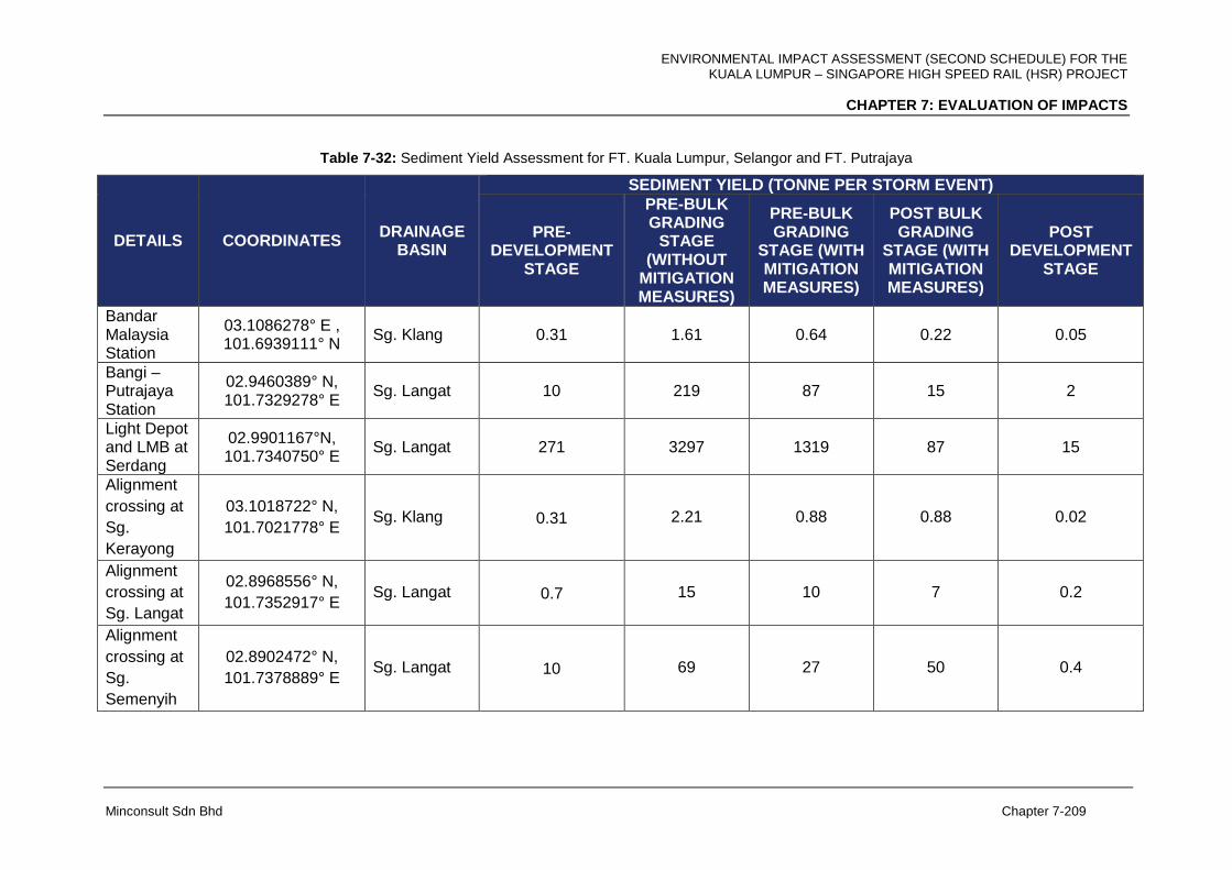
ENVIRONMENTAL IMPACT ASSESSMENT (SECOND SCHEDULE) FOR THE KUALA LUMPUR – SINGAPORE HIGH SPEED RAIL (HSR) PROJECT
CHAPTER 7: EVALUATION OF IMPACTS
Minconsult Sdn Bhd Chapter 7-209
Table 7-32: Sediment Yield Assessment for FT. Kuala Lumpur, Selangor and FT. Putrajaya
DETAILS COORDINATES DRAINAGE
BASIN
SEDIMENT YIELD (TONNE PER STORM EVENT)
PRE-DEVELOPMENT
STAGE
PRE-BULK GRADING
STAGE (WITHOUT
MITIGATION MEASURES)
PRE-BULK GRADING
STAGE (WITH MITIGATION MEASURES)
POST BULK GRADING
STAGE (WITH MITIGATION MEASURES)
POST DEVELOPMENT
STAGE
Bandar Malaysia Station
03.1086278° E , 101.6939111° N
Sg. Klang 0.31 1.61 0.64 0.22 0.05
Bangi – Putrajaya Station
02.9460389° N, 101.7329278° E
Sg. Langat 10 219 87 15 2
Light Depot and LMB at Serdang
02.9901167°N, 101.7340750° E
Sg. Langat 271 3297 1319 87 15
Alignment
crossing at
Sg.
Kerayong
03.1018722° N,
101.7021778° E Sg. Klang 0.31 2.21 0.88 0.88 0.02
Alignment
crossing at
Sg. Langat
02.8968556° N,
101.7352917° E Sg. Langat 0.7 15 10 7 0.2
Alignment
crossing at
Sg.
Semenyih
02.8902472° N,
101.7378889° E Sg. Langat 10 69 27 50 0.4
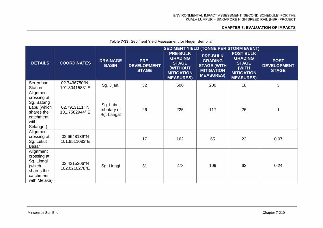
ENVIRONMENTAL IMPACT ASSESSMENT (SECOND SCHEDULE) FOR THE KUALA LUMPUR – SINGAPORE HIGH SPEED RAIL (HSR) PROJECT
CHAPTER 7: EVALUATION OF IMPACTS
Minconsult Sdn Bhd Chapter 7-210
Table 7-33: Sediment Yield Assessment for Negeri Sembilan
DETAILS COORDINATES DRAINAGE
BASIN
SEDIMENT YIELD (TONNE PER STORM EVENT)
PRE-DEVELOPMENT
STAGE
PRE-BULK GRADING
STAGE (WITHOUT
MITIGATION MEASURES)
PRE-BULK GRADING
STAGE (WITH MITIGATION MEASURES)
POST BULK GRADING
STAGE (WITH
MITIGATION MEASURES)
POST DEVELOPMENT
STAGE
Seremban Station
02.7436750°N, 101.8041583° E
Sg. Jijan. 32 500 200 18 3
Alignment crossing at Sg. Batang Labu (which shares the catchment with Selangor)
02.7913111° N 101.7582944° E
Sg. Labu, tributary of Sg. Langat
26 225 117 26 1
Alignment crossing at Sg. Lukut Besar
02.6648139°N 101.8511083°E
17 162 65 23 0.07
Alignment crossing at Sg. Linggi (which shares the catchment with Melaka)
02.4215306°N 102.0210278°E
Sg. Linggi 31 273 109 62 0.24

ENVIRONMENTAL IMPACT ASSESSMENT (SECOND SCHEDULE) FOR THE KUALA LUMPUR – SINGAPORE HIGH SPEED RAIL (HSR) PROJECT
CHAPTER 7: EVALUATION OF IMPACTS
Minconsult Sdn Bhd Chapter 7-211
Table 7-34: Sediment Yield Assessment for Melaka
DETAILS COORDINATES DRAINAGE
BASIN
SEDIMENT YIELD (TONNE PER STORM EVENT)
PRE-DEVELOPMENT
STAGE
PRE-BULK GRADING
STAGE (WITHOUT
MITIGATION MEASURES)
PRE-BULK GRADING
STAGE (WITH MITIGATION MEASURES)
POST BULK GRADING
STAGE (WITH
MITIGATION MEASURES)
POST DEVELOPMENT
STAGE
Melaka Station
02.2965722°N 102.3049861°E
Sg. Anak Ayer Padang
Keladi 39 439 176 18 3
Alignment crossing at Sg. Linggi (which shares the catchment with Negeri Sembilan)
02.4215306°N 102.0210278°E
Sg. Linggi 31 273 109 62 0.24
Alignment crossing at Sg. Durian Tunggal and Sg. Melaka
02.3060778°N
102.2669111°E,
02.3085000°N 102.2560111°E
Sg. Durian Tunggal and Sg. Melaka
2.7 18.9 7.5 7.5 2.0
Alignment crossing at Sg. Ayer Panas
02.2744972°N 102.3662306°E
Sg. Ayer Molek
11 68 27 13 0.6
Alignment crossing at Sg. Bemban
02.2641306°N
102.3740667°E
Sg. Ayer Panas
10 75 30 23 1
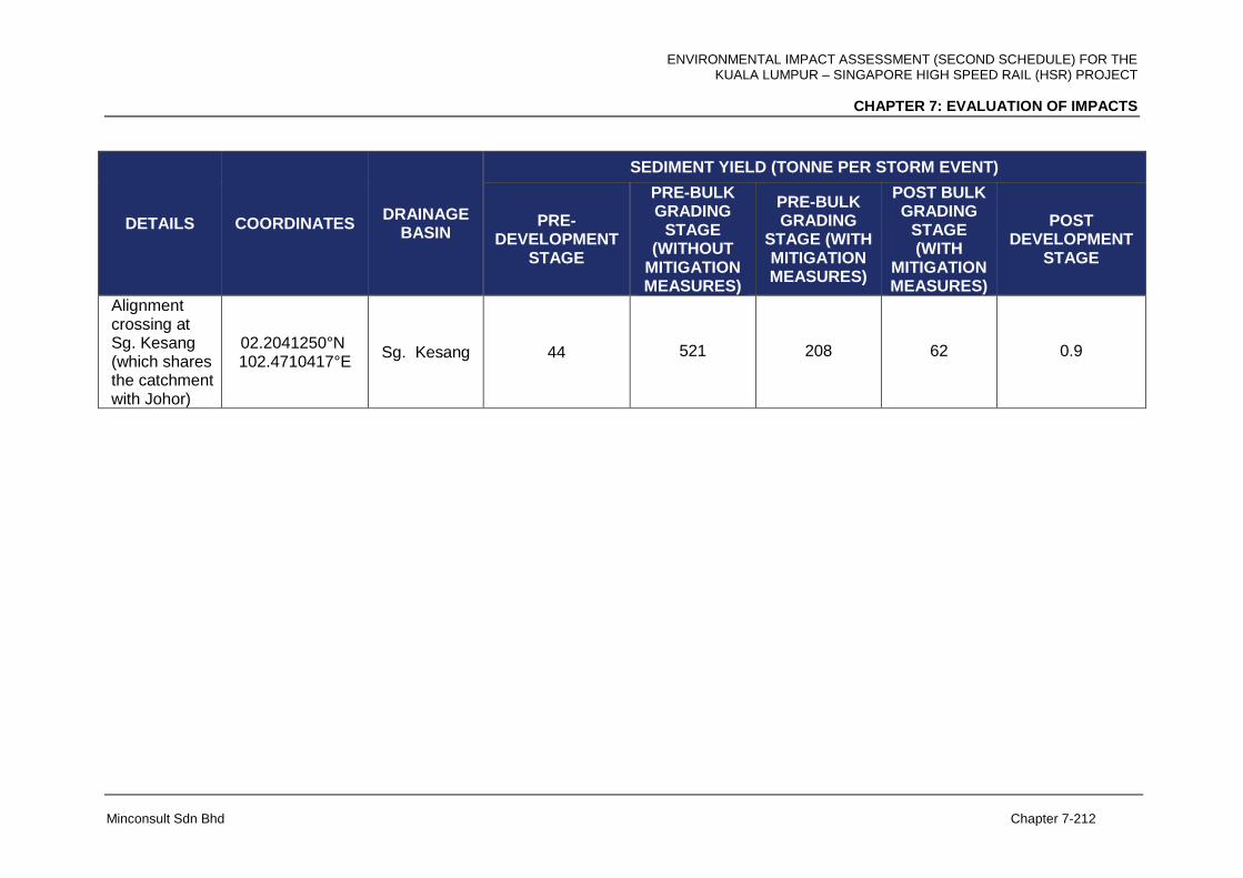
ENVIRONMENTAL IMPACT ASSESSMENT (SECOND SCHEDULE) FOR THE KUALA LUMPUR – SINGAPORE HIGH SPEED RAIL (HSR) PROJECT
CHAPTER 7: EVALUATION OF IMPACTS
Minconsult Sdn Bhd Chapter 7-212
DETAILS COORDINATES DRAINAGE
BASIN
SEDIMENT YIELD (TONNE PER STORM EVENT)
PRE-DEVELOPMENT
STAGE
PRE-BULK GRADING
STAGE (WITHOUT
MITIGATION MEASURES)
PRE-BULK GRADING
STAGE (WITH MITIGATION MEASURES)
POST BULK GRADING
STAGE (WITH
MITIGATION MEASURES)
POST DEVELOPMENT
STAGE
Alignment crossing at Sg. Kesang (which shares the catchment with Johor)
02.2041250°N 102.4710417°E
Sg. Kesang 44 521 208 62 0.9
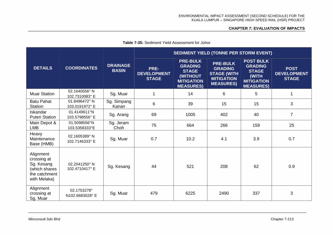
ENVIRONMENTAL IMPACT ASSESSMENT (SECOND SCHEDULE) FOR THE KUALA LUMPUR – SINGAPORE HIGH SPEED RAIL (HSR) PROJECT
CHAPTER 7: EVALUATION OF IMPACTS
Minconsult Sdn Bhd Chapter 7-213
Table 7-35: Sediment Yield Assessment for Johor
DETAILS COORDINATES DRAINAGE
BASIN
SEDIMENT YIELD (TONNE PER STORM EVENT)
PRE-DEVELOPMENT
STAGE
PRE-BULK GRADING
STAGE (WITHOUT
MITIGATION MEASURES)
PRE-BULK GRADING
STAGE (WITH MITIGATION MEASURES)
POST BULK GRADING
STAGE (WITH
MITIGATION MEASURES)
POST DEVELOPMENT
STAGE
Muar Station 02.1640556° N
102.7310083° E Sg. Muar 1 14 6 5 1
Batu Pahat Station
01.8496472° N
103.0191972° E Sg. Simpang
Kanan 6 39 15 15 3
Iskandar Puteri Station
01.4149611°N
103.5798556° E Sg. Arang 69 1005 402 40 7
Main Depot & LMB
01.5098556°N
103.5358333°E Sg. Jeram
Choh 75 664 266 159 25
Heavy Maintenance Base (HMB)
02.1605389° N
102.7146333° E Sg. Muar 0.7 10.2 4.1 3.9 0.7
Alignment crossing at Sg. Kesang (which shares the catchment with Melaka)
02.2041250° N 102.4710417° E
Sg. Kesang 44 521 208 62 0.9
Alignment crossing at Sg. Muar
02.1753278°
N102.6683028° E Sg. Muar 479 6225 2490 337 3
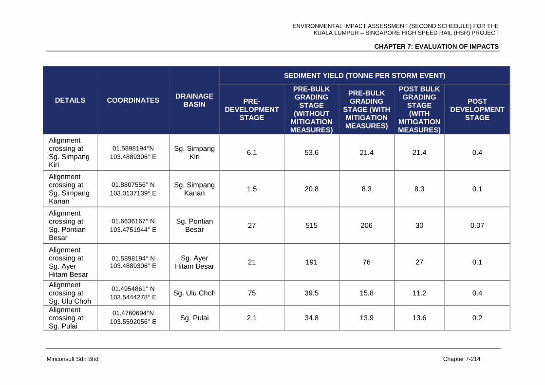
ENVIRONMENTAL IMPACT ASSESSMENT (SECOND SCHEDULE) FOR THE KUALA LUMPUR – SINGAPORE HIGH SPEED RAIL (HSR) PROJECT
CHAPTER 7: EVALUATION OF IMPACTS
Minconsult Sdn Bhd Chapter 7-214
DETAILS COORDINATES DRAINAGE
BASIN
SEDIMENT YIELD (TONNE PER STORM EVENT)
PRE-DEVELOPMENT
STAGE
PRE-BULK GRADING
STAGE (WITHOUT
MITIGATION MEASURES)
PRE-BULK GRADING
STAGE (WITH MITIGATION MEASURES)
POST BULK GRADING
STAGE (WITH
MITIGATION MEASURES)
POST DEVELOPMENT
STAGE
Alignment crossing at Sg. Simpang Kiri
01.5898194°N
103.4889306° E Sg. Simpang
Kiri 6.1 53.6 21.4 21.4 0.4
Alignment crossing at Sg. Simpang Kanan
01.8807556° N
103.0137139° E Sg. Simpang
Kanan 1.5 20.8 8.3 8.3 0.1
Alignment crossing at Sg. Pontian Besar
01.6636167° N
103.4751944° E Sg. Pontian
Besar 27 515 206 30 0.07
Alignment crossing at Sg. Ayer Hitam Besar
01.5898194° N 103.4889306° E
Sg. Ayer Hitam Besar
21 191 76 27 0.1
Alignment crossing at Sg. Ulu Choh
01.4954861° N
103.5444278° E Sg. Ulu Choh 75 39.5 15.8 11.2 0.4
Alignment crossing at Sg. Pulai
01.4760694°N
103.5592056° E Sg. Pulai 2.1 34.8 13.9 13.6 0.2
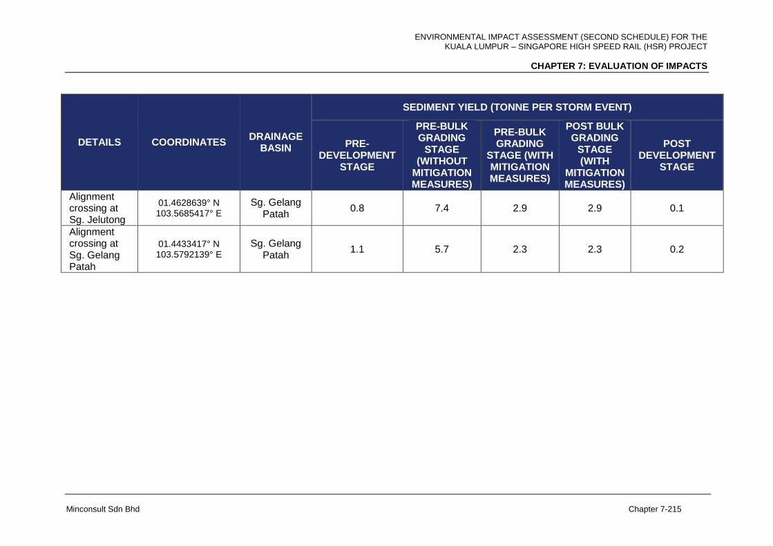
ENVIRONMENTAL IMPACT ASSESSMENT (SECOND SCHEDULE) FOR THE KUALA LUMPUR – SINGAPORE HIGH SPEED RAIL (HSR) PROJECT
CHAPTER 7: EVALUATION OF IMPACTS
Minconsult Sdn Bhd Chapter 7-215
DETAILS COORDINATES DRAINAGE
BASIN
SEDIMENT YIELD (TONNE PER STORM EVENT)
PRE-DEVELOPMENT
STAGE
PRE-BULK GRADING
STAGE (WITHOUT
MITIGATION MEASURES)
PRE-BULK GRADING
STAGE (WITH MITIGATION MEASURES)
POST BULK GRADING
STAGE (WITH
MITIGATION MEASURES)
POST DEVELOPMENT
STAGE
Alignment crossing at Sg. Jelutong
01.4628639° N 103.5685417° E
Sg. Gelang Patah
0.8 7.4 2.9 2.9 0.1
Alignment crossing at Sg. Gelang Patah
01.4433417° N 103.5792139° E
Sg. Gelang Patah
1.1 5.7 2.3 2.3 0.2
ENVIRONMENTAL IMPACT ASSESSMENT (SECOND SCHEDULE) FOR THE KUALA LUMPUR – SINGAPORE HIGH SPEED RAIL (HSR) PROJECT
CHAPTER 7: EVALUATION OF IMPACTS
Minconsult Sdn Bhd Chapter 7-216
7.6.2.2 Operational Phase
Results from the erosion and sedimentation risk assessment during the operational stage
are found to be lower or the same as during pre-development stage.
The stations, depots and maintenance base are mostly built-up with buildings, paved road
and infrastructure. Non-built-up areas shall be landscaped with greenery for environmental
protection and aesthetic purpose. The erosion and sedimentation risks are very low.
The HSR alignment consists of three (3) types of structure, namely, elevated, at-grade and
tunnel. The erosion and sedimentation risks are discussed below:
Elevated structure - erosion and sedimentation risks will mostly be the same or
slightly lower than the pre-development stage. Buildings, roads and small vegetation
below the elevated structure shall not be disturbed unnecessarily. Land disturbance
to the non-built-up area shall be minimized. Upon completion of construction work,
the disturbed area shall be stabilised with turfing, crusher run, concrete or other
permanent environmental protection measures.
At-grade structure - the alignment segments with at-grade structure are usually
constructed with cut or fill platforms, which shall be stabilized with turfing, erosion
blanket and other P2M2. The erosion and sedimentation risk is assessed to be low.
Tunnel structure - as extensive earthwork is involved at the tunnel portals, erosion
and sedimentation risks can range from low to high due to the extensive cut slopes
exposed to abundant rainfall in the long term. Hence, permanent slope protection
measures such as erosion blanket, hydroseeding, concrete cover, shotcrete,
retaining wall, etc., shall be inspected and maintained on a regular basis.
During the operational stage, all disturbed area shall be stabilized with buildings,
infrastructure, green landscape and permanent environmental protection measures such as
drainage, turfing, crusher run, concrete cover, retaining wall, etc. The potential erosion and
sedimentation impacts are predicted to be low.

ENVIRONMENTAL IMPACT ASSESSMENT (SECOND SCHEDULE) FOR THE KUALA LUMPUR – SINGAPORE HIGH SPEED RAIL (HSR) PROJECT
CHAPTER 7: EVALUATION OF IMPACTS
Minconsult Sdn Bhd Chapter 7-217
7.6.3 Sewage Effluent
7.6.3.1 Construction Phase
During construction phase following are the assumption made for estimated sewage effluent
from the Centralized Labour Quarters (CLQ) located at the proposed depots and HMB.
Total workers each camp: 5,000 nos
To provide: 4 blocks
Floor levels: 4 levels
No of toilet each floor: 21 nos
Total no of toilet at each camp: 336 nos
Total estimated PE: 5,040
During construction stage, each quarter will be using approved package STP approved by
SPAN. The approved SPAN’s package STP system provided at each camp with 5,040 PE
and regular maintenance is important to address sewage pollution may raise at this
temporary facility. The size of PE may increase based on the works number in the actual
facility.
7.6.3.2 Operational Phase
Impacts associated with the discharge of treated effluents to receiving waterways will be a
long-term consequence. Untreated or partially treated sewage and wastewater discharges
from stations, maintenance depots and train toilets could pollute local streams and rivers and
diminish their functional status and resource value; and promote negative public health
impacts and degradation of aquatic ecological communities. In the case of sewage treatment
there are commercially proven technologies which can remove pollutants to very low levels
before release to the environment. The amount of treated sewage effluents that will be
discharged by the Project facilities to the environment has been estimated to be relatively
low (Table 7-34). A majority of the Stations will be located within, or near to, new urban
developments, and as such their effluents can be discharged to the latter’s sewerage
system. This strategy would be more viable, effective and economical then treating the raw
sewage flows within the Facility site.
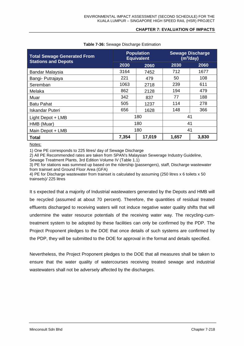
ENVIRONMENTAL IMPACT ASSESSMENT (SECOND SCHEDULE) FOR THE KUALA LUMPUR – SINGAPORE HIGH SPEED RAIL (HSR) PROJECT
CHAPTER 7: EVALUATION OF IMPACTS
Minconsult Sdn Bhd Chapter 7-218
Table 7-36: Sewage Discharge Estimation
Total Sewage Generated From Stations and Depots
Population Equivalent
Sewage Discharge (m3/day)
2030 2060 2030 2060
Bandar Malaysia 3164 7452 712 1677
Bangi- Putrajaya 221 479 50 108
Seremban 1063 2718 239 611
Melaka 862 2128 194 479
Muar 342 837 77 188
Batu Pahat 505 1237 114 278
Iskandar Puteri 656 1628 148 366
Light Depot + LMB 180 41
HMB (Muar) 180 41
Main Depot + LMB 180 41
Total 7,354 17,019 1,657 3,830
Notes:
1) One PE corresponds to 225 litres/ day of Sewage Discharge 2) All PE Recommended rates are taken from SPAN's Malaysian Sewerage Industry Guideline, Sewage Treatment Plants, 3rd Edition Volume IV (Table 1.1) 3) PE for stations was summed up based on the ridership (passengers), staff, Discharge wastewater from trainset and Ground Floor Area (GFA) 4) PE for Discharge wastewater from trainset is calculated by assuming (250 litres x 6 toilets x 50 trainsets)/ 225 litres
It s expected that a majority of Industrial wastewaters generated by the Depots and HMB will
be recycled (assumed at about 70 percent). Therefore, the quantities of residual treated
effluents discharged to receiving waters will not induce negative water quality shifts that will
undermine the water resource potentials of the receiving water way. The recycling-cum-
treatment system to be adopted by these facilities can only be confirmed by the PDP. The
Project Proponent pledges to the DOE that once details of such systems are confirmed by
the PDP, they will be submitted to the DOE for approval in the format and details specified.
Nevertheless, the Project Proponent pledges to the DOE that all measures shall be taken to
ensure that the water quality of watercourses receiving treated sewage and industrial
wastewaters shall not be adversely affected by the discharges.
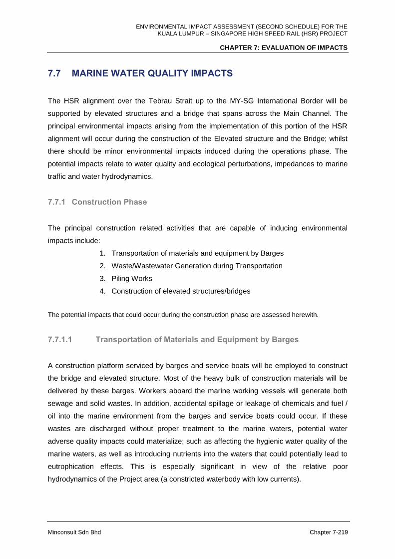
ENVIRONMENTAL IMPACT ASSESSMENT (SECOND SCHEDULE) FOR THE KUALA LUMPUR – SINGAPORE HIGH SPEED RAIL (HSR) PROJECT
CHAPTER 7: EVALUATION OF IMPACTS
Minconsult Sdn Bhd Chapter 7-219
7.7 MARINE WATER QUALITY IMPACTS
The HSR alignment over the Tebrau Strait up to the MY-SG International Border will be
supported by elevated structures and a bridge that spans across the Main Channel. The
principal environmental impacts arising from the implementation of this portion of the HSR
alignment will occur during the construction of the Elevated structure and the Bridge; whilst
there should be minor environmental impacts induced during the operations phase. The
potential impacts relate to water quality and ecological perturbations, impedances to marine
traffic and water hydrodynamics.
7.7.1 Construction Phase
The principal construction related activities that are capable of inducing environmental
impacts include:
1. Transportation of materials and equipment by Barges
2. Waste/Wastewater Generation during Transportation
3. Piling Works
4. Construction of elevated structures/bridges
The potential impacts that could occur during the construction phase are assessed herewith.
7.7.1.1 Transportation of Materials and Equipment by Barges
A construction platform serviced by barges and service boats will be employed to construct
the bridge and elevated structure. Most of the heavy bulk of construction materials will be
delivered by these barges. Workers aboard the marine working vessels will generate both
sewage and solid wastes. In addition, accidental spillage or leakage of chemicals and fuel /
oil into the marine environment from the barges and service boats could occur. If these
wastes are discharged without proper treatment to the marine waters, potential water
adverse quality impacts could materialize; such as affecting the hygienic water quality of the
marine waters, as well as introducing nutrients into the waters that could potentially lead to
eutrophication effects. This is especially significant in view of the relative poor
hydrodynamics of the Project area (a constricted waterbody with low currents).
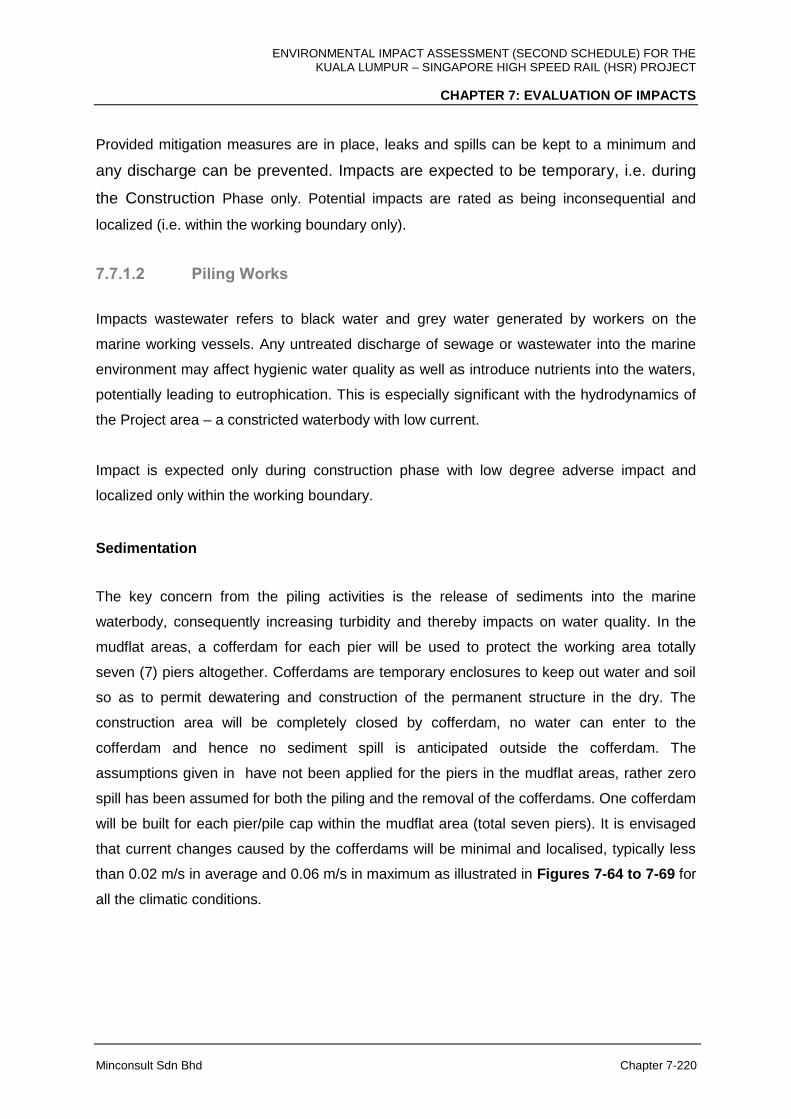
ENVIRONMENTAL IMPACT ASSESSMENT (SECOND SCHEDULE) FOR THE KUALA LUMPUR – SINGAPORE HIGH SPEED RAIL (HSR) PROJECT
CHAPTER 7: EVALUATION OF IMPACTS
Minconsult Sdn Bhd Chapter 7-220
Provided mitigation measures are in place, leaks and spills can be kept to a minimum and
any discharge can be prevented. Impacts are expected to be temporary, i.e. during
the Construction Phase only. Potential impacts are rated as being inconsequential and
localized (i.e. within the working boundary only).
7.7.1.2 Piling Works
Impacts wastewater refers to black water and grey water generated by workers on the
marine working vessels. Any untreated discharge of sewage or wastewater into the marine
environment may affect hygienic water quality as well as introduce nutrients into the waters,
potentially leading to eutrophication. This is especially significant with the hydrodynamics of
the Project area – a constricted waterbody with low current.
Impact is expected only during construction phase with low degree adverse impact and
localized only within the working boundary.
Sedimentation
The key concern from the piling activities is the release of sediments into the marine
waterbody, consequently increasing turbidity and thereby impacts on water quality. In the
mudflat areas, a cofferdam for each pier will be used to protect the working area totally
seven (7) piers altogether. Cofferdams are temporary enclosures to keep out water and soil
so as to permit dewatering and construction of the permanent structure in the dry. The
construction area will be completely closed by cofferdam, no water can enter to the
cofferdam and hence no sediment spill is anticipated outside the cofferdam. The
assumptions given in have not been applied for the piers in the mudflat areas, rather zero
spill has been assumed for both the piling and the removal of the cofferdams. One cofferdam
will be built for each pier/pile cap within the mudflat area (total seven piers). It is envisaged
that current changes caused by the cofferdams will be minimal and localised, typically less
than 0.02 m/s in average and 0.06 m/s in maximum as illustrated in Figures 7-64 to 7-69 for
all the climatic conditions.
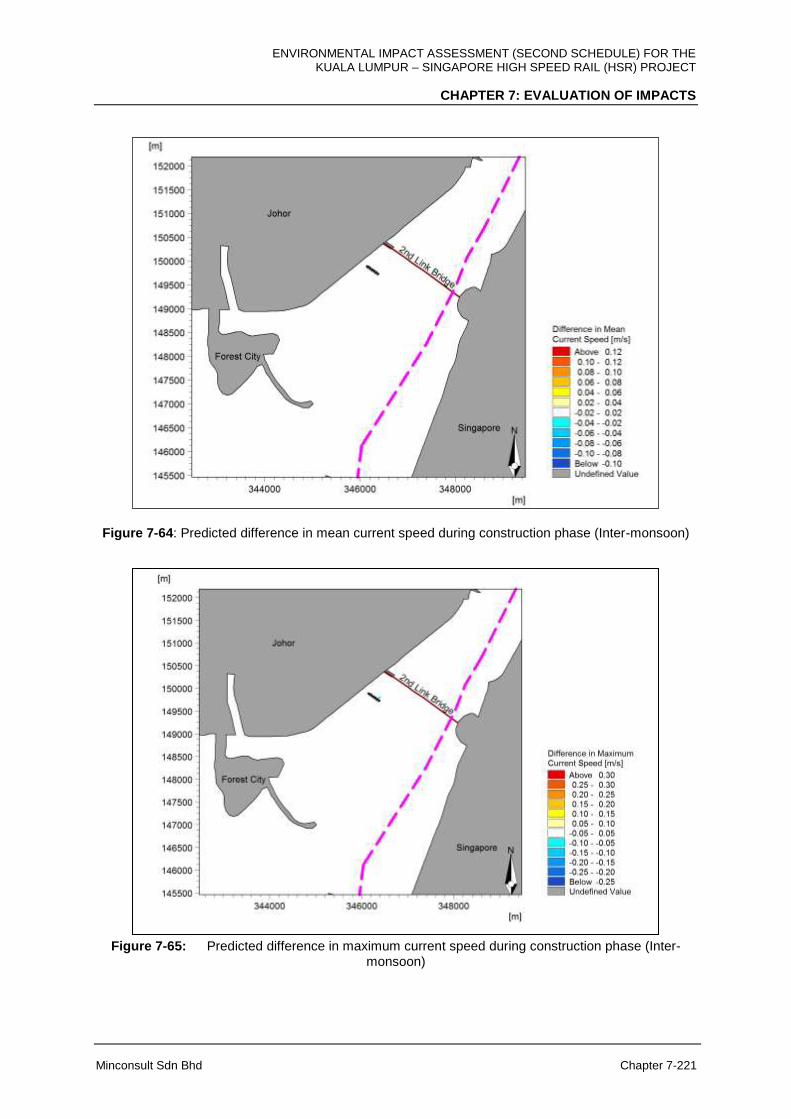
ENVIRONMENTAL IMPACT ASSESSMENT (SECOND SCHEDULE) FOR THE KUALA LUMPUR – SINGAPORE HIGH SPEED RAIL (HSR) PROJECT
CHAPTER 7: EVALUATION OF IMPACTS
Minconsult Sdn Bhd Chapter 7-221
Figure 7-64: Predicted difference in mean current speed during construction phase (Inter-monsoon)
Figure 7-65: Predicted difference in maximum current speed during construction phase (Inter-monsoon)

ENVIRONMENTAL IMPACT ASSESSMENT (SECOND SCHEDULE) FOR THE KUALA LUMPUR – SINGAPORE HIGH SPEED RAIL (HSR) PROJECT
CHAPTER 7: EVALUATION OF IMPACTS
Minconsult Sdn Bhd Chapter 7-222
Figure 7-66: Predicted difference in mean current speed during construction phase (Northeast
monsoon).
Figure 7-67: Predicted difference in maximum current speed during construction phase (Northeast
Monsoon).
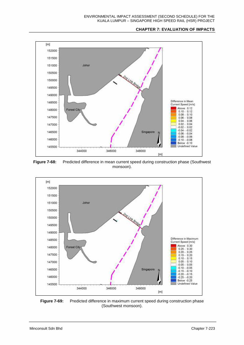
ENVIRONMENTAL IMPACT ASSESSMENT (SECOND SCHEDULE) FOR THE KUALA LUMPUR – SINGAPORE HIGH SPEED RAIL (HSR) PROJECT
CHAPTER 7: EVALUATION OF IMPACTS
Minconsult Sdn Bhd Chapter 7-223
Figure 7-68: Predicted difference in mean current speed during construction phase (Southwest monsoon).
Figure 7-69: Predicted difference in maximum current speed during construction phase (Southwest monsoon).
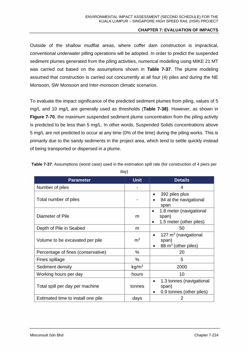
ENVIRONMENTAL IMPACT ASSESSMENT (SECOND SCHEDULE) FOR THE KUALA LUMPUR – SINGAPORE HIGH SPEED RAIL (HSR) PROJECT
CHAPTER 7: EVALUATION OF IMPACTS
Minconsult Sdn Bhd Chapter 7-224
Outside of the shallow mudflat areas, where coffer dam construction is impractical,
conventional underwater pilling operations will be adopted. In order to predict the suspended
sediment plumes generated from the piling activities, numerical modelling using MIKE 21 MT
was carried out based on the assumptions shown in Table 7-37. The plume modeling
assumed that construction is carried out concurrently at all four (4) piles and during the NE
Monsoon, SW Monsoon and Inter-monsoon climatic scenarios.
To evaluate the impact significance of the predicted sediment plumes from piling, values of 5
mg/L and 10 mg/L are generally used as thresholds (Table 7-38). However, as shown in
Figure 7-70, the maximum suspended sediment plume concentration from the piling activity
is predicted to be less than 5 mg/L. In other words, Suspended Solids concentrations above
5 mg/L are not predicted to occur at any time (0% of the time) during the piling works. This is
primarily due to the sandy sediments in the project area, which tend to settle quickly instead
of being transported or dispersed in a plume.
Table 7-37: Assumptions (worst case) used in the estimation spill rate (for construction of 4 piers per
day)
Parameter Unit Details
Number of piles - 4
Total number of piles - 392 piles plus
84 at the navigational span
Diameter of Pile m 1.8 meter (navigational
span)
1.5 meter (other piles)
Depth of Pile in Seabed m 50
Volume to be excavated per pile m3 127 m3 (navigational
span)
88 m3 (other piles)
Percentage of fines (conservative) % 20
Fines spillage % 5
Sediment density kg/m3 2000
Working hours per day hours 10
Total spill per day per machine tonnes 1.3 tonnes (navigational
span)
0.9 tonnes (other piles)
Estimated time to install one pile days 2

ENVIRONMENTAL IMPACT ASSESSMENT (SECOND SCHEDULE) FOR THE KUALA LUMPUR – SINGAPORE HIGH SPEED RAIL (HSR) PROJECT
CHAPTER 7: EVALUATION OF IMPACTS
Minconsult Sdn Bhd Chapter 7-225
Table 7-38: Suspended Sediment Concentration (SSC) Threshold.
Threshold Value Assessment Purpose Description
Exceeds 5 mg/L for more than 10% of the time
Plume visibility1 5 mg/L is the assumed limit at which the suspended sediments (in excess of background concentration) become visible.
Exceeds 10 mg/L for more than 5% of the time
International Boundary Accepted threshold for cross border impacts based on previous studies, e.g. IDPT1.
Note: 1PIANC Report No. 108 (2010).
Figure 7-70: Maximum excess TSS levels for inter (top), northeast (middle) and southwest (bottom) monsoon conditions.
ENVIRONMENTAL IMPACT ASSESSMENT (SECOND SCHEDULE) FOR THE KUALA LUMPUR – SINGAPORE HIGH SPEED RAIL (HSR) PROJECT
CHAPTER 7: EVALUATION OF IMPACTS
Minconsult Sdn Bhd Chapter 7-226
7.7.1.3 Construction of Elevated Structures/Bridges
Waste Discharges: Construction activities may impact the water quality within vicinity of
the project site through oil spills and/or leakage from construction machinery and
transportation vessels. Impact will be for a limited duration with low degree of induced
adverse impacts. Impacts will be localized only within the working boundary.
Impact will be during construction phase with low degree adverse impact and localized only
within the working boundary.
7.7.2 Operational Phase
The principal Project’s operations related activities that are capable of inducing
environmental impacts include:
1. Footprint of piers
2. Repair and maintenance work on track
The potential impacts that could occur during the Project’s operational phase are assessed
herewith.
7.7.2.1 Footprint of Piers
Hydrodynamic Properties: The change in the flushing conditions is evaluated based on an
analysis of the changes of the tidal prism, defined as volume of water crosses a section for a
tidal cycle (high tide to low tide). In order to evaluate the potential changes in the discharges
across these areas, the tidal prism has been calculated for baseline and post development
at transects L1 and L2 shown in Figure 7-71.
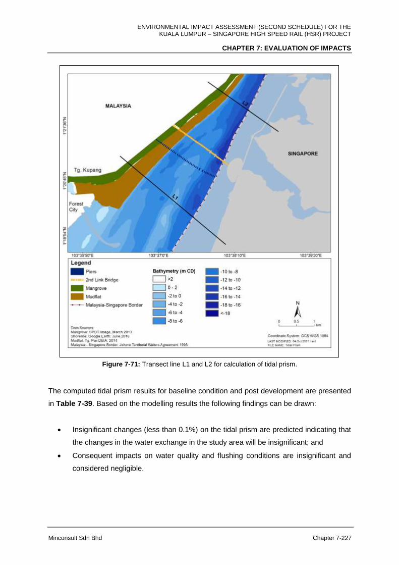
ENVIRONMENTAL IMPACT ASSESSMENT (SECOND SCHEDULE) FOR THE KUALA LUMPUR – SINGAPORE HIGH SPEED RAIL (HSR) PROJECT
CHAPTER 7: EVALUATION OF IMPACTS
Minconsult Sdn Bhd Chapter 7-227
Figure 7-71: Transect line L1 and L2 for calculation of tidal prism.
The computed tidal prism results for baseline condition and post development are presented
in Table 7-39. Based on the modelling results the following findings can be drawn:
Insignificant changes (less than 0.1%) on the tidal prism are predicted indicating that
the changes in the water exchange in the study area will be insignificant; and
Consequent impacts on water quality and flushing conditions are insignificant and
considered negligible.

ENVIRONMENTAL IMPACT ASSESSMENT (SECOND SCHEDULE) FOR THE KUALA LUMPUR – SINGAPORE HIGH SPEED RAIL (HSR) PROJECT
CHAPTER 7: EVALUATION OF IMPACTS
Minconsult Sdn Bhd Chapter 7-228
Table 7-39: Predicted tidal prism based on differences in water discharge volume for a tidal cycle.
Transect Baseline With HSR alignment
Water Discharge volume (million
m3)
Difference water discharge volume
(million m3)
Difference of water discharge volume in
percentage (%)
L1 170.900 -0.112 -0.066
L2 145.994 -0.105 -0.072
Sedimentation / Erosion: The predicted sedimentation rate induced by the HSR alignment
has been simulated for all three climatic conditions, and these have been combined to
calculate the annual sedimentation rate as shown in Figure 7-72. The results indicate that
changes in bed level of approximately 0.2 m per year occur in the offshore area where the
current speed is stronger, but these occur locally within the vicinity of the piers and extend to
the main span of second link bridge (Figure 7-72). It should be noted that these predictions
show initial changes after the project has been constructed, whereas once the sediment
transport at the study area reaches equilibrium, the sedimentation/erosion rate will reduce to
zero.
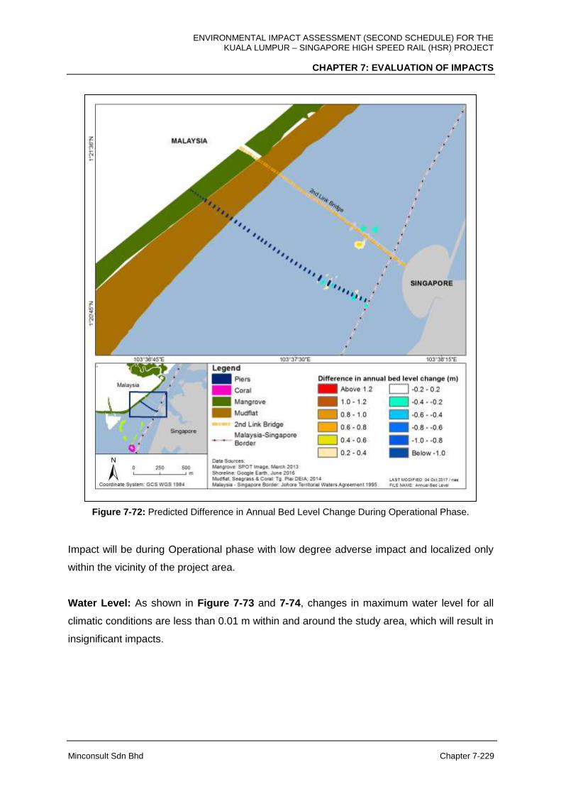
ENVIRONMENTAL IMPACT ASSESSMENT (SECOND SCHEDULE) FOR THE KUALA LUMPUR – SINGAPORE HIGH SPEED RAIL (HSR) PROJECT
CHAPTER 7: EVALUATION OF IMPACTS
Minconsult Sdn Bhd Chapter 7-229
Figure 7-72: Predicted Difference in Annual Bed Level Change During Operational Phase.
Impact will be during Operational phase with low degree adverse impact and localized only
within the vicinity of the project area.
Water Level: As shown in Figure 7-73 and 7-74, changes in maximum water level for all
climatic conditions are less than 0.01 m within and around the study area, which will result in
insignificant impacts.
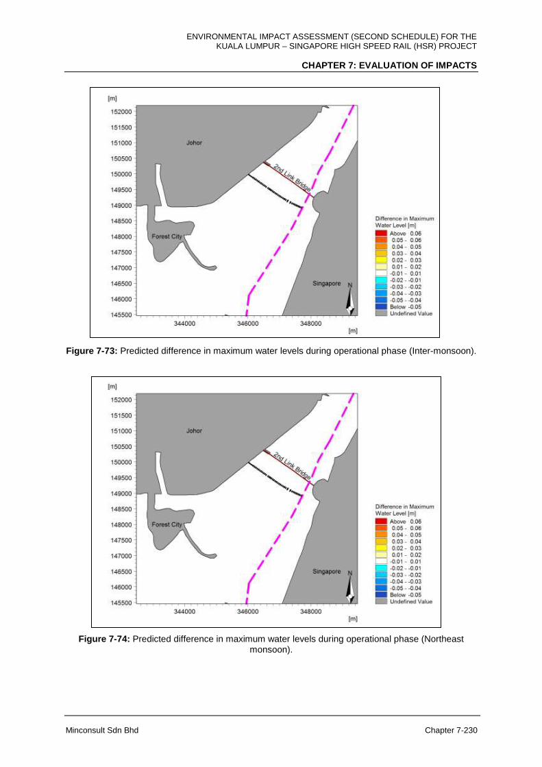
ENVIRONMENTAL IMPACT ASSESSMENT (SECOND SCHEDULE) FOR THE KUALA LUMPUR – SINGAPORE HIGH SPEED RAIL (HSR) PROJECT
CHAPTER 7: EVALUATION OF IMPACTS
Minconsult Sdn Bhd Chapter 7-230
Figure 7-73: Predicted difference in maximum water levels during operational phase (Inter-monsoon).
Figure 7-74: Predicted difference in maximum water levels during operational phase (Northeast monsoon).

ENVIRONMENTAL IMPACT ASSESSMENT (SECOND SCHEDULE) FOR THE KUALA LUMPUR – SINGAPORE HIGH SPEED RAIL (HSR) PROJECT
CHAPTER 7: EVALUATION OF IMPACTS
Minconsult Sdn Bhd Chapter 7-231
Current Flow: The current changes in mean and maximum current speeds during the
Project’s operational phase for inter-monsoon, northeast monsoon and southwest monsoon
scenarios are depicted in Figures 7-75 to 7-81.
Predicted changes in current speeds are less than 0.04 m/s for mean current speed and 0.1
m/s for maximum current speed, particularly at the main span where there are 42 piles in
place and the currents are stronger. Overall, the changes in current flow are minimal and
localised (500 m from the project footprint within Malaysia boundary), with no cross-border
impact predicted.
Figure 7-75: Predicted difference in mean current speed during operational phase (Inter-monsoon).

ENVIRONMENTAL IMPACT ASSESSMENT (SECOND SCHEDULE) FOR THE KUALA LUMPUR – SINGAPORE HIGH SPEED RAIL (HSR) PROJECT
CHAPTER 7: EVALUATION OF IMPACTS
Minconsult Sdn Bhd Chapter 7-232
Figure 7-76: Predicted difference in maximum current speed during operational phase (Inter-
monsoon).
Figure 7-77: Predicted difference in mean current speed during operational phase (Northeast monsoon).
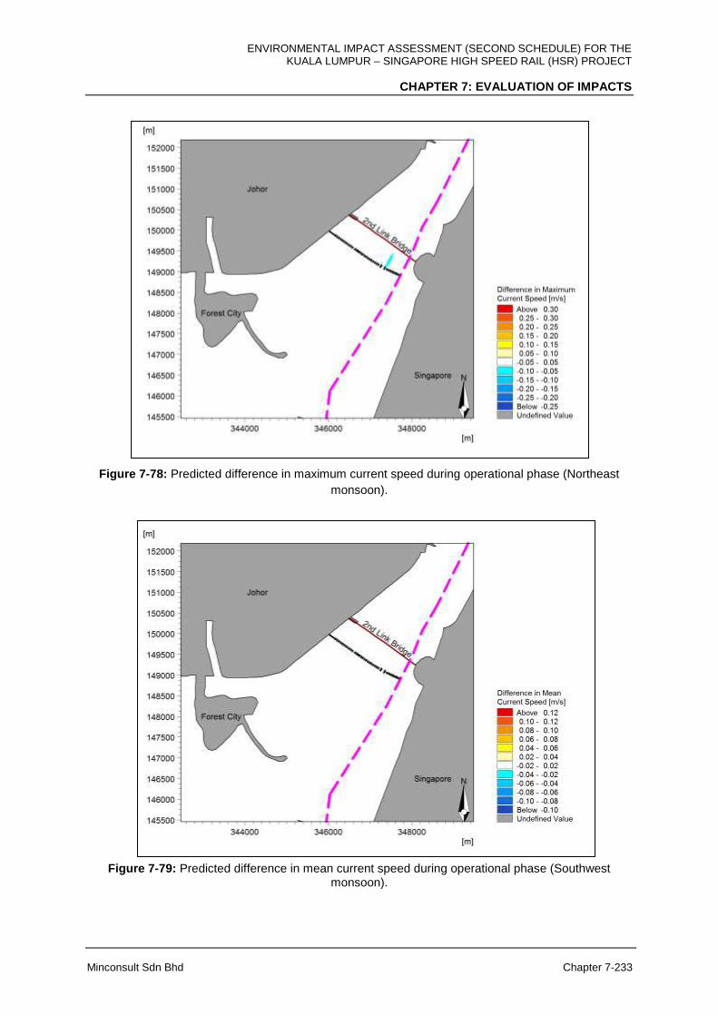
ENVIRONMENTAL IMPACT ASSESSMENT (SECOND SCHEDULE) FOR THE KUALA LUMPUR – SINGAPORE HIGH SPEED RAIL (HSR) PROJECT
CHAPTER 7: EVALUATION OF IMPACTS
Minconsult Sdn Bhd Chapter 7-233
Figure 7-78: Predicted difference in maximum current speed during operational phase (Northeast
monsoon).
Figure 7-79: Predicted difference in mean current speed during operational phase (Southwest monsoon).
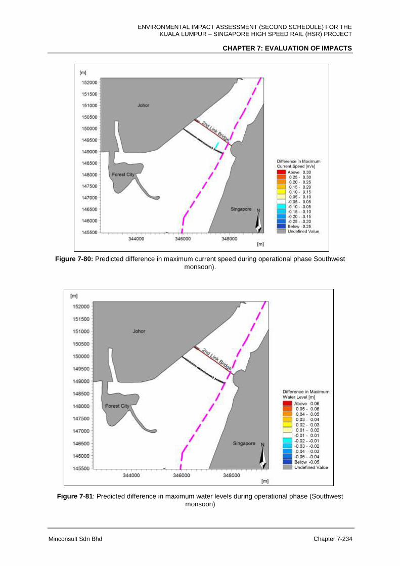
ENVIRONMENTAL IMPACT ASSESSMENT (SECOND SCHEDULE) FOR THE KUALA LUMPUR – SINGAPORE HIGH SPEED RAIL (HSR) PROJECT
CHAPTER 7: EVALUATION OF IMPACTS
Minconsult Sdn Bhd Chapter 7-234
Figure 7-80: Predicted difference in maximum current speed during operational phase Southwest
monsoon).
Figure 7-81: Predicted difference in maximum water levels during operational phase (Southwest monsoon)

ENVIRONMENTAL IMPACT ASSESSMENT (SECOND SCHEDULE) FOR THE KUALA LUMPUR – SINGAPORE HIGH SPEED RAIL (HSR) PROJECT
CHAPTER 7: EVALUATION OF IMPACTS
Minconsult Sdn Bhd Chapter 7-235
Wave Height: The proposed development is located at a sheltered channel where the wind-
wave fetches are short thus the waves in this area are weak. Changes in mean and
maximum wave heights during the Project’s operational phase for all climatic conditions is
depicted in Figures 7-82 to 7-87.
During the northeast monsoon, a reduction in significant wave height occurs southwest of
the project which is related to the predominant north-easterly wind. Overall, the changes in
wave are minimal and localised (500 m from the project footprint within Malaysia boundary)
which is highly unlikely to cause any impacts to other areas or cross-border impact.
Figure 7-82: Predicted difference in mean significant wave height during operational phase (inter-
monsoon).
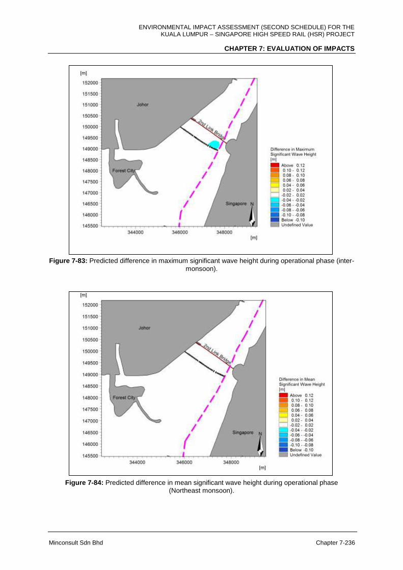
ENVIRONMENTAL IMPACT ASSESSMENT (SECOND SCHEDULE) FOR THE KUALA LUMPUR – SINGAPORE HIGH SPEED RAIL (HSR) PROJECT
CHAPTER 7: EVALUATION OF IMPACTS
Minconsult Sdn Bhd Chapter 7-236
Figure 7-83: Predicted difference in maximum significant wave height during operational phase (inter-
monsoon).
Figure 7-84: Predicted difference in mean significant wave height during operational phase (Northeast monsoon).
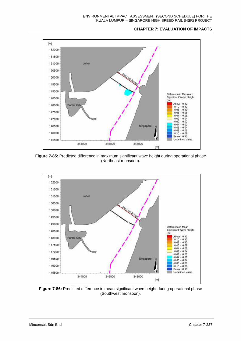
ENVIRONMENTAL IMPACT ASSESSMENT (SECOND SCHEDULE) FOR THE KUALA LUMPUR – SINGAPORE HIGH SPEED RAIL (HSR) PROJECT
CHAPTER 7: EVALUATION OF IMPACTS
Minconsult Sdn Bhd Chapter 7-237
Figure 7-85: Predicted difference in maximum significant wave height during operational phase
(Northeast monsoon).
Figure 7-86: Predicted difference in mean significant wave height during operational phase (Southwest monsoon).
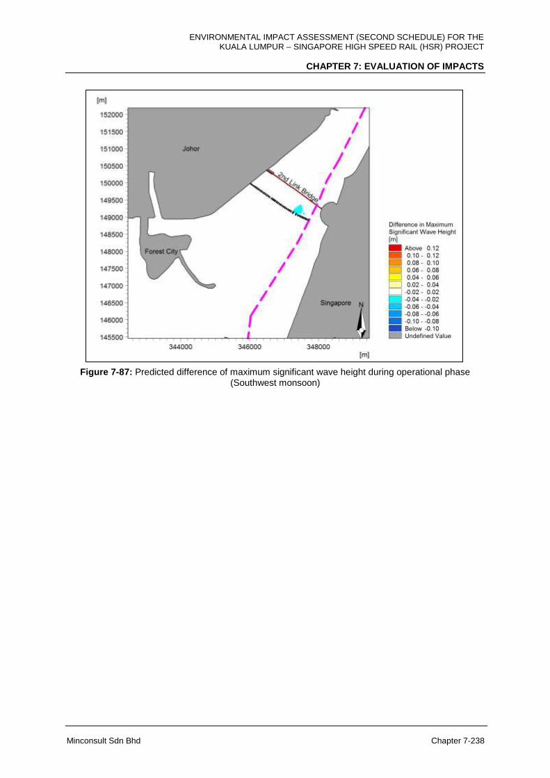
ENVIRONMENTAL IMPACT ASSESSMENT (SECOND SCHEDULE) FOR THE KUALA LUMPUR – SINGAPORE HIGH SPEED RAIL (HSR) PROJECT
CHAPTER 7: EVALUATION OF IMPACTS
Minconsult Sdn Bhd Chapter 7-238
Figure 7-87: Predicted difference of maximum significant wave height during operational phase (Southwest monsoon)
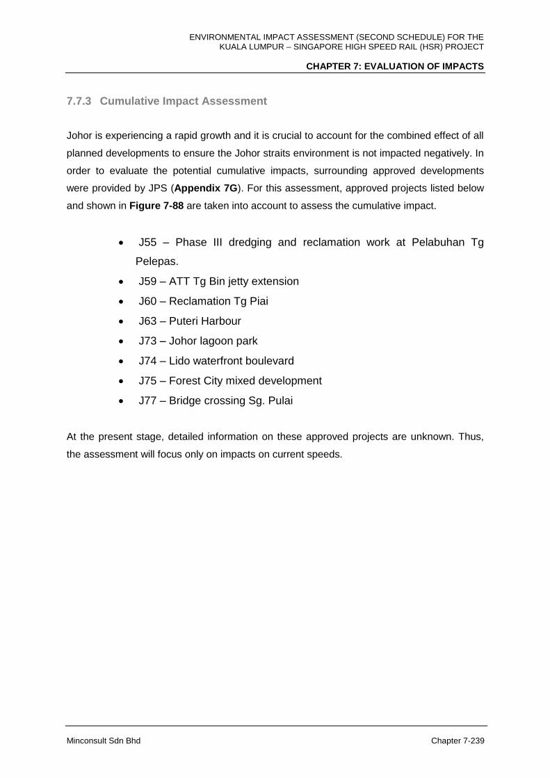
ENVIRONMENTAL IMPACT ASSESSMENT (SECOND SCHEDULE) FOR THE KUALA LUMPUR – SINGAPORE HIGH SPEED RAIL (HSR) PROJECT
CHAPTER 7: EVALUATION OF IMPACTS
Minconsult Sdn Bhd Chapter 7-239
7.7.3 Cumulative Impact Assessment
Johor is experiencing a rapid growth and it is crucial to account for the combined effect of all
planned developments to ensure the Johor straits environment is not impacted negatively. In
order to evaluate the potential cumulative impacts, surrounding approved developments
were provided by JPS (Appendix 7G). For this assessment, approved projects listed below
and shown in Figure 7-88 are taken into account to assess the cumulative impact.
J55 – Phase III dredging and reclamation work at Pelabuhan Tg
Pelepas.
J59 – ATT Tg Bin jetty extension
J60 – Reclamation Tg Piai
J63 – Puteri Harbour
J73 – Johor lagoon park
J74 – Lido waterfront boulevard
J75 – Forest City mixed development
J77 – Bridge crossing Sg. Pulai
At the present stage, detailed information on these approved projects are unknown. Thus,
the assessment will focus only on impacts on current speeds.
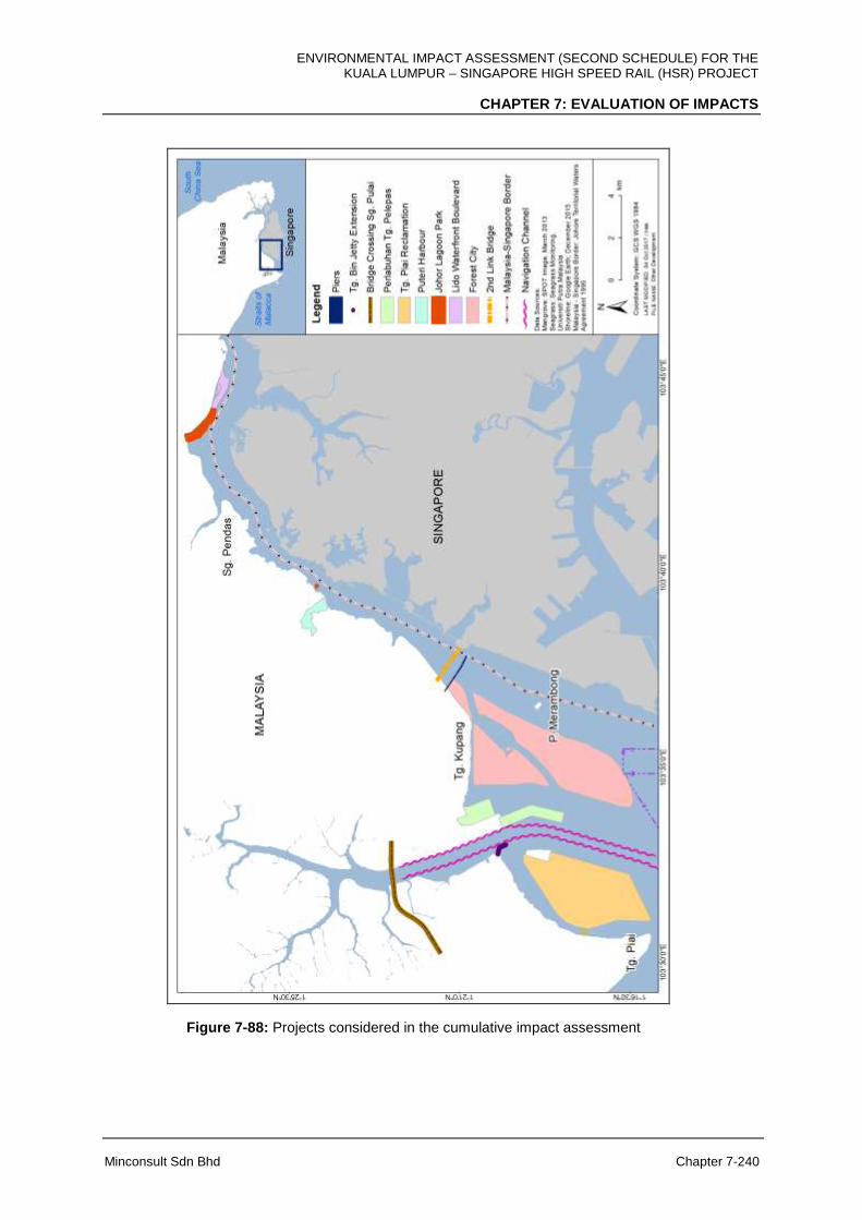
ENVIRONMENTAL IMPACT ASSESSMENT (SECOND SCHEDULE) FOR THE KUALA LUMPUR – SINGAPORE HIGH SPEED RAIL (HSR) PROJECT
CHAPTER 7: EVALUATION OF IMPACTS
Minconsult Sdn Bhd Chapter 7-240
Figure 7-88: Projects considered in the cumulative impact assessment

ENVIRONMENTAL IMPACT ASSESSMENT (SECOND SCHEDULE) FOR THE KUALA LUMPUR – SINGAPORE HIGH SPEED RAIL (HSR) PROJECT
CHAPTER 7: EVALUATION OF IMPACTS
Minconsult Sdn Bhd Chapter 7-241
In order to evaluate the potential cumulative impacts of the approved future developments,
an assessment of impact of these projects against the baseline (existing conditions) has
been carried out with and without the HSR Project. Figure 7-89 and Figure 7-90 present the
predicted differences in mean and maximum current speed respectively. Based on analysis,
the findings are summarised below:
Minor changes are predicted for the case with and without the HSR alignment
indicating that the contribution of the HSR alignment on the cummulative impacts is
minimal and localised around the piers and and insignificant in vicinity areas.
Large developments southwest of HSR alignment for instance Tanjung Pelepas, Tanjung
Piai, Tanjung Bin, Forest City and Sungai Pulai alter the current flow at the area, where
changes in current speeds up to 0.5 m/s can be observed around the proposed reclamation
area. Increase in currents is noticed in the channels whereas reduction is observed next to
the reclamations, however no significant impacts are predicted beyond the international
border
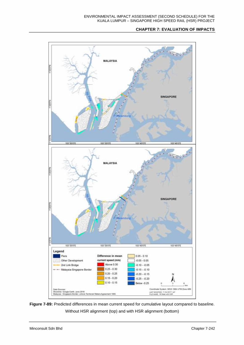
ENVIRONMENTAL IMPACT ASSESSMENT (SECOND SCHEDULE) FOR THE KUALA LUMPUR – SINGAPORE HIGH SPEED RAIL (HSR) PROJECT
CHAPTER 7: EVALUATION OF IMPACTS
Minconsult Sdn Bhd Chapter 7-242
Figure 7-89: Predicted differences in mean current speed for cumulative layout compared to baseline.
Without HSR alignment (top) and with HSR alignment (bottom)
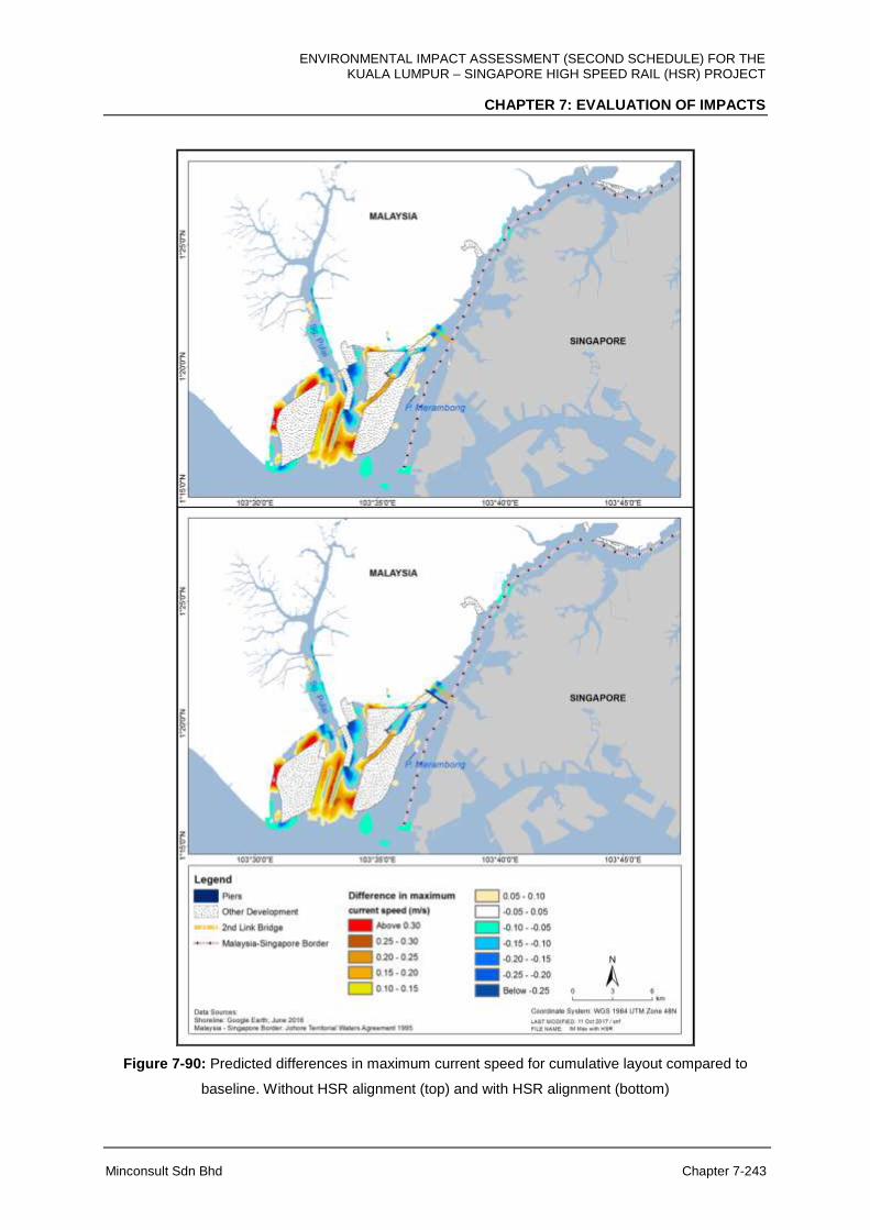
ENVIRONMENTAL IMPACT ASSESSMENT (SECOND SCHEDULE) FOR THE KUALA LUMPUR – SINGAPORE HIGH SPEED RAIL (HSR) PROJECT
CHAPTER 7: EVALUATION OF IMPACTS
Minconsult Sdn Bhd Chapter 7-243
Figure 7-90: Predicted differences in maximum current speed for cumulative layout compared to
baseline. Without HSR alignment (top) and with HSR alignment (bottom)
ENVIRONMENTAL IMPACT ASSESSMENT (SECOND SCHEDULE) FOR THE KUALA LUMPUR – SINGAPORE HIGH SPEED RAIL (HSR) PROJECT
CHAPTER 7: EVALUATION OF IMPACTS
Minconsult Sdn Bhd Chapter 7-244
7.8 GEOLOGY AND HYDROGEOLOGY
The construction of HSR alignment involves major civil engineering works such as the
construction of Bridges, Elevated Structures, shallow and deep foundations, excavations
works, retaining walls, cut and fill slopes, and tunnelling works. Issues and problems related
to the impact of geology and geotechnical to the engineering works and also the impact of
the structure to the geology (geotechnics) shall be highlighted to minimise impacts to the
surrounding environment and therefore reduce the risk of structural failures.
Most of civil engineering structures in HSR Project may affect the stability of the soil and
rock masses in various ways such as; (i) changes made to the ground topography by
earthworks including cutting, filling and/or excavation; (ii) changes in natural drainage
system; and (iii) changes in vegetation on site.
The key parameters in determining the structure type to be used lies in the topography of the
land. The type of structures proposed for the HSR Project is At-Grade, Elevated, Tunnel,
grade separation and river bridge. Elevated Structure is a dominant engineering design for
HSR Project. There are several stretches with At-Grade rail track. Seven (7) tunnels will be
constructed along the HSR alignment, one (1) located in Kuala Lumpur till Selangor (8.8
km), two (2) in Selangor (0.7 km and 2.3 km), two (2) in Negeri Sembilan (each 0.4 km) and
two (2) in Johor (1.9 km and 0.4 km).
7.8.1 Geology
7.8.1.1 Pre-Construction Phase
7.8.1.1.1 Detailed site investigation
Subsurface information and geotechnical data are required for the planning, development
and design stages of all construction projects particularly for ground improvement and
foundation design. A comprehensive site investigation (SI) is required for detailed design of
the HSR alignment. The Project Delivery Partner (PDP) shall undertake his own additional
soil investigation and material surveys for the purpose of preparation of the detailed

ENVIRONMENTAL IMPACT ASSESSMENT (SECOND SCHEDULE) FOR THE KUALA LUMPUR – SINGAPORE HIGH SPEED RAIL (HSR) PROJECT
CHAPTER 7: EVALUATION OF IMPACTS
Minconsult Sdn Bhd Chapter 7-245
engineering design and construction of the works. A copy of the geotechnical report shall be
submitted to Mineral and Geoscience Department.
7.8.1.2 Construction Phase
A) FT. Kuala Lumpur
The geology of FT. Kuala Lumpur is consisting of mainly of granite, limestone and meta-
sediment which can be classified as strong foundation for most of the structures. The
construction of HSR alignment in FT. Kuala Lumpur will involve the Elevated Structures and
Tunnel.
(i) The environmental impact of Elevated Structures is due to differential settlement due
to unsuitable foundation of elevated piers. A thick layer of residual soil may increase
the cost of pilling claim to reach the sound rock which is located at greater depth.
Foundation in karstic limestone area must be given extra safety measures to avoid
putting the pile foundation on a limestone pinnacles or above the underground
cavern. Kuala Lumpur Limestone has karstic features due to the highly soluble
nature of the limestone, the tropical weather has produced deep weathering with the
less soluble dolomitic rock forming the tower-like pinnacles. In addition, solution
cavities Kuala Lumpur limestone area was also heavily mined in the past leaving
behind numerous ponds and remnants consisting of sand and clay slime, forming a
highly heterogeneous overburden of limestone (Figure 7-91)
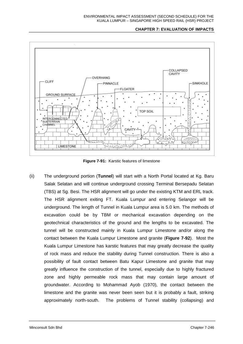
ENVIRONMENTAL IMPACT ASSESSMENT (SECOND SCHEDULE) FOR THE KUALA LUMPUR – SINGAPORE HIGH SPEED RAIL (HSR) PROJECT
CHAPTER 7: EVALUATION OF IMPACTS
Minconsult Sdn Bhd Chapter 7-246
Figure 7-91: Karstic features of limestone
(ii) The underground portion (Tunnel) will start with a North Portal located at Kg. Baru
Salak Selatan and will continue underground crossing Terminal Bersepadu Selatan
(TBS) at Sg. Besi. The HSR alignment will go under the existing KTM and ERL track.
The HSR alignment exiting FT. Kuala Lumpur and entering Selangor will be
underground. The length of Tunnel in Kuala Lumpur area is 5.0 km. The methods of
excavation could be by TBM or mechanical excavation depending on the
geotechnical characteristics of the ground and the lengths to be excavated. The
tunnel will be constructed mainly in Kuala Lumpur Limestone and/or along the
contact between the Kuala Lumpur Limestone and granite (Figure 7-92). Most the
Kuala Lumpur Limestone has karstic features that may greatly decrease the quality
of rock mass and reduce the stability during Tunnel construction. There is also a
possibility of fault contact between Batu Kapur Limestone and granite that may
greatly influence the construction of the tunnel, especially due to highly fractured
zone and highly permeable rock mass that may contain large amount of
groundwater. According to Mohammad Ayob (1970), the contact between the
limestone and the granite was never been seen but it is probably a fault, striking
approximately north-south. The problems of Tunnel stability (collapsing) and

ENVIRONMENTAL IMPACT ASSESSMENT (SECOND SCHEDULE) FOR THE KUALA LUMPUR – SINGAPORE HIGH SPEED RAIL (HSR) PROJECT
CHAPTER 7: EVALUATION OF IMPACTS
Minconsult Sdn Bhd Chapter 7-247
groundwater seepage into the tunnel are expected while excavating through this
formation.
(iii) Weak zones such as highly fractured rocks, shear zones, or fault lines are
challenging in tunnel construction. Weak zone can cause instability to the tunnel roof
hence led to collapse and overbreak of the tunnel perimeter. The HSR alignment will
cut across the possible fault line as shown in Figure 7-92. Fault zone is geologically
weak zone in which construction of major civil works on top will require proper
treatment on the foundation.
(iv) There is a potential environmental issue with the soil deposits in Kuala Lumpur area
consist of alluvial deposits, mine tailings, manmade fills, organic mud and peat, and
residual soils of the various rock formations. The main concerns are the soft soils
such as mining slimes, municipal wastes and the very weak collapsed zone above
the limestone bedrock.
Figure 7-92: The tunnel route along the HSR alignment will be constructed mainly in karstic Kuala
Lumpur Limestone (JMG, 2010)

ENVIRONMENTAL IMPACT ASSESSMENT (SECOND SCHEDULE) FOR THE KUALA LUMPUR – SINGAPORE HIGH SPEED RAIL (HSR) PROJECT
CHAPTER 7: EVALUATION OF IMPACTS
Minconsult Sdn Bhd Chapter 7-248
(v) The impacts to groundwater regime during the construction of the tunnel.
Groundwater is always a main concern for deep excavation works to reduce the rate
of groundwater inflow into the excavation tunnel. It is a way to reduce pathways of
water flow into the excavated area in order to prevent excessive groundwater
drawdown.
(vi) Tunnel excavation will produce a lot of excavated material (i.e. waste rock) also
known as muck. Huge amount of tunnel muck, which, if not re-used, has to be
dumped, with high costs concerning both the impact on the territory and the Project
itself. In tunneling excavation, two very important aspects have to be taken into
account: the dumping of the excavated material and the opening of new quarries to
supply raw materials. A solution that could be proposed to minimize these relevant
environmental problems is the recycling, or reusing, of the muck from tunnel
excavations which can be employed as aggregates for concrete.
Figure 7-93: The tunnel excavation in Kuala Lumpur will be constructed laterally at lower surface
topography (Elevation 50 m).
B) Selangor
(i) The structure of HSR alignment in Selangor is mainly Elevated Structure and At-Grade
Structure. The geology in Selangor area is not similar with Kuala Lumpur area, where it
is only comprised of residual soil from meta-sedimentary rocks. Residual soil from meta-

ENVIRONMENTAL IMPACT ASSESSMENT (SECOND SCHEDULE) FOR THE KUALA LUMPUR – SINGAPORE HIGH SPEED RAIL (HSR) PROJECT
CHAPTER 7: EVALUATION OF IMPACTS
Minconsult Sdn Bhd Chapter 7-249
sedimentary rocks is a good material for the foundation of HSR alignment. The piers of
elevated structure can be founded on the bedrock of meta-sedimentary rock.
(ii) Construction materials
The foundation of HSR alignment using At-Grade Structure will require large amount of
construction materials. By looking at the geological map of Selangor, one can easily
identify that Selangor has abundance of granites especially at the east part. However,
the location of granite as potential construction material is located quite at a distance
from the HSR alignment. The haulage of aggregate materials from the nearest granite
quarry will increase the number of lorries on the road and will also increase the
construction cost for this Project.
(iii) There is one (1) tunnel will be constructed near Bukit Unggul Golf and Country Club in
Selangor. The length of the tunnel is about 2.3 km. This Tunnel will be constructed in a
metamorphic rock formation comprising of phyllite, quartzite and slate. The drilling
method for this tunnel could probably be mechanical excavation but depending on the
geotechnical characteristics of the ground, the depth of the tunnel and lengths to be
excavated. For urban and shallow tunnels which is located in FT. Kuala Lumpur -
Selangor, TBM excavation is proposed as the most suitable to prevent the settlements in
the buildings and other infrastructures, like train lines, bridges and water / gas collectors.
Some parts will be constructed with cut and cover method and other tunnel will be using
drill and blast (NATM) method. Project Proponent shall refer to the Mining and Quarry
unit from Mineral and Geoscience Department if blasting method is used for the
tunnelling construction.
Geotechnical issue excavating in metamorphic rocks is due to its foliation planes (plane of
weaknesses). Foliated rocks possess prominent directional properties. The strength is much
weaker in the direction of the foliation than in other directions. Care should be taken that
loads (bridges, dams, and buildings) are not transferred to foliated directions. In Tunnel
construction, foliated metamorphic rocks are generally more costly because of more steel
supports. In other meta-sedimentary rock types such as quartzite (sandstone) and
interbedded of quartzite and slate (sandstone and shale), the engineering behaviour of these
rock types are different, where quartzite is stronger and brittle while slate (shale) is softer
and ductile. The interbedded of quartzite and slate (shale) behave differently to the
excavation technique being employed in the construction of the Tunnel. For example, drill

ENVIRONMENTAL IMPACT ASSESSMENT (SECOND SCHEDULE) FOR THE KUALA LUMPUR – SINGAPORE HIGH SPEED RAIL (HSR) PROJECT
CHAPTER 7: EVALUATION OF IMPACTS
Minconsult Sdn Bhd Chapter 7-250
and blast excavation method faces challenges with layered quartzite and shale because
different materials behave differently to this excavation technique. Highly dense rock
distributes the blasting energy better to the surrounding rock while softer rocks such as shale
/ slate can react as a damper (i.e. they absorb more energy from the explosive material).
Weak layers of rocks on top of the tunnel roof may cause blocks to fall. It is even worse if the
excavation is in the same direction as the dip of the meta-sedimentary bedding.
Figure 7-94: A second tunnel in Selangor with a length of 2.3 km cutting hill at the highest magnitude
of 182 m
C) FT. Putrajaya
The site is underlain with meta-sedimentary rocks from Hawthornden Schist formation. The
residual soil is clayey silt which is a competent cohesive soil, with adequate bearing capacity
to support the embankment. It is envisaged that no special foundation treatment is required
for such conditions, except replacement / recompaction of the sub-grade. Relict structures
of schist can still be clearly observed in Putrajaya (i.e. as foliation planes). These planes are
considered as the weakest parts of this material due to the HSR alignment of platy minerals
after metamorphism. These planes are prone for sliding and failure.

ENVIRONMENTAL IMPACT ASSESSMENT (SECOND SCHEDULE) FOR THE KUALA LUMPUR – SINGAPORE HIGH SPEED RAIL (HSR) PROJECT
CHAPTER 7: EVALUATION OF IMPACTS
Minconsult Sdn Bhd Chapter 7-251
The geology of FT. Putrajaya is also made of graphitic schist. Graphitic material in soils has
given so many problems to engineering design. This material may contain pyrite minerals
that react with water and oxygen to produce sulfuric acid in water. Acidic water corrodes the
concrete and steel in foundation structure. Other problem with graphitic material is in slope
design. A slope cut through this material is difficult to protect / remediate using plants /
vegetation cover, i.e. plants are difficult to grow on this type of material due to its acidic
nature.
D) Negeri Sembilan
For the HSR alignment in Negeri Sembilan, the HSR structure type will be intermittent
between At-Grade, Elevated, Tunnel and Bridge depending on geographical conditions,
development and population of the area. Tunnel will be constructed in metamorphic rocks
such as schist, phyllite, and slate. Special precaution in constructing the tunnel in
metamorphic rock is due to its foliation. The proposed short tunnel probably will utilise drill
NATM technique as the most likely method to be used in the construction. Tunnelling in
phyllite and schist may also encounter extremely strong metamorphosed rock such as
quartzite. This extremely hard rock mat slow down the excavation work. Two tunnels will be
constructed in Negeri Sembilan with the length of 0.4 km and 0.4 km respectively. These
tunnels will penetrate two hills with an elevation of 101 m and 110 m.
Figure 7-95: First tunnel in Negeri Sembilan with a length of 0.4 km and elevation 101 m
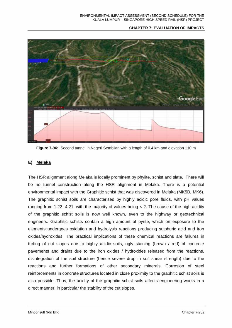
ENVIRONMENTAL IMPACT ASSESSMENT (SECOND SCHEDULE) FOR THE KUALA LUMPUR – SINGAPORE HIGH SPEED RAIL (HSR) PROJECT
CHAPTER 7: EVALUATION OF IMPACTS
Minconsult Sdn Bhd Chapter 7-252
Figure 7-96: Second tunnel in Negeri Sembilan with a length of 0.4 km and elevation 110 m
E) Melaka
The HSR alignment along Melaka is locally prominent by phylite, schist and slate. There will
be no tunnel construction along the HSR alignment in Melaka. There is a potential
environmental impact with the Graphitic schist that was discovered in Melaka (MK5B, MK6).
The graphitic schist soils are characterised by highly acidic pore fluids, with pH values
ranging from 1.22- 4.21, with the majority of values being < 2. The cause of the high acidity
of the graphitic schist soils is now well known, even to the highway or geotechnical
engineers. Graphitic schists contain a high amount of pyrite, which on exposure to the
elements undergoes oxidation and hydrolysis reactions producing sulphuric acid and iron
oxides/hydroxides. The practical implications of these chemical reactions are failures in
turfing of cut slopes due to highly acidic soils, ugly staining (brown / red) of concrete
pavements and drains due to the iron oxides / hydroxides released from the reactions,
disintegration of the soil structure (hence severe drop in soil shear strength) due to the
reactions and further formations of other secondary minerals. Corrosion of steel
reinforcements in concrete structures located in close proximity to the graphitic schist soils is
also possible. Thus, the acidity of the graphitic schist soils affects engineering works in a
direct manner, in particular the stability of the cut slopes.

ENVIRONMENTAL IMPACT ASSESSMENT (SECOND SCHEDULE) FOR THE KUALA LUMPUR – SINGAPORE HIGH SPEED RAIL (HSR) PROJECT
CHAPTER 7: EVALUATION OF IMPACTS
Minconsult Sdn Bhd Chapter 7-253
F) Johor
(i) Peat and marine clay is discovered mainly at the western side of Johor especially in
Pontian, Batu Pahat, and Muar. Peat is usually found as an extremely loose, wet,
unconsolidated surface deposit which forms an integral part of a wetland system. Peat
area has been categorized as Class III area meaning that the area needs highly
geotechnical restriction to be developed. The marine clay found in study area are soft to
very hard according to Mackintosh Probe test. Based on the numbers of boreholes
drilled along the HSR alignment (Phase 1B), there were three (3) boreholes namely BH7,
BH8 and BH9 located on soft ground condition that can give a great problem in the
stability of the rail track foundation. During Phase 2A site investigation, there were
another four (4) boreholes ABH1, ABH4, ABH6 and ABH10 located in peat soil and very
thick soft clay (maximum thickness of 27 m).
Peat and marine clay are problematic for HSR alignment due to large settlement and
require ground improvement depending on the severity of the situation. They are highly
compressible, very soft to soft subsoil materials with low bearing capacity and incapable
of supporting the fill embankment. For such ground conditions depending on the
thickness of compressible layer and height of fill, it is envisaged that ground
improvement works are required to support the embankments.
Ground improvement options include removal of unsuitable material, dynamic
replacement, prefabricated vertical drains, construction of stone columns and piled
embankments.
(i) Another environmental issue with constructing on peat area in Johor is the peat fire
especially during prolong dry weather.
(ii) The quaternary deposits in Johor is also consider as a production zone for groundwater.
The data have also shown the groundwater level in this area is very shallow (close to the
surface). The groundwater level and its chemistry will affect the foundation structure of
the tracks and its stability.
(iii) Two (2) tunnels construction are proposed namely Bukit Naning 1 and Bukit Naning 2.
The total length of both tunnels is about 2.3 km and will be constructed under the 190 m
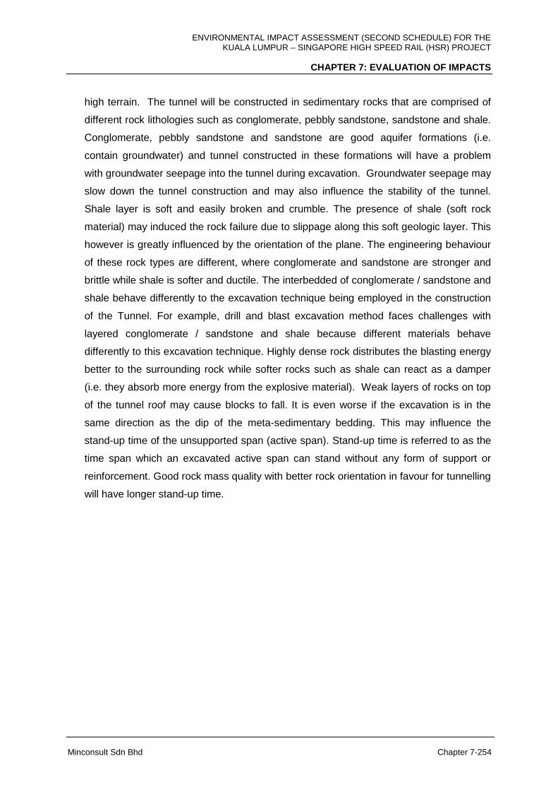
ENVIRONMENTAL IMPACT ASSESSMENT (SECOND SCHEDULE) FOR THE KUALA LUMPUR – SINGAPORE HIGH SPEED RAIL (HSR) PROJECT
CHAPTER 7: EVALUATION OF IMPACTS
Minconsult Sdn Bhd Chapter 7-254
high terrain. The tunnel will be constructed in sedimentary rocks that are comprised of
different rock lithologies such as conglomerate, pebbly sandstone, sandstone and shale.
Conglomerate, pebbly sandstone and sandstone are good aquifer formations (i.e.
contain groundwater) and tunnel constructed in these formations will have a problem
with groundwater seepage into the tunnel during excavation. Groundwater seepage may
slow down the tunnel construction and may also influence the stability of the tunnel.
Shale layer is soft and easily broken and crumble. The presence of shale (soft rock
material) may induced the rock failure due to slippage along this soft geologic layer. This
however is greatly influenced by the orientation of the plane. The engineering behaviour
of these rock types are different, where conglomerate and sandstone are stronger and
brittle while shale is softer and ductile. The interbedded of conglomerate / sandstone and
shale behave differently to the excavation technique being employed in the construction
of the Tunnel. For example, drill and blast excavation method faces challenges with
layered conglomerate / sandstone and shale because different materials behave
differently to this excavation technique. Highly dense rock distributes the blasting energy
better to the surrounding rock while softer rocks such as shale can react as a damper
(i.e. they absorb more energy from the explosive material). Weak layers of rocks on top
of the tunnel roof may cause blocks to fall. It is even worse if the excavation is in the
same direction as the dip of the meta-sedimentary bedding. This may influence the
stand-up time of the unsupported span (active span). Stand-up time is referred to as the
time span which an excavated active span can stand without any form of support or
reinforcement. Good rock mass quality with better rock orientation in favour for tunnelling
will have longer stand-up time.

ENVIRONMENTAL IMPACT ASSESSMENT (SECOND SCHEDULE) FOR THE KUALA LUMPUR – SINGAPORE HIGH SPEED RAIL (HSR) PROJECT
CHAPTER 7: EVALUATION OF IMPACTS
Minconsult Sdn Bhd Chapter 7-255
Figure 7-97: A proposed tunnel location in Muar, Johor with a length of 2.3 m and terrain elevation of
190 m
7.8.1.2.1 Slopes
The need to cut into natural ground arises from the fact that railway formations have to
maintain relatively easier gradients than the prevailing ground slopes. A cutting is a
permanently open excavation. The cut profile (or cutting) may pass through soils, rocks or a
combination of both. There are several places along the HSR alignment where the slopes
will be cut. Based on the feasibility study conducted for HSR project, there are eight (8) cut
slopes in Selangor, 21 in Negeri Sembilan, 13 in Melaka and 27 in Johor. The main problem
with the cut slope and embankment (fill) slope are due to erosion and slope failures.
7.8.1.2.2 Ground treatment
Several States along the HSR alignment was discovered having problematic ground
conditions that must be avoided and/or stabilised such as peat soil and marine clay. Table 7-
39 shows the locations of problematic ground condition at four (4) States namely Selangor,
Negeri Sembilan, Melaka and Johor.
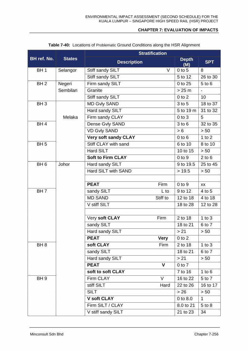
ENVIRONMENTAL IMPACT ASSESSMENT (SECOND SCHEDULE) FOR THE KUALA LUMPUR – SINGAPORE HIGH SPEED RAIL (HSR) PROJECT
CHAPTER 7: EVALUATION OF IMPACTS
Minconsult Sdn Bhd Chapter 7-256
Table 7-40: Locations of Problematic Ground Conditions along the HSR Alignment
BH ref. No. States
Stratification
Description Depth
(M) SPT
BH 1 Selangor Stiff sandy SILT V 0 to 5 8
Stiff sandy SILT 5 to 12 26 to 30
BH 2 Negeri Firm sandy SILT 0 to 25 5 to 6
Sembilan Granite > 25 m -
Stiff sandy SILT 0 to 2 10
BH 3 MD Gvly SAND 3 to 5 18 to 37
Hard sandy SILT 5 to 19 m 31 to 32
Melaka Firm sandy CLAY 0 to 3 5
BH 4 Dense Gvly SAND 3 to 6 32 to 35
VD Gvly SAND > 6 > 50
Very soft sandy CLAY 0 to 6 1 to 2
BH 5 Stiff CLAY with sand 6 to 10 8 to 10
Hard SILT 10 to 15 > 50
Soft to Firm CLAY 0 to 9 2 to 6
BH 6 Johor Hard sandy SILT 9 to 19.5 25 to 45
Hard SILT with SAND > 19.5 > 50
PEAT Firm 0 to 9 xx
BH 7 sandy SILT L to 9 to 12 4 to 5
MD SAND Stiff to 12 to 18 4 to 18
V stiff SILT 18 to 28 12 to 28
Very soft CLAY Firm 2 to 18 1 to 3
sandy SILT 18 to 21 6 to 7
Hard sandy SILT > 21 > 50
PEAT Very 0 to 2
BH 8 soft CLAY Firm 2 to 18 1 to 3
sandy SILT 18 to 21 6 to 7
Hard sandy SILT > 21 > 50
PEAT V 0 to 7
soft to soft CLAY 7 to 16 1 to 6
BH 9 Firm CLAY V 16 to 22 5 to 7
stiff SILT Hard 22 to 26 16 to 17
SILT > 26 > 50
V soft CLAY 0 to 8.0 1
Firm SILT / CLAY 8.0 to 21 5 to 8
V stiff sandy SILT 21 to 23 34
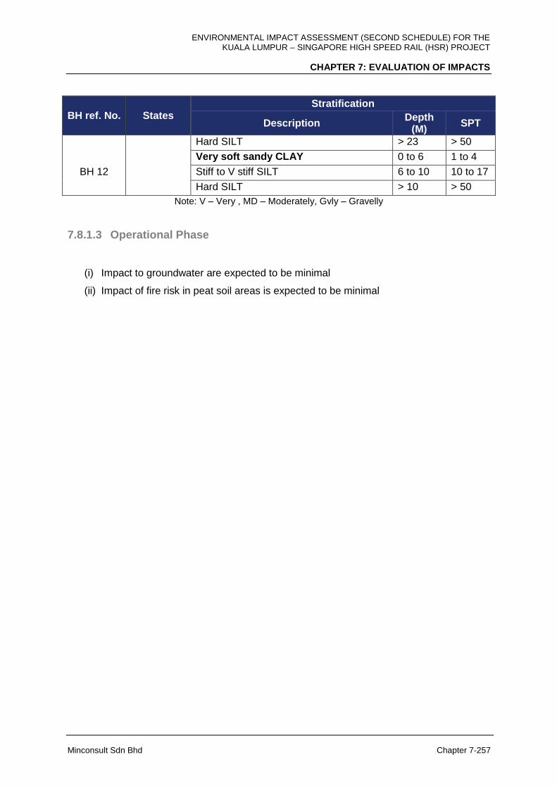
ENVIRONMENTAL IMPACT ASSESSMENT (SECOND SCHEDULE) FOR THE KUALA LUMPUR – SINGAPORE HIGH SPEED RAIL (HSR) PROJECT
CHAPTER 7: EVALUATION OF IMPACTS
Minconsult Sdn Bhd Chapter 7-257
BH ref. No. States Stratification
Description Depth
(M) SPT
Hard SILT > 23 > 50
Very soft sandy CLAY 0 to 6 1 to 4
BH 12 Stiff to V stiff SILT 6 to 10 10 to 17
Hard SILT > 10 > 50
Note: V – Very , MD – Moderately, Gvly – Gravelly
7.8.1.3 Operational Phase
(i) Impact to groundwater are expected to be minimal
(ii) Impact of fire risk in peat soil areas is expected to be minimal
ENVIRONMENTAL IMPACT ASSESSMENT (SECOND SCHEDULE) FOR THE KUALA LUMPUR – SINGAPORE HIGH SPEED RAIL (HSR) PROJECT
CHAPTER 7: EVALUATION OF IMPACTS
Minconsult Sdn Bhd Chapter 7-258
7.8.2 Hydrogeology
Groundwater system in the HSR Project area generally seems to have insignificant roles in
term of provisioning services for the local community nearby. However, it may be
contributing significant and important roles in providing a physical regulating service in the
hydrologic cycle and in providing a sustainable local ecosystem in terms of supporting fauna
and flora population. Hence, an assessment of the potential impacts of the construction and
operation of the HSR Project on the groundwater environment in terms of water quality and
quantity in the vicinity and downstream of the railway infrastructure is important.
7.8.2.1 Pre-Construction Phase
There will be no significant impacts of pre-construction activities of the Project to
hydrogeology and groundwater environment of the area.
7.8.2.2 Construction Phase
Change in Groundwater Levels due to Underground Excavation (Tunnelling) and
Ground Compaction (Foundation)
Tunnels excavation in soils or rocks may produce hydrogeological barrier that cause
disturbance to the natural groundwater flow. Water seepage into tunnels during its
construction may temporarily reduce groundwater level in the vicinity area. However, the
impacts would be eliminated when the wall of the structures is grouted and concreted.
Subsequently, the water-resistant tunnels may also cause some variation in local
groundwater level. As the HSR alignment is generally crossing the main local direction of
groundwater flow, the groundwater level in the upstream of groundwater flow may raise
while the level in the downstream nearby may be lowered. The behaviour on the natural
groundwater hydrodynamic that lead to rising-lowering groundwater level is inspired by size
of the tunnel and its position or depth in reference to the groundwater level.
Ground compaction for the foundation of the HSR will also be introducing hydrogeological
barrier crossing the main groundwater flow. Excavation of soft grounds such as peats and
replacing with fine grained materials or soils for compaction will be developing long
continuous impervious blockage that prevent the natural groundwater flow. A significant
ENVIRONMENTAL IMPACT ASSESSMENT (SECOND SCHEDULE) FOR THE KUALA LUMPUR – SINGAPORE HIGH SPEED RAIL (HSR) PROJECT
CHAPTER 7: EVALUATION OF IMPACTS
Minconsult Sdn Bhd Chapter 7-259
change in groundwater level due to disruption in groundwater movement, in peats area in
particular, may cause serious environmental impacts such as peat firing and flooding.
Contamination of Groundwater
It can be assumed that potential groundwater contamination during the Project construction
will be minimal. However, the potential source of contaminant from the
uncontrolled runoff or accidental spillage of fuels and lubricants, or from the inadequate or
unsafe disposal of sanitary wastewater from construction sites should not be completely
avoided. Moreover, the HSR is constructed on the potential surficial groundwater recharge
areas that characterises by underlying rocks of various degrees of permeability from low-
moderate (meta-sedimentary rocks) to very high (peat).
7.8.2.3 Operational Phase
Change in Groundwater Levels due to Development of Hydrogeological Barriers
The change in groundwater level and flow due to the construction of tunnel may be minimal
if the groundwater is still allowed to flow towards its natural direction. However, the
compacted HSR foundation replacing the original soft and high permeable ground will
completely blockage and permanently prevent the natural groundwater flow. As the structure
remain for the high speed train operation, it will permanently incite for the subsequent
impacts such as peats firing due to significant reduction in groundwater level on one side
and flooding due to groundwater level rise on the other side.
ENVIRONMENTAL IMPACT ASSESSMENT (SECOND SCHEDULE) FOR THE KUALA LUMPUR – SINGAPORE HIGH SPEED RAIL (HSR) PROJECT
CHAPTER 7: EVALUATION OF IMPACTS
Minconsult Sdn Bhd Chapter 7-260
7.9 HYDROLOGY
7.9.1 Pre-Construction Phase
At pre-construction phase, the Project begins with survey, additional feasibility study, site
investigation, utility mapping, utility relocation and Land Acquisition. During this phase, there
will not be any significant impact affecting the hydrology section at all locations with regards
to the Project.
7.9.2 Construction Phase
This section shall discuss the evaluation of impact arising from activities that will be carried
out during construction of the HSR Project. These impacts are predicted based on the
existing physical and environment change due to the Project.
The main activities that will be carried out by the Project Proponent are listed but not limited
to below:
Project Activities during Construction
Main Project Activities Sub-Project Activities
Survey & Investigation
Land Clearing
Demolition
Construction Of Access Roads
Earthwork
Drainage
Transportation Of Materials / Equipment
Vehicle Movemen
Traffic Diversion
Disposal Of Unsuitable Material
Waste / Wastewater Generation
Disposal Of Solid And Construction Waste / Biomass
Establishment Of Site Office, Storage Areas
Establishment Of Workers Camp
Piling
Construction Of Station / Depots / Maintenance Base
Construction Of Elevated Structures
Construction Of At-Grade Structures
Utilities Relocation
Employment Of Workers And Staff
Business Development
Abandonment
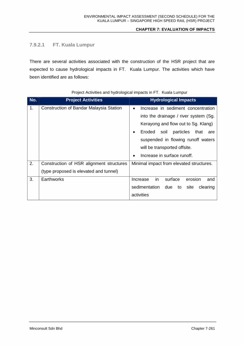
ENVIRONMENTAL IMPACT ASSESSMENT (SECOND SCHEDULE) FOR THE KUALA LUMPUR – SINGAPORE HIGH SPEED RAIL (HSR) PROJECT
CHAPTER 7: EVALUATION OF IMPACTS
Minconsult Sdn Bhd Chapter 7-261
7.9.2.1 FT. Kuala Lumpur
There are several activities associated with the construction of the HSR project that are
expected to cause hydrological impacts in FT. Kuala Lumpur. The activities which have
been identified are as follows:
Project Activities and hydrological impacts in FT. Kuala Lumpur
No. Project Activities Hydrological Impacts
1. Construction of Bandar Malaysia Station Increase in sediment concentration
into the drainage / river system (Sg.
Kerayong and flow out to Sg. Klang)
Eroded soil particles that are
suspended in flowing runoff waters
will be transported offsite.
Increase in surface runoff.
2. Construction of HSR alignment structures
(type proposed is elevated and tunnel)
Minimal impact from elevated structures.
3. Earthworks Increase in surface erosion and
sedimentation due to site clearing
activities
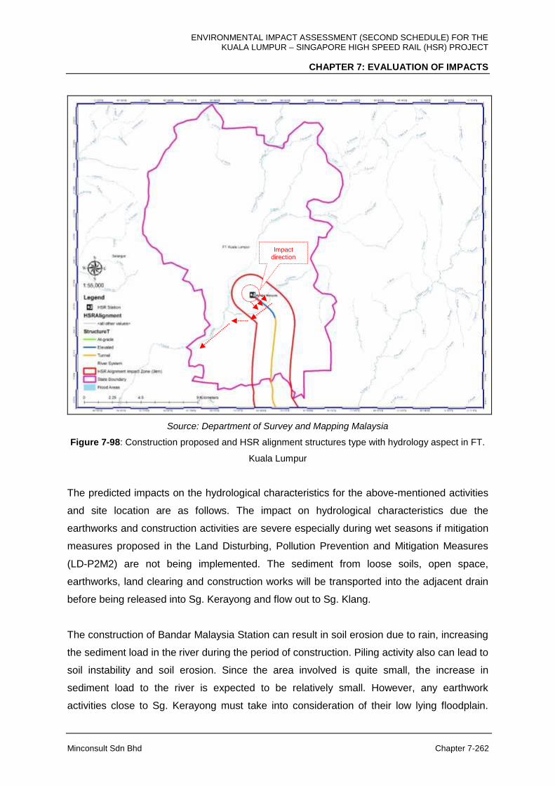
ENVIRONMENTAL IMPACT ASSESSMENT (SECOND SCHEDULE) FOR THE KUALA LUMPUR – SINGAPORE HIGH SPEED RAIL (HSR) PROJECT
CHAPTER 7: EVALUATION OF IMPACTS
Minconsult Sdn Bhd Chapter 7-262
Source: Department of Survey and Mapping Malaysia
Figure 7-98: Construction proposed and HSR alignment structures type with hydrology aspect in FT.
Kuala Lumpur
The predicted impacts on the hydrological characteristics for the above-mentioned activities
and site location are as follows. The impact on hydrological characteristics due the
earthworks and construction activities are severe especially during wet seasons if mitigation
measures proposed in the Land Disturbing, Pollution Prevention and Mitigation Measures
(LD-P2M2) are not being implemented. The sediment from loose soils, open space,
earthworks, land clearing and construction works will be transported into the adjacent drain
before being released into Sg. Kerayong and flow out to Sg. Klang.
The construction of Bandar Malaysia Station can result in soil erosion due to rain, increasing
the sediment load in the river during the period of construction. Piling activity also can lead to
soil instability and soil erosion. Since the area involved is quite small, the increase in
sediment load to the river is expected to be relatively small. However, any earthwork
activities close to Sg. Kerayong must take into consideration of their low lying floodplain.
Impact direction
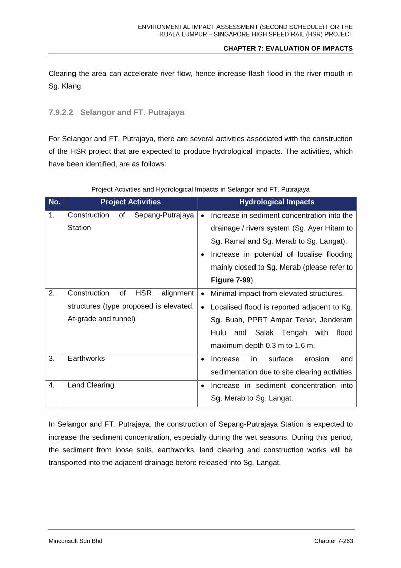
ENVIRONMENTAL IMPACT ASSESSMENT (SECOND SCHEDULE) FOR THE KUALA LUMPUR – SINGAPORE HIGH SPEED RAIL (HSR) PROJECT
CHAPTER 7: EVALUATION OF IMPACTS
Minconsult Sdn Bhd Chapter 7-263
Clearing the area can accelerate river flow, hence increase flash flood in the river mouth in
Sg. Klang.
7.9.2.2 Selangor and FT. Putrajaya
For Selangor and FT. Putrajaya, there are several activities associated with the construction
of the HSR project that are expected to produce hydrological impacts. The activities, which
have been identified, are as follows:
Project Activities and Hydrological Impacts in Selangor and FT. Putrajaya
No. Project Activities Hydrological Impacts
1. Construction of Sepang-Putrajaya
Station
Increase in sediment concentration into the
drainage / rivers system (Sg. Ayer Hitam to
Sg. Ramal and Sg. Merab to Sg. Langat).
Increase in potential of localise flooding
mainly closed to Sg. Merab (please refer to
Figure 7-99).
2. Construction of HSR alignment
structures (type proposed is elevated,
At-grade and tunnel)
Minimal impact from elevated structures.
Localised flood is reported adjacent to Kg.
Sg. Buah, PPRT Ampar Tenar, Jenderam
Hulu and Salak Tengah with flood
maximum depth 0.3 m to 1.6 m.
3. Earthworks Increase in surface erosion and
sedimentation due to site clearing activities
4. Land Clearing Increase in sediment concentration into
Sg. Merab to Sg. Langat.
In Selangor and FT. Putrajaya, the construction of Sepang-Putrajaya Station is expected to
increase the sediment concentration, especially during the wet seasons. During this period,
the sediment from loose soils, earthworks, land clearing and construction works will be
transported into the adjacent drainage before released into Sg. Langat.
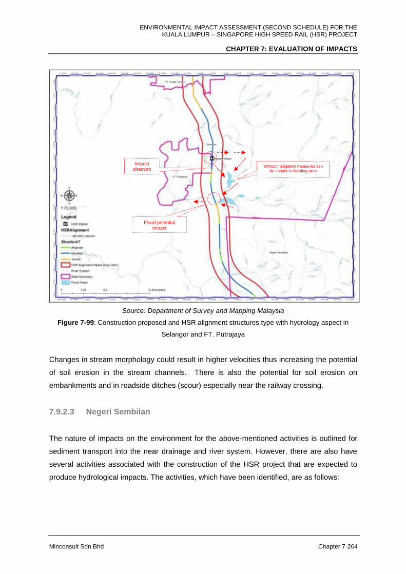
ENVIRONMENTAL IMPACT ASSESSMENT (SECOND SCHEDULE) FOR THE KUALA LUMPUR – SINGAPORE HIGH SPEED RAIL (HSR) PROJECT
CHAPTER 7: EVALUATION OF IMPACTS
Minconsult Sdn Bhd Chapter 7-264
Source: Department of Survey and Mapping Malaysia
Figure 7-99: Construction proposed and HSR alignment structures type with hydrology aspect in
Selangor and FT. Putrajaya
Changes in stream morphology could result in higher velocities thus increasing the potential
of soil erosion in the stream channels. There is also the potential for soil erosion on
embankments and in roadside ditches (scour) especially near the railway crossing.
7.9.2.3 Negeri Sembilan
The nature of impacts on the environment for the above-mentioned activities is outlined for
sediment transport into the near drainage and river system. However, there are also have
several activities associated with the construction of the HSR project that are expected to
produce hydrological impacts. The activities, which have been identified, are as follows:
Impact direction
Without mitigation measures can be impact to flooding area
Flood potential impact
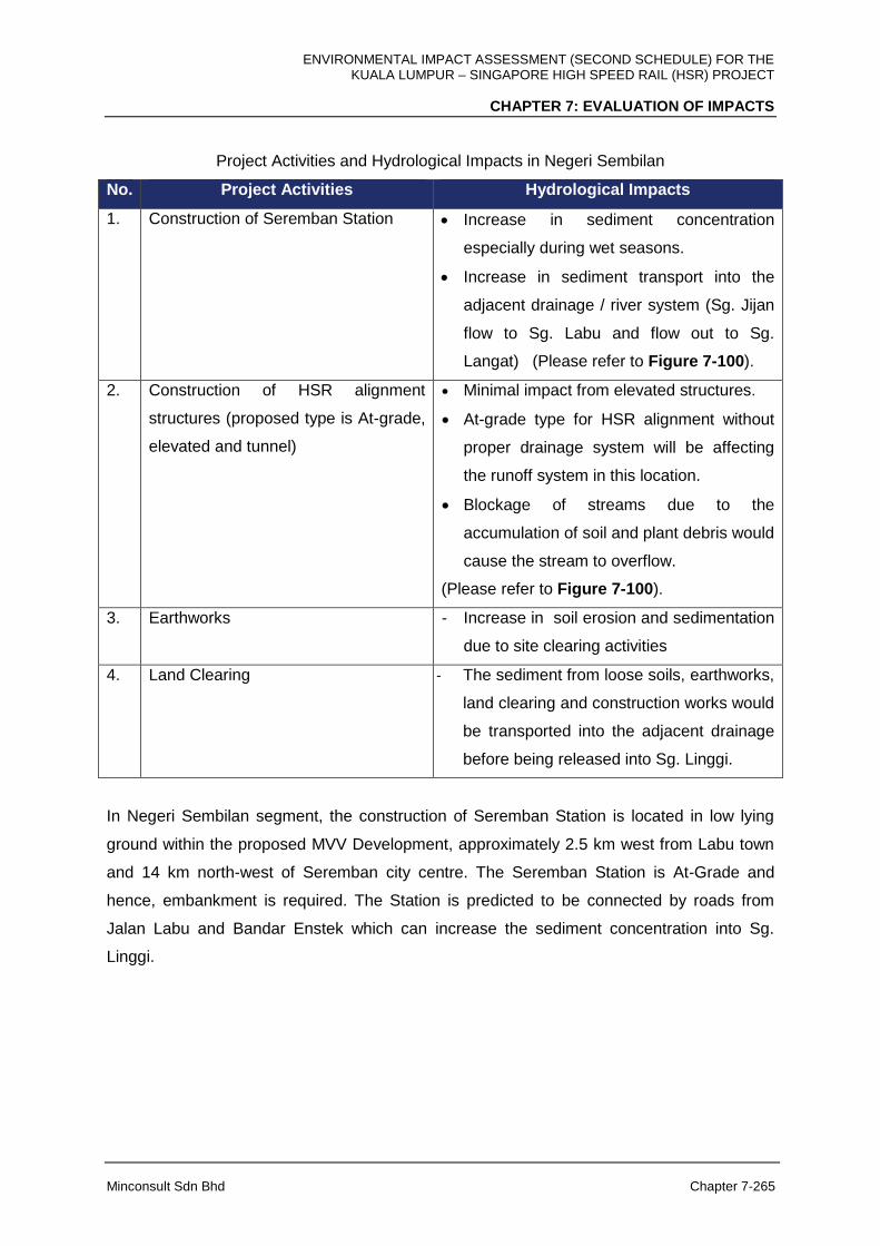
ENVIRONMENTAL IMPACT ASSESSMENT (SECOND SCHEDULE) FOR THE KUALA LUMPUR – SINGAPORE HIGH SPEED RAIL (HSR) PROJECT
CHAPTER 7: EVALUATION OF IMPACTS
Minconsult Sdn Bhd Chapter 7-265
Project Activities and Hydrological Impacts in Negeri Sembilan
No. Project Activities Hydrological Impacts
1. Construction of Seremban Station
Increase in sediment concentration
especially during wet seasons.
Increase in sediment transport into the
adjacent drainage / river system (Sg. Jijan
flow to Sg. Labu and flow out to Sg.
Langat) (Please refer to Figure 7-100).
2. Construction of HSR alignment
structures (proposed type is At-grade,
elevated and tunnel)
Minimal impact from elevated structures.
At-grade type for HSR alignment without
proper drainage system will be affecting
the runoff system in this location.
Blockage of streams due to the
accumulation of soil and plant debris would
cause the stream to overflow.
(Please refer to Figure 7-100).
3. Earthworks - Increase in soil erosion and sedimentation
due to site clearing activities
4. Land Clearing - The sediment from loose soils, earthworks,
land clearing and construction works would
be transported into the adjacent drainage
before being released into Sg. Linggi.
In Negeri Sembilan segment, the construction of Seremban Station is located in low lying
ground within the proposed MVV Development, approximately 2.5 km west from Labu town
and 14 km north-west of Seremban city centre. The Seremban Station is At-Grade and
hence, embankment is required. The Station is predicted to be connected by roads from
Jalan Labu and Bandar Enstek which can increase the sediment concentration into Sg.
Linggi.
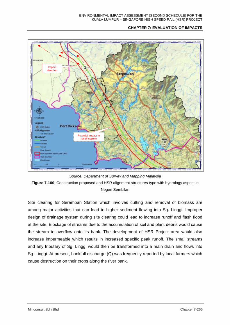
ENVIRONMENTAL IMPACT ASSESSMENT (SECOND SCHEDULE) FOR THE KUALA LUMPUR – SINGAPORE HIGH SPEED RAIL (HSR) PROJECT
CHAPTER 7: EVALUATION OF IMPACTS
Minconsult Sdn Bhd Chapter 7-266
Source: Department of Survey and Mapping Malaysia
Figure 7-100: Construction proposed and HSR alignment structures type with hydrology aspect in
Negeri Sembilan
Site clearing for Seremban Station which involves cutting and removal of biomass are
among major activities that can lead to higher sediment flowing into Sg. Linggi. Improper
design of drainage system during site clearing could lead to increase runoff and flash flood
at the site. Blockage of streams due to the accumulation of soil and plant debris would cause
the stream to overflow onto its bank. The development of HSR Project area would also
increase impermeable which results in increased specific peak runoff. The small streams
and any tributary of Sg. Linggi would then be transformed into a main drain and flows into
Sg. Linggi. At present, bankfull discharge (Q) was frequently reported by local farmers which
cause destruction on their crops along the river bank.
Impact direction
Potential impact to runoff system
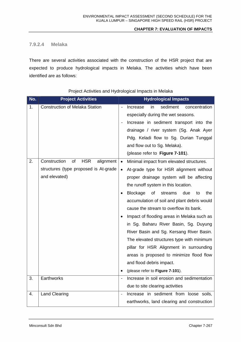
ENVIRONMENTAL IMPACT ASSESSMENT (SECOND SCHEDULE) FOR THE KUALA LUMPUR – SINGAPORE HIGH SPEED RAIL (HSR) PROJECT
CHAPTER 7: EVALUATION OF IMPACTS
Minconsult Sdn Bhd Chapter 7-267
7.9.2.4 Melaka
There are several activities associated with the construction of the HSR project that are
expected to produce hydrological impacts in Melaka. The activities which have been
identified are as follows:
Project Activities and Hydrological Impacts in Melaka
No. Project Activities Hydrological Impacts
1. Construction of Melaka Station
- Increase in sediment concentration
especially during the wet seasons.
- Increase in sediment transport into the
drainage / river system (Sg. Anak Ayer
Pdg. Keladi flow to Sg. Durian Tunggal
and flow out to Sg. Melaka).
(please refer to Figure 7-101).
2. Construction of HSR alignment
structures (type proposed is At-grade
and elevated)
Minimal impact from elevated structures.
At-grade type for HSR alignment without
proper drainage system will be affecting
the runoff system in this location.
Blockage of streams due to the
accumulation of soil and plant debris would
cause the stream to overflow its bank.
Impact of flooding areas in Melaka such as
in Sg. Baharu River Basin, Sg. Duyung
River Basin and Sg. Kersang River Basin.
The elevated structures type with minimum
pillar for HSR Alignment in surrounding
areas is proposed to minimize flood flow
and flood debris impact.
(please refer to Figure 7-101).
3. Earthworks - Increase in soil erosion and sedimentation
due to site clearing activities
4. Land Clearing - Increase in sediment from loose soils,
earthworks, land clearing and construction
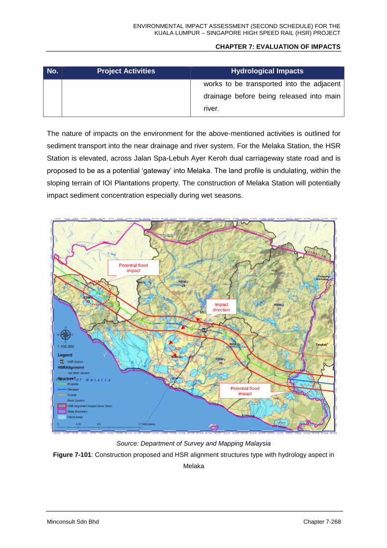
ENVIRONMENTAL IMPACT ASSESSMENT (SECOND SCHEDULE) FOR THE KUALA LUMPUR – SINGAPORE HIGH SPEED RAIL (HSR) PROJECT
CHAPTER 7: EVALUATION OF IMPACTS
Minconsult Sdn Bhd Chapter 7-268
No. Project Activities Hydrological Impacts
works to be transported into the adjacent
drainage before being released into main
river.
The nature of impacts on the environment for the above-mentioned activities is outlined for
sediment transport into the near drainage and river system. For the Melaka Station, the HSR
Station is elevated, across Jalan Spa-Lebuh Ayer Keroh dual carriageway state road and is
proposed to be as a potential ‘gateway’ into Melaka. The land profile is undulating, within the
sloping terrain of IOI Plantations property. The construction of Melaka Station will potentially
impact sediment concentration especially during wet seasons.
Source: Department of Survey and Mapping Malaysia
Figure 7-101: Construction proposed and HSR alignment structures type with hydrology aspect in
Melaka
Impact direction
Potential flood impact
Potential flood impact

ENVIRONMENTAL IMPACT ASSESSMENT (SECOND SCHEDULE) FOR THE KUALA LUMPUR – SINGAPORE HIGH SPEED RAIL (HSR) PROJECT
CHAPTER 7: EVALUATION OF IMPACTS
Minconsult Sdn Bhd Chapter 7-269
Sediment from loose soils, earthworks, land clearing and construction work would be
transported into the adjacent drainage before being released into Sg Bemban. Slope erosion
and sedimentation may also increase due to site clearing activities. During the tree cutting
for access roads, land clearing and earthworks for construction of the Melaka Station would
cause serious surface erosion and sedimentation problems if it is not planned properly. The
Melaka Station is an elevated structure located at Melaka International Motor Circuit (MIMC).
Thus, minimal tree cutting for access roads will be required as the access roads for the
project will be expected from the existing roads to MIMC. Minimal land clearing is expected
as well. When eroded soil particles is washed downstream, it can reduce the quality of water
for irrigation and local treatment and diminish their efficiency, thus increase the costs of
maintenance for the water.
7.9.2.5 Johor
There are several activities associated with the construction of the HSR project that are
expected to produce hydrological impacts in Johor segment. The activities which have been
identified are as follows:
Project Activities and Hydrological Impacts in Johor
No. Project Activities Hydrological Impacts
1. Construction of Muar Station Increase in sediment concentration
especially during wet seasons.
Increase in sediment transport into the
drainage / river system (Sg. Pagoh and
flow out to Sg. Muar).
The Muar Station is close to flooding areas
as reported in Sg. Muar.
(Please refer to Figure 7-102).
2. Construction of Batu Pahat Station Increase in sediment concentration
especially during wet seasons.
Increase in sediment transport into the
drainage / river system (Sg. Simpang
Kanan and flow out to Sg. Simpang Kiri).
The Batu Pahat Station is located within

ENVIRONMENTAL IMPACT ASSESSMENT (SECOND SCHEDULE) FOR THE KUALA LUMPUR – SINGAPORE HIGH SPEED RAIL (HSR) PROJECT
CHAPTER 7: EVALUATION OF IMPACTS
Minconsult Sdn Bhd Chapter 7-270
No. Project Activities Hydrological Impacts
the flooding areas as reported in Sg.
Senggarang.
(Please refer to Figure 7-102).
3. Construction of Iskandar Puteri
Station
Increase in sediment concentration
especially during wet seasons.
Increase in sediment transport into the
drainage / river system (Sg. Arang and
flow out to Sg. Pulai).
(Please refer to Figure 7-102).
4. Construction of HSR alignment
structures (type proposed is elevated,
at-grade and Tunnel)
Minimal impact from elevated structures.
Minimal impact from tunnel structures.
At-grade type for HSR alignment without
proper drainage system will be affecting
the runoff system in this location.
Blockage of streams due to the
accumulation of soil and plant debris would
cause the stream to overflow to its bank.
Impact of flooding areas in Johor such as
in Sg. Sanglang River Basin, Sg. Pontian
Besar River Basin and Sg. Pulai River
Basin. The elevated structures type with
minimum number of pillars for HSR
Alignment at the surrounding areas is
proposed to minimise the potential of flood
flows and flood debris impacts.
(Please refer to Figure 7-102).
5. Earthworks Increase in soil erosion and sedimentation
due to site clearing activities
6. Land Clearing The sediment from loose soils, earthworks,
land clearing and construction works would
be transported into the adjacent drainage
before being released into main river.
ENVIRONMENTAL IMPACT ASSESSMENT (SECOND SCHEDULE) FOR THE KUALA LUMPUR – SINGAPORE HIGH SPEED RAIL (HSR) PROJECT
CHAPTER 7: EVALUATION OF IMPACTS
Minconsult Sdn Bhd Chapter 7-271
In Johor segment, for construction activity for Muar Station, sediment from loose soils,
earthworks, land clearing and construction works would be transported into the adjacent Sg.
Pagoh before being released into Sg. Muar.
The construction of Batu Pahat Station may also increase the sedimentation value where the
source comes from loose soils, earthworks, land clearing and the construction works. The
sediment would be transported into Sg. Simpang Kanan.
For Iskandar Puteri Station, sediment from loose soils, earthworks, land clearing and
construction works would be transported into the adjacent tributary of Sg. Pulai before being
released into main of Sg. Pulai and flow out to the sea.
Source: Department of Survey and Mapping Malaysia
Figure 7-102: Construction proposed and HSR alignment structures type with hydrology aspect in
Johor
Impact direction
Potential flood impact
Potential flood impact
Potential flood impact
Impact direction
Impact direction
Potential flood impact
Potential flood impact
Potential flood impact
Potential flood impact Potential
flood impact
ENVIRONMENTAL IMPACT ASSESSMENT (SECOND SCHEDULE) FOR THE KUALA LUMPUR – SINGAPORE HIGH SPEED RAIL (HSR) PROJECT
CHAPTER 7: EVALUATION OF IMPACTS
Minconsult Sdn Bhd Chapter 7-272
All the HSR station in Johor i.e. Muar, Batu Pahat and Iskandar Puteri is an elevated
structure. Land clearing and earthworks for construction of Muar and Batu Pahat Stations
and access roads may cause serious surface erosion and sedimentation problems. When
eroded soil particles is washed downstream, it can reduce the quality of water for irrigation
and reduce the efficiency of downstream water treatment and increase the costs of
maintenance. Any land clearance on the upstream site would increase sediment load and
destroy the river system. However for Iskandar Puteri station, since it is an international
station that provides more service than other HSR stations which is express, shuttle and
domestic service, thus the footprint of the station will be bigger, thus it may be a significant
contributor to the increase of sedimentation.
7.9.3 Operational Phase
During operation of HSR Project, minimal impacts on environmental hydrology are predicted
along the HSR alignment. However, significant impact is predicted, especially to the all HSR
Stations, Depots and Maintenance Bases activities if waste / wastewater generation is not
properly managed, thus will be affecting the river ecosystems, river flow, river capacity and
potential of flash flood. At-grade structure type for HSR alignment without proper
maintenance will affect the runoff system in this location. Blockage of streams due to the
accumulation of soil and any debris would cause the stream to overflow its bank. Example of
flood debris impact to the worse case flood in Malaysia is as shown in Figure 7-103. For
localise flood, impact of flooding areas to all elevated structures type is very minimal as the
elevated structure design has taken into consideration the maximum flood magnitude
proposed on the areas.
Depot and Maintenance Base for the HSR project are as follows:
1. Light Depot and Light Maintenance Base (LMB), Serdang
2. Heavy Maintenance Base (HMB), Muar and
3. Main Depot and Light Maintenance Base (LMB), Pontian
It has been reported that future climate changes may increase rainfall intensity and
frequency resulting in higher flooding potentials. Therefore, the project has identified that the
alignment will be supported on elevated structure as it traverses through current potential
flooding areas.

ENVIRONMENTAL IMPACT ASSESSMENT (SECOND SCHEDULE) FOR THE KUALA LUMPUR – SINGAPORE HIGH SPEED RAIL (HSR) PROJECT
CHAPTER 7: EVALUATION OF IMPACTS
Minconsult Sdn Bhd Chapter 7-273
Source: bharian.com.my, Yahoo News Singapore, Berita Harian, and MyNewsHub)
Figure 7-103: Flood debris impact to the worst case flood in Malaysia
ENVIRONMENTAL IMPACT ASSESSMENT (SECOND SCHEDULE) FOR THE KUALA LUMPUR – SINGAPORE HIGH SPEED RAIL (HSR) PROJECT
CHAPTER 7: EVALUATION OF IMPACTS
Minconsult Sdn Bhd Chapter 7-274
7.10 TERRESTRIAL ECOLOGY IMPACTS
7.10.1 Construction Phase
The following activities are expected to have significant impacts on flora and fauna during
the construction phase of the HSR Project:
Land clearing and earthworks
Construction of access roads
Works at and over river crossings
Works at mangrove areas
Works at forest reserves (Sg. Pulai)
Works at or near habitable areas
Construction of stations depots, tunnels, elevated structure and at-grade structures
Project abandonment
Loss of Biomass and Habitat of Small Animals
Since the majority (75% to 80%) of the HSR alignment will traverse through tree crop
plantations, i.e. rubber and oil palm estates/small holders, route clearance to construct the
rail lines will result in the generation of significant amounts of rubber and oil palm biomass
which has to be adequately managed in order to prevent adverse environmental impacts. It
has been assumed that the mass unit rate of oil palm and rubber is 47 tones/ha and 96.12
tonnes/ha respectively. The anticipated amounts of biomass that is expected be cleared
during the construction phase is summarized in Table 7-18. Details of land clearing and
earthworks are discussed above under Section 7.5.
The clearing of land for the construction of the HSR alignment structures, Stations and
Depots and Maintenance Bases and construction of temporary access roads will result in the
loss of biomass (primarily oil palm and rubber trees), which are home to many monkey and
small animal species within the corridor. The loss and/or disruption of flora and fauna and
their habitats due to this are expected to be minimal and temporary, basically confined to the
project footprint and the access roads only.
ENVIRONMENTAL IMPACT ASSESSMENT (SECOND SCHEDULE) FOR THE KUALA LUMPUR – SINGAPORE HIGH SPEED RAIL (HSR) PROJECT
CHAPTER 7: EVALUATION OF IMPACTS
Minconsult Sdn Bhd Chapter 7-275
In general, much of the areas surrounding the HSR alignment comprises of plantation areas
cultivating oil palm and rubber tree crops. Urban settlements and commercial centres are
scattered along the alignment as it traverses the FT. Kuala Lumpur, Selangor, FT. Putrajaya,
Negeri Sembilan, Melaka and Johor. The biological components present are common, and
are representative of commensal fauna species, ornamentals and other cultivated plant
species typically found in disturbed, cultivated and urban habitats. These species are easily
replaceable.
Land and Habitat Fragmentation
The HSR alignment, stations and associated facilities are chosen to avoid environmental
sensitive areas (ESA) during the feasibility study. Natural parks, pristine forest, wetland,
steepland and hill stations are avoided where possible. Where crossing over steep slope,
road, TNB pylon, river, swampy and soft soils such as peat area cannot be avoided,
minimisation of soil erosion impact will be undertaken by use of viaduct, long-span super-
structure, bridge or tunnel to minimise the area of disturbance.
Construction of the At-Grade structure will cause fragmentation of land and habitat in forest
areas, causing animal species and their feeding grounds to be divided into either side of the
HSR alignment. These animals will not be able to move from one side of the alignment to the
other due to the possible presence of fencing / barriers along the alignment (if deemed
necessary by the Project Proponent). If there are no fences or barriers along the at-grade
sections of the HSR alignment, animals that try to cross the railway tracks face the risk of
being hit and killed by the high-speed trains. The impacts of land and habitat fragmentation,
however, is not significant as the At-Grade sections of the HSR alignment passes majority
through agriculture and plantation areas and forest areas, whereby there is no presence of
large animals like tigers or elephants.
Impact on Wildlife Species
The HSR alignment does not encroach into any forest areas. However, the alignment is
approximately 400 m from the fringe of the Bukit Bindu Forest Reserve in Johor that houses
a family of three individuals of the Lembu Bali (Bos javanicus) that was recorded by camera
trapping in Bukit Bindu Forest. This species which originated from Indonesia and is a
commercial species, has been confirmed by Jabatan PERHILITAN to have escaped from a
ENVIRONMENTAL IMPACT ASSESSMENT (SECOND SCHEDULE) FOR THE KUALA LUMPUR – SINGAPORE HIGH SPEED RAIL (HSR) PROJECT
CHAPTER 7: EVALUATION OF IMPACTS
Minconsult Sdn Bhd Chapter 7-276
failed breeding programme to cross the Lembu Bali with the domescated cattle, previously
attempted by one of the nearby villagers. It is not known how far into or out of the forest
reserve this species wanders. Therefore, appropriate measures should be in place to ensure
that construction activities do not adversely impact this species and other protected wildlife.
Disturbance to Mangrove Ecosystem
The loss of mangrove cover will affect existing wildlife population (such as primates, small
mammals and herpetofauna) inhabiting that particular area (Figure 7-104 to 7-105). As
many animal species show territorial habit, migration of any wildlife from the Project area to
adjacent areas will add more pressure on the wildlife population of the adjacent natural
areas (e.g. mangroves), which are already under much human-induced pressures within the
downstream parts of certain river catchments. However, site clearing, tunnelling and
earthworks activities for the HSR Project are expected to be minimal and confined only to
the access roads and the project footprint, where much of the flora comprise disturbed
composites (shrubs, climbers, weeds and back mangroves) and cultivated species (mainly
rubber and oil palm) of little conservation interest. Figure 7-106 shown the alignment
traverses at the frindge of the Sg. Pulai Forest Reserve which involves approximately 4.4 ha.
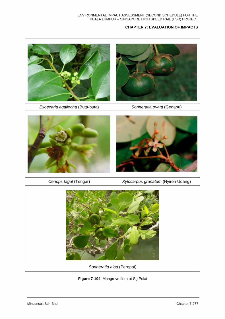
ENVIRONMENTAL IMPACT ASSESSMENT (SECOND SCHEDULE) FOR THE KUALA LUMPUR – SINGAPORE HIGH SPEED RAIL (HSR) PROJECT
CHAPTER 7: EVALUATION OF IMPACTS
Minconsult Sdn Bhd Chapter 7-277
Exoecaria agallocha (Buta-buta) Sonneratia ovata (Gedabu)
Ceriops tagal (Tengar) Xylocarpus granatum (Nyireh Udang)
Sonneratia alba (Perepat)
Figure 7-104: Mangrove flora at Sg Pulai
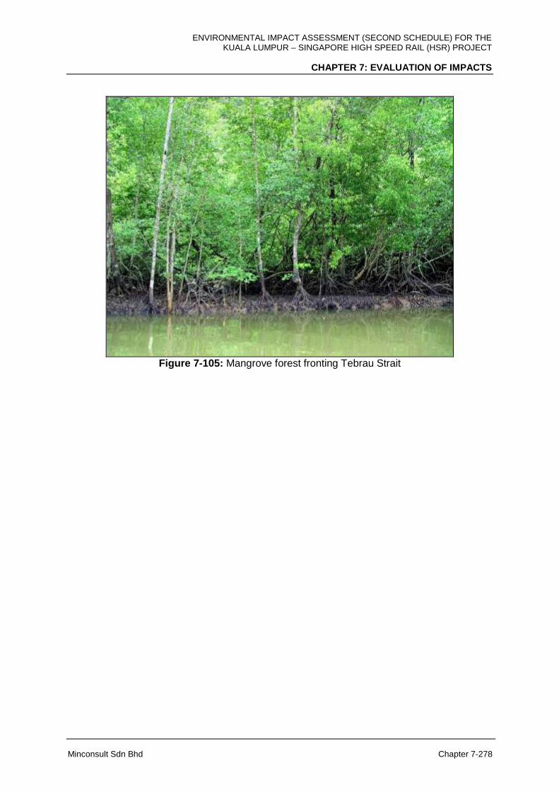
ENVIRONMENTAL IMPACT ASSESSMENT (SECOND SCHEDULE) FOR THE KUALA LUMPUR – SINGAPORE HIGH SPEED RAIL (HSR) PROJECT
CHAPTER 7: EVALUATION OF IMPACTS
Minconsult Sdn Bhd Chapter 7-278
Figure 7-105: Mangrove forest fronting Tebrau Strait
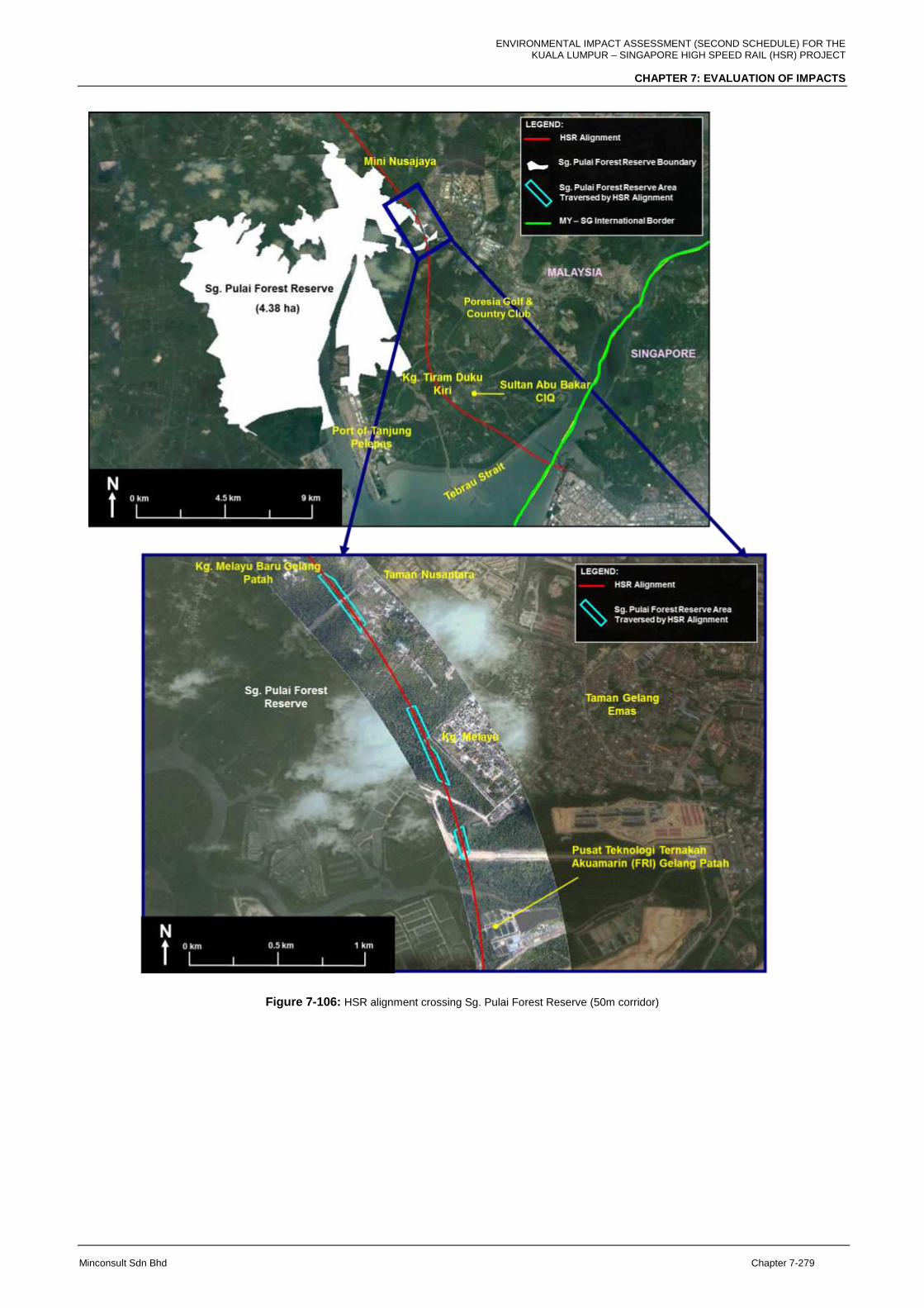
ENVIRONMENTAL IMPACT ASSESSMENT (SECOND SCHEDULE) FOR THE KUALA LUMPUR – SINGAPORE HIGH SPEED RAIL (HSR) PROJECT
CHAPTER 7: EVALUATION OF IMPACTS
Minconsult Sdn Bhd Chapter 7-279
Figure 7-106: HSR alignment crossing Sg. Pulai Forest Reserve (50m corridor)
ENVIRONMENTAL IMPACT ASSESSMENT (SECOND SCHEDULE) FOR THE KUALA LUMPUR – SINGAPORE HIGH SPEED RAIL (HSR) PROJECT
CHAPTER 7: EVALUATION OF IMPACTS
Minconsult Sdn Bhd Chapter 7-280
Spreading of Diseases and Viruses
Land clearing of forests and swamp areas is directly related to the potential of disease
vectors migrating into nearby settlements, particularly with regards to Aedesalbopictus and
Culex species that may lead to disease outbreaks like dengue fever, malaria, filariasis and
chikungunya. Larger vectors like rats and other rodents could transmit other diseases like
leptospirosis, and scrub typhus.
Migration of Animals and Human-Wildlife Conflict
Larger mobile mammals (such as primates and wild pigs), birds and fishes could escape
from the disrupted areas during land clearing (especially in the plantations and forest fringes)
and migrate into adjacent surroundings. Based on the discussions with the Department of
Wildlife and National Parks (PERHILITAN), the main concern that was highlighted was that
the incidence of human-wildlife conflicts that could rise during the construction phase, such
as increase in the number of wild pigs and monkeys predating on crops in cultivated fields
and fruits in the orchards, and of pest primates and snakes entering homes adjacent to the
work sites. The exact locations of these impacts cannot be predicted, as they will occur
along the entire alignment that passes through settlements and plantation areas.
7.10.2 Operational Phase
These following activities are expected to have significant impacts on flora and fauna during
the operational phase of the HSR Project
(a) Passing of trains through plantations and green areas
(b) Landscaping Works
(c) Abandonment
Land and Habitat Fragmentation
For all the states traversed by the HSR alignment, the presence of the HSR Project during
its operational phase would permanently bisect contiguous habitats, causing habitat
fragmentation and the creation of a linear barrier across the home range and feeding
grounds of various wildlife species such as mammals, herpetafauna, etc. Habitat
fragmentation reduces the size of available habitat for fauna and the cleared forest strip may

ENVIRONMENTAL IMPACT ASSESSMENT (SECOND SCHEDULE) FOR THE KUALA LUMPUR – SINGAPORE HIGH SPEED RAIL (HSR) PROJECT
CHAPTER 7: EVALUATION OF IMPACTS
Minconsult Sdn Bhd Chapter 7-281
cause disorientation to large mammals. The affected population of any fauna species that
are not able to cross the HSR alignment barrier (is deemed necessary by the Project
Proponent) will be separated into several smaller populations. Small fragmented forest areas
may not be suitable for large mammals to roam for food and shelter. Lack of food within the
fragmented area will push animals to go outside the forest and cause conflict with/damage to
the adjacent plantation and settlement areas. Attempts of the animals to cross the railways
tracks (if there are no fences or barriers present) may also result in collision with the trains
moving at high speed and an increased mortality rate of the animals.
Disturbance to Mangrove Areas and Ecosystem
In Negeri Sembilan, the Sg. Linggi Forest Reserve and likewise, in Johor, the Sg. Pulai
Mangrove Reserve both have very good, stable and mature mangrove stands fronted by
mudflats. These habitats provide invaluable ecosystem services as nursery grounds to
support fishery resources, as stopover sites for migrating birds, for erosion control and for
coastal protection against storm surges and sea level rise. The proximity of the HSR
alignment and its associated facilities to these protected areas could encourage further
encroachment and forest degradation if future developments are not properly controlled and
planned.
Wildlife Collision
Collision and mortality of wildlife at elevated sections of the alignment is not an issue, as the
animals do not have access to the railways tracks, while down below, they are free to roam
about their natural home range. However, when the alignment is at-grade, it is possible that
some stray animals will attempt to cross the at-grade alignment to get to the other side in
search for food and shelter, whereby collision of wildlife/fauna with the high speed trains
could occur.
Impacts of Enhancement due to Landscaping Works
For all the states traversed by the HSR alignment, landscaping and vegetation works of the
exposed ground during the operation phase of the project utilising suitable choices of plant
species will have positive impacts as it would facilitate ground stability and slope protection
as the root zone of trees and shrubs would anchor the soft grounds, prevent surface erosion
ENVIRONMENTAL IMPACT ASSESSMENT (SECOND SCHEDULE) FOR THE KUALA LUMPUR – SINGAPORE HIGH SPEED RAIL (HSR) PROJECT
CHAPTER 7: EVALUATION OF IMPACTS
Minconsult Sdn Bhd Chapter 7-282
and accelerate consolidation of the soil profile. The positive impacts of long term and
permanent benefits pertains to slope/ soil and water quality protection, natural aesthetics,
landscape and other ecological functions.
Health and Safety Risks due to Abandonment
For all the states traversed by the HSR alignment, any abandoned or damaged vehicles,
equipment and uncompleted structures left onsite can pose health and safety hazards to the
public, especially children, pets and domestic animals.
7.11 MARINE ECOLOGY
7.11.1 Construction Phase
The principal construction related activities that are capable of inducing environmental
impacts include:
1. Transportation of materials and equipment by Barges
2. Disposal of solid and construction water/biomass
3. Piling Works
The potential impacts that could occur during the construction phase are assessed herewith.
7.11.1.1 Transportation of Materials and Equipment by Barges
Plankton: Any untreated discharge of sewage or wastewater into the marine environment
would result in an increase in nutrients and organic matter in the receiving waters, which
may increase phytoplankton biomass and potentially lead to eutrophication. Eutrophication
is a condition in an aquatic ecosystem where high nutrient concentrations stimulate blooms
of algae (e.g., phytoplankton). As an outcome, the algal blooms limit the amount of dissolved
oxygen required for respiration by other animal and plant species in the water. Although in
this case, the likelihood of waste/wastewater to be discharged into the marine area is very
low, while the magnitude (amount of waste/ wastewater) would be small. Hence potential
impacts are considered to be insignificant if proper mitigation measures are adopted as
explained in the Chapter 8.
ENVIRONMENTAL IMPACT ASSESSMENT (SECOND SCHEDULE) FOR THE KUALA LUMPUR – SINGAPORE HIGH SPEED RAIL (HSR) PROJECT
CHAPTER 7: EVALUATION OF IMPACTS
Minconsult Sdn Bhd Chapter 7-283
Fish Fauna: Potential impact to the water quality during the transportation includes
wastewater discharge and accidental spillage or leakage of chemicals and fuel / oil into the
marine environment. Nevertheless, these spillages are predicted to be minimal and the
immediate impact on fish fauna would be migration of fish and free-swimming or mobile
marine life to safer or less disturbed areas (generally deeper waters) as a natural response
to changes in the marine environment (Wildish, D.J. & Power, J. (1985), Pennekamp, J. &
Quuak, M. (1990)) thus avoiding direct deleterious effects.
7.11.1.2 Piling Works
Phytoplankton: Although temporary, the increased load of suspended sediment arising
from piling activities may reduce light penetration and thus reduce the depth of
photosynthetic activity by phytoplankton. However as has been predicted the induced
suspended sediment concentrations will be below 5 mg/L throughout the piling activities.
Literature review of plankton threshold limits to suspended sediments is generally much
higher, with one study reporting a significant impact with suspended solids concentrations of
more than 10 mg/L for exposure time over 1344 hours (Bilotta, G.S. Brazier, R.E. (2008)).
Hence, the impact to phytoplankton and zooplankton communities due to increased
suspended sediments is deemed insignificant.
Macrobenthos: Sediment communities have been found to play a critical role in the food
chain for the marine organism (Chong, et al. (1990)). Benthic macrofauna are also one of the
most important food sources for marine demersal fish Sasekumar, A. and C. Wilkinson.
(1994), Erftemeyer, P et al. (1989)). Thus, the loss of macrobenthic fauna may impact fish
fauna by disrupting the food chain.
The following thresholds have been used:
Suspended sediment (primarily affecting filter feeders) – 25 mg/L
Sedimentation - The sensitivity of benthic invertebrates to burial from siltation is
species specific. Mobile species of polychaetes, bivalves, gastropods and
crustaceans have been reported to be able to migrate between 2 – 26 cm during
eight days after an acute burial by 32 cm of sand (Birklund, J. & Wijsman, J.W.M.,
(2005)). Mortality of most species was low in sand and high in silt.

ENVIRONMENTAL IMPACT ASSESSMENT (SECOND SCHEDULE) FOR THE KUALA LUMPUR – SINGAPORE HIGH SPEED RAIL (HSR) PROJECT
CHAPTER 7: EVALUATION OF IMPACTS
Minconsult Sdn Bhd Chapter 7-284
Based on the above, considering the maximum suspended sediment plume concentration
from the piling activity is predicted to be less than 5 mg/L, no impact is predicted. This is
further supported due to the sandy sediments in the project area, which tend to settle quickly
thus sedimentation during construction activities are negligible.
Crustaceans such as shrimps and molluscs (gastropod and bivalves), which have limited
mobility and are largely dependent upon food and shelter on the foreshore area can be
affected due to piling activities. This in turn, would reduce the abundance of these
organisms. A study by Ingle (1952) reported that high levels of suspended sediments have
been shown to kill bivalves. Other impacts arise from the disturbance of seabed are
destruction of spawning areas and smothering or suffocation of sessile organisms in the
area (Pennekamp, J. & Quuak, M. (1990)).
The predicted sediment plume excursion due to piling activities has been presented in
Section 7.8 above. With excess concentrations of 5 mg/L and above predicted to occur less
than 5% of the time, concentrations of 25 mg/L and above will be even more limited in
duration, , rendering the impact insignificant.
Loss of Community and Habitat: During piling, loss of the macrobenthic community and its
habitat is inevitable due to the invasive nature of the piling activity. Although this is the case,
it is expected that this impact is temporary (only during piling) and will be confined along the
piling and cofferdam areas only
Fish Fauna: The threshold limit for suspended sediment for fish health is based on Malaysia
Marine Water Quality Criteria and Standard (MMWQCS) Class 2 categorizing fisheries as
part of Class 2 with the limit of 50 mg/L TSS. The predicted suspended sediments from the
piling activities is less than 5 mg/L, and hence no impacts on fish fauna is expected due to
suspended sediment plumes No suspended sediment plume impacts to the seagrass areas
further south at Tg. Kupang are predicted. Consequently, the function of the seagrass bed
as a nursery area for juvenile fish will not be affected.
Underwater Noise Disturbance: There is potential for fish fauna to be disturbed by noise
and vibration as a result of piling, motors or heavy construction work on site as well as
movement of vessels during construction. It is noted however that the foundation will be
constructed with large-diameter bored cast in-situ piles. This minimises the impact by
ENVIRONMENTAL IMPACT ASSESSMENT (SECOND SCHEDULE) FOR THE KUALA LUMPUR – SINGAPORE HIGH SPEED RAIL (HSR) PROJECT
CHAPTER 7: EVALUATION OF IMPACTS
Minconsult Sdn Bhd Chapter 7-285
avoiding high percussive sound emissions. According to McCauley (1994), the response of
fish fauna to acoustic emissions can range from no effect to various behavioural changes.
However, fish fauna are highly mobile and would generally avoid areas of high sound
emissions. Impact will be during construction phase with low degree adverse impact and
localized only within the working boundary.
7.11.2 Operational Phase
The principal Project’s operations related activities that are capable of inducing
environmental impacts include:
1. Footprint of piers
2. Repair and maintenance work on track
The potential impacts that could occur during the operational phase are assessed herewith.
7.11.2.1 Footprint of Piers
Fish Fauna: The presence of the piers may be beneficial to the fish fauna as these piers
may possibly act as fish aggregating structures. This is especially significant for those piers
located within deep waters.
7.11.2.2 Repair and Maintenance Work on Track
Fish Fauna: Potential impact to the water quality during the repair and maintenance work
on track includes wastewater discharge and accidental spillage or leakage of chemicals and
fuel / oil into the marine environment. Nevertheless, these spillages are predicted to be non-
routine and minimal; the immediate impact on fish fauna would be migration of fish and free-
swimming or mobile marine life to safer or less disturbed areas (generally deeper waters) as
a natural response to changes in the marine environment thus avoiding direct deleterious
effects.
ENVIRONMENTAL IMPACT ASSESSMENT (SECOND SCHEDULE) FOR THE KUALA LUMPUR – SINGAPORE HIGH SPEED RAIL (HSR) PROJECT
CHAPTER 7: EVALUATION OF IMPACTS
Minconsult Sdn Bhd Chapter 7-286
7.12 LAND TRAFFIC
This sub-chapter describe land traffic impacts within surrounding existing road networks
within ZOI of 2km radius of HSR alignment and facilities. More emphasis is placed on
sensitive receptors surrounding the seven (7) traffic count stations and the HSR Stations.
The assessment is based on the SIDRA generated status of Level of Service (LOS) which in
essence, the assessment of traffic volumes versus the available capacity of the junction and
road networks surrounding the intersection. The project activities as described in the
Chapter 6. The impacts to be assessed will be based on current (baseline) LOS status at
identified sensitive receptors surrounding the stations locations. Assessment of impacts for
track works shall be described as a qualitative assessment for sensitive receptors (affected
road networks) surrounding the whole entire track alignment.
The impacts assessment description shall be narrated by stages of HSR Project
implementation and its locality of sensitive receptors from North (Bandar Malaysia Station) to
South (Iskandar Puteri Station).
7.12.1 Pre-construction Phase
All Locations (along the entire HSR alignment)
During pre-construction phase, activities which will be carried out in sequence of least
intrusive to most intrusive are land acquisition, land survey, utilities mapping, and utilities
relocation. During the land survey, utilities mapping, and land acquisition, works can be well
controlled and areas where the works are being carried out are not necessarily be required
to be cordoned off instead, placement of equipment and workers are well within the
boundary of the alignment and will impose minimal impact.
However, for the works to carry out utilities relocation which are the most intrusive at pre-
construction phase, it is foreseen that this activity can potentially pose nominal impact due to
sub-activities such as trenching and shoring works which leads to roads diversion/partial
closure and construction of bypass route, construction of start and target shaft for pipe
jacking or directional drilling works, movement of unsuitable materials to disposal areas,
import of approved backfill material and transport of materials to offsite disposal area
(Figure 7-107).
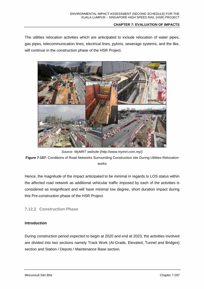
ENVIRONMENTAL IMPACT ASSESSMENT (SECOND SCHEDULE) FOR THE KUALA LUMPUR – SINGAPORE HIGH SPEED RAIL (HSR) PROJECT
CHAPTER 7: EVALUATION OF IMPACTS
Minconsult Sdn Bhd Chapter 7-287
The utilities relocation activities which are anticipated to include relocation of water pipes,
gas pipes, telecommunication lines, electrical lines, pylons, sewerage systems, and the like,
will continue in the construction phase of the HSR Project.
Source: MyMRT website (http://www.mymrt.com.my/)
Figure 7-107: Conditions of Road Networks Surrounding Construction site During Utilities Relocation
works
Hence, the magnitude of the impact anticipated to be minimal in regards to LOS status within
the affected road network as additional vehicular traffic imposed by each of the activities is
considered as insignificant and will have minimal low degree, short duration impact during
this Pre-construction phase of the HSR Project.
7.12.2 Construction Phase
Introduction
During construction period expected to begin at 2020 and end at 2023, the activities involved
are divided into two sections namely Track Work (At-Grade, Elevated, Tunnel and Bridges)
section and Station / Depots / Maintenance Base section.

ENVIRONMENTAL IMPACT ASSESSMENT (SECOND SCHEDULE) FOR THE KUALA LUMPUR – SINGAPORE HIGH SPEED RAIL (HSR) PROJECT
CHAPTER 7: EVALUATION OF IMPACTS
Minconsult Sdn Bhd Chapter 7-288
The activities involved in the Track work will be Land Clearing, Demolition, Construction of
Access Road, Earthwork, Drainage, Transportation of Materials / Equipment, Vehicle
Movement, Traffic Diversion, Disposable of Unsuitable Materials, Waste / Wastewater
Generation, Disposal of Solid and Construction Waste / Biomass, Piling, Construction of
Elevated Structures / Bridges, Construction of At-Grade Structures, Tunnelling, Installation of
Track, Employment of Workers and Staff, Business Development and Abandonment.
Whereas, the activities involved in the Station section are Land Clearing, Demolition,
Construction of Access Road, Earthwork, Drainage, Transportation of Materials / Equipment,
Vehicle Movement, Traffic Diversion, Disposal of Unsuitable Materials, Waste / Wastewater
Generation, Disposal of Solid and Construction Waste / Biomass, Establishment of Site
Office, Storage Areas, Establishment of Workers Camps, Piling, Construction of Station /
Depots/ Maintenance Base, Construction of Elevated Structures / Bridges, Construction of
At-Grade Structures, Utility Relocation, Employment of Workers and Staff, Business
Development and Abandonment.
The above activities shall be taken into consideration in illustrating the impacts to the
surrounding sensitive receptors during the construction phase.
A) FT. Kuala Lumpur
Introduction
The structure type proposed within FT. Kuala Lumpur alignment up to the Selangor state
boundary will be Elevated Structure and Tunnel. The state crossing from FT. Kuala Lumpur
and Selangor is within the Tunnel structure alignment specifically at the Palace of the
Golden Horses vicinity under BESRAYA expressway (E39) alignment.
Bandar Malaysia Station and Tunnel
At Bandar Malaysia, the construction of the Bandar Malaysia Station, will involve several key
activities which impose less number of trucks than the tunnelling works on the daily. Tunnel
construction, impose the most significant impact throughout FT. Kuala Lumpur alignment as
it involves boring works and disposal of unsuitable materials. Through FT. Kuala Lumpur
alignment, construction of Tunnel 1 from the North Portal to the South Portal at Taman Sri
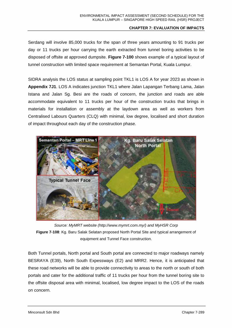
ENVIRONMENTAL IMPACT ASSESSMENT (SECOND SCHEDULE) FOR THE KUALA LUMPUR – SINGAPORE HIGH SPEED RAIL (HSR) PROJECT
CHAPTER 7: EVALUATION OF IMPACTS
Minconsult Sdn Bhd Chapter 7-289
Serdang will involve 85,000 trucks for the span of three years amounting to 91 trucks per
day or 11 trucks per hour carrying the earth extracted from tunnel boring activities to be
disposed of offsite at approved dumpsite. Figure 7-100 shows example of a typical layout of
tunnel construction with limited space requirement at Semantan Portal, Kuala Lumpur.
SIDRA analysis the LOS status at sampling point TKL1 is LOS A for year 2023 as shown in
Appendix 7J1. LOS A indicates junction TKL1 where Jalan Lapangan Terbang Lama, Jalan
Istana and Jalan Sg. Besi are the roads of concern, the junction and roads are able
accommodate equivalent to 11 trucks per hour of the construction trucks that brings in
materials for installation or assembly at the laydown area as well as workers from
Centralised Labours Quarters (CLQ) with minimal, low degree, localised and short duration
of impact throughout each day of the construction phase.
Source: MyMRT website (http://www.mymrt.com.my/) and MyHSR Corp
Figure 7-108: Kg. Baru Salak Selatan proposed North Portal Site and typical arrangement of
equipment and Tunnel Face construction.
Both Tunnel portals, North portal and South portal are connected to major roadways namely
BESRAYA (E39), North South Expessways (E2) and MRR2. Hence, it is anticipated that
these road networks will be able to provide connectivity to areas to the north or south of both
portals and cater for the additional traffic of 11 trucks per hour from the tunnel boring site to
the offsite disposal area with minimal, localised, low degree impact to the LOS of the roads
on concern.

ENVIRONMENTAL IMPACT ASSESSMENT (SECOND SCHEDULE) FOR THE KUALA LUMPUR – SINGAPORE HIGH SPEED RAIL (HSR) PROJECT
CHAPTER 7: EVALUATION OF IMPACTS
Minconsult Sdn Bhd Chapter 7-290
The 11 trucks per hour movement out of the tunnelling works site is equivalent to only 1% of
the total peak hour traffic forecasted for TKL1 junction which was recorded to have a peak
hour traffic of 984 counts at present.
Elevated Structure
Impacts imposed during construction of the elevated structure within FT. Kuala Lumpur area
is anticipated to impose minimal and localised impact to surrounding roads within the
alignment path. With advancement and maturity of elevated structure construction
methodologies, construction of the elevated tracks crossing over roads, rivers and
properties, can be undertaken within a very constricted space with minimal traffic impacts to
the ongoing traffic. The construction methodologies that will be adopted will be able to limit
the intrusion into public roads that limits the reduction of the roads capacity and that will
decrease the LOS status of the roads where the elevated structure crosses or runs parallel.
Typical road diversion HSR Project is as illustrated in the following Figure 7-109.
Source: MyHSR Corp
Figure 7-109: Options for realignment of collector roads for construction of Elevated Structure within
station area and at the roads median.

ENVIRONMENTAL IMPACT ASSESSMENT (SECOND SCHEDULE) FOR THE KUALA LUMPUR – SINGAPORE HIGH SPEED RAIL (HSR) PROJECT
CHAPTER 7: EVALUATION OF IMPACTS
Minconsult Sdn Bhd Chapter 7-291
B) Selangor and FT. Putrajaya
Introduction
The structure type proposed within Selangor and FT. Putrajaya alignment up to the Negeri
Sembilan state boundary will be Elevated Structure, Tunnel and At-Grade structure.
Sepang-Putrajaya Station and Tunnels
Construction of Sepang-Putrajaya Station and the 0.7 km mined tunnel at Puncak Pinggiran
Putra, Kajang will impose additional traffic due to the tunnel mining activities. The number of
construction trucks involved in constructing the 0.7 km mined tunnel from Puncak Pinggiran
Putra, Kajang will be 25,380 trucks for the span of three (3) years amounting to 27 trucks per
day or 3 trucks per hour will be carrying the soil mined from the tunnel activities to be
dumped in the dedicated dumpsite.
From SIDRA analysis the LOS for sampling point TSP1 is at LOS F for year 2023 as shown
in Appendix 7J2. LOS F indicates junction TSP1 cannot accommodate the forecast traffic
flow including the construction trucks. This junction needs to be upgraded to handle the
increase in traffic flow including the construction trucks.
The 3 trucks per hour movement out of this tunnelling works site is equivalent to only 0.1%
of the total peak hour traffic forecasted for TSP1 junction which was recorded to have a peak
hour traffic of 4,077 counts at present.
Similarly, the construction of another mined tunnel at Bukit Unggul Golf and Country Club, a
2.3 km mined tunnel, will add 7,420 trucks traffic over three (3) years duration, amounting to
8 trucks per day or 1 truck per hour, to carry the soil mined from the tunnel activities to be
dumped at offsite approved dumpsite.
Based on SIDRA analysis the LOS for sampling point TSP1 is at LOS F for year 2023 as
shown in Appendix 7J3 LOS F indicates junction TSP1 cannot accommodate the forecast
traffic flow including the construction trucks. This junction needs to be upgraded to handle
the increase in traffic flow including the construction trucks.

ENVIRONMENTAL IMPACT ASSESSMENT (SECOND SCHEDULE) FOR THE KUALA LUMPUR – SINGAPORE HIGH SPEED RAIL (HSR) PROJECT
CHAPTER 7: EVALUATION OF IMPACTS
Minconsult Sdn Bhd Chapter 7-292
The one truck per hour movement out of this tunnelling works site is equivalent to only
0.03% of the total peak hour traffic forecasted for TSP1 junction which was recorded to have
a peak hour traffic of 4,077 counts at present.
Elevated Structure
Impacts imposed during construction of the Elevated Structure within Selangor - FT.
Putrajaya area is anticipated to impose minimal and localised impact to surrounding roads
within the HSR alignment. With advancement and maturity of elevated structure construction
methodologies, as can be observed in all linear elevated rail and road projects in Malaysia,
construction of the elevated tracks crossing over roads, rivers and properties, can be
undertaken within a very constricted space with minimal traffic impacts to the ongoing traffic.
The construction methodologies that will be adopted will be able to limit the intrusion into
public roads that limits the reduction of the roads capacity and that will decrease the LOS
status of the roads where the elevated structure crosses or runs parallel.
At-grade Structure
Within Selangor - FT. Putrajaya alignment, five (5) short stretches of At-Grade strcture is
anticipated. For At-Grade alignment, construction works will be planned to include areas
required for traffic diversion only if it is necessary hence impacts to surrounding traffic is
expected to be minimal, short duration and to the LOS, will have low degree impact to
surrounding networks traffic. Typical area requirement for the construction of At-Grade
structures are illustrated in the following Figure 7-110.
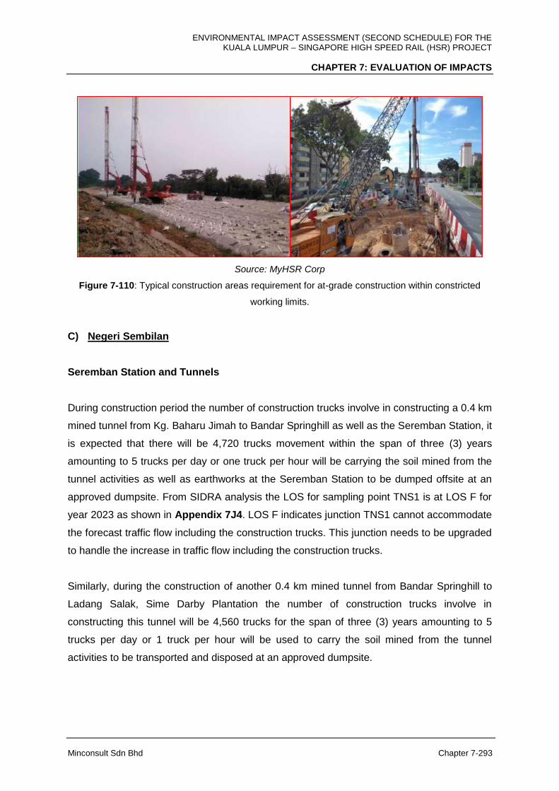
ENVIRONMENTAL IMPACT ASSESSMENT (SECOND SCHEDULE) FOR THE KUALA LUMPUR – SINGAPORE HIGH SPEED RAIL (HSR) PROJECT
CHAPTER 7: EVALUATION OF IMPACTS
Minconsult Sdn Bhd Chapter 7-293
Source: MyHSR Corp
Figure 7-110: Typical construction areas requirement for at-grade construction within constricted
working limits.
C) Negeri Sembilan
Seremban Station and Tunnels
During construction period the number of construction trucks involve in constructing a 0.4 km
mined tunnel from Kg. Baharu Jimah to Bandar Springhill as well as the Seremban Station, it
is expected that there will be 4,720 trucks movement within the span of three (3) years
amounting to 5 trucks per day or one truck per hour will be carrying the soil mined from the
tunnel activities as well as earthworks at the Seremban Station to be dumped offsite at an
approved dumpsite. From SIDRA analysis the LOS for sampling point TNS1 is at LOS F for
year 2023 as shown in Appendix 7J4. LOS F indicates junction TNS1 cannot accommodate
the forecast traffic flow including the construction trucks. This junction needs to be upgraded
to handle the increase in traffic flow including the construction trucks.
Similarly, during the construction of another 0.4 km mined tunnel from Bandar Springhill to
Ladang Salak, Sime Darby Plantation the number of construction trucks involve in
constructing this tunnel will be 4,560 trucks for the span of three (3) years amounting to 5
trucks per day or 1 truck per hour will be used to carry the soil mined from the tunnel
activities to be transported and disposed at an approved dumpsite.

ENVIRONMENTAL IMPACT ASSESSMENT (SECOND SCHEDULE) FOR THE KUALA LUMPUR – SINGAPORE HIGH SPEED RAIL (HSR) PROJECT
CHAPTER 7: EVALUATION OF IMPACTS
Minconsult Sdn Bhd Chapter 7-294
From SIDRA analysis the LOS for sampling point TNS1 is at LOS F for year 2023 as shown
in Appendix 7J5. LOS F indicates junction TNS1 cannot accommodate the forecast traffic
flow including the construction trucks. This junction needs to be upgraded to handle the
increase in traffic flow including the construction trucks.
The 5 trucks per hour movement out of this tunnelling works site is equivalent to only 0.3%
of the total peak hour traffic forecasted for TNS1 junction which was recorded to have a peak
hour traffic of 1,521 counts at present.
Elevated Structure
Impacts imposed during construction of the elevated structure within Negeri Sembilan
alignment is anticipated to impose minimal and localised impact to surrounding roads within
the HSR alignment. With advancement and maturity of elevated structure construction
methodologies, as can be observed in all linear elevated rail and road projects in Malaysia,
construction of the elevated tracks crossing over roads, rivers and properties, can be
undertaken within a very constricted space with minimal traffic impacts to the ongoing traffic.
The construction methodologies that will be adopted will be able to limit the intrusion into
public roads that limits the reduction of the roads capacity and will decrease the LOS status
of the roads where the elevated structure crosses or runs parallel.
At-grade Structure
Within Negeri Sembilan alignment, majority of the tracks structure type are of At-Grade
alignment. For At-Grade alignment, construction works will be planned to include areas
required for traffic diversion only if it is necessary hence impacts to surrounding traffic is
expected to be minimal, short duration and to the LOS, will have low degree impact to
surrounding networks traffic.
D) Melaka
Melaka Station
During construction, it is anticipated that construction of Melaka Station will impose higher
than normal volumes of traffic. However, the degree of additional traffic imposed is expected
ENVIRONMENTAL IMPACT ASSESSMENT (SECOND SCHEDULE) FOR THE KUALA LUMPUR – SINGAPORE HIGH SPEED RAIL (HSR) PROJECT
CHAPTER 7: EVALUATION OF IMPACTS
Minconsult Sdn Bhd Chapter 7-295
to be insignificant (estimated at less than 1 truck per hour movement on average throughout
the 3 years construction period) as compared to the existing traffic surrounding traffic
counting station TM1 throughout the construction period. From SIDRA analysis, the LOS for
sampling point TM1 is at LOS F for the year 2023. LOS F indicates junction TM1 should be
upgraded to accommodate the huge increase in traffic flow which the intersection of concern
along with its surrounding roads are not able to accommodate the additional traffic.
Elevated Structure
Impacts imposed during construction of the elevated structure within Melaka alignment is
anticipated to impose minimal and localised impact to surrounding roads within the HSR
alignment. With advancement and maturity of elevated structure construction methodologies,
as can be observed in all linear elevated rail and road projects in Malaysia, construction of
the elevated tracks crossing over roads, rivers and properties, can be undertaken within a
very constricted space with minimal traffic impacts to the ongoing traffic. The construction
methodologies that will be adopted will be able to limit the intrusion into public roads that
limits the reduction of the roads capacity and will decrease the LOS status of the roads
where the elevated structure crosses or runs parallel.
At-Grade Structure
Within Melaka state alignment too, majority of the tracks structure type are of At-Grade
alignment. For At-Grade alignment, construction works will be planned to include areas
required for traffic diversion only if it is necessary, hence impacts to surrounding traffic is
expected to be minimal, short duration and to the LOS, will have low degree impact to
surrounding networks traffic.
E) Johor
Muar, Batu Pahat and Iskandar Puteri Stations and Tunnels
From SIDRA analysis the LOS for sampling point TJ1 is at LOS F for year 2023 as shown in
Appendix 7J6. LOS F indicates junction TJ1 cannot accommodate the forecast traffic flow
including the construction trucks. The construction of Muar Station involves minimal
(estimated at less than 2 truck movement per hour throughout the three (3) years
ENVIRONMENTAL IMPACT ASSESSMENT (SECOND SCHEDULE) FOR THE KUALA LUMPUR – SINGAPORE HIGH SPEED RAIL (HSR) PROJECT
CHAPTER 7: EVALUATION OF IMPACTS
Minconsult Sdn Bhd Chapter 7-296
construction period) increase of traffic volume and since the junction is at LOS F now, it is
anticipated that the junction would need to be upgraded to handle the increase in traffic flow
including the construction trucks.
At TJ2, SIDRA analysis shows that the junction is at LOS F in 2017 and in 2023, during and
up to the end of the construction phase, it is anticipated to remain at LOS F considering no
permanent capacity expansion of the junction. The Batu Pahat Station construction involve
also minimal increase in traffic volume per day hour (estimated at 2 trucks per hour)
however, since the LOS is at already limiting LOS F, it is expected that the junction capacity
need to be increased.
Areas surrounding Iskandar Puteri Station, surrounding areas of TJ3, through SIDRA
analysis of current baseline information on traffic volume and roads capacity, it is still at LOS
F which limits movement of trucks at peak hours. Even though it is expected that additional
traffic imposed for the station construction will not be significant (estimated to be less than 2
trucks per hour movement on average throughout the three (3) years construction period),
the limitation is still the current LOS F.
There are also several tunnels that is to be constructed along the Johor HSR alignment
namely the Bukit Naning 1 and Bukit Naning 2 Tunnel.
During construction phase of these tunnels, the number of construction trucks involve in the
construction 16,275 trucks over the span of three (3) years amounting to 16 trucks per day
or 2 trucks per hour. Two tunnels with total length of 2.3 km, which will be a mined tunnel at
Bukit Naning, Muar, will involve transporting the soil mined from the tunnel activities to be
dumped at an approved offsite dumpsite.
From SIDRA analysis the LOS for sampling point TJ1 is at LOS F for year 2023 as shown in
Appendix 7J7. LOS F indicates junction TJ1 cannot accommodate the forecast traffic flow
including the construction trucks. This junction needs to be upgraded to handle the increase
in traffic flow including the construction trucks.
The 2 trucks per hour movement out of this tunnelling works site is equivalent to only 0.3%
of the total peak hour traffic forecasted for TJ1 junction which was recorded to have a peak
hour traffic of 1,521 counts at present.
ENVIRONMENTAL IMPACT ASSESSMENT (SECOND SCHEDULE) FOR THE KUALA LUMPUR – SINGAPORE HIGH SPEED RAIL (HSR) PROJECT
CHAPTER 7: EVALUATION OF IMPACTS
Minconsult Sdn Bhd Chapter 7-297
Elevated Structure
In Johor, the stretches of elevated structure and At-Grade tracks are balanced from the
Melaka – Johor state border to the MY-SG International Border. Impacts imposed during
construction of the elevated structure within Johor alignment is anticipated to impose
minimal and localised impact to surrounding roads within the HSR alignment. With
advancement and maturity of elevated structure construction methodologies, as can be
observed in all linear cross state projects in Malaysia, construction of the elevated tracks
crossing over roads, rivers and properties, can be undertaken within a very constricted
space with minimal traffic impacts to the ongoing traffic. This will enable the project activities
to be done with minimal intrusion into public roads that limits the reduction of the roads
capacity and will decrease the LOS status of the roads where the Elevated Structure crosses
or runs parallel.
At-Grade Structure
Within Johor alignment, there are several tracks stretches structure type are of At -Grade
alignment. For At-Grade alignment, construction works will be planned to include areas
required for traffic diversion only if it is necessary, hence impacts to surrounding traffic is
expected to be minimal, short duration and to the LOS, will have low degree impact to
surrounding networks traffic.
7.12.3 Land Traffic Impact during Operation
A) FT. Kuala Lumpur
During operation the annual ridership forecast for the year 2030 and 2060 will be 5,134,000
persons/year and 12,959,000 persons/year respectively. If half (50%) (based on assumption
and experience elsewhere) of the total ridership will travel by roads and the rest by others
train-based mode of transport there will be an increase in road traffic flow to and from the
elevated Bandar Malaysia Station especially during the morning and evening peak hours.
This scenario should be addressed accordingly.
ENVIRONMENTAL IMPACT ASSESSMENT (SECOND SCHEDULE) FOR THE KUALA LUMPUR – SINGAPORE HIGH SPEED RAIL (HSR) PROJECT
CHAPTER 7: EVALUATION OF IMPACTS
Minconsult Sdn Bhd Chapter 7-298
From SIDRA analysis the LOS for sampling point TKL1 are both at LOS F for the year 2030
and 2060 as shown in Appendix 7L1 and 7L2 respectively. The LOS F indicates junction
TKL1 should be upgraded to accommodate the enormous increase in traffic flow which it
cannot sustain.
Bandar Malaysia Station and surrounding area will experience chaotic scenarios in term of
movement of road traffic and pedestrian if the ingress and egress routes to the station is not
well planned, designed and constructed in regards to of number of lanes per direction to
accommodate the increase in traffic flow. If derailment or collision occurred, some chaotic
scenarios at the station and its vicinity are expected.
B) Selangor and FT. Putrajaya
The Sepang-Putrajaya Station shall be connected by roads from Jalan P14 and Jalan Ayer
Hitam. The proposed Station is approximately 3.5 km east of the Putrajaya Administrative
Centre and 2.8 km west of Bandar Baru Bangi. The location is of close proximity to
numerous Institutional Training Centres, and borders the residential area of Kg. Dato Abu
Bakar Baginda and the Diplomatic Precint in Putrajaya.
During operation the annual ridership forecast for the year 2030 and 2060 will be 371,000
persons/year and 842,000 persons/year respectively. If all of the total ridership will travel by
roads there will be an increase in road traffic flow to and from the elevated Sepang-Putrajaya
Station especially during the morning and evening peak hours. These untoward scenarios
should be addressed accordingly.
From SIDRA analysis, the LOS for sampling point TSP1 are both at LOSs F for the year
2030 and 2060 as shown in Appendix 7L3 and 7L4 respectively. The LOS F indicates
junction TSP1 should be upgraded to accommodate huge increase in traffic flow which it
cannot endure. During operation for the Light Depot and Light Maintenance Base at
Serdang, the annual ridership forecast for staff or workers for the 2030 will be 600
persons/year. There will be minimum movement of road traffic at this facility in Serdang.

ENVIRONMENTAL IMPACT ASSESSMENT (SECOND SCHEDULE) FOR THE KUALA LUMPUR – SINGAPORE HIGH SPEED RAIL (HSR) PROJECT
CHAPTER 7: EVALUATION OF IMPACTS
Minconsult Sdn Bhd Chapter 7-299
C) Negeri Sembilan
Seremban Station will be an integral part of the Integrated Transport District (ITD), one of the
six (6) economic clusters planned in MVV through its draft CDP, making it a strategic
location for several growth areas. Bio-economy is one key growth area as there is already
existing infrastructure and plans to promote a life sciences cluster technology park in MVV.
During operation the annual ridership forecast for the year 2030 and 2060 will be 1,907,000
persons/year and 4,927,000 persons/year respectively. If all of the total ridership will travel
by roads there will be a big increase in road traffic flow to and from the At-Grade Seremban
Station especially during the morning and evening peak hours. These inconvenient
scenarios should be addressed accordingly.
From SIDRA analysis, the LOS for sampling point TNS1 are both at LOSs F for the year
2030 and 2060 as shown in Appendix 7L5 and 7L6 respectively. LOS F indicates junction
TNS1 should be upgraded to accommodate the huge increase in traffic flow which it cannot
cope. Movement of train is expected to be smooth, punctual and on time to indicate
professional and excellent services.
D) Melaka
The Melaka Station is envisaged to be connected by roads from Lebuh SPA, Lebuh Ayer
Keroh and Jalan Durian Tunggal. The Station is located approximately 0.6 km south from the
North-South Highway Ayer Keroh Toll Plaza and 12 km northeast of the historical city of
Melaka. The Melaka International Trade Centre is located 3.5 km southwest of the Station.
The land profile is undulating and the preferred access to the Station is from Lebuh SPA.
During operation the annual ridership forecast for the year 2030 and 2060 will be 1,540,000
persons/year and 3,850,000 persons/year respectively. If all of the total ridership will travel
by roads there will be a big increase in road traffic flow to and from the elevated Melaka
Station especially during the morning and evening peak hours. These troublesome scenarios
should be addressed accordingly. From SIDRA analysis, the LOS for sampling point TM1
are both at LOSs F for the year 2030 and 2060 as shown in Appendix 7L7 and 7L8
respectively. LOS F indicates junction TM1 should be upgraded to accommodate the huge

ENVIRONMENTAL IMPACT ASSESSMENT (SECOND SCHEDULE) FOR THE KUALA LUMPUR – SINGAPORE HIGH SPEED RAIL (HSR) PROJECT
CHAPTER 7: EVALUATION OF IMPACTS
Minconsult Sdn Bhd Chapter 7-300
increase in traffic flow which it cannot handle. Movement of train is expected to be smooth,
punctual and on time to indicate professional and excellent services.
Melaka Station will experience chaotic scenarios in term of movement of road traffic and
pedestrian if it is not well designed and constructed to address their present. When
derailment or collision occurred, some chaotic scenarios will be expected.
E) Johor
Muar Station
Muar station will be located within the Pagoh High Education Hub nearby Muar town. In
addition to supporting the student population, the HSR Station will provide new connectivity
and market access to its tourism and furniture industries. Muar has a distinct identity as
Bandar Maharani Bandar Di Raja (Royal City of Johor) and is being positioned as the
foundation of the ‘Cradle of Johor Heritage’. This will be a unique tourist draw that will
facilitate the development of this area.
During operation the annual ridership forecast for the year 2030 and 2060 will be 592,000
persons/year and 1,494,000 persons/year respectively. If all of the total ridership will travel
by roads there will be a big increase in road traffic flow to and from the elevated Muar
Station especially during the morning and evening peak hours. These bothersome scenarios
should be addressed accordingly. From SIDRA analysis, the LOS for sampling point TJ1 are
both at LOSs F for the year 2030 and 2060 as shown in Appendix 7L9 and 7L10
respectively. LOS F indicates junction TM1 should be upgraded to accommodate the huge
increase in traffic flow which it cannot handle. During operation there will be an increase in
road traffic flow and pedestrians movement at this station especially during morning and
evening peak hours.
During operation for the Heavy Maintenance Base at Muar depot, the annual ridership
forecast for staff or workers for the 2030 will be 600 persons/year. There will be minimum
movement of road traffic at the Heavy Maintenance Base.

ENVIRONMENTAL IMPACT ASSESSMENT (SECOND SCHEDULE) FOR THE KUALA LUMPUR – SINGAPORE HIGH SPEED RAIL (HSR) PROJECT
CHAPTER 7: EVALUATION OF IMPACTS
Minconsult Sdn Bhd Chapter 7-301
Areas within the vicinity of Muar Station will experience chaotic scenarios in term of
movement of road traffic and pedestrian if they are not well designed and constructed to
address their present. When derailment or collision occurred, some chaotic scenarios will be
expected.
Batu Pahat Station
Batu Pahat Station is located within the masterplan of a new residential development of Pura
Kencana. The proposed station shall be accessed from Jalan Kluang. The Station is located
approximately 6.5km west of Universiti Tun Hussein Onn and 9 km east of Batu Pahat.
During operation the annual ridership forecast for the year 2030 and 2060 will be 888,000
persons/year and 2,225,000 persons/year respectively. If all of the total ridership will travel
by roads there will be a big increase in road traffic flow to and from the elevated Batu Pahat
Station especially during the morning and evening peak hours. These annoying scenarios
should be addressed accordingly.
From SIDRA analysis, the LOS for sampling point TJ2 are both at LOSs F for the year 2030
and 2060 as shown in Appendix 7L11 and 7L12 respectively. LOS F indicates junction TM1
should be upgraded to accommodate the huge increase in traffic flow which this junction are
unable to accommodate.
During operation there will be an increase in road traffic flow and pedestrians movement at
this stations especially during morning and evening peak hours.
Iskandar Puteri Station
Iskandar Puteri Station is the last Station within Peninsular Malaysia and will serve both the
domestic (MY only) and international (from SG) passengers, CIQ facilities will be provided in
this Station. It is located in Iskandar Malaysia, a special economic region established by the
government of Malaysia.
During operation the annual ridership forecast for the year 2030 and 2060 will be 1,165,000
persons/year and 2,939,000 persons/year respectively. If all of the total ridership will travel
ENVIRONMENTAL IMPACT ASSESSMENT (SECOND SCHEDULE) FOR THE KUALA LUMPUR – SINGAPORE HIGH SPEED RAIL (HSR) PROJECT
CHAPTER 7: EVALUATION OF IMPACTS
Minconsult Sdn Bhd Chapter 7-302
by roads there will be a big increase in road traffic flow to and from the Iskandar Puteri
Station especially during the morning and evening peak hours.
From SIDRA analysis, the LOS for sampling point TJ3 are both at LOSs F for the year 2030
and 2060 as shown in Appendix 7L13 and 7L14 respectively. LOS F indicates junction TJ3
should be upgraded to accommodate the huge increase in traffic flow.
During operation there will be an increase in road traffic flow and pedestrians movement at
these Stations especially during morning and evening peak hours. There will be minimal
(estimated at less than 10 traffic movement per hour on average) to the additional road
traffic surrounding of the Main Depot and Light Maintenance Base.
Iskandar Puteri At-Grade Station will experience chaotic scenarios in term of movement of
road traffic and pedestrian if they are not well designed and constructed to address their
present conditions. When derailment or collision occurred, some chaotic scenarios will be
expected.
ENVIRONMENTAL IMPACT ASSESSMENT (SECOND SCHEDULE) FOR THE KUALA LUMPUR – SINGAPORE HIGH SPEED RAIL (HSR) PROJECT
CHAPTER 7: EVALUATION OF IMPACTS
Minconsult Sdn Bhd Chapter 7-303
7.13 MARINE TRAFFIC
7.13.1 Construction Phase
The principal construction related activities that are capable of inducing environmental
impacts include:
1. Transportation of materials and equipment by Barges
2. Disposal of solid and construction water/biomass
3. Piling Works
4. Construction of elevated structures/bridges
The potential impacts that could occur during the construction phase are assessed herewith.
7.13.1.1 Transportation of Materials and Equipment by Barges
The construction of the bridge with the 36 piers and the placement or construction of beams
between piers would require substantial support and transportation base from the shore. The
on-land support base for the construction activities will provide facilities for loading and
unloading of equipment, material as well as personnel required for the bridge construction.
These activities would be continuous during the construction period that may take more than
two (2) years. However, the location of this support base is as yet unknown. For the
purposes of this assessment, it is assumed that it is within 5 km of the HSR Project footprint.
The vessels that would be making more frequent movements would be the passenger
launches and tugs and would be moving from the support base to the piling sites and other
locations. The barges movements would be less frequent and generally would be moving
during high water and when the loading or unloading has been completed. Therefore, an
increased volume of marine traffic is expected during the marine construction involving
activities during construction of piers to deliver construction material, pile barge etc. With the
assumption that the support base is located within 5 km of the project site, a localised, low
degree adverse impact is expected.
ENVIRONMENTAL IMPACT ASSESSMENT (SECOND SCHEDULE) FOR THE KUALA LUMPUR – SINGAPORE HIGH SPEED RAIL (HSR) PROJECT
CHAPTER 7: EVALUATION OF IMPACTS
Minconsult Sdn Bhd Chapter 7-304
7.13.1.2 Piling Works
An increase in volume of marine traffic is expected during the piling activities. There will also
be potential of vessel collision among the working vessels and also the fishing vessels.
Small boats may be damaged or sunk by a collision with larger vessel. However it is
predicted that potential impacts will only occur for a short duration and will be low key and
localized only within the working boundary.
7.13.1.3 Construction of Elevated Structures/Bridges
The construction of the Elevated Structures and Bridges may necessitate the closure of a
particular section of the HSR Bridge between piers, however detailed information is not
available at the moment. The closure of that particular section should be coordinated with
the Marine Department Wilayah Selatan for the issuance of the Notice to Mariners and Port
Notice. If the main channel is to be reduced in vertical clearance or be closed due to
construction activities, the project proponent should consult with the Marine Department
Wilayah Selatan on the ways how to reduce the risk to shipping during the temporary vertical
limits reduction or closure. Only with the Marine Department Wilayah Selatan agreement
may the main channel be temporarily reduced in its vertical limits or be temporarily closed.
Based on the design of construction methods, the incorporation of International Association
of Marine Aids to Navigation and Lighthouse Authorities (IALA) requirements, and the
temporary nature of the works, it is anticipated that there will be a low negative effect on
users of the Tebrau Strait due to the presence of temporary structures within the channel.
Based on the importance of the receptor (moderate) and the magnitude of effect (low) it is
considered that the significance of this effect will be low. Impact will be during Construction
Phase with low degree adverse impact and localized only within the working boundary.
7.13.2 Operational Phase
The principal Project’s operations related activities that are capable of inducing
environmental impacts include:
1. Footprint of piers
2. Repair and maintenance work on track
The potential impacts that could occur during the operational phase are assessed herewith.

ENVIRONMENTAL IMPACT ASSESSMENT (SECOND SCHEDULE) FOR THE KUALA LUMPUR – SINGAPORE HIGH SPEED RAIL (HSR) PROJECT
CHAPTER 7: EVALUATION OF IMPACTS
Minconsult Sdn Bhd Chapter 7-305
7.13.2.1 Footprint of Piers
The HSR bridge will maintain the same vertical clearances as currently available to
navigational craft at the Second Link Bridge. As it is located around 500 m west of the
Second Link Bridge, its vertical clearance using the tidal datum for the Port of Tanjung
Pelepas has also been calculated. Based on this information the proposed vertical for HSR
Bridge will be as follows:
West Channel vertical clearance: 9 m above MHWS; and
Main Channel vertical clearance: 25 m above MHWS and
Horizontal width of 75 m
It is therefore considered that there will be no effect on users of the Tebrau Strait due to the
operation of the HSR Project in terms of air draft clearance.
7.13.2.2 Repair and Maintenance Work on Track
Marine Navigation: During regular maintenance of the HSR bridge, structure there will be a
temporary reduction in vertical clearance due to the requirement for temporary structures
beneath the final soffit level. This will be short term and temporary in nature and of low
magnitude. Based on the importance of the receptor (moderate) and the magnitude of this
effect (low) it is therefore considered that there will be a low significant effect for users of the
Tebrau Strait due to maintenance activity. Impact will be limited only during repair and
maintenance work with low degree adverse impact and localized only within the working
boundary.
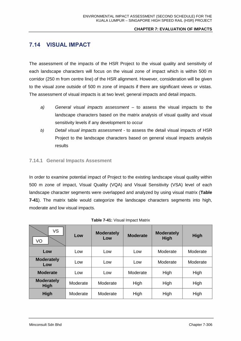
ENVIRONMENTAL IMPACT ASSESSMENT (SECOND SCHEDULE) FOR THE KUALA LUMPUR – SINGAPORE HIGH SPEED RAIL (HSR) PROJECT
CHAPTER 7: EVALUATION OF IMPACTS
Minconsult Sdn Bhd Chapter 7-306
7.14 VISUAL IMPACT
The assessment of the impacts of the HSR Project to the visual quality and sensitivity of
each landscape characters will focus on the visual zone of impact which is within 500 m
corridor (250 m from centre line) of the HSR alignment. However, consideration will be given
to the visual zone outside of 500 m zone of impacts if there are significant views or vistas.
The assessment of visual impacts is at two level; general impacts and detail impacts.
a) General visual impacts assessment – to assess the visual impacts to the
landscape characters based on the matrix analysis of visual quality and visual
sensitivity levels if any development to occur
b) Detail visual impacts assessment - to assess the detail visual impacts of HSR
Project to the landscape characters based on general visual impacts analysis
results
7.14.1 General Impacts Assesment
In order to examine potential impact of Project to the existing landscape visual quality within
500 m zone of impact, Visual Quality (VQA) and Visual Sensitivity (VSA) level of each
landscape character segments were overlapped and analyzed by using visual matrix (Table
7-41). The matrix table would categorize the landscape characters segments into high,
moderate and low visual impacts.
Table 7-41: Visual Impact Matrix
Low Moderately
Low Moderate
Moderately High
High
Low Low Low Low Moderate Moderate
Moderately Low
Low Low Low Moderate Moderate
Moderate Low Low Moderate High High
Moderately High
Moderate Moderate High High High
High Moderate Moderate High High High
VSA
VQA

ENVIRONMENTAL IMPACT ASSESSMENT (SECOND SCHEDULE) FOR THE KUALA LUMPUR – SINGAPORE HIGH SPEED RAIL (HSR) PROJECT
CHAPTER 7: EVALUATION OF IMPACTS
Minconsult Sdn Bhd Chapter 7-307
a) Low impact – development will not change the visual quality and sensitivity of the
landscape characters
b) Moderate impact – development will moderately change the visual quality and
sensitivity of the landscape characters
c) High impact – development will change the visual quality and sensitivity of the
landscape characters
A) F.T Kuala Lumpur
Based on matrix analysis, from 41 landscape characters, 21 landscape characters segments
were categorised as having low impacts (51.2 %), 15 segments (36.6 %) are having
moderate impacts and five (5) segments (12.2 %) are having high impacts (Table 7-42).
Table 7-42: General Visual Impact for the FT. Kuala Lumpur
General Visual Impacts
Total LC Segments
Nos Percentage (%)
Low
41
21 51.2
Moderate 15 36.6
High 5 12.2
The areas that have been identified for having high visual impacts are hilly lakesides areas
near Terminal Bersepadu Selatan at Bandar Tasik Selatan and Lakeside Residence at
Bandar Tasik Selatan. These areas are considered to have high impacts due to the facts
that they are located on hilly site, presence of water bodies and highly visible to the viewers.
It is observed that the areas marked for Bandar Malaysia Station are classified as having low
and moderate visual impacts. Please refer to Appendix 7M – Table 1 and Appendix 7O1
for detail distribution of the general visual impacts areas in the FT. Kuala Lumpur
B) F.T Putrajaya
There are two (2) landscape characters segments within HSR Project corridor in the FT.
Putrajaya. It was found that one segment (50 %) were classified as having low visual
impacts and the other one is having moderate (50 %) visual impacts (Table 7-43). Please
refer to Appendix 7M – Table 2 and Appendix 7O2 for detail distribution of the general
visual impacts areas in FT. Putrajaya.
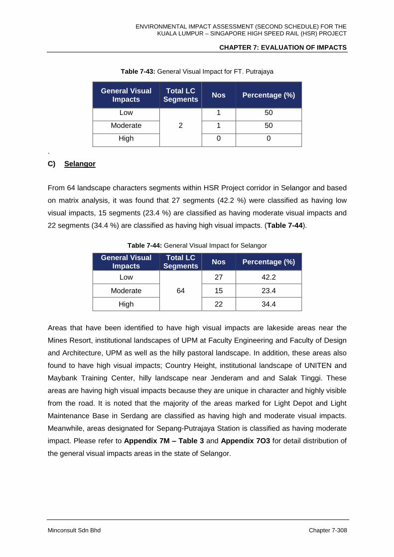
ENVIRONMENTAL IMPACT ASSESSMENT (SECOND SCHEDULE) FOR THE KUALA LUMPUR – SINGAPORE HIGH SPEED RAIL (HSR) PROJECT
CHAPTER 7: EVALUATION OF IMPACTS
Minconsult Sdn Bhd Chapter 7-308
Table 7-43: General Visual Impact for FT. Putrajaya
General Visual Impacts
Total LC Segments
Nos Percentage (%)
Low
2
1 50
Moderate 1 50
High 0 0
.
C) Selangor
From 64 landscape characters segments within HSR Project corridor in Selangor and based
on matrix analysis, it was found that 27 segments (42.2 %) were classified as having low
visual impacts, 15 segments (23.4 %) are classified as having moderate visual impacts and
22 segments (34.4 %) are classified as having high visual impacts. (Table 7-44).
Table 7-44: General Visual Impact for Selangor
General Visual Impacts
Total LC Segments
Nos Percentage (%)
Low
64
27 42.2
Moderate 15 23.4
High 22 34.4
Areas that have been identified to have high visual impacts are lakeside areas near the
Mines Resort, institutional landscapes of UPM at Faculty Engineering and Faculty of Design
and Architecture, UPM as well as the hilly pastoral landscape. In addition, these areas also
found to have high visual impacts; Country Height, institutional landscape of UNITEN and
Maybank Training Center, hilly landscape near Jenderam and and Salak Tinggi. These
areas are having high visual impacts because they are unique in character and highly visible
from the road. It is noted that the majority of the areas marked for Light Depot and Light
Maintenance Base in Serdang are classified as having high and moderate visual impacts.
Meanwhile, areas designated for Sepang-Putrajaya Station is classified as having moderate
impact. Please refer to Appendix 7M – Table 3 and Appendix 7O3 for detail distribution of
the general visual impacts areas in the state of Selangor.

ENVIRONMENTAL IMPACT ASSESSMENT (SECOND SCHEDULE) FOR THE KUALA LUMPUR – SINGAPORE HIGH SPEED RAIL (HSR) PROJECT
CHAPTER 7: EVALUATION OF IMPACTS
Minconsult Sdn Bhd Chapter 7-309
D) Negeri Sembilan
From 28 landscape characters segments within HSR Project corridor in Negeri Sembilan
and based on matrix analysis, it was found that 11 segments (39.3%) were classified as
having low visual impacts, 11 segments (39.3%) are classified as having moderate visual
impacts and six (6) segments (16.9%) are having high visual impacts. (Table 7-45).
Table 7-45: General Visual Impact for Negeri Sembilan
General Visual Impacts
Total LC Segments
Nos Percentage (%)
Low
28
11 39.3
Moderate 11 39.3
High 6 21.4
Areas that have been found to have high visual impacts are residential and recreational
areas near Kota Seriemas. The areas have highly organised landscape, high end
residentials and opportunity for recreation. It is noted that the areas marked for Seremban
Station are classified as having low visual impacts. Please refer to Appendix 7M – Table 4
and Appendix 7O4 for detail distribution of the general visual impacts areas in Negeri
Sembilan.
E) Melaka
From 41 landscape characters segments within HSR Project corridor in Melaka and based
on matrix analysis, it was found that 20 segments (48.8 %) were classified as having low
visual impacts, 15 segments (36.6 %) are classified as having moderate visual impacts and
six (6) segments (14.6 %) are having high visual impacts. (Table 7-46).
Table 7-46: General Visual Impact for Melaka
General Visual Impacts
Total LC Segments
Nos Percentage (%)
Low
41
20 48.8
Moderate 15 36.6
High 6 14.6
Areas that have been found to have high visual impacts in Melaka is traditional village at Kg
Solok Ayer Limau, riparian landscape of Sg. Melaka at Krubong near Kg. Pulau, and areas
near to PLUS interchanges at Ayer Keroh. These areas are having high visual impacts

ENVIRONMENTAL IMPACT ASSESSMENT (SECOND SCHEDULE) FOR THE KUALA LUMPUR – SINGAPORE HIGH SPEED RAIL (HSR) PROJECT
CHAPTER 7: EVALUATION OF IMPACTS
Minconsult Sdn Bhd Chapter 7-310
because they are unique in character (traditional architecture), highly visible from the road
and tourism point of view and the presence of large water bodies (Sg Melaka). It is observed
that the areas marked for Melaka Station at Ayer Keroh are classified from low to high
impacts but majority of the impacts are moderate in nature. Please refer to Appendix 7 M –
Table 5 and Appendix 7O5 for detail distribution of the general visual impacts areas in
Melaka
F) Johor
There are 84 landscape characters segments within HSR Project corridor in Johor. From
these 84 segments it was found that 47 segments (56.0%) are classified as having low
visual impacts, 33 segments (39.3%) are having moderate visual impacts and four (4)
segments (4.8%) are having high visual impact level (Table 7-47). Areas that have been
found to have high visual impacts are traditional village near Pagoh around Kg. Selancar and
Kg. Raja, school and residential areas near Simpang Renggam, swamp forest near
aquaculture center at Gelang Patah and swamp forest as well as estuarine landscape near
Kg. Ladang and Tebrau Strait. They are three (3) stations in Johor; Muar, Batu Pahat and
Iskandar Puteri and it is observed that for these three (3) stations, the visual impacts levels
are classified as moderate and low. For HMB in Muar and Main Depot and LMB in Pontian
the visual impacts are classified as low and moderate. Please refer to Appendix 7M – Table
6 and Appendix 7O6 for detail distribution of the general visual impacts in the state of Johor.
Table 7-47: General Visual Impact for Johor
General Visual Impacts
Total LC Segments
Nos Percentage (%)
Low
84
47 56.0
Moderate 33 39.3
High 4 4.8
The general visual impacts of HSR Project to the existing visual quality were identified within
500 m zone of impacts and the impacts were classified into 3 levels; high, moderate and low.
Table 7-48 summarizes the impacts for the entire expanse of HSR Project from the FT.
Kuala Lumpur to Johor.
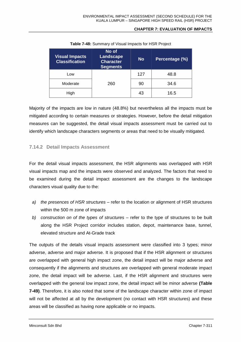
ENVIRONMENTAL IMPACT ASSESSMENT (SECOND SCHEDULE) FOR THE KUALA LUMPUR – SINGAPORE HIGH SPEED RAIL (HSR) PROJECT
CHAPTER 7: EVALUATION OF IMPACTS
Minconsult Sdn Bhd Chapter 7-311
Table 7-48: Summary of Visual Impacts for HSR Project
Visual Impacts Classification
No of Landscape Character Segments
No Percentage (%)
Low
260
127 48.8
Moderate 90 34.6
High 43 16.5
Majority of the impacts are low in nature (48.8%) but nevertheless all the impacts must be
mitigated according to certain measures or strategies. However, before the detail mitigation
measures can be suggested, the detail visual impacts assessment must be carried out to
identify which landscape characters segments or areas that need to be visually mitigated.
7.14.2 Detail Impacts Assessment
For the detail visual impacts assessment, the HSR alignments was overlapped with HSR
visual impacts map and the impacts were observed and analyzed. The factors that need to
be examined during the detail impact assessment are the changes to the landscape
characters visual quality due to the:
a) the presences of HSR structures – refer to the location or alignment of HSR structures
within the 500 m zone of impacts
b) construction on of the types of structures – refer to the type of structures to be built
along the HSR Project corridor includes station, depot, maintenance base, tunnel,
elevated structure and At-Grade track
The outputs of the details visual impacts assessment were classified into 3 types; minor
adverse, adverse and major adverse. It is proposed that if the HSR alignment or structures
are overlapped with general high impact zone, the detail impact will be major adverse and
consequently if the alignments and structures are overlapped with general moderate impact
zone, the detail impact will be adverse. Last, if the HSR alignment and structures were
overlapped with the general low impact zone, the detail impact will be minor adverse (Table
7-49). Therefore, it is also noted that some of the landscape character within zone of impact
will not be affected at all by the development (no contact with HSR structures) and these
areas will be classified as having none applicable or no impacts.
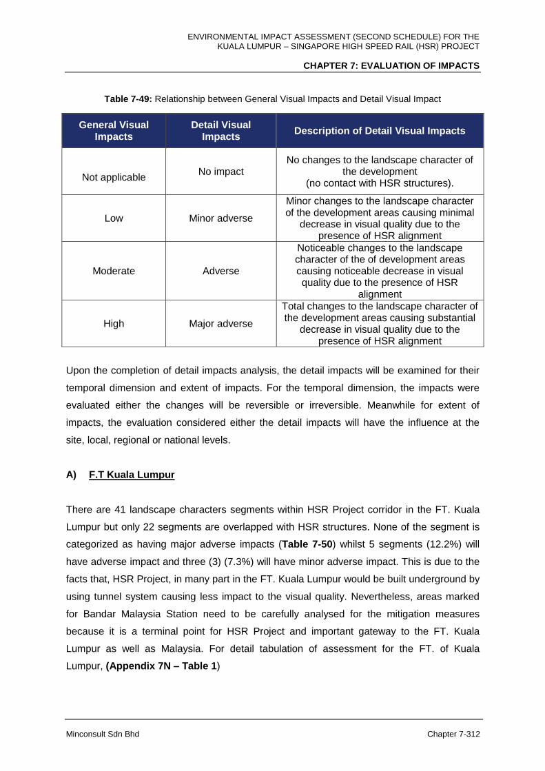
ENVIRONMENTAL IMPACT ASSESSMENT (SECOND SCHEDULE) FOR THE KUALA LUMPUR – SINGAPORE HIGH SPEED RAIL (HSR) PROJECT
CHAPTER 7: EVALUATION OF IMPACTS
Minconsult Sdn Bhd Chapter 7-312
Table 7-49: Relationship between General Visual Impacts and Detail Visual Impact
General Visual Impacts
Detail Visual Impacts
Description of Detail Visual Impacts
Not applicable
No impact No changes to the landscape character of
the development (no contact with HSR structures).
Low Minor adverse
Minor changes to the landscape character of the development areas causing minimal
decrease in visual quality due to the presence of HSR alignment
Moderate Adverse
Noticeable changes to the landscape character of the of development areas causing noticeable decrease in visual quality due to the presence of HSR
alignment
High Major adverse
Total changes to the landscape character of the development areas causing substantial
decrease in visual quality due to the presence of HSR alignment
Upon the completion of detail impacts analysis, the detail impacts will be examined for their
temporal dimension and extent of impacts. For the temporal dimension, the impacts were
evaluated either the changes will be reversible or irreversible. Meanwhile for extent of
impacts, the evaluation considered either the detail impacts will have the influence at the
site, local, regional or national levels.
A) F.T Kuala Lumpur
There are 41 landscape characters segments within HSR Project corridor in the FT. Kuala
Lumpur but only 22 segments are overlapped with HSR structures. None of the segment is
categorized as having major adverse impacts (Table 7-50) whilst 5 segments (12.2%) will
have adverse impact and three (3) (7.3%) will have minor adverse impact. This is due to the
facts that, HSR Project, in many part in the FT. Kuala Lumpur would be built underground by
using tunnel system causing less impact to the visual quality. Nevertheless, areas marked
for Bandar Malaysia Station need to be carefully analysed for the mitigation measures
because it is a terminal point for HSR Project and important gateway to the FT. Kuala
Lumpur as well as Malaysia. For detail tabulation of assessment for the FT. of Kuala
Lumpur, (Appendix 7N – Table 1)
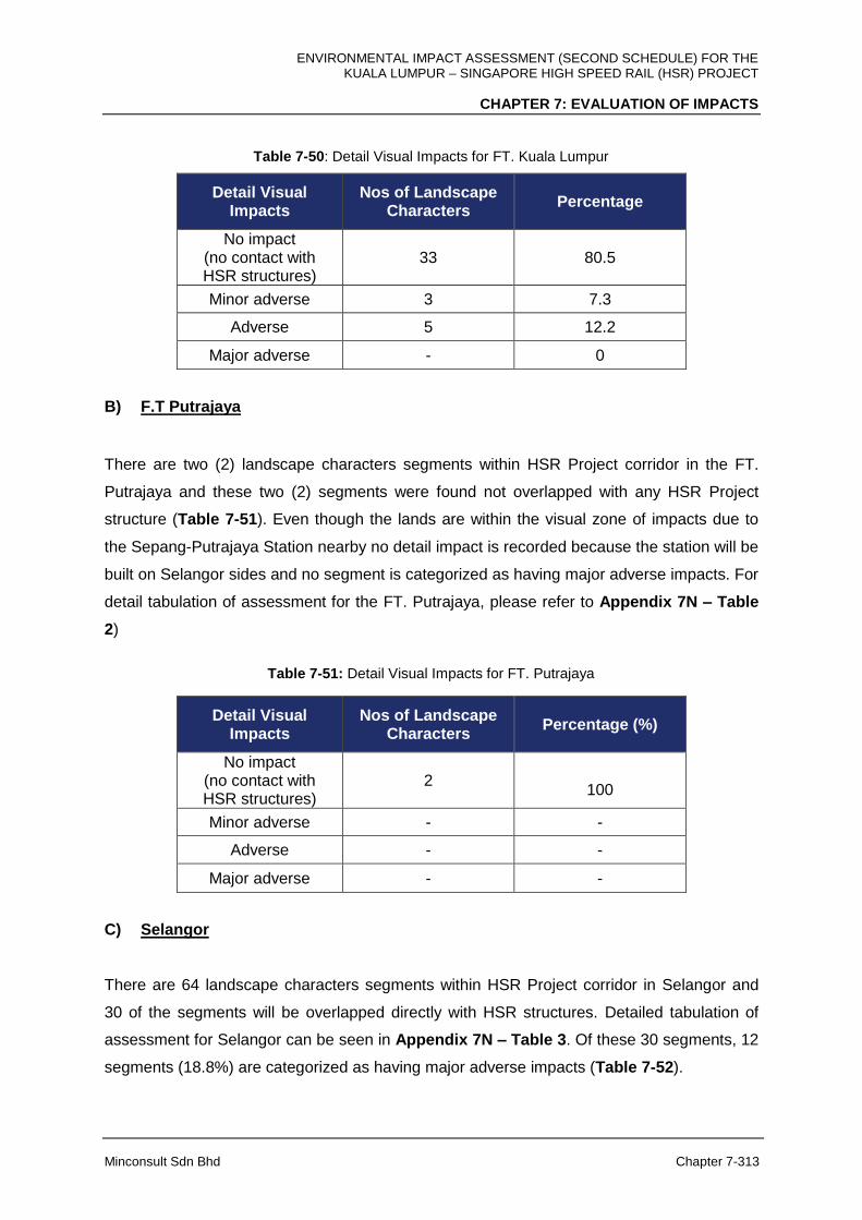
ENVIRONMENTAL IMPACT ASSESSMENT (SECOND SCHEDULE) FOR THE KUALA LUMPUR – SINGAPORE HIGH SPEED RAIL (HSR) PROJECT
CHAPTER 7: EVALUATION OF IMPACTS
Minconsult Sdn Bhd Chapter 7-313
Table 7-50: Detail Visual Impacts for FT. Kuala Lumpur
Detail Visual Impacts
Nos of Landscape Characters
Percentage
No impact (no contact with HSR structures)
33 80.5
Minor adverse 3 7.3
Adverse 5 12.2
Major adverse - 0
B) F.T Putrajaya
There are two (2) landscape characters segments within HSR Project corridor in the FT.
Putrajaya and these two (2) segments were found not overlapped with any HSR Project
structure (Table 7-51). Even though the lands are within the visual zone of impacts due to
the Sepang-Putrajaya Station nearby no detail impact is recorded because the station will be
built on Selangor sides and no segment is categorized as having major adverse impacts. For
detail tabulation of assessment for the FT. Putrajaya, please refer to Appendix 7N – Table
2)
Table 7-51: Detail Visual Impacts for FT. Putrajaya
Detail Visual Impacts
Nos of Landscape Characters
Percentage (%)
No impact (no contact with HSR structures)
2
100
Minor adverse - -
Adverse - -
Major adverse - -
C) Selangor
There are 64 landscape characters segments within HSR Project corridor in Selangor and
30 of the segments will be overlapped directly with HSR structures. Detailed tabulation of
assessment for Selangor can be seen in Appendix 7N – Table 3. Of these 30 segments, 12
segments (18.8%) are categorized as having major adverse impacts (Table 7-52).
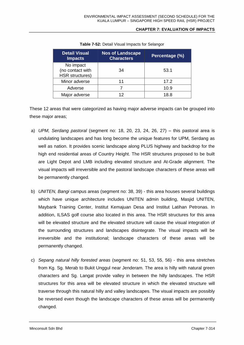
ENVIRONMENTAL IMPACT ASSESSMENT (SECOND SCHEDULE) FOR THE KUALA LUMPUR – SINGAPORE HIGH SPEED RAIL (HSR) PROJECT
CHAPTER 7: EVALUATION OF IMPACTS
Minconsult Sdn Bhd Chapter 7-314
Table 7-52: Detail Visual Impacts for Selangor
Detail Visual Impacts
Nos of Landscape Characters
Percentage (%)
No impact (no contact with HSR structures)
34 53.1
Minor adverse 11 17.2
Adverse 7 10.9
Major adverse 12 18.8
These 12 areas that were categorized as having major adverse impacts can be grouped into
these major areas;
a) UPM, Serdang pastoral (segment no: 18, 20, 23, 24, 26, 27) – this pastoral area is
undulating landscapes and has long become the unique features for UPM, Serdang as
well as nation. It provides scenic landscape along PLUS highway and backdrop for the
high end residential areas of Country Height. The HSR structures proposed to be built
are Light Depot and LMB including elevated structure and At-Grade alignment. The
visual impacts will irreversible and the pastoral landscape characters of these areas will
be permanently changed.
b) UNITEN, Bangi campus areas (segment no: 38, 39) - this area houses several buildings
which have unique architecture includes UNITEN admin building, Masjid UNITEN,
Maybank Training Center, Institut Kemajuan Desa and Institut Latihan Petronas. In
addition, ILSAS golf course also located in this area. The HSR structures for this area
will be elevated structure and the elevated structure will cause the visual integration of
the surrounding structures and landscapes disintegrate. The visual impacts will be
irreversible and the institutional; landscape characters of these areas will be
permanently changed.
c) Sepang natural hilly forested areas (segment no: 51, 53, 55, 56) - this area stretches
from Kg. Sg. Merab to Bukit Unggul near Jenderam. The area is hilly with natural green
characters and Sg. Langat provide valley in between the hilly landscapes. The HSR
structures for this area will be elevated structure in which the elevated structure will
traverse through this natural hilly and valley landscapes. The visual impacts are possibly
be reversed even though the landscape characters of these areas will be permanently
changed.
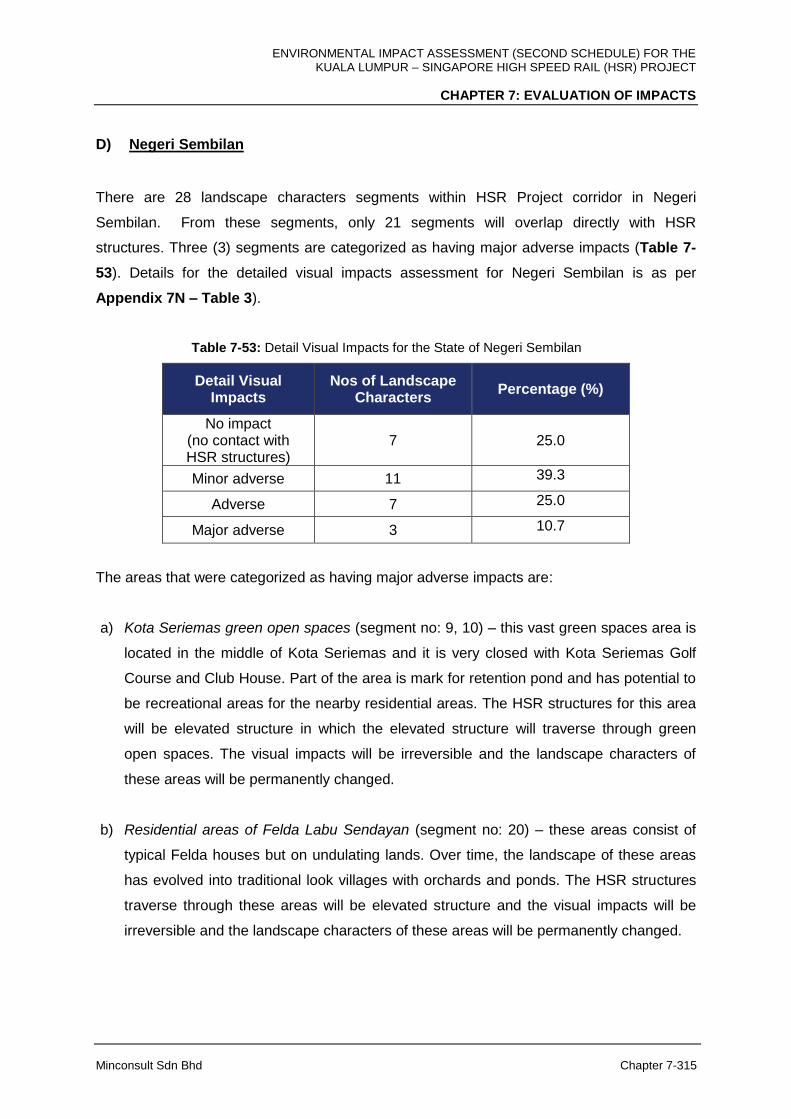
ENVIRONMENTAL IMPACT ASSESSMENT (SECOND SCHEDULE) FOR THE KUALA LUMPUR – SINGAPORE HIGH SPEED RAIL (HSR) PROJECT
CHAPTER 7: EVALUATION OF IMPACTS
Minconsult Sdn Bhd Chapter 7-315
D) Negeri Sembilan
There are 28 landscape characters segments within HSR Project corridor in Negeri
Sembilan. From these segments, only 21 segments will overlap directly with HSR
structures. Three (3) segments are categorized as having major adverse impacts (Table 7-
53). Details for the detailed visual impacts assessment for Negeri Sembilan is as per
Appendix 7N – Table 3).
Table 7-53: Detail Visual Impacts for the State of Negeri Sembilan
Detail Visual Impacts
Nos of Landscape Characters
Percentage (%)
No impact (no contact with HSR structures)
7
25.0
Minor adverse 11 39.3
Adverse 7 25.0
Major adverse 3 10.7
The areas that were categorized as having major adverse impacts are:
a) Kota Seriemas green open spaces (segment no: 9, 10) – this vast green spaces area is
located in the middle of Kota Seriemas and it is very closed with Kota Seriemas Golf
Course and Club House. Part of the area is mark for retention pond and has potential to
be recreational areas for the nearby residential areas. The HSR structures for this area
will be elevated structure in which the elevated structure will traverse through green
open spaces. The visual impacts will be irreversible and the landscape characters of
these areas will be permanently changed.
b) Residential areas of Felda Labu Sendayan (segment no: 20) – these areas consist of
typical Felda houses but on undulating lands. Over time, the landscape of these areas
has evolved into traditional look villages with orchards and ponds. The HSR structures
traverse through these areas will be elevated structure and the visual impacts will be
irreversible and the landscape characters of these areas will be permanently changed.

ENVIRONMENTAL IMPACT ASSESSMENT (SECOND SCHEDULE) FOR THE KUALA LUMPUR – SINGAPORE HIGH SPEED RAIL (HSR) PROJECT
CHAPTER 7: EVALUATION OF IMPACTS
Minconsult Sdn Bhd Chapter 7-316
E) Melaka
There are 41 landscape characters segments within HSR Project corridor in Melaka. From
these segments it was found that 28 segments will be overlapped with HSR Project.
Altogether, six (6) segments are categorized as having major adverse impacts (Table 7-54).
For detail tabulation of assessment for the state of Negeri Sembilan is as per Appendix 7N
– Table 5).
Table 7-54: Detail Visual Impacts for Melaka
Detail Visual Impacts
Nos of Landscape Characters
Percentage (%)
No impact (no contact with HSR structures)
13
31.7
Minor adverse 13 31.7
Adverse 9 22.0
Major adverse 6 14.6
These six (6) areas that were categorized as having major adverse impacts can be grouped
into these areas;
a) Kg. Solok Air Limau (segment no: 5) – it is a traditional village with compact layout and
many of the houses have traditional Melaka house architecture style. The HSR
structures traverse through these areas will be partly elevated structure and At-Grade. It
is predicted that the visual impacts to this area will be irreversible and the landscape
characters of these areas will be permanently changed.
b) Sg. Melaka near Kg. Pulau and Kg Solok Air Hilir (segment no: 13) – Sg Melaka riparian
areas with vast flat open spaces and greenery. The area is flank with traditional villages.
Due to this visual situation, the areas provide scenic environment to the surrounding
areas. The HSR structures for this area will be elevated structure in which the elevated
structure will traverse through this riparian valley landscapes. The visual impacts are
possibly be reversed even though the landscape characters of these areas will be
permanently changed.
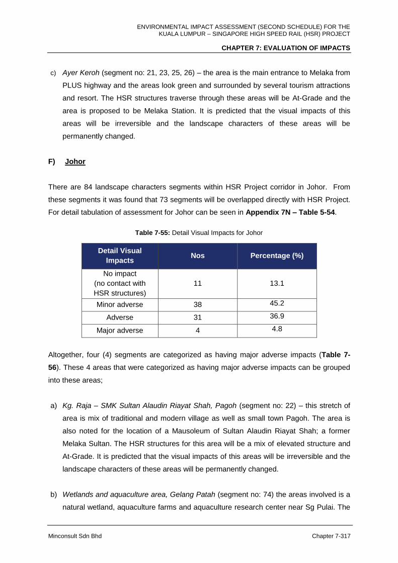
ENVIRONMENTAL IMPACT ASSESSMENT (SECOND SCHEDULE) FOR THE KUALA LUMPUR – SINGAPORE HIGH SPEED RAIL (HSR) PROJECT
CHAPTER 7: EVALUATION OF IMPACTS
Minconsult Sdn Bhd Chapter 7-317
c) Ayer Keroh (segment no: 21, 23, 25, 26) – the area is the main entrance to Melaka from
PLUS highway and the areas look green and surrounded by several tourism attractions
and resort. The HSR structures traverse through these areas will be At-Grade and the
area is proposed to be Melaka Station. It is predicted that the visual impacts of this
areas will be irreversible and the landscape characters of these areas will be
permanently changed.
F) Johor
There are 84 landscape characters segments within HSR Project corridor in Johor. From
these segments it was found that 73 segments will be overlapped directly with HSR Project.
For detail tabulation of assessment for Johor can be seen in Appendix 7N – Table 5-54.
Table 7-55: Detail Visual Impacts for Johor
Detail Visual
Impacts Nos Percentage (%)
No impact
(no contact with
HSR structures)
11
13.1
Minor adverse 38 45.2
Adverse 31 36.9
Major adverse 4 4.8
Altogether, four (4) segments are categorized as having major adverse impacts (Table 7-
56). These 4 areas that were categorized as having major adverse impacts can be grouped
into these areas;
a) Kg. Raja – SMK Sultan Alaudin Riayat Shah, Pagoh (segment no: 22) – this stretch of
area is mix of traditional and modern village as well as small town Pagoh. The area is
also noted for the location of a Mausoleum of Sultan Alaudin Riayat Shah; a former
Melaka Sultan. The HSR structures for this area will be a mix of elevated structure and
At-Grade. It is predicted that the visual impacts of this areas will be irreversible and the
landscape characters of these areas will be permanently changed.
b) Wetlands and aquaculture area, Gelang Patah (segment no: 74) the areas involved is a
natural wetland, aquaculture farms and aquaculture research center near Sg Pulai. The
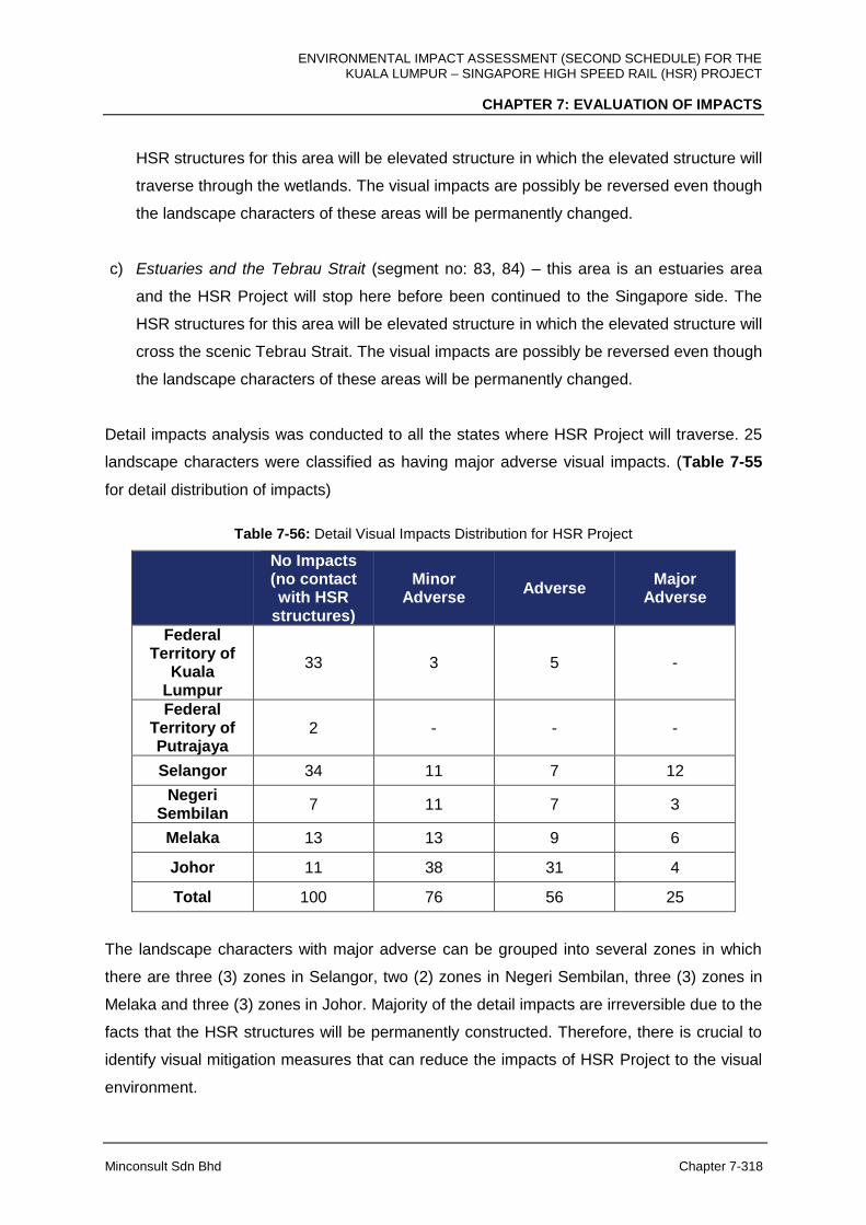
ENVIRONMENTAL IMPACT ASSESSMENT (SECOND SCHEDULE) FOR THE KUALA LUMPUR – SINGAPORE HIGH SPEED RAIL (HSR) PROJECT
CHAPTER 7: EVALUATION OF IMPACTS
Minconsult Sdn Bhd Chapter 7-318
HSR structures for this area will be elevated structure in which the elevated structure will
traverse through the wetlands. The visual impacts are possibly be reversed even though
the landscape characters of these areas will be permanently changed.
c) Estuaries and the Tebrau Strait (segment no: 83, 84) – this area is an estuaries area
and the HSR Project will stop here before been continued to the Singapore side. The
HSR structures for this area will be elevated structure in which the elevated structure will
cross the scenic Tebrau Strait. The visual impacts are possibly be reversed even though
the landscape characters of these areas will be permanently changed.
Detail impacts analysis was conducted to all the states where HSR Project will traverse. 25
landscape characters were classified as having major adverse visual impacts. (Table 7-55
for detail distribution of impacts)
Table 7-56: Detail Visual Impacts Distribution for HSR Project
No Impacts (no contact with HSR
structures)
Minor Adverse
Adverse Major
Adverse
Federal Territory of
Kuala Lumpur
33 3 5 -
Federal Territory of Putrajaya
2 - - -
Selangor 34 11 7 12
Negeri Sembilan
7 11 7 3
Melaka 13 13 9 6
Johor 11 38 31 4
Total 100 76 56 25
The landscape characters with major adverse can be grouped into several zones in which
there are three (3) zones in Selangor, two (2) zones in Negeri Sembilan, three (3) zones in
Melaka and three (3) zones in Johor. Majority of the detail impacts are irreversible due to the
facts that the HSR structures will be permanently constructed. Therefore, there is crucial to
identify visual mitigation measures that can reduce the impacts of HSR Project to the visual
environment.
ENVIRONMENTAL IMPACT ASSESSMENT (SECOND SCHEDULE) FOR THE KUALA LUMPUR – SINGAPORE HIGH SPEED RAIL (HSR) PROJECT
CHAPTER 7: EVALUATION OF IMPACTS
Minconsult Sdn Bhd Chapter 7-319
7.15 PUBLIC HEALTH IMPACTS
7.15.1 Pre-Construction Phase
Planning for the eviction and resettlement of affected people, and relocation of commercial
buildings, will be carried out in this phase. This will be proceeded with activities to relocate
affected people from identified Project sites and to close down commercial business.
Resettlement of People
Potential impact: The HSR alignment crosses certain settlements and housing areas
throughout its length. The resettled communities are exposed to a risk of mental stress due
to involuntary movement into a new social environment. This may contribute to social friction
within the communities, the occurrence of fights and injuries, feelings of fear, anger and
depression and may result in homicide or suicide, in extreme cases.
7.15.2 Construction Phase
There are specific potential health related impacts that could materialize during this phase of
Project. They include:
A. Workers Health
Potential Impacts: The influx of foreign as well as local workers cause spreading of certain
diseases, particularly influenza (flu), malaria, tuberculosis, typhoid, leprosy, hepatitis B and
sexual transmitted infections (STIs). Their presence, culture and behavior may alter and
increase the current disease burden within the surrounding residential areas, including
criminal and social troubles, particularly near their placement locations.
The various nationalities among the workers are also known to pose a risk of violence
among the workers and within the communities living in the vicinity. Feelings of anger,
frustration, discomfort or dissatisfaction often leads to the occurrence of fights, and in
extreme cases, homicide.

ENVIRONMENTAL IMPACT ASSESSMENT (SECOND SCHEDULE) FOR THE KUALA LUMPUR – SINGAPORE HIGH SPEED RAIL (HSR) PROJECT
CHAPTER 7: EVALUATION OF IMPACTS
Minconsult Sdn Bhd Chapter 7-320
B. Communicable Diseases
Potential Impact: Land clearing involving forest and swampy areas are directly related to
the potential of migration of vectors to nearby villages and towns. In particular, the migration
of Aedes Albopictus and Culex mosquito species may lead to an outbreak of dengue fever,
malaria, filariasis and chikungunya. Larger vectors like rats and rodents pose a risk of
diseases like leptospirosis and scrub typhus. The influx of a high number of foreign and local
workers usually gives rise to the spread of respiratory problems like acute respiratory
infection and tuberculosis; and gastrointestinal problems like acute gastroenteritis and
diarrhoea. Poor health conditions of the workers will lead to them being unfit to work or even
the potential occurrence of human errors that may end in casualties or fatalities.
7.15.3 Operational Phase
There are specific potential health related impacts that could materialize during this phase of
Project development. They include:
A. Accident, Injury and Safety of Communities
Potential impact: Risk of accidents and injuries to the surrounding population due to
collision with the fast-moving train along the HSR alignment from north to south. People may
be injured or killed in an attempt to trespass through or cross the railway tracks.
B. Noise Disruptions to Communities
Potential impact: High noise levels produced by trains passing at high speeds may induce
hearing problems over a period of time among exposed communities. In addition, it also
causes non-auditory health effects such as disruption of peace and negative affects on
mental health. High noise levels will cause feelings of anxiety, anger, unsatisfaction,
exhaustion, aggression and depression. Noise is a major reason for the loss of sleep, which
can lead to chronic fatigue. The Environmental Protection Agency states that a 35 dB sound
level allows for healthy sleep. Rail wheel squeals on curves along the railway tracks and
train horns are among the identified sources of potential noise that may cause annoyance,
particularly to communities living adjacent to the HSR alignment.

ENVIRONMENTAL IMPACT ASSESSMENT (SECOND SCHEDULE) FOR THE KUALA LUMPUR – SINGAPORE HIGH SPEED RAIL (HSR) PROJECT
CHAPTER 7: EVALUATION OF IMPACTS
Minconsult Sdn Bhd Chapter 7-321
7.16 RISK AND HAZARD IMPACTS
7.16.1 Introduction
The Risk and Hazard Assessment (RHA) study as required by Department of Environment
(DOE) (2004) is to determine quantitatively the risk faced by the project component and the
public within the project area and its vicinity (Impact zone). Hazard is an inherent property of
a substance, agent or source of energy that have the potential to cause undesirable
consequences. Risk is the probability of an unwanted event occurring due to uncontrolled
release of a hazard that will produce harm to Environment, Human or property.
Figure 7-111: The steps in RHA Study

ENVIRONMENTAL IMPACT ASSESSMENT (SECOND SCHEDULE) FOR THE KUALA LUMPUR – SINGAPORE HIGH SPEED RAIL (HSR) PROJECT
CHAPTER 7: EVALUATION OF IMPACTS
Minconsult Sdn Bhd Chapter 7-322
As an example of risk in transportation activities, supposed that a country has a population
of 10 million people and on average there are 1000 fatalities per year due to transport
accidents and the average transport accidents are 10000 per year. A general expression of
the risk is;
Risk = Frequency
No. of vulnerable source exposed
Thus;
Still another form of risk indicator known as the average individual risk is expressed as;
The risk indicator is then compared to the voluntary and involuntary risk levels in order to
determine whether the risk posed by the project is acceptable.
7.16.2 Objective of Risk Assessment
The objective of the study is to determine the average individual risk (IR) which is also
defined as the probability of a person being fatally affected when standing at a certain
location from a potential hazard. The process of estimating the risk is shown as in the
flowchart in Figure 7-111.
7.16.3 Scope of Study
There are two phases with the implementation of the HSR Project and in each phase there
are different type of hazards and hence risks which are associated with them. The first
phase is the construction and installation of the railways logistic which involves activities
such as drilling, transporting, blasting and crushing which typically will expose high risk to
workers and personnel on site (Hui-Nee, 2014).
The second phase of the HSR Project will be the risk expose during normal operation of the
high speed train. The major hazard associated with the second phase will be probable trains
ENVIRONMENTAL IMPACT ASSESSMENT (SECOND SCHEDULE) FOR THE KUALA LUMPUR – SINGAPORE HIGH SPEED RAIL (HSR) PROJECT
CHAPTER 7: EVALUATION OF IMPACTS
Minconsult Sdn Bhd Chapter 7-323
accidents that may occur that can cause major fatalities. These risks will be exposed to the
passenger, the personnel around the railways logistic and the population residing or being
besides the railways lines.
In determining the average individual risk (IR), the primary step is to identify potential
hazards and qualitatively assess potential Safety, Health and Environmental risk to project
component and public during the construction and operational phases of the Project.
Secondary step is to quantitatively assess the magnitude of the risk. The third step is to
propose reasonable risk mitigation measures based on the impact of the risk created during
the project realization. Forth objective is to provide a framework for risk management to
bring the impact to a level of As Low As Reasonably Possible (ALARP).
7.16.4 Construction Phase
As mentioned above, this is the first phase of the risk assessment study. During construction
and installation of the railways logistics, the type of risk present will be similar to those found
during general construction works in any development. Unless there is nearby settlement,
the people who are generally exposed to this kind of risk, it will be restricted to the
construction workers and personnel.
7.16.5 Study Procedures
1. Identification of Hazard;
2. Exposed population.;
3. Estimation of the probabilities/frequencies of hazardous events;
4. Determination of the individual risk (IR);
5. Determination of the risk acceptability;
6. Recommendation of appropriate measures to mitigate risk if any;
7.16.6 Identification of Hazards during Construction & Installation
The type of hazard found during construction activities can be categorized according to the
type of accidents during construction. Chong and Low (2014) recorded that the causes of
accident from 2005-2009 are as follow;
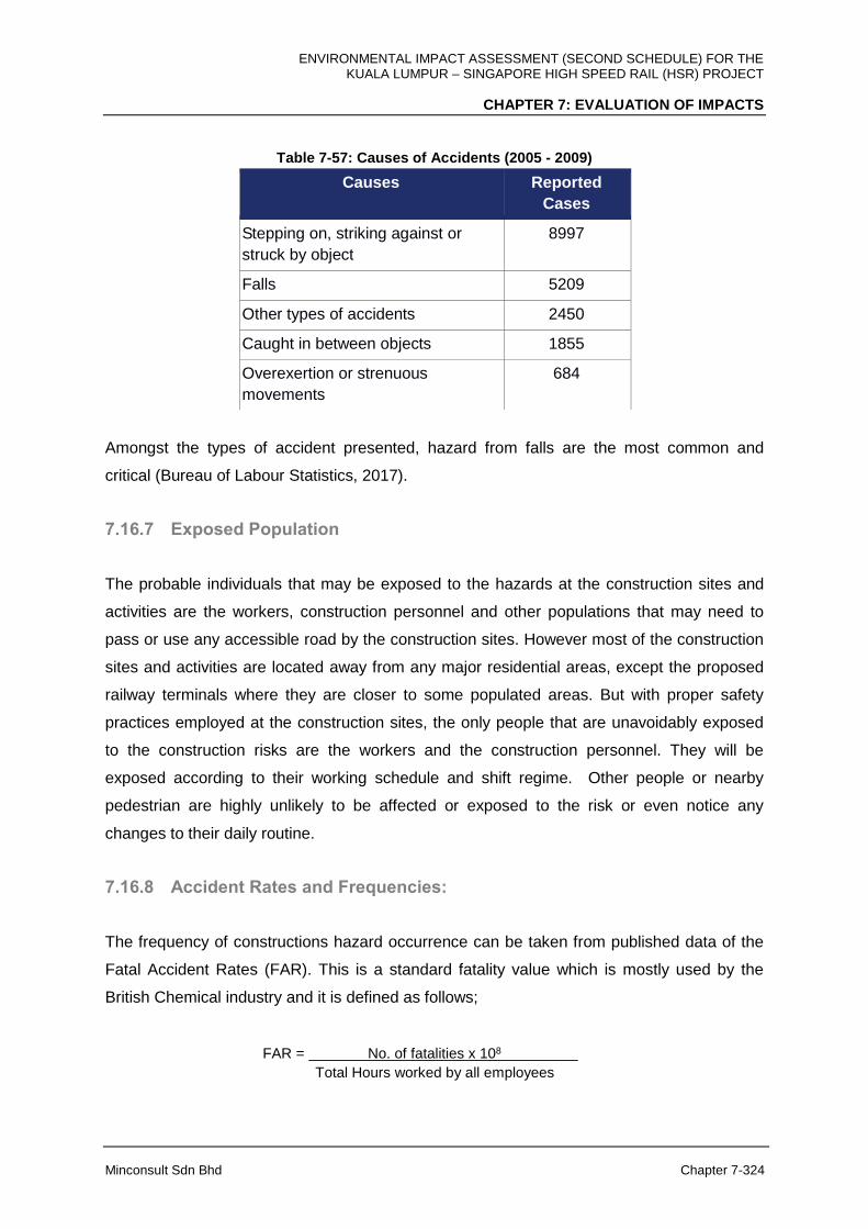
ENVIRONMENTAL IMPACT ASSESSMENT (SECOND SCHEDULE) FOR THE KUALA LUMPUR – SINGAPORE HIGH SPEED RAIL (HSR) PROJECT
CHAPTER 7: EVALUATION OF IMPACTS
Minconsult Sdn Bhd Chapter 7-324
Table 7-57: Causes of Accidents (2005 - 2009)
Amongst the types of accident presented, hazard from falls are the most common and
critical (Bureau of Labour Statistics, 2017).
7.16.7 Exposed Population
The probable individuals that may be exposed to the hazards at the construction sites and
activities are the workers, construction personnel and other populations that may need to
pass or use any accessible road by the construction sites. However most of the construction
sites and activities are located away from any major residential areas, except the proposed
railway terminals where they are closer to some populated areas. But with proper safety
practices employed at the construction sites, the only people that are unavoidably exposed
to the construction risks are the workers and the construction personnel. They will be
exposed according to their working schedule and shift regime. Other people or nearby
pedestrian are highly unlikely to be affected or exposed to the risk or even notice any
changes to their daily routine.
7.16.8 Accident Rates and Frequencies:
The frequency of constructions hazard occurrence can be taken from published data of the
Fatal Accident Rates (FAR). This is a standard fatality value which is mostly used by the
British Chemical industry and it is defined as follows;
FAR = No. of fatalities x 108
Total Hours worked by all employees
Causes Reported
Cases
Stepping on, striking against or
struck by object
8997
Falls 5209
Other types of accidents 2450
Caught in between objects 1855
Overexertion or strenuous
movements
684
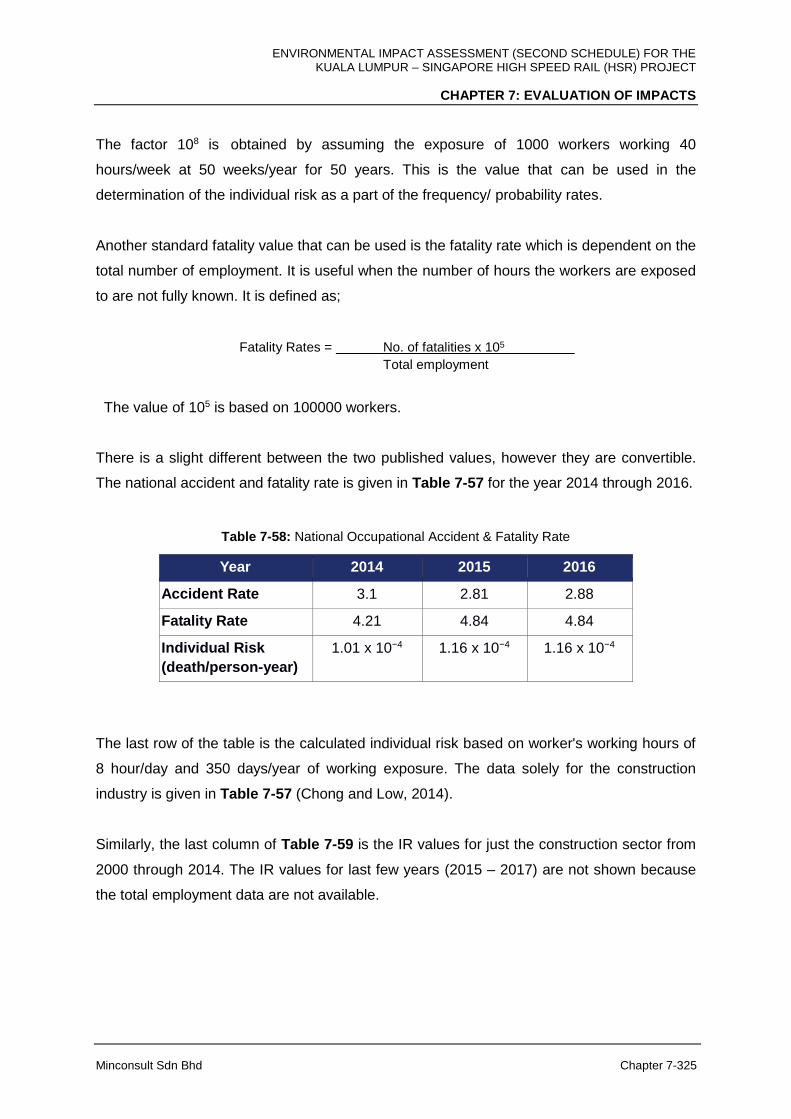
ENVIRONMENTAL IMPACT ASSESSMENT (SECOND SCHEDULE) FOR THE KUALA LUMPUR – SINGAPORE HIGH SPEED RAIL (HSR) PROJECT
CHAPTER 7: EVALUATION OF IMPACTS
Minconsult Sdn Bhd Chapter 7-325
The factor 108 is obtained by assuming the exposure of 1000 workers working 40
hours/week at 50 weeks/year for 50 years. This is the value that can be used in the
determination of the individual risk as a part of the frequency/ probability rates.
Another standard fatality value that can be used is the fatality rate which is dependent on the
total number of employment. It is useful when the number of hours the workers are exposed
to are not fully known. It is defined as;
Fatality Rates = No. of fatalities x 105
Total employment
The value of 105 is based on 100000 workers.
There is a slight different between the two published values, however they are convertible.
The national accident and fatality rate is given in Table 7-57 for the year 2014 through 2016.
Table 7-58: National Occupational Accident & Fatality Rate
Year 2014 2015 2016
Accident Rate 3.1 2.81 2.88
Fatality Rate 4.21 4.84 4.84
Individual Risk
(death/person-year)
1.01 x 10⁻⁴ 1.16 x 10⁻⁴ 1.16 x 10⁻⁴
The last row of the table is the calculated individual risk based on worker's working hours of
8 hour/day and 350 days/year of working exposure. The data solely for the construction
industry is given in Table 7-57 (Chong and Low, 2014).
Similarly, the last column of Table 7-59 is the IR values for just the construction sector from
2000 through 2014. The IR values for last few years (2015 – 2017) are not shown because
the total employment data are not available.
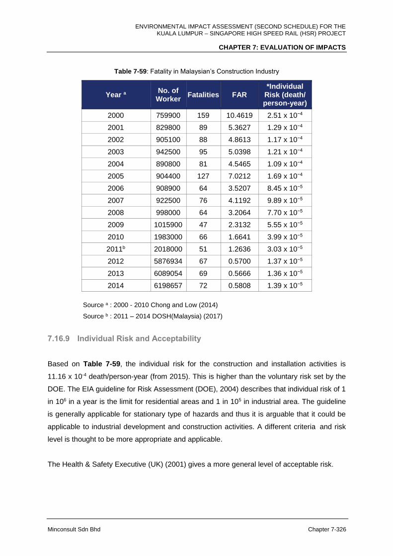
ENVIRONMENTAL IMPACT ASSESSMENT (SECOND SCHEDULE) FOR THE KUALA LUMPUR – SINGAPORE HIGH SPEED RAIL (HSR) PROJECT
CHAPTER 7: EVALUATION OF IMPACTS
Minconsult Sdn Bhd Chapter 7-326
Table 7-59: Fatality in Malaysian’s Construction Industry
Year a No. of
Worker Fatalities FAR
*Individual Risk (death/ person-year)
2000 759900 159 10.4619 2.51 x 10⁻⁴
2001 829800 89 5.3627 1.29 x 10⁻⁴
2002 905100 88 4.8613 1.17 x 10⁻⁴
2003 942500 95 5.0398 1.21 x 10⁻⁴
2004 890800 81 4.5465 1.09 x 10⁻⁴
2005 904400 127 7.0212 1.69 x 10⁻⁴
2006 908900 64 3.5207 8.45 x 10⁻⁵
2007 922500 76 4.1192 9.89 x 10⁻⁵
2008 998000 64 3.2064 7.70 x 10⁻⁵
2009 1015900 47 2.3132 5.55 x 10⁻⁵
2010 1983000 66 1.6641 3.99 x 10⁻⁵
2011b 2018000 51 1.2636 3.03 x 10⁻⁵
2012 5876934 67 0.5700 1.37 x 10⁻⁵
2013 6089054 69 0.5666 1.36 x 10⁻⁵
2014 6198657 72 0.5808 1.39 x 10⁻⁵
Source a : 2000 - 2010 Chong and Low (2014)
Source b : 2011 – 2014 DOSH(Malaysia) (2017)
7.16.9 Individual Risk and Acceptability
Based on Table 7-59, the individual risk for the construction and installation activities is
11.16 x 10⁻⁴ death/person-year (from 2015). This is higher than the voluntary risk set by the
DOE. The EIA guideline for Risk Assessment (DOE), 2004) describes that individual risk of 1
in 106 in a year is the limit for residential areas and 1 in 105 in industrial area. The guideline
is generally applicable for stationary type of hazards and thus it is arguable that it could be
applicable to industrial development and construction activities. A different criteria and risk
level is thought to be more appropriate and applicable.
The Health & Safety Executive (UK) (2001) gives a more general level of acceptable risk.

ENVIRONMENTAL IMPACT ASSESSMENT (SECOND SCHEDULE) FOR THE KUALA LUMPUR – SINGAPORE HIGH SPEED RAIL (HSR) PROJECT
CHAPTER 7: EVALUATION OF IMPACTS
Minconsult Sdn Bhd Chapter 7-327
Table 7-60: Acceptable Level of Risk (Health & Safety Executive (UK), 2001)
Risk Level Description
< 1 x 10⁻⁶ Broadly acceptable region
1 x 10⁻⁴ to 1 x 10⁻⁶ Tolerable region. Involuntary risk
1 x 10⁻³ to 1 x 10⁻⁶ Tolerable region. Voluntary risk.
< 1 x 10⁻⁴ Unacceptable region for public or involuntary risk
< 1 x 10⁻³ Unacceptable region for public or voluntary risk
The individual risk levels calculated in the above tables (Table 7-58 and 7-59) showed that
the results are slightly higher than the recommended level by the DOE guideline i.e.
involuntary risk is 1 x 10⁶ and the voluntary risk is 1 x 10⁵ (Department of Environment,
(DOE), 2004). However, if the IR level suggested by the Health & Safety Executive (UK)
(2001) is used Table 7-60 instead, the results are well within the tolerable region. The IR
values are also decreasing over the years and thus it is reasonable to assumed that the IR
value will be within the DOE recommended level in the future and may well be already within
the required level if stringent safety practices is adhered at all times. For comparison, the
FAR value reported in the construction industry between the US and the EU is 7.9 and 9.6
respectively (Bureau Labor Statistics, 2014). This is much higher than what is reported
locally. Although we accept that the IR values would still be lower due to the bigger number
of workers in those countries.
Based on the argument above, the level of IR during construction and installation phase for
the Project is acceptable.
ENVIRONMENTAL IMPACT ASSESSMENT (SECOND SCHEDULE) FOR THE KUALA LUMPUR – SINGAPORE HIGH SPEED RAIL (HSR) PROJECT
CHAPTER 7: EVALUATION OF IMPACTS
Minconsult Sdn Bhd Chapter 7-328
7.16.10 Risk Assessment of the High Speed Rail
Description of the Project is detailed in Chapter 5. Brief description is given here in this
section only those that are relevant to the risk and hazard assessment study of the Project.
This is the second phase of the QRA study and mainly revolve around the normal operation
of the high speed railway transport. The main objective is to determine the IR due to the
implementation of the HSR project.
The HSR Project will be used only to transport passenger. There will be no cargo of any
dangerous materials or hazardous chemicals.
Study Procedures
1. Hazard identification
2. Exposed Population
3. Probability and Consequence Analysis
4. Risk Evaluation and Estimation
5. Recommendation of Safety measures
6. Conclusion
Hazard identification
The HSR will not be transporting any chemicals or hazardous materials, thus there is no
possibility of any contribution of risk from chemical hazards. The main sources of hazard will
by train accidents. According to Office of Rail and Road, ORR, (2017), the number of train
accidents that are possible are:
Collisions
Derailment
Level crossings accidents
Accident to persons caused by rolling stock in motion
Fires in rolling stock.
The precursors to the accidents are;
Broken rails
Broken wheels or axles

ENVIRONMENTAL IMPACT ASSESSMENT (SECOND SCHEDULE) FOR THE KUALA LUMPUR – SINGAPORE HIGH SPEED RAIL (HSR) PROJECT
CHAPTER 7: EVALUATION OF IMPACTS
Minconsult Sdn Bhd Chapter 7-329
Signal passed at danger.
Although collisions and level crossing accidents are mentioned, they are highly unlikely to
occur with respect to the intended project as the proposed track will be a double track
system and there will underpass and overpass as regard to any level crossing. Other
hazards are of minimal consequence such as tunnel portal effect, seismic constrains and
hydro meteorological hazard.
Actual local train accidents data is difficult to obtain as there is virtually no available data
since 1998. The last EIA study on double tracking only used data up to 1998. Another
possible source is the European and United Kingdom train statistics which although may not
satisfactory, they do throw some light on the hazard scenario locally.
Exposed Population/ Individual
During normal operation of the HSR, the most vulnerable people that will be exposed to the
risk level from the implementation of the project are the intended passengers, employees,
unauthorised persons on railway premises, level crossing users and others. However as has
been mentioned above level crossing users are virtually non-existence as the intended
tracks has no exposure to level crossing.
Probability and Consequence Analysis
The main objective of a probability analysis is to determine the frequency occurrences of
accidents and hence the probability of accidents. There are several methods for estimating
probability of failure (Fell et al., 2001);
1. Fault tree (FTA) methods - represent logical combinations of systems states and
possible causes that contribute to a specified event (top event) in a railway system.
This method requires the contributions and participation of experience and
knowledgeable persons in HSR in order to construct a comprehensive fault-tree.
Again counter checking the resulting FTA with historical performance would enhance
the credibility of the estimates.
2. Event tree (ETA) methods – this is an inductive process that allows one to determine
what will happen finally from an initiation event. Again, participation of experience

ENVIRONMENTAL IMPACT ASSESSMENT (SECOND SCHEDULE) FOR THE KUALA LUMPUR – SINGAPORE HIGH SPEED RAIL (HSR) PROJECT
CHAPTER 7: EVALUATION OF IMPACTS
Minconsult Sdn Bhd Chapter 7-330
persons or engineers in HSR is required to perform a comprehensive analysis. And
as with the FTA, historical performance data would help as a 'credibility check'.
3. Historical performance data methods - use of historical performance of similar railway
system in an equivalent or similar settings would indicate probable train accident
rates. The assumptions is that historical accident frequency obtained would be
similar to the future accident frequencies. The data from the study could also further
be adjusted by experience QRA analyst to account for better safety system and
better railway tracks.
Out of the three (3) methods above, historical performance method is the most useful and
credible option to determine the probability of train accidents.
Trains accidents is a very low incidence for example there were no train accidents in 2014-
2015 and in the UK and that has been the same case for previous eight years in succession
with no passengers have died as a results of train accident (ORR,2017) .
However, there are a number of statistical safety data available (ORR (2017), European
Commission (2017) and Evans (2011, 2014)) that have analysed not only the historical train
accident rates but also the fatality rates for train accidents. Hence it is easier to perform the
consequence analysis to determine fatality rate and subsequently the individual risk using
those data rather than to start from the accidents rate. The data that are available are the
train kilometre, the fatality per billion passenger kilometre (Evans 2011, 2014). Using the
following relationship the IR can be calculated;
Fatality / year = fatalities/ million train kilometer Train – kilometer per year
IR = fatalities/ year Total Population
The previous study (DOE), 2002) on double track railway concluded that the IR is 1.53 x 10⁻⁹
fatalities/person-year based on total population of 21 million.
The data on the fatalities per million train kilometre and train-kilometre for several
representative countries are given in Table 7-61.

ENVIRONMENTAL IMPACT ASSESSMENT (SECOND SCHEDULE) FOR THE KUALA LUMPUR – SINGAPORE HIGH SPEED RAIL (HSR) PROJECT
CHAPTER 7: EVALUATION OF IMPACTS
Minconsult Sdn Bhd Chapter 7-331
Table 7-61: Comparison of the Train Safety Statistic for Representative Country.
Country Train-
Km (MM)
Fatality/Billion Train km
(mean from 1990-2013
Fatality/MM Train km
(mean from 1990-2013
Fatality/year Population Fatality/person-
year
EU28+NO+CH 4349 1.26 0.00126 5.48 520382923 1.05 x 10⁻⁸
Germany 1038 0.64 0.00064 0.66 80523746 8.25 x 10⁻⁹
France 512 0.39 0.00039 0.20 65640000 3.04 x 10⁻⁹
UK 536 0.31 0.00031 0.17 63905297 2.60 x 10⁻⁹
Italy 317 3.39 0.00339 1.07 59685227 1.80 x 10⁻⁸
Poland 224 1.32 0.00132 0.30 38062535 7.77 x 10⁻⁹
Spain 189 1.92 0.00192 0.36 46727890 7.77 x 10⁻⁹
Czech Republic
161 5.81 0.00581 0.94 10516125 8.90 x 10⁻⁸
Switzerland 191 2.10 0.0021 0.40 8039060 4.99 x 10⁻⁸
Austria 150 1.39 0.00139 0.21 8451860 2.47 x 10⁻⁸
Netherlands 150 0.86 0.00086 0.13 16779575 7.69 x 10⁻⁹
Sweden 140 0.17 0.00017 0.02 9555893 2.49 x 10⁻⁹
Romania 108 2.06 0.00206 0.22 20020074 1.11 x 10⁻⁸
Hungary 116 1.00 0.001 0.12 9908798 1.17 x 10⁻⁸
Belgium 99 6.63 0.00663 0.66 11161642 5.88 x 10⁻⁸
Denmark 83 0.42 0.00042 0.03 5602628 6.22 x 10⁻⁹
Slovak 46 1.92 0.00192 0.09 5410836 1.63 x 10⁻⁸
Finland 51 2.53 0.00253 0.13 5426674 2.38 x 10⁻⁸
Bulgaria 28 0.35 0.00035 0.01 7284552 1.35 x 10⁻⁹
Portugal 37 4.81 0.00481 0.18 10487289 1.70 x 10⁻⁸
Norway 47 3.92 0.00392 0.18 5051275 3.65 x 10⁻⁸
Malaysia a 0.02263 - 2.98 0.07 31000000 2.18 x 10⁻⁹
Source: Evans (2011, 2014), Office of Rail and Road, ORR(2017), European Commission (2017) a DOE (2002) EIA on the Proposed Electrified Double Tracking Project Between Seremban-Johor Bharu- Tg Pagar.
Risk Evaluation and Estimation
The consequence of a hazard being realised is loss of life and or damage to property and
environment. However in QRA, the aim is to ascertain the fatality rate and subsequently the
individual risk. Table 7-61 shows that the IR obtained for most countries are in the range of
ENVIRONMENTAL IMPACT ASSESSMENT (SECOND SCHEDULE) FOR THE KUALA LUMPUR – SINGAPORE HIGH SPEED RAIL (HSR) PROJECT
CHAPTER 7: EVALUATION OF IMPACTS
Minconsult Sdn Bhd Chapter 7-332
10-8 and 10-9. Thus the estimated IR 2.18 x 10⁻⁹ for Malaysia is reasonable. The DOE (2004)
stipulated that the involuntary risk is 1 x 10⁻⁶ and the voluntary risk is 1 x 10⁻⁵. The IR results
obtained from the data show that the IR for railway transport system is well below the
involuntary risk level. Hence the implementation of the HSR Project should not pose any
unduly risk to people and population around the Project.
7.16.11 Risk Control Measures
The IR calculated in this phase follows the general risk found in the local construction
industry. It can be seen that values are only slightly higher than the recommended level.
However, in order to ensure the risk level will be well below the national level and within the
ALARP (as low as reasonably practicable) condition the workers and personnel who are
involve in the construction and installation activities should always adhere to the best safety
principle and practices.
The focus of the RHA is to address all hazards and risks captured in the following broad
categories:
Hazards inherent during construction of stations and its support system and elevated
structure;
Hazards inherent to installation / commissioning activities;
Hazards inherent to operation and maintenance of the HSR;
Hazards inherent to interfacing systems and activities such as adjacent railway,
overhead transmission line, utilities, etc.; and
Possible hazards due to site location, the environment and other external factors.
The hazard categories form the starting point for identifying environmental health and safety
hazards. The potential impact created by the hazards determines the risk in the Project.
The categories used in this project are listed below:
Lifting/ dropped objects;
Objects falling off Rolling Stock/ elevated structure/ others;
Electrical systems – touch potential/ earthing;
Electrical systems – Electromagnetic Interference;
Unauthorised access – station/ guide way / Plant rooms;

ENVIRONMENTAL IMPACT ASSESSMENT (SECOND SCHEDULE) FOR THE KUALA LUMPUR – SINGAPORE HIGH SPEED RAIL (HSR) PROJECT
CHAPTER 7: EVALUATION OF IMPACTS
Minconsult Sdn Bhd Chapter 7-333
Wrong routing;
Overrun from the guide way;
Uncontrolled speed/ derailment/ collision;
Maintenance vehicle operation;
Fire in Rolling Stock / Station / Tunnel
Passenger behaviour;
Dangerous substances/ materials;
Activities near elevated structure;
Ground investigation/ excavation/ Tunnelling damage to utilities, Existing Buildings and
Ground level (Cave in);
Machinery;
Dust/ noise/ vibration;
Structure collapse;
Subsidence/ ground movements/ etc.;
Adverse environment conditions i.e. flood and high wind velocity;
Traffic;
Evacuation/ emergency.
Working over Water
Once a hazard and its potential causes were identified, the possible consequences were
qualitatively evaluated. Any consequence with the potential to cause injury, fatality or
multiple fatalities was identified.
Considering probability of occurrence, consequence level and the effectiveness of the
safeguards provided, the risk arising from each identified hazard was ranked into four broad
categories (defined in EN 50126) as provided in Table 7-62.
Table 7-62: Risk Category and Actions
Risk Category Actions to be applied against each category
Intolerable Risk shall be eliminated
Undesirable
Risk shall only be accepted when risk reduction is
impracticable and with the agreement of the Railway
Authority or the Safety Regulatory Authority, as appropriate.
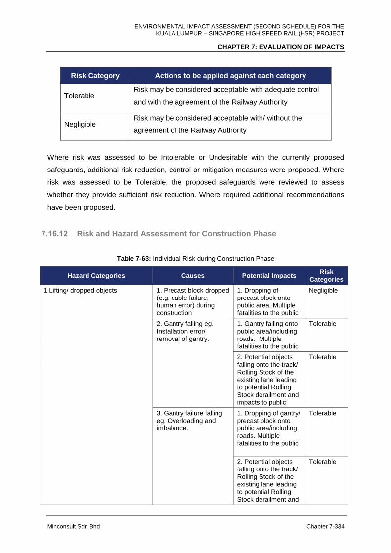
ENVIRONMENTAL IMPACT ASSESSMENT (SECOND SCHEDULE) FOR THE KUALA LUMPUR – SINGAPORE HIGH SPEED RAIL (HSR) PROJECT
CHAPTER 7: EVALUATION OF IMPACTS
Minconsult Sdn Bhd Chapter 7-334
Risk Category Actions to be applied against each category
Tolerable Risk may be considered acceptable with adequate control
and with the agreement of the Railway Authority
Negligible Risk may be considered acceptable with/ without the
agreement of the Railway Authority
Where risk was assessed to be Intolerable or Undesirable with the currently proposed
safeguards, additional risk reduction, control or mitigation measures were proposed. Where
risk was assessed to be Tolerable, the proposed safeguards were reviewed to assess
whether they provide sufficient risk reduction. Where required additional recommendations
have been proposed.
7.16.12 Risk and Hazard Assessment for Construction Phase
Table 7-63: Individual Risk during Construction Phase
Hazard Categories Causes Potential Impacts Risk
Categories
1.Lifting/ dropped objects
1. Precast block dropped (e.g. cable failure, human error) during construction
1. Dropping of precast block onto public area. Multiple fatalities to the public
Negligible
2. Gantry falling eg. Installation error/ removal of gantry.
1. Gantry falling onto public area/including roads. Multiple fatalities to the public
Tolerable
2. Potential objects falling onto the track/ Rolling Stock of the existing lane leading to potential Rolling Stock derailment and impacts to public.
Tolerable
3. Gantry failure falling eg. Overloading and imbalance.
1. Dropping of gantry/ precast block onto public area/including roads. Multiple fatalities to the public
Tolerable
2. Potential objects falling onto the track/ Rolling Stock of the existing lane leading to potential Rolling Stock derailment and
Tolerable
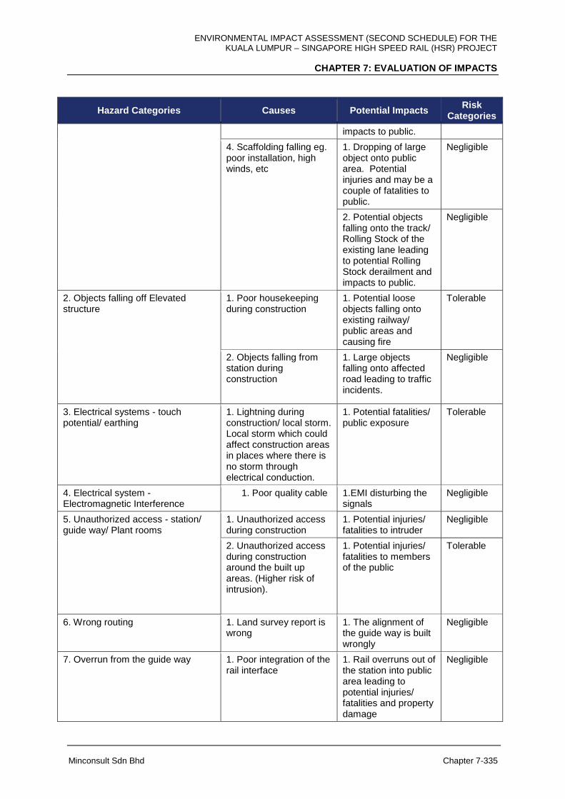
ENVIRONMENTAL IMPACT ASSESSMENT (SECOND SCHEDULE) FOR THE KUALA LUMPUR – SINGAPORE HIGH SPEED RAIL (HSR) PROJECT
CHAPTER 7: EVALUATION OF IMPACTS
Minconsult Sdn Bhd Chapter 7-335
Hazard Categories Causes Potential Impacts Risk
Categories
impacts to public.
4. Scaffolding falling eg. poor installation, high winds, etc
1. Dropping of large object onto public area. Potential injuries and may be a couple of fatalities to public.
Negligible
2. Potential objects falling onto the track/ Rolling Stock of the existing lane leading to potential Rolling Stock derailment and impacts to public.
Negligible
2. Objects falling off Elevated structure
1. Poor housekeeping during construction
1. Potential loose objects falling onto existing railway/ public areas and causing fire
Tolerable
2. Objects falling from station during construction
1. Large objects falling onto affected road leading to traffic incidents.
Negligible
3. Electrical systems - touch potential/ earthing
1. Lightning during construction/ local storm. Local storm which could affect construction areas in places where there is no storm through electrical conduction.
1. Potential fatalities/ public exposure
Tolerable
4. Electrical system - Electromagnetic Interference
1. Poor quality cable 1.EMI disturbing the signals
Negligible
5. Unauthorized access - station/ guide way/ Plant rooms
1. Unauthorized access during construction
1. Potential injuries/ fatalities to intruder
Negligible
2. Unauthorized access during construction around the built up areas. (Higher risk of intrusion).
1. Potential injuries/ fatalities to members of the public
Tolerable
6. Wrong routing 1. Land survey report is wrong
1. The alignment of the guide way is built wrongly
Negligible
7. Overrun from the guide way 1. Poor integration of the rail interface
1. Rail overruns out of the station into public area leading to potential injuries/ fatalities and property damage
Negligible
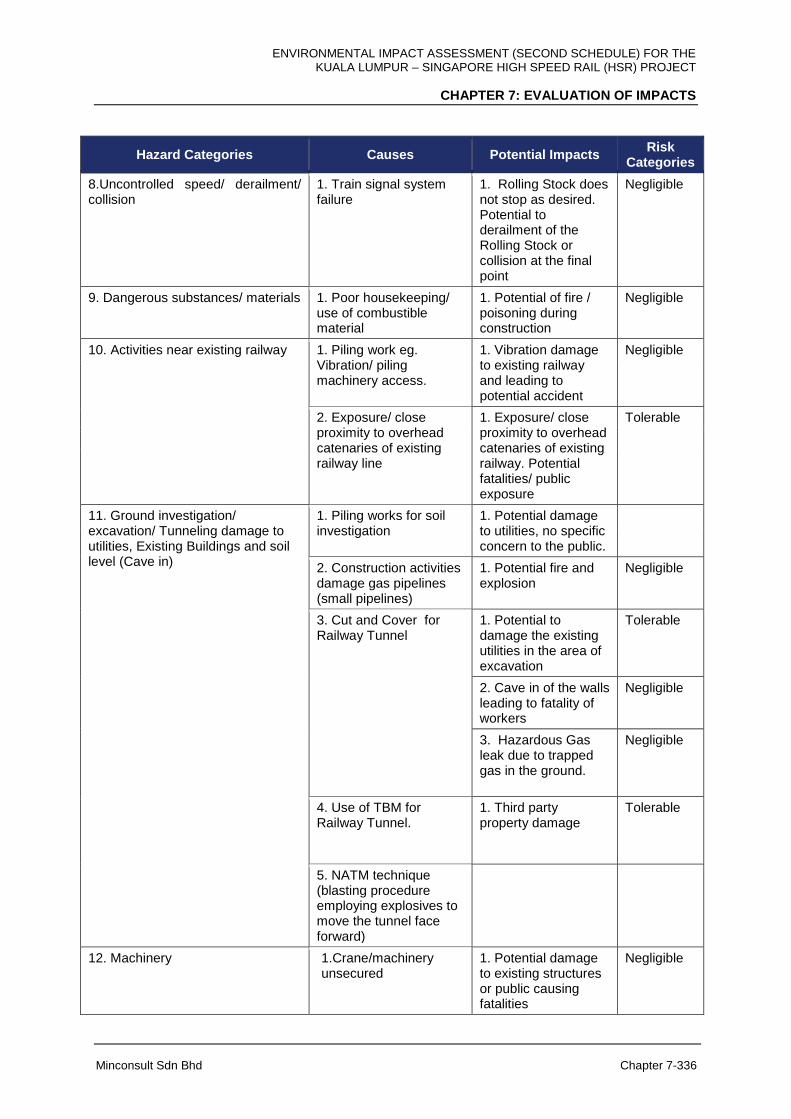
ENVIRONMENTAL IMPACT ASSESSMENT (SECOND SCHEDULE) FOR THE KUALA LUMPUR – SINGAPORE HIGH SPEED RAIL (HSR) PROJECT
CHAPTER 7: EVALUATION OF IMPACTS
Minconsult Sdn Bhd Chapter 7-336
Hazard Categories Causes Potential Impacts Risk
Categories
8.Uncontrolled speed/ derailment/ collision
1. Train signal system failure
1. Rolling Stock does not stop as desired. Potential to derailment of the Rolling Stock or collision at the final point
Negligible
9. Dangerous substances/ materials 1. Poor housekeeping/ use of combustible material
1. Potential of fire / poisoning during construction
Negligible
10. Activities near existing railway 1. Piling work eg. Vibration/ piling machinery access.
1. Vibration damage to existing railway and leading to potential accident
Negligible
2. Exposure/ close proximity to overhead catenaries of existing railway line
1. Exposure/ close proximity to overhead catenaries of existing railway. Potential fatalities/ public exposure
Tolerable
11. Ground investigation/ excavation/ Tunneling damage to utilities, Existing Buildings and soil level (Cave in)
1. Piling works for soil investigation
1. Potential damage to utilities, no specific concern to the public.
2. Construction activities damage gas pipelines (small pipelines)
1. Potential fire and explosion
Negligible
3. Cut and Cover for Railway Tunnel
1. Potential to damage the existing utilities in the area of excavation
Tolerable
2. Cave in of the walls leading to fatality of workers
Negligible
3. Hazardous Gas leak due to trapped gas in the ground.
Negligible
4. Use of TBM for Railway Tunnel.
1. Third party property damage
Tolerable
5. NATM technique (blasting procedure employing explosives to move the tunnel face forward)
12. Machinery 1.Crane/machinery unsecured
1. Potential damage to existing structures or public causing fatalities
Negligible

ENVIRONMENTAL IMPACT ASSESSMENT (SECOND SCHEDULE) FOR THE KUALA LUMPUR – SINGAPORE HIGH SPEED RAIL (HSR) PROJECT
CHAPTER 7: EVALUATION OF IMPACTS
Minconsult Sdn Bhd Chapter 7-337
Hazard Categories Causes Potential Impacts Risk
Categories
13. Dust/ noise/ vibration 1. Piling works 1. Potential damage to building eg. window building cracking
Negligible
2. Noise generated during construction
1. Potential health/ injuries issues
Negligible
3. Generation of dust during construction
1. Potential health/ injuries issues
Negligible
14. Structure collapse 1. Integrity of the built structure
1. Potential damage to existing structures or public causing fatalities
Negligible
15. Subsidence/ ground movements/ etc.
1. Potential subsidence to existing track during construction.
1. Potential damage to existing railway accident/ public impact (road)
Tolerable
2. Potential subsidence near existing affected road leading to traffic accidents
Tolerable
16. Adverse environment conditions 1. Earthquakes 1. Potential damage to guide ways, structure falling, public impact
Negligible
2. Thunder storm combined with drain blockage/ overloading of drain system
1. Potential damage to nearby buildings
Undesirable
17. Traffic 1. Improperly cleaned vehicles from construction area to public areas
1. Potential increase risk of traffic accident due to mud spill on public road/ increase generation of dust
Tolerable
2. Improper loading/ unloading from construction area
1. Damage to properties leading to potential public impacts
Tolerable
3. Improper management of Heavy construction vehicles ingress/ egress
1. Potential increase risk of traffic accident on public road
Tolerable
4. At station exit b y road vehicle
1. Potential increase risk of traffic accident on public road/ increase generation of dust
Negligible
5. Construction access/ restriction along major roads.
1. Potential increase risk of traffic accident on public road due to
Tolerable
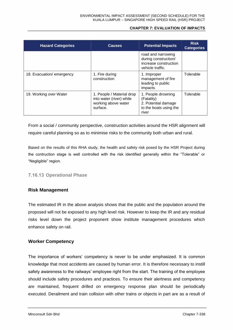
ENVIRONMENTAL IMPACT ASSESSMENT (SECOND SCHEDULE) FOR THE KUALA LUMPUR – SINGAPORE HIGH SPEED RAIL (HSR) PROJECT
CHAPTER 7: EVALUATION OF IMPACTS
Minconsult Sdn Bhd Chapter 7-338
Hazard Categories Causes Potential Impacts Risk
Categories
road and narrowing during construction/ increase construction vehicle traffic.
18. Evacuation/ emergency 1. Fire during construction
1. Improper management of fire leading to public impacts.
Tolerable
19. Working over Water 1. People / Material drop into water (river) while working above water surface.
1. People drowning (Fatality) 2. Potential damage to the boats using the river
Tolerable
From a social / community perspective, construction activities around the HSR alignment will
require careful planning so as to minimise risks to the community both urban and rural.
Based on the results of this RHA study, the health and safety risk posed by the HSR Project during
the contruction stage is well controlled with the risk identified generally within the “Tolerable” or
“Negligible” region.
7.16.13 Operational Phase
Risk Management
The estimated IR in the above analysis shows that the public and the population around the
proposed will not be exposed to any high level risk. However to keep the IR and any residual
risks level down the project proponent show institute management procedures which
enhance safety on rail.
Worker Competency
The importance of workers’ competency is never to be under emphasized. It is common
knowledge that most accidents are caused by human error. It is therefore necessary to instill
safety awareness to the railways’ employee right from the start. The training of the employee
should include safety procedures and practices. To ensure their alertness and competency
are maintained, frequent drilled on emergency response plan should be periodically
executed. Derailment and train collision with other trains or objects in part are as a result of
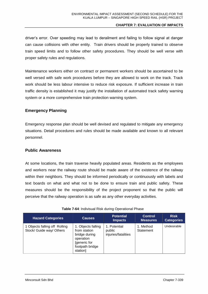
ENVIRONMENTAL IMPACT ASSESSMENT (SECOND SCHEDULE) FOR THE KUALA LUMPUR – SINGAPORE HIGH SPEED RAIL (HSR) PROJECT
CHAPTER 7: EVALUATION OF IMPACTS
Minconsult Sdn Bhd Chapter 7-339
driver’s error. Over speeding may lead to derailment and failing to follow signal at danger
can cause collisions with other entity. Train drivers should be properly trained to observe
train speed limits and to follow other safety procedures. They should be well verse with
proper safety rules and regulations.
Maintenance workers either on contract or permanent workers should be ascertained to be
well versed with safe work procedures before they are allowed to work on the track. Track
work should be less labour intensive to reduce risk exposure. If sufficient increase in train
traffic density is established it may justify the installation of automated track safety warning
system or a more comprehensive train protection warning system.
Emergency Planning
Emergency response plan should be well devised and regulated to mitigate any emergency
situations. Detail procedures and rules should be made available and known to all relevant
personnel.
Public Awareness
At some locations, the train traverse heavily populated areas. Residents as the employees
and workers near the railway route should be made aware of the existence of the railway
within their neighbors. They should be informed periodically or continuously with labels and
text boards on what and what not to be done to ensure train and public safety. These
measures should be the responsibility of the project proponent so that the public will
perceive that the railway operation is as safe as any other everyday activities.
Table 7-64: Indivisual Risk during Operational Phase
Hazard Categories Causes Potential Impacts
Control Measures
Risk Categories
1 Objects falling off Rolling Stock/ Guide way/ Others
1. Objects falling from station bridge during operation [generic for footpath bridge station]
1. Potential public injuries/fatalities
1. Method Statement
Undesirable
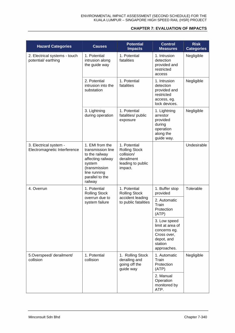
ENVIRONMENTAL IMPACT ASSESSMENT (SECOND SCHEDULE) FOR THE KUALA LUMPUR – SINGAPORE HIGH SPEED RAIL (HSR) PROJECT
CHAPTER 7: EVALUATION OF IMPACTS
Minconsult Sdn Bhd Chapter 7-340
Hazard Categories Causes Potential Impacts
Control Measures
Risk Categories
2. Electrical systems - touch potential/ earthing
1. Potential intrusion along the guide way
1. Potential fatalities
1. Intrusion detection provided and restricted access
Negligible
2. Potential intrusion into the substation
1. Potential fatalities
1. Intrusion detection provided and restricted access, eg. lock devices.
Negligible
3. Lightning during operation
1. Potential fatalities/ public exposure
1. Lightning arrestor provided during operation along the guide way.
Negligible
3. Electrical system - Electromagnetic Interference
1. EMI from the transmission line to the railway affecting railway system (transmission line running parallel to the railway
1. Potential Rolling Stock collision/ derailment leading to public impact.
Undesirable
4. Overrun 1. Potential Rolling Stock overrun due to system failure
1. Potential Rolling Stock accident leading to public fatalities
1. Buffer stop provided
Tolerable
2. Automatic Train Protection (ATP)
3. Low speed limit at area of concerns eg. Cross over, depot, and station approaches.
5.Overspeed/ derailment/ collision
1. Potential collision
1. Rolling Stock derailing and going off the guide way
1. Automatic Train Protection (ATP)
Negligible
2. Manual Operation monitored by ATP.
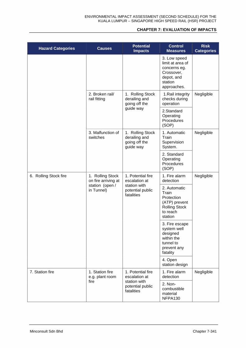
ENVIRONMENTAL IMPACT ASSESSMENT (SECOND SCHEDULE) FOR THE KUALA LUMPUR – SINGAPORE HIGH SPEED RAIL (HSR) PROJECT
CHAPTER 7: EVALUATION OF IMPACTS
Minconsult Sdn Bhd Chapter 7-341
Hazard Categories Causes Potential Impacts
Control Measures
Risk Categories
3. Low speed limit at area of concerns eg. Crossover, depot, and station approaches.
2. Broken rail/ rail fitting
1. Rolling Stock derailing and going off the guide way
1.Rail integrity checks during operation
Negligible
2.Standard Operating Procedures (SOP)
3. Malfunction of switches
1. Rolling Stock derailing and going off the guide way
1. Automatic Train Supervision System.
Negligible
2. Standard Operating Procedures (SOP)
6. Rolling Stock fire
1. Rolling Stock on fire arriving at station (open / in Tunnel)
1. Potential fire escalation at station with potential public fatalities
1. Fire alarm detection
Negligible
2. Automatic Train Protection (ATP) prevent Rolling Stock to reach station
3. Fire escape system well designed within the tunnel to prevent any fatality
4. Open station design
7. Station fire 1. Station fire e.g. plant room fire
1. Potential fire escalation at station with potential public fatalities
1. Fire alarm detection
Negligible
2. Non-combustible material NFPA130
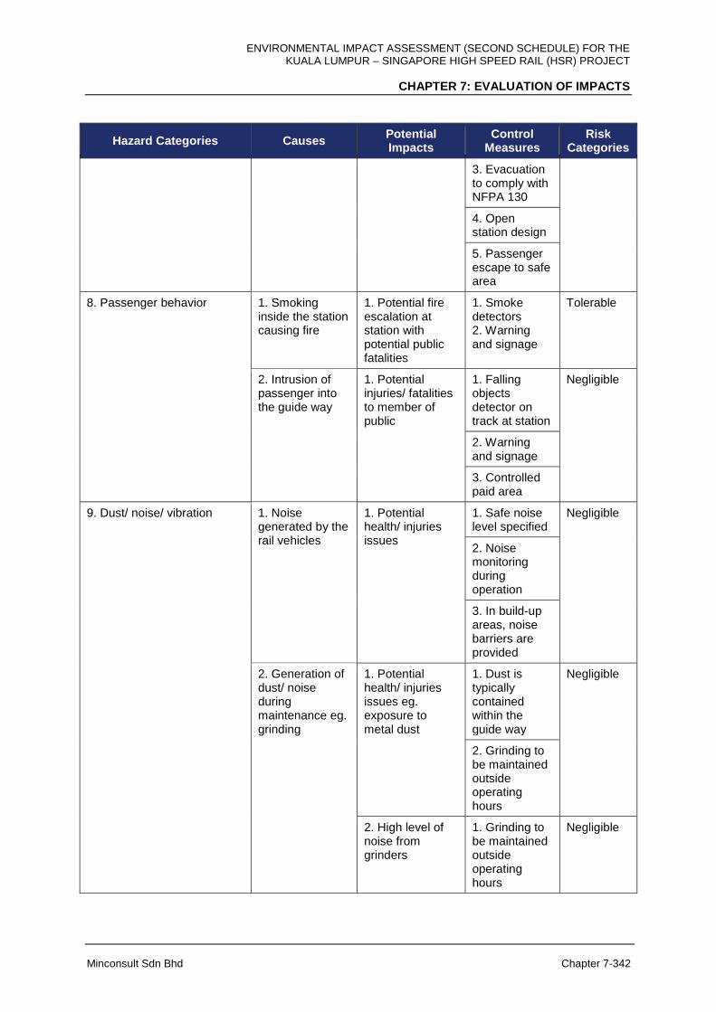
ENVIRONMENTAL IMPACT ASSESSMENT (SECOND SCHEDULE) FOR THE KUALA LUMPUR – SINGAPORE HIGH SPEED RAIL (HSR) PROJECT
CHAPTER 7: EVALUATION OF IMPACTS
Minconsult Sdn Bhd Chapter 7-342
Hazard Categories Causes Potential Impacts
Control Measures
Risk Categories
3. Evacuation to comply with NFPA 130
4. Open station design
5. Passenger escape to safe area
8. Passenger behavior 1. Smoking inside the station causing fire
1. Potential fire escalation at station with potential public fatalities
1. Smoke detectors 2. Warning and signage
Tolerable
2. Intrusion of passenger into the guide way
1. Potential injuries/ fatalities to member of public
1. Falling objects detector on track at station
Negligible
2. Warning and signage
3. Controlled paid area
9. Dust/ noise/ vibration
1. Noise generated by the rail vehicles
1. Potential health/ injuries issues
1. Safe noise level specified
Negligible
2. Noise monitoring during operation
3. In build-up areas, noise barriers are provided
2. Generation of dust/ noise during maintenance eg. grinding
1. Potential health/ injuries issues eg. exposure to metal dust
1. Dust is typically contained within the guide way
Negligible
2. Grinding to be maintained outside operating hours
2. High level of noise from grinders
1. Grinding to be maintained outside operating hours
Negligible
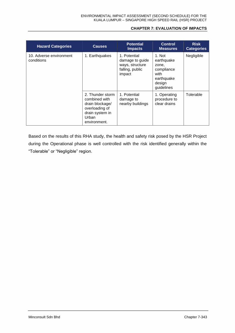
ENVIRONMENTAL IMPACT ASSESSMENT (SECOND SCHEDULE) FOR THE KUALA LUMPUR – SINGAPORE HIGH SPEED RAIL (HSR) PROJECT
CHAPTER 7: EVALUATION OF IMPACTS
Minconsult Sdn Bhd Chapter 7-343
Hazard Categories Causes Potential Impacts
Control Measures
Risk Categories
10. Adverse environment conditions
1. Earthquakes 1. Potential damage to guide ways, structure falling, public impact
1. Not earthquake zone, compliance with earthquake design guidelines
Negligible
2. Thunder storm combined with drain blockage/ overloading of drain system in Urban environment.
1. Potential damage to nearby buildings
1. Operating procedure to clear drains
Tolerable
Based on the results of this RHA study, the health and safety risk posed by the HSR Project
during the Operational phase is well controlled with the risk identified generally within the
“Tolerable” or “Negligible” region.
ENVIRONMENTAL IMPACT ASSESSMENT (SECOND SCHEDULE) FOR THE KUALA LUMPUR – SINGAPORE HIGH SPEED RAIL (HSR) PROJECT
CHAPTER 7: EVALUATION OF IMPACTS
Minconsult Sdn Bhd Chapter 7-344
7.17 ECONOMIC VALUATION OF ENVIRONMENTAL IMPACTS
7.17.1 Introduction
The HSR Project is expected to positively contribute towards the development of the national
economy by compressing geographical distances and rebalancing economic growth by
spreading development to the southern region. More directly, it will also have impact on the
economy through construction activities and subsequent commercial/economic activities
associated with an improved transportation network. Notwithstanding these economic
benefits, the proposed project activities may bring about some negative environmental
impacts although many of them will be mitigated, as required by law, through the EIA
approval process.
Not withstanding the above-mentioned benefits, associated project activities are also likely to
cause some negative environmental impacts although many of them will be mitigated as
required by law, through the EIA approval process. Some of the negative impacts cannot,
however, be completely mitigated. In compliance with the EIA approval process, these
negative (and positive) impacts need to be quantified (to the extent possible) in monetary
terms. The quantification is focused at monetizing the degradation (or gain) in services
obtainable from the environment. This valuation exercise allows for the appreciation of the
significance of the environmental values of the services that will be gained or lost due to
project implementation. It also complements the project proponent’s economic feasibility
study by explicitly incorporating the estimated environmental cost into the analysis.
Environmental services that will be foregone (or obtained) following project implementation
are real opportunity cost (or gain) to society. Hence, it is imperative that their values are
estimated. Recent advances in both theoretical and empirical methods and protocols of
environmental resources evaluation enable practitioners to produce reliable monetary
estimates of environmental services with a reasonable degree of reliability.
This section contains the methods and results of the economic valuation of the
environmental impacts of the proposed project. The methods of valuation generally abide by
the “Guidelines on Economic Evaluation of Environmental Impacts for EIA Projects”
published by the Department of Environment. The main goal of this chapter is to quantify

ENVIRONMENTAL IMPACT ASSESSMENT (SECOND SCHEDULE) FOR THE KUALA LUMPUR – SINGAPORE HIGH SPEED RAIL (HSR) PROJECT
CHAPTER 7: EVALUATION OF IMPACTS
Minconsult Sdn Bhd Chapter 7-345
the losses and gains (if any) in environmental services as a result of the proposed project
implementation. It is worth noting that this evaluation is not a full-blown project economic
feasibility evaluation and should never be viewed as such.
7.17.2 Objective
In general, the objective of the economic evaluation is to assess the impacts of the proposed
project on services obtainable from the surrounding environment. This requires the
economic evaluation of the changes (both negative and positive if any) in environmental
services arising from project implementation.
7.17.3 Methodology
One important step in the valuation process revolves around the need to ensure valid
attribution of impacts on environmental services to the proposed project. In order to satisfy
this requirement, physical environmental impacts that can reasonably be attributable to the
proposed project must first be demonstrated. In other words, the approach requires the
establishment of a clear link between project impacts on the physical functions of the
environment and the alteration of the quality and quantity of streams of environmental goods
and services. The Guidelines on the Economic Valuation of the Environmental Impacts for
EIA projects is very clear in this regards where it specifies that:
“… a key issue is to identify and quantify the changes in the flow of goods and
services produced by the environment which are impacted by a development project,
and then to monetize these changes into costs or benefits”.
The valuation process can be divided into nine distinct steps, as follows:
Step 1: Identify the project stakeholders.
The stakeholders that are affected by the alteration in environmental services are identified
in this step.

ENVIRONMENTAL IMPACT ASSESSMENT (SECOND SCHEDULE) FOR THE KUALA LUMPUR – SINGAPORE HIGH SPEED RAIL (HSR) PROJECT
CHAPTER 7: EVALUATION OF IMPACTS
Minconsult Sdn Bhd Chapter 7-346
Step 2: Define the “with project” and “without project” scenario.
A contrast is provided under the “with” and “without” project scenarios, as opposed to
“before” and “after” scenarios. It involves the conceptualization of the “with” and “without”
project scenarios. For the purpose of the assessment, the “with project” scenario is defined
as the situation where the high speed rail system is constructed and operated. “Without
project” scenario is depicted as the situation in which the proposed project is not
implemented i.e. maintenance of the status quo.
Step 3: Describe the physical impacts.
A listing of potential physical impacts of the project that can be reasonably attributed to the
project is prepared and described by focusing on the physical extent of the impact and the
link between the project and its impact on the flow of environmental services.
Step 4: Quantify the impacts on the environment over the duration of the project.
The physical impacts of the project on the environment is linked and explained in
quantitative manner. Quantifications of physical impacts are required in order to translate
the alteration in environmental services into monetary values. This is achieved through
scientific assessments of the study team that include among others air quality, water quality
specialist, and land use specialist.
Step 5: Monetize the impacts.
The physical impacts identified in Step 4 are quantified in monetary terms, at this stage.
This is attained by using market and non-market valuation techniques. For the purpose of
this study, values of similar environmental services obtained in other studies are used as the
bases of evaluation. This procedure is commonly known in the literature as the benefit
transfer method.
Step 6: Discounting.
The streams of costs and benefits are discounted to present values using several discount
rates (4%, 6% and 8%).
ENVIRONMENTAL IMPACT ASSESSMENT (SECOND SCHEDULE) FOR THE KUALA LUMPUR – SINGAPORE HIGH SPEED RAIL (HSR) PROJECT
CHAPTER 7: EVALUATION OF IMPACTS
Minconsult Sdn Bhd Chapter 7-347
Step 7: Determine the Net Present Value.
The net present value is computed in this step by adding up the discounted values of the
losses and gains in environmental services.
Step 8: Perform sensitivity analysis.
Sensitivity test is conducted for different discount rates to demonstrate the impact of
variation in rates on the net present value of the environmental costs and benefits.
Step 9: Make a recommendation.
An overall assessment is made based on the magnitude of Net Present Values at different
levels of discount rates.
7.17.4 Identification of Incremental Costs and Benefits
It is imperative that only incremental environmental impacts are considered in the evaluation
exercise. Considering only “incremental change in environmental services” means that only
marginal costs and benefits that arise as a result of choosing the “with project” option
(instead of “without project”) is subjected to evaluation.
Based on discussions with other study team members responsible to assess the impacts of
the project on all environmental components as well as reports prepared by them, Table 7-
61 shows the environmental services that may change as a result of project implementation.
The table describes the kind and spatial extent of the impacts as well as their respective
locations. From among these potential impacts, mitigation measures are considered, and
only those that remains to be significant are evaluated in this study.
7.17.5 Valuation of Costs and Benefits
Five environmental services (Table 7-62) can potentially change as a result of project
implementation. These changes can arise from removal of mangrove forest vegetation, the
loss of land planted with oil palm, the loss of land planted with rubber trees, reduction in
greenhouse gas emission, and degradation of water quality that feeds into intake points. Of
ENVIRONMENTAL IMPACT ASSESSMENT (SECOND SCHEDULE) FOR THE KUALA LUMPUR – SINGAPORE HIGH SPEED RAIL (HSR) PROJECT
CHAPTER 7: EVALUATION OF IMPACTS
Minconsult Sdn Bhd Chapter 7-348
the 5 potential changes in environmental services, four are considered to be significant
enough for evaluation. These are changes due to i) removal of mangrove forest vegetation,
ii) loss of land planted with oil palm, iii) loss of land planted with rubber trees, and iv)
reduction in greenhouse gas emission. The nature of losses in environmental services for
each of the impact is described and evaluated in Table 7-65.
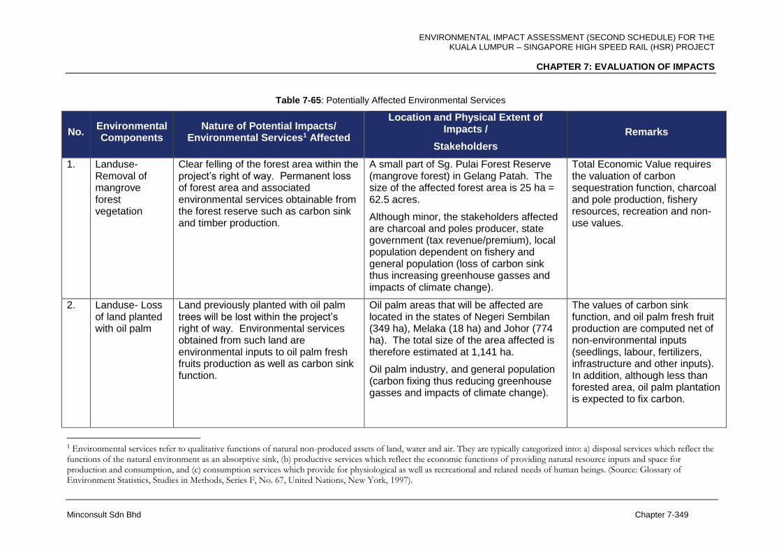
ENVIRONMENTAL IMPACT ASSESSMENT (SECOND SCHEDULE) FOR THE KUALA LUMPUR – SINGAPORE HIGH SPEED RAIL (HSR) PROJECT
CHAPTER 7: EVALUATION OF IMPACTS
Minconsult Sdn Bhd Chapter 7-349
Table 7-65: Potentially Affected Environmental Services
No. Environmental Components
Nature of Potential Impacts/ Environmental Services1 Affected
Location and Physical Extent of Impacts /
Stakeholders
Remarks
1. Landuse- Removal of mangrove forest vegetation
Clear felling of the forest area within the project’s right of way. Permanent loss of forest area and associated environmental services obtainable from the forest reserve such as carbon sink and timber production.
A small part of Sg. Pulai Forest Reserve (mangrove forest) in Gelang Patah. The size of the affected forest area is 25 ha = 62.5 acres.
Although minor, the stakeholders affected are charcoal and poles producer, state government (tax revenue/premium), local population dependent on fishery and general population (loss of carbon sink thus increasing greenhouse gasses and impacts of climate change).
Total Economic Value requires the valuation of carbon sequestration function, charcoal and pole production, fishery resources, recreation and non-use values.
2. Landuse- Loss of land planted with oil palm
Land previously planted with oil palm trees will be lost within the project’s right of way. Environmental services obtained from such land are environmental inputs to oil palm fresh fruits production as well as carbon sink function.
Oil palm areas that will be affected are located in the states of Negeri Sembilan (349 ha), Melaka (18 ha) and Johor (774 ha). The total size of the area affected is therefore estimated at 1,141 ha.
Oil palm industry, and general population (carbon fixing thus reducing greenhouse gasses and impacts of climate change).
The values of carbon sink function, and oil palm fresh fruit production are computed net of non-environmental inputs (seedlings, labour, fertilizers, infrastructure and other inputs). In addition, although less than forested area, oil palm plantation is expected to fix carbon.
1 Environmental services refer to qualitative functions of natural non-produced assets of land, water and air. They are typically categorized into: a) disposal services which reflect the functions of the natural environment as an absorptive sink, (b) productive services which reflect the economic functions of providing natural resource inputs and space for production and consumption, and (c) consumption services which provide for physiological as well as recreational and related needs of human beings. (Source: Glossary of Environment Statistics, Studies in Methods, Series F, No. 67, United Nations, New York, 1997).

ENVIRONMENTAL IMPACT ASSESSMENT (SECOND SCHEDULE) FOR THE KUALA LUMPUR – SINGAPORE HIGH SPEED RAIL (HSR) PROJECT
CHAPTER 7: EVALUATION OF IMPACTS
Minconsult Sdn Bhd Chapter 7-350
No. Environmental Components
Nature of Potential Impacts/ Environmental Services1 Affected
Location and Physical Extent of Impacts /
Stakeholders
Remarks
3. Landuse- Loss of land planted with rubber
Land previously planted with rubber trees will be lost within the project’s right of way. Environmental services obtained from such land are environmental inputs to latex and rubber wood production as well as carbon sink function.
Rubber holdings that will be affected are located in Negeri Sembilan (63 ha), Melaka (362 ha) and Johor (477 ha). The total size of rubber-planted area affected is estimated at 902 ha.
/Rubber industry, and general population (carbon fixing thus reducing greenhouse gasses and impacts of climate change).
The values of carbon sink function, and latex and rubber wood production are computed net of non-environmental inputs (seedlings, labour, fertilizers, infrastructure and other inputs). Rubber plantation also fixes carbon.
4. Air Quality – Reduction in greenhouse gas emission
Shifting motor vehicle and aircraft users to HSR can potentially bring about a net reduction in greenhouse gas emissions.
Reduction in air emission of greenhouse gases (CO2) will contribute towards overcoming global warming impacts.
Within (and beyond) national border. /Malaysians and global population in general.
The emission of CO2 is expected to be reduced when the proposed HSR begins operation as people using motor vehicles and aircraft switch to HSR, although the amount of reduction depends on the relative fuel efficiency of a transport mode and the HSR. The assessment quantifies the potential reduction in CO2 through modal shift from motor vehicles and aircrafts to HSR.
5. Water Quality – Water supply to intake points
Construction activities for river and stream crossings will affect environmental services including reduction in water quality of the streams and rivers thus potentially impacting the quality of water at intake points.
Water intakes that are located downstream of the project alignment include:
i. Sg. Semenyih Water Intake (about 0.125 km away).
ii. Sg. Labu WTP Intake (about 3.0 km
Minimal water quality impact is expected because mitigation measures such as site specific erosion and sediment control measures, and construction of bridges at river crossings will be

ENVIRONMENTAL IMPACT ASSESSMENT (SECOND SCHEDULE) FOR THE KUALA LUMPUR – SINGAPORE HIGH SPEED RAIL (HSR) PROJECT
CHAPTER 7: EVALUATION OF IMPACTS
Minconsult Sdn Bhd Chapter 7-351
No. Environmental Components
Nature of Potential Impacts/ Environmental Services1 Affected
Location and Physical Extent of Impacts /
Stakeholders
Remarks
away). iii. Durian Tunggal Water Intake (about
1.0 km away) iv. Sg. Kesang/ Lanchang Intake Point
(about 1.0 km away) Water treatment plant operators, public utilities, and commercial, industrial and residential users of water sourced from the intake points.
implemented in the proposed project. No valuation is therefore necessary.
ENVIRONMENTAL IMPACT ASSESSMENT (SECOND SCHEDULE) FOR THE KUALA LUMPUR – SINGAPORE HIGH SPEED RAIL (HSR) PROJECT
CHAPTER 7: EVALUATION OF IMPACTS
Minconsult Sdn Bhd Chapter 7-352
7.17.5.1 Removal of Mangrove Forest Area
In general, the benefits obtainable from environmental services from mangrove forest areas
can be divided into use and non-use values, the sum of which is known as the Total
Economic Value. Further, use value can be divided into direct and indirect use value, option
use value and bequest value. A schematic diagram showing a listing of values of services
obtainable from a mangrove forest area is provided in Figure 7-112. For the purpose of
valuation, appropriate techniques must be applied in order to arrive at valid monetary values
for the different services
Mangroves that are part of the coastal ecosystems, provide a wide range of economic and
ecological services. The environmental services provided by mangrove forest (and hence
affected by the proposed project) include:
(a) Production of charcoal and poles
(b) Provision of feeding and breeding grounds for shrimp, fish, crab and molusc
(c) Tourism and recreation
(d) Provision of traditional goods
(e) Carbon sequestration function
(f) Shoreline protection
(g) Option, existence and biodiversity values
The total size of forest area affected is only 25 ha (62.5 acres) based on the worst case
scenario, 100 m corridor, Sg. Pulai Forest Reserve in Gelang Patah. However, because
environmental services provided by mangrove forest areas are generally highly valued, this
study proceeds to evaluate value of services that will be lost when the area is cleared along
the HSR alignment.

ENVIRONMENTAL IMPACT ASSESSMENT (SECOND SCHEDULE) FOR THE KUALA LUMPUR – SINGAPORE HIGH SPEED RAIL (HSR) PROJECT
CHAPTER 7: EVALUATION OF IMPACTS
Minconsult Sdn Bhd Chapter 7-353
Figure 7-112: Total Economic Value of Forest Area (Adapted from Munasinghe dan Lutz (1993)
ENVIRONMENTAL IMPACT ASSESSMENT (SECOND SCHEDULE) FOR THE KUALA LUMPUR – SINGAPORE HIGH SPEED RAIL (HSR) PROJECT
CHAPTER 7: EVALUATION OF IMPACTS
Minconsult Sdn Bhd Chapter 7-354
(a) Charcoal and Poles
Mangrove areas produce timber, fuelwood, and building materials. Sathirathai (2000)
estimated that the annual net return from charcoal obtained from Thailand’s mangrove forest
is estimated to be $91.97. According to Sivakumar and Fernando (1997) Rhizophora sp.
used in housing construction generates Rs. 1 million/ha/year in Sri Lanka. Bann (1997)
estimated that the net benefit from selective commercial mangrove cutting schemes was
estimated to be $ 20 million/ year in Indonesia. This study adopts a current value of RM
11,051.98/ha/year of mangrove area after incorporating inflationary factor and exchange rate
conversion determined from prior studies.
(b) Shrimp, fish, crab and molusc
Mangroves are feeding and breeding ground for fish. Bann (1999) estimated the direct use
value of mangroves from captured fishery at US$ 526/ha/yr in Malaysia. In several other
developing countries, the annual value of the fish caught in mangroves, varies between
US$900 and US$12,400/ha of mangrove (Rodríguez 2001). The economic value of the
fisheries function of mangroves has been reviewed or estimated by many researchers
including Hamilton & Snedker, (1984); Ruitenbeek, (1991); Gren & Soderqvist, (1994);
Hambrey, (1997); Gilbert & Janssen, (1997) and Costanza et al, (1997) The values ranged
from $66 to almost $3,000 /ha/yr. Christensen (1982) estimated the fisheries function in
Thailand at 130/ha/yr. Lal (1990) estimated the fisheries function of mangroves in Fiji at
US$ 100/ha/yr while Ruitenbeek (1992) estimated the same in Indonesia at US$ 117/ha/yr.
Janssen and Padilla (1996) estimated the mangrove fisheries function in Philippines at US$
60/ha/yr.
For this study the environmental services offered by mangroves habitat for fishery feeding
and breeding ground is evaluated based on expected total catch (quantity) and market price
of fishery resources. Further computation produces an estimate of RM 7,285.48/ha/year as
the value of fishery resources that are dependent on the mangrove area. This estimate is
obtained after incorporating inflationary factor and exchange rate conversion for values
estimated by previous studies.
ENVIRONMENTAL IMPACT ASSESSMENT (SECOND SCHEDULE) FOR THE KUALA LUMPUR – SINGAPORE HIGH SPEED RAIL (HSR) PROJECT
CHAPTER 7: EVALUATION OF IMPACTS
Minconsult Sdn Bhd Chapter 7-355
(c) Tourism and Recreation
This component of the study analyses the economic value of recreation benefits of
mangrove forests for both domestic and international tourists. Avoiding degradation or loss
in mangrove areas increases the opportunity for recreation, which will lead to the promotion
of the tourism industry. Costanza et al (1989) in the United States estimated recreational
value of mangroves using both these methods and came up with $ 70.67 per visitor from
TCM and $ 47.11 per visitor from CVM.
In Sri Lanka the estimates for recreational and tourism value of mangrove areas have been
estimated at US$ 1,196/ha/year for international tourism and the corresponding value for
domestic tourism is US$ 933 (Batagoda 2003). The only Malaysian study on the value of
mangrove forest from the tourism perspective can be found in Bennett and Reynolds (1993)
that estimated that tourism value derived from mangrove forest in Sarawak was US$
473.26/ha/year. Cesar (1996) proposed a net return factor of 60% of revenue thus giving a
net benefit of US$283.96. Hence the value adopted for this study is RM 1,706.57/ha/year.
(d) Traditional Use
Mangrove forests provide several marketed and non-marketed forest resources in the form
of traditional use products like nipah shingles, resins, medicines and cane products. For
example, Ruitenbeek (1992) estimated the annual net benefit from medicinal plants to be
$15/ ha/ yr. from a mangrove forest in Indonesia. Because the values derived from
traditional products are small, this study ignores the traditional use value of mangrove forest.
(e) Biodiversity Values
Mangroves store valuable genetic resources in addition to providing habitats for migratory
species. In general, biological diversity helps the mangroves in maintaining ecological
(carrier) and regulatory functions, especially in undisturbed state. Several studies have
estimated the economic value of biodiversity maintenance by estimating several functions of
mangroves. Ruitenbeek (1992) in an Indonesian study, estimated the capturable biodiversity
benefits of mangroves if they are maintained intact at US$1,500 per square kilometer per
year that translates into US$15/ha/year for mangrove forest in Indonesia. Several other
studies have estimated the plant based pharmaceutical value of mangroves ranging from

ENVIRONMENTAL IMPACT ASSESSMENT (SECOND SCHEDULE) FOR THE KUALA LUMPUR – SINGAPORE HIGH SPEED RAIL (HSR) PROJECT
CHAPTER 7: EVALUATION OF IMPACTS
Minconsult Sdn Bhd Chapter 7-356
US$0.1 to US$ 61/a/year (Bann 1997). This study uses an adjusted figure of RM
141.22/ha/year for the biodiversity value of the mangrove areas.
(f) Carbon Sequestration
Mangroves play an important role in regulating carbon dioxide in the global atmosphere by
absorbing CO2 and storing it in their biomass. Emission of carbon dioxide leads to
greenhouse effect i.e. a process in which the emission of infrared radiation by the
atmosphere warms a planet's surface. Carbon sequestration does the reverse. According
to the Third Assessment Report of the Intergovernmental Panel on Climate Change (IPPC),
the globally averaged surface temperature is projected to increase by between 1.4 and
5.8°C from 1990 to 2100 under business-as-usual, and sea levels are expected to rise by
between 9 and 88 cm over the same period. If nothing is done to reduce these changes,
they will have major consequences for the ecosystem and our economies. With a 5-6°C
warming, a real possibility for the next century, models estimate an average of 5-10% loss in
global GDP, with poor countries suffering costs in excess of 10% GDP (Stern Review, 2006).
In order to reduce greenhouse gas emission, the international community has agreed (the
Kyoto Protocol) on introducing three market-based "flexible mechanisms" that allows for
emission trading. Emission trading price (usually quoted in tone carbon dioxide equivalent)
provides a good basis for the quantification of the impact of greenhouse gases on the
environment. Created in 2005, the European Union Emission Trading Scheme (EU ETS) is
the largest multi-national, emissions trading scheme in the world. The treaty binds most
developed nations to a cap and trade system for the six major greenhouse gases. Emission
quotas were agreed by each participating country, with the intention of reducing their overall
emissions by 5.2% of their 1990 levels by the end of 2012. Under the treaty, for the 5-year
compliance period from 2008 until 2012, countries discharging less than their quota can sell
credits to others that go above their quota.
The treaty essentially sets up an emission trading system to control pollution by providing
economic/financial incentives to reduce emissions of pollutants including carbon. Under the
system a central authority sets a cap on the amount of a pollutant that can be emitted.
Companies are issued emission permits and hold an equivalent number of credits which
represent the right to emit a specific amount. Companies that need to increase their
emission allowance must buy credits from those who pollute less. The transfer of allowances

ENVIRONMENTAL IMPACT ASSESSMENT (SECOND SCHEDULE) FOR THE KUALA LUMPUR – SINGAPORE HIGH SPEED RAIL (HSR) PROJECT
CHAPTER 7: EVALUATION OF IMPACTS
Minconsult Sdn Bhd Chapter 7-357
is referred to as a trade. In effect, the buyer is paying a charge for polluting, while the seller
is being rewarded for having reduced emissions by more than was needed. By doing so,
companies that can reduce emissions most cheaply will do so, achieving the pollution
reduction at the lowest possible cost to society.
There are currently active trading programs in several pollutants. For greenhouse gases, the
largest is the European Union Emission Trading Scheme. Historically the price per ton of
carbon has been fluctuating mostly within the band of €10 to €30. However, the latest data
in recent years shows that price had fallen to between €3.00 to €6.00/ton. At the same time,
there was a perceptible upward trend in the price level thus warranting the use of the late
2016 price of about €5/ton for the purpose of valuation in this EIA report.
Carbon sequestration benefits of the mangrove forest can then be estimated by calculating
the total biomass per ha and then applying appropriate conversion factors to obtain carbon
equivalents. The daily net CO2- fixations of several dominant mangrove species found in
Thailand as well as Sri Lanka such as Avicennia marina, Rhizophora apiculata, and
Excoecaria agallocha have been estimated at 14,942 mg at 14,942 mg CO2/m2/day, 24,235
mg CO2/m2/day, and 14,097 mg CO2/m2/day respectively. Based on these results, average
value for carbon-fixation of mangroves in Kanjanadit District in Thailand was estimated at
15.1 tonC/ha/yr.
For this study, the value of mangrove forest service obtained in the form of carbon
sequestration function is estimated at RM 339.75/ha/year.
(g) Shoreline Protection
Mangroves function as natural barriers of the shoreline from erosion. The shoreline
protection value is normally estimated by using the replacement cost approach i.e. the cost
of building artificial structures. The cost of constructing protective structures has been
estimated at RM 1.36 million/km in Malaysia (Hiew and Lim 1994). Estimates for building a
seawall and breakwater is about US$1.2 million/km (Dahuri 1995). Taking the Malaysian
study as the basis for computing the shoreline protection service provided by mangrove
area, this study determines that the value of this function is RM 6,476.43/ha/year.

ENVIRONMENTAL IMPACT ASSESSMENT (SECOND SCHEDULE) FOR THE KUALA LUMPUR – SINGAPORE HIGH SPEED RAIL (HSR) PROJECT
CHAPTER 7: EVALUATION OF IMPACTS
Minconsult Sdn Bhd Chapter 7-358
Table 7-66 provides the estimated environmental cost of mangrove removal per ha. The
total estimated environmental value from the mangrove area is RM27,001.44/ha/year. This
rate is applied to the total loss of 25 ha in mangrove area.
Table 7-66: Estimated Environmental Value of Mangrove Areaby Service Type (2014 price)
Environmental Services Unit Value
(RM/ha/year)
Direct use value
Production of charcoal/poles 11,051.98
Feeding and breeding ground
and habitat for
shrimp/fish/crab/molusc
7,285.48
Tourism and recreation 1,706.57
Traditional use -
Indirect use
value
Carbon sequestration 339.75
Shoreline protection 6,476.43
Option/Non-use
value Biodiversity values 141.22
Total 27,001.44
7.17.5.2 Loss of Non-Forested Area - Oil Palm
Apart from the removal of forest area, the proposed project will also cause the loss of areas
planted with commercial crops (oil palm and rubber). The total oil palm area affected is
estimated at 1,141 ha (349 ha in Negeri Sembilan, 18 ha Melaka and 774 ha in Johor).
There are some environmental services provided by oil palm areas. In particular, the
existing oil palm land produces valuable fresh fruits, the production of which requires
environmental inputs (services). This loss in environmental services is valued in this study
by estimating the resource rent which is equivalent to the value of the fruits net of non-
environmental inputs. This approach is consistent with the procedure of subtracting
harvesting cost and profit margin in determining the stumpage value of timber.
In addition to non-environmental inputs at the operation and harvesting stage, the estimation
of the resource rent must take into account the oil palm areas’ development expenditure that
is known to be very significant. For a given plot of oil palm area, deducting expenditure on
ENVIRONMENTAL IMPACT ASSESSMENT (SECOND SCHEDULE) FOR THE KUALA LUMPUR – SINGAPORE HIGH SPEED RAIL (HSR) PROJECT
CHAPTER 7: EVALUATION OF IMPACTS
Minconsult Sdn Bhd Chapter 7-359
non-environmental inputs from the value of fresh fruit bunch harvest leads to under or over
valuation of environmental service during different points of the trees’ life-cycle. For
example, in the initial years, there will be “negative” environmental service using this
computation. On the other hand, in years when the trees are most productive,
environmental service flow will appear to be very large. To overcome this difficulty, this
study assumes that the age of trees is uniformly distributed over their life-cycle of 30 years.
By doing so, over and under valuation of environmental services are netted out to correctly
represent the value of the contribution of the environment to oil palm production in any given
year.
Another environmental service provided by the oil palm areas is carbon sequestration
function. The value of this environmental service loss is also evaluated in this study using
method that is similar to valuing carbon sequestration function of forest.
(i) The Economic Value of Oil Palm Fresh Fruits
The economic value of oil palm fresh fruits can be ascertained by subtracting the cost of
production (including initial capital cost) and imputed profit rate, from the revenue obtained
from fresh fruits produced. By definition, the value is equal to the market price of fresh fruits
minus all non-environmental input cost. The relevant price is, of course, the price that
prevails in a competitive fresh fruits market.
This method of value computation is known as the residual value method where, (over the
project life):
LR = P.Q – Cp – Ce – π
where; LR = Value of fresh fruits
P = Market price of fresh fruits
Q = Quantity of production
Cp = Cost of operating and maintaining the plantation
Ce = Cost of plantation establishment
π = Profit margin
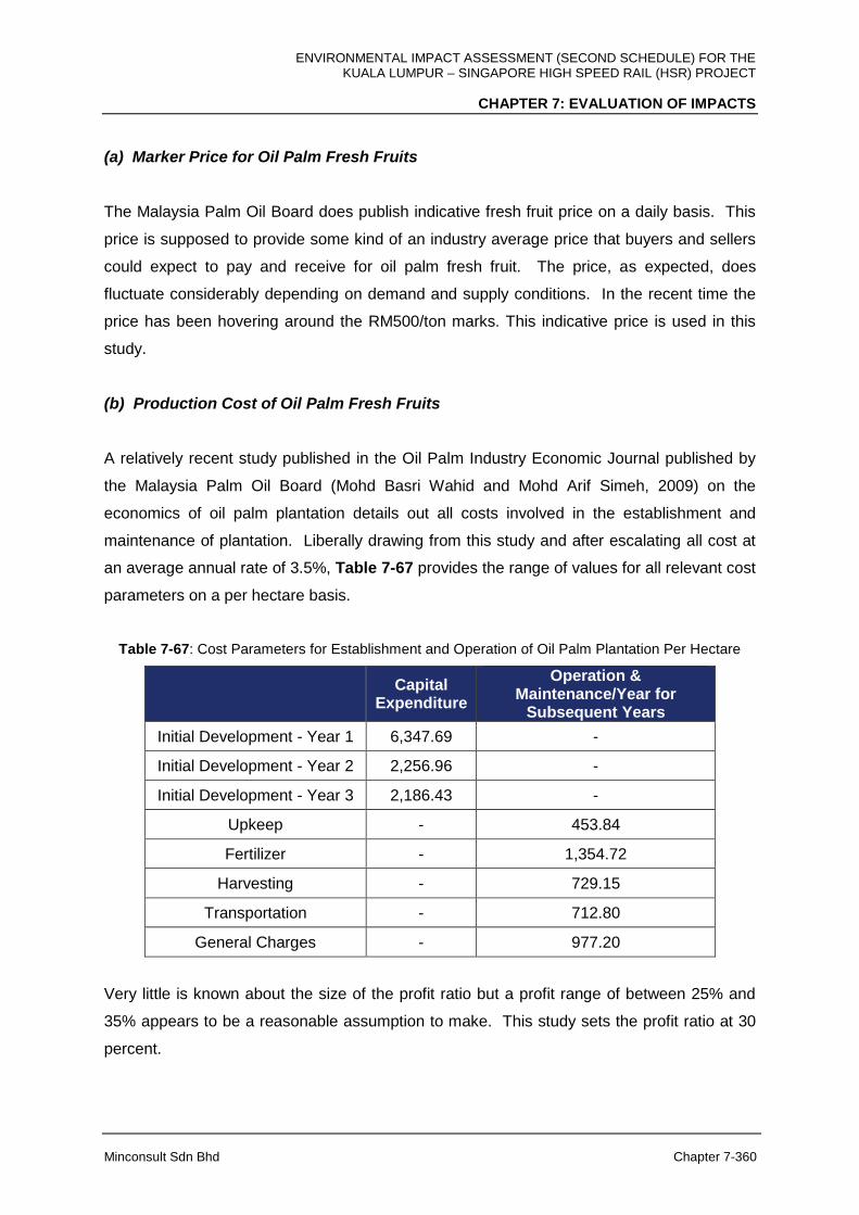
ENVIRONMENTAL IMPACT ASSESSMENT (SECOND SCHEDULE) FOR THE KUALA LUMPUR – SINGAPORE HIGH SPEED RAIL (HSR) PROJECT
CHAPTER 7: EVALUATION OF IMPACTS
Minconsult Sdn Bhd Chapter 7-360
(a) Marker Price for Oil Palm Fresh Fruits
The Malaysia Palm Oil Board does publish indicative fresh fruit price on a daily basis. This
price is supposed to provide some kind of an industry average price that buyers and sellers
could expect to pay and receive for oil palm fresh fruit. The price, as expected, does
fluctuate considerably depending on demand and supply conditions. In the recent time the
price has been hovering around the RM500/ton marks. This indicative price is used in this
study.
(b) Production Cost of Oil Palm Fresh Fruits
A relatively recent study published in the Oil Palm Industry Economic Journal published by
the Malaysia Palm Oil Board (Mohd Basri Wahid and Mohd Arif Simeh, 2009) on the
economics of oil palm plantation details out all costs involved in the establishment and
maintenance of plantation. Liberally drawing from this study and after escalating all cost at
an average annual rate of 3.5%, Table 7-67 provides the range of values for all relevant cost
parameters on a per hectare basis.
Table 7-67: Cost Parameters for Establishment and Operation of Oil Palm Plantation Per Hectare
Capital
Expenditure
Operation & Maintenance/Year for
Subsequent Years
Initial Development - Year 1 6,347.69 -
Initial Development - Year 2 2,256.96 -
Initial Development - Year 3 2,186.43 -
Upkeep - 453.84
Fertilizer - 1,354.72
Harvesting - 729.15
Transportation - 712.80
General Charges - 977.20
Very little is known about the size of the profit ratio but a profit range of between 25% and
35% appears to be a reasonable assumption to make. This study sets the profit ratio at 30
percent.

ENVIRONMENTAL IMPACT ASSESSMENT (SECOND SCHEDULE) FOR THE KUALA LUMPUR – SINGAPORE HIGH SPEED RAIL (HSR) PROJECT
CHAPTER 7: EVALUATION OF IMPACTS
Minconsult Sdn Bhd Chapter 7-361
(c) Oil Palm Yield
Oil palm yield is dependent on the age of the plantation trees. For this study, yield estimates
by age of tree stock per ha is obtained from Azman Ismail and Mohd Noor Mamat, (2002).
The estimates are given in Table 7-68. The oil palm plantation requires three (3) years to
establish and harvesting can begin in year 4 with peak yield from year 8 to 19. Thereafter
yield begins to decline gradually to around 15 ton/ha by year 30.
Table 7-68: Oil Palm Fresh Fruit Bunch Yield
Year Yield
(ton/ha) Year Yield (ton/ha)
1 0 16 19.58
2 0 17 19.58
3 0 18 19.33
4 4.52 19 19.08
5 7.53 20 18.83
6 12.55 21 18.58
7 16.57 22 18.33
8 19.08 23 18.08
9 19.83 24 17.83
10 20.34 25 17.58
11 20.34 26 17.33
12 20.09 27 16.83
13 20.09 28 16.33
14 19.93 29 16.08
15 19.58 30 15.58
(ii) The Economic Value of Carbon Sink Function of Oil Palm Plantation
The rate of biomass accumulation is positive for a plantation with growing oil palm trees.
Hence, we can expect a net carbon sequestration and a rising stock of carbon right from
planting to just before replanting.

ENVIRONMENTAL IMPACT ASSESSMENT (SECOND SCHEDULE) FOR THE KUALA LUMPUR – SINGAPORE HIGH SPEED RAIL (HSR) PROJECT
CHAPTER 7: EVALUATION OF IMPACTS
Minconsult Sdn Bhd Chapter 7-362
(a) Carbon Stock and Fixing of Oil Palm Plantation
Using findings from the study by Germer and Sauerborn (2008), the carbon fixing
rate/ha/year can be computed by factoring in the ultimate biomass content of oil palm
plantation and biomass-carbon conversion rate. The estimated total biomass after 30 years
is estimated at 99.0 ton/ha comprising 72.0 ton/ha above ground biomass, 24 ton/ha below
ground biomas and 3.0 ton/ha of ground cover biomass. The estimated biomass
accumulation rate is 3.3 ton/ha annually.
The amount of carbon fixed is therefore 40.3 ton/ha over a 30-year cycle by utilizing the
percentage of carbon content of oil palm trees and ground cover of 40.4% and 50.0%
respectively. The corresponding rate of carbon fixing is therefore on average estimated at
1.34 ton/ha/year for 30 years.
(b) Value of Carbon Sequestration
For consistency, the same carbon price used for mangrove forest carbon sequestration
function of €5/ton is used. The annual economic value of carbon sequestration lost due to
removal of oil palm land is provided in Tables 7-68, 7-69 and 7-70.
7.17.5.3 Loss of Non-Forested Area – Rubber
The HSR Project will also cause the loss of areas planted with rubber trees. The total size of
rubber-planted area affected is estimated at 902 ha (63 ha in Negeri Sembilan, 362 ha
Melaka and 477 ha in Johor).
Like oil palm, there are some environmental services provided by rubber-planted areas. In
particular, the rubber-planted area produces commercially valuable latex and rubber-wood,
the production of which requires environmental inputs (services). This loss in environmental
services is valued in this study by estimating the resource rent which is equivalent to the
value of the latex and rubber wood net of non-environmental inputs. This approach is
consistent with the procedure of subtracting harvesting cost and profit margin in determining
the stumpage value of timber.

ENVIRONMENTAL IMPACT ASSESSMENT (SECOND SCHEDULE) FOR THE KUALA LUMPUR – SINGAPORE HIGH SPEED RAIL (HSR) PROJECT
CHAPTER 7: EVALUATION OF IMPACTS
Minconsult Sdn Bhd Chapter 7-363
In addition to non-environmental inputs, the estimation of the resource rent must take into
account the rubber-planted areas’ development expenditure that is known to be very
significant. For any given period say a year, deducting expenditure on non-environmental
inputs from the value of latex and rubber wood for the current year, leads to under or over
valuation of environmental service during different points of the trees’ life-cycle. For
example, in the initial years, such computation will lead to environmental service being
valued as “negative”. On the other hand, in years when the trees are most productive in
producing latex and when rubber wood is harvested, environmental service flow will appear
to be very large. To overcome this difficulty, this study assumes that the age of trees are
uniformly distributed over their life-cycle (evaluation period of 30 years). By doing so, over
and under valuation of environmental services are netted out to correctly represent the value
of the contribution of the environment to latex and rubber-wood production in any given year.
Another environmental service provided by the rubber-planted areas is carbon sequestration
function. The value of this environmental service loss is also evaluated in this study using
method that is similar to valuing carbon sequestration function of forest.
(i) The Economic Value of Latex and Rubber Wood
The economic value of latex can be ascertained by subtracting the cost of production
(including initial capital cost) and imputed profit rate, from the revenue obtained from latex
produced. By definition, the value is equal to the market price of latex minus all non-
environmental input cost. The relevant price is, of course, the price that prevails in a
competitive latex market.
The economic worth of rubber wood logs can be ascertained by referring to its stumpage
value which in turn is the financial value of standing logs. By definition, stumpage value is
equal to the price paid by the rubber wood log mill less the cost of transporting the logs to
the mill and all non-environmental input cost in the establishment of the plantation. The
relevant price is, of course, the price that prevails in a competitive rubber wood market.
Again consistent with the valuation of timber, the residual value method is adopted for the
computation of economic value of rubber wood logs. The value of rubber logs has to be
adopted to include the cost of plantation establishment. Variables that are required in order

ENVIRONMENTAL IMPACT ASSESSMENT (SECOND SCHEDULE) FOR THE KUALA LUMPUR – SINGAPORE HIGH SPEED RAIL (HSR) PROJECT
CHAPTER 7: EVALUATION OF IMPACTS
Minconsult Sdn Bhd Chapter 7-364
to compute the value of rubber logs include market price, volume, cost drivers as well as
profit margin. The residual value is computed as:
LR = P – C – π
where; LR = Value of logs
PR = Price
Ch = Cost of logs harvesting
Ce = Cost of plantation establishment
π = Profit margin
The residual value of latex is also determined using the above formula by switching "logs” to
“latex”.
(a) Marker Price for Rubber Wood and Latex
The daily latex price per kg for November 2017 of about RM5.80 (Malaysia Rubber Board) is
used as the market price parameter for latex in this study.
The Malaysia Timber Board does publish indicative rubber wood price on a regular basis.
This price is supposed to provide some kind of an industry average price that buyers and
sellers could expect to pay and receive for rubber logs. Marketable rubber logs are of two
types: bole log and canopy wood. The canopy wood price is typically set at about 35% of
bole log price on a cubic metre basis (MTIB, 2017). The latest available indicative price is
RM180/tonne for bole log. The conversion rate ordinarily used to convert volume into weight
is 180 m3 = 130 tonne. The price and conversion rates are used in this study.
(b) Production Cost of Latex, Rubber Wood and Profit Ratio
A Malaysian Rubber Board publication (Mohamad Johari, 2006) on the economics of rubber
forest plantation details out all costs involved in the establishment and maintenance of
rubber plantation. Liberally drawing from this study and after escalating all cost at an
average annual rate of 3.5%, Table 7-69 provides the range of values for all relevant cost
parameters on a per hectare basis.
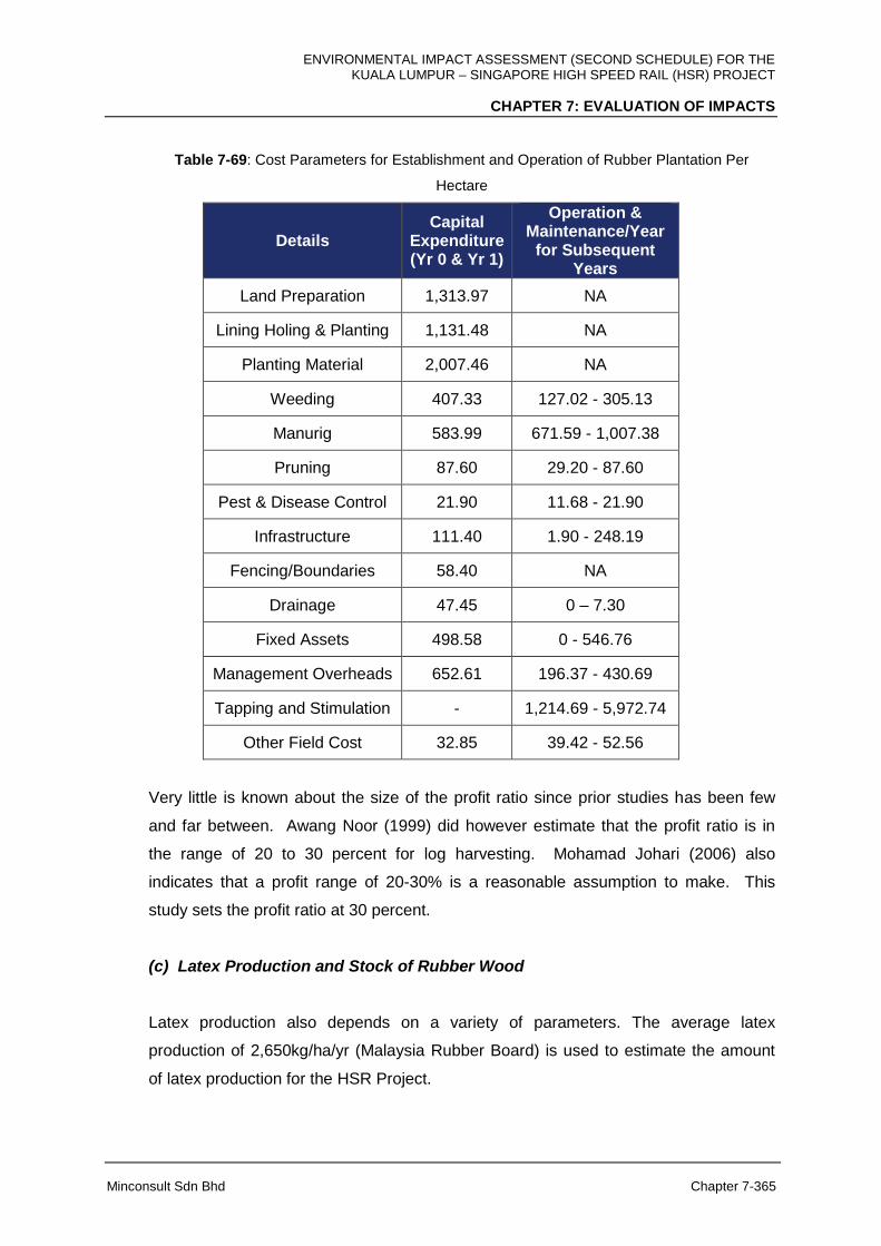
ENVIRONMENTAL IMPACT ASSESSMENT (SECOND SCHEDULE) FOR THE KUALA LUMPUR – SINGAPORE HIGH SPEED RAIL (HSR) PROJECT
CHAPTER 7: EVALUATION OF IMPACTS
Minconsult Sdn Bhd Chapter 7-365
Table 7-69: Cost Parameters for Establishment and Operation of Rubber Plantation Per
Hectare
Details Capital
Expenditure (Yr 0 & Yr 1)
Operation & Maintenance/Year
for Subsequent Years
Land Preparation 1,313.97 NA
Lining Holing & Planting 1,131.48 NA
Planting Material 2,007.46 NA
Weeding 407.33 127.02 - 305.13
Manurig 583.99 671.59 - 1,007.38
Pruning 87.60 29.20 - 87.60
Pest & Disease Control 21.90 11.68 - 21.90
Infrastructure 111.40 1.90 - 248.19
Fencing/Boundaries 58.40 NA
Drainage 47.45 0 – 7.30
Fixed Assets 498.58 0 - 546.76
Management Overheads 652.61 196.37 - 430.69
Tapping and Stimulation - 1,214.69 - 5,972.74
Other Field Cost 32.85 39.42 - 52.56
Very little is known about the size of the profit ratio since prior studies has been few
and far between. Awang Noor (1999) did however estimate that the profit ratio is in
the range of 20 to 30 percent for log harvesting. Mohamad Johari (2006) also
indicates that a profit range of 20-30% is a reasonable assumption to make. This
study sets the profit ratio at 30 percent.
(c) Latex Production and Stock of Rubber Wood
Latex production also depends on a variety of parameters. The average latex
production of 2,650kg/ha/yr (Malaysia Rubber Board) is used to estimate the amount
of latex production for the HSR Project.
ENVIRONMENTAL IMPACT ASSESSMENT (SECOND SCHEDULE) FOR THE KUALA LUMPUR – SINGAPORE HIGH SPEED RAIL (HSR) PROJECT
CHAPTER 7: EVALUATION OF IMPACTS
Minconsult Sdn Bhd Chapter 7-366
The rubber plantation requires 8 years to establish and tapping can only commence in
the 9th year for a period of 7 years. Thereafter the cycle of plant establishment,
operation and harvesting is repeated.
The total amount of harvestable rubber wood logs depends on the number of trees per
ha, clone type and logging cycle. For this study, the estimate of the stock of rubber
wood logs per ha is obtained from Mohamad Johari (2006). A typical rubber forest
plantation has about 524 trees/ha and each tree can on average produce bole log
amounting to 0.5 m3 and canopy wood amounting to 0.3 m3.
(ii) The Economic Value of Carbon Sink Function of Rubber Plantation
The rate of biomass accumulation is positive for a plantation with growing rubber trees.
Hence, we can expect a net carbon sequestered and a rising stock of carbon right from
planting to harvesting. There is some indication that following through on the usage of
rubber wood, rubber plantation become carbon neutral at twice its planting cycle (Liew
2001). The unpublished study traces the use and re-use of rubber wood in arriving at the
conclusion.
(a) Carbon Stock and Fixing of Rubber Plantation
Conservatively assuming that only biomass in the form of bole log amounting to 0.5 m3 and
canopy wood amounting to 0.3 m3 per tree were generated over one harvesting cycle of 16
years, the carbon fixing rate/ha/year can be computed by factoring in planting density and
biomass-carbon conversion rate. As mentioned earlier, 524 trees/ha is a typical planting
density for rubber plantation. It is therefore estimated that the amount of carbon fixed over a
16 year cycle is 419.2 m3/haor about 302.8 ton/ha. Since, only about 45% of the total dry
biomass constitutes carbon (Lasco, et. al, 2003), the amount of carbon fixed is 136.2 ton/ha
over a harvesting cycle of 16 years.
This gives us an estimated biomass accumulation rate of 18.9 ton/ha annually. The
corresponding rate of carbon fixing is therefore 8.5 ton/ha/year for 16 years.
ENVIRONMENTAL IMPACT ASSESSMENT (SECOND SCHEDULE) FOR THE KUALA LUMPUR – SINGAPORE HIGH SPEED RAIL (HSR) PROJECT
CHAPTER 7: EVALUATION OF IMPACTS
Minconsult Sdn Bhd Chapter 7-367
(b) Value of Carbon Sequestration
For consistency, the same carbon price used for mangrove forest carbon sequestration
function of €5/ton is applied. The annual economic value of carbon sequestration lost due to
removal of rubber-planted land is provided in Tables 7-68, 7-69 and 7-70.
7.17.5.4 Reduction in Green House Gas Emission from Modal Shift
The emission of CO2 is expected to be reduced when the HSR begins operation as people
using motor vehicles and aircraft switch to HSR, although the amount of reduction depends
on the relative fuel efficiency of a particular transport mode to the HSR. For example, CO2
emission per passenger km for short haul flight is estimated at 172.71 g/passenger km
(DEFRA, 2012) compared to 50.0 g per passenger km for rail travel (Britain’s Transport
Infrastructure Rail Electrification, 2009). This section quantifies the potential reduction in
CO2 as a result of modal shift from motor vehicles and aircrafts to HSR.
CO2 is released indirectly by the HSR operation as traction power is source from the
electricity power plants. However, emission from HSR operation is expected to be offset by
the reduction in the number of motor vehicles and aircraft usage as users switch to HSR.
The greenhouse gas of concern is CO2 as other greenhouse gas such as methane and
nitrous oxide are relatively minor.
The net change in CO2 emission from modal shift to the HSR is computed based on the
formula below:
Net change in CO2 emission = Reduction in CO2 emission by other modes (cars, buses,
existing rail and aircraft) as users switch to HSR minus Increase in CO2 resulting from HSR
operation (including induced demand).
(i) Emission Factors and Parameters
The emission factors and parameters are provided by the air quality consultant for the
purpose of estimating the net impact of HSR operation on CO2 emission.
ENVIRONMENTAL IMPACT ASSESSMENT (SECOND SCHEDULE) FOR THE KUALA LUMPUR – SINGAPORE HIGH SPEED RAIL (HSR) PROJECT
CHAPTER 7: EVALUATION OF IMPACTS
Minconsult Sdn Bhd Chapter 7-368
The emission factors and parameters that were used in the calculations of CO2 emissions
are:
a. The percentage of shifted passenger km by mode for air, cars, buses and rail based on
impact of HSR on other modes (Chapter 3, Demand and Revenue): 46%, 10%, 25%
and 23%;
b. CO2 emission factor for private car: 77.30 g per vehicle km, assuming average
occupancy of 2.5 (Global Environment Facility (GEF), 2010);
c. CO2 emission factor for bus: 135.52 g per passenger km (Department of Environment,
Food and Rural Affairs, UK (DEFRA), 2012);
d. CO2 emission factor for aircraft passengers (short haul; flight distance <785 km): 172.71
g per passenger km (Department of Environment, Food and Rural Affairs, UK (DEFRA),
2012);
e. Emission factor for passenger train: 50.0 g/km pp (Britain’s Transport Infrastructure Rail
Electrification, 2009).
(ii) Ridership and Passenger KM Projection
The annual ridership projection is provided in Chapter 5 of this report. It is expected to grow
from 15.2 million passengers in the initial year of operation to 37.8 million passengers in the
30th year of operation. The ridership figures are then converted to passenger km by
multiplying the number of passengers by segment with the respective segment distance.
Summing up the passenger km value by segment over all segments produces the total
passenger km.
(iii) Change in CO2 Emission
The annual total passenger km figure is then applied in combination with the emission
factors and parameters, and percentage of modal shift to compute the change in emission
by transport mode. The sum of the change (reduction) in emission by transport mode plus
the increase in emission due to induced demand gives the net impact of the HSR on CO2
emission.
ENVIRONMENTAL IMPACT ASSESSMENT (SECOND SCHEDULE) FOR THE KUALA LUMPUR – SINGAPORE HIGH SPEED RAIL (HSR) PROJECT
CHAPTER 7: EVALUATION OF IMPACTS
Minconsult Sdn Bhd Chapter 7-369
(iv) Value of Emission Reduction
For consistency, the same carbon price of €5/ton is used in valuing the value of the reduction in
emission. The annual economic value of emission reduction from modal shift made possible by the
HSR operation is provided in Tables 7-70, 7-71 and 7-72.
7.17.5.5 Overall Assessment
Tables 7-70, 7-71 and 7-72 show the streams of discounted environmental costs/benefits for
a period of 50 years that can be attributed to the HSR Project. The 8% rate is chosen to
reflect the market rate of interest conventionally use for Project evaluation while the 6% and
4% rates are more appropriate for social/ environmental evaluation.
After discounting at the rate of 4%, the total present value of the stream of net loss in
environmental services amounts to RM20.054 million over a 50-year period. The present
value is relatively small because the economic value of the reduction in environmental
services from the loss of mangrove, oil palm and rubber land is almost fully compensated by
the economic value of the reduction in CO2 emission due to modal shift.
When 6% and 8% rates of discount are used, the corresponding value of environmental
services loss are RM26.056 million and RM27.932 million respectively. Note that the
present value of environmental service loss increases with the discount rate. This is due to
the fact that larger environmental gain from reduction in vehicle emission, as users switch to
the HSR, builds up over time. The process of discounting naturally results in gain that will be
obtained in the distant future becoming small in present value terms, thus resulting in more
negative values for higher discount rates. This study also notes that the Present Values
should not be construed as indicating project feasibility. They rather provide some indication
of the magnitude, in monetary terms, of the net change in the flow of environmental services
as a result of the implementation of the Project.

ENVIRONMENTAL IMPACT ASSESSMENT (SECOND SCHEDULE) FOR THE KUALA LUMPUR – SINGAPORE HIGH SPEED RAIL (HSR) PROJECT
CHAPTER 7: EVALUATION OF IMPACTS
Minconsult Sdn Bhd Chapter 7-370
Table 7-70: Estimates of the Discounted Environmental Cost and Benefit (Discount Rate = 4%)
Yr
Loss of Env Services
from Mangrove-Direct Use
Value
Loss of Env Services from
Mangrove-Indirect Use
Value
Loss of Env Services
from Mangrove-
Option/ Non Use Value
Loss in Oil Palm Land -
Productivity Net of Net of Non-Environmental
Inputs
Loss in Oil Palm Land -
Carbon Sequestration
Loss in Rubber Land - Productivity Net of Net of
Non-Environmental
Inputs
Loss in Rubber Land
- Carbon Sequestration
Gain from Reduction in CO2 Emission due to Mode
Switching
Net Gain/(Loss) in Environmental
Services
0 (501,101) (191,324) (3,531) (2,749,014) (119,379) (2,617,236) (163,211) 623,766 (5,721,029)
1 (481,828) (183,966) (3,395) (2,643,282) (114,787) (2,516,573) (156,934) 1,059,449 (5,041,316)
2 (463,296) (176,890) (3,264) (2,541,618) (110,372) (2,419,782) (150,898) 1,460,695 (4,405,425)
3 (445,477) (170,087) (3,139) (2,443,863) (106,127) (2,326,713) (145,094) 1,829,509 (3,810,991)
4 (428,343) (163,545) (3,018) (2,349,868) (102,046) (2,237,224) (139,514) 2,167,791 (3,255,766)
5 (411,868) (157,255) (2,902) (2,259,489) (98,121) (2,151,177) (134,148) 2,477,346 (2,737,613)
6 (396,027) (151,206) (2,790) (2,172,585) (94,347) (2,068,440) (128,988) 2,759,882 (2,254,502)
7 (380,796) (145,391) (2,683) (2,089,024) (90,718) (1,988,884) (124,027) 3,017,019 (1,804,504)
8 (366,150) (139,799) (2,580) (2,008,677) (87,229) (1,912,389) (119,257) 3,250,295 (1,385,785)
9 (352,067) (134,422) (2,481) (1,931,420) (83,874) (1,838,835) (114,670) 3,461,162 (996,607)
10 (338,526) (129,252) (2,385) (1,857,135) (80,648) (1,768,111) (110,260) 3,651,001 (635,315)
11 (325,506) (124,281) (2,293) (1,785,707) (77,546) (1,700,107) (106,019) 3,643,079 (478,379)
12 (312,986) (119,501) (2,205) (1,717,026) (74,564) (1,634,718) (101,941) 3,630,365 (332,576)
13 (300,948) (114,904) (2,120) (1,650,986) (71,696) (1,571,844) (98,020) 3,613,240 (197,280)
14 (289,373) (110,485) (2,039) (1,587,487) (68,938) (1,511,389) (94,250) 3,592,062 (71,900)

ENVIRONMENTAL IMPACT ASSESSMENT (SECOND SCHEDULE) FOR THE KUALA LUMPUR – SINGAPORE HIGH SPEED RAIL (HSR) PROJECT
CHAPTER 7: EVALUATION OF IMPACTS
Minconsult Sdn Bhd Chapter 7-371
Yr
Loss of Env Services
from Mangrove-Direct Use
Value
Loss of Env Services from
Mangrove-Indirect Use
Value
Loss of Env Services
from Mangrove-
Option/ Non Use Value
Loss in Oil Palm Land -
Productivity Net of Net of Non-Environmental
Inputs
Loss in Oil Palm Land -
Carbon Sequestration
Loss in Rubber Land - Productivity Net of Net of
Non-Environmental
Inputs
Loss in Rubber Land
- Carbon Sequestration
Gain from Reduction in CO2 Emission due to Mode
Switching
Net Gain/(Loss) in Environmental
Services
15 (278,244) (106,236) (1,960) (1,526,430) (66,287) (1,453,258) (90,625) 3,567,167 44,128
16 (267,542) (102,150) (1,885) (1,467,721) (63,737) (1,397,364) (87,140) 3,538,874 151,336
17 (257,252) (98,221) (1,813) (1,411,270) (61,286) (1,343,619) (83,788) 3,507,481 250,233
18 (247,358) (94,443) (1,743) (1,356,990) (58,929) (1,291,941) (80,566) 3,473,268 341,298
19 (237,844) (90,811) (1,676) (1,304,798) (56,662) (1,242,251) (77,467) 3,436,497 424,988
20 (228,696) (87,318) (1,611) (1,254,614) (54,483) (1,194,472) (74,487) 3,397,417 501,736
21 (219,900) (83,960) (1,549) (1,206,360) (52,387) (1,148,531) (71,623) 3,361,230 576,921
22 (211,442) (80,730) (1,490) (1,159,961) (50,373) (1,104,357) (68,868) 3,322,801 645,580
23 (203,310) (77,625) (1,432) (1,115,347) (48,435) (1,061,882) (66,219) 3,282,355 708,104
24 (195,490) (74,640) (1,377) (1,072,449) (46,572) (1,021,040) (63,672) 3,240,105 764,864
25 (187,971) (71,769) (1,324) (1,031,201) (44,781) (981,769) (61,223) 3,196,250 816,210
26 (180,742) (69,009) (1,273) (991,540) (43,059) (944,009) (58,869) 3,150,975 862,475
27 (173,790) (66,354) (1,224) (953,403) (41,403) (907,701) (56,604) 3,104,454 903,974
28 (167,106) (63,802) (1,177) (916,734) (39,810) (872,789) (54,427) 3,056,851 941,005
29 (160,679) (61,348) (1,132) (881,475) (38,279) (839,220) (52,334) 3,008,318 973,850
30 (154,499) (58,989) (1,089) (847,572) (36,807) (806,943) (50,321) 2,958,995 1,002,776
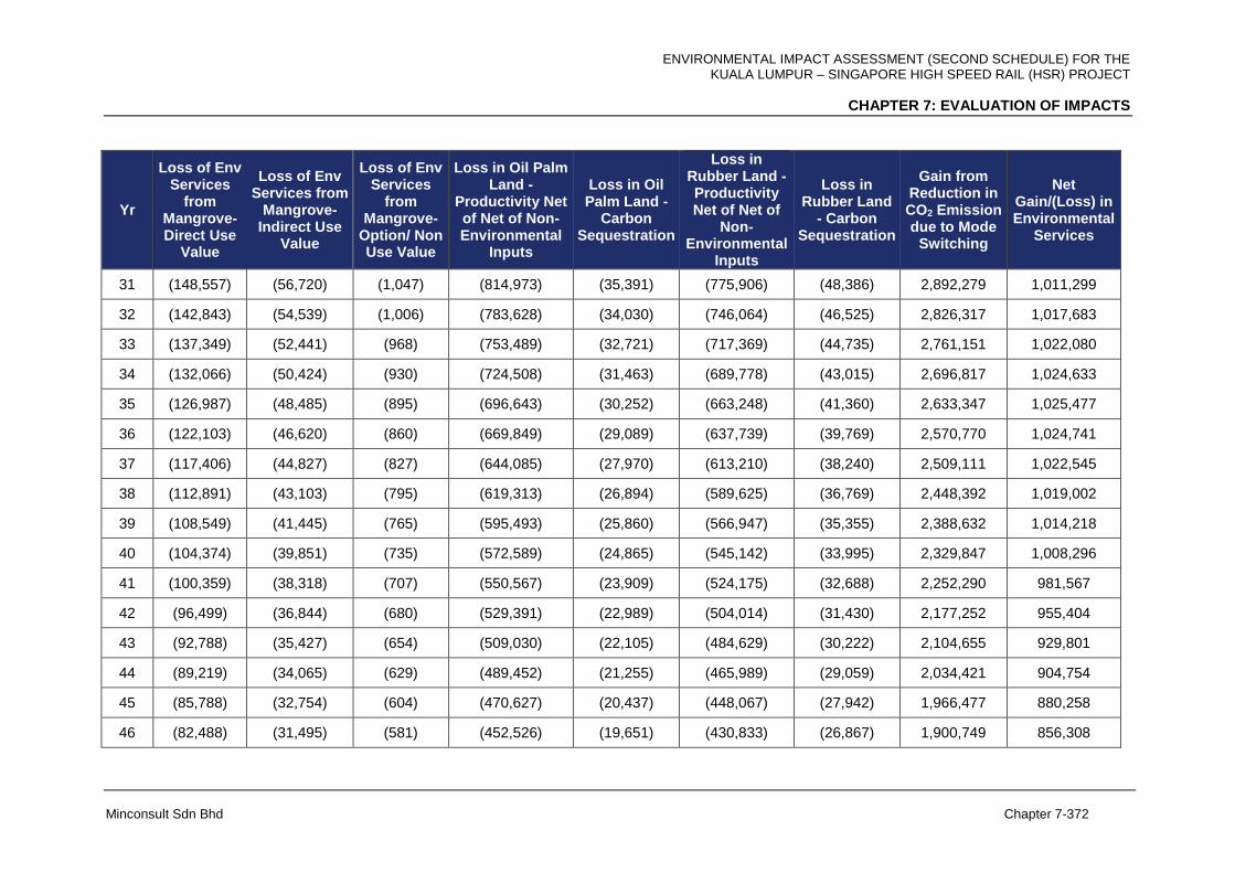
ENVIRONMENTAL IMPACT ASSESSMENT (SECOND SCHEDULE) FOR THE KUALA LUMPUR – SINGAPORE HIGH SPEED RAIL (HSR) PROJECT
CHAPTER 7: EVALUATION OF IMPACTS
Minconsult Sdn Bhd Chapter 7-372
Yr
Loss of Env Services
from Mangrove-Direct Use
Value
Loss of Env Services from
Mangrove-Indirect Use
Value
Loss of Env Services
from Mangrove-
Option/ Non Use Value
Loss in Oil Palm Land -
Productivity Net of Net of Non-Environmental
Inputs
Loss in Oil Palm Land -
Carbon Sequestration
Loss in Rubber Land - Productivity Net of Net of
Non-Environmental
Inputs
Loss in Rubber Land
- Carbon Sequestration
Gain from Reduction in CO2 Emission due to Mode
Switching
Net Gain/(Loss) in Environmental
Services
31 (148,557) (56,720) (1,047) (814,973) (35,391) (775,906) (48,386) 2,892,279 1,011,299
32 (142,843) (54,539) (1,006) (783,628) (34,030) (746,064) (46,525) 2,826,317 1,017,683
33 (137,349) (52,441) (968) (753,489) (32,721) (717,369) (44,735) 2,761,151 1,022,080
34 (132,066) (50,424) (930) (724,508) (31,463) (689,778) (43,015) 2,696,817 1,024,633
35 (126,987) (48,485) (895) (696,643) (30,252) (663,248) (41,360) 2,633,347 1,025,477
36 (122,103) (46,620) (860) (669,849) (29,089) (637,739) (39,769) 2,570,770 1,024,741
37 (117,406) (44,827) (827) (644,085) (27,970) (613,210) (38,240) 2,509,111 1,022,545
38 (112,891) (43,103) (795) (619,313) (26,894) (589,625) (36,769) 2,448,392 1,019,002
39 (108,549) (41,445) (765) (595,493) (25,860) (566,947) (35,355) 2,388,632 1,014,218
40 (104,374) (39,851) (735) (572,589) (24,865) (545,142) (33,995) 2,329,847 1,008,296
41 (100,359) (38,318) (707) (550,567) (23,909) (524,175) (32,688) 2,252,290 981,567
42 (96,499) (36,844) (680) (529,391) (22,989) (504,014) (31,430) 2,177,252 955,404
43 (92,788) (35,427) (654) (509,030) (22,105) (484,629) (30,222) 2,104,655 929,801
44 (89,219) (34,065) (629) (489,452) (21,255) (465,989) (29,059) 2,034,421 904,754
45 (85,788) (32,754) (604) (470,627) (20,437) (448,067) (27,942) 1,966,477 880,258
46 (82,488) (31,495) (581) (452,526) (19,651) (430,833) (26,867) 1,900,749 856,308
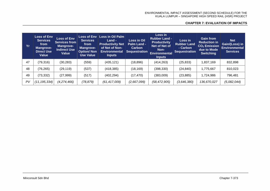
ENVIRONMENTAL IMPACT ASSESSMENT (SECOND SCHEDULE) FOR THE KUALA LUMPUR – SINGAPORE HIGH SPEED RAIL (HSR) PROJECT
CHAPTER 7: EVALUATION OF IMPACTS
Minconsult Sdn Bhd Chapter 7-373
Yr
Loss of Env Services
from Mangrove-Direct Use
Value
Loss of Env Services from
Mangrove-Indirect Use
Value
Loss of Env Services
from Mangrove-
Option/ Non Use Value
Loss in Oil Palm Land -
Productivity Net of Net of Non-Environmental
Inputs
Loss in Oil Palm Land -
Carbon Sequestration
Loss in Rubber Land - Productivity Net of Net of
Non-Environmental
Inputs
Loss in Rubber Land
- Carbon Sequestration
Gain from Reduction in CO2 Emission due to Mode
Switching
Net Gain/(Loss) in Environmental
Services
47 (79,316) (30,283) (559) (435,121) (18,896) (414,263) (25,833) 1,837,169 832,898
48 (76,265) (29,119) (537) (418,385) (18,169) (398,330) (24,840) 1,775,667 810,023
49 (73,332) (27,999) (517) (402,294) (17,470) (383,009) (23,885) 1,724,986 796,481
PV (11,195,334) (4,274,466) (78,879) (61,417,009) (2,667,099) (58,472,905) (3,646,380) 136,670,027 (5,082,044)
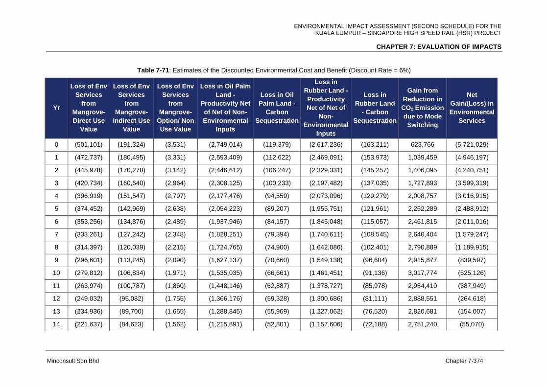
ENVIRONMENTAL IMPACT ASSESSMENT (SECOND SCHEDULE) FOR THE KUALA LUMPUR – SINGAPORE HIGH SPEED RAIL (HSR) PROJECT
CHAPTER 7: EVALUATION OF IMPACTS
Minconsult Sdn Bhd Chapter 7-374
Table 7-71: Estimates of the Discounted Environmental Cost and Benefit (Discount Rate = 6%)
Yr
Loss of Env
Services
from
Mangrove-
Direct Use
Value
Loss of Env
Services
from
Mangrove-
Indirect Use
Value
Loss of Env
Services
from
Mangrove-
Option/ Non
Use Value
Loss in Oil Palm
Land -
Productivity Net
of Net of Non-
Environmental
Inputs
Loss in Oil
Palm Land -
Carbon
Sequestration
Loss in
Rubber Land -
Productivity
Net of Net of
Non-
Environmental
Inputs
Loss in
Rubber Land
- Carbon
Sequestration
Gain from
Reduction in
CO2 Emission
due to Mode
Switching
Net
Gain/(Loss) in
Environmental
Services
0 (501,101) (191,324) (3,531) (2,749,014) (119,379) (2,617,236) (163,211) 623,766 (5,721,029)
1 (472,737) (180,495) (3,331) (2,593,409) (112,622) (2,469,091) (153,973) 1,039,459 (4,946,197)
2 (445,978) (170,278) (3,142) (2,446,612) (106,247) (2,329,331) (145,257) 1,406,095 (4,240,751)
3 (420,734) (160,640) (2,964) (2,308,125) (100,233) (2,197,482) (137,035) 1,727,893 (3,599,319)
4 (396,919) (151,547) (2,797) (2,177,476) (94,559) (2,073,096) (129,279) 2,008,757 (3,016,915)
5 (374,452) (142,969) (2,638) (2,054,223) (89,207) (1,955,751) (121,961) 2,252,289 (2,488,912)
6 (353,256) (134,876) (2,489) (1,937,946) (84,157) (1,845,048) (115,057) 2,461,815 (2,011,016)
7 (333,261) (127,242) (2,348) (1,828,251) (79,394) (1,740,611) (108,545) 2,640,404 (1,579,247)
8 (314,397) (120,039) (2,215) (1,724,765) (74,900) (1,642,086) (102,401) 2,790,889 (1,189,915)
9 (296,601) (113,245) (2,090) (1,627,137) (70,660) (1,549,138) (96,604) 2,915,877 (839,597)
10 (279,812) (106,834) (1,971) (1,535,035) (66,661) (1,461,451) (91,136) 3,017,774 (525,126)
11 (263,974) (100,787) (1,860) (1,448,146) (62,887) (1,378,727) (85,978) 2,954,410 (387,949)
12 (249,032) (95,082) (1,755) (1,366,176) (59,328) (1,300,686) (81,111) 2,888,551 (264,618)
13 (234,936) (89,700) (1,655) (1,288,845) (55,969) (1,227,062) (76,520) 2,820,681 (154,007)
14 (221,637) (84,623) (1,562) (1,215,891) (52,801) (1,157,606) (72,188) 2,751,240 (55,070)
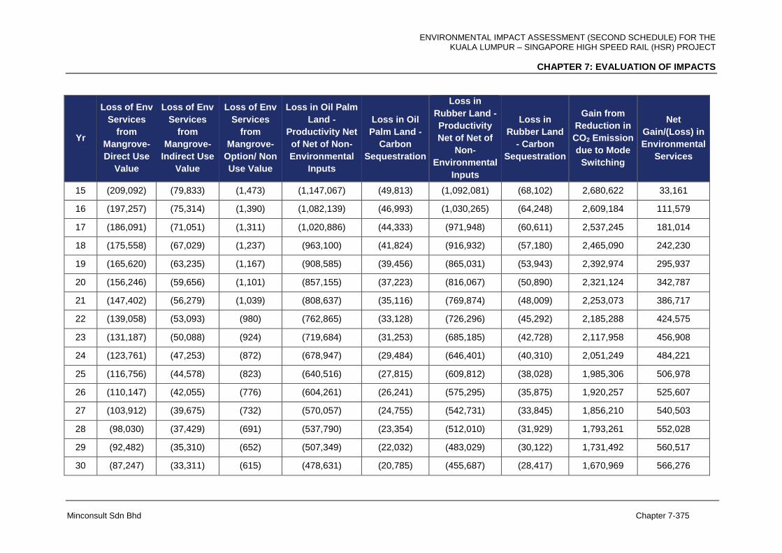
ENVIRONMENTAL IMPACT ASSESSMENT (SECOND SCHEDULE) FOR THE KUALA LUMPUR – SINGAPORE HIGH SPEED RAIL (HSR) PROJECT
CHAPTER 7: EVALUATION OF IMPACTS
Minconsult Sdn Bhd Chapter 7-375
Yr
Loss of Env
Services
from
Mangrove-
Direct Use
Value
Loss of Env
Services
from
Mangrove-
Indirect Use
Value
Loss of Env
Services
from
Mangrove-
Option/ Non
Use Value
Loss in Oil Palm
Land -
Productivity Net
of Net of Non-
Environmental
Inputs
Loss in Oil
Palm Land -
Carbon
Sequestration
Loss in
Rubber Land -
Productivity
Net of Net of
Non-
Environmental
Inputs
Loss in
Rubber Land
- Carbon
Sequestration
Gain from
Reduction in
CO2 Emission
due to Mode
Switching
Net
Gain/(Loss) in
Environmental
Services
15 (209,092) (79,833) (1,473) (1,147,067) (49,813) (1,092,081) (68,102) 2,680,622 33,161
16 (197,257) (75,314) (1,390) (1,082,139) (46,993) (1,030,265) (64,248) 2,609,184 111,579
17 (186,091) (71,051) (1,311) (1,020,886) (44,333) (971,948) (60,611) 2,537,245 181,014
18 (175,558) (67,029) (1,237) (963,100) (41,824) (916,932) (57,180) 2,465,090 242,230
19 (165,620) (63,235) (1,167) (908,585) (39,456) (865,031) (53,943) 2,392,974 295,937
20 (156,246) (59,656) (1,101) (857,155) (37,223) (816,067) (50,890) 2,321,124 342,787
21 (147,402) (56,279) (1,039) (808,637) (35,116) (769,874) (48,009) 2,253,073 386,717
22 (139,058) (53,093) (980) (762,865) (33,128) (726,296) (45,292) 2,185,288 424,575
23 (131,187) (50,088) (924) (719,684) (31,253) (685,185) (42,728) 2,117,958 456,908
24 (123,761) (47,253) (872) (678,947) (29,484) (646,401) (40,310) 2,051,249 484,221
25 (116,756) (44,578) (823) (640,516) (27,815) (609,812) (38,028) 1,985,306 506,978
26 (110,147) (42,055) (776) (604,261) (26,241) (575,295) (35,875) 1,920,257 525,607
27 (103,912) (39,675) (732) (570,057) (24,755) (542,731) (33,845) 1,856,210 540,503
28 (98,030) (37,429) (691) (537,790) (23,354) (512,010) (31,929) 1,793,261 552,028
29 (92,482) (35,310) (652) (507,349) (22,032) (483,029) (30,122) 1,731,492 560,517
30 (87,247) (33,311) (615) (478,631) (20,785) (455,687) (28,417) 1,670,969 566,276

ENVIRONMENTAL IMPACT ASSESSMENT (SECOND SCHEDULE) FOR THE KUALA LUMPUR – SINGAPORE HIGH SPEED RAIL (HSR) PROJECT
CHAPTER 7: EVALUATION OF IMPACTS
Minconsult Sdn Bhd Chapter 7-376
Yr
Loss of Env
Services
from
Mangrove-
Direct Use
Value
Loss of Env
Services
from
Mangrove-
Indirect Use
Value
Loss of Env
Services
from
Mangrove-
Option/ Non
Use Value
Loss in Oil Palm
Land -
Productivity Net
of Net of Non-
Environmental
Inputs
Loss in Oil
Palm Land -
Carbon
Sequestration
Loss in
Rubber Land -
Productivity
Net of Net of
Non-
Environmental
Inputs
Loss in
Rubber Land
- Carbon
Sequestration
Gain from
Reduction in
CO2 Emission
due to Mode
Switching
Net
Gain/(Loss) in
Environmental
Services
31 (82,308) (31,426) (580) (451,539) (19,609) (429,894) (26,808) 1,602,477 560,314
32 (77,649) (29,647) (547) (425,980) (18,499) (405,560) (25,291) 1,536,385 553,212
33 (73,254) (27,969) (516) (401,868) (17,452) (382,604) (23,859) 1,472,641 545,119
34 (69,108) (26,386) (487) (379,121) (16,464) (360,947) (22,509) 1,411,190 536,170
35 (65,196) (24,892) (459) (357,661) (15,532) (340,516) (21,235) 1,351,978 526,487
36 (61,506) (23,483) (433) (337,416) (14,653) (321,242) (20,033) 1,294,948 516,183
37 (58,024) (22,154) (409) (318,317) (13,823) (303,058) (18,899) 1,240,042 505,358
38 (54,740) (20,900) (386) (300,299) (13,041) (285,904) (17,829) 1,187,203 494,105
39 (51,641) (19,717) (364) (283,301) (12,303) (269,721) (16,820) 1,136,372 482,506
40 (48,718) (18,601) (343) (267,265) (11,606) (254,453) (15,868) 1,087,493 470,638
41 (45,961) (17,548) (324) (252,137) (10,949) (240,050) (14,970) 1,031,456 449,517
42 (43,359) (16,555) (305) (237,865) (10,330) (226,463) (14,122) 978,279 429,280
43 (40,905) (15,618) (288) (224,401) (9,745) (213,644) (13,323) 927,817 409,894
44 (38,589) (14,734) (272) (211,699) (9,193) (201,551) (12,569) 879,933 391,326
45 (36,405) (13,900) (256) (199,716) (8,673) (190,142) (11,857) 834,498 373,548
46 (34,344) (13,113) (242) (188,411) (8,182) (179,380) (11,186) 791,386 356,528
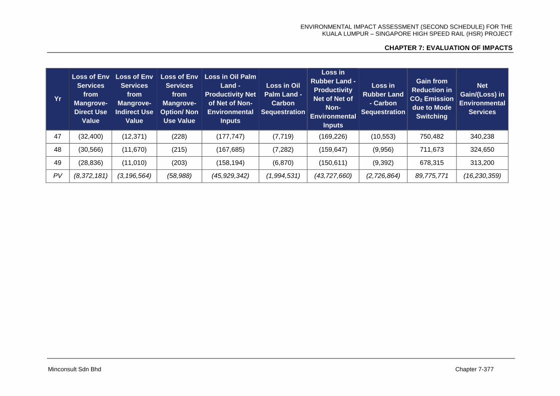
ENVIRONMENTAL IMPACT ASSESSMENT (SECOND SCHEDULE) FOR THE KUALA LUMPUR – SINGAPORE HIGH SPEED RAIL (HSR) PROJECT
CHAPTER 7: EVALUATION OF IMPACTS
Minconsult Sdn Bhd Chapter 7-377
Yr
Loss of Env
Services
from
Mangrove-
Direct Use
Value
Loss of Env
Services
from
Mangrove-
Indirect Use
Value
Loss of Env
Services
from
Mangrove-
Option/ Non
Use Value
Loss in Oil Palm
Land -
Productivity Net
of Net of Non-
Environmental
Inputs
Loss in Oil
Palm Land -
Carbon
Sequestration
Loss in
Rubber Land -
Productivity
Net of Net of
Non-
Environmental
Inputs
Loss in
Rubber Land
- Carbon
Sequestration
Gain from
Reduction in
CO2 Emission
due to Mode
Switching
Net
Gain/(Loss) in
Environmental
Services
47 (32,400) (12,371) (228) (177,747) (7,719) (169,226) (10,553) 750,482 340,238
48 (30,566) (11,670) (215) (167,685) (7,282) (159,647) (9,956) 711,673 324,650
49 (28,836) (11,010) (203) (158,194) (6,870) (150,611) (9,392) 678,315 313,200
PV (8,372,181) (3,196,564) (58,988) (45,929,342) (1,994,531) (43,727,660) (2,726,864) 89,775,771 (16,230,359)
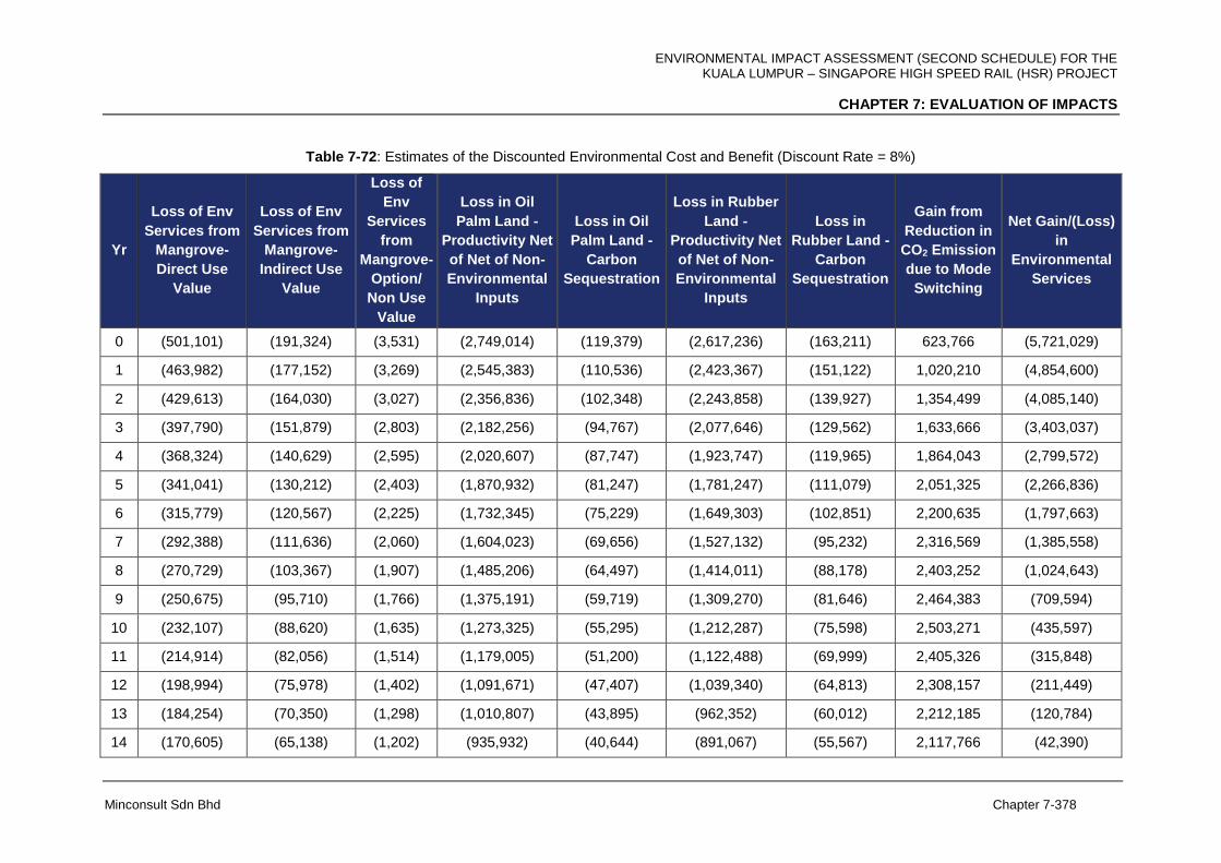
ENVIRONMENTAL IMPACT ASSESSMENT (SECOND SCHEDULE) FOR THE KUALA LUMPUR – SINGAPORE HIGH SPEED RAIL (HSR) PROJECT
CHAPTER 7: EVALUATION OF IMPACTS
Minconsult Sdn Bhd Chapter 7-378
Table 7-72: Estimates of the Discounted Environmental Cost and Benefit (Discount Rate = 8%)
Yr
Loss of Env
Services from
Mangrove-
Direct Use
Value
Loss of Env
Services from
Mangrove-
Indirect Use
Value
Loss of
Env
Services
from
Mangrove-
Option/
Non Use
Value
Loss in Oil
Palm Land -
Productivity Net
of Net of Non-
Environmental
Inputs
Loss in Oil
Palm Land -
Carbon
Sequestration
Loss in Rubber
Land -
Productivity Net
of Net of Non-
Environmental
Inputs
Loss in
Rubber Land -
Carbon
Sequestration
Gain from
Reduction in
CO2 Emission
due to Mode
Switching
Net Gain/(Loss)
in
Environmental
Services
0 (501,101) (191,324) (3,531) (2,749,014) (119,379) (2,617,236) (163,211) 623,766 (5,721,029)
1 (463,982) (177,152) (3,269) (2,545,383) (110,536) (2,423,367) (151,122) 1,020,210 (4,854,600)
2 (429,613) (164,030) (3,027) (2,356,836) (102,348) (2,243,858) (139,927) 1,354,499 (4,085,140)
3 (397,790) (151,879) (2,803) (2,182,256) (94,767) (2,077,646) (129,562) 1,633,666 (3,403,037)
4 (368,324) (140,629) (2,595) (2,020,607) (87,747) (1,923,747) (119,965) 1,864,043 (2,799,572)
5 (341,041) (130,212) (2,403) (1,870,932) (81,247) (1,781,247) (111,079) 2,051,325 (2,266,836)
6 (315,779) (120,567) (2,225) (1,732,345) (75,229) (1,649,303) (102,851) 2,200,635 (1,797,663)
7 (292,388) (111,636) (2,060) (1,604,023) (69,656) (1,527,132) (95,232) 2,316,569 (1,385,558)
8 (270,729) (103,367) (1,907) (1,485,206) (64,497) (1,414,011) (88,178) 2,403,252 (1,024,643)
9 (250,675) (95,710) (1,766) (1,375,191) (59,719) (1,309,270) (81,646) 2,464,383 (709,594)
10 (232,107) (88,620) (1,635) (1,273,325) (55,295) (1,212,287) (75,598) 2,503,271 (435,597)
11 (214,914) (82,056) (1,514) (1,179,005) (51,200) (1,122,488) (69,999) 2,405,326 (315,848)
12 (198,994) (75,978) (1,402) (1,091,671) (47,407) (1,039,340) (64,813) 2,308,157 (211,449)
13 (184,254) (70,350) (1,298) (1,010,807) (43,895) (962,352) (60,012) 2,212,185 (120,784)
14 (170,605) (65,138) (1,202) (935,932) (40,644) (891,067) (55,567) 2,117,766 (42,390)

ENVIRONMENTAL IMPACT ASSESSMENT (SECOND SCHEDULE) FOR THE KUALA LUMPUR – SINGAPORE HIGH SPEED RAIL (HSR) PROJECT
CHAPTER 7: EVALUATION OF IMPACTS
Minconsult Sdn Bhd Chapter 7-379
Yr
Loss of Env
Services from
Mangrove-
Direct Use
Value
Loss of Env
Services from
Mangrove-
Indirect Use
Value
Loss of
Env
Services
from
Mangrove-
Option/
Non Use
Value
Loss in Oil
Palm Land -
Productivity Net
of Net of Non-
Environmental
Inputs
Loss in Oil
Palm Land -
Carbon
Sequestration
Loss in Rubber
Land -
Productivity Net
of Net of Non-
Environmental
Inputs
Loss in
Rubber Land -
Carbon
Sequestration
Gain from
Reduction in
CO2 Emission
due to Mode
Switching
Net Gain/(Loss)
in
Environmental
Services
15 (157,968) (60,313) (1,113) (866,604) (37,633) (825,062) (51,451) 2,025,197 25,053
16 (146,267) (55,846) (1,031) (802,411) (34,846) (763,946) (47,640) 1,934,722 82,736
17 (135,432) (51,709) (954) (742,973) (32,264) (707,358) (44,111) 1,846,538 131,737
18 (125,400) (47,879) (884) (687,938) (29,874) (654,961) (40,843) 1,760,803 173,024
19 (116,111) (44,332) (818) (636,980) (27,662) (606,445) (37,818) 1,677,637 207,472
20 (107,510) (41,048) (757) (589,796) (25,613) (561,523) (35,017) 1,597,131 235,867
21 (99,547) (38,008) (701) (546,107) (23,715) (519,929) (32,423) 1,521,596 261,166
22 (92,173) (35,192) (649) (505,655) (21,959) (481,416) (30,021) 1,448,489 281,424
23 (85,345) (32,585) (601) (468,199) (20,332) (445,755) (27,797) 1,377,863 297,247
24 (79,023) (30,172) (557) (433,518) (18,826) (412,736) (25,738) 1,309,752 309,182
25 (73,170) (27,937) (516) (401,405) (17,431) (382,163) (23,832) 1,244,172 317,718
26 (67,750) (25,867) (477) (371,671) (16,140) (353,855) (22,066) 1,181,120 323,293
27 (62,731) (23,951) (442) (344,140) (14,945) (327,643) (20,432) 1,120,583 326,298
28 (58,084) (22,177) (409) (318,648) (13,838) (303,374) (18,918) 1,062,534 327,085
29 (53,782) (20,534) (379) (295,045) (12,813) (280,901) (17,517) 1,006,935 325,964

ENVIRONMENTAL IMPACT ASSESSMENT (SECOND SCHEDULE) FOR THE KUALA LUMPUR – SINGAPORE HIGH SPEED RAIL (HSR) PROJECT
CHAPTER 7: EVALUATION OF IMPACTS
Minconsult Sdn Bhd Chapter 7-380
Yr
Loss of Env
Services from
Mangrove-
Direct Use
Value
Loss of Env
Services from
Mangrove-
Indirect Use
Value
Loss of
Env
Services
from
Mangrove-
Option/
Non Use
Value
Loss in Oil
Palm Land -
Productivity Net
of Net of Non-
Environmental
Inputs
Loss in Oil
Palm Land -
Carbon
Sequestration
Loss in Rubber
Land -
Productivity Net
of Net of Non-
Environmental
Inputs
Loss in
Rubber Land -
Carbon
Sequestration
Gain from
Reduction in
CO2 Emission
due to Mode
Switching
Net Gain/(Loss)
in
Environmental
Services
30 (49,798) (19,013) (351) (273,190) (11,864) (260,094) (16,219) 953,744 323,215
31 (46,109) (17,605) (325) (252,953) (10,985) (240,828) (15,018) 897,712 313,889
32 (42,694) (16,301) (301) (234,216) (10,171) (222,989) (13,906) 844,749 304,172
33 (39,531) (15,093) (279) (216,867) (9,418) (206,471) (12,876) 794,706 294,172
34 (36,603) (13,975) (258) (200,803) (8,720) (191,177) (11,922) 747,442 283,984
35 (33,892) (12,940) (239) (185,928) (8,074) (177,016) (11,039) 702,819 273,692
36 (31,381) (11,982) (221) (172,156) (7,476) (163,903) (10,221) 660,706 263,366
37 (29,057) (11,094) (205) (159,404) (6,922) (151,762) (9,464) 620,975 253,068
38 (26,904) (10,272) (190) (147,596) (6,410) (140,521) (8,763) 583,506 242,851
39 (24,911) (9,511) (176) (136,663) (5,935) (130,112) (8,114) 548,180 232,758
40 (23,066) (8,807) (163) (126,540) (5,495) (120,474) (7,513) 514,886 222,829
41 (21,358) (8,154) (150) (117,166) (5,088) (111,550) (6,956) 479,311 208,888
42 (19,776) (7,550) (139) (108,487) (4,711) (103,287) (6,441) 446,181 195,790
43 (18,311) (6,991) (129) (100,451) (4,362) (95,636) (5,964) 415,330 183,486
44 (16,954) (6,473) (119) (93,010) (4,039) (88,552) (5,522) 386,601 171,930
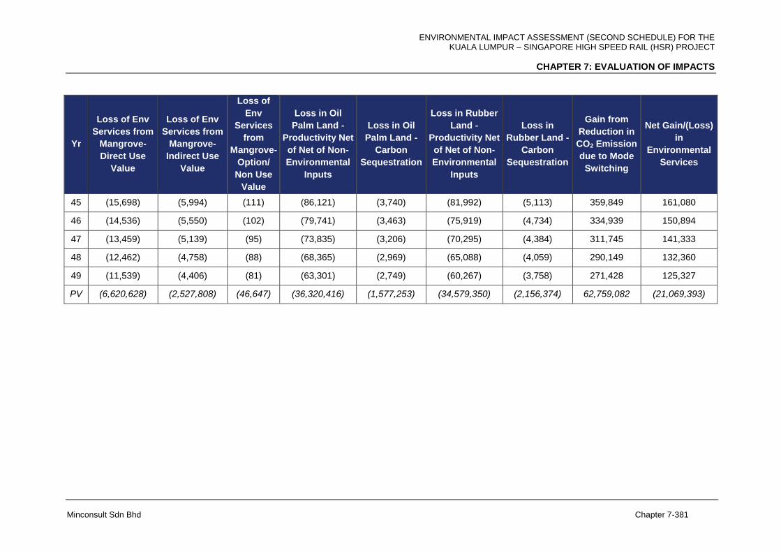
ENVIRONMENTAL IMPACT ASSESSMENT (SECOND SCHEDULE) FOR THE KUALA LUMPUR – SINGAPORE HIGH SPEED RAIL (HSR) PROJECT
CHAPTER 7: EVALUATION OF IMPACTS
Minconsult Sdn Bhd Chapter 7-381
Yr
Loss of Env
Services from
Mangrove-
Direct Use
Value
Loss of Env
Services from
Mangrove-
Indirect Use
Value
Loss of
Env
Services
from
Mangrove-
Option/
Non Use
Value
Loss in Oil
Palm Land -
Productivity Net
of Net of Non-
Environmental
Inputs
Loss in Oil
Palm Land -
Carbon
Sequestration
Loss in Rubber
Land -
Productivity Net
of Net of Non-
Environmental
Inputs
Loss in
Rubber Land -
Carbon
Sequestration
Gain from
Reduction in
CO2 Emission
due to Mode
Switching
Net Gain/(Loss)
in
Environmental
Services
45 (15,698) (5,994) (111) (86,121) (3,740) (81,992) (5,113) 359,849 161,080
46 (14,536) (5,550) (102) (79,741) (3,463) (75,919) (4,734) 334,939 150,894
47 (13,459) (5,139) (95) (73,835) (3,206) (70,295) (4,384) 311,745 141,333
48 (12,462) (4,758) (88) (68,365) (2,969) (65,088) (4,059) 290,149 132,360
49 (11,539) (4,406) (81) (63,301) (2,749) (60,267) (3,758) 271,428 125,327
PV (6,620,628) (2,527,808) (46,647) (36,320,416) (1,577,253) (34,579,350) (2,156,374) 62,759,082 (21,069,393)
ENVIRONMENTAL IMPACT ASSESSMENT (SECOND SCHEDULE) FOR THE KUALA LUMPUR – SINGAPORE HIGH SPEED RAIL (HSR) PROJECT
CHAPTER 7: EVALUATION OF IMPACTS
Minconsult Sdn Bhd Chapter 7-382
7.18 PRE-CONSTRUCTION STAGE
7.18.1 Surveys, Designs and Studies
The conduct of topographical, geotechnical and utility detection surveys will not cause any
significant adverse impacts to be exerted on identified environmental receptors that are
located within the Zone of Influence (ZOI). Instead, positive impacts shall materialize
because of the following reasons, viz:
Information garnered shall assist in the design of safe and structurally sound
stations, park and ride buildings, piers, guideways, tracking power sub-
stations, access roads, etc.
Topographical and soils surveys shall optimize the Project’s alignment
foundation designs and minimize site preparation works. In addition these
surveys shall eliminate Project’s capabilities to damage existing structures. In
addition the mentioned surveys will assist in estimating reliable Project costs.
Utility surveys shall be able to Identify and confirm the exact location of
pipelines and cables that lie within or adjacent to the Project’s ROW, thus
preventing any accidental damage and/or interruption to the services during
construction of the Project’s facilities such as the planned elevated structure,
tunnels etc.
All activities executed at this stage shall generate both business and
employment opportunities, albeit on a relatively low scale.
Generally, on a socio-economic front, net positive impacts will be generated albeit on a
moderate scale. This will arise as a consequence of generating employment and business
opportunities through engagement of specialist consultants; and in the conduct of
topographic, utility and geotechnical surveys. It is concluded that marginal net positive
beneficial impacts will be generated over a limited period of time; having both local and
regional spatial effects.
ENVIRONMENTAL IMPACT ASSESSMENT (SECOND SCHEDULE) FOR THE KUALA LUMPUR – SINGAPORE HIGH SPEED RAIL (HSR) PROJECT
CHAPTER 7: EVALUATION OF IMPACTS
Minconsult Sdn Bhd Chapter 7-383
Environmental investigations have contributed to positive impacts in that they have provided
the means to identify specific control and mitigation measures that are required to be
adopted as part and parcel of Project development and operations so as to ensure that
adverse impacts on external environmental receptors do not materialize over the Project’s
lifespan. It provides an opportunity to stipulate mitigation measures which contractors have
to abide with, and to pay for, as part of their obligations to the Project Proponent. The EIA
study shall also provide an independent consensus, and reconfirm, on the suitability of sitting
the Project at the proposed locations, i.e. attesting its sitting compatibility in relation to
surrounding land use, activities and environmental resources and receptors.
7.18.2 Land Acquisition
The Project will require a significant amount of land areas to be acquired prior to
commencing with the construction of facilities. In this respect about 2,043 ha of rubber and
oil palm plantation land will have to be alienated and acquired. Potential impacts relate to
current and future revenue losses from the sales of rubber latex and palm oil fruit bunches.
The route alignment has been selected so as to minimise compulsory purchase of residential
and commercial land areas, and associated eviction of land owners. Approximately 3,000
lots of land will be potentially acquired for the Project.
Impacts typically associated with land acquisition include anxiety, severance from
community, financial distress and concerns, relocation costs, market impacts (for
commercial properties); and operational difficulties (for commercial properties). Given the
nature of acquisition required for this Project, physical relocation of households or business
premises are expected to occur.
Impacts typically associated with land acquisition include anxiety, severance from
community, financial distress and concerns, relocation costs, market impacts (for
commercial properties); and operational difficulties (for commercial properties). Given the
nature of acquisition required for this Project, physical relocation of households or business
premises are to be expected.
ENVIRONMENTAL IMPACT ASSESSMENT (SECOND SCHEDULE) FOR THE KUALA LUMPUR – SINGAPORE HIGH SPEED RAIL (HSR) PROJECT
CHAPTER 7: EVALUATION OF IMPACTS
Minconsult Sdn Bhd Chapter 7-384
Private land will be acquired under the processes established in the Land Acquisition Act,
1960. The First Schedule of the Act allows for the following matters to be considered in
determining the amount of compensation to which a private entity is entitled:
Market value of the land;
Betterment; i.e. any increase in the value of the remaining land after acquisition
(this value is deducted);
Damage to existing use value of the land caused by severance;
Damage sustained or potentially sustained to the value of the land caused by any
other factors associated with the acquisition;
Incidental expenses incurred as a result of resettlement of business or dwelling;
and/or
Provision of any benefits accrued by the acquisition to remaining land parcel (if
only partially acquired) e.g. through the provision of infrastructure (roads, drains,
walls, fences etc).
The extent of compulsory purchase required for this Project has been minimised to the
extent possible. Nevertheless, clear compensation provisions and rights will need to be
communicated clearly to affected parties early to minimise anxiety and stress.
A detailed assessment and evaluation of the socio-economic impacts associated with the
acquisition of land areas, and with the eviction and relocation of commercial businesses and
individual residents, are being carried out under a separate Social Impact Assessment
(SIA) study under the purview of PLANMalayisa. The Terms of Reference (TOR) for SIA has
been submitted and endorsed by PLANMalayisa as attached in Appendix 1A. The salient
findings and conclusions of this Study will be reported in an independent document.
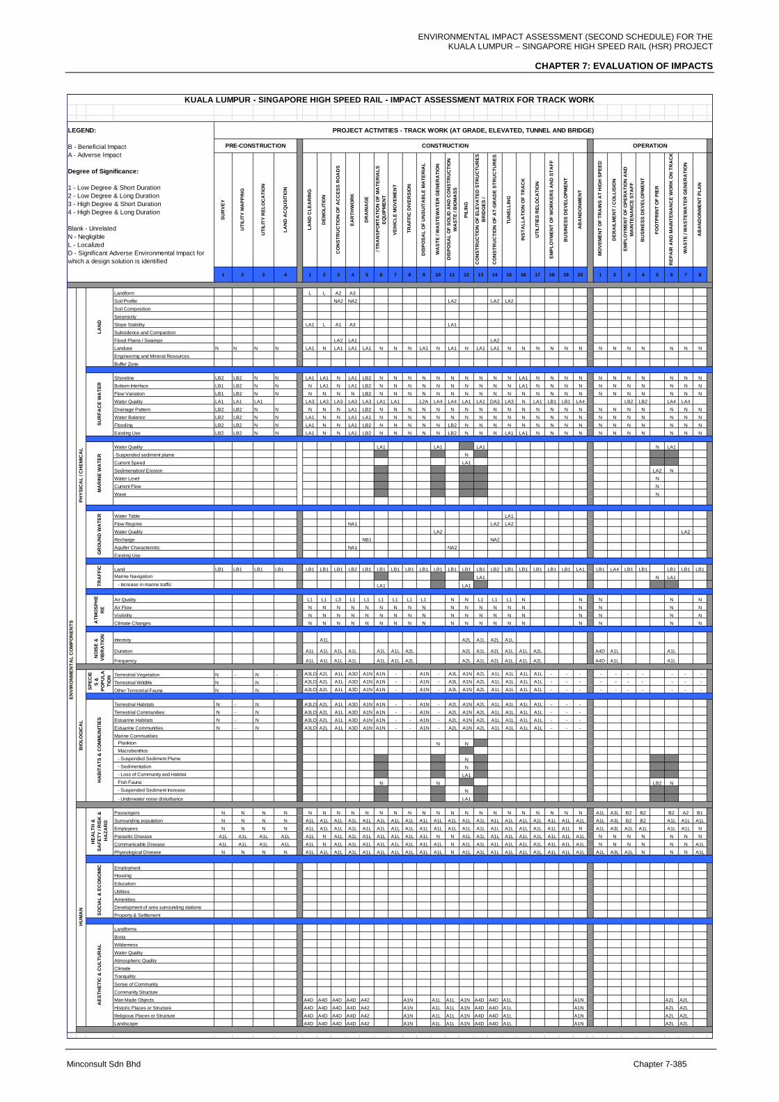
ENVIRONMENTAL IMPACT ASSESSMENT (SECOND SCHEDULE) FOR THE KUALA LUMPUR – SINGAPORE HIGH SPEED RAIL (HSR) PROJECT
CHAPTER 7: EVALUATION OF IMPACTS
Minconsult Sdn Bhd Chapter 7-385
SU
RV
EY
UT
ILIT
Y M
AP
PIN
G
UT
ILIT
Y R
EL
OC
AT
ION
LA
ND
AC
QU
SIT
ION
LA
ND
CL
EA
RIN
G
DE
MO
LIT
ION
CO
NS
TR
UC
TIO
N O
F A
CC
ES
S R
OA
DS
EA
RT
HW
OR
K
DR
AIN
AG
E
/ T
RA
NS
PO
RT
AT
ION
OF
MA
TE
RIA
LS
EQ
UIP
ME
NT
VE
HIC
LE
MO
VE
ME
NT
TR
AF
FIC
DIV
ER
SIO
N
DIS
PO
SA
L O
F U
NS
UIT
AB
LE
MA
TE
RIA
L
WA
ST
E / W
AS
TE
WA
TE
R G
EN
ER
AT
ION
DIS
PO
SA
L O
F S
OL
ID A
ND
CO
NS
TR
UC
TIO
N
WA
ST
E / B
IOM
AS
S
PIL
ING
CO
NS
TR
UC
TIO
N O
F E
LE
VA
TE
D S
TR
UC
TU
RE
S
BR
IDG
ES
/
CO
NS
TR
UC
TIO
N O
F A
T-G
RA
DE
ST
RU
CT
UR
ES
TU
NE
LL
ING
INS
TA
LL
AT
ION
OF
TR
AC
K
UT
ILIT
IES
RE
LO
CA
TIO
N
EM
PL
OY
ME
NT
OF
WO
RK
ER
S A
ND
ST
AF
F
BU
SIN
ES
S D
EV
EL
OP
ME
NT
AB
AN
DO
NM
EN
T
MO
VE
ME
NT
OF
TR
AIN
S A
T H
IGH
SP
EE
D
DE
RA
ILM
EN
T / C
OL
LIS
ION
EM
PL
OY
ME
NT
OF
OP
ER
AT
ION
AN
D
MA
INT
EN
AN
CE
ST
AF
F
BU
SIN
ES
S D
EV
EL
OP
ME
NT
FO
OT
PR
INT
OF
PIE
R
RE
PA
IR A
ND
MA
INT
EN
AN
CE
WO
RK
ON
TR
AC
K
WA
ST
E / W
AS
TE
WA
TE
R G
EN
ER
AT
ION
AB
AN
DO
NM
EN
T P
LA
N
1 2 3 4 1 2 3 4 5 6 7 8 9 10 11 12 13 14 15 16 17 18 19 20 1 2 3 4 5 6 7 8
Landform L L A2 A3
Soil Profile NA2 NA2 LA2 LA2 LA2
Soil Composition
Seismicity
Slope Stability LA1 L A1 A3 LA1
Subsidence and Compaction
Flood Plains / Swamps LA2 LA1 LA2
Landuse N N N N LA1 N LA1 LA1 LA1 N N N LA1 N LA1 N LA1 LA1 N N N N N N N N N N N N N
Engineering and Mineral Resources
Buffer Zone
Shoreline LB2 LB2 N N LA1 LA1 N LA1 LB2 N N N N N N N N N N LA1 N N N N N N N N N N N
Bottom Interface LB1 LB2 N N N LA1 N LA1 LB2 N N N N N N N N N N LA1 N N N N N N N N N N N
Flow Variation LB1 LB2 N N N N N N LB2 N N N N N N N N N N N N N N N N N N N N N N
Water Quality LA1 LA1 LA1 LA3 LA3 LA3 LA3 LA3 LA1 LA1 L2A LA4 LA4 LA1 LA1 DA3 LA3 N LA1 LB1 LB1 LA4 LB2 LB2 LA4 LA4
Drainage Pattern LB2 LB2 N N N N N LA1 LB2 N N N N N N N N N N N N N N N N N N N N N N
Water Balance LB2 LB2 N N LA1 N N LA1 LA1 N N N N N N N N N N N N N N N N N N N N N N
Flooding LB2 LB2 N N LA1 N N LA1 LB2 N N N N N LB2 N N N N N N N N N N N N N N N N
Existing Use LB2 LB2 N N LA1 N N LA1 LB2 N N N N N LB2 N N N LA1 LA1 N N N N N N N N N N N
Water Quality LA1 LA1 LA1 N LA1
-Suspended sediment plume N
Current Speed LA1
Sedimenation/ Erosion LA2 N
Water Level N
Current Flow N
Wave N
Water Table LA1
Flow Regime NA1 LA2 LA2
Water Quality LA2 LA2
Recharge NB1 NA2
Aquifer Characteristic NA1 NA2
Existing Use
Land LB1 LB1 LB1 LB1 LB1 LB1 LB1 LB2 LB1 LB1 LB1 LB1 LB1 LB1 LB1 LB1 LB1 LB2 LB1 LB1 LB1 LB1 LB1 LA1 LB1 LA4 LB1 LB1 LB1 LB1 LB1
Marine Navigation LA1 N LA1
- Increase in marine traffic LA1 LA1
Air Quality L1 L1 L3 L1 L1 L1 L1 L1 L1 N N L1 L1 L1 N N N N N
Air Flow N N N N N N N N N N N N N N N N N N N
Visibility N N N N N N N N N N N N N N N N N N N
Climate Changes N N N N N N N N N N N N N N N N N N N
Intensity A1L A2L A1L A2L A1L
Duration A1L A1L A1L A1L A1L A1L A2L A2L A1L A2L A1L A1L A2L A4D A1L A1L
Frequency A1L A1L A1L A1L A1L A1L A2L A2L A1L A2L A1L A1L A2L A4D A1L A1L
Terrestrial Vegetation N - N - A3LD A2L A1L A3D A1N A1N - - A1N - A3L A1N A2L A1L A1L A1L A1L - - - - - - - - - -
Terrestrial Wildlife N - N - A3LD A2L A1L A3D A1N A1N - - A1N - A3L A1N A2L A1L A1L A1L A1L - - - - - - - - - -
Other Terrestrial Fauna N - N - A3LD A2L A1L A3D A1N A1N - - A1N - A3L A1N A2L A1L A1L A1L A1L - - - - - - - - - -
Terrestrial Habitats N - N A3LD A2L A1L A3D A1N A1N - - A1N - A2L A1N A2L A1L A1L A1L A1L - - -
Terrestrial Communities N - N A3LD A2L A1L A3D A1N A1N - - A1N - A2L A1N A2L A1L A1L A1L A1L - - -
Estuarine Habitats N - N A3LD A2L A1L A3D A1N A1N - - A1N - A2L A1N A2L A1L A1L A1L A1L - - -
Estuarine Communities N - N A3LD A2L A1L A3D A1N A1N - - A1N - A2L A1N A2L A1L A1L A1L A1L - - -
Marine Communities
Plankton N N
Macrobenthos
- Suspended Sediment Plume N
- Sedimentation N
- Loss of Community and Habitat LA1
Fish Fauna N N LB2 N
- Suspended Sediment Increase N
- Underwater noise disturbance LA1
Passengers N N N N N N N N N N N N N N N N N N N N N N N N A1L A3L B2 B2 B2 A2 B1
Surrounding population N N N N A1L A1L A1L A1L A1L A1L A1L A1L A1L A1L A1L A1L A1L A1L A1L A1L A1L A1L A1L A1L A1L A3L B2 B2 A1L A1L A1L
Employees N N N N A1L A1L A1L A1L A1L A1L A1L A1L A1L A1L A1L A1L A1L A1L A1L A1L A1L A1L A1L N A1L A3L A1L A1L A1L A1L N
Parasitic Disease A1L A1L A1L A1L A1L N A1L A1L A1L A1L A1L A1L A1L N N A1L A1L A1L A1L A1L A1L A1L A1L A1L N N N N N N N
Communicable Disease A1L A1L A1L A1L A1L N A1L A1L A1L A1L A1L A1L A1L A1L N A1L A1L A1L A1L A1L A1L A1L A1L A1L N N N N N N A1L
Physiological Disease N N N N A1L A1L A1L A1L A1L A1L A1L A1L A1L A1L N A1L A1L A1L A1L A1L A1L A1L A1L A1L A1L A3L A1L N N N A1L
Employment
Housing
Education
Utilities
Amenities
Development of area surrounding stations
Property & Settlement
Landforms
Biota
Wilderness
Water Quality
Atmospheric Quality
Climate
Tranquility
Sense of Community
Community Structure
Man Made Objects A4D A4D A4D A4D A42 A1N A1L A1L A1N A4D A4D A1L A1N A2L A2L
Historic Places or Structure A4D A4D A4D A4D A42 A1N A1L A1L A1N A4D A4D A1L A1N A2L A2L
Religious Places or Structure A4D A4D A4D A4D A42 A1N A1L A1L A1N A4D A4D A1L A1N A2L A2L
Landscape A4D A4D A4D A4D A42 A1N A1L A1L A1N A4D A4D A1L A1N A2L A2L
KUALA LUMPUR - SINGAPORE HIGH SPEED RAIL - IMPACT ASSESSMENT MATRIX FOR TRACK WORK
OPERATION
PH
YS
ICA
L / C
HE
MIC
AL
TR
AF
FIC
SP
EC
IE
S &
PO
PU
LA
TIO
N
BIO
LO
GIC
AL
CONSTRUCTION
LA
ND
LEGEND:
B - Beneficial Impact
A - Adverse Impact
Degree of Significance:
1 - Low Degree & Short Duration
2 - Low Degree & Long Duration
3 - High Degree & Short Duration
4 - High Degree & Long Duration
Blank - Unrelated
N - Negligible
L - Localized
D - Significant Adverse Environmental Impact for
which a design solution is identified
PRE-CONSTRUCTION
PROJECT ACTIVITIES - TRACK WORK (AT GRADE, ELEVATED, TUNNEL AND BRIDGE)
NO
ISE
&
VIB
RA
TIO
N
EN
VIR
ON
ME
NT
AL
CO
MP
ON
EN
TS
GR
OU
ND
WA
TE
RH
AB
ITA
TS
& C
OM
MU
NIT
IES
MA
RIN
E W
AT
ER
SO
CIA
L &
EC
ON
OM
ICA
TM
OS
PH
E
RE
HU
MA
N
SU
RF
AC
E W
AT
ER
AE
ST
HE
TIC
& C
UL
TU
RA
L
HE
AL
TH
&
SA
FE
TY
/ R
ISK
&
HA
ZA
RD
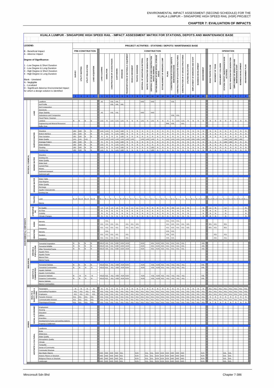
ENVIRONMENTAL IMPACT ASSESSMENT (SECOND SCHEDULE) FOR THE KUALA LUMPUR – SINGAPORE HIGH SPEED RAIL (HSR) PROJECT
CHAPTER 7: EVALUATION OF IMPACTS
Minconsult Sdn Bhd Chapter 7-386
SU
RV
EY
UT
ILIT
Y M
AP
PIN
G
UT
ILIT
Y R
EL
OC
AT
ION
LA
ND
AC
QU
SIT
ION
LA
ND
CL
EA
RIN
G
DE
MO
LIT
ION
CO
NS
TR
UC
TIO
N O
F A
CC
ES
S R
OA
DS
EA
RT
HW
OR
K
DR
AIN
AG
E
TR
AN
SP
OR
TA
TIO
N O
F M
AT
ER
IAL
S / E
QU
IPM
EN
T
VE
HIC
LE
MO
VE
ME
NT
TR
AF
FIC
DIV
ER
SIO
N
DIS
PO
SA
L O
F U
NS
UIT
AB
LE
MA
TE
RIA
L
WA
ST
E / W
AS
TE
WA
TE
R G
EN
ER
AT
ION
DIS
PO
SA
L O
F S
OL
ID A
ND
CO
NS
TR
UC
TIO
N
WA
ST
E / B
IOM
AS
S
ES
TA
BL
ISH
ME
NT
OF
SIT
E O
FF
ICE
, S
TO
RA
GE
AR
EA
S
ES
TA
BL
ISH
ME
NT
OF
WO
RK
ER
S C
AM
P
PIL
ING
/ C
ON
ST
RU
CT
ION
OF
ST
AT
ION
/ D
EP
OT
S
MA
INT
EN
AN
CE
BA
SE
CO
NS
TR
UC
TIO
N O
F E
LE
VA
TE
D S
TR
UC
TU
RE
S
CO
NS
TR
UC
TIO
N O
F A
T-G
RA
DE
ST
RU
CT
UR
ES
UT
ILIT
IES
RE
LO
CA
TIO
N
EM
PL
OY
ME
NT
OF
WO
RK
ER
S A
ND
ST
AF
F
BU
SIN
ES
S D
EV
EL
OP
ME
NT
AB
AN
DO
NM
EN
T
RO
AD
TR
AF
FIC
FL
OW
M
OV
EM
EN
T O
F T
RA
IN
DE
RA
ILM
EN
T / C
OL
LIS
ION
ST
AT
ION
/ D
EP
OT
/ M
AIN
TE
NA
NC
E B
AS
E
AC
TIV
ITIE
S
WA
ST
E / W
AS
TE
WA
TE
R G
EN
ER
AT
ION
EM
PL
OY
ME
NT
OF
OP
ER
AT
ION
AN
D
MA
INT
EN
AN
CE
ST
AF
F
BU
SIN
ES
S D
EV
EL
OP
ME
NT
AB
AN
DO
NM
EN
T P
LA
N
1 2 3 4 1 2 3 4 5 6 7 8 9 10 11 12 13 14 15 16 17 18 19 20 21 1 2 3 4 5 6 7 8
Landform A2 A3L A4L A4D A4D A3L
Soil Profile A3L A4L A4L
Soil Composition
Seismicity
Slope Stability A3 A3L A3L A4D A4D
Subsidence and Compaction A3L A1L
Flood Plains / Swamps
Landuse N N N N LA1 N LA1 LA1 LA1 N N N LA1 N LA1 N N N N LA1 LA1 N N N N N N N N N N N N
Engineering and Mineral Resources B4L A3L A1L
Buffer Zone
Shoreline LB2 LB2 N N LA1 LA1 N LA1 LB2 N N N N N N N N N N N N N N N N N N N N N N N N
Bottom Interface LB1 LB2 N N N LA1 N LA1 LB2 N N N N N N N N N N N N N N N N N N N N N N N N
Flow Variation LB1 LB2 N N N N N N LB2 N N N N N N N N N N N N N N N N N N N N N N N N
Water Quality LA1 LA1 LA1 LA3 LA3 LA3 LA3 LA3 LA3 LA3 LA3 LA3 LA3 N N LA1 LA1 LA1 LA1 LA2 LB1 LB1 LA2 LA4 LA2 LB2 LB2
Drainage Pattern LB2 LB2 N N N N N LA1 LB2 N N N N N N N N N N N N N N N N N N N LB2 LB2 N N N
Water Balance LB2 LB2 N N LA1 N N LA1 LA1 N N N N N N N N N N N N N N N N N N N N N N N N
Flooding LB2 LB2 N N LA1 N N LA1 LB2 N N N N N LB2 N N N N N N N N N N N N N N N N N N
Existing Use LB2 LB2 N N LA1 N N LA1 LB2 N N N N N LB2 N N N N N N N N N N N N N N N N N N
Shoreline
Existing Use
Water Quality
Water level
Current Flow
Waves
Sediment transport
Sediment spill
Water Table
Flow Regime
Water Quality
Recharge
Aquifer Characteristic
Existing Use
Land B,1,N B,1,N B,1,N B,1,N B,1,L B,1,L B,1,L B,1,L B,1,N B,3,L B,2,L B,1,L B,1,L B,1,L B,1,L B,1,L B,2,L B,1,L B,3,L B,1,L 2, L B,1,L B,1,L B,1,N A,1,N B,1,N B,1,N A,3,L B,1,N B,1,N B,1,N B,1,N B,1,L
Marine
Air Quality L3 L3 L3 L3 N L1 L1 L1 L1 N N N N N D3 L1 L1 N N L2 N L2 N
Air Flow N N N N N N N N N N N N N N N N N N N N N N N
Visibility N N N N N N N N N N N N N N N N N N N N N N N
Climate Changes N N N N N N N N N N N N N N N N N N N B N N N
Intensity A1L A1L A2L A1L
Duration A1L A1L A1L A1L A1L A1L A2L A1L A2L A1L A1L A2L B2L A2L B2L
FrequencyA1L A1L A1L A1L A1L A1L A2L A1L A2L A1L A1L A2L B2L A2L B2L
Intensity A1L A3L A2L
Duration A1L A1L A1L A1L A1L A3L A2L A2L A1L
FrequencyA1L A1L A1L A1L A1L A3L A2L A2L A1L
Terrestrial Vegetation N N N N A3LD A2L A1L A3D A1N A1N A1N A3L A1N A2L A1L A1L A1L A1L A3L
Terrestrial Wildlife N N N N A3LD A2L A1L A3D A1N A1N A1N A3L A1N A2L A1L A1L A1L A1L A3L
Other Terrestrial Fauna N N N N A3LD A2L A1L A3D A1N A1N A1N A3L A1N A2L A1L A1L A1L A1L A3L
Aquatic Flora
Aquatic Fauna
Marine Flora
Marine Fauna
Terrestrial Habitats N N N N A3LD A2L A1L A3D A1N A1N A1N A3L A1N A2L A1L A1L A1L A1L A3L
Terrestrial Communities N N N N A3LD A2L A1L A3D A1N A1N A1N A3L A1N A1L A1L A1L A1L A1L - - - A3L
Aquatic Habitats
Aquatic Communities
Estuarine Habitats N -N N -N A3LD A2L A1L A3D A1N A1N A1N - A3L A1N A2L A1L A1L A1L A1L - - - A3L
Estuarine Communities N N N N A3LD A2L A1L A3D A1N A1N A1N A3L A1N A2L A1L A1L A1L A1L - - - A3L
Marine Habitats
Marine Communities
Passengers N N N N N N N N N N N N N N N N N N N N N N N N N A1L A1L A1L A1L A1L A1L A1L A1L
Surrounding Population A1L A1L A1L A1L A1L A1L A1L A1L A1L A1L A1L A1L A1L A1L A1L A1L A1L A1L A1L A1L A1L A1L A1L A1L A1L A1L A1L A1L A1L A1L A1L A1L A1L
Employees A1L A1L A1L A1L A1L A1L A1L A1L A1L A1L A1L A1L A1L A1L A1L A1L A1L A1L A1L A1L A1L A1L A1L A1L A1L A1L A1L A1L A1L A1L A1L A1L A1L
Parasitic Disease A1L A1L A1L A1L A1L A1L A1L A1L A1L A1L A1L A1L A1L A1L A1L A1L A1L A1L A1L A1L A1L A1L A1L A1L A1L N N N N N N N N
Communicable Disease A1L A1L A1L A1L A1L A1L A1L A1L A1L A1L A1L A1L A1L A1L A1L A1L A1L A1L A1L A1L A1L A1L A1L A1L A1L A1L A1L A1L A1L A1L A1L A1L A1L
Physiological Disease A1L A1L A1L A1L A1L A1L A1L A1L A1L A1L A1L A1L A1L A1L A1L A1L A1L A1L A1L A1L A1L A1L A1L A1L A1L N N N N N N N N
Employment
Housing
Education
Utilities
Amenities
Development of area surrounding stations
Property & Settlement
Landforms
Biota
Wilderness
Water Quality
Atmospheric Quality
Climate
Tranquility
Sense of Community
Community Structure
Man Made Objects A4D A4D A4D A4D A2L A1N A1L A1L A1N A1N A1N A4D A4D A4D A1N A2L A2L
Historic Places or Structure A4D A4D A4D A4D A2L A1N A1L A1L A1N A1N A1N A4D A4D A4D A1N A2L A2L
Religious Places or Structure A4D A4D A4D A4D A2L A1N A1L A1L A1N A1N A1N A4D A4D A4D A1N A2L A2L
Landscape A4D A4D A4D A4D A2L A1N A1L A1L A1N A1N A1N A4D A4D A4D A1N A2L A2L
GR
OU
ND
WA
TE
R
HU
MA
N
HA
BIT
AT
S &
CO
MM
UN
ITIE
SKUALA LUMPUR - SINGAPORE HIGH SPEED RAIL - IMPACT ASSESSMENT MATRIX FOR STATIONS, DEPOTS AND MAINTENANCE BASE
PROJECT ACTIVITIES - STATIONS / DEPOTS / MAINTENANCE BASE
PRE-CONSTRUCTION OPERATIONCONSTRUCTION
LEGEND:
B - Beneficial Impact
A - Adverse Impact
Degree of Significance:
1 - Low Degree & Short Duration
2 - Low Degree & Long Duration
3 - High Degree & Short Duration
4 - High Degree & Long Duration
Blank - Unrelated
N - Negligible
L - Localized
D - Significant Adverse Environmental Impact
for which a design solution is identified
BIO
LO
GIC
AL
SO
CIA
L &
EC
ON
OM
ICA
ES
TH
ET
IC &
CU
LT
UR
AL
SP
EC
IES
&
PO
PU
LA
TIO
NM
AR
INE
WA
TE
RL
AN
D
EN
VIR
ON
ME
NT
AL
CO
MP
ON
EN
TS
TR
AF
FIC
HE
AL
TH
&
SA
FE
TY
/ R
ISK
&
HA
ZA
RD
NO
ISE
PH
YS
ICA
L / C
HE
MIC
AL
SU
RF
AC
E W
AT
ER
AT
MO
SP
HE
RE
VIB
RA
TIO
N
ENVIRONMENTAL IMPACT ASSESSMENT (SECOND SCHEDULE) FOR THE KUALA LUMPUR – SINGAPORE HIGH SPEED RAIL (HSR) PROJECT
CHAPTER 8: MITIGATION MEASURES
Minconsult Sdn Bhd Chapter 8 - 1
8.1 INTRODUCTION
The principal impacts which the HSR Project could induce on environmental and other
receptors located in the vicinity of its alignment have been identified and thereafter assessed
as to their capability to interact adversely or beneficially with local and regional
environmental receptors. The findings have been described in Chapter 7. The assessment
took into consideration the capability of pollution control systems and environmental
protection strategies that are planned to be incorporated in plant design and operations to
mitigate potential adverse impacts. The broad range of pollution control systems to be
integrated into facility operations were discussed in Chapter 5.
The approach taken in this Chapter is to assess the applicability and reliability of proposed
mitigation measures to be advocated for each identified HSR Project activity, and thereby to
ascertain whether they are comprehensive and complete, or require additional or further
amelioration measures to ensure tolerable impacts on identified local and regional
environmental receptors.
This Chapter also identifies and describes measures which are capable of effectively
mitigating adverse impacts, as well as enhancing the potential of beneficial impacts, based
on proven applications. The probable scope and intensity of residual impacts that remain
after appropriate mitigation and control measures are adopted are described, and their
implications discussed in the following Chapter, i.e. Chapter 9.
8.2 AIR QUALITY
8.2.1 Construction Phase
The potential for dust dispersions from earthworks operations during the HSR Project’s
construction phase is moderate, and the resulting impacts on external receptors being
localised and temporary. However, should suspended particulate matter (PM10) levels rise
above acceptable levels at all construction sites, the following mitigation measures should be
taken:
ENVIRONMENTAL IMPACT ASSESSMENT (SECOND SCHEDULE) FOR THE KUALA LUMPUR – SINGAPORE HIGH SPEED RAIL (HSR) PROJECT
CHAPTER 8: MITIGATION MEASURES
Minconsult Sdn Bhd Chapter 8 - 2
• Soil loads on construction vehicles shall be kept covered during transit on public
roads;
• Topsoil stockpiles shall be kept covered or have a suitable dust palliative such as wet
suppression with water sprinklers and water browsers applied;
• Wet suppression shall be applied to unsealed roads if suspended particulate matter
(monitored at the approved monitoring stations) rises above the Malaysian Ambient
Air Quality Guideline limits for PM10;
• Particulate matter deposition monitoring shall be conducted in accordance with
recommended sampling methods.
• All construction vehicles and machinery shall be regularly serviced and maintained to
ensure good working condition, thereby reducing the possibility of excessive exhaust
emissions.
• Regular spraying and sweeping at the entrance and exit points of construction sites
should be conducted. Partially vegetated land surfaces, and temporary stockpiled
excavated soils are to be watered / wetted in order to minimize dust dispersions (i.e.
negate adverse air quality impacts).
• Construction of 2 m high hoardings around the Project sites wherever feasible.
• It should be made mandatory for the Contractor to abstain from burning waste
material at the Project Sites, or at off-site disposal areas, unless a contravening
license is obtained from the relevant authorities. Adherence to this practice shall
ensure that adverse episodes related to fire hazards and dust/soot/toxic gas
emission and dispersion do not materialize; and thereby impact adversely on
surrounding areas and construction workers.
• A requirement that construction vehicles to go through washing bays within the site
before exiting is recommended.
• Raw materials such as sand, gravel and cement should be stored neatly and covered
properly to reduce atmospheric dispersion of these materials.
Traffic controls such as speed limits and traffic volume restrictions to reduce dust churned up
by vehicles should be implemented. The recommended speed is not to exceed 30 km/h
along haulage roads. Lorries should not be loaded higher than the side tail boards. If
possible, transport of earth and construction materials should be confined to non-peak hours
of between 10.00 am and 3.00 pm especially in urban areas. Construction roads should also
preferably be at least 100 m from dwellings.
ENVIRONMENTAL IMPACT ASSESSMENT (SECOND SCHEDULE) FOR THE KUALA LUMPUR – SINGAPORE HIGH SPEED RAIL (HSR) PROJECT
CHAPTER 8: MITIGATION MEASURES
Minconsult Sdn Bhd Chapter 8 - 3
Construction areas should be fenced and boarded to reduce wind-blown dust dispersion and
formation of dust clouds.
Installation and operation of portable generator sets or other air pollutant emitting equipment
should comply with the requirements of Environmental Quality (Clean Air) Regulations 2014.
No burning of construction wastes should be permitted within the HSR Project sites, nor at
disposal sites without the permission of the DOE and/or Local Authorities.
Adequate crusher run vehicular access pathways should be placed where site preparation
and excavation works are to be carried out to construct At-Grade guideways, stations,
depots and maintenance bases. These pathways established within the construction sites
are required to be wetted regularly to minimize fugitive dust dispersions.
In a worst case scenario when dust control measures are inadequate and during
unfavourable meteorological conditions such as a prolonged dry spell, sensitive receptors
which are located close to significant dust sources should be avoided if the source is from
traffic movements. In the case of stationary sources, back up mitigation measures such as
reducing the amount of construction activity is recommended.
8.2.2 Operational Phase
Adverse air quality impacts induced by the HSR Project during the operational phase are
expected to be negligible and mitigation measures are not required.
It is predicted that positive impacts can be achieved by the operations of the HSR Project, in
that the overall carbon dioxide emissions by all modes of transportation between FT. Kuala
Lumpur and Singapore will be reduced significantly once the HSR begins operations. This
positive impact should be enhanced by adopting the following measures, viz: (a) entice more
commuters to shift their mode of travel from cars/buses, airlines and low speed trains to the
HSR service by proving effectiveness and efficiency of travel, and establishing competitive
fares; (b) improve operational efficiencies; and (c) make maximum use of regenerative
breaking opportunities to recycle energy and thereby lower electricity consumptions.
ENVIRONMENTAL IMPACT ASSESSMENT (SECOND SCHEDULE) FOR THE KUALA LUMPUR – SINGAPORE HIGH SPEED RAIL (HSR) PROJECT
CHAPTER 8: MITIGATION MEASURES
Minconsult Sdn Bhd Chapter 8 - 4
8.3 NOISE AND VIBRATION
8.3.1 Noise
8.3.1.1 Construction Phase
In Chapter 7 an assessment of the potential impacts which the following Project activities
could induce on surrounding receptors were discussed, viz:
FT. Kuala Lumpur
I. Noise from Land Preparation, Earthworks and Demolition Activities
II. Noise induced by Vehicle Movements and Transportation of Materials and
Equipment
III. Noise from Construction of Access Roads
IV. Noise from Piling Activities
V. Noise from Construction of Stations, Depots and Maintenance Bases
VI. Noise from Construction of Elevated Structures and Bridges
VII. Noise from Tunnelling
VIII. Noise from Installation of Tracks
IX. Noise from Utilities Relocation
Selangor / FT. Putrajaya
I. Noise from Land Preparation, Earthworks and Demolition Activities
II. Noise induced by Vehicle Movements and Transportation of Materials and
Equipment
III. Noise from Construction of Access Roads
IV. Noise from Traffic Diversions
V. Noise from Piling Activities
VI. Noise from Construction of Stations, Depots and Maintenance Bases
VII. Noise from Construction of Elevated Structures and Bridges
VIII. Noise from Construction of At-grade Structures
IX. Noise from Tunnelling
X. Noise from Installation of Tracks
XI. Noise from Utilities Relocation

ENVIRONMENTAL IMPACT ASSESSMENT (SECOND SCHEDULE) FOR THE KUALA LUMPUR – SINGAPORE HIGH SPEED RAIL (HSR) PROJECT
CHAPTER 8: MITIGATION MEASURES
Minconsult Sdn Bhd Chapter 8 - 5
Negeri Sembilan
I. Noise from Land Preparation, Earthworks and Demolition Activities
II. Noise induced by Vehicle Movements and Transportation of Materials and
Equipment
III. Noise from Construction of Access Roads
IV. Noise from Traffic Diversions
V. Noise from Piling Activities
VI. Noise from Construction of Elevated Structures and Bridges
VII. Noise from Tunnelling
VIII. Noise from Installation of Tracks
IX. Noise from Utilities Relocation
Melaka
I. Noise from Land Preparation, Earthworks and Demolition Activities
II. Noise induced by Vehicle Movements and Transportation of Materials and
Equipment
III. Noise from Construction of Access Roads
IV. Noise from Traffic Diversions
V. Noise from Piling Activities
VI. Noise from Construction of Stations, Depots and Maintenance Bases
VII. Noise from Construction of Elevated Structures and Bridges
VIII. Noise from Construction of At-grade Structures
IX. Noise from Installation of Tracks
X. Noise from Utilities Relocation
Johor
I. Noise from Land Preparation, Earthworks and Demolition Activities
II. Noise induced by Vehicle Movements and Transportation of Materials and
Equipment
III. Noise from Construction of Access Roads
IV. Noise from Traffic Diversions
V. Noise from Piling Activities
VI. Noise from Construction of Stations, Depots and Maintenance Bases
VII. Noise from Construction of Elevated Structures and Bridges
VIII. Noise from Construction of At-grade Structures
ENVIRONMENTAL IMPACT ASSESSMENT (SECOND SCHEDULE) FOR THE KUALA LUMPUR – SINGAPORE HIGH SPEED RAIL (HSR) PROJECT
CHAPTER 8: MITIGATION MEASURES
Minconsult Sdn Bhd Chapter 8 - 6
IX. Noise from Tunnelling
X. Noise from Installation of Tracks
XI. Noise from Utilities Relocation
The findings indicated that for certain activities carried out, the resulting impacts exerted on
receptors could induce significant adverse perturbations for which mitigation measures are
needed to be adopted in order to reduce the intensity of impacts to tolerable levels. The
nature and scope of recommended measures are presented herewith.
A. Noise from Land Preparation, Earthworks and Demolition Activities
I. Noise-emitting construction activities at the construction site should be restricted
to day-time (7.00 a.m. – 7.00 p.m.) and working days only when working close to
noise sensitive receptors and residential areas. Subject to restriction by local
authority, intensity of noise-emitting activities should be reduced in the evening
(7.00 p.m. – 10.00 p.m.) so that the generated sound level is maintained below
the limits stipulated in Table 7-4 . No construction activities are to be performed at
night (10.00 p.m. – 7.00 a.m.) which are close to nearest residents and noise
sensitive receptors unless with approval from the DOE and/or local authorities.
II. Approval of any use of explosives for demolition must be obtained from local
authorities, whereby its use should be restricted to working days and during day
time (7.00 a.m. – 7.00 p.m.) when working close to nearest residents and noise
sensitive receptors. Affected residents should be informed of the expected
duration of particular noise-emitting activities in order to minimise complaints.
III. Noise-emitting machinery and equipment used for land preparation, earthworks
and demolition activities must be checked for proper installation of noise control
devices such as mufflers and soundproof enclosures to reduce noise emission.
B. Noise induced by Vehicle Movements and Transportation of Materials and Equipment
I. Vehicle frequency and movement to and from the construction sites which
generate high noise should be reduced when operating outside working hours
and during the weekends and public holidays and when passing close to noise
sensitive receptors and residential areas.
II. Noise-emitting vehicles used for transportation of materials and equipment must
be checked for proper installation of noise control devices such as mufflers and
soundproof enclosures to reduce noise emission.
ENVIRONMENTAL IMPACT ASSESSMENT (SECOND SCHEDULE) FOR THE KUALA LUMPUR – SINGAPORE HIGH SPEED RAIL (HSR) PROJECT
CHAPTER 8: MITIGATION MEASURES
Minconsult Sdn Bhd Chapter 8 - 7
C. Noise from Construction of Access Roads
I. Noise-emitting machinery, equipment and vehicles used for construction of
access roads must be checked for proper installation of noise control devices
such as mufflers and soundproof enclosures to reduce noise emission.
D. Noise from Traffic Diversions
I. Temporary noise barriers or noise panels should be erected if the diverted traffic
is too close to noise sensitive receptors or residential areas.
E. Noise from Piling Activities
I. Construction of the elevated tracks, bridges, stations, depots and maintenance
bases should employ more silent and low-vibration piling methods such as bored
piling, hydraulic press-in or jack-in spun piling when working close to noise
sensitive receptors and residential areas.
II. Noise-emitting construction activities at the construction site should be restricted
to day-time (7.00 a.m. – 7.00 p.m.) and working days only when working close to
noise sensitive receptors and residential areas. Subject to restriction by local
authority, intensity of noise-emitting activities should be reduced in the evening
(7.00 p.m. – 10.00 p.m.) so that the generated sound level is maintained below
the limits stipulated in Table 7-4 . No construction activities are to be performed at
night (10.00 p.m. – 7.00 a.m.) in areas close to nearest residents and noise
sensitive receptors without approval from the DOE and/or local authorities.
III. Noise-emitting machinery and equipment used for piling must be checked for
proper installation of noise control devices such as mufflers and soundproof
enclosures to reduce noise emission.
F. Noise from Construction of Stations, Depots and Maintenance Bases
I. Construction of the stations, depots and maintenance bases should employ more
silent and low-vibration piling methods such as bored piling, hydraulic press-in or
jack-in spun piling when working close to noise sensitive receptors and
residential areas.
II. Noise-emitting construction activities at the construction site should be restricted
to day-time (7.00 a.m. – 7.00 p.m.) and working days only when working close to
noise sensitive receptors and residential areas. Subject to restriction by local
authority, intensity of noise-emitting activities should be reduced in the evening
ENVIRONMENTAL IMPACT ASSESSMENT (SECOND SCHEDULE) FOR THE KUALA LUMPUR – SINGAPORE HIGH SPEED RAIL (HSR) PROJECT
CHAPTER 8: MITIGATION MEASURES
Minconsult Sdn Bhd Chapter 8 - 8
(7.00 p.m. – 10.00 p.m.) so that the generated sound level is maintained below
the limits stipulated in Table 7-4 . No construction activities are to be performed at
night (10.00 p.m. – 7.00 a.m.) in areas close to nearest residents and noise
sensitive receptors without approval from the DOE and/or local authorities.
III. Noise-emitting machinery and equipment used for construction of stations,
depots and maintenance bases must be checked for proper installation of noise
control devices such as mufflers and soundproof enclosures to reduce noise
emission.
G. Noise from Construction of Elevated Structures and Bridges
I. Construction of the elevated structures and bridges should employ more silent
and low-vibration piling methods such as bored piling, hydraulic press-in or jack-
in spun piling when working close to noise sensitive receptors and residential
areas.
II. Noise-emitting construction activities at the construction site should be restricted
to day-time (7.00 a.m. – 7.00 p.m.) and working days only when working close to
noise sensitive receptors and residential areas. Subject to restriction by local
authority, intensity of noise-emitting activities should be reduced in the evening
(7.00 p.m. – 10.00 p.m.) so that the generated sound level is maintained below
the limits stipulated in Table 7-4 . No construction activities are to be performed at
night (10.00 p.m. – 7.00 a.m.) in areas close to nearest residents and noise
sensitive receptors without approval from the DOE and/or local authorities.
III. Noise-emitting machinery and equipment used for construction of elevated
structures and bridges must be checked for proper installation of noise control
devices such as mufflers and soundproof enclosures to reduce noise emission.
H. Noise from Construction of At-grade Structures
I. Noise-emitting construction activities at the construction site should be restricted
to day-time (7.00 a.m. – 7.00 p.m.) and working days only when working close to
noise sensitive receptors and residential areas. Subject to restriction by local
authority, intensity of noise-emitting activities should be reduced in the evening
(7.00 p.m. – 10.00 p.m.) so that the generated sound level is maintained below
the limits stipulated in Table 7-4 . No construction activities are to be performed at
night (10.00 p.m. – 7.00 a.m.) in areas close to nearest residents and noise
sensitive receptors without approval from the DOE and/or local authorities.
ENVIRONMENTAL IMPACT ASSESSMENT (SECOND SCHEDULE) FOR THE KUALA LUMPUR – SINGAPORE HIGH SPEED RAIL (HSR) PROJECT
CHAPTER 8: MITIGATION MEASURES
Minconsult Sdn Bhd Chapter 8 - 9
II. Noise-emitting machinery and equipment used for construction of At-Grade
structures must be checked for proper installation of noise control devices such
as mufflers and soundproof enclosures to reduce noise emission.
I. Noise from Tunnelling
I. Noise-emitting construction activities at the construction site should be restricted
to day-time (7.00 a.m. – 7.00 p.m.) and working days only when working close to
noise sensitive receptors and residential areas. Subject to restriction by local
authority, intensity of noise-emitting activities should be reduced in the evening
(7.00 p.m. – 10.00 p.m.) so that the generated sound level is maintained below
the limits stipulated in Table 7-4 . No construction activities are to be performed at
night (10.00 p.m. – 7.00 a.m.) in areas close to nearest residents and noise
sensitive receptors without approval from the DOE and/or local authorities.
II. If NATM is used for construction of tunnel, approval of any use of explosives for
demolition must be obtained from local authorities, whereby its use should be
restricted to working days and during day time (7.00 a.m. – 7.00 p.m.) when
working close to nearest residents and noise sensitive receptors. Affected
residents should be informed of the expected duration of particular noise-emitting
activities in order to minimise complaints.
III. Noise-emitting machinery and equipment used for tunnelling must be checked for
proper installation of noise control devices such as mufflers and soundproof
enclosures to reduce noise emission.
J. Noise from Installation of Tracks
I. Noise-emitting construction activities at the construction site should be restricted
to day-time (7.00 a.m. – 7.00 p.m.) and working days only when working close to
noise sensitive receptors and residential areas. Subject to restriction by local
authority, intensity of noise-emitting activities should be reduced in the evening
(7.00 p.m. – 10.00 p.m.) so that the generated sound level is maintained below
the limits stipulated in Table 7-4 . No construction activities are to be performed at
night (10.00 p.m. – 7.00 a.m.) in areas close to nearest residents and noise
sensitive receptors without approval from the DOE and/or local authorities.
II. Noise-emitting machinery and equipment used for installation of tracks must be
checked for proper installation of noise control devices such as mufflers and
soundproof enclosures to reduce noise emission.
ENVIRONMENTAL IMPACT ASSESSMENT (SECOND SCHEDULE) FOR THE KUALA LUMPUR – SINGAPORE HIGH SPEED RAIL (HSR) PROJECT
CHAPTER 8: MITIGATION MEASURES
Minconsult Sdn Bhd Chapter 8 - 10
K. Noise from Utilities Relocation
I. Vehicle frequency and movement to and from the construction sites which
generate high noise should be reduced when operating outside working hours
and during the weekends and public holidays and when passing close to noise
sensitive receptors and residential areas.
II. Noise-emitting machinery and equipment used for utilities relocation must be
checked for proper installation of noise control devices such as mufflers and
soundproof enclosures to reduce noise emission.
The mitigation measures recommended in Section 8.3.1.1(A-K) above are in line with
BS 5228-1:2009 (Code of practice for noise and vibration control on construction and open
sites – Part 1: Noise) such as restriction on working hours, installation of equipment silencer,
equipment closure, selection of piling method, trenches construction and proper equipment
maintenance. Hence, it is recommended that the construction activities follow the code of
practice as stipulated by BS 5228-1:2009, which covers the need for protection against noise
and vibration of persons living and working in the vicinity of construction and open sites. The
standard recommends procedures for noise and vibration control in respect of construction
operations and aims to assist architects, contractors and site operatives, designers,
developers, engineers, local authority environmental health officers and planners.
In controlling noise transmission to adjacent residential abodes, a noise barrier is the most
popular method. A noise barrier is an obstacle placed between source and receiver that
interrupts the path of noise. A properly constructed barrier can reduce outdoor noise levels
by about 5 to 10 dBA. To be effective, the barrier must block the ‘line of sight’ between the
noise source and the receiver and must be continuous and solid without any opening.
Barriers may be provided in the form of earth mounds or fences made of various rigid
materials such as concrete blocks and timber. It is recommended that the Project Proponent
conduct detailed noise propagation study during detailed design to study the feasibility of
constructing a 3 m (provides noise reduction of approximately 13.5 dB) high perimeter wall /
hoarding made from rigid material surrounding the Project Site at critical locations (when
construction sites are located adjacent to urban developments or rural villages) in the early
phase of the construction period. It is recommended that temporary hoarding be erected at
locations along the alignment that are less than 30m from the HSR alignment, stations,
depots and maintenance bases. However, the eventual need for temporary barriers at these

ENVIRONMENTAL IMPACT ASSESSMENT (SECOND SCHEDULE) FOR THE KUALA LUMPUR – SINGAPORE HIGH SPEED RAIL (HSR) PROJECT
CHAPTER 8: MITIGATION MEASURES
Minconsult Sdn Bhd Chapter 8 - 11
locations depends on the intensity of construction activities at the respective areas and can
only be finalized during the detailed design and pre-construction stage.
Continuous noise monitoring is recommended during the construction phase. All complaints
from any interested party must be investigated and remedial/control measures implemented.
Other Considerations
In order to check for proper installation and effectiveness of noise control devices onto
vehicles transporting construction materials and construction machinery and equipment such
as mufflers and soundproof enclosures, the device should reduce the sound pressure level
to a maximum of 85 dBA at one metre from the noise source as stipulated by the Factories
and Machinery (Noise Exposure) Regulations 1989. By doing so, the cumulative sound
pressure level can be ensured to be below the limits stipulated by in Chapter 7 at a distance
25-30 m or a buffer zone of similar length from the construction sites with 6-10 vehicles and
construction machines operating at the same time. If the level cannot be reduced, the
temporary noise barriers or noise panels are required so that the noise level during
construction is below the stipulated limits at nearest noise sensitive receptors and residential
areas.
8.3.1.2 Operational Phase
In Chapter 7 an assessment of the potential impacts which the following Project activities
could induce on surrounding Receptors were discussed, viz:
FT. Kuala Lumpur
I. Noise from movement of trains at high speed and approaching/leaving stations.
II. Noise due to Activities at Stations
Selangor / FT. Putrajaya
I. Noise from movement of trains at high speed and approaching/leaving stations .
II. Noise due to Activities at Stations, Depots and Maintenance Bases and Repair and
Maintenance Work on Tracks
III. Noise from Road Traffic Flow
ENVIRONMENTAL IMPACT ASSESSMENT (SECOND SCHEDULE) FOR THE KUALA LUMPUR – SINGAPORE HIGH SPEED RAIL (HSR) PROJECT
CHAPTER 8: MITIGATION MEASURES
Minconsult Sdn Bhd Chapter 8 - 12
Negeri Sembilan
I. Noise from movement of trains at high speed and approaching/leaving stations
II. Noise due to Activities at Stations
Melaka
I. Noise from movement of trains at high speed and approaching/leaving stations
II. Noise due to Activities at Stations
Johor
I. Noise from movement of trains at high speed and approaching/leaving stations
II. Noise from Road Traffic Flow
III. Noise due to Activities at Stations, Depots and Maintenance Bases and Repair and
Maintenance Work on Tracks
The findings indicated that for certain activities carried out, the resulting impacts exerted on
receptors could induce significant adverse perturbations for which mitigation and abatement
(M&A) measures were needed to be instituted in order to reduce the intensity of impacts to
tolerable levels. The nature and scope of the required M&A measures are presented
herewith.
A. Movement of Trains at High Speed and When Approaching/Leaving Stations
I. A number of residents and other noise sensitive receptors located within 70
meters and 360 meters from the HSR alignment will experience high sound levels
(above 65 dB) every day between the hours of 6.00 a.m. to 12.00 a.m. The sound
levels will be induced by the frequent passage of trains (several times in an hour)
at high speeds (up to 320 km/hr). Effective noise barriers need to be erected
alongside the tracks to quell the intensity of transmitted sounds to tolerable levels
at the Receptor positions. Noise barriers are recommended to be erected as
mitigating measures in all States. The recommended noise barrier locations
along the HSR alignment for year 2030 and 2060 is listed in Table 8-1 . The
recommended noise barrier locations are not exhaustive and will be further
assessed and determined during the detailed design stage.
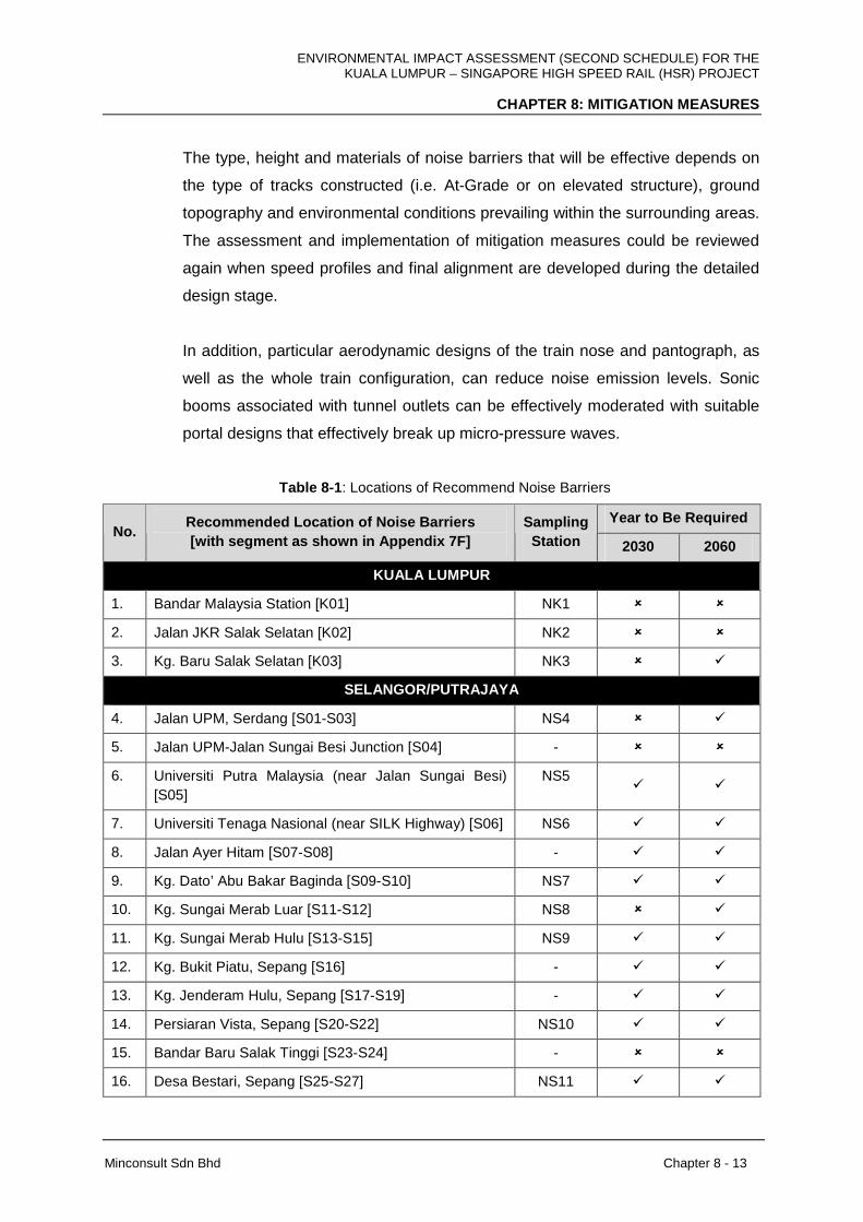
ENVIRONMENTAL IMPACT ASSESSMENT (SECOND SCHEDULE) FOR THE KUALA LUMPUR – SINGAPORE HIGH SPEED RAIL (HSR) PROJECT
CHAPTER 8: MITIGATION MEASURES
Minconsult Sdn Bhd Chapter 8 - 13
The type, height and materials of noise barriers that will be effective depends on
the type of tracks constructed (i.e. At-Grade or on elevated structure), ground
topography and environmental conditions prevailing within the surrounding areas.
The assessment and implementation of mitigation measures could be reviewed
again when speed profiles and final alignment are developed during the detailed
design stage.
In addition, particular aerodynamic designs of the train nose and pantograph, as
well as the whole train configuration, can reduce noise emission levels. Sonic
booms associated with tunnel outlets can be effectively moderated with suitable
portal designs that effectively break up micro-pressure waves.
Table 8-1 : Locations of Recommend Noise Barriers
Year to Be Required No.
Recommended Location of Noise Barriers [with segment as shown in Appendix 7F]
Sampling Station 2030 2060
KUALA LUMPUR
1. Bandar Malaysia Station [K01] NK1 � �
2. Jalan JKR Salak Selatan [K02] NK2 � �
3. Kg. Baru Salak Selatan [K03] NK3 � �
SELANGOR/PUTRAJAYA
4. Jalan UPM, Serdang [S01-S03] NS4 � �
5. Jalan UPM-Jalan Sungai Besi Junction [S04] - � �
6. Universiti Putra Malaysia (near Jalan Sungai Besi) [S05]
NS5 � �
7. Universiti Tenaga Nasional (near SILK Highway) [S06] NS6 � �
8. Jalan Ayer Hitam [S07-S08] - � �
9. Kg. Dato’ Abu Bakar Baginda [S09-S10] NS7 � �
10. Kg. Sungai Merab Luar [S11-S12] NS8 � �
11. Kg. Sungai Merab Hulu [S13-S15] NS9 � �
12. Kg. Bukit Piatu, Sepang [S16] - � �
13. Kg. Jenderam Hulu, Sepang [S17-S19] - � �
14. Persiaran Vista, Sepang [S20-S22] NS10 � �
15. Bandar Baru Salak Tinggi [S23-S24] - � �
16. Desa Bestari, Sepang [S25-S27] NS11 � �
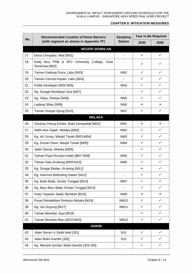
ENVIRONMENTAL IMPACT ASSESSMENT (SECOND SCHEDULE) FOR THE KUALA LUMPUR – SINGAPORE HIGH SPEED RAIL (HSR) PROJECT
CHAPTER 8: MITIGATION MEASURES
Minconsult Sdn Bhd Chapter 8 - 14
Year to Be Required No.
Recommended Location of Noise Barriers [with segment as shown in Appendix 7F]
Sampling Station 2030 2060
NEGERI SEMBILAN
17. Desa Cempaka, Nilai [N01] - � �
18. Kolej Ilmu PNB & KPJ University College, Kota Seriemas [N02]
- � �
19. Taman Gadong Putra, Labu [N03] NN2 � �
20. Taman Cermat Impian, Labu [N04] - � �
21. Felda Sendayan [N05-N06] NN4 � �
22. Kg. Sungai Sendayan Dua [N07] - � �
23. Kg. Siliau, Rantau [N08] NN5 � �
24. Ladang Siliau [N09] NN6 � �
25. Taman Sungai Ujong [N10] NN7 � �
MELAKA
26. Genting Cheng Estate, Bukit Cempedak [M01] NM1 � �
27. IKBN Alor Gajah, Melaka [M02] NM2 � �
28. Kg. Air Limau, Masjid Tanah [M03-M04] NM3 � �
29. Kg. Durian Daun, Masjid Tanah [M05] NM4 � �
30. Jalan Damai, Melaka [M06] - � �
31. Taman Paya Rumput Indah [M07-M08] NM5 � �
32. Taman Satu Krubong [M09-M10] NM6 � �
33. Kg. Sungai Badau, Krubong [M11] - � �
34. Kg. Harmoni Belimbing Dalam [M12] - � �
35. Kg. Bukit Balai, Durian Tunggal [M13] NM7 � �
36. Kg. Baru Baru Balai, Durian Tunggal [M14] - � �
37. Kolej Yayasan Saad, Bemban [M15] NM9 � �
38. Pusat Rehabilitasi Perkeso Melaka [M16] NM10 � �
39. Kg. Ulu Duyung [M17] NM11 � �
40. Taman Bemban Jaya [M18] - � �
41. Taman Bemban Baru [M19-M20] NM12 � �
JOHOR
42. Jalan Serom 4, Bukit Mati [J01] NJ1 � �
43. Jalan Bukit Gambir [J02] NJ2 � �
44. Kg. Meranti Sundai, Bukit Gambir [J03-J04] - � �
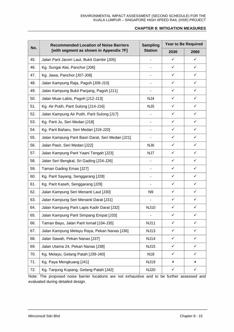
ENVIRONMENTAL IMPACT ASSESSMENT (SECOND SCHEDULE) FOR THE KUALA LUMPUR – SINGAPORE HIGH SPEED RAIL (HSR) PROJECT
CHAPTER 8: MITIGATION MEASURES
Minconsult Sdn Bhd Chapter 8 - 15
Year to Be Required No.
Recommended Location of Noise Barriers [with segment as shown in Appendix 7F]
Sampling Station 2030 2060
45. Jalan Parit Jarom Laut, Bukit Gambir [J05] - � �
46. Kg. Sungai Alai, Panchor [J06] - � �
47. Kg. Jawa, Panchor [J07-J08] - � �
48. Jalan Kampung Raja, Pagoh [J09-J10] - � �
49. Jalan Kampung Bukit Panjang, Pagoh [J11] - � �
50. Jalan Muar-Labis, Pagoh [J12-J13] NJ4 � �
51. Kg. Air Putih, Parit Sulong [J14-J16] NJ5 � �
52. Jalan Kampung Air Putih, Parit Sulong [J17] - � �
53. Kg. Parit Ju, Seri Medan [J18] - � �
54. Kg. Parit Baharu, Seri Medan [J19-J20] - � �
55. Jalan Kampung Parit Basri Darat, Seri Medan [J21] - � �
56. Jalan Pasir, Seri Medan [J22] NJ6 � �
57. Jalan Kampung Parit Yaani Tengah [J23] NJ7 � �
58. Jalan Seri Bengkal, Sri Gading [J24-J26] - � �
59. Taman Gading Emas [J27] - � �
60. Kg. Parit Sayang, Senggarang [J28] - � �
61. Kg. Parit Kaseh, Senggarang [J29] - � �
62. Jalan Kampung Seri Menanti Laut [J30] N9 � �
63. Jalan Kampung Seri Menanti Darat [J31] - � �
64. Jalan Kampung Parit Lapis Kadir Darat [J32] NJ10 � �
65. Jalan Kampung Parit Simpang Empat [J33] - � �
66. Taman Bayu, Jalan Parit Ismail [J34-J35] NJ11 � �
67. Jalan Kampung Melayu Raya, Pekan Nanas [J36] NJ13 � �
68. Jalan Sawah, Pekan Nanas [J37] NJ14 � �
69. Jalan Utama 24, Pekan Nanas [J38] NJ15 � �
70. Kg. Melayu, Gelang Patah [J39-J40] N18 � �
71. Kg. Paya Mengkuang [J41] NJ19 � �
72. Kg. Tanjung Kupang, Gelang Patah [J42] NJ20 � �
Note: The proposed noise barrier locations are not exhaustive and to be further assessed and evaluated during detailed design.
ENVIRONMENTAL IMPACT ASSESSMENT (SECOND SCHEDULE) FOR THE KUALA LUMPUR – SINGAPORE HIGH SPEED RAIL (HSR) PROJECT
CHAPTER 8: MITIGATION MEASURES
Minconsult Sdn Bhd Chapter 8 - 16
B. Road Traffic Flows
I. Nearby residents and noise sensitive recipients should be informed of the
existence of new roads for diverting traffic away from the structures constructed
for the Project. Noise assessment should be performed to identify and mitigate
any impacts to the affected receptors due to the change in traffic profiles, which
may lead to the need of noise barriers alongside the diverted roads.
C. Activities at Stations, Depots and Maintenance Bases, and Repair and Maintenance
Works on Tracks
I. Noise-emitting machinery and equipment used for activities at stations, depots
and maintenance bases, and for repair and maintenance works on the tracks,
must be checked for proper installation of noise control devices such as mufflers
and soundproof enclosures to reduce noise emissions if it were to be operated
outdoor, outside the building of the stations, depots and maintenance bases and
close to residents and noise sensitive receptors.
II. Repair and maintenance works along the track, including periodic grinding of rail
heads, should be restricted to day-time (7.00 a.m. – 7.00 p.m.) periods and
working days only when works are carried out close to sensitive receptors. The
intensity of noise activities should be reduced in the evening (7.00 p.m. –
10.00 p.m.) in urban areas so that the generated sound level is below the limits
as stipulated in Table 7-4 .
8.3.2 Vibration
8.3.2.1 Construction Phase
In Chapter 7 an assessment of the potential impacts which the following Project activities
could induce on surrounding Receptors in the states of FT. Kuala Lumpur, Selangor and FT.
Putarajaya, Negeri Sembilan, Melaka and Johor were discussed, viz:
I. Vibration from Land Preparation, Earthworks and Demolition Activities
II. Vibration induced by Vehicle Movements and Transportation of Materials and
Equipment
III. Vibration from Piling Activities
ENVIRONMENTAL IMPACT ASSESSMENT (SECOND SCHEDULE) FOR THE KUALA LUMPUR – SINGAPORE HIGH SPEED RAIL (HSR) PROJECT
CHAPTER 8: MITIGATION MEASURES
Minconsult Sdn Bhd Chapter 8 - 17
IV. Vibration from Tunnelling
The findings indicated that for certain activities carried out, the resulting impacts exerted on
receptors could induce significant adverse perturbations for which mitigation and abatement
(M&A) measures were needed to be adopted in order to reduce the intensity of impacts to
tolerable levels. The nature and scope of recommended M&A measures are presented
herewith.
A. Vibration from Land Preparation, Earthworks and Demolition Activities
I. Approval of any use of explosives for demolition must be obtained from local
authorities, whereby its use should be restricted to working days and during day
time (7.00 a.m. – 7.00 p.m.) when working close to nearest recipients/residents.
Affected residents should be informed of the expected duration of particular
vibration-emitting activities in order to minimise complaints.
B. Vibration from Vehicle Movement and Transportation of Materials and Equipment
I. Vehicle frequency and movement to and from the construction sites which
generate high noise should be reduced when operating outside working hours
and during the weekends and public holidays and when passing close to noise
sensitive receptors and residential areas.
C. Vibration from Piling
I. Construction of the elevated tracks, bridges, stations, depots and maintenance
bases should employ more silent and low-vibration piling methods such as bored
piling, hydraulic press-in or jack-in spun piling when working close to vibration
sensitive receptors and residential areas so that the vibration signal is not
propagated to the nearest receptor.
D. Vibration from Tunnelling
I. For construction of tunnel using TBM, free-face drilling approach can be used for
excavation involving hard rocks and foundation to reduce underground vibration.
II. For construction of tunnel using NATM, the impact from blasting can be reduced
by restricting blasting to day-time only and adopting controlled blasting
approaches such as partial upper/lower blasting and multi-step blasting.
III. Approval of any use of explosives for demolition must be obtained from local
authorities, whereby its use should be restricted to working days and during day
ENVIRONMENTAL IMPACT ASSESSMENT (SECOND SCHEDULE) FOR THE KUALA LUMPUR – SINGAPORE HIGH SPEED RAIL (HSR) PROJECT
CHAPTER 8: MITIGATION MEASURES
Minconsult Sdn Bhd Chapter 8 - 18
time (7.00 a.m. – 7.00 p.m.) when working close to nearest recipients/residents.
Affected residents should be informed of the expected duration of particular
vibration-emitting activities in order to minimise complaints.
The measures recommended above must comply with the limits as stipulated in Table 7-14
in Chapter 7.
The mitigation measures recommended in Section 8.3.2.1(A-D) above are in line with
BS 5228-2:2009 (Code of practice for noise and vibration control on construction and open
sites – Part 2: Vibration) such as restriction on working hours, installation of equipment
silencer, equipment closure, selection of piling method, trenches construction and proper
equipment maintenance. Hence, it is recommended that the construction activities follow the
code of practice as stipulated by BS 5228-2:2009, which covers the need for protection
against noise and vibration of persons living and working in the vicinity of construction and
open sites. The standard recommends procedures for noise and vibration control in respect
of construction operations and aims to assist architects, contractors and site operatives,
designers, developers, engineers, local authority environmental health officers and planners.
8.3.2.2 Operational Phase
In Chapter 7 an assessment of the potential impacts which the following Project activities
could induce on surrounding Receptors were discussed, viz:
FT. Kuala Lumpur
I. Vibration from movement of trains at high speed and approaching/leaving stations
II. Vibration due to Activities at Station Repair and Maintenance Work on Tracks
Selangor / FT. Putrajaya
I. Vibration from movement of trains at high speed and approaching/leaving stations
II. Vibration due to Activities at Stations, Depots and Maintenance Bases and Repair
and Maintenance Work on Tracks
Negeri Sembilan
I. Vibration from movement of trains at high speed and approaching/leaving stations
ENVIRONMENTAL IMPACT ASSESSMENT (SECOND SCHEDULE) FOR THE KUALA LUMPUR – SINGAPORE HIGH SPEED RAIL (HSR) PROJECT
CHAPTER 8: MITIGATION MEASURES
Minconsult Sdn Bhd Chapter 8 - 19
Melaka
I. Vibration from movement of trains at high speed and approaching/leaving stations
II. Vibration due to Activities at Stations, Depots and Maintenance Bases and Repair
and Maintenance Work on Tracks
Johor
I. Vibration from movement of trains at high speed and approaching/leaving stations
II. Vibration due to Activities at Stations, Depots and Maintenance Bases and Repair
and Maintenance Work on Tracks
The findings indicated that for certain activities carried out, the resulting impacts exerted on
receptors could induce significant adverse perturbations for which mitigation and abatement
(M&A) measures were needed to be instituted in order to reduce the intensity of impacts to
tolerable levels. The nature and scope of the required M&A measures are presented
herewith.
A. Movement of Trains at High Speed and When Approaching/Leaving Stations
I. Vibration isolation device should be installed at track sleepers, ballasts or
viaducts in order to properly isolate vibration signals from being passed and
propagated to nearest residential areas and vibration sensitive receptors.
B. Activities at Stations, Depots and Maintenance Bases, and Repair and Maintenance
Works on Tracks
I. Repair and maintenance works along the track, including periodic grinding of rail
heads, should be restricted to night-time (12.00 a.m. – 6.00 a.m.) periods and
working days only when works are carried out close to sensitive receptors. The
intensity of noise activities should be reduced in the evening (7.00 p.m. –
10.00 p.m.) in urban areas.
The measures recommended above must comply with the limits as stipulated in Table 7-14
in Chapter 7.
Attenuation of vibration can be further mitigated using the slab track design measures as listed in Table 8-2 . Figures 8-1 and 8-2 illustrate examples of typical rail fastening systems that are incorporated in the design of rail tracks.
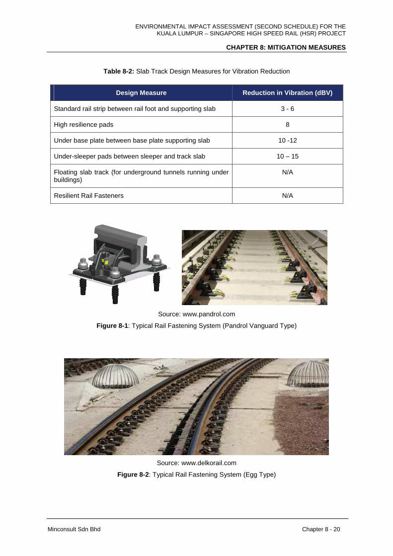
ENVIRONMENTAL IMPACT ASSESSMENT (SECOND SCHEDULE) FOR THE KUALA LUMPUR – SINGAPORE HIGH SPEED RAIL (HSR) PROJECT
CHAPTER 8: MITIGATION MEASURES
Minconsult Sdn Bhd Chapter 8 - 20
Table 8-2: Slab Track Design Measures for Vibration Reduction
Design Measure Reduction in Vibration (dBV)
Standard rail strip between rail foot and supporting slab 3 - 6
High resilience pads 8
Under base plate between base plate supporting slab 10 -12
Under-sleeper pads between sleeper and track slab 10 – 15
Floating slab track (for underground tunnels running under buildings)
N/A
Resilient Rail Fasteners N/A
Source: www.pandrol.com
Figure 8-1 : Typical Rail Fastening System (Pandrol Vanguard Type)
Source: www.delkorail.com
Figure 8-2 : Typical Rail Fastening System (Egg Type)
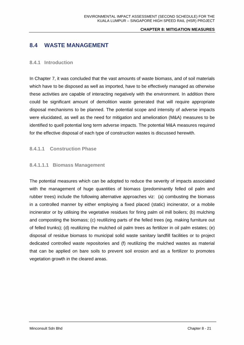
ENVIRONMENTAL IMPACT ASSESSMENT (SECOND SCHEDULE) FOR THE KUALA LUMPUR – SINGAPORE HIGH SPEED RAIL (HSR) PROJECT
CHAPTER 8: MITIGATION MEASURES
Minconsult Sdn Bhd Chapter 8 - 21
8.4 WASTE MANAGEMENT
8.4.1 Introduction
In Chapter 7, it was concluded that the vast amounts of waste biomass, and of soil materials
which have to be disposed as well as imported, have to be effectively managed as otherwise
these activities are capable of interacting negatively with the environment. In addition there
could be significant amount of demolition waste generated that will require appropriate
disposal mechanisms to be planned. The potential scope and intensity of adverse impacts
were elucidated, as well as the need for mitigation and amelioration (M&A) measures to be
identified to quell potential long term adverse impacts. The potential M&A measures required
for the effective disposal of each type of construction wastes is discussed herewith.
8.4.1.1 Construction Phase
8.4.1.1.1 Biomass Management
The potential measures which can be adopted to reduce the severity of impacts associated
with the management of huge quantities of biomass (predominantly felled oil palm and
rubber trees) include the following alternative approaches viz: (a) combusting the biomass
in a controlled manner by either employing a fixed placed (static) incinerator, or a mobile
incinerator or by utilising the vegetative residues for firing palm oil mill boilers; (b) mulching
and composting the biomass; (c) reutilizing parts of the felled trees (eg. making furniture out
of felled trunks); (d) reutilizing the mulched oil palm trees as fertilizer in oil palm estates; (e)
disposal of residue biomass to municipal solid waste sanitary landfill facilities or to project
dedicated controlled waste repositories and (f) reutilizing the mulched wastes as material
that can be applied on bare soils to prevent soil erosion and as a fertilizer to promotes
vegetation growth in the cleared areas.
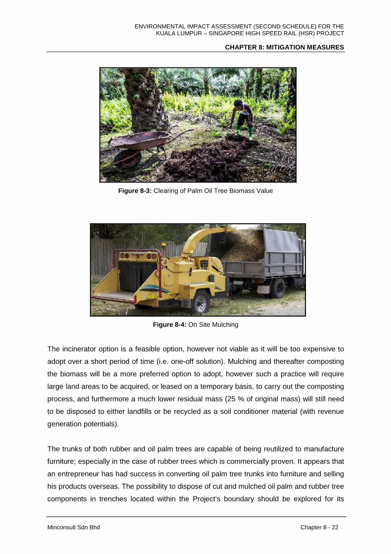
ENVIRONMENTAL IMPACT ASSESSMENT (SECOND SCHEDULE) FOR THE KUALA LUMPUR – SINGAPORE HIGH SPEED RAIL (HSR) PROJECT
CHAPTER 8: MITIGATION MEASURES
Minconsult Sdn Bhd Chapter 8 - 22
Figure 8-3: Clearing of Palm Oil Tree Biomass Value
Figure 8-4: On Site Mulching
The incinerator option is a feasible option, however not viable as it will be too expensive to
adopt over a short period of time (i.e. one-off solution). Mulching and thereafter composting
the biomass will be a more preferred option to adopt, however such a practice will require
large land areas to be acquired, or leased on a temporary basis, to carry out the composting
process, and furthermore a much lower residual mass (25 % of original mass) will still need
to be disposed to either landfills or be recycled as a soil conditioner material (with revenue
generation potentials).
The trunks of both rubber and oil palm trees are capable of being reutilized to manufacture
furniture; especially in the case of rubber trees which is commercially proven. It appears that
an entrepreneur has had success in converting oil palm tree trunks into furniture and selling
his products overseas. The possibility to dispose of cut and mulched oil palm and rubber tree
components in trenches located within the Project’s boundary should be explored for its
ENVIRONMENTAL IMPACT ASSESSMENT (SECOND SCHEDULE) FOR THE KUALA LUMPUR – SINGAPORE HIGH SPEED RAIL (HSR) PROJECT
CHAPTER 8: MITIGATION MEASURES
Minconsult Sdn Bhd Chapter 8 - 23
practicality and viability. Employing mulched wastes as an anti-erosion measure along
cleared areas of the alignment and at Station and Depot sites should be seriously
considered.
There appears to be “green” alternatives available to adequately manage the ultimate
disposal of biomass residues arising from Project development. It will be the appointed
Contractor’s responsibility to dispose of the biomass generated. However because of the
vast quantities of biomass that has to be managed, the Project Proponent should guide the
Contractor in carrying his/her responsibilities. In this respect the Project Proponent should
specify that the Contractor is obligated to, as a first priority, to adopt disposal strategies that
place emphasis on recycling and/or reuse options. This would encompass exploring the
potential to, as a first priority, to dispose the biomass to markets that are capable of
converting the waste to wood products of value (eg rubber and oil palm based furniture,
plywood and pulp and paper). Secondly to compost the waste and market it as a
fertilizer/soil conditioner; and thirdly to reutilise it as a fuel to fire palm oil mill boilers to raise
steam for electricity production. The last option would be to establish dedicated repositories.
Remaining portions of the biomass will be stockpiled temporarily at specified areas for
decomposition. The locations of the temporary stockpile locations will be identified before the
construction phase of the HSR Project commences in which these stockpile locations will be
away from water bodies and sensitive areas along the vicinity of the alignment while
preventive steps will be taken to prevent the waste vegetation stockpiles to effect the river
network. The stockpiles shall be bunded to prevent any spread of the vegetation stockpiles
to areas within the vicinity. Open burning of these stockpiles will be prohibited.
The clearing of forest vegetation within the HSR Project alignment boundary will only be
conducted after consultation with the Forestry Departments of Selangor (Bukit Unggul
Forest) and Johor (Sg. Pulai Forest Reserve). Surveys will be conducted by personnel from
the Forestry Department in collaboration with the HSR Project Proponent to identify any
trees of conservation and commercial value that will be removed during site clearing.
The Project Proponent should require the Contractor to submit Waste Management Plan
detailing the Approach and Methodology proposed to be adopted to manage the biomass
wastes for review by the Project Proponent. This document should also detail out the
transportation strategies to deliver the waste material to destination points. The Contractor

ENVIRONMENTAL IMPACT ASSESSMENT (SECOND SCHEDULE) FOR THE KUALA LUMPUR – SINGAPORE HIGH SPEED RAIL (HSR) PROJECT
CHAPTER 8: MITIGATION MEASURES
Minconsult Sdn Bhd Chapter 8 - 24
shall only commence disposal activities after receiving conditional approvals from the Project
Proponent and Local Authority. The Project Proponent’s supervising engineers /
environmental consultants shall monitor and regulate the biomass disposal operations.
8.4.1.1.2 Soil Materials
Site preparation and earthworks operations will need to be carried out in a controlled manner
in order to avoid inducing potential nuisance impacts. Surrounding developments, especially
commercial, institutional and residential abodes, as well as tree crop plantation and wetland
areas, need to be adequately protected against dust dispersions, noise and vibrations, and
potentially flash floods caused by the silting of drains by earthworks operations.
To reduce waste from earthworks and excavated material, suitable excavated material can
be reused as fill material for the embankments at necessary areas along the HSR Project
alignment boundary as far as possible. The spoil material that comprises of rocky soil from
the excavation of tunnelling activities can be utilised for the construction of roads, while
granitic rock material obtained can be used as railway ballasts. Spoil material that is found to
be unsuitable can be reutilised for landscaping fill or for restoring disturbed sites within the
alignment. All excavated material will be handled in a manner that minimises the release of
fugitive dust especially during hot and dry weather. The following measures will be adopted
within the temporary stockpiling area to reduce potential impacts.
• Identifying locations for temporary stockpile areas that minimize environmental,
visual and public health impacts
• Covering of material during heavy rainfall
• Implementing dust suppression measures such as dampening with fine water spray
and covering of material with tarpaulin
• Segregation of surface water system for the stockpile of excavated material and
fitting of silt traps within regions of the temporary stockpile areas
• Controlling of excessive use of water during spraying to ensure that generation of
runoffs are prevented.
• Design of appropriate haulage roads for transport of materials.
Excavated material which cannot be re-used on the site will require disposal at landfill or at
approved disposal areas. In the case of excavated material that is contaminated,
ENVIRONMENTAL IMPACT ASSESSMENT (SECOND SCHEDULE) FOR THE KUALA LUMPUR – SINGAPORE HIGH SPEED RAIL (HSR) PROJECT
CHAPTER 8: MITIGATION MEASURES
Minconsult Sdn Bhd Chapter 8 - 25
segregation and storage of the material in designated areas which are bunded will be
conducted to prevent discharge of contaminated material through water runoffs from rainfall.
The contaminated excavated materials will be collected and disposed of by a licensed waste
collector as soon as practical.
The Project Proponent shall include the following mitigation and abatement (M&A) measures
in the site preparation contract packages to protect the local environment, viz:
• The Project Proponent and/or Contractor shall need to identify external areas where
excess unsuitable soils and/or construction wastes can be discarded, and obtain
approval from the Local Authority to employ such areas as depositories for the waste
materials, prior to initiating site preparation operations. Disposal areas that will be
identified in collaboration with the relevant Authorities should be capable of
accommodating non-schedule wastes without inducing, inter-alia, elimination of
indigenous terrestrial flora and fauna habitats; cause siltation of rivers and streams
leading to flooding, and imposing adverse impacts on downstream users of the
waterway; pose a danger to survival of aquatic flora and fauna; and create suitable
habitats where disease propagating vectors can proliferate. The use of discarded
rock from tunnel construction for reclamation purposes, or for purpose of reutilization,
needs adequate study and planning.
• The transportation of excess unsuitable soils and/or construction wastes to approved
disposal sites, outside of the Project work sites, shall be closely regulated in order
not to impact adversely with normal traffic circulation patterns on selected routes.
Timing of travel on public roads shall be spaced out in order not to exacerbate peak
period heavy traffic flows. Appropriate measures must be taken to ensure that the
transported material is well stacked and covered. This will prevent accidental
spillages, minimize potential fugitive dust dispersions, and avoid endangering
motorists.
• The Project Proponent should request from the earthworks contractor a mandatory
Method Statement describing, inter-alia, the identity of the Burrow Area(s); and
disposal sites for spoils and discarded construction materials; the types of vehicles
that will be employed to cart the fill and wastes materials; certificates of inspection
and road worthiness of vehicles employed; routes to be traversed to transport fill to

ENVIRONMENTAL IMPACT ASSESSMENT (SECOND SCHEDULE) FOR THE KUALA LUMPUR – SINGAPORE HIGH SPEED RAIL (HSR) PROJECT
CHAPTER 8: MITIGATION MEASURES
Minconsult Sdn Bhd Chapter 8 - 26
the Project Sites; to export waste materials; the protective methods to be adopted to
prevent spillages of fill material and to prevent fugitive dust dispersions from dump
trucks; and precautions to be taken to avoid dust dispersions. Adverse traffic
circulation impacts can be mitigated through advance planning of the routes to be
traversed to transport fill material from burrow areas to the Project Sites; and to
dispose unsuitable soils and construction materials from the Project Sites. Proper
scheduling of truck trips is also required to avoid potential adverse impacts.
• The Project Proponent shall instill the need for the Contractor to submit plans for
expedient guniting of exposed rock surfaces, and inculcating landscaping works, in
order to reduce any soil erosion tendencies especially along barren slopes, etc
8.4.1.1.3 Construction and Demolition Wastes
A large portion of construction and demolition waste will be generated along the HSR Project
alignment boundary. Thus to ensure that the amount of construction and demolition waste
sent for disposal is minimised, waste reuse, and recycling measures can be adopted as
much as possible.
The careful deconstruction or selective demolition of buildings along the alignment
represents an approach for clearing the buildings within the HSR Project alignment
boundary. Deconstruction can be applied on a number of levels to salvage usable materials
and significantly cut waste and reduce disposal. This can range from reusing an entire
structure or foundation, to select assemblies and systems, to the careful removal of specific
materials or items such as bricks, tiles, metals and timber can be reused or recycled.
Additionally, reusing and recycling construction and demolition material can contribute to
reducing transportation costs for waste disposal. Once the process of deconstruction of
construction and demolition waste is conducted and the reusable and recyclable waste is
identified, the material can be for various purposes as shown below:
• The salvaged construction or demolition debris will be placed in storage buildings for
reuse on further needs or requirements of the HSR Project.
• The salvaged material will be sold as a resource for other HSR Projects.
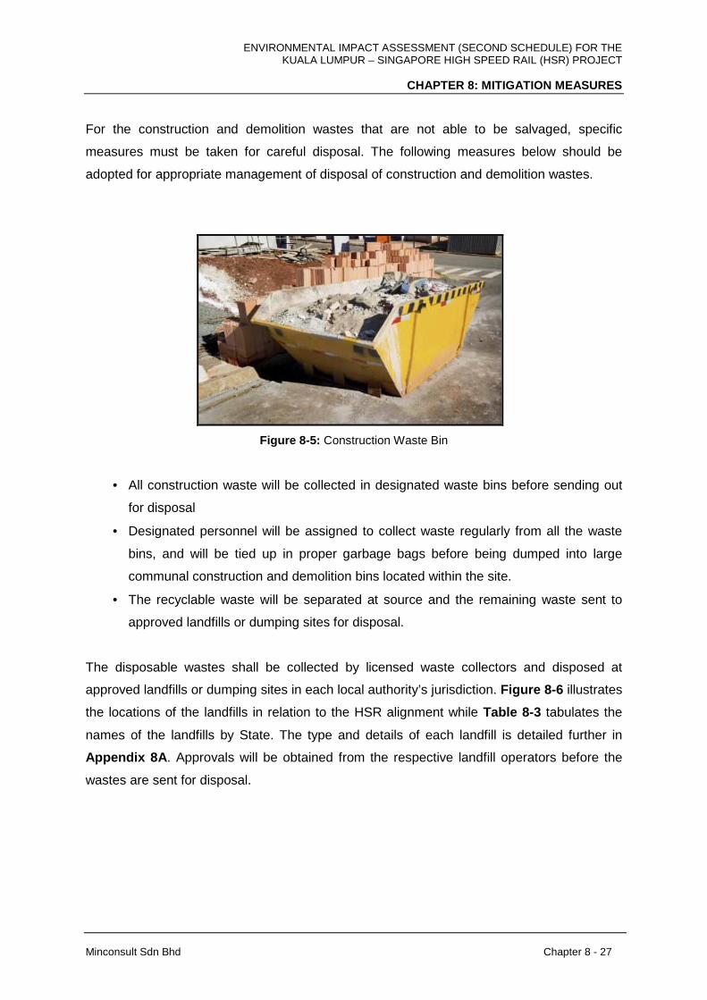
ENVIRONMENTAL IMPACT ASSESSMENT (SECOND SCHEDULE) FOR THE KUALA LUMPUR – SINGAPORE HIGH SPEED RAIL (HSR) PROJECT
CHAPTER 8: MITIGATION MEASURES
Minconsult Sdn Bhd Chapter 8 - 27
For the construction and demolition wastes that are not able to be salvaged, specific
measures must be taken for careful disposal. The following measures below should be
adopted for appropriate management of disposal of construction and demolition wastes.
Figure 8-5: Construction Waste Bin
• All construction waste will be collected in designated waste bins before sending out
for disposal
• Designated personnel will be assigned to collect waste regularly from all the waste
bins, and will be tied up in proper garbage bags before being dumped into large
communal construction and demolition bins located within the site.
• The recyclable waste will be separated at source and the remaining waste sent to
approved landfills or dumping sites for disposal.
The disposable wastes shall be collected by licensed waste collectors and disposed at
approved landfills or dumping sites in each local authority’s jurisdiction. Figure 8-6 illustrates
the locations of the landfills in relation to the HSR alignment while Table 8-3 tabulates the
names of the landfills by State. The type and details of each landfill is detailed further in
Appendix 8A . Approvals will be obtained from the respective landfill operators before the
wastes are sent for disposal.
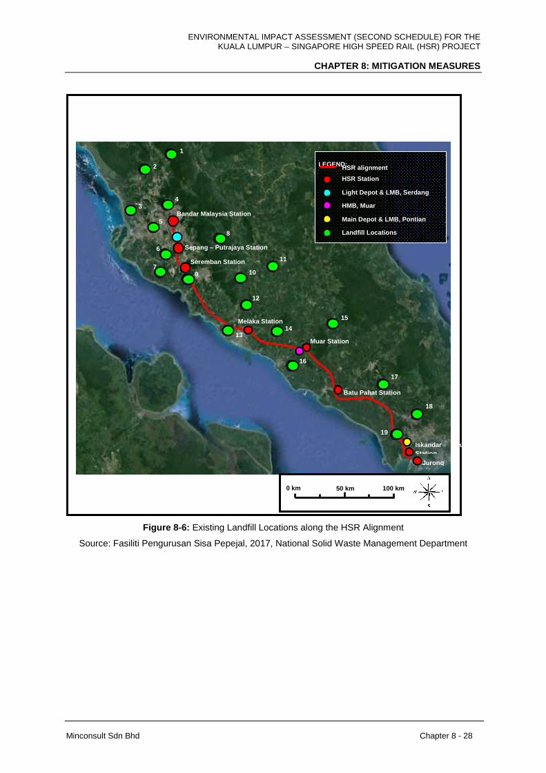
ENVIRONMENTAL IMPACT ASSESSMENT (SECOND SCHEDULE) FOR THE KUALA LUMPUR – SINGAPORE HIGH SPEED RAIL (HSR) PROJECT
CHAPTER 8: MITIGATION MEASURES
Minconsult Sdn Bhd Chapter 8 - 28
Figure 8-6: Existing Landfill Locations along the HSR Alignment
Source: Fasiliti Pengurusan Sisa Pepejal, 2017, National Solid Waste Management Department
1
2
3
4
5
Bandar Malaysia Station
Sepang – Putrajaya Station
8
6
7
9
Seremban Station
10
11
12
13
Melaka Station
14
15
Muar Station
16
Batu Pahat Station
17
18
19
Iskandar Puteri Station
Jurong East
LEGEND:
HSR alignment
HSR Station
Light Depot & LMB, Serdang
HMB, Muar
Main Depot & LMB, Pontian
Landfill Locations
100 km 50 km 0 km
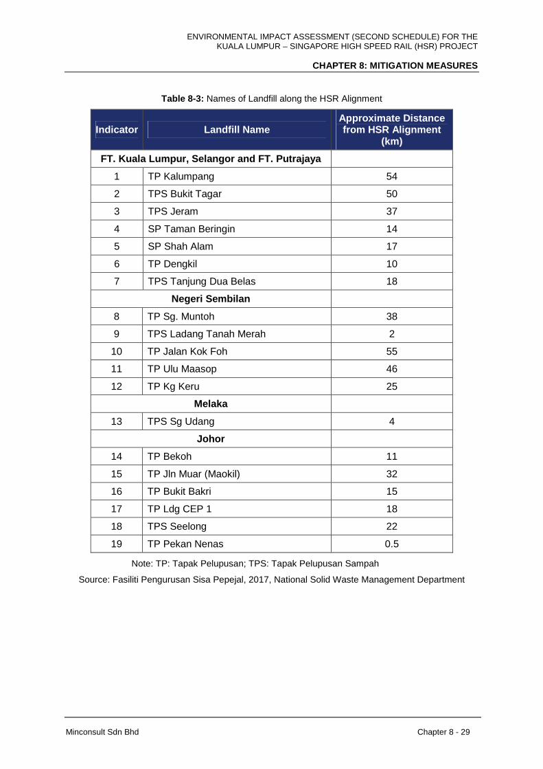
ENVIRONMENTAL IMPACT ASSESSMENT (SECOND SCHEDULE) FOR THE KUALA LUMPUR – SINGAPORE HIGH SPEED RAIL (HSR) PROJECT
CHAPTER 8: MITIGATION MEASURES
Minconsult Sdn Bhd Chapter 8 - 29
Table 8-3: Names of Landfill along the HSR Alignment
Indicator Landfill Name Approximate Distance from HSR Alignment
(km)
FT. Kuala Lumpur, Selangor and FT. Putrajaya
1 TP Kalumpang 54
2 TPS Bukit Tagar 50
3 TPS Jeram 37
4 SP Taman Beringin 14
5 SP Shah Alam 17
6 TP Dengkil 10
7 TPS Tanjung Dua Belas 18
Negeri Sembilan
8 TP Sg. Muntoh 38
9 TPS Ladang Tanah Merah 2
10 TP Jalan Kok Foh 55
11 TP Ulu Maasop 46
12 TP Kg Keru 25
Melaka
13 TPS Sg Udang 4
Johor
14 TP Bekoh 11
15 TP Jln Muar (Maokil) 32
16 TP Bukit Bakri 15
17 TP Ldg CEP 1 18
18 TPS Seelong 22
19 TP Pekan Nenas 0.5
Note: TP: Tapak Pelupusan; TPS: Tapak Pelupusan Sampah
Source: Fasiliti Pengurusan Sisa Pepejal, 2017, National Solid Waste Management Department
ENVIRONMENTAL IMPACT ASSESSMENT (SECOND SCHEDULE) FOR THE KUALA LUMPUR – SINGAPORE HIGH SPEED RAIL (HSR) PROJECT
CHAPTER 8: MITIGATION MEASURES
Minconsult Sdn Bhd Chapter 8 - 30
8.4.1.1.4 Domestic Wastes
Domestic waste that is generated during the construction phase consists of the general
refuse that is generated at the Centralized Labour Quarters (CLQ). This typically comprises
of general food and beverage waste and dry wastes such as cardboards, and recyclable
plastics, and metals. The following measures below can be applied to mitigate the waste
impacts.
• Waste receptacles with lids will be stationed at appropriate locations within the CLQ
in which wastes will be collected by licensed recyclable collectors at a regular basis
• The waste receptacles will be differentiated based on colour to ensure food wastes
and other general refuse is segregated to avoid odour, nuisance and pest problems
and the spread of diseases.
• Wastes requiring disposal will be managed and disposed at approved landfills.
The Project Proponent will implement the 5S methodology throughout the construction
phase as an effective and efficient waste management strategy at all the HSR stations,
depots and maintenance bases. The Project Proponent will also make the continuous
implementation of this methodology a mandatory requirement for the Operators during the
operational phase. The Project Proponent will provide waste segregation facilities at all the
HSR stations, depots and maintenance bases to conform to the 5S principle.
8.4.1.2.5 Scheduled Wastes
Scheduled wastes will be generated during construction phase of the HSR Project from the
construction vehicles maintenance activity and spillage from the diesel drums/tank.
Scheduled wastes shall be managed according to the requirements of the Environmental
Quality (Schedule Wastes) Regulations 2005. Scheduled wastes shall be stored in proper
containers and kept in a designated scheduled waste storage area, which shall be roofed to
prevent entry of rainwater and must be ventilated adequately. Warning signs shall be clearly
visible at the scheduled waste storage area. All scheduled and toxic wastes shall be labelled
according to their contents as required by the Third Schedule of the Environmental Quality
(Schedule Wastes) Regulations 2005.

ENVIRONMENTAL IMPACT ASSESSMENT (SECOND SCHEDULE) FOR THE KUALA LUMPUR – SINGAPORE HIGH SPEED RAIL (HSR) PROJECT
CHAPTER 8: MITIGATION MEASURES
Minconsult Sdn Bhd Chapter 8 - 31
Figure 8-7: Scheduled Waste Storage Area
8.4.1.2 Operational Phase
8.4.1.2.1 Domestic Wastes
The domestic waste management that is generated during the operation phase mainly
consists of general refuse generated at the stations and by the passengers in the train.
These wastes can comprise of aluminium cans, bottles, papers and various forms of
plastics, besides the food waste generated at restaurants and cafes at the stations. The
following measures will be implemented as the following below.
• Ample recycling bins to be sufficiently provided within the rolling stock and the
stations to encourage recycling. Wastes shall then be collected by licensed
recyclable collectors at a regular basis.
• General refuse shall be collected on a daily basis by assigned personnel in proper
garbage bags and delivered to the appropriate refuse point to be removed regularly
by licensed waste collectors.
• Food refuse shall be segregated from other general refuse and ensuring food waste
is removed every day to avoid odour, nuisance and pest problems and spread of
diseases.
• Wastes requiring disposal will be managed and disposed at approved landfills.
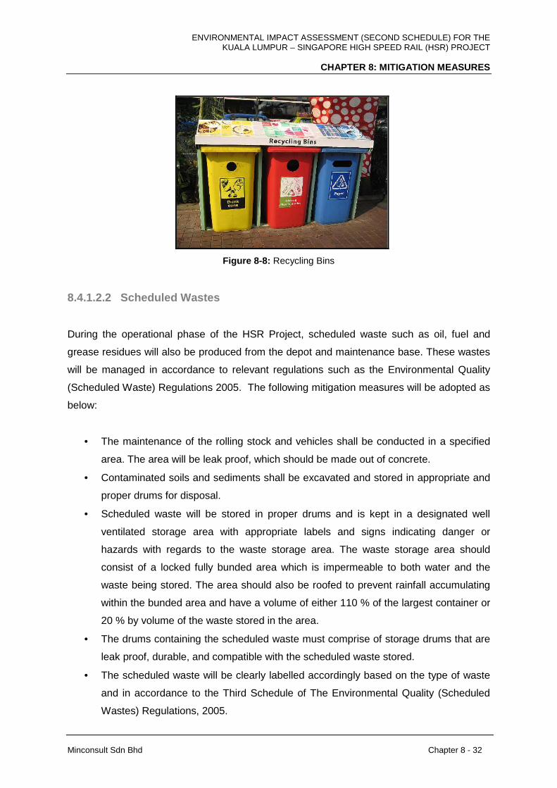
ENVIRONMENTAL IMPACT ASSESSMENT (SECOND SCHEDULE) FOR THE KUALA LUMPUR – SINGAPORE HIGH SPEED RAIL (HSR) PROJECT
CHAPTER 8: MITIGATION MEASURES
Minconsult Sdn Bhd Chapter 8 - 32
Figure 8-8: Recycling Bins
8.4.1.2.2 Scheduled Wastes
During the operational phase of the HSR Project, scheduled waste such as oil, fuel and
grease residues will also be produced from the depot and maintenance base. These wastes
will be managed in accordance to relevant regulations such as the Environmental Quality
(Scheduled Waste) Regulations 2005. The following mitigation measures will be adopted as
below:
• The maintenance of the rolling stock and vehicles shall be conducted in a specified
area. The area will be leak proof, which should be made out of concrete.
• Contaminated soils and sediments shall be excavated and stored in appropriate and
proper drums for disposal.
• Scheduled waste will be stored in proper drums and is kept in a designated well
ventilated storage area with appropriate labels and signs indicating danger or
hazards with regards to the waste storage area. The waste storage area should
consist of a locked fully bunded area which is impermeable to both water and the
waste being stored. The area should also be roofed to prevent rainfall accumulating
within the bunded area and have a volume of either 110 % of the largest container or
20 % by volume of the waste stored in the area.
• The drums containing the scheduled waste must comprise of storage drums that are
leak proof, durable, and compatible with the scheduled waste stored.
• The scheduled waste will be clearly labelled accordingly based on the type of waste
and in accordance to the Third Schedule of The Environmental Quality (Scheduled
Wastes) Regulations, 2005.
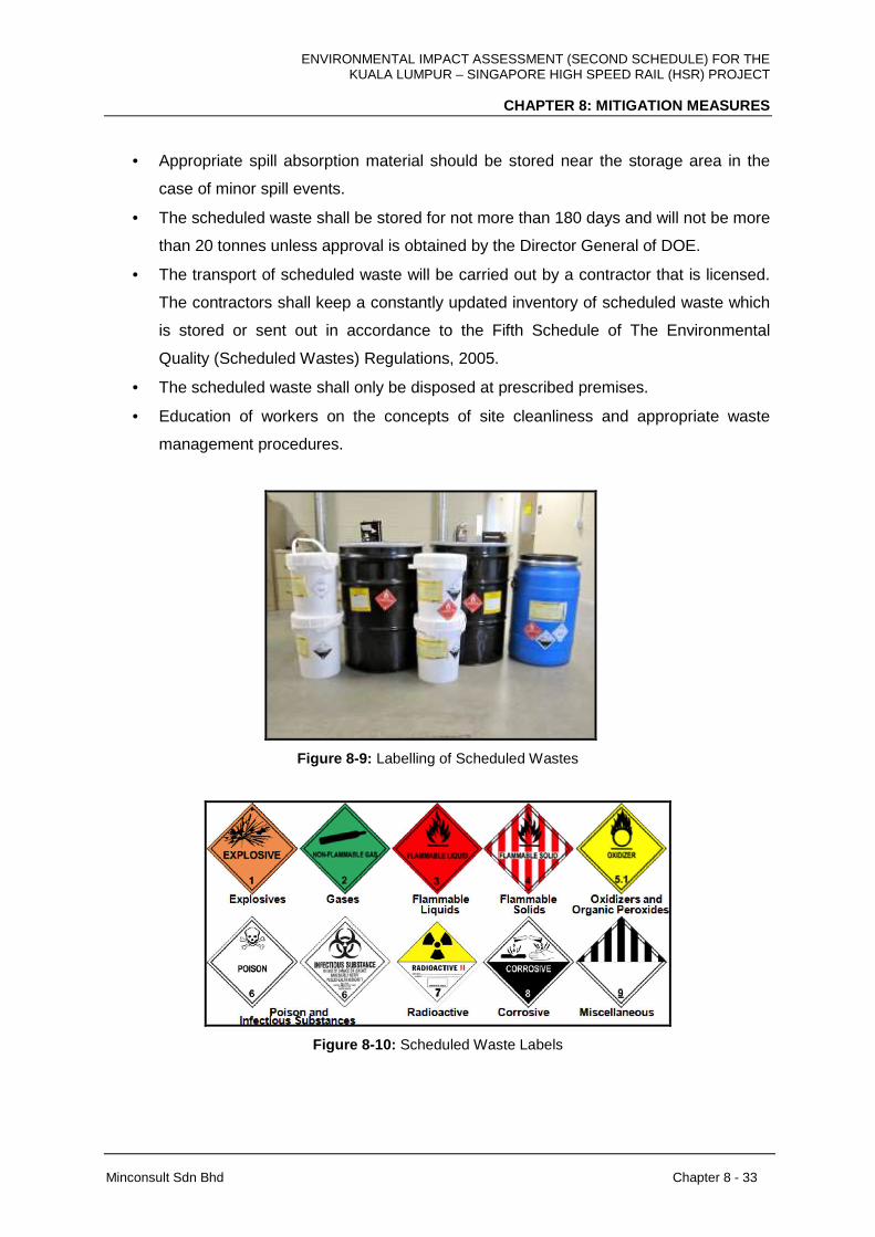
ENVIRONMENTAL IMPACT ASSESSMENT (SECOND SCHEDULE) FOR THE KUALA LUMPUR – SINGAPORE HIGH SPEED RAIL (HSR) PROJECT
CHAPTER 8: MITIGATION MEASURES
Minconsult Sdn Bhd Chapter 8 - 33
• Appropriate spill absorption material should be stored near the storage area in the
case of minor spill events.
• The scheduled waste shall be stored for not more than 180 days and will not be more
than 20 tonnes unless approval is obtained by the Director General of DOE.
• The transport of scheduled waste will be carried out by a contractor that is licensed.
The contractors shall keep a constantly updated inventory of scheduled waste which
is stored or sent out in accordance to the Fifth Schedule of The Environmental
Quality (Scheduled Wastes) Regulations, 2005.
• The scheduled waste shall only be disposed at prescribed premises.
• Education of workers on the concepts of site cleanliness and appropriate waste
management procedures.
Figure 8-9: Labelling of Scheduled Wastes
Figure 8-10: Scheduled Waste Labels
ENVIRONMENTAL IMPACT ASSESSMENT (SECOND SCHEDULE) FOR THE KUALA LUMPUR – SINGAPORE HIGH SPEED RAIL (HSR) PROJECT
CHAPTER 8: MITIGATION MEASURES
Minconsult Sdn Bhd Chapter 8 - 34
8.5 SURFACE WATER QUALITY
8.5.1 Construction Phase
8.5.1.1 Soil Erosion and Sedimentation
The potential for land clearing and earthworks operations to significantly increase the risks
and rate of soil erosion and subsequent sedimentation in watercourses has been clearly
demonstrated in Chapter 7. Although short term in nature, there should be effective
mitigation and abatement measures adopted to reduce the rates of soil erosion and
sedimentation in order to prevent intensive soil particulate loadings on receiving
watercourses.
Pollution prevention and mitigation measures can be adopted to reduce the intensity of
potential soil erosion episodes. These measures include:
(a) Earthworks to prepare the base of buildings and other structures shall be carried out
during the dry season and selectively during the monsoon;
(b) Any disturbed soil surface shall be immediately levelled trough to prevent creation of
slopes which accelerates water runoff;
(c) Sloping areas at the periphery of the project sites shall be completely terraced with
the introduction of berm drains
(d) For every 10 meters of slope length, slope shall be prepared at less than 45 degree
angle;
(e) Immediate mulching of the exposed ground shall be implemented;
(f) Geotextile or turf reinforcement mats shall be utilised on slope areas and monsoon
drains;
(g) Sediment basins and silt traps shall be constructed to collect and prevent coarse
sediments from being discharged into the river system;
(h) All waste soils, fill materials and construction materials (e.g. sand, aggregates, etc.)
stored on site must be properly protected from the rain;
(i) All soil stockpile must be located at least 20m away from the nearest water body and
have temporary perimeter drains around it that discharges into a sediment basin;
ENVIRONMENTAL IMPACT ASSESSMENT (SECOND SCHEDULE) FOR THE KUALA LUMPUR – SINGAPORE HIGH SPEED RAIL (HSR) PROJECT
CHAPTER 8: MITIGATION MEASURES
Minconsult Sdn Bhd Chapter 8 - 35
(j) All filled areas must be properly compacted (following BS1377) to prevent soil
settlement, structural failure or unnecessary maintenance costs; and
Site-specific LD-P2M2 plans are prepared for selected segments and facilities of the project
site based on available information at this stage as shown in Appendix 7H2 . The temporary
and permanent general pollution prevention and mitigation measures (P2M2) that are
recommended for adoption at target sites that is, ie the HSR alignment, stations, depots and
maintenance bases, and at river crossing are described in the following sub-sections.
Complete and site-specific Soil Erosion and Sedimentation Assessments relevant to each
state are attached as Appendix 7I .
8.5.1.1.1 Stations, Depots and Maintenance Bases
1. Land clearing shall be carried out in the shortest possible time. Biomass generated
from land clearing shall be disposed off-site at an approved landfill. Trunks from the
trees can be chipped and used as Mulch to cover up the exposed land.
2. Demolition waste from demolishing of existing structures shall be placed in a
temporary stockpile, located at least 20 m away from any drain.
3. Before earthwork commences, Pollution Prevention and Mitigation Measures (P2M2)
such as Stabilized Construction Entrance, Wash Trough, Temporary Earth Drain,
Check Dam, Silt Fence, Earth Bund and Sediment Basin shall be established onsite.
4. Earthwork shall be carried out from cutting of higher elevation and then fill at the
lower elevation. Cut and fill volumes shall be balanced within the project site, where
possible. Consideration on allowing for wildlife to escape to the neighbouring forested
area is also
5. The cut material from the higher elevations shall be filled at the lower elevations
onsite to achieve the desired platform levels. Cut material shall not be disposed
outside the project boundary. Excess material can be used as fill material at other
approved sites.
6. Silt Fence and Earth Bund shall be constructed at the perimeter of the project
boundary to prevent runoff from flowing out uncontrollably.
7. Diversion drain shall be constructed to channel runoff from undisturbed area adjacent
to the southern boundary of the project site away from the disturbed area. Where
necessary, additional P2M2 such as temporary detention ponds shall be constructed
to ensure the Qpeak is balanced to avoid flooding downstream.
ENVIRONMENTAL IMPACT ASSESSMENT (SECOND SCHEDULE) FOR THE KUALA LUMPUR – SINGAPORE HIGH SPEED RAIL (HSR) PROJECT
CHAPTER 8: MITIGATION MEASURES
Minconsult Sdn Bhd Chapter 8 - 36
8. All runoff within the disturbed area shall be channelled to Sediment Basin by
Temporary Earth Drain before discharging out of the project site.
9. All filled areas must be properly compacted (following BS1377) to prevent soil
settlement, structural failure or unnecessary maintenance costs.
10. Dust emitted during earthworks need to be reduced by regularly spraying of water to
wet the dusty surfaces.
11. Temporary Stockpile shall be located at least 20 m away from any waterway.
12. Close Turfing shall be carried out within 7 days after earthwork is completed on non-
built up areas.
13. Sediment basins shall be desilted regularly.
14. Only Total Suspended Solid (TSS) concentration not exceeding 50 mg/l can be
discharged to the receiving watercourse. Alternative treatment method such as
chemical dosing can be carried out to facilitate sediment control where necessary.
15. Weekly inspection of all P2M2 shall be carried out. In addition, inspection shall be
carried out after every raining episode to check the conditions of all P2M2. Immediate
remedial action shall be carried out to repair any damaged P2M2.
16. Once construction is completed, all temporary P2M2 such as Temporary Earth Drain,
Check Dam, Silt Fence, Earth Bund and Sediment Basin shall be removed from the
project site. The disturbed area shall be stabilized with vegetation cover or pavement.
8.5.1.1.2 Construction and Storage Yard
1. The boundary of Construction & Storage Yard shall be clearly marked by Hoarding.
The Construction and Storage Yard should be concrete paved to reduce erosion risk.
2. Tyre Washing Facility with a hose and water tank shall be allocated at the entrance
to the local paved road.
3. Site clearing shall be carried out within the limit of construction by removal of bushes,
undergrowth, small trees, shrubs, debris, etc. The vegetation outside the construction
area shall be maintained undisturbed.
4. Site clearance biomass will be temporarily stockpiled at flat area before being
transported out from the project site.
5. Temporary Earth Drain shall be installed along the inner section of the Hoarding.
6. Sediment basin shall be installed to receive runoff from the disturbed area.

ENVIRONMENTAL IMPACT ASSESSMENT (SECOND SCHEDULE) FOR THE KUALA LUMPUR – SINGAPORE HIGH SPEED RAIL (HSR) PROJECT
CHAPTER 8: MITIGATION MEASURES
Minconsult Sdn Bhd Chapter 8 - 37
7. Weekly inspection of all P2M2 shall be carried out. In addition, inspection shall be
carried out after every raining episode to check the conditions of all P2M2s.
Immediate remedial action shall be carried out to repair any damaged P2M2.
8. All the P2M2 shall be uninstalled and the ground stabilized after construction work is
completed.
8.5.1.1.3 Alignment Crossings over Rivers
(a) Viaduct Construction
1. Sandbag Barrier shall be installed along the river bank to prevent runoff from the
disturbed area from flowing directly into the river.
2. Excavation for pier foundation of the viaduct shall be carried out with the minimum
area disturbed. Sheet pile protection shall be used in the excavation of the pier
foundation.
3. Any silt-laden water from the excavation pit shall not be discharged freely into the
receiving river.
4. Water accumulated in the excavation pit shall be mechanically pumped into the Roll-
off Bin, which is then transported to the nearest Sediment Basin for treatment.
5. In case of heavy clay material with high dispersion content is present, Active
Treatment System (ATS) by use of chemical dosing can be used to reduce the TSS
in the runoff before discharging out of the construction site. The choice of chemical
dosing shall be suitable to the soil type of the project site, subject to further soil test.
6. Excess soil material from the excavation shall be placed in a Temporary Stockpile
and then sent to the approved site for filling. The Stockpile shall be installed
perimeter control such as a low bund or Sandbag Barrier. Tarpaulin sheet shall be
used to cover the Stockpile. Alternatively, excess soil material from the excavation
shall be placed in a Roll-off Bin and then sent to the approved site for filling.
7. Balanced cantilever bridge method shall be adopted as the preferred method used to
construct the elevated platform over the rivers. All construction activities, materials
and waste shall be suitably control to avoid disturbing the river banks.
8. The river bank shall not be disturbed throughout the construction period.
9. Weekly inspection of all P2M2 shall be carried out. In addition, inspection shall be
carried out after every raining episode to check the conditions of all P2M2. Immediate
remedial action shall be carried out to repair any damaged P2M2.
ENVIRONMENTAL IMPACT ASSESSMENT (SECOND SCHEDULE) FOR THE KUALA LUMPUR – SINGAPORE HIGH SPEED RAIL (HSR) PROJECT
CHAPTER 8: MITIGATION MEASURES
Minconsult Sdn Bhd Chapter 8 - 38
10. All the P2M2 at each pier shall be uninstalled and the ground stabilized with Close
Turfing after construction work is completed at each segment of the viaduct.
(b) Bridge Construction
1. A layer of Silt Fence and Sandbag Barrier shall be lined along the upper slope bank
where river crossing for the alignment is located.
2. Excavation for pier foundation of the bridge shall be carried out with the minimum
area disturbed. Sheet pile protection shall be used in the excavation of the pier
foundation.
3. Any silt-laden water from the excavation pit shall not be discharged freely into the
receiving river.
4. Water accumulated in the excavation pit shall be mechanically pumped into the Silt
Trap.
5. Excess soil material from the excavation shall be placed in a Temporary Stockpile
and then sent to the approved site for filling. The Stockpile shall be installed
perimeter control such as a low bund or Sandbag Barrier. Tarpaulin sheet shall be
used to cover the Stockpile.
6. Balanced cantilever bridge method shall be adopted as the preferred method used to
construct the elevated platform over the river. All construction activities, materials
and waste shall be suitably control to avoid disturbing the river banks.
7. Weekly inspection of all P2M2 shall be carried out. In addition, inspection shall be
carried out after every raining episode to check the conditions of all P2M2. Immediate
remedial action shall be carried out to repair any damaged P2M2.
8. All the P2M2 at each pier shall be uninstalled and the ground stabilized with close
turf after construction work is completed. Any exposed or disturbed area shall be
stabilized and covered with Hydroseeding or Close Turfing.
8.5.1.1.4 Road Crossing
1. The boundary of the At-Grade construction site shall be clearly marked by Hoarding,
according to the progress of work.
2. Tyre Washing Facility with a hose and water tank shall be allocated at the entrance
to the local paved road.
ENVIRONMENTAL IMPACT ASSESSMENT (SECOND SCHEDULE) FOR THE KUALA LUMPUR – SINGAPORE HIGH SPEED RAIL (HSR) PROJECT
CHAPTER 8: MITIGATION MEASURES
Minconsult Sdn Bhd Chapter 8 - 39
3. Site clearing shall be carried out within the limit of construction by removal of bushes,
undergrowth, small trees, shrubs, debris, etc. The vegetation outside the construction
area shall be maintained undisturbed.
4. Site clearance biomass will be temporarily stockpiled at flat area before being
transported out from the project site.
5. Diversion drain shall be constructed at the upper slope (where applicable) to
intercept the surface run-off and channel away from the construction site to the lower
terrain for discharge.
6. Pipe/Box Culvert shall be installed at stream or drain crossings to allow natural flow
of runoff from the higher ground to the lower ground. Discharge outlet of the pipe
culvert shall be lined with a layer of gravel as energy dissipater.
7. Temporary Earth Drain shall be constructed at the lower slope of the construction
site. The earth drain shall be channeled to a silt trap for treatment before discharge.
Discharge outlet of the silt trap shall be lined with a layer of gravel as energy
dissipater.
8. Fill embankment shall be constructed to create the platform for railway track. Fill
slopes shall be covered with grass by hydroseeding.
9. Once the railway track is completed at a specified stretch, Hydroseeding or Close
Turfing shall be carried out within 14 days to reduce the duration and area of the
disturbed land being exposed to rain. A layer of Silt Fence and Sandbag Barrier shall
be lined along the upper slope bank where road crossing for the alignment is located.
10. Excavation for pier foundation of the viaduct foundation shall be carried out with the
minimum area disturbed. Sheet pile protection shall be used in the excavation of the
pier foundation.
11. Any silt-laden water from the excavation pit shall not be discharged freely into the
receiving water body.
12. Water accumulated in the excavation pit shall be mechanically pumped into the Silt
Trap.
13. Excess soil material from the excavation shall be placed in a Temporary Stockpile
and then sent to the approved site for filling. The Stockpile shall be installed
perimeter control such as a low bund or Sandbag Barrier. Tarpaulin sheet shall be
used to cover the Stockpile.
14. Viaduct shall be constructed on elevated platform over the road. All construction
activities, materials and waste shall be suitably controlled.
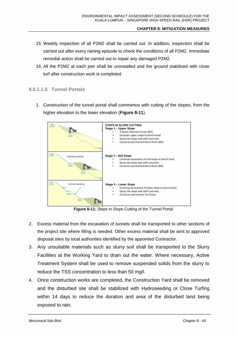
ENVIRONMENTAL IMPACT ASSESSMENT (SECOND SCHEDULE) FOR THE KUALA LUMPUR – SINGAPORE HIGH SPEED RAIL (HSR) PROJECT
CHAPTER 8: MITIGATION MEASURES
Minconsult Sdn Bhd Chapter 8 - 40
15. Weekly inspection of all P2M2 shall be carried out. In addition, inspection shall be
carried out after every raining episode to check the conditions of all P2M2. Immediate
remedial action shall be carried out to repair any damaged P2M2.
16. All the P2M2 at each pier shall be uninstalled and the ground stabilized with close
turf after construction work is completed.
8.5.1.1.5 Tunnel Portals
1. Construction of the tunnel portal shall commence with cutting of the slopes, from the
higher elevation to the lower elevation (Figure 8-11 ).
Figure 8-11: Steps in Slope Cutting of the Tunnel Portal
2. Excess material from the excavation of tunnels shall be transported to other sections of
the project site where filling is needed. Other excess material shall be sent to approved
disposal sites by local authorities identified by the appointed Contractor.
3. Any unsuitable materials such as slurry soil shall be transported to the Slurry
Facilities at the Working Yard to drain out the water. Where necessary, Active
Treatment System shall be used to remove suspended solids from the slurry to
reduce the TSS concentration to less than 50 mg/l.
4. Once construction works are completed, the Construction Yard shall be removed
and the disturbed site shall be stabilized with Hydroseeding or Close Turfing
within 14 days to reduce the duration and area of the disturbed land being
exposed to rain.
STEPS IN SLOPE CUTTING Stage 1 – Upper Slope
• Prepare Diversion Drain (DD).
• Excavate upper slope to bench level.
• Spray the slope wall with concrete.
• Construct permanent Berm Drain (BD).
Stage 2 – Mid Slope • Continue excavation of mid slope to bench level.
• Spray the slope wall with concrete.
• Construct permanent Berm Drain (BD).
Stage 3 – Lower Slope • Continue excavation of lower slope to bench level.
• Spray the slope wall with concrete.
• Construct permanent Toe Drain.
Concrete spraying
Concrete spraying

ENVIRONMENTAL IMPACT ASSESSMENT (SECOND SCHEDULE) FOR THE KUALA LUMPUR – SINGAPORE HIGH SPEED RAIL (HSR) PROJECT
CHAPTER 8: MITIGATION MEASURES
Minconsult Sdn Bhd Chapter 8 - 41
8.5.1.1.6 Slope Cutting
1. Cutting of slope is necessary to stabilize and create berms along the alignment
crossing over undulating or hilly terrain. It is imperative that the sequence of slope
cutting be carried out in such way to minimize erosion risk. Slope cutting shall be
carried out not more than 500m length at any one time.
2. Before physical work commences, diversion drain shall be established at the upper
boundary of the proposed cut slope. The diversion drain shall receive runoff from
undisturbed area and channels it downstream to the receiving river via pipe culvert.
Runoff from the diversion drain shall not be mixed with runoff from the Temporary
Earth Drain.
3. Discharge outlet of the pipe culvert shall be stabilised with crusher run to reduce the
flow velocity of the runoff and spread out the flow, therefore reducing scouring of the
ground surface.
4. Slope cutting will be carried out by excavator from the uppermost elevation to the
lower ground. The cut slope gradient shall be 1 (V) : 1.5 (H) with minimum 1.5 m
berm width at every 5.0 m height. For rocky slope, the cut slope gradient shall be 4
(V) : 1H.
5. Berm drain shall be constructed to receive runoff from each slope surface and
channels to the cascading drain at the side. The cascading drain shall flow into the
Temporary Earth Drain with check dams to reduce flow rate. The runoff is channelled
across the proposed road via a pipe culvert. The runoff is then discharged to the
nearest sediment basin. Runoff from the Temporary Earth Drain shall not be mixed
with runoff from the diversion drain. The drainage system shall be regularly inspected
and maintained, especially after each heavy downpour. To protect the earth drain
from scouring by runoff, drain surface can be protected with a layer of erosion
blanket with average mass of 360 to 400 g/m2.
6. Erosion risk is very high on slope exceeding 25° steepness. The cut slope shall be
covered with erosion blanket as soon as the slope is established (do not wait for 14
days after slope cutting). The erosion blanket or any equivalent method shall be
secured to the cut slope by soil nailing. The erosion blanket shall have an average
mass of 360 to 400 g/m2.Hydroseeding shall be carried out once the erosion blanket
is installed on the cut slopes.
ENVIRONMENTAL IMPACT ASSESSMENT (SECOND SCHEDULE) FOR THE KUALA LUMPUR – SINGAPORE HIGH SPEED RAIL (HSR) PROJECT
CHAPTER 8: MITIGATION MEASURES
Minconsult Sdn Bhd Chapter 8 - 42
7. Permanent slope stabilization measures on soil slope such as soil nailing, soil
anchor, spray concrete and gunitting, rubble pitching shall be carried out within 14
days after slope cutting is completed.
8. Slope stabilization measures on rock slope such as rock face dentition, rock
bolt/anchor or rock dowel, gunitting surface protection and spray concrete shall be
carried out within 14 days after slope cutting is completed.
8.5.1.1.7 Fill Embankment
1. Slope of 1V:2H shall generally be adopted for fill embankment with minimum 1.5 m
berm at every 5.0 m height.
2. Perimeter Earth Drain shall be constructed at the outer rim of the filled area.
Discharge outlet of the perimeter drain shall be protected with Check Dam or loose
rocks as Energy Dissipater.
3. When filling, every 200 mm lift of soil layer shall be compacted up to 95%.
4. Once filling is completed at each stretch, Hydroseeding or Turfing shall be carried out
immediately. Perimeter filled slope with 25° and above shall be protected with
Erosion Blanket followed by hydroseeding.
8.5.1.1.8 Removal of Unsuitable Material
Generation of unsuitable material from excavation of pier foundation on location with limited
working space will increase the risk of erosion and sedimentation to the nearby river or drain.
In addition, rainwater runoff mixed with the excavated soil may form slurry and muck.
Roll-off bins can be used to temporarily store the excavated material and transported to an
approved Excess Material Disposal Site for filling. Slurry mixture of soil material and runoff
may be sent to the nearest Sediment Basin to allow sufficient time for settling. Figure 8-12
shows examples of water-tight Roll-off Bins.

ENVIRONMENTAL IMPACT ASSESSMENT (SECOND SCHEDULE) FOR THE KUALA LUMPUR – SINGAPORE HIGH SPEED RAIL (HSR) PROJECT
CHAPTER 8: MITIGATION MEASURES
Minconsult Sdn Bhd Chapter 8 - 43
Figure 8-12: Example of Roll-off Bins
Based on the Soil Investigation results and the interpretive reports, unsuitable material for
engineering works are likely to be from the soft alluvial clays found near the river deposits
and swampy area. Suitable disposal sites will need to be identified. The criteria of suitable
disposal sites are:
� The site shall be low lying but not within a flood zone;
� The site shall be located away from surface watercourses;
� The site shall not be groundwater recharge areas;
� Proper drain and collection sump shall be constructed at the perimeter of the
disposal site to retain sediment runoff.
8.5.1.1.9 Active Treatment System (ATS)
Active treatment system (ATS) refers to the treatment of runoff using a mechanical system
with the application of coagulants and flocculants to promote the settling of suspended solids
out of the aqueous phase. Only coagulants and flocculants which have been approved for
use by environmental agencies such as USEPA or similar authorities are allowed to be used.
ATS can be used in the following conditions:
(a) In the event when the TSS discharge exceeds the EIA approved standard
(b) When analysis of soil investigation in the project site shows the dispersible fine-grained
clays contain more than 10 % of dispersible material
(c) There is limited space to provide adequate size of Sediment Basin.
Example of an ATS set up and process is given in Appendix 7H2 .
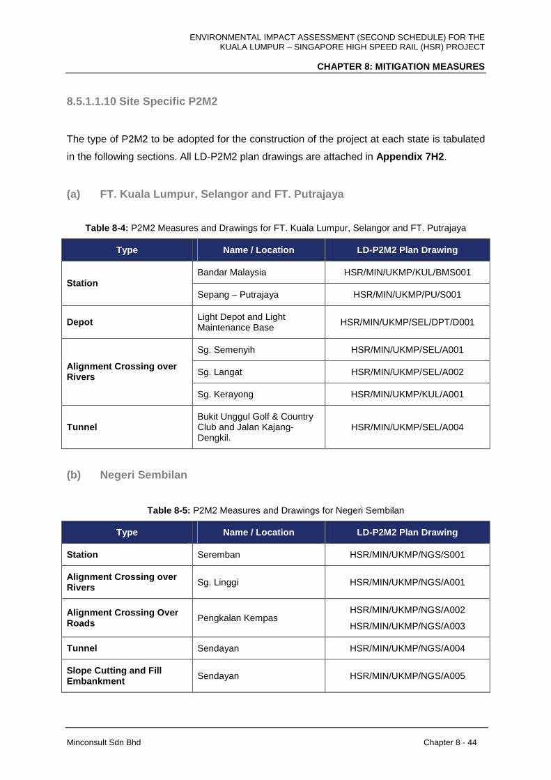
ENVIRONMENTAL IMPACT ASSESSMENT (SECOND SCHEDULE) FOR THE KUALA LUMPUR – SINGAPORE HIGH SPEED RAIL (HSR) PROJECT
CHAPTER 8: MITIGATION MEASURES
Minconsult Sdn Bhd Chapter 8 - 44
8.5.1.1.10 Site Specific P2M2
The type of P2M2 to be adopted for the construction of the project at each state is tabulated
in the following sections. All LD-P2M2 plan drawings are attached in Appendix 7H2 .
(a) FT. Kuala Lumpur, Selangor and FT. Putrajaya
Table 8-4: P2M2 Measures and Drawings for FT. Kuala Lumpur, Selangor and FT. Putrajaya
Type Name / Location LD-P2M2 Plan Drawing
Bandar Malaysia HSR/MIN/UKMP/KUL/BMS001 Station
Sepang – Putrajaya HSR/MIN/UKMP/PU/S001
Depot Light Depot and Light Maintenance Base
HSR/MIN/UKMP/SEL/DPT/D001
Sg. Semenyih HSR/MIN/UKMP/SEL/A001
Sg. Langat HSR/MIN/UKMP/SEL/A002 Alignment Crossing over Rivers
Sg. Kerayong HSR/MIN/UKMP/KUL/A001
Tunnel Bukit Unggul Golf & Country Club and Jalan Kajang-Dengkil.
HSR/MIN/UKMP/SEL/A004
(b) Negeri Sembilan
Table 8-5: P2M2 Measures and Drawings for Negeri Sembilan
Type Name / Location LD-P2M2 Plan Drawing
Station Seremban HSR/MIN/UKMP/NGS/S001
Alignment Crossing over Rivers Sg. Linggi HSR/MIN/UKMP/NGS/A001
Alignment Crossing Over Roads Pengkalan Kempas
HSR/MIN/UKMP/NGS/A002
HSR/MIN/UKMP/NGS/A003
Tunnel Sendayan HSR/MIN/UKMP/NGS/A004
Slope Cutting and Fill Embankment Sendayan HSR/MIN/UKMP/NGS/A005

ENVIRONMENTAL IMPACT ASSESSMENT (SECOND SCHEDULE) FOR THE KUALA LUMPUR – SINGAPORE HIGH SPEED RAIL (HSR) PROJECT
CHAPTER 8: MITIGATION MEASURES
Minconsult Sdn Bhd Chapter 8 - 45
(c) Melaka
Table 8-6: P2M2 Measures and Drawings for Melaka
Type Name / Location LD-P2M2 Plan Drawing
Station Melaka HSR/MIN/UKMP/MLK/S001
Sg. Durian Tunggal HSR/MIN/UKMP/MLK/A003
Sg. Melaka HSR/MIN/UKMP/MLK/A004 Alignment Crossing over Rivers
Sg. Linggi HSR/MIN/UKMP/MLK/A005
Kg. Solok Hilir, Bemban HSR/MIN/UKMP/MLK/A001 Slope Cutting and Fill Embankment
Sg. Durian Tunggal HSR/MIN/UKMP/MLK/A002
(d) Johor
Table 8-7: P2M2 Measures and Drawings for Johor
Type Name / Location LD-P2M2 Plan Drawing
Iskandar Puteri HSR/MIN/UKMP/JHR/IP/S001
Batu Pahat HSR/MIN/UKMP/JHR/S002 Station
Muar HSR/MIN/UKMP/JHR/S003
Main Depot and Light Maintenance Base
HSR/MIN/UKMP/JHR/DPT/D001 Depot
Heavy Maintenance Base HSR/MIN/UKMP/JHR/H001
Sg. Pulai HSR/MIN/UKMP/JHR/A003 Alignment Crossing over Rivers
Sg. Ayer Hitam Besar HSR/MIN/UKMP/JHR/A007
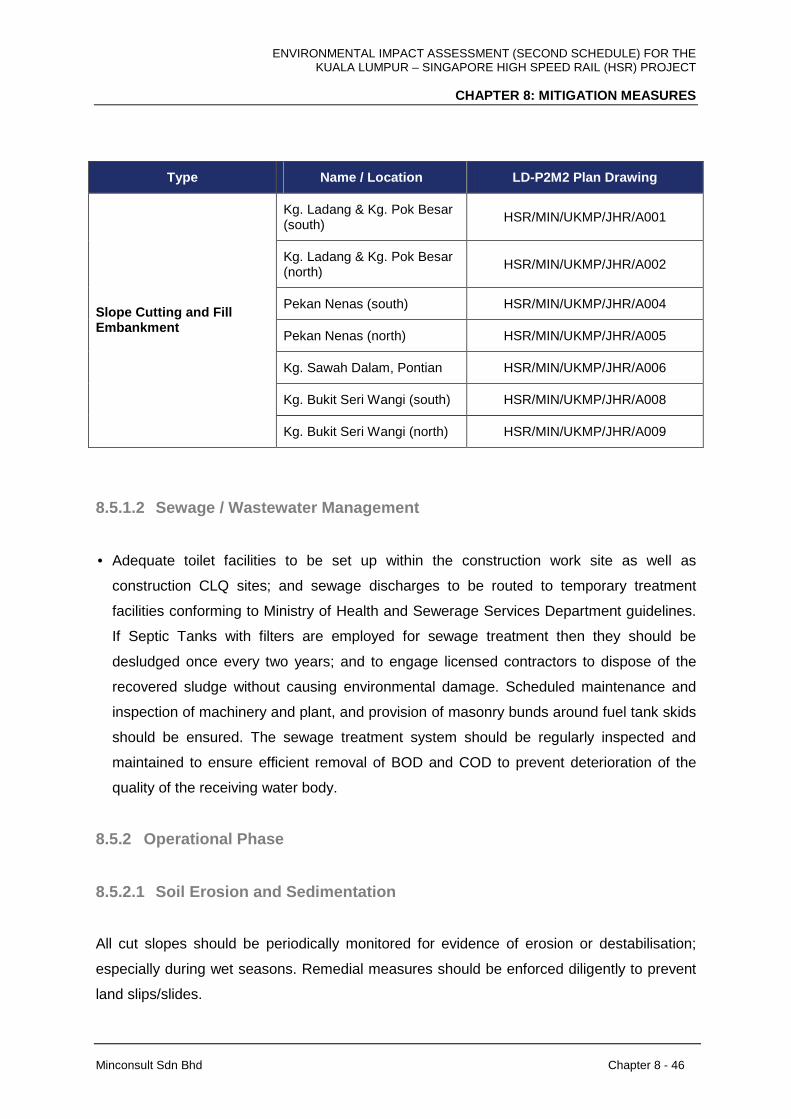
ENVIRONMENTAL IMPACT ASSESSMENT (SECOND SCHEDULE) FOR THE KUALA LUMPUR – SINGAPORE HIGH SPEED RAIL (HSR) PROJECT
CHAPTER 8: MITIGATION MEASURES
Minconsult Sdn Bhd Chapter 8 - 46
Type Name / Location LD-P2M2 Plan Drawing
Kg. Ladang & Kg. Pok Besar (south)
HSR/MIN/UKMP/JHR/A001
Kg. Ladang & Kg. Pok Besar (north)
HSR/MIN/UKMP/JHR/A002
Pekan Nenas (south) HSR/MIN/UKMP/JHR/A004
Pekan Nenas (north) HSR/MIN/UKMP/JHR/A005
Kg. Sawah Dalam, Pontian HSR/MIN/UKMP/JHR/A006
Kg. Bukit Seri Wangi (south) HSR/MIN/UKMP/JHR/A008
Slope Cutting and Fill Embankment
Kg. Bukit Seri Wangi (north) HSR/MIN/UKMP/JHR/A009
8.5.1.2 Sewage / Wastewater Management
• Adequate toilet facilities to be set up within the construction work site as well as
construction CLQ sites; and sewage discharges to be routed to temporary treatment
facilities conforming to Ministry of Health and Sewerage Services Department guidelines.
If Septic Tanks with filters are employed for sewage treatment then they should be
desludged once every two years; and to engage licensed contractors to dispose of the
recovered sludge without causing environmental damage. Scheduled maintenance and
inspection of machinery and plant, and provision of masonry bunds around fuel tank skids
should be ensured. The sewage treatment system should be regularly inspected and
maintained to ensure efficient removal of BOD and COD to prevent deterioration of the
quality of the receiving water body.
8.5.2 Operational Phase
8.5.2.1 Soil Erosion and Sedimentation
All cut slopes should be periodically monitored for evidence of erosion or destabilisation;
especially during wet seasons. Remedial measures should be enforced diligently to prevent
land slips/slides.

ENVIRONMENTAL IMPACT ASSESSMENT (SECOND SCHEDULE) FOR THE KUALA LUMPUR – SINGAPORE HIGH SPEED RAIL (HSR) PROJECT
CHAPTER 8: MITIGATION MEASURES
Minconsult Sdn Bhd Chapter 8 - 47
Slopes should be vegetated adequately at all times with suitably selected vegetation
species.
8.5.2.2 Sewage / Wastewater Management
As described in Chapter 7, the HSR stations and located in developed areas. Hence,
sewage flows from the stations shall be discharged to adjacent public sewerage schemes for
treatment.
In cases where it is not possible to discharge raw sewage flows to an adjacent public
sewerage scheme, then efforts should be made to segregate the raw flows into grey (flows
not containing faecal matter or urine) and black (mainly composed of faecal matter, urine
and kitchen wastes) wastewaters; and to recycle the grey wastewaters for use within the
Station/Depot. In either case the pollutant loads discharged to the recipient waterway is not
expected to induce negative water quality shifts that would affect aquatic life or prohibit other
economical use of the receiving waters.
8.6 MARINE WATER QUALITY
8.6.1 Alignment Crossing Over Tebrau Strait
8.6.1.1 Introduction
The potential impacts which activities associated with the construction and operations of that
sector of the HSR alignment which crosses over Tebrau Strait and terminates at the
MY-SG border have been elucidated under Chapter 7. For the most part it was concluded
that minimal transient potentially adverse impacts on the water quality, hydrodynamic
properties and harboured marine ecosystem status could materialize especially if
appropriate mitigation measures are not instituted during the construction and operations
periods, especially the former. The following narrative summarises the required mitigation
measures that should be adopted by the Project Proponent and its contractors and operators
to ensure insignificant residual adverse impacts are induced by Project related activities.
ENVIRONMENTAL IMPACT ASSESSMENT (SECOND SCHEDULE) FOR THE KUALA LUMPUR – SINGAPORE HIGH SPEED RAIL (HSR) PROJECT
CHAPTER 8: MITIGATION MEASURES
Minconsult Sdn Bhd Chapter 8 - 48
8.6.2 Construction Phase
No additional mitigation measures are required during piling activities as no significant
suspended sediment plume is predicted. It is noted that this assessment is based on the use
of cofferdams to construct the piers in the mudflat areas, and adoption of conventional piling
methods in deeper foreshore waters.
Other mitigation measures focusing on other potential water quality pollutants are
recommended as described below:
• Waste management plan, which include procedures for collecting, storing, processing
and disposing of garbage generated on vessels should be adopted to reduce
generation of wastes and the potential water pollution.
• Wastes / wastewater generated by working vessels should be stored on board (in
appropriate storage container) and be taken back to base for eventual transfer to shore
facilities and their eventual disposal.
• All marine vessels should operate under the requirements of Regulation 11 of
MARPOL 73/78 where the discharge of sewage into the sea is prohibited.
• Marine vessels shall carry oil and spill response kit in case fuel is spilt.
8.6.3 Operational Phase
During the operational phase, the operator of this system to include waste identification and
requirements for disposal as part of the Standard Operating Procedure (SOP) for routine
maintenance as well as EOP to address accidental spills.

ENVIRONMENTAL IMPACT ASSESSMENT (SECOND SCHEDULE) FOR THE KUALA LUMPUR – SINGAPORE HIGH SPEED RAIL (HSR) PROJECT
CHAPTER 8: MITIGATION MEASURES
Minconsult Sdn Bhd Chapter 8 - 49
8.7 GEOLOGY AND HYDROGEOLOGY
8.7.1 Geology and Geotechnical
8.7.1.1 Construction Phase
The following mitigating measures as shown in Table 8-8 are proposed to ameliorate
adverse geological impacts on construction of HSR Structures.
Table 8-8: Geology Mitigation Measures
State Geology Mitigating Measures
FT. Kuala Lumpur The piers of an elevated structure will be built mainly in limestone
and granite. The piers of the elevated structure must be piled on
hard material (SPT>50) or on the bedrock to increase the stability
of the elevated structure. Use deep foundation compared to
shallow foundation.
Bored piles shall be preferred over driven piles in limestone areas
due to:
• Should there be cavities with roofs of inadequate
thickness, there will be risk of collapse of the roofs if piles
bear on the roofs. Bored piles can penetrate through the
cavity roofs and socket a sufficient depth into the
bedrock.
• Driving of piles is not allowed in many populated parts of
FT. Kuala Lumpur due to noise pollution.
• Due to erratic limestone rock surface, piles tend to
deviate during driving
Site investigation shall be conducted with great detail in
Limestone area to detect karstic features and fault zones.
Tunneling through the karstic limestone is a challenging task
when the tunnel encounters the weak zones. Soil Investigation
(SI) shall be carried out at closer intervals to obtain more realistic
information about the sub-soil profile and soil parameters.
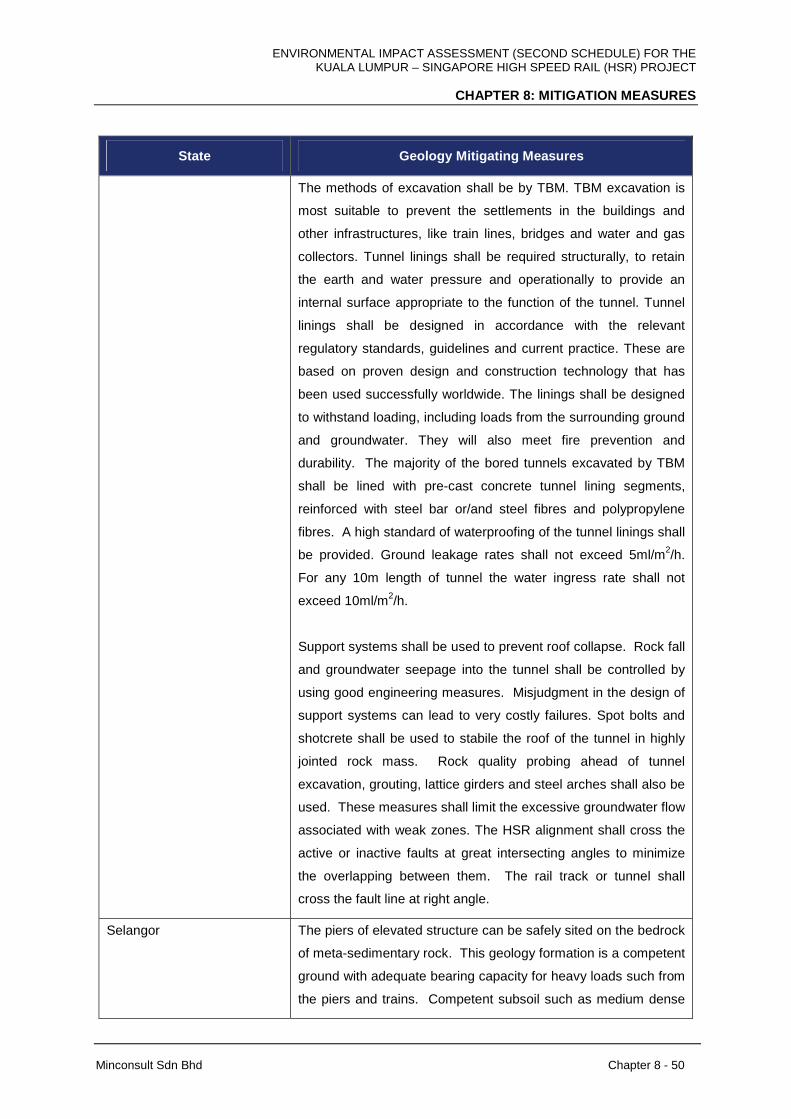
ENVIRONMENTAL IMPACT ASSESSMENT (SECOND SCHEDULE) FOR THE KUALA LUMPUR – SINGAPORE HIGH SPEED RAIL (HSR) PROJECT
CHAPTER 8: MITIGATION MEASURES
Minconsult Sdn Bhd Chapter 8 - 50
State Geology Mitigating Measures
The methods of excavation shall be by TBM. TBM excavation is
most suitable to prevent the settlements in the buildings and
other infrastructures, like train lines, bridges and water and gas
collectors. Tunnel linings shall be required structurally, to retain
the earth and water pressure and operationally to provide an
internal surface appropriate to the function of the tunnel. Tunnel
linings shall be designed in accordance with the relevant
regulatory standards, guidelines and current practice. These are
based on proven design and construction technology that has
been used successfully worldwide. The linings shall be designed
to withstand loading, including loads from the surrounding ground
and groundwater. They will also meet fire prevention and
durability. The majority of the bored tunnels excavated by TBM
shall be lined with pre-cast concrete tunnel lining segments,
reinforced with steel bar or/and steel fibres and polypropylene
fibres. A high standard of waterproofing of the tunnel linings shall
be provided. Ground leakage rates shall not exceed 5ml/m2/h.
For any 10m length of tunnel the water ingress rate shall not
exceed 10ml/m2/h.
Support systems shall be used to prevent roof collapse. Rock fall
and groundwater seepage into the tunnel shall be controlled by
using good engineering measures. Misjudgment in the design of
support systems can lead to very costly failures. Spot bolts and
shotcrete shall be used to stabile the roof of the tunnel in highly
jointed rock mass. Rock quality probing ahead of tunnel
excavation, grouting, lattice girders and steel arches shall also be
used. These measures shall limit the excessive groundwater flow
associated with weak zones. The HSR alignment shall cross the
active or inactive faults at great intersecting angles to minimize
the overlapping between them. The rail track or tunnel shall
cross the fault line at right angle.
Selangor The piers of elevated structure can be safely sited on the bedrock
of meta-sedimentary rock. This geology formation is a competent
ground with adequate bearing capacity for heavy loads such from
the piers and trains. Competent subsoil such as medium dense

ENVIRONMENTAL IMPACT ASSESSMENT (SECOND SCHEDULE) FOR THE KUALA LUMPUR – SINGAPORE HIGH SPEED RAIL (HSR) PROJECT
CHAPTER 8: MITIGATION MEASURES
Minconsult Sdn Bhd Chapter 8 - 51
State Geology Mitigating Measures
sand or stiff cohesive soils, with adequate bearing capacity to
support the embankment. It is envisaged that no special
foundation treatment is required for such conditions, except
replacement / re-compaction of the sub-grade. Deep foundation
shall be adopted for elevated piers to transfer the structural loads
to a deeper founding stratum and to minimize any excessive total
or differential settlement. The foundation for At-Grade foundation
shall be made by using embankment on the ground
Care should be taken that loads shall not be transferred to
foliated directions. Tunnelling in metamorphic rock shall be
influenced by the foliation planes especially when the excavation
is in the same direction as the dip of the stratum. Tunnelling in
phyllite shall be supported using lining or any other supports. In
the second tunnel, the interbedded of quartzite and slate (shale)
behave differently to the excavation technique being employed in
the construction of the tunnel.
FT. Putrajaya All slopes made must be designed and cut taking into account the
orientation of these weakest planes. Special care and treatment
dealing with graphite in soil shall be conducted such as soil
removal and/or the usage of lime to neutralise an acidic soil.
Concrete made with supersulphated cement has a reputation for
better acid resistance than portland cements shall be used during
construction.
Negeri Sembilan Tunnelling in metamorphic rock shall be influenced by the
foliation planes especially when the excavation is in the same
direction as the dip of the stratum. Tunnelling in phyllite shall be
supported using lining.
Melaka All slopes made must be designed and cut taking into account the
orientation of these weakest planes. Special care and treatment
dealing with graphite in soil shall be conducted such as soil
removal and/or the usage of lime to neutralise an acidic soil.
Concrete made with supersulphated cement has a reputation for
better acid resistance than portland cements shall also be used
during construction.
ENVIRONMENTAL IMPACT ASSESSMENT (SECOND SCHEDULE) FOR THE KUALA LUMPUR – SINGAPORE HIGH SPEED RAIL (HSR) PROJECT
CHAPTER 8: MITIGATION MEASURES
Minconsult Sdn Bhd Chapter 8 - 52
State Geology Mitigating Measures
Johor For embankment in poor sub-soil conditions, various methods of
ground improvement shall be considered. The method of ground
improvement adopted depends on the following factors; (i) Height
of embankment; (ii) Existing ground conditions, including
thickness, type and properties of soil strata; (iii) Time available for
construction; (iv) cost consideration and (v) Site constraints.
Detailed investigation of the subsoil shall be conducted such as
using boreholes or trial pits. Thorough study shall be carried out
to evaluate the properties of these soft materials such as their
load bearing capacity, strength, compressibility, liquefaction,
differential settlement and expansiveness of the marine clay.
Expansive soils are typically associated with fine grained marine
clay soils that have the potential to shrink or swell with the
repeated changes in the moisture content.
Embankments shall be designed and constructed so that
maximum settlement occurring after completion and handover of
sub-ballast layer shall not exceed 100 mm over 25 years at a rate
less than 10 mm per year. The differential settlement shall not
exceed 4 mm per year over a length of 30 m and 10 mm per year
over a length of 200 m.
Peat soil and marine are highly compressible with low bearing
capacity. In peat area, removal of peat up to 2 m depth and
Replacement (R/R) with suitable fill material shall be considered.
For thicker peat layer and high fill embankment more than 12 m,
generally piled embankment has been considered. Stone Column
(SC) or Piled Embankment (PE) with continuous pile-caps are
specified at locations where deeper depth of treatment is
required. Stone column are considered for fill height not
exceeding 10 m. The length of Stone Column varies from 10 m to
24 m and spacing from 1.5 m to 2.5 m. The length of pile varies
from 9 m to 27 m and spacing from 1.2 m to 2.5 m.
Mitigation measures to control peat fire are by having facilities to
ENVIRONMENTAL IMPACT ASSESSMENT (SECOND SCHEDULE) FOR THE KUALA LUMPUR – SINGAPORE HIGH SPEED RAIL (HSR) PROJECT
CHAPTER 8: MITIGATION MEASURES
Minconsult Sdn Bhd Chapter 8 - 53
State Geology Mitigating Measures
wet the peat area by constructing check dam or groundwater
production well for controlling the fire. The natural hydrology
system of the peat area shall not be seriously interrupted. The
use of fire and open burning at peat area shall be prohibited
especially during the construction stage of this rail track.
Other mitigation measures during the construction phase will encompass:
(i) Soil Investigations (SI) should be carried out at closer intervals and to obtain more
realistic information about the sub-soil profile and soil parameters. This investigation
shall cover all areas, in particular, bridges, elevated structures, tunnels, stations, cut
areas, fill area, culverts and retaining wall. Boreholes (BH) shall be proposed for
bridges, elevated structures, and cut slopes. For fill embankment both borehole and
Cone Penetration Test (CPT) are proposed. This data shall be used for the design of
ground improvement in fill area, stabilization works for cut area, foundation of all
structures.
(ii) Mitigation for slopes
(a) Slope stability analysis
Slope stability analysis, including establishing design criteria and performing
calculations, shall be required for all cut, fill and natural slopes. Slope stability
analysis shall include; i. Stability analysis for the temporary stability measured
during construction. ii. Cut and fill slope stability analysis should include both
circular and non-circular analysis and in multi-mode of failure. iii. Any slope that
is influenced by surcharge load shall be analysed taking into consideration of
this surcharge load.
(b) Rock slopes
All Rock slopes shall be analysed and designed. Preliminary consideration can
be used using 4V:1H for weathering grade I and 3V:1H for weathering grade II.
If analysis indicates that it is unstable, it shall be designed to a better gradient
and/or requiring extensive stabilisation measures. The type of stabilisation
ENVIRONMENTAL IMPACT ASSESSMENT (SECOND SCHEDULE) FOR THE KUALA LUMPUR – SINGAPORE HIGH SPEED RAIL (HSR) PROJECT
CHAPTER 8: MITIGATION MEASURES
Minconsult Sdn Bhd Chapter 8 - 54
measures to be used can be one of the following: permanent rock anchors, rock
dowels, rock bolting, and buttress walls, counter forts, relieved drains.
(c) Cut slopes
All untreated slopes shall be designed with minimum of 2m berm width and
maximum 6m berm height with a Factor of Safety greater than 1.3. Stabilisation
measures can be considered when the design is inadequate. Stabilisation
measures may include the following: - soil nailing with slope surface protection;
permanent ground anchors; retaining walls, etc. The maximum number of
berms for cut slopes shall be restricted to 6 berms. If the design shows that
more than 6 berms are required, other solutions such as tunnel, rock shade,
bridges etc. shall be considered.
(d) Fill slopes and embankments
All untreated fill slopes and embankments shall be designed with 2 m berm
width and 6m berm height with a minimum Factor of Safety of 1.3. Stabilizations
measures can be considered when the design is inadequate. And may include
the following:-geogrid/geotextiles reinforcement; reinforced concrete retaining
structure; reinforced fill structure; replacing the fills with elevated structures.
Due to maintenance reasons and to minimize risk to the users, the maximum
number of berms for fill slopes shall be restricted to six (6) berms. If the design
shows that more than 6 berms are required, other solutions such as bridges,
viaduct etc. shall be considered.
(iii) Ground treatment
The summary of ground treatment methods that can be used for highly compressible
materials such as peat and marine clay is presented in Table 8-9 .
Table 8-9: Summary of Ground Treatment that shall be used for Highly Compressible Materials
Types of ground treatment
Description
R/R Remove and
Replacement
This method is proposed where the incompetent /unsuitable
soil layer thickness is less and is underlain by a soil layer
competent enough to sustain the embankment load.

ENVIRONMENTAL IMPACT ASSESSMENT (SECOND SCHEDULE) FOR THE KUALA LUMPUR – SINGAPORE HIGH SPEED RAIL (HSR) PROJECT
CHAPTER 8: MITIGATION MEASURES
Minconsult Sdn Bhd Chapter 8 - 55
Types of ground treatment
Description
Considering the time, cost and possible requirement of
temporary works at certain locations, the depth of removal is
limited to about 3 m. In this method, the recommended
thickness of unsuitable material is removed and replaced
with granular / suitable material and compacted in layers.
Refer to Replacement Method in Figure 5-39 of Chapter 5.
DR Dynamic
Replacement
This method is proposed where the thickness of incompetent
/ unsuitable, soft compressible material is not more than 6 m.
In this method, after the site clearance, a layer of granular
drainage blanket (about 1 m thick) is placed over the ground.
A heavy mass is dropped a few times from a suitable height
to compact the ground and form a crater. This crater is filled
with granular drainage blanket and the filled material is again
compacted. This is repeated over the area in a grid form at a
suitable spacing, generally about 5 m. The ground is levelled
and is again compacted with a few passes of vibratory roller
(Ironing Phase) to obtain a uniform surface before
embankment construction. Refer to Dynamic Compaction in
Figure 5-39 of Chapter 5.
PVD Prefabricated
Vertical Drain
This method is proposed where the thickness of incompetent
/ soft compressible soil more than 6 m. Considering the
stability of embankment during construction, staged
construction with waiting period between stages, this method
is not practicable generally for fill height greater than 6 m
including surcharge. After the site clearance, a layer of
granular drainage blanket (about 750 mm thick) is placed
and PVD is installed. A second layer of drainage blanket is
provided after PVD installation. Where required, Counter
Weight Berm (CWB) is also provided to improve the stability
of embankment. The spacing of drains is designed
considering the available construction time. Refer to Vertical
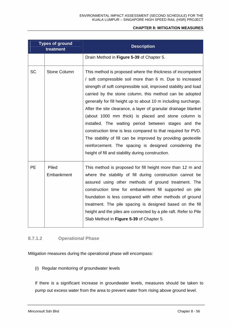
ENVIRONMENTAL IMPACT ASSESSMENT (SECOND SCHEDULE) FOR THE KUALA LUMPUR – SINGAPORE HIGH SPEED RAIL (HSR) PROJECT
CHAPTER 8: MITIGATION MEASURES
Minconsult Sdn Bhd Chapter 8 - 56
Types of ground treatment
Description
Drain Method in Figure 5-39 of Chapter 5.
SC Stone Column This method is proposed where the thickness of incompetent
/ soft compressible soil more than 6 m. Due to increased
strength of soft compressible soil, improved stability and load
carried by the stone column, this method can be adopted
generally for fill height up to about 10 m including surcharge.
After the site clearance, a layer of granular drainage blanket
(about 1000 mm thick) is placed and stone column is
installed. The waiting period between stages and the
construction time is less compared to that required for PVD.
The stability of fill can be improved by providing geotextile
reinforcement. The spacing is designed considering the
height of fill and stability during construction.
PE Piled
Embankment
This method is proposed for fill height more than 12 m and
where the stability of fill during construction cannot be
assured using other methods of ground treatment. The
construction time for embankment fill supported on pile
foundation is less compared with other methods of ground
treatment. The pile spacing is designed based on the fill
height and the piles are connected by a pile raft. Refer to Pile
Slab Method in Figure 5-39 of Chapter 5.
8.7.1.2 Operational Phase
Mitigation measures during the operational phase will encompass:
(i) Regular monitoring of groundwater levels
If there is a significant increase in groundwater levels, measures should be taken to
pump out excess water from the area to prevent water from rising above ground level.

ENVIRONMENTAL IMPACT ASSESSMENT (SECOND SCHEDULE) FOR THE KUALA LUMPUR – SINGAPORE HIGH SPEED RAIL (HSR) PROJECT
CHAPTER 8: MITIGATION MEASURES
Minconsult Sdn Bhd Chapter 8 - 57
(ii) Fire prevention in peat areas
Peat areas that have dried up due inability of water to flow from one area to another
through the compacted ground along the railway tracks have the potential of catching fire
due to the slow burning of organic material in the soil. Measures should be in place to
water dry peat areas to prevent or put out fires.
8.7.2 Hydrogeology
8.7.2.1 Construction Phase
Monitoring of groundwater condition (levels and quality) at the nearest existing wells to the
HSR alignment on the downstream of groundwater flow at a higher frequency. The exercise
is to be conducted during the construction phase as well as during high speed train
operation.
In addition, piezometers are to be installed at depots and stations that are constructed on the
groundwater related environmentally sensitive areas such as alluvium deposits and peat
lands in south of Negeri Sembilan and west and southwest of Johor in particular.
Groundwater monitoring exercise is to be conducted to provide baseline information on
groundwater condition prior and during the HSR construction, as well as to verify the impact
of the project operation to groundwater in the surrounding area, if any.
Leaking or accidental spillages of contaminant such fuel and lubricants etc. that may occur
directly into watercourses or infiltrate into groundwater need to be avoided. At the same
time, appropriate design of drainage infrastructure is unconditionally required to prevent
infiltration of contaminant into the local groundwater system.
8.7.2.2 Operational Phase
The local ecosystem and profile of high water bearing formation such as alluvium and peats
need to be prevented. Disruption to the area is to be minimised by particularly developing
elevated railway. No major impervious barrier that crossing and preventing the natural
groundwater is be constructed in the area.
ENVIRONMENTAL IMPACT ASSESSMENT (SECOND SCHEDULE) FOR THE KUALA LUMPUR – SINGAPORE HIGH SPEED RAIL (HSR) PROJECT
CHAPTER 8: MITIGATION MEASURES
Minconsult Sdn Bhd Chapter 8 - 58
8.8 HYDROLOGY
8.8.1 Construction Phase
Summary of potential impacts during construction phase for all segments (FT. Kuala
Lumpur, Selangor and FT. Putrajaya, Negeri Sembilan, Melaka and Johor) for HSR Project
activity:
1. Sediment transport into the river
2. Surface erosion and sedimentation
3. Flash flood & localized flooding
Mitigation measures for sediment transport into the drainage/ river
i. The site clearing impact from this activity can be minimised by scheduling the cutting
and removal of biomass.
ii. If possible, the construction of U-wall, trenches, retaining walls or slope treatment
(Temporary/ permanent) should be done first and far away from the water courses (at
least 20 m from the drainage or riverbanks).
Mitigation measures for surface erosion and sedimentation
i. Proposed station must be adjacent to existing landmark and plantation land
(contamination – potential impact for the existing environment).
ii. Melaka Station is adjacent to water treatment plant (Temporary Earth Drains and
sediment basins must be designed for contamination control).
iii. Muar Station is located at adjacent to Muar River (contamination control have been
required) to this stations construction.
iv. Proper terrains must be constructed beside the steep roads to avoid landslide or
slope failure. Wherever river crossing to be made, a proper bridge must be
constructed bank to bank to avoid minimal disturbance to water body.
v. Adequate LD-P2M2 measures should be implemented where earthworks and
construction of hauling roads are carried out to mitigate impacts of erosion.
vi. Close proximity of local unnamed watercourse must be use where the environmental
considerations and erosion, sediment control must be required.

ENVIRONMENTAL IMPACT ASSESSMENT (SECOND SCHEDULE) FOR THE KUALA LUMPUR – SINGAPORE HIGH SPEED RAIL (HSR) PROJECT
CHAPTER 8: MITIGATION MEASURES
Minconsult Sdn Bhd Chapter 8 - 59
Mitigation measures for flash flood & localized flooding
I. The lack of rainfall, flow and water level data in most proposed alignment is a serious
shortcoming that should be addressed. It is further recommended that funds should
be made available in the budget of the current project to design a strategy to
implement the collection of critical data. This data should then be used to monitor
future flood events and compare actual measurements with the model results. The
construction programme and a flood management plan must be designed for the
construction phase when the town will be most susceptible to flooding.
II. Mitigating measures on the impacts from site preparation can be minimized by re-
using the previously cleared areas for the camp sites. These can minimize removal of
terrestrial vegetation.
III. For drilling activities, the construction of perimeter trench or bund can avoid loose
soils to be washed away by runoff.
IV. Proper dedicated channels must be constructed and installed along the diversion
tunnel/ river. The size must be adequate to cater for river discharge during normal
and flood flows. Minimum number of piers for the elevated structures of the HSR
alignment within flood prone areas are proposed in order to minimize flood flow and
flood debris impact (especially during worst case scenario).
Water Yield Management
Baseflow is groundwater flow that enters the stream or river by way of deep subsurface flow
below the main water table, and is affected by the net effect of changes in
evapotranspiration and rainfall infiltration opportunities following forest removal. If the
infiltration rates, after the catchment disturbance have reduced to the extent that increases in
surface storm runoff during rainfall exceed the gain in baseflow associated with lower
evapotranspiration loss, then diminished dry season flow will occur and the river will
eventually dry up. Conversely, if soil infiltration capacity is maintained, increase in dry
season flow can be expected, as the soil water storage is already higher than before forest
removal.
Therefore, appropriate mitigating measures would include:
i. Using standard reduced impact logging techniques as applicable to land clearing, i.e.
those techniques aimed at reducing soil damage. Such techniques include, but are
not limited to: Winching rather than direct dragging, skidding on top of debris, pre-

ENVIRONMENTAL IMPACT ASSESSMENT (SECOND SCHEDULE) FOR THE KUALA LUMPUR – SINGAPORE HIGH SPEED RAIL (HSR) PROJECT
CHAPTER 8: MITIGATION MEASURES
Minconsult Sdn Bhd Chapter 8 - 60
planned skid tracks, use of light machinery, limitation to work during drier periods,
commence planting soon.
ii. Development or land clearing should be spread over different sub catchments
instead of concentrated in one big catchment. This is to help in reducing total water
loss and sediment yield.
8.8.2 Operational Phase
There are several mitigation measures to associate the construction of the HSR Project that
are expected to reduce the hydrological impacts during operation phase. The activities which
have been identified are as follows:
1. Light Depot and Light Maintenance Base (LMB),
2. Heavy Maintenance Base (HMB), and
3. Main Depot and Light Maintenance Base (LMB).
The mitigation measures on the environment for the above-mentioned activities are outlined
below:
Waste/wastewater Management
During the operational phase of the HSR Project, minimum impacts to the hydrology sector
is predicted for all segments along the alignment. However, the significant impact is
predicted due to Depot and Maintenance Base activities where if waste/wastewater
generation is not properly managed, it will be affected to river ecosystems, river flow, river
capacity and flash flood will be happens. Therefore, appropriate mitigating measures would
include rubbish collecting system to solve the solid waste pollution problems where this
problem can infect water flow on the drainage system and floodgate system. Improper
maintenance causing constriction to flow and backflow in drainages or rivers during
operations must be avoided. Continuously monitoring and proper maintenance to the river
and drainage system is proposed to control the flooding issues in the future.
ENVIRONMENTAL IMPACT ASSESSMENT (SECOND SCHEDULE) FOR THE KUALA LUMPUR – SINGAPORE HIGH SPEED RAIL (HSR) PROJECT
CHAPTER 8: MITIGATION MEASURES
Minconsult Sdn Bhd Chapter 8 - 61
8.9 TERRESTRIAL ECOLOGY
8.9.1 Construction Stage
Limit Site Clearing and Earthworks within Dedicated Areas
Site clearing, tunnelling and earthworks activities should be restricted to designated footprint
areas as much as practicable in order to reduce the potential magnitude of any land
disturbance impacts. The authorities reserve the right to determine the cutting, uprooting,
destroying and felling of trees for any part of the HSR Project area within their respective
purview and the Project Proponent (and the respective contractors) shall comply with the
stipulated rules and regulations. The forestry department has a standard operating
procedure (SOP) for timber cutting in the forest including best management practices
(BMPs) which should be complied with by the logging contractor.
Clearing of the site should also be carried out starting from residential areas, outwards in a
single direction towards and into the plantation and forest areas. This will provide time and
passage to enable the animals to move further into the plantation or forest in search of a
new home, thus reducing human-wildlife conflicts and preventing the animals from seeking
shelter in the residential areas instead.
The Department of Wildlife and National Parks (PERHILITAN) recommended that the project
proponent and the contractor should ensure that a secure fence is constructed to prevent
encroachment of wildlife into the worksite and the railway line during construction. Hunting
activities are totally prohibited. The project proponent and the contractor should ensure that
the construction workers do not carry out any hunting activities. PERHILITAN also
recommended that all the construction workers be given training and awareness pertaining
to prohibition of hunting and other prohibited activities as listed in the Wildlife Conservation
Act 2010 (Act 716). Public awareness campaigns regarding wildlife conservation should also
be expanded to cover the local communities adjacent to the alignment.
The Forestry Department has a standard operating procedure (SOP) for timber cutting in the
forest including best management practices (BMPs) which should be complied with by the
logging contractor. The Project Proponent will notify PERHILITAN prior to the

ENVIRONMENTAL IMPACT ASSESSMENT (SECOND SCHEDULE) FOR THE KUALA LUMPUR – SINGAPORE HIGH SPEED RAIL (HSR) PROJECT
CHAPTER 8: MITIGATION MEASURES
Minconsult Sdn Bhd Chapter 8 - 62
commencement of land clearing activities and ensure that land clearing and preparation
activities are carried out in a controlled and staged manner.
Proper Management and Disposal of Wastes
Biomass should be disposed off at designated and approved dumpsites. Some of the plant
parts can also be utilized as rip-rap in marshy grounds during construction works and used
as protective materials/mulching against surface erosion of exposed grounds. Large trees
can be chopped off with wood recoverable for sale. Small trees and branches can be used
for making chipboard, or cleared together with palm fronds and shrubs by slashing, or
shredded and stacked across slopes for erosion control/runoff barrier. No open burning of
biomass is allowed.
Proper management of garbage and solid wastes is essential to prevent littering and
pollution of nearby water bodies. Garbage bins should be provided to discourage
proliferation of roaches, flies and scavenger animals (particularly rodents that could transmit
communicable diseases like leptospirosis and scrub typhus). Garbage should be properly
disposed off at designated landfills. Worksites, depot and Centralized Labour Quarters
(CLQs) should be checked and cleared of any solid wastes at the end of each working day.
PERHILITAN also recommended that monkey-proof garbage bins or equivalent measures
should be installed for solid waste disposal in areas where monkeys are the main pests
creating human-wildlife conflicts.
At the CLQ and depots, disposal of scheduled wastes and effluents should follow proper
procedures to prevent ground and water pollution impacting terrestrial and aquatic flora and
fauna. The river reserves and river corridors must be left untouched to avoid erosion and
slope failure. The distance of the river reserve must comply with the Department of Irrigation
and Drainage (JPS) regulations. Proliferation of pests and disease vectors is part of the
adverse impacts of improper solid waste disposal which would affect animals and humans
alike.
ENVIRONMENTAL IMPACT ASSESSMENT (SECOND SCHEDULE) FOR THE KUALA LUMPUR – SINGAPORE HIGH SPEED RAIL (HSR) PROJECT
CHAPTER 8: MITIGATION MEASURES
Minconsult Sdn Bhd Chapter 8 - 63
Employment of LD-P2M2 for Soil Erosion and Water Quality
Removal of unwanted biomass and shrubs and the control of slope and soil erosion should
follow proper guidelines and the LD-P2M2 procedures as given in the relevant section of this
EIA report.
Although further reduction in water quality is expected with a rise in turbidity and sediment
loads during earthworks and construction of facilities, utilities and infrastructures, these
impacts, are expected to be temporary and localized, and can be resolved with proper
mitigating measures of LD-P2M2, such as installing retention ponds and silt curtains in the
rivers at worksites to retain sediment loads, immediate compaction of exposed soil, returfing
and other standard soil protection works.
Protection and Preservation of Mangroves, Riparian Habitats and River Banks
To preserve natural riparian habitats as much as possible, the marshy grounds adjacent to
the riparian zones (e.g. Sg. Langat, Sg. Semenyih, Sg. Linggi and Sg. Muar) can be
stabilised with ground treatment in accordance with best practices to accommodate for post-
construction/differential settlement of pavements/platforms. Both structural and geotechnical
solutions can be applied in areas of soft/unconsolidated grounds to achieve the most
economical and safest construction performance. A balanced cantilever method should be
the preferred method employed for the construction of elevated structures over the
mangroves and rivers.
Sufficient numbers and sizes of culverts can be provided in areas of soft grounds, consistent
with providing a satisfactory drainage layout which safeguards the integrity of the HSR
alignment and associated facilities, as well as the surrounding environment, for which the
project proponent will adhere to the latest requirements of Jabatan Pengairan dan Saliran
(JPS) in connection with works on rivers or other water bodies.
Preparation and Implementation of Wildlife Management Plan
Although the HSR alignment does not cut through the Bukit Bindu Forest Reserve in Johor
that is home to three individuals of Lembu Bali (Bos javanicus), the distance of the alignment
(approximately 400-700 m) from the fringes of the forest reserve makes it necessary to
ENVIRONMENTAL IMPACT ASSESSMENT (SECOND SCHEDULE) FOR THE KUALA LUMPUR – SINGAPORE HIGH SPEED RAIL (HSR) PROJECT
CHAPTER 8: MITIGATION MEASURES
Minconsult Sdn Bhd Chapter 8 - 64
mitigate impacts that may affect any protected wildlife and forestry resources from poaching
and illegal harvesting. The Project Proponent should conduct a detailed inventory of the
Lembu Bali in order to prepare and implement a Wildlife Management Plan to protect this
and other wildlife species. The methodology and mitigation measures suggested must be
discussed with and approved by the Department of Wildlife and National Parks
(PERHILITAN).
Protection of Aquatic Life in Rivers
For the continuous survival of fish and other aquatic life during construction works at river
crossings, dissolved oxygen (DO) content in the rivers and drainage systems can be
improved with increased flow and aeration; thus, it important that the channels not be
clogged or stagnated by construction debris and other obstructions. Reduced DO and
increased biochemical oxygen demand (BOD) will jeopardize aquatic life in the rivers; thus,
proper design of drainage layouts is important to ensure regular flow and aeration.
Landscaping and Re-vegetation
It is proposed that ornamentals and landscaping trees which are removed should be
replanted where necessary and required. The authorities reserve the right to determine the
preservation of trees or replanting thereof for any part of the project area within their
respective purview and the Project Proponent (and the respective contractors) shall comply
with the stipulated rules and regulations. Landscaping should also be provided for open
spaces at the stations, depots, associated roadsides and along some of the buffer zones of
the HSR alignment and in the green areas in accordance with the stipulated rules and
guidelines. Ornamentals and hedgerow shrubs should be planted in open spaces and green
areas to enhance the visual aesthetics and ecosystem services of the project area. Suitable
choices of plant species for landscaping works will facilitate ground succession as the root
zone of trees and shrubs would anchor the soft ground and accelerate consolidation of the
soil. Re-turfing and landscaping of disturbed grounds should follow relevant standard
procedures and guidelines.
Care should be taken in selecting the types and locations of ornamental trees and shrubs to
ensure minimal obstruction and to avoid the root system of ornamentals and wayside trees
from disrupting/undermining the pavement structures and underground facilities when they

ENVIRONMENTAL IMPACT ASSESSMENT (SECOND SCHEDULE) FOR THE KUALA LUMPUR – SINGAPORE HIGH SPEED RAIL (HSR) PROJECT
CHAPTER 8: MITIGATION MEASURES
Minconsult Sdn Bhd Chapter 8 - 65
reach maturity. Suitable choices of landscaping species are important to ensure easy
maintenance and to minimise pest problems. Local and endemic species should be
preferred over alien and exotic species to reduce infestation risks and disease problems to
our cultivated crops and native species.
Proper landscaping and re-vegetation will enhance the aesthetic qualities of the project area.
However, chemical fertilisers should be applied judiciously to avoid enrichment of the tidal
and sub-tidal areas which can trigger algal bloom. Organic fertilisers are recommended.
Local indigenous species should preferably be utilised for re-vegetation and landscaping
purposes to preserve local biodiversity.
Landscaping is a positive impact on habitats and communities. The proper choice and
maintenance of landscaping trees, flowering plants and ornamentals would encourage
beneficial fauna and pollinators such as bees, butterflies and other insects, bats and birds
into the area, thus providing food resources for herbivores and carnivores further up the food
chain and supporting local biodiversity of species. Furthermore, it is highly recommended
that enrichment planting with year-round fruiting and flowering trees and plants (like
bananas, papayas, figs, jambu, etc.) should be implemented in the buffer zones to provide
additional/new food resources for wildlife, thus reducing their encroachment into the buffer
zone or nearby settlements and orchards.
Mitigation of Human-Wildlife Conflict
The project proponent and the contractor should ensure that the construction of the CLQ and
the presence of the construction workers do not disturb the wildlife in the nearby areas. The
CLQ should be situated away from the wildlife habitats. There should be no CLQ or
temporary storage areas located within forests or plantations, as this will attract animals
seeking shelter or food to encroach. Domestic wastes (especially food) should be properly
managed and noise to be kept to a minimum level within the CLQ, as animals may be
attracted to the smell and noise generated at the CLQ. CLQ should also be appropriately
fenced to prevent encroachment of animals into the premises.
Hunting activities are totally prohibited. The project proponent and the contractor should
ensure that the construction workers do not carry out any hunting activities. PERHILITAN
recommended that the all the construction workers should be given training and awareness
ENVIRONMENTAL IMPACT ASSESSMENT (SECOND SCHEDULE) FOR THE KUALA LUMPUR – SINGAPORE HIGH SPEED RAIL (HSR) PROJECT
CHAPTER 8: MITIGATION MEASURES
Minconsult Sdn Bhd Chapter 8 - 66
pertaining to prohibition on hunting and other prohibitive activities as listed in the Wildlife
Conservation Act 2010 (Act 716). Public awareness campaign regarding wildlife
conservation should also be expanded to cover the local communities adjacent to the
alignment.
8.9.2 Operational Phase
Habitat Fragmentation
The impacts of habitat fragmentation on wildlife and other fauna can be mitigated by
enrichment planting of the buffer zone areas with suitable flowering and year-round fruiting
trees such as jambu, local figs (waringin or ara), papaya, etc. With bountiful food resources
available to the wildlife, they will not encroach upon the cultivated land and settlement areas,
thus avoiding human-wildlife conflict. The Wildlife Departments of Johor and Negeri
Sembilan had also requested that the Project Proponent, as part of its Corporate Social
Responsibility (CSR) and good rapport to supply the affected villages (through their JKKK
committees) with some cage traps, to facilitate PERHILITAN in the capturing and
transferring of any pest/nuisance wildlife, especially monkeys, to nearby protected forests.
Since the alignment when at grade, mostly passes through settlements, oil palm and rubber
plantations and does not cut through any forest reserve that include the home range of
protected wildlife such as elephants and tigers, it not anticipated that there is a necessity for
animal crossing to be provided along most of the alignment route. However, PERHILITAN
has recommended that wildlife crossing should be provided at strategic points of the at-
grade alignment to mitigate for habitat fragmentation. This wildlife crossing would serve to
connect the fragmented habitats bisected by the alignment. It would avoid wildlife collision
with the passing train by providing a safe passage to enable wildlife to move across the
alignment freely. The wildlife crossing will be included in the WMP if deemed necessary
following advice from PERHILITAN. The advice and approval by PERHILITAN should be
solicited for the detailed design of the wildlife crossing.
It is also recommended that the Project Proponent solicit advice and cooperation of relevant
agencies, i.e. PERHILITAN in providing effective mitigating measures to resolve the human-
wildlife conflict issues. Some measures which have been implemented in this country and
elsewhere include construction of barrier trenches and traps and fencing where applicable,

ENVIRONMENTAL IMPACT ASSESSMENT (SECOND SCHEDULE) FOR THE KUALA LUMPUR – SINGAPORE HIGH SPEED RAIL (HSR) PROJECT
CHAPTER 8: MITIGATION MEASURES
Minconsult Sdn Bhd Chapter 8 - 67
to prevent refugee wildlife such as wild pigs and monkeys from encroaching onto the HSR
alignment or the nearby significantly affected farms, orchards and settlements.
PERHILITAN also recommended that monkey-proof garbage bins or equivalent measures
should be installed for solid waste disposal at the stations and maintenance depots in areas
where monkeys are the main pests creating human-wildlife conflicts.
Preservation of Mangroves
Mangroves support a wide variety of plants and wildlife species, particularly birds (migrants
as well as residents). Consequently, it is important to introduce a number of protection and
conservation measures to ensure sustainability of the mangrove buffer, as well as to mitigate
for potential environmental impacts of the HSR Project. The key measures (strategies) are
related to the protection and management of the mangrove stands of Sg. Muar, Sg. Linggi
and Sg. Pulai as protection buffer adjacent to the proposed development [refer to Appendix
8B, Kamaruzaman Jusoff (2008). Managing Sustainable Mangrove Forests in Peninsular
Malaysia].
To ensure the sustainability of healthy mangroves and mudflats as breeding and nursery
grounds for coastal and riverine species of fish, prawns, crabs, gastropods and other
shellfish, a mangrove replanting programme is recommended to replenish diebacks and
degraded stands due to project development within the protected mangrove reserves.
For mangrove replanting and management, a special task force should be set-up that
comprises the Project Proponent, the Forestry Department, mangrove expert and JKKK local
communities. The conservation and preservation of mangroves should be carried out as a
joint collaboration between the local communities, relevant agencies and stakeholders and
NGOs.
User-friendly maintenance roads should be provided in the Forest Reserve areas at Sg.
Pulai for the Project Proponent to conduct all maintenance works for the HSR alignment and
a permit should be obtained to enter the forest area through this dedicated maintenance
road to minimize encroachment into the forest habitats.

ENVIRONMENTAL IMPACT ASSESSMENT (SECOND SCHEDULE) FOR THE KUALA LUMPUR – SINGAPORE HIGH SPEED RAIL (HSR) PROJECT
CHAPTER 8: MITIGATION MEASURES
Minconsult Sdn Bhd Chapter 8 - 68
Wildlife Collision
Collision and mortality of wildlife at elevated sections of the alignment is not an issue, as the
animals do not have access to the railways tracks. However, it is possible that the animals
will attempt to cross the At-Grade railway tracks to get to the other side in search for food
and shelter. Collision of wildlife with the high speed trains can be mitigated by installing
suitable barrier fencing or trenches along the At-Grade alignment to prevent encroachment
of animals onto the tracks. These fences or trenches must be inspected and maintained
properly, to ensure that there are no sections that have been damaged by animals or
trespassers.
PERHILITAN recommended that the project proponent and the contractor should provide
wildlife crossing in the areas identified as a wildlife passage to avoid encroachment of
wildlife into the alignment that could result in collision with the high speed trains, thus risking
the wildlife and the passengers. However, the wildlife crossing will be included in the WMP if
deemed necessary following advice from PERHILITAN.
Preparation and Implementation of Environmental Management Plan
The HSR Project contractor shall be required to prepare an Environmental Management
Plan and conform to the environmental protection guidelines that identify procedures to
minimize environmental impacts resulting from the HSR Project’s work procedures. The
guidelines shall be incorporated into the HSR Project plans and specifications to be used by
the HSR Project contractors.
Preparation and Implementation of Wildlife Manageme nt Plan (WMP)
The project proponent and the contractor should prepare and implement a Wildlife
Management Plan (WMP) for this project. The advice of and approval by PERHILITAN
should be solicited for the preparation of the Wildlife Management Plan (WMP). Mitigating
measures to reduce human-wildlife conflicts (as discussed earlier) will be elaborated in the
Wildlife Management Plan (WMP).

ENVIRONMENTAL IMPACT ASSESSMENT (SECOND SCHEDULE) FOR THE KUALA LUMPUR – SINGAPORE HIGH SPEED RAIL (HSR) PROJECT
CHAPTER 8: MITIGATION MEASURES
Minconsult Sdn Bhd Chapter 8 - 69
The project proponent and the contractor should notify PERHILITAN before the
commencement of any site clearing works. The site clearing works must be conducted in a
controlled and systematic manner so as to minimize any adverse impacts on wildlife.
The project proponent and the contractor should undertake all control and mitigating
measures to ensure that there would be no significant adverse impacts on wildlife in the
worksite as well as in the human settlement area during site clearing, construction and
operation phases of the project.
Rehabilitation of Site due to Project Abandonment
The abandoned project site should be rehabilitated and protected to avoid further
deterioration of the environment. The abandoned project site should be sealed off from
public access with proper fencing and secured walls. Warning signages and notices to
inform and create safety awareness among the public should be erected at strategic
locations. Any abandoned vehicles, equipment and incomplete structures should be
removed or demolished. The site should be restored for other beneficial uses by carrying out
proper remediation and landscaping works.
8.10 MARINE ECOLOGY
No mitigation measures specific to plankton are proposed. Mitigation measures related to
the control of water pollution as outlined in the Water Quality section will further minimize
impacts to plankton.
8.11 LAND TRAFFIC
Based on the traffic count survey and forecasted traffic due to Pre-construction, Construction
and Operational phase of the HSR Project along with assessment of potential land traffic
impact, indicates that certain activities would result in impacts being imposed to the sensitive
receptors in this case the road networks surrounding the Project. In order to limit traffic
impacts to the on-going traffic, mitigation measures shall be implemented during the Pre-

ENVIRONMENTAL IMPACT ASSESSMENT (SECOND SCHEDULE) FOR THE KUALA LUMPUR – SINGAPORE HIGH SPEED RAIL (HSR) PROJECT
CHAPTER 8: MITIGATION MEASURES
Minconsult Sdn Bhd Chapter 8 - 70
construction and Construction as well as the Operational Phase. Both phases have specific
requirements that need to be implemented. The description of these mitigation measures is
narrated below.
8.11.1 Pre-Construction and Construction Phase
All Stations
During the Pre-Construction and Construction phase, it is envisaged that temporary road
signs and traffic control devices shall be placed at strategic location to direct the traffic, all in
accordance with the approved Traffic Management Plan (TMP). The TMP should be in
accordance with one the following documents as applicable to the Relevant Authority or
namely, Dewan Bandaraya Kuala Lumpur, Majlis Perbandaran Sepang, Majlis Perbandaran
Kajang or Perbadanan Putrajaya, Majlis Perbandaran Seremban, Majlis Bandaraya Melaka
Bersejarah and Majlis Perbandaran Muar, Majlis Perbandaran Batu Pahat dan Majlis
Bandaraya Iskandar Puteri.
i. New Guidelines for Traffic Management during Construction (Road Engineering
Association of Malaysia (REAM).
ii. Malaysia Highway Authority Traffic Management Implementation Guidelines.
iii. JKR Arahan Teknik (JALAN) 2C/85 Manual on Traffic Control Devices for Temporary
Signs and Work Zones Control.
iv. JKR Arahan Teknik (JALAN) 2D/85 (Pindaan 2017) – Manual on Traffic Control
Devices: Road Marking and Delineation.
Where the HSR alignment crosses roads, the structures are positioned in accordance with
the following configurations and TMP methodology will suit these configurations:
a. Piers and portal columns at the road median.
i. Existing road side utilities and drains will be relocated as near as possible to the limit
of the road reserve. Both sides of the road will be widened. Lane replacement will be
based on a one to one basis depending on the lane taken up to create the working
area. The realignment of the lane shift will be redesigned based on the posted speed
of the existing roadway. If temporary speed reduction is required to accommodate
the TMP, approval from relevant authorities should be obtained.
ENVIRONMENTAL IMPACT ASSESSMENT (SECOND SCHEDULE) FOR THE KUALA LUMPUR – SINGAPORE HIGH SPEED RAIL (HSR) PROJECT
CHAPTER 8: MITIGATION MEASURES
Minconsult Sdn Bhd Chapter 8 - 71
ii. While general sequencing of works affecting roadway will need to be submitted by
the contractor at start of construction. TMP will be developed and submitted to
relevant authorities for approval at least 3 months prior to TMP implementation.
iii. The lanes adjacent to the median should be cordoned off using New Jersey Profile
Barriers and hoardings with access opening provided without affecting sightline.
iv. Temporary road signs and traffic control devices should be placed to direct the traffic,
all in accordance with the approved TMP.
v. Trained flagmen should be stationed at the road diversions to direct and control the
traffic during peak hours.
b. Piers and portal columns by the road side.
i. No traffic diversion will be required.
ii. New Jersey Barriers and hoardings should be erected at the road edge with access
openings provided.
iii. Temporary road signs and traffic control devices should be placed to direct the traffic,
all in accordance with the approved TMP.
iv. Trained flagmen should be stationed at the work areas to direct and control the traffic
during peak hours.
c. Piers and portal columns at interchanges.
i. If the piers or columns are positioned within an interchange, it will usually necessitate
the temporary closure or shifting of roadway of an existing road and slip road due to
working space constraints. In closure situations, an alternative route will be provided
using the existing road network. A comprehensive TMP, Traffic Impact Assessment
report (TIA) and Road Safety Audit report (RSA) will be carried out on the temporary
alternative route.
ii. Piers and portal columns at interchanges.
d. Site access to HSR alignment.
i. No traffic diversion will be required.
ENVIRONMENTAL IMPACT ASSESSMENT (SECOND SCHEDULE) FOR THE KUALA LUMPUR – SINGAPORE HIGH SPEED RAIL (HSR) PROJECT
CHAPTER 8: MITIGATION MEASURES
Minconsult Sdn Bhd Chapter 8 - 72
ii. Temporary site access to the HSR alignment shall be design to a standard priority
junction with adequate sightline. Where high volume of traffic is expected, the
junction maybe need to be upgraded to a signalized junction.
e. Temporary road diversions
All temporary road diversions will be removed and temporary lane and road closures will
be ended once all works have been completed. All temporary road signs and control
devices will be removed, the original road alignment reinstated and road surface
resurfaced. The original road will be handed back to the relevant authorities for
maintenance.
8.11.2 Operational Phase
During the operational phase, all facilities that have been built is expected to have met local
Authorities requirements prior to the revenue service. However, care still need to be
undertaken but the project proponent for the safe and sustainable operation of the HSR
facilities. Herewith below, description by station of the required measures to be carried out:
FT. Kuala Lumpur The Bandar Malaysia Station will be accessible through the following modes of
transportation:
• Taxi and buses - bus bays and taxi pick-up bays will be provided along with taxi
waiting area/ queuing storage bays;
• Private cars - Multi-storey Park and Ride facilities will be provided along with private
cars drop-off bays and pick-up bays at Departure and Arrival halls respectively;
• Future MRT Line 2 & 3 - Based on current proposal, the future MRT Line 2 and 3 in
Bandar Malaysia will be integrated at concourse of the HSR station via a pedestrian
link way;
• Will provide pedestrian sheltered / high-quality walkways whether At-Grade or
elevated walkways with crossings at high pedestrian generators such as city centre
stations and commercial precincts within or at the station. These walkways will be
sheltered where possible.

ENVIRONMENTAL IMPACT ASSESSMENT (SECOND SCHEDULE) FOR THE KUALA LUMPUR – SINGAPORE HIGH SPEED RAIL (HSR) PROJECT
CHAPTER 8: MITIGATION MEASURES
Minconsult Sdn Bhd Chapter 8 - 73
• Will provide direct pedestrian Overhead Bridge and Subway for direct access from
stations into major developments like shopping centres.
• Will provide interchange Connection for connecting stations.
Hence, the Project Proponent should appoint a traffic consultant to carry out TIA to assess
and propose mitigation to address the road traffic and pedestrian circulation issues due to
the completion of HSR station and Bandar Malaysia Development. Adequate and regular
interval of signages should be provided to guide motorists to the station facilities and
amenities.
In case of occurrence of train derailment or collision, special Standard Operating Procedure
(SOP) steps should be designed to address this situation.
Selangor – FT. Putrajaya
The Sepang-Putrajaya elevated station planning will allow for provision to interchange with
future Putrajaya Tram. Sepang-Putrajaya elevated station will be accessible through the
following modes of transportation:
• Taxi and buses – bus bays and taxi pick-up bays will be provided along with taxi
waiting area/ queuing storage bays;
• Private cars –Multi-storey Park and Ride facilities will be provided along with private
cars drop-off bays and pick-up bays at Departure and Arrival halls respectively.
• Will provide pedestrian sheltered / high-quality walkways whether At-Grade or
elevated walkways with crossings if required within or at the station. These walkways
will be sheltered where possible.
Therefore, adequate signages shall be placed at strategic locations to guide the motorists to
the station facilities and amenities.
In case of occurrence of train derailment or collision, special SOP steps should be designed
to address these problems.
Negeri Sembilan
Seremban At-Grade station will be accessible through the following modes of transportation:
ENVIRONMENTAL IMPACT ASSESSMENT (SECOND SCHEDULE) FOR THE KUALA LUMPUR – SINGAPORE HIGH SPEED RAIL (HSR) PROJECT
CHAPTER 8: MITIGATION MEASURES
Minconsult Sdn Bhd Chapter 8 - 74
• Taxi and buses – bus bays and taxi pick-up bays will be provided along with taxi
waiting area/ queuing storage bays;
• Private cars –Multi-storey Park and Ride facilities will be provided along with private
cars drop-off bays and pick-up bays at Departure and Arrival halls respectively.
• Will provide pedestrian sheltered / high-quality walkways whether At-Grade or
elevated walkways with crossings if required within or at the station. These walkways
will be sheltered where possible.
Hence, adequate signages shall be placed at strategic locations to guide the motorists to the
station facilities and amenities.
In case of occurrence of train derailment or collision, special SOP steps should be designed
to address these problems.
Melaka
Melaka elevated station will be accessible through the following modes of transportation:
• Taxi and buses – bus bays and taxi pick-up bays will be provided along with taxi
waiting area/ queuing storage bays;
• Private cars –Multi-storey Park and Ride facilities will be provided along with private
cars drop-off bays and pick-up bays at Departure and Arrival halls respectively.
• Will provide pedestrian sheltered / high-quality walkways whether At-Grade or
elevated walkways with crossings if required within or at the station. These walkways
will be sheltered where possible.
Considering the above, adequate signages should be placed at strategic locations to guide
the motorists to the station facilities and amenities.
In case of occurrence of train derailment or collision, special SOP steps should be designed
to address these problems.
ENVIRONMENTAL IMPACT ASSESSMENT (SECOND SCHEDULE) FOR THE KUALA LUMPUR – SINGAPORE HIGH SPEED RAIL (HSR) PROJECT
CHAPTER 8: MITIGATION MEASURES
Minconsult Sdn Bhd Chapter 8 - 75
Johor
Muar Station
Muar elevated station will be accessible through the following modes of transportation:
• Taxi and buses – bus bays and taxi pick-up bays will be provided along with taxi
waiting area/ queuing storage bays;
• Private cars – Multi-storey Park and Ride facilities will be provided along with private
cars drop-off bays and pick-up bays at Departure and Arrival halls respectively.
• Will provide pedestrian sheltered / high-quality walkways whether At-Grade or
elevated walkways with crossings if required within or at the station. These walkways
will be sheltered where possible.
The above connectivity means signages are important and shall be provided at strategic
locations to guide the motorists to the station facilities and amenities.
In case of occurrence of train derailment or collision, special SOP steps should be designed
to address these problems.
Batu Pahat Station
Batu Pahat elevated station will be accessible through the following modes of transportation:
Taxi and buses – bus bays and taxi pick-up bays will be provided along with taxi waiting
area/ queuing storage bays;
• Private cars – Multi-storey Park and Ride facilities will be provided along with private
cars drop-off bays and pick-up bays at Departure and Arrival halls respectively.
• Will provide pedestrian sheltered / high-quality walkways whether At-Grade or
elevated walkways with crossings if required within or at the station. These walkways
will be sheltered where possible.
Adequate and at regular interval signages should be provided to guide the motorists to the
station facilities and amenities.
In case of occurrence of train derailment or collision, special SOP steps should be designed
to address these problems.
ENVIRONMENTAL IMPACT ASSESSMENT (SECOND SCHEDULE) FOR THE KUALA LUMPUR – SINGAPORE HIGH SPEED RAIL (HSR) PROJECT
CHAPTER 8: MITIGATION MEASURES
Minconsult Sdn Bhd Chapter 8 - 76
Iskandar Puteri Station
Iskandar Puteri At-Grade station will be accessible through the following modes of
transportation:
• Taxi and buses – bus bays and taxi pick-up bays will be provided along with taxi
waiting area/ queuing storage bays;
• Private cars – Multi-storey Park and Ride facilities will be provided along with private
cars drop-off bays and pick-up bays at Departure and Arrival halls respectively.
• Will provide pedestrian sheltered / high-quality walkways whether At-Grade or
elevated walkways with crossings if required within or at the station. These walkways
will be sheltered where possible.
Adequate and at regular interval signages should be provided to guide the motorists to the
station facilities and amenities.
In case of occurrence of train derailment or collision, special SOP steps should be designed
to address these problems.
8.12 MARINE NAVIGATION
Mitigation measures, including signage and advanced warnings, have been proposed to
reduce the significance of effects associated with the following activities within the navigable
channels:
• Reduced air draft clearance.
• Presence of cofferdams or other temporary structures for construction of the piled
caps.
• Frequent movements of construction vessels and its support vessels.
Observation of the collision regulations by all construction related vessels should be done
and all signals and lights that should be displayed are displayed at all appropriate times. This
must be stressed to all vessels masters that are engaged in the activities at the sites.
ENVIRONMENTAL IMPACT ASSESSMENT (SECOND SCHEDULE) FOR THE KUALA LUMPUR – SINGAPORE HIGH SPEED RAIL (HSR) PROJECT
CHAPTER 8: MITIGATION MEASURES
Minconsult Sdn Bhd Chapter 8 - 77
Contingency plan to cover all emergencies shall be made available and all personnel
involved and coming to the construction site must be made aware and understand the
contingency plan. If necessary, exercises should be regularly conducted.
Piling is an activity, in this particular case, conducted from piling vessels. The characteristics
of these piling vessels would be having at least four (4) mooring anchors or most likely be
eight (8) mooring anchors, chains and wires be attached to the mooring winches. These
anchors would be placed at a distance from the piling barge by the anchor handling tugs.
Each anchor location would be marked by a locator buoy for easy retrieval of the anchor.
The locator buoy must be marked in accordance with IALA standards. The character and
colour of the lights should comply with the requirement of the Marine Department.
Should the closure of any section of the HSR Bridge between piers be required for the
construction of the elevated structures, close coordination with the Marine Department
Wilayah Selatan will be required to formulate additional mitigation measures and to issue the
Notice to Mariners and Port Notice.
8.13 VISUAL
8.13.1 General Mitigation Measures
From the detail impact assessment, it was found that in overall, 100 areas will have no
impact, 76 (moderate adverse impact), 56 (adverse impact) and 25 (major adverse impact).
For the major adverse impacts, the 25 areas were zoned into 11 zones, in which 3 zone in
Selangor, Negeri Sembilan (2), Melaka (2) and Johor (3). Due consideration of the fact that
the design of the HSR stations has incorporated local cultural values has also been taken
into account. It is noted that majority of the impacts are irreversible because HSR structure
will permanently constructed on ground and will continue influencing existing environmental
visual quality. Therefore there is necessity to mitigate the impacts to ensure HSR
developments are compatible with surrounding visual environment and the mitigation
measures must be taken into account during before construction (design phase) during
construction and after construction period.

ENVIRONMENTAL IMPACT ASSESSMENT (SECOND SCHEDULE) FOR THE KUALA LUMPUR – SINGAPORE HIGH SPEED RAIL (HSR) PROJECT
CHAPTER 8: MITIGATION MEASURES
Minconsult Sdn Bhd Chapter 8 - 78
a) Visual Mitigation Strategy During Design Phase (Before Construction)
To mitigate the impacts identified along the HSR development alignment during design
phases or before construction period, three (3) mitigation approaches have been
selected which are based on the concept of reduce, restore and replace.
i. Reduce refer to the visual mitigation measures that can minimize the visual
impacts of developments and the measures includes:
1. Control the placement of the vertical structure – the HSR vertical
structures (viaducts and stations) must not be seen dominating the
skyline of the areas especially in the hilly or slope zone.
Figure 8-13 : Structure Complementing the Surrounding Landscape
2. Conforming architecture style with the surrounding landscape
character – the architecture style of the buildings (especially station)
must follow the surrounding or local architecture style as close as
possible. If the buildings need to be in contrast to the surrounding
areas, the design must be unique and have sound architecture style.
3. Control the painting of the structures to conform to surrounding color –
the color of the structure (especially the viaducts, depot and
maintenance buildings) must conform to surrounding areas common
color. For example, green for natural areas and grey for urban areas.

ENVIRONMENTAL IMPACT ASSESSMENT (SECOND SCHEDULE) FOR THE KUALA LUMPUR – SINGAPORE HIGH SPEED RAIL (HSR) PROJECT
CHAPTER 8: MITIGATION MEASURES
Minconsult Sdn Bhd Chapter 8 - 79
The color of the structures must not dominate the surrounding
environment visual environment.
4. Hide unnecessary infrastructure cables where feasible –
infrastructures cables should be hide from public viewing. The cable
can be buried on ground or concealed within buildings/structure
system.
5. Treatment for noise pollution must consider visual quality – the
devices to control noise on selected areas must be designed to suit
with surrounding environment landscape. The devices should allow
people to view surrounding landscape and not be in contrast in term
of size, color, texture and form.
Figure 8-14: Noise Barrier Allowing People to View Surrounding Landscape
6. Brightness of the light must be controlled – the brightness from
stations, depot and alignments shall be controlled to ensure the light
is not perceived as visual blight or pollution to the surrounding areas.
7. Screen and buffer the structures from people and visually sensitive
areas – the areas or structures that are visually sensitive must
screened and buffered from public viewing. It is recommended that
the screen and buffer strategies and materials are made up of soft
landscape or green materials.
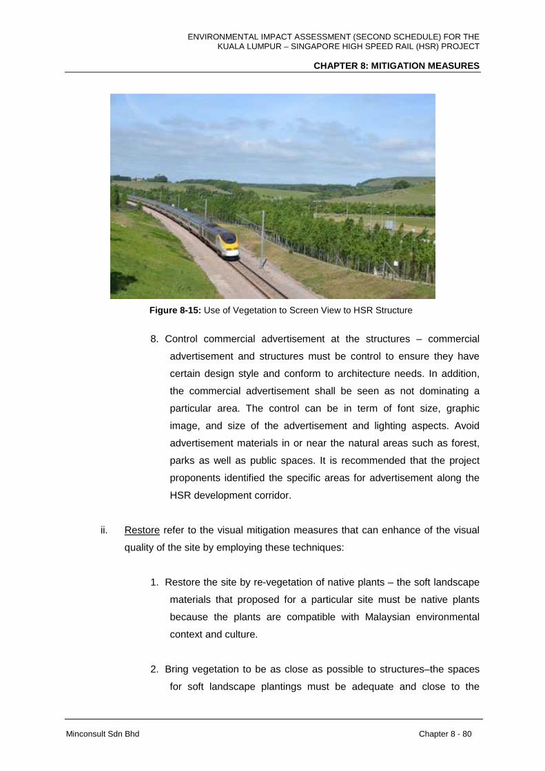
ENVIRONMENTAL IMPACT ASSESSMENT (SECOND SCHEDULE) FOR THE KUALA LUMPUR – SINGAPORE HIGH SPEED RAIL (HSR) PROJECT
CHAPTER 8: MITIGATION MEASURES
Minconsult Sdn Bhd Chapter 8 - 80
Figure 8-15: Use of Vegetation to Screen View to HSR Structure
8. Control commercial advertisement at the structures – commercial
advertisement and structures must be control to ensure they have
certain design style and conform to architecture needs. In addition,
the commercial advertisement shall be seen as not dominating a
particular area. The control can be in term of font size, graphic
image, and size of the advertisement and lighting aspects. Avoid
advertisement materials in or near the natural areas such as forest,
parks as well as public spaces. It is recommended that the project
proponents identified the specific areas for advertisement along the
HSR development corridor.
ii. Restore refer to the visual mitigation measures that can enhance of the visual
quality of the site by employing these techniques:
1. Restore the site by re-vegetation of native plants – the soft landscape
materials that proposed for a particular site must be native plants
because the plants are compatible with Malaysian environmental
context and culture.
2. Bring vegetation to be as close as possible to structures–the spaces
for soft landscape plantings must be adequate and close to the
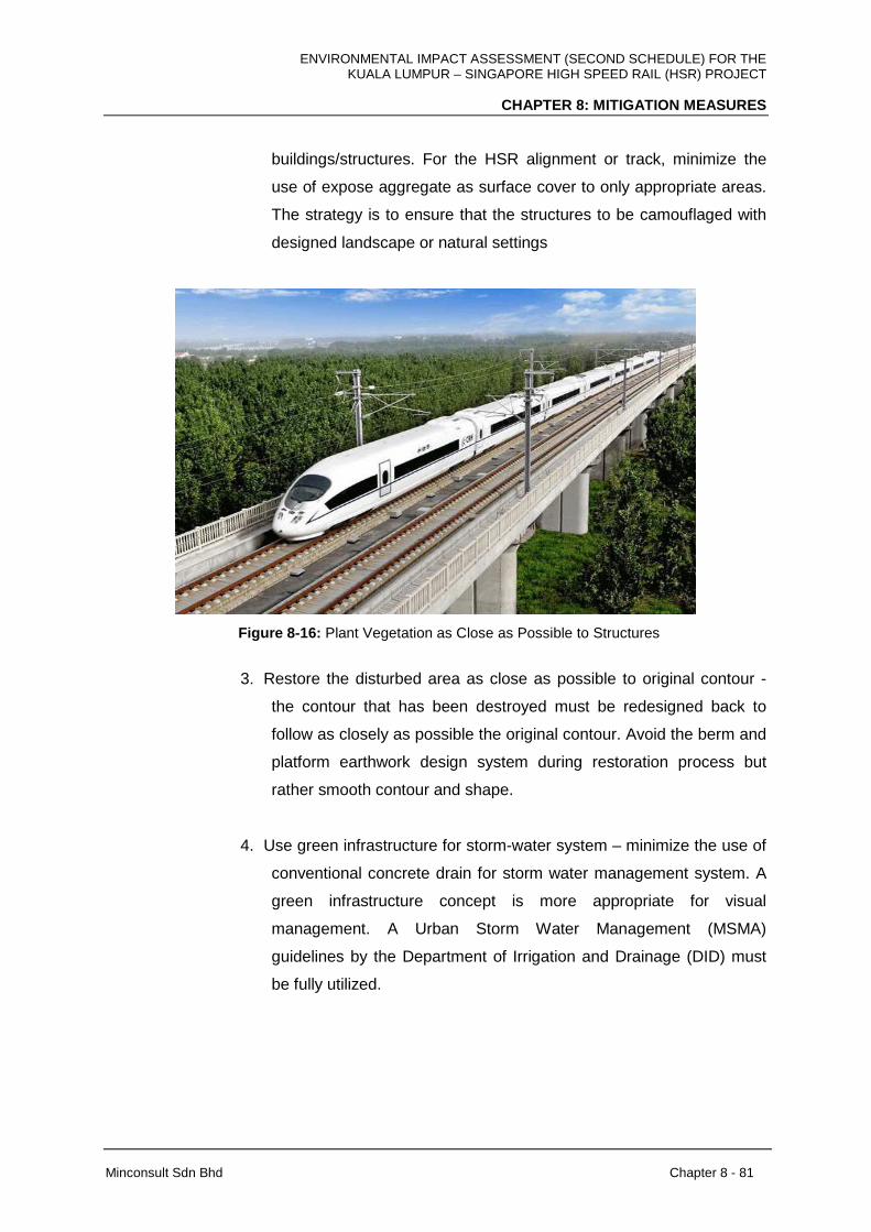
ENVIRONMENTAL IMPACT ASSESSMENT (SECOND SCHEDULE) FOR THE KUALA LUMPUR – SINGAPORE HIGH SPEED RAIL (HSR) PROJECT
CHAPTER 8: MITIGATION MEASURES
Minconsult Sdn Bhd Chapter 8 - 81
buildings/structures. For the HSR alignment or track, minimize the
use of expose aggregate as surface cover to only appropriate areas.
The strategy is to ensure that the structures to be camouflaged with
designed landscape or natural settings
Figure 8-16: Plant Vegetation as Close as Possible to Structures
3. Restore the disturbed area as close as possible to original contour -
the contour that has been destroyed must be redesigned back to
follow as closely as possible the original contour. Avoid the berm and
platform earthwork design system during restoration process but
rather smooth contour and shape.
4. Use green infrastructure for storm-water system – minimize the use of
conventional concrete drain for storm water management system. A
green infrastructure concept is more appropriate for visual
management. A Urban Storm Water Management (MSMA)
guidelines by the Department of Irrigation and Drainage (DID) must
be fully utilized.
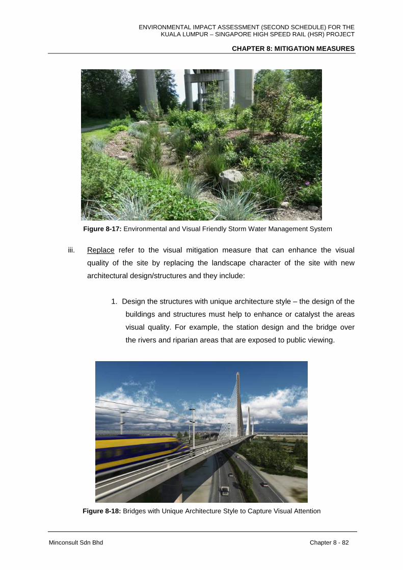
ENVIRONMENTAL IMPACT ASSESSMENT (SECOND SCHEDULE) FOR THE KUALA LUMPUR – SINGAPORE HIGH SPEED RAIL (HSR) PROJECT
CHAPTER 8: MITIGATION MEASURES
Minconsult Sdn Bhd Chapter 8 - 82
Figure 8-17: Environmental and Visual Friendly Storm Water Management System
iii. Replace refer to the visual mitigation measure that can enhance the visual
quality of the site by replacing the landscape character of the site with new
architectural design/structures and they include:
1. Design the structures with unique architecture style – the design of the
buildings and structures must help to enhance or catalyst the areas
visual quality. For example, the station design and the bridge over
the rivers and riparian areas that are exposed to public viewing.
Figure 8-18: Bridges with Unique Architecture Style to Capture Visual Attention

ENVIRONMENTAL IMPACT ASSESSMENT (SECOND SCHEDULE) FOR THE KUALA LUMPUR – SINGAPORE HIGH SPEED RAIL (HSR) PROJECT
CHAPTER 8: MITIGATION MEASURES
Minconsult Sdn Bhd Chapter 8 - 83
2. Provision of public spaces within the structures compound with proper
landscape design – one of the factors that can enhance public
preferences for visual environment is the ability for the spaces to
attract people to use. Therefore, in order to increase people
acceptance for changes and visual preferences is to introduce public
spaces in the vicinity of the structures such plaza, viewing zone and
small park.
Figure 8-19: Public Spaces at the Station and to Increase Visual Affordance
3. Provide connection with the surrounding spaces – connection of the
HSR structures especially the station with surrounding areas also
can increase people acceptance for HSR development. The
connection strategies such as pedestrian walkways to surrounding
neighborhoods (where applicable) will be perceived as increase a
place functions to people thus increasing the aesthetic values.
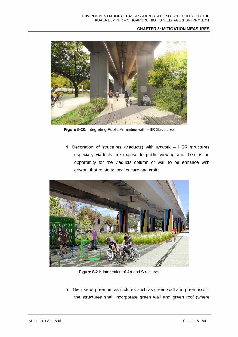
ENVIRONMENTAL IMPACT ASSESSMENT (SECOND SCHEDULE) FOR THE KUALA LUMPUR – SINGAPORE HIGH SPEED RAIL (HSR) PROJECT
CHAPTER 8: MITIGATION MEASURES
Minconsult Sdn Bhd Chapter 8 - 84
Figure 8-20: Integrating Public Amenities with HSR Structures
4. Decoration of structures (viaducts) with artwork – HSR structures
especially viaducts are expose to public viewing and there is an
opportunity for the viaducts column or wall to be enhance with
artwork that relate to local culture and crafts.
Figure 8-21: Integration of Art and Structures
5. The use of green infrastructures such as green wall and green roof –
the structures shall incorporate green wall and green roof (where
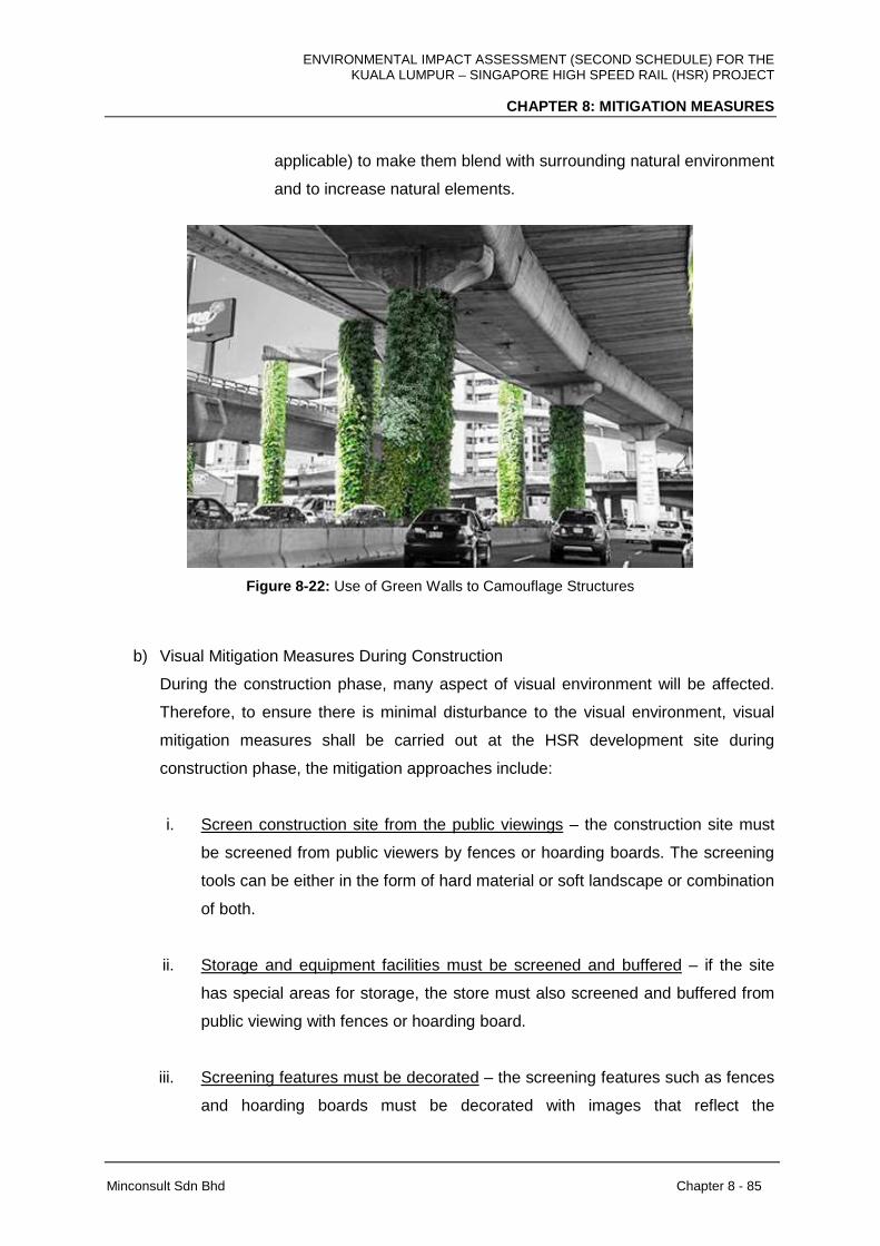
ENVIRONMENTAL IMPACT ASSESSMENT (SECOND SCHEDULE) FOR THE KUALA LUMPUR – SINGAPORE HIGH SPEED RAIL (HSR) PROJECT
CHAPTER 8: MITIGATION MEASURES
Minconsult Sdn Bhd Chapter 8 - 85
applicable) to make them blend with surrounding natural environment
and to increase natural elements.
Figure 8-22: Use of Green Walls to Camouflage Structures
b) Visual Mitigation Measures During Construction
During the construction phase, many aspect of visual environment will be affected.
Therefore, to ensure there is minimal disturbance to the visual environment, visual
mitigation measures shall be carried out at the HSR development site during
construction phase, the mitigation approaches include:
i. Screen construction site from the public viewings – the construction site must
be screened from public viewers by fences or hoarding boards. The screening
tools can be either in the form of hard material or soft landscape or combination
of both.
ii. Storage and equipment facilities must be screened and buffered – if the site
has special areas for storage, the store must also screened and buffered from
public viewing with fences or hoarding board.
iii. Screening features must be decorated – the screening features such as fences
and hoarding boards must be decorated with images that reflect the

ENVIRONMENTAL IMPACT ASSESSMENT (SECOND SCHEDULE) FOR THE KUALA LUMPUR – SINGAPORE HIGH SPEED RAIL (HSR) PROJECT
CHAPTER 8: MITIGATION MEASURES
Minconsult Sdn Bhd Chapter 8 - 86
development of the area or HSR project. Artist impression of the development
as well as the development information is one of the suitable decoration
materials for screen.
iv. Point of access to the construction site must be control and enhanced – by
controlling the access point, the visual quality of the construction will be better
managed. The access point must be clear designed as a proper entrance
statement. The access point also shall be enhanced with soft landscape
features.
c) Visual Mitigation Measures During Operational
Upon the completion of the HSR development, the mitigation measures must be
monitored and managed to ensure the mitigation measures is successful and meet
the objectives. Among the measures that need to be taken after constructions are:
i. Needs of natural landscape maintenance plan – there is a need to have
maintenance and operational plan for the visual mitigation measures involving
natural areas such as wetlands and forest. The plan need to address
maintenance and operational needs to ensure the measures is successful and
do not affect the operation of HSR train.
ii. Needs of detail landscape maintenance plan – for the areas that are not in
natural areas, there is a need to have detail landscape design maintenance
and operational plan for the visual mitigation measures. The plan need to
address maintenance and operational needs to ensure the measures is
successful and do not affect the operation of HSR train.
iii. Regular maintenance operation – regular maintenance operation activities are
needed and scheduled such as repainting of structures, replanting of
vegetation, replacement of artworks and control of advertisement materials.
iv. Elicitation of public feedbacks – public opinions about visual quality after
construction need to be gauged regularly (at least once a year). It is to ensure
that the visual quality of the areas meeting public needs and do not deteriorate
after some time.
ENVIRONMENTAL IMPACT ASSESSMENT (SECOND SCHEDULE) FOR THE KUALA LUMPUR – SINGAPORE HIGH SPEED RAIL (HSR) PROJECT
CHAPTER 8: MITIGATION MEASURES
Minconsult Sdn Bhd Chapter 8 - 87
d) Compliance with Laws and Guidelines
During the mitigation process it is also very important to ensure that detail design
follows all the laws, state enactments, local by-law and guidelines that have been
enacted in relation to landscape development and visual quality. Among the laws are:
i. Act 172 (Town Planning Act 1976) – provision regarding site characters and
tree provision order (TPO) before Kebenaran Merancang (KM/DO) can be
obtained.
ii. Act 133 (Road and Drainage Act 1974) – provision for building/infrastructure
development submission and approval that require Building and Landscape
Plan be submitted and approved.
iii. Act 645 (National Heritage Act 2005) – to check and to ensure that HSR
development will not compromise the structures, sites or a person with
cultural and heritage significant.
iv. Respective Structures and Local Plans – these planning control documents,
commissioned under Act 172, outlined the needs for any development to
adhere states and local needs. Sectors regarding to landscapes, land use and
environment must be reviewed and the suggestion must be complied with.
v. Local authority requirement especially in relation to landscapes and greenery
– Local requirement or local by-laws in relation to landscape plants,
maintenance and operation must be followed.
All landscape characters were analyzed for appropriate mitigation measures and strategies
for before, during and after construction phase (see Appendix 8D for each federal territories
and states mitigation measures). However, site specific mitigation measures shall also been
imposed to particular areas especially the areas with major adverse impacts and with HSR
development structures such as stations and maintenance depot.
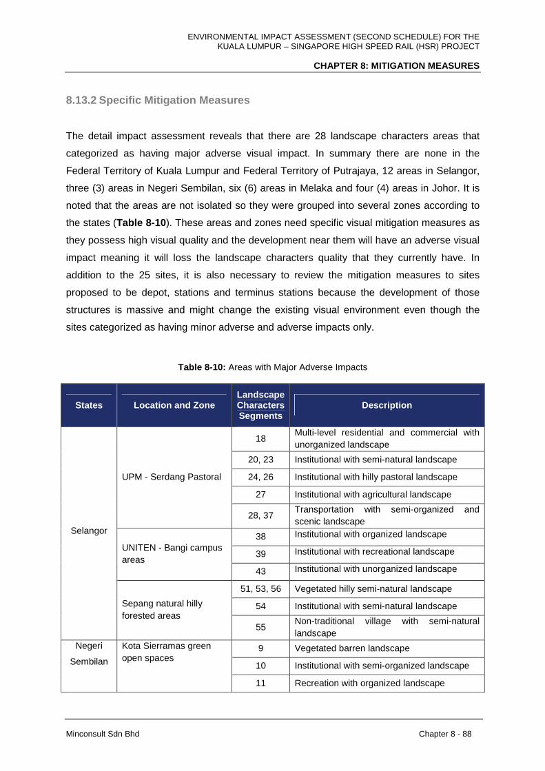
ENVIRONMENTAL IMPACT ASSESSMENT (SECOND SCHEDULE) FOR THE KUALA LUMPUR – SINGAPORE HIGH SPEED RAIL (HSR) PROJECT
CHAPTER 8: MITIGATION MEASURES
Minconsult Sdn Bhd Chapter 8 - 88
8.13.2 Specific Mitigation Measures
The detail impact assessment reveals that there are 28 landscape characters areas that
categorized as having major adverse visual impact. In summary there are none in the
Federal Territory of Kuala Lumpur and Federal Territory of Putrajaya, 12 areas in Selangor,
three (3) areas in Negeri Sembilan, six (6) areas in Melaka and four (4) areas in Johor. It is
noted that the areas are not isolated so they were grouped into several zones according to
the states (Table 8-10 ). These areas and zones need specific visual mitigation measures as
they possess high visual quality and the development near them will have an adverse visual
impact meaning it will loss the landscape characters quality that they currently have. In
addition to the 25 sites, it is also necessary to review the mitigation measures to sites
proposed to be depot, stations and terminus stations because the development of those
structures is massive and might change the existing visual environment even though the
sites categorized as having minor adverse and adverse impacts only.
Table 8-10: Areas with Major Adverse Impacts
States Location and Zone Landscape Characters Segments
Description
18 Multi-level residential and commercial with unorganized landscape
20, 23 Institutional with semi-natural landscape
24, 26 Institutional with hilly pastoral landscape
27 Institutional with agricultural landscape
UPM - Serdang Pastoral
28, 37 Transportation with semi-organized and scenic landscape
38 Institutional with organized landscape
39 Institutional with recreational landscape UNITEN - Bangi campus areas
43 Institutional with unorganized landscape
51, 53, 56 Vegetated hilly semi-natural landscape
54 Institutional with semi-natural landscape
Selangor
Sepang natural hilly forested areas
55 Non-traditional village with semi-natural landscape
9 Vegetated barren landscape
10 Institutional with semi-organized landscape
Negeri
Sembilan
Kota Sierramas green open spaces
11 Recreation with organized landscape
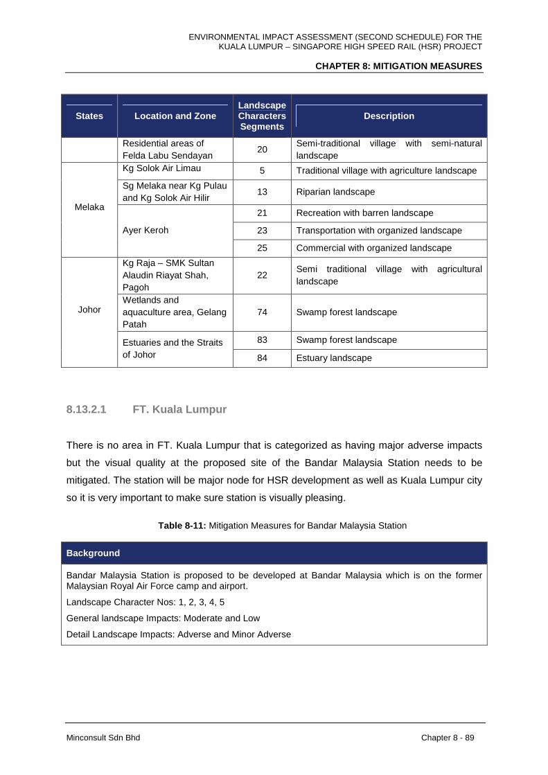
ENVIRONMENTAL IMPACT ASSESSMENT (SECOND SCHEDULE) FOR THE KUALA LUMPUR – SINGAPORE HIGH SPEED RAIL (HSR) PROJECT
CHAPTER 8: MITIGATION MEASURES
Minconsult Sdn Bhd Chapter 8 - 89
States Location and Zone Landscape Characters Segments
Description
Residential areas of Felda Labu Sendayan
20 Semi-traditional village with semi-natural landscape
Kg Solok Air Limau 5 Traditional village with agriculture landscape
Sg Melaka near Kg Pulau and Kg Solok Air Hilir
13 Riparian landscape
21 Recreation with barren landscape
23 Transportation with organized landscape
Melaka
Ayer Keroh
25 Commercial with organized landscape
Kg Raja – SMK Sultan Alaudin Riayat Shah, Pagoh
22 Semi traditional village with agricultural landscape
Wetlands and aquaculture area, Gelang Patah
74 Swamp forest landscape
83 Swamp forest landscape
Johor
Estuaries and the Straits of Johor 84 Estuary landscape
8.13.2.1 FT. Kuala Lumpur
There is no area in FT. Kuala Lumpur that is categorized as having major adverse impacts
but the visual quality at the proposed site of the Bandar Malaysia Station needs to be
mitigated. The station will be major node for HSR development as well as Kuala Lumpur city
so it is very important to make sure station is visually pleasing.
Table 8-11: Mitigation Measures for Bandar Malaysia Station
Background
Bandar Malaysia Station is proposed to be developed at Bandar Malaysia which is on the former Malaysian Royal Air Force camp and airport.
Landscape Character Nos: 1, 2, 3, 4, 5
General landscape Impacts: Moderate and Low
Detail Landscape Impacts: Adverse and Minor Adverse
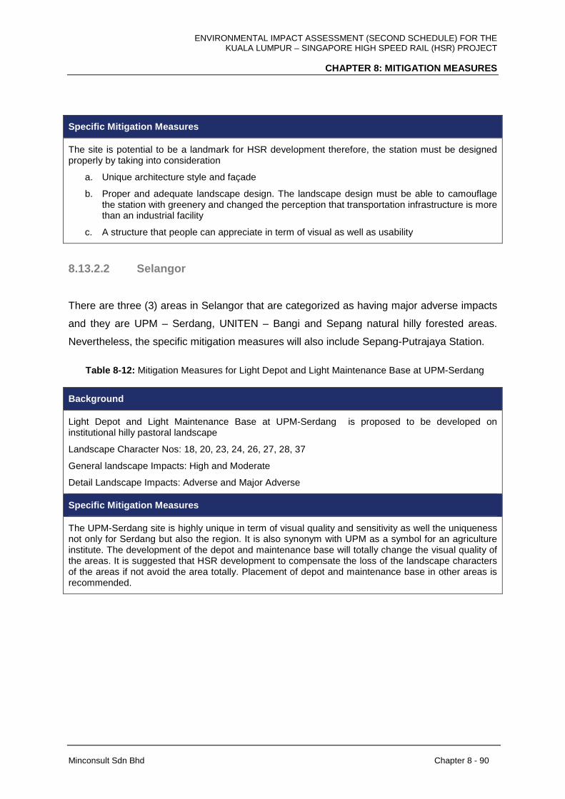
ENVIRONMENTAL IMPACT ASSESSMENT (SECOND SCHEDULE) FOR THE KUALA LUMPUR – SINGAPORE HIGH SPEED RAIL (HSR) PROJECT
CHAPTER 8: MITIGATION MEASURES
Minconsult Sdn Bhd Chapter 8 - 90
Specific Mitigation Measures
The site is potential to be a landmark for HSR development therefore, the station must be designed properly by taking into consideration
a. Unique architecture style and façade
b. Proper and adequate landscape design. The landscape design must be able to camouflage the station with greenery and changed the perception that transportation infrastructure is more than an industrial facility
c. A structure that people can appreciate in term of visual as well as usability
8.13.2.2 Selangor
There are three (3) areas in Selangor that are categorized as having major adverse impacts
and they are UPM – Serdang, UNITEN – Bangi and Sepang natural hilly forested areas.
Nevertheless, the specific mitigation measures will also include Sepang-Putrajaya Station.
Table 8-12: Mitigation Measures for Light Depot and Light Maintenance Base at UPM-Serdang
Background
Light Depot and Light Maintenance Base at UPM-Serdang is proposed to be developed on institutional hilly pastoral landscape
Landscape Character Nos: 18, 20, 23, 24, 26, 27, 28, 37
General landscape Impacts: High and Moderate
Detail Landscape Impacts: Adverse and Major Adverse
Specific Mitigation Measures
The UPM-Serdang site is highly unique in term of visual quality and sensitivity as well the uniqueness not only for Serdang but also the region. It is also synonym with UPM as a symbol for an agriculture institute. The development of the depot and maintenance base will totally change the visual quality of the areas. It is suggested that HSR development to compensate the loss of the landscape characters of the areas if not avoid the area totally. Placement of depot and maintenance base in other areas is recommended.
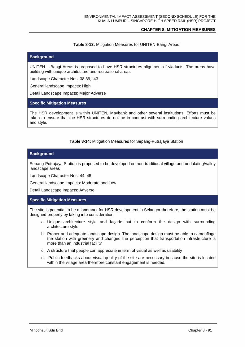
ENVIRONMENTAL IMPACT ASSESSMENT (SECOND SCHEDULE) FOR THE KUALA LUMPUR – SINGAPORE HIGH SPEED RAIL (HSR) PROJECT
CHAPTER 8: MITIGATION MEASURES
Minconsult Sdn Bhd Chapter 8 - 91
Table 8-13: Mitigation Measures for UNITEN-Bangi Areas
Background
UNITEN – Bangi Areas is proposed to have HSR structures alignment of viaducts. The areas have building with unique architecture and recreational areas
Landscape Character Nos: 38,39, 43
General landscape Impacts: High
Detail Landscape Impacts: Major Adverse
Specific Mitigation Measures
The HSR development is within UNITEN, Maybank and other several institutions. Efforts must be taken to ensure that the HSR structures do not be in contrast with surrounding architecture values and style.
Table 8-14: Mitigation Measures for Sepang-Putrajaya Station
Background
Sepang-Putrajaya Station is proposed to be developed on non-traditional village and undulating/valley landscape areas
Landscape Character Nos: 44, 45
General landscape Impacts: Moderate and Low
Detail Landscape Impacts: Adverse
Specific Mitigation Measures
The site is potential to be a landmark for HSR development in Selangor therefore, the station must be designed properly by taking into consideration
a. Unique architecture style and façade but to conform the design with surrounding architecture style
b. Proper and adequate landscape design. The landscape design must be able to camouflage the station with greenery and changed the perception that transportation infrastructure is more than an industrial facility
c. A structure that people can appreciate in term of visual as well as usability
d. Public feedbacks about visual quality of the site are necessary because the site is located within the village area therefore constant engagement is needed.
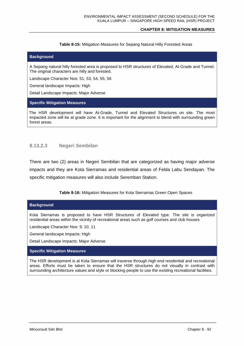
ENVIRONMENTAL IMPACT ASSESSMENT (SECOND SCHEDULE) FOR THE KUALA LUMPUR – SINGAPORE HIGH SPEED RAIL (HSR) PROJECT
CHAPTER 8: MITIGATION MEASURES
Minconsult Sdn Bhd Chapter 8 - 92
Table 8-15: Mitigation Measures for Sepang Natural Hilly Forested Areas
Background
A Sepang natural hilly forested area is proposed to HSR structures of Elevated, At-Grade and Tunnel. The original characters are hilly and forested.
Landscape Character Nos: 51, 53, 54, 55, 56
General landscape Impacts: High
Detail Landscape Impacts: Major Adverse
Specific Mitigation Measures
The HSR development will have At-Grade, Tunnel and Elevated Structures on site. The most impacted zone will be at grade zone. It is important for the alignment to blend with surrounding green forest areas.
8.13.2.3 Negeri Sembilan
There are two (2) areas in Negeri Sembilan that are categorized as having major adverse
impacts and they are Kota Sierramas and residential areas of Felda Labu Sendayan. The
specific mitigation measures will also include Seremban Station.
Table 8-16: Mitigation Measures for Kota Sierramas Green Open Spaces
Background
Kota Sierramas is proposed to have HSR Structures of Elevated type. The site is organized residential areas within the vicinity of recreational areas such as golf courses and club houses
Landscape Character Nos: 9, 10, 11
General landscape Impacts: High
Detail Landscape Impacts: Major Adverse
Specific Mitigation Measures
The HSR development is at Kota Sierramas will traverse through high end residential and recreational areas. Efforts must be taken to ensure that the HSR structures do not visually in contrast with surrounding architecture values and style or blocking people to use the existing recreational facilities.
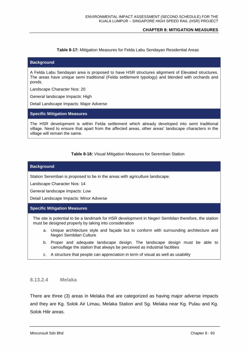
ENVIRONMENTAL IMPACT ASSESSMENT (SECOND SCHEDULE) FOR THE KUALA LUMPUR – SINGAPORE HIGH SPEED RAIL (HSR) PROJECT
CHAPTER 8: MITIGATION MEASURES
Minconsult Sdn Bhd Chapter 8 - 93
Table 8-17: Mitigation Measures for Felda Labu Sendayan Residential Areas
Background
A Felda Labu Sendayan area is proposed to have HSR structures alignment of Elevated structures. The areas have unique semi traditional (Felda settlement typology) and blended with orchards and ponds.
Landscape Character Nos: 20
General landscape Impacts: High
Detail Landscape Impacts: Major Adverse
Specific Mitigation Measures
The HSR development is within Felda settlement which already developed into semi traditional village. Need to ensure that apart from the affected areas, other areas’ landscape characters in the village will remain the same.
Table 8-18: Visual Mitigation Measures for Seremban Station
Background
Station Seremban is proposed to be in the areas with agriculture landscape.
Landscape Character Nos: 14
General landscape Impacts: Low
Detail Landscape Impacts: Minor Adverse
Specific Mitigation Measures
The site is potential to be a landmark for HSR development in Negeri Sembilan therefore, the station must be designed properly by taking into consideration
a. Unique architecture style and façade but to conform with surrounding architecture and Negeri Sembilan Culture
b. Proper and adequate landscape design. The landscape design must be able to camouflage the station that always be perceived as industrial facilities
c. A structure that people can appreciation in term of visual as well as usability
8.13.2.4 Melaka
There are three (3) areas in Melaka that are categorized as having major adverse impacts
and they are Kg. Solok Air Limau, Melaka Station and Sg. Melaka near Kg. Pulau and Kg.
Solok Hilir areas.

ENVIRONMENTAL IMPACT ASSESSMENT (SECOND SCHEDULE) FOR THE KUALA LUMPUR – SINGAPORE HIGH SPEED RAIL (HSR) PROJECT
CHAPTER 8: MITIGATION MEASURES
Minconsult Sdn Bhd Chapter 8 - 94
Table 8-19: Mitigation Measures for Kg. Solok Ayer Limau
Background
Kg. Solok Air Limau areas is proposed to have HSR structures alignment of Elevated and At-Grade. The areas have unique traditional Melaka village character and blended with traditional orchards.
Landscape Character Nos:5
General landscape Impacts: High
Detail Landscape Impacts: Major Adverse
Mitigation Measures
The HSR development is within traditional Melaka Village. Need to ensure that apart from the affected areas, other areas will remain the same character. Public feedback must be obtain regularly because the areas is within the village
Table 8-20: Visual Mitigation Measures for Melaka Station
Background
The Melaka Station in Ayer Keroh is proposed to be built in the areas with highway, vegetated areas and recreation areas
Landscape Character Nos: 21,22, 23, 24, 25, 26
General landscape Impacts: High and Moderate
Detail Landscape Impacts: Adverse and Major Adverse
Specific Mitigation Measures
The site is potential to be a landmark for HSR development in Melaka therefore, the station must be designed properly by taking into consideration
a. Unique architecture style and façade but to conform with surrounding architecture and Melaka Culture
b. Proper and adequate landscape design. The landscape design must be able to camouflage the station that always be perceived as industrial facilities
c. A structure that people can appreciation in term of visual as well as usability
The HSR Elevated structures and station platform is planned to cross the road towards Ayer Keroh from PLUS Highway, It is necessary to design the Elevated structure and station to be part and parcel of welcoming statement to Melaka (i.e gateway concept)

ENVIRONMENTAL IMPACT ASSESSMENT (SECOND SCHEDULE) FOR THE KUALA LUMPUR – SINGAPORE HIGH SPEED RAIL (HSR) PROJECT
CHAPTER 8: MITIGATION MEASURES
Minconsult Sdn Bhd Chapter 8 - 95
Table 8-21: Mitigation Measures for Sg. Melaka near Kg. Solok Hilir and Kg. Pulau
Background
Sg. Melaka areas near Kg. Solok Hilir and Kg. Pulau are proposed to have HSR Elevated structures alignment. The areas have riparian and riverine landscapes.
Landscape Character Nos: 13
General landscape Impacts: High
Detail Landscape Impacts: Major Adverse
Specific Mitigation Measures
The HSR development in this particular part of Sg. Melaka is within vast open riparian areas. The viaduct will be highly visible; therefore, an opportunity for people to view the bridge should be enhanced by providing a proper viewing area (public space). The viaduct that crossing the river must be visible and properly designed with unique architecture style.
8.13.2.5 Johor
There are three (3) areas in Johor that are categorized as having major adverse impacts and
they are Kg. Raja – SMK Sultan Alaudin Riayat Shah, Pagoh, wetlands and aquaculture
areas near Gelang Patah and estuaries near to Straits of Johor. Nevertheless, the specific
mitigation measures will also include Muar Station, Batu Pahat Station, Iskandar Puteri
Station, Heavy Maintenance Base in Muar and Main Depot and Light Maintenance Base in
Pontian.
Table 8-22: Mitigation measures for Kg. Raja – SMK Sultan Alaudin Riayat Shah, Pagoh
Background
Kg Raja – SMK Sultan Alaudin Riayat Shah, Pagoh is proposed to have HSR structures alignment of Elevated and At-Grade. The areas have unique traditional Melaka/Johor village character and blended with traditional orchards. One of the uniqueness of this area is its vicinity to Mausoleum of Sultan Melaka, Sultan Alaudin Riayat Shah that is located at Masjid Lama Kg Raja.
Landscape Character Nos: 22
General landscape Impacts: High
Detail Landscape Impacts: Major Adverse
Specific Mitigation Measures
The HSR development is within traditional Melaka/Johor village and near to historical site. Need to ensure that apart from the affected areas, other areas will remain the same character. In addition, during the design and construction phase, it has to ensure that the historical areas will not be affected.
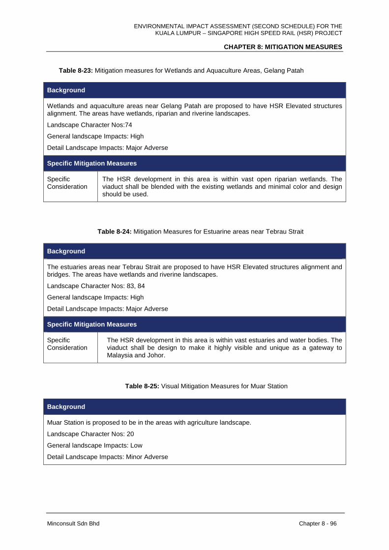
ENVIRONMENTAL IMPACT ASSESSMENT (SECOND SCHEDULE) FOR THE KUALA LUMPUR – SINGAPORE HIGH SPEED RAIL (HSR) PROJECT
CHAPTER 8: MITIGATION MEASURES
Minconsult Sdn Bhd Chapter 8 - 96
Table 8-23: Mitigation measures for Wetlands and Aquaculture Areas, Gelang Patah
Background
Wetlands and aquaculture areas near Gelang Patah are proposed to have HSR Elevated structures alignment. The areas have wetlands, riparian and riverine landscapes.
Landscape Character Nos:74
General landscape Impacts: High
Detail Landscape Impacts: Major Adverse
Specific Mitigation Measures
Specific Consideration
The HSR development in this area is within vast open riparian wetlands. The viaduct shall be blended with the existing wetlands and minimal color and design should be used.
Table 8-24: Mitigation Measures for Estuarine areas near Tebrau Strait
Background
The estuaries areas near Tebrau Strait are proposed to have HSR Elevated structures alignment and bridges. The areas have wetlands and riverine landscapes.
Landscape Character Nos: 83, 84
General landscape Impacts: High
Detail Landscape Impacts: Major Adverse
Specific Mitigation Measures
Specific Consideration
The HSR development in this area is within vast estuaries and water bodies. The viaduct shall be design to make it highly visible and unique as a gateway to Malaysia and Johor.
Table 8-25: Visual Mitigation Measures for Muar Station
Background
Muar Station is proposed to be in the areas with agriculture landscape.
Landscape Character Nos: 20
General landscape Impacts: Low
Detail Landscape Impacts: Minor Adverse
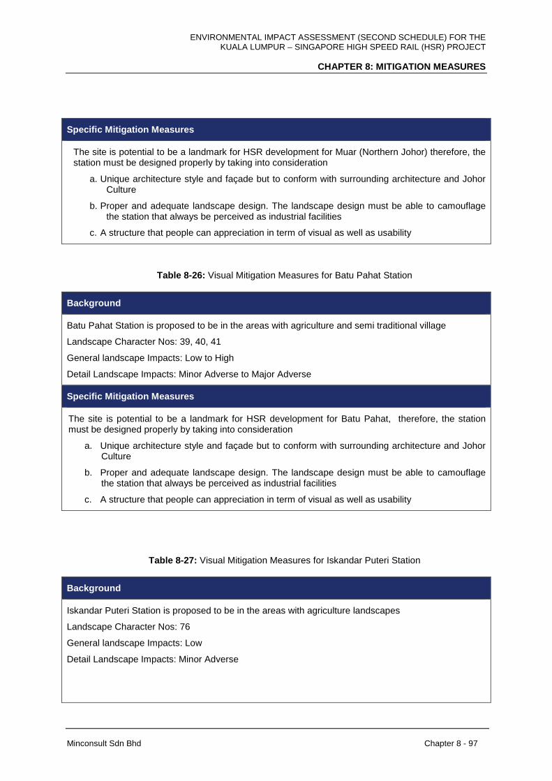
ENVIRONMENTAL IMPACT ASSESSMENT (SECOND SCHEDULE) FOR THE KUALA LUMPUR – SINGAPORE HIGH SPEED RAIL (HSR) PROJECT
CHAPTER 8: MITIGATION MEASURES
Minconsult Sdn Bhd Chapter 8 - 97
Specific Mitigation Measures
The site is potential to be a landmark for HSR development for Muar (Northern Johor) therefore, the station must be designed properly by taking into consideration
a. Unique architecture style and façade but to conform with surrounding architecture and Johor Culture
b. Proper and adequate landscape design. The landscape design must be able to camouflage the station that always be perceived as industrial facilities
c. A structure that people can appreciation in term of visual as well as usability
Table 8-26: Visual Mitigation Measures for Batu Pahat Station
Background
Batu Pahat Station is proposed to be in the areas with agriculture and semi traditional village
Landscape Character Nos: 39, 40, 41
General landscape Impacts: Low to High
Detail Landscape Impacts: Minor Adverse to Major Adverse
Specific Mitigation Measures
The site is potential to be a landmark for HSR development for Batu Pahat, therefore, the station must be designed properly by taking into consideration
a. Unique architecture style and façade but to conform with surrounding architecture and Johor Culture
b. Proper and adequate landscape design. The landscape design must be able to camouflage the station that always be perceived as industrial facilities
c. A structure that people can appreciation in term of visual as well as usability
Table 8-27: Visual Mitigation Measures for Iskandar Puteri Station
Background
Iskandar Puteri Station is proposed to be in the areas with agriculture landscapes
Landscape Character Nos: 76
General landscape Impacts: Low
Detail Landscape Impacts: Minor Adverse
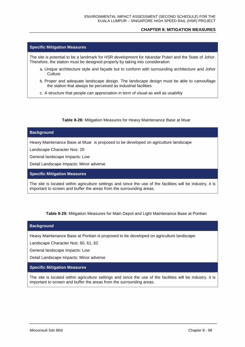
ENVIRONMENTAL IMPACT ASSESSMENT (SECOND SCHEDULE) FOR THE KUALA LUMPUR – SINGAPORE HIGH SPEED RAIL (HSR) PROJECT
CHAPTER 8: MITIGATION MEASURES
Minconsult Sdn Bhd Chapter 8 - 98
Specific Mitigation Measures
The site is potential to be a landmark for HSR development for Iskandar Puteri and the State of Johor. Therefore, the station must be designed properly by taking into consideration
a. Unique architecture style and façade but to conform with surrounding architecture and Johor Culture
b. Proper and adequate landscape design. The landscape design must be able to camouflage the station that always be perceived as industrial facilities
c. A structure that people can appreciation in term of visual as well as usability
Table 8-28: Mitigation Measures for Heavy Maintenance Base at Muar
Background
Heavy Maintenance Base at Muar is proposed to be developed on agriculture landscape
Landscape Character Nos: 20
General landscape Impacts: Low
Detail Landscape Impacts: Minor adverse
Specific Mitigation Measures
The site is located within agriculture settings and since the use of the facilities will be industry, it is important to screen and buffer the areas from the surrounding areas.
Table 8-29: Mitigation Measures for Main Depot and Light Maintenance Base at Pontian
Background
Heavy Maintenance Base at Pontian is proposed to be developed on agriculture landscape
Landscape Character Nos: 60, 61, 62
General landscape Impacts: Low
Detail Landscape Impacts: Minor adverse
Specific Mitigation Measures
The site is located within agriculture settings and since the use of the facilities will be industry. it is important to screen and buffer the areas from the surrounding areas.

ENVIRONMENTAL IMPACT ASSESSMENT (SECOND SCHEDULE) FOR THE KUALA LUMPUR – SINGAPORE HIGH SPEED RAIL (HSR) PROJECT
CHAPTER 8: MITIGATION MEASURES
Minconsult Sdn Bhd Chapter 8 - 99
In conclusion, from the impacts analysis, 25 areas were categorized as having major
adverse visual impacts and the areas can be found in the State of Selangor, Negeri
Sembilan, Melaka and Johor. The impacts are irreversible because the HSR structures will
be permanently constructed. Therefore, there is a need to mitigate the impacts of HSR
development and consequently soften the changes to the existing visual environment. It is
recommended that the impacts to be mitigated during design phase, during construction and
operation. For design phase or before construction phase, reduce, restore and replace
approaches have been suggested. All the landscape characters segments will receive at
least a minimal visual mitigation measures. For 25 areas with major adverse impact, specific
mitigation measures were proposed.
8.14 PUBLIC HEALTH
8.14.1 Pre-Construction Phase
The following mitigation measures are recommended in order to ameliorate potential
adverse impacts discussed in Chapter 7.
The arrangement and conditions at the new settlement area has to be as good as or better
than the previous housing area. The communities should be given a choice to select their
preferred home in the new settlement area. The location of homes within the new settlement
should also be similar to that of their old housing area, in terms of proximity to their relatives’
homes and arrangement according to different ethnicity, if applicable.
Grave yards or cemeteries local to a settlement has to be relocated closer to the new
resettlement area for the convenience of caretaking by and/or visitors from the respective
communities. The new resettlement area should have similar or better facilities and services
as the old housing area. Such facilities include schools, Balai Raya, healthcare services, wet
markets, banks and others. Any compensation has to be justified, honest, equal to the
current value of the land and satisfactory to the parties that are to be resettled.
ENVIRONMENTAL IMPACT ASSESSMENT (SECOND SCHEDULE) FOR THE KUALA LUMPUR – SINGAPORE HIGH SPEED RAIL (HSR) PROJECT
CHAPTER 8: MITIGATION MEASURES
Minconsult Sdn Bhd Chapter 8 - 100
8.14.2 Construction Phase
The following mitigation measures are recommended in order to ameliorate potential
adverse impacts discussed in Chapter 7 viz:
All workers should be mandated to undergo FOMEMA medical checkup as recommended by
the Ministry of Health (MOH), Malaysia. During the checkup, investigation of health history is
very important to determine the potential health risks among the workers. They should have
symptoms screening and medical examinations conducted at dedicated physician clinics.
For tuberculosis, Tuberculin Skin Test (TST) and Interferon Gama Release Assay (IGRA)
Test should be conducted together with Chest X-ray that reviewed by a Medical Officer.
Additional tests should also be conducted to detect other diseases, including influenza,
malaria, typhoid, leprosy, hepatitis B and STIs. This checkup should be done every year for
all workers as recommended by the MOH.
The workers of various nationalities should be properly managed in order to ensure a
comfortable and safe environment in the base camp and working area. A suitable and
trusted person should be selected as a leader to take control of the group’s interests and to
create a harmonious living environment to prevent social problems among the workers.
Good housekeeping throughout the alignment, all stations and other sites should be
maintained clean and managed to prevent any outbreak of communicable diseases such as
dengue fever, malaria, filariasis, chikungunya, leptospirosis and food poisoning. The
construction sites should have good waste collection systems and regular collection, with
collaboration with respective local authorities. Any food serving areas or canteen at sites
should maintain good hygiene practices and managed by vaccinated and trained food
handlers.
8.14.3 Operational Phase
The following mitigation measures are recommended in order to ameliorate potential
adverse impacts discussed in Chapter 7 with regards to Accident, Injury and Safety of
Communities viz:

ENVIRONMENTAL IMPACT ASSESSMENT (SECOND SCHEDULE) FOR THE KUALA LUMPUR – SINGAPORE HIGH SPEED RAIL (HSR) PROJECT
CHAPTER 8: MITIGATION MEASURES
Minconsult Sdn Bhd Chapter 8 - 101
• The railway tracks, trestles, yards and all equipments should be secured from illegal
entry. Walking or playing on them should be prohibited and trespassers should be
subjected to prosecution and fines. Walking, running, cycling or the operation of all
terrain vehicles (ATV’s) on the railway tracks, rights-of-way or through its tunnels
should be prohibited.
• No hunting, fishing or bungee jumping from railway trestles should be allowed as the
tracks are not designed with sidewalks or pedestrian bridges.
• The perimeter of the railway tracks should be fenced to prevent trespassing or
crossing at locations other than dedicated crossing points. In sensitive areas such as
schools or towns, an overhead bridge for crossing should be erected to be used by
pedestrians and motorcyclists for. People should be allowed to cross the tracks only
at designated pedestrian or railway crossings, must be required to observe and obey
all warning signs and signals provided.
• Trains passing through identified critical crossing points that serve densely populated
areas and sensitive institutions like hospitals, offices and schools should decrease its
speed to recommended levels.
The following mitigation measures are recommended in order to ameliorate potential
adverse impacts discussed in Chapter 7 with regards to Noise Disruptions to Communities,
viz:
The train be required to reduce its speed to a recommended level at critical locations,
especially near dense housing areas, hospitals, schools and religious centers
(mosques, temples and churches), and braking too late or too close to the recipients
should be avoided.
A buffer zone should be provided between the railway tracks and the nearest
communities, with adequate distance and presence of trees or any physical barriers
that can act as noise shields.
Noise barriers of suitable height and length should be installed at identified sensitive
areas along the alignment to reduce the noise exposure to adjacent human
settlement or institutions.

ENVIRONMENTAL IMPACT ASSESSMENT (SECOND SCHEDULE) FOR THE KUALA LUMPUR – SINGAPORE HIGH SPEED RAIL (HSR) PROJECT
CHAPTER 8: MITIGATION MEASURES
Minconsult Sdn Bhd Chapter 8 - 102
• Erection of elevated crossing points is the best practice as the local traffic will not
have to stop for the train to pass. This will eliminate the need for the use of the train
horn and grade-crossing bell, while also maintaining public safety and emergency
vehicle access, and reduce potential local traffic congestion and air pollution.
8.15 RISK
8.15.1 Introduction
The estimated Individual Risk (IR) analysis in the Chapter 7 shows that the public and the
population around the HSR Project will not be exposed to any high level risk. However to
keep the IR and any residual risks level down the Project Proponent shall institute
management procedures which enhance safety on rail.
Once a hazard and its potential causes were identified, the possible consequences are
qualitatively evaluated. Any consequence with the potential to cause injury, fatality or
multiple fatalities needs to be mitigated.
Where risk was assessed to be Intolerable or Undesirable with the currently proposed
safeguards, additional risk reduction, control or mitigation measures were proposed. Where
risk was assessed to be Tolerable, the proposed safeguards were reviewed to assess
whether they provide sufficient risk reduction. Additional recommendations are proposed
where required.
Worker Competency
The importance of workers’ competency is never to be under emphasised. It is common
knowledge that most accidents are caused by human error. It is therefore necessary to instil
safety awareness to the railways’ employee right from the start. The training of the employee
should include safety procedures and practices. To ensure their alertness and competency
are maintained, frequent drilled on emergency response plan should be periodically
executed. Derailment and train collision with other trains or objects in part are as a result of
driver’s error. Over speeding may lead to derailment and failing to follow signal at danger
ENVIRONMENTAL IMPACT ASSESSMENT (SECOND SCHEDULE) FOR THE KUALA LUMPUR – SINGAPORE HIGH SPEED RAIL (HSR) PROJECT
CHAPTER 8: MITIGATION MEASURES
Minconsult Sdn Bhd Chapter 8 - 103
can cause collisions with other entity. So train drivers should be properly trained to observe
train speed limits and to follow other safety procedures. They should be well verse with
proper safety rules and regulations.
Maintenance workers either on contract or permanent workers should be ascertained to be
well versed with safe work procedures before they are allowed to work on the track. Track
work should be less labour intensive to reduce risk exposure. If sufficient increase in train
traffic density is established it may justify the installation of automated track safety warning
system or a more comprehensive train protection warning system.
Emergency Planning
An Emergency Response Plan should be well devised and regulated to mitigate any
emergency situations. Detail procedures and rules should be made available and known to
all relevant personnel.
Public Awareness
At some locations, the train traverse heavily populated areas. Residents as the employees
and workers near the railway route should be made aware of the existence of the railway
within their neighbours. They should be informed periodically or continuously with labels and
text boards on what and what not to be done to ensure train and public safety. These
measures should be the responsibility of the project proponent so that the public will
perceive that the railway operation is as safe as any other everyday activities.

ENVIRONMENTAL IMPACT ASSESSMENT (SECOND SCHEDULE) FOR THE KUALA LUMPUR – SINGAPORE HIGH SPEED RAIL (HSR) PROJECT
CHAPTER 8: MITIGATION MEASURES
Minconsult Sdn Bhd Chapter 8 - 104
8.15.2 Construction Phase
Specific hazards, their causes and recommended mitigations measures during the construction phase of the HSR Project is tabulated below.
Table 8-30: Hazards and Mitigation Measures during the Construction Phase
Hazard Categories Causes Mitigation Measures Risk Categories Additional Recommendation
1. Traffic interruption before lifting operation
1. Precast block dropped (e.g. cable failure, human error) during construction
2. Method statement
Negligible 1. Construction method statement must be certified by competent personnel, eg. Professional Engineer (PE).
2. Adequate work supervision and traffic diversion during the process.
3. Emergency Response Plan
1. Traffic interruption during installation and removal of gantry
2. Method statement
1.Lifting/ dropped objects
2. Gantry falling e.g. Installation error/ removal of gantry.
3. Compliance with railway protection zone regulations
Tolerable 1. Contractor to avoid as far as possible installing/ removing gantry over existing railway or major roads.
2. Contractor to as far as possible installing/ removing gantry after railway operating hours
3. Construction method statement
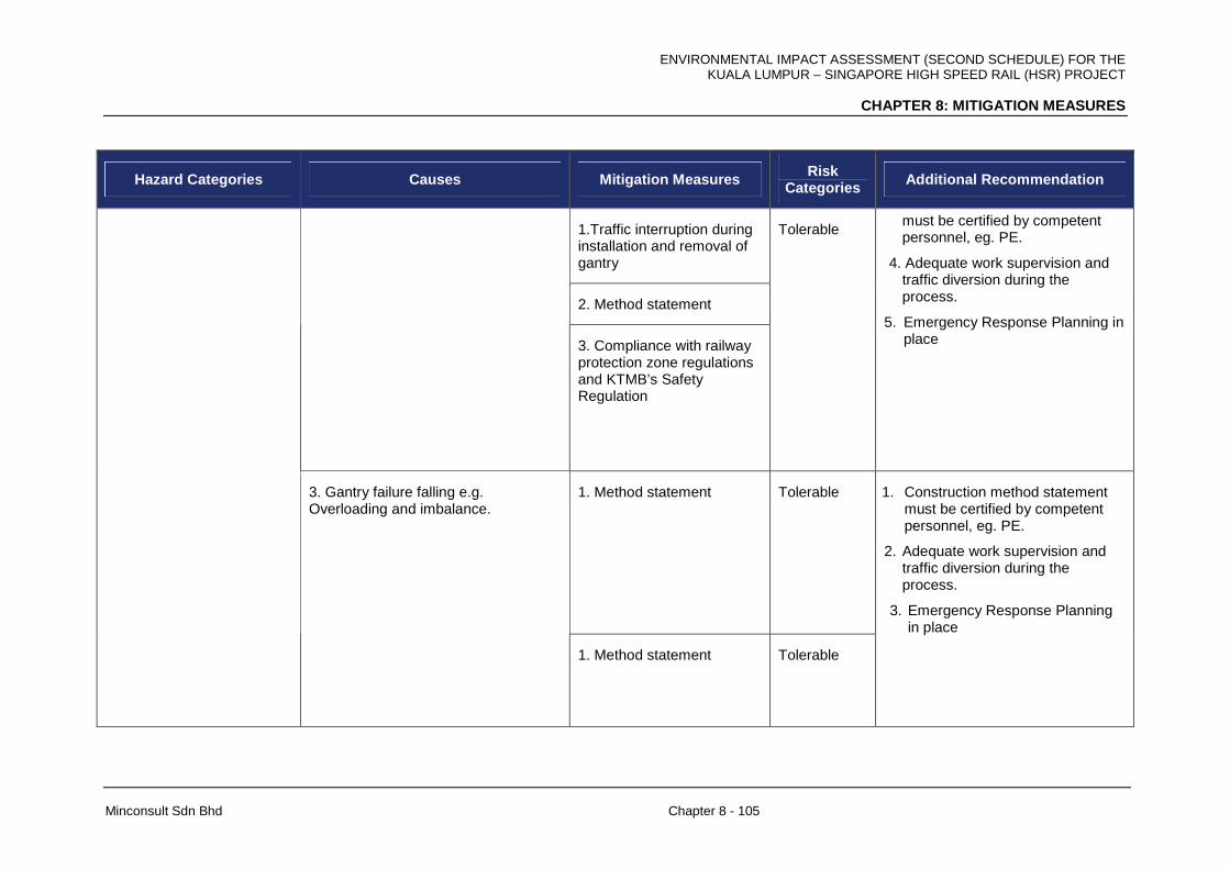
ENVIRONMENTAL IMPACT ASSESSMENT (SECOND SCHEDULE) FOR THE KUALA LUMPUR – SINGAPORE HIGH SPEED RAIL (HSR) PROJECT
CHAPTER 8: MITIGATION MEASURES
Minconsult Sdn Bhd Chapter 8 - 105
Hazard Categories Causes Mitigation Measures Risk Categories Additional Recommendation
1.Traffic interruption during installation and removal of gantry
2. Method statement
3. Compliance with railway protection zone regulations and KTMB’s Safety Regulation
Tolerable must be certified by competent personnel, eg. PE.
4. Adequate work supervision and traffic diversion during the process.
5. Emergency Response Planning in place
1. Method statement Tolerable
3. Gantry failure falling e.g. Overloading and imbalance.
1. Method statement Tolerable
1. Construction method statement must be certified by competent personnel, eg. PE.
2. Adequate work supervision and traffic diversion during the process.
3. Emergency Response Planning in place
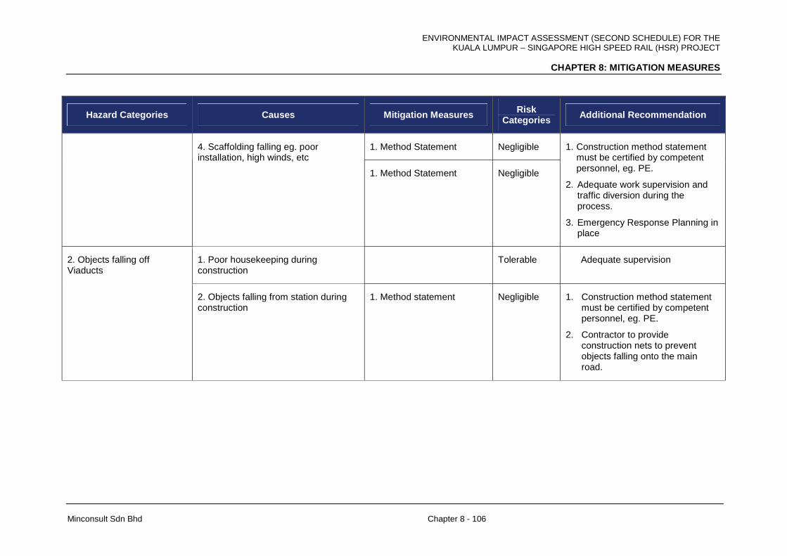
ENVIRONMENTAL IMPACT ASSESSMENT (SECOND SCHEDULE) FOR THE KUALA LUMPUR – SINGAPORE HIGH SPEED RAIL (HSR) PROJECT
CHAPTER 8: MITIGATION MEASURES
Minconsult Sdn Bhd Chapter 8 - 106
Hazard Categories Causes Mitigation Measures Risk Categories Additional Recommendation
1. Method Statement Negligible 4. Scaffolding falling eg. poor installation, high winds, etc
1. Method Statement Negligible
1. Construction method statement must be certified by competent personnel, eg. PE.
2. Adequate work supervision and traffic diversion during the process.
3. Emergency Response Planning in place
1. Poor housekeeping during construction
Tolerable Adequate supervision 2. Objects falling off Viaducts
2. Objects falling from station during construction
1. Method statement Negligible
1. Construction method statement must be certified by competent personnel, eg. PE.
2. Contractor to provide construction nets to prevent objects falling onto the main road.

ENVIRONMENTAL IMPACT ASSESSMENT (SECOND SCHEDULE) FOR THE KUALA LUMPUR – SINGAPORE HIGH SPEED RAIL (HSR) PROJECT
CHAPTER 8: MITIGATION MEASURES
Minconsult Sdn Bhd Chapter 8 - 107
Hazard Categories Causes Mitigation Measures Risk Categories Additional Recommendation
3. Electrical systems - touch potential/ earthing
1. Lightning during construction/ local storm. Local storm which could affect construction areas in places where there is no storm through electrical conduction.
1. Method statement Tolerable 1. Construction method statement must be certified by competent personnel, eg. PE.
2. Contractor to develop clear warning and the working procedures under lightning and storm conditions.
3. Emergency Response Plan to address
4. Electrical system - Electromagnetic Interference
Poor quality cable 1. Technical Specification of materials used in the project.
Negligible 1. Verification of material quality before acceptance.
1. Unauthorized access during construction
1. Site Security System Plan
Negligible 1. Contractor to secure the site at all time during construction.
2. Contractor to provide a warning signage to secure construction site.
5. Unauthorized access - station/ guide way/ Plant rooms
2. Unauthorized access during construction around the built up areas. (Higher risk of intrusion).
1. Site Security System Plan
Tolerable 1. Contractor to supervise and secure the exit point for construction near built up areas.

ENVIRONMENTAL IMPACT ASSESSMENT (SECOND SCHEDULE) FOR THE KUALA LUMPUR – SINGAPORE HIGH SPEED RAIL (HSR) PROJECT
CHAPTER 8: MITIGATION MEASURES
Minconsult Sdn Bhd Chapter 8 - 108
Hazard Categories Causes Mitigation Measures Risk Categories Additional Recommendation
6. Wrong routing Land survey report is wrong 1.Verification of the land survey report and design
Negligible 1. The Design specification is verified by the contractors and the Project supervising engineers.
7. Overrun from the guide way
Poor integration of the rail interface Reliability Assurance Management System (RAMS)
Negligible 1. System failure testing conducted periodically by the operative
9.Uncontrolled speed/ derailment/ collision
1. Train signal system failure Reliability Assurance Management System (RAMS)
Negligible 1. System failure testing conducted periodically by the operative
1. Regular monitoring by site supervisor.
14. Dangerous substances/ materials
1. Poor housekeeping/ use of combustible material
1. Specific procedure to work with dangerous substances and material
Negligible
1. Contractor to keep combustible materials offsite for work carried out near existing populated areas
1. Method statement 15. Activities near existing railway
1. Piling work eg. Vibration/ piling machinery access.
2. Compliance with railway protection zone regulations
Negligible N/A
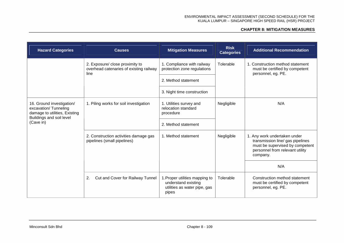
ENVIRONMENTAL IMPACT ASSESSMENT (SECOND SCHEDULE) FOR THE KUALA LUMPUR – SINGAPORE HIGH SPEED RAIL (HSR) PROJECT
CHAPTER 8: MITIGATION MEASURES
Minconsult Sdn Bhd Chapter 8 - 109
Hazard Categories Causes Mitigation Measures Risk Categories Additional Recommendation
1. Compliance with railway protection zone regulations
2. Method statement
2. Exposure/ close proximity to overhead catenaries of existing railway line
3. Night time construction
Tolerable 1. Construction method statement must be certified by competent personnel, eg. PE.
1. Utilities survey and relocation standard procedure
1. Piling works for soil investigation
2. Method statement
Negligible N/A
1. Any work undertaken under transmission line/ gas pipelines must be supervised by competent personnel from relevant utility company.
2. Construction activities damage gas pipelines (small pipelines)
1. Method statement Negligible
N/A
16. Ground investigation/ excavation/ Tunneling damage to utilities, Existing Buildings and soil level (Cave in)
2. Cut and Cover for Railway Tunnel 1. Proper utilities mapping to understand existing utilities as water pipe, gas pipes
Tolerable Construction method statement must be certified by competent personnel, eg. PE.
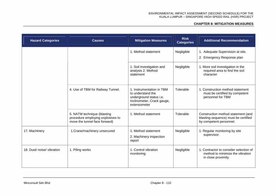
ENVIRONMENTAL IMPACT ASSESSMENT (SECOND SCHEDULE) FOR THE KUALA LUMPUR – SINGAPORE HIGH SPEED RAIL (HSR) PROJECT
CHAPTER 8: MITIGATION MEASURES
Minconsult Sdn Bhd Chapter 8 - 110
Hazard Categories Causes Mitigation Measures Risk Categories Additional Recommendation
1. Method statement Negligible 1. Adequate Supervision at site.
2. Emergency Response plan
1. Soil investigation and analysis 2. Method statement
Negligible 1. More soil investigation in the required area to find the soil character
4. Use of TBM for Railway Tunnel. 1. Instrumentation in TBM to understand the underground status i.e. Inclinometer, Crack gauge, extensometer
Tolerable 1. Construction method statement must be certified by competent personnel for TBM
5. NATM technique (blasting procedure employing explosives to move the tunnel face forward)
1. Method statement Tolerable Construction method statement (and blasting sequence) must be certified by competent personnel.
17. Machinery 1.Crane/machinery unsecured 1. Method statement
2. Machinery inspection report
Negligible 1. Regular monitoring by site supervisor.
18. Dust/ noise/ vibration
1. Piling works 1. Control vibration monitoring
Negligible 1. Contractor to consider selection of method to minimize the vibration in close proximity.
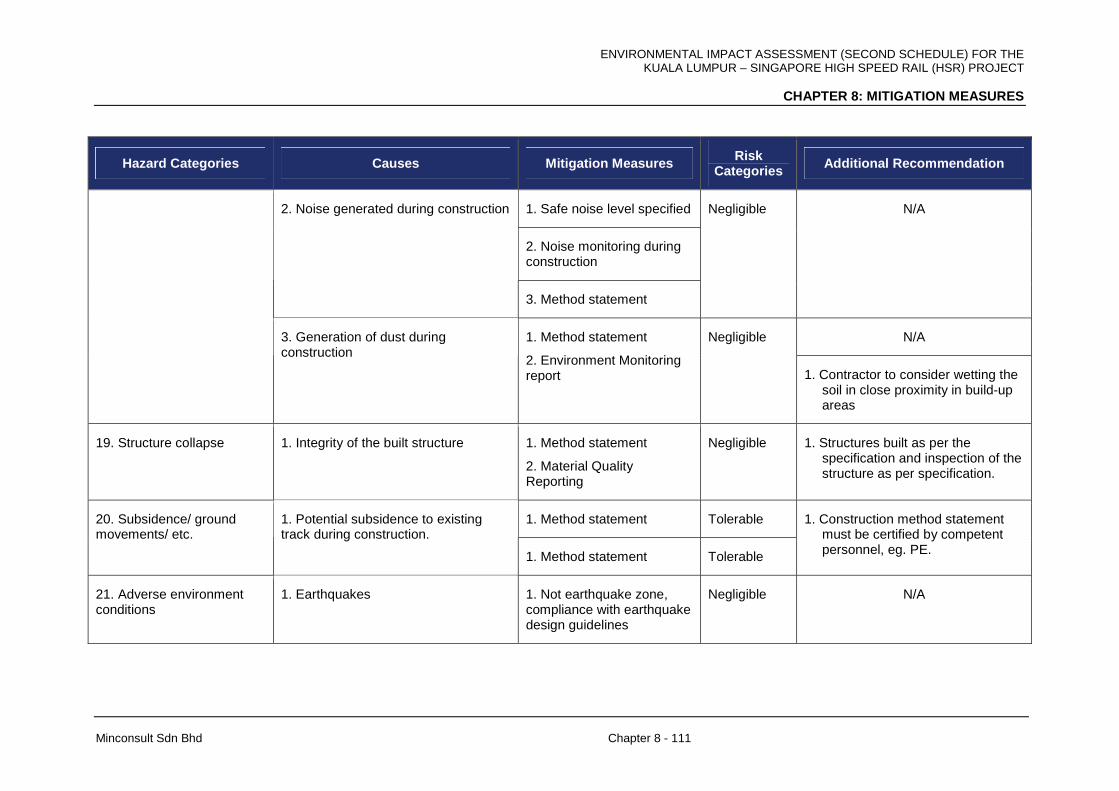
ENVIRONMENTAL IMPACT ASSESSMENT (SECOND SCHEDULE) FOR THE KUALA LUMPUR – SINGAPORE HIGH SPEED RAIL (HSR) PROJECT
CHAPTER 8: MITIGATION MEASURES
Minconsult Sdn Bhd Chapter 8 - 111
Hazard Categories Causes Mitigation Measures Risk Categories Additional Recommendation
1. Safe noise level specified
2. Noise monitoring during construction
2. Noise generated during construction
3. Method statement
Negligible N/A
N/A
3. Generation of dust during construction
1. Method statement
2. Environment Monitoring report
Negligible
1. Contractor to consider wetting the soil in close proximity in build-up areas
19. Structure collapse 1. Integrity of the built structure 1. Method statement
2. Material Quality Reporting
Negligible 1. Structures built as per the specification and inspection of the structure as per specification.
1. Method statement Tolerable 20. Subsidence/ ground movements/ etc.
1. Potential subsidence to existing track during construction.
1. Method statement Tolerable
1. Construction method statement must be certified by competent personnel, eg. PE.
21. Adverse environment conditions
1. Earthquakes 1. Not earthquake zone, compliance with earthquake design guidelines
Negligible N/A
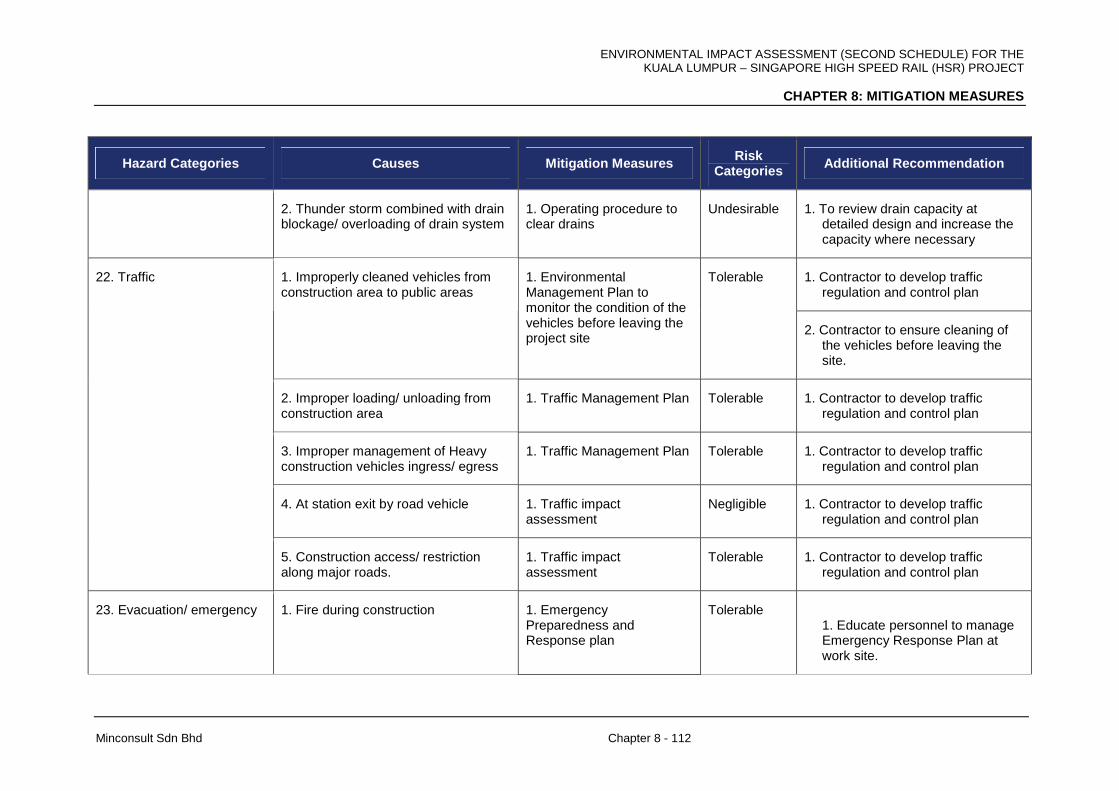
ENVIRONMENTAL IMPACT ASSESSMENT (SECOND SCHEDULE) FOR THE KUALA LUMPUR – SINGAPORE HIGH SPEED RAIL (HSR) PROJECT
CHAPTER 8: MITIGATION MEASURES
Minconsult Sdn Bhd Chapter 8 - 112
Hazard Categories Causes Mitigation Measures Risk Categories Additional Recommendation
2. Thunder storm combined with drain blockage/ overloading of drain system
1. Operating procedure to clear drains
Undesirable
1. To review drain capacity at detailed design and increase the capacity where necessary
1. Contractor to develop traffic regulation and control plan
1. Improperly cleaned vehicles from construction area to public areas
1. Environmental Management Plan to monitor the condition of the vehicles before leaving the project site
Tolerable
2. Contractor to ensure cleaning of the vehicles before leaving the site.
2. Improper loading/ unloading from construction area
1. Traffic Management Plan Tolerable 1. Contractor to develop traffic regulation and control plan
3. Improper management of Heavy construction vehicles ingress/ egress
1. Traffic Management Plan Tolerable 1. Contractor to develop traffic regulation and control plan
4. At station exit by road vehicle 1. Traffic impact assessment
Negligible 1. Contractor to develop traffic regulation and control plan
22. Traffic
5. Construction access/ restriction along major roads.
1. Traffic impact assessment
Tolerable 1. Contractor to develop traffic regulation and control plan
23. Evacuation/ emergency 1. Fire during construction 1. Emergency Preparedness and Response plan
Tolerable 1. Educate personnel to manage Emergency Response Plan at work site.
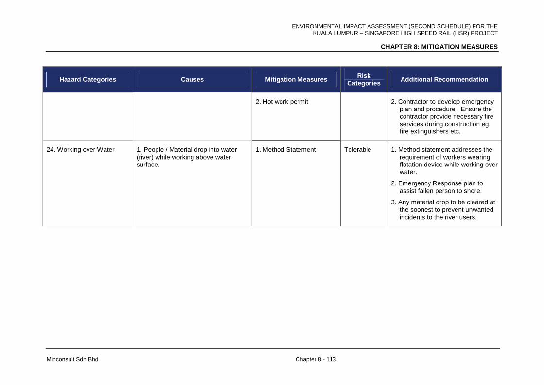
ENVIRONMENTAL IMPACT ASSESSMENT (SECOND SCHEDULE) FOR THE KUALA LUMPUR – SINGAPORE HIGH SPEED RAIL (HSR) PROJECT
CHAPTER 8: MITIGATION MEASURES
Minconsult Sdn Bhd Chapter 8 - 113
Hazard Categories Causes Mitigation Measures Risk Categories Additional Recommendation
2. Hot work permit 2. Contractor to develop emergency plan and procedure. Ensure the contractor provide necessary fire services during construction eg. fire extinguishers etc.
24. Working over Water 1. People / Material drop into water (river) while working above water surface.
1. Method Statement Tolerable 1. Method statement addresses the requirement of workers wearing flotation device while working over water.
2. Emergency Response plan to assist fallen person to shore.
3. Any material drop to be cleared at the soonest to prevent unwanted incidents to the river users.

ENVIRONMENTAL IMPACT ASSESSMENT (SECOND SCHEDULE) FOR THE KUALA LUMPUR – SINGAPORE HIGH SPEED RAIL (HSR) PROJECT
CHAPTER 8: MITIGATION MEASURES
Minconsult Sdn Bhd Chapter 8 - 114
8.15.3 Operational Phase
Specific hazards, their causes and recommended mitigations measures during the operational phase of the HSR Project is tabulated below.
Table 8-31: Hazards and Mitigation Measures during the Operational Phase
Hazard Categories Causes Mitigation Measures Risk Categories Additional Recommendation
1. Objects falling off Rolling Stock/ Guide way/ Others
1. Objects falling from station bridge during operation [generic for footpath bridge station]
1. Method Statement Undesirable 1. The operation procedure for Rolling Stock maintenance.
1. Potential intrusion along the guide way
1. Intrusion detection provided and restricted access
Negligible 2. Periodic Inspection of the line for protection of Earthing issues.
2. Potential intrusion into the substation
1. Intrusion detection provided and restricted access, eg. lock devices.
Negligible N/A
2. Electrical systems - touch potential/ earthing
3. Lightning during operation
1. Lightning arrestor provided during operation along the guide way.
Negligible Inspection of the Lighting arrestors
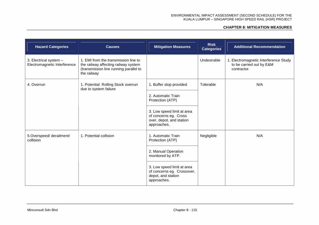
ENVIRONMENTAL IMPACT ASSESSMENT (SECOND SCHEDULE) FOR THE KUALA LUMPUR – SINGAPORE HIGH SPEED RAIL (HSR) PROJECT
CHAPTER 8: MITIGATION MEASURES
Minconsult Sdn Bhd Chapter 8 - 115
Hazard Categories Causes Mitigation Measures Risk Categories Additional Recommendation
3. Electrical system – Electromagnetic Interference
1. EMI from the transmission line to the railway affecting railway system (transmission line running parallel to the railway
Undesirable 1. Electromagnetic Interference Study to be carried out by E&M contractor.
1. Buffer stop provided
2. Automatic Train Protection (ATP)
4. Overrun 1. Potential Rolling Stock overrun due to system failure
3. Low speed limit at area of concerns eg. Cross over, depot, and station approaches.
Tolerable N/A
1. Automatic Train Protection (ATP)
2. Manual Operation monitored by ATP.
5.Overspeed/ derailment/ collision
1. Potential collision
3. Low speed limit at area of concerns eg. Crossover, depot, and station approaches.
Negligible N/A

ENVIRONMENTAL IMPACT ASSESSMENT (SECOND SCHEDULE) FOR THE KUALA LUMPUR – SINGAPORE HIGH SPEED RAIL (HSR) PROJECT
CHAPTER 8: MITIGATION MEASURES
Minconsult Sdn Bhd Chapter 8 - 116
Hazard Categories Causes Mitigation Measures Risk Categories Additional Recommendation
1.Rail integrity checks during operation
2. Broken rail/ rail fitting
2.Standard Operating Procedures (SOP)
Negligible N/A
1. Automatic Train Supervision System.
3. Malfunction of switches
2. Standard Operating Procedures (SOP)
Negligible N/A
1. Fire alarm detection
2. Automatic Train Protection (ATP) prevent Rolling Stock to reach station
3. Fire escape system well designed within the tunnel to prevent any fatality
6. Rolling Stock fire
1. Rolling Stock on fire arriving at station (open / in Tunnel)
4. Open station design
Negligible
Periodic evacuation drill for the employees to ensure they know what they need to do in case of fire emergency.

ENVIRONMENTAL IMPACT ASSESSMENT (SECOND SCHEDULE) FOR THE KUALA LUMPUR – SINGAPORE HIGH SPEED RAIL (HSR) PROJECT
CHAPTER 8: MITIGATION MEASURES
Minconsult Sdn Bhd Chapter 8 - 117
Hazard Categories Causes Mitigation Measures Risk Categories Additional Recommendation
1. Fire alarm detection
2. Non-combustible material NFPA130
3. Evacuation to comply with NFPA 130
4. Open station design
7. Station fire 1. Station fire e.g. plant room fire
5. Passenger escape to safe area
Negligible Periodic evacuation drill for the employees to ensure they know what they need to do in case of fire emergency.
1. Smoking inside the station causing fire
1. Smoke detectors
2. Warning and signage
Tolerable N/A
1. Falling objects detector on track at station
2. Warning and signage
8. Passenger behavior
2. Intrusion of passenger into the guide way
3. Controlled paid area
Negligible N/A
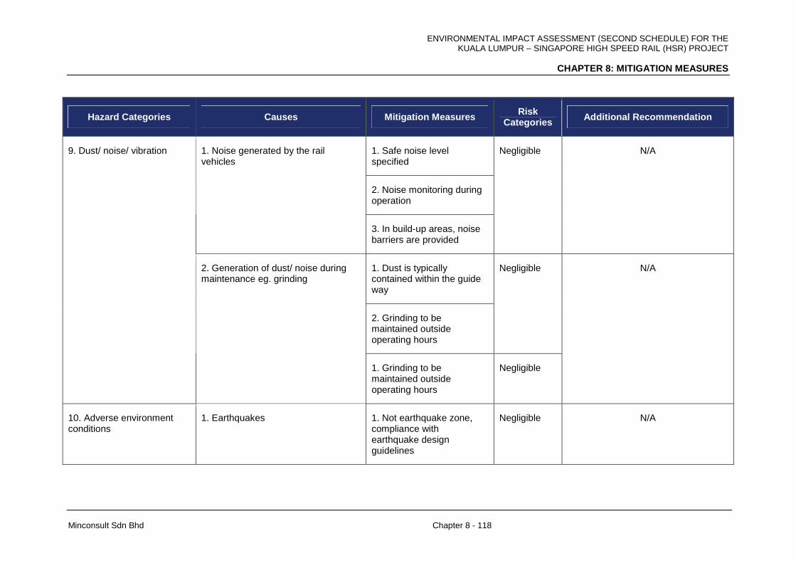
ENVIRONMENTAL IMPACT ASSESSMENT (SECOND SCHEDULE) FOR THE KUALA LUMPUR – SINGAPORE HIGH SPEED RAIL (HSR) PROJECT
CHAPTER 8: MITIGATION MEASURES
Minconsult Sdn Bhd Chapter 8 - 118
Hazard Categories Causes Mitigation Measures Risk Categories Additional Recommendation
1. Safe noise level specified
2. Noise monitoring during operation
1. Noise generated by the rail vehicles
3. In build-up areas, noise barriers are provided
Negligible N/A
1. Dust is typically contained within the guide way
2. Grinding to be maintained outside operating hours
Negligible
9. Dust/ noise/ vibration
2. Generation of dust/ noise during maintenance eg. grinding
1. Grinding to be maintained outside operating hours
Negligible
N/A
10. Adverse environment conditions
1. Earthquakes 1. Not earthquake zone, compliance with earthquake design guidelines
Negligible N/A
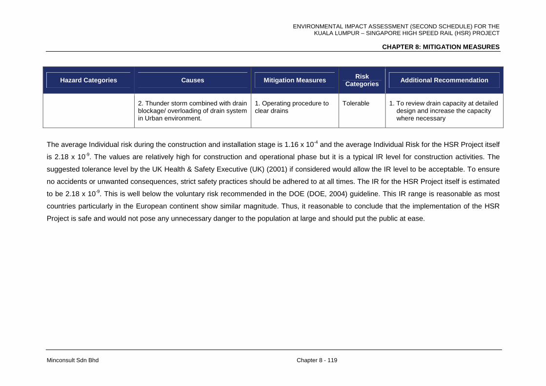
ENVIRONMENTAL IMPACT ASSESSMENT (SECOND SCHEDULE) FOR THE KUALA LUMPUR – SINGAPORE HIGH SPEED RAIL (HSR) PROJECT
CHAPTER 8: MITIGATION MEASURES
Minconsult Sdn Bhd Chapter 8 - 119
Hazard Categories Causes Mitigation Measures Risk Categories Additional Recommendation
2. Thunder storm combined with drain blockage/ overloading of drain system in Urban environment.
1. Operating procedure to clear drains
Tolerable
1. To review drain capacity at detailed design and increase the capacity where necessary
The average Individual risk during the construction and installation stage is 1.16 x 10⁻⁴ and the average Individual Risk for the HSR Project itself
is 2.18 x 10⁻⁹. The values are relatively high for construction and operational phase but it is a typical IR level for construction activities. The
suggested tolerance level by the UK Health & Safety Executive (UK) (2001) if considered would allow the IR level to be acceptable. To ensure
no accidents or unwanted consequences, strict safety practices should be adhered to at all times. The IR for the HSR Project itself is estimated
to be 2.18 x 10⁻⁹. This is well below the voluntary risk recommended in the DOE (DOE, 2004) guideline. This IR range is reasonable as most
countries particularly in the European continent show similar magnitude. Thus, it reasonable to conclude that the implementation of the HSR
Project is safe and would not pose any unnecessary danger to the population at large and should put the public at ease.
ENVIRONMENTAL IMPACT ASSESSMENT (SECOND SCHEDULE) FOR THE KUALA LUMPUR – SINGAPORE HIGH SPEED RAIL (HSR) PROJECT
CHAPTER 8: MITIGATION MEASURES
Minconsult Sdn Bhd Chapter 8 - 120
8.16 OTHER REQUIRED MITIGATION MEASURES
8.16.1 Surveys, Designs and Studies Pre-Constructio n Phase
Project designs have been on the whole tailored towards minimizing environmental impacts
that could occur during the construction and operation phases of the HSR Project. The
protection of the external environment, i.e. receptors located beyond the HSR alignment
boundaries, have been given due consideration especially in view of the fact that (a)
residential developments exist in close vicinity of the alignment and (b) the vulnerability of
the Sg. Labu, Sg. Langat and Sg. Semenyih to adverse water quality shifts arising from
pollution loads discharged to its watercourses especially during drought periods.
A preliminary LD-P2M2 plan has been prepared by the Environmental Consultants to control
excessive erosion of soil particles from within the HSR alignment. This aspect has been
discussed in Chapter 7. The PDP is expected to engage a Certified Erosion and Sediment
Control professional to prepare a detailed LD-P2M2 and submit the same to JPS for
approval. The alignments and design features of temporary cut-off and permanent storm
drains, as well as connections to silt traps, will be identified in the Detailed Plan. Suitable silt
traps that are capable of retaining as much of the eroded solids as possible, and their
placement will also e delineated in the final Plan.
Appropriate sites for disposal of waste construction materials shall be identified, and if
necessary stipulated in Contract specifications. In this respect, close liaison with the
Department of Environment, the Ministry of Health and the Local Authorities shall be
maintained in order to select suitable dumping site(s), in neighbourhood areas.
8.16.2 Environmental Impact Studies
The environmental mitigation and abatement measures identified by the designers, together
with other measures identified in this EIA Study as well as additional control and
amelioration measures imposed by the Department of Environment and other Government
agencies, shall be integrated into the final designs of Project elements, and in developing
operational strategies for various HSR Project functions.

ENVIRONMENTAL IMPACT ASSESSMENT (SECOND SCHEDULE) FOR THE KUALA LUMPUR – SINGAPORE HIGH SPEED RAIL (HSR) PROJECT
CHAPTER 8: MITIGATION MEASURES
Minconsult Sdn Bhd Chapter 8 - 121
An Environmental Management Plan (EMP) shall be evolved to guide and ensure an
environmentally friendly execution of various construction and operational activities. The
EMP shall incorporate mitigation and abatement measures identified in this Study, and those
that are required by the Department of Environment (DOE) and other Government agencies
and statutory bodies. This is to ensure that the Contractors price their Tenders incorporating
costs associated with having to plan, implement and execute specific environmental
protection measures, and environmental monitoring schedules, throughout the Construction
Period. The PDP shall establish an Environmental, Health and Safety (EHS) team within its
overall construction organisational structure to ensure effective reporting of environmental
receptor monitoring findings, and to put into effect adequate follow-up procedures to offset
any deviations from set objectives. The documentation of the Environmental Management
Plan (EMP) shall follow the specific reporting guidelines as established by the Department of
Environment Malaysia.
Operating procedures shall be evolved incorporating environmental protection measures and
emergency response plans, as recommended in this EIA Report, and those required by the
DOE. The Project Proponent and their Railway Operators (RO) shall evolve a
comprehensive, integrated environmental surveillance and monitoring strategy. This would
include delineating the scope of air, water, noise vibration and waste disposal monitoring
programmes on a periodic basis, and establish an organizational structure to ensure
effective reporting of findings, and to put into effect adequate follow-up procedures to offset
any deviations from set objectives. The recommended monitoring and surveillance
measures, which are specified in Chapter 10 of this EIA report, should be incorporated in the
Operating Schedule.
8.16.3 General Construction Practices
As explained in Chapter 7, there are potentials for activities carried out during the Project’s
construction phase to impart significant adverse as well as beneficial impacts on the local
and regional environments; as well as on the socio-economic fabric of the Nation. Mitigation
and abatement measures are therefore required to be adopted to ensure that activities
associated with the construction and installation of facilities do not adversely interact with
local environmental receptors; especially with respect to degrading ambient air and water
qualities, increasing noise and vibration levels, degrading the quality of land areas because
of indiscriminate disposal of construction waste material and sourcing of construction raw

ENVIRONMENTAL IMPACT ASSESSMENT (SECOND SCHEDULE) FOR THE KUALA LUMPUR – SINGAPORE HIGH SPEED RAIL (HSR) PROJECT
CHAPTER 8: MITIGATION MEASURES
Minconsult Sdn Bhd Chapter 8 - 122
materials (including fill material), disruption of road traffic circulations, retarding the safety,
welfare and quality of life of communities, and affecting the viability of other economic
activities operating in the local area.
The construction of the Project shall be executed by appointed contractors selected through
a competitive tendering process. The role to be played by the Project Proponent during the
Project construction phase shall be to oversee, regulate and monitor the performance of the
appointed contractors to ensure that all works carried out conform with internationally
accepted engineering specifications, criteria and guidelines; internationally accepted best
engineering practices, and with the Environmental Management Plan (EMP) to be
established by the Project Proponent’s Environmental Consultants.
The Project Proponent is able to exert considerable influence in making sure that the
appointed Contractors follow and meet specific obligations to protect the environment during
the construction of the Project and ancillary works by ensuring that they comply strictly with
the Specifications and Conditions contained in the EMP. Hence it is important that the EMP
be documented as part of the Performance Specifications developed for the overall
construction of the Project.
In addition the following additional general mitigating measures shall be adopted, viz:
• Construction sites are to be well maintained in order to eliminate ponded areas which
could act as suitable disease vector habitats.
• All potential activities which could induce fires will be closely supervised.
• Contractors will take all necessary precautions not to interfere with, or cause
nuisance and damage to the nearby existing developments located adjacent to the
Project Sites. In this respect the Contractor shall be fully aware of, and strictly adhere
to, the Project Proponent’s safety and emergency procedures associated with
construction works carried out within Project Sites.
• Drainage provisions within the Work Sites shall ensure minimal occurrences of
ponded water at all times.

ENVIRONMENTAL IMPACT ASSESSMENT (SECOND SCHEDULE) FOR THE KUALA LUMPUR – SINGAPORE HIGH SPEED RAIL (HSR) PROJECT
CHAPTER 8: MITIGATION MEASURES
Minconsult Sdn Bhd Chapter 8 - 123
• Construction materials, equipment and plants shall be delivered to site by overland
transportation. It should be incumbent on the Contractor to ensure that transportation
schedules are properly planned out ahead of time, and that road traffic authorities
and the Local Authority are alerted especially when transportation of bulky items by
articulated multi-axle vehicles are employed. These measures shall restrict possible
nuisance conditions (traffic congestion) and accident risks (collisions) being imposed
on public road commuters, and on any roadside pedestrians. Surveillance on the
speed of vehicular travel shall be periodically monitored by the Project Proponent's
appointed supervising engineers. The Contractor should submit well ahead of time a
schedule for transportation of bulky equipment from source to Project Sites.
To avoid interfering with through flow traffic, the Project Proponent shall establish
safe and proper ingress/egress junction arrangements for vehicles to enter and leave
the Project Sites. This is to enable construction vehicles to avoid causing traffic
encumbrances.
It will be incumbent on the Contractor to employ suitable well maintained vehicles to
deliver the necessary materials and plants. In this respect, compliance to tariff load
restrictions shall be enforced in order to avoid structural damages to road surfaces,
bridges and culverts. In any case, the Project Proponent (and the appointed
contractors) shall assume responsibility to redress road pavement damages that are
proven to be induced by Project-related vehicles.
• Traffic barriers shall be used for the protection to workers and public during
construction. Traffic barrier types shall be either;
• Triton TL-2 barriers
• Traffic barriers
• Barricades
• Construction signing, lighting and barricading shall be provided during all phases of
construction as required by the Local Authorities
It is also recommended that the Project Proponent prepare a Traffic Management
Plan (TMP) prior to the start of construction works. The TMP must be submitted to
ENVIRONMENTAL IMPACT ASSESSMENT (SECOND SCHEDULE) FOR THE KUALA LUMPUR – SINGAPORE HIGH SPEED RAIL (HSR) PROJECT
CHAPTER 8: MITIGATION MEASURES
Minconsult Sdn Bhd Chapter 8 - 124
the respective Local Authorities for their approval. The TMP shall be prepared for
access roads leading to Project Sites to ensure that no hazards would result from the
increased truck and other Project related traffic flows, and that local baseline traffic
flows would not be adversely impacted. In the TMP, informational signs would be
used to inform the public of temporary traffic hazards. Flaggers’ should be employed
when Project related machineries and equipment could block throughways, and
traffic cones would be used to identify any temporary changes in lane configuration
necessary to minimize traffic impacts.
A site preparation execution and management plan incorporating all environmental
protection measures should be drawn up by the Contractor and submitted to the
Project Proponent for consideration and approval prior to commencing works.
The above procedures and requirements shall be specified in the Civil contracts, in
order that Tenderers shall price their bid taking due cognizance of limitations to be
imposed on them, and on the special precautions that are needed to be adopted by
them in execution of the works.
Toxic and hazardous (i.e. “Scheduled”) waste materials (e.g. waste oils, paints,
solvents, etc.) will be selectively collected and packaged for convenient disposal to
recycling or approved disposal centres following the Environmental Quality
(Scheduled Waste) Regulations, 1987.
Suitable arrangements will be made with the regional utility authorities (i.e. Water
Supplies and Electricity) in order to procure construction related (temporary) water
and electricity needs. Tapping onto public water mains and electrical sub-stations will
only be carried out on approval by the respective Authorities. If required, the Project
Proponent shall erect a temporary water storage tank within the Site for use by
Contractors.
If an on-site electricity generator is to be installed then permission to do so should be
obtained from relevant authorities. Oil storage should be adequately regulated and a
bund shall encircle the storage tanks, Run-offs from the diesel generator area should
be routed to oil traps prior to disposal to off-site storm drains. If necessary, hoardings

ENVIRONMENTAL IMPACT ASSESSMENT (SECOND SCHEDULE) FOR THE KUALA LUMPUR – SINGAPORE HIGH SPEED RAIL (HSR) PROJECT
CHAPTER 8: MITIGATION MEASURES
Minconsult Sdn Bhd Chapter 8 - 125
shall be erected around the Project Sites in order to mitigate against adverse visual
aesthetics.
8.16.4 Centralized Worker Quarters
It should be made mandatory for the Main Contractor, and their appointed sub-contractors,
who wish to set-up temporary housing for accommodating immigrant workers to seek
appropriate permission from the Project Proponent and the relevant Local Authorities prior to
establishing the necessary Centralized Worker Quarters (CLQ).
Approval of site to locate the CLQ shall be issued by the Local Authority. In addition, the
State Health, Religious and Police Departments shall be duly informed on the setting up of
temporary accommodation facilities so as to maintain effective surveillance over public
health, social and security matters.
The Contractor shall ensure that the sites on which the CLQ are established are adequately
drained; that adequate provisions are made to collect and treat sewage generated, and to
dispose of it in a manner that meets with the approval of the State DOE and Jabatan
Perkhidmatan Pembentungan (JPP). Sewage management facilities must be regularly
serviced by a licensed contractor to ensure its’ efficiency. Suitable measures should be
provided to collect and store domestic refuse. Burning of rubbish on-site should not be
permitted. Refuse generated at the temporary accommodation should be placed in covered
bins and regularly collected by a licensed waste contractor for proper disposal to prevent
malodour generation and transmission to neighbouring residential areas. Regular checks by
an appointed Project Health, Safety and Environment Officer should be conducted to ensure
that the work site is kept reasonably clean and free from vector foraging and breeding sites
It is concluded that appropriate mitigation measures, such as those discussed above, can
be inculcated to off-set potential adverse public health and social discords that may
eventuate. However, it is recommended that construction CLQ be established external to the
Project Work sites. CLQ should be set up prior to the commencement of site preparation
activities so as to also accommodate the work force involved during this preliminary activity
stage.

ENVIRONMENTAL IMPACT ASSESSMENT (SECOND SCHEDULE) FOR THE KUALA LUMPUR – SINGAPORE HIGH SPEED RAIL (HSR) PROJECT
CHAPTER 8: MITIGATION MEASURES
Minconsult Sdn Bhd Chapter 8 - 126
8.17 ENVIRONMENTAL PLEDGES
8.17.1 Noise
The EIA has proposed that noise barriers be located at various identified positions along the
HSR alignment, which will be confirmed during the Detailed Design stage of the Project
through the conduct of a detailed noise assessment study. Details on the type of barrier to
be erected (dimensions and material) will be determined during this study.
8.17.2 Vibration
In the absence of detailed soil information along the HSR alignment, prediction of ground
borne vibration impacts and propagation to the surrounding receptors will be inaccurate and
cannot be reliably predicted. Therefore, a detailed vibration impact analysis will be
performed by the Project Proponent during the Detailed Design stage of the HSR Project,
details of which will be submitted to the DOE.
A detailed vibration study for the Kuala Lumpur Tunnel shall also be carried out by the
Project Proponent when detailed soil data of the area and detailed information on adjacent
structures has been obtained to ascertain the scope of mitigation and control measures
required to be implemented in order to protect the integrity of adjacent structures.
8.17.3 Waste Management
It’s expected that a majority of industrial wastewaters generated at depots and maintenance
bases will be recycled (assumed at about 70 %). The recycling-cum-treatment system to be
adopted by these facilities can only be confirmed by the Project Proponent. The Project
Proponent pledges to the DOE that once details of such systems are confirmed by the
Project Proponent, they will be submitted to the DOE for approval in the format and details
specified.
The Project Proponent pledges to the DOE that all measures shall be taken to ensure that
the water quality of watercourses receiving treated sewage and industrial wastewaters shall
not be adversely affected by the discharges.

ENVIRONMENTAL IMPACT ASSESSMENT (SECOND SCHEDULE) FOR THE KUALA LUMPUR – SINGAPORE HIGH SPEED RAIL (HSR) PROJECT
CHAPTER 8: MITIGATION MEASURES
Minconsult Sdn Bhd Chapter 8 - 127
8.17.4 Soil Erosion
Detailed construction methodology on construction of alignment, stations, depots and
maintenance bases will only be finalized during the detailed design stage. As such, the
Project Proponent will engage a Certified Professional in Erosion and Sediment Control
(CPESC) to prepare a detailed LD-P2M2 as part of the Environmental Management Plan
(EMP) to be submitted to the DOE for approval.
The alignment and design features of temporary cut-off and permanent storm drains, as well
as connections to silt traps and silt fences will be identified in the detailed plan. Suitable silt
traps and silt fences that are capable of retaining as much of the eroded solids as possible,
and their placement will also be delineated in the final plan.
8.17.5 Wildlife Management Plan (WMP)
It is not anticipated for the implementation of the HSR Project to have negative impacts on
protected wildlife within the Project’s corridor. The EIA Study also does not necessitate the
need for animal crossings, as the HSR alignment traverses through settlements, oil palm
estates and rubber plantations when at-grade.
However, the Project Proponent and the appointed contractor will prepare and implement a
Wildlife Management Plan (WMP), with the advice and approval of PERHILITAN. The WMP
will address the mitigation of potential impacts towards identified protected wildlife, the
provision and design of animal crossings, if deemed necessary, and the mitigation of
potential human-wildlife conflicts.
8.17.6 Changes to Alignment and Facilities
The Project Proponent pledge to inform DOE if any changes to the alignment and location of
the facilities such as stations, depots and heavy maintenance base. Environmental
assessment will be conducted if deemed necessary after the engagement with the DOE.
ENVIRONMENTAL IMPACT ASSESSMENT (SECOND SCHEDULE) FOR THE KUALA LUMPUR – SINGAPORE HIGH SPEED RAIL (HSR) PROJECT
CHAPTER 9: ENVIRONMENTAL MANAGEMENT PLAN (EMP)
Minconsult Sdn Bhd Chapter 9-1
9.1 INTRODUCTION
The EIA Report for this Project has identified the potential environmental impacts and key
issues that may materialize; namely air quality, water quality, noise, vibration, waste
management, ecological, and traffic circulation impacts. Mitigation and abatement measures
to ameliorate potential adverse impacts to acceptable levels, and measures to enhance the
intensity of beneficial impacts have also been proposed in preceding sections of this Report.
This chapter describes the scope of the Environment Management Plan (EMP) that is
relevant for this project. The EMP also includes the legislative requirement to be observed
and complied with. Those are given below but not necessarily limited to it:
• Compliance to the Environmental Quality Act (Amendment) 2012.
• Compliance to the Environmental Quality Act 1974 (Act 127) and subsidiary
legislation made thereunder.
• To adopt wherever necessary and applicable the Environmental Impact Assessment
Guidelines produced by the Department of Environment (DOE) that are relevant to
the project.
• Compliance to the Terms and Conditions of Approval that are issued by Authorities
for the duration of this project.
• Compliance with all the Malaysian Environmental Guideline produced by the DOE,
other relevant authorities and other relevant laws.
The EMP should have a comprehensive monitoring programme, which should take into
account the following:
• Monitoring and measurement shall be carried out by trained qualified Technician or
accredited laboratory under Skim Akreditasi Makmal Malaysia (SAMM)
• Monitoring and measuring equipment shall be controlled and maintained and a copy
of the report shall be handed over to the Employers’ Representative and DOE.
The purpose of monitoring is to identify any changes caused by the project activities. It will
also establish whether mitigating measures adopted are sufficient to reduce impact. This
document is not meant to be a final EMP document for submission to the authority.

ENVIRONMENTAL IMPACT ASSESSMENT (SECOND SCHEDULE) FOR THE KUALA LUMPUR – SINGAPORE HIGH SPEED RAIL (HSR) PROJECT
CHAPTER 9: ENVIRONMENTAL MANAGEMENT PLAN (EMP)
Minconsult Sdn Bhd Chapter 9-2
9.1.1 Objective and Purpose of the EMP
The Environmental Management Plan (EMP) for the Project is intended to be a safeguard
measure to ensure that the environmental impacts which were predicted to materialise
during the construction and operational phases of the Project are adequately monitored,
recorded and analysed. One of the principal aims of an EMP is also to detect and measure
actual impacts that materialise on ground, arising from project activities that differ in scope
and in magnitude to that predicted in the EIA study. Differences need to be detected early
and remedial measures enforced expeditiously to ensure that adverse environmental
impacts are mitigated or minimised to tolerable levels as expeditiously as possible. The
philosophy is to strike a balance between the development of the Project and environmental
protection.
The Objectives of the EMP are to protect, restore and enhance the environmental quality
within areas that are likely to be impacted upon by the construction and operations of the
Project (i.e. within the ZOI). This is achieved by:
• Compiling and collating data that can be usefully employed to realistically gauge the
environmental impacts induced by the construction and operation of the HSR Project.
• Maintain a monitoring of air (CO, CO2, NOX and suspended particles) and water
pollutant emissions (sewerage and industrial wastewater), solid wastes generation,
noise and vibration releases to the environment, soil erosion and sedimentation rates
of work areas, and the status of terrestrial and marine ecological systems over the
tenure of this Project.
• Establish appropriate standards and procedures for the monitoring of environmental
impacts arising from the Project’s operations; as well as the performance efficiencies
of pollution control plant and equipment
• Verify the HSR Project’s compliance with environmental laws, regulations, etc.
• Foster good Project Proponent-Community relationships.
ENVIRONMENTAL IMPACT ASSESSMENT (SECOND SCHEDULE) FOR THE KUALA LUMPUR – SINGAPORE HIGH SPEED RAIL (HSR) PROJECT
CHAPTER 9: ENVIRONMENTAL MANAGEMENT PLAN (EMP)
Minconsult Sdn Bhd Chapter 9-3
• Assign responsibilities for monitoring the environmental compliances that the Project
has to meet.
The measures set out in this EMP should be incorporated into the contractual agreements
which will be entered into between the Project Proponent and the parties who will be
responsible for the construction, installation, erection, the commissioning and thereafter
operations of the various components of the Project. In this way, compliance with the
measures set out in the EMP may be ensured through the possible imposition of penalties
on contractors/operators that are at fault.
9.1.2 Future Review of EMP
In view of the fact that the EIA Report has been prepared in tandem with preliminary
designs, this EMP is a guideline that would need to be reviewed once detailed plans are
finalized after appointment of the Project Delivery Partner (PDP). The recommendations
made in this EMP will need to be reviewed in detail in parallel with the detailed design work
for the Project, and with the operational needs and characteristics of the Project as options
are selected and firmed up.
9.1.3 EMP Implementation Schedule
The scope of compliance monitoring, performance monitoring and environmental audit
programmes that should be instituted during the following three (3) phases of the Project
development, namely (a) Phase I – Pre-Construction or Preliminary Stage, (b) Phase II -
Construction phase, and (c) Phase III - Operational phase in order to monitor actual impacts
induced by Project development and operations in a quantitative manner, and to gauge the
effectiveness of mitigation measures, are described in this Chapter.
Actual monitoring programmes shall be instituted just prior to and during the construction of
the Project; and this shall be carried over throughout the life span of the Project.
Environmental audits shall be performed throughout the construction period, and periodically
over the Project’s operational period.
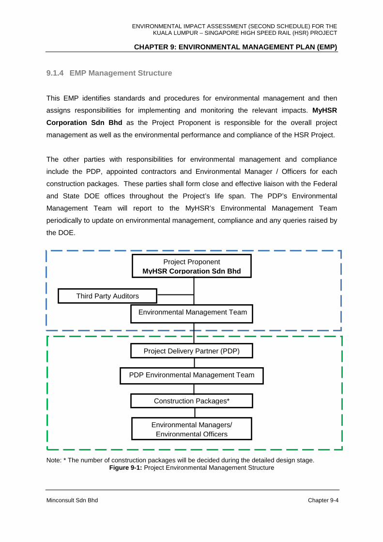
ENVIRONMENTAL IMPACT ASSESSMENT (SECOND SCHEDULE) FOR THE KUALA LUMPUR – SINGAPORE HIGH SPEED RAIL (HSR) PROJECT
CHAPTER 9: ENVIRONMENTAL MANAGEMENT PLAN (EMP)
Minconsult Sdn Bhd Chapter 9-4
9.1.4 EMP Management Structure
This EMP identifies standards and procedures for environmental management and then
assigns responsibilities for implementing and monitoring the relevant impacts. MyHSR
Corporation Sdn Bhd as the Project Proponent is responsible for the overall project
management as well as the environmental performance and compliance of the HSR Project.
The other parties with responsibilities for environmental management and compliance
include the PDP, appointed contractors and Environmental Manager / Officers for each
construction packages. These parties shall form close and effective liaison with the Federal
and State DOE offices throughout the Project’s life span. The PDP’s Environmental
Management Team will report to the MyHSR’s Environmental Management Team
periodically to update on environmental management, compliance and any queries raised by
the DOE.
Note: * The number of construction packages will be decided during the detailed design stage.
Figure 9-1: Project Environmental Management Structure
Environmental Managers/ Environmental Officers
Construction Packages*
PDP Environmental Management Team
Project Delivery Partner (PDP)
Environmental Management Team
Third Party Auditors
Project Proponent MyHSR Corporation Sdn Bhd
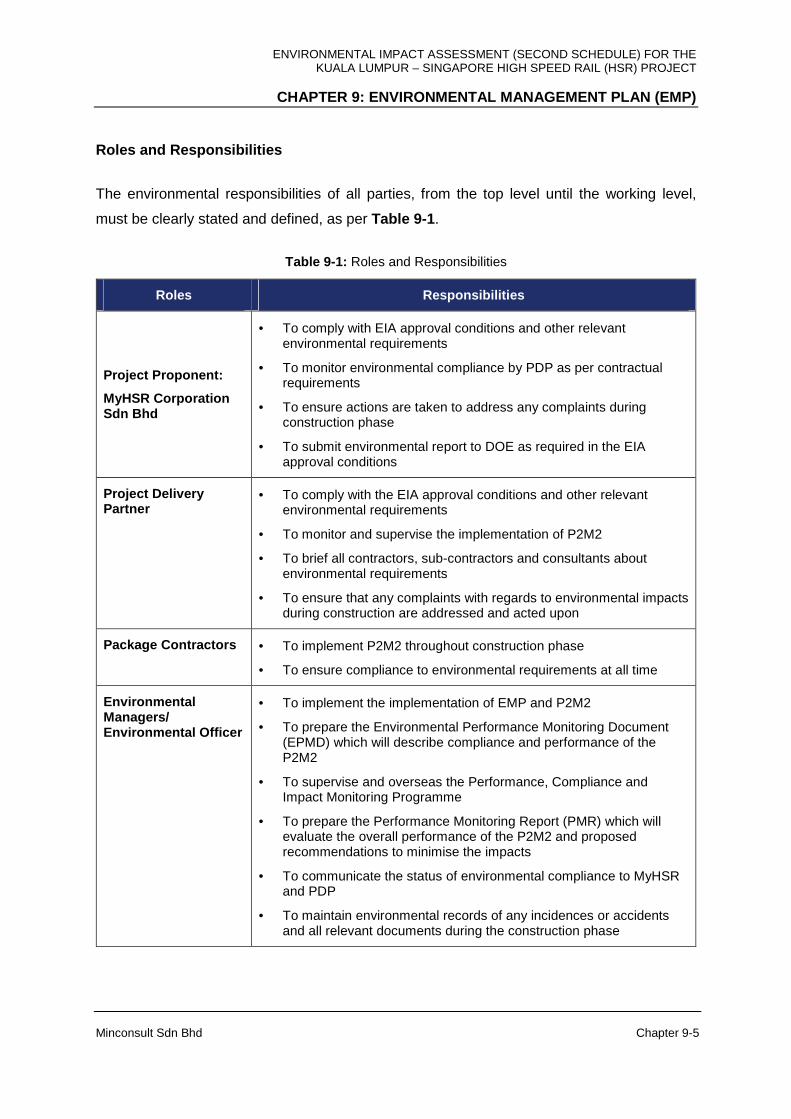
ENVIRONMENTAL IMPACT ASSESSMENT (SECOND SCHEDULE) FOR THE KUALA LUMPUR – SINGAPORE HIGH SPEED RAIL (HSR) PROJECT
CHAPTER 9: ENVIRONMENTAL MANAGEMENT PLAN (EMP)
Minconsult Sdn Bhd Chapter 9-5
Roles and Responsibilities
The environmental responsibilities of all parties, from the top level until the working level,
must be clearly stated and defined, as per Table 9-1 .
Table 9-1: Roles and Responsibilities
Roles Responsibilities
Project Proponent:
MyHSR Corporation Sdn Bhd
• To comply with EIA approval conditions and other relevant environmental requirements
• To monitor environmental compliance by PDP as per contractual requirements
• To ensure actions are taken to address any complaints during construction phase
• To submit environmental report to DOE as required in the EIA approval conditions
Project Delivery Partner
• To comply with the EIA approval conditions and other relevant environmental requirements
• To monitor and supervise the implementation of P2M2
• To brief all contractors, sub-contractors and consultants about environmental requirements
• To ensure that any complaints with regards to environmental impacts during construction are addressed and acted upon
Package Contractors • To implement P2M2 throughout construction phase
• To ensure compliance to environmental requirements at all time
Environmental Managers/ Environmental Officer
• To implement the implementation of EMP and P2M2
• To prepare the Environmental Performance Monitoring Document (EPMD) which will describe compliance and performance of the P2M2
• To supervise and overseas the Performance, Compliance and Impact Monitoring Programme
• To prepare the Performance Monitoring Report (PMR) which will evaluate the overall performance of the P2M2 and proposed recommendations to minimise the impacts
• To communicate the status of environmental compliance to MyHSR and PDP
• To maintain environmental records of any incidences or accidents and all relevant documents during the construction phase

ENVIRONMENTAL IMPACT ASSESSMENT (SECOND SCHEDULE) FOR THE KUALA LUMPUR – SINGAPORE HIGH SPEED RAIL (HSR) PROJECT
CHAPTER 9: ENVIRONMENTAL MANAGEMENT PLAN (EMP)
Minconsult Sdn Bhd Chapter 9-6
9.1.5 Scope of EMP
The EMP encompasses five (5) main categories of activities, they being:
(a) Land Disturbing Pollution Prevention and Mitigation Measures (LD-P2M2);
(b) Performance Monitoring Programme (PMP);
(c) Impact Monitoring Programme (IMP);
(d) Environmental Auditing Programme (EAP).
(e) Environmental Mainstreaming
There is a need for the EMP to establish effective and efficient Land Disturbing Pollution
Prevention and Mitigation Measures (LD-P2M2) . The focus of the LD-P2M2 is on the
prevention, mitigation and control of the discharge from the development area containing
the major pollutant (suspended solids) resulting from land disturbing activities. Details of
Pollution Prevention and Mitigating Measure (P2M2s) for this section are based on the
mitigating measures in Chapter 8 and incorporation with the Condition of Approval (COA) of
EIA report from DOE.
All relevant parties including Project Proponent, PDP, Contractors, Environmental Mangers /
Environmental Officers (EOs) understand LD-P2M2 in order to facilitate compliance with the
minimum standards requirements.
All relevant P2M2s especially temporary Best Management Practices (BMPs) at the
construction phase are installed and maintained to mitigate the potential pollution due to
land disturbing activities. This P2M2 should include step and BMPs of following where
applicable to proposed project:
• Schedule of Phasing, Staging and Sequencing
• Schedule Site Meeting
• Construction Markers
• Stabilized Construction Entrance
• Stream/drainage way/waterway/watercourse buffers
• Perimeter control
• Sediment Basin / Trap
ENVIRONMENTAL IMPACT ASSESSMENT (SECOND SCHEDULE) FOR THE KUALA LUMPUR – SINGAPORE HIGH SPEED RAIL (HSR) PROJECT
CHAPTER 9: ENVIRONMENTAL MANAGEMENT PLAN (EMP)
Minconsult Sdn Bhd Chapter 9-7
• Runoff Management
• Temporary or permanent watercourse diversion
• Temporary or permanent watercourse crossing
• Temporary or permanent roadways
• Temporary Stabilization
• Stockpile Soil Management
• Spoil Management Area (Disposal Area)
• Dewatering practices
• Active Treatment System (ATS)
• Corrective Actions
• Site Inspections
• Maintenance
• Standard and Specification for P2M2s
Performance Monitoring Programmes (PMP) is of importance as they will assist in
complementing the interpretation and deduction of LD-P2M2 data. In this respect, the PMP
will focus on ascertaining whether pollution control and abatement equipment and plant, and
other structural/non-structural measures, are performing to their design intent. Such a
monitoring programme will assist in deducing whether such plant and equipment are
contributing towards the deteriorating status of environmental components that are being
monitored for their compliance with appropriate standards.
Impact Monitoring Programmes (IMP) is required in order to monitor and assess the
actual impacts of the predicted impacts that are uncertain. Such a programme will enable
those uncertain impacts to be accurately defined in terms of its extent of impact.
Environmental Auditing Programmes (EAP) is required in order to ensure that the
commitments made by the Project Proponent to protect the environment from deterioration
and degradation throughout the Project’s lifespan, so far as is reasonably practicable, will be
fulfilled. The EAP should be undertaken during the development such as construction and
operational phase. This would enable the Project Proponent to verify the effectiveness of the
system and provide adequate time to incorporate the necessary changes to suit the Project
ENVIRONMENTAL IMPACT ASSESSMENT (SECOND SCHEDULE) FOR THE KUALA LUMPUR – SINGAPORE HIGH SPEED RAIL (HSR) PROJECT
CHAPTER 9: ENVIRONMENTAL MANAGEMENT PLAN (EMP)
Minconsult Sdn Bhd Chapter 9-8
Proponent’s requirements as well as train the necessary manpower that would be required
to implement the EMP for the entire life of the HSR Project.
Environmental Mainstreaming has been integrated into all the recent regulation of the
DOE. Self-regulation has been adopted by DOE as a long-term goal to be achieved and a
culture to be inculcated within the regulated sectors through mainstreaming of environmental
agenda. This approach to pollution control is a win-win concept which has shown to accrue
positive results in improved environmental image of companies, increased public
acceptability of projects, optimal operation of pollution control systems (PCSs), prevention of
PCS failure, cost savings in PCS operation, systematic management of performance
monitoring data and improved regulatory compliance on sustained basis. On wider
perspective, self-regulation which complements the existing command and control approach
of the DOE, would result in cultivating environmental ownership and excellence in
environmental commitment and in environmental regulatory compliance from the regulated
sectors.
The EMP is to be executed in six (6) stages as described below:
• Section 9.2 outlines the environmental mainstreaming framework to be adopted
by the Project Proponent in the implementation of this EMP.
• Section 9.3 outlines the environmental monitoring requirements that should be
followed pre-construction phase of the Project.
• Section 9.4 outlines the environmental monitoring requirements that should be
followed during the construction phase of the Project; taking due cognizance of the
environmental protection requirements needed to ensure compliance with the
relevant environmental performance standards established for this Project.
• Section 9.5 outlines the environmental monitoring requirements that should be
adhered to during the operational phase (normal or otherwise) of the Project.
• Section 9.6 outlines the performance monitoring requirements for this Project.
ENVIRONMENTAL IMPACT ASSESSMENT (SECOND SCHEDULE) FOR THE KUALA LUMPUR – SINGAPORE HIGH SPEED RAIL (HSR) PROJECT
CHAPTER 9: ENVIRONMENTAL MANAGEMENT PLAN (EMP)
Minconsult Sdn Bhd Chapter 9-9
• Section 9.7 outlines the environmental auditing requirements that should be adhered
to during the construction and operational phase of the Project.
9.2 ENVIRONMENTAL MAINSTREAMING
Environmental Mainstreaming Elements
A. Environmental Policy (EP)
The policy generated basically represents the Project Proponent’s assurance to protect,
restore, and enhance the environmental quality at the site. It embodies a set of objectives,
which directs the formulation of the EMP.
Project Proponent need to be dedicated towards conservation and protection of the
environment and continues to make these initiatives their priorities in their policy decisions
which comply with all relevant legislative requirements.
B. Competent Person
It is essential for the Project Proponent to complete the implementation of the Project with
minimal impact to the environment. In order to achieve this, designation competent
personnel is important to ensure proper planning and communication with DOE is
accomplished. Competent person position should be commensurate with their
responsibilities. Their roles and responsibility are to facilitate the overall environmental
management in term of guided self-regulation documentation and implementation.
C. Performance Monitoring (PM)
Project Proponent must carry out performance monitoring as it is a proactive and preventive
monitoring of process to ensure PCSs are optimally operated and maintained. PM should
be incorporated as a standard code of practice (SOP) which must be implemented and
strictly enforced.
ENVIRONMENTAL IMPACT ASSESSMENT (SECOND SCHEDULE) FOR THE KUALA LUMPUR – SINGAPORE HIGH SPEED RAIL (HSR) PROJECT
CHAPTER 9: ENVIRONMENTAL MANAGEMENT PLAN (EMP)
Minconsult Sdn Bhd Chapter 9-10
D. Environmental Performance Monitoring Committee ( EPMC)
The successful implementation of Guided Self- Regulation (GSR) requires commitment of
all members in the committees of the organisational. EPMC is a permanent committee at
the operational level which is established to monitor the construction, operation,
maintenance, and performance of PCS, waste reduction targets, etc. This commitment
should begin at the highest level of management by formulating an organisational structure
which defines roles, responsibilities and authorities of each operational management staff
toward environmental compliance. The EPMC must meet at a minimum once a month and
meeting records must be maintained.
E. Environmental Regulatory Compliance Monitoring C ommittee (ERCMC)
The committee at the policy level must be set up to monitor the implementation and the
effectiveness of environmental policy and for formulating additional policy elements if
necessary. Implication of new environmental regulatory amendments, environmental
implication of company expansion program, environmental improvement projects, major
initiative to address major noncompliance issues, procurement and purchasing policy in
relation with environmental implications are subject matters discusses at ERCMC meetings.
The company’s compliance with all the regulations enforced by the DOE comes under the
scrutiny and responsibility of this committee. The ERCMC is chaired by the company’s
highest level with members comprised of the heads of the departments. The ERCMC must
meet once a year and meeting record must be maintained.
F. Record Keeping
A systematic procedure and record keeping system must be established to keep records
related to the operation, maintenance and performance of PCS, upset condition and the
chemical usage.
G. Data Analysis and Interpretation
The performance monitoring data, compliance monitoring data, upset condition data, and
operation and maintenance data must be analysed and presented in suitable format for
presentation at EPMC meetings and for decision making purposes.
ENVIRONMENTAL IMPACT ASSESSMENT (SECOND SCHEDULE) FOR THE KUALA LUMPUR – SINGAPORE HIGH SPEED RAIL (HSR) PROJECT
CHAPTER 9: ENVIRONMENTAL MANAGEMENT PLAN (EMP)
Minconsult Sdn Bhd Chapter 9-11
H. Discharge Monitoring
Discharge of effluent to the environment must be monitored on a schedule basis and
reported according to regulatory requirements. Wherever applicable, real time monitoring
system such as equivalent system for effluent monitoring must be investigated for
implementation.
I. Reporting and Communication
A reporting procedure and an internal communication channel within the company must be
officially established for reporting and communicating environmental performance to the
relevant company personnel. This creates companywide awareness and concern for the
environment and for environmental performance. Regulatory environmental compliance and
excellent performance is an achievement and pride which should be shared among the
company staff.
Budget Allocation and Staffing Requirement
Project Proponent needs to allocate sufficient budget for the implementation of the
environmental mainstreaming (EM) initiative. Top level commitment in the form of budget
allocation is a prerequisite for the success of the initiative.
Implementation Schedule and Monitoring
Top management must understand the environmental mainstreaming (EM) concept and
trickle down to those involved in the implementation phase of mainstreaming initiative. The
schedule of implementation must be drawn up and EM implementation program monitored
by the highest level in the organisation. It is recommended that the EM initiative should be
completed within six (6) to 12 months.
Reporting to the DOE
Within six (6) months from the commencement of the implementation of the environmental
mainstreaming (EM) initiative, an implementation status report must be submitted to the
DOE.

ENVIRONMENTAL IMPACT ASSESSMENT (SECOND SCHEDULE) FOR THE KUALA LUMPUR – SINGAPORE HIGH SPEED RAIL (HSR) PROJECT
CHAPTER 9: ENVIRONMENTAL MANAGEMENT PLAN (EMP)
Minconsult Sdn Bhd Chapter 9-12
LD-P2M2 Submission Checklist
All relevant checklist items regarding the Proposed Project need to be identified, addresses,
discussed, assessed, evaluated and presented in the LD-P2M2 document. Checklist items
are as below:
• Project Activity and Implementation
• Information and Analysis on Project Development
• Map of site plan with the existing site condition (pre-development)
• Map of site development plan
*Note: Details of all above item can be referred in Guidance Document for the preparation of
the document on Land-Disturbing Pollution Prevention and Mitigating Measure (LD-P2M2)
(Appendix 4 of EIA Guidelines in Malaysia, 2016)
9.3 ENVIRONMENTAL MANAGEMENT PROGRAMME – PRE-
CONSTRUCTION STAGE
Pre-construction plans have to be initiated early so that activities which can affect the
environment can be identified early and plans for mitigation measures initiated accordingly.
The pertinent pre-construction activities that would require adequate planning and prior
deliberation should be identified. These activities have been highlighted in the preceding
chapters of the main text.
The ad-hoc monitoring undertaken by the EIA Consultant during the course of this EIA study
would constitute the monitoring programme for the preliminary stage. The parameters and
the locations of these monitoring points are indicated in Chapter 6 . The selection of these
sampling stations, and the environmental parameters to be monitored, are based on
anticipated impacts induced by the project on the environment within the ZOI. The results
from the ad-hoc monitoring would therefore form the baseline data with which the
subsequent monitoring results would be compared with to determine the actual real time
impacts of the project on the environment. The parameters and sampling stations for the
ENVIRONMENTAL IMPACT ASSESSMENT (SECOND SCHEDULE) FOR THE KUALA LUMPUR – SINGAPORE HIGH SPEED RAIL (HSR) PROJECT
CHAPTER 9: ENVIRONMENTAL MANAGEMENT PLAN (EMP)
Minconsult Sdn Bhd Chapter 9-13
subsequent stages of the project shall be similar to that of the ad-hoc monitoring programme
to facilitate comparison of data at various stages of the project and to determine the impacts
of the project activities on the environment.
9.4 ENVIRONMENTAL MANAGEMENT PROGRAMME –
CONSTRUCTION PHASE
9.4.1 Introduction
The EIA Consultants are of the opinion that a detailed Environmental Management Quality
Procedure (EMQP) should be drawn up in order to define the environmental monitoring (and
management) programmes to be implemented during the construction of the Project. The
EMQP will be a series of environmental management guidelines, standards and criteria that
will be imposed by the Project Proponent (in liaison with its Consultant) on all contractors
involved in the construction of the Project. The purpose of this will be to ensure that
satisfactory levels of environmental monitoring and compliance will be achieved during and
after all construction activities in or around the project sites have been initiated.
The standards to be established within the ambit of the EMP should be agreed with the
relevant authorities and government departments, namely the DOE. It should include the
measurement of ambient noise and vibration levels, air and water qualities similar to that
carried out under the EIA Study, as well as qualitative studies of other environmental
indicators such as land contamination, public health status, ecological status and intensity of
traffic circulations and impedances.
9.4.2 General Requirements
The Project Proponent and its appointed contractors will be required to comply with all legal
duties and obligations regarding the protection of the environment (in particular, those laid
down in the Environmental Quality Act 1974), and further relevant legislation introduced prior
to the commencement of construction, and all regulations, standards and guidelines made

ENVIRONMENTAL IMPACT ASSESSMENT (SECOND SCHEDULE) FOR THE KUALA LUMPUR – SINGAPORE HIGH SPEED RAIL (HSR) PROJECT
CHAPTER 9: ENVIRONMENTAL MANAGEMENT PLAN (EMP)
Minconsult Sdn Bhd Chapter 9-14
under the purview of such legislation. The Project Proponent will also be ultimately
responsible for the implementation of the EMP throughout the construction phase.
A full-time Environmental Manager, employed by the Project Proponent, shall have the
authority to regularly monitor the works and to audit construction activities and management
practices on site. The Environmental Manager should have the authority to halt any activity
found on site causing a breach of the EMQP, until revised working methods have been
agreed and implemented.
9.4.3 Construction and Development Activities
Normally the administration of construction contracts rests with the PDP team and therefore
the task of environmental monitoring and management during construction will be their
responsibility. The EPMC on their part will be assisted by their Environmental Manager. The
contractor(s) involved in the construction of the HSR system and supporting facilities have
an important role in the management of the environment. The contractor is expected to have
particular responsibility in the protection of the environment with regards to (a) air pollution,
(b) water pollution, (c) noise and vibration induced pollution, (d) terrestrial and marine
ecosystems, (e) traffic management and (f) waste disposal.
9.4.4 Environmental Monitoring During Construction Phase
9.4.4.1 Air Quality
Table 9-2 below describes the standards and procedures for monitoring air quality during the
construction phase.

ENVIRONMENTAL IMPACT ASSESSMENT (SECOND SCHEDULE) FOR THE KUALA LUMPUR – SINGAPORE HIGH SPEED RAIL (HSR) PROJECT
CHAPTER 9: ENVIRONMENTAL MANAGEMENT PLAN (EMP)
Minconsult Sdn Bhd Chapter 9-15
Table 9-2: Monitoring of Air Quality during Construction Phase
Issue Standards and Procedures
Air quality
monitoring
programme
The Project Proponent to submit programme for air quality
monitoring to the DOE before the commencement of any
construction or development activity. Details to be submitted will
include locations of the air quality monitoring stations, parameters
to be monitored, frequency of sampling, equipment to be used
(dust deposition gauges, air samplers) and submission of the
monitoring results.
The air quality parameters to be monitored should comply to the
EIA approval condition. The frequency of monitoring should be
once a month or as per the approved EIA condition and the report
submitted to DOE once every three (3) months or as per the
approved EIA condition. Based on the impact assessment study,
the proposed monitoring points are listed in Appendix 9A and
Appendix 6J .
Submission and
Documentation
The Project Proponent shall submit to the DOE State the results of
the monitoring programme once every three (3) months or as per
the approved EIA condition. Relevant forms and documents should
also be submitted for the activities under the Clear Air Regulations
1978 that would require further approval from the DOE. The status
of compliance to the Conditions of Approval of the EIA shall be
submitted to DOE once every three (3) months (including relevant
forms).
Proposed Parameters to be Monitored
Proposed parameters to be monitored are Total Suspended Particulate (TSP), PM10, NOx
and CO. The air quality standards to be complied with are provided in Chapter 6 .
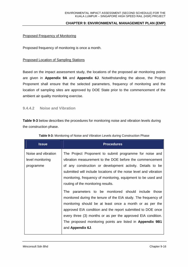
ENVIRONMENTAL IMPACT ASSESSMENT (SECOND SCHEDULE) FOR THE KUALA LUMPUR – SINGAPORE HIGH SPEED RAIL (HSR) PROJECT
CHAPTER 9: ENVIRONMENTAL MANAGEMENT PLAN (EMP)
Minconsult Sdn Bhd Chapter 9-16
Proposed Frequency of Monitoring
Proposed frequency of monitoring is once a month.
Proposed Location of Sampling Stations
Based on the impact assessment study, the locations of the proposed air monitoring points
are given in Appendix 9A and Appendix 6J . Notwithstanding the above, the Project
Proponent shall ensure that the selected parameters, frequency of monitoring and the
location of sampling sites are approved by DOE State prior to the commencement of the
ambient air quality monitoring exercise.
9.4.4.2 Noise and Vibration
Table 9-3 below describes the procedures for monitoring noise and vibration levels during
the construction phase.
Table 9-3: Monitoring of Noise and Vibration Levels during Construction Phase
Issue Procedures
Noise and vibration
level monitoring
programme
The Project Proponent to submit programme for noise and
vibration measurement to the DOE before the commencement
of any construction or development activity. Details to be
submitted will include locations of the noise level and vibration
monitoring, frequency of monitoring, equipment to be used and
routing of the monitoring results.
The parameters to be monitored should include those
monitored during the tenure of the EIA study. The frequency of
monitoring should be at least once a month or as per the
approved EIA condition and the report submitted to DOE once
every three (3) months or as per the approved EIA condition.
The proposed monitoring points are listed in Appendix 9B1
and Appendix 6J .
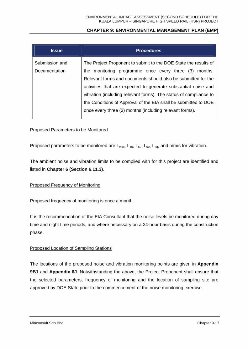
ENVIRONMENTAL IMPACT ASSESSMENT (SECOND SCHEDULE) FOR THE KUALA LUMPUR – SINGAPORE HIGH SPEED RAIL (HSR) PROJECT
CHAPTER 9: ENVIRONMENTAL MANAGEMENT PLAN (EMP)
Minconsult Sdn Bhd Chapter 9-17
Issue Procedures
Submission and
Documentation
The Project Proponent to submit to the DOE State the results of
the monitoring programme once every three (3) months.
Relevant forms and documents should also be submitted for the
activities that are expected to generate substantial noise and
vibration (including relevant forms). The status of compliance to
the Conditions of Approval of the EIA shall be submitted to DOE
once every three (3) months (including relevant forms).
Proposed Parameters to be Monitored
Proposed parameters to be monitored are Lmax, L10, L50, L90, Leq, and mm/s for vibration.
The ambient noise and vibration limits to be complied with for this project are identified and
listed in Chapter 6 (Section 6.11.3) .
Proposed Frequency of Monitoring
Proposed frequency of monitoring is once a month.
It is the recommendation of the EIA Consultant that the noise levels be monitored during day
time and night time periods, and where necessary on a 24-hour basis during the construction
phase.
Proposed Location of Sampling Stations
The locations of the proposed noise and vibration monitoring points are given in Appendix
9B1 and Appendix 6J . Notwithstanding the above, the Project Proponent shall ensure that
the selected parameters, frequency of monitoring and the location of sampling site are
approved by DOE State prior to the commencement of the noise monitoring exercise.
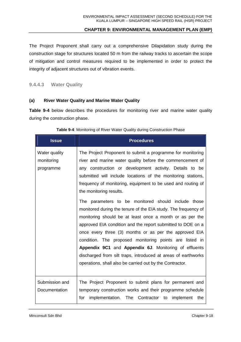
ENVIRONMENTAL IMPACT ASSESSMENT (SECOND SCHEDULE) FOR THE KUALA LUMPUR – SINGAPORE HIGH SPEED RAIL (HSR) PROJECT
CHAPTER 9: ENVIRONMENTAL MANAGEMENT PLAN (EMP)
Minconsult Sdn Bhd Chapter 9-18
The Project Proponent shall carry out a comprehensive Dilapidation study during the
construction stage for structures located 50 m from the railway tracks to ascertain the scope
of mitigation and control measures required to be implemented in order to protect the
integrity of adjacent structures out of vibration events.
9.4.4.3 Water Quality
(a) River Water Quality and Marine Water Quality
Table 9-4 below describes the procedures for monitoring river and marine water quality
during the construction phase.
Table 9-4 : Monitoring of River Water Quality during Construction Phase
Issue Procedures
Water quality
monitoring
programme
The Project Proponent to submit a programme for monitoring
river and marine water quality before the commencement of
any construction or development activity. Details to be
submitted will include locations of the monitoring stations,
frequency of monitoring, equipment to be used and routing of
the monitoring results.
The parameters to be monitored should include those
monitored during the tenure of the EIA study. The frequency of
monitoring should be at least once a month or as per the
approved EIA condition and the report submitted to DOE on a
once every three (3) months or as per the approved EIA
condition. The proposed monitoring points are listed in
Appendix 9C1 and Appendix 6J . Monitoring of effluents
discharged from silt traps, introduced at areas of earthworks
operations, shall also be carried out by the Contractor.
Submission and
Documentation
The Project Proponent to submit plans for permanent and
temporary construction works and their programme schedule
for implementation. The Contractor to implement the
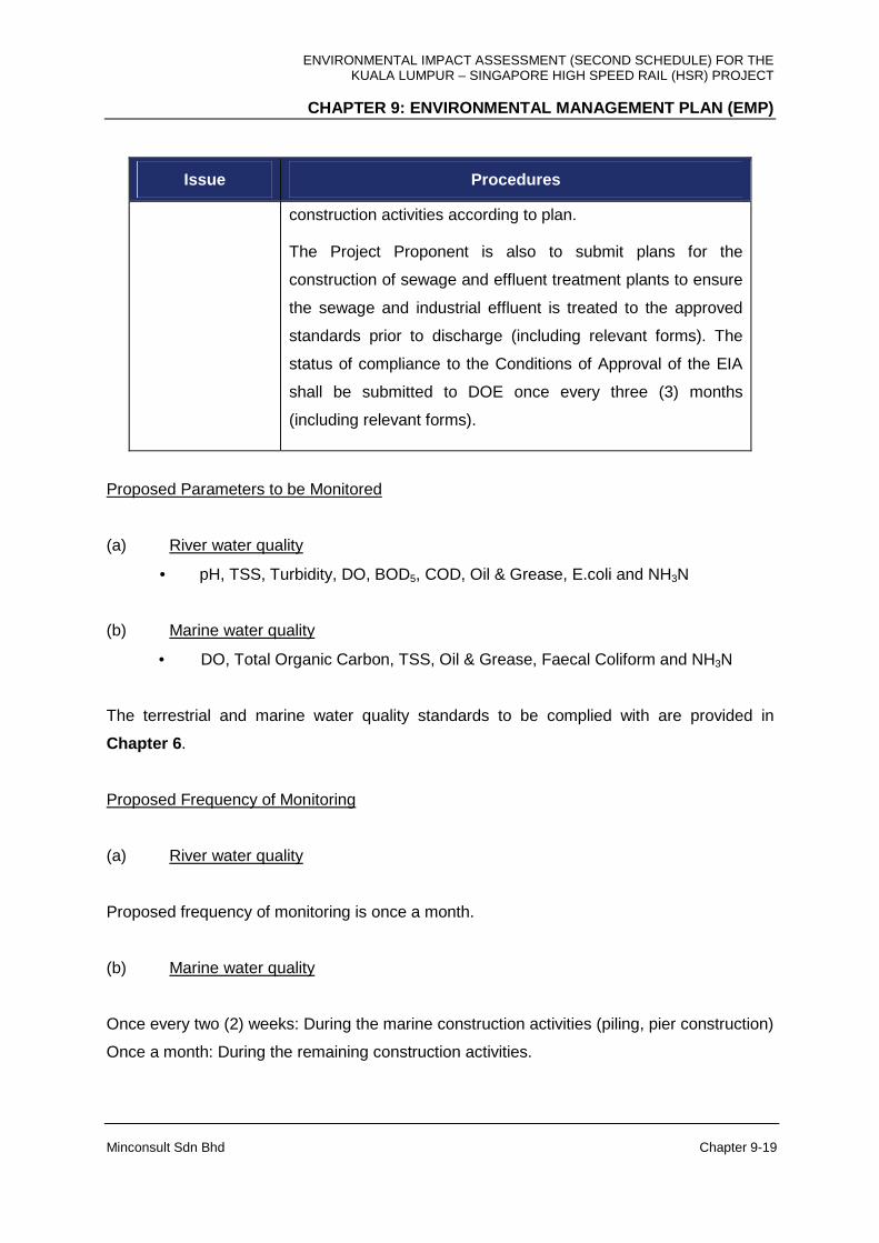
ENVIRONMENTAL IMPACT ASSESSMENT (SECOND SCHEDULE) FOR THE KUALA LUMPUR – SINGAPORE HIGH SPEED RAIL (HSR) PROJECT
CHAPTER 9: ENVIRONMENTAL MANAGEMENT PLAN (EMP)
Minconsult Sdn Bhd Chapter 9-19
Issue Procedures
construction activities according to plan.
The Project Proponent is also to submit plans for the
construction of sewage and effluent treatment plants to ensure
the sewage and industrial effluent is treated to the approved
standards prior to discharge (including relevant forms). The
status of compliance to the Conditions of Approval of the EIA
shall be submitted to DOE once every three (3) months
(including relevant forms).
Proposed Parameters to be Monitored
(a) River water quality
• pH, TSS, Turbidity, DO, BOD5, COD, Oil & Grease, E.coli and NH3N
(b) Marine water quality
• DO, Total Organic Carbon, TSS, Oil & Grease, Faecal Coliform and NH3N
The terrestrial and marine water quality standards to be complied with are provided in
Chapter 6 .
Proposed Frequency of Monitoring
(a) River water quality
Proposed frequency of monitoring is once a month.
(b) Marine water quality
Once every two (2) weeks: During the marine construction activities (piling, pier construction)
Once a month: During the remaining construction activities.

ENVIRONMENTAL IMPACT ASSESSMENT (SECOND SCHEDULE) FOR THE KUALA LUMPUR – SINGAPORE HIGH SPEED RAIL (HSR) PROJECT
CHAPTER 9: ENVIRONMENTAL MANAGEMENT PLAN (EMP)
Minconsult Sdn Bhd Chapter 9-20
Proposed Location of Sampling Stations
The locations of the proposed water monitoring points are given in Appendix 9C1 and
Appendix 6J . Notwithstanding the above, the Project Proponent shall ensure that the
selected parameters, frequency of monitoring and the location of sampling site are approved
by DOE State prior to the commencement of the water monitoring exercise.
Other Components
Monitoring is not required during the construction phase for the following components:
1) Current Speed
2) Marine Navigation
3) Plankton
4) Macrobenthos
5) Fish Fauna
(b) Silt Trap Discharge
Inspection of the temporary earth drains, check dam, sediment basins, silt fence and earth
bund be carried out immediately after an episode of heavy or prolonged downpour. The
LDP2M2 Inspection Checklist shall be prepared specific to the site condition. Table 9-5
shows the schedule of P2M2 inspection and maintenance during the construction phase.
Table 9-5: Schedule of Inspection and Maintenance
P2M2 Type of Maintenance Frequency of Inspection
Frequency of Maintenance
Temporary Earth Drain To remove silt and check flow
Mulch To reapply gap area
Close Turfing To replant at gap area
Hydroseeding To reapply at gap area
Erosion Blanket To replace damaged section
Sediment Basin To remove silt
Silt Trap To remove silt
Once a week inspection after
each raining episode
Once every two (2) weeks
(1st week & 3rd week of the
month)
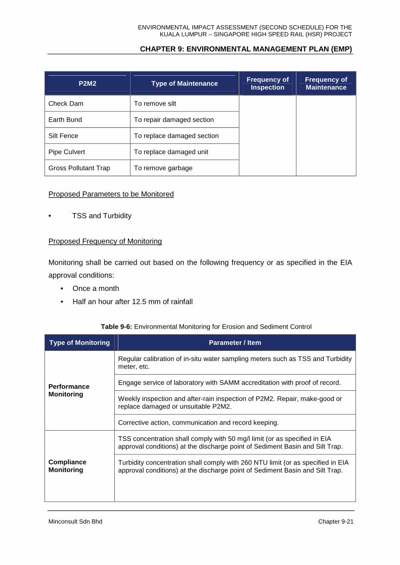
ENVIRONMENTAL IMPACT ASSESSMENT (SECOND SCHEDULE) FOR THE KUALA LUMPUR – SINGAPORE HIGH SPEED RAIL (HSR) PROJECT
CHAPTER 9: ENVIRONMENTAL MANAGEMENT PLAN (EMP)
Minconsult Sdn Bhd Chapter 9-21
P2M2 Type of Maintenance Frequency of Inspection
Frequency of Maintenance
Check Dam To remove silt
Earth Bund To repair damaged section
Silt Fence To replace damaged section
Pipe Culvert To replace damaged unit
Gross Pollutant Trap To remove garbage
Proposed Parameters to be Monitored
• TSS and Turbidity
Proposed Frequency of Monitoring
Monitoring shall be carried out based on the following frequency or as specified in the EIA
approval conditions:
• Once a month
• Half an hour after 12.5 mm of rainfall
Table 9-6: Environmental Monitoring for Erosion and Sediment Control
Type of Monitoring Parameter / Item
Regular calibration of in-situ water sampling meters such as TSS and Turbidity meter, etc.
Engage service of laboratory with SAMM accreditation with proof of record.
Weekly inspection and after-rain inspection of P2M2. Repair, make-good or replace damaged or unsuitable P2M2.
Performance Monitoring
Corrective action, communication and record keeping.
TSS concentration shall comply with 50 mg/l limit (or as specified in EIA approval conditions) at the discharge point of Sediment Basin and Silt Trap.
Compliance Monitoring
Turbidity concentration shall comply with 260 NTU limit (or as specified in EIA approval conditions) at the discharge point of Sediment Basin and Silt Trap.
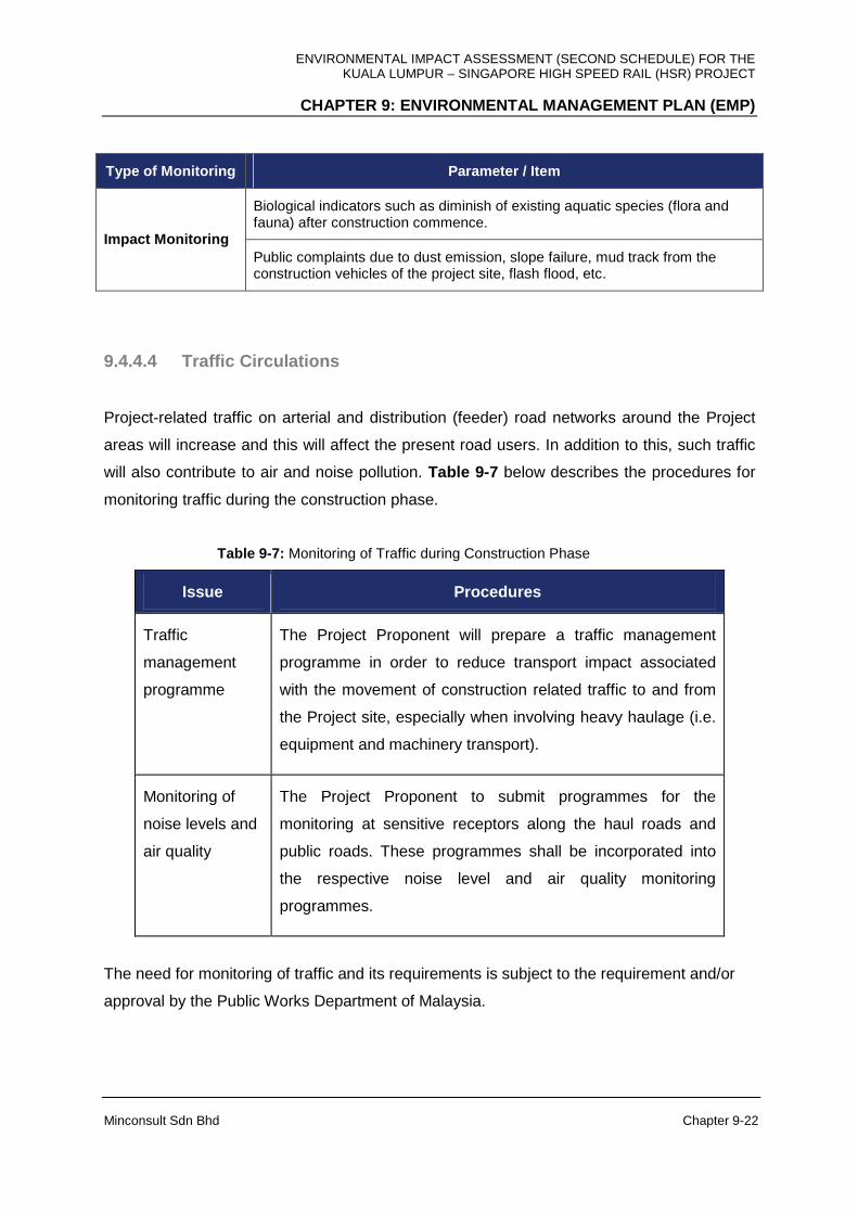
ENVIRONMENTAL IMPACT ASSESSMENT (SECOND SCHEDULE) FOR THE KUALA LUMPUR – SINGAPORE HIGH SPEED RAIL (HSR) PROJECT
CHAPTER 9: ENVIRONMENTAL MANAGEMENT PLAN (EMP)
Minconsult Sdn Bhd Chapter 9-22
Type of Monitoring Parameter / Item
Biological indicators such as diminish of existing aquatic species (flora and fauna) after construction commence.
Impact Monitoring Public complaints due to dust emission, slope failure, mud track from the construction vehicles of the project site, flash flood, etc.
9.4.4.4 Traffic Circulations
Project-related traffic on arterial and distribution (feeder) road networks around the Project
areas will increase and this will affect the present road users. In addition to this, such traffic
will also contribute to air and noise pollution. Table 9-7 below describes the procedures for
monitoring traffic during the construction phase.
Table 9-7: Monitoring of Traffic during Construction Phase
Issue Procedures
Traffic
management
programme
The Project Proponent will prepare a traffic management
programme in order to reduce transport impact associated
with the movement of construction related traffic to and from
the Project site, especially when involving heavy haulage (i.e.
equipment and machinery transport).
Monitoring of
noise levels and
air quality
The Project Proponent to submit programmes for the
monitoring at sensitive receptors along the haul roads and
public roads. These programmes shall be incorporated into
the respective noise level and air quality monitoring
programmes.
The need for monitoring of traffic and its requirements is subject to the requirement and/or
approval by the Public Works Department of Malaysia.
ENVIRONMENTAL IMPACT ASSESSMENT (SECOND SCHEDULE) FOR THE KUALA LUMPUR – SINGAPORE HIGH SPEED RAIL (HSR) PROJECT
CHAPTER 9: ENVIRONMENTAL MANAGEMENT PLAN (EMP)
Minconsult Sdn Bhd Chapter 9-23
9.4.4.5 Waste Generation and Management
Significant amounts of biomass will be generated during clearing of land areas to
accommodate the HSR facilities. In addition some amount of construction debris would be
generated during the construction and commissioning stages of the project. The disposal of
these wastes unless controlled, can have an impact on the environment. The Project
Proponent should prepare a programme for waste management, and strategy for
minimization and reuse. The Project Proponent shall inform the DOE as well as the local
authority of their plans for disposal of solid wastes off-site (to approve disposal sites). This
Plan should be disseminated to the Project’s Contractors and Suppliers (producers’
responsibility to manage used items of packaging etc.). The Project Proponent should
develop a programme to monitor the contractors’ efforts in effective waste management.
The Project Proponent should instill a programme to enhance recycling and reuse efforts
amongst its contractors and suppliers, and develop a tracking programme to monitor the
effectiveness of this programme and share the results with the DOE
Some amount of scheduled wastes is also expected during the construction and
commissioning stages of the project, that include, amongst others, oil-contaminated wastes
(i.e. spent oil/grease used for construction vehicles), spent organic solvents and paint
sludge/residues. These scheduled wastes shall be temporarily stored within the site until
such time when it is sent to Kualiti Alam’s Scheduled Wastes Treatment Facility in Bukit
Nenas or recycling facilities approved by the DOE.
Similarly, some amount of sewage related wastes is also expected during the construction
and commissioning stage of the project that would be generated from the toilet facilities
provided at the site offices and workers’ accommodations. These facilities shall be
constructed in accordance to the requirements of the SPAN, the Sewerage Services
Department and IWK. These facilities should be desludged on a regular basis by Indah
Water Konsortium (IWK) or its appointed contractors; and disposed at the nearest IWK
Sludge Disposal Facility. Table 9-8 below describes the procedures for monitoring waste
generation and management during the construction phase.
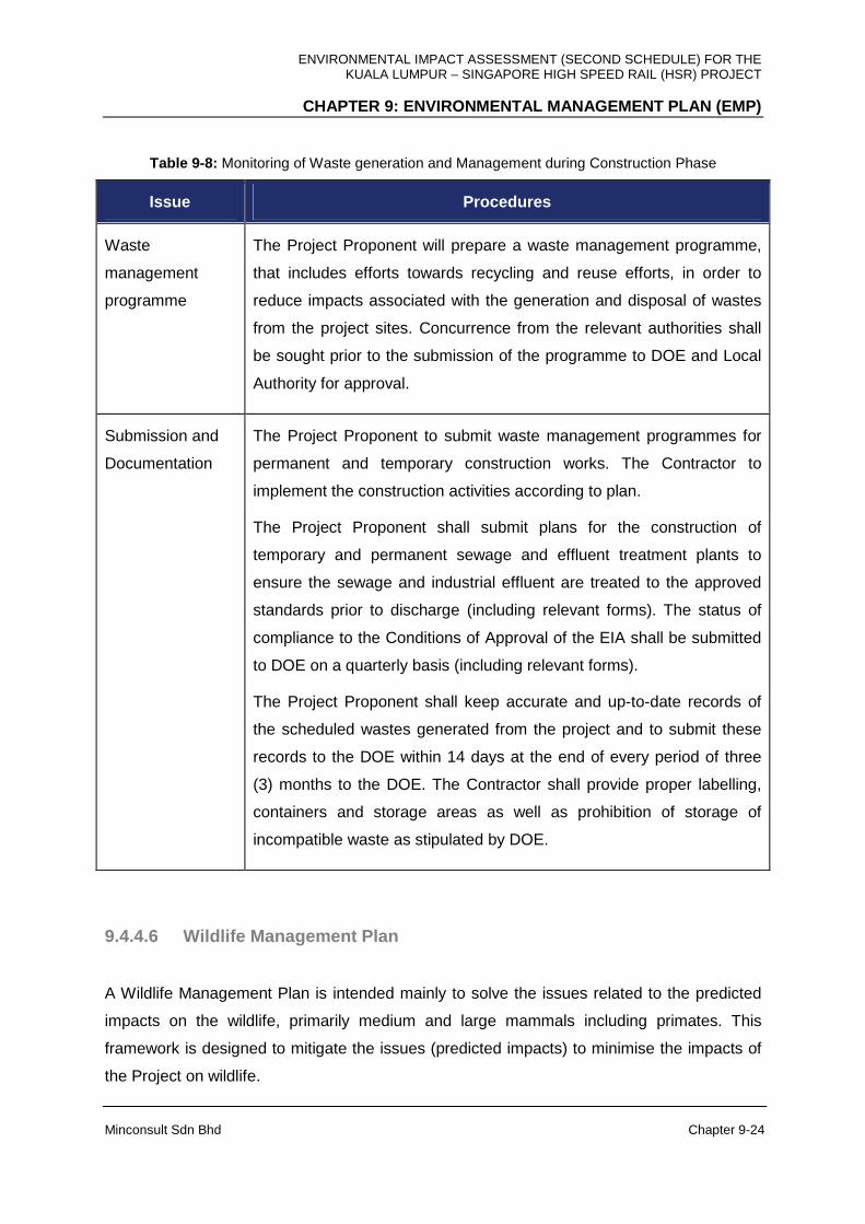
ENVIRONMENTAL IMPACT ASSESSMENT (SECOND SCHEDULE) FOR THE KUALA LUMPUR – SINGAPORE HIGH SPEED RAIL (HSR) PROJECT
CHAPTER 9: ENVIRONMENTAL MANAGEMENT PLAN (EMP)
Minconsult Sdn Bhd Chapter 9-24
Table 9-8: Monitoring of Waste generation and Management during Construction Phase
Issue Procedures
Waste
management
programme
The Project Proponent will prepare a waste management programme,
that includes efforts towards recycling and reuse efforts, in order to
reduce impacts associated with the generation and disposal of wastes
from the project sites. Concurrence from the relevant authorities shall
be sought prior to the submission of the programme to DOE and Local
Authority for approval.
Submission and
Documentation
The Project Proponent to submit waste management programmes for
permanent and temporary construction works. The Contractor to
implement the construction activities according to plan.
The Project Proponent shall submit plans for the construction of
temporary and permanent sewage and effluent treatment plants to
ensure the sewage and industrial effluent are treated to the approved
standards prior to discharge (including relevant forms). The status of
compliance to the Conditions of Approval of the EIA shall be submitted
to DOE on a quarterly basis (including relevant forms).
The Project Proponent shall keep accurate and up-to-date records of
the scheduled wastes generated from the project and to submit these
records to the DOE within 14 days at the end of every period of three
(3) months to the DOE. The Contractor shall provide proper labelling,
containers and storage areas as well as prohibition of storage of
incompatible waste as stipulated by DOE.
9.4.4.6 Wildlife Management Plan
A Wildlife Management Plan is intended mainly to solve the issues related to the predicted
impacts on the wildlife, primarily medium and large mammals including primates. This
framework is designed to mitigate the issues (predicted impacts) to minimise the impacts of
the Project on wildlife.

ENVIRONMENTAL IMPACT ASSESSMENT (SECOND SCHEDULE) FOR THE KUALA LUMPUR – SINGAPORE HIGH SPEED RAIL (HSR) PROJECT
CHAPTER 9: ENVIRONMENTAL MANAGEMENT PLAN (EMP)
Minconsult Sdn Bhd Chapter 9-25
Wildlife Management Plan During Pre-Construction Ph ase
Although it was predicted that the impact of the Project will be minimal on wildlife and no
mitigation measure was proposed, to ensure the safety of the wildlife, and wildlife-human
conflict, several activities will be required to be done at this stage.
(a) Rapid Wildlife Survey
The objective of this rapid survey is to monitor the presence endangered wildlife species. It
was suggested in Chapter 8 that banteng (Bosjavanus) needs to be translocated if they (5
individuals estimated in the EIA study) are still living in the Bukit Bindu Forest Reserve. This
rapid survey also will provide insight to the presence of other endangered wildlife species.
Translocation may be required to ensure the safety of these individuals.
To note, the Department of Wildlife and National Parks (PERHILITAN) is the only local
authority responsible for the translocation process including trapping and catching,
transporting and releasing the animals at the selected release site.
Wildlife Management Plan During Construction Phase
There are several major activities that will be carried out during this stage which include land
clearing and earthworks for construction of temporary access road, constructions of road
embankment, and construction of railway. As indicated in Chapter 7 , the activities during
this stage will cause i) disturbance to wildlife, ii) disorientation, iii) displacement due to
habitat loss and iv) some may be perish.
(a) Wildlife Education
To enhance and ensure the wildlife management plan is much more effective, other on site
actions should be implemented by the proponents;
i) All environmental officers and workers at the construction site should be educated
on the important of conservation and laws on wildlife and forestry.
ENVIRONMENTAL IMPACT ASSESSMENT (SECOND SCHEDULE) FOR THE KUALA LUMPUR – SINGAPORE HIGH SPEED RAIL (HSR) PROJECT
CHAPTER 9: ENVIRONMENTAL MANAGEMENT PLAN (EMP)
Minconsult Sdn Bhd Chapter 9-26
ii) Apart from education program pamphlets and leaflets will be posted at the camp or
work areas.
iii) After completion, all construction materials should be removed because all of these
materials can be used as hiding places by wildlife, including reptiles (e.g. snakes).
Venomous snakes such as cobra can pose a threat to human.
(b) Wildlife Monitoring
At this stage, wildlife monitoring is needed to gather information on the species and location
of wildlife along the HSR alignment especially segment within forest areas (Bukit Bindu
Forest Reserve). Monitoring at this stage can be made in two ways;
i) Monitoring from reports received from locals and workers on wildlife found at the
Project site.
ii) Survey is another way of monitoring the presence of large mammals. This is a brief
survey that can be conducted by PERHILITAN at the construction areas within the
forest areas.
Evaluation can be made based on these reports on the safety of the wildlife and surrounding
local communities.
(c) Monitoring for Wildlife Encroachment or Conflic t
The encroachment or conflict means here is the wildlife that lives outside its normal habitat
such as plantations and human habitations. Wildlife living outside its normal habitat may or
may not cause problem. Once this species causing problem to human, it is considered as a
conflict between wildlife and human.
Assessment can be done by compiling all the conflicts occurring along the alignment (if
available). These data can be gathered from the complaint or conflict reports available at the
PERHILITAN (Peninsular Malaysia or Selangor/Kuala Lumpur/Negeri
Sembilan/Melaka/Johor Office). This assessment should be carried out by the PERHILITAN
or other consultants.

ENVIRONMENTAL IMPACT ASSESSMENT (SECOND SCHEDULE) FOR THE KUALA LUMPUR – SINGAPORE HIGH SPEED RAIL (HSR) PROJECT
CHAPTER 9: ENVIRONMENTAL MANAGEMENT PLAN (EMP)
Minconsult Sdn Bhd Chapter 9-27
The need for monitoring of wildlife and its requirements is subject to the requirement and/or
approval by the Department of Wildlife and National Parks Peninsular Malaysia.
9.5 ENVIRONMENTAL MANAGEMENT PROGRAMME –
OPERATIONAL PHASE
9.5.1 Introduction
The EIA Consultant recommends that a Code of Practice for Environmental Management
should also be drawn up to cover the operational activities of the Project. The Code of
Practice for the project operations will set out environmental performance guidelines,
standards and required environmental monitoring and management practices that are to be
complied with. Here again, the aim would be to ensure that the inevitable environmental
effects associated with Project operations are recorded, analysed, properly managed, and a
satisfactory level of environmental protection is achieved.
Standards to be complied to be based on the environmental monitoring and management
programmes that were carried out within the Project areas during the construction phase.
The Project Proponent should then discuss these standards with the appropriate authorities
and Government departments before finalizing and adopting the environmental monitoring
and management programme during the operational phase.
9.5.2 General Requirements
The Project Proponent and its operators shall be required to adhere to all the requirements
of the code, and should be responsible for ensuring that all third party, out sourced,
contractors (i.e. operations and maintenance contractors) involved in Project operations do
likewise. The Project Proponent shall be required to comply with all legal duties and
obligations regarding the protection of the environment (e.g. those laid down in the
Environmental Quality Act 1974, any further relevant legislation introduced prior to the
commissioning of the plant, and all regulations, standards and guidelines made under the
ENVIRONMENTAL IMPACT ASSESSMENT (SECOND SCHEDULE) FOR THE KUALA LUMPUR – SINGAPORE HIGH SPEED RAIL (HSR) PROJECT
CHAPTER 9: ENVIRONMENTAL MANAGEMENT PLAN (EMP)
Minconsult Sdn Bhd Chapter 9-28
authority of such legislation). Where there is an apparent conflict between these standards,
the more stringent standard should be adopted.
The Company appointed by the Project Proponent to undertake the HSR operations should
consider adopting the following EMP and liaise with the State DOE Officers to finalize the
EMP structure and scope. The appointed Company shall be required to submit to DOE, a
detailed environmental management plan for the operational phase that outlines all the
operational activities which will be carried out, the character and duration of those activities,
the measures proposed to minimize any resulting environmental impacts as well as the
environmental monitoring programme to gauge actual real time impacts induced. The
appointed Company will be responsible for consulting the Local Authorities, relevant
Agencies and the DOE in drawing up the environmental management plan. The appointed
Company should be required to obtain DOE’s acceptance of the detailed environmental
management plan prior to the operations phase. The environmental compliance
responsibility during the operational phase lies solely with the appointed Company who is
expected to delegate such duties to the appointed Environmental Manager and its operators.
9.5.3 Operational Activities
The potential environmental impacts arising from the operational activities of the HSR
Project relate mainly to noise, vibration, air quality, water quality, road traffic near to Stations,
and waste management and disposal. Water quality impacts arising from the Project is
expected to be minimal, unless recurring soil erosion and sedimentation effects at cleared
(worked over) areas during the construction phase occur. Nevertheless, a programme for the
monitoring of water quality impacts shall be integrated into the overall monitoring programme
carried out for the Project.
9.5.4 Environmental Monitoring During Operational Phase
9.5.4.1 Air Quality
Environmental impacts associated with emissions of air pollutants from operational activities
of the Project are expected to be insignificant. However, it is expected that with the operation
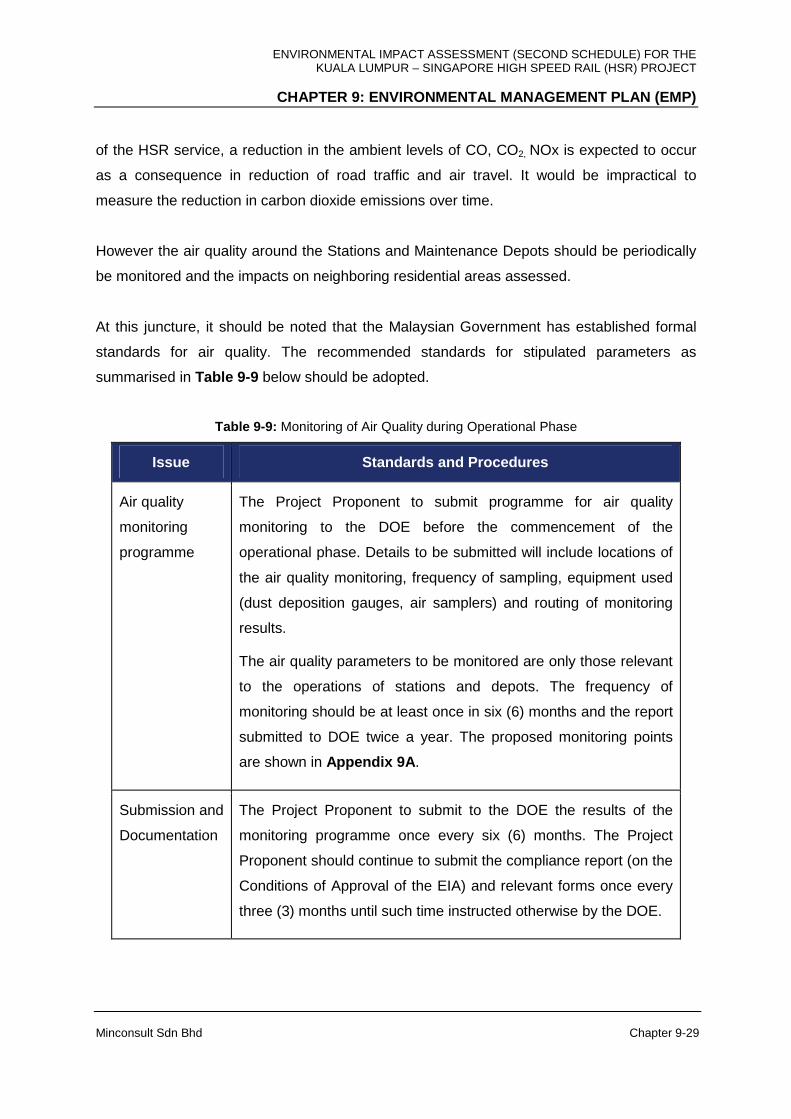
ENVIRONMENTAL IMPACT ASSESSMENT (SECOND SCHEDULE) FOR THE KUALA LUMPUR – SINGAPORE HIGH SPEED RAIL (HSR) PROJECT
CHAPTER 9: ENVIRONMENTAL MANAGEMENT PLAN (EMP)
Minconsult Sdn Bhd Chapter 9-29
of the HSR service, a reduction in the ambient levels of CO, CO2, NOx is expected to occur
as a consequence in reduction of road traffic and air travel. It would be impractical to
measure the reduction in carbon dioxide emissions over time.
However the air quality around the Stations and Maintenance Depots should be periodically
be monitored and the impacts on neighboring residential areas assessed.
At this juncture, it should be noted that the Malaysian Government has established formal
standards for air quality. The recommended standards for stipulated parameters as
summarised in Table 9-9 below should be adopted.
Table 9-9: Monitoring of Air Quality during Operational Phase
Issue Standards and Procedures
Air quality
monitoring
programme
The Project Proponent to submit programme for air quality
monitoring to the DOE before the commencement of the
operational phase. Details to be submitted will include locations of
the air quality monitoring, frequency of sampling, equipment used
(dust deposition gauges, air samplers) and routing of monitoring
results.
The air quality parameters to be monitored are only those relevant
to the operations of stations and depots. The frequency of
monitoring should be at least once in six (6) months and the report
submitted to DOE twice a year. The proposed monitoring points
are shown in Appendix 9A .
Submission and
Documentation
The Project Proponent to submit to the DOE the results of the
monitoring programme once every six (6) months. The Project
Proponent should continue to submit the compliance report (on the
Conditions of Approval of the EIA) and relevant forms once every
three (3) months until such time instructed otherwise by the DOE.
ENVIRONMENTAL IMPACT ASSESSMENT (SECOND SCHEDULE) FOR THE KUALA LUMPUR – SINGAPORE HIGH SPEED RAIL (HSR) PROJECT
CHAPTER 9: ENVIRONMENTAL MANAGEMENT PLAN (EMP)
Minconsult Sdn Bhd Chapter 9-30
Proposed Parameters to be Monitored
(i) Total Suspended Particles (TSP)
(ii) Nitrogen Dioxide (NO2)
(iii) Carbon Monoxide (CO)
(iv) PM10
The ambient air quality and emission limit requirements to be complied for the Project are
identified and listed in Chapter 6 .
Proposed Frequency of Monitoring
It is the recommendation of the EIA Consultant that, for the ambient air quality monitoring, all
the parameters listed above shall be monitored once every six (6) months.
Proposed Location of Sampling Stations
At selected points located adjacent to the Stations and Maintenance Depots. The locations
of the proposed ambient air monitoring points are given in Appendix 9A . Not withstanding
the above, the Project Proponent shall ensure that the selected parameters, frequency of
monitoring and the location of sampling sites associated with the monitoring exercise are
approved by DOE prior to the commencement of the air monitoring exercise.
9.5.4.2 Noise and Vibration
Monitoring of environmental noise and vibration levels in the vicinity of the Project facilities
will be required to be carried out mainly to document the extent and magnitude of noise and
vibration induced from train operations and from stations and maintenance depots. The
monitoring of L10, L90 and Leq noise levels, and peak particle velocities associated with
vibration transmissions, in these areas will assist the Project Proponent in ensuring that
noise and vibration emitted from the track and stations does not exceed acceptable levels,
[i.e. 65 dB(A) and 3 mm/sec]. The ambient noise and vibration level criteria to be complied
for the Project are identified and listed in Chapter 6 (Section 6.11.3). In respect of vibration
monitoring requirements, periodic three dimensional vibration levels shall be monitored near
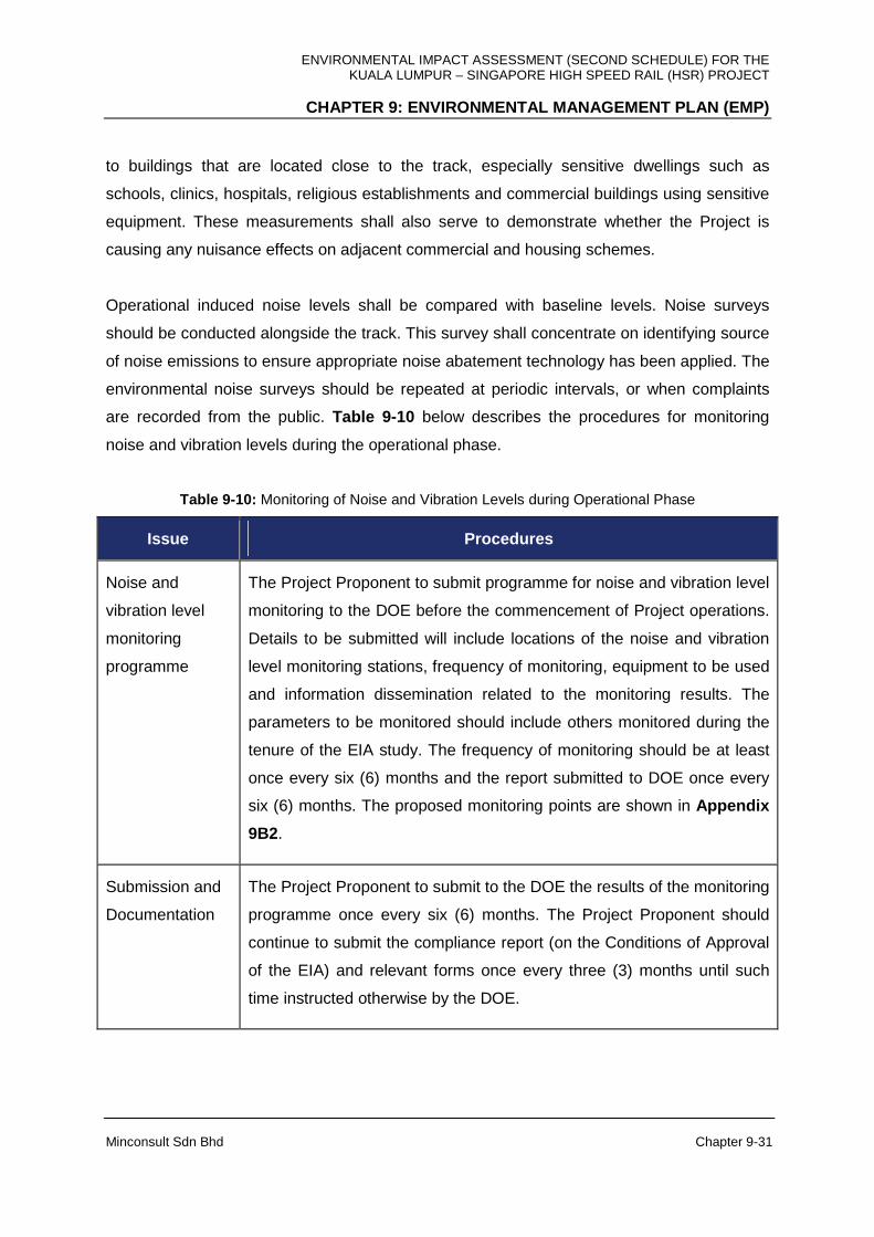
ENVIRONMENTAL IMPACT ASSESSMENT (SECOND SCHEDULE) FOR THE KUALA LUMPUR – SINGAPORE HIGH SPEED RAIL (HSR) PROJECT
CHAPTER 9: ENVIRONMENTAL MANAGEMENT PLAN (EMP)
Minconsult Sdn Bhd Chapter 9-31
to buildings that are located close to the track, especially sensitive dwellings such as
schools, clinics, hospitals, religious establishments and commercial buildings using sensitive
equipment. These measurements shall also serve to demonstrate whether the Project is
causing any nuisance effects on adjacent commercial and housing schemes.
Operational induced noise levels shall be compared with baseline levels. Noise surveys
should be conducted alongside the track. This survey shall concentrate on identifying source
of noise emissions to ensure appropriate noise abatement technology has been applied. The
environmental noise surveys should be repeated at periodic intervals, or when complaints
are recorded from the public. Table 9-10 below describes the procedures for monitoring
noise and vibration levels during the operational phase.
Table 9-10: Monitoring of Noise and Vibration Levels during Operational Phase
Issue Procedures
Noise and
vibration level
monitoring
programme
The Project Proponent to submit programme for noise and vibration level
monitoring to the DOE before the commencement of Project operations.
Details to be submitted will include locations of the noise and vibration
level monitoring stations, frequency of monitoring, equipment to be used
and information dissemination related to the monitoring results. The
parameters to be monitored should include others monitored during the
tenure of the EIA study. The frequency of monitoring should be at least
once every six (6) months and the report submitted to DOE once every
six (6) months. The proposed monitoring points are shown in Appendix
9B2.
Submission and
Documentation
The Project Proponent to submit to the DOE the results of the monitoring
programme once every six (6) months. The Project Proponent should
continue to submit the compliance report (on the Conditions of Approval
of the EIA) and relevant forms once every three (3) months until such
time instructed otherwise by the DOE.
ENVIRONMENTAL IMPACT ASSESSMENT (SECOND SCHEDULE) FOR THE KUALA LUMPUR – SINGAPORE HIGH SPEED RAIL (HSR) PROJECT
CHAPTER 9: ENVIRONMENTAL MANAGEMENT PLAN (EMP)
Minconsult Sdn Bhd Chapter 9-32
Proposed Parameters to be Monitored
Proposed parameters to be monitored are Lmax, L10, L50, L90, Leq, and mm/s for vibration.
The ambient noise and vibration limits to be complied for this project are identified and listed
in Chapter 6 respectively.
Proposed Location of Sampling Stations
The locations of the proposed noise and vibration monitoring points are given in Appendix
9B2. Notwithstanding the above, the Project Proponent shall ensure that the selected
parameters, frequency of monitoring and the location of sampling site are approved by DOE
State prior to the commencement of the noise monitoring exercise.
Proposed Frequency of Monitoring
Proposed frequency of monitoring is once every six (6) months.
It is recommended by the EIA Consultant that the frequency of noise and vibration
monitoring be at least once every three (3) months during the commissioning stage of the
Project. This is to enable the Project Proponent to monitor the performance of the equipment
and machinery more closely and carry out any engineering controls (in cases of non-
conformance) to ensure compliance to the ambient noise and vibration standard criteria. It is
also proposed that sampling locations near to adjacent dwelling units be retained for
monitoring during the commissioning stage.
The Project Proponent shall carry out a comprehensive Dilapidation study during the
operational phase (on a periodic basis) for structures located 50 m from the railway tracks to
ascertain the scope of mitigation and control measures required to be implemented in order
to protect the integrity of adjacent structures out of vibration events.
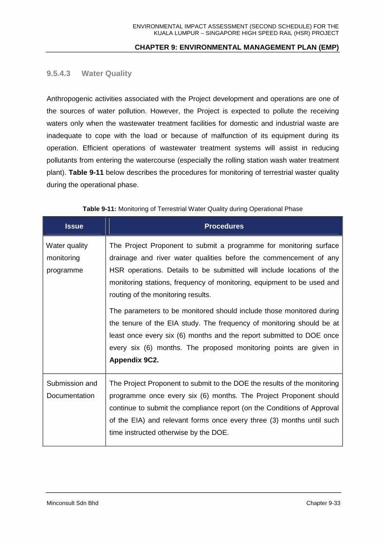
ENVIRONMENTAL IMPACT ASSESSMENT (SECOND SCHEDULE) FOR THE KUALA LUMPUR – SINGAPORE HIGH SPEED RAIL (HSR) PROJECT
CHAPTER 9: ENVIRONMENTAL MANAGEMENT PLAN (EMP)
Minconsult Sdn Bhd Chapter 9-33
9.5.4.3 Water Quality
Anthropogenic activities associated with the Project development and operations are one of
the sources of water pollution. However, the Project is expected to pollute the receiving
waters only when the wastewater treatment facilities for domestic and industrial waste are
inadequate to cope with the load or because of malfunction of its equipment during its
operation. Efficient operations of wastewater treatment systems will assist in reducing
pollutants from entering the watercourse (especially the rolling station wash water treatment
plant). Table 9-11 below describes the procedures for monitoring of terrestrial waster quality
during the operational phase.
Table 9-11: Monitoring of Terrestrial Water Quality during Operational Phase
Issue Procedures
Water quality
monitoring
programme
The Project Proponent to submit a programme for monitoring surface
drainage and river water qualities before the commencement of any
HSR operations. Details to be submitted will include locations of the
monitoring stations, frequency of monitoring, equipment to be used and
routing of the monitoring results.
The parameters to be monitored should include those monitored during
the tenure of the EIA study. The frequency of monitoring should be at
least once every six (6) months and the report submitted to DOE once
every six (6) months. The proposed monitoring points are given in
Appendix 9C2.
Submission and
Documentation
The Project Proponent to submit to the DOE the results of the monitoring
programme once every six (6) months. The Project Proponent should
continue to submit the compliance report (on the Conditions of Approval
of the EIA) and relevant forms once every three (3) months until such
time instructed otherwise by the DOE.
ENVIRONMENTAL IMPACT ASSESSMENT (SECOND SCHEDULE) FOR THE KUALA LUMPUR – SINGAPORE HIGH SPEED RAIL (HSR) PROJECT
CHAPTER 9: ENVIRONMENTAL MANAGEMENT PLAN (EMP)
Minconsult Sdn Bhd Chapter 9-34
Proposed Parameters to be Monitored
Discharge of STPs at stations, depots, heavy Maintenance Base and Light maintenance
Bases - pH, TSS, DO, BOD5, COD, Oil & Grease, E.Coli and NH3N.
Proposed Location of Sampling Stations
The locations of the proposed water monitoring points are given in Appendix 9C2 . Not
withstanding the above, the Project Proponent shall ensure that the selected parameters,
frequency of monitoring and the location of sampling sites are approved by DOE prior to the
commencement of the water monitoring exercise.
Proposed Frequency of Monitoring
Proposed frequency of monitoring is once every six (6) months.
9.5.4.4 Waste Generation and Management
The collection and disposal of the solid wastes from the Project are anticipated to be carried
out by private contractors; as is the current practice. The Project Proponent will have to
ensure the collection and disposal is regular and carried out in a sanitary manner.
9.5.4.5 Wildlife Management
The HSR Project shall be fenced along the at-grade area as to avoid any potential crossing.
Thus, it is anticipated there shall be no potential incident of wildlife crossing within the HSR
alignment.
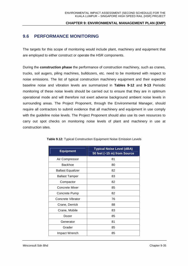
ENVIRONMENTAL IMPACT ASSESSMENT (SECOND SCHEDULE) FOR THE KUALA LUMPUR – SINGAPORE HIGH SPEED RAIL (HSR) PROJECT
CHAPTER 9: ENVIRONMENTAL MANAGEMENT PLAN (EMP)
Minconsult Sdn Bhd Chapter 9-35
9.6 PERFORMANCE MONITORING
The targets for this scope of monitoring would include plant, machinery and equipment that
are employed to either construct or operate the HSR components.
During the construction phase the performance of construction machinery, such as cranes,
trucks, soil augers, piling machines, bulldozers, etc. need to be monitored with respect to
noise emissions. The list of typical construction machinery equipment and their expected
baseline noise and vibration levels are summarized in Tables 9-12 and 9-13 Periodic
monitoring of these noise levels should be carried out to ensure that they are in optimum
operational mode and will therefore not exert adverse background ambient noise levels in
surrounding areas. The Project Proponent, through the Environmental Manager, should
require all contractors to submit evidence that all machinery and equipment in use comply
with the guideline noise levels. The Project Proponent should also use its own resources to
carry out spot checks on monitoring noise levels of plant and machinery in use at
construction sites.
Table 9.12: Typical Construction Equipment Noise Emission Levels
Equipment Typical Noise Level (dBA)
50 feet (~15 m) from Source
Air Compressor 81
Backhoe 80
Ballast Equalizer 82
Ballast Tamper 83
Compactor 82
Concrete Mixer 85
Concrete Pump 82
Concrete Vibrator 76
Crane, Derrick 88
Crane, Mobile 83
Dozer 85
Generator 81
Grader 85
Impact Wrench 85

ENVIRONMENTAL IMPACT ASSESSMENT (SECOND SCHEDULE) FOR THE KUALA LUMPUR – SINGAPORE HIGH SPEED RAIL (HSR) PROJECT
CHAPTER 9: ENVIRONMENTAL MANAGEMENT PLAN (EMP)
Minconsult Sdn Bhd Chapter 9-36
Equipment Typical Noise Level (dBA)
50 feet (~15 m) from Source
Jack Hammer 88
Loader 85
Paver 89
Pile-driver (Impact) 101
Pile-driver (Sonic) 96
Pneumatic Tool 85
Pump 76
Rail Saw 90
Rock Drill 98
Roller 74
Saw 76
Scarifier 83
Scraper 89
Shovel 82
Spike Driver 77
Tie Cutter 84
Tie Handler 80
Tie Inserter 85
Truck 88
Source: Transit Noise & Vibration Impact Assessment. Office of Planning and Environment, Federal Transit Administration, United States of America Department of Transportation, May 2006.
Table 9-13: Vibration Source Levels for Construction Equipment
PPV at 25 feet (~8 m) Equipment
in/s mm/s
upper range 1.518 38.6 Pile Driver (impact)
typical 0.644 16.4
upper range 0.734 18.6 Pile Driver (sonic)
typical 0.170 4.32
Clam shovel drop (slurry wall)
0.202 5.13
in soil 0.008 0.203 Hydromill (slurry wall)
in rock 0.017 0.432

ENVIRONMENTAL IMPACT ASSESSMENT (SECOND SCHEDULE) FOR THE KUALA LUMPUR – SINGAPORE HIGH SPEED RAIL (HSR) PROJECT
CHAPTER 9: ENVIRONMENTAL MANAGEMENT PLAN (EMP)
Minconsult Sdn Bhd Chapter 9-37
PPV at 25 feet (~8 m)
Vibratory Roller 0.210 5.33
Hoe Ram 0.089 2.26
Large bulldozer 0.089 2.26
Caisson drilling 0.089 2.26
Loaded trucks 0.076 1.93
Jackhammer 0.035 0.889
Small bulldozer 0.003 0.0762
Source: Transit Noise & Vibration Impact Assessment. Office of Planning and Environment, Federal Transit
Administration, United States of America Department of Transportation, May 2006.
In addition the treatment performance of temporary sanitary systems should be periodically
monitored for its efficacy in meeting specified pollutant discharge set standards. Similarly the
efficacy of silt traps need to be monitored regularly by the contractor and report on results
submitted to the Project Proponent. The contractor shall recommend remedial measures if
the silt traps are not functioning to design intent
During the operational phase, the emphasis shall be placed on monitoring the efficacy of
sewage and wastewater treatment plants established at stations and maintenance depots.
Furthermore HSR train equipment capable of emitting noise, such as compressors, air
conditioning units etc shall be monitored periodically for their compliance to standard noise
ratings. This would also apply to plant and equipment installed at stations and at
maintenance depots.
ENVIRONMENTAL IMPACT ASSESSMENT (SECOND SCHEDULE) FOR THE KUALA LUMPUR – SINGAPORE HIGH SPEED RAIL (HSR) PROJECT
CHAPTER 9: ENVIRONMENTAL MANAGEMENT PLAN (EMP)
Minconsult Sdn Bhd Chapter 9-38
9.7 ENVIRONMENTAL AUDITS
The third-party environmental audit shall be carried out throughout the Project period. The
main objectives of the environmental audit are to determine whether there are any non-
compliances to the environmental requirements as stated in the EIA and EMP as well as to
ensure that all the P2M2s are properly implemented, functioning as per designed and
adequately maintained to ensure its performance.
The appointed third-party auditor shall be registered with DOE, whom is Certified Erosion,
Sediment and Storm Water Inspector (CESSWI) or with equivalent qualification. The
environmental audit shall be carried out in accordance to the Environmental Audit Guidance
Manual published by DOE Malaysia.
The site audit will be carried out in accordance to the accepted protocol detailing areas of
non-compliance. Any non-compliance with legislative standards will be identified and
probable cause of such non-compliances investigated.
ENVIRONMENTAL IMPACT ASSESSMENT (SECOND SCHEDULE) FOR THE KUALA LUMPUR – SINGAPORE HIGH SPEED RAIL (HSR) PROJECT
CHAPTER 10: STUDY FINDINGS
Minconsult Sdn Bhd Chapter 10 - 1
10.1 STUDY FINDINGS
10.1.1 Introduction
The EIA study that has been carried out for the HSR Project has focused on assessing and
evaluating the scope and extent of residual environmental perturbations that can materialize
during the HSR Project’s construction and operational phases, taking due cognizance of the
planning efforts aimed at reducing adverse environmental impacts to tolerable levels. The
EIA study also placed emphasis on determining whether additional mitigation and
amelioration measures are required in order for the HSR Project to comply consistently with
air, water and noise and vibration ambient standards and regulations, and the need to further
reduce nuisance conditions that could possibly be imposed on communities.
It has been verified that this HSR Project will adopt the latest innovative HSR technologies in
order to minimize energy demands, to enhance service safety standards and to ensure
commuters a comfortable, convenient, reliable, punctual and affordable service. A main
focus of the HSR Project is to entice commuters to migrate from car, bus and air travel to the
HSR service, and to achieve high occupancy rates over time (at least 80 %), in order that a
net positive life cycle environmental impact is attained.
Currently, preliminary designs of the HSR Project’s components are on-going as a pre-
requisite to develop suitable information to solicit Tenders from a qualified Project Delivery
Partner (PDP) to implement the HSR Project.
10.1.2 Impact Assessment Findings
The major environmental impacts of concern associated with the development and
operations of this Project include air, water and noise and vibration impacts. In addition
aesthetics, safety, soil erosion and sedimentation and risk issues can also assume center
stage. A summary of the potential environmental impacts that can materialize during the
HSR Project’s construction and operation phases were investigated and the consequential
environmental perturbations that could materialize are documented as described herewith.
ENVIRONMENTAL IMPACT ASSESSMENT (SECOND SCHEDULE) FOR THE KUALA LUMPUR – SINGAPORE HIGH SPEED RAIL (HSR) PROJECT
CHAPTER 10: STUDY FINDINGS
Minconsult Sdn Bhd Chapter 10 - 2
Construction Phase
It has been ascertained that during the HSR Project’s construction phase, there could be
possibilities for residential areas located close to the construction sites (30 to 50 m) to be
subjected to adverse air and noise, and potentially vibration impacts, albeit on a short term
basis. However there are well established control measures that have proven to be able to
ameliorate adverse impacts to tolerable levels and the potential adverse noise and air quality
impacts can be curtailed to acceptable levels through adoption of both structural, non
structural and by proper administration/management measures
The HSR Project’s earthworks and biomass disposal operations will be extensive (estimates
of 1,111,403 m3 of soil and 139,306 tons of biomass requiring transport and disposal along
the approximate 328 km HSR alignment). Pathways used for transporting soils and biomass
should not be located within 300 m of residential areas.
Soil erosion incidences will be of concern especially during monsoon seasons and when
cleared areas are located upstream of public water supply treatment plants and intakes, and
if the hydraulic capacity of receiving water courses are low. On the whole, the resulting water
quality impacts and potential flooding episodes can be moderated to acceptable levels
based on adoption of effective management practices over clearing and re-vegetation
operations, proper placement and maintenance of silt traps, and timing of works. In any case
the duration of the construction period is relatively of short term and impacts will be
intermittent over this tenure.
The amount of sewage and industrial wastewater discharges from the seven (7) HSR
Stations and three (3) maintenance depots will be moderate to low. However, the Project
Proponent is committed to ensure that the latest innovative treatment facilities are adopted
to reduce residual pollutants levels that will not undermine the receiving water courses
existing water quality status nor its resource capability.
The HSR Project is expected to positively contribute towards the development of the national
economy by compressing geographical distances and rebalancing economic growth by
spreading development to the southern region. More directly, it will also have an impact on
the economy through construction activities and subsequent commercial / economic
activities associated with an improved transportation network. Based on the assessment of
ENVIRONMENTAL IMPACT ASSESSMENT (SECOND SCHEDULE) FOR THE KUALA LUMPUR – SINGAPORE HIGH SPEED RAIL (HSR) PROJECT
CHAPTER 10: STUDY FINDINGS
Minconsult Sdn Bhd Chapter 10 - 3
the Economic Evaluation of Environmental Impacts (EVEI), after discounting at the rate of
4 %, the total present value of the stream of net loss in environmental services amounts to -
RM6.118 million over a 50-year period. The present value is very small because the
economic value of the reduction in environmental services from the loss of forest, oil palm
and rubber land is almost fully compensated by the economic value of the reduction in CO2
emission due to modal shift.
The construction of the HSR alignment over Tebrau Strait will not have any adverse impacts
on the water quality and ecological status of this water body; nor will it hamper vessel
navigations along the Straits.
Potential adverse impacts on terrestrial ecosystems, and on community public health status
along the construction sites, can be effectively controlled to tolerable levels employing well
known mitigation measures.
However adverse long term social impacts could materialize with the eviction and relocation
of people and businesses and the acquisition and fragmentation of private lots. A Social
Impact Assessment Study (SIA) is being carried out by the Project Proponent to address
these potential adverse impacts as well as the potential benefit impacts.
Operational Phase
It is predicted that during the HSR Project’s operational phase, net positive impacts will
materialize, but subject to predictions of commuter cross over to the HSR service becoming
a reality. The major positive impacts that can occur include the substantial net reduction in
yearly transportation related greenhouse gas emissions. Carbon dioxide (CO2) is the only
greenhouse gas of concern and based on the assessment, the HSR Project would reduce
435,590 tons of CO2 per year. Another positive impact would be the potential reduction in
road accidents and community health issues that can materialize, in comparison with the
business as usual scenario where the HSR Project is not implemented.
The HSR Project will create about 111,000 jobs opportunities during planning, construction
and operation. The HSR Project is also expected to boost local economy following the
potential investments from companies. It creates a spill over effect to the local people with a
high demand of manpower to support the services.
ENVIRONMENTAL IMPACT ASSESSMENT (SECOND SCHEDULE) FOR THE KUALA LUMPUR – SINGAPORE HIGH SPEED RAIL (HSR) PROJECT
CHAPTER 10: STUDY FINDINGS
Minconsult Sdn Bhd Chapter 10 - 4
The HSR Project will enhance the productivity through connectivity. The Greater Kuala
Lumpur / Klang Valley (Greater KL / KV) urban conurbation of 7.2 million people and
Singapore with 5.4 million people are both major population and economic centres in
Southeast Asia. The intermediate cities served by the HSR Project range in size from around
250,000 people in Muar (the smallest city served) to 1.1 million people in the greater
Seremban area.
The main value proposition of the HSR Project is that it offers significant travel time savings
over traditional modes of transport. The HSR Project shall trim travel time between KL-
Singapore to a minimum of 90 minutes, compared with 4–5 hours by road, 7 hours by
conventional rail services, or 3 hours by air.
Noise, vibration, air and water quality adverse impacts can be adequately mitigated adopting
well tried and tested methodologies and by introducing stringent and exhaustive surveillance
measures.
It is important that adequate facilities and mitigation measures be implemented to prevent
animal and people collisions, to avoid impeding cross flow traffic, and surface flows, across
the HSR alignment especially when it is constructed as an At-Grade alignment.
10.2 SURVEILLANCE AND MONITORING PROGRAMS
It is important for exhaustive surveillance and monitoring programs to be evolved and
implemented in order to confirm whether predicted environmental impacts induced by the
construction and operations of the HSR Project are accurate and realistic, and whether all
required mitigation and abatement measures have been implemented and are functioning
adequately. Such measurements provide the Project Proponent an opportunity to take
effective remedial measures if residual impacts exceed regulatory or guideline control
values. In this respect, Chapter 9 of this EIA report details in depth the scope and range of
monitoring and performance measurements that are required to be taken during the
Project’s construction and operational phases, together with the locations where the
measurements are to be taken, as well as the pollutant parameters to be measured at what
range of frequencies. In addition the manpower needs, range of instruments and manpower
organizational structure required to execute the monitoring programme are also detailed.

ENVIRONMENTAL IMPACT ASSESSMENT (SECOND SCHEDULE) FOR THE KUALA LUMPUR – SINGAPORE HIGH SPEED RAIL (HSR) PROJECT
CHAPTER 10: STUDY FINDINGS
Minconsult Sdn Bhd Chapter 10 - 5
An audit of the environmental performance of the construction phase is required to be
executed in order to gauge the overall effectiveness of mitigation and control measures
introduced, and the extent of residual impacts induced on human and ecological habitats
and the consequences that materialized.
10.3 CONCLUDING REMARKS
It is concluded that from an environmental perspective that the chosen HSR alignment is not
expected to induce environmental perturbations of note that can materially affect the health,
and safety of community’s resident within areas surrounding the HSR Project’s alignment;
and in addition will not have any significant impacts on ecological and surface and ground
water regimes.
The HSR Project is expected to induce positive long term environmental impacts through its
capability to reduce net emissions of greenhouse gases by the transportation sector in
Malaysia, enhancing connectivity, increase connectivity through time saving, creating job
opportunities and reducing traffic accidents by implementing HSR Project.
MyHSR Corp is committed to implement all the P2M2 identified in this report and to ensure
they are implemented effectively throughout the construction and operational process.
MyHSR is also committed to mainstreaming environmental protection into the Project and
towards self-regulation to ensure that the quality of the environment is protected during the
construction and operation of HSR Project.