shifting boundaries of volunteered geographic information systems and modalities: learning from pgis
TRANSCRIPT

Shifting Boundaries of Volunteered
Geographic Information Systems and
Modalities: Learning from PGIS
Michael K. McCall
1
National Autonomous University of Mexico (UNAM), Centre for Research in
Environmental Geography (CIGA), CP 58190. Morelia, Michoacan, Mexico. Tel
(443) 322-38-79 Fax (443) 322-38-80
University of Twente, Faculty of Geo-Information Science and Earth Observation –
ITC, P.O. Box 217, 7500AE Enschede, The Netherlands
Javier Martinez
University of Twente, Faculty of Geo-Information Science and Earth Observation –
ITC, P.O. Box 217, 7500AE Enschede, The Netherlands
Jeroen Verplanke
University of Twente, Faculty of Geo-Information Science and Earth Observation –
ITC, P.O. Box 217, 7500AE Enschede, The Netherlands
1 Published under Creative Commons licence: Attribution-Noncommercial-No Derivative Works
Shifting Boundaries of Volunteered Geographic Information Systems and Modalities 2
Abstract
This paper develops a framework for assessing how Volunteered
Geographical Information (VGI)2 systems, modalities and practices perform, as
measured against principles of good governance and participation; the framework
is applied to two case studies. From this, we argue for a shift towards recognising,
valuing and incorporating into VGI, the values of participatory processes which are
the essence of PGIS (Participatory GIS). We firstly over-view the current range of
handling citizen’s local (spatial) knowledge in VGI by identifying two foundational
drivers, which are: the recognition of the value of vulgar local knowledge, and the
acceleration of cyberspace communication capacities. Section 2 analyses VGI
modalities and systems in terms of their characteristics and practices, in a frame of
good governance principles and participatory process. In Section 3 this analytical
framework is used in evaluating two specific cases in terms of governance and
participation principles and practice. The paper concludes with needs and
challenges about shifting the boundaries of VGI towards a deeper, more
participatory construct of ‘vulgar grounded intelligence’.
Introduction
Innovative VGI platforms (internet and GIS-enabled fixed and mobile
devices, such as Smartphones), and the ubiquity of free-to-use Web maps and
Virtual Globes have created enormous potential for cheap, simple tools to acquire,
analyse and present spatial information from individual and community
viewpoints. The ultra-rapid growth in the quantity, speed and breadth of
information produced by the public, beyond the formal and informal regulations of
structured organizations, is producing two structural fault lines.
On one hand, it is putting institutional embedded expert knowledge under
operational performance, political, and ethical pressures. People are no longer
‘civilians’ - passive consumers. Policy-makers, politicians and researchers are
increasingly recognising that a richer understanding of local people’s accumulated
knowledge of their local physical and social environmental conditions, such as
their vulnerabilities and capacities, is essential.
On the other hand, it is undermining the perceived value and appreciated
benefits of the participatory spatial knowledge which is acquired through slow,
small-scale, limited, collaborative practices of PGIS (Participatory GIS) or social
mapping. Volunteered Geographical Information (VGI) is generating so much
information so fast and so cheaply, that the careful, considered and accepted steps
of PGIS approaches are over-ridden and seen as uncompetitive.
2 Without a consensus on a suitable overarching term for the set of approaches, systems, and
modalities for acquiring citizens’ local (spatial) knowledge, we use the term VGI to also incorporate
relevant UGC (user-generated content) systems.

ACME: An International E-Journal for Critical Geographies, 2013, x (x), x -xx 3
But the basic suppositions of PGIS remain valid: local people know the
variability and dynamics in the environmental and socioeconomic situations of
their areas. Local people have both historical experience and contemporaneous
knowledge, they understand subtleties of people’s behaviour and local cultural and
institutional structures, and they work out mechanisms for resilience and coping.
Local people specifically have local spatial knowledge.
The motivations behind this paper are: to understand better where VGI fits
into handling ‘local spatial knowledge’ (LSK) based on the drivers and structure of
working with citizens’ knowledge inputs, to propose an approach for evaluating
how VGI practices and their operational characteristics relate to participation and
good governance principles, and to apply that approach to two case studies. Finally,
we consider a convergence from VGI as ‘volunteered geographic information’
towards a deeper, more participatory construct of VGI as ‘vulgar grounded
intelligence’.
Handling Citizens’ Local Spatial Knowledge
Two Drivers – People Power meets Cyberspace
There are two deep drivers of the VGI explosion, which have developed
separately, but also are intertwined. The first is the critical drive for more of
people’s participation in planning, design, policy, and, everything. A direct
consequence of this is that recognition, value and social significance are gradually
being accorded to lay people’s phenomenological and technical knowledge. This
popular ‘vulgar knowledge’ formation and usage is an alternative knowledge which
is usually critical and therefore often in conflict with authoritative information. (It
is not necessarily spatial information). Overarching conceptualisations contained in
this drive are UGC (user-generated content), VCI (volunteered citizens’
information), and citizen journalism – although these are not necessarily driven by
‘scientific‘ knowledge. Through their Citizen Science activities and Citizen
Observatories (McGlade 2009), people’s participation and vulgar knowledge may
bring them into epistemological and political conflict with established science.
The second driver comes from the rapid technological advances in handling,
dissecting and utilising geospatial information in GI science and technology. The
term ‘WebGIS’ summarises the broader social and cultural implications of what are
specifically technical extensions of conventional GIS technologies and systems,
such as: mash-ups, dynamic GIS, Cybercartography, geotagging, and locative
media. These all have broad implications for knowledge frames in Citizen Science
and other UGC.
The two drivers come together in an array of approaches, activities and
methods which are shaping the geospatial face of citizen science. They deal with
the generation, management, and visualisation of popular, local information and
understanding which is essentially geospatial, that is, ‘local spatial knowledge’
(LSK). These approaches and activities are to varying degrees, participatory,
critical and subversive. PGIS and participatory / social mapping which are both

Shifting Boundaries of Volunteered Geographic Information Systems and Modalities 4
well-established, as well as Qualitative GIS, are more participatory and more
critical, whereas VGI and HSW (Human Sensor Webs) which form the focus of
this paper, are less participatory and less critical.
Shifting Authoritative Information: ‘Citizen Science’ and People’s Participation
At the level of conceptualization of alternative knowledge formation, the
proto-concepts behind VGI in this paper include: Citizen Science (Cohn 2008;
Silvertown 2009; Haklay 2012) and Crowdsourcing (Howe, 2006; Elwood &
Leszczynski 2012)3; though these two are not necessarily dealing with spatial
knowledge. These conceptualizations of knowledge formation and usage are
critical and alternative, and often in conflict with authoritative information.
However the growing demands for public engagement in participation, and the
realisation by professionals that the public can provide knowledge, labour, skills,
computing power and even funding, have led to the concept and reality of citizen
science projects (Silvertown 2009; Cohn 2008).
The Internet as a global infrastructure has enabled a reincarnation of Citizen
Science. Innovative projects utilise the abilities of personal computers, GPS
receivers, mobile phones and other personal e-devices to double as scientific
instruments. This type of citizen science is sometimes termed ‘citizen cyber
science’ (Grey 2009); within it can be identified three sub-categories: volunteered
computing, volunteered thinking and participatory sensing (Haklay 2012). In
volunteered computing, non-specialists – the volunteering citizens - participate in
collaborative data collection and analysis. A pioneering project was SETI@Home
which harnessed the idle computing time of millions of participants in the search
for extra-terrestrial life; similarly with modelling of malaria epidemiology by
Malariacontrol.net4
5. An essential of volunteered knowledge production is that
people are not just passive sensors, but active participants in checking, assessing or
commenting on scientific observations’ for example the observation and
classification by volunteers of galaxies and ‘habitable’ planets circling stars, such
as in Galaxy Zoo6 with its celebrity volunteer Hanny van Arkel
7. Participatory
sensing is the broadest category; for example, citizen scientists make detailed
observations of the natural world, as in the long-running Audubon Society’s
Christmas Bird Count8, now in its 114
th year.
Crowdsourcing is usually considered as voluntary, participative and
mutually-rewarding. “The undertaking of the task, of variable complexity and
modularity, and in which the crowd should participate bringing their work, money,
3 Citizen journalism and blogs and Citizen Observatories would also belong under this category, but
are not analysed here. 4 NOTE: all web references accessed in August 2013.
5 http://www.malariacontrol.net/
6 http://www.galaxyzoo.org/
7 http://www.hannysvoorwerp.com/
8 http://birds.audubon.org/christmas-bird-coun t

ACME: An International E-Journal for Critical Geographies, 2013, x (x), x -xx 5
knowledge and/or experience, always entails mutual benefit” (Estellés Arolas &
Ladrón-de-Guevara 2012: 9; c.f. Elwood & Leszczynski 2012; Vivacqua and
Borges 2012). Crowdsourcing covers a variety of actual modalities and practices,
but not all are highly voluntary beyond the initial accordance to join a platform.
Some crowdsourcing activities are highly intensive, calling upon time and effort
inputs from dedicated volunteers, but others are not. Crowdsourcing may be
dealing with specifically spatial information such as OpenStreetMap9 (OSM), or it
may be non-spatial.
Adding Location – GIS and geo-referencing in the Web
This topic deals with the specifically GIS technologies and systems using
Web powers and functionalities, such as map mash-ups, WebGIS, cloud based GIS,
and ‘locative media’ (e.g. Thielmann 2010; Baud et al. 2011; Pfeffer et al 2013) -
all of these have broad implications for Citizen Science. It is not helpful to
categorise these entirely as being non-participatory; however, they mainly function
at low intensities of participation compared with the intertwined approaches.10
The term WebGIS refers to a GIS developed specifically for the Web, and
differing from traditional GIS for the specific purposes of communication and
information sharing with other users in real time, as exemplified by WebGIS sites
for location maps or street maps online, like the popular Google Maps,
OpenStreetMap and associated Walking Paper maps11
, or Bing! Maps. "Web GIS is
similar to web mapping but with an emphasis on analysis, processing of project
specific geodata and exploratory aspects" (Leroux 2011).
Standing out among many geospatial applications in Web 2.0 are Google
Earth and its currently thousands of mash-ups on Google Maps (Google My
Maps). The strong technical basis of Google Earth allows all kinds of information
to be uploaded on the Google image, including captions, photo images, videos,
sound, links, and metadata which can all be geotagged or geo-referenced12
13
(Miller 2006; Goodchild 2007a; Bugs et al 2010) Wikimapia supports specialised
place descriptions in about 90 languages including Anglo Saxon, and there are the
geotagged entries in Wikipedia14
.
9 http://www.openstreetmap.org
10 An expression of this approach designed to be more participatory, is Cybercartography, (coined
by Fraser Taylor 1997), defined as “The organization, presentation, analysis and communication of
spatially referenced information on a wide variety of topics of interest and use to society in an
interactive, dynamic, multimedia, multisensory and multidisciplinary format” (Fraser Taylor 2003,
406). 11
http://walking-papers.org/ 12
Google Earth Mashups http://googlemapsmania.blogspot.com/ , and Google Earth hacks website
www.gearthhacks.com 13
http://maps.google.com/support/bin/answer.py?hl=en&answer=62843 14
http://wikimapia.org/wiki/Main_Page ; http://blog.wikimapia.org /

Shifting Boundaries of Volunteered Geographic Information Systems and Modalities 6
Similarly, the OpenStreetMap (OSM) project is reaching to cover the whole
world with local inputs of ‘crowdsourced’ volunteered spatial information
(Goodchild 2007a, 2008, 2009; Tulloch 2007, 2008; Rouse et al. 2007; Haklay &
Weber 2008) in a free editable map data repository, for instance, with Mapping
Parties15
. This type of crowdsourcing is special because it is voluntary, dedicated
and demands a big time resource from the volunteer participants. “A growing
sentiment of the crowdsource community, at least within this mapping sector, is
that this group is out to create value for the common good. They are willing to
share their hours of hard work for a mission that vests them in a creation that they
can be proud of” (Ball 2010) (See also Heipke 2010).
The billions of bits of information embodied in social networking sites like
Facebook and Twitter may not yet be geo-referenced, but they will be, and this will
mega-multiply the geo-information explosion overload and all the locational-
ethical issues below (Elwood 2009). Flickr already has hundreds of millions of
geo-tagged photos uploaded by ordinary people16
, and consider the impact of social
media maps17
, and Twitter GeoAPI, Twitter maps18
and Tweetscapes.
Adding Criticality to Geo-Spatial Knowledge
In these critical approaches, the drive for more participation and ‘citizen
science’ stocks of rich local knowledge, especially local spatial knowledge, fuse
with the new GIS and Web capabilities to respond to users (Baud et al. 2011;
Pfeffer et al. 2013). Our review focuses on these activities, modalities and methods
which are dealing with the generation and management of local spatial information
and knowledge. They are, to varying degrees, participatory, critical, diverse and
subversive. They include conceptual bases and methodologies as with: GIS/2,
Neogeography, Qualitative GIS, and PGIS.
An early name for these approaches was GIS/2 (Schroeder 1996), given as a
set of methods and instruments emphasising participatory process (of a GIS
activity) and oriented towards communication about representations, as much as
toward the representations themselves. GIS/2 should emphasise the role of
participants in creating and evaluating data and it should aim to equitably represent
diverse views, preserve contradictions, inconsistencies and disputes, and, be more
dynamic. Outputs of GIS/2 should reflect the standards and goals of the
participants and be reflexive, rather than privilege the closeness of fit to measures
of spatial accuracy.
The concept of Neogeography “is about people using and creating their own
maps, on their own terms and by combining elements of an existing toolset.
Neogeography is about sharing location information with friends and visitors,
15
http://wiki.openstreetmap.org/wiki/Mapping_parties 16
(160,216,588 geotagged items as of 17.9.2011). http://www.flickr.com/groups/geotagging/ 17
http://blogs.esri.com/esri/arcgis/2011/08/26/social-media-hurricane-irene-map/ 18
http://blogs.esri.com/esri/arcgis/2011/05/02/tweet-mapping-template/

ACME: An International E-Journal for Critical Geographies, 2013, x (x), x -xx 7
helping shape context, and conveying understanding through knowledge of place”.
(Turner 2006: 2-3). Thus, Turner’s neogeography appears very similar to some
interpretations of PGIS. Neogeography allows for a wide range of tools, methods
and deliveries that use spatial information, and it opposes, though it may also
complement, professionals’ use of what Sui & DeLyser (2012) call
“paleogeography”. It is not necessarily standard GIS-based, and there is a
generously broad interpretation of both ‘spatial’ and of ‘information’. Roche
(2010: 6) called this the development of the “geospatial democratisation process”,
which he breaks into four ‘dimensions’: new types of information, new
technologies and standards (Web 2.0, wikis), new “user-creators”, and, new forms
of materialisation like VGI, geoblogs, geo-wikis, geo-tagging, or mashups.
The same arguments are made for the approach of Qualitative GIS (Cope &
Elwood 2009), though with more emphasis laid on criticality and positionality.
Qualitative GIS is intended to bring political dimensions to the fore, to critically
assess the multiplicity of spatial representations and significations, such as through
counter-mapping, and to challenge hegemonic power settings and interrelations,
such as by reflecting a feminist stance.
PGIS, initially a merger of Participatory Learning and Action methods with
geographic information technologies, is by now an emergent practice in its own
right with forceful emphases on active local participation, on LSK, on local
ownership of PGIS products, and on pushing for local empowerment.
[P]PGIS refers to the uses and applications of geo-spatial information (GI)
and/or GIS technology used by members of the public, individually or as grassroots
groups, for participation in public processes that affect their lives (data collection,
mapping, analysis, and/or decision-making) (Tulloch 2003; Tulloch & Shapiro
2003).
PGIS aims to represent local people’s spatial knowledge by map products
that can facilitate participatory decision-making processes and support
communication and community advocacy. PGIS practice is geared towards
community empowerment through tailored, demand-driven and user-friendly
applications of these geospatial technologies. Good practice in PGIS is flexible and
adapts to different socio-cultural and biophysical environments, relying on the
combination of ‘expert’ skills with local knowledge. In contrast to traditional GIS
applications, PGIS places the control on access and use of culturally sensitive
spatial data in the hands of the communities who generate it (Rambaldi, Kyem et
al. 2006).
Most PGIS activities are deliberately local and small-scale, but examples of a
global reach are the multi-lingual PPGIS discussion and information forum19
; and
19
‘Open Forum on Participatory Geographic Information Systems and Technologies’
www.ppgis.net
Shifting Boundaries of Volunteered Geographic Information Systems and Modalities 8
the Green Maps project20
which handles LSK with volunteers and NGOs making
counter maps in hundreds of cities worldwide devoted to issues usually overlooked
by municipal authorities and official maps, such as urban safety and women’s
security, child-friendly spaces, greenness and bikeability.
Where does VGI fit?
The acquisition techniques of VGI and of HSW (‘human sensor webs’) have
flourished with the unforeseen global proliferation of cell phones and the internet.
We address HSW first.
A human sensor web is an assembly of publicly available Web services
which people with mobile phones (‘human sensors’) use to report and publicise
issues and share information (Georgiadou et al. 2011). Water, electricity and urban
transportation networks contain a multitude of electronic sensors recording
parameters continuously or on demand, accessed remotely or physically. The
human sensor can be considered as equivalent to this network, allowing operators
to use them as collectors of quantitative and qualitative parameters. Human sensors
enable their mobile devices (phones or tablet computers) to record these
parameters, actively - when encountering an event or by allowing third parties to
use their devices for sensor measurements, or passively - if the mobile device
enters an active monitoring network. HSW is thus positioned between the open
ended VGI and the more focused Participatory Sensing (Burke et al. 2006;
Verplanke et al. 2010). In HSW, (see Case 2 below: HSW project, Zanzibar), the
supplier of the content is “volunteering” to generate content with limited degrees of
freedom; and with crowdsourcing techniques (participatory sensing), the task and
purpose of collecting information are usually even more explicitly indicated to the
user.
HSW should be distinguished from techniques that “silently” collect user
(locational) information. These are termed Web scraping (or its more obfuscatory
name ‘Web harvesting/mining’), opportunistic sensing, and mobile phone tracking.
There is more locational and time-registerable information in the data extraction of
credit cards (application forms or history) and online purchasing by Amazon,
Facebook, or Google+21
, and yet more in involuntary CCTV footage and in the data
mining of the NSA and GCHQ, as the revelations of Edward Snowden22
confirm.
The current technology of Web and cellphone services provides rich,
abundant, high-frequency flows of geographic and geo-referenced volunteered
information. Volunteered Geographic Information (VGI) is the harnessing of tools
to create, assemble, and disseminate geographic data provided voluntarily by
20
http://www.greenmaps.org 21
E.g. Forbes story, 2/16/2012 @ 11:02AM “How Target figured out a teen girl was pregnant
before her father did”. 22
Greenwald et al. (June 10, 2013). "Edward Snowden: the whistleblower behind the NSA
surveillance revelations". The Guardian (London).

ACME: An International E-Journal for Critical Geographies, 2013, x (x), x -xx 9
individuals (Goodchild 2007a, 2007b, 2008, 2009, 2010; Tulloch 2008; Elwood
2008a 2008b; Gouveia & Fonseca 2008; Leszczynski 2010; Roche 2010;
Goodchild & Glennon 2010; Budhathoki et al. 2010; McCall 2011; Haklay 2012;
Elwood & Leszczynski 2012; Sui & DeLyser 2012; Sui, Elwood, et al. 2012). This
volunteered spatial information can be disseminated on the internet in e.g. My
Maps, Wikimapia or OSM. VGI sites provide general base map information and
allow users to create their own content by marking locations where events occur or
certain features exist, but are not already shown on the base map.
Ushahidi23
is a widely-accepted VGI platform, originally developed in Kenya
for monitoring election political and ethnic violence, now having scores of
applications worldwide. (e.g. Okolloh 2009; Meier 2010; Berdou 2012).
FrontLineSMS24
, originating in South Africa, has functioned in many countries in
health, agricultural marketing, post-disaster, and political elections among other
applications. (e.g. Freifeld et al. 2010; McGee & Gow 2012) 25
VGI is a special case, geospatial in nature, of the larger Web phenomenon of
UGC and Web 2.0. It is associated with aspects of geographical Citizen Science
and geo-referencing on the Web (two sections above), and thus with GIS/2 and
Neogeography,
But the position and status of VGI within the domain and principles of
critical geo-spatial knowledge, is very contested. This is especially pertinent in
relation to the degree of participatoriness of VGI. In this, it is significantly different
from PGIS (Table 1).
Table 1. Is VGI participatory? Differences between VGI and PGIS
Participatory GIS VGI
Small groups Aggregation of individuals OR of small groups
High degree of participation Low OR medium degree of participation
Two-way, multi-party interactive No OR little interaction – likely to be one-way flow.
Searchable
Transparent process - actors and their
inputs are known and visible
Not transparent – actors are unknown, manipulation of
actors’ inputs is feasible
Trust is created over time, and by peer
validisation
Creating Trust requires other forms of Validation
Small sample of people, usually selected
by some criteria
Large sample of people but biased towards specific
socio-economic groups (there is a “long tail effect”
statistical distribution)
Low frequency of information flow.
Slow response times
High to very high frequency.
Fast response time, if needed
23
http:// www.ushahidi.com 24
http:// www.frontlinesms.com 25
See also Avila et al. (2011) who examined over 100 projects globally which use new technologies
aimed at increasing ‘Transparency and Accountability’.

Shifting Boundaries of Volunteered Geographic Information Systems and Modalities 10
Huge time investment, slow, very slow 26
Small time investment, fast
Normally voluntary, but … Voluntary (voluntary at initiation, but can become more
opportunistic)
.. it can be dominated by cliques Difficult to dominate
Empowering on a small scale –
generates confidence, capacity and
satisfaction
Empowering – for society on a macro (political) scale,
but not usually at the individual level
Richness and depth of information /
knowledge
Unlikely to be rich and deep data / information
Explanation and understanding created Description, and more amenable to statistical analysis
Source: this paper
The Framework - Characteristics of VGI Systems and Principles of
Participation and Good Governance
To better understand VGI systems and activities we need to analyse them in
terms of their characteristics and practices, and clarify what are the primary
purposes and potentials. How and to what extent do the innovations in VGI
systems meet the needs of citizens, governing institutions and private enterprise
sectors? Are they ‘fit for purpose’ in terms of: dealing with reporting ‘real space’?,
in satisfying ‘real actors demanding good governance’? (cf. Floreddu and
Cabiddu’s 2012 measures of satisfaction with participation), and in supporting
societal development?
We develop a framework for assessing how VGI systems and actions
perform, or can potentially perform, with respect to principles and measures of
societal development and good governance criteria, including participation. The
aim of developing such a framework is constructivist: towards a more appropriate
matching of the many different VGI modalities with their different purposes, actor
categories, and governance contexts.
‘Good governance’ principles have implications and messages for the
analytical and operational characteristics of VGI. The functional challenge is to
relate the governance categories to the VGI characteristics and indicators. We
review nine pronounced analytical and operational characteristics of VGI activities,
based on the extensive VGI literature (e.g. Goodchild 2007a, 2007b; Elwood 2008a
2008b; Tulloch 2008; Sui & DeLyser 2012; Adams 2012; Haklay 2012; Sui,
Elwood, et al. 2012). These characteristics can be grouped under five headings of -
Purpose of the VGI information flow, Characteristics of relationships,
Characteristics of the providers, Characteristics of the messages and delivery, and
26
The importance of ‘slowness’ can hardly be overstated. There is no substitute for spending time
engaging and interacting with people to have any chance of effective trust and acceptance. (e.g.
Sammy Musyoki of Map Kibera http://mapkibera.org/ interviewed in Berdou 2012).

ACME: An International E-Journal for Critical Geographies, 2013, x (x), x -xx 11
Technological characteristics. (Summary, Table 2). These characteristics appear in,
and shape, the VGI activities and approaches.
Purpose of the VGI Information Flow
Purpose is the single most important operational characteristic. The purpose
of the VGI will always hugely influence the degrees of spatial precision and of
cognitive precision needed, and the spatial and temporal scales employed, etc. The
‘purpose’ determines: Who benefits?, Who volunteers?, and the selection of
procedures and processes and tools. The core question is of course, ‘who decides
what is the purpose(s)?’ (Rambaldi, Chambers et al. 2006).
The purposes do not easily fall into definitive broad categories, but we
reviewed the gamut of applications of VGI (e.g. Goodchild 2007a, 2007b; Elwood
2008a, 2008 b; Gouveia & Fonseca 2008; Tulloch 2008; Goodchild & Glennon
2010; Resch et al. 2011; McCall 2011; Sui & DeLyser 2012; Adams 2012; Boulos
et al. 2011; Haklay 2012; Sui, Elwood, et al. 2012) and identified the following
significant categories of VGI purposes:
Personal and social presentation (‘vanity mapping’).
Cultural communication (this overlaps with the personal / social
category).
Consumption and marketing, which may be commercially sponsored
or may be countered by consumers’ rants.
Environmental reporting on the quality of life (water, waste, air,
noise). This is more common in urban areas; there is a small
specialised focus on environmental and safety qualities for children.
Grievance and complaints reporting about public spaces, services,
nuisances, etc. (this overlaps with the category above).
Transport has a significant share of environmental and grievance
reporting.
Security and personal safety, including urban safety and violence
(often a gender issue); and disaster risk, such as water, pollution,
fires, and weather events.
Land and resource claims are significant, though currently a small
share of VGI use27
28
.
In relation to purpose, a distinction needs to be made between VGI systems
which are the uni-directional provision of citizens’ data and information ‘upwards’,
27
This is changing - even national cadastral agencies are recognising the values of citizens’
information for speed, timeliness, range, costs, local accuracy, local acceptability, etc. (RICS 2011) 28
In VGI, land claims are commonly local or regional, but an example of VGI for national
territories is ‘Palestine remembered’ (Wood & Quiquivix 2011)
Shifting Boundaries of Volunteered Geographic Information Systems and Modalities 12
and, systems which are interactive - whether these be only simple feedback, or,
reciprocal dialogue flows. Pertinent examples of simple uni-directional platforms
created to collect grievances and discontent are the platforms “Ipaidabribe.com” in
India29
and “fixmystreet.com” (global)30
, and platforms intended as citizen-on-
citizen surveillance31
. Interactive (two-way, reciprocal) platforms have been set up
with the intention to facilitate the generation of collaborative solutions for which
Patrick Meier of Ushahidi suggests the term ‘crowdfeeding’32
to imply returning
aggregated and/or processed information back to the providers, e.g. Cidade
Democrática33
.
E-grievance redressal systems are public feedback mechanisms with the
characteristic that citizens’ complaints to the authorities can be traced back (see 3.1
Mysore case).34
Because of this characteristic, e-grievance redressal systems and
public feedback mechanisms are considered by some as ‘the key to increase
transparency in e-government initiatives’ (UNDP 2005). E-grievance redressal
systems are also considered as a mechanism of accountability to citizens whenever
citizens are encouraged to participate in service delivery (Cavill & Sohail 2004).
They are usually presented as an opportunity to increase openness and transparency
within the public administration, to support efficient (city) management, and to
monitor effectiveness of responses (Wallack & Nadhamuni 2007: 9).
An important characteristic is the degree of open-endedness / closedness of
the information flows between the actors who are acquiring and uploading
information, and the actors at the destination of the messages. The flows may be in
a joint relationship, - with a dedicated information flow for dedicated purposes, or
they may be mixed flows – which are partially to dedicated receivers, and partly are
free-flowing into the Webosphere. Furthermore, the flows may be uploaded into
the free-flowing Web with a primary known purpose, or, they may be uploaded
into the Web without any specified purpose.
29
http://www.ipaidabribe.com/ 30
http://www.fixmystreet.com/; http://reparaciudad.com/ 31
e.g. http://www.meldpuntmiddenenoosteuropeanen.nl/ was a controversial platform -already
closed- set up by the Dutch right-wing political party PVV during 2012 to collect complaints about
middle east Europeans. 32
Crowd feeding may have the negative intonation of suggesting only selected feedback, or
promoting dependency. 33
http://www.cidadedemocratica.org.br 34
Avila et al (2011, #7) found that the majority of ‘transparency/accountability’ projects are aimed
at the executive or legislative branches of government, with a smaller number focusing on the
judicial branch, or on media, private sector, or donors.

ACME: An International E-Journal for Critical Geographies, 2013, x (x), x -xx 13
Characteristics of Relationships between Providers and Receivers
Power and Trust Relationships
The accelerating ability to easily generate masses of local data from a large
population means that verification, validation and cross-checking of the exploding
input material is a huge challenge. A major problem in VGI is the credibility of the
information. Recipients, whether government institutions, NGOs, or communities,
need to understand how and why information should be accepted as reliable before
they work with it, and they need to assess the competences of the people who are
the sources of the VGI.
Distinction must be made between: volunteered (a conscious choice, and
known, activated and engaged) involvement – and thus, truly volunteered
information; and opportunistic involvement. ‘Opportunistic’ involvement may be
known-but-passive involvement (and therefore might be interpreted as ‘voluntary’),
or, it may be really ‘opportunistic’ which is involuntary (unconscious and
unpermitted) involvement, as in the ‘silent’ capturing or harvesting of information
from individuals. Therefore, conscious transmission should be included in the
understanding and definition of volunteered information.
Beyond this, there is a range of degrees of 'voluntariness' in the process. This
is analogous to analyses of the 'intensity' or degree of participation in social
development processes, as in participation ladders. Much of ‘volunteered citizen
information’ (and VGI) is not really 'voluntary' at all, it's just that the information
suppliers haven’t bothered to switch off or don’t know what Google or Facebook
are using them for.35
Cell phone service providers are capable of doing plenty with
triangulation, such as in supermarket shopping research to know where the marks
are loitering. This is not voluntary at all, but it is very geo-precise.
The key value in this spatial information dilemma, as in others parts of life
where we rely on other people’s knowledge, is reciprocated trust. Academics trust
peer review, local rural communities may trust traditional leaders and some NGOs,
but rarely trust Government, (do they trust researchers?); mapmakers trust
surveyors and satellite images; teenage tweeters trust peer review of cool places;
customers too easily trust commercial Websites. How do NGOs or responsible
planners know how to trust the volunteers in VGI? And how do volunteers in the
community know they can trust that their uploaded delivered knowledge will be
used safely, carefully and wisely? (Elwood 2008; Flanagin & Metzger 2008;
Coleman et al. 2009; Sanvig Knudsen and Kahila 2012; Brown et al. 2013). Local
communities commonly perceive authorities as too far away from their problems
and do not expect useful help from them; and from the other side, the authorities
believe that information collected from the locals is not sufficiently reliable
35
“Right to be forgotten law”: http://www.presseurop.eu/en/content/news-brief/1440901-right-be-
forgotten-law-welcomed

Shifting Boundaries of Volunteered Geographic Information Systems and Modalities 14
The degree of trust required between giver agents and receiver agents
depends on several issues. They include how symmetrical the power relations are,
the credibility of the exchanged information, and the reputation of the volunteer
who provides the information (the giver agent). Reputation is built upon the
history of past interactions between the agents. The other party's “abilities and
disposition" (Resnick et al. 2000: 46) are the features that reputations are based on.
The ‘reputation’ is then used to estimate the risk of future interactions. Rambaldi
points out that ‘reputation’ and thus ‘accountability’ and trust are immensely more
transparent and immediate in a PGIS mapping or a P3DM situation than in a VGI –
“.. [they] put your reputation at stake ...”36
.
Cross-checking VGI and HSW is an issue tackled by Laituri & Kodrich
(2008), Flanagin & Metzger (2008), Goodchild & Glennon (2010), and White et al.
(2010). Whether the ‘Crowd Sourcing’ in VGI results in ‘Crowd Wisdom’ or not,
is part of the same debate as ‘who is checking the information?’, and ‘how?’. As
we contemplate massively more easily-accessible data, and much more real-time
observations, we can no longer afford to rely solely on the authority of the academy
and governing agents.
A few analysts have examined current mechanisms and the needs for stronger
methods for determining acceptable-credible reputation in VGI and ‘collaborative
metadata’ (see Maué 2007a, 2007b; Flanagin & Metzger 2008; Ball 2010; Haklay
2010; Berdou 2012; Elwood & Leszczynski 2012). Research shows that under
appropriate conditions, VGI information can be trusted (accepted) as reliable
(Haklay 2010; Haklay et al. 2010). In the Extreme Citizen Science (ExCiteS)
approach, the usual Web-based GIS in which users view and analyse existing
information becomes “WebPGIS”, in which people can improve and update
information as well as validate or review information made available by others.
Other approaches from the Web 2.0 world for VGI to learn from, are EBay’s
rating system, which is used to assess the credibility of auctioneers based on their
reputation, and Wikipedia, with its extensive, endless peer reviews and a hierarchy
of managers (Goodchild 2007, 2008; Rowley & Johnson 2013). CouchSurfing
relies on a triple check – after the posting of self-description, the formal checking
for validity of the email / name ownership, endorsements by known ‘reliable’
members (as with LinkedIn), and a follow-up questionnaire37
(Rosen et al. 2011).
The reliability/ trust assessment in CouchSurfing is claimed to be extremely
effective, and this is for an activity which could expose people to real immediate
dangers.
36
Interview with Giacomo Rambaldi, 1.11.2011 in Berdou (2012, p.16) 37
http://www.couchsurfing.org/about/safety/

ACME: An International E-Journal for Critical Geographies, 2013, x (x), x -xx 15
Competing Values of Information.
The experience and settings of a VGI activity and its trajectory and eventual
impacts are shaped by the value of the information which is being uploaded and
consumed. But values are very different for different actors, and they are dynamic,
responding to changing actor power relations and contexts. Maps and other GI
products are dangerous weapons that can be employed progressively or
regressively; note that Mapping for Indigenous Advocacy (2004) used the assertion
“Maps are inseparable from the political and cultural contexts in which they are
used” as their conference title. The ethical imperatives in PGIS are no less valid
for VGI activities, including to ensure that vulnerable participants are not placed in
any danger (Rambaldi, Chambers et al. 2006) and that FPIC principles are
followed.
A measure of the value of information is the degree of effort made by actors
to acquire the information, that is, to check, (to share), to upload, to re-check, and
so on. But that is only a hedonic measure of the value. There are economic,
cultural, group-social, and personal-emotional types of value of knowledge for the
different actors. Further, the values of the information do not stand still to be
measured, they are highly dynamic, responding to changing actor power relations
and contexts. It is daunting to model the significance of the values as they are felt,
but what we know is that the values attached to the information flowing in the VGI
are a major determinant of the efforts that actors put into uploading, checking,
validating, and using.
The ownership issues, that is, the ownership of the information / knowledge
products are interrogations about value – ‘for whom are the knowledge and the
knowledge products valuable’? Ownership is closely related to issues of purpose
(Rambaldi, Chambers, et al. 2006). The current and future status of the ownership
of local (spatial) knowledge must be clear, taking into account for instance the
liabilities for protection of indigenous (local) Intellectual Property Rights. In New
Zealand, Maori communities devised various methods of protecting their
ownership of, and access to, sensitive spatial information in a GIS set-up
(Harmsworth 1998).
Characteristics of the Providers
Social, Cultural and Economic Characteristics
Who are considered as acceptable parties to collect data and knowledge and
to share with the community (the local population), and with local government,
NGOs, and external experts? Who are the ‘volunteers’ providing information?
(Coleman et al. 2009). The types of actors likely to be engaged in a VGI activity
are mainly determined by the purpose of the VGI activity, the relations of power
and trust between the ‘governing’ and the ‘governed’ actors, and the types of
participation which have been built into the platform, or which can be leveraged in.

Shifting Boundaries of Volunteered Geographic Information Systems and Modalities 16
The active and less active participants can range over the whole gamut of
citizenry, but there are some generalisations. Any participation takes time and a
variety of resources and skills, social and technical, as well as opportunity and
motivation to enter and remain engaged. Access to the Internet and smartphones or
other platforms for uploading, and some operational skills (cf. Goodchild &
Glennon 2010) are pre-requisites. But access is becoming much less of a barrier,
even in rural developing areas with limited Web networks and bandwidth, because
cellphones and texting substitute for computers.
Other skills and resources are essential for people’s involvement in VGI.
Time is paramount among these, and some basic awareness of the phenomena in
question – crime, hazards, social hotspots, the music scene, demonstrations,
restaurants, bargain shopping, noise and pollution spots, traffic jams – whatever,
(the range is limitless). Teenagers and 20-somethings have technical skills and
energy, whereas the retired hold social skills of experience and judgement and have
time. But the young will always be the more e-savvy whatever the technological
innovations, so there is likely to be a perpetual bias in responses. The ‘gender gap’
in usage however, is shrinking fast.
The drive to participation in these processes should encompass government
and service providers as well as NGOs and citizens. Avila et al (2011, #3)
concluded that technology for ‘transparency and accountability’ projects were more
likely to produce effective change when they collaborated with all parties.
There is a strand of concern whether VGI participants should be self-
selecting or appointed. In discussing VGI for local hazards in Caucasus, worries
were voiced that reports could be uploaded by tourists or youngsters with shallow
local knowledge which would not represent local priorities. The conclusion was, it
is better that ‘volunteers’ are selected and organised as in NGOs, rather than as
uncontrolled uploaders (Spanu & McCall 2013). Similarly in Nairobi, Map
Kibera38
seeks ‘bounded’ crowdsourcing where the reports come from known and
trusted individuals in the community (Berdou 2012)
Scale of Reporting Units
VGI output usually aggregates information upto the ‘crowd’ scale, depending
on the purpose, so as to gain economies of scale and efficient cross-checking.
There may be legal restrictions to the minimum scale of information outputs, or it
may be technically infeasible to dis-aggregate them for further analysis. But what
is highly significant for the operations and experiences of VGI is the original social
scale at which the information was uploaded; in practice we are talking about
whether it’s at individual or household / family scale, or from community to larger
scale.
38
See http://mapkibera.org/

ACME: An International E-Journal for Critical Geographies, 2013, x (x), x -xx 17
It makes a big difference to the actual content of the uploaded final messages
and their validity or credibility, whether the final product (i.e. the delivered
message) is the aggregated or averaged of individual readings or records, or, the
uploaded information is already a priori created by group discussion. Group
discussions create wholly different social processes of communication, because
they incorporate both ‘positive’ and ‘negative’ discourse elements from the group-
inspired debate, peer pressure, consensus formation and conflict generation.
A related issue is the aggregate size of the reporting population and the total
number of reports coming in. A rationale of VGI of course is that it aggregates the
observations and knowledge of a very large number of reporters; however this
depends on the ability and skills of the VGI organisation to mobilise people. In
Map Kibera for instance, there were two tiers of participation, an ‘inner circle’ of
citizen-journalists who initiated, trained, supported, and then evaluated the in-
coming information, and an ‘outer circle’ of occasional reports or eyewitnesses.
(Okolloh 2009; Berdou 2012).
Degree of Spatial Precision
The degree of spatial precision called for, depends on the purposes of the
VGI and on the expectations or demands of the different actors. The question
becomes ‘precision for whom?’, for whom of the actors and to what ends? There
are appropriate degrees of ‘precision’ for different mapping purposes for different
actors. VGI does not include only precisely geo-referenced locations, but VGI
should extend to natural language messages, saying, 'this is a nice bar / picnic spot /
garbage dump', or 'this stretch of beach is too sandy', by adding perception of place.
VGI however, as with conventional GIS, is open to the temptations of employing
misleading, unnecessary ‘false’ precision, along with other seductions of sexy hi-
tech visual appearances and obfuscatory statistical outputs (McCall 2006; McCall
& Dunn 2012).
Characteristics of the Message and Delivery
Levels of Cognitive Precision (of the reported attributes in the messages)
The questions here are whether the messages concern: ‘facts’ and direct
measurements, or opinions and preferences and value statements, or predictions
and expectations, or perceptions? In practice, they are usually some combination
of these. A significant issue also is whether the messages are recorded at the
moment in time that something is observed or measured or felt; or, if they are
based on historical recall.
Operationally in VGI platforms, as found in questionnaire design, there are
distinctions between ‘controlled’ formats, i.e. pre-specified sets of information
messages for uploading, implying a limited range of information, and, ‘open-
ended’ formats allowing degrees of freedom in responses. This methodological
issue of critiquing cognitive (content) precision (vis-a-vis positional precision) has
been addressed more in PGIS debates than in the analysis of VGI. (see below). In

Shifting Boundaries of Volunteered Geographic Information Systems and Modalities 18
standard cartography and GIS the focus is on positional precision, whereas PGIS
emphasises the understanding (precision) of the objects being portrayed, and thus
their representational accuracy (Rundstrom 1990; Wood 1993; McCall 2006).
Timeliness, and Frequency of Reporting
A strong case for VGI is made by its technical and social capacities in the
temporal dimension, the dynamics of the data stream, and the timeliness and
currency of information. All geographic information deteriorates through time at
varying rates between geological and wildfire speed, and fast acquisition of
geographic information is critical to its value (and sometimes its accuracy) by
maintaining the currency of information. Avila et al.’s (2011: 21) empirical cases
showed that “A key element of successful technology for transparency and
accountability efforts is their speed, both in execution and in stimulating change.”
Time-critical community mapping and information are needed especially during
crises. “During emergencies time is of the essence, and the risks associated with
volunteered information are often outweighed by the benefits of its use” for
preparedness, response, recovery and mitigation (Goodchild & Glennon 2010:
231).
The Technological Choice
Roche (2010: 16) identified the geodata weaknesses of the VGI/virtual globe
culture as its homogenisation and standardisation - for instance if Google API
becomes “the unique way” to represent the earth, and the over-simplification of
cartographic representation. There are also professional concerns about: data
quality, the misuse and misinterpretation ‘out of context’, and non-expert spatial
reasoning capabilities. There is a natural reluctance amongst professionals, whether
geographers, cartographers, or spatial planners, to allow too much penetration into
their professional worlds by ‘civilians’ or amateurs (e.g. Tulloch 2007, Goodchild
2007, 2008, 2009; Roche 2010), although there can be admiration also, e.g. Tulloch
(2007) re CommonCensus.
There are two main issues here. The first reprises the characteristics relating
to positional and representational precision. The choice of technology in VGI in
part reflects the temptations to gild the lily with seductive fancy packaging,
including unnecessary but visually impressive false precision of location. Avila et
al. (2011, #5) have demonstrated that the technology of transparency and
accountability tools do not have to be sophisticated, but they need to be designed
intelligently with an eye towards local context.
Another issue is related to another aspect of trust, in this case, the balance of
faith of VGI owners, designers and users between animate human sensors
(reporters) and inanimate physical sensors (monitoring devices for water, air, noise,
or remote sensing). If there are physical sensors, what is the role, if any, of human
actors in managing and utilizing them? What is the role of community actors or
observatories in the decisions to employ sensors, and in the technical selection?

ACME: An International E-Journal for Critical Geographies, 2013, x (x), x -xx 19
The answers to these questions significantly affect the degree and type of
participation of local actors in the whole process. (Francis et al. 2008)
Principles of Good Governance and Operational Characteristics of VGI
This section examines the nine operational characteristics of VGI above with
respect to how they function in the context of ‘good governance’. There is a
plethora of theoretical commentary on social and political concepts in governance
and critiques of the failure of good governance in many supposedly participatory
processes (van Kersbergen & van Waarden 2001; Aubut 2004; Pan Suk Kim et al.
2005). There is no single acceptable definition of ‘good governance’; however, the
vagueness of its meaning is a reason why this term has such traction as a boundary
concept - it conveys slightly different meanings depending on who uses it (Aubut
2004). Thus, good governance is both a process and an outcome – an emergent
property of a complex system. Literature provides at least 25 named dimensions or
characteristics of governance / good governance, among which the UNDP (1997)
list is accessible and acceptable.
The core concepts of good governance which form the imperatives and basic
principles are identifiable as follows (from: UNDP 1997; van Kersbergen & van
Waarden 2001; McCall 2003; Aubut 2004; Pan Suk Kim et al. 2005; Béne &
Neiland 2006; McCall & Dunn 2012).
1) Respect - for dignity of people and cultures, including respect for
local vulgar knowledge and LSK; for rights and entitlements; and
for localness and spatial grounding.
2) Equity - Human and gender rights; rights of social and cultural
groups; and of future generations (‘sustainable development’).
3) Competence - Local manageability, efficiency and effectiveness in
delivery, currency and learning, and appropriate cost.
4) Legitimacy - Lawfulness; participation; empowerment; ownership of
products and process; trust and confidence.
Over and above these principles is that of:
5) Accountability, which can be expressed in terms of: transparency
and visibility of government decisions and policies; accessibility;
selection of accountability and lawfulness mechanisms; and
responsiveness to lower levels.
In Table 2 the analytical and operational characteristics above are related to the five
key principles of good governance. There is no simple 1-to-1 relationship between
the operational characteristics and the five good governance principles and criteria.
Each of the operational characteristics which are observable, concrete, and felt on
the ground by people involved in a VGI, relate to several principles.

Shifting Boundaries of Volunteered Geographic Information Systems and Modalities 20
Table 2: Analytical Characteristics of VGI in relation to Governance
Principles
RE
SP
EC
T
for
righ
ts a
nd
enti
tlem
ents
EQ
UIT
Y
CO
MP
ET
EN
CE
LE
GIT
IMA
CY
AC
CO
UN
TA
BIL
ITY
1 PURPOSE
1.1 Purpose of the Information Flow
2. CHARACTERISTICS OF RELATIONSHIPS
2.1 Power and Trust Relationships
2.2 Values of the information (multiple views, local
knowledge)
3. CHARACTERISTICS OF THE PROVIDERS
3.1 Social / Cultural / Economic characteristics of Reporting
units
3.2 Scale of reporting units [spatial grounding]
3.3 Degree of Spatial Precision
4. CHARACTERISTICS OF THE MESSAGE and
DELIVERY
4.1 Levels of Cognitive Precision of Messages
4.2 Timeliness, Frequency of Reporting
5. TECHNOLOGY
5.1 The Technological Choice ? ? ? ?
Source: this paper
Case Studies: Mysore and Zanzibar
This section examines examples from Zanzibar and from Mysore and
assesses how they measure up on the criteria of ‘good governance’. It is a
qualitative assessment based on a range of evidence and supporting stories.
Mysore, India: grievance and complaint reporting system
Mysore, the second largest city in the state of Karnataka (India) has a
population approaching one million. The Mysore City Corporation initiated in 2008
a “Public Grievance Redressal System” to register and track public complaints via
different channels (web, phone and paper). The system was developed by the
Bangalore-based not-for-profit trust, eGovernments Foundation (MCC 2011; E-
Governments Foundation 2011).

ACME: An International E-Journal for Critical Geographies, 2013, x (x), x -xx 21
Figure 1a. “Just one SMS will help you” e-grievance redressal promotional folder.
Figure 1b. “24/7 control room” poster, e-grievance redressal control room, Mysore.
In the case of the Mysore e-grievance redressal systems the purpose of the
information flow is very clear: complaint and grievance reporting. Until the Web
system was implemented complaints were received in hard copy or via telephone.
It is claimed by the Mysore City Corporation that the system is set to ensure timely
redressal of the complaints. In this particular case the municipal corporation
formulates the objective to produce reports to allow the identification of trends and
patterns of location of problems (MCC 2011).
Considering the relationships between providers and receivers, the case of
Mysore is voluntary and reciprocal, but unbalanced in terms of empowerment and
legitimacy towards better-off areas and groups. A spatial analysis of the
distribution of complaints for one calendar year (August 2008-2009) per ward
shows that they are not concentrated in the most deprived areas (Miscione et al.
2012, unpublished); this coincides with analyses of complaints in other Indian
cities (Martinez et al. 2011; van Teeffelen & Baud 2011). Some concerns may be
raised in terms of equity, despite the system being open and not blocking anyone
from participating. Some vulnerable and deprived groups might not actually
participate, and the use of certain categories of complaints might stigmatize them,
such as ‘illegal water connections’ or ‘encroachments’. In terms of accountability,
volunteers can trace complaints through a case number and identify the
concentration of complaints in their ward. Reports of complaints are published

Shifting Boundaries of Volunteered Geographic Information Systems and Modalities 22
online and visualized in maps indicating ward-level concentrations of complaints
(Figure 2).
Power and Trust Relationships are reflected in several aspects of the system.
The local government is in line with a national push towards ICT and “e-
governance” which legitimises the system. One expected output mentioned by the
Mysore City Corporation is the “escalation of complaints to higher authorities”
(MCC 2011). The system does not allow anonymity since the name of the
volunteer and the address are required. It seems to be an asymmetrical power
relation between volunteers since some categories of complaints imply citizen-on-
citizen surveillance, such as ‘illegal construction’ or ‘unhygienic eateries’.
Nevertheless, other categories favour accountability by suggesting a citizen-on-
government surveillance such as “demand for illegal gratification”. It is unclear
how this will affect the actual number of complaints submitted via the Web if
anonymity is not guaranteed.
In terms of values of the information, the e-grievance system does allow for
multiple views and incorporates local knowledge; however, it is likely to favour
typical middle class values such as related to 'beautification ideals” and aversion
for urban blight (encroachments, slums, hawkers, and beggars). Equity criteria are
incorporated in the design since the forms are provided in English and Kannada.
The social-cultural-economic characteristics of reporting units can be
understood by analysing the distribution of categories of complaints. The highest
frequency of complaints (August 2008-2009) were topics reflecting typical
concerns of better-off groups. The three most frequently mentioned complaints
(82% of the total) were underground drainage blockages, street lights and garbage.
Other complaints such as ‘public toilet cleaning’ are marginal (only 3 out of a total
of 36619 complaints). Suggested categories in the Web forms such as
‘encroachment in parks’ which is listed under “horticulture”, reflect similar values.
The level of cognitive precision, the scale of reporting units and the degree of
spatial precision indicate the focus on competence found in the technical design of
the system. The citizen who volunteers to submit a complaint is guided by a menu
of categories with the option to specify a new category if is not included. The
complaint is reported at individual level (the address of the volunteer is required),
but the final spatial unit of the reports is aggregation at ward level.
Timeliness and frequency of reporting are characterized by an instant
registration of the complaint (at the time that the volunteer decides to submit the
complaint). However the map of the complaints aggregated at ward level is shown
at a frequency of approximately a month.

ACME: An International E-Journal for Critical Geographies, 2013, x (x), x -xx 23
Figure 2. Map of complaints reported on 13/11/2011
(http://www.mysorecity.gov.in/pgr/grievance-redressal.jsp )
Zanzibar, a Human Sensor Web for public water service
Figure 3a. Example of
signboard placed at each
water point
Figure 3b. Screenshot of the HSW user interface,
publicly accessible on the Internet.

Shifting Boundaries of Volunteered Geographic Information Systems and Modalities 24
Under the h2.0 ‘Inform and Empower’ initiative (UN-Habitat 2009) a research
project was established to develop a Human Sensor Web for the collaborative
generation and interoperable dissemination of well-defined water supply
information. The purpose of this pilot project was to capture and assess the social,
economic, cultural, institutional, political, and technical conditions required for a
Human Sensor Web to function. The purpose of the information flow was to
capture the functionality of 50 pre-selected public water points in Zanzibar Town,
Tanzania.
In term of the contextualising characteristics of the relationships, the project
unearthed a few of the many issues at play in the wider social-cultural setting of
Unguja Island of Zanzibar. In the societal dimension a discrepancy appears
between water collection and phone ownership (Sung 2010). In many parts of
Unguja, it is women who collect water, but mainly men who possess phones.
Leaving aside social and cultural gender implications of this ‘digital divide’, this
caused problems for the data collection in HSW with direct consequences for the
timeliness and frequency of reporting, because women who encountered a problem
with the water service were unable to report it immediately. As a consequence they
would report at a later time (back at home, or in the evening when the husband
came home) when it was possible that water service had already been restored.
Ndungu (2012) found this not to be the case however in urban parts of Unguja
where phone ownership was more or less equal between men and women.
Power and Trust Relationships. It was found (Sung 2010; Yusra 2011) that
there was little trust among people in the capacity of the local water authority to
solve the water problems. Despite a long-running programme, the water authority
was still facing image problems, probably tainted by years of bad service provision.
People did not see the point of sending a message from which they did not expect
to receive any responses. Two wider societal dimensions were also important for
HSW. The local governance setting creates the specific situation that on Zanzibar
the Sheha - the elected leaders of the smallest administrative units (10 to 20
households) - have significant influence. Traditionally the Sheha is approached
when people encounter a problem with public services. This concept was not well
understood when HSW was designed. If the Sheha were not favourable towards
HSW, they would not motivate their constituents to file reports by SMS. Therefore
the Sheha (totalling about 40) all needed to be included in the institutionalization
efforts.
Another power/trust issue in Zanzibar is the way people interact socially.
HSW was designed to record very short coded messages. In Zanzibari culture
however, personal interaction is highly respectful and sensitive when approaching
‘seniors’ - officials and the elderly. People appeared to be reluctant to send a mere
code without context or proper elaborate greetings to an unknown person (Sung
2010). This could lead to error messages when the system received SMS messages
with long text strings that it could not interpret. The ‘errors’ in the message were
actually due to the greetings and lengthy explanations of the problem in the context
ACME: An International E-Journal for Critical Geographies, 2013, x (x), x -xx 25
of a specific water point. HSW was unable to deal with such data-rich text strings
due to its design for automated response.
In terms of the value of the information, the physical setting of water
provision on Zanzibar sets up another problem. The water infrastructure is limited
and deficient, pipes are poor quality or too old, causing frequent breaks and leaks,
and many are too low capacity. There are also electricity pumping failures, and
therefore the piped water distribution is mostly intermittent. However, Zanzibaris
have adapted to this situation of intermittent supply; although not liking it, people
would accept the situation as a given because they had coping mechanisms (Sung
2010; Yusra 2011). A requirement for HSW to function properly is that people
report all problems; however, at those times of day when water supply was not
anyway expected, people would not feel the need to send a message. Thus although
HSW did record situations when water service was worse than normal, it did not
reflect whether or not the situation was unsatisfactory during the periods with no
reports. An important lesson therefore, is that the HSW reporting system was
monitoring felt needs, rather than service quality.
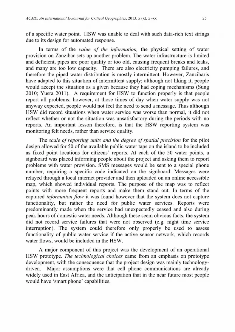
The scale of reporting units and the degree of spatial precision for the pilot
design allowed for 50 of the available public water taps on the island to be included
as fixed point locations for citizens’ reports. At each of the 50 water points, a
signboard was placed informing people about the project and asking them to report
problems with water provision. SMS messages would be sent to a special phone
number, requiring a specific code indicated on the signboard. Messages were
relayed through a local internet provider and then uploaded on an online accessible
map, which showed individual reports. The purpose of the map was to reflect
points with more frequent reports and make them stand out. In terms of the
captured information flow it was found however that the system does not capture
functionality, but rather the need for public water services. Reports were
predominantly made when the service had unexpectedly ceased and also during
peak hours of domestic water needs. Although these seem obvious facts, the system
did not record service failures that were not observed (e.g. night time service
interruption). The system could therefore only properly be used to assess
functionality of public water service if the active sensor network, which records
water flows, would be included in the HSW.
A major component of this project was the development of an operational
HSW prototype. The technological choices came from an emphasis on prototype
development, with the consequence that the project design was mainly technology-
driven. Major assumptions were that cell phone communications are already
widely used in East Africa, and the anticipation that in the near future most people
would have ‘smart phone’ capabilities.
Shifting Boundaries of Volunteered Geographic Information Systems and Modalities 26
Shifting the Boundaries of Volunteered Geographic Information Systems,
Modalities and Practices
4.1 Analysing VGI and Governance
The current conceptualisation of VGI is imprecise and confusing. Therefore,
first we looked again at VGI and associated UGC modalities, to identify the two
foundational drivers: growing recognition of the value of vulgar knowledge, and
the acceleration of cyberspace communication capacities.
Then, we have developed a framework that assesses VGI performance and
operational characteristics with respect to participation and good governance
principles. By examining two case studies to assess how they measure up on the
VGI framework, we see the complex local specificities in space, time and society
that are embedded in any VGI practice, thus creating the need for converging with
participatory knowledge processes, namely PGIS.
Key values and ethics in the modalities of practice must be addressed in order
to assess VGI activities and extend VGI to a closer fit with the nature of
participatory involvement. Seemingly simple, but profound, is the question of ‘who
volunteers to provide VGI information?’ We identified a continuum from passive
physical sensors, through passive human sensors and then active human sensors,
and hence to VGI ‘volunteers’ who are involved in acquisition and reporting and
maybe also in assessing the observations. Further along the continuum are PGIS
‘participants’ who should be incorporated in all these activities, and, beyond this,
be involved in analysis and critical evaluation, and in reflection. Pertinent
questions concern the many other actors participating in VGI systems and actions.
Who designs the specific VGI activities and platforms? Who tests and processes
the outputs? Who are the final users? And significantly, who will be the owner of
the information? The governing in many instances may have reason to resist
increased empowerment and transparency in VGI practice, if and when it
converges towards PGIS and its tools of counter mapping.
4.2 VGI to VGI.2 (Vulgar Grounded Intelligence)
If VGI is to be more credible as an approach and medium to represent local
knowledge and people’s priorities, needs and hopes, and to fulfil conditions of
good governance, then it must more fully represent the values of the people who
are ‘volunteering’ the information. For that, we can aim towards a more
appropriate meaning to the acronym “VGI”, thus, ‘vulgar grounded intelligence’
(VGI.2). ‘Vulgar Grounded Intelligence’ (VGI.2) is germane, because we are
dealing with local spatial knowledge of, and from, the ‘common people’ (Vulgar),
which is well-grounded in people’s life experience (Grounded), and which is
representing not only observations and information, but also the ‘citizen science’ of
knowledge analysis and assessment (Intelligence).
ACME: An International E-Journal for Critical Geographies, 2013, x (x), x -xx 27
Table 3 Shifting from Low to High Levels of Participation in VGI – from VGI
to VGI.2
VGI Lower Participation
VGI.2 Higher Participation
One–way elicitation
Closed set of questions, categories and
layers
Not interactive
Selective respondents
Involuntary
Maybe hidden process
Faster
Crowdsourcing for external purposes
n-way participatory group
discussion
Open-ended conversations, no fixed
agenda
Interactive, feedback, reciprocal,
Inclusive (proactive inclusion)
Voluntary
Transparent process
Slow (deliberately slow)
Empowering participants over time
Source: this paper
PGIS has always challenged the status quo of ‘authoritative information’, that
is, the official information of agencies which is inextricably linked with their
relative power position. Below the surface of the map products are the underlying
power structures. Whereas VGI activities are rarely actively subversive, there are
cases, which we can term as VGI.2, that are motivated towards critical and
reflective “vulgar grounded intelligence”. Ushahidi is a leading global platform
that can and does challenge authoritative information, and consider also such
politically motivated examples as Cidade Democrática (Brazil), ‘I paid a bribe’
(India), ‘Bribr’ (Russia)39
, or ‘Palestine remembered’ (Palestine/Israel)40
, or the
‘counter-cultural’ ‘Price of weed’ (USA and global)41
.
At the ‘low participation VGI’ end of this continuum, VGI activities can be
conceived of as cheap data production relying on a cheap labour force providing
data for information-crunchers, whether government or commercial. At this
extremity, society’s growing acceptance of and nonchalance towards the GIS/2
milieu and its software combined with the explosion of CCTVs and other spy
devices, including billions of smartphones with cameras, exposes us to
unprecedented levels of surveillance and governing control (Elwood 2009). Here,
the ‘P’ has been utterly discarded.
A richer understanding of the rapid, fairly raw spate of information from VGI
and the like, and the capability to cross-communicate it as trustworthy knowledge,
involves locational, historical, and cultural-social specificities, and this need for
localness favours participation. The challenge is to benefit from both VGI and
PGIS, that is, how to better exploit the ‘breadth’ of VGI together with the ‘depth’
of PGIS, and thus, how to shift from VGI towards VGI.2.
39
http://www.crowdsourcing.org/editorial/in-russia-the-crowd-targets-corruption-and-bribes/22322 40
http://www.palestineremembered.com/Articles/General/Story1913.html 41
http://www.priceofweed.com/

Shifting Boundaries of Volunteered Geographic Information Systems and Modalities 28
Acknowledgements
Thanks to Gianluca Miscione who provided ideas and commentaries early on.
References
Adams, David. 2012. Volunteered Geographic Information: potential implications
for participatory planning. Planning Practice and Research iFirst
DOI:10.1080/02697459.2012.725549
Aubut, J. 2004. The good governance agenda: who wins and who loses. Some
empirical evidence for 2001. LSE, Development Studies Institute, London,
DESTIN Working Paper No. 04-48.
Avila, Renata; Feigenblatt, Hazel; Heacock, Rebekah; and Heller, Nathaniel. 2011.
Global Mapping of Technology for Transparency and Accountability. New
Technologies. London: Transparency and Accountability Initiative.
www.transparency-initiative.org
Ball, Matt. 2010. What’s the distinction between crowdsourcing, volunteered
geographic information and authoritative data? Spatial Sustain. October 8,
2010. http://www.sensysmag.com/spatialsustain/whats-the-distinction-
between-crowdsourcing-volunteered-geographic-information-and-
authoritative-data.html
Baud, Isa; Pfeffer, Karin; Scott, Dianne; and Sydenstricker, John. 2011.
Developing Participatory ‘Spatial’ Knowledge Models in Metropolitan
Governance Networks for Sustainable Development. Literature Review.
Bonn: EADI, Change2Sustain
Béné, Christopher; and Neiland, Arthur E. 2006. From Participation to
Governance: A critical review of the concepts of governance, co-
management and participation, and their implementation in small-scale
inland fisheries in developing countries. Penang: WorldFish Center, Penang,
AND Colombo: CGIAR Challenge Program on Water and Food,
Contribution No. 1750.
http://www.worldfishcenter.org/resource_centre/GovernancePaper.pdf
Berdou, Evangelia. 2012. Participatory Technologies and Participatory
Methodologies: Ways Forward for Innovative Thinking and Practice.
Brighton: University of Sussex, IDS - Institute of Development Studies,
Vulnerability and Poverty Reduction Team.
http://wiki.ikmemergent.net/files/1202-Berdou_IKM_27022012.pdf
Boulos, Maged N. Kamel; Resch, Bernd; Crowley, David N.; Breslin, John G.;
Sohn, Gunho; Burtner, Russ; Pike, William A.; Jezierski, Eduardo; and Kuo-
Yu Slayer Chuang. 2011. Crowdsourcing, citizen sensing and sensor web
technologies for public and environmental health surveillance and crisis

ACME: An International E-Journal for Critical Geographies, 2013, x (x), x -xx 29
management: trends, OGC standards and application examples. International
Journal of Health Geographics 10, 67
Brown, Gregory; Kelly, Maggi; and Whitall, Debra. 2013. Which “public”?
Sampling effects in public participation GIS (PPGIS) and volunteered
geographic information (VGI) systems for public lands management.
Journal of Environmental Planning and Management.
DOI:10.1080/09640568.2012.741045
Budhathoki, Nama Raj; Nedovic-Budic, Zorica; and Bertram (Chip) Bruce. 2010.
An interdisciplinary frame for understanding Volunteered Geographic
Information. Geomatica 64 (1) 313-320.
Bugs, Geisa; Granell, Carlos; Fonts, Oscar; Huerta, Joaquín; and Painho, Marco.
2010. An assessment of Public Participation GIS and Web 2.0 technologies
in urban planning practice in Canela, Brazil. Cities 27, 172–181
Burke, J.; Estrin, D.; Hansen, M.; Parker, A.; Ramanathan, N.; Reddy, S.; and
Srivastava, M.B. 2006. Participatory Sensing. Paper given at 4th ACM
Conf. on Embedded Networked Sensor Systems (ACM SenSys 2006),
Workshop on World-Sensor-Web (WSW'2006), Boulder, CO. Nov. 2006.
Cavill, S., and Sohail, M. 2004. Strengthening accountability for urban services.
Environment and Urbanization 16 (1) 155-170.
Chambers, Robert. 2006. Participatory mapping and geographic information
systems: Whose map? Who is empowered and who disempowered? Who
gains and who loses? Electronic Journal of Information Systems in
Developing Countries (EJISDC) 25 (1)
Cohn, Jeffrey P. 2008. Citizen Science: can volunteers do real research?
BioScience 58 (3)192-197.
Coleman, David J.; Georgiadou, Yola; and Labonte, Jeff. 2009. Volunteered
Geographic Information: the nature and motivation of produsers. (sic)
International Journal of Spatial Data Infrastructures Research 4, 332-358.
Cope, Meghan; and Elwood, Sarah (eds). 2009. Qualitative GIS. A Mixed
Methods Approach. Sage.
E- Governments Foundation. 2011. E-gov clients.
http://www.egovernments.org/clients.htm India
Elwood, Sarah. 2008 a. Volunteered geographic information: future research
directions motivated by critical, participatory, and feminist GIS. GeoJournal
72 (3-4) 173-183.
Elwood, Sarah. 2008 b. Volunteered geographic information: key questions,
concepts and methods to guide emerging research and practice. GeoJournal
72 (3-4) 133-135.

Shifting Boundaries of Volunteered Geographic Information Systems and Modalities 30
Elwood, Sarah. 2009. Geographic Information Science: new geovisualization
technologies emerging questions and linkages with GIScience research.
Progress in Human Geography 33, 256-263.
Elwood, Sarah; and Leszczynski, Agnieszka. 2012. New spatial media, new
knowledge politics. Transactions of the Institute of British Geographers 38
(4) 544-559.
Estellés Arolas, Enrique; and González Ladrón-de-Guevara, Fernando. 2012.
Clasificación de iniciativas de crowdsourcing basada en tareas. El
Profesional de la Informacion 01/2012;
Flanagin, Andrew J.; and Metzger, Miriam J. 2008. The credibility of volunteered
geographic information. GeoJournal 72, 137–148.
Floreddu, Paola Barbara; and Cabiddu, Francesca. 2012. Public decisions and
citizen satisfaction: the potential role of public participation geographic
information systems. International Journal of Electronic Commerce Studies
3 (1) 121-134.
Francis, Louise; Whitaker, Colleen; and Haklay, Muki. 2008 Noise mapping helps
citizens take action. GIS Professional 23, 26-28.
Fraser Taylor, David R. 1997. Maps and mapping in the information era. In,
Ottoson, L. (ed.) Proceedings of the 18th International Cartographic
Conference. Vol. 1. Gavle, Sweden: Swedish Cartographic Society. pp. 1-10.
http://icaci.org/files/documents/ICC_proceedings/ICC1997/icc1997_volume1
_part1.pdf
Fraser Taylor, David R. 2003. The concept of cybercartography. In, Peterson, M.P.
(ed.) Maps and the Internet. Amsterdam: Elsevier. pp. 405-420.
Freifeld, C.C.; Chunara, R.; Mekaru, S.R.; Chan, E.H.; Kass-Hout, T.; et al. 2010.
Participatory epidemiology: use of mobile phones for community-based
health reporting. PLoS Med 7 (12): e1000376.
Georgiadou, Yola; Budhathoki, Nama Raj; and Nedovic-Budic, Zorica. 2011. An
exploration of SDI and Volunteered Geographic Information in Africa. In,
Nedovic-Budic, Zorica; Crompvoets, Joep; and Georgiadou, Yola (eds).
2011. Spatial Data Infrastructure in Context: North and South, Boca Raton,
FL: CRC Press. Chap. 10, pp. 203-218.
Goodchild, Michael F. 2007 a. Citizens as sensors: The world of volunteered
geography. GeoJournal 69, 211–221.
Goodchild, Michael F. 2007 b. Citizens as voluntary sensors: spatial data
infrastructure in the world of Web 2.0. International Journal of Spatial
Data Infrastructures Research 2, 24-32. (editorial)
Goodchild, Michael F. 2008. Commentary: whither VGI? Geojournal 72, 239-
244.

ACME: An International E-Journal for Critical Geographies, 2013, x (x), x -xx 31
Goodchild, Michael F. 2009. NeoGeography and the nature of geographic
expertise. Journal of Location-Based Services 3 (2) 82-96.
Goodchild, Michael F.; and Glennon, J. Alan. 2010. Crowdsourcing geographic
information for disaster response: a research frontier. International Journal
of Digital Earth 3 (3) 231-241
Grey, Francois. 2009. Citizen Cyberscience - Francois Grey.
http://www.youtube.com/watch?v=Beh-peFXzkc
Gouveia, C.; and Fonseca, A. 2008. New approaches to environmental
monitoring: The use of ICT to explore volunteered geographic information.
GeoJournal 72 (3-4) 185-197
Haklay, Muki. 2010. How good is volunteered geographical information? A
comparative study of OpenStreetMap and Ordnance Survey datasets.
Environment and Planning B 37 (4) 682 – 703
Haklay, Muki. 2012. Citizen Science and Volunteered Geographic Information -
Overview and Typology of Participation. In, Sui, D.Z.; Elwood, S.; and M.F.
Goodchild (eds). 2012. Volunteered Geographic Information: Public
Participation and Crowdsourced Production of Geographic Knowledge.
Berlin: Springer.
Haklay, Muki; Basiouka, S.; Antoniou, V.; and Ather, A. 2010. How many
volunteers does it take to map an area well? The Cartographic Journal 47
(4) 315-322.
Haklay, Muki; Singleton A.; and Parker C. 2008. Web mapping 2.0: the
Neogeography of the GeoWeb. Geography Compass 2, 2011-2039.
Haklay, Muki; and Weber, P. 2008. OpenStreetMap – User Generated Street Map,
IEEE Pervasive Computing. October-December 2008, pp. 12-18.
Harmsworth, Garth. 1998. Indigenous values and GIS: a method and a framework.
Indigenous Knowledge and Development Monitor 6 (3) 3-7.
Heipke, Christian. 2010. Crowdsourcing geospatial data. ISPRS Journal of
Photogrammetry and Remote Sensing 65 (6) 550-557
Howe, Jeff. 2006. The rise of crowdsourcing. Wired Issue 14.06 - June 2006
www.wired.com/wired/archive/14.06/crowds.html
van Kersbergen, Kees; and van Waarden, Frans. 2001. Shifts in Governance:
Problems of Legitimacy and Accountability. The Hague: MAGW (Social
Science Research Council), for: NWO (Neth. Organization for Scientific
Research)
Laituri, Melinda; and Kodrich, Kris. 2008. On line disaster response community:
People as sensors of high magnitude disasters using Internet GIS. Sensors
8, 3037-3055

Shifting Boundaries of Volunteered Geographic Information Systems and Modalities 32
Leroux, Alexandre. 2011. [[email protected]] 20 February 2011 19:22.
Leszczynski, A. 2010. Neogeo as neolib? Towards a preliminary political
economy of VGI. Paper given at the Annual Meeting of the Association of
American Geographers, Washington, DC, April 2010
Mapping for Indigenous Advocacy. 2004. International Forum on Indigenous
Mapping: Mapping for Indigenous Advocacy and Empowerment Conference,
Vancouver, BC, April 2004.
Martinez, J.; Pfeffer, K.; and van Dijk, T. 2011. E-Government Tools, Claimed
Potentials/Unnamed Limitations. Environment and Urbanization Asia 2 (2)
223-234.
Maué, Patrick. 2007 a. Collaborative metadata: The need for reputation. In,
Probst, Florian; and Keßler, Carsten (eds.) (2007) GI-Days 2007 - Young
Researchers Forum. IfGIprints 30. pp. 233-236.
Maué, Patrick. 2007 b. Reputation as tool to ensure validity of VGI. Paper given
at: Specialist Meeting on Volunteered Geographic Information, Santa
Barbara, CA, December 2007.
http://www.ncgia.ucsb.edu/projects/vgi/docs/position/Maue_paper.pdf
MCC Mysore City Corporation. 2011. Complaint Registration.
http://www.mysorecity.gov.in/pgrinfo
McCall, Michael K. 2003. Seeking good governance in participatory-GIS: a
review of processes and governance dimensions in applying GIS to
participatory spatial planning. Habitat International 27 (4) 549-573.
McCall, Michael K. 2006. Precision for whom? – Mapping ambiguity and
certainty in (Participatory) GIS. Participatory Learning and Action 54,
114-119.
McCall, Michael K. 2011. Can neogeography and GIS/2 satisfy PGIS?’ In, Orban-
Ferauge, Françoise (ed.) 2011. Participatory Geographic Information
Systems and Land Planning: Life Experiences for People Empowerment and
Community Transformation. Namur: FUNDP. pp.79-96.
McCall, Michael K.; and Dunn, Christine E. 2012. Geo-information tools for
participatory spatial planning: Fulfilling the criteria for ‘good’ governance?
GeoForum 43 (1) 81-94.
McGee, Tara K.; and Gow, Gordon A. 2012. Potential responses by on-campus
university students to a university emergency alert. Journal of Risk Research
15 (6) 693-710
McGlade, Jacqueline. 2009. Annual Earthwatch lecture - Citizen Science, Oxford,
16.2.2009. http://www.eea.europa.eu/pressroom/speeches/global-citizen-
observatory-the-role-of-individuals-in-observing-and-understanding-our-
changing-world

ACME: An International E-Journal for Critical Geographies, 2013, x (x), x -xx 33
Meier, Patrick. 2010. Ushahidi and the unprecedented role of SMS in disaster
response. Wired: Haiti Rewired 23.2.2010.
http://haitirewired.wired.com/profiles/blogs/ushahidi-ampthe-unprecedented
Miller, C. 2006. A beast in the field: the Google Maps mashup as GIS.
Cartographica 41, 1878-1899
Miscione, G.; Martinez, J.; Pfeffer, K.; and De’, R. 2012. Whose Inclusion?
Whose Knowledge? Consequences of e-Grievance Redressal Systems’ use in
India and Europe. Enschede: ITC, University of Twente. [unpublished]
Ndungu, W. 2012. Applicability of Volunteered Geographic Information in
Assessing Subjective Quality of Life: Case from Zanzibar. Enschede: MSc
Thesis, ITC, University of Twente.
Okolloh, O. 2009. Ushahidi, or 'testimony': Web 2.0 tools for crowdsourcing
crisis information. Participatory Learning and Action 59, pp. 65-70.
Pan Suk Kim; Halligan, John; Cho, Namshin; Oh, Cheol H.; and Eikenberry,
Angela M. 2005. Toward participatory and transparent governance: Report
on the Sixth Global Forum on Reinventing Government. Public
Administration Review 65 (6) 646-654.
Pfeffer, Karin; Baud, Isa; Denis, Erik; Scott, Dianne; and Sydenstricker-Neto,
John. 2013. Participatory spatial knowledge management tools. Information,
Communication and Society 16 (2) 258-285.
Rambaldi, Giacomo; Chambers, Robert; McCall, Michael; and Fox, Jefferson.
2006. Practical ethics for PGIS practitioners, facilitators, technology
intermediaries, and researchers. Participatory Learning and Action 54, 106-
113.
Rambaldi, Giacomo; Kyem, Peter A. Kwaku; McCall, Michael; and Weiner,
Daniel. 2006. Participatory spatial information management and
communication in developing countries. Electronic Journal of Information
Systems in Developing Countries 25 (1) 1-9.
Resnick, Paul; Zeckhauser, Richard; Friedman, Eric; and Kuwabara, Ko. 2000.
Reputation systems. Communications of the ACM 43 (12) 45-48.
RICS. 2011. Crowdsourcing Support of Land Administration. A New,
Collaborative Partnership between Citizens and Land Professionals.
London: RICS Royal Institution of Chartered Surveyors. [Author: Robin
McLaren]
Roche, Stéphane. 2010. Geoweb, Neogeography, and VGI: New Challenges for
Geomatics Sciences and Engineering. Presentation at FIG Congress 2010,
Sydney, Australia, April 2010.
http://www.fig.net/pub/fig2010/papers/ts02b%5Cts02b_roche_abs_4208.pdf

Shifting Boundaries of Volunteered Geographic Information Systems and Modalities 34
Rosen, Devan; Lafontaine, Pascale Roy; and Hendrickson, Blake. 2011.
CouchSurfing: Belonging and trust in a globally cooperative online social
network. New Media and Society 13: 981-998.
Rouse, L. Jesse; Bergeron, Susan J.; and Harris, Trevor M. 2007. Participating in
the geospatial Web: collaborative mapping, social networks and Participatory
GIS. In, Scharl, Arno; and Tochtermann, Klaues (eds). 2007. The
Geospatial Web. How Geobrowsers, Social Software and the Web 2.0 are
Shaping the Network Society. London: Springer, Advanced Information and
Knowledge Processing Series. Chap. 14, pp. 153-158.
Rowley, J.; and Johnson, F. 2013. Understanding trust formation in digital
information sources: The case of Wikipedia. Journal of Information Science
March 6, 2013 doi: 10.1177/0165551513477820
Rundstrom, Robert A. 1990. A cultural interpretation of Inuit map accuracy.
Geographical Review 80 (2) 155-168.
Sanvig Knudsen, Anne-Marie; and Kahila, Maarit. 2012. The role of Volunteered
Geographic Information in participatory planning: Examples from Denmark
and Finland. Perspektiv 21, 35-46.
Schroeder, Paul. 1996. Criteria for the Design of a GIS/2. Paper for NCGIA
Initiative 19: GIS and Society.
Silvertown, J. 2009. A new dawn for Citizen Science. Trends in Ecology and
Evolution 24, 467-471.
Spanu, Valentina; and McCall, Michael K. 2013. Eliciting local spatial knowledge
for community-based disaster risk management: working with CyberTracker
in Georgian Caucasus. International Journal of E-Planning Research
(IJEPR) 2 (2) 45-59
Sui, Dsniel; and DeLyser, D. 2012. Crossing the qualitative-quantitative chasm I:
Hybrid geographies, the spatial turn, and volunteered geographic information
(VGI). Progress in Human Geography 36 (1) 111-124.
Sui, Daniel Z.; Elwood, Sarah; and Goodchild, Michael F. (eds). 2012.
Crowdsourcing Geographic Knowledge: Volunteered Geographic
Information (VGI) in Theory and Practice. Berlin: Springer.
Sung, C.Y. 2010. Understanding of Data Quality in Human Sensor Web.
Enschede: MSc Thesis, ITC, University of Twente.
van Teeffelen, J., and Baud, Isa. 2011. Exercising citizenship: invited and
negotiated spaces in grievance redressal systems in Hubli-Dharwad.
Environment and Urbanization Asia, 2 (2) 169-185.
Thielmann, Tristan. 2010. Locative media and mediated localities. Aether,
Journal of Media Geography 5a, 1-17.
ACME: An International E-Journal for Critical Geographies, 2013, x (x), x -xx 35
Tulloch, David L. 2003. What PPGIS really needs is … New Brunswick, NJ:
Rutgers, Center for Remote Sensing and Spatial Analysis.
http://deathstar.rutgers.edu/ppgis/Tulloch.PPGIS.2003.htm
Tulloch, David L. 2007. Many, many maps: Empowerment and online
participatory mapping. Firstmonday: peer-reviewed journal on the internet.
12 (2) (14p.)
Tulloch, David L. 2008. Is VGI participation? From vernal pools to video games.
GeoJournal 72, 161–171
Tulloch, David L.; and Shapiro, Tamara. 2003. The intersection of data access and
public participation: impacting GIS users' success? Urban and Regional
Information Systems Association (URISA) Journal 15 (APA II), 55-60.
Turner, Andrew. 2006. Introduction to Neogeography. Sebastopol, CA: O’Reilly
Media. http://oreilly.com/catalog/9780596529956/
UNDP. 1997. Governance for Sustainable Human Development. UNDP policy
document, January 1997. New York, NY: United Nations Development
Programme.
UNDP. 2005. The Key to Increasing Transparency in e-Government Deployments.
Public Feedback Mechanisms. New York, NY: United Nations Development
Programme. APDIP e-Note 3 / 2005.
UN-Habitat. 2009. h2.0 Monitoring Services to Inform and Empower. Nairobi:
UN-Habitat. http://www.unhabitat.org/categories.asp?catid=635
Verplanke, Jeroen; Miscione, Gianluca; and Lemmens, Rob. 2010. Geo-location
in open systems - Reflection from a ‘human sensor web’. 14th
AGILE
Conference on Geo-information Science. Workshop 6 - Multi- and
Interdisciplinary Research on Spatial Knowledge in the light of SII.
Vivacqua, Adriana S.; and Borges, Marcos R.S. 2012. Taking advantage of
collective knowledge in emergency response systems. Journal of Network
and Computer Applications 35, 189–198.
Wallack, J., and Nadhamuni, S. 2007. User Innovation and E-governance Design.
www.egovernments.org
White, I.; Kingston, Richard; and Barker, A. 2010. Participatory geographic
information systems and public engagement within flood risk management.
Journal of Flood Risk Management 3, 337–346.
Wood, Denis. 1993. What makes a map a map? Cartographica 30 (2-3) 81-86.
Wood, Denis; and Quiquivix, Linda. 2011. Interview, Maps and the Question of
Palestine: An Interview with Denis Wood. Arena of Speculation: Critical
perspectives on the future of Israel-Palestine. (August 2011).
http://arenaofspeculation.org/2011/08/04/maps-and-the-question-of-palestine,

Shifting Boundaries of Volunteered Geographic Information Systems and Modalities 36
Yusra, S. 2011. Assessing the Motivations for Submitting VGI: the Case of the
Human Sensor Web on Zanzibar. Enschede: MSc Thesis, ITC, University of
Twente.
Zook, Matthew A.; and Graham, Mark. 2007. The creative reconstruction of the
Internet: Google and the privatization of cyberspace and DigiPlace.
Geoforum 38, 1322-1343.
Zook, Matthew A.; Graham, Mark; Shelton, T; and Gorman, S. 2010. Volunteered
Geographic Information and crowdsourcing disaster relief: A case study of
the Haitian earthquake. World Medical and Health Policy 2 (2)