shelby county schools extended learning guide science
TRANSCRIPT
Shelby County Schools
Extended Learning Guide
Science
Grade 6
Lesson
ESSENTIAL QUESTION
What is weather and how can we describe different types of weather conditions?By the end of this lesson, you
should be able to describe
elements of weather and explain
how they are measured.
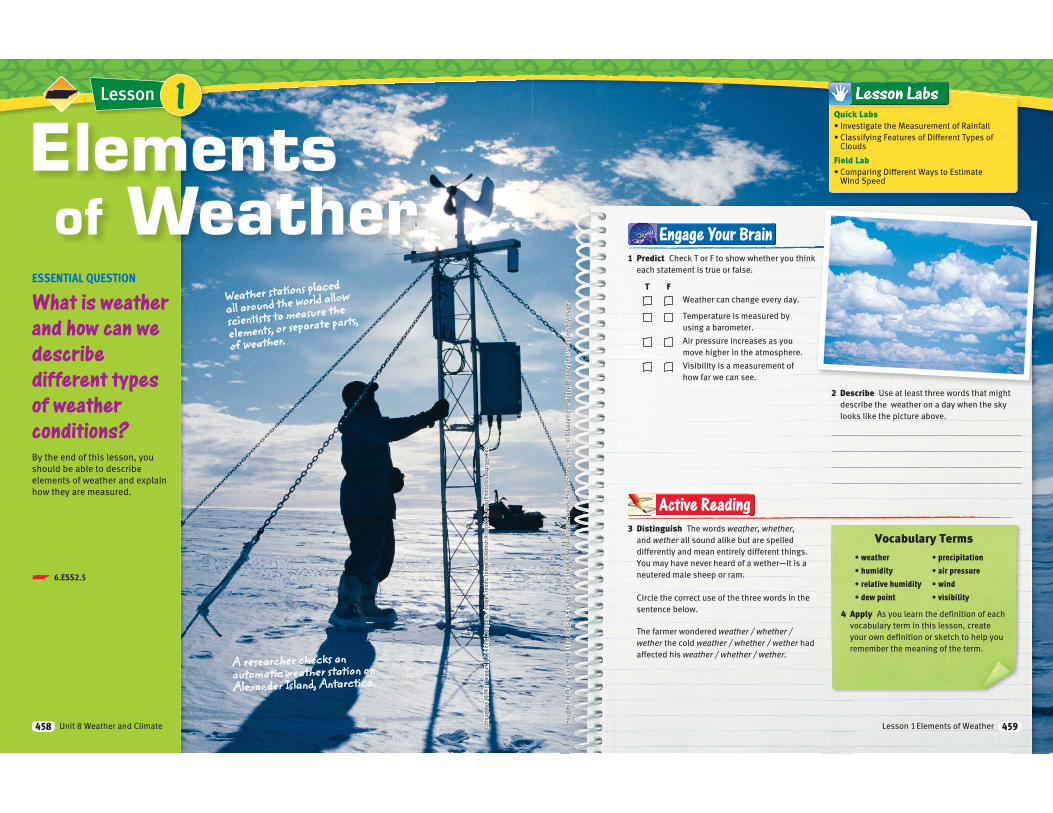
Elementsof Weather
Weather stations placed
all around the world allow
scientists to measure the
elements, or separate parts,
of weather.
A researcher checks an automatic weather station on Alexander Island, Antarctica.
1
Unit 8 Weather and Climate458
p 6.ESS2.5
Engage Your Brain
3 Distinguish The words weather, whether, and wether all sound alike but are spelled
differently and mean entirely different things.
You may have never heard of a wether—it is a
neutered male sheep or ram.
Circle the correct use of the three words in the
sentence below.
The farmer wondered weather / whether / wether the cold weather / whether / wether had
affected his weather / whether / wether.
Active Reading
4 Apply As you learn the definition of each
vocabulary term in this lesson, create
your own definition or sketch to help you
remember the meaning of the term.
1 Predict Check T or F to show whether you think
each statement is true or false.
T FWeather can change every day.
Temperature is measured by
using a barometer.
Air pressure increases as you
move higher in the atmosphere.
Visibility is a measurement of
how far we can see.
2 Describe Use at least three words that might
describe the weather on a day when the sky
looks like the picture above.
Vocabulary Terms
Quick Labs
Clouds
Field Lab
Wind Speed
Lesson 1 Elements of Weather 459
What is weather?Weather is the condition of Earth’s atmosphere at a certain time
and place. Different observations give you clues to the weather.
If you see plants moving from side to side, you might infer that
it is windy. If you see a gray sky and wet, shiny streets, you might
decide to wear a raincoat. People talk about weather by describing
factors such as temperature, humidity, precipitation, air pressure,
wind, and visibility
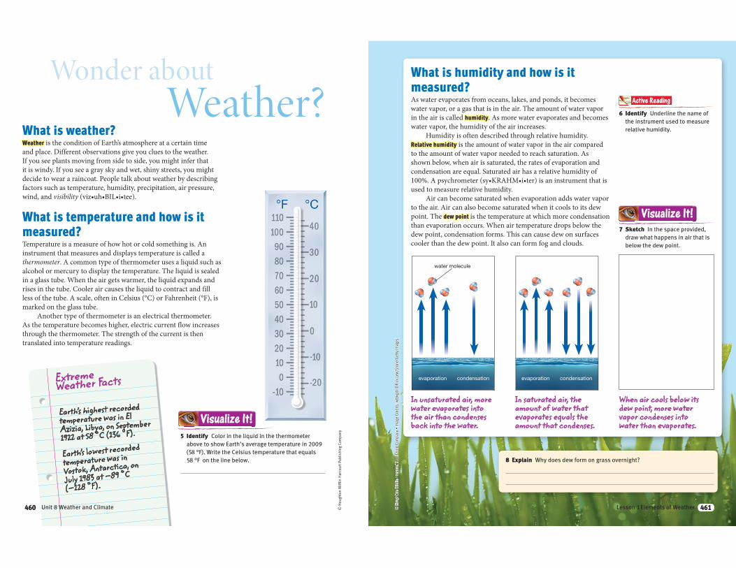
What is temperature and how is it
measured?Temperature is a measure of how hot or cold something is. An
instrument that measures and displays temperature is called a
thermometer. A common type of thermometer uses a liquid such as
alcohol or mercury to display the temperature. The liquid is sealed
in a glass tube. When the air gets warmer, the liquid expands and
rises in the tube. Cooler air causes the liquid to contract and fill
marked on the glass tube.
Another type of thermometer is an electrical thermometer.
As the temperature becomes higher, electric current flow increases
through the thermometer. The strength of the current is then
translated into temperature readings. ©
Hou
ghto
n M
ifflin
Har
cour
t Pub
lishi
ng C
ompa
ny
Wonder aboutWeather?
Extreme Weather Facts
5 Identify Color in the liquid in the thermometer
above to show Earth’s average temperature in 2009
(58 °F). Write the Celsius temperature that equals
58 °F on the line below.
Visualize It!
Earth’s lowest recorded
temperature was in
Vostok, Antarctica, on
July 1983 at –89 °C
(–128 °F).
Earth’s highest recorded temperature was in El Azizia, Libya, on September
1922 at 58 °C (136 °F).
460 Unit 8 Weather and Climate460
evaporation condensationevaporation
water molecule
condensation
What is humidity and how is it
measured?As water evaporates from oceans, lakes, and ponds, it becomes
water vapor, or a gas that is in the air. The amount of water vapor
in the air is called humidity. As more water evaporates and becomes
water vapor, the humidity of the air increases.
Humidity is often described through relative humidity.
Relative humidity is the amount of water vapor in the air compared
to the amount of water vapor needed to reach saturation. As
shown below, when air is saturated, the rates of evaporation and
condensation are equal. Saturated air has a relative humidity of
used to measure relative humidity.
Air can become saturated when evaporation adds water vapor
to the air. Air can also become saturated when it cools to its dew
point. The dew point is the temperature at which more condensation
than evaporation occurs. When air temperature drops below the
dew point, condensation forms. This can cause dew on surfaces
cooler than the dew point. It also can form fog and clouds.
In unsaturated air, more water evaporates into the air than condenses back into the water.
In saturated air, the amount of water that evaporates equals the amount that condenses.
6 Identify Underline the name of
the instrument used to measure
relative humidity.
Active Reading
8 Explain Why does dew form on grass overnight?
7 Sketch In the space provided,
draw what happens in air that is
below the dew point.
Visualize It!
When air cools below its dew point, more water vapor condenses into water than evaporates.
461Lesson 1 Elements of Weather 461
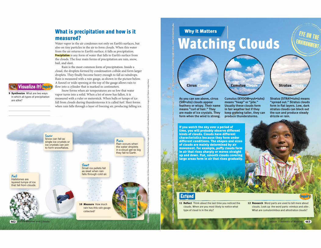
What is precipitation and how is it
measured?Water vapor in the air condenses not only on Earth’s surfaces, but
also on tiny particles in the air to form clouds. When this water
from the air returns to Earth’s surface, it falls as precipitation.
Precipitation is any form of water that falls to Earth’s surface from
the clouds. The four main forms of precipitation are rain, snow,
hail, and sleet.
Rain is the most common form of precipitation. Inside a
cloud, the droplets formed by condensation collide and form larger
droplets. They finally become heavy enough to fall as raindrops.
Rain is measured with a rain gauge, as shown in the picture below.
A funnel or wide opening at the top of the gauge allows rain to
flow into a cylinder that is marked in centimeters.
Snow forms when air temperatures are so low that water
vapor turns into a solid. When a lot of snow has fallen, it is
measured with a ruler or meterstick. When balls or lumps of ice
fall from clouds during thunderstorms it is called hail. Sleet forms
when rain falls through a layer of freezing air, producing falling ice.
9 Synthesize What are two ways
in which all types of precipitation
are alike?
Visualize It! Inquiry
HailHailstones are layered lumps of ice that fall from clouds.
SnowSnow can fall as single ice crystals or ice crystals can join to form snowflakes.
SleetSmall ice pellets fall as sleet when rain falls through cold air.
RainRain occurs when the water droplets in a cloud get so big they fall to Earth.
10 Measure How much
rain has this rain gauge
collected?
462 Unit 8 Weather and Climate462
Inquiry
Why It Matters
If you watch the sky over a period of time, you will probably observe different kinds of clouds. Clouds have different characteristics because they form under different conditions. The shapes and sizes of clouds are mainly determined by air movement. For example, puffy clouds form in air that rises sharply or moves straight up and down. Flat, smooth clouds covering large areas form in air that rises gradually.
Watching Clouds
11 Reflect Think about the last time you noticed the
clouds. When are you most likely to notice what
type of cloud is in the sky?
12 Research Word parts are used to tell more about
clouds. Look up the word parts -nimbus and alto-.
What are cumulonimbus and altostratus clouds?
Extend
Cirrus Clouds Cumulus Clouds Stratus Clouds
463Lesson 1 Elements of Weather 463
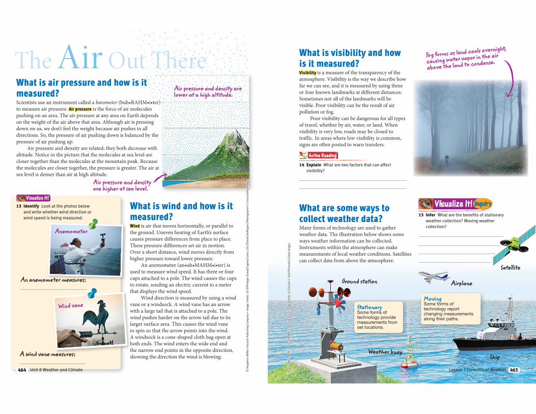
What is air pressure and how is it
measured?Scientists use an instrument called a barometerto measure air pressure. Air pressure is the force of air molecules
pushing on an area. The air pressure at any area on Earth depends
down on us, we don’t feel the weight because air pushes in all
directions. So, the pressure of air pushing down is balanced by the
pressure of air pushing up.
altitude. Notice in the picture that the molecules at sea level are
closer together than the molecules at the mountain peak. Because
the molecules are closer together, the pressure is greater. The air at
sea level is denser than air at high altitude.
What is wind and how is it
measured?Wind is air that moves horizontally, or parallel to
the ground. Uneven heating of Earth’s surface
causes pressure differences from place to place.
These pressure differences set air in motion.
Over a short distance, wind moves directly from
higher pressure toward lower pressure.
used to measure wind speed. It has three or four
cups attached to a pole. The wind causes the cups
to rotate, sending an electric current to a meter
that displays the wind speed.
Wind direction is measured by using a wind
with a large tail that is attached to a pole. The
wind pushes harder on the arrow tail due to its
larger surface area. This causes the wind vane
to spin so that the arrow points into the wind.
both ends. The wind enters the wide end and
the narrow end points in the opposite direction,
showing the direction the wind is blowing.
The Air Out There
Air pressure and density are higher at sea level.
Air pressure and density are lower at a high altitude.
Wind vane
Anemometer
A wind vane measures:
An anemometer measures:
13 Identify Look at the photos below
and write whether wind direction or
wind speed is being measured.
Visualize It!
464 Unit 8 Weather and Climate464
What is visibility and how
is it measured?Visibility is a measure of the transparency of the
atmosphere. Visibility is the way we describe how
far we can see, and it is measured by using three
or four known landmarks at different distances.
Sometimes not all of the landmarks will be
visible. Poor visibility can be the result of air
pollution or fog.
Poor visibility can be dangerous for all types
of travel, whether by air, water, or land. When
visibility is very low, roads may be closed to
traffic. In areas where low visibility is common,
signs are often posted to warn travelers.
What are some ways to
collect weather data?Many forms of technology are used to gather
weather data. The illustration below shows some
ways weather information can be collected.
Instruments within the atmosphere can make
measurements of local weather conditions. Satellites
can collect data from above the atmosphere.
Fog forms as land cools overnight,
causing water vapor in the air
above the land to condense.
Satellite
Ground station
Weather buoyShip
Airplane
14 Explain What are two factors that can affect
visibility?
Active Reading
StationarySome forms of technology provide measurements from set locations.
MovingSome forms of technology report changing measurements along their paths.
15 Infer What are the benefits of stationary
weather collection? Moving weather
collection?
Visualize It! Inquiry
465Lesson 1 Elements of Weather 465
evaporation condensation
To complete this summary, fill in the blanks with the correct word or phrase. Then use the key below to check your answers. You can use this page to review the main concepts of the lesson.
TTTTTTTTTTTTTTTTTTT llllllllllllllllll tttttttttttttttttttt ttththththththhthththhthhhthttthiiiiiiiiiiiiiiii fififfiffifififififififffffffiffffiiif llllllllllllllllllllllllllllllllll iiiiiiiiiiiiiiii tttttttthhhhthhttttht bbbbbbbbbbblblllllllblbbbbbblbbbbbblbbblblll kkkkkkkkkkkkkkkkkkkkkkkkkkkkk itttttittiiiiititittitti hhhhhhhhhhhhhhhhhhhhhhhh thththththththhhththhththttthhhhtthhhhh
Visual Summary
21 Synthesize What instruments would you take along if you were going
on a 3-month field study to measure how the weather on a mountaintop
changes over the course of a season?
Answers: 16 temperature; 17 relative; 18 higher, lower; 19 fog; 20 sleet
Humidity describes the amount of water vapor in the air.
Uneven heating of Earth’s surface causes air pressure differences and wind.
Weather is a condition of the atmosphere at a certain time and place.
Visibility describes how far into the distance objects can be seen.
Precipitation occurs when the water that condenses as clouds falls back to Earth in solid or liquid form.
17 The amount of moisture in the air is commonly expressed as humidity.
16 Weather is often expressed by describing , humidity, precipitation, air pressure, wind, and visibility.
1 8 Wind moves from areas of pressure to areas of pressure.
20 The main types of precipitation are hail, snow, , and rain.
19 Visibility can be affected by air pollution and
Elements of Weather
466 Unit 8 Weather and Climate © H
ough
ton
Miff
lin H
arco
urt P
ublis
hing
Com
pany
LessonLesson ReviewVocabulary
In your own words, define the following terms.
1 weather
2 humidity
3 air pressure
4 visibility
Key Concepts
Weather element Instrument
5 Identify Measures temperature
6 Identify Is measured by using a barometer
7 Identify Measures relative humidity
8 Identify Is measured by using a rain gauge or meterstick
9 Identify Measures wind speed
10 List What are four types of precipitation?
Critical Thinking
11 Apply Explain how wind is related to the uneven heating of Earth’s surfaces by the sun.
12 Explain Why does air pressure decrease as altitude increases?
13 Synthesize What is the relative humidity when the air temperature is at its dew point?
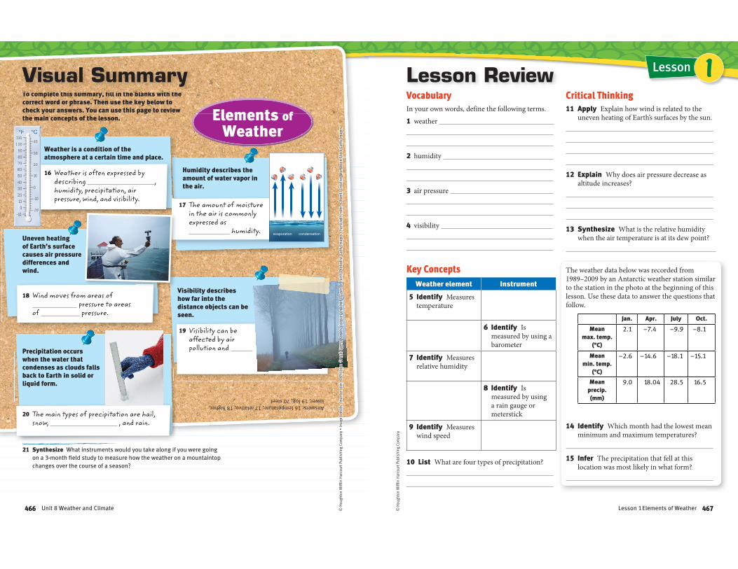
The weather data below was recorded from 1989–2009 by an Antarctic weather station similar to the station in the photo at the beginning of this lesson. Use these data to answer the questions that follow.
Jan. Apr. July Oct.
Mean max. temp.
(°C)
2.1 –7.4 –9.9 –8.1
Mean min. temp.
(°C)
–2.6 –14.6 –18.1 –15.1
Mean precip. (mm)
9.0 18.04 28.5 16.5
14 Identify Which month had the lowest mean minimum and maximum temperatures?
15 Infer The precipitation that fell at this location was most likely in what form?
1
467Lesson 1 Elements of Weather
p 6.ESS2.3
Lesson
Clouds and Cloud FormationESSENTIAL QUESTION
How do clouds
form, and how
are clouds
classified?
By the end of this lesson, you
should be able to describe the
formation and classification of
clouds.
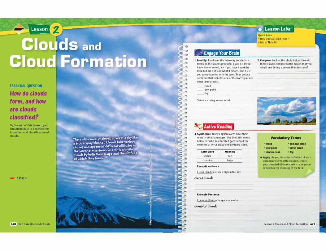
These altocumulus clouds cover the sky like a bluish-gray blanket. Clouds take various shapes and appear at different altitudes in the lower atmosphere. Scientists classify clouds by both their shape and the altitude at which they form.
2
470 Unit 8 Weather and Climate
Vocabulary Terms
4 Apply As you learn the definition of each
vocabulary term in this lesson, create
your own definition or sketch to help you
remember the meaning of the term.
1 Identify Read over the following vocabulary
terms. In the spaces provided, place a + if you
know the term well, a ~ if you have heard the
term but are not sure what it means, and a ? if
you are unfamiliar with the term. Then write a
sentence that includes one of the words you are
most familiar with.
_____ cloud
_____ dew point
_____ fog
Sentence using known word:
2 Compare Look at the photo below. How do
these clouds compare to the clouds that you
would see during a severe thunderstorm?
Engage Your Brain
3 Synthesize Many English words have their
roots in other languages. Use the Latin words
below to make an educated guess about the
meaning of cirrus cloud and cumulus cloud.
Latin word Meaning
cirrus curl
cumulus heap
Example sentence
Cirrus clouds are seen high in the sky.
cirrus cloud:
Example Sentence
Cumulus clouds change shape often.
cumulus cloud:
Active Reading
Quick Labs
471
What are clouds?When you look into the sky, you see the amazing shapes that
clouds take and how quickly those shapes change. But, have you
ever asked yourself what clouds are made of or how they form?
And did you know that there are different types of clouds?
A cloud is a collection of small water droplets or ice crystals
that are suspended in the air. Clouds are visible because water
droplets and ice crystals reflect light. Clouds are most often
associated with precipitation. However, the reality is that most
cloud types do not produce precipitation.
How do clouds affect climate?The precipitation that falls from clouds has a significant effect on
local climate. In particular, the pattern of precipitation of an area
will determine the climate of that area. For instance, a desert is
an area that receives less than 25 cm of precipitation a year. But, a
tropical rainforest may average 250 cm of precipitation a year.
Clouds also affect temperatures on Earth. About 25% of
the sun’s energy that reaches Earth is reflected back into space
by clouds. Low-altitude clouds, which are thick and reflect more
sunlight, help to cool Earth. On the other hand, thin, high-altitude
clouds absorb some of the energy that radiates from Earth. Part of
this energy is reradiated back to Earth’s surface. This warms Earth,
because this energy is not directly lost to space.
Active Reading 5 Describe What are two ways in which clouds affect
Earth’s climate?
6 Apply Sketch a cloud, and write
a caption that relates the drawing
to the content on this page.
Storm clouds appear dark gray. They
are so full of water droplets that little light can pass through them.
Unit 8 Weather and Climate472
B
© H
ough
ton
Miff
lin H
arco
urt P
ublis
hing
Com
pany
How do clouds form?Clouds form when water vapor condenses, or
changes from a gas to a liquid. For water vapor to
condense, two things must happen. Air must be
cooled to its dew point, and there must be a solid
surface on which water molecules can condense.
Air Cools to the Dew PointAs warm air rises in Earth’s atmosphere, it
expands and cools. If air rises high enough into
the atmosphere, it cools to its dew point. Dew
point is the temperature at which the rate of
condensation equals the rate of evaporation.
Evaporation is the change of state from a liquid to
a gas that usually occurs at the surface of a liquid.
Evaporation takes place at the surface of an
ocean, lake, stream, or other body of water. Water
vapor in the air can condense and form water
droplets or ice crystals when the temperature is
at or below the dew point.
Water Droplets or Ice Crystals Form on NucleiWater molecules condense much more rapidly
when there is a solid surface on which to
condense. In clouds, tiny solid particles called
cloud condensation nuclei are the surfaces on
which water droplets condense. Examples of
cloud condensation nuclei include dust, salt,
soil, and smoke.
Clouds are most commonly made of very
large numbers of very small water droplets.
However, at high altitudes, where
temperatures are very cold, clouds
are composed of ice crystals.
7 Conclude Complete the flow chart by filling in
the missing information.
A Warm air rises, expands, and cools.
condensation nucleus0.0002 millimeter diameter
cloud droplet0.05 millimeter diameter
D Cloud formation takes place.
C Condensation takes place on nuclei.
473
Frontal Lifting
Wind
Warm air
Cold front
Cold air-4 °C4 °C
6 °C 10 °C 13 °C
0 °C
Orographic Lifting
4000 m
3000 m
2000 m
1000 m
Sea level
Ocean
Desert30 °C
20 °C
15 °C
10 °C
© H
ough
ton
Miff
lin H
arco
urt P
ublis
hing
Com
pany
What is the role of solar
energy in cloud formation?The water cycle is the movement of water
between the atmosphere, land, and ocean. Solar
energy drives the water cycle and, therefore,
provides the energy for cloud formation.
About 50 percent of the sun’s incoming
energy is absorbed by land, by water on the land’s
surface, and by surface waters in the oceans. This absorbed energy causes liquid water at the
water’s surface to become water vapor, a gas. This
process is called evaporation. The water vapor
rises into the atmosphere with air that has been
warmed near Earth’s surface.
Solar energy does not warm the surface of
Earth evenly. Unequal heating of Earth’s surface
causes areas of high pressure and low pressure to
form in the atmosphere. Air flows horizontally
from areas of high pressure to areas of low
pressure. This horizontal movement of air is
called wind. Wind causes clouds to move around
Earth’s surface. However, for air to be cooled to
its dew point so that clouds can form, the air is
pushed up, or is lifted, into the atmosphere.
What processes cool air
enough to form clouds?
Active Reading 8 Identify As you read, underline
the processes that can cool air enough to form clouds.
There are several ways in which air can be cooled
to its dew point. These include frontal and
rises over a cold air mass. Once the rising air
cools to its dew point, condensation occurs and
clouds form.
of cold air slides under a mass of warm air,
pushing the warm air upward. The rising air
cools to the dew point. Clouds form that often
develop into thunderstorms.
Orographic lifting occurs when an obstacle,
such as a mountain range, forces a mass of air
upward. Water vapor in the air cools to its dew
point and condenses. The clouds that form
release large amounts of precipitation as rain or
snow as they rise up the mountain. The other
side of the mountain receives little precipitation.
9 Compare The images below show two processes by which clouds form
when an air mass is lifted. In what ways are these two processes similar?
In what ways are these two processes different?
Visualize It!
Unit 8 Weather and Climate474
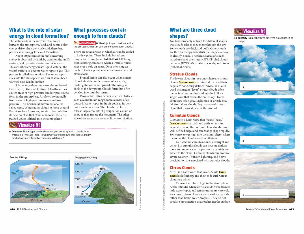
10 Identify Name the three different clouds based on
shape.
Visualize It!What are three cloud
shapes?You have probably noticed the different shapes
that clouds take as they move through the sky.
Some clouds are thick and puffy. Other clouds
are thin and wispy. Scientists use shape as a way
to classify clouds. The three classes of clouds
Stratus CloudsThe lowest clouds in the atmosphere are stratus
clouds. Stratus clouds
edges are not clearly defined. Stratus is a Latin
word that means “layer.” Stratus clouds often
merge into one another and may look like a
single layer that covers the entire sky. Stratus
clouds are often gray. Light mist or drizzle may
fall from these clouds. Fog is a type of stratus
cloud that forms at or near the ground.
Cumulus CloudsCumulus is a Latin word that means “heap.”
Cumulus clouds are thick and puffy on top and
generally flat on the bottom. These clouds have
well-defined edges and can change shape rapidly.
the top of the cloud sometimes flattens.
Fair-weather cumulus clouds are bright and
white. But cumulus clouds can become dark as
more and more water droplets or ice crystals are
added to the cloud. Cumulus clouds can produce
precipitation are associated with cumulus clouds.
Cirrus CloudsCirrus is a Latin word that means “curl.” Cirrus
clouds
clouds are white.
Cirrus clouds form high in the atmosphere.
rather than liquid water droplets. They do not
produce precipitation that reaches Earth’s surface.
A
B
C
Lesson 2 Clouds and Cloud Formation 475
Think Outside the Book Inquiry
© H
ough
ton
Miff
lin H
arco
urt P
ublis
hing
Com
pany
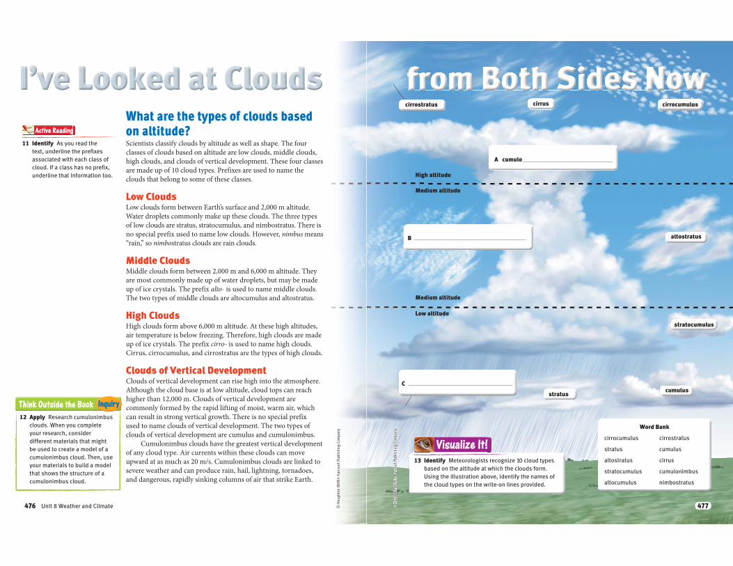
What are the types of clouds based
on altitude?Scientists classify clouds by altitude as well as shape. The four
classes of clouds based on altitude are low clouds, middle clouds,
high clouds, and clouds of vertical development. These four classes
are made up of 10 cloud types. Prefixes are used to name the
clouds that belong to some of these classes.
Low CloudsLow clouds form between Earth’s surface and 2,000 m altitude.
Water droplets commonly make up these clouds. The three types
of low clouds are stratus, stratocumulus, and nimbostratus. There is
no special prefix used to name low clouds. However, nimbus means
“rain,” so nimbostratus clouds are rain clouds.
Middle CloudsMiddle clouds form between 2,000 m and 6,000 m altitude. They
are most commonly made up of water droplets, but may be made
up of ice crystals. The prefix alto- is used to name middle clouds.
The two types of middle clouds are altocumulus and altostratus.
High CloudsHigh clouds form above 6,000 m altitude. At these high altitudes,
air temperature is below freezing. Therefore, high clouds are made
up of ice crystals. The prefix cirro- is used to name high clouds.
Cirrus, cirrocumulus, and cirrostratus are the types of high clouds.
Clouds of Vertical DevelopmentClouds of vertical development can rise high into the atmosphere.
Although the cloud base is at low altitude, cloud tops can reach
higher than 12,000 m. Clouds of vertical development are
commonly formed by the rapid lifting of moist, warm air, which
can result in strong vertical growth. There is no special prefix
used to name clouds of vertical development. The two types of
clouds of vertical development are cumulus and cumulonimbus.
Cumulonimbus clouds have the greatest vertical development
of any cloud type. Air currents within these clouds can move
upward at as much as 20 m/s. Cumulonimbus clouds are linked to
severe weather and can produce rain, hail, lightning, tornadoes,
and dangerous, rapidly sinking columns of air that strike Earth.
12 Apply Research cumulonimbus
clouds. When you complete
your research, consider
different materials that might
be used to create a model of a
cumulonimbus cloud. Then, use
your materials to build a model
that shows the structure of a
cumulonimbus cloud.
11 Identify As you read the
text, underline the prefixes
associated with each class of
cloud. If a class has no prefix,
underline that information too.
Active Reading
Unit 8 Weather and Climate476
High altitude
Medium altitude
Medium altitude
Low altitude
© H
ough
ton
Miff
lin H
arco
urt P
ublis
hing
Com
pany
13 Identify Meteorologists recognize 10 cloud types
based on the altitude at which the clouds form.
Using the illustration above, identify the names of
the cloud types on the write-on lines provided.
Visualize It!
Word Bank
cirrocumulus cirrostratus
stratus cumulus
altostratus cirrus
stratocumulus cumulonimbus
altocumulus nimbostratus
cumulus
A cumulo
altostratus
cirrus cirrocumulus
C
B
cirrostratus
stratocumulus
stratus
477
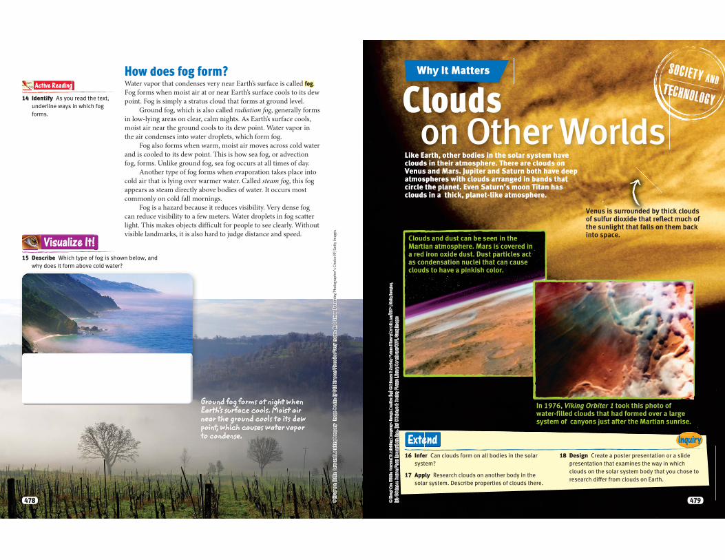
How does fog form?Water vapor that condenses very near Earth’s surface is called fog.
Fog forms when moist air at or near Earth’s surface cools to its dew
point. Fog is simply a stratus cloud that forms at ground level.
Ground fog, which is also called radiation fog, generally forms
in low-lying areas on clear, calm nights. As Earth’s surface cools,
moist air near the ground cools to its dew point. Water vapor in
the air condenses into water droplets, which form fog.
Fog also forms when warm, moist air moves across cold water
and is cooled to its dew point. This is how sea fog, or advection
fog, forms. Unlike ground fog, sea fog occurs at all times of day.
Another type of fog forms when evaporation takes place into
cold air that is lying over warmer water. Called steam fog, this fog
appears as steam directly above bodies of water. It occurs most
commonly on cold fall mornings.
Fog is a hazard because it reduces visibility. Very dense fog
can reduce visibility to a few meters. Water droplets in fog scatter
light. This makes objects difficult for people to see clearly. Without
visible landmarks, it is also hard to judge distance and speed.
15 Describe Which type of fog is shown below, and
why does it form above cold water?
Visualize It!
Ground fog forms at night when Earth’s surface cools. Moist air near the ground cools to its dew point, which causes water vapor to condense.
14 Identify As you read the text,
underline ways in which fog
forms.
Active Reading
478
Why It Matters
Clouds on Other Worlds
16 Infer Can clouds form on all bodies in the solar
system?
17 Apply Research clouds on another body in the
solar system. Describe properties of clouds there.
18 Design Create a poster presentation or a slide
presentation that examines the way in which
clouds on the solar system body that you chose to
research differ from clouds on Earth.
InquiryExtend
Like Earth, other bodies in the solar system have clouds in their atmosphere. There are clouds on Venus and Mars. Jupiter and Saturn both have deep atmospheres with clouds arranged in bands that circle the planet. Even Saturn’s moon Titan has clouds in a thick, planet-like atmosphere.
In 1976, Viking Orbiter 1 took this photo of water-filled clouds that had formed over a large system of canyons just after the Martian sunrise.
Clouds and dust can be seen in the Martian atmosphere. Mars is covered in a red iron oxide dust. Dust particles act as condensation nuclei that can cause clouds to have a pinkish color.
Venus is surrounded by thick clouds of sulfur dioxide that reflect much of the sunlight that falls on them back into space.
479
Answers: 19 frontal; 20 high; 21 cirrus; 22 Ground
Clouds and Cloud Formation
19 Warm air that is forced upward by a cold front is an example of frontal/orographic lifting.
20 Clouds that are made up entirely of ice crystals are middle/high clouds.
22 Ground/Sea fog generally forms in low-lying areas, such as valleys.
Clouds form when rising air cools to the dew point and condensation occurs.
Clouds can be classified by shape.
Fog is a cloud that has formed very near Earth’s surface.
Clouds can be classified by altitude.
To complete this summary, circle the correct word. Then, use the key below to check your answers. You can use this page to review the main concepts of the lesson.
TTTTTTTTTTTTTTTTTTTTT lllllllllllllllllll ttttttttttttttttttt ttthththththhththththhhthhthhtthiiiiiiiiiiiiiiiiii iiiiiiiiiiiiiii lllllllllllll tttttttttttttthhhhhhhhhhhh tttttttttttttttttt ddddddddddddddddddddddddd TTTTTTTTTTTTTTTTTTTTTTTTTTTTTTTThhhhhhhhhhhhhhhhhhhhhhhhhhhhhhhhhhhhhhh
Visual Summary
23 Synthesis How can clouds be used to help predict the weather?
21 Thin, wispy clouds that do not produce precipitation are cirrus/cumulus clouds.
Unit 8 Weather and Climate480
ground
Temperature
12 ˚C
14 ˚C
16 ˚C
18 ˚C
20 ˚C
© H
ough
ton
Miff
lin H
arco
urt P
ublis
hing
Com
pany
LessonLesson ReviewVocabulary
Fill in the blank with the term that best completes the following sentences.
1 A cloud is thin, wispy, and made of ice crystals.
2 The temperature at which water vapor condenses is the
3 is condensed water vapor that forms very close to Earth’s surface.
Key Concepts
4 Compare What are two differences between stratus clouds and cirrus clouds?
5 List What are the four classes of clouds based on altitude?
6 Describe What are three ways in which clouds affect climate?
7 Explain What part do tiny, solid particles in the atmosphere play in cloud formation?
Critical Thinking
Use this diagram to answer the following questions.
8 Analyze What is the dew-point temperature at which cloud formation began?
9 Explain Why doesn’t cloud formation take place until the dew-point temperature is reached?
10 Apply What kind of clouds would you expect to form at the leading edge of a cold front, where warm air is gradually being pushed above cold air?
2
Lesson 2 Clouds and Cloud Formation 481
Lesson
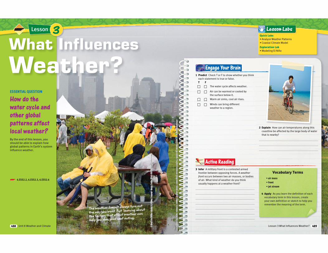
ESSENTIAL QUESTION
How do the water cycle and other global patterns affect local weather?By the end of this lesson, you
should be able to explain how
global patterns in Earth’s system
influence weather.
What Influences
Weather?
The weather doesn’t always turn out
the way you want. But learning about
the factors that affect weather can
help you plan your next outing.
3
p 6.ESS2.2, 6.ESS2.3, 6.ESS2.6
Unit 8 Weather and Climate488
3 Infer A military front is a contested armed
frontier between opposing forces. A weather front occurs between two air masses, or bodies
of air. What kind of weather do you think
usually happens at a weather front?
Active ReadingActive ReadinggggActive ReadinggActive ReadinggActive Reading
4 Apply As you learn the definition of each
vocabulary term in this lesson, create
your own definition or sketch to help you
remember the meaning of the term.
1 Predict Check T or F to show whether you think
each statement is true or false.
T FThe water cycle affects weather.
Air can be warmed or cooled by
the surface below it.
Warm air sinks, cool air rises.
Winds can bring different
weather to a region.
2 Explain How can air temperatures along this
coastline be affected by the large body of water
that is nearby?
Engage Your Brain
Vocabulary Terms
Quick Labs
Exploration Lab
Lesson 3 What Influences Weather? 489
© H
ough
ton
Miff
lin H
arco
urt P
ublis
hing
Com
pany
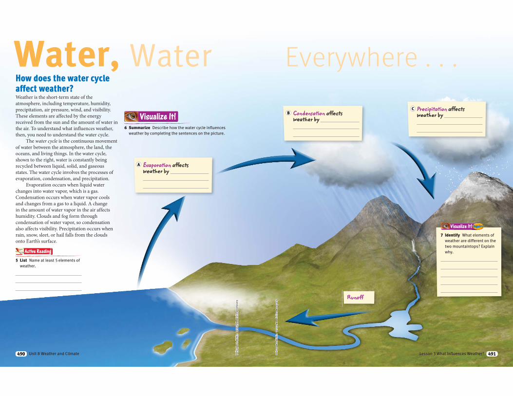
How does the water cycle
affect weather?Weather is the short-term state of the
atmosphere, including temperature, humidity,
precipitation, air pressure, wind, and visibility.
These elements are affected by the energy
received from the sun and the amount of water in
the air. To understand what influences weather,
then, you need to understand the water cycle.
The water cycle is the continuous movement
of water between the atmosphere, the land, the
oceans, and living things. In the water cycle,
shown to the right, water is constantly being
recycled between liquid, solid, and gaseous
states. The water cycle involves the processes of
evaporation, condensation, and precipitation.
Evaporation occurs when liquid water
changes into water vapor, which is a gas.
Condensation occurs when water vapor cools
and changes from a gas to a liquid. A change
in the amount of water vapor in the air affects
humidity. Clouds and fog form through
condensation of water vapor, so condensation
also affects visibility. Precipitation occurs when
rain, snow, sleet, or hail falls from the clouds
onto Earth’s surface.
Water, Water
6 Summarize Describe how the water cycle influences
weather by completing the sentences on the picture.
Visualize It!
5 List Name at least 5 elements of
weather.
Active Reading
Evaporation affects weather by
A
490 Unit 8 Weather and Climate490
Visualize It! Inquiry
Everywhere . . .
© H
ough
ton
Miff
lin H
arco
urt P
ublis
hing
Com
pany
Runoff
Condensation affects weather by
Precipitation affects weather by B
C
7 Identify What elements of
weather are different on the
two mountaintops? Explain
why.
491Lesson 3 What Influences Weather? 491
© H
ough
ton
Miff
lin H
arco
urt P
ublis
hing
Com
pany
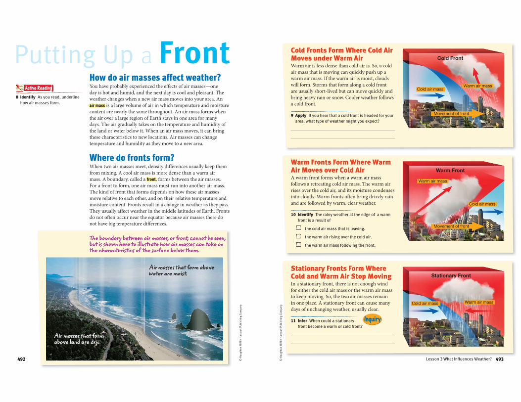
How do air masses affect weather?You have probably experienced the effects of air masses—one
day is hot and humid, and the next day is cool and pleasant. The
weather changes when a new air mass moves into your area. An
air mass is a large volume of air in which temperature and moisture
content are nearly the same throughout. An air mass forms when
the air over a large region of Earth stays in one area for many
days. The air gradually takes on the temperature and humidity of
the land or water below it. When an air mass moves, it can bring
these characteristics to new locations. Air masses can change
temperature and humidity as they move to a new area.
Where do fronts form? When two air masses meet, density differences usually keep them
from mixing. A cool air mass is more dense than a warm air
mass. A boundary, called a front, forms between the air masses.
For a front to form, one air mass must run into another air mass.
The kind of front that forms depends on how these air masses
move relative to each other, and on their relative temperature and
moisture content. Fronts result in a change in weather as they pass.
They usually affect weather in the middle latitudes of Earth. Fronts
do not often occur near the equator because air masses there do
not have big temperature differences.
Putting Up a Front8 Identify As you read, underline
how air masses form.
Active Reading
Air masses that form above land are dry.
Air masses that form above water are moist.
The boundary between air masses, or front, cannot be seen, but is shown here to illustrate how air masses can take on the characteristics of the surface below them.
492492
Inquiry
© H
ough
ton
Miff
lin H
arco
urt P
ublis
hing
Com
pany
Cold Fronts Form Where Cold Air Moves under Warm AirWarm air is less dense than cold air is. So, a cold
air mass that is moving can quickly push up a
warm air mass. If the warm air is moist, clouds
will form. Storms that form along a cold front
are usually short-lived but can move quickly and
bring heavy rain or snow. Cooler weather follows
a cold front.
9 Apply If you hear that a cold front is headed for your
area, what type of weather might you expect?
10 Identify The rainy weather at the edge of a warm
front is a result of
the cold air mass that is leaving.
the warm air rising over the cold air.
the warm air mass following the front.
11 Infer When could a stationary
front become a warm or cold front?
Stationary Fronts Form Where Cold and Warm Air Stop MovingIn a stationary front, there is not enough wind
for either the cold air mass or the warm air mass
to keep moving. So, the two air masses remain
in one place. A stationary front can cause many
days of unchanging weather, usually clear.
Warm Fronts Form Where Warm Air Moves over Cold AirA warm front forms when a warm air mass
follows a retreating cold air mass. The warm air
rises over the cold air, and its moisture condenses
into clouds. Warm fronts often bring drizzly rain
and are followed by warm, clear weather.
493Lesson 3 What Influences Weather? 493
© H
ough
ton
Miff
lin H
arco
urt P
ublis
hing
Com
pany
What are pressure systems, and how
do they interact?Areas of different air pressure cause changes in the weather. In
a high-pressure system, air sinks slowly down. As the air nears
the ground, it spreads out toward areas of lower pressure. Most
high-pressure systems are large and change slowly. When a high-
pressure system stays in one location for a long time, an air mass
may form. The air mass can be warm or cold, humid or dry.
In a low-pressure system, air rises and so has a lower air
pressure than the areas around it. As the air in the center of a low-
pressure system rises, the air cools.
The diagram below shows how a high-pressure system can
form a low-pressure system. Surface air, shown by the black
arrows, moves out and away from high-pressure centers. Air above
the surface sinks and warms. The green arrows show how air
swirls from a high-pressure system into a low-pressure system. In a
low-pressure system, the air rises and cools.
Feeling the Pressure!
12 Identify Choose the correct
answer for each of the pressure
systems shown below.
Visualize It!A high-pressure system can spiral into a low-pressure system, as illustrated by the green arrows below. In the Northern Hemisphere, air circles in the directions shown.
A BIn a high-pressure system, air
rises and cools.
sinks and warms.
in a low-pressure system, air
rises and cools.
sinks and warms.
494 Unit 8 Weather and Climate494
How do different pressure systems
affect us?When air pressure differences are small, air doesn’t move very
much. If the air remains in one place or moves slowly, the air takes
on the temperature and humidity of the land or water beneath it.
Each type of pressure system has it own unique weather pattern.
By keeping track of high- and low-pressure systems, scientists can
predict the weather.
High-Pressure Systems Produce Clear WeatherHigh-pressure systems are areas where air sinks
and moves outward. The sinking air is denser
than the surrounding air, and the pressure is
higher. Cooler, denser air moves out of the center
of these high-pressure areas toward areas of
lower pressure. As the air sinks, it gets warmer
and absorbs moisture. Water droplets evaporate,
relative humidity decreases, and clouds often
disappear. A high-pressure system generally
brings clear skies and calm air or gentle breezes.
Low-Pressure Systems Produce Rainy WeatherLow-pressure systems have lower pressure than
the surrounding areas. Air in a low-pressure
system comes together, or converges, and rises.
As the air in the center of a low-pressure system
rises, it cools and forms clouds and rain. The
rising air in a low-pressure system causes stormy
weather.
A low-pressure system can develop
wherever there is a center of low pressure. One
place this often happens is along a boundary
between a warm air mass and a cold air mass.
Rain often occurs at these boundaries, or fronts.
13 Match Label each picture as a result of a high- or low-pressure system.
Then, draw a line from each photo to its matching air-pressure diagram.
Visualize It!
A
B
Warm air rises
Cold air descends
495495
horse latitudes
horse latitudes
trade winds
trade winds
easterlies
easterlies
westerlies
westerlies
doldrums
90°N
90°S
60°S
60°N
30°N
30°S
0°Equator
© H
ough
ton
Miff
lin H
arco
urt P
ublis
hing
Com
pany
Windy Weather
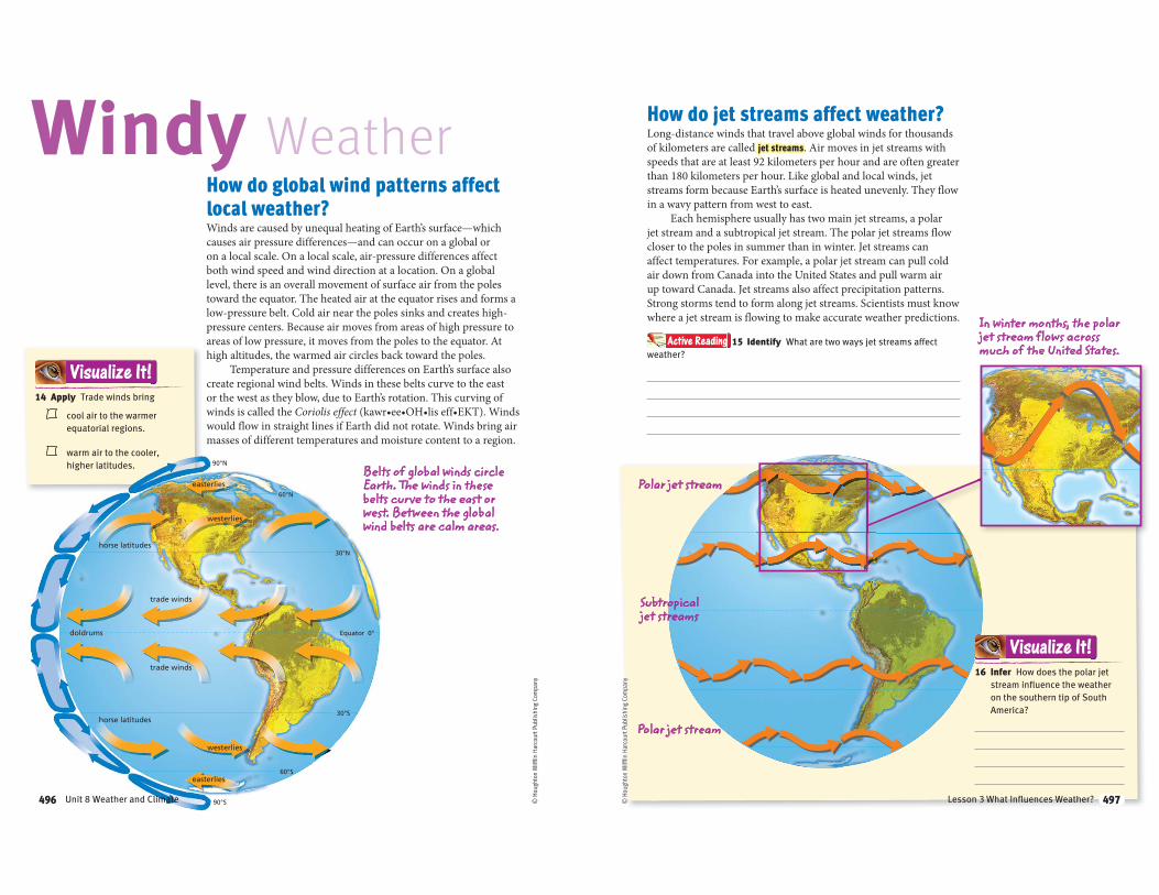
14 Apply Trade winds bring
cool air to the warmer
equatorial regions.
warm air to the cooler,
higher latitudes.
Visualize It!
Belts of global winds circle Earth. The winds in these belts curve to the east or west. Between the global wind belts are calm areas.
How do global wind patterns affect
local weather?Winds are caused by unequal heating of Earth’s surface—which
causes air pressure differences—and can occur on a global or
on a local scale. On a local scale, air-pressure differences affect
both wind speed and wind direction at a location. On a global
level, there is an overall movement of surface air from the poles
toward the equator. The heated air at the equator rises and forms a
low-pressure belt. Cold air near the poles sinks and creates high-
pressure centers. Because air moves from areas of high pressure to
areas of low pressure, it moves from the poles to the equator. At
high altitudes, the warmed air circles back toward the poles.
Temperature and pressure differences on Earth’s surface also
create regional wind belts. Winds in these belts curve to the east
or the west as they blow, due to Earth’s rotation. This curving of
winds is called the Coriolis effect would flow in straight lines if Earth did not rotate. Winds bring air
masses of different temperatures and moisture content to a region.
496 Unit 8 Weather and Climate496
How do jet streams affect weather?Long-distance winds that travel above global winds for thousands
of kilometers are called jet streams. Air moves in jet streams with
speeds that are at least 92 kilometers per hour and are often greater
than 180 kilometers per hour. Like global and local winds, jet
streams form because Earth’s surface is heated unevenly. They flow
in a wavy pattern from west to east.
Each hemisphere usually has two main jet streams, a polar
jet stream and a subtropical jet stream. The polar jet streams flow
closer to the poles in summer than in winter. Jet streams can
affect temperatures. For example, a polar jet stream can pull cold
air down from Canada into the United States and pull warm air
up toward Canada. Jet streams also affect precipitation patterns.
Strong storms tend to form along jet streams. Scientists must know
where a jet stream is flowing to make accurate weather predictions.
© H
ough
ton
Miff
lin H
arco
urt P
ublis
hing
Com
pany
In winter months, the polar jet stream flows across much of the United States.
Polar jet stream
Subtropical jet streams
Polar jet stream
16 Infer How does the polar jet
stream influence the weather
on the southern tip of South
America?
Visualize It!
Active Reading 15 Identify What are two ways jet streams affect
weather?
497Lesson 3 What Influences Weather? 497
Warm current
Cold current
© H
ough
ton
Miff
lin H
arco
urt P
ublis
hing
Com
pany
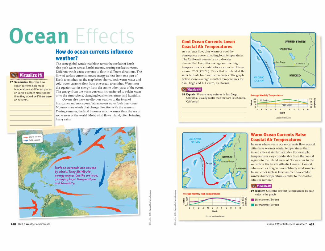
How do ocean currents influence
weather?The same global winds that blow across the surface of Earth
also push water across Earth’s oceans, causing surface currents.
Different winds cause currents to flow in different directions. The
flow of surface currents moves energy as heat from one part of
Earth to another. As the map below shows, both warm-water and
cold-water currents flow from one ocean to another. Water near
the equator carries energy from the sun to other parts of the ocean.
The energy from the warm currents is transferred to colder water
or to the atmosphere, changing local temperatures and humidity.
Oceans also have an effect on weather in the form of
hurricanes and monsoons. Warm ocean water fuels hurricanes.
Monsoons are winds that change direction with the seasons.
During summer, the land becomes much warmer than the sea in
some areas of the world. Moist wind flows inland, often bringing
heavy rains.
Ocean Effects
Surface currents are caused by winds. They distribute energy across Earth’s surface, changing local temperature and humidity.
17 Summarize Describe how
ocean currents help make
temperatures at different places
on Earth’s surface more similar
than they would be if there were
no currents.
Visualize It!
498 Unit 8 Weather and Climate498
Source: weather.com
Celsius
Fahrenheit
Month
Average Monthly Temperatures
4530150
113865932
J F M A M J J A S O N D
El Centro
San Diego
El Centro
San Diego
Source: worldweather.org
Celsius
Fahrenheit
Month
Average Monthly High Temperatures
20100
-10
68503214
J F M A M J J A S O N D
San Diego El Centro
CALIFORNIA
MEXICO
UNITED STATES
California Current
PACIFICOCEAN
Visualize It!
Visualize It!
BergenLillehammer
NORWAY
SWEDEN
North Atlantic Current
North Atlantic Current
ATLANTICOCEAN
Cool Ocean Currents Lower Coastal Air TemperaturesAs currents flow, they warm or cool the
atmosphere above, affecting local temperatures.
The California current is a cold-water
current that keeps the average summer high
temperatures of coastal cities such as San Diego
around 26 °C (78 °F). Cities that lie inland at the
same latitude have warmer averages. The graph
below shows average monthly temperatures for
San Diego and El Centro, California.
Warm Ocean Currents Raise Coastal Air TemperaturesIn areas where warm ocean currents flow, coastal
cities have warmer winter temperatures than
inland cities at similar latitudes. For example,
temperatures vary considerably from the coastal
regions to the inland areas of Norway due to the
warmth of the North Atlantic Current. Coastal
cities such as Bergen have relatively mild winters.
Inland cities such as Lillehammer have colder
winters but temperatures similar to the coastal
cities in summer.
© H
ough
ton
Miff
lin H
arco
urt P
ublis
hing
Com
pany 19 Identify Circle the city that is represented by each
color in the graph.
Lillehammer/Bergen
Lillehammer/Bergen
18 Explain Why are temperatures in San Diego,
California, usually cooler than they are in El Centro,
California?
499Lesson 3 What Influences Weather? 499

Warm air rises
© H
ough
ton
Miff
lin H
arco
urt P
ublis
hing
Com
pany
To complete this summary, circle the correct word. Then, use the key below to check your answers. You can use this page to review the main concepts of the lesson.
TTTTTTTTTTTTTTTTTTTTTTT lllllllllllllllllll tttttttttttttttttttt tthththththththhhhththtthhhthttthiiiiiiiiiiiiiii iiiiiiiiiiiiiii llllllllllllll ttttttttttttttttttthhhhhhhhhhhhhhhh ttttttttttttttttt
Visual Summary
25 Synthesize How do air masses cause weather changes?
Answers: 20 water; 21 warm; 22 upward; 23 sinks; rises; 24 warming
A front forms where two air masses meet.
Low-pressure systems bring stormy weather, and high-pressure systems bring dry, clear weather.
Understanding the water cycle is key to understanding weather.
Pressure differences from the uneven heating of Earth’s surface cause predictable patterns of wind.
Global ocean surface currents can have warming or cooling effects on the air masses above them.
21 When a warm air mass and a cool air mass meet, the warm / cool air mass usually moves upward. 22 In a low-pressure system, air
moves upward / downward.
24 Warm currents have a warming / cooling effect on the air masses above them.
23 Global wind patterns occur as, due to temperature differences, air rises / sinks at the poles and rises / sinks at the equator.
Influences of Weather
20 Weather is affected by the amount of oxygen / water in the air.
500 Unit 8 Weather and Climate
Cool air descends Warm air rises
© H
ough
ton
Miff
lin H
arco
urt P
ublis
hing
Com
pany
LessonLesson ReviewVocabulary
For each pair of terms, explain how the meanings of the terms differ.
1 front and air mass
2 high-pressure system and low-pressure system
3 jet streams and global wind belts
Key Concepts
4 Apply If the weather becomes stormy for a short time and then becomes colder, which type of front has most likely passed?
5 Describe Explain how an ocean current can affect the temperature and the amount of moisture of the air mass above the current and above nearby coastlines.
6 Synthesize How does the water cycle affect weather?
Critical Thinking
Use the diagram below to answer the following question.
7 Interpret How does the movement of air affect the type of weather that forms from high-pressure and low-pressure systems?
8 Explain How does the polar jet stream affect temperature and precipitation in North America?
9 Describe Explain how changes in weather are caused by the interaction of air masses.
3
501Lesson 3 What Influences Weather?
Lesson
Severe Weather and Weather SafetyESSENTIAL QUESTION
How can humans
protect
themselves
from hazardous
weather?
By the end of this lesson, you
should be able to describe
the major types of hazardous
weather and the ways human
beings can protect themselves
from hazardous weather and
from sun exposure.
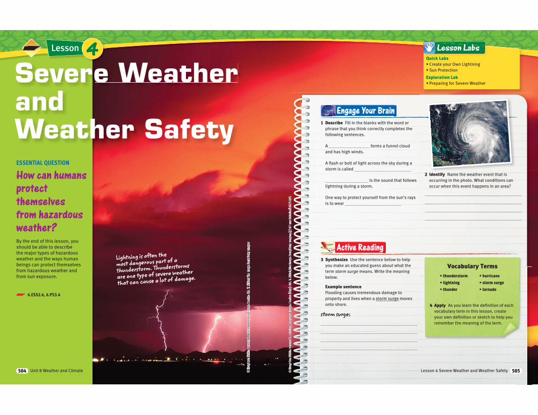
Lightning is often the most dangerous part of a
thunderstorm. Thunderstorms
are one type of severe weather
that can cause a lot of damage.
4
p 6.ESS2.6, 6.PS3.4
Unit 8 Weather and Climate504
Vocabulary Terms
4 Apply As you learn the definition of each
vocabulary term in this lesson, create
your own definition or sketch to help you
remember the meaning of the term.
3 Synthesize Use the sentence below to help
you make an educated guess about what the
term storm surge means. Write the meaning
below.
Example sentenceFlooding causes tremendous damage to
property and lives when a storm surge moves
onto shore.
storm surge:
Active Reading
Engage Your Brain
1 Describe Fill in the blanks with the word or
phrase that you think correctly completes the
following sentences.
A forms a funnel cloud
and has high winds.
A flash or bolt of light across the sky during a
storm is called
is the sound that follows
lightning during a storm.
One way to protect yourself from the sun’s rays
is to wear
2 Identify Name the weather event that is
occurring in the photo. What conditions can
occur when this event happens in an area?
Quick Labs
Exploration Lab
Lesson 4 Severe Weather and Weather Safety 505
© H
ough
ton
Miff
lin H
arco
urt P
ublis
hing
Com
pany
What do we know about
thunderstorms?SPLAAAAAT! BOOOOM! The loud, sharp noise of thunder
might surprise you, and maybe even make you jump. The thunder
may have been joined by lightning, wind, and rain. A thunderstorm
is an intense local storm that forms strong winds, heavy rain,
lightning, thunder, and sometimes hail. A thunderstorm is an
example of severe weather. Severe weather is weather that can
cause property damage and sometimes death.
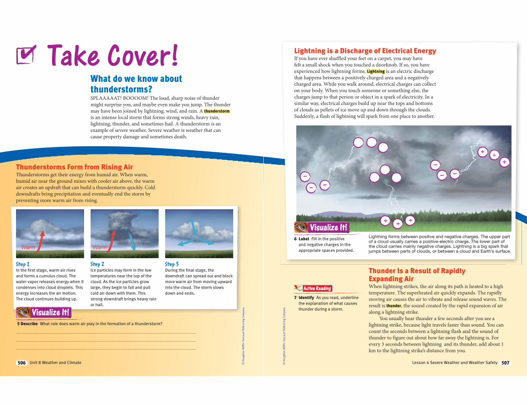
Thunderstorms Form from Rising AirThunderstorms get their energy from humid air. When warm,
humid air near the ground mixes with cooler air above, the warm
air creates an updraft that can build a thunderstorm quickly. Cold
downdrafts bring precipitation and eventually end the storm by
preventing more warm air from rising.
Take Cover!
5 Describe What role does warm air play in the formation of a thunderstorm?
Visualize It!
Step 1In the first stage, warm air rises
and forms a cumulus cloud. The
water vapor releases energy when it
condenses into cloud droplets. This
energy increases the air motion.
The cloud continues building up.
Step 2Ice particles may form in the low
temperatures near the top of the
cloud. As the ice particles grow
large, they begin to fall and pull
cold air down with them. This
strong downdraft brings heavy rain
or hail.
Step 3During the final stage, the
downdraft can spread out and block
more warm air from moving upward
into the cloud. The storm slows
down and ends.
✔
506 Unit 8 Weather and Climate506 © H
ough
ton
Miff
lin H
arco
urt P
ublis
hing
Com
pany
Lightning is a Discharge of Electrical EnergyIf you have ever shuffled your feet on a carpet, you may have
felt a small shock when you touched a doorknob. If so, you have
experienced how lightning forms. Lightning is an electric discharge
that happens between a positively charged area and a negatively
charged area. While you walk around, electrical charges can collect
on your body. When you touch someone or something else, the
charges jump to that person or object in a spark of electricity. In a
similar way, electrical charges build up near the tops and bottoms
of clouds as pellets of ice move up and down through the clouds.
Suddenly, a flash of lightning will spark from one place to another.
Thunder Is a Result of Rapidly Expanding AirWhen lightning strikes, the air along its path is heated to a high
temperature. The superheated air quickly expands. The rapidly
moving air causes the air to vibrate and release sound waves. The
result is thunder, the sound created by the rapid expansion of air
along a lightning strike.
You usually hear thunder a few seconds after you see a
lightning strike, because light travels faster than sound. You can
count the seconds between a lightning flash and the sound of
thunder to figure out about how far away the lightning is. For
every 3 seconds between lightning and its thunder, add about 1
km to the lightning strike’s distance from you.
6 Label Fill in the positive
and negative charges in the
appropriate spaces provided.
Visualize It!
7 Identify As you read, underline
the explanation of what causes
thunder during a storm.
Active Reading
Lightning forms between positive and negative charges. The upper part of a cloud usually carries a positive electric charge. The lower part of the cloud carries mainly negative charges. Lightning is a big spark that jumps between parts of clouds, or between a cloud and Earth’s surface.
–
–
+
–
+ + +
– –
++
–
507Lesson 4 Severe Weather and Weather Safety 507
What do we know about hurricanes? A hurricane is a tropical low-pressure system with winds blowing at
speeds of 119 km/h (74 mi/h) or more —strong enough to uproot
trees. Hurricanes are called typhoons when they form over the
western Pacific Ocean and cyclones when they form over the
Indian Ocean.
Hurricanes Need Water to Form and GrowA hurricane begins as a group of thunderstorms moving over
tropical ocean waters. Thunderstorms form in areas of low
pressure. Near the equator, warm ocean water provides the energy
that can turn a low-pressure center into a violent storm. As water
evaporates from the ocean, energy is transferred from the ocean
water into the air. This energy makes warm air rise faster. Tall
clouds and strong winds develop. As winds blow across the water
from different directions into the low-pressure center, the paths
bend into a spiral. The winds blow faster and faster around the
low-pressure center, which becomes the center of the hurricane.
As long as a hurricane stays above warm water, it can grow
bigger and more powerful. As soon as a hurricane moves over land
or over cooler water, it loses its source of energy. The winds lose
strength and the storm dies out. If a hurricane moves over land,
the rough surface of the land reduces the winds even more.
Plan Ahead!8 Identify As you read, underline
the definition of hurricane.
Active Reading
Hurricanes in the Northern Hemisphere usually move westward with the trade winds. Near land, however, they will often move north or even back out to sea.
✔
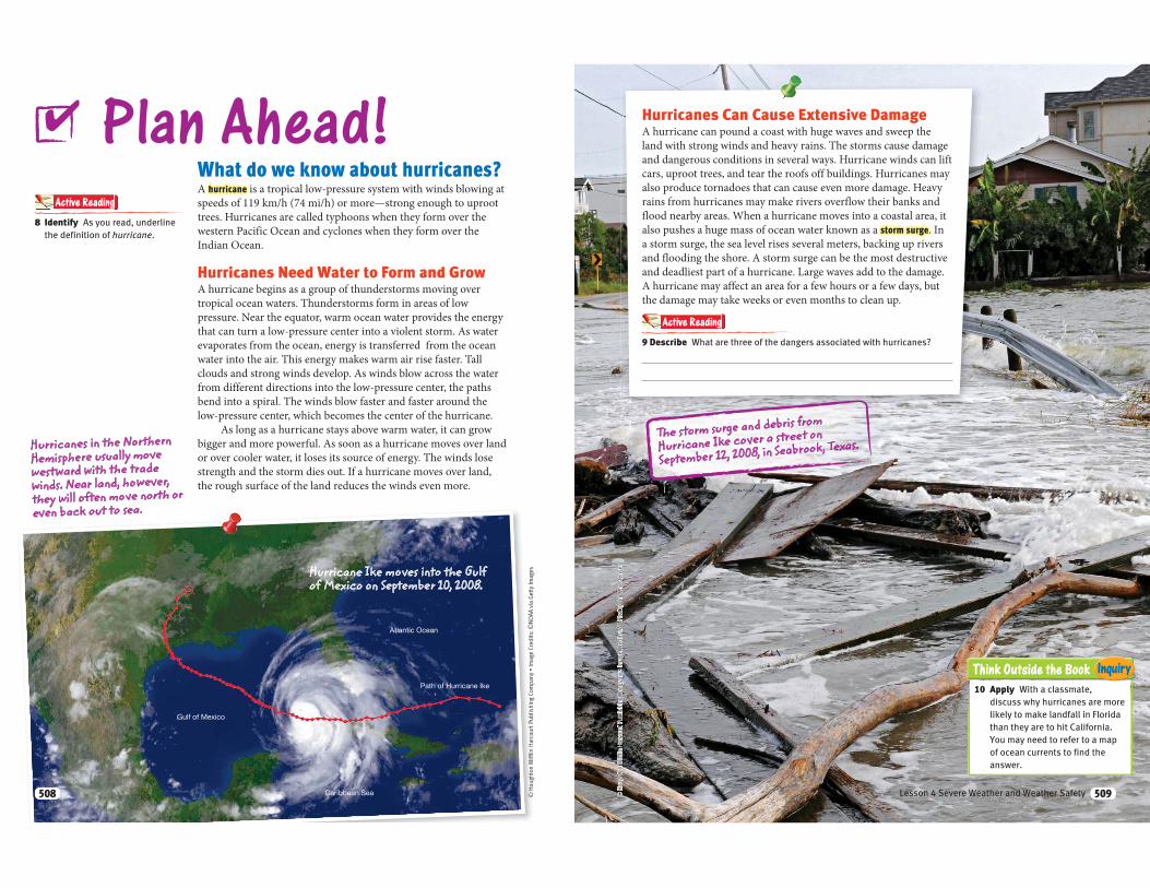
Hurricane Ike moves into the Gulf of Mexico on September 10, 2008.
508508
Think Outside the Book Inquiry
Hurricanes Can Cause Extensive DamageA hurricane can pound a coast with huge waves and sweep the
land with strong winds and heavy rains. The storms cause damage
and dangerous conditions in several ways. Hurricane winds can lift
cars, uproot trees, and tear the roofs off buildings. Hurricanes may
also produce tornadoes that can cause even more damage. Heavy
rains from hurricanes may make rivers overflow their banks and
flood nearby areas. When a hurricane moves into a coastal area, it
also pushes a huge mass of ocean water known as a storm surge. In
a storm surge, the sea level rises several meters, backing up rivers
and flooding the shore. A storm surge can be the most destructive
and deadliest part of a hurricane. Large waves add to the damage.
A hurricane may affect an area for a few hours or a few days, but
the damage may take weeks or even months to clean up.
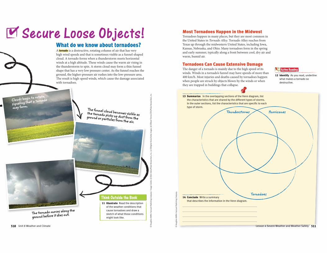
9 Describe What are three of the dangers associated with hurricanes?
Active Reading
The storm surge and debris from
Hurricane Ike cover a street on
September 12, 2008, in Seabrook, Texas.
10 Apply With a classmate,
discuss why hurricanes are more
likely to make landfall in Florida
than they are to hit California.
You may need to refer to a map
of ocean currents to find the
answer.
509Lesson 4 Severe Weather and Weather Safety 509
Think Outside the Book
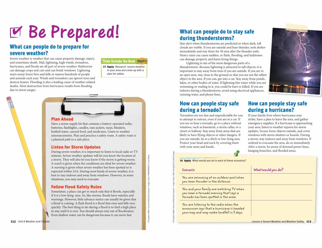
What do we know about tornadoes?A tornado is a destructive, rotating column of air that has very
high wind speeds and that is sometimes visible as a funnel-shaped
cloud. A tornado forms when a thunderstorm meets horizontal
winds at a high altitude. These winds cause the warm air rising in
the thunderstorm to spin. A storm cloud may form a thin funnel
shape that has a very low pressure center. As the funnel reaches the
ground, the higher-pressure air rushes into the low-pressure area.
The result is high-speed winds, which cause the damage associated
with tornadoes.
Secure Loose Objects!
Clouds begin to rotate,
signaling that a tornado
may form.The funnel cloud becomes visible as the tornado picks up dust from the ground or particles from the air.
The tornado moves along the
ground before it dies out.
11 Illustrate Read the description
of the weather conditions that
cause tornadoes and draw a
sketch of what those conditions
might look like.
✔
510 Unit 8 Weather and Climate510 © H
ough
ton
Miff
lin H
arco
urt P
ublis
hing
Com
pany
Most Tornadoes Happen in the MidwestTornadoes happen in many places, but they are most common in
the United States in Tornado Alley. Tornado Alley reaches from
Texas up through the midwestern United States, including Iowa,
Kansas, Nebraska, and Ohio. Many tornadoes form in the spring
and early summer, typically along a front between cool, dry air and
warm, humid air.
Tornadoes Can Cause Extensive DamageThe danger of a tornado is mainly due to the high speed of its
winds. Winds in a tornado’s funnel may have speeds of more than
400 km/h. Most injuries and deaths caused by tornadoes happen
when people are struck by objects blown by the winds or when
they are trapped in buildings that collapse.
13 Summarize In the overlapping sections of the Venn diagram, list
the characteristics that are shared by the different types of storms.
In the outer sections, list the characteristics that are specific to each
type of storm.
14 Conclude Write a summary
that describes the information in the Venn diagram.
12 Identify As you read, underline
what makes a tornado so
destructive.
Active Reading
Thunderstorms Hurricanes
Tornadoes
511Lesson 4 Severe Weather and Weather Safety 511
Think Outside the Book Inquiry
What can people do to prepare for
severe weather?Severe weather is weather that can cause property damage, injury,
and sometimes death. Hail, lightning, high winds, tornadoes,
hurricanes, and floods are all part of severe weather. Hailstorms
can damage crops and cars and can break windows. Lightning
starts many forest fires and kills or injures hundreds of people
and animals each year. Winds and tornadoes can uproot trees and
destroy homes. Flooding is also a leading cause of weather-related
deaths. Most destruction from hurricanes results from flooding
due to storm surges.
Be Prepared!
Plan AheadHave a storm supply kit that contains a battery-operated radio,
batteries, flashlights, candles, rain jackets, tarps, blankets,
bottled water, canned food, and medicines. Listen to weather
announcements. Plan and practice a safety route. A safety route is
a planned path to a safe place.
Listen for Storm UpdatesDuring severe weather, it is important to listen to local radio or TV
stations. Severe weather updates will let you know the location of
a storm. They will also let you know if the storm is getting worse.
A watch is given when the conditions are ideal for severe weather.
A warning is given when severe weather has been spotted or is
expected within 24 h. During most kinds of severe weather, it is
best to stay indoors and away from windows. However, in some
situations, you may need to evacuate.
Follow Flood Safety RulesSometimes, a place can get so much rain that it floods, especially
if it is a low-lying area. So, like storms, floods have watches and
warnings. However, little advance notice can usually be given that
a flood is coming. A flash flood is a flood that rises and falls very
quickly. The best thing to do during a flood is to find a high place
to stay until it is over. You should always stay out of floodwaters.
Even shallow water can be dangerous because it can move fast.
✔
15 Apply Research severe weather
in your area and come up with a
plan for safety.
512 Unit 8 Weather and Climate512
What can people do to stay safe
during thunderstorms?Stay alert when thunderstorms are predicted or when dark, tall
clouds are visible. If you are outside and hear thunder, seek shelter
immediately and stay there for 30 min after the thunder ends.
Heavy rains can cause sudden, or flash, flooding, and hailstones
can damage property and harm living things.
Lightning is one of the most dangerous parts of a
thunderstorm. Because lightning is attracted to tall objects, it is
important to stay away from trees if you are outside. If you are in
an open area, stay close to the ground so that you are not the tallest
object in the area. If you can, get into a car. Stay away from ponds,
lakes, or other bodies of water. If lightning hits water while you are
swimming or wading in it, you could be hurt or killed. If you are
indoors during a thunderstorm, avoid using electrical appliances,
running water, and phone lines.
How can people stay safe
during a tornado?Tornadoes are too fast and unpredictable for you
to attempt to outrun, even if you are in a car. If
you see or hear a tornado, go to a place without
windows, such as basement, a storm cellar, or a
closet or hallway. Stay away from areas that are
likely to have flying objects or other dangers. If
you are outside, lie in a ditch or low-lying area.
Protect your head and neck by covering them
with your arms and hands.
How can people stay safe
during a hurricane?If your family lives where hurricanes may
strike, have a plan to leave the area, and gather
emergency supplies. If a hurricane is approaching
your area, listen to weather reports for storm
updates. Secure loose objects outside, and cover
windows with storm shutters or boards. During
a storm, stay indoors and away from windows. If
ordered to evacuate the area, do so immediately.
After a storm, be aware of downed power lines,
hanging branches, and flooded areas.
Scenario What would you do?
You are swimming at an outdoor pool when you hear thunder in the distance.
You and your family are watching TV when you hear a tornado warning that says a tornado has been spotted in the area.
You are listening to the radio when the announcer says that a hurricane is headed your way and may make landfall in 3 days.
16 Apply What would you do in each of these scenarios?
513Lesson 4 Severe Weather and Weather Safety 513
How can people protect their skin
from the sun?Human skin contains melanin, which is the body’s natural
protection against ultraviolet (UV) radiation from the sun. The
skin produces more melanin when it is exposed to the sun, but
UV rays will still cause sunburn when you spend too much time
outside. It is particularly important to protect your skin when the
sun’s rays are strongest, usually between 10 A.M and 4 P.M.
Know the Sun’s HazardsIt’s easy to notice the effects of a sunburn. Sunburn usually appears
within a few hours after sun exposure. It causes red, painful skin
that feels hot to the touch. Prolonged exposure to the sun will
lead to sunburn in even the darkest-skinned people. Sunburn can
lead to skin cancer and premature aging of the skin. The best way
to prevent sunburn is to protect your skin from the sun, even on
cloudy days. UV rays pass right through clouds and can give you a
false feeling of protection from the sun.
Wear Sunscreen and Protective ClothingEven if you tan easily, you should still use sunscreen. For most
people, a sun protection factor (SPF) of 30 or more will prevent
burning for about 1.5 h. Babies and people who have pale skin
should use an SPF of 45 or more. In addition, you can protect your
skin and eyes in different ways. Seek the shade, and wear hats,
sunglasses, and perhaps even UV light-protective clothing.
Use Sun Sense!
17 Identify As you read, underline
when the sun’s ray’s are
strongest during the day.
Active Reading
Have fun in the sun! Just be sure to protect your skin from harmful rays.
✔
514514
How can people protect themselves
from summer heat?Heat exhaustion is a condition in which the body has been
exposed to high temperatures for an extended period of time.
Symptoms include cold, moist skin, normal or near-normal body
temperature, headache, nausea, and extreme fatigue. Heat stroke
is a condition in which the body loses its ability to cool itself by
sweating because the victim has become dehydrated.
Limit Outdoor ActivitiesWhen outdoor temperatures are high, be cautious about exercising
outdoors for long periods of time. Pay attention to how your body
is feeling, and go inside or to a shady spot if you are starting to feel
light-headed or too warm.
Drink WaterHeat exhaustion and heat stroke can best be prevented by drinking
6 to 8 oz of water at least 10 times a day when you are active in
warm weather. If you are feeling overheated, dizzy, nauseous, or
are sweating heavily, drink something cool (not cold). Drink about
half a glass of cool water every 15 min until you feel like your
normal self.
Know the Signs of Heat StrokeActive Reading 19 Identify Underline signs of
heat stroke in the paragraph below.
Heat stroke is life threatening, so it is important
to know the signs and treatment for it. Symptoms
of heat stroke include hot, dry skin; higher than
normal body temperature; rapid pulse; rapid,
shallow breathing; disorientation; and possible
loss of consciousness.
What to Do In Case of Heat Stroke Seek emergency help immediately.
If there are no emergency facilities nearby, move
the person to a cool place.
Cool the person’s body by immersing it in a cool
(not cold) bath or using wet towels.
Do not give the person food or water if he or she is
vomiting.
Place ice packs under the person’s armpits.
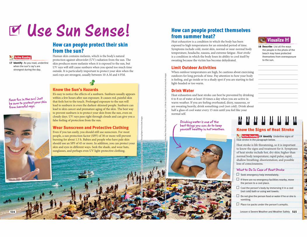
18 Describe List all the ways
the people in the photo of the
beach may have protected
themselves from overexposure
to the sun.
Visualize It!
Drinking water is one of the best things you can do to keep yourself healthy in hot weather.
515Lesson 4 Severe Weather and Weather Safety 515
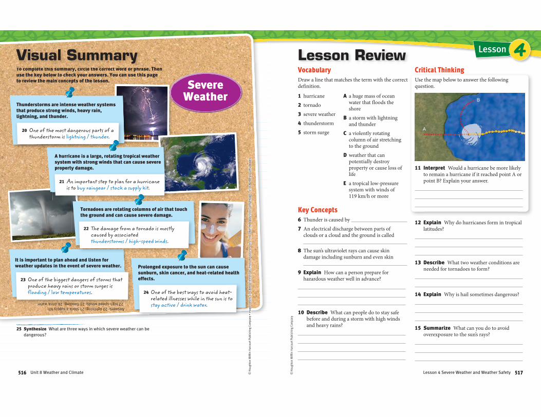
A hurricane is a large, rotating tropical weather system with strong winds that can cause severe property damage.
It is important to plan ahead and listen for weather updates in the event of severe weather.
Tornadoes are rotating columns of air that touch the ground and can cause severe damage.
Prolonged exposure to the sun can cause sunburn, skin cancer, and heat-related health effects.
Thunderstorms are intense weather systems that produce strong winds, heavy rain, lightning, and thunder.
Answers: 20 lightning; 21 stock a supply kit; 22 high-speed winds; 23 flooding; 24 drink water
21 An important step to plan for a hurricane is to buy raingear / stock a supply kit.
23 One of the biggest dangers of storms that produce heavy rains or storm surges is flooding / low temperatures.
20 One of the most dangerous parts of a thunderstorm is lightning / thunder.
To complete this summary, circle the correct word or phrase. Then use the key below to check your answers. You can use this page to review the main concepts of the lesson.
TTTTTTTTTTTTTTTTTTTTTTT lllllllllllllllll ttttttttttttttttttt tthththththththhhthththhthhhthtthiiiiiiiiiiiiiiiii iiiiiiiiiiiiii llllllllllllll ttttttttttttttttttthhhhhhhhhhhhhh tttttttttttttttttt ddddddddddddddddddddddddddddd hhhhhhhhhhhhhhhhhhhh
Visual Summary
25 Synthesize What are three ways in which severe weather can be
dangerous?
Severe Weather
22 The damage from a tornado is mostly caused by associated thunderstorms / high-speed winds.
24 One of the best ways to avoid heat-related illnesses while in the sun is to stay active / drink water.
516 Unit 8 Weather and Climate © H
ough
ton
Miff
lin H
arco
urt P
ublis
hing
Com
pany
LessonLesson ReviewVocabulary
Draw a line that matches the term with the correct definition.
1 hurricane
2 tornado
3 severe weather
4 thunderstorm
5 storm surge
A a huge mass of ocean water that floods the shore
B a storm with lightning and thunder
C a violently rotating column of air stretching to the ground
D weather that can potentially destroy property or cause loss of life
E a tropical low-pressure system with winds of 119 km/h or more
Key Concepts
6 Thunder is caused by
7 An electrical discharge between parts of clouds or a cloud and the ground is called
8 The sun’s ultraviolet rays can cause skin damage including sunburn and even skin
9 Explain How can a person prepare for hazardous weather well in advance?
10 Describe What can people do to stay safe before and during a storm with high winds and heavy rains?
Critical Thinking
Use the map below to answer the following question.
11 Interpret Would a hurricane be more likely to remain a hurricane if it reached point A or point B? Explain your answer.
12 Explain Why do hurricanes form in tropical latitudes?
13 Describe What two weather conditions are needed for tornadoes to form?
14 Explain Why is hail sometimes dangerous?
15 Summarize What can you do to avoid overexposure to the sun’s rays?
4
517Lesson 4 Severe Weather and Weather Safety
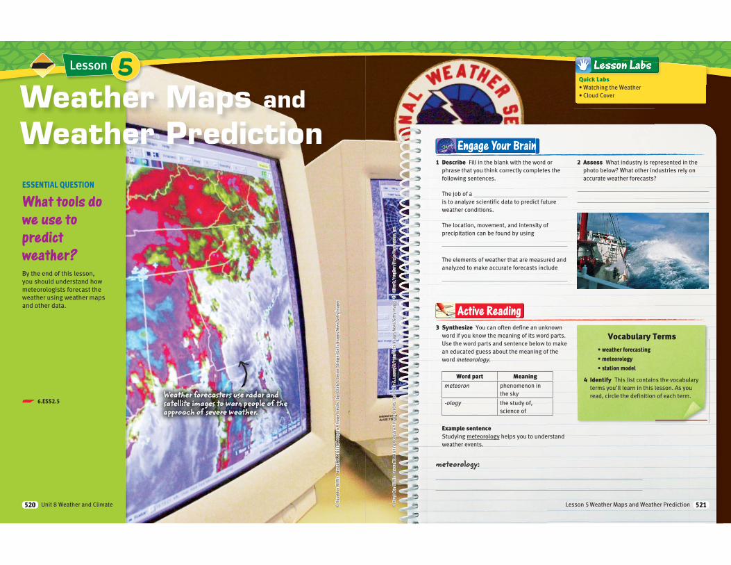
p 6.ESS2.5
Lesson
ESSENTIAL QUESTION
What tools do
we use to
predict
weather?
By the end of this lesson,
you should understand how
meteorologists forecast the
weather using weather maps
and other data.
Weather Maps and
Weather Prediction
Weather forecasters use radar and satellite images to warn people of the approach of severe weather.
5
Unit 8 Weather and Climate520
4 Identify This list contains the vocabulary
terms you’ll learn in this lesson. As you
read, circle the definition of each term.
Vocabulary Terms3 Synthesize You can often define an unknown
word if you know the meaning of its word parts.
Use the word parts and sentence below to make
an educated guess about the meaning of the
word meteorology.
Word part Meaning
meteoron phenomenon in
the sky
-ology the study of,
science of
Example sentenceStudying meteorology helps you to understand
weather events.
Active Reading
1 Describe Fill in the blank with the word or
phrase that you think correctly completes the
following sentences.
The job of a
is to analyze scientific data to predict future
weather conditions.
The location, movement, and intensity of
precipitation can be found by using
The elements of weather that are measured and
analyzed to make accurate forecasts include
2 Assess What industry is represented in the
photo below? What other industries rely on
accurate weather forecasts?
Engage Your Brain
meteorology:
Quick LabsWatching the Weather
Cloud Cover
Lesson 5 Weather Maps and Weather Prediction 521
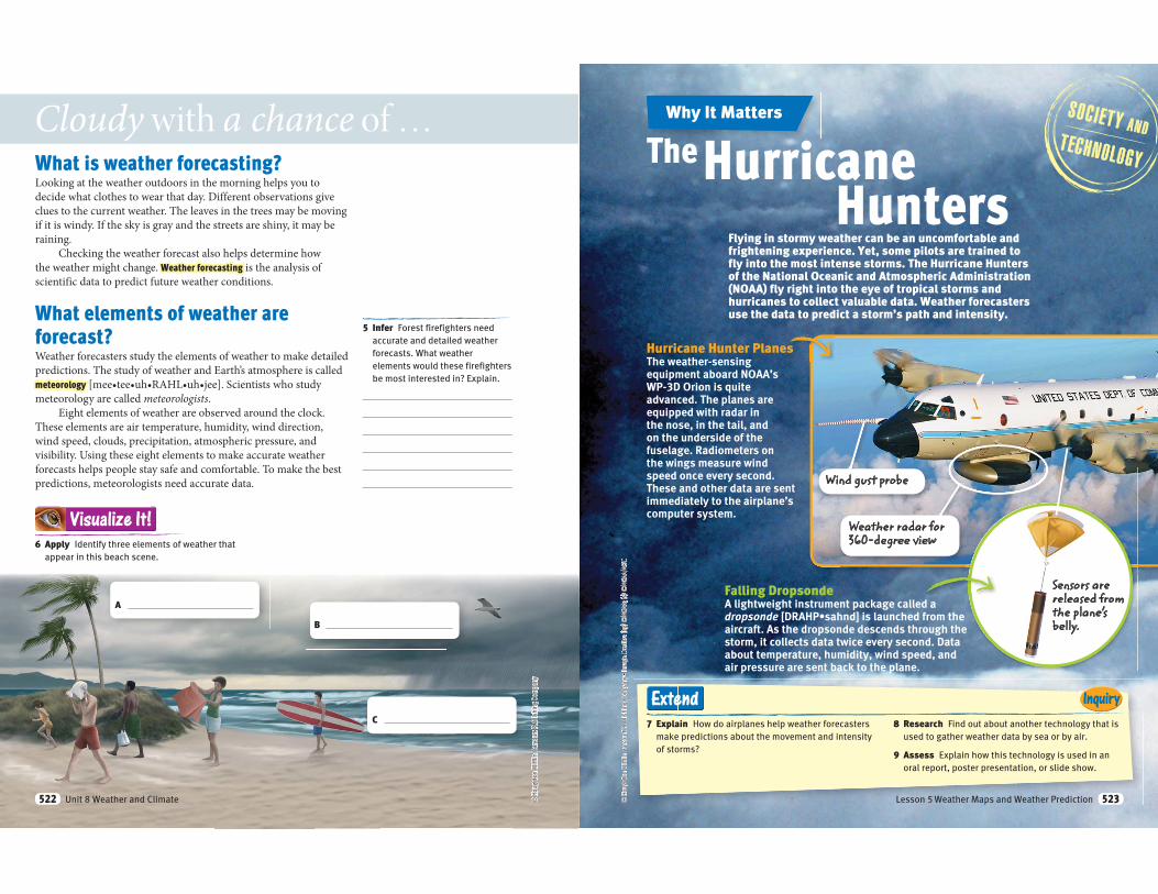
What is weather forecasting?Looking at the weather outdoors in the morning helps you to
decide what clothes to wear that day. Different observations give
clues to the current weather. The leaves in the trees may be moving
if it is windy. If the sky is gray and the streets are shiny, it may be
raining.
Checking the weather forecast also helps determine how
the weather might change. Weather forecasting is the analysis of
scientific data to predict future weather conditions.
What elements of weather are
forecast? Weather forecasters study the elements of weather to make detailed
predictions. The study of weather and Earth’s atmosphere is called
meteorology
meteorology are called meteorologists.
Eight elements of weather are observed around the clock.
These elements are air temperature, humidity, wind direction,
wind speed, clouds, precipitation, atmospheric pressure, and
visibility. Using these eight elements to make accurate weather
forecasts helps people stay safe and comfortable. To make the best
predictions, meteorologists need accurate data.
© H
ough
ton
Miff
lin H
arco
urt P
ublis
hing
Com
pany
Cloudy with a chance of …
5 Infer Forest firefighters need
accurate and detailed weather
forecasts. What weather
elements would these firefighters
be most interested in? Explain.
6 Apply Identify three elements of weather that
appear in this beach scene.
Visualize It!
A
B
C
Unit 8 Weather and Climate522
7 Explain How do airplanes help weather forecasters
make predictions about the movement and intensity
of storms?
8 Research Find out about another technology that is
used to gather weather data by sea or by air.
9 Assess Explain how this technology is used in an
oral report, poster presentation, or slide show.
InquiryExtend
Flying in stormy weather can be an uncomfortable and frightening experience. Yet, some pilots are trained to fly into the most intense storms. The Hurricane Hunters of the National Oceanic and Atmospheric Administration (NOAA) fly right into the eye of tropical storms and hurricanes to collect valuable data. Weather forecasters use the data to predict a storm’s path and intensity.
The Hurricane Hunters
Hurricane Hunter PlanesThe weather-sensing equipment aboard NOAA’s WP-3D Orion is quite advanced. The planes are equipped with radar in the nose, in the tail, and on the underside of the fuselage. Radiometers on the wings measure wind speed once every second. These and other data are sent immediately to the airplane’s computer system.
Falling DropsondeA lightweight instrument package called a dropsonde [DRAHPaircraft. As the dropsonde descends through the storm, it collects data twice every second. Data about temperature, humidity, wind speed, and air pressure are sent back to the plane.
Wind gust probe
Weather radar for 360-degree view
Why It Matters
Sensors are released from the plane’s belly.
Lesson 5 Weather Maps and Weather Prediction 523
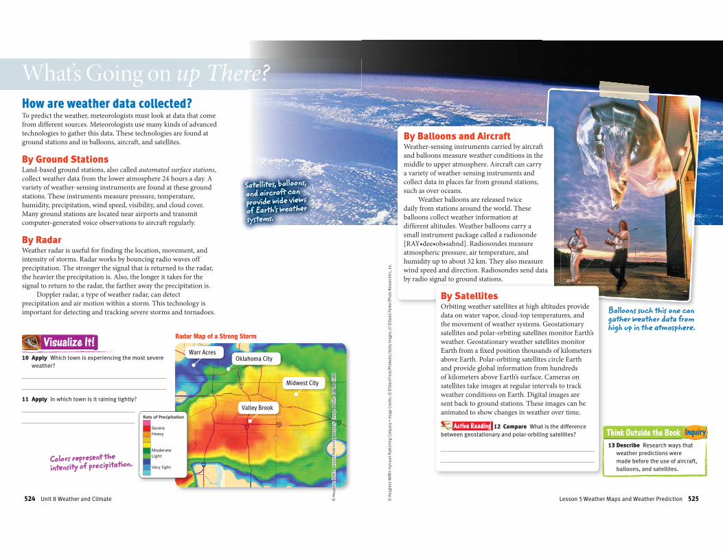
Very light
LightModerate
HeavySevere
Rate of Precipitation
How are weather data collected?To predict the weather, meteorologists must look at data that come
from different sources. Meteorologists use many kinds of advanced
technologies to gather this data. These technologies are found at
ground stations and in balloons, aircraft, and satellites.
By Ground StationsLand-based ground stations, also called automated surface stations,
collect weather data from the lower atmosphere 24 hours a day. A
variety of weather-sensing instruments are found at these ground
stations. These instruments measure pressure, temperature,
humidity, precipitation, wind speed, visibility, and cloud cover.
Many ground stations are located near airports and transmit
computer-generated voice observations to aircraft regularly.
By RadarWeather radar is useful for finding the location, movement, and
intensity of storms. Radar works by bouncing radio waves off
precipitation. The stronger the signal that is returned to the radar,
the heavier the precipitation is. Also, the longer it takes for the
signal to return to the radar, the farther away the precipitation is.
Doppler radar, a type of weather radar, can detect
precipitation and air motion within a storm. This technology is
important for detecting and tracking severe storms and tornadoes.
What’s Going on up There?
10 Apply Which town is experiencing the most severe
weather?
11 Apply In which town is it raining lightly?
Visualize It!
Colors represent the intensity of precipitation.
Satellites, balloons, and aircraft can provide wide views of Earth’s weather systems.
Warr AcresOklahoma City
Midwest City
Valley Brook
Radar Map of a Strong Storm
Unit 8 Weather and Climate524
Think Outside the Book Inquiry
By Balloons and AircraftWeather-sensing instruments carried by aircraft
and balloons measure weather conditions in the
middle to upper atmosphere. Aircraft can carry
a variety of weather-sensing instruments and
collect data in places far from ground stations,
such as over oceans.
Weather balloons are released twice
daily from stations around the world. These
balloons collect weather information at
different altitudes. Weather balloons carry a
small instrument package called a radiosonde
atmospheric pressure, air temperature, and
humidity up to about 32 km. They also measure
wind speed and direction. Radiosondes send data
by radio signal to ground stations.
By SatellitesOrbiting weather satellites at high altitudes provide
data on water vapor, cloud-top temperatures, and
the movement of weather systems. Geostationary
satellites and polar-orbiting satellites monitor Earth’s
weather. Geostationary weather satellites monitor
Earth from a fixed position thousands of kilometers
above Earth. Polar-orbiting satellites circle Earth
and provide global information from hundreds
of kilometers above Earth’s surface. Cameras on
satellites take images at regular intervals to track
weather conditions on Earth. Digital images are
sent back to ground stations. These images can be
animated to show changes in weather over time.
Active Reading 12 Compare What is the difference
between geostationary and polar-orbiting satellites?
Balloons such this one can gather weather data from high up in the atmosphere.
13 Describe Research ways that
weather predictions were
made before the use of aircraft,
balloons, and satellites.
Lesson 5 Weather Maps and Weather Prediction 525
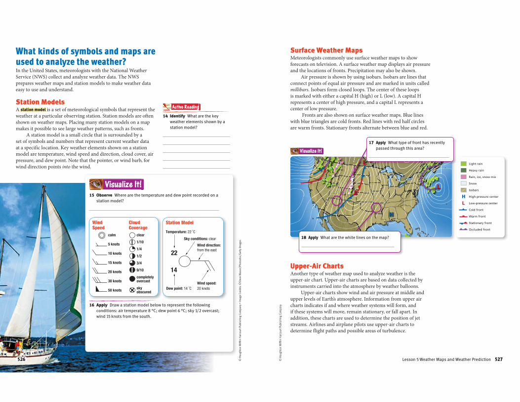
calm
5 knots
10 knots
15 knots
20 knots
30 knots
50 knots
clear
1/10
1/4
1/2
3/4
9/10
completely overcast
sky obscured
Wind Speed
Cloud Coverage
22
14
Wind direction: from the east
Temperature: 22 ˚C
Dew point: 14 ˚C
Sky conditions: clear
Wind speed: 20 knots
What kinds of symbols and maps are
used to analyze the weather?In the United States, meteorologists with the National Weather
Service (NWS) collect and analyze weather data. The NWS
prepares weather maps and station models to make weather data
easy to use and understand.
Station ModelsA station model is a set of meteorological symbols that represent the
weather at a particular observing station. Station models are often
shown on weather maps. Placing many station models on a map
makes it possible to see large weather patterns, such as fronts.
A station model is a small circle that is surrounded by a
set of symbols and numbers that represent current weather data
at a specific location. Key weather elements shown on a station
model are temperature, wind speed and direction, cloud cover, air
pressure, and dew point. Note that the pointer, or wind barb, for
wind direction points into the wind.
15 Observe Where are the temperature and dew point recorded on a
station model?
Visualize It!
16 Apply Draw a station model below to represent the following
conditions: air temperature 8 °C; dew point 6 °C; sky 1/2 overcast;
wind 15 knots from the south.
14 Identify What are the key
weather elements shown by a
station model?
Active Reading
Station Model
526
L
LL
H
Light rain
Heavy rain
Rain, ice, snow mix
Snow
Isobars
High-pressure center
Low-pressure center
Cold front
Warm front
Stationary front
Occluded front
LH
LLLLLLL
LLLLLLLLLLLLL
LLLLLLL
Visualize It!
Upper-Air ChartsAnother type of weather map used to analyze weather is the
upper-air chart. Upper-air charts are based on data collected by
instruments carried into the atmosphere by weather balloons.
Upper-air charts show wind and air pressure at middle and
upper levels of Earth’s atmosphere. Information from upper air
charts indicates if and where weather systems will form, and
if these systems will move, remain stationary, or fall apart. In
addition, these charts are used to determine the position of jet
streams. Airlines and airplane pilots use upper-air charts to
determine flight paths and possible areas of turbulence.
© H
ough
ton
Miff
lin H
arco
urt P
ublis
hing
Com
pany
Surface Weather Maps Meteorologists commonly use surface weather maps to show
forecasts on television. A surface weather map displays air pressure
and the locations of fronts. Precipitation may also be shown.
Air pressure is shown by using isobars. Isobars are lines that
connect points of equal air pressure and are marked in units called
millibars. Isobars form closed loops. The center of these loops
is marked with either a capital H (high) or L (low). A capital H
represents a center of high pressure, and a capital L represents a
center of low pressure.
Fronts are also shown on surface weather maps. Blue lines
with blue triangles are cold fronts. Red lines with red half circles
are warm fronts. Stationary fronts alternate between blue and red.
17 Apply What type of front has recently
passed through this area?
18 Apply What are the white lines on the map?
Lesson 5 Weather Maps and Weather Prediction 527
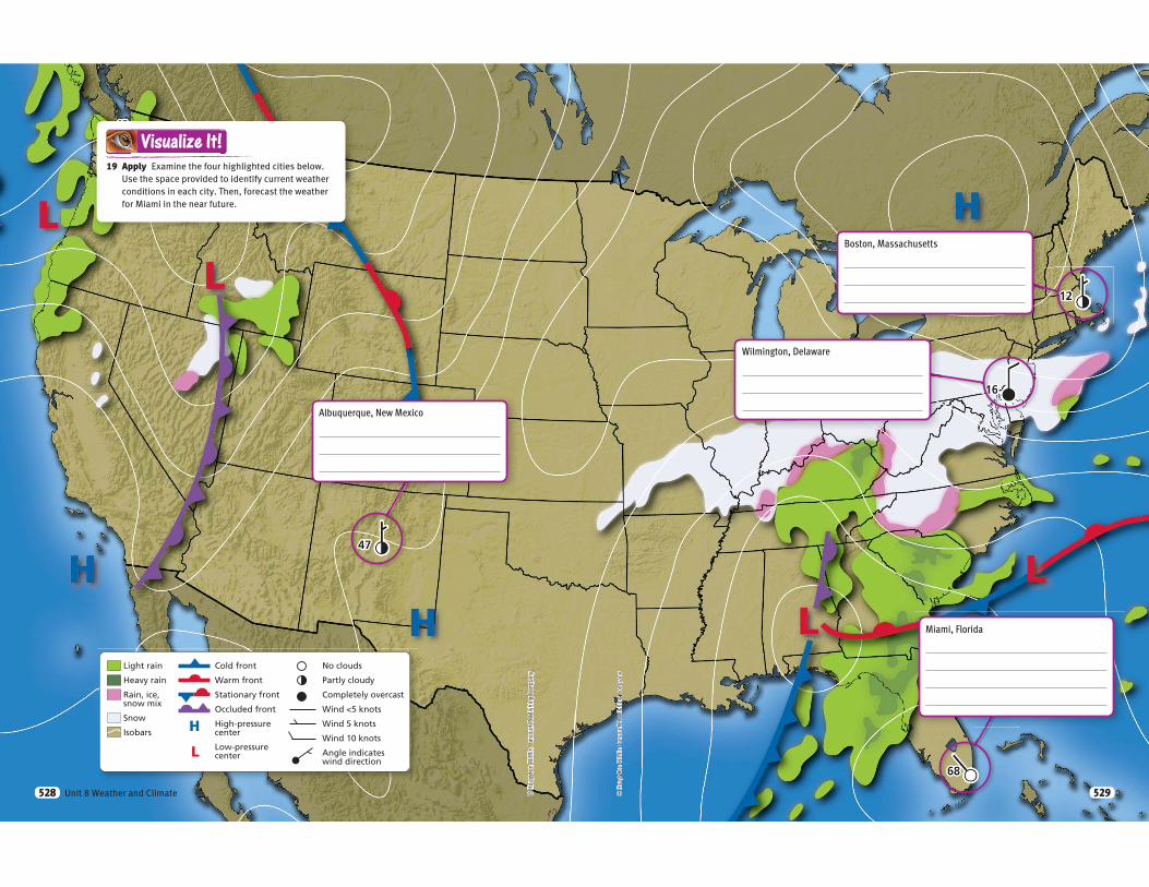
Light rain
Heavy rain
Rain, ice,snow mix
Snow
Isobars
Cold front
Warm front
Stationary front
Occluded front
High-pressurecenter
Low-pressurecenter
No clouds
Partly cloudy
Completely overcast
Wind <5 knots
Wind 5 knots
Wind 10 knots
Angle indicateswind direction
H
L
© H
ough
ton
Miff
lin H
arco
urt P
ublis
hing
Com
pany
19 Apply Examine the four highlighted cities below.
Use the space provided to identify current weather
conditions in each city. Then, forecast the weather
for Miami in the near future.
Visualize It!
Albuquerque, New Mexico
Unit 8 Weather and Climate528 © H
ough
ton
Miff
lin H
arco
urt P
ublis
hing
Com
pany
Boston, Massachusetts
Wilmington, Delaware
Miami, Florida
529
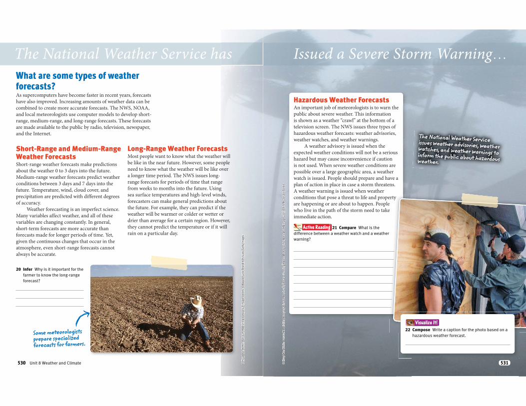
The National Weather Service has
What are some types of weather
forecasts? As supercomputers have become faster in recent years, forecasts
have also improved. Increasing amounts of weather data can be
combined to create more accurate forecasts. The NWS, NOAA,
and local meteorologists use computer models to develop short-
range, medium-range, and long-range forecasts. These forecasts
are made available to the public by radio, television, newspaper,
and the Internet.
Short-Range and Medium-Range Weather Forecasts Short-range weather forecasts make predictions
about the weather 0 to 3 days into the future.
Medium-range weather forecasts predict weather
conditions between 3 days and 7 days into the
future. Temperature, wind, cloud cover, and
precipitation are predicted with different degrees
of accuracy.
Weather forecasting is an imperfect science.
Many variables affect weather, and all of these
variables are changing constantly. In general,
short-term forecasts are more accurate than
forecasts made for longer periods of time. Yet,
given the continuous changes that occur in the
atmosphere, even short-range forecasts cannot
always be accurate.
Long-Range Weather ForecastsMost people want to know what the weather will
be like in the near future. However, some people
need to know what the weather will be like over
a longer time period. The NWS issues long-
range forecasts for periods of time that range
from weeks to months into the future. Using
sea surface temperatures and high-level winds,
forecasters can make general predictions about
the future. For example, they can predict if the
weather will be warmer or colder or wetter or
drier than average for a certain region. However,
they cannot predict the temperature or if it will
rain on a particular day.
20 Infer Why is it important for the
farmer to know the long-range
forecast?
Some meteorologists prepare specialized forecasts for farmers.
Unit 8 Weather and Climate530
Issued a Severe Storm Warning…
Hazardous Weather ForecastsAn important job of meteorologists is to warn the
public about severe weather. This information
is shown as a weather “crawl” at the bottom of a
television screen. The NWS issues three types of
hazardous weather forecasts: weather advisories,
weather watches, and weather warnings.
A weather advisory is issued when the
expected weather conditions will not be a serious
hazard but may cause inconvenience if caution
is not used. When severe weather conditions are
possible over a large geographic area, a weather
watch is issued. People should prepare and have a
plan of action in place in case a storm threatens.
A weather warning is issued when weather
conditions that pose a threat to life and property
are happening or are about to happen. People
who live in the path of the storm need to take
immediate action.
Active Reading 21 Compare What is the
difference between a weather watch and a weather
warning?
The National Weather Service issues weather advisories, weather watches, and weather warnings to inform the public about hazardous weather.
22 Compose Write a caption for the photo based on a
hazardous weather forecast.
Visualize It!
531
18
12
Visual SummaryTo complete this summary, check the box that indicates true or false. Then use the key below to check your answers. You can use this page to review the main concepts of the lesson.
27 Synthesis Describe the technologies used to gather data, prepare a
forecast, and broadcast a forecast for a town in the path of a hurricane.
Answers: 23 F; 24 T; 25 F; 26 T
Weather forecasting is the analysis of scientific data to predict likely future weather conditions.
Weather data come from many sources on land and in the air.
Different kinds of weather data can be shown together on station models and weather maps.
Meteorologists use computer models to make short-range, medium-range, and long-range weather forecasts.
Weather Maps and Weather
Prediction
T F23 In order to forecast the
weather, meteorologists gather weather data for five important weather elements.
T F24 Two types of weather maps
that meteorologists use to show the weather are surface weather maps and upper-air charts.
T F26 Three types of hazardous
weather forecasts are weather advisories, weather watches, and weather warnings.
T F25 Weather balloons and aircraft
allow for surface weather observations.
Unit 8 Weather and Climate532
Mon Tue Wed Thu Fri
74˚
62˚
70˚
64˚
56˚
48˚
56˚
54˚
66˚
56˚
© H
ough
ton
Miff
lin H
arco
urt P
ublis
hing
Com
pany
LessonLesson ReviewVocabulary
Fill in the blank with the term that best completes the following sentences.
1 A is a group of meteorological symbols that represents the weather at a particular observing station.
2 is the analysis of scientific data to predict likely future weather conditions.
3 The scientific study of Earth’s atmosphere and weather is called
Key Concepts
4 List What are the eight elements of weather that are observed for making weather forecasts?
5 Identify What kinds of data do surface weather maps provide?
6 Summarize Describe each of the three types of hazardous weather forecasts.
Critical Thinking
Use the diagram to answer the following questions.
7 Analyze On what day will there likely be severe weather?
8 Infer Between which two days will a cold front arrive? Explain.
9 Diagram Draw a station model based on the Thursday forecast, if winds are 15 knots from the northwest.
10 Assess Why do you think weather observations are made frequently at airports around the world?
5
Lesson 5 Weather Maps and Weather Prediction 533
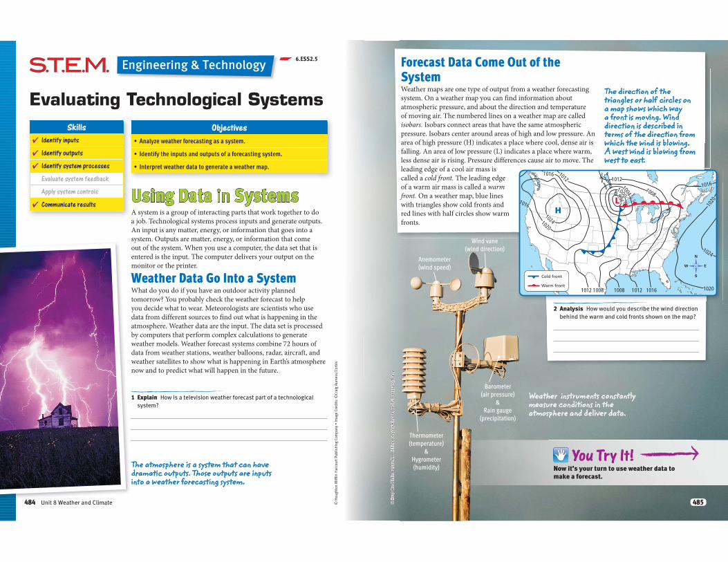
p 6.ESS2.5
1 Explain How is a television weather forecast part of a technological
system?
Using Data in SystemsA system is a group of interacting parts that work together to do
a job. Technological systems process inputs and generate outputs.
An input is any matter, energy, or information that goes into a
system. Outputs are matter, energy, or information that come
out of the system. When you use a computer, the data set that is
entered is the input. The computer delivers your output on the
monitor or the printer.
Weather Data Go Into a SystemWhat do you do if you have an outdoor activity planned
tomorrow? You probably check the weather forecast to help
you decide what to wear. Meteorologists are scientists who use
data from different sources to find out what is happening in the
atmosphere. Weather data are the input. The data set is processed
by computers that perform complex calculations to generate
weather models. Weather forecast systems combine 72 hours of
data from weather stations, weather balloons, radar, aircraft, and
weather satellites to show what is happening in Earth’s atmosphere
now and to predict what will happen in the future.
ObjectivesSkills
� Identify inputs
� Identify outputs
� Identify system processes
Evaluate system feedback
Apply system controls
� Communicate results
Evaluating Technological Systems
Engineering & Technology
The atmosphere is a system that can have dramatic outputs. Those outputs are inputs into a weather forecasting system.
484 Unit 8 Weather and Climate
LH
1012
1012
100810081012
1012
1008
1016
1016
1020
1024
1016 1020
1024
1020
1016
996
1000
1004
Cold front
Warm front
2 Analysis How would you describe the wind direction
behind the warm and cold fronts shown on the map?
Now it’s your turn to use weather data to make a forecast.NoN w itit’s’s’s yourr turn ttoo use weeaa
Forecast Data Come Out of the
SystemWeather maps are one type of output from a weather forecasting
system. On a weather map you can find information about
atmospheric pressure, and about the direction and temperature
of moving air. The numbered lines on a weather map are called
isobars. Isobars connect areas that have the same atmospheric
pressure. Isobars center around areas of high and low pressure. An
area of high pressure (H) indicates a place where cool, dense air is
falling. An area of low pressure (L) indicates a place where warm,
less dense air is rising. Pressure differences cause air to move. The
leading edge of a cool air mass is
called a cold front. The leading edge
of a warm air mass is called a warm
front. On a weather map, blue lines
with triangles show cold fronts and
red lines with half circles show warm
fronts.
Weather instruments constantly measure conditions in the atmosphere and deliver data.
Barometer
(air pressure)
&
Rain gauge
(precipitation)
Anemometer
(wind speed)
Wind vane
(wind direction)
Thermometer
(temperature)
&
Hygrometer
(humidity)
The direction of the triangles or half circles on a map shows which way a front is moving. Wind direction is described in terms of the direction from which the wind is blowing. A west wind is blowing from west to east.
485
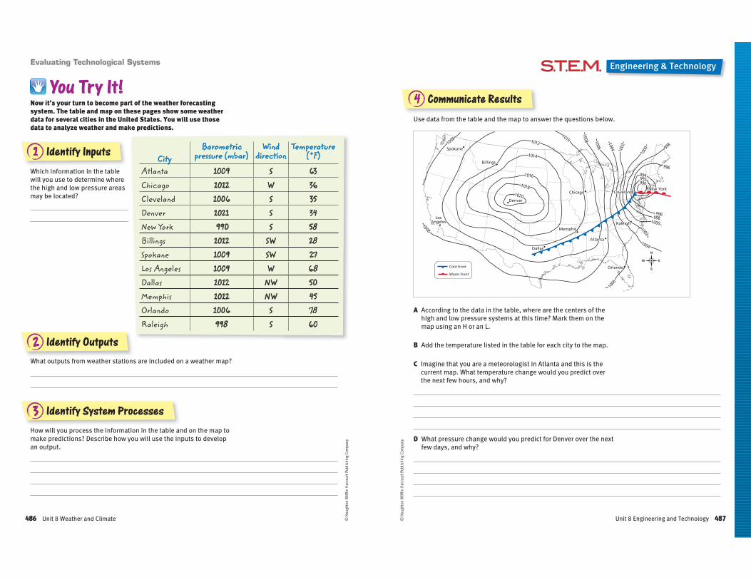
1 Identify Inputs
2 Identify Outputs
3 Identify System Processes
Which information in the table
will you use to determine where
the high and low pressure areas
may be located?
Evaluating Technological Systems
Now it’s your turn to become part of the weather forecasting system. The table and map on these pages show some weather data for several cities in the United States. You will use those data to analyze weather and make predictions.
CityBarometric
pressure (mbar)Wind
directionTemperature
(˚F)
Atlanta 1009 S 63Chicago 1012 W 36Cleveland 1006 S 35Denver 1021 S 34New York 990 S 58Billings 1012 SW 28Spokane 1009 SW 27Los Angeles 1009 W 68Dallas 1012 NW 50Memphis 1012 NW 45Orlando 1006 S 78Raleigh 998 S 60
What outputs from weather stations are included on a weather map?
How will you process the information in the table and on the map to
make predictions? Describe how you will use the inputs to develop
an output.
© H
ough
ton
Miff
lin H
arco
urt P
ublis
hing
Com
pany
486 Unit 8 Weather and Climate
Chicago
Denver
Dallas
Billings
Spokane
LosAngeles
Atlanta
RaleighMemphis
Orlando
ClevelandNew York
1020
1018
1016
1014
1012
10101008
1008
1008 1006
1006
1004 1002
1000
1000
1002
1004
998
996
996998
994992990
1020
1018
1016
1014
1012
10101008
1008
1008 1006
1006
1004 1002
1000
1000
1002
1004
998
996
996998
994992990
Chicago
Denver
Dallas
Billings
Spokane
LosAngeles
Atlanta
RaleighMemphis
Orlando
ClevelandNew York
Cold front
Warm front
Engineering & Technology
4 Communicate Results
A According to the data in the table, where are the centers of the
high and low pressure systems at this time? Mark them on the
map using an H or an L.
D What pressure change would you predict for Denver over the next
few days, and why?
B Add the temperature listed in the table for each city to the map.
C Imagine that you are a meteorologist in Atlanta and this is the
current map. What temperature change would you predict over
the next few hours, and why?
Use data from the table and the map to answer the questions below.
© H
ough
ton
Miff
lin H
arco
urt P
ublis
hing
Com
pany
487Unit 8 Engineering and Technology
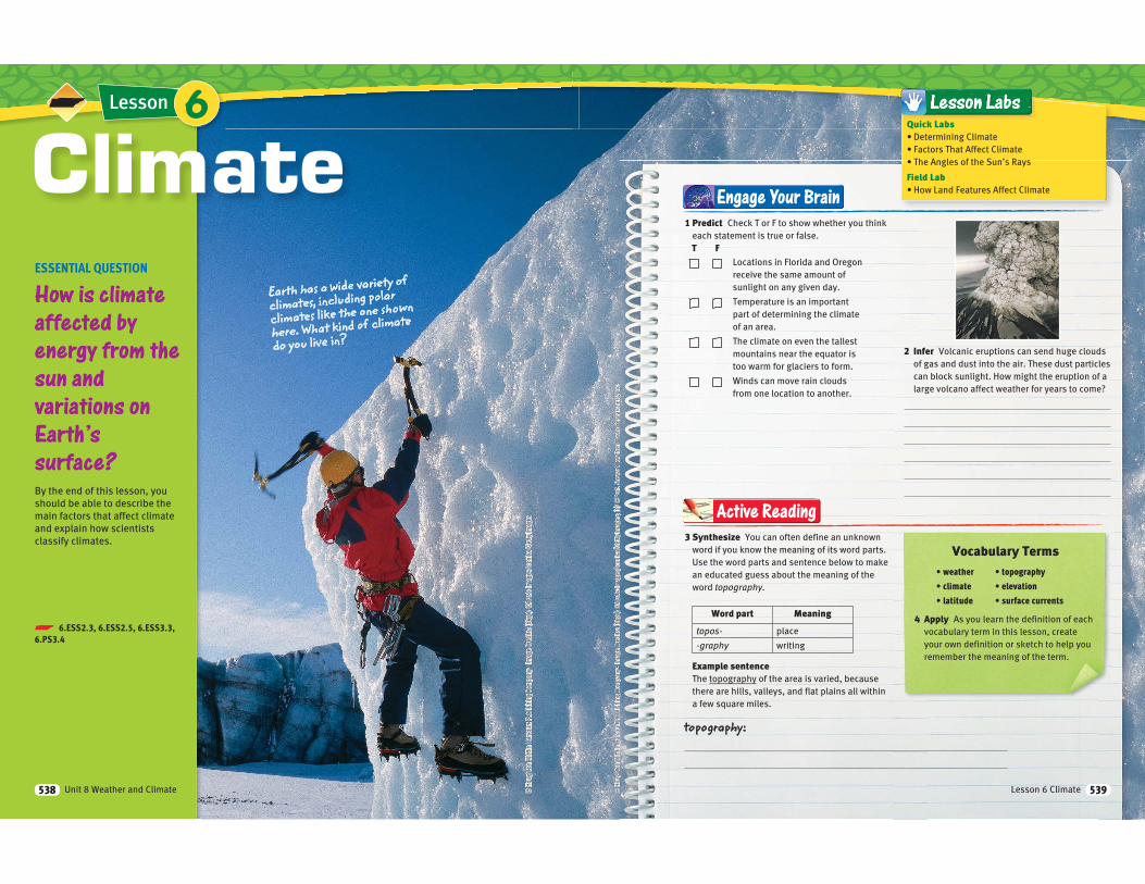
Lesson
ESSENTIAL QUESTION
How is climate
affected by
energy from the
sun and
variations on
Earth’s
surface?
By the end of this lesson, you
should be able to describe the
main factors that affect climate
and explain how scientists
classify climates.
ClimateEarth has a wide variety of
climates, including polar
climates like the one shown
here. What kind of climate
do you live in?
6
p 6.ESS2.3, 6.ESS2.5, 6.ESS3.3, 6.PS3.4
Unit 8 Weather and Climate538
Engage Your Brain
1 Predict Check T or F to show whether you think
each statement is true or false.
T FLocations in Florida and Oregon
receive the same amount of
sunlight on any given day.
Temperature is an important
part of determining the climate
of an area.
The climate on even the tallest
mountains near the equator is
too warm for glaciers to form.
Winds can move rain clouds
from one location to another.
2 Infer Volcanic eruptions can send huge clouds
of gas and dust into the air. These dust particles
can block sunlight. How might the eruption of a
large volcano affect weather for years to come?
3 Synthesize You can often define an unknown
word if you know the meaning of its word parts.
Use the word parts and sentence below to make
an educated guess about the meaning of the
word topography.
Word part Meaning
topos- place
-graphy writing
Example sentenceThe topography of the area is varied, because
there are hills, valleys, and flat plains all within
a few square miles.
Active Reading
4 Apply As you learn the definition of each
vocabulary term in this lesson, create
your own definition or sketch to help you
remember the meaning of the term.
Vocabulary Terms
topography:
Quick Labs
Field Lab
Lesson 6 Climate 539
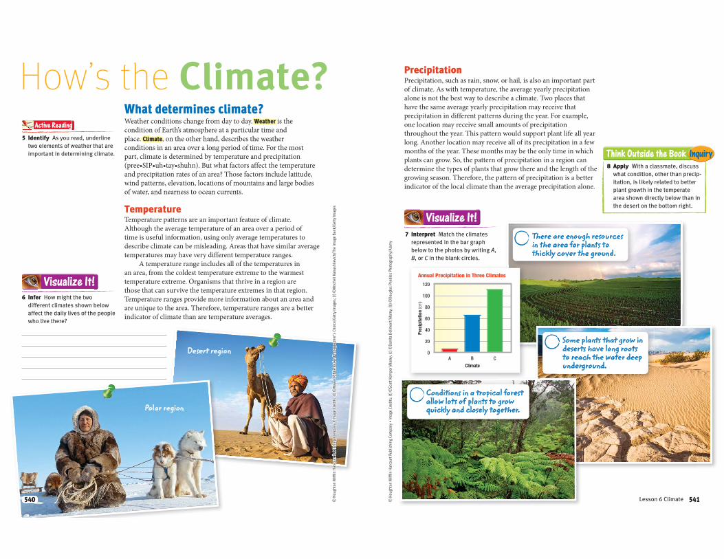
What determines climate?Weather conditions change from day to day. Weather is the
condition of Earth’s atmosphere at a particular time and
place. Climate, on the other hand, describes the weather
conditions in an area over a long period of time. For the most
part, climate is determined by temperature and precipitation
and precipitation rates of an area? Those factors include latitude,
wind patterns, elevation, locations of mountains and large bodies
of water, and nearness to ocean currents.
TemperatureTemperature patterns are an important feature of climate.
Although the average temperature of an area over a period of
time is useful information, using only average temperatures to
describe climate can be misleading. Areas that have similar average
temperatures may have very different temperature ranges.
A temperature range includes all of the temperatures in
an area, from the coldest temperature extreme to the warmest
temperature extreme. Organisms that thrive in a region are
those that can survive the temperature extremes in that region.
Temperature ranges provide more information about an area and
are unique to the area. Therefore, temperature ranges are a better
indicator of climate than are temperature averages.
How’s the Climate?5 Identify As you read, underline
two elements of weather that are
important in determining climate.
Active Reading
6 Infer How might the two
different climates shown below
affect the daily lives of the people
who live there?
Visualize It!
Polar region
Desert region
540540
Prec
ipita
tion (cm)
Climate
Annual Precipitation in Three Climates
120
100
80
60
40
20
0A B C
There are enough resources in the area for plants to thickly cover the ground.
Some plants that grow in deserts have long roots to reach the water deep underground.
PrecipitationPrecipitation, such as rain, snow, or hail, is also an important part
of climate. As with temperature, the average yearly precipitation
alone is not the best way to describe a climate. Two places that
have the same average yearly precipitation may receive that
precipitation in different patterns during the year. For example,
one location may receive small amounts of precipitation
throughout the year. This pattern would support plant life all year
long. Another location may receive all of its precipitation in a few
months of the year. These months may be the only time in which
plants can grow. So, the pattern of precipitation in a region can
determine the types of plants that grow there and the length of the
growing season. Therefore, the pattern of precipitation is a better
indicator of the local climate than the average precipitation alone.
7 Interpret Match the climates
represented in the bar graph
below to the photos by writing A,
B, or C in the blank circles.
Conditions in a tropical forest allow lots of plants to grow quickly and closely together.
Visualize It!
Think Outside the Book Inquiry
8 Apply With a classmate, discuss
what condition, other than precip-
itation, is likely related to better
plant growth in the temperate
area shown directly below than in
the desert on the bottom right.
541Lesson 6 Climate 541
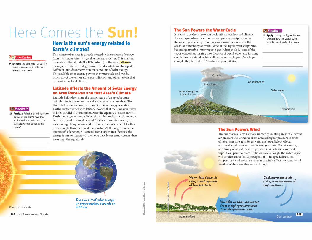
Visualize It!
© H
ough
ton
Miff
lin H
arco
urt P
ublis
hing
Com
pany
Here Comes the Sun!How is the sun’s energy related to
Earth’s climate?The climate of an area is directly related to the amount of energy
from the sun, or solar energy, that the area receives. This amount
Latitude is
the angular distance in degrees north and south from the equator.
Different latitudes receive different amounts of solar energy.
The available solar energy powers the water cycle and winds,
which affect the temperature, precipitation, and other factors that
determine the local climate.
Latitude Affects the Amount of Solar Energy an Area Receives and that Area’s ClimateLatitude helps determine the temperature of an area, because
latitude affects the amount of solar energy an area receives. The
figure below shows how the amount of solar energy reaching
Earth’s surface varies with latitude. Notice that the sun’s rays travel
in lines parallel to one another. Near the equator, the sun’s rays hit
Earth directly, at almost a 90° angle. At this angle, the solar energy
is concentrated in a small area of Earth’s surface. As a result, that
area has high temperatures. At the poles, the sun’s rays hit Earth at
a lesser angle than they do at the equator. At this angle, the same
amount of solar energy is spread over a larger area. Because the
energy is less concentrated, the poles have lower temperatures than
areas near the equator do.
10 Analyze What is the difference
between the sun’s rays that
strike at the equator and the
sun’s rays that strike at the
poles?
9 Identify As you read, underline
how solar energy affects the
climate of an area.
Active Reading
The amount of solar energy an area receives depends on latitude.Drawing is not to scale.
542 Unit 8 Weather and Climate542
Clouds
Precipitation
Surface runoff
Condensation
Water vapor
Evaporation
Water storage in ice and snow
Visualize It!
Warm surface Cool surface
© H
ough
ton
Miff
lin H
arco
urt P
ublis
hing
Com
pany
The Sun Powers the Water CycleIt is easy to see how the water cycle affects weather and climate.
For example, when it rains or snows, you see precipitation. In
the water cycle, energy from the sun warms the surface of the
ocean or other body of water. Some of the liquid water evaporates,
becoming invisible water vapor, a gas. When cooled, some of the
vapor condenses, turning into droplets of liquid water and forming
clouds. Some water droplets collide, becoming larger. Once large
enough, they fall to Earth’s surface as precipitation.
11 Apply Using the figure below,
explain how the water cycle
affects the climate of an area.
The Sun Powers WindThe sun warms Earth’s surface unevenly, creating areas of different
air pressure. As air moves from areas of higher pressure to areas
of lower pressure, it is felt as wind, as shown below. Global
and local wind patterns transfer energy around Earth’s surface,
affecting global and local temperatures. Winds also carry water
vapor from place to place. If the air cools enough, the water vapor
will condense and fall as precipitation. The speed, direction,
temperature, and moisture content of winds affect the climate and
weather of the areas they move through.
Warm, less dense air rises, creating areas of low pressure.
Wind forms when air moves from a high-pressure area to a low-pressure area.
Cold, more dense air sinks, creating areas of high pressure.
543543
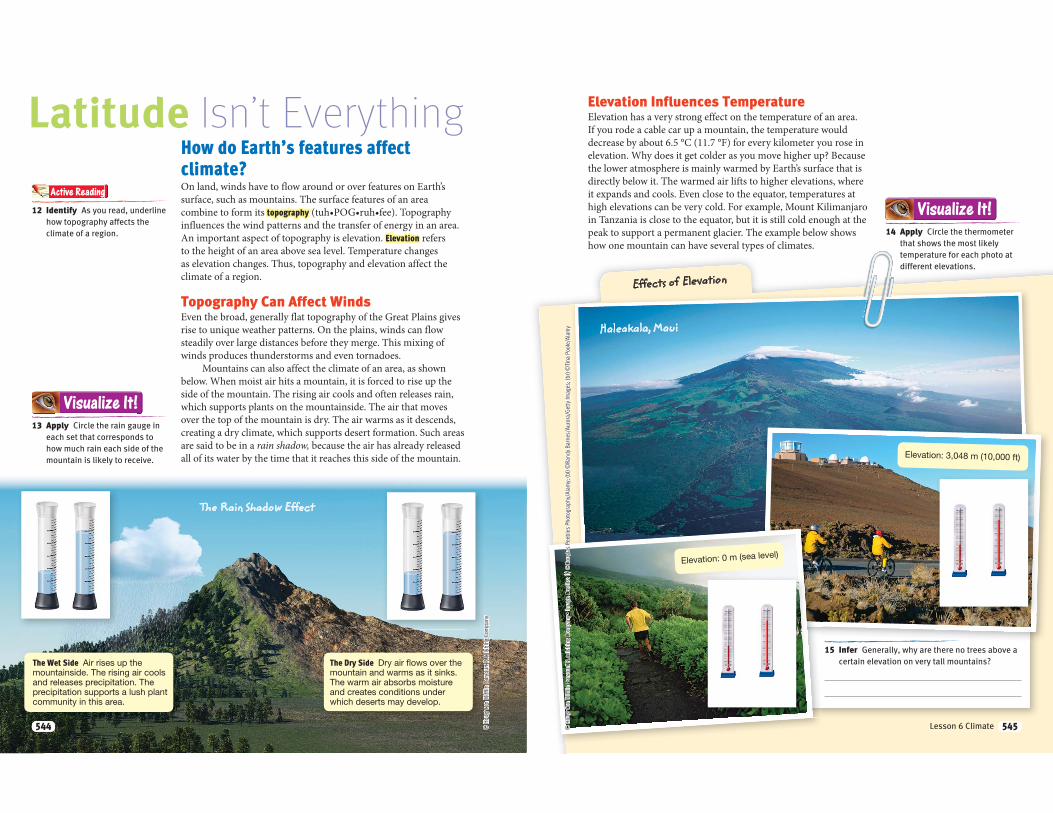
© H
ough
ton
Miff
lin H
arco
urt P
ublis
hing
Com
pany
Latitude Isn’t EverythingHow do Earth’s features affect
climate?On land, winds have to flow around or over features on Earth’s surface, such as mountains. The surface features of an area combine to form its topography
Elevation refers
Topography Can Affect Winds
Mountains can also affect the climate of an area, as shown
are said to be in a rain shadow,
The Wet Side Air rises up the mountainside. The rising air cools and releases precipitation. The precipitation supports a lush plant community in this area.
12 Identify As you read, underline
how topography affects the
climate of a region.
Active Reading
13 Apply Circle the rain gauge in
each set that corresponds to
how much rain each side of the
mountain is likely to receive.
Visualize It!
The Dry Side Dry air flows over the mountain and warms as it sinks. The warm air absorbs moisture and creates conditions under which deserts may develop.
The Rain Shadow Effect
544544
Elevation Influences TemperatureElevation has a very strong effect on the temperature of an area.
If you rode a cable car up a mountain, the temperature would
decrease by about 6.5 °C (11.7 °F) for every kilometer you rose in
elevation. Why does it get colder as you move higher up? Because
the lower atmosphere is mainly warmed by Earth’s surface that is
directly below it. The warmed air lifts to higher elevations, where
it expands and cools. Even close to the equator, temperatures at
high elevations can be very cold. For example, Mount Kilimanjaro
in Tanzania is close to the equator, but it is still cold enough at the
peak to support a permanent glacier. The example below shows
how one mountain can have several types of climates.
Effects of Elevation
14 Apply Circle the thermometer
that shows the most likely
temperature for each photo at
different elevations.
Visualize It!
Haleakala, Maui
Elevation: 3,048 m (10,000 ft)
15 Infer Generally, why are there no trees above a
certain elevation on very tall mountains?
Elevation: 0 m (sea level)
545Lesson 6 Climate 545
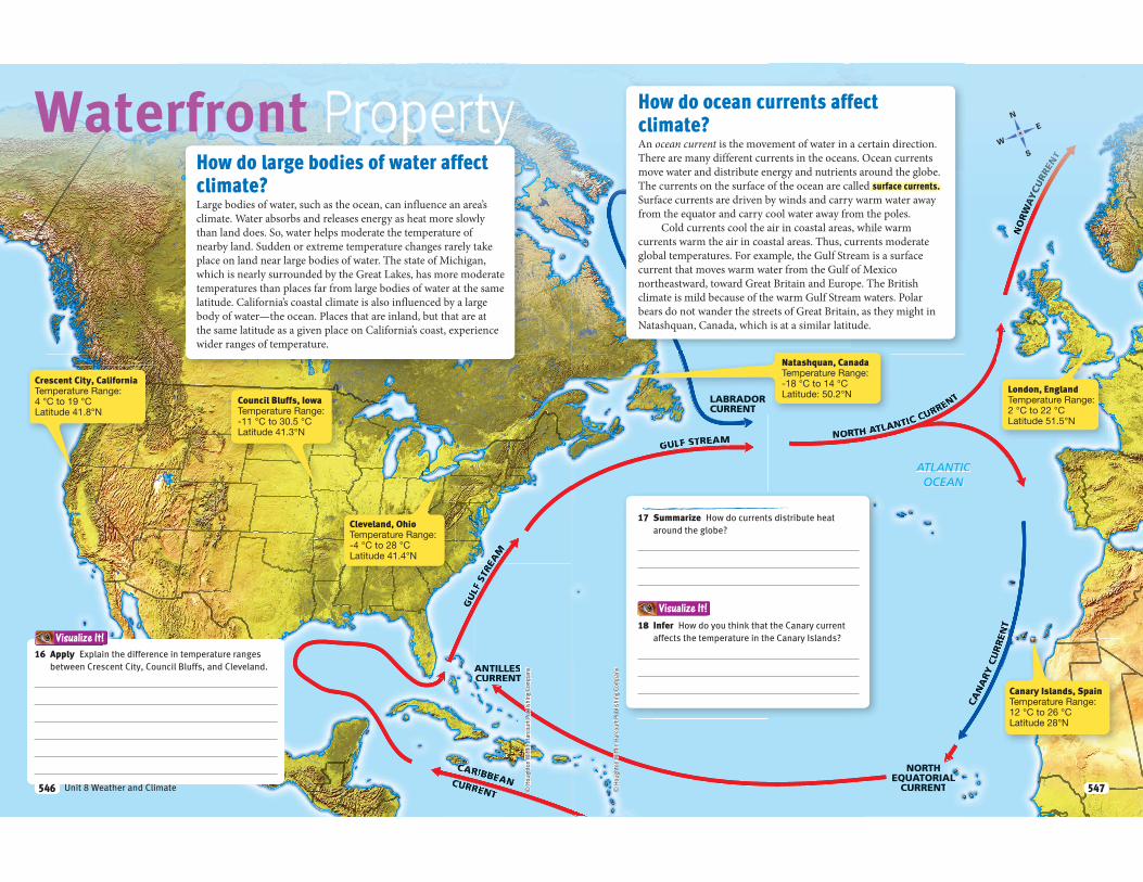
GULF
STREE
AAM
CCCCCCCCCCCCCCCCCAAAAAAARIBBEANCURRENT
ANAA TILLESCCUCUCCCCCC RRENT
© H
ough
ton
Miff
lin H
arco
urt P
ublis
hing
Com
pany
Waterfront PropertyHow do large bodies of water affect
climate?Large bodies of water, such as the ocean, can influence an area’s
climate. Water absorbs and releases energy as heat more slowly
than land does. So, water helps moderate the temperature of
nearby land. Sudden or extreme temperature changes rarely take
place on land near large bodies of water. The state of Michigan,
which is nearly surrounded by the Great Lakes, has more moderate
temperatures than places far from large bodies of water at the same
latitude. California’s coastal climate is also influenced by a large
body of water—the ocean. Places that are inland, but that are at
the same latitude as a given place on California’s coast, experience
wider ranges of temperature.
Crescent City, CaliforniaTemperature Range: 4 °C to 19 °CLatitude 41.8°N
16 Apply Explain the difference in temperature ranges
between Crescent City, Council Bluffs, and Cleveland.
Council Bluffs, IowaTemperature Range: -11 °C to 30.5 °CLatitude 41.3°N
Visualize It!
Cleveland, OhioTemperature Range: -4 °C to 28 °CLatitude 41.4°N
546 Unit 8 Weather and Climate546
CANARYRR
CURREENNN
TT
NORTRR H ATAA LANTIC CURRE
NT
NNORWWWAAA
WWYYY
AACCCUUU
RRRREENN
TT
GULF STREAM
NORTHEQUATORIALALALLLLLLLLLLLCURRENT
ATLANTICOCEAN
EAST
GRE
ENNLLAAA
NNNDDDCCCUU
RRRRREENN
TT
LABRADORCURRENT
Visualize It!
RRREE
© H
ough
ton
Miff
lin H
arco
urt P
ublis
hing
Com
pany
How do ocean currents affect
climate?An ocean current is the movement of water in a certain direction.
There are many different currents in the oceans. Ocean currents
move water and distribute energy and nutrients around the globe.
The currents on the surface of the ocean are called surface currents.
Surface currents are driven by winds and carry warm water away
from the equator and carry cool water away from the poles.
Cold currents cool the air in coastal areas, while warm
currents warm the air in coastal areas. Thus, currents moderate
global temperatures. For example, the Gulf Stream is a surface
current that moves warm water from the Gulf of Mexico
northeastward, toward Great Britain and Europe. The British
climate is mild because of the warm Gulf Stream waters. Polar
bears do not wander the streets of Great Britain, as they might in
Natashquan, Canada, which is at a similar latitude.
17 Summarize How do currents distribute heat
around the globe?
18 Infer How do you think that the Canary current
affects the temperature in the Canary Islands?
Natashquan, CanadaTemperature Range: -18 °C to 14 °CLatitude: 50.2°N
London, EnglandTemperature Range: 2 °C to 22 °CLatitude 51.5°N
Canary Islands, SpainTemperature Range: 12 °C to 26 °CLatitude 28°N
547547
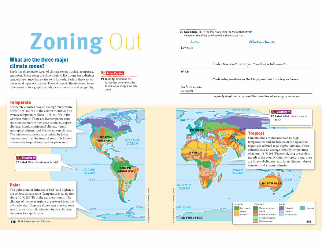
SOUTHE
ARCTIC OCEAN
ATLANTICOCEAN
PACIFICOCEAN
SOUTHAMERICA
NORTHAMERICA
0°
23.5°S
66.5°S
23.5°N
Equator
22
23.52
66.
© H
ough
ton
Miff
lin H
arco
urt P
ublis
hing
Com
pany
Zoning OutWhat are the three major
climate zones?Earth has three major types of climate zones: tropical, temperate,
and polar. These zones are shown below. Each zone has a distinct
temperature range that relates to its latitude. Each of these zones
has several types of climates. These different climates result from
differences in topography, winds, ocean currents, and geography.
TemperateTemperate climates have an average temperature
below 18 °C (64 °F) in the coldest month and an
average temperature above 10 °C (50 °F) in the
warmest month. There are five temperate zone
subclimates: marine west coast climates, steppe
climates, humid continental climate, humid
subtropical climate, and Mediterranean climate.
The temperate zone is characterized by lower
temperatures than the tropical zone. It is located
between the tropical zone and the polar zone.
19 Identify Underline the
factor that determines the
temperature ranges in each
zone.
Active Reading
20 Label What climate zone is this?
PolarThe polar zone, at latitudes of 66.5° and higher, is
the coldest climate zone. Temperatures rarely rise
above 10 °C (50 °F) in the warmest month. The
climates of the polar regions are referred to as the
polar climates. There are three types of polar zone
subclimates: subarctic climates, tundra climates,
and polar ice cap climates.
Visualize It!
548 Unit 8 Weather and Climate548
ARCTIC OCEAN
ERN OCEAN
ATLANTICOCEAN
INDIANOCEAN
PACIFICOCEAN
AFRICA
EUROPEASIA
AUSTRALIA
ANTARCTICA
0°
23.5°S
66.5°N
66.5°S
23.5°N
Equator
INDIANOCEAN
PACIFICOCEAN
ASIAA
0°
23.5°N
Equator
HighlandSubarctic
Tundra
Polar icecaps
Marine west coast
Steppe
Humid continential
Humid subtropical
Mediterranean
Rain forest
Desert
Savanna
TROPICAL TEMPERATE POLAR
© H
ough
ton
Miff
lin H
arco
urt P
ublis
hing
Com
pany
21 Summarize Fill in the table for either the factor that affects
climate or the effect on climate the given factor has.
TropicalClimates that are characterized by high
temperatures and are located in the equatorial
region are referred to as tropical climates. These
climates have an average monthly temperature
of at least 18 °C (64 °F), even during the coldest
month of the year. Within the tropical zone, there
are three subclimates: rain forest climates, desert
climates, and savanna climates.
22 Label What climate zone is
this?
Factor Effect on climateLatitude
Cooler temperatures as you travel up a tall mountain
Winds
Moderates weather so that highs and lows are less extreme
Surface ocean currents
Impacts wind patterns and the transfer of energy in an area
Visualize It!
549549
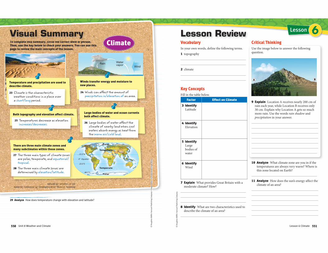
Temperate
Temperate
Polar
Polar
0°
23.5°N
66.5°N
23.5°S
66.5°S
Equator
RainWind
Watervapor
Winds transfer energy and moisture to new places.
Answers: 23 long; 24 precipitation; 25 increases; 26 warm air; 27 tropical; 28 latitude
24 Winds can affect the amount of precipitation in/elevation of an area.
To complete this summary, circle the correct word or phrase. Then, use the key below to check your answers. You can use this page to review the main concepts of the lesson.
TTTTTTTTTTTTTTTTTTTTT llllllllllllllll tttttttttttttttttttt tthththththththhhththththhhhthtthiiiiiiiiiiiiiiiiiii iiiiiiiiiiiiiii llllllllllllll ttttttttttttttttthhhhhhhhhhhhhhh tttttttttttttttttttt ddddddddddddddddddddddddd hhhhhhhhhhhhhhhhhh
Visual Summary
29 Analyze How does temperature change with elevation and latitude?
Climate
Large bodies of water and ocean currents both affect climate.
26 Large bodies of water affect the climate of nearby land when cool waters absorb energy as heat from the warm air/cold land.
Both topography and elevation affect climate.
25 Temperatures decrease as elevation increases/decreases.
There are three main climate zones and many subclimates within those zones.
27 The three main types of climate zones are polar, temperate, and equatorial/tropical.
28 The three main climate zones are determined by elevation/latitude.
Temperature and precipitation are used to describe climate.
23 Climate is the characteristic weather conditions in a place over a short/long period.
550 Unit 8 Weather and Climate
A B
© H
ough
ton
Miff
lin H
arco
urt P
ublis
hing
Com
pany
LessonLesson ReviewVocabulary
In your own words, define the following terms.
1 topography
2 climate
Key Concepts
Fill in the table below.
Factor Effect on Climate
3 Identify Latitude
4 Identify Elevation
5 Identify Large bodies of water
6 Identify Wind
7 Explain What provides Great Britain with a moderate climate? How?
8 Identify What are two characteristics used to describe the climate of an area?
Critical Thinking
Use the image below to answer the following question.
9 Explain Location A receives nearly 200 cm of rain each year, while Location B receives only 30 cm. Explain why Location A gets so much more rain. Use the words rain shadow and precipitation in your answer.
10 Analyze What climate zone are you in if the temperatures are always very warm? Where is this zone located on Earth?
11 Analyze How does the sun’s energy affect the climate of an area?
BA
6
551Lesson 6 Climate
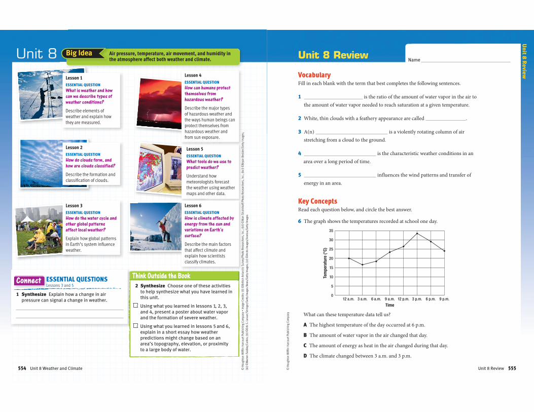
Lesson 3ESSENTIAL QUESTION
How do the water cycle and
other global patterns
affect local weather?
Explain how global patterns in Earth’s system influence weather.
Unit 8
Lesson 1ESSENTIAL QUESTION
What is weather and how
can we describe types of
weather conditions?
Describe elements of weather and explain how they are measured.
Lesson 5ESSENTIAL QUESTION
What tools do we use to
predict weather?
Understand how meteorologists forecast the weather using weather maps and other data.
Lesson 2ESSENTIAL QUESTION
How do clouds form, and
how are clouds classified?
Describe the formation and classification of clouds.
Think Outside the Book
2 Synthesize Choose one of these activities
to help synthesize what you have learned in
this unit.
Using what you learned in lessons 1, 2, 3,
and 4, present a poster about water vapor
and the formation of severe weather.
Using what you learned in lessons 5 and 6,
explain in a short essay how weather
predictions might change based on an
area’s topography, elevation, or proximity
to a large body of water.
Lesson 6ESSENTIAL QUESTION
How is climate affected by
energy from the sun and
variations on Earth’s
surface?
Describe the main factors that affect climate and explain how scientists classify climates.
Lesson 4ESSENTIAL QUESTION
How can humans protect
themselves from
hazardous weather?
Describe the major types of hazardous weather and the ways human beings can protect themselves from hazardous weather and from sun exposure.
1 Synthesize Explain how a change in air
pressure can signal a change in weather.
ESSENTIAL QUESTIONS Lessons 3 and 5
Connect
Air pressure, temperature, air movement, and humidity in the atmosphere affect both weather and climate.
Big Idea
Unit 8 Weather and Climate554
35
30
25
20
15
10
5
012 a.m. 3 a.m. 6 a.m. 9 a.m. 12 p.m. 3 p.m. 6 p.m. 9 p.m.
Tem
pera
ture
(°C)
Time
© H
ough
ton
Miff
lin H
arco
urt P
ublis
hing
Com
pany
Unit 8 ReviewName
VocabularyFill in each blank with the term that best completes the following sentences.
1 is the ratio of the amount of water vapor in the air to
the amount of water vapor needed to reach saturation at a given temperature.
2 White, thin clouds with a feathery appearance are called .
3 A(n) is a violently rotating column of air
stretching from a cloud to the ground.
4 is the characteristic weather conditions in an
area over a long period of time.
5 influences the wind patterns and transfer of
energy in an area.
Key ConceptsRead each question below, and circle the best answer.
6 The graph shows the temperatures recorded at school one day.
What can these temperature data tell us?
A The highest temperature of the day occurred at 6 p.m.
B The amount of water vapor in the air changed that day.
C The amount of energy as heat in the air changed during that day.
D The climate changed between 3 a.m. and 3 p.m.
Unit 8 R
eview
Unit 8 Review 555
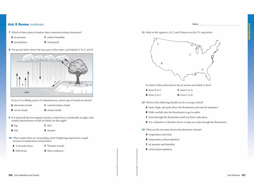
A
B
C
D
Lake
© H
ough
ton
Miff
lin H
arco
urt P
ublis
hing
Com
pany
Unit 8 Review continued
7 Which of these types of weather data is measured using a barometer?
A air pressure C relative humidity
B precipitation D wind speed
8 The picture below shows the four parts of the water cycle labeled A, B, C, and D.
If rain (C) is falling as part of a thunderstorm, which type of clouds are shown?
A altostratus clouds C cumulonimbus clouds
B cirrus clouds D stratus clouds
9 If it rained all day but stopped and then cooled down considerably at night, what weather phenomenon would you likely see that night?
A fog C sleet
B hail D thunder
10 What results when air surrounding a bolt of lightning experiences a rapid increase in temperature and pressure?
A A tornado forms. C Thunder sounds.
B Hail forms. D Rain condenses.
Unit 8 Weather and Climate556
A
B
C
D
© H
ough
ton
Miff
lin H
arco
urt P
ublis
hing
Com
pany
11 Refer to the regions A, B, C, and D shown on the U.S. map below.
In which of these directions is the jet stream most likely to flow?
A from D to C C from C to A
B from A to C D from C to B
12 Which of the following should you do to escape a flood?
A Seek a high, safe point above the floodwaters and wait for assistance.
B Walk carefully into the floodwaters to get to safety.
C Swim through the floodwaters until you find a safer place.
D Use a lifejacket or flotation device to help you wade through the floodwaters.
13 What are the two main factors that determine climate?
A temperature and wind
B temperature and precipitation
C air pressure and humidity
D wind and precipitation
Name
Unit 8 R
eview
Unit 8 Review 557
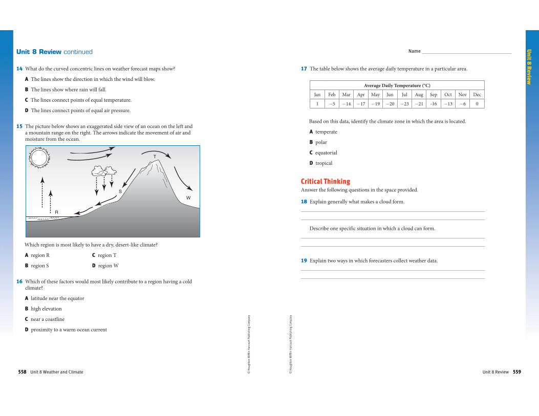
T
R
SW
© H
ough
ton
Miff
lin H
arco
urt P
ublis
hing
Com
pany
Unit 8 Review continued
14 What do the curved concentric lines on weather forecast maps show?
A The lines show the direction in which the wind will blow.
B The lines show where rain will fall.
C The lines connect points of equal temperature.
D The lines connect points of equal air pressure.
15 The picture below shows an exaggerated side view of an ocean on the left and a mountain range on the right. The arrows indicate the movement of air and moisture from the ocean.
Which region is most likely to have a dry, desert-like climate?
A region R C region T
B region S D region W
16 Which of these factors would most likely contribute to a region having a cold climate?
A latitude near the equator
B high elevation
C near a coastline
D proximity to a warm ocean current
Unit 8 Weather and Climate558 © H
ough
ton
Miff
lin H
arco
urt P
ublis
hing
Com
pany
17 The table below shows the average daily temperature in a particular area.
Based on this data, identify the climate zone in which the area is located.
A temperate
B polar
C equatorial
D tropical
Critical Thinking Answer the following questions in the space provided.
18 Explain generally what makes a cloud form.
Describe one specific situation in which a cloud can form.
19 Explain two ways in which forecasters collect weather data.
Name
Unit 8 R
eview
Average Daily Temperature (°C)
Jan Feb Mar Apr May Jun Jul Aug Sep Oct Nov Dec
1-5 -14 -17 -19 -20 -23 -21 -16
-13 -6 0
Unit 8 Review 559
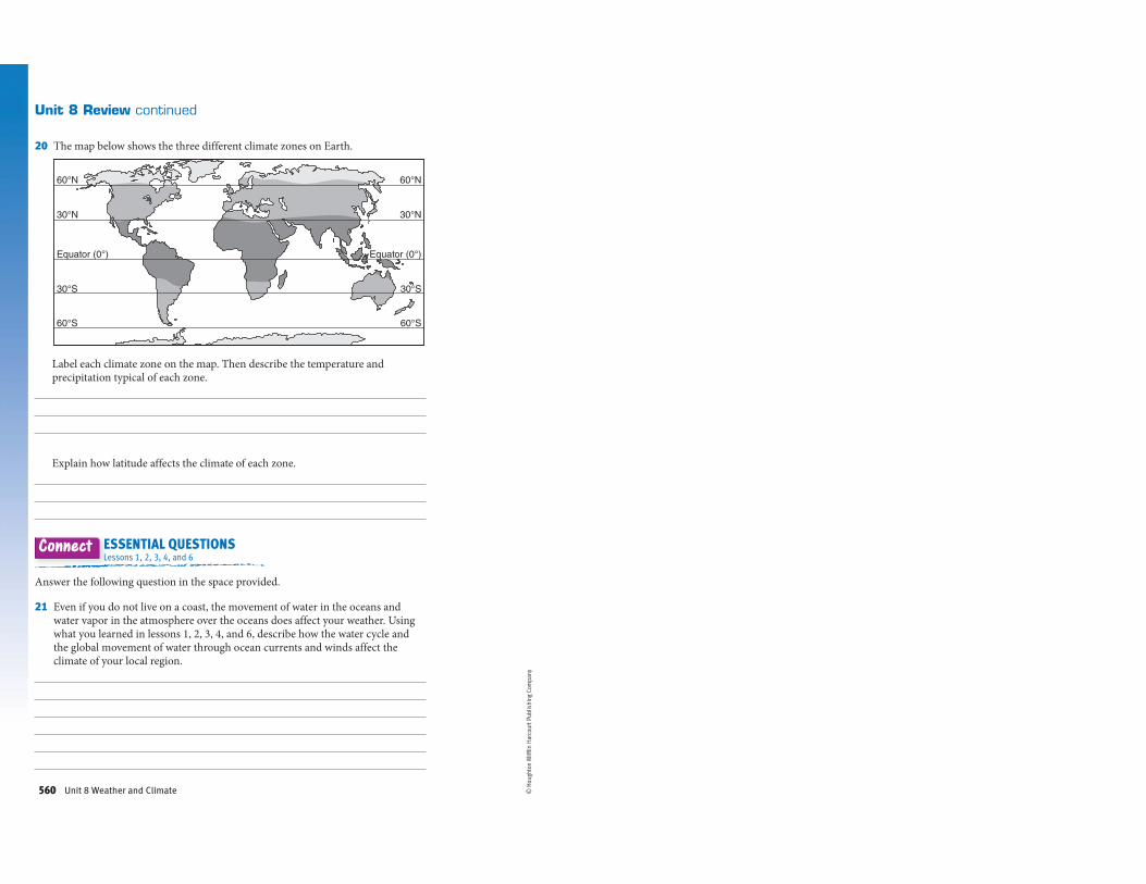
60°N
30°N
30°S
60°S
Equator (0°)
60°N
30°N
30°S
60°S
Equator (0°)
© H
ough
ton
Miff
lin H
arco
urt P
ublis
hing
Com
pany
Unit 8 Review continued
20 The map below shows the three different climate zones on Earth.
Label each climate zone on the map. Then describe the temperature and precipitation typical of each zone.
Explain how latitude affects the climate of each zone.
ESSENTIAL QUESTIONSLessons 1, 2, 3, 4, and 6
Connect
Answer the following question in the space provided.
21 Even if you do not live on a coast, the movement of water in the oceans and water vapor in the atmosphere over the oceans does affect your weather. Using what you learned in lessons 1, 2, 3, 4, and 6, describe how the water cycle and the global movement of water through ocean currents and winds affect the climate of your local region.
Unit 8 Weather and Climate560
Lesson 1: Elements of Weather Enrichment
Climb the Pyramid: Weather Basics
Choose one item from each layer of the pyramid to complete showing what you have learned about
the elements of weather.
__ Creating Questions
Create a ten-question quiz about the
elements of weather and the ways
these elements are measured.
Include five multiple-choice
questions and five true-or-false
questions. Include questions about
temperature, humidity, precipitation,
air pressure, wind direction, and
visibility. Include the answers to your
questions on a separate sheet.
__ This Just In!
Imagine your school has just
purchased a barometer, a wind
sock, a thermometer, and a
precipitation gauge. Present a
news report that discusses the
functions of these tools and the
ways they will help students at
your school learn about weather.
__ Measuring Up
Compose a PowerPoint
presentation with at least four
slides. On each slide, define one
instrument used to measure the
elements of weather. Find pictures
of each of the featured elements
and include them on your slides.
__ Back to the Drawing Board
Imagine that you just wrote a book
about the elements of weather.
Design a cover for your book. Be
sure to include a descriptive title
and an illustration that is
appropriate for your topic.
__ Precipitation Poetry
Write a four-stanza poem about
the four major types of
precipitation. Have each stanza of
the poem discuss one of the major
types. Try to keep all the stanzas
at about the same length.
__ Picturing the Weather
Create a collage of weather
events that are typical for the area
in which you live. Try to include as
many different weather events as
possible. Use pictures from old
magazines or pictures from the
Internet to complete your collage.
Lesson 3: What Influences Weather? Enrichment
Take Your Pick: Weather’s Influences
Choose items to complete below for a total of 10 points.
2 Points
_____ Picturing Currents Choose a coastal area of the United States and draw a map of it. Add ocean
currents to your map. Indicate whether the land is affected by cold or warm currents.
_____ You Decide Using a small piece of paper or an index card, write an answer to the following question:
What do you know about air masses and how they affect the weather?
5 Points
_____ In Your Own Words Choose one paragraph or one screen from the Ocean Effects section of your
lesson. Rewrite the content in your own words.
_____ Under Pressure Develop and perform a dance that represents both high- and low-pressure systems.
In your dance, show how both systems act and what types of weather are associated with each system.
_____ Making a Cycle Create a three-dimensional model of how the water cycle influences weather. Use
materials such as shoe boxes, cotton balls, paper, and markers. Then write a one-paragraph summary
of the ways parts of the water cycle affect weather. Attach the summary to the model.
_____ A Different Point of View Write a short fiction story or cartoon from the point of view of the polar jet
stream. In your story, have the polar jet stream explain how it affects the weather. Additionally, have the
jet stream describe one of its best weather-related memories.
8 Points
_____ Star Attraction Suppose you are the owner of a beachside resort. Make a commercial advertising
your resort. Include information about how the local weather is affected by ocean currents, weather
systems, and weather fronts.
_____ This Just In! Present a news report about the visibility in your area. Find your local weather forecast
and locate information about visibility. Present this information in your news report. Then present your
ideas about why the visibility in your area is high or low. Remember that visibility can be affected by
clouds, fog, precipitation, weather systems, and weather fronts.
Lesson 5: Weather Maps and Weather Prediction Enrichment
Tic-Tac-Toe: Weather Trackers
Your team of student assistants is spending a week with a meteorologist investigating the science
behind a variety of weather conditions. Choose three quick activities from the game to complete.
Check the boxes you plan to complete, make sure they form a straight line in any direction.
__ Becoming a
Meteorologist
Create a brochure explaining what
a meteorologist does and what the
basic requirements are for
succeeding in this career.
__ Weather High Up
Imagine that you are an airplane
pilot. You are trying to convince
your co-pilot to use an upper-air
chart to plan your next flight. Write
an e-mail to him explaining what
types of information the chart can
provide, and why this information
is useful.
__ Weather Crawl
Design a weather crawl that will
scroll across the bottom
of the TV screen in moving banner
format. How will you make this
small screen space eye-catching?
__ Satellite Sonnet
Write a poem describing the
images that a satellite sent back
to a ground station from its
position hundreds of kilometers
above Earth.
__ Forecasting the Future
Write a skit that shows the effects
a short-term forecast that predicts
stormy weather has on a variety of
people in different occupations.
__ Teaching Plan
Design a plan to teach an
elementary school class what
symbols on a surface weather
map mean. You should include a
key for the symbols, an example
of a surface weather map, and a
written plan for explaining the
map.
__ Competition
Storm chasers are preparing to
capture a tornado on film. There is
a spot available for assistants
from one school in your state.
Write a persuasive e-mail detailing
why your team is best suited for
the job.
__ Disaster Plan
Design a poster that the National
Weather Service will use to
advertise hazardous weather
forecasts, what they mean, and
what people should do when they
hear them.
__ Nor’easter Report
Strong winds are blowing in from
the northeast, dumping heavy rain
and snow along the Atlantic Coast
and creating high surf that will
result in coastal flooding. Write an
urgent news report that will
be broadcast on the radio.
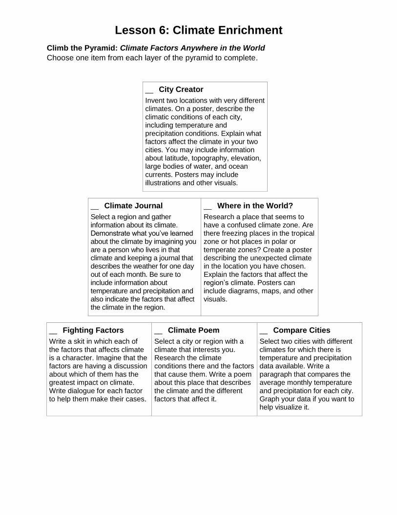
Lesson 6: Climate Enrichment
Climb the Pyramid: Climate Factors Anywhere in the World
Choose one item from each layer of the pyramid to complete.
__ City Creator
Invent two locations with very different climates. On a poster, describe the climatic conditions of each city, including temperature and precipitation conditions. Explain what factors affect the climate in your two cities. You may include information about latitude, topography, elevation, large bodies of water, and ocean currents. Posters may include illustrations and other visuals.
__ Climate Journal
Select a region and gather information about its climate. Demonstrate what you’ve learned about the climate by imagining you are a person who lives in that climate and keeping a journal that describes the weather for one day out of each month. Be sure to include information about temperature and precipitation and also indicate the factors that affect the climate in the region.
__ Where in the World?
Research a place that seems to have a confused climate zone. Are there freezing places in the tropical zone or hot places in polar or temperate zones? Create a poster describing the unexpected climate in the location you have chosen. Explain the factors that affect the region’s climate. Posters can include diagrams, maps, and other visuals.
__ Fighting Factors
Write a skit in which each of the factors that affects climate is a character. Imagine that the factors are having a discussion about which of them has the greatest impact on climate. Write dialogue for each factor to help them make their cases.
__ Climate Poem
Select a city or region with a climate that interests you. Research the climate conditions there and the factors that cause them. Write a poem about this place that describes the climate and the different factors that affect it.
__ Compare Cities
Select two cities with different climates for which there is temperature and precipitation data available. Write a paragraph that compares the average monthly temperature and precipitation for each city. Graph your data if you want to help visualize it.