seaward-branching coastal-plain and piedmont incised-valley systems through multiple sea-level...
TRANSCRIPT

Journal of Sedimentary Research, 2007, v. 77, 139–158
Research Article
DOI: 10.2110/jsr.2007.016
SEAWARD-BRANCHING COASTAL-PLAIN AND PIEDMONT INCISED-VALLEY SYSTEMS THROUGHMULTIPLE SEA-LEVEL CYCLES: LATE QUATERNARY EXAMPLES FROM MOBILE BAY AND
MISSISSIPPI SOUND, U.S.A.
D. LAWRENCE GREENE, JR.,1 ANTONIO B. RODRIGUEZ,2 AND JOHN B. ANDERSON3
1ConocoPhillips, 600 N. Dairy Ashford, Houston, Texas, 77079, U.S.A.2University of North Carolina at Chapel Hill, Institute of Marine Sciences, 3431 Arendell St., Morehead City, North Carolina, 28557, U.S.A.
3Rice University, Department of Earth Science, Box 1982, Houston, Texas, 77251-1982, U.S.A.e-mail: [email protected]
ABSTRACT: Most incised valleys become more organized seaward through tributaries merging with the main trunk valley. LateQuaternary incised valleys on the Mississippi and Alabama inner continental shelf branch seaward, although they do coalescetowards the shelf break where they feed shelf-edge deltas. To link fluvial systems with their associated previously mappedincised valleys on the shelf, and evaluate the contribution of small coastal-plain valley systems to the lowstand systems tract,high-resolution seismic data and cores were collected from Mobile Bay, eastern Mississippi Sound, and the Mobile bay-headdelta. These data show four unconformity-bounded stacked units, and this study focuses on the upper two regionally mappableunits. The upper two unconformities were sampled in core as exposure surfaces, and, on the basis of stratigraphic position,depth of incision, and 14C dates, are interpreted as sequence boundaries. The shallowest sequence boundary (A) formed inresponse to the Oxygen Isotope Stage 2 sea-level lowstand, while the underlying sequence boundary (B) formed in response toan earlier lowstand (Stage 6?). A map of Sequence Boundary B shows a network of seaward-branching valleys, 20–35 m deepand 0.6–7.7 km wide, that extend across Mobile Bay and Mississippi Sound. These valleys, which are bounded by well-developed terraces, are extensions of the piedmont Mobile fluvial system and the coastal-plain Fowl and La Batre fluvialsystems. A map of the Stage 2 Sequence Boundary shows that all systems generally reoccupied their previous valley positionsand are separated by interfluve plateaus. Valley fill between Sequence Boundary B and the Stage 2 Sequence Boundary isgenerally composed of a basal unit of alluvial sediments overlain by bay-head delta deposits; however, Stage 2 to 1 valley fill iscomposed entirely of central-basin sediments. The presence of bay-head delta deposits on the inner shelf indicates thisdepositional environment backstepped across the estuaries to modern positions. Backstepping likely occurred as the low-gradient paleovalleys were inundated, resulting in rapid rates of transgression. Fluvial gradients measured on SequenceBoundary B and the Stage 2 Sequence Boundary, below the modern Mobile bay-head delta plain and the estuaries, are verylow (1.3–0.3 m/km). The Mobile bay-head delta and upper Mobile Bay are confined by steep topography, which opensbasinward into the low-gradient shorelines surrounding lower Mobile Bay and Mississippi Sound. During falling sea level,channel branching likely occurred as the low-gradient fluvial systems extended basinward beyond the confined topography.These channels incised as sea level fell below the steeper shelf break during the lowstand. Stage 2 valley morphology is par-tially influenced by the position of the underlying Stage 6 valleys. Both coastal-plain and piedmont valley systems exhibitcompound fill, indicating that differentiation between these types of incised valleys cannot be based on valley-fill architecturealone.
INTRODUCTION
The Mississippi and Alabama continental shelf is characterized bya complex network of paleovalleys that formed during Oxygen IsotopeStage 2 (last lowstand; Fig. 1; Kindinger et al. 1994; Roberts et al. 2004;Bartek et al. 2004). These valleys feed a 130 km stretch of shelf-margindeltas including the Lagniappe (Kindinger 1988; 1989a; 1989b; Kindingeret al. 1994; Roberts et al. 2004; Bartek et al. 2004) and four Mobile deltas(Fig. 1; Sager et al. 1999; Bartek et al. 2004; Bart and Anderson 2004).Although these valleys coalesce towards the shelf break, they branchseaward near the modern shoreline and on the inner shelf; this is differentfrom other Gulf of Mexico incised-valley systems that become more
organized seaward (Fig. 1; Anderson et al. 2004). The Mobile incised-valley system was interpreted as a source for each of the five shelf-edgedeltas (Kindinger et al. 1994; Bartek et al. 2004; Fillon et al. 2004;Roberts et al. 2004). Kindinger et al. (1994) and Bartek et al. (2004)mapped incised valleys across the shelf, which link the eastern por-tion of the Lagniappe Delta, the Western Mobile Delta, and theEastern Mobile Delta to the Mobile Oxygen Isotope Stage 2 valleysystem in Mobile Bay (Fig. 1). However, based on detailed chrono-stratigraphy of the Lagniappe delta and a regional seismic line collectedalong the shelf break, Roberts et al. (2004) showed that the Eastern andWestern Mobile deltas predate the Oxygen Isotope Stage 2 lowstand by2 or 3 cycles (Oxygen Isotope Stages 6 or 8). This calls into question
Copyright E 2007, SEPM (Society for Sedimentary Geology) 1527-1404/07/077-139/$03.00

140 D.L. GREENE, JR. ET AL. J S R

the nature and timing of the feeder systems mapped on the shelf andbay.
Previous studies of the Stage 2 Mobile valley differ in regard to valleylocation and depth in Mobile Bay. Mars et al. (1992), Davies andHummel (1994), and Hummel and Parker (1995a) mapped the valleyas 13–15 m deep, extending from the modern bay-head delta to 15 kmnorth of Morgan Peninsula. Here, it bifurcates into a western valley thatcontinues through the modern tidal inlet and an eastern valley thatextends below Morgan Peninsula (Fig. 1; Mars et al. 1992; Davies andHummel 1994; Hummel and Parker 1995a). Kindinger et al. (1994)mapped the valley as 25–45 m deep, extending along eastern MobileBay from south of the modern bay-head delta to 15 km north ofMorgan Peninsula. At this location, it bifurcates into a western valleythat extends through the modern tidal inlet and an eastern valley thatextends below Morgan Peninsula (Fig. 1; Kindinger et al. 1994). Theeastern valley bifurcates offshore of Morgan Peninsula, where it isdifficult to trace (Kindinger et al. 1994). For the most part, these studieswere based on the same seismic and vibracore data sets, indicatingthat there is significant difficulty with imaging the stratigraphy of MobileBay.
Incised valleys commonly result from fluvial downcutting in res-ponse to a base-level fall and fill during the subsequent transgressionwith a variety of facies that range from nonmarine through estuarine toopen-marine (Nichols 1991; Allen and Posamentier 1991, 1993; Boydand Honig 1992; Shanley and McCabe 1994; Dalrymple et al. 1992;1994; Thomas and Anderson 1994; Zaitlin et al. 1994; Buck et al. 1999).Valley-fill stratigraphy may be affected by numerous parameters,including changes in shelf gradient, valley morphology, sea level, climate,and hydrodynamic processes. Zaitlin et al. (1994) classified incised-valley systems as simple, if the valley filled completely during onelowstand–transgressive–highstand sequence, or compound, if the valleypersisted through multiple cycles of incision and fill. A compoundincised-valley fill is characterized by multiple internal sequence bound-aries in addition to the main basal sequence boundary, whereasa simple incised-valley fill is characterized by only one basal sequenceboundary (Zaitlin et al. 1994). Incised-valley systems that extend intomountainous regions (piedmont incised-valley systems) are thought tomore commonly exhibit compound valley fills than fluvial systemsthat are confined to the coastal plain (coastal-plain incised-valleysystems; Zaitlin et al. 1994). This is because piedmont incised-valleysystems are usually associated with underlying structural featuresthat promote existence through multiple relative sea-level cycles (Zaitlinet al. 1994). The Mobile is a piedmont incised-valley system; however,Kindinger et al. (1994) and Dalrymple et al. (1994) characterized its fill assimple.
This study examines the nature and timing of valley incision and fill inMobile Bay and eastern Mississippi Sound to better evaluate the source ofsediment to shelf-margin deltas. Small-scale coastal-plain valley systems,including Bayou La Batre and Fowl River, are examined and comparedwith the larger Mobile piedmont valley system to evaluate whether theirrespective valley-fill facies architecture is truly simple and compound, aspredicted by Zaitlin et al. (1994).
STUDY AREA
Estuaries
The Mobile Bay Estuary, which includes Bon Secour Bay in thesoutheast, is shallow (average depth of 3.5 m), approximately 1,000 km2
in area, and elongate in a north–south orientation (Fig. 2). The estuary isprotected from the Gulf of Mexico by Dauphin Island and MorganPeninsula, is 46 km long from the western end of Morgan Peninsula tothe modern bay-head delta, and is 32 km wide at its widest point 6 kmnorth of the Main Pass tidal inlet. Approximately 85% of the MobileRiver water discharge passes through the Main Pass Inlet to the Gulfof Mexico, while Pass aux Herons, which connects Mobile Bay toMississippi Sound, transmits the remainder into the Sound (Ryan 1969).Discharge from coastal streams and rivers results in variations in surfacesalinity from 0 to 30% (McBride et al. 1991; Hummel and Parker 1995b;Hummel 1996). The western and southeastern shorelines of the estuarycontain small pocket bays, low-lying topography (0.5–5 m elevationsextending 1–3 km inland), and tidal marshes, whereas the northeasternshoreline is marked by steep topography (7–10 m elevations less than0.25 km inland) (Fig. 2). The northern shoreline comprises the modernMobile bay-head delta, with distributary channels, interdistributary bays,and extensive marshlands.
The eastern portion of Mississippi Sound includes Heron, Fowl River,Portersville, and Grand bays, has an average depth of 4 m, and isapproximately 375 km2 in area. This part of the estuary is located alongthe Mississippi–Alabama coast and is protected from the Gulf of Mexicoby Dauphin Island (Fig. 2). Eastern Mississippi Sound extends 31 kmfrom the eastern end of Dauphin Island to the Grande Batture Headlandsand reaches its maximum width of 19 km from the western end ofDauphin Island to the northern shoreline of Grand Bay. Petit Bois Passconnects eastern Mississippi Sound to the Gulf of Mexico. The northernshoreline of the estuary comprises a series of pocket bays, islands, andtidal marshes and is marked by low-lying topography (0–5 m elevation 4–6 km inland). In general, turbidity is greater in the northern part of theestuary, which is largely attributed to sediment-laden water from MobileBay entering the sound through Pass aux Herons (McPherson 1970).
The estuaries along the Alabama coast are microtidal with a diurnaltidal range of 0.35–0.80 m (Knowles 1989; Hummel 1996). Wave intensityalong coastal Alabama is low to moderate, except for cold fronts andtropical storms that impact the area on average 2.2 times per year(Neumann et al. 1981). Average wave height along the coast is 0.30 m(Jensen 1983) with periods ranging from 3 to 8 seconds (Upshaw et al.1966). Offshore wave propagation is predominantly from the southeast,corresponding to the prevailing wind direction, which produces a 0.5 to1.5 m/s net westward-flowing longshore current (Boone 1973; Wilson1984).
Fluvial Systems
The piedmont Mobile–Tensaw river system, with a drainage area ofapproximately 133,500 km2, discharges into northern Mobile Bayforming an extensive (465 km2) bay-head delta (Fig. 2; Gastaldo 1989).The delta is constrained by steep topography on the west and east
r
FIG. 1.—Composite paleogeographic map of the last sea-level lowstand (oxygen isotope stage 2) showing a complex network of fluvial systems on the northeasternGulf of Mexico continental shelf and their associated shelf-edge deltas. Position of the Mobile Incised Valley (MV; Kindinger et al. 1994; Hummel and Parker 1995b;Mars et al. 1992) in Mobile Bay, the Pearl Incised Valley (PV; Kindinger 1988; Kindinger et al. 1994), the Pascagoula Incised Valley (PIV; Kindinger 1988; Kindinger etal. 1994), the West Mobile Valley (WMV; Bartek et al. 2004), and the East Mobile Valley (EMV; Bartek et al. 2004) on the continental shelf, and the East Mobile Deltas(EMD-S, Sager et al. 1999; EMD, Bart and Anderson 2004; Bartek et al. 2004), the West Mobile Delta (WMD-S, Sager et al. 1999; WMD, Bartek et al. 2004), and theLagniappe Delta (Kindinger 1988, 1989a, 1989b; Bartek et al. 2004; Roberts et al. 2004) at the shelf break are indicated.
SEAWARD BRANCHING OF COASTAL-PLAIN AND PIEDMONT INCISED-VALLEY SYSTEMS 141J S R

(Fig. 2). The location of the lower Mobile–Tensaw river system andassociated bay-head delta may be, in part, controlled by the interpretedMobile Graben (Smith 1988). The drainage basin is characterized byanastomosed channels, extensive marshlands and low-lying topography(0–5 m) within the delta plain, extensive floodplains (2–20 km in width)and meander scars in lower and central Alabama, and numerous fault-bounded synclines and anticlines within the Appalachian Mountains ofnorthern Alabama and Tennessee. Average water discharge for theMobile–Tensaw River is approximately 1,788 m3/s (Hummel and Parker1995b).
The Fowl and Bayou La Batre coastal-plain fluvial systems flow intoEastern Mississippi Sound. The Fowl River drainage basin covers
approximately 197 km2 (Fig. 1), and the river meanders 28 km from itsheadwaters in central Mobile County, flowing southward into Fowl RiverBay, a pocket bay located along the north shore of Mississippi Sound(Fig. 2). Average water discharge is 1 m3/s. The drainage basin ischaracterized by marshland, low-lying areas (0–5 m), unpaired terraces,and well-developed floodplains (averaging 0.5–1.2 km in width). TheBayou La Batre drainage basin covers approximately 75 km2 (Fig. 1),and the river meanders 12 km from its headwaters in southern MobileCounty southward through the Grand Bay Swamp before flowing intoeastern Mississippi Sound. Average water discharge is 0.4 m3/s. Thedrainage basin is characterized by small-scale floodplains (averaging onlya few hundred meters to 1.0 km in width), marsh, and swampland areas.
FIG. 2.—Map showing the locations of seismic lines and cores collected and incorporated into this study. Inset digital elevation model shows that the Mobile bay-headdelta and Upper Mobile Bay are confined by steep topography, which opens basinward into the low-gradient shorelines surrounding lower Mobile Bay and MississippiSound. Data shown in subsequent figures are indicated by dark-gray lines. The locations of Grand Batture Headlands (GBH), Grand Bay (GB), Portersville Bay (PB),Fowl River Bay (FRB), Mon Louis Island (MLI), Heron Bay (HB), Pass aux Herons (PAH), and Point Clear (PC) are also indicated.
142 D.L. GREENE, JR. ET AL. J S R

METHODS
Marine Seismic Data
Approximately 260 and 240 km of high-resolution seismic data werecollected from Mobile Bay and eastern Mississippi Sound, respectively(Fig. 2) using an EdgeTech SB-216S chirp system that emitted a 2–15 kHz pulse at 0.25 second intervals. Data were collected in digital formwith Edge Tech MIDAS and Codatm DA 50 acquisition systems. Avelocity of 1500 m/s was used to convert the two-way travel time todepth. This velocity was verified by cores that sampled changes inlithology at the same depths as seismic facies transitions. Data collectedusing the MIDAS system were processed by applying a time-varying gainof 4 db per 10 ms. Data collected using the Codatm system were processedby applying a time-varying gain of 2.5 db per 10 ms and a 250 Hz high-pass filter. These data were incorporated with approximately 250 km ofhigh-resolution single-channel (200–400 J) boomer data published inKindinger et al. (1994). After the positions of the paleovalleys wereconstrained, seismic lines were collected up the axis of each valley toexamine flooding surfaces and associated depositional changes in greaterdetail.
Lithologic Data
Seventeen cores were obtained from Mobile Bay, the Mobile bay-headdelta, Mississippi Sound, and along Cedar Point Peninsula to groundtruth seismic facies to lithology and to provide shell, plant, and woodmaterial for environmental analysis and radiocarbon dating (Fig. 2).Four rotary drill cores (MS-04-1, MS-04-2, MS-04-4, and MS-04-5) werecollected from the northern and southern portions of the Sound. Sevenvibracores (MB-98-1 through MB-98-4, MD-02-7 through MD-02-9) andnine rotary drill cores (MD-02-2, MD-02-3, MB-03-1 through MB-03-5,MB-04-1, and MB-04-2) were taken throughout the northern, central,and lower portions of Mobile Bay. One rotary drill core (MD-02-1) wastaken in Chacaloochee Bay, an interdistributary bay of the Mobile Delta.The drill cores were collected from a small barge using a hydraulic rotarydrill that allows nearly continuous sampling to approximately 35 m.During drilling, cuttings are removed by circulating water through thedrill stem. Cores are obtained by lowering a push-coring device throughthe drill casing, allowing the extraction of an undisturbed interval of corefrom below the level of the drill bit. An additional core (MS-04-3) wascollected on land along Cedar Point Peninsula using a truck-mountedGeoProbetm coring system. Core lengths ranged from 2.6 to 18.1 m.
Radiocarbon dating (AMS) of shell and organic material wasperformed by the Woods Hole Oceanographic Institution and Beta
Analytic (Table 1) and dates were calibrated using CALIB 5.0.2 software(Stuiver and Reimer 1993). To ensure that dated material was preservedin situ, whenever possible individual wood fragments and articulatedbivalves were chosen for dating instead of bulk peat or unpaired valves.Species from well-defined macrofossil assemblages indicative of thedepositional environment were preferentially chosen for dating.
RESULTS AND INTERPRETATIONS
Regional Seismic Units and Bounding Surfaces
Across Mobile Bay and Mississippi Sound, four regional unconformi-ty-bounded stacked seismic units were recognized (Unconformity D is thedeepest and Unconformity A is the shallowest; Fig. 3). The regionalunconformities are characterized by high-amplitude reflections thatexhibit 7–35 m of relief, truncate underlying reflections, and define broad(0.6–17.9 km wide) valleys. Only the uppermost two unconformity-bounded units were mapped because in Mississippi Sound UnconformityB completely removed entire sections of the lower seismic units andthroughout much of Mobile Bay seismic attenuation completely obscuresthe lower seismic units.
Unconformity B was mapped throughout Mobile Bay and MississippiSound and defines broad (0.8–7.7 km wide) valleys that extend updip tothe modern Bayou La Batre, Dog River, Fish–Magnolia River, FowlRiver, and Mobile–Tensaw River systems (Fig. 4). Valley thalwegs are20–35 m deep (Figs. 3, 4), and broad, flat interfluvial areas, found at215 m and 210 m (relative to modern sea level), separate the differentfluvial systems. Core MS-04-5 penetrated Unconformity B and sampledclay rip-up clasts and plant roots at a sharp contact separating a tannishgray to grayish blue-green clayey sand above from a bluish greenbioturbated clay below, at the depth of the seismic surface (Fig. 5).
Unconformity A also defines multiple broad (0.6–5.4 km wide) valleysthat extend to the modern La Batre, Fowl, Dog, Mobile–Tensaw, andFish–Magnolia river systems (Fig. 6). The main trunk valleys aregenerally in the same location as those mapped on Unconformity B.Valley thalwegs are 10–25 m deep, and a broad, flat interfluvial area at210 m separates the East and West Mobile valleys while flat interfluvialareas at 25 m separate the Fowl River Valley from the Mississippi Soundextension of the Mobile Valley (Fig. 6). Unconformity A was sampled byten cores, and is a sharp contact separating a dark greenish-gray tomedium gray sandy clay above, from a stiff, oxidized medium gray, darkgreenish-gray to yellow-orange clay below (Fig. 5). The stiff, oxidizednature of the clay below the contact is indicative of subaerial exposure.Based on the presence of incision, evidence of subaerial exposure (roots
TABLE 1.— Radiocarbon ages and type of material sampled from the cores.
Lab code Sample name MaterialConventional 14C age:
yr BP; 1sCalibrated 14C age:
cal. yr BP; 1s
OS-44717 Mississippi Sound, MS-04-1 (776 cm) Probythenella louisianae 4030 6 30 3981–4092OS-44718 Mississippi Sound, MS-04-1 (866 cm) Wood . 48000 —OS-44719 Mississippi Sound, MS-04-1 (1052 cm) Wood . 48000 —OS-44720 Mississippi Sound, MS-04-4 (591 cm) Peat 5470 6 50 6210–6308OS-44722 Mississippi Sound, MS-04-5 (1258 cm) Wood 38400 6 330 —AA35692 Mobile Bay, MB-98-4 (637 cm) Crassostrea virginica 4980 6 55 5278–5416AA35693 Mobile Bay, MB-98-4 (697 cm) Peat . 47000 —OS-41067 Mobile Bay Bay, MB-03-04 (1514 cm) Peat 8270 6 60 9196–9318OS-36428 Mobile Bay-head Delta, MD-02-1 (1726 cm) Wood 8710 6 35 9595–9697OS-36435 Mobile Bay-head Delta, MD-02-1 (1809 cm) Wood 8770 6 50 9687–9892OS-41176 Bon Secour Bay, MB-03-05 (1368 cm) Corbula contracta* 7680 6 40 8069–8190OS-44826 Bon Secour Bay, MB-03-05 (1412 cm) wood 8060 6 40 8976–9029
Samples were processed at the NSF AMS Radiocarbon laboratory of the Woods Hole Oceanographic Institution’s National Ocean Sciences Accelerator MassSpectrometry Facility and Beta Analytic and calibrated using Stuiver and Reimer (1993), Hughen et al. (2004), and Reimer et al. (2004). Articulated bivalves dated areindicated by an asterisk. Sample depths (reported parenthetically) are relative to sea level.
SEAWARD BRANCHING OF COASTAL-PLAIN AND PIEDMONT INCISED-VALLEY SYSTEMS 143J S R

and oxidation), and regional extent, unconformities A and B areinterpreted as sequence boundaries. In interfluvial locations, sequenceboundaries A and B are sometimes amalgamated but generally areseparated by approximately 5 m.
Mobile Incised-Valley System
Sequence Boundary B.—The Mobile Valley is 10.6 km wide at the bay-head delta (Fig. 7) and bifurcates seaward into east and west valleys(Fig. 4). The start of bifurcation is resolved in the core transect at the bay-head delta, where distinct east and west channels are recognized atsequence boundary B (Fig. 7; May 1976). The East and West Mobilevalleys also bifurcate seaward and become wider and deeper towards thesouth (Fig. 4). In the northern and middle part of the bay, the EastMobile Valley is approximately 1.4–3.9 km wide and 25–33 m deep(Fig. 4). In the southern part of the bay, the valley bifurcates arounda small paleo-high into two valleys that are 3.4–3.2 km wide and , 35 mdeep (Figs. 4, 8). The Fish–Magnolia Valley merges with the East MobileValley along the southern margin (Fig. 4).
In the northern and middle part of the bay, the West Mobile Valley isapproximately 0.6–3.5 km wide and 26 m deep (Figs. 4, 9). The DogRiver Valley merges with the western valley along the northern margin ofthe bay (Fig. 4). In the southern part of the bay, the valley bifurcates intoa valley, 3.2 km wide and 20–25 m deep that extends into MississippiSound (Figs. 4, 10) and a valley, 4.0 km wide and 25–30 m deep, thatextends offshore at the location of the Main Pass inlet. The MississippiSound extension of the Mobile Valley branches into smaller channels thatextend seaward under eastern Dauphin Island (Fig. 4).
Interfluvial plateaus form a natural divide between the East and WestMobile valleys in the center of the Mobile estuary and between the
Mississippi Sound Mobile Valley and the Fowl River Valley in easternMississippi Sound (Fig. 4). These plateaus at 215 and 210 m depth varyin width from 1.6 to 6.9 km and from 0.55 to 6.3 km, respectively. Smallplateaus at 215 m and 210 m depth (both 0.3–0.55 km wide) also serveas a natural divide between the West Mobile Valley and the MississippiSound Mobile Valley. Terraces at 215 m exist along the landward-facingflanks of the valleys in Mobile Bay (adjacent to the modern shoreline) andare 0.5–3.0 km wide (Fig. 4).
The valley fill (Seismic Unit B) is composed of a basal acousticallytransparent, chaotic to semi-parallel seismic facies (Figs. 8, 9B, 10). Thisfacies was sampled only in core MS-04-5, collected from the center of theMississippi Sound Mobile Valley (Fig. 10), and is a tannish gray tograyish blue-green clayey sand (Fig. 5). Although , 1 m of this facieswas sampled, it is interpreted as alluvial on the basis of its stratigraphicposition, seismic character, and lithology. Alluvial sediments are overlainby acoustically laminated to inclined (shingled) reflections (Figs. 8, 10,11). The shingled facies has reflections inclined both towards the valleyflanks and down the valley axis and is interpreted to represent lateralaccretion and progradation. This facies was sampled in cores MS-04-5and MB-03-05 and is a medium gray to dark greenish-gray bioturbatedclay with numerous wood fragments, shell hash, and sand-filledsubhorizontal Ophiomorpha and Thalassinoides burrows (Fig. 5). Thisupper valley-fill facies is interpreted as bay-head delta. The contactbetween the alluvial and bay-head delta facies shows small-scale channels,and this surface is interpreted as a bay-head delta diastem (Fig. 9B;Zaitlin et al. 1994).
Sequence Boundary A.—The Mobile Valley is 10.6 km wide at themodern bay-head delta and bifurcates seaward into East and WestMobile valleys (Figs. 6, 7). The morphology of Sequence Boundary A at
FIG. 3.—Seismic profile from northern Mississippi Sound showing the four unconformities imaged in the study area and the Fowl Paleovalley delineated on SequenceBoundaries (SB) A and B. See Figure 2 for profile location.
144 D.L. GREENE, JR. ET AL. J S R

the bay-head delta core transect generally mimics Sequence Boundary B(Fig. 7; May 1976). The East Mobile Valley is 1.3–5.4 km wide and 15–20 m deep in northern and middle Mobile Bay, and it deepens to 25 mtowards the south (Fig. 6). The Fish–Magnolia Valley, which extendsthrough Weeks Bay (Duran 2006), merges with the eastern valley acrossa broad flat terrace (Figs. 6, 8). The East Mobile Valley extends seawardbelow the Holocene accretionary-spit portion of Morgan Peninsula(Fig. 6; Blum et al. 2003; Rodriguez and Meyer 2006).
The West Mobile Valley trifurcates seaward and deepens toward thesouth (Fig. 6). In the northern and middle part of the bay, the valley is1.4–3.0 km wide with a maximum depth of 20 m and the Dog RiverValley merges with it (Figs. 6, 9A). In the southern part of Mobile Bay,the valley deepens to 24 m and trifurcates (Fig. 6). The eastern twobranches, which are about 2.5 km wide and 23 m deep, extend seawardthrough the modern Main Pass tidal inlet and the western tip of MorganPeninsula (Fig. 9B). The western branch of the West Mobile Valleyextends into Mississippi Sound. This Mississippi Sound extension of theWest Mobile Valley diverges around a small 25 m paleo-high (Figs. 6,10) and extends seaward below the Holocene portion of Dauphin Island.At Dauphin Island, the valley thalweg reaches a depth of 210 m (Fig. 6;Otvos 2004).
The Mobile Valley is bounded by unpaired terraces at 214, 210, and,25 m. A large (12.6 km wide) 214 m terrace is located along the EastMobile Valley flank in the southern part of the estuary (Figs. 6, 8). Broadinterfluve plateaus in central and northern Mobile Bay at 210 m vary inwidth from 0.3 to 6.1 km wide and terraces and paleo-highs in Mississippi
Sound at 25 m vary in width from 0.8 to 2.9 km. Cedar Point Peninsulais located above a 25 m terrace or paleo-high, which may havefunctioned as a nucleus for sediment accumulation (Fig. 6). Additionalterraces and paleo-highs found at 25 m form a natural drainage divideseparating the Mississippi Sound branch of the Western Mobile Valleyfrom the Fowl River Valley (Fig. 6).
The valley fill (Seismic Unit A) is composed of acoustically transparentto laminated seismic facies sampled in 9 cores as a 10–20-m-thick packageof homogeneous to bioturbated dark greenish-gray to medium-gray clayto sandy clay with whole oysters, shell hash, and sand-filled subhorizontalOphiomorpha, Chondrites, and Thalassinoides burrows (Figs. 5, 8, 9, 10).Cores from the upper bay and bay margins that sampled this unit containwood fragments. This unit is interpreted as central basin, which isconsistent with previous studies by Kindinger et al. (1994) and Bartek etal. (2004). Peat was sampled at the base of the unit in cores MD-02-1,MB-03-4, and MS-04-4 directly above Sequence Boundary A. Anindividual plant fragment sampled from a peat at 215.14 m directlyabove Sequence Boundary A in core MB-03-4 from the West MobileValley was dated at 9,260 6 60 cal. yr BP, and a wood fragment sampledat 214.12 m directly above Sequence Boundary A in core MB-03-5 fromthe East Mobile Valley was dated at 9,005 6 25 cal. yr BP. The datesindicate central basin conditions were present at these locations sometimeafter 9,000 cal. yr BP.
Core MD-02-1 was collected at the modern bay-head delta front andsampled 8.2 m of organic-rich olive-gray bioturbated medium- to fine-grained massive sand to thinly laminated clayey sand (Metcalf and
FIG. 4.—Structure map of Sequence Boundary B in Mobile Bay and eastern Mississippi Sound showing that valleys branch seaward in the area. Contour interval is5 m and depths are below sea level.
SEAWARD BRANCHING OF COASTAL-PLAIN AND PIEDMONT INCISED-VALLEY SYSTEMS 145J S R
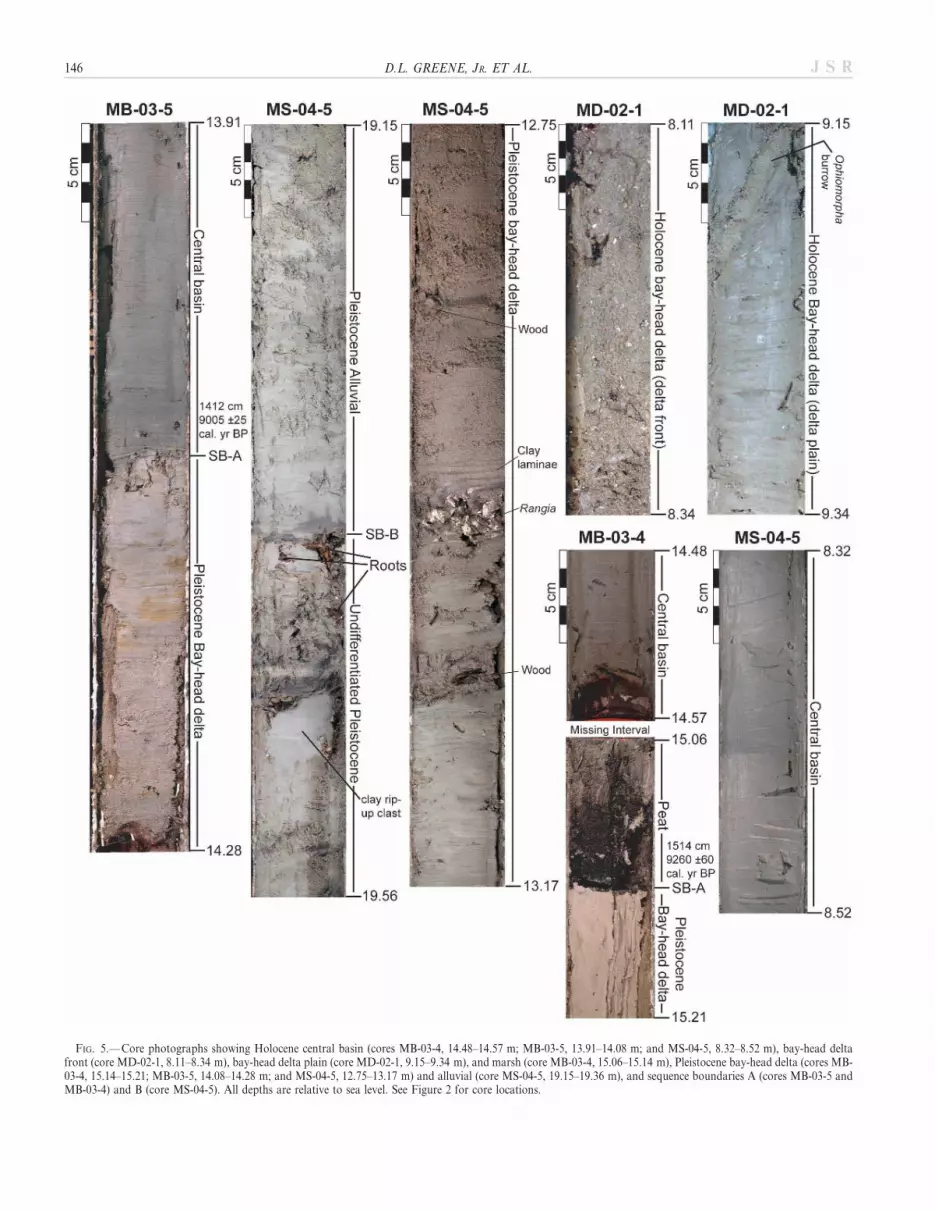
FIG. 5.— Core photographs showing Holocene central basin (cores MB-03-4, 14.48–14.57 m; MB-03-5, 13.91–14.08 m; and MS-04-5, 8.32–8.52 m), bay-head deltafront (core MD-02-1, 8.11–8.34 m), bay-head delta plain (core MD-02-1, 9.15–9.34 m), and marsh (core MB-03-4, 15.06–15.14 m), Pleistocene bay-head delta (cores MB-03-4, 15.14–15.21; MB-03-5, 14.08–14.28 m; and MS-04-5, 12.75–13.17 m) and alluvial (core MS-04-5, 19.15–19.36 m), and sequence boundaries A (cores MB-03-5 andMB-03-4) and B (core MS-04-5). All depths are relative to sea level. See Figure 2 for core locations.
146 D.L. GREENE, JR. ET AL. J S R

FIG. 6.—Structure map of Sequence Boundary A in Mobile Bay and eastern Mississippi Sound showing broad interfluve plateaus. Contour interval is 5 m and depthsare below sea level. Areas that are relatively flat are indicated with patterns.
FIG. 7.— Cross-section A–A9 across the Mo-bile bay-head delta along the Interstate-10 bridgebased on borings, which penetrated . 35 m,collected by the State of Alabama HighwayDepartment (B-15 to B-28) and core MD-02-1(Modified from May 1976). Generalized litho-logic descriptions are after May (1976). At thislandward location, sequence boundaries (SB) Aand B define a single broad Mobile–TensawPaleovalley. See Figures 2, 4, and 6 for location.
SEAWARD BRANCHING OF COASTAL-PLAIN AND PIEDMONT INCISED-VALLEY SYSTEMS 147J S R

148 D.L. GREENE, JR. ET AL. J S R

Rodriguez 2003; Figs. 5, 7). Whole Rangia cuneata shells, shell and woodfragments, and numerous mud- and sand-filled subhorizontal Ophiomor-pha, Chondrites, and Thalassinoides burrows were also recognized (Fig. 5;Metcalf and Rodriguez 2003). This unit is interpreted as delta front andoverlies a 9.3-m-thick package of organic-rich dark-gray to olive-graybioturbated clay to sandy clay with whole Rangia cuneata shells, shell andwood fragments, and sand-filled Ophiomorpha, Chondrites, and Thalassi-noides burrows interpreted as delta plain (Metcalf and Rodriguez 2003).The facies succession indicates modern bay-head delta aggradation andretrogradation. A radiocarbon date from a piece of wood sampled fromthe core directly above Sequence Boundary A at 218.09 m is 9,780 6 90cal. yr BP, which marks the initiation of deltaic sedimentation in the area(Metcalf and Rodriguez 2003).
Fowl and La Batre Incised-Valley Systems
Sequence Boundary B.—The Fowl River Valley is 1.0 km wide and 20–28 m deep, and bifurcates seaward (Figs. 3, 4, 11), while the La BatreValley branches into an intricate 7.7-km-wide network of valleys justseaward of the northern Mississippi Sound shoreline (Figs. 4, 12). LaBatre trunk valleys vary in width from 1.3 to 2.2 km, smaller valleys varyin width from 0.3 to 1.1 km, and all are 20–33 m deep (Figs. 4, 12). TheFowl and La Batre valleys extend seaward under western Dauphin Islandand Petit Bois Pass (Fig. 4).
Valleys are bounded by stepped interfluve plateaus. The plateaus are at215 and 210 m, and the 210 m plateaus contain terraces at 215 m. Theterraces and plateaus range between 0.6 and 5.5 km in width. Thesefeatures form drainage divides between the Fowl and La Batre paleo-fluvial systems in the west and between the Fowl and Mississippi Soundextension of the Mobile Valley in the east.
The valley fill (Seismic Unit B) is composed of a basal acousticallytransparent to chaotic seismic facies that has semi-parallel reflections inplaces (Figs. 3, 11). This unit was not sampled, but on the basis of itssimilarity to the Mobile basal valley-fill seismic unit it is interpreted asalluvial. This unit is capped by sets of semi-parallel inclined reflections(inclined both towards the valley flanks and down the valley axis) that areinterpreted to represent lateral accretion and progradation (Fig. 11), oran acoustically transparent facies may be present (Fig. 12). Core MS-04-1sampled the acoustically transparent facies in the La Batre valley asa medium gray to dark greenish-gray bioturbated, clay to sandy clay withnumerous wood fragments, tree roots, shell hash, and sand-filledsubhorizontal Thalassinoides burrows. Based on the lithologic andseismic data, this unit is interpreted as a bay-head delta. Seismic-sectiontransects oriented up the axis of the valleys show that the Fowl valley fillis composed of continuous alluvial sediments below bay-head-deltasediments whereas the La Batre valley fill is composed solely of bay-head-delta sediments (Fig. 13). Wood fragments taken from the upper portionof the bay-head-delta unit in core MS-04-1 were radiocarbon dated at. 48,000 yr (radiocarbon dead), making the timing of valley fillproblematic.
Sequence Boundary A.—The Fowl Valley is 0.9 km wide and 10–11 mdeep in northern Mississippi Sound; however, narrower tributarychannels that are beyond mapping resolution incise to depths of 16–17 m (Figs. 3, 11). This valley flows across a broad low-gradient plain in
central and southern Mississippi Sound where the valley branches intosmaller channels that are below mapping resolution (Figs. 6, 12). Innorthern Mississippi Sound, the La Batre Valley is 1.12 km wide and15 m deep, and extends seaward beneath Petit Bois Pass (Fig. 6).
The valley fill of the Fowl and Bayou La Batre systems (Seismic UnitA) is composed of an acoustically transparent seismic facies withlaminated to wavy parallel reflections in places. This seismic facies wassampled in cores MS-04-1 and MS-04-4 as a bioturbated dark greenish-gray to medium gray clay to clayey sand with wood fragments, wholeshells, shell hash, and sand-filled subhorizontal Ophiomorpha, Chondrites,and Thalassinoides burrows. This unit is exposed at the bay floor and onthe basis of the seismic and lithologic data is interpreted as central basin.Seismic-section transects (Fig. 13) and cores show that the paleovalleysare filled continuously with central-basin sediments; no other unit existsabove Sequence Boundary A. Radiocarbon dating of a Probythenella
louisianae shell found at 27.76 m in core MS-04-1 indicates that centralbasin conditions have existed since at least 4,124 6 25 yr cal. BP.
DISCUSSION
Age of Sequence Boundaries
All dates above Sequence Boundary A are Holocene (, 10 ka)whereas dates obtained below are Pleistocene (. 20 ka), indicating thatSequence Boundary A formed in response to the Oxygen Isotope Stage 2lowstand in sea level (Table 1) approximately 22,000–17,000 years ago(Bard et al. 1990). This is consistent with previous work in the area byKramer (1990), McBride et al. (1991), Mars et al. (1992), Davies andHummel (1994), and Hummel and Parker (1995a; 1995b).
The timing of Sequence Boundary B could not be constrained byradiocarbon dating. A Nuculana acuta shell sampled at 212.54 m in coreMS-04-5, from the center of the Mississippi Sound Mobile Valley belowSequence Boundary A, was radiocarbon dated at 38,400 yr BP. Twoother dates from wood fragments in core MS-04-1, sampled from thecenter of the La Batre Valley at the same stratigraphic level, came backradiocarbon dead (Table 1). Grootes (1983) showed that moderncontamination of 1% modern carbon would produce an age date of37 ka from an isotopically dead sample. The reported 38,400 yr BP dateis likely the result of contamination and is disregarded.
The Oxygen Isotope Stage 4 lowstand (, 80 m below sea level) wasshallower and of shorter duration than the Stage 2 lowstand (, 120 mbelow sea level; Chappell et al. 1996). Anderson et al. (2004) did notrecognize significant fluvial incision during Stage 4 along the northernGulf of Mexico shelf. Because the valley incisions mapped on SequenceBoundary B are overall wider and deeper (Figs. 3, 11, 12) than thosemapped on the Stage 2 Sequence boundary, it is unlikely that they areassociated with Stage 4. It is more likely that valleys mapped on SequenceBoundary B formed during the Oxygen Isotope Stage 6 lowstand whensea-level was , 2140 m, 155,000–136,000 years ago (Shackleton 1987),although it is possible that Sequence Boundary B formed earlier.
The placement of the Oxygen Isotope Stage 2 Sequence Boundary onuppermost Unconformity A is distinct from previous work conducted onthe Alabama shelf and Mobile Bay. Based on its deeper incision depth,Kindinger et al. (1994) placed the Stage 2 Sequence Boundary onUnconformity B and interpreted Unconformity A as a transgressivesurface separating early from late fluvial deposition. Developing
r
FIG. 8.—Seismic chirp profile shows the 214 m terrace on Sequence Boundary A that was penetrated by core MB-03-5 (see Fig. 5A). Seismic boomer profile shows theEast Mobile Valley delineated by Sequence Boundary B (SB-B; B). Accretionary bay-head delta deposits are truncated above by the 214 m terrace on SequenceBoundary A (SB-A). See Figures 2, 4, and 6 for profile locations.
SEAWARD BRANCHING OF COASTAL-PLAIN AND PIEDMONT INCISED-VALLEY SYSTEMS 149J S R

FIG. 9.—Seismic chirp profiles across the West Mobile Valley in A) central and B) southern Mobile Bay. Core MB-03-4 penetrated Sequence Boundary A (SB-A) atabout 215 m (see Fig. 5). The West Mobile Valley occupied this location through multiple sea-level cycles. Figures 2, 4, and 6 show profile locations.
150 D.L. GREENE, JR. ET AL. J S R

a chronostratigraphy from the vibracores examined by Kindinger et al.(1994) is difficult; these cores penetrated through the Stage 2 SequenceBoundary only in interfluve areas, near the modern bay shorelines, whereUnconformities A and B are amalgamated.
Valley-Fill Architecture
The Mobile and Fowl valley-fill successions, between SequenceBoundary B and the Stage 2 Sequence Boundary, are generally composedof alluvial deposits overlain by bay-head delta deposits (Figs. 10, 11). Theabsence of alluvial facies in the La Batre valley could indicate either thatthese sediments were removed by downcutting associated with the bay-head delta diastem or that these sediments were never deposited (Fig. 12).Pleistocene bay-head delta sediments cover the 215 m and 210 mterraces to a level of approximately 25 m in Mississippi Sound (Figs. 3,11), indicating that deltaic sedimentation completely filled the valleys.Central-basin sediments were not recognized above the bay-head delta.These sediments could have been deposited but then were removed duringthe subsequent Stage 2 incision, or central-basin sediments were neverdeposited at modern estuarine locations.
Bay-head delta deposits are absent above the Stage 2 SequenceBoundary in Mobile Bay and Mississippi Sound; however, they wererecognized offshore in the Mobile Paleovalley on the Alabama shelf(Cabote 1998; Bartek et al. 2004). The absence of this facies at modernestuarine locations and the presence of modern bay-head deltasassociated with the Mobile, Fowl, and La Batre rivers indicate that theseenvironments backstepped across the modern estuaries. Based onradiocarbon dates above the Stage 2 Sequence Boundary, these back-stepping events occurred before 9,780 6 80 cal. yr BP in Mobile Bay (theoldest deltaic sediments at the modern bay-head delta) and 6,223 6 25cal. yr BP in Mississippi Sound (the age of bay sediments directly abovethe Stage 2 Sequence Boundary).
Possible causal mechanisms for bay-head delta backstepping include anincrease in the rate of sea-level rise, a decrease in sediment supply, and
variations in antecedent topography. The rate of sea-level rise during theHolocene was not increasing (Bard et al. 1996; Tornqvist et al. 2004;Otvos 2005), making this an unlikely mechanism for backstepping.Although a decrease in sediment supply cannot be ruled out, the lowgradients of the Stage 2 valleys, 0.3 m/km for the Mobile, Fowl, and LaBatre, must have played a large role in bay-head delta backstepping.When sea level reached , 220 m, the low-gradient Mobile valley wasrapidly inundated. This forced the bay-head delta to backstep landwardand accrete at its modern location as opposed to gradually transgressingacross the estuary. Mobile bay-head delta deposition began at its modernposition around 9.7 ka at 218 m depth (based on core MD-02-1), andthis age and depth is close to sea level (Otvos 2004). This implies that theinundation of the low-gradient fluvial systems resulted in the faciestransitions. Given the higher elevation of the low-gradient Stage 2Sequence Boundary in Mississippi Sound (around 210 m), backsteppingof the Fowl and La Batre bay-head deltas must have occurred later,between 8.0 and 7.0 ka judging from the sea-level curves of Otvos (2004)and Tornqvist et al. (2004). Inundation of low-gradient antecedenttopography has been recognized elsewhere as an important mechanismfor backstepping (Heap and Nichol 1997; Amorosi et al. 2005; Rodriguezet al. 2005).
As defined by Zaitlin et al. (1994), incised valleys are classified assimple if the valley filled completely during one sea-level cycle, orcompound if the valley persisted through multiple cycles. Coastal-plainvalleys are predicted to have simple fill, and piedmont valleys areexpected to have compound fill. This is thought to be the case because thelocation of piedmont systems is strongly controlled by underlyingstructural features (Zaitlin et al. 1994). As expected, the Mobile piedmontsystem shows a compound fill with two distinct sequences. However, thecoastal-plain Fowl and La Batre systems also persisted through the sametwo sea-level cycles and show compound fill. It is likely that these coastal-plain systems generally reoccupied the same valleys because of highercompaction rates and greater erodibility of the younger valley-fillsediments versus interfluve areas. It may be difficult to distinguish
FIG. 10.— Seismic chirp profile across the Mississippi Sound Mobile Valley in southeast Mississippi Sound showing truncation of bay-head delta reflections bySequence Boundary A (SB-A). Core MS-04-5 penetrated sequence boundaries A and B (see Fig. 5). Figures 2, 4, and 6 show the profile location.
SEAWARD BRANCHING OF COASTAL-PLAIN AND PIEDMONT INCISED-VALLEY SYSTEMS 151J S R

between a coastal-plain valley (Fowl Valley; Fig. 3) versus a piedmontvalley (Mobile Valley; Fig. 8) on the basis of valley-fill architecture alone.
Incised-Valley Branching
Maps of Sequence Boundary B and the Stage 2 Sequence Boundary(Figs. 4, 6) show an increase in fluvial complexity seaward through valleybranching. This is different from other coeval Gulf of Mexico valleysystems that become more organized seaward through tributaries mergingwith the main trunk valley (Thomas and Anderson 1989; Nichol et al.
1996; Abdulah et al. 2004; Bartek et al 2004). Valleys examined along theAlabama coast are similar to seaward-branching valleys recognized in theUpper Campanian Sego Sandstone Member of the Mancos Shale in theBook Cliffs, Utah; however, the mechanism for valley formation has beenthe focus of much debate (Van Wagoner et al. 1990; Willis and Gabel2003; Wood 2004; Wood and Yoshida 2004).
Seaward branching of the Mobile, Fowl, and La Batre valleys waslikely caused by a decrease in gradient and a transition from restricted tounconfined topography at the location of the estuaries. Absolute timingof branching cannot be constrained; however, all valleys mapped in
FIG. 11.—Seismic chirp profile across the Fowl Valley in northern Mississippi Sound showing two branches of the Fowl Valley delineated by Sequence Boundary B(SB-B). The eastern branch was reoccupied by the Fowl river during the subsequent lowstand. Figures 2, 4, and 6 show the profile location.
152 D.L. GREENE, JR. ET AL. J S R

Mobile Bay and Mississippi Sound are confined to the same regionalbounding surfaces (sequence boundaries) and are not distributaries.Sequence Boundary B and the Stage 2 Sequence Boundary have very lowgradients in interfluve areas, as demonstrated by the flat interfluveplateaus that divide valley branches in the estuaries. Average fluvialgradients of the modern Mobile (0.8 m/km), Fowl (1.25 m/km), and LaBatre (2.25 m/km) rivers decrease at their associated bay-head deltas(Fig. 14) and are all greater than gradients measured down the axis oftheir associated paleovalleys, mapped in the vicinity of the estuaries onSequence Boundary B (0.69, 0.55, and 1.33 m/km, respectively) and theStage 2 Sequence Boundary (0.27 m/km, 0.28 m/km, and 0.31 m/km,respectively). Fluvial gradients during the highstands that precededformation of the sequence boundaries mapped here cannot be determinedfrom the data set; however, using the modern as an analog, it is probablethat gradients decreased near the northern edge of the bay-head deltas.Wescott (1993), Wood et al. (1993), and Ritchie et al. (2004) recognizedthat changes in channel pattern (sinuosity, geometry, and complexity) canoccur as a fluvial system crosses a break in slope. Alluvial aggradationand valley branching observed here likely occurred during the falling limbof the sea-level curve in response to fluvial systems extending across newlyexposed and lower-gradient areas.
While gradient change is deemed an important mechanism for valleybranching, Mobile fluvial gradients likely decreased 63 km landward ofthe estuary, at the head of the bay-head delta; however, the fluvial systemdid not branch until it flowed across the newly exposed Mobile Bay area(Fig. 14). All of the paleovalleys branch at the northern estuarineshorelines in Mississippi Sound and Mobile Bay. This location coincideswith where valley-flank topography becomes broader and fluvial systems
are less restricted (Fig. 14), which facilitated valley branching. During thelowstand, when sea level exposed the steeper continental shelf break, thechannels incised and left behind the complex alluvial morphology mappedhere. The complex morphology mapped on the sequence boundaries isalso influenced by the position and morphology of the underlyingpaleovalleys.
Feeder Systems to Alabama Shelf-Edge Deltas
Merging paleogeographic maps of the continental shelf by Kindinger etal. (1994) and Bartek et al. (2004) with this study yields better constraintson the source of sediment to shelf-margin deltas. Some of the previouslymapped offshore valleys and their associated shelf-margin deltas predatethe Stage 2 lowstand on the basis of valley depth, position of valleysmapped in this study relative to those previously mapped on the shelf,a detailed chronostratigraphy, and a regional seismic line collected alongthe shelf break by Roberts et al. (2004). It is likely that the East and WestMobile deltas of Bartek et al. (2004) and the offshore valleys of Kindingeret al. (1994) and Bartek et al. (2004) are associated with SequenceBoundary B, which may have formed during the Stage 6 lowstand orpossibly the Stage 8 lowstand as proposed by Roberts et al. (2004). TheLa Batre Paleovalley mapped in Mississippi Sound lies directly headwardof the Pascagoula Paleovalley mapped on the shelf by Kindinger et al.(1994) and Bartek et al. (2004), with only 7 km separating the twodatasets. It is likely that the previously named Pascagoula Paleovalleyoffshore is truly the La Batre Paleovalley.
If these correlations are valid, during the Stage 6 or 8 lowstand the EastMobile Delta, as mapped by Bart and Anderson (2004) and Bartek et al.(2004), was nourished by the East Mobile Valley with an additional
FIG. 12.—Seismic chirp profile across the eastern branch of the La Batre Valley in southern Mississippi Sound delineated by Sequence Boundary B (SB-B). SequenceBoundary A (SB-A) defines only small channels in this area. Figures 2, 4, and 6 show the profile location.
SEAWARD BRANCHING OF COASTAL-PLAIN AND PIEDMONT INCISED-VALLEY SYSTEMS 153J S R

contribution from the Fish–Magnolia Valley while the West MobileDelta, as mapped by Bartek et al. (2004), was nourished by the WestMobile Valley and its Mississippi Sound extension with significantcontributions from the Dog, Fowl, and La Batre systems. Furthermore,during the Stage 2 lowstand the East and West Mobile valleys may haveformed a braided network of channels offshore as proposed by Young(2002) similar to the Pearl Paleovalley of Kindinger et al. (1988). Thesesystems likely nourished the Lagniappe Delta as proposed by Kindingeret al. (1994), Bartek et al. (2004), Fillon et al. (2004), and Roberts et al.(2004).
SUMMARY AND CONCLUSIONS
During the lowstand associated with Sequence Boundary B, the LaBatre, Fowl, and Mobile–Tensaw fluvial systems incised valleys acrossMobile Bay and Mississippi Sound (Fig. 15A). During the subsequent
transgression, the Fowl and Mobile valleys were filled, from bottom totop, with alluvial, bay-head delta, and central-basin sediments. Aprominent bay-head delta diastem separates alluvial from bay-head deltasediments and likely removed the entire alluvial section from the La Batrevalley (Fig. 15B). During the Stage 2 lowstand, the La Batre, Fowl, andMobile–Tensaw fluvial systems incised and generally reoccupied theearlier valleys (Fig. 15C). During the Stage 2 to 1 sea-level rise, bay-headdeltas backstepped across Mobile Bay and Mississippi Sound in responseto inundation of low-gradient topography. Stage 2 valleys are filled withcentral-basin sediments; no basal alluvial sediments were recognized.However, alluvial sediments could have been deposited and thensubsequently eroded by bay-ravinement processes associated with therapid shoreline transgression event, or are thin (below seismic resolution)and discontinuous (not sampled).
Valleys mapped on Sequence Boundary B, interpreted to have formedduring Oxygen Isotope Stage 6, exhibit significantly greater erosion depth
FIG. 13.—Cross section through the axis ofthe Fowl (B–B9) and La Batre (C–C9) valleysbased on seismic sections (short strike-orientedline drawings of seismic data clipped from longerprofiles) and core MS-04-1. Between sequenceboundaries A and B, the Fowl Valley is filledwith a continuous section of alluvial and bay-head-delta sediments whereas the La BatreValley is filled only with a continuous section ofbay-head-delta sediments. Alluvial sediments atthe base of the La Batre Valley may have beendeposited and subsequently removed by the bay-head delta diastem. Figure 2 shows the locationof cross sections.
154 D.L. GREENE, JR. ET AL. J S R

FIG. 14.—Digital elevation model showing a decrease in gradient of the Alabama (east) and Tombigbee (west) rivers as they converge to form the Mobile–Tensaw riversystem at the bay-head delta. Gradients down the axis of paleovalleys, mapped on Sequence Boundary B and the Stage 2 Sequence Boundary, are low. Valley-flanktopography becomes broader and fluvial systems are less restricted towards the south. Valleys also branch towards the south. The northern two cross sections are basedon borings across the Interstate-60 (top; based on 75 borings) and Interstate-10 (based on 14 borings; Fig. 7) bridges collected by the State of Alabama HighwayDepartment (May 1976). Notice vertical scale change at 0 m.
SEAWARD BRANCHING OF COASTAL-PLAIN AND PIEDMONT INCISED-VALLEY SYSTEMS 155J S R

and width than Stage 2 valleys. This is probably because Stage 2 sealevel was higher, and the lowstand was of shorter duration than Stage6. The morphology of Stage 6 valleys may indicate that fluvialsystems carried higher sediment loads to the Mississippi–Alabama–Florida shelf break during the Stage 6 lowstand as opposed to the Stage 2lowstand and may explain deposition of multiple associated lowstanddeltas. Greater erosion depth, larger width, and increased sedimentdischarge across the shelf during the Stage 6 lowstand as opposed to theStage 2 lowstand was recognized along the west Louisiana and east Texascoast (Wellner et al. 2004) and the central Texas coast (Abdulah et al.2004).
Antecedent topography is important in controlling valley morphologyand fill architecture. Fluvial systems branched seaward during the fallinglimb of the sea-level curve in response to low-gradient coastal-plaintopography being exposed. These systems likely coalesced fartherseaward as gradients increased before feeding shelf-edge deltas (Sager etal. 1999; Kindinger 1988; Roberts et al. 2004; and Bartek et al. 2004).During the Stage 2 to 1 sea-level rise, inundation of low-gradienttopography induced rapid shoreline transgression, which caused bay-head deltas to backstep across Mississippi Sound and Mobile Bay.
The piedmont Mobile–Tensaw and coastal-plain Fowl and La Batrevalley systems persisted through at least two sea-level cycles. Reoccupa-
tion of older valleys during Stage 2 could have been caused by theformation of topographic lows during the highstand above valleysmapped on Sequence Boundary B in response to greater compaction ofthese younger valley-fill sediments than sediments in adjacent interfluveareas. Underlying valley-fill sediments may also have been less induratedand more erodible than the adjacent older interfluve strata, promotingreincision during Stage 2. The presence of compound valley-fill sequencesin all valley systems examined suggests that differentiation betweencoastal-plain and piedmont incised valleys cannot be based on valley-fillarchitecture alone.
ACKNOWLEDGMENTS
Funding for this project was provided by the National Science FoundationEAR-0107650, the Gulf Coast Association of Geological Societies, and theHooks Research Fund. Jerry Bowling, Tom Creech, Craig Meyer, JoeLambert, and Robin Mattheus, from the University of Alabama, and AlexSimms and Chip Anderson from Rice University, provided valuableassistance in the field. Thanks goes to Jack Kindinger for providing accessto the USGS seismic data. This manuscript was influenced by usefuldiscussions with Louis Bartek, Robert Dalrymple, James MacEachern, HarryRoberts, Brian Willis, Rob Wellner, and Lesli Wood. Constructive reviews byGary Hampson, Alessandro Amorosi, and Martin Gibling are greatlyappreciated and improved the paper.
FIG. 15.—Cartoon east–west cross sectionextending through northern Mississippi Soundand south-central Mobile Bay illustrating theevolution of the area during the late Quaternary.A) During the lowstand associated with theformation of Sequence Boundary B, the La Batre(LBV), Fowl (FLV), and Mobile (MississippiSound Mobile Valley (MSMV), West MobileValley (WMV), and East Mobile Valley (EMV))fluvial systems incised and branched seaward. B)These valleys were filled with alluvial, bay-headdelta, and central basin sediments during thesubsequent transgression. C) During the Stage 2lowstand, the fluvial systems generally reoccu-pied previous valleys and during the subsequentStage 2 to 1 transgression filled with central-basin sediments.
156 D.L. GREENE, JR. ET AL. J S R

REFERENCES
ABDULAH, K.C., ANDERSON, J.B., SNOW, J.N., AND HOLDFORD-JACK, L., 2004, The LateQuaternary Brazos and Colorado deltas, offshore Texas—Their evolution and thefactors that controlled their deposition, in Anderson, J.B., and Fillon, R.H., eds., LateQuaternary Stratigraphic Evolution of the Northern Gulf of Mexico: SEPM, SpecialPublication 79, p. 237–271.
ALLEN, G.P., AND POSAMENTIER, H.W., 1991, Facies and the stratal patterns in incisedvalleys: examples from the recent Gironde Estuary (France) and the CretaceousViking Formation (abstract): American Association of Petroleum Geologists, AnnualMeeting, Program with Abstracts, p. 534.
ALLEN, G.P., AND POSAMENTIER, H.W., 1993, Sequence stratigraphy and facies model ofan incised valley fill: Gironde Estuary, France: Journal of Sedimentary Petrology,v. 63, p. 378–391.
AMOROSI, A., CENTINEO, M.C., COLALONGO, M.L., AND FIORINI, F., 2005, Millennial-scale depositional cycles from the Holocene of the Po Plain, Italy: Marine Geology,v. 222–223, p. 7–18.
ANDERSON, J.B., RODRIGUEZ, A.B., ABDULAH, K.C., FILLON, R.H., BANDFIELD, L.A.,MCKEOWN, H.A., AND WELLNER, J.S., 2004, Late Quaternary stratigraphic evolutionof the northern Gulf of Mexico margin: a synthesis, in Anderson, J.B., and Fillon,R.H., eds., Late Quaternary Stratigraphic Evolution of the Northern Gulf of Mexico:SEPM, Special Publication 79, p. 1–23.
BARD, E., HAMELIN, B., FAIRBANKS, R.G., AND ZINDLER, A., 1990, Calibration of the 14Ctimescale over the past 30,000 years using mass spectrometric U–Th ages fromBarbados corals: Nature, v. 345, p. 405–410.
BARD, E., HAMELIN, B., ARNOLD, M., MONTAGGONI, L., CABIOCH, G., FAURE, G., AND
ROUGERIE, 1996, Deglacial sea-level record from Tahiti corals and the timing of globalmeltwater discharge: Nature, v. 282, p. 241–244.
BART, P.J., AND ANDERSON, J.B., 2004, Late Quaternary stratigraphic evolution of theAlabama and West Florida outer continental shelf, in Anderson, J.B., and Fillon,R.H., eds., Late Quaternary Stratigraphic Evolution of the Northern Gulf of Mexico:SEPM, Special Publication 79, p. 43–53.
BARTEK, L.R., CABOTE, B.S., YOUNG, T., AND SCHROEDER, W., 2004, Sequencestratigraphy of a continental margin subjected to low-energy and low-sedimentsupply environmental boundary conditions: late Pleistocene–Holocene depositionoffshore Alabama, U.S.A., in Anderson, J.B., and Fillon, R.H., eds., Late QuaternaryStratigraphic Evolution of the Northern Gulf of Mexico: SEPM, Special Publication79, p. 85–109.
BLUM, M.D., SIVERS, A.E., ZAYAC, T., AND GOBLE, R., 2003, Middle Holocene sea-leveland evolution of the Gulf of Mexico coast: Gulf Coast Association of GeologicalSocieties, Transactions, v. 53, p. 266–277.
BOONE, P.A., 1973, Depositional systems of Alabama, Mississippi, and western Floridacoastal zone: Gulf Coast Association of Geological Societies, Transactions, v. 23, p.266–277.
BOYD, R., AND HONIG, C., 1992, Estuarine sedimentation of the eastern shore of NovaScotia: Journal of Sedimentary Petrology, v. 62, p. 569–583.
BUCK, K.F., OLSON, H.C., AND AUSTIN, J.A., 1999, Paleoenvironmental evidence for thelatest Pleistocene sea-level fluctuations on the New Jersey continental shelf: combininghigh-resolution sequence stratigraphy and foraminiferal analysis: Marine Geology,v. 154, p. 287–304.
CABOTE, B.S., 1998, Seismic stratigraphy and stochastic models of Late Quaternarylowstand and transgressive deposition, Mobile incised valley system, offshoreAlabama [Unpublished M.S. Thesis]: University of Alabama, Tuscaloosa, 311 p.
CHAPPELL, J., OMURA, A., ESAT, T., MCCULLOCH, M., PANDILL, J., OTA, Y., AND PILLANS,B., 1996, Reconciliation of late Quaternary sea-levels derived from coral terraces atHuon Peninsula with deep sea oxygen isotope records: Earth and Planetary ScienceLetters, v. 141, p. 227–236.
DALRYMPLE, R.W., ZAITLIN, B.A., AND BOYD, R., 1992, Estuarine facies models:conceptual basis and stratigraphic implications: Journal of Sedimentary Petrology,v. 62, p. 1130–1146.
DALRYMPLE, R.W., BOYD, R., AND ZAITLIN, B.A., 1994, History of research, types andinternal organization of incised-valley systems: introduction to volume, in Dalrymple,R.W., Boyd, R., and Zaitlin, B.A., eds., Incised-Valley Systems: Origin andSedimentary Sequences: SEPM, Special Publication 51, p. 1–10.
DURAN, D.M., 2006, Incised-valley fill architecture controlled by the interplay betweenvalley morphology and sea-level rise in Weeks Bay, Alabama [Unpublished M.S.Thesis]: University of Alabama, Tuscaloosa, 89 p.
DAVIES, D.J., AND HUMMEL, R.L., 1994, Lithofacies evolution from transgressive tohighstand systems tracts, Holocene of the Alabama Coastal Zone: Gulf CoastAssociation of Geological Societies, Transactions, v. 44, p. 145–153.
FILLON, R.H., KOHL, B., AND ROBERTS, H.H., 2004, Late Quaternary deposition andpaleobathymetry at the shelf–slope transition, ancestral Mobile River delta complex,northeastern Gulf of Mexico, in Anderson, J.B., and Fillon, R.H., eds., LateQuaternary Stratigraphic Evolution of the Northern Gulf of Mexico: SEPM, SpecialPublication 79, p. 111–141.
GASTALDO, R.A., 1989, Preliminary observations on phytotaphonomic assemblages ina subtropical/temperate Holocene bayhead delta: Mobile Delta, Gulf Coastal Plain,Alabama: Review of Palaeobotany and Palynology, v. 58, p. 61–83.
GROOTES, P.M., 1983, Radioisotopes in the Holocene, in Wright, H.E., ed., LateQuaternary environments of the United States, Volume 2, The Holocene: Minnea-polis, University of Minnesota Press, p. 86–105.
HEAP, A.D., AND NICHOL, S.L., 1997, The influence of limited accommodation space onthe stratigraphy of an incised-valley succession: Weiti River estuary, New Zealand:Marine Geology, v. 144, p. 229–252.
HUGHEN, K.A., BAILLIE, M.G.L., BARD, E., BAYLISS, A., BECK, J.W., BERTRAND, C.J.H.,BLACKWELL, P.G., BUCK, C.E., BURR, G.S., CUTLER, K.B., DAMON, P.E., EDWARDS,R.L., FAIRBANKS, R.G., FRIEDRICH, M., GUILDERSON, T.P., KROMER, B., MCCORMAC,F.G., MANNING, S.W., BRONK RAMSEY, C., REIMER, P.J., REIMER, R.W., REMMELE, S.,SOUTHON, J.R., STUIVER, M., TALAMO, S., TAYLOR, F.W., VAN DER PLICHT, J., AND
WEYHENMEYER, C.E., 2004, Marine04 Marine radiocarbon age calibration 26–0 kaBP: Radiocarbon, v. 46, p. 1059–1086.
HUMMEL, R.L., 1996, Holocene Geologic History of the West Alabama InnerContinental Shelf, Alabama: Tuscaloosa, Geological Survey of Alabama, Circular189, 131 p.
HUMMEL, R.L., AND PARKER, S.J., 1995a, Holocene Geologic History of MississippiSound, Alabama: Tuscaloosa, Geological Survey of Alabama, Circular 185, 91 p.
HUMMEL, R.L., AND PARKER, S.J., 1995b, Holocene Geologic History of Mobile Bay,Alabama: Tuscaloosa, Geological Survey of Alabama, Circular 186, 97 p.
JENSEN, R.E., 1983, Mississippi Sound Wave–Hindcast Study: Vicksburg, US ArmyCorps of Engineers, Waterways Experiment Station, Technical Report HL-83-8, 56 p.
KINDINGER, J.L., 1988, Seismic stratigraphy of the Mississippi–Alabama shelf and uppercontinental slope: Marine Geology, v. 83, p. 79–94.
KINDINGER, J.L., 1989a, Depositional history of the Lagniappe Delta, northern Gulf ofMexico: Geo-Marine Letters, v. 9, p. 59–66.
KINDINGER, J.L., 1989b, Upper Pleistocene to Recent shelf and upper slope deposits ofoffshore Mississippi–Alabama: SEPM, Gulf Coast Section, Seventh Annual ResearchConference, p. 163–174.
KINDINGER, J.L., BALSON, P.S., AND FLOCKS, J.G., 1994, Stratigraphy of the Mississippi–Alabama shelf and the Mobile River incised-valley system, in Dalrymple, R.W., Boyd,R., and Zaitlin, B.A., eds., Incised-Valley Systems: Origin and SedimentarySequences: SEPM, Special Publication 51, p. 83–95.
KNOWLES, S.J., 1989, Analysis of ship channeling at Ship Island, Mississippi, in Stauble,D.K., and Magoon, O.T., eds., Barrier Islands: Process and Management: Charleston,American Society of Engineers, p. 238–252.
KRAMER, K.A., 1990, Late Pleistocene to Holocene geologic evolution of the GrandeBatture headland area, Jackson County, Mississippi, Starkville [unpublished M.S.Thesis]: Mississippi State University, Mississippi State, 165 p.
MARS, J.C., SHULTZ, A.W., AND SCHROEDER, W.W., 1992, Stratigraphy and Holoceneevolution of Mobile Bay in southwestern Alabama: Gulf Coast Association ofGeological Societies, Transactions, v. 42, p. 529–542.
MAY, E.B., 1976, Holocene Sediments of Mobile Bay, Alabama: Alabama MarineResources, Bulletin 11, 25 p.
MCBRIDE, R.A., BYRNES, M.R., PENLAND, S., POPE, D.L., AND KINDINGER, J.L., 1991,Geomorphic history, geologic framework, and hard mineral resources of the PetitBois Pass area, Mississippi–Alabama: SEPM, Gulf Coast Section, 12th AnnualResearch Conference, Program and Abstracts, p. 116–127.
MCPHERSON, R.M., 1970, The hydrography of Mobile Bay and Mississippi Sound,Alabama: Alabama Marine Science Institute, Marine Science Journal, v. 1, p. 1–83.
METCALF, M.J., AND RODRIGUEZ, A.B., 2003, Sedimentary facies and Holocene evolutionof the Mobile bay-head delta, Alabama: Proceedings, International Conference onCoastal Sediments 2003, 8 p.
NEUMANN, C.J., CRY, E.C., AND JARVENIN, B., 1981, Tropical cyclones of the northAtlantic Ocean 1871–1980: Ashville, United States Department of Commerce,National Climate Center, 174 p.
NICHOL, S.L., BOYD, R., AND PENLAND, S., 1996, Sequence stratigraphy of a coastal-plainincised valley estuary: Lake Calcasieu, Louisiana: Journal of Sedimentary Research,v. 66, p. 847–857.
NICHOLS, M.M., 1991, Zonation and sedimentology of estuarine facies in an incised-valley, wave dominated, microtidal setting, in Smith, D.G., Reinson, G.E., andZaitlin, B.A., eds., Clastic Tidal Sedimentology: Canadian Society of PetroleumGeologists, Memoir 16, p. 41–58.
OTVOS, E.G., 2004, Holocene Gulf levels: recognition issues and an updated sea-levelcurve: Journal of Coastal Research, v. 20, p. 680–699.
OTVOS, E.G., 2005, Holocene coastal barriers, Gulf of Mexico: chronology, evolution,and sea-level relationships: Journal of Coastal Research, Rhodes FairbridgeFestschrift Volume, Special Issue 42, p. 141–163.
REIMER, P.J., BAILLIE, M.G.L., BARD, E., BAYLISS, A., BECK, J.W., BERTRAND, C.J.H.,BLACKWELL, P.G., BUCK, C.E., BURR, G.S., CUTLER, K.B., DAMON, P.E., EDWARDS,R.L., FAIRBANKS, R.G., FRIEDRICH, M., GUILDERSON, T.P., HOGG, A.G., HUGHEN,K.A., KROMER, B., MCCORMAC, F.G., MANNING, S.W., RAMSEY, C.B., REIMER, R.W.,REMMELE, S., SOUTHON, J.R., STUIVER, M., TALAMO, S., TAYLOR, F.W., VAN DER
PLICHT, J., AND WEYHENMEYER, C.E., 2004, IntCal04 Terrestrial radiocarbon agecalibration 26–0 ka BP.: Radiocarbon, v. 46, p. 1029–1058.
RITCHIE, B.D., GAWTHORPE, R.L., AND HARDY, S., 2004, Three-dimensional numericalmodeling of deltaic depositional sequences 2: influence of local controls: Journal ofSedimentary Research, v. 74, p. 221–238.
ROBERTS, H.H., FILLON, R., KOHL, B., ROBALIN, J., AND SYDOW, J., 2004, Depositionalarchitecture of the Lagniappe Delta: sediment characteristics, timing of depositionalevents, and temporal relationship with adjacent shelf-edge deltas, in Anderson, J.B.,and Fillon, R.H., eds., Late Quaternary Stratigraphic Evolution of the Northern Gulfof Mexico: SEPM, Special Publication 79, p. 143–188.
RODRIGUEZ, A.B., AND MEYER, C., 2006, Sea-level variation during the Holocenededuced from the morphologic and stratigraphic evolution of Morgan Peninsula,Alabama, U.S.A.: Journal of Sedimentary Research, v. 76, p. 257–269.
SEAWARD BRANCHING OF COASTAL-PLAIN AND PIEDMONT INCISED-VALLEY SYSTEMS 157J S R
RODRIGUEZ, A.B., ANDERSON, J.B., AND SIMMS, A.R., 2005, Incised valley parasequenceformation and implications for estuarine evolution: Galveston Estuary, Texas:Journal of Sedimentary Research, v. 75, p. 608–620.
RYAN, J.J., 1969, A sedimentological study of Mobile Bay, Alabama: Tallahassee,Florida State University, Sedimentological Research Laboratory, Contribution 30,110 p.
SAGER, W.W., SCHROEDER, W.W., DAVIS, K.S., AND REZAK, R., 1999, A tale of twodeltas: seismic mapping of surface sediments on the Mississippi–Alabama outer shelfand implications for recent sea-level fluctuations: Marine Geology, v. 160, p. 119–136.
SHACKLETON, N.J., 1987, Oxygen isotopes, ice volume, and sea-level: Quaternary ScienceReviews, v. 6, p. 183–190.
SHANLEY, K.W., AND MCCABE, P.J., 1994, Perspective on the sequence stratigraphy ofcontinental strata: American Association of Petroleum Geologists, Bulletin, v. 78, p.544–568.
SMITH, W.E., 1988, Geomorphology of the Mobile Delta: Tuscaloosa, Geological Surveyof Alabama, Circular 132, 131 p.
STUIVER, M., AND REIMER, P.J., 1993, Extended 14C database and revised CALIBradiocarbon calibration program: Radiocarbon, v. 35, p. 215–230.
TORNQVIST, T.E., GONZALEZ, J., NEWSCOM, L., VAN DER BORG, K., DE JONG, A.F.M., AND
KURNIK, C.W., 2004, Deciphering Holocene sea-level history on the U.S. Gulf Coast:a high resolution record of the Mississippi Delta: Geological Society of America,Bulletin, v. 116, p. 1026–1039.
THOMAS, M.A., AND ANDERSON, J.B., 1989, Glacial eustatic controls on seismicsequences and parasequences on the Trinity/Sabine incised valley, Texas continentalshelf: Gulf Coast Association of Geological Societies, Transactions, v. 39, p. 563–569.
THOMAS, M.A., AND ANDERSON, J.B., 1994, Sea-level controls on the facies architectureof the Trinity/Sabine incised valley-system: Texas continental shelf, in Dalrymple,R.W., Boyd, R., and Zaitlin, B.A., eds., Incised-Valley Systems: Origin andSedimentary Sequences: SEPM, Special Publication 51, p. 63–82.
UPSHAW, C.F., CREATH, C.W., AND BROOKS, F.L., 1966, Sediments and microfauna offthe coasts of Mississippi and adjacent states: Oxford, Mississippi Geological Survey,Bulletin 106, 127 p.
VAN WAGONER, J.C., MITCHUM, R.M., CAMPION, K.M., AND RAHMANIAN, V.D., 1990,Siliclastic Sequence Stratigraphy in Well Logs, Cores, and Outcrops: Concepts forHigh-Resolution Correlation of Time and Facies: American Association of PetroleumGeologists, Methods in Exploration Series, No. 7, 55 p.
WILLIS, B.J., AND GABEL, S.L., 2003, Formation of deep incisions into tide-dominatedriver deltas: implications for the stratigraphy of the Sego Sandstone, Book Cliffs,Utah, U.S.A.: Journal of Sedimentary Research, v. 73, p. 246–263.
WELLNER, J.S., SARZALEJO, S., LAGOE, M., AND ANDERSON, J.B., 2004, Late Quaternarystratigraphic evolution of the west Louisiana–east Texas continental shelf, inAnderson, J.B., and Fillon, R.H., eds., Late Quaternary Stratigraphic Evolution ofthe Northern Gulf of Mexico: SEPM, Special Publication 79, p. 143–188.
WILSON, A.M., 1984, Response modeling of Holocene sediments within the shallowsubstrate of central Mississippi Sound [unpublished M.S. Thesis]: The University ofMississippi, Oxford, 88 p.
YOUNG, T., 2002, Seismic stratigraphy of the offshore Alabama continental shelf[unpublished M.S. Thesis]: The University of Alabama, Tuscaloosa, 353 p.
WESTCOTT, W.A., 1993, Geomorphic thresholds and complex response of fluvialsystems—some implications for sequence stratigraphy: American Association ofPetroleum Geologists, Bulletin, v. 77, p. 1208–1218.
WOOD, L.J., ETHRIDGE, F.G., AND SCHUMM, S.A., 1993, An experimental study of theinfluence of subaqueous shelf angles on the coastal plain and shelf deposits, inWeimer, P., and Posamentier, H.W., eds., Siliciclastic Sequence Stratigraphy—RecentDevelopments and Applications: American Association of Petroleum Geologists,Memoir 58, p. 381–391.
WOOD, L.J., 2004, Predicting tidal sand reservoir architecture using data from modernand ancient depositional systems, in Grammer, G.M., Harris, P.M., and Eberli, G.P.,eds., Integration of Outcrop and Modern Analogs in Reservoir Modeling: AmericanAssociation of Petroleum Geologists, Memoir 80, p. 45–66.
WOOD, L.J., AND YOSHIDA, S., 2004, Sequence Stratigraphy and Reservoir Architectureof Tide-Influenced Shoreline Systems in the Late Cretaceous (Campanian) SegoSandstone Member of the Mancos Shale: Recent Advances in Shoreline–ShelfStratigraphy: SEPM, Research Conference, Field Guide, Day 2, p. 1–63.
ZAITLIN, B.A., DALRYMPLE, R.W., AND BOYD, R., 1994, The stratigraphic organization ofincised valley systems associated with relative sea level change, in Dalrymple, R.W.,Boyd, R., and Zaitlin, B.A., eds., Incised-Valley Systems: Origin and SedimentarySequences: SEPM, Special Publication 51, p. 45–60.
Received 27 February 2006; accepted 5 September 2006.
158 D.L. GREENE, JR. ET AL. J S R