sao domingo project summary - land matrix
TRANSCRIPT
1
Sao Domingo Project Summary
2
Content Executive Summary ....................................................................................... 4
Sao Domingo Gold Project .................................................................................. 5
Project Location ............................................................................................................................. 5 Climate and Physiography ............................................................................................................. 6
Geological Background ................................................................................ 8
History Background ....................................................................................................................... 8 Geology and Mineralization ........................................................................................................ 14 Weathering crust and geological/geomorphological conditions of Sao Domingo, Toucano ....... 16 History and Exploration maturity ................................................................................................ 17
Aurora Gold Primary Occurrences ............................................................ 18
Fofoca .......................................................................................................................................... 18 Cachoeira ..................................................................................................................................... 19 Esmeril ......................................................................................................................................... 19 Atacadão ...................................................................................................................................... 20 Toucano ....................................................................................................................................... 20 Other Ore Occurrences Within Sao Domingo .............................................................................. 21 Structural control of gold mineralization .................................................................................... 25 Scope of high priority prospecting and exploration activities ..................................................... 30 Sampling results ........................................................................................................................... 33
List of Figures FIGURE 1 LOCATION AND ACCESS TO SAO DOMINGO PROJECT ...................................................................................... 5 FIGURE 2 AVERAGE DAILY TEMPERATURE AND PRECIPITATION BY MONTH (ITAITUBA METEOROLOGICAL STATION) .... 6 FIGURE 3. AERIAL VIEW ACROSS THE PROJECT AREA – HILLS COVERED BY TROPICAL FORESTS (70% OF THE PROJECT
AREA) AND CLEARED GRASS LANDS (30% OF THE TERRITORY). ............................................................................ 7 FIGURE 4 ARTISANAL MINING WORKINGS ON ATACADÃO SITE, NEAR THE AREA OF THE VILLAGE OF SAO DOMINGO ... 7 FIGURE 5. А – MAJOR PRIMARY GOLD DEPOSITS OF BRAZIL. B – DEPOSITS, ORE OCCURRENCES AND EXPLORATION
PROJECTS IN THE TAPAJOS PROVINCE. ................................................................................................................. 11 FIGURE 6 CROSS-SECTION OF A RIVER VALLEY, TYPICAL OF THE TAPAJOS PROVINCE, WITH THE LOCATION OF
PRIMARY AND SECONDARY GOLD DEPOSITS. ....................................................................................................... 14 FIGURE 7 BASIC ELEMENTS OF THE LATERITIC WEATHERING PROFILE AND ZONES OF AU AND SECONDARY
ENRICHMENT OF THE TOUCANO STOCKWORK (LOCATION AND GRADES OF 1M CHIP SAMPLES ARE SHOWN, MAY
2012). .................................................................................................................................................................. 16 FIGURE 8 PRINCIPAL AREAS OF AGC EXPLORATION...................................................................................................... 18 FIGURE 9 MAJOR ORE OCCURRENCES WITHIN THE SAO DOMINGO PROJECT AREA (BLACK CIRCLES SHOW BEDROCK
SAMPLES) ............................................................................................................................................................ 22 FIGURE 10 GOLD-BEARING STOCKWORK TOUCANO AT THE BOTTOM OF THE OPEN PIT (24 M; MAY, 2012) ................. 24 FIGURE 11 RECENTLY FOUND A HIGH GRADE VEIN MARIA DIO ORE OCCURRENCE (MAY, 2012) ................................. 24 FIGURE 12 STRUCTURAL PARAGENETIC MODELS (FAULT SYSTEMS) DESCRIBING DEFORMATION STRUCTURES THAT
FORMS IN LEFT-LATERAL SHEAR ZONES: ........................................................................................................ 25 FIGURE 13. INTERPRETATION BASED ON THE SPACE IMAGERY OF WORLD VIEW AND LANDSAT, TOPOGRAPHY
(ASTER-2) AND A SHEAR ZONE MODEL FOR LEFT-LATERAL FAULTING: 1- LINEAMENTS, 2 – MAJOR RIGHT-
3
LATERAL FAULTS AND OTHER FAULTS (BY CPRM), 3 – REGIONAL FAULTS, 4- AU ORE OCCURRENCES, 5 – ZONES
(TRENDS) POTENTIAL FOR THE DISCOVERY OF NEW DEPOSITS. ............................................................................ 26 FIGURE 14 GENERAL STRUCTURAL PARAGENESIS CHARACTERISTIC (FAULT SYSTEMS) OF TRANSPRESSION
STRUCTURES, FORMED UNDER COMBINED COMPRESSION AND RIGHT-LATERAL SHEAR LOADING: ................ 27 FIGURE 15 REGIONAL AEROGAMMASPECTROMETRY AND THE CENTRAL REGIONAL FAULT AS A FIELD GRADIENT
(YELLOW LINE). ................................................................................................................................................... 27 FIGURE 16. INTERPRETATION BASED ON THE SPACE IMAGERY OF WORLD VIEW AND LANDSAT, TOPOGRAPHY
(ASTER-2) AND A SHEAR ZONE MODEL FOR RIGHT-LATERAL FAULTING: 1- LINEAMENTS, 2 – MAJOR
RIGHT-LATERAL FAULTS AND OTHER FAULTS (BY CPRM), 3 – REGIONAL FAULTS, 4- AU ORE OCCURRENCES, 5 –
ZONES (TRENDS) POTENTIAL FOR THE DISCOVERY OF NEW DEPOSITS. ................................................................. 28 FIGURE 17 HIGH PRIORITY TARGET SITES WITH THE POTENTIAL TO DISCOVER PRIMARY DEPOSITS WITHIN SAO
DOMINGO PROJECT AREA .................................................................................................................................... 29 FIGURE 18 PROSPECTING (VERIFICATION OF SOIL ANOMALIES) AND PROPOSED EXPLORATION DRILLING PROGRAM AT
THE TARGET 1 PROSPECT (TOUCAN) ................................................................................................................... 30 FIGURE 19. PLANNING THE SURVEY DRILLING PROFILE: GIVEN THE AVERAGE THICKNESS OF 10 M OF LATERITIC CRUST
AND SAPROLITE, THE DRILLING ANGLE OF 45 AND INTERPRETED VERTICAL POSITION OF ORE BODIES, THE
AVERAGE DEPTH OF DRILLING IS 35 M WITH HOLES DRILLED AT 16 M INTERVALS. THESE CONDITIONS PROVIDE
CONTINUITY OF SAMPLING ALONG THE MAIN PROFILE AND REDUCE THE RISK OF MISSING ORE BODIES; FRESH UN
WEATHERED BEDROCK SHOULD BE ENCOUNTERED AND ASSAYED. ..................................................................... 31 FIGURE 20 PLANNED PROSPECTING AND EXPLORATION DRILLING AT TARGET 2 SITE (FOFOCA TREND) ...................... 32 FIGURE 21 RECOMMENDED AREAS FOR GEOCHEMICAL SURVEY OF SECONDARY DISSEMINATION AUREOLES (1) AND
EXPLORED AREAS OF AURORA GOLD (2) ............................................................................................................. 33
4
Executive Summary The area of Sao Domingo Project is a part of Brazil’s largest and high potential gold province – Tapajos.
The Project is supported by such factors as the location close to major discoveries (Tocantinzinho, Cuiu-Cuiu, Palito, etc.), the presence of high-grade primary and placer occurrences, favourable structural and geological conditions and good infrastructure. Aurora considers the discovery of further resources is highly possible.
Results of the follow up exploration identified further primary and placer gold occurrences which were subsequently sampled for gold and associated minerals; cartographic archival data was reviewed, and follow on exploration recommendations and budgets tabled.
Included in the recommendations is a geophysical survey utilising GPR (Georadar) profiling as a method for determining overburden depths and delineation of potential alluvial ore zones in cross a section.
Currently the Company has a budget for exploration and alluvial/elluvial mining, and will seek to acquire a trial mining license in the near future.
5
Sao Domingo Gold Project
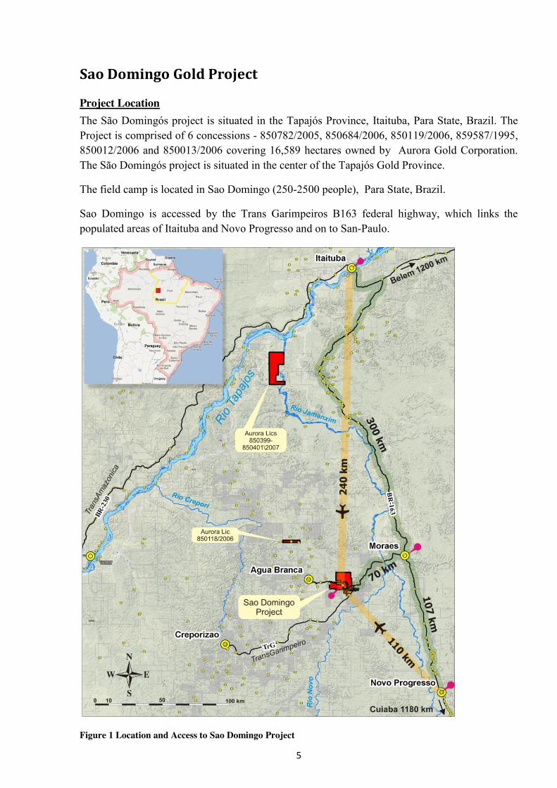
Project Location The São Domingós project is situated in the Tapajós Province, Itaituba, Para State, Brazil. The Project is comprised of 6 concessions - 850782/2005, 850684/2006, 850119/2006, 859587/1995, 850012/2006 and 850013/2006 covering 16,589 hectares owned by Aurora Gold Corporation. The São Domingós project is situated in the center of the Tapajós Gold Province.
The field camp is located in Sao Domingo (250-2500 people), Para State, Brazil.
Sao Domingo is accessed by the Trans Garimpeiros B163 federal highway, which links the populated areas of Itaituba and Novo Progresso and on to San-Paulo.
Figure 1 Location and Access to Sao Domingo Project
6
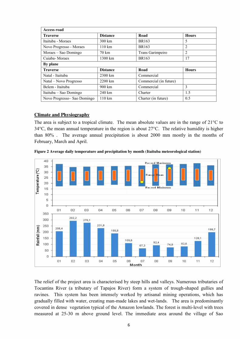
Access road Traverse Distance Road Hours Itaituba - Moraes 300 km BR163 5 Novo Progresso - Moraes 110 km BR163 2 Moraes – Sao Domingo 70 km Trans Garimpeiro 2 Cuiaba- Moraes 1300 km BR163 17 By plane Traverse Distance Road Hours Natal - Itaituba 2300 km Commercial Natal – Novo Progresso 2200 km Commercial (in future) Belem - Itaituba 900 km Commercial 3 Itaituba – Sao Domingo 240 km Charter 1.5 Novo Progresso– Sao Domingo 110 km Charter (in future) 0.5
Climate and Physiography The area is subject to a tropical climate. The mean absolute values are in the range of 21°C to 34°C, the mean annual temperature in the region is about 27°C. The relative humidity is higher than 80% . The average annual precipitation is about 2000 mm mostly in the months of February, March and April.
Figure 2 Average daily temperature and precipitation by month (Itaituba meteorological station)
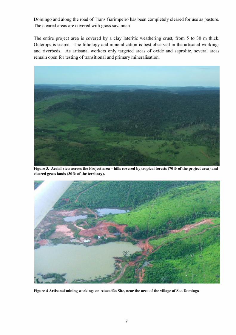
The relief of the project area is characterised by steep hills and valleys. Numerous tributaries of Tocantins River (a tributary of Tapajos River) form a system of trough-shaped gullies and ravines. This system has been intensely worked by artisanal mining operations, which has gradually filled with water, creating man-made lakes and wet-lands. The area is predominantly covered in dense vegetation typical of the Amazon lowlands. The forest is multi-level with trees measured at 25-30 m above ground level. The immediate area around the village of Sao
7
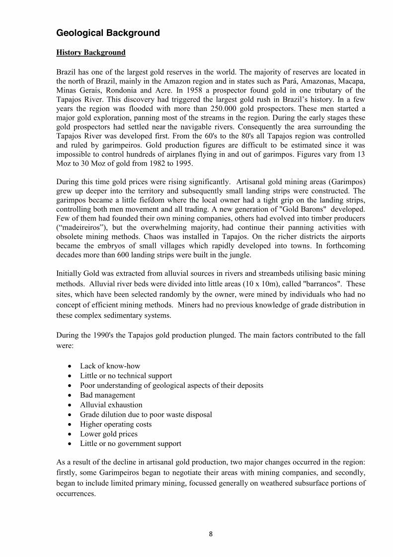
Domingo and along the road of Trans Garimpeiro has been completely cleared for use as pasture. The cleared areas are covered with grass savannah. The entire project area is covered by a clay lateritic weathering crust, from 5 to 30 m thick. Outcrops is scarce. The lithology and mineralization is best observed in the artisanal workings and riverbeds. As artisanal workers only targeted areas of oxide and saprolite, several areas remain open for testing of transitional and primary mineralisation.
Figure 3. Aerial view across the Project area – hills covered by tropical forests (70% of the project area) and cleared grass lands (30% of the territory).
Figure 4 Artisanal mining workings on Atacadão Site, near the area of the village of Sao Domingo
8
Geological Background
History Background
Brazil has one of the largest gold reserves in the world. The majority of reserves are located in the north of Brazil, mainly in the Amazon region and in states such as Pará, Amazonas, Macapa, Minas Gerais, Rondonia and Acre. In 1958 a prospector found gold in one tributary of the Tapajos River. This discovery had triggered the largest gold rush in Brazil’s history. In a few years the region was flooded with more than 250.000 gold prospectors. These men started a major gold exploration, panning most of the streams in the region. During the early stages these gold prospectors had settled near the navigable rivers. Consequently the area surrounding the Tapajos River was developed first. From the 60's to the 80's all Tapajos region was controlled and ruled by garimpeiros. Gold production figures are difficult to be estimated since it was impossible to control hundreds of airplanes flying in and out of garimpos. Figures vary from 13 Moz to 30 Moz of gold from 1982 to 1995.
During this time gold prices were rising significantly. Artisanal gold mining areas (Garimpos) grew up deeper into the territory and subsequently small landing strips were constructed. The garimpos became a little fiefdom where the local owner had a tight grip on the landing strips, controlling both men movement and all trading. A new generation of "Gold Barons" developed. Few of them had founded their own mining companies, others had evolved into timber producers (“madeireiros”), but the overwhelming majority, had continue their panning activities with obsolete mining methods. Chaos was installed in Tapajos. On the richer districts the airports became the embryos of small villages which rapidly developed into towns. In forthcoming decades more than 600 landing strips were built in the jungle.
Initially Gold was extracted from alluvial sources in rivers and streambeds utilising basic mining methods. Alluvial river beds were divided into little areas (10 x 10m), called "barrancos". These sites, which have been selected randomly by the owner, were mined by individuals who had no concept of efficient mining methods. Miners had no previous knowledge of grade distribution in these complex sedimentary systems.
During the 1990's the Tapajos gold production plunged. The main factors contributed to the fall were:
Lack of know-how Little or no technical support Poor understanding of geological aspects of their deposits Bad management Alluvial exhaustion Grade dilution due to poor waste disposal Higher operating costs Lower gold prices Little or no government support
As a result of the decline in artisanal gold production, two major changes occurred in the region: firstly, some Garimpeiros began to negotiate their areas with mining companies, and secondly, began to include limited primary mining, focussed generally on weathered subsurface portions of occurrences.
9
Rio Tinto Zinc (RTZ) was the first major company to start a serious exploration program in Tapajos and to deal directly with the garimpeiros. In less than one year RTZ discovered 2 small to medium sized gold deposits, drawing the attention from several other mining companies.
Following Rio Tinto's example several Brazilian and foreign companies made other mineral agreements. This demonstrated that a peaceful and productive relationship could be established with garimpeiros who were now starting to organize themselves in Cooperatives (AMOT).
At the same time, hundreds of new primary gold occurrences were discovered and a new era started for Tapajos.
Mining companies realized that:
1- Tapajos wasn't as remote as they thought: Almost all targets are within 40km from a major road or navigable river. The local economic center, Itaituba, was served by major air companies everyday of the week, banks and services.
2- The work done by garimpeiros, panning and excavating all possible primary sources, had an immense value for follow on exploration companies.
3- It was very easy to visit several occurrences that had never been inspected by professional geotechnicians.
4- Negotiating agreements were not as cost prohibitive as in other mining places in the world.
5- The Tapajos appeared to be "elephant country" and several world class gold deposits could be identified from the ongoing exploration effort.
During these years exploration investment increased sharply in the region and a number of very important discoveries made. Most of the large mineralized provinces have been covered by airborne geophysics.
Since 1992 to 1998 Rio Tinto discovered Jutaí (100,000oz = 3 ton), Ouro Roxo (1.3 Moz = 40 ton), São Jorge (900 000 Oz = 27 ton), Palito (0.7 Moz = 21 ton), and V3 (1 Moz = 31 ton).
In 1997 the mineral exploration boom in the region ended. Exploration funds were extremely limited as a result of the stock exchange turmoil in the mineral industry. As a result many foreign companies closed down operations in Brazil.
A renewed interest in exploration began in 2004, generally by junior companies, attracted by the discovery of a large “world class” gold deposit - Tocantinzinho (2.5 Moz, 77 tons) Eldorado Gold. This included Aurora Gold Corp who took options over numerous areas in the region. Over the next 3 years Aurora reviewed 13 properties and ranked them in priority. After follow up reviews Aurora reduced the number of properties to the current portfolio, based on probability of economic discoveries and infrastructure.
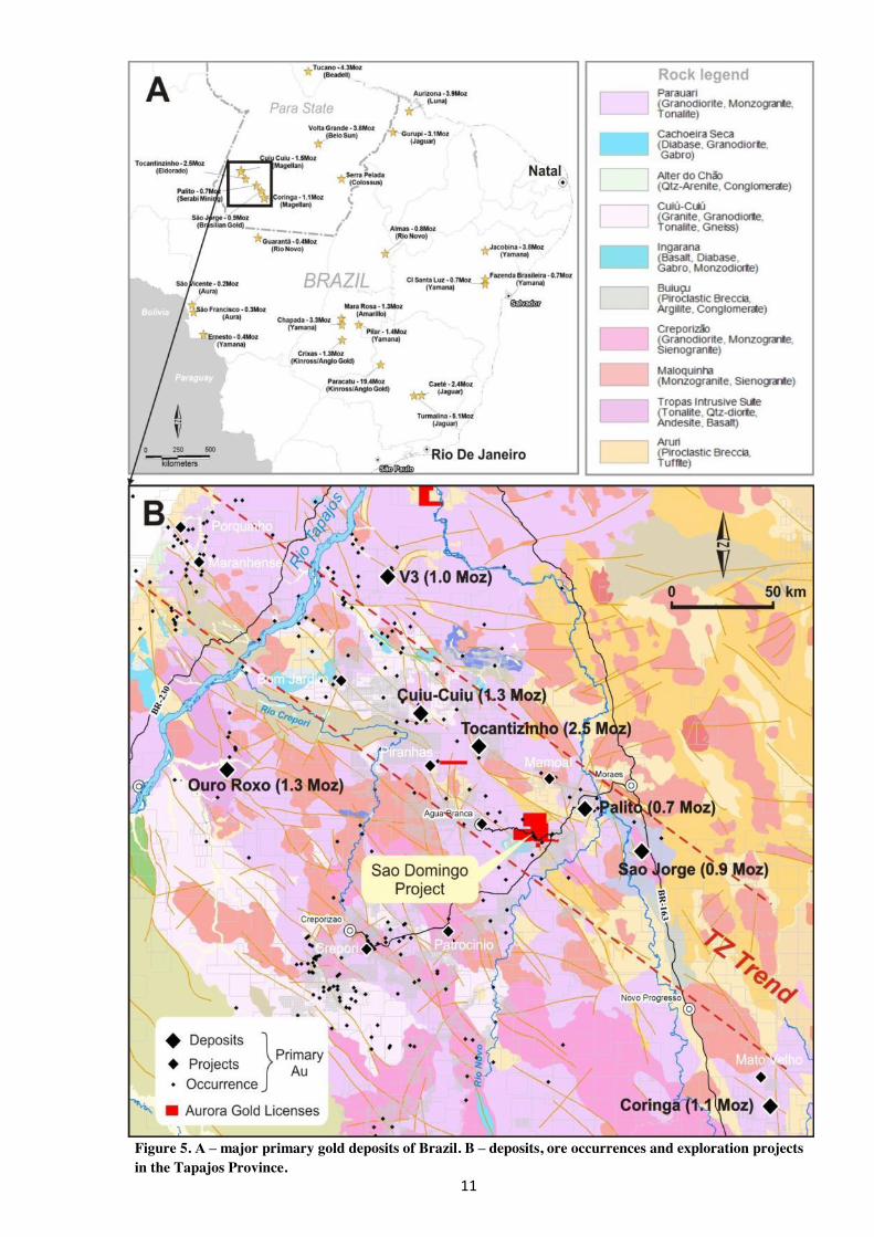
Figure 5 shows the main primary gold deposits of Brazil (A) and deposits, ore occurrences and exploration projects within the Tapajos Province (B).
10
Brief description of Tapajos gold deposits is given in Table 3; similar deposits, as yet unknown or unexplored, may be found within Sao Domingo project area.
Note, that the Sao Domingo project area is a part of the so-called Tocantinzinho Trend (TZ trend) – a highly mineralized structural-tectonic belt roughly 300 km in strike length, with the potential gold reserves estimated at > 5 Moz in a number of medium-size and large deposits.
11
Figure 5. А – major primary gold deposits of Brazil. B – deposits, ore occurrences and exploration projects in the Tapajos Province.
12
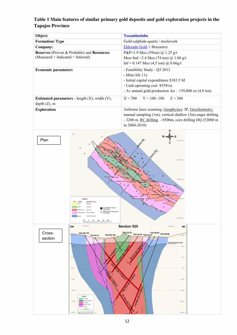
Table 1 Main features of similar primary gold deposits and gold exploration projects in the Tapajos Province
Object:
Tocantinzinho Formation/ Type Gold-sulphide-quartz / stockwork
Company: Eldorado Gold ( Brazauro) Reserves (Proven & Probable) and Resources
(Measured + Indicated + Inferred)
P&P=1.9 Moz (59ton) @ 1.25 g/t Mea+Ind =2.4 Moz (74 ton) @ 1.06 g/t Inf = 0.147 Moz (4,5 ton) @ 0.66g/t
Economic parameters - Feasibility Study - Q3 2012 - Mine life 11y - Initial capital expenditures $383.5 M - Cash operating cost $559/oz - Av annual gold production Au - 159,000 oz (4,9 ton)
Estimated parameters - length (X), width (Y), depth (Z), m
X = 700 Y = 100 -180 Z = 300
Exploration Airborne laser scanning, Geophysics: IP, Geochemistry: manual sampling (1m), vertical shallow (3m) auger drilling - 3200 m, RC drilling - 8500m, core drilling HQ (52000 m in 2004-2010)
Cross-section
Plan
13
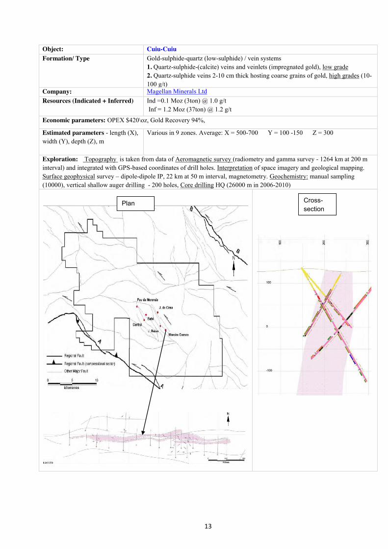
Object:
Cuiu-Cuiu
Formation/ Type Gold-sulphide-quartz (low-sulphide) / vein systems
1. Quartz-sulphide-(calcite) veins and veinlets (impregnated gold), low grade 2. Quartz-sulphide veins 2-10 cm thick hosting coarse grains of gold, high grades (10-100 g/t)
Company: Magellan Minerals Ltd Resources (Indicated + Inferred)
Ind =0.1 Moz (3ton) @ 1.0 g/t Inf = 1.2 Moz (37ton) @ 1.2 g/t
Economic parameters: OPEX $420\oz, Gold Recovery 94%,
Estimated parameters - length (X), width (Y), depth (Z), m
Various in 9 zones. Average: X = 500-700 Y = 100 -150 Z = 300
Exploration: Topography is taken from data of Aeromagnetic survey (radiometry and gamma survey - 1264 km at 200 m interval) and integrated with GPS-based coordinates of drill holes. Interpretation of space imagery and geological mapping. Surface geophysical survey – dipole-dipole IP, 22 km at 50 m interval, magnetometry. Geochemistry: manual sampling (10000), vertical shallow auger drilling - 200 holes, Core drilling HQ (26000 m in 2006-2010)
Cross-section
Plan
14
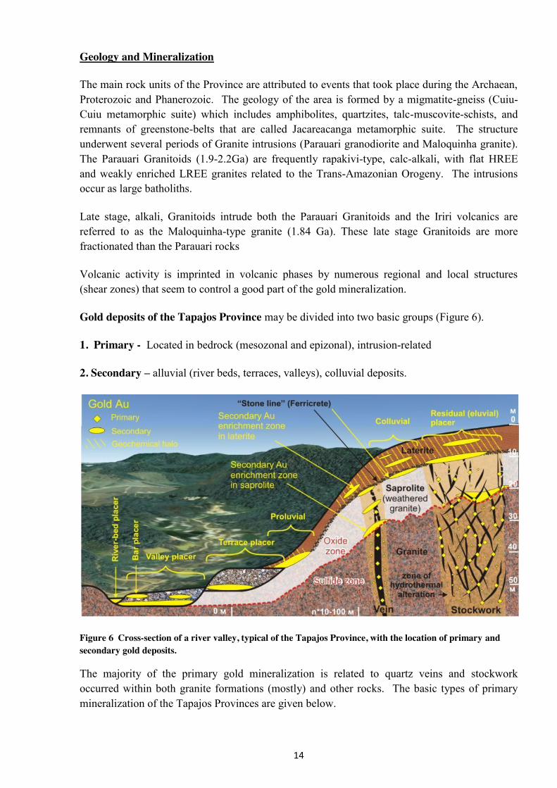
Geology and Mineralization
The main rock units of the Province are attributed to events that took place during the Archaean, Proterozoic and Phanerozoic. The geology of the area is formed by a migmatite-gneiss (Cuiu-Cuiu metamorphic suite) which includes amphibolites, quartzites, talc-muscovite-schists, and remnants of greenstone-belts that are called Jacareacanga metamorphic suite. The structure underwent several periods of Granite intrusions (Parauari granodiorite and Maloquinha granite). The Parauari Granitoids (1.9-2.2Ga) are frequently rapakivi-type, calc-alkali, with flat HREE and weakly enriched LREE granites related to the Trans-Amazonian Orogeny. The intrusions occur as large batholiths.
Late stage, alkali, Granitoids intrude both the Parauari Granitoids and the Iriri volcanics are referred to as the Maloquinha-type granite (1.84 Ga). These late stage Granitoids are more fractionated than the Parauari rocks
Volcanic activity is imprinted in volcanic phases by numerous regional and local structures (shear zones) that seem to control a good part of the gold mineralization.
Gold deposits of the Tapajos Province may be divided into two basic groups (Figure 6).
1. Primary - Located in bedrock (mesozonal and epizonal), intrusion-related
2. Secondary – alluvial (river beds, terraces, valleys), colluvial deposits.
Figure 6 Cross-section of a river valley, typical of the Tapajos Province, with the location of primary and secondary gold deposits.
The majority of the primary gold mineralization is related to quartz veins and stockwork occurred within both granite formations (mostly) and other rocks. The basic types of primary mineralization of the Tapajos Provinces are given below.
15
Quartz veins: In almost all districts quartz-sulfide veins are abundant. In general quartz veins are narrow and discontinuous. Quartz veins are known in all kinds of terrain and ages in Tapajos. Gold is often visible and quite frequently occur associated to rich clusters. Grades may be very high. Sulfides are mostly pyrite and secondarily chalcopyrite and galena. Pyrrhotite, molibdenite and sphalerite are described in a few areas. Carbonates are common.
Characteristics: medium tonnage and high grade (~6 to 8 g/ton) with 0.5 to 1.5 Moz of Au. Example: Palito Mine, Cuiu-Cuiu.
Chlorite (sericite)-quartz-sulfide veins: Important high-grade mineralization is associated to large chlorite-quartz-sulfide veins. These veins are filling open spaces in competent rocks affected by brittle deformation. Hydrothermal alteration is restricted to the selvages and is never pervasive. Host rocks vary from granites and volcanics to gneisses. Main sulfides are pyrite, chalcopyrite, pyrrhotite and galena. Generally whenever Cpy is present gold grades are greatly amplified, frequently well in excess of 30g/t. Massive sulfide occurrences within the areas are generally exhibit bonanza gold grades (up to 300g/t Au noted in Sao Domingo). Good correlation between copper and gold is common in several districts in Tapajos, and as demonstrated on the Sao Domingo, Fofoca resource area.
Stockwork of stacked quartz-sulphide veins: During the preliminary reconnaissance in 1990s, a number of gold bearing stock works frequently associated with large alteration systems were discovered. In general stockwork are associated to the upper portion of granitic intrusions, to volcanics intruded by granitic bodies, to porphyry type intrusions, and to epithermal-porphyry deposits.
Characteristics: large tonnage, low grade (~1 to 2 g/ton) with 0.5 to more than 2 Moz of Au. Example: São Jorge and Tocantinzinho.
Epithermal gold in the extrusive felsic volcanics . Characteristics: low to medium tonnage with very high grade (~10 to 12 g/ton) with 0.1 to 0.5 Moz of Au. Example: V3 и V6(?)
The majority of vein systems and zones of mineralization within the project area have vertical or sub-vertical dips. They usually strike 120º to 125º (regional TZ trend), 40º to 60º, in places nearly east-west.
Thus, given the geological similarity to the deposits above and taking into account the ore occurrences discovered to date within the Sao Domingo project area Aurora is confident of converting the occurrences into further economic resources.
Secondary alluvial occurrences of the Tapajos Province are widespread and several previous Garimpeiro operations are found on Sao Domingo. The occurrences they are formed by mechanical accumulation of gold grains in coarse clastic sediments of rivers and streams and derived from primary mineralization.
Secondary saprolite gold deposits occur within deeply weathered bedrock and confined to primary source (veins, veinlets, impregnated mineralization). They occur as near horizontal zones of Au enrichment around previous redox fronts in the weathering profile.
16
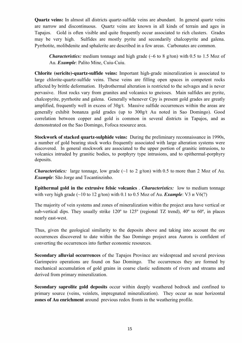
Weathering crust and geological/geomorphological conditions of Sao Domingo, Toucano
Tropical lateritic soils are developed over most of the Sao Domingo project area, with deeper development on plateaus. Basic elements of the lateritic weathering profile and zones of Au secondary enrichment are shown below in Figure 7.
Figure 7 Basic elements of the lateritic weathering profile and zones of Au and secondary enrichment of the Toucano stockwork (location and grades of 1m chip samples are shown, May 2012).
The lateritic soils is generally 2 to 15 meters thick, brick red in colour and developed over weathered bedrock (saprolite). The lateritic soils usually display a well developed ferricrete horizon with a so-called “stone line” or oolitic conglomerate formed by cementation of gravel by iron oxide derived from the oxidation of percolating solutions of iron salts. Saprolite with varying degrees of relict texture, soft and Kaolinitized, heavily altered by natural leaching, occurs below the laterite usually around 10m to 30m thick. The transition from saprolite to relatively fresh rock is sharp, occurring over 1.5m or less. It is important to note that the grades of gold in the weathering crust are often higher than in the primary sources thereof due to the complex and combined physical-chemical processes of
17
secondary enrichment in the supergene zone. This can result in the formation of secondary commercial deposits, which contain both primary gold from oxidized sulphides and free gold associated with secondary iron oxides (goethite, hematite). Such deposits are usually one layer as the zones of enrichment in saprolite do not exceed 5-10 meters. However, the deposits can be 10 times wider than the primary mineralization zones due to the ability of gold to migrate during weathering. Weathered saprolite has a low density of about 1.8 - 2 g\cm3 compared with relatively fresh un weathered rock with the density of 2.7 g\cm3 (granite). Such saprolite and lateritic zones of secondary enrichment are often mined by artisanal prospectors due to easily recoverable gold by gravity concentration. Thus, at the Toucan ore occurrence, located within the project area, artisanal prospectors successfully mine gold from laterite (overburden) along with the high grade saprolite portion of the weathering profile. During the exploration in the first half of 2012, a vertical channel was cut in Toucano and 19samples were collected over 1 meter intervals, from the vertical walls of the open pit: nine samples of saprolite and 10 samples of laterite. Results showed the rich nature of the Toucano occurrence, and the prospectivity of having a ready oxide source of gravity won gold coupled with extensions of the known mineralisation into the primary bedrock. Obvious drilling targets.
History and Exploration maturity The Sao Domingo Project area has been prospected for placer and saprolite gold deposits periodically since the gold rush of the last century to the present day. Garimpeiros, with varied success, found and worked rich sites that presented easy cooperative mining still utilising the same obsolete methods of gold extraction. There are a lot of old abandoned shafts, trenches and pits within the project area providing further numerous targets and sources for potential alluvial production, and tracing the source of the gold to the primary occurrence.
18
Aurora Gold Primary Occurrences
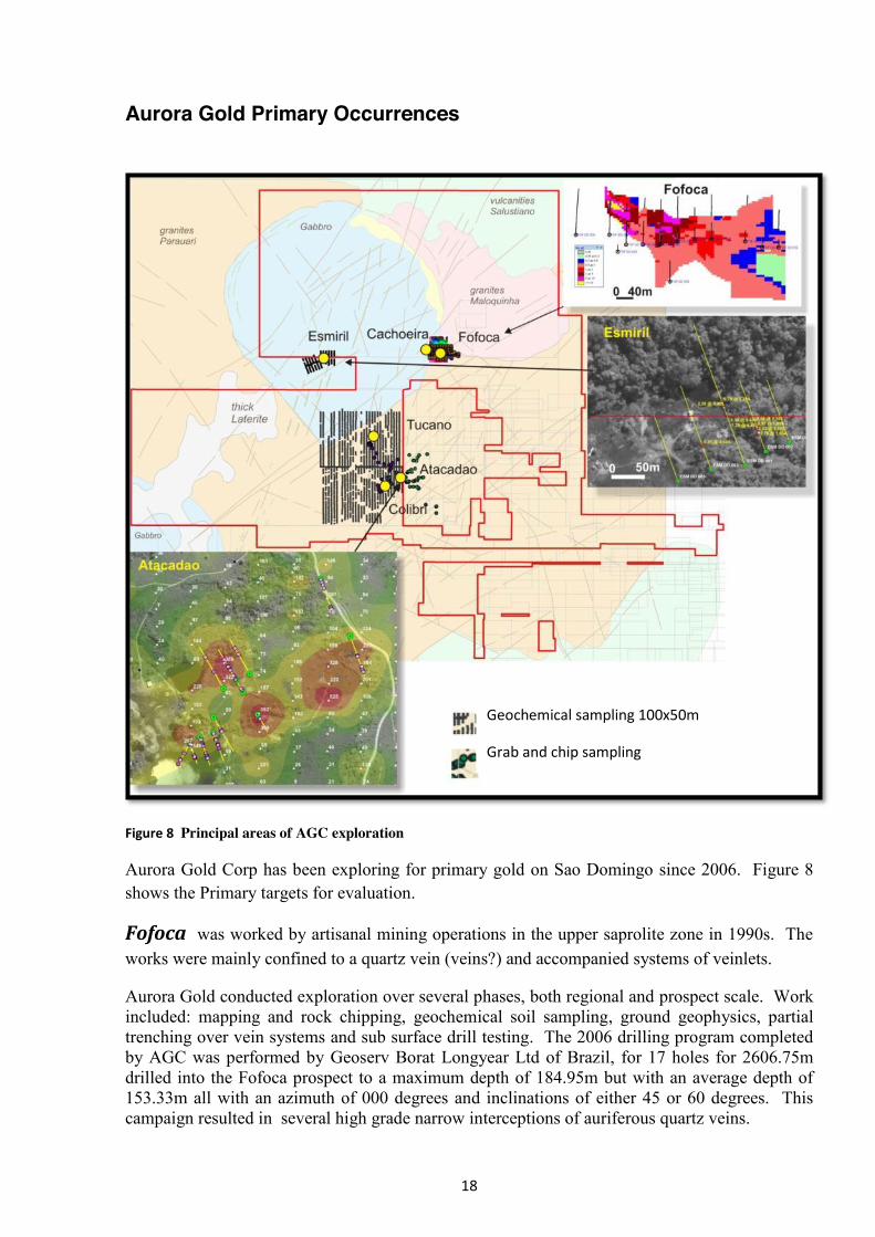
Figure 8 Principal areas of AGC exploration
Aurora Gold Corp has been exploring for primary gold on Sao Domingo since 2006. Figure 8 shows the Primary targets for evaluation.
Fofoca was worked by artisanal mining operations in the upper saprolite zone in 1990s. The works were mainly confined to a quartz vein (veins?) and accompanied systems of veinlets.
Aurora Gold conducted exploration over several phases, both regional and prospect scale. Work included: mapping and rock chipping, geochemical soil sampling, ground geophysics, partial trenching over vein systems and sub surface drill testing. The 2006 drilling program completed by AGC was performed by Geoserv Borat Longyear Ltd of Brazil, for 17 holes for 2606.75m drilled into the Fofoca prospect to a maximum depth of 184.95m but with an average depth of 153.33m all with an azimuth of 000 degrees and inclinations of either 45 or 60 degrees. This campaign resulted in several high grade narrow interceptions of auriferous quartz veins.
Geochemical sampling 100х50m
Grab and chip sampling
19
In mid 2007, a second drilling campaign commenced using a different drilling company (Explorer Drilling Services) in which two holes were drilled into Fofoca. One of these two holes failed (FOF-19) due to mechanical issues with the rig. Financial issues led to the termination of the contract and the exploration program. Generally the drill holes encountered thin hydrothermally brecciated, vuggy, sulphidic quartz veins with alterations ranging from argillic through to potassic (possible overprinting) which is typical for this style of mineralisation. Fofoca has five dominant types of alteration; namely, argillic, advanced argillic, phyllic, propylitic, silicification and some patchy potassic alteration which form localised around the quartz veins and it is believed that these can be used to identify zones that are analogous to classical epithermal quartz vein models. In April 2010 AGC announced Inferred resource of 130,000 Oz @ 2g/t gold.
Based on mapping and outcrop sampling the Fofoca occurrence also appears to continue to the west into the Cachoeirinha area. Geophysics commissioned by AGC and conducted by Fugro confirmed that a structural trend links Fofoca with Cachoeirinha adding a significant portion to current resources. Ground based investigations at Fofoca consisted of fourteen N-S survey lines 950 metres in length cut through the dense vegetation with 50m spacing for a total survey length of 13.30km covering an area of 0.665 km2 . The geophysics involved spectral IP and magnetics which supported the assumption that the Fofoca structure continued to the west and was displaced by late stage faulting to the north. Cachoeira is located in 400 m NW of Fofoca. It includes a number of old artisanal workings which were abandoned due to the lack of proper equipment for crushing the vein material. The veins (as well as mining pits) strike NE-SW, i.e. near parallel to the Fofoca structural trend.
A trench striking east to west, 60 m long, contains numerous quartz veins up to 5 cm thick and a separate systems of veins up to 20 cm hosted in the walls of the trench. Grab samples resulted in grades up to 13.4 g/t gold with several other results greater than 8 g/t gold.
Esmeril includes a large outcrop with a series of parallel veins worked in trenches and adits. The most potential for are veins and systems of veins striking 60°-240° - 70°-250°.
The results of samples collected from zones of silicified veins showed gold grades of 12 - 37 g/t. Between the well-defined systems of veins there is an outcrop of heavily altered and fractured rocks hosting a quartz stockwork. Samples from the stockwork showed gold grades up to 3 g/t.
Preliminary geological mapping of the area confirmed the presence of granites and gabbros overlaid with lateritic soils. Gabbros are characterized by a large number of thin-bedded plagioclases which are probably a part of the intrusive formation of Cachoeira Seca.
During 2006, 5 holes were drilled (HQ). The drill holes penetrated heavily altered by hydrothermal granites with hosted quartz veins and systems of veinlets, as well as low mineralized gabbro. Core logs show a great variety of structural elements related to various phases of deformation processes. Parallel fault planes within and close to the gabbro formations are often covered with talcum and have slickenlines. Interpretation shows intense faulting within the tectonic zone and that the zones of quartz-sulphide veins may represent a highly compressed contact between granites of the Paleo-proterozoic intrusive complex of Parauari and the Mesoproterozoic intrusive complex of Cachoeira Seca.
20
Atacadão is characterised by the presence of large open pits and systems of adits driven in two hills. The quartz veinlets and veins have sub-vertical dips and strike NE-SW to EW. The systems of cracks and related mineralization strike 70°-250°.
Initial sampling returned gold values up to 70 g/t. Thickness of the veins varies from a few millimetres to 0.5 meters. Small sub parallel veinlets were noted to coalesce to form large vein zones with high grades, and show boudinage characteristics. Additionally, the veins frequently pinch and swell out laterally.
During 2006, 11 holes were drilled, which penetrated mineralization grading at 0.3 to 60 g\t at the average length of intervals of 0.2-0.8 m. Core logs reveal evidence of several phases of tectonic activation and mineralization. Aplitic and basalt dykes, and crosscut tension cracks have been formed during the recent processes of deformation and penetration of molten rocks. In general, interpretation suggests the alteration of rocks and mineralization in the Parauari granites was preceded by intense fracturing; however, not all rocks and quartz veins display mineralization.
Toucano Toucano is a recent discovery first having been noted in Q4 2011. Since then Aurora has mapped and sampled the current known area of exposures from Garimpeiro work-ings. The Toucano target is located in the same vicinity as the Fofoca area of mineralised mate-rial and containing a JORC compliant resource of 130,000 ounces, the Attacadau occurrence and also high grade Colibri occurrence. All the mineralised areas, including Toucano, have a strike approximating East-West.
The discovery is significant in that it is sub parallel and proximal to the other mineralised occur-rences on site raising the confidence level that the resource inventory could be greatly increased as most occurrences are located within a 2km radius of each other and within 7 km of the Fofoca resource area.
Remote sensing imagery is critical as an aid to exploration in the Tapajos due to the nature of the location as well as to the development of the project. By the application of various spectral ana-lytical methods, Aurora has been able to locate numerous areas for follow up investigation. A digital elevation map obtained by SRTM radar mapping has been essential to regional appraisal of the Sao Domingo property. The illustration, as indicated below, shows how Aurora is utilis-ing the satellite imagery for the Sao Domingo property area.
By viewing spectral wave band ratio's designed to indicate iron oxides and clay minerals, Aurora has been able to decipher areas of past artisanal activity which could lead to the discovery of further hard rock targets, as demonstrated by the discovery of Colibri and Toucano.
A total of 4 initial samples of Garimpeiro ore material and one from tailings at Toucano resulted in 89.17g/t, 33.10g/t 18.04g/t, 19.27g/t and 89.54g/t from tailings. The high grade results were followed up by channel sampling across the mapped ore zone. Results of the channel sam-pling at Toucano 18m @ 12.8 g/t Gold including 5m @ 33.19 g/t Gold.
Several other rock chip samples from in and around the Toucano occurrence returned highly significant results with 3 samples assaying greater than 100g/t gold. Silver was also reported in notable quantities.
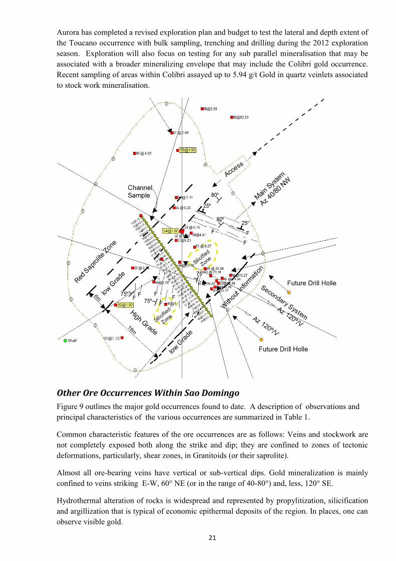
21
Aurora has completed a revised exploration plan and budget to test the lateral and depth extent of the Toucano occurrence with bulk sampling, trenching and drilling during the 2012 exploration season. Exploration will also focus on testing for any sub parallel mineralisation that may be associated with a broader mineralizing envelope that may include the Colibri gold occurrence. Recent sampling of areas within Colibri assayed up to 5.94 g/t Gold in quartz veinlets associated to stock work mineralisation.
Other Ore Occurrences Within Sao Domingo Figure 9 outlines the major gold occurrences found to date. A description of observations and principal characteristics of the various occurrences are summarized in Table 1.
Common characteristic features of the ore occurrences are as follows: Veins and stockwork are not completely exposed both along the strike and dip; they are confined to zones of tectonic deformations, particularly, shear zones, in Granitoids (or their saprolite).
Almost all ore-bearing veins have vertical or sub-vertical dips. Gold mineralization is mainly confined to veins striking E-W, 60° NE (or in the range of 40-80°) and, less, 120° SE.
Hydrothermal alteration of rocks is widespread and represented by propylitization, silicification and argillization that is typical of economic epithermal deposits of the region. In places, one can observe visible gold.
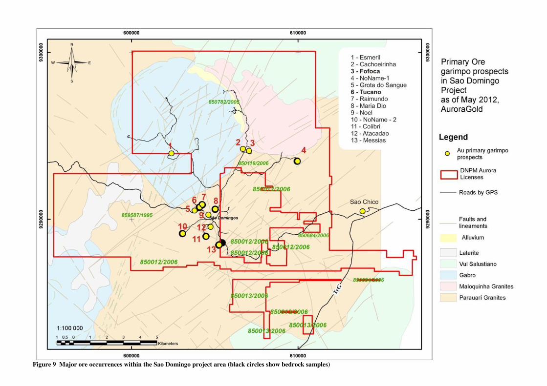
22 Figure 9 Major ore occurrences within the Sao Domingo project area (black circles show bedrock samples)
23
Expl. Priority
open pit
year
name of prospect type of mineralizatio
n
Thick. Observed,
m
Main strike Description
1
2011
Toucano Au-Q-Sulf \ stockwork
40 Main 40-80
Second 120
Third 250
Stockwork of gold-sulphide-quartz formation. Veins and veinlets in 3 main systems: Main one sub vertical has strike 40-80 NW and dip from 75-90. Second one – vertical strike 120 Third one – latest – az dip 250 dip 25-30 All veins and veinlets zone are in saprolite granites and shear zone with alteration such as propylitic silicified rocks.
2 2003
Grota do Sangue Au-Q \ veins
5 60⁰ highly mineralised vein of about 0.5 meter width. typical vein rocks mainly consist of crystalline Quartz and cubic Hematite crystals up to 2 cm. vein rock tailings = 91 g/t. Host rocks are most probably highly hydrothermally altered Parauari Granites. The distribution of former working sites indicates a strike potential of about 700 m length. 3 2003 Raimundo
veinlet sys? 3 60⁰
4 2012 Maria Dio Au-Q-Sulf \ vein
2 E-W highly mineralised vein zone of about 2 meter width.
5 2007
Colibri Au-Q-Sulf \ stockwork
>5 60⁰ Qz veinlets with sericitic hydrothermal alteration and oxidation zone
6 2005
Atacadão Au-Q-Sulf \ veins
NE-SW to
E-W
Fractures and Quartz veinlets and veins run nearly vertically. The vein width varies between several mm to nearly 0.5 m. Inconsistent vein widths and extensions seem to occur frequently. Vein rock samples - up to 70 g/t
7 2012
Messias Au-Q \ veinlets
60⁰ Quartz veinlets 10cv wide in brecciated zone apprx 20 m wide, oxidised with weakly propylitic altered within saprolite granite. There is a visible gold! In brecciaed zone occurs about 5 quartz veinlets 10-15 cm each.
8 2006 Fofoca Au-Q-Sulf \ veins
E-W big vein with adjacent stockwork system under water 9 m. Pile rock and tailings samples yielded gold grades of 2 g/t to 20 g/t.
9 2006
Cachoeirinha Au-Q \ veins
NE-SW to exactly E-W
Veins in Maloquinha granite. vein rock samples = 5 g/t. Distinct Quartz veins up to 5 cm width and diffuse vein zones up to 20 cm width were observed all over the trench walls in E-W.
10 2006
Esmeril Au-Q-Sulf \ stockwork
60°- 70° 3 structural directions occur with the most prospective veins and vein zones in hydrothermally altered Granites and less mineralised Gabbros. Assayed samples of highly silicified vein rocks worked along the trenches yielded gold grades of 12 to 37 g/t
Table 1. Major ore occurrences within the Sao Domingo project area
24
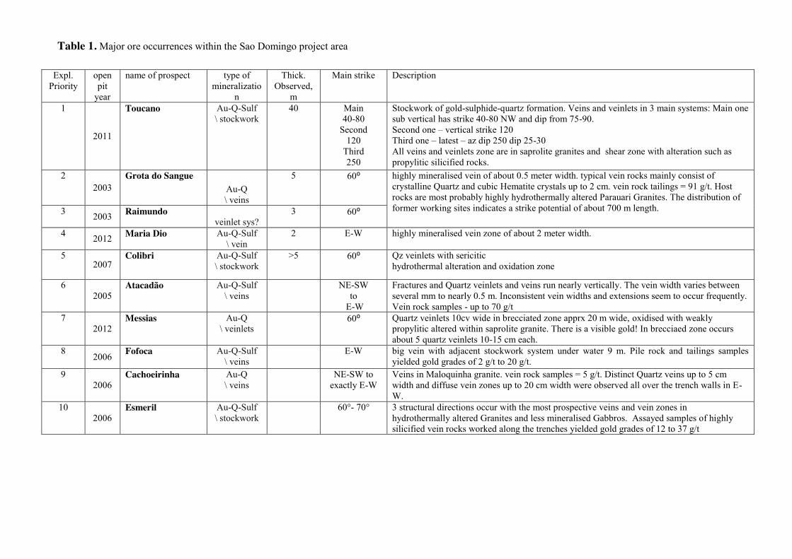
Figure 10 Gold-bearing stockwork Toucano at the bottom of the open pit (24 m; May, 2012)
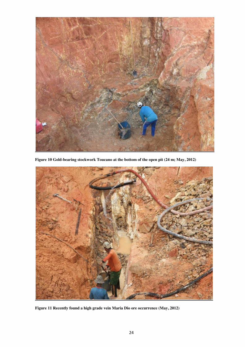
Figure 11 Recently found a high grade vein Maria Dio ore occurrence (May, 2012)
25
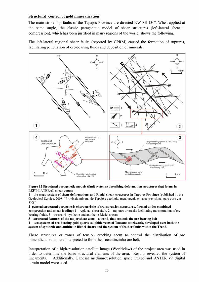
Structural control of gold mineralization The main strike-slip faults of the Tapajos Province are directed NW-SE 130º. When applied at the same angle, the classic paragenetic model of shear structures (left-lateral shear – compression), which has been justified in many regions of the world, shows the following.
The left-lateral regional shear faults (reported by CPRM) caused the formation of ruptures, facilitating penetration of ore-bearing fluids and deposition of minerals.
Figure 12 Structural paragenetic models (fault systems) describing deformation structures that forms in LEFT-LATERAL shear zones: 1 – the mega-system of shear deformations and Riedel shear structures in Tapajos Province (published by the Geological Service, 2008;; “Província mineral do Tapajós: geologia, metalogenia e mapa previsional para ouro em SIG”) 2- general structural paragenesis characteristic of transpression structures, formed under combined compression and shear loading: 1 – regional shear fault, 2 – ruptures or cracks facilitating transportation of ore-bearing fluids, 3 – thrusts, 4- synthetic and antithetic Riedel shears. 3 – structural features of the major shear zone – a trend, that controls the ore-bearing belt 4 – two systems of ore-bearing gold-quartz-sulphide veins of Toucano stockwork, developed over both the system of synthetic and antithetic Riedel shears and the system of feather faults within the Trend. These structures or zones of tension cracking seem to control the distribution of ore mineralization and are interpreted to form the Tocantinzinho ore belt. Interpretation of a high-resolution satellite image (Worldview) of the project area was used in order to determine the basic structural elements of the area. Results revealed the system of lineaments. Additionally, Landsat medium-resolution space image and ASTER v2 digital terrain model were used.
26
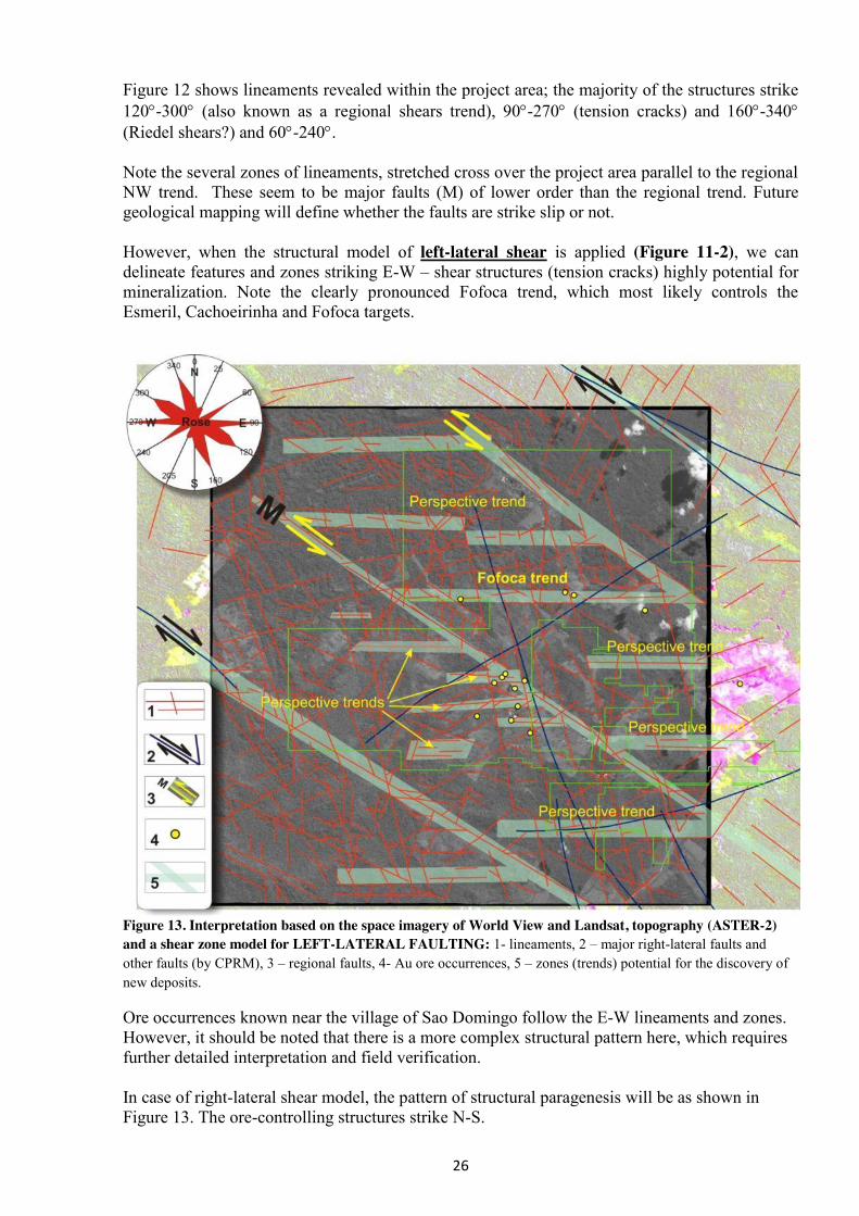
Figure 12 shows lineaments revealed within the project area; the majority of the structures strike 120-300 (also known as a regional shears trend), 90-270 (tension cracks) and 160-340 (Riedel shears?) and 60-240. Note the several zones of lineaments, stretched cross over the project area parallel to the regional NW trend. These seem to be major faults (M) of lower order than the regional trend. Future geological mapping will define whether the faults are strike slip or not. However, when the structural model of left-lateral shear is applied (Figure 11-2), we can delineate features and zones striking E-W – shear structures (tension cracks) highly potential for mineralization. Note the clearly pronounced Fofoca trend, which most likely controls the Esmeril, Cachoeirinha and Fofoca targets.
Figure 13. Interpretation based on the space imagery of World View and Landsat, topography (ASTER-2) and a shear zone model for LEFT-LATERAL FAULTING: 1- lineaments, 2 – major right-lateral faults and other faults (by CPRM), 3 – regional faults, 4- Au ore occurrences, 5 – zones (trends) potential for the discovery of new deposits.
Ore occurrences known near the village of Sao Domingo follow the E-W lineaments and zones. However, it should be noted that there is a more complex structural pattern here, which requires further detailed interpretation and field verification. In case of right-lateral shear model, the pattern of structural paragenesis will be as shown in Figure 13. The ore-controlling structures strike N-S.
27
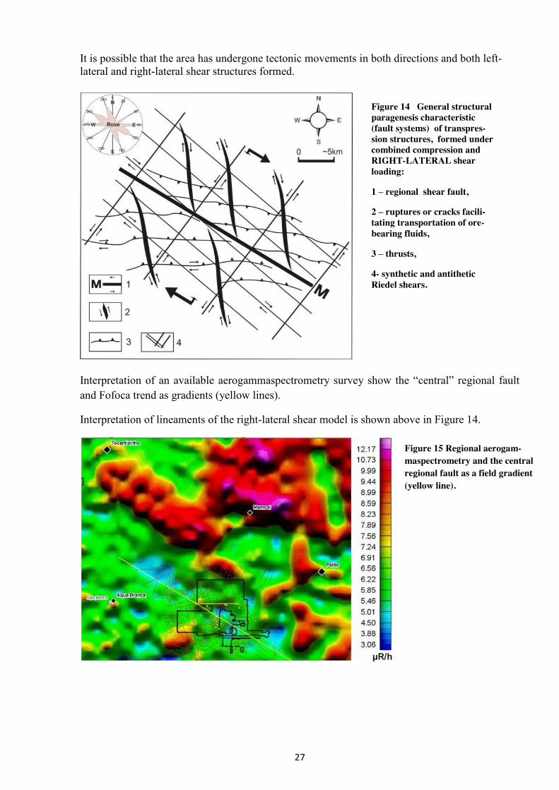
It is possible that the area has undergone tectonic movements in both directions and both left-lateral and right-lateral shear structures formed.
Interpretation of an available aerogammaspectrometry survey show the “central” regional fault and Fofoca trend as gradients (yellow lines).
Interpretation of lineaments of the right-lateral shear model is shown above in Figure 14.
Figure 15 Regional aerogam-maspectrometry and the central regional fault as a field gradient (yellow line).
Figure 14 General structural paragenesis characteristic (fault systems) of transpres-sion structures, formed under combined compression and RIGHT-LATERAL shear loading:
1 – regional shear fault,
2 – ruptures or cracks facili-tating transportation of ore-bearing fluids,
3 – thrusts,
4- synthetic and antithetic Riedel shears.
28
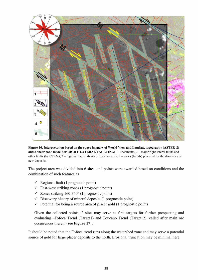
Figure 16. Interpretation based on the space imagery of World View and Landsat, topography (ASTER-2) and a shear zone model for RIGHT-LATERAL FAULTING: 1- lineaments, 2 – major right-lateral faults and other faults (by CPRM), 3 – regional faults, 4- Au ore occurrences, 5 – zones (trends) potential for the discovery of new deposits.
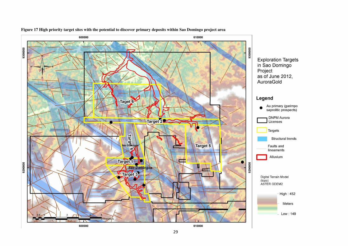
The project area was divided into 6 sites, and points were awarded based on conditions and the combination of such features as
Regional fault (1 prognostic point) East-west striking zones (1 prognostic point) Zones striking 160-340 (1 prognostic point) Discovery history of mineral deposits (1 prognostic point) Potential for being a source area of placer gold (1 prognostic point)
Given the collected points, 2 sites may serve as first targets for further prospecting and evaluating –Fofoca Trend (Target1) and Toucano Trend (Target 2), called after main ore occurrences therein (see Figure 17).
It should be noted that the Fofoca trend runs along the watershed zone and may serve a potential source of gold for large placer deposits to the north. Erosional truncation may be minimal here.
29
Figure 17 High priority target sites with the potential to discover primary deposits within Sao Domingo project area
30
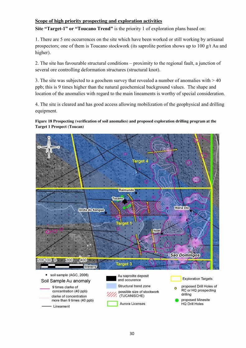
Scope of high priority prospecting and exploration activities Site “Target-1” or “Toucano Trend” is the priority 1 of exploration plans based on:
1. There are 5 ore occurrences on the site which have been worked or still working by artisanal prospectors; one of them is Toucano stockwork (its saprolite portion shows up to 100 g/t Au and higher).
2. The site has favourable structural conditions – proximity to the regional fault, a junction of several ore controlling deformation structures (structural knot).
3. The site was subjected to a geochem survey that revealed a number of anomalies with > 40 ppb; this is 9 times higher than the natural geochemical background values. The shape and location of the anomalies with regard to the main lineaments is worthy of special consideration.
4. The site is cleared and has good access allowing mobilization of the geophysical and drilling equipment.
Figure 18 Prospecting (verification of soil anomalies) and proposed exploration drilling program at the Target 1 Prospect (Toucan)
31
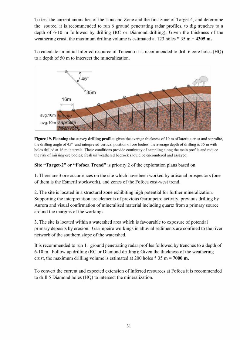
To test the current anomalies of the Toucano Zone and the first zone of Target 4, and determine the source, it is recommended to run 6 ground penetrating radar profiles, to dig trenches to a depth of 6-10 m followed by drilling (RC or Diamond drilling); Given the thickness of the weathering crust, the maximum drilling volume is estimated at 123 holes * 35 m = 4305 m. To calculate an initial Inferred resource of Toucano it is recommended to drill 6 core holes (HQ) to a depth of 50 m to intersect the mineralization.
Figure 19. Planning the survey drilling profile: given the average thickness of 10 m of lateritic crust and saprolite, the drilling angle of 45 and interpreted vertical position of ore bodies, the average depth of drilling is 35 m with holes drilled at 16 m intervals. These conditions provide continuity of sampling along the main profile and reduce the risk of missing ore bodies; fresh un weathered bedrock should be encountered and assayed.
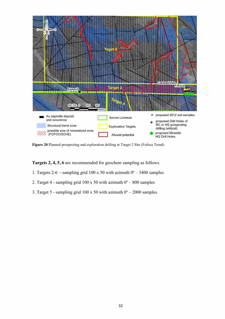
Site “Target-2” or “Fofoca Trend” is priority 2 of the exploration plans based on:
1. There are 3 ore occurrences on the site which have been worked by artisanal prospectors (one of them is the Esmeril stockwork), and zones of the Fofoca east-west trend.
2. The site is located in a structural zone exhibiting high potential for further mineralization. Supporting the interpretation are elements of previous Garimpeiro activity, previous drilling by Aurora and visual confirmation of mineralised material including quartz from a primary source around the margins of the workings.
3. The site is located within a watershed area which is favourable to exposure of potential primary deposits by erosion. Garimpeiro workings in alluvial sediments are confined to the river network of the southern slope of the watershed.
It is recommended to run 11 ground penetrating radar profiles followed by trenches to a depth of 6-10 m. Follow up drilling (RC or Diamond drilling); Given the thickness of the weathering crust, the maximum drilling volume is estimated at 200 holes * 35 m = 7000 m. To convert the current and expected extension of Inferred resources at Fofoca it is recommended to drill 5 Diamond holes (HQ) to intersect the mineralization.
32
Figure 20 Planned prospecting and exploration drilling at Target 2 Site (Fofoca Trend)
Targets 2, 4, 5, 6 are recommended for geochem sampling as follows.
1. Targets 2-6 - sampling grid 100 х 50 with azimuth 0º – 3400 samples
2. Target 4 - sampling grid 100 х 50 with azimuth 0º – 800 samples
3. Target 5 - sampling grid 100 х 50 with azimuth 0º – 2000 samples
33
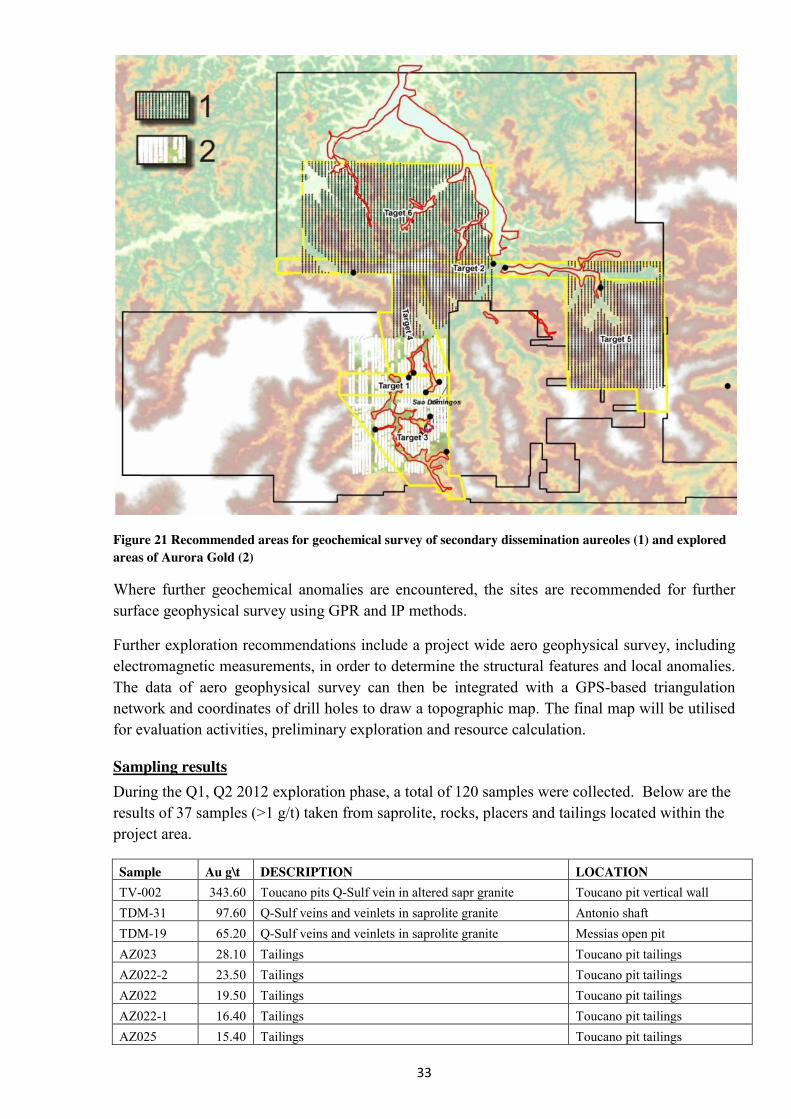
Figure 21 Recommended areas for geochemical survey of secondary dissemination aureoles (1) and explored areas of Aurora Gold (2)
Where further geochemical anomalies are encountered, the sites are recommended for further surface geophysical survey using GPR and IP methods.
Further exploration recommendations include a project wide aero geophysical survey, including electromagnetic measurements, in order to determine the structural features and local anomalies. The data of aero geophysical survey can then be integrated with a GPS-based triangulation network and coordinates of drill holes to draw a topographic map. The final map will be utilised for evaluation activities, preliminary exploration and resource calculation.
Sampling results During the Q1, Q2 2012 exploration phase, a total of 120 samples were collected. Below are the results of 37 samples (>1 g/t) taken from saprolite, rocks, placers and tailings located within the project area.
Sample Au g\t DESCRIPTION LOCATION TV-002 343.60 Toucano pits Q-Sulf vein in altered sapr granite Toucano pit vertical wall TDM-31 97.60 Q-Sulf veins and veinlets in saprolite granite Antonio shaft TDM-19 65.20 Q-Sulf veins and veinlets in saprolite granite Messias open pit AZ023 28.10 Tailings Toucano pit tailings AZ022-2 23.50 Tailings Toucano pit tailings AZ022 19.50 Tailings Toucano pit tailings AZ022-1 16.40 Tailings Toucano pit tailings AZ025 15.40 Tailings Toucano pit tailings
34
TV-006 12.50 Toucano pits Q-Sulf vein in altered sapr granite Toucano pit vertical wall AZ026-2 11.60 Tailings Toucano pit tailings TDM-04 11.50 Q-Sulf veins and veinlets Under Sao Domingo air strip AZ027-OR 8.28 Ore Toucano AZ032-1 7.70 Tailings Toucano AZ026-1 6.18 Tailings Toucano AZ027-1 6.11 Tailings Toucano AZ037 5.97 Tailings Toucano AZ031-3 5.84 Tailings Toucano AZ031-2 5.71 Tailings Toucano AZ023-OR 4.73 Ore Toucano AZ024 4.09 Tailings
AZ-054 3.94 Ore AZ030-1 3.47 Tailings AZ030-3 3.44 Tailings TV-011 3.01 Toucano pits reddish elluvium Toucano pit vertical wall
TV-004 2.78 Toucano pits Q-Sulf vein in altered sapr granite Toucano pit vertical wall AZ031-1 2.61 Tailings
TDM-26 2.49 Q veinlets 1 cm in brecciated zone Messias open pit AZ032A 2.48 Tailings
TDM-23 2.21 Q-Sulf veins and veinlets in saprolite granite Messias open pit AZ032-2 1.74 Tailings
AZ030-2 1.71 Tailings AZ030A 1.28 Tailings TDM-28 1.26 Q veinlets 1 cm in brecciated zone Messias open pit
AZ035-OR 1.20 saprolite TV-012 1.18 Toucano pits reddish elluvium Toucano pit vertical wall
TDM-29 1.15 Q veinlets 1 cm in brecciated zone Antonio shaft TDM-16 1.13 Q veinlets 1 cm in brecciated zone Colibri
Results of 19 samples taken from vertical walls of Toucano Open Pit are shown in Figure 7. As expected, there is a high-grade zone (TV011 - 3.01 g/t Au) between saprolite and lateritic clays in the transition zone. It is also noteworthy the presence of gold in the lateritic clays (overburden) with a grade of 0.4 g/t.
Sample results from the placer deposits show low grades, although taken at the bottom of the section. Sampling on a regular grid over the entire area of loose sediments *see report by Zaporozhets) is expected to give enhanced results.
Conclusions: The exploration phase during the initial half of 2012, coupled with data from previous campaigns has shown the project has great potential to host significant economic alluvial and hard rock mineralisation.
Following phases of the projects development will include quantitative parameters for sampling as applied to local conditions. Granulometric and mineralogical analysis of bulk samples from primary and placer occurrences is needed to identify the form of gold, grain size (fineness) and gold-bearing mineralogical associations. Efficient techniques for exploration and prospecting

35
sampling and the size of sampling channels will be reviewed. Channel samples will be verified using bulk sampling.
Check shall be made by assessing bulk samples with preliminary gravity separation of gold (sieving to 0.1 and -0.1 mm, and reduction, followed by separate assay tests of each fraction). If channel and bulk samples show significant differences in grades, the possibility of increasing the size of channels shall be considered, as well as preliminary gold separation applied. Site-specific sampling techniques will be determined on the basis of results of the experimental and various sampling methods.