rock art of nlaka'pamux: indigenous theory and practice on the british columbia plateau
TRANSCRIPT

ROCK ART OF NLAKA’PAMUX: INDIGENOUS THEORY
AND PRACTICE ON THE BRITISH COLUMBIA PLATEAU
by
Christopher Anderson Arnett
B.A., The University of British Columbia 1979
A THESIS SUBMITTED IN PARTIAL FULFILLMENT OF
THE REQUIREMENTS FOR THE DEGREE OF
DOCTOR OF PHILOSOPHY
in
THE FACULTY OF GRADUATE AND POSTDOCTORAL STUDIES
(Anthropology)
THE UNIVERSITY OF BRITISH COLUMBIA
(Vancouver)
April 2016
© Christopher Anderson Arnett, 2016

ii
Abstract
The ethnographic and archaeological data on Nlaka’pamux Interior Salish rock art is among the
richest of its kind in North America and offers a rare opportunity to study indigenous rock art in
the historical and cultural context of its production. Direct historical and cultural continuity offer
the advantage of foregrounding indigenous taxonomy and interpretation. With multiple sources
available (ethnographic texts, historical texts, archaeological data and localized indigenous
knowledge) Nlaka’pamux rock art can be detached from western theory and studied empirically
(temporally and spatially) as a material signature of practice within a circumscribed territory.
Nlaka’pamux rock painting, according to oral tradition, is an ancient practice. Many rock
paintings visible today appeared on certain landforms after the arrival of Europeans and
pathogens (smallpox) on the east coast of North America. Oral traditions state that Nlaka’pamux
knew of European presence prior to face to face contact and took active measures to mitigate the
impact using culturally prescribed means—speeches, dances and rock painting which occurred at
50 or so locations throughout the territory along travel corridors as early as the 16th century and
into the 20th century. In all its phases, Nlaka’pamux rock painting is a pro-active historically
contingent act of intervention with protection, demographic revitalization and intergenerational
memory in mind.

iii
Preface
This dissertation is original, unpublished, and independent work by the author. Very
small portions of Chapters 2 and 3 appeared in Archaeological Investigations at TSeTSeQU
(EbRk-2), an Nlaka’pamux Rock Painting Site on the Stein River, British Columbia. The Midden,
Volume 44, No. 3/4, pp. 17-22. 2012.
iv
Table of Contents
Abstract .................................................................................................................................................... ii
Preface ..................................................................................................................................................... iii
Table of Contents .................................................................................................................................. iv
List of Figures ......................................................................................................................................... ix
Acknowledgements ........................................................................................................................... xxi
Chapter One: They Dream it and Write It ...................................................................................... 1
Introduction ............................................................................................................................................................ 5
They Write Their Dream .................................................................................................................................... 9
Universal Rock Art ............................................................................................................................................. 16
Analogy and Neuro-‐Psychological Models .............................................................................................. 19
Historical Models ............................................................................................................................................... 23
The Trail ................................................................................................................................................................. 26
Nlaka’pamux ........................................................................................................................................................ 32
sht.ayn ..................................................................................................................................................................... 37
Summary ................................................................................................................................................................ 42
Chapter Two: An Archaeology of Nlaka’pamux Rock Painting ............................................ 45
Introduction ......................................................................................................................................................... 46
Nlaka’pamux Archaeological Chronology ............................................................................................... 47
Nlaka’pamux Rock Art ..................................................................................................................................... 49

v
Early studies/Spences Bridge/Stein River ............................................................................................. 51
Spences Bridge (EcRh-‐6, EcRh-‐8) ............................................................................................................... 53
Stein River (EbRj-‐5, EbRk-‐1) ........................................................................................................................ 58
Ts’paa’nk (EdRi-‐2 and EdRi-‐ 10) ................................................................................................................. 71
EdRi-‐2 ..................................................................................................................................................................... 72
EdRi-‐10 ................................................................................................................................................................... 76
Tcutciwi’xa (DhRa-‐2) ....................................................................................................................................... 78
Kwoiek (EaRj-‐80, EaRj-‐81) ............................................................................................................................ 83
Nahatlatch Lake (EeRk-‐1), Uztlius Creek (DlRh-‐1) ............................................................................. 87
Douglas Creek (EdRm-‐5) ................................................................................................................................ 88
Summary ................................................................................................................................................................ 89
Integrated Rock Art Archaeology Applied to TSeTSeQU, (EbRk-‐2) .............................................. 90
Methods .................................................................................................................................................................. 91
Painting Events ................................................................................................................................................... 92
Surface and subsurface features ................................................................................................................. 97
Initial Context ................................................................................................................................................... 100
Graphic Stratigraphy ..................................................................................................................................... 112
Conventional motifs ....................................................................................................................................... 120
Surface Features .............................................................................................................................................. 137
Subsurface Features ...................................................................................................................................... 140
Summary ............................................................................................................................................................. 155
Chapter Three: Ethnography of Nlaka’pamux Rock Art ....................................................... 163
Introduction ...................................................................................................................................................... 163
Simon Fraser ..................................................................................................................................................... 169

vi
Franz Boas .......................................................................................................................................................... 171
James Alexander Teit .................................................................................................................................... 172
Harlan I. Smith .................................................................................................................................................. 177
Charles Hill-‐Tout ............................................................................................................................................. 178
C. J. Hallisey ........................................................................................................................................................ 179
John C. Goodfellow .......................................................................................................................................... 181
Recent Ethnographers .................................................................................................................................. 183
Ethnographic Interpretations of Nlaka’pamux Rock Art Sites .................................................... 184
Tsaxalis (DjTr-‐4) ............................................................................................................................................. 184
DiRl-‐6 ................................................................................................................................................................... 188
Harrison Lake ................................................................................................................................................... 189
The “Coyote Rocks” or “Mysteries " (Speks ha ShenKee-‐yAp/ TSee-‐yA ha shenKee-‐yAp
shm.am /s’hhA. hha’s ha shenkee-‐yap shm.am) ................................................................................................... 191
s’hhA.hha’s ha shenkee-‐yap shm.am ......................................................................................................... 193
TSee-‐yA ha shenKee-‐yAp shm.am .............................................................................................................. 195
Skaitok (EcRh-‐8) ............................................................................................................................................. 197
s’keehh .................................................................................................................................................................. 210
ts’paa’nk/EdRi-‐2, EdRi-‐10 ........................................................................................................................... 215
Stein River EbRj-‐4/EbRj-‐5/EbRk-‐1 ........................................................................................................ 219
EbRj-‐4 ................................................................................................................................................................... 220
EbRj-‐5 ................................................................................................................................................................... 221
EbRk-‐1 ................................................................................................................................................................. 223
The Place Where Justice Was Administered (DiRb-‐17, DiRb-‐18 and DiRb-‐19, DiRr-‐4,
DiRb-‐15 and DiRb-‐20 .................................................................................................................................................... 225

vii
k´ay7ísxnm/ (DhRa-‐2) ................................................................................................................................... 228
zuhh’t/ ch-‐chut/nkAowmn ........................................................................................................................... 232
Thematic Interpretations of Rock Art from Ethnographic Sources .......................................... 235
shhwEY’m and hha.hhA muh ....................................................................................................................... 235
tumulh/ztsmn ................................................................................................................................................... 239
TSeQU ................................................................................................................................................................... 255
Rock Painting and atsama ........................................................................................................................... 262
Archaeological Signatures of Ethnographic Practice ...................................................................... 269
Chronology ........................................................................................................................................................ 276
Annie York and Richard Daly ..................................................................................................................... 279
Chapter 4: demEEwuh (“universal”) Theory—Towards a Perspectivist Archaeology of
Non-‐Material Site Formation ...................................................................................................................... 287
Introduction ...................................................................................................................................................... 287
demEEwuh .......................................................................................................................................................... 297
sptaqulh ............................................................................................................................................................... 298
atsama ................................................................................................................................................................. 303
shAytknmhh ....................................................................................................................................................... 307
hha.hhA ................................................................................................................................................................ 311
Annie York and Richard Daly on demEEwuh/atsama ..................................................................... 312
Accretions of Knowledge ............................................................................................................................. 315
Community-‐oriented Archaeology? ........................................................................................................ 318
Chapter 5:This Tells You the Way the World is Coming to. ................................................ 326
Introduction ...................................................................................................................................................... 326
Proto-‐contact America .................................................................................................................................. 327

viii
Smallpox ............................................................................................................................................................. 328
Precognition and Prophecy ........................................................................................................................ 334
Annie York on the Prophets and Rock Art ........................................................................................... 345
Material Signatures of Practice ................................................................................................................. 349
Intervention ...................................................................................................................................................... 356
A Kutenuxa Comparison .............................................................................................................................. 368
Rock Art on the Columbia River ............................................................................................................... 372
Extended Objects in Space .......................................................................................................................... 376
Chapter 6. That Indian Writing, I Tell You!You Gotta Be Pretty Clever To Know All
Those Symbols Of It. ....................................................................................................................................... 382
The Song Remains the Same ...................................................................................................................... 396
Prophecy in the Stein .................................................................................................................................... 401
Postscript ............................................................................................................................................................ 413
References ........................................................................................................................................... 417
Appendix .............................................................................................................................................. 459
Rock Paintings at EbRk-‐2, TSeTSeQU. ................................................................................................... 459

ix
List of Figures
Figure 1-1. Nlaka’pamux Territory. Map by John T.T.R. Arnett. ................................................ 32
Figure 2-1. TSeTSeQU, EbRk-2. Photo by Chris Arnett .............................................................. 45
Figure 2-2. Nlaka’pamux territory and Salish rock painting sites. Map by John T. T. Arnett. .... 50
Figure 2-3. Drawings by Carl Purpus of paintings at EbRk-8. After Purpus1892: 234. .............. 51
Figure 2-4. The“Basket Kettle of Coyote'sWife, ”EcRh-6, 1897. Photo by Harlan I. Smith.
Neg.42761. Courtesy of the Division of Anthropology, American Museum of Natural
History................................................................................................................................... 54
Figure 2-5. The“Basket Kettle of the Coyote's Wife” (east side). Photo by Harlan I. Smith.
Neg.42762. Courtesy of the Division of Anthropology, American Museum of Natural
History................................................................................................................................... 55
Figure 2-6. The "Coyote Stones" or "Mysteries, "1897. Note Nlaka'pamux road enlarged for cart
and wagon traffic in early 1860’s. Photo by Harlan I. Smith. Neg. 42764. Courtesy of the
Division of Anthropology, American Museum of Natural History. ..................................... 56
Figure 2-7. The“Vulva of the Coyote'sWife, ”1897. The“vulva”is the crack to the lower right of
the rock. Photo by Harlan I. Smith. Neg.42766. Courtesy of the Division of Anthropology,
American Museum of Natural History. ................................................................................ 57
Figure 2- 8. Large boulder with rock paintings, EcRh-8, near Skaitok, Spence’s Bridge, 1897.
Photo by Harlan I. Smith. Neg.54948. Courtesy of the Canadian Museum of History. ....... 58
Figure 2-9. EbRj-5, 2012. Photo by Chris Arnett. ........................................................................ 59

x
Figure 2-10. Rock paintings at EbRj-5 (left side of hollow), 1897. Photo by Harlan I. Smith.
Neg.42823. Courtesy of the Division of Anthropology, American Museum of Natural
History................................................................................................................................... 60
Figure 2-11. Rock paintings at EbRj-5 (right side of hollow), 1897. Paintings occur on
speleothem at left (see Figure 3-24) and on shadowed rock surface (Figure 2-12). Photo by
Harlan I. Smith. Neg.42822. Courtesy of the Division of Anthropology, American Museum
of Natural History. ................................................................................................................ 60
Figure 2-12. Drawing by Harlan I. Smith of rock painting at EbRj-5. Photo courtesy of Angela
Clyburn. S658. Courtesy of the Division of Anthropology, American Museum of Natural
History................................................................................................................................... 61
Figure 2-13. EbRk-1, 2012. Paintings are on the cliff just downstream from active talus slope.
Photo by Chris Arnett. .......................................................................................................... 63
Figure 2-14. John J. Oakes sketching rock painting at EbRk-1, August 1897. Photo by Harlan I
Smith. Neg. 42821. Courtesy of the Division of Anthropology, Museum of Natural History.
............................................................................................................................................... 65
Figure 2-15. Drawing by Harlan I. Smith of paintings at EbRk-1. Annotations by Teit. Photo
courtesy of Angela Clyburn. S658. Courtesy of the Division of Anthropology, American
Museum of Natural History. ................................................................................................. 66
Figure 2-16. Dynamited painted boulder (EhRc-90), 2014. Thompson River. Photo courtesy of
Angela Clyburn. .................................................................................................................... 70
Figure 2-17.spitkwa’uz, EdRi-2, 2013. Paintings are found adjacent to me and further along the
base of the cliff as the trail ascends. The 1988-89 excavations occurred in foreground. Photo
courtesy of Barbara Arnett. ................................................................................................... 72

xi
Figure 2-18. Drawings of rock paintings on cliff face at EdRi-2. Panel sequence runs left to right
along the base of the cliff. After Rousseau et al.1991, Fig.10. Courtesy Mike Rousseau. .. 73
Figure 2-19.1988/1989 excavations at EdRi-2. Note relationship to “panels” of rock paintings
(labeled PA, PB, PC)to excavation units. After Rousseau et al. 1991, Fig. 9. Courtesy Mike
Rousseau. .............................................................................................................................. 74
Figure 2-20. Frontal schematic drawing of rock shelter (EdRi-10) and excavation in relation to
rock painting. After Rousseau et al.1991: Fig.16. Courtesy Mike Rousseau. ...................... 77
Figure 2-21. Excavations at DhRa-2 with stratigraphy and radiocarbon dates. After Copp2006.
Courtesy Stan Copp. ............................................................................................................. 81
Figure 2-22. Map and sketches of rock paintings at EaRj-80 in relation to mountain topography.
After Angelbeck and Hall 2008:Figure 68. Courtesy Bill Angelbeck. ................................. 85
Figure 2-23. Rock paintings at EaRj-80. Note rock feature to left, rock shelter, and thick bands of
paint covered by speleothem. After Anglebeck and Hall 2008: Fig. 71. Courtesy Bill
Angelbeck. ............................................................................................................................ 85
Figure 2-24. Map of EaRj-81. After Anglebeck and Hall 2008: Figure 74. Courtesy Bill
Angelbeck. ............................................................................................................................ 86
Figure 2-25. Unit 2, EaRj-81, 2011. Note powdery fragmented red ochre concentration in lower
corner of unit next to hearth feature. Photo courtesy of Adrian Sanders. ............................. 87
Figure 2-26. Rock painting, EdRm-5, 2014. Photo courtesy of Peter Merchant. ......................... 89
Figure 2-27. Rock Paintings EbRk-2-54 and 55. DStretch enhancement. Photo by Chris Arnett 94
Figure 2-28. Detail of painting events, Group1, EbRk-2, 2012. DStretch enhancement. Photo by
ChrisArnett. ........................................................................................................................... 96

xii
Figure 2-29. Map showing location of EbRk-2, Stein River. The village of Stein is located on the
benches at the river mouth. ................................................................................................... 98
Figure 2-30. EbRk-2 (TSeTSeQU), 2014. Rock shelter and paintings are located on the cliff and
boulders (left). Note sandy river terrace, trail and river. Photo by Chris Arnett .................. 99
Figure 2-31. Geomorphology at EbRk-2, 2010. Note mechanical erosion (collapsed rock shelter).
Photo by Chris Arnett. ........................................................................................................ 103
Figure 2-32. DStretch-enhanced geomorphology, Group2, 2014. Note collapsed rockshelter.
Photo by John Arnett and Chris Arnett. .............................................................................. 104
Figure 2-33. Speleothem and paintings at EbRk-2, Group 3, 2014. Initial context (above),
DStretch enhancement (below). Photo by John Arnett and Chris Arnett. .......................... 107
Figure 2-34. Painting EbRk-2-136. Initial context (left), DStretch enhancement (right). Portions
of the speleothem matrix have fallen or been removed. Photo by Chris Arnett. ................ 108
Figure 2-35. Multiple paintings incorporated into cracks and speleothem covered surfaces. Initial
context (left), DStretch enhancement (right). Photo by Chris Arnett. ................................ 108
Figure 2-36. Painting EbRk-2-50 with natural iron oxide and speleothem. Initial context (left),
DStretch enhancement (right). Photo by Chris Arnett. ....................................................... 109
Figure 2-37. Painting EbRk-2-118 and natural mineral accretion. DStretch enhancement. Photo
by Chris Arnett .................................................................................................................... 110
Figure 2- 38. Rock Paintings EbRk-2-18 and 19 incorporated into quartzite veins. Initial context
(left), DStretch enhancement (right). Photo by Chris Arnett. ............................................. 110
Figure 2-39. Painting EbRk-2-178. Ungulate in a crescent. Note incorporation of painting into
surface features. DStretch enhancement. Photo by Chris Arnett. ....................................... 111

xiii
Figure 2-40. Rock paintings, EbRk-2. Initial context (above), DStretch enhancement (below).
Photo by Chris Arnett. ........................................................................................................ 113
Figure 2-41. Painting EbRk-2-100 superimposed on Painting EbRk-2-99. DStretch enhancement.
Photo by Chris Arnett. ........................................................................................................ 115
Figure 2-42. Image enhanced painting EbRk-2-12 (dark red left) and EbRk-2-11 (to right and
beneath EbRk-2-12). Photo by Chris Arnett. ...................................................................... 115
Figure 2-43. Photo mosaic showing graphic stratigraphy with Painting EbRk-2-52 (a “mountain
goat” and a “structure”) over an older painting EbRk-2-51 (two “five-pointed stars” joined
by a line). DStretch enhancement. Photo by Chris Arnett. ................................................. 116
Figure 2-44. Painting EbRk-2-68, superimposed over Painting EbRk-2-69. DStretch
enhancemnet. Photo by Chris Arnett. ................................................................................. 116
Figure 2-45. Left arm of painting EbRk-2-24 (“ghost”) overlapps earlier painting EbRk-2-21
(“thick band”). Note linear painting EbRk-2-23 (“earthline”?) overlapping EbRk-2-2-22
(“circle”). DStretch enhancement. Photo by Chris Arnett. ................................................. 117
Figure 2-46. Painting EbRk-2-123overlapping EbRk-2-124. Note lower “ray”of the
“sun”superimposed on the“grizzly bear arm.”Note also conformity of design to cracks in
the rock. Photo by Chris Arnett .......................................................................................... 118
Figure 2-47. “TLapEEsht.”Paintings EbRk-2-158 and 159. DStretch enhancement. Photo by
Chris Arnett. ........................................................................................................................ 119
Figure 2-48. “Mountain goat.” Painting EbRk-2-52, DStretch enhancement. Photo by Chris
Arnett .................................................................................................................................. 123
Figure 2-49."Bighorn sheep.”Painting EbRk-2-192. DStretch enhancement. Photo by Chris
Arnett. ................................................................................................................................. 123

xiv
Figure 2-50."Elk"?Painting EbRk-2-160. DStretch enhancement. Photo by Chris Arnett. ....... 124
Figure 2-51. Two ungulates with single body chevron, Painting EbRk-2-150. DStretch
enhancement. Photoby Chris Arnett. .................................................................................. 124
Figure 2-52. Painting EbRk-2-170. Ungulate with three body chevrons. DStretch enhancement.
Photo by Chris Arnett. ........................................................................................................ 125
Figure 2-53.“Ungulate”under arch. Painting EbRk-2-23. DStretch enhancement. Photo by Chris
Arnett. ................................................................................................................................. 126
Figure 2-54.“Ungulates”under arches. Painting EbRk-2-25. DStretch enhancement. Photo by
Chris Arnett. ........................................................................................................................ 126
Figure 2-55.“Grizzly bear tracks.”DStretch enhancement. Photo by Chris Arnett. ................... 127
Figure 2-56."sunulhkAz.”Paintings EbRk-2-98 (top) and EbRk-2-155 (bottom). DStretch
enhancement. Photos by Chris Arnett. ................................................................................ 128
Figure 2-57."sunulhkAz.”From top to bottom: Paintings EbRk-2-1, EbRk-2-18 and EbRk-2-145
and EbRk-2-148 (detail). DStretch enhancement. Photos by Chris Arnett. ....................... 129
Figure 2-58.“sunulhkAz.”Nahatlatch Lake, (EeRk-1). DStretch enhancement. Photo courtesy of
Brian Pegg. .......................................................................................................................... 132
Figure 2-59. “Horned lizard.” Paintings EbRk-2-13 (top), EbRk-2-117 (right) and EbRk-2-168.
............................................................................................................................................. 133
Figure 2-60."TLapEEsht." Painting EbRk-2-148. ...................................................................... 134
Figure 2-61. "Ghost" imagery, EbRk-2- 37 (top), EbRk-2-152 (middle left), EbRk-2-24 (middle
right) and EbRk-2-31 (bottom). .......................................................................................... 136

xv
Figure 2-62. Entrance to rock shelter showing manuport deposit in foreground, 2009. Excavation
unit occurred in light coloured area at entrance to collapsed shelter. Red “pictograph” in
right centre is recent (21st century) and has been removed. Photo by Chris Arnett ........... 139
Figure 2-63. Manuport deposit at EbRk-2, 2009. Photo by Chris Arnett. .................................. 139
Figure 2-64. Ground surface Unit 3 prior to excavation, EbRk-2, 2009. Note thin surface layer of
aeolian sand overlaying darker sediments and rootlets. Darkened rectangle is 30 cm x 50
cm. Photo by Chris Arnett. ................................................................................................. 142
Figure 2-65. Northeast corner of Unit 3 to sterile sand 13 cm DBS, EbRk-2, 2009. Note
alternating layers of layers of aeloian sand and darker strata, fire altered rock and sand
oxidized by fire. Photo courtesy of Adrian Sanders. .......................................................... 143
Figure 2-66. Northwest corner of Unit 3 showing culture strata to 13 cm DBS, EbRk-2, 2009.
Photo courtesy of Adrian Sanders. ...................................................................................... 144
Figure 2-67. Unit 3 excavation to sterile river sand showing hearth. Note manuports at right
surface and subsurface. Photo courtesy of Adrian Sanders. ............................................... 144
Figure 2-68. Red ochre fragment recovered from EbRk-2. ........................................................ 145
Figure 2-69. Plot of calcium and iron showing XRF results. Four types of ochre at EbRk-2 are
indicated by solid triangle, square, diamond, and star. Low iron samples (not ochre) marked
as “x” and others with calcium carbonate as dots. Plot courtesy of Rudy Reimer. ............ 146
Figure 2-70. Basalt debitage, Unit 3, 6 - 8 cm DBS. .................................................................. 148
Figure 2-71. Glass shatter, Unit 3, EbRk-2. ................................................................................ 148
Figure 2-72. Burnt fragment of Pecten carinus. ......................................................................... 150
Figure 2-73. Dentalia pretiosum bead, Unit 3, 9.5 cm DBS. ..................................................... 151
Figure 2-74. Prunus ssp. (left) and Rubus spp. Unit 3. ............................................................... 153

xvi
Figure 2-75. Laris occidentalis (western larch) pitch. In situ Unit 3, 6 cm DBS. ...................... 153
Figure 2-76. Spirally fractured tibia (?) of large land mammal, found with a single piece of fire-
cracked cobble at 4 cm DBS in Unit 4 beneath paintings in Figure 2-35. .......................... 155
Figure 2 -77. Posterior probability distribution of radiocarbon dates from EbRk-2 and EaRj-81.
............................................................................................................................................. 161
Figure 3-1. Copy of Fraser's map by Francis Harper with reference to Tsaxalis. After Hayes
2005:15. Courtesy Derek Hayes. ........................................................................................ 171
Figure 3-2. James Alexander Teit and Lucy Susanna Antko. Courtesy Nicola Valley Archives
Association. ......................................................................................................................... 173
Figure 3-3. Drawing and notes by James Teit of some rock paintings on “a large granite boulder”
(EcRh-90) below the “Coyote Rocks.”The rock was dynamited in the 20th century and
fragments with paintings are found on the riverbank (see Figure 2-15). Photo courtesy of
Angela Clyburn. Courtesy of the Anthropology Division, American Museum of Natural
History................................................................................................................................. 174
Figure 3-4. Tsaxalis (DjTr-4), overlooking the Fraser River showing various lines incised/sawn
into the rock, 2014. Another site with incised quartzite veins is located on the opposite
shore (See Mohs 1987). Photo by Chris Arnett. ................................................................. 186
Figure 3-5. Markings at Gilt Creek (DiRi-6), 1946. Carvings have been chalked. Moody Album.
Courtesy Royal British Columbia Museum. ....................................................................... 188
Figure 3-6. TSee-yA ha shenKee-yAp shm.am (The “Basket Kettle of Coyote's Wife”) (EcRh-6),
2013. Speks na shenKee-yAp (The Coyotes Penis is just visible on the upper right). Photo by
Chris Arnett. ........................................................................................................................ 191

xvii
Figure 3-7. Drawings by James Teit of rock paintings on s’hhA.hha’s ha shenkee-yap shm.am
“Vulva of the Coyote's Wife.” Nlaka’pamux explanations: a, grizzly bear; b, track of
grizzly bear; c, pool of grizzly bear; d, fir-branches; e, vulva of Coyote's wife; f, trench with
poles; g, Coyote; h, fish; i, arrow; j, cap with fringe; k, otter; l, grave poles; m, insect; n,
crossing of trails, sacrifices of food, and pole; o, insect kilazwa’us. (Teit 1900:Plate XX,
Fig.13). Note the “duck” figure” to the right of “g. Coyote” perhaps a reference to the white
duck, one of his wives (Hanna and Henry 1996:33). Photo courtesy of Angela Clyburn.
T458, Folder2, Courtsey Division of Anthropology, American Museum of Natural History.
............................................................................................................................................. 194
Figure 3-8. Drawings by James Teit of rock paintings on "The Basket Kettle of Coyote's Wife."
Explanations: 1, no data; 2 a, tree; b, Juniper-bush; 3 a, Earth, water and trees; 4 a, Catfish;
b, a fir-branch.5 a ................................................................................................................ 196
Figure 3-9. Drawing by James Teit of rock paintings on boulder at EcRh-8, Spences Bridge.
After Teit 1896: 229. ........................................................................................................... 199
Figure 3-10. Rock paintings at Skaitok, EcRh-8, 2014. DStretch enhanced. Note evidence of
superpositioning “made by various girls at the time when they reached maturity” (Teit
1896:227). Photo by Chris Arnett. ...................................................................................... 199
Figure 3-11. Puberty isolation lodge (nhho’hhwuheeyAten) of small fir trees and boughs,
Spence’s Bridge, 1914. Photo by James Teit. Neg. 27073. Courtesy Canadian Museum of
History................................................................................................................................. 202
Figure 3-12. Rock paintings of nhho’hhwuheeyAten (isolation lodges) made of fir bows from
EcRh-8. After Teit 1896: 229. ............................................................................................ 202
Figure 3-13. Rock paintings of fir boughs at EcRh-8, Spence’s Bridge. After Teit 1896:229. .. 204

xviii
Figure 3-14. Model wearing fir bough headdress of young woman, 1914. Photo by James Teit.
Neg. 27099. Courtesy Canadian Museum of History. ........................................................ 205
Figure 3-15. Two trenches, two sticks, or the numeral two. After Teit 1900, Plate XX, Fig.16.206
Figure 3-16. Rock paintings of cross-trails, EcRh-8. After Teit 1896:229. ................................ 206
Figure 3-17. Rock paintings of unfinished basketry or mats. EcRh-8. After Teit 1896:229. ..... 207
Figure 3-18. “Snake (“12”) and two dogs (“19”, ”22”), EcRh-8. After Teit 1896:229. ............. 208
Figure 3-19. DStretch enhanced detail showing figures added to EcRh-8 rock after 1896. Photo
by Chris Arnett. ................................................................................................................... 209
Figure 3-20. Drawing by James Teit of paintings at s'keehh. Photo courtesy of Angela Clyburn.
T458, Section 2. Courtesy Division of Anthropology, American Museum of Natural
History................................................................................................................................. 212
Figure 3-21. Drawing by James Teit of paintings on south face of s’keehh. Photo courtesy of
Angela Clyburn. T458, Section 2, Courtesy Division of Anthropology, American Museum
of Natural History. .............................................................................................................. 213
Figure 3-22. Drawings by James Teit of rock paintings at ts’paank: EdRi-10 (Fig. 6), EdRi-100
(Fig. 10) and other unidentified locations. Explanations: 6, three men, two of them with
feather headdress; 7a, black bear; b, fir-branch; c, snake; d, lakes and river; e, trench and
dirt thrown out; 8, Face with tears; 9.beaver; 10, a, trench and poles; b, unfinished basketry
or pile of fir branches; c, man; d, ........................................................................................ 215
Figure 3-23. Possible“avian”imagery at spitkwa’uz, EdRi-2, 2014. Photos by Chris Arnett. .... 218
Figure 3-24. Granite boulderwith rock carvings, EbRj-4, 1990. Photo courtesy of Paul Schmid.
............................................................................................................................................. 219

xix
Figure 3-25. Drawings of animals at EbRj-5 by Harlan I. Smith (left) and Chris Arnett (right)
showing relationship of the animals to “the trail that goes over the hill” (Smith 1932). .... 222
Figure 3-26. "The Place Where Justice Was Administered, "2014. Photo by Chris Arnett. ...... 225
Figure 3-27. Rock paintings at k´ay7ísxnm (DhRl-2). Similkameen Valley. ............................. 228
Figure 2-28. Drawing by James Teit of rock paintings at DhRa-2. Photo courtesy Angela
Clyburn. T458, Section 2. Courtesy the Division of Anthropology, American Museum of
Natural History. ................................................................................................................... 229
Figure 3-29.chul-chut. Early 1900’s. The “spirit of the place” paintings were formerly visible in
the pool area between the two sets of falls. Photo by J. S. Matthews. AM-54-S-38. Courtesy
Vancouver Library Archives. .............................................................................................. 232
Figure 3-30. Red ochre quarry at Tulmn /ztsmn (Tulameen). 2013. Photo by Chris Arnett. ...... 242
Figure 3-31. Strata atTulmn showing fine red ochre deposit, 2013. Photo by Chris Arnett. ...... 245
Figure 3-32. Young woman with face painted with red ochre for puberty training. After Teit
1900: Fig.208. ..................................................................................................................... 248
Figure 3-33. Nlaka’pamux face paintingAfter Teit 1930, Plate 6. ............................................. 252
Figure 3- 34. Dog halter. After Smth1899:114. .......................................................................... 258
Figure 3-35 Drawing by James Teit of paintings on Similkameen Valley boulder (DiRb-2), k,
“sun or earth and trees, ” l, m, n, “Vision of an adolescent meaning doubtful.” After Teit
1930: Fig 21. ....................................................................................................................... 266
Figure 4-1. North American vision quest model. After Atleo 2004:Fig.3. Courtesy UBC Press.
............................................................................................................................................. 303
Figure 5-1. Average rate of occurence/year of structured features of proxy demography on the
Plateau. After Campbell 1990, Fig. 6-8. Courtesy Sarah Campbell. .................................. 331

xx
Figure 5-2. Ghost Dance face paintings after Teit 1900:Fig 291. Upper row: 1) clouds, rain, rays,
something good descending from above; extension to ear has reference to hearing; 2) same
but including symbol of sun; 3) ascending rays of the sun. It may mean prayers or
something else ascending; the setting sun or the sun’s rays on the earth; 4) Thought to
represent a cloud line or clouds with sun rays ascending, the rising sun, the lower line
probably represents the earth. The painting may have some connection with speech; 5)
lightning or a rainstorm; 6) cloud line or cloud with rays of the sun shining on its side; 7)
the upper line may mean the sky the lower one a cloud, something good descending from
above, setting sun (Teit 1930:424). ..................................................................................... 344
Figure 5-3. Drawing of Nlaka'pamux cosmos by Nau'kwalis of Spences Bridge showing land of
the dead (top). After Teit 1900, Fig.290. ............................................................................ 355
Figure 6-1. TSeTSeQU, EbRK-2, Stein River, 2014. Photo by Chris Arnett. ............................ 384

xxi
Acknowledgements
I thank my committee Dr. Andrew Martindale (supervisor), Dr. Bruce Miller and Dr.
Michael Blake (committee members) for their unswerving support and guidance in the creation
of this work. I picked the best! A special shout-out to my supervisor for going above and beyond
the call of duty! I also thank my external examiner Dr. Stephen Silliman, departmental examiner
Dr. Jennifer Kramer and university examiner Dr. Paige Raibmon for their insightful and astute
comments. There are many others I thank who have helped along the way. First and foremost, I
thank my beautiful wife Barbara who has accompanied me to many sites and with whom I share
a depth and breadth of experience and knowledge impossible to surpass. My sons John and Carl
Arnett also accompanied me on later forays and offered insight and expertise which has
enhanced my knowledge. My Mother-in-law Judy Anderson has housed and fed me during these
past few years on Point Grey. My parents out in Sooke, John and Norma Arnett, have always
encouraged me in what I do. Among others are:
Peter Hubley, Willie Nahanee, Paul Schmid, Charles McNaughton, John Corner, Joe
Ritlop, Brenda Gould, Doris Lundy, Dan Leen, Grant Keddie, Gerry Freeman, Chief Ruby
Dunstan, Grand Chief Bob Pasco, Wendy Wickwire, Michael M’Gonigle, Dana Lepofsky, Ken
Lay, John McCandless, Charles Southwell, Rita Haugen, Willie Dick, Ina Dick, Louie Philips,
Rosie Fandrich, Willie Justice, Andrew Johnny, Steve Paul, Amy Hance, Mary Anderson, E.
Richard Atleo, Mick Hesselin, Mauriri McGlinchey, Stan Copp, Al Mackie, Morgan Ritchie,
Adrian Sanders, Bryan Gordon, Michael Klassen, Iain McKechnie, Jesse Morin, Susanne
Villeneuve, Nick Waber, David Whitley, Daniel Arsenault, James Keyser, Peter Merchant, Beth
Velliky, Stacy Thom, John Haugen, Natasha Lyons, Rebecca J. Wigen, Brian Pegg, Johnny

xxii
Jones, Bill Angelbeck, Juan Francisco Ruiz Lopez, Gerard O’Regan, Rudy Reimer, Chelsey
Armstrong, Nyra Chalmers, Brian Pegg, Frank and Gail Neumann, David Pokotylo, Zhichun
Jing, Dr. Ellen White, Arvid Charlie, Leslie Tepper, Andrea Laforet, Angela Clyburn, Chief
David Walkem, Jean-Michel Geneste, Rafael Pont, Sue Rowley, Amy Charlie, Richard Daly and
Annie York.

1
Chapter One: They Dream it and Write It
And every man that goes and practices in that mountain—whatever he dreams he writes it out.”
Annie York
I had no interest in rock art until I visited xuluxuls, Squamish for
“markings”, a rock art site on the shores of Howe Sound in British Columbia. I
grew up in the Squamish territory a few miles south of the site we visited but knew
little about the culture let alone nearby rock paintings or pictographs as they are
commonly called. When a friend mentioned that he had a Squamish friend who
would show us a rock painting site, I was curious to go. My only preconception was
that rock art was rudimentary—stick figures, lines, dots, animals—uninteresting.
After a short walk along the railway track we climbed down through the
trees and along a steep rocky shoreline to an open space above the water with
spectacular views south towards the entrance to Howe Sound. Behind us a vertical
rock face of granite reflected sunlight from the water shimmered across well-
preserved paintings in different shades of red made with brushes or fingertips in a
place very much like it was right now. The “rock art” of xuluxuls was abstract and
unfamiliar—bigger and bolder than I had imagined. Some of the paintings, covered
with a film of water, glistened. In some places lichens and algae grew in close
proximity to the paintings. The outdoor setting was multi-sensory—rock, art, ocean,
distant islands, trees and sky.

2
Our guide enthusiastically pointed out the various figures—a “wolf, ” a
“killer whale, ” “stars, ” a “crescent moon, ” “rayed sun, ” “stars, ” and
“planets” (“Mars” and “Venus”) but the one that drew the most of our attention
was a large human-like figure unlike anything I had seen before. It was painted
with a red ochre paint over a thick deposit of speleothem, the groundwater-borne
white mineral precipitate that coated the painting with successive layers made
translucent with seasonal groundwater seepage down the rock face.
He pointed to the biceps which the painter had carefully delineated in the
flexed arms of the standing figure—“a powerful man”—we were told, who
appeared in the last millennium. I noticed the prominent skeletal ribs of the figure
and immediately thought of similar motifs in the literature on “shamanism” that
was enjoying wide circulation in the 70’s and 80’s.
He told us the professional name of the person who made the markings—
someone called a kwitsit, a man or woman who knew how to use the tumulh, the red
ochre paint, and the proper song to accompany the markings.
The local knowledge, well-preserved paintings, spectacular setting and the
awareness that there were hundreds of similar displays throughout the Pacific
Northwest, each unique and specific to the place, was most impressive. After the
trip we talked about writing a book about the site. Our guide had a two-page hand
written manuscript and while I was enthusiastic I knew little about the subject or
how to proceed. If it is any consolation the visit to xuluxuls changed my life and this
work is a result, friend.

3
In 1985 I went to the Stein River, a tributary of the Fraser River, in the
western territory of the Nlaka’pamux Interior Salish of the British Columbia
Plateau. On a cold rainy day in March we walked the old trail by the river visiting
rock painting sites in the lower canyon including the largest site in the valley. Here
the trail passed close to the base of a wet granite cliff where numerous paintings,
some placed as high as 6 meters above the ground, are found for a distance of 74
meters. Most of the imagery at the site had never been recorded and red ochre
paintings seemed to be everywhere although many were barely legible from
erosion, or partially covered with speleothem, lush lichen, algae or moss. As I
explored the site and pushed away the brush to see the paintings I knew that it was
the largest group of paintings in the Nlaka’pamux territory and that one might
spend a long time studying them. I later learned that the place was called
TSeTSeQU, the nlha.kapmchEEn translation of xuluxuls—markings, pictures,
writing.1
I became involved in a broad coalition of local and urban people opposed
to any late 20th century industrial use of the Stein River Valley. The large group of
paintings I had seen on that rainy day in March was located along the base of a
major cliff-faced outcrop of granite that restricted access into the valley to the
original trail that skirted the base of the cliff. The proposed logging access road
was surveyed to cut across the upper portion of the cliff which would require
blasting and the removal of rock with probable negative impact to the rock art site
1 nlha.kapmhhchEEn words are transcribed according to a writing system developed for the Nlaha.kapmhh Language Program (Nlaka’pamuc Nation Tribal Council 2007).Indigenous words not italicized in the text remain in their original transcription and await confirmation of pronunciation.

4
below. The logging company argued that impact from falling debris would be
minimal but the site was well known to local Nlaka’pamux and many of them were
concerned about its protection.
As someone informally studying rock paintings, I was able to work in the
valley on behalf of the Western Canada Wilderness Committee and the Lytton and
Mount Currie Indian Bands (as they were then called) to visit and record all of the
17 known sites along the valley corridor and to interview Nlaka’pamux elders born
at the beginning of the 20th century on what they were willing to share. Some told
us the that the red ochre paintings (called TSeQU) were made by people they call
shoowushnA-m, (literally “mysterious/powerful protecting spirit song”) the
Nlaka’pamux “Indian doctor.” The name says it all. We learned that paintings
appeared and disappeared, they made songs, they talked, but when people tried to
communicate with them, at least in the 20th century, the paintings replied in a
language they didn’t understand. A woman told us that her father and uncle were
camped by the river near a well-known site and heard singing throughout the night
from the hollow where the paintings were found. A few weeks later another cave
with well-preserved rock paintings was rediscovered by helicopter, 1.5 km above
the river on the side of a mountain overlooking the valley.
All of this was to be used in the political and legal arena where the future
use of the place was being debated by the provincial government, private citizens,
business lobbies, and First Nations.
It was obvious that rock art in the path of industrial expansion could play a
significant role in protecting the physical integrity of a valley ecosystem. In the end

5
this is exactly what happened. In some ways, these paintings in the Stein River
valley fulfilled an original purpose to preserve and protect people and place.
Introduction
In the territories of the Nlaka’pamux, an Interior Salish speaking people of the British
Columbia Plateau (Figure 1-1), are certain rock formations—mainly granite—including cliffs,
outcrops, boulders, and caves marked by various designs made with a red ochre paint. Some of
these marked places are secluded and difficult to find but most, including those with the largest
numbers of paintings are located along important land and water travel corridors in full view of
passersby. Even though they are among the most visible of archaeological sites, these rock
formations with paintings are not particularly well understood, which should be surprising
because at one time all of them were well-known places with names, histories, and other non-
material properties. That all these aspects should be largely forgotten is not surprising when
recent history is known.
In the era of the modern settler nation state the anonymity of these inscribed places
might be seen as direct evidence of demographic collapse in the wake of the European
colonization of indigenous territories and communities in North America following 1511 AD.2
Indigenous traditions in the Pacific Northwest (e.g. Lummi, Sechelt, Squamish, Katzie, Tsleil-
Waututh, Nlaka’pamux and others) hold that the plagues appeared before the first Europeans
were seen (Harris 1997:67; Hill-Tout 1899; Suttles 1954:42, Teit 1900:174; Wells 1966) a
pattern known elsewhere in the western hemisphere (Cieza de Leon 1864; Dobyns 1966, 1986).
In some areas fatalities may have been as high as 90% (Boyd 1999; Harris 1994) and with the
2 This is the date of the earliest known incidence of smallpox on the east coast (Florida) of North America (Jones 2014).

6
loss of people came a corresponding loss of knowledge of details of places and associated
practices. The majority of Nlaka’pamux escaped the devastating plagues until 1862 (Teit 1900).
Population fell dramatically but the people and the culture adapted and survived as they have
for millennia. In the 21st century, descendant communities of Salish people such as the
Nlaka’pamux maintain direct historical and cultural continuity with their ancestors and their
historical territories and places.
Among Nlaka’pamux, where the names and stories are known, places with rock
paintings are shhwEY’m (“the transformed”) and represent the bodies, body parts or artifacts of
ancient beings turned to stone by QUeeQUTL’QUeTLt (the Transformers) or shenKee-yAp
(Coyote) during a time period called sptaqulh (“the stories/narratives”) when the social order of
the present world was established (Laforet and York 1998; Mohs 1987; Teit 1898, 1912; Teit et
al. 1917; Thompson and Egesdal 2008). The narratives about shhwEY’m are detailed and
complex (See Teit 1898, 1912). shhwEY’m are said to be the bodies of ill-disposed
shoowushnA-m drowned by lhQUOOba (Beaver); others originated as the body parts of
cannibal beings dismembered and thrown across the landscape by legendary heroes. Because of
these associations, shhwEY’m are also hha.hhA-muh (“mystery places”) to degrees. In this
sense rock painting sites are both physical places and social entities with visible and non-
visible properties. All exist within demEEwuh—a useful nlha.kapmchhEEn word to describe
the world and everything in it (Laforet and York 1998:61-62).
Not all such rock formations in the Nlaka’pamux territory are marked. The marking of
shhwEY’m was dependent on historically contingent and culturally prescribed collaborations
between people and the geomorphology. While many of the narratives of these places have
disappeared forever with those who knew them, the cultural significance of the paint and the

7
imagery used to mark them survives as a living practice that may, with caution and consultation
with indigenous descendants, be a lens to interpret past events and the meaning, or more
appropriately, the act of rock painting. This dissertation is about exploring and unpacking this
significance.
Based on indigenous knowledge and previous archaeological work (Copp 2006;
Rousseau et al.1991) we know that Nlaka’pamux rock painting locations have a considerable
antiquity and an importance that continues in the present. The material content of rock art
locations has two contexts: the paintings on the rock surface and the surface and surface or
subsurface remains of human activities that may or may not be associated with the production
of the rock art. These are material signatures, the residue of unique individual and collective
acts. It follows that a combined examination of these archaeological contexts will reveal
important data on the material site formation processes of Nlaka’pamux places with rock
paintings. This data in turn may be interwoven with local ethnographic, ethnohistoric and
indigenous anthropology to advance a multi-directional study of this record. This is the logical
route I take in this analysis.
My effort is an attempt at a scholarly synthesis of western academic and indigenous
Nlaka’pamux knowledge. As such it strives for a cumulative path, in which different kinds of
knowledge are layered upon each other (See Bierwert 1999). However, I also argue (following
Martindale and Nicholas 2014) that juxtaposition of different ways of knowing is both
insufficient for inter-cultural translation and a potential mask of ethnocentric assumptions.
Thus, this work is also a reflexive mediation on translation between knowledge-worlds. This is
not an end in itself, although the vulnerabilities to bias and its masks are complex and worthy
of fuller analysis than I provide here. Rather, it is a means to an end—an effort to weave a

8
richer and more accessible understanding of Nlaka’pamux rock art and its meanings for a non-
Nlaka’pamux audience. Throughout, I follow Atleo’s (2004) directive to value description
(data) above explanation (causality), as an effort to minimize the vulnerability to
ethnocentrism. Foundational to this view is that Nlaka’pamux explanations of their history and
the world are historically causal and thus real, even when these beliefs appear fantastical to the
non-Nlaka’pamux reader. The result is a series of refracted views on Nlaka’pamux rock art:
archaeological, ethnographic, Nlaka’pamux, and historical. These form the basis of a re-
examination of the scholarship of Annie York whose knowledge formed the basis of the
foundational text on Nlaka’pamux rock art by Annie, Richard Daly, and myself (York et al.
1993). We did not fully understand what Annie was saying in this original work. Nlaka’pamux
rock art is more than we understood it to be. It is a material signature of intangible (spiritual)
intervention to protect land and people
The most visible current forms, the red ochre paintings we see today, mitigated
colonial invasion—a historically contingent purpose that emerged from a long tradition of
practice. I identify two main chronological periods: a 16th to early 19th century form that I
associate with the spiritual intervention of Prophets and a 19th to 20th century form that I
associate with the puberty rites and ceremonies of adolescents. Although distinct in time,
composition, author, and content, I interpret these as facets of a singular Nlaka’pamux response
to the colonial invasion of North America. The Prophet period represents the effort of powerful
shoowushnA-m to forestall invasion of Europeans and their diseases by intervention in the
spiritual realm. The training and fertility period occurs after significant depopulation and other
deleterious colonial effects and represents the Nlaka’pamux effort to mitigate colonization by
preserving the people (via the emphasis on fertility) and the traditions (via the emphasis on

9
spiritual training). Though the practices are different, they represent a coherent, historically
contingent response that can only be understood through an appreciation of Nlaka’pamux
cultural worldview and history. This thesis is an exploration of this worldview and history and
the rock art it produced in response to the colonization of North America.
In many ways, Nlaka’pamux rock art is the material expression of the non-material. It
represents the expression of both intentional, conscious (what sociologists call discursive)
knowledge as well as knowledge that is less conscious, less discursive, more associated with
the practices of everyday life and the deep philosophical and epistemological frameworks they
invoke (Giddens 1986). As I discuss in subsequent pages most of the visible Nlaka’pamux rock
art, particularly rock paintings, represent acts of intervention, boundary maintenance (perimeter
defense) and demographic revitalization from approximately 500 BP to the current era.
Although this medium has great antiquity, its most visible, and thus abundant form (to
contemporary eyes) is directed at mitigating the upheavals associated with the colonial invasion
and its waves of influence prior to and after the arrival of colonists. Red ochre painting in the
proto-contact and contact era can be understood with reference to a millennia-long suite of
Salishan traditions and part of an extended temporal field that reaches back into the deep past
drawn up into the present to address the unseen future—a traditional indigenous response to
crisis. Nlaka’pamux rock art is not just explicable with reference to universal human qualities
of physiology and cognition, but as a historical and contingent response to the upheavals—
physical, societal and cultural—imposed upon them by unprecedented events.
They Write Their Dream
This work builds on a previous work (York et al. 1993) compiled from 16 hours of taped
interviews made by Richard Daly in Spuzzum, British Columbia with an Nlaka’pamux cultural

10
authority Annie York on the subject of rock paintings or, as Annie preferred to call them,
writings—an English term closest to their Nlaka’pamux meaning. During these interviews
Richard Daly used a set of drawings from 17 different rock painting sites of the Stein River
valley, which I had compiled both on my own and during work for the Nlaka’pamux Nation in
1987-88. What began as an independent research project on Richard’s part, with Annie’s help
became for each of us an opportunity to apply an activist anthropology aimed at educating the
public sphere about the potential destructiveness, socially and environmentally, of late 20th
century industrial forest extraction in the Stein River Valley, a tributary of the Fraser River at
the eastern edge of the Canadian Plateau in the Nlaka’pamux territory of southern British
Columbia. Our collaborative work was published in 1993 and recognized, on account of Annie
York’s co-authorship, as both a singular contribution to the study of rock art (Whitley 2010)
and a problematic work arising from issues of representation and interpretation (Keyser and
Whitley 2006; Layton 2006; Wickwire and M’Gonigle 1994).
Annie York was co-author of the 1993 work in that she shared or, to be more accurate,
deferred writing duties to Richard Daly who while attentive to Annie’s exact words and
knowledge regarding ritual practices, was informed by his own contextual understanding of
Nlaka’pamux rock painting through the 19th century work of James Teit. Using copies of my
drawings of Stein paintings as a guide, the interviews focused on detailed consideration of
possible meanings embedded in the linear compositions for which Annie drew largely on her
knowledge of trail signs made from sticks and broken branches which the linear iconography of
the black and white drawings resembled.
Our work also applied a theoretical paradigm of rock art developed by South African
researchers David Lewis-Williams and Thomas Dowson (1988) based on the resemblance of

11
rock art imagery to entoptic (within the eye) imagery of trance as identified by neurological
science. Lewis and Dowson elaborated a three-stage model of trance imagery seemingly
applicable to rock art sites found worldwide. Initially a universal interpretation, the authors
have modified their stance over the years recognizing both the diversity of practice worldwide
including rock art that is not derived from such states (Dowson 2009; Lewis-Williams
2012:30). Nlaka’pamux rock art conformed to the model fitting well with Annie York’s
statements and 19th century ethnographic accounts of rock art production. Richard Daly viewed
Nlaka’pamux rock painting as a system of proto-writing borne of vision questing dreamers
representing both a biological process and an encoded semiotic system universal to all cultures.
He theorized on the origins of world writing systems from similar dream derived imagery
found in other times and places (York et al. 1993).
With a real sense of urgency to educate the Canadian public about a place in danger of
imminent and destructive industrial resource use, a book was planned. Daly’s interviews with
Annie York on the subject matter and origin of Nlaka’pamux rock “writings” in the Stein
Valley were organized and edited by Daly to form a coherent readable text. In the original
interviews Annie had a tendency to repeat what Daly said and sometimes lose her train of
thought. In some instances there was confusion over the subject as well, which further
complicated Daly’s desire to provide an accurate transmission of what she said. This is the way
of conversation but the editorial “clarifications” allowed Daly’s own comments to be included
here and there verbatim in the book to assist the reader’s comprehension but leaving the
impression that they were all Annie’s words. The editorial intervention was infrequent but
occurred enough in areas where the nuance of what she said was missed. While the substance
of the dialogue remained intact these editorial additions were included in the published 1993
12
text and in one instance used to substantiate a theory based on a perception of faulty
transcription but not in the way the critique imagined.
Keyser and Whitley (2006) reconsidered the hunting magic interpretation for Plateau
rock art using a selective sampling of ethnographic (mainly specific practices of “sympathetic
magic” taken out of context) and a passage and images from our 1993 book. In one instance
Annie identified a conventional rock painting image as two ungulates standing inside a crescent
shape. She said that it represented a sptaqulh of someone dreaming of catching two deer in a
snare and being admonished by QUeeTL’QUeTLt for greed (the theme of “greed is not good”
being a frequent interpretation for many of the “stories behind the pictographs) (York et al.
1993:124). Later, however, the same image is encountered in another drawing but her
interpretation is different: “Deer and Goat, the things the hunter wants. The deer and goat are
not in a snare. That’s the way you write it. It shows he has caught them in his mind. That’s
what his mind sees, like inside an egg” (York et al. 1993:161).
Keyser and Whitley (2006) seized on this portion of the text as it seemed to illustrate
their theory that rock art could be a form of hunting magic. They claimed that the word “not” in
the phrase “deer and goat are not in a snare” was an error in transcription (and not fitting their
deductive hunting magic hypothesis). However, the original conversation reveals Annie talking
about one thing (the image in relation to sptaqulh) and Richard talking about another (cognitive
visualization of game). The topics are not unrelated but not exactly as published. Annie did not
say, “The deer and goat are not in a snare. That’s the way you write it.” These are Richard’s
words based on his understanding of Annie’s teaching as may be seen in original conversation:
RD: But the things of their concern are a lot of animals on the other side. AY: Yeah RD: That they would be hunting questions?

13
A: It’s easier to get deer and goats up here. Yeah that looks like a deer and a goat in the two halves of a heart isn’t it? But the man you see, the man, that’s his thinkings. He thinks that he would like to have everything on that side. That’s why they have the two here. RD: But why are they encapsulated like this inside of a… AY: He’s trying to… RD: Focus on them? AY: That’s the way he wants it. RD: Like two yolks of an egg? AY: Yeah, but he wasn’t allowed to have him. That’s why a small animal is born just like a human being complete. RD: Well when you see these animals in a sort of bubble that’s the focusing of the dreamer on his quest. AY: Yeah [reluctantly] (17/9/89:40-41).3
Richard Daly used inductive reasoning, based on other examples in Annie’s teachings, while
Keyser and Whitley employed deductive reasoning looking to confirm the hypothesis. Both
approaches lacked prior knowledge, the essential requisite to abductive logic and cultural
understanding. It is incorrect to see Richard’s role as a misunderstanding. Rather he and Annie
York are having two different conversations at the same time. He is appreciative of her
knowledge but also thinking in universal terms grounded in both limited exposure to
Nlaka’pamux culture (and here I refer to both its discursive and less discursive forms writ into
the context and practices of life as well as the self-consciously held ideas about things cultural)
and his enthusiasm for the potential of more universal logics which might explain the origin of
symbolic communication. Annie’s position is more complex in that she is both an instructor of
“rock writing” but one faced with the vastness of the cultural difference between herself and
Richard, and a subaltern to Richard’s professional, cultural, and disciplinary power (Richard
would insist that he was the subaltern but that is not the point here). These conversations, and
the moments of dissonance such as this one that they capture, illuminate the divide between us
3 References to the original conversations between Richard Daly (RD) and Annie York (AY) are cited by date of interview and page number of the transcript in the author’s possession.
14
as cultural beings and our ambitions as scholars to achieve what Martindale and Nicholas
(2014) refer to as a federated space of knowledge—where all knowledge is considered.
Listening again to the original interviews I realized that there was an over-riding
theme in the conversations not readily apparent to anyone reading the book—a story of
individuals involved in the spiritual defense of the country. I became aware of this narrative by
re-listening to and re-transcribing the tapes in chronological order being thus privy to the
development of the conversation and the teaching and learning that was occurring.
Richard Daly had argued that Nlaka’pamux rock painting was a “socially understood
form of communication”—a “proto-writing” based not on a linguistic code but “the concrete
results of living people having written down their often inspirational messages from their
dreamings” to share with others (York et al.1993: 225). He was interested in the specifics of
the imagery as a form of communication in the sense of a “proto-literacy” that took seriously
the English translation of the Nlaka’pamux term for rock art, “writing”—derived from
culturally informed experience based on altered states of consciousness, or “dreaming.” Daly
argued, “that First Nations people saw rock writing as an affair of the mind, a question of
meditative focusing and a sensitivity to the ancient narratives within which they, as
descendants, were working and acting” (Richard Daly personal communication, 2009). In some
ways he followed a tradition in British Columbia anthropology of reading art as a language-like
symbolic form of communication (Boas 1900; Duff 1975; Martindale 2013), which some of it
certainly is, but art serves other equally pragmatic purposes. The only thing missing from this
analysis was the historical context.
Annie York communicated a message regarding the historical context of production that
was documented in the original interviews and all but lost in the translation. She interpreted
15
much of the imagery of Stein Valley and Fraser Canyon rock art in terms of local origin stories
(sptaqulh) because she expected this subject matter to be there. Annie was taught that the rock
paintings of the Stein Valley and other places were the work of historical Prophets from the late
18th early 19th centuries or earlier. She asserted that they communicated a central message of
the Prophet to uphold the teachings of sptaqulh and in particular the importance of spiritual
training (atsama). This narrative, of how the rock art was a strategic intervention against the
encroachments of colonization, was missing from our original analysis (even though it was so
apropos to our political cause). It was foundational both to the history of these places and to
Annie York’s scholarship. This dissertation is about bringing this explanation to light and
reflecting on its significance in the interpretation of Nlaka’pamux history and rock art traditions
in general.
Nlaka’pamux rock painting represents a range of meanings from the abstract and
philosophical to the contingent and situational—across many scales from the collective and
intergenerational to the individual and biographical. Key issues situated here relate to
anthropological and archaeological theories of rock art such as: the relationship between “art”
and ritual, indigenous resistance to colonization, and reconciling archaeology with Indigenous
historical consciousness. Rock painting, then, is like oral history with multiple levels of
meaning4 but cognitively particular to the degree of prior knowledge.
Nlaka’pamux rock painting is part of an ancient Salishan practice where red paint is
used to accomplish specific tasks on a range of media related to situations where there is a need
for physical and spiritual protection. Much of the visible rock art today is not the product an
essentialized timeless practice but instead a culturally pragmatic activity in the Nlaka’pamux
4 Thanks to Bruce Miller for this observation.

16
territory by proactive men and women. The result of their efforts is distributed across the
landscape as a material expression of a historically contingent cognitive process in response to
the physical and spiritual colonization of North America.
Universal Rock Art
The application of paint to landscapes of fixed geological landforms is a universal phenomena
that brings to mind the famous 36, 000 year old “cave art” of Upper Paleolithic Europe (Clottes
and Geneste 2012) or the incredibly diverse work found on the Australian continent, where
rock painting has occurred continuously over 39, 000 years into the 21st century (Moorhead
2000). There are numerous sites, spectacular and not, across the world on every continent
except Antarctica. Fascination for these paintings and the search for the origins of human
consciousness, communication, culture, conflict or art tend to neglect contextual indigenous
interpretations. This tension between the universal and the particular is endemic to
anthropology and as Atleo (2004) argues, western scholars tend to favor universal explanations
over strongly local, temporally and culturally specific relational variability of practice. This is a
logical inversion that places deductive explanation above inductive observation when the
reverse is the foundation of science (Martindale and Nicholas 2014).
Rock art publications often juxtapose images from diverse times and places as if
marking landforms is motivated everywhere by the same causes. Perhaps it is partly true.
Cross-cultural similarities are intriguing and the comparative method is always suggestive but
universal theories and cross continental comparisons must not constrain discussion of culturally
and historically specific areas where, obviously, the painting of landforms is a practice intrinsic
to place and to its unique attendant permutations of history. The ambition of universal,
deductive explanations tends to attenuate the local, in this case indigenous, view.

17
An individual familiar with different sites across the globe cannot fail but recognize the
similarities in the selection of unusual geology or acoustics that undoubtedly formed part of
what attracted people to these places and motivated them to paint during certain time periods.
The ubiquity of the practice in human societies over time and space suggests a universal
anthropic origin (either analogically learned or neurologically derived) for the art and the place
where it is made but always under circumstances that are culturally specific and historically
contingent. In this sense it is like all cultural expressions, individual practice negotiated via the
structuration of society. The challenge of western scholarship of indigenous rock art is to
question the very universal explanations that make some sense of these obviously evocative but
effectively silent expressions. A historically contingent approach to rock art, while more
possible in the historic era, undermines western scholarship’s most powerful method.
Over the past century, places in the world with rock art (petroglyphs and pictographs,
etc.) have been the subject of archaeological and anthropological study with results
proportionate to the personal, historical and social contexts of research agendas.5 Approaches to
the study of rock art include ethnographic interviews (Conway 1993; McMurdo 1972; McLeary
2008; Porr and Rachel 2012; Teit 1896; York et al. 1993), spatial analysis (Lundy 1974;
Norder 2003; Norder and Carroll 2011), the study of the graphic stratigraphy, or superposition,
of paintings (Brady and Gunn 2012; Loubser 2010; Loubser and Keyser 2004) and, less often,
the excavation and analysis of associated subsurface sediments (Copp 2010; David 2002;
Mohs1987; Leondorf 1996; Whitley et al. 1999). Very few studies (see Clottes and Geneste
5 Excellent summaries of which may be found in Bednarik 2007; Blundel et al. 2010; Carlson 1993; Gillete et al. 2015; Keyser 1992; Leondorf et al. 2005; Lundy 1974; MacDonald and Veth 2012; Neddy 2007; Seglie 2010; Whitley 2001

18
2013; David 2002; Mohs 1987) have focused on the relationship between the archaeological
deposits and rock painting events to locate the latter in time.
World scholarship has compiled information on different aspects of rock art production
using various technical and discursive analyses of “formal methods to explore the physical
properties and spatial context of archaeology or “informed” methods that rely on ethnographic
data (Bahn 2010; Bednarik 2007; Chippendale and Nash 2004; Chippendale and Tacon 1998;
Lewis-Williams 2002; MacDonald et al. 2013; Norder 2003; Seglie 2010; Whitley 1987, 2001)
Bednarik, an internationally known rock art researcher and critic, refers to this vast literature as
“a cacophony of hypotheses about what it all means” (2007:2). He argues that meaning “is not
a part of rock art science until ways are found to present propositions about it in a falsifiable
format” (2008:153). Hypotheses framed in contexts that preclude their testing are always fertile
ground for ethnocentric vulnerabilities (Martindale and Nicholas 2014).
The interpretation of rock art must consider local ethnography but more critically, it must
prioritize local indigenous knowledge, which differs from ethnography (and ethnohistory)
because it is not a description of a people by outsiders rendered through a western academic
frame. Indigenous anthropology is a localized knowledge system based on long-term,
intergenerational, sustainable use of land. Its ultimate expression—language—is an available
source to access levels of meaning (Coffin 1987; Little Bear 2000:78; Harris 2006). Theoretical
movements in this direction are emerging in rock art scholarship.
Posthumanist rock art studies reject universal essentialized qualities in human nature as
the foundation of human agency and offer a (non-anthropocentric) material agency perspective
as a method to complement Western ways of knowing with Indigenous perspectives (David
2002; Goulet and Miller 2007; Knappet and Malafouris 2008; McCleary 2008; Morwood 2002;

19
Martindale and Nicholas 2014; Norder 2012; Wallis 2009). These approaches argue that culture
is writ across the material worlds of individuals who, in granting both discursive and less-
discursive forms of meaning to things, inhabit a world in which things echo individual and
collective meanings. Posthumanism thus considers animic ontologies, non-human agency and
rhizomic personhood (a metaphor to describe connection, heterogeneity, and variability in
identity formation) as ways to move beyond limited logocentric rationalist approaches of
European intellectual traditions where history is interpreted as the consequence of cost-benefit
optimizations by groups motivated by self interest as opposed to the mutual self interest of the
perspectivist world (Sahlins 2008).
Analogy and Neuro-Psychological Models
Ethnographic analogy and the neuro-psychological model are two methods used to interpret
rock painting (see for example Blundell et al. 2010). David Lewis-Williams, whose work in
southern Africa renewed interest in the use of ethnographic texts in interpretation of rock art,
argues convincingly that rock art can only ever be understood in terms of the beliefs, values
and metaphors evident in the mythology and ceremonies of the people who produced it (2002).
Out of this work he and Thomas Dowson developed a “neurological bridge” to the past arguing
that rock art imagery might be interpreted as visual evidence of the four stages of trance, a
model derived from the documented cross-cultural hallucinatory experience of seeing entoptic
phenomena associated with altered states of consciousness as experienced in the visionary
experience or trance of shamans or others in related “shamanistic” practices (Dowson and
Lewis-Williams 1988; Lewis-Williams 2000). There is now a consensus of opinion that
phosphene motifs (15 known standard form constants) are autogenous involuntary phenomenon
of the mammalian visual system that matches rock art imagery almost universally (Bednarik

20
2007:159-160, Fig.54; Lewis-Williams and Dowson 1988). With this model the projection of
mental imagery onto surfaces is proposed as the origin of two dimensional and engraved
paintings in Paleolithic Europe and elsewhere (Clottes and Lewis-Williams 1998). In this view
rock art emerges from an autonomic cognitive process producing images in the mind that are
then associated with meanings and left as a visual material record.
The neuro-psychological model for the production of rock art inspired American and
Canadian researchers to revisit 19th and 20th century anthropological texts for a closer reading
of indigenous worldviews and ritual practice as it related to rock art in western North America
(Blundel et al. 2010; Keyser and Poetschat 2006; McCleary 2008; Whitley 1987, 2000; York et
al. 1993). Whitley in particular stressed the importance of using ethnographic material and the
neuro-psychological model to generate hypotheses regarding rock art production among
Indigenous people of the Great Basin desert, California and the Columbia Plateau (Whitley
1992, 1998, 2000, 2006).
David Lewis-Williams and Thomas Dowson’s (1988) three-stages of trance model with
its corpus of entoptic iconography provided a plausible neurological explanation for the imagery
in the Stein Valley and resonated with the Nlaka’pamux origin of rock art imagery in the vision
quest, or in a dream. The uniformity that Dawson and Lewis Williams saw in the “Signs of all
Times” across time and space supported Daly’s contention that rock art, wherever it is found,
was characterized by a propensity for humans to “write down” human experience to
communicate spiritual, social, political and economic life and was universal in its application.
Richard Daly wrote that:
The iconography which Annie was eager to read and interpret is remarkably widespread in terms of human geography and human history. The stylized realism of the images has been recorded in many lands since the period of the last Ice Age. It is an integral part of our human history of thinking conceptualizing and writing

21
down our physical, social and psychic experiences. This iconography has been a medium not only for Nlaka’pamux people but also Europeans and others to record aspects of their history for thousands of years (York et al.1993:225).
Daly argued that “what was encoded was not a spoken language but, rather, situational specific
experiences made meaningful in relation to an ancient and locally rooted cultural tradition and
cosmology, as well as to a relatively stable, bountiful and sedentary economic life” (1993:225).
Robust local data (such as language) permits a finer resolution of universal theories.
Alternate states of consciousness (the non-material) were an important part of Nlaka’pamux
reality and the geometric imagery of rock art may be influenced or even derived from entoptic
sources but its origin as a method may be only partly based on internalized geometric
hallucinations made external. TSeQU in the Nlaka’pamux language is the term for “rock art” or
any marking, including, writing, pictures - the designs on baskets, clothing, bodies, artifacts
and geology. The word TSeQU seems to be derived from its root iQU, a phoneme with several
roots that refer to scratching, scraping, itching and by extension marking and striping
(Thompson and Thompson 1996:10) thus the name for rock art is derived from the marks and
the sounds made by fingernails (or claws) when scratching something or scraping the insides of
hides with tools or fingers to remove fat in the preparation of skins and leaving the often
parallel marks behind.6Thus the concept of marking and image making, at least among
Nlaka’pamux, is part analogical and a direct observation of a world where knowledge is
6 A similar argument may be made against the overtly entoptic interpretation offered for the imagery found in European paleolithic sites such as Chauvet where super-positioning on the “Panneau des Chevaux” revealed that the first markings in the sequence were by cave bears followed by those of humans who were likely not projecting entoptic imagery but engaged in an iterative process (Clottes and Geneste 2012).

22
“shared” or presented. Thus the saying “Nature is the Teacher” 7 which is not the romanticized
notion westerners might perceive but a pragmatic one where patterns emerge from close
observation through experience and practices and deeds are successful according to their effects
on the world. Paintings are not random or even culturally expected hallucinations projected
onto a rock surface but conventional images made in collaboration with the rock surface, which
if anything projects onto the viewer.
This is not to say that visionary states did not play an important role in the creation of
Nlaka’pamux rock painting, they most certainly did, and many if not most images painted,
carved and tattooed were derived from dreams sometimes prescribed by sna.m or the dead
(ancestors) (Boas 1900; Teit 1930). Annie York was unfamiliar with the trance theory but
understood the relationship between visionary altered state of consciousness or “dreaming” and
certain rock paintings as she explained to Richard Daly on June 11, 1990 at her home in
Spuzzum:
AY: Most of them stories are being dreamed by other people and they dream it and write it. RD: They know the story and it may come up in their dreams so they write it. AY: They write it—something like hippies (laughter). You see? RD: [taken aback] That’s not what Nathan [Chief Nathan Spinks] said—its like going to a university. AY: The hippies—they eat that mushroom and they dream about these things and they write it on the wall what they dream. RD: The hippies. AY: Yeah (6/11/90:7).
At the time of the interview Daly was unaware of Dowson and Lewis-Williams’ 1988 paper
hence his surprise that an elder would make a direct comparison between the origin of a
something as “sacred” as rock art and western cultural norms of graffiti and psychedelics.
7I was introduced to this phrase by resident elders Ray Peters (Quw’utsun) and Dr. Ellen White (Snuneymuhw) at Malaspina College (now Vancouver Island University) in 2000-2001.

23
Adherents of the trance model further argue that privileged access to visionary states in
the past may have marked the beginning of social conflict and hierarchy by individuals who
created the rock art in subterranean enclaves or elsewhere (Lewis-Williams 2002a, 2006). Rock
art as a form of social division or exclusion finds expression among North American rock art
researchers who often cast the rock painting of shamans as some intimidating visible
expression of their power (Shulting 1995; Whitley 2010:127-132). Assumptions of social
division based on autonomic cognitive processes or models of social inequality impose a
western lens on very different societies. People may be motivated to act for reasons other than
economic or social gain especially when such behavior is contrary to the cultural norm as
expressed in sptaqulh.
Among Nlaka’pamux power was accessible to everyone—there was no exclusion based
on sex or status rendering a model of exclusive access an ethnocentric imposition.
Nlaka’pamux rock artists painted strategically with intention. The subject matter of this
intention comes from many sources including spiritual (in the sense of non-material) sources
such as dreams and/or related to protective guardian spirits (sna.m). These combined agencies
are then used as a technology (rock painting) to make things happen and influence the course of
events. The entoptic model is useful in understanding some of the neurological building blocks
of rock art iconography but ignores the practical side of things, that is, “human action in the
world” (Sahlins 1981:5).
Historical Models
In this analysis, I follow many contemporary rock art scholars who advocate an integrated
approach characterized by interdisciplinarity: spatial analysis, “forensic archaeology” (the
archaeological study of microscopy, nano-stratigraphy, element analysis and digital

24
photography of painting super-positioning combined with subsurface excavation) and, where
possible, ethnography and indigenous knowledge, to illustrate the connections between
painting and places (Bednarik 2008; Blundel et al. 2010; David 2000; Norder 2003, 2012;
Norder and Carroll 2011; Sheehan and Lilley 2008). In doing so, I wish to foreground the
tensions between the universal and the particular, the textual and the semiotic, the individual
and the society, the discursive and the less discursive, the archaeologist and the rock art, all of
which are part of both the interpretation of rock art and of Annie York’s meditations upon its
meaning. In this sense, I wish to explore indigenous knowledge as a form of prior knowledge
of time and place that emerges from, as Ingold (2010) cleverly frames it: the variegated ground
(context), the wayfarer’s path (collective and individual biography), the wind and weather
(friction or frictionlessness in cultural practice) and signposting (the conscious and less
discursive signaling of meaning through the distributed agencies of circumstance). As
Chippendale and Tacon (1998:7) observe, iconographic meanings “cannot be standardized or
accessible by any generalizing rules of an anthropology of art but are instead variable;
historically idiosyncratic, and ethnographic insight into an informed knowledge is essential to
that kind of understanding.”
The present work draws on theories of practice and agency where paintings are, on one
hand, the patterned material expression of deliberate individual acts but also material agents in
themselves according to an indigenous epistemology (and an anthropology of art) that
attributes personhood and agency to art (Gell 1998). Rock paintings are permanent reminders
of a specific activity constrained and enabled by prevailing social norms. They offer an
opportunity to explore the relationship between these material cultural expressions in the
context of a society mitigating European expansion in the Western Hemisphere. Indigenous

25
specialists reacted proactively to the crisis with culturally prescribed activities that were, in and
of themselves as practices, often culturally proscribed.
Cultural site formation processes are defined “as the processes of human behavior that
affect or transform artifacts after the initial period of use in a given activity” (Schiffer 1987:7).
This is a broad category that includes the primary activity, the practice that creates the
archaeological signature and its interpretation over time into the present. Retooling his concept
of cultural site formation processes can better reflect the field of inquiry in the study area where
indigenous scholarly traditions are extensive, available and, when used in conjunction with
archaeological method, indispensible to understanding the non-material cultural site formation
process essential to interpretation.
Nlaka’pamux rock painting has never left its context (one of the reasons, precisely,
why it was created). The point of course is that archaeologists can create new contexts that may
have little to do with the original purpose of the artifact, what Montelle (2010) calls “false
taxonomies, ” instead of recognizing the ongoing systemic context of rock art sites.
Nlaka’pamux rock painting is a material signature of the prior knowledge of the time and place
of an intergenerational kincentric world. Thus it is advantageous to study rock painting
phenomena from the perspective of material and non-material formation processes (place and
space) over time to identify variables associated with its production. Interdisplinarity is more
than an accumulation of different methods. It requires a mutual understanding of metaphors and
metonyms as translation devices to learn how to see and what to look for based on one’s
experience. As Annie York told Richard Daly: “You don't know what you don’t—see it.”

26
The Trail
The idea that intervention, boundary maintenance and demographic revitalization will leave a
material signature is supported, figuratively speaking, by four house posts: archaeology,
ethnography, indigenous anthropology and ethnohistory. If the goal of traditional historical
anthropology is to integrate the subject matter of archaeology into colonial history (Pauketaut
2001), here I develop a way (following Sahlins 1981 and Kame'eleihiwa 1992) of looking
culturally at a certain history through interdisciplinarity—that is—recognition of localized
indigenous anthropology as a method of analysis. This is a complex issue with contemporary
manifestations and tensions regarding identity and authority. I follow TallBear “in figuring out
how to articulate overlapping respective, intellectual, ethical, and institution building
projects—how to share goals and desires while staying engaged in critical conversations and
producing new knowledge and insight” (TallBear 2015). In the present work I refer to this as
the non-material site formation processes of Nlaka’pamux rock art sites. I argue that a focus on
the combined recovery of material (archaeology and ethnographic and historic texts) and non-
material (Indigenous anthropology) site formation processes enlarges the data set of
Nlaka’pamux rock painting to contextualize its practice culturally and historically. I move from
the empirical and descriptive towards the iconological and interpretive.8 Thus my approach is
8 Iconology—knowledge of icons. The approach is influenced by the art history theory of Edwin Panofsky who advocated a method for the analysis of material culture referred to as “works of art” beginning with 1) the primary descriptive or pre iconographic, informed by history of forms 2) the iconographic informed by a history of types (archaeology and ethnography) with “insight into the manner in which, under varying historical conditions, specific themes or concepts were expressed by objects and events”(Panofsky1939:41). The third step, iconological interpretation, “ arises from synthesis rather than analysis” and deals with the intrinsic meaning or content “constituting the world of “symbolical’ values” (Panofsky 1939:34). Here the equipment for interpretation involves a synthetic intuition informed by familiarity of the history of the material culture (for example “rock art”) and particularly by “insight into the manner in which, under varying historical conditions, essential

27
both cumulative (I add different empirical layers via distinct epistemological and
methodological approaches) and translative (I weave a single analysis between these layers).
As a primary document of direct empirical evidence, orthodox archaeology is essential
to understanding the site formation process of Nlaka’pamux rock painting sites. Chapter 2
looks at the history of archaeological research in the territory and the empirical spatial and
temporal data of Nlaka’pamux rock painting sites with particular focus on the archaeological
assemblage at EbRk-2 a rock painting site on the Stein River with the largest amount of rock
painting found in the territory. Formal archaeological analysis of rock art sites includes
attention to the initial context9 (the geomorphology), the paintings on the rock surfaces and the
associated surface and sub-surface archeological deposits. Bearing in mind that not all
subsurface deposits at rock art sites may relate to actual painting activity (see Bednarik 2007;
Lim 2010:100; Whitley1998) in the Nlaka’pamux territory, where cultural deposits and
material culture are determined by robust perimeters of regional site formation processes, finer
resolution may be made between the association of rock paintings and subsurface deposits. The
results of archaeological excavations at four Nlaka’pamux rock painting sites (EbRk-2, EaRj-
81, EdRi- 2 and 10) and the Upper Similkameen site of Tcutciwi’xa (DhRa-2) produce a
chronology of material signatures comparable to the ethnographic descriptions of rock art
production and other ritual activity associated with these sites.
Chapter 3 looks at the ethnographic record of Nlaka’pamux rock art to demonstrate the
variability of 19th century practice and its bearing on chronology. The ethnographic record on
the production of “rock art” in the Nlaka’pamux and neighboring Salish territories of the
tendencies of the human mind were expressed by specific themes and concepts” (ibid: 41) that is, historical contingencies. 9“Initial context” is a term used in geo-archaeology to describe the interface of human and geological activity (Rapp and Hill 2006). Here I use it the same way and add the cultural aspect of precedence.

28
Pacific Northwest is among the richest in North America.10This is due to the cultural and
historical continuity of people and place and the research interests of non-native scholars who
worked at a time when detailed knowledge of paintings, practice, and the individuals, who
painted, survived. Many researchers have recognized the value of this work and it is often
referenced in studies on Salishan and Plateau rock art (Boreson 1974; Bouchard and Brown
1996; Corner 1968; Hill and Hill 1974; Gjessing 1952; Goodfellow 1928; Kennedy 1979,
1988; Keyser and Taylor 2006; Keyser and Whitley 2000; Klassen 2003; Leechman 1954;
Loubser 2006; Lundy 1974; Teit 1896; Whitley 2006; York et al.1993; Wickwire 1986). All of
this work has been important in identifying sites, patterns, materials and cultural practices but
very little attention is made to the significance of the cultural practice of rock painting in
relation to its variability and to the historical context of its production.11
Interpretation must also consider indigenous anthropology (in this case localized
Nlaka’pamux knowledge) and its application in theory and method to archaeology. Chapter 4
argues that an understanding of Nlaka’pamux worldview is necessary to interpret the
archaeological and the ethnographic records. Nlaka’pamux elders, practices,
10 Whitley (2000) makes an identical claim for the California region of the United States. For historical and geographical reasons the Pacific Northwest people avoided the more brutal impacts of genocide and forced relocation that beset Native California (Heizer 1974) and retained much greater cultural and geographic continuity (Tennant 1990; Carlson 2001). 11 Notable exceptions are Teit’s study of 19th century Nlaka’pamux rock painting at Spences Bridge (1896) , Strong’s (1940) comparison of rock art iconography within the spatial distribution of the Plateau Ghost Dance of the late 18th and early 19th centuries; and the temporal association between the iconography of the Tsagaglalal Columbia river rock art and funerary iconography found with cremated victims of 18th and early 19th century epidemics on the Columbia River (Butler 1965; Keyser 1990). Cash Cash’s Niimipoo indigenous language analysis of a Salishan rock art site situated the production of certain southern Plateau rock art within a specific time period of proto-contact (2004). In Australia much research is focused on post-contact era rock art (Frederick 2012; Moorwood 2000; Tacon et al. 2012).

29
nlaha.kapmhhchEEn language and landscape provide the method for non-Nlaka’pamux
comprehension.12
Indigenous anthropology, as local intergenerational knowledge of time and place, is
rarely assimilated into western scientific discourse because of the perceived epistemological
problems that seem diametrically opposed, mutually unintelligible, and non-interdisciplinary
worldviews or paradigms (cosmologies) (Denis 1996; Little Bear 2000; McGhee 2000; Mason
2006). The critique of McGhee (2000) and Mason (2006) is more apparent than real both
because of a misunderstanding about what exactly indigenous anthropology is and the
deference to a perception that Eurocentric views ought to be privileged. Humility is not an
important value in western culture—indigenous anthropology asserts it is the norm (Atleo
2004). Why should scholars aspire to humility? Atleo argues that western science consistently
places its own philosophical beliefs above those of indigenous communities when studying
indigenous people, while claiming that culture is not an influence. Humility creates the
expectation that an archaeological understanding of indigenous culture and history is limited (in
spite of its technical expertise) in the interpretation of the indigenous past (Atalay 2012;
Martindale and Nicholas 2014; Silliman 2008; Wobst 2006; Wylie 1993). It is the essential
component of an Nlaka’pamux research method (atsama—the vision quest) used successfully
12This work is foregrounded in the regional indigenous anthropology of Nlaka’pamux and draws on personal interaction with Nlaka’pamux elders including Rita Haugen, Rosie Adams, Amy Charlie, Mary Anderson, Amy Charlie, Willie Dick, Ina Dick, Hilda Austin, Louie Philips, Rosie Fandrich, Willie Justice, Andrew Johnny, Steve Paul, Amie Hance, and Annie York. Although contact was limited, sometimes only an hour or so, all of these people contributed valuable information on rock painting. Annie York, who figures largely in this work, was an Nlaka’pamux scholar who worked with non-native scholars on linguistics, material culture, history and ethnobotany, many of whom acknowledged the import of her indigenous knowledge to their own comprehension of the discursive and non –discursive nature of Nlaka’pamux culture. Many emphasized her contribution in co-authored work (Laforet and York 1986; 1998; Turner et al. 1990; York et al. 1993).

30
for millenia. Non-Nlaka’pamux may never attain a similar level of cultural insight but we have
much to learn from that which is locally and cuturally specific.
As Deitler and Herbich (1998:233) observe “all archeological inferences about past
societies… hinge critically upon an understanding of the relationship between material and
non-material aspects of culture and society: left with only remnants of the former we seek to
use them to perceive and comprehend the latter. That is the essence of the archaeological
endeavor”. No archaeologist would deny this but no one would argue that the non-material
aspect is inaccessible without informed sources. Indigenous epistemologies and logical
frameworks accessible through oral traditions, cultural practices and language offer new
methods to understand peoples relationship with landscapes, site formation process,
chronology, iconography and ultimately, the purpose and meaning of places with rock art.
In the space of a century following the arrival of Europeans and Africans on the
Atlantic coast in 1492 the western hemisphere witnessed catastrophic demographic collapse, by
some estimates up to 97% in the wake of European-sourced microorganisms that travelled
across the well established roads and highways of the Americas far beyond physical contact
(Boyd 1999; Dobyns 1966, 1986; Harris 1994; Jones 2014). Within a relatively short time
millions died and thousands of years of social and cultural institutions disappeared or changed
forever. This is the broad context, the proto-contact period, in which any discussion of the post
1492 North America must be grounded. Chapter Five explores this history and its connection to
Salishan rock art.
For Nlaka’pamux people, the presence of Europeans in North America was made
known by various Prophets who were informed by the dead of what was to be and how to
prepare. For an undisclosed time prior to the records of the earliest European visitors,

31
throughout the Pacific Northwest Prophets or dreamers visited the Chief of the Dead and
returned spreading the word of coming changes. In culturally prescribed response people
“died” and visited the land of the dead bringing back confirmation of the presence of
newcomers and offered culturally prescribed pro-active measures to meet the challenges of a
changing world. Nlaka’pamux, like many indigenous people of the Pacific Northwest, knew
well in advance of European presence long before Europeans knew about the indigenous
people of the Pacific Northwest. Visits to the dead, dancing and media were proactive measures
to mitigate the emergency. These measures of intervention, perimeter defense and boundary
maintenance taken by Nlaka’pamux specialists ensured that plague did not reach their
territories until 1857/1862. When it did arrive it was ruthless. The practice of rock painting
changed though a central theme remained. The visible record of Nlaka’pamux rock painting is
a culturally and historically specific activity congruent with these (and other) events.
Chapter Six, entitled “That Indian writing. I tell you. You gotta be pretty clever to
know all the symbols of it, ” summarizes the data of Nlaka’pamux voices and considers,
according to indigenous epistemology, the long-term strategy of indigenous activists in the past
in aid of the present. The emergent and active role of Nlaka’pamux rock art in the late 20th
century to confront a proposed logging access road in the Stein River Valley, British Columbia
is used to highlight the historical and cultural continuity of the indigenous values of rock art.
Chapter Six explores this confrontation as the latest in a series of confrontations between
Nlaka’pamux people and colonial invaders in which rock art is a medium of power. In this
thesis I argue that the production and experience of Nlaka’pamux rock art is not ahistorical but
historically contingent. To explore these issues, I first consider Nlaka’pamux people, their
culture, lands and history.

32
Figure 1-1. Nlaka’pamux Territory. Map by John T.T.R. Arnett.
Nlaka’pamux
In the previous section I argued that an Indigenous theory approach to the archaeology of rock
art was necessarily founded on an understanding of indigenous culture, although I noted that
this is a complex challenge of translation. In this section, I begin the process of developing that
translative space by reviewing the anthropological knowledge of the Nlaka’pamux. This is one
beginning point, but not the only one, though it will be a familiar point of departure for many
archaeologists. It is also not the end point. Rather I argue that the knowledge we need to
understand Nlaka’pamux rock art goes well beyond traditional ethnographic summaries and
rock art literature. Crossing the chasms of cultural difference (White Deer 1997) via the rope

33
bridges of logic (Ames and Martindale 2014) requires first steps and initial cables on which to
begin weaving a mutually constructed history.
The traditional territory of the Nlaka’pamux Interior Salish13occupies the southwestern
corner of the British Columbia plateau into Washington State (Figure 1-1). TLKumchEEn,
(Lytton) at the confluence of the Thompson and Fraser Rivers is considered by many to the
physical, spiritual and political center of the Nlaka’pamux universe (Hanna and Henry 1996;
Teit 1900, 1912). Their vast land encompasses a diverse topography from the wet forests on the
northeast shore of Harrison Lake, along the Coastal Mountains from Spuzzum north along the
Fraser River to the dry country of Texas Creek south of Lillooet. East from the center,
TLKumcheen, the dry Plateau portion of the territory follows the Thompson River to
nlKumcheen (Spences Bridge) and on to the open country and of Ashcroft and the kaarst
country of Oregon Jack Valley. To the south the territory includes the Nicola Valley and lake
country and the headwaters and valleys of the Similkameen and upper Skagit Rivers.
The territory is figuratively conceived as a great sh. EEshdkn (“winter house”) marked
by five posts with TLKumchEEn, (Lytton) as the center post. In some accounts TLKumchEEn,
is described as the physical and spiritual origin place of all Nlaka’pamux. In a famous 1858
speech, marking the end of conflict with the foreign gold miners, the great 19th century
Nlaka’pamux leader shwooshpntlm defined the posts or boundaries of the territory at that time:
One post up the Fraser at [Fountain]—one down the Fraser at Spuzzum—one up the Thompson River at Ashcroft—one up the Nicola River at Quilchena—one down the Similkameen River at Tcutcuwi’xa. All the country between these posts is my country and the lands of my people. At Lytton is my centre-post. It is the middle of my house, and I sit there. All the country to the headwaters of all the streams running into the valleys between these posts is also my territory in which my children gather food. We extend to meet the boundaries of the hunting
13 Linguistically and culturally the Nlaka’pamux are related to 26 other groups of the Salish language family collectively called Interior Salish (Thompson and Thompson 1992).

34
territories of other tribes. All around over this country I have spoken of, I have jurisdiction. I know no white man’s boundaries or post. If the whites have put up post and divided up my country, I do not recognize them. They have not consulted me. They have broken my house without my consent. All Indian Tribes have the same as posts and recognized boundaries, and the chiefs know them since long before the whites came to the country” (Hanna and Henry 1996:5).14
The five posts define a territory of five regions based on geography, mythical ancestry, history
and dialectics of nlaha.kapmhhchEEn (the Nlaka’pamux language) (Laforet and York 1998;
Teit 1900:170-171; ). In some accounts the four posts are described as “the doors of my house”
(Teit et al. 1917:59) leading to a network of ancient travel corridors or “roads”15 along which
traveled animals, people (with their artifacts and produce) and non-material entities.
shwooshpntlm had some nominal jurisdiction over this vast area under a system that had
elements of participatory democracy in which an individual’s locally-based socially-achieved
status was contingent on performance and collective benefit of the entire social group (humans
and non humans). In the Similkameen, a region of amalgamation and intermarriage between
14 On the biography of shwooshpntlm see Teit 1912. The engraved marble text on the David Spintlum (shwooshpntlm) monument in the town of Lytton carries the inscription:“David Spintlum made his post at Spuzzum; at Lillooet; at Stathshone; and at Sheheouos and these are the four posts of the Thompson tribal territory” (see Waite 1972). In this text “Stathshone” is thought to correspond to Ashcroft while “Sheheouos” seems to be a rendition of shchOOwA- wuh (Tcutcuwi’xa). Working in 1904 Teit considered Tcutcuwi’xa (as he spelled it) to be “an Okanagan name” used by them to refer to the district and vicinity (in the same way the Nlaka’pamux at that time referred to the same area as Snaizist in reference to the village and the mineral formations above Hedley that were “striped like a goats wool blanket” (Teit 1928:205). The word fits comfortably in nlaha.kapmhhchEEn, as shchOOwA- wuh “a little creek that runs all the time” (Thompson and Thompson 1996:736; Nlaka’pamux Tribal Council 2007:18) very similar to the spelling of the reserve name Chuchuwayha but dissimilar to the Similkameen dialect. 15 So-called by the earliest workers for the North West Company who recognized them for what they were (Bergon 1989: 225; Cox 1831; Ross 1849). The extent of the Nlaka’pamux trail system is shown in an undated and unsigned map derived from a map of 1835 made by Samuel Black, Chief Trader and then Chief Factor at Thompsons River post from 1831 to 1841 (M’Gonigle and Wickwire 1989; Wickwire 1986:21-23). Although there is some uncertainty over the exact date of the map it is valuable for its portrayal of Indigenous travel corridors in the Salishan territories of Southwestern BC.

35
Stuwix, Nlaka’pamux and Sylix, the people describe themselves as having “kin based corporate
control over strategic resources” (Copp 2006:47) reflecting Coast Salish systems of
redistribution and circulation of goods, people and ideas (Miller 1999; Suttles 1987; Miller
2006). Nlaka’pamux social organization differs from that of state societies, which are
characterized by inequality (a class system) defined by the separation of power from society
(Angelbeck and Grier 2012; Clastres 2010) and the separation of society from nature (Atleo
2004, 2008; Latour 1993). Non-state society is characterized by an inclusive social equality (in
the sense of all things human and non-human) with no separation of power and society as often
assumed for the pre-contact past (Hayden 1997; Prentice and Kuijt 2003). All people existed
within the constraints and challenges of this social order as kin within a house—a metaphor for
the ecosystem and not unlike the Greek origin of the word ecos or house.
At the center post are the TLKumchEEn-mhh (“people of lklumsheen) often referred to
as “the Nlaka’pamux proper.” The slahh’yuwuhmhh are north of Lytton towards Lillooet, while
south are utamqtmhh, the people of the Fraser Canyon below Siska to Spuzzum. East through
the dryer plateau Thompson River region are the nkumsheen’numhh “people of the entrance” at
Spences Bridge towards Ashcroft, while the tsawa’hhamhh identify with the Nicola River and
Lake south to the Similkameen “post” of Tcutcuwi’xa (Sheheouos) (Hanna and Henry 1996:3-
6; Teit 1900).
Within these broad designations, smaller social groups based on villages further
refined and defined the diversity of local landscapes and watersheds along the Thompson
Nicola and Fraser Rivers (Teit 1900:171). Thus shpzhmhh are “people of the little flat” shpzhm,
sht.aynmhh are the people of sht.ayn, a village and river trail system just north of the
confluence of the Thompson and Fraser Rivers, ztsnmhh, “people of the red paint, ” and so on.

36
Populations of Nlaka’pamux as with all Interior Salish people were much higher prior to
smallpox and other European introduced disease and attendant increased warfare, displacement,
social and cultural disruption (Teit 1900; 1928).
The southeastern portion of the Nlaka’pamux territory in the Similkameen River
region experienced shifts of indigenous populations in proto and post-contact times (Bouchard
and Kennedy 1984; Teit 1900:174, 1928:204-205). As a major travel corridor the Similkameen
Valley was an area in transition beginning in the early 18th century after the introduction of the
horse when Sylix (Okanagan) people under pressure from European invasion east and south,
began to displace the indigenous Athapaskan-speaking Stuwix whose territory extended from
the Okanagan river to the Nicola Valley (Bouchard and Kennedy 1984:12-22; Teit 1900:166;
Teit 1928:214; Wyatt 1971). Nlaka’pamux encroached from the east and north intermarrying
among the Stuwix as early as the late 18h century and by the early 19th century the
Nlaka’pamux/Stuwix influence extended to Keremeos. Following a smallpox epidemic around
1800 the last of Stuwix concentrated in the area between Hedley and Keremeos area. Here they
invited Okanagan people “to stay with them…after awhile they became one band of people,
because the old Similkameen died and the children learned the Okanagan language” (Bouchard
and Kennedy 1984:21). By 1811 a distinct Similkameen group was recognized (Ross
1849:289-290) and by the 1870’s the Okanagan language was dominant in the southern reaches
(Alison 1976; Copp 2006).
At that time, Nlaka’pamux presence was most prominent at ztsmn (“red paint”) so
named for the famous red ochre paint quarry by the confluence of the Tulameen and
Similkameen Rivers (Dawson 1891; Smith 1900). “This band, ” Teit wrote, “was called the
Vermillion band by the Traders. They were mostly all Thompson [Nlaka’pamux] and

37
numbered at one time one hundred or more people” (Teit 1928:204). When Teit first visited the
area the people spoke both languages (Teit 1900:174) but by 1904 he spoke of Nlaka’pamux in
the past tense noting that some descendants of the original ztsmnmhh lived downstream at
nTLkay’hhEluhh, now Lulu Reserve No.5 (Teit 1928:205). Ensuing years saw further
intermarriage and increasing presence by Okanagan speaking people and culture in
Nlaka’pamux territory.16
shwooshpntlm’s description of the territory in 1858 defines the parameter for this study
of Nlaka’pamux rock art but acknowledges the historical process and the legal reality of federal
band administrative areas in particular the Upper Similkameen Indian Band which overlaps the
traditional territory and many rock painting sites between Hedley and Princeton as well as the
famous quarry of Tulmn/ztsmn.
All these divisions among the Nlaka’pamux formed a local place-based community of
humans and non-humans connected to other regions by what has been described as an
“anchored radiance” (Miller 1999) that provided the foundation of material (natural resources
and products) and non-material (information) alliances with other people, places, and less
visible entities (Laforet and York 1998; Miller 1999; York et al. 1993).
sht.ayn
Much of the data in this study comes from the western edge of the Nlaka’pamux
Territory in the Stein River Valley where a vigorous mountain stream flows east to its
confluence with the Fraser River through granite landforms marked by 30, 000 years of glacial
16 When Teit did his fieldwork in 1904 Nlaka’pamux influence still extended to some degree as far as Nsre’pus a sxa’nex (“where the stone sticks up or is planted”) an nlaha.kapmhhchEEN word and a major rock painting site) east of Keremeos. People today recognize their combined ancestry (Klassen 2004:5).

38
and post-glacial activity in the Coast Mountain range of British Columbia. Geological shaping
creates a large elevation gradient from the high mountain peaks through U-shaped glacial
valleys, with cirques, moraines, and numerous creeks from alpine lakes and turns to the lower
canyon of the Stein River. In the lower canyon post-glacial erosion has cut into the rock
producing V-shaped rocky gorges with steep forested and talused slopes—some old some
new—above the sandy river terraces of re-deposited glacial boulders and larger erratics.
Leaving “the granite belt” the river descends rapidly soon cutting deep through fluvial terraces
past the ancient village of sht.ayn at the confluence with the Fraser River.
The village of sht.ayn like many winter villages is a gateway community to upland
resources (Hayden and Cannon 1985) for those who have lived in the region “from time
immemorial’ as evidenced by archaeology and sptaqulh (origin narratives) specific to the
Lytton and Stein area (Hanna and Henry 1994; Teit 1898; 1900; 1912; York et al. 1993).
Nlaka’pamux oral traditions and archaeological research in the Nlaka’pamux territories confirm
an uninterrupted sustainable occupation by the descendant community from shortly after
deglaciation 12, 000/11, 000 years BP to the present (Hanna and Henry 1996; Rousseau 2004;
Stryd and Rousseau 1996). Archaeology at the mouth of Stein River indicates continuous
human activity from at least 5, 500/5, 000 to 3, 500 BP (Handley and Merchant 1995:62;
Lepofsky 1988 Rousseau 1979:71).17 Four known Transformer sites and the contemporary
17 The mouth of the Stein River and the valley are well-known for the diversity and number of archaeological and spiritual sites but there has been little systematic study in over a century of intermittent archaeological investigation much of it directed at mitigating the impact of proposed industrial development (Arnett 2011; Corner 1968; Handley and Merchant 1995:62; Lepofsky 1986, 1988Parker 1988; Rousseau 1979, 1991; Sanger 1961; Smith 1899; Wilson 1985; Wilson and Eldridge 1988; York et al 1993). In recent years with the creation of the Stein Valley Nlaka’pamux heritage park and its co management by BC Parks and Lytton First Nation, Michael Klassen has been conducting ongoing research identifying archaeological sites and mitigating impacts to heritage resources in the area on behalf of the Nlaka’pamux Nation Tribal Council (Klassen 2011).

39
village of sht.ayn and a remnant pithouse village and cemetery are located at the mouth of the
river. The valley is well-known for the rock paintings identified at the river mouth and 17
locations along the trail and in the mountains for a distance of 20 km upriver. The distribution
fits the spatial patterning of Salishan rock painting sites in relationship to resource areas and
village site access identified by Boreson (1974).
The significance of the place is made known by stories and physical features which
layer upon each other through time. I explore these more fully later, but consider that it is here
that five locations in the vicinity of the village of Stein bear marks of sptaqulh with shhwEY’m
and (Transformer beings) stones giving physical expression (Bouchard and Kennedy 1988; Teit
et al. 1917:14). When the Transformers arrived a man scorned them and he and his village were
turned to stone as a reminder of maladaptive behavior. The “seat” where they sat and two rocks
each bearing a foot print of the Transformer as he strode away are found on the terrace above
the Fraser River a site later occupied by the first Christian (Anglican) church in 1876.
Ethnographically the Stein River was a travel corridor, and trails along the river and its
tributaries gave access to seasonally abundant food and medicinal products and longer journeys
through alpine passes into the territories of other Salishan people—the Lil’wat of Tuk (Duffy
lake) and Lillooet Lake, Xa’xtsa (Douglas) of Lillooet Lake and River, Sts’ailes (Chehalis) of
Harrison Lake and points beyond for purposes of trade, kinship and warfare (Bouchard and
Kennedy 1977, 1988; M’Gonigle and Wickwire 1989; Purpus 1892). As the late Bea Hanna
recalled: “There were trails everywhere. Like you go over the mountain and you’d land in
Merritt [in the intermontaine], then you go over the other way and you’d land in Squamish [on
the coast]” (Hanna and Henry 1996:166).

40
The valley is also known for its more recent history of wars (ongoing feuds between
families) against Lil’wat and Xa’xtsa between 1790 and 1850 where warriors on both sides
used the trail to access the other’s territories. Versions of this conflict were recorded in 1952,
1969, 1971, 1972 and 1987 (Bouchard and Kennedy 1988:148-163; Wickwire 1986:3). On at
least one occasion a party of 150 to 200 Nlaka’pamux warriors used the trail to raid settlements
at Lillooet Lake (Teit 1906:242). The last battle in the Nlaka’pamux-Lil’wat War occurred
sometime between 1830 and 1850 and resulted in a defeat with numerous casualties among the
Nlaka’pamux at an undisclosed site “near the headwaters of Stryne Creek” in the alpine area
(Bouchard and Kennedy 1985:159; Wickwire 1986:6-7).
Travel eased off significantly after the war and the epidemics but the trail remained
important. As Ruby Dunstan (personal communication, 2008) says “the trail itself is sacred
because people died while travelling it and were buried there” an observation that recalls oral
traditions of the 1862 plague when victims leaving their villages died on the trails where there
bodies were found years later (Teit 1900:176).
Simon Fraser visited the mouth of the Stein River briefly in his journey downriver but
the first known shuma to explore the valley was John Ball in 1860 (Bouchard and Kennedy
1985). Carl Purpus the plant botanist noted several groups of Nlaka’pamux accessing resources
in the valley during his brief visit (Purpus 1892). In the fur trade economy of the 19th and early
20th century Nlaka’pamux licenses and trap lines were extensive and the Stein was known as a
“fur farm” that created cash in addition to all the resources the valley provided from medicinal
and edible plants, game animals, and fish. As the elders say, it is all these things: “It’s your
medicine chest, your groceries and your church” (Ruby Dunstan, personal communication,
2008).

41
Other aspects of the valley are less material but still visceral to the visitor if only
because of the natural power of the river. Because of various innate and cultural values
associated with hha.hhA, (“nature power”) and sptaqulh, the valley was and is accessed for
spiritual training—an activity requiring much investment of time and labor (Bouchard and
Kennedy 1988; Wickwire 1986; York et al. 1993).
Annie York said that sht.ayn meant “hiding” in reference to the mountains nmkEEp or
ka’kAw’zeek the peaks of which are only visible from certain vantages on the bench land at the
mouth of the river. The mountains have significance as “Indian colleges” in the sense of being
training places for people seeking non-material entities known as sn’am “song/protecting
spirit”. In a conversation Richard Daly asked Annie York about the meaning of the name:
RD: What is the meaning of sht.ayn? AY: sht.ayn means, “It’s kind of a hiding place, kind of hiding in.” They don't show up like other mountains. Like you look up here—you seeing Broadback [near Spuzzum], but not that mountain [ka’kAw’zeek]. And that mountain got a strong attach to the Lytton people because the Lytton people that's where they…when they’re young, that’s where they go to…[atsama (“quest for power”) (1/9/89:8-9).
At the beginning of their last interview on April 4, 1991 Annie York clarified the
significance of the Stein Valley in general terms:
RD: First of all, were all the people who went into the Stein for dreaming, were they either shoowushnA-m, or were they in training, or was it a general thing that all young people did? AY: No, it’s this way you see. Young women and young men—that’s what the kid’s was talking about it here yesterday. Okay, you’re young, and when you’re about ten or fourteen, fifteen, your grandfather worries about you—if you’re just a boy. He doesn’t like you to be just an ordinary person because, when you grow up to be a man, you going to be a hunter, fisherman, trapper. So, they have to go up to the hills to learn all the different animals, their ways. And they have to go up to that Stein, those that can—make it (4/4/1991:1).
Areas of the Stein River Valley (and many other places in the Nlaka’pamux territory) were
important to physical and spiritual well-being. In further conversation about a painted cave

42
relocated in 1988 in the Stein Valley at 2, 600 meters above sea level (Wilson and Eldridge
1988) Annie York stressed the antiquity of such places and the intervention of people in their
history:
AY: the same with that writing—that place that they found this cave. I guess for thousands of years the Indians goes to that cave. We got one up here [at Spuzzum]. We got a cave where people use to go. I guess the peoples goes there. They got this paint you see, they had a big bag of paint and they took it there whoever the ancestors was I guess they tell them: “This paint is what you gonna use!”And if you dream you wanna draw your own dreams”—just like that picture you gave me there. RD: You draw them inside the cave?
AY: Yeah, that’s the way they do it. Everything. Because the Prophet, when he’s coming prophesized that and said to them, “Everything you do in your sleep I’m gonna teach you and if you keep your life clean you gonna have luck in your life all the time.”
RD: And the places where you had the powerful dreams are the places where the Prophet came?
AY: Yeah, that’s where he came. He came there and your dream is very strong. RD: And you draw your dreams nearby.
AY: Nearby. That’s the way you do it and I guess for hundreds of years they be going into that place. I heard that, like [from] that Moses nah-LEE18 when I was a little wee gal (1/7/1989: 6-8).
Summary
The central thesis explored here is that Nlaka’pamux rock art is both a form and a record of
spiritual intervention against an external threat. The most visible forms of this art today
correspond with the most recent and significant threat: the colonial invasion. My research is
based on a model of rock art production that is supported by archaeology, ethnography,
ethnohistory and indigenous anthropology. It considers the significant (but not exclusive)
218 Moses nal-EE, (b. 1860? –d.1915?) was one of three brothers from Lytton who taught Anne York the ethno-chronology of the Stein River paintings (York et al. 1993:6, 34, 41).

43
association of Nlaka’pamux rock painting to the largest known demographic collapse in North
American history. By virtue of the culturally prescribed attributes of the red paint and the
practice of painting, Nlaka’pamux rock painting can be seen as proactive acts of intervention,
perimeter defense, boundary maintenance and demographic revitalization carried on in physical
and non-physical space during this time. However, it must also be understood in terms that
were meaningful to Nlaka’pamux people. Thus appropriate intervention in the face of a disease
pandemic included spiritual acts of protection that were mediated through the use of tumulh
(rock art). I resist the ethnocentric tendency to diminish such actions as ignorance, not only
because their efficacy is irrelevant to our understanding of their origin, but also because they
worked.
Two stages of rock painting emerged during this time: an early period of specialists
interacting with specific sites throughout territory to mitigate disease and, once disease,
depopulation and dispossession took hold, a later period of youth visiting these and other sites
for the purpose of demographic revitalization. As I will discuss, the rock art of the
Nlaka’pamux made in the context of colonial invasion and plague did serve to save
Nlaka’pamux lands and people from colonial encroachment just not in terms that archaeologists
expect.
A study of rock painting production inside circumscribed geographical and tribal areas
of North America can reevaluate interpretations of rock art and the theoretical ideas from which
these emerge. Nlaka’pamux rock painting sites have been among the earliest subjects of
integrated archaeological and ethnographic study (Smith 1899, 1900, 1913, 1932; Teit 1896,
1900, 1906, 1909, 1918) but are little known in the archaeological study of rock art despite
their theoretical importance. In the social and political reality of contemporary British

44
Columbia, rock art sites are part of living cultures that regard these places as indisputable
evidence of indigenous connections to land—in all its connotations—thus fulfilling the original
purpose to preserve and protect the land and the people from the physical and spiritual effects
of colonization. In many ways, Nlaka’pamux rock art has served and continues to serve this
purpose.

45
Chapter Two: An Archaeology of Nlaka’pamux Rock Painting
“Whatever happens, human agency is exercised within the material world” (Gell 1998:20).
Figure 2-1. TSeTSeQU, EbRk-2. Photo by Chris Arnett

46
Introduction
In their overview of archaeology in the Pacific Northwest authors Daughtery and Kirk wrote,
“archaeological documentation rests on the study of artifacts in situ, that is, lying in a place
undisturbed. It deals with relationships as much as with objects” (Kirk and Daughtery
1978:65). The immediate physical context connects to other events within and between sites.
Any activity from the past may leave archaeological traces of human behaviour (the material
signatures of practice). In this regard Nlaka’pamux rock painting sites are well preserved,
patterned and distributed objects in time and space.
In this chapter I explore Nlaka’pamux rock art via the lens of archaeology and thus
materiality—the material site formation process of places where rock painting occurs. My
argument here is that archaeology is a powerful tool because it reveals direct historical
evidence of site activities that include not just the rock art but other material signatures of
practice, including temporal data. Following a review of archaeological research on rock art in
the Nlaka’pamux territory I will look in detail at a rock painting site in the Stein River Valley
(EbRk-2) to illustrate the variability of practice and chronological framework at one particular
site. Exploring the totality of site formation processes at an Nlaka’pamux rock art site permits
finer resolution in the comparison to ethnographic and historical records. Archaeology as a
descriptive method has much to offer, as we shall see in the analysis of the paintings and the
rock surfaces, and in the surface and subsurface features, to the consideration of Indigenous
views of the landscape.
I argue that an integrated archaeology (the totality of material site formation process of
individual Nlaka’pamux rock art sites) is important to the study of the Nlaka’pamux rock art, in
regard to an understanding of its chronology, taxonomy and more general explanations of the

47
practice that are the subject of later chapters. It is an archaeological orthodoxy that places and
material gestures are communicative of discursive meaning—the initial layer of data from the
past pre-requisite to the written and oral records. Key to the data set (and not inconsistent with
indigenous theory) is the actual site itself as a geomorphological feature along a trail. Rock
paintings are shaped by location and rock surface features. Thus the trail and the rock itself are
integral to the site formation process. The geomorphology, trail and the paintings are the most
visible features but rock art sites also consist of other important surface and subsurface features
including manuports, hearths, lithics, shells, botanicals, animals, ochre and radiocarbon dates
documenting other site activities. Understanding the relationship of these features in concert
with the paintings is critical to understanding the age and variability of site activities over time.
I begin with a review of Nlaka’pamux history as seen from archaeology.
Nlaka’pamux Archaeological Chronology
The Plateau area of the Pacific Northwest has been occupied for 11, 000 years by people, who
in the wake of the glacial retreat witnessed great transformations of water and land that were
later voiced in the sptaqulh of their descendants (Hanna and Henry 1996; Ignace 2008; Teit
1898, 1912). This great swath of time is characterized by archaeologists through a general
culture chronology focusing on taxonomy of subsistence adaptations with an early period of
“mobile foragers” appearing in the wake of retreating ice beginning 11, 500 to 8, 000 BP (Stryd
and Rousseau 1996). These cultures slowly transitioned into a second period of increasing
reliance on salmon, efficient use of land mammal and plant resources between 8, 000 and 5,
000 BP (Pokytolo and Mitchell 1998; Rousseau 2006). Around 5, 000 BP with the onset of
cooler and wetter climate and greater availability of salmon resources and root crops a river
oriented settlement and subsistence pattern was introduced to the British Columbia Plateau by

48
coastal peoples moving along the Fraser River, the Harrison Lillooet Corridor and the
Okanagan/Columbia Corridor (Ignace 2008; Rousseau 2006). Intergenerational sedentary
villages of semi-subterranean houses began to appear between 5, 500 to 5, 000 years ago in the
Fraser and Thompson Rivers region of the British Columbia Plateau and flourished well into
the late 19th century (Copp 2010; Hayden 1992; Hayden et al. 1985; Laforet and York 1998;
Richards and Rousseau 1987; Rousseau 2006; Smith 1913:18).
All archaeologically known Nlaka’pamux/Nlaka’pamux-related rock painting site
assemblages date from the last 5, 000 years of this chronology and are associated with a pattern
of material culture identified as the Plateau Pithouse Tradition (PPT) named after its most
distinguishing cultural feature—sh. EEshdkn, the “winter house” (Laforet and York 1986;
Richards and Rousseau 1987). Four chronological phases have been defined archaeologically
based on radiocarbon dates, material culture and settlement patterns including the Lochnore
Phase (circa 5, 500/5, 000 to 3, 500 BP19), the Shuswap Horizon (3, 500 to 2, 400 BP), Plateau
Horizon (2, 400 to 1, 200 BP) and the Kamloops Horizon (1, 200 to 200 BP).
The subject matter and style of Nlaka’pamux rock painting is closest to iconography
found in archeological contexts within the terminal years of the PPT, a time period of cultural
material and practices known as the Kamloops Horizon which emerged 1200 BP and
technically ended with the appearance of European trade goods in the archaeological record
(Rousseau 2004:21; Richards and Rousseau 1987; Sanger 1968). However, many aspects of
PPT culture such as travel corridors, rock painting, botanical and lithic technology continued
well into the next century among Nlaka’pamux and neighboring Plateau people (Campbell
1990; Smith 1913). This period was also marked by an increased production of figurative art,
19 All dates presented as BP refer to calibrated ages.

49
including rock art, throughout the Plateau (Angelbeck and Hall 2008:14; Copp 1974, 1975:270,
2006; Richard and Rousseau 1987:45-4; Schulting 1996)—its appearance and interpretation as
always a reflection of the time.
Nlaka’pamux Rock Art
Among the many archaeological material signatures of Nlaka’pamux presence on the land
are“rock art sites” either petroglyphs (rock carvings) produced by reductive techniques of
abrasion, pecking or sawing, or pictographs (rock paintings) an additive process of applying red
ochre based paint to rock. All major Nlaka’pamux rock painting sites are found along travel
corridors often in full view of passersby. Ethnography and archaeology indicates that many of
these places were well known landmarks, at least to local people, for thousands of years (Copp
2006; Rousseau et al. 1991; Teit 1900). Rock painting, the main topic of this dissertation
occurs throughout the territory of Nlaka’pamux (Fig. 2-2). Its distribution accords with
Boreson’s study (1976) that found a direct correlation between rock art preferred settlement
patterns, subsistence resources and “occurrence along major routes of travel” (Boreson
1976:93). This pattern seems to occur throughout North America. A geospatial analysis of rock
painting sites along the travel routes in the Lake of the Woods, Ontario, suggested that rock art
sites along travel corridors were selected to fascilitate information exchange among highly
mobile people (Norder and Carrol 2011).

50
Figure 2-2. Nlaka’pamux territory and Salish rock painting sites. Map by John T. T. Arnett.

51
Early studies/Spences Bridge/Stein River
Nlaka’pamux rock painting per se attracted the scholarly attention of non-natives as early as
1887 when the German Botanist Carl Purpus visited the “Ste-in” Valley with Skaggai from
Lytton (Purpus 1892). Purpus was looking for plants but his account describes the earliest
known European encounter with Nlaka’pamux rock painting (EbRk-8).
After a while the mountains moved closer together again, the valley narrowed, the path came closer to the river and now passed close beside it, on the left side bordered by steeply rising, not tall rocks, whose smooth walls were sometimes completely covered with Indian drawings, which I, insofar as they were still visible, copied onto paper. The drawings were made with a red colour, and depicted various figures and signs, some of which I was not in a position to understand (Purpus 1892:394).
Figure 2-3. Drawings by Carl Purpus of paintings at EbRk-8. After Purpus1892: 234.

52
His quick sketch (Figure2-3) of the “Indian drawings” (at a site later identified as
EbRk-8, see Corner 1968; York et al. 1993:176-191) later appeared in Ausland, a popular
German travel magazine (Purpus 1892; Scheckenburger 2001). As the first ever published
images of Nlaka’pamux rock paintings they probably caught the eye of the leading American
anthropologist of the day Franz Boas who had himself visited Lytton and Stein village in July
of 1888 (Wickwire 2006).
Nlaka’pamux rock painting was first studied from an archaeological perspective during
the 1897 field season of the Boas-led Jesup North Pacific Expedition (JNPE) the first major
multi-disciplinary field work in the world to integrate archaeology, anthropology, ethnology
and physical anthropology the four fields of Boasian anthropology (Fitzhugh and Krupnick
2001; Joanaitus 1991; Kendal et al. 1997). The American archaeologist Harlan I. Smith was
directed by Boas to include Nlaka’pamux rock paintings in his study of archaeological material
culture. It was soon apparent to Smith that there was little distinction between the ethnographic
culture under study and the archaeology and that rock painting was very much a part of the
Nlaka’pamux cultural landscape and cultural practice. As a result the majority of the data on it
appeared in the ethnographic reports of the expeditions (Teit 1900:Plate XX, 1906, 1909).
Smith as an archaeologist contributed to the ethnographic data on rock art (mainly in his notes)
and he also used the latest photographic equipment to document five important Nlaka’pamux
rock painting locations in the Stein, Thompson, and Nicola Valleys. These are the earliest
known photographs of rock art in the British Columbia Plateau and important archaeological
visual data to compare with the sites today.
In the next section, I review the data from this early archaeological work via the
archaeological designations of site location, which is based on the spatial proximity of features.

53
Many of the sites studied by later archaeologists were identified in this early work. I narrate
this history of research below to reveal the diversity of sites and methods.
Spences Bridge (EcRh-6, EcRh-8)
Smith began his work at Spences Bridge where local Nlaka’pamux and James Teit took him to
“the Coyote Stones” or “Mysteries, ” a group of culturally significant boulders and bedrock out
crops adjacent to the road on a steep slope overlooking the Thompson River (Figure 2-6). The
rocks represented the genitalia of the Coyote and his wife along with her basket kettle (see
Chapter 3 for the discussion of ethnographic data on this site, especially the work of Teit).

54
Figure 2-4. The“Basket Kettle of Coyote'sWife, ”EcRh-6, 1897. Photo by Harlan I. Smith. Neg.42761. Courtesy of the Division of Anthropology, American Museum of Natural History.

55
Smith’s movement around the Transformer site is seen by the numerical sequence of his
photographs now in the American Museum of Natural History. He approached along a trail on
the lower bench stopping at “an unusually shaped boulder amid the sagebrush”—the “Basket
Kettle of Coyote’s Wife” which had the best-preserved paintings. Smith took an overall
contextual photo of the rock (Figure 2-4) and two more details of paintings on the east (Figure
2-5) and west sides of the rock (Teit 1900:Plate XIX, Fig. 2).
Figure 2-5. The“Basket Kettle of the Coyote's Wife” (east side). Photo by Harlan I. Smith. Neg.42762. Courtesy of the Division of Anthropology, American Museum of Natural History.
Smith was told about another large boulder (EcRh-90), located some 100 meters below
the basket kettle but he chose instead to photograph another rock nearby with barely visible
paintings (AMNH Neg. 42763).
The party then climbed up the slope where Smith photographed the entire site with an
overall shot that captured the proximity of the geomorphology to the Nlaka’pamux highway

56
(Figure 2-6). He took a closer shot of the Coyote’s Penis before he scrambled down the slope to
take one last photograph—a close up showing some of the paintings and notable feature of the
Vulva of the Coyote’s Wife (Figure 2-7).
Figure 2-6. The "Coyote Stones" or "Mysteries, "1897. Note Nlaka'pamux road enlarged for cart and wagon traffic in early 1860’s. Photo by Harlan I. Smith. Neg. 42764. Courtesy of the Division of Anthropology, American Museum of Natural History.

57
Figure 2-7. The“Vulva of the Coyote'sWife, ”1897. The“vulva”is the crack to the lower right of the rock. Photo by Harlan I. Smith. Neg.42766. Courtesy of the Division of Anthropology, American Museum of Natural History.
Smith used his photography to record another rock painting site near a place called
Skaitok close to Spences Bridge (Figure 2-8) where young women visited during their puberty
rites and recorded in red paint events associated with their training (Teit 1896, 1900: Plate XX,
Fig.1). At least 27 images are located on the boulder representing the work of several
individuals as Teit noted with more recent painting events evident by the darker hue. Smith
found pieces of red ochre near the boulder, which he collected (Corner 1968:23).

58
Figure 2- 8. Large boulder with rock paintings, EcRh-8, near Skaitok, Spence’s Bridge, 1897. Photo by Harlan I. Smith. Neg.54948. Courtesy of the Canadian Museum of History.
Stein River (EbRj-5, EbRk-1)
In July and in August 1897 Smith in company with his brother in law John J. Oakes and an
Nlaka’pamux guide named Jimmie from tzcozup (the first community north of Lytton on the
east side of the Fraser) went to locate and document the Nlaka’pamux rock paintings on the
Stein River last featured in the magazine Ausland. The first site they visited was EbRj-5, the
“Asking Rock” an outcrop of sedimentary rock with a prominent water worn hollow with
paintings inside (Figure 2-9). Jimmie was familiar with the site and shared information
regarding cultural use and even interpreted certain paintings. None of the ethnographic data he
collected was included in the publications of the JNPE and remained only in Smith’s notes.

59
Figure 2-9. EbRj-5, 2012. Photo by Chris Arnett.

60
Figure 2-10. Rock paintings at EbRj-5 (left side of hollow), 1897. Photo by Harlan I. Smith. Neg.42823. Courtesy of the Division of Anthropology, American Museum of Natural History.
Figure 2-11. Rock paintings at EbRj-5 (right side of hollow), 1897. Paintings occur on speleothem at left (see Figure 3-24) and on shadowed rock surface (Figure 2-12). Photo by Harlan I. Smith. Neg.42822. Courtesy of the Division of Anthropology, American Museum of Natural History.

61
Figure 2-12. Drawing by Harlan I. Smith of rock painting at EbRj-5. Photo courtesy of Angela Clyburn. S658. Courtesy of the Division of Anthropology, American Museum of Natural History.
Smith climbed the rock to the upper alcove where he made two photographs of the
paintings inside the hollow (Figure 2-10, 2-11). They drew what images they could in red ink
producing six drawings (see Figure 2-12). Two of which (Smith’s) were published in Teit

62
(1900:Plate XX, Figs. 15-16). Some images at the site were not recorded by Smith and Oakes
but appeared in his photographs indicating that they did not see all the paintings visible at the
sites they visited.

63
Figure 2-13. EbRk-1, 2012. Paintings are on the cliff just downstream from active talus slope. Photo by Chris Arnett.

64
They proceeded upstream (passing a small boulder with a single human-like figure) a
further three kilometers and through a large talus slope of immense boulders to a large cliff
(EbRk-1, Figure 2-13).“All the picture writings except one group” Smith later wrote, ”are
easily reached from an Indian trail. Sketches were made of all or at least the chief picture
writings here under my direction by my assistant Mr. John J. Oakes, and by myself, and I took
photographs of the best of them” (Smith, 1932:14). In one of his photos (AMNH Neg. 532) the
presence of more deciduous trees is evidence that there was more forest at the base of the cliff
than today. Smith made five photographs (See Figure 2-14) and he and Oakes made 15
drawings three of which were published in Teit (1900: Plate XX, Figs.17, 21 and 22) including
the two shown here (Figure 2-12 and 2-15). His guide Jimmie also described some of the site
use and interpreted a painting that Smith recorded in his notes.
Smith was shown only the two sites and the party did not continue 100 meters upstream
to EbRk-2 the largest collection of rock painting site in the valley. Jimmie may have prevented
Smith’s access or there were other reasons including difficulty of access (rough terrain and
wasp nests) or time constraints. Smith was aware of other rock painting sites in the Stein and
planned to visit a painted cave “high in the mountains” but baulked at the wages (Smith to
Marshall 1897).

65
Figure 2-14. John J. Oakes sketching rock painting at EbRk-1, August 1897. Photo by Harlan I Smith. Neg. 42821. Courtesy of the Division of Anthropology, Museum of Natural History.

66
Figure 2-15. Drawing by Harlan I. Smith of paintings at EbRk-1. Annotations by Teit. Photo courtesy of Angela Clyburn. S658. Courtesy of the Division of Anthropology, American Museum of Natural History.
After his Stein photography Smith photographed one other rock art site a group of
paintings on a boulder “close by the wagon road” on the Nicola River (Smith 1934; AMNH
Neg. 468). Teit made a drawing with conventional (culturally ascribed) meaning of the imagery
supplied by elders (Teit 1900: Plate XX, Fig.20). He recalled that there were at least three such
boulders along a 16-mile stretch of trail from the confluence of the Nicola and Thompson
Rivers (Smith 1932:25).
Following Boas’ mandate to collect examples of Nlaka’pamux rock art Smith’s work
focused on documenting the imagery, the most visible aspect of the material culture of these
sites, using photography and drawing with red pencil. In his notes Smith complained about the
difficulty of photographing and drawing the Stein paintings because of the geomorphology
(Smith 1932:14). At EbRj-5, for example, the fissured rock surface covered by speleothem

67
prevented an accurate iconographic record of the paintings by either method. At EbRk-1 Smith
sketched a group of paintings arranged around a diagonal crack with significant natural iron
oxide deposits that Smith mistook for paint and incorporated into his drawing (viz. the strong
diagonal bar in Figure 2-15). Smith’s pioneering use of the camera in rock art recording, while
it did not successfully capture all of the imagery, enables us to document rates of speleothem
accumulation, moss and lichen growth rates and the remarkable preservation of the paint over
the span of a century.
Smith limited his archaeology of rock art sites to photography and drawing. He
collected some pieces of red ochre from the boulder at Skaitok and a small painted boulder
beside the trail on the Stein River (York et al. 1993:266). No other surface collections or
archaeological excavations were made at the sites they visited possibly because they were still
in use but more likely that digging in shallow deposits was not considered important.
After 1897 few academic outsiders worked on rock art in the Nlaka’pamux territory or
vicinity until the summer and autumn of 1952 when American archaeologist William Caldwell
visited the rock shelter at Tcutcuwi’xa as part of his archaeological survey of the Similkameen
and Okanagan Valleys (Caldwell 1954). Inside the shelter Caldwell observed the stone lined pit
against the east wall inside the shelter noting the “many pictographs” and “ the floor deposits
are thick and dry; points, fire-cracked stones and bone fragments have been recovered”
(1954:16). This implies that Caldwell did some excavation or shovel testing, possibly the
modern pit shown in Figure 2-21. He identified a “single definite group of cist burials in an old
talus slope 50 feet south of the shelter where he observed “four stone cists, one opened”
(Caldwell 1954:16). Each had visible superstructures “of large flat stone slabs arranged in a
rectangular form” but there is no further description of them.

68
In 1961 when, in response to reports of massive looting of indigenous cemeteries
uncovered by logging and land alteration along the Fraser River between Lytton and Lillooet,
Archaeologist Charles Borden of UBC directed his then MA student David Sanger to undertake
a burial site survey in the area. In the summer of that year, accompanied by his wife Mary Jo
and guided by Andrew Johnny Jr. of Stein, Sanger included a brief survey of the lower Stein
River officially recording five rock art sites including the largest site in the valley, EbRk-2
(Sanger 1961:20). Rock art sites were recognized in provincial legislation as important heritage
resources that required management allowing larger data bases of all archaeological sites
(Apland 1993) and opportunities for more quantitative research on rock art in some places
(Baravelle 1977; Lundy 1972; McMurdo 1972; Richards 1981).
John Corner, a provincial apiarist who studied rock paintings as an avocational
archaeologist, visited and made scale drawings of paintings from 34 Nlaka’pamux sites (and
data on 6 others) which were included with other Interior sites for his 1968 publication
“Pictographs (“Indian Paintings” in the Interior of British Columbia”). Corner’s work
considered the rock painting site in its entirety by noting the geology, orientation, tribal
affiliation, iconographic content, super-positioning, surface features and distribution of 118
rock painting sites on the British Columbia Plateau (Corner 1968). Corner confirmed the
location of a majority of rock painting sites “right on, or adjacent to, well-traveled Indian trails
and migration routes” and identified several such corridors in his work (1968:4-5). His
distribution charts based on the conventional designs of rock painting recorded by Teit show
the consistency of Plateau rock painting imagery over a wide geographical area (1968:126-129)
corresponding with the extent of the Salish language and culture.

69
Nlaka’pamux rock art sites began to feel the brunt of colonization in the wake of the
railway and increased development from the 1950’s to the 1980’s. The transformer site at Gilt
Creek (DkRi-6) was damaged by the construction of a power line and vehicle traffic (Sto:lo
Nation News 1987) over the site. Boulders at the Coyote Rocks were removed or dynamited
(Fig. 2-16). In the places where Boas, Teit and Smith had worked, increasing pressure by forest
industry to gain access to depleting wood supplies saw the Stein River Valley in the late 70’s
and 80’s as the focus of a political debate in which the rock art sites, and particularly EbRk-2
played a significant part.
EbRk-2 was revisited by Mike Rousseau and Geordie Howe in 1979 (Rousseau
1979:71, 74, 75) as part of the Thompson-Okanagan Impact Assessment funded by the
Highways Branch and Heritage Conservation Branch and administered by the Archaeology
division of the latter “to locate, record and assess both historic and prehistoric sites in those
areas presently designated for industrial, commercial or residential purposes” (Rousseau
1979:1). Ethnographic studies did not figure in these early heritage site impact assessments but
there was casual local consultation.

70
Figure 2-16. Dynamited painted boulder (EhRc-90), 2014. Thompson River. Photo courtesy of Angela Clyburn.
When logging companies wanted access to the wood in the Stein River Valley
archaeologists were employed by the forest companies and the First Nations to identify an
assess impacts to the rock art sites (Wilson 2014; Wickwire 1988; Lepofsky 1988. York et al.
1993; Wilson 1988; Bouchard and Kennedy 1988) New sites were rediscovered, photographed,
mapped and recorded. As most of the survey was focused on the proposed logging access road
much of it along the old travel corridor, 17 rock painting sites were identified including a
painted cave located 1, 600 meters above the valley floor (2, 300 above sea level) (Lepofsky
1988; Wilson 1985/1988; Wilson and Eldridge 1988; York et al. 1993). The archaeology was

71
largely quantitative reflecting the cultural perspectives of the industrial proponents paying for
the research who were more concerned with fulfilling permit requirements and mitigation to
allow industrial land use (Wickwire 1991).
Ts’paa’nk (EdRi-2 and EdRi- 10)
The first archeologically controlled excavations at an Nlaka’pamux rock painting site occurred
in 1989 at two rock shelters (EdRi-2 and EdRi-10) located along the base of the northernmost
of three limestone promontories in a general area called tsi’paa’nk better known to non-natives
as Oregon Jack Provincial Park (Bryan and Bryan 1975:118-119; Rousseau et al.1991). The
two rock art localities were included as part of a larger research design of investigating
archaeological sites throughout the Oregon Jack Creek area to assess the temporal and spatial
perimeters of each site. Both ts’paa’nk rock painting sites were associated with trails, rock
shelters and cultural deposits with significant time depth. Although the relationship between the
subsurface deposits and the paintings was not the focus of research “and not readily apparent”
(Rousseau et al. 1991:25) certain inferences were made regarding their association.
EdRi-2, EdRi-10 and two other rock pinting sites are located along a well-used trail
that passes along the forested base of the 25 meter high limestone rock face before ascending
past the largest group of paintings (EdRi-2) and continuing around the bluff past four other
rock shelters with paintings (EdRi- 8, EdRi-9, EdRi-10 and EdRi-100). All are located on the
north side of a small box canyon travel corridor called “the Chute, ” linking Upper Oregon Jack
Creek with the Upper Hat Creek Valley (Rousseau et al. 1991:24). Teit made seven sets of
drawings from the Oregon Jack area (See Figure 3-21) but only two sets (Teit 1900: Plate XX,
Figs. 6, 10) have been matched with paintings from known sites (EdRi-8 and EdRi-100
respectively).

72
EdRi-2
Figure 2-17.spitkwa’uz, EdRi-2, 2013. Paintings are found adjacent to me and further along the base of the cliff as the trail ascends. The 1988-89 excavations occurred in foreground. Photo courtesy of Barbara Arnett.
The largest group of paintings occur in the vicinity of a rock shelter located at the base
of limestone cliff is at a place called spitka’wuz (something “split” or “fractured”) in reference
to either fissures in the 25 m gently arcing limestone cliff or to a large split boulder directly in
front of the cliff (Figure 2-17). The name of the place was relocated and verified by elders

73
(Amy Charlie) in 2012 during a Nlaka’pamux Nation Tribal Council nshAyktkn (“family”) visit
to the paintings.
Figure 2-18. Drawings of rock paintings on cliff face at EdRi-2. Panel sequence runs left to right along the base of the cliff. After Rousseau et al.1991, Fig.10. Courtesy Mike Rousseau.
A few isolated paintings, very weathered, occur on the large split boulder facing the
cliff which has more numerous and better-preserved paintings (Figures 2-18, 3-22). Five areas
of painting occur appear along 25 meters of the cliff face from the rock shelter north along a

74
steep rocky portion of the trail that hugs the cliff as it ascends the draw forcing passerby to see
the paintings. The paintings furthest from the shelter (“Panel E”) are the best preserved and
possibly the most recent.
In 1988 and 1989 archaeologist Mike Rousseau recorded the paintings by photography
and drawings Figure 2-18) noting that that hue variation between sets of figures on the
pictograph panels suggested multiple site visitations though older paintings may have
disappeared through weathering (Rousseau et al.1991:39).
Figure 2-19.1988/1989 excavations at EdRi-2. Note relationship to “panels” of rock paintings (labeled PA, PB, PC)to excavation units. After Rousseau et al. 1991, Fig. 9. Courtesy Mike Rousseau.
Sub-surface cultural deposits cover an area of 90 square meters at the base of the cliff
adjacent to the lowest group of paintings on the cliff and boulders (Figure 2-19). Fallen rock or
eboulis made up 20 to 60% of the deposits. Two units (5 and 7) were placed on the trail itself.

75
At 45 to 50 cm below surface there was a noticeable increase in organic matter with a
concomitant increase in compaction suggesting much earlier use of the trail.
Three uncalibrated radiocarbon dates were obtained: 7120 ± 80 BP, from Unit 7, 3470
± 80 BP from Unit 5 and 1550 ± 70 BP from Unit 9. None of these dates came from clearly
cultural contexts but they were useful to assign relative ages to the documented occupation
levels (Rousseau et al.1991: 35). Subsurface excavation of all units showed three to four
independent and discrete occupation episodes dating from the Plateau Horizon to the early
Kamloops Horizon (Rousseau et al. 1991:39). The overall low to medium sediment
accumulation over almost 10, 000 years indicated a slow constant rate of deposition over the
past 7000 years (Rousseau et al. 1991:35).
The largest encountered feature (besides the rock paintings) was a one meter diameter
saucer shaped hearth with scattered charcoal and fire cracked rock located in Units 1, 2 and 6
directly in front of the locations of the lower three panels of paintings. The majority of faunal
remains (n=325) mostly fragmented, burnt and unidentifiable mammal bone fragments and two
fish bones) were recovered 5 to 20 cm below the surface (DBS) in the vicinity of the hearth.
Only 5% of the fauna was identifiable. Based on its stratigraphic position relative to the other
dated units, this feature suggested a date between 3500 and 1000 BP (Rousseau et al. 1991:39).
Smaller hearths with small quantities of fire cracked rock and faunal remains encountered
throughout the stratigraphy of the units suggesting that the site was used regularly, but the
features were not used repeatedly, perhaps reflecting use by only small groups or an individual
at a time.
Lithics included one retouched flake, a basalt microblade and mostly basalt debitage
(n=51). All debirage appeared to be small soft hammer or pressure flakes representing either

76
the final stages of tool manufacture or re-sharpening. This concentration of flakes was found
just below the microblade in the vicinity of the compacted paleosoil of the old trail and just
above the Mount Mazama ash layer dated to 7120 ± 80 BP (Rousseau et al. 1991:36) indicating
some antiquity of the use of these kinds of lithic assemblages at rock art sites.
The other lithics were “small flecks” of ochre encountered in most units with a
noticeable amount (11 pieces of ochre 4 mm to 11 mm in size) at various depths in those units
(5, 7 and 9) furthest from the rock paintings (see Figure 2-19).
EdRi-10
Further up the trail from EdRi-2 are four other locations with lesser amounts of painting
including EdRi-10, a concave hollow rock shelter on the north side of the box canyon (Figure
2-20). Here the unit was placed directly in front of a single remnant painting at the back of the
shelter and through the centre of the cultural deposits. Excavation revealed the presence of at
least one early occupation manifest by a low density lithic scatter and a small hearth feature C
14 dated to 1680 ± 70 BP of some antiquity dating from the Plateau horizon (2400 to 1200 BP).

77
Figure 2-20. Frontal schematic drawing of rock shelter (EdRi-10) and excavation in relation to rock painting. After Rousseau et al.1991: Fig.16. Courtesy Mike Rousseau.
Five stratigraphic layers were determined with the bulk of cultural material coming
from a stratum covered by substantial single event rock fall (probably prior to the painting). In
the uppermost levels the most recent artifacts include five pieces of red ochre ranging in size
from 0.3 cm to 1.0 cm presumed to “relate to the pictograph symbols present on the back wall
of the rock- shelter” (Rousseau et al. 1991:48). No dates were obtained form the upper levels.
Lithics comprised one utilized basalt flake and debitage (n=35)indicating minimal
production of simple flake tools and production and/or re-sharpening/maintenance of bifacial
tools as found at other sites. The sparse cultural data suggested that the Chute rockshelter was

78
used on at least one occasion (but more likely on several occasions) by one or two persons
travelling along Hat Creek trail, which passes immediately in front of the site.
Occupations at this and the other shelter were brief and intermittent over a long period
of time. A direct functional association between these sites, the pictographs and “the well-used
trail to the immediate north” are implied (Rousseau et al. 1991:28). Drawing on unspecified
ethnography the authors suggest that the site probably also served a spiritual function, such as a
vision questing retreat with occupational episodes represented by the numerous small
"sleeping" hearths encountered throughout the investigated area. The authors also noted that
“pictographs are typically associated with both trails and Spirit Quest sites, thus their presence
at the rock shelter is not particularly surprising. Indeed, there are several similar rock shelters
with pictographs in the immediate area” (Rousseau et al. 1991).
The presence of red ochre is assumed to be related to rock painting activity giving
“pictographic writing … a fairly respectable antiquity on the Canadian Plateau” (Rousseau et al.
1991:27) with any early paintings long gone. The largest pieces of ochre were found in units
furthest from the paintings. Small amounts of red ochre were also found throughout the
deposits. Regarding the existing rock painting at EdRi-2 and EdRi-10 and the assumed
disappearance of earlier paintings it was “inferred that the pictographs associated with the rock
shelters most probably dated to within the last few hundred years” (Rousseau et al. 1991:28).
Tcutciwi’xa (DhRa-2)
Considered a post of the Nlaka’pamux Nation, Tcutcuwi’xa is outside of the core territory of
the Nlaka’pamux today within an area of shared use within the jurisdiction of the Upper
Similkameen Indian Band (Klassen 2001; Kruger 2005). This important site (DhRa-2), known
locally as k’ay7isxnm, is included in this study because of the mutual ancestry and history of

79
the people and the archaeological work at the site. Located above the old settlement of
Tcutcuwi’xa, (“little creeks”) at the base of a prominent south facing granite cliff outcrop
overlooking the Similkameen valley corridor, DhRa-2 features cultural deposits of at least four
millennia and the largest number of paintings found at one place in the Similkameen Valley
(Caldwell 1954; Copp 2006; Corner 1968; Harris 1949; Keddie 2007; Teit 1928:Fig 22.).20
James Teit had made copies of almost all of the paintings and collected conventional meanings
from his consultants during his ethnographic work in the Similkameen between 1904 and 1907
(Teit 1928). Corner (1968) noted the presence of black paintings, which are extremely rare for
the Pacific Northwest but dominate a back recess of the shelter (1968).21 Local elders confirm
Caldwell’s earlier observations that stone graves were located in the talus slope in front of the
shelter (Stan Copp, personal communication, 2009) and looted in the 1960’s or 70’s by known
non-native individuals (Brenda Gould, personal communication, 2015).
Approximately 25 painting events are identifiable at DhRa-2 (Corner 1968; Teit
1928). There is variability of hue and line that suggest different authors and no obvious super-
positioning of paintings or overlap. The paintings of persons on horseback and one
approximately dated painting (Keddie 2007) suggest that many of the other paintings similarly
preserved may be contemporaneous by association (MacLure 1986). Comparative visual
20 Other locations of inordinate numbers of paintings are found along the Similkameen trail at Nsre’pus a axanex (DhQx-8) and the paintings in the vicinity of “The Place Where Justice Was Administered” (see below). 21In 1974, researchers with the Canadian Conservation Institute took samples from some of he paintings. A flourescence photomicrograph of paint from one of the black paintings showed a black cellular structure of softwood used for the charcoal pigment (Ian Wainwright, personal communication, 2010). Such samples could be AMS dated. The photograph also revealed a thick layer of speleothem overlaying the painting indicating that they are as old as the others and not painted after Teit’s visit in the early 20th century. Elsewhere Teit noted that paintings could be in black but they are rare for the study area (Corner 1968). Here they dominate a recess at the east end of the shelter.

80
analysis of line and paint reveals that the paintings were made by two different people either at
the same time or on separate occasions. The subject matter suggests that these paintings are not
separated by a long period of time and occurred since the horse was known or introduced to the
Similkameen sometime in the early 18th century (Teit 1928:249). Other ethnographic data
identifies another painting as made by an individual, Francois Tomiaken, in the 1870’s (Keddie
2007).
A part of his ongoing research interest and doctoral research in the Similkameen Valley
Stanley Copp documented many rock painting sites and cultural continuity and change along
the Similkameen River and Ashlu River major travel corridors in this southern reach of former
Nlaka’pamux influence (Copp 1974: 2006). His survey of rock painting sites in the
Similkameen and Okanagan valleys found rock art on surfaces near valley bottoms or on raised
terraces and in rocky draws or passes. “Most sites” he wrote, “tend to occur within 200 to 300
meters of the lowest elevation of the adjacent valley. The location of pictographs in easily
accessible terrain supports the hypothesis that they were associated with major trails or routes
of travel” (Copp1974: 50).
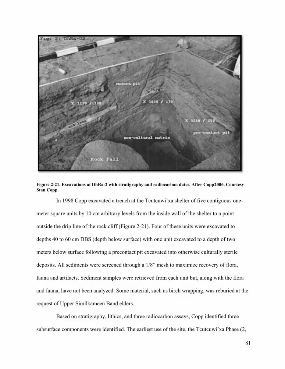
81
Figure 2-21. Excavations at DhRa-2 with stratigraphy and radiocarbon dates. After Copp2006. Courtesy Stan Copp.
In 1998 Copp excavated a trench at the Tcutcuwi’xa shelter of five contiguous one-
meter square units by 10 cm arbitrary levels from the inside wall of the shelter to a point
outside the drip line of the rock cliff (Figure 2-21). Four of these units were excavated to
depths 40 to 60 cm DBS (depth below surface) with one unit excavated to a depth of two
meters below surface following a precontact pit excavated into otherwise culturally sterile
deposits. All sediments were screened through a 1/8” mesh to maximize recovery of flora,
fauna and artifacts. Sediment samples were retrieved from each unit but, along with the flora
and fauna, have not been analyzed. Some material, such as birch wrapping, was reburied at the
request of Upper Similkameen Band elders.
Based on stratigraphy, lithics, and three radiocarbon assays, Copp identified three
subsurface components were identified. The earliest use of the site, the Tcutcuwi’xa Phase (2,

82
500 - 4, 500 BP), was identified by a single leaf-shaped “Cascade” projectile point located in
the lowest stratum above Mount St Helen’s tephra dating to circa 3, 500 BP (Copp 2006:300).
At the same level an artiodactyl (mountain sheep or goat) bone yielded an uncalibrated
radiocarbon date of 3, 580 ±170 BP. The subsequent Snazai’st Phase (1, 500-2, 500 BP) lithics
included an “idiosyncratic” corner notched projectile point located in stratum between the two
assayed dates of 1, 130 ±100 and 3, 280 ± 150 BP and a single side notched point preform.
The uppermost and latest cultural strata are most likely associated with the paintings
(the Sxwalhani.t Phase (200 to 1, 500 BP) that contained four preserved rolls of birch bark, a
small unmodified crystal and “several fragments of ochre nodules within the first 20 cm of
excavations” (Copp 2006:407). Copp suggested that these red ochre fragments in the upper
levels were “probably associated with the pictographs on shelter walls” (2006:303).
Copp stated that the four units at DhRa-2 “had surprisingly little cultural material
and/or features compared to similar sized rock shelters in the US part of the Plateau which he
suggests “may have been due to the probable sacred nature of the site going back at least a few
millennia” (Stanley Copp, personal communication, 2009). The 1998 investigations revealed a
low density site formation process over 4, 000 years to the present with red ochre related
activities most evident in the uppermost recent levels of the site a pattern that would hold for all
investigated Interior Salish rock art locations.
A microblade, indicating older occupation or presence was found on the surface near
the drip line of the cave. Two more microblades were recovered from disturbed units closest to
the shelter and lacked secure provenience. Not much could be said about the microblades other
than that they probably date to over 1000 years BP.

83
Further archaeological research at DhRa-2 occurred in 2008 when Bryan Gordon
excavated three small units to a depth of 46 cm below surface adjacent to Copp’s unit to
recover paint particles in association with organic materials for potential radio carbon dating
(Gordon 2008). Gordon’s method used paper sheets with glue to retrieve surface layers or
“peels” (5 mm scrapes) for later analysis using photographic enhancement of RGB values to
identify ochre ‘droplets” or particles assumed to have fallen from above surface paintings. A
few particles were identified but further analysis is required to determine if the “ochre” is
natural to the site or imported (see below). Fragments of wood, bone and teeth were also
recovered (and not identified). No other artifacts were found and no C14 samples have been
processed.
Michael Klassen has worked in the Nlaka’pamux territory for a number of years
recording rock art sites including a petroglyph and another rock painting at the mouth of the
Stein River as well as paintings on a large boulder on the Anderson Trail (Michael Klassen
2012; personal communication, 2015). Klassen was instrumental in creating national historic
site status in recognition of the cultural and historic significance of the Tulmn red ochre quarry
and rock painting sites along the Similkameen trail in the southern boundary region between
Tulmn and Tcutcuwi’xa (Klassen 2001; 2004).
Kwoiek (EaRj-80, EaRj-81)
Archaeological survey and assessments of archaeology on the Kwoeik River, the next major
river system south of the Stein River in 2006 by Arrowstone Archaeology identified a complex
three major proto-contact settlements (EaRj-66, EaRj-65 and EaRj-12) each apparently
occupied until the terminal years of the Kamloops Horizon i.e. post 1500 AD (Angelbeck and
Hall 2008). Three rock art sites were identified. One is a boulder rock shelter with exterior

84
paintings located on the Kwoiek River (EaRj-86) while the other two sites are inland. EaRj-80
is situated on two painted outcrops below a mountain peak with commanding views (Figure 2-
22). One outcrop features two sets of paintings, while the other has four panels of paintings in
the vicinity of a small rock shelter with an associated feature of piled rocks and four small
panels. (Figure 2-23). EaRj-81 (Figure 2-24) is a rock shelter at the base of a talus slope near an
isolated house and a large village (Figure 2-26). One panel of small figuratve paintings and two
areas of smeared paint occur. A piece of scallop shell (Pecten carinus) was identified on the
surface of the rock shelter at EaRj-81, an item found since Plateau times but more frequent in
the Kamloops Horizon. Another surface artifact, a broken basalt bifaces, was located in 2011.
Excavation in 2011 by Chris Arnett and Adrian Sanders recovered more pieces of scallop shell
along with other lithic debitage, red ochre, steatite pipe fragments, a chalcedony drill, flora,
fauna and three uncalibrated radio-carbon dates: 268 ± 25 BP, 316 ±23 BP and 910 ±25 BP
concurrent with the occupation of the nearby village EaRi-12 and the larger settlements closer
to the mouth of the Kwoeik. Excavation revealed a hearth and evidence of red ochre
preparation using heat (Figure 25).

85
Figure 2-22. Map and sketches of rock paintings at EaRj-80 in relation to mountain topography. After Angelbeck and Hall 2008:Figure 68. Courtesy Bill Angelbeck.
Figure 2-23. Rock paintings at EaRj-80. Note rock feature to left, rock shelter, and thick bands of paint covered by speleothem. After Anglebeck and Hall 2008: Fig. 71. Courtesy Bill Angelbeck.

86
Figure 2-24. Map of EaRj-81. After Anglebeck and Hall 2008: Figure 74. Courtesy Bill Angelbeck.

87
Figure 2-25. Unit 2, EaRj-81, 2011. Note powdery fragmented red ochre concentration in lower corner of unit next to hearth feature. Photo courtesy of Adrian Sanders.
Nahatlatch Lake (EeRk-1), Uztlius Creek (DlRh-1)
Investigation of two Nlaka’pamux rock painting sites on the Nahatlatch River and Uztlius
Creek travel corridors by Kwantlen Polytechnic University field school of 2011 under the
direction of Brian Pegg relied on photographic documentation to record the physical setting, the
relationship of the art to surface features and image enhancement of weathered paintings. My

88
own reconnaissance of EeRk-1 identified a rock shelter with what appeared to be the remains
of a fir bough bed.
Douglas Creek (EdRm-5)
This site is located on a large angular boulder along Douglas Creek on the boundary of
Nlaka’pamux and Xa’xtsa and within the shared use area and is notworthy for its well-
preserved black painting (Figure 2-26) (Arnett, in press). It is located directly on the boundary
of the core territory and Xa’xtsa (“Douglas”) people at the heed of Harrison Lake. Adrian
Sanders and Peter Merchant recently investigated the site on behalf of the Xa’xtsa First Nation.
They report the presence of a few earlier black paintings and significant deposits of cracked
faunal bones and a few broken Kamloops style projectile points (Peter Merchant, personal
communication, 2014). The only other known black paintings within the study area are found
at Tcutciwi’xa (DhRa-2) in the Similkameen Valley (Corner 1968:63).

89
Figure 2-26. Rock painting, EdRm-5, 2014. Photo courtesy of Peter Merchant.
Summary
The archaeology of Nlaka’pamux rock art has from the beginning focused on recording the
material culture of the rock paintings. Only recently have archaeologists paid attention to both
surface and sub-surface cultural features at rock painting sites both within and outside the
Nlaka’pamux territory. In adjacent Lil’wat territory on the Birkenhead River Bryan Gordon,
with Raymond Chung and Johnny Jones, pioneered the use of a colour pixel scanner (CPS) to
enhance RGB values in paintings to create scanner pixel plots placed on a white background to
reveal super-positioning and painting events (Gordon and Jones 2010). Gordon and Jones also
made excavations in front of a rock painting site (EbRp-29) on the Birkenhead River where

90
coins, bone, wood, tobacco and ochre pieces were recovered.22 One radiocarbon date was
determined—early 19th century (Gordon 2010). Gordon made similar excavations at three of
the Nicola Valley sites and recovered possible pieces of ochre at various depths between 7.5 cm
and 33 cm DBS and recovered charcoal samples from some of these associations none of which
have been dated (Gordon 2008).
Eslewhere in British Columbia archaeological investigations of rock art sites have
occurred in Kutanuxa territory on Columbia Lake (Mohs 1981) and more recently in Stse’hailis
territory on the Harrison River (Ritchie and Springer 2011) and in Squamish territory in the
Squamish Valley and Ashlu River (Rudy Reimer personal communication, 2010; Velliky
2013). This recent work has revealed important data on the site formation processes including
indigenous perspectives of rock art sites in those areas.
While producing invaluable data (location along travel corridors, antiquity and
material signatures of practice), previous archaeological work at Nlaka’pamux rock art sites has
not fully explained the relationship between the geomorphology, the material culture of the
rock paintings and the surface and subsurface deposits found at these sites within broader
temporal and spatial contexts. Understanding the physical relationship between the cultural and
natural site formation processes (as per Schaffer 1987) is the first step towards further levels of
analysis dealing with non-material aspects—the non-material site formation process.
Integrated Rock Art Archaeology Applied to TSeTSeQU, (EbRk-2)
Knowing the material culture of rock painting in relation to the geomorphology, the trail, and
other surface and subsurface features is important to identifying the material signatures of
22 Johnny Jones (personal communication, 2016) reports that 2 nickels and a few pennies were recovered. The oldest date on the coins was 1966. At EbRk-8 we identified a 1934 Canadian nickel left at the site presumably as an offering (York et al. 1993:177).

91
practice within the parameters of radiocarbon dates at a given site. Understanding the natural
and cultural site formation processes at TSeTSeQU, (EbRk-2) an Nlaka’pamux rock painting
site on the Stein River from an archaeological perspective renders the relationships between
rock painting as material culture (painting events), surface and subsurface deposits more
explicit and comparable to the ethnographic and other records. Recent work has advanced both
our understanding of these sites and the methods for their study.
Methods
Researchers use various techniques to collect data from rock art sites. For rock paintings
standard recording procedures range from comprehensive scale drawings (Bell 1979; Corner
1968; Keyser et al. 2006, 2008), film and digital photographic coverage (Fritz and Tosselo
2007; Gordon 2009; 2010; Gordon and Jones 2010a; Longman 2009; SIMRAP 1990) and laser
scans of entire sites (Montelle 2010). More recently DStretch is being used as a method to aid
rock art studies in British Columbia (Clyburn 2015; Francis and Porter 2010; Skala 2015;
Velliky 2013).
DStretch, short for decorrelation-stretch, is an image enhancement plug-in developed by
Jon Harmon which has revolutionized rock art studies worldwide with its ability to enhance
faint traces of mineral-based paint through a visual image enhancement algorithm program into
a false colour restoration (Harmon 2005). Digital image enhancement allows the archaeologist
to measure subtle differences in the “colour space” of paintings that would otherwise not be
noticeable by a human observer (David et al. 2001). DStretch analysis, in association with
direct observation, can reveal differences in paint hue/value, line and superposition to assist in
the identification of separate marking events DStretch is particularly effective at delineating the

92
super-positioning of paintings something that is also not always obvious given the taphonomy
and variability of Nlaka’pamux iconography.
Photographic DStretch analysis of rock painting enables fine-grained analysis of the
total site assemblage of existing painting events. It provides a digital non-destructive
excavation technique that reveals painted graphic stratigraphy that may be only barely visible
to normal photography or the naked eye. An inventory of painting events is important to
understanding aspects of the site formation process including the demonstrably close
relationship between the paintings and the rock surfaces. It allows us to see both what is there
but also how painting accommodates surface features suggesting a connection between the act
and the art beyond simple representation. Using the DStretch method, individual painting
events at EbRk-2 were identified, photographed and processed to gain a full inventory of all
paintings at the site.
Painting Events
Identifying the number of marking events is important to an understanding of the site
formation process at rock painting sites (Clottes and Geneste 2012; Fritz and Tosello 2007;
Perez-Seonne and Ramos 2006; Savidson 2012; ). Rock painting locations present certain
challenges to recording this form of material culture because paintings were made at different
times on rock surfaces subject to ongoing erosion.
Gerard O’Regan’s study of South Island Maori rock art in New Zealand considered the
proximity of element positioning at specific sites and “the extent to which the rock art figures
represent different marking events from surrounding elements” with defining characteristics
being differences in general colour, shade, and intensity of markings to determine if
neighboring art were different applications (1996:43). Following O’Regan, I identified marking

93
events by a spatial analysis using criteria or variables of position, line and two aspects of colour
(hue and value).
Painting position is studied and recorded by direct observation and a photogrammetric
record using the DStretch plug-in to record all measureable painting activity including the full
inventory of identifiable painting events and to identify temporally distinct events by direct
graphic stratigraphy. DStretch eliminates potential colour bias by artificially enhancing
differences in hue and value, superposition and line. Position is determined by the location of
the painting in relation to others either by distance, superposition, line or hue. The spatial
grouping of units of elements comprising single painting events can also be based on spatial
characteristics of paintings within the physical features of the rock surface.
Line/execution refers to the line of paint (the brushwork or finger work) and the manner
in which it is used to create a painting or group of paintings. Line is determined by the variable
size of the finger digits (biometrics), brushes, twigs or whatever used to apply the paint on the
rock surface and to the type of paint. Some paint is applied thickly and expressively while
others are more liquid and methodical. Style has to do with individual modes of expression
such as line, temperament and the constraints of time and tradition.
The assumption is that variability in line, based as it is on the tool or the biometrics of
individual fingers, will distinguish one painting or marking event from another. Two paintings,
similar in subject matter, on careful inspection, show differences in style and paint preservation
leading to a conclusion that the paintings were not made by the same individual, one being a
duplication of an, assumedly, earlier image. For example measurements of the left arms of the
two “warrior figures” in Figure 2-27 were 6.50 mm (left figure) 3.57 mm (right figure)
indicating different sized fingers and different painting method. Velliky’s (2013) PXRF study

94
of two paintings on the same panel at a Squamish rock painting site on the Squamish River
(EaRu-9) demonstrated that there was geochemical variance between adjacent paintings—data
that supported the more subjective observation of differential hue and colour values.
Figure 2-27. Rock Paintings EbRk-2-54 and 55. DStretch enhancement. Photo by Chris Arnett

95
The assumption of relative age is based partly on the degree of preservation of
individual paintings—with paintings lacking paint appearing more “faded” and lighter in colour
due to mechanical weathering where the paint literally falls from the paintings leaving only a
faint residue. The rate of deterioration is based on variables of paint quality, and exposure to
mechanical erosion (Taylor et al. 1974; Wainwright 1985) that may impact a single painting
with only portions of it subject to erosion and fading while other parts are better preserved.
The third component, hue, is the most distinct attribute of a colour entirely dependent
on the dominant wavelength and, in rock painting, on the preservation of the paint with
thickness of paint being relevant to color value. Hue variation between sets of paintings at
single sites has been long recognized in studies of Salishan rock art as evidence of multiple site
visitations (Corner 1968; Lundy 1972; Rousseau et al. 1991:38; Teit 1918; Velliky 2013)
The value of the hue is relative to the degree of lightness or darkness intrinsic to the
paint but is also the result of taphonomy either the slow inevitable deterioration, the deposit
fallout that removes rock and particles of pigment, or the covering of the image by speleothem.
Hue is variable according to weathering, which may or may not support relative dating of
separate images as differential weathering can occur with images on the same panel that may in
fact be contemporaneous. Assumptions regarding relative contemporaneity of paintings cannot
rely completely on differences in paint preservation. Hill-Tout’s 1890’s informants claimed
“the paints made by the present Indians are not like the older ones”indicating the possibility
that later paintings could deteriorate faster.23Weathering rates are also highly variable even
within a single painting where a portion may be well preserved and another much eroded
23 Jack Brink (2011) describes an interesting example of a former Kutenai/Salishan rock painting site being used by later ethnically different Blackfeet and the ephemerality of the later Blackfoot paintings due to differences in paint quality.

96
simply depending on exposure to surface groundwater flow. Thus relative fading will not
always be indicative of relative age. Super-positioning, the placement of one painting over
another, is a better indication of relative age. Given the variability of rock surfaces and paint
quality among other things, each painting event is unique.
Figure 2-28. Detail of painting events, Group1, EbRk-2, 2012. DStretch enhancement. Photo by ChrisArnett.
Painting events are hypothesized episodes of painting activity based on comparative
value (hue), line and graphic stratigraphy—the super-positioning of paintings one over the
other. Using the above method of identification, 193 marking events were recorded at EbRk-2
(See Appendix). Painting events at the sight were recorded from downstream to upstream and
given a hyphenated number that includes the Borden site number designation and the painting

97
event (Figure 2-28).24 The number of painting events at EbRk-2 is not absolute in that future
work and finer resolution of painting events and individual artists will likely lower it.
Surface and subsurface features
The geomorphology and the paintings are intimately connected and so to varying degrees must
also be the trail, surface and subsurface features in their vicinity. Investigation requires
observation and traditional archaeological techniques of excavation according to the
sedimentology of rock shelters of which no two are alike (Farrand 1985). While trails are rarely
excavated, at EbRk-2 two shovel tests were made in the existing trail through sterile deposits of
coarse to fine grain eboulis revealing an earlier compact trail surface 25 cm beneath the surface.
Surface and subsurface archeological deposits were identified in the vicinity of the collapsed
rock shelter beneath existing paintings. Visible surface features at Nlaka’pamux rock painting
sites can also include rocks brought to the site (manuports) or artifacts of various types such as
older curated bifaces or Canadian coins (Copp 1974; York et al. 1993; Gordon 2010).
Two subsurface units less than 1 m x 1 m each were excavated to sterile deposits (13
cm DBS) by 2 cm levels using a 1.5 mm screen. As a result there was good recovery of cultural
material including lithics, glass, shell, as well as small amounts of fauna and flora. Four
radiocarbon dates were secured bracketing the unit to give a good temporal resolution of the
cultural deposit. The site was not excavated in its entirety as other deposits were deliberately
left for future investigation.
I conducted archaeological research at the TSeTSeQU site to clarify the relationship
between geomorphology, trail, painting, surface and subsurface deposits, the study of the
24 This method of identifying painting events was used in a 2013 survey of Tsleil-Waututh rock painting sites in Indian Arm for Tsleil-Waututh Nation.

98
graphic stratigraphy of the paintings and traditional excavation techniques at a Naka’pamux
rock painting site aim to answer questions of temporality and practice—how did this place
occur?
Figure 2-29. Map showing location of EbRk-2, Stein River. The village of Stein is located on the benches at the river mouth.

99
Figure 2-30. EbRk-2 (TSeTSeQU), 2014. Rock shelter and paintings are located on the cliff and boulders (left). Note sandy river terrace, trail and river. Photo by Chris Arnett
TSeTSeQU, nlha.kapmhhchEEn, for “markings/writings” references the large number of
rock paintings (TSeQU) found) on two granite cliffs (EbRk-1 and EbRk-2) and a painted
boulder (EbRk-7) along the Stein River Trail five kilometers upstream from the confluence of
the Stein and Fraser Rivers. The two cliffs stand 200 m apart on the south side of the river
where the valley narrows and the river bends to make its fast descent through the more
restricted terrain of the lower canyon. The cliffs are separated on the south side by an active
talus slope that continues straight up the mountain and is slowly infringing on the cliff at EbRk-
2 (Figure 2-13). As of this writing 10 meters of the trail adjacent to the active talus slope was

100
swept away. Hikers must pass over a jumble of rocky unstable debris where a boulder the size
of a camper trailer has detached and rolled down the slope. In this steep forested terrain the
position of these cliffs in proximity to the river restricts the traveler to the narrow trail along the
base of each cliff where the paintings are easily seen.
Upstream facing a sandy grove across from the river the cliff at EbRk-2 looms
vertically 14 meters above the trail revealing a spectacular array of older granite sheets
suspended within later intrusive veins and dykes of light coloured quartzite and other minerals
aligned at various interstices to create geometrical relationships with each other as well as
vortexes for painting (Figures 2-31, 2-32).
The terrain between the cliff face and the Stein River is a level 40-meter stretch of
forested river terrace of sand and large water worn boulders within old river channels (Figure
2-30). Eleven cedar (Thuja plicata) trees in the grove of trees on the terrace are culturally
modified with strips of bark removed. The predominant sand and lack of significant forest soils
suggest intermittent flooding over much of the terrace over the years. Soil is more stable
towards the cliff. Two dates from two trees, a possible culturally modified western red cedar
(cut near the river’s edge a number of years ago), and a recent fallen Douglas fir (Pseudotsuga
menziesii) cut circa 2013 by BC Parks staff at the upstream entrance to the site tree were the
same age (230/231 years before cut) and suggest that the present stand was established from at
least AD 1783 very close to one of the middle radiocarbon dates from excavations at the rock
shelter (see below).
Initial Context
The initial context of the material site formation of EbRk-2 began in the Late Cretaceous 90 to
65 million years ago with subterranean volcanic activity and the upward movement of molten

101
magma gradually cooling and cracking before reaching the surface to become granite, the
crystalized molten rock of quartz silicates with quartz making up to 20-60 per cent of the rock
(Mathews and Monger 2005:94; Migon 2006).
This geomorphic process is responsible for the most characteristic feature of granite
formations—discontinuities—or fractures which are “any discontinuity breaking the coherence
of a rock mass” caused by stress and mechanical erosion and is the process responsible for the
mechanical weathering of the granite rock mass into sometimes massive cubic blocks (Migon
2006:17).25 The fractures of older granite formations can be filled with more recent lighter
coloured intrusions of polymineralic and monomineralic quartz or quartzite leaving
characteristic striped rock surfaces (Figure 2-32). Exposed rock faces are further shaped by
pleistocene glaciation and early Holocene deglaciation (water flow).
Discontinuities are the key controls of geomorphic processes operating within granite
landscapes. Fractures parallel and perpendicular to the flow crossing at right angles create
orthogonal structures and geometrical relationships to each other. This aspect of granite
geomorphology is what exerts “a profound influence on the visual appearance of the geology ”
(Migon 2006:16).
Granites “are particularly sensitive to the amount of moisture in the environment” and
subject to mechanical weathering on a variety of scales from the microscopic deterioration of
the surface layer due to exfoliation or spalling to the wholesale collapse of blocks of rock
weighing several tons falling singly or in large talus fans. The rate and efficacy of this
25 Granite fractures are divided into two main groups of systematic (planar) and non-systematic (curved traces). Four main groups of primary discontinuities fracture classes include cross fractures, longitudinal fractures, flat lying fractures, and diagonals created by variable cooling and pressure of the magma (Migon 2006:Figure 1.5).

102
weathering is controlled by a range of climatic factors including the number of freeze thaw
cycles dependent on the rate of freezing and moisture availability that would change over time
(Migon 2006:44). The nlha.kapmhhchEEn word for cliff reflects exactly this geological aspect
of granite. shul is the word for “peel”, “smooth” or a “sheer cliff” (Thompson and Thompson
1994:338). With a slightly different “u” sound, shul means “secrete fluid” perhaps referencing
the peeled geology and the significant water seepage that appears through the openings.
Mechanical erosion occurs at various scales from granular erosion of the surface to
large- scale mechanical erosion of blocks weighing many tons. Seismic activity and freeze and
thaw cycles are responsible for the most visible and recent erosion at Stein River rock painting
sites such as EbRk-8, where subsurface fallen slabs with paintings have been identified (York
et al. 1993). In the same place, in 1993, a large multi ton block with paintings across it plunged
to the river (York et al. 1993:55). At EbRk-2 two slabs more than 3 meters long and weighing
several tons have detached from the base of the cliff. One formed the roof of the rock shelter
and bore paintings on the “ceiling” and the face of the block in its original position. Because of
the way it fell against other rocks most of this painting is now hidden. Other blocks, some with
paintings, seem destined to follow.
Besides seeping though the internal fissures in the rock groundwater can leave a mineral
precipitate in places where it emerges and flows over the rock surface. Research by the
Canadian Conservation Institute (Taylor et al. 1974:39, Wainwright 1985) found that
atmospheric CO 2 dissolved in rain and organic acids dissolved from the soil creates an acidic
groundwater which as it percolates through the rock dissolves small amounts of elements such
as Na, Ca, K, Mg, Si and to a lesser extent Al and Fe to form a dilute solution that emerges
from the cracks and flows over vertical rock surfaces accumulating layers over the years (See

103
also Aubert et al. 2004:54-56). As the seepage evaporates the less soluble elements Al, Si and
Ca ions precipitate to from a white -coloured deposit of amorphous shape referred to as
flowstone (Bates and Jackson 1976:189) or, as the term used here, speleothem a general term
for a phenomena that includes all rock secretions such as stalactites and stalagmites.
Speleothem in all its forms is a feature of rock art sites world wide suggesting a universal
significance of this material to those who engage in rock art (See Arsenault 2004: 303; Keyser
and Poetschat 2004:127).
.
Figure 2-31. Geomorphology at EbRk-2, 2010. Note mechanical erosion (collapsed rock shelter). Photo by Chris Arnett.

104
Figure 2-32. DStretch-enhanced geomorphology, Group2, 2014. Note collapsed rockshelter. Photo by John Arnett and Chris Arnett.

105
The physical relationship between the red ochre paint and the speleothem of granite
rock art sites in Canada was noticed years ago by researchers at the Canadian Conservation
Institute who obtained small chips from rock paintings on granite formations in the Canadian
Shield and the Similkameen Valley to learn more about the nature of red ochre rock painting
and the natural processes affecting its preservation (Taylor et al. 1974; Wainwright 1985).
Research questions focused on identifying the interrelationship of the pigment, binder and rock
surface and to explain differential fading thought to be caused by mechanical weathering.
Ground and polished cross-sections of two millimeter square samples were prepared and
studied with SEM-EDX and photomicrography to determine the precise location of various
elements in the samples. Expecting to find a pattern of paint applied directly to rock,
researchers found the intermediate layer of ground water mineral deposit composed of Na, Ca,
K, Mg, Si, A and Fe. Their analysis revealed “a remarkably consistent pattern of analytical
data.” Paintings were consistently and deliberately made on these mineral deposits so much so
that “the pigment is firmly attached to and intimately mixed with the mineral deposit” (Taylor
et al. 1974). After painting, subsequent ground water borne material deposited over the
paintings sandwiches them in a four-part structure of rock base, intermediate layer, pigment
and surface (Taylor et al. 1974; Wainwright 1985).
Granite is dynamic and alters with physical, chemical and biological effects constantly
acting on the rock surface as part of an ongoing geological process. All granite rock art sites are
constantly eroding as part of a “living” geologically active landscape where change is constant,
dramatic and, in a direct physical way, dangerous.26 Mechanical erosion and colour (white) is
26 In 2012 a single detached granite block fell from the mountain slope and took out the north tower of a recently built metal suspension bridge.

106
part of the material agency of these places.27 The geomorphology produces a complex and
varied biologically active rock surface that was culturally significant to those who painted.
27 To which we may add biological and biochemical action. Epilithi agents, unidentified variously colored (mostly dark) lichens and algaes, can penetrate 10-22 um into the rock surface substratum crossing and contouring the individual constituent quartz, feldspar and mica crystals detaching pieces up to 2-3 mm long from the underlaying surface (Morig: 2008:49). These plants spread over the rock surface, infiltrating the rock, mineral deposits and adhering paint and removing all over time leaving only a residue of paint visible as a thin (thus faint) orange or red coloured stain (Taylor et al.1974) Algae, as well, grows in micro cracks on the surface and expand upon absorption of water contributing to detachment of 2-4 mm flakes. Often these growths appear in the vicinity of paintings and affect preservation. Some of the paintings at EbRk-2 are more protected from exposure but all show erosion through mechanical, chemical and biological weathering typical of granite formations

107
Figure 2-33. Speleothem and paintings at EbRk-2, Group 3, 2014. Initial context (above), DStretch enhancement (below). Photo by John Arnett and Chris Arnett.

108
Figure 2-34. Painting EbRk-2-136. Initial context (left), DStretch enhancement (right). Portions of the speleothem matrix have fallen or been removed. Photo by Chris Arnett.
Figure 2-35. Multiple paintings incorporated into cracks and speleothem covered surfaces. Initial context (left), DStretch enhancement (right). Photo by Chris Arnett.

109
Figure 2-36. Painting EbRk-2-50 with natural iron oxide and speleothem. Initial context (left), DStretch enhancement (right). Photo by Chris Arnett.

110
Figure 2-37. Painting EbRk-2-118 and natural mineral accretion. DStretch enhancement. Photo by Chris Arnett
Figure 2- 38. Rock Paintings EbRk-2-18 and 19 incorporated into quartzite veins. Initial context (left), DStretch enhancement (right). Photo by Chris Arnett.

111
Figure 2-39. Painting EbRk-2-178. Ungulate in a crescent. Note incorporation of painting into surface features. DStretch enhancement. Photo by Chris Arnett.
The earliest rock paintings at EbRk-2 are inextricably connected to the rock surface of
the geomorphology. Later paintings do not replicate this practice. Super-positioning on earlier
paintings becomes the norm. Paintings were applied to the rock surface with fingertips, brushes
or other sorts of applicators along the base of the cliff for 70 meters from ground level to, in
some places, a height of 6 meters probably accessed by ladders, trees, rappelling or rock
climbing. Generally speaking the paintings occur in three main concentrations with the largest
number of painting events (Group 2, n=122) in the vicinity of the most elaborate
geomorphology and the rock shelter. The peripheral areas of the site are less densely painted
with 15 painting events (Group 1) on rock faces downstream from the shelter while Group 3,
the other concentration of paintings (n=56), is located furthest upstream. The paintings in this
group diminish in number and frequency toward the periphery of the geomorphology that
creates the site

112
Study of the paintings at EbRk-2 and elsewhere show that pre-existing features in the
rock guide rock painting surface that influence the final form. Cracks, often minute (Figures 2-
35, 2-39, 2-48), speleothem deposits (Figures 2-33, 2-34, 2-35) epigenetic veins (Figure 2-38),
iron oxide or other mineral deposits (Figures 2-36, 2-37), all the distinctive features of granite
are directly incorporated into the final design—a testimony to the agency of the rock—a
universal feature of rock art found throughout the world.
Graphic Stratigraphy
Graphic stratigraphy is a term adopted from Whitley (2009:117) to describe the super-
positioning of paintings—a time honored method in world rock art studies with results open to
scrutiny and replication (Loubser and Keyser 2004:83). In some areas of the world where rock
art has been produced continuously, such as Australia and France, for thousands of years the
study of the intimate stratigraphic relationship between rock painting and speleothem deposits
is referred to by more a expansive (and expensive) study of mineral accretions or nano-
stratigraphy (Aubert et al. 2004; Clottes and Geneste 2012:595; Watchman et al. 2000). Here
we use graphic stratigraphy to refer to the stratigraphy of paintings over time in place—one
painting on top of another—to identify a distinct chronology of painting at the site.

113
Figure 2-40. Rock paintings, EbRk-2. Initial context (above), DStretch enhancement (below). Photo by Chris Arnett.
At EbRk-2 a group of paintings (Figure 2-40) appear on a flat angular rock surface
beneath a diagonal vein of quartzite speckled with mica. A thin layer of speleothem coats the
surface. Two other paintings occur on the underside of the granite block part of the remaining
ceiling of the rock shelter. Clear super-positioning of paintings over earlier ones indicate at

114
least three painting events and possibly as many painters. One of the earliest paintings in this
group, EbRk-2-98 (Figure 2-57), depicts a spiny two headed, four-legged creature with a
grizzly bear fore-arm appended to its front head—a variation of a conventional motif called the
“sunulhkAz” (see below). Superimposed over this earlier figure is a group of paintings
including a profile rectangular-bodied mountain goat, a non-descript image, a human-like
figure with bifurcated headgear, a grizzly bear forearm and a small convex “sunulhkAz” which
together from a compositional unity and hue and thus grouped as the work of a single painter
(EbRk-2-108). These paintings are all superimposed by a third group of paintings (EbRk-2-
109) that include two bear paws with five claws each, one bear paw with four claws and two
convex lines (see detail in Figure 2-41). The order of paint strokes in the “grizzly bear”
painings may also be determined by the overlay of line. The painter went from right to left on
each bear paw painting. Shared attributes of each painting, most notably the curvature of the
fingertip stroke that defines the left side of each grizzly bear image suggests the work of a
single rock artist.

115
Figure 2-41. Painting EbRk-2-100 superimposed on Painting EbRk-2-99. DStretch enhancement. Photo by Chris Arnett.
There is a difference of preservation and style between the early and later paintings in
this group relative to super-positioning. The most recent paint is thicker and better preserved
compared to that of the earlier paintings. The newer paintings of “grizzly bear” tracks retain the
triangular shape of the conventional image but lack the characteristic horizontal bar across the
triangle shape to identify the bear’s instep. This stylistic feature distinguishes them from earlier
examples. Thicker line and simpler depiction of conventional motifs seems to be a
characteristic of later rock art painting. The best-preserved “grizzly bear” painting on the lower
right of the panel is unconventional with four toes in place of the usual five. The painting
appears to be repainted—the only obvious example at the site (Morgan Wells [Lil’wat],
personal communication). Repainting was practiced in other parts of the Plateau until the
1930’s (Harrison 1961:29).
Figure 2-42. Image enhanced painting EbRk-2-12 (dark red left) and EbRk-2-11 (to right and beneath
EbRk-2-12). Photo by Chris Arnett.

116
Figure 2-43. Photo mosaic showing graphic stratigraphy with Painting EbRk-2-52 (a “mountain goat” and a “structure”) over an older painting EbRk-2-51 (two “five-pointed stars” joined by a line). DStretch enhancement. Photo by Chris Arnett.
Figure 2-44. Painting EbRk-2-68, superimposed over Painting EbRk-2-69. DStretch enhancemnet. Photo by Chris Arnett.

117
Figure 2-45. Left arm of painting EbRk-2-24 (“ghost”) overlapps earlier painting EbRk-2-21 (“thick band”). Note linear painting EbRk-2-23 (“earthline”?) overlapping EbRk-2-2-22 (“circle”). DStretch enhancement. Photo by Chris Arnett.
Palimpsests of paintings are rare in the Salishan world (Corner 1968; Coburn 1975) but
prevalent at EbRk-2 with 12% (n=24) of the painting events showing over-painting of earlier
imagery. Super-positioning is more frequent (75.5%) in proximity to the rock shelter (Group
2), suggesting a desire of later painters to paint in this particular area or to repaint similar
images. In some cases the over-painting is overt and obvious, in other instances the overlap is
overt yet subtle and, without close examination, almost unnoticeable (Figure 2-46).
Overpainting shows less concern for surface features of the rock and more interest in the
previous imagery. There is also a noticeable stylistic change from the earlier trend of tighter
design and careful execution to a more expressive painting style with less attention to orthodox
forms and more emphasis on the act of painting (Figures 2-42).28
28 19th and early 20th century shuma researchers perceived a qualitative difference between late 19th century rock painting judging that “their skill in this line…is manifestly inferior to that on articles found on the old sites” (Smith 1913:36).

118
Figure 2-46. Painting EbRk-2-123overlapping EbRk-2-124. Note lower “ray”of the “sun”superimposed on the“grizzly bear arm.”Note also conformity of design to cracks in the rock. Photo by Chris Arnett

119
Another time-related feature of rock painting at this and other sites in the Plateau region
is the practice of replicating an earlier image. Two paintings (EbRk-2-60 and 61) depict near
identical chevron chested (ribbed) human like figures with outstretched legs and arms carrying
bows and shields or a container (Figure 2-27). The two figures are similar in form and
presumably conventional meaning. However, the preservation and hue of the paint, quality of
line and lack of detail indicate that they are the work of different painters. The hue and line of
the rayed arc below the pair is similar in style and preservation to one of the images (EbRk-2-
60) and overlaps the image on the right a direct indication of relative age.
Figure 2-47. “TLapEEsht.”Paintings EbRk-2-158 and 159. DStretch enhancement. Photo by Chris Arnett.
Paintings EbRk-2-158 and EbRk-2-159 (Figure 2-47) share similar composition and
subject matter of a winged being with large eyes “gathering” deer and mountain sheep/goats

120
under its outstretched wings. The paintings are the work of different painters one replicating the
work of an earlier painter with subtle differences.
Based on preservation the image on the upper left is probably the earliest. It is
composed of a finer line, is more weathered and a portion of it is overlaid by a “diagonal
barbed-line” painting (EbRk-2-153) one of only two examples of graphic stratigraphy in this
area of the site. The figure also appears to have fringes on its “hunting shirt” whereas the later
image does not. Different conventions are used to portray the ungulates under the wings of the
two “TLapEEsht.” On the left is a mountain sheep judging from the curvature of the horn and a
solid body. The animal under the other wing is probably a deer shown with an outlined
rectangular body with two internal chevrons. The painter of EbRk-2-159 replicated the
composition of 158 but switched the positions of the deer and the sheep and depicted them with
solid bodies (a potential chronological marker relative to the depiction of hollow bodied
animals with chevrons in the earlier painting). In keeping with other paintings at the site, the
later “TLapEEsht ” painting here is bolder (more recent and better preserved) and there is less
detail (i.e. no internal markings or fringed shirt) demonstrating individual variability within a
conventional image.
Conventional motifs
Of a postulated 193 painting events at EbRk-2 there are recurrent motifs defined here as a
conventional design being “a recurrent visual image which has a particular arrangement of
components” (MacDonald 1977:395-396) and, as ethnography demonstrates, multiple
meanings. For the purpose of archaeology motifs have conventional meaning in that they
possess formal attributes that are recognizable and replicable to the people who produce them.

121
Franz Boas, working with the material collected by James Teit in the late 19th century,
was interested in pictography as symbolic communication and encouraged Teit to collect
“translations” for all his drawings of rock paintings (see Chapter 2). Teit, with the help of his
native colleagues recorded some 98 conventional meanings of British Columbia Plateau rock
painting imagery--an important informed taxonomy of conventional imagery for descriptive
purposes (Corner 1968:29; Teit 1900, 1906, 1909, 1928; ). Teit’s data were drawn from a
number of sites but it was not comprehensive. As Teit found out, many paintings are unique in
subject matter and execution resisting identification as conventional icons.
Conventional images at EbRk-2 correspond to imagery identified by Teit’s native
informants including “mystery, ” “cross trails, ” “earth line, ” “sun, ” “mountain goat, ” “deer, ”
“mountain sheep, ” “grizzly bear, ” “rayed arc, ” “trenches with dirt thrown out, ” “grave poles,
” and “rising sun.” There are a number paintings at EbRk-2 not found in Teit’s taxonomy that
also exhibit a regularity of form and no doubt had conventional meaning. For example, the
“sunulhkAz ” (a two-headed creature) (Figures 2-56 and 2-57), the “horned lizard” (Figure 2-
59), and the “TLapEEsht ” imagery (Figures 2-47 and 2-60) are clearly conventional yet
stylistically specific to the Stein River.
All conventional motifs are schematic in the sense that they abstract physical things and
give materiality to the non-material. There is great variability in Stein River rock painting (as
everywhere) with many unique images. A selection of conventional motifs characteristic to
TSeTSeQU shows the variability of imagery within Nlaka’pamux convention and the locally
specific iconography.
Ungulates with and without horns make up the single largest group of conventional
motifs (n=58) at EbRk-2 and occur across the site (Figures 2-48 through 2-54). They are most

122
numerous in and around the rock shelter. They appear singly or in processions of three of more
possibly part of an iterative process. All are shown in profile with rectangular bodies, chevron-
legs and a short upturned tail. Species are usually identifiable by their characteristic antlers, the
short slightly curved horns of the goats (shwuhee. TLATS) (Figure 2-48) more rounded horns of
the bighorn sheep (shwlOOpahand) (Figure 2-49) and the classic pronged antlers of the deer
(shwuhhee-yAhhkn) or elk (dukdukAyhhkn) (Figure 2-50). Based on these diagnostic attributes
mountain goat iconography predominates at EbRk-2 (n=46), then mountain sheep (n=7), then
deer (n=5).
The bodies of the animals are rendered solid or in outline. Those in outline show
variability in the internal or surface detail (one to four chevrons) that may have chronological
implications (Figures 2-50, 2-51). Some of the variations appear to be time sensitive with
decreasing body chevrons over time with the latest examples having only a single chevron or
none. These are late in the sequence as they have more remnant (recent) paint and are
sometimes superimposed over earlier paintings (Figure 2-40). In the paintings found in the
“Answering Cave” (EbRl-6) located 1, 600 meters above the Stein River all of the goat figures
were rendered with a single chevron internal detail suggesting a contemporaneity of style and
time (see York et al. 1993:200-201).

123
Figure 2-48. “Mountain goat.” Painting EbRk-2-52, DStretch enhancement. Photo by Chris Arnett
Figure 2-49."Bighorn sheep.”Painting EbRk-2-192. DStretch enhancement. Photo by Chris Arnett.

124
Figure 2-50."Elk"?Painting EbRk-2-160. DStretch enhancement. Photo by Chris Arnett.
Figure 2-51. Two ungulates with single body chevron, Painting EbRk-2-150. DStretch enhancement. Photoby Chris Arnett.

125
Figure 2-52. Painting EbRk-2-170. Ungulate with three body chevrons. DStretch enhancement. Photo by Chris Arnett.
Some of the ungulate motifs are part of more complex compositions (n=7) where a
single animal is shown on a straight or slightly curved line with another line starting at the rear
of the baseline and arching over the body to the snout (Figures 2-53). In a two instances at the
site, these motifs are mirrored by another similar ungulate motif to create a symmetrical image
(Figure 2-54). Degrees of difference between the two halves of these symmetrical compositions
suggest that different people may have done them at different times. The predominance of
ungulate (mostly mountain goat) is matched by the high cultural value of the animal as a fellow
species and source of physical and spiritual wealth.

126
Figure 2-53.“Ungulate”under arch. Painting EbRk-2-23. DStretch enhancement. Photo by Chris Arnett.
Figure 2-54.“Ungulates”under arches. Painting EbRk-2-25. DStretch enhancement. Photo by Chris Arnett.

127
Figure 2-55.“Grizzly bear tracks.”DStretch enhancement. Photo by Chris Arnett.
The second most common motif at EbRk-2 is the grizzly bear paw print (n=18) (Figure
2-55) identified as such by Teit’s teachers (Teit1900: Plate XX, Fig.13b; 1928, Fig.22d, 23e, g,
24j). Annie York also noted that the grizzly motif was distinguished from the black bear by its
triangular heel, while that of the black bear was more rounded (York et al. 1993:107). Teit’s
informants made a similar distinction (Compare Teit 1900: Plate XX, fig 7a with Plate XX,
fig.13; Corner 1968:29). The grizzly bear track sometimes has a horizontal line across it to
indicate the pronounced instep. Based on the super positioning of motifs at EbRk-2 omission of
the line seems to be a late trait (Figure 2-41). The panel of paintings in Figure 2-55 shows five
images of grizzly bear in the two most conventional ways—as a single paw or as a “forearm.”
The bear paw track (whether grizzly or black) is the one of the most widespread conventional

128
designs in the Plateau and one of the very few conventional signs showing an animal track—a
direct reflection of its widespread social and cultural importance.
Figure 2-56."sunulhkAz.”Paintings EbRk-2-98 (top) and EbRk-2-155 (bottom). DStretch enhancement. Photos by Chris Arnett.

129
Figure 2-57."sunulhkAz.”From top to bottom: Paintings EbRk-2-1, EbRk-2-18 and EbRk-2-145 and EbRk-2-148 (detail). DStretch enhancement. Photos by Chris Arnett.

130
The third most common motif (n=13) at EbRk-2 is a conventional image of a two-headed
creature that defies western taxonomies probably a type of snake/lizard combination called
“sunulhkAz” (Figures 2-56, 2-57).29 The conventional design is a body with two opposite heads
with wide-open mouths protruding tongue, spines along the back and sets of legs. There is
formal variation most evident in the depiction of the head, the body and legs. Some are shown
with a rounded head while the others are more angular. The form of the mouth also ranges from
angular to rounded. The presence or absence of feet is another expression of individuality.
The body is usually shown as a single line but two paintings at EbRk-2 show the
creature with a lenticular boat shaped body and an appended “grizzly bear arm” (Figure 2-57).
One is over painted by later designs (see Figure 2-40) suggesting that the lenticular body is an
earlier design. The variation of conventional imagery of the “sunulhkAz” indicates that they are
the work of several individuals each with their own manner of representing the creature within
conventional guidelines. Some paintings have formal characteristics that suggest they are the
work of the same painter (compare paintings EbRk-2-145 and 148 (Figure 2-57).
In four of the paintings (EbRk-2-1, EbRk-2-18, EbRk-2-42, and EbRk-2-176) the two
halves of the body of the motif are not symmetrical but show different attributes suggesting the
work of two different painters. This assessement is based on the stylistic and compositional
differences between the two “halves.”
A meter long bilateral image of “sunulhkAz” shows is the most southerly painting on
the cliff and the only image found on this particular vertical rock face (Figure 2-57 top). It is
rendered with two opposed bodies each with open mouth, protruding tongue, large ears or
29 Snake-like supernatural beings are well described for the Coast and, to a lesser extent, Interior Salish (Barnett 1955; Wells 1966; Mathews 1955, Van Eijk 2001; York et al. 1993; Jones 2011). Van Eijk was right to correct our assumption that the two-headed snake at EbRk-2 was the TLupEEst (Pacific rubber boa) and not a plateau version of the Coast Salish siilquey—or “fearsome snake” (Van Eijk 2001).

131
horns with legs and spines along the back. A convex line with a couple of short vertical dashes,
arches over the body and joins the two heads—an unusual convention. The right half of the
compostion is longer than the left, uses a thicker line of paint, has teeth, and more acute spines.
The leg also occupies a different position in relationship to the rest of the body. As well there is
a deliberate gap in the continuity of the “body” seen in one other “composite” two headed
painting at EbRk-2.
The composition may be the result of two painters and/or painting events. This
difference may be seen in the composition of the two heads each of which is different—the left
head is round and spines on the back vertical, the right head is less defined and the spines
diagonal. The mouth and tongue of the head on the right conforms to a natural fold in the rock
and may have served as a reference point for the painting.
Some of the paintings of two headed snakes may be the culturally prescribed work of
two individuals. Coast Salish people sometimes described the two heads as different (Matthews
1955) and perhaps this difference is seen here. Comparison with the other two headed snakes at
EbRk-2 does not follow this pattern however which suggest that something else may be taking
place with two individuals contributing to a painting to make it bilaterally asymmetrical.30
Unlike the grizzly bear and the ungulates, the sunulhkAz is not common at known sites
outside of the Stein River appearing it seems only once at EeRk-1 on Nahatlatch Lake (Figure
2-58). The conventional motif is recognizable by the attributes of two open mouthed heads,
spines and bent legs, but it is different in style. The motif may occur perhaps twice in other
Plateau locations (Corner 1968:71 (48j) and 99 k, l). The persistence of form and replication in
30 The dissimilarity between the heads and what appears to a deliberate break, not erosion, in the line that forms the body, a sign of discontinuity or separation characteristic incidently of the image of the two-headed snake in stories of the proto-contact colonial culture (York et al.1993).

132
other media suggest a strong iterative process within a family or group (perhaps something
indicative of all Nlaka’pamux two dimensional design production,
Figure 2-58.“sunulhkAz.”Nahatlatch Lake, (EeRk-1). DStretch enhancement. Photo courtesy of Brian Pegg.
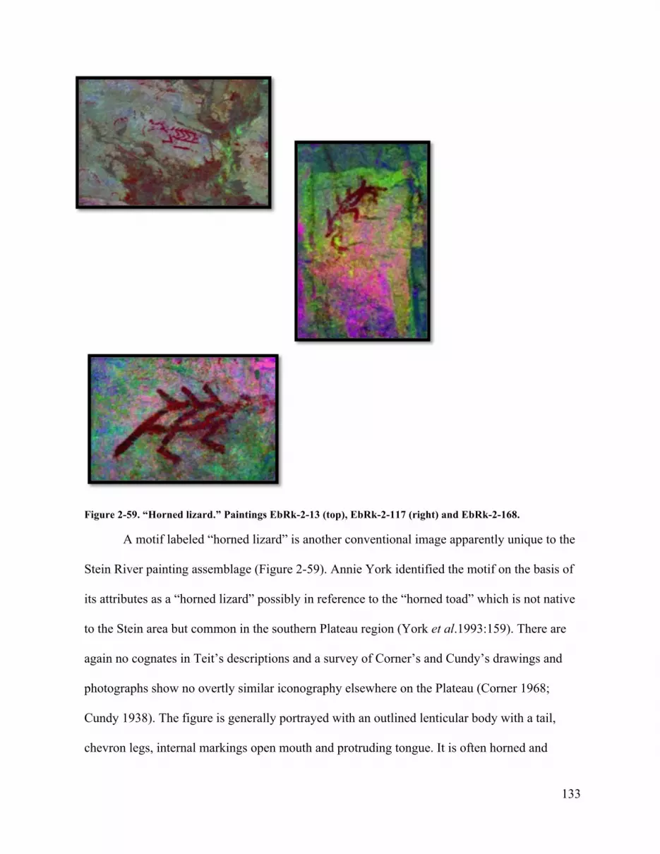
133
Figure 2-59. “Horned lizard.” Paintings EbRk-2-13 (top), EbRk-2-117 (right) and EbRk-2-168.
A motif labeled “horned lizard” is another conventional image apparently unique to the
Stein River painting assemblage (Figure 2-59). Annie York identified the motif on the basis of
its attributes as a “horned lizard” possibly in reference to the “horned toad” which is not native
to the Stein area but common in the southern Plateau region (York et al.1993:159). There are
again no cognates in Teit’s descriptions and a survey of Corner’s and Cundy’s drawings and
photographs show no overtly similar iconography elsewhere on the Plateau (Corner 1968;
Cundy 1938). The figure is generally portrayed with an outlined lenticular body with a tail,
chevron legs, internal markings open mouth and protruding tongue. It is often horned and

134
spines are shown along its back. Some (Paintings EbRk-2-13 and EbRk-2-42) are rectilinear
and very close in style to the “sunulhkAz” figures.
Figure 2-60."TLapEEsht." Painting EbRk-2-148.
There are six conventional images that represent a frontal winged being with
outstretched sheet-like body and large staring “eyes” which Annie York identified as
“TLapEEsht”—a term used here (Figure 2-47, 60). A later version (because it overlaps older

135
paintings) has the head shown as a single mass. These are very rare elsewhere though versions
are said to occur in the Similkameen Valley in the Ashnola area (Stan Copp, personal
communication, 2011, see also Corner 1968). The figure is shown either singly, holding a spear
and in two instances is shown with its wings arched over ungulates depicted underneath on
either side as if gathering or protecting them (Figure 2-47). In another painting the
“TLapEEsht” spears an ungulate (Figure 2-60) . The majority of these images are found among
the upstream Group 3 paintings suggesting a preference for this area of the site. Only one
(Painting EbRk-2-104) appears in Group 2 overlapping (just slightly) an earlier ungulate
painting.
Another striking group of motifs at EbRk-2 incorporated into patches of speleothem at
EbRk-2 are large conventional human-like images (Figure 2-61). These are identified as a
“ghost” after its similarity to the tattoo and body painting imagery of a St’at’imc shaman’s
guardian spirit of the same name (See Teit 1906:Fig 99a, 100a). The “ghost” is represented
visually as a frontal bloated (like a corpse) human-like figure with skeletal attributes. This
image is also found in the Similkameen Valley, Nahatlatch Lake and on the coast suggesting it
had widespread conventional significance (see Lundy 1972).

136
Figure 2-61. "Ghost" imagery, EbRk-2- 37 (top), EbRk-2-152 (middle left), EbRk-2-24 (middle right) and EbRk-2-31 (bottom).

137
Surface Features
The direct empirical relationship of the trail to the site suggests that it is an important
component of most rock painting location, a general pattern noted elsewhere (Copp 1974;
Corner 1968; Cundy1938; Rousseau et al. 1991; Taylor et al. 1974; York et al. 1993;
Zawadska 2013). As a temporal marker the trail must also predate the archaeological deposits
and the paintings as people had to be able to access the site. However, trails and direct access
from below rock paintings do not always preclude their appearance in places where access
might came from above, through rappelling,
The downstream entry to the site is restricted by the proximity of the geomorphology to
the river allowing only a small margin of access until the river terrace in front of the site is
reached and the trail proceeds along the base of the cliff (Figure 2-30). At the upstream west
entrance to the site the trail passes over rock talus and directly adjacent to the cliff. Here two
contiguous small units (12 cm by 20 cm) were excavated from the base of the cliff directly
below a vertical rock surface with paintings in Group 3 (see Figure 2-23).
The deposits below the paintings consisted of fine eboulis interspersed with larger
fragments. Because this portion of the trail is located along the drip line of the cliff the deposits
were heavily percolated. The matrix was also bioturbated with cedar roots some of which were
burnt. To clarify the nature of the deposit one of the units was excavated to a depth of 40 cm
below surface (DBS) to reveal an older stratum with a distinct compact horizontal surface with
organic material at 25 cm DBS. The lower stratum was not riverine but consisted of the same
granular eboulis of the upper level, only more compact, suggesting an earlier period of heavier
use. Based on the vertical proximity to the existing Stein River trail this layer is an earlier

138
signature of the trail. As we saw above, Rousseau identified a similar archaeological signature
of a preexisting trail at the spit’kwa’us rock paintingsite (EdRi-2).
Climatic and geological processes, continuous trail use and possibly other cultural
restrictions prevented formation of archaeological sub-surface cultural deposits in this area of
the site except for the trail itself. Cultural material in the trail excavation was limited to a small
3 mm piece of red ochre located at 9 cm DBS in the percolated deposits. A small number of
smooth river stones may have been left intentionally. These would seem to be manuports, that
is, natural objects brought to the site through human agency.
An important surface feature at EbRk-2 is a concentration of manuports of various
rocks, mostly water worn cobbles, at the center of the site in the vicinity of the rock shelter
(Figures 2-62, 2-63). Some are fire blackened possibly from recent campfires. The unusual
concentration and diversity of rocks suggests that they were brought to this portion of the site
from elsewhere. Excavation showed that this feature continued beneath the surface (Figure 2-
26). This suggests that the practice of bringing manuports to EbRk-2 has some time depth.

139
Figure 2-62. Entrance to rock shelter showing manuport deposit in foreground, 2009. Excavation unit occurred in light coloured area at entrance to collapsed shelter. Red “pictograph” in right centre is recent (21st century) and has been removed. Photo by Chris Arnett
Figure 2-63. Manuport deposit at EbRk-2, 2009. Photo by Chris Arnett.

140
Subsurface Features
The subsurface cultural deposits at EbRk-2 are largely confined to the area in and
around the rock shelter at the base of the cliff (Figure 2-62). The area of obvious cultural
deposits (darkened sandy sediments) measured less than 2 square meters and extended into the
collapsed shelter. Cultural sediments at the entry to the shelter were not deep only 13 cm to
sterile river sand and boulders. A shovel test into sterile deposits beneath the cultural levels
revealed the presence of alluvial sand and large river boulders. It is assumed because of the
natural site formation process of the river terrace that there are no deeper cultural deposits
present at the site. Older deposits either never existed or if they did they may have been washed
away by a powerful flood caused by a broken ice, log jam or other changes in the river. This
seems unlikely as forest cover has been constant since late 18th century and cultural deposits in
the shelter date to at least the 16th century (see below).
Each rock shelter is unique and has it own history of sedimentology (Farrand 1985). At
EbRk-2 the subsurface deposits are composed of sporadic pieces of eboulis amongst wavy
layers of aeolian sand and forest debris creating a complicated undulating stratigraphy typical
of cyroclastic rock shelter formations (Farrand 1985). Eboulis, French for rubble, describes the
presence of disintegrated rock found in archaeological deposits due to mechanical weathering,
chiefly by freezing and thawing cycles, that create “a relatively steady rain of rock fall” ranging
in size from individual grains to large blocks (Farrand 1985:25-27; Goldberg and McPhail
2006:175). Eboulis constituted 20 to 60% of sub-surface deposits at spit’kawuz and a similar
percentage was evident here.31
31 Climate change may be part of the observed difference in the natural site formation process at EbRk-2 with warmer temperatures associated with the initial occupation of the site followed by a colder period

141
A single roughly 1 x 1 meter excavation was made directly underneath the painted
overhang at the entrance of the collapsed rock shelter in the most visible area of subsurface
deposits at EbRk-2 (See Figures 2-64 through 2-65). Excavation was by arbitrary 2 cm levels to
13 cm DBS to sterile parent material. Excavation focused on the stratigraphic recovery of all
artifacts, fauna, and pigment using a 1.3 mm mesh screen. Despite the shallowness of deposits
four strata could be distinguished.
A disturbed surface layer (Stratum I) up to 2 cm deep consisting of aeolian sand mixed
with rootlets, forest debris, and eboulis overlay a more compact 6 cm thick cultural stratum
(Stratum II) of dark brown ashy bioturbated sediment interspersed with aeolian sand with
evidence of calcined bone. A radiocarbon sample from this layer revealed an uncalibrated date
of 1769 ± 25 AD. This stratum graded into a layer (Stratum III) composed of sandy ashy
sediment with no eboulis with a small stone hearth. Charcoal from this stratum yielded two
(so-called little ice age) with wetter freeze and thaw cycles increasing mechanical erosion, speleothem, production of eboulis, and human use of the site. Differential deposition of eboulis (fallen rock fragments) in cultural levels may be a signature of the little Ice Age and subsequent colder temperatures resulting in increased cyroclastic weathering between 1550 and 1800 AD (Lamb 1972:107)—a time period closely matched by the radiocarbon dates of circa 16th to early 19th century.

142
other uncalibrated dates 1581 ± 29 AD, and 1585 ± 26 AD, the latter from the stone hearth 32
Figure 2-64. Ground surface Unit 3 prior to excavation, EbRk-2, 2009. Note thin surface layer of aeolian sand overlaying darker sediments and rootlets. Darkened rectangle is 30 cm x 50 cm. Photo by Chris Arnett.
32 One other uncalibrated date was secured from the lowest level 1812 ±31 AD. The improbability of its stratigraphic sequence suggests that it slipped ffrom the excavation unit wall. Nevertheless it demonstrates an “historic” presence. Seven radiocarbon dates from EbRk-2 and EaRj-81 were calibrated using the CALIB REV7.1.0 radiocarbon calibration program (Stuiver and Reimer 1993). Median probability dates are1516 AD, 1562 AD, 1768 AD and 1810 AD (see Fig. 2-77).

143
Figure 2-65. Northeast corner of Unit 3 to sterile sand 13 cm DBS, EbRk-2, 2009. Note alternating layers of layers of aeloian sand and darker strata, fire altered rock and sand oxidized by fire. Photo courtesy of Adrian Sanders.

144
Figure 2-66. Northwest corner of Unit 3 showing culture strata to 13 cm DBS, EbRk-2, 2009. Photo courtesy of Adrian Sanders.
Figure 2-67. Unit 3 excavation to sterile river sand showing hearth. Note manuports at right surface and subsurface. Photo courtesy of Adrian Sanders.

145
The lowest stratum (IV) was composed solely of alluvial deposits of sand and water
worn cobbles and boulders at 13 cm DBS. This suggests that the Stein River once flowed close
by this portion of the cliff prior to the deposition of the present cultural layers and the
establishment of the forested grove.
Recovered cultural material included ochre, lithic debitage, glass shatter, shell, fauna
and flora—the physical remains of previous activities that occurred at EbRk-2 over several
centuries. Along with geomorphology, rock paintings and the travel corridor, these material
signatures of practice are equally important to understanding the site formation process at
EbRk-2 or any rock art site.
Figure 2-68. Red ochre fragment recovered from EbRk-2.
127 pieces of materials believed to be red (Fe2O3) and yellow ochre (FeO (OH) H2 O)
were recovered in most strata throughout the 13 cm deep excavation underneath the painted
overhang at the entrance to the shelter (Figure 2-68). Several of the larger pieces of red ochre
were excavated in situ. Fine-sorting to 500 um yielded the bulk of samples. Successful XRF
analysis of 79 of these fragments identified only 40 pieces as actual ochre brought to the site
possibly from as many as four sources (Figure 2-69). This supports Velliky’s (2013)
documentation of adjacent paintings at a Squamish site being made with different ochres.

146
Fully half of the measurable samples consisted of naturally occurring ochre visible
throughout the granite rock formations at EbRk-2 (and at other rock art sites). Visual
identification alone is insufficient to identify red ochre in cultural deposits at rock art sites of
granite formation (MacDonald 2008). Non-ochre is visibly red but has low iron readings
compared to the high amounts found in authentic quarried ochre (Rudy Reimer, personal
communication, 2014).
Figure 2-69. Plot of calcium and iron showing XRF results. Four types of ochre at EbRk-2 are indicated by solid triangle, square, diamond, and star. Low iron samples (not ochre) marked as “x” and others with calcium carbonate as dots. Plot courtesy of Rudy Reimer.
Red ochre, or tumulh, is found in igneous, metaphoric and sedimentary formations and
in coarse grained metamorphic rock schist found in layers where sedimentary clay, composed
of two different forms of iron oxide (Fe2 03 and Fe0), is differentially exposed to heat and
naturally tinted by iron oxides (5 to 75%) and up to 32 other elements. Recent work by Brandi
0
50000
100000
150000
200000
250000
300000
Ca
0 100000 200000 300000 400000 500000Fe

147
MacDonald and Beth Velliky has focused on geochemical characterizations of ochre for the
purpose of geological proveniencing (MacDonald et al. 2013). The paint has high cultural
significance (See Chapter 3).
Basalt and quartzite debitage (n=32) was located throughout the units but more
prevalent in the upper levels (Figure 2-70). 97.5% of the lithic debitage was found in the pre-
glass (European) levels >4 cm DBS and the recovered amount is consistent with the
percentages of basalt debitage at EdRi-2 (spitkwa’uz) where vitreous and fine grained basalt
made up 98.1% of the debitage (Rousseau et al.1991). Basalt was an important resource on the
British Columbia Plateau and the percentages found in rock art shelters match those found in
domestic contexts (Sanger 1970).
Stone tool artifact production is reductive and the absence of large debitage, cores and
the small size of the basalt debitage at EbRk2 (X=7.6, SD 3.75) indicates late stage lithic tool
manufacture (Andresky 2005:98) and a pattern of very short-term limited maintenance or
production of basalt, chert and quartzite lithic tools.

148
Figure 2-70. Basalt debitage, Unit 3, 6 - 8 cm DBS.
Four types of glass shatter (n=12) were recovered from the upper 4 cm of Unit 4 (Figure
2-71). Overall glass made up 51% of the debitage/shatter from this layer suggesting recent
deposition over the last century or more. Amounts were concentrated in the sub-units closest to
the outside perimeter of the shelter overhang.
Figure 2-71. Glass shatter, Unit 3, EbRk-2.

149
Glass, as an excellent source material of European-American origin, is recognized as a
legitimate raw material in archaeological assemblages on the North West coast and elsewhere
(Deal and Hayden 1987; Martindale and Jurakic 2006). The Stein River and its archaeological
sites have been known for well over a century by outsiders and hundreds, perhaps thousands, of
people have visited EbRk-2 in the last few decades. Some of the glass shatter may have
originated from this activity. Still, glass made up a significant 57% of the slim Strata 1
debitage. The relatively small amount (n=12) from several different sources suggests that it
may not have originated in some accidental or deliberate breaking of a glass container which
would leave a significant amount of shatter from the one object. An aggregate analysis of the
debitage size showed more size consistency between the green glass shatter and the earlier
lithic tradition (Arnett 2010).33
33 Microscopic analysis of two of the green glass shatter showed possible lines of wear, in one instance, against the Hertzian lines common to shattered glass. Two of the clear glass pieces resemble remnants of small multi-dimensional cores from which small flakes have been secured. Reports of glass arrowheads in the Lytton/Lillooet area suggest that post-contact incorporation of glass as a raw material into Indigenous cultural activity is a distinct possibility and demonstrates a change in raw material acquisition and continuity of practice into the beginning of the 20th century.

150
Figure 2-72. Burnt fragment of Pecten carinus.
A tiny fragment (7.5 mm x 5.2 mm) of calcined shell was recovered from Unit 4 at 4-6
cm DBS (Figure 2-72) and identified, by comparison with taxonomic collections in the LOA at
UBC, as Pecten caurinus or kweenemen (swimming scallop). Pecten caurinus is native to the
Gulf of Georgia where there are at least three known gathering locations, one on Waldron
Island, and two on Satellite Channel (Arvid Charlie, personal communication, 2014). These
shells were imported to the Middle Fraser and Kamloops areas where they have been found in
burials nested together in groups of four or seven shells, no doubt as rattles similar to those in
use today on the coast. Worked fragments made into pendants or other artifacts have also been
recovered at burial, habitation and rock painting locations (Harris 2012:74; Sanger 1968:123;
1970:101; Smith 1899:152, 1900:428, 1913: Plate XIII fig. 3f; ). Scallop shell is found only in
Plateau (2400 -1200 BP) and Kamloops Horizons (1200-100 BP) context (Richards and
Rousseau 1987:Table 10).

151
Figure 2-73. Dentalia pretiosum bead, Unit 3, 9.5 cm DBS.
A single dentalium bead was recovered near the base of the shallow cultural deposits
(Figure 2-73). The 5 mm x 3.6 mm bead was cut from a shell of Dentalia pretiosum originating
most likely from the west coast of Vancouver Island. It may have been deposited singly or as
part of a larger ornament. Whole or modified dentalium can appear in prodigious numbers in
ceremonial contexts such as burials at Salishan archaeological sites (Stryd 1974:301; Blake
2004:108-109). The artifact is comparable to archaeological examples found in burials at Cache
Creek (Richards and Rousseau 1987: Fig 23j), Nicola Lake (Smith 1900:425) Kamloops
(Sanger 1968:123 and Lillooet (Stryd 1973: 425-427). While unmodified dentalium has a
respectable antiquity in Pacific Northwest archaeological sites (Andrews 1989), cut dentalium
beads are only found in Plateau (2400-1200 BP) and Kamloops (1200 BP to 200 [100] BP)
contexts (Richards and Rousseau 1987:91).
A limited variety of fauna material, including fish and mammal taxa, was recovered
from EbRk-2 in the excavations at the shelter entrance beneath the painted overhang.
Recovered fragmented bone elements (n=92) were evenly divided between fish (47 elements)
and mammal (45 elements). Rebecca J. Wigen of Pacific Identifications analyzed the fauna

152
using the comparative collections in the Anthropology Department of the University of
Victoria.
Salmon elements were most abundant, contributing 19% of the fish assemblage, or 82%
of the identified specimens. A few small bones (n=5) were calcined or heat-treated. It was not
possible to identify specific salmon species although one vertebra was complete enough to
indicate it came from an individual of about 50 cm in length. These could be any of the
Oncorhynchus species, including all of the salmons, steelhead or any of several trout. Most of
the elements were vertebra or vertebra fragments, but a single postcleithum was present.
According to Wigen the presence of a single postcleithum, a bone associated with the pectoral
fin behind the gills, suggests that it may be from a processed fillet rather than a whole fish. As a
result it is possible all the salmon elements might have come from processed fillets brought to
the site rather than whole fresh fish.
A single vertebra has been tentatively identified as whitefish (Prosopium williamson).
The element size (this is from medium sized individual) and range information suggests the
most likely whitefish is the mountain whitefish (Nancy Wigen personal communication, 2012).
The faunal assemblage shows clear evidence of very small amounts of fish being
consumed (burnt/calcined bones) over time. Large land mammal bones were also processed
and burnt—a good indication of hunting, most likely of deer, and processing of bone. It is also
possible some wood rat and marmot hunting was taking place, but it is also possible that the
mammals died naturally at the site.
A variety of flora, 30 seeds, 1 intact fruit, and 1 calyx were recovered and identified
by Natasha Lyons. These included seeds from Prunus spp (n=21) or chokecherry, Rubus ssp. or
black raspberry /blackcap (n= 8), Sambucas cf. cerulean (n=1), or blue elderberry, Shepherdia

153
canadensis or soapallalie (n=1), Potentilla spp. and a single seed of Prunus armetiaca. All,
except the last, are culturally valuable indigenous plants. The degree of preservation of
(mostly) uncharred remains indicated a protohistoric assemblage congruent with the
radiocarbon dating (Natasha Lyons personal communication, 2011)
Figure 2-74. Prunus ssp. (left) and Rubus spp. Unit 3.
Figure 2-75. Laris occidentalis (western larch) pitch. In situ Unit 3, 6 cm DBS.

154
A single globular piece of pitch was identified as Larix occidentalis (Western Larch) by
comparison with Beatty Museum of Biodiversity collection specimens at the University of
British Columbia. It was found 6 cm below surface (Figure 2-75).
In the excavation of sediment directly below the paintings shown in Figure 2-34 at 4 cm
below the surface, a moderate three centimeter wide cedar root pinned half a fire cracked
cobble with several pieces of shaft fragments from large land mammal bone, as well as
mandible and tooth fragment of an ungulate either deer or mountain goat (Figure 2-76).
According to Wigen’s analysis it seems most likely these are mule deer but the size category
could include mountain goat, black bear and wolf. The fragments appeared to be limb bones
(one was probably tibia) and all showed spiral fractures created by striking the bones. This
could either have been done to access the marrow either as food or raw material (such as paint
manufacture). There were no marks determine which case was occurring. The single fire
cracked rock and the spirally fractured bone were the only cultural material encountered
throughout an homogenous matrix of moderately bioturbated aeolian ashy sand excavated to
sterile river sediment (20 cm DBS).

155
.
Figure 2-76. Spirally fractured tibia (?) of large land mammal, found with a single piece of fire-cracked cobble at 4 cm DBS in Unit 4 beneath paintings in Figure 2-35.
Summary
The rock paintings, surface and subsurface archaeological assemblage at EbRk-2 on the Stein
River appears with river terrace stabilization and the construction of a small stone hearth in the
early 16th century or later with very limited site activities involving limited mammal, fish and
berry consumption and fire (the burning of bone, Pecten carinus, and Prunus sp.). The presence
of red ochre and other materials suggest the use or production of red ochre paint, some
transport of dentalium and late stage reduction or sharpening of basalt, quartzite and possibly
glass tools. Manuports (river cobbles and other rocks) were also transported to the site from
elsewhere. These activities occurred into the early 19th century as suggested by the latest

156
radiocarbon dates and the presence of glass shatter mixed with lithic material and red ochre in
the uppermost deposits of the site.
The study of painting events at EbRk-2 show that two distinct chronological phases are
evident. In the earliest phase large numbers of paintings are produced with careful attention to
the incorporation of rock surfaces. In a very few cases these overlap earlier paintings. The
second phase is represented by fewer paintings and super-positioning of imagery on earlier
paintings. Over painting represents less than 12% (n=24) of all painting events at EbRk-2 and
analysis of the graphic stratigraphy reveals no overall change in iconography between the
earlier and later images a pattern of super-positioning documented at other rock painting sites
across the Plateau (Loubser 2006:242). Other chronological features such as internal chevrons
seem to be time sensitive with the latest paintings having fewer chevrons than earlier examples.
The paint on these later paintings is also better preserved having been exposed to the elements
over less time.
The limited graphic stratigraphy suggests a limited time span of painting practice late in
the chronology—focused around older paintings in the vicinity of the rock shelter. Individuals
deliberately painted over certain earlier paintings despite the seeming availability of space, and
other paintings, elsewhere.
In a study of seven Salishan rock painting sites in the Dalles-Deschutes region of the
southern Plateau Keyser and Loubser (2004) looked at the direct stratigraphic relationship
between individual motifs to see if there was an overall sequence of change and found none.
“Although these motifs are seldom located directly on top of previous ones, they nevertheless
appear to duplicate the earlier motifs” (Loubser and Keyser 2004:90). Thirty percent of super-
positioning consisted of similar motifs. The similarity in style of super-positioned Plateau rock

157
art shows a consistency of iconography not indicative of great temporal difference or distinct
traditions (Keyser 1971:565; Loubser 2006:242) something Steward noticed in the rock art of
the vast area he studied further south (Steward 1929:232).
A pattern of copying an earlier image occurs with some frequency across the entire
Plateau (see examples in Corner 1968; Longman 2009:6). These paintings share qualities of
style, preservation and contemporaneity with the paintings superimposed over earlier ones.
Copying is also associated with post-contact imagery (the horse) at three Plateau sites including
Tcutciwi’xa in the Nlaka’pamux/Stuwix/Okanagan (Sylix) border region of the Similkameen
Valley suggesting by association the comtemporaniety of the practice eslewhere.34
Rock painting sites are activity areas—“the locus at which a particular human event
occurred” (Kent 1984:1). Activities may or may not be associated with the production of the
paintings but all activities are themselves historically contingent and part of a suite of cultural
practices. It is clear from the ethnographic record and present day practices that indigenous use
of a site may occur without the production of rock paintings. The archaeologist Smith was
informed that youths in the late 19th century visited Stein River rock painting locations in the
lower canyon to fast or to wash with fir boughs not to paint (Smith 1934). Such activities
would leave a minimal archaeological signature. While the presence of ochre is not necessarily
associated with rock painting (it may have been for body painting), its predominance in the
upper layers of Salishan rock paintings sites suggests contemporaneity with the paintings.
34 Other Plateau examples are on the Adams River in Secwepmec Territory and on the Salmon River in Idaho (see Keyser 1992:114.). Paired imagery is often referred to in the literatures as representations of “Twins” (Cain 1950; Keyser 1992:77-78, 86). However, close comparison of these images show significant differences in line and execution despite the overall similarity of form). Suggesting the work of different people creating the same subject (See Cundy1938, Plate 47a; Keyser 1992:67)

158
Aggregate analysis of the small amount of lithic debitage and glass material at EbRk-2
showed continuity of a lithic practice and adaptation over time of site activity other than
painting (Arnett 2010). Small, later stage reduction basalt debitage appears at the initial use of
the site circa 500 BP and continued with the incorporation of diverse materials including
quartzite and possibly glass into the historic period. The consistency of lithic debitage and glass
shatter size and the absence of cores or finished tools over this time period indicates that the
limited tool production at EbRk-2 represented the latter stages of biface reduction or the
sharpening and/or manufacture of particular lithic and/or glass instruments—a pattern similar
to other Nlaka’pamux rock art site lithic assemblages.
Magne’s (1985) study on variations of lithic debitage patterns within archaeological
type sites in the Southern Interior identified 11 types, one of which is characterized by small
assemblages, “with restricted ranges of debitage reduction stages” which he terms “short term
lithic scatters with fire-cracked rock” that related to large mammal procurement and processing
(Magne 1985:248-249). The sparse faunal remains at EbRk-2, complete lack of tools or cores,
and the socio-cultural context of a rock art landscape suggests that lithic technology at EbRk-2
was a limited and infrequent activity involving later stages of lithic reduction or maintenance or
expedient tool manufacture. This lithic production is not necessarily associated with the
processing of game but could represent an alternative cultural, perhaps ritual, activity.
The presence of glass shatter may represent the incorporation of European materials
into an older lithic tradition of tool manufacturing as well as more recent use of the site (Arnett
2010). Expedient glass artifacts, with retouched edges, have also been located at one other rock
painting location, DhRl-2, the large Sts’aisles site on the Harrison River (Ritchie and Springer
2009).

159
The lithic activity at EbRk-2 and other rock painting sites is intermingled with the
debris of burning (in one instance Pecten carinus), spirally fractured mammal bone indicating
marrow extraction, red ochre fragments and potential paint making materials (Western larch
pitch, Prunus spp., Rubus spp.). Not all of these practices may be related to the production of
rock painting per se. We can assume that cultural activity at Nlaka’pamux “rock painting sites”
occurred prior to and after the paintings appeared.
Flora is a significant component of the site assemblage at EbRk-2 and presumably other
sites. At EaRj-81 at Kwoiek, for recovered by flotation included charred Corylus californicus
(beaked hazelnut), Sambucas spp. (elderberry), Rubus ssp (raspberry), Arctostaphylos uva-ursi
(kinnikinnick), Pseudotsuga menziesii Douglas fir (needles), Pinus ponderosa (Ponderosa Pine
needles), Sorbus` sitchensis (sitka mountainAsh), and Betula papyrifera (birch bark) (Lyons
2013). The presence of Arctostaphylos uva-ursi (kinnikinnick) identifies plant use in the rock
shelter as very different than habitation contexts making EaRj-81 “clearly a special use site”
(Lyons 2013:29).
In this chapter, I have reviewed previous archaeological work in the region and then
presented new archaeological data for an Nlaka’pamux rock art site on the Stein River. EbRk-2
is one of only a few Coast or Interior Salish sites where an exceptional number of paintings are
found—that is while there are scores of locations where rock paintings were made only a very
few have 100 or more painting events. EbRk-2 is located along the Stein River travel corridor
with 16 other rock painting locations (cliffs, rock outcrops, boulders and caves) each with far
fewer painting events (Corner 1968; Rousseau 1978; York et al. 1993) not apparently due to
lack of available painting space.

160
EbRk-2 is part of a general patterning of Nlaka’pamux rock art sites showing sporadic
low-scale activity (small hearths, limited food and lithic maintenance, paint use, and limited
stay). Some sites (EdRi-2, EdRi-10, EaRj-81 and DhRl- 2) have evidence of early use
indicating that the sites were well known in past times with use intensifying during the later
period of the Kamloops Horizon when marking activities occurred and possibly took
precedence over earlier site activities.
The archaeology of Nlaka’pamux rock art demonstrates that sites where rock paintings
are found may have considerable antiquity with ongoing use over time into the present. This is
particularly true of rock painting sites in ts’paa’nk (EdRi-2 and EdRi-10) and the Similkameen
Valley (DhRa-2) where there is evidence of thousands of years of continuous use. By contrast,
posterior probability distribution of seven calibrated dates from EbRk-2 and EaRj-81 show that
the bulk of dates (n=6) occur within 500 BP. While red ochre is found in deeper levels at most
rock art sites, it is generally concentrated in the upper levels of the subsurface deposits (Copp
2006: 303; Ritchie and Springer 2009).

161
Figure 2 -77. Posterior probability distribution of radiocarbon dates from EbRk-2 and EaRj-81.
Rock paintings and subsurface cultural deposits are the material culture of intermittent
activities at certain landforms that increased over time until the 19th century when paintings
became less frequent and overlapped older ones suggesting a change in practice. At Spences
Bridge the practice continued into the 20th century (Teit 1918). Comparison of all
archaeological data suggests that rock painting sites are ancient (sptaqulh) and that the
paintings and other activities are historically contingent, that is, they occur during a specific
time period within a long history of traditional practices associated with each site.
Nlaka’pamux rock painting sites share similarities in geological configuration and
chronology with other Salishan and Kutenuxa rock painting locations suggesting that the
production of Nlaka’pamux painting was part of a larger pan-Pacific Northwest practice

162
drawing on ancient models but motivated by events beginning circa 500 BP into the so-called
ethnographic period.

163
Chapter Three: Ethnography of Nlaka’pamux Rock Art
The mode of life of the prehistoric tribes, their utensils, their methods of manufacture, and even their customs, must have been practically the same as those of the recent Indians. One of the strongest evidences for the identity of culture is the ability of the modern Indians to interpret the conventional designs found on prehistoric remains (Smith 1899:161).
I’m interested in the rock paintings particularly the ones in the Stein Valley. I have some pictures here if you could explain (Richard Daly1/7/89:1).
Introduction
The archaeology of Nlaka’pamux rock painting sites provides some time depth and
control for a practice that was well-documented in the ethnographic literature of the
late 19th and early 20th centuries. Indeed as the above quote by Harlan Smith attests,
an archeologist digging in the cemeteries across the river from Lytton in 1897 could
not help but notice the cultural and historical connection between the objects he
was recovering and the contemporary Nlaka’pamux culture:
The similarity of the art designs of the prehistoric people to those of the present natives is the strongest argument in favor of the theory that the culture of this area has not materially changed since the times when the prehistoric burial ground of Lytton was in use and the prehistoric sites inhabited (Smith 1899:157).
In a letter written to a friend he thought that the rock paintings he had seen “were probably
more recent than the burial places although the bear grease mixed with the paint might preserve
such pictures for a long time period in this climate” (Smith 1897). Like many archaeologists
before and since, Smith recognized the value of ethnographic data to archaeological
interpretation particularly when there was direct historical and cultural continuity In this
chapter I chart the wealth of ethnography on the subject of Nlaka’pamux rock painting to show

164
its value not simply as explanatory or analogical but as an illustration of a western cultural
engagement with a complex culture and practice.
Ethnography is the written record of an indigenous culture indicative of the person
who writes it and of the time it was recorded, i.e. a specific standpoint view among many
possibilities. Its success as a narration on indigenous culture is proportionate to the research
interest of the ethnographer and the degree of mutual understanding between them and their
subjects. Not everyone is interested in the same thing when a world of difference exists
between them but ethnography, as the past observations of practice and places by interested
individuals, has value once allowance is made for the cultural and historical context of the
scholar and the method (Martindale 2013).
The Pacific Northwest of North America was colonized late but Salish people were likely
well aware of what was going on elsewhere through the networks of kinship across geography, by
travelers and by individuals possessed of the ability to sense beyond the frontier. On the coast the
latter were called siyu’wa. To give one example, among the Sechelt a siyu’wa (a “Prophet” from
iyu’wa to prophesize) named kwi kwe (“daybreak”) “got up in the morning, made a fire, wrapped
soqwal [a goat wool blanket] around him, jerked and said, “White men coming across; too much!
No one knew of the whites then” (Suttles 1952: 22).
The same man told that there was going to be the stove, kettles, dishes, etc. When Lt.
Jose de Maria Narvaez and his crew of Catalunya Light Infantry sailed into Georgia Strait in
July 1791 local “dreamers, ” such as hulqulustun of puneluhutth had anticipated their arrival
(Jenness 1934-35; Arnett 2007:99). More Europeans (Vancouver and Galiano) visited the
Salish Sea the following year and noted evidence of disease on the faces of individuals and
empty village sites. Coastal traditions describe pre-contact epidemics prior to the arrival of the

165
first known European visitors with fatalities estimated as high as 90% (Harris 1994).
Archaeological data reflects this population collapse (Merchant 2011) and some argue that
smallpox hit the northwest possibly as early as the 16th century (Campbell 1990). Thus the
indigenous world encountered by Europeans was not the indigenous world before the influence
of Europeans, but rather one already confronting facets of colonization. In its face, Indigenous
people took pro-active measures to mitigate the change in multiple ways using culturally
prescribed means. For example, kwi’kwi, the Sechelt Prophet, “used to talk to the people before
daybreak, lecture them on how to be rich, happy etc.” (Suttles 1952: 22).
In 1793 the first known European to cross the continent to the Pacific coast, Alexander
MacKenzie, traversed just north of Interior Salish territories to the coast where he was stopped
in North Bentick Arm by Heiltsuk militia. There, before he turned back, he inscribed his name
and the date of his arrival on a rock surface using red ochre and bear grease. It is interesting to
speculate on whether or not he knew its ritual significance or what interpretation his act may
have had on the Heiltsuk or Bella Coola. Mackenzie was not unfamiliar with Indigenous rock
painting and recorded instances he had seen along portage routes in Manitoba (Jones 1981:66-
67). MacKenzie knew that rock paintings marked important places in the landscape and his
writing hints that he understood that the practice was historically contingent. In his writing he
described two sites in Manitoba, one of which represented a bear, “where the Indians have
painted red figures on the face of a rock, and where it was their custom formerly to make an
offering of some of the articles they had with them” (MacKenzie quoted in Jones 1981:66).
Perhaps his knowledge of native practice informed his act in the confrontational situation with
the Heiltsuk. As for the Heiltsuk, who have a rich tradition of rock painting (Skala 2015),
MacKenzie’s graffiti may have taken on local culturally prescribed significance.

166
A few years after Mackenzie, a fellow Scot, Simon Fraser, while stationed at Fort St
James much further north of the Fraser River, also appears to have left his signature and the
date (1806) in red ochre at a Dunna rock art site (GdSc-6) on Stuart Lake (Richards 1981:151;
Frances and Porter 2010). There is only one Dunna painting known at the site which
“resembles the lower part of a person standing in a canoe” (Richards 1981: Fig. 20). This is an
interesting coincidence considering that the Nlaka’pamux named him “birch bark canoe”
(Kenny 1954).
Two years later Fraser became the first European to visit Nlaka’pamux territory (by
Nlaka’pamux and European accounts) when he and his entourage passed through in June 1808 to
find a way to the coast. His visit attracted much attention as he traveled down the river that would
one day bear his name until he too was turned back at seawater by Musqueam militia.
Nlaka’pamux encountered what they termed the “real whites” or the “good people”
(shuma) shortly afterwards. These were the French Canadian employees of fur trade
companies, who arrived with the establishment of Fort Kamloops in 1814 (Barman 2015). The
fur trade and the Okanagan Brigade Trail to the Columbia River offered opportunities for trade,
travel and new industry along well-established indigenous travel corridors (Gibson 1997).
Nlaka’pamux were cognizant of change in the air and especially of the threat of smallpox.
Forewarned, people took proactive measures to prevent smallpox, which included knowledge
of European vaccination methods. In 1832 when Interior Salish people refused to sell fish they
were told that a smallpox epidemic was approaching and the vaccine cost 10, 000 fish
(Nlaka’pamux Tribal 2015). While neighboring populations on the coast and to the east were
devastated Upper Nlaka’pamux and other Interior groups escaped epidemics through early

167
vaccination and culturally prescribed practices until 1857-1862 (Teit 1900). I discuss this
history in more detail in Chapter 5.
The new economic processes had impact on local culture through the introduction of a
social order based on the acquisition and control of access to commodities and new perceptions of
wealth–hallmarks of incoming western influence (Arnett and Nord 2015). As Teit described it the
adoption of symbols of social rank (mortuary poles, elaborate mausoleums) was limited to a few
families influenced by similar trends among coastal cultures with longer inter-action with
Europeans (Teit 1900:29, 329; 1909:574). Some scholars have used these accounts as evidence
that similar social rank existed in the past (Hayden 1992; Prentice and Kuijt 2012) without
recognizing the historical contingency explicitly remarked upon by Teit who saw it as maladaptive
and short-lived (Harris 2012; Martindale 2003).
The present-day 21st century jurisdiction of British Columbia has been described as “a
crossroad of colonialism and the modern world” (Harris 1997:xi) in reference to its recent
rediscovery by Europeans (less than 250 years ago) and the rapidity of colonization following
its establishment in 1858 as a Crown Colony—an imperial dictated regime of conquest without
treaty (Harris 2002; Manuel and Poslun 1974: Tennant 1990). The Fraser River Gold rush of
1858 saw an invasion of nationalities into the Fraser Canyon and armed conflict, resulting in at
least three burned Nlaka’pamux villages below Boston Bar and casualties on both sides
(Marshall 2000; Pegg et al. 2013; Teit 1900:271). Smallpox may have been introduced as early
as the year before (Teit 1928). An all out war involving other Plateau groups was only averted
by the leadership of shwoohspntlm the son of the Prophet who arranged a peace treaty based on
mutual agreements that purported to recognize Nlaka’pamux jurisdiction (David Spintlum
Memorial Stone, Lytton; Hanna and Henry 1996:130-131; Waite 1977).

168
After the devastating smallpox epidemic of 1862 Nlaka’pamux land was gradually
alienated by pre-emption without consent contrary to the 1858 agreements with the gold rush
miners to co-exist (Mary Williams in Hanna and Henry 1996:131). When British Columbia was
assimilated into the Canadian nation state in 1872 Nlaka’pamux were technically administered
by a distant administration while two transcontinental railways were blasted through their
territories destroying resources, settlements and sacred sites (Harris 2002; Mohs 1987;
Nlaka’pamux Tribal Council 2015).
Because Nlaka’pamux rock art was practiced into the early 20th century, newcomers
interested in the subject found knowledgeable people willing to share information. With direct
historical and cultural continuity, ethnographc records of cultural practices such as rock art may
be situated in their proper cultural and even temporal context of production. The ethnographic
record of rock art frames the gradual colonization of the Nlaka’pamux territory and follows a
trajectory from the incredulity of early explorers towards more informed inclusive
understanding based on the primacy of local knowledge.
In the following section, I review the prominent 19th and 20th century non-native
ethnographers of Nlaka’pamux rock art. This includes a discussion of the ethnographic data on
rock painting sites referenced in Chapter 2. Here, themes of the ethnographic record expand on
the material evidence and explore the variability of cultural and historical contexts of rock art
production in the ethnographic record that have analogues to the material signatures of the
archaeological record. The ethnography of Nlaka’pamux rock art comes from diverse
sources—the first European to see the Nlaka’pamux, a leading 19th century anthropologist and
his British Columbia colleagues, UBC geography students, hard luck miners and an
anthropologist who worked with one of the leading Nlaka’pamux authorities and published

169
work on the subject. A number of individuals with different motivations have been curious
about rock art compiling data according to their interest.
Simon Fraser
Nlaka’pamux saw their first Europeans in June 1808 when Simon Fraser and his companions
from the North West Company arrived in their territory. Fraser and company were searching
for an alternate route to the coast and passed through the heart of Nlaka’apmux territory
stopping at sh.tayn, TLKumchEEn, spup’zuhm and Tsaxalis, the last an Nlaka’pamux rock art
site at the southern reaches of the territory (Teit 1912; Lamb 1972; Wickwire 1996). Several
oral traditions of his visit have been recorded one of which described him and his companions
as sptaqulh (persons of the mythological age) as dentified by their physical appearance and
attributes (Wickwire 1996). One account, by a woman named wAhhtko, stated that Fraser was
called “the Sun” because of a brass emblem that resembled the sun that he wore on his hat
(Hanna and Henry 1996; Laforet and York 1998; Teit et al. 1917:64; Wickwire 1996).35 At
Lytton, Fraser gave his metal insignia to wAhhtko’s grandfather Tcewix, a spiritual leader from
Spences Bridge, after which Fraser was named for is metod of transportation—“birchbark
canoe” (Murray 1954; Teit et al. 1917:64). Wendy Wickwire (1996) compared Fraser’s account
with multiple Nlaka’pamux sources to reveal the accord and divergence of Fraser’s solitary
account.
Fraser’s journal is noteworthy among other things for its description of a well known
rock art site called Tsaxalis overlooking the Fraser River south of shpupz-m (Spuzzum)
possibly the earliest known description of rock art in western North America and certainly the
35 There is a Secwepmec tradition in which this term was briefly applied to the first whites ”because when first seen they were believed to be the ‘ancients’ returned, and thus from the sun”(Teit 1909:452).

170
first Pacific Northwest rock art site ever recorded for the story associated with it and not the
imagery. On June 18, 1808 Fraser was escorted by shpupz-mhh, from shpupz-m, the
southernmost Nlaka’pamux village to a place called Tsaxalis where:
The Natives informed us that white people like us came there from below and they shewed us indented marks, by which the white people made upon the rocks (Lamb 1960:100).
Fraser understood these earlier visitors to be European but he was skeptical regarding the
inscriptions “which, by the bye, seem to us to be natural marks” (Lamb 1960:100).
The Nlaka’pamux regarded the “indented marks” at Tsaxalis very differently. The incised lines
they showed to Fraser were not natural nor made by white men, as in Europeans, but inscribed
in the time of the sptaqulh by QUeeQUTL’QUeTLt one of the miraculous beings referred to as
transformers who roamed the travel corridors of the Salishan world making it fit for human
occupation. They travelled “from the sea” upriver and through Nlaka’pamux territory teaching
people the arts of survival, punishing maladaptive behavior and and giving form to the present
world. Reminders of their pasing are preserved in biodiversity, physical features and long-lived
cultures (See Beirwert 1999; McHalsie et al. 2001; Hill-Tout 1899; Mohs 1987; Teit 1898,
1912).36
Fraser and his entourage were thought, for a brief time, to be sptaqulh and the visit
was not unexpected by the shpupz-muh. They had been informed by shwooshpintlum, of
TLKumchEEn (an influential leader also known as the Lytton Prophet), that they were on their
36 “Transformer” narratives are found throughout the Pacific Northwest on the coast and Interior coexisting and collating with local narratives and variable to place yet having an overall consistent structural form and function (Bierwert 1999; Bouchard and Kennedy 1977, 1979, 2000; Carlson 2001; Elmendorf 1977; Jenness 1934/35; Matthews 1955; Mohs 1987:59-62; Teit 1898, 1912, 1912; White 2004). The QUeeQUTL’QUeTLt”(so-named for the “smiling” (QUeTLt) visage of the youngest member “were four brothers who came from the saltwater”(Teit 1898:119, n.296).

171
way downriver and to receive them hospitably, which they did (Hanna and Henry 1995:123;
Laforet and York 1998:41-42; Lamb 1974). After feasting his entourage the shpupz-muh
escorted Fraser to Tsaxalis because they expected him to be familiar with its significance.
Fraser, of course, had no idea of the cultural significance of the markings and interpreted the
story differently. On the map of his journey (Figure 3-1) he recorded its approximate location
with “To this Place the White Men have come from the Sea”—one of the few “places” noted
on his rudimentary map and on David Thompson’s 1814 copy, “Map of the Northwest
Territory of the Province of Canada” (Hayes 2005:15, 178).
Figure 3-1. Copy of Fraser's map by Francis Harper with reference to Tsaxalis. After Hayes 2005:15. Courtesy Derek Hayes.
Franz Boas
Serious ethnographic study of indigenous “rock art” in British Columbia began with the leading
figure of American Anthropology, Franz Boas, who, on his second visit to BC in 1889, visited
the well-known petroglyph site of ka’ka’win also known as Kwatyaat’s House, a quadrangular
vertical rock face with 10 large images engraved across it on Sproat Lake in the territory of the
Hupacasath (a people of Salish and Wakashan ancestry) on Vancouver Island (Arnett 2015;
Boas 1891). Boas recorded some ethnographic data from his guides and stood in the cold

172
waters of the lake to draw the petroglyph imagery. Published three years later, his was the
earliest European visual record and ethnographic inquiry of rock art in what is now British
Columbia.
Boas, as we have seen, was the driving intellectual force behind the 1897 multi-
disciplinary Jesup North Pacific Expedition (JNPE) goal to gather ethnographic,
anthropometric, linguistic and archaeological data from Siberia and the Northwest Coast to
create a database for further comparative study of the diverse cultures of the regions and test
prevailing theories based on evolution and diffusion (Kendall and Runic 2003). Boas’ brand of
historical particularism sought a snapshot of culture to challenge (or verify) the assumption of
evolutionary theory in a Darwinian world of socially constructed ideas of racial superiority.
James Alexander Teit
Boas interrupted his 1894 train trip to the coast to spend a few days in Spence’s Bridge where,
through a chance encounter with a local resident, he met his extraordinary future colleague, a
young Scottish immigrant, names James Alexander Teit whom he sought out on his country
ranch where he lived with his Nlaka’pamux wife, Lucy Bartok (Figure 3.2). “The young man,
James Teit, is a treasure, ” Boas wrote, “He knows a great deal about the Indians. I engaged
him right away” (Rohner 1969:139). Teit arranged a brief tour of Nlaka’pamux settlements in
December 1894 including a visit to sht.ayn (Stein) where Boas measured heads (following
European academic interest in the practice of craniometry) and listened to speeches made by
local leaders (Wickwire 2006:300). As a result of their chance meeting in Spences Bridge Boas
invited Teit to became a major contributor to the Jesup Expedition and assist its mandate to
collect a wide range of ethnographic and archaeological data in particular cultural areas to gain
a greater knowledge of cultural diversity.

173
Figure 3-2. James Alexander Teit and Lucy Susanna Antko. Courtesy Nicola Valley Archives Association.
James Alexander Teit came to British Columbia from Lerwick in the Shetland
Islands in 1884 to work on his uncle’s farm in Spences Bridge, a small settler and native
community (TLKumchEEn) at the junction of the Thompson and Nicola rivers (Banks 1970). In
1887 he began living with a local Nlaka’pamux woman, Lucy Susanna Antko, and married her
in 1892. It was through this relationship that he learned the language and culture of the
Nlaka’pamux and their Salishan neighbors.
In addition to his many other research projects no other non-native scholar had paid
more ethnographic attention to the study of indigenous rock painting at a time when knowledge

174
of the practice was still prevalent among the people who produced it. Teit’s work for the Jesup
Expedition identified six Nlaka’pamux rock painting sites in the neighborhood of Spence’s
Bridge, one in the Nicola Valley, and several in the kaarst formations of ts’paa’nk Canyon in
the Oregon Jack Valley North of Ashcroft. Teit visited the sites and made pencil drawings that
he later went over in red ink (Figure 3-3). He showed them to native colleagues, described as
“old women’ or “old men” who offered their educated guess which he recorded next to the
image. These he forwarded to Boas along with short explanations of the subject matter most of
which were published in his 1900 Nlaka’pamux monograph (Teit 1900; Plate XX).37
Figure 3-3. Drawing and notes by James Teit of some rock paintings on “a large granite boulder” (EcRh-90) below the “Coyote Rocks.”The rock was dynamited in the 20th century and fragments with paintings are found on the riverbank (see Figure 2-15). Photo courtesy of Angela Clyburn. Courtesy of the Anthropology Division, American Museum of Natural History.
37 Angela Clyburn drew my attention to the original material previously unpublished and the EcRh-90 data and kindly provided me with photographs of the Teit and Smith material in the AMNH.

175
Under the Boasian historical particularist model Teit was obliged to collect data on rock
paintings by recording the imagery of the paintings along with “translations” by informants so
that Boas could describe the symbolism in terms of a system of Nlaka’pamux pictography for
purposes of comparative cross-cultural studies (Boas 1900). Teit followed Boas’ method but
through his fluency was also privy to additional cultural information such as stories associated
with specific rock paintings sites and contemporary cultural teachings and practice associated
with the paintings.38 In doing so he documented the variability of rock art production according
to 19th century Nlaka’pamux norms. Boas seemed more interested in the imagery but as Teit
made clear in his own work rock painting was less about the painting and more about the
practice.
Teit devoted, off and on, 24 years to the study of Salishan rock painting, visiting and
recording sites in every region that he worked (Teit 1896, 1900, 1906, 1909, 1930). Much of
his data on rock painting pertained to more recent practice by youths as part of their puberty
38 Teit, it seems initially, had no innate interest in rock painting but he began his work immediately. He did some reading and in a letter to Boas mentions that he had sent “a week or so ago a copy of some Indian rock paintings. Can you inform me to what type of pictography they belong Shoshonean, Californian or otherwise? I believe Mr. Garrick Mallery divides North American picture writing into types as the Shoshenaen, Algoquian etc” (Teit to Boas 9/11/95). Teit was referring to the work of Garrick Mallery, a retired US army soldier and amateur ethnologist who was interested in Native American pictography and sign language. He had recently published a magnum opus—a hemispheric survey entitled “Picture Writing of the American Indian” through the Bureau of Ethnology in 1893 (Mallery 1972). Mallery concluded that rock art was a communicative device to “ be reviewed in reference to the methodological progress of pictography toward a determined and convenient form of writing” (Mallery 1893:773) the occurrence of which bore “significantly on the evolution of the human mind (1893:28). Boas did not consider pictography as an evolutionary stepping-stone to a written language, but considered it to be symbolic in nature using conventional designs “to express certain ideas”(Boas 1900:377). Boas’ research interest on the historically particular was not compatible with Mallery’s wide-ranging comparative approach. The publication of his work under the auspices of the Smithsonian Bureau of Ethnology with which Boas had clashed over its evolutionist representations of Native Americans (Joanitus 1991:126-128) no doubt further alienated him from the work. Whatever Boas thought specifically of Mallery’s classification system for “rock writing” is not known but Teit did not mention Mallery’s work again.

176
training. As a result the role of rock painting in the context of puberty training received
prominence under the editorial hand of Boas despite the variability of practice that Teit
recorded. Teit received information regarding other rock art practices not directly associated
with the puberty ceremomies, such as specific types paintings at specific rock painting sites and
in some cases the stories associated with them. Not always systematically collected, the data he
collected on rock art surfaces here and there throughout his work and correspondence.
For example in 1918, in response to an inquiry by W. Kermode of the Provincial
Museum about a rock painting on Shuswap Lake in Secwepmec territory, Teit wrote a four
page reply summarizing a lifetime of experience unrestrained by the editorial hand of Boas.
The letter is a treatise on the nature of Interior Salish rock art sites and practice after years of
living with and researching Interior Salish culture. If there is a “Rosetta Stone” of Interior
Salish rock painting it is Teit’s letter of condensed ancestral data, not in the sense of a one on
one decipherment or translation of a text, but as a guide to understanding rock painting in terms
of its own agency and cosmology. Portions of it are thickly quoted below. Despite its many
insights into the art, the most obvious feature of the practice, the imagery, with the exception of
the female puberty art, was given very little attention by Teit or his consultants. As Teit
informed his colleague, “I don’t know what the Indians living nearest to this rock painting may
say of it, but they will likely disclaim knowledge of its history and also of the exact meanings
of the pictographs. This does not cause surprise to persons acquainted with the general origin of
these rock paintings” (Teit 1918 1).
In his ethnographic writing Teit emphasized the current practice of rock painting within
the context of male and female puberty rites as related in the 19th century by living practioners.
He also identified paintings made outside of the puberty training context by ritualists who

177
painted pictures of sn’am (“guardian spirit”) at special locations along travel corridors. The
distinction has important chronological implications for rock paintings found at rock art sites
such as EbRk-2 where we saw evidence of more recent painting often superimposed over
earlier ones.
Harlan I. Smith
As seen in the last chapter, Teit’s JNPE archaeology colleague was Harlan I. Smith who in
addition to his archaeological work also recorded ethnographic data that remained in his notes.
When he visited the two Stein River rock painting sites he recorded some of his guide’s
comments on site use and very brief narratives of certain paintings. Boas forwarded the
drawings of the Stein River rock paintings made by Smith and Oakes to Teit for “translation”
apparently unaware that Smith had obtained direct information from a local Nlaka’pamux
source with knowledge of cultural practices at the Stein sites. Smith did include some of this
data in the material he sent Boas. Boas sent the drawings to Teit who responded that he had
“shown the Stryne [Stein] Creek paintings and others to several of the best informed old men
but was not able to get much additional information regarding them. I send them back to you”
(Teit to Boas Nov. 3, 1898). Smith’s sketches in the American Museum of Natural History all
show Teit’s annotations many with question marks. Five of their sketches (four by Smith and
one by Oakes) found their way into Teit’s ethnography on the Nlaka’pamux (Teit 1900:Plate
XX, Figs. 15, 16, 17, 21 and 22) with the interpretations by Teit’s informants.39
After the JNPE, Smith worked for many years with the Geological Survey of Canada,
publishing and keeping files on rock art sites throughout British Columbia and Canada (Smith
39 This is a good example of the discrepancy of interpretation and the caution necessary in privileging a “translation” of conventional motifs (Bednarik 2007).

178
1922; Smith 1932). Smith associated Nlaka’pamux rock paintings with recent or contemporary
practices based on his own observation and the work of Teit:
Red paint was used for marking on great boulders. It was probably mixed with grease which would prevent its being washed off by the slight rains of the region…. It is said that these markings are records of the various experiences of youth while undergoing the purifications, fasting and training necessary to prepare them for admission to adult society. These may have been made recently as the modern Indians paint geometric and figure patterns in red ochre on the boulders (1913:36).
Charles Hill-Tout
A third researcher in the study of Nlaka’pamux rock painting at this time was an English
immigrant business man and amateur anthropologist, named Charles Hill-Tout, who had
initiated his own research in the Lytton area as early as 1895 (Banks 1970; Maud 1978; Hill-
Tout 1978a, 1978b).40 Hill-Tout was keen to be part of the JNPE but his theoretical approach
and personality found ill favor with Boas. Undeterred, Hill-Tout, conducted ethnographic
research in the Lytton area under the auspices of the British Association for the Advancement
of Science and in 1897 assisted Smith in his archaeological investigations as a volunteer (Smith
1899:130).
40 Hill-Tout also investigated rock paintings on the coast on Burrard Inlet. In a brief report written by anthropologist and archaeologist Charles Hill-Tout for the Ethnological Survey of Canada Committee Report for the year 1898. In it, Hill-Tout wrote:
I enclose a set of (3) photographs in duplicate of a rock painting found on a cliff about twenty miles from Vancouver. The Indians of the neighbourhood know nothing of it or its meaning. I venture no opinion on it myself. In my next report I hope to have more to communicate (Maud 1978:IV:21).
Given the mileage Hill-Tout is most likely referring to rock paintings art in Tsleil-Watuth territory between Deep Cove and the BC Electric Powerhouse. The nearest Squamish paintings are at xuluxuls (DjRt-2) on Howe Sound some 60 kms from Vancouver. A paper by Hill-Tout, entitled “On some Rock- Drawings from British Columbia, ” appeared in the list of papers read that same year (1898) at the 68th meeting of the British Association for the Advancement of Science Report BAAS 1898:1016 (Maud 1978). Hill-Tout’s photographs and paper were never published and are yet to be relocated.

179
Chief Baptiste Mischell, an Nlaka’pamux authority of Lytton, provided Hill-Tout with a
Transformer narrative that included the origin story of a rock painting site on Harrison Lake in
the southwest corner of Nlaka’pamux territory. Here, during the travels of
QUeeQUTL’QUeTLt, a shoowushnA-m who was killing people was turned into a rock
“whereupon men might paint” (Hill- Tout 1978a [1899a] and see below).
While in Lytton, Hill-Tout made his own trek up the Stein River in company with
“older Indians” who shared their knowledge of rock painting sites along the lower river of
which he recorded only the barest outlines (Hill-Tout 1978 [1899]). Nevertheless the data he
collected is significant in terms of relative dating and authorship of the Stein River rock
paintings. Hill-Tout was given unrestricted access by local people to landscapes with rock art
and privy to explicit information, but he adhered to his evolutionary theory (of a pre- Salishan
culture) thus preventing him from fully appreciating and recording in more detail the valuable
cultural information regarding Nlaka’pamux rock art shared by contemporary and
knowledgeable late 19th century Nlaka’pamux elders.
C. J. Hallisey
Detailed local knowledge of the Stein River paintings was evident two decades after the Jesup
North Pacific Expedition when three non-native residents of Lytton, C. J. Hallisey, Arthur W.
Anthony and Gerald R. Anthony, became the first known non-natives to see and record the
paintings at EbRk-2 that Smith did not see 20 years earlier. They traveled up the Stein River
trail in the summer of 1919 without guides specifically to look for and record rock paintings

180
(Hallisey nd). Hallisey described their “discovery” of EbRk-2 in the following interpretive
vignette written some years later:41
We passed into the great granite belt first point being an overhanging cliff perhaps 200 feet long. Here we found the main directory a long line indicating the main valley and off chutes of its tributaries. The game of the district was shown in the usual form of pictures. But interspersed were the hieroglyphics of a well-defined sameness which was quite clearly a written language the interpretation of which would open a flood of knowledge and exciting adventure. As we lingered for some hours sketching and making fictitious guesses of interpretation we noticed that no remains of campsite could be found for which we were to find out the reason later (Hallisey nd:2-3).
Hallisey drew seven numbered “sets” of drawings, five of which are clearly from EbRk-2 with
the others from EbRk-8, the site visited years earlier by Purpus (York et al. 1993).42In his
manuscript Hallisey recorded some interesting data from local elders but preferred his own
theory of a group of “painters” who travelled the world from Europe thousands of years ago
leaving, of course, rock paintings everywhere as a sign of their travels. While curious about
indigenous thoughts on the paintings they followed the Eurocentric pattern of ignoring local
42 Hallisey shared this information with Walter B. Anderson, another rock art enthusiast who lived in Victoria, and in a letter written to Harlan Smith on December 3, 1919, shared the “discovery” on “Stryne Creek” of “[figures of men and reptiles on cliffs about 7 miles up the valley”(Smith n.d.) There was some excitement regarding his “discoveries” a few years later at the University of British Columbia where Hallisey was a student. On January 25, 1922, one of his professors, M.Y. Williams wrote to Harlan Smith informing him that:
one of our students has some drawings, copied from Indian pictorials on a cliff 10 miles from the Fraser River on Styne Creek near Lytton B.C. They were in red line on granite canyon walls, and about 40-50 feet up –quite inaccessible today. Do you know of this occurrence of pictorials? Would you like copies if I could secure them?”(Smith1922).
Smith was of course very interested and Anderson happily obliged by providing the Victoria Museum with eight photographs of Hallisey’s drawings “in the summer of 1922” (Smith 1932:14). In reference to them Smith seemed perplexed by Hallisey’s crude work:
Some of the drawings closely resemble the Indian pictographs of the region while others are of the style of white man’s work, possibly being reconstructions of indistinct pictures. Many pictographs are now so indistinct that it is very difficult to get an accurate idea of them (Smith 1932:14).

181
interpretations in favor of theories which generally involved notions of great antiquity and
diffusion that distanced the paintings from the contemporary residents.
Other non-academic non-natives encountered local individuals who gave direct
information regarding a specific painting on the Stein River at EbRj-5 (the “Asking Rock”). In
the 1920’s Charles Southwell of Vancouver was working for Nlaka’pamux miners on Mount
Roach when one of them, Willie Charlie a man in his 50’s from Stein, showed Southwell the
EbRj-5 site on the Stein River where, as part of his puberty training, was required to spend a
night in one of the fir-branch lined stone “beds” at EbRj-5. He did not indicate that he made
any of the paintings but he pointed out two prominent lines on the back of the “cave” and told
Southwell what it meant to him. The subject matter of paintings had very specific locally based
interpretations, in this case relating to prophecies regarding the construction of the railways in
the Thompson and Fraser canyons through the heartland of the Nlaka’pamux (see Chapter 6).
John C. Goodfellow
Many years after Teit’s work in the Similkameen Valley, the Reverend John C. Goodfellow
(1890-1960) moved to the town of Princeton (formerly named Vermillion Forks after the
famous Tulmn quarry) where he served as United Church minister at St Paul’s United Church
from 1927 to 1958. Goodfellow took an immediate interest in the culture of the indigenous
people of the valley and was particularly interested in what he called their “picture writing”
publishing two accounts on the subject (Goodfellow 1928, nd). Years later he included further
observations in a general history of the Similkameen Valley (Goodfellow 1958).43
43 Goodfellow incorporated portions of Teit’s 1900 monograph on the Thompson Indian. Teit’s Similkameen rock art studies were not available until 1930, a couple of years after Goodfellow’s work, and were not referenced.

182
The Similkameen Valley had undergone transition, as Teit observed earlier in the
century, from a predominantly Nlaka’pamux presence (north of Hedley) to one more aligned
with Sylix (Okanagan) identity, yet Goodfellow’s observations are pertinent, as are all Salish
accounts to an Nlaka’pamux ethnography of rock art. Some of his informants, were of
Nlaka’pamux ancestry and one of them, Susan Arcat was one of the last occupants of the old
village of nTLkay’hhEluhh, flanked on both sides by numerous painting locations (Goodfellow
nd; Corner 1968; Klassen 2001:Fig.1, 2004).
Goodfellow recorded the locations of twenty-one individual sites in the Upper
Similkameen and north of Keremeos valley (Goodfellow nd). Many of these sites had already
been visited and recorded by Teit in 1904 (Teit 1930). Goodfellow noted that rock paintings
were found “chiefly along the old road which follows the original trail” on “boulders, bluffs,
rock faces, and canyons” and, remarking on this visibility, described them as the “canvases for
the early painters who left messages for the many who would follow” (Goodfellow 1958).
Goodfellow made his own ethnographic inquiries amongst Similkameen elders with
whom he had some acquaintance and found that they were knowledgeable about the existence
of the art and some aspects of its social production. The elders did not relegate it to a distant
past but instead affirmed its historicity and connection to relatively recent events including the
puberty training of their grandparents and an invasion of their valley in the late 1850’s by
American marauders (see below).
Goodfellow’s 1928 account preserves an interesting record of his negotiation of inquiry
through the Similkameen community of the late 1920’s. A friend, Evan J. Thomas, introduced
him to an elder, Charlie Squakem, who while keen to “tell us all he knew” was not from the
area having arrived in the Similkameen as a young boy from the Nicola Valley. “He knew that

183
the pictographs were there, and that they were made by Indians. But that was a long time ago.
They were there when he first came to the valley. How they originated, or what they meant, he
professed not to know” (1928:16). He was however familiar with the paint, and identified the
famous ochre quarry at Tulmn (Tulameen, later Vermillion Fork and then Princeton) as the
source.
Goodfellow’s acquaintance with Charlie Squakem, introduced him to Mrs. Arcat of
nTLkay’hhEluhh, a small village of mixed Nlaka’pamux, Stuwix and Okanagan ancestry and to
other Similkameen elders (most whose names are not recorded) who told him that the sites
were used by young women as part of their puberty training. Another individual told him “that
the paintings indicate the old trail along which the Indians used to travel” underlining the
important association between rock painting locales and travel corridors.
Recent Ethnographers
In 1985 Randy Bouchard and Dorothy Kennedy were hired by I. R. Wilson Consultants to
provide an ethnographic summary of the Stein River Valley in which they collected valuable
material on place names and rock art (Bouchard and Kennedy 1988). In the summer of 1988
Wendy Wickwire and Chris Arnett conducted a series of interviews with Nlaka’pamux on
behalf the Nlaka’pamux Nation Development Corporation on land use in the Stein (Wickwire
1988). Everyone knew about the rock paintings in the valley—some people offered comments
about them and a few gave accounts of specific sites. These accounts demonstrated the
continuity of tradition in the area. They have never been published and will appear in Chapter
6.

184
Ethnographic Interpretations of Nlaka’pamux Rock Art Sites
Rock art sites with ethnographic data (n=16) cluster in three main areas, Lytton, Spences
Bridge and the Similkameen Valley, all areas where early ethnographic studies were focused.
In the following section I summarize the ethnographic data for each of these sites. Following
this I consider a number of themes relating to rock painting: materials and practice using red
paint (tumulh), iconography, spiritual training, and chronology. Then I consider the
ethnographic parallels of practice in the archaelogical record with some forays into middle
range theory. I conclude with a look at the ethnographic work of Richard Daly and Annie York.
The ethnographic story is complex: uncertainty reigns, variability is the rule, gender and
historically contingent contexts are referenced. I suggest that the ethnographic sample is
capturing a range of contexts, most dramatically a difference between 19th and 20th century uses
of the sites as places of spiritual training for youth and an earlier component that captures the
indigenous confrontation with colonialism and disease. Neither is mutually exlusive and both
overlay an ongoing and varied practice of rock art sites as places to mark the body of the land,
thus nexus of reflection and power.
Tsaxalis (DjTr-4)
The markings shown to Simon Fraser on June 18, 1808 was long known to Indigenous people
as evident in the narrative associated with it. They were made by the QUeeQUTL-QUeTL, three
brothers who travelled from the mouth of the Fraser into the Nlaka’pamux country where “they
did many wonderful things along the Fraser River changing people into fishes and also into
stones. They also left their footprints and other signs in many places where they travelled (Teit
1898:42). The following late 19th century account recorded by James Teit from a shpups-muh

185
elder documents the origin of the markings at Tsaxalis when QUeeQUTL-QUeTL, came across
a group of people who:
at the canyon known as Tsaxalis… were trying to catch fish with their hands while being held by their legs upside down by others. The Transformer was sorry for these people, and said to himself, "They have no fishing-utensils, I will try to help them.” So he sat down and began to think. There was a rock in front of him, and he scratched it with his fingernails. With each scratch a thought came into the heads of the people, and they gained knowledge. After the first they said, "Let us make nets!" and so on with each scratch until they had obtained the whole knowledge of catching and curing salmon as the Indians do at the present day. After the people had learned everything, and had begun to catch fish in the proper way, he showed them all the best places for the purpose; and the Indians have always used these fishing-places or stations since that time (1912: 227).
There, Teit noted, “the scratches in the rock which the Transformer made while teaching the
people how to fish, may be seen at the present day” (Teit 1912:228). For those who know the
story, these marks document the accumulated knowledge of the most important economic
resource of all the people along the Fraser River.44
44 Downriver Stolo and Yale people also regard the place, which they call Thexelis, as very significant site in their history (Mohs 1987:88-93; Bierwert 1999). In these versions the markings are made by the Transformer Xa:ls during a fight with a sxhlam on the opposite side of the river. Each mark made in the rock by Xa:ls weakened the opponent who was eventually overcome.The cultural importance of Tsaxalis to people on the Fraser River has not been forgotten by current generations which suggest that that the site had some antiquity in 1808 when Fraser was taken there.

186
Figure 3-4. Tsaxalis (DjTr-4), overlooking the Fraser River showing various lines incised/sawn into the rock, 2014. Another site with incised quartzite veins is located on the opposite shore (See Mohs 1987). Photo by Chris Arnett.
The markings at Tsaxalis are visible as 35 lines, most less than 20 cm in length and of
various depths up to 1 cm, sawn into the granite overlooking the Fraser River (Figure 3-4). In
the vicinity are other Transformer sites including xexelos (Lady Franklin Rock) and other

187
cultural reminders of antiquity (Mohs 1987, Bierwert 1999).45 Examining one of the carvings at
Tsaxalis, Wilson Duff opined that they resembled the sawing of nephrite, which would be
necessary as the material being carved is almost as hard (Arnett in press). This technology was
introduced some three thousand years ago in the upper canyon so the carving could be as old.
Up until the late 19th /early 20th century the incised lines at Tsaxalis, and those at Gilt
Creek, were periodically filled with red paint showing a continuity of practice surrounding rock
art at a single site over a period of time (York et al. 1993:276-277). Rain, it is said, eventually
washed out all traces of the paint.46
45 One site across the river at Xelhalh features similar lines sawn into a wide vein of quartzite said, in the Sto:lo version of the story to be the scratchmarks of a man named Kwiyaxtel who fought a duel with Xa:ls (Mohs1987 Figs. 28-29). Other natural features here are associated with similar contests (Bierwert 1999). 46 On the coast Snuneymuhw territory at Jack Point there is a rock where carvings of dog salmon are marked with red ochre paint every year to ritually facilitate the return of the fish according to an ancient pact between humans and salmon returning to the Nanaimo River (Arnett 2015; Barnett 1955; Hill and Hill 1977; York et al. 1993). Red ochre paint on petroglyphs is known elsewhere on the Columbia Plateau (Cain 1950:30, 32). Microscopic examination of carved grooves at petroglyph sites may reveal ochre impregnated carvings in which case petroglyphs may be not so much a different technique as the figurative receptacle for red paint.

188
Figure 3-5. Markings at Gilt Creek (DiRi-6), 1946. Carvings have been chalked. Moody Album. Courtesy Royal British Columbia Museum.
DiRl-6
There are other sites in the Nlaka’pamux area of the Fraser Canyon associated with the
teachings of QUeeQUTL’QUeTLt that also feature lines, generally parallel, abraded into the
rock (Arnett in press; Chilliwack Progress 1927; Lundy 1979; Mohs 1987; York et al. 1993).
Petroglyphs on a gneissic bedrock outcrop above Gilt creek (DiRl-6) on the east side of the
Fraser show parallel, diagonal and parabolic lines incised onto exposed sheets of schist (Figure
3-5). Amateur archaeologist Bruce McKelvie, inspecting the site in the 1920’s noted later, more
figurative markings on the older work (Chilliwack Progress 1927). The markings are
interpreted by local indigenous people by a narrative similar to that of the Tsaxalis markings
regarding the introduction of fishing technology but here the thoughts being “placed in people’s
minds” are concerned with canoe building, and other technology (York et al. 1993:121). As at

189
Tsaxalis, the grooves in the rock were periodically filled with red paint (York et al. 1993)
possibly to remind people of what occurred there.
sptaqulh narratives associated with Nlaka’pamux rock art sites offer one way to use
ethnography to identify specific archeological features, in this case rock surfaces with deep
incised lines, as chronological markers in the landscape even if all we can say is that they are
very old. The ethnography is clear that sptaqulh sites of the Canyon Nlaka’pamux are marked
by linear markings in rock attributed to the work of Transformer beings like
QUeeQUTL’QUeTLt and that the marking were intentional acts not to create a work of art but
to achieve a purpose (Arnett in press; Mohs 1987; Teit 1912; York et al.1993). Without this
informed data a series of incised lines at three or more rock art sites in the Fraser Canyon
would be impossible to interpret except on very formal grounds as some activity such as tool
sharpening which has been suggested as the origin of the lines (Lundy 1979:55). Such tool
sharpening rocks are said to exist in the hills but these, as an elder informed Wilson Duff,
“were different” (Duff nd).
Harrison Lake
Hill-Tout recorded the following story from Baptiste Michelle of Lytton on the transformation
of a man onto a rock-painting locale by QUeeQUTL’QUeTLt. During their travels along the
western edge of the Nlaka’pamux territory on Harrison Lake they:
heard of a man who caused wind-storms to arise at his wish, so that those who were on the lake were never sure of getting back safe again. He did this to upset their boats, in order that his cannibal brother, Seal-man, might have their bodies for his dinner. Seeking this man out, Benign-face [QUeeQUTL’QUeLTt] said to him, “I am told you are a very great man, and have medicine to make the wind rise when you wish to. Is the report true?” The shaman, not knowing who his questioner was, and proud of his powers, declared it was quite true. When asked what use he put his powers to, he boldly confessed that he used them to upset and drown people on the lake, that his brother might have their bodies. This made Benign-face very angry. And, calling Seal-man to him, he deprived him of his

190
arms and legs, giving him flippers in their stead, and commanded him to eat no more human flesh, but to feed thereafter on fish. Thus it is that the seal has flippers, and feeds on fish. But the shaman he punished by transforming him into a smooth-faced rock, whereon men might paint, which rock may be seen on the shore of the lake, according to Michelle, with its painted figures upon it, to this day (Hill-Tout 1978a:38).
The site has not been re-identified. It is assumed it would be on the northeast shoreline of
Harrison Lake. As a major travel corridor and location of ontologically significant sites,
Harrison Lake is marked by numerous rock painting locations particularly in the Stai’les
territory (Arnett in press; Brown 1994; Ritchie 2011; Ritchie and Springer 2009).

191
The “Coyote Rocks” or “Mysteries " (Speks ha ShenKee-yAp/ TSee-yA ha shenKee-
yAp shm.am /s’hhA. hha’s ha shenkee-yap shm.am)
Figure 3-6. TSee-yA ha shenKee-yAp shm.am (The “Basket Kettle of Coyote's Wife”) (EcRh-6), 2013. Speks na shenKee-yAp (The Coyotes Penis is just visible on the upper right). Photo by Chris Arnett.

192
As we saw in the last chapter, Smith photographed two painted boulders in a
landscape known to non-natives as the “Coyote Rocks” or “Mysteries” significant as the site of
an encounter between Coyote and his wife and the travelling QUeeQUTL’QUeTLt
(Transformers) during their epic journey from the coast into the British Columbia plateau:
A little farther on, they met a Coyote and his wife, cooking food in their basket or kettle. They turned into stone the basket, and the stones used for heating the water, and also tried to metamorphose the Coyote and his wife, but were not able to do so, owing to the too powerful magic of these people. Eventually they were compelled to take flight. They managed however, to turn parts of the body of both the Coyote and his wife into stone, which may be seen to the present day with the basket at a little distance (Teit 1898:44).
In the footnotes Teit or Boas was more specific—the QUeeQUTL’QUeTLt only succeeding “to
turn the genitalia of both Coyote and his wife into stone. The place is generally called spaeks
ha snikia’p (Coyote’s Penis)” (Teit 1898:108, n.132).speks ha shenKee-yAp is an outcrop of
bedrock adjacent to the road while the female parts and basket are two water worn glacial
erratics: s’hhA.hha’s ha shenkee-yap shm.am (“The Mysterious/taboo Thing of the Coyote’s
Wife”) located nearby and TSee-yA ha shenKee-yAp shm.am (“The Basket Kettle of Coyotes
wife”) located on a lower bench towards the river. The “mysterious taboo thing” of the
Coyote’s wife was as Teit observed, her vulva or genitalia and the use of the word hha.hhA to
describe it may have followed Christian influence with the word often used to refer to
something “vulgar.” On the other hand the original meaning would also be appropriate
(something mysterious, forbidden, dangerous, sacred).47 Teit made drawings of most of the
paintings found on these two rocks (Figures 3-7, 3-8) as well as those found on a boulder down
47 Thanks to Angela Clyburn for rediscovering the names in Teit’s notes at the AMNH and thanks to Steve Egesdal for clarifying the names of the rocks from Teit’s transcription. s’hhA.hha’s ha shenkee-yap shm.am was moved or destroyed sometime during the 20th century most likely by highway construction although it or parts of it may lay in the rubble below.

193
by the river’s edge (EcRh-91, Figure 3-3). No paintings were found on the “Penis of the
Coyote” which suggests a gender specific use of the place in that only the female gendered
rocks carry paintings.
s’hhA.hha’s ha shenkee-yap shm.am
13 paintings occur on this rock including a representation of its namesake—an image of “the
Vulva of Coyote’s Wife” (Figure 3-7 “n”). Another unidentified image that resembles a duck is
shown in close proximity to a painting of coyote (Teit 1900, Plate XX, Fig.13). Some sptaqulh
describe his wife as a white duck (Hanna and Henry 1996:33). Other possible female
iconography consisted of fir branches, cross trails, trenches amid imagery of grizzly bear paws,
grave poles, etc., not generally or overtly associated with the iconography of female puberty
rites as seen at the female puberty rock a few kilometers down river at Skaitok.

194
Figure 3-7. Drawings by James Teit of rock paintings on s’hhA.hha’s ha shenkee-yap shm.am “Vulva of the Coyote's Wife.” Nlaka’pamux explanations: a, grizzly bear; b, track of grizzly bear; c, pool of grizzly bear; d, fir-branches; e, vulva of Coyote's wife; f, trench with poles; g, Coyote; h, fish; i, arrow; j, cap with fringe; k, otter; l, grave poles; m, insect; n, crossing of trails, sacrifices of food, and pole; o, insect kilazwa’us. (Teit
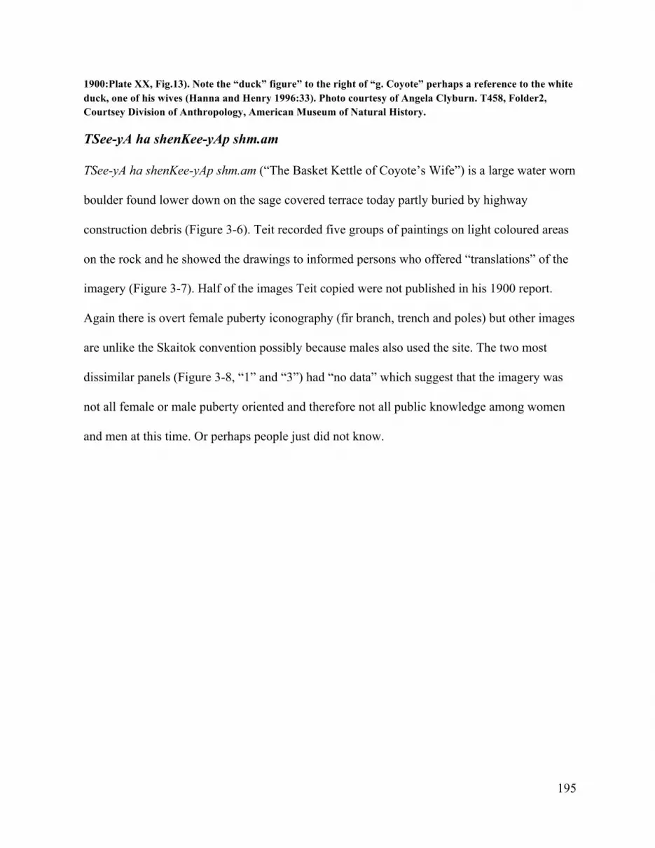
195
1900:Plate XX, Fig.13). Note the “duck” figure” to the right of “g. Coyote” perhaps a reference to the white duck, one of his wives (Hanna and Henry 1996:33). Photo courtesy of Angela Clyburn. T458, Folder2, Courtsey Division of Anthropology, American Museum of Natural History.
TSee-yA ha shenKee-yAp shm.am
TSee-yA ha shenKee-yAp shm.am (“The Basket Kettle of Coyote’s Wife”) is a large water worn
boulder found lower down on the sage covered terrace today partly buried by highway
construction debris (Figure 3-6). Teit recorded five groups of paintings on light coloured areas
on the rock and he showed the drawings to informed persons who offered “translations” of the
imagery (Figure 3-7). Half of the images Teit copied were not published in his 1900 report.
Again there is overt female puberty iconography (fir branch, trench and poles) but other images
are unlike the Skaitok convention possibly because males also used the site. The two most
dissimilar panels (Figure 3-8, “1” and “3”) had “no data” which suggest that the imagery was
not all female or male puberty oriented and therefore not all public knowledge among women
and men at this time. Or perhaps people just did not know.

196
Figure 3-8. Drawings by James Teit of rock paintings on "The Basket Kettle of Coyote's Wife." Explanations: 1, no data; 2 a, tree; b, Juniper-bush; 3 a, Earth, water and trees; 4 a, Catfish; b, a fir-branch.5 a, Trench and poles. After Teit 1900, Plate XX, Figs.1-5.
In the notes that accompanied his drawings of the “Coyote Rocks”Teit wrote“the
pictures are said to have been made by young women and young men on reaching the age of
puberty” (Teit 1897).

197
The Coyote Mysteries/Stones is an example of another Nlaka’pamux rock painting site
with an associated sptaqulh narrative that clearly predate the paintings on the rock. At other
rock art locations, similar clusters of rocks, painted or not, may also be connected to each other
by narratives similar to the Coyote Rocks. Non-material narratives most certainly accompanied
all places with rock paintings (and of course many others without).48
Skaitok (EcRh-8)
One of James Teit’s first research projects following his opportune meeting with Franz Boas
was to record the red ochre paintings found on a two meter water worn granite boulder (EcRh-
8) on a sage-covered bench just below the foothills near a place called Skaitok above
nkumshEEn (Spences Bridge), overlooking the Thompson River (Figures 2-8, 3-10). Teit made
a sketch of the paintings on the south facing side and top of the boulder which he forwarded to
Boas (Figure 3-9). Comparison with image-enhanced photograph of the rock shows that Teit
did not record all of the images (See Figure 3-10). Super-positioning of later more thickly
painted images over earlier finer lined ones is evident. One group of paintings (see below) on
the west side of the rock was made after Teit’s visit. Nevertheless, Teit’s drawing is noteworthy
48 A third rock painting mentioned in the correspondence “close to the river edge below the Coyote’s Wife’s basket, ” is evidently that shown in Figure 17 according to a description of it by Teit in a letter to Smith that mentions “…the circle is a line going right around the boulder” (Smith 1932). Noteworthy is the depiction of a horse indicating a post 1720 date. This painted and dynamited boulder (EcRh- 91) was relocated by Angela Clyburn.Teit recorded one other Spences Bridge boulder (Teit 1900, Plate XX, Fig.18). The last site Teit documented in the Upper Nlak’pamux territory for the JNPE was a painted boulder located along the trail on the Nicola River (Teit 1900, Plate XX, fig. 20). This boulder carried a prominant conventional image of an eagle, two beavers, a grizzly bear paw and a fir branch. These five paintings were drawn by up to as many people but probably less. No overlap is evident. Comparison of Teit’s drawing with the rock today shows additional imagery added after 1896 (see Corner 1968:48). This boulder has been moved from its original location close to the road and is now located near old sh.EEshdk n (Longman 2008). It was photgraphed in situ by Harlan Smith and no early narrative of this site is known.

198
for its attention to detail evident in what he did record such as the careful delineation of figures
using “broken lines’ to indicate separate images.
Teit soon informed Boas that:“the meaning of the rock picture I sent to you last have
mostly all been explained to me by some old women. If you send me back the last pictures I
sent you I will number the figures or pictures and write out numbered explanations which I will
return to you along with the picture. I think that is the best way” (Teit to Boas 1896). It seems
Teit did not have a copy of the drawing and must have visited the site since in person with the
“old women” who then explained the imagery to him.
By September 20, 1896, Teit sent Boas “the tracing of the rock painting—numbered
and grouped”—with “full explanations” hoping they would “prove both useful and interesting
to you” (Teit to Boas, September 20, 1896). Boas edited Teit’s notes on the Spences Bridge
rock painting and the work was soon published in the Bulletin of the American Museum of
Natural History (Teit 1896).
Because of its significance as a pioneering study of Nlaka’pamux rock painting it is
worthwhile to look in detail at the iconography of the boulder and the explanations by wAhhtko
of the images. All of the paintings pertained to the puberty training and ceremony/ritual of
young women from nKlumcheen and included records of their offerings, ceremonies and more
rarely visions. As Teit noted, the rock paintings at this specific site were conventional and “all
women of the tribe are able to interpret their meaning” (Teit 1896:227).

199
Figure 3-9. Drawing by James Teit of rock paintings on boulder at EcRh-8, Spences Bridge. After Teit 1896: 229.
Figure 3-10. Rock paintings at Skaitok, EcRh-8, 2014. DStretch enhanced. Note evidence of superpositioning “made by various girls at the time when they reached maturity” (Teit 1896:227). Photo by Chris Arnett.
wAhhtko was an elder, from a well-known Spences Bridge family, the granddaughter
of Tcecex, a famous Spences Bridge leader (Teit 1912; Teit et al.1917:64; Kenney 1954). She

200
was “born about 1830, or slightly later” and died in 1912 near Spences Bridge (Teit 1917:64).
wAhhtko did not claim authorship of the paintings at EcRh-8 but informed Teit:
that she had made paintings of the same character when undergoing the ceremonial of purification at the time when she reached maturity, and that she was perfectly familiar with the meanings of all the designs. According to her statement the paintings were made by various girls at the time when they reached maturity. This is borne out by the appearance of the paintings, some of which are quite fresh, while others appear old and indistinct (Teit 1896:227).
Teit elaborated on the cultural context of production:
According to the custom of the Thompson River Indians, who form a branch of the Salishan Family, girls on reaching maturity must retire to the hills where they undergo a long ceremony of purification and make offerings to secure good luck. At the end of this period they record their offerings and the ceremonies that they have performed on a boulder. The subjects of these records are therefore identical in many cases, and all the women of the tribe are able to interpret their meaning (Teit 1896:227).
The subject matter of the paintings included imagery of the offerings and ceremonies the young
women performed. The boulder was a prescribed place to record these cultural practices using
red paint and figurative conventional imagery.
The subject matter of rock paintings made by young women at Spence’s Bridge is
dominated by conventional depictions of fir branches which are shown as a single line with
bilateral acute lines on each side appearing singly, in groups or parts of structures (Figure 3-
13). As documented throughout Teit’s ethnographic work (1898, 1900, 1912) fir branches
(tse’Ap) were important agents in the rituals accompanying the puberty of young adults for
their protective value. The fir branch protected in a physical sense against the elements (in the
from of fir bough huts, costumes and beds) and by promoting skin circulation. In a spiritual

201
sense protection came from the innate qualities and synergies associated with the fir branch.49
In curing practices Nlaka’pamux specialists used fir boughs “in arranging for the ritual
protection of patients” (Laforet and York 1998: 44).
49The protective value of the fir branch is highlighted in Teit’s account of the bathing ritual the washing with fir boughs” during her period of seclusion. The young woman “drew a small fir branch over each part of her body four times, at the same time praying to the Dawn that every part of her body might be free of disease or pain in future years. Having finished washing, she stood up and addressed the Dawn thus:
If it should happen that my body be afflicted with sickness, may it leave me as easily as this fir branch does!” at the last words tossing the branch away from her, between her legs, and backward. In washing, she never touched her body with her hands, but used a brush made of fir-boughs tied together”(Teit 1900:314). She gathered fresh boughs every morning and carried them back to her isolation tipi where they were strewn on the floor. She stroked “her head and back with a branch, praying that those members might never get tired when carrying heavy burdens. She also stroked her legs and feet, hat they might never get tired when travelling long distances. She did the same to her moccasin strings that they might never break. During the day she often busied herself by picking one needle at a time off two large fir branches suspended from the roof of her hut for that purpose. While thus engaged, she prayed that she might never be lazy, but always quick and active at work. The prayer was generally addressed to the fir branch…Four large fir-branches were placed in front of the girl’s hut, a little distance apart, leaving room to step over them. The branches were renewed each morning, the old ones being taken away and thrown into the creek, the girl praying, “May I never bewitch any man, nor my fellow-women! May it never happen!” The first four times that the girl happened to go out or in, she addressed the branches, saying, “If ever I step into trouble or difficulties or step unknowingly inside the magical spell of some person, may you help me, O Fir-branches, with your power!”(Teit 1900:315-316).

202
Figure 3-11. Puberty isolation lodge (nhho’hhwuheeyAten) of small fir trees and boughs, Spence’s Bridge, 1914. Photo by James Teit. Neg. 27073. Courtesy Canadian Museum of History.
Figure 3-12. Rock paintings of nhho’hhwuheeyAten (isolation lodges) made of fir bows from EcRh-8. After Teit 1896: 229.

203
Three of the rock paintings at EcRh-8 were identified by wAhhtko as depictions of
nhho’hhwuheeyAten, the temporary fir branch structures made by young women during their
training away from settlements (Figures 3-11, 3-12).50 There is variation in the representation
of the fir lodge motif and discrimination of specific details noted by a culturally informed
person. For example, Fig. 5 of Teit’s drawing (Figure 3-12 left) is interpreted as “a girls lodge,
made of fir branches” (Teit 1896:228). The lower portion up to the dotted line represents the fir
branches that hang down from the roof of the lodge. The girl plucks the needles from these one
by one. The top of the figure represents the roof of the lodge, or the fir branches placed in front
of the entrance.
wAhhtko offered the following interpretation of a drawing of another lodge (Figure 3-
12 middle): “The cross line on top of this figure and the two downward lines to the right
represent the roof of a fir lodge. The long line with the short diverging lines at its lower end
represents a fir branch which is suspended from the roof of the lodge, the needles of which
have been plucked off.”
wAhhtko or the other informants were unsure of the fourth motif (Figure 3-12 right)
and suggested to Teit that it was “either a fir branch or an imperfect representation of a fir
lodge.”
50They built a special fir bough tipi(nhho’hhwuheeyAten ) “when coming into womanhood”(Teit 1900:198, 316).These were conical structures set apart from habitation sites and made entirely of fir branches and tree-tops. Four small fir-trees were placed in a square with their tops tied together and the branches knotted together with the open spaces filled with more branches and twigs (Teit 1900:198). By the last decade of 19th century these special tipis were “fast going out of use” (Teit 1900:198).

204
Figure 3-13. Rock paintings of fir boughs at EcRh-8, Spence’s Bridge. After Teit 1896:229.
Red paintings of fir branches in combination or separate predominate on the boulder
and conform to a conventional form of a long line with short sloping lines projecting from both
sides to represent the branch and needles (Figure 3-13). Comparison of actual fir boughs such
as those in the girl’s puberty headdress worn by the model shown in Figure 3-14 illustrate the
resemblance. Teit’s “Figure 4” (Figure 3-13) is described as “a fir branch the needles of which
have been plucked off; used as an offering. The girls pluck the needles one by one, that there
fingers may become nimble, and that they may not grow tired by the work that will be her share
in life.” The most complex of the fir branch rock paintings on thi rock appears in Teit’s “Figure
3” (Figure 3-13, extreme left). He decribed it thus: “Four fir branches, such as the girl had to
deposit at the entrance of her lodge, which was built of three or four branches. The horizontal
line connecting the three branches at the left side indicates that they were placed near each
other” (Teit, 1896:228). Teit had information that the conventional fir branch motif was
“possibly only made by women” (Teit 1930:415). This observation is certainly consistent with
the female specific use of the Skaitok boulder and the predominant fir branch imagery found
there.

205
Figure 3-14. Model wearing fir bough headdress of young woman, 1914. Photo by James Teit. Neg. 27099. Courtesy Canadian Museum of History.
Even with the conventional representation of the fir branch motif it is apparent from
wAhhtko’s explanations that variation of detail in an image was significant to meaning. The
ambiguity of representation sometimes gave wAhhtko pause. Regarding the image in Teit’s
Figure 10 (Figure 3-13 “10” here) “the explainer was in doubt if this figure was a poor
representation of a fir branch—it will be noticed that the short central line at the base is missing
–—or if it meant a trench with a fir branch at each end. Girls used to dig trenches in order to
attain skill and endurance in digging roots and doing hard work of all kinds” (Teit 1896:228).

206
The most ambiguous image on the boulder is a small painting of two parallel lines (Figure 3-
15) which represented “either two trenches or two sticks given as an offering, or simply the
numeral two having reference to the snake (see Teit’s Figure 12), or to another of the
surrounding designs” (Teit 1896:230).
Figure 3-15. Two trenches, two sticks, or the numeral two. After Teit 1900, Plate XX, Fig.16.
Figure 3-16. Rock paintings of cross-trails, EcRh-8. After Teit 1896:229.
Another group of conventional female puberty rock painting motifs are cross patterns
signifying the crossing of trails (Figure 3-16). “At such places, ” Teit was informed, “girls used
to bury part of the food they were given after having fasted four days at the beginning of the
period of purification” (Teit 1896:229). These paintings of cross trails are either shown singly,
joined together as ‘the crossing of two trails” or combined with other motifs into a composite
image. Two of the latter appear on the EcRh-8 boulder (Teit 1896, Figs. 13 and 25). In Teit’s
1896, Fig.13 (Figure 3-16 second from left), wAhhtko explained to him that “[t] he two long
lines which cross at right angles represent the crossing of trails. The four short lines which run

207
downward from the horizontal line represent four sticks that are placed at the crossing as an
offering. The longer line to the right with its two diverging branches represents a fir branch that
is also placed at the crossing” (Teit 1896:230).
Figure 3-16 (left) depicts another composite image of the cross trail showing the
degree of variation in representation. In describing this painting wAhhtko stated that: “The
upper part of this figure represents the crossing of trails. The branches further down represent
fir branches set up as offerings at the crossing” (Teit 1896:230).
wAhhtko explained the imagery shown in Figure 3-17 as representations of “[t]he
unfinished edge of a mat or of some other kind of basketry work. Girls had to make, during the
period of their isolation, small mats and baskets in order to become expert in this line of work.
The painting represents work of this kind that the girl had done (Teit 1896:230). Of all the
iconography depicted at EcRh-8, these images of unfinished cedar bark weaving show a
consistent conventional form.
Figure 3-17. Rock paintings of unfinished basketry or mats. EcRh-8. After Teit 1896:229.
The conventional trench motif (part of a composite drawing already discussed)
represented the digging of trenches—part of the female puberty rites recorded by Teit:

208
She dug trenches that she might be capable of doing a large amount of digging and other hard work. The trenches were from twenty to thirty yards in length and generally shallow. Others were short and deep. They were near some trail and parallel to it, always on the lower side of the trail. The excavated dirt was thrown on either side of the ditch. This was believed to shorten the duration of her monthly periods. She planted at each end of the trench a single fir-branch or the stick with which she dug the ditch. Sometimes she planted her root digger there, or deposited a single smooth stone, on which she painted pictures; or she placed two or three unpainted small stones (Teit 1896:230).
Figure 3-18. “Snake (“12”) and two dogs (“19”, ”22”), EcRh-8. After Teit 1896:229.
wAhhtko identified a “snake” (Figure 3-18 left) which probably formed the subject of
one of the girl’s dreams” and paintings of two animals (Figure 3-18 right) probably dogs
“which had formed the subject of one of the girl’s dreams” (1896:229). Dreams were an
important part of the puberty training and during their isolation the young women “wandered
some nights to lonely parts of the mountains, where she would dance, imploring the spirits to
pity and protect her during her future life” (Teit 1900:313). These helpers appeared in dreams
and bestow protection via songs, many examples of which were recorded by Teit between 1912
and 1921 (Teit 1912-1921, No.81, 84, 92, 110, 130, 131, 203, No. 8, V1 M 36).

209
Figure 3-19. DStretch enhanced detail showing figures added to EcRh-8 rock after 1896. Photo by Chris Arnett.
Other paintings were added to the west side of the boulder after Teit worked at the site
showing ongoing use of the location, presumably by young women, after 1896 (Corner
1968:47) These paintings included a figure (male?) shown in profile walking wearing a wide

210
brimmed hat and other figures possibly a fir branch and an animal-like figure (Figure 3-19).
The wide brimmed hat could indicate a white man but since native men by this time had largely
adopted Western clothing the figure could just as well represent an indigenous man. Teit
observed that young women in addition to the conventional female iconography also “ painted
pictures of men, symbolic of her future husband” (Teit 1900:317). Given site use the paintings
may be part of a 19th century gender specific conventional imagery used by young women in
the Spences Bridge area and elsewhere “made by women only” of portraying their future
husbands “to bring good luck in securing a good husband” (Teit 1930:415). Tattooing the
image of a man on her body was supposed to bring similar luck (Teit 1930:415). Not all rock
art imagery recorded visions, some of it was thinking towards the future.
The two other adjacent paintings are also noteworthy in that they are not recognizably
“historic” in subject matter, in the sense of depicting imagery of western artifacts or attributes.
A lack of “overt” historical content in rock art is not necessarily indicative of a “pre-contact”
time period (See Tacon et al. 2012:422, 427; Frederic 2012:404).
s’keehh
wAhhtko provided information on the images found at another rock painting site visited only by
young women, a boulder “3 ½ ft. in length by 3 ft. in breadth and 2 ½ ft. in height” on the south
side of the Thompson River two miles east of Spences Bridge “near a kikule house [sh.
EEshdkn ] site between the CPR [railway] track and the river” (Smith 1932; Teit 1900 Plate
XX, Fig. 24). The rock was called s’keehh, an affectionate term for an older sister or cousin
(Thompson and Thompson 1996:94; NNTC 2006:10) and no doubt recalled a sptaqulh

211
narrative perhaps about the importance of training.51 Teit made drawings of this site which
were published (Teit 1900: Plate XX, fig.24) but wAhhtko’s explanations of the predominant
female puberty imagery went unrecorded under the editorial hand of Franz Boas as recourse to
Teit’s original notes demonstrate.
Teit made drawings of two sets of paintings located on separate faces of the boulder
(west and south) (Figures 3-20 and 3-21) and observed that although there were multiple
images in each panel, “ the pictures have the appearance of having been made by at least two
different persons supporting the idea that distance, variation in hue, line and value indicate
separate painting events.wAhhtko gave a detailed explanations of each painting (Figures 3-19
51 I am indebted to Angela Clyburn for bringing my attention to Teit’s JNPE notes on this site now in the American Museum of Natural History.

212
and 3-20).
Figure 3-20. Drawing by James Teit of paintings at s'keehh. Photo courtesy of Angela Clyburn. T458, Section 2. Courtesy Division of Anthropology, American Museum of Natural History.
In the painting on the west side of the boulder (Figure 3-19) wAhhtko identified the
double curved line (1) as “a rainbow (probably) seen by the girl during her period of training
and which she thus recorded” (Teit 1897). The two groups of human-like figures (2) she
described as
People, probably men. Girls always expected to be married sometime and used often to draw the pictures of a man which was supposed to represent the future husband. The girl might have a certain man in view when she drew the picture but had no particular one in her mind. (3) represented fir branches and (4) “Cross roads

213
– These stick or marks set up (The marks were often stones set on end. In either case they were often painted with designs) (Teit 1897).
Figure 3-21. Drawing by James Teit of paintings on south face of s’keehh. Photo courtesy of Angela Clyburn. T458, Section 2, Courtesy Division of Anthropology, American Museum of Natural History.
The paintings on the south side also featured an arching crescent (5) were explained
as“Probably represent a head band. Cedar bark headbands were worn by some girls.”The

214
largest painting, anthropomorphic in character, (6) were “likely cedar bark towels used by
many girls for wiping their mouths after eating or drinking.” Teit provided further details of
their manufacture, which are referenced in the paintings by letters: “The bark was doubled up
and tied tightly at A. Some of them were tied again at B, C is the string by which it was
fastened (either to her other paraphernalia or around her neck” (Teit 1897).
wAhhtko’s attention to the details of the image is evident in Teit’s notes: “the old
woman says by rights that the strings ought to have been made in the picture as going up
instead of down of the towel “[he included a sketch of the proper way in his notes].
The final painting (7) she commented on was another anthropomorphic imagea:
Probably a birch bark cup with drinking tube and scratcher attached. They were all tied onto the one string. E stands for the bark cup which were all made [draws an eliptical-shaped container]. F stands for the scratcher and drinking tube. G may have some connection with the cup etc. The perpendicular line may stand for the string to which they were attached or the lines may mean cross-roads either having or not having connection with the preceding. The only connection that might be is that after finishing period of training the bark cups were sometimes hung up in a bush, sometimes at crossroads, sometime not –but most generally it was thrown into the water (Teit 1897).
Teit’s work on the women’s rock painting sites near Spences Bridge was unique for its early
foregrounding of indigenous knowledge, temporal and cultural context making it the first
comprehensive scientific study of indigenous rock painting west of the Rocky Mountains.
Skaitok and s’keehh are culturally and historically situated Nlaka’pamux rock painting sites are
gender specific sites situated in a locally and culturally specific context of female puberty rites
within a temporally significant time period between 1830 and 1895 in the Nlaka’pamux
territory, Spence’s Bridge. These paintings are historically contingent events within a broader
timespan.
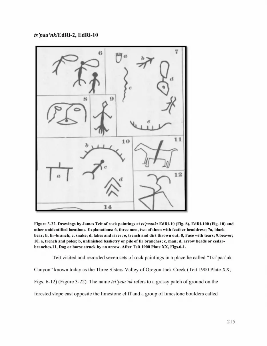
215
ts’paa’nk/EdRi-2, EdRi-10
Figure 3-22. Drawings by James Teit of rock paintings at ts’paank: EdRi-10 (Fig. 6), EdRi-100 (Fig. 10) and other unidentified locations. Explanations: 6, three men, two of them with feather headdress; 7a, black bear; b, fir-branch; c, snake; d, lakes and river; e, trench and dirt thrown out; 8, Face with tears; 9.beaver; 10, a, trench and poles; b, unfinished basketry or pile of fir branches; c, man; d, arrow heads or cedar-branches.11, Dog or horse struck by an arrow. After Teit 1900 Plate XX, Figs.6-1.
Teit visited and recorded seven sets of rock paintings in a place he called “Tsi’paa’uk
Canyon” known today as the Three Sisters Valley of Oregon Jack Creek (Teit 1900 Plate XX,
Figs. 6-12) (Figure 3-22). The name tsi’paa’nk refers to a grassy patch of ground on the
forested slope east opposite the limestone cliff and a group of limestone boulders called

216
spitkwa’uz where the rock paintings are found. 52 As we saw in the last chapter, the majority of
paintings appear on the cliff and an adjacent boulder and in three open rock shelters further up
along the trail. The old trail passes close along the cliff spitkwa’uz directly past the various
groups of paintings that are mainly clustered at one end of the cliff where the trail begins to
make its steep ascent to higher open country. Two sets of paintings matching Teit’s drawings
(Teit 1900, Plate XX, Fig.6 and Fig.13) have been relocated at a rock shelter (EdRi-8) and a
rock face (EdRi-100) up the trail from the largest site, spitkwa’us (EdRi-2).
Teit’s drawing included possible female puberty imagery (unfinished basketry, fir
branches, trenches with dirt thrown out, men), and other imagery such as geographical features
(lakes and river) animals, (black bear, snake, horse or dog struck by an arrow and “face with
tears” (Teit 1900, Plate XX). These may represent now eroded paintings or paintings yet to be
relocated at spitkwa’uz or elsewhere in the valley. In his notes he wrote, “the pictures are said
to have been painted by young men and women on attaining the age of puberty” (Teit 1897).
None of his drawings represent paintings from the largest site spitkwa’us (EdRi-2) where local
knowledge attributes the work to shoowushnA-m (“shaman”) (Bob Pasco, personal
communication, 2014).
Sometime before 1912 an unidentified nKlumsheenmuh elder provided Teit with a
narrative for the site (Teit 1912: 371-72) about the acquisition of shamanic powers by a man
treacherously abandoned on a ledge on the cliff at spitkwa’uz where he survives with the help
of eagles:
52The site was revisited and the place name verified by an Nkshayktn 2011 gathering. In Teit 1900 ts’paa’nk is spelled Txi’paa’nk with a “u” in place of the “n.” The name refers to a burnt off area in general and here specifically to a grassy open area on the sidehill opposite spitkwa’uz (Bob Pasco, personal communication, 2013).

217
Thus he lived until the eaglets were ready to fly. Then, one morning, he cut up his buckskin clothes and made strings with which he tied the two young eagles to his ankles and the old eagles to each arm. After asking their assistance, he flung himself off the cliff. The eagles all flew straight across the narrow valley in a descending line, and lighted on the opposite hillside called Tcexpaa’nk [ts’paa’nk]. Now he cut loose the strings, pulled out four feathers from each of the eagles’ tails, and bade them good-bye, thanking them for keeping and preserving him. He put the eagles’ feathers on his head, went into the bush and made a bow and arrows. When he returned home, he found his false friend living with his wife, and killed him. He became a noted shaman and a great warrior. The golden eagle was his guardian (Teit 1912:372).
This story is rich in cultural teachings regarding jealousy, adultery, friendship, the ability to
communicate with non-humans, eagle hunting, and the acquisition of spiritual power. Similar
locally specific accounts are found in other areas of the Salish world showing the fundamental
nature of the teaching in Salish epistemology.
The story is directly associated with the cliff spitkwa’uz where the largest concentration
of paintings in the valley are found suggesting a relationship between the narrative and the
(later) appearance of the paintings. No other stories are associated with the geomorphology but
we may assume they existed. Two paintings at the site (Figure 3-23) are “bird-like”—showing
a possible connection between these paintings and motifs in the story. The two paintings in one
of the shelters further up the trail (EdRi-10) were identified Teit’s informants as “men with
feather headresses” (Teit 1900; Plate XX, Fig.6) perhaps in reference to the hero of the story
who put the eagle’s feathers on his head” (Teit 1912:72).

218
Figure 3-23. Possible“avian”imagery at spitkwa’uz, EdRi-2, 2014. Photos by Chris Arnett.

219
Stein River EbRj-4/EbRj-5/EbRk-1
Figure 3-24. Granite boulderwith rock carvings, EbRj-4, 1990. Photo courtesy of Paul Schmid.
Nlaka’pamux elders associate the Stein River as a place where the Transformers came
down the Fraser River from the Secewpmec country leaving as they did everywhere a reminder
of their visit. Teit recorded the following story from an Nlaka’pamux elder that uses personal
names for two of the QUeeQUTL’QUeTLt:
They were good men and taught the people many arts. They transformed those who were proud, while they helped those who were grateful for advice and instruction. They reached Styne Creek at dusk. A number of people were living in an underground lodge just north of the creek, and their dogs began to howl when the transformers approached. A man went out to see who was coming. When he saw the Transformers he made fun of them. Therefore they transformed him, the house and the people into stone. When leaving this place, Sesulia’n left the mark of his right foot on a stone, and a little further down the river Seku’lia left the mark of his left foot. Both these impressions of human feet may still be seen in the woods near Styne (Teit 1917 et al.13-14).

220
These sites are located on the north terrace of the river along with others including a stone seat
and further up the river the tracks of a deer and a goat or deer (Bouchard and Kennedy 1988).
These are the only ethnographic descriptions of transformer rocks in the Stein area and while
the “foot prints” could be classified as petroglyphs (i.e. some kind of pictorial imagery) the
other sites (the underground house, the people and the stone seat are geomorphology and not
inscribed or marked in any way).
EbRj-4
The mouth of the Stein River features the only petroglyph rock art found outside of the Fraser
canyon, but the style of the work is very different and closer to the schematic style of rock
paintings (Figure 3-24). The round holes on this boulder on exposed bedrock nearby and on
another boulder on the other side of the river (Mike Klassen personal communication), may be
the result of a male puberty rite described by Teit:
He made round holes in rocks or boulders with a jadeite adze, which was held in the hand. Every night he worked at these until the holes were two or three inches deep. When making them he prayed, “May I have strength of arm, may my arm never get tired—from thee O stone.” This was believed to make the arm tireless and the hand dexterous in making stone implements of any kind (Teit 1900:320).
No local stories are known regarding these specific rocks but the above account by Teit, who
knew the Stein area well, may refer to this exact location as no other sites of similar description
are known in the Nlaka’pamux territory.53
53 Boulders and other geology with “cupules” –rounded holes –are found on the lower Fraser and around the Gulf of Georgia (Salish Sea) and are particular common on the lower Columbia River (Arnett in press; Hill and Hill 1974; Leen 1981; Loring and Loring 1982; Lundy 1974). An exceptional concentration of boulders (EeRl-42) is found in St’alt’imc territory on the Fraser River at the confluence of Gibbs Creek north of Lillooet (Lundy 1979:55-56).

221
EbRj-5
On his visit to record Stein River rock paintings in the summer of 1897 Smith was taken to
EbRj-5 known today as the Asking Rock where prayers are made prior to entering the valley
asking for protection from the inhabitants (York et al. 1993). Here the river flows forcefully
and loudly through the narrow canyon in the sedimentary rock formation. Perched above the
trail the water worn alcove features a geomorphology of water worn hollows. On the ledge of
the largest hollow above the trail the floor of the painted alcove above and facing the river are
eroded, elongated depressions where one must stand to view or make, the paintings. Smith’s
Nlaka’pamux guide Jimmie, offered some interpretation of the subject matter of a certain group
of paintings on the right side of the panel and information on site use as Smith later noted:
On an overhanging rock on the south side of Stine Creek, only a short distance above is mouth, are picture writings representing three quadrupeds with heads to the west on the rock. These are not much weathered. There is a narrow ledge below these pictures on which one could stand and paint the pictures…the line from the head of the lower figure at the right extends up about ten feet. Jimmie, a Thompson Indian of Lytton, explained that this line represented a trail over the hill on which the animal goes. He also stated that the place was where boys and girls came to wash with fir-boughs during their puberty ceremonial. I made a full size drawing of this picture on July 1897 (Figure 3-24 left) for the Jesup North Pacific Expedition (Smith 1932).
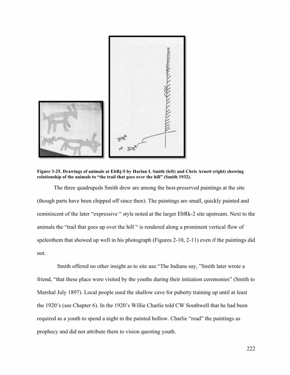
222
Figure 3-25. Drawings of animals at EbRj-5 by Harlan I. Smith (left) and Chris Arnett (right) showing relationship of the animals to “the trail that goes over the hill” (Smith 1932).
The three quadrupeds Smith drew are among the best-preserved paintings at the site
(though parts have been chipped off since then). The paintings are small, quickly painted and
reminiscent of the later “expressive “ style noted at the larger EbRk-2 site upstream. Next to the
animals the “trail that goes up over the hill “ is rendered along a prominent vertical flow of
speleothem that showed up well in his photograph (Figures 2-10, 2-11) even if the paintings did
not.
Smith offered no other insight as to site use.“The Indians say, ”Smith later wrote a
friend, “that these place were visited by the youths during their initiation ceremonies” (Smith to
Marshal July 1897). Local people used the shallow cave for puberty training up until at least
the 1920’s (see Chapter 6). In the 1920’s Willie Charlie told CW Southwell that he had been
required as a youth to spend a night in the painted hollow. Charlie “read” the paintings as
prophecy and did not attribute them to vision questing youth.

223
EbRk-1
When Jimmie guided Smith 4 km upstream to EbRk-1 he informed Smith that the place “was
where girls washed with fir-branches during their puberty ceremonies” (Smith 1932:14).
Jimmie also interpreted some of the iconography drawn by Smith (Figure 2-15) Smith was told
that “the little circles or ovals with four or five radiating lines on one side represented cub
tracks, the triangular figures with lines perpendicular to one side represented bear tracks”
(Smith 1932:14). The largest figure “Jimmie said represented a rattle” (Smith 1932:15)
possibly the scallop shell rattle (fragments of which have been found at Nlaka’pamux rock
painting locations in the Stein and elsewhere).
Charles Hill-Tout also visited the Stein probably at the same as Smith who recognized
Hill-Touts assistance in some of the work (Smith 1899). Hill-Tout excavated in cemeteries like
Smith but he was also was involved in the late 19th century Spiritualist movement. His interest
in the non-material guided much of his research on indigenous spirituality. The entire albeit
brief content of the section entitled “Shamanism” is devoted the Stein River rock painting sites
in the lower canyon (EbRj 5, EbRk-1 and possibly 2) and their association with “noted
shamans” or shoowushnA-m:
Shamanism was prevalent among theThompson [Nlaka’pamux]. This we can gather readily enough from their stories: and certain spots and localities are pointed out by the older Indians as the places where certain celebrated shamans underwent their fasts and training to gain their powers. There were several such spots on the banks of Stein Creek, a mountain stream that runs into the Fraser about five miles above Lytton. Worn and hollowed places are pointed out here and there, and these are said to have been made by the feet of the aspirants after shamanistic powers in the performance of their exercises.
We find several groups of paintings along this creek, which are believed by the present Indians to have been made in the past by noted shamans. It is interesting to note that these paintings are invariably found high up on cliff surfaces above the reach of the tallest man, in some case as high as twenty or thirty feet from the ground. It is clear, therefore, that they must have used some kind of ladder or platform to reach these heights. This to the Indian mind, always adds to their

224
mystery. The modern Indians seem to have no knowledge of the significance of these paintings, and they say that the pigments used by themselves will not stand the weather or endure like those of the ancients (Hill-Tout 1978:48).
Hill-Tout certainly visited the most accessible Stein River rock painting landscape, EbRj 5, at
the confluence of Stryen Creek and the Stein River. The natural physical features of the floor of
the alcove at the site match Hill-Tout’s description of “worn and hallowed places...made by the
feet of the aspirants after shamanistic powers.” Further up the river, both EbRk-1 and EbRk-2
feature sheer cliffs with, as Hill-Tout described, many paintings “above the reach of the tallest
man.” Hill-Tout may have visited both sites with his guides.
Hill-Tout does not explicitly associate the Stein rock paintings with the places the
“noted shamans” trained and fasted but we can assume by the context of his statements that
they are related and that late 19th century youth visited these places, as Smith observed, to
similarly fast and perform other activities such as “washing” with fir boughs.” The fact that the
paintings were “made in the past by noted shamans” is also significant in that the paintings
were not recent work. The use of term “noted shamans” implies that these individuals were
locally significant actors, or shoowushnA-m whose work predated 1895 AD. Neither Hill-
Tout’s or Smith’s informants attributed the Stein paintings to late 19th century youth who
visited the sites as part of their puberty training.

225
The Place Where Justice Was Administered (DiRb-17, DiRb-18 and DiRb-19,
DiRr-4, DiRb-15 and DiRb-20
Figure 3-26. "The Place Where Justice Was Administered, "2014. Photo by Chris Arnett.
This area of the Nicola-Similkameen Trail passed between a narrow rock defile, now
considerably widened for the existing road, marked by seven groups of rock paintings—four
(DiRb-1, DiRb-18 and DiRb-19, and one apparently destroyed site) in the immediate vicinity
and three other sites on erratic boulders (DiRr-4, DiRb-15 and DiRb-20) along the trail to the
west (Figure 3-26). Collectively this is the second largest group of paintings in the
Similkameen after Tcutcuwi’xa and one of two clusters of paintings sites that flank either side
of the old village of nTLkay’hhEluhh now Lulu Indian Reserve 5 (Klassen 2001, Fig.1). Teit
visited the “Justice” site, as Goodfellow called it, (Goodfellow n.d.) as early as 1904 and
recorded four sets of paintings and a range of conventional meaning from his informants from

226
“doubtful, ” “an animal on a trail, ” “three men walking, ” “an animal running, ” “bears tracks,
” “eagles, ” “a person on horseback, ” etc. (Teit 1930: Fig.21p, Fig 23a-e and Fig. 24 a-k). The
“person on horseback is clear proto/post contact imagery but no other information about the site
was recorded other than its distance from Princeton.
Years later Goodfellow recorded a story about the place from an unknown male
Similkameen elder (Goodfellow 1928). While the actors are not Nlaka’pamux per se the
account is included as being within the prescribed area of former Nlaka’pamux influence and
because the narrative situates rock art practice in a marginal space of trails, locations and
invaders.
According to the account narrated to Goodfellow the paintings mark the site of a mid
19th century attack on a group of American miners who had “insulted a girl of the Ashnolas” –
the predominantly Sylix (Okanagan) of the Ashnola River. Goodfellow takes up the story
paraphrased from an unknown Similkameen informant:
But the most interesting explanation of all concerned a rock painting which he termed “Justice” after the, presumably, Indigenous name which translated as the “Place Where Justice Was Administered, ” and makes one feel that however much truth the above explanations [girls’ puberty rites] may contain they are inadequate. Here again the story is set in the hazy past—“long time ago.”
The hero of the tale was Ashnola John’s eldest brother. John died some years ago [i.e. pre-1927]. A number of white men were coming up from the south. Possibly they were making for the Coast, travelling by the old Hope Trail. They were not likely to meet any white settlers in these early days (probably the early sixties). Some of the white men insulted a girl of the Ashnolas. The elder brother of Ashnola John went out to avenge the insult. The elder brother was murdered by the white men.
Then all the Ashnolas went out together to avenge this double insult. They fell upon the white men at the “Place Where Justice Was Administered.” The white men who escaped fled to the hills, but the Indians pursued them. Eventually one lone man escaped over the Hope trail. All the rest paid with their lives for the insults heaped on the Ashnolas (Goodfellow 1928).

227
Goodfellow was well aware that the association between the paintings and the event are not
made explicit in the account. As he admitted:
even with this story it is hard to interpret the markings on the Justice pictograph. Possibly the interpretation would be easier in the light of history, but many more details are necessary before the pictograph becomes wholly intelligible. Of course we cannot apply the historical method of interpretation to all the paintings. One is not necessarily a key to the rest, although its interpretation may throw much light on many. No single pictograph can be regarded as a Rosetta stone giving a clue to the meaning of all the rest (1928:24).
Goodfellow recognized the importance of historical context for the production of rock painting
even if it did not give him the direct one to one correspondence he sought between the rock
painting imagery and the historical fact that he sought.
Teit who relied on his native guides and informants for “translations” identified one
painting on a boulder (DiRb-17) in the field east of the defile where the American column was
attacked as a “person on horseback” (Teit 1930:Fig.24e) the only imagery at would be
recognized by its subject matter as overtly “historic.” If the paintings date from the battle as
intimated in the account then this site is another example of post-contact early 19th century rock
art.

228
k´ay7ísxnm/ (DhRa-2)
Figure 3-27. Rock paintings at k´ay7ísxnm (DhRl-2). Similkameen Valley.
The rock shelter at Tcutciwi’xa is an ancient site of continuous circumspect use as we
have seen, with cultural deposits as old as 3289 ±150 BP (Copp 2006) and relatively dated rock
painting subject matter (two horsemen each painted by a different person probably at different
times) (Figure 3-27). The local Sylix name for the site is k´ay7ísxnm—literally “lots of
paintings” (Klassen 2001:33). Teit visited in the early 20th century and made sketches in his
notebook (Figure 3-28) of most of the imagery and later recorded the conventional meanings:
“men on horse back, ” “four quarters, ” “grizzy bear, ” “ a stream running out of a lake with an
island, ”etc, from unknown informants (Teit 1928: Figs. 22-24). He recorded little else
regarding the nature of paintings.

229
Figure 2-28. Drawing by James Teit of rock paintings at DhRa-2. Photo courtesy Angela Clyburn. T458, Section 2. Courtesy the Division of Anthropology, American Museum of Natural History.

230
In the 1930’s and 1940’ Joseph (Joe) Harris, who lived in the Okanagan area since 1917
and was an active member of the Penticton Branch of the Okanagan Historical Society, visited
and photographed many Interior Salish pictograph sites. In 1949, he published a short summary
of his findings: “Indian Pictographs in South Central British Columbia” (Harris 1949). He
wrote that the “reason for their location is still a matter of conjecture” but he noted their
occurrence “on the old Indian trails.” He believed “that in most instances” they were associated
with the vision quest (Harris 1949:22-23)—probably in reference to the latest rock art practice
associated with the sites.
Of all the sites he visited Harris “found only one set of paintings to which a reasonably
definite story can be attached”—the rock shelter at Tcutciwi’xa (DhRa-2) (Harris 1949:22).
“This group of paintings, ” he wrote, “depicts men on horseback, with two reins extending
from the horse’s head. They are of fairly recent origin. A story has been handed down by word
of mouth to the effect that this group was done by a mature native and depicts an incident
connected with he coming of the first white men” (Harris 1949:23). The incident is not
specified as Harris left out details of his research.
In 1974 Grant Keddie interviewed Joe Harris regarding information he had received
from many of the longtime residents of the area. One of them, Duncan Woods of Penticton
(who died age 76 in 1936) told Harris that he was given information about the paintings at
Tcutcuwi’xa by a Lower Similkameen man named Francois Tomoican. Keddie assumes that
the person referred to is Francois Tomar who died May 16, 1917 at the age of 60 on the Lower
Similkameen Skemeoskuankin Reserve. According to Keddie:
Francois told Duncan Woods that he was one of the people who painted pictographs in Hedley cave, while on a spirit quest as a youth. The figure he painted was the group of four human-like figures connected by the necks with a line surrounded by dog-like animals. Francois did not offer an interpretation of the

231
meaning to the painting other than saying he painted the one with the group of four people only and not the painting of the two men on horseback. This painting has a distinct dark purple different than the lighter red of the nearby painting of two men on horseback. If Francois Tomar is the same person as Francois Tomoican, he would have painted the images at about the age of 14 in showing use of the site for painting purposes up until 1871 (Keddie 2007).
It would seem that Francois Tomar was a different informant than the “mature Indian”
mentioned in Harris’s piece regarding the horsemen.
According to information conveyed by Similkameen elder Edward Allison
to Mike Klassen, “much traditional knowledge had been lost, but that the old people
knew stories about the site and would try to translate the paintings when they visited.
Mr. Allison said that there were probably many uses for the site and many ideas
about the paintings, but that it was undoubtedly a spiritual site and probably used for
vision quests” (Klassen 2001:33).
In the 1960’s a story emerged suggesting that the horsemen and associated paintings
represented a narrative of a “lost Spanish Column” (Barlee 1966; Christie 1999:33-34).
Regardless of the details the narrative is probably an accretion of stories associated with non-
native incursions into Similkameen territory that, as we have seen, were often accompanied by
violence and retaliation (Goodwell 1928; Barlee 1966).54
Similkameen elder Hazel Squakin recalls that the meaning of the imagery at places such
as k´ay7ísxnm was not always fully revealed by elders: “Some pictographs look like they were
a part of the oral stories that have been handed down for many generations and so I feel very
strong about those landmarks. The pictographs should be protected so that the future
generations can view them and see what messages their ancestors left on those rocks for
54 See Barlee’s (1966) account of a Similkameen attack on a small group of US cavalry who were killed and buried in a rockslide south of Cawston.

232
everyone to see” (Klassen 2004:12).
The location of four elaborate stone slab graves in proximity to the site is deliberate.
There is a Similkameen tradition of burying important individuals (chiefs) near rock art sites.
The best known example being the grave of Chief Skeu’s who asked to be buried across from
Nsre’pus a axanex, (“where the stone sticks up”) a large rock painting site directly on the
Similkameen Trail “so that this children might see him as they passed by” (Teit 1928:289).
Across from k´ay7ísxnm in the field by the highway is the grave of a chief named
Tcutciwi’xsqet (Mike Alison personal communication) described as “a Brigham Young of the
Indians” attesting, possibly, to the significance of the vicinity (Lyons 1972:62).
zuhh’t/ ch-chut/nkAowmn
Figure 3-29.chul-chut. Early 1900’s. The “spirit of the place” paintings were formerly visible in the pool area between the two sets of falls. Photo by J. S. Matthews. AM-54-S-38. Courtesy Vancouver Library Archives.

233
In the late 19th century Nlaka’pamux recognized that people made many of the paintings
but Teit also learned of certain rock paintings that “are also “mystery” [hha.hhA] and have not
been made in any ordinary way. Some of them have not been made by the hand of man” (Teit
1898:118, n.282). In his 1900 monograph he mentioned some of these places:
The Indians claim that some of the rock paintings to be found in their country, especially those on rocks which overlook water, are the work of the spirits of those places. One of these was a rock facing the pool between the little and big waterfalls of Waterfall Creek near Spences Bridge. The pictures were made in red paint, and represented the sun, the stars, the coyote, wolf, grisly bear etc. They were at one time very plain, but within the past few years have become obliterated. The Indians say that this is a sign that the “spirit” has left the place. Another painting of this description was above NEqa’umin [nkAowmn] Waterfall, near Thompson Siding. Still another was on a cliff overhanging Nicola Lake, not far from Kwiltch’na. This painting is said to be still visible. The Indians while passing below in canoes avoid looking at the place, because, if they do so, they say the wind will immediately commence to blow (Teit 1900).
The latter site (EaRd-11) is called zuhh’t, the name of a powerful cannibal who was defeated by
the QUeeQUTL’QUTLt on their epic journey and his house of bones covered by the waters of
Nicola Lake (Teit 1898; Longman 2009:8-9). Annie York had never seen the paintings but was
told by an aunt, her “mother’s cousin, ” that the name of the rock painting location referred to
the cannibal being.
AY: I never seen that. You see, my aunt, my mother’s cousin told me. Really she said you should try and see it when the water is low…Its on the sides, the writing. It’s on this side and I never see it. But at Merritt you got to go in a boat. RD: Does that place have a name? Because that’s another thing that we were wondering about, was whether these important sites where the paintings are had names?
AY: They have, zuhh’t, that lake’s called… RD: That’s Nicola Lake?
AY: Yeah zuhh’t. Because—zuhh’t it's like sitting inside a hole (4/4/91:10)

234
The hha.hhA paintings are located on a fractured granite outcrop a cliff overlooking the water
at the base of the mountain and are well known to locals who generally avoid the place
(Wickwire 1988; Longman 2009:8).
A photograph of Waterfall (also known as Murray) Creek or chul-chut taken in the
early part of the 20th century just west of Spences Bridge shows the approximate location of the
paintings made by “the spirits” (Figure 3-29). It is unclear if Teit actually saw these paintings
and whether they faded since his arrival in 1884, or if he was only told about them. Given that
he lived so close by it and his precise recollection of the subject matter suggest that he did see
them and saw them deteriorate since.
Later he wrote in regard to certain rock painting sites that ”some Indians believe that
the larger and older rock paintings are not the work of human beings, but are pictures made and
shown by the mysteries, or powers, or spirits of the place where they were meant to be seen”
(Teit 1918: 5).55
Another painting is on a rock overlooking Kamloops Lake, not far from Savona. This picture is also ascribed by most Indians to a supernatural agency, while some claim that it was painted by the Shuswap to commemorate a victory gained a the place by the latter over a war party of Thompson [Nlaka’pamux] Indians (Teit 1900:339).
As this last observation indicates there were a variety of interpretations for individual locations
with some paintings the product of the mysteries of the place [hha.hhA] and others by warriors
55Among the Cour de Laine of the southern Plateau: There was no belief that spirits or “land mysteries” made certain rock paintings. All were made by people. Besides being records of dreams, objects seen in dreams, guardian spirits, battles, and exploits, they were supposed to transmit power from the object depicted to the person making the pictures. Young men during their puberty ceremonials made rock paintings, but girls very seldom did. From time to time older men painted dreams on cliffs(Teit 1930:194).
Teit’s accounts reflect a consistency of interpretation—paintings by youth, dreams by older men.

235
“to commemorate a victory.” This does not reflect uncertainty regarding specific rock painting
site interpretation but reflects multiple and historically contingent interpretations of landscapes
and practices wherever rock art is found.56
The rock painting at nkAowmn above the falls has not been relocated although
nkAowmn community members recently identified a rock painting on a boulder nearby (2015).
The falls are significant for an origin story regarding a cannibal who is defeated and
dismembered with various body parts thrown in different directions across southwestern BC or
left onsite (Teit 1898; York et al. 1993). nkAowmn according to Annie York is also important
in that shwooshpntlm the Lytton Prophet trained here, as did the culture hero nKTL’smtm
before him prior to going to Lytton where his deeds established the center of the world.
Thematic Interpretations of Rock Art from Ethnographic Sources
In the following section I explore key thematic issues in the production of rock art as recorded
in ethnographic sources—the origin of rock art sites (shhwEY’m and hha.hhA), the protective
role of red paint (tumulh), iconography (TSeQU), and its use in atsama (”questing for guardian
spirit power.” I define them here and expand on their value and meaning in Chapters 4, 5 and 6.
shhwEY’m and hha.hhA muh
The origin narratives of rock painting sites suggest that all geomorphology associated with rock
paintings were gendered and had their origins as transformed beings or sptaqulh. As such we
56 In a separate report on the archaeology of the Thompson River, Harlan Smith provided further information on the paintings at Kamloops Lake stating that they were on a “rock cliff on the north shore of the lake, near the mouth of Tranquille River” and bore “numerous pictographs painted in red. The cliff is known locally as “Battle Bluff” (Smith1900: 401-402). Smith did not elaborate further but the name “Battle Bluff” seems to corroborate Teit’s information regarding the paintings found there as a commemoration of a military encounter. This site is located on the boundary between the Nlaka’pamux and Sewepmec.

236
may assume that all Nlaka’pamux rock painting sites with very few exceptions57 represent
shhwEY’m and hha.hhA muh and are the sites of sptaqulh with the story preserved in the
anamorphic features of the site granite (Teit 1918; Ritchie 2011). According to Teit:
Indians also frequently painted pictures on rocks which were thought to be metamorphosis beings (originally human or semi-human, semi-animal, or semi-God like in character) concerning which there were stories in their ancient mythological tales or traditions. These rocks are generally boulders corresponding roughly to human and animal forms or to parts of the body etc. or rocks worn into peculiar or fantastic forms of various kinds suiting in some way the story that is told of them. By painting on them, power in some degree it was thought might be obtained from them or their spirits.
The most significant and primary feature of any rock painting site is the geomorphic
entity, the cliff, boulder, or outcrop and its surfaces that was the subject of the
painters’attention. The geological substrate is not a tabula rasa, a Latin term suggesting some
sort of inert clean slate with an absence of meaning but rather, by its very nature as a geological
entity, absolutely prior to the intentions and practice evident by painting activities. Geological
formation is more than an inert surface. Knowledge of these sites was more prevalent in the
19th century. As Teit noted “most of the rocks and boulders of remarkable shape are considered
as transformed men or animals of the Mythological period” (1900:337).
shhwEY’m are literally “the transformed”—geomorphology that represent the sptaqulh
actors or things turned to stone (Thompson And Thompson 1996:433; Laforet and York
1998:209). The word is the nominative form derived from hhwEy’ “transform
someone/something into something else” and describes “a personage of the myth age turned
into a natural object or animal or a natural object that resembles a person or object such as a
57 The exceptions were situations where people encountered “monstrous” or uncanny things and made a rock painting as both protection and to gain power from the encounter. As Teit noted, these paintings “could be made any place”(Teit 1918).

237
fossil” (Thompson and Thompson 1996:443). As the physical manifestation of transformed
beings the shhwEY’m landscapes embody narrative and transpersonal experience by the very
fact that they were once flesh and blood “humans.”The root hhwEY’also means to mesmerize.
shhwEY’m is to be changed, transformed, transfigured into something different—powerful
reminder of spiritual realties and metaphors for the transformative, catharsis that is a central
feature of training for spirit power, or atsama (Thompson and Thompson 1996:1338).
Other localities with rock art are referred to as hha.hhA muh—a haunted area or place
(Thompson and Thompson 1996). hha.hhA muh (“land mysteries” according to Teit’s
translation), possessed special culturally significant properties that attracted the attention of
painters. These places were hha.hhA “spooky” originating from the drowned bodies of anti-
social beings whose bodies were left to rot on the land after the great flood or other beings and
localities such as the body parts of dismembered cannibal beings thrown about the landscape
(See Teit 1898; 1912; York et al. 1993). These places were so powerful they could kill but
those with correct method could benefit from exposure. As Teit learned they could “also be of
service to those who seek them and wish to gain wisdom from them, for many shamans have
trained in these places” (1912:333).
Nlaka’pamux sources reveal an intimate connection between places regarded as
shhwEY’m, hha.hhA and the production of rock art. A very few names of these place are
recalled but it is likely that any geomorphology be it cliff, boulder or cave very likely had
names and stories. “If there’s a place, ” the late Andrew Johnny of Stein told me, “Indians got a
name for it.”
The ethnographic records reveal that rock art is a historically contingent activity in a
place of ontological significance and ancestral use. Teit’s Secwepmec informants stated that:

238
“Ancient rock paintings have mysterious powers and may hide and show themselves at will.
They are supposed to have been made by people long ago; but through the agency of the dead,
or by the supernatural influence remaining in them, they are in a manner spiritualized. Some
people think they were made by the spirits of the place or by beings of the Mythological Age”
(Teit 1909:598). By virtue of their relative age to the descendant community there is an obvious
connection between rock paintings and predeceased people of recent and ancient times that
gives them an immediate cultural association with non-material areas involving hha.hhA—and
shnayEEs, the ancestral dead.
In 1919 upon their return to Lytton, after their search for rock paintings along the Stein
river, UBC student Hallisey and his friends “made exhaustive inquiries amongst the old
Indians” who informed them that “the paintings had always been there and that at times the
“snyees” (spirits) put on fresh paint” (nd: 4). Hallisey interpreted the first information as
ignorance about the paintings and the latter comment an explanation for the groundwater
seepage that in winter renews the colour of the paintings. The term “snyees” (shnayEEs)
actually has a more specific meaning, and refers specifically to a “corpse, ghost, dead person,
cemetery” (Thompson and Thompson 1994:215). Hallisey was informed by elders that: “No
Indian would make camp under or near painted rocks regardless of how good the campsite”
(n.d: 4) because of this connection with ancestral dead. EbRk-2 and similar sites were
considered hha.hhA (“restricted, ” “haunted, ” “holy”), which explains why Hallisey and his
friends found no visible traces of campsites where rock paintings were found. As we have seen,
they were used for other purposes.

239
tumulh/ztsmn
Nlaka’pamux rock painting is not an isolated cultural expression but part of an ancient practice
of purposeful marking using red paint. The protective and defensive properties of tumulh are
demonstrated in sptaqulh. In a story recorded from 19th century Nlaka’pamux elders (“The
Coyote’s Daughters and Their Dogs”) two girls on their way to meet new husbands are given
two dogs (Grizzly bear and Rattlesnake) by their father as companions and guardians (Teit
1912). When the new husbands are confronted by the aggressive dogs the girls chewed the red
ochre and rubbed it over the dogs’ mouths and they became “quite quiet after this treatment”
and protected the girls on their journey back to their husbands along a trail of red ochre
Take the red trail, which is the right one, and avoid the other, as it will lead you over a wide prairie, devoid of trees, to a land where live dead people, monsters and mysterious people. We will keep your dogs here with us, and if you should happen to be in danger, and cry for help, the dogs will warn us, and we will at once let them loose to go to your aid (Teit 1912:293).
In sptaqulh ochre is used as a technology to transform things and situations (Elliot 1931; Teit
1898:34, 1912:293; White 2006). In the Coast Salish swoxyiyam (“ancient narratives”) red
paint is used by the Transformers to immobilize people and turn them to stone. The rock shee
on the west side of Harrison Lake was once an old man named shee who was transformed into
Doctor’s Rock by a woman using her puberty paint:
When he turned around to look up the mountain they were about to climb, the sister threw on his back the red paint she had used when pubescent: and he was immediately turned into a stone, which may be seen at the present day (Teit 1912:293).
In the St’at’imc territory, close neighbours and relatives of Nlaka’pamux are two rock paintings
by Transformers along the Harrison /Lillooet travel corridor at Anderson Lake and Harrison
Lake. Each rock painting was the result of an encounter between the Transformer (s) and a man

240
fishing with the wrong tools very similar to the Nlaka’pamux Tsaxalis narrative above. At
Anderson Lake:
they asked him what he was doing. He said, “I am fishing. But I never catch any.”He only fished up slime which he wiped off his pole with grass. TheTransformers said, “We will show you how to catch fish.”They took hair from their legs below the knees and threw it on the ground. Immediately it became spatsem grass. They took it and showed him how to go home and cook it. When he had gone they took his net and threw it up against the face of the mountain and marked it with their paint. They said, “That will show what we have done here” (Elliot 1931:1).
Elliot noted that “this mark is still to be seen at this point” (Elliot 1931:168, n.3) possibly one
of the known sites along the south shore of Anderson Lake (see Corner 1968).
The St’at’imc narrative from Harrison Lake describes almost the same story about a
place called STA-thli-lick. There the man, whose name is Tsoop, is once again fishing
unsuccessfully with a pole and trying to make snowshoes. In this version the use of the red
paint is very different—after Tsoop is turned to stone his eyes continue to blink until the
Transformers apply red paint to immobilize him entirely (Bouchard and Kennedy 1977: 13-14,
16).58
Annie York’s interpretation of the Stein River iconography frequently explained
paintings in the context of stories about QUeeQUTL’QUeTLt “fixing things” in stone or
TSeQU for future generations for example when he created the song power seweten in its
visible form—a swan-like bird. QUeeQUTL’QUeTLt “dragged the bird [a sna.m] and says to
58 Further down the Fraser river in the Sto:lo territory is a place called sqayexiya (“mink”) (DhRk-1) , on the east side of the Fraser River opposite Herrling Island where Xa:ls [the Sto:lo Transformer] turned Mink’s grandmother sqi’ (“smoked salmon”) into a rock and painted an image of her under an overhang. This rock was destroyed by railway construction (Mohs 1987).

241
him, “You see your picture there? I’ll put your picture there and you’re not going to do that
anymore’ ” and immobilizes the bird with red paint (18/09/89:24).
At Pitt Lake in Katzie territory there are some famous rock paintings associated with the
Transformer Xa:ls who encountered a people he sends to live under the lake where they
became dangerous spiritual entities with the power to kill anyone but local people. Xa:ls
proclaims “…your customs shall be painted on this bluff as a warning to those who come
hereafter” (Jenness 1955:28). It is not clear from the published account whether or not Xa:ls
himself painted the figures. The association of the paintings communicating the presence of a
place of deadly supernatural power is, however, explicit.
Annie York was very familiar with this site having lived for a time near Pitt Lake.
Teachings regarding these paintings were important to her upbringing.
AY: You see, in Pitt Lake, my mother and father, they told me “Always respect those writings. Do not fool with them, because the one that wrote that spent his time in the lake, and his woman spent their time. And never deface them.” My father and mother told me that.
RD: You know the ones on Pitt Lake? AY: No I never went to see it, but my father did. And my father said it was in the water. I never seen it [here equating it with the beings sent under the water by Xa:ls] (Jenness 1954:88) (3/3/13:13).
Teit recorded information regarding the use of red ochre paint that demonstrated the variability
of practice surrounding a lithic material, indeed a technology, that was important substance in
physical and spiritual protection. People today in the Lytton area call red ochre paint, tumulh, a
word for red ochre found throughout the Salishan-speaking world (Thompson and Thompson
1996:1068). Other words for paint also occur such as xwum-mn “red Indian paint” (Thompson
and Thompson 1996:1068). tumulh seems to have its linguistic root in “earth” and has long-
term use in the Nlaka’pamux territories, North America and indeed throughout the world into

242
deep time (MacDonald 2008; MacDonald et al. 2012). The paint was known both by its name
and sometimes by the quarry itself. Thus the excellent red ochre paint called ztsmn is both the
name for the place and the excellent quality of the paint derived from it.
Figure 3-30. Red ochre quarry at Tulmn /ztsmn (Tulameen). 2013. Photo by Chris Arnett.
One of the most famous red paint quarries of the British Columbia Plateau is found at
ztsmn/Tulmn (Figure 3-30) near the confluence of the Tulameen River and the Similkameen
River in the southern reaches of the Nlaka’pamux territory (Teit, 1900; Dawson 1891).59 Here
sedimentary formation of clay exposed to volcanic heat created conditions for superior iron
oxide pigment. The Nlaka’pamux name for the place is ztsmn derived from the root zts,
(“compressed, ” “snug”) in reference it would seem to the compact layers of red and yellow
59 Dawson (1891:7) noted that ztsmn was one of three well-known localties in the British Columbia Plateau from which red ochre paint was derived:“Tsul’-a-men, or “red paint” is the remarkable red bluff from which the Vermillion Forks of the Similkameen River is named.”

243
ochre visible at the site (Figure 31). The area today is significant to the Upper Similkameen
First Nation who maintains stewardship over the site, which they call Tulmn, a regional
linguistic cognate of tumulh. Areas where paint was and is quarried are visible on the face of
the striated rock today (Figure 2-31).
Tumln/ztsmn is significant in the QUeeQUTL’QUeTLt narrative as the place where the
Transformers in their journey through the Interior were finally stopped and turned back by
Coyote.
The Qwo’qtqwal [QUeeQUTL’QUeTLt] swerved to the south from Zuxt, and travelled down the Similkameen River to the Forks. Here at Zu’tsamen [red paint] they again met Coyote, who objected to their invasion of the country—and threatened to destroy them. They decided to leave the interior so they travelled up the Tulameen River and crossed the Cascade range to the Lower Fraser River (Teit 1912:317).
This is no doubt a very superficial account of a more detailed narrative that would have all
manner of specific prior knowledge. Because the name of the place is mentioned in the
sptaqulh is seems likely that the place and its attributes played some part in helping Coyote
send the Transformers back to the coast. This signature event whereby powerful invading
entities are repelled may have bestowed additional non-material properties to the tumulh at this
particular site. Ever since, people have accessed the quarry to acquire a piece of its protective
qualities and the paint became known throughout the territory at Spuzzum, Spences Bridge and
Merrit as ztsmn to distinguish it from other sources (York et al. 1993).
Teit wrote“large quantities of good red paint were obtained at Vermillion, in the upper
Similkameen Valley. It formed an article of export, and the place was much visited by
Thompson [Nlaka’pamux] Indians (1930:218). In the early 19th century the Princeton area was
called Vermillion Forks and the local group, who were mostly of Nlaka’pamux ancestry, were

244
referred to as the Vermillion band by early non-natives—a fairly accurate translation of their
nlha’kapmhhchEEn name ztsmnmhh (“people of the red paint”) (Teit 1928:204). Their village
glossed by Goodwell as “Yak tulamen” was at “Allison Flats, ” site of the present day saw mill
(Goodwell 1958). In the early 19th century their chief Sinilast held influence between Princeton
and Hedley (Teit 1917). Elsewhere Teit (1928:254) recorded that “red paint was sold by the
Similkameen people to both the Okanagon and Thompson, and parties of these tribes also came
to Tulameen Forks or Vermillion to gather it themselves.” Teit identified other trade networks
whereby red ochre arrived in the territory—for example the Okanagan trading paint to Spences
Bridge band and the Lytton band trading paint to the Lower Thompson (Teit 1900; 1928).
Teit recorded data on quarry procedures for his Secwepmec ethnography that would
apply to their Nlaka’pamux neighbors (Teit 1909:475). Miners used wood, bone, and antler
scrapers but seemed to prefer a specific tool:
crooked sticks, somewhat spoon-shaped, like the sticks used for removing the brains out of the skulls of animals. They were used for scraping from seams decomposed rock which served as paint. Chisels and pinch bars were inserted in cracks, and fragments of rocks were split off by their means. In a few places at which paint has been gathered for long periods, deep holes and small tunnels were formed, which were worked along the seams of paint-rock or in those directions where the rock showed least resistance. In other places the material was obtained more easily, being found in the talus slope of cliffs (Teit 1909:475).
Teit’s description matches closely the geology of quarries such as the great quarry at Tulmn
where the mining focused on particular seams of rock with fine powdery red ochre (Figure 3-
31).

245
Figure 3-31. Strata atTulmn showing fine red ochre deposit, 2013. Photo by Chris Arnett.
The unique qualities of red ochre made it a valuable item of exchange and an important
commodity with the introduction of a European economy. Hudson Bay company records
demonstrate the high value given to red paint—a direct reflection of its high utilitarian value. 60
In the late 19th century Teit recorded that one 4” x7” pouch of red paint was worth 10 dried
salmon (“100 salmon to a stick. 3 sticks of salmon for a canoe 1 stick = 1 fathom HBC red
cloth” (Teit 1900:40). Cundy wrote, “the red pigment was a much sought after article of trade.
A small amount held in the palm of the hand about one rounded teaspoonful—was worth a
beaver pelt” (Cundy 1938:13). The value of red ochre as a trade item reflected its value as a
60 When Ft Vancouver was established in 1824 on the Columbia River vermillion fetched more beaver skins per weight than gunpowder, iron kettles, and beads and was the most expensive commodity after guns, tobacco and blankets (Simpson in Strong 1959:239-249; Boyd 1996:155). Alexander Ross, an employee of the North West Company with extensive experience on the Columbia plateau, was perplexed by the culturally relative value of goods. When he was among the Shoshene, at the edge of Salishan territories and desirous of a piece of tumulh “a little red earth or ochre of their mystical medicine bags.” Ross found that “the price was enormous…an ounce of vermillion was of more value than a yard of fine cloth”(1855:258 -59).

246
product and its general use in health and medicine related areas in the holistic sense of physical
and spiritual benefit and protection.
Red ochre has both physical and, in a non-material sense, spiritual qualities with
measurable effects in the world in the sense of physically protecting the body to prevent cold or
mosquitos to spiritual protection from unseen entities. The paint was prepared according to
various recipes that may have been family specific and secret. Teit described various means
used to apply the paint: “paint pencils” or “the points of the fingers, paint brushes, and paint
sticks; ” dry paint “was much used, but most painting, including all the finer work, was done
with paint mixed with water or grease” (Teit 1930:418). Annie York described its preparation
including the use of Larix occidentalis pitch as an emulsifier:
AY: You mix it in a stone bowl. First you take the stuff for the paint and heat it over the fire. Then you put it into the bowl and grind it. Up country they use it raw. This is red ochre. Its name is xwum-mn. There is another red paint that you store in bags for painting the body. It’s made the same way, but you add burnt tamarack pitch. It’s stored in bags and called ztsmn [York et al.1993: 3-4].
RD: Was there anything added with the color to make it stick?
AY: Oh Sometimes they do. Like this tree, you know. Now what is it called? That tree is a special one. The thing comes down like – pitch! Burn that, and mix it with that color (3/3/91:4)
Leechman (1952:38) mentions water, saliva, grease, tallow, fish oil, fish eggs, glue and resin as
vehicles for the pigment. Secwepmec used chokecherries mixed with bear grease and water to
make a paint by for pictographs (Turner 1979:239). Sam Mitchel, former Chief of the Xalip
(Fountain Band) recalled that paint was prepared according to its use:“The skins were pounded
into a paste. The glue was added to the paint if it was to be used to paint on rock. If the paint
was to be used on the body it was mixed with deer tallow” (cited in Corner 1969:22).
Erwin’s (1930:41) research on the eastern Plateau found red ochre pigment was ground
then mixed with “oil or grease of some kind” then “dissolved in very thin gum or resin of the

247
pine or fir tree, and when mixed and applied on a rock it will harden and become glazed over
which will hold its bright colour for a great many years, if not too much exposed. Cactus
(Opuntia fragilis) was also used for smearing over paint to “seal” it” (Teit 1900).
While organic binders are said to have been used in the making of paint analysis of rock
painting research by the Canadian Conservation Institute in the 1970’s on Similkameen and
Canadian Shield rock art paint using “infrared spectrophotometric, gas chromatographic,
thermogravimetric and fluorescence microscopic methods have been able to discern only a
trace of organic material, which could also be attributed to contamination” (Wainwright
1985:20).
Sometimes all that was necessary to make paint could be found in close proximity.
Annie York claimed that only saliva alone could be used with the raw pigment. Erwin
documented the use of binders but also wrote that oftentimes “the paint is just water and
coloring matter which will oxidize and, in penetrating the rock, will become part of it” (Erwin
1930:41).

248
Figure 3-32. Young woman with face painted with red ochre for puberty training. After Teit 1900: Fig.208.
Teit studied Nlaka’pamux body tattooing and painting as practiced between 1840 and 1860
with a Spences Bridge shoowushnA-m named Ullamsest who informed Teit that the character
and meaning “was similar to paintings on garments of adolescents, and to the records painted
by them on boulders and cliffs” (Boas 1900; Teit 1930:407). Used in everyday life for cosmetic
and protective practice painting had physical and non-physical properties:
Nearly everyone painted a narrow red stripe along the partings of the hair. Many people also painted a red streak over the hair of each eyebrow. The paintings are said to have been for decorative purposes only, but it seems probable they were also regarded as in some degree protective (1930:420).

249
Painting the entire face red was a standard practice for various reasons: to show deference, as
offerings, for propitiation, to obtain success, or for protection (Figure 32). Painting with red
ochre was “considered as an offering to the spirits” (Teit 190:344):
The face painted red all over or occasionally from the eyes down, also dry paint put in the hand and the latter rubbed roughly over the face, the paint thus being thicker in some places than others. This painting was very common, and used more or less by everybody, old and young, of both sexes. Many persons, if they had a bad dream, immediately painted the face red. A noted hunter called Tsa’la having had a bad dream about grizzly bears, painted a circle in red around his face. He stated this was to ward off the danger portended in the dream. This was supposed to help ward off the danger and make the dream ineffective, and to protect them from harm.
Nearly all the women used this painting when digging roots, and to a less extent, when picking berries. It was thought to give them success and protection, help them to find roots, and to dig more easily; also to preserve them from harm while engaged in their avocations. The Indians believed danger lurked in every place. It appears also to have been in the nature of a propitiation of the earth.
Nobody approached places where land and water mysteries were located without first painting the face red. If they neglected this the mysteries might be angry and do them harm by casting a spell of sickness or bad luck on them. The face was painted all red when offerings were made to mysteries or spirits of certain localities, when offering the first fruits to the earth, when partaking of the first berries and tobacco, and on other ceremonial occasions, or encountering spirits of certain localities. Some hunters searching for game, men spearing large fish in the wintertime, dancers at ceremonies and potlatches, and some men trapping, all used this painting. It remains almost the only painting still used. A person going on strange ground for the first time also used this painting (Teit 1900:438).
While ornament was an aspect, body markings by whatever means were for the most part
“intimately connected with the religious beliefs of the people” and ”in connection with puberty
and the acquirement of guardians, to insure success, health or protection and as a record or
offering or as a preventative against weakness and premature old age” (Teit 1930:404). Teit
wrote:
Some people painted the skin red wherever it appeared unnatural or diseased. Paint mixed with oil was supposed to be good for the skin, and hinder it from getting too dry or wrinkled…Rough or chapped skin was well rubbed or painted with pencils of deer’s back fat, kept for the purpose. Sometimes a little dry red paint was rubbed

250
over the greased part. Dry red paint was applied to the face and hands in very cold weather. It was supposed to keep out the cold and prevent freezing (Teit 1900:439).
The most common use of tattooing and painting “appears to have been in connection with
puberty ceremonials, dreaming and the acquirement of a guardian spirit” (Teit 1930:422). He
reiterates that painting, “also had a strong connection with religion, dreams, guardian spirits,
cure of disease, protection, prayers, speech, good luck, war, or death…dream paintings were
very common” (Teit 1930:420). Red ochre paint was and is an important part of the toolkit of
the shoowushnA-m who when making his or her cures painted their entire face red and other
parts of their body with tumulh.shoowushnA-m possessed powerful songs and an inventory of
designs (TSeQU) provided to him or her by their sna.m, or guardian spirits. Teit’s informants
were explicit regarding the character, use and origin of the red ochre images that shoowushnA-
m drew on bodies:
The subject matter of these paintings were derived from the dreams of the shaman, and were similar in character to dream and shaman’s designs. Some were different, such as spots painted over places where there was pain, lines above and below these places, circles around wounds or sores. I have not obtained any individual records of these, although they were in use until quite recently and probably still are to some extent. Sometimes the shaman did the painting and sometimes the patient or his friends were directed to do it. Scars and marks of old wounds were often painted over with red, probably to make them more conspicuous, and also as protection from injury by shamans gazing at them, as these parts were to some extent more vulnerable. Sometimes a fresh wound had a ring painted around it, and as soon as it healed red paint was put on it regularly for some time (Teit 1930:439).
This practice accords with other Coast Salish and southern Plateau people where red ochre
designs were painted on patients as part of the healing process. Red ochre was the friend of the

251
spirits and the designs were often identical to those in local rock art (Jenness 1934-35:174;
1955).61
Red paint was protective of body and soul and had active properties. Among Plateau red
“stood for power in fighting or healing” (Cline et al. 1938:144). Among the Nlaka’pamux the
colour red materialized everything positive and creative. The colour, red signified “good in a
general sense. It also expressed life, existence, blood, heat, fire, light, day. Some say it meant
the earth. It appears also to have had the meaning self, friendship, success” (Teit 1930:418).62
61 Jenness worked with Vancouver Island Coast Salish experts who described the use of red ochre paint by Thitha and Siowa in Saanich curing rites. When his boy’s face becomes paralyzed Pullki takes him to a siowa who paints her face [others say no.] “I shall paint my face four times, ”she said, and if he doesn’t straighten out the fourth time his case is hopeless. “She dipped her feather in the ochre and started to paint her face, announcing that she was going to depict the things (spalkwithe or ghost) that the boy had encountered. She chanted a song all the time he painted her face with what suggested a person; then she rubbed it off with her goat’s wool and painted it another pattern to the accompaniment of anther song. She did this four times. The boys face straightened at the 4th song. [Old Johnson says it was a thitha, not siowa, that she must have painted patients face, not her own”(1934-35:215). The thitha obtains in the woods or somewhere a chart or series of patterns on a piece of skin. With this he goes to the patient, and paints the patient’s face with red ochre, copying one of the patterns. If the patient does not move he wipes off the patterns and paints another with each painting he sings a chant. At one pattern, perhaps, the patient stirs. Then the thitha knows that he is on the right track. The thitha sometimes obtains his patterns from petroglyphs.” The petroglyphs are not identified but this account shows the congruity between paintings on rock and paintings on people.
Similarly, on the southern Plateau MacWhorter describes a Yakima account of the shaman Smat-louit who “holds communion with the little Wah-tee-tas, the “ancient people” who painted the pictures on the cliff in the Naches Gap. These spirit people of the cliff, Samit-louit can send [his spirit] into the body of anyone he chooses, and he alone can remove this spirit. The ethnographer McWorter recorded the following account describing the use of a rock painting image in a shaman’s practice:
…I agreed to pay Smat-louit a cow and a calf, and three horses if he would cure her. He had placed one of those pictures you see painted on those rocks over her face, and at times she could not see. He also put one of the spirits in her body. He kept working a little with her for three days, but she did not get any better. I said to him: Why don’t you take that thing from her face and draw the bad spirit from her body? Do you want me to pay more?”
Then he got ashamed and said: “No! I do not want you to pay me more. I will take it away now.” He then began to work in a good way and soon my wife was well. I gave him the stock I promised and was satisfied. Smat-louit is a bad medicine man. He talks to the spirits inhabiting the Puh-tuh-num” [painted or marked rocks]. Unidentified Yakima man (Hine 1993:103-104) 62 Similarly among the St’at’imc, red signified good, good luck, success, good-will, love, friendship, fire, bright, life; (Teit 1906:291)

252
There was also “a vague recognition of red as a color for the east” (1930:419) where all disease
originated (Teit 1900:368).63
Figure 3-33. Nlaka’pamux face paintingAfter Teit 1930, Plate 6.
Tepper’s study of numerous Nlaka’pamux painted hide and willow bark clothing with
red ochre figurative designs and color symbolism, based on the work of Teit, argued that the
63 The Coast Salish (Sto:lo) also have traditions of disease coming from the east (Jenness 1955).

253
prevalence of the color red makes it possible to explore some of its symbolic ‘potency’ in its
cultural context (1994:77). As we have seen red paint marked openings that marked the
physical and spiritual limits of the body, as well as openings and passages for conduits and
transformation. Paint was thus applied along all edges, openings and seams of clothing for
protective purposes in the same way as the red ochre was used on the body itself or, I would
add, along the cracks and crevices of cliffs and boulders. Teit identified more than 10 occasions
in which red paint “served as an active, potent force”—a protective, counteractive element for
women harvesting plants, or men hunting, trapping or spearing large fish in winter (Tepper
1994). Red paint was necessary for anyone “going on strange ground for the first time” or to
places where land and water mysteries were located. Such places included those with rock
paintings.
The culturally perceived qualities of tumulh are protective and life preserving. “The
life and the protection of your life” said Annie York (York et al. 1993:4). On the coast tumulh
is conceived as the blood of the earth (White 2004). The life asserting qualities were evident in
a letter Teit wrote to Boas where he mentioned that “two old Indians here [at Spences Bridge]
told me that the chief object of young men and women making rock paintings was to ensure
them long life” (Teit to Boas Sept 20 1896).
People elsewhere on the Plateau attach similar significance to the red paint as
revealed in this dialogue between a rock art researcher and Viola Kalama of the Warm Springs
Reservation a direct and displaced descendant of the lower Columbia people.
James Keyser: You were speaking of the mortuary rituals happening at home. I have read that red paint was used in mortuary ritual. Is that still practiced?
Viola Kalama: That was one of the sacred things that happened. The Chinook people used a lot of red paint. The red paint was very important. Even being out in some kind of celebration or any activity people painted. My mother used to paint a lot. She painted each cheek. When they gambled, they’d paint real bad, red

254
faced. When there was a death they painted their faces and they sprinkled paint on them. We were the red people too, but this is not done anymore. Bridgette [her granddaughter] and I practice that yet. “Paint” I tell her, “To help you.” So she does it. So do I.
James Keyser: Does it bring good luck? Viola Kalama: It staves off bad thoughts and bad spirits (Keyser et al. 2006:13-14).
As we shall see, in the letter written in 1918 Teit documented the mid 19th century rock
painting practices associated with puberty training but he also identified other motives for the
production of rock paintings that focused on the “protective” qualities in relation to prophetic
dreams warning of outside threats:
Occasionally paintings on rocks were made by both novices and adults of any age for what seems to have been chiefly protective purposes, such as after a very striking dream (or an event) believed to portend evil, for the purpose of warding off the disaster or evil happenings. Paintings of this kind were sometimes made near camps.
Paintings of manitous and men were also sometimes made in certain places near camps or overlooking paths and routes (on land or water) by which enemies or evil (such as certain sicknesses or harmful things) might approach. These pictographs by reason this connection with the manitous or guardian spirits [sna.m] of the people who made them were believed to help in the protection of the latter (Teit 1918:3).
These paintings represent something very different than the paintings of the youths and more in
line with Boreson’s (1976) spatial distribution model linking rock art to preferred resource
areas, travel corridors and village sites. They also seem to be the work of shoowushnA-m
trained in the use of the paint employing their skills to mark significant places along trails for
purposes of intervention, boundary maintenance and perimeter defense.
There is a view in archaeology that “art” is somehow non-utilitarian in the sense if
being unrelated to food production or rock art as a display of warrior status in perimeter
defense (Hayden and Schulting 1997:55; Bouchert-Bert 1999; Schulting 1998). Gell’s (1998)
insight into art as a technology and “doing” is more commensurate with Nlaka’pamux

255
epistemology. Not art but an art—in the sense of a learned technical skill not just for aesthetic
purposes but pragmatic in providing physical protection of the skin (body) and the spirit.
Teit attributed the overall decline of tattooing and painting “to the changed mode of life
of the Indians and to the discontinuance of their former social practices, particularly those
associate with war, religion, shamanism and puberty. Tattooing and painting were intimately
connected with all of these” (Teit 1930:403). By the time he conducted his research, body
painting with tumulh was primarily used only by shoowushnA-m and women (Teit 1900:228).
The culturally prescribed properties of tumulh offer insight to the predominant material culture,
the red ochre paintings, found at Nlaka’pamux rock writing sites. Red paint and painting was
part of the Nlaka’pamux tool kit and used in many different contexts to achieve ends.
TSeQU
Tumulh was the medium of imagery that, when used by specialists, had perceived effects on
the world. The nlhahka’pamshEEn word for marking/drawing/writing is TSeQU referring to
any markings, paintings, patterns, printed pages or writing systems (Thompson and Thompson
1996; Teit 1898; Nlaka’pamux Nation 2007/08). Teit wrote “the Indians of the present day call
the white man’s writing and pictures, stsuq. They also call paper stsuq” (Teit 1898:118, n.283).
Elsewhere he translated TSeQU as “pictures, painting or decoration” (Teit 1912:250 n.3).
Thompson and Thompson (1996:69) under the comments for the apparent root iQU [scrape
skin] (Thompson and Thompson 1996:10) list several roots, some historically related that refer
to scratching, scraping, itching and by extension, marking and striping. Could the word be
derived from the practice of incising or abrading the “skin” of rock surfaces, which were
sometimes filled with red paint?

256
In two stories that appeared side by side in Teit’s 1898 collection of sptaqulh and other
narratives, TSeQU is described outside of rock art contexts per se but nevertheless shows use of
such imagery from the indigenous perspective of practice that can be translated into different
contexts of production. While components of the story are non-indigenous in origin (the
horses) the activity is not.
In the nkumsheenmhh story “The Lad who caught the Wind” a young man acquires a
coyote as “a friend” a spiritual helper, to assist him in various tasks (1898:87-88). He acquires a
wife from a powerful leader and secrets her from the family home along with her father’s two
best horses and saddles. When they are pursued and almost overtaken “they turned their horses
and saddles into stsuq [TSeQU] which they hid in their shirts for safety hiding in the bush” thus
evading their pursuers (Teit 1898:88). The TSeQU in this case was “ a small piece of birchbark
with figures on it” representing the aforesaid items. The young man later sells the horses for
valuable goods, turns it back into a TSeQU and the valuable goods into a canoe to make the
final journey home” (Teit 1898:88-89). In this instance material things such as horse and saddle
(TSeQU) are hidden by a schematic images of what they represent. This could only be done by
someone who “was considered a great man in magic” or hha.hhA (Teit 1898:88).
The very next story in the collection also features the use of magical portable TSeQU
and its ability to shape shift
No she answered, “I cannot go with you, but I will help you, ” and forthwith gave him a long knife and a stsuq, saying, “When you get tired and wish to ride, throw the stsuq down and it will become a horse. When you desire, command, and it will become stsuq again.”Then he went on is way and shortly threw the stsuq down, and it became a fine large black horse, fleet of limb, on which he mounted (Teit 1898:90).

257
These stories illustrate the magical power of imagery in the hands of people possessed of
extraordinary power and the transformative ability of imagery to capture things, hide them or as
we saw in the spatqulh accounts, to silence them. In the footnotes to a story Teit enlarges on
the meaning of TSeQU the word and its contextual associations with rock art.
Stsuq means a mark or picture of any kind…Such when made by a person gifted in magic, had supernatural powers...some rock paintings [TSeQU] are also“mystery, ”and have not been made in any ordinary way. Some of them have not been made by the hand of man (Teit 1898:118).
Teit recognized that Nlaka’pamux rock painting was a cultural product in a larger field of
practice regarding the use of images (TSeQU) and red ochre paint (tumulh) and that it
functioned in the negotiation of two realities, the physical world and the non-physical
intangible, uncanny.
Because Boas was interested interest in pictography, Teit collected a large variety of
material culture (clothing, accessories and artifacts) decorated with imagery and, in some
insrtances, interpretaions of the content. In describing this wealth of data Boas observed,
“designs representing the guardian spirits and supernatural dreams of the owner are very
frequent. These are believed to be the means of endowing the implements with supernatural
powers. Men decorated their clothing according to instructions received from their guardian
spirits” (Boas 1900:377). Among neighboring St’at’imc, who shared similar beliefs, “figures
representing guardian spirits were much used …for marking their weapons, implements, and
other belongings, and also for painting and tattooing face and body”Teit wrote (1906:298).
Boas wrote the chapter on Art in James Alexander Teit’s 1900 monograph on the
Nlaka’pamux in which he argued that the fundamental idea behind Nlaka’pamux two-
dimensional conventional designs was symbolic and in a sense utilitarian (Boas 1900). When

258
found on objects such as tools the use of the object denoted the meaning of the design because
they were always symbolic of the use of the implement. Conventional designs, while “the
meaning of which is always understood, ” are at the same time ambiguous (Boas 1900:377-
378). This was particularly true when the connection between the painting and the object of the
painting (the tool, body or place where it occurs) was less obvious—a reminder of the dual
components, the material physical and non-material spiritual, present in Nlaka’pamux material
culture. Boas, through his long correspondence with the pre-eminent ethnographer of the
Nlaka’pamux, James Teit was well aware of the non-material aspect of Nlaka’pamux life and
the role of the art: “Designs representing the guardian spirits and supernatural dreams of the
owner are very frequent. These were believed to be the means of endowing the implements
with supernatural powers” (Boas 1900:379).
Figure 3- 34. Dog halter. After Smth1899:114.

259
19th century Nlaka’pamux people were very aware of the iconographic conventions of
their pictography allowing us to visualize the same convention when we study the art thanks to
those who offered and recorded the data. A carved dog halter (Figure 3-34) that Smith
recovered from grave 11 at Lytton was immediately recognized by Teit and his instructors,
Salicte, Charlie Tcilaxitca, and Baptiste Michelle, as “a fixture for a dog halter to keep the loop
from slipping up and choking the dog” (Smith 1899:Fig.114; 1900:442). Familiar with the
iconographic conventions regarding depiction of sna.m, they added, “that the carving represents
the Manitou [sna.m] of the owner of the dog, and was first seen in a dream” (1900:442). The
iconographic convention is the chevron design along the body of the creature, a conventional
design frequently found in Nlaka’pamux rock art and portable art. Portrayed on the bodies of
mountain goats Annie York identified the motif as a sign for color specifically the colorful
blankets made from goat wool and the motif of the chevron or v-stripe. The chevron as a
marker of guardian spirit power appears in an iconic story of a the shoowushnA-m se?ye from
shpup-zm who described her vision of a mountain goat “who appeared to her as a human being.
He was dressed in a goat wool blanket, and he had red paint in v-stripes on his chest, and they
went over his shoulders onto his back” (Laforet and York 1998:111). Given the predominance
of this motif in the rock art of the Nlaka’pamux and its signification of sna.m it seems likely
that V–stripes or chevrons, are a conventional device to signal sn.am.
Of interest is the data recorded by Smith regarding the iconography of the incised
imagery from a pipe recovered from a grave at Lytton (EbRj-1):
Its design probably represents the beings that appeared to the owner in a dream. It was customary for men to carve on their pipes, and chiefly on sacred pipes, representations of the beings appearing in their dreams, especially in their first important dream in which they received their Manitou [sna.m]. Owing to the secrecy of treatment of sacred objects, it is difficult to obtain specific interpretations of the designs, for these secrets would be kept by the individual even

260
from his friends, and with his death the knowledge of the significance of the design would pass away. The short parallel lines on this pipe may represent either a wood worm or a rattlesnake’s tail. The ladder designs are again supposed to be snakes or worms. The lines on the stem of the pipe may depict woodworm borings, while a large curve close to the rim may represent the earth, a mountain or the foot of a mountain. The inverted V-shaped figures on the bowl probably represent a bat, or they may be the flying goose design (Smith1899: 157).
Teit’s later research on the use of Plateau pictographic imagery among Couer de Laine, who
shared many cultural traits with their neighbours to the north, further clarified the purpose and
agency of “art”:
Men painted images or representations or symbols of their guardian spirits and pictures of their most important dreams on their clothes, robes, shields, and weapons. …Pictures and symbols of guardian spirits were also often painted or tattooed on the body. It was believed that these pictures had offensive or defensive power derived directly from the guardian spirit. Thus a man who had an arrow tattooed or painted on his arm, if the arrow was one of his guardians, believed that his arm was made more efficient for shooting. In the same way a mountain tattooed or painted on the arm rendered it strong, provided the mountain was a guardian spirit of the person. Likewise the reproduction of a bear on the arm gave the person skill in bear and dear hunting, provided these animals were the guardian of the hunter (Teit 1928:192 emphasis added).
Some painting and imagery was purely for ornament but, as Teit concluded from his study of
the subject, “much also had a strong connection with religion, dreams, guardian spirits, cure of
disease, protection, prayers, speech, good luck, war or death” (Teit 1930:420). Art served a
multiplicity of purpose decorative at times but imminently practical.
Aside from his work with wAhhtko and a few others, Teit found a general lack of
interest among the people he talked with regarding interpretation or “translations” for
individual images. In a letter to Boas thanking him for the copies of his published 1896 article
Teit wrote “I have been trying to obtain translations of the other “pictures” I sent you without
much success” (Teit to Boas Dec. 18, 1896). As he was later to note this reluctance was
261
obvious. Due to the proscribed nature of the practice, the imagery was extremely subjective,
personal and secret known only to the painter.
Thus one person did not know exactly the meaning of the figure painted by another, because he did not know the other person’s dreams, experiences etc. He might guess at the meanings and also might know that certain figures represent certain things, but of their connection with one another he could not be sure.
A person who saw the pictures of say a basket and of a sun painted on a rock would probably know that the pictures represented these things, but beyond that he would know nothing with certainty. He would surmise that the basket was painted by a girl because men generally did not paint such things. He would surmise that the basket was painted by a girl as a record of the sample basket she had made during her ceremonial training at puberty (at this time girls made samples of all kinds of work they might be expected to make in life after) or because she desired to be expert in basket-making in after years. Same with the figure of the sun. He would surmise a young man painted it either because he had acquired it as a Manitou, or desired it as a Manitou, or had dreamed of it. Different forms of the sun or lines connected with it might enlighten him as to which of these reasons was the correct one (Teit 1918).
While there were conventional designs recognized by everyone there was variability in the
depiction of imagery (as noted above in the discussion of the fir lodge iconography). In a letter
to Boas (Teit to Boas, May 9th 1898) Teit enclosed some drawings by an elderly Nlaka’pamux
man named N’aukawilix that he hoped “might give you some hints and also some further idea
of the style of pictography here” (Spence’s Bridge). In commenting on the drawings Teit wrote:
probably some other man would draw some of the pictures differently as they have several different ways of making some things as the sun, stars etc etc. Some men preferred to draw from aback view and others from a side view. Some draw from a distant view and others again from a closer view and so on. Most of the pictures are representative of the girl’s ceremonies.
That the iconographic content of these drawings had to do with female puberty ceremonies
shows awareness by males of the conventional subject matter. While some of these ceremonies
clearly involved visionary experiences, very few paintings of “visions” were made at rock art
sites visited by young women.

262
The making of imagery with red paint was multipurpose according to need and thus
variable. The variability of practice appears to be historically contingent among Nlaka’pamux
as it was for neighboring groups. Among the St’at’imc “the largest and oldest paintings are said
to have been made by the people of the mythological age, others are known to have been
painted by girls and boys during their puberty ceremonials, or to be dream records painted by
men” (Teit 1906:275). The variability of practice using TSeQU is demonstrated Teit’s
observation of a St’at’imc rock painting practice:
There were several rocks on which every person passing by for the first time had to paint a picture. One of these is a rock called SO’EZA near Lillooet. At this place may be seen pictures of dentalia, feathers, leggings, root diggers, arrows, grass, gambling sticks, roots of different kinds, baskets, canoes, lakes, creeks, salmon, men, bears, goats, marmots, eagles, etc. There are other rocks like this not far from Lillooet” (Teit 1906:282).
This site has not been rediscovered or the paintings have somehow dispappeared. Teit visited
and drew 52 of the paintings at another famous St’at’imc site overlooking the Seton River with
a different inventory of images and three types of paint red, black and white (Teit 1906:282).
These paintings, according to “an apparently well informed Indian” interviewed in 1925, “were
painted there by the medicine men of the tribe to commemorate important events” (Edwards
1985:53).
Rock Painting and atsama
The ethnography of Plateau Salish people indicates that in the 19th century certain male and
female youth made rock paintings (and in some areas petroglyphs) as part of their puberty
training (Teit nd; 1896; 1900; Goodfellow 1928; Boreson 1974; Bouchard and Kennedy 1980;
Miller 1990; Whitley 2006; Keyser and Whitley 2000; Cundy1938). Teit’s analysis of the
female paintings at two sites in Spences Bridge (EcRh-8, and s’keehh) relied on detailed
explanations of the puberty training iconography by practioners. Teit gave a broader summary

263
of the practice in a 1918 letter to an inquiry about rock paintings by the curator of the
Provincial Museum, W. Kermode:
These paintings are to be found in places such as cliffs over-looking or close to lakes and streams, near waterfalls, within and around caves, on the walls of canyons, natural amphitheaters, and on boulders near trails etc. Generally they are in lonely or secluded places near where Indians were in the habit of holding vigil and undergoing training during the period of their puberty ceremonials when they generally acquired their manitous. These places were resorted to because they were considered mysterious and were the haunts of “mysteries” from whom they expected to obtain power. The mysterious forces or powers of Nature were believed to be in greater abundance and strength at these places and the novices desired to imbibe power and knowledge from these sources to help them in after years.
They went through exercises, purified, supplicated, slept, prayed, fasted and held vigil at or near these places so as to obtain as much as they could of this power. At the expiration of training (or sometimes also during same if they had any vision or experience considered extraordinary or specially important) the novice painted pictures on cliffs or boulders near by (or at) these training places wherever rocks with a suitable surface for painting on, could be found. Where these did not abound very few paintings are made, or the paintings were done on small smooth stones, or on debarked trees etc.
The paintings made were largely in the nature of records of the most important of the novices’ experiences whilst training, such as things seen in peculiar or striking visions and dreams, things obtained or partially obtained as manitous or guardians etc., things wished for or desired to be obtained, things actually seen during training or during vigils, actual experiences or adventures of the novice, especially those in connection with animals etc.
By making paintings of these things on rocks the novices believed they would make such powers (or manitous etc) as they had attained (or obtained) stronger and more permanent, and what they desired to attain (for instance to be a shaman, warrior, proficient hunter etc. etc.) or to obtain (as for instance a certain Manitou, or certain powers or benefits etc. etc.) more easily and quickly obtainable…Striking natural phenomena (such as eclipses etc) if they occurred during the person’s training were frequently recorded by painting on rocks (Teit 1918).
Painting was culturally prescribed, proactive and secretive. In addition to their dreams and
desires people training recorded “things actually seen” “actual experiences” or “adventures of
the novice” all associated with a heightened awareness brought on by fasting and other
deprivation but not necessarily trance-like states. However, the paintings were not always of

264
dreams. The rock art of the 19th century vision questing youth was intended to leave a record of
training activities, visitation and to make the acquisition of sna.m “more easily and quickly
attainable” (Teit 1918) serving a different purpose than other types of rock art directed towards
invisible entities with powerful ways to intervene in human lives.
Teit wrote “people usually made their paintings in secret and alone, and often offered
prayers when making them” (Teit 1918). Coast Salish practices also refer to the practice of
making marks as a prayer (Arnett 2007:199) a reminder that the immaterial aspects of the
image are as important and real as the graphic representation and as difficult to interpret:
RD: And when you are doing the drawing, do you pray? AY: Oh yeah that’s very natural to an Indian.
RD: What do you say when you are doing the drawing? AY: Well, you have to ask God to help you, that you gonna use this drawing in later life –that’s going to be your strength too. And any kind of animal that you dream, that’s going to be your power (1/3/91:5-6).
As we have seen at the Spences Bridge locations and at ts’paa’nk rock painting sites could be
for gender specific use (Skaitok, s’keeha) or visited by both sexes. At EbRj-5 (the Asking
Rock) Smith was told that both genders visited the site to fast and scrub themselves with fir-
boughs at the cliffs and pools. At EbRk-1 only young women are mentioned as using the site to
wash themselves with fir-boughs. “Jimmie” was able to explain some of the rock painting
imagery at both sites but nowhere did he state that the paintings were made by the youths in the
course of their training. Although EbRk-1 would seem to have an exclusive female use, there
are no paintings of obvious fir bough related iconography on the cliff walls (See York et al.
1993) unlike the Spences Bridge sites of Skaitok and s’keehh, where women are known to have
visited and painted using specific conventional iconography. It seems apparent that here as
elsewhere in the 19th century, young people in training were required to visit places with rock

265
art even though they did not always make paintings at these locations – although sometimes
they did (Bouchard and Kennedy 1979:127; Cundy 1938; Miller 1990; Seaman 1976:120; York
et al. 1993:14). Goodfellow found that recent memory in the SimilkameenValley associated
rock painting with female puberty training. Charlie Sqaukem referred Goodfellow to another
elder woman identified only as Mrs. Arcat (according to Goodfellow her name was a
corruption of Agatha) who lived at nTLey’hheluhh. Unlike Charlie, Mrs. Arcat seemed less co-
operative and possibly dismissive of their inquiry claiming that the paintings were frivolous.
She told the two men that the “the pictures had been on the rocks a long time” but added that:
“My Mamma told me that they were made by old-time gels (girls). The girls were just playing.
The marks don’t mean anything” (Goodfello 1928). Goodfellow was not dismissive of her
statements and cited Emmanual Domenech’s infamous 1860 “Manuscript Pictographique
American” as an extreme example of overzealous imagination noting that “the eyes of a pale
enthusiast looking for his destiny can see the history of a thousand years in the track of an ink-
bedraggled fly.” Was Mrs. Arcat dismissing the curiousity of the Minister? Goodfellow
believed that there was “too much evidence of design to be the work of “gels, just playing”
(Goodfellow 1928).
Goodfellow questioned another elder, a man, whose name was not recorded, who
expanded on the information provided by Mrs. Arcat.
He said that the marks were made “long time ago, ”and that they were made by girls. At that time girls were required by their parents to stay out all night periodically at some lonely place. This was done with the Spartan idea of making the girls hardy, brave, and unafraid of the dark. To indicate that they ad been at certain spots, they made these marks on the rocks. The records were a guarantee of obedience to parental wish or command (Goodfellow 1928).

266
Goodfellow saw the correspondence with the ethnographic description in Teit showing social
memory consistent with Teit’s research decades previous.
Teit documented other activities at rock art sites that left material signatures other than
paintings. Describing practices associated with puberty training in the Similkameen Valley Teit
wrote “in 1907 I saw in the canyon of the Similkameen River many remains of stone circles
made by girls on the top of flat boulders. The sides of many of these boulders are painted”
(1928:283). This practice may be unique to the Similkameen (Copp 1974:41-43) and a
reminder that there are other features at rock art sites such as stone alignments, manuports,
lithics etc. besides the paintings.
Figure 3-35 Drawing by James Teit of paintings on Similkameen Valley boulder (DiRb-2), k, “sun or earth and trees, ” l, m, n, “Vision of an adolescent meaning doubtful.” After Teit 1930: Fig 21.
Teit made a pencil drawing in his notebook of the paintings on a large boulder (DiRb-2)
located on the Similkameen River Trail showing three of the four paintings now visible on the
boulder (Figure 3-35). His sketchbook has no interpretative data, which suggests that he

267
gathered the “explanations” later. Three of the images are described as the “visions of an
adolescent” meaning doubtful” reflecting the hesitancy of his Similkameen informants to
interpret meaning beyond the conventional imagery. These paintings, and two others, occur
next to a larger painting described as the “sun or earth with trees” evidently not the work of an
adolescent and representing something else.
The variability at this site reflected in the two, perhaps three episodes of painting
accords with his general observation on the production of rock art among the Sylix of the
Similkameen and Okanagan where he was aware of two spheres of practice: one associated
with puberty training, the other with “notable dreams”:
In connection with the training period, adolescents of both sexes made records of remarkable dreams, pictures of what they desired, or what they had seen, and events connected with their training. These records were made with red paint on boulders or cliffs, wherever the surface was suitable. Rock paintings in their territory are plentiful…rock paintings were made also by adults as records of notable dreams, and more rarely of incidents in their lives (Teit 1930a: 283-284).
Compared to the detailed explanation he received from wAhhtko regarding the rock
painting iconography of female training places, Teit gave no detailed examples of
specific male training sites. While the puberty rites associated with the training of
young men were becoming more attenuated, they too occasionally made paintings as
part of their training in a similar manner to young women:
Lads painted records, which were pictures representing their ceremonies and their dreams, on boulders, or oftener on cliffs, especially in wild spots, like canyons, near waterfalls etc. These were generally pictures of animals, birds, fishes, arrows, fir branches, lakes, sun, thunder, etc. Figures of women symbolized their future wives (Teit 1900:321).
The range of geomorphology accessed by“lads”seems more varied and included, besides
boulders, cliff formations, canyons and waterfalls. Whether these were gender specific sites or

268
not is unclear and such sites do exist in contemporary social memory. As with the women,
young men who trained this way painted records of their ceremonies, including fir branches
and images of their future partners and dreams. The rock art imagery associated of those
undergoing 19th century rites of passage was only slightly gender specific and not exclusively
visionary or hallucinatory—but prescribed and depicted using conventional designs familiar to
everyone.
At Spences Bridge after the mid 19th century the practice of rock painting as a part of
puberty rites may have been more common with women than men, although both sexes were
said to have made rock paintings as part of their puberty training (Teit 1900). As a reflection of
the new economy, young men were less inclined to follow the traditional ways of making a
living in favor of livelihoods more conducive to the new introduced capitalist order. Teit noted
that by the late 19th century “almost all of the customs connected with the puberty rituals of
males have fallen into disuse. They are practiced by a very few in a much modified form” (Teit
1900:321). This was in contrast to the training of young women which, at least in the Spences
Bridge area in the 1890’s, “are still maintained to a great extent; but some of the old rites have
also become somewhat modified either in their observance or their form (Teit 1900:321). For
example, the training of young women had previously extended ”over a year instead of four
months” (Teit 1900:317). As Andrea Laforet observed, “Before the gold rush, each new
generation learned the meaning of hha.hhA through the use of the land, and as that became
more and more difficult fewer and fewer children had an opportunity to learn” (Laforet and
York 1998:194).
Teit was under direction by Franz Boas to gather a historically particular snapshot of the
traditional Nlaka’pamux culture. Teit focused on the most recent practice of rock painting in

269
the context of puberty ceremonials of young people sent to these specific locations. Many of
the sites he visited had paintings by these youth but it soon became evident that not all
paintings originated in the culturally specific cultural context of puberty rites. Youths visited
rock art sites but did not always make paintings there. The few that did paint copied earlier
images or superimposed them. Such paintings are infrequent.
Archaeological Signatures of Ethnographic Practice
According to Nlaka’pamux ethnography there are different methods of marking
geomorphology, each appropriate to its time and purpose. Archaeologists distinguish these
markings or ‘rock art’ based on the technique of manufacture be it reductive (carving, pecking,
or abrading resulting in works called petroglyphs) or additive (using red ochre based paints to
create pictographs). Each method has its own chain de operatoire (in the sense of integrated
cultural and technical aspects) from inception to finish. Both techniques were used by
Nlaka’pamux who appear to make no distinctions based on the method of rock art creation and
refer to all and markings, paintings, patterns, printed pages or writing systems as TSeQU
(Thompson and Thompson 1994; Teit 1898; Nlaka’pamux Nation 2007/08).
Teit recognized that rock art sites witnessed multiple visits and he commented on the
variability of style and imagery found at many rock painting location:
It will thus be seen that all the large rock paintings were made by several or many different individuals (male and female)at different times. Some individuals made only a figure or two and others a number. Some individuals depicted the object they desired to record, by painting the figure clearly, whilst others who were very poor in the pictographic art, painted figures so carelessly and rudely that other people had great difficulty in making out what they represented. In places where older figures had faded or become indistinct, Indians often painted over these.
On some rocks which were favorite places for painting, so many figures had been made by many persons at many times that the whole cliff had been covered with figures which so ran into each other and over each other that there was no more room left to paint any more. In cases like this the pictures had become so intermixed and confused very few of them could be made out clearly or understood.

270
On some cliffs where the surface of the rock within easy reach had been completely covered, young men sometimes made ladders and put on their paintings above the others. In some cases young men suspended themselves with ropes, to make their paintings out of ordinary reach or in some striking place (Teit 1918).
This is an interesting passage in that superpositioning is so very rare among Plateau sites that
the place he describes could only apply to one site on the British Columbia Plateau namely
EbRk-2 on the Stein River which has the most evidence of super-positioning found anywhere
and also paintings found far above “ordinary reach.”
If, in the 19th century, rock painting locations were identified as the sites of painting
activities by “noted shamans in the past” and 19th century youths, then the material signatures
of both these activities should be present at rock painting sites. Red ochre paintings displayed
on various geological surfaces are the most obvious analogy between the practices described
and the material culture. The super-positioning of fewer, more recent paintings, at EbRk-2 and
elsewhere suggest that these later paintings are by 19th century youth while the earlier paintings
are the work of shwooshnA-m who visited these sites for purposes of intervention.
Subsurface deposits at all sites reveal the presence of red ochre in all levels indicating
its use for rock painting or body painting at these locations over time. Other materials are
represented that could by ethnographic analogy be associated with paint manufacture such as
western larch pitch described in the making of red ochre paint and Prunus and Rubus spp
berries (found at EbRk-2). Turner (1978:239) records that among the Secwepmec Prunus
virginianus, the most common plant encountered in the unit at EbRk-2 was an ingredient to
make paint used in rock painting. Spirally fractured mammal bone found at EbRk-2 and EaRj-
81 could indicate the extraction of marrow, a material possibly used as the “melted animal fat”
described by Teit as an additive of paint used in rock painting (Teit 1918:2) Small hearths at

271
EbRj-81 and EbRk-2 provided controlled heat for the preparation of paint. This is particularly
evident at EbRj-81 where ochre fragments were concentrated within and around the ashy
deposits of a hearth.
The paucity of food remains indicates that food production at Nlaka’pamux rock
painting sites was minimal and possibly evidence of restricted diets prescribed by protocols
during puberty training. According to Teit, among Nlaka’pamux“the girl during her training
period was allowed to eat any kind of roots or vegetables, also dried salmon and trout. She
must not eat fresh salmon or trout, nor grouse or other birds until the day after they had been
killed; she must not eat deer or other quadrupeds, either fresh or dried; nor berries until a month
after the first ones were ripe; else she would be liable to sickness or to be bewitched” (Teit
1900:317). As for the male “he did not eat berries or roots, or any food prepared by women. He
ate only deer and other animal meat, but especially the former, ether fresh or dried, grouse and
other birds, and fresh or dried salmon or trout” (Teit 1900:321). The gender discrepancies in
diet might have archaeological signatures. Males could eat the fresh meat of mammals and fish
but women could not. Both were permitted dried fish. Males were not allowed to eat berries
and women were also restricted somewhat (to the first month) regarding berry consumption
(Teit 1900:317). In addition Teit writes that males “purged themselves with medicines” (Teit
1900:319) –plants that may leave archaeological signatures (such as the kinikinnick found at
EaRj-81).
All of the recovered plants are present in the immediate environment and have
economic or cultural value as foods, medicines, and materials (primarily in the production of
paints or stains). The most represented flora at EbRk-2 are, with one exception, uncharred pits
of Prunus ssp. (n=21). These could were found at all levels of the excavation and could

272
represent one or all of three species—choke cherries, pin cherries or bitter cherries. Annie York
described the use of Larix occidentalis Nutt (tamarack) pitch in the preparation of red ochre
paint (Turner et al. 1990:99; York et al.1993: 4, 10). It is quite likely that the single globule of
pitch recovered was brought to the site for the purpose of paint production.
At EaRj-81 near Kwoeik, 12 fragments of soapstone were identified two of which
showed curvature and thickness suggesting that they may have been parts of tubular pipes. Teit
wrote that these kinds of pipes, made of various types of soapstone, were popular “about four
generations ago“ [from 1900] (Teit 1909:575). Such pipes were “well adapted to the native
tobacco; but after the introduction of twist tobacco, which was smoked with kinnikinnic, pipes
with upright bowls entirely replaced them” (Teit 1909:575).
According to Teit, prior to Europeans “smoking was considered the privilege of people
possessed of mysterious powers such as shamans and others” (Teit 1900:350). Teit described
the practice of shoowushnA-m:
Before beginning to treat a patient the shaman frequently pulled out his long pipe, from which hung eagle feathers, and took a smoke; for smoking was looked upon as a means of communication, not only between the shaman and his guardian spirit but also between him and the spirit-world (Teit 1900:363).
In Plateau culture tobacco provided a means to neurophysiologicaly engage with non -material
realities (Wickwire 2004:131-132; Boyd 1996:77). Other possible proxy evidence of smoking
at EaRj-81 are charred seeds of Arctostaphylos uva-ursi (Kinnininnick or Bearberry) a plant
used alone and with tobacco as a smoking mixture but with other uses as a diuretic and to
prevent thirst by chewing the leaves (Turner et al.1990: 211-212). Pipes of European
manufacture have been recovered from a Coast Salish (Sts’ailes) site (Ritchie and Springer

273
2011) and ethnographic confirmation that smoking occurred at rock art locations came from
Nlaka’pamux elder Sam Phillips (Wickwire 1988).
Manuports and lithics have been observed in surface features at EbRk-2 and other rock
paintings sites and represent a material signature of ritual activity or ceremony involving the
transport of rocks, a practice documented elsewhere on the Plateau region (Keyser et al.
2008:75-76) and California (Whitley et al. 1999). While not referring specifically to rock art
sites Teit did note that in practice people left offerings when passing certain locations
“appeased the spirits by making an offering to them…These offerings generally consisted of a
lock of hair, a rag from their clothing, a little powder, a few shot, a piece of tobacco, a stone
and so on” (Teit 1900:344). People today continue the practice using less permanent offerings,
such as Saskatoon leaves or small stones.
While lithic scatters are generally associated by archaeologists with the production of
tools for hunting or food processing (Magne1985) the ethnographies indicate that lithic debris
might also be the result of ritual activities not necessarily associated with food production.
Lithics found at Nlaka’pamux rock art sites would seem to fall into this category. The small
amount of lithic debitage recovered from Nlaka’pamux rock art sites indicate a pattern of late
stage manufacture or sharpening of mainly basalt artifacts.
The ethnography of James Teit documents the use of lithics in ritual situations in the
context of bloodletting which were an important part of ritual practices that could explain the
presence of late stage debitage at EbRk-2 and other rock painting sites
Teit noted that the practice was general throughout the tribes of the British Columbia
Plateau. The instrument was a “sharp arrowstone” the common name for basalt.
Lads also cut one another’s chests, legs and arms with knives until they bled freely and bathed in cold water immediately afterwards. The Indians say that this custom

274
served to let out the bad blood. This would make the person insensible to fatigue, able to sustain loss of blood and capable of seeing and smelling blood without fainting. Most lads also slashed the points of their fingers in order to become lucky in war the chase and other avocations. These customs of cutting themselves and one another were also practiced by the Thompson Indians and by the Shuswap (1906:267).64
Among the Nlaka’pamux, red ochre was sometimes rubbed into the wounds suggesting again
that not all ochre in subsurface deposits may represent rock painting practice (Teit 1900:41).
In a similar fashion, faunal remains recovered from the site may have associations other
than hunting or food production. A single metacarpal proxima element, based on the size of the
element is identified as a hoary marmot.65As Wigen noted marmots have a high quality pelt and
were hunted (Teit 1900: 230). People also kept parts of animals representative of sn, am which
could include hoary marmot (Teit 1900:360-361) known to be guardian sprits of hunters (Teit
1900: 355). It is also possible that marmots lived in the rock shelter and might have died there.
64For other references to bloodletting as ritual practice among Lil’wat see Bouchard and Kennedy(2010:114). The following is the Secwepmec account from Teit describing the special training of a hunter:
The novice ran until quite hot, and then cut the points of his eight fingers with a sharp arrowstone, after which he sweat bathed. Others usually cut four half-circles or four straight lines, not very deep, on the outside of each leg, between the ankle and the knee, with a stone knife or dagger, or, instead cutting four dot-like cuts. He made these cuts in very cold clear water, and afterwards sweat-bathed. Meanwhile he prayed that he might be enabled to withstand pain stoically and without fear, and that, if wounded, his wounds might heal quickly. The cutting of the fingertips was supposed to let out all bad blood. Besides the above, lads training to be warriors slashed their sides and breast – generally four cuts on each side, and from four to eight on the breast. Those training to be gamblers also cut the point of their tongue and some of them swallowed the blood. This was supposed to make them lucky (Teit 1909:590).
According to Teit, “almost all the lads of the tribe cut their bodies at some time during their period of training (Teit 1909:589). 65 It is possible, according to Wigen, that this could be a yellow-bellied marmot (M. flaviventris) as well. Hoary marmots, the largest of the marmots, are found in alpine and subalpine areas (Nagorsen 2005: 125) while the smaller yellow-bellied marmot is found at lower elevations (ibid: 131).It has been sighted in the lower canyon of the Stein. Both marmots live in small colonies where they create extensive burrows, and hibernate through the winter. They both inhabit rocky, boulder-strewn areas, while the yellow-bellied marmot will also burrow under debris piles.

275
There was no modification to the element, so no definite answer from it. If people hunted this
marmot then it would have to be in the summer as the marmots are hibernating the rest of the
year. Although it possibly died as the result of natural causes, the presence of a single
metacarpal proxima of hoary marmot with no other remains may indicate that it may have been
brought to the site, possibly as part of a cultural practice and not necessarily the by product of
hunting or natural causes. Even the single dentalium bead or the fragment of Pecten carinus
could be a sn.am-related artifact. The fact that only one dentalium was found as opposed to an
entire string suggests that it might have been a single precious token of something else.
The small amount of spirally fractured mammal bone and a tooth laid carefully next to a
fire cracked cobble directly at the base of painting, in otherwise culturally sterile sediment
suggests a ritual or ceremonial context for the features.
In the light of ethnographic data the small amounts of lithic debitage, red ochre, flora
and fauna at the Nlaka’pamux rock painting sites over time may be archaeological signatures of
activity associated with ritual practices at these places. This is supported by the more recent site
history of the Stein river sites EbRk-2 which is locally known to have been significant to
“noted” shoowushnA-m and to youths during puberty training in the 19th century. In the cultural
deposit excavated at EbRk-2 pigment was found in the same context as the lithic and glass
debitage suggesting a connection between the activities of limited scale lithic reduction and
rock art site visitation.
It seems likely that limited lithic oriented activity, evidence of restricted diet, red ochre
and possible paint additives in the shallow cultural deposits at EbRk-2 and other Nlaka’pamux
rock painting locations represented short-term restrictive activity other than hunting.
Transpersonal non-material experience is expressed in human behavior which can leave traces

276
in the archaeological record (Whitley 2008). The most visible evidence of this activity is the
practice of rock painting (Whitley 2008:551) yet other archaeological signatures at
Nlaka’pamux rock art sites suggest burning, limited lithic activities, limited food production
and paint manufacture. These are material signatures of intermittent low impact occupation for
brief periods of time by one or a few individuals for the purpose of ritual activity.
Chronology
Generally speaking, the ethnographic data reveals two indigenous chronologies for rock art one
ancient (in the sense of always present and ongoing) and the other more recent. Places where
rock art is found are ancient and include the markings at Tsaxalis by QUeeQUTL’QUeTLt or
where Transformers turned people to stone and marked them with red paint. Other paintings
were produced by the site itself. In all instances this rockart predates the more recent past when
people painted at these sites or visited them for different purposes.
Like many non-natives before and since, the Reverend Goodfellow was curious about
the age of the paintings acknowledging that the red ochre paint had “a time defying quality that
makes dating difficult” in spite of modern techniques (Bednarik 2010; Goodfellow 1958; Rowe
2005). Goodfellow believed that it was “not possible to assign dates to these pictures” yet there
was a consensus among “the oldest Indians” who informed him that the paintings “were made
by their grandparents ” (Goodfellow 1958). Grandparents of course might be taken as a general
reference to ancestors but if taken literally this statement contains a chronological marker could
be situated in time. One of the elders he talked to, Ashnola Mary Narcisse, who died May 24,
1944 at age 110, was born in 1832. Her grandparent’s generation would have produced the
work in the early 1800’s in accord with other Plateau and coastal genealogies, particularly

277
Spokane and Sechelt, that situate specific ancestors with specific paintings and/or sites in the
late 18th or early 19th centuries (Smith 1922; Coburn 1975:12).
While no explanation was given regarding the association, the rock paintings on the
boulders and rock faces at “The Place Where Justice Was Administered” have some connection
to the events that occurred which would place at least some of them in the mid 19th century
(probably circa 1858) when the incident took place.
James Teit’s observations on the age of Interior Salish rock painting are especially
revealing, informed as they were by numerous interviews with knowledgeable persons:
Rock paintings in different places vary a great deal in age, as also do very often the different paintings on the same rock. As far as the Indians know, rock paintings have been made from time immemorial and until lately. A number of old men and women still living [1918] have made them. It may be said the practice of making these paintings commenced to fall into disuse about 60 years ago. Of course some have been made since then, and paintings are still made occasionally on small stones and pebbles. Probably most of the rock paintings now to be seen are between 60 and 100 years old but in some places where the rock or their situations are favourable to the preservation of the paint, no doubt are very much older. Some Indians believe that many of the larger and older rock paintings66 are not the work of human beings, but are pictures made and shown by the mysteries, or powers, or spirits of the places where they are to be seen. It is said that in some places these pictures appear and disappear and in some places different pictures appear at different times (Teit 1918: 4).
Teit wrote that the practice of rock painting began to “fall into disuse about 60 years ago” a
date that coincides with the Fraser River Gold Rush of 1858 and, less approximately, with the
1862 smallpox that decimated Nlaka’pamux. Taken literally, Teit’s statement that “most of the
paintings now to be seen are between 100 and 60 years old” clearly situates many of the
material signatures of Interior Salish rock painting visible today as having been produced
66 It is unclear whether he was referring to large rock paintings per se or sites with large numbers of rock paintings probably the latter.

278
between 1818 and 1858 when Nlaka’pamux painters were taking extraordinary measures to
produce this art in certain localities.
These accounts situate rock painting with specific generations dating back over
200 years. Direct dating of individual paintings is unavailable with one potential exception
being a painting said to have been made by a Francis Tomoican at Tcutciw’xa in the early
1870’s in the context of puberty rites at that place. As seen earler, the woman’s puberty rock at
Spences Bridge (EcRh-8) has three paintings made after 1896. Teit understood that paintings
have been made from time immemorial until recently but that the majority of paintings visible
in the late 19th century were made between 1818 and 1858 with fewer paintings made after
1858 and into the early years of the 20th century (Teit 1918). Teit recorded that painting on
small stones was a practice late as 1918 (Teit 1918). As we have seen, the radiocarbon dates
from EbRk-2 and EaRj-81 suggest that Nlaka’pamux rock painting may have been produced
much earlier perhaps as early as the 16th century (see Figure 2-76). 67
If 19th century rock painting locations were identified as the sites of painting activities
by “noted shamans in the past” and 19th century youths then the material signatures of these
activities should be present at rock painting sites. Red ochre paintings displayed on various
geological surfaces are the most obvious analogy between the practices described and the
material culture. The copying and super-positioning of fewer, more recent paintings, at EbRk-2
and elsewhere suggest that these later painting are by 19th century youth while the earlier
paintings are the work of shwoohnA-m. In the next section we will see how AnneYork’s
67 This is congruent with Coburn’s (1972:12) estimate of between 1750 and 1930 for much of the paintings visible in the Spokane Territory (Spokane River) based on ethno-genealogy of informants and field observation. Between 1805 and 1840 is estimated as well for the production of large numbers of red ocher paintings on the Columbia River (Strong et al. 1930) ; Boreson has no firm early dates offering that most rock art sites “were created within the past 2000 years, but especially within the last 300 years” (Boreson 1974:114).

279
narrative situates Nlaka’pamux rock painting into the time period discussed above with some k
specific commentary on their origin.
Annie York and Richard Daly
The most detailed ethnographic interpretation of Nlaka’pamux rock painting occurred when
anthropologist Richard Daly interviewed Spuzzum elder and scholar Annie York on the subject
of the rock paintings of the Stein River (York et al. 1993). Daly was involved with research in
the Sto:lo area at the time and became aware of the land use conflict over the Stein River
Valley and like others of his profession sought to bring their expertise to engage in an activist
archaeology and anthropology to educate and hopefully contribute positively to the complex
social and political debate (Wickwire and M’Gonigle 1989; Lepofsky1988; Wickwire 1991;
York et al. 1993; Wilson 2015).
Daly visited Annie and her cousin Arthur often and interviewed her on a variety of
topics. On his second visit to the Stein River Valley, Daly encountered a grizzly bear on the
trail in a confrontation that ended peacefully, mitigated by Annie York who had foreseen the
danger directed at Richard, “her student” by an un-named malicious rival and she took
immediate counter measures on Richard’s behalf (York et al. 1993:41). On his return to
Spuzzum from this eventful trip Annie York noticed a drawing he, the rival, had made of a
particular painting at a well-known site on the Stein river. She recognized it immediately as a
component of a sptaqulh narrative which she proceeded to relate. “This experience, ” Daly later
wrote, “sparked my desire to locate drawings of all the Stein rock paintings or rock writings as
Annie called them, and Ask Annie if she would be so kind as to read them for me on tape”
(York et al. 1993:41). A few weeks later Daly acquired a set of drawings of red ochre paintings
from all of the known painting sites in the Stein River Valley. Annie agreed to be interviewed

280
and Daly met with her over the course of the next three years on July 1, Sept 16-19, 1989, June
11-13, 1990 and April 14 1991 producing some 16 hours of dialogue. With Annie’s
encouragement and blessing these interviews were transcribed and edited for publication and
became the basis for “They Write Their Dreams on The Rocks Forever” published in 1993 by
Talonbooks two years after Annie’s passing. This book is unique in that it is the only
publication on North American rock art senior authored by an indigenous elder (see Whitley
2010).
Annie York was a scholar who respected indigenous ways of knowing as well as
those of the “whites” reflecting her traditional training as a syuwe (ethnobotanist, seer) and her
upbringing in the local Anglican church where she assisted the lay preachers as a translator in
their sermons (Laforet and York 1998:108-109; York et al. 1993). Annie had no problem
incorporating western data into her knowledge if it was consistent with indigenous logics.
Through her renown as a cultural expert Annie York worked closely for over two decades with
indigenous and non-indigenous scholars particularly Andrea Laforet and the linguists Laurence
and M. Terry Thompson. She was also familiar with the work of linguists Randy Bouchard and
Dorothy Kennedy and reviewed tapes made on their behalf by Mamie Henry of Lytton elders
such as Mary Williams and assisted in their translation. Through these people and her own
research she was familiar with the ethnographic literature especially the work of James Teit. It
is evident from the transcript of their interviews that the story was primary and she drew little
distinctions between indigenous and non-indigenous sources. For example, after narrating an
account of Coyote’s son nKTL’smtm inspired by her interpretation of a particular set of
drawings of Stein paintings, Richard Daly asks her to repeat the name of the protagonist:
RD: Once again, what's the name of the man who went to the moon?

281
AY: nKTL’smtm. It’s also in that book [gesturing to unidentified book] and in Teit’s book.
RD: In Teit’s book, too. That’s right. (22/6/89:22).
On another occasion during a discussion of winter house [sh. EEshdkn] she interjects stating:
“Teit learns a bit when he counts how many houses each place is” (22/6/89:35). Annie is
referring to either Teit’s 1906 The Lillooet Indians, or to the footnotes in Teit’s 1928
monograph “Western tribes of the Salishan Plateau, ”where Teit notes the number of houses in
each village; the only publications he ever did so in all his ethnographic work.
When Daly questioned Annie York regarding a “two-headed snake, ” Annie drew on
her own experience and familiarity with Pauline Johnson’s account (Johnson 1911) of the “Salt
Chuck Oluk “ in her book “Legends of Vancouver, ”—not directly, or even accurately, but in
such away as to acknowledge the relevance of the comparative material to the conversation.
This is not to say that Annie York’s testimony is somehow tainted by her familiarity
with written texts either by Pauline Johnson or James Teit or by her association with the
Anglican church (see Velliky 2013) rather as an indigenous scholar she was interested in any
work that made sense within her own culturally informed logic.
Richard Daly interviewed Annie York on the subject of rock paintings using a set of
photocopied black and white 20-1 scale drawings of 17 sites along the Stein River. Unlike her
predecessor wAhhtko, Annie was unfamiliar with the conventional imagery and the specific
sites although she knew of the cultural and historical significance of the paintings and used her
knowledge of trail signage to “interpret” as much as possible the black and white copies
Richard Daly showed her. Annie York’s recognition of key iconic conventional images in
context triggered her associations with the relevant, that is localized historical accounts.

282
Annie York drew heavily on her knowledge of history and sptaqulh—stories of
QUeeQUTL’QUeTLt, nKTL’smtm, and other legendary beings of the Lytton area and the Stein
valley.68 Annie York was not from the Lytton area but heard the stories from her grand aunt
Josephine and the Nahlee brothers. They and others also informed her knowledge of Indigenous
rock art, which she called ‘writings”, an English translation more in keeping with the multiple
and interelated meanings of the nlah’kamphhchEEn word TseQU. As she informed Daly: “You
have to know legends to find that out” but added that there was more to rock art than simple
translations—“But they’re not legends, ” she said, “that's the story of life, the history of life ”
(18/9/89:12). On another occasion she discussed the painters:
RD: When you talked with Moses Nahlee, did he tell you about the different places where there were paintings or just about the caves?
AY: Oh he told me about these painting, people that paint, and all those, but he said that most of those, it was God’s servant that did most of the painting, and the people that learns to be a medicine man, they do too. They paint (4/4/91:16).
God’s servant was QUeeQUTL’QUeTLt but also a term she used to describe the Prophet (s)
who came later. According to Nlaka’pamux chronologies rock art could be associated with
either of these two periods one ancient and the other more recent.
In most rock art studies rock art practice is often perceived as ahistorical (see however
Cash Cash 2008; David and Meredith 2002; Martindale 2006; Tacon et al. 2011). Annie York
did not see it that way and related the imagery to Nlaka’pamux historical consciousness and
conceptions of time more concerned with “who” and “what” as opposed to “when” (Laforet
and York 1998:208-209) yet identifiable with historical figures of the early 18th and 19th
68 Many of these stories were, and continue to be, written down (Hanna and Henry1996; Laforet and York 1998; Teit 1898; 192, Thompson and Egesdal 2008; Thompson and Thompson 1996; Wickwire 1994; York et al. 1993; ).

283
centuries. Dream iconography, recognized by many as a component of rock art world wide, is
always historically contingent and culturally situated.
In her narratives on the drawings of Stein River rock paintings Annie explained much
of the imagery in terms of sptaqulh narratives concerned with greed and excess. In her first
interview with Richard Daly on the subject of rock writing she mentioned this aspect of the
teachings sixteen times and reiterated it throughout the conversations she did on this occasion
when they considered a group of drawings of paintings:
RD: OK, little animals one above another. AY: That little animal you see, the little one and a huge one.
RD: Tiny little one o the left, three down from the top. AY: Yeah and that one was told…this person when he… QUeeQUTL’QUeTLt asked him, “Which one would you like to always have on this earth? Do you want a small animal, or do you want this size, or do want the huge one?” The man says, “I want the huge one.” So QUeeQUTL’QUeTLt says, “You’re too greedy.” So they just made animals from the small to the big one and that's why” (16/9/89:18).
Even though she had never visited Stein, she expected such subject matter to be present in the
subject matter of the paintings given her knowledge of rock art informed by elders. In her
commentary on the drawings I made of the Stein paintings when she spoke of
QUeeQUTL’QUeTLt or the Prophet making a specific image it was not in reference to an
actual site in the Stein, which she had never seen, but what she would expect to see based on
her knowledge of the place and the conventional subject matter of Nlaka’pamux schematic
drawings.
More specifically Annie York often refered to the rock art and rock painting in the Stein
Valley as the work of “Prophets, ” a broad term that she used sometimes to refer to
QUeeQUTL’QUeTLt and to the activities of specific individuals such as shwooshpntlm (or,
“Spinks, ” as she often called him an anglicization of his name). On other occasions, to make

284
the connection meaningful to the listener, she referred to them as “the Gospels” not in the sense
of Christian influence but Christian analogy for Nlaka’pamux experience. These individuals
were active throughout the Plateau as part of a wider spread demographic revitalization
movements that gained momentum during the proto-contact period wherever European impact
was felt—direct or indirect (Aberle 1959; Miller 1985; Spier 1937; Walker 1960).
Annie York’s testimony reiterates earlier ethnography that rock art was both ancient and
recent. Annie saw rock art as the product of two time periods, the sptaqulh and the proto-
contact, both times of immense change. Nlaka’pamux cultural context history has a chronology
that is multi-linear in the sense of having both a physical chronology and a non-material
chronology that by its nature exists in the present and is made visible in the physical world by
landscape, behavior, or whatever happens in the world. The past time lives in the physical and
non-physical present through various transformations where the story is more important than
the chronology. These characters appear during times of historic change associated with
societal and environmental stress. AnnieYork’s interpretations reiterated the teachings of the
Prophets which recalled those of the Transformers. It was all about negotiating a changing
world by maintaining an indigenous value system (cultural teachings) embodied in the land and
everything in it—demEEwuh.
Regardless of its age, on account of its culturally prescribed and proscribed and public
nature, everyone knew that the act of painting was significant:
Certain people will do anything, and everybody supposed to know what it meant, you know. You seen it drawn on a rock – that means you know who it was that done it. The people that done it, it’s given to them—yeah, not everybody. You could do anything on the rock, but there’s meaning to it (Fred Hanna in Hanna and Henry 1996:168).

285
Nlaka’pamux rock art ethnography represents historically contingent practices and is not a
mirror of the past but revealing of the time it was recorded—an end sequence of long-term
development (Pauketaut 2005; Grier 2008). A closer reading of the ethnographic literature
helps us to move beyond essentializing the production of rock art to one social group or
cultural practice and to situate it historically. For example, there is a debate about whether or
not Plateau rock art is the work of “shaman” or “non-shaman” vision questing with Whitley
and Loubser concluding that the difference ”is one of degree, not kind” (Loubser 2006:245).
Fine grained analysis of the literature reveals that the difference is also historically contingent.
The 19th and 20th century ethnography of Salish rock painting reveals a chronology and
a variability of practice during specific time periods before and following the smallpox
epidemic and European invasion in the Upper Nlaka’pamux territory between 1857 and
1862—a time of pivotal change in their way of life and for rock painting a different pragmatic
in practice. As an “informed” source Nlaka’pamux ethnographic data on rock art specifically,
not indirectly, provides a local vocabulary of content and practices to situate the production of
rock painting in an historical context that is supported by the archaeological record.
Nlaka’pamux rock painting was practiced into the 20th century and much of the
ethnographic data can be situated chronologically to show changes in rock painting practice
over time that mirror patterns in the archaeological record. Between c.1840 and 1900 rock
paintings were part of prescribed training of select young women under pressure of foreign
colonization and significant decline in population numbers (over 50%) between 1884 and 1894,
the very time Teit began his ethnography (Teit 1900:171-172). Thus there is a correlation
between population decline, demographic revitalization and the production of rock painting in
female puberty ceremonies. Teit wrote that the practice generally stopped around 1858 with the

286
inevitable incursions of settlers and disease. Practice shifted from mitigative efforts by
specialists at specific geomorphology along travel corridors and continued among certain
families who maintained cultural practices. These included visiting rock painting locations to
“study the pictographs” made by their predecessors. In some cases to make their own in those
same places or elsewhere in different possibly newly prescribed locations.
Rock painting as a cultural tradition is part of an Salishan ancient practice centered
around red ocher and its role in “Indian doctoring” through the agency of sn.am, or guardian
spirit power/songs obtained in the atsama, or vision quest. Due to its culturally proscribed
nature and its association with the practices of shoowushnA-m, image making with red paint
was made only under exceptional circumstances in situations of cultural emergencies (i.e.
threats to physical and spiritual security). Annie York suggests that one such emergency for its
production was to mitigate the colonial invasion. Individuals emerged and drew on their
expertise to negotiate the changing world through intervention in the spiritual realm. In doing
so they preserved and passed on information to their descendants.
Nlaka’pamux rock painting is part of dynamic tradition of using red paint for its own
inherent qualities and to display dream-derived devices in proscribed conditions for physical
and spiritual protection. It has defensive and offensive applications. Thus rock paintings are the
material signatures of the non-material prior knowledge necessary for intervention. In the
following chapter I situate this activity within the Nalka’pamux cosmology.
.

287
Chapter 4: demEEwuh (“universal”) Theory—Towards a
Perspectivist Archaeology of Non-Material Site Formation
“You don't know what you don’t - see it. ”
Annie York (16/9/89:40).
Introduction
In September, 1985, as part of their contribution to an Archaeological Impact Assessment for a
proposed logging road into the Stein River valley, Randy Bouchard and Dorothy Kennedy
engaged Mamie Henry, an Nlaka’pamux linguist, to interview a well-known Lytton elder Mary
Williams about her cultural knowledge of the Stein River. During the course of an interview,
which was not in English due to the consultant’s preference for her native language, Mary
Williams gave the following account, which was translated into English by Mamie Henry:
A trapper up the Stein sought shelter in a cave. He lit a fire and promptly fell asleep on a natural rock ledge around the inside perimeter of the cave. During the night he was awakened by an unusual sound, “tss-tss-tss.” He looked up and saw that the walls of the cave were covered with pictographic figures that were now pulsating in the firelight. The man fell asleep again, but early in the morning he was awakened once more, this time by a voice saying tsux’wik’w (“it is morning”) (Bouchard and Kennedy1988:117-119).
Seeking shelter on a snowy night, a 20 century trapper from sht.ayn encounters rock paintings
that pulsate and emit sounds in a cave that “speaks” at the dawn of the day – a rare account of
words spoken by an archaeological site at the most auspicious time for prayer and miraculous
things.69 The phrase “it is morning” (tsuhh’weekwuh, ) is not a regular expression in the
69 Upon awakening Nlaka’pamux prayed to the “Dawn of the Day” (Teit 1900:316-317, 344).

288
Nlaka’pamux language and “would only be used in a situation relating to a mythological or
profound experience” (Bouchard and Kennedy 1988:119).
Mary William’s narrative assumes a pre-understanding dependent on local prior
knowledge (Laforet and York 1998). In keeping with a story told in nlhakamphhcheen, a
language rooted in long intergenerational occupation, the listener would be already culturally
well-equipped to place the story into its proper context without extensive explanation (see also
Atleo 2004:3; Hann and Henry 1996; Laforet and York 1998).
We have seen how archaeology and ethnography (traditional western approaches to
indigenous material culture) have established the form, content and diversity of the practice of
Nlaka’pamux rock painting. This knowledge while valuable is descriptive and inadequate for a
Nlaka’pamux understanding of rock art. In this chapter I will argue that attention to localized
Nlaka’pamux ontologies and epistemologies is another important method to enhance
interpretation of rock painting sites by adding to the inductive knowledge of the archaeologist
to begin a conversation with the phenomena of rock art without the assumptions and
expectations of deductive reasoning (Chapter 2). In Chapter 3 we saw the variability of rock art
practice and the utility of indigenous terminology (shhwEY’m, hha.hhA muh, tumulh and
TSeQU) to appreciate some aspects of the material culture of rock art. In what follows,
important aspects of Nlaka’pamux conceptions (demEEwuh, sptaqulh, atsama, shAytknmhh,
and hha-hhA ) are described to expand the list of Indigenous non-material taxonomies crucial to
understanding the material and non-material site formation processes of Nlaka’pamux rock art
sites.
As Martindale and Nicholas (2014) argue, orthodox archaeology struggles with its
ambition for a deductive logic that tends to valorize universal rules and mono-causality in

289
history. The alternative, they suggest, is greater appreciation for history to emerge from
constructions of cultural expectation that consolidate individual agency into collective
traditions via the practices of everyday life. North American rock art studies based on Western
epistemologies of deductive reasoning tend to assume universal rules to explain complex
localized cultural phenomena (Heizer and Baumoff 1976; Loendorf 2010; Whitley 1998, 2001).
The historical reality is likely far more complicated and emergent (Wylie 1993). Atleo (2004)
argues that western fetishization with deduction reduces historical causality to either an
attenuated idea of culture or an ethnocentric projection of western cultural values on indigenous
history. He suggests that western scholars of indigenous culture pay less attention to
expectations of causality and be more open to inductively determined patterns whose meanings
are situated within the contexts of their production. Both forms of logic involve quantitative
methods of collecting data based on typologies absolutely foreign to the culture being studied
creating “false taxonomies” that “cannot be analyzed scientifically because they are not real
classes of entities in the real world” (MacIntosh 1977; Patterson 2007:345). As many have
argued, subjective non-indigenous typologies are limited because they do not replicate
indigenous understanding (Atalay 2012; Bednarik 2008:153-165; Harris 2006; Little Bear
2000; TallBear 2015; Wobst 2006). The challenge of travellers in indigenous places, as Atleo
(2004) and Martindale and Nicholas (2014) note, is to devote the effort and humility necessary
to effect an appropriate translation to make the transition to mutually constructed histories via
federated knowledges.
The principle of indigenous anthropology then is that culture’s complex arbitrariness
has coherence and historical causality despite its volatility. For the people who live in and share
the understanding, everything cultural is connected with the universe of its conversance—one

290
vast social network spanning physical and spiritual (non-material) space. Indigenous
anthropology is the study of social relations and their cultural foundations writ large. It is
increasingly recognized as an independent North American scholarly tradition with its own
theory and methods of acquiring knowledge sometimes referred to as indigenous theory (see
Atalay 2012; Atleo 2004; 2000; Laforet and York 1998; Little Bear 2000; Manuel and Posluns
1974; Tuhiwai-Smith 1999; 2008; Turner 2010; 2014; York et al. 1993). 70
Indigenous understandings tend to be couched in an abductive logic derived from a
theory of long term ongoing intergenerational social relationships that include non-humans
(i.e., animals, plants, water, etc.) within an ultimate reality that includes both the physical and
non-visible spiritual worlds (Atleo 2004; Battiste 2000; Bierwert 1986; 1999; Feld and Basso
1997; Laforet and York 1998:63; Manuel and Polsun 1974; Miller 1999; Porr and Rachel 2012;
Viveiros de Castro 1999; Wallis 2009; White 2004). As Cruikshank (2005) demonstrates,
culturalist influences also exist in the production of western science but in neither the western
nor the indigenous context are they barriers to scholarship. In this project, I aspire to a form of
research that reaches inside the territories and institutions of a living Interior Salish culture.
Interpretation can be more intuitive because of the active presence of localized prior knowledge
of time and place.
70 Indigenous theory may be closest in in terms of western thought to Peirce’s concept of synechism—“the tendency to regard everything as continuous” (Peirce Edition Project 1998:1) where everything and anything is, and can become, a sign in an ongoing semiosis of meaning that finds parallel expression in FN phrase all my relations, hish ish tsawalk (Atleo 2004, 2008) or the Maori kincentric concept of whakapapa (Te Maire Tau 2003). Peirce conceived semiotics as an irreducible way of life, encompassing not only humans but everything in the entire universe in which “…continuity governs the whole domain of experience in every element of it” (Peirce Edition Project 1998:1) a condition characteristic of an indigenous anthropology encapsulated in the Nlaka’pamux notion of demEEwuh and hha.hhA.

291
The archaeology of rock art can usefully expand its methods by acknowledging the
limitations of its ethnocentricsm (such as anthropocentricsm), recognizing multiple, culturally
arbitrary causalities in history and, most importantly, exploring language and practice as
essential guides to cultural insight. Although this is most possible in recent periods, the
challenges of applying indigenous theory to the distant past of rock art studies should not
preclude it from the endeavor. Archaeologists should include the importance of the non-
material or “spiritual” in indigenous history. Doing so allows us to see the landscape and
history of Nlaka’pamux rock art as a mediation of the spiritual world, a core form of
indigenous (and thus historical) rationality.
Bierwert (1986, 1998) has shown how Salish origin stories and upbringing are a
template for learning. As she found during her fieldwork among the Sto:lo, places and things
have inherent agency apart from human projections within a social order that is contrary to
western perspectives. It is socially constructed but different by the inclusion of local non-
human agents collectively understood through the individual personal transformative nature of
the atsama (vision quest) and by the accumulative knowledge of place. The central teaching
seems to be that all knowledge comes from a spiritual (in the sense of not physical) place and is
communicated through stories of place and practices with layers of meaning proportionate to
cultural initiation.sptaqulh demonstrate that the path to that place is blocked by greed and other
anti-social behavior—society being understood to include humans and non-human agents
(Hanna and Henry 1996; Laforet and York 1998; Teit 1898, 1912).
Bierwert found that cognition worked similar to the abductive logic found in the
writings of the American philosopher and semiotician Charles Peirce who described the form
of hypothetic inference (in which C is history and A is causality) thus:

292
The surprising fact, C, is observed; But if A were true, C would be a matter of course, Hence, there is reason to suspect that A is true (cited in Bierwert 1990:48).71
The conclusion is always tentative—and the argument based only the idea that certain ideas or
conjectures are worth considering because they are pragmatic. The utility is obvious and
whether or not the facts are justified remains to be further tested. In this way, scholarship is a
cumulative effort that advances slowly and cautiously.
Atleo argues that Indigenous theory “appears to be similar, even identical to some
contemporary theoretical ideas that employ the concept of context in social science and
environmental discourse” (Atleo 2004:117) or the epistemology of realism (Bunge 1996) which
advocates a positivist approach that Trigger describes as “not only what can be perceived with
the senses or conceptualized with the brain but all that exists and happens. Thus, realists pay
equal attention to all things, whether they can observe them or only their effects. Ideas are
viewed as processes that occur in the human brain and hence can be studied from a materialist
perspective” (Trigger 2008:30). These cognitive states find expression material expression
during certain time periods (Gell 1998; Panofsky 1939). Archaeological data, such as rock art,
and lithics are the material remnant of activities that have non-material aspects and as such
serve as a proxy or measure of non-material worlds and events.
Indigenous theory also resonates with actor network theory (Latour 1993) that de-
centers humans and “accentuates the relational, subjugating the specific importance of
individual actors within networks in order to focus on the multiplicity of mutually constitutive
and positioning ‘actants’ which together serve to hybridize agency” (Jones and Cloke 2008:80).
71 Ecco citing Peirce (ii: 824) refers to abduction as a form of synthetic inference “where we find some very curious circumstances, which would be explained by the supposition that it was a case of some general rule” (Ecco 1976:1310).

293
By employing metaphors of networks and hybridity, non-human agents become “an essential
element in how the natural and the social flow into one another” (Jones and Cloke 2008:84).
Nature in all its guises becomes “both a real material actor and a socially constituted object”
(Demerrit 1994:183). Scholars already invoke animic ontology, relational epistemology and
rhizomic networks of personhood to theorize a “new Animism” to disrupt western standpoints
and their assumptions of autonomous personhood and the privileging of human agency (Wallis
2010). Indigenous anthropology similarly decenters human agency and western theory to
broaden the discourse of interdisciplinarity to include non-human agency in the
(re)construction of rock painting practice. Recognition of the hybridized agency, the combined
influences of human and non-human actors, from an integrated perspective of Indigenous
ontology and archaeological data, furthers understanding of site formation processes and the
material agency of Nlaka’pamux and Salishan rock art landscapes in the past and the present.
Such an approach is consistent with an indigenous theory of context, which “assumes
that any variable must be affected by a multitude of additional variables that can be found in a
variety of contexts across different dimensions of experience” (Atleo 2004:118). In the Nlaka’
pamux world where people and things “have the capacity to exist in more than one domain”
(Laforet and York 1998:63) the material and non-material are interconnected. Therefore an
holistic (perspectivist) archaeology that reflects indigenous values “will demand more rather
than fewer variables for any given study” (Atleo 2004:118). In an archaeological context of
Nlaka’pamux rock art sites such variables would include the relationships between the material
culture and the landscape, language, travel corridors, origin stories, colonization, ethnography
and intergenerational history. In some ways the last, intergenerational history, is the most

294
poignant and salient with its direct connection to the dead, powerful agents in the Nlaka’pamux
world.
Bourdieu wrote that “the progress of knowledge presupposes progress in our knowledge
of the conditions of knowledge” (Bourdieu 1990:1) meaning that the success of the interpretive
exercise is always relative to the degree of pre-understanding of the objective and subjective
relations of the viewer towards the subject. Without a sense of indigenous historical
consciousness and indigenous scholarly tradition we have little idea what we are looking at
when we look at rock art, beyond its empirical description, valuable as it is. The non-empirical
is less obvious and relies on prior knowledge of place in its material and spiritual aspccts.
Archaeology, as in law, must look for and listen to indigenous perspective where it exists
(Miller 2011). Material culture is only half of the picture. I advocate a perspectivist
archaeology where the archaeologist does not create the singular point of view, but is aware of
other points of view or subjects at archaeological sites not in any sense of a misconstrued
animism, or a anthropocentric projections onto other animals and things, rather as recognition
of multiple points of views and subjects and knowledge of the different ways in which they all
see the same world (Viveiros de Castro 1998). A basic premise of the indigenous cosmos is that
everything is an actor, alive, sentient and interrelated within the physical and spiritual realms of
existence (Atleo 2004; Bierwert 1999; Cruikshank 2005; Harris 2006; Miller 1999).
Archaeology consistently misinterprets or undervalues the role of spiritual/nonmaterial
component of culture when it was essential to the quotidian practices of food gathering
societies who relied on maintaining relationships with fish, birds, animals, trees and plants
(Laforet and York 1998; Turner et al. 1990). In the Canadian Plateau culturally prescribed
ritual activity is related in a very direct way to natural food resources and is integrated with

295
technology as an adaptive mechanism essential to the reproduction of life and social structure.
Successful hunting of large land mammals such as mountain goat, bighorn sheep and deer,
according to 19th and 20th century Nlaka’pamux epistemology, was dependent on the
acquisition of spiritual powers in the course of a rigorous training program (Laforet and York
1998:66-67; Teit 1900:311-321) and lengthy ritual practices prior and after the hunt. Spiritual
training was necessary to maintain these relationships and involved much time and effort equal
if not exceeding that spent on food production. Power was accumulative and some individual
trained for years or life. Ritual preparation was an important adaptive element in an economy
such as the Nlaka’pamux based on localized food production. The core teachings embodied in
sptaqulh and intergenerational practice were essential to the adaptive strategies of food
gathering and information systems that sustained Nlaka’pamux people for millennia. Thus,
spiritual training and its attendant adaptive qualities was directly related to all economic and
social pursuits over a vast period of time on the Plateau and adjacent regions. It is however
rarely explored in the archaeology of subsistence (see Losey 2010 for a rare example).
A combined integrated approach focusing on the recovery of material and non-material
site formation processes is consistent with an indigenous theory of relationships enlarging the
data set of Nlaka’pamux rock painting sites to help explain the material signatures of practice.
Everything visible is a manifestation of the invisible, or spiritual, from which everything
emerges including technologies (art) such as rock painting. As archaeologists, everything we
deal with is the product of non-material unseen events that we understand based on our own
historical consciousness, potentially our ethnocentrism (Martindale and Nichols 2014).
For the archaeologist the spiritual can have a neutral meaning of “not being visible to
the eye” yet still present in non-material form. While these agents may not be directly visible in

296
sub surface remains or the graphic stratigraphy of rock art, their impacts may be measured and
modeled as they certainly are in indigenous communities to this day.
How do we begin to locate such things? Language is a window to understand the
behaviour that produces the material cultural (Coffin 2007; Harris 2005; O’Regan 2007). In the
following section, I explore foundational Nlaka’pamux terms and ideas for describing the
meanings associated with the practices of rock art. Language is not the only avenue for either
the manifestation or translation of complex cultural epistemologies and philosophies, and in
later chapters I look more fully at phenomenology and practice. However, it is a good place to
start, one that is recognized in other jurisdictions such as New Zealand where archaeology
actively, respectfully and successfully embraces Maori terminology and community research
enriching knowledge of the past for all parties (Coffin 2007; O’Regan 2007; Tuhiwai Smith
1999). Similar trends are evident in British Columbia demonstrating the value and method
issues of combining oral traditions, archaeology and ethnohistory (McLaren 2003; Martindale
2006; Menzies 2015; Merchant 2011; Reimer 2003; 2010; Velliky 2013). Some of these terms
were explored in Chapter 3, but here I work explicity from Nlaka’pamux sources toward a
Nlaka’pamux understanding.
Few archaeologists are linguists or students of indigenous language, but key indigenous
words and their meanings in reference to chronology or geomorphology can aid in the
interpretation of indigenous (for us archaeological) sites and balance ethnocentric bias by
translating material culture data into a cultural identity we can use to interpret site formation
processes. Internalizing the language and philosophy associated with it enables an unbiased
non-anthropocentric perspectivist approach where whatever is acted or agented by the
perspective or point of view will be a subject (Viveiros de Castro 1998). Thus a variety of

297
agents, human and non-human, material and non-material can become part of the
archaeological narrative via an exploration of language and the cultural, epistemological and
philosophical concepts it reflects.
demEEwuh
Andrea Laforet, who works with Nlaka’pamux, identifies two concepts “central to
Nlaka’pamux economy, thought and literature”:demEEwuh and hha.hhA (Laforet and York
1996:61).demEEwuh means “the earth” but has a more inclusive meaning “encompassing the
earth and all that which is in and on it” physical and non-physical (Laforet and York 1996:60;
Thompson and Thompson 1996). The indigenous theory of demEEwuh assumes that the
universe is complex, unified, interconnected and interrelated as opposed to state ideologies that
assume a unilinear evolutionary historical process (Atleo 2004).demEEwuh articulates a theory
based on local long-term sustainable intergenerational connection to land in a sentient
universe—a universal concept known everywhere by indigenous peoples (Atleo 2004, 2008;
Baptiste 2000; 2011; Goulet and Miller 2007; Harris 2005; Manuel and Posluns 1974; Miller
1998).demEEwuh is a dynamic cosmological unity with polarities of existence from positive
creative tendencies to negative and destructive ways. In this relational universe mutually
dependent life forms require mutually acceptable protocols to maintain balance and harmony.
The struggles are articulated in sptaqulh, ‘the narratives, ” the mythic modes which are the
charter for social institutions or, as Sewcepmec scholar Ron Ignace explains: “the equipment
for living, how to behave, how to connect to social norms and values that have guided the
people” (Ignace 2008). The cultural landscape is not just about human beings; it is about the
notion of an indigenous humanity as a metaphysical condition that unites everything
underneath its surface appearance. As Ruby Dunstan (personal communication, 2008) explains,

298
“demEEwuh is not just land. It’s everything. It’s you, your family, your kids, your dog, your
cow—everything is your demEEwuh, the mountain, the fish—everything. That came from the
elders.”
sptaqulh
In the Nlaka’pamux cosmology all beings are qualitatively equivalent and at one time were
indistinguishable by form. Animals, birds, rocks, trees etc. were all “people” (shAktynmhh)
until they were transformed by the actions of beings collectively called the Transformers at the
end of the sptaqulh (“the narratives/story”). As Teit explained:
The mountains and valleys were given their present form by a number of Transformers who travelled throughout the world. The greatest of these was the Old Coyote, who, it is said, was sent by the “Old Man” to put the world in order. At the same time three brothers named Qoa’qLqaL [QUeeQULT, QUeLTt ] travelled all over the country, working miracles. There lived still another Transformer, whose name was Kokwe’la (Lomatium macrocarpum). The brothers were finally transformed into stone, while the Old Man traveled over the country. The beings who inhabited the world during the mythological age, until the time of the Transformers were called spetak’kL[sptaqulh]. They were men with animal characteristics…They were finally transformed into real animals. Most of the rocks and boulders of remarkable shape are considered as transformed men or animals of the mythological period (Teit 1900:337; see also Teit 1906:274 for the St’at’imc, and Teit 1909:397 for the Secwepmec).72
For Nlaka’pamux, the present-day world is the physical manifestation of the transformations of
the sptaqulh, a term used to describe both the Mythological Age before the modern era, and
traditional narratives (Hanna and Henry 1996; Laforet and York 1998; Teit 1898, 1912;
Thompson and Egesdal 2008). Thompson and Egesdal refer to sptaqulh as “ not so much a time
72 Ignace has shown how the route of the transformer matches the distribution of Lomatium macrocarpum (Ignace 2008).

299
or place as a dimension, another reality, in which elements in the landscape—fauna, flora and
even natural phenomena, such as Thunder and Ice—are anthropomorphized” (2008:xxx).73
Anthropomorphizing as used here is not to be considered as a representation or a
projection of human qualities onto another subject but as a figurative device, a cosmological
deixis to demonstrate the idea of the shared origin of everything, something identified in all
Amerindian indigenous creation stories (Atleo 2004; 2011; Laforet and York 1998: 206-7;
Viveiros de Castro 1998). There is only one species called “life”—a view in accord with
western historical ecology and ethnoecology (Richard Atleo personal communication, 2000;
Ballee 1998:15). shAytknmhh (“person”) expresses the metaphysical continuity that transcends
the physical discontinuity of the Transformer’s work. Transformed, they were only
distinguished by their outer forms, the specificity of the bodies. Inside all remained the same.
For Annie York, an important agent of change was QUeeQULT’QUeLTt:
You see QUeeQULT’QUeLTt was one of the Gospels and he was told to look at the people, what they’re doing and they all got bird’s name so he just turned them into a bird ‘cause they were doing something funny just the same as the little chickadee. A little chickadee—they were humans, but they were tattlers, always tattle-telling things so when QUeeQUL’QUeLTt came he says, “Ok, you people been always tattle-taling, telling all kind of things, ” so he turned him into a bird. That’s why sometimes… you see them yesterday. There was one flying around that tells on you[laughter]. So that’s what’s QUeeQULT’QUeLTt’s doings. But people…That’s what I told that Debbie [Spuzzum First Nation leader]. I says, “When you go to court about Stein you mustn’t tell people this, that the birds were not human beings in the first place –they were! But we tell religion…we call religion bear, but their name is bear. Just the same as any white name. And the birds name is
73Similar traditions occur among all the Coast and Interior Salish (see Bierwert 1999; Jenness 1955; McHalsie et al. 2001; Ignace 2008). Among Lushotseed Salish “as the epic age closed, each being assumed a final form and became associated with a particular location. Many transformed into particular landmarks where they still exist as aspects of geography, unusual acoustics, or appearance. In this manner mythic people became mountains, echoes and surf reverberated, and birds became colourful”(Miller 1999:30). Simon Pierre (Katzie Coast Salish) informed Jenness that “birds and animals and reptiles have different sliuks(bodies) from man, but the same blood. They are really one with man’s”(1934-35:141).

300
TSeshKEEkeek [chickadee], hoohoo-EE all these people, that’s their name. So when QUeeQULT’QUeLTt came around, they were watching them, what they were doing, wrong things, so he turned them into a bird and told them.“People gonna call you that name” (16/9/89:15).
Perspectivism in Nlaka’pamux thought is exemplified in the famous story of nKTL’smtm “Son
of Coyote” who unwittingly visited the other world and as a result provided Nlaka’pamux with
the ways and means of gaining knowledge in the world. His journey is the model for the
transformative power of the vision quest and an early reference to TSeQU—designs or patterns
he brought back from the spiritual realm to teach people the arts of survival.
TKKlemchEEn (Lytton), Nlaka’pamux territory, is thought by many to be the centre of
the world—demEEwuh-—“because all legends seem to meet there” (Mildred Michell in Hanna
and Henry 1996:28; Teit 1900:337). Here nKTL’smtm was tricked into the other world by a
father lusting for the younger wife of his son’s two wives (Hanna and Henry 1996; Teit 1898;
Thompson and Thompson 1990).
Old Coyote sent NKTL’smtm to climb a tall cliff, or tree, and, as the young man
climbed, the father squinted his eyes to force the cliff or tree higher into the sky. Once in this
other world he came across a sh. EEshdkhn (“winter house”) and entered it. No one was there
but all kinds of beautifully made baskets were arranged along the walls. He heard human voices
but saw no one so he began to help himself to one of the baskets thinking that no one would
notice. Immediately voices shouted, “Don’t take that! Stop stealing” and everything tumbled
down so that he was forced to flee shouting, “Oh my friends! You are people! (shAktynmhh).”
It takes him awhile to get the idea but in the lengthy narrative ngliksentem goes on to many
more houses each with its own unique assemblage of animated artifacts and when he tries to
steal he is reminded that they are people and that it is wrong to steal. Finally nKTL’smtm

301
encounters “a teeny weeny winterhouse” (sh. EEshdkhn) with an elderly couple (shKAKee.t
/Spider) spinning large amounts of hemp fibre. They are kind and care for him.nKTL’smtm
assists them in their work harvesting food, creating materials from his own body (four of his
pubic hairs become high grade hemp fibre) but he misses his family in the other world at
Lytton. The Spiders decide to send him home in a basketry vehicle—a space basket—which
they equip with patterns TSeQU of all the knowledge they possessed. “It is said they gave him
all kinds of things that were going to be his patterns” (n-TSeQU-ayap-tun) for “the way all the
things are going to be made” (Thompson and Thompson 1992). These included patterns for
baskets, goat hair blankets, awls, skin clothing and footwear, combs, stone hammers, hunting
and fishing equipment bows and arrows—all the patterns needed in the physical material world
to allow people to survive. Using their spun hemp fibre, the elders lowered him down inside the
space basket with all his TSeQU patterns back to Lytton as they sang. The space basket landed
south of the village near the edge of the Lytton Creek ravine onto a large flat stone where the
marks of its landing gear and footprints were left on the rock (Mohs 1987). nKTL’smtm
unloaded the Spider’s gifts, the basket retuned whence it came, and he shared the patterns
showing “the people, everyone, how things are going to be done in this world.” The space
basket left and they all lived well for millennia.74 The place where he landed is called
TLAmEEsh (forever).
Similar stories on the origin of spiritual training were found in other Nlaka’pamux
villages in the past. Annie York tells an nkAowmn version of this story again as the model for
74 The famous rock with the markings of the space basket was visible at Lytton, British Columbia for many years. Sometime after 1858 local people buried the rock to prevent its desecration by colonizers (Mohs 1987; Teit 1898, ee also Harry Robinson’s detailed Similkameen account account (Wickwire 2004).

302
the vision quest (Thompson and Thompson 1992). Before nKTL’smtm’s journey, the people
knew nothing of spiritual training (atsama) and as a result were impoverished as they had no
way to access the spiritual realm where all knowledge including technology originates. Prior to
Coyote’s son “the people didn't know anything at all about how to do things…so nKTL’smtm
makes a “space canoe” “in which he was going to go to the moon. It is said this fellow was
there and it was his desire to find out how they did things [up] there.” I’m going to find out
their way of doing things…these people in the world (tek demEEwuh). When he showed up at
their home they told him: “You’re one of the poorest that has come to this world we have ever
seen” (Thompson and Thompson 1992).
Annie York told Richard Daly that nKTL’smtm’s journey was the archetype of the vison
quest: “That's why an Indian never went. Tried to do that before” (9/17/89:13). She described
this other world thus: “And of course he got into the—a second space. You know when the
world was created its got a second earth, like and that's where he got to” (9/17/89:13-14). This
second earth is not so much a physical place even though it is sometime described as “the
moon” or “the upper world.” These are different configurations of the non-material world of
demEEwuh conveyed by storytellers.
A late 19th century nlKumsheenmhh account reiterated “that nli’ksentem [, nKTL’smtm]
when he went to the other world, was ignorant. When he returned he was skilled and wise, for
his grandfather the Spider advised him to train himself, and instructed him in all manner of
magic; and thus he became possessed of the power and knowledge for which he was afterwards
distinguished” (Teit 1912:104, n.50). It is a classic vision quest narrative with wide distribution
and structural similarities throughout the Pacific Northwest (Elmendorf 1977; Riddington
1978) where a culture hero provides the template or the model for the method.

303
nKTL’smtm “was the first one done that”—vision quest – an indigenous research
method to test a theory that reality has a material aspect that is subsidiary to a non-material
one—where success in the material physical world is sought in the spiritual one (Figure 4-1).
Figure 4-1. North American vision quest model. After Atleo 2004:Fig.3. Courtesy UBC Press.
atsama
atsama, the localized version of the vision quest undertaken once by all Nlaka’pamux, is the
fundamental “religious” experience of people in North American non-state societies informed
by protracted direct experience in a kincentric environment (Atleo 2004; Hines 1993;
Hultkrantze 1997; Jilek 1982). The nlaha.kapmhhchEEn term means “go questing for spirit
power [go to isolated area, usually high in mountains, and fast until power comes in dream or
vision” (Thompson and Thompson 1996:3)—very different to orthodoxies (ideologies) of state
institutions originating in human minds (Bourdieu 1977, 1981). While western state religions

304
and individuals claim direct experience with non-material forces these beliefs occur outside of
localized indigenous ethno-ecology (kincentric environments) and thus constrained by
Eurocentric perspectives that often separate nature from culture.
The institution of the vision quest seems to have revealed the perspectivist universe
through physiological experience—a state of being not restricted but accessible to everyone
through contact with hha.hhA. All society trained.“Spirituality” was not based on an imposed
and ordered ideology, rather it was directly experienced in the body. There was no monopoly
on vision states only the amount and type of power sought or acquired. “Each person had his
guardian spirit” wrote Teit, “which he acquired in the puberty ceremonial” (Teit 1900:354).
atsama, as a research method, experientially tested the validity of demEEwuh and
sptaqulh. During atsama, people sought situations or places with hha.hhA to acquire powerful
sna.m (guardian spirit/songs) to assist and protect the individual (Laforet and York 1998:63;
Teit 1900; 1912, 1918). The correspondence between hha.hhA and sna.am was explained by
Nlaka’pamux elder Albert Seymour who said that hha.hhA is like the tape recorder while sna.m
is the tape thus hha.hhA is the conduit for sna.m (Wickwire 1988). Andrea Laforet and Annie
York describe the outcome of the process:
If his training was successful, his fasting and repetitive exercise led to a dream, s?iklxw, and a meeting with a being who spoke to him, explained the gift he would have, and left him awakening with a song that symbolized both his new power and their relationship. In the waking world the being encountered in this way moved through the world as a bear, a crane, or water. To the dreaming person it appeared as a human being. In their relationship, which was expected to be lifelong, it was his sna.m (Laforet and York1998: 63).75
atsama allowed people to see past the physical discontinuity of nature created by
75James Teit collected a number of Nlaka’pamux sn.am songs and narratives (1912-1921). See also (Laforet and York 1998:65).

305
QUeeQUTL’QUeLTt to reveal the unity of demEEwuh. atsama was central to 19th century
Nlaka’pamux rites of passage and involved a rigorous training until the individual received
sn.am, the visual and auditory confirmation of a spiritual power to guide them through life (Teit
1900:311-321). As Teit explained:
The ceremonial rites continued until the lad dreamed of some animal or bird. These particular animals or birds then became his protectors or guardian spirits for life, and to them he afterwards prayed. Besides helping him, and protecting him from danger, they also became mediums, imparting to him power and magic, also knowledge concerning the world of the living and that of the dead. They furnished him with a song, with which he called them up (Teit 1900:320).
What then is the nature of the spiritual relationship between a person and a guardian spirit
protector? Is atsama the phenomenological underpinning of the origin stories and Nlaka’pamux
philosophy? Both sptaqulh and atsama focus on the unity and inter-relationship between the
physical (the material culture) and the spiritual (non-visible non-discursive) components.
Elmendorf’s cross cultural analysis of the Coast and Interior Salish Salish identified a sequence
of behavior associated with spiritual training (modeled on mythic prototypes) that formed
a“paradigmatic model which appears to have applied to varying systems of belief and ritual”
(Elmendorf 1977). His abstract formulation of the structure came about from inductive analysis
of ethnographic data that showed striking surface variation but shared structure over a wide
area coast and plateau.
The transpersonal/transpecific experience, or alternate state of consciousness, produced
by the various techniques of fasting, vigil, exercise, ingestion of plants, and chanting enabled a
neuropsychological experience which as a “research methodology” tested the validity of the
sptqulh, hha.hhA muh, and shhwEY’m—bringing individual experience into greater accord with
“certain invariant attributes of reality” (Laughlin and Troop 2003; Atleo 2004). The variety of
sn.am is unlimited and the list provided to Teit by his informants include plants, people,

306
animals, rocks, reptiles, artifacts, clouds or the colour blue and innumerable other phenomena
(Teit 1900:354-355). The incredible diversity of sna.m across species and environments, and
even manifestations is a testimony to the inclusivity and complexity of demEEwuh. It verifies
the concept of shAytknmhh.
While knowledgeable of their power, people did not speak openly of it or use its songs
except in exceptional circumstances. When references to power did occur in dance or in
costume or painting it was always indirect. Individuals grasped perspectivism from personal
experience not from indoctrination (in the sense of state institutionalized education
/socialization) but by orthodoxy of the experience itself and its adaptive value to a social life.
As Annie York put it “You don't know what you don’t—see it” (16/9/89:40).
atsama has physiological aspects that validated the theory in the body producing
individuals culturally confident and (more often than not) generous with their power and
willing to share their talents for the benefit of the community—making humility and generosity
an adaptive strategy for long term survival of the group. The relationship between a person and
a non-human guardian spirit is the model for universal sociality and practices. It is not too
amenable to western methods of analysis as it involves private experience, the very thing
Mason and others point to as ”seemingly privileging of some sort of knowledge not accessible
to western peer review” (Mason 2000). The critiques are missing the point. Nobody knows the
private experience except for the actor. What is known is that something is there and may be
made manifest in the real world by acts and results (sustainability for example) or by material
culture. What it is depends on your prior knowledge.
Local intergenerational scholarly traditions based on personal experience of atsama
theorize a perspectivist world, populated by numerous subjects, where human and non-human,

307
the visible (material) and non-material (non-visible) entities possess distinctive points of view
that are rooted in their physical and their equally tangible non-visible (spiritual) forms (Atleo
2004; 2011; Baptiste 2000; Bird-David 1999; Ingold 1993; 2000; Viveiros de Castro 1998).
Their effects find expression in the physical world in the lives of people and in places with
material culture such as rock art sites.
shAytknmhh
In the same way that the social organization of the non-state differs from that of the state, in the
separation or not between society and power, so too are ontologies or worldviews a mirror of a
culture’s spiritual universe (Durkheim 1915). While modern states and state religions maintain
a divide between culture and nature, and privilege the inequality of individuals over the
collective, non-state societies privilege an indigenous anthropology that makes no such
distinction. Nature is part of the cultural world with its own societies and protocols where
beings are differentiated from one another by their outward physical appearance that only
disguises the inner spiritual unity with the observer (Bird-David 1999; Viveiros de Castro
1998). As James Teit learned: “Every living thing has a soul. All animals and everything that
grows, such as trees and herbs and even rocks, fire, and water are believed to have souls, since
they were people during the mythological age” (Teit1900: 35). The Nlaka’pamux refer to this
more inclusive notion of person as shAktynmhh a term not limited to people but inclusive of all
things organic and inorganic, visible and non-visible (Laforet and York 1998:209, 249, n.65;
Thompson and Thompson 1996). The concept is explicit in sptaqulh but its origin must stem
from the transformative physiological experience of the atsama.
shAytknmhh are “persons, ” that is, “Indians as opposed to non-Indians” in the larger
inclusive sense of society (Laforet and York 1998:255; Thompson and Thompson 1996:319).

308
Among Nlaka’pamux the list would include trees, rocks, artifacts, water, clouds etc. each
subject distinguished by its outer appearance yet equivalent entities underneath the surface
coverings be they skin, bark or rock. People are not former animals as the evolutionary theory
of west would have it; animals, trees and rocks are former people.
Transformation between species is a frequent theme in Annie York’s discourse on the
Stein River drawings and she often references QUeeQUTL’QULTt changing various people to
their current forms. She referred directly to the concept of shAktyknmhh in her discussion of
drawings of rock paintings. Noting a drawing of an anthropomorphic figure with deer antlers
she said: “Yeah you see it's a man but he’s got a horn…You see in the legend its called the deer
smeetz.smeetz is a deer and in the beginning walks like a human being” (1/07/89:15). Or again
during discussion of another image in a complex of figures:
RD: The figure beside? AY: Oh of course that’s a human being. You see [counting digits of figure] One, two, three four, five, you see? Got fingers. RD: And its got a little body…but all the things coming out from the head like the sun why is that? AY: Well you see the Indians…always…the sun, the sun was a human being in the first place. This is what I was saying to you before. RD: Is this the sun?
AY: Yeah that’s the Sun. Yeah well this Sun always looks at us. And the Sun, this is the thing, you see now that’s coming to that; the Sun was a man on this earth. There was no Sun. Earth was something like the planet so he was told “Ok you, you always wanting to be very bright so we gonna give you a job. So that’s why ya got a head like that” [rayed arc]. So that man was thrown up there from here. The woman was told, “Your children… you’re gonna always be seeing your son up there” (17/9/89:18).
The natural world, of which humans are part, is the cultural world of the Nlaka’pamux, one
reality characterized by social relations between humans and non-humans that are
experientially based, intergenerational and essential to social reproduction and survival over

309
long periods of time thus extremely adaptive. In this kincentric ecology, the physical
environment, events and material culture are not inert but possessed of agency in that places,
objects, and things as subjects can, in various ways, influence people’s actions and reactions
which, in turn, may leave traces of practice as the various agents interact. One reality seen in
multiple ways is a basic tenet of an Nlaka’pamux indigenous anthropology. An understanding
of it requires something other than European rationality or postmodern theorizing—something
more inclusive—a non-anthropocentric view (see Knappet and Malafouris 2008).
Western philosophy and culture is not only anthropocentric it advocates an objective
view of the Indigenous North American world that can overlook the essence of practice which
is the actor’s inhabited understanding (Bourdieu 1977). In North American perspectivism the
point of view creates the subject and makes evident potential social roles of “animate” objects
and landscapes within a wider network of social relations (Viveiros de Castro 1998). A
perpsectivist approach allows orthodox empirical archaeology to engage with an entirely new
data set of relationships more in keeping with indigenous worldviews.
Perspectivism has the potential to elaborate on the traditional cultural ecology approach
defined as the ‘the study of the processes by which a society adapts to its environment’
(Steward 1968:337) by revealing spiritual links between society, technology and the
environment. Archaeology must consider causalities beyond economic necessity and consider
the inordinate time, and thus economic investment, spent in other less utilitarian activities.
Spiritual investment is, in the Nlaka’pamux worldview, equally necessary to survival. Such
investments invoke non-discursive knowledge forms that find expression in aesthetics of
materiality and practice (Gell 1998; Robb 1998). In this cultural context rock formations, as
subjects, are not blank canvases or anthropomorphized (culturally constructed) landscapes but

310
social agents qualitatively equivalent to all others through the absolute agency of their bodies
and synergies (Gell 1998). They are important participants and players in a cosmogenealogy
(LaDuke 2010) that does not differentiate on the basis of anthropocentric superiorities but
instead shares in an ancient cultural tradition of intergenerational knowledge.
With social relations not limited to human society but inclusive of the entire world and
everything in it, anything is a potential subject with a unique cultural perspective. In a multi-
natural as opposed to multi-cultural context it is no longer a question of what we as western
scientists know and model onto the unknown but a consideration of the multiple relationships
that might be invoked in any archaeologically-represented moment. To view the Nlaka’pamux
world from a perspectivist position is not a matter of subscribing to Nlaka’pamux belief but
rather of learning “how to see” and translate Nlaka’pamux taxonomies and metaphors into the
work of archaeology. This approach is not unique to archaeology in Indigenous North
America, but common throughout projects where the archaeologists and descent communities
share cultural proximity (Martindale and Nicholas 2014; Nicholas 2010). Thus its resistence in
North American archaeology is related to the cultural divide between the Indigenous subject
and the western archaeological endeavor, i.e. itself a derivative of colonization and
colonialism.
Origin Stories situate human experience in physical and spiritual contexts based on a
pre-understanding of the interconnections between the material physical realm of place and its
non-materiality through a cultural practice called atsama—vision questing.sptaqulh, as theory,
are tested by the vision quest, itself an experiential reality that does not rely solely on human
agents of authority but also regards nature as a source of knowledge. Thus, the Nlaka’pamux

311
worldview is foundationally different from that of archaeology, a distance that, if crossed,
brings an understanding of the role and purpose of rock art to light.
hha.hhA
To see requires hha.hhA—as a word the iteration of the repeated voiceless velar fricative (“hh”)
connotes its intensity, oddity and edginess. The word invokes the crossing thresholds of
experience to participate in physical and non-physical realities simultaneously and experience
transpecification.hha.hhA is not merely a quality of demEEwuh, it is “the point of vital
connection between human beings and the earth and all it represents” (Laforet and York
1996:62). Laforet and York describe hha.hhA as “the daily presence in the waking world of
what in English would be called supernatural” (Laforet and York 1996:62). Teit recorded that
hha.hhA referred to anything “having supernatural power, powerful, haunted forbidden, taboo,
abnormal, spooky mysterious” (Teit 1912:312). hha.hhA was sometimes personified as “a
mysterious person, person gifted with mystery, magic, superhuman or wonderful powers, a
wizard, etc.” (Teit 1912:312, n.1) or simply as “mystery” or “magical.” People that have it are
hha.hhA-um, a condition that “changed the effects they might have on their environment and
those around them at particular times of their lives” (Laforet and York 1998:109). As noted in
Chapter 3, a name for places where rock paintings are found is hha.hhA muh (place of hha.hhA)
in reference to its spiritual non-material component. Rock paintings themselves could be
hha.hhA especially those made by the hha.hhA of the place or by a person similarly “vested in
mystery “ (Teit 1898). In this way, rock painting sites are not simply canvases on which
meaning is painted. Nor are they only meditations on the nature of meaning in the
Nlaka’pamux world. They are themselves agents in an animated spiritual landscape that

312
intervene in and anchor the social relationships that create the firmament of reality, of which
humans are part.
Annie York and Richard Daly on demEEwuh/atsama
When Richard Daly interviewed Annie York in her living room on September 1, 1989 they
discussed a drawing of a circular rock painting from TSeTSeQU from two perspectives:
semiotics (that the paintings were a proto-writing) and pragmatism (that the natives knew the
world was round by observing the physical effects of earthquakes and views from mountain
tops). The actual interview transcript is an account of the cognitive process described above
that informs the abductive logic of indigenous anthropology or demEEwuh theory. As we
witness, with the hindsight of time, (I hope Richard won’t mind), the dialogue between cultures
is not always mutually understood.
Richard Daly is sitting in Annie’s kitchen at Spuzzum showing her drawings of
Nlaka’pamux pictographs and recording her observations regarding the meaning of a “circle”:
RD: So, it's the circle of the earth, the circle of the moon and what about this “cycle of life”—the “cycle of the seasons”- is that there, too? AY: The cycles of life.
RD: Is that a circle? AY: It’s a circle too. What’s this? [Annie’s attention is drawn to another image] Hah...that’s the way they have that. All people…[she begins to change the subject away from “circles” and ‘cycles” towards the atsama - spiritual training]
AY: All people… If you are to live in the mountain you see it. Your life is not like the same down here. You go up the mountain you know it.
RD: You know that the world is a circle from on top of a mountain. AY: Yeah, you go up the mountain.
RD: That's clear. AY: You go up there your life changes. You don’t feel the same and you go up there. You could see things that other people will never see. If you go to sleep there, trees, animals, any kind of thing, that’s why I was saying to people: “You don’t know what you don't—see it.” If you sleep there by yourself you know it.

313
Anything—trees can speak, water can speak, rocks can talk to you if you want to know. But your life changes there. It’s just like a circle that goes like this but it has no end. What you learn never has ends (8/16/89:40-41)
She recalled elsewhere another solo experience in the mountains likening the surrounding
forest to a crowd of friendly folks: “Its just like there were people talking all around you.
That’s what I was telling people. They think I’m crazy. When I went to sleep it sounded if like
I had lots of friends talking” (6/11/90:27).
Another elder from Lytton, Fred Hanna described similar experience of the perspectivist
world of atsama:
Stay up the mountain—you are not alone. There’s the lake, there’s the creek, there’s the firs, pine, cedar—all kinds of bushes. They are all alive. That’s the only companions you’ll have. And animals, all kinds of birds up there, up the mountain. Maybe take days before they get to know you, then they start talking to you in a dream, like, tell you what to do, and you got to follow it—after that it starts to be easier. You got to talk to everything—they will help you (1996:158-159).
Annie York discussed in more detail her own training as a syuwe (ethnobotonist/seer) with fir
and spruce boughs and “elfs” (nTSema’skalwuhtn) in this instance the indigenous humanity of
cedar, and its special song:
AY: Yeah and those that’s gonna be a medicine woman or those that are gonna be a syuwe they got aaallll different training—all of them. A young girl that's going to be a syuwe—a syuwe is a different thing on the Fraser language [i.e. a seer or Prophet]. Here it's a girl that goes up in the mountain and you wash yourself cleeeeaaann until that dream comes to you. These little people, little elfs, comes to you then, and that little elf is connected to the cedar tree and this tree. RD: Which tree, the one outside the front here?
AY: The spruce tree… that's connected with that. When you going to be a syuwe you must bathe with that – oh its spiney!
RD: It’s prickly. AY: Yeah hahha. But you know, when it’s wet, it’s not as prickly when you dip that in the water. RD: You mean when it’s wet?

314
AY: A cedar, the cedar… RD: You must be covered in blood all the time if you wash yourself with the spruce boughs! AY: No you don't. I didn’t.
RD: It must be very prickly. AY: No I didn’t… They do it like thiiiisss, four times.
RD: They stroke you from the head, top of the head down the body four times. AY: Yeah, all the branches is made like that... You keep thaaat, some girls wouldn’t stand it, and they stay up there. RD: Stay up on the mountain
AY: Stay up in the mountain and here that comes, those elfs, little elfs. RD: The power or the spirit power...
AY: Yeah. RD: From the tree.
AY: Yeah, that's the power from the tree and they sing a different song. Hahahhaa they sing a different song. That's why those kind people are friendly. They’re good to all our people. You got to dream about them four times before you know it’s your own.
RD: Four times oooh (13/6 /90:11)76
Annie’s account of her training experience (which must have happened around the First World
War) made no mention of rock painting suggesting that the practice was not prevalent at that
time among young woman in the Spuzzum area although it did continue elsewhere (Spences
Bridge). On their last visit together Daly asked Annie York if she had made rock paintings
herself. She replied in the negative but told more about her vision quest experience.
RD: Oh, Uh, I don't think I’ve ever asked you. Have you ever done this Annie?
Did you ever do your own drawings too?
76According to Annie York sn.am also had four aspects. In relation to a bat sna.m of a witch (ye’wint) she explained that there was “the one that heals, the one that protects the family, the one that gathers things, and the one that does bad things.There’s four and all of them come from the bat. And the person that’s wicked, he’s using the wicked kind. They carry that with them”(18/9/89:18). In other words sna.m conformed to people’s dispositions.

315
AY: No I didn't. You know I’m going to tell you something. That’s why I neeeeeever wear green. The kids here, they were going to give me something that has green, and I tell them I never wear it. RD: Oh I know I remember.
AY: I burned that tree and that tree spoke to me. “From now on, you can’t wear our clothes.” Ahahah! It's a woman! It come out as a woman and told me. I was sleeping and she came into my dream and told me, “From now on, you can’t wear green, because you burned our clothes!” That’s why I neeeever wear green.
RD: So you didn't do any paintings, no writings on the rocks? AY: No, no. I didn’t do it, but I respect it same as these other things that people always very superstitious about (3/3/91:10).
Accretions of Knowledge
Interdisciplinearity between an inclusive indigenous anthropology and the archaeology of a
place with rock paintings must begin with the geology as the primary data of the site formation
process. The natural site formation or the initial context is de facto prior to any cultural
transcription by Nlaka’pamux or the archaeological worldview. Archaeological expectations of
the absence of non-material agency in the physical landscape are, in this translative context,
cultural projections. Any reconstruction of the indigenous past must take this into account
unless it wants “to make up things”—apply theories to Indigenous history based on Western
ontologies. The idea of geomorphology as a social entity is essential to understanding the
cultural processes of site activities. The rock is possessed of its own unique story in its physical
presence—its “body” which is the basis of its agency, and its perspective as a subject in a
societal space in proximity to a travel corridor.
In landscapes where rock art is found, the physical place, the geological landform
(geomorphology) and the material cultural (the spatial patterning or history of meaning-making
found there) are interconnected and can be explored empirically. The data set will include the
landform, the material signatures of trails, hearths, tool making, the painting and non-material

316
site formation processes (Origin stories and indigenous scholarly traditions) as a guide to
interpretation, ritual practices and painting. The geomorphology is possessed of a unique story,
concealed in its appearance or “body” which is the basis of its agency, and perspective, its point
of view, as a subject (See Mohs 1987; Viveiros de Castro 1998). Landscape through its sheer
physicality alone “a foundation for all thought and social interaction” (Tilley 2008:271).
Many Nlaka’pamux rock painting locations are in an active geological environment
ranging from microscopic erosion of the rock surface to massive rock falls—something not
instilled by humans but inherent in its active geological processes. Geomorphology is central to
place and is a primary agent of the land and the culture that emerged in the wake of creation.
Along the natural corridors created by retreating glaciers, rivers, lakes, rich ecosystems
developed, salmon, deer, sheep, goat, bear, rattlesnake, the two-headed snake and societies of
people. As a catalogue of the powerful forces that created the world, geomorphology is a
powerful visual and tactile reminder of things that have gone before and still are.
Mohs (1987) was one of the first archaeologists to communicate the indigenous theory
of the landscape by documenting “spiritual” places along the Fraser River from Lytton the mid-
Fraser Valley that would not be recognized, and were not recognized, by westerners as
archaeological sites because of lack of sub-surface deposits (or the presence of other cultural
material such as rock art). Sites such as these are recognizeable only through the non-
discursive, non-material narratives (sptaqulh) and oral traditions, potential associated cultural
deposits and physical distinction.
Mohs’ survey of Sto:lo and Nlaka’pamux spiritual sites along the Fraser River
identified numerous places in the landscape where people, animals and artifacts were turned to
rock by Transformers and “believed to have residual power” while other formations, possessed

317
“resident spirits/beings” (Mohs 1987:78). As Mohs points out it was not so much the physical
characteristics of these places that mattered, but “what each site represents and the individual
feelings that are held toward it.” In this regard elders often refer to many sites as “stone people”
and regard them “as ancestral, physical manifestations of Indigenous spirituality” (1987:72-75).
Since this pioneering work, Transformer stones are now recognized as archaeological sites in
the British Columbia archaeological register.
In the cosmological deixis the “stone people, ” or shhwEY’m, and the hha.hhA muh as
“non-human persons, ” shared with all life-forms the ability to interact with each other. Jay
Miller describes them as “other-than-human persons who were immortal” sharing
“characteristics of gender, intelligence and sensitivity with humans” (Hunn 1990:230; Miller
1999:9). By virtue of their physical similarities to humans or animals or artifacts
anthropomorphic rock landscapes possess other human values as well such as their capacity to
share or withhold, to be kind or vindictive and they can be quick to take offence at human
hubris (see Bierwert 1986; 1999; Cruikshank 2005). We can assume that many more places
were recognized prior to the massive depopulation and the impact on social memory.
We may also assume that many rock formations especially those with paintings are
shhwEY’m and that anamorphic qualities—unusual shapes in the cliff face that bear
resemblance to human or some other form—are also shhwEY’m. Anamorphous, Greek for
“formed again, ” describes a process of distorting the perspective of an image so dramatically
that its correct dimensions can be recaptured only when you change your point of view just as
dramatically. The anamorphous quality of known shhwEY’m makes us alert for these features
at rock art sites and other less tangible qualities, perhaps non-visual things such as echoes or
other acoustic phenomena. Knowing the cultural context of a rock as shhwEY’m, an agent, or

318
hha.hhA (“mysterious/spooky”) we can theorize beyond the signifying role of the human agent
and include him or her in a larger field of actors. Since anthropomorphic features are a feature
of shhwEY’m and often universally recognizeable in the guise of a general shape (face, etc.)
archaeologists should consider that any anthropomorphic feature in a landscape may be
culturally significant.
In this hybridized agency, recognition of the network of actors within the Indigenous
universe increases our understanding of an archaeological record. For archaeologists awareness
of perspectivism at a theoretical level will enlarge the database with other subject points of
view. Humans do not act alone but in concert with sna.am and other social beings. A cliff or
boulder as an agent takes on another significance when a painting is applied to it by other
“persons.”Indigenous theory is a dynamic and accumulative process where meaning can be
grasped in field situations where the palimpsest of place and its non-material nature result in
abductive reasoning, a sudden flash of insight or knowing only possible when a variety of
internalized teachings are activated by a situation.
Community-oriented Archaeology?
A community-oriented archaeology by definition is only possible when archaeologists bring
not only their technical expertise but a desire to become thoroughly acquainted with the local
indigenous culture and epistemology. Can the technical materialist nature of research-oriented
and CRM archaeology, particularly the latter with operations in diverse areas, truly be
community-oriented? Technical training alongside learning the local discursive and non-
discursive literature would give the researcher locally derived, that is Indigenous, method and
theory to understand material and non-material site formation processes found in whatever
archaeological locality.

319
In Australia and New Zealand, researchers integrate western and indigenous theory by
considering how indigenous perspectivist views of the landscape might influence the ways in
which archaeologists find, excavate and interpret sites of past human activity (O’Regan 2007;
Sheehan and Lilley 2008). For Sheehann and Lilley (2008:88) this approach is “based on the
fact that the way the physical landscape appears to Aboriginal people—its visual organization
or structure—reflects spiritual aspects of the organization or structure of the landscape that
constrain people’s behavior.” Having this information makes the researcher aware that if a
particular landscape looks, and is said to be, like a certain being, it actually is that being in its
spiritual guise and can be approached as such, out of respect for current beliefs and as a guide
to site investigation. Along the animal’s “body, ” certain activities will be possible, while
others will be restricted, reflecting different types of archaeological signatures. With this
awareness, in this instance, archaeological investigation is cognizant of a “specific sort of
living organism” even if we cannot perceive it as such, that may in fact be regarded as kin to
local people.
Significantly, this is not just an arbitrary imposition of meaning but the spiritual, non-
material manifestation of the landscape over an inter-generational history of experience with
content related to teachings important to social reproduction (Basso 1996). That landscapes are
pythons, giant slingstones, rattlesnake women, the vulva of Coyote’s wife, the shaman of
Harrison Lake, or the basket kettle of Coyote’s wife, these geomorphs inhere metaphorical
encoding of knowledge on many levels: geological; ecological, spiritual, philosophical, social,
and phenomenological. The trick, as Sheehan and Lilley (2008:88) put it, is for the
archaeologist to learn “to see what is there” for the indigenous actors by studying the cultural
spaces (ethnography local knowledge and archaeology) specific to place.

320
Emerging practice in British Columbia acknowledges indigenous worldviews as data in
the interpretation and research design of the archaeological record (see Losey 2010; McLaren
2003; Martindale and Lyons 2014; Martindale and Nicholas 2014; Nicholas and Andrew 1997;
Reimer 2003, 2010; Wylie 1993). As such these represent a trend and an opportunity both to
remove epistemological divides and to reconcile indigenous and scientific world views. North
American indigenous theory compatible with the holistic trend of British and European
landscape archaeologies of inhabitation which views “the term landscape in its broadest
possible sense…to describe the entire material, spiritual and emotional world of people in the
past” (Chadwick 2004:1). Thus human artefacts such as tools, pottery vessels, buildings, towns
cities, trackways and roads, animals and plants are as much part of landscapes as natural
features such as trees, rocks and mountains rivers and lakes all of which contribute to the
human experience of landscapes, as do memories, myths, and stories (Bradley 2000; Chadwick
2004; Ingold 2006; Tilley 1994; 2008).
Nlaka’pamux indigenous materiality exists in the sense offered by Wobst—not static
but “always in process, in reference to the moment, with knowledge of its history, and with a
sense of its readers, producers, owners, users and their agendas” (2006:27). Materiality includes
local understanding of physical objects and the reciprocal relationship between human and non-
human agency over time into the present. Material agency is offered not as an alternative to
ideas of human agency but as “a challenge to the anthropomorphism inherent in existing
approaches to agency” (Knappet and Malafouris 2008: xvii) and as good comparative data to
other material culture.
As Taylor observes, matter has physical and meta-physical aspects not in the sense of
beyond or above nature (supernatural) “but by being a category defined in relation to a whole

321
field of other fundamental concepts, including form, reality, mind, ideal, time, and space”
(Taylor 2008:297). This gives materiality a discursive aspect beyond the material object itself
(Wobst 2006:27). Thus material culture is not just the artifact or the painting, but, as Robb,
describes, “the extended artifact, the artifact with its extension into space and time” (2004:133).
According to Indigenous anthropology rock paintings are not simply inscribed on a
blank space by agents to create a place they are agents themselves in collaboration with the
physicality of the rock and its non-material associations. In the Nlaka’pamux territories, and all
indigenous lands, as attested in sptaqulh, place exists prior to inscription and is pre-given
(Cruikshank 2005), and over time human agents act in dialogue with non-human agents to
produce the cultural space
Maori rock art researcher Gerard O’Regan believes that no single interpretation of any
rock art is possible with meaning situational to time, place and audience (Slack 2015). Every
society “produces a space, its own space” with spatial practices and social actions
‘incorporated’ into social spaces (Lefebvre 1991:31) but social spaces in a perspectivist world
are not exclusive to human beings. Lefebvre’s statement that social (space) is socially
constructed is given wider scope by admitting non-human agents and agencies into the
archeological database. Archaeology fulfills what Lefebvre called “the need for a study of that
space which is able to apprehend it as such, in its genesis and form, with is own specific time or
times” (Lefebvre 1991:31). The end result of human action, the stuff of archaeology, is a
patterning of repetitive practice embedded in a spatial context. Western concepts of place and
space as theorized by Lefebvre (1991), Casey (1996), Ingold (1993; 2012) and others are
avenues towards interdisciplinarity with Indigenous pre-capitalist concepts once humanist and
materialist limitations are acknowledged. Integrated data (material and non-material) permits a

322
finer resolution of past activities with the potential to reveal spiritual causality in indigenous
history. As McCleary discovered in his study of Apaalooke (Crow) rock art, “cultural concepts
of space and place are fundamental to the way rock art is discussed, experienced and
interpreted” (McCleary 2008:1).
Indigenous anthropology provides a method for a symmetrical
anthropology/archaeology by its focus on a broad range of contextual relationships. Along with
the material culture of archaeology, which includes artifacts and texts, an indigenous historical
consciousness in the broadest sense includes the “non-empirical environment” (Burch 1971), as
part of the non-material data set of site formation process. Localized indigenous anthropology
complements western theory in that it is inclusive of both material and non-material influences
on people’s lives through the recognition of non-human agency (Atleo 2004; Bierwert 1999;
Wallis 2009).
Archaeologists often assume that the material culture of practice, the rock paintings or
pictographs, alone create the site, which is true from a western, materialist anthropocentric
perspective of inscription. However, the indigenous point of view situates place over material
culture (Bierwert 1999; Jones 2011; Keyser et al. 2006; Lepofsky 1986:59; Mohs 1987;
Wickwire 1992:71). Place, particularly in the context of rock art sites, includes more than the
immediate material culture of the human inscription even though the inscribed initiates through
an unfolding semiosis. The geological substrates of sites such as EbRk-2, from an indigenous
perspective, can be considered culturally ancient (dating from the sptaqulh while associated
material culture, such as red ochre paintings, are historically contingent, representing a series of
episodes within the long history of the place. As archaeologists we are used to looking for
patterns in the material culture documenting them as best we can and putting them together

323
with other data in order to further human knowledge. As anthropologists we do not have to
limit ourselves to material culture but we can look for patterns elsewhere. An interdisciplinary
archaeology in keeping with the tenets of indigenous theory “demands the assumption that all
variables must be related, associated or correlated” and further “does not exclude any aspect of
reality” (Atleo 2004:117). Thus it considers material and non-material (spiritual) agency as
present and quantifiable by archaeological signatures.
According to indigenous anthropology paintings are the work of humans in
collaboration with non-humans, specifically sna.m who provide the imagery (usually) and the
rock shhwEY’m or hha.hhA. Part of the non-material site formation process is not visible in
material remains per se but which we may assume to be there given cultural practice associated
with the paintings. Ethnographies and indigenous practice indicate that many of the designs of
material culture and surface decoration on pipes jackets, shields, and rocks originated with, and
are gifted by sn’am to human beings. Whitley has shown how earlier anthropologists in the
western United States misconstrued the meaning of local people when they explained that
paintings were made by “water babies” or “mythological beings” when they were in fact
describing the power that gifted and motivated the painter (Whitley 1992). In fact, sna.m are
part of the extended personhood and a core, inextricable part of the individual—his or her
“protecting spirit” (Teit 1898:110, n.167). As Annie York explained: “Yeah you go to sleep
and your dream comes to you and tells you: ‘It’s this way.’ And then you do it. This is what I
was telling the boys. You see they were asking about the shwooshnA-m” (3/3/91:5).
Indigenous anthropology of place enables us to move past the iconocentrism of rock art
studies and be inclusive of a much wider range of variables not always readily apparent

324
(Montelle 2010; Patterson 2010). Working with indigenous rock art and communities in the
Northern Territory of Australia, Mulvaney notes that:
The mythological meaning is contained in more than just the painted images, though often the art of a site is the only tangible (constructed) manifestation of the mythological world. For the custodians the art is secondary to other considerations, such as the Dreaming associations of the place. In contrast, for the researcher, casual visitor or tourism promoter, the art is the primary focus of their concerns (1993:110).
Archaeological models of the Nlaka’pamux past should in a similar fashion expand beyond
limited western notions of what constitutes society and social agents and acknowledge that
multiple variables must be considered in any archaeological analysis beyond what is normally
considered to be part of the site formation process. For Nlaka’pamux the non-material
comprises the prior knowledge or pre-understanding (David 2002) of a perspectivist world
where, even if the details are lost, the presence of strange-shaped boulders and other geological
formations, trails and the material culture associated with them, are material expressions of it.
We should expect to find such relationships.
Nlaka’pamux rock art is the material expression of deliberate individual acts meant to
be seen and remembered as significant material agents interacting with other subjects.
Paintings, where they survive, are permanent reminders of a specific activity constrained and
enabled by prevailing social contexts. Recent discussions of the active role of rock art as a
“mobilization of the right to be-in-place in a context of resistance” with comparison is made
with urban graffiti art as boundary maintenance (David and Wilson 2002) or in the context of
protocontact warfare on the Plains (Bouchert-Bert 1999) are examples of historically situated
and contextualized rock art production in times of cultural stress (for examples elsewhere in the
world see Domingo Sanz 2012; Frederick 2012; Morphy 2012, Tacon et al. 2012). Rock

325
paintings are part of traditions appearing as social constructs at the interface of structure and
action in a dynamic process that is historically situated and contingent (Pauketaut 2001;
Martindale 2006, 2009, 2013). The means and methods of agents interacting with the world
make more sense in light of these systems of prior knowledge of place in the context a society
changing in response to European expansion into the Western Hemisphere. The red paint was
the medium and the message to make things happen by experts who understood the world and
its properties.

326
Chapter 5:This Tells You the Way the World is Coming to.
Annie York: Because a young man he can’t come home ‘til he dreams all those things. Until he dreams everything what he’s supposed to be. Richard Daly: What he’s supposed to be and what he will do in life.
Annie York: Yeah, and that’s what Spinks telling ya there [gestures at drawings of Stein River rock paintings]. He was very close to our people that preaching of that kind.” (6/13/90:12).
Eurocentric writings about the ghost dance misunderstood the visions. The normative visions and dances were not part of a messianic movement but a sustained vision of how to resist colonization. It was a vision of how to release all the spirits contained in the old ceremonies and rites. The dance released these contained spirits or forces back into the deep caves of Mother Earth, where they would be immune from colonizers’ strategies and techniques (Henderson 2000:57-58).
I’m painting these here so that if you ever have any illness or get hurt you can call on me to help you (Cline et al. 1938:143).
Introduction
We saw in previous chapters how Nlaka’pamux rock art can be framed by archaeology and
ethnography and that Indigenous anthropology reveals a diversity of practice by two social
groups separated in time—young people who made paintings at these and other sites during
their puberty training in the 19th century and men and women who made paintings at certain
locations along travel corridors beginning as early as the 16th century. In this chapter I argue
that the production of Nlaka’pamux rock art during this time period was a material
manifestation of the demographic revitalization movement known as the Prophet or Ghost
Dance. With the insight of Annie York, previous ethnography is made more intelligible, and
Nlaka’pamux rock art can be seen in its historical and cultural context.

327
Annie York is unequivocal regarding the indigenous production of the rock paintings
in the Stein River Valley. They were the work of individuals she described as “Prophets” or the
“Gospels” and their message related to teachings upholding the Nlaka’pamux way of life.
These individuals may be situated historically to the late 18th century and earlier according to
indigenous sources that record their appearance prior to the arrival of shuma (“Europeans”).
The time period fits the archaeological parameters of Nlaka’pamux rock painting sites and the
ethnographically sourced chronology of rock painting. Hill-Tout’s information that the Stein
River paintings were all “made in the past by noted shamans” (1978:48) is an example of
reference in the ethnographic literature to those same Prophets.
In the massive change felt throughout the western hemisphere during the colonial era, the
diversity of Nlaka’pamux rock painting can be viewed as a practice, a culturally determined
historically contingent activity that echoes and generates the non-discursive knowledge of
tradition. Thus, rock painting is a medium with a range of purposes. Variability in rock art practice
is the purposeful material manifestation of immaterial realities to counter equally visible yet
intangible realities manifest in historic causalities. Recognizing the temporal context of production
of rock art creates links between “the nature of the material evidence and the nature of the original
cultural context” (Moorwood 2002:90).
Proto-contact America
Until 1492 the Afro-Eurasian world was largely unaware of the existence of the Western
Hemisphere.77 In the intervening time period two continents were invaded and indigenous
77 There is a literature exploring pre-1492 primarily dealing with brief Norse and Basque occupations and others less robust.Robert Paine (1996) discusses the European “dilemma of discovery” when face to face with alterity outside of the early Renaissance European orthodoxy. St Denis (1997) looks at the

328
populations attacked by disease and socially devastated in a process that is ongoing and
contested (Battiste 2000; Sider 2014; Silliman 2010; Tennant 1990; Thornton 1986; Wright
1993). The ethnographic record that archaeologists rely on to interpret the pre-contact period is
derived from this time and is much influenced by a long history of social and environmental
impact that is only beginning to be revealed (Boyd 1990, 1996; 1999; Campbell 1990; Dobyns
1966; Faust et al. 2006; Lightfoot and Simmons 1995; Lydon and Rizvi 2010; Pauketat 2001;
Verano and Ubelaker 1992; Wobst and Smith 2008). In scale and effect the European
occupation was the single greatest catastrophy the western Hemisphere had witnessed. Scholars
euphemistically refer to this time as “the Columbian exchange, ” a term that belies the one-sided
horror of biological invasion (Crosby 1986).
Smallpox
Disease moved along the travel corridors of North America in advance of European settlement
via people and objects. Smallpox spread by direct contact with fluids from pustules of infected
persons but that may also find their way on clothing or other inanimate objects. The extensive
travel, trade and communication networks of the Americas facilitated the spread of disease.
Proxy signatures of de-populated landscapes seen by the first European visitors,
archaeological signatures and indigenous accounts leave no doubt regarding the magnitude of
the disaster (Boyd 1990; Campbell 1990; Dobyns 1983; Harris 1994; Jones 2014; Lightfoot and
Simmons 1995; Merchant 2012; Mohs 1987; Ramenofsky 1987). The proto-contact pre-colonial
period, the time prior to actual face-to-face contact between indigenous people, was
characterized by disease or the threat of disease. Disease was a non-material entitiy with real
irreconcilable nature of worldviews in the British Columbia courts (but see Miller 2011). Alterity goes both directions (Wickwire 1994).

329
physical effects on living persons, one that left mass graves and abandoned villages but also
efforts by people to mitigate the situation. In the Nlaka’pamux proto-contact world, lethal
pandemic disease vectors and mysterious other-worldly intruders would be understood
according to Nlaka’pamux perspectivist worldview and would require mitigation. Rock art can
be seen as response to this catastrophe—a culturally prescribed effort to address these threats
that was pro-active, pragmatic and anticipated the long term.
Drawing on European accounts of smallpox, Jones (2014) used a Mantel test, a
regression analysis that compares matrixes of the spatial and temporal distances to track the
smallpox epidemic (Jones 2014:494). Jones found positive correlation between location and
timing for earliest contact, sustained interaction and depopulation. Krigging, a method of
mapping time spatial coordinates plotted the movement of plagues along travel corridors and
found spatial patterns in the timing of disease related depopulation events (Jones 2014:Figure
1). The results show variability in the rates of disease spread between regions with continuous
progression across the North American continent towards the Northwest Coast. Proximity of
populations to major transportation routes connected dispersed groups and counteracted the
geographic buffers between populations. Jones’ study relies on written European accounts and
does not include indigenous data regarding smallpox prior to actual face-to-face meetings. As
argued by Dobyns and others (Boyd 1990; Dobyns 1966, 1986; Harris1994) these could
predate Jones’ data on earliest contact and sustained interaction with Europeans. Thus the scale
of the epidemic could be far larger than currently recognized.
Sarah Campbell argues that archaeological evidence suggests epidemics may have
occurred in the Pacific Northwest as early as the 16th century in Sylix territories in northern
Washington (Campbell 1990). Campbell used archaeological data to test a model of early and

330
extensive depopulation in the Pacific Northwest as proposed by Dobyns (1966) to challenge
assumptions of cultural stability and continuity by archaeologists who “routinely use
ethnographic models to interpret cultural patterns as much as several thousand years removed”
(1990:2). Archaeologists cannot easily measure absolute population at a single instant in time,
so Campbell employed a strategy of relative population estimates using population surrogates
(site frequency, site area and quantity of refuse) to measure human activities and archaeological
remains in terms of events per unit of time (Figure 5-1). Using three different estimates of
component duration she found that each surrogate exhibited a marked decline after the 1475-
1525 interval with rebound and decline again in 1780 and rebound and decline in 1860. The
latter two patterns match the historical records of disease epidemics (See Harris 1994; Boyd
1999). She identified population decline as “the most plausible underlying cause for decrease in
these disparate types of remains” and “epidemic mortality as the most likely cause of a rapid
drop in population at this time” (1990:4). Therefore, she argues, disease was present in the
early 16th century and cultural stability into the ethnographic period (post 1808) cannot be
assumed. There is, she argued, “potential for significant discontinuities in populations and
cultural adaptive systems in a time period accessible only through archaeological data”
(Campbell 1990).

331
Figure 5-1. Average rate of occurence/year of structured features of proxy demography on the Plateau. After Campbell 1990, Fig. 6-8. Courtesy Sarah Campbell.
Campbell’s work demonstrates that significant population decline prior to physical
contact with Euro-Americans may have “had effects on adaptation that render ethnographic
accounts unsuitable as interpretative models for adaptations of earlier populations” (1990:3).
However, ethnographic accounts are also suitable precisely because they emerged during this
time period. The ensuing cultural stress was manifest in culturally prescribed behaviours and
practices the best known of which are the demographic revitalization movements such as the
Ghost or Prophet Dance. There is a direct correlation between the threat of demographic
collapse and the appearance of these culturally adaptive movements that, by employing
strategic culturally prescribed yet often novel methods, sought to mitigate and reverse
depopulation trajectories (Thornton 1986). Demographic revitalization has a visible social
signature, a collective remnant, captured by ethnography, ethnohistory and social memory
supporting Campbell’s thesis that “population decline is believed to have a significant impact

332
on other aspects of the cultural system” (Campbell 1990:5). Social disruption and population
collapse may also leave visible archaeological signatures in the form of media employed to
mitigate the situation drawing on ancient practices for new situations.
The Upper Nlaka’pamux were aware of the presence of smallpox on the coast in the
late 18th century and in the south through the corridor of the Similkameen where an epidemic
decimated the Athapaska Stuwix around 1800 (Bouchard and Kennedy 1985). Teit compiled
the following chronology of disease on the Plateau regions and the negative demographic
impact on neighbouring tribes south and east of the Nlaka’pamux:
According to all accounts, the decrease in the population of the tribes [Columbia Plateau] has been much greater, and began at an earlier date, than among the Shuswap [Secwepmec] and Thompson [Nlaka’pamux]. About 1800 the Colville and Lake were decimated by smallpox, which reached the Sanpoil but spared the Okanagon. About 1832 all the tribes were decimated by an epidemic, probably smallpox. The Okanagan suffered almost as severely as the others. It appears that the Shuswap and Thompson escaped all the epidemics until 1857 and 1862. The Indians ascribe the great decrease in their numbers to these epidemics and to a lesser extant, other diseases brought in by the whites at a later date (Teit 1928:212-213). 78
78 Nlaka’pamux today relate an oral tradition where the Chief Trader at Fort Kamloops “who told them that a smallpox epidemic was on its way and succeeded in trading from them 10, 000 salmon for the only vaccine available. No epidemic came at that time”(Nlaka’pamux Nation Tribal Council, 2015). Cox, an employee of the North West company who arrived on the Columbia River Plateau in 1811, provides an early record of the late 18th century epidemic that swept the plains, the Plateau, the Columbia River Puget sound and the Gulf of Georgia as far inland as the utaqktmhh but fell short of the Upper Nlaka’pamux who would have known about it:
About thirty years before this period [i.e. circa 1781] the smallpox had committed dreadful ravages among these Indians, the vestiges of which were still visible on the countenances of the elderly men and women.It is believed in the northwest that this disease was willfully introduced by the American traders among the Indians of the Missouri, as a short and easy method of reducing their numbers, and thereby destroying in a great measure their hostility to the whites. The Americans throw the blame on the French; while they in turn deny the foul imputation, and broadly charge the Spaniards as the original delinquents. Be this as it may, the disease first proceeded from the banks of the Missouri, and the British are free from having had any participation in the detestable act. It travelled with destructive rapidity as far as Athabasca and the shores of the Great Slave Lake, crossed the Rocky Mountains at the sources of the Missouri, and having fastened its deadly venom on the Snake Indian, spread its devastating course to the northward and southward until its frightful progress was arrested by the Pacific Ocean (Cox1831: 314).

333
Two dates are given 1857 and 1862, the latter date for the Upper Nlaka’amux. For the entire
Nlaka’pamux territory, according to the authorities interviewed by Teit:
Smallpox has appeared but once among the Upper Thompson Indians; but the Lower Thompsons state that it has broken out three or four times in their tribe. Its first appearance was near the beginning of the century. Nevertheless this disease has reduced the numbers of the tribe more than anything else. It was brought into the country in 1863 and thousands of Indians throughout the Interior of British Columbia succumbed to it. If the evidence of the old people can be relied on, it must have carried off from one-fourth to one third of the tribe.
In many cases the Indians became panic stricken, and fled to the mountains for safety. Numbers of them dropped dead along the trail; and their bodies were buried, or their bones gathered up, a considerable time afterwards. Some took refuge in their sweathouses, expecting to cure the disease by sweating and died there.
It was early in spring when the epidemic was raging, and most of the Indians were living in their winter houses, under such conditions that all the inhabitants were constantly exposed to the contagen. The occupants of one group of winter houses near Spences Bridge were completely exterminated; and those of another about three miles away, numbering about twenty people all died inside of their house. Their friends buried them by letting the roof of the house down on them. Afterwards they removed their bones, and buried them in a graveyard. Since then the tribe had been decreasing (Teit 1900:176).
Archaeological evidence of mid 19th century depopulation is evident among the Nlaka’pamux
as elsewhere in British Columbia in the ratio of former village sites to those occupied today
(Teit 1900; 169, 179; Merchant 2011). Social memory persists in regard to some ancestral
village sites while others have been largely forgotten. On the Fraser River at hwey eek are the
remains of two large winter village sites on both sides of he mouth of Kwoeik Creek (EeRj-65
and EaRj-65) both of which were abandoned and burned during the Kamloops Horizon.
Angelbeck argues that the northern portion of the village was abandoned by 800 BP and the
lower village later in the proto-historic period (Bill Angelbeck, personal communication, 2015).

334
The ancient site and the Kwoeik Valley is associated today with the modern day Kanaka Bar
Indian band who are sometimes described as the uppermost people of the utamqtmhh (Lower
Nlaka’pamux) and were visited by plague four times between 1800 and 1857 (Teit 1900).
Elsewhere Teit (ndd) recorded the place-name Kwoeik (but was unsure of the meaning). One
possible meaning of the word hhweyEEk is “many people died” and if so may reference the
abandonment of this village by depopulation in 1857 or earlier. Downstream, similar
placenames were given to Sto:lo villages whose populations were all but wiped out by
smallpox following 1782 (Mohs 1987).
Knowledge that certain abandoned winter village sites were cemeteries of plague
victims was noted by Sanger in his archaeological survey of former Nlaka’pamux settlements
on the westside of the Fraser River between Lillooet and Lytton in 1960 (Sanger 1961). As a
child, Annie York was warned not to dig in old shEEshdykn “because people had died in them
during the course of epidemics. She saw the remains of two or three in which the dead had been
cremated and around which survivors had piled stones” (Laforet and York 1998:28).
Prior to the epidemic Upper Nlaka’pamux populations were robust. According to
information received by Teit:
The old people Indians compare the number of people formerly living in the vicinity of Lytton to “ants about an anthill.” Although they cannot state the number of inhabitants forty years ago, there are still old men living who can give approximately the number of summer lodges or winter villages along Thompson River at that time, showing clearly the great decrease which has taken place (Teit 1900:175).
Precognition and Prophecy
Indigenous people of the Pacific Northwest knew of Europeans long in advance of their
physical appearance via the travel corridors of the continent (Walker 1960; see Lightfoot and

335
Simmons 1998 for California). Consider Teit’s instructor the noted shoowushnA-m Baptiste
Ulumellst who was born, Teit reckoned, between 1828 and 1848 in Kamloops. Teit wrote
“When a young man, he travelled extensively east as far as Kootenai and Montana, and
southward into Oregon” (Teit 1930:403) where he would have met people who walked similar
distances in other directions.
Broadscale exchange and communication networks existed throughout North America
and provided “the conduit for announcing” European presence far in advance of their physical
appearance influencing Indigenous reactions to face-to-face contacts (Lightfoot and Simmons
1998:147). The appearance of the horse expedited the transmission of news wherever it was
introduced (Haines 1938). Judging by the distribution of items of known provenience not only
material objects but people, ideas, and eventually microorganisms passed along the travel
corridors of indigenous America (Aberle 1959; Lightfoot and Simmons 1998; Teit 1928;
Walker 1960). Following 1511 change was in the air and distant events and happenings were
felt like the initial ripples of a tidal wave over a continent.79
Wherever Western scholars assume the date of contact, indigenous accounts of the
contact period begin with precognition of European presence in continental North America by
observation and by culturally prescribed extrasensory means—the dreams of individuals or
Prophets who foretold the future (Wilkes 1841; Wickwire 1994). Among Nlaka’pamux such
79Examples may be found in the writings of the North West Company employees such as Ross who described how news of the Tonquin “massacre” in 1811in Tlaoquiaht territory on the coast of Vancouver Island reached Fort Astoria on the Columbia not by the coast but by a circuitous route through the Interior of British Columbia (Ross 1849).

336
men and women were called wu’wEEkim both the word for seer, prophet or clairvoyant and “to
have visions” and “hallucinate” (Thompson and Thompson 1996:380).80
Using culturally prescribed practices Nlaka’pamux knew of the European presence
through cognitive journeys to the spiritual realm of the dead where they saw the coming of
Europeans, enemies and plague moving along the ancient travel corridors of the country. Fore-
warned, these wu’wEEkim worked hard to prepare people for the coming change with culturally
prescribed activities including dances, songs and other reminders of the importance of localized
cultural teachings that held the keys to atsama. Many of these individuals were considered to
be “greater than shamans” and referred to in English as “Prophets” (Castillo 1999; Kelton
2004; Miller 1985; Spier 1935; Riddington 1978; York et al. 1993; Teit 1900:364-366;
Wickwire 1994). Annie York also used the term “Prophet.” When she described the
QUeeQUTL’QULTt or the Prophet as the “Gospels” she is not projecting Christian beliefs onto
indigenous ones but using biblical analogies to explain indigenous ways.
Spier surveyed the ethnohistorical and ethnographic literature to describe this complex
of beliefs, doctrine, and throughout the Pacific Northwest based upon cultural conceptions
about “relations of the living with the dead” (1935:6). Spier identifies and documents the
appearance and geographical extent of the movement of the Prophet movement in the
ethnohistoric record and its temporal precedence and influence on later 19th century Ghost
80As noted above, Coast Salish individuals prophesized the coming of the European. Another account from Sechelt relates how “some women were siya?wa [Prophets] too. Long ago an Indian woman had a s?ulyu [dream] of white people--before the whites came. She told of the steamboat”(Suttles 1952: 6). Diamond Jenness recorded that “the Nanaimo Indians heard of Tcitstciem, over 100 years ago before the white man came” (Jenness 1934-35:26). Elsewhere he described a man named Kansimo “whose father got the spirit of the white man, long before any white men arrived on the Pacific Coast. He had hwunitum saila: “white man’s spirit.”At his dance during the winter he would sing two songs: hwunitum tena “I am a white man” and “ho ho ho ho ho” accompanied by motions of pulling up an anchor. Another man at Blaine also got he white man’s spirit before any white men arrived. His song ran: ‘it will be fun when the white man comes to my place (Jenness 1934/35:26).

337
Dances. Spier’s study of the Ghost Dance was distributional in space and time and was
followed by a literature of debate over whether or not the Ghost Dance was an indigenous
institution or something unique to the age (Aberle 1959; Suttles, 1987; Walker 1960).
Riddington’s work on the Prophet movement among the Dunne Za, far to the north of
the Nlaka’pamux, drew upon his relationship with the last known Dunne Za dreamer, Charlie
Yahey. Through him Riddington learned that the Ghost Dance complex was not an
“acculturative revitalization” as much as “an indigenous mosaic of meaning” (1978:46).
Riddington’s work focused on the internal consistency of the complex and tracked the changes
in that mosaic that came about with European influence. Modeled on the vision quest the
Plateau Ghost/Prophet Dance is an adaptation to conditions of social and cultural upheaval by
proactively countering European presence in the Americas with practices reaffirming ancient
traditions and identity.
Ridington learned that the dreams of the Prophet were a logical extension of the vision
quest (“medicine dreaming”) identical in form and different only in extent and purpose. The
key metaphor and functional adaptive feature of the vision quest is a transformative experience
used, say, by the hunter to “dream” ahead to make connection with game animals, a very
practical skill to enable the continuity of physical life. In this continuum of practice the Prophet
dreams ahead for everyone to ensure the continuation of society. The structural relationship of
meaning between the transformative experience of the vision quest, the narratives of
Transformer culture hero and the Prophet among Dunne Za can be seen as an adaptive response
to European invasion.
Duune Za dreamers sought symbolic control over the societal transformations they
perceived using traditional means of dealing with novel situations (Ridington 1978:28). These

338
included powerful medicine songs that were only used in social contexts in times of stress such
as illness, accident, starvation, or other misfortune when they were sung “to turn the course of
events in a desired direction” (1978:10). Prophets used other forms of media to convey their
message including pictographic drawings of entities and places encountered on the Trail to
Heaven (see Riddington 1988:244; 1990:1).
The core features of the “Plateau Prophet Dance” (or “Ghost Dance”as Teit called it)
among Nlaka’pamux also focus on a central figure who has died, visited the land of the dead
(or “heaven”) and returned to the land of the living with the ability to communicate through
dreams with deities and the dead thereby having prophetic powers. As early as the late 18th
century, charismatic Prophets appeared urging people to live righteously and prepare for the
coming changes, teaching songs and circular dances. Some of them recorded their dreams in
special books using pictographic imagery. Because the complex of traits associated with the
Prophet Dance have continuous distribution over a large geography, Riddington argued that it
was a traditional practice of considerable antiquity (Riddington 1978).
Europeans visiting the Columbia Plateau provide the earliest written records of Prophet
activity during the late 18th century.81 Lewis and Clark on their journey through the southern
81 Further south, on the Columbia River in 1841 the members of the U.S. Wilkes expedition met a Spokane leader called Silimxnotylmilakobok (called Bighead or Cornelius by the Americans) who gave one of the earliest detailed account of a Prophet’s teachings and prior knowledge of Europeans:
He gives an account of a singular prophecy that was made by one of their medicine men. Some fifty years ago, [1791] before they knew anything of white people, or had heard of them. Cornelieus, when about ten years of age was sleeping in a lodge with a great many people, and was suddenly awakened by his mother, who called out to him that the world was falling to pieces. He then heard a great noise of thunder overhead, and all the people crying out in great terror. Something was falling very thick, which they first took for snow, but on going out they found it to be dirt; it proved to be ashes, which fell to the depth of six inches, and increased their fears, by causing them to suppose that the end of the world was actually at hand. The medicine man arose, told them to stop their fear and crying, for the world was not about to fall to pieces. “Soon, ” said he, “there will come from the rising sun a different kind of man from any you have seen, who will bring with them a book and will teach you everything, and after that the world will fall to pieces.”
339
Plateau down the Columbia River were greeted at the mouth of the Walla Walla with the
Prophet dance, a circular dance with singing found throughout the Pacific Northwest.
One of their party who made himself the most Conspicuous character in the dance and songs, we were told was a Medesene man & could foretell things, that he had told of our Comeing into their country and was now about to Consult his God the moon if what we Said was the truth etc. etc. (Lewis and Clark 1988:180-81).
Two years later Simon Fraser arrived in Lytton, the first European to do so and, as Annie York
explains, like Lewis and Clark, his appearance was not a surprise:
When Simon Fraser came down, the Lytton Indians were the first ones that knew them. They seen this man, the Lytton Indians seen this man coming down in the canoe with his party and Chief sh-PEENlum [shwooshpntlm] soon spot it and he says, “That’s what my wife foretold. That man is coming to this area.”So he said to the Indians, “You must never touch him. See that white, what he got on his head?” He had a white handerchief that he tied around as a band. And he’s the head man in the canoe. That’s the man of the sun. He’s the son of the sun. That was the man that was foretold to come. They welcomed him (Wickwire 1994:15).
Fraser assumed that the Nlaka’pamux considered him to be a supernatural being which they did
until they met him after which he was called Kwolnin “birch bark canoe” for his mode of travel,
not his solar attributes. He gave his hat badge to Txecex from Spences Bridge, after the latter
delivered a stirring speech. Tcecex was described as “greater than a shaman, ” a description
often used by Teit when speaking of the Plateau Prophets of Nlaka’pamux, St’at’imc,
Secwepmec and Sylix (See Teit 1906:285-86).
At the end of the sptaqulh when the Old Man (the Chief of the Dead) and Coyote left
they told the people that they would not be seen again, but would communicate through the
Beside the appearance of the Spaniards, and English, under Cook, on the coast, the existence of white men must have become known through the intercommunication of the different nations (Wilkes 1845:4:439-468).

340
Prophets until the time they would return accompanied “by all the spirits of the dead” (Teit et
al.1917:83). Teit wrote on the subject of Prophets among the Nlaka’pamux:
Occasionally Prophets made their appearance among the tribe. They generally bore some message from the spirit world, which they claimed they had visited, and from which they said they had just returned. Some of these were people who had been sick and had been in a state of trance. When a person who had been in a state of trance revived, and related that he had been in the land of the ghosts, dancers similar to those described and were held by his friends and neighbours. These dances continued for several days. This was done particularly when the person claimed to have seen the chief of the land of the ghosts, and to have been sent back to this world with a message. Then he would travel throughout the country, escorted by Indians, and would be listened to with respect. Wherever he went, religious dances were performed. If the message brought by such a person was considered a welcome one, the dancers offered prayers of thanks to the chief. If the message was one of foreboding evil. They made supplications for mercy.
Some Indians prophesized by means of vision. They foretold the coming of the whites, the advent of epidemics, the final extinction of the Indians, the introduction of whiskey, stoves, dishes, flour, sugar, etc. One instance related is that of a Lower Thompson chief called Pe’lak, who travelled through the tribe forty years or more ago [pre-1858] and foretold the coming of the white settlers and the great changes that would take place, even going into minute details. He also told the Indians that they would “die out like fire” on the appearance of the whites; in other words, that they were doomed to extinction. It seems that he obtained his information from employees of the Hudson’s Bay Company whom he had met. Pe’lak was also a worker of miracles, for near Thompson Siding he put some fish bones into the river, and turned them into salmon. Great crowds of Upper Thompson went to Thompsons Siding to hear him speak.82
82 The cultural institution continued after the arrival of whites in a slightly different form and emphasis as described by Teit showing the flexibility of the model:
In the last fifteen or twenty years [pre 1883] three Prophets of this kind have appeared among the tribe. One was a man from the Fraser Delta, who talked through an interpreter, and travelled as far east as Lytton. He prayed a great deal, and performed slight of hand tricks. The Thompson Indians claim that their shamans killed him, for he died shortly after his return home to the Fraser River. Another was a woman belonging to Nicola, who professed to have been in the land of the souls. She travelled throughout the Spences Bridge and Nicola country, giving a description of the wonders to be seen in the land of the souls. The last one was also a woman, of the Okanagan tribe, I believe from that part of the territory lying in the United States.
She appeared about 1891, and averred that by dreams and visions she was destined to be the savior of the Indians. She also claimed that she was invulnerable (?) and could not be shot. She preached against the whites, and wanted the Indians to follow her in battle against them. She met with so much opposition from the chiefs of

341
In his notes on songs Teit gave this detailed description of Kwalos (‘green face’) who was:
A dance chief, dreamer and Prophet of the Spences Bridge division of the Up[per] Ntlak[pamux]. Before the first white people came to the country he had a series of dreams and visions which impressed him very much. He told his dreams to the people and gathered them together to sing and dance. He told how his spirit left his body and passed rapidly to the shores of a great lake in the far east, where the clouds always hung low along the edge of the water. Here his spirit left the land and rolled along the clouds until it came to a land on the other side of the great lake. Here were many strange people who spoke a language very different in sound from Indian languages. (He imitated the speech of these people and what he said sounded very much like French). These people were very different from Indians and had many beautiful and wonderful things the Indians knew nothing of. They had light skins and different colors of hair and eyes and many kinds of fine clothes and ornaments. Both the men and women dressed differently from Indians and their clothes were of peculiar patterns and materials. The women especially had very striking and beautiful dresses.
These people were very numerous and did many strange things. They lived in many high houses made of stone. They had fires inside of stones (prob. stoves), and much smoke could be seen coming out of the stones (prob. chimneys). Their houses had mouths and eyes (prob. doors and windows) and around them were many grassy lands and grasses some of which were used as food (prob. fields of grain, vegetables etc, and flower gardens). Surrounding some of the houses were gorgeous flowers. Outside the houses were many rabbits (don’t know what he meant by rabbits) and many goats (prob. Sheep) from which the people obtained wool for clothes. Also there were animals somewhat like buffalo (prob. cattle) from which they drew milk and the flesh of which they ate, and there were other animals somewhat like moose or deer (prob. Horses) but without horns. All the animals were tame like dogs and mixed with the people. These white people had much music and singing, were very rich and seemed to be happy.
In the dances Kwalos prayed that the people he had seen would come over and enlighten the Indians and make them powerful, wise, rich and happy like themselves. He further stated that he believed these people would come to the Indians sometime soon and then great changes would take place among the Indians. Many people were skeptical of Kwalos dream and prophecies and put little faith in them. They spoke of them as merely wild dreams and fancies without significance, but the present day Indians [1915] believe his spirit really went over to France and that he foretold the advent of the whites at an early date. The first white to come among the Indians spoke French. Kwalos used the song when he held dances in
the different bands, and other leading Indians who favoured the whites, that she turned back on reaching Nicola Valley. Teit was told had she come 20 years earlier “it is difficult to say what might have been the result, as even now she has more than one admirer among the upper divisions of the tribes (Teit 1900:366).

342
connection with his visions of the white man’s land. He generally led the singing and dancing and putting in words relative to what he had seen and what he wished or prayed for (Teit 1912-1921:V1 M 51).
Teit recorded a version of his song and in the lyric the Europeans are described as ulh
hhaa-hhA shayktnmhh (mystery people) (Teit 1912-1921). Other Nlaka’pamux Prophets
and “dance chiefs” included Nokanekkautken (alias Nekwas), a dance chief of the Lytton
area and Tcexawaten of Ashcroft. Both of them are credited with introducing, around
1825, several praying songs, and:
With prophesizing the kind of things (utensils, food, etc) the whites would introduce among the Indians and the great change which would take place in the lives of the Indians. Both men had visions in which they saw many things belonging to the whites (Teit 1912-1921:No. 68 V1 M 102).
Semalitsa, a Nlaka’pamux woman from Stein gave this account of indigenous culturally
informed perspective of the coming of the first whites in 1808.
Some Indians thought they were just people from a far country and of a different race, for they had heard vague rumors of the strange people with guns, who, it was expected might find there way to this country some time; but very many people though they were beings of the mythological period, who had taken a notion to travel again over the earth; and they often wondered what object they had in mind, and what results would follow (Teit 1912:415).
Once white people were seen and experienced Prophets continued to appear but their narrative
changed from one of hopeful anticipation to active resistance. Prior to 1850 an Nlaka’pamux
female Prophet from Nicola:
Traveled in Similkameen and Okanagan, telling the people about the spirit-land, and also relating how the coming of the whites would result in the destruction of the Indians’ lands and the destruction of the game by the whites and stated that they would destroy the Indians while pretending to benefit him. She invited the Indians to join in a great war against the whites to drive them out. Even if the Indians were all killed in this war it would be better than being reduced to the conditions they would have to endure once the whites became dominant. She also advised the Indians to retain their old customs and not to adopt any of the white man’s ways,

343
which were as poison to the Indians. She claimed to be arrow and bullet proof, like the greatest warriors who led in battle. She did not require to wield weapons herself; but if the Indians would follow her, they would be successful in arms against he whites. Being a woman her war propaganda secured but little following. She sang war songs at her meetings. A year or two afterwards, about 1850, she died suddenly (Teit 1928:202).83
The Prophets introduced activities and practices associated with their message including
the use of visual media applied to bodies, material culture and geology. Teit illustrates a
series of Ghost dance face paintings with iconography similar in subject matter to rock
paintings (Figure 5-3). These “were nearly always in red” (Teit 1930:424).
83 A David Thompson narrative July 3, 1811 records a Columbia River lesbian Prophet, the former wife of an employee, who because “her conduct then was so loose” was sent away to the Kutenais where after wandering from nation to nation: “She became a Prophetess, declared her sex changed, that she was now a Man, dressed, and armed herself as such, and also took a young woman to Wife, of whom she pretended to be very jealous: when with the Chinooks, as a Prophetess, she predicted diseases to them, which made some of them threaten her life, and she found it necessary for her safety to endeavor to return to her own country at the head of this River (Tyrell 1916:513).

344
Figure 5-2. Ghost Dance face paintings after Teit 1900:Fig 291. Upper row: 1) clouds, rain, rays, something good descending from above; extension to ear has reference to hearing; 2) same but including symbol of sun; 3) ascending rays of the sun. It may mean prayers or something else ascending; the setting sun or the sun’s rays on the earth; 4) Thought to represent a cloud line or clouds with sun rays ascending, the rising sun, the lower line probably represents the earth. The painting may have some connection with speech; 5) lightning or a rainstorm; 6) cloud line or cloud with rays of the sun shining on its side; 7) the upper line may mean the sky the lower one a cloud, something good descending from above, setting sun (Teit 1930:424).
These face paintings represented songs but Teit’s informants made a distinction
between the origin of the songs and paintings used in the ghost dance, “It is said that none of
the songs used in the praying dance was obtained from manitous although occasionally they
were acquired in dreams or visions and were also obtained from the land of the dead” (Teit
1912-1921: No 42).
Nineteenth century “dreambooks” bore subject matter akin to that of rock art but
incorporating European elements with decorative floral elements and increased figurative detail
(See Carlson 2001). Annie York also spoke of “Dream Books” kept by Spuzzum leaders (some
made of rabbit hide) in which they kept records of dreams (York et al. 1993). She was familiar
with the “Dream Book”of Kwaitlets, a Sto’lo Prophet that “was left by him in a house at
Spuzzum when he returned home, circa 1882” (Teit1912-1921).
In 1985 Sonnie McHalsie and Gordon Mohs visited Annie York at her home in
Spuzzum with photocopies of the book. She was certain that book had belonged to a Spuzzum
chief and she attributed the work to a Prophet who foretold the coming of the Europeans.84
According to what Annie told the researchers:
He composed the Dream Book from what he had seen in visions. They are images that tells you how you’re supposed to make your things to live and what you’re
84“The Dream Book of a Sto:lo chief” (see Carlson 2001:154-161).According to Teit’s notes the book belonged to Kwaitlets, a Sto:lo prophet who visited Nlaka’pamux drawing large crows and performing miracles past Lytton up to nkAowmn (Laforet and York 1998; Teit 1900; 1912-1921).Annie York told Richard Daly that the book belonged to Paul Hihena of Spuzzum (but perhaps he only acquired the book, like Teit says).

345
supposed to do on earth. They illustrate how, before the white man came the Prophet told “all the people one thing hasn’t come yet, when it comes, things are going to be different. We’re going to cultivate the land…we’re going to be ruled by these people…this tells you the white man is coming (Sto:lo Nation News 1985:7).
The subject matter of the book emphasized the importance of cultural traditions. The fish on the
cover represented a miracle with salmon brought back to life. Another image portrayed “how
Indian doctors must go up to the mountains and dream of the plants to use to cure people.”
Another page featured “the seasons and the years and the layers of the earth.” In her summary
of the book’s contents she said: “All these things represent what is coming and what is past”
(Sto:lo Nation News 1985:7).
Mohs and McHalsie asked Annie York about the Prophet: “She explained that, before
the white man came, there was a Prophet who travelled all around the Fraser Valley and up the
canyon as far as Lytton. There are rock paintings of his up in the Stein Valley” (Sto:lo Nation
News 1985:7).
Annie York on the Prophets and Rock Art
When Richard Daly began his interview with Annie York on the subject of the Stein River
paintings on July 1, 1989 in her house at Spuzzum he said:
RD:I’m interested in the rock painting, particularly the ones from the Stein Valley. I have some pictures here…if you could explain.” Annie replied: “Well, the Stein Valley writing, I heard that a loooong long time ago before I ever came to Spuzzum. I was just a young woman or a young girl and I heard my grandmother talking, my grand aunt rather (I always call her my grandmother) then afterwards when I was about seventeen I heard this story from Moses Nali, telling me all about those mountain life.”85
RD: And Moses Nalee was from Lytton” AY: … from Lytton. He’s got a lot of brothers.
85 Annie is referring to spiritual and physical training in the mountains.

346
RD: And your grandaunt was from… AY: Thompson Siding [nkaomn] Staya from Thompson Siding and she used to tell us the story about what Shwooshpitlum knows and what kind of prayer he handles every morning. That old man goes outside and preaches all the old people what to do—is to go, to these mountains, these kind of mountains like that Stein to spend their life there and God is going to help them, gonna give them strength and their life is going to be strong and they’re able to conquer any kind of disease that comes to their life and be a strong man or a woman. A young girl, their Grandmother takes them there and they spend their time there. When that Gospel came to this earth, it’s not only the white people that say, “Oh, there is a Prophet that teaches this and that.” No. The Indian knew that long before this certain person came, and they’re coming along and tell them what, that you are going to do and what you want.
RD: They had their own Prophets AY: They had their own Prophets in this life. And that Prophet travelled aloooong everywhere and wherever he is, he writes these things, whatever they—if he sees a people they write it. See that one across the river? [DiRl-3]. That one’s got a writing before and somebody disbanded [destroyed] the whole lot of it. Up at Anderson Creek it shows you there how to make a scoop net and how to make a canoe. It tells you how—and how to make a trap. You know the trap on a creek to catch small fish? It has it there before, but peoples always destroys these things and some of the things like that—the people buries—don't want nobody to know it, to see it, because they destroy it and it kills the memory, only certain ones that knows it. And that person that travels from Stein, he traaaaaveled across here way down, down to the coast everywhere.
RD: He came into the Stein? AY: And then he went all the way down
RD: Back and forth across the river AY: Yeah and crossing and back and forth
RD: Anderson Creek, Siwash Creek AY: All of them, they went like that. All the way down. I’ve seen the same writing in a lot of different places before. In Pitt Lake there, there’s a young lady here, came to visit me last year and she was telling me about the writings, almost similar that animal, there’s pictures of an animal, that always very common. And the moon, the sun and the way houses supposed to built and the canoe…But all those things is like that Stein there. You see the reason why the Indians are very strongly demanded, that must never be disturbed because that writing, all those rock writings, they’re there to remind the young people that there is a person was on this earth for thousands of years before the European people came (1/7/89:1).
Annie York situates the subject matter of the early Stein river paintings into a cultural and
historical context foregrounding (oral footnoting) her authorities, her Aunt Josephine from

347
nkoAwmn and the na-lEE brothers from Lytton on whom she based her information. According
to them the Stein River paintings were the work of a Prophet who preached the importance of
spiritual training and the negative effects of avarice, extreme greed for wealth or gain—the
constant refrain of sptaqulh.
Throughout the 16 hours of interviews Annie York reiterated these teachings as the
central message in the paintings conflating the roles of the Transformer QUeeQULT’QUeTLt
with historical persons described as Prophets. In this way she grafted the oral traditions
regarding rock art and the QUeeQUTL’QUeLTt with the demographic revitalization
movements associated with a known late 18th early 19th century historical person,
shwooshpintlm and his contemporaries. Doing so places the production of Nlaka’pamux rock
painting into a very specific historical proto-contact context that matches the archaeological
data from Nlaka’pamux rock painting sites EbRk-2 and EaRj-81, Teit’s inference of the
production of art between 1818 and 1858, and the genealogical data regarding ethnographic
accounts of rock art produce.
Daly began his interviews by showing black and white photocopies of drawings of rock
paintings from 17 Nlaka’pamux rock painting sites, one north of Lytton on the Fraser River and
the rest from the more numerous locations along the Stein River travel corridor. He followed
the order and numbering of sites from the figures in the original report, which were arranged in
order of their occurrence along a portion of the Fraser River and up the Stein (Lepofsky 1988).
Annie had never seen these places nor the paintings but her response was unequivocal in
placing the work in its cultural (and temporal) context as material signatures of the teachings of
individuals which she styled “Prophets.”The paintings she explained often related to
“commandments.” proscriptions encoded in sptaqulh against greed and self-centred

348
aggrandizers and reminders that all technology came from the spiritual realm (and was encoded
in the Fraser Canyon rock art and elsewhere attributed to the QUeeQUTL’QUeLTt.
Annie York drew upon this cultural knowledge regarding the vision content of the
Nlaka’pamux Prophets to interpret the drawings of the Stein paintings describing paintings (at
EbRj-5 and EbRk-1) as depictions of European utensils because she expected to find this kind
of visionary content in the paintings. Her interpretation was not based on actual experience
visiting the sites but prior knowledge that Stein River valley contained paintings of this nature.
During an interview on September 16, 1989, while going through the inventory of
drawings at a EbRk-1 on the Stein River, her interpretation on a series of imagery described by
Daly as “a very complicated contraption” (see York et al. 1993:108) reveals the connection
between he imagery and the message of the Prophet:
AY: Yeah but that’s also the same person, but this tells you the way the world is coming to. You see, when we are…at that time, there’s no such thing as pots and pans. We don’t have that. They don’t wear hats. That tells the coming of the time when you’re gonna wear a hat like that and this tells you that you’re gonna have a pot that hangs down, frying pan or anything. This man, this here powerful man, is dreaming about those things. That’s his dream. He tells anything he dreams, he tells it and he marks it. Old people all do that (16/8/1989:16).86
Similarly, on another occasion she interpreted a set of drawings of paintings at EbRj-5 as
the dream of the Prophet:
AY: But this here, when they dream about it and he couldn’t figure out what that was. So his Creator told him, “You gonna have a thing like that to make your fire in!” And here’s the pipe…and here’s the axe, you see. He told him “This thing you’re not just going to get wood, you gonna use an axe to chop a wood into that one.”
RD: This is a vision of a stove then. AY: Yeah, that's the vision of the stove, the boiler stove.
86 The particular painting under discussion is found at EbRk-1 on the Stein River. It was drawn by Harlan Smith in 1897 (Figure 2-15) ,

349
RD: And it’s got a stove, pipe, axe…and the two legs on the bottom are like a stove’s legs aren’t they?
AY: Yeah. That's drawn too in shwooshpntlm’s drawing where the fire is going to be
RD: This is in shwooshpntlm’s drawing of the stove? AY: He dream about…
RD: He drew various things that were to happen didn’t he…? AY: Yeah and he was…
RD: He was a Prophet. AY: Was one of the spiritual Prophets. He was the Prophet in Lytton.
RD: So this may have been drawn in his time then? AY: Yeah, that was drawn in his time. You see the fire, you gonna put it in there and have fire inside. He talked about that. He talked about telephone, talked about the plane, everything (1/7/89:18).
Material Signatures of Practice
Historic accounts from elsewhere in North America describe how indigenous people reacted to
the “biological holocaust “ with pro-active measures by indigenous community ritualists and
leaders (Castillo 1999; Kelton 2004). Castillo has documented the 1769 movement that swept
southern Tongva and Chumash of southern California where people responded to the horrors of
colonial empire in a manner consistent with their worldviews proactively and creatively using
cultural prescribed means including the use of guardian spirit imagery.
If there was active resistance to these plagues (avoiding “the smallpox spirits”) such
activity may be visible in the archaeological record and document the emergence of Prophets.
These activities leave material signatures—the residue of unique individual and collective acts.
If as Annie York suggests the Prophets were the authors of the majority of paintings then rock
painting from this time was one creative strategic response to the threat of small pox and the
attendant social fallout caused by European presence in the Americas. Because many of the

350
Prophets were already shamans or considered to be “greater than shamans” their approach to
this emergency employed many of the tools of their profession—red paint in particular—an
invaluable protective medium to negotiate the generally invisible “other world.” Because these
things traveled the corridors of all beings, rock paintings were placed strategically on those
rocks appropriate for intervention to forestall the invasion.
Patterning in the archaeological record is the material result of repetitive practice that
embody cultural traditions and meanings thus “much of what we see in the archaeological
record is the product of (and reflects) practice” (Pauketat 2001:15). The appearance of rock art
over a time period of demographic collapse in North America is the result of a prescribed
cultural response to the threat of population collapse and the need for boundary maintenance (in
the material and non-material sense) and perimeter defence showing an ability to respond
creatively to epidemics and like their North American compatriots elsewhere “avoiding
complete physical and spiritual destruction” (Kelton 2004:47).
Rock painting is not just perimeter defense of physical space (see Bouchert-Bert 1999)
but the intervention of a specialist with a location significant by its connections to a non-visible
space –the land of the dead, or the spiritual realm, supervised by the “Chief of the Dead, ”
where all disease originates. According to Teit:
Their diseases were believed to be of natural causes, witchcraft, neglect of certain observances, or the influence of the dead. The neglect of hunters to perform certain observances while hunting was often followed by sickness, for which the animals were said to be responsible. Some claim that all sickness comes from the east (Teit 1900:368).
Preoccupation and emphasis on a land of the dead and a chief of the dead would seem to reflect
a cultural awareness of significant demographic collapse occurring in North America through

351
introduced disease. Social response to the threat or aftermath of demographic collapse will
leave an archaeological signature in this instance rock painting.
The most significant feature of rock painting sites are the fissures in the rock and the
amorphous layers of white speleothem that flows over the vertical surface. The deliberate focus
of the painter on these features—particularly on the mineral precipitate speleotheum with its
association by colour with death—suggests interaction with the Chief of the Dead:
Now the trail winds to the right, and the boundaries the spirit land may be seen in the distance like a wall of rock. On this wall, or on a high stone which marks the entrance through it, sits the Chief of the Dead, watching. On the one side he sees the world and the trail of the dead and on the other the entire land of souls. The wall at the end of the trail is an effectual barrier; so that approaching souls cannot see the spirit land, and the shades cannot see those who approach. No one can scale the wall, or get out or in, without the Chief seeing him, for he is always at watch at the entrance to meet them (Teit 1906).
The boundary between the living and the dead (the spiritual realm) is figuratively and
conceptually a wall of rock, but passage is possible for those who can successfully negotiate
the path. Understanding the nature of hha.hhA “the pivot of vital connection (Laforet and York
1998) permits access by socially prescribed methods and materials that recognize a
transpecificity of physical and non-material (cognitive) states. Certain people “died” and visited
the land of the dead and returning to the world of the living as Prophets to inform people of the
changes that were coming and how such change could be mitigated. In a society of general
reciprocity between material and non-material components the land of the dead assumed
significance and new media became increasingly important to share this information.
Corner, a fastidious researcher of Interior Salish rock art, (1968) identified “granite” as
the rock surface in 89% of the Salishan rock painting locations he studied. Similarly, a cross
Canada survey of sites found that “the vast majority of the hundreds of pictograph sites across

352
the country have been painted with red ochre on granitic cliffs or boulders” (Taylor et al.
1974:87). Obviously granite formations have characteristic features that merited the attention of
the painters in many communities. The geology, or more specifically, the geomorphology, the
formal characteristics of the geological formation in particular surface features in geometrical
relationships, sets it apart in some unique way from other terrain. Rock paintings are found
occassionally on other formations, sedimentary and conglomerate but the normative pattern of
Nlaka’pamux rock painting sites are granite formations which suggest that certain qualities
associated with granite morphology are culturally significant to the painters. The granite
morphology of surface features, materialized in geometrical relationships, fissures,
speleotheum and iron oxide deposits have inherent features that merited the attention of
Nlaka’pamux painters, their activities and those of others.
This relationship becomes visible when the rock surface takes an active role in the
production of rock painting. Many paintings are directly associated with discontinuities in the
rock surface (fractures, epigenetic veins, speleothem, and possibly lichen patterns as well) –
direct empirical evidence of a kind of agency innate in the geology. As we saw in Chapter 2
close study of the paintings shows how the rock surface participates fully in the creation of the
work—a phenomena noted worldwide by many rock art researchers who identify the rock
surface “in a real sense as symbolically important as the iconography” (Whitley 1998:17;
Chippendale and Nash 2004; Wallis 2008).
Speleothem is widely recognized component of rock art sites but rarely considered
beyond its use as a painting surface or as an agent of painting taphonomy (but see Arsenault
2004; Keyser and Poetschat 2004). The predominate focus of painters on this material suggest
that it had significant cultural importance probably related to its colour. White was associated

353
with “death, spirit-land, dead, corpse, ghost, skeleton, bones” (Teit 1930, 1906:291; Laforet
and York 1998). Prior knowledge of this informs us that the substance is related to these things
suggesting all manner of reasons why people might interact with “the dead.”
demEEwuh articulates the spatial relationship between the living and the dead—with
the former in the physical world and the latter as part of the often non-visible spiritual
existence. The visible signs of unrest and crisis in the physical world were attributed to an
imbalance with the spiritual realm that the dead inhabit. Sickness, social and environmental
unrest came from the dead—the spiritual, non-visible realm. Where there is a disconnect
between the living and the dead, reunion of the dead with the living will restore the culture not
in the sense of coming back (as in a zombie movie) but as partners once again in the continuum
of a life severed and almost destroyed by colonization. A speech by a Coast Salish Chief
Seattle put well the role of the dead in the lives of the first peoples and their immortal presence.
The white man will never be alone. Let him be just and deal kindly with my people. For the dead are not powerless. Dead—did I say? There is no death only a change of worlds (Hibert 1991:266).
Like indigenous people elsewhere in North America (Riddington 1978: Castillo 1999; Kenton
2004; Miller 1999) institutions similar to atsama enabled specialists to emerge with proactive
strategic measures to counter the novel and potentially malicious changes taking place
particularly the threat of smallpox. Red paint as the curative medium par excellence was
essential to mitigation between the material and non-material worlds.87 Applied to the cracks
87 Ethnographic data from the Coast Salish (Sechelt) indicate that red ochre was used in the treatment of “sores” (Suttles 1952).

354
and speleothem of certain geological entities it allowed negotiation as well with the spiritual
realm of the dead and its representative The Chief of the Dead.88
The epidemics on the coast and the moving eastern frontier of epidemics and displaced
populations were signs of a far larger process of continental destabilization interpreted locally
as instability in the world of the dead because its origin was not as visible as its effects.
Preparation and resistance required a pro-active response by indigenous people to increase
social awareness using cultural mechanisms of Prophetic dreams and tools such as paint, song
and dance to mitigate the destructive aspects of the rupture. Nlaka’pamux rock painting visible
today was produced during this time period and it seems likely that there is a connection or
correlation between the exceptional display of iconography at specific sites and events
unprecedented in North American history.
88 As documented elsewhere in the world for example Siberia (Rozwadowski 2012).

355
Figure 5-3. Drawing of Nlaka'pamux cosmos by Nau'kwalis of Spences Bridge showing land of the dead (top). After Teit 1900, Fig.290.

356
Intervention
Theories regarding the so-called Ghost and Prophet dances of North America describe
them as either hysterical reactions or millennial beliefs (Mooney 1896; Kehoe 2006; Stoffle et
al. 2000). Thornton (1986) documented the direct correlation between the emergence of these
movements as an adaptive means to counter population collapse and promote demographic
revitalization through proactive measures designed to strengthen group solidarity and to
employ material and spiritual perimeter defense.
There is a tendency in the rock art literature to consider shamans in general as self-
interested persons with no interest in collective affairs who use their unique abilities to gain
advantage. For example, some theorize that the rock art in the Paleolithic was the beginning of
inequality and conflict because of an assumption that “shamans” had exclusive access to
visionary states (Lewis-Williams 2002a). These ideas are less tenable in non-state societies
such as the Interior Salish where access to power was open to everyone through the universal
method of the atsama.
As James Teit observed in the 19th century, shamans (shoowushnA-m) were by and
large like other people only with exceptional gifts. He wrote that “almost the only difference
between them and other men was that they made a profession of curing people who were sick”
(my emphasis, Teit 1930:195). Usually they practiced alone with individual patients but during
times of unprecedented crisis shamans also worked collectively to assist the population as a
whole. Ethnographic accounts describe shamans working together collectively to mitigate the
effects of plague and social catastrophe calling on their guardian spirits to assist in the work.
“When any sickness was upon the people, or if more deaths had occurred than usual, shamans
were asked to “drive the sickness away” and to “clean up the earth” (Teit 1930:291). Because

357
of this duty to assist others, sometimes from the brink of death, one could argue that the calling
was by definition opposed to self-interest despite those for example in coastal communities
who profited from the profession within a new cash economy. According to some Interior
Salish families where the profession was practiced the cost is incurred not only by self-interest
but for the benefit of the community.
Indian spiritual leaders have been telling our people for a very long time that every man answers directly to his Creator through his own conscience, that he is judged by that Creator according to his service to his community, and that every man has the potential to make that service. My grandfather, who raised me from infancy until his death when I was twelve years old, was an Indian doctor. It was on such a view of the world that he based all his teachings, both spiritual and medical, for the two were never very far apart (Manuel and Posluns 1974:10).
Because of their expertise with “transpecifities” including access to the land of the dead
shoowushnA-m were obliged to assist in the negotiations such as Hultkrantze observed of the
Plains where disease and social unrest “are disruptions in the harmonious cosmic pattern that
involves gods and spirits, people and animals, and all of nature” (Hultkrantze 1996:21).
Among Nlaka’pamux, in perspectivist vision, the plague itself was visualized by the
shaman as a large cloud of vapor and treated with respect as shAktynmhh (a person):
Sometimes a shaman would declare that his guardian spirit had told him that a plague was coming. It was seen by him in the shape of an approaching fog. If the epidemic was to cause a great many deaths, it was seen as a large cloud of vapor approaching along the ground. Then he made the people paint themselves in the same way as he was painted. He asked them to join in his song, and they danced as in the religious dance. Then they all brought him food. He cut a little piece from each offering, and sacrificed these to the spirit of the plague, which often appeared in the form of a man. Afterward the offering was thrown into the stream; and the rest of the food presented to the shaman was divided among the people, or was eaten on the spot. This was said to prevent the people from having the sickness. Instead of making an offering, sometimes the shaman escorted the sickness to the west, and there blessed it and asked it to leave (Teit 1900:364).

358
Similarly, among the St’at’imc, “when smallpox first appeared among the Lillooet [St’at’imc],
they prayed to it, addressing it as “Chief”, and asking it to leave” (Teit 1906:279).
Shamanic societies formed across North America in the wake of demographic collapse
and its attendant calamities and ripple effects (Miller 1999; Kenton 2003; Castillo 1999). An
example of the collective activity of shamans working with their guardian spirits to fight
disease on behalf the community may be found in the work of James Teit who documented the
actions taken by an early 18th century (?) celebrated Secwepmec shoowushnA-m of Soda Creek
called sqe’qet (“spider”) who declared:
I have seen a great evil ‘mystery’ travelling in our country. It will throw sickness on us. It will attack us; it is a mystery sickness (epidemic). We must try to dispose of it.” He and three other shamans cut four sticks, and, sharpening the points, stuck them into the ground. Then putting on their mat masks, their souls went to search for the sickness. It was very hot weather, and the people squatted on the ground nearby watching them. The shamans called out, “We need not go far. See it is coming here. We will meet it!” They ordered the people away some distance. At last they said. “It has arrived.” Now they told the sickness or mystery to leave, or to return whence it came, but it would not go back, and the shamans could not make it return. Neither could it pass them. Then the shamans took their sticks and dug a hole in the ground. Now the mystery tried to pass the shamans; and when it became to the mysterious powers with which they intercepted it, the combat was so violent that the earth shook as with an earthquake, and the people’s dogs, which were tied, broke their halters and ran away, yelping with fear. The children also began to cry. Then the shamans seized the sickness, and with much exertion pushed it into the whole they dug. It got out several times, but they rolled it back again with their stick, and at last covered it with some earth. They said to it, “You must go away beyond the habitations of people, and must not come out of the earth this side of Fort George, for beyond that place there are no people.” At last the mystery left, and, travelling underground, came out beyond Fort George in the shape of a gale of wind, which blew northward so violently that it devastated the country, in some places overturning all the trees. No other Shuswap shamans were able to master “mystery sickness” like those of Soda Creek (Teit 1909:614).

359
The Secwepmec in solidarity with their close neighbors and relations the Nlaka’pamux also
resisted plague until 1857/1862.89
Comparative data from across North America shows variation according to cultural
tension, local ecology and external pressure within a shared pattern of shamans working
collectively for the benefit of the whole community. Jay Miller has studied the post contact
phenomena of shamans acting collectively by looking in detail at a Lushootseed ritual the name
of which could be translated literally as “Shamans curing in a row… indicating that a trajectory
of shamans intends to cure their patient by recovering his or her absent spirit” (Miller 1999:
xvi). This is achieved by a symbolic journey to the land of the dead by four to twelve shamans
in a vehicular space created by large boards with pictographic imagery painted on a white
background. The land of the dead exists on the “on the other side” in the sense of “the other
side of a solid surface or object” a spiritual world parallel to the physical one.
Miller sees the Pacific Northwest as socially and ecologically suited to preserve
solidarity in the face of oppressive circumstances with bilateral kindred insuring that networks
of shamans were widespread geographically and inclined to work together. Geography enabled
solidarity through connecting waterways, travel corridors and exchange networks. The Euro-
invasion increased solidarity among tribes and the co-operation of shamans (Miller 1999). “The
89 Teit also recorded this Secwepmec account documenting the collective activity of shamans and their guardian spirits in community defense against illness:
Once at least, during the winter, the people gathered in the largest underground house, and each in turn sang his mystery-song,—either the most powerful song obtained from his guardians, or the one best adapted for the purpose of the ceremony. This is said to have been done for the purpose of discovering whether any sickness were approaching, whether anyone had been bewitched, or if any other evil were threatening. As nearly all the men were possessed of some shamanistic power, their spirits watched, and if they saw or found any influence that would be harmful to the community, they reported it in their song.Thus the people were warned and prepared to defend themselves.Each man, in his song, told what was wonderful or important that had happened to his spirit since last they sang the mystery—songs.A very few of the men danced when they sang (Teit 1909:610).

360
ceremony is not a ritual so much as a ritualizing with a focus on doctoring rather than doctors”
(Miller 1999:84).
Given this discussion of collective shamanic rites in the context of colonialism and the
use of red paint iconography by shamans, rock art sites may represent a similar situation of
shamans “pooling” their resources to work collectively in a crisis situation. The appearance of
rock paintings in significant numbers with similarities in style over geography could represent
kinship connections and group solidarities distributed in space as externalized objects of
culturally motivated internal cognitive processes. Indigenous travel corridors were the avenues
by which outside influences could penetrate and as a result trails become likely places for
intervention.
Nlaka’pamux rock painting as a ritual activity attributed to shamans did not serve the
self interest of individual shaman artists but was produced on behalf of the collective to
mediate destructive forces. This is evident in the Okanagan ethnographies where rock painting
is intimately associated with the ability to assist others (Cline et al. 1938). During an
ethnographic field school from the University of Washington, students interviewed Sylix elders
who were willing to share some of what they knew. One elder shared an account, unique in its
detail, of specialists working together to produce rock art “especially to cure sicknesses”:
Only people with strong power painted pictures on rock. One did not do this until he had sung his power song at his first winter dance. When he painted these pictures, he had with him a friend who knew their meaning and who could later call on him for aid from the pictures. The painter said to his friend, “I’m painting these here so that if you ever have any illness or get hurt you can call on me to help you.” The painter’s companion told other members of the tribe that so-and-so had painted the pictures, which thus served as a kind of advertisement. Often both men made rock paintings at the same time. There was no formal obligation to such friendship, though the two shamans usually remained friends for life and told their troubles to one another. These pictures, in some vague way, assisted the painter to employ his power, especially to cure sickness, but the cure itself did not have to take place near

361
the paintings. To these pictographs children were sent on the power quest, sometime many years after the paintings were done (Cline et al. 1938:144).
As this work demonstrates, Interior Salish ritualists acted together to proactively mark places
tobenefit the collective and future generations. The co-operative paintings seen at EbRk-2 in
the Stein River Valley and elsewhere might reflect that practice.
Archaeological patterns of ritual practice may not always indicate social inequality or
restricted access to resources or knowledge but may be concerned with the maintenance, well
being (protection) and perpetuation of other cultural values. As Teit recorded:
On the whole shamans were supposed to have more powerful guardians than most other men; and they were credited with having greater knowledge of the dead and disease than other people. Their process of treatment was chiefly incantations. They sang their individual shaman’s songs which had been obtained from their guardians, and they blew on their patients and made passes over them (Teit 1930:196).
Incantations were songs given by guardian spirits that found visual expression in paintings and
other imagery. Rock art, as visual songs, remind us of the extraordinary circumstances that
would have required people to mark certain rocks. In the context of Nlala’pamux healing and
intervention with the spiritual realm rock paintings may be seen as a widespread visual pattern
of a social emergency. Images such as these were proscribed—that is they were not meant to be
seen in their usual private applications. In the mid 20th century children were warned by their
mothers not to look at the paintings lest they get ‘crippled”—it was “the Indian doctor’s stuff”
(York et al.1993). What seems to be a common archaelogcal assemblage (i.e. rock art) to non-
natives was absolutely extraordinary at the time of its creation in the Nlaka’pamux territory.
The Prophet/Ghost Dance was a historically documented collective ritual response to
mitigate and negotiate change. There were numerous Prophets among the Plateau and many
could be characterized as shamans, indeed many were considered to be greater than shamans.

362
Shamans took on the role of Prophets derived in part from their exceptional gifts. According to
Teit, both the Ghost Dance and the practice of rock painting largely ceased around 1858, the
year of significant European and Asian migration into the Plateau (Teit 1900:354; 1909; 1918).
The simultaneous end of these two cultural traditions suggest they were related.
Why were some rocks painted and not others along the travel corridors?Teit mentioned
that paintings were made on certain transformed rocks “so that power could be derive from
them or their spirits” (Teit 1918). While the narratives associated with many of the shhwEY’m
are gone, information regarding TSee-yA ha shenKee-yAp shm.am (“Basket Kettle of Coyote’s
Wife”) near Spences Bridge may explain the significance of certain sites over others as places
to mark with red paint. Of the few sites identified in the ethnographic literature, the basket
kettle in the story of the Transformers and the Coyotes was no ordinary artifact and possessed
access to non-visible sources that might provide benefits—or so it was hoped. According to the
oral tradition of TSee-yA ha shenKee-yAp shm.am recorded by Stewart:
The Father of Mysteries gave Mrs. Coyote this wonderful kettle made of coiled basket work; it could hold water and cook food; but of much greater importance it had the magic power to grant the wishes of its owner and to protect her from danger. Who can be surprised at the care taken by Mrs. Coyote of this precious gift, for it possessed another amazing property. If by chance Mrs. Coyote was injured a sweet herb or flower or fine shade tree instantly sprung up to heal the wound. And once, when by accident Mrs. Coyote was shot in one arm and lost much strength, at that exact moment a much needed stream began to flow on a far distant hill-side providing an ample supply of pure water for the thirsty folk who live there (Stewart 1960: 6-7).
Earlier Nlaka’pamux paintings are material references to the transformers and to social
movements such as the 18th and 19th century Prophet or Ghost Dance which, while derived
from ancient models, took on unique aspects under the impact of European expansion

363
(Ridington 1978; Spier1935; Walker 1969). The paintings described by Teit as protective, are
indicative of earlier practices to mitigate or draw on invisible forces that had visible impacts.
Later episodes of painting reflect prescribed practice associated with puberty training rituals
specific to the middle and late 19th century (Teit 1896) when youths visited older rock painting
locations and also new ones. Given that rock painting is known ethnographically to have been
made from at least the beginning of the 19th century and into the early twentieth century and
based on archaeological evidence showing increasing use of ochre at rock art sites from 500 BP
we can assume that a significant amount of Nlaka’pamux, indeed all Salishan rock painting
visible today was produced during this proto/post contact time period
According to the archaeological and ethnographic data Nlaka’pamux rock painting
flourished prior to the mid 19th century epidemic then fell into disuse following the actual
arrival of plague, invasion and demographic collapse (Teit 1918). However some forms of rock
painting continued as a new practice within smaller family groups aimed toward the solidarity
of the family and the maintenance of traditions as populations declined further into the latter
19th century until the trend was reversed in the early 20th century and the practice ceased
entirely.
Years ago Duncan Strong (1945) suggested that certain Late Period material culture
(carved wooden grave posts, portable funerary art and rock art with skeletal motifs) of the
Columbia River region may have been an archaeological signature of “Ghost Dances” as
described by Spier. He noted that the geographic distribution of the Plateau Ghost Dance
“coincides in a rather remarkable manner with the known distribution of skeletal art motifs”
and suggested that the style may have been prompted by rapid population decline from disease
(1945:259). Strong recognized the antiquity of the motif but its appearance in archaeological

364
contexts with iron objects inspired his effort “to correlate them with ethnological studies and
historic records” (1945: 253). “If ancient, Strong wrote, “certain assumption regarding
messianic revivalistic movements might be re-examined. If recent, as current data reveal,
revivalistic phenomena and population decrease may be closely related and thus track
population European impact and native population decline prior to direct contact.” Strong
advocated that archaeologists operate with “historically calibrated tools”:
If we are to understand the historical and biological causes for such phenomena, as well as the demographic and psychological results therefrom …we must have many more penetrating studies wherein ethnohistorical analysis and synthesis are fused with historically creative archaeology (Strong 1945:253).
Strong was the first North American archaeologist to associate rock art with population
decrease. Archaeology, according to him, would one day correlate the material phenomena
with the social phenomena of the Prophet Dance (Strong 1945:258).
Butler (1965:1) was skeptical regarding Strong’s inference claiming that the motif was
ancient and “that it was quite a different matter, however to demonstrate a tie between this
motif and such a social phenomena as the Prophet [Ghost] Dance of the Northwest” primarily,
he argued, because nothing was known regarding the meaning or significance of the art
“despite the fact that many types of proto historic and historic artifacts were embellished with
geometric motifs” (Butler 1965:8). Nevertheless Butler’s own work confirmed that another
frequent image found in funerary and rock art, the “grinning face” also known a s Tsagiglalal
“seems to be largely an 18th century phenomenon” aligning it to the same time period of the
Ghost Dance (Butler 1965:9). More recently others have followed Strong’s lead in recognizing
the connection between the appearance of the “grinning face” and the devastating epidemics on
the Columbia River (Shulting 1995:47-48; Keyser 1990) but missed the opportunity to extend

365
the interpretation beyond the specific image of Tsagiglalal and her cognates and see them as
part of a more widespread pattern. Jean Clottes, on the other hand, in a recent survey of world
rock art, recognized the historical contingency of the Columbia River rock art writing that
“they created new images to ward of these mysterious illnesses” (Clottes 2002:112).
In her survey of Northwest Coast rock art Lundy (1974) identified coastal pictographs
by a formal category she referred to as “the abstract rectilinear style and the naturalistic rock art
style” which “resemble closely the rock art of the Interior Plateau of British Columbia,
Washington and Oregon (1974:97). She regarded these rock paintings as an “intrusive style” on
the coast originating in the British Columbia Interior (Lundy 1974). This Interior Intrusive
Style (pictograph) is distinct from the coastal styles yet has a similar overall appearance with
Interior Plateau rock art and makes its pronounced appearance in Kwakwaka’wakw and Coast
Salish area (Lundy 1974:283-293, Table X) probably during the same time period as the
Nlaka’pamux paintings. Technique, subject matter, dominance of the style in the Interior, its
appearance side by side with coastal art style, and naturally depicted quadrupeds are all features
that “would seem to belong to a group of interior traits that seem to have entered coastal
territory” (Lundy 1974). The “Interior Intrusive style” is chronologically late and ”found on the
mainland waterways almost as though its distribution from Interior strongholds into the coast
was not completed before rock painting and carvings were no longer made in any great
numbers on the on the coast” (Lundy 1974:288). Her observation ties in well with Suttles’
remark that “the Coast Salish data should demonstrate that a form of the Prophet dance was
carried westward from the Plateau to the coast, where it spread to nearly all of the tribes in
Puget Sound and Georgia Strait. Any signs of a Prophet/ghost dance cult on the coast should
reflect an east to west movement” (Suttles 1987:153). The identification of an intrusive red

366
ochre pictograph style of Plateau origins may be a manifestation of the Prophet movement
introduced to the coast between the early 16th and the early 19th centuries. This is supported by
4 radiocarbon dates from the same time period in archaeological investigations of deposits at
the largest rock art site (DhRl-2) on the Harrison Lillooet Travel corridor in Sts’ailes Territory
(Ritchie and Springer 2009; Ritchie personal communication).
The visibility and iconicity of rock painting may be an archaeological expression of
indigenous practices such as the Prophet/Ghost Dance (to remind people of collective
responsibilities during times of social and environmental stress), using culturally prescribed
means of dealing with change. Thus there may be a direct correlation between increased stress
and uncertainty, which I suppose could be literally interpreted as “increasing social complexity,
” resulting in the production of rock paintings for the purpose of intervention using protective,
mitigative and defensive measures.
More Prophets appeared warning of greater dangers—the loss of the people, the
animals and the land demEEwuh in its entirety. They marked certain places both as acts of
intervention and to remind their children and grandchildren of the significance of these places.
Their descendants, women such as wAhhtko, carried on the memory and the use of the red paint
by visiting the rock painting sites, making their own paintings and adapting to the changing
world as their ancestors before them.
Richard Daly’s last interview with Annie York did not seek her “reading” of the rock
art imagery drawn by us a few years before from the various sites in the Stein River. Instead he
asked specific questions about painting protagonists to clarify who exactly made the paintings:
RD: When you talked with Moses na-LEE did he tell you about the different places where there were paintings, or just about the caves?

367
AY: Oh, he told me about these painting, people that paint, and all those…but most of those, it was God’s servant that did most of the painting, and the people that learns to be medicine man, they too. They paint. RD: Did he say which was which?
AY: No, he didn’t tell me which doctor but some of them that goes there, they in later life they know. You see you can tell when they sing.
RD: And there is something that was explained to researchers up north. I don't know if it applies to this area. They said that there was a painting, a powerful person putting his dream, his own guardian spirit at the edge of their people’s territory, as a form of…
AY: That’s to protect them. RD: Of protection and when an enemy would come, either spiritually or physically, then they could feel that, when the stranger passed the painting AY: Yeah, Yeah, sometimes if they want, they can never pass it. You can’t pass it.
RD: Why is it too strong? AY: Too strong. One person that looks after an area. Too powerful for anybody.
RD: So it would make them sick would it? AY: Yeah! Ha!A person that wants to do dirty things. That person watches out for it. RD: But they would try to sneak past wouldn’t they?
AY: Yeah they want to sneak in. There’s lots of those kind. RD: There are?
AY:Yeah there’s lots of people [interrupted] (4/4/91:13).
Annie York then commented on the significance of the color red as a defensive mechanism
against spiritual entities: “Your life. The red is for life; the protection of your life; to protect
yourself from other people’s casting sins, too. You know, Indians are great for that black stuff
too” (4/4/91:14)
She reminds us of the extent of long distance European influence that directed rock art
not just towards disease intervention but to all the attendant upheaval and social instability of
displaced populations, trade competition, and increased warfare during the exact time the first
Europeans began to physically arrive and document what they saw. Daly’s reference to

368
Northern practice drew on the late 19th century account by Father Morice who was informed by
Tl’azt’en (Carrier/Sekani) people of northern British Columbia about the significance of the
largest concentration of paintings on Stuart Lake:
The various objects represented are personal totems, and the object in view in depicting them on the rocks will be better understood by a reference to the locality of the inscription reproduced here [Morice 1892: Fig. 190]. It is to be seen about half way between this place, Stuart’s Lake or Na’kraztli and Pintce, the nearest village by water. By painting in such a conspicuous place the totem which had been the object of his dream, the Pintce Indian meant to protect himself against any inhabitant of Na’kraztli, as the intimate connection between himself and his totem could not fail, he beloved, to reveal by an infallible presentment the coming of any person who had passed along he rock adorned with the image of his totem. Thus it will be seen that clairvoyance had adepts even in such an out of the way place as Stuart’s Lake (Morice 1893:207).
The paintings may have been directed at the people Morice describes or they may have had
wider application against other entities and practices as well. His account accords exactly with
the early Nlaka’pamux practice of making paintings “in certain places near camps or
overlooking paths and routes (on land or water) by which enemies or evil (such as certain
sicknesses or harmful things) might approach. These pictographs by reason this connection
with the manitous or guardian spirits [sna.m] of the people who made them were believed to
help in the protection of the latter” (Teit 1918).
A Kutenuxa Comparison
In 1949, far from the Nlaka’pamux territories, archaeologists examined a rock shelter (Site
24LA3) with red ochre paintings at the base of a shale escarpment along the Flathead Lake
travel corridor near Dayton, Montana (Malouf and White 1954). Inside on the back wall of the
shelter “over 100 distinct marks and figures” were identified - red ochre paintings some of
which extended below ground level. Rough sketches of the paintings showed typical Plateau-
style human and animal-like figures and horizontal groups of vertical lines “many of the latter

369
in groups of five as if made with the fingers and thumb outspread” (Malouf and White 1950:29;
Fig.11). Excavation inside the shelter was rudimentary and no artifacts were found. Six miles
north along the corridor of the lake they visited another well-known rock painting site, the
Painted Rocks, a large shale cliff above deep water with a ledge along the base with numerous
paintings. This site, “a tourist attraction for many years”… lay “in a conspicuous location on
the open lake in direct view of boat passengers en route to Dayton, Wild Horse Island, and
Polson” (Malouf and White 1954).
If the archaeology at these sites was less than rigorous, Malouf and White compensated
with their ethnographic work when they recorded the words of a 76 year old Kutanuxa elder,
Mathias Baptiste, described as “the last of the Sun Dance chiefs of the Flathead Lake Kutenai”
who related “a myth of the Kutenai [that] attempts to explain the origin of the pictographs on
Painted Rocks” (Malouf and White 1955:29). Baptiste, as a Kutanuxa scholar, gave the
following account about the “Painted Rocks, ” and another destroyed site at Kerr Dam, in
which he describes their significance:
The old man told me one time there was a flood. The water began to rise. And there was a few nipika [guardian spirit/sna.am] in a canoe. It was going to tip over. These spirits, these nipika, knew what was coming. They knew too that this place was going to be taken over by people later. They knew it was about time for that, so they got together and discussed the matter:
It’s about time to get together here. Let’s do something about it that will help.” The water was high by then, but they could still reach the cliff at the edge of the water from their canoe. “Each one of us will put our signature on the rock. And we’ll put down how we are going to do that for them. There must be someway to help them get started. Everything is wet and destroyed. It will be a long time before things come back to this world again.”
So they held a big meeting there at the Painted Rocks, near Rollins. Up on top of the hill it is flat, with a kind of circular place where they could meet. So there they were, and they began this discussion, and when they were through one of them stood up and said: “I’m going to give this power to them. If they seek me for it I’ll give it to them. And I’ll give them a song. I’ll put my signature on this rock, and when they come they will know it is mine.”

370
Finally all the nipika put their names on the rock, all over the rocks. Where Kerr Dam is now some nipika put their signatures, too. Later on some Indians also put their signatures there, and put marks, red marks or lines, to show how long they had been there. The symbols are names, and the lines show how long they were there. One hundred years ago, maybe one thousand years ago.
When the white people came there were diseases, and the Indians that got them went to these places to seek nipika. They put their names down there and how many days they were there. Names like Standing Bear, Three Star, Walking Bear. It shows they got their power there. One thing they can’t read there any more are the dates. But it was later than the flood some time. There are some more marks on a rock out in the lake [Arno Rock, near Somers]. You have to swim out there to see them. And some are also on an island in the lake (Malouf and White 1955:29).
The archaeologists dismissed this prior knowledge as being “of little value in determining the
source and meaning of the pictographs” a pattern in North American archaeology of regarding
indigenous interpretation of rock painting sites as somehow unscientific, uninformed or
deliberately misleading (see Keyser 1990).90
90 Archaeologists working with rock art at the southern edge of the Plateau in the 20’s prior to the flooding and cultural ethnocide of the Columbia River, due to the western tradition of difficulty with alterity also dismissed indigenous perspective entirely. Regarding the famous Wishram image of Tsagiglalal they wrote:
we observed that the great face, partly petroglyph and partly pictograph, on the cliff back of the present Spedis village, and called Tsagiglalal on the authority of Pete McGuff, Sapir's interpreter, was regarded with a certain amount of superstitious awe especially by the older women. Such feelings, however, seemed obviously invoked by the uncertain origin and purpose of the creation and by the fact that it came from the “old, old people.”Such awe appeared to be simply a manifestation of the wide-spread reverence with which even such ordinary archaeological specimens as arrow points have been regarded among many simple people.The Wakemap mound [a large plague village site] itself excited much stronger emotions among the entire Spedis population without there being the slightest implication that it was an adjunct to worship. Hence the ascribing of worship to petrography appears a process of modern rationalization” (Strong et al.1930).
Strong et al. had no prior knowledge or pre-understanding of any culture except their own and could not see the connection to place in Wishram “widespread reverence” especially places such as Wakemap mound the site of a large village where the people perished by plague (See Butler 1965).Once when Butler visited the site a local elder Mary Skanawa accosted him, “Go‘way, white man no good.Go ‘way.White man kill everything.Kill all Indian.Once many houses, many fires, many old people.”She spread out her arms and pointed in all directions, “Many young people.All dead now. All gone. Go ‘way!”(Dalles Chronicle, Oct.30 1965).

371
Unlike the archaeologists, mid-20th century Kutanuxa people were well aware of these
sites. It is not specified that “the cliff” is sentient although this can be assumed given
indigenous ontology and epistemology. As in the rest of the Plateau, Kutunxa recognized a
chronology of painters each identified with collective activities designed to help people adapt.
The first markings were made by people of the mythic times who became guardian
spirits, who left their signatures to help future generations with knowledge acquisition; the
second, a vague group (Prophets?) who left their names and showed how long they had been
there while the third group of paintings were made by smallpox victims seeking assistance
from the original painters at the site (hha.hhA muh of Nlaka’pamux).
As the Kutenuxa example indicates, what happened among Nlaka’pamux happened
elsewhere across North America. It is likely that some of the rock art in those regions was
produced under similar circumstances. Among the Kutenuxa, Nlaka’pamux and other peoples
throughout the Pacific Northwest, inordinate numbers of paintings are ancient places sought out
precisely to deal with the European occupation of North America in all its ramifications. The
painters employed the best treatment available against sores, enemies and invisible sickness.
tumulh (red ochre paint), as the physical material expression of spiritual power was the medium
between worlds.
Kutanuxa indigenous history is not a chronology in the linear sense of western time
keeping but of events that re-iterate the original mythical model—the covenant or template—
with continuity of practice, painting (rock), as part of adapting to change. In the relational
world of the Kutanuxa, mythology links the old and the new because they are part of the same
story. Late painters visited the site to reiterate the message of the original painters calling on
them to assist in the act of demographic revitalization and restore the imbalance. Barbeau, a

372
leading ethnographer of the Kutenuxa elaborated on the significance of the painting as a
purposeful pragmatic activity associated with prophesy and proactivity:
Kutenai people go to pictographs for visions. There they talk to the spirits about the future. The spirits old them how they would live and what they would do. Red paint was the medicine; it had supernatural powers. They painted pictures to make things happen (Barbeau 1960:207-211).
Rock Art on the Columbia River
At the southern edge of the Plateau along the Columbia River American archaeologists
working in the 1920’s surmised that the rock art was an ancient practice. They also recognized
it as “the expression of a specialized cultural development”—a “comparatively intense
development of a characteristic petrography extending from Spedis east to the Snake River and
northward up the Yakima and Columbia valleys into central Washington and perhaps further”
(Strong et al. 1930:137).
Direct dating was not possible but the presence of horse iconography offered dating by
association:
Between the very old and the very new the situation is obscure. The appearance of the horse in several panels shows that the art was practiced after the arrival of that animal, or about 1750. Not only are these horses associated with other pictures but they seem to be executed in about the same style, so that, if stylistic affinity can be relied upon, a large part of the petroglyphs would belong to the same rather recent period (Strong et al. 1930:135).
Based on field observation they had subjective comments on the age:
It appears improbable that the bulk of Columbia petrography noted by us is extremely old. On the other hand, it seems doubtful if the petroglyphs are more recent than about 1800, although some of the pictographs, particularly nearsites13-15, may be. No Caucasian articles are shown. Certain species of animals (e.g., the mountain sheep) are depicted that became extinct in the region shortly after the arrival of the whites (Strong et al. 1930:135).

373
They noted that the most prominent examples of Columbia River rock art were large
concentrations of red ochre paintings in the vicinity of Wasco settlement established in the area
following Lewis and Clark’s visit in 1805/1806 and before the Wilkes expedition of 1841:
The most prominent examples of Oregon Columbia river petrography are the pictographs near sites 13-15 where settlements of Indians were established between 1805 and the Wilkes Survey of 1841. Presumably these were Wasco…These nineteenth century settlers might have been responsible for the pictographs but our impression is otherwise (Strong et al. 1930:129).
They don't give much evidence for their “impression” despite the correlation of the settlement
pattern and the rock art reflecting a tendency perhaps on the part of archaeologists to
exaggerate the age of rock art without considering the recent past. Doing so effectively
distances interpretation from the living culture.
In the course of their research on Columbia River rock art the Columbia university
archaeologists remarked on the absence of its presence in the accounts of the first European
explorers and workers active in the area since 1805.
It will be recalled that notices of petrography are extremely rare in the accounts of the early white travelers in the Americas even where such travelers are giving minute accounts of Indian practices and some of the petrography gives evidence of being approximately contemporaneous with such travelers. For example, Lewis and Clark, extraordinarily keen observers that they were, have not a word concerning the abundant petrography near Spedis, although pictures of the horse suggest that some of the work was done not long prior to their visit (Strong et al. 1930:85).
This absence of direct observation is all the more noteworthy in that Lewis and Clark knew
rock art when they saw it east of the Rocky Mountains mentioning it on three occasions, twice
on the Missouri River and once on the Yellowstone (Bergon 1989:8; Hunter 2011).91
91 The first ten days into their journey “we passed a large Cave on the Lbd. Side (Called by the French the Tavern) about 120 feet wide 40 feet Deep & 20 feet high many different images are Painted on the Rock at this place the Ind. & French pay homage. Many names are wrote on the rock” (Borgan 1989:4). Later they described the “Painted rock” (where Lewis drew its image (Bergon 1989:8). Upon

374
It has been suggested that the reason Lewis and Clark did not record any rock art along
the Columbia was because they portaged around the major sites where rock art occurred
(Keyser 1992:81) or were in too much of a hurry to notice it (Hunter 2011). They made
minimal portages during their descent of the Columbia at Celileo Falls (457 yds) and at the
Dalles (940 yds) (Bergon 1989:303-306) but in other areas they were on the water including a
32 km stretch of the Columbia River between Biggs Station and the Dalles. Before flooding
this stretch of the Columbia contained “the richest concentration of rock art in the Columbia
Plateau and one of the richest concentrations in all of North America”—a place, indeed, where
“one would never have been out of site of rock art (Keyser et al. 2008:77; Loring and Loring
1982). It would seem that such a display of indigenous rock art would attract their notice.
Following Lewis and Clark two Scots, Ross Cox and Alexander Ross in the employ of
the North West Company spent a dozen years on the Columbia with up to nine trips along the
Columbia River. They wrote in detail about their experiences from 1811, the earliest written
accounts of the region. Neither made any mention of rock art. Again this is all the more
remarkable in that one of them Alexander Ross was not unfamiliar with rock art and described
it elsewhere in southern British Columbia in 1825 and Manitoba in 1826 when he encountered
it, but made no mention of it on the Columbia River where he spent most of his career.92
their return Clark visited Iishbiiammaach, an important Apsoolaak (“Crow”) site on the Yellowstone River.Clark named it “Pompey’s Rock.” He wrote, “The nativ have ingraved on the face of this rock the figures of animals &c. near which I marked my name and the day of the month & year—William Clark, July 25, 1806” (Hunter 2012). 92 Alexander Ross spent 12 years on the Columbia plateau based in Fort George in the service of the Northwest Company between 1813 and 1822 and travelled the Columbia River as well as the various “roads” as they were generally called, the overland travel corridors used by indigenous people areas. In his book “Fur Hunters of the Far West” Ross mentions rock art several times but only after 1822 when his journeys took him into what is now southern British Columbia and Manitoba (Ross 1849; 1859).
During a journey along the Arrow Lake travel corridor Ross commented on a group of paintings on the shores of Lower Arrow Lake: “At a point on the west side a number of figures of men and

375
Another late 18th early 19th century European explorer and keen observer was David
Thompson who travelled throughout the Plateau area and in 1811 took a keen interest in
geological formations just east of the Upper Dalles in the midst of the greatest concentration of
rock art in North America:
The first five miles the River had banks of Basalt, mostly in rude pillars and columns, close behind which, and in places attached were ruinous like walls of the same; some of the columns were entire for forty feet, these were generally fluted; others in a dilapidated state, the fracture always horizontal, in blocks of one to three feet, the color was a greyish black, the whole had a ruinous appearance, they were the facings of sterile, sandy plains (Tyrrell 1916:518).
Thompson paid close attention to the geology but makes no mention of rock art anywhere
in his writing. The fact that some careful observers mentioned rock art at all suggests that
it was a novelty. Lewis and Clark did not see any rock art on the Columbia River for the
simple reason that there was not much if any of it there when they passed by in 1805.
Only 38 years later, in 1841, the Wilkes expedition explored the Columbia and for the
first time Europeans noticed rock art on the river:
about eight miles above their encampment they came to the Hieroglyphic Rocks. These are about twenty feet high, and on them are supposed to be recorded the deeds of some former tribe. They passed so quickly that Mr. Drayton could only
animals have been rudely portrayed on the naked rocks with red ochre; and into a large cavity, at a considerable height above high-water mark, a number of arrows have been shot, which remain as a menace left by some distant tribe who had paddled there on a warlike expedition. The natives understand these signs, and can tell, on examining the arrows, to which tribe they belong”(Anderson 1855:167). Anderson’s account is sparce but provides valuable data. Firstly and temporally, he observed the site in 1822 with guides who understood the signs on the rocks and interpreted them as in the context of territorial tension.”It is difficult to determine if the paintings were also “a menace left by some distant tribes, ”or a symbolic locally produced perimeter defence. The place may be what is now known as Deer Point, the largest site in the Arrow lake corridor.
A few years later in 1825 in what is now Manitoba, Ross portaged over a well-known route from the Nelson River up a stream to a “height of land named the “Painted Stone, ” from certain figures carved and painted onto it by the Indians…and where they formerly left some offerings to propitiate the deity of the place”(Ross 1849:228). It is interesting that he uses the word “formerly.” Elsewhere he describes the poor economic condition of the locals and the desolated ecology (Ross 1849:251-252).

376
make quick sketches of them; and it is to be regretted that they were not sufficiently perfect to allow of their being given in this place [i.e. illustrated] (Wilkes 1841:IV: 416).
By “former tribe” Wilkes was referring to a people no longer present as Columbia River
populations had decreased between 71 and 85% between 1802 and 1841 (Boyd 1996:175).
Given its non-existence on the river in 1805 the production of most Columbia rock art was
quick and proportionate to rapid population decrease following 1805. This time frame for the
bulk of rock art production on the Columbia river system is identical to that ethnographically
posited for much Nlaka’pamux rock painting by Teit and his colleagues (1818-1858) and is
given further time depth based on the archaeology to as early as the 16th century.
Extended Objects in Space
John Corner, who visited more rock panting sites than any researcher prior or since, believed
that Salishan rock painting was produced during a limited time period:
Taking into account such background information as rock type, exposure, location, variation and distribution of the designs it becomes doubtful that these rock paintings are as old as some people would like to believe. Of the many sites visited, only a few show evidence of pictographs painted over pictographs... All the signs point to a period of painting which started spontaneously, flourished and then ended as quickly as it began (Corner 1968:119).
Rock art enthusiast Harold Cundy made a similar observation of his research on Sylix rock
paintings in Central Washington: “It would seem that if petrographs had been made throughout
a long period of time, a great many more would have been discovered” (1938:27). As shown in
this study there are no signs of palimpsests of paintings that would be expected if people were
doing it for thousands of years.

377
Nlaka’pamux rock painting appears suddenly over a large area as an extended object
in space (Gell 1998) the product of internal cognitive processes shared by individuals for
purposes of intervention and demographic revitalization. These individuals understood the
significance of particular places and the properties of the red paint and marked these places
because of their significance as shhwEY’m or hha.hhAmuh—sites to connect with a spiritual
world (of the dead) represented by the Chief of the Dead. The Chief of the Dead was embodied
in certain geology in the features of the rock. They painted to intervene, to protect place and
people from harm, and to ensure that the stories and teachings of the place, being so marked by
the material expression of song and spirit would transmit to future generations and not be lost.
Gell’s anthropology of art (1998) concerns social relations in the vicinity of objects
that mediate social agency. To comprehend how art works he argues that we must see such
things (as rock painting for example) as social agents drawing on ancient prescribed practice
established in the past to address historical contingencies in this instance the threats of massive
depopulation, societal and environmental change. The internal individual transformative
process of the vision quest was elaborated by Prophets and eternalized over a wide area as a
collective materialization of a cognitive process. Nlaka’pamux rock art is the material result of
a collective practice writ large as an extended object across the landscape—a cultural tradition
circumscribed by place and time by external events manifested as social and material
signatures, “a distributed object structurally isomorphous to consciousness as a temporal
process” (Gell 1999).
Because there is a direct correlation between demographic collapse in North America
and the time period during which most rock painting was made, the production of rock art can
be associated with activities of resistance and demographic revitalization. We can place these

378
activities (in the forms we know historically) archaeologicaly between 1511, with the first
appearance of smallpox in North America and 1858 when the practice largely ceased albeit
continuing in a changed form. These dates are matched by radiocarbon dates from the
Nlaka’pamux rock writing sites (EbRk-2 and EaRj-81) and Teit’s observation that most of the
paintings visible in 1918 were painted “between 60 and 100 years ago.”All this suggests a
correlation between the production of rock painting and the onset of demographic collapse in
North America until 1858 when mitigation efforts became less pragmatic and either ceased or
transformed into alternative practices. As epidemics and displaced people moved west (and east
from the coast) Nlaka’pamux specialists, men and women, became aware of these events their
networks. To meet the challenge they drew on an ancient practice, using the cultural means at
hand—dreams and the lithic technology of red paint. The production and meaning of
Nlaka’pamux rock art is a material signature of demographic revitalization movements such as
the ghost dance and puberty training both part of “a sustained vision of how to resist
colonization” (Henderson 2000).
The late 20th century ethnographic record, most notably the work of Annie York,
unequivocally associates the production of rock painting in the Stein Valley and elsewhere as
the work of late 18th early 19th century Prophets a term she and others have used to describe the
culturally prescribed and socially sanctioned role of the dreamer who visits the land of the dead
and returns with important communication and ideas regarding social conduct. The extent of
the Prophet movement matches the distribution of rock painting (and associated petroglyph
imagery) and may be a collective material signature of internal cognitive processes shared by
numerous individuals over a wide geographical and cultural area employed as a strategic local
response to a grave emergency.

379
As Teit mentioned the majority of rock painting used in the interventionist art of the
Prophets and shwooshnA-m began to cease around 1858 while other forms continued into the
20th century (Teit 1918). wAhhtko, the Nlaka’pamux woman who understood the iconography
and practice of woman’s rock painting and shared her knowledge with James Teit was the
granddaughter of Tcexe’x “a prominent chief and a great orator” who met Simon Fraser at
Lytton in 1808 (Teit et al 1917; Kenney 1954:30). Tcexe’x was described as greater than a
shaman because of his powers of prophecy. His teachings were passed down through his
descendants, people such as wAhhtko who practiced what her grandfather preached. She visited
old rock art sites or new places to make protective paintings of ceremonies, future husbands
and occasionally sn.am. In doing so she and others preserved traditions and places that
otherwise would be lost.
When Richard Daly tried to clarify who produced rock painting during this
tumultuous time, Annie gave the following response where she links the intergenerational
historically contingent process:
RD: Okay, you see the reason I asked the question about whether it was just the experts, who did the dreaming up in the valley, was because some people say it was just those specialists who made the drawings and not other people. AY: No. They [the Prophets] go there and practice and then they sleep, and this dream tells them. Then he writes his dream on the rock. That’s left there forever. RD: Does everybody write it on the rock? AY: Yeah, everybody that goes there. RD: So when you would go there for the training and the dreaming, you would take along the paint with you? AY: Oh yeah, that’s very natural. You take a paint. Your grandmother, your grandfather, gives you the paint (4/4/91:3).

380
Towards the end of their last interview Annie explained to Richard why the young people
visited these places, “Well, sometimes these people too, young people, they go and sleep
there. They get srong and they refilled that writing. That's why the writing never gets
faded, never” (4/4/91:33).
The Nlaka’pamux model has implications for the widespread appearance of rock
painting across the territories of the Coastal and Interior Salish speaking people over the same
time period. In these places cultural stress relating to a scenario of demographic collapse will
leave a material signature of resistance, boundary maintenance and demographic revitalization.
In this regard Secwepmec neighbours and relations of Nlaka’pamux recognize that all
rock painting locations refer “to our Aboriginal title and rights to land of places where the
ancestors marked the land—the rights to our land and the land that we have by way of the
deeds and markings of our ancestors” (Ignace 2008:91). Thus rock art constitutes
indigenous law:“This is the writing/how it was marked by our long ago relatives” (Ignace
2008:91).
Annie York reiterates the cultural context of Nlaka’pamux rock art and its historical
connection to visions past and present—the content of this dissertation:
AY: You see they call it a legend because it's thousand centuries backThey dream all these things and then they write it every time they have the dreams.
RD: And the dream is not just their own experience but quite often its linked into the story of creation of the world.
AY: Yeah, because QUeeQUTL’QUeLTt was the one that made that to the Indians. That’s why you see down here, down there, they…he made the markings and that man he … showed to me. He said, “There’s like a rock and that writings inside.” But that one concerns about, at the time these people were there, and the earthquake came. So he thought to himself, “I’m going to write it now and people will see it a hundred year from now, a thousand years from now, that’s an earthquake sign.
RD: So he was leaving something for history then. AY: Yeah.

381
RD: In case everything was destroyed. AY: Yeah, so he didn’t put it on a side-hill. He put it in a cave.
RD: And the dreams were quite often about what was going to happen? AY: Yeah, always. (1/07/89:7-8).

382
Chapter 6. That Indian Writing, I Tell You!You Gotta Be Pretty
Clever To Know All Those Symbols Of It.
“That’s why it’s in the pictures!” shwooshpntlm says, “Those are really aaaaall my people must have freedom to hunt and to fish. You must never pen them in” (Annie York, 11/06/90:7). “They painted pictures to make things happen” (Barbeau 1960).
I had never been in a helicopter before and we were on our way to visit a cave with
rock paintings recently located on the side of a mountain 1.5 km above the Stein
River, 2, 300 meters above sea level. In the fight to“Save The Stein” from industrial
logging the newly discovered site had revealed itself from the air a few weeks
earlier to a group searching for a painted cave in the company of a Nlaka’pamux
elder who had visited it as a younger man. This was not the cave he saw and its
rediscovery made front-page news in Vancouver as another example of the cultural
value of the “Stein River Wilderness” and indisputable evidence of long term
Nlaka’pamux presence in the valley
We approached the site and Jerry the pilot looked for a place to land the
helicopter. He saw a spur of rock just east of the cave—ideal if some of the trees
were cleared. We hovered above and he shouted that he would descend as close as
he could to let us drop from the helicopter and do the necessary work. Ken
wrapped the power saw in his jacket and tossed it to the ground while we edged out
the door one at a time to dangle by our arms from the struts of the helicopter as it
maneuvered with trees inches away from the whirling props. We let go and dropped
to the ground. The chopper flew up and then down into the valley below leaving us

383
in total silence on a rocky spur high above the valley floor meters away from a
painted cave that had not been visited we assumed in some time. We didn’t take a
closer look but went straight to work felling small fir trees, laying them sideways
across the spur to create a landing pad.
We waited for the party to return and when they did we clambered across
the scree towards the cave entrance which was emblazoned with vivid red
paintings. A painting on a sheer surface near the entrance covered a white sheet of
speleothem and featured a bird-like creature—its body a solid area of paint
bearing the fingertip markings of the painter’s hand. We stooped to enter the small
cave in awe at the well-preserved paintings inside which had, like the paintings
outside, a fresh appearance though many were streaked with speleothem. Mountain
goat dung, much of it fresh, covered the floor. The walls and ceiling of the cave
were covered with images many of them conventional mountain goats with
rectangular bodies marked with a single chevron. Similar paintings at the large site
downriver overlay earlier ones suggesting that the paintings in the cave were more
recent as well. A small natural well-worn seat inside near the entrance gave
stunning views of the valley below. People in Lytton dubbed it the Answering Cave
for reasons we knew not. Enquiry does not require a leap of faith only attention to
the details.

384
Figure 6-1. TSeTSeQU, EbRK-2, Stein River, 2014. Photo by Chris Arnett.
In the vast landscapes of the Nlaka’pamux and their neighbors rock paintings are not
particularly common but exceptional, patterned thus socially prescribed and proscribed, subject
to strict protocols and restraints of tradition and the predilections of individual agents aided and

385
abetted by non-human entities. Depiction, in effect practice, of these images was not common
and only used in exceptional circumstances—in life or death situations be it a solitary specialist
curing a patient or the protection of an entire place and way of life by numerous individuals.
Ethnographic data and archaeological work at EbRk-2, EaRj-81, and other rock painting
localities indicate that the majority of rock painting visible today was produced over the past
few centuries as part of the proactive measures taken by indigenous people to reduce social
anxiety (cultural stress) and increase resilience using a culturally prescribed means of
intervention, boundary maintenance and protection. This demanded attention to the universal
reality—the physical and spiritual worlds—an Nlaka’pamux mitigation shared with known
revitalization movements (ghost dance) recorded in the ethnohistoric and indigenous oral
literature. The archaeological data corresponds with Salish ethnographic chronologies on the
Coast and Plateau that sometimes identify specific individuals who lived in the late 18th early
19th centuries as having created the rock paintings in these same contexts. Their work is
characterized by close attention to the rock surface indicating the collaborative nature of the art.
Later painters were directed to these and other sites to study the paintings or make their own.
These later paintings paid less notice to surface features and more attention to the earlier work,
which was overlapped or copied. The archeological sequence of graphic stratigraphy at EbRk-2
and elsewhere is a signature of two phases of Nlaka’pamux rock art—the first to forestall and
prepare for the onset of disease. Once disease took hold the older art ceased but youths
continued to visit rock art sites where they occasionally made paintings.
In this chapter I reflect on the disjunction of archaeology and indigenous knowledge
framed in a late 20th century conflict over the use of natural resources. As mentioned, the book
we co-authored with Annie York in 1993 was a collective project aimed at informing people

386
about the cultural significance of the Stein River. During this work it was evident that local
people were very much aware of the significance of the rock art in the valley. Their stories
resonated with the ethnographies of the previous century and revealed the continuity of
relationships with non-human societies. Before that journey I reiterate two themes of this
dissertation—the lack of historical context in rock art studies and the value of archaeology to
provide some of that context. As a prelude to the Stein story I consider the relationship between
localized indigenous ways of knowing and phenomenology in the context of a collaborative
effort of natives and non-natives to intervene in a place marked with red paint. In such a
context rock art has multiple audiences but its attachment to place is incontrovertible and, I
argue, a fulfillment of the painter’s original agenda.
The archaeology of the rock painting site and the local indigenous perspective (sought
in this analysis mainly through language, frameworks of philosophical tenets and the material
signatures of practice) makes it possible to approach indigenous taxonomies, epistemologies
and site formation processes of Nlaka’pamux rock art sites. A practice-based approach to rock
art focuses on the indigenous use of the paint and its properties to explain practice within
the historical context of its production (which most ignore). While the practice is ancient, I
argue that much of the current record of the rock art visible today was created over the past few
centuries as an adaptive strategy to deal with European colonization of North America.
Archaeology, Nlaka’pamux ethnohistory, ethnography and indigenous knowledge
suggest that some late period Salishan rock painting displays along travel corridors are
historically contingent practices of individuals acting together on behalf of the collective to
counter the social disruption caused by European derived influences on the Plateau, possibly as
early as 500 BP. The fact that late period Salishan rock art has wide distribution throughout the

387
Pacific Northwest suggests that the localized practice described for Nlaka’pamux is part of a
wider proto-contact phenomenon similarly motivated to address critical external causalities. Far
from the essentialized art of the ancients, Nlaka’pamux rock painting is the art of the recents—
the work of inspirationally motivated pro-active individuals who from as early as the 16th
century assisted Nlaka’pamux to negotiate the effects of colonization both direct and indirect
by the re- affirmation of indigenous values made concrete through practice such as monitoring
of travel corridors.
Rock art studies tend to be reductive—in the sense that a complex system of ideas and
practices is often reduced to a two-dimensional image on a rock surface—in essence
“iconocentric” (Montelle 2010). Rock art emerges in the context of complex historical
processes (Adams 2004; Butler 1965; Cash Cash 2004; Strong 1940). Formal typologies
revealed by superposition, as seen at EbRk-2, identify historical process but are limited for
interpretation when informed sources of direct historical and cultural continuity are missing.93
As the late Bruce Trigger observed, without taking into account the specific historical and
cultural context, the social symbolism and the significance of material culture such as rock art
cannot be established (Trigger 2008:453).
93 Informed sources do not have to be present however to assess historical phenomena which may be identified by physical (formal) and spatial qualities.Adams work on Coast Salish Snuneymuhw rock art (<1500 BP) used formal methods to show it as “a localized historical phenomena” produced by “an individual specialist or a small group/family of trained carvers” in a fairly compressed period of time” perhaps one or two generations within a very broad time span of a millenium.While not firm resolution she identified, through formal analysis, an historically contingent process, in this case a specific style of rock carvings made at specific locations over a period of time in the past.The descendant community recognize these as ancestral sources of spiritual guidance(Adams 2003). Adams (2003) argues that rock art studies generally ignore “localized specificity in exchange for regional synthesis and generalization” (2008:6).

388
Indigenous rock art studied outside of the historical and cultural mode of production
creates an idealized timeless past imbued with western values and separated from histories of
plague, war and dispossession—the political realities that characterized that portion of the
colonial encounter when much of this art seems to have appeared.
Lighfoot (1995) argues that a strong grounding in regional chronologies is critical to
any historical anthropology that seeks to understand the full magnitude of European
colonization in North America and the profound changes underway before face-to-face contact
with native cultures. Without a perspective of la longue duree “scholars cannot undertake
comparative analyses of cultural transformations that took place before, during, and after
European contact and colonialism” (Lightfoot 1995:200). Lightfoot’s work in multi-ethnic
contexts of colonial California highlights the strength of a comparative approach using
independently constituted lines of evidence drawn from archaeology, ethnohistory,
ethnography, and linguistics to evaluate interpretations from particular historical contexts and
to allow for the study of culture change “by comparing and contrasting different lines of
evidence in a diachronic framework” (Lightfoot 1995:204). In his analysis of methodological
issues and the interdisplinearity of indigenous and archaeological epistemologies, Martindale
shows that Tsimshian history “has its own historically linear structure around chronological
markers” and that this material provides “basic observable data from oral records” that we can
use (Martindale 2006:176). In regard to rock painting sites these markers include geology in the
form of shhwEY’m which are temporally and spatially prior to the rock art and the other related
activities that occurred later.
The separation of North American archaeology into distinct subfields labeled
prehistoric and historic creates an artificial division that affects the study of long-term process,

389
especially in multi-ethnic post contact contexts (Lightfoot 1995; Moss and Erlandson 1995;
Wobst 2009:27; Silliman 2010). The term prehistory is an anachronism, that is, a thing
belonging or appropriate to a period other than that in which it exists. Still widely used in rock
art studies in rock art publications (Leondorf et al. 2005; Rowe 2005) it is the result of a North
American propensity to distance European colonizers temporally and socially from the social
reality of dispossessed indigenous people and their material culture allowing the past to be
colonized by theory. As a Eurocentric concept, prehistory is meaningless to Nlaka’pamux and
to studies of Nlaka’pamux rock art.
Nevertheless, North American rock art studies consistently erase the North American
colonial context from discussions of intent, practice and meaning in the production of rock art
often essentializing it as timeless ahistorical practice (Keyser 1990; Keyser and Whitley 2000;
Whitley 2006). Notable exceptions are Strong (1940) who situated the work in the context of
19th century demographic collapse, Leechman (1955) who documented Kwakwa’wakw
paintings from the 1920’s, Cash Cash’s work (2003) on proto contact iconography and studies
of the Tsagiglalal rock art motif that recognize a close relationship between the production of
that particular “grinning face image” and the deadly plague that destroyed a people (Butler
1965; Keyser 1990; Schulting 1995).
Because the discipline spans the pre-contact and post-contact periods archaeology is
well-situated to reconfigure history in North America by providing a common baseline for
comparing the recent past to the deep past (Moss and Erlandson 1995; Lightfoot 1995; Silliman
2010). The archaeological evidence suggests that the largest group of paintings in the
Nlaka’pamux territory at EbRk-2 was created between the early 16th century until the mid-19th

390
century a period of approximately 400 years for 193 painting events to occur.94Similar time
frames occur in other Nlaka’pamux and neighboring Salishan sites. As shown on Chapter 3
ethnographic practice was variable with rock paintings largely being made not by elites as some
have surmised (Schulting 1995:48) but by a variety of people mainly shoowushnA-m and the
later the 19th century children of resilient families instructed to preserve teachings in a rapidly
changing world.
Nlaka’pamux rock art has been studied for well over over a century but research has
focused almost exclusively on the visual imagery paying little attention to the physical location
where the art is found. The focus on visual primacy of the imagery in rock art studies has only
been challenged recently by scholars who have turned their attention to the significance of the
landscapes where rock art is found and to non-material features such as acoustics and oral
traditions (Chippendale and Nash 2004; Diaz-Andreu and Benito 2013; Gillette et al. 2014;
Tacon et al. 2004; Wallis 2008)—approaches more in line with indigenous perspectives that
give priority to landscape when rock art is discussed (Keyser et al. 2006:19-20; Porr and
Rachel 2012 ) It is therefore more appropriate, in terms of Indigenous perspective, to speak of
landscape with rock art, as opposed to rock art landscapes. Nlaka’pamux ethnographic sources
reveal an intimate connection between places regarded as sentient and the production of rock
art, which strongly suggests that the latter may be used to identify the former (Arsenault 2004).
Nlaka’ pamux rock painting is known to have been made through the 19th century into
the early 20th century. Teit himself said that most of the painting visible in his day, and he had
the ear of knowledgeable people, was produced between 1818 and 1858, just prior to actual
94 By way of comparison to a geographically, culturally and historically distinct area, the artist Najombolmi of the Bardmardi Clan made 604 paintings at 46 sites in Australia during his lifetime (1895-1967) (Moorwood 2002:93).

391
white invasion (Marshal 2000) and the smallpox epidemics of 1857/62 (Teit 1900; 1928). This
chronology fits with other Salishan ethno-chronologies for the production of rock art on the
Coast and Annie York’s assertion that rock painting in the Stein and elsewhere was the work of
historical Prophets active during the same time period. Demographic revitalization movements
led by Prophets became active in the Pacific Northwest relative to word of depopulation from
elsewhere in the Americas. The earliest medians of calibrated dates at EbRk-2 are 1515 and
1562 at which time smallpox had made its way into North America (Figure 5-1). Early 19th
century (and no doubt earlier) Iroquois connections with the Pacific NW suggest that
knowledge of early epidemics could have occurred in the Pacific Northwest as early as the 16th
century but more work needs to be done.
Consideration of archaeology, ethnohistory and ethnography suggests that Nlaka’pamux
rock painting displays along travel corridors are historically contingent practices and testimony
to individuals acting collectively to resist the social disruption caused by European influence,
direct and indirect, on the Plateau possibly as early as 500 BP. Late period Kamloops Horizon
(1500-100 BP). Salishan rock painting as a widespread ritual activity attributed to individuals
styled shamans or Prophets produced by them on behalf of the collective to mediate destructive
forces. Painting events at Salishan rock art sites, along with other archaeological signatures in
cultural deposits at the same locations, may reflect collective ritual activities of individuals as
well as individual practice.
David Bruno and Meredith Wilson (2002) considered studies on graffiti in
contemporary urban areas to compare to post-contact Wardaman rock art, which they found not
only mapped the cosmology of the land but also a frontier situation of invasion and threats to
territory (2002:54). They suggest that the timing of certain forms of rock art was not

392
coincidental but indicated an act of territorial resistance and a mobilization of solidarity in a
context of resistance and boundary maintenance (2002:57). By analogy with modern urban
graffiti they argued that socially produced places (territories) lead people to define themselves
in relation to others. Affected by social circumstances these inscribed places become sites of
institutionalization (or social normalization). Urban graffiti place marking is about claiming
turf/space as one’s own and “represents resistance to (the possibility of) exclusion and the
affirmation of emplacement within an institutionalized landscape” (2002:57). As resistance to
exclusion and affirmation of emplacement inscribed places become sites of resistance against
marginalization as the excluded other. The process of place making is an act of resistance but
individuals and groups inscribe in different ways and in varying degrees “depending on the
particular nature of perceived or operating social relations of power, of domination and
subordination” (2002: 57). As the Wardaman example shows, rock art produced in a context of
colonization or proto colonization may be different in scale and purpose but it is always
adaptive.
Bouchert-Bert’s important study of Plains rock art at Writing On Stone considered the
social, political and geographic contexts of post contact Plains (Blackfoot) rock art found at
Writing On Stone in southern Alberta to argue against an exclusive religious or spiritual
function to the site in favor of an interpretation that the art “functioned as a tribal boundary
marker to deter political enemies” (1998:27). Bouchert-Bert was interested in the role of rock
art a “deterrent art” and suggests five conditions for deterrent boundary marker art
interpretation. These include conflict which must be demonstrated between tribes in the study
area; site situation in boundary zone; site situation in an area likely to be frequented by
intended receivers of message; motifs must be deterrent in nature to, “project an image of

393
power and force to be reckoned with, ” and the art should be created by single culture “to mark
its boundary zone and threaten potential enemies” (Bouchert-Bert 1998:31). He cites the
significance of the established trail, which presumably existed prior to the pictographs and
ethnohistoric use of Plains biographic art in warfare. The art came about under European
influences on the culture through the obvious horses and guns; increased warfare, which led to
an increased need for Blackfoot warriors to display their military propaganda to mark a
perimeter defense area within dissolving social boundaries exacerbated by ethnic competition
over buffalo (Boucher-Bert 1998:44). His interpretation resonates with the data presented here
but does not consider non-material (spiritual) causalities or agents embodied in the sites
themselves.
Archaeological patterns of ritual practice may not always indicate social inequality or
restricted access to resources (Schulting 1995:48) or knowledge but may be geared to the
maintenance (the protection), and perpetuation of other cultural values. Nlaka’pamux rock
painting sires anchor 21st century social memory by the sheer agency of the painters—those
predecessors, singular men and women who drew on their pasts to deal with the present and
ensure the future by the material signatures of their practice. Nlaka’pamux rock painting was an
emergent practice in response to a continental crisis—a proactive measure in common with
other North American strategies (Castillo 1999; Henderson 2000; Kenton 2003; Riddington
1978; Spier 1935).
The largest Salishan rock art sites are located along major travel corridors between
settlements. These routes generally follow river valleys and are the travel corridors of people,
trade, war and disease. Rock art was meant to be seen by passerby (human and non-human)
along these routes. Paintings were placed on selected ontologically significant landforms in

394
aspecific rite between painter and place, the entity or access manifest in a specific
geomorphology. The careful and deliberate attention of the early painters to the placement of
paint in relation to cracks, speleothem and other features of the rock surface was critical to the
success of the activity. These rock features are “portals to a supernatural realm” but not
exclusively—that place is easily accessible because it exists everywhere. More specifically
these rocks are known entities peculiar to place each with an ancient narrative inherent in the
features of their bodies that was culturally appropriate and desirable to interact with paint to
make things happen. Nlaka’pamux rock paintings in common with rock art the world over
“must be seen not only as a cultural element but also as a cultural product in close relation with
the social action of the people who produced them” (Gomez Barrera 2005:11).
Nlaka’pamux rock painting is a material signature of ritual intervention, boundary
maintenance and resilience for three reasons:
1) The increased production of rock art during late period of the Kamloops
Horizon (1500-100 BP) a time of encroaching continental demographic
collapse with the attendant significant social and cultural disruption
caused by mediate European influence.
2) The ethnographic and contemporary use of red paint and iconography in
the context of relations between material and non-material spaces.
3) The physical location and cultural significance of sites (that represent
mythological beings or properties) in visible locations along important
Pacific Northwest travel corridors.
Marking certain landforms with powerful dream symbols normally hidden from
view was a situated response in which a traditional practice was modified within an

395
indigenous cultural context under mediate European influence. In light of the important
protective and curative qualities attributed to tumulh, rock paintings are a material
signature of culturally prescribed pro-active practice for the purpose of intervention (with
spiritual realms) boundary maintenance (rock paintings on corridors) and demographic
revitalization (Prophets and vision questing youth) by specialists (ritualists) to preserve and
protect ancestral places and people. Though not immediately pragmatic the efforts of
Nlaka’pamux practitioners were ultimately successful. Later generations of survivors can
now see these acts of mitigation and defiance Nlaka’pamux, rock paintings are important
expressions of individual agency and they are historical particularities in the history of a
place.
The fact that late period Salishan rock art has a similarity of form and location
throughout the Pacific Northwest suggests that other communities created similar social
and cultural responses to larger shared external threats to community interests
Panofsky’s art historical approach relied on a synthetic intuition, or familiarity with
what he called the essential tendencies of the human mind to make an iconological (cultural
anthropological) interpretation of the intrinsic meaning or content of a work of art. For him, the
corrective principle of interpretation was awareness of the history of social practice and how,
under varying historical conditions, habitus and cosmology might be expressed by specific
themes—for example painting on geology. Intrinsic meaning is “apprehended by ascertaining
those underlying principles which reveal the basic attitude of a nation, a period, a class, a
religious or philosophical persuasion—qualified by one personality and condensed into one
work” (Panofsky 1938). Nlaka’pamux rock painting is the individual expression of a culturally

396
prescribed activity circumscribed by time and place supporting Gell’s observation that the
structures of art history demonstrate an externalized and collectivized cognitive process.
Following Gell (1998) the uniformity of style, practice and distribution of rock
paintings throughout the Nlaka’pamux territory world (and beyond) suggest that rock painting
constitutes a distributed object in space, an historically contingent, widespread material
expression of a collective cognitive process made possible by atsama (“vision questing” or
“dreaming” as Annie called it), that continued up until approximately 1858 when rock painting
changed to a practice associated with puberty training carried on by only a few families in such
places as Spence Bridge and the Upper Similkameen particularly. Different episodes of
Nlaka’pamux rock painting at individual sites may reflect different practice over time with the
earliest paintings being material references to social movements (characterized by the Prophets)
that flourished until 1858 while later rock painting reflects practice associated with puberty
training, the rituals drew on the teachings of the Prophets.
In this study we have seen how archaeology, ethnography and Indigenous knowledge
has given more resolution to the study of rock art in a circumscribed area—the territory of
Nlaka’pamux—where two phases of red ochre painting correspond to different periods of
colonization. Both efforts aimed to protect people and land and continue to do so.
The Song Remains the Same
Rock painting imagery may be the product of protective sna.m be it representation, instruction
or invocation by song. Thus the non-material aspect may be expressed in different ways.sna.m
have an auditory component as songs bestowed on the recipient—the real source of power that
makes a physical act, such as a rock painting, efficacious. These songs emerge from the
landscape (Teit 1912-1921). We have discussed how the literature on transpersonal, or trance

397
experience (and rock art) privileges the visual (but see Montelle 2012; Noll 1985). As Lowie
long ago observed, “visions” were often “nothing of the sort but hallucinations of an auditory
nature or at least are associated with non-visual components. This is not a trivial point
considering the incredible frequency of sacred, i.e., revealed, songs” (Lowie 1937:272). Rock
paintings as representation of sn.am are material expressions of non-material auditory. The
intangible, not the permanent image is the important thing. As another Kutenuxa elder Lasso
Stasso confirmed, “It is the song that does it. The power is in the song“ (Malouf and White
1952). Where does the song originate? As Thompson and Egesdal observe:
Songs are the product of discovery or revelation vis-a-vis creation. As one elder explained, all the songs were created at the beginning of the world and they must be discovered by the singer or revealed to him or her. That discovery or revelation is facilitated by animals or one’s other guardian spirit (s). Much of Salish music, then, apparently derives from an external calling. The intimate magical nature of Salish song often stopped outsiders from gathering even a modest amount of song. One does not share secrets with strangers. Songs connected people on this side of the world with the other side—the spirit side—typically to effect some change on this side. Songs come from the other side (Thompson and Egesdal 2008:xxxvi).
The combination of aural and visual sense impressions (synesthesia) is a recognized aspect of
Nlaka’pamux transpersonal experience (Teit 1900:320, 1912-1921; Barbeau and Melvin
1943:59-62). More accurately, we might speak of the paintings as depictions of sna.m, or
power songs gifted from nature and intentionally left at these places. In the spiritual reality of
the vision quest, there is no distinction between sound and vision; song and image being
synonymous representations of power. While the specific meaning of the imagery preserved in
paint on rock surfaces may be inaccessible, the acoustic phenomenology of the physical
landscape of the Stein River allows us to “put ourselves inside a set of material circumstances
which were integral to a meaningful world in the past” (Thomas 2004:181). Exposed to this
identical soundscape 21st century people may experience in varying degrees the

398
phenomenology of previous generations. As Thomas observes “engagement with the material
traces of the past does not give us access to past experiences, but it provides us with an
understanding how far they may have been unlike our own” (Thomas 2004:181). The
difference, for those that experience it in the body, is profound (Maracle et al.1993; Armstrong
2001).
Sound is a key non-material component of Nlaka’pamux transpersonal experience
associated with the acquisition of sn.am “guardian spirit song power.”The association of
vision-questing shamans and youths, rock paintings and acoustics suggest that the sounds
generated from the unique proximity of these sites to the Stein River may have been a factor in
the acquisition of power through transpersonal experience. Based on a study of the high decibel
levels at several important Swedish rock art sites, and his own subjective experience, Swedish
archaeologist Joakim Goldhan (2002) suggests that the physical and psychological affects
experienced in riparian landscapes are connected to exposure to sound-waves and would induce
transpersonal experience through alternate states of consciousness. We can assume, based on
oral traditions, that the phenomenology of the Stein River landscape was as prominent in the
cultural landscape of the past as it is in the present and that some of the acoustic phenomena is
interpreted as songs (na) which, with the requisite cultural training would become sna.m, or
power songs from demEEwuh.
The typology of transpersonal experience, as the biogenetic structuralists argue, is
relative to the degree to which a person is neurologically and culturally aware of a specific
environment (Laughlin 1994:7-8). Cultural awareness could explain Nlaka’pamux interaction
with their environment but this denies the hybridized agency of human beings and the
environment that cannot be inscribed upon or reduced to the central nervous system. Among

399
the Nlaka’pamux, the ethnographic and archaeological data demonstrates that transpersonal, or
spiritual, experience is associated with places assumed to be living sentient beings who
communicate through the sounds of nature with the ability to mobilize thousands of others in
late capitalist society to support Indigenous people’s rights and titles through “wilderness
preservation.”
Because it recognizes the agency of place, present-day phenomenology, may be a
legitimate data set in the archaeology of an inter-related world, in keeping with indigenous
theory. When supported by ethnography, phenomenology may aid in the recognition and
interpretation of places of spiritual significance in the archaeological record. Arsenault, in his
study of Algonquin “sacred landscapes”with associated rock art, identifies significant visual
and acoustic, even tactile properties and observes that even though “it is difficult and in some
cases impossible to quantify the impact or frequency of perceptual effects, it is best to
recognize explicitly that such effects, taken as signs of supernatural manifestations in the
Algonquin spiritual universes may have existed and may have constituted the right or even
necessary conditions for carrying out certain social acts, in particular the production of rock
art” (Arsenault 2004:307).
Phenomenology, through its correlation to indigenous accounts, and cross-cultural
effect on the body, may allow meaningful structures to emerge at the interface of western and
indigenous ways of knowing. First hand experience appreciates the agency of these places
through the emotional and physical impact of the audio-visual environment on the senses. The
sheer physicality of striking visible geological features in a natural riparian environment allows
a “dialogue”which is “real and physical rather than simply cognized or imagined or
represented” (Tilley 2008:271). As records of historically particular past events the paintings

400
found in these landscapes are significant material culture but completely secondary to the
physical landscape which holds the ultimate key to the meaning.
Given the assumption of a living landscape, Sheehan and Lilley advocate a
phenomenological approach to landscape archaeology along the lines developed by European
archaeologists with bodily interaction with space (Bender1993; Bradley 2000; Thomas 2004;
Tilley 1994, 2008) but informed by indigenous knowledge. In this way Tilley argues
“landscape is being continually encultured, bringing things into meaning as part of a symbolic
process by which human consciousness makes the physical reality of the natural environment
into an intelligible and socialized from” (Tilley 1994:67:2008:271).
Western knowledge seeks definitions to develop and communicate understanding while
indigenous knowledge “posits knowledge-as-living-in-the-world” and “requires a relational
structure from which some understanding emerges” (Sheehan And Lilley 2008:102). This
relational structure is a method, an organizational cognitive process achieved through
awareness of indigenous historical consciousness (local ethnography, landscape and indigenous
voice) as a frame of reference for archaeology.
This is more along the lines of Ingold’s assertion that people do not universally
discriminate between living and non-living things and that “for many, life is not an attribute of
things at all—it does not emanate from a world that already exists populated by objects as such,
but is rather immanent in the very process of that world’s continued generation or coming-into-
being” (Ingold 2006:10). It is contended that emergent structures can manifest at the interface
of western and Indigenous ways of knowing within a particular landscape from a material
signature made in the past given presence in the present by their sheer survival and emerging
inclusive social policy in British Columbia since the late 20th century.

401
Prophecy in the Stein
As mentioned previously, in the 1920’s the late Charles Southwell worked for
Nlaka’pamux gold miners up Stryne Creek a lower tributary of the Stein. One of the workers
was Willie Charlie who showed Southwell the paintings at EbRj-5, the“Asking Rock, ”where
he had been required to sleep during his youth. They“scrambled a bit”up into the large hollow
to view the paintings. Southwell asked Willie Charlie, “What does it mean?”His guide pointed
to two prominent red lines and said to Southwell, “That line is the CPR. That line is the CN.
And when the next one is built it will be the end of the world.”95
Willie’s account to a young shuma from Vancouver is direct testimony to practice in a
specific rock painting place on the Stein River as both a site for training young people (he
himself had slept here) and a place of prophecy—the paintings vivid reminders to the local
population that greed and avarice were destructive and maladaptive. Charles Hill-Tout recorded
only 20 years before that the Stein paintings were said to have been “made in the past by noted
shamans”— (shwooshpntlm and others) who as Annie York suggests, in many ways left their
marks in the valley. Willie Charlie’s interpretation of two horizontal lines was not based on a
knowledge of conventional designs but on prior knowledge of place. The paintings and oral
tradition behind them encapsulated for Nlaka’pamux the destruction wrought in demEEwuh by
industrial development beginning with the destruction of Coyote’s Landing stone that marked
the centre of the world at TLakmEElh “forever” (John Haugen, personal communication, 2015).
In 1986 the provincial government officially gave permission to allow industrial
logging to proceed in the last unlogged watershed in the Nlaka’pamux territory just north of
95 This is from my memory and notes of my interview with Mr. Southwell in 1988. Astute readers will note the difference between this quote and the one that appeared in 1993 (York et al.1993). I plead editorial bias but the meaning is the same, which is Daly’s argument as well and probably all anthropologists.

402
TLKemchEEn, the centre axis of the Nlaka’pamux world where nKTL’smtm came down in his
space basket with all the knowledge and patterns of how to make a living in demEEwuh. The
community of Lytton was divided across and through native and non-natïve communties
because many people were employed by the industry full time or in seasonal work. For others
the logging would be an affront to their long term ongoing shared co-management of the valley
with other beings contrary to Nlaka’pamux ownership and stewardship (Wilson 2015) and ran
contrary to Nlaka’pamux declarations such as those of the 19th century leader shwoohspntlm
according to Annie York:
And that’s why the Indian wants to preserve that place and the timber. They knew very well that shwuhspintlm says in his…on his preaching. He told the people, “Do not destroy the timber. The timber is very important!” (1/789:9).
With the decision to allow industrial logging in the valley permission was given to British
Columbia Forest Products (BCFP) to begin construction of logging access road. As formerly
required by the provincial agency of the day, the Heritage Conservation Branch, BCFP was
obliged to pay for an Archaeological Impact Assessment to mitigate potential damage to
archaeological sites along the proposed 34 kilometer logging access “haul road” into the Stein
River Valley. Archaeology in the midst of politically charged public arena of resource
development and indigenous rights and title is always compromised as a research method
biased in favor of the employer (Wickwire 1991). When the employer is a multinational forest
company archaeology (and ethnography) is the cost of doing business.
Archaeologist I. R. Wilson of Brentwood Bay was contacted by BCFP to conduct the
survey. Given the high profile and political nature of the project Wilson engaged well-known
linguist/ethnographers Randy Bouchard and Dorothy Kennedy to undertake an ethnographic

403
component to the study. Bouchard and Kennedy interviewed elders on a variety of topics
regarding the Stein for over a month in Lytton.
After being issued Permit 1985-20, Wilson spent approximately 13 days with an
assistant, conducting a 50 meter wide study area along the proposed right of way (Wilson
1985/1988) some of which followed the route of the Stein River Trail. Among other kinds of
“sites” two previously unrecorded rock art sites were identified. The “scientific value” of each
rock art landscape was evaluated on a numerical scale of one to five based on the degree of
visibility of the red ochre paintings (Wilson 1985). Indigenous views of the place were
recorded by a separate team of ethnographers who interviewed a number of knowledgeable
elders (Bouchard and Kennedy1988).
Over this period of almost two weeks the two largest rock art sites in the valley most
likely to be seriously impacted by road construction, (EbRk-1 and EbRk-2), “were not located”
and “were not re-examined because Heritage Conservation Branch 1:50, 000 site location maps
position these sites on the north side of the Stein River” (my emphasis) (Wilson 1985a:48).96
Although the sites were reported at great length under the “Data Gaps” heading in his
original report, and the work of Sanger and Corner cited (the latter providing explicit
instructions to locating the site) in 13 days of fieldwork “no major effort was expended” to
relocate EbRk-1 and EbRk-2 even though they were ”well known to users of the Stein River
valley and [have] been viewed by B. C. Forest Products personnel” (Wilson 1985:54). Based on
this level of information Wilson assessed that EbRk-1 and its larger upstream neighbor EbRk-2
would be in no danger of impact “because it is assumed that the sites are located on a protected
rock face…and that care in construction should be exercised in their general area” (1985a: 68).
96Wilson released several versions of his 1985 report over a three-year period in response to criticism of “data gaps” in his reports. The “1985a” reference refers to the initial report.

404
Not unlike Smith a century earlier, Wilson did not visit the largest concentration of paintings in
the valley and not because of reluctant Nlaka’pamux guides but perhaps because he knew
exactly where they were.
Criticism of this work quickly followed (Wickwire 1986, 1991; Lepofsky 1986;
Lepofsky 1988) and resulted in at least two revisions of the original 1985 report including a
visit to EbRk-2 where sketches were made of most of the extant paintings at EbRk-2 (Wilson
and Eldridge1988:43-61). These quick sketches, like those by researchers over the previous
century, only approximated the visible art. Spalled surfaces of the site (Wilson and Eldridge
1988:55) were not in fact spalled but natural quartzite intrusions. Incorrect observations gave a
false impression of site preservation and subsurface cultural deposits were not mentioned.
Even with revisions to his original report Wilson and BCFP personnel continued to hold
to the position that, with regard to the paintings at EbRk-2, the “site”was limited to the actual
paintings on the cliff face. These, they asserted, would not be impacted by falling rock debris
from the construction of a logging access road across the face of a steep mountain slope
directly above (Wilson and Eldridge 1988:82).97In her critique of archaeological practice that
ignored ethnography and local indigenous knowledge anthropologist Wendy Wickwire argued
that the “site” constituted much more than the paintings on a vertical rock surface:
The aural quality of the place, the special rock formations, the bend in the river at a particular point, the mythology of the place—all these come together to make the place suitable for painting (Wickwire 1991:71).
Analyzing the different methods to gauge the value of “heritage resources” (a term used by
government to categorize these places) Wickwire observed that “a major weakness of the
97 During a presentation on the Stein sites at a town hall meeting in Lytton a principal of the mill indicated with a smiling face and gestures that the rocks would fall down in front of the paintings.

405
inventory approach to heritage assessment is its reliance upon tangible physical remains, to the
exclusion of all else including all the intangible aspects of a place felt by those who know it”
(Wickwire 1991).98
I was contracted by the Nlaka’pamux Nation Development Corporation to record the
imagery and ethnography of all known Stein River rock art sites (n=17) and to work with
Wendy Wickwire, Dana Lepofsky and international rock art researcher Brian Molyneux to
calculate by sheer inventory of archeological sites and numerous interviews the cultural
heritage of the place for Nlaka’pamux in response to similar work in favor of the proposed
industry sponsored cultural resource management (Lepofsky 1988; Wickwire 1988). This work
included scale drawings of most of the Stein River rock art imagery and interviews with
Nlaka’pamux elders included here (Lepofsky 1988).99
People of different ages, not just elders, were interviewed in their homes in Lytton or on
the west side regarding family connections and land use within the Stein River Valley. In
response to questioning some elders made statements regarding their knowledge of the rock art
sites. People were not too specific about the meaning of the paintings. Scottie Johnson, who
had many years experience in the valley said only, “There are lots of shnayEEs [ghosts] in
there” (Wickwire 1988:296). Interviewed over the phone he did not clarify but his statement
98The rhetoric of the environmentalist movement embraced First Nation’s teachings regarding sentiency of place in their descriptions of the valley as “ a complete ecosystem—a living organism” (Persky1988:17; McCandless and Kruger 1988). 99 These drawings formed the basis of interviews between anthropologist Richard Daly with the late Annie York of Spuzzum regarding the interpretation of Nlaka’pamux rock art and were published in “They Write Their Dreams on The Rocks Forever: Rock Writings of the Stein River Valley, British Columbia” (York et al. 1993). Despite the effort to ensure a higher quality of reproduction than previous efforts, these drawings are significantly less accurate than current digital photo enhancement technology.

406
recalls the aftermath of the Hallisey trip of 1919 when the boys were told that the shnayEEs
[the dead] put fresh paint on the paintings every spring (Hallisey nd). They still do.
No one repeated the assertions in Teit’s work that the rock art was made by adolescent
youths on their “vision quests” a popular interpretation by non-natives (Fladmark 1986:121-
124; Keyser and Whitley 2000; Leechman 1954; Loubser 2006:246; Whitley 2006; Wickwire
1985:74-76) but in reality a historically contingent practice of the 19th century. On the other
hand, two people confirmed Hill-Tout’s statement that the Stein paintings “had been made in
the past by noted shamans.”
People told us rock art landscape possessed an inherent power capable of interfering
with the actions of people. The late Rita Haugen, Mary Williams’ daughter, who grew up at
Stein, said that her mother told her that rock paintings were “the Indian doctor’s stuff.” The
power of the paintings was such that her mother warned her children not to look at them or
“we’d get crippled” (York et al. 1993:23). An Nlaka’pamux woman, Shirley James, claimed
that her grandmother told her “that if any logging road was ever built, there would be a lot of
logging truck accidents over that place” [referring to EbRk 2]. “That’s where shaman’s
trained” (Shirley James, personal communication, 1988).
Everyone was familiar with the rock art of the Stein Valley, particularly the painted
caves which are part of the valley lore and figured in all of the reports.100 Bouchard and
100 Harlan Smith quotes a letter he received from T.L Thatcher March 24, 1923: “A few years ago some Indians on the west side of the Fraser river, north of Lytton, were hunting goats near lake where the annually go in the late autumn to catch fish through the ice. A wounded goat disappeared into a crack in the face of some cliffs above the lake, and when the Indians followed it, the found it had taken refuge in a cave. They entered the cave, and before dispatching the goat, one of them lit a torch. To their amazement they discovered the walls of this cave were ornamented from top to bottom with paintings, of whose origin none of the tribe had any knowledge. This story I heard from an official who obtained it from one of he tribal chiefs and he is apparently reluctant to tell a white man exactly where the spot is” (Corner 1968:3-4).

407
Kennedy (1988) recorded Mary Williams’ iconic tale of the Stein trapper who sought shelter
from the snow and falls asleep in the rock shelter only to awaken to see pictographs pulsating
with energy. He talked to them, his daughter told me, but they answered in a language he did
not understand. In the morning when he left he looked back and could see no trace of the place.
As Willie Justice told Wendy Wickwire:
I seen that cave. My old man show me. About maybe wider than this, deep as that. Just painted right around and up on top there where the entrance is. Just like it was painted yesterday. All kinds of pictures on that. It’s got a little ledge there right around the inside about that wide. It’s got a little ledge right around, about that high. I had a picture of that but I don’t know what happened to it. I used to go up and hunt goat up there. Brought my little camera. Don't know what happened to it (Wickwire 1985:76).
Later, Willie Justice took part in the rediscovery of a painted cave 1.5 km from the
valley bottom during a helicopter trip to locate the cave he had seen as a youth. The
cave was small but decorated inside and out with paintings. At the entrance is a
natural seat worn by use. Many of the paintings were done with a very liquid paint
and well preserved from erosion, though many were covered with streaks of white
speleothem which is likely why they were painted there in the first place.
The media and social attention to the rediscovery prompted memories of
stories of Stein caves with paintings and it became readily apparent that the painted
caves were not simply galleries for the display of rock art. In fact, the paintings were
barely mentioned. The physical place, the geomorphology, was the most important
aspect. Rosie Fandrich (Adams) interviewed by Wendy Wickwire in 1988 talked
about a Stein valley cave with paintings restricted to men only:
Rosie Fandrich: “I’ve never seen that ‘cause I think they had a phobia about a woman being unclean to go in there, you know? You had to be somewhat… Wendy Wickwire: … a special person…

408
Rosie Fandrich: Yeah, yeah. See a woman is not supposed to go near, but nowadays that’s taboo I guess. It’s all forgotten, you know. A lot of people still think about that, you know. I know my Dad[Jules Adams]did. So that is quite interesting (Wickwire 1988:200).
Nlaka’pamux elder Albert Seymour also heard about a powerful “painted cave” in
the Stein Valley that could only be reached by canoe or boat on the other side of the
“lake” formed by the meandering river in the centre of the valley:
When you get inside there, that closes and you can’t get out for four days…There’s all kind of painting inside. You stay in there for four days. And you can get power from that or you could die. You can die if it’s not for you (Wickwire 1988:157.)
Caves as singular geomorphology are hha.hhA, ancient shhwEY’m regarded with respect for
their cultural significance and their adaptive role in the production of shoowushn-Am who serve
the people and maintain of social relationships in the kincentric ethno-ecology of demEEwuh.
One day we sat in the Lytton living room of Ina and Willy Dick, who grew up at
Spapium on the westside and talked about the the Stein river rock painting site, the “Asking
Rock” (EbRj-5). Willy Dick recalled a time when the natural stone beds at the site were lined
with fir boughs:
There’s a story about that. There used to be a lot of twigs up there in that hollow where you could lay down. It was like a little bed of fir boughs. When a woman gonna give birth they a lay there and then go to the creek and have a shower. That’s what they told me, the old-timers (Lepofsky 1988:41).
The remains of similar fir bough beds may still be observed at the large painting site on
Nahatlatch Lake and fir needle flora found at rock art sites may also originate from the same
practice. Willy Dick confirmed what we knew from the ethnographies of a century before that
these places, marked in the past by noted shoowushnA-m, were later sought by 19th century
youths to visit and stay in fir bough beds, to fast and “wash” with fir boughs. His wife Ina

409
recalled a story of the same place that reiterated the non-material aspects of what we term rock
art sites:
My father and his brother were camped at Last Chance Creek. They were camped close to the creek and the paintings were there in the hollow. In the nightime they heard singing in there, an old song, in the nighttime. It was around 11 oclock at night when they heard the singing in there, a woman and a man. It went on all night and when it was daytime it was quiet (Lepofsky 1988:41-42).
Other elders spoke of other practices. Sam Phillips, who was unfamiliar with English, when
asked about the rock paintings in the Stein said “they make a fire there, smoke there—pictures
–—then they drum” (Wickwire 1988) alluding to practices present in the archaeological
features of Nlaka’pamux rock painting sites.
On a warm summer evening in 1988 we were talking in the front yard of the Hance
home with the entrance to the Stein. I asked the late Steve Paul about the pictographs. He
situated them chronologically and as a practice associated with events in the 70 year war
between Nlaka’pamux and Lil’wat when the Stein was used to raid Lil’wat and between
approximately 1780 and 1850 when peace was concluded (Purpus 1892; Wickwire 1986:5-8;
Bouchard and Kennedy 1985:140-148).
There’s supposed to be a story [about the paintings] I guess that’s when they were battling it out. I guess each one who wins. Mount Currie Indian people got up and paint on there and then my people go up and they fight there and when they come back they paint something there (Lepofsky 1988:56; Wickwire 1988).
The war, of course, was part of the series of events caused by increased warfare in the Pacific
Northwest not in the wake of European occupation but through indirect influence long before
(Teit 1928; Jones 2011:6). This warfare was, like the rock art produced at the same time,
historically contingent and particular. Paul’s account underlines the variability and complexity
of rock painting practice according to social memory of historically contingent events ensuring

410
that no one account will ever suffice as multiple audiences view and contest the visual terrain
and the empirical data.
Gerard O’Regan, an indigenous researcher working on the subject of Ngai Tahu
(Maori) rock art in New Zealand (SIMRAP) observes that when people ask, ”What does the
rock art mean?” they are thinking about the people who created it but, as he argues, what is
equally important is how multiple audiences have engaged with the art over time and how they
are still engaged with it (Slack 2015). According to O’Regan place, time, and people matter just
as much—“It’s not just the art” (Slack 2015:32).
“It’s not just the art” and yet that is what attracts legions of people for whom rock art is
a cultural anomaly or a fascinating subject of study. Enchantment with rock art begins with the
visually enigmatic designs easily accessible to the senses and to imagination fueled by cultural
assumptions. The image eclipses what matters and becomes a focus of foreign gaze, power and
misinterpretation (Bednarik 2010; Montelle 2010). Without the historical and cultural context
of production rock art studies risk creating not only false taxonomies but false pasts. Too many
of the descendant communities and cultures of the people who produced rock art have been
destroyed along with their environments. We can record and measure but the substantive non-
material aspects are gone forever because the historical and cultural context that produced them
does not exist. In some places where we have been fortunate to work, the direct historical and
cultural continuity makes things not so elusive. Such places are rare in the world. Nlaka’pamux
know about the rock art but they don't talk much about it.
And what can we say about rock art anywhere without the cultural and historical
context? If the universe (demEEwuh) exists as a continuous whole that increases in complexity
and connectedness through semiosis then signs refer not only to ontological questions of being

411
but also becoming as they grow and continually produce other signs (Peirce 1998; Pruecel
2010:49). Semiosis, Peirce argued, is an irreducible form of activity that characterizes all
things, human and non-human, and exists within a continuity that “governs the whole domain
of experience in every element of it” (Peirce 1998:1). The interpretation of signs involves a
triangulation of the subject (what it is), the object (what it represents) and the act of
interpretation (what it means). As I have argued in this dissertation, successful interpretation
depends on prior knowledge of place and time to bridge the gap “between knowing inquirer
and who or what are considered to be the resources or grounds for knowledge production”
(TallBear 2015).
Continuity of tradition, with its intergenerational insight into the past, place and
practice, while an invaluable guide to interpretation, imposes, because it is still “present, ” a
limitation on academic writing and, ultimately, the production of a comprehensive work. The
tumulh, or red ochre, the essential physical ingredient of the paint, is a material substance that
is well known but associated with situations and circumstances outside of the realm of
everyday scientific discourse. Its use today, as in the past, is imbued with acknowledged non-
material agency that is obvious by the way people use and talk about it—very circumspectly.
I was recently given information regarding the use of red ochre paint by a recognized
Coast Salish cultural authority that confirmed the thesis of this work. As I scribbled down the
information he said, “I don’t think they’d want you writing about that. It’s okay if it’s just me
telling you.” This is the crux of the archaeologist’s dilemna as a scientist/technician when
archaeology as “the history of everything” (Armstrong 2013:94) looks at the material
signatures of restricted knowledge active in living communities. By its very nature, restricted

412
knowledge cannot be written about or even discussed verbally in much detail let alone in print
and in public.
In the Nlaka’pamux and greater Salishan world where people are subject to authorities
other than those of the Canadian state (St. Denis 1999; Bierwert 1999; Miller 2011) or
academic propriety, talking about non-material (non-discursive) realities can be not only
inappropriate but also harmful both to the speaker and his audience. Dreams, unusual
happenings or sights, ritual practices, while freely discussed by non-natives, are not the subject
of everyday conversation and can bring on derangement. As a Sto:lo elder told a researcher in
the 1970’s: “You have to be careful with what you tell others, especially things that should not
be written about” (Mohs 1987). Salish society extends beyond the boundaries of human society
and kinship and includes the flora, fauna and the geomorphology of the adjacent landscape in
all its material and non material aspects as contained in the word and theory of demEEwuh—
the world and the universe in its entirety—where the physical reality is only the visible
manifestation of a non-material or spiritual reality less easily quantified but leaving a pattern
whether an adaptive social system or a body of art.
When our desire is to lay bare the structures and practices of the peoples of non-state
societies, to achieve intellectual satisfaction and a completeness to the work, such restrictions
to data may seem contrary to the entire exercise. Omitting important data, and declaring it,
(why even mention it?) sounds overtly privileged, the very thing critiques of indigenous
epistemology identify as cultural, unverifiable, extraneous, non-scientific, sanctimonious,
pretentious and intellectually disingenuous (Mason 2000: McGee 2008). I mention it because
the non-material, or what some call the spiritual (that which cannot be seen but is present but

413
invisible and non-discursive) is a reality of fieldwork today in the Pacific Northwest Salishan
territories 150 years into the post-colonial era.
While the marking of landforms is an ancient practice attested in sptaqulh—
archaeological evidence, ethnography and oral tradition suggests that many of the visible rock
paintings within the Nlaka’pamux and adjacent territory constitute a record of efforts to
confront and mitigate the effects, both direct and indirect, of the European colonialization in
North America. Because of its culturally prescribed nature, in the hands of specialists, or
specialists to be, image making with red paint, as both a tool and social media, was performed
only under exceptional historically contingent circumstances of cultural emergency.
Postscript
The roar of the river is constant reverberating off steep valley walls flowing fast through the
rock passages of the lower canyon. The sheer multi-sensory physicality of the Stein River
dominates the natural environment and is adjunct to archaeological work. It is difficult to
imagine anyone in such a place, particularly the lower canyon, to not be affected physically by
the sheer materiality that is the agency of the place. Local people talk to the river, to the creeks
that feed it, to the animals, plants and mountains.
Indigenous elders with intergenerational knowledge refer to the land as a living entity
full of information with and the caprice of human beings (See also Bierwert 1999 and
Cruikshank 2005). As Louie Phillips explained,
In our day we learned by listening to the land. The land talks if you know how to listen... The mountain, hat place talks to them. Some it doesn’t talk too. Some are not successful. Sometimes it’s like that place doesn’t want to teach anybody. It hides away in rain and snow and fog. Even in summertime…That place has two faces, a helping face and a spooky face. When it doesn’t want to help you it hides its face. A lot of the time it hides its face and is not a good place to be. Gets spooky in there, unfriendly (York et al. 1993).

414
Annie understood all this: “Yeah, that spring sings. Even this creek does sometimes [the one
next to her house in Spuzzum]. When sometimes something is not being done right, you never
hear it” (4/4/91:27).
As it turned out the nature of the granite geology and steep terrain above the rock art of
TSeTSeQU effectively precluded any argument to proceed with the construction of a logging
access road into the Stein Valley. Whatever the case politically, the rock paintings and the
place they marked could not escape being altered by the falling rock and debris of a logging
access road blasted across the top of the cliff. It was an issue nobody talked about (except
NGO’s) but everybody—industry, government and natives—knew. The universal enchantment
of rock art was instrumental in the emotional appeal to protect the Stein Valley from
destruction by late 20th century capitalism precisely the intention of the painters. By virtue of
the granite geomorphology of the cliff and the red ochre paintings across its surface, the
material and non-material agency of place and people (s) (shyAktknmhh) merged with a 20th
century settler consciousness steeped in the phenemonology of “natural” environments, to
protect such places from desecration—a logical outcome according to a theory of demEEwuh
and an answer to the question “What does indigenous humanity look like?” (Tuhiwai Smith
2015).
The rock paintings by shoowushnA-m, shwooshpntlm and others, beginning as early as
the 16th century at TSeTSeQU on the Stein River occupied ground zero on the map—at the
exact physical location barring access to the valley. The lines and images of red paint left with
purpose along the face of a granite cliff could not escape being altered by falling rock or debris.

415
By virtue of this site specific geomorphology and the ancient narrative it contains, manifest in
the paintings placed years ago, no road could or would ever be built.
Despite massive expenditure by BCFP101 and their successor Fletcher Challenge to
convince the Provincial government and the public to allow road construction to proceed, on
November 22, 1995, the Stein River Valley was made a 107, 191 hectare Class A provincial
park co-managed by BC Parks and the Lytton First Nation with the official name of Stein
Valley Nlaka’pamux Heritage Park (Wilson 2015).102
Mandy Wilson (2015) documented the Save the Stein campaign and argued that the
authoritative role of the Nlaka’pamux Lytton First Nation in the Stein Valley in reality
superceded the legislation having been produced first and foremost in the longstanding
relationship between the people and the place. This conversance with the place preceded the
imposition of a formal co-management structure that exists today and that the Stein’s longterm
protection is in the powerful human-land relations that emerged as much as the park status.
Wilson interviewed Dr. Ruby Dunstan the Nlaka’pmaux leader who led a divided community
against a multi- national corporation. Whenever Ruby felt overwhelmed she would go into the
Stein Valley and come out stronger and more determined. “Nothing has ever happened, or will
even happen, if the Nlaka’pamux ancestors—and the Stein itself—don’t want it to. The Stein
Valley, she said, is too powerful” (Wilson 2015:104).
People have the impression that it was a political decision made by non-native
employees of government and business to preserve the Stein River Valley from industrial
101 British Columbia Forest Products (BCFP) claimed to have spent $100, 000 to mitigate heritage concerns along the proposed route (Share the Stein 1988). 102 In the secret meetings that took place in Victoria between Lytton First Nation and the Provincial Government, everytime they met copies of Wendy Wickwire and Michael M’Gonigle’s book “Stein the Way of the River” (M’Gonigle and Wickwire 1989) and our book (York et al. 1993) were placed on the table (John MaCandless, personal communication, 1995).

416
logging but the truth of the matter is on the ground at the interface of ancient places, historical
events, the present and the future. The geomorphology of the lower Stein River was such that a
logging access road could not be built into the valley without direct impact on important
landscapes including one of the largest single “rock art sites” in the country. Whatever the
statistical data relating to the political losses or gains, the shhwEY’m and hha.hhA muh marked
with tumulh and TSeQU by ancestors responding to the impact of European presence in the
Americas played the crucial role in determining the outcome of events in late capitalist geo-
politics in late 20th century British Columbia by virtue of their ability to relate a specific
physical node to a constellation of ideas and people imaging and allowing to be imagined –
demEEwuh—“the world and everything in it.” It is an example of what James Teit had in mind
when he translated hha.hhA as “anything magical, mysterious, supernatural, wonderful, awe-
inspiring, or beyond the understanding of the ordinary individual” (Teit 1898:117, n.294).
We were told this would happen. Years before, while interviewing members of the
Hance family on the doorstep of the family home at Stein, a truck drove up in a cloud of dust
and out stepped a large man who lived nearby. He was aggressive and asked us what we were
doing (It turned out later that he thought we were working for BC Forest Products). We told
him that we were doing anthropological and archaeological studies for the Lytton Indian band
to save the valley from being logged. His demeanor changed and he laughed as he dismissed
our conceit: “You think you can do that? Don’t worry about it! My Grandma told me the Stein
can protect itself.”

417
References
Aberle, David 1959 The Prophet Dance and Reactions to White Contact. Southwestern Journal of
Anthropology15 (1)74-83. Adams, Amanda 2003 Visions Cast on Stone:A Stylistic Analysis of the Petroglyphs of Gabriola Island, B. C.
M. A. Thesis, University of British Columbia. Ames, Kenneth and Andrew Martindale 2014 Rope Bridges and Cables: A Sythesis of Prince Rupert Harbour Archaeology. Canadian
Journal of Archaeology 38:140-178. Andrews, Rebecca W. 1989 Hiaqua: Use of Dentalium Shells by the Native Peoples of the Pacific Northwest. MA
Thesis. University of Washington, Seattle. Andrefsky, William 2005 Lithics: Macroscopic Approaches to Analysis. Cambridge University Press, Cambridge. Angelbeck, Bill and Colin Grier 2012 Anarchism and the Archaeology of Anarchic Societies: Resistance to Centralization in
the Coast Salish Region of the Pacific Northwest Coast. Current Anthropology 53 (5)547-587.
Angelbeck, Bill and David Hall 2008 Archaeological Impact Assessment of the Proposed Kwoeik Creek Hydro Electric
Project near Lytton, B. C. Heritage Inspection Permit 2006-094. Prepared on behalf of Kanaka Bar Indian Fraser Canyon Indian Administration and Kwoiek Resources Limited Partnership.
Apland, Brian 1993 The Roles of The Provincial Government in British Columbia Archaeology. In
Changing Times: British Columbia Archaeology in the 1980s. Edited by Knut Fladmark. BC Studies Theme Issue 99:7-24.
Armstrong, Chelsey Geralda D. 2013 Ancient DNA in Archaeologically Charred Zea Mays L: Prospects and Limitations. MA
Thesis. University of Western Ontario, London. Armstrong, Jeanette 2001 Sharing One Skin: Okanagan Community. Columbiana 7 (1):3-6.

418
Arnett, Chris 2007 Two Houses Half-buried in Sand: Oral Traditions of The Hul’q’umi’num’ Speaking
People of Kuper Island and Vancouver Island by Beryl Mildred Cryer. Compiled and edited by Chris Arnett. Talonbooks, Vancouver.
2010 Evidence of Ritual Activity at a Nlaka’pamux Rock Art Landscape through the Analysis
of Lithic Debitage and Glass Shatter. Paper presented at the 76th Meeting of the Society of American Archaeologists, Sacramento, May 31.
2011 An Archaeological Investigation at TSeTSeQU, (EbRk-2), Stein River Valley, British
Columbia. Report for Heritage Investigation Permit 2009-0141. Archaeology Branch, Ministry of Forests, Lands and Natural Resources, Victoria.
2012 Archaeological Investigations at TSeTSeQU (EbRk-2), an Nlaka’pamux Rock Painting
Site on the Stein River, British Columbia. The Midden, Volume 44, No. 3/4, pp. 17-22. 2015 Petroglyphs and Place in Huupachesath and Snuneymuxw Territories, Vancouver Island,
British Columbia. InBotschaften in Stein:Zum Gedenken an Dietrich Evers. Herausgegeben von Hans-Jurgen Beier und Hans-Peter Hinze. pp.169-179. Beitrage zur Ur-und Fruhgeschichte Mitteleuropas 78.
In press Rock Art of The Lower Fraser River. In Archaeology of the Lower Fraser River.
Edited by Mike Rousseau and Roy Carlson. SFU Archaeology Press, Burnaby. Arnett, Chris and Celia Nord 2015 The Child in the Copper Pail: Canadian Plateau Child Burials and Regionally
Entrenched Myths. Archaeological Review from Cambridge 30 (2): 71-85. Arsenault, Daniel 2004 From Natural Settings to Spiritual Places in the Algonkian Sacred Landscape: an
Archaeological, Ethnohistorical and Ethnographic Analysis of Canadian Shield Rock-art Sites. In The Figured Landscapes of Rock-Art: Looking at Pictures in Place. Edited by Christopher Chippendale and George Nash, pp 289-309. Cambridge University Press, Cambridge.
Atalay, Sonya 2012 Community-based Archaeology: Research with, by, and for Indigenous and Local
Communities. University of California Press. Berkeley Atleo, E. Richard 2004 Tsawalk: A Nuu-chah-nuulth Worldview. UBC Press, Vancouver. 2011 Principles of Tsawalk: An Indigenous Approach to Global Crisis. UBC Press,
Vancouver.

419
Aubert, Maxime, Alan Watchman, Daniel Arsenault and Louis Gagnon 2004 L’archeologie rupestre du Bouclier Canadian: Potential archeometrique. Canadian
Journal of Archaeology 28 (1)51-74. Bahn, Paul G. 2010 Prehistoric Rock Art: Polemics and Progress. Cambridge University Press, Cambridge. Balee, William 1998 Historical Ecology:Premises and Postulates. In Advances in Historical Ecology. Edited
by William Balee.pp.13-29. Columbia University Press, New York. Banks, Judith Judd 1970 Comparative Biographies of Two British Columbia Anthropologists:Charles Hill-Tout
And James A. Teit. MA thesis. University of British Columbia. Barbeau, Marius 1960 Indian Days on the Western Prairies. Department of Northern Affairs and Natural
Resources National Museum of Canada, Ottawa Barbeau, Matius and Brace Melvin 1945 The Indian Speaks. Macmillan Printers, Toronto. Baravelle, V. E. Richard 1977 Report on a Survey of the Lower Kootenay Pictographs, KootenayLake, British
Columbia. In Annual Report for the Year 1977. Activities of the Provincial Archaeologist Office of British Columbia and Selected Research Reports, pp. 71-100. Heritage Conservation Branch. Archaeology Division. Ministry of the Provincial Secretary and Government Services, Victoria.
Barlee, N. L. 1966 Similkameen; The Pictograph Country. Self-published. Barman, Jean 2015 French Canadians, Furs, and Indigenous Women in the Making of the Pacific
Northwest. UBC Press, Vancouver. Barnett, Homer 1955 The Coast Salish of British Columbia. University of Oregon Press, Eugene. Basso, Keith H. 1996 Wisdom Sits in Places: Landscape and Language among the Western Apache.
University of New Mexico Press, Albuquerque. Bates, Robert L. and Julia A. Jackson (editors). 1976 Dictionary of Geological Terms. 3rd Edition. Anchor Books, New York.

420
Battiste, Marie (editor). 2000 Reclaiming Indigenous Voice and Vision. UBC Press, Vancouver. Bedanarik, Robert G. 2007 Rock Art Science: The Scientific Study of Paleoart. Aryan Books International, New
Delhi. 2010 The Main Problems in Rock Art Research. In Rock Art of the World. Edited by Dario
Segle.pp.1-15. Serials Publications, New Delhi. Bell, Joy 1979 The Pictographs of Slocan Lake. In CRARA ’77 Papers from the Fourth Biennial
Conference of the Canadian Rock Art Research Associates, October 27-30, 1977, Victoria. Edited by Doris Lundy, pp. 23-48. British Columbia Provincial Museum Heritage Record No. 8.
Bender, Barbara 1993 Landscape: Politics and Perspective. University of Michigan Press, Ann Arbor. Bergon, Frank (editor) 1989 The Journals of Lewis And Clark. Penguin Books. Bird-David, N. 1999 Animism Revisited Personhood: Environment and Relational Epistemology. Current
Anthropology 40:67-91. Supplement, February. Bierwert, Crisca 1986 Tracery in the Mistlines:Semiotic Readings of Sto:lo Culture. PhD thesis, University of
Washington. 1999 Brushed by Cedar, Living by the River:Coast Salish Figures of Power. University of
Arizona Press, Tuscon. Binford, Lewis R. 1989 Debating Archaeology. Academic Press Inc., San Diego. 2001 Constructing Frames of Reference: An Analytical Method for Archaeological Theory
Building Using Ethnographic and Environmental Data Sets. University of California Press.
Blake, Michael 2004 Fraser Valley Trade and Prestige as seen from Scowlitz. In Complex Hunter –
Gatherers: Evolution and Organization of Prehistoric Communities on the Plateau of Northwestern North America. Edited by William C. Prentiss and Ian Kuijt.pp.103-114. University of Utah Press, Salt Lake City.

421
Blundel, Geoffrey, Christopher Chippendale, and Benjamin Smith, (Editors) 2010 Seeing and Knowing: Understanding Rock Art with and without Ethnography. Left
Coast Press, Walnut Creek. Boas Franz 1900 Art. In The Thompson Indians of British Columbia. Publications of the Jesup North
Pacific Expedition 1 (4)376-386. Memoir of the American Museum of Natural History. Bourdieu Pierre, 1977 Outline of a Theory of Practice. Cambridge UniversityPress, Cambridge. 1981 The Logic of Practice. Stanford University Press, Stanford. Boreson, Keo 1974 Rock Art of the Pacific Northwest. Northwest Anthropological Research Notes 10
(1)90-122. Bouchard, Randy and Dorothy Kennedy 1985 Indian Land Use and Indian History of the Stein River Valley, British Columbia, In
Stein River Haulroad Heritage Resources Inventory and Impact Assessment Permit 1985-20. Prepared for British Columbia Forest Products Ltd., Boston Bar Division, Boston Bar.
Bouchard, Randy, and Dorothy Kennedy 1977 Lillooet Stories. BC Aural History, Provincial Archives of British Columbia, Victoria. 1979 Shuswap Stories. CommCept Publishing, Vancouver. 1984 Indian History and Knowledge of the Lower Similkameen River –Palmer Lake Area.
(Technical Report Series). United States Army Corps of Engineers, Seattle District. 1988 Indian Land Use and History of the Stein River Valley. Report prepared for I. R. Wilson
Consultants Ltd. and British Columbia Forest Products Ltd., Heritage Conservation Branch, Victoria.
Bouchard, Randy and Dorothy Kennedy (editors) 2002 Indian Myths and Legends from the North Pacific Coast of America: A Translation of
Franz Boas’ 1895 Edition of Indianische Sagen von der Nord-Pacifischen Kuste Amerikas. Talonbooks, Vancouver.
2010 The Lil’wat World of Charlie Mack. Talonbooks, Vancouver. Bouchert-Bert, Luc 1999 Boundary-Marking Deterrent Art: A Reinterpretation of Writing-on-Stone. In Plains
Anthropologist 44 (1)27-46.

422
Boyd, Robert 1990 Demographic History, 1774-1874. In Handbook of North American Indians: Volume 7
The Northwest Coast. Edited by W. Suttles, pp. 135-148. Smithsonian Institution, Washington, DC.
1996 People of the Dalles:The Indians of Wascopam Mission. University of Nebraska Press,
Lincoln. 1999 The Coming of the Spirit of Pestilence: Introduced Infectious Diseases and Population
Decline among Northwest Coast Indians, 1774-1874. University of Nebraska Press, Lincoln.
Brady, Liam M. and Robert G. Gunn 2012 Digital Enhancement of Deteriorated and Superimposed Art: Methods and Case
Studies. In A Companion to Rock Art. Edited by Jo MacDonald and Peter Veth, pp.627-643. Blackwell Publishing.
Bradley, Richard 2000 An Archaeology of Natural Places. Routledge, London. Brink, Jack 2011 Disappearing Dreams at the Zephyr Creek Rock Art Site, Alberta. Canadian Journal of
Archaeology 35:193-231. Brown, Doug 1994 Rock Painting and Place: A Study of Pictograph Placement in Sto:lo Territory.
Department of Anthropology, University of British Columbia. Bryan, Liz and Jack Bryan 1975 Backroads of British Columbia. Evergreen Press, Vancouver. Bunge, Mario 1996 Finding Philosophy in Social Science. Yale University Press. Burch, Ernest 1971 The Non-Empirical Environment of the Arctic Alaska Eskimos. Southwestern Journal
of Anthropology 27:158-65. Butler, B. Robert 1959 Lower Columbia Valley Archaeology: A Survey and Appraisal of Some Major
Archaeological Resources. Tebiwa 2 (2):7-23. Pocatello. 1965 Perspectives on the Prehistory of the Lower Columbia Valley. Tebiwa 8 (1):1-16. Cain, Thomas H. 1950 Petroglyphs of Central Washington. University of Washington Press, Seattle.

423
Caldwell, W. 1954 An Archaeological Survey of the Okanagan and Similkameen Valleys of British
Columbia. In Anthropology in B. C. No. 4: 19-24. Victoria. Campbell, J. B. 2000 The Chillagoe and Laura Laser-AMS Dating Project. In Advances in Dating Australian
Rock Markings. Edited by G. K. Ward and C. Tuniz, pp.80-83. Occasional AURA Publication 10, Australian Rock Art Research Association, Melbourne.
Campbell, Sarah 1990 Post-Columbian Culture History in the Northern Columbia Plateau A. D.1500-1900.
Garland, New York. Carlson, Roy 1993 Content and Chronology of Northwest Coast (North America) Rock Art. In Time and
Space: Dating and Spatial Considerations in Rock Art Research, pp.7-12, Papers of Symposia F and E, Second AURA Congress, Cairns 1992.
Carlson, Keith Thor 2001 Prophesy. In A Sto:lo—Coast Salish Historical Atlas. Edited by Keith Thor Carslon,
pp.154-163. Douglas and McIntyre, Vancouver/Toronto. University of Washington Press, Seattle. Sto:lo Heritage Trust, Chilliwack.
Carlson, Keith Thor (Editor) 2001 A Sto:lo – Coast Salish Historical Atlas. Edited by Keith Thor Carslon, pp.154-163.
Vancouver/Toronto: Douglas and McIntyre: Seattle: University of Washington Press: Sto:lo Heritage Trust, Chilliwack.
Casey, Edward S. 1996 How to Get from Space to Place in a Fairly Short Stretch of Time: Phenomenological
Prolegomonea. In Senses of Place. Edited by Steven Feld and Keith H. Basso, pp.13-52. School of American Research Press, Santa Fe.
Cash Cash, Phillip 2006 Tiim’enin’:Indigenous Conceptions of Columbia Plateau Rock-art. In Talking With The
Past: The Ethnography of Rock Art. Edited by James D. Keyser, George Poetschat and Michael Taylor, pp-143-157. Oregon Archaeological Society Publication #16, Portland.
Castillo, Edward D. 1999 Blood Came from Their Mouths: Tongva and Chumash Responses to the Pandemic of
180. American Indian Culture and Research Journal 23 (3): 47-61. Chadwick, Adrian M. 2004 ‘Geographies of Sentience’ – and Introduction to Space, Place and Time. In Stories
from the Landscape: Archaeologies of Inhabitation. Edited by Adrian M. Chadwick pp.33-50. BAR (International Series) S1238. Archaeopress, Oxford.

424
Chatters, James C. 1998 Environment. In Handbook of North American Indians, vol. 12; Plateau. Edited by
Deward E. Walker Jr. pp.19-48. Smithsonian Institution Press, Washington, DC. The Chilliwack Progress [Chilliwack] 1927 Valuable Discovery of Indian Hieroglyphics Made Near Town of Yale
September 15, 1927. Chippendale, Christopher and George Nash (editors) 2004. The Figured Landscapes of Rock-Art: Looking at Pictures in Place. Cambridge
University Press, Cambridge. Chippendale, Christopher and Paul S. C. Tacon (editors) 1998 The Archaeology of Rock Art. Cambridge University Press, Cambridge. Christy, Jim 1999 Between the Meridians. Ekstasis Editions, Victoria. Cieza de Leon, Pedro 1864 The Travels of Pedro de Cieza de Léon, A. D. 1532-50, contained in the First Part of
his Chronicle of Peru. Translation of Parte Primera de la Chronica del Peru.1553 by Sir Clements Markham. Hakluyt Society, London.
Clastres Pierre 2010 The Archaeology of Violence. Semiotexte (e), Los Angeles. Cline, W. R. S. Commons, M. Mandelbaum, R. H. Post, and L. V. M. Walters 1938 The Sinkaietk or Southern Okanagan of Washington. General Series in Anthropology,
No. 6, Menasha. Clyburn, Angela 2015 Photographing Rock Art and Digitally Enhancing with DStretch: A Manual. Copy in
Upper Similkameen Indian Band, Hedley. Clottes, Jean 2002 World Rock Art. Vol.6 of Conservation and Cultural Heritage. Getty Conservation
Institute, University of Michigan. Clottes, Jean and David Lewis-Willams 1998 The Shaman’s of Prehistory: Trance and Magic in the Painted Caves. Harry N.
Abrams, Inc, New York. Clottes, Jean and Jean-Michel Geneste 2012 Twelve Years of Research in Chauvet Cave: Methodology and Results. In A
Companion to Rock Art. Edited by Jo MacDonald, and Peter Veth, pp. 583-604. Blackwell Publishing Ltd.

425
Coburn, Larry Winthrop 1975 A Theoretical Framework for Investigating the Relationship of Pictographs to
Mythology in the Northern Plateau. M. A. Thesis, Washington State University, Pulman.
Coffin, Antoine Nelson 2007 Nga Kupu Maori Nga Wahi Tupuna, Wahi Tapu Me Nga Wahi Toanga: Maori
Terminology For Places of Significance. Archaeology in New Zealand 50 (1):43-56. Conway, Thor 1993 Painted Dreams: Native American Rock Art. Northwood Press, Minocqua. Copp, Stanley 1974 An Archaeological Site Survey of the Okanagan-Similkameen Regions in the Interior of
British Columbia. Report to the Archaeological Sites Advisory Board, Permit 1974-6. 1980 A Dated Pictograph from the South Okanagan Valley in British Columbia. Canadian
Rock Art Research Associates Newsletter 14:44-48. 2006 Similkameen Archaeology 1993-2004. PhD Dissertation. Simon Fraser University. Corner, John 1968 Pictographs in the Interior of British Columbia. Wayside Press, Vernon. Cox, Ross 1831 Adventures on the Columbia River: including the Narrative of a Residence of Six Years
on the Western Side of the Rocky Mountains among Various Tribes of Indians hitherto unknown: Together with a Journey across the American Continent. Henry Colburn and Richard Benbley, London.
Crosby, Alfred W. 1986 Ecological Imperialism:The Biological Expansion of Europe, 900-1900. Oxford
University Press, Oxford. Cruikshank, Julie 2005 Do Glaciers Listen? Local Knowledge, Colonial Encounters and Social Imagination.
UBC Press, Vancover. Cundy, Harold 1938 Petrographs of North Central Washington. Tacoma City Archives, Tacoma. Dalles
Chronicle, Oct. 30 1965 (Dalles, Washington). David, Bruno Meredith Wilson 2002 Spaces of Resistance: Graffiti and Indigenous Place Markings in the Early European
Contact Period of Northern Australia. In Inscribed Landscapes: Marketing and Making Place. Edited by Bruno David and Meredith Wilson, pp. 42–60. University of Hawaii Press, Honolulu.

426
David, Bruno 2002 Landscapes, Rock-Art and the Dreaming:An Archaeology of Pre-understanding.
Leicester University Press, London. David, Bruno with Marvin W. Rowe, R. A. Armitage, Marian Hyman, and Ewan Lawson. 1999 Landscapes in Transition: New Radiocarbon Dates on Cave Paintings and the
Geographical Patterning of Artistic Behaviour in North Queensland History. Archaeology In Oceania 34:103-120.
David. Bruno and J. Brayer and Alan Watchman 2001 Why Digital Enhancement of Rock Paint Works: Rescaling and Saturating Colours.
American Antiquity 75:781-782. Dawson, George M. 1891 Notes on the Shushwap. In Transactions of the Royal Society of Canada, Section II, 18
pp.10-12. Deal, M. and Hayden, B. 1987 The Persistence of Pre-Columbian Lithic Technology in the Form of Glass Working. In
Lithic Studies among the Contemporary Highland Maya. Edited by Brian B. Hayden. Pp.235-331. University of Arizona Press.
Dowson, Thomas 2009 Re-animating Hunter-gatherer Rock-art Research. Cambridge Archaeological
Journal19 (3): 378-379. Deitler, Michael and I. Herbich 1998 Habitus, Techniques, Style: An Integrated Approach to the Social Understanding of
Material Culture and Boundaries. In The Archaeology of Social Boundaries. Edited by M. Stark, pp.232-263. Smithsonian Press, Washington, DC.
Denis, Claude 1997 We Are Not You: First Nations and Canadian Modernity. Broadview Press,
Peterborough. Demerrit, D. 1994 The Nature of Metaphors in Geography and Environmental History. Progress in Human
Geography 18:163-85. Dewdney, Selwyn 1970 Dating Rock Art in the Canadian Shield Region. Royal Ontario Museum, Occ. Paper 24.

427
Diaz-Andreu, Margarita and Carlos Garcia Benito 2013 Sound And Ritual in Levantibe Art. In Music and Ritual: Bridging Material and Living
Cultures. Edited by Raquel Jimenez, Rupert Till and Mark Howell.pp.227-256. EkhoVerlag, Berlin.
Dobyns, Henry 1966 An Appraisal of Techniques for Estimating Aboriginal Populations with a New
Hemispheric Estimate. Current Anthropology 7:395-416. 1983 Their Number Became Thinned: Native American Population Dynamics in Eastern
North America. University of Tennessee, Chattanooga. Domingo Sans, Ines 2012 A Theoretical Approach to Style in Levantine Rock Art. In A Companion to Rock Art.
Edited by MacDonald, Jo and Peter Veth, pp.306-319. Blackwell Publishing. Dowson, Thomas 2009 Re-animating Hunter-gatherer Rock-art Research. Cambridge Archaeological Journal
19 (3): 378-379. Dubois, Clara 1938 The Feather Cult of the Middle Columbia. General Series in Anthropology, No. 7. Duff, Wilson 1956 Prehistoric Stone Sculpture from the Fraser River and Gulf of Georgia. Memoir No. 5.
Anthropology in British Columbia. British Columbia Provincial Museum, Victoria. 1975 Images Stone BC:Thirty Centuries of Northwest Coast Sculpture. Oxford University
Press, Toronto. nd Field notes, Fraser River, Royal British Columbia Museum. Durkehim, Emile 1912 Elementary Forms of the Religious Life. Translated from the French by Frances Ward
Swain. George Allen and Unwin, London. Ecco, Umberto 1976 A Theory of Semiotics. Indiana University Press, Bloomington. Echo Hawk, Roger 2000 Ancient History in the New World: Integrating Oral Traditions and the Archaeological
Record in Deep Time. American Antiquity 65 (2):267-90. Elliot WC 1931 Lake Lillooet Tales. Journal of American Folk Lore 44:166-181.

428
Edwards, Irene 1985 Short Portage to Lillooet. Gold Spring Books, Mission. Elmendorf, William W. 1977 Coast and Interior Salish Power Concepts of Power: A Structural Comparison. Arctic
Anthropology 14 (1):64-76. Erwin, Richard P. 1930 Indian Rock Writings in Idaho. Annual Report No.12. Idaho Historical Society, Boise. Farrand, William R. 1985 Rock Shelter and Cave Sediments. In Archaeological Sediments in Context. Edited by
Julie Stein and William Farrand, pp-21-40. Centre for the Study of Early Man. Institute of Quarternary Studies, University of Maine at Orono.
Faust, Franz X. and Cristóbal Gnecco, Hermann Mannstein, Jörg Stamm 2006 Evidence for the Postconquest Demographic Collapse of the Americas in Historical
CO2 Levels. Journal of the Meterological Society 10 (11):1-14. Feld, Steven and Keith Basso, (editors) 1997 Senses of Place. School of American Research Press, Santa Fe. Fitzugh, William W. and Igor Krupnik 2002 “Gateways”: Exploring the Legacy of the Jesup North Pacific Expedition 1897-1902.
Smithsonian Institution: National Museum of Natural History, Washington, DC. Fladmark, Knut 1986 British Columbia Prehistory. Canadian Prehistory Series. Archaeological Survey of
Canada. National Museum of Man, Ottawa. Fladmark, Sharon 1972 Shuswap Lakes Archaeological Project. Permit No. 1972-17. Archaeology Branch,
Ministry of Forests, Victoria. Francis, Peter D. and John E. P. Porter 2010 A Possible Simon Fraser Signature Site, Stuart Lake, British Columbia. Canadian
Journal of Archaeology 34 (1):89-103. Frederick, Ursula K. 2012 When Worlds Collide Quietly: Rock Art and the Meditation of Distance. In
ACompanion to Rock Art. Edited by Jo MacDonald and Peter Veth.pp.401-419. Blackwell Publishing Ltd.

429
Fritz, C. and G. Tosello 2007 The Hidden Meaning of Forms: Methods of Recording Paleolthic Parietal Art. Journal
of Archaeological Method and Theory (14):48-80. Gell, Alfred 1998 Art And Agency: An Anthropological Theory. Clarendon Press, Oxford. Gibson James R. 1997 The Lifeline of the Oregon Country: The Fraser-Columbia Brigade System.1811-47.
UBC Press, Vancouver. Giddens, Anthony 1986 The Constitution of Society: Outline of the Theory of Structuration. University of
California. Gillette, Donna L and Mavis Greer, Michelle Helene Hayward, William Breen Murray
(Editors) 2014 Rock Art and Sacred Landscapes. Springer, New York, Heidelberg, Dordrecht, London. Gjessing, Gutorm 1952 Petroglyphs and Pictographs in British Columbia. In Indian Tribes of Aboriginal North
America:Selected Papers of the Twenty-ninth International Congress of Americanists (1949:New York). Edited by Sol Tax.pp. 66-79. University of Chicago Press, Chicago.
Goldhahn, Joakim 2002. Roaring Rocks: An Audio-Visual Perspective on Hunter-Gatherer Engravings in
Northern Sweden and Scandinavia. Norwegian Archaeological Review 35 (1):20-38. Goodfellow, J. C. 1928 Pictographs of the Similkameen Valley of British Columbia. Museum Notes 3 (2). Art,
Historical and Scientific Association of Vancouver. 1950 The Story of the Similkameen. Vol.1. Princeton Centennial Community, Princeton, B. C. nd Similkameen Pictographs. Princeton. Golberg, Paul and Richard I. MacPhail 2006 Practical and Theoretical Geoarchaeology. Blackwell Publishing,
Malden/Oxford/Carlton. Gomez-Barrera, Juan A. 2005 La Pintura rupestre esqematica como accion social de los grupos agroganaderos en la
meseta castellano-leonesa. Cuadernos se Arte Rupestre, (2): 11-58.

430
Gordon, Bryan C. 2008a Dating and Digitally Reconstructing Pictographs at the Hedley Rock Shelter, British
Columbia. http://httpserver.carleton.ca/~bgordon/RockArt/FieldResults/Hedley/Hedley1.htm. Accessed January 1, 2015
2008b Dating and Digitally Reconstructing Pictographs at the Nicola Sites, British Columbia.
http://http-server.carleton.ca/~bgordon/RockArt/FieldResults/Nicola/Nicola1.htm. Accessed January 1, 2015.
2010 Testing and Dating the Hummingbird Pictograph, Mt. Currie First Nations, British
Columbia. http://http-server.carleton.ca/~bgordon/Journal/Web_Journal.htm. Accessed January 1, 2015
Gordon, Bryan C. and Johnny Jones CPS – 2010 Visualizing Pictographs by Selecting Different Shades of Red
http://http-server.carleton.ca/~bgordon/RockArt/Lil'wat/CPS-8Red.htm Accessed January 1, 2015.
Goulet, Jean-Guy and Bruce G. Miller 2007 Extraordinary Anthropology: Transformations in the Field. University of Nebraska
Press. Grier, Colin 2007 Consuming the Recent for Constructing the Ancient: The Role of Ethnography in Coast
Salish Archaeological Interpretation. In Be of Good Mind: Essays on the Coast Salish. Edited by Bruce Granville Miller, pp. 284-307. UBC Press, Vancouver/Toronto.
Haines, Francis 1938 The Northward Spread of Horses among the Plains Indians. American Anthropologist
40:429-37. Hallisey, C. J. nd The Painters. Manuscript in possession of the author. Hanna Darwin and Mamie Henry 1996 Our Tellings: Interior Salish Stories of the Nlha7kapmx People. UBC Press,
Vancouver. Handley, Martin and Peter Merchant 1995 Archaeological Investigations at Site EbRj-3: A Salmon Fishing Basecamp Near the
Confluence of the Stein and Fraser Rivers, Stryen` I. R. No. 9, Lytton, B. C. Archaeology Branch Permit 1994-102. Prepared for Civic Engineering Services, Ltd. Kamloops, Ministry of Small Business, Tourism and Culture, Victoria.

431
Harmon, Jon 2005 Using Decorrelation Stretch to Enhance Rock Art Images. Paper presented American
Rock Art Research Association Annual Meeting May 28, 2005 http://www.dstretch.com/AlgorithmDescription.html Accessed May 5, 2013
Harris, Cole 1994 Voices of Disaster: Smallpox around the Strait of Georgia in 1782. Ethnohistory 41
(4):591-626. 1997 The Resettlement of British Columbia. Vancouver: Essays on Colonialism and
Geographic Change. UBC Press, Vancouver. 2002 Making Native Space: Colonialism, Resistance, and Reserves in British Columbia. UBC
Press, Vancouver. Harrison, P. 1961 Report on the Archaeological Survey of the High Water Reservoir. Permit 1961-5.
Heritage Conservation Branch, Victoria. Harris, Heather 2006 Indigenous Worldviews and Ways of Knowing as Theoretical and Methodological
Foundations for Archaeological Research. In Indigenous Archaeologies: Decolonizing Theory and Practice. Edited by Claire Smith and H. Martin Wobst, pp.85-99. One World Archaeology, Routledge.
Harris J. 1949 Indian Pictographs of South Central British Columbia. Thirteenth Annual Report of the
Okanagan Historical Society, pp.22-23, Vernon. Harris, Lucille 2012 Heterarchy and Hierarchy in the Formation and Dissolution of Complex Hunter-
Gatherer Communities on the Northern Plateau of Northwestern North America, ca. 2000-300. PhD Thesis. University of Toronto.
Hayden, Brian (Editor) 1992 A Complex Culture of the British Columbia Plateau: Traditional Stl’atl’imx Resource
Use. UBC Press, Vancouver. 1997 The Pithouses of Keatley Creek: Complex Hunter Gatherers of the Pacific Plateau.
Harcourt Bruce College Publishers, Fort Worth, Montreal, Tokyo. Hayden, Brian and Rick Schulting 1997 The Plateau Interaction Sphere and Late Prehistoric Cultural Complexity. American
Antiquity 62 (1): 51-85.

432
Hayden, Brian, Morley Eldridge and Aubrey Cannon 1985 Complex Hunter-Gatherers in British Columbia. In Prehistoric Hunter Gatherers The
Emergence of Cultural Complexity. Edited by T. Douglas Price and James Brown, pp.189-199. Academic Press, New York.
Heiser, Robert 1974 The Destruction of California Indians. University of Nebraska Press. Heizer, Robert F. and Martin A. Baumoff 1976 Prehistoric Rock Art of Nevada and Eastern California. University of California Press,
Berkeley. Henderson, James (Sakej) Youngblood 2000 Postcolonial Ghost Dancing: Diagnosing European Colonization. In Reclaimng
IndigenousVoice and Vision. Edited by Marie Battiste, pp:57-76. UBC Press, Vancouver.
Henderson, James Youngblood 2000 The Context of the State of Nature. In Reclaiming Indigenous Voice and Vision. Edited
by Marie Battiste, pp. 11-38. UBC Press, Vancouver. Henderson, J. W. 2002 Digitizing the Past: A New Procedure for Faded Rock Painting Photography. Canadian
Journal of Archaeology 26 (1):25-40. Hibert, Vi 1991 When Chief Seattle Spoke. In A Time of Gathering: Native Heritage in Washington
State. Edited by Robin K. Wright, pp.259-266. University of Washington Press, Seattle. Hill, Beth and Ray Hill 1974 Indian Petroglyphs of the Pacific Northwest. University of Washington Press, Seattle. Hill-Tout, Charles 1978a [1899a] Sqaktkquaclt, or the Benign-faced, the Oannes of the Ntlakapamuq
[Thompson]British Columbia. In The Salish People, Vol.1. Edited by Ralph Maud, pp.21-39. Talonbooks, Vancouver.
1978 [1899] The Nlakapamuq of British Columbia:A Branch of the Great Salish Stock of
North America. InThe Salish People, Vol.1. Edited by Ralph Maud, pp.41-129. Talonbooks, Vancouver.
Hines, Donald M. 1993 Magic in the Mountains: The Yakima Shaman: Power and Practice. Great Eagle
Publishing, Issaquah.

433
Hodder, Ian and S. Hudson. 2003 Reading the Past. Cambridge University Press, Cambridge. Hultkrantze, Abe 1997 Shamanic Healing & Ritual Drama: Health & Medicine in the Native North American
Religious Traditions. The Crossroad Publishing Company, New York. Hunn, Eugene S. 1990. Nch’i-Wana:“The Big River”: Mid-Columbia Indians and their Land. University of
Washington Press, Seattle and London. Hunter, Francis 2011 Rock Art of the Lewis and Clark Trail. Frances Hunter’s American Heroes Blog
https://franceshunter.wordpress.com/2011/08/31/rock-art-of-the-lewis-clark-trail/ Acessed July 3, 2014.
Ignace, Ronald E. 2008 Our Oral Histories Are Our Iron Posts: Secwepmec Stories and Historical
Consciousness. PhD Thesis, Simon Fraser University. Ingold, Timothy 1993 The Temporality of the Landscape. In World Archaeology Conceptions of Time and
Ancient Society 25 (2):152-174. 2006 Rethinking the Animate, Re-animating Thought. Ethnos: Journal of Anthropology 71
(1):19-20. Jenness, Diamond 1934-35 Coast Salish Mythology. Unpublished fieldnotes. Royal British Columbia Museum,
Victoria. 1955 The Faith of a Coast Salish Indian. Anthropology in British Columbia, Memoir No. 3,
British Columbia Provincial Museum, Victoria. Jilkek, Wolfgang G. 1982 Indian Healing: Shamanic Ceremonialism in the Pacific Northwest. Hancock House
Publishers, Surrey. Joanitus, Aldona 1991 From the Land of the Totem Poles. American Museum of Natural History, New York. Johnson, Pauline 1911 Legends of Vancouver. Mitchell Press, Vancouver.

434
Jones, Eric E. 2014 Spatiotemporal Analysis of Old World Diseases in North America, A. D.1519-1807.
American Antiquity 79 (3)487-506. Jones, Johnny 2011 Lil’wat Landscapes. The Midden 43 (1):4-9. Jones, Owain and Paul Cloke 2008 Non-human agencies: Trees in Place and Time. In Material Agency: Towards a Non-
anthropocentric Approach. Edited by Carl Knappett and Lambros Malafouris, pp.79-96. Springer.
Jones, Timothy 1981 The Aboriginal Rock paintings of the Churchill River. Anthropological Series/Number
4. Saskatchewan Department of Culture and Youth. Regina. Kame'eleihiwa, Lilikalā 1992 Native Land and Foreign Desires. Bishop Museum Press, Honolulu. Keddie, Grant 2007 The Hedley Cave Pictograph Site, DhRa-2. Unpublished manuscript, Royal British
Columbia Museum, Victoria. Kehoe, Alice B. 2006 The Ghost Dance: Ethnohistory and Revitalization. Waveland Press. Kendall, Laurel, Stanley A. Freed and Thomas Ross Miller 1997 Drawing Shadows to Stone: The Photography of the Jesup North Pacific Expedition,
1897-1902. University of Washington Press, Seattle. Kennedy, Michael 2008/2009 Fraser River Placer Mining Landscapes. BC Studies 160 Winter 2008/2009 pp.35-
66. Kenny, M. A. 1954 An Indian History. Okanagan Historical Annual Society Report, 1954:30-32. Kent, Susan 1984 Analyzing Activity Areas: An Ethnoarchaeological Study of the Use of Space.
University of Mexico Press, Albuquerque. Kenton, Paul 2004 Avoiding the Smallpox Spirits: Colonial Epidemics and Southeastern Indian Survival.
Ethnohistory 51 (1):45-71.

435
Keyser, James, George Poetschat, and Michael W. Taylor Keyser, James 2006 Talking With the Past: The Ethnography of Rock Art. Oregon Archaeological Society,
No.16, Portland. Keyser, James 1990 Tsagiglalal –She Who Watches: Rock Art as an Interpretable Phenomena. Journal of
Interpretation14 (2):1-4. 1992 Indian Rock Art of the Columbia Plateau. University of Washington Press, Seattle and
London. Keyser, James, Michael W. Taylor and George R. Poetschat 2004 Echoes of the Ancients: Rock Art of the Dalles –Deschutes Region. Oregon
Archaeological Society Publication No. 14, Portland. Keyser, James and George Poetschat 2004 The Canvas as the Art: Landscape Analysis of the Rock-art Panel. In The Figured
Landscapes of Rock-Art: Looking at Pictures in Place. Edited by Chippendale, Christopher and George Nash, pp.118-130. Cambridge University Press, Cambridge.
Keyser, James and David S. Whitley 2006 Sympathetic Magic in Western North American Rock Art. American Antiquity, 71 (1)3-
26. Keyser, James and George Poetschat, Phillip, Minthorn Cass Cash, Don Hann, Helen Hiczun, ,
Roz Malin, Carol Pedersen, Cathy Poetschat, Betty Tandberg 2006 Columbia Plateau Rock Art. Oregon Archaeological Society Press Publication No.11,
Second Edition, Portland. Keyser, James D. and Michael Taylor 2006 The Blade Cuts Two Ways: Using Ethnographic Analogy to Interpret the Columbia
Plateau Scratched Style. In Talking With the Past: The Ethnography of Rock Art. Edited by James D. Keyser, James, George Poetschat, and Michael W. Taylor, pp. 200-221. Oregon Archaeological Society, No. 16, Portland.
Keyser, James, Michael W. Taylor, George Poetschat and David A. Kaiser. 2006 Vision in the Mist: The Rock Art of Celileo Falls. Oregon Archaeological Society
Publication No 17, Portland. Keyser, James D. and David Whitley 2000 A New Ethnographic Reference for Columbia Plateau Rock Art: Documenting a
Century of Vision Quest Practices. International Newsletter on Rock Art 25:14-20.

436
Klassen Michael 2001 Commemorating Pictographs as National Historic Sites in the West Kootenay-
Okanagan-Similkameen Region of British Columbia: Feasibility Study. Report on file with Parks Canada, Western Canada Service Centre, Calgary.
2004 Upper Similkameen Band National Historic Site Submission. Report on file with Upper
Similkameen Band, Hedley. 2013 Indigenous Heritage Stewardship and the Transformation of Archaeological Practice:
Two Studies from the Mid-Fraser Region of British Columbia. PhD Thesis. Simon Fraser University.
Knappett, C. and L. Malafouris (Editors). 2008 Material Agency: Towards a Non-Anthropocentric Approach. Springer. New York. Kruger, Darius 2005 Pictographs in the Upper Similkameen Traditional Territory. The Midden 37 (4)5-8. LaDuke, Winnona 2014 Seeds of our Ancestors, Seeds of Life.http://www.vidqt.com/id/pHNlel72eQc?lang=en
Accessed March 3, 2014 Laforet, Andrea and Annie Z. York 1981 Notes on the Thompson Winter Dwelling. In The World is as Sharp as a Knife, Edited
by Donald N. Abbott, pp.115-22. British Columbia Provincial Museum, Victoria. 1998 Spuzzum: Fraser River Canyon Histories 1808-1939. Canadian Museum of
Civilization, Ottawa. Lamb, Hubert H. 1972 Climate: Past, Present and Future. Meuthen, London. Lamb, W. Kaye ed. 1960 The Letters and Journals of Simon Fraser, 1806-1808. Macmillan Co. of Canada,
Toronto. Latour, Bruno 1993 We Have Never Been Modern. Harvard University Press, Cambridge. Laughlin, Charles 1994 Transpersonal Anthropology: Then and Now. Transpersonal Review 1 (1): 7-10. Laughlin Charles and C. Jason Troop 2003 Experience, Culture and Reality: The Significance of Fisher Information for
Understanding the Relationship between Alternative States of Consciousness and the Structures of Reality. International Journal of Transpersonal Studies 22:7-26.

437
Layton, Robert 2006 Habitus and Narratives of Rock Art. In Talking With the Past: The Ethnography of Rock
Art Keyser. Edited by James D. Keyser, George Poetschat, and Michael W. Taylor, pp.73-99. Oregon Archaeological Society, No. 16. Portland.
Layton, R. and P. Ucko 1999 Introduction: Gazing at the Landscape and Encountering the Environment, In The
Archaeology and Anthropology of Landscape, Edited by Peter Ucko and Robert Layton, pp.1-20. Routledge, London.
Leechman, Douglas 1954 Some Pictographs of Southeastern British Columbia. Transactions of the Royal Society
of Canada, Volume XLVIII; Series III, June 1954. Ottawa. Leen, Daniel 1981 Rock Art of Western Washington. In Northwest Anthropological Research Notes 15
(1):1-56. Lefebvre, Henri 1991 The Production of Space. Translated by Donald Nicholson-Smith. Blackwell, Oxford. Lepofsky, Dana 1986 Stein River Heritage: Summary and Evaluation. Report prepared for the Lytton and
Mount Currie Indian Bands. 1988 Stein Valley Archaeology Assessment (with chapter on Pictographs by Chris Arnett).
Prepared for the Nlaka’pamux Nation Development Corporation and the Native Economic Development Program, Lytton.
Lender, Lawrence L. Christopher Chippendale and David S. Whitley (editors) 2005 Discovering North American Rock Art. University of Arizona Press, Tucson. Lewis-Williams, J. David 2002 A Cosmos in Stone: Interpreting Religion and Society through Rock Art. Altimira Press,
Walnut Creek. 2002a The Mind in the Cave. Thames and Hudson, London. 2006 Rock Art And Ethnography: A Case in Point from Southern Africa. In Talking With the
Past: The Ethnography of Rock Art. Edited by James D. Keyser, James, George Poetschat, and Michael W. Taylor, pp. 30-49. Oregon Archaeological Society, No. 16, Portland.

438
2012 Rock Art and Shamanism. In A Companion to Rock Art. Edited by Jo MacDonald and Peter Veth, pp.17-33. Blackwell Publishing.
Lewis-Williams, J. David and David Thomas Dowson 1988 The Sign of All Times: Entoptic Phenomena in Upper Paleolithic Art. Current
Anthropology 29:201-245. Lightfoot, Kent G. 1995 Culture Contact Studies: Redefining the Relationship Between Prehistoric and
Historical Archaeology. American Antiquity 60:199–217. Lightfoot, Kent and William Simmons 1998 Culture Contact in Protohistoric California: Social Contexts of Native and European
Encounters. Journal of California and Great Basin Anthropology 20 (2):138-170. Lim, Iomegene L. 2010 Archaeology, Ethnography, and Rock Art: A Modern Day Study in Tanzania. In Seeing
and Knowing: Understanding Rock Art with and without Ethnography. Edited by Geoffrey Blundel, Christopher Chippendale, and Benjamin Smith, pp. 99-115. Left: Coast Press, Walnut Creek.
Little Bear, Leroy 2000 Jagged Worldviews Colliding. In Reclaiming Indigenous Voice and Vision. Edited by
Marie Battiste, pp. 76-85. UBC Press, Vancouver. Loendorf, Lawrence L. 1994 Traditional Archaeological Methods and their Applications to Rock Art Sites In New
Light on Old Art: Recent Advances on Hunter-gatherer Rock Art Research. Edited by David Whitely and L. L Leondorf, pp.95-104. Institute of Archeology Monograph 36, University of California, Los Angeles.
Loendorf, Lawrence L, Christopher Chippendale and David S. Whitley 2005 Discovering North American Rock Art. University of Arizona Press, Tucson. Longman, Mary 2009 Nicola Valley Pictograph Report: Digital Restoration and Non-Evasive Dating.
Unpublished report in possession of the author. Loendorf, Lawrence L. 2010 Crow Indian Elk Medicine and Rock Art in Montana and Wyoming. In Seeing and
Knowing: Understanding Rock Art with and without Ethnography. Edited b Geoffrey Blundel, Christopher Chippendale, and Benjamin Smith, pp. 139-145. Left Coast Press, Walnut Creek

439
Loring, J. Malcolm and Louise Loring 1982 Pictographs and Petroglyphs of the Oregon Country. Part 1: Columbia River and
Northern Oregon. University of California Press, Los Angeles. Losey, Robert 2010 Animism as a Means of exploring Arcaheological Fishing Structures on Willapa bay,
Washington, U. S. A. Cambridge Archaeological Journal 20 (1):17-32. Loubser, J. H. N. and James D. Keyser 2004 Harris Lattice Analysis. In Echoes of the Ancients: Rock Art of the Dalles –Deschutes
Region. Edited by James D. Keyser, Michael W. Taylor and George R. Poetschat pp.83-97. Oregon Archaeological Society Publication No. 14. Portland.
Loubser, J. H. N. 2006 Rock Art, Physical Setting, and Ethnographic Context: A Comparative Perspective. In
Talking With the Past: The Ethnography of Rock Art. Edited by James D. Keyser, James, George Poetschat, and Michael W. Taylor pp. 225-253. Oregon Archaeological Society, No. 16, Portland.
2010 Layer by Layer: Precision and Accuracy in Rock Art Recording and Dating. In Seeing
and Knowing: Understanding Rock Art with and without Ethnography. Edited by Geoffrey Blundel, Christopher Chippendale, and Benjamin Smith, pp.149-168. Left Coast Press, Walnut Creek.
Lowie, R. H. 1937 The History of Ethnological Inquiry. Holt, Reinhart and Winston, New York. Lundy, Doris 1972 The Pitt Lake Pictograph Sites. In Salvage ’71: Reports on Salvage Archaeology
Undertaken in British Columbia in 1971. Department of Archaeology, Simon Fraser University. Publication No.1.
1974 The Rock Art of the Northwest Coast. M. A. Thesis. Simon Fraser University. 1979 The Petroglyphs of the British Columbia Interior. In CRARA ’77: Papers from the
Fourth Biennial Conference of the Canadian Rock Art Research Associates. Edited by Doris Lundy pp: 49-70. British Columbia Provincial Museum, Heritage Record No. 8. Victoria.
Lydon Jane and Uzma Z. Rizvi (editors). 2007 Handbook of Postcolonial Archaeology. World Archaeological Congress Research
Handbooks in Archaeology. Left Coast Press, Walnut Creek. Lyons, Chess 1970 Mileposts in Ogopogo Land. Foremost Publishing Company, Surrey.

440
Lyons, Natasha 2013 Palaeoethnobotanical Analysis of Four Sites on Kwoiek Creek, British Columbia.
Prepared for Arrowstone Archaeological Research and Consulting by Natasha Lyons, Ursus Heritage Consulting, Coldstream.
McHalsie, Sonny 2007 We Have to Take Care of Everything that Belongs to Us. In Be of Good Mind: Essays
on the Coast Salish. Edited by Bruce G. Miller, pp.82-130. UBC Press, Vancouver. McHalsie, Sonny, David M. Schaepe and Keith Thor Carlson 2001 Making the World Right through Transformations. In A Sto:lo-Coast Salish Historical
Atlas. Edited by Keith Thor Carlson, pp.102-103. Douglas and McIntyre/ University of Washington Press/ Sto:lo Heritage Trust, Vancouver, Seattle, Chilliwack.
McCandless, John and Napoleon Kruger 1988 Stein Spirituality. Manuscript in possession of author. McKechnie, Iain M. P. 2013 An Archaeology of Food and Settlement on the Northwest Coast. PhD Thesis,
Department of Anthropology, University of British Columbia. MacLaren, Duncan 2003 Uncovering Historical Sequences in Central Coast Salish Narratives. In Archaeology of
Coastal British Columbia; Essay in Hour of Professor Philip M. Holder. Edited by Roy Carlson, pp.189-202. Simon Fraser University, Archaeology Press, Burnaby.
McCleary, Timothy 2008 Ghosts on the Land:Apaalooke (Crow Indian) Interpretations of Rock Art. PhD
dissertation. Department of Anthropology. University of Illinois at Urbana-Champaign. MacDonald, Brandi Lee 2008 Ochre Procurement and Distribution on the Central Coast of British Columbia. M. A.
Thesis. Macmaster University. MacDonald, Brandi and R. G. V. Hamcock. A. Cannon, F. McNeill. R. Reimer and A.
Pidruczny, 2013 Elemental Analysis of Ochre Outcrops in Southern British Columbia, Canada.
Archaeometry55 (6):1020–1033. MacDonald, Jo and Peter Veth (editors). 2012 A Companion to Rock Art. Blackwell Publishing. McGhee, Robert 2008 Aboriginalism and the Problem of Indigenous Archaeology. American Antiquity 73
(4):579-597.

441
M’Gonigle Michael and Wendy Wickwire 1989 Stein: The Way of the River. Talonbooks, Vancouver. MacIntosh, N. W. G. 1977 Beswick Cave Two Decades Later: A Reappraisal. In Form in IndigenousArt. Edited by
P. J Ucko.pp.191-197. Australian Institute of Aboriginal Studies, Canberra. McLure, Richard H. Jr. 1984 Rock Art of the Dalles-Deschutes Region: A Chronological Perspective. M. A. Thesis.
Washington State University. McMurdo, J. 1972 Archaeological Investigations in theTakla Lake Region. In Salvage ’71: Reports on
Salvage Archaeology Undertaken in British Columbia in 1971. Department of Archaeology, Simon Fraser University.
McNiven, Ian J. and Lynette Russell 2008 Toward a Postcolonial Archaeology of Indigenous Australia. In Handbook of
Archaeological Theories. Edited by R. Alexander Bentley, Herbert D. G. Maschner, and Christopher Chippendale, pp.423-446. Alta Mira Press, Menlo Park.
Magne, Michael P. R. 1985 Lithics and Livelihood: Stone Tool Technologies of Central and Southern Interior
British Columbia. Archaeological Survey of Canada, No.133. National Museums of Canada, Ottawa.
Mallery, Garrick 1972 Picture Writing of the American Indians.2 volumes. Dover Publications. Inc, New
York. Malouf, C and T. White 1953 The Origin of Pictographs. Anthropological and Sociology Papers 14. Montana State
University Papers, Missoula, Montana. Manuel, George and Michael Posluns 1974 The Fourth World: An Indian Reality. Collier Macmillan Canada Ltd., Don Mills. Maracle, Lee and Jeanette C. Armstrong, Delphine Derickson, and Greg Young-Lin (editors) 1993 We Get Our Living Like Milk From The Land. Theytus Books Ltd, Penticton. Marshall, Daniel 2000 Claiming the Land: Indians, Goldseekers, and the Rush to British Columbia. PhD
Thesis. Department of History, University of British Columbia.

442
Martindale, Andrew 2006 Methodological Issues in the Use of Tsimshian Oral Traditions (Adawx) in
Archaeology. Canadian Journal of Archaeology 30:159-193. 2009 Entanglement and Tinkering: Structural History in the Archaeology of the Northern
Tsimshian. Journal of Social Archaeology 9 (1):59-91. 2013 Thresholds of Meaning: Voice, Time, and Epistemology in the Archaeological
Consideration of Northwest Coast Art. In The Construction of Northwest Coast Art: An Anthology. Edited by Charlotte Townsend-Gault, Jennifer Kramer, and Ki-ke-in (Ron Hamilton) pp. 113-140. UBC Press, Vancouver.
Martindale, Andrew and Irena Jurac 2006 Identifying Expedient Glass Tools in a Post-Contact Tsimshian Village. Journal of
Archaeological Science 33 (3):414-427. Martindale Andrew and George Nicholas 2014 Archaeology as Federated Knowledge. Canadian Journal of Archaeology 38:434-465. Mason, Ronald 2000 Archeaology and Native American Oral Traditions. American Antiquity 65 (2):239-266. Matthews, Bill and Jim Monger 2005 Roadside Geology of Southern British Columbia. Mountain Press Publishing Company,
Missoula. Matthews, J. S 1955 Conversations with Khahsahlano 1932-1954. CityArchives, Vancouver. Maud Ralph Maud (editor) 1978 The Salish People, Volumes 1-4. Talonbooks, Vancouver. Merchant, Peter 2011 Shishalh Responces to the Colonial Conflict (1791-Present): Resilience in the Face of
Disease, Missionaries and Colonization. M. A. Thesis, University of British Columbia. Migon, Peotr 2006 Granite Landscapes of the World. Oxford University Press, New York. Miller, Bruce G. (editor) 2007 Be of Good Mind: Essays on the Coast Salish. UBC Press, Vancouver. Miller, Bruce Granville 2011 Oral History on Trial. UBC Press, Vancouver.

443
Miller, Christopher 1985 Prophetic Worlds: Indians and Whites on the Columbia Plateau. Rutgers University
Press, New Jersey. Miller, Jay Miller, (editor). 1990 Mourning Dove: A Salishan Autobiography. University of Nebraska Press, Lincoln. 1998 Shamanic Odyssey: The Lushootseed Salish Journey to the Land of the Dead. Ballena
Press, Menlo Park. 1999 Lushootseed Culture and the Shamanic Odyssey. University of Nebraska Press,
Lincoln. Mohs, Gordon 1981 Archaeological Investigation of a Kutenai Encampment (Heritage Site EbPw-1:
Columbia Lake). Report for British Columbia Heritage Conservation Branch 1980. Emergency Salvage Program. Heritage Conservation Branch, Victoria.
1987. Spiritual Sites, Ethnic Significance, and Native Spirituality: The Heritage Sites of the
Sto:lo Indians of British Columbia. M. A. Thesis, Simon Fraser University. Montelle, Yann-Pierre 2010 Application of Forensic Methods to Rock Art Investigations –A Proposal. In Rock Art
of the World. Edited by Dario Seglie, pp.108-119. Serial Publications, New Delhi. Mooney, James 1896 The Ghost Dance Religion and the Great Souix Outbreak of 1890. US Government
Printing Office. Moorwood, M. J. 2002 Visions from the Past:The Archaeology of Australian Aboriginal Art: Smithsonian
Institution Press, Washington, D. C. Morice, A. G. 1893 Notes Archaeological, Industrial and Sociological on the Western Denes. Transactions
of the Canadian Institute (4)1-32. Morin, Jesse 2012 The Political Economy of Stone Celt Exchange in Pre-Contact British Columbia: The
Salish Nephrite/Jade Industry. PhD Thesis, University of British Columbia. Morphy, Howard 2012 Recursive and Iterative Processes in Australian Rock Art: An Anthropological
Perspective A Companion to Rock Art. Edited by Jo MacDonald, Peter Veth pp. 294-305. Blackwell Publishing.
444
Moss, Madonna L. and Jon M. Erlandson 1995 Reflections on North American Pacific Coast History. Journal of World History 9 (1):1-
45. Mulvaney, Ken 1993 Which way you look: Rock art, a dilemma for contemporary custodians. Rock Art
Research 10 (2):107-113. Murray, Tim Ed. 2004 The Archaeology of Contact in Settler Societies. Cambridge University Press.
Cambridge. Nagorsen, D. W. 2005 Rodents and Lagomorphs of British Columbia. Volume 4: The Mammals of British
Columbia. The Royal British Columbia Museum, Victoria. Neddy, Pedarapu Chenna 2007 Exploring the Mind of Ancient Man: Feistchrift to Robert G. Bednarik. Research India
Press. Nicholas, George and Thomas D. Andrews 1997 Indigenous Archaeology in the Postmodern World. In At A Crossroads: Archaeology
and First Peoples in Canada. Edited by George P. Nicholas and Thomas D. Andrews pp.1-18. Archaeology Press Publication No. 24, Burnaby.
Nicholas, George (editor) 2010 Becoming Indigenous Archeologists. Left Coast Press, Walnut Creek. Nlaka’pamux Nation Tribal Council 2007 nlha.kApmhh Language Program. Nlaka’pamux NationTribal Council, Lytton. 2015 A Timeline of the Colonial Erosion of the Pacific Salmon Fishery. In Nlaka’pamux
Learners:Understanding Who We Are. Presentation by Nlaka’pamux Nation Tribal Council for Teachers of Nlaka’pamux Learners, 13 April 2015, Lytton.
Norder, John W. 2003 Marking Place and Creating Space in Northern Algonquian Landscapes: the Rock-art
of the Lake of the Woods Region, Ontario. Unpublished PhD dissertation, Department of Anthropology, University.
2012 The Creation and Endurance of Memory and Place Among First Nations of
Northwestern Ontario, Canada. International Journal of Historical Archaeology 16 (2):385-400.
Norder, John W. and J. W. Carroll 2011 Applied Geospatial Perspectives on the Rock Art of the Lake of the Woods Region of

445
Ontario, Canada. In International Journal ofApplied Geospatial Research 2 (4):77-92. Noll, Richard 1983 Mental Imagery Cultivation as a Cultural Phenomenon: The Role of Visions in
Shamanism. Current Anthropology 26 (4): 443-461. O’Regan, G. 2007 Wahi tapu and rock art: an intra-site analysis of two Southern Maori rock art shelters.
M. A.thesis, University of Auckland. Palmer, Andie Diane 2005 Maps of Experience: The Anchoring of Land to Story in Secwepmec Discourse.
University of Toronto Press, Toronto. Panofsky, Erwin 1939 Studies in Iconology: Humanist Themes in the Art of the Renaissance. Oxford
University Press, Oxford. Parker, M. L 1988 Preliminary Dendrochronological Investigations in the Stein River Valley: Tree Age,
Size and Modification by Aboriginal Use. Contract Report to Western Canada Wilderness Committee. Vancouver.
Patterson, C. 2007 Scientific Interpretation of Rock Art. In Exploring the Mind of Ancient Man, Festschrift
to Robert G. Bednarik. Edited by Peddarapu Chenna Reddy, pp.345-356. Research India Press, New Delhi.
Pauketat, Timothy 2001 A New Tradition in Archaeology. In The Archaeology of Traditions: Agency and
History Before and After Columbus. Edited by Timothy Pauketat, pp.1- 15. University Press of Florida.
Pegg, Brian, C. Cromarty, J. Elcock and N. Martin 2006 Just Over the Mountain: the Archaeology of Gold Rush History in the Fraser Canyon.
The Midden 45 (3) 2-10. Peirce Edition Project 1998 The Essential Peirce: Selected Philosophical Writings, Vol. 2 1893-1913. University
Press, Bloomington. Perez-Seoane, M. M. and Saramos, P. A. 2006 Ochos nuevos hallazgos de caballos solutrenses en el techo policromo de Altimira.
Antes de ser un techo de bisontes. Altamira fue un techo de caballos. En Miscelanea en homage a Victoria Cabrera. Edited by J. M. Maillo and E. Baquedano, pp. 32-41. Zona Arcquelogica 7, II.

446
Persky, Stan 1988. Watershed Down: The Battle for the Stein River. This Magazine 22 (5):12-18. Peterson, Lester 1990 The Story of the Sechelt Nation. Sechelt Indian Band/Harbour Publishing, Sechelt. Porr, Martin and Hannah Rachel 2012 ‘Rock-art’, ‘Animism’ and Two-way Thinking: Towards a Complementary
epistemology in the understanding of Material Culture and ‘Rock-Art’ of Hunting and Gathering People. Journal of Archaeology Method and Theory 19:1-205.
Prentice, William C. Prentiss and Ian Kuijt (editors) 2004 Complex Hunter –Gatherers: Evolution and Organization of Prehistoric Communities
on the Plateau of Northwestern North America. University of Utah Press, Salt Lake City.
Prentice, William C. Prentiss and Ian Kuijt 2012 People of the Middle Fraser Canyon. UBC Press, Vancouver. Pruecel, Robert W. 2010 Archaeological Semiotics. Willey-Blackwell. Purpus, Carl A. 1892 Im Hochgebirge der Kaskaden zwischen Lytton und dem Lillooetlake in Britisch-
Columbia. Ausland 65:252-255, 264-267, 280-284. Ramenofsky, A. F. 1987 Vectors of Death: The Archaeology of European Contact. Albuquerque: University of
New Mexico Press. Rapp, George (Rip) and Christopher Hill 2006 GeoArchaeology: The Earth Science Approach to Archaeological Interpretation. Second
Edition. New Haven: Yale University Press. Reimer, Rudy 2003 Alpine Archaeology and Oral Traditions of the Squamish. In Archaeology of Coastal
British Columbia: Essays in Honour of Professor Philip M. Holder. Edited by Roy Carlson, pp. 45-60. Simon Fraser University, Archaeology Press, Burnaby.
2006 The Mountains and Rocks are Forever; Lithics and Landscapes of Skwxwu7mesh
Uswamixw. Phd thesis, Macmaster University. Richards, Thomas H. 1981 A pictograph Survey of Southeast Stuart Lake, British Columbia. In Annual Research
Report 1. Selected Research Reports and Activities of the Heritage Conservation Branch for the Year 1978 pp.133-166. Heritage Conservation Branch, Ministry of the Provincial Secretary and Government Services, Victoria.

447
Richards, Thomas H. and Mike Rousseau 1987 Late Prehistoric Cultural Horizons on the Canadian Plateau. Department of
Archaeology Publication16. Simon Fraser University, Burnaby. Ridington, Robin 1978 Swan People: A Study of the Dunne Za Prophet Dance. Canadian Ethnology Service,
Mercury Series, no. 38. National Museum of Canada, Ottawa. 1988 Trail to Heaven: Knowledge and Narrative in a Northern Community. Douglas and
McIntyre, Vancouver/Toronto. 1990 Little Bit Know Something: Stories in a Language of Anthropology. Vancouver and
Douglas and MacIntyre, Toronto. Ritchie, Morgan 2010 From House to Watershed:The Cultural Landscape of the Sts’ailes People. M. A.
thesis, Simon Fraser University. Ritchie, Morgan and Chris Springer 2009 Chocolate Bar Excavation on the Harrison River. Sts’ailes Heritage Consultants,
Agassiz. Robb, John E. 1998 The Archaeology of Symbols. Annual Review of Anthropology, 27:329-346. Rohner, Ronald P. (editor). 1969 The Ethnography of Franz Boas: Letters and diaries written on the northwest coast
from 1886 to 1931. University of Chicago Press, Chicago and London. Ross, Alexander. 1849 Oregon or Columbia River: Being a narrative of the expedition fitted out by John Jacob
Astor to outfit the Pacific Fur Trade Company with an account of some Indian tribes on the Coast of the Pacific. Smith, Elder and Co., London.
1855 Fur Hunters of the Far West: A Narrative of Adventures in the Oregon and Rocky
Mountains. Smith, Elder and Co., London. Rousseau Mike, 1979 Thompson-Okanagan Impact Assessement 1979. Final Report. Heritage Conservation
Branch, Victoria. 1985 An Impact Assessment and Inventory of Heritage Resources within the Upper Stein
River Basin, Southwestern B. C. Prepared for the Heritage Conservation Branch and the Institute for New Economics.

448
1988 Archaeological Investigations within the Upper Oregon Jack Creek Drainage and on Cornwall Summit, near Ashcroft, B. C. Results. Heritage Resource and Outdoor Recreation Branch, Parlament Buildings, Victoria.
2004 A Culture Historic Synthesis and Changes in Human Mobility, Sedentism, Subsistence,
Settlement, And Population on the Canadian Plateau, 7000-200 B. P. In Complex Hunter –Gatherers: Evolution and Organization of Prehistoric Communities on the Plateau of Northwestern North America. Edited by William C. Prentiss and Ian Kuijt, pp.3-22. University of Utah Press, Salt Lake City.
Rousseau, Mike and Robert Muir, Diana Alexander, John Breffitt, Susan Woods, Kevin Berry,
Tina Van Gaalen. 1991 Results of the 1989 Archaeological Investigations conducted in the Oregon Jack Creek
locality, Thompson River Region, South Central British Columbia. Report submitted in fulfillment of permit No. 1989-76. Archaeology Branch, Ministry of Municipal Affairs, recreation and Culture, Parliament Buildings, Victoria.
Rowe, Marvin W. 2005 Dating Studies of Prehistoric Pictographs in North America. In Discovering North
American Rock Art. Edited by Lawrence L. Leondorf, Christopher Chippendale, and David S. Whitley, pp.240-264. University of Arizona Press, Tucson.
Rozwadowski Andrej 2012 Shamanism in Indigenous Context: Understanding Siberian Rock Art. In A Companion
to Rock Art. Edited byJo MacDonald and Peter Veth, pp 455-471. Blackwell Publishing.
Sahlins, Marshall 1981 Historical Metaphors and Mythical Realities: Structure in the early history of the
Sandwich Islands. University of Michigan Press, Ann Arbor. 2008 The Western Illusion of Human Nature. Pickwick Press, Chicago. Sanger, David 1961 A Burial Site Survey of the Shuswap, Thompson and Lilloet River Area in South-Central
B.C. Heritage Conservation Branch, Victoria. 1968 The Texas Creek burial assemblage, British Columbia. Volume 17, National Museum
of Canada Anthropology Papers. Queens Printer, Ottawa. 1970 The Archaeology of the Lochore-Nesikep locality, British Columbia. Syesis 3,
Supplement 1:1-129. Schiffer, Michael B. 1987 Formation Processes of the Archaeological Record. University of New Mexico Press,
Albuquerque.

449
Schulting, Rick J. 1995 Mortuary Variability and Status Differentiation on the Columbia-Fraser Plateau.
Archaeology Press, Simon Fraser University, Burnaby. Seglie, Dario (editor). 2006 Rock Art in the World. New Dehli: Serials Publications. Share the Stein. 1988 Share the Stein, BC Forest Products, Boston Bar. Schneckenburger, Stefan 2001 Carl Albert Purpus (1851-1941). Eindeutscher Pflanzensammler in Amerika. Darmstad,
Technische Universitat. Sheehan, Norm and Ian Lilley 2006 Things Are Not Always What They Seem: Indigenous Knowledge and Pattern
Recognition in the Archaeological Interpretation of Cultural Landscapes. In Collaboration in Archaeological Practices: Engaging Descendant Communities Edited by Chip Colwell-Chanthaphonh and T. J. Ferguson, pp. 87-113. Alta Mira Press, Walnut Creek.
Sider, Gerald M. 2014 Skin for Skin: Death and Life for the Inuit and Innu. Durham: Duke University Press. Silliman, Stephen W. editor 2008 Collaborative Indigenous Archaeology at the Trowel’s Edge: Exploring Methodology
and Education in North American Archaeology. Amerind Studies in Archaeology 2. University of Arizona Press, Tuscon.
Silliman, Stephen W. 2010 Writing New Archaeological Narratives:Indigenous North America. In Handbook of
Postcolonial Archaeology. Edited by Lydon Jane and Uzma Z. Rizvi pp.145-160. World Archaeological Congress Research Handbooks in Archaeology. Left Coast Press, Walnut Creek.
SIMRAP 1990-present South Island Maori Rock Art Project. Te Runanga o Ngai Tahu.
Christchurch/Timaru. Skala, Aurora 2015 Heiltsuk and Wuikinuxv rock art: applying DStretch to reveal a layered landscape, a
case study on the Central Coast, British Columbia. Canada. M. A.thesis. University ofVictoria.

450
Slack, David 2015 A Sense of Time, Place and People: How the Passion to Preserve Rock Art Gathered
Momentum. Te Karaka, 65:32 Kahuru/Autumn. Smith, Harlan I. 1897 Smith, Harlan I. to Marshall, July 11, 1897. Ass. No. 1897-27 American Museum of
Natural History. 1897a The Papers of Harlan I. Smith, S658, Division ofAnthropology, American, Museum of
Natural History. 1899 The Archaeology of Lytton. Publications of the The Jesup North Pacific Expedition.
Memoir of the American Museum of Natural History (2)1. 1900 Archaeology of the Thompson River Region. Publications of the Jesup North Pacific
Expedition. Memoir of the American Museum of Natural History (2) 6. 1913 The Archaeological Collection from the Southern Interior of British Columbia. Ottawa:
Government Printing Bureau for the Museum of the Geological Survey of Canada. 1932 A List of Pictographs in British Columbia and Petroglyphs in Canada. June 16, 1932.
The National Museum of Canada. 1922. Unpublished field notes of Harlan I. Smith. Sechelt, Box13, F2. Archaeological Survey
of Canada. Canadian Museum of Civilization, Ottawa. Smith, Claire and H. Martin Wobst 2006 Decolonizing Archaeological Theory and Practice. In Indigenous Archaeologies:
Decolonizing Theory and Practice. Edited by Claire Smith and H. Martin Wobst pp. 5-16. Routledge.
Spier, Leslie 1935 The Prophet Dance of the Northwest and its Derivatives. General Series in
Anthropology I. Menasha. American Anthropological Association. 2 Steelman, Karen L and Marvin W. Rowe 2012 Radiocarbon Dating of Rock Paintings: Incorporating Pictographs into the
Archaeologcial Record. In A Companion to Rock Art. Edited by Jo MacDonald and Peter Veth pp.565-582. Blackwell Publishing Ltd
Steinbring, Jack 1979 The Caribou Lake Gorget: Cross-media Form Correspondences in the Prehistoric Rock
Art of Interior North America. In CRARA ’77 Papers from the Fourth Biennial Conference of the Canadian Rock Art research Associates, October 27-30, 1977, Victoria. Edited by Doris Lundy pp.89-100). British Columbia Provincial Museum Heritage Record No. 8.

451
Steward, Julian H. 1929 Petroglyphs of California and Adjoining States. University of California Publications in
American Archaeology and Ethnology 24 (2): 47-288. Berkeley; University of California Press.
1968 The Concept and Method of Cultural Ecology. In Evolution and Ecology: Essays on
Social Transformation. Edited by Jane C. Steward and Robert F. Murphy. Urbana, University of Illinois Press.
Stewart, Noel 1960 Meet Mr. Coyote: A Series of B. C. Indian Legends (Thompson Tribe). J. Parker Budde
Printing Co. Ltd. Victoria, B. C. Stoffle, Richard W. Lawrence Loendorf, Diane E. Austin, David B. Halmo, and Angelita
Buletts. 2000 Ghost Dancing the Grand Canyon: Southern Paiute Rock Art, Ceremony, and Cultural
Landscapes. Current Anthropology 41 (1):11-38. Sto:lo Nation News [Chilliwack] 1985 Dream Book of a Sto:lo Chief. Sto:lo Nation News (10)102:7, Chilliwack. 1987 Spuzzum Petroglyphs Revisited:40 Years Later. Sto:lo Nation News 12 (120):4-5.
Chilliwack. Strong, William Duncan W. Egbert Schenk and Julian H. Steward. 1930 Archaeology of the Dalles-Deschutes Region. University of California Publications in
American Archaeology and Ethnology29 (1). Strong, William Duncan 1945 The Occurrence and wider implications of a “Ghost Cult” on the Columbia River
Suggested by Carvings in Wood, Bone and Stone. American Anthropologist 47 (2):244-261.
Stryrd, Arnoud 1973 The Later History of the Lilloet Area. PhD Thesis. University of Calgary, Calgary. Stryd, Arnoud and James Baker 1968 Salvage Excavations at Lillooet, British Columbia. In Syesis1 (1, 2):47-56. British
Columbia Provincial Museum. Stryd Arnoud and Mike Rousseau 1996 The Early prehistory of the Mid Fraser-Thompson area. In Early Human Occupation in
British Columbia. Edited by Roy Carlson and Luke Dalla Bona, pp.177-204. UBC Press, Vancouver.

452
Stuiver, M and P. J. Reimer 1993 Radiocarbon Calibration Program. Radiocarbon 35:215-230. Suttles, Wayne 1952 Wayne Suttles’ ethnographical notes with Agnes and Basil Joe,
Sechelt.9thSeptember1952 (Copy of these notes provided to the BC Indian Language project with the permission of Wayne Suttles).
1954 Post-Contact Culture Change among the Lummi Indians. In British Columbia Historical
Quarterly18:29-102. 1955 Katzie Ethnographic Notes. Anthropology in British Columbia, Memoir No. 2, British
Columbia Provincial Museum. 1987 The Plateau Prophet Dance among the Coast Salish. In Coast Salish Essays. Edited by
Wayne Suttles pp. 152-198. Talonbooks, Vancouver.
1987a Productivity and its Constraints –A Coast Salish Case. In Coast Salish Essays. Edited by Wayne Suttles pp. 100-136. Talonbooks, Vancouver.
Tacon, Paul and June Ross, Alistair Peterson, and Sally May 2012 Picturing Change and Changing Pictures: Contact Period Rock Art of Australia. In A
Companion to Rock Art. Edited by Jo MacDonald, and Peter Veth pp. 420-26. Blackwell Publishing Ltd.
TallBear, Kim 2015 Speak With and Speaking on Faith: A Feminist Indigenous Approach to Inquiry. In
Journal of Research Practice.10 (2), 2015. Taylor, Timothy 2006 Materiality. In Handbook of Archaeological Theories. Edited by Alexander Bentley,
Herbert D. G. Maschner and Christopher Chippendale, pp. 297-320. Altimira Press, Walnut Creek.
Taylor, J. M., R. M. Myers and I. N. W. Wainwright 1974 Scientific Studies of Indian Rock Paintings in Canada. In Bulletin of the American
Institute for Conservation of Historic and Artistic Works14 (2):28-43. Te Maire Tau, Rawiri 2003 Nga Pikituroa o Ngai Tahu: The Oral Traditions of Ngai Tahu. University of Otago
Press, Dunedin. Teit, James 1896 A Rock Painting of the Thompson River Indians British Columbia. Bulletin of the
American Museum of Natural History 8:227-30.

453
1897 Field Notes and Drawings in Red of Pictographs. James Alexander Teit Collection. T458. Folder 2. American Museum of Natural History, New York
1898 Traditions of the Thompson River Indians of British Columbia. American Folklore
Society. Houghton-Mifflin, NewYork. 1900 TheThompson Indians of British Columbia. In Publications of the Jesup North Pacific
Expedition (4):163-392. Memoir of the American Museum of Natural History2. 1906 The Lillooet Indians. In Publications of the Jesup North Pacific Expedition 2 (5).
Memoir of the American Museum of Natural History4 (7). 1909 The Shuswap. Publications of the Jesup North Pacific Expedition. Memoir of the
American Museum of Natural History 4 (7). 1912 Mythology of the Thompson Indians. Publications of the Jesup North Pacific
Expedition7 (2). Memoir of the American Museum of Natural History12. 1912-1921Notes on Songs of the Indians of British Columbia. Collected by JamesTeit, 1912-
1921. Typsecript by Andrea Laforet. Box 414 F3 (VII-X-53M). Canadian Museum of History, Ottawa.
1918 Notes on Rock Painting in General. Spences Bridge. Typescript in the Royal British
Columbia Museum, Victoria. 1928 The Salishan Tribes of Western Plateau. Annual Report, no. 45. Washington, D. C.: US
Government Printing Office. 1930 Tattooing and Face and Body Painting of the Thompson Indians, British Columbia.45th
Annual Report, Bureau of American Ethnology. nd Unpublished field notes Nlaka’pamux place names: map. American Philosophical
Society Library. Microfrom #A-246, Item S3, BC Archives and Records Service, Victoria.
Teit, James to Franz Boas 1898 Letters. The American Museum of Natural History. Teit, James A. and M. K Gould, L. Farrand, and K. Spinder 1917 Folk Tales of the Salishan and Sahaptin. Memoirs of the American Folk Society11. Tepper, Leslie 1994 Earth Line and Morning Star: Nlaka’pamux Clothing Traditions. Canadian Museum of
Civilization, Hull.

454
Tennant, Paul 1990 Aboriginal Peoples and Politics: The Indian Land Question in B. C.
UBC Press, Vancouver. Thomas, Julian 2004 Archaeologies of Place and Landscape. In Archaeological Theory Today. Edited by Ian
Hodder, pp.165-186. Polity Press/Blackwell Publishers, Malden Thompson, Laurence C. and M. Terry Thompson 1992 The Thompson Language. University of Montana Occasional Papers In Linguistics, No.
8. University of Montana, Missoula. 1996 Thompson River Salish Dictionary. University of Montana Occassional Papers in
Linguistics 12. Missoula. M. Terry and Steven M. Egesdal 2006 Salish Myths and Legends: One People’s Stories. University of Nebraska Press,
Lincoln. Thornton, Russell 1986 We Shall Live Again: The 1870 and 1890 Ghost Dance Movements as Demographic
Revitalization. Cambridge UniversityPress, Cambridge. Tilley, Christopher 1994 A Phenomenology of Landscapes- Place, Paths and Monuments. Berg Publishers.
Oxford/Providence. 2008 Body and Image: Explorations in Landscape Phenomenology. Left Coast Press, Walnut
Creek. Trigger, Bruce 2008 A History of Archaeological Thought. Cambridge University Press, Cambridge Tuhiwai Smith, Linda 1999 Decolonizing Methodologies: Research and Indigenous Peoples. Zed Books, London. 2015 Heritage and Knowledge: Decolonizing the Research Process. Munro lecture, SFU
Harbour Centre, April 23, 2015. Turner, Nancy 1978 Plants in British Columbia Indian Technology. British Columbia Provincial Museum
Handbook No.38. Provincial Secretary, Victoria. 2014 Ancient Pathways, Ancestral Knowledge: Ethnobotany and Ecological Wisdom of
Indigenous Peoples of Northwestern North America, Volume 2. McGill-Queens University Press, Kingston, Ontario.

455
Turner, Nancy Laurence C. Thompson, M. Terry Thompson and Annie Z. York 1990 Thompson Ethnobotany. Royal British Columbia Museum, Memoir No.3, Victoria. Tyrrell, J. B. (Editor) 1916 David Thompsons Narrative of his explorations in Western North America
1784-1812. The Champlain Society, Toronto. Van Eijk, Jan 2001 Who Is Sunulqaz? A Salish Quest. Anthropological Linguistics 43:177-197. Velliky, Elizabeth 2013 PXRF and Place-names: Painting Narrative on Squamish Ochre Sources and Rock Art.
M. A.thesis, Simon Fraser University, Burnaby. Vearno, John W. and Douglas H. Ubelaker (editors) 1992 Disease and Demography in the Americas. Smithsonian Institution Press, Washington
and London. Viveiros de Castro, Eduardo 1998 Cosmological Deixis and Amerindian Perspectivism. The Journal of the Royal
Anthropological Institute 4 (3): 469-488. Waite, Don 1972 Tales of the Fraser Canyon. D. Waite Photo, Mission. Wainwright, Ian N. W. 1985 Rock Art Conservation in Canada. Bollettino de Centro Camano di Studi Preistorici
(22)15-35. Walker, Deward E. 1969 New Light on the Prophet Dance Controversy. Ethnohistory (3):245-255. Wallis, Robert J. 2010 Re-enchanting Rock Art Landscapes: Animic Ontologies, Non-human Agency and
Rhizomic Personhood. In Time And Mind: The Journal of Archaeology Consciousness and Cultur (2)1:47-90).
Watchman, A. L., and B. David, I. J. McNiven, J. Flood 2000 Micro-archaeology of Engraved and Painted Rock Surface Crusts at Yiwarlarlay (the
Lightning Brothers Site) Northern Territory, Australia. Journal of Archaeological Science 27:315-325.
Wells, Oliver (editor) 1966 Squamish Legends: by Chief August Jack Khahtsahlano and Domanic Charlie. Charles
Chamberlain and Frank T. Coan, Vancouver.

456
White, Ellen 2006 Legends and Teachings of Xeel’s, the Creator. Pacific Educational Press.
Vancouver. White Deer, Gary 1997 Return to the Sacred. In Native Americans and Archaeologists: Stepping Stones to
Common Ground Edited by Nina Swidler, Kurt Dongoske, Roger Anyon and Alan Downer. pp. 37–43. AltaMira Press, Walnut Creek.
Whitley, David S. 1987 Socioreligious Context and Rock Art in East-Central California. Journal of
Anthropological Archaeology 6:159-188. 1992 Shamanism and rock art in Far Western North America. Cambridge Archaeological
Journal 2 (1):89-113. 1998 Finding Rain in the Desert: Landscape, Gender and Far Western North American Rock
Art. In The Archaeology of Rock Art. Edited by Christopher Chippendale and Paul S. C. Tacon, pp. 15-38. Cambridge University Press, Cambridge.
2000 The Art of the Shaman: Rock Art of California. University of Utah Press, Salt Lake
City. 2006 Rock Art and Rites of Passage in Far Western North America. In Talking with the Past:
The Ethnography of Rock Art. Edited by James D. Keyser, George Poetschat, and Michael W. Taylor, Oregon Archaeological Society Publication no. 16, Portland.
2008 Religion. In Handbook of Archaeological Theories. Edited by Alexander Bentley,
Herbert D. G. Maschner and Christopher Chippendale, pp. 567-572. Alta Mira Press, Walnut Creek.
2009 Cave Paintings and the Human Spirit: The Origin of Creativity and Belief. Prometheus
Books. Amherst. Whitley, David S. (Editor) 2001 Handbook of Rock Art Research. Alta Mira Press, Walnut Creek. Whitely, David, Ronald I Dorn, J. M. Simon, and Tamara K. Whitely 1999 Sally’s Rock Shelter and the Archaeology of the Vision Quest. Cambridge
Archaeological Journal 9:221-46. Wickwire, Wendy 1986 Ethnographic Summary: Stein River Heritage: Summary and Evaluation. Report
prepared for Lytton and Mount Currie Indian Bands.

457
1988 Stein: Its People Speak. Report for the Nlaka’pamux Nation Development Corporation and the Native Economic Development Program. On file with Lytton First Nation, Lytton.
1991 Ethnography and Archaeology as Ideology: The Case of the Stein River Valley. BC
Studies 91/92 Autumn/Winter. 1994 To See Ourselves as the Other’s Other:Nlaka’pamux Contact Narratives. The Canadian
Historical Review LXXV, pp.39-98. 1998 “We Shall Drink From the Stream and So Shall You’: James A. Teit and Native
Resistance in British Columbia, 1908-22, ” Canadian Historical Review 79 (2), pp. 199-236.
2004 Harry Robinson: Write it on your Heart: The Epic World of an Okanagan Storyteller.
Talonbooks, Vancouver. 2004 Harry Robinson: Nature Power: In the Spirit of an Okanagan Storyteller. Talonbooks,
Vancouver. 2006 “‘They Wanted Me To Help Them’: James A. Teit and the Challenge of Ethnography in
the Boasian Era.” In With Good Intentions: Euro-Canadian and Aboriginal Relations in Colonial Canada. Edited by Celia Haig-Brown and David A. Nock, pp. 307-31. UBC Press, Vancouver.
Wickwire, Wendy and Michael M’Gonigle 1988 Stein: The Way of the River. Talonbooks, Vancouver. 1993 Rock Art: One Art: Many Senses. BC Studies, Number 108:75-83. Winter 1995-96. Wilson, I. R. 1988 (1985) Stein River Haulroad: Heritage Resources Inventory and Impact Assessment
Permit 1985-20. Report prepared for British Columbia Forest Products Ltd., Boston Bar Division, Boston Bar.
Wilson, I. R. and Morley Eldridge 1988 Report on a Brief Field Trip, Stein River Valley. Prepared for BC Forest Products, May
1988. Boston Bar. Wobst, H. Martin 2006 Power to the (Indigenous) Past and Present! Or: The Theory and Method behind
Archaeological Theory and Method. In Indigenous Archaeologies: Decolonizing Theory and Practice, Edited by Claire Smith and H. Martin Wobst, pp. 1-27. One World Archaeology 47, Routledge, London.

458
Wright, Ronald 1993 Stolen Continents: Conquest and Resistance in the Americas. Penguin. Wyatt, D. 1971 A Preliminary Outline of Nicola Prehistory. In Aboriginal Man and environments on
the Plateau of Northwest America. Edited by Arnoud H. Stryd and Rachel A. Smith pp.60-72.
Wylie, Alison 1993 Facts and Fictions:Writing Archaeology in a Different voice. Canadian Journal of
Archaeology17:5-12. York, Annie, Richard Daly and Chris Arnett 1993 They Write Their Dreams on The Rocks Forever: Rock Writings of the Stein River
Valley, British Columbia. Talonbook, Vancouver. Zawadska, Dagamara 2013 Beyond the Sacred: Temagami Area Rock Art.2013 Ontario Archaeology No.93.

459
Appendix
Rock Paintings at EbRk-2, TSeTSeQU.
Group 1, EbRk-2
The geomorphology on the downstream portion of the granite cliff at EbRk-2 cliff is a series of
diagonal ledges of granite with epigenetic polymineralic rock frames creating vectors and
panels for five areas of paintings from two and a half meters above ground level to
approximately five meters up the on individual rock faces. Some are grouped together on the
same rock face. Despite the height of some of the paintings, all are accessible to agile climbers.
One area shows over painting of earlier imagery.

460
EbRk-2-1
This meter long painting is the most southerly painting on the cliff and the only image found on
this particular vertical rock face. It is easily accessed from the trail by rock ledges. The image is
a "sunulhkAz” or “two headed snake” so-named for the bilateral image of two opposed bodies
each depicted with open mouth, protruding tongue, large ears or horns with legs and spines (?)
along the back. A convex line with a couple of short vertical dashes arches over the body and
joins the two heads. Only one other painting of the "sunulhkAz” (EbRk-2-176) showing four
legs occurs at EbRk-2, at the opposite end of the site.
The composition may be the result of two painters and/or painting events. This
difference may be seen in the composition of the two heads each of which is different. The left
head is round and spines on the back vertical while the right head is less defined and the spines
diagonal. The mouth and tongue of the head on the right seem to conform with a natural fold in

461
the rock and may have served as a reference point for the painting. The dissimilarity between
the heads and what appears to a deliberate break, not erosion, in the line that forms the body.
EbRk-2-2
Above and to the right of EbRk-2-2 is a frontal human-like figure with a disproportionately
large head and a small cyclopean eye/circle at the center but the exact iconography is not clear.
The head seems to emerge from a spalled area of the rock surface feature becoming integral to
the design. The isolated position of this painting suggest that it is a single marking event.

462
EbRk-4
Just below Painting EbRk-2- 2, on the planar surfaces on either side of a vertical rock facet are
two paintings of dissimilar line width and hue in horizontal proximity to each other.

463
EbRk-2-3 is a bold painting of a square-bodied ruminant-like animal portrayed with bold
simple strokes of paint. The legs are rendered “backwards” contrary to the usual manner– an
attribute of individual style (and a possibly a chronological marker) found here and at other
sites in the Stein Valley. Because of its placement, at right angles to the face of the cliff, it is
one of the few paintings at the site to face downstream.

464
The adjacent painting EbRk-2-4 on a separate plane of the same block consists of
parallel horizontal lines that converge together at one end and seem to incorporate visual
surface features of the rock, in this instance barely distinctive diagonal bands.

465
The largest concentration of paintings in the Group 1 occur four to five meters above ground on
various rock faces. Two sets of paintings are clustered on a meter long elliptical, block of

466
granite suspended beneath an overhang. Groundwater deposited speleothem from cracks in the
rock cover the elliptical slab. DStretch image enhancement of the main group of paintings show
significant differences in paint, hue and value suggesting differential preservation and paint
between the groups of paintings on the nodule and adjacent rock faces. This is particularly
evident on the horizontal block of granite suspended by crisscrossing lines of quartzite. A
temporal difference might also be implied with the better preserved hues and values indicative
of a later date than those less well preserved (though not necessarily).
EbRk-2-5
This painting consists of an indistinguishable form of lines diagonally connected to an
epigenetic quartzite vein.

467
EbRk-2-6
Centrally located on the trapezoidal granite block, lichen and mechanical erosion has affected
preservation particularly of the head area (Figure 7). The painting appears to be an elliptical
“horned lizard” facing right. Two, possibly three, internal chevrons are visible on its body.
EbRk-2-7
Despite the proximity of a smooth surface the artist chose to place the upper portion of the
painting over the rough surface of the quartzite. A solid owl-like form perched on a horizontal
line flanked by wavy appended vertical bars with circular “heads.”
EbRk-2-8
This small single painting appears just below a crack and a vein of quartzite.

468
EbRk-9
Painting EbRk-2-9 is one of two painting events located on a separate plane of rock of granite
and quartzite above the previously described forms. These occur in an area of flowstone that
partially obscures some of the paintings—a vertical arrangement of horizontal forms and a
bisected ellipse—the latter painted directly on the flowstone with little subsequent deposit over
the image in this area
EbRk-2-10
Painting EbRk-2-10 represents another painting event on the same elliptical block. The upper
portion of this painting consists of three forms arranged horizontally. All are painted directly
beneath an overhanging ledge onto the speleothem and include a vertical pair of “zigzag” lines,
a “cross-like” motif consisting of a horizontal oval with interior horizontal lines crossed
vertically by a bar with a barbed ending. Next is a frontal “ghost” figure with diamond shaped

469
torso and arms held up and dangling from the elbows and extended legs bent upwards. Below
this group the painter selected a different facet of rock to outline a rectangular bodied
“mountain goat” with two internal chevrons and an open (“singing”?) mouth with large
protruding tongue (a characteristic of other EbRk-2 motifs, the “horned lizard” and “two
headed snake”).
EbRk-2-11
A trapezium-shaped granite block with surface area equally divided into natural granite and
speleothem circumscribed by a parallelogram of epigenetic quartzite veins is the location of
two painting events. Painting EbRk-2-11, the earlier more eroded painting of lines, vertical
dashes and a horizontal triangle-shape (among the more discernible signs) is superimposed by a
later, better preserved painting (EbRk-2-12). The latter painting, though fairly well revealed in
DStretch, is weathered enough to be indiscernible to most viewers.
The less visible earlier painting EbRk-2-11 is much eroded but situated between the
trapezoid created by near parallel veins of quartzite and is composed of short vertical lines
arranged horizontally. In the left portion of the painting, where it begins to be covered by
EbRk-2-12, a triangular shape is discernible.
EbRk-2-12
This painting is a vertical arrangement of possible human-like figures, bear paws and at the top
of the work, horizontal lines with acute angles. Also of note is a long line of paint following a
quartzite vein along the top of the block terminating in an acute angled hook or barb. This
painting is partially superimposed on a poorly preserved earlier painting (EbRk-12-11)—the
only instance of super-positioning in this area of the cliff. This painting, and a few others, are
notable, when compared with the majority of paintings at EbRk-2, for their

470
“expressive”quality suggesting quick execution. The fact that they overlay earlier, more
conventional; paintings, indicates that the expressive markings are later and thus more recent.

471
EbRk-2-13/14
These dissimilar paintings occur at the same height, 6 m above ground level, as the previous
group. EbRk-2-13 is a linear figure painted “upside-down” along the exposed edge of a thin
spall. The body is composed of a long single line with dashes for spines and two chevron legs
with a triangle-shaped head with wide-open mouth and protruding tongue. The figure
resembles conventional “sunulhkAz” but the unidirectional legs and spines and lack of a rear
head distinguish this figure from the bilaterally symmetrical ones.

472
EbRk-2-14
Adjacent and above EbRk-2-13 is EbRk-2-14, a painting of an outlined elliptical -bodied,
“horned lizard” with open mouth, curved protruding tongue, bent profile legs that terminate in
knob-like feet, and a dozen spines along its back. Within the body outline are four, perhaps five
sequential chevrons. A swath of paint terminates in a pointed tail. A similar horizontal line
appears underneath the figure and adjacent marks to the left complete the painting event.

473
EbRk-2-15
The proximity line taphonomy hue and value of these two images suggest they are part of a
single painting event. An abstract vertical form with appended acute lines appears above a
human-like figure with bulbous outlined torso marked at the chest by a horizontal chevron.
Arms and legs are extended while an oval defines a head surmounted by short dashed lines
representing hair or rays. It is interesting that more paintings are not found in this area of the
cliff despite the availabily of what seem to be suitable surfaces for painting.

474
Group 2, EbRk-2
Painting activity at EbRk-2 is most visible in and around the rock shelter centrally located at
the base of the cliff in an extraordinary geomorphology. Here, the cliff face is a wide vertical

475
twisting column of large orthogonal blocks of granite sheeting broken, fractured and penetrated
by more recent mono and poly mineralic intrusions (epigenetic) that filled the crevices of older
rock and upon cooling suspending the older broken pieces of granite between veins of various
sizes diagonally oriented across the cliff face. At the base of the cliff are three large angular
spalls of granite that prior to detachment formed the ceiling of the rock shelter. Paintings are
found inside at the very base of the cliff and along the face and sides and on top of the first two
spalls. Paintings are found underneath Spalls 2 and 3 the collapsed slabs and on the rock face
above to a height of five meters
EbRk-2- 16/17
Two paintings occur approximately six meters from ground level and represent the highest
positioned images at EbRk-2. The uppermost painting is a “sunulhkAz” with the right half of
the design obscured by a patch of black lichen. Minute vestiges of the right side of the
composition reveal that while bilateral symmetry is present, the rear portion is not a mirror of
the left side but, in keeping with other images of “sunulhkAz” at EbRk-2, shows variation -

476
most evident here in the shape of the tongue which curves downward in contrast to the angular
tongue found on the left portion.
Below EbRk-2-16 is a painting of another “horned lizard” (Painting EbRk-2-17) with a
rounded eye, open mouth, extended tongue and elongated body, two (?) internal chevrons and a
long trailing tail. While the proximity of these two paintings close together on the same
triangular slab of granite embedded in a quartzite dike, and certain aspects of style (i.e. “right
angled tongues on both figures (as opposed to the usual curved tongues) might suggest
common authorship. Difference in line argues for separate painting events.
EbRk-2-17
The profile “horned lizard” motif is shown with an outlined lenticular body with bent legs and
a tail. Two chevrons occur as internal detail, A circle defines the head with attached curving
horns The lines composing the mouth are parallel and the protruding tongue is angular like that
of EbRk-2-26 above suggestive perhaps of some relationship or influence other than deliberate
proximity.
EbRk-2-18/19/20

477
On the same inclined geological vector west of the last paintings are three paintings (EbRk-2-
18/19 and 20. Both upper paintings are deliberatley incorporated into thin veins of quartzite
with the top image (s) painted directly along the vein of quartz while the bottom inage
incorporates the quartz vein through the head.
EbRk-2-18
EbRk-2-18 is another ‘two-headed” creature that appears to be, as seen previously in EbRk-2-1,
the product of two painting events where a single profile image is replicated to create a near
symetrical composite image. This assessement is based on stylistic and compositional
differences between the two “halves” Compared to the left half, the right half of the compostion
is longer, uses a thicker line of paint, has teeth, and the spines are more angled. The leg also
occupies a different position compared to the rest of the body. There is also deliberate gap in
the continuity of the “body” as seen in at least one other painting of “sunulhkAz” at EbRk-2
(EbRk-2-1). Whether the paintings are by two different persons is, for now, conjectural.
EbRk-2-19
This painting represents a frontal human-like figure in a splayed position with raised arms and
legs extending from an elliptical torso shown with v- shape on the chest. An eroded line
between the legs could represent genitalia or a tail (?). Paint deterioration has left some
ambiguity in the features of the head. If the head is depicted in profile, the left side could
represent an ear with a beak-like mouth shown on the right. Alternatively the head is depicted
frontally with two large ears. The figure is painted so that a vein of quartz passes through these
features of the head—probably a deliberate intention.
EbRk-2-20

478
This image, a small linear figure of articulated shapes and lines (EbRk-2-20) is painted directly
onto a large epigentic vein of quartzite adjacent to the previous paintings.
Below the aforementioned group of paintings, is another complex geological vector of
intrusive veins and dykes framing irregular water polished blocks of granite located directly
above the collapsed rock shelter. A complicated array of paintings, in various states of
preservation and super-positioning are incorporated into this geological matrix.
EbRk-2-21
Painting EbRk-2-21 is a meter-long six cm wide slightly undulating band of paint aligned in
reference to and intersecting an epigenetic diagonal quartzite vein which divides the granite
block on which this and other paintings occur. A spalled section of the rock surface has carried
away a lower portion of the painting. EbRk-2-21 is partially overlapped by a later image
(EbRk-2-23) indicating the relative age.

479
EbRk-2-22
Painting EbRk-2-22 is an outlined circle approximately five cm diameter covered by
speleothem reducing its visibility. It is superimposed by Painting EbRk-2-23.

480
EbRk-2-23
Two thinner long red lines (EbRk-2-23) parallel the EbRk-2-21 painting and frame a diagonal
epigenetic vein that terminate with a solid bodied ungulate figure contained within a
surrounding arch. One figure overlaps Painting EbRk-22.
The similarity of hue and value of these lines, seem to the same value and hue as the large
figure and thus appear contemporaneous.

481
EbRk-2-24
This exceptional painting EbRk-2-24 is one of the largest single images known in the Plateau
region. Painted five meters above ground level, a “bloated” frontal human-like figure (ghost”)
is represented with arms raised and legs spread wide apart. Its form is “painterly” compared to
most rock paintings in the formal attention to the volume of the thighs in the representation of
the legs and in the execution of the solidly painted head with the nose, eye and grinning mouth
left as negative space. The arms terminate in three fingered hands but the feet are portrayed in
profile. The torso features paired horizontal lines to represent ribs and a single vertical line to
represent the sternum A vertical line with acute angled tip in the genital area suggests an erect
phallus thus identifying the figure as male. The bloated body and the exposed ribs of the torso
are conventional 19th century ways of representing a corpse or ghost in painting, tattooing and
grave sculpture. These attributes along with staring orbits and a grinning face represent the
physical properties of a decayed human body.

482
The fractured granite slab where this painting is found is bifurcated by epigenetic veins
that motivated the placement of imagery. In this instance, the painter has deliberately placed
his/her work over this feature a way that is atypical in contrast to nearby linear paintings that
derive their form by conformity with features of the rock surface. No attempt is made to
incorporate this feature as a compositional element other than by direct super-positioning with
the painting laid directly over the vein that cuts through the upper torso. Epigenetic dikes were
obviously culturally significant and crucial/causal in the production and placement of painting
incorporated into the painting in different ways by different people.
EbRk-2-25
To the right of the above figure’s left knee is a painting of two solid-bodied ungulates,
shwuhee-yAhhkn (male deer) on the left, and shwuhee. TLATS (mountain goat) on the right
standing on curved lines and facing each other inside a peaked arch. Care was taken not to
overlap the large human-like figure and, like the large figure, the painter rendered them directly
over a parallel thinner (two cm) epigenetic vein that bifurcate the composition.
Two solid-bodied ungulates, possibly mountain goats, each above a concave line with a
connected line arching over their bodies, face each other in a symmetrical composition that

483
may be the result of two different painters. The distinction may be present in two ways: in the
shapes of the respective heads of the animals with the one having three curved projections from
the top of its head (the rear one intended as an ear?) while the right figure has a single profile
horn only. The second distinction is in the arch which in the painting on the left is more
rectangular unlike the curved arch over the animal on the right.
EbRk-2-26
Two paintings appear along the lower edge of the granite block and represent, on the right, a
figurative image that appears to have half the composition eroded away. To its right is a
vertical line with a cross bar at the top and an inverted triangle at the base where it meets the
edge of the rock.

484
EbRk-2-27/28/29/30
Painting EbRk-2-26 is composed of two parallel diagonal lines of red paint that enclose two
images of ungulates in crescents. The lower end of the parallel lines is flanked at the top by
what appears to be another animal inside a crescent painting EbRk-2-28, /29 superimposed on
Painting EbRk-2-30 (see below), and at the bottom left by an unrecognizable motif composed
of an oval shape with interior and adjunct paintings of short lines and other figures (EbRk-2-
30).

485
EbRk-2-31
Following the same diagonal geological vortex is an image similar in scale and form to EbRk-
2-24 (a “ghost”) here portrayed with a smaller elliptical solid body and outstretched arms and
legs. Diagonally oriented epigenetic veins define the position of the head and body. A large
head outlined as an arch with two empty eyes above a horizontal eliptical mouth with possible
vestiges of teeth. Formal counterparts exist in other areas of the traditional Nlaka’pamux
territory (Nahatlatch and Similkameen Valleys). At least two paintings are superimposed upon
this image.

486
EbRk-2-32
This small single painting of a right angle appears to the upper right of the head of EbRk-2-31
and may be a separate event or part of the other compositions.
EbRk-2-33
A painter made a thick painted line along the upper edge of a diagonal epigenetic with four
acute diagonal dashes at intervals along its base, crossing the vein.

487
EbRk-2-34
Painting EbRk-2-34 occurs along a prominent polymineralic epigenetic vein of rock in the
vicinity of naturally occurring FeO2. Paint was lightly applied along the edge of the vein and
six finger-dots (?) of paint arranged to form a cross are laid along a small crack emerging from
an angle created by another fracture where it meets the vein.

488
These Group 2 paintings appear on a slightly recessed vertical surface in areas defined by
fractures and a deposit of speleothem. They constitute the most complex arrangement of
paintings found at EbRk-2 or indeed anywhere else in the Salish territories with earlier
paintings overlaid by later ones. In several areas along the rock surface, faint vestiges of earlier
paintings may be discerned. Overlap and variable preservation make identification of
conventional motifs difficult. The desire to paint here on top of earlier imagery suggest that this
portion of the site had special significance relative to other rock faces.

489
EbRk-2-35
Placed above the other paintings as if hovering above them is a human-like figure (“ghost”)
with a rounded head with a single round circle “eye” that is continuous with an oval body and
one arm with two fingers. Below the rounded torso may be two legs shown in profile or a
combination of dangling genitalia between two legs one of which (its left leg) is poorly
preserved. The line of the lower torso may not be continuous and, if so, the figure may have
been painted to give the effect of emerging from the rock surface.
EbRk-2-36
Below EbRk-2-36 is a complicated array of paintings over what appears to be an undulating
solid bodied “serpent-like” motif unlike any encountered in Salishan rock art. If reconstructed
correctly, the tail portion is shown at the lower left beneath the feet of the human-like skeleton
(“ghost”). The body is mostly over-painted but a head (?) emerges to the right with open mouth
and long slightly curved horns or spines (?) The painting is such an anomaly in Interior Salish
art that it is difficult to describe in light of later conventions and doesn't fit the mold. It could be
one of the oldest paintings at the site and reminds one of monumental older rock art coastal
styles.

490
EbRk-2-37/38
Painting EbRk-2-37 is a human-like skeleton with a round head and facial details, short neck,
trapezoidal body, showing spinal chord, three ribs and short legs (“ghost”). Although obscured
by chemical and mechanical weathering and over-painting, two outstretched arms bent at the
elbows, seem indicated. The right arm of the figure terminates in a three-fingered hand that
seems to be grasping a stick-shaped object in the position it would occupy if it was the
extension of the skeleton’s right arm. A later painter (?) has partially superimposed one of the
animal in the crescent motifs (i.e. Painting EbRk-2-38 over the head of EbRk-2-39).

491
EbRk-2-39
Painting EbRk-2-39 is a long thick diagonal line with an amorphous T-handle shape at the top
end by the skull of the skeleton crosses the rock face to join with a fissure to create an acute
angle.
EbRk-2-40
A painter chose to paint over the existing images of EbRk-2-37 and 38 with a thick horizontal
line with thick vertical short lines placed at intervals (“trench with dirt thrown out”) and an
additional diagonal line with an angled tip (Figure 20 and 30).

492
EbRk-2-41
The painter has taken advantage of a rock surface anomaly to create this rather naturalistic
silhouette of an ungulate perhaps a mountain sheep using the shape of the rock surface to
emphasize the different proportions of the animal.
EbRk-2-42
A “sunulhkAz” is portrayed but again the two heads are significantly different. Thickness of
line is one determinant with the left side having three diagonal stripes and the right side three
vertical stripes. The initial painting showed a single serpent emerging from the crack with a
later visitor (or the same person?) adding the right half incorporated into a diagonal crack in the
rock’s surface.

493
EbRk-2-43
This older mechanically weathered painting appears to show a grid-like pattern.
EbRk-2-44.
This weathered painting represents a “grizzly bear paw” painted to conform to a triangle shape
in the rock. The scale of the motif is larger than later examples.

494
EbRk-2-45
Another older image shows a “ladder-like” image.
EbRk-2-46
Painting EbRk-2-46 is a horizontal nine-point zigzag at the base of the aforementioned images.
EbRk-2-47
This painting could represent a disembodied arm and hand or some other image.

495
EbRk-2-48
Painting EbRk-2-39 is an “expressive” painting of a “rayed arc” or “unfinished basketry” with
10 “rays” surrounds two rather indistinct vertical figures with circled heads (?) and is
superimposed on the diagonal line painting EbRk-2-39.
EbRk-2-49

496
Two fractures meet at an angle creating a space for a painting of a linear figure with open
mouth, tongue, large eye (head) spines, a linear body with spines and two v-shaped legs which
seems to be emerging from the angle created by the cracks. The conventional form of the head
conforms to other images found at this site of the two-headed snake. Here, perhaps, an intended
second symmetrical image was never completed.
EbRk-2-50
A rock surface with speleothem and natural iron oxide deposits attracted a painter who
incorporated a painting of a circle with appended dots into the pre-existing natural iron oxide
deposit.

497
EbRk-2-51/52/53
This area of granite above the collapsed lower slabs of the rock shelter has two painting events
(EbRk-2-52/53) superimposed on a third (EbRk-2-51). The difference is evident in hue and
preservation. Both the early and recent set made full use of the rock surface space between the
upper epigenetic vein and the lower crack (now bottom ledge).

498
EbRk-2- 51
Painting EbRk-2-51is partially obscured by later paintings (EbRk-2-52 and EbRk-2-53) of
different hue. Two “star” shapes (each a two circle with a central dot and triangles) are joined
by a thick line. Also present are a rayed circle (“sun”?), a non-descriptive motif and another
“star” pattern, superimposed by painting EbRk-2-53.

499
EbRk-2-52
A painter applied two images, one (EbRk-2-52) being a solid-bodied mountain goat over an
earlier painting incorporating the back of the animal along the horizontal in the earlier image.
The goat is portrayed open-mouthed with ears, curving horns and four long bent legs. Next to
the goat is a composition of a horizontal line with angled, appended lines and other areas of
paint including a short line along the bottom outer edge of the rock.

500
EbRk-2-53
The painter of EbRk-2-53 overlapped earlier imagery and accommodated the body of his or her
image to rock’s lower edge. A version of the “sunulhkAz” motif seems to be represented with,
on the left, the characteristic, if abbreviated, open mouth and protruding tongue, front leg and
back spines. The other end is less obviously a head but a rear appendage of some kind possibly
representing the dissimilar heads of these beings as described in oral descriptions. Above the
“rear” head is a circle painted with the same thick line and hue of paint. In keeping with the
pattern already seen, the “sunulhkAz” seems to be the product of two different episodes of
painting by different painters?

501
EbRk-2-54/55/56/57
A group of paintings is found on a recessed vertical rock surface parallel to the fallen roof slabs
of the shelter. The recessed area corresponds with Spall 1 of the adjacent shelter indicating that
this panel of paintings occurred after it had collapsed. No other paintings are found on the
exposed areas left by the collapse of Spalls 2 and 3.

502
EbRk-2-54/55
On the left of the panel are two near identical human -like figures with T-shaped heads,
outstretched legs and arms carrying bows and shields or containers. Their rectangular bodies
are shown with a single V-shaped chevron (ribs/colour?) on the chest. Below EbRk-2-54 and
overlapping EbRk-2-55 are two diagonal lines, one with dashes along the top. Similarity of
hue, value and line suggest that it is part of the EbRk-2-54 painting event and painted later than
EbRk-2-55.

503
While the two figures share an overall similar of form and presumably conventional meaning,
the preservation and hue of the paint, quality of line and lack of detail indicate that they are the
work of different painters.
EbRk-2-56
Two paintings of human-like figures are assumed, on the basis of line, value and hue, to be a
single painting event. The figure on the left is portrayed frontally with round head, legs and
arms akimbo terminating in three digits but no torso. The figure on the right is more complete
body-wise, is oriented towards the former figure, and holds a large leaf-shaped object at waist
level.

504
EbRk-2-57
Beneath the better preserved paintings is a less well-preserved small group of paintings (EbRk-
2-57) which, based on taphonomy, hue and line, seems to be the product of a single marking

505
event or individual. One of the two human like figures (on the right) seems to replicate the
form of the larger figure above (or vice versa).
EbRk-2-58/59/60/61/62
These paintings occur below the previous group and may have been “inside” the rock shelter
prior to its collapse or, alternatively, added after that event.
EbRk-2-58
Painting EbRk-2-58 is a thick band of paint that “emerges”from a crack in the rock. The thin
line shown adjacent was created recently (possibly lipstick).

506
EbRk-2-59/60/61

507
EbRk-2-59
This painting represents a frontal human-like figure with round (bloated) body outstretched
arms and legs. A circle is painted inside the torso and the hair on the head sticks out like rays.

508
To the right of EbRk-2-59 are small marks (EbRk-2-60) that may be part of larger eroded
compositions. Further in, closer to the cliff are, based on differences in hue and subject matter,
two separate painting events. One, EbRk-2-61, is a large circle with an internal somewhat
central dot. To the lower right is a human-like stick figure (EbRk-2-62)with outlined circle
head, long body legs and penis (?). It may be a fir branch—if so it is the only obvious one here.
Collapsed shelter/Spall 1 and Spall 2
Some of the spalls making up the lower course of granite and the rock shelter collapsed during
the use of the site. Four large spalls collapsed at varying times.

509
EbRk-2-63/64
The underside of this Spall 1 is flush with the ground. It seems to have collapsed prior to
paintings being made at the site but only excavation underneath it would be conclusive. Two
thin lined paintings of indeterminate motif (EbRk-2-63) appear one above the other on the
outside edge of the spall. The upper painting (EbRk-2-63), a horizontal crouching (?) figure
with suggestions of a tail, circle head and bent legs, appears along the edge of the spall. Below
it is another less well-preserved image. On the surface of the spall is painting EbRk-2-64, of
similar line but different hue to the other paintings, and consists of three or four parallel lines
painted along the upper surface to the front edge of the spall.

510
EbRk-2-65/66
Next to Spall I is Spall 2, part of the same strata of granite that spalled after painting at the site
had begun. Paintings are found on the edge and front. The circle (EbRk-2-66) appears on the
top of the slab painted after it fell. Large circle with some appendages of paint is implied.

511
EbRk-2-65
Painting EbRk-2-65 is a wide band of paint from the upper edge of Spall 2 painted after it
collapsed.

512
EbRk-2-66
The lower painting (EbRk-2-66) on top of Spall 1 is a circle-shape with additional internal and
external imagery some of it in the form of short sequential dashes. DStretch analysis alerts us to
always keep in mind that discrepancies in hue over a small area of painting may indicate
differential weathering (very common at all rock art sites) of individual paintings in addition to
separate painting events or painters. Portions of the painting are covered by flowstone that has
dropped from upper rock surface.

513
Spall 3

514
EbRk-2-67
This broad “arrow shaped” painting (EbRk-2-67) is the only painting on the upper surface of
Spall 2 painted after it fell. The extensive unpainted surface area of Spall 3 suggests that the
spall fell shortly before painting at the site became less prevalent.

515
EbRk-2-68

516
EbRk-2-69/70
A wide band of paint (EbRk-2-69) parallel to a thinner wavy line of paint occupies the exposed
rock face of Spall 3 and likely continues underneath the slab now inaccessible. The consistency
of paint and application of the two bands may represent part of a single composition. If it is, the
suggestion of a mouth at one end of the wide band and the thinner wavy tail suggest a large
snake-like.
Another painting (EbRk-2-70) of an animal, most likely an ungulate, mountain goat or
shwulOOpsh (big horn sheep), was made over the earlier painting. This later figure is portrayed

517
with the distinctive rectangular body, snout, horns, chevron legs and this painter’s unusual way
of depicting the internal chevrons of the body “backwards” contrary to convention—and late in
the chronological sequence.
EbRk-2-71
The furthest rock panel along the front side of Spall 2 shows a bold figurative painting of a
bisected ellipse with appendages at either end. The painting occupies a plane of rock that
projected like the previous paintings from the ceiling at the original entrance to the shelter. The
figure is not a recognizable motif but one end of its linear body terminates in a three-pronged
curved lines reminiscent of the some of the mouths of the “sunulhkAz.”
EbRk-2-72
On the same face below EbRk-2-71 is an eroded painting of an animal, probably a shwulOOpsh
(big horn sheep) judging from the arc of the horns) portrayed with an outlined elongated body
with two internal chevrons and four legs.

518
EbRk-2-73
On the weathered moss-covered outer edge of the fallen spall is a ten centimeter long, thin-
lined painting of a zigzag motif connecting a circle an amorphous shape.

519
EbRk-2-74/75/76
These paintings occur on the underside of Spall 3 which collapsed in the past while paintings
were still being made at the site. Some or all could have been painted on the ceiling of the slab
when it was in place, or after it fell. Painting EbRk-2-74 is a grid like painting that probably
extended to the edge of the “ceiling.”A related painting occurs to its left partially covered by
another figure, part of painting EbRk-2-76 which encompasses two expressive paintings one of
which, the largest, arcs over the accesible surface area of the spall (suggesting it may have been
done after the slab fell). The latter has an arched “body” terminating in appendages with
mutiple lines that suggest an expressive rendering of the “sunulhkAz.”At the centre of he spall
is a weathered linear painting EbRk-2-75.

520
EbRk-2-76
Painting EbRk-2-76 occurs underneath an edge of Spall 3. It represents an expressive
composition and possible super-positioning.

521
Spall 4
Spall 4, before it detached, also formed the roof of the entrance to the rock shelter and the
exposed sides and underneath of the spall are marked with paintings. No paintings are found on
the surface which suggests it fell after painting at the site had largely stopped. The diminishing
number of images on each spall suggest that there may relative to the sequence of collapse.
When it was in place the rounded water worn concave edge of this spall influenced the overall
look of the cliff geomorphology because of its “organic” appearance (Figure 59). The lower
right rounded corner of the fallen slab was well-polished by numerous hands as people entered
or emerged for the shelter or they passed by when it was in place.

522
EbRk-2-77/78/79
Painting EbRk-2-77 on the corner edge of Spall 4 depict two expressive curved images with
projecting angular lines painted to fit the available space created after the slab had fallen. The
shared quality of line and hue suggest that they are the work of a single person or perhaps two

523
people using the same paint. The top painting appears to be separate to another the curved band
of paint (EbRk-2-78) that wraps the corner and occupies two surface planes. This painting is
superimposed on a linear painting of finer line (EbRk-2-79). Other paintings appear adjacent to
these across the front of the slab but are not visible because of its fallen position against other
rocks.
EbRk-2 -79/80
The west face of the slab features two triangular surface planes with groups of paintings on
each exposed surface. The right proximal facet of the fallen slab has a large smear of red paint
at the apex of the triangular plane of granite (EbRk-2-80). This smear overlays an earlier
natural oxide stein that appeared with groundwater from a crack in the cliff and appears above
on the exposed break. Some of the paint at the lower right of the smeared area seems to be
earlier figurative work (EbRk-2-79) as revealed by the vestiges of two parallel chevrons (rear
legs?) and a long appendage shown of the main area of paint (and crosses similar to those
adjacent).
“Those adjacent” are five paintings of cross-trails (EbRk-2-79) and other less
identifiable markings some superimposed over earlier difficult to reconstitute (one of which is
similar to a conventional “horned lizard”) and collectively labeled (EbRk-2-78) . The cross

524
paintings (EbRk-2-79) and other images here could be the work of several painters. Some of
these markings consist of short lines/dashes arranged in horizontal groups of four or more.
Cross trail iconography is part of the conventional iconography used by women in the context
of an attribute of female.
EbRk-2-81/82
On the right, shown above is a group of three animals (ungulates), one of which. Painting
EbRk-81 on the right is identifiable by its antlers as a deer or elk. The others are less
identifiable. All are positioned horizontally in a single direction along a line (or surface)
supported by zigzag diagonal lines arranged between the base of the painted line and the
bottom edge of the slab. The line leads into the rock at one end and at the other, droops and
terminates crossed by three parallel lines at the other. The lead goat of the pair on the left is
compressed to fit the space and seems to be entering the crack in the diagonal face.
Close examination of these paintings suggest that they are the work of different
painters. EbRk-2- 87 on the right differs from the other two in composition and execution, with
a large rectangular well-defined body with four internal chevrons and four chevron legs (EbRk-
2-82). There is also more attention to careful delineation of form. Because of its juxtaposition

525
to the “earth-line” and the “zigzag” (standard “earth, ” “mountain” iconography) these features
are also part of the assumed earlier painting EbRk-2-82.
The two goats on the left both share similarities of style and quality of line with two
internal body chevrons and four squat legs which seem to be the work a different individual
who may have started the painting adjacent to an existing one, following it and adapting the
images to fit the space. This is another clue that the internal chevron’s are chronological
markers with the number of chevrons relative to age (which may be only over a few
generations).
EbRk-2-83/84
Two paintings in close proximity to each other are visible beneath Spall 1 and may have been
painted when the slab was still in place or after it fell. The upper, better preserved image
(EbRk-2-83) resembles a convex image with a central almost elliptical body with two
eared/horned appendages at either side, possibly another rendition of the “sunulhkAz.” The

526
composition is very similar to Sechelt conventions. Another less well-preserved painting below
is a similar convex image (EbRk-2-84) less identifiable
Rear wall, collapsed shelter
EbRk-2-85
These paintings (EbRk-2-85) at the lower back wall of the shelter may have been made prior to
the collapse of Spall 2 when they would have been inside beneath the fallen spall 2 Two nested
crescent-shaped nested bands of paint, possibly representing separate events. They are similar
to the crescent paintings on the outer ledge of the Spall 3. The right crescent has numerous
scratch-marks. The crescents conform with the rock surface and the smear of paint “emerges”
from, or enters into, a surface protuberance as does an adjacent amorphous area of paint.
EbRk-2-86

527
Inside the shelter at the back are two paintings of ungulates -– the uppermost is a classic
rendition of a mountain sheep with curved horns, rectangular body, single internal chevron and
bent legs. Underneath is another ungulate with less detail, a thinner line—possibly the work of
another artist and an instance of replication but in this instance based on hue, value and line and
differences in attributes of the subject matter apparently by the same artist.

528
EbRk-2-87/88
At the back of the shelter is a significant deposit of speleothem and flat rock surface planes that
served as appropriate areas for paintings. At the top a diagonal recessed rectangular plane of
rock carries a zigzag painting (EbRk-2-87) along its length with small circles inside some of

529
the interstices. The composition of the painting is guided and integrated into the circumscribed
space.
This earlier painting is superimposed by a thickly painted rayed arc (Painting EbRk-2-88) at the
height of the panel above a horizontal row of other paintings (EbRk-2-89) including lines, a
human –like figure, an arrow-like staff, and two inverted conventional bear paws, similar in
hue to the rayed arc and may be associated.

530
EbRk-2-90
These well-preserved paintings, all of similar line, hue and value that extend below the
subsurface at the rear of the shelter. The paintings are a diagonal line with three attached angled
lines and a circle with two parallel horizontal lines attached. Below is a linear image of right

531
angle with curved line inside the angle. Today they are behind a large rock (imported ?) at the
base of the wall and extend slightly below the surface.
EbRk-2- 91
The two paintings of EbRk-2 -91 share line and hue and are thus attributable to a single painter
or event. They occur on the smooth face of granite with a prominent central zigzag crack)
suspended between epigenetic veins of polymineralic rock. The figure on the upper left is radial
image composed of four triangles and two lines in a star-like pattern similar to those in Painting
EbRk-2-51 (and may be contemporary). The other image is an oval shape suggestive of a
natural human-like face surmounted by 12 lines (rays or hair?) painted deliberately close to the
zigzag.

532
EbRk-2-92/93/94/95/96/97
Six painting events occur in a restricted space above the collapsed shelter. Painting EbRk-2-92
is a diagonal line with twelve short dashes along the strait edge of a spall.
Adjacent to it is another eroded painting of an arch (EbRk-2-93) with a line along the
base of he spall that seems to have framed interior images including an a solid-bodied ungulate
portrayed with 4 chevron legs ungulate and possibly a human-like figure) covered by later more
expressive ones). Above is a concentric circle (EbRk-2-94). The three stacked “expressive”
paintings include a horizontal indistinct image, a grizzly bear paw (or two) and other indistinct
markings.

533
EbRk-2-95/96
On the rock face immediately below the “arched paintings, ” at the lower end of the vertical
plane of rock, two ruminants are portrayed evidently the work of different painters. The
mountain goat (EbRk-2-95) on the left is rendered expressively with thick, short straight lines
to depict open mouth, horns, body with two near vertical lines for ribs) and two short vertical
strokes for the ribs and the legs in place of the usual chevron motif. The other painter (EbRk-2-
96) chose to emphasis the bulk of the ungulate body with a solid rectangular form and
rudimentary head, tail and legs).

534
EbRk-2-97
On the underside of a recess beneath the above group and above the “earth-line” is Painting
EbRk-2- 97—a four-point zigzag conforming to the plane of the rock.

535
EbRk-2-98/99/100
This important group of paintings (eleven motifs) appears on the flat angular surface and
underside of a granite spall that is part of the ceiling of a small rock shelter adjacent to the
collapsed one. These paintings appear on a flat angular surface directly adjacent to a rough vein
of quartzite speckled with mica. A thin layer of speleothem coats the surface. Clear super-
positioning of paintings over earlier ones indicate at least three painting events and possibly as
many painters. One of the earliest paintings, EbRk-2-98 depicts a spiny two-headed, four-
legged creature with a grizzly bear paw (or fore-arm) appended to its front head—conventional

536
motif called the “sunulhkAz.”
Superimposed over this earlier figure is a group of paintings including a profile rectangular-
bodied mountain goat a non-descript image, a human-like figure with bifurcated head, a grizzly
bear forearm and a small convex two headed snake which together from a compositional unity
and hue and thus grouped as the work of a single painter (EbRk-2-99). These paintings are all
superimposed by a third group of paintings (EbRk-2-100) that include two bear paws with five
claws each, one bear paw with four claws and two convex lines). The bear paws lack the
conventional horizontal line used to indicate the instep. There is a difference of preservation
and style between the early and later paintings in this group relative to super-positioning. The
paint on the most recent is thicker and therefore better preserved compared to the earlier
paintings. In the more recent paintings the paws while retaining the triangular shape of the
grizzly bear paw, lack the characteristic horizontal bar across the triangle shape to identify the
bear’s instep that distinguishes them from earlier examples. The best-preserved grizzly bear
painting on the lower right is unconventional with four toes in place of the usual five. It looks
to have been repainted over time the only obvious example of repainting at the site Re-painting
was be practiced in other parts of the Plateau until the 1930’s. The interrelationships of the

537
individual painting events (at least three) within the sequence await finer resolution of the
suggested super-position posited here.
EbRk-2-101/102
Two paintings are located underneath the granite block and distinguishable on the basis of
style, hue and taphonomy. The bottom painting (EbRk-2-101) depicts a three-peaked seven-
lined zigzag painted in conformity to the plane of rock from one edge to another. The paint, the
variability of technique and the unique composition reflects the individuality (agency) of the

538
painter. The paint is very liquid in appearance and dissimilar in hue to adjacent paintings. Close
examination of the serrated proximal tips of the bands of paint indicates that a brush was used
to apply the paint. The zigzag line has an additional thinner line along one side also applied
with a brush assumedly the same painter. Although the painting is careful and deliberate there
seems to be an intention on the artist’s part to make each line equally important, while
maintaining the overall continuity of form.
At the left end of the zigzag is a linear figure with attached angular and perpendicular
lines which based on similarity of line and hue, is part of a convention of Nlaka’pamux
painting whereby unlike subject matter is juxtaposed.
Painted furthest inside closer to the cliff face is another group of images (EbRk-2-102)
that by association and weathering seem to represent a separate painting event. The two images
are very deteriorated but the lower one depicts what is probably a four-legged animal. Lack of
identifiable attributes limits species identification but the depiction of straight, as opposed to
bent legs, is exceptional at EbRk-2. Elsewhere in the Plateau and the coast Salish, such
conventions are often used, though not exclusively, for depictions of horses.

539
EbRk-2-103
Painting EbRk-2-103 is expressive and has well preserved pigment. It is composed of a
near vertical line with attached diagonal lines one of them angled.
EbRk-2-104/105
This painting of winged-being (EbRk-2-104) and a box-bodied ungulate (EbRk-2-105)
is located at the base of the cliff inside the outer entry to the rock shelter. The ungulate has two

540
internal chevrons and the position of its head is influenced by the presence of natural iron oxide
deposit in another example of rock surface features incorporated into, and contributing to, the
final work. DStretch analysis shows that the painting of the winged figure on the left is
overlapping the rear end of the ungulate. The homogeneity of hue and clear signs of overlap
were only resolved by stylistic analysis: i.e. the flared base of the winged figure interrupting the
angularity of the ungulate body that would be evident given conventions of Nlaka’pamux style.

541
EbRk-2-106/107
Paintings EbRk-2-106 and EbRk-2-107 are located on the ceiling at the inner most reaches of
the overhang and represent two painting events. As elsewhere, one of the paintings (EbRk-2-
107) is incorporated into an existing natural copper-coloured mineral accretion and both occupy
rectangular block circumscribed by fractures that again influence the final painting.

542
EbRk-2-108
A spall projecting from the very rear of the shelter has three paintings (two arrow-shapes on the
upper right and below a single line from the edge of the block. DStretch shows the design
relationship between these paintings and natural (or possibly not) iron oxide deposits.

543
EbRk-2-109
Painting EbRk-2-109 depicts a pair of diagonal (rake-like) lines marked with short lines on the
outer edges. The images are deliberately placed to connect two epigenetic fractures of the rock
surface.

544
EbRk-2-109/110
Two painting events are found around the corner, so to speak, of the rock shelter complex and
face west upstream and may be distinguished in terms of hue and super positioning of imagery
by numerous bold finger strokes of paint deliberately placed to incorporate surface features (the
discontinuities/minute cracks). As often seen, remote areas of rock may attract another painter.
This iteration is prevalent at EbRk-2 but only occurs once in each case. There is no palimpsest
of imagery outside of the immediate rock shelter area that one might expect of a long
continuous tradition.
The bottom painting (EbRk-2-110) represents a five-digit conventional grizzly bear
paw with instep and vertical line attached (fore-arm?). Note how the paw of the bear fits
exactly between two cracks and incorporates the bottom one into the design. Similarly the

545
conventional sun image is painted with regard to the rock surface incorporating the upper crack
into the design. One of the lower rays projects across the crack and overlays the bear paw
image, indicating that the sun image was painted later.
EbRk-2-111/112/113
This group of paintings occurs near the innermost recess at the base of a spectacular fault in the
cliff surrounded by high angular walls with significant deposits of white speleothem providing
the focus for this and the other paintings some of which occur five meters up. This complex
painting, remarkable for its accumulative size, is oriented to the cross like intersection of a
horizontal crack and a prominent vertical white speleothem precipitate that flows from the
crack on the rock surface at. At least three painting events or episodes are represented in this
complicated series of paintings. Overall the composition suggests the body, front and hind legs

546
of a buck deer standing in profile but the initial impression is illusory. Closer inspection of the
paint in relationship to the rock surface shows several episodes of paintings guided by the
amorphous white areas of speleothem.
On the left is a strong vertical axis of flowstone with an amorphous human like figure,
with head, torso and minimum legs (EbRk-2-111) indicated with a prominent rack of antlers
(the largest such representation in the Salish speaking world!). This has clear, deer or elk,
association. As a composition this is the largest ungulate painting in the Salish territories. On
the right is a similar more eroded painting that may or may not be part of the left painting. Over
the right half of this painting is a later square image composed of thick lines some with
attached dashes (EbRk-2-112), circumscribed to orthogonal areas caused by cracks and. Other
diagonal lines with lines attached overlay the square image. A third image, that appears to be a
variant grizzly bear paw print (EbRk-2-113), is superimposed over earlier painting.
Something of conventional meaning invoking/pertaining to, deer or elk, is represented
but our understanding of the relationships of the sum to the parts is hampered by overpainting
and practice in particular the desire by the painter to incorporate natural features and symbolic
values, of the rock features that were not always conducive to us as being significant.

547
EbRk-2-114/115/116
Three vertical registers of paintings occur four meters above ground level on the vertical rock
surfaces below an overhang. The painters chose areas of significant flowstone deposits some of
which covers portions of the paintings making some illegible.
These paintings comprise three distinct groups identified left to right as EbRk-2-
114/115/116. Each is situated within and covered to various degrees by speleothem. The
surfaces are susceptible to mechanical erosion and once removed, the attached paintings, unless
recovered are gone for good. Although a number of paintings are evident in this area of the site
those on the lower walls have suffered from exfoliation. The three groups of paintings higher
up are better preserved but covered with deposits of mineral.

548
EbRk-2-114/115/116
The paintings of EbRk-2-114 are a meter in length and occupy their own plane of rock. As
many as five motifs may be discernable with possible over painting. The uppermost image is an
almost diagonal line with four angled lines along one edge. Directly below is a “horned lizard”
expressively rendered with an elliptical body and long undulating tail with nine diagonal dashes
along its back. Four legs quickly done and a head and mouth indicated by short quick lines.
Below is an eight cm diameter circle with central dot and two convex horizontal lines
attached to one side with two vertical lines below. Other horizontal lines of less distinguishable
motifs are evident.

549
The adjacent group of paintings (Painting EbRk-2-116) is a similar vertical stack of four
or five images including, as in the uppermost image, a strong diagonal line diagonal line.
The right portion of the painting is extensively covered by speleothem deposits but two
horizontal figures are visible. The right half of the lower painting is similar to the “two headed
snake” which is probably what is intended.

550
EbRk-2-117
On a vertical segment of rectangular rock a painter has rendered an expressionistic painting of a
“horned lizard” with open mouth and curved tongue, semi-ellipse body, spiny head and back,
tail facing downwards. The hue is noticeably different than the larger paintings painted above.
Variability in the paintings is also reflected in the ochre found in cultural deposits at the site.

551
EbRk-2-118/119
Eight individual paintings occur along the face of a block of granite acting as a “pillar” of the
overhang at the base of the cliff. Some are coated with speleothem and appear more faded,
hence they seem “older” than others. The difference may be seen in individual paintings by
comparing areas of paint that are not covered with speleothem with those that are.
DStretch analysis suggests over painting of earlier work (EbRk-2-118), a group of
paintings including what may be, based on certain attributes, a horizontal linear figure with
appendages (a triangular head and open mouth a “sunulhkAz, ” a corset shaped image with a
vertical central line and an outlined profile animal figure.
These paintings are painted over by two better-preserved conventional images, (EbRk-
2-119) of ungulates (one clearly deer or an elk) with long snouts and two chevrons on their
boat-shaped bodies. A portion of rock has disappeared from the lower animal taking with it
some paint that would have revealed its headgear. Based on the remaining fragment, a

552
mountain sheep is suggested. Differences in the rendering of the two bodies may suggest
different makers/events. In any case, overall similarities of form suggest close temporality.
EbRk-2-120/121
When the painters selected this rock surface it was already coated with speleothem having the
consistency of dry mud therefore fragile and subject to mechanical erosion which has carried
away pieces of paint leaving many images only partially intact. Based on super-positioning the
earliest paintings are four grizzly bear paws, three on top and one on the bottom (EbRk-2-120)
one of which is overlapped by a pair of strong curves with indistinguishable motifs possibly
deer-like (EbRk-2-121). Another curved line arches above and may be part of the same event.
To the right, a much eroded (pecked?) image obscures recognition.

553
EbRk-2-122
Horizontally-aligned group of expressive paintings of similar line hue and value are adapted to
speleothem deposits. An indistinct oval to the left merges with the vertical speleothem. To its
right is a more visible shape recalls an inverse bear paw with four digits. The upper right figure
is a mountain goat composed of short quick lines with two ribs shown as simple lines
incorporating the vertical deposits of speleothem.

554
EbRk-2-123/124
A group of paintings arranged on either side of a fracture across the granite block are made less
distinct by the heavy speleothem deposits upon which they were painted. Some of which has
fallen due to mechanical erosion or obscured through deposition usually a combination of both.
Angled lines to the left facing a two-ribbed bighorn sheep below (EbRk-2-123) and other less
distinct markings that may be part of the same event. Above is an amorphous figure flanked by
two wavy vertical lines with adjacent paintings that may also be related (EbRk-124).

555
EbRk-2-125
Painting EbRk-2-125 is a figure flanked by wavy lines. Paint was applied to speleothem that
since broke away carrying paint—part of the taphonomy of the site.

556
EbRk-2-126/127
.
These two sets of painting side by side and by line and composition seem to be based on line
and composition, the work of different painters. The subject matter is similar with a human-like
figure next to legged creature. The animal on the right has the long curving horns of a goat or a
sheep (painting EbRk-2-127).
As for the other animal in Painting EbRk-2-126 certain attributes suggest that it may
represent a horse. No horns are shown only an ear. Unfortunately an important part of the
paintings surface has spalled exactly where the body of the rider would have been. The only
indication that the figure is riding a horse are two short vertical lines that extend below the
belly of the profile animal—a conventional Plateau way to render the feet of man riding a
horse.

557
EbRk-2-128
This isolated image of a mountain goat or sheep is painted with strong expressive lines of
tumulh on a small patch of speleothem. A long curving horn, two internal chevrons and rear leg

558
on a rectangular body are shown in the traditional manner with short thick lines. The front leg
does not appear to be depicted suggesting that the animal is entering (?) the rock.
EbRk-2-129
A spalled piece of granite rock located at the base of the cliff, the only portable rock painting at
the site, has been moved slightly since it was observed in 1985. The thickly-painted expressive
lines might be representational but conventional meaning is not immediate.

559
EbRk-2-130/131/132/133
Perpendicular to the base of the cliff is a river boulder directly embedded on the Stein River
trail with traffic often walking directly over its upper surface. These are among the very few
paintings at the site that face downstream which may have to do with other factors, such as
available rock surface or other guidance, such as direction. Based on difference between line,
paint hue, and super-positioning at least two possibly three painting events are indicated. Based
on line and taphonomy the less visible amorphous face-like images on the middle left side of
the boulder and the “sunulhkAz” (?) on the bottom lower right (EbRk-2-130) may be the
earliest and contemporary with another distinctive “bug-like” critter (EbRk-2-131) added on
the left. The top of the latter painting was damaged with another adjacent painting in the
1980’s.
Two images comprise EbRk-2-132: an hourglass figure with disproportionately large
three fingered hands and a figure with arching brows that may be painted over an earlier image.

560
Next to it is a vertical structure of alternating angled lines either intended to represent a rib cage
(which seems doubtful given the alternation) or a section of fir branch with alternate needles
removed, a known ethnographic practice associated with atsama (puberty rites). This painting
overlays part of EbRk-2-133, another “sunulhkAz” showing the temporal distinction.

561
EbRk-2- 134/135/136
Three painting events are hypothesized for this group of paintings based on line and
superposition. Painting EbRk-2-134 consists of the four diminutive images (two human-like
and two animal-like) arranged vertically. EbRk-2-135 is the ungulate (deer/elk) shown at left as
well as the large elliptical image with projecting lines and a “rayed” head (parts of which are
eroded). A bisected expressive “rounded triangle” (EbRk-2-136) overlays part of it.

562
Group 3, EbRk-2
In this area the trail is constricted between the cliff face and large water worn boulders.
Paintings are found on both sides of the trail but most occupy three vectors of a vertical rock
face directly adjacent to the travel corridor and facing the river. This area of the site is also
noteworthy for the speleothem deposits on the cliff the cliff, some of which are framed by
vertical stripes of black algae lichen.
Despite the availability of surfaces only three paintings are found in two locations in this area
of the cliff.

563
EbRk-2-137
Painting EbRk-2-137 consists of three images: an amorphous unconventional image with
appendages at either end, a diagonal line with three vertical lines appended below and a
“horned lizard.”

564
EbRk-2-138/139
This group is comprised of an earlier painting of a chevron-marked lozenge shaped image of
the conventional horned lizard and at least one other less well-preserved painting (EbRk-2-
138). They are over-painted by a later painter who used two expressionistic paintings of a
grizzly bear paw and a solid—bodied profile ungulate apparently a bighorn sheep (EbRk-2-

565
139). The wavy lines of the grizzly bear claws are unusual and represent a unique expression of
a conventional image. A painting of an arch terminates at one end with a stick-like figure.
Painting EbRk-2-139 is noteworthy for the amount of pit marks about the surface either
from battering with a stone or the effects of some other projectile. These seem to be intentional
as the battering is not random but directed at areas of paint. Other paintings at EbRk-2 and
elsewhere sometimes also show signs of pecking or surface loss not always attributable to
natural weathering.

566
EbRk-2-140/141
Another group of two paintings are located 4 meters above ground level in an area with many
available surfaces left unpainted.

567
EbRk-2-142
Similar ity of hue, line and proximity (four meters above ground level) suggest that this painting
is the work of a single painter using the triangle of the spall to compose this vertical
arrangement of motifs. An elaborate expressive 15 rayed arch of two parallel lines ending in
two circles appears above a mountain goat with three crescent ribs and legs bent backward
(opposite to convention). Beneath are several diagonal dashes of paint along the edge of the
granite slab.

568
EbRk-2-143
On an vertical rock surface at the same height but spatially segregated from the previous
painting is Painting EbRk-2 -143—an oval “sun-like” image with sixteen short vertical lines
and five appended zigzag “rays” that cross a fracture.

569
EbRk-2-144/145
A rounded river boulder at the base of cliff on the trail has two groups of paintings on its top
surface and sides. EbRk-2-144 is a mountain goat with three chevrons on its rectangular body
and an adjacent “earth” (?) line. On the river side of the boulder are three motifs: six chevrons,
a “sunulhkAz” and a horizontal human-like figure arranged vertically and rendered “upside
down” according to normal conventions (EbRk-2-145) The upside down paintings may have
not been a deliberate act but the result of movement of the boulder from its original position?

570
EbRk-2-146
The paintings shown here upside down from their present context show a vertical arrangement
of images. The center image is most recognizable as a “sunulhkAz” in its classic form of wide
open mouth protruding tongue and spines. It is not obvious that the two heads are dissimilar
indicating that it is the work of a single artist (and very similar to painting EbRK-2-148). The
image on top could be a human-like figure on its side or perhaps another rendition of the
“sunulhkAz.”Below is a horizontal row of 6 chevrons that decrease in size from right to left.

571
EbRk-2-147
The trail passes between this boulder and the cliff. On the concave face a painter has applied a
wide band of tumulh to mirror the edge of the rock. This is the only painting that faces the cliff.

572
EbRk-2-148/149
Two painting events are indicated on this smooth rock face in areas of speleothem deposition.
Based on line, value and hue, two later paintings of a thick-lined (expressive?) “sunulhkAz”
and an “owl” (EbRk-2-149)are incorporated into the original group (EbRk-2-148).

573
EbRk-2-150
Two images of mountain goats with rectangular bodies and a single chevron are deliberately
placed on vertical areas of speleothem and algae growth. Similarity of taphonomy, line and
iconography suggest the work of a single artist and not iteration.

574
EbRk-2-151/152
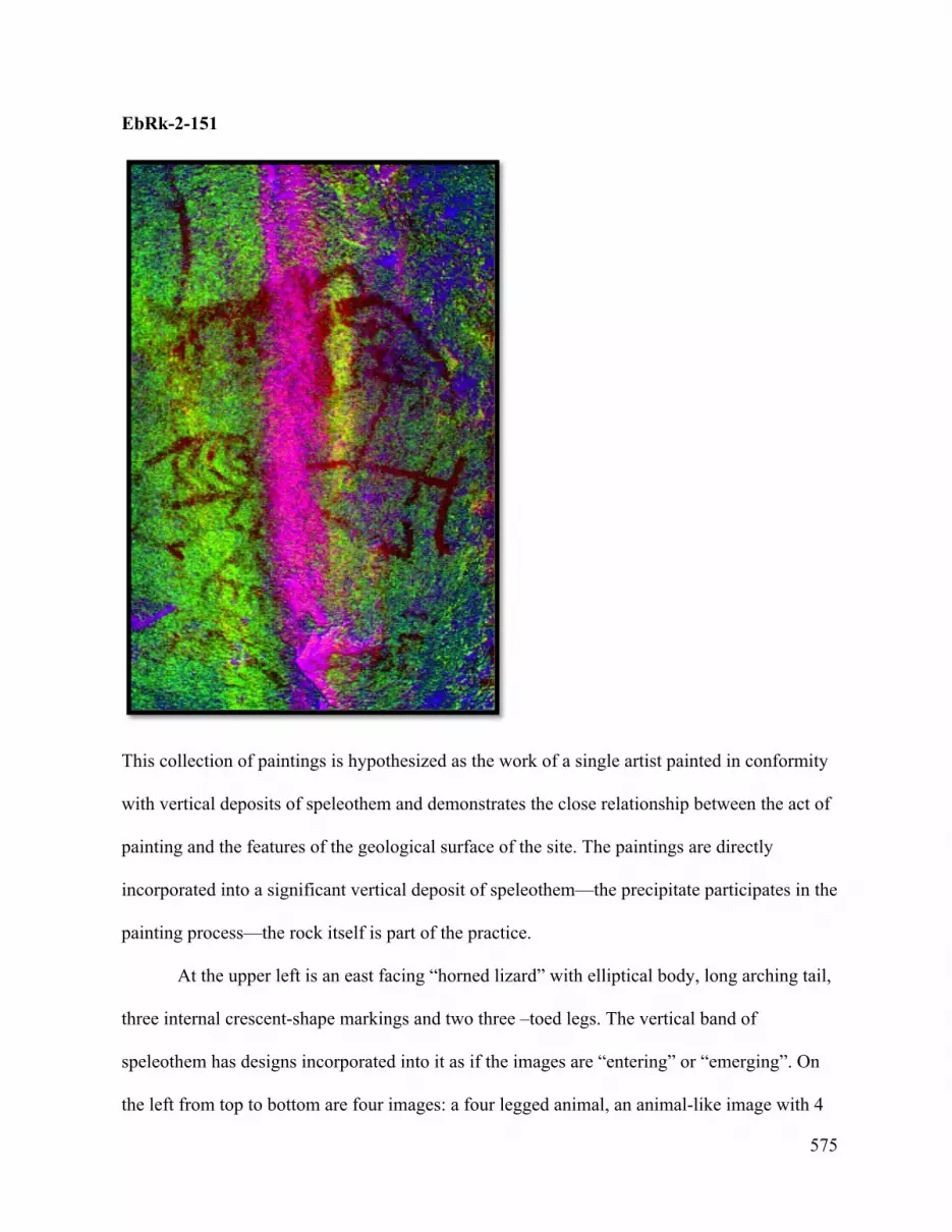
575
EbRk-2-151
This collection of paintings is hypothesized as the work of a single artist painted in conformity
with vertical deposits of speleothem and demonstrates the close relationship between the act of
painting and the features of the geological surface of the site. The paintings are directly
incorporated into a significant vertical deposit of speleothem—the precipitate participates in the
painting process—the rock itself is part of the practice.
At the upper left is an east facing “horned lizard” with elliptical body, long arching tail,
three internal crescent-shape markings and two three –toed legs. The vertical band of
speleothem has designs incorporated into it as if the images are “entering” or “emerging”. On
the left from top to bottom are four images: a four legged animal, an animal-like image with 4

576
internal chevrons, a grizzly bear arm and a single line. On the right are (top to bottom): an owl,
a complicate linear figure with 2-chevroned mountain goat.

577
EbRk-2-152

578
On the right of the group is a single painting of a skeletal “ghost” figure. The painter directly
and deliberately incorporated the white mineral precipitate of the rock surface into the
composition of the painting. The upper body is identified by a head with large empty eyes and
an upper torso with exposed esophagus. Three V- marks would seem to represent a human-like
rib-cage. Below the long torso other thinner vertical patches of speleothem become profile legs,
one straight the other bent suggesting movement.
Adjacent to the afore-mentioned paintings is a recessed rock area with the largest array
of paintings in Group 3. Here the trail passes through a narrow aperture of boulders in close
proximity to a rock face covered with speleothem and epigenetic veins of rock adorned with
paintings.

579

580

581
EbRk-2-153/15
A long diagonal line with appendages (EbRk-2-153) parallels the epigenetic vein in the rock
and crosses two vertical streams of speleothem which has covered portions of the painting. The
nature of this painting is somewhat speculative given we may be dealing with the work of one
or two artists. The painter drawing on different aspects of the iconography and the rock surface
to bring forth the concept the final painter who made this meter long painting chose.
The upper half is line with four diagonal lines projecting from each side. The upper end
terminates in two angled lines (a open mouth? legs?). The lower end terminates in an angle.
The lower end of the painting terminates in a set of nine parallel diagonal lines (Painting EbRk-
2-154) filling the area between two parallel cracks.

582
EbRk-2-155
A painting of a “sunulhkAz” with an appended “grizzly bear paw and forearm” dangling from
its left head overlaps the upper portion of the previous painting indicating hat it was done later.
The motif is similar in form to painting EbRk-2–98 in Group 2 at the rock. This painting
however is by a different painter as evident in the rendition of the heads, the solid body, and the
grizzly near paw. The subject matter though is identical and suggest a strong relationship and
seems to be a uniform work not the product of two events or painters as seen in other examples
of this motif.

583
EbRk-2-156
This painting appears at the top of the panel. A cross-like motif is portrayed atop a pronounced
raise on a horizontal line. Four wavy parallel lines flank the cross, two on each side.
EbRk-2-157
This painting, somewhat deteriorated and adjacent to the last features three figures—a wavy
line, a rounded shape with internal features (a face?) and an indistinct figure.

584
EbRk-2-158/159
Paintings EbRk-2-158 and 159 share similar composition and subject matter of a winged being
with large eyes “gathering/protecting” deer and mountain sheep/goats under its wings. The
paintings are the work of different painters one replicating the work of the first. Based on
preservation EbRk-2-158 on the upper left is probably the oldest. It is composed of finer line
and appears to be wearing a fringed shirt. A portion of it is overlaid by the “diagonal barbed
line” (which makes this painting older than EbRk-2-153).
Painting EbRk-2-158 depicts one of the animals under the wing as a mountain sheep
judging from the curvature of the horn and a solid body. The other animal is probably a deer
shown with an outlined rectangular body with l-shaped bent legs and two internal chevrons.
The painter of EbRk-2-159 replicated the composition of EbRk-2-158 but depicted a
deer with horns on one side and a mountain sheep on the other with both the bodies filled in.

585
The colour is bolder (more recent and better preserved) and there is less detail (i.e. no internal
markings on the animal or fringed shirt).
EbRk-2-160
This painter created a unique image (EbRk-2-160) by combining a typical profile ungulate
body with the head portrayed frontally with large asymmetrical antlers and whiskers on each
side of the head (possibly an elk)? Two chevrons mark the body with some additional detail (a
heart?). Four curved legs are depicted atypical of the usual convention of angled legs. A line
with two prongs at each end arches over the back of the animal—a frequent them at EbRk-2.

586
EbRk-2-161
The second vector of geology is an epigenetic vein with significant speleothem carried down
from the area above. Expressive imagery occurs across its surface. The upper most painting
EbRk-2-161 has an indistinct design and a vertical image of a line with attached perpendicular
lines.
EbRk-2-162
Painting EbRk-2-162 consists of two paintings close together. The upper one appears to be a
partial sun-like image incorporated into the rock surface while below is a small single
composition of a “sunulhkAz.”

587
EbRk-2-163/164
An almost indistinct group of images (EbRk-2-163), two lines with angled tips and two
outlined ungulates, are aligned along in conformity with quartzite veins in the rock epigenetic
vein. Below painted directly on the wider epigenetic vein are three, possibly four expressive
thick-lined box-shaped paintings of mountain goats in a row (Painting EbRk-2-164). Ochre
may also have been smeared in this area as well.

588
EbRk-2-165
This area of the rock surface is dominated by a large human-like figure with a round head with
eyes, nose, thick neck and rectangular body with outstretched arms (EbRk-2-165). The V-shape
in the upper torso—reminiscent of a rib cage—would seem to be a variant of the “ghost”
iconography found elsewhere. Straight lines for legs terminate in profile feet. Another painting
(EbRk-2-166) lays across the lower torso.

589
EbRk-2-166
A bending diagonal line (Painting EbRk-2-166) is superimposed upon and crosses the mid
torso of the large human figure painting. At the lower end over the human figure the line passes
through a four legged animal with a rounded lower body and continues up to terminate in
vertical figure that has the convention of the fir branch but terminates at one end with small
head with four lines projecting radially from the head.

590
EbRk-2-167
At the base of the panel on a protruding weathered ledge of granite are two paintings (EbRk-2-
167 and EbRk-2-168). The first is a wide horizontal band of paint deliberately placed to enter
cracks in the rock. The painting was directional seen by comparing the thickness of paint from
left to right. Part of the surface was later chipped probably by people.

591
EbRk-2-168
This painter has rendered a version of the “horned lizard” motif with strong lines, typical
elliptical body, tail, angled legs with three spines and diagonal lines for “ribs.” The head is
rendered simple with eye an open mouth and ubiquitous protruding tongue.
EbRk-169

592
At the upper right of this outcrop on the sloping edge is a small painting of a “sunulhkAz”
across two small cracks. It is much eroded. Open mouth and tongues are evident and the body
form is of the less angular variety.
EbRk-2-170
This composition of a rectangular shaped with four bent legs and four chevrons portrayed on its
body. Two lines indicate an open mouth and two lines a set of ears/antlers (mountain goat?).

593
EbRk-2-171/172/173
Three painting events may be represented. Following the pattern of the wall the paintings are
arranged diagonally beginning with a ladder-like figure composed of a line and 8 cross pieces
(EbRk-2-171). Painting EbRk-2-172 is composed of two paintings of thicker line and better
preserved paint; a motif of a diagonal line with a vertical line across its center and an arrow like
tip is shown with an ungulate with bent legs and interior chevron, the latter shown backwards
to convention. Both paintings seem in the expressive (later) style. To the right is another band
of red paint (Painting EbRk-2-173) following the trajectory of geology at the site.

594
EbRk-2-174/175/176
EbRk-2-174
This painting is deliberately placed in relation to speleothem deposits and cracks on the rock. A
gradual arching line terminates in an array of 8 bottom lines and half circle that may represent
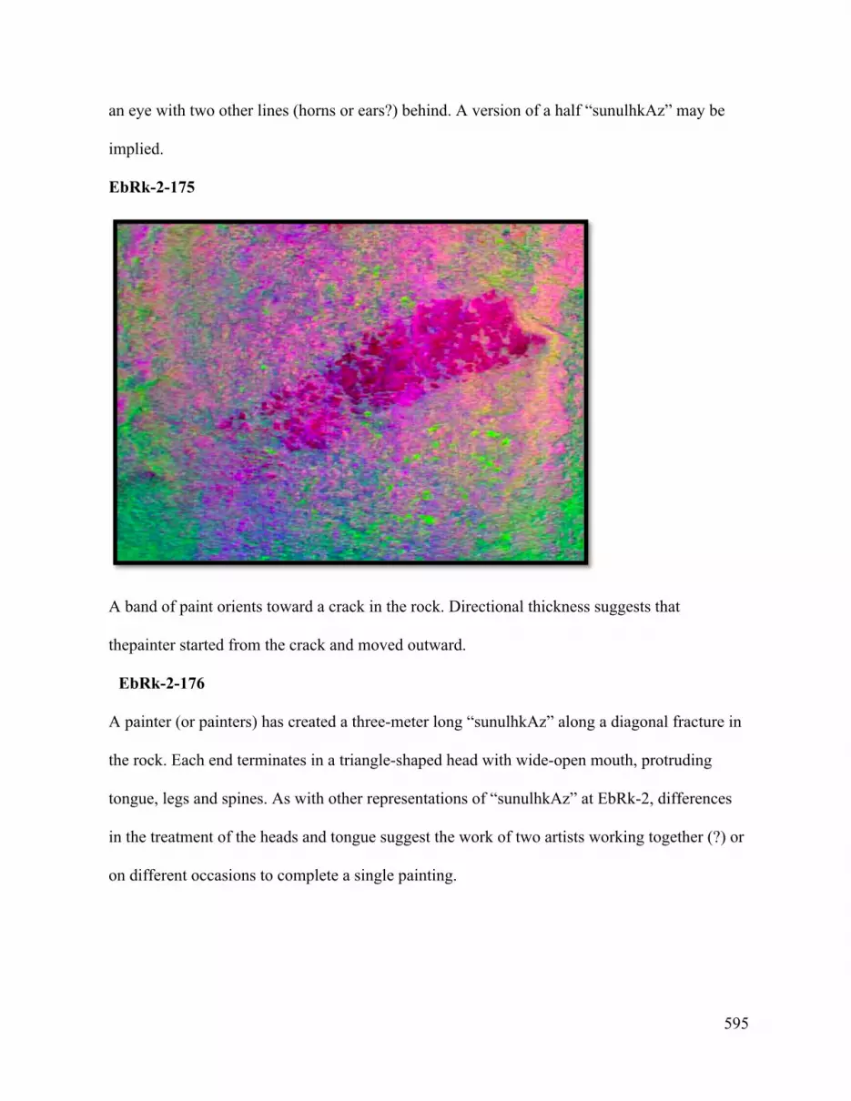
595
an eye with two other lines (horns or ears?) behind. A version of a half “sunulhkAz” may be
implied.
EbRk-2-175
A band of paint orients toward a crack in the rock. Directional thickness suggests that
thepainter started from the crack and moved outward.
EbRk-2-176
A painter (or painters) has created a three-meter long “sunulhkAz” along a diagonal fracture in
the rock. Each end terminates in a triangle-shaped head with wide-open mouth, protruding
tongue, legs and spines. As with other representations of “sunulhkAz” at EbRk-2, differences
in the treatment of the heads and tongue suggest the work of two artists working together (?) or
on different occasions to complete a single painting.

596
EbRk-2-177
This not well-preserved thin-line painting of an ungulate (mountain goat?) with outlined body,
long curved horn, upright tail, three internal chevrons, and short legs shown backwards to
convention. The hue is different than adjacent paintings but may be the result of weathering or
paint quality.

597
EbRk-2-178
The motif of a solid-bodied ungulate on an earth line appears inside a crescent shape.
Note how the painter has used the crack in the rock as base for the “earth line” and the origin of
the line that arches behind and over it.

598
EbRk-2-179/180
Two paintings of ungulates probably mountain goats appear on an earth line inside crescent.
Both are portrayed in outline with two internal chevron details. Here, each animal may have
been painted by a different person or occasions. The largest image (EbRk-2-180) was likely
painted first, with the mirror image painted later and slightly smaller to fit the space between
EbRk-2-179 and the large “sunulhkAz” painting.

599
EbRk-2-181
Two innocuous shapes are rendered along the edge of a wide epigenetic vein across the rock
surface.
EbRk-2-182
This painting is an unconventional representation of a vertical mark flanked by two
vertical zigzags over two parallel horizontal lines to the right.

600
EbRk-2-183
Below the previous painting EbRk-2-182 is a horizontal smear of paint on an epigenetic vein
between two natural iron oxide deposit (EbRk-2-183).

601
EbRk-2-184/185
At the “entrance to the main “gallery” at EbRk-2 are three groups of paintings where the
painters employed horizontal compositions across otherwise unmarked rock faces.

602
EbRk-2-185
This painter made two 60 cm parallel lines with a single vertical line beneath.

603
EbRk-2-186/187/188
EbRk-2-186/187

604
On this rough vertical plane of rock are two paintings, EbRk-2-187 and EbRk-2-1889. EbRk-2-
187 is an abstract motif of a vertical elliptical “body” with long “neck” and “head”terminating
in an acute angle (“arrowhead”?). EbRk-2-187 is a linear composition of four outlined-oval
shaped ungulates that increase in size from right to left. Above them are three horizontal stick
like figures.
EbRk-2-188
EbRk-2-188 is a linear composition showing an unidentifiable ungulate with ta rectangular
body with two chevrons, bent legs, upright tail and what could be a spear (?) in its back. The
head area appears deliberately smudged and inexact. Behind the animal is a horizontal line
crossed at intervals by 7 short vertical lines—a “ladder” or ‘fence” motif.

605
EbRk-2-189/190/191/192
Tentatively there are four painting events are found on this vertical face along the path to the
main cliff. On the lower left near ground-level a painter has rendered an abstract diamond
bodied radial image (EbRk-2-189) with central axis bisected vertically and horizontally, cross-
like, with angled lines at each end that oppose each other creating diagonal axes (Figure 142).
To its left is a companion (?) painting of a vertical line with angled tip.

606
On the right separated by a vertical crack and epigenetic veins are EbRk-2-190, a strong 90 cm
diagonal line that goes to the base of the rock face. This painting is superimposed by a less
preserved painting event EbRk-2-191. Two paintings comprise the latter: with the upper
horizontal image (with wide open mouth and tongue of the head and evidence of spines)
suggesting an individual’s version of the conventional “sunulhkAz.”
Below it, by virtue of the carefully delineated concentric pair of horns, is a big horn
sheep with four bent legs, horizontal tail, two internal chevrons and a wide band (Painting
EbRk-2-192). The head portion, particularly the snout, has eroded. In the style composition of
the body the painter has deliberately used variability in line width to create a unique image
within the Nlaka’pamux canon.

607
The uppermost paintings (EbRk-2-191), based on proximity, hue and line, appear to be the
work of one person and represent a composition of five painted dashes, and a horizontal line
with 10 dashes along the back and angled lines at each end, over an outlined lozenge-shape.

608
EbRk-2-193
This painting occurs on the vertical face of granite directly adjacent to the trail. The rock face is
marked with very thin lateral epigenetic veins. The torso of a human-like male image is painted

609
over one of these thin lines and two other, smaller, more rudimentary human-like figures are
shown below the more visible. The images are very weathered and practically indiscernible
without image enhancement. The painter must have been conscious that his/her painting was
the furthest west of all the paintings at EbRk-2 marking the entrance to the upstream portion of
the site many meters from the next painting.