robust simultaneous localization and mapping for very large outdoor environments
TRANSCRIPT
Robust Simultaneous Localization andMapping for very large Outdoor Environments
Eduardo Nebot, Favio Masson,, Jose Guivant and H. Durrant-Whyte
Australian Centre for Field Robotics, University of Sydney, Australia
Abstract. This paper addresses the problem of Simultaneous Localization andMapping (SLAM) when working in very large environments. A Hybrid architectureis presented that makes use of the Extended Kalman Filter to perform SLAM ina very efficient form and a Monte Carlo type filter to resolve the data associa-tion problem potentially present when returning to a known location after a largeexploration task. The proposed algorithm incorporates significant integrity to thestandard SLAM algorithms by providing the ability to handle multimodal distri-butions in real time. Experimental results in outdoor environments are presentedto demonstrate the performance of the algorithm proposed.
1 Introduction
This paper address the problem of navigating autonomously in very large ar-eas. This problem is usually referred as Simultaneous Localization and Map-ping (SLAM) [1] or Concurrent Map Building and Localization (CML) [2].It has been addressed in [3] using a Monte Carlo method in indoor problemsand in [4] using sum of Gaussian in sub-sea applications. These algorithmsare suitable to handle multi-modal probability distribution. Although thesemethods have proven to be very robust in many localization applicationstheir extension to SLAM is computationally expensive making them difficultto apply in real time. In [5] the map building and localization processes aredecoupled by assuming that the pose of the vehicle is known. This is achievedwith enough particles to represent the true pose of the vehicle at all times.The Kalman Filter can also be extended to solve the SLAM problem [1] onceappropriate models for the vehicle and sensors are obtained. In [6] the realtime implementation aspects of SLAM using EKF techniques were addressed.A Compressed Extended Kalman Filter (CEKF) algorithm was introducedthat significantly reduces the computational requirement without introduc-ing any penalties in the accuracy of the results. Sub-optimal simplificationswere also presented in [7] to update the full covariance matrix of the statesbounding the computational cost and memory requirements.
Simultaneous navigation and map building algorithms are based on aexploration stage and re-visit of known places to register the new learnedmap to the known map. Depending on the quality of the kinematics modelsand external sensors used, the exploration stage can be extended to largerareas. Nevertheless no matter how good sensors and models are, at one point
2 Nebot et. al.
−200 −150 −100 −50 0 50 100−250
−200
−150
−100
−50
0
50
Longitud in meters
Latit
ud in
met
ers
Approximated Travel PathLandmarks or trees
1
2
3
A B
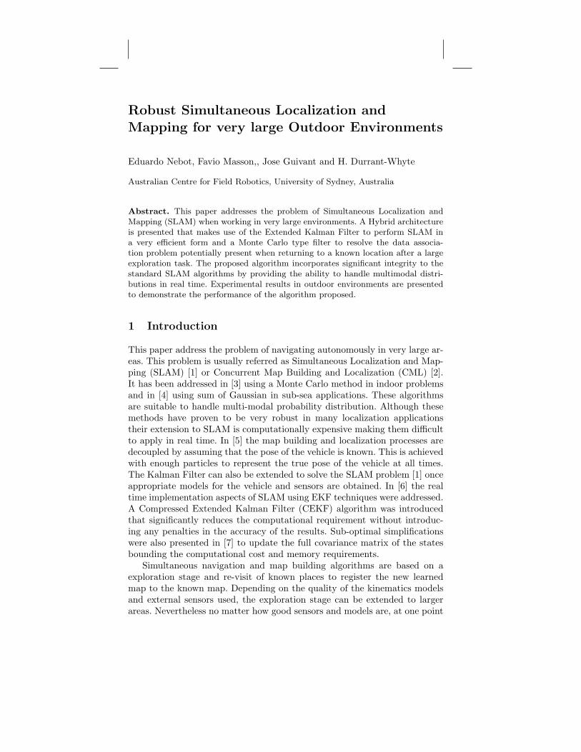
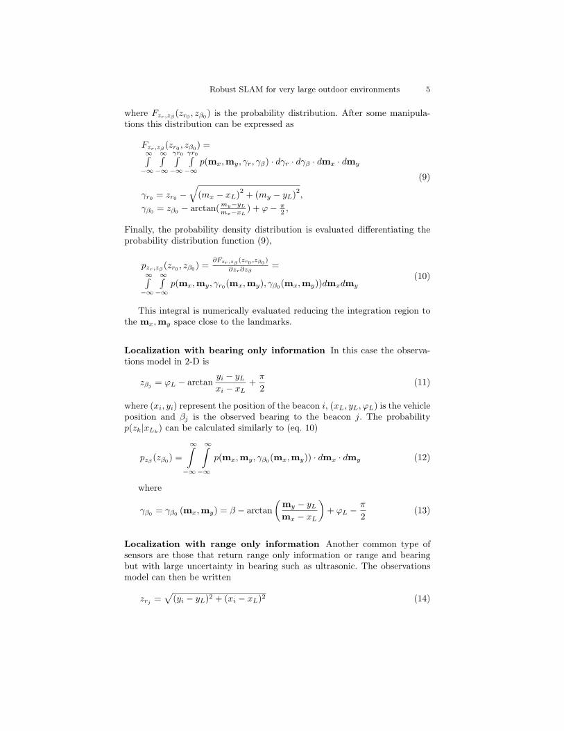
Fig. 1. Example of closing a large loop. The uncertainty when closing the loop atpoint 3 is larger than the separation between landmarks A and B.
the accumulated error will make the registration or data association taskimpossible. This problem is shown is Figure 1. In this experimental run thevehicle started near point 3 and circulated CW direction. The Figure showsthe estimated path using a CEKF filter aided with absolute GPS information[8]. The ” ∗ ” represent natural landmarks incorporated as features into themap. The vehicle uses dead reckoning information to predict its position andincorporates features into the map to bound the dead-reckoning errors. If thevehicle return to the point label 3 with an error smaller than the separationbetween landmarks then it is possible to use standard algorithms to performdata association and register the new learned local map. In this particularcase there are very few landmarks in the part of the trajectory labeled 1-2-3 making the estimated vehicle error to grow to 10 meters when returningclose to the initial position labeled 3. This error is plotted as an ellipse in theFigure. Since the separation between the landmarks A and B is approximately8 meters the algorithm will not be able to perform the data association andwill be in failure. This is an inherent limitation of all simultaneous navigationand mapping methods and is independent of the implementation method ormodel used. Significant improvements to the standard Nearest Neighbor (NN)data association algorithm were presented in [9] with an approach based onconsidering more than one feature at a time. In this paper we present a robustsolution to this problem using a combination of the CEKF with a MonteCarlo Filter. This hybrid architecture is designed to exploit the efficiency ofthe CEKF algorithm to estimate and maintain vehicle and map states andto provide appropriate initialization to the Monte Carlo filter to acceleratethe convergence of the particle type filters once a potential data associationproblem is detected. The algorithms are presented for generic range/bearing,range only and bearing only sensors.
Robust SLAM for very large outdoor environments 3
2 Bayesian Estimation in navigation problems
The SLAM problem under a probabilistic estimation approach requires thatthe marginal probability density p(xLk
,m|Zk,Uk, x0) must be known for allk, where xLk
is the vehicle state, x0 its initial condition, m are the statesrepresenting a feature in the map and Zk and Uk are the observations andinput signals respectively at time k. To obtain the recursively form of thisdensity [4] [10], it is assumed that the density p(xLk−1 ,m|Zk−1,Uk−1, x0) isknown. Then applying the Bayesian rule and the Total Probability theoremwe have
p(xLk,m|Zk,Uk, x0) = κp(zk|xLk
,m)·· ∫ p(xLk
|xLk−1 , uk)p(xLk−1 ,m|Zk−1,Uk−1, x0)dxLk−1
(1)
where κ is a normalization constant, p(zk|xLk,m) represents the observation
model and p(xLk|xLk−1 , uk) models the vehicle dynamic. When the map m
is known
p(xLk|m,Zk,Uk, x0) = κp(zk|m, xLk
)∫p(xLk
|xLk−1 , uk)p(xLk−1 |m,Zk−1,Uk−1, x0)dxLk−1
(2)
represents the Localization Problem.
2.1 Localization with the Particle Filter
Particle Filters approximate the joint posterior probability density with aset of random samples called particles. As the number of samples becomeslarge, they provide an exact, equivalent representation of the required distri-bution, that is the filter output will be close to the Bayesian filter. In thiswork we use the SIR (Sampling Importance Resampling) filter [11], to lo-calize a vehicle in a predefined map using range and bearing information.Assuming that R samples xi
k−1Ri=1 of the previous posterior distribution
are available, the process model is then used to propagate these samples toobtain xi
kRi=1. The new samples represents the a priori probability density
p(xk|m,Zk−1,Uk, x0). The update stage is performed in two steps. The firststep consist of the evaluation likelihood for each predicted particle as,
wi =p(zk|m, xi
k)R∑
j=1
p(zk|m, xjk)
(3)
where zk is the observation at time k. The pair xikR
i=1 , wikR
i=1 defines adiscrete distribution that tends to the real continuous posterior distributionas R tends to infinity. The second stage performs a resampling selectingonly the particles with probability prxj
k = xik = wi
k for each j. Finally theprobability of measuring zk given the state xk is required, that is p(zk|m, xi
k).This pdf can be approximated with a sum of gaussian (SOG) assuming each
4 Nebot et. al.
beacon is represented with a Gaussian distribution centered at its estimatedposition and considering all the uncertainties presents in the observation:
p(zk|m, xLk) =
n∑1
αi
2πσrσβe−0.5(
(xm−xi)2
σ2x
+(ym−yi)
2
σ2y
)(4)
where (xi, yi) are the landmarks a priori estimated positions, σx and σy arethe correspondent deviation in x and y and (xm, ym) are the observationsobtained from each particle. For the range and bearing case they can beexpressed as follows:
xm = xLik + zr cos(zβ − pi/2 + ϕL
ik)
ym = yLik + zr sin(zβ − pi/2 + ϕL
ik)
(5)
where (xLik, yL
ik, ϕL
ik) are each of the states of the particles and (zr, zβ) are
the observations.
Localization with Range and Bearing Information In the case of rangeand bearing observation (zr, zβ), it can be assumed that the measurements arecontaminated by additive noise (γr, γβ) with a given probability distribution.The conditional probability distribution of the observation (zr, zβ) respect tothe vehicle states, considering the uncertainty in the landmark position andthe observation noise can be obtained from the following integral,
p(zk|m, xLk) =
∫Ω
p(mx,my, γr, γβ) µ |−→dS|Ω = (mx,my, γr, γβ) ∈ <4
(6)
The integral is a surface integral and p(mx,my, γr, γβ) is the joint probabil-ity density distribution of the random variables (r.v.) due to the four noisesources. The factor µ · |−→dS| is the surface differential used to perform theintegration over the surface region defined by the equality constrains givenin equation 7.
zr =√
(mx − xL)2 + (my − yL)2 + γr
zβ = arctan(my−yL
mx−xL)− ϕ + π
2 + γβ
(7)
The probability density distribution 6 can be evaluated using the proba-bility density distribution restricted to the observations,
pzr,zβ(zr0 , zβ0) =
∂Fzr,zβ(zr0 , zβ0)
∂zr∂zβ(8)
Robust SLAM for very large outdoor environments 5
where Fzr,zβ(zr0 , zβ0) is the probability distribution. After some manipula-
tions this distribution can be expressed as
Fzr,zβ(zr0 , zβ0) =
∞∫−∞
∞∫−∞
γr0∫−∞
γr0∫−∞
p(mx,my, γr, γβ) · dγr · dγβ · dmx · dmy
γr0 = zr0 −√
(mx − xL)2 + (my − yL)2,γβ0 = zβ0 − arctan( my−yL
mx−xL) + ϕ− π
2 ,
(9)
Finally, the probability density distribution is evaluated differentiating theprobability distribution function (9),
pzr,zβ(zr0 , zβ0) =
∂Fzr,zβ(zr0 ,zβ0 )
∂zr∂zβ=
∞∫−∞
∞∫−∞
p(mx,my, γr0(mx,my), γβ0(mx,my))dmxdmy
(10)
This integral is numerically evaluated reducing the integration region tothe mx,my space close to the landmarks.
Localization with bearing only information In this case the observa-tions model in 2-D is
zβj = ϕL − arctanyi − yL
xi − xL+
π
2(11)
where (xi, yi) represent the position of the beacon i, (xL, yL, ϕL) is the vehicleposition and βj is the observed bearing to the beacon j. The probabilityp(zk|xLk
) can be calculated similarly to (eq. 10)
pzβ(zβ0) =
∞∫
−∞
∞∫
−∞p(mx,my, γβ0(mx,my)) · dmx · dmy (12)
where
γβ0 = γβ0 (mx,my) = β − arctan(
my − yL
mx − xL
)+ ϕL − π
2(13)
Localization with range only information Another common type ofsensors are those that return range only information or range and bearingbut with large uncertainty in bearing such as ultrasonic. The observationsmodel can then be written
zrj =√
(yi − yL)2 + (xi − xL)2 (14)
6 Nebot et. al.
where (xi, yi) is the position of the observed beacon i, (xL, yL, ϕL) is thevehicle position and zrj is the j observation in the sensor data frame.
The conditional probability density distribution p(zk|xLk) can be calcu-
lated according to (eq. 15) considering all the uncertainties present
pzr(zr0) =
∞∫
−∞
∞∫
−∞p(mx,my, γr0(mx,my)) · dmx · dmy (15)
where
γr0 = zr0 −√
(mx − xL)2 + (my − yL)2 (16)
3 Compressed filter and the aiding of the SIR filter
The proposed architecture uses CEKF under normal conditions to performSLAM. At a certain time the system may not be able to perform the asso-ciation task due to large errors in vehicle pose estimation. This is an indica-tion that the filter can not continue working with a mono-modal probabilitydensity distribution. At this point, we have the CEKF estimated mean anddeviation of the states representing the vehicle pose and landmark positions.With the actual map, a de-correlated map is built using a coordinate trans-form and the decorrelation procedures presented in [7]. A particle filter usesthis information to resolve the position of the rover as a localization prob-lem. When the multi-hypothesis are resolved the CEKF is restarted withthe back propagated states values. Then the CEKF resumes operation untila new potential data association problem is detected. This section presentsseveral important implementation issues that need to be taken into accountto maximize the performance of the proposed architecture.
Map for the particle filter The SLAM algorithm builds a map while thevehicle explore a new area. The map states will be, in most cases, highly cor-related in a local area. In order to use the particle filter to solve the localiza-tion problem a two dimensional map probability density distribution needs tobe synthesized from an originally strongly correlated n dimension map. Thedecorrelation procedure is implemented in two steps. The map, originallyrepresented in global coordinates is now represented in a local frame definedby two beacons states that are highly correlated to all the local landmarks.The other local landmarks are then referenced to this new base. This resultsin a covariance matrix of the form,
pm =
pm1 C12 · · · C1m
C21 pm2 · · ·...
.... . . . . .
...
Cm1 · · · . . . pmm
(17)
Robust SLAM for very large outdoor environments 7
where the cross-correlation components between states of different landmarksare usually weak, i.e. they meet the condition Ci,j/
√pmi · pmj << 1. To de-
correlate the map it is necessary to apply an additional step. A conservativebound matrix for (eq. 17) can be easily obtained increasing the diagonal com-ponents and deleting the cross-correlation terms. This can be implemented asshown in eq 18 where diag[·] represents the elements of a diagonal matrix [7].For presentation purposes, all the states in equation 18 are assumed to belongto different landmarks. The decorrelation procedure performs the decorrela-tion of block diagonal matrices, being each block matrix the covariance ofthe states representing a particular landmark.
pm = diag
pm1 +j 6=1∑
j
| k1j · C1j |...
pmm +j 6=m∑
j
| kmj · Cmj |
(18)
The set kiji,j meets the condition kij = 1/kji > 0. This un-correlatedmap is used to define a two dimension map probability density distributionused by the particle filter to localize the vehicle.
Filter Initialization: As the number of particles affects both, the com-putational requirements and convergence of the algorithm, it is necessary toselect an appropriate set of particles to represent the a priori density func-tion at time T0. Since the particle filters work with samples of a distributionrather than its analytic expression it is possible to select the samples basedon the most probable initial pose of the rover. A good initial distribution isa set of particles that is dense in at least a small sub-region that containsthe true states value. The initial distribution should be based in at least oneobservation in a sub-region that contains this true states value. Once a rangeand bearing from a landmark is obtained a distribution is created having ashape similar to a family of solid helical cylinders. Although it is recognizedthat some returns will not be due to landmarks, all range and bearing ob-servations in a single scan are used to build the initial distribution. Eventhough a family of families of helices will introduce more particles than asingle family of helices (one observation), it will be more robust in presenceof spurious observations. Considering the observations of range and bearingas perfect observations, this defines a discontinued one dimensional curve(family of helices) C, in the three dimensional space (x, y, ϕ)
Ci =
(x, y, ϕ) \x = x (τ) = xi + zr · cos (τ)y = y (τ) = yi + zr · sin (τ)ϕ = ϕ (τ) = τ − zβ − π
2τ ∈ [0, 2π)
(19)
8 Nebot et. al.
These regions can be reduced by adjusting the variation of τ according tothe uncertainty in ϕ. Assuming the presence of noise in the observation andin landmark position
zr = z∗r + γr, zβ = z∗β + γβ
xi = x∗i + γxi , yi = y∗i + γyi
(20)
this family of helices becomes a family of cylindrical regions surrounding thehelices.
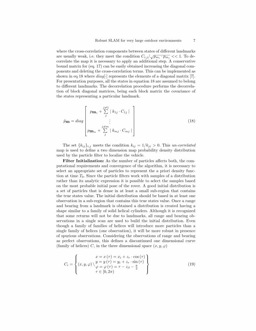
Selection of a reduced local map: In most practical cases the localmap is very large when compared to the sensor field of view. Most of thelandmarks are usually beyond the range of the sensor. It is then possible toselect only the visible beacons from the entire map taking into account theactual uncertainties. This will significantly reduce the computation complex-ity of (10). Figure 2 presents this approach for the case of only two particles.In this Figure (R, β) are the observations, the ” ∗ ” are the projected obser-vation form each particles and the encircle stars are the beacons. It can beappreciated from the Figure that there are only a few beacons that can bewithin the field of view of any of the particles. The other beacons are notconsidered to be part of the reduced map.
Fig. 2. Selected beacons in a reduced local map and uncertainty regions
Interface with the CEKF: Two main issues need to be addressed toimplement the switching strategy between the CEKF and the SIR filter. Thedetection of the potential data association failure while running the CEKFis implemented by monitoring the estimated error in vehicle and local mapstates. The second issue is the reliable determination that the particle filterhas resolved the multi-hypothesis problem and is ready to send the correctposition to the CEKF back propagating its results. This problem is addressedby analyzing the evolution of the estimated deviations errors. The filter isassumed to converge when the estimated standard deviation error becomesless than two times the the noise in the propagation error model for x, y andϕ.
Robust SLAM for very large outdoor environments 9
−10 −5 0 5 10
−10
−5
0
5
10
Longitude
Latit
ude
Initial Particles
−10 −5 0 5 10
−10
−5
0
5
10
Longitude
Latit
ude
Particles 3th update
−10 −5 0 5 10
−10
−5
0
5
10
Longitude
Latit
ude
Particles 6th update
−10 −5 0 5 10
−10
−5
0
5
10
Longitude
Latit
ude
Particles 52th update
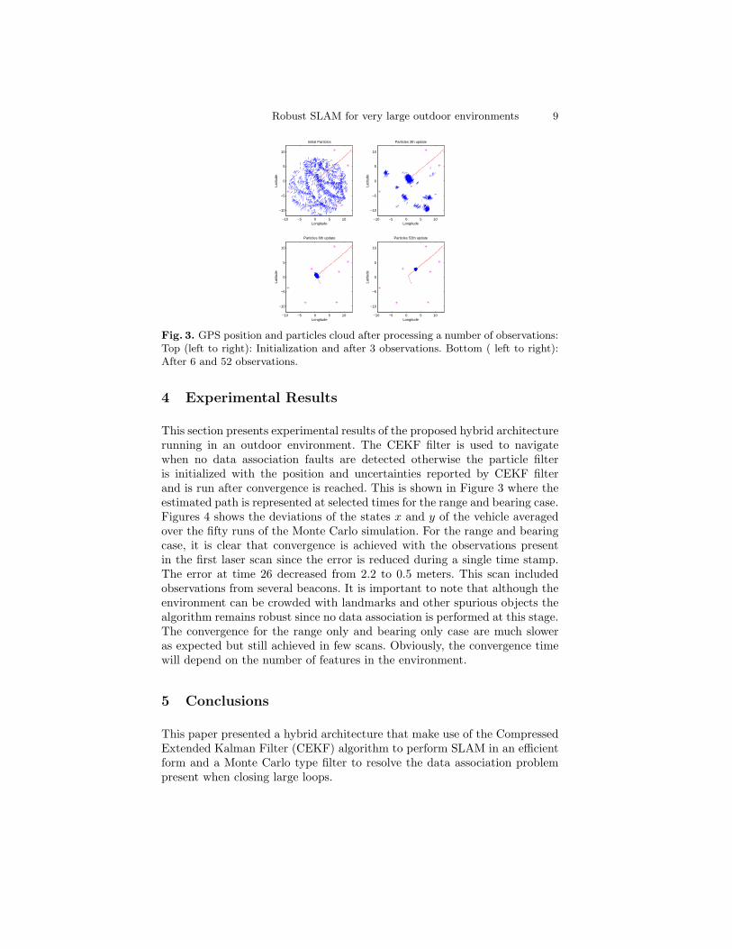
Fig. 3. GPS position and particles cloud after processing a number of observations:Top (left to right): Initialization and after 3 observations. Bottom ( left to right):After 6 and 52 observations.
4 Experimental Results
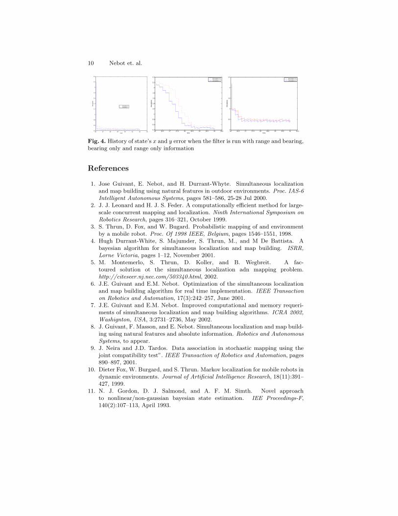
This section presents experimental results of the proposed hybrid architecturerunning in an outdoor environment. The CEKF filter is used to navigatewhen no data association faults are detected otherwise the particle filteris initialized with the position and uncertainties reported by CEKF filterand is run after convergence is reached. This is shown in Figure 3 where theestimated path is represented at selected times for the range and bearing case.Figures 4 shows the deviations of the states x and y of the vehicle averagedover the fifty runs of the Monte Carlo simulation. For the range and bearingcase, it is clear that convergence is achieved with the observations presentin the first laser scan since the error is reduced during a single time stamp.The error at time 26 decreased from 2.2 to 0.5 meters. This scan includedobservations from several beacons. It is important to note that although theenvironment can be crowded with landmarks and other spurious objects thealgorithm remains robust since no data association is performed at this stage.The convergence for the range only and bearing only case are much sloweras expected but still achieved in few scans. Obviously, the convergence timewill depend on the number of features in the environment.
5 Conclusions
This paper presented a hybrid architecture that make use of the CompressedExtended Kalman Filter (CEKF) algorithm to perform SLAM in an efficientform and a Monte Carlo type filter to resolve the data association problempresent when closing large loops.
10 Nebot et. al.
26 27 28 29 30 31 32 330.4
0.6
0.8
1
1.2
1.4
1.6
1.8
2
2.2
2.4
time
Dev
iatio
ns
Deviation XDeviation Y
26 26.5 27 27.5 28 28.5 29 29.5 30 30.50.4
0.6
0.8
1
1.2
1.4
1.6
1.8
2
2.2
2.4
time
Dev
iatio
ns
Deviation XDeviation Y
26 26.5 27 27.5 28 28.5 29 29.5 30 30.50
0.5
1
1.5
2
2.5
time
Dev
iatio
ns
Deviation XDeviation Y
Fig. 4. History of state’s x and y error when the filter is run with range and bearing,bearing only and range only information
References
1. Jose Guivant, E. Nebot, and H. Durrant-Whyte. Simultaneous localizationand map building using natural features in outdoor environments. Proc. IAS-6Intelligent Autonomous Systems, pages 581–586, 25-28 Jul 2000.
2. J. J. Leonard and H. J. S. Feder. A computationally efficient method for large-scale concurrent mapping and localization. Ninth International Symposium onRobotics Research, pages 316–321, October 1999.
3. S. Thrun, D. Fox, and W. Bugard. Probabilistic mapping of and environmentby a mobile robot. Proc. Of 1998 IEEE, Belgium, pages 1546–1551, 1998.
4. Hugh Durrant-White, S. Majumder, S. Thrun, M., and M De Battista. Abayesian algorithm for simultaneous localization and map building. ISRR,Lorne Victoria, pages 1–12, November 2001.
5. M. Montemerlo, S. Thrun, D. Koller, and B. Wegbreit. A fac-toured solution ot the simultaneous localization adn mapping problem.http://citeseer.nj.nec.com/503340.html, 2002.
6. J.E. Guivant and E.M. Nebot. Optimization of the simultaneous localizationand map building algorithm for real time implementation. IEEE Transactionon Robotics and Automation, 17(3):242–257, June 2001.
7. J.E. Guivant and E.M. Nebot. Improved computational and memory requeri-ments of simultaneous localization and map building algorithms. ICRA 2002,Washignton, USA, 3:2731–2736, May 2002.
8. J. Guivant, F. Masson, and E. Nebot. Simultaneous localization and map build-ing using natural features and absolute information. Robotics and AutonomousSystems, to appear.
9. J. Neira and J.D. Tardos. Data association in stochastic mapping using thejoint compatibility test”. IEEE Transaction of Robotics and Automation, pages890–897, 2001.
10. Dieter Fox, W. Burgard, and S. Thrun. Markov localization for mobile robots indynamic environments. Journal of Artificial Intelligence Research, 18(11):391–427, 1999.
11. N. J. Gordon, D. J. Salmond, and A. F. M. Simth. Novel approachto nonlinear/non-gaussian bayesian state estimation. IEE Proceedings-F,140(2):107–113, April 1993.