r levesque associates, inc notice of intent - town of
TRANSCRIPT
R LEVESQUE ASSOCIATES, INC A L AND PL ANNING SERVICES COMPANY 40 School Street, Westfield, MA 01085
p 413.568.0985 · f 413.568.0986 · www.rlaland.com
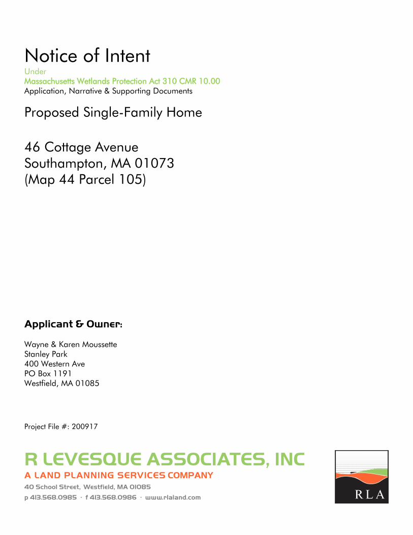
Notice of Intent Under Massachusetts Wetlands Protection Act 310 CMR 10.00 Application, Narrative & Supporting Documents
Proposed Single-Family Home 46 Cottage Avenue Southampton, MA 01073 (Map 44 Parcel 105) Applicant & Owner: Wayne & Karen Moussette Stanley Park 400 Western Ave PO Box 1191 Westfield, MA 01085
Project File #: 200917
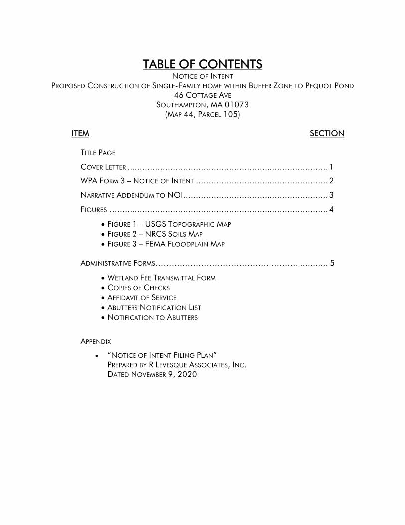
TABLE OF CONTENTS NOTICE OF INTENT
PROPOSED CONSTRUCTION OF SINGLE-FAMILY HOME WITHIN BUFFER ZONE TO PEQUOT POND 46 COTTAGE AVE
SOUTHAMPTON, MA 01073 (MAP 44, PARCEL 105)
ITEM SECTION
TITLE PAGE
COVER LETTER ............................................................................... 1
WPA FORM 3 – NOTICE OF INTENT .................................................... 2
NARRATIVE ADDENDUM TO NOI......................................................... 3
FIGURES ...................................................................................... 4
• FIGURE 1 – USGS TOPOGRAPHIC MAP • FIGURE 2 – NRCS SOILS MAP • FIGURE 3 – FEMA FLOODPLAIN MAP
ADMINISTRATIVE FORMS………..…………………………………… ........... 5
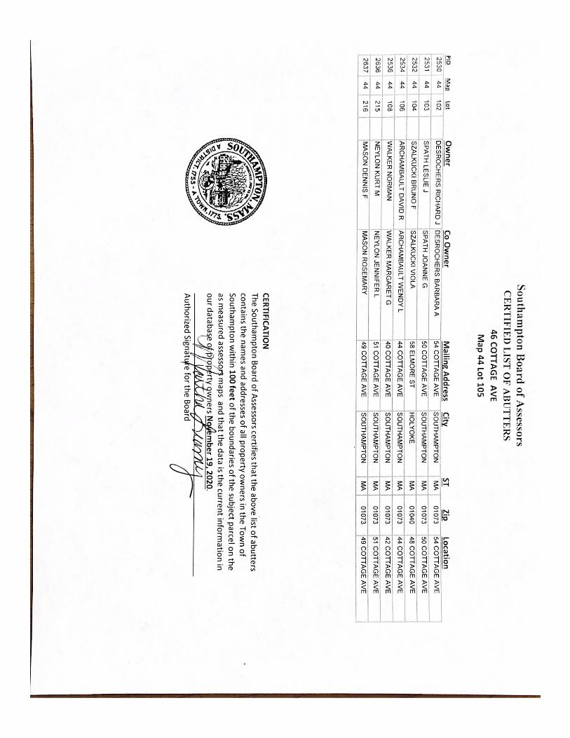
• WETLAND FEE TRANSMITTAL FORM • COPIES OF CHECKS • AFFIDAVIT OF SERVICE • ABUTTERS NOTIFICATION LIST • NOTIFICATION TO ABUTTERS
APPENDIX
• “NOTICE OF INTENT FILING PLAN” PREPARED BY R LEVESQUE ASSOCIATES, INC. DATED NOVEMBER 9, 2020

SECTION 1 COVER LETTER
R LEVESQUE ASSOCIATES, INC. 40 School Street, Westfield, MA 01085 p
413.568.0985 · f 413.568.0986 · www.rlaland.com
A L AND PL ANNING SERVICES COMPANY
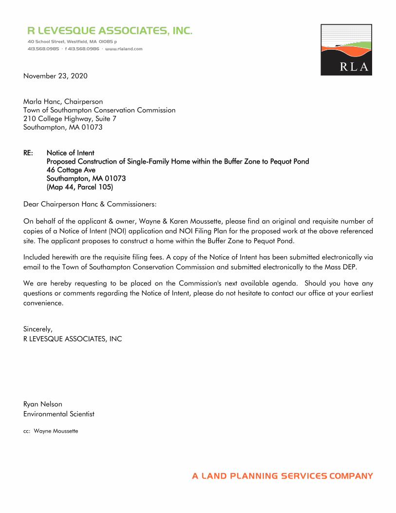
November 23, 2020 Marla Hanc, Chairperson Town of Southampton Conservation Commission 210 College Highway, Suite 7 Southampton, MA 01073 RE: Notice of Intent
Proposed Construction of Single-Family Home within the Buffer Zone to Pequot Pond 46 Cottage Ave Southampton, MA 01073 (Map 44, Parcel 105)
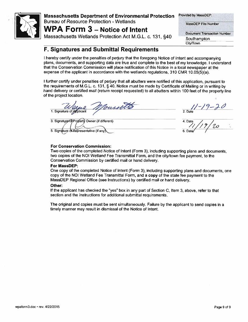
Dear Chairperson Hanc & Commissioners: On behalf of the applicant & owner, Wayne & Karen Moussette, please find an original and requisite number of copies of a Notice of Intent (NOI) application and NOI Filing Plan for the proposed work at the above referenced site. The applicant proposes to construct a home within the Buffer Zone to Pequot Pond.
Included herewith are the requisite filing fees. A copy of the Notice of Intent has been submitted electronically via email to the Town of Southampton Conservation Commission and submitted electronically to the Mass DEP.
We are hereby requesting to be placed on the Commission's next available agenda. Should you have any questions or comments regarding the Notice of Intent, please do not hesitate to contact our office at your earliest convenience.
Sincerely, R LEVESQUE ASSOCIATES, INC
Ryan Nelson Environmental Scientist cc: Wayne Moussette

SECTION 2 WPA FORM 3 – NOTICE OF INTENT
wpaform3.doc • rev. 4/22/2015
Page 1 of 9
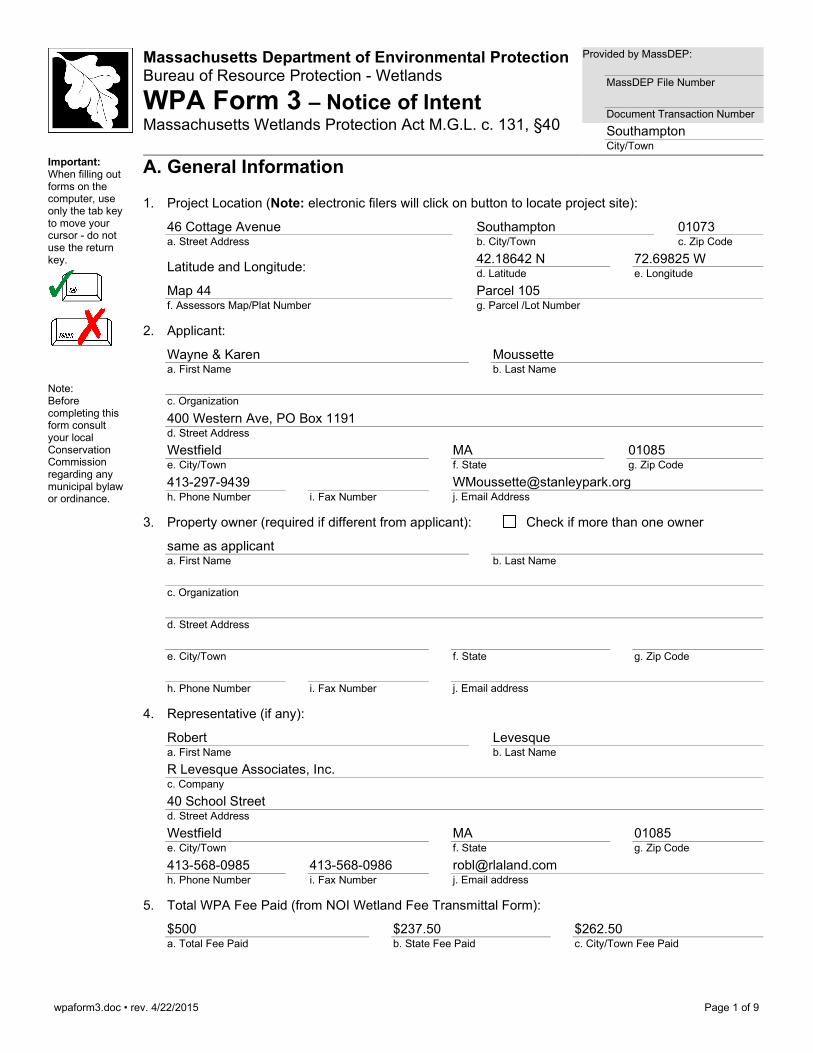
Massachusetts Department of Environmental Protection Bureau of Resource Protection - Wetlands
WPA Form 3 – Notice of Intent Massachusetts Wetlands Protection Act M.G.L. c. 131, §40
Provided by MassDEP:
MassDEP File Number Document Transaction Number Southampton City/Town
Important: When filling out forms on the computer, use only the tab key to move your cursor - do not use the return key.
Note: Before completing this form consult your local Conservation Commission regarding any municipal bylaw or ordinance.
A. General Information
1. Project Location (Note: electronic filers will click on button to locate project site):
46 Cottage Avenue a. Street Address
Southampton b. City/Town
01073 c. Zip Code
Latitude and Longitude: 42.18642 N d. Latitude
72.69825 W e. Longitude
Map 44 f. Assessors Map/Plat Number
Parcel 105 g. Parcel /Lot Number
2. Applicant:
Wayne & Karen a. First Name
Moussette b. Last Name
c. Organization 400 Western Ave, PO Box 1191 d. Street Address Westfield e. City/Town
MA f. State
01085 g. Zip Code
413-297-9439 h. Phone Number
i. Fax Number
[email protected] j. Email Address
3. Property owner (required if different from applicant): Check if more than one owner
same as applicant a. First Name
b. Last Name
c. Organization
d. Street Address
e. City/Town
f. State
g. Zip Code
h. Phone Number
i. Fax Number
j. Email address
4. Representative (if any):
Robert a. First Name
Levesque b. Last Name
R Levesque Associates, Inc. c. Company
40 School Street d. Street Address
Westfield e. City/Town
MA f. State
01085 g. Zip Code
413-568-0985 h. Phone Number
413-568-0986 i. Fax Number
[email protected] j. Email address
5. Total WPA Fee Paid (from NOI Wetland Fee Transmittal Form):
$500 a. Total Fee Paid
$237.50 b. State Fee Paid
$262.50 c. City/Town Fee Paid

wpaform3.doc • rev. 4/22/2015
Page 2 of 9
Massachusetts Department of Environmental Protection Bureau of Resource Protection - Wetlands
WPA Form 3 – Notice of Intent Massachusetts Wetlands Protection Act M.G.L. c. 131, §40
Provided by MassDEP:
MassDEP File Number Document Transaction Number Southampton City/Town
A. General Information (continued) 6. General Project Description: The proposed project includes the demolition of the existing house and construction of a new house
with associated site improvements including patios, retaining walls, and utility connections. The project is within the buffer zone to Pequot Pond. Please refer to the accompanying filing plan and narrative for greater detail.
7a. Project Type Checklist: (Limited Project Types see Section A. 7b.)
1. Single Family Home 2. Residential Subdivision
3. Commercial/Industrial 4. Dock/Pier
5. Utilities 6. Coastal engineering Structure
7. Agriculture (e.g., cranberries, forestry) 8. Transportation
9. Other
7b. Is any portion of the proposed activity eligible to be treated as a limited project (including Ecological Restoration Limited Project) subject to 310 CMR 10.24 (coastal) or 310 CMR 10.53 (inland)?
1. Yes No If yes, describe which limited project applies to this project. (See 310 CMR 10.24 and 10.53 for a complete list and description of limited project types)
2. Limited Project Type
If the proposed activity is eligible to be treated as an Ecological Restoration Limited Project (310 CMR10.24(8), 310 CMR 10.53(4)), complete and attach Appendix A: Ecological Restoration Limited Project Checklist and Signed Certification.
8. Property recorded at the Registry of Deeds for:
Hampshire a. County
b. Certificate # (if registered land)
13736 c. Book
200 d. Page Number
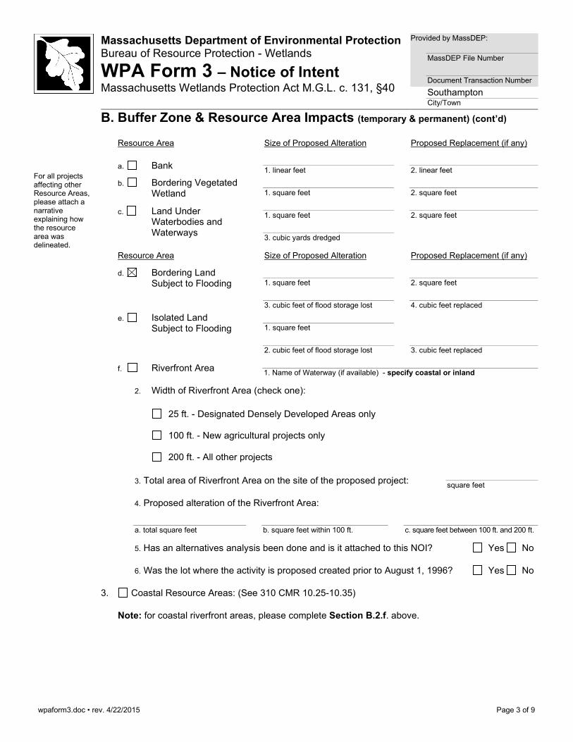
B. Buffer Zone & Resource Area Impacts (temporary & permanent)
1. Buffer Zone Only – Check if the project is located only in the Buffer Zone of a Bordering Vegetated Wetland, Inland Bank, or Coastal Resource Area.
2. Inland Resource Areas (see 310 CMR 10.54-10.58; if not applicable, go to Section B.3, Coastal Resource Areas).
Check all that apply below. Attach narrative and any supporting documentation describing how the project will meet all performance standards for each of the resource areas altered, including standards requiring consideration of alternative project design or location.
wpaform3.doc • rev. 4/22/2015
Page 3 of 9
Massachusetts Department of Environmental Protection Bureau of Resource Protection - Wetlands
WPA Form 3 – Notice of Intent Massachusetts Wetlands Protection Act M.G.L. c. 131, §40
Provided by MassDEP:
MassDEP File Number Document Transaction Number Southampton City/Town
B. Buffer Zone & Resource Area Impacts (temporary & permanent) (cont’d)
For all projects affecting other Resource Areas, please attach a narrative explaining how the resource area was delineated.
Resource Area Size of Proposed Alteration Proposed Replacement (if any)
a. Bank 1. linear feet
2. linear feet
b. Bordering Vegetated Wetland
1. square feet
2. square feet
c. Land Under Waterbodies and Waterways
1. square feet
2. square feet
3. cubic yards dredged
Resource Area Size of Proposed Alteration Proposed Replacement (if any)
d. Bordering Land Subject to Flooding
1. square feet
2. square feet
3. cubic feet of flood storage lost
4. cubic feet replaced
e. Isolated Land Subject to Flooding
1. square feet
2. cubic feet of flood storage lost
3. cubic feet replaced
f. Riverfront Area 1. Name of Waterway (if available) - specify coastal or inland
2. Width of Riverfront Area (check one):
25 ft. - Designated Densely Developed Areas only
100 ft. - New agricultural projects only
200 ft. - All other projects
3. Total area of Riverfront Area on the site of the proposed project: square feet
4. Proposed alteration of the Riverfront Area:
a. total square feet
b. square feet within 100 ft.
c. square feet between 100 ft. and 200 ft.
5. Has an alternatives analysis been done and is it attached to this NOI? Yes No
6. Was the lot where the activity is proposed created prior to August 1, 1996? Yes No
3. Coastal Resource Areas: (See 310 CMR 10.25-10.35) Note: for coastal riverfront areas, please complete Section B.2.f. above.
wpaform3.doc • rev. 4/22/2015
Page 4 of 9
Massachusetts Department of Environmental Protection Bureau of Resource Protection - Wetlands
WPA Form 3 – Notice of Intent Massachusetts Wetlands Protection Act M.G.L. c. 131, §40
Provided by MassDEP:
MassDEP File Number Document Transaction Number Southampton City/Town
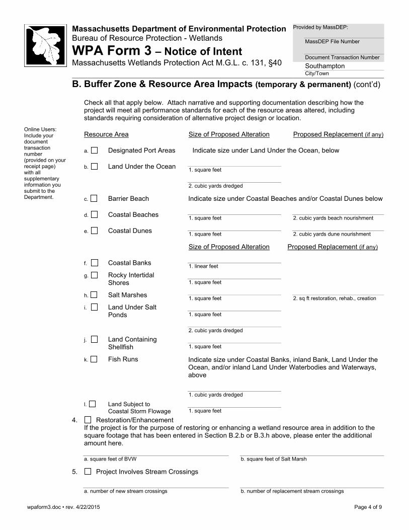
B. Buffer Zone & Resource Area Impacts (temporary & permanent) (cont’d)
Check all that apply below. Attach narrative and supporting documentation describing how the project will meet all performance standards for each of the resource areas altered, including standards requiring consideration of alternative project design or location.
Online Users: Include your document transaction number (provided on your receipt page) with all supplementary information you submit to the Department.
Resource Area Size of Proposed Alteration Proposed Replacement (if any)
a. Designated Port Areas Indicate size under Land Under the Ocean, below
b. Land Under the Ocean 1. square feet
2. cubic yards dredged
c. Barrier Beach Indicate size under Coastal Beaches and/or Coastal Dunes below
d. Coastal Beaches 1. square feet
2. cubic yards beach nourishment
e. Coastal Dunes
1. square feet 2. cubic yards dune nourishment
Size of Proposed Alteration Proposed Replacement (if any)
f. Coastal Banks
1. linear feet g. Rocky Intertidal
Shores 1. square feet
h. Salt Marshes
1. square feet 2. sq ft restoration, rehab., creation
i. Land Under Salt Ponds
1. square feet
2. cubic yards dredged
j. Land Containing Shellfish
1. square feet
k. Fish Runs Indicate size under Coastal Banks, inland Bank, Land Under the Ocean, and/or inland Land Under Waterbodies and Waterways, above
1. cubic yards dredged
l. Land Subject to Coastal Storm Flowage
1. square feet
4. Restoration/Enhancement If the project is for the purpose of restoring or enhancing a wetland resource area in addition to the square footage that has been entered in Section B.2.b or B.3.h above, please enter the additional amount here.
a. square feet of BVW
b. square feet of Salt Marsh
5. Project Involves Stream Crossings
a. number of new stream crossings
b. number of replacement stream crossings
wpaform3.doc • rev. 4/22/2015
Page 5 of 9
Massachusetts Department of Environmental Protection Bureau of Resource Protection - Wetlands
WPA Form 3 – Notice of Intent Massachusetts Wetlands Protection Act M.G.L. c. 131, §40
Provided by MassDEP:
MassDEP File Number Document Transaction Number Southampton City/Town
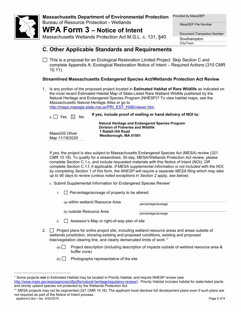
C. Other Applicable Standards and Requirements This is a proposal for an Ecological Restoration Limited Project. Skip Section C and
complete Appendix A: Ecological Restoration Notice of Intent – Required Actions (310 CMR 10.11).
Streamlined Massachusetts Endangered Species Act/Wetlands Protection Act Review
1. Is any portion of the proposed project located in Estimated Habitat of Rare Wildlife as indicated on the most recent Estimated Habitat Map of State-Listed Rare Wetland Wildlife published by the Natural Heritage and Endangered Species Program (NHESP)? To view habitat maps, see the Massachusetts Natural Heritage Atlas or go to http://maps.massgis.state.ma.us/PRI_EST_HAB/viewer.htm.
a. Yes No If yes, include proof of mailing or hand delivery of NOI to:
Natural Heritage and Endangered Species Program Division of Fisheries and Wildlife 1 Rabbit Hill Road Westborough, MA 01581
MassGIS Oliver Map 11/18/2020
If yes, the project is also subject to Massachusetts Endangered Species Act (MESA) review (321 CMR 10.18). To qualify for a streamlined, 30-day, MESA/Wetlands Protection Act review, please complete Section C.1.c, and include requested materials with this Notice of Intent (NOI); OR complete Section C.1.f, if applicable. If MESA supplemental information is not included with the NOI, by completing Section 1 of this form, the NHESP will require a separate MESA filing which may take up to 90 days to review (unless noted exceptions in Section 2 apply, see below).
c. Submit Supplemental Information for Endangered Species Review∗
1. Percentage/acreage of property to be altered:
(a) within wetland Resource Area percentage/acreage
(b) outside Resource Area percentage/acreage
2. Assessor’s Map or right-of-way plan of site
2. Project plans for entire project site, including wetland resource areas and areas outside of wetlands jurisdiction, showing existing and proposed conditions, existing and proposed tree/vegetation clearing line, and clearly demarcated limits of work ∗∗
(a) Project description (including description of impacts outside of wetland resource area & buffer zone)
(b) Photographs representative of the site
∗ Some projects not in Estimated Habitat may be located in Priority Habitat, and require NHESP review (see http://www.mass.gov/eea/agencies/dfg/dfw/natural-heritage/regulatory-review/). Priority Habitat includes habitat for state-listed plants and strictly upland species not protected by the Wetlands Protection Act. ∗∗ MESA projects may not be segmented (321 CMR 10.16). The applicant must disclose full development plans even if such plans are not required as part of the Notice of Intent process.
wpaform3.doc • rev. 4/22/2015
Page 6 of 9
Massachusetts Department of Environmental Protection Bureau of Resource Protection - Wetlands
WPA Form 3 – Notice of Intent Massachusetts Wetlands Protection Act M.G.L. c. 131, §40
Provided by MassDEP:
MassDEP File Number Document Transaction Number Southampton City/Town
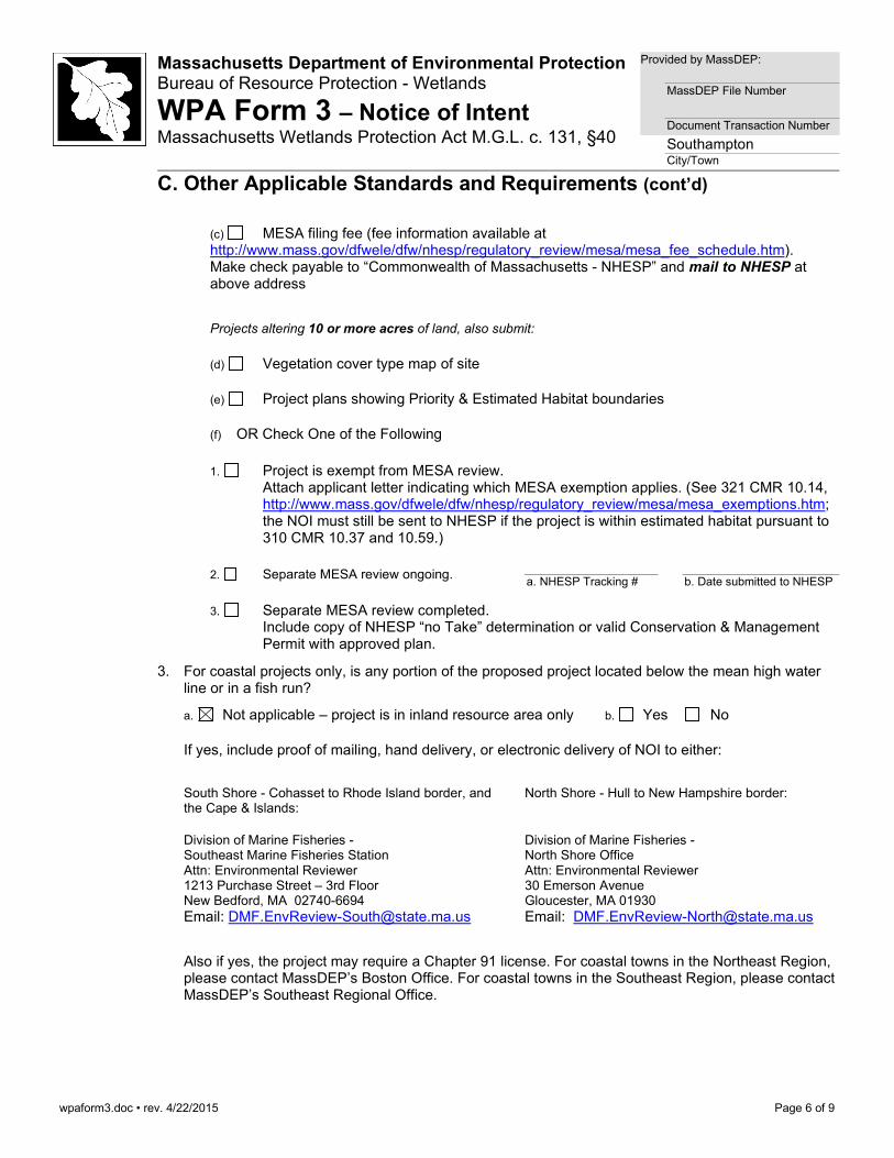
C. Other Applicable Standards and Requirements (cont’d)
(c) MESA filing fee (fee information available at http://www.mass.gov/dfwele/dfw/nhesp/regulatory_review/mesa/mesa_fee_schedule.htm). Make check payable to “Commonwealth of Massachusetts - NHESP” and mail to NHESP at above address
Projects altering 10 or more acres of land, also submit:
(d) Vegetation cover type map of site
(e) Project plans showing Priority & Estimated Habitat boundaries
(f) OR Check One of the Following
1. Project is exempt from MESA review.
Attach applicant letter indicating which MESA exemption applies. (See 321 CMR 10.14, http://www.mass.gov/dfwele/dfw/nhesp/regulatory_review/mesa/mesa_exemptions.htm; the NOI must still be sent to NHESP if the project is within estimated habitat pursuant to 310 CMR 10.37 and 10.59.)
2. Separate MESA review ongoing. a. NHESP Tracking #
b. Date submitted to NHESP
3. Separate MESA review completed.
Include copy of NHESP “no Take” determination or valid Conservation & Management Permit with approved plan.
3. For coastal projects only, is any portion of the proposed project located below the mean high water line or in a fish run?
a. Not applicable – project is in inland resource area only b. Yes No
If yes, include proof of mailing, hand delivery, or electronic delivery of NOI to either:
South Shore - Cohasset to Rhode Island border, and the Cape & Islands:
Division of Marine Fisheries - Southeast Marine Fisheries Station Attn: Environmental Reviewer 1213 Purchase Street – 3rd Floor New Bedford, MA 02740-6694 Email: [email protected]
North Shore - Hull to New Hampshire border:
Division of Marine Fisheries - North Shore Office Attn: Environmental Reviewer 30 Emerson Avenue Gloucester, MA 01930 Email: [email protected]
Also if yes, the project may require a Chapter 91 license. For coastal towns in the Northeast Region, please contact MassDEP’s Boston Office. For coastal towns in the Southeast Region, please contact MassDEP’s Southeast Regional Office.

wpaform3.doc • rev. 4/22/2015
Page 7 of 9
Massachusetts Department of Environmental Protection Bureau of Resource Protection - Wetlands
WPA Form 3 – Notice of Intent Massachusetts Wetlands Protection Act M.G.L. c. 131, §40
Provided by MassDEP:
MassDEP File Number Document Transaction Number Southampton City/Town
C. Other Applicable Standards and Requirements (cont’d)
Online Users: Include your document transaction number (provided on your receipt page) with all supplementary information you submit to the Department.
4. Is any portion of the proposed project within an Area of Critical Environmental Concern (ACEC)?
a. Yes No If yes, provide name of ACEC (see instructions to WPA Form 3 or MassDEP Website for ACEC locations). Note: electronic filers click on Website.
b. ACEC
5. Is any portion of the proposed project within an area designated as an Outstanding Resource Water (ORW) as designated in the Massachusetts Surface Water Quality Standards, 314 CMR 4.00?
a. Yes No
6. Is any portion of the site subject to a Wetlands Restriction Order under the Inland Wetlands Restriction Act (M.G.L. c. 131, § 40A) or the Coastal Wetlands Restriction Act (M.G.L. c. 130, § 105)?
a. Yes No
7. Is this project subject to provisions of the MassDEP Stormwater Management Standards?
a. Yes. Attach a copy of the Stormwater Report as required by the Stormwater Management Standards per 310 CMR 10.05(6)(k)-(q) and check if:
1. Applying for Low Impact Development (LID) site design credits (as described in Stormwater Management Handbook Vol. 2, Chapter 3)
2. A portion of the site constitutes redevelopment
3. Proprietary BMPs are included in the Stormwater Management System.
b. No. Check why the project is exempt:
1. Single-family house
2. Emergency road repair
3. Small Residential Subdivision (less than or equal to 4 single-family houses or less than or equal to 4 units in multi-family housing project) with no discharge to Critical Areas.
D. Additional Information
This is a proposal for an Ecological Restoration Limited Project. Skip Section D and complete Appendix A: Ecological Restoration Notice of Intent – Minimum Required Documents (310 CMR 10.12).
Applicants must include the following with this Notice of Intent (NOI). See instructions for details.
Online Users: Attach the document transaction number (provided on your receipt page) for any of the following information you submit to the Department.
1. USGS or other map of the area (along with a narrative description, if necessary) containing sufficient information for the Conservation Commission and the Department to locate the site. (Electronic filers may omit this item.)
2. Plans identifying the location of proposed activities (including activities proposed to serve as a Bordering Vegetated Wetland [BVW] replication area or other mitigating measure) relative to the boundaries of each affected resource area.
wpaform3.doc • rev. 4/22/2015
Page 8 of 9
Massachusetts Department of Environmental Protection Bureau of Resource Protection - Wetlands
WPA Form 3 – Notice of Intent Massachusetts Wetlands Protection Act M.G.L. c. 131, §40
Provided by MassDEP:
MassDEP File Number Document Transaction Number Southampton City/Town
D. Additional Information (cont’d)
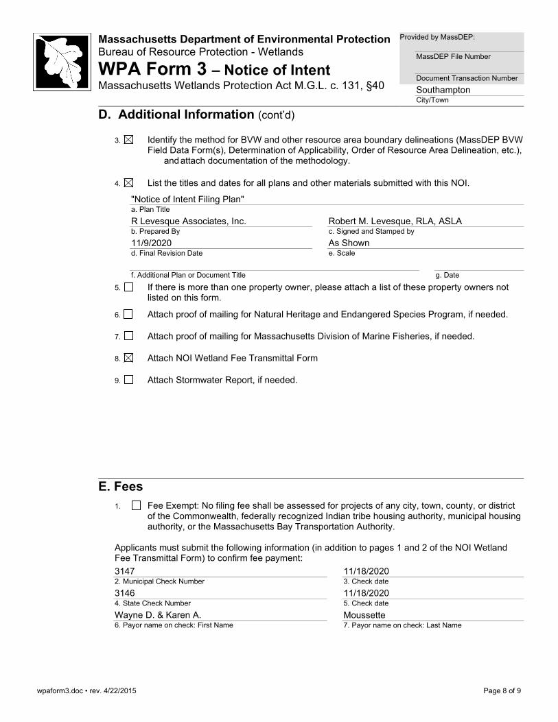
3. Identify the method for BVW and other resource area boundary delineations (MassDEP BVW Field Data Form(s), Determination of Applicability, Order of Resource Area Delineation, etc.), and attach documentation of the methodology.
4. List the titles and dates for all plans and other materials submitted with this NOI.
"Notice of Intent Filing Plan" a. Plan Title
R Levesque Associates, Inc. b. Prepared By
Robert M. Levesque, RLA, ASLA c. Signed and Stamped by
11/9/2020 d. Final Revision Date
As Shown e. Scale
f. Additional Plan or Document Title
g. Date
5. If there is more than one property owner, please attach a list of these property owners not listed on this form.
6. Attach proof of mailing for Natural Heritage and Endangered Species Program, if needed.
7. Attach proof of mailing for Massachusetts Division of Marine Fisheries, if needed.
8. Attach NOI Wetland Fee Transmittal Form
9. Attach Stormwater Report, if needed.
E. Fees 1. Fee Exempt: No filing fee shall be assessed for projects of any city, town, county, or district
of the Commonwealth, federally recognized Indian tribe housing authority, municipal housing authority, or the Massachusetts Bay Transportation Authority.
Applicants must submit the following information (in addition to pages 1 and 2 of the NOI Wetland Fee Transmittal Form) to confirm fee payment:
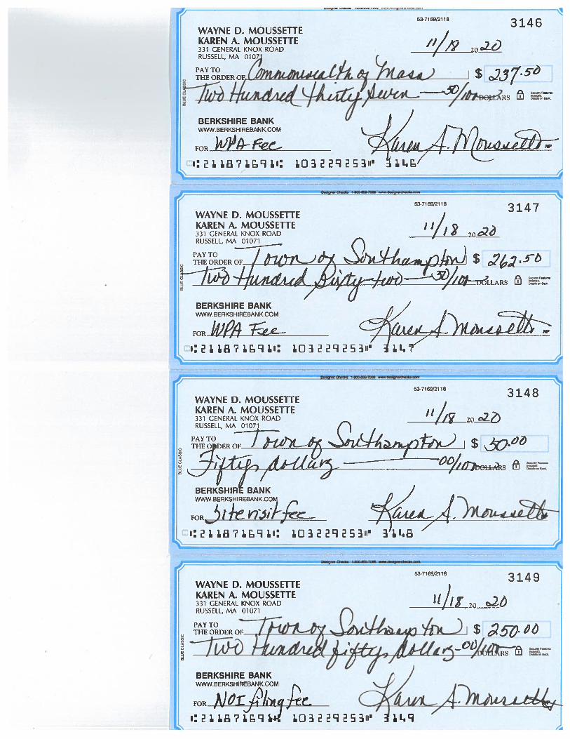
3147 2. Municipal Check Number
11/18/2020 3. Check date
3146 4. State Check Number
11/18/2020 5. Check date
Wayne D. & Karen A. 6. Payor name on check: First Name
Moussette 7. Payor name on check: Last Name

SECTION 3 NARRATIVE ADDENDUM TO NOI
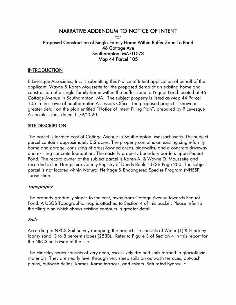
NARRATIVE ADDENDUM TO NOTICE OF INTENT for
Proposed Construction of Single-Family Home Within Buffer Zone To Pond 46 Cottage Ave
Southampton, MA 01073 Map 44 Parcel 105
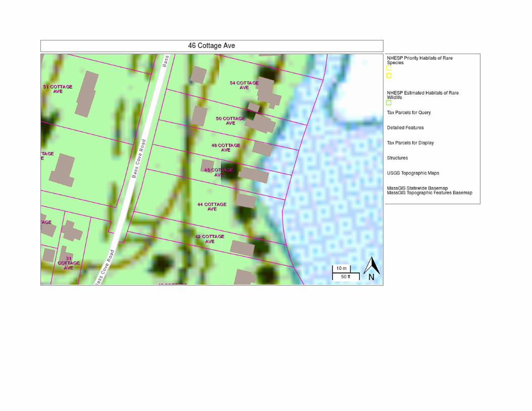
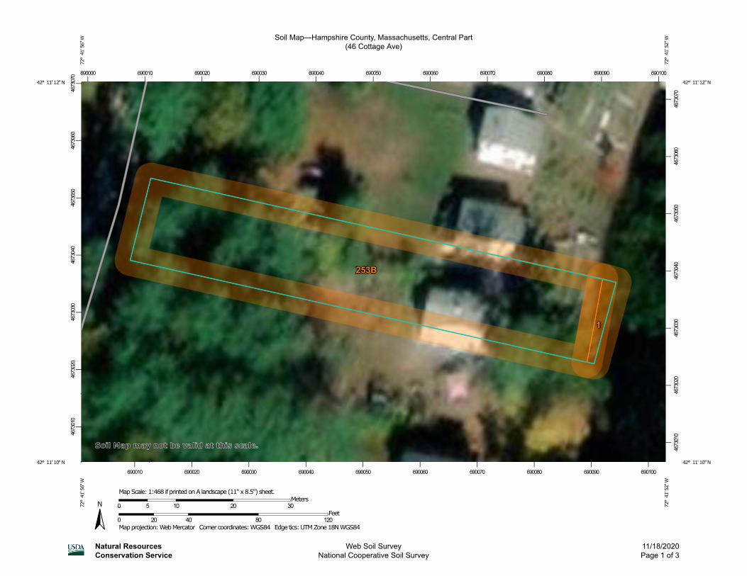
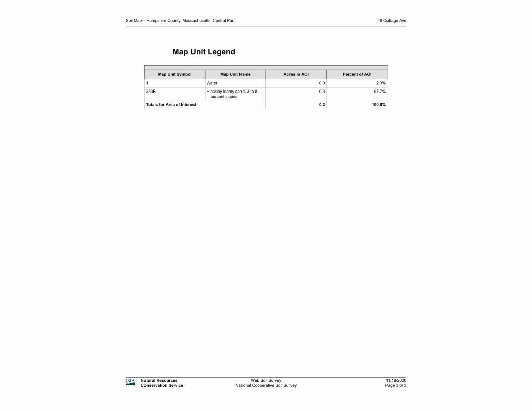
INTRODUCTION R Levesque Associates, Inc. is submitting this Notice of Intent application of behalf of the applicant, Wayne & Karen Moussette for the proposed demo of an existing home and construction of a single-family home within the buffer zone to Pequot Pond located at 46 Cottage Avenue in Southampton, MA. The subject property is listed as Map 44 Parcel 105 in the Town of Southampton Assessors Office. The proposed project is shown in greater detail on the plan entitled “Notice of Intent Filing Plan”, prepared by R Levesque Associates, Inc., dated 11/9/2020. SITE DESCRIPTION The parcel is located east of Cottage Avenue in Southampton, Massachusetts. The subject parcel contains approximately 0.2 acres. The property contains an existing single-family home and garage, consisting of grass-lawned areas, sidewalks, and a concrete driveway and existing concrete foundation. The easterly property boundary borders upon Pequot Pond. The record owner of the subject parcel is Karen A. & Wayne D. Moussette and recorded in the Hampshire County Registry of Deeds Book 13736 Page 200. The subject parcel is not located within Natural Heritage & Endangered Species Program (NHESP) Jurisdiction. Topography The property gradually slopes to the east, away from Cottage Avenue towards Pequot Pond. A USGS Topographic map is attached to Section 4 of this packet. Please refer to the filing plan which shows existing contours in greater detail. Soils According to NRCS Soil Survey mapping, the project site consists of Water (1) & Hinckley loamy sand, 3 to 8 percent slopes (253B). Refer to Figure 3 of Section 4 in this report for the NRCS Soils Map of the site. The Hinckley series consists of very deep, excessively drained soils formed in glaciofluvial materials. They are nearly level through very steep soils on outwash terraces, outwash plains, outwash deltas, kames, kame terraces, and eskers. Saturated hydraulic
Narrative to NOI Page 2 of 4
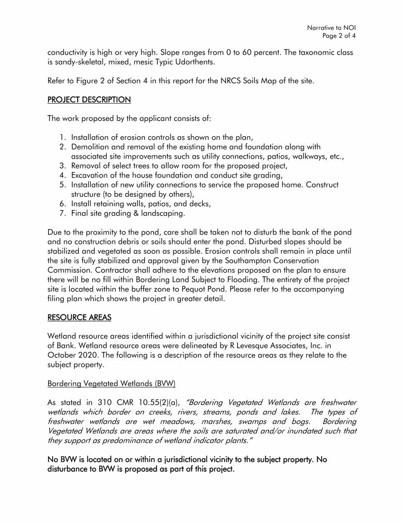
conductivity is high or very high. Slope ranges from 0 to 60 percent. The taxonomic class is sandy-skeletal, mixed, mesic Typic Udorthents. Refer to Figure 2 of Section 4 in this report for the NRCS Soils Map of the site. PROJECT DESCRIPTION The work proposed by the applicant consists of:
1. Installation of erosion controls as shown on the plan, 2. Demolition and removal of the existing home and foundation along with
associated site improvements such as utility connections, patios, walkways, etc., 3. Removal of select trees to allow room for the proposed project, 4. Excavation of the house foundation and conduct site grading, 5. Installation of new utility connections to service the proposed home. Construct
structure (to be designed by others), 6. Install retaining walls, patios, and decks, 7. Final site grading & landscaping.
Due to the proximity to the pond, care shall be taken not to disturb the bank of the pond and no construction debris or soils should enter the pond. Disturbed slopes should be stabilized and vegetated as soon as possible. Erosion controls shall remain in place until the site is fully stabilized and approval given by the Southampton Conservation Commission. Contractor shall adhere to the elevations proposed on the plan to ensure there will be no fill within Bordering Land Subject to Flooding. The entirety of the project site is located within the buffer zone to Pequot Pond. Please refer to the accompanying filing plan which shows the project in greater detail. RESOURCE AREAS Wetland resource areas identified within a jurisdictional vicinity of the project site consist of Bank. Wetland resource areas were delineated by R Levesque Associates, Inc. in October 2020. The following is a description of the resource areas as they relate to the subject property. Bordering Vegetated Wetlands (BVW) As stated in 310 CMR 10.55(2)(a), “Bordering Vegetated Wetlands are freshwater wetlands which border on creeks, rivers, streams, ponds and lakes. The types of freshwater wetlands are wet meadows, marshes, swamps and bogs. Bordering Vegetated Wetlands are areas where the soils are saturated and/or inundated such that they support as predominance of wetland indicator plants.”
No BVW is located on or within a jurisdictional vicinity to the subject property. No disturbance to BVW is proposed as part of this project.
Narrative to NOI Page 3 of 4
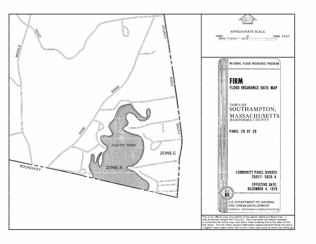
Bank In 310 CMR 10.54(2), a “Bank is the portion of the land surface which normally abuts and confines a water body. It occurs between a water body and a vegetated bordering wetland and adjacent flood plain, or, in the absence of these, it occurs between a water body and an upland.” Bank is associated with Pequot Pond, located on the eastern portion of the property. The bank of Pequot Pond is shown on the accompanying plan. The proposed retaining wall located along the lake is to be installed upgradient of Bank. Bank will not be disturbed as part of this project. Bordering Land Subject to Flooding (BLSF) According to 310 CMR 10.57(2)(a)1., “Bordering Land Subject to Flooding is an area with low, flat topography adjacent to and inundated by flood waters rising from creeks, rivers, streams, ponds or lakes. It extends from the banks of these waterways and water bodies; where a bordering vegetated wetland occurs, it extends from said wetlands.” A portion of the subject parcel is located within a Special Flood Zone Area according to Flood Insurance Rate Map number 2501710020A – effective date December 4, 1979. The 100-year flood elevation is not provided by the mapping however a FEMA Letter of Map Amendment (dated 10/18/2005) has determined the 100-year flood zone for the site to be 256.3 (NAVD 88). No work is proposed within BLSF. Buffer Zone Buffer Zone as defined in 310 CMR 10.04 is “the area of land extending 100 feet horizontally outward from the boundary of any areas specified in 310 CMR 10.02(1)(a)”. Buffer Zone on the subject property is associated with Bank of Pequot Pond. The Buffer Zone is shown on the accompanying plan to extend 50 and 100 feet from the top of Bank. Work proposed within the buffer zone includes the demolition of the existing home, the construction of the proposed home, site grading, installation of required utilities, and landscaping. Prior to construction, erosion controls (silt fence, straw log etc.) will be installed along the approved limit of work to protect downgradient resource areas. Please refer to the accompanying plans for greater detail on the location of proposed work in relation to wetland resource areas.
Narrative to NOI Page 4 of 4
Isolated Land Subject to Flooding (ILSF) In accordance with 310 CMR 10.57(2)(b), Isolated Land Subject to Flooding is an “isolated depression or closed basin without an inlet or outlet. It is an area which at least once a year confines standing water to a volume of at least ½ acre-feet and to an average depth of at least six inches.” ILSF was not observed within the project area. Erosion Controls & Best Management Practices Measures proposed to minimize earth disturbing impacts of the proposed project will be undertaken through the use of Best Management Practices. This includes, but is not limited to: limiting the area of disturbance, installing erosion controls between the work area and adjacent resource areas and their associate buffer zones, construction entrance anti-tracking pads, temporary stormwater controls, etc. Please refer to the accompanying plan set which depicts the location and details on erosion controls. The proposed project is anticipated to be less than 1 acre of earth disturbance and therefore will not require a Stormwater Pollution Prevention Plan (SWPPP) however best management practices should be adhered to during construction to protect the adjacent wetland resource areas.
** END OF NARRATIVE **
SECTION 4 FIGURES
• FIGURE 1 – USGS TOPOGRAPHIC MAP
• FIGURE 2 – NRCS SOILS MAP • FIGURE 3 – FEMA FLOODPLAIN MAP
SECTION 5 ADMINISTRATIVE FORMS
● WETLAND FEE TRANSMITTAL FORM
●COPIES OF CHECKS ●AFFIDAVIT OF SERVICE
●ABUTTERS NOTIFICATION LISTS ●NOTIFICATION TO ABUTTERS
noifeetf.doc • Wetland Fee Transmittal Form • rev. 10/11 Page 1 of 2
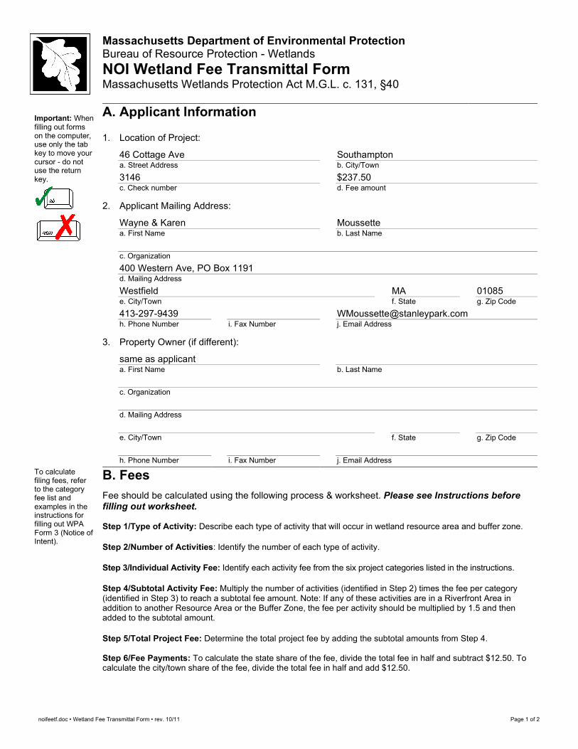
Massachusetts Department of Environmental Protection Bureau of Resource Protection - Wetlands NOI Wetland Fee Transmittal Form Massachusetts Wetlands Protection Act M.G.L. c. 131, §40
Important: When filling out forms on the computer, use only the tab key to move your cursor - do not use the return key.
A. Applicant Information
1. Location of Project:
46 Cottage Ave a. Street Address
Southampton b. City/Town
3146 c. Check number
$237.50 d. Fee amount
2. Applicant Mailing Address:
Wayne & Karen a. First Name
Moussette b. Last Name
c. Organization 400 Western Ave, PO Box 1191 d. Mailing Address Westfield e. City/Town
MA f. State
01085 g. Zip Code
413-297-9439 h. Phone Number
i. Fax Number
[email protected] j. Email Address
3. Property Owner (if different):
same as applicant a. First Name
b. Last Name
c. Organization
d. Mailing Address
e. City/Town
f. State
g. Zip Code
h. Phone Number
i. Fax Number
j. Email Address
To calculate filing fees, refer to the category fee list and examples in the instructions for filling out WPA Form 3 (Notice of Intent).
B. Fees Fee should be calculated using the following process & worksheet. Please see Instructions before filling out worksheet. Step 1/Type of Activity: Describe each type of activity that will occur in wetland resource area and buffer zone. Step 2/Number of Activities: Identify the number of each type of activity. Step 3/Individual Activity Fee: Identify each activity fee from the six project categories listed in the instructions. Step 4/Subtotal Activity Fee: Multiply the number of activities (identified in Step 2) times the fee per category (identified in Step 3) to reach a subtotal fee amount. Note: If any of these activities are in a Riverfront Area in addition to another Resource Area or the Buffer Zone, the fee per activity should be multiplied by 1.5 and then added to the subtotal amount. Step 5/Total Project Fee: Determine the total project fee by adding the subtotal amounts from Step 4. Step 6/Fee Payments: To calculate the state share of the fee, divide the total fee in half and subtract $12.50. To calculate the city/town share of the fee, divide the total fee in half and add $12.50.
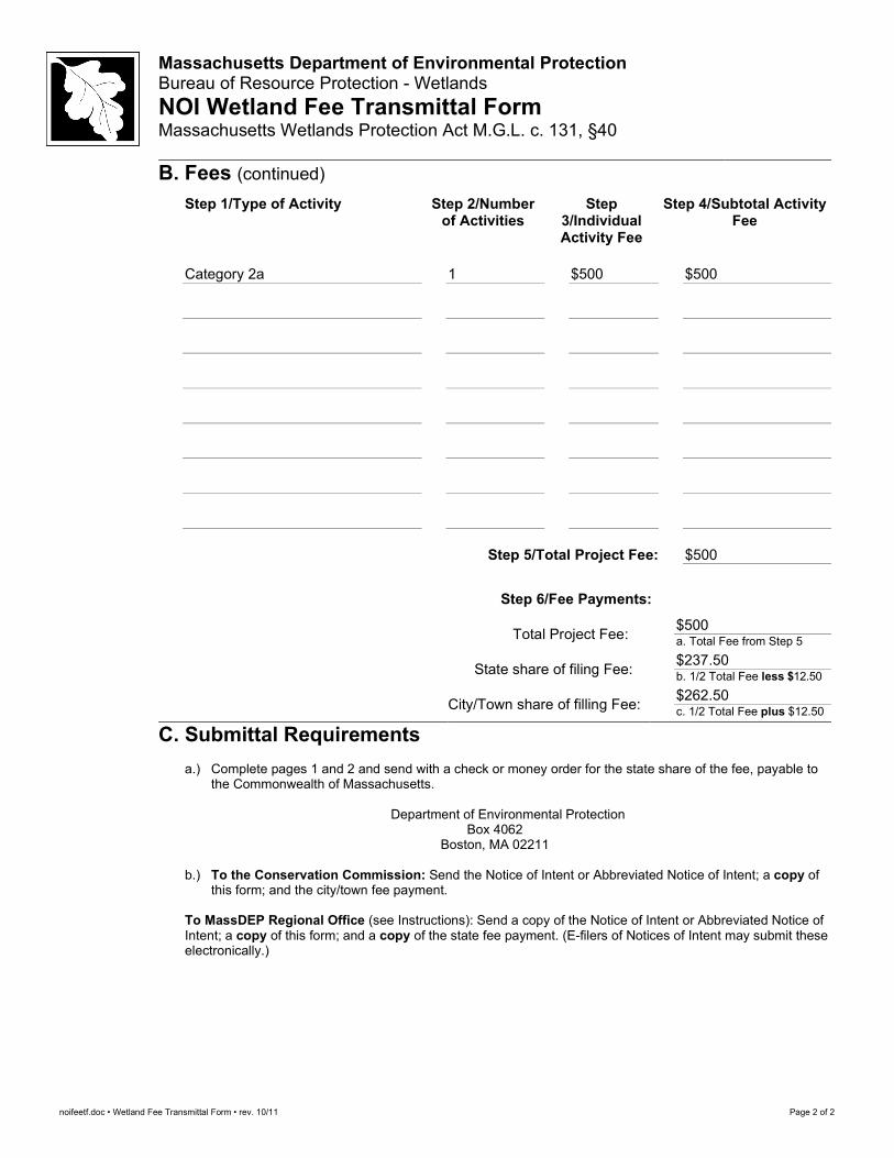
noifeetf.doc • Wetland Fee Transmittal Form • rev. 10/11 Page 2 of 2
Massachusetts Department of Environmental Protection Bureau of Resource Protection - Wetlands NOI Wetland Fee Transmittal Form Massachusetts Wetlands Protection Act M.G.L. c. 131, §40
B. Fees (continued) Step 1/Type of Activity Step 2/Number
of Activities Step
3/Individual Activity Fee
Step 4/Subtotal Activity Fee
Category 2a
1
$500
$500
Step 5/Total Project Fee: $500
Step 6/Fee Payments:
Total Project Fee: $500 a. Total Fee from Step 5
State share of filing Fee: $237.50 b. 1/2 Total Fee less $12.50
City/Town share of filling Fee: $262.50 c. 1/2 Total Fee plus $12.50
C. Submittal Requirements
a.) Complete pages 1 and 2 and send with a check or money order for the state share of the fee, payable to the Commonwealth of Massachusetts.
Department of Environmental Protection
Box 4062 Boston, MA 02211
b.) To the Conservation Commission: Send the Notice of Intent or Abbreviated Notice of Intent; a copy of
this form; and the city/town fee payment.
To MassDEP Regional Office (see Instructions): Send a copy of the Notice of Intent or Abbreviated Notice of Intent; a copy of this form; and a copy of the state fee payment. (E-filers of Notices of Intent may submit these electronically.)
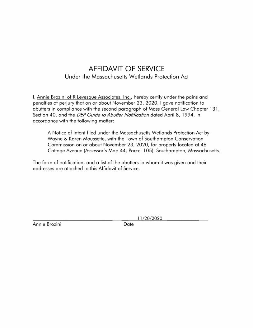
AFFIDAVIT OF SERVICE Under the Massachusetts Wetlands Protection Act
I, Annie Brozini of R Levesque Associates, Inc., hereby certify under the pains and penalties of perjury that on or about November 23, 2020, I gave notification to abutters in compliance with the second paragraph of Mass General Law Chapter 131, Section 40, and the DEP Guide to Abutter Notification dated April 8, 1994, in accordance with the following matter:
A Notice of Intent filed under the Massachusetts Wetlands Protection Act by Wayne & Karen Moussette, with the Town of Southampton Conservation Commission on or about November 23, 2020, for property located at 46 Cottage Avenue (Assessor’s Map 44, Parcel 105), Southampton, Massachusetts.
The form of notification, and a list of the abutters to whom it was given and their addresses are attached to this Affidavit of Service. __________________________________________ 11/20/2020 __________________ Annie Brozini Date
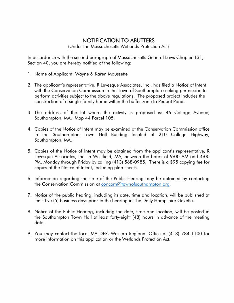
NOTIFICATION TO ABUTTERS (Under the Massachusetts Wetlands Protection Act)
In accordance with the second paragraph of Massachusetts General Laws Chapter 131, Section 40, you are hereby notified of the following: 1. Name of Applicant: Wayne & Karen Moussette
2. The applicant’s representative, R Levesque Associates, Inc., has filed a Notice of Intent
with the Conservation Commission in the Town of Southampton seeking permission to perform activities subject to the above regulations. The proposed project includes the construction of a single-family home within the buffer zone to Pequot Pond.
3. The address of the lot where the activity is proposed is: 46 Cottage Avenue, Southampton, MA. Map 44 Parcel 105.
4. Copies of the Notice of Intent may be examined at the Conservation Commission office in the Southampton Town Hall Building located at 210 College Highway, Southampton, MA.
5. Copies of the Notice of Intent may be obtained from the applicant’s representative, R
Levesque Associates, Inc. in Westfield, MA, between the hours of 9:00 AM and 4:00 PM, Monday through Friday by calling (413) 568-0985. There is a $95 copying fee for copies of the Notice of Intent, including plan sheets.
6. Information regarding the time of the Public Hearing may be obtained by contacting
the Conservation Commission at [email protected]. 7. Notice of the public hearing, including its date, time and location, will be published at
least five (5) business days prior to the hearing in The Daily Hampshire Gazette. 8. Notice of the Public Hearing, including the date, time and location, will be posted in
the Southampton Town Hall at least forty-eight (48) hours in advance of the meeting date.
9. You may contact the local MA DEP, Western Regional Office at (413) 784-1100 for
more information on this application or the Wetlands Protection Act.

APPENDIX
• “NOTICE OF INTENT FILING PLAN” PREPARED BY R LEVESQUE ASSOCIATES, INC.
DATED NOVEMBER 9, 2020