punjab water syndrome - im4change
TRANSCRIPT
REVIEW OF RURAL AFFAIRS
december 28, 2013 vol xlviII no 52 EPW Economic & Political Weekly64
Punjab Water SyndromeDiagnostics and Prescriptions
Himanshu Kulkarni, Mihir Shah
The current groundwater crisis in Punjab is a
combination of paradoxical consequences – extreme
depletion in some areas and water logging in others.
This paper provides a brief description of the contours of
the crisis and pinpoints possible reasons for its
emergence in failures of policy as well as
implementation. It also proposes a package of
approaches as part of a paradigm shift for Punjab that
can simultaneously tackle the twin challenges of water
logging and a decline in groundwater levels and quality.
The authors are grateful to P S Vijay Shankar for reviewing an earlier draft and making useful suggestions. The authors also thank members of the High Level Expert Group on Waterlogging in Punjab set up by the Planning Commission, Government of India, for useful discussions.
Himanshu Kulkarni ([email protected]) is with the Advanced Centre for Water Resources Development and Management, Pune. Mihir Shah ([email protected]) is Member, Planning Commission, Government of India.
The Indo-Gangetic system is a unique hydrogeological setting in India. It constitutes an eco-hydrological zone related to the weathering, erosion, and deposition of large
volumes of sediments that have resulted from the tectonics associated with the collision of the Indian and Asian plates. These largely unconsolidated sediments, eroded and transported from the Himalayan range by three main river systems – Ganga, Indus and Brahmaputra – encompass an area of slightly under one million square kilometres, with some 21 Indian states being fully or partially covered under this unique setting.1
The sense of water abundance in the Indo-Gangetic alluvial plains is derived from two factors. First, the river system that transects this region originates in the Himalayan ranges, which provide abundant water fl ows to these rivers over a long period of time, although climatic and demographic changes have begun to affect river fl ows from the source region in innumerable ways. Second, alluvial deposits – loose, unconsolidated, eroded material, ranging greatly in size and having high porosity and permeability – are not only exten-sive in this region but are also quite thick, lending high stora-tivity and transmissivity to these aquifers. Thus, aquifers in this region have always been perceived to have abundant groundwater storage and well-yields, providing a constant push to “develop” groundwater through an increase in the number and depth of wells and tube wells.
The state of Punjab falls under the typical setting of river alluvium, deposited during relatively recent geological times – geologically referred to as quaternary alluvial deposits – although the south-western region of the state also has aeolian (wind-borne) sediments.2 The region of water abundance has been subject to large-scale groundwater resource development, pri-marily with the intention of pushing the development of irri-gation and crop-intensifi cation to their very limits. Groundwater resources development in Punjab, simply put, is a combination of both, independent drilling of tube wells in prolifi c aquifers and a consequence of groundwater command-area development, stemming from the surface irrigation systems in the Indus sub-basins. In many ways, the trajectory of water resources deve-lopment has been following a simple principle of “developing”, which in the case of groundwater means extracting more water to produce more grain. The consequences of intensive water resources mobilisation, in the absence of systematic ground-water management backed by robust water governance mech-anisms, have been extreme depletion of groundwater resources on one hand and a rising water level, leading to water logging and
REVIEW OF RURAL AFFAIRS
Economic & Political Weekly EPW december 28, 2013 vol xlviII no 52 65
soil salinity, on the other (Perveen et al 2012). Groundwater pollution due to anthropogenic activities, often leading to urban water short-ages, is also cited as a serious issue (Gupta 2011) in Punjab’s overall water crisis. Incidentally, both of these have also been coterminous with groundwater contamination on wide-ranging scales due to various factors.3 Hence, many factors together have led to a severe water crisis in the state, prompting us to label the crisis the “Punjab water syndrome”.
In many ways the emergence of the Punjab water syndrome can be seen as a classic case study of the consequences of the engineering-construction-extraction-centred approach, based on control over nature, which has dominated India’s water resource development since Inde-pendence. Punjab’s experience underscores the need for a paradigm shift towards an eco-system understanding located in participatory governance of the common pool resources of the region, especially groundwater. This is ex-actly aligned to India’s Twelfth Five-Year Plan (2012-17), which recognises that India faces daunting challenges in the water sector, with confl icts between competing uses and users of water growing by the day. The plan proposes a paradigm shift in the management of water resources in India, a crucial element of which is the shift in emphasis in irrigation from con-struction to management, with empowerment of water users and improved water effi ciency (Shah 2013). Such a shift makes eminent sense if we are to combat the twin menace of ground-water over-exploitation and water logging in the state. Addressing this issue is imperative not just to prevent fertile land from being laid waste, but also to optimise the use of surface water and to conserve and recharge ground-water, wherever necessary and possible. While improved groundwater management is impor-tant to the reform on the operations side, building a system of groundwater governance, including the development of a robust institutional mechanism, is equally critical. This is because the Punjab water crisis is not just about scarcity and contamination, but about a broader challenge of ecosystem res-toration, protection, and governance. This paper, while briefl y discussing the groundwater problems in the state, attempts to suggest the contours of the water-governance approach to tackling the Punjab water syndrome.
Agriculture, Irrigation, and Groundwater Exploitation
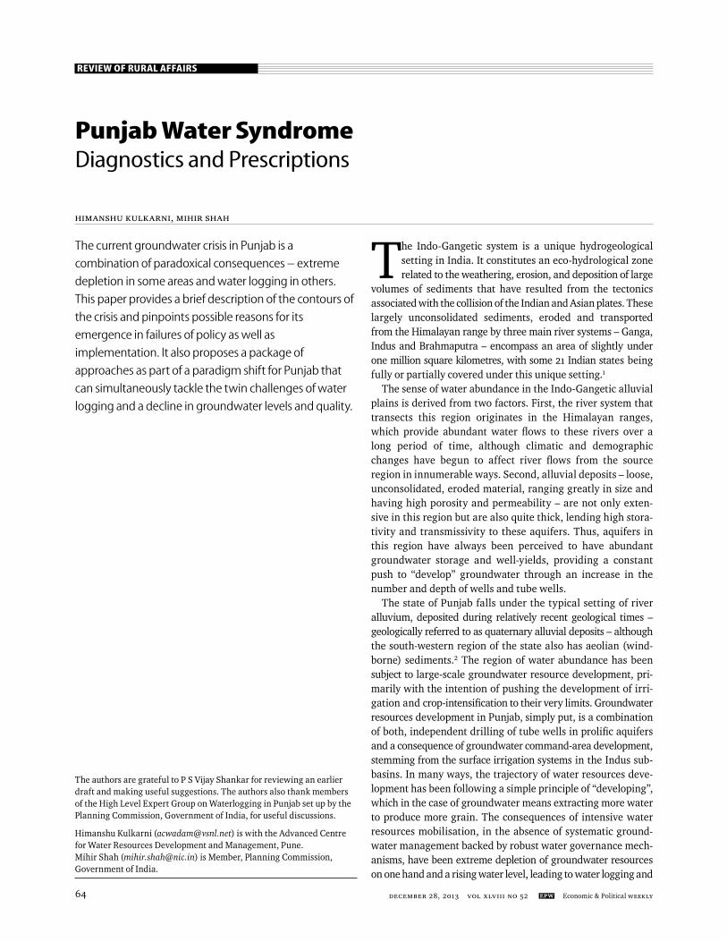
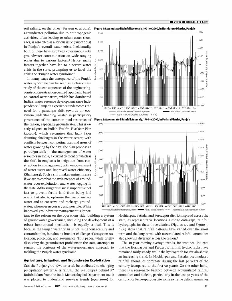
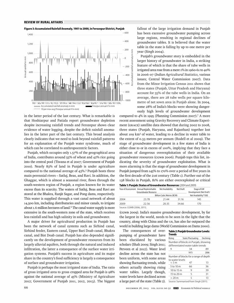
Can the Punjab groundwater crisis be attributed to changing precipitation patterns? Is rainfall the real culprit behind it? Rainfall data from the India Meteorological Department (IMD) was plotted to understand 100-year trends (1901-2000) for
Hoshiarpur, Patiala, and Ferozepur districts, spread across the state, as representative locations. Despite data-gaps, rainfall hydrographs for these three districts (Figures 1, 2 and Figure 3, p 66) show that rainfall patterns have varied over the short term and the long term, with accumulated rainfall anomalies also showing diversity across the region.4
The 10-year moving average trends, for instance, indicate that the Hoshiarpur and Ferozepur rainfall hydrographs have remained fairly steady, while the hydrograph for Patiala shows an increasing trend. In Hoshiarpur and Patiala, accumulated rainfall anomalies dominate during the last 50 years of the century (compared to the fi rst 50 years). On the other hand, there is a reasonable balance between accumulated rainfall anomalies and defi cits, particularly in the last 50 years of the century for Ferozepur, despite some extreme defi cit anomalies
Figure 1: Accumulated Rainfall Anomaly, 1901 to 2000, in Hoshiarpur District, Punjab
An
nu
al ra
infa
ll in
mm
Acc
um
ula
ted
rain
fall
anom
aly
in m
m
– 800
– 600
– 400
– 200
– 0
– -200
– -400
– -600
– -800
– -1000
1,600
1,400
1,200
1,000
800
600
400
200
0
Accumulated rainfall anomaly in mm Hoshiarpur annual rf in mm 10 per mov avg (Hoshiarpur annual rf in mm)
Figure 2: Accumulated Rainfall Anomaly, 1901 to 2000, in Patiala District, Punjab
An
nu
al ra
infa
ll in
mm
1,800
1,600
1,400
1,200
1,000
800
600
400
200
0A
ccu
mu
late
d ra
infa
ll an
omal
y in
mm
– 1000
– 800
– 600
– 400
– 200
– 0
– -200
– -400
– -600
– -800
– -1000
Accumulated rainfall anomaly in mm Patiala annual rf in mm 10 per mov avg (Patiala annual rf in mm)
REVIEW OF RURAL AFFAIRS
december 28, 2013 vol xlviII no 52 EPW Economic & Political Weekly66
in the latter period of the last century. What is remarkable is that Hoshiarpur and Patiala report groundwater depletion despite increasing rainfall trends and Ferozepur shows clear evidence of water logging, despite the defi cit rainfall anoma-lies in the latter part of the last century. This broad analysis clearly indicates that we need to look beyond rainfall patterns for an explanation of the Punjab water syndrome, much of which can be correlated to anthropocentric factors.
Punjab, which occupies only 1.57% of the geographical area of India, contributes around 55% of wheat and 42% rice going into the central pool (Tiwana et al 2007; Government of Punjab 2010). Nearly 83% of land in Punjab is under agriculture compared to the national average of 43%.5 Punjab hosts three main perennial rivers – Satluj, Beas, and Ravi. In addition, the Ghaggar, which is almost a seasonal river, fl ows through the south-western region of Punjab, a region known for its water excess than its scarcity. The waters of Satluj, Beas and Ravi are stored at the Bhakra, Ranjit Sagar, and Pong dams, respectively. This water is supplied through a vast canal network of about 14,500 km, including distributaries and minor canals, to irrigate about 1.6 million hectares of land.6 The canal water supply is more extensive in the south-western zone of the state, which receives less rainfall and has high salinity in soils and groundwater.
A major driver for agricultural production in Punjab has been the network of canal systems such as Sirhind canal, Sirhind feeder, Eastern canal, Upper Bari Doab canal, Bhakra canal, and Bist Doab canal. Punjab has also depended signifi -cantly on the development of groundwater resources from its largely alluvial aquifers, both through the natural and induced infi ltration, the latter a consequence of the surface water irri-gation systems. Punjab’s success in agriculture and its major share in the country’s food suffi ciency is largely a consequence of surface and groundwater irrigation.
Punjab is perhaps the most irrigated state of India. The ratio of gross irrigated area to gross cropped area for Punjab is 98% against the national average of 45% (Ministry of Agriculture 2012; Government of Punjab 2011, 2012, 2013). The biggest
fallout of the large irrigation demand in Punjab has been excessive groundwater pumping across large regions, resulting in regional declines of groundwater tables. It is believed that the water table in the state is falling by up to one metre per year (Singh 2004).
Punjab’s groundwater story is embedded in the larger history of groundwater in India, a striking feature of which is that the share of tube wells in irrigated area rose from a mere 1% in 1960-61 to 40% in 2006-07 (Indian Agricultural Statistics, various issues; Central Water Commission 2007). Data from the Minor Irrigation Census 2011 shows that three states (Punjab, Uttar Pradesh and Haryana) account for 55% of the tube wells in India. On an average, there are 28 tube wells per square kilo-metre of net sown area in Punjab alone. In 2004, some 28% of India’s blocks were showing danger-ously high levels of groundwater development
compared to 4% in 1995 (Planning Commission 2007).7 A more recent assessment using Gravity Recovery and Climate Experi-ment (GRACE) satellite data showed that during 2002 to 2008, three states (Punjab, Haryana, and Rajasthan) together lost about 109 km3 of water, leading to a decline in water table to the extent of 0.33 metres per annum (Rodell et al 2009). The stage of groundwater development in a few states of India is either close to or in excess of 100%, implying that they face a situation of dangerous overexploitation of their available groundwater resources (CGWB 2006). Punjab tops this list, in-dicating the severity of groundwater exploitation. What is more alarming is that the stage of groundwater development in Punjab jumped from 145% to 170% over a period of fi ve years in the fi rst decade of the 21st century (Table 1). Further out of the 138 blocks in Punjab, 81% are either overexploited or critical
(CGWB 2009). India’s massive groundwater development, by far the largest in the world, needs to be seen in the light that the country, along with China and the US, has also far outpaced the world in building large dams (World Commission on Dams 2000).
The consequences of over-pumping of groundwater have been elucidated by various scholars (Shah 2009; Singh 2011; Perveen et al 2012). Water level decline across the state has not been uniform, with some areas showing fl uctuating trends, while others actually showing rising water tables. Largely though, water levels have declined across a large part of the state (Table 2).
An
nu
al ra
infa
ll in
mm
Figure 3: Accumulated Rainfall Anomaly, 1901 to 2000, in Ferozepur District, Punjab
Acc
um
ula
ted
rain
fall
anom
aly
in m
m
– 600
– 400
– 200
– 0
– -200
– -400
– -600
– -800
– -1000
1,400
1,200
1,000
800
600
400
200
0
Accumulated rainfall anomaly in mm Firozpur annual rf in mm 10 per mov avg (Firozpur annual rf in mm)
Table 1: Punjab: Status of Groundwater Resources (2004 and 2009)Year of Assessment Annual Replenishable Net Availability Net Draft Stage of GW Groundwater Resource Development (Net Draft/ Billion Cubic Metres (BCM) Net Availability*100)
2004 23.78 21.44 31.16 145
2009 22.56 20.35 34.66 170Source: CGWB (2006, 2011).
Table 2: Punjab Groundwater Levels: TrendsRising Static/Fluctuating Declining
Number of blocks in Punjab, showing differentiated water table trends 9 34 89 1973 2006
Number of blocks for a range of depth to water levels < 5 m 47 13
5 to 10 m 66 36
10 to 15 m 9 39
15 to 20 m 5 31
> 20 m 5 13Source: Summarised from Singh (2011).
REVIEW OF RURAL AFFAIRS
Economic & Political Weekly EPW december 28, 2013 vol xlviII no 52 67
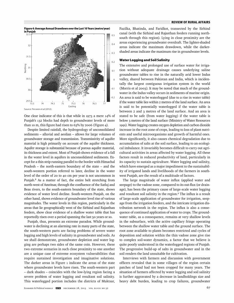
One clear indicator of this is that while in 1973 a mere 14% of Punjab’s 132 blocks had depth to groundwater levels of more than 10 m, this fi gure had risen to 63% by 2006 (Figure 4).
Despite limited rainfall, the hydrogeology of unconsolidated sediments – alluvial and aeolian – allows for large volumes of groundwater storage and transmission. Transmissivity of aquifer material is high primarily on account of the aquifer thickness. Aquifer storage is substantial because of porous aquifer material, its thickness and extent. Most of Punjab shows evidence of a fall in the water level in aquifers in unconsolidated sediments. Ex-cept for a thin strip running parallel to the border with Himachal Pradesh – the north-eastern boundary of the state – and the south-western portion referred to later, decline in the water level of the order of 20 to 40 cm per year is not uncommon in Punjab.8 As a matter of fact, the entire belt stretching from north-west of Amritsar, through the confl uence of the Satluj and Beas rivers, to the south-eastern boundary of the state, shows evidence of water level decline. South-western Punjab, on the other hand, shows evidence of groundwater level rise of various magnitudes. The water levels in this region, particularly in the areas that lie geographically west of the Sirhind and Rajasthan feeders, show clear evidence of a shallow water table that has reportedly risen over a period spanning the last 50 years or so.
Punjab, thus, presents an extreme paradox. While ground-water is declining at an alarming rate in many parts of the state, the south-western parts are facing problems of severe water logging and high levels of salinity in groundwater and soils. As we shall demonstrate, groundwater depletion and water log-ging are perhaps two sides of the same coin. However, these two extreme scenarios in such close proximity to one another are a unique case of extreme ecosystem vulnerabilities that require sustained investigation and imaginative solutions. The darker areas in Figure 1 indicate the areas of the state where groundwater levels have risen. The south-western part – dark shades – coincides with the low-lying region facing a severe problem of water logging and resul tant soil salinity. This waterlogged portion includes the districts of Muktsar,
Fazilka, Bhatinda, and Faridkot, transected by the Sirhind canal (with the Sirhind and Rajasthan feeders running north-south through this region). Lying in close proximity are the areas experiencing groundwater overdraft. The lighter-shaded areas indicate the maximum drawdown, while the darker- shaded areas indicate the maximum rise in groundwater levels.
Water Logging and Soil Salinity
The extensive and prolonged use of surface water for irriga-tion without adequate drainage causes underlying saline groundwater tables to rise in the naturally arid lower Indus valley, shared between Pakistan and India, which is inciden-tally the largest contiguous irrigation system in the world (Morris et al 2003). It may be noted that much of the ground-water in the Indus valley occurs in sediments of marine origin. An area is said to be waterlogged (due to a rise in water table) if the water table lies within 2 metres of the land surface. An area is said to be potentially waterlogged if the water table is between 2 and 3 metres of the land surface. And an area is stated to be safe (from water logging) if the water table is below 3 metres of the land surface (Ministry of Water Resources 1991). Water logging creates oxygen depletion and carbon dioxide increase in the root zone of crops, leading to loss of plant nutri-ents and useful microorganisms and growth of harmful ones. More signifi cantly, it also causes chemical degradation due to accumulation of salts at the soil surface, leading to an ecologi-cal imbalance. It invariably becomes diffi cult to carry out agri-cultural activities in areas affected by water logging. All these factors result in reduced productivity of land, particularly in its capacity to sustain agriculture. Water logging and salinity, which have emerged as a major impediment to the sustainabil-ity of irrigated lands and livelihoods of the farmers in south-west Punjab, are the result of a multitude of factors.
The large magnitude of water infl ux (applied water and seepage) to the vadose zone, compared to its out-fl ux (or drain-age), has been the primary cause of large-scale water logging and resultant soil salinity in the region.9 The infl ux is a result of large-scale application of groundwater for irrigation, seep-age from the irrigation feeders, and the intricate irrigation dis-tribution network in the region. The infl ux is also a conse-quence of continued application of water to crops. The ground-water table, as a consequence, remains at very shallow levels in the subsurface, with the active capillary fringe operating between the shallow water table and the ground surface. The root zone available to plants becomes restricted and cycles of deposition and solution within the thin vadose zone give rise to complex soil-water dynamics, a factor that we believe is quite poorly understood in the waterlogged regions of Punjab. The progressive build-up of salts in groundwater and in the soil renders the land unsuitable for cultivation.
Interviews with farmers and discussion with government offi cers revealed that in some villages of the region certain patches of land had not been cropped for many years. The situation of farmers affected by water logging and soil salinity is further aggravated by a decrease in landholdings size and heavy debt burden, leading to crop failures, groundwater
Figure 4: Average Annual Drawdown over the Last 10 Years (metre/year) in Punjab
Nor
thin
g
32.5
32
31.5
31
30.5
30
29.5
0.5
0.4
0.3
0.2
0.1
0
-0.1
-0.2
Source: Perveen et al (2012).Easting
73.5 74 74.5 75 75.5 76 76.5 77
REVIEW OF RURAL AFFAIRS
december 28, 2013 vol xlviII no 52 EPW Economic & Political Weekly68
pollution, agro-industrial sickness, and even suicides in some cases. The farmers whose fi elds are waterlogged have limited sources of income and are forced to work as labourers. Fur-ther, the contamination of drinking water in the waterlogged area with uranium, arsenic and heavy metals is posing a grave threat to the region. Uranium occurrence in shallow ground-water in parts of the state has been attributed to agrochemical processes occurring in calcareous soils (Alrakabi et al 2012).
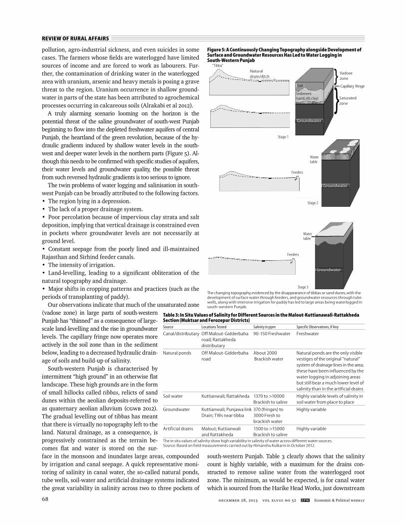
A truly alarming scenario looming on the horizon is the potential threat of the saline groundwater of south-west Punjab beginning to fl ow into the depleted freshwater aquifers of central Punjab, the heartland of the green revolution, because of the hy-draulic gradients induced by shallow water levels in the south-west and deeper water levels in the northern parts (Figure 5). Al-though this needs to be confi rmed with specifi c studies of aquifers, their water levels and groundwater quality, the possible threat from such reversed hydraulic gradients is too serious to ignore.
The twin problems of water logging and salinisation in south-west Punjab can be broadly attributed to the following factors.• The region lying in a depression.• The lack of a proper drainage system.• Poor percolation because of impervious clay strata and salt deposition, implying that vertical drainage is constrained even in pockets where groundwater levels are not necessarily at ground level.• Constant seepage from the poorly lined and ill-maintained Rajasthan and Sirhind feeder canals.• The intensity of irrigation.• Land-levelling, leading to a signifi cant obliteration of the natural topography and drainage.• Major shifts in cropping patterns and practices (such as the periods of transplanting of paddy).
Our observations indicate that much of the unsaturated zone (vadose zone) in large parts of south-western Punjab has “thinned” as a consequence of large-scale land-levelling and the rise in groundwater levels. The capillary fringe now operates more actively in the soil zone than in the sediment below, leading to a decreased hydraulic drain-age of soils and build-up of salinity.
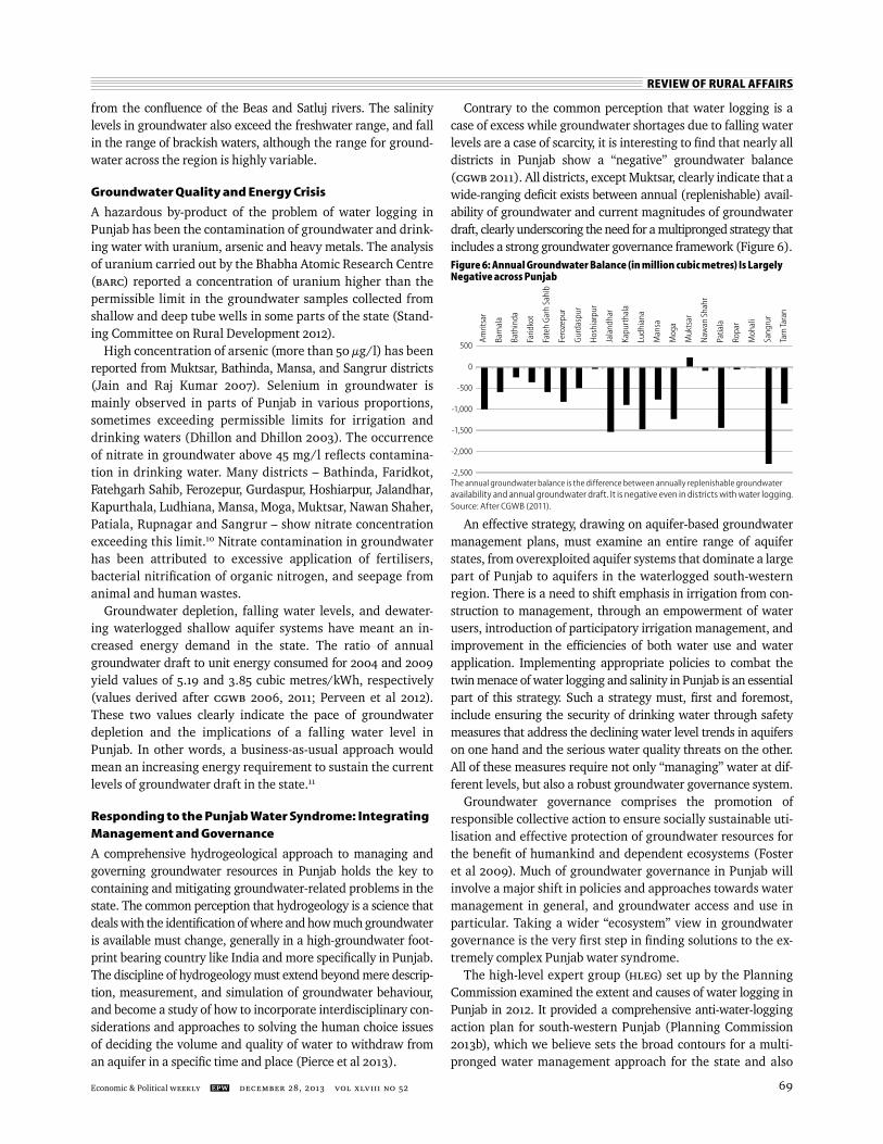
South-western Punjab is characterised by intermittent “high ground” in an otherwise fl at landscape. These high grounds are in the form of small hillocks called tibbas, relicts of sand dunes within the aeolian deposits-referred to as quaternary aeolian alluvium (CGWB 2012). The gradual levelling out of tibbas has meant that there is virtually no topography left to the land. Natural drainage, as a consequence, is progressively constrained as the terrain be-comes fl at and water is stored on the sur-face in the monsoon and inundates large areas, compounded by irrigation and canal seepage. A quick representative moni-toring of salinity in canal water, the so-called natural ponds, tube wells, soil-water and artifi cial drainage systems indicated the great variability in salinity across two to three pockets of
south-western Punjab. Table 3 clearly shows that the salinity count is highly variable, with a maximum for the drains con-structed to remove saline water from the waterlogged root zone. The minimum, as would be expected, is for canal water which is sourced from the Harike Head Works, just downstream
Figure 5: A Continuously Changing Topography alongside Development of Surface and Groundwater Resources Has Led to Water Logging in South-Western Punjab
The changing topography, evidenced by the disappearance of tibbas or sand dunes, with the development of surface water through feeders, and groundwater resources through tube wells, along with intensive irrigation for paddy has led to large areas being waterlogged in south-western Punjab.
Naturaldrain/ditch
Watertable
Vadosezone
Capillary fringe
Saturated zone
Soil
Sediment (sand, silt, clay)
Groundwater
Groundwater
Stage 1
Feeders
Stage 2
Watertable
Feeders
Groundwater
Stage 3
“Tibba”
Table 3: In Situ Values of Salinity for Different Sources in the Malout-Kuttianawali-Rattakheda Section (Muktsar and Ferozepur Districts) Source Locations Tested Salinity in ppm Specific Observations, If Any
Canal/distributary Off Malout-Gidderbaha 90-150 Freshwater Freshwater road; Rattakheda distributary
Natural ponds Off Malout-Gidderbaha About 2000 Natural ponds are the only visible road Brackish water vestiges of the original “natural” system of drainage lines in the area; these have been influenced by the water logging in adjoining areas but still bear a much lower level of salinity than in the artificial drains
Soil water Kuttianwali; Rattakheda 1370 to >10000 Highly variable levels of salinity in Brackish to saline soil water from place to place
Groundwater Kuttianwali; Punjawa link 370 (fringes) to Highly variable Drain; TWs near tibba 3000 Fresh to brackish water
Artificial drains Malout; Kuttianwali 1500 to >15000 Highly variable and Rattakheda Brackish to saline The in situ values of salinity show high variability in salinity of water across different water sources. Source: Based on field measurements carried out by Himanshu Kulkarni in October 2012.
REVIEW OF RURAL AFFAIRS
Economic & Political Weekly EPW december 28, 2013 vol xlviII no 52 69
from the confl uence of the Beas and Satluj rivers. The salinity levels in groundwater also exceed the freshwater range, and fall in the range of brackish waters, although the range for ground-water across the region is highly variable.
Groundwater Quality and Energy Crisis
A hazardous by-product of the problem of water logging in Punjab has been the contamination of groundwater and drink-ing water with uranium, arsenic and heavy metals. The analysis of uranium carried out by the Bhabha Atomic Research Centre (BARC) reported a concentration of uranium higher than the permissible limit in the groundwater samples collected from shallow and deep tube wells in some parts of the state (Stand-ing Committee on Rural Development 2012).
High concentration of arsenic (more than 50 µg/l) has been reported from Muktsar, Bathinda, Mansa, and Sangrur districts (Jain and Raj Kumar 2007). Selenium in groundwater is mainly observed in parts of Punjab in various proportions, sometimes exceeding permissible limits for irrigation and drinking waters (Dhillon and Dhillon 2003). The occurrence of nitrate in groundwater above 45 mg/l refl ects contamina-tion in drinking water. Many districts – Bathinda, Faridkot, Fatehgarh Sahib, Ferozepur, Gurdaspur, Hoshiarpur, Jalandhar, Kapurthala, Ludhiana, Mansa, Moga, Muktsar, Nawan Shaher, Patiala, Rupnagar and Sangrur – show nitrate concentration exceeding this limit.10 Nitrate contamination in groundwater has been attributed to excessive application of fertilisers, bacterial nitrifi cation of organic nitrogen, and seepage from animal and human wastes.
Groundwater depletion, falling water levels, and dewater-ing waterlogged shallow aquifer systems have meant an in-creased energy demand in the state. The ratio of annual groundwater draft to unit energy consumed for 2004 and 2009 yield values of 5.19 and 3.85 cubic metres/kWh, respectively (values derived after CGWB 2006, 2011; Perveen et al 2012). These two values clearly indicate the pace of groundwater depletion and the implications of a falling water level in Punjab. In other words, a business-as-usual approach would mean an increasing energy requirement to sustain the current levels of groundwater draft in the state.11
Responding to the Punjab Water Syndrome: Integrating Management and Governance
A comprehensive hydrogeological approach to managing and governing groundwater resources in Punjab holds the key to containing and mitigating groundwater-related problems in the state. The common perception that hydrogeology is a science that deals with the identifi cation of where and how much groundwater is available must change, generally in a high-groundwater foot-print bearing country like India and more specifi cally in Punjab. The discipline of hydrogeology must extend beyond mere descrip-tion, measurement, and simulation of groundwater behaviour, and become a study of how to incorporate interdisciplinary con-siderations and approaches to solving the human choice issues of deciding the volume and quality of water to withdraw from an aquifer in a specifi c time and place (Pierce et al 2013).
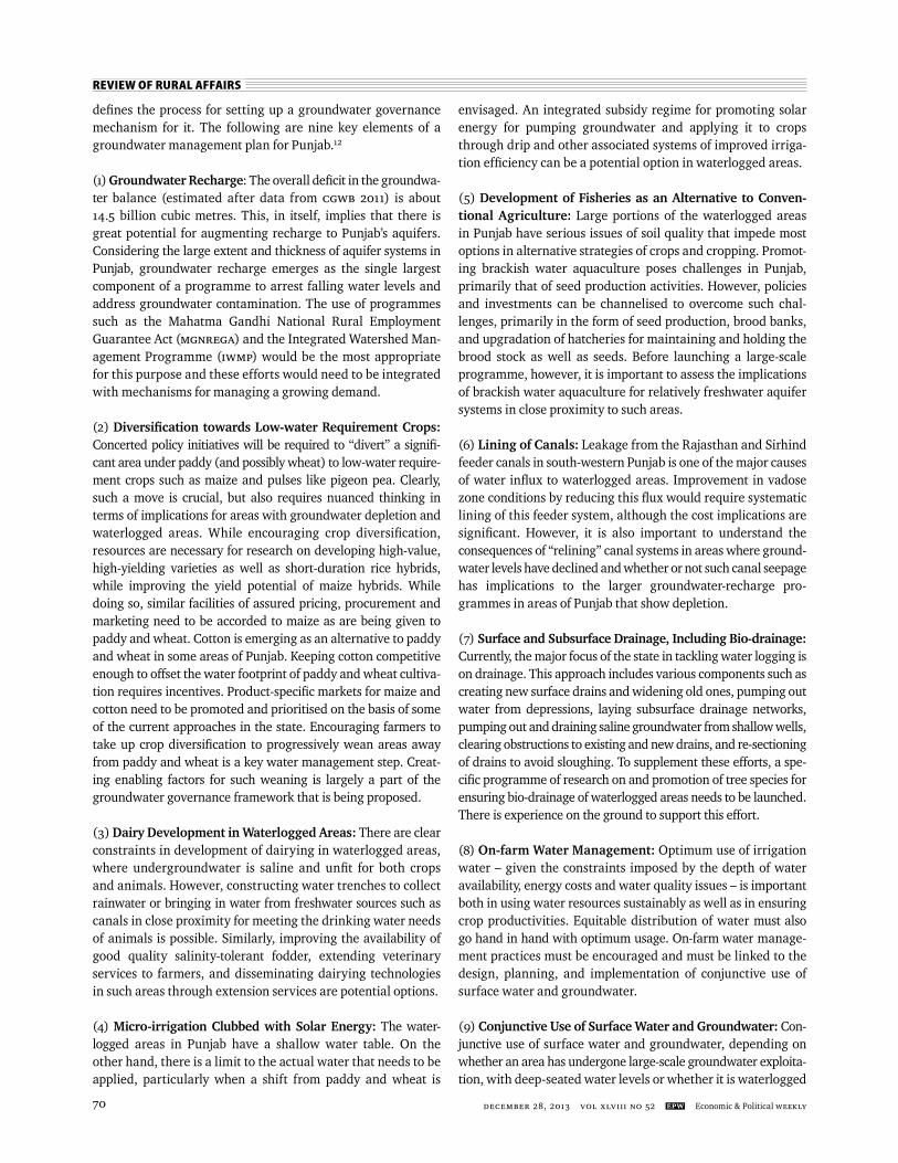
Contrary to the common perception that water logging is a case of excess while groundwater shortages due to falling water levels are a case of scarcity, it is interesting to fi nd that nearly all districts in Punjab show a “negative” groundwater balance (CGWB 2011). All districts, except Muktsar, clearly indicate that a wide-ranging defi cit exists between annual (replenishable) avail-ability of groundwater and current magnitudes of groundwater draft, clearly underscoring the need for a multipronged strategy that includes a strong groundwater governance framework (Figure 6).
An effective strategy, drawing on aquifer-based groundwater management plans, must examine an entire range of aquifer states, from overexploited aquifer systems that dominate a large part of Punjab to aquifers in the waterlogged south-western region. There is a need to shift emphasis in irrigation from con-struction to management, through an empowerment of water users, introduction of participatory irrigation management, and improvement in the effi ciencies of both water use and water application. Implementing appropriate policies to combat the twin menace of water logging and salinity in Punjab is an essential part of this strategy. Such a strategy must, fi rst and foremost, include ensuring the security of drinking water through safety measures that address the declining water level trends in aquifers on one hand and the serious water quality threats on the other. All of these measures require not only “managing” water at dif-ferent levels, but also a robust groundwater governance system.
Groundwater governance comprises the promotion of responsible collective action to ensure socially sustainable uti-lisation and effective protection of groundwater resources for the benefi t of humankind and dependent ecosystems (Foster et al 2009). Much of groundwater governance in Punjab will involve a major shift in policies and approaches towards water management in general, and groundwater access and use in particular. Taking a wider “ecosystem” view in groundwater governance is the very fi rst step in fi nding solutions to the ex-tremely complex Punjab water syndrome.
The high-level expert group (HLEG) set up by the Planning Commission examined the extent and causes of water logging in Punjab in 2012. It provided a comprehensive anti-water-logging action plan for south-western Punjab (Planning Commission 2013b), which we believe sets the broad contours for a multi-pronged water management approach for the state and also
Figure 6: Annual Groundwater Balance (in million cubic metres) Is Largely Negative across Punjab
Am
ritsa
r
Barn
ala
Bath
inda
Farid
kot
Fate
h G
arh
Sahi
b
Fero
zepu
r
Gur
dasp
ur
Hos
hiar
pur
Jala
ndha
r
Kapu
rtha
la
Ludh
iana
Man
sa
Mog
a
Muk
tsar
Naw
an S
hahr
Patia
la
Ropa
r
Moh
ali
Sang
rur
Tarn
Tara
n
The annual groundwater balance is the difference between annually replenishable groundwater availability and annual groundwater draft. It is negative even in districts with water logging.Source: After CGWB (2011).
G J T500
0
-500
-1,000
-1,500
-2,000
-2,500
REVIEW OF RURAL AFFAIRS
december 28, 2013 vol xlviII no 52 EPW Economic & Political Weekly70
defi nes the process for setting up a groundwater governance mechanism for it. The following are nine key elements of a groundwater management plan for Punjab.12
(1) Groundwater Recharge: The overall defi cit in the groundwa-ter balance (estimated after data from CGWB 2011) is about 14.5 billion cubic metres. This, in itself, implies that there is great potential for augmenting recharge to Punjab’s aquifers. Considering the large extent and thickness of aquifer systems in Punjab, groundwater recharge emerges as the single largest component of a programme to arrest falling water levels and address groundwater contamination. The use of programmes such as the Mahatma Gandhi National Rural Employment Guarantee Act (MGNREGA) and the Integrated Watershed Man-agement Programme (IWMP) would be the most appropriate for this purpose and these efforts would need to be integrated with mechanisms for managing a growing demand.
(2) Diversifi cation towards Low-water Requirement Crops: Concerted policy initiatives will be required to “divert” a signifi -cant area under paddy (and possibly wheat) to low-water require-ment crops such as maize and pulses like pigeon pea. Clearly, such a move is crucial, but also requires nuanced thinking in terms of implications for areas with groundwater depletion and waterlogged areas. While encouraging crop diversifi cation, resources are necessary for research on developing high-value, high-yielding varieties as well as short-duration rice hybrids, while improving the yield potential of maize hybrids. While doing so, similar facilities of assured pricing, procurement and marketing need to be accorded to maize as are being given to paddy and wheat. Cotton is emerging as an alternative to paddy and wheat in some areas of Punjab. Keeping cotton competitive enough to offset the water footprint of paddy and wheat cultiva-tion requires incentives. Product-specifi c markets for maize and cotton need to be promoted and prioritised on the basis of some of the current approaches in the state. Encouraging farmers to take up crop diversifi cation to progressively wean areas away from paddy and wheat is a key water management step. Creat-ing enabling factors for such weaning is largely a part of the groundwater governance framework that is being proposed.
(3) Dairy Development in Waterlogged Areas: There are clear constraints in development of dairying in waterlogged areas, where undergroundwater is saline and unfi t for both crops and animals. However, constructing water trenches to collect rainwater or bringing in water from freshwater sources such as canals in close proximity for meeting the drinking water needs of animals is possible. Similarly, improving the availability of good quality salinity-tolerant fodder, extending veterinary services to farmers, and disseminating dairying technologies in such areas through extension services are potential options.
(4) Micro-irrigation Clubbed with Solar Energy: The water-logged areas in Punjab have a shallow water table. On the other hand, there is a limit to the actual water that needs to be applied, particularly when a shift from paddy and wheat is
envisaged. An integrated subsidy regime for promoting solar energy for pumping groundwater and applying it to crops through drip and other associated systems of improved irriga-tion effi ciency can be a potential option in waterlogged areas.
(5) Development of Fisheries as an Alternative to Conven-tional Agriculture: Large portions of the waterlogged areas in Punjab have serious issues of soil quality that impede most options in alter native strategies of crops and cropping. Promot-ing brackish water aquaculture poses challenges in Punjab, primarily that of seed production activities. However, policies and investments can be channelised to overcome such chal-lenges, primarily in the form of seed production, brood banks, and upgradation of hatcheries for maintaining and holding the brood stock as well as seeds. Before launching a large-scale programme, however, it is important to assess the implications of brackish water aquaculture for relatively freshwater aquifer systems in close proximity to such areas.
(6) Lining of Canals: Leakage from the Rajasthan and Sirhind feeder canals in south-western Punjab is one of the major causes of water infl ux to waterlogged areas. Improvement in vadose zone conditions by reducing this fl ux would require systematic lining of this feeder system, although the cost implications are signifi cant. However, it is also important to understand the consequences of “relining” canal systems in areas where ground-water levels have declined and whether or not such canal seepage has implications to the larger groundwater-recharge pro-grammes in areas of Punjab that show depletion.
(7) Surface and Subsurface Drainage, Including Bio-drainage: Currently, the major focus of the state in tackling water logging is on drainage. This approach includes various components such as creating new surface drains and widening old ones, pumping out water from depressions, laying subsurface drainage networks, pumping out and draining saline groundwater from shallow wells, clearing obstructions to existing and new drains, and re-sectioning of drains to avoid sloughing. To supplement these efforts, a spe-cifi c programme of research on and promotion of tree species for ensuring bio-drainage of waterlogged areas needs to be launched. There is experience on the ground to support this effort.
(8) On-farm Water Management: Optimum use of irrigation water – given the constraints imposed by the depth of water availability, energy costs and water quality issues – is important both in using water resources sustainably as well as in ensuring crop productivities. Equitable distribution of water must also go hand in hand with optimum usage. On-farm water manage-ment practices must be encouraged and must be linked to the design, planning, and implementation of conjunctive use of surface water and groundwater.
(9) Conjunctive Use of Surface Water and Groundwater: Con-junctive use of surface water and groundwater, depending on whether an area has undergone large-scale groundwater exploita-tion, with deep-seated water levels or whether it is waterlogged
REVIEW OF RURAL AFFAIRS
Economic & Political Weekly EPW december 28, 2013 vol xlviII no 52 71
with shallow water levels and poor quality groundwater, must clearly be a part of a long-term water management strategy. The concept of participatory irrigation management, employed suc-cessfully in other parts of India, may be used to draw lessons in customising this concept to the Punjab situation. A state-led pro-gramme on participatory irrigation management, combining surface and groundwater resources through a defi nition of short- medium- and long-term goals could be the best way of operationalising conjunctive water use.
Groundwater Governance Framework
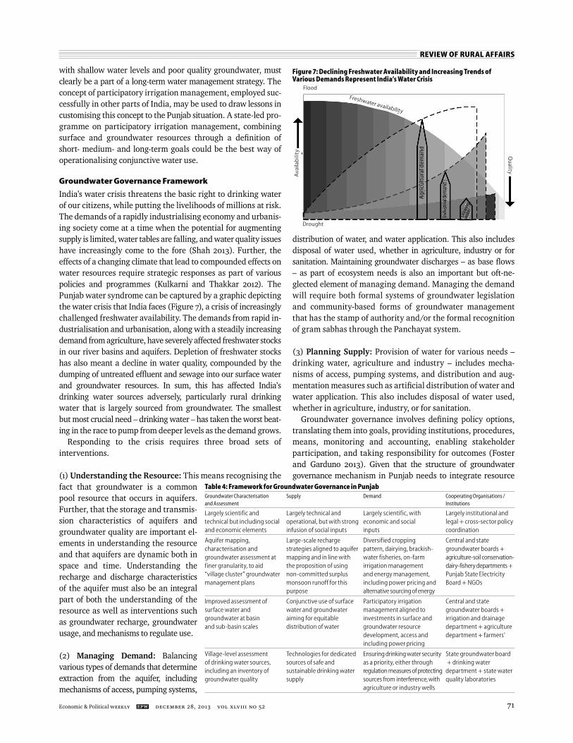
India’s water crisis threatens the basic right to drinking water of our citizens, while putting the livelihoods of millions at risk. The demands of a rapidly industrialising economy and urbanis-ing society come at a time when the potential for augmenting supply is limited, water tables are falling, and water quality issues have increasingly come to the fore (Shah 2013). Further, the effects of a changing climate that lead to compounded effects on water resources require strategic responses as part of various policies and programmes (Kulkarni and Thakkar 2012). The Punjab water syndrome can be captured by a graphic depicting the water crisis that India faces (Figure 7), a crisis of increasingly challenged freshwater availability. The demands from rapid in-dustrialisation and urbanisation, along with a steadily increasing demand from agriculture, have severely affected freshwater stocks in our river basins and aquifers. Depletion of freshwater stocks has also meant a decline in water quality, compounded by the dumping of untreated effl uent and sewage into our surface water and groundwater resources. In sum, this has affected India’s drinking water sources adversely, particularly rural drinking water that is largely sourced from groundwater. The smallest but most crucial need – drinking water – has taken the worst beat-ing in the race to pump from deeper levels as the demand grows.
Responding to the crisis requires three broad sets of interventions.
(1) Understanding the Resource: This means recognising the fact that groundwater is a common pool resource that occurs in aquifers. Further, that the storage and transmis-sion characteristics of aquifers and groundwater quality are important el-ements in understanding the resource and that aquifers are dynamic both in space and time. Understanding the recharge and discharge characteristics of the aquifer must also be an integral part of both the understanding of the resource as well as interventions such as groundwater recharge, groundwater usage, and mechanisms to regulate use.
(2) Managing Demand: Balancing various types of demands that determine extraction from the aquifer, including mechanisms of access, pumping systems,
distribution of water, and water application. This also includes disposal of water used, whether in agriculture, industry or for sanitation. Maintaining groundwater discharges – as base fl ows – as part of ecosystem needs is also an important but oft-ne-glected element of managing demand. Managing the demand will require both formal systems of groundwater legislation and community-based forms of groundwater management that has the stamp of authority and/or the formal recognition of gram sabhas through the Panchayat system.
(3) Planning Supply: Provision of water for various needs – drinking water, agriculture and industry – includes mecha-nisms of access, pumping systems, and distribution and aug-mentation measures such as artifi cial distribution of water and water application. This also includes disposal of water used, whether in agriculture, industry, or for sanitation.
Groundwater governance involves defi ning policy options, translating them into goals, providing institutions, procedures, means, monitoring and accounting, enabling stakeholder participation, and taking responsibility for outcomes (Foster and Garduno 2013). Given that the structure of groundwater governance mechanism in Punjab needs to integrate resource
Table 4: Framework for Groundwater Governance in PunjabGroundwater Characterisation Supply Demand Cooperating Organisations / and Assessment Institutions
Largely scientific and Largely technical and Largely scientific, with Largely institutional andtechnical but including social operational, but with strong economic and social legal + cross-sector policy and economic elements infusion of social inputs inputs coordination
Aquifer mapping, Large-scale recharge Diversified cropping Central and statecharacterisation and strategies aligned to aquifer pattern, dairying, brackish- groundwater boards + groundwater assessment at mapping and in line with water fisheries, on-farm agriculture-soil conservation-finer granularity, to aid the proposition of using irrigation management dairy-fishery departments + “village cluster” groundwater non-committed surplus and energy management, Punjab State Electricity management plans monsoon runoff for this including power pricing and Board + NGOs purpose alternative sourcing of energy
Improved assessment of Conjunctive use of surface Participatory irrigation Central and statesurface water and water and groundwater management aligned to groundwater boards + groundwater at basin aiming for equitable investments in surface and irrigation and drainageand sub-basin scales distribution of water groundwater resource department + agriculture development, access and department + farmers’ including power pricing
Village-level assessment Technologies for dedicated Ensuring drinking water security State groundwater boardof drinking water sources, sources of safe and as a priority, either through + drinking water including an inventory of sustainable drinking water regulation measures of protecting department + state watergroundwater quality supply sources from interference, with quality laboratories agriculture or industry wells
Figure 7: Declining Freshwater Availability and Increasing Trends of Various Demands Represent India’s Water Crisis
Flood
Drought
Ava
ilab
ility Q
uality
Freshwater availability
Ag
ricu
ltu
ral d
eman
d
Indu
stria
l dem
and
ndus
trial
Drin
king
wat
er
REVIEW OF RURAL AFFAIRS
december 28, 2013 vol xlviII no 52 EPW Economic & Political Weekly72
understanding with management of supply and demand, the four types of provisions and corresponding capacities – technical, legal and institutional, cross-sector policy coordination, and opera-tional aspects – suggested for evaluating groundwater govern-ance provisions are quite useful (Foster et al 2011; Foster and Garduno 2013). The broad elements of resource understanding, supply management, and demand control can be achieved primarily by forging cooperation and coordination between various agencies/departments/boards that operate in the state. This becomes a starting point to form entities around clusters of groundwater management activities listed out in Table 4 (p 71).
The complex layering of rock strata with varying aquifer properties gives rise to specifi c groundwater typologies (Kulkarni et al 2009; World Bank 2010). We must remember that while the physical features of aquifers are important in identifying and describing such typologies, it is important to recognise that aquifers go with a historically governed pattern of access to groundwater and the social processes that regulate its use. Hence, a time dimension is also involved in the understanding of ground-water resources, a dimension that cannot be ignored if one adds the evolution of socio-economic conditions surrounding ground-water resources in south Asia, as elucidated by Shah (2009). More over, identifi cation of typologies becomes more complex when we bring groundwater quality into the management frame.
Punjab presents an interesting paradox in the socioecological analysis of south Asia’s water anarchy.13 While Shah (2009) labels groundwater use from the Indo-Gangetic basin as “atomistic individualism”, we believe that Punjab also presents a large dose of what he labels “collusive opportunism” for groundwater use in the arid alluvial aquifers of Rajasthan and parts of Gujarat. Reining in such collusive opportunism in the alluvial groundwater setting of India’s groundwater typology (ibid) is perhaps the simplest mission statement for a ground-water governance mechanism in Punjab. At the same time, un-like hard-rock aquifers, where programmes like watershed de-velopment can prove benefi cial in getting water into the ground for users to abstract through wells during an annual cycle (Gale et al 2006), alluvial aquifers offer a different setting for re-charge. In an alluvial aquifer system, the impact of an individual user’s extraction on the aquifer as a whole is limited. Hence, there is a great incentive to collude and collectively exploit the aquifer, often through thousands, if not millions, of wells. The recharge efforts of an individual will, by the same token, be typically small in relation to the size of the aquifer. So there is no point in recharge unless a large number of users “collude” there as well. Recharge programmes in a hydrogeological setting like the alluvial aquifers of Punjab, therefore, require collective action. Hence, a statewide recharge programme must
include social, economic and environmental considerations in addition to the hydrogeology of the region.
Groundwater governance goes far beyond groundwater itself. Groundwater-specifi c management goals must look be-yond straightjacket regulatory mechanisms and develop alter-native niches in livelihoods, energy use, and opportunities of-fered under adaptation and coping strategies that focus on events such as droughts, fl oods, economic drivers, and climate change and variability (Moench et al 2012). Institutionalising groundwater governance is about how the state and its citizens cooperate in tackling the groundwater crisis. Without critically examining policies governing choice of cropping patterns (price and procurement support), we cannot even begin to understand farmers’ choices that intensify dependence on groundwater. Policies in this regard continue to be heavily biased in favour of the two major water-intensive crops in India, rice and wheat, and it is this factor that has primarily driven the groundwater crisis in Punjab. Farmers do not get the same kind of state sup-port when they grow less water-intensive crops such as maize and pulses. Even if price support is available, procurement op-erations lack the requisite scale and outreach. What is also clear is that overall approaches to the pricing of water and power have greatly incentivised overexploitation of groundwater. While liberal approaches to such pricing did form the bedrock of the green revolution, it has in turn triggered the groundwater crisis in Punjab. Marginal cost pricing is clearly not an option as it threatens the livelihoods of small and marginal farmers, who form the vast majority. However, separation of power feeders is a middle path explored by many states across the country that is effective in breaking what has been described as the “ground-water-energy nexus” (Shah 2013).
Groundwater governance, of course, requires taking a closer look at Punjab’s aquifers to assess future prospects for the resource, particularly with regard to the extent and thickness of aquifers and characteristics such as transmissivity, storativity, and groundwater quality. The understanding of “boundaries” and “discontinuities in such boundaries” is of utmost impor-tance, given the potential threat from regional groundwater fl ows that may rapidly change patterns of risks arising from groundwater contamination.
The best opportunity for doing so is provided by the aquifer mapping and aquifer management programme being initiated under the Twelfth Five-Year Plan (Planning Commission 2013a). At the same time, key initiatives such as groundwater recharge or large-scale crop diversifi cation must be viewed through a groundwater governance framework (Table 4) to accommodate multipronged approaches involving different stakeholders, rather than being seen as standalone magic bullets.
Notes
1 Estimated on the basis of Kulkarni et al (2009), cited in Shankar et al (2011), EPW, XLVI (2), Map 1. Reconfi rmed through CGWB (2012) in the atlas called “Aquifer Systems of India”, p 7.
2 Various sources, including CGWB (2004) – Aq-uifer Systems of India, Table 4 and Geological and Mineral Map of Punjab by GSI (2004) available at http://www.indiawaterportal.org/
sites/indiawaterportal.org/fi les/Map_Punjab_State_Geology_and_Mineral_Maps_Geological_Survey_of_India.pdf
3 Factors contributing to groundwater conta-mination in different parts of Punjab have been discussed in various publications; much of this discussion has been captured in the re-port submitted by the High-Level Expert Group (HLEG) on Water Logging in Punjab –
referenced in this article as Planning Commis-sion (2013b).
4 Accumulated rainfall anomaly is the difference between the annual rainfall and the long-term average. Anomalies (or their inverses, called defi -cit rainfall anomalies in this paper) have signifi -cant bearing on rainwater available for ground-water recharge. These anomalies provide us with the broader, longer-term trends of surplus and

REVIEW OF RURAL AFFAIRS
Economic & Political Weekly EPW december 28, 2013 vol xlviII no 52 73
defi cit rainfall available in an area that may or may not have infl uenced groundwater recharge and discharge patterns in a region. The analysis is only indicative and is not corrected for data-gaps.
5 Estimated from data for 2010-11 in the section “Land-use Statistics at a Glance” in Agriculture Statistics at a Glance by Directorate of Economics and Statistics, Government of India, Table 1.1, http://eands.dacnet.nic.in/LUS_1999_2004.htm
6 Punjab Department of Irrigation, http://www.pbirrigation.gov.in
7 Level (or stage) of groundwater development is the ratio of gross annual groundwater draft for all uses to net annual groundwater availability. Net annual groundwater availability is defi ned as the annual groundwater potential (total annual re-charge from monsoon and non-monsoon seasons) minus the natural discharge during non-monsoon season (estimated at 5%-10% of the total annual groundwater potential). These defi nitions can be found in various documents published by CGWB, for instance, CGWB (2011).
8 Much information regarding fall and rise of groundwater levels in Punjab is available with various departments, including the CGWB and the State Groundwater Department. Over and above this, much of what we have summarised is also based upon interviews with farmers from various parts of the state.
9 The vadose zone, also called “unsaturated zone”, is the zone of the earth’s subsurface above the water table (of the phreatic/unconfi ned aquifer). In other words, it extends from the surface of the ground to the water table and includes wa-ter retained by forces of adhesion and capillary action against the force of gravity. Soil moisture can be considered a part of the vadose zone.
10 http://cgwb.gov.in/gw_profi les/st_Punjab.htm 11 It is quite likely that the ratio before 2004
might be higher than 5.19, but it is diffi cult to reconcile groundwater abstraction data before the methodology of computing annual ground-water draft changed in 1997.
12 The nine elements draw heavily upon the HLEG report for waterlogged areas but have been modifi ed to also include the larger context of the Punjab Water Syndrome described earlier in the paper.
13 We draw upon the scholarly work by Tushaar Shah (2009), a consolidated attempt to describe and analyse the groundwater anarchy prevailing in the south Asian region. The anarchy is attrib-uted largely to the atomistic irrigation arising out of the fact that millions of farmers in the region have accessed and used groundwater to improve agriculture in their landholdings.
References
Alrakabi, M, G Singh, A Bhalla, S Kumar, S Kumar, A Srivastava, B Rai, N Singh, J S Shahiand and D Mehta (2012): “Study of Uranium Contami-nation of Groundwater in Punjab State in India, Using X-Ray Fluorescence Technique”, Journal of Radioanalytical and Nuclear Chemistry, 294 (2): 221-27.
CGWB (2006): “Dynamic Ground Water Resources of India (as on March 2004)”, Central Ground Water Board, Ministry of Water Resources, Government of India.
– (2011): “Dynamic Ground Water Resources of India (as on March 2009)”, Central Ground Water Board, Ministry of Water Resources, Government of India.
– (2012): Aquifer Systems of India”, Central Ground Water Board, Ministry of Water Resources, Government of India, 91.
Central Water Commission (2007): “Water and Related Statistics”, Ministry of Water Resources, Government of India, New Delhi.
Dhillon, S K and K S Dhillon (2003): “Quality of Underground Water and Its Contribution Towards Selenium Enrichment of the Soil-Plant System for a Seleniferous Region of Northwest India”, Journal of Hydrology, v 272: 120-30.
Gale, I, D M Macdonald, R C Calow, I Neumann, M Moench, H Kulkarni, S Mudrakartha and K Palanisami (2006): “Managed Aquifer Recharge: An Assessement of Its Role and Effectiveness in Watershed Management”, British Geological Survey Commissioned Report, CR/06/107N. 80.
Government of Punjab (2010): Agriculture Scenario, viewed on 23 November 2013, http://punjab-govt.nic.in/AGRICULTURE/AGRI CULT1.htm
– (2011): Punjab-at-a-glance, Government of Punjab, 36: 77, viewed on 23 November 2013, http://pbplanning.gov.in/pdf/PunjabGlance-2011CompleteVD%20Graphs.pdf
– (2012): Statistical Abstract of Punjab – 2012, Economic and Statistical Organisation, Govern-ment of Punjab, 938: 784, viewed on 23 Novem-ber 2013, http://pbplanning.gov.in/pdf/Statis-tical%20abstract%202012.pdf
– (2013): Economic Survey – 2012-13, Economic Adviser, Government of Punjab, 334, viewed on 23 November 2013, http://pbplanning.gov.in/pdf/Economic%20Survey%20of%20Pun-jab%202012-13.pdf
Gupta, S (2011): “Groundwater Management in Alluvial Areas”, Incidental Paper – 2011, CGWB, Ministry of Water Resources, Government of India,viewed on 23 November 2013, http://cgwb.gov.in/documents/papers/incidpapers/Paper%2011-%20sushil%20gupta.pdf
Foster S, H Garduno, A Tuinhof and C Tovey (2009): “Groundwater Governance: Conceptual Frame-work for Assessment of Provisions and Needs”, GW-MATE Strategic Overview Series, 1, World Bank, Washington DC, viewed on 23 November 2013, http://documents.worldbank.org/curated/en/ 2010/01/13818060/groundwater-governance-conceptual-framework-assessment-provisions-needs
Foster, S and H Garduno (2013): “Groundwater-Resource Governance: Are Government and Stakeholders Responding to the Challenge?”, Hydrogeology Journal, 21: 317-20.
Indian Agricultural Statistics (2008): Ministry of Agriculture, (http://dacnet.nic.in/eands/latest_ 2008.htm).
Jain, A K and Raj Kumar (2007): “Water Management Issues – Punjab, North-West India”, 5-9 March 2007, proceedings, Indo-US Workshop on “Innovative E-Technologies for Distance Educa-tion and Extension/Outreach for Effi cient Water Management”, ICRISAT, Hyderabad, India.
Kaur, R and M Sharma (2012): “Agricultural Subsidies in India: Case Study of Electricity Subsidy in Punjab State – An Analysis”, International Journal of Scientifi c and Research Publications, 2 (10), viewed on 23 November 2013, http://www.ijs-rp.org/research-paper-1012/ijsrp-p1085.pdf
Kulkarni, H, U Badarayani, H Dhawan, D Upasani and R Gupta (2009): “Groundwater Management in India: From Typology to Protocols and Commu nity- driven Pilots” in H Kulkarni, U Badarayani and D Upasani (ed.), Groundwater Management: Typol-ogy of Challenges, Opportunities and Approaches (ACWA-H-09-2, ACWADAM, Pune), 18-48.
Kulkarni, H and H Thakkar (2012): “Framework for India’s Strategic Water Resource Management under a Changing Climate” in N Dubash (ed.), Handbook on Climate Change and India, Oxford University Press, 328-40.
Minor Irrigation Census, Government of India (2011): Report on Census of Minor Irrigation Schemes (1993-94), Minor Irrigation Division, Ministry of Water Resources, New Delhi.
Morris, B L, A R L Lawrence, P J C Chilton, B Adams, R C Calow and B A Klinck (2003): “Groundwater and Its Susceptibility to Degradation: A Global Assessment of the Problem and Options for Man-agement”, Early Warning and Assessment Report Series, RS 03-3. United Nations Environment Programme, Nairobi, Kenya, viewed on 23 No-vember 2013, http://www.unep.org/dewa/water/groundwater/pdfs/Groundwater_INC_cover.pdf
Ministry of Agriculture, Government of India (2012): Agriculture Statistics at a Glance, Directorate of Economics and Statistics, Department of Agri-culture and Co-operation, Ministry of Agriculture,
Government of India, viewed on 23 November 2013, http://eands.dacnet.nic.in/Publication12-12-2012/Agriculture_at_a_Glance% 202012/Pages1-37.pdf
Ministry of Water Resources, Government of India (1991): Waterlogging, Salinity and Alkalinity. Report, Working Group on identifi cation of ex-tent of affected areas and suggested remedial measures, MoWR, GoI.
Moench, M, H Kulkarni and J Burke (2012): “Trends in Local Groundwater Management Institutions”, Groundwater Governance: A Global Framework for Country Action, GEF ID 3726, Thematic paper 7, viewed on 23 November 2013, http://www.groundwatergovernance.org/fi leadmin/user_upload/groundwatergovernance/docs/The-matic_papers/GWG_Thematic_Paper_7.pdf
Perveen, S, C K Krishnamurthy, R S Sidhu, K Vatta, B Kaur, V Modi, R Fishman, L Polycarpou and U Lall (2012): “Restoring Groundwater in Punjab, India’s Breadbasket: Finding Agricultural Solu-tions for Water Sustainability”. Columbia Water Center White Paper: Agriculture, India, 2012, Columbia Water Center, Earth Institute, Columbia University, viewed on 23 November 2013, http://water.columbia.edu/fi les/2012/08/Pun-jabWhitepaper-Final-Version-2-July-20121.pdf
Pierce, S, J M Sharp (Jr), J H AGuillaume, R E Mace and D J Eaton (2013): “Aquifer-yield Continuum as a Guide and Typology for Science-based Groundwater Management”, Hydrogeology Journal, 21: 331-40.
Planning Commission, Government of India (2007): Groundwater Management and Ownership, Report of the Expert Group, Planning Commis-sion, New Delhi, viewed on 21 November 2013, http://planningcommission.nic.in/reports/genrep/rep_grndwat.pdf
– (2013a): Twelfth Five Year Plan (2012–2017): Faster, More Inclusive and Sustainable Growth, Planning Commission, Government of India, v I, Sage Publications India Pvt Ltd, New Delhi.
– (2013b): Report of the High Level Expert Group on Waterlogging in Punjab, New Delhi, Planning Commission, Government of India.
Rodell, M, I Velicogna and J S Famiglietti (2009): “Satellite-based Estimates of Groundwater Depletion in India”, Nature, 460: 999-1002.
Shah, M (2013): “Water: Towards a Paradigm Shift in the Twelfth Plan”, Special Article, Economic & Political Weekly, XLVIII: 40-52.
Shah, T (2009): Taming the Anarchy: Groundwater Governance in South Asia, Resources for the Fu-ture, Washington DC and International Water Management Institute, Colombo, 310p.
Shankar, P S Vijay, H Kulkarni and S Krishnan (2011): “India’s Groundwater Challenge and the Way Forward”, Economic & Political Weekly, XLVI (2), 8 January, 37-45.
Singh, S (2004): “Crisis and Diversifi cation in Punjab Agriculture – Role of State and Agribusiness”, Economic & Political Weekly, XXXIX (52), Review of Agriculture, 25 December.
Singh, K (2011): “Groundwater Depletion in Punjab: Measurement and Countering Strategies”, Indian Journal of Agricultural Economics, 66(4).
Standing Committee on Rural Development, Gov-ernment of India (2012): Ministry of Drinking Water and Sanitation: Demand for Grants – 2012-13, 27th Report, 5th Lok Sabha, Lok Sabha Secretariat, New Delhi, viewed on 23 Septem-ber 2013, http://164.100.47.134/lsscommittee/Rural%20Development/27%20REPORT%20DFG%20DWS%20FINAL.pdf
The World Bank (2010): Deep Wells and Prudence: Towards Pragmatic Action for Addressing Groundwater Overexploitation in India, The World Bank, Washington DC, p 97.
Tiwana, N S, N Jerath, S SLadhar, G Singh, R Paul, D K Dua and H K Parwana (2007): State of Envi-ronment: Punjab-2007, Punjab State Council for Science & Technology, p 243.
World Commission on Dams (2000): Dams and Development – A New Framework for Decision-making, Earthscan Publications Ltd, London and Sterling, VA.