precision farming with geoinformatics: a new paradigm for agricultural production in a developing...
TRANSCRIPT
Transactions in GIS
, 2006, 10(2): 177–197
© 2006 The Authors. Journal compilation © 2006 Blackwell Publishing Ltd
Review Article
Precision Farming with Geoinformatics: A New Paradigm for Agricultural Production in a Developing Country
M L Rilwani
Department of Geography and Regional Planning Ambrose Ali University
Isi A Ikhuoria
Department of Geography andRegional PlanningUniversity of Benin
Abstract
This paper critically evaluates conventional agricultural land suitability and appraisalmethods in a developing country and points out their shortcomings. It also evaluatesthe new paradigm of precision farming with geoinformatics techniques and highlightsthe beneficial aspects to land use and agricultural production. In this context the papershows that traditional physiographic, taxonomic, and land use systems prove inadequatewhile geoinformatics (using remote sensing data and GPS controlled point observationsand soil sample data) work best in modern precision farming. An application of the newparadigm in the Orle River basin in Edo State, Nigeria is used to illustrate how precisionfarming strategies incorporating geoinformatics might be implemented in Africa.
1 Introduction
According to Ameyan (1994), one of the cornerstones of development objectives inNigeria is the creation of food self-sufficiency through intensification of food and cashcrop production to meet the balance of payment goals and rural development requirements.A fundamental problem of agricultural development in Nigeria is poor knowledge andappraisal of the suitability of parcels of lands for agricultural production. This hasadverse implications for agricultural development since the bulk of agricultural produc-tion takes place under traditional systems where soil fertility is a key component. Theconsequence is low yield, poor farm management practices, and high costs of produc-tion. To address these problems it is necessary to provide spatial data that identify thesuitability of agricultural lands for particular uses and ensure that land of high value foran existing land use is protected against changes that are difficult to reverse.
Address for correspondence:
Isi A. Ikhuoria, Department of Geography and Regional Planning,University of Benin, Benin City, Nigeria. E-mail: [email protected]

178
M L Rilwani and I A Ikhuoria
© 2006 The Authors. Journal compilation © 2006 Blackwell Publishing Ltd
Transactions in GIS
, 2006, 10(2)
The conventional methods of agricultural land appraisal in Nigeria, and other regionsof the world, can be grouped into land classification, land evaluation and land use systems.Hitherto, these methods were based on field transects, field inspection of geophysicalproperties of landscape and soils, and questionnaire administration techniques (Klingebieland Montgomery 1961; FAO 1976; Ameyan 1986a, b, c). In the 1980s, attempts werealso made to use aerial photographs and satellite remotely sensed imagery to appraiseland qualities, albeit at coarse levels and with minimal results in Nigeria (Fagbami 1980,1981; Fagbami and Fapohunda 1986). A new method of agricultural land appraisal thathas evolved in the advanced world is geoinformatics, which uses remote sensing, globalpositioning system (GPS) and geographic information systems (GIS) principles andproducts to analyse and define agricultural suitability areas. Thus, precision farmingwith geoinformatics has become a new paradigm.
The objective of this paper is to critically evaluate the conventional agricultural landsuitability and appraisal methods in Nigeria and point out their shortcomings. It alsoevaluates the new paradigm of precision farming with geoinformatics and highlights thebeneficial aspects to land use and agricultural production
.
Finally, an application of thenew paradigm in the Orle River basin in Edo State is used to illustrate how precisionfarming strategies that incorporate geoinformatics might work in Nigeria.
The remainder of the paper is organised into four sections. In the first, the newparadigm or concept of precision farming with geoinformatics is explained, and then acritical review of the literature on conventional agricultural land appraisal methods inNigeria is made in the second section. In the third, a case study is used to illustrate howthe new paradigm can work in Nigeria, while the fourth section contains some concludingremarks.
2 The Concept of Precision Farming
Precision farming is an information and technology-based agricultural management systemthat identifies, analyses, and manages site-specific spatial and temporal soil variabilitywithin paddocks (farm fields) for optimum yield or productivity, profitability, sustain-ability, and protection of the environment (Bouma 1997, Metternicht et al. 2001,Mishra et
al. 2003). The concept identifies the agricultural suitability of land parcels fromthe spatial variability of soil fertility status, and other land qualities (water and oxygenavailability and retention capacity; plant root conditions, salt hazards and topographicconditions). The concept recognises that variations occur within agricultural fields, andthus seeks to identify the spatial location and extent of such variations. The objective isto assess the causes of such variations to ensure that the correct decision is taken withregards to type of crop to be cultivated, time to cultivate, and management practicesrequired. According to Berry (1998), precision farming implies doing the right thing, inthe right way, at the right place, and at the right time. Technologies that have advancedthe introduction of precision farming include GPS, continuous data sensors, remote sensing,variable rate treatment (VRT) and GIS (Usery et al. 1995). The use of these technologiesin agriculture offers at least four advantages which according to Wilson (1999) are: (1)provision of data cheaply and quickly at a variety of resolutions; (2) use of repeatablemethods; (3) provision of improved diagnostics for error detection and accuracy deter-minations; and (4) generation of information that can be used with the visualisation toolsin GIS to develop customised maps as well as tabular summaries. The new paradigm

Precision Farming with Geoinformatics
179
© 2006 The Authors. Journal compilation © 2006 Blackwell Publishing Ltd
Transactions in GIS
, 2006, 10(2)
has been adopted in the United States and Europe since the middle of the 1990s (e.g.Looijen et al. 1995, Berry 1998). Its exploration in Third World economies such as Nigeriahas yet to receive significant focus.
The operational procedure of precision farming requires geo-referenced point dataobtained with a grid design and a minimal number of observations. Patterns are obtainedby geostatistical interpolation of these point data (Bouma 1997). The techniques involvethe integration of databases or sensors that provide information needed to develop inputresponse to site-specific conditions; positioning capabilities (GPS) to know where equip-ment is located; and some real-time mechanism for controlling crop production inputs.
Precision farming according to Usery et al. (1995) incorporates three main areas ofmanagement. In the first instance, data on yield and potential yield-affecting factors arecollected. Subsequently, the data are analysed to determine whether or not yield is affectedby the factors studied and if so decide on the remedial measures to apply. Finally, themeasures chosen are applied in a manner that will ensure that the right treatment isapplied at the right rate and location within a field. Evaluation of the treatment effectsis then undertaken to determine whether or not it has been successful. This conceptuallyimplies a return to the start of the circle in Figure 1.
2.1 Relevance of Geoinformatics in Precision Farming
Geoinformatics
is a multidisciplinary science that integrates the technologies andprinciples of digital cartography, remote sensing, photogrammetry, surveying, GPS, GIS,and automated data capture systems using high resolution geo-referenced spatial infor-mation from aerospace remote sensing platforms. Geoinformatics tools are used in thecollection, processing, manipulation and analysis of spatial data to produce informationtied explicitly to, and used to make decisions, about portions of the earth and environ-mental problems (DeMers 1997). The techniques can include all stages of data collec-tion, data processing, database management, data analysis and modelling and datapresentation, to end use in the creation of maps and spatial information products.
The interest, advocacy and adoption of the emerging concept of precision agriculturehas been featured in a variety of literature and news media outlets. Zuviria and Valenzuela
Figure 1 The conceptual components of precision farming (after Usery et al. 1995)
180
M L Rilwani and I A Ikhuoria
© 2006 The Authors. Journal compilation © 2006 Blackwell Publishing Ltd
Transactions in GIS
, 2006, 10(2)
(1994) used the Integrated Land and Water Information Systems (ILWIS) GIS softwareto map the land suitability for coffee in the Salta province of northern Argentina at thescale of 1:75,000. Using GIS, the land suitability for coffee was derived from the elevation,slope gradient, and land-unit maps interpreted from satellite imagery. The map of landsuitability for coffee showed for every map unit the distribution pattern of the suitabilitieswithin each land unit. The surface area for different suitabilities was calculated usingILWIS. Another principal achievement of this study is that it used GIS to integrate spatialdata within the FAO framework to derive the suitability maps showing the prevailingsuitability variations for each map unit. Burrough (1991) had suggested this approachand it will be explored further in our pilot study in Nigeria.
Ramalho-Filho (1997) carried out an integrated study using GIS to determine theland potential for agriculture in Brazil by physiographic regions; establishing a stratifi-cation of land potential according to land management levels; and developing a systemof analysis for management of attributes and the geometric components in an inter-disciplinary context at various levels of aggregation. In New Zealand, the first projecton land suitability mapping from satellite data was conducted in 1996 (Wilde et al.1996). In this study, SPOT multi-spectral data was used to produce a 1:50,000-scaleland use map for an intensively used agricultural site situated on highly productivealluvial soils in the Manawatu region.
In Thailand, Mongkolsawat et al. (1997) used GIS to establish spatial models forland evaluation and land suitability for rice cultivation. The landform information wasobtained from satellite imagery, while spatial information on soil nutrient availability,soil texture and salinisation were generated from soil maps. These thematic layers andassociated attribute data were digitally encoded into a GIS database. By applying theland suitability-rating model in an overlay operation with the thematic layers of thedatabase, land suitability classes for rice cultivation were produced. A similar applica-tion was made by Mongkolsawat et al. (1999) in the Song Kram watershed of northeastThailand. GIS was used to integrate remotely sensed data on topography, land units,soil qualities (such as water and oxygen availability, water retention capacity, nutrientavailability index) with crop requirements and FAO guidelines for rain fed agriculture.As a result, a classification of land units suitable for growing combinations of economiccrops (rice, cassava, sugar cane and pasture) using GIS was made.
Crop conditions have also been mapped using airborne videography in southwesternAustralia (Metternicht et al. 1998). In addition, Metternicht et al. (2001) assessed a farmin the Shire area of Kojonup for precision crop management. The techniques involveduse of airborne videographs, field inspection and
in situ
interviews with the farmers tocollect data. It also involved manipulation of existing topographic and land use data,generation of digital elevation models, computation of selected vegetation indices (VIs),generation of field layers, and spatial statistical analysis. Four vegetation indices wereapplied to map different crop types and conditions by an analysis of the relationshipbetween variations in crop, field conditions, and terrain attributes. The four vegetationindices were plant pigment ratio (PPR), photosynthetic vigour ratio (PVR), cell densityratio (CDR), and normalised difference vegetation index (NDVI). The indices provedsensitive to variations in drainage conditions, soil landscape units (and associated terrainattributes such as slope), and the presence of weeds within a paddock. The results of thestudy show that qualitative images can be used to compute vegetation indices andthereby provide useful information for identifying zones that perform differently withinor between paddocks.
Precision Farming with Geoinformatics
181
© 2006 The Authors. Journal compilation © 2006 Blackwell Publishing Ltd
Transactions in GIS
, 2006, 10(2)
Mishra et al. (2003) identified small land holdings, heterogeneity of cropping sys-tems and market imperfections, lack of technical expertise knowledge and technology,and high cost, as practical problems to implementing precision farming in developingcountries. A five-step strategy was, therefore, advocated for the adoption of precisionfarming in India:
1. Creation of multidisciplinary teams to study the overall scope of precision agriculture.2. Formation of farmers co-operatives to enable the acquisition of precision agriculture tools.3. Government legislation restraining indiscriminate use of farm inputs that could cause
ecological /environmental problems.4. Carrying out pilot studies on farmer’s fields to demonstrate the benefits of precision
agriculture.5. Creation of awareness amongst farmers on the adverse implications of applying excessive
quantities of farm inputs.
The government of India has already taken practical steps towards the adoption ofprecision farming. For instance, the Department of Space has initiated eight pilot studiesin well-managed agricultural farms of the ICRIST, the Indian Council of AgriculturalResearch and the Agricultural Universities, as well as in farmers’ fields. The aim of thepilot studies is to delineate homogeneous zones with respect to soil fertility and cropyield, estimation of potential yield, yield gap analysis, and monitoring of crop conditionsusing optical and microwave sensor data. The result will enable the matching of farminputs to bridge the gap between potential and actual yield through Spatial DecisionSupport Systems (Mishra et al. 2003). The next step would be to generate detailedinformation on soil resources to address potentials and limitations of individual fields.
As a first step towards the operationalisation of precision farming at the nationallevel in India, Mishra
et al.
(2003) advocated for the establishment of a Differential GlobalPositioning System (DPGS) infrastructure for the whole country. This would providefarmers with an accuracy level of a few centimetres in processes such as sowing, fertiliser,herbicide, and pesticide applications.
There is also growing interest, advocacy and research in precision agriculture inAfrica. A land classification in the western province of Zambia based on vegetation types,drainage pattern and landforms derived from aerial photographic and Landsat remotelysensed data was carried out by Baars and Jeanes (1997). By using the remote sensing dataand FAO guidelines a hierarchical classification of nine land regions, 32 land systems,124 land units and 415 land facets as well as the assessment of their carrying capacitieswas carried out. In Sierra Leone, FAO-assisted land use planning for optimising agricul-tural production was initiated to address the problems of declining crop production, soildegradation, and increasing competition for land. This pilot project was designed toimplement the new FAO approach to land use planning in the field. The objective wasto demonstrate that closer integration of physical, socio-economic, legal and institutionalcomponents, combined with a stronger participatory component, makes land use planninga useful tool to tackle land issues and optimise land use (Kutter et al. 1997).
In Nigeria, the application of these techniques in agricultural land evaluation andprecision farming has yet to receive adequate attention. However, Ameyan (1994) hasdemonstrated the feasibility of applying
geoinformatics
techniques in land evaluationstudies in central Nigeria. He incorporated the Comprehensive Resource Inventory andEvaluation System (CRIES) GIS with the FAO framework to assess the suitability of theJema’a platform in central Nigeria for traditional rain-fed grain production. Data on the

182
M L Rilwani and I A Ikhuoria
© 2006 The Authors. Journal compilation © 2006 Blackwell Publishing Ltd
Transactions in GIS
, 2006, 10(2)
requirements of maize, sorghum and millet, as well as land quality and characteristics,which are expressions of these requirements, were collected and used in the evaluation.GIS data manipulation and analysis involved reclassification and
aggregation of attributedata, spatial analysis including cell overlay, and statistical analysis. Generalised maps ofland suitability for maize, sorghum, and millet were consequently produced. Overallland suitability in relation to traditional agriculture was also assessed. Although theattempt represents a feasible demonstration of the utility of geoinformatics techniquesin land appraisal in Nigeria, there is still a need to sustain the international and localinterests and research efforts in the application of geoinformatics in land classificationand suitability studies for precision agriculture to thrive.
3 Conventional Agricultural Land Appraisal Methods in Nigeria
Agricultural land appraisal and evaluation involves the identification and assessment ofa geographic unit, region or landmass with distinct features such as geomorphic orphysiographic characteristics, soil landscape and soil taxonomy, and vegetation types. Inthis context, agricultural lands have been classified into physiographic regions, land useand vegetation zones of homogenous characteristics. They also form the frame ofinformation aggregation and analysis, and such land masses often have little correlationwith political and administrative units.
Physiographic classification is based on knowledge of geomorphic controls of land-forms by rock structure, bedrock history, and fluvial processes. Plant geographers and soilscientists traditionally used physiographic or geomorphic characteristics to define regionsof landform assemblages of great soil groups and natural vegetation classes. John Wesleyintroduced the concept of geomorphic or physiographic regions in the nineteenth century.Later, Fenneman provided details for defining physiographic boundaries in North America,while Lobeck extended the process to cover all continents of the globe (Strahler 1975).
Land classification is sometimes based on the principles of vegetation description interms of its structure, and the organisation of vegetation into plant assemblages of variousorders of magnitude. The global mapping of broad units of natural vegetation is basedon distinctive physical properties and their characteristic arrangement as landscapeelements. Vegetation is interrelated with soils, landforms and climate; and vegetationassemblages vary in some systematic way with latitude, elevation, and continental position.Vegetation zones are, therefore, useful spatial frameworks of land appraisal.
Agricultural land appraisal can be based on land classification, land evaluation andother methods. Figure 2 shows the interrelation and connectivity of land appraisal methods.Hitherto, the general practice has been by traditional classification and evaluationmethods. Geomorphic or physiographic regions or soil taxonomic systems were used toclassify land processes. Evaluation methods included land capability, land suitability,fertility capability, and soil quality ratings as well as soil productivity indices. Otherrecent approaches include land use and geoinformatics techniques (Figure 2).
3.1 Critical Assessment of Agricultural Land Appraisal by Land Classification Methods in Nigeria
The following examples illustrate the traditional systems of land appraisal by landclassification in Nigeria. In the studies of Jema’a platform in the Keffi plain as well as

Precision Farming with Geoinformatics
183
© 2006 The Authors. Journal compilation © 2006 Blackwell Publishing Ltd
Transactions in GIS
, 2006, 10(2)
the Mada plains of Northern Nigeria, Ameyan (1986a, b) used land facets to determinesoil mapping units. The studies first examined the variability of soil properties withinthe land facets and secondly, determined interclass correlation and between-and-withinclass variances. The land facets were divided into square grids from which soil sampleswere taken. The samples were analysed for basic physical and chemical properties.Coefficient of Variation (CV) and Analysis of Variance (ANOVA) were used to assessthe degree of variability of soil properties within each land facet. The results indicatedmarked contrasts in the levels of variability of soil properties within and between theland facets. Critically, the studies revealed that physical properties are generally lessvariable than chemical properties. Consequently, the land facet method only serves as arapid method of accomplishing basic inventory of land resources of large areas andexploitation of forest resources. Thus, land classification according to land facets wouldnot be effective for determining agricultural suitability or precision farming zones.
Remotely sensed data have been applied in agricultural land appraisal using thephysiographic approach in Nigeria. Fagbami (1980) carried out soil mapping in the FederalCapital Territory through the interpretation and delineation of the physiographic char-acteristics of the area from Landsat images. Similarly, Fagbami (1981) and Fagbami andFapohunda (1986), respectively interpreted the soils and physiographic units of theeastern Niger Delta and Bendel State in Western Nigeria from Side Looking AirborneRadar (SLAR) images. In the former, Landsat was used because the area was relativelycloud free, while in the latter cloud-ridden equatorial region, SLAR, which has theability to penetrate cloud and haze, was utilised. For the three studies images were visuallyinterpreted. The criteria used in delineating landform units into component land typeswere vegetation characteristics, drainage pattern, and relief. Mapped land units wereverified using information from topographic maps, aerial photographs, and field checks.Fieldwork involved the collection of ground data on morphology, soils, vegetation, andland use. Soil investigation involved examination of auger holes or mini-pits, descriptionof dug profiles, and analysis of samples for particle size, pH, exchangeable cations, basesaturation, organic matter, and available phosphorus. The relevance of the physiographicapproach in agricultural land appraisal is based on the assumption that the units so
Figure 2 Major land appraisal methods

184
M L Rilwani and I A Ikhuoria
© 2006 The Authors. Journal compilation © 2006 Blackwell Publishing Ltd
Transactions in GIS
, 2006, 10(2)
defined are sufficiently homogenous for land use planning. This is not always true in ahumid tropical country such as Nigeria. Considerably finer subdivisions would give unitswith a higher degree of homogeneity of soil properties. Thus, a critical assessment of theworks of Fagbami (1980, 1981) and Fagbami and Fapohunda (1986) shows they are mostuseful at the reconnaissance level. Although they included an expression of soil potential,the high level of generalisation and in particular, the coarse sampling frame underminestheir relevance for precision farming. Furthermore, the results were mainly descriptionsof mapping units, individual soil profiles and soil characteristics, and thus, provided noinformation on variability in field conditions that are required for precision farming.
Land classification by taxonomic system was developed by the U.S. Department ofAgriculture (USDA) in 1960 and it officially came into use in 1965. The Food andAgriculture Organisation (FAO) and the United Nations Educational Scientific and CulturalOrganisation (UNESCO) devised a parallel classification system, which was used to producea series of soil maps of the world for 1970–80, 1984 and 1994. Basically, the governingconcept in soil taxonomic classification is the distinguishing of major differences in thehistories of soil horizon development with respect to properties and genetic factors. Thesystem is based on the morphology and composition of the soils, i.e. the soil characteristicsthemselves. The classes are defined strictly in terms of the diagnostic properties of soilhorizons and soil features which lend themselves to quantification (Strahler 1975). TheUSDA soil taxonomy is the most extensively used system of soil classification in Nigeria.Examples of the application of this approach in Nigeria include the works of Ogunkuleand Onasanya (1992), Amusan and Ashaye (1991), and Abu and Ojanuga (1989).
Ogunkule and Onasanya, (1992) in a study of soil and landscape relationships in theAyepe village in southwestern Nigeria, established three regions, in two toposequences.These are well-drained upper- and mid-slope soils of high base status, lower slope soils,and valley bottom soils. The well-drained upper- and mid-slope soils of high base statuswere classified as
Typic Kandiudalfs
,
the lower slope soils as
Aquic Kandiudalfs
and
AericHaplaquent
, and the valley bottom soils as
Typic Psammaquent
and
Aeric Haplaquent.
The results of the classification indicate that the upper- and mid-slope soils are the mostsimilar; the lower slope soils the most dissimilar, while the valley bottom soils are betweenthese extremes. In a similar study, Amusan and Ashaye (1991) classified soils of the Ondoand Iwo series in the humid forest of southwestern Nigeria respectively as
Kanhaplustults
and
Haplusttults
. The basic classification criteria were variability in electrical conduc-tivity (EC), texture, and clay distribution. In Abu and Ojanuga (1989), lithic and paralithicproperties influenced their classification of soils of the Dange area of Sokoto State innorthwestern Nigeria, as
lithic Ustropept, oxic Ustropept, VerticTropaquept
,
and
TypicTropaquept.
It was observed that the soils were derived from aeolian and aeolian-colluvialparent material and consequently had low to moderate quantities of nutrient elements.The general approach adopted in these studies was examination of soil characteristicsat augur borings.
A fundamental limitation of these studies is the high level of technical terms used.It made the results almost unintelligible to users who are not familiar with the classifi-cation terms. The outcomes of the studies are cumbersome comprising numerousdescriptions along with micro-morphological and pedologic data. The results are of littlerelevance in agricultural land use planning because of the lack of precision in the definitionof classes. For agricultural surveys, it is perhaps necessary to devise a special classifica-tion system for the specific desired level of efficiency, as is required in site-specific cropmanagement in precision farming.

Precision Farming with Geoinformatics
185
© 2006 The Authors. Journal compilation © 2006 Blackwell Publishing Ltd
Transactions in GIS
, 2006, 10(2)
3.2 Critical Assessment of Agricultural Land Appraisal by Land Evaluation Methods in Nigeria
Land evaluation involves the matching of land quality and land characteristics with therequirements of the envisaged land use/land utilisation types (Braimoh 2000). There isno single universal approach in land evaluation. Some methods emphasise an evaluationof the physical features of the land, some concentrate on the socio-economic factors, whileothers integrate both. A division also exists between those which adopt a
holistic
approach,and those which use the
parametric
approach. The holistic approach conceives of theland as an integral system in which all the factors interact so closely as to be effectivelyinseparable, while the parametric approach entails the division and classification of landon the basis of selected definable parameters. The former is used mainly in land capabilitystudies, while the latter is applied in specific suitability assessments.
The systems of land evaluation that have been used for studies in Nigeria includeland capability classification, land suitability classification, fertility capability classification,soil quality rating, and soil productivity indices. Capability is the potential of the landto be used in specified ways or with specified management practices (Dent and Young1981). Thus, a capability is a grouping of land areas that have the same potential,limitations, and management responses (Okafor and Onokerhoraye 1986). The landcapability classification system of the USDA, which was originally devised for farmplanning in the USA (Klingebiel and Montgomery 1961) has been adapted and widelyused in agricultural applications in many other countries.
In Nigeria early large-scale land capability studies include the works of Bawden and Tuley(1966) and Hills and Wall (1978). Bawden and Tuley (1966) identified six classes of landwith varying potential for agricultural development in the former Sardauna and Adamawaprovinces of northern Nigeria. Class 1 and 2 lands were suitable for arable cultivation. Class1 required normal conservation measures, while class 2 required strict conservation measures.Class 3 was land suitable for livestock production with strict conservation measures, whileclass 4 was suitable for dry-season grazing with high potential for tsetse fly eradication anddevelopment of mixed farming. Class 5 was land meriting investigation for the developmentof tree crops and productive forestry. Class 6 land required strict conservation for watershedprotection. Similarly, Hills and Wall (1987) investigated the land resources of central Nigeria,with particular reference to agricultural potential. The study also assessed areas suitablefor the growth of specified annual rain fed crops (maize, millet, sorghum, yams, rice,groundnut, and cotton), as well as rangeland and forestry potential. The results revealed:(1) the selection of areas suitable for a particular type of agricultural development;(2) selection of areas for the production of particular crops; and (3) selection of types ofagricultural development within particular administrative and land systems units.
These land capability studies were based on the land systems approach and areclosely related to land classification using the physiographic method. Aerial photographinterpretation complemented with field observation was utilised in the classification ofland units with similar characteristics. Ground investigations of the soils and vegetationwithin these units were linked with climatic data to determine the land capability forvarious crops, grazing and forestry, and information of current land use was used toidentify development possibilities. A critical assessment shows that although these studieshave a reconnaissance nature and high level of generalisation, they nevertheless providedvaluable appraisal information from which areas with high potential for precision farmingcould be selected for detailed investigation.

186
M L Rilwani and I A Ikhuoria
© 2006 The Authors. Journal compilation © 2006 Blackwell Publishing Ltd
Transactions in GIS
, 2006, 10(2)
The land suitability classification of the FAO published in 1976 has also been widelyapplied in Nigeria. The initiative for the development of this suitability classificationcame from the shortcomings of applying the USDA land capability classification systemin developing countries. Based on the fragmented nature of agricultural land use, andthe paucity of relevant data for land use planning in many of these countries, the needto devise a procedure for comparing the suitability of land for different uses becamenecessary.
Land suitability is the process of estimating the potential of land for alternative kindsof uses (Dent and Young 1981). Hence, Ogunkunle (1993) evaluated the suitability ofthe Nigeria Institute for Oil Palm Research (NIFOR) main station for oil palm cultivationaccording to the FAO system, using data from 12 pedons representing four soil series.The study adopted the common conventional limitation method. The procedure entailsbiophysical assessment of land potential based on the integration of data on land userequirements, soil characteristics, and climatic variables. The results revealed marginalsuitability (s
3
), but indicated potential for moderate (s
2
) or high (s
1
) suitability for morethan half of the
pedons
. The major limitations noted are soil fertility and particle size.In a similar study, Braimoh (2000) assessed the relative relevance of Boolean logic
and Fuzzy set matching techniques in evaluating the land of the International Instituteof Tropical Agriculture (IITA) in Ibadan, south-western Nigeria for sorghum cultivation.For the Boolean technique, pedons were placed in suitability classes by matching theircharacteristics with sorghum requirements according to the model of Sys et al. (1991).The land parameters used in defining suitability classes were slope, drainage, texture,Cation Exchange Capacity (CEC), and gravel concentration. The suitability class of apedon is thus indicated by its most limiting characteristics. For the fuzzy method (whichin theory is a generalisation of Boolean logic), the land characteristics for each pedonwere replaced by fuzzy membership values. The overall suitability assessment of eachpedon was made by the use of a joint membership function which required weightingof land characteristics. The choice of weights was derived firstly, from a principal com-ponent analysis to determine the main factors responsible for the spatial variations inthe soils, and secondly, guidance from previous research works in the area.
The results of the study indicated overall superiority of the fuzzy method over Booleanlogic. For instance, the fuzzy technique considered all land characteristics to determineoverall suitability, while in the Boolean technique there was the tendency for less importantcharacteristics to mask more important ones, leading to a depression of the overallsuitability class. Furthermore, the fuzzy theory unlike the Boolean technique consideredproperties which have values (near rigidly defined boundaries), and took into accountthe spatial variability in soil properties. Finally, the fuzzy technique overcame the diffi-culty of ranking pedons that fall under the same variability class as is the case in theBoolean technique. Despite the advantages of the fuzzy technique a critical assessmentof the studies indicated that some refinement is needed. Hence, the author noted thatthreshold fuzzy suitability indices similar to land productivity indices that correspond todifferent suitability classes (and are applicable to various uses) could be developed.Similarly, the choice of weighting should be properly considered and preferably basedon data and knowledge rather than multivariate techniques.
Biophysical assessment is also a widely used approach of land evaluation in Nigeria.In this regard, Gbadegesin and Nwangu (1990) integrated both biophysical andeconomic factors in their suitability assessment of the forests and savanna ecologicalzones of southwestern Nigeria for maize production. The procedure involved firstly, the
Precision Farming with Geoinformatics
187
© 2006 The Authors. Journal compilation © 2006 Blackwell Publishing Ltd
Transactions in GIS
, 2006, 10(2)
identification of the important soil and climatic factors that influence maize productionin the two ecological zones using a stepwise regression analysis technique. The secondstage involved the collection of farm gate financial costs and revenues accruing from theproduction of 1 ha of maize in each farm. In the third and final stage, an assessmentand quantitative rating of the sampled farms was carried out to determine suitability formaize production. The results revealed that 65% of the forest zone was fairly suitableor suitable for maize production, while the whole of the savanna zone was found to befairly suitable or very suitable for maize production. A major limiting factor in the RainForest zone is the high cost of production, especially in terms of labour cost. The studyindicates that the biophysical/economic approach was potentially a better approach toland suitability assessment in Nigeria than either the soil or climatic parameters alone.
Soil fertility capability classification is yet another technique of land evaluation. Itis a technical classification system that involves the grouping of soils according tofertility limitation proposed by Buol et al. (1975). This is the first system that attemptedto group soils with similar fertility limitations, using quantitative limits. Couper (1996)regarded soil fertility capability classification as probably the most suitable for the agri-culturist. In Nigeria, Aighewi (1999a, b) used the fertility capability system to classifysoils of the Derived Savannah zone and the Rain Forest zone of Edo State. The proce-dure involved the collection and physical-chemical examination of soil samples at depthsof 0–20 and 20–50 cm. The results indicated that the Rain Forest zone consisted ofhighly weathered Tropical soils with deep profiles and coastal plain sands. The threecommon fertility limitations are deep sandy top soil, strong to medium acidity, and lowpotassium reserves. Some of the soils have potential Aluminium toxicity as an additionallimitation, while a few have the limitation of low effective CEC. For the derived Savannahzone the fertility limitations in order of decreasing frequency are sandy topsoil, acidity,lack of potassium reserves, dryness, aluminium toxicity, gravely texture, and low CEC.
In a similar study, Ameyan (1987) had compared the results of observations of thespatial variability in soil fertility for the main soil groups in the lower Ngell River valleyin northern Nigeria. Seven variables (calcium, organic matter, nitrogen, carbon/nitrogenratio, pH, phosphorus and CEC) were selected to develop fertility indicators. The studyadopted the ‘standard score (i.e.
Z
score) additive model’ to show the disparity in soilfertility of the soil groups in the river valley. This approach involved standardising differentsets of observations by specifying a mean of zero and standard deviation of one for allthe variables. The standard score for each of the chosen fertility indicators was thendetermined for the soil groups, and mapped accordingly. A general indicator of fertilitywas derived through the addition of the
Z
scores for the seven variables. Finally, the scoreswere graded to determine the level of fertility. The results implied a positive relationshipbetween overall soil fertility, slope position, and parent material. A critical assessmentof the soil fertility capability classification revealed that it is basically useful in groupingexperimental sites that are expected to respond to similar soil management practices.Consequently, soil fertility classification serves as a guide for fertiliser applications.
Another system of land appraisal is soil quality rating. This represents an attemptto express the absolute or relative productivity of a given soil under specified conditionsin a single number or group of numbers. The focus is on diagnostic analysis of thoseproperties of the soils that have a bearing on its fertility and productivity. For instance,Ameyan (1988) evaluated the soil factors which are critical to the yield of cowpeas andthree varieties of maize under different land use practices in the humid tropical environ-ment of Nigeria. The procedure involved monitoring edaphic trials in an area with

188
M L Rilwani and I A Ikhuoria
© 2006 The Authors. Journal compilation © 2006 Blackwell Publishing Ltd
Transactions in GIS
, 2006, 10(2)
broadly similar macroclimate, but with considerable variations in soil properties andcrop yields, and analysis of the relationship between crop yield and soil properties. Soilsamples were collected and analysed for physical and chemical properties required forplant growth. Bivariate correlation analysis was used to determine the relationshipbetween yield and the individual soil properties as well as the extent of interrelationshipsamong soil properties. Consequently, soil properties, which are of unquestionable rele-vance to the yields of different crops under defined management systems, were estab-lished through stepwise multiple regression analysis. The results indicated that many ofthe soil properties recorded are unsatisfactory predictors of crop yield, and that cropswithin some of the land use practices are unique with respect to the critical soil factorsinfluencing yield. Thus, the conclusion was that each crop or combination of crops andtheir areas must first be closely monitored to determine the critical soil factors that areimportant for production.
Soil productivity indices comprise another system of land evaluation. This family oftechniques seeks to characterize land types in quantitative terms compatible with moderncomputation capabilities. The principle involves the expression of different land prop-erties in numerical terms, combination of factors according to mathematical law, andthe production of a final index of performance, which is used to rank the land for aspecified use (Nix 1968). In this regard, Aiboni and Ogunkunle (1998) devised an indexof soil productivity for cassava and yam in Nigeria. The evaluation was based on theFAO framework. Soil profiles were dug and described while samples were taken byhorizons and analysed. The evaluation process involved the identification of diagnosticcriteria and the numerical rating of the criteria using some mathematical equations.Each characteristic was rated for cassava and yam. Land productivity indices wereconsequently obtained as the product of the percentage ratings using a modified versionof Storie’s (1978) index. To obtain the productivity index, the ratings were computedin decimals and then expressed as percentages. The researchers noted that the produc-tivity indices could be converted to suitability classes using a suitable conversion methodsuch as the FAO (1976) framework. The reliability of the productivity index approachis implied in the similarity of ranking between the measured and predicted yield for bothmaize and yam. However, because the approach treats all factors equally, it is highlyinfluenced by the proportion of the factors with high or low ratings.
By and large, a critical assessment of the land evaluation methods in the precedingsection shows that there are numerous crop-yield prediction models that relate cropyields to a single set of factors. These models have been of limited utility, largely becausethey are location-specific, and do not take into consideration variability in soil and cropsconditions at regional, local, and farm levels. Furthermore, most of the models are basedon biophysical assessment of land potential alone, while holding other factors of cropproduction (such as economic factors) constant. Such models, which have been the basisfor recommending organic fertiliser application for crop farming in Nigeria, are notadequate for precision farming. It would be better to evaluate what the natural soils aremost suitable for, and to identify those crops that should be grown for optimum yield. Theapplication of fertilisers, if necessary, would only occur on marginally suitable farm fields.
3.3 Other Techniques of Land Appraisal in Nigeria
Other methods of agricultural land appraisal are land use systems that incorporategeoinformatics (which embraces data acquisition and manipulation with aerial photographs,
Precision Farming with Geoinformatics
189
© 2006 The Authors. Journal compilation © 2006 Blackwell Publishing Ltd
Transactions in GIS
, 2006, 10(2)
satellite images and GPS). Land use systems are dynamic systems where specificationsof both the land unit and the land utilisation type change over time. A land use systemis composed of one land utilisation type practised on one land unit. Such single land usesystems are core elements in land suitability assessment. More complex forms of landuse can be handled as aggregations of single land use systems: rotations are sequencesof single land use systems, and intercropping can in theory be analysed by examiningconcurrent single land use systems that share the same land unit (Driessen 1997). Landuse systems or terms such as “land unit” and “land utilisation type” have been widelyaccepted since their introduction by FAO in the 1970s. Land units refer to delineatedareas on soil maps. When applied in the context of land evaluation, they have beeneffective in illustrating that the same type of soil can function in different ways, depend-ing on the land use (Bouma 1997). However, as Bouma (1997) has pointed out, landunits defined by soil taxonomy may not be relevant in terms of management units in afarmer’s field because soil series that are different from a taxonomic point of view may actdifferently from a functional point of view. Worse, soils that are taxonomically identicalmay act differently.
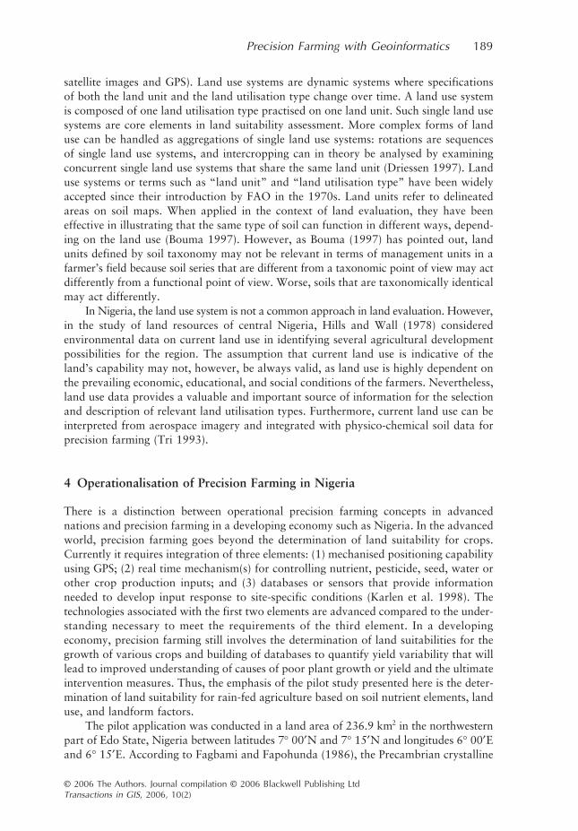
In Nigeria, the land use system is not a common approach in land evaluation. However,in the study of land resources of central Nigeria, Hills and Wall (1978) consideredenvironmental data on current land use in identifying several agricultural developmentpossibilities for the region. The assumption that current land use is indicative of theland’s capability may not, however, be always valid, as land use is highly dependent onthe prevailing economic, educational, and social conditions of the farmers. Nevertheless,land use data provides a valuable and important source of information for the selectionand description of relevant land utilisation types. Furthermore, current land use can beinterpreted from aerospace imagery and integrated with physico-chemical soil data forprecision farming (Tri 1993).
4 Operationalisation of Precision Farming in Nigeria
There is a distinction between operational precision farming concepts in advancednations and precision farming in a developing economy such as Nigeria. In the advancedworld, precision farming goes beyond the determination of land suitability for crops.Currently it requires integration of three elements: (1) mechanised positioning capabilityusing GPS; (2) real time mechanism(s) for controlling nutrient, pesticide, seed, water orother crop production inputs; and (3) databases or sensors that provide informationneeded to develop input response to site-specific conditions (Karlen et al. 1998). Thetechnologies associated with the first two elements are advanced compared to the under-standing necessary to meet the requirements of the third element. In a developingeconomy, precision farming still involves the determination of land suitabilities for thegrowth of various crops and building of databases to quantify yield variability that willlead to improved understanding of causes of poor plant growth or yield and the ultimateintervention measures. Thus, the emphasis of the pilot study presented here is the deter-mination of land suitability for rain-fed agriculture based on soil nutrient elements, landuse, and landform factors.
The pilot application was conducted in a land area of 236.9 km
2
in the northwesternpart of Edo State, Nigeria between latitudes 7
°
00
′
N and 7
°
15
′
N and longitudes 6
°
00
′
Eand 6
°
15
′
E. According to Fagbami and Fapohunda (1986), the Precambrian crystalline
190
M L Rilwani and I A Ikhuoria
© 2006 The Authors. Journal compilation © 2006 Blackwell Publishing Ltd
Transactions in GIS
, 2006, 10(2)
basement complex underlies the area. The major landform unit of the area is crystallineBasement Complex (BCH) while the land types are Auchi (BCH4) and Ibillo (BCH5).The landscape is characterised by non-lineated rocks, with dendritic drainage savannahvegetation and arable crops. It has rainy (April-October) and dry (November-March)seasons, respectively with annual rainfall of 1,322 mm and a mean temperature of 28
°
C.The soils are variable and characterised by shallow, stony, gravelly soils associated withrock outcrops. The toposequence comprises a shallow to very shallow soil over bedrock(
Lithic Ustrorthents
); and a well-drained sandy loam topsoil, overlaying sandy clayloam to sandy clay subsoil (
Oxic Paleustalfs
) (Fagbami and Fapohunda 1986).The methodology involved: (1) use of 1993/95 satellite remote sensing data to interpret
and confirm the land unit classification of the area prepared by Fagbami and Fakpohunda(1986); (2) use of a Garmin 12 GPS receiver to determine the position (geographiccoordinates) of soil sample points; (3) determination of the physical-chemical propertiesof collected soil samples at depths of 0–15 and 15–30 cm, and their nutrient ratings;and (4) use of the ArcView (GIS) software to integrate the spatial and attribute data andgenerate the land suitability map for maize and oil palm crops based on FAO guidelinesand suitability models.
In detail, the 1993/95 satellite image (a mosaic of SPOT, Landsat TM, and ERS-1data) at the scale of 1:250,000 was obtained from the Forest Resources, Monitoring,Evaluation and Co-ordination Unit (FORMECU) of the Federal Ministry of Agriculture,Abuja, Nigeria. The landform and land use/ land cover characteristics on the imagerywere visually interpreted and classified according to the FORMECU classificationscheme, and verified during the subsequent soil sampling exercise. A topographic mapat the scale of 1:100,000 was used to grid the study area into 30 5 km by 5 km cells fordata collection. The average elevation, slope, drainage pattern, and settlements of eachcell were determined from topographic maps. Fifteen alternate cells were systematicallyselected for soil sampling. Soil samples were collected with an augur at depths of 0–15and 15–30 cm and analysed at the Chemistry Laboratory of the Nigerian Institute forOil Palm Research (NIFOR). The following soil parameters were determined: graininess,texture, water retention capacity, acidity (pH), and nutrient variables (nitrogen, phos-phorous, potassium, magnesium, calcium, sodium, organic matter and CEC). These datasets constituted the themes that were assembled in the ArcView GIS.
The suitability classification model in Figure 3 illustrates the procedure adopted inthe analysis. Established query or suitability ratings (Table 1) and suitability classes(Table 2) were prepared from established crop requirements to diagnose the land suita-bility for maize and oil palm cultivation. The ArcView GIS was then used to integrateand perform the diagnostic queries of the spatial and attribute data sets by digitallycomparing the soil characteristics of the sampled cells with the suitability ratings andindices for maize and oil palm crops. Linear interpolation, overlay, and intersectionfunctions were then applied to the thematic layers to create the respective crop suita-bility areas. When the crops are considered together, the areas of optimal suitability tosupport high, moderate, and marginal productivity of maize and oil palm are shown inFigure 4.
The result shows that areas of 53.8 ha and 17.6 km
2
are highly suitable for maizeand oil palm cultivation, respectively. Similarly, the areas of moderate suitability formaize and oil palm cultivation are 11 km
2
and 46 km
2
respectively, while an area of6 km
2
is moderately suitable for the cultivation of both crops. The remaining area of167.2 km2 is only marginally suitable for the cultivation of both crops.
Precision Farming with Geoinformatics 191
© 2006 The Authors. Journal compilation © 2006 Blackwell Publishing LtdTransactions in GIS, 2006, 10(2)
5 Conclusions
The paper critically evaluated conventional agricultural land appraisal and suitabilitymethods in Nigeria and points out that, by and large, the physiographic, land system,land facet, and vegetation systems of land appraisal are useful at the reconnaissancelevel that serves as rapid methods of accomplishing basic land and forest resourcesinventory and exploitation of large areas. Land appraisal by taxonomic methods ischaracterised by the high level of technical terms and cumbersome descriptions ofmicro-morphological and pedagogical data that makes the results almost unintelligibleto users who are not familiar with the classification terms. The results are of littlerelevance in agricultural land use planning because of the lack of precision in the defi-nition of classes. Thus, conventional land classification is neither adequate nor effectivefor determining agricultural suitability zones and precision farming.
The paper further examined land evaluation systems in Nigeria, which embracesland capability classification, land suitability classification, fertility capability classifica-tion, soil quality rating, and soil productivity indices. A critical assessment of thesemethods in the context of precision farming revealed that although land capabilityclassification, land suitability classification, and fertility capability classification methodshave a reconnaissance nature and high level of generalisation, they nevertheless providevaluable appraisal information from which areas with high potential for precision farm-ing could be selected for detailed investigation. However, the soil quality rating and soil
Figure 3 Suitability classification

192 M L Rilwani and I A Ikhuoria
© 2006 The Authors. Journal compilation © 2006 Blackwell Publishing LtdTransactions in GIS, 2006, 10(2)
Table 1 Suitability rating scale for maize and oil palm crops
Maize suitability rating scale
Total nitrogen (%) Phosphorous (ppm)
Range Score (%) Range Score (%)
<0.100.11–0.150.16–0.200.21–0.25
>0.26
1 i.e. 402 i.e. 553 i.e. 704 i.e. 855 i.e. 100
<3.03.1–5.05.1–6.56.6–8.5
>0.26
1 i.e. 402 i.e. 553 i.e. 704 i.e. 855 i.e. 100
Potassium (mg/kg) pH
Range Score (%) Range Score (%)
<0.010.02–0.040.05–0.100.12–0.190.20–0.22
1 i.e. 402 i.e. 553 i.e. 704 i.e. 855 i.e. 100
<4.04.1–4.54.6–5.05.1–6.0
>6.1
1 i.e. 402 i.e. 553 i.e. 704 i.e. 855 i.e. 100
Organic matter (g/kg)
Range Score (%)
<0.010.02–0.040.05–0.100.12–0.190.20–0.22
1 i.e. 402 i.e. 553 i.e. 704 i.e. 855 i.e. 100
Oil palm suitability rating scale
Nitrogen (%) Magnesim (meq/100 g)
Range Score (%) Range Score (%)
<0.020.03–0.080.09–0.120.13–0.20
>0.20
1 i.e. 402 i.e. 553 i.e. 704 i.e. 855 i.e. 100
<0.50.6–1.31.4–1.81.9–2.3
>2.3
1 i.e. 402 i.e. 553 i.e. 704 i.e. 855 i.e. 100
Potassium (meq/100 g) Phosphorous (ppm)
Range Score (%) Range Score (%)
<0.060.07–0.090.10–0.200.21–0.24
>0.24
1 i.e. 402 i.e. 553 i.e. 704 i.e. 855 i.e. 100
<1011–1516–2526–35
>35
1 i.e. 402 i.e. 553 i.e. 704 i.e. 855 i.e. 100

Precision Farming w
ith Geoinform
atics193
© 2006 The A
uthors. Journal compilation ©
2006 Blackw
ell Publishing LtdTransactions in G
IS, 2006, 10(2)
Table 2 Definition of suitability classes
Suitability Class
Definition of YieldsExpected crop yield as a % of yield under optimal conditions, in the absence of inputs specific to the land quality considered
Definition in terms of InputsInputs or management practices specific to the land quality considered necessary to achieve yields of >80% of those under optimal conditions
S1, highly suitable >80% NoneS2, moderately suitable 40–80% Inputs needed which are likely to be
both practicable and economicS3, marginally suitable 20–40% Inputs needed which are practicable
but only economic under favourable circumstances
N, not suitable <20% Limitation can rarely or never be overcome by inputs or management practices
From Dent and Young 1981, p. 145

194 M L Rilwani and I A Ikhuoria
© 2006 The Authors. Journal compilation © 2006 Blackwell Publishing LtdTransactions in GIS, 2006, 10(2)
productivity index methods are characterised by numerous crop-yield prediction modelsthat relate crop yields to a single set of factors. These models would be of limited utility,largely because they are location-specific, and do not take into consideration variabilityin soil and crops conditions at regional, local, and farm levels. Furthermore, most of themodels are based on biophysical assessment of land potential alone, while holding otherfactors of crop production (such as economic factors) constant. Such models, whichhave been the basis for recommending organic fertiliser applications for crop farming inNigeria, are not adequate for precision farming applications. It would be better toevaluate what the natural soils are most suitable for so that crops can be selected foroptimum yield. The application of fertilisers, if necessary, would only be promoted inmarginally suitable farm fields.
Finally, the paper evaluated the new paradigm of precision farming with geoinfor-matics and highlights the beneficial aspects to agricultural production. The growing interest,advocacy and research in precision agriculture in the world, and Africa in particular,were emphasised. In this context an application of the new paradigm in the Orle Riverbasin in Edo State is used to illustrate how the strategy of precision farming withgeoinformatics can work in Nigeria. The result clearly indicated that the basin could not
Figure 4 Land suitability of Orle River Basin. This figure appears in colour in the electronicversion of this article and in the plate section at the back of the printed journal

Precision Farming with Geoinformatics 195
© 2006 The Authors. Journal compilation © 2006 Blackwell Publishing LtdTransactions in GIS, 2006, 10(2)
sustain meaningful grain crop production under prevailing traditional farming practicesbased on natural soil fertility. The basin is more suitable for the cultivation of tree cashcrops such as oil palm and cocoa. Consequently, maize or other grain production in thearea requires substantial fertiliser inputs. The policy implication is that grain productionis not economically viable and the carrying capacity of the basin to support the ruralpopulation is precarious. Since the rural subsistence economic base is unable to augment soilnutrient with chemical fertilisers, a farm management intervention policy should promoteorganic matter build-up through green manuring, zero tillage, and the agro-tugya system.
Nigeria launched its first remote sensing satellite system in 2003. Thus, like India,the Nigerian government can take practical steps towards the adoption of precisionfarming by using its (low cost) remote sensing data to generate detailed information onsoil resources to address potentials and limitations of agricultural fields. Further analysisis still required to study and classify agricultural lands and suitability zones with respectto soil fertility and crop yield, estimation of potential yield, yield gap analysis, andmonitoring of crop conditions. The result will enable the matching of farm inputs tobridge the gap between potential and actual yield through GIS-based spatial decisionsupport systems.
Acknowledgements
We express our sincere thanks to the reviewers whose incisive and in-depth commentshelped us to revise and restructure the paper.
References
Abu A A and Ojanuga A G 1989 Properties and classification of soils of Dange area of SokotoState, Nigeria. Samaru Journal of Agricultural Research B: 37–46
Aiboni V U and Ogunkunle A O 1998 An index of soil productivity for cassava and yam on thebasement complex of southwestern Nigeria. Journal of Science Research 4: 77–85
Aighewi I T 1999a Fertility capability classification of some derived savannah soils of Edo State,Nigeria. GeoResearch 4(12): 1–10
Aighewi I T 1999b Fertility capability classification of some humid tropical soils of Edo State,Nigeria. Nigerian Annals of Agricultural Science 1: 5–14
Ameyan O 1986a Quality of land facets as soil mapping units in an area of northern Nigeria.Geoforum 17: 97–107
Ameyan O 1986b Soil heterogeneity and soil sampling: A statistical study of two land facets innorthern Nigeria. International Journal of Environmental Studies 28: 33–40
Ameyan O 1986c Land evaluation for agricultural development in lower N’Gell Valley, northernNigeria. The Nigerian Geographical Journal 28/29: 57–70
Ameyan O 1987 Fertility of soil mapping units: An exploratory study in Lower N’Gell valley,northern Nigeria. GeoJournal 14: 109–14
Ameyan O 1988 The soil factor in crop production: An exploratory study in a humid tropicalenvironment. Agricultural Systems 26: 51–64
Ameyan O 1994 Evaluating land suitability from geo-based information systems in central Nigeria.The Nigerian Geographical Journal 1: 51–69
Amusan A A and Ashaye T I 1991 Classification of granitic-gnessis derived soils in the humidtropics of southwestern Nigeria. Ife Journal of Agriculture 1: 1–8
Baars R M T and Jeanes K W 1997 Land classification of western province, Zambia. ITC Journal1: 1–8
Bawden M G and Tuley P 1966 The Land Resources of Southern Sardauna and Adamawa Pronvinces:

196 M L Rilwani and I A Ikhuoria
© 2006 The Authors. Journal compilation © 2006 Blackwell Publishing LtdTransactions in GIS, 2006, 10(2)
Northern Nigeria. Tolworth, Land Resources Division, United Kingdom Directorate of OverseasSurveys Land Resources Study No 2
Berry J 1998 Who’s minding the farm? GIS World. February: 46–51Bouma J 1997 The land use systems approach to planning sustainable land management at several
scales. ITC Journal 3/4: 237–42Braimoh A K 2000 Land Evaluation for sorghum based on Boolean and fuzzy set methodologies.
Nigerian Journal of Soil Science 12: 6–11Buol S W, Sanchez P A, Cate R R and Granger M A 1975 Soil fertility capability classification for
fertility management. In Bornenisza E and Alvarado A (eds) Soil Management in TropicalAmerica. Raleigh, NC, North Carolina University Press: 126–41
Burrough P A 1991 Soil information systems. In Maguire D J, Goodchild M F, and Rhind D W(eds) Geographical Information Systems: Principles and Applications. New York, John Wileyand Sons: 153–69
Couper D C 1996 Land Survey for Research Statistics. Ibadan, Nigeria, International Institute forTropical Agriculture (IITA) Research Guide No 1
DeMers M N 1997 Fundamentals of Geographic Information Systems. New York, John Wileyand Sons
Dent D and A Young A 1981 Soil Survey and Land Evaluation. London, E and F N SponDriessen P M 1997 Biophysical sustainability of land use systems. ITC Journal 3/4: 243–7Fagbami A 1980 Interpretation of Landsat MSS imagery of the Nigeria Capital Territory for soil
survey purposes. Geoforum 11: 71–83Fagbami A 1981 SLAR imagery interpretation for Eastern Niger Delta soil survey purposes. In
Proceedings of the Annual Meeting of the American Society of Photogrammetry, San Francisco,California: 191–202
Fagbami A and Fapohunda A 1986 SLAR imagery for soil mapping and regional planning inwestern Nigeria. In Eden M J and Parry J T (ed) Remote Sensing and Tropical LandManagement. Chichester, John Wiley and Sons: 55–78
FAO 1976 A Framework for Land Evaluation. Rome, FAO Soils Bulletin No 32Gbadegesin A S and Nwagwu U 1990 On the suitability assessment of the forest and ecological
zones of southwestern Nigeria for maize production. Agricultural Ecosystems and Environment31: 99–113
Hills I D and Wall J R D (eds) 1978 Land Resources of Central Nigeria: Agricultural DevelopmentPossibilities. Tolworth, Land Resources Development Centre (LRDC), United KingdomMinistry of Overseas Development Land Resources Study No 29
Karlen D L, Andrews S S, Colvin T S, Jaynes D B, and Berry E C 1998 Spatial and temporalvariability in corn growth, development, insect pressures, and yields. In Robert P C, Rust RM, and Larsen W E (eds) Proceedings of the Fourth International Conference on PrecisionAgriculture. Madison, WI, American Society of Agronomy: 101–12
Klingebiel A A and Montgomery P H 1961 Land Capability Classification. Washington, DC,United States Department of Agriculture, Agriculture Handbook No 210
Kutter A, Nachtergaele F O and Verheye W O 1997 The FAO approach to land use planning andmanagement, and its application in Sierra Leone. ITC Journal 3/4: 278–83
Looijen J, Pelesikoti N, and Stalijanssens M 1995 ICOMIS: A spatial multi-objective decisionsupport system for coastal resources management. ITC Journal 3: 202–16
Mishra A, Raj P C, and Balaji D 2003 Operationalization of Precision Farming in India. WWWdocument, http://www.gisdevelopment.net/application/agriculture/overview/mio3’27.htm
Metternicht G, Hageman E, Honey F, and Beeston G 2001 Mapping variations in crop conditionsusing airborne videography. In Proceedings of the Twentieth International CartographicConference, Beijing, China: 732–42
Mongkolsawat C, Thirangoon P, and Kuptawutinan P 1997 A physical evaluation of land suitabilityfor rice: A methodological study using GIS. In Proceedings of the Asian Conference on RemoteSensing (ACRS’97), Kuala Lumpur, Malaysia (available at http://www.gisdevelopment.net/aars/acrs/1997/ts11/ts11004.shtml)
Mongkolsawat C, Thirangoon P, and Kuptawutinan P 1999 Land evaluation for combining cropsusing GIS and remotely sensed data. In Proceedings of the Asian Conference on Remote Sensing(ACRS’99), Hong Kong (available at http://www.gisdevelopment.net/aars/acrs/1999/ts1/ts1028.shtml)
Precision Farming with Geoinformatics 197
© 2006 The Authors. Journal compilation © 2006 Blackwell Publishing LtdTransactions in GIS, 2006, 10(2)
Nix H A 1968 Assessment of Biological Productivity. In Stewart G A (ed) Land Evaluation: Papersof the CSIRO Symposium. Canberra, Commonwealth Scientific and Industrial ResearchOrganization: 77–87
Ogunkunle A O 1993 Soil in land suitability evaluation: An example with Oil Palm, Nigeria. SoilUse and Management 19: 38–48
Ogunkunle A O and Onasanya O S 1992 Soil landscape relationship in a forest zone in southwesternNigeria. Samaru Journal of Agricultural Research 9: 19–33
Okafor F C and Onokerhoraye A G 1986 Rural Systems and Planning for Africa. Benin City,University of Benin Press: 145–63
Ramalho-Filho A, de Oliveira R P, and Pereira L C 1997 Use of geographic information systemsin (planning) sustainable land management in Brazil: Potentialities and user needs. ITC Journal3/4: 295–301
Strahler A N 1975 Physical Geography. Toronto, John Wiley and SonsStorie R E 1978 The Storie Index Soil Rating Revised. Davis, CA, University of California, Division
of Agricultural Science, Special Publication No 3203Sys C, Van Ranst E, and Debaveye J 1991 Land Evaluation: Part II, Methods in Land Evaluation.
Brussels, General Administration for Development Cooperation, Agricultural Publication No 7Tri L Q 1993 Present landuse as a basis for land evaluation in the Mekong District. ITC Journal
4: 377–85Usery E N, Pocknee S, and Boydell B 1995 Precision farming data management using geographic
information systems. Photogrammetric Engineering and Remote Sensing 61: 1383–91Wilde H, Jessen M, and Stephens P 1996 Land use mapping using satellite data of Manawatu,
New Zealand. ITC Journal 2: 149–55Wilson J P 1999 Local, national, and global applications of GIS in agriculture. In Longley P A,
Maguire D J, Goodchild M F, and Rhind D W (eds) Geographical Information Systems:Volume 2, Management Issues and Applications. New York, John Wiley and Sons: 981–8
Zuviria M de and Valenzuela C 1994 Mapping land suitability with ILWIS. ITC Journal 3: 301–7