paterson inlet sawmilling, stewart island, new zealand. archaeological survey
TRANSCRIPT
Paterson Inlet Sawmilling(Sawdust Bay & Sawmill Bay)
Stewart Island/Rakiura
Archæological Surveyfor the
Department of Conservation
Southland Conservancy
P.G. Petchey
Southern Archæology Ltd
Dunedin
2010
2Paterson Inlet Sawmilling Archæology
Table of Contents
Acknowledgements ....................................................................................................................3
Introduction................................................................................................................................4
General Geographic Description ................................................................................................4
Field Survey ...............................................................................................................................6
History of Sawmill Bay &Sawdust Bay Sawmills .....................................................................7
The Stewart Island Timber Industry ......................................................................................7
Previous Archæological Survey Work .....................................................................................11
2009 Archæological Survey .....................................................................................................11
Gallon’s Mill Site.....................................................................................................................12
Gallon’s Mill Site in 2009....................................................................................................13
McCallum’s Mill Site...............................................................................................................19
McCallum’s Mill Site in 2009 .............................................................................................22
Bullock’s Mill Site ...................................................................................................................25
Bullock’s Mill Site in 2009..................................................................................................27
Matthews’ & Collins’ Mill .......................................................................................................28
Matthews’ & Collins’ Mill, Tramway & Wharf in 2009 .....................................................28
Matthews’ & Collins’ Mill Boiler & Portable Engine .........................................................32
Swain’s Mill .............................................................................................................................34
Discussion & Recommendations..............................................................................................35
References................................................................................................................................37
Appendix A ..............................................................................................................................38

3Paterson Inlet Sawmilling Archæology
Acknowledgements
A number of people assisted with the preparation of this survey report. Rachael Egerton of the
Department of Conservation commissioned the survey and acted as field assistant throughout.
Heather Brooks, also of the Department of Conservation, also assisted throughout the survey.
The Dunedin Regional Office of Archives New Zealand gave permission to reproduce parts
of maps in their collection, and John Hall-Jones gave permission to reproduce images from
his book Stewart Island Explored.
4Paterson Inlet Sawmilling Archæology
Paterson Inlet Sawmilling
(Sawmill Bay & Sawdust Bay, Paterson Inlet)
Archæological Survey2010
P.G. Petchey
Southern Archæology
Introduction
This report was carried out for the Southland Conservancy of the Department of Conservation
(DOC) to record in detail the physical remains of sawmilling activity in the area of Kaipipi
Bay and the North Arm of Paterson Inlet, specifically archæological sites E48/44 (Gallon’s
mill site), E48/9 (McCallum’s mill site), the related features at the settlement and wharf site at
Kaipipi, and site E48/12 (Matthews’ & Collin’s mill). This work was intended to assist the
planning of track work near these sites, and to provide interpretation material at Gallon’s mill
site.
General Geographic Description
Stewart Island/Rakiura is the southernmost of New Zealand’s three main islands, lying 24
kilometres off the South Island, between the latitudes 46 and 48 degrees south (Figure 1). The
island has an area of 1,720 square kilometres (650 square miles), much of which is included
in the newly created Rakiura National Park.
There is only one permanent settlement, at Oban in Halfmoon Bay, although numerous small
cribs and huts are scattered about, including those used once a year by muttonbirders. The
population is generally about 400, although this increases significantly in the summer months.
A road network only exists around Oban, the rest of the island being accessible only by
walking tracks, by boat or by air, the latter restricted to places where landing sites are
available for helicopter or amphibious aeroplane.
The coastline is generally craggy and rocky, although Mason Bay on the west coast has a
sandy beach some seven miles long. There are several large natural harbours, including Port
William, Paterson Inlet, Port Adventure and Port Pegasus. The majority of the island is hilly
or mountainous, the highest peak being Mt. Anglem in the north (980m, 3,214ft), while Mt.
Allen in the Tin Range is 716 metres (2,459ft) high.
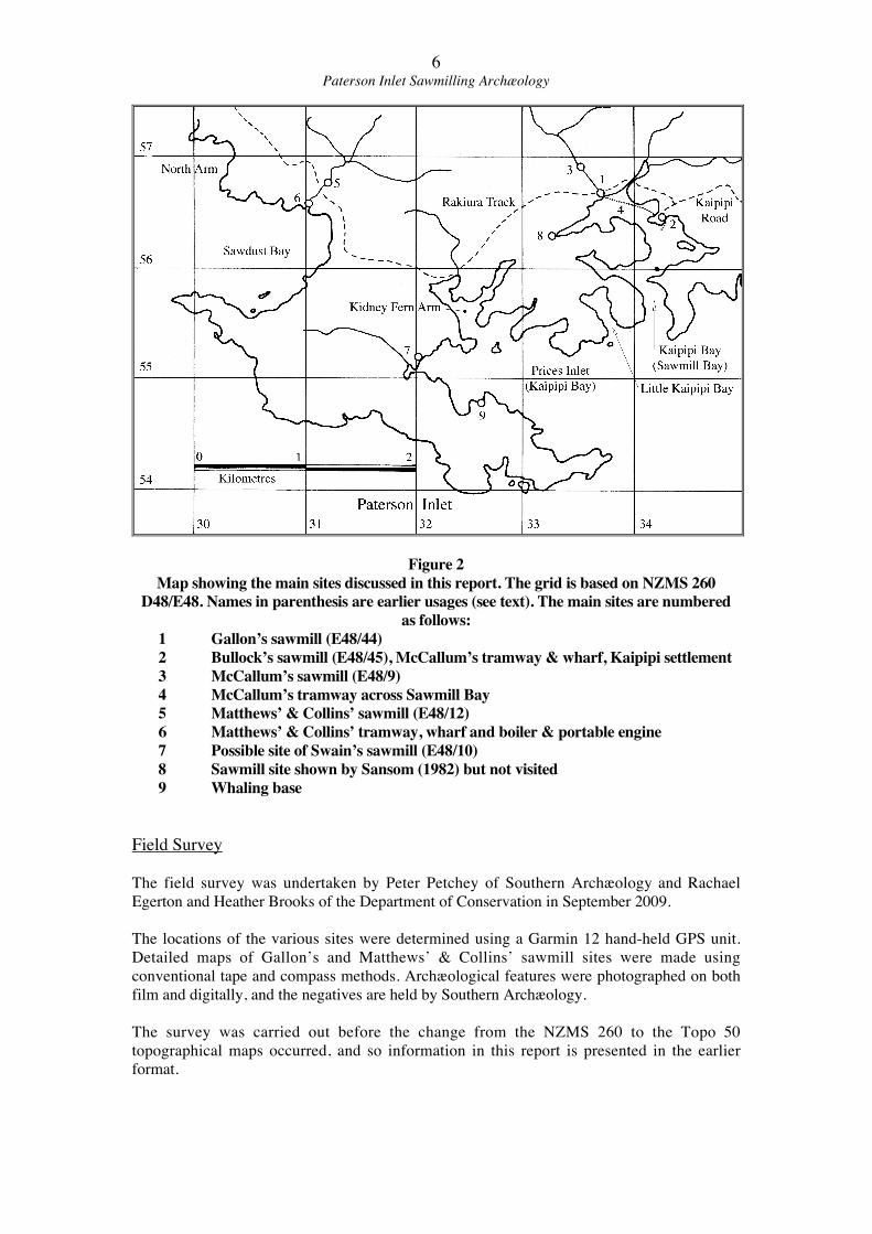
It is of note in the discussions below that the use of names for various inlets has varied
somewhat over the years. The present maps (NZMS 260 D48/E48) make a clear distinction
between Kaipipi Bay and Prices Inlet on the north shore of Paterson Inlet. Older maps show
what is now known as Kaipipi Bay as Sawmill Bay, and Prices Bay as Kaipipi Bay (see
Figure 2). In the discussion below ‘Sawmill Bay’ will be used when discussing sites in what
is now Kaipipi Bay as it is quite specific and avoids confusion.
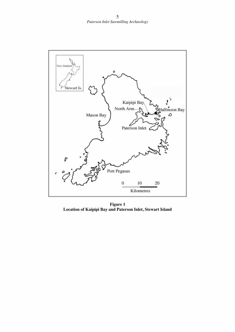
5Paterson Inlet Sawmilling Archæology
Figure 1
Location of Kaipipi Bay and Paterson Inlet, Stewart Island
6Paterson Inlet Sawmilling Archæology
Figure 2
Map showing the main sites discussed in this report. The grid is based on NZMS 260
D48/E48. Names in parenthesis are earlier usages (see text). The main sites are numbered
as follows:
1 Gallon’s sawmill (E48/44)
2 Bullock’s sawmill (E48/45), McCallum’s tramway & wharf, Kaipipi settlement
3 McCallum’s sawmill (E48/9)
4 McCallum’s tramway across Sawmill Bay
5 Matthews’ & Collins’ sawmill (E48/12)
6 Matthews’ & Collins’ tramway, wharf and boiler & portable engine
7 Possible site of Swain’s sawmill (E48/10)
8 Sawmill site shown by Sansom (1982) but not visited
9 Whaling base
Field Survey
The field survey was undertaken by Peter Petchey of Southern Archæology and Rachael
Egerton and Heather Brooks of the Department of Conservation in September 2009.
The locations of the various sites were determined using a Garmin 12 hand-held GPS unit.
Detailed maps of Gallon’s and Matthews’ & Collins’ sawmill sites were made using
conventional tape and compass methods. Archæological features were photographed on both
film and digitally, and the negatives are held by Southern Archæology.
The survey was carried out before the change from the NZMS 260 to the Topo 50
topographical maps occurred, and so information in this report is presented in the earlier
format.
7Paterson Inlet Sawmilling Archæology
History of Sawmill Bay &Sawdust Bay Sawmills
The Stewart Island Timber Industry
The timber industry on Stewart Island started when William Stewart established a shipbuilding
enterprise at Port Pegasus in 1826, although all of the timber there would have been hand-cut and
pit-sawn. The first mechanical sawmill on the island was established in 1861 at Kaipipi Bay,
Paterson Inlet, by a man named Gallon. This was powered by a water wheel, and the first steam
powered mill was established nearby later the same year by John Bullock (Howard 1940: 196).
Over the following 60 years numerous mills were established around Paterson Inlet, Halfmoon
Bay and Horseshoe Bay, the last of which was the operation at Maori Beach that finally closed in
1931 (Howard 1940: 196-197). The distribution of mills was largely determined by the
distribution of economically millable rimu trees, which were found at lower altitudes at the
northern end of the island (Howard 1940: 190). By 1886, when much of Stewart Island was
proclaimed State Forest, the best of the timber had already been felled. Much of the island was
reserved for the protection of flora, fauna and scenery in 1906, and the only uncut forests open to
milling enterprises after that were in the coastal fringe from Port William to Mason Bay (Howard
1940: 193-195).
The history of samilling ventures is often complex, with companies changing ownership and
name, and licences changing hands. Recent research on the Maori Beach sawmilling operation
(Petchey 2009) has shown that the published histories are often incomplete. The milling
operations discussed below (ca. 1861 to ca. 1926) are earlier than the Maori Beach operation (ca.
1915 to 1931), and so the surviving documentary evidence is more sparse than that for Maori
Beach. In particular it can be difficult to determine exactly which sawmill sites were in use at a
particular date and by whom. The discussion below is as accurate as possible, but if more
historical information comes to light some interpretations may change.
Howard (1940: 191-192) has discussed the establishment of Gallon’s and Bullock’s sawmills,
and was of the opinion that although John Bullock had first proposed the establishment of a
steam powered sawmill capable of cutting “upward of 30,000 feet of superficial weekly” in
October 1860, it was Gallon’s water-powered mill that was actually operating first. Certainly,
both mills were operating close to each other in early 1861. The Otago Witness (13 April 1861:
101) reported in April 1861 that:
“About four miles up the west arm, in a beautiful bay (called by the natives Kepeepe
Bay), Mr. Gallon and Mr. Bullock have erected their saw-mills, which will find constant
employment for about seventy men…”
Another mention in the paper later in the year (Otago Witness 8 June 1861: 9) mentioned that
both mills were working, but also referred to “Bullock and Walker’s” mills, possibly suggesting
that Bullock had taken on a partner. When James Hector (1863: 448) visited Paterson Inlet in
1863 he did not visit the mills, but reported that:
“A boat visited us from the sawmills which are situated about five miles up Peterson’s
Inlet. There are two different establishments, and altogether a little community
comprising nearly a hundred persons.”
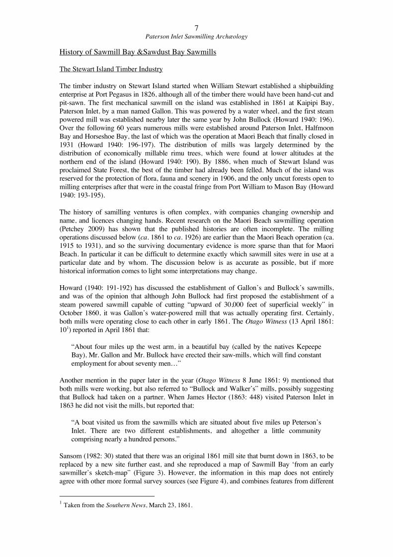
Sansom (1982: 30) stated that there was an original 1861 mill site that burnt down in 1863, to be
replaced by a new site further east, and she reproduced a map of Sawmill Bay ‘from an early
sawmiller’s sketch-map” (Figure 3). However, the information in this map does not entirely
agree with other more formal survey sources (see Figure 4), and combines features from different
1 Taken from the Southern News, March 23, 1861.
8Paterson Inlet Sawmilling Archæology
eras, as she shows the long timber bridge of McCallum’s tramline that was used until 1926 (see
discussion below).
Figure 3
Sketch map of Sawmill Bay, Kaipipi, from Sansom (1982). This map appears to combine
features from different eras, as the timber bridge and mill site are those of McCallum’s
operation of the early twentieth century. The “Old mill site” was possibly an earlier
location of either Gallon’s or Bullock’s mill, while the known locations of both of these
mills are not shown.
9Paterson Inlet Sawmilling Archæology
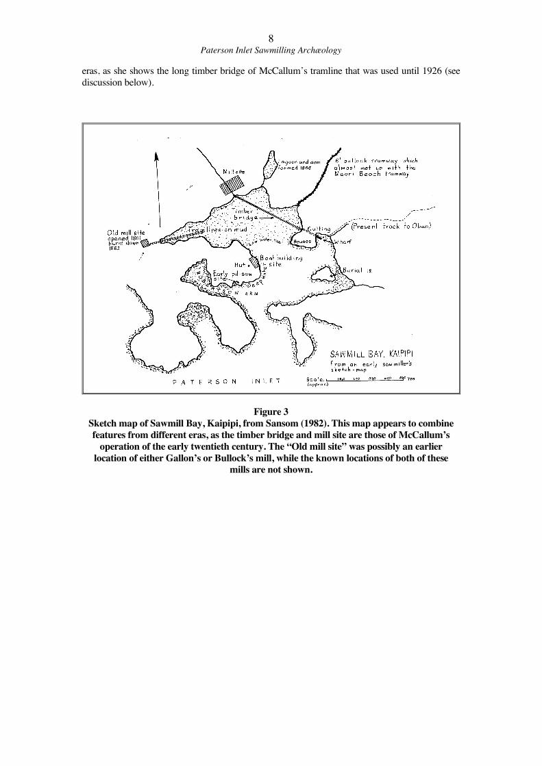
Figure 4
Detail of 1878 map of part of Block XV Paterson District (S.O. 1521) showing locations of
two old sawmills in Sawmill Bay. These are almost certainly Gallon’s Mill (left) and
Bullock’s Mill (Right). (LINZ)
In about 1864 Bullock opened another mill in Paterson Inlet, near Thule close to Halfmoon Bay.
Howard was of the opinion that the machinery from the Bullock’s old mill at Kaipipi was shifted
to this new mill, which then continued to operate until 1867 or 1868 (Howard 1940: 192).2 At
about that time both mills in Kaipipi closed down, although Gallon’s mill was soon reopened
under the management of Jabez Hay.
By 1878 both mills in Kaipipi appear to have been closed down, as a map drawn that year (S.O.
1521, see Figure 4) shows both sites as ‘old sawmills.’ In the early twentieth century both sites
were partially reused by a new sawmilling operation, known generally as McCallum’s Mill. This
new mill was established about 400 metres upstream from Gallon’s Mill, where the valley
widened out to a large flat. A tramway ran down the valley, across Gallon’s Mill site, and then
across the Sawmill Bay tidal flats to the peninsula where Bullock’s Mill had stood, where a new
jetty was also built. The exact date that this mill was established is not known, but it was there by
1911 (S.O. 4006). It is likely that it was actually established by John Bragg, and then passed to
McCallum & Co. John Bragg was born on Stewart Island, and was elected as a County
Councillor in 1902, and is recorded as having had sawmilling interests in Paterson Inlet
(Cyclopedia of New Zealand, Vol. 4: 892).
Two different mills were also established in what is now Prices Inlet, both by Swain. One was
near Swains Beach, and the second in Kidney Fern Arm (Howard 1940: 196). The machinery for
these mills came from an earlier mill at Ryan’s Creek (Howard 1940: 197).
In the North Arm of Paterson Inlet several mills were established, although details of their
establishments are hazy. Cullen and Clark set up a water-powered mill in about 1870, which was
later taken over by Hay (not Jabez Hay who took over Gallon’s mill) and converted to steam
power, and later sold to McPherson, Filmer & Co. (Howard 1940: 196). Another steam powered
2 However, Sansom (1982: 30) was of the opinion that it was Gallon that operated the Thule mill.
10Paterson Inlet Sawmilling Archæology
mill was operated by Matthews and Collins, although it was probably established by John Bragg,
and it closed during the First World War (Howard 1940: 197).
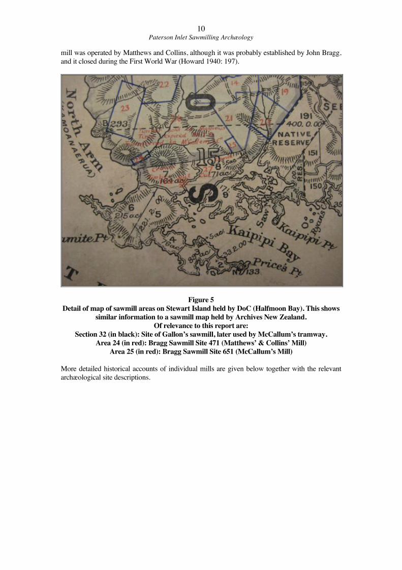
Figure 5
Detail of map of sawmill areas on Stewart Island held by DoC (Halfmoon Bay). This shows
similar information to a sawmill map held by Archives New Zealand.
Of relevance to this report are:
Section 32 (in black): Site of Gallon’s sawmill, later used by McCallum’s tramway.
Area 24 (in red): Bragg Sawmill Site 471 (Matthews’ & Collins’ Mill)
Area 25 (in red): Bragg Sawmill Site 651 (McCallum’s Mill)
More detailed historical accounts of individual mills are given below together with the relevant
archæological site descriptions.
11Paterson Inlet Sawmilling Archæology
Previous Archæological Survey Work
To date no detailed systematic archæological survey has been undertaken of the Stewart
Island timber milling industry, although the main mill and hauler sites have been recorded.
The site of Gallon’s Mill is actively managed by the Department of Conservation, and a
Conservation Plan (Bradley et al 1994) has been prepared. In 1977 Neville Ritchie (then of
the Southland Museum in Invercargill) recorded a number of the mill sites on the New
Zealand Archæological Association Site Record Scheme based on the descriptions given in
Howard (1940). The previously recorded sites in Paterson Inlet that are discussed in this
report and their imperial and metric site record numbers are summarised in Table 1. Updated
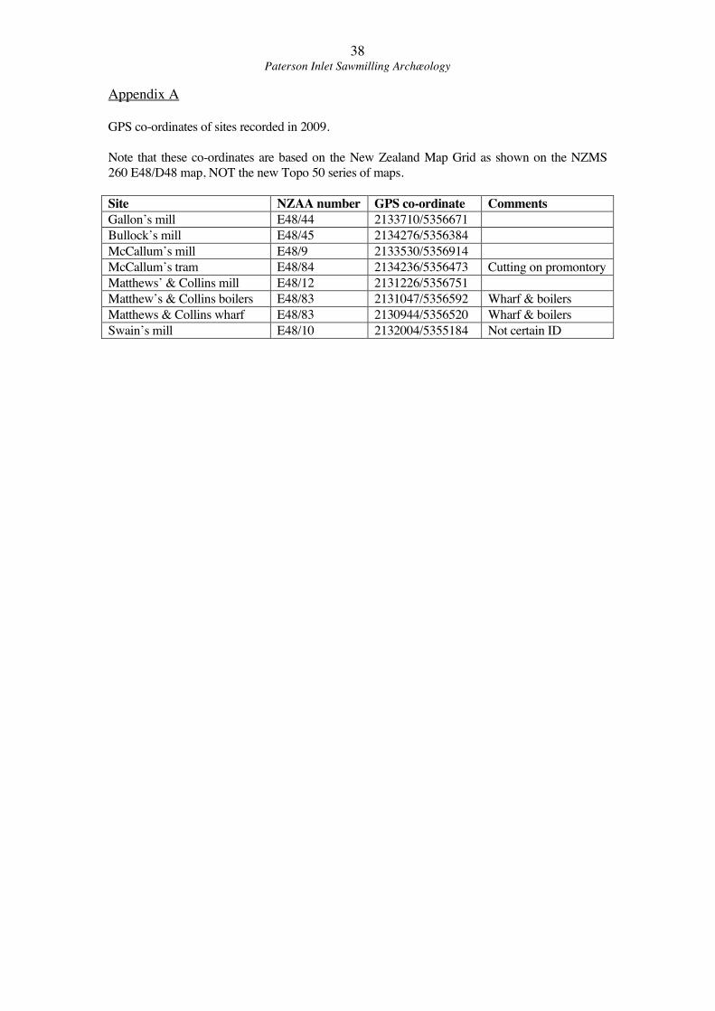
grid references are given in Appendix A.
Mill Imperial no. Metric no. Comments
Gallon’s S186/11 E48/44 Recorded in detail in 2009
Bullock’s S186/12 E48/45 Not visited
McCallum’s S186/13 E48/9 Visited in 2009
Matthew & Collins’ S186/18 E48/12 Recorded in 2009
Swain’s S186/14 E48/10 Visited in 2009
Swain’s (Kidney fern) S186/15 E48/11 Not visited in 2009
Hay’s S186/17 E48/53 Exact location not known
Table 1
Recorded sawmill sites
2009 Archæological Survey
The 2009 archæological survey visited five possible early sawmill sites; Gallon’s, Bullock’s,
McCallum’s, Matthew’s & Collins’, and Swain’s. Of these, Gallon’s Mill was recorded in
some detail and the site of the main mill shed at Matthew’s & Collins’ Mill was mapped,
while the others were simply inspected. The identification of Swain’s mill site was by no
means certain. Detailed mapping was carried out using basic tape and compass methods, with
hand-held GPS co-ordinates taken to record the overall location of each site.
12Paterson Inlet Sawmilling Archæology
Gallon’s Mill Site
NZAA Site No. E48/44 (S168/11)
Gallon’s Mill is significant as it was the first mechanical sawmill on Stewart Island, and it is
on the Rakiura Track and so is regularly visited by walkers. It is actively managed by the
Department of Conservation. The mill site is located astride a small stream that runs into the
north shore of Sawmill Bay. The 5 acre Section 32 Block XV Paterson District was surveyed
along the stream, and included the mill site. This property was an unregistered Crown Grant
(Southland Deeds Local Index).
As described above, the mill was opened in 1861 by Gallon. Although little is known about
the mill, and no photographs have been found, some small details of its operations can be
gleaned from newspaper columns. The Otago Witness on March 29th 1862 reported that the
mill continued in full work, and that shipments of timber were sent to Invercargill fortnightly
on the schooner Hawkhead. The best description of the milling operation was An Otago
Witness article on 11th July 1868, written when the mill was being reopened by the Hay
brothers of Invercargill after a short closure:
“Messrs Hay Bros, of Invercargill, are about to re-open the sawmill, known as
‘Gallon’s,’ at the head of Paterson’s Inlet, where they have a practically unlimited
supply of timber, and water power to drive the machinery for cutting it. One fact in
connection with the mills is worthy of especial notice. The dam built to obtain the
requisite fall of water, turns the stream above it into a kind of lagoon, stretching back for
about two miles through country well timbered to the water’s edge. Logs can, therefore,
be easily felled on the hill sides, rolled into the water, stapled and chained off into rafts,
and taken down to the mills at once. The saving between this plan and that of hauling
with bullocks will be very great.”
This description is extremely valuable, as it not only states that the mill was still water-
powered at this date, but it also describes part of the logging operation. The use of the mill
reservoir to transport logs would have had the considerable advantage of reducing the need to
construct tramlines through the bush, as logs could be floated down all the way to the mill,
which stood at the foot of the dam. However the easily accessible logs would presumably
have been quickly cut out, and it would have been necessary to transport logs from further
afield, so this advantage would have lessened over time.
The date that Gallon’s/Hay’s Mill finally closed is not known, although an 1878 map (SO
1521, see Figure 4 above) suggests that by this date it has ceased to operate as it was then
described as an ‘old sawmill.’ Closure was certainly prior to the establishment of McCallum’s
Mill upstream because the site of McCallum’s mill would have been underwater if Gallon’s
dam had been intact, and McCallums tramline cut through this dam. The history of
McCallum’s Mill is discussed in more detail below, but it was certainly in operation by 1911.
In summary, Gallon’s Mill operated through most of the 1860s, and possibly into the 1870s.
The mill was located close to the mouth of a small stream that ran into Sawmill Bay, part of
Kaipipi Bay. The mill was powered by a water wheel (almost certainly an overshot wheel, see
discussion below) fed by water from the reservoir. Logs were floated down to the mill on the
reservoir. There is no evidence as to how the logs were loaded aboard boats for transport to
markets, but presumably there was a wharf or jetty out into Sawmill Bay.
13Paterson Inlet Sawmilling Archæology
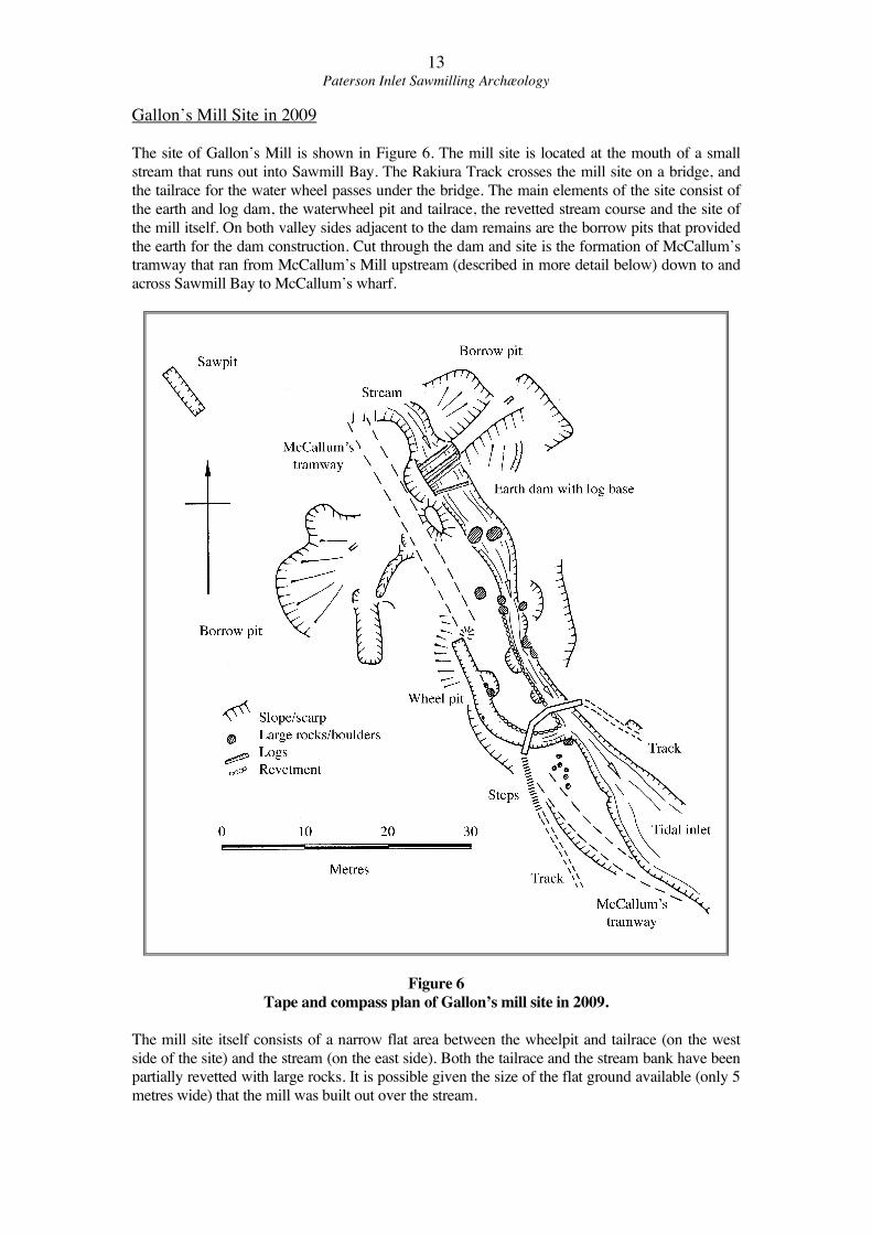
Gallon’s Mill Site in 2009
The site of Gallon’s Mill is shown in Figure 6. The mill site is located at the mouth of a small
stream that runs out into Sawmill Bay. The Rakiura Track crosses the mill site on a bridge, and
the tailrace for the water wheel passes under the bridge. The main elements of the site consist of
the earth and log dam, the waterwheel pit and tailrace, the revetted stream course and the site of
the mill itself. On both valley sides adjacent to the dam remains are the borrow pits that provided
the earth for the dam construction. Cut through the dam and site is the formation of McCallum’s
tramway that ran from McCallum’s Mill upstream (described in more detail below) down to and
across Sawmill Bay to McCallum’s wharf.
Figure 6
Tape and compass plan of Gallon’s mill site in 2009.
The mill site itself consists of a narrow flat area between the wheelpit and tailrace (on the west
side of the site) and the stream (on the east side). Both the tailrace and the stream bank have been
partially revetted with large rocks. It is possible given the size of the flat ground available (only 5
metres wide) that the mill was built out over the stream.
14Paterson Inlet Sawmilling Archæology
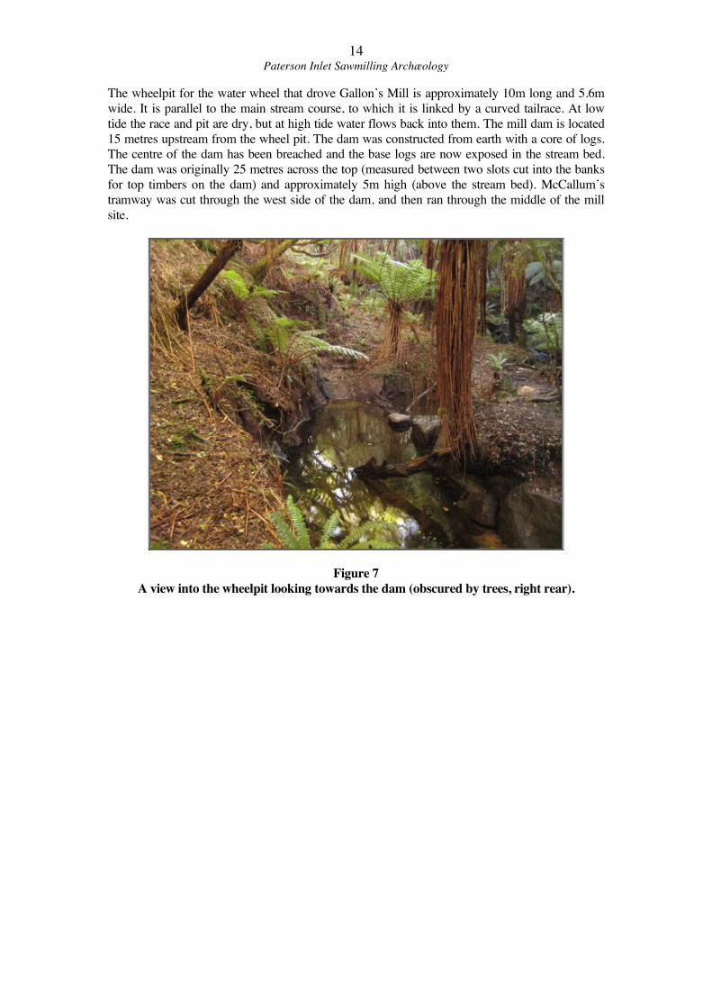
The wheelpit for the water wheel that drove Gallon’s Mill is approximately 10m long and 5.6m
wide. It is parallel to the main stream course, to which it is linked by a curved tailrace. At low
tide the race and pit are dry, but at high tide water flows back into them. The mill dam is located
15 metres upstream from the wheel pit. The dam was constructed from earth with a core of logs.
The centre of the dam has been breached and the base logs are now exposed in the stream bed.
The dam was originally 25 metres across the top (measured between two slots cut into the banks
for top timbers on the dam) and approximately 5m high (above the stream bed). McCallum’s
tramway was cut through the west side of the dam, and then ran through the middle of the mill
site.
Figure 7
A view into the wheelpit looking towards the dam (obscured by trees, right rear).
15Paterson Inlet Sawmilling Archæology
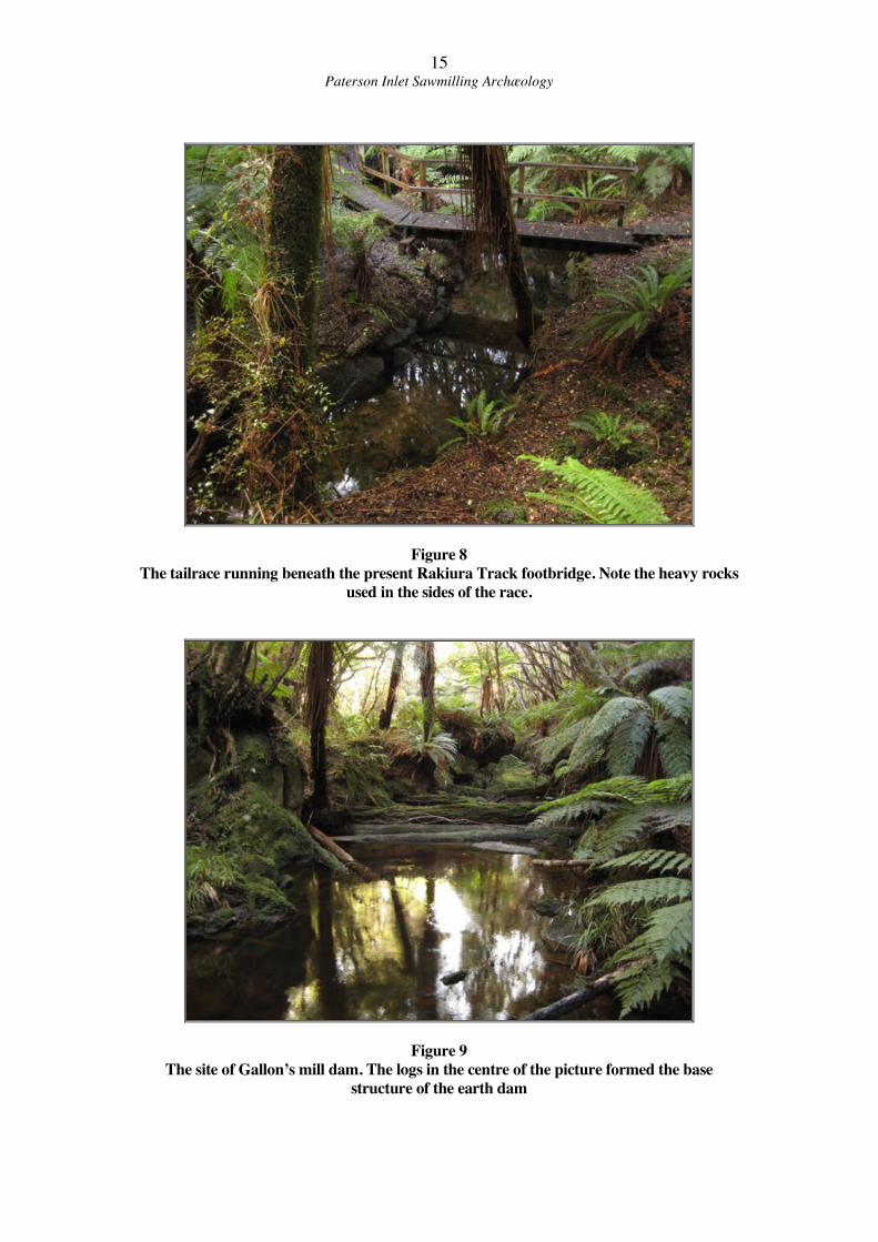
Figure 8
The tailrace running beneath the present Rakiura Track footbridge. Note the heavy rocks
used in the sides of the race.
Figure 9
The site of Gallon’s mill dam. The logs in the centre of the picture formed the base
structure of the earth dam
16Paterson Inlet Sawmilling Archæology
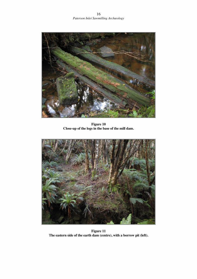
Figure 10
Close-up of the logs in the base of the mill dam.
Figure 11
The eastern side of the earth dam (centre), with a borrow pit (left).
17Paterson Inlet Sawmilling Archæology
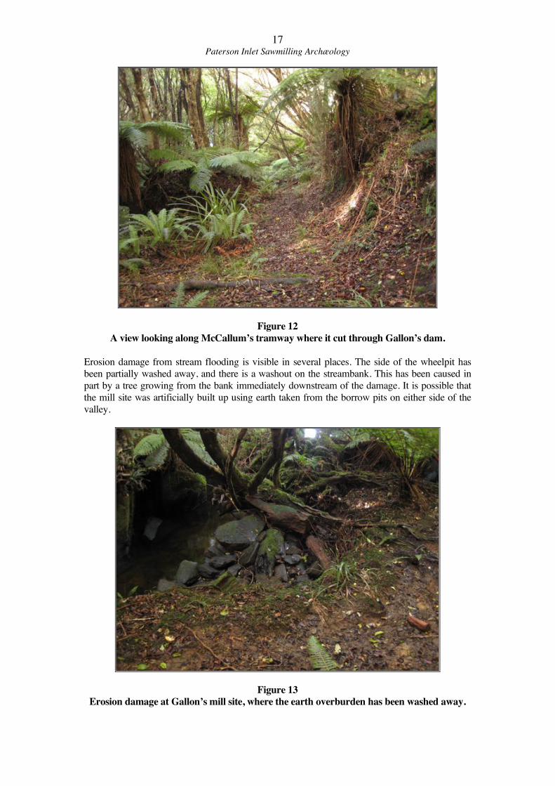
Figure 12
A view looking along McCallum’s tramway where it cut through Gallon’s dam.
Erosion damage from stream flooding is visible in several places. The side of the wheelpit has
been partially washed away, and there is a washout on the streambank. This has been caused in
part by a tree growing from the bank immediately downstream of the damage. It is possible that
the mill site was artificially built up using earth taken from the borrow pits on either side of the
valley.
Figure 13
Erosion damage at Gallon’s mill site, where the earth overburden has been washed away.
18Paterson Inlet Sawmilling Archæology
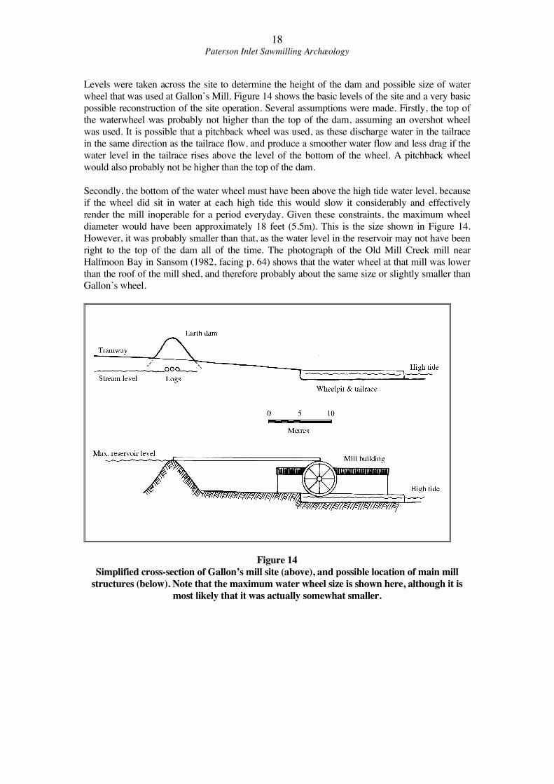
Levels were taken across the site to determine the height of the dam and possible size of water
wheel that was used at Gallon’s Mill. Figure 14 shows the basic levels of the site and a very basic
possible reconstruction of the site operation. Several assumptions were made. Firstly, the top of
the waterwheel was probably not higher than the top of the dam, assuming an overshot wheel
was used. It is possible that a pitchback wheel was used, as these discharge water in the tailrace
in the same direction as the tailrace flow, and produce a smoother water flow and less drag if the
water level in the tailrace rises above the level of the bottom of the wheel. A pitchback wheel
would also probably not be higher than the top of the dam.
Secondly, the bottom of the water wheel must have been above the high tide water level, because
if the wheel did sit in water at each high tide this would slow it considerably and effectively
render the mill inoperable for a period everyday. Given these constraints, the maximum wheel
diameter would have been approximately 18 feet (5.5m). This is the size shown in Figure 14.
However, it was probably smaller than that, as the water level in the reservoir may not have been
right to the top of the dam all of the time. The photograph of the Old Mill Creek mill near
Halfmoon Bay in Sansom (1982, facing p. 64) shows that the water wheel at that mill was lower
than the roof of the mill shed, and therefore probably about the same size or slightly smaller than
Gallon’s wheel.
Figure 14
Simplified cross-section of Gallon’s mill site (above), and possible location of main mill
structures (below). Note that the maximum water wheel size is shown here, although it is
most likely that it was actually somewhat smaller.
19Paterson Inlet Sawmilling Archæology
McCallum’s Mill Site
NZAA Site No. E48/9 (S186/13)
McCallum’s Mill site is located upstream (north) of Gallon’s Mill site, on a large grassy flat
400 metres from the shore of Sawmill Bay. This flat would have been under the waters of
Gallon’s Mill reservoir when the earlier mill was in operation, meaning that it was probably
clear of large timber when McCallum’s Mill was established.
The exact establishment date of McCallum’s Mill is not known. Sawmill Site No. 651 was
granted to McCallum & Co. Ltd of Invercargill in 1920 (State Forest Service, Sawmill Site
651 correspondence, Archives NZ), but the mill almost certainly already existed at this date
as a note on the file refers to previous correspondence regarding the sawmill site and tramway
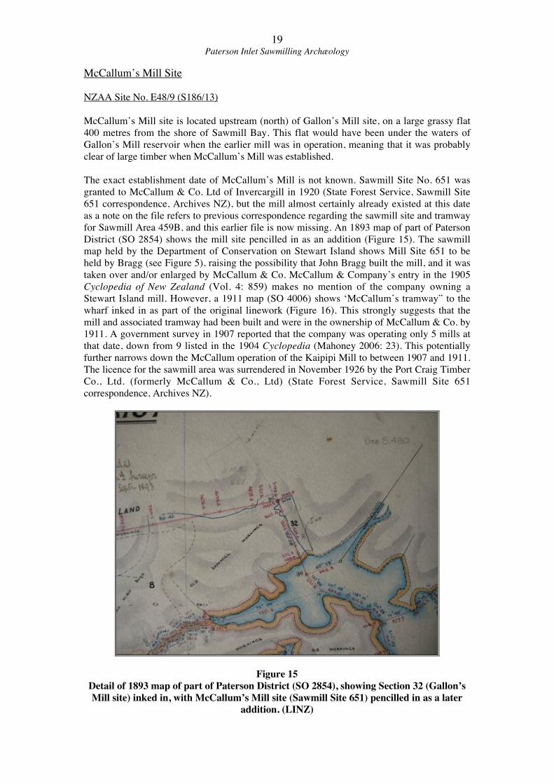
for Sawmill Area 459B, and this earlier file is now missing. An 1893 map of part of Paterson
District (SO 2854) shows the mill site pencilled in as an addition (Figure 15). The sawmill
map held by the Department of Conservation on Stewart Island shows Mill Site 651 to be
held by Bragg (see Figure 5), raising the possibility that John Bragg built the mill, and it was
taken over and/or enlarged by McCallum & Co. McCallum & Company’s entry in the 1905
Cyclopedia of New Zealand (Vol. 4: 859) makes no mention of the company owning a
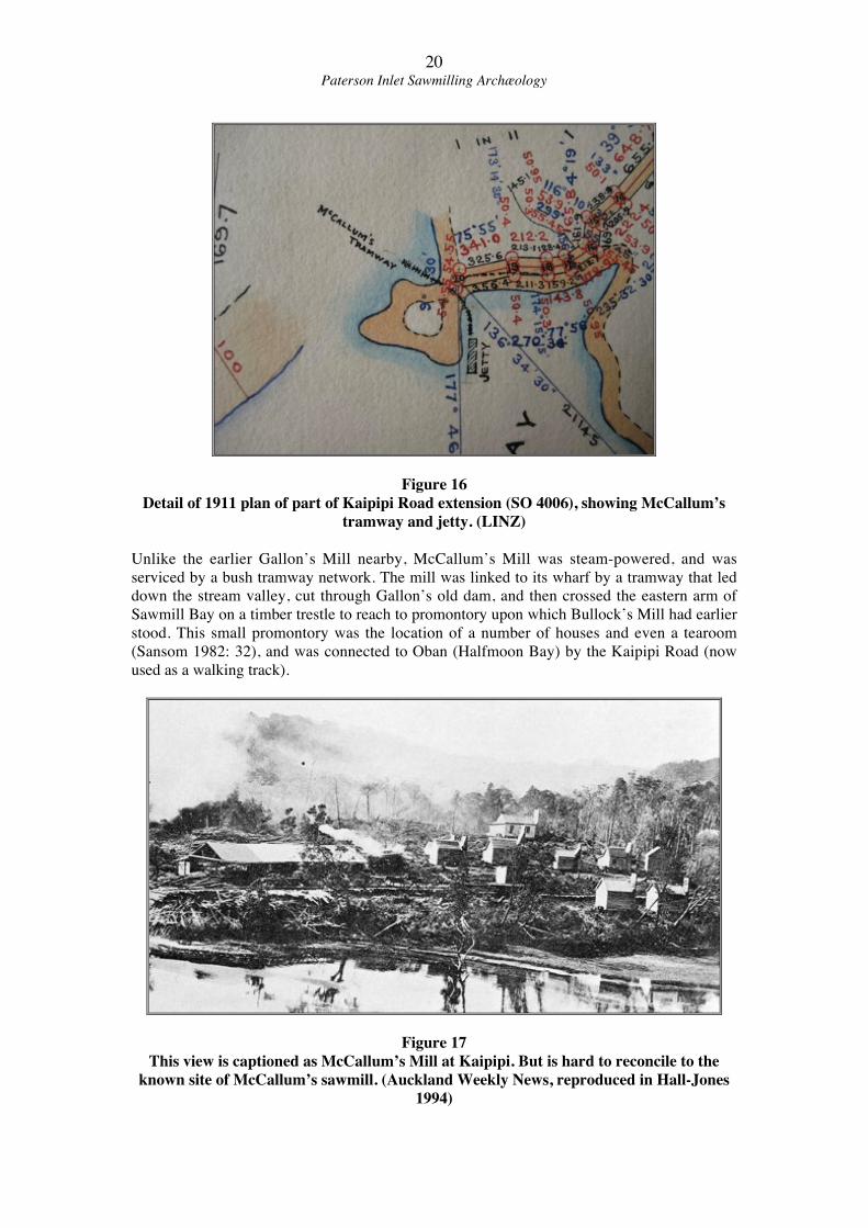
Stewart Island mill. However, a 1911 map (SO 4006) shows ‘McCallum’s tramway” to the
wharf inked in as part of the original linework (Figure 16). This strongly suggests that the
mill and associated tramway had been built and were in the ownership of McCallum & Co. by
1911. A government survey in 1907 reported that the company was operating only 5 mills at
that date, down from 9 listed in the 1904 Cyclopedia (Mahoney 2006: 23). This potentially
further narrows down the McCallum operation of the Kaipipi Mill to between 1907 and 1911.
The licence for the sawmill area was surrendered in November 1926 by the Port Craig Timber
Co., Ltd. (formerly McCallum & Co., Ltd) (State Forest Service, Sawmill Site 651
correspondence, Archives NZ).
Figure 15
Detail of 1893 map of part of Paterson District (SO 2854), showing Section 32 (Gallon’s
Mill site) inked in, with McCallum’s Mill site (Sawmill Site 651) pencilled in as a later
addition. (LINZ)
20Paterson Inlet Sawmilling Archæology
Figure 16
Detail of 1911 plan of part of Kaipipi Road extension (SO 4006), showing McCallum’s
tramway and jetty. (LINZ)
Unlike the earlier Gallon’s Mill nearby, McCallum’s Mill was steam-powered, and was
serviced by a bush tramway network. The mill was linked to its wharf by a tramway that led
down the stream valley, cut through Gallon’s old dam, and then crossed the eastern arm of
Sawmill Bay on a timber trestle to reach to promontory upon which Bullock’s Mill had earlier
stood. This small promontory was the location of a number of houses and even a tearoom
(Sansom 1982: 32), and was connected to Oban (Halfmoon Bay) by the Kaipipi Road (now
used as a walking track).
Figure 17
This view is captioned as McCallum’s Mill at Kaipipi. But is hard to reconcile to the
known site of McCallum’s sawmill. (Auckland Weekly News, reproduced in Hall-Jones
1994)
21Paterson Inlet Sawmilling Archæology
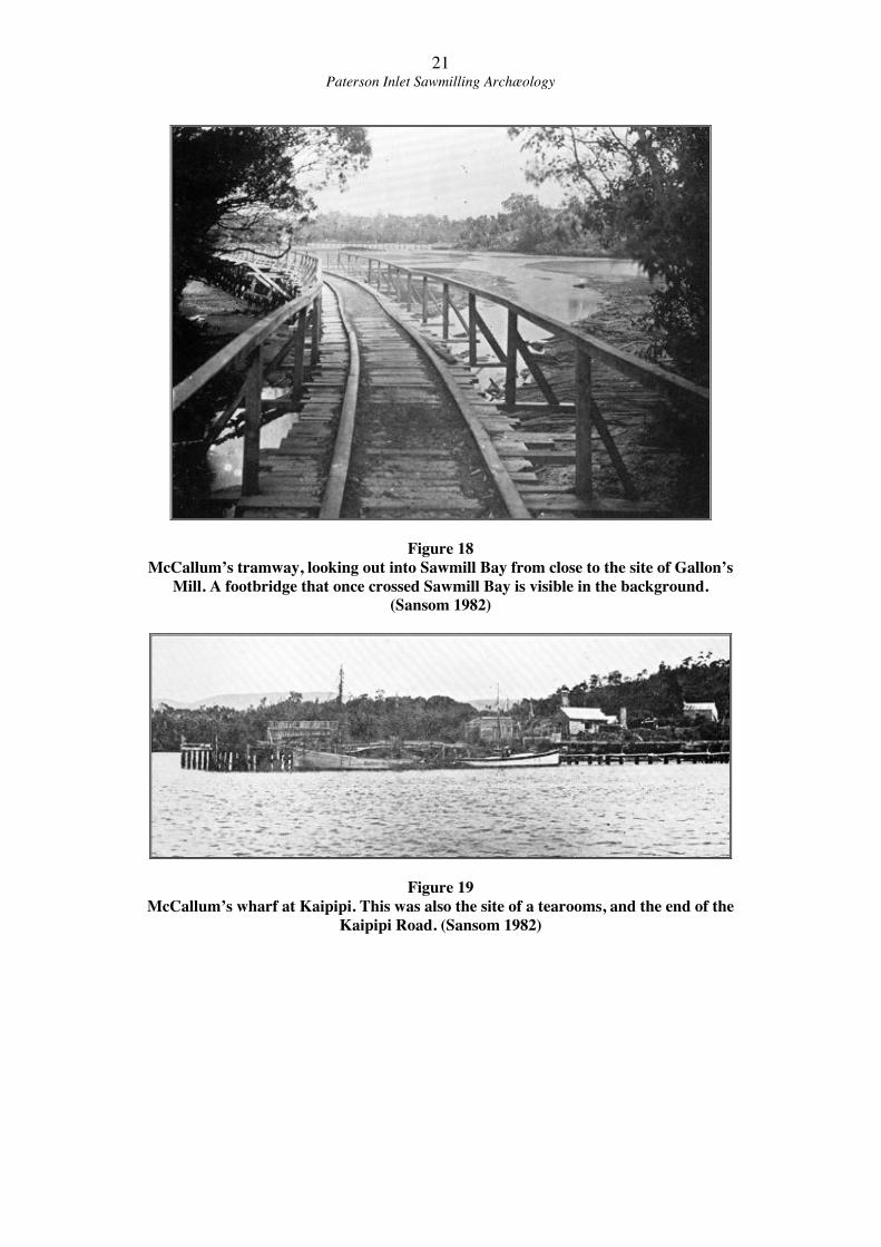
Figure 18
McCallum’s tramway, looking out into Sawmill Bay from close to the site of Gallon’s
Mill. A footbridge that once crossed Sawmill Bay is visible in the background.
(Sansom 1982)
Figure 19
McCallum’s wharf at Kaipipi. This was also the site of a tearooms, and the end of the
Kaipipi Road. (Sansom 1982)
22Paterson Inlet Sawmilling Archæology
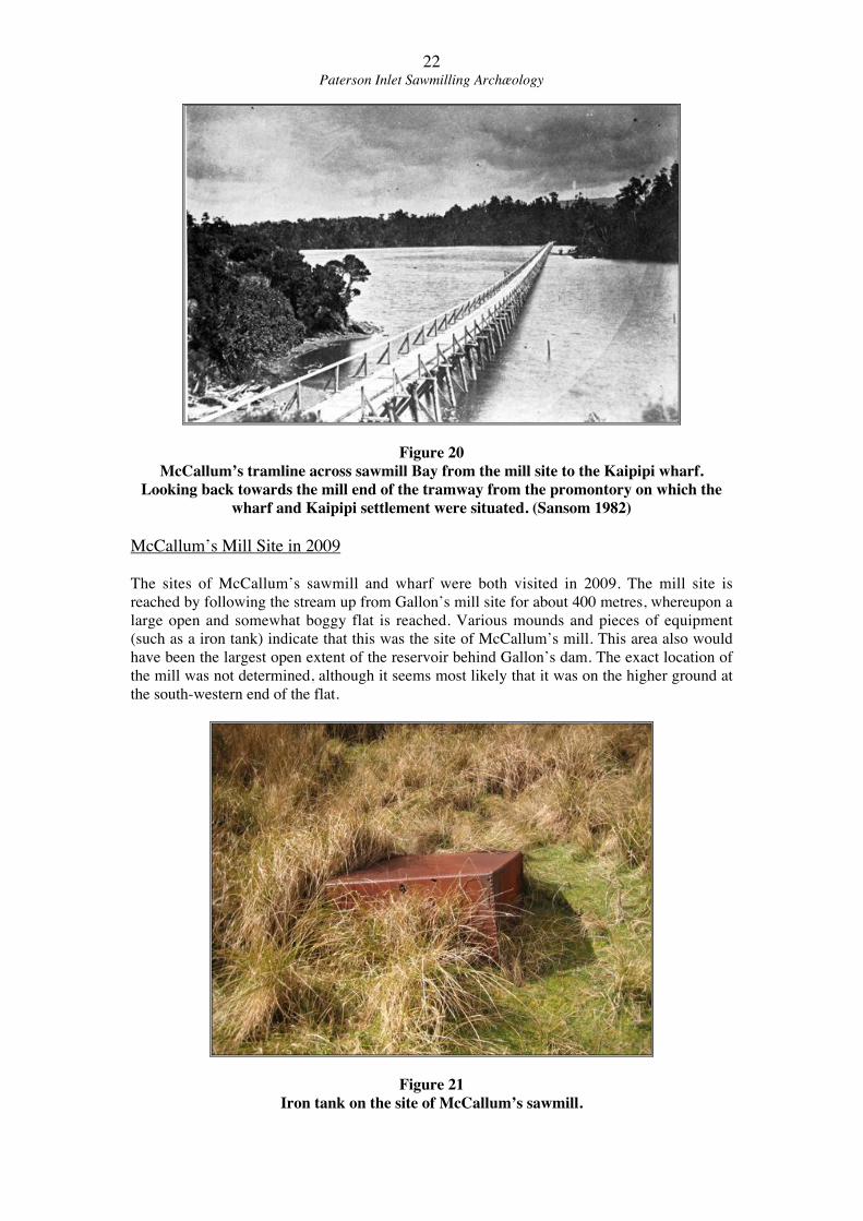
Figure 20
McCallum’s tramline across sawmill Bay from the mill site to the Kaipipi wharf.
Looking back towards the mill end of the tramway from the promontory on which the
wharf and Kaipipi settlement were situated. (Sansom 1982)
McCallum’s Mill Site in 2009
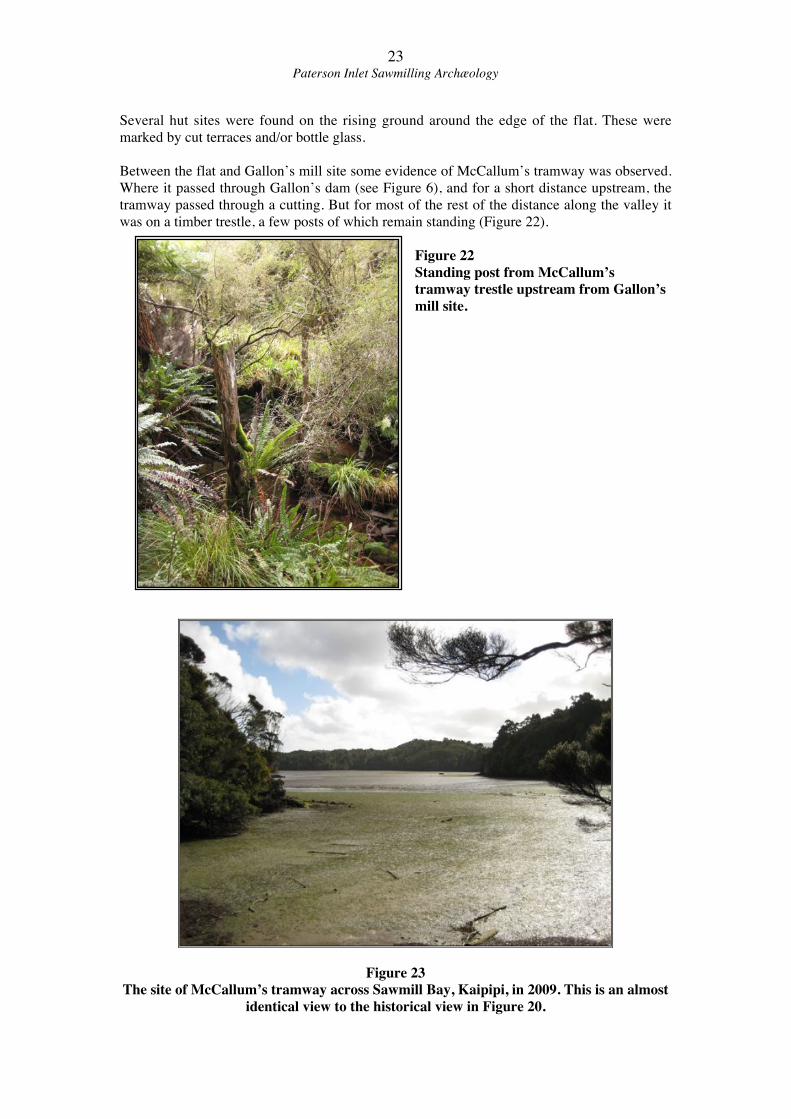
The sites of McCallum’s sawmill and wharf were both visited in 2009. The mill site is
reached by following the stream up from Gallon’s mill site for about 400 metres, whereupon a
large open and somewhat boggy flat is reached. Various mounds and pieces of equipment
(such as a iron tank) indicate that this was the site of McCallum’s mill. This area also would
have been the largest open extent of the reservoir behind Gallon’s dam. The exact location of
the mill was not determined, although it seems most likely that it was on the higher ground at
the south-western end of the flat.
Figure 21
Iron tank on the site of McCallum’s sawmill.
23Paterson Inlet Sawmilling Archæology
Several hut sites were found on the rising ground around the edge of the flat. These were
marked by cut terraces and/or bottle glass.
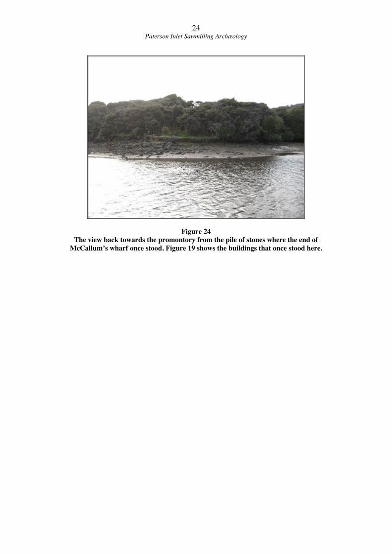
Between the flat and Gallon’s mill site some evidence of McCallum’s tramway was observed.
Where it passed through Gallon’s dam (see Figure 6), and for a short distance upstream, the
tramway passed through a cutting. But for most of the rest of the distance along the valley it
was on a timber trestle, a few posts of which remain standing (Figure 22).
Figure 22
Standing post from McCallum’s
tramway trestle upstream from Gallon’s
mill site.
Figure 23
The site of McCallum’s tramway across Sawmill Bay, Kaipipi, in 2009. This is an almost
identical view to the historical view in Figure 20.
24Paterson Inlet Sawmilling Archæology
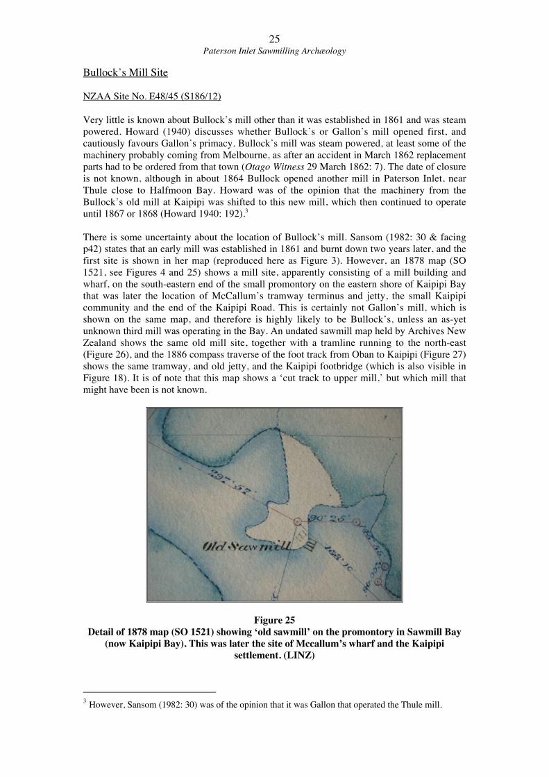
Figure 24
The view back towards the promontory from the pile of stones where the end of
McCallum’s wharf once stood. Figure 19 shows the buildings that once stood here.
25Paterson Inlet Sawmilling Archæology
Bullock’s Mill Site
NZAA Site No. E48/45 (S186/12)
Very little is known about Bullock’s mill other than it was established in 1861 and was steam
powered. Howard (1940) discusses whether Bullock’s or Gallon’s mill opened first, and
cautiously favours Gallon’s primacy. Bullock’s mill was steam powered, at least some of the
machinery probably coming from Melbourne, as after an accident in March 1862 replacement
parts had to be ordered from that town (Otago Witness 29 March 1862: 7). The date of closure
is not known, although in about 1864 Bullock opened another mill in Paterson Inlet, near
Thule close to Halfmoon Bay. Howard was of the opinion that the machinery from the
Bullock’s old mill at Kaipipi was shifted to this new mill, which then continued to operate
until 1867 or 1868 (Howard 1940: 192).3
There is some uncertainty about the location of Bullock’s mill. Sansom (1982: 30 & facing
p42) states that an early mill was established in 1861 and burnt down two years later, and the
first site is shown in her map (reproduced here as Figure 3). However, an 1878 map (SO
1521, see Figures 4 and 25) shows a mill site, apparently consisting of a mill building and
wharf, on the south-eastern end of the small promontory on the eastern shore of Kaipipi Bay
that was later the location of McCallum’s tramway terminus and jetty, the small Kaipipi
community and the end of the Kaipipi Road. This is certainly not Gallon’s mill, which is
shown on the same map, and therefore is highly likely to be Bullock’s, unless an as-yet
unknown third mill was operating in the Bay. An undated sawmill map held by Archives New
Zealand shows the same old mill site, together with a tramline running to the north-east
(Figure 26), and the 1886 compass traverse of the foot track from Oban to Kaipipi (Figure 27)
shows the same tramway, and old jetty, and the Kaipipi footbridge (which is also visible in
Figure 18). It is of note that this map shows a ‘cut track to upper mill,’ but which mill that
might have been is not known.
Figure 25
Detail of 1878 map (SO 1521) showing ‘old sawmill’ on the promontory in Sawmill Bay
(now Kaipipi Bay). This was later the site of Mccallum’s wharf and the Kaipipi
settlement. (LINZ)
3 However, Sansom (1982: 30) was of the opinion that it was Gallon that operated the Thule mill.
26Paterson Inlet Sawmilling Archæology
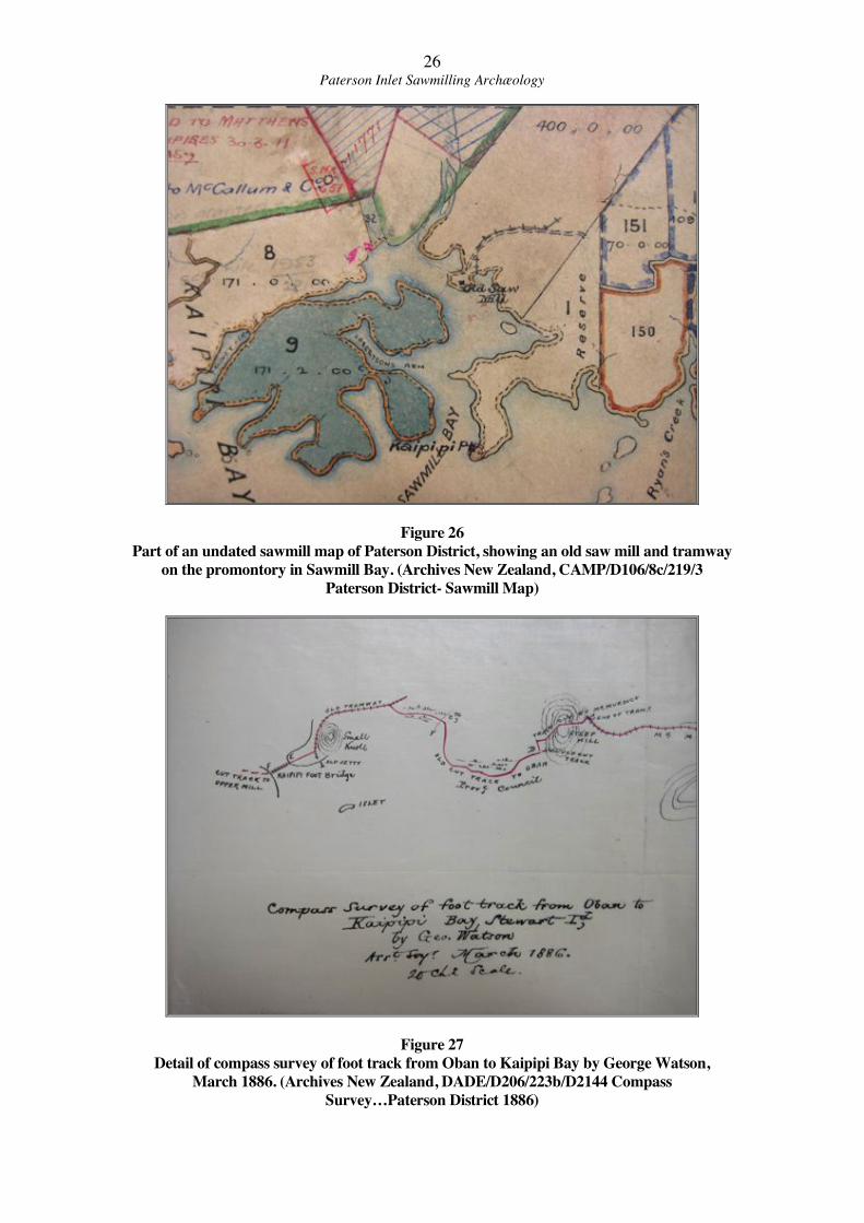
Figure 26
Part of an undated sawmill map of Paterson District, showing an old saw mill and tramway
on the promontory in Sawmill Bay. (Archives New Zealand, CAMP/D106/8c/219/3
Paterson District- Sawmill Map)
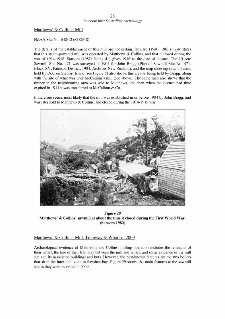
Figure 27
Detail of compass survey of foot track from Oban to Kaipipi Bay by George Watson,
March 1886. (Archives New Zealand, DADE/D206/223b/D2144 Compass
Survey…Paterson District 1886)

27Paterson Inlet Sawmilling Archæology
Bullock’s Mill Site in 2009
The Old Mill Site shown by Sansom was not visited in 2009. At the peninsula site nothing can
with certainty be associated with this mill, as the archæological features visible today on the
promontory relate to the later use of the area by McCallum & Co., and the Kaipipi settlement,
and are discussed above under McCallum’s Mill. It is likely that there will be sub-surface
evidence on the promontory of Bullock’s mill.
28Paterson Inlet Sawmilling Archæology
Matthews’ & Collins’ Mill
NZAA Site No. E48/12 (S186/18)
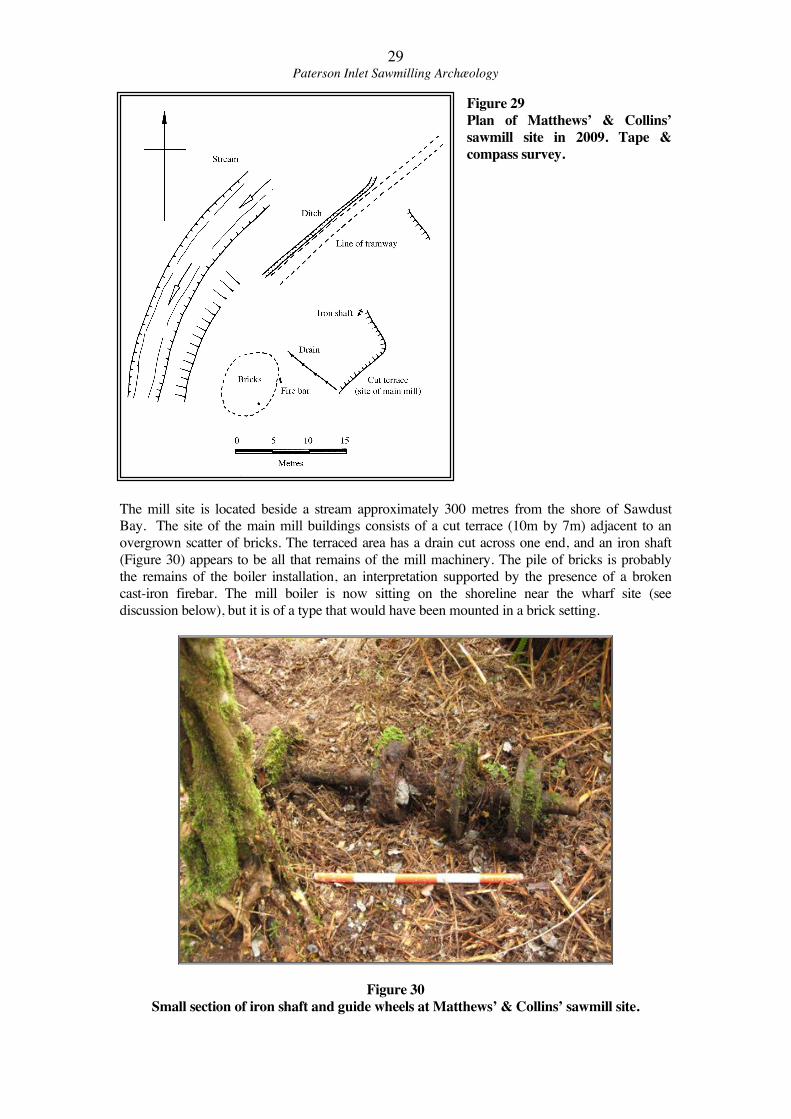
The details of the establishment of this mill are not certain. Howard (1940: 196) simply states
that this steam-powered mill was operated by Matthews & Collins, and that it closed during the
war of 1914-1918. Sansom (1982: facing 41) gives 1916 as the date of closure. The 10 acre
Sawmill Site No. 471 was surveyed in 1904 for John Bragg (Plan of Sawmill Site No. 471,
Block XV, Paterson District, 1904. Archives New Zealand), and the map showing sawmill areas
held by DoC on Stewart Island (see Figure 5) also shows this area as being held by Bragg, along
with the site of what was later McCallum’s mill (see above). The same map also shows that the
timber in the neighbouring area was sold to Matthews, and then when the licence had time
expired in 1911 it was transferred to McCallum & Co.
It therefore seems most likely that the mill was established in or before 1904 by John Bragg, and
was later sold to Matthews & Collins, and closed during the 1914-1918 war.
Figure 28
Matthews’ & Collins’ sawmill at about the time it closed during the First World War.
(Sansom 1982)
Matthews’ & Collins’ Mill, Tramway & Wharf in 2009
Archæological evidence of Matthew’s and Collins’ milling operation includes the remnants of
their wharf, the line of their tramway between the mill and wharf, and some evidence of the mill
site and its associated buildings and huts. However, the best-known features are the two boilers
that sit in the inter-tidal zone in Sawdust bay. Figure 29 shows the main features at the sawmill
site as they were recorded in 2009.
29Paterson Inlet Sawmilling Archæology
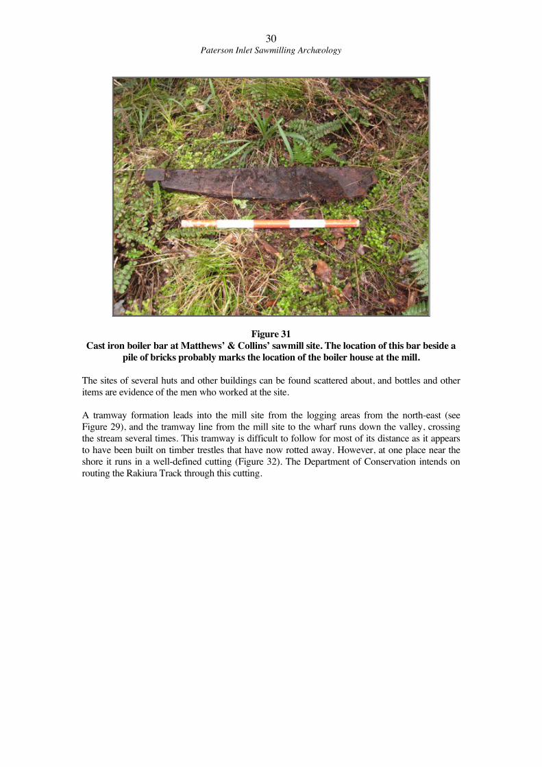
Figure 29
Plan of Matthews’ & Collins’
sawmill site in 2009. Tape &
compass survey.
The mill site is located beside a stream approximately 300 metres from the shore of Sawdust
Bay. The site of the main mill buildings consists of a cut terrace (10m by 7m) adjacent to an
overgrown scatter of bricks. The terraced area has a drain cut across one end, and an iron shaft
(Figure 30) appears to be all that remains of the mill machinery. The pile of bricks is probably
the remains of the boiler installation, an interpretation supported by the presence of a broken
cast-iron firebar. The mill boiler is now sitting on the shoreline near the wharf site (see
discussion below), but it is of a type that would have been mounted in a brick setting.
Figure 30
Small section of iron shaft and guide wheels at Matthews’ & Collins’ sawmill site.
30Paterson Inlet Sawmilling Archæology
Figure 31
Cast iron boiler bar at Matthews’ & Collins’ sawmill site. The location of this bar beside a
pile of bricks probably marks the location of the boiler house at the mill.
The sites of several huts and other buildings can be found scattered about, and bottles and other
items are evidence of the men who worked at the site.
A tramway formation leads into the mill site from the logging areas from the north-east (see
Figure 29), and the tramway line from the mill site to the wharf runs down the valley, crossing
the stream several times. This tramway is difficult to follow for most of its distance as it appears
to have been built on timber trestles that have now rotted away. However, at one place near the
shore it runs in a well-defined cutting (Figure 32). The Department of Conservation intends on
routing the Rakiura Track through this cutting.
31Paterson Inlet Sawmilling Archæology
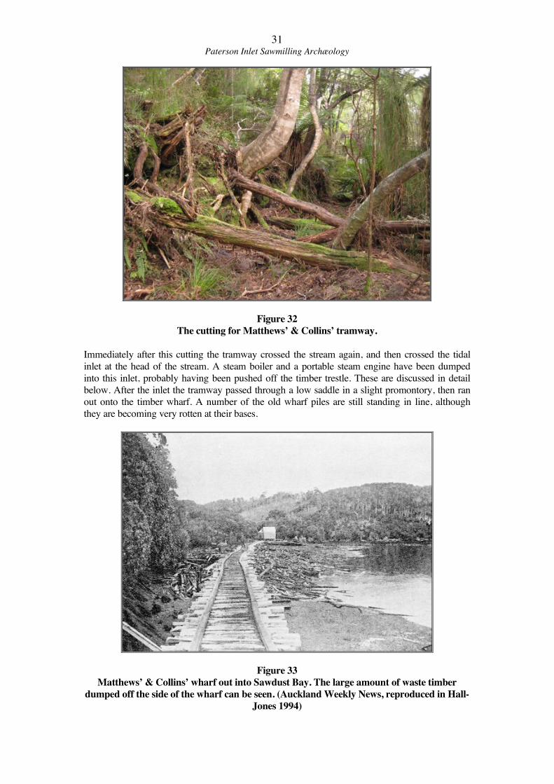
Figure 32
The cutting for Matthews’ & Collins’ tramway.
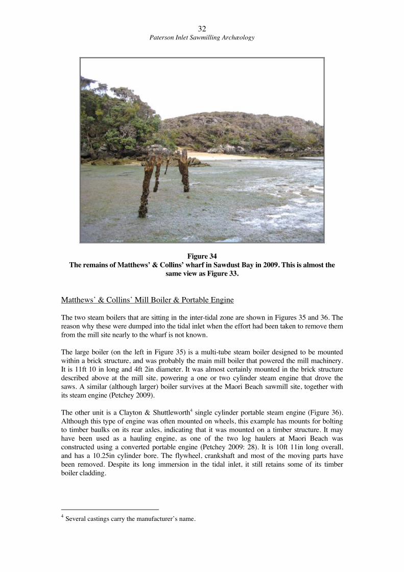
Immediately after this cutting the tramway crossed the stream again, and then crossed the tidal
inlet at the head of the stream. A steam boiler and a portable steam engine have been dumped
into this inlet, probably having been pushed off the timber trestle. These are discussed in detail
below. After the inlet the tramway passed through a low saddle in a slight promontory, then ran
out onto the timber wharf. A number of the old wharf piles are still standing in line, although
they are becoming very rotten at their bases.
Figure 33
Matthews’ & Collins’ wharf out into Sawdust Bay. The large amount of waste timber
dumped off the side of the wharf can be seen. (Auckland Weekly News, reproduced in Hall-
Jones 1994)
32Paterson Inlet Sawmilling Archæology
Figure 34
The remains of Matthews’ & Collins’ wharf in Sawdust Bay in 2009. This is almost the
same view as Figure 33.
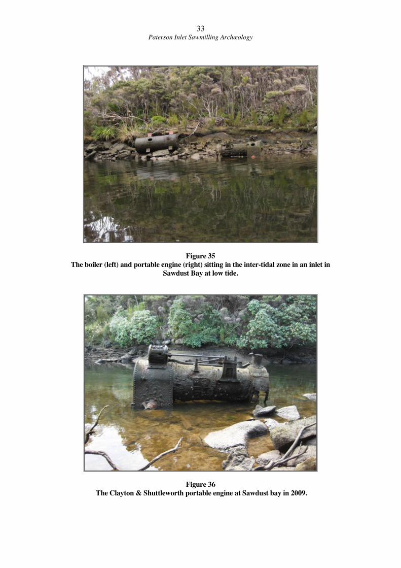
Matthews’ & Collins’ Mill Boiler & Portable Engine
The two steam boilers that are sitting in the inter-tidal zone are shown in Figures 35 and 36. The
reason why these were dumped into the tidal inlet when the effort had been taken to remove them
from the mill site nearly to the wharf is not known.
The large boiler (on the left in Figure 35) is a multi-tube steam boiler designed to be mounted
within a brick structure, and was probably the main mill boiler that powered the mill machinery.
It is 11ft 10 in long and 4ft 2in diameter. It was almost certainly mounted in the brick structure
described above at the mill site, powering a one or two cylinder steam engine that drove the
saws. A similar (although larger) boiler survives at the Maori Beach sawmill site, together with
its steam engine (Petchey 2009).
The other unit is a Clayton & Shuttleworth4 single cylinder portable steam engine (Figure 36).
Although this type of engine was often mounted on wheels, this example has mounts for bolting
to timber baulks on its rear axles, indicating that it was mounted on a timber structure. It may
have been used as a hauling engine, as one of the two log haulers at Maori Beach was
constructed using a converted portable engine (Petchey 2009: 28). It is 10ft 11in long overall,
and has a 10.25in cylinder bore. The flywheel, crankshaft and most of the moving parts have
been removed. Despite its long immersion in the tidal inlet, it still retains some of its timber
boiler cladding.
4 Several castings carry the manufacturer’s name.
33Paterson Inlet Sawmilling Archæology
Figure 35
The boiler (left) and portable engine (right) sitting in the inter-tidal zone in an inlet in
Sawdust Bay at low tide.
Figure 36
The Clayton & Shuttleworth portable engine at Sawdust bay in 2009.
34Paterson Inlet Sawmilling Archæology
Swain’s Mill
NZAA Site No. E48/10 (S186/14)
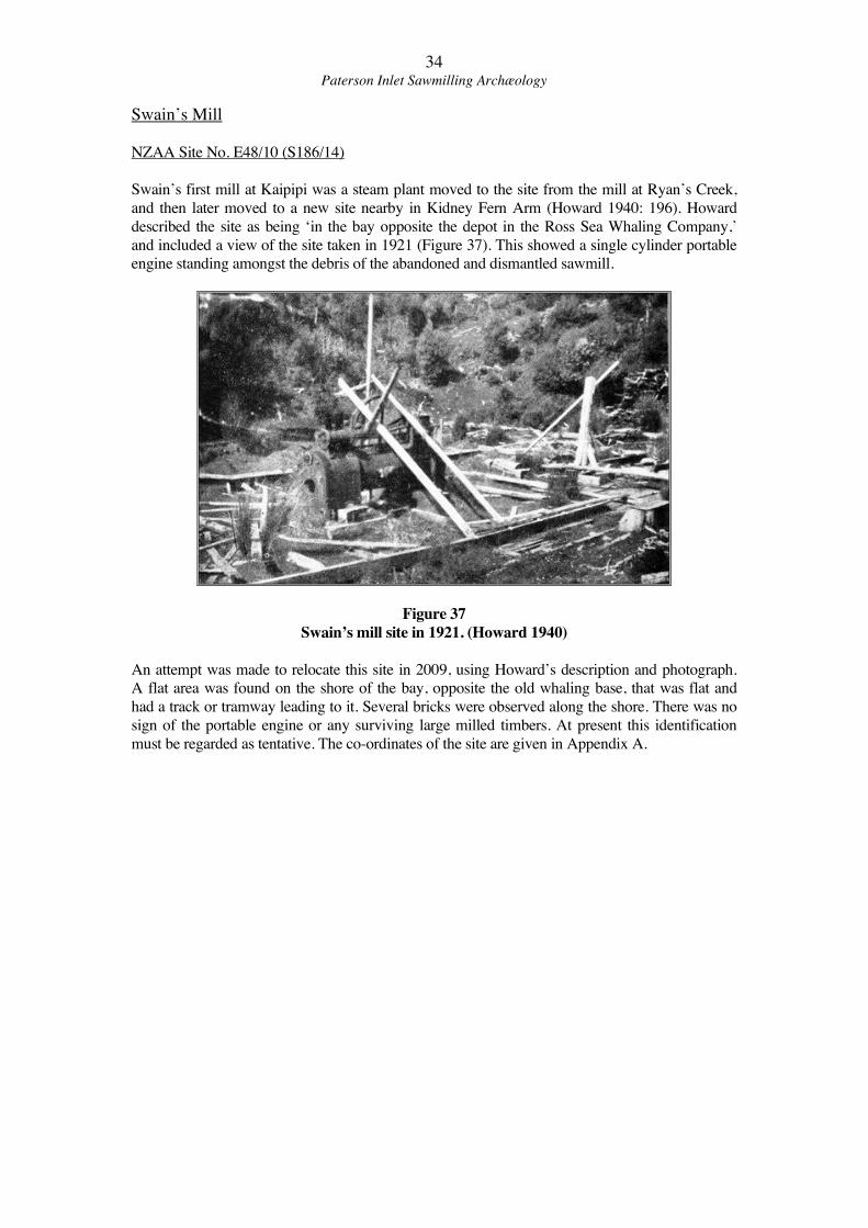
Swain’s first mill at Kaipipi was a steam plant moved to the site from the mill at Ryan’s Creek,
and then later moved to a new site nearby in Kidney Fern Arm (Howard 1940: 196). Howard
described the site as being ‘in the bay opposite the depot in the Ross Sea Whaling Company,’
and included a view of the site taken in 1921 (Figure 37). This showed a single cylinder portable
engine standing amongst the debris of the abandoned and dismantled sawmill.
Figure 37
Swain’s mill site in 1921. (Howard 1940)
An attempt was made to relocate this site in 2009, using Howard’s description and photograph.
A flat area was found on the shore of the bay, opposite the old whaling base, that was flat and
had a track or tramway leading to it. Several bricks were observed along the shore. There was no
sign of the portable engine or any surviving large milled timbers. At present this identification
must be regarded as tentative. The co-ordinates of the site are given in Appendix A.
35Paterson Inlet Sawmilling Archæology
Discussion & Recommendations
The sawmill sites and features discussed in this report provide a good insight into the early
sawmilling industry on Stewart Island. This survey was only a brief overview, and each of the
milling operations described here could be the subject of a more detailed investigation. In
particular, no attempt was made to trace the bush tramway networks that typically radiate out
from such mill sites. Recent work nearby at Maori Beach (Petchey 2009) has shown that such
work can provide a great deal of detail about historic sawmill operations. A number of accounts
have stated that McCallum’s Kaipipi tramlines almost met the Maori Beach tramlines, so an
extensive tramway network is sure to exist in this area.
All of the sites discussed here have potential for public interpretation, as they are on or are close
to the route of the Rakiura Track, and therefore visited on a regular basis. Gallon’s mill is of
particular interest as it was the first mechanised mill on Stewart Island, and enough evidence
survives at the site to enable it to be meaningfully interpreted. Identifiable features include the
wheelpit, tailrace, mill dam and stone revetment. The cutting for McCallum’s tramway through
Gallon’s mill dam can tell a story of change in the local milling industry, with the larger
McCallum operation overlying the earlier water-powered enterprise. The walking track to the
end of the Kaipipi promontory also passes over a cutting for McCallum’s tram (the intervening
distance across Sawmill Bay having been crossed by a wooden trestle), and while this cutting is
presently unmarked, potential exists for these two areas to be tied together in interpretation
material. The whole of this small promontory has archæological potential, with building sites and
cultural plantings present. A detailed archæological survey of this area has not been carried out,
but could be valuable for management of the area in future. At present any earth moving on the
point should be avoided if possible.
The site of Gallon’s sawmill itself has a number of major issues, the most pressing being erosion.
Several sections of the streambank at the mill site and one side of the water wheel pit are
suffering from erosion. This has in part been caused by a tree growing in the stream bank,
causing flood waters to back up and eddy, and this tree had now been cut back. The areas of
damage should ideally be recorded photographically, and then repaired using soil brought in
from outside the site (not taken from the historic borrow pits). A readily identifiable barrier
(geotextile or similar) should be placed beneath and new material, so that the archæological
integrity of the undamaged part of the site is not confused in the future. The surface of Gallon’s
mill site is also somewhat muddy, and increased visitation could cause erosion problems. The
installation of a boardwalk from the existing track up to the dam site should be considered.
The site of Matthews’ & Collins’ mill, tramway and wharf are also potentially very informative.
Although the mill site is not easy to find and is some distance off existing tracks, the presence of
the mill boiler and the portable engine in the inter-tidal zone near the remaining wharf piles
makes it a potentially useful site for public interpretation. The tramway cutting and wharf
represent the transport network of the operation, the mill boiler powered the sawmill itself, and
its is very likely that the Clayton & Shuttleworth portable engine was used to haul logs from the
bush, thus representing the actual logging operation. The use of part of the tramway formation
for the Rakiura Track has interpretation potential, particularly with the close proximity of the
boiler and portable engine, allowing visitors to get a brief but informative glance at the history of
the area. Once again, earth moving in the proximity of the historic features should be avoided,
although the greatest amount of archæological evidence will be at the mill site, which is well
away from both the present and proposed Rakiura Track alignments.
In particular the following recommendations are made:
• Archæological Authorities from the New Zealand Historic Places Trust will be required
for any ground disturbance at sites that pre-date 1900. These include Gallon’s mill site

36Paterson Inlet Sawmilling Archæology
and the promontory at the end of the Kaipipi Road (the probable location of Bullock’s
mill site).
• At all other historic sites (that post-date 1900) any activities that may affect the site will
not need an Archæological Authority, but should still follow relevant DOC processes
including the preparation of an assessment of effects and the involvement of a suitably
qualified heritage specialist.
37Paterson Inlet Sawmilling Archæology
References
Appendices to the Journals of the House of Representatives.
Bradley, K., Egerton, R., Hockly, W. (1994) “Gallon’s Sawmill, Conservation Plan.”
Department of Conservation, Southland Conservancy.
Cyclopedia of New Zealand. Volume 4, Otago & Southland. The Cyclopedia Company Ltd.,
Christchurch.
Department of Conservation (Southland Conservancy) Database of archæological sites.
Hall-Jones, J. (1994) Stewart Island Explored. Craig Printing C. Ltd., Invercargill.
Hector, J. (1863) “ Geological Expedition to the West Coast of Otago , New Zealand.” Otago
Provincial Government Gazette, VI, 1863.
Howard, B. (1940) Rakiura. A History of Stewart Island, New Zealand. A.H. & A.W. Reed,
Dunedin & Wellington.
Mahoney. P. (2006) “Western Southland: Timber & Tramlines.” Department of Conservation.
Otago Witness (Newspaper, Dunedin) 1861, 1862, 1868
Petchey, P.G. (2009) “Maori Beach Sawmilling, Stewart Island/Rakiura.” Report by Southern
Archæology for the Department of Conservation.
Sansom, O. (1982) In the Grip of an Island. Early Stewart Island History. Craig Printing Co.
Ltd., Invercargill.
Southland Deeds Local Index. LINZ, Dunedin.
Maps & files held by Archives New Zealand, Dunedin Regional Office.
• DAFU/18285/D311/42d/ 23/7/5, Sawmill Site 651, McCallum & Co.
• CAMP/D106/38g/S471, Sawmill Site No. 471, John Bragg, 1904.
• CAMP/D106/8c/219/3 Paterson District- Sawmill Map n.d.
• DADE/D206/223b/D2144 Compass Survey of Foot Track from Oban to Kaipipi,
1886
Map & Plans
Land Information New Zealand. All SO numbers are for Southland Land District.
SO 1521 Part of Block XV Paterson District. J. Hay, Feb. 1878
SO 2854 Part of Block XV Paterson District, H.R. Dundas, Sept. 1893
SO 4006 Kaipipi Road extension through Section 1, Blk, I, & Section 191, Blk. XV
Paterson District, P.B. Macdonald, May 1911.
38Paterson Inlet Sawmilling Archæology
Appendix A
GPS co-ordinates of sites recorded in 2009.
Note that these co-ordinates are based on the New Zealand Map Grid as shown on the NZMS
260 E48/D48 map, NOT the new Topo 50 series of maps.
Site NZAA number GPS co-ordinate Comments
Gallon’s mill E48/44 2133710/5356671
Bullock’s mill E48/45 2134276/5356384
McCallum’s mill E48/9 2133530/5356914
McCallum’s tram E48/84 2134236/5356473 Cutting on promontory
Matthews’ & Collins mill E48/12 2131226/5356751
Matthew’s & Collins boilers E48/83 2131047/5356592 Wharf & boilers
Matthews & Collins wharf E48/83 2130944/5356520 Wharf & boilers
Swain’s mill E48/10 2132004/5355184 Not certain ID