palaeomagnetic and anisotropy of magnetic susceptibility
TRANSCRIPT
Geol. Mag. 146 (3 ), 2009, pp. 419–436. c© 2008 Cambridge University Press 419doi:10.1017/S0016756808005827 Printed in the United Kingdom
Palaeomagnetic and anisotropy of magnetic susceptibility databearing on the emplacement of the Western Granite,
Isle of Rum, NW Scotland
M. S. PETRONIS∗†, B. O’DRISCOLL‡§, V. R. TROLL‡, C. H. EMELEUS¶ &J. W. GEISSMAN∗
∗Department of Earth and Planetary Sciences, University of New Mexico, Albuquerque, NM 87131, USA‡Department of Geology, Museum Building, Trinity College, Dublin 2, Ireland
¶Department of Earth Sciences, University of Durham, Science Laboratories, South Road, Durham, DHI 3 LE, UK
(Received 2 February 2008; accepted 8 September 2008; First published online 11 December 2008)
Abstract – The Western Granite is the largest of several granitic bodies around the margin of the RumCentral Igneous Complex. We report palaeomagnetic and anisotropy of magnetic susceptibility (AMS)data that bear on the emplacement and deformation of the Western Granite. The collection includessamples from 27 sites throughout the Western Granite, five sites in adjacent feldspathic peridotite, andtwo sites in intermediate to mafic hybrid contact aureole rocks. Palaeomagnetic data from 22 of the 27sites in the granite provide an in situ group mean D = 213.2◦, I = −69.5◦, α95 = 5.5◦ that is discordantto an early Paleocene reverse polarity expected field (about 184◦, −66◦, α95 = 4.3◦). The discrepancyis eliminated by removing an inferred 15◦ of northwest-side-down tilting about a best fit horizontal tiltaxis trending 040◦. Data from the younger peridotite and hybrid rocks of the Rum Layered Suite providean in situ group mean of D = 182.6◦, I = −64.8◦, α95 = 4.0◦, which is statistically indistinguishablefrom an early Paleocene expected field, and imply no post-emplacement tilting of these rocks sinceremanence acquisition. The inferred tilt recorded in the Western Granite, which did not affect theyounger Layered Suite, suggests that emplacement of the ultrabasic rocks resulted in roof uplift andassociated tilt of the Western Granite to make space for mafic magma emplacement. Magnetic fabricmagnitude and susceptibility parameters yield two subtle groupings in the Western Granite AMS dataset. Group 1 data, defined by rocks from exposures to the east and south, have comparatively highbulk susceptibilities (Kmean, 29.51 × 10⁻³ in SI system), stronger anisotropies (Pj, 1.031) and oblatesusceptibility ellipsoids. Group 2 data, from rocks in the west part of the pluton, have lower valuesof Kmean (15.89 × 10⁻³ SI) and Pj (1.014), and triaxial susceptibility ellipsoids. Magnetic lineationsargue for emplacement of the granite as a tabular sheet from the south–southeast toward the north andwest. Moderate to steeply outward-dipping magnetic foliations, together with deflection of the countryrock bedding in the north, are consistent with doming accompanying magma emplacement.
Keywords: palaeomagnetism, anisotropy of magnetic susceptibility, magma emplacement, Isle ofRum, granite.
1. Introduction
The British Palaeogene Igneous Province (BPIP) hasbeen a key area for the study of igneous processes forwell over a century (e.g. Judd, 1889; Geikie, 1897;Harker, 1904, 1908; Bailey et al. 1924; Richey &Thomas, 1930; Richey, 1932), and research on theprovince has contributed to our understanding ofsubvolcanic magma transport and emplacement pro-cesses. This region has also been noted for its diverseassemblage of magma types, particularly the commonoccurrence of mixed mafic and felsic compositions(Blake et al. 1965; Gamble, 1979; Sparks, 1988; Troll,Donaldson & Emeleus, 2004). In this respect, theorigin and emplacement of felsic magma bodies hasbeen of great interest (Walker, 1975; Meighan, 1979;
†Author for correspondence: [email protected]; now at Environ-mental Geology, Natural Resource Management Department, NewMexico Highlands University, P.O. Box 9000, Las Vegas, NM 87701,USA§School of Physical and Geographical Sciences, Keele University,
Keele ST5 5BG, UK
Thompson, 1982; England, 1992; Gamble, Meighan &McCormick, 1992; Meighan, Fallick & Mccormick,1992; McCormick et al. 1993; Stevenson et al. 2007),and no universally accepted model presently exists toexplain their genesis. The Western Granite on the Isleof Rum (Inner Hebrides, NW Scotland) is the largestof several granitoid bodies around the margin of theRum Igneous Centre, all of which are interpreted aspart of the early felsic updoming and caldera collapsestage (Stage 1) that preceded the intrusion of the RumLayered Suite (Stage 2; Emeleus et al. 1996; Emeleus,1997).
The origin and emplacement history of the WesternGranite is obscured by the paucity of primary intrusivecontacts with the country rocks and lack of mac-roscopic igneous fabrics. Initial work suggested thatthe Western Granite originated through metasomaticalteration of feldspathic sandstones of the ProterozoicTorridonian Group (Black, 1952, 1954). Subsequentinvestigation demonstrated that Black’s proposed con-tinuous transition from sandstone to microgranite does
https://www.cambridge.org/core/terms. https://doi.org/10.1017/S0016756808005827Downloaded from https://www.cambridge.org/core. Uppsala Universitetsbibliotek, on 13 Jul 2021 at 08:31:42, subject to the Cambridge Core terms of use, available at
420 M. S. PETRONIS AND OTHERS
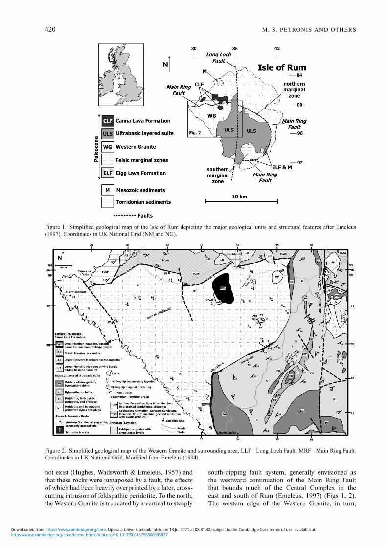
Figure 1. Simplified geological map of the Isle of Rum depicting the major geological units and structural features after Emeleus(1997). Coordinates in UK National Grid (NM and NG).
Figure 2. Simplified geological map of the Western Granite and surrounding area. LLF – Long Loch Fault; MRF – Main Ring Fault.Coordinates in UK National Grid. Modified from Emeleus (1994).
not exist (Hughes, Wadsworth & Emeleus, 1957) andthat these rocks were juxtaposed by a fault, the effectsof which had been heavily overprinted by a later, cross-cutting intrusion of feldspathic peridotite. To the north,the Western Granite is truncated by a vertical to steeply
south-dipping fault system, generally envisioned asthe westward continuation of the Main Ring Faultthat bounds much of the Central Complex in theeast and south of Rum (Emeleus, 1997) (Figs 1, 2).The western edge of the Western Granite, in turn,
https://www.cambridge.org/core/terms. https://doi.org/10.1017/S0016756808005827Downloaded from https://www.cambridge.org/core. Uppsala Universitetsbibliotek, on 13 Jul 2021 at 08:31:42, subject to the Cambridge Core terms of use, available at
Emplacement and deformation of the Western Granite 421
is defined by sea cliffs, whereas to the south andsoutheast it is intruded by ultrabasic intrusive rocks ofStage 2 and marked by extensive intrusion breccias andhybridization. The sole remnants of original WesternGranite contacts with the country rock crop out on thesummit and southern flank of Ard Nev (N57.02, W6.37;Fig. 2), where a presumed roof pendant of ArchaeanLewisian gneiss is intruded by the granite. Apartfrom this, information on the age and emplacementhistory of the Western Granite is provided by a single40Ar−39Ar age spectrum determination on biotite of60.01 ± 0.45 Ma (Chambers, Pringle & Parrish, 2005),apparent geochemical similarities to the rhyodacitesand other rocks belonging to Stage 1 (Dunham, 1968;Donaldson, Troll & Emeleus, 2001), and the cross-cutting contacts of the younger Layered Suite.
To understand the emplacement history and theintrusive geometry of the Western Granite, we carriedout a combined petrographic, palaeomagnetic andAMS (anisotropy of magnetic susceptibility) studyof the Western Granite. Considerable petrologicalvariation within the pluton is shown at the hand sampleand thin-section scale, suggesting that the body mayin fact represent multiple intrusions. Modest, post-emplacement wholescale gentle tilting of the plutonin the late Palaeogene is inferred from discordantpalaeomagnetic data from the granite and is most likelythe result of emplacement of the Layered Suite. Onepreferred interpretation of the AMS data suggests thatthe intrusion has an overall dome-like geometry inmap view, and its major feeder zone may lie to thesouth–southeast of the granite mass in the central partof the island (Fig. 1). We hypothesize that graniteemplacement resulted in a domal geometry to theintrusion and that the AMS and palaeomagnetic datareflect this emplacement style.
2. Geological setting
The Palaeogene Isle of Rum igneous centre developedin two separate stages. During Stage 1, central uplifton a major arcuate fault system, the Main Ring Fault(Bailey, 1945), was accompanied by felsic and mixedfelsic/mafic magmatism and the formation of a calderawhich filled with felsic ash flows, tuffs and breccias(Emeleus, 1997; Troll, Emeleus & Donaldson, 2000).The country rocks are domed over the central complex,while uplift along the ring faults brought masses ofLewisian gneiss and basal members of the TorridonGroup to the present structural levels. Subsequentcaldera subsidence resulted in the preservation ofJurassic sedimentary rocks and Paleocene basalticlavas of the Eigg Lava Formation in the Main RingFault (Fig. 1). Shortly after this movement on theMain Ring Fault, several microgranites were intruded,including the Papadil and Long Loch bodies, aswell as the more extensive Western Granite (Fig. 2).Further uplift probably occurred on the Main Ring Faultsystem following emplacement of the Western Granite.
During the original geological survey of Rum(Harker, 1908), many exposures were identified inwhich the peridotites, troctolites and gabbros in theCentral Intrusion of the Layered Suite had beenintruded by microgranite and porphyritic rhyodacite,from which it was concluded that the felsic rockswere the younger. Wherever the mafic rocks are incontact with felsic rocks, there are spectacular brecciasin which angular to sub-rounded mafic rocks areembedded in a network of veins and dykes of fine- tomedium-grained microgranite. This interpretation waslater challenged, and it is now thought that the brecciasare intrusion breccias, formed when hot mafic magmaschilled against, but also melted or partially meltedand remobilized, silicic country rocks. These wereprincipally microgranite and porphyritic rhyodacite,but also sandstones and feldspathic gneisses (Hughes,Wadsworth & Emeleus, 1957; Hughes, 1960; Dunham,1968; Emeleus, 1997). The relatively low-temperature,rheomorphic silicic melts burst through and fragmentedthe chilled and contracting margins of the mafic intru-sions, locally producing sinuous, rounded liquid–liquidcontacts where still-liquid mafic magma chilled againstthe relatively low-temperature felsic liquids, while insome instances, hybrid rocks were formed when heatedfelsic magma was able to mingle with mafic magma(Emeleus & Troll, in press). Thus, it is now generallyaccepted that the rocks of the Layered Suite post-datethe felsic rocks (Western Granite) of Rum.
Stage 2 commenced with the intrusion of a suiteof basaltic cone-sheets and numerous basaltic dykes,many of which trend NW–NNW, followed by emplace-ment of the Rum Layered Suite (feldspathic peridotites,troctolites and gabbros). In eastern Rum, the maficand ultramafic rocks form prominent, gently dippingmacro-rhythmic layers (generally termed ‘Units’) sometens of metres in thickness, and make up the EasternLayered Intrusion. Layered rocks also crop out in SWRum where they form the Western Layered Intrusion,bordering and intruding the Western Granite (Fig. 1).The Eastern and Western Layered Intrusions areseparated by the Central Intrusion, which is composedof a N–S belt of igneous breccias composed ofblocks and megablocks of feldspathic peridotite and(commonly layered) troctolites enclosed in matrices ofsimilar lithologies. The Central Intrusion is regardedas representing the feeder system for the LayeredSuite and is located along a major N–S fracture, theLong Loch Fault (Emeleus et al. 1996; Emeleus, 1997;O’Driscoll et al. 2007) (Fig. 1).
3. Petrography of the Western Granite
3.a. Silicate mineralogy
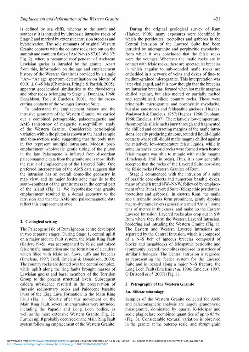
Samples of the Western Granite collected for AMSand palaeomagnetic analysis are largely granophyricmicrogranite, dominated by quartz, K-feldspar andsodic plagioclase (combined quantities of up to 85 %)(Fig. 3). Considerable textural variation is observedin the granite at the outcrop scale, and abrupt grain
https://www.cambridge.org/core/terms. https://doi.org/10.1017/S0016756808005827Downloaded from https://www.cambridge.org/core. Uppsala Universitetsbibliotek, on 13 Jul 2021 at 08:31:42, subject to the Cambridge Core terms of use, available at
422 M. S. PETRONIS AND OTHERS
Figure 3. Representative thin-section photomicrographs of rock textures from the Western Granite.
size variation is common, as are frequent irregularlydistributed concentrations of drusy cavities, whichcontain quartz and calcite (Emeleus, 1997). Mostquartz and K-feldspar in the rock form radiate graphicintergrowths around plagioclase grains, a featureobserved in many samples examined in this study(Fig. 3). Both feldspars usually exhibit turbid grainsurfaces, and partial alteration to aggregates of fine-grained white mica is common. This effect is muchmore pronounced in the western part of the intrusion,while samples collected from the eastern part of theWestern Granite are relatively fresh and do not displayheavy alteration. Mafic phases are principally biotiteand hornblende and make up less than 10 modal %.Interstices are filled in with apatite and chlorite, andopaque grains are also observed. Clinopyroxene is oftenaltered, though Emeleus, Dunham & Thompson (1971)note the presence of relatively fresh ferropigeonite andferroaugite in the NE part of the intrusion. A faciescontaining fayalite occurs in the southern part of theintrusion; this also contained green ferrohedenbergite(Emeleus, 1997). Importantly, no evidence of a fabric,magmatic or solid-state, is observed in the field or inthin-section.
3.b. Oxide mineralogy
Oxide minerals in the Western Granite have distri-butions of opaque grains that are somewhat typical
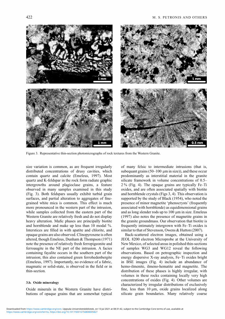
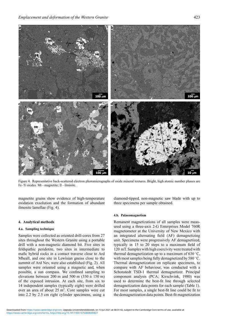
of many felsic to intermediate intrusions (that is,subequant grains (50–100 μm in size)), and these occurpredominantly as interstitial material in the granitesilicate framework in volume concentrations of 0.5–2 % (Fig. 4). The opaque grains are typically Fe–Tioxides, and are often associated spatially with biotiteand hornblende crystals (Figs 3, 4). This observation issupported by the study of Black (1954), who noted thepresence of minor magnetite ‘phenocrysts’ (frequentlyassociated with hornblende) as equidimensional grainsand as long slender rods up to 100 μm in size. Emeleus(1997) also notes the presence of magnetite grains inthe granite groundmass. Our observation that biotite isfrequently intimately intergrown with Fe–Ti oxides issimilar to that of Stevenson, Owens & Hutton (2007).
Back-scattered electron images, obtained using aJEOL 8200 electron Microprobe at the University ofNew Mexico, of selected areas in polished thin-sectionsof samples WG3 and WG12 reveal the followingobservations. Based on petrographic inspection andenergy dispersive X-ray analysis, Fe–Ti oxides brightin BSE images (Fig. 4) include an abundance ofhemo-ilmenite, ilmeno-hematite and magnetite. Thedistribution of these phases is highly irregular, withvolumes in these rocks containing locally very highconcentrations of oxides (Fig. 4). Other volumes arecharacterized by irregular distributions of exclusivelyfine, less than 10 μm, oxide grains localized alongsilicate grain boundaries. Many relatively coarse
https://www.cambridge.org/core/terms. https://doi.org/10.1017/S0016756808005827Downloaded from https://www.cambridge.org/core. Uppsala Universitetsbibliotek, on 13 Jul 2021 at 08:31:42, subject to the Cambridge Core terms of use, available at
Emplacement and deformation of the Western Granite 423
Figure 4. Representative back-scattered electron photomicrographs of oxide mineral textures. Bright, high atomic number phases areFe–Ti oxides. Mt – magnetite; Il – ilminite.
magnetite grains show evidence of high-temperatureoxidation exsolution and the formation of abundantilmenite lamellae (Fig. 4).
4. Analytical methods
4.a. Sampling technique
Samples were collected as oriented drill-cores from 27sites throughout the Western Granite using a portabledrill with a non-magnetic diamond bit. Five sites infeldspathic peridotite, two sites in intermediate tomafic hybrid rocks in a contact traverse close to ArdMheall, and one site in Lewisian gneiss close to thesummit of Ard Nev, were also established (Fig. 2). Allsamples were oriented using a magnetic and, whenpossible, a sun compass. We confined sampling toelevations between 200 m and 500 m (350 ± 150 m)of the exposed intrusion. At each site, from six to14 independent samples (typically eight) were drilledover an area of about 25 m2. Core samples were cutinto 2.2 by 2.5 cm right cylinder specimens, using a
diamond-tipped, non-magnetic saw blade with up tothree specimens per sample obtained.
4.b. Palaeomagnetism
Remanent magnetizations of all samples were meas-ured using a three-axis 2-G Enterprises Model 760Rmagnetometer at the University of New Mexico withan integrated alternating field (AF) demagnetizingunit. Specimens were progressively AF demagnetized,typically in 15 to 20 steps to a maximum field of120 mT. Samples with high coercivity were treated withthermal demagnetization up to a maximum of 630 ◦C,with most samples being fully demagnetized by 580 ◦C.Thermal demagnetization on replicate specimens, tocompare with AF behaviour, was conducted with aSchonstedt TSD-1 thermal demagnetizer. Principalcomponent analysis (PCA; Kirschvink, 1980) wasused to determine the best-fit line through selecteddemagnetization data points for each sample (Table 1).For most samples, a single best-fit line could be fit tothe demagnetization data points. Best-fit magnetization
https://www.cambridge.org/core/terms. https://doi.org/10.1017/S0016756808005827Downloaded from https://www.cambridge.org/core. Uppsala Universitetsbibliotek, on 13 Jul 2021 at 08:31:42, subject to the Cambridge Core terms of use, available at
424 M. S. PETRONIS AND OTHERS
Table 1. Palaeomagnetic data: Isle of Rum, NW Scotland
in situ VGP (in situ)
Site Unit n/N R Dec Inc α95 k Lat Long
Western GraniteWG1∗ WGS 7/7 6.90 176.9 −44.4 9.2 37.82 59.0 179.1WG2 WGS 6/9 5.90 212.0 −50.7 7.0 78.36 56.2 119.3WG3 WG 4/6 3.90 243.3 −73.5 15.7 26.43 57.8 52.4WG4 WG 5/7 4.80 210.9 −67.8 19.3 13.40 70.9 89.5WG11 WG 5/6 4.90 187.0 −70.7 2.3 913.95 85.6 108.2WG12 WG 10/10 9.94 157.1 −61.6 4.1 141.63 69.7 229.0WG13 WG 8/9 7.90 226.8 −79.6 3.2 267.89 66.3 32.4WG14 WG 4/6 3.90 272.4 −67.6 3.5 514.97 39.3 48.4WG15 WG 9/9 8.89 236.9 −66.5 6.1 71.72 55.9 72.4WG16 WG 9/9 8.96 231.3 −67.8 3.6 202.38 59.9 73.3WG17 WG 8/8 7.98 226.8 −65.1 2.9 360.54 60.3 82.7WG18 WG 9/9 8.98 236.3 −71.8 2.9 327.63 60.1 60.1WG19 WG 4/7 3.97 205.1 −64.1 8.5 118.07 70.9 108.8WG20∗ WG 5/5 4.90 6.3 −73.4 11.5 36.38 26.3 350.1WG21 WG 7/9 6.76 67.4 58.6 12.2 25.27 43.9 76.1WG22 WG 9/9 8.94 205.7 −73.7 4.6 124.33 76.3 61.7WG23 WG 7/8 6.95 281.4 −75.7 5.2 118.40 44.3 32.2WG24∗ WG 9/9 8.95 119.8 −68.6 3.9 172.19 55.8 281.5WG25 WG 6/7 5.90 172.3 −64.4 6.7 85.36 78.2 200.7WG26 WG 8/9 7.90 174.3 −52.9 7.9 43.80 66.1 185.5WG27 WG 9/9 8.97 229.8 −71.2 3.4 229.03 63.0 65.0WG28 WG 6/8 5.95 211.6 −56.8 6.9 94.93 61.4 113.4WG29∗ WG 8/8 7.97 287.0 −53.3 3.6 238.73 20.0 51.1WG30 WG 9/9 8.85 201.7 −58.6 7.2 51.86 67.3 125.7WG31# WGWG32 WG 8/9 7.98 231.8 −80.2 2.6 464.12 64.5 30.3WG34 WG 6/6 5.98 176.3 −67.9 3.9 236.11 83.5 194.8
Peridotite and hybrid rocksWG5 PER 9/9 8.90 174.3 −58.6 6.4 59.08 71.9 188.0WG6 PER 8/8 7.90 188.9 −62.9 3.6 204.94 76.2 146.2WG7a PER 7/7 6.90 176.1 −64.3 3.5 250.91 78.8 187.8WG7b PER 5/8 4.90 176.9 −69.2 6.6 108.78 85.4 197.8WG8 PER 7/7 6.90 190.1 −63.7 2.2 624.88 76.7 141.2WG9 HYB 9/9 8.90 173.7 −67.0 3.9 173.70 81.8 203.4WG10 HYB 9/9 8.96 198.2 −65.8 3.5 21.98 75.8 115.2
Site – palaeomagnetic sampling location; n/N – ratio of samples used (n) to samples collected (N) at each site; R – resultant vector length,Dec/Inc – in situ declination and inclination; α95 – 95% confidence interval about the estimated mean direction, assuming a circulardistribution; k – best estimate of (Fisher) precision parameter; corrected VGP Lat/Long – latitude and longitude of the virtual geomagneticpole for the site; ∗ – rejected: lightning struck; “ – rejected: high dispersion (α95 >15 degrees, k < 15); # – excluded from group mean (greaterthan 2 sigma from mean). WGS – satellite Western Granite intrusion.
vectors involved 5 to 18 data points, but as few as 3to as many as 25 were used. Magnetization vectorswith maximum angular deviation values greater than5◦ were not included in site mean calculations. Forless than 10 % of the demagnetization results, it wasnecessary to anchor the magnetization vector to theorigin. Individual sample directions were consideredoutliers and rejected from the site mean calculation ifthe angular distance between the sample direction andthe estimated site mean was greater than 18◦.
4.c. Principles of the AMS technique
An anisotropy of magnetic susceptibility measurementof one rock specimen yields an ellipsoid of magneticsusceptibility (K) defined by the length and orient-ation of its three principal axes, K1 ≥ K2 ≥ K3,which are the three eigenvectors of the susceptibilitytensor (Tarling & Hrouda, 1993). The long axis ofthe magnetic susceptibility ellipsoid, K1, defines themagnetic lineation, while the short axis, K3, definesthe normal to the plane of the magnetic foliation. The
mean magnetic susceptibility (Km) is the arithmeticmean of the principal axes K1, K2 and K3. In addition,the AMS technique defines the degree of magnitudeof the linear (L = K1/K2) and planar (F = K2/K3)fabric components. The technique also quantifies thecorrected degree of anisotropy, Pj = exp (2[(η1 − η)2 +(η2–η)2 + (η3 − η)2]1/2), where η1 = ln K1, η2 = lnK2, η3 = ln K3, and η = ln (K1 + K2 + K3)1/3. Avalue of Pj = 1 describes a perfectly isotropic fabric, a Pj
value of 1.15 describes a sample with 15 % anisotropyand so on. Given the above, Pj values of 0–5 % indicatea weak anisotropy, 5–10 % moderate anisotropy, 10–20 % a strong anisotropy, and > 20 % a very stronganisotropy. The shape of the susceptibility ellipsoid (Tj)(with Tj = (2lnk2 – lnk1 – lnk3)/(lnk1 – lnk3): Jelinek,1981) ranges from +1 where purely oblate to −1where purely prolate, and is triaxial between bothend-members.
We measured the AMS of 470 specimens preparedfrom samples collected at 27 sites distributed across theWestern Granite, of which 401 yield interpretable res-ults (Table 2). In addition, we measured the AMS of 99
https://www.cambridge.org/core/terms. https://doi.org/10.1017/S0016756808005827Downloaded from https://www.cambridge.org/core. Uppsala Universitetsbibliotek, on 13 Jul 2021 at 08:31:42, subject to the Cambridge Core terms of use, available at
Em
placementand
deformation
oftheW
esternG
ranite425
Table 2. Anisotropy of magnetic susceptibility data from the Western Granite, NW Scotland
British Grid Ordnance Survey
SiteRocktype No. N Km
K1(in situ)
K3(in situ)
K1(Cor)
K3(Cor) L F P Pj T Sp Latitude Longitude Elev (m)
WG1 WGS 10 13 68.63 297\3 180\83 7\9 291\79 1.021 1.015 1.037 1.037 −0.153 P 57.0089 6.3423 190WG2∗ WGS 10 10 62.87 45\16 160\56 41\15 175\69 1.007 1.024 1.030 1.032 0.561 O 57.0077 6.3407 190WG3 WG 9 14 74.96 159\6 251\23 160\18 256\16 1.009 1.028 1.038 1.039 0.492 O 57.0032 6.3578 250WG4 WG 9 11 36.08 340\10 245\25 160\2 251\20 1.009 1.019 1.028 1.029 0.378 O 57.0051 6.3601 255WG5# PER 0 12 350WG6 PER 16 19 18.87 140\23 306\66 140\36 310\51 1.023 1.007 1.031 1.032 −0.506 P 56.9961 6.3650 350WG7_a PER 17 22 15.54 149\29 308\59 151\42 311\44 1.010 1.052 1.062 1.067 0.661 O 56.9961 6.3650 350WG7_b# PER 19 19 15.19 123\58 293\31 115\70 296\17 1.005 1.005 1.010 1.010 0.032 O 56.9961 6.3650 340WG8 PER 12 13 55.59 89\20 332\51 85\28 329\36 1.006 1.014 1.020 1.020 0.367 O 56.9964 6.3655 330WG9 HYB 9 14 90.33 35\12 291\48 33\9 296\34 1.008 1.012 1.021 1.021 0.182 O 56.9963 6.3666 350WG10 HYB 18 21 51.55 225\1 316\20 225\1 316\5 1.008 1.023 1.031 1.032 0.466 O 56.9966 6.3668 360WG11 WG 12 12 29.96 70\39 319\24 59\43 319\9 1.013 1.003 1.017 1.018 −0.583 P 56.9964 6.3685 380WG12∗ WG 21 22 15.74 159\63 50\10 176\74 47\10 1.004 1.010 1.014 1.014 0.484 O 57.0140 6.3805 365WG13 WG 10 12 15.83 121\16 219\26 216\19 227\27 1.010 1.005 1.015 1.015 −0.287 P 57.0099 6.4050 270WG14 WG 14 15 15.22 255\56 4\12 269\49 3\2 1.002 1.012 1.014 1.015 0.756 O 57.0102 6.4107 280WG15 WG 17 18 9.872 206\22 308\28 212\26 309\13 1.009 1.002 1.011 1.012 −0.597 P 57.0112 6.4128 230WG16 WG 17 18 15.07 304\45 177\31 306\32 185\42 1.006 1.012 1.018 1.018 0.380 O 57.0081 6.4136 320WG17 WG 15 18 4.36 257\8 160\41 258\1 168\54 1.004 1.004 1.008 1.008 −0.053 P 57.0053 6.4216 310WG18 WG 15 17 14.78 285\46 139\39 290\35 140\54 1.003 1.005 1.008 1.009 0.288 O 57.0027 6.4280 290WG19∗ WG 11 16 6.95 236\7 123\74 237\5 55\86 1.003 1.008 1.011 1.011 0.428 O 56.9993 6.4342 250WG20 WG 16 18 13.96 306\61 100\26 309\48 94\38 1.006 1.007 1.013 1.013 0.026 O 57.0000 6.4341 250WG21 WG 11 15 19.31 107\65 232\15 83\75 236\13 1.002 1.007 1.009 1.009 0.467 O 57.0012 6.4411 200WG22 WG 15 18 21.41 244\33 146\13 251\28 147\28 1.006 1.010 1.016 1.017 0.283 O 57.0130 6.3780 300WG23 WG 15 18 17.38 322\33 193\44 322\20 208\51 1.008 1.029 1.038 1.039 0.560 O 57.0094 6.3754 310WG24 WG 18 20 20.73 358\30 227\49 354\20 244\47 1.003 1.010 1.013 1.014 0.561 O 57.0062 6.3673 310WG25∗ WG 15 16 35.08 145\26 272\52 146\39 282\40 1.003 1.027 1.030 1.033 0.788 O 56.9767 6.3893 50WG26 WG 22 23 17.79 274\6 21\70 94\4 355\60 1.005 1.014 1.019 1.020 0.496 O 56.9797 6.3941 150WG27 WG 13 15 49.82 308\74 121\15 312\61 119\29 1.011 1.018 1.030 1.030 0.218 O 56.9822 6.4004 170WG28# WG 0 16 150WG29 WG 18 18 7.722 294\41 199\6 297\29 201\13 1.002 1.005 1.007 1.007 0.533 O 56.9962 6.4121 210WG30 WG 22 24 40.46 187\11 303\67 290\19 308\52 1.006 1.013 1.019 1.019 0.361 O 56.9974 6.3712 400WG31∗ WG 11 15 21.58 325\9 222\56 145\4 244\54 1.003 1.012 1.015 1.016 0.637 O 56.9996 6.3731 400WG32∗ WG 20 20 10.53 13\59 177\30 359\50 184\41 1.002 1.009 1.010 1.011 0.698 O 57.0067 6.3782 450WG33 PcGn 12 14 27.54 162\42 345\48 169\54 339\34 1.056 1.083 1.144 1.145 0.190 O 57.0021 6.3708 500WG34 WG 17 17 10.16 350\40 248\14 345\29 251\8 1.003 1.009 1.012 1.013 0.527 O 57.0018 6.3716 530
Site – AMS sampling site; No. – number of samples collected at each site; N – number of accepted specimens at each site, typically, one to three specimens per sample; Km – magnitude of susceptibility(in 10E-3 SI); K1 (in situ) – in situ azimuth and plunge (in degrees) of magnetic lineation; K3 (in situ) – in situ azimuth and plunge (in degrees) of normal to magnetic foliation plane; K1 (Cor) and K3(Cor) – tilt corrected K1 and K3 based on paleomagnetic data; L – magnetic lineation ((K1–K2)/Km); F – magnetic foliation ((K2–K3)/Km); P – anisotropy degree (K1/K3); Pj – magnitude of anisotropy,corrected anisotropy (Jelinek, 1981); T – shape parameter (Jelinek, 1981). Sp – shape: P – prolate shape; O – oblate shape; # – rejected site (high dispersion); ∗ – K1–K2 confidence ellipse overlap (girdle),inferred magma flow direction of low confidence; WGS – satellite Western Granite intrusion; WG – Western Granite; PER – Peridotite; PcGn – Precambrian gneiss; HYB – hybrid.
https://ww
w.cam
bridge.org/core/terms. https://doi.org/10.1017/S0016756808005827
Dow
nloaded from https://w
ww
.cambridge.org/core. U
ppsala Universitetsbibliotek, on 13 Jul 2021 at 08:31:42, subject to the Cam
bridge Core terms of use, available at
426 M. S. PETRONIS AND OTHERS
Table 3. Early Tertiary palaeomagnetic poles for northwest Scotland
Expected direction
Rock type, locationPole
Latitude (N)Longitude
(E) dp dm A95 KAge(Ma) Dec Inc Reference
Northern England, Skye lavas 71.5 165.2 2.8 3.8 57.5 356.6 58.0 1Northern England, Cleveland- 75.0 240.0 5.5 5.5 58.5 21.1 66.4 2
Armathwaite dykeRhum and Canna igneous rocks 81.4 181.9 3.2 3.9 59.0 1.9 66.1Scotland, dy ke swarm, Skye 82.5 158.0 2.1 2.5 59.0 356.9 67.0 3UK Ardnamurchan igneous complex 77.0 175.0 3.3 4.2 59.5 0.4 62.6 4Scotland, Mull lavas 72.2 168.3 3.0 4.1 62.0 357.9 58.5 5Synthetic poles 81.4 168.3 4.2 57.0 55 358.8 66.1 6
80.5 188.9 4.3 48.8 60 3.7 65.6 679.8 209.5 3.6 68.0 65 9.0 66.0 6
References: 1 – Willson, Hall & Dagley, 1972; 2 – Giddings, Tarling & Thomas, 1974; 3 – Dagley & Mussett, 1981; 4 – Dagley, Mussett &Skelhorn, 1984; 5 – Hall, Wilson & Dagley, 1977; 6 – Besse & Courtillot, 2002.Semi-major (dm) and semi-minor (dp) axes of the confidence limits about the magnetic pole. Dec – declination; Inc – inclination; A95 – 95%confidence limit about the pole; K – best estimate of (Fisher) precision parameter.
specimens from samples at seven sites in the peridotiteand hybrid rocks of which 73 yield interpretable results.All sample sites were collected away from faults andfractures and were precisely positioned using GPS(Table 2). AMS measurements were performed on aKappabridge KLY-4S, operating at low alternating field3.7 × 10−5 T (300 A/m) at 875 Hz at the University ofNew Mexico Paleomagnetism laboratory.
5. Results
5.a. Palaeomagnetic results
5.a.1. General demagnetization behaviour
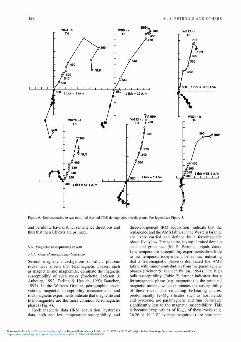
Of the 27 sample sites in the Western Granite, 26 sitesyield interpretable results (Table 1). The one rejectedsite (WG31) did not yield stable end-point behaviourand appears to have been lightning-struck. All sevensites in the peridotite and hybrid rocks yielded inter-pretable results. Overall, progressive alternating fieldresponse of all rocks is characterized by high-qualityresults (Fig. 5), with a linear trajectory defined over abroad range of peak fields. Duplicate specimens treatedwith thermal demagnetization yielded directional datasimilar to those resolved in AF demagnetization(Fig. 6). In general, most samples contain a single char-acteristic remanent magnetization (ChRM) that is wellgrouped at the site level, but some samples also containadditional magnetizations, depending on rock type, thatare readily randomized by 10 mT or by 250 ◦C (Figs5, 6). We interpret these magnetization componentsas low-coercivity viscous overprints (VRM). After re-moving the VRM, the ChRM, which we interpret as theprimary thermal remanent magnetization (TRM), de-cays along a roughly univectoral path to the origin withless than 10 % of the NRM intensity remaining aftertreatment in 120 mT fields or by 600 ◦C (Figs 5, 6).
5.a.2. Palaeomagnetism
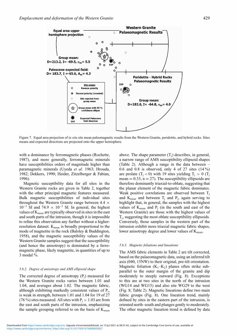
Of the 26 interpretable sites, 22 yield in situ reversepolarity mean directions (after inverting WG21 through
the origin) of south to southwest declination andmoderate to steep inclinations that are well grouped(17 sites with α95 < 10◦) at the site level and providean overall group mean D = 213.2◦, I = −69.5◦, R =21.36, α95 = 5.5◦, k = 33.2 (ASD = 14.05◦) that isdiscordant, at 95 % confidence, to an early Paleoceneexpected field D = 183.7◦, I = −65.6◦, A95 = 4.3◦
based on a 60 Ma synthetic palaeomagnetic pole (Besse& Courtillot, 2002) (Fig. 7; Table 3). The discordantgroup mean is restored to the Paleocene expected fielddirection by removing an inferred 15◦ of northwest-side-down tilting about a best-fit horizontal tilt axistrending 040◦.
All palaeomagnetic data from the peridotite andhybrid rocks yield in situ reverse polarity results ofsouth declination and moderate negative inclinationsthat are very well grouped (five sites with α95 < 4◦)at the site level and provide an overall group meanD = 182.6◦, I =−64.8◦, R = 6.9741, α95 = 4.0◦, k =269.9, which is statistically indistinguishable from anearly Paleocene expected field D = 183.7◦, I = −65.6◦
(Besse & Courtillot, 2002) (Fig. 7).
5.a.3. Field test
To evaluate the antiquity of the magnetization, apalaeomagnetic contact test was conducted at apartially exposed margin of the intrusion wherefeldspathic peridotite is emplaced into the WesternGranite just northeast of Ard Mheall (Fig. 2). Due toexposure limitations, an ideal contact test could not beperformed; however, a modified test was attempted.We established sampling sites in the feldspathicperidotite at a distance of about 50 m from the inferredcontact with the granite, and progressively closer tothe intrusion. In total, five sites were established infeldspathic peridotite, two sites in hybrid rocks, and onesite in the granite. The granite–peridotite contact is nota simple baked intrusive contact; rather it is a complexintrusion breccia, consisting of a narrow (< 10 m) zoneof hybrid rocks that are a mixture of felsic and maficmaterial enveloping blocks of felsic and mafic rocks
https://www.cambridge.org/core/terms. https://doi.org/10.1017/S0016756808005827Downloaded from https://www.cambridge.org/core. Uppsala Universitetsbibliotek, on 13 Jul 2021 at 08:31:42, subject to the Cambridge Core terms of use, available at

Emplacement and deformation of the Western Granite 427
Figure 5. Representative in situ modified AF demagnetization diagrams (Zijderveld, 1967; Roy & Park, 1974). Solid (open) symbolsrepresent the projection onto the horizontal (true vertical) plane. AF demagnetization steps are given in milliTesla and thermaldemagnetization steps in degrees Celsius. Typically, AF and thermal demagnetization (TH) results from two specimens of the samesample are shown for comparison for some samples. See Figure 6 for TH demagnetization diagrams. Diagrams are designated by aSite number (e.g. WG13), method of treatment (AF or TH), and rock type. Intensity (A/m), is shown along one axis for each sample;each tick equals indicated intensity.
from < 1 cm to > 1 m in diameter. This zone reflectspartial melting of the granite due to emplacementof the mafic peridotite (Greenwood, Donaldson &Emeleus, 1990; Emeleus & Troll, in press). Fromwest to east, progressively closer to the peridotitecontact zone, the granite yields mean directions forWG11 (187.8◦, −70.0◦), within the hybrid rocks,WG9 (173.7◦, −67.0◦) and WG10 (198.2◦, −65.8◦),and in the peridotite WG8 (190.1◦, −63.7◦), WG7b
(176.9◦, −69.2◦), WG7a (176.1◦, −64.3◦), WG6(188.9◦, −62.9◦), WG5 (174.3◦, −58.6◦). Overall,the remanence directions in the granite progressivelyshallow and become more south-directed, and moresimilar to those characteristic of the peridotite as thecontact is approached. Although the data do not define astrict positive contact test, we interpret the progressivechange in direction from cross-cutting feldspathicperidotite to host granite to indicate that the granite
https://www.cambridge.org/core/terms. https://doi.org/10.1017/S0016756808005827Downloaded from https://www.cambridge.org/core. Uppsala Universitetsbibliotek, on 13 Jul 2021 at 08:31:42, subject to the Cambridge Core terms of use, available at
428 M. S. PETRONIS AND OTHERS
Figure 6. Representative in situ modified thermal (TH) demagnetization diagrams. For legend see Figure 5.
and peridotite have distinct remanence directions andthus that their ChRMs are primary.
5.b. Magnetic susceptibility results
5.b.1. General susceptibility behaviour
Several magnetic investigations of silicic plutonicrocks have shown that ferrimagnetic phases, suchas magnetite and maghemite, dominate the magneticsusceptibility of such rocks (Rochette, Jackson &Aubourg, 1992; Tarling & Hrouda, 1993; Bouchez,1997). In the Western Granite, petrographic obser-vations, magnetic susceptibility measurements androck magnetic experiments indicate that magnetite andtitanomagnetite are the most common ferromagneticphases (Fig. 4).
Rock magnetic data (IRM acquisition, hysteresisdata, high and low temperature susceptibility, and
three-component IRM acquisition) indicate that theremanence and the AMS fabrics in the Western Graniteare likely carried and defined by a ferromagneticphase, likely low-Ti magnetite, having a limited domainstate and grain size (M. S. Petronis, unpub. data).Low-temperature susceptibility experiments show littleto no temperature-dependent behaviour, indicatingthat a ferromagnetic phase(s) dominated the AMSfabric with minor contribution from the paramagneticphases (Richter & van der Pluijm, 1994). The highbulk susceptibility (Table 2) further indicates that aferromagnetic phase (e.g. magnetite) is the principalmagnetic mineral which dominates the susceptibilityof these rocks. The remaining Fe-bearing phases,predominantly Fe–Mg silicates such as hornblendeand pyroxene, are paramagnetic and thus contributesignificantly less to the magnetic susceptibility. Thisis because large values of Kmean of these rocks (e.g.26.26 × 10−3 SI average magnitude) are consistent
https://www.cambridge.org/core/terms. https://doi.org/10.1017/S0016756808005827Downloaded from https://www.cambridge.org/core. Uppsala Universitetsbibliotek, on 13 Jul 2021 at 08:31:42, subject to the Cambridge Core terms of use, available at
Emplacement and deformation of the Western Granite 429
Figure 7. Equal area projection of in situ site mean paleomagnetic results from the Western Granite, peridotite, and hybrid rocks. Sitesmeans and expected directions are projected onto the upper hemisphere.
with a dominance by ferromagnetic phases (Rochette,1987), and more generally, ferromagnetic mineralshave susceptibilities orders of magnitude higher thanparamagnetic minerals (Uyeda et al. 1963; Hrouda,1982; Dekkers, 1990; Heider, Zitzelberger & Fabian,1996).
Magnetic susceptibility data for all sites in theWestern Granite rocks are given in Table 2, togetherwith the other principal magnetic features measured.Bulk magnetic susceptibilities of individual sitesthroughout the Western Granite range between 4.4 ×10⁻³ SI and 74.9 × 10⁻³ SI. In general, the highestvalues of Kmean are typically observed in sites in the eastand south parts of the intrusion, though it is impossibleto refine this observation any further without a higher-resolution dataset. Kmean is broadly proportional to themode of magnetite in the rock (Balsley & Buddington,1958), and the magnetic susceptibility values of theWestern Granite samples suggest that the susceptibility(and hence the anisotropy) is dominated by a ferro-magnetic phase, likely magnetite, in quantities of up to3 modal %.
5.b.2. Degree of anisotropy and AMS ellipsoid shape
The corrected degree of anisotropy (Pj) measured forthe Western Granite rocks varies between 1.01 and1.04, and averages about 1.02. The magnetic fabric,although exhibiting markedly consistent values of Pj,is weak in strength, between 1.01 and 1.04 for 19 of 27(76 %) sites measured. All sites with Pj > 1.03 are fromthe east and south parts of the intrusion, emphasizingthe sample grouping referred to on the basis of Kmean
above. The shape parameter (Tj) describes, in general,a narrow range of AMS susceptibility ellipsoid shapes(Table 2). Although a range in the data between –0.6 and 0.8 is observed, only 4 of 27 sites (14 %)are prolate (Tj < 0) with 19 sites yielding Tj > 0 (Tj
mean = 0.33, n = 27). The susceptibility ellipsoids aretherefore dominantly triaxial-to-oblate, suggesting thatthe planar element of the magnetic fabric dominates.Weak positive correlations are observed between Tj
and Kmean and between Tj and Pj, again serving tohighlight that, in general, the samples with the highestvalues of Kmean and Pj (in the south and east of theWestern Granite) are those with the highest values ofTj, suggesting the most oblate susceptibility ellipsoids.Conversely, those samples in the western part of theintrusion exhibit more triaxial magnetic fabric shapes,lower anisotropy degree and lower values of Kmean.
5.b.3. Magnetic foliations and lineations
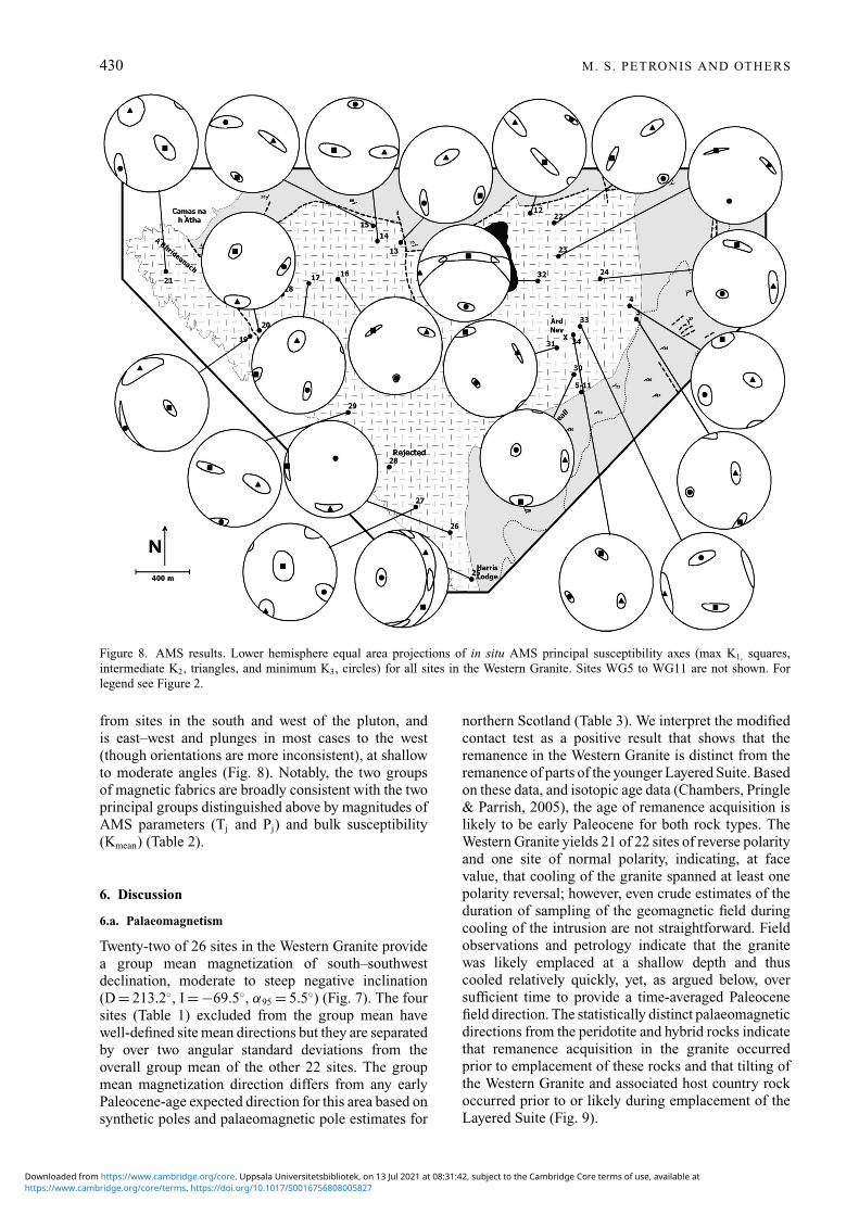
The AMS fabric elements in Table 2 are tilt corrected,based on the palaeomagnetic data, using an inferred tiltaxis (040, 15NW) to their original, pre-tilt orientation.Magnetic foliation (K1–K2) planes often strike sub-parallel to the outer margin of the granite and dipmoderately to steeply outward (Fig. 8). Exceptionsto this are at two sites in the north of the intrusion(WG14 and WG15) and also site WG29 to the west(Fig. 8; Table 2). Magnetic lineations define two mainfabric groups (Fig. 8). One lineation trend, mainlydefined by sites in the eastern part of the intrusion, isoriented north–south and plunges gently to moderately.The other magnetic lineation trend is defined by data
https://www.cambridge.org/core/terms. https://doi.org/10.1017/S0016756808005827Downloaded from https://www.cambridge.org/core. Uppsala Universitetsbibliotek, on 13 Jul 2021 at 08:31:42, subject to the Cambridge Core terms of use, available at
430 M. S. PETRONIS AND OTHERS
Figure 8. AMS results. Lower hemisphere equal area projections of in situ AMS principal susceptibility axes (max K1, squares,intermediate K2, triangles, and minimum K3, circles) for all sites in the Western Granite. Sites WG5 to WG11 are not shown. Forlegend see Figure 2.
from sites in the south and west of the pluton, andis east–west and plunges in most cases to the west(though orientations are more inconsistent), at shallowto moderate angles (Fig. 8). Notably, the two groupsof magnetic fabrics are broadly consistent with the twoprincipal groups distinguished above by magnitudes ofAMS parameters (Tj and Pj) and bulk susceptibility(Kmean) (Table 2).
6. Discussion
6.a. Palaeomagnetism
Twenty-two of 26 sites in the Western Granite providea group mean magnetization of south–southwestdeclination, moderate to steep negative inclination(D = 213.2◦, I = −69.5◦, α95 = 5.5◦) (Fig. 7). The foursites (Table 1) excluded from the group mean havewell-defined site mean directions but they are separatedby over two angular standard deviations from theoverall group mean of the other 22 sites. The groupmean magnetization direction differs from any earlyPaleocene-age expected direction for this area based onsynthetic poles and palaeomagnetic pole estimates for
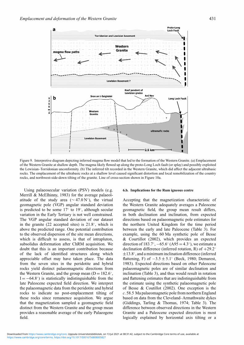
northern Scotland (Table 3). We interpret the modifiedcontact test as a positive result that shows that theremanence in the Western Granite is distinct from theremanence of parts of the younger Layered Suite. Basedon these data, and isotopic age data (Chambers, Pringle& Parrish, 2005), the age of remanence acquisition islikely to be early Paleocene for both rock types. TheWestern Granite yields 21 of 22 sites of reverse polarityand one site of normal polarity, indicating, at facevalue, that cooling of the granite spanned at least onepolarity reversal; however, even crude estimates of theduration of sampling of the geomagnetic field duringcooling of the intrusion are not straightforward. Fieldobservations and petrology indicate that the granitewas likely emplaced at a shallow depth and thuscooled relatively quickly, yet, as argued below, oversufficient time to provide a time-averaged Paleocenefield direction. The statistically distinct palaeomagneticdirections from the peridotite and hybrid rocks indicatethat remanence acquisition in the granite occurredprior to emplacement of these rocks and that tilting ofthe Western Granite and associated host country rockoccurred prior to or likely during emplacement of theLayered Suite (Fig. 9).
https://www.cambridge.org/core/terms. https://doi.org/10.1017/S0016756808005827Downloaded from https://www.cambridge.org/core. Uppsala Universitetsbibliotek, on 13 Jul 2021 at 08:31:42, subject to the Cambridge Core terms of use, available at
Emplacement and deformation of the Western Granite 431
Figure 9. Interpretive diagram depicting inferred magma flow model that led to the formation of the Western Granite. (a) Emplacementof the Western Granite at shallow depth. The magma likely flowed up along the proto-Long Loch fault (or splay) and possibly exploitedthe Lewisian–Torridonian unconformity. (b) The inferred tilt recorded in the Western Granite, which did affect the adjacent ultrabasicrocks. The emplacement of the ultrabasic rocks at a shallow level caused significant distortion and local remobilization of the countryrocks, and northwest-side-down tilting of the granite. Line of cross-section shown in Figure 10a.
Using palaeosecular variation (PSV) models (e.g.Merrill & McElhinny, 1983) for the average palaeol-atitude of the study area (∼ 47.0 N◦), the virtualgeomagnetic pole (VGP) angular standard deviationis predicted to be some 17◦ to 19◦, although secularvariation in the Early Tertiary is not well constrained.The VGP angular standard deviation of our datasetin the granite (22 accepted sites) is 21.8◦, which isabove the predicted range. One potential contributionto the observed dispersion of the site mean directions,which is difficult to assess, is that of intrapluton,subsolidus deformation after ChRM acquisition. Wedoubt that this is an important contribution becauseof the lack of identified structures along whichappreciable offset may have taken place. The datafrom the seven sites in the peridotite and hybridrocks yield distinct palaeomagnetic directions fromthe Western Granite, and the group mean (D = 182.6◦,I =−64.8◦) is statistically indistinguishable from thelate Paleocene expected field direction. We interpretthe palaeomagnetic data from the peridotite and hybridrocks to indicate no post-emplacement tilting ofthese rocks since remanence acquisition. We arguethat the magnetization sampled a geomagnetic fielddistinct from the Western Granite and the group meanprovides a reasonable average of the early Palaeogenefield.
6.b. Implications for the Rum igneous centre
Accepting that the magnetization characteristic ofthe Western Granite adequately averages a Paleocenegeomagnetic field, the group mean result differs,in both declination and inclination, from expecteddirections based on palaeomagnetic pole estimates forthe northern United Kingdom for the time periodbetween the early and late Paleocene (Table 3). Forexample, using the 60 Ma synthetic pole of Besse& Courtillot (2002), which provides an expecteddirection of 183.7◦, −65.6◦ (A95 = 4.3◦), we estimate adeclination difference (inferred rotation, R) of +29.2◦
±13.8◦, and a minimum inclination difference (inferredflattening, F) of −3.5 ± 5.1◦ (Beck, 1980; Demarest,1983). Expected directions based on other Paleocenepalaeomagnetic poles are of similar declination andinclination (Table 3), and thus would result in rotationand flattening estimates that are indistinguishable fromthe estimate using the synthetic palaeomagnetic poleof Besse & Coutillot (2002). One exception is thec. 58.5 Ma palaeomagnetic pole from northern Englandbased on data from the Cleveland–Armathwaite dykes(Giddings, Tarling & Thomas, 1974; Table 3). Thedifference between observed directions in the WesternGranite and a Paleocene expected direction is mostlogically explained by horizontal axis tilting or a
https://www.cambridge.org/core/terms. https://doi.org/10.1017/S0016756808005827Downloaded from https://www.cambridge.org/core. Uppsala Universitetsbibliotek, on 13 Jul 2021 at 08:31:42, subject to the Cambridge Core terms of use, available at
432 M. S. PETRONIS AND OTHERS
combination of moderate clockwise vertical axisrotation and tilting. We note that simple clockwiserotation does not account for the modest inclinationdiscordance (Fig. 7). About 15◦ of northwest-side-down tilt about a northeast-trending (040◦) horizontaltilt axis fully explains the discrepancy and is consistentwith field relations and emplacement models of theRum Central Complex (Emeleus et al. 1996) (Fig. 9).The inferred tilt we conclude to be recorded in theWestern Granite is consistent with a cause and effectrelationship, particularly when considering the fieldrelations between the granite and the ultrabasic rocks.We argue that the emplacement of the ultrabasic rocksat a shallow level caused roof uplift and associatedtilting of the Western Granite, providing space for maficmagma emplacement (Fig. 9).
6.c. Anisotropy of magnetic susceptibility
AMS studies have been successfully applied to theshallow-level intrusions of the British PalaeogeneIgneous Province over the past several years (e.g.Geoffrey, Olivier & Rochette, 1997; O’Driscoll et al.2006; Stevenson et al. 2007). The latter two of thesestudies questioned the validity of long-standing ring-dyke models in the Ardnamurchan (NW Scotland) andEastern Mourne (Northern Ireland) igneous centres,respectively. In particular, Stevenson et al. (2007)interpreted gently outward-dipping magnetic fabricsin the Eastern Mourne granite pluton, even close tocontacts, as reflecting a forceful laccolithic style ofemplacement. This laccolith model is supported byfield evidence for deflection and uplift of country rockbedding close to the intrusion margins. Conversely,O’Driscoll et al. (2006) interpreted consistentlyinward-plunging magnetic lineations, inward-dippingcontacts and inward-dipping magmatic layering in themafic Great Eucrite of Centre 3, Ardnamurchan asreflecting a lopolithic geometry. Geoffrey, Olivier &Rochette (1997) found that magnetic foliations in theWestern Red Hills granite sheets on the Isle of Skye ig-neous centre dip gently yet steepen to outward dips ap-proaching the outer wall of each intrusion. The authorsinterpreted this fabric as a post-injection magmaticfabric, indicative of upward-directed magma pressure.Geoffrey, Olivier & Rochette (1997), however, did notdispute the established ring-dyke emplacement mech-anism, and accepted that the contacts of the WesternRed Hills granite were near vertical (after Bell, 1979).
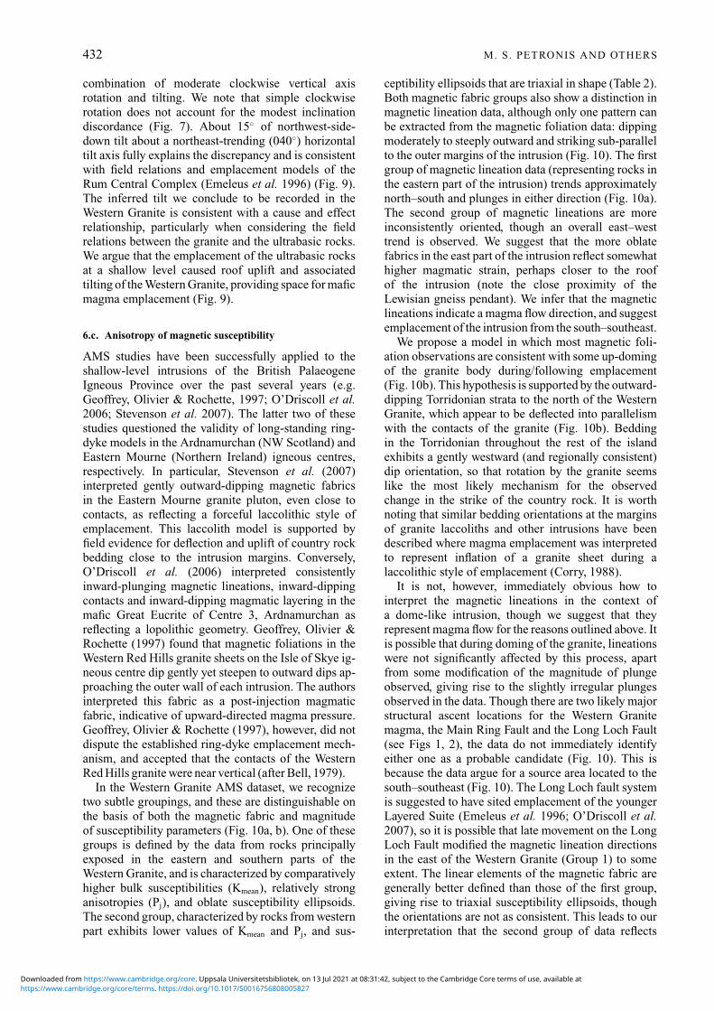
In the Western Granite AMS dataset, we recognizetwo subtle groupings, and these are distinguishable onthe basis of both the magnetic fabric and magnitudeof susceptibility parameters (Fig. 10a, b). One of thesegroups is defined by the data from rocks principallyexposed in the eastern and southern parts of theWestern Granite, and is characterized by comparativelyhigher bulk susceptibilities (Kmean), relatively stronganisotropies (Pj), and oblate susceptibility ellipsoids.The second group, characterized by rocks from westernpart exhibits lower values of Kmean and Pj, and sus-
ceptibility ellipsoids that are triaxial in shape (Table 2).Both magnetic fabric groups also show a distinction inmagnetic lineation data, although only one pattern canbe extracted from the magnetic foliation data: dippingmoderately to steeply outward and striking sub-parallelto the outer margins of the intrusion (Fig. 10). The firstgroup of magnetic lineation data (representing rocks inthe eastern part of the intrusion) trends approximatelynorth–south and plunges in either direction (Fig. 10a).The second group of magnetic lineations are moreinconsistently oriented, though an overall east–westtrend is observed. We suggest that the more oblatefabrics in the east part of the intrusion reflect somewhathigher magmatic strain, perhaps closer to the roofof the intrusion (note the close proximity of theLewisian gneiss pendant). We infer that the magneticlineations indicate a magma flow direction, and suggestemplacement of the intrusion from the south–southeast.
We propose a model in which most magnetic foli-ation observations are consistent with some up-domingof the granite body during/following emplacement(Fig. 10b). This hypothesis is supported by the outward-dipping Torridonian strata to the north of the WesternGranite, which appear to be deflected into parallelismwith the contacts of the granite (Fig. 10b). Beddingin the Torridonian throughout the rest of the islandexhibits a gently westward (and regionally consistent)dip orientation, so that rotation by the granite seemslike the most likely mechanism for the observedchange in the strike of the country rock. It is worthnoting that similar bedding orientations at the marginsof granite laccoliths and other intrusions have beendescribed where magma emplacement was interpretedto represent inflation of a granite sheet during alaccolithic style of emplacement (Corry, 1988).
It is not, however, immediately obvious how tointerpret the magnetic lineations in the context ofa dome-like intrusion, though we suggest that theyrepresent magma flow for the reasons outlined above. Itis possible that during doming of the granite, lineationswere not significantly affected by this process, apartfrom some modification of the magnitude of plungeobserved, giving rise to the slightly irregular plungesobserved in the data. Though there are two likely majorstructural ascent locations for the Western Granitemagma, the Main Ring Fault and the Long Loch Fault(see Figs 1, 2), the data do not immediately identifyeither one as a probable candidate (Fig. 10). This isbecause the data argue for a source area located to thesouth–southeast (Fig. 10). The Long Loch fault systemis suggested to have sited emplacement of the youngerLayered Suite (Emeleus et al. 1996; O’Driscoll et al.2007), so it is possible that late movement on the LongLoch Fault modified the magnetic lineation directionsin the east of the Western Granite (Group 1) to someextent. The linear elements of the magnetic fabric aregenerally better defined than those of the first group,giving rise to triaxial susceptibility ellipsoids, thoughthe orientations are not as consistent. This leads to ourinterpretation that the second group of data reflects
https://www.cambridge.org/core/terms. https://doi.org/10.1017/S0016756808005827Downloaded from https://www.cambridge.org/core. Uppsala Universitetsbibliotek, on 13 Jul 2021 at 08:31:42, subject to the Cambridge Core terms of use, available at
Emplacement and deformation of the Western Granite 433
Figure 10. Simplified geological map depicting AMS magnetic lineation and foliation data from the Western Granite. Sites establishedin the eastern and southern parts of the Western Granite are characterized by high bulk susceptibilities, strong anisotropies and oblatesusceptibility ellipsoids. Sites from the western part exhibits lower susceptibility and anisotropy values and triaxial susceptibilityellipsoids (Table 2). (a) Magnetic lineation data. Sites in the eastern part of the intrusion yield lineations that trend north–south andplunge gently to moderately. For sites in the south and west, lineations trend east–west and plunge shallowly to moderately, dominantlytoward the west. The triaxial fabrics and gentler plunge of the magnetic lineations in the west are interpreted to reflect lateral flowtransport. (b) Magnetic foliations, defined by the K1–K2 plane, typically strike sub-parallel to the outer margin of the granite anddip moderately to steeply outward towards the contact of the granite. The magnetic foliations reflect a record of up-doming of thegranite body during emplacement. The outward-dipping Torridonian strata to the north appears to be deflected into parallelism withthe contacts of the granite supporting this interpretation. The Long Loch fault system exhibits a similar north–south trend to the trendof the AMS lineations from the eastern part of the intrusion and it (or a similarly oriented splay) plausibly served as a conduit formagma emplacement or a concealed structure to the south–southeast. For legend see Figure 2.
https://www.cambridge.org/core/terms. https://doi.org/10.1017/S0016756808005827Downloaded from https://www.cambridge.org/core. Uppsala Universitetsbibliotek, on 13 Jul 2021 at 08:31:42, subject to the Cambridge Core terms of use, available at
434 M. S. PETRONIS AND OTHERS
semi-lateral sub-horizontal flow of magma filling atabular granite sheet (Fig. 10) in a zone of slightlylower magmatic strain. If the gneiss pendant on ArdNev represents roof material and an original intrusivecontact, then it might be expected that slightly moreoblate fabrics would be observed in the east. Given theinferred tilt from the palaeomagnetic data presentedhere, the sites in the west of the intrusion might besampling a zone of the intrusion further from the roof.
7. Conclusions
Palaeomagnetic data are discordant to the earlyPalaeogene expected field, and we interpret these data toindicate that the Western Granite as a whole was tiltedto the northwest by about 15◦. The slightly youngerultrabasic rocks of the Rum Layered Suite yieldpalaeomagnetic data that are indistinguishable from theexpected field and thus indicate no post-emplacementdeformation since early Palaeogene times. The inferredtilt recorded in the Western Granite, which did not affectthe younger ultrabasic suite, suggests that emplacementof the Rum Layered Suite rocks caused significantdistortion and local remobilization of the country rockscoupled with roof uplift and tilting of the WesternGranite to accommodate the intrusion. The AMS datafrom the Western Granite reveal magnetic lineationsthat indicate flow from a source to the south–southeast,and this cannot readily be linked to either of the majorstructures in the area, the Long Loch Fault or the MainRing Fault. The magnetic foliations together with theobserved deformation (deflection) of the country rockin the north suggest a degree of doming of the graniteroof during intrusion, possibly accompanied by failureand faulting on the periphery of the roof-zone.
Acknowledgements. We thank Scottish Natural Heritagefor permission to conduct geological studies and samplingin the Isle of Rum Nature Preserve. A special thanks toMark Hudson for use of the Kappabridge KLY-3S at theUSGS in Lakewood, Colorado, and Jim and Pat Haganfor travel assistance to Rum. M. Petronis acknowledgesgrants received from the Student Research AllocationsCommittee at the University of New Mexico and theDepartment of Geology at Colorado College. B. O’Driscollwishes to acknowledge support from an Irish ResearchCouncil for Science, Engineering and Technology (IRCSET)scholarship, and V. Troll gratefully acknowledges supportfrom a Science Foundation Ireland (SFI) grant. Constructivereviews by C. Stevenson and C. Mac Niocaill greatlyimproved the manuscript.
References
BAILEY, E. B. 1945. Tertiary igneous tectonics of Rhum(Inner Hebrides). Quarterly Journal of the GeologicalSociety of London 100, 165–91.
BAILEY, E. B., CLOUGH, C. T., WRIGHT, W. B., RICHEY,J. E. & WILSON, G. V. 1924. Tertiary and Post-Tertiarygeology of Mull, Loch Aline and Oban. Memoir of theGeological Survey of Great Britain, Sheet 44, Scotland,445 pp.
BALSLEY, J. R. & BUDDINGTON, A. F. 1958. Iron titaniumoxide minerals, rocks, and aeromagnetic anomalies ofthe Adirondack area, New York. Economic Geology53(7), 777–805.
BECK, M. E. 1980. Palaeomagnetic record of plate-margintectonic processes along the western edge of NorthAmerica. Journal of Geophysical Research 85, 7115–31.
BELL, J. D. 1979. Granites and associated rocks of the easternpart of the Western Redhills Complex, Isle of Skye.Transactions of the Royal Society of Edinburgh 66, 307–43.
BESSE, J. & COURTILLOT, V. 2002. Apparent and true polarwander and the geometry of the geomagnetic fieldover the last 200 Myr vol 107, art no 2300, 2002.Journal of Geophysical Research – Solid Earth 108,2469.
BLACK, G. P. 1952. The age relationship of the granophyreand basalt of Orval, Isle of Rhum. Geological Magazine89, 106–12.
BLACK, G. P. 1954. The acid rocks of western Rhum.Geological Magazine 91, 257–72.
BLAKE, D. H., ELWELL, R. W. D., GIBSON, I. L., SKELHORN,R. R. & WALKER, G. P. L. 1965. Some relationshipsresulting from the intimate association of acid and basicmagmas. Quarterly Journal of the Geological Society ofLondon 121, 31–49.
BOUCHEZ, J. L. 1997. Granite is never isotropic: anintroduction to AMS studies of granitic rocks. InGranite: From Segregation of Melt to EmplacementFabrics (eds J. L. Bouchez, D. H. W. Hutton & W. E.Stephens), pp. 96–112. Dordrecht: Kluwer.
CHAMBERS, L. M., PRINGLE, M. S. & PARRISH, R. R.2005. Rapid formation of the Small Isles Tertiary centreconstrained by precise 40Ar/39Ar and U–Pb ages. Lithos79, 367–84.
CORRY, C. E. 1988. Laccoliths – mechanics of emplacementand growth. Geological Society of America, SpecialPaper no. 220, 120 pp.
DAGLEY, P. & MUSSETT, A. E. 1981. Palaeomagnetism ofthe British Tertiary igneous province: Rhum and Canna.Geophysical Journal of the Royal Astronomical Society65, 475–91.
DAGLEY, P., MUSSETT, A. E. & SKELHORN, R. R. 1984.The palaeomagnetism of the Tertiary igneous complexof Ardnamurchan. Geophysical Journal of the RoyalAstronomical Society 79, 911–22.
DEKKERS, M. J. 1990. Magnetic properties of naturalgoethite-III Magnetic behaviour and properties ofminerals origionating from goethite dehydration duringthermal demagnetization. Geophysical Journal Interna-tional 103, 233–50.
DEMAREST, H. H. 1983. Error analysis for the determinationof tectonic rotations from palaeomagnetic data. Journalof Geophysical Research 88, 4321–8.
DONALDSON, C. H., TROLL, V. R. & EMELEUS, C. H. 2001.Felsites and breccias in the Northern Marginal Zone ofthe Rum Igneous Complex: changing views ca. 1900–2000. Proceedings of the Yorkshire Geological Society53, 167–75.
DUNHAM, A. C. 1968. The felsites, granophyre, explosionbreccias and tuffisites of the north eastern margin ofthe Tertiary igneous complex of Rhum, Inverness-shire.Quarterly Journal of the Geological Society of London123, 327–52.
EMELEUS, C. H. 1994. 1:20 000 solid geology mapof Rum, 2nd edition. Edinburgh: Scottish NaturalHeritage.
https://www.cambridge.org/core/terms. https://doi.org/10.1017/S0016756808005827Downloaded from https://www.cambridge.org/core. Uppsala Universitetsbibliotek, on 13 Jul 2021 at 08:31:42, subject to the Cambridge Core terms of use, available at
Emplacement and deformation of the Western Granite 435
EMELEUS, C. H. 1997. Geology of Rum and the adjacentislands. Memoir of the British Geological Survey, Sheet60 (Scotland), 170 pp.
EMELEUS, C. H., CHEADLE, M. J., HUNTER, R. H., UPTON,B. G. J. & WADSWORTH, W. J. 1996. The Rum LayeredSuite. In Layered igneous rocks (ed. R. G. Cawthorn),pp. 403–40. Amsterdam: Elsevier.
EMELEUS, C. H., DUNHAM, A. C. & THOMPSON, R. N. 1971.Iron-rich pigeonites from acid rocks in the TertiaryIgneous Province of Scotland. American Mineralogist56, 940–51.
EMELEUS, C. H. & TROLL, V. In press. Excursion Guideto the Paleocene Igneous Rocks of the Isle of Rum,Inner Hebrides. Edinburgh: Edinburgh GeologicalSociety.
ENGLAND, R. W. 1992. The genesis, ascent, and emplacementof the Northern Arran Granite, Scotland: Implicationsfor granitic diapirism. Geological Society of AmericaBulletin 104, 606–14.
GAMBLE, J. A. 1979. Some relationships between coexistinggranitic and basaltic magmas and the genesis ofhybrid rocks in the Tertiary central complex of SlieveGullion, northeast Ireland. Journal of Volcanology andGeothermal Research 5, 297–316.
GAMBLE, J. A., MEIGHAN, I. G. & MCCORMICK, A. G.1992. The petrogenesis of tertiary microgranites andgranophyres from Slieve Gullion Central Complex, NEIreland. Journal of the Geological Society, London 149,93–106.
GEIKIE, A. 1897. The ancient volcanoes of Great Britain.London: Macmillan, 2 vols, xxiv + 477 pp., viii +492 pp.
GEOFFREY, L., OLIVIER, P. & ROCHETTE, P. 1997. Struc-ture of a hypovolcanic acid complex inferred frommagnetic susceptibility anisotropy measurements: theWestern Red Hills granites Skye, Scotland, ThuleanIgneous Province. Bulletin of Volcanology 59, 147–59.
GIDDINGS, J. W., TARLING, D. H. & THOMAS, D. H. 1974. Thepalaeomagnetism of the Cleveland-Armathwaite Dyke,northern England. Transactions of the Nature Society,Northumberland 4, 220–6.
GREENWOOD, R. C., DONALDSON, C. H. & EMELEUS, C. H.1990. The contact zone of the Rum ultrabasic intrusion:evidence of peridotite formation from magnesian mag-mas. Journal of the Geological Society, London 147,209–12.
HALL, J. M., WILSON, R. L. & DAGLEY, P. 1977. Apalaeomagnetic study of the Mull Lava succession.Geophysical Journal of the Royal Astronomical Society49, 499–514.
HARKER, A. 1904. The Tertiary igneous rocks of Skye.Memoir of the Geological Survey of Great Britain.Sheets 70 and 71 (Scotland), 471 pp.
HARKER, A. 1908. The geology of the Small Isles of Invernessshire. Memoirs of the Geological Survey: Scotland.Sheet 60 (Scotland), 210 pp.
HEIDER, F., ZITZELBERGER, A. & FABIAN, K. 1996. Magneticsusceptibility and remanent coercive force in grownmagnetite crystals from 0.1 μm to 6 mm. Physics ofthe Earth and Planetary Interiors 93, 239–56.
HROUDA, F. 1982. Magnetic anisotropy of rocks and itsapplications in geology and geophysics. GeophysicalSurvey 5, 38–82.
HUGHES, C. J., WADSWORTH, W. J. & EMELEUS, C. H.1957. The contact between Tertiary granophyre and Tor-ridonian arkose on Minishal, Isle of Rhum. GeologicalMagazine 94, 337–9.
HUGHES, C. J. 1960. The Southern Mountains igneouscomplex, Isle of Rhum. Journal of the GeologicalSociety, London 116, 111–38.
JELINEK, V. 1981. Characterization of the magnetic fabric ofrocks. Tectonophysics 79, T63–7.
JUDD, J. W. 1889. The Tertiary volcanoes of the Western Islesof Scotland. Quarterly Journal of the Geological Societyof London 45, 187–219.
KIRSHVINCK, J. L. 1980. The least-squares line and plane andthe analysis of palaeomagnetic data. Geophysics JournalInternational 62, 699–718.
MCCORMICK, A. G., FALLICK, A. E., HARMON, R. S.,MEIGHAN, I. G. & GIBSON, D. 1993. Oxygen and hy-drogen isotope geochemistry of the Mourne MountainsTertiary Granites, Northern Ireland. Journal of Petrology34, 1177–1202.
MEIGHAN, I. G. 1979. The acid igneous rocks of the BritishTertiary Province. Bulletin of the Geological Survey ofGreat Britain 70, 10–22.
MEIGHAN, I. G., FALLICK, A. E. & MCCORMICK, A. G.1992. Anorogenic granite magma genesis: new isotopedata for the southern sector of the British TertiaryIgneous Province. Transactions of the Royal Society ofEdinburgh 83, 227–33.
MERRILL, R. T. & MCELHINNY, M. W. 1983. The Earth’sMagnetic Field: Its History, Origin, and PlanetaryPerspective. International Geophysical Series, vol. 32.Academic Press, 401 pp.
O’DRISCOLL, B., TROLL, V. R., REAVY, R. J. & TURNER,P. 2006. The Great Eucrite intrusion of Ardnamurchan,Scotland: re-evaluating the ring-dyke concept. Geology34, 189–92.
O’DRISCOLL, B., HARGRAVES, R. B., EMELEUS, C. H.,TROLL, V. R., DONALDSON, C. H. & REAVY, R. J.2007. Magmatic lineations inferred from anisotropy ofmagnetic susceptibility fabrics in Units 8, 9 and 10 ofthe Rum Eastern Layered Series, Scotland. Lithos 98,27–44.
PEACOCK, G. W., PETRONIS, M. S. & GEISSMAN, J. W. 2006.Anisotropy of Magnetic Susceptibility and Paleomag-netism of the mid-Tertiary Three Peaks Laccolith, IronAxis Province, Southwest Utah. Eos, Transactions of theAmerican Geophysical Union 87(52).
RICHEY, J. E. 1932. Tertiary ring structures in Britain.Transactions of the Geological Society of Glasgow 19,42–140.
RICHEY, J. E. & THOMAS, H. H. 1930. The geology ofArdnamurchan, North West Mull and Coll. Memoirsof the Geological Survey. Scotland, Sheets 51 and 52.Edinburgh: HMSO.
RICHTER, C. & VAN DER PLUIJM, B. A. 1994. Separationof paramagnetic and ferromagnetic susceptibilitiesusing low temperature magnetic susceptibilities andcomparison with high field methods. Physics of theEarth and Planetary Interiors 82, 113–23.
ROCHETTE, P. 1987. Magnetic susceptibility of the rockmatrix related to magnetic fabric studies. Journal ofStructural Geology 9, 1015–20.
ROCHETTE, P., JACKSON, M. & AUBOURG, C. 1992. Rockmagnetism and the interpretation of anisotropy ofmagnetic susceptibility. Reviews of Geophysics 30(3),209–26.
ROY, J. L. & PARK, J. K. 1974. The magnetization processof certain red beds: Vector analysis of chemical andthermal results, Canadian Journal of Earth Sciences 2,437–71.
SPARKS, R. S. J. 1988. Petrology and geochemistry of theLoch Ba ring-dyke, Mull N. W. Scotland ; an example
https://www.cambridge.org/core/terms. https://doi.org/10.1017/S0016756808005827Downloaded from https://www.cambridge.org/core. Uppsala Universitetsbibliotek, on 13 Jul 2021 at 08:31:42, subject to the Cambridge Core terms of use, available at
436 Emplacement and deformation of the Western Granite
of the extreme differentiation of tholeiitic magmas.Contributions to Mineralogy and Petrology 100, 446–61.
STEVENSON, C. T. E., OWENS, W. H. & HUTTON, D. W. H.2007. Flow lobes in granite: the determination ofmagma flow direction in the Trawenagh Bay Granite,N. W. Ireland, using anisotropy of magnetic suscept-ibility. Geological Society of America Bulletin 119,1368–86.
STEVENSON, C. T. E., OWENS, W. H., HUTTON, D. H., HOOD,D. N. & MEIGHAN, I. G. 2007. Laccolithic, as opposedto cauldron subsidence, emplacement of the EasternMourne pluton, N. Ireland: evidence from anisotropyof magnetic susceptibility. Journal of the GeologicalSociety, London 164, 99–110.
TARLING, D. H. & HROUDA, F. 1993. The magneticanisotropy of rocks. London: Chapman & Hall,217 pp.
THOMPSON, R. N. 1982. Magmatism of the British TertiaryVolcanic Province. Scottish Journal of Geology 18, 49–107.
TROLL, V. R., EMELEUS, C. H. & DONALDSON, C. H.2000. Caldera formation in the Rum Igneous Complex,Scotland. Bulletin of Volcanology 62, 301–17.
TROLL, V. R., DONALDSON, C. H. & EMELEUS, C. H. 2004.Pre-eruptive magma mixing in intra-caldera ash-flowdeposits of the Rum Igneous Centre, Scotland. Contri-butions to Mineralogy and Petrology 147, 722–39.
UYEDA, S., FULLER, M. D., BELSHE, J. C. & GIRDLER, R. W.1963. Anisotropy of magnetic susceptibility of rocks andminerals. Journal of Geophysical Research 68, 279–91.
WALKER, G. P. L. 1975. A new concept of the evolutionof the British Tertiary intrusive centres. Journal of theGeological Society, London 131, 121–41.
WILLSON, R. L., HALL, J. M. & DAGLEY, P. 1972. The BritishTertiary igneous province: palaeomagnetism of the dykeswarm along the Sleat coast of Skye. GeophysicalJournal International 68, 317–23.
ZIJDERVELD, J. D. A. 1967. A. C. Demagnetization of rocks:Analysis of results. In Methods in Paleomagnetism (edsD. W. Collinson, K. M. Creer & S. K. Runcorn), pp. 254,286. Amsterdam: Elsevier.
https://www.cambridge.org/core/terms. https://doi.org/10.1017/S0016756808005827Downloaded from https://www.cambridge.org/core. Uppsala Universitetsbibliotek, on 13 Jul 2021 at 08:31:42, subject to the Cambridge Core terms of use, available at