newman-roy hill transmission line survey
TRANSCRIPT

Newman-Roy Hill Transmission Line Survey
Alinta Energy
© Ecoscape (Australia) Pty Ltd 8497-2817-12R_ ii
COPYRIGHT STATEMENT FOR:
Newman-Roy Hill Transmission Line Survey
Our Reference:
8497-2817-12R_final
Copyright © 1987-2012
Ecoscape (Australia) Pty Ltd
ABN 70 070 128 675
Except as permitted under the Copyright Act 1968 (Cth), the whole or any part of this report may not be reproduced
by any process, electronic or otherwise, without the specific written permission of the copyright owner, Alinta
Energy. This includes microcopying, photocopying or recording of any parts of the report.
Neither may the information contained in this report be reproduced, transmitted or stored electronically in any form,
such as in a retrieval system, without the specific written permission of Alinta Energy.
Quality Assurance
Ecoscape (Australia) has implemented a comprehensive range of quality control measures on all aspects of the
company’s operation and has Quality Assurance certification to ISO 9001.
An internal quality review process has been applied to each project task undertaken by us. Each document is carefully
reviewed by senior members of the consultancy team and signed off prior to issue to the client. Draft documents are
submitted to the client for comment and acceptance prior to final production.
Limitations Statement
This report has been exclusively drafted for the needs of Alinta Energy . No express or implied warranties are made
by Ecoscape (Australia) Pty Ltd regarding the research findings and data contained in this report. All of the
information details included in this report are based upon the existent land area conditions, research provided and
obtained, and so forth at the time Ecoscape (Australia) Pty Ltd conducted its analysis into the area. Ecoscape
(Australia) Pty Ltd will not be responsible for the application of its recommended strategies by Alinta Energy
Please note that the strategies devised in this report may not be directly applicable towards another company’s
needs or any other specific land area requiring management strategies. We would also warn against the
environmental dangers of adapting this report’s strategies to another land area which has not been researched and
analysed by Ecoscape (Australia) Pty Ltd. Instead, please contact Ecoscape (Australia) Pty Ltd to provide a tailored
report for your area’s needs. Otherwise, Ecoscape (Australia) Pty Ltd accepts no liability whatsoever for a third
party’s use of, or reliance upon, this specific report.
Direct all inquiries to: Ecoscape (Australia) Pty Ltd
9 Stirling Highway • PO Box 50 North Fremantle WA 6159
Ph: (08) 9430 8955 Fax: (08) 9430 8977
Rev No. Author Approved for Issue Date
draft JS/LA/RD BT 05/10/2012
final LA/JS BT 30/10/2012
© Ecoscape (Australia) Pty Ltd 8497-2817-12R_ iii
© E
cosc
ape
(Au
stra
lia)
Pty
Ltd
84
97
-28
17
-12
R_
iii
Table of Contents
Acronyms and Abbreviations ...................................................................................... 1
Executive Summary .................................................................................................... 2
1.0 Introduction ..................................................................................................... 6
1.1 Project Overview ....................................................................................................... 6
1.2 Project Objectives ..................................................................................................... 7
1.3 Previous Biological Surveys ....................................................................................... 7
2.0 Existing Environment ........................................................................................ 9
2.1 Physical Environment ................................................................................................ 9
2.2 Biological Environment ........................................................................................... 12
3.0 Methods ......................................................................................................... 24
3.1 Flora and Vegetation Assessment ........................................................................... 24
3.2 Flora and Vegetation Significance ........................................................................... 31
3.3 Fauna and Habitat Assessment ............................................................................... 31
4.0 Results ........................................................................................................... 34
4.1 Flora Survey ............................................................................................................. 34
4.2 Vegetation Assessment ........................................................................................... 48
4.3 Adequacy of Sampling ............................................................................................. 68
4.4 Botanical Limitations ............................................................................................... 69
4.5 Fauna and Habitat ................................................................................................... 70
5.0 Discussion ...................................................................................................... 79
5.1 Flora ........................................................................................................................ 79
5.2 Vegetation Significance ........................................................................................... 82
5.3 Vegetation Condition .............................................................................................. 86
5.4 Fauna ....................................................................................................................... 86
References ............................................................................................................... 93
Maps ................................................................................................................ 106
Appendix One: Definitions and Criteria ................................................................... 138
Appendix Two: Flora Database Search Results ......................................................... 145
Appendix Three: EPBC Protected Matters Search Results ......................................... 151
Appendix Four: NatureMap Search Results and Fauna Inventory ............................. 158
© Ecoscape (Australia) Pty Ltd 8497-2817-12R_ iv
Appendix Five: Correspondence .............................................................................. 179
Appendix Six: Floristic Quadrat Data ....................................................................... 182
Appendix Seven: Flora Inventory ............................................................................ 255
Appendix Eight: Threatened and Priority Flora Report Forms ................................... 262
Appendix Nine: Floristic Analysis Dendrogram ........................................................ 273
Appendix Ten: Conservation Significant Flora Risk Assessment ................................ 275
Appendix Eleven: Vegetation Significance Review Summary .................................... 286
Appendix Twelve: Fauna Species Profiles ................................................................ 289
List of Figures
Figure 1: Study Area location .............................................................................................. 6
Figure 2: Monthly rainfall and temperature averages for Newman Airport BoM
site (BoM 2012a) ................................................................................................................. 9
Figure 3: Western Australian rainfall deciles December 2011-Agust 2012 (BoM
2012b) ............................................................................................................................... 30
Figure 4: Rainfall and temperature data for Newman Airport BoM station 2011-
2012 (BoM 2012a) ............................................................................................................. 30
Figure 5: Eremophila pilosa records from NatureMap (DEC 2007-), accessed
September 19, 2012 .......................................................................................................... 38
Figure 6: Nearby Eremophila youngii subsp. lepidota records from NatureMap
(DEC 2007-), accessed September 19, 2012, and the current survey (A, B, C) ................ 40
Figure 7: nearby Goodenia nuda records from NatureMap (DEC 2007-), accessed
September 20, 2012 .......................................................................................................... 41
Figure 8: Rhagodia sp. Hamersley records from NatureMap (DEC 2007-), accessed
September 19, 2012 .......................................................................................................... 42
Figure 9: Nearby Themeda sp. Hamersley Station records from NatureMap (DEC
2007-), accessed September 19, 2012 ............................................................................. 43
Figure 10: Nearby *Tribulus terrestris records from NatureMap (DEC 2007-),
accessed September 20, 2012 ........................................................................................... 44
Figure 11: Species accumulation curve ............................................................................. 69
List of Tables
Table 1: Geological units ................................................................................................... 10
Table 2: Descriptions of land types and systems occurring in the transmission line
Study Area (Van Vreeswyk et al. 2004) ............................................................................. 11
Table 3: Extent of land systems within the Study Area and regional representation....... 12
Table 4: Vegetation associations (Pilbara bioregion) ........................................................ 16
© Ecoscape (Australia) Pty Ltd 8497-2817-12R_ v
Table 5: Vegetation associations (Gascoyne bioregion) ................................................... 17
Table 6. DEC Threatened and Priority Fauna search results ............................................. 21
Table 7. Protected Matters Search Tool Results (fauna) ................................................... 22
Table 8. Threatened and Priority fauna species potentially occurring in Study Area
but not recorded by DEC or predicted by PMST ............................................................... 23
Table 9: Priority Flora species locations (GDA 94, Zone 50).............................................. 35
Table 10: DEC (2012a) and EWSWA (CALM 1999) rankings .............................................. 47
Table 11: Vegetation types and their extents within the Study Area ............................... 48
Table 12: Vegetation condition, assessed using the adapted Keighery Vegetation
Condition Scale (EPA & DEC 2012) .................................................................................... 68
Table 13: Botanical limitations .......................................................................................... 69
Table 14. Locality records for conservation significant fauna ........................................... 73
Table 15. Summary of habitat, occupancy status and potential impact of
proposed clearing for conservation significant fauna species .......................................... 87
Table 16. Possible or confirmed occurrence of conservation significant fauna
species in Land Systems intersected by the Study Area ................................................... 91
Table 17: EPBC Act categories for flora and fauna (Commonwealth of Australia
1999)................................................................................................................................ 138
Table 18: DEC conservation codes for flora and fauna (DEC2011) ................................. 139
Table 19: DEC definitions and criteria for TECs and PECs (DEC 2010) ............................ 140
Table 20: EPBC Act categories for TECs (DSEWPaC 2009) ............................................... 142
Table 21: NVIS structural formation terminology (terrestrial vegetation) (NHT
2003)................................................................................................................................ 143
Table 22: Vegetation Condition Scale for the Eremaean and Northern Botanical
Provinces (adapted from Keighery (1994), included in EPA & DEC (2012)) .................... 144
Table 23: DEC database, NatureMap and DSEWPaC search results, Threatened
and Priority flora ............................................................................................................. 145
Table 24: Vertebrate taxa known or potentially present in the Study Area ................... 158
Table 25: Flora Inventory ................................................................................................ 255
Table 26: Conservation Significant Flora Risk Assessment .............................................. 275
Table 27: Vegetation conservation risk assessment ....................................................... 281
Table 28: Reports reviewed for vegetation significance and summary of findings
relevant to the Study Area .............................................................................................. 286
Table 29. Ranking of Land Systems by number of Norther Quoll records (if >3) in
proportion to land area (Land Systems intersected by Study Area shown in bold) ....... 289
List of Maps
Map 1: Land systems ....................................................................................................... 107
Map 2: DEC database search results ............................................................................... 108
© Ecoscape (Australia) Pty Ltd 8497-2817-12R_ vi
Map 3: Beard vegetation mapping .................................................................................. 109
Map 4: Conservation significant flora ............................................................................. 110
Map 5: Vegetation types ................................................................................................. 113
Map 6: Vegetation condition........................................................................................... 125
Map 7: Fauna Habitats identified through field survey .................................................. 137
List of Plates
Plate 1: Eremophila pilosa flowers and foliage ................................................................. 38
Plate 2: Eremophila pilosa form ........................................................................................ 38
Plate 3: Eremophila pilosa spacing (relevé AERL-7) .......................................................... 39
Plate 4: Eremophila youngii subsp. lepidota flowers and foliage ..................................... 40
Plate 5: Eremophila youngii subsp. lepidota form ............................................................ 40
Plate 6: Themeda sp. Hamersley Station seed head ......................................................... 43
Plate 7: Themeda sp. Hamersley Station form .................................................................. 43
Plate 8: Vegetation type AapAscTe (relevé AHH1221R) ................................................... 51
Plate 9: Vegetation type AapAscTe (quadrat AHH1234Q) ................................................ 51
Plate 10: Vegetation type AapEfTe, Mulga grove (relevé AHH1204R) .............................. 53
Plate 11: Vegetation type AsyAc Mulga intergrove (relevé AHH1202R) ........................... 53
Plate 12: Vegetation type AbiTe, valley floor (relevé AERL11) ......................................... 54
Plate 13: Vegetation type AbiTe, lower slope immediately adjacent to valley
(relevé AERL10) ................................................................................................................. 54
Plate 14: Vegetation type AbiTw (relevé AHH1216R) ....................................................... 55
Plate 15: Vegetation type AscTe (relevé AERL1) ............................................................... 56
Plate 16: Vegetation type AstTl (relevé AERL13) .............................................................. 57
Plate 17: Vegetation type AsyTl, depression (relevé AERL15) .......................................... 57
Plate 18: Vegetation type AstTl (quadrat AEQL7) ............................................................. 58
Plate 19: Vegetation type AsyTl, depression (relevé AHH1219R) ..................................... 58
Plate 20: Vegetation type EvAscCc (relevé AHH1225R) .................................................... 59
Plate 21: Vegetation type EvAscPs (quadrat AEQL3) ........................................................ 60
Plate 22: Vegetation type EvVfPs (relevé AHH1228R) ...................................................... 61
Plate 23: Vegetation type Sc (relevé AHH1223R) .............................................................. 62
Plate 24: Vegetation type Tb; the more usual form dominated by T. basedowii
(relevé AERL3) ................................................................................................................... 64
Plate 25: Vegetation type Tb; dominated by T. longiceps (relevé AHH1211R) ................. 64
Plate 26: Vegetation type Tb; ecotone (relevé AERL8) ..................................................... 64
Plate 27: Vegetation type Tb; most dense Eremophila pilosa area .................................. 64
Plate 28: Vegetation type VfEc (relevé AHH1226R) .......................................................... 65
Plate 29: Vegetation type VfEc (relevé AHH1227R) .......................................................... 65
Plate 30: Very poor condition vegetation (vegetation type EvAscCc) .............................. 68
© Ecoscape (Australia) Pty Ltd 8497-2817-12R_ vii
Plate 31. Mulgara burrows, Divide Land System ............................................................... 74
Plate 32. Mulgara track ..................................................................................................... 75
Plate 33. Banded Ironstone outcrop adjacent to Fortescue River in Ophthalmia
Range, potential Northern Quoll habitat .......................................................................... 75
Plate 34. Calcrete caprock on low hill, potential Northern Quoll habitat in
Elimunna Land System ...................................................................................................... 76
Plate 35. Rabbit scat, Ophthalmia Range .......................................................................... 76
Plate 36. Bustard and Emu tracks...................................................................................... 77
Plate 37. Bush Stone-curlew track, Kalgan Pool road ....................................................... 77
© Ecoscape (Australia) Pty Ltd 8497-2817-12R_ 1
© E
cosc
ape
(Au
stra
lia)
Pty
Ltd
84
97
-28
17
-12
R_
1
Acronyms and Abbreviations ARRP Act (1976) Western Australian Agriculture and Related Resource Protection
Act (1976)
BoM Bureau of Meteorology
CALM Department of Conservation and Land Management (now DEC)
DEC Western Australian Department of Environment and Conservation
DMP Western Australian Department of Mines and Petroleum
DSEWPaC Commonwealth Department of Sustainability, Environment, Water, Populations and Communities
Ecoscape Ecoscape (Australia) Pty Ltd
EPA Western Australian Environmental Protection Authority
EP Act (1986) Western Australian Environmental Protection Act (1986)
EPBC Act (1999) Commonwealth Environment Protection and Biodiversity Conservation Act (1999)
ESA Environmentally Sensitive Area
EWSWA Environmental Weed Strategy for Western Australia
GDE Groundwater Dependent Ecosystem
GWA Government of Western Australia
GPS Global Positioning System
ibid. (Latin) ibidem, meaning ‘the same place’ (refers to the previously quoted reference)
NHT National Heritage Trust
NVIS National Vegetation Inventory System
OEPA Office of the Environmental Protection Authority
PEC Priority Ecological Community
PF Priority Flora, also known as Priority Listed Flora
P1, P2, P3, P4, P5 Priority Flora rankings (see Table 14); also codes for degree of control required for Declared Plants
RX Range extension (n = northern, e = eastern, s = southern, w = western)
sens. lat. (Latin) sensu lato, meaning ‘in the broad sense’
TEC Threatened Ecological Community
TF Threatened Flora (formerly termed Declared Rare Flora, DRF)
WAH Western Australian Herbarium
WAHERB Western Australian Herbarium specimen
WC Act (1950) Western Australian Wildlife Conservation Act (1950)

© Ecoscape (Australia) Pty Ltd 8497-2817-12R_ 2
© E
cosc
ape
(Au
stra
lia)
Pty
Ltd
84
97
-28
17
-12
R_
2
Executive Summary Alinta Energy commissiond Ecoscape to undertake a Level 2 Flora and Vegetation assessment and
Level 1 Fauna assessment of a 2460 ha, 123 km long alignment from near Newman to approximately
65 km south of Nullagine. Due to access and time constraints, 81 km of the alignment was surveyed
in August 2012.
The assessments included background ‘desktop’ research and a reconnaissance (field) survey to
verify the accuracy of the background research. Targeted searches for conservation significant flora
and fauna species and significant ecological communities were also conducted.
The desktop assessment of the biological environment for the entire alignment identified:
The Department of Environment and Conservation (DEC) Ecological Communities database
search (search reference 20-0712EC) identified the Endangered TEC ‘Ethel Gorge’, described as
‘Ethel Gorge aquifer stygobiont community’and Priority 1 PEC ‘Fortescue Marsh (Marsh Land
System)’ to within approximately 5km of the transmission line Study Area
there were two Threatened Flora (TF) and 94 Priority Listed Flora (PF) species identified from
the DEC database search request, NatureMap query and Commonwealth (DSEWPaC) online
databases of the transmission line area and 15 km buffer; none of which have been recorded
from within the Study Area
there were 17 Threatened, Priority listed or other Specially Protected Fauna species identified
from the DEC database search of the Study Area (precise buffer distance not stated)
seven Threatened and five Migratory Fauna species were identified by the Environment
Protection and Biodiversity Conservation (EPBC) Protected Matters Search Tool as potentially
occurring in the Study Area and 10 km buffer
a search of the NatureMap database and previous fauna survey reports indicates two
additional Priority Fauna species that may be expected to occur, and nine additional Migratory
shorebirds that have been recorded close to the Study Area
the fauna species of highest conservation significance that are recorded close to or have been
predicted to occur in the Study Area are Northern Quoll (Dasyurus hallucatus, Endangered),
Crest-tailed Mulgara (Dasycercus cristicauda, Vulnerable), Greater Bilby (Macrotis lagotis,
Vulnerable), Pilbara Leaf-nosed Bat (Rhinonicteris aurantia, Vulnerable), Pilbara Olive Python
(Liasis olivaceus barroni, Vulnerable), and Night Parrot (Pezoporus occidentalis, Endangered).
The Level 2 Flora and Vegetation survey, conducted during August 4-9, 2012, described and mapped
the vegetation types, documented the vascular flora, identified species and vegetation types of
particular conservation significance and reported on significant infestation of introduced plants in the
Study Area. The field survey was conducted between poles 42 and 130, except for a 1.3 km section
at Kalgan Creek that was inaccessible due to roadworks.
© Ecoscape (Australia) Pty Ltd 8497-2817-12R_ 3
The field survey resulted in 264 vascular flora species being recorded, however the survey timing
resulted in a low degree of confidence in some identifications, particularly grass species, although
none were likely to be of conservation significance. Four PF species were recorded plus one
potential P4 (Goodenia ?nuda due to poor flowering material):
Eremophila pilosa (P1) was recorded from two populations and was associated with vegetation
types Tb and VfEc
Eremophila youngii subsp. lepidota (P4) was recorded from two populations, one previously
unrecorded, and was associated with vegetation types AapEfTe/AsyAc, AsyTl and EvAscPs
Goodenia ?nuda (P4) was recorded from a single population, however the identification is
unconfirmed
Rhagodia sp. Hamersley (M. Trudgen 17794) (P3) from three populations associated with
vegetation types AapAscTe, EvAscCc and VfEc. Although the identification of this species is
not absolutely certain, it is considered as being highly likely (almost certain)
Themeda sp. Hamersley Station (M.E. Trudgen 11431) (P3) was identified from one population
associated with vegetation type AapEfTe/AsyAc.
The introduced species recorded from the Study Area were:
*Aerva javanica (Kapok Weed)
*Bidens bipinnata (Bipinnate Beggartick)
*Cenchrus ciliaris (Buffel Grass), that formed significant infestations especially on the Fortesue
River floodplain and was a dominant species in two vegetation types, CcAscCc and EvAscCc,
and was characteristic in vegetation types AscTe and VfEc
*Heliotropium europaeum (Heliotrope) (Declared Plant but not in Shire of East Kimberley)
*Malvastrum americanum (Spiked Malvastrum)
*Portulaca oleracea (Purslane)
*Tribulus ?terrestris (Caltrop); although the identification of this species is uncertain, it has
previously been collected from within 5 km of the collection site during this survey thus the
identification is likely
*Vachellia farnesiana (Mimosa Bush) that formed a dominant species in two vegetation types,
EvVfPs and VfEc, and was characteristic in vegetation type EvAscPs.
Thirteen vegetation types were identified during the field survey, including one mosaic type:
AapAscTe, Acacia aptaneura tall open shrubland over Acacia sclerosperma subsp.
sclerosperma and A. synchronicia sparse mid shrubland over Triodia epactia, Eremophila
cuneifolia and Ptilotus nobilis var. nobilis mid open shrubland (non-groving Mulga)
AapEfTe/AsyAc, mosaic of Acacia aptaneura, A. pruinocarpa and A. paraneura low woodland
over Eremophila forrestiii subsp. forrestii, Acacia tetragonophylla and E. youngii subsp.
lepidota tall-mid sparse shrubland over Triodia epactia, Aristida contorta and A. inaequiglumis
mid- low open hummock grassland/mid-low open tussock grassland AND Acacia synchronicia

© Ecoscape (Australia) Pty Ltd 8497-2817-12R_ 4
tall open/sparse shrubland over Aristida contorta, Sclerolaena spp. and Senna sp. Meekatharra
(E. Bailey 1-26) low sparse grassland/low sparse chenopod shrubland/low sparse shrubland.
Grove- intergrove Mulga (sheet flow dependent vegetation). It also occurred in a mosaic with
vegetation type Tb
AbiTe, Acacia bivenosa, A. ancistrocarpa and A. sclerosperma subsp. sclerosperma tall-mid
open shrubland over Triodia epactia and T. wiseana mid-low hummock grassland, in the
valleys of the Opthalmia Range. It also occurred as a mosiac with vegetation type AbiTw.
AbiTw, Acacia bivenosa mid sparse shrubland over Triodia wiseana, Acacia hilliana and T.
epactia low open hummock grassland/low open-sparse shrubland with Eucalyptus leucophloia
subsp. leucophloia low scattered trees, in the Opthalmia Range.
AscTe, Acacia sclerosperma subsp. sclerosperma and A. synchronicia tall sparse shrubland over
Triodia epactia, Eragrostis eriopoda and *Cenchrus ciliaris tall hummock grassland/low sparse
tussock grassland, near Kalgan Creek
AsyTl, Acacia synchronicia mid sparse shrubland over Triodia longiceps, Aristida contorta and
Sclerolaena spp. tall open-sparse hummock grassland/low sparse grassland/low sparse
chenopod shrubland, on potentially slightly saline soils
CcAscCc, Corymbia candida subsp. dipsodes and Eucalyptus victrix low open woodland-isolated
trees over Acacia sclerosperma subsp. sclerosperma tall sparse shrubland over *Cenchrus
ciliaris and Triodia epactia mid tussock grassland/mid open hummock grassland, on low lying
areas and associated with minor drainage lines
EvAscCc, Eucalyptus victrix, Acacia aptaneura and Atalaya hemiglauca open woodland over
Acacia sclerosperma subsp. sclerosperma, Eremophila youngii subsp. lepidota and *Vachellia
farnesiana tall-mid sparse shrubland over *Cenchrus ciliaris, *Malvastrum americanum and
Salsola australis low sparse tussock grassland/low sparse forbland, associated with the
Fortescue River and other minor floodplains
EvAscPs, Eucalyptus victrix and Acacia aptaneura low open-sparse woodland over Acacia
sclerosperma subsp. sclerosperma, *Vachellia farnesiana and A. tetragonophylla mid sparse
shrubland over mixed Poaceae spp. low open tussock grassland, that formed an ecotone
between the floodplain and Mulga grove-intergrove vegetation
EvVfPs, Eucalyptus victrix, E. camaldulensis subsp. refulgens and Atalaya hemiglauca mid open
forest over Poaceae sp. mid open tussock grassland with *Vachellia farnesiana mid scattered
shrubs, associated with the Fortescue River
Sc, Sclerolaena cornishiana and S. bicornis var. bicornis low sparse chenopod shrubland, on
clay flats
Tb, Triodia basedowii, T. longiceps and Paraneurachne muelleri mid-low open hummock
grassland/low sparse tussock grassland with Acacia ancistrocarpa and A. pachyacra tall-mid
scattered shrubs. This was the most commonly recorded vegetation type, and was associated
with sandplains. At times it was dominated by T. longiceps.
© Ecoscape (Australia) Pty Ltd 8497-2817-12R_ 5
VfEc, *Vachellia farnesiana and Senna glutinosa subsp. luerssenii x pruinosa mid sparse
shrubland over Enneapogon caerulscens, *Cenchrus ciliaris and *Aerva javanica low scattered
tussock grassland/low sparse forbland with Acacia aptaneura and A. paraneura low scattered
trees, on calcrete rises.
A conservation significance risk assement identified vegetation types AapEfTe/AsyAc and EvVfPs as
having the highest local significance, with vegetation types EvAscCc and EvAscPs also identified as
having local significance. It should be noted, however, that, within the Study Area, most riparian
vegetation (including EvVfPs, EvAscCc and EvAscPs) was impacted by grazing and frequently in Poor
condition and thus has reduced conservation significance than areas in better condition. Vegetation
types Tb and VfEc also have a degree of significance as they harbour P1 species Eremophila pilosa.
Vegetation type EvVfPs (occupying 3.71 ha), containing Eucalyptus camaldulensis subsp. refulgens, is
considered to represent a Groudwater Dependent Ecosystem. Although the water use physiology of
Eucalyptus victrix is less understood, vegetation containing this species (vegetation types CcAscCc,
occupying 30.79 ha, EvAscCc, occupying 62.40 ha and EvAscPs, occupying 29.23 ha) are also
potentially representative of a Groundwater Dependent Ecosystem.
The fauna reconnaissance survey conducted during August 4-9, 2012, recorded presence of
conservation significant species Mulgara (Dasycercus cristicauda, EPBC VU, or D. blythi, DEC P4),
Australian Bustard (Ardeotis australis, DEC P4), Bush Stone-curlew (Burhinus grallarius, DEC P4), and
Rainbow Bee-eater (Merops ornatus, EPBC Migratory) either within the Study Area or in contiguous
similar habitats. Evidence of Western Pebble-mound Mouse (Pseudomys chapmani, DEC P4) was
also observed, but may not be recent. Based on the survey and other data, current presence of some
conservation significant species (including Northern Quoll, Pilbara Leaf-nosed Bat and Pilbara Olive
Python) is considered to be highly unlikely.
© Ecoscape (Australia) Pty Ltd 8497-2817-12R_ 6
© E
cosc
ape
(Au
stra
lia)
Pty
Ltd
84
97
-28
17
-12
R_
6
1.0 Introduction
1.1 Project Overview
Ecoscape was commissioned by Alinta DEWAP Pty Ltd (Alinta Energy) to undertake a Level 1 Fauna
survey and a Level 2 Vegetation and Flora survey in accordance with the Environmental Protection
Authority (EPA) Guidance Statements for Environment Impact Assessment.
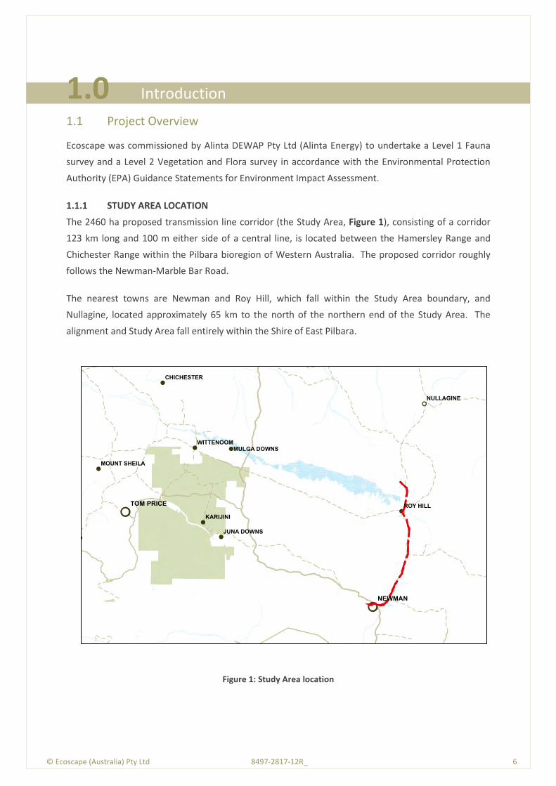
1.1.1 STUDY AREA LOCATION
The 2460 ha proposed transmission line corridor (the Study Area, Figure 1), consisting of a corridor
123 km long and 100 m either side of a central line, is located between the Hamersley Range and
Chichester Range within the Pilbara bioregion of Western Australia. The proposed corridor roughly
follows the Newman-Marble Bar Road.
The nearest towns are Newman and Roy Hill, which fall within the Study Area boundary, and
Nullagine, located approximately 65 km to the north of the northern end of the Study Area. The
alignment and Study Area fall entirely within the Shire of East Pilbara.
Figure 1: Study Area location
!!
! !
!
!! !
!
!!
!
!!
!
NEWMAN
TOM PRICE
NULLAGINE
ROY HILL
KARIJINI
WITTENOOM
CHICHESTER
JUNA DOWNS
MULGA DOWNS
MOUNT SHEILA

© Ecoscape (Australia) Pty Ltd 8497-2817-12R_ 7
1.2 Project Objectives
The project objectives include a level 2 flora and vegetation assessment and targeted conservation
significant flora searches compliant with:
Guidance for the Assessment of Environmental Factors (in accordance with the Environmental
Protection Act 1986) No. 51 - Terrestrial Flora and Vegetation Surveys for Environmental
Impact Assessment in Western Australia (known as Guidance Statement No. 51)
(Environmental Protection Authority, EPA 2004a)
Terrestrial Biological Surveys as an Element of Biodiversity Protection Position Statement No. 3
(EPA 2002).
The project also includes a level 1 fauna survey compliant with Position Statement No. 3 (EPA 2002).
The assessment consisted of:
background research or ‘desktop’ study at the locality scale involving a search of all sources of
literature, data and map-based information
a flora and vegetation field survey, resulting in an understanding of flora species and
vegetation types present, and their representation over a broader area
targeted searches for significant flora species and vegetation, including Threatened Ecological
Communities (TECs), Threatened Flora (TF), Priority Ecological Communities (PECs), Priority-
listed Flora (PF) and Declared Plants
a reconnaissance survey of the Study Area to determine the different fauna habitat types as
well as undertake low level sampling and opportunistic observations of the fauna present
a report that includes figures and maps showing flora and vegetation recording locations,
significant flora species, introduced flora species, vegetation assemblages/communities and
vegetation condition, fauna habitat types and significant fauna species locations.
1.3 Previous Biological Surveys
Reports reviewed for information relevant to the Study Area include:
EPA (2005) Pilbara Iron Ore & Infrastructure Project: East-West Railway and Mine Sites (Stage
B) - Fortescue Metals Group. Report and recommendations of the Environmental Protection
Authority
ENVIRON Australia Pty Ltd (2009) Roy Hill 1 Iron Ore Mining Project: Stage 2 Environmental
Referral
EPA (2009a) Roy Hill 1 Iron Ore Mining Project Stage 1 - Roy Hill Iron Ore Pty Ltd. Report and
Recommendations of the Environmental Protection Authority. Report 1342
EPA (2009c) Roy Hill 1 Iron Ore Mining Project Stage 2 - Roy Hill Iron Ore Pty Ltd. Report and
Recommendations of the Environmental Protection Authority. Report 1345
Everard and Bamford (2009) Fauna Assessment of the BC Iron Nullagine Iron Ore Project
© Ecoscape (Australia) Pty Ltd 8497-2817-12R_ 8
Outback Ecology Services (2009) Jimblebar Iron Ore Project - Terrestrial Vertebrate Fauna
Assessment
McKenzie et al (2009) A Biodiversity Survey of the Pilbara Region of Western Australia, 2002 -
2007
Bamford Consulting Ecologists & Ecoscape (2012) Fauna Assessment - Nyidinghu Iron Ore
Project
Everard et al. (2012) Vertebrate Fauna Assessment of the Iron Valley Project Area
Ninox (2009) A Fauna Survey of the Proposed Hope Downs 4 Mining Area, near Newman,
Western Australia
Davis et al. (2005) Fauna survey of proposed Iron Ore Mine, Cloud Break
Phoenix (2011a; 2011b) Level 1 fauna habitat assessment and targeted mulgara survey for the
FerrAus Pilbara Project; and Consolidated report on vertebrate fauna surveys conducted for the
FerrAus Pilbara Project
Ecologia (2006) Roy Hill Iron Ore Project Terrestrial Vertebrate Fauna Assessment
Everard and Bamford (2009) Fauna Assessment of the BC Iron Nullagine Iron Ore Project
Ecoscape (2011a) Cookes Creek Terrestrial and Subterranean Fauna Survey
How and Dell (2004) Reptile assemblage of the Abydos Plain, north-eastern Pilbara, Western
Australia
How and Cooper (2002) Terrestrial small mammals of the Abydos Plain in the north-eastern
Pilbara, Western Australia.
© Ecoscape (Australia) Pty Ltd 8497-2817-12R_ 9
© E
cosc
ape
(Au
stra
lia)
Pty
Ltd
84
97
-28
17
-12
R_
9
2.0 Existing Environment
2.1 Physical Environment
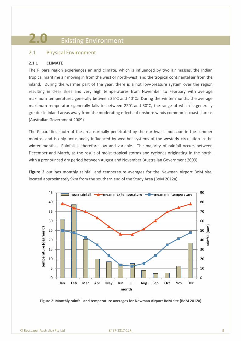
2.1.1 CLIMATE
The Pilbara region experiences an arid climate, which is influenced by two air masses, the Indian
tropical maritime air moving in from the west or north-west, and the tropical continental air from the
inland. During the warmer part of the year, there is a hot low-pressure system over the region
resulting in clear skies and very high temperatures from November to February with average
maximum temperatures generally between 35°C and 40°C. During the winter months the average
maximum temperature generally falls to between 22°C and 30°C, the range of which is generally
greater in inland areas away from the moderating effects of onshore winds common in coastal areas
(Australian Government 2009).
The Pilbara lies south of the area normally penetrated by the northwest monsoon in the summer
months, and is only occasionally influenced by weather systems of the westerly circulation in the
winter months. Rainfall is therefore low and variable. The majority of rainfall occurs between
December and March, as the result of moist tropical storms and cyclones originating in the north,
with a pronounced dry period between August and November (Australian Government 2009).
Figure 2 outlines monthly rainfall and temperature averages for the Newman Airport BoM site,
located approximately 9km from the southern end of the Study Area (BoM 2012a).
Figure 2: Monthly rainfall and temperature averages for Newman Airport BoM site (BoM 2012a)
0
10
20
30
40
50
60
70
80
90
0
5
10
15
20
25
30
35
40
45
Jan Feb Mar Apr May Jun Jul Aug Sep Oct Nov Dec
rain
fall
(mm
)
tem
pe
ratu
re (
de
gre
es
C)
month
mean rainfall mean max temperature mean min temperature
© Ecoscape (Australia) Pty Ltd 8497-2817-12R_ 10
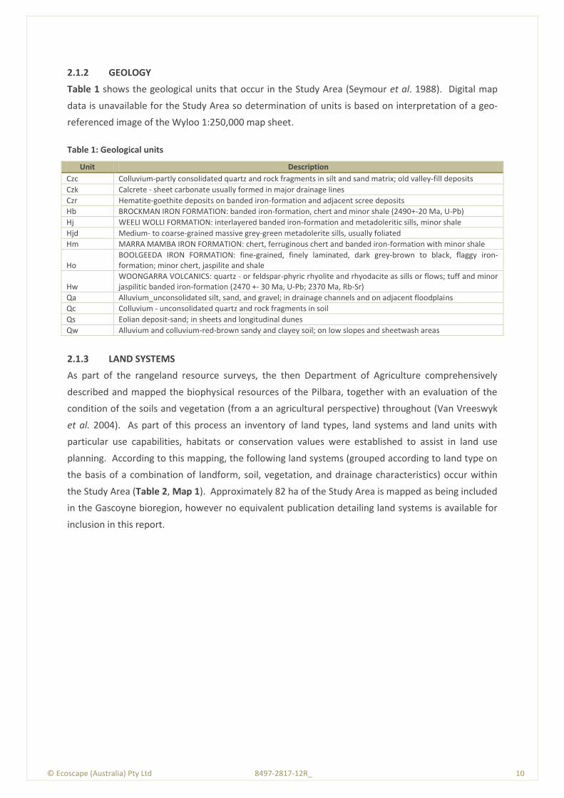
2.1.2 GEOLOGY
Table 1 shows the geological units that occur in the Study Area (Seymour et al. 1988). Digital map
data is unavailable for the Study Area so determination of units is based on interpretation of a geo-
referenced image of the Wyloo 1:250,000 map sheet.
Table 1: Geological units
2.1.3 LAND SYSTEMS
As part of the rangeland resource surveys, the then Department of Agriculture comprehensively
described and mapped the biophysical resources of the Pilbara, together with an evaluation of the
condition of the soils and vegetation (from a an agricultural perspective) throughout (Van Vreeswyk
et al. 2004). As part of this process an inventory of land types, land systems and land units with
particular use capabilities, habitats or conservation values were established to assist in land use
planning. According to this mapping, the following land systems (grouped according to land type on
the basis of a combination of landform, soil, vegetation, and drainage characteristics) occur within
the Study Area (Table 2, Map 1). Approximately 82 ha of the Study Area is mapped as being included
in the Gascoyne bioregion, however no equivalent publication detailing land systems is available for
inclusion in this report.
Unit Description
Czc Colluvium-partly consolidated quartz and rock fragments in silt and sand matrix; old valley-fill deposits
Czk Calcrete - sheet carbonate usually formed in major drainage lines
Czr Hematite-goethite deposits on banded iron-formation and adjacent scree deposits
Hb BROCKMAN IRON FORMATION: banded iron-formation, chert and minor shale (2490+-20 Ma, U-Pb)
Hj WEELI WOLLI FORMATION: interlayered banded iron-formation and metadoleritic sills, minor shale
Hjd Medium- to coarse-grained massive grey-green metadolerite sills, usually foliated
Hm MARRA MAMBA IRON FORMATION: chert, ferruginous chert and banded iron-formation with minor shale
Ho BOOLGEEDA IRON FORMATION: fine-grained, finely laminated, dark grey-brown to black, flaggy iron-formation; minor chert, jaspilite and shale
Hw WOONGARRA VOLCANICS: quartz - or feldspar-phyric rhyolite and rhyodacite as sills or flows; tuff and minor jaspilitic banded iron-formation (2470 +- 30 Ma, U-Pb; 2370 Ma, Rb-Sr)
Qa Alluvium_unconsolidated silt, sand, and gravel; in drainage channels and on adjacent floodplains
Qc Colluvium - unconsolidated quartz and rock fragments in soil
Qs Eolian deposit-sand; in sheets and longitudinal dunes
Qw Alluvium and colluvium-red-brown sandy and clayey soil; on low slopes and sheetwash areas
© Ecoscape (Australia) Pty Ltd 8497-2817-12R_ 11
Table 2: Descriptions of land types and systems occurring in the transmission line Study Area (Van Vreeswyk et al. 2004)
Unit Description Geomorphology
Land type 2
Newman Land System (NEW)
Rugged ironstone ridges, plateaux and mountains; hard spinifex pastures in good to excellent condition; no erosion.
Erosional (BIF, outcrop and stony mantle)
Rocklea Land System (ROC)
Rugged basalt hills and dissected plateaux; poorly accessible, not degraded or eroded.
Erosional (steep stony slopes, small channels and stony interfluves, minor gilgai plains)
Land type 16
Elimunna Land System (ELI)
Stony plains on basalt supporting sparse acacia and cassia shrublands and patchy tussock grasslands.
Mainly depositional (level to gently undulating, some low hills, some gilgai)
Land type 4
Boolgeeda Land System (BGD)
Stony lower slopes and plains below hill systems; not degraded or eroded.
Depositional (colluvial/alluvial lower slopes, stony, derived from Newman LS)
Land type 28
Divide Land System (DIV)
Sandplains and occasional dunes supporting shrubby hard spinifex grasslands.
Depositional (aeolian sand, sandy loam)
Land type 31
Fan Land System (FAN) Hardpan plains and gilgai plains supporting groved mulga shrublands and minor tussock grasslands.
Depositional (alluvial/colluvial, sandy, near-level)
Jamindie Land System (JAM)
Stony hardpan plains and rises supporting groved mulga shrublands, occasionally with spinifex understorey.
Depositional (alluvial/colluvial, partly stony incl. laterite, clay)
Washplain Land System (WSP)
Hardpan plains supporting groved mulga shrublands
Depositional (alluvial clay, stony or sandy in parts)
Land type 34
Narbung Land System (NAB)
Alluvial wash plains with prominent internal drainage foci supporting snakewood and mulga shrublands with halophytic low shrubs.
Depositional (alluvial, sandy)
Land type 39
Turee Land System (TUR)
Stony alluvial plains with gilgaied and non-gilgaied surfaces supporting tussock grasslands and grassy shrublands.
Depositional (alluvial/colluvial, clay, partly stony)
Land type 40
Warri Land System (WAI)
Low calcrete platforms and plains supporting mulga and cassia shrublands
Depositional (calcrete, colluvial gravel, alluvial clay)
Land type 42
Coolibah Land System (COB)
Flood plains with weakly gilgaied clay soils supporting coolibah woodlands with tussock grass understorey.
Depositional (alluvial clay, some sand, calcrete)
River Land System (RIV) Flood plains and terraces flanking major rivers and creeks; little pasture degradation or erosion.
Floodplains and terraces (sand, cobbles)
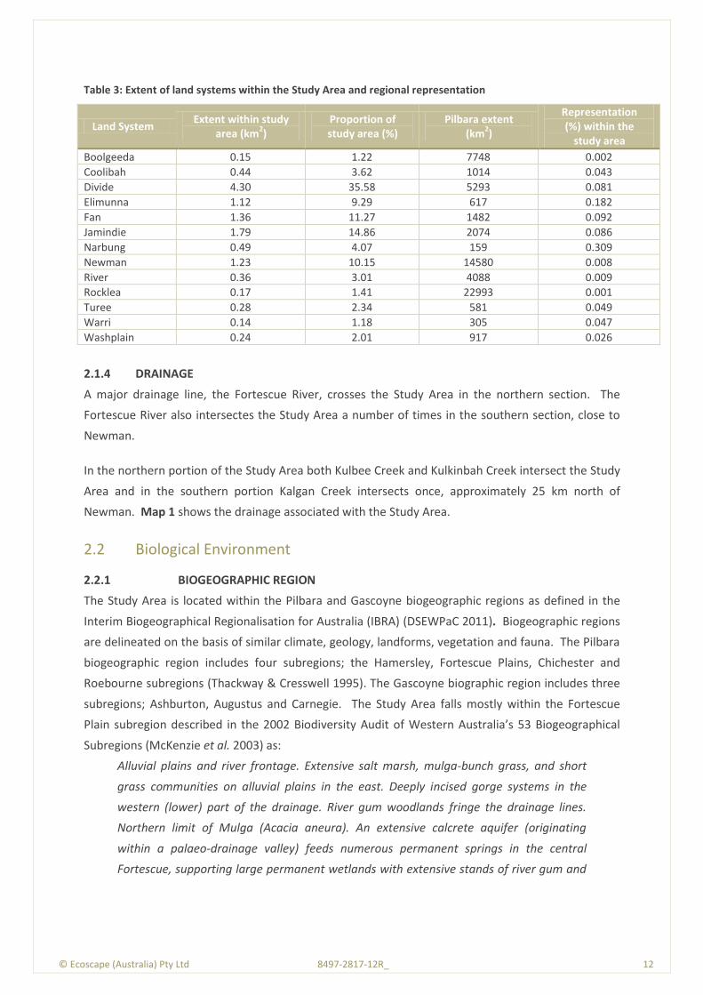
The extent of the land systems outlined above within the transmission line Study Area are indicated
in Table 4.
© Ecoscape (Australia) Pty Ltd 8497-2817-12R_ 12
Table 3: Extent of land systems within the Study Area and regional representation
Land System Extent within study
area (km2)
Proportion of study area (%)
Pilbara extent (km
2)
Representation (%) within the
study area
Boolgeeda 0.15 1.22 7748 0.002
Coolibah 0.44 3.62 1014 0.043
Divide 4.30 35.58 5293 0.081
Elimunna 1.12 9.29 617 0.182
Fan 1.36 11.27 1482 0.092
Jamindie 1.79 14.86 2074 0.086
Narbung 0.49 4.07 159 0.309
Newman 1.23 10.15 14580 0.008
River 0.36 3.01 4088 0.009
Rocklea 0.17 1.41 22993 0.001
Turee 0.28 2.34 581 0.049
Warri 0.14 1.18 305 0.047
Washplain 0.24 2.01 917 0.026
2.1.4 DRAINAGE
A major drainage line, the Fortescue River, crosses the Study Area in the northern section. The
Fortescue River also intersectes the Study Area a number of times in the southern section, close to
Newman.
In the northern portion of the Study Area both Kulbee Creek and Kulkinbah Creek intersect the Study
Area and in the southern portion Kalgan Creek intersects once, approximately 25 km north of
Newman. Map 1 shows the drainage associated with the Study Area.
2.2 Biological Environment
2.2.1 BIOGEOGRAPHIC REGION
The Study Area is located within the Pilbara and Gascoyne biogeographic regions as defined in the
Interim Biogeographical Regionalisation for Australia (IBRA) (DSEWPaC 2011). Biogeographic regions
are delineated on the basis of similar climate, geology, landforms, vegetation and fauna. The Pilbara
biogeographic region includes four subregions; the Hamersley, Fortescue Plains, Chichester and
Roebourne subregions (Thackway & Cresswell 1995). The Gascoyne biographic region includes three
subregions; Ashburton, Augustus and Carnegie. The Study Area falls mostly within the Fortescue
Plain subregion described in the 2002 Biodiversity Audit of Western Australia’s 53 Biogeographical
Subregions (McKenzie et al. 2003) as:
Alluvial plains and river frontage. Extensive salt marsh, mulga-bunch grass, and short
grass communities on alluvial plains in the east. Deeply incised gorge systems in the
western (lower) part of the drainage. River gum woodlands fringe the drainage lines.
Northern limit of Mulga (Acacia aneura). An extensive calcrete aquifer (originating
within a palaeo-drainage valley) feeds numerous permanent springs in the central
Fortescue, supporting large permanent wetlands with extensive stands of river gum and
© Ecoscape (Australia) Pty Ltd 8497-2817-12R_ 13
cadjeput Melaleuca woodlands. Climatic conditions are semi desert tropical, with
average rainfall of 300 mm, falling mainly in summer cyclonic events. Drainage occurs to
the north-west.
A small proportion of the Study Area’s southern end falls in the Hamersley and Augustus biographic
subregions described by McKenzie et al. (2003) as:
Hamersley: Mountainous area of Proterozoic sedimentary ranges and plateaux,
dissected by gorges (basalt, shale and dolerite). Mulga low woodland over bunch grasses
on fine textured soils in valley floors and Eucalyptus leucophloia over Triodia brizoides on
skeletal soils of the ranges. The climate is Semi-desert tropical, average 300mm rainfall,
usually in summer cyclonic or thunderstorm events. Winter rain is not uncommon.
Drainage into either the Fortescue (to the north), the Ashburton to the south, or the Robe
to the west.
Augustus: Rugged low Proterozoic sedimentary and granite ranges divided by broad flat
valleys. Also includes the Narryera Complex and Bryah Basin of the Proterozoic Capricorn
Orogen (on northern margin of the Yilgarn Craton), as well as the Archaean Marymia
and Sylvania Inliers. Although the Gascoyne River System provides the main drainage of
this subregion, it is also the headwaters of the Ashburton and Fortescue Rivers. There are
extensive areas of alluvial valley-fill deposits. Mulga woodland with Triodia occur on
shallow stony loams on rises, while the shallow earthy loams over hardpan on the plains
are covered by Mulga parkland. A desert climate with bimodal rainfall.
2.2.2 ENVIRONMENTALLY SENSITIVE AREAS
Environmentally sensitive areas (ESAs) are protected under the Environmental Protection (Clearing of
Native Vegetation) Regulations 2004. There are a number of ESAs within Western Australia where
exeptions in regulations do no apply. Section 51B of the EP Act allows the minister to declare ESAs.
Map 2 shows an ESA associated with the TEC ‘Ethel Gorge aquifer stygobiont community’ intersecting
with a small portion of the Study Areas southern region. A larger ESA associated with the PEC
‘Fortescue Marsh (Marsh Land System)’ falls within 2 km of the Study Area however, the Study Area
does not intersect with this PEC.
2.2.3 FLORA
2.2.3.1 Conservation Significant Flora Species
For the purposes of this report, conservation significant flora species are those that are listed by the
Department of Environment and Conservation (DEC) as Threatened Flora (TF) and Priority Flora (PF).
Flora species are classified as TF or listed as Priority Flora (PF) where populations are geographically
restricted or threatened by local processes.
© Ecoscape (Australia) Pty Ltd 8497-2817-12R_ 14
TF species (previously known in Western Australian as Declared Rare Flora (DRF)) are listed by the
DEC and are protected under the Western Australian Wildlife Conservation Act (WC Act) (1950). Rare
flora species, as they are termed in the WC Act, are gazetted under Sub-section 2 of Section 23F,
thereby making it an offence to remove or damage rare flora without Ministerial approval.
Some TF species have additional legislative protection by being listed under the Commonwealth
Environment Protection and Biodiversity Conservation Act 1999 (EPBC Act) (Commonwealth of
Australia 1999).
Definitions of the Commonwealth (DSEWPaC) categories are provided in Table 17 in Appendix One.
There are six categories covering State-listed TF and PF species (DEC 2011), which are outlined in
Table 18 in Appendix One. PF for Western Australia are regularly reviewed by the DEC whenever
new information becomes available. Species are removed from the list or their status is altered
when they no longer meet the requirements outlined in Table 18.
DEC Database Search
The DEC Threatened Flora database search (DEC reference 10-0712FL, conducted for the
Transmission Line Study Area and 20 km buffer in 2012) identifies TF and PF data from validated
populations of TF and some PF from the Threatened Flora Database (DEFL), specimens in the
Western Australian Herbarium (WAHERB). Combined, TF and PF species are referred to as
conservation significant flora species.
Ninety six conservation significant vascular flora taxa (species, subspecies and varieties) were
identified from the DEC Threatened Flora database search as occurring within 20 km of the
Transmission Line Study Area (Table 23, Appendix Two). Locations of those with known co-ordinates
are shown on Map 2.
Two TF taxa, Lepidium catapycnon and Thryptomene wittweri, were identified by the DEC database
search, along with 30 P1 taxa, 14 P2 taxa, 45 P3 taxa and five P4 taxa as occurring within the
database search area.
The conservation significant flora species identified by the DEC database search request that have
been recorded within 5km of the Transmission Line Study Area are:
Brachyscome sp. Wanna Munna Flats (S. van Leeuwen 4662); 2.5 km south from the southern
end of the Study Area.
Crotalaria smithiana; 3.9 km east from the southern region of the Study Area
Eremophila pilosa; 750 m west from the central region of the Study Area
Eremophila spongiocarpa; 1.9 km west from the northern region of the Study Area
Eremophila youngii subsp. lepidota; 750 m west from the northern region of the Study Area

© Ecoscape (Australia) Pty Ltd 8497-2817-12R_ 15
Goodenia nuda; 1 km west from the northern region of the Study Area
Gymnanthera cunninghamii; 550m east from the southern section of the Study Area
Rhagodia sp. Hamersley (M. Trudgen 17794); 4 km north from the northern tip of the Study
Area
Tecticornia medusa; 350 m west from the northern region of the Study Area.
The DEC Threatened Flora database search does not identify other significant flora species, described
in Guidance Statement No. 51 (EPA2004a) as including keystone or relictual species, those having
anomalous features, range extremities, range extensions, population outliers, restricted subtaxa and
hybrids, local endemics or poorly reserved species.
Commonwealth Protected Matters Search
A review of the DSEWPaC online databases (Protected Matters Search Tool and Species Profile and
Threats Database) was also conducted to identify any additional threatened flora with
Commonwealth protection nearby. The results of the Protected Matters Search are reproduced in
Appendix Three.
One additional threatened flora species was identified within 10 km of the Study Area through the
DSEWPaC database search, Pityrodia augustensis. The species is listed under the EPBC Act as
Vulnerable.
NatureMap Search
The results of a NatureMap (DEC 2012b) search are presented in Appendix Four.
The NatureMap search identified 824 plant species that have been recorded from within a simplified
version of the Study Area (a rectangle encompassing most northern, southern, western and eastern
extents). Eight additional conservation significant plant species were identified through the
NatureMap database search:
Acacia glaucocaesia (P3)
Ampelopteris prolifera (P3)
Aristida lazaridis (P3)
Elatine macrocalyx (P2)
Euphorbia stevenii (Caustic Bottletree) (P3)
Gompholobium karijini (P2)
Isotropis parviflora (P2)
Phragmites karka (Tropical Reed) (P3)

© Ecoscape (Australia) Pty Ltd 8497-2817-12R_ 16
2.2.4 VEGETATION
2.2.4.1 Vegetation Association Mapping
During the 1970s, John Beard and associates conducted a systematic survey of native vegetation,
describing the vegetation systems in Western Australia at a scale of 1:250 000 in the south-west and
at a scale of 1:1 000 000 in less developed areas. The vegetation survey of Western Australia maps
and explanatory memoirs (1974-1981) are credited to J.S. Beard (or Beard with various co-authors).
Beard’s vegetation maps attempted to depict the native vegetation as it was presumed to be at the
time of settlement, and is known as the pre-European vegetation type and extent. It has since been
developed in digital form by Shepherd et al. (2002). The extent of the pre-European vegetation
associations within the Study Area are displayed in Map 3.
The extents of the pre-European vegetation associations identified from the Pilbara bioregion
portion of the Study Area (Government of Western Australia 2011) are listed in Table 5. The Pilbara
bioregion occupies 17,821,309.90 ha.
Table 4: Vegetation associations (Pilbara bioregion)
Vegetation Association
Pilbara Bioregion Extent within the
study area
Pre-European
Extent (ha)
Current Extent (ha)
% Remaining
Extent (ha)
Proportion (%)
18 - Low woodland; mulga (Acacia aneura)
676,557 672,424 99.39 102.83 4.26
29 - Sparse low woodland; mulga, discontinuous in scattered groups
1,133,220 1,132,939 99.98 1136.23 47.02
82 - Hummock grasslands, low tree steppe; snappy gum over Triodia wiseana
2,563,583 2,550,899 99.51 222.90 9.22
111 - Hummock grasslands, shrub steppe; Eucalyptus gamophylla over hard spinifex
550,287 550,232 99.99 702.25 29.06
157 - Hummock grasslands, grass steppe; hard spinifex, Triodia wiseana
198,634 197,098 99.23 9.09 0.38
197 - Sedgeland; sedges with scattered medium trees; coolabah over various sedges & forbes
47,420 47,400 99.96 115.70 4.79
562 - Mosaic: Low woodland; mulga in valleys / Hummock grasslands, open low tree-steppe; snappy gum over Triodia wiseana
103,607 103,607 100.00 39.18 1.62
676 - Succulent steppe; samphire 92,363 92,303 99.93 6.20 0.26
The extents of the pre-European vegetation associations identified from the Gascoyne bioregion
portion of the Study Area (Government of Western Australia 2011) are listed in Table 5. The
Gascoyne bioregion occupies 18,075,219.48 ha.
© Ecoscape (Australia) Pty Ltd 8497-2817-12R_ 17
Table 5: Vegetation associations (Gascoyne bioregion)
Vegetation Association
Gascoyne Bioregion Extent within the
study area
Pre-European
Extent (ha)
Current Extent (ha)
% Remaining
Extent (ha)
Proportion (%)
29 - Sparse low woodland; mulga, discontinuous in scattered groups
780,622 780,429 99.98 82.00 3.39
2.2.4.2 Threatened and Priority Ecological Communities
Threatened Ecological Communities (TECs) are categorised at both State level (DEC 2010) and
Commonwealth level (Commonwealth of Australia 1999), while Priority Ecological Communities
(PECs) are classed at State level (DEC 2010). The status of the State and Commonwealth ratings are
summarised in Table 19 and Table 20 in Appendix One.
According to the TECs listed on the DEC database endorsed by the Minister for the Environment (DEC
2012c), there are two State-listed TECs within the Pilbara bioregion:
The vulnerable ‘Themeda grasslands on cracking clays (Hamersley Station, Pilbara)’. This TEC is
described as grassland plains dominated by the perennial Themeda (kangaroo grass) and many
annual herbs and grasses.
The endangered ‘Ethel Gorge aquifer stygobiont community’.
There are no Commonwealth-listed TECs within the Pilbara bioregion (DSEWPaC 2009).
There are 30 PECs listed as occurring in the Pilbara bioregion (DEC 2012d).
DEC Ecological Communities Database Search
The DEC Ecological Communities database search (search reference 20-0712EC) identified the
following TEC and PEC as occuring within approximately 5km of the Alinta transmission line Study
Area:
the endangered TEC ‘Ethel Gorge’, described as ‘Ethel Gorge aquifer stygobiont community’
the Priority 1 PEC ‘Fortescue Marsh (Marsh Land System)’ described as ‘Extensive, episodically
inundated samphire marsh at the upper terminus of the Fortescue River and the western end
of Goodiadarrie Hills. It is regarded as the largest ephemeral wetland in the Pilbara. It is a
highly diverse ecosystem with fringing mulga woodlands (on the northern side), samphire
shrublands and groundwater dependant riparian ecosystems. It is an arid wetland utilized by
waterbirds and supports a rich diversity of restricted aquatic and terrestrial invertebrates.
Recorded locality for night parrot and bilby and several other threatened vertebrate fauna.
© Ecoscape (Australia) Pty Ltd 8497-2817-12R_ 18
Endemic Eremophila species, populations of priority flora and several near endemic and new
to science samphires’.
The DEC Ecological Communities database search does not identify other significant vegetation
described in Guidance Statement No. 51 (EPA 2004a), including scare vegetation types; communities
including unusual species or a novel combination of species; vegetation acting as a refuge or key
habitat for threatened species; vegetation representative of a range of a unit, or vegetation having a
restricted distribution.
Map 2 displays the locations of the TECs identified from the DEC database search.
2.2.4.3 Protected Matters Search
A search conducted using the DSEWPaC (2012) online databases (Protected Matters Search Tool and
Species Profile and Threats Database) identified no other protected matters from the Study Area.
The search results are shown in Appendix Three.
2.2.4.4 Groundwater Dependent Ecosystems
Groundwater Dependent Ecosystems (GDEs) are defined as ecosystems that are dependent on
groundwater for their survival at some stage of their lifecycle (Eamus 2009b).
Hatton and Evans (1998) identified four types of GDEs based on their geographic setting:
1. Terrestrial vegetation – vegetation communities and dependent fauna that have seasonal or
episodic dependence on groundwater
2. River base flow systems – aquatic and riparian ecosystems that exist in or adjacent to streams
that are fed by groundwater base flow
3. Aquifer and cave ecosystems
4. Wetlands.
Eamus et al. (2006) identified three primary classes based on type of groundwater reliance:
1. Aquifer and cave ecosystems
2. All ecosystems dependent on the surface expression of groundwater;
a) river base flows
b) wetlands, swamplands
c) seagrass beds in estuaries
d) floodplains
e) mound springs
f) riparian vegetation
g) saline discharge to lakes
h) low lying forests

© Ecoscape (Australia) Pty Ltd 8497-2817-12R_ 19
3. All ecosystems dependent on the subsurface presence of groundwater, often accessed via the
capillary fringe (non-saturated zone above the water table) when roots penetrate this zone;
a) River Red Gum (Eucalyptus camaldulensis) forests
b) Banksia woodlands
c) Riparian vegetation in the wet/dry tropics.
In the Pilbara, riparian vegetation is generally determined to be vegetation associated with major or
mid-sized drainage lines, and dominated most commonly by Eucalyptus camaldulensis subsp.
refulgens and E. victrix.
Phreatophytic Species
Phreatophytic species rely on groundwater sources for water intake (eg Maunsell Australia Pty Ltd
2006); essentially the water requirements of phreatophytes are greater than can be provided from
the surface soil profile (e.g. riparian vegetation) or they are dependent on free water availability (e.g.
wetland species). They frequently show low tolerance to extended water stress due to a lack of
physiological and/or morphological adaptation to drought, and respond to significant water deficit by
a decline in health and eventual death (ibid.).
Phreatophytic species known to occur in or close to the Study Area include:
Eucalyptus camaldulensis subsp. refulgens, which is regarded as a facultative phreatophyte
that is dependent on groundwater for part of its lifecycle and/or in times of drought. This
species has been reported to be tolerant of groundwater falls of up to 4 m per year (Maunsell
Australia Pty Ltd 2006), has both lateral and sinker roots and is tolerant of waterlogging
(Grierson 2010).
Eucalyptus victrix, which may be regarded as a facultative phreatophyte (Froend 2009). It is
considered to be relatively drought tolerant and likely to be tolerant of gradual declines to the
watertable (to a degree) (Maunsell Australia Pty Ltd 2006). Eucalyptus victrix has lateral and
sinker roots (ie a dimorphic root system) but is not tolerant of waterlogging (Grierson 2010).
There is some conjecture that this species is actually a vadophyte (i.e. relies on water from
within the soil surface profile, and is independent of groundwater) or weakly phreatophytic
(Resource and Environmental Management Pty Ltd 2007). However, Eamus (2009a, point
3.2.2i) presents evidence that at least one E. victrix population has been considered to be an
obligate phreatophyte. Froend (2009) considers that there is likely to be variability in water
sources used depending on hydrological habitat.
wetland species including Melaleuca argentea and Cyperus vaginatus.
Facultative phreatophytes can switch their water source from groundwater in times of drought to
water in the soil surface profile in times of rain (Grierson 2010). Obligate phreatophytes are
dependent on groundwater for their survival.

© Ecoscape (Australia) Pty Ltd 8497-2817-12R_ 20
It is uncertain which, if any, of other species commonly associated with riparian areas are facultative
phreatophytes or vadophytes (ie the plant’s water requirements are entirely accessed from the soil
surface profile). Corymbia candida is frequently associated with low-lying areas that may be
periodically inundated (e.g. Ecoscape 2012c), and is possibly a facultative phreatophyte (Astron
Environmental Services 2008). However, until there is evidence that this species accesses
groundwater, it is not considered to be indicative of GDEs.
GDEs within the Study Area
GDE and presence of phreatophytic species cannot be directly correlated as some phreatophytic
species are dependent on free water availability (i.e. wetland species), and do not access
groundwater.
For the purposes of this survey, only phreatophytes that are known to access groundwater (i.e.
Eucalyptus camaldulensis subsp. refulgens and E. victrix) are considered to indicate a GDE.
2.2.5 FAUNA
2.2.5.1 Conservation Significant Fauna
The conservation status of fauna species is assessed under both the EPBC Act (Commonwealth of
Australia 1999) and the WC Act (1950). The significance levels for fauna used in the EPBC Act (1999)
are those recommended by the International Union for the Conservation of Nature and Natural
Resources (IUCN) and reviewed by Mace and Stuart (1994). EPBC Act (1999) categories are listed in
Table 17, Appendix One.
The WC Act (1950) uses a set of Schedules but also classifies species using some of the IUCN
categories. DEC Schedules, which provide special protection to listed fauna under the WC Act (1950)
and definitions are shown in Table 18, Appendix One. Under a memorandum of understanding
between DEC and DSEWPaC, taxa listed as threatened by DEC are automatically listed under the
EPBC Act (1999).
In Western Australia, the DEC has produced a supplementary list of Priority Fauna which are not
considered Threatened under the WC Act (1950) but for which the DEC considers there is cause for
concern. Some Priority species are also assigned to the IUCN Conservation Dependent category. It is
important to recognise that such Priority Lists have no statutory standing, but are used to assist the
DEC when considering which fauna are most in need of more surveys or other investigations, in order
to establish their status in the wild.
The Priority Fauna List for Western Australia includes taxa organised by priority codes that either:
have recently been removed from the schedule of threatened fauna

© Ecoscape (Australia) Pty Ltd 8497-2817-12R_ 21
have a restricted range, are uncommon or are declining in range and/or abundance, but which
do not meet the criteria for inclusion on the schedule of threatened fauna
have been nominated for consideration for the schedule of threatened fauna and for which
there is insufficient information for the advisory committee to make an assessment of their
status
are worthy of inclusion on such a list, as determined by the DEC.
The Priority Fauna List for Western Australia is reviewed by the DEC whenever new information on
relevant taxa becomes available. Taxa are removed from the list by the DEC as they cease to meet
the requirements identified above.
Vertebrate taxonomy in this report follows the WAM checklists last updated Feb 2011, except for
birds where the classification and sequence follows Christidis and Boles (2008).
A DEC database search identified 17 conservation significant fauna species (Threatened, Priority or
other specially protected) as known to occur in the East Pilbara (Table 6). No spatial data or precise
buffer distance from the Study Area was provided, but relevant records can mostly be located in
NatureMap (DEC 2012b).
Table 6. DEC Threatened and Priority Fauna search results
Species Name Common Name EPBC Act
Status
WC Act
Status
DEC Status
No. of records
Pezoporus occidentalis Night Parrot EN S1 EN 1
Dasyurus hallucatus Northern Quoll EN S1 EN 2
Liasis olivaceus barroni Pilbara Olive Python VU S1 VU 3
Petrogale lateralis lateralis Black-flanked Rock-wallaby VU S1 VU 4
Falco peregrinus Peregrine Falcon S4 9
Ramphotyphlops ganei Pilbara Blindsnake P1 12
Ctenotus uber johnstonei Balgo Spotted Ctenotus P2 3
Lerista macropisthopus remota Robust Lerista P2 4
Ardeotis australis Australian Bustard P4 68
Burhinus grallarius Bush Stone-curlew P4 7
Dasycercus blythi Brush-tailed Mulgara P4 2
Falco hypoleucos Grey Falcon P4 3
Leggadina lakedownensis Short-tailed Mouse P4 9
Macroderma gigas Ghost Bat P4 3
Oreoica gutturalis gutturalis Crested Bellbird (southern) P4 2
Pseudomys chapmani Western Pebble-mound Mouse P4 49
Sminthopsis longicaudata Long-tailed Dunnart P4 2
2.2.5.2 EPBC Protected Matters Search
Results of the Protected Matters Search Tool identified the following Threatened and Migratory
fauna species as potentially occurring within 10 km of the Study Area (Table 7).
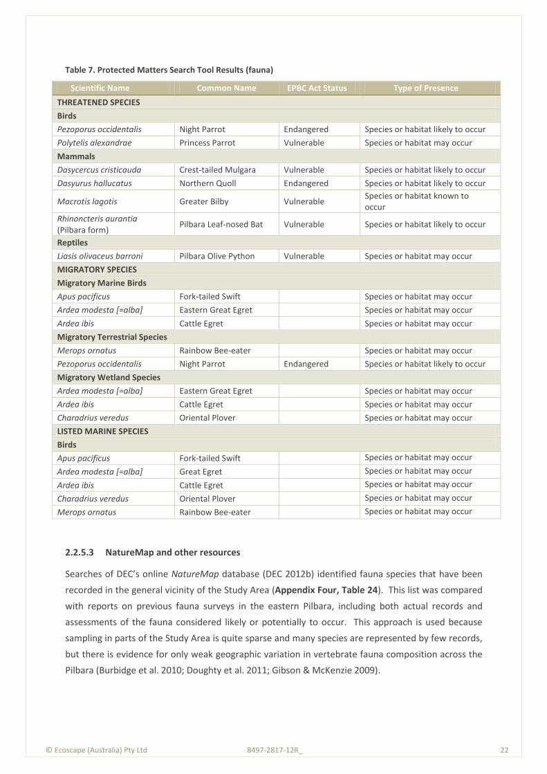
© Ecoscape (Australia) Pty Ltd 8497-2817-12R_ 22
Table 7. Protected Matters Search Tool Results (fauna)
Scientific Name Common Name EPBC Act Status Type of Presence
THREATENED SPECIES
Birds
Pezoporus occidentalis Night Parrot Endangered Species or habitat likely to occur
Polytelis alexandrae Princess Parrot Vulnerable Species or habitat may occur
Mammals
Dasycercus cristicauda Crest-tailed Mulgara Vulnerable Species or habitat likely to occur
Dasyurus hallucatus Northern Quoll Endangered Species or habitat likely to occur
Macrotis lagotis Greater Bilby Vulnerable Species or habitat known to occur
Rhinoncteris aurantia (Pilbara form)
Pilbara Leaf-nosed Bat Vulnerable Species or habitat likely to occur
Reptiles
Liasis olivaceus barroni Pilbara Olive Python Vulnerable Species or habitat may occur
MIGRATORY SPECIES
Migratory Marine Birds
Apus pacificus Fork-tailed Swift Species or habitat may occur
Ardea modesta [=alba] Eastern Great Egret Species or habitat may occur
Ardea ibis Cattle Egret Species or habitat may occur
Migratory Terrestrial Species
Merops ornatus Rainbow Bee-eater Species or habitat may occur
Pezoporus occidentalis Night Parrot Endangered Species or habitat likely to occur
Migratory Wetland Species
Ardea modesta [=alba] Eastern Great Egret Species or habitat may occur
Ardea ibis Cattle Egret Species or habitat may occur
Charadrius veredus Oriental Plover Species or habitat may occur
LISTED MARINE SPECIES
Birds
Apus pacificus Fork-tailed Swift Species or habitat may occur
Ardea modesta [=alba] Great Egret Species or habitat may occur
Ardea ibis Cattle Egret Species or habitat may occur
Charadrius veredus Oriental Plover Species or habitat may occur
Merops ornatus Rainbow Bee-eater Species or habitat may occur
2.2.5.3 NatureMap and other resources
Searches of DEC’s online NatureMap database (DEC 2012b) identified fauna species that have been
recorded in the general vicinity of the Study Area (Appendix Four, Table 24). This list was compared
with reports on previous fauna surveys in the eastern Pilbara, including both actual records and
assessments of the fauna considered likely or potentially to occur. This approach is used because
sampling in parts of the Study Area is quite sparse and many species are represented by few records,
but there is evidence for only weak geographic variation in vertebrate fauna composition across the
Pilbara (Burbidge et al. 2010; Doughty et al. 2011; Gibson & McKenzie 2009).
© Ecoscape (Australia) Pty Ltd 8497-2817-12R_ 23
In addition to those listed in Table 6 and Table 7, the following conservation significant fauna species
are considered to potentially occur in the broad vicinity of the Study Area, and discussed further
below:
Table 8. Threatened and Priority fauna species potentially occurring in Study Area but not recorded by DEC or predicted by PMST
Species Name Common Name EPBC Act
Status
WC Act
Status
DEC Status
presence
Notoryctes caurinus Northern Marsupial Mole EN S1 EN unlikely
Planigale spp. 1 & 2 Planigales likely
Lagorchestes conspicillatus leichardti
Spectacled Hare-wallaby (mainland)
P3 unlikely
Ctenotus nigrilineatus Pinstriped Finesnout Ctenotus
P1 possible
Liopholis kintorei (or Egernia kintorei)
Great Desert Skink VU S1 VU unlilkely
Haliaeetus leucogaster White-bellied Sea-eagle M S3 unlikely
Scolopacidae (9 spp) Migratory waders M S3 possible
Hydroprogne caspia (or Sterna caspia)
Caspian Tern M S3 unlikely
Neochmia ruficauda subclarescens
Western Star Finch P4 possible
© Ecoscape (Australia) Pty Ltd 8497-2817-12R_ 24
© E
cosc
ape
(Au
stra
lia)
Pty
Ltd
84
97
-28
17
-12
R_
2
4
3.0 Methods
3.1 Flora and Vegetation Assessment
This assessment was conducted as a single season Level 2 flora and vegetation assessment,
undertaken to be compliant with:
Guidance Statement No. 51: Terrestrial Flora and Vegetation Surveys for Environmental Impact
Assessments in Western Australia (EPA 2004a)
Terrestrial Biological Surveys as an Element of Biodiversity Protection Position Statement No. 3
(EPA 2002).
Advice was sought from DEC’s Biogeography Program Leader & Partnerships Manager (Dr Stephen
van Leeuwen) as to whether a single season field survey was likely to be accepted by the OEPA as a
suitable Level 2 survey. The advice received (via email 14 June 2012, Appendix Five) indicated that
the proposed survey was likely to be acceptable to the OEPA, dependent on the Study Area being
‘along the road’.
Level 2 assessments incorporate background research and a reconnaissance survey as preparation
for a more intensive and detailed survey. As the area has been well surveyed previously (e.g. Section
1.3), the reconnaissance survey was conducted during the Level 2 field survey.
Level 2 assessments require one or more visits in the main flowering season and replication of survey
effort.
In order to determine the overall value of the vegetation and flora of the Study Area, data collected
during the field survey was used to:
describe and map the vegetation types of the Study Area to indicate the distribution and
relative abundance of each vegetation unit and to help to define units of particular
conservation value
document the vascular flora of the area and provide a measure of the overall floristic richness
identify species and vegetation types of particular conservation significance
identify significant infestations of introduced plant species and occurrence of Declared Plants.
© Ecoscape (Australia) Pty Ltd 8497-2817-12R_ 25
3.1.1 FIELD SURVEYS
The field survey was conducted by Lyn Atkins (flora collecting permit SL009823) and Hayley Hughes
(SL009824), assisted by Tom Lucey and Haylee D’Agui during August 4-9, 2012. The field survey
duration was dictated by accommodation availability in Newman. The extent of the alignment
included in the survey was dictated largely by the status of discussions between Alinta and
underlying leaseholders, and to a lesser degree by time constraints.
The complete Study Area was from near Newman to near Roy Hill. Desktop data refer to the entire
extent, following the alignment supplied at the time of field survey. The field survey results
discussed below apply only to the surveyed section.
The field survey covered approximately 81 km between pole 42 and pole 130 at Noreena Roy Hill
Road. Within this (but not included in the field survey distance calculation), a section of
approximately 1.3 km (26 ha, located approximately between poles 70 and 73 on either side of
Kalgan Creek) was not accessible due to roadworks and was not surveyed. Another section, 8 km
long between approximately poles 192 and 291, was not surveyed for conservation significant flora
species but is included in the field survey results as the results from the surrounding area can be
interpreted to include this area.
3.1.1.1 Floristic Survey
The vegetation and floristic data were collected and described from 16 floristic quadrats (abbreviated
to ‘quadrats’), 50 m x 50 m in dimension or equivalent area if linear (e.g. along a drainage line), which
is in line with the DEC’s Draft Technical Guide - Flora and Vegetation Surveys for Environmental
Impact Assessment. Version 1, February 2012 (EPA & DEC 2012) and Guidance Statement No. 51 (EPA
2004a).
Floristic, biological and physical data was collected and recorded from each of these quadrats. The
flora records provided the names used in the vegetation descriptions and contributed to the flora
species lists and frequency of occurrence data. Various parameters relating to the individual
quadrats were used to assist in both the description of vegetation types and the determination of
flora distribution, particularly in terms of defining associated landforms.
The quadrats were distributed throughout the vegetation types recorded over the Study Area. The
quadrats were unmarked, but were orientated in a north-south and east-west direction, except
where they were located in linear vegetation types (e.g. drainage lines). The co-ordinates of the
north-western corner of the quadrat were recorded.
The following parameters were recorded at each quadrat:
MGA coordinates recorded in GDA 94 datum using a hand-held Global Positioning System
(GPS), to an accuracy usually within 5 m
© Ecoscape (Australia) Pty Ltd 8497-2817-12R_ 26
plant species and their attributes required to form National Vegetation Inventory System
(NVIS, National Hertiage Trust 2003) vegetation description based on the height and estimated
cover of dominant species
an inventory of all species, with estimated maximum height and percent foliage cover
description of landform and habitat
broad description of surface soil type and stony surface mantle
percentage of litter cover and depth
percentage of bare ground
evidence of grazing, mining exploration activities, weed invasion, frequent fires etc. Fire
effects were only considered a negative impact if they were caused by repeated burning (e.g.
for pastoral purposes).
Photographs of the vegetation at each site were taken from the north-west corner (or nearest
equivalent for linear quadrats) of each quadrat using a digital camera.
Information on the vegetation of the Study Area was also described using brief relevés. Forty three
relevés were recorded. The data collected from each relevé included:
MGA coordinate recorded in GDA 94 datum using a hand-held Global Positioning System
(GPS), to an accuracy usually within 5 m
digital photograph of representative vegetation
NVIS (NHT 2003)vegetation description based on the height and estimated cover of dominant
species
description of landform and habitat, recorded at Level V
broad description of surface soil type and stony surface mantle
evidence of grazing, mining exploration activities, weed invasion, frequent fires etc. Fire
effects were only considered a negative impact if they were caused by repeated burning (e.g.
for pastoral purposes)
presence of conservation significant flora species in the vicinity.
73.33 km of the Study Area were traversed on foot. A flora species inventory was collected from
opportunistic observations during the foot survey and quadrat and relevé recordings.
Voucher specimens of species that could not be identified with certainty and potential conservation
significant taxa were collected, assigned a unique number to facilitate tracking of data, and pressed
in the field. Specimens collected were dried and treated in accordance with the requirements of the
WAH.

© Ecoscape (Australia) Pty Ltd 8497-2817-12R_ 27
3.1.1.2 Flora Identification and Data Entry
Voucher specimens were identified by Ecoscape (Stephen Kern) to infrataxa (subspecies, variety,
affinity or hybrid) level where possible, using appropriate publications, and/or comparison with
pressed specimens housed at the WAH.
Nomenclature was checked against the current listing of scientific names recognised by the WAH and
listed on FloraBase (WAH 1998-) and updated as necessary.
All raw site data was entered into a Microsoft Access database, with species names entered following
formal identification of the collected specimens.
3.1.1.3 Conservation Significant Flora
Approximately 73 km of the 81 km Study Area were searched on foot for conservation significant
flora species. The search was conducted by two surveyors walking a roughly parallel line along the
200 m wide Study Area alignment, meandering where necessary to inspect plants that resembled
known conservation significant species, were different to other plants in the area, to search behind
clumps of vegetation that obscured line-of-sight or to inspect different landforms or small-scale
differences in vegetation. Where possible the surveyors were separated by 40-50 m to best cover
the Study Area alignment.
In order to assist with identification in the field, survey teams had access to literature, including
images (where available) of conservation significant species identified by the DEC database search.
Specimens of PF species were collected for identification purposes.
Having undertaken an ad hoc risk assessment, Ecoscape considered the portion of the Study Area not
included in the foot search was unlikely to have Eremophila pilosa (P1) as it was away from the
previously recorded population and the vegetation types and land systems in which E. pilosa had
previously been recorded were not present.
3.1.1.4 Introduced Species
Introduced species were opportunistically recorded.
Flora species were considered to be introduced if they are listed as such on FloraBase (WAH 1998-).
3.1.1.5 Vegetation Description
Vegetation was described from each of the quadrats using the height and estimated cover of
dominant and characteristic species of each stratum, based on the NVIS (NHT 2003). Up to three
species per stratum from each stratum (upper, mid and ground) were used to formulate vegetation
descriptions for each quadrat and relevé and to formulate vegetation type descriptions.
© Ecoscape (Australia) Pty Ltd 8497-2817-12R_ 28
3.1.1.6 Vegetation Condition
Vegetation condition of the quadrats, relevés and Study Area were assessed using the adapted
Keighery Vegetation Condition Scale for Eremaean and Northern Botanical Provinces included in the
Draft Technical Guide – Flora and Vegetation Surveys for Environmental Impact Assessment (EPA &
DEC 2012), Table 22.
The vegetation condition of the Study Area was assessed by extrapolating the value recorded for
each quadrat and relevé and applying the condition to the vegetation type in the vicinity and from
‘spot’ evaluations recorded during traverses through the Study Area.
3.1.1.7 Other Significant Vegetation Types (Locally Significant Vegetation Types)
Whilst having no formal statutory protection, Guidance Statement No. 51 (EPA 2004a) lists several
reasons why vegetation may be considered to be significant in addition to its listing as a TEC or PEC
or because the extent is below a minimum threshold. These reasons, which may apply at a number
of scales but are not defined in detail, include:
scarcity
unusual species
novel combinations of species
role as a refuge
role as a key habitat for threatened species or large populations representing a significant
proportion of the local to regional total population of a species
being representative of the range of a unit (particularly a good local and/or regional example
of a unit in ’prime’ habitat, at the extremes of range, recently discovered range extension or
isolated outliers of the main range)
restricted distribution.
Vegetation displaying any of the above attributes can be considered to be ‘locally significant’, and are
detailed in the assessment.
3.1.2 FIELD SURVEY TIMING
The field survey was conducted in early August 2012. The seasonal conditions were considered to be
‘above average’ (Figure 3) (and summer rainfall considerably above average, Figure 4) most plants
had flowered (and were still identifiable) or were flowering during the field survey. However, the dry
period (below average rainfall) from April until the field survey was apparent during the field survey.
The survey was not conducted in the season following rain as outlined in Guidance Statement No.51.
However based on the extent of the previous wet season in the area, advice from DEC sought prior
to commencement of the survey (Section 3.1 and Appendix Five), Ecoscape is confident in the
accuracy of species identification and the completeness of the survey results.
© Ecoscape (Australia) Pty Ltd 8497-2817-12R_ 29
Although still identifiable by experienced botanists, annual grasses (e.g. Aristida contorta, Sporobolus
australasicus) and many grasses on the Fortescue River floodplain (at the northern end of the Study
Area) had dehisced. However, all conservation significant grasses identified by the DEC database
search request as potentially occurring within the Study Area are not known from the Fortescue River
floodplain (in the vicinity of the Study Area).
Similarly, all Triodia species (except T. basedowii) had dehisced and had no, or poor quality,
reproductive material. Except for T. basedowii, identification of Triodia species are based on
vegetative form and may not be correct (e.g. T. epactia, T. melvillei, T. pungens and T. schinzii are all
soft, resinous species that occur within the general area, and may all occur within the Study Area but
were indistinguishable at the time of field survey). However, none of the Triodia species recorded
from the Study Area are conservation significant species identified by the DEC database search as
potentially occurring in the area.
Mulga species were also largely devoid of reproductive material, which is frequently required for
identification. Therefore, except for Acacia macraneura and A. paraneura, identification of Mulga is
tentative. None are of conservation significance.
The lack of certaintly in relation to these identifications is considered a negligible constraint as none
is likely to be of conservation significance. These identifications are not required to determine
vegetation type significance.
The timing of the field survey was optimal for identifying most likely high priority (P1) taxa
(Eremophila pilosa). Early August coincided with the anticipated flowering period making it easy to
identify this species by flowers or flower buds.
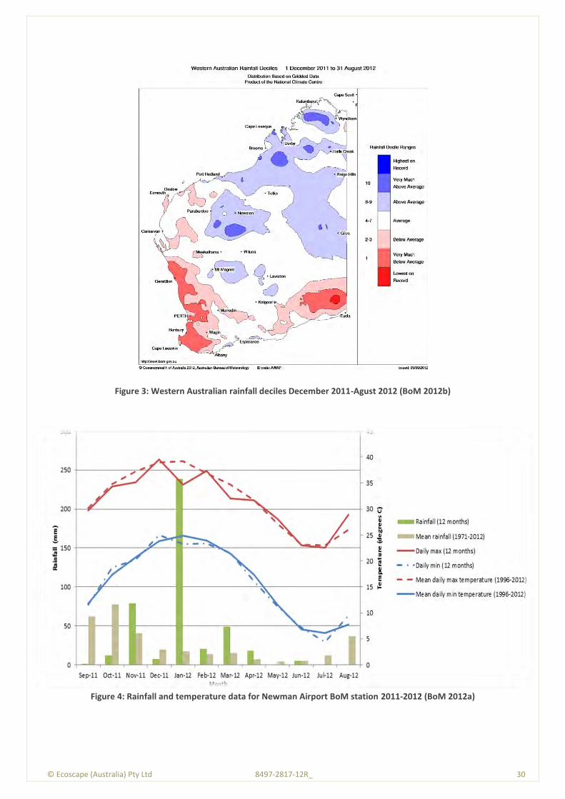
© Ecoscape (Australia) Pty Ltd 8497-2817-12R_ 30
Figure 3: Western Australian rainfall deciles December 2011-Agust 2012 (BoM 2012b)
Figure 4: Rainfall and temperature data for Newman Airport BoM station 2011-2012 (BoM 2012a)

© Ecoscape (Australia) Pty Ltd 8497-2817-12R_ 31
3.2 Flora and Vegetation Significance
3.2.1 STUDY AREA FLORISTIC ANALYSIS
PATN© software (Belbin & Collins 2006) was used to undertake statistical analysis and generate
floristic groups using the data collected from the floristic quadrats; relevé data were not included in
the analysis. PATN analysis has been used for several local floristic analyses including Gibson et al.
(1994) for the Swan Coastal Plain, and is routinely used for regional floristic analysis in the Pilbara by
ME Trudgen and E Griffin (eg Ecoscape 2010; 2011b).
PATN is a multivariate analysis tool that generates estimates of association (resemblance, affinity,
distance) between sets of objects described by a suite of variables (attributes), and classifies the
objects into groups and condenses the information and displays the patterns in the data graphically.
PATN offers a choice of data transformations prior to multivariate analysis. In this case, because the
analysis used presence / absence data, the Kulczynski similarity coefficient was the appropriate
association to use as it has proven to be a good estimation of association for ecological applications
(Belbin & Collins 2006). This was followed by Flexible UPMGA (Un-weighted Pair Group Using
Arithmetic Averaging) fusion to produce clusters of related objects (species); these are the floristic
groups that are displayed as a dendrogram. For this analysis, dominant species were given a
weighting whereas other species recorded from the quadrats were unweighted.
Interpretation of these purely floristic groups into recognisable and mappable on-ground units is
required to identify vegetation types. This interpretation is largely based on dominant species from
each stratum. Generally, quadrats that are closely floristically related on the dendrogram form
identifiable vegetation units, however, as presence-absence data is used in the analysis and there is
no weighting given to dominant species, at times the floristic groups are not easily related to on-
ground vegetation types. Vegetation types are therefore determined as a combination of floristic
analysis and on-ground interpretation.
3.2.2 REGIONAL FLORA AND VEGETATION SIGNIFICANCE
The reports listed in Section 1.3 (and others) were reviewed to assess similarities and differences
between the flora and vegetation of nearby areas.
3.3 Fauna and Habitat Assessment
3.3.1 FIELD ASSESSMENT
The reconnaissance survey and habitat assessment was undertaken from August 3 – 6 2012, by
Natalie Randall and John Scanlon, both Senior Environmental Scientists (Zoologists). Fieldwork was
carried out under DEC Licence No. SF008773.
© Ecoscape (Australia) Pty Ltd 8497-2817-12R_ 32
The Study Area was accessed at various points from the Newman – Marble Bar road, using other
4WD tracks where available but mostly on foot.
The survey method comprised:
assessment of habitat suitability for target species based on visual inspection of terrain,
vegetation and soils, and opportunistic recording of fauna present, with reference to mapped
land systems and vegetation types
walking transects of potentially suitable habitat areas by day, searching for burrows, tracks,
scats and other signs of target species
when tracks, burrows or other potential indicators of target species were observed,
assessment of their specific identity based on location, size, and associated traces. Where
these were considered likely to pertain to target species or not determinable with certainty in
the field, photographs were taken and GPS locations recorded, and searches extended or
intensified (if necessary) to identify any other evidence of occupation within 50 m
subsequent consultation with Bruce Turner (Principal Environmental Scientist, Ecoscape) and
Mike Bamford (Bamford Consulting Ecologists) to reach consensus identification of burrows,
tracks and other traces.
Opportunistic observations of fauna other than the target species were also made during the day
whilst driving and walking the Study Area. Nocturnal searches were not conducted. References
utilised for identification include Menkhorst & Knight (2004) for mammals, Wilson & Swan (2008) for
reptiles, Simpson & Day (2004) for birds, Triggs (1996) for scats and tracks, and Thompson &
Thompson (2007; 2008) for burrows.
3.3.2 INTERPRETATION OF SPECIES LISTS
Species lists generated from the desktop review are generous as they include records drawn from a
large region and possibly from environments not represented in the project area. Therefore, some
species that were returned by one or more of the data searches have been excluded because their
ecology, combined with the environments within the Study Area, make it highly unlikely that these
species would be present. In general, however, species returned by the desktop review process are
expected in the Study Area whether or not they were recorded during field surveys.
Interpretation of species lists generated through the desktop review included assigning an expected
status within the project area to species of conservation significance. This is particularly important
for birds that may naturally be migratory or nomadic, and for some mammals that can also be mobile
or irruptive. The status categories used are:
Resident: species with a population permanently present in the project area;
Regular migrant or visitor: species that occur within the project area regularly in at least
moderate numbers, such as part of annual cycle;
© Ecoscape (Australia) Pty Ltd 8497-2817-12R_ 33
Irregular Visitor: species that occur within the project area irregularly such as nomadic and
irruptive species. The length of time between visitations could be decades but when the
species is present, it uses the project area in at least moderate numbers and for some time;
Vagrant: species that occur within the project area unpredictably, in small numbers and/or for
very brief periods. Therefore, the project area is unlikely to be of important for the species;
and
Locally extinct: species that has not been recently recorded in the local area and therefore is
almost certainly no longer present in the project area.

© Ecoscape (Australia) Pty Ltd 8497-2817-12R_ 34
© E
cosc
ape
(Au
stra
lia)
Pty
Ltd
84
97
-28
17
-12
R_
3
4
4.0 Results
4.1 Flora Survey
Floristic quadrat details are included in Appendix Six, and the complete flora inventory in Appendix
Seven.
A total of 264 vascular flora taxa (including species, subspecies, varieties, hybrids, affinities and
forms) were recorded from floristic quadrats, relevès, opportunistic observations and conservation
significant flora searches (Table 25).
Thirty eight identified families and 110 identified genera are represented in the Study Area. The
most commonly represented families are:
Fabaceae (including the former Mimosaceae, Caesalpiniaceae and Papilionaceae); 48 taxa (one
introduced, and including two Acacia species with a degree of uncertainty in regard to their
identification and one that was only identified to potential genus (?Glycine sp.). One of the
Acacia species may represent a duplication)
Poaceae; 41 taxa (one introduced, and including two identified only to genus level, one
identified only to family level – these may represent duplications – , and one given a tentative
name)
Chenopidaceae; 25 taxa (three identified only to genus level that may represent duplications)
Malvaceae; 24 taxa (one introduced, one identified only to family level, three identified only to
genus level and five with an element of doubt in relation to their identifications – these may all
represent duplications)
Amaranthaceae; 15 taxa (two indentified only to genus level that may represent duplications).
The most commonly represented genera are Acacia (27 taxa, including two given tentative names,
one of which may represent duplication), Ptilotus (11 taxa, although one was idenfied only to genus
and represent a duplication), Senna (10 taxa, most of which were identified to subspecies and hybrid
level), Goodenia (nine taxa, including two given tentative names and one idenfied only to genus level
that may represent duplications) and Eragrostis (six taxa)
The most commonly encountered species were Triodia epactia recorded from 20 quadrats and
relevés, Acacia sclerosperma subsp. sclerosperma and A. synchronicia (18 quadrats and relevés),
Acacia aptaneura and *Cenchrus ciliaris (17 quadrats and relevès) and Acacia ancistrocarpa (16
quadrats and relevès).
© Ecoscape (Australia) Pty Ltd 8497-2817-12R_ 35
Species Range Extents
Based on the records included on NatureMap (DEC 2007-), two P3 species are considered to
represent a range extremitiy and a range extension:
Rhagodia sp. Hamersley (M. trudgen 17794), if confirmed as this species, is a new population
on the eastern edge of its known extent
Themeda sp. Hamersley Station (M.E. Trudgen 11431) represents a new population, and a
range extension of approximately 45 km to the east of the previously known south-eastern
extremity.
Taxa ranges and range extensions were assessed using the NatureMap (DEC 2007-) distance
measuring tool.
4.1.1 CONSERVATION SIGNIFICANT FLORA
4.1.1.1 Environmental Protection and Biodiversity Conservation Act 1999
No plant taxon recorded in the Study Area is listed as Threatened pursuant to Schedule 1 of the EPBC
Act (1999).
4.1.1.2 Wildlife Conservation Act 1950
No plant taxon recorded in the survey is gazetted as a TF pursuant to Subsection 2 of Section 23F of
the WC Act (1950).
4.1.1.3 Priority Flora
The Priority Flora recorded from the Study Area are listed and briefly described below. Their
locations are included in Table 9 and shown on Map 4. Threatened and Priority Flora Report Forms
are included in Appendix Eight.
Table 9: Priority Flora species locations (GDA 94, Zone 50)
Species Cons. Code
Vegetation mE mN Population
Size
Eremophila pilosa P1 Tb 808314 7465060 <10
Eremophila pilosa P1 Tb 808513 7467940 <10
Eremophila pilosa P1 Tb 808519 7468130 50+
Eremophila pilosa P1 Tb 808509 7468230 <10
Eremophila pilosa P1 Tb 808532 7468330 <10
Eremophila pilosa P1 Tb 808558 7468430 <10
Eremophila pilosa P1 Tb 808595 7468900 <10
Eremophila pilosa P1 Tb 808575 7469180 <10
Eremophila pilosa P1 Tb 808580 7469270 <10
Eremophila pilosa P1 Tb 808597 7469300 <10
Eremophila pilosa P1 Tb 808603 7469330 <10
Eremophila pilosa P1 Tb 808604 7469530 <10
Eremophila pilosa P1 Tb 808621 7469670 <10
Eremophila pilosa P1 Tb 808677 7469800 <10
© Ecoscape (Australia) Pty Ltd 8497-2817-12R_ 36
Species Cons. Code
Vegetation mE mN Population
Size
Eremophila pilosa P1 Tb 808636 7469900 <10
Eremophila pilosa P1 Tb 808616 7470150 <10
Eremophila pilosa P1 Tb 808661 7470290 <10
Eremophila pilosa P1 Tb 808753 7470380 <10
Eremophila pilosa P1 Tb 808713 7470410 <10
Eremophila pilosa P1 Tb 808729 7471170 <10
Eremophila pilosa P1 Tb 808759 7471850 10 to 50
Eremophila pilosa P1 VfEc 808838 7472620 <10
Eremophila pilosa P1 VfEc 808887 7472620 <10
Eremophila pilosa P1 VfEc 808841 7472670 <10
Eremophila pilosa P1 VfEc 808892 7472670 <10
Eremophila pilosa P1 VfEc 809009 7475750 <10
Eremophila pilosa P1 VfEc 808989 7476420 <10
Eremophila pilosa P1 VfEc 808997 7476480 <10
Eremophila pilosa P1 VfEc 808985 7476530 <10
Eremophila pilosa P1 VfEc 808526 7478120 <10
Eremophila pilosa P1 VfEc 808431 7478470 <10
Eremophila pilosa P1 VfEc 808391 7478610 <10
Eremophila youngii subsp. lepidota P4 AsyTl 796512 7428870 10 to 50
Eremophila youngii subsp. lepidota P4 AsyTl 796486 7428880 10 to 50
Eremophila youngii subsp. lepidota P4 AsyTl 796505 7428940 10 to 50
Eremophila youngii subsp. lepidota P4 AsyTl 796515 7428980 10 to 50
Eremophila youngii subsp. lepidota P4 AsyTl 796519 7429050 10 to 50
Eremophila youngii subsp. lepidota P4 AapEfTe/AsyAc 796575 7429160 10 to 50
Eremophila youngii subsp. lepidota P4 AsyTl 796816 7429650 10 to 50
Eremophila youngii subsp. lepidota P4 AsyTl 796930 7430050 10 to 50
Eremophila youngii subsp. lepidota P4 AsyTl 796958 7430070 <10
Eremophila youngii subsp. lepidota P4 AsyTl 796990 7430080 <10
Eremophila youngii subsp. lepidota P4 AsyTl 797008 7430100 <10
Eremophila youngii subsp. lepidota P4 AsyTl 797009 7430160 <10
Eremophila youngii subsp. lepidota P4 AapEfTe/AsyAc 804141 7488320 1
Eremophila youngii subsp. lepidota P4 AapEfTe/AsyAc 803815 7488960 10 to 50
Eremophila youngii subsp. lepidota P4 AapEfTe/AsyAc 803747 7489280 10 to 50
Eremophila youngii subsp. lepidota P4 AapEfTe/AsyAc 803702 7489290 1
Eremophila youngii subsp. lepidota P4 AapEfTe/AsyAc 803787 7489430 10 to 50
Eremophila youngii subsp. lepidota P4 AapEfTe/AsyAc 803802 7489560 <10
Eremophila youngii subsp. lepidota P4 EvAscPs 803904 7489730 10 to 50
Eremophila youngii subsp. lepidota P4 EvAscPs 803797 7489750 1
Eremophila youngii subsp. lepidota P4 EvAscPs 803953 7489920 <10
Eremophila youngii subsp. lepidota P4 EvAscPs 804044 7490020 <10
Eremophila youngii subsp. lepidota P4 EvAscPs 804134 7490380 <10
Eremophila youngii subsp. lepidota P4 EvAscPs 805564 7494210 10 to 50
Eremophila youngii subsp. lepidota P4 EvAscCc 805613 7494550 1
Eremophila youngii subsp. lepidota P4 EvAscCc 805625 7494550 <10
Eremophila youngii subsp. lepidota P4 EvAscCc 805613 7494550 <10
Eremophila youngii subsp. lepidota P4 EvAscCc 805755 7494850 <10
Eremophila youngii subsp. lepidota P4 EvAscCc 805762 7494910 <10
Eremophila youngii subsp. lepidota P4 EvAscCc 805784 7494960 <10
Goodenia ?nuda P4 Tb 803960 7443980 <10
Rhagodia sp. Hamersley (M. Trudgen 17794)
P3 AapAscTe 796232 7428500 1
© Ecoscape (Australia) Pty Ltd 8497-2817-12R_ 37
Species Cons. Code
Vegetation mE mN Population
Size
Rhagodia sp. Hamersley (M. Trudgen 17794)
P3 VfEc 809013 7475590 1
Rhagodia sp. Hamersley (M. Trudgen 17794)
P3 EvAscCc 805839 7495120 1
Themeda sp. Hamersley Station (M.E. Trudgen 11431)
P3 AapEfTe/AsyAc 800731 7436650 10 to 50
Priority flora descriptions are derived from FloraBase (WAH 1998-) descriptions and field
observations.
Eremophila pilosa (P1)
Eremophila pilosa is a low shrub to 0.8 m high with purple flowers (WAH 1998-). Within the Study
Area it was generally of smaller stature (approximately 0.4-0.6 m high), and whilst the flowers were
purple, they varied from mid-purple to darker purple and the upper flower lobes were variously
shallowly or deeply incised. The leaves were distinctively grey and hairy. Plate 1 and Plate 2
illustrate this species.
Within the Study Area E. pilosa occurred as two apparent populations over approximately 8.5 km of
the Study Area alignment separated by approximately 1 km, with a small number of outlier
individuals to the south (Map 4). Whilst E. pilosa within the Study Area apparently consists of two
populations (plus outliers), the survey did not include areas outside of the alignment and it is likely
that the populations are contiguous (ie a single population).
E. pilosa is known from six records listed on NatureMap (DEC 2007-), distributed over two or three
populations (Figure 5). This Study Area is within the vicinity of the population represented by two
blue dots in Figure 5. Several hundred individuals were recorded within the alignment; the
population as a whole in the vicinity would number in the thousands of plants. Within the alignment,
the plants were sparsely spaced although frequently occurring in an open grouping. Plate 3 shows
the typical plant spacing, with two E. pilosa individuals clearly visible (the low grey shrub in the open
area in the centre midground and one in the right foreground between, and partly obscured by, two
Triodia clumps) and up to five other individuals scattered indistinctly throughout the image area.
Within the Study Area, E. pilosa was recorded mostly from open areas dominated by Triodia
basedowii or, at times more densely, in areas dominated by T. longiceps.
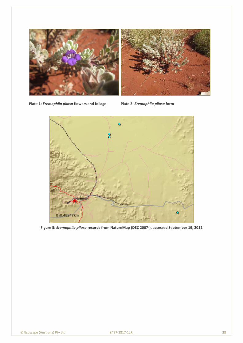
© Ecoscape (Australia) Pty Ltd 8497-2817-12R_ 38
Plate 1: Eremophila pilosa flowers and foliage
Plate 2: Eremophila pilosa form
Figure 5: Eremophila pilosa records from NatureMap (DEC 2007-), accessed September 19, 2012
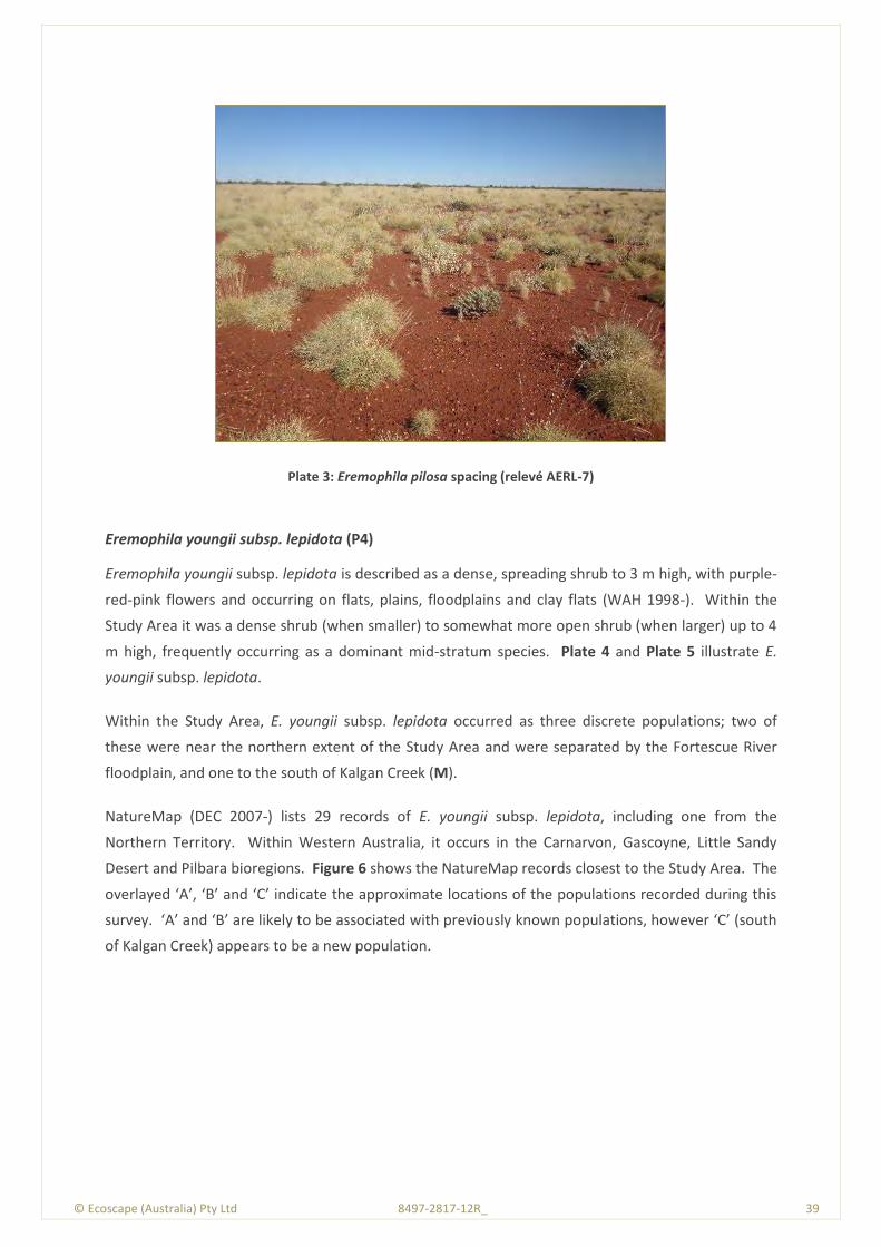
© Ecoscape (Australia) Pty Ltd 8497-2817-12R_ 39
Plate 3: Eremophila pilosa spacing (relevé AERL-7)
Eremophila youngii subsp. lepidota (P4)
Eremophila youngii subsp. lepidota is described as a dense, spreading shrub to 3 m high, with purple-
red-pink flowers and occurring on flats, plains, floodplains and clay flats (WAH 1998-). Within the
Study Area it was a dense shrub (when smaller) to somewhat more open shrub (when larger) up to 4
m high, frequently occurring as a dominant mid-stratum species. Plate 4 and Plate 5 illustrate E.
youngii subsp. lepidota.
Within the Study Area, E. youngii subsp. lepidota occurred as three discrete populations; two of
these were near the northern extent of the Study Area and were separated by the Fortescue River
floodplain, and one to the south of Kalgan Creek (M).
NatureMap (DEC 2007-) lists 29 records of E. youngii subsp. lepidota, including one from the
Northern Territory. Within Western Australia, it occurs in the Carnarvon, Gascoyne, Little Sandy
Desert and Pilbara bioregions. Figure 6 shows the NatureMap records closest to the Study Area. The
overlayed ‘A’, ‘B’ and ‘C’ indicate the approximate locations of the populations recorded during this
survey. ‘A’ and ‘B’ are likely to be associated with previously known populations, however ‘C’ (south
of Kalgan Creek) appears to be a new population.
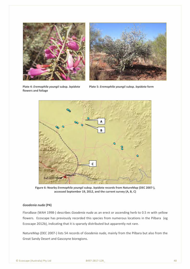
© Ecoscape (Australia) Pty Ltd 8497-2817-12R_ 40
Plate 4: Eremophila youngii subsp. lepidota flowers and foliage
Plate 5: Eremophila youngii subsp. lepidota form
Figure 6: Nearby Eremophila youngii subsp. lepidota records from NatureMap (DEC 2007-),
accessed September 19, 2012, and the current survey (A, B, C)
Goodenia nuda (P4)
FloraBase (WAH 1998-) describes Goodenia nuda as an erect or ascending herb to 0.5 m with yellow
flowers. Ecoscape has previously recorded this species from numerous locations in the Pilbara (eg
Ecoscape 2012b), indicating that it is sparsely distributed but apparently not rare.
NatureMap (DEC 2007-) lists 54 records of Goodenia nuda, mainly from the Pilbara but also from the
Great Sandy Desert and Gascoyne bioregions.
A
B
C
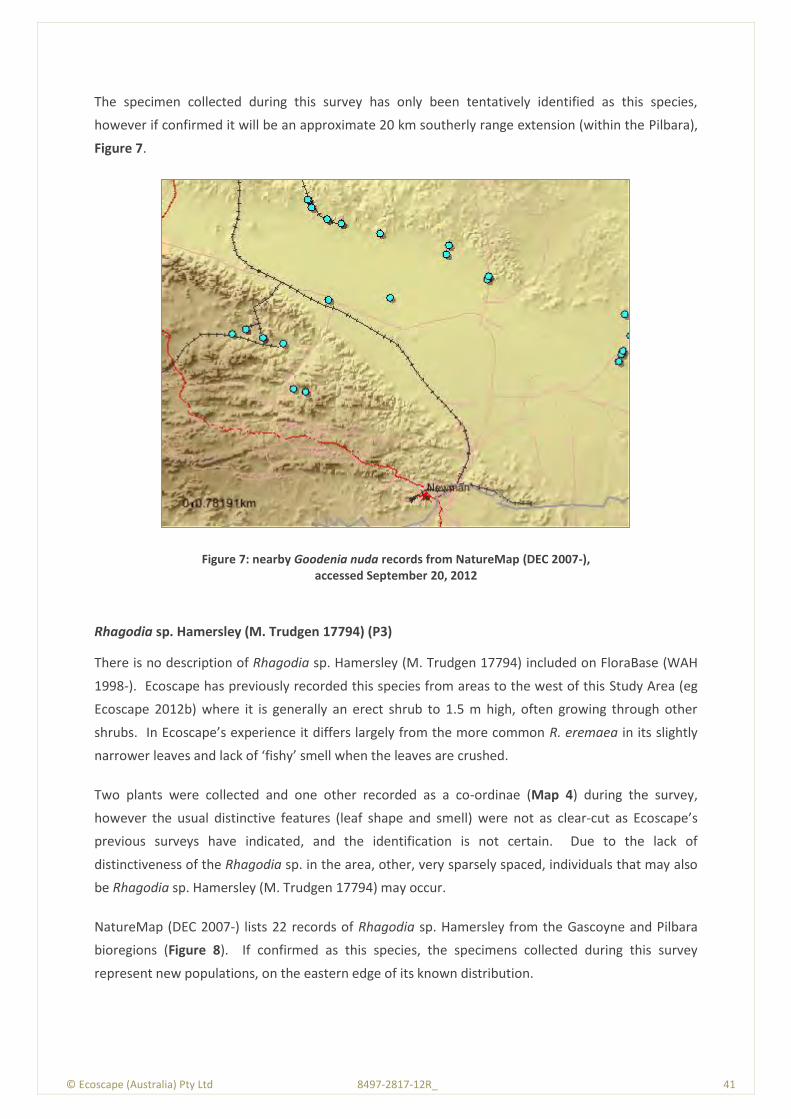
© Ecoscape (Australia) Pty Ltd 8497-2817-12R_ 41
The specimen collected during this survey has only been tentatively identified as this species,
however if confirmed it will be an approximate 20 km southerly range extension (within the Pilbara),
Figure 7.
Figure 7: nearby Goodenia nuda records from NatureMap (DEC 2007-), accessed September 20, 2012
Rhagodia sp. Hamersley (M. Trudgen 17794) (P3)
There is no description of Rhagodia sp. Hamersley (M. Trudgen 17794) included on FloraBase (WAH
1998-). Ecoscape has previously recorded this species from areas to the west of this Study Area (eg
Ecoscape 2012b) where it is generally an erect shrub to 1.5 m high, often growing through other
shrubs. In Ecoscape’s experience it differs largely from the more common R. eremaea in its slightly
narrower leaves and lack of ‘fishy’ smell when the leaves are crushed.
Two plants were collected and one other recorded as a co-ordinae (Map 4) during the survey,
however the usual distinctive features (leaf shape and smell) were not as clear-cut as Ecoscape’s
previous surveys have indicated, and the identification is not certain. Due to the lack of
distinctiveness of the Rhagodia sp. in the area, other, very sparsely spaced, individuals that may also
be Rhagodia sp. Hamersley (M. Trudgen 17794) may occur.
NatureMap (DEC 2007-) lists 22 records of Rhagodia sp. Hamersley from the Gascoyne and Pilbara
bioregions (Figure 8). If confirmed as this species, the specimens collected during this survey
represent new populations, on the eastern edge of its known distribution.
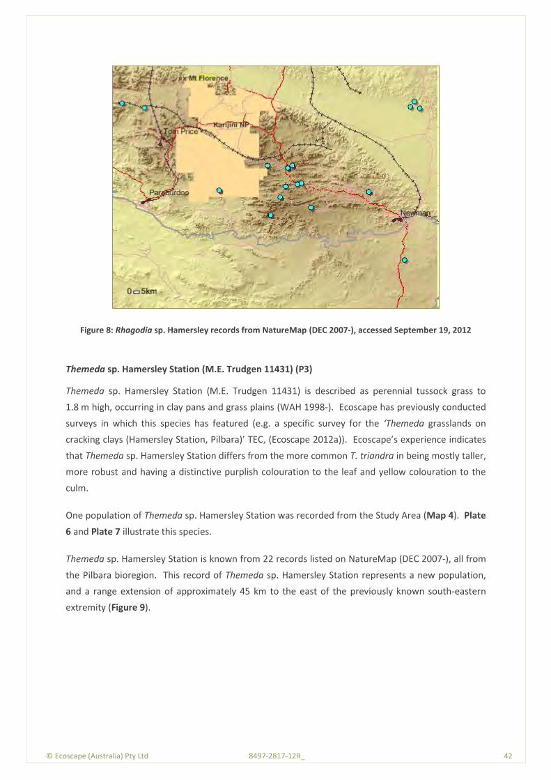
© Ecoscape (Australia) Pty Ltd 8497-2817-12R_ 42
Figure 8: Rhagodia sp. Hamersley records from NatureMap (DEC 2007-), accessed September 19, 2012
Themeda sp. Hamersley Station (M.E. Trudgen 11431) (P3)
Themeda sp. Hamersley Station (M.E. Trudgen 11431) is described as perennial tussock grass to
1.8 m high, occurring in clay pans and grass plains (WAH 1998-). Ecoscape has previously conducted
surveys in which this species has featured (e.g. a specific survey for the ‘Themeda grasslands on
cracking clays (Hamersley Station, Pilbara)’ TEC, (Ecoscape 2012a)). Ecoscape’s experience indicates
that Themeda sp. Hamersley Station differs from the more common T. triandra in being mostly taller,
more robust and having a distinctive purplish colouration to the leaf and yellow colouration to the
culm.
One population of Themeda sp. Hamersley Station was recorded from the Study Area (Map 4). Plate
6 and Plate 7 illustrate this species.
Themeda sp. Hamersley Station is known from 22 records listed on NatureMap (DEC 2007-), all from
the Pilbara bioregion. This record of Themeda sp. Hamersley Station represents a new population,
and a range extension of approximately 45 km to the east of the previously known south-eastern
extremity (Figure 9).
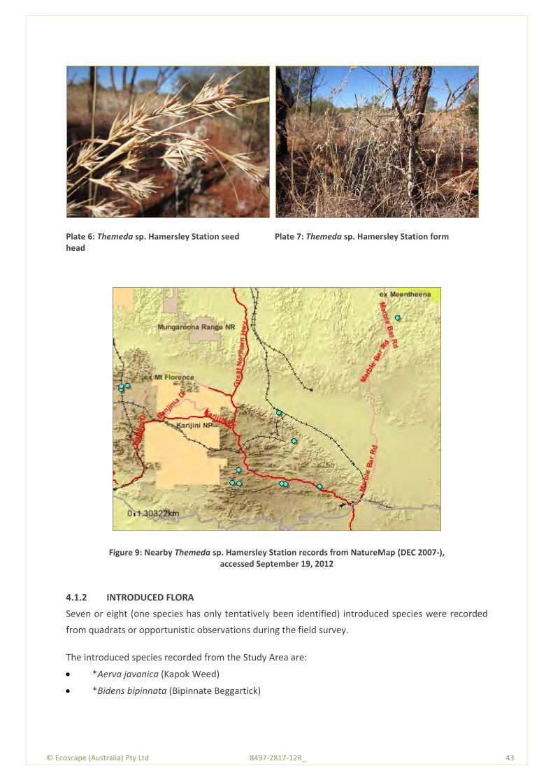
© Ecoscape (Australia) Pty Ltd 8497-2817-12R_ 43
Plate 6: Themeda sp. Hamersley Station seed head
Plate 7: Themeda sp. Hamersley Station form
Figure 9: Nearby Themeda sp. Hamersley Station records from NatureMap (DEC 2007-), accessed September 19, 2012
4.1.2 INTRODUCED FLORA
Seven or eight (one species has only tentatively been identified) introduced species were recorded
from quadrats or opportunistic observations during the field survey.
The introduced species recorded from the Study Area are:
*Aerva javanica (Kapok Weed)
*Bidens bipinnata (Bipinnate Beggartick)
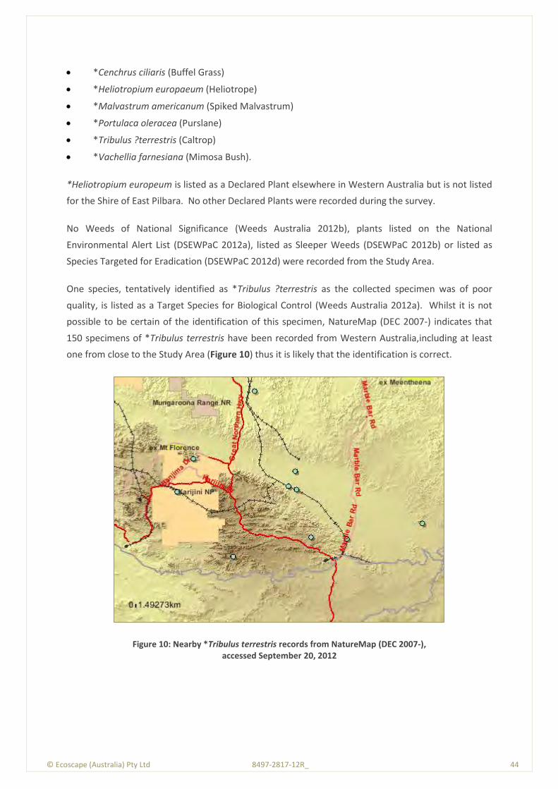
© Ecoscape (Australia) Pty Ltd 8497-2817-12R_ 44
*Cenchrus ciliaris (Buffel Grass)
*Heliotropium europaeum (Heliotrope)
*Malvastrum americanum (Spiked Malvastrum)
*Portulaca oleracea (Purslane)
*Tribulus ?terrestris (Caltrop)
*Vachellia farnesiana (Mimosa Bush).
*Heliotropium europeum is listed as a Declared Plant elsewhere in Western Australia but is not listed
for the Shire of East Pilbara. No other Declared Plants were recorded during the survey.
No Weeds of National Significance (Weeds Australia 2012b), plants listed on the National
Environmental Alert List (DSEWPaC 2012a), listed as Sleeper Weeds (DSEWPaC 2012b) or listed as
Species Targeted for Eradication (DSEWPaC 2012d) were recorded from the Study Area.
One species, tentatively identified as *Tribulus ?terrestris as the collected specimen was of poor
quality, is listed as a Target Species for Biological Control (Weeds Australia 2012a). Whilst it is not
possible to be certain of the identification of this specimen, NatureMap (DEC 2007-) indicates that
150 specimens of *Tribulus terrestris have been recorded from Western Australia,including at least
one from close to the Study Area (Figure 10) thus it is likely that the identification is correct.
Figure 10: Nearby *Tribulus terrestris records from NatureMap (DEC 2007-), accessed September 20, 2012
© Ecoscape (Australia) Pty Ltd 8497-2817-12R_ 45
4.1.2.1 Introduced Flora Descriptions
Descriptions of introduced species are based on field observations, supplemented with information
from Hussey et al. (2007) and FloraBase (WAH 1998-), and NatureMap (DEC 2007-) for distribution
data.
*Aerva javanica (Kapok weed)
*Aerva javanica is a perennial herb to 1.6 m high (approximately 0.8 m high in the Study Area) with
greyish white flowers throughout much of the year. It is usually associated with disturbed areas and
drainage lines, and is found throughout much of northern Western Australia.
Within the Study Area it occurred in isolated patches, and did not form significant infestations.
*Bidens bipinnata (Bipinnate Beggartick)
*Bidens bipinnata is an annual herb to 1.5 m high, although usually approximately 0.5 m high in the
Study Area. *Bidens bipinnata is found throughout much of the north of Western Australia.
Within the Study Area it was associated with Mulga groves but did not form significant infestations.
*Cenchrus ciliaris (Buffel Grass)
*Cenchrus ciliaris is a perennial tussock-forming grass to 1 m high, although usually approximately
0.5 m high in the Study Area. It is generally associated with clay loam soil of drainage lines and
floodplains, and is more common in grazed areas. *Cenchrus ciliaris was either deliberately planted
for pasture or accidently introduced (Van Vreeswyk et al. 2004), and has been known from the
Pilbara bioregion since the early 1900s (Keighery 2010).
It formed clumps in isolated areas within the Study Area and was a significant component (frequently
as the dominant understorey species along drainage lines). It also occurred on the Fortescue River
Floodplain, however this area was, in most places, heavily grazed and it was not possible to
determine if it may have been a dominant species in some areas.
*Cenchrus ciliaris was one of the most frequently recorded species in the Study Area; it occurred in
17 (28%) of quadrats and relevès.
*Heliotropium europaeum (Heliotrope)
*Heliotropeum europaeum is an annual herb to 0.6 m high with white flowers. It is generally found in
the south-west of Western Australia, where it is a Declared Plant.
It was recorded from one quadrat in the Study Area, near the northern end of the surveyed area on
the Fortescue River floodplain, in heavily grazed Eucalyptus victrix and Acacia aptaneura low sparse
woodland. There is only one other record of this species from the Pilbara bioregion (Warrawagine

© Ecoscape (Australia) Pty Ltd 8497-2817-12R_ 46
Station, approximately 260 km north-east of Newman), although ENVIRON Australia Pty Ltd (2009)
reported it as occurring in Roy Hill Stage 2, north of the Study Area. It is a significant finding of
scientific interest, although not a range extension. As it is not a Declared Plant in the Shire of East
Pilbara, it is not considered of concern.
Idenfication of this species is tentative due to the poor quality specimen, however there are no other
similar species so the identification is likely to be correct.
*Malvastrum americanum (Spiked Malvastrum)
*Malvastrum americanum is a perennial herb or shrub to 1.3 m high, although within the Study Area
it was generally less than 0.5 m high. It is usually, but not always, associated with drainage lines and
floodplains and has a wide distribution through northern and arid Western Australia.
Within the Study Area it was a dominant understorey species on the Fortescue River floodplain and
an occasional occurrence elsewhere.
*Portulaca oleracea (Purslane)
*Portulaca oleracea is a succulent prostrate to decumbent annual herb. It is found throughout much
of Western Australia, however there is some dispute if it is native or introduced: FloraBase (WAH
1998-) considers *Portulaca oleracea to be ‘alien’ (introduced), whereas Hussey et al. (2007) consider
it to be native, except in the south-west.
Within the Study Area it was sparsely distributed in grazed areas, but was not observed on the
Fortescue River floodplain.
*Tribulus ?terrestris (Caltrop)
*Tribulus terrestris is a prostrate annual with yellow flowers and spiny spherical fruit. Hussey et al.
(2007) consider that some forms may be native to Western Australia. It is found throughout most of
the state.
Although the identification is not conclusive due to the poor quality of the specimen, T. terrestris has
previously been recorded from less than 5 km from the location it was collected from during this
survey, thus it is likely to be correctly identified.
*Vachellia farnesiana (Mimosa Bush)
*Vachellia farnesiana is an erect spinescent tree or, more usually, shrub to 4 m high. It is widely
distributed through the north of Western Australia, however it occurs sporadically in areas closer to
Perth. Hussey et al. (2007) consider it to have been introduced to Australia prior to European
settlement.

© Ecoscape (Australia) Pty Ltd 8497-2817-12R_ 47
Within the Study Area it was a dominant or characteristic species of the midstratum on the Fortescue
River floodplain.
4.1.2.2 Introduced Species Rankings
Table 10 lists the introduced species (‘*’; weeds) recorded for the Study Area, with their Invasive
Plant Prioritisation Process for the DEC (DEC 2012a) and Environmental Weed Strategy for Western
Australia (EWSWA, CALM 1999) rankings.
Table 10: DEC (2012a) and EWSWA (CALM 1999) rankings
Species Potential
Dist. Current
Dist. Abundance
Ecological Impact
Invasiveness Feasibility of control
Status EWSWA
*Aerva javanica L M A H R H-M EST High
*Bidens bipinnata H H - U R L - Unrated
*Cenchrus ciliaris H H A H R L EST High
*Heliotropium europaeum Not listed for the Pilbara Low
*Malvastrum americanum L H A H R L EST Moderate
*Portulaca oleracea - - - L - - - Low
*Tribulus ?terrestris L L
L S H - Low
*Vachellia farnesiana L H C H R L EST High
Table codes:
H = high, M= moderate, L = low (impact or feasibility of control)
O = occasional (light – scattered individuals), C = common (medium – scattered patches), A = abundant (isolated plants interspersed)
R= rapid, S = slow, U = unknown
EST = established
EWSWA risk rating for invasiveness, distribution and environmental impact criteria (High = three criteria, Moderate = two criteria, Mild = one criteria, Low = scoring on none of the criteria).
Table column headings:
Potential distribution = area of potential habitat in the region that could be occupied or the area at risk of invasion by the weed
Current distribution = area of habitat in the region currently occupied by the weed
Abundance = density class across one or more IBRA regions in the DEC Region
Ecological impact = impact of species within the Region, from low impact (causes minimal disruption to ecological processes or loss of biodiversity) to high (causes acute disruption of ecological processes, dominates and/or significantly alters vegetation structure, composition and function of ecosystems)
Invasiveness = rate of spread of a weed in native vegetation, encompassing factors of establishment, reproduction (time to seeding, seed production, vegetative reproduction) and dispersal (wind, water, flying animals, ground animals, deliberate human spread, accidental human spread, vehicles, produce contaminant)
Feasibility of control = the longer a coordinated control program takes to achieve its desired goal, the more expensive and less feasible it becomes. Key factors to consider include how widespread a weed is, ease of finding infestations, cost of controlling infestations, difficulty of limiting the weed's dispersal, willingness of landholders and governments to control the weed, and commercial use of the plant

© Ecoscape (Australia) Pty Ltd 8497-2817-12R_ 48
Status = defines whether the species is outside the region, considered emerging (density class of occasional), established (density class of common or abundant) or unknown.
4.2 Vegetation Assessment
Due to time limitations, the emphasis during the field survey was placed on identifying botanical
constraints to clearingi.e.identifying the presence and locations of conservation significant flora and
vegetation. Consequently the vegetation was described using a combination of 50 m x 50 m floristic
quadrats and brief relevès that were quicker to record, in which only the physical environment and
dominant and characteristic species were recorded.
4.2.1 VEGETATION TYPES
Thirteen vegetation types, including one mosaic, were identified from the Study Area during the field
survey and subsequent analysis and interpretation. The floristic analaysis dendrogram using the
quadrat data is included in Appendix Nine.
These vegetation types and their extents are included in Table 11, and shown on Map 5.
Roadworks near Kalgan Creek restricted access to 25 ha, which was not surveyed.
Table 11: Vegetation types and their extents within the Study Area
Map Code
Vegetation Type Quadrat/Relevé Area (ha) Proportion
AapAscTe
Acacia aptaneura tall open shrubland over Acacia sclerosperma subsp. sclerosperma and A. synchronicia sparse mid shrubland over Triodia epactia, Eremophila cuneifolia and Ptilotus nobilis var. nobilis mid open shrubland
AHH1221R, AHH1222R, AHH1231Q 44.36 2.73
AapEfTe/AsyAc
Mulga grove: Acacia aptaneura, A. pruinocarpa and A. paraneura low woodland over Eremophila forrestiii subsp. forrestii, Acacia tetragonophylla and E. youngii subsp. lepidota tall-mid sparse shrubland over Triodia epactia, Aristida contorta and A. inaequiglumis mid- low open hummock grassland/mid-low open tussock grassland Mulga intergrove: Acacia synchronicia tall open/sparse shrubland over Aristida contorta, Sclerolaena spp. and Senna sp. Meekatharra (E. Bailey 1-26) low sparse grassland/low sparse chenopod shrubland/low sparse shrubland
AERL2, AERL14, AERL16, AERL17, AHH1201R, AHH1203R, AHH1204R, AHH1206R, AHH1212Q AEQL4, AHH1202R, AHH1205R 322.22 19.82
Mosaic AapEfTe/AsyAc/Tb 29.34 1.80
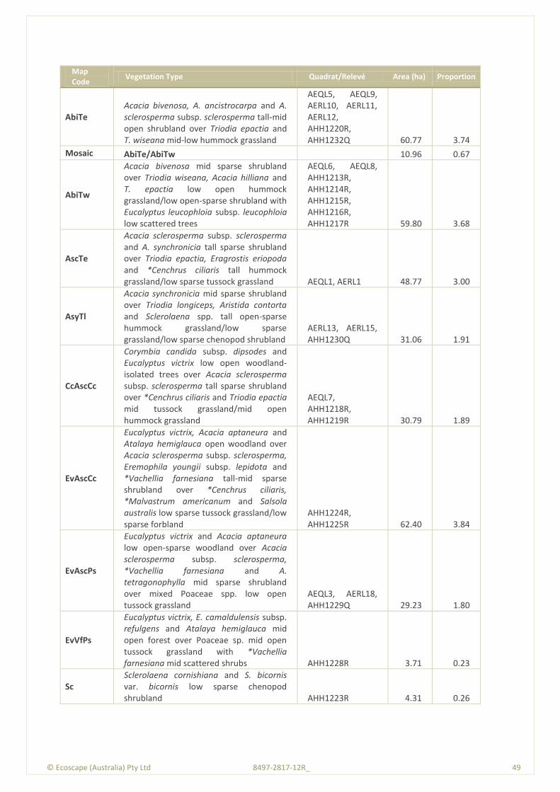
© Ecoscape (Australia) Pty Ltd 8497-2817-12R_ 49
Map Code
Vegetation Type Quadrat/Relevé Area (ha) Proportion
AbiTe Acacia bivenosa, A. ancistrocarpa and A. sclerosperma subsp. sclerosperma tall-mid open shrubland over Triodia epactia and T. wiseana mid-low hummock grassland
AEQL5, AEQL9, AERL10, AERL11, AERL12, AHH1220R, AHH1232Q 60.77 3.74
Mosaic AbiTe/AbiTw 10.96 0.67
AbiTw
Acacia bivenosa mid sparse shrubland over Triodia wiseana, Acacia hilliana and T. epactia low open hummock grassland/low open-sparse shrubland with Eucalyptus leucophloia subsp. leucophloia low scattered trees
AEQL6, AEQL8, AHH1213R, AHH1214R, AHH1215R, AHH1216R, AHH1217R 59.80 3.68
AscTe
Acacia sclerosperma subsp. sclerosperma and A. synchronicia tall sparse shrubland over Triodia epactia, Eragrostis eriopoda and *Cenchrus ciliaris tall hummock grassland/low sparse tussock grassland AEQL1, AERL1 48.77 3.00
AsyTl
Acacia synchronicia mid sparse shrubland over Triodia longiceps, Aristida contorta and Sclerolaena spp. tall open-sparse hummock grassland/low sparse grassland/low sparse chenopod shrubland
AERL13, AERL15, AHH1230Q 31.06 1.91
CcAscCc
Corymbia candida subsp. dipsodes and Eucalyptus victrix low open woodland-isolated trees over Acacia sclerosperma subsp. sclerosperma tall sparse shrubland over *Cenchrus ciliaris and Triodia epactia mid tussock grassland/mid open hummock grassland
AEQL7, AHH1218R, AHH1219R 30.79 1.89
EvAscCc
Eucalyptus victrix, Acacia aptaneura and Atalaya hemiglauca open woodland over Acacia sclerosperma subsp. sclerosperma, Eremophila youngii subsp. lepidota and *Vachellia farnesiana tall-mid sparse shrubland over *Cenchrus ciliaris, *Malvastrum americanum and Salsola australis low sparse tussock grassland/low sparse forbland
AHH1224R, AHH1225R 62.40 3.84
EvAscPs
Eucalyptus victrix and Acacia aptaneura low open-sparse woodland over Acacia sclerosperma subsp. sclerosperma, *Vachellia farnesiana and A. tetragonophylla mid sparse shrubland over mixed Poaceae spp. low open tussock grassland
AEQL3, AERL18, AHH1229Q 29.23 1.80
EvVfPs
Eucalyptus victrix, E. camaldulensis subsp. refulgens and Atalaya hemiglauca mid open forest over Poaceae sp. mid open tussock grassland with *Vachellia farnesiana mid scattered shrubs AHH1228R 3.71 0.23
Sc Sclerolaena cornishiana and S. bicornis var. bicornis low sparse chenopod shrubland AHH1223R 4.31 0.26
© Ecoscape (Australia) Pty Ltd 8497-2817-12R_ 50
Map Code
Vegetation Type Quadrat/Relevé Area (ha) Proportion
Tb Triodia basedowii, T. longiceps and Paraneurachne muelleri mid-low open hummock grassland/low sparse tussock grassland with Acacia ancistrocarpa and A. pachyacra tall-mid scattered shrubs
AEQL2, AERL3, AERL4, AERL5, AERL6, AERL7, AERL8, AERL9, AHH1207R, AHH1209R, AHH1211R, AHH1212R, AHH1220R 678.58 41.73
VfEc
*Vachellia farnesiana and Senna glutinosa subsp. luerssenii x pruinosa mid sparse shrubland over Enneapogon caerulscens, *Cenchrus ciliaris and *Aerva javanica low scattered tussock grassland/low sparse forbland with Acacia aptaneura and A. paraneura low scattered trees
AHH1226R, AHH1227R 184.84 11.37
N/A Roadworks 25.00 1.54
TOTAL 1626.13 100.00
Vegetation type map codes are derived from the first letter of the genus and species of the dominant
species of each stratum, but not including emergent strata. The exception is for Acacia species that
are identified using the first two letters of the species name.
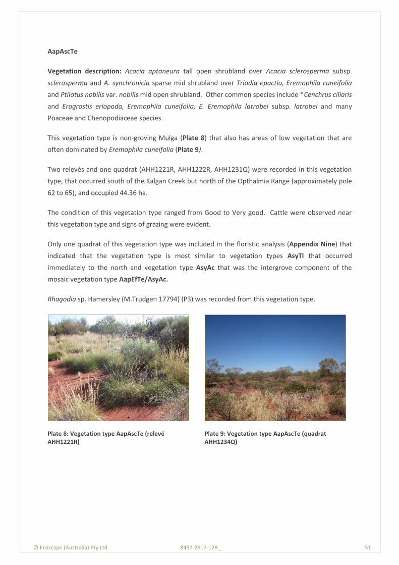
© Ecoscape (Australia) Pty Ltd 8497-2817-12R_ 51
AapAscTe
Vegetation description: Acacia aptaneura tall open shrubland over Acacia sclerosperma subsp.
sclerosperma and A. synchronicia sparse mid shrubland over Triodia epactia, Eremophila cuneifolia
and Ptilotus nobilis var. nobilis mid open shrubland. Other common species include *Cenchrus ciliaris
and Eragrostis eriopoda, Eremophila cuneifolia, E. Eremophila latrobei subsp. latrobei and many
Poaceae and Chenopodiaceae species.
This vegetation type is non-groving Mulga (Plate 8) that also has areas of low vegetation that are
often dominated by Eremophila cuneifolia (Plate 9).
Two relevès and one quadrat (AHH1221R, AHH1222R, AHH1231Q) were recorded in this vegetation
type, that occurred south of the Kalgan Creek but north of the Opthalmia Range (approximately pole
62 to 65), and occupied 44.36 ha.
The condition of this vegetation type ranged from Good to Very good. Cattle were observed near
this vegetation type and signs of grazing were evident.
Only one quadrat of this vegetation type was included in the floristic analysis (Appendix Nine) that
indicated that the vegetation type is most similar to vegetation types AsyTl that occurred
immediately to the north and vegetation type AsyAc that was the intergrove component of the
mosaic vegetation type AapEfTe/AsyAc.
Rhagodia sp. Hamersley (M.Trudgen 17794) (P3) was recorded from this vegetation type.
Plate 8: Vegetation type AapAscTe (relevé AHH1221R)
Plate 9: Vegetation type AapAscTe (quadrat AHH1234Q)
© Ecoscape (Australia) Pty Ltd 8497-2817-12R_ 52
AapEfTe/AsyAc
This vegetation type was groving Mulga, and consisted of a mosaic of Mulga grove (vegetation type
AapEfTe) and intergrove (vegetation type AsyAc).
AapEfTe Mulga grove:
Vegetation description: Acacia aptaneura, A. pruinocarpa and A. paraneura low woodland over
Eremophila forrestiii subsp. forrestii, Acacia tetragonophylla and E. youngii subsp. lepidota tall-mid
sparse shrubland over Triodia epactia, Aristida contorta and A. inaequiglumis mid- low open
hummock grassland/mid-low open tussock grassland. Other common species include Acacia
pruinocarpa, Acacia sclerosperma subsp. sclerosperma, Acacia tetragonophylla, Eremophila
cuneifolia and Sclerolaena cornishiana. The Mulga species also include Acacia macraneura.
Plate 10 illustrate this vegetation type that was recorded from eight relevès and one quadrat (AERL2,
AERL14, AERL16, AERL17, AHH1201R, AHH1203R, AHH1204R, AHH1206R, AHH1212Q). There were
several occurrences of this vegetation type within the Study Area, that in total occupied 322.22 ha.
This vegetation type also occurred in a small-scale mosaic with vegetation type Tb (this section
occupying 29.34 ha), in which the components occurred at a scale too small to be mapped as
individual units.
The condition of this vegetation type ranged from Poor to Very good, depending on the impacts of
cattle grazing.
Only one quadrat of this vegetation type was included in the floristic analysis (Appendix Nine) that
indicated that the vegetation type is most floristically similar to vegetation type AbiTw that occurred
on the hills of the Opthalmia Range, however the relationship was not considered to be closely
similar and a larger number of quadrats is likely to indicate a different relationship. The floristic
analysis indicated that the Mulga grove vegetation type AapEfTe was not floristically similar to the
intergrove vegetation type AsyAc, however they occurred in close proximity and could not be
mapped as a separate unit.
E. youngii subsp. lepidota (P4) was a characteristic species of this vegetation type and intergrove
vegetation type AsyAc in the more northern portion of this Study Area. Themeda sp. Hamersley
Station (M.E. Trudgen 11431) was also recorded from this vegetation type.
AsyAc Mulga intergrove:
Vegetation description: Acacia synchronicia tall open/sparse shrubland over Aristida contorta,
Sclerolaena spp. and Senna sp. Meekatharra (E. Bailey 1-26) low sparse grassland/low sparse
chenopod shrubland/low sparse shrubland. Other common species include Eremophila youngii

© Ecoscape (Australia) Pty Ltd 8497-2817-12R_ 53
subsp. lepidota and several Chenopdiaceae species. The Sclerolaena species recorded from this
vegetation type include S. costata, S. cuneata, S. densiflora and S. lanicuspis.
Plate 11 illustrates this vegetation type that was recorded from two relevès and one quadrat (AEQL4,
AHH1202R, AHH1205R).
The condition of this vegetation type ranged from Good-Very good depending on the impacts of
cattle grazing.
Plate 10: Vegetation type AapEfTe, Mulga grove (relevé AHH1204R)
Plate 11: Vegetation type AsyAc Mulga intergrove (relevé AHH1202R)
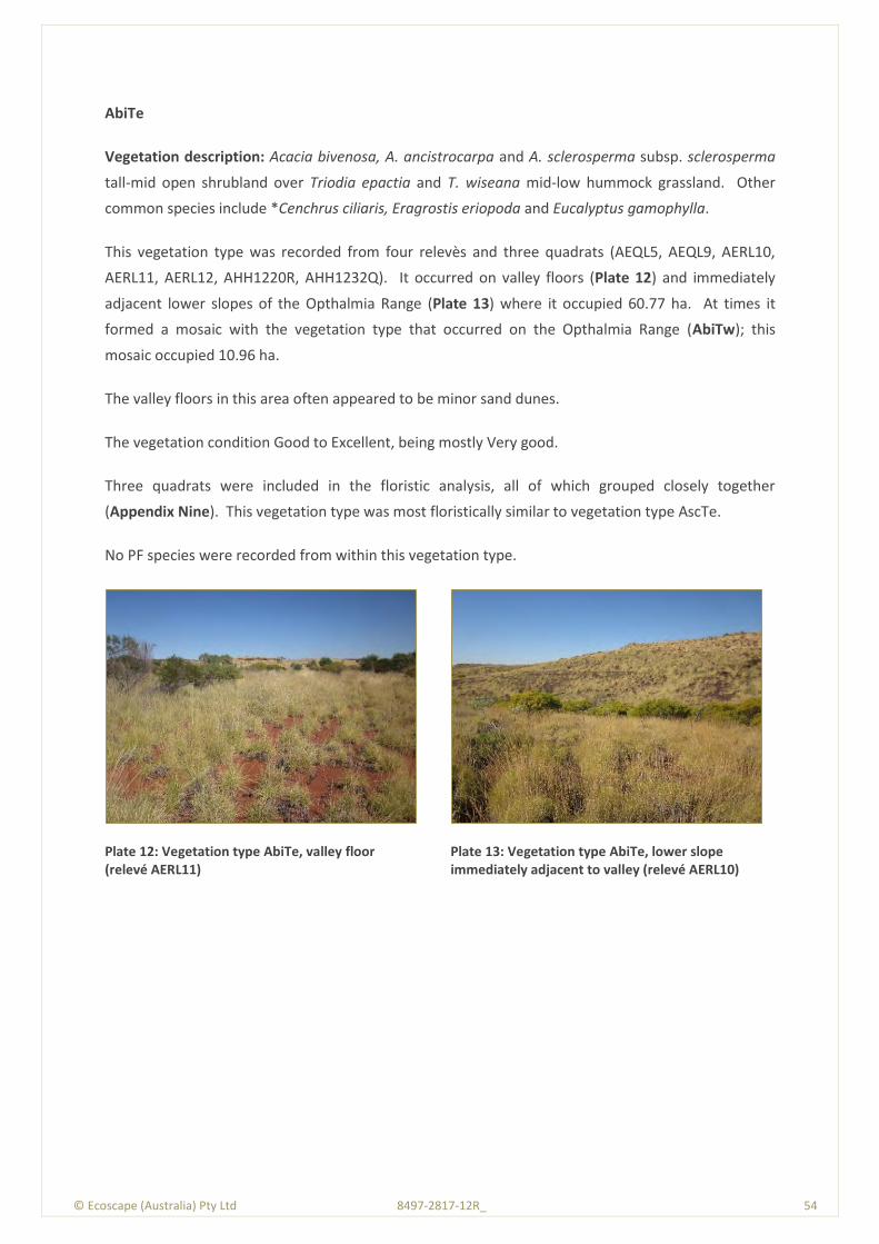
© Ecoscape (Australia) Pty Ltd 8497-2817-12R_ 54
AbiTe
Vegetation description: Acacia bivenosa, A. ancistrocarpa and A. sclerosperma subsp. sclerosperma
tall-mid open shrubland over Triodia epactia and T. wiseana mid-low hummock grassland. Other
common species include *Cenchrus ciliaris, Eragrostis eriopoda and Eucalyptus gamophylla.
This vegetation type was recorded from four relevès and three quadrats (AEQL5, AEQL9, AERL10,
AERL11, AERL12, AHH1220R, AHH1232Q). It occurred on valley floors (Plate 12) and immediately
adjacent lower slopes of the Opthalmia Range (Plate 13) where it occupied 60.77 ha. At times it
formed a mosaic with the vegetation type that occurred on the Opthalmia Range (AbiTw); this
mosaic occupied 10.96 ha.
The valley floors in this area often appeared to be minor sand dunes.
The vegetation condition Good to Excellent, being mostly Very good.
Three quadrats were included in the floristic analysis, all of which grouped closely together
(Appendix Nine). This vegetation type was most floristically similar to vegetation type AscTe.
No PF species were recorded from within this vegetation type.
Plate 12: Vegetation type AbiTe, valley floor (relevé AERL11)
Plate 13: Vegetation type AbiTe, lower slope immediately adjacent to valley (relevé AERL10)
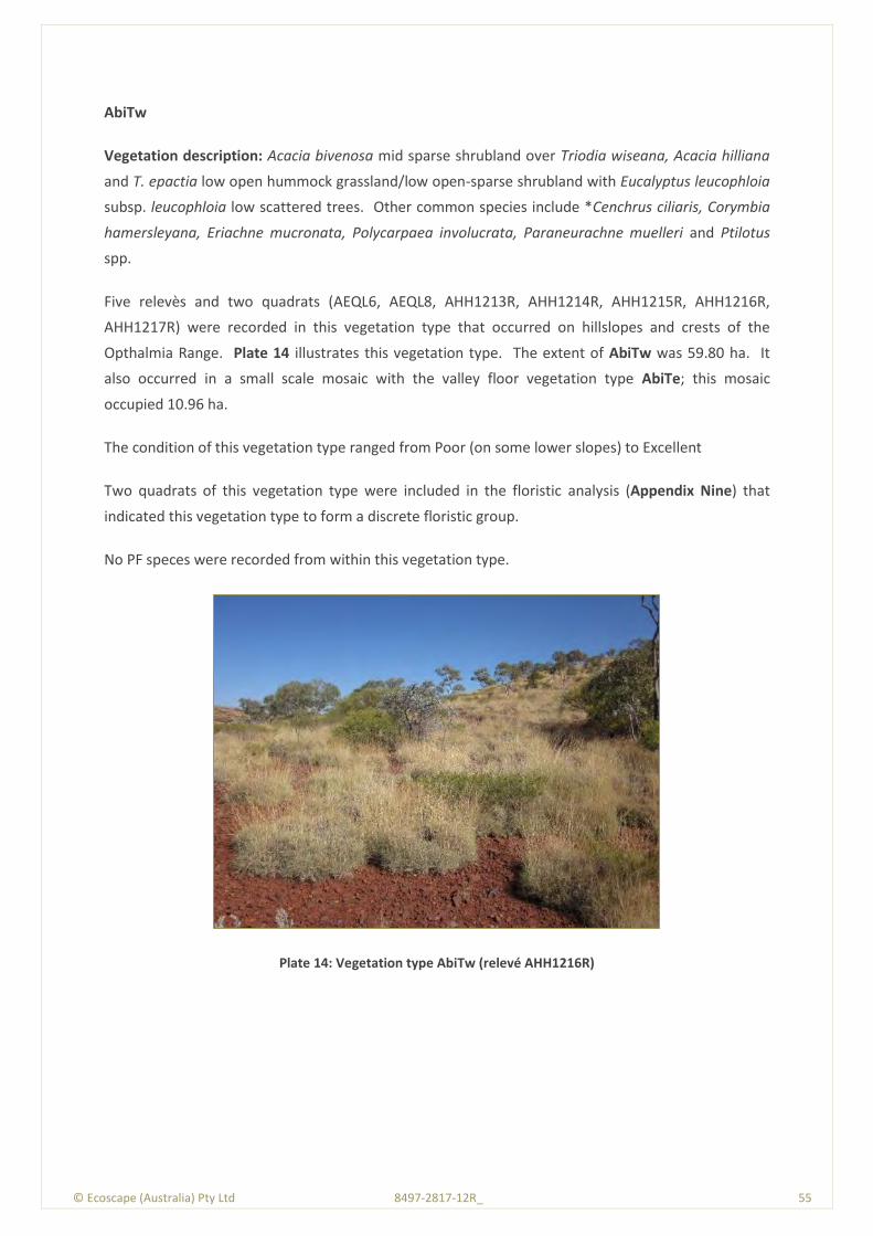
© Ecoscape (Australia) Pty Ltd 8497-2817-12R_ 55
AbiTw
Vegetation description: Acacia bivenosa mid sparse shrubland over Triodia wiseana, Acacia hilliana
and T. epactia low open hummock grassland/low open-sparse shrubland with Eucalyptus leucophloia
subsp. leucophloia low scattered trees. Other common species include *Cenchrus ciliaris, Corymbia
hamersleyana, Eriachne mucronata, Polycarpaea involucrata, Paraneurachne muelleri and Ptilotus
spp.
Five relevès and two quadrats (AEQL6, AEQL8, AHH1213R, AHH1214R, AHH1215R, AHH1216R,
AHH1217R) were recorded in this vegetation type that occurred on hillslopes and crests of the
Opthalmia Range. Plate 14 illustrates this vegetation type. The extent of AbiTw was 59.80 ha. It
also occurred in a small scale mosaic with the valley floor vegetation type AbiTe; this mosaic
occupied 10.96 ha.
The condition of this vegetation type ranged from Poor (on some lower slopes) to Excellent
Two quadrats of this vegetation type were included in the floristic analysis (Appendix Nine) that
indicated this vegetation type to form a discrete floristic group.
No PF speces were recorded from within this vegetation type.
Plate 14: Vegetation type AbiTw (relevé AHH1216R)
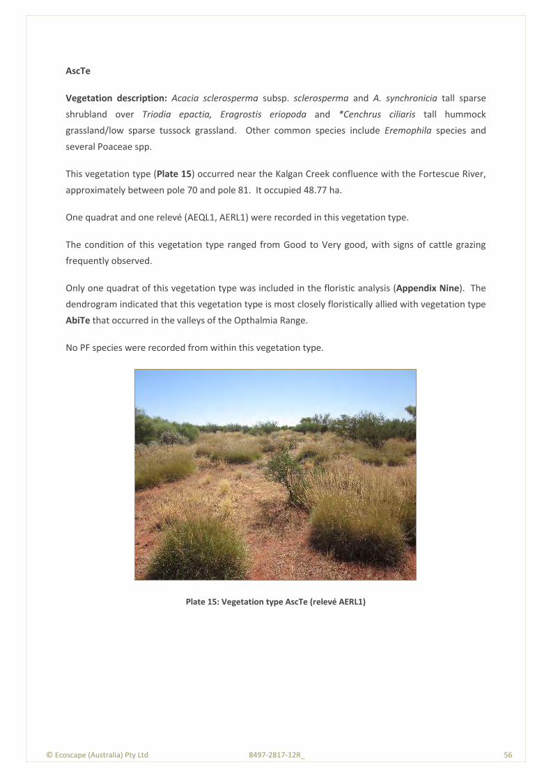
© Ecoscape (Australia) Pty Ltd 8497-2817-12R_ 56
AscTe
Vegetation description: Acacia sclerosperma subsp. sclerosperma and A. synchronicia tall sparse
shrubland over Triodia epactia, Eragrostis eriopoda and *Cenchrus ciliaris tall hummock
grassland/low sparse tussock grassland. Other common species include Eremophila species and
several Poaceae spp.
This vegetation type (Plate 15) occurred near the Kalgan Creek confluence with the Fortescue River,
approximately between pole 70 and pole 81. It occupied 48.77 ha.
One quadrat and one relevé (AEQL1, AERL1) were recorded in this vegetation type.
The condition of this vegetation type ranged from Good to Very good, with signs of cattle grazing
frequently observed.
Only one quadrat of this vegetation type was included in the floristic analysis (Appendix Nine). The
dendrogram indicated that this vegetation type is most closely floristically allied with vegetation type
AbiTe that occurred in the valleys of the Opthalmia Range.
No PF species were recorded from within this vegetation type.
Plate 15: Vegetation type AscTe (relevé AERL1)

© Ecoscape (Australia) Pty Ltd 8497-2817-12R_ 57
AsyTl
Vegetation description: Acacia synchronicia mid sparse shrubland over Triodia longiceps, Aristida
contorta and Sclerolaena spp. tall open-sparse hummock grassland/low sparse grassland/low sparse
chenopod shrubland. Other common species include Acacia aptaneura, Eragrostis dielsii, E. falcata,
Sporobolis australasicus and Chenopodiaceae species. The Sclerolaena species include S.
beaugleholei, S. densiflora and S. eriacantha.
Two relevès and one quadrat (AERL13, AERL15, AHH1230Q) were recorded from this vegetation type,
that occurred on soil that appeared to be slightly saline. Most of the vegetation was similar to Plate
16 however there were some lower lying areas (minor depressions) dominated by Chenopodiaceae
spp. (Plate 17). There were two occurrences of this vegetation type, approximately between poles
63 and 69, and poles 187 and 190. The total extent was 31.06 ha.
The condition of this vegetation type ranged from Good to Very good.
Only one quadrat of this vegetation type was included in the floristic analysis (Appendix Nine) that
indicated that this vegetation type is floristically most similar to the Mulga intergrove vegetation type
AsyAc.
The P4 species Eremophila youngii subsp. lepidota was associated with this vegetation type in the
southern extent, and is a new population of this species but not a range extension.
Plate 16: Vegetation type AstTl (relevé AERL13)
Plate 17: Vegetation type AsyTl, depression (relevé AERL15)
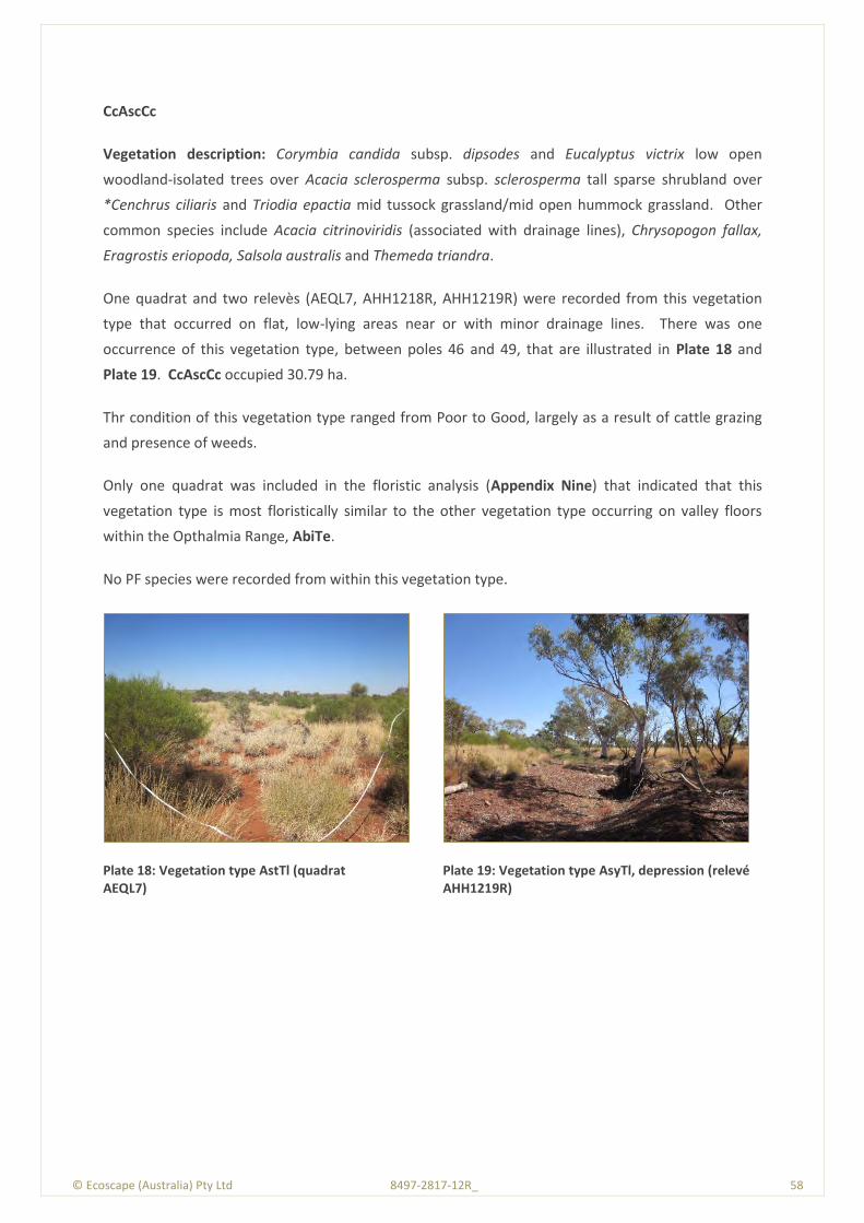
© Ecoscape (Australia) Pty Ltd 8497-2817-12R_ 58
CcAscCc
Vegetation description: Corymbia candida subsp. dipsodes and Eucalyptus victrix low open
woodland-isolated trees over Acacia sclerosperma subsp. sclerosperma tall sparse shrubland over
*Cenchrus ciliaris and Triodia epactia mid tussock grassland/mid open hummock grassland. Other
common species include Acacia citrinoviridis (associated with drainage lines), Chrysopogon fallax,
Eragrostis eriopoda, Salsola australis and Themeda triandra.
One quadrat and two relevès (AEQL7, AHH1218R, AHH1219R) were recorded from this vegetation
type that occurred on flat, low-lying areas near or with minor drainage lines. There was one
occurrence of this vegetation type, between poles 46 and 49, that are illustrated in Plate 18 and
Plate 19. CcAscCc occupied 30.79 ha.
Thr condition of this vegetation type ranged from Poor to Good, largely as a result of cattle grazing
and presence of weeds.
Only one quadrat was included in the floristic analysis (Appendix Nine) that indicated that this
vegetation type is most floristically similar to the other vegetation type occurring on valley floors
within the Opthalmia Range, AbiTe.
No PF species were recorded from within this vegetation type.
Plate 18: Vegetation type AstTl (quadrat AEQL7)
Plate 19: Vegetation type AsyTl, depression (relevé AHH1219R)
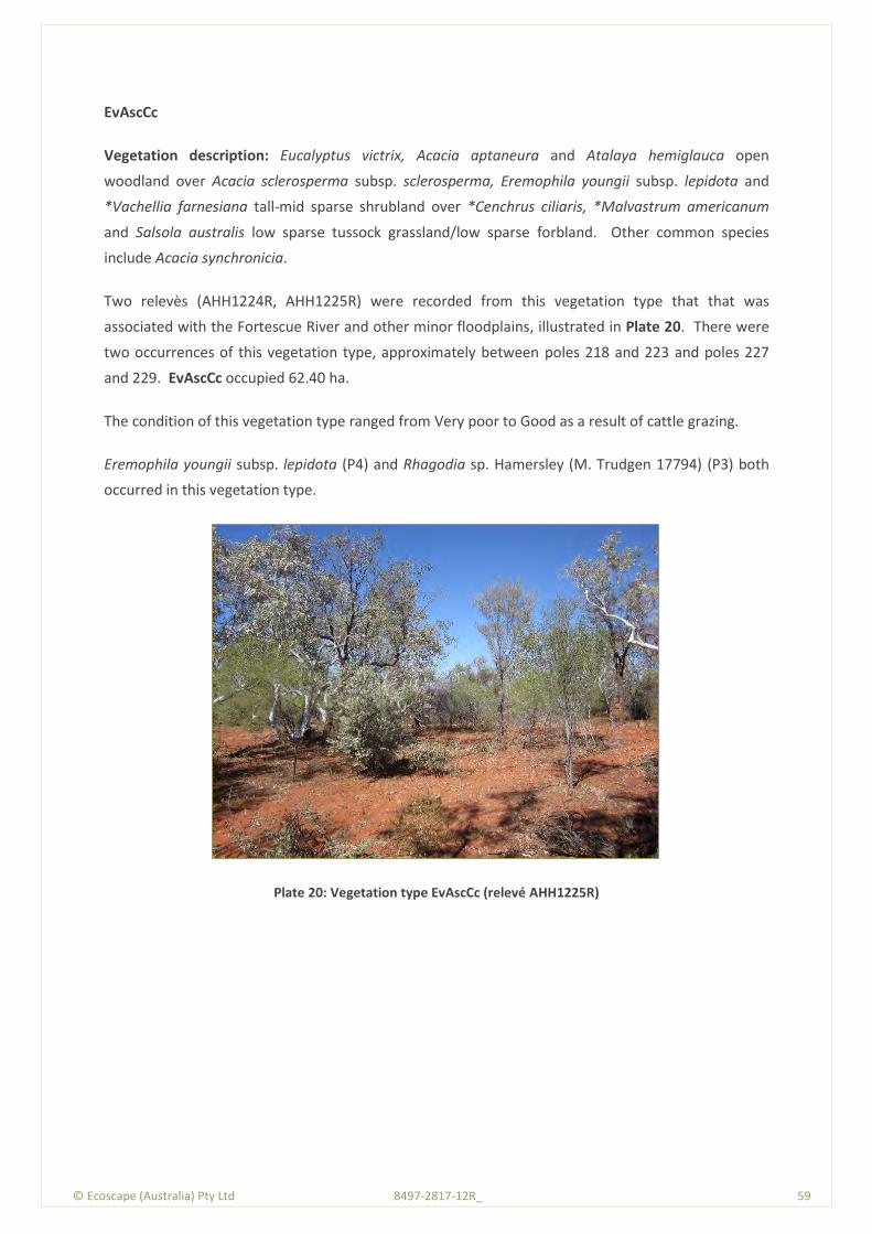
© Ecoscape (Australia) Pty Ltd 8497-2817-12R_ 59
EvAscCc
Vegetation description: Eucalyptus victrix, Acacia aptaneura and Atalaya hemiglauca open
woodland over Acacia sclerosperma subsp. sclerosperma, Eremophila youngii subsp. lepidota and
*Vachellia farnesiana tall-mid sparse shrubland over *Cenchrus ciliaris, *Malvastrum americanum
and Salsola australis low sparse tussock grassland/low sparse forbland. Other common species
include Acacia synchronicia.
Two relevès (AHH1224R, AHH1225R) were recorded from this vegetation type that that was
associated with the Fortescue River and other minor floodplains, illustrated in Plate 20. There were
two occurrences of this vegetation type, approximately between poles 218 and 223 and poles 227
and 229. EvAscCc occupied 62.40 ha.
The condition of this vegetation type ranged from Very poor to Good as a result of cattle grazing.
Eremophila youngii subsp. lepidota (P4) and Rhagodia sp. Hamersley (M. Trudgen 17794) (P3) both
occurred in this vegetation type.
Plate 20: Vegetation type EvAscCc (relevé AHH1225R)
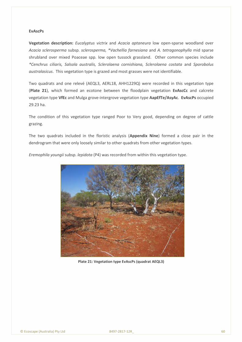
© Ecoscape (Australia) Pty Ltd 8497-2817-12R_ 60
EvAscPs
Vegetation description: Eucalyptus victrix and Acacia aptaneura low open-sparse woodland over
Acacia sclerosperma subsp. sclerosperma, *Vachellia farnesiana and A. tetragonophylla mid sparse
shrubland over mixed Poaceae spp. low open tussock grassland. Other common species include
*Cenchrus ciliaris, Salsola australis, Sclerolaena cornishiana, Sclerolaena costata and Sporobolus
australasicus. This vegetation type is grazed and most grasses were not identifiable.
Two quadrats and one relevé (AEQL3, AERL18, AHH1229Q) were recorded in this vegetation type
(Plate 21), which formed an ecotone between the floodplain vegetation EvAscCc and calcrete
vegetation type VfEc and Mulga grove-intergrove vegetation type AapEfTe/AsyAc. EvAscPs occupied
29.23 ha.
The condition of this vegetation type ranged Poor to Very good, depending on degree of cattle
grazing.
The two quadrats included in the floristic analysis (Appendix Nine) formed a close pair in the
dendrogram that were only loosely similar to other quadrats from other vegetation types.
Eremophila youngii subsp. lepidota (P4) was recorded from within this vegetation type.
Plate 21: Vegetation type EvAscPs (quadrat AEQL3)
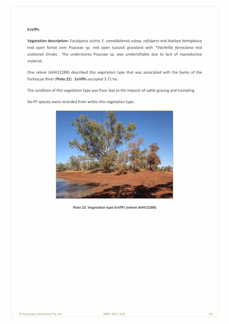
© Ecoscape (Australia) Pty Ltd 8497-2817-12R_ 61
EvVfPs
Vegetation description: Eucalyptus victrix, E. camaldulensis subsp. refulgens and Atalaya hemiglauca
mid open forest over Poaceae sp. mid open tussock grassland with *Vachellia farnesiana mid
scattered shrubs. The understorey Poaceae sp. was unidentifiable due to lack of reproductive
material.
One relevé (AHH1228R) described this vegetation type that was associated with the banks of the
Fortescue River (Plate 22). EvVfPs occupied 3.71 ha.
The condition of this vegetation type was Poor due to the impacts of cattle grazing and trampling.
No PF species were recorded from within this vegetation type.
Plate 22: Vegetation type EvVfPs (relevé AHH1228R)

© Ecoscape (Australia) Pty Ltd 8497-2817-12R_ 62
Sc
Vegetation description: Sclerolaena cornishiana and S. bicornis var. bicornis low sparse chenopod
shrubland.
One relevé was recorded on this vegetation type (AHH1223R) that occurred on clay flats and clay
pans at the northern portion of the surveyed Study Area (Plate 23). Sc occupied 4.31 ha.
The vegetation condition ranged from Poor to Good as a result of cattle grazing, with some areas
almost devoid of vegetation.
No PF species were recorded from within this vegetation type.
Plate 23: Vegetation type Sc (relevé AHH1223R)
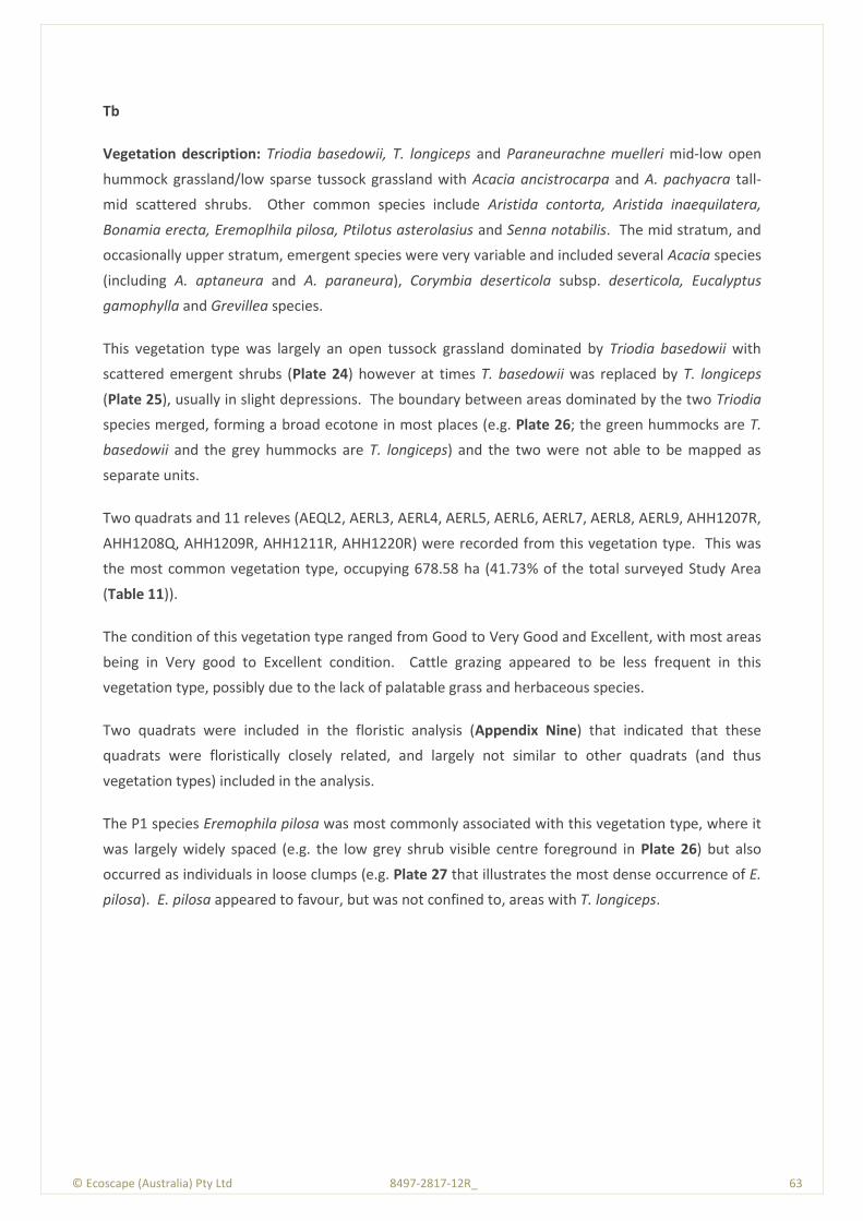
© Ecoscape (Australia) Pty Ltd 8497-2817-12R_ 63
Tb
Vegetation description: Triodia basedowii, T. longiceps and Paraneurachne muelleri mid-low open
hummock grassland/low sparse tussock grassland with Acacia ancistrocarpa and A. pachyacra tall-
mid scattered shrubs. Other common species include Aristida contorta, Aristida inaequilatera,
Bonamia erecta, Eremoplhila pilosa, Ptilotus asterolasius and Senna notabilis. The mid stratum, and
occasionally upper stratum, emergent species were very variable and included several Acacia species
(including A. aptaneura and A. paraneura), Corymbia deserticola subsp. deserticola, Eucalyptus
gamophylla and Grevillea species.
This vegetation type was largely an open tussock grassland dominated by Triodia basedowii with
scattered emergent shrubs (Plate 24) however at times T. basedowii was replaced by T. longiceps
(Plate 25), usually in slight depressions. The boundary between areas dominated by the two Triodia
species merged, forming a broad ecotone in most places (e.g. Plate 26; the green hummocks are T.
basedowii and the grey hummocks are T. longiceps) and the two were not able to be mapped as
separate units.
Two quadrats and 11 releves (AEQL2, AERL3, AERL4, AERL5, AERL6, AERL7, AERL8, AERL9, AHH1207R,
AHH1208Q, AHH1209R, AHH1211R, AHH1220R) were recorded from this vegetation type. This was
the most common vegetation type, occupying 678.58 ha (41.73% of the total surveyed Study Area
(Table 11)).
The condition of this vegetation type ranged from Good to Very Good and Excellent, with most areas
being in Very good to Excellent condition. Cattle grazing appeared to be less frequent in this
vegetation type, possibly due to the lack of palatable grass and herbaceous species.
Two quadrats were included in the floristic analysis (Appendix Nine) that indicated that these
quadrats were floristically closely related, and largely not similar to other quadrats (and thus
vegetation types) included in the analysis.
The P1 species Eremophila pilosa was most commonly associated with this vegetation type, where it
was largely widely spaced (e.g. the low grey shrub visible centre foreground in Plate 26) but also
occurred as individuals in loose clumps (e.g. Plate 27 that illustrates the most dense occurrence of E.
pilosa). E. pilosa appeared to favour, but was not confined to, areas with T. longiceps.

© Ecoscape (Australia) Pty Ltd 8497-2817-12R_ 64
Plate 24: Vegetation type Tb; the more usual form dominated by T. basedowii (relevé AERL3)
Plate 25: Vegetation type Tb; dominated by T. longiceps (relevé AHH1211R)
Plate 26: Vegetation type Tb; ecotone (relevé AERL8)
Plate 27: Vegetation type Tb; most dense Eremophila pilosa area
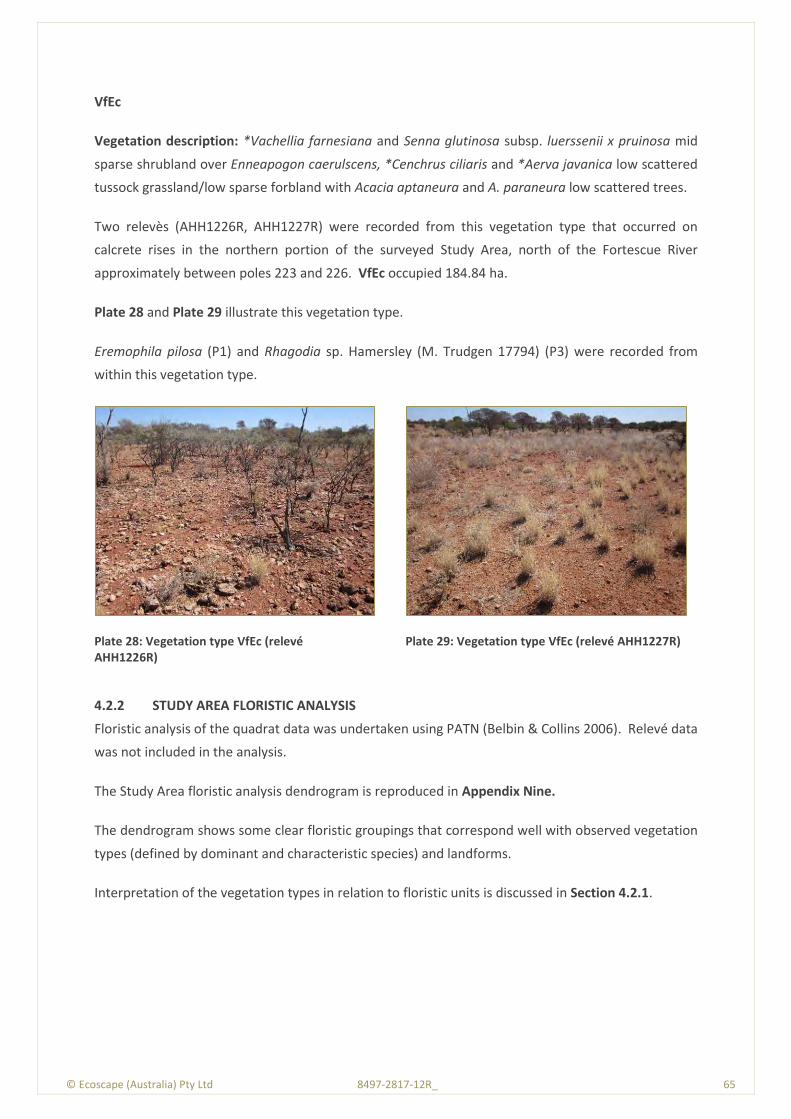
© Ecoscape (Australia) Pty Ltd 8497-2817-12R_ 65
VfEc
Vegetation description: *Vachellia farnesiana and Senna glutinosa subsp. luerssenii x pruinosa mid
sparse shrubland over Enneapogon caerulscens, *Cenchrus ciliaris and *Aerva javanica low scattered
tussock grassland/low sparse forbland with Acacia aptaneura and A. paraneura low scattered trees.
Two relevès (AHH1226R, AHH1227R) were recorded from this vegetation type that occurred on
calcrete rises in the northern portion of the surveyed Study Area, north of the Fortescue River
approximately between poles 223 and 226. VfEc occupied 184.84 ha.
Plate 28 and Plate 29 illustrate this vegetation type.
Eremophila pilosa (P1) and Rhagodia sp. Hamersley (M. Trudgen 17794) (P3) were recorded from
within this vegetation type.
Plate 28: Vegetation type VfEc (relevé AHH1226R)
Plate 29: Vegetation type VfEc (relevé AHH1227R)
4.2.2 STUDY AREA FLORISTIC ANALYSIS
Floristic analysis of the quadrat data was undertaken using PATN (Belbin & Collins 2006). Relevé data
was not included in the analysis.
The Study Area floristic analysis dendrogram is reproduced in Appendix Nine.
The dendrogram shows some clear floristic groupings that correspond well with observed vegetation
types (defined by dominant and characteristic species) and landforms.
Interpretation of the vegetation types in relation to floristic units is discussed in Section 4.2.1.
© Ecoscape (Australia) Pty Ltd 8497-2817-12R_ 66
4.2.3 CONSERVATION SIGNIFICANT VEGETATION TYPES
4.2.3.1 Threatened or Priority Ecological Communities
No vegetation assessed as being, or likely to be considered, as a TEC or PEC was recorded from the
Study Area.
4.2.3.2 Groundwater Dependent Ecosystems
Vegetation including Eucalyptus camaldulensis
Eucalyptus camaldulensis subsp. refulgens is widely regarded as being characteristic of a GDE (see
Section 2.2.4.4). This species was a component of vegetation type EvVfPs, thus this vegetation type
can be considered to represent a GDE.
EvVfPs occupied 3.71 ha of the Study Area.
Eucalyptus victrix-dominated vegetation
Current evidence does not clearly indicate if Eucalyptus victrix is groundwater dependent or not. In
some populations it has been demonstrated to be at most weakly phreatophytic (ie able to access
groundwater) and tolerant of lowered groundwater tables (Batini 2008; EPA & Hamersley Iron Pty
Ltd 2010; Maunsell Australia Pty Ltd 2006). Other populations are considered to be not dependent
on groundwater (eg Resource and Environmental Management Pty Ltd 2007). However, the EPA has
required monitoring of E. victrix populations in Karijini National Park that may be impacted by
groundwater drawdown as a result of activities in the nearby Marandoo Mine (EPA & Hamersley Iron
Pty Ltd 2010) and Eamus (2009a) discusses a population of E. victrix that is considered to be
groundwater dependent, indicating the potential for E. victrix-dominated vegetation to be
considered as a GDE.
Based on the evidence listed above (and others; not quoted), it is not possible to conclude if E. victrix
is dependent on groundwater or not. However the precautionary principle outlined in Position
Statement No. 7 – Principles of Environmental Protection (EPA2004b) should be followed and E.
victrix considered to be at least partly groundwater dependent and therefore potentially
characteristic of a GDE.
Four vegetation types are either dominated or characterised by Eucalyptus victrix; CcAscCc
(occupying 30.79 ha), EvAscCc (occupying 29.23 ha), EvAscPs (occupying 62.40 ha) and EvVfPs (see
above). The three first listed vegetation types can be considered to potentially represent a GDE.
© Ecoscape (Australia) Pty Ltd 8497-2817-12R_ 67
4.2.3.3 Sheet Flow Dependent Communities
Grove-intergrove Mulga is considered to be dependent on surface water flows to regenerate, and are
therefore vulnerable to changes in surface hydrology including mounding and lowered surfaces
associated with roads and tracks.
The mosaic vegetation type AapEfTe/AsyAc is considered to be grove-intergrove Mulga.
4.2.3.4 Other Measures of Vegetation Type Significance
In Guidance Statement No. 51 (2004a), the EPA lists several reasons why vegetation may be
considered to be significant in addition to its listing as a TEC or PEC or because the extent is below a
minimum threshold. These reasons, which may apply at a number of scales but are not defined in
detail, include:
scarcity
unusual species
novel combinations of species
role as a refuge
role as a key habitat for threatened species or large populations representing a significant
proportion of the local to regional total population of a species
being representative of the range of a unit (particularly a good local and/or regional example
of a unit in ’prime’ habitat, at the extremes of range, recently discovered range extension or
isolated outliers of the main range)
restricted distribution.
Locally significant vegetation, unless it is a TEC, do not have any form of statutory protection.
Vegetation type Tb that was the main habitat for P1 species Eremophila pilosa may be considered to
be perform the role of key habitat for the species. However, P1 species are not considered as
threatened species; rather they are poorly known, with no known populations on conservation lands
(Table 18).
Vegetation significance is discussed in Section 5.2.
4.2.4 VEGETATION CONDITION
Vegetation condition was assessed both within quadrats and relevès (which were recorded in areas
considered typical of the vegetation type) and extrapolated to the surrounding area, and from ‘spot
recordings’ noted during traverses through the Study Area.
The extents and proportion of each vegetation condition rating category (using the adapted Keighery
Vegetation Condition Scale (EPA & DEC 2012)) is shown in Table 12. Map 6 shows the vegetation
condition of the Study Area.
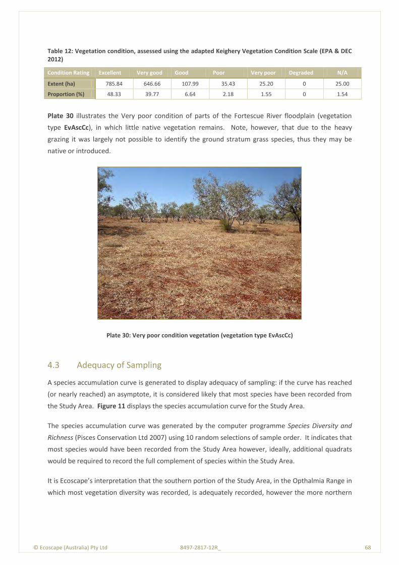
© Ecoscape (Australia) Pty Ltd 8497-2817-12R_ 68
Table 12: Vegetation condition, assessed using the adapted Keighery Vegetation Condition Scale (EPA & DEC 2012)
Condition Rating Excellent Very good Good Poor Very poor Degraded N/A
Extent (ha) 785.84 646.66 107.99 35.43 25.20 0 25.00
Proportion (%) 48.33 39.77 6.64 2.18 1.55 0 1.54
Plate 30 illustrates the Very poor condition of parts of the Fortescue River floodplain (vegetation
type EvAscCc), in which little native vegetation remains. Note, however, that due to the heavy
grazing it was largely not possible to identify the ground stratum grass species, thus they may be
native or introduced.
Plate 30: Very poor condition vegetation (vegetation type EvAscCc)
4.3 Adequacy of Sampling
A species accumulation curve is generated to display adequacy of sampling: if the curve has reached
(or nearly reached) an asymptote, it is considered likely that most species have been recorded from
the Study Area. Figure 11 displays the species accumulation curve for the Study Area.
The species accumulation curve was generated by the computer programme Species Diversity and
Richness (Pisces Conservation Ltd 2007) using 10 random selections of sample order. It indicates that
most species would have been recorded from the Study Area however, ideally, additional quadrats
would be required to record the full complement of species within the Study Area.
It is Ecoscape’s interpretation that the southern portion of the Study Area, in the Opthalmia Range in
which most vegetation diversity was recorded, is adequately recorded, however the more northern
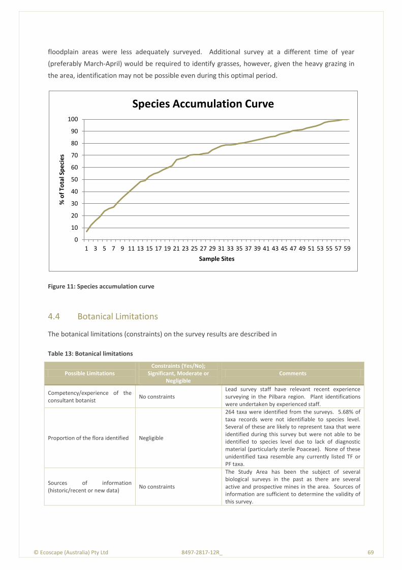
© Ecoscape (Australia) Pty Ltd 8497-2817-12R_ 69
floodplain areas were less adequately surveyed. Additional survey at a different time of year
(preferably March-April) would be required to identify grasses, however, given the heavy grazing in
the area, identification may not be possible even during this optimal period.
Figure 11: Species accumulation curve
4.4 Botanical Limitations
The botanical limitations (constraints) on the survey results are described in
Table 13: Botanical limitations
Possible Limitations Constraints (Yes/No);
Significant, Moderate or Negligible
Comments
Competency/experience of the consultant botanist
No constraints Lead survey staff have relevant recent experience surveying in the Pilbara region. Plant identifications were undertaken by experienced staff.
Proportion of the flora identified Negligible
264 taxa were identified from the surveys. 5.68% of taxa records were not identifiable to species level. Several of these are likely to represent taxa that were identified during this survey but were not able to be identified to species level due to lack of diagnostic material (particularly sterile Poaceae). None of these unidentified taxa resemble any currently listed TF or PF taxa.
Sources of information (historic/recent or new data)
No constraints
The Study Area has been the subject of several biological surveys in the past as there are several active and prospective mines in the area. Sources of information are sufficient to determine the validity of this survey.
0
10
20
30
40
50
60
70
80
90
100
1 3 5 7 9 11 13 15 17 19 21 23 25 27 29 31 33 35 37 39 41 43 45 47 49 51 53 55 57 59
% o
f To
tal S
pe
cie
s
Sample Sites
Species Accumulation Curve
© Ecoscape (Australia) Pty Ltd 8497-2817-12R_ 70
Possible Limitations Constraints (Yes/No);
Significant, Moderate or Negligible
Comments
Proportion of the task achieved and further work that may need to be undertaken
Negligible (for surveyed area)
A small section was not surveyed on foot for conservation significant flora species, however the unsurveyed area is highly unlikely to contain TF as the habitat of the known Pilbara TF was not present in this area. P4 species are known to occur in this area, however this species is extremely common (and a dominant mid stratum species) thus the overall population is not threatened by the small amount clearing anticipated.
Timing/weather/season/cycle Negligible-moderate
The survey was conducted during August, which is not considered optimal to identify plants in the area. However, the rainfall was considered average, thus providing no constraints on the presence of ephemeral species and a negligible to moderate constraint in terms of the ability to identify ephemerals and grass species due to lack of reportductive material. However, no TF species were anticipated in the area due to lack of suitable habitat, and no specimens were considered likely to have been TF. The known P1 species in the area, Eremophila pilosa, was flowering during the field survey and readily identifiable.
Intensity of survey No constraints (for surveyed area)
Ecoscape considered the survey of sufficient intensity to identify botanical constraints in relation to the proposed clearing.
Completeness (e.g. was relevant area fully surveyed)
Negligible (for surveyed area)
Approximately 10% of the field survey was not covered by a foot traverse, however the flora and vegetation of the unsurveyed area is sufficiently understood to anticipate no botanical constraints to the proposed clearing.
Resources (e.g. degree of expertise available for plant identification)
Negligible Sufficient resources were available..
Availability of contextual (e.g. bioregional) information for the Study Area
Negligible Adequate information was available.
4.5 Fauna and Habitat
4.5.1 HABITAT TYPES
Components of ‘habitat type’ that affect whether a particular vertebrate species is likely to be
present or absent at a site include (among others) topography, rock type, soil type, vegetation
structure, presence/absence of particular plant taxa or size/age classes, and waterbodies.
For this report, the habitat types of the Study Area are represented by Land Systems as described
and mapped by Van Vreeswyk et al (2004), as the field survey confirmed that they are reasonably
distinct from each other (often with boundaries clearly perceptible on the ground and/or aerial view)
and more or less uniform internally (Map 7). Brief descriptions of land systems and their extents
within the Study Area are provided in Table 2 and Table 3 (Section 2.1.3). Recognition of a smaller
© Ecoscape (Australia) Pty Ltd 8497-2817-12R_ 71
number of habitat types (e.g. by ‘lumping’ of land systems) would obscure differences relevant to the
known requirements or associations of at least some of the conservation significant fauna species.
Approximately one third of the Study Area lies within the Divide Land System (sandplain and Spinifex
with scattered shrubs), with smaller proportions (5-15%) in Jamindie LS (hardpan clay and stony lag
with mulga groves and Spinifex), Fan LS (hardpan clay and sandy loam with mulga groves and tussock
grass), Newman LS (banded ironstone hills with Spinifex), and Elimunna LS (stony plains and low hills
with shrubland and tussock grass), and 1-5% of the area in each of the remaining eight systems.
4.5.2 HABITAT CONDITION
The condition of habitat was relatively good through most of the Study Area, and generally
corresponds to the vegetation condition (4.2.4). Disturbance and degradation was associated both
with existing infrastructure (road, rail, minor tracks) intersecting or adjacent to the Study Area, and
grazing by introduced stock. Degradation of understorey vegetation, with loss of grass cover or
replacement by weeds, was particularly evident in the Eucalyptus victrix woodland with and without
Acacia tetragonophylla (Coolibah and Warri LS), but also in some patches in other habitat types.
4.5.3 FAUNA OBSERVATIONS
The following fauna species were recorded based on sightings, scats, tracks, burrows or calls during
the reconnaissance survey, including the Study Area and nearby sites. Conservation significant
species are indicated in bold:
Mammals (4 native, 4 introduced and one or more indeterminate species)
Dasycercus sp. (Mulgara) burrows, tracks (DIV, Plate 31)
Macropus rufus (Red Kangaroo) sightings, tracks, scats
Oryctolagus cuniculus (Rabbit) scats, possible burrows (WSP)
Pseudomys chapmani (Western Pebble-mound Mouse) inactive mound (NEW)
Muridae indet. (mice) tracks
Bos taurus (European Cattle) scats, tracks
Equus caballus (Horse) scats, tracks
Canis lupus dingo (Dingo) sighting, scats, tracks
Felis catus (Feral Cat) scats, tracks
Reptiles (5 native species)
Ctenophorus isolepis (Military Dragon) frequent sightings
Ctenophorus nuchalis/reticulatus (Netted Dragon sp.) sighting
Varanus eremius (Pygmy Desert Monitor) found dead
Varanus giganteus (Perentie) track
Varanus gouldii/panoptes (Sand Goanna sp.) tracks
© Ecoscape (Australia) Pty Ltd 8497-2817-12R_ 72
Birds (42 native species)
Dromaius novaehollandiae (Emu) tracks
Cygnus atratus (Black Swan) sightings, Ophthalmia Dam
Tachybaptus novaehollandiae (Australasian Grebe) sightings, Ophthalmia Dam
Ocyphaps lophotes (Crested Pigeon) sightings
Geopelia cuneata (Diamond Dove) frequent sightings
Phalacrocorax carbo/sulcirostris (Black Cormorant sp.) sightings, Ophthalmia Dam
Threskiornis spinicollis (Straw-necked Ibis) sightings, Newman
Hamirostra melanosternon (Black-brested Buzzard) sighting
Haliastur sphenurus (Whistling Kite) frequent sightings
Aquila audax (Wedge-tailed Eagle) frequent sightings, roadkill
Hieraeetus morphnoides (Little Eagle) sighting
Falco cenchroides (Australian Kestrel) frequent sightings
Falco berigora (Brown Falcon) sightings
Ardeotis australis (Australian Bustard) sightings, frequent tracks
Burhinus grallarius (Bush Stone-curlew) tracks
Turnix velox (Little Button-quail) frequent sightings, tracks
Eolophus roseicapillus (Galah) sightings, calls
Cacatua sanguinea (Little Corella) sightings
Nymphicus hollandicus (Cockatiel) frequent sightings
Barnardius zonarius (Australian Ringneck) sightings, calls
Melopsittacus undulatus (Budgerigar) frequent sightings, calls
Todiramphus sanctus/pyrrhopygia (Kingfisher sp.) sightings, nest-holes
Merops ornatus (Rainbow Bee-eater) sightings, Ophthalmia Dam
Malurus leucopterus (White-winged Fairy-wren) sighting, calls
Malurus lamberti (Variegated Fairy-wren) calls
Smicrornis brevirostris (Weebill) sightings, calls
Pardalotus rubricatus (Red-browed Pardalote) calls
Lichenostomus virescens (Singing Honeyeater) sightings, calls
Lichenostomus penicillatus (White-plumed Honeyeater) sightings, calls
Manorina flavigula (Yellow-throated Miner) sightings, calls
Acanthagenys rufogularis (Spiny-cheeked Honeyeater) sighting
Coracina novaehollandiae (Black-faced Cuckoo-shrike) sightings, calls
Pachycephala rufiventris (Rufous Whistler) calls
Colluricincla harmonica (Grey Shrike-thrush) calls
Artamus minor (Little Woodswallow) frequent sightings
Cracticus nigrogularis (Pied Butcherbird) sightings, calls
Rhipidura leucophrys (Willie Wagtail) sightings, calls
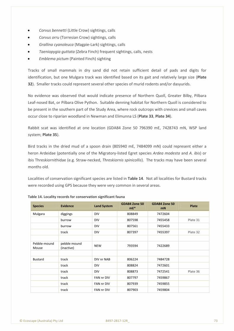
© Ecoscape (Australia) Pty Ltd 8497-2817-12R_ 73
Corvus bennetti (Little Crow) sightings, calls
Corvus orru (Torresian Crow) sightings, calls
Grallina cyanoleuca (Magpie-Lark) sightings, calls
Taeniopygia guttata (Zebra Finch) frequent sightings, calls, nests
Emblema pictum (Painted Finch) sighting
Tracks of small mammals in dry sand did not retain sufficient detail of pads and digits for
identification, but one Mulgara track was identified based on its gait and relatively large size (Plate
32). Smaller tracks could represent several other species of murid rodents and/or dasyurids.
No evidence was observed that would indicate presence of Northern Quoll, Greater Bilby, Pilbara
Leaf-nosed Bat, or Pilbara Olive Python. Suitable denning habitat for Northern Quoll is considered to
be present in the southern part of the Study Area, where rock outcrops with crevices and small caves
occur close to riparian woodland in Newman and Elimunna LS (Plate 33, Plate 34).
Rabbit scat was identified at one location (GDA84 Zone 50 796390 mE, 7428743 mN, WSP land
system; Plate 35).
Bird tracks in the dried mud of a spoon drain (805940 mE, 7484099 mN) could represent either a
heron Ardeidae (potentially one of the Migratory-listed Egret species Ardea modesta and A. ibis) or
ibis Threskiornithidae (e.g. Straw-necked, Threskiornis spinicollis). The tracks may have been several
months old.
Localities of conservation significant species are listed in Table 14. Not all localities for Bustard tracks
were recorded using GPS because they were very common in several areas.
Table 14. Locality records for conservation significant fauna
Species Evidence Land System GDA84 Zone 50
mE* GDA84 Zone 50
mN Plate
Mulgara diggings DIV 808849 7472604
burrow DIV 807598 7455458 Plate 31
burrow DIV 807561 7455433
track DIV 807397 7455397 Plate 32
Pebble-mound Mouse
pebble mound (inactive)
NEW 793594 7422689
Bustard track DIV nr NAB 806224 7484728
track DIV 808824 7472601
track DIV 808873 7472541 Plate 36
track FAN nr DIV 807797 7459867
track FAN nr DIV 807939 7459855
track FAN nr DIV 807903 7459804

© Ecoscape (Australia) Pty Ltd 8497-2817-12R_ 74
Species Evidence Land System GDA84 Zone 50
mE* GDA84 Zone 50
mN Plate
track DIV 807214 7455444
track DIV 807451 7455376
sighting (2), track RIV nr FAN 798425 7431365
Bush Stone-curlew
track RIV/WSP 793502 7430857 Plate 37
Rainbow Bee-eater
sighting RIV 794274 7415976
* Eastings are shown for GDA84 Zone 50, but some actually lie in Zone 51
Plate 31. Mulgara burrows, Divide Land System

© Ecoscape (Australia) Pty Ltd 8497-2817-12R_ 75
Plate 32. Mulgara track
Plate 33. Banded Ironstone outcrop adjacent to Fortescue River in Ophthalmia Range, potential Northern Quoll habitat

© Ecoscape (Australia) Pty Ltd 8497-2817-12R_ 76
Plate 34. Calcrete caprock on low hill, potential Northern Quoll habitat in Elimunna Land System
Plate 35. Rabbit scat, Ophthalmia Range
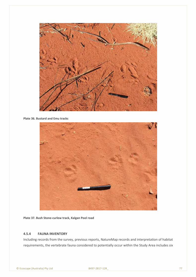
© Ecoscape (Australia) Pty Ltd 8497-2817-12R_ 77
Plate 36. Bustard and Emu tracks
Plate 37. Bush Stone-curlew track, Kalgan Pool road
4.5.4 FAUNA INVENTORY
Including records from the survey, previous reports, NatureMap records and interpretation of habitat
requirements, the vertebrate fauna considered to potentially occur within the Study Area includes six

© Ecoscape (Australia) Pty Ltd 8497-2817-12R_ 78
species of fish, 13 frogs, 53 mammals, 122 reptiles, and 191 birds (Appendix Four, Table 24). The
fauna species actually recorded represent 17% of the mammals, 5% of the reptiles and 22% of the
birds that could potentially occur.
© Ecoscape (Australia) Pty Ltd 8497-2817-12R_ 79
© E
cosc
ape
(Au
stra
lia)
Pty
Ltd
84
97
-28
17
-12
R_
7
9
5.0 Discussion
5.1 Flora
There were 264 vascular flora species identified from the quadrats, relevès, opportunistic and
conservation significant flora searches conducted in the Study Area. The species accumulation curve
(Figure 11) indicates that additional survey would have been required to identify more species,
however Ecoscape considers the survey intensity to be sufficient to identify the botanical constraints
to the proposed clearing. Ecoscape also considers that the flora inventory would have increased if
the survey had been conducted earlier in the season (ie March-June).
The seasonal conditions in the wet season prior to the field survey were above average (Figure 4)
thus ephemeral species were anticipated to be present. However the dry period immediately before
the field survey, that was conducted in August, meant that many grass speces, in particular, had
deshisced and some identifications are tentative (including for many Triodia species), although none
were likely to have been of conservation significance.
5.1.1 CONSERVATION SIGNIFICANT FLORA SPECIES
No flora taxa listed as TF under either the Commonwealth EPBC Act (1999) or Western Australian WC
Act (1950) were recorded during the survey.
There are only two TF species known from the Pilbara (WAH 1998-), Lepidium catapycnon and
Thryptomene wittweri. Both are known from hillslopes, including scree slopes with a generally
southerly aspect. Neither have previously been recorded from within the Study Area. Lepidium
catapycnon has been recorded from approximately 9 km west of the town of Newman
(approximately 9 km from the southern end of the area encompassed by the field survey), and
Thryptomene wittweri from over 100 km to the west.
Five PF species were recorded from the Study Area:
Eremophila pilosa (P1) was recorded from two populations and was associated with vegetation
types Tb and VfEc
Eremophila youngii subsp. lepidota (P4) was recorded from two populations, one previously
unrecorded, and was associated with vegetation types AapEfTe/AsyAc, AsyTl and EvAscPs
Goodenia ?nuda (P4) was recorded from a single population, however the identification is as
yet unconfirmed
Rhagodia sp. Hamersley (M. Trudgen 17794) (P3) from three populations associated with
vegetation types AapAscTe, EvAscCc and VfEc. Although the identification of this species is
not absolutely certain, it is considered as being highly likely (almost certain)
Themeda sp. Hamersley Station (M.E. Trudgen 11431) (P3) was identified from one population
associated with vegetation type AapEfTe/AsyAc.
© Ecoscape (Australia) Pty Ltd 8497-2817-12R_ 80
Of these, Rhagodia sp. Hamersley is a new population on the eastern edge of its known extent, and
Themeda sp. Hamersley Station represents a new population with a range extension of
approximately 45 km eastwards.
5.1.1.1 Conservation Significant Flora Risk Assessment
Approximately 90% of the field survey Study Area was traversed on foot during targeted searches for
conservation significant flora. Despite this, it is possible that some species may have been
overlooked or were not identifiable during the field survey (ie not flowering), or occurred in the
unsurveyed area. In order to achieve a better understanding of the likelihood of conservation
significant species occurring within the Study Area, a risk assessment of the potential for these taxa,
as ideintified by the DEC database search, Table 23: DEC database, NatureMap and DSEWPaC search
results, Threatened and Priority flora to occur was undertaken (Table 26).
The likelihood of a species occurring in the Study Area is based on the following attributes, as listed
on FloraBase (WAH 1998-; WAH & DEC 2012) and tailored to Pilbara populations and including recent
information from recent nearby surveys. The attributes were the:
broad soil type usually associated with the species
broad landform usually associated with the species
usual vegetation (characteristic species) with which the species is usually associated
species having previously been recorded from within approximately 50 km of the Study Area
(considered as ‘nearby’).
The likelihood rating is assigned using the following categories:
Does occur (ie it was recorded within the Study Area); denoted as ‘Recorded’
Almost certain: it is expected to occur within the Study Area (but was not recorded); broadly,
all of the required attributes are present in the Study Area
Possible: it may occur within the Study Area; two or three of the required attributes (including
records from nearby) are present in the Study Area
Unlikely: it could occur but is not expected; one- three of the required attributes are present in
the Study Area but it is not known from nearby (in the case of three attributes, it is not known
from within 100 km)
Almost none: no attributes other than having been recorded nearby or one or two attributes
but not known from within 100 km
None (Rare): the species characteristics include none of the required attributes of soil,
landform, associated vegetation and having previously been recorded nearby, and as such it
almost certainly does not occur within the Study Area.
The conservation significant flora most likely to occur in the Study Area but not recorded during the
field survey are:
Brachyscome sp. Wanna Munna Flats (S. van Leeuwen 4662) (P1)
© Ecoscape (Australia) Pty Ltd 8497-2817-12R_ 81
Helichrysum oligochaetum (P1)
Amaranthus centralis (P3)
Gymnanthera cunninghamii (P3)
Indigofera gilesii subsp. gilesii (P3)
Iotasperma sessilifolium (P3).
Despite the above species being identified as the most likely to occur, the narrow (linear) nature of
the Study Area may not encounter any individuals within it, even if nearby. As an example,
Gymnanthera cunninghamii is known from within a few hundred metres of the Study Area, but was
not encountered. The data and co-ordinates for this specimen record indicate that it was associated
with a significant drainage line. The Study Area did not encompass the drainage line although it was
very close.
5.1.2 RANGE EXTENTIONS
Based on the records included on NatureMap (DEC 2007-), one flora taxa recorded from the Study
Area, Themeda sp. Hamersley Station (M.E. Trudgen 11431) (P3) is considered to represent range
extensions (ie it is outside its previously recorded range), whilst another, Rhagodia sp. Hamersley (M.
trudgen 17794) (P3) is at the edge of its known distribution.
That only one taxon was recorded outside of its usual extent is considered to be due to the area
having been well-surveyed in the past.
There is no statutory protection of species found outside their usual extents, however Guidance
Statement No. 51 (EPA 2004a) considers species that have recently discovered range extensions or
are isolated outliers of the main range to be ‘significant flora’, and should be taken into consideration
when defining the scale and nature of impacts on biodiversity.
5.1.3 INTRODUCED SPECIES
Seven or eight introduced species were identified from the Study Area: *Aerva javanica (Kapok
Weed), *Bidens bipinnata (Bipinnate Beggartick), *Cenchrus ciliaris (Buffel Grass), *Heliotropium
europaeum (Heliotrope), *Malvastrum americanum (Spiked Malvastrum), *Portulaca oleracea
(Purslane), *Tribulus ?terrestris (Caltrop), *Vachellia farnesiana (Mimosa Bush). *Tribulus ?terrestris
is not identified with certainty, however there is an existing record within 5 km thus the identification
is likely.
None of these introduced species are recognised under the ARRP Act 1976 as Declared Plants in the
Shire of East Pilbara, (GWA 2009), nor as WONS (Weeds Australia 2012b).

© Ecoscape (Australia) Pty Ltd 8497-2817-12R_ 82
5.2 Vegetation Significance
5.2.1 VEGETATION CONSERVATION SIGNIFICANCE
Thirteen vegetation types, including one mosaic, were identified from the Study Area:
AapAscTe, Acacia aptaneura tall open shrubland over Acacia sclerosperma subsp.
sclerosperma and A. synchronicia sparse mid shrubland over Triodia epactia, Eremophila
cuneifolia and Ptilotus nobilis var. nobilis mid open shrubland
AapEfTe/AsyAc, mosaic of Acacia aptaneura, A. pruinocarpa and A. paraneura low woodland
over Eremophila forrestiii subsp. forrestii, Acacia tetragonophylla and E. youngii subsp.
lepidota tall-mid sparse shrubland over Triodia epactia, Aristida contorta and A. inaequiglumis
mid- low open hummock grassland/mid-low open tussock grassland AND Acacia synchronicia
tall open/sparse shrubland over Aristida contorta, Sclerolaena spp. and Senna sp. Meekatharra
(E. Bailey 1-26) low sparse grassland/low sparse chenopod shrubland/low sparse shrubland,
that also occurred in a mosaic with vegetation type Tb
AbiTe, Acacia bivenosa, A. ancistrocarpa and A. sclerosperma subsp. sclerosperma tall-mid
open shrubland over Triodia epactia and T. wiseana mid-low hummock grassland, that also
occurred as a mosia with vegetation type AbiTw
AbiTw, Acacia bivenosa mid sparse shrubland over Triodia wiseana, Acacia hilliana and T.
epactia low open hummock grassland/low open-sparse shrubland with Eucalyptus leucophloia
subsp. leucophloia low scattered trees
AscTe, Acacia sclerosperma subsp. sclerosperma and A. synchronicia tall sparse shrubland over
Triodia epactia, Eragrostis eriopoda and *Cenchrus ciliaris tall hummock grassland/low sparse
tussock grassland
AsyTl, Acacia synchronicia mid sparse shrubland over Triodia longiceps, Aristida contorta and
Sclerolaena spp. tall open-sparse hummock grassland/low sparse grassland/low sparse
chenopod shrubland
CcAscCc, Corymbia candida subsp. dipsodes and Eucalyptus victrix low open woodland-isolated
trees over Acacia sclerosperma subsp. sclerosperma tall sparse shrubland over *Cenchrus
ciliaris and Triodia epactia mid tussock grassland/mid open hummock grassland
EvAscCc, Eucalyptus victrix, Acacia aptaneura and Atalaya hemiglauca open woodland over
Acacia sclerosperma subsp. sclerosperma, Eremophila youngii subsp. lepidota and *Vachellia
farnesiana tall-mid sparse shrubland over *Cenchrus ciliaris, *Malvastrum americanum and
Salsola australis low sparse tussock grassland/low sparse forbland
EvAscPs, Eucalyptus victrix and Acacia aptaneura low open-sparse woodland over Acacia
sclerosperma subsp. sclerosperma, *Vachellia farnesiana and A. tetragonophylla mid sparse
shrubland over mixed Poaceae spp. low open tussock grassland

© Ecoscape (Australia) Pty Ltd 8497-2817-12R_ 83
EvVfPs, Eucalyptus victrix, E. camaldulensis subsp. refulgens and Atalaya hemiglauca mid open
forest over Poaceae sp. mid open tussock grassland with *Vachellia farnesiana mid scattered
shrubs
Sc, Sclerolaena cornishiana and S. bicornis var. bicornis low sparse chenopod shrubland
Tb, Triodia basedowii, T. longiceps and Paraneurachne muelleri mid-low open hummock
grassland/low sparse tussock grassland with Acacia ancistrocarpa and A. pachyacra tall-mid
scattered shrubs
VfEc, *Vachellia farnesiana and Senna glutinosa subsp. luerssenii x pruinosa mid sparse
shrubland over Enneapogon caerulscens, *Cenchrus ciliaris and *Aerva javanica low scattered
tussock grassland/low sparse forbland with Acacia aptaneura and A. paraneura low scattered
trees.
Unless specifically discussed below, the vegetation of the Study Area is of no particular significance.
5.2.1.1 TECs and PECs
No vegetation recorded from the Study Area was considered to match the descriptions of any
currently recognised TEC or PEC in the Pilbara.
5.2.1.2 Local Conservation Significance
A number of reports (Table 28), many of them EPA recommendations reports, were reviewed to
determine if any vegetation of the Study Area was similar to any vegetation from nearby areas that
was considered to have significance. A summary of relevant findings is included in Table 28.
The following broad vegetation types are considered significant in a number of these reports:
phreatophytic (partly groundwater dependent) riparian vegetation dominated by Eucalyptus
camaldulensis and E. victrix, due largely to impacts of groundwater drawdown from mine
dewatering or diverted drainge
Mulga, considered to be susceptible to changes to surface water hydrology
saltmarsh vegetation (none of which occurred in the Study Area)
vegetation harbouring conservation significant (PF) species.
The above vegetation types or attributes (e.g. landform) concur with the definition of significant
vegetation in Guidance Statement 51 (EPA 2004a) due to them having a restricted distribution or
being a key habitat for threatened species.
In order to define significance of vegetation types within the Study Area, a risk assessment matrix
was developed. The significance of each vegetation type in the Study Area is calculated using the
following parameters:
a) Small extent.

© Ecoscape (Australia) Pty Ltd 8497-2817-12R_ 84
b) Restricted to as specific landform/soil/habitat type (e.g. calcrete, clay, gully, mesa, high hilltop,
scree).
c) Restricted to riparian areas.
d) Contains Mulga (sheet flow dependent vegetation; non-groving Mulga, but not vegetation that
has Mulga as a minor component).
e) Supports PF or undescribed species.
f) Is vulnerable to disturbance (e.g. fire sensitive vegetation, vulnerable to weed invasion or
surface water changes).
g) Has a significant ephemeral species component (ie has high but variable species diversity).
Each of the above attributes was given a score, based on importance attributed to the various factors
in the reviewed reports (Table 28). Whilst the scores are subjective and based on Ecoscape’s
interpretation, they do give an indication of significance. The scores and rationale are:
a) Score 1 if the vegetation type occupies 1-5% of the Study Area, score 2 if it occupies <1%
(rationale: greater significance for small extent)
b) Score 1 if the vegetation type occurs on a landform, soil or habitat type that occupies only a
restricted extent but is not confined to that area although it must largely be so, score 2 if the
vegetation type only occurs on that landform, soil or habitat type (rationale: greater
significance for vegetation confined to restricted areas, with lesser significance if they also
occur elsewhere)
c) Riparian/GDE areas are considered significant in most of the reviewed reports. They were
given a score of 1 because they generally have other attributes that also contribute to the total
(e.g. they are vulnerable to disturbance), and a score of 2 if they contain vegetation that is
considered to represent a GDE (ie has Eucalyptus camaldulensis subsp. refulgens).
d) Mulga vegetation is considered significant in most of the reviewed reports, and various forms
are considered as an ‘Ecosystem at Risk’ (CALM 2002). Most reports consider Mulga groves
(Sheet Flow Dependent Vegetation, SFDV, also known as grove-intergrove Mulga) to be of
greater significance (here given a score of 2), but valley floor Mulga (non-groving) is also
significant (score 1).
e) Vegetation providing habitat for conservation significant flora species is considered significant
in most reviewed reports. A score of 1 is given to vegetation providing habitat for a P3 or P4
species, and a score of 2 given to vegetation providing habitat for TF, P1, P2, multiple species
of P3 or P4, and undescribed species.
f) Vegetation considered vulnerable to disturbance is given a score of 1.
g) Many of the reviewed reports consider vegetation types with a high ephemeral component to
be of significance; score 1
h) Vegetation already recognised as having conservation significance is given a score of 1 if it is a
recognised (or appreciably similar to) a PEC and a score of 2 if it recognised as a TEC.

© Ecoscape (Australia) Pty Ltd 8497-2817-12R_ 85
Based on the risk assessment (Table 28, Appendix 11), vegetation types AapEfTe/AsyAc and EvVfPs
have the highest local significance (score 6, highlighted in darker blue in Table 28), with vegetation
types EvAscCc and EvAscPs also identified as having local significance (score 5, highlighted in lighter
blue in Table 28)). AapEfTe/AsyAc is grove-intergrove (or sheet flow dependent) Mulga. The others
are riparian/GDE vegetation, although it should be noted that, within the Study Area, most riparian
vegetation was impacted by grazing and frequently in Poor condition and thus has reduced
conservation significance than areas in better condition.
5.2.1.3 Groundwater Dependent Ecosystems
Vegetation containing Eucalyptus camaldulensis subsp. refulgens (vegetation type EvVfPs, dominated
by E. victrix) and therefore considered to represent a GDE occupied 3.71 ha (0.23%) of the Study
Area, along the banks of the Fortescue River. However the condition of this vegetation type was
Poor due to the impacts of livestock grazing.
Three other vegetation types dominated or characterised by Eucalyptus victrix were recorded from
the Study Area; CcAscCc (occupying 30.79 ha, 1.89% of the Study Area), EvAscCc (occupying 62.40 ha,
3.84%) and EvAscPs (occupying 29.23 ha, 1.80%).
There is some debate if Eucalyptus victrix is dependent on groundwater or not, however the
precautionary principle outlined in Position Statement No. 7 – Principles of Environmental Protection
(EPA2004b) should be followed and E. victrix considered to be at least partly groundwater dependent
and therefore potentially characteristic of a GDE.
The Eucalyptus victrix-dominated/characterized vegetation types are the most heavily grazed in the
Study Area, and their condition ranges from Very poor (especially the Fortescue River floodplain
vegetation type EvAscCc) to Very good. Therefore, the conservation value of these vegetation types
is reduced.
5.2.1.4 Vegetation Supporting Priority Flora
Vegetation types that support PF also have a degree of significance. Within the Study Area, 14
vegetation types (of a total of 24 types) support PF. The vegetation types supporting PF are
AapAscTe, +AapEfTe/AsyAc, AsyTl, +EvAscCc, +EvAScPs, Tb and VfEc. Those suffixed by ‘+’ have been
considered (in Section 5.2.1.2) to have a degree of local significance. The unmarked vegetation types
have been considered to have no local significance. However, vegetation types Tb and VfEc harbour
the P1 species, Eremophila pilosa, and therefore have added significance.
PF and the vegetation supporting them have no statutory protection unless listed as a TEC.
© Ecoscape (Australia) Pty Ltd 8497-2817-12R_ 86
5.3 Vegetation Condition
The vegetation condition of the Study Area was assessed using the adapted Keighery Vegetation
Condition Scale for Eremaean and Northern Botanical Provinces included in the Draft Technical Guide
– Flora and Vegetation Surveys for Environmental Impact Assessment (EPA & DEC 2012), Table 22.
Vegetation condition of the Study Area ranged from Very Poor to Excellent (Table 12).
Overall, 88.1% of the Study Area was in Very good or Excellent condition. The difference between
these two ratings are generally due to minor differences in recorder interpretation, or low levels of
grazing impacts or small areas of weed cover. Both can be interpreted as displaying only minor (or
no) obvious impacts of European man.
The lesser condition areas (Good, Poor and Very poor) occupied 10.37 of the Study Area and were
generally associated with riparian and valley floor (particularly floodplain or outwash plain)
vegetation types. Cattle, and perhaps horse, grazing (direct sightings, hoofprints including trails,
trampled soil and vegetation, grazed shrubs, faeces) and presence of introduced species (particularly
*Cenchrus ciliaris and *Vachellia farnesiana) were the main factors contributing to rating vegetation
as being in Good (or lower) condition.
5.4 Fauna
5.4.1 LIKELIHOOD OF OCCURRENCE OF CONSERVATION SIGNIFICANT SPECIES
Table 15 gives brief summaries of habitat requirements, inferred occupancy status (see section 3.3.2)
and estimate of maximum likely impact of proposed clearing for species listed in Table 6 - Table 8.
Categories of impact used are negligible (no decline in local population likely) and minor (short-term
local decline possible, no long-term effects on viability). The Table is based on more detailed species
profiles provided in Appendix Twelve
5.4.2 OCCURRENCE OF CONSERVATION SIGNIFICANT SPECIES IN RELATION TO LAND SYSTEMS
Table 16 is based on the attributes of species listed in the preceding section and those of the Land
Systems intersecting the Study Area, and indicates known (+) or predicted potential occurrence (p) of
species in each LS. Any impacts would be limited to habitat types in which the species actually or
potentially occur.
© Ecoscape (Australia) Pty Ltd 8497-2817-12R_ 87
© E
cosc
ape
(Au
stra
lia)
Pty
Ltd
84
97
-28
17
-12
R_
8
7
Table 15. Summary of habitat, occupancy status and potential impact of proposed clearing for conservation significant fauna species
Family Species Common Name
EPB
C A
ct s
tatu
s
WC
Act
sta
tus
DEC
sta
tus
DEC
Th
reat
en
ed
fau
na
dat
abas
e
EPB
C A
ct P
MST
Preferred habitat Occupancy status Potential Impacts
MAMMALS
Thylacomyidae Macrotis lagotis Greater Bilby V U S 1 V U K Sandy desert, cracking
clay and shrubland
Inferred to be locally
extinct None
Dasyuridae
Dasycercus cristicauda Crest-tailed Mulgara V U S 1 VU L Sanplains and
dunefileds One or both species
recorded
Minor impact to
population Dasycercus blythi Brush-tailed Mulgara P 4 2
Sandplains and gibber
plains
Dasyurus hallucatus Northern Quoll E N S 1 EN 2 L
Gorges, riparian
woodland, breakaways,
boulder piles
Occasional visitor,
potential; for future
establishment
No impact to
population, minor
impact to habitat
Sminthopsis longicaudata Long-tailed Dunnart P 4 2 Rocky scree and
plateaux
Likely resident or
irruptive visitor Negligible
Notoryctidae Notoryctes caurinus Northern Marsupial Mole E N S 1 EN - Dunefields with shrubs
and spinifex
Outside known or likely
range None
Macropodidae
Lagorchestes conspicillatus
leichardti Spectacled Hare-wallaby P 3
Woodland, shrubland,
sandplain with spinifex
Locally extinct except
for known remnants
(Jimblebar, Nullagine)
None
Petrogale lateralis lateralis Black-flanked Rock-wallaby V U S 1 VU 4 - Cliffs and boulder piles Locally extinct None
Megadermatidae Macroderma gigas Ghost Bat P 4 3
Humid caves, riparian
woodland, shrubland
and grassland
Likely resident or
regular visitor
Minor impact to
foraging habitat,
potentially to day roosts
Hipposideridae Rhinonicteris aurantia Pilbara Leaf-nosed Bat V U S 1 VU L Deep humid caves and
adits, riparian
Possible occasional
visitor, unlikely to be
Minor to negligible
impact to foraging
© Ecoscape (Australia) Pty Ltd 8497-2817-12R_ 88
Family Species Common Name
EPB
C A
ct s
tatu
s
WC
Act
sta
tus
DEC
sta
tus
DEC
Th
reat
en
ed
fau
na
dat
abas
e
EPB
C A
ct P
MST
Preferred habitat Occupancy status Potential Impacts
woodland, rocky hills,
gorges
resident habitat only
Muridae
Leggadina lakedownensis Short-tailed Mouse P 4 9 Grassland and savannah
woodland
Likely resident or
irruptive visitor Negligible
Pseudomys chapmani Western Pebble-mound
Mouse P 4 49
Gravel slopes and
hilltops with Spinifex
and scattered shrubs
Likely resident Negligible to minor
impact possible
REPTILES
Scincidae
Ctenotus nigrilineatus Pinstriped Finesnout
Ctenotus P 1 Spiifex, rock outcrops
Possible resident
(outside known range,
likely absent)
Negligible to minor
impact possible
Ctenotus uber johnstonei (aff.) Balgo Spotted Ctenotus P 2 3 Chenopod and Acacia
shrubland, rocky hills Likely resident
Negligible to minor
impact possible
Lerista macropisthopus remota Robust Slider P 2 4
Acacia, mallee or
Corymbia woodland
with litter
Likely resident in
southern part
Negligible to minor
impact possible
Typhlopidae Ramphotyphlops ganei Pilbara Blindsnake P 1 12 Gorges in rocky hills,
floodplain, spinifex Likely resident
Negligible to minor
impact possible
Pythonidae Liasis olivaceus barroni Pilbara Olive Python V U S 1 VU 3 M Rocky hills and gorges
near waterholes
Possible resident (near
edge of range, likely
absent)
Negligible to minor
impact possible
BIRDS
Apodidae Apus pacificus Fork-tailed Swift M S 3 M Aerial, all habitats Likely regular visitor,
non-breeding None
Ardeidae Ardea modesta Eastern Great Egret M S 3 M
Permanent and
temporary wetlands
Likely occasional visitor,
non-breeding
Negligible to minor
impact possible
Ardea ibis Cattle Egret M S 3 M Permanent and Likely occasional visitor Negligible to minor
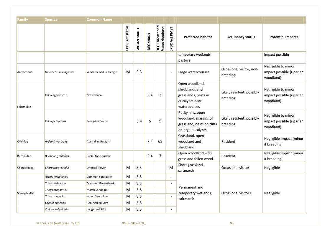
© Ecoscape (Australia) Pty Ltd 8497-2817-12R_ 89
Family Species Common Name
EPB
C A
ct s
tatu
s
WC
Act
sta
tus
DEC
sta
tus
DEC
Th
reat
en
ed
fau
na
dat
abas
e
EPB
C A
ct P
MST
Preferred habitat Occupancy status Potential Impacts
temporary wetlands,
pasture
impact possible
Accipitridae Haliaeetus leucogaster White-bellied Sea-eagle M S 3 - Large watercourses Occasional visitor, non-
breeding
Negligible to minor
impact possible (riparian
woodland)
Falconidae
Falco hypoleucos Grey Falcon P 4 3
Open woodland,
shrublands and
grasslands, nests in
eucalypts near
watercourses
Likely resident, possibly
breeding
Negligible to minor
impact possible (riparian
woodland)
Falco peregrinus Peregrine Falcon S 4 S 9
Rocky hills, open
woodland, margins of
grassland, nests on cliffs
or large eucalypts
Likely resident, possibly
breeding
Negligible to minor
impact possible (riparian
woodland)
Otididae Ardeotis australis Australian Bustard P 4 68
Grassland, open
woodland and
shrubland
Resident Negligible impact (minor
if breeding)
Burhinidae Burhinus grallarius Bush Stone-curlew P 4 7 Open woodland with
grass and fallen wood Resident
Negligible impact (minor
if breeding)
Charadriidae Charadrius veredus Oriental Plover M S 3 M Short grassland,
saltmarsh Occasional visitor Negligible
Scolopacidae
Actitis hypoleucos Common Sandpiper M S 3 -
Permanent and
temporary wetlands,
saltmarsh
Occasional visitors Negligible
Tringa nebularia Common Greenshank M S 3 -
Tringa stagnatilis Marsh Sandpiper M S 3 -
Tringa glareola Wood Sandpiper M S 3 -
Calidris ruficollis Red-necked Stint M S 3 -
Calidris subminuta Long-toed Stint M S 3 -
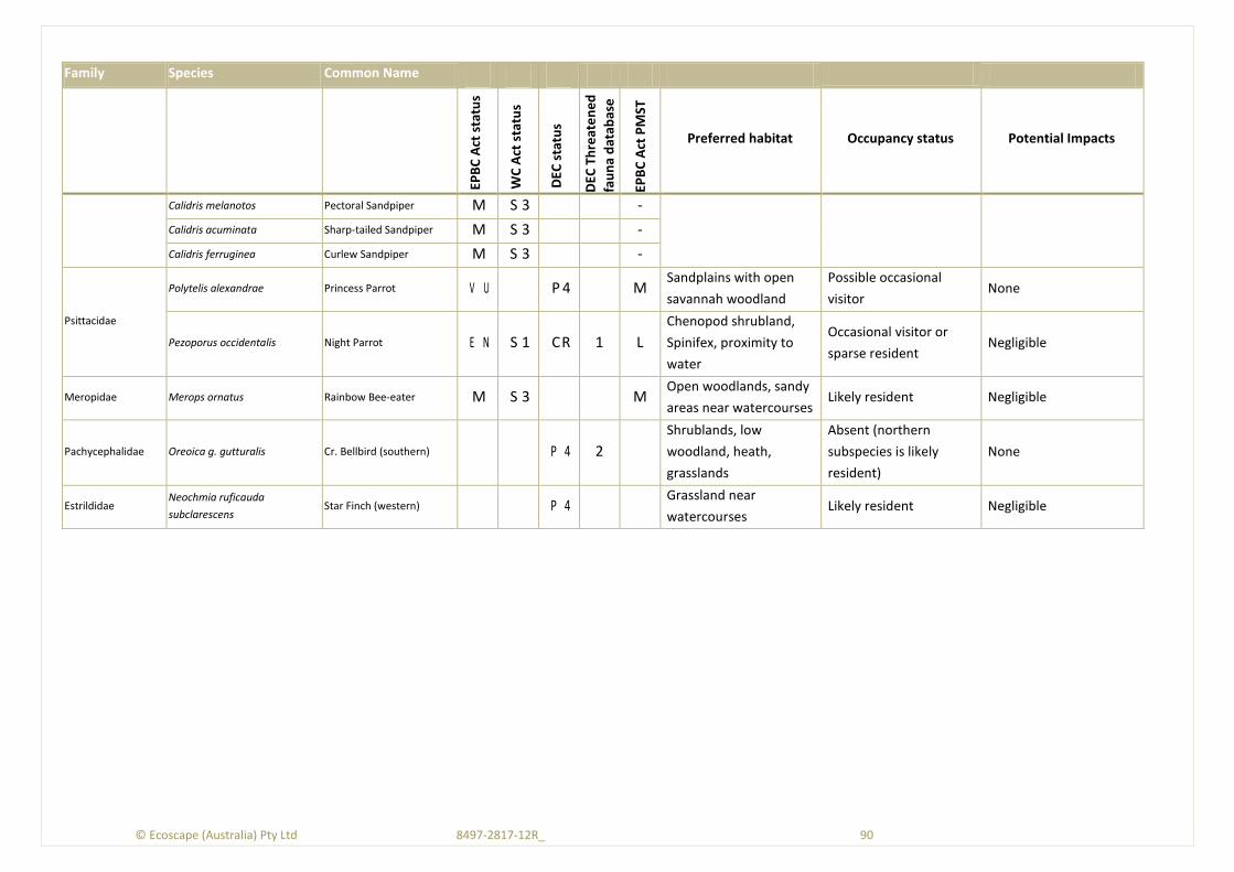
© Ecoscape (Australia) Pty Ltd 8497-2817-12R_ 90
Family Species Common Name
EPB
C A
ct s
tatu
s
WC
Act
sta
tus
DEC
sta
tus
DEC
Th
reat
en
ed
fau
na
dat
abas
e
EPB
C A
ct P
MST
Preferred habitat Occupancy status Potential Impacts
Calidris melanotos Pectoral Sandpiper M S 3 -
Calidris acuminata Sharp-tailed Sandpiper M S 3 -
Calidris ferruginea Curlew Sandpiper M S 3 -
Psittacidae
Polytelis alexandrae Princess Parrot V U P 4 M Sandplains with open
savannah woodland
Possible occasional
visitor None
Pezoporus occidentalis Night Parrot E N S 1 CR 1 L
Chenopod shrubland,
Spinifex, proximity to
water
Occasional visitor or
sparse resident Negligible
Meropidae Merops ornatus Rainbow Bee-eater M S 3 M Open woodlands, sandy
areas near watercourses Likely resident Negligible
Pachycephalidae Oreoica g. gutturalis Cr. Bellbird (southern) P 4 2
Shrublands, low
woodland, heath,
grasslands
Absent (northern
subspecies is likely
resident)
None
Estrildidae Neochmia ruficauda
subclarescens Star Finch (western) P 4
Grassland near
watercourses Likely resident Negligible
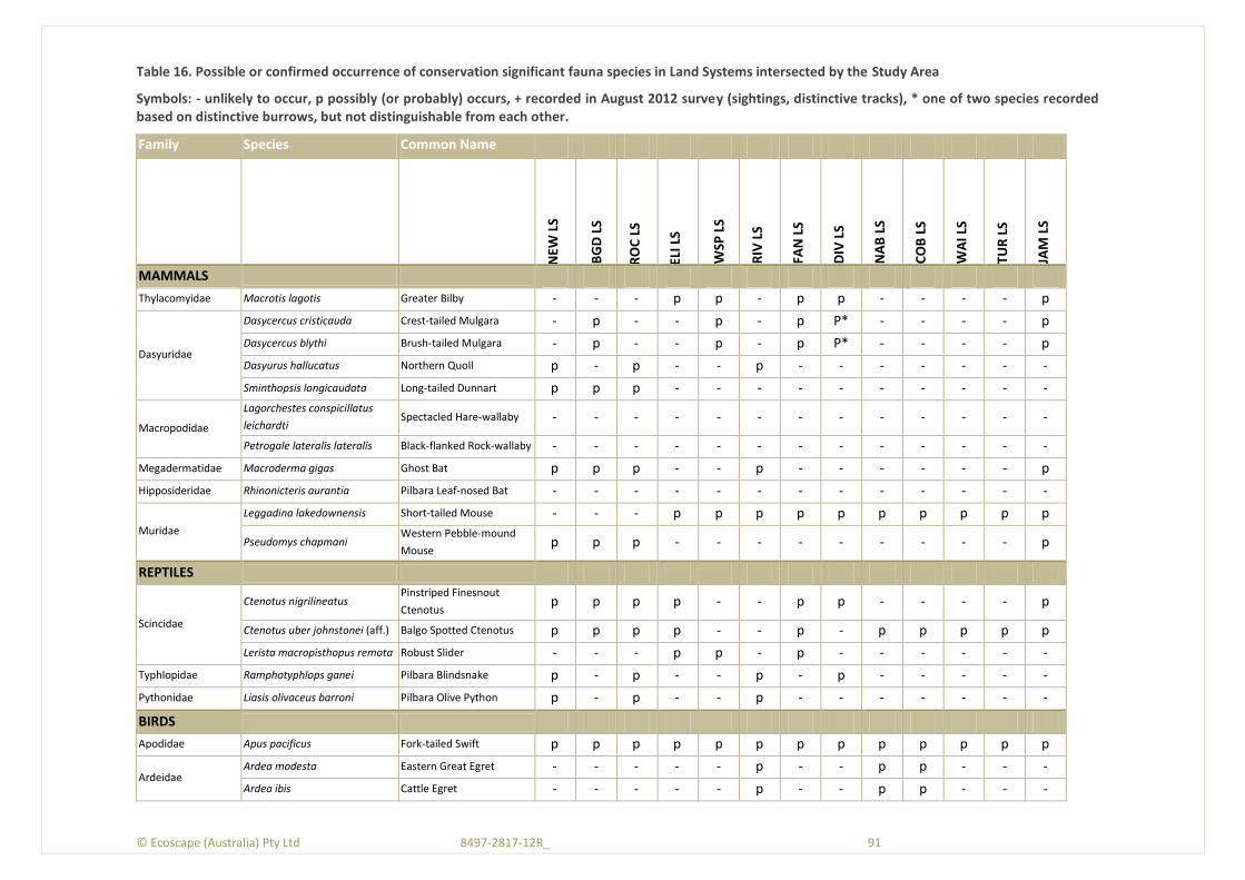
© Ecoscape (Australia) Pty Ltd 8497-2817-12R_ 91
Table 16. Possible or confirmed occurrence of conservation significant fauna species in Land Systems intersected by the Study Area
Symbols: - unlikely to occur, p possibly (or probably) occurs, + recorded in August 2012 survey (sightings, distinctive tracks), * one of two species recorded based on distinctive burrows, but not distinguishable from each other.
Family Species Common Name
NEW
LS
BG
D L
S
RO
C L
S
ELI L
S
WSP
LS
RIV
LS
FAN
LS
DIV
LS
NA
B L
S
CO
B L
S
WA
I LS
TUR
LS
JAM
LS
MAMMALS
Thylacomyidae Macrotis lagotis Greater Bilby - - - p p - p p - - - - p
Dasyuridae
Dasycercus cristicauda Crest-tailed Mulgara - p - - p - p P* - - - - p
Dasycercus blythi Brush-tailed Mulgara - p - - p - p P* - - - - p
Dasyurus hallucatus Northern Quoll p - p - - p - - - - - - -
Sminthopsis longicaudata Long-tailed Dunnart p p p - - - - - - - - - -
Macropodidae
Lagorchestes conspicillatus
leichardti Spectacled Hare-wallaby - - - - - - - - - - - - -
Petrogale lateralis lateralis Black-flanked Rock-wallaby - - - - - - - - - - - - -
Megadermatidae Macroderma gigas Ghost Bat p p p - - p - - - - - - p
Hipposideridae Rhinonicteris aurantia Pilbara Leaf-nosed Bat - - - - - - - - - - - - -
Muridae
Leggadina lakedownensis Short-tailed Mouse - - - p p p p p p p p p p
Pseudomys chapmani Western Pebble-mound
Mouse p p p - - - - - - - - - p
REPTILES
Scincidae
Ctenotus nigrilineatus Pinstriped Finesnout
Ctenotus p p p p - - p p - - - - p
Ctenotus uber johnstonei (aff.) Balgo Spotted Ctenotus p p p p - - p - p p p p p
Lerista macropisthopus remota Robust Slider - - - p p - p - - - - - -
Typhlopidae Ramphotyphlops ganei Pilbara Blindsnake p - p - - p - p - - - - -
Pythonidae Liasis olivaceus barroni Pilbara Olive Python p - p - - p - - - - - - -
BIRDS
Apodidae Apus pacificus Fork-tailed Swift p p p p p p p p p p p p p
Ardeidae Ardea modesta Eastern Great Egret - - - - - p - - p p - - -
Ardea ibis Cattle Egret - - - - - p - - p p - - -
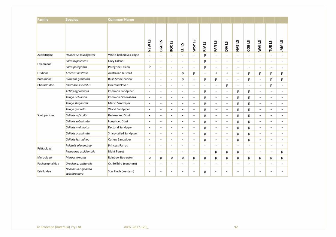
© Ecoscape (Australia) Pty Ltd 8497-2817-12R_ 92
Family Species Common Name
NEW
LS
BG
D L
S
RO
C L
S
ELI L
S
WSP
LS
RIV
LS
FAN
LS
DIV
LS
NA
B L
S
CO
B L
S
WA
I LS
TUR
LS
JAM
LS
Accipitridae Haliaeetus leucogaster White-bellied Sea-eagle - - - - - p - - - - - - -
Falconidae Falco hypoleucos Grey Falcon - - - - - p - - - - - - -
Falco peregrinus Peregrine Falcon P - - - - p - - - - - - -
Otididae Ardeotis australis Australian Bustard - - - p p + + + + p p p p
Burhinidae Burhinus grallarius Bush Stone-curlew - - - p + p p - - p - p p
Charadriidae Charadrius veredus Oriental Plover - - - - - - - p - - - p -
Scolopacidae
Actitis hypoleucos Common Sandpiper - - - - - p - - p p - - -
Tringa nebularia Common Greenshank - - - - - p - - p p - - -
Tringa stagnatilis Marsh Sandpiper - - - - - p - - p p - - -
Tringa glareola Wood Sandpiper - - - - - p - - p p - - -
Calidris ruficollis Red-necked Stint - - - - - p - - p p - - -
Calidris subminuta Long-toed Stint - - - - - p - - p p - - -
Calidris melanotos Pectoral Sandpiper - - - - - p - - p p - - -
Calidris acuminata Sharp-tailed Sandpiper - - - - - p - - p p - - -
Calidris ferruginea Curlew Sandpiper - - - - - p - - p p - - -
Psittacidae Polytelis alexandrae Princess Parrot - - - - - - - - - - - - -
Pezoporus occidentalis Night Parrot - - - - - - p p p - - - p
Meropidae Merops ornatus Rainbow Bee-eater p p p p p p p p p p p p p
Pachycephalidae Oreoica g. gutturalis Cr. Bellbird (southern) - - - - - - - - - - - - -
Estrildidae Neochmia ruficauda
subclarescens Star Finch (western) - - - - - p - - - - - - -
© Ecoscape (Australia) Pty Ltd 8497-2817-12R_ 93
© E
cosc
ape
(Au
stra
lia)
Pty
Ltd
84
97
-28
17
-12
R_
9
3
References
Anstee, S.D. 1996. Use of external mound structures as indicators of the presence of the Pebblemound Mouse, Pseudomys chapmani, in mound systems. Wildlife Research, vol. 23, pp. 429-434
Anstee, S.D., Roberts, J.D., & O'Shea, J.E. 1997. Social structure and patterns of movement of the Western Pebble-mouse, Pseudomys chapmani, at Marandoo, Western Australia. Wildlife Research, vol. 24, pp. 295-305
Aplin, K.P. 1998. Three new blindsnakes (Squamata: Typhlopidae) from northwestern Australia. Records of the Western Australian Museum, vol. 19, pp. 1-12
Armstrong, K.N. 2001. The roost habitat and distribution of the orange leaf-nosed bat, Rhinonicteris aurantius, in the Pilbara region of Western Australia. Wildlife Research, vol. 28:95-104,
Astron Environmental Services 2008. Nullagine Project Flora and Vegetation May - September 2008.
Australian Government. 2009. Australian Natural Resources Atlas. Rangelends - Overview (Pilbara). Available from: <http://www.anra.gov.au/topics/rangelands/overview/wa/ibra-pil.html#climate>.
Bamford Consulting Ecologists 2005. Fauna Survey of Proposed Iron Ore Mine, Cloudbreak.
Bamford Consulting Ecologists & Ecoscape (Australia) Pty Ltd 2012, Fauna Assessment - Nyidinghu Iron Ore Project, Prepared for Fortescue Metals Group, Perth.
Batini, F. 2008. Interim Report to 17-09-2008 - Marandoo Phase 2 Proposal, Assessing the Impacts of Groundwater Dewatering and Surface Water Drainage on Significant Vegetation - Coolibah and Mulga.
Belbin, L. & Collins, A. 2006. PATN Version 3.11.
Benshemesh, J. 2004. Recovery Plan for Marsupial Moles Notoryctes typhlops and N. caurinus. 2005-2010. Alice Springs, Northern Territory Department of Infrastructure, Planning and Environment.
Benshemesh, J. 2005, Manual for Marsupial Mole survey and Monitoring by Trenches, Version 1.0, Report to Anangu-Pitjantjatjara Land Management and the Department of Heritage and Environment (SA).
Benshemesh, J. & Aplin, K. 2008, "Kakarratul, Notoryctes caurinus," in The Mammals of Australia (Third Edition), S. Van Dyck & R. Strahan eds., Reed New Holland, Sydney, pp. 410-411.
Benshemesh, J. & Johnson, K. 2003, "Biology and conservation of marsupial moles (Notoryctes)," in Predators with pouches: the biology of carnivorous marsupials, M. Jones, C. R. Dickman, & M. Archer eds., CSIRO Publishing, Melbourne, pp. 464-474.
Biota Environmental Sciences Pty Ltd 2004a, Vegetation and Flora Survey of the Proposed FMG Stage A Rail Corridor, Unpublished Report for Fortescue Metals Group Ltd, August 2004.
Biota Environmental Sciences Pty Ltd 2004b, Vegetation and Flora Survey of the Proposed FMG Stage B Rail Corridor and Mines Areas, Unpublished Report for Fortescue Metals Group Ltd, December 2004.
© Ecoscape (Australia) Pty Ltd 8497-2817-12R_ 94
Biota Environmental Sciences Pty Ltd 2005a. Fauna Habitats and Fauna Assemblage of Mesa A and G, near Pannawonica.
Biota Environmental Sciences Pty Ltd 2005b, Fauna Habitats and Fauna Assemblage of the Proposed FMG Stage B Rail Corridor and Mindy Mindy, Christmas Creek, Mt Lewin and Mt Nicholas Mine Areas.
Biota Environmental Sciences Pty Ltd 2008, Marandoo Mine Phase 2 Project Vegetation and Flora Survey, Unpublished report prepared for Rio Tinto.
Biota Environmental Sciences Pty Ltd 2009. Hope Downs IV Northern Quoll Position Paper.
Blacket, M.J., Adams, M., Krajewski, C., & Westerman, M. 2000. Genetic variation within the dasyurid marsupial genus Planigale. Australian Journal of Zoology, vol. 48, no. 5, pp. 443-459
Blyth, J., Burbidge, A., Kendrick, P., & Boles, W. 1996. Report on an expedition to the Western Desert and East Pilbara areas to search for Night Parrots (Pesoporus occidentalis) November 12-29 1996.
Boland, C.R.J. 2004. Breeding biology of Rainbow Bee-eaters (Merops ornatus): a migratory, colonial, cooperative bird. The Auk, vol. 121, no. 3, pp. 811-823
Boles, W.E., Longmore, N.W., & Thompson, M.C. 1994. A recent specimen of the Night Parrot Geopsittacus occidentalis. Emu, vol. 94, pp. 37-40
Braithwaite, R.W. & Griffiths, A. 1994. Demographic variation anf range contrsction in the northern quoll Dasyurus hallacatus (Marsupialia: Dasyuridae). Wildlife Research, vol. 21, pp. 203-217
Burbidge, A., Johnstone, R., & Pearson, D. 2010. Birds in a vast arid upland: Avian biogeographical patterns in the Pilbara Region of Western Australia.
Burbidge, A. A., McKenzie, N. L., & Fuller, P. J. 2008, "Long-tailed Dunnart, Sminthopsis longicaudata," in Mammals of Australia, S. Van Dyck & R. Strahan eds., Reed New Holland, Sydney, pp. 148-150.
Bureau of Meteorology. 2012a. Climate Data Online (Newman Aero, Station 007176). Available from: <http://www.bom.gov.au/climate/data/index.shtml?bookmark=200>.
Bureau of Meteorology. 2012b. Western Australian Rainfall Deciles 1 December 2011 to 31 August 2012. Available from: <http://www.bom.gov.au/web03/ncc/www/awap/rainfall/decile/9month/colour/latest.wa.hres.gif>.
Christidis, L. & Boles, W. 2008. Systematics and Taxonomy of Australian Birds Melbourne, CSIRO Publishing.
Churchill, S.K. & Helman, P.M. 1990. Distribution of the ghost bat, Macroderma gigas, (Chiroptera: Megadermatidae) in central and south Australia. Australian Mammology, vol. 13, pp. 149-156
Churchill, S.K., Helman, P.M., & Hall, L.S. 1988. Distribution, populations and status of the Orange Horseshoe Bat, Rhinonicteris aurantius (Chiroptera: Hipposideridae). Australian Mammalogy, vol. 11, no. 1, pp. 27-33
Coffey Environments 2007, Supplementary Vegetation and Flora Survey of the Port Hedland to Cloudbreak Rail Corridor and Associated Borrow Pits and Infrastructure, Prepared for Fortescue Metals Group Ltd, August 2007, Report No. 2007/186: Version 1.
© Ecoscape (Australia) Pty Ltd 8497-2817-12R_ 95
Coffey Environments 2010a, Flora and Vegetation Assessment, Solomon Project and Investigator - Volume 1, Unpublished report for Fortescue Metals Group Ltd.
Coffey Environments 2010b, Flora and Vegetation Assessment, Solomon Rail Project - Volume 1, Unpublished report for Fortescue Metals Group Ltd.
Commonwealth of Australia. Environment Protection and Biodiversity Conservation Act 1999.
Debus, S. 2009. Threatened Raptors - Update on article in October 2008 The Bird Observer. The Bird Observer no. 860, pp. 25
Department of Conservation and Land Management 1999, Environmental Weed Strategy for Western Australia, CALM, Como, Western Australia.
Department of Conservation and Land Management. 2002. A Biodiversity Audit of Western Australia's 53 Biogeographical Subregions in 2002. Department of Conservation and Land Management.
Department of Environment and Conservation. 2007. NatureMap: Mapping Western Australia's Biodiversity. Available from: <http://naturemap.dec.wa.gov.au/default.aspx>.
Department of Environment and Conservation. 2010. Definitions, Categories and Criteria for Threatened Ecological Communities. Available from: <http://www.dec.wa.gov.au/component/option,com_docman/Itemid,1/gid,402/task,doc_download/>.
Department of Environment and Conservation. 2011. Conservation Codes for Western Australian Flora and Fauna. Available from: <http://www.dec.wa.gov.au/content/view/852/2010/1/1/>.
Department of Environment and Conservation. 2012a. Invasive plant prioritisation process for DEC. Available from: <http://www.dec.wa.gov.au/content/view/6295/2275/1/1/>.
Department of Environment and Conservation. 2012b. NatureMap. Available from: <http://naturemap.dec.wa.gov.au/default.aspx>.
Department of Environment and Conservation, S. &. C. B. 2012c. List of Threatened Ecological Communities endorsed by the Western Australian Minister for the Environment (Correct to April 2012). Available from: <http://www.dec.wa.gov.au/component/option,com_docman/task,doc_download/gid,7113/Itemid,/>.
Department of Environment and Conservation, S. a. C. B. 2012d. Priority Ecological Communities for Western Australia Version 17 (13 April 2012). Available from: <http://www.dec.wa.gov.au/component/option,com_docman/task,doc_download/gid,7114/Itemid,/>.
Department of Environment Water Heritage and the Arts. 2008. Approved Conservation Advice for Liasis olivaceus barroni (Olive Python-Pilbara subspecies). in Environment Protection and Biodiversity Conservation Act 1999, ed.
Department of Foreign Affairs. 1995. Agreement between the Government of Australia and the Government of Japan for the Protection of Migratory Birds in Danger of Extinction and their Environment

© Ecoscape (Australia) Pty Ltd 8497-2817-12R_ 96
(JAMBA) [1981] ATS 6. Available from: <http://www.austlii.edu.au/au/other/dfat/treaties/1981/6.html>.
Department of Sustainability and Environment (Victoria). 2005. Australian Threatened Species: Bush Stone-curlew Burhinus grallarius. Available from: <http://www.environment.gov.au/biodiversity/threatened/publications/pubs/tsd05bush-stone-curlew.pdf>.
Department of Sustainability Environment Water Population and Communities. 2009. EPBC Act List of Threatened Ecological Communities. Available from: <http://www.environment.gov.au/cgi-bin/sprat/public/publiclookupcommunities.pl>.
Department of Sustainability Environment Water Population and Communities. 2010. Approval Decision, Roy Hill Railway and Associated Infrastructure Project, Pilbara, WA (EPBC 2010/5424). Available from: <http://www.environment.gov.au/cgi-bin/epbc/epbc_ap.pl?name=current_referral_detail&proposal_id=5424>.
Department of Sustainability Environment Water Population and Communities. 2011. IBRA - Australia's Bioregions. Available from: <http://www.environment.gov.au/parks/nrs/science/bioregion-framework/ibra/>.
Department of Sustainability Environment Water Population and Communities. 2012a. National Environmental Alert List. Available from: <http://www.environment.gov.au/biodiversity/invasive/weeds/weeds/lists/alert.html>.
Department of Sustainability Environment Water Population and Communities. 2012b. Sleeper Weeds. Available from: <http://www.environment.gov.au/biodiversity/invasive/weeds/weeds/lists/sleeper.html>.
Department of Sustainability Environment Water Population and Communities. 2012c. Species Profile and Threats Database. Available from: <http://www.environment.gov.au/cgi-bin/sprat/public/sprat.pl>. [May 2011c].
Department of Sustainability Environment Water Population and Communities. 2012d. Species Targeted for Eradication. Available from: <http://www.environment.gov.au/biodiversity/invasive/weeds/weeds/lists/eradication.html>.
Department of Sustainability Environment Water Populations and Communities. 2012. Protected Matters
Search Tool. Available from: <http://www.environment.gov.au/epbc/pmst/index.html>.
Department of the Environment and Heritage. 2001. List of Migratory Species under the EPBC Act. Available from: <http://www.environment.gov.au/biodiversity/migratory/list.html>.
Doughty, P., Rolfe, J.K., Burbidge, A.H., Pearson, D.J., & Kendrick, P.G. 2011. Herpetological assemblages of the Pilbara biogeographic region, Western Australia: ecological associations, biogeographic patterns and conservation. Records of the Western Australian Museum Supplement, vol. 78, pp. 315-341
Dunlop, J. N. & Sawle, M. 1983, "The small mammals of the Eastern Pilbara and the Hamersley Range National Park," in Bulletin No. 1. A Fauna Survey of the Hamersley Range National Park, Western Australia 1980, B. G. Muir ed., National Parks Authority of Western Australia, Perth, pp. 26-30.
© Ecoscape (Australia) Pty Ltd 8497-2817-12R_ 97
Eamus, D. 2009a, A review of the report written by Frank Batini entitled "Eucalyptus victrix, Karijini National Park", Unpublished report for Rio Tinto Iron Ore.
Eamus, D. 2009b. Identifying groundwater dependent ecosystems: a guide for land and water managers.
Available from: <http://lwa.gov.au/files/products/innovation/pn30129/pn30129_1.pdf>.
Eamus, D., Froend, R., Loomes, R., Hose, G., & Murray, B. 2006. A functional methodology for determining the groundwater regime needed to maintain the health of groundwater-dependent vegetation. Australian Journal of Botany, vol. 54, pp. 97-114
Ecologia Environment 2006, Roy Hill Iron Ore Project Terrestrial Vertebrate Fauna Assessment, Prepared for Hancock Prospecting Pty Ltd, Perth.
Ecologia Environment 2008, BHP Billiton Iron Ore Rapid Growth Project 5 (RGP5) Chichester Deviation Vegetation and Flora Report (Version 3), Unpublished report for BHPBIO.
Ecologia Environment 2009, Brockman Resources Limited Marillana (E47/1408) Vegetation and Flora Report Version 5, Unpublished report for Brockman Resources Limited.
Ecologia Environment 2010. Solomon Project: Kings Area Vertebrate Fauna Assessment., vol. Unpublished Report,
Ecoscape (Australia) Pty Ltd 2010, Level Two Flora and Vegetation Assessment, Firetail Mining Area, Unpublished report for Fortescue Metals Group Ltd.
Ecoscape (Australia) Pty Ltd 2011a, Cookes Creek Terrestrial and Subterranean Fauna Survey 7236-2460-10R.
Ecoscape (Australia) Pty Ltd 2011b, Pilbara Iron Ore Project - Blacksmith Flora and Vegetation Survey, Unpublished report for Flinders Mines Ltd..
Ecoscape (Australia) Pty Ltd 2012a, 'Themeda Grasslands on Cracking Clay' TEC Assessment, Unpublished report for Fortescue Metals Group Ltd.
Ecoscape (Australia) Pty Ltd 2012b, Central Pilbara Project Level 2 Flora and Vegetation Assessment, Unpublished report for Fortescue Metals Group Ltd.
Ecoscape (Australia) Pty Ltd 2012c, Groundwater Dependent Ecosystem Mapping and Conservation Significant Flora Survey, Unpublished report for Fortescue Metals Group Ltd.
Ehmann, H. & Watson, M. 2008. Grey Falcon, Falco hypoleuca. South Australian Arid Lands Natural Resources Management Board. Government of Australia. South Australian Arid Lands Natural Resources Management Board. Biodiversity Studies. Government of South Australia.
ENVIRON Australia Pty Ltd 2009, Roy Hill 1 Iron Ore Mining Project: Stage 2 Environmental Referral, Unpublished report for Roy Hill Iron Ore Pty Ltd.
Environment Australia. 1999. The Action Plan for Australian Bats. Available from: <http://www.environment.gov.au/biodiversity/threatened/publications/action/bats/47.html>.
Environmental Protection Authority 2002, Position Statement No. 3 - Terrestrial Biological Surveys as an Element of Biodiversity Protection, Environmental Protection Authority, Perth.
© Ecoscape (Australia) Pty Ltd 8497-2817-12R_ 98
Environmental Protection Authority 2004a, Guidance for the Assessment of Environmental Factors (in accordance with the Environmental Protection Act 1986) No. 51 - Terrestrial Flora and Vegetation Surveys for Environmental Impact Assessment in Western Australia, EPA, Perth, Western Australia.
Environmental Protection Authority 2004b, Position Statement No. 7 - Principles of Environmental Protection, Government of Western Australia.
Environmental Protection Authority 2005, Pilbara Iron Ore & Infrastructure Project: East-West Railway and Mine Sites (Stage B) - Fortescue Metals Group. Report and recommendations of the Environmental Protection Authority, EPA, Perth, Western Australia.
Environmental Protection Authority 2009a, Roy Hill 1 Iron Ore Mining Project Stage 1 - Roy Hill Iron Ore Pty Ltd. Report and Recommendations of the Environmental Protection Authority. Report 1342, EPA, Perth, Western Australia.
Environmental Protection Authority 2009b, Roy Hill 1 Iron Ore Mining Project Stage 1: Report and Recommendations of the Environmental Protection Authority. Report 1342, EPA, Perth, Western Australia.
Environmental Protection Authority 2009c, Roy Hill 1 Iron Ore Mining Project Stage 2 - Roy Hill Iron Ore Pty Ltd. Report and Recommendations of the Environmental Protection Authority. Report 1345, EPA, Perth, Western Australia.
Environmental Protection Authority 2012a, Cloudbreak Life of Mine Project. Report and Recommendations of the Environmental Protection Authority. Report 1429, Government of Western Australia.
Environmental Protection Authority 2012b, FerrAus Pilbara Project. Report and Recommendations of the Environmental Protection Authority. Report 1449, Government of Western Australia.
Environmental Protection Authority 2012c, Yandicoogina Iron Ore Project - expansion to include Junction south West and Oxbow Depostis. Report and Recommendations of the Environmental Protection Authority. Report 1448, Government of Western Australia.
Environmental Protection Authority & Department of Environment and Conservation 2012, Draft Technical Guide - Flora and Vegetation Surveys for Environmental Impact Assessment. Version 1, February 2012.
Environmental Protection Authority & Hamersley Iron Pty Ltd 2010, Marandoo Mine Phase 2: Report and recommendations of the Environmental Protection Authority, Environmental Protection Authority, Perth, Western Australia.
Everard, C. & Bamford, M. 2009, Fauna Assessment of the BC Iron Nullagine Iron Ore Project, Prepared for Astron Environmental Services, Perth.
Everard, C., Bamford, M., Huang, N., & Gamblin, T. 2012, Vertebrate Fauna Assessment of the Iron Valley Project Area, Prepared for Iron Ore Holdings Ltd, Perth.
Fortescue Metals Group Limited 2005. Night Parrot (Pezoporus occidentalis) Management Plan.
Fortescue Metals Group Ltd 2011, Significant Flora, Vegetation, Fauna and Fauna Habitats of the Special Rail Licence.

© Ecoscape (Australia) Pty Ltd 8497-2817-12R_ 99
Friend, T., Morris, K., & van Weenen, J. 2011. Macrotis lagotis. Available from: <http://www.iucnredlist.org/apps/redlist/details/12650/0>. [March 2012].
Frith, H. 1976. Reader's Digest Complete Book of Australian Birds Sydney, Reader’s Digest Services Pty Ltd.
Froend, R. 2009, Peer Review of the Mt Bruce Flats Coolibah Woodland 'State of Knowledge' Report, Unpublished report for Rio Tinto Iron Ore.
Garnett, S., Crowley, G., Duncan, R., Baker, N., & Doherty, P. 1993. Notes on live Night Parrot sightings in north-western Queensland. Emu, vol. 93, pp. 292
Garnett, S. T. & Crowley, G. M. 2000. The Action Plan for Australian Birds 2000. Available from: <http://www.environment.gov.au/biodiversity/threatened/publications/action/birds2000/index.html>.
Garnett, S.T., Szabo, J., & Dutson, G. 2011. The Action Plan for Australian Birds 2010 Melbourne, CSIRO Publishing.
Gibson, L.A. & McKenzie, N.L. 2009. Environmental associations of small ground-dwelling mammals in the Pilbara region, Western Australia. Records of the Western Australian Museum, vol. Supplement 78, pp. 91-122
Gibson, N., Keighery, B., Keighery, G., Burbidge, A., & Lyons, M. 1994. A Floristic Survey of the Southern Swan Coastal Plain Perth, Department of Conservation and Land Management.
Goodyear, S.E. & Pianka, E.R. 2011. Spatial and temporal variation in diets of sympatric lizards (genus Ctenotus) in the Great Victoria Desert, Western Australia. Journal of Herpetology, vol. 45, pp. 265-271
Government of Western Australia. Wildlife Conservation Act 1950.
Government of Western Australia. 2009. Agriculture and Related Resources Protection Act 1976 - Declared Plants. Available from: <http://www.agric.wa.gov.au/objtwr/imported_assets/content/pw/weed/decp/dec_plants_list.pdf>. [2012].
Government of Western Australia. 2011. 2011 Statewide Vegetation Statistics incorporating the CAR Reserve Analysis. Available from: <https://www2.landgate.wa.gov.au/web/guest/downloader>.
Greer, A.E. 1997. The biology and evolution of Australian snakes Chipping Norton, Surrey Beatty and Sons.
Grierson, P. 2010, Ecological water requirements of riparian vegetation, In Kwongan Workshop 2010: On the ecology of WA's arid zone, University of Western Australia.
Hall, L., Richards, G. C., McKenzie, N. L., & Dunlop, N. 1997, "The importance of abandoned mines as habitat for bats," in Conservation Outside Nature Reserves, P. Hale & D. Lamb eds., Centre for Conservation Biology, University of Queensland, Brisbane, pp. 326-334.
Hatton, T. & Evans, R. 1998, Dependence of ecosystems on groundwater and its significance to Australia, Land and Water Research and Development Corporation (Australia), Occasional Paper No. 12/98, Canberra, ACT.
© Ecoscape (Australia) Pty Ltd 8497-2817-12R_ 100
Higgins, P.J. 1999. Handbook of Australian, New Zealand and Antarctic Birds: Parrots to Dollarbird Melbourne, Oxford University Press.
How, R.A. & Cooper, N.K. 2002. Terrestrial small mammals of the Abydos Plain in the north-eastern Pilbara, Western Australia. Journal of the Royal Society of Western Australia, vol. 85, pp. 71-82
How, R.A. & Dell, J. 2004. Reptile assemblage of the Abydos Plain, north-eastern Pilbara, Western Australia. Journal of the Royal Society of Western Australia, vol. 87, pp. 85-95
Hussey, B., Keighery, G., Dodd, J., Lloyd, S., & Cousens, R. 2007. Western Weeds: A guide to the weeds of Western Australia, Second edn, Victoria Park, Western Australia, The Plant Protection Society of Western Australia (Inc.).
Ingleby, S. 1991. Distribution and status of the Spectacled Hare-wallaby, Lagorchestes conspicullatus. Wildlife Research, vol. 18, pp. 501-519
Ingleby, S. & Westoby, M. 1992. Habitat requirements of the Spectacled Hare-wallaby (Lagorchestes conspicillatus) in the Northern Territory and Western Australia. Wildlife Research, vol. 19, pp. 721-741
International Union for Conservation of Nature. 2007. The IUCN Red List of Threatened Species.
International Union for Conservation of Nature. 2011. The IUCN Red List of Threatened Species 2011.2. Available from: <http://www.iucnredlist.org/>.
Johnstone, R.E. & Storr, G.M. 1998. Handbook of Western Australian birds. Volume 1: Non-passerines (Emu to Dollarbird) Perth, Western Australia, Western Australian Museum.
Keighery, B.J. 1994. Bushland Plant Survey - A Guide to Plant Community Survey for the Community Nedlands, Western Australia, Wildflower Society of WA (Inc.).
Keighery, G. 2010. The naturalised vascular plants of the Pilbara region. Records of the Western Australian Museum, Supplement 78, pp. 299-311
Kendrick, P. 2002, "Pilbara 3 (PIL3 - Hamersley subregion)," in A Biodiversity Audit of Western Australia's 53 Biogeographic Subregions in 2002, Department of Conservation and Land Management, Perth, pp. 568-580.
Kendrick, P.G. 1991. The phylogenetics and comparative ecology of Lerista Bell, 1833: patterns of evolution in a genus of sand-swimming skinks. PhD University of Western Australia.
Lavery, H.J. & Kirkpatrick, T.H. 1997. Field Management of the Bilby Macrotis lagotis in an Area of South-Western Queensland. Biological Conservation, vol. 79, pp. 271-281
Mace, G. & Stuart, S. 1994. Draft IUCN Red List Categories, Version 2.2. Species. Newsletter of the Species Survival Commission.IUCN - The World Conservation Union, vol. 21-22, pp. 13-24
Marchant, S. & Higgins, P.J. 1990. Handbook of Australian, New Zealand and Antarctic Birds: Ratites to Ducks Melbourne, Victoria, Oxford University Press.
Marchant, S. & Higgins, P.J. 1993. Handbook of Australian, New Zealand and Antarctic Birds. Volume 2, Raptors to Lapwings Melbourne, Oxford University Press.

© Ecoscape (Australia) Pty Ltd 8497-2817-12R_ 101
Mattiske Consulting Pty Ltd 2005, Flora and Vegetation on the Cloudbreak and White Knight Leases, Unpublished report for Fortescue Metals Group Ltd.
Mattiske Consulting Pty Ltd 2008a. Condition and Composition of Flora and Vegetation along Creek Systems near Discharge Points - Marandoo, Phase 2.
Mattiske Consulting Pty Ltd 2008b, Flora and Vegetation on the Hope Downs 4 Mine and Village/Camp Area, Unpublished report for Pilbara Iron.
Mattiske Consulting Pty Ltd 2009, Flora and Vegetation on the Creeklines (Coondiner, Kalgan, Mindy Mindy and Unnamed) Associated with Hope Downs 4, Unpublished report for Pilbara Iron.
Mattiske Consulting Pty Ltd 2011a, Flora and Vegetation Survey of Roy Hill Infrastructure Railway- Bonney Downs Alignment, Unpublished report for Roy Hill Infrastructure Pty Ltd.
Mattiske Consulting Pty Ltd 2011b, Review of Flora and Vegetation Along Weeli Wolli, Mindy Mindy and Coondiner Creeklines, Unpublished report for Rio Tinto.
Maunsell Australia Pty Ltd 2006, Pit Dewatering and Vegetation Monitoring Plan - Iron Ore Mine and Downstream Processing, Cape Preston, Western Australia, Unpublished report prepared for Mineralogy Pty Ltd.
Maxwell, S., Burbidge, A.A., & Morris, K. 1996. Action Plan for Australian Marsupials and Monotremes. Available from: http://www.deh.gov.au/biodiversity/threatened/action/marsupials/25.html
McKenzie, N.L. & Bullen, R.D. 2009. The echolocation calls, habitat relationships, foraging niches and communities of Pilbara microbats. Records of the Western Australian Museum, vol. Supplement No. 78, pp. 123-155
McKenzie, N.L., May, J.E., & McKenna, S. 2003. Bioregional Summary of the 2002 Biodiversity Audit for Western Australia.
McKenzie, N.L., van Leeuwen, S., & Pinder, A.M. 2009. A Biodiversity Survey of the Pilbara Region of Western Australia, 2002 - 2007. Records of the Western Australian Museum, vol. Supplement No. 78, pp. 3-89
Menkhorst, P. & Knight, F. 2004. A Field Guide to Mammals of Australia, 2nd edn, Melbourne, Oxford University Press.
Moro, D. & Kutt, A. 2008, "Northern Short-tailed Mouse, Leggadina lakedownensis," in The Mammals of Australia, Third edn, S. Van Dyck & R. Strahan eds., Reed New Holland, Sydney, Australia, pp. 583-584.
National Heritage Trust. 2003. Australian Vegetation Attribute Manual Version 6.0. Available from: <http://www.environment.gov.au/erin/nvis/>.
National Hertiage Trust. 2003. Australian Vegetation Attribute Manual Version 6.0. Available from: <http://www.environment.gov.au/erin/nvis/>.
Ninox Wildlife Consulting 2009, A Fauna Survey of the Proposed Hope Downs 4 Mining Area, near Newman, Western Australia, Prepared for Mattiske Consulting Pty Ltd on behalf of Pilbara Iron Comany (Services) Pty Ltd, Perth.

© Ecoscape (Australia) Pty Ltd 8497-2817-12R_ 102
NSW National Parks and Wildlife Service. 1999. Bush Stone-curlew Burhinus grallarius (Latham, 1801).
O'Neill, P. pers. comm. 5 July 2012
Oakwood, M. 2008. Dasyurus hallucatus. IUCN Red List of Threatened Species., vol. Version 2009.2.. Available from: www.iucnredlist.org
Olsen, J., Fuentes, E., Bird, D.M., Rose, A.B., & Judge, D. 2008. Dietary shifts based upon prey availability in Peregrine Falcons and Australian Hobbies breeding near Canberra, Australia. Journal of Raptor Research, vol. 42, pp. 125-137
Olsen, P.D. & Olsen, J. 1986. Distribution, status, movements and breeding of the Grey Falcon Falco hypoleucos. Emu, vol. 86, pp. 47-51
Outback Ecology Services 2009, Jimblebar Iron Ore Project - Terrestrial Vertebrate Fauna Assessment, Report for BHP Billiton Iron Ore, Perth.
Pavey, C. 2006. Long-Tailed Dunnart Sminthopsis longicaudata. Available from: <Website: http://www.nt.gov.au/nreta/wildlife/animals/threatened/pdf/mammals/longtailed_dunnart_vu.pdf.>.
Pavey, C.R., Nano, C.E.M., Cooper, S.J.B., Cole, J.R., & McDonald, P.J. 2011. Habitat use, population dynamics and species identification of mulgara, Dasycercus blythi and D. cristicauda, in a zone of sympatry in central Australia. Australian Journal of Zoology, vol. 59, pp. 156-169
Pearson, D. J. 1993, "Distribution, status and conservation of pythons in Western Australia," in Herpetology in Australia: a Diverse Discipline, D. Lunney & D. Ayers eds., Royal Zoological Society of NSW, Sydney, pp. 383-395.
Pearson, D.J. 2003. Giant Pythons of the Pilbara. Landscope, vol. 19, no. 1, pp. 32-39
Pearson, D.J. pers. comm. 26 March 2012
Pearson, D.J. & Kinnear, J.E. 1997. A review of the distribution, status and conservation or rock-wallabies in Western Australia. Australian Mammalogy, vol. 19, pp. 137-152
Pearson, D.J. & Turner, J. 2000. Marsupial Moles pop up in the Great Victoria and Gibson Deserts. Australian Mammalogy, vol. 22, pp. 115-119
Phoenix Environmental Sciences 2011a, Consolidated report on vertebrate fauna surveys conducted for the FerrAus Pilbara Project, Prepared for FerrAus Limited, Perth.
Phoenix Environmental Sciences 2011b, Level 1 fauna habitat assessment and targeted mulgara survey for the FerrAus Pilbara Project.
Pisces Conservation Ltd. 2007. Species Diversity and Richness Version 4.1.2.
Pough, F.H., Preest, M.R., & Fusari, M.H. 1997. Prey-handling and the evolutionary ecology of sand-swimming lizards (Lerista: Scincidae). Oecologia, vol. 112, pp. 351-361
Resource and Environmental Management Pty Ltd 2007, Pirraburdoo Creek Groundwater Dependent Ecosystems study, Unpublished report for Pilbara Iron.
© Ecoscape (Australia) Pty Ltd 8497-2817-12R_ 103
Richards, G. C. & Hand, S. 1995, "Ghost Bat Macroderma gigas," in The Mammals of Australia, R. Strahan ed., Reed Books, Chatswood, NSW, pp. 446-447.
Schodde, R. & Mason, I.J. 1999. The directory of Australian birds: Passerines Melbourne, CSIRO Publishing.
Schodde, R. & Tidemann, S.C. 1986. Reader's Digest Complete Book of Australian Birds, Revised edn, Sydney, Reader's Digest Services.
Seymour, D, Thorne, A, and Blight, D, 1988. 'Wyloo, Western Australia', Perth, Western Australia: Geological Survey of Western Australia. 1:250 000 Geological Series - Explanatory Notes.
Shea, G.M. & Scanlon, J.D. 2007. Revision of the small tropical whipsnakes previously referred to Demansia olivacea (Gray, 1842) and Demansia torquata (Günther, 1862) (Squamata: Elapidae). Records of the Australian Museum, vol. 59, pp. 117-142. Available from: http://australianmuseum.net.au/Uploads/Journals/18049/1488_complete.pdf
Shepherd, D.P., Beeston, G.R., & Hopkins, A.J.M. 2002. Native Vegetation in Western Australia: Extent, Type and Status. Resource Management Technical Report 249
Simpson, K. & Day, N. 2004. Field Guide to the Birds of Australia, 7th Edition Camberwell, Victoria, Penguin Group.
Smith, L. 1981. A Revision of the Liasis olivaceus species-group (Serpentes: Boidae) in Western Australia. Records of the Western Australian Museum, vol. 9, no. 2, pp. 227-233
Start, A. N. 2008, "Western Pebble-mouse Pseudomys chapmani," in The Mammals of Australia, S. Van Dyck & R. Strahan eds., Reed New Holland, Sydney, pp. 621-622.
Storr, G.M. 1990. The Ctenotus colletti complex (Lacertilia: Scincidae) including a new species from the Pilbara. Records of the Western Australian Museum, vol. 14, pp. 623-626
Storr, G.M. 1991. Partial revision of the Lerista macropisthopus group (Lacertilia: Scincidae). Records of the Western Australian Museum, vol. 15, pp. 149-161
Thackway, R. & Cresswell, I. 1995. An Interim Biogeographic Regionalisation for Australia: a framework for establishing the national system of reserves, Version 4.0 Canberra, Australian Nature Conservation Agency.
Thompson, G.G. & Thompson, S.A. 2007. Shape and spatial distribution of Mulgara (Dasycercus cristicauda) burrows, with comments on their presence in a burnt habitat and a translocation protocol. Journal of the Royal Society of Western Australia, vol. 90, pp. 195-202
Thompson, G.G. & Thompson, S.A. 2008. Greater Bilby (Macrotis lagotis) burrows, diggings and scats in the Pilbara. Journal of the Royal Society of Western Australia, vol. 91, pp. 21-25
Threatened Species Scientific Committee. 2005. Commonwealth Conservation Advice on Northern Quoll (Dasyurus hallucatus). Available from: <http://www.environment.gov.au/biodiversity/threatened/species/dasyurus-hallucatus.html#conservation>.
Tidemann, C.R. 1985. Foraging behaviour of the Australian Ghost Bat, Macroderma gigas (Microchiroptera: Megadermatidae). Australian Journal of Zoology, vol. 33, pp. 705-713
© Ecoscape (Australia) Pty Ltd 8497-2817-12R_ 104
Toop, G. 1979, Ghost bat studies: compiled reports to Australian National Parks and Wildlife Service, 1975-79, Unpublished report for Australian National Parks and Wildlife Service, Canberra.
Toop, G.J. 1985. Habitat requirements, survival strategies and ecology of the ghost bat, Macroderma gigas Dobson, (Microchiroptera, Megadermatidae) in central coastal Queensland. Macroderma, vol. 1, pp. 37-41
Triggs, B. 1996. Tracks, scats and other traces: A field guide to Australian mammals Melbourne, Oxford University Press.
Trudgen, M. E. & Casson, N. 1998, Flora and Vegetation Surveys of Orebody A and Orebody B in the West Angelas Hill Area, an Area Surrounding Them, and of Rail Route Options Considered to Link Them to the Existing Robe River Iron Associates Rail Line, Unpublished Report for Robe River Iron Associates.
Van Dyck, S. & Strahan, R. 2008. The Mammals of Australia (Third Edition) Sydney, Reed New Holland.
Van Vreeswyk, A.M.E., Payne, A.L., Leighton, K.A., & Hennig, P. 2004. Technical Bulletin 92 - An inventory and condition survey of the Pilbara region, Western Australia South Perth, Department of Agriculture.
Webb, J.K. & Shine, R. 1993. Dietary habits of Australian Blindsnakes (Typhlopidae). Copeia, vol. 1993, pp. 762-770
Weeds Australia. 2012a. Target Species for Biological Control. Available from: <http://www.weeds.org.au/management.htm>.
Weeds Australia. 2012b. Weeds of National Significance. Available from: <http://www.weeds.org.au/WoNS/>.
Western Australian Herbarium. 1998. FloraBase - the Western Australian Flora. Available from: <http://florabase.dec.wa.gov.au/>.
Western Australian Herbarium & Department of Environment and Conservation. 2012. FloraBase: Specimen Search. Available from: <http://florabase.dec.wa.gov.au/>.
Wildlife Australia. 1996. Action Plan for Australian Marsupials and Monotremes. Available from: <http://www.environment.gov.au/biodiversity/threatened/publications/action/marsupials/index.html>.
Wilson, S.K. & Swan, G. 2008. A Complete Guide to Reptiles of Australia, 2 edn, Sydney, New Holland.
Woolley, P.A. 1990. Mulgaras, Dasycercus cristicauda (Marsupialia: Dasyuridae); their burrows, and records of attempts to collect live animals between 1966 and 1979. Australian Mammalogy, vol. 13, pp. 61-64
Woolley, P.A. 2005. The species of Dasycercus Peters, 1875 (Marsupialia: Dasyuridae). Memoirs of Museum Victoria, vol. 62, pp. 213
Worthington-Wilmer, J., Moritz, C., Hall, L., & Toop, J. 1994. Extreme population structuring in the threatened Ghost Bat, Macroderma gigas: evidence from mitochondrial DNA. Proceedings of the Royal Society, London, vol. 257, pp. 193-198

© Ecoscape (Australia) Pty Ltd 8497-2817-12R_ 105
Ziembicki, M. & Woinarski, J.C.Z. 2012. Monitoring continental movement patterns of the Australian Bustard Ardeotis australis through community-based surveys and remote sensing. Pacific Conservation Biology, vol. 13, no. 2, pp. 128-142
© Ecoscape (Australia) Pty Ltd 8497-2817-12R_ 106
© E
cosc
ape
(Au
stra
lia)
Pty
Ltd
84
97
-28
17
-12
R_
1
06
Maps
756000
756000
806000
806000
7450
000
7450
000
7500
000
7500
000
NEWMAN TO ROY H ILL BIOLOGICAL SURVEYS
MAP 1LAND SYSTEMS
1:395,000SC ALE @ A3
A U T H O R : R D C H E C K E D : J ND AT E : 0 9 - 1 2 P R O J E C T N O : 2 8 1 7 - 1 2
0 10 20 Km
CLIENT: ALINTA ENERGY
LEGENDStudy Area
Land Systems (DAFWA 2007)ADR, Adrian Land SystemBGD, Boolgeeda Land SystemBLF, Balfour Land SystemBLG, Billygoat Land SystemBRO, Brockman Land SystemCAD, Cadgie Land SystemCAL, Calcrete Land SystemCHA, Charley Land SystemCOB, Coolibah Land SystemCWA, Cowra Land SystemDIV, Divide Land SystemEGE, Egerton Land SystemELI, Elimunna Land SystemFAN, Fan Land SystemFTC, Fortescue Land SystemJAM, Jamindie Land SystemJIG, Jigalong Land SystemJUR, Jurrawarrina Land SystemKUM, Kumina Land SystemKUN, Kunderong Land SystemLAB, Lake Bed Land SystemLAT, Laterite Land SystemMCK, McKay Land System
MOS, Mosquito Land SystemMRA, Marillana Land SystemMSH, Marsh Land SystemNAB, Narbung Land SystemNEW, Newman Land SystemNIR, Nirran Land SystemNON, Nooingnin Land SystemOAK, Oakover Land SystemPDG, Pindering Land SystemPLA, Platform Land SystemPRA, Prairie Land SystemRBT, Robertson Land SystemRIV, River Land SystemROB, Robe Land SystemROC, Rocklea Land SystemSPH, Spearhole Land SystemSYL, Sylvania Land SystemTAB, Table Land SystemTLG, Talga Land SystemTUR, Turee Land SystemURY, Urandy Land SystemWAI, Warri Land SystemWNM, Wannamunna Land SystemWSP, Washplain Land SystemZEB, Zebra Land System
OVERVIEW
Great Northern Highway
!!
!!
!!
!!!!!!
!!
!!
!!
NEWMAN
KARRATHA
TOM PRICE
PORTHEDLAND
MALLINA
NULLAGINE
MARBLEBAR
NorthWest
Coast
al H
ighwayMa rble Bar Road
Karijini DriveNanutarra Wittenoom Road
PANNAWONICA
706000
706000
756000
756000
806000
806000
7400
000
7400
000
7450
000
7450
000
7500
000
7500
000
NEWMAN TO ROY H ILL BIOLOGICAL SURVEYS
MAP 2CONSERVATION SIGNIFICANT FLORA LOCATIONS
AND TEC/PEC ADMINISTRATIVE BOUNDARIES
1:500,000SC ALE @ A3
A U T H O R : R D C H E C K E D : J ND AT E : 0 9 - 1 2 P R O J E C T N O : 2 8 1 7 - 1 2
0 10 20 Km
CLIENT: ALINTA ENERGY
LEGENDStudy AreaEnvironmentally Sensitive Areas (DEC 2010)
DEC Ecological Communities DatabaseTEC: Ethel Gorge Aquifer Stygobiont CommunityPEC: Fortescue Marsh (Marsh Land System)Drainage
Roads and TracksHighwayRoad; sealedRoad; unsealed
DEC Threatened Flora Database^̂ Threatened!! Priority 1## Priority 2$$ Priority 3"" Priority 4
WA Herbarium^̂ Threatened!! Priority 1## Priority 2$$ Priority 3"" Priority 4
OVERVIEW
!!
!!
!!
!!!!!!
!!
!!
!!
NEWMAN
KARRATHA
TOM PRICE
PORTHEDLAND
MALLINA
NULLAGINE
MARBLEBAR
NorthWest
Coast
al H
ighwayMa rble Bar Road
Karijini DriveNanutarra Wittenoom Road
PANNAWONICA
756000
756000
806000
806000
7450
000
7450
000
7500
000
7500
000
NEWMAN TO ROY H ILL BIOLOGICAL SURVEYS
MAP 3BEARD VEGETATION MAPPING
1:395,000SC ALE @ A3
A U T H O R : R D C H E C K E D : J ND AT E : 0 9 - 1 2 P R O J E C T N O : 2 8 1 7 - 1 2
0 10 20 Km
CLIENT: ALINTA ENERGY
LEGENDStudy AreaIBRA Subregions
PreEuropean Vegetation (DAFWA 2006)Assocciation Number
18282982111157166173175197216562676
Roads and TracksHighwayRoad; sealedRoad; unsealedDrainage
!!
!!
!!
!!!!!!
!!
!!
!!
NEWMAN
KARRATHA
TOM PRICE
PORTHEDLAND
MALLINA
NULLAGINE
MARBLEBAR
NorthWest
Coast
al H
ighwayMa rble Bar Road
Karijini DriveNanutarra Wittenoom Road
PANNAWONICA
OVERVIEW

!
!
!
!
!
!
!
!
!
!
!
!
!
!
!
!
!
!
!
!
!
!
!
!
!
!
!
!
!
!
!
!
!!
ÆÆ
ÆÆÆÆ!!ÆÆ
!!!!
!!
!!!!!!
!!!!
ÆÆ
ROY HILL
Pole # 227
Pole # 226
Pole # 223
Pole # 217
Pole # 216
Pole # 214
Pole # 213
Pole # 204
Marbl
e Bar
Road
Munjina Roy Hill Road
Noreena Roy Hill Road
800000 802000 804000 806000 808000 81000074
8600
074
8800
074
9000
074
9200
074
9400
0
NEWMAN TO ROY H ILL BIOLOGICAL SURVEYS
MAP 4aCONSERVATION SIGNIFICANT FLORA
1:37,500SC ALE @ A3
A U T H O R : R D C H E C K E D : J ND AT E : 0 9 - 1 2 P R O J E C T N O : 2 8 1 7 - 1 2
0 1 2 Km
CLIENT: ALINTA ENERGY
LEGEND! Pole Locations
Study AreaRoads and Tracks
HighwayRoad; sealedRoad; unsealedRailwayDrainage
Conservation Significant Flora Individual plants within 50 m!! P3 Rhagodia sp. Hamersley, 1 plant!! P4 Eremophila youngii subsp. lepidota, less than 10 plantsÆÆ P4 Eremophila youngii subsp. lepidota, 10-50 plants
Groups of plantsP4 Eremophila youngii subsp. lepidota (sparse - less than 0.5% cover)
!!
!
NEWMAN
ROY HILL
OVERVIEW
SurveyedUnsurveyed
Im a g e r y S o u r c e : A l i n t a E n e r g y ( 2 0 1 2 )
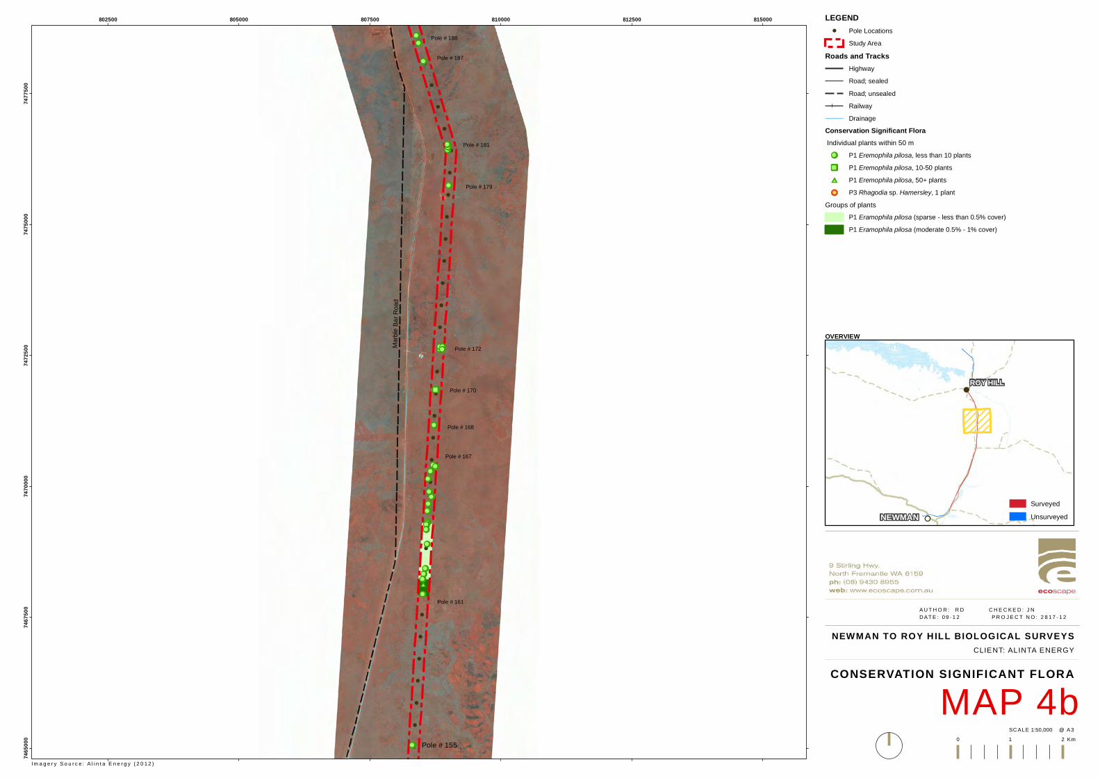
!
!
!
!
!
!
!
!
!
!
!
!
!
!
!
!
!
!
!
!
!
!
!
!
!
!
!
!
!
!
!
!
!
!
!
!
!
!!!!!!!!
!!
ÆÆ
!!!!!!
!!!!!!!!
!!
!!!!!!##
!!
!!!!!!
!!!!!!!!
!!!!
!!!!
!!
!!
!!
Pole # 188
Pole # 187
Pole # 181
Pole # 179
Pole # 172
Pole # 170
Pole # 168
Pole # 167
Pole # 161
Pole # 155
Marbl
e Bar
Road
802500 805000 807500 810000 812500 81500074
6500
074
6750
074
7000
074
7250
074
7500
074
7750
0
NEWMAN TO ROY H ILL BIOLOGICAL SURVEYS
MAP 4bCONSERVATION SIGNIFICANT FLORA
1:50,000SC ALE @ A3
A U T H O R : R D C H E C K E D : J ND AT E : 0 9 - 1 2 P R O J E C T N O : 2 8 1 7 - 1 2
0 1 2 Km
CLIENT: ALINTA ENERGY
LEGEND! Pole Locations
Study AreaRoads and Tracks
HighwayRoad; sealedRoad; unsealedRailwayDrainage
Conservation Significant Flora Individual plants within 50 m!! P1 Eremophila pilosa, less than 10 plantsÆÆ P1 Eremophila pilosa, 10-50 plants## P1 Eremophila pilosa, 50+ plants!! P3 Rhagodia sp. Hamersley, 1 plant
Groups of plantsP1 Eramophila pilosa (sparse - less than 0.5% cover)P1 Eramophila pilosa (moderate 0.5% - 1% cover)
OVERVIEW
Im a g e r y S o u r c e : A l i n t a E n e r g y ( 2 0 1 2 )
!!
!
NEWMAN
ROY HILL
SurveyedUnsurveyed
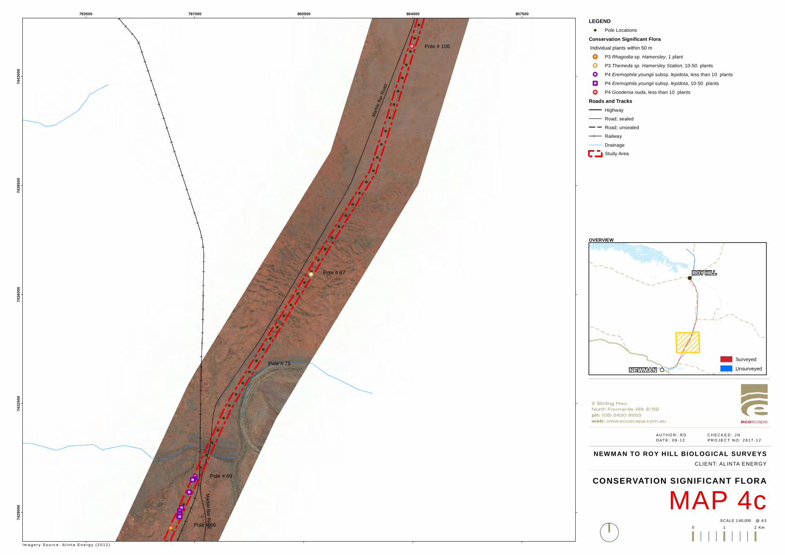
!
!
!
!
!
!
!
!
!
!
!
!
!
!
!
!
!
!
!
!
!
!
!
!
!
!
!
!
!
!
!
!
!
!
!
!
!
!
!
!
!
!
!
!
!
!
!
!
!!
!!!!!!!!ÆÆ
ÆÆ
ÆÆÆÆÆÆÆÆ
!!
ÆÆÆÆ
!! Pole # 87
Pole # 79
Pole # 69
Pole # 66
Pole # 106
Marbl
e Bar
Road
Marble Bar Road
793500 797000 800500 804000 80750074
2900
074
3250
074
3600
074
3950
074
4300
0
NEWMAN TO ROY H ILL BIOLOGICAL SURVEYS
MAP 4cCONSERVATION SIGNIFICANT FLORA
1:60,000SC ALE @ A3
A U T H O R : R D C H E C K E D : J ND AT E : 0 9 - 1 2 P R O J E C T N O : 2 8 1 7 - 1 2
0 1 2 Km
CLIENT: ALINTA ENERGY
LEGEND! Pole Locations
Conservation Significant Flora Individual plants within 50 m!! P3 Rhagodia sp. Hamersley, 1 plant!! P3 Themeda sp. Hamersley Station, 10-50 plants!! P4 Eremophila youngii subsp. lepidota, less than 10 plantsÆÆ P4 Eremophila youngii subsp. lepidota, 10-50 plants!! P4 Goodenia nuda, less than 10 plants
Roads and TracksHighwayRoad; sealedRoad; unsealedRailwayDrainageStudy Area
OVERVIEW
Im a g e r y S o u r c e : A l i n t a E n e r g y ( 2 0 1 2 )
!!
!
NEWMAN
ROY HILL
SurveyedUnsurveyed

!
!
!
!
!
!
!
!
!
!
!
!
!
!
!
!
!
!
!
!
!
!
!
!
!!
!!
!!
!!
!!
!!
!!
Sc
VfEc
EvAscCc
EvAscPs
EvAscCc
EvAscPs
EvVfPsAHH1228R
AHH1227R
AHH1226R
AHH1225R
AHH1224R
AHH1223R
AHH1229Q
FORT
ESCU
E RIVE
R KULKINBAH CREEK
Marbl
e Bar
Road
Noreena Roy Hill Road
Munjina Roy Hill Road ROY HILL
803500 806000 80850074
9250
074
9500
074
9750
0
GDA 1994 MGA Zone 50
NEWMAN TO ROY HILL BIOLOGICAL SURVEYS
MAP 5aVEGETATION TYPES
1:30,000SC ALE @ A3
A U T H O R : R D C H E C K E D : J N D AT E : 0 9 - 1 2 P R O J E C T N O : 2 8 1 7 - 1 2
0 1 2 km
CLIENT: ALINTA ENERGY
LEGEND! Pole Locations!! Quadrats
!! RelevésRoads and Tracks
HighwayRoad; sealedRoad; unsealedRailway
Vegetation CommunitiesAapAscTe - Acacia aptaneura tall open shrubland over Acacia sclerosperma
subsp. sclerosperma and A. synchronicia sparse mid shrublandover Triodia epactia, Eremophila cuneifolia and Ptilotus nobilis var. nobilis mid open shrubland
AapEfTe/AsyAc - Mulga grove: Acacia aptaneura, A. pruinocarpaand A. paraneura low woodlandover Eremophila forrestii subsp. forrestii, A. tetragonophylla and E. youngiisubsp. lepidota tall-mid sparse shrubland over Triodia epactia, Aristida contorta and A. inaequiglumis mid-low open hummock/tussock grasslandMulga intergrove: A. synchronicia tall open/sparse shrubland over Aristida contorta,Sclerolaena spp. and Senna sp. Meekatharra (E. Bailey 1-26) low sparsegrassland/low sparse chenopod shrubland/low sparse shrubland
AapEfTe/AsyAc/Tb - Mosaic of Acacia aptaneura tall open shrubland over Acacia sclerosperma subsp.sclerosperma and A. synchronicia sparse mid shrubland over Triodia epactia,Eremophila cuneifolia and Ptilotus nobilis var. nobilis mid open shrubland/Acacia synchronicia tall open/sparse shrubland over Aristida contorta, Sclerolaenaspp. and Senna sp. Meekatharra (E. Bailey 1-26) low sparse grassland/low sparsechenopod shrubland/low sparse shrubland and Tb
AbiTe - Acacia bivenosa, A. ancistrocarpa and A. sclerosperma subsp.sclerosperma tall-mid open shrubland over Triodia epactia andT. wiseana mid-low hummock grassland
AbiTe/AbiTw - Mosaic of AbiTe and AbiTw
AbiTw - Acacia bivenosa mid sparse shrubland over Triodia wiseana, Acaciahilliana and T. epactia low open hummock grassland/low open-sparse shrublandwith Eucalyptus leucophloia subsp. leucophloia low scattered trees
AscTe - Acacia sclerosperma subsp. sclerosperma and A. synchronicia tall sparseshrubland over Triodia epactia, Eragrostis eriopoda and *Cenchrus ciliaristall hummock grassland/low sparse tussock grassland
AsyTl - Acacia synchronicia mid sparse shrubland over Triodia longiceps, Aristidacontorta and Sclerolaena spp. tall open-sparse hummock grassland/low sparsegrassland/low sparse chenopod shrubland
CcAscCc - Corymbia candida subsp. dipsodes and Eucalyptus victrix low openwoodland-isolated trees over Acacia sclerosperma subsp. sclerosperma tallsparse shrubland over *Cenchrus ciliaris and Triodia epactia mid tussockgrassland/mid open hummock grassland
EvAscCc - Eucalyptus victrix, Acacia aptaneura and Atalaya hemiglauca open woodlandover Acacia sclerosperma subsp. sclerosperma, Eremophila youngii subsp.lepidota and *Vachellia farnesiana tall-mid sparse shrubland over *Cenchrusciliaris, *Malvastrum americanum and Salsola australis low sparse tussockgrassland/low sparse forbland
EvAscPs - Eucalyptus victrix and Acacia aptaneura low open-sparse woodland overAcacia sclerosperma subsp. sclerosperma, *Vachellia farnesiana and A.tetragonophylla mid sparse shrubland over mixed Poaceae spp. low opentussock grassland
EvVfPs - Eucalyptus victrix, E. camaldulensis subsp. refulgens and Atalaya hemiglaucamid open forest over Poaceae sp. mid open tussock grassland with *Vachelliafarnesiana mid scattered shrubs
Sc - Sclerolaena cornishiana and S. bicornis var. bicornis low sparse chenopod shrubland
Tb - Triodia basedowii, T. longiceps and Paraneurachne muelleri mid-low openhummock grassland/low sparse tussock grassland with Acacia ancistrocarpa andA. pachyacra tall-mid scattered shrubs
VfEc *Vachellia farnesiana and Senna glutinosa subsp. luerssenii x pruinosa midsparse shrubland over Enneapogon caerulscens, *Cenchrus ciliaris and *Aerva javanica low scattered tussock grassland/low sparse forbland withAcacia aptaneura and A. paraneura low scattered trees
N/A - Roadworks
Study Area
Im a g e r y S o u r c e : A l i n t a E n e r g y ( 2 0 1 2 )
OVERVIEW
!!
!
NEWMAN
ROY HILL
SurveyedUnsurveyed

!
!
!
!
!
!
!
!
!
!
!
!
!
!
!
!
!
!
!
!
!
!
!
!
!
!!
!!
!!
!!
!!
AapEfTe/AsyAc
EvAscCc
EvAscPs
AERL-18
AERL-17
AERL-16
AEQL4
AEQL3
FORTESCUE RIVER
Marble Bar Road
Munjina Roy Hill Road ROY HILL
803500 806000 80850074
8500
074
8750
074
9000
0
GDA 1994 MGA Zone 50
NEWMAN TO ROY HILL BIOLOGICAL SURVEYS
MAP 5bVEGETATION TYPES
1:30,000SC ALE @ A3
A U T H O R : R D C H E C K E D : J N D AT E : 0 9 - 1 2 P R O J E C T N O : 2 8 1 7 - 1 2
0 1 2 km
CLIENT: ALINTA ENERGY
LEGEND! Pole Locations!! Quadrats
!! RelevésRoads and Tracks
HighwayRoad; sealedRoad; unsealedRailway
Vegetation CommunitiesAapAscTe - Acacia aptaneura tall open shrubland over Acacia sclerosperma
subsp. sclerosperma and A. synchronicia sparse mid shrublandover Triodia epactia, Eremophila cuneifolia and Ptilotus nobilis var. nobilis mid open shrubland
AapEfTe/AsyAc - Mulga grove: Acacia aptaneura, A. pruinocarpaand A. paraneura low woodlandover Eremophila forrestii subsp. forrestii, A. tetragonophylla and E. youngiisubsp. lepidota tall-mid sparse shrubland over Triodia epactia, Aristida contorta and A. inaequiglumis mid-low open hummock/tussock grasslandMulga intergrove: A. synchronicia tall open/sparse shrubland over Aristida contorta,Sclerolaena spp. and Senna sp. Meekatharra (E. Bailey 1-26) low sparsegrassland/low sparse chenopod shrubland/low sparse shrubland
AapEfTe/AsyAc/Tb - Mosaic of Acacia aptaneura tall open shrubland over Acacia sclerosperma subsp.sclerosperma and A. synchronicia sparse mid shrubland over Triodia epactia,Eremophila cuneifolia and Ptilotus nobilis var. nobilis mid open shrubland/Acacia synchronicia tall open/sparse shrubland over Aristida contorta, Sclerolaenaspp. and Senna sp. Meekatharra (E. Bailey 1-26) low sparse grassland/low sparsechenopod shrubland/low sparse shrubland and Tb
AbiTe - Acacia bivenosa, A. ancistrocarpa and A. sclerosperma subsp.sclerosperma tall-mid open shrubland over Triodia epactia andT. wiseana mid-low hummock grassland
AbiTe/AbiTw - Mosaic of AbiTe and AbiTw
AbiTw - Acacia bivenosa mid sparse shrubland over Triodia wiseana, Acaciahilliana and T. epactia low open hummock grassland/low open-sparse shrublandwith Eucalyptus leucophloia subsp. leucophloia low scattered trees
AscTe - Acacia sclerosperma subsp. sclerosperma and A. synchronicia tall sparseshrubland over Triodia epactia, Eragrostis eriopoda and *Cenchrus ciliaristall hummock grassland/low sparse tussock grassland
AsyTl - Acacia synchronicia mid sparse shrubland over Triodia longiceps, Aristidacontorta and Sclerolaena spp. tall open-sparse hummock grassland/low sparsegrassland/low sparse chenopod shrubland
CcAscCc - Corymbia candida subsp. dipsodes and Eucalyptus victrix low openwoodland-isolated trees over Acacia sclerosperma subsp. sclerosperma tallsparse shrubland over *Cenchrus ciliaris and Triodia epactia mid tussockgrassland/mid open hummock grassland
EvAscCc - Eucalyptus victrix, Acacia aptaneura and Atalaya hemiglauca open woodlandover Acacia sclerosperma subsp. sclerosperma, Eremophila youngii subsp.lepidota and *Vachellia farnesiana tall-mid sparse shrubland over *Cenchrusciliaris, *Malvastrum americanum and Salsola australis low sparse tussockgrassland/low sparse forbland
EvAscPs - Eucalyptus victrix and Acacia aptaneura low open-sparse woodland overAcacia sclerosperma subsp. sclerosperma, *Vachellia farnesiana and A.tetragonophylla mid sparse shrubland over mixed Poaceae spp. low opentussock grassland
EvVfPs - Eucalyptus victrix, E. camaldulensis subsp. refulgens and Atalaya hemiglaucamid open forest over Poaceae sp. mid open tussock grassland with *Vachelliafarnesiana mid scattered shrubs
Sc - Sclerolaena cornishiana and S. bicornis var. bicornis low sparse chenopod shrubland
Tb - Triodia basedowii, T. longiceps and Paraneurachne muelleri mid-low openhummock grassland/low sparse tussock grassland with Acacia ancistrocarpa andA. pachyacra tall-mid scattered shrubs
VfEc *Vachellia farnesiana and Senna glutinosa subsp. luerssenii x pruinosa midsparse shrubland over Enneapogon caerulscens, *Cenchrus ciliaris and *Aerva javanica low scattered tussock grassland/low sparse forbland withAcacia aptaneura and A. paraneura low scattered trees
N/A - Roadworks
Study Area
Im a g e r y S o u r c e : A l i n t a E n e r g y ( 2 0 1 2 )
OVERVIEW
!!
!
NEWMAN
ROY HILL
SurveyedUnsurveyed
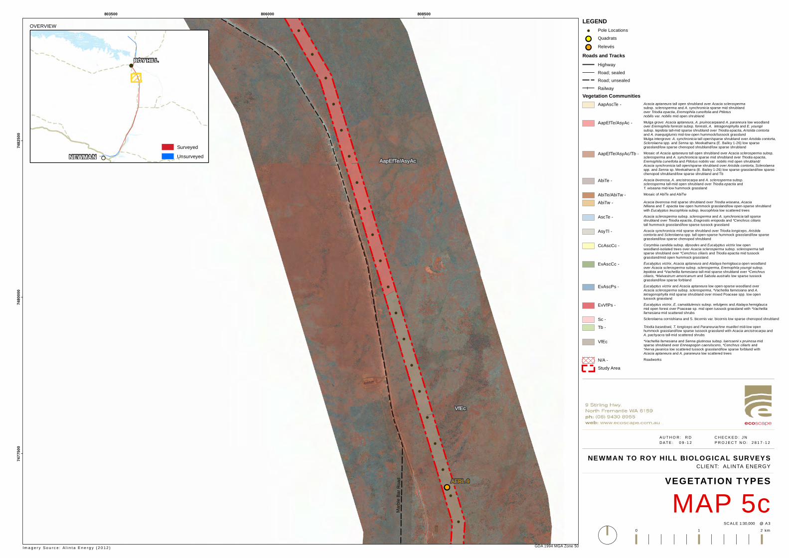
!
!
!
!
!
!
!
!
!
!
!
!
!
!
!
!
!
!
!
!
!
!
!
!
!!
AapEfTe/AsyAc
VfEc
AERL-9
Marbl
e Bar
Road
803500 806000 80850074
7750
074
8000
074
8250
0
GDA 1994 MGA Zone 50
NEWMAN TO ROY HILL BIOLOGICAL SURVEYS
MAP 5cVEGETATION TYPES
1:30,000SC ALE @ A3
A U T H O R : R D C H E C K E D : J N D AT E : 0 9 - 1 2 P R O J E C T N O : 2 8 1 7 - 1 2
0 1 2 km
CLIENT: ALINTA ENERGY
LEGEND! Pole Locations!! Quadrats
!! RelevésRoads and Tracks
HighwayRoad; sealedRoad; unsealedRailway
Vegetation CommunitiesAapAscTe - Acacia aptaneura tall open shrubland over Acacia sclerosperma
subsp. sclerosperma and A. synchronicia sparse mid shrublandover Triodia epactia, Eremophila cuneifolia and Ptilotus nobilis var. nobilis mid open shrubland
AapEfTe/AsyAc - Mulga grove: Acacia aptaneura, A. pruinocarpaand A. paraneura low woodlandover Eremophila forrestii subsp. forrestii, A. tetragonophylla and E. youngiisubsp. lepidota tall-mid sparse shrubland over Triodia epactia, Aristida contorta and A. inaequiglumis mid-low open hummock/tussock grasslandMulga intergrove: A. synchronicia tall open/sparse shrubland over Aristida contorta,Sclerolaena spp. and Senna sp. Meekatharra (E. Bailey 1-26) low sparsegrassland/low sparse chenopod shrubland/low sparse shrubland
AapEfTe/AsyAc/Tb - Mosaic of Acacia aptaneura tall open shrubland over Acacia sclerosperma subsp.sclerosperma and A. synchronicia sparse mid shrubland over Triodia epactia,Eremophila cuneifolia and Ptilotus nobilis var. nobilis mid open shrubland/Acacia synchronicia tall open/sparse shrubland over Aristida contorta, Sclerolaenaspp. and Senna sp. Meekatharra (E. Bailey 1-26) low sparse grassland/low sparsechenopod shrubland/low sparse shrubland and Tb
AbiTe - Acacia bivenosa, A. ancistrocarpa and A. sclerosperma subsp.sclerosperma tall-mid open shrubland over Triodia epactia andT. wiseana mid-low hummock grassland
AbiTe/AbiTw - Mosaic of AbiTe and AbiTw
AbiTw - Acacia bivenosa mid sparse shrubland over Triodia wiseana, Acaciahilliana and T. epactia low open hummock grassland/low open-sparse shrublandwith Eucalyptus leucophloia subsp. leucophloia low scattered trees
AscTe - Acacia sclerosperma subsp. sclerosperma and A. synchronicia tall sparseshrubland over Triodia epactia, Eragrostis eriopoda and *Cenchrus ciliaristall hummock grassland/low sparse tussock grassland
AsyTl - Acacia synchronicia mid sparse shrubland over Triodia longiceps, Aristidacontorta and Sclerolaena spp. tall open-sparse hummock grassland/low sparsegrassland/low sparse chenopod shrubland
CcAscCc - Corymbia candida subsp. dipsodes and Eucalyptus victrix low openwoodland-isolated trees over Acacia sclerosperma subsp. sclerosperma tallsparse shrubland over *Cenchrus ciliaris and Triodia epactia mid tussockgrassland/mid open hummock grassland
EvAscCc - Eucalyptus victrix, Acacia aptaneura and Atalaya hemiglauca open woodlandover Acacia sclerosperma subsp. sclerosperma, Eremophila youngii subsp.lepidota and *Vachellia farnesiana tall-mid sparse shrubland over *Cenchrusciliaris, *Malvastrum americanum and Salsola australis low sparse tussockgrassland/low sparse forbland
EvAscPs - Eucalyptus victrix and Acacia aptaneura low open-sparse woodland overAcacia sclerosperma subsp. sclerosperma, *Vachellia farnesiana and A.tetragonophylla mid sparse shrubland over mixed Poaceae spp. low opentussock grassland
EvVfPs - Eucalyptus victrix, E. camaldulensis subsp. refulgens and Atalaya hemiglaucamid open forest over Poaceae sp. mid open tussock grassland with *Vachelliafarnesiana mid scattered shrubs
Sc - Sclerolaena cornishiana and S. bicornis var. bicornis low sparse chenopod shrubland
Tb - Triodia basedowii, T. longiceps and Paraneurachne muelleri mid-low openhummock grassland/low sparse tussock grassland with Acacia ancistrocarpa andA. pachyacra tall-mid scattered shrubs
VfEc *Vachellia farnesiana and Senna glutinosa subsp. luerssenii x pruinosa midsparse shrubland over Enneapogon caerulscens, *Cenchrus ciliaris and *Aerva javanica low scattered tussock grassland/low sparse forbland withAcacia aptaneura and A. paraneura low scattered trees
N/A - Roadworks
Study Area
Im a g e r y S o u r c e : A l i n t a E n e r g y ( 2 0 1 2 )
OVERVIEW
!!
!
NEWMAN
ROY HILL
SurveyedUnsurveyed

!
!
!
!
!
!
!
!
!
!
!
!
!
!
!
!
!
!
!
!
!
!
!
!!
!!
!!
!!
!!
!!
VfEc
AapEfTe/AsyAc
Tb
AERL-9
AERL-7
AERL-6
AHH1207R
AHH1212Q
AHH1208Q
Marbl
e Bar
Road
803500 806000 808500 81100074
7000
074
7250
074
7500
0
GDA 1994 MGA Zone 50
NEWMAN TO ROY HILL BIOLOGICAL SURVEYS
MAP 5dVEGETATION TYPES
1:30,000SC ALE @ A3
A U T H O R : R D C H E C K E D : J N D AT E : 0 9 - 1 2 P R O J E C T N O : 2 8 1 7 - 1 2
0 1 2 km
CLIENT: ALINTA ENERGY
LEGEND! Pole Locations!! Quadrats
!! RelevésRoads and Tracks
HighwayRoad; sealedRoad; unsealedRailway
Vegetation CommunitiesAapAscTe - Acacia aptaneura tall open shrubland over Acacia sclerosperma
subsp. sclerosperma and A. synchronicia sparse mid shrublandover Triodia epactia, Eremophila cuneifolia and Ptilotus nobilis var. nobilis mid open shrubland
AapEfTe/AsyAc - Mulga grove: Acacia aptaneura, A. pruinocarpaand A. paraneura low woodlandover Eremophila forrestii subsp. forrestii, A. tetragonophylla and E. youngiisubsp. lepidota tall-mid sparse shrubland over Triodia epactia, Aristida contorta and A. inaequiglumis mid-low open hummock/tussock grasslandMulga intergrove: A. synchronicia tall open/sparse shrubland over Aristida contorta,Sclerolaena spp. and Senna sp. Meekatharra (E. Bailey 1-26) low sparsegrassland/low sparse chenopod shrubland/low sparse shrubland
AapEfTe/AsyAc/Tb - Mosaic of Acacia aptaneura tall open shrubland over Acacia sclerosperma subsp.sclerosperma and A. synchronicia sparse mid shrubland over Triodia epactia,Eremophila cuneifolia and Ptilotus nobilis var. nobilis mid open shrubland/Acacia synchronicia tall open/sparse shrubland over Aristida contorta, Sclerolaenaspp. and Senna sp. Meekatharra (E. Bailey 1-26) low sparse grassland/low sparsechenopod shrubland/low sparse shrubland and Tb
AbiTe - Acacia bivenosa, A. ancistrocarpa and A. sclerosperma subsp.sclerosperma tall-mid open shrubland over Triodia epactia andT. wiseana mid-low hummock grassland
AbiTe/AbiTw - Mosaic of AbiTe and AbiTw
AbiTw - Acacia bivenosa mid sparse shrubland over Triodia wiseana, Acaciahilliana and T. epactia low open hummock grassland/low open-sparse shrublandwith Eucalyptus leucophloia subsp. leucophloia low scattered trees
AscTe - Acacia sclerosperma subsp. sclerosperma and A. synchronicia tall sparseshrubland over Triodia epactia, Eragrostis eriopoda and *Cenchrus ciliaristall hummock grassland/low sparse tussock grassland
AsyTl - Acacia synchronicia mid sparse shrubland over Triodia longiceps, Aristidacontorta and Sclerolaena spp. tall open-sparse hummock grassland/low sparsegrassland/low sparse chenopod shrubland
CcAscCc - Corymbia candida subsp. dipsodes and Eucalyptus victrix low openwoodland-isolated trees over Acacia sclerosperma subsp. sclerosperma tallsparse shrubland over *Cenchrus ciliaris and Triodia epactia mid tussockgrassland/mid open hummock grassland
EvAscCc - Eucalyptus victrix, Acacia aptaneura and Atalaya hemiglauca open woodlandover Acacia sclerosperma subsp. sclerosperma, Eremophila youngii subsp.lepidota and *Vachellia farnesiana tall-mid sparse shrubland over *Cenchrusciliaris, *Malvastrum americanum and Salsola australis low sparse tussockgrassland/low sparse forbland
EvAscPs - Eucalyptus victrix and Acacia aptaneura low open-sparse woodland overAcacia sclerosperma subsp. sclerosperma, *Vachellia farnesiana and A.tetragonophylla mid sparse shrubland over mixed Poaceae spp. low opentussock grassland
EvVfPs - Eucalyptus victrix, E. camaldulensis subsp. refulgens and Atalaya hemiglaucamid open forest over Poaceae sp. mid open tussock grassland with *Vachelliafarnesiana mid scattered shrubs
Sc - Sclerolaena cornishiana and S. bicornis var. bicornis low sparse chenopod shrubland
Tb - Triodia basedowii, T. longiceps and Paraneurachne muelleri mid-low openhummock grassland/low sparse tussock grassland with Acacia ancistrocarpa andA. pachyacra tall-mid scattered shrubs
VfEc *Vachellia farnesiana and Senna glutinosa subsp. luerssenii x pruinosa midsparse shrubland over Enneapogon caerulscens, *Cenchrus ciliaris and *Aerva javanica low scattered tussock grassland/low sparse forbland withAcacia aptaneura and A. paraneura low scattered trees
N/A - Roadworks
Study Area
Im a g e r y S o u r c e : A l i n t a E n e r g y ( 2 0 1 2 )
OVERVIEW
!!
!
NEWMAN
ROY HILL
SurveyedUnsurveyed
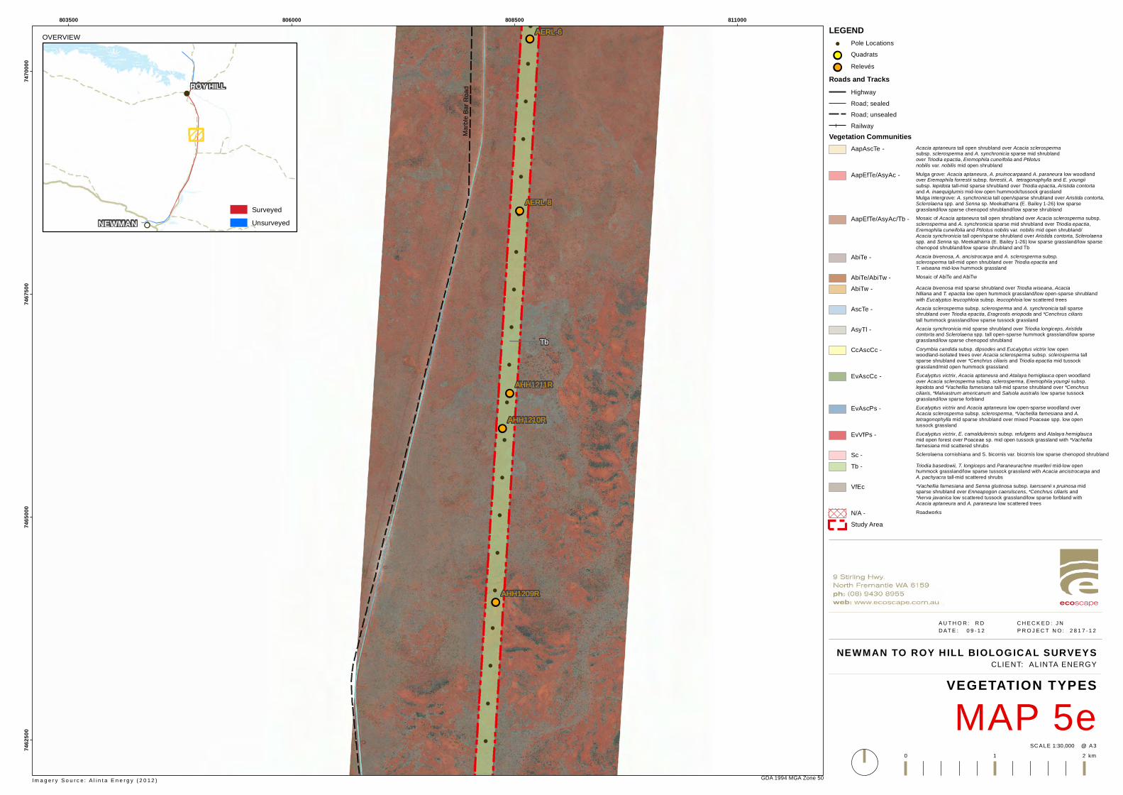
!
!
!
!
!
!
!
!
!
!
!
!
!
!
!
!
!
!
!
!
!
!
!
!!
!!
!!
!!
!!
Tb
AERL-8
AERL-6
AHH1211R
AHH1210R
AHH1209R
Marbl
e Bar
Road
803500 806000 808500 81100074
6250
074
6500
074
6750
074
7000
0
GDA 1994 MGA Zone 50
NEWMAN TO ROY HILL BIOLOGICAL SURVEYS
MAP 5eVEGETATION TYPES
1:30,000SC ALE @ A3
A U T H O R : R D C H E C K E D : J N D AT E : 0 9 - 1 2 P R O J E C T N O : 2 8 1 7 - 1 2
0 1 2 km
CLIENT: ALINTA ENERGY
LEGEND! Pole Locations!! Quadrats
!! RelevésRoads and Tracks
HighwayRoad; sealedRoad; unsealedRailway
Vegetation CommunitiesAapAscTe - Acacia aptaneura tall open shrubland over Acacia sclerosperma
subsp. sclerosperma and A. synchronicia sparse mid shrublandover Triodia epactia, Eremophila cuneifolia and Ptilotus nobilis var. nobilis mid open shrubland
AapEfTe/AsyAc - Mulga grove: Acacia aptaneura, A. pruinocarpaand A. paraneura low woodlandover Eremophila forrestii subsp. forrestii, A. tetragonophylla and E. youngiisubsp. lepidota tall-mid sparse shrubland over Triodia epactia, Aristida contorta and A. inaequiglumis mid-low open hummock/tussock grasslandMulga intergrove: A. synchronicia tall open/sparse shrubland over Aristida contorta,Sclerolaena spp. and Senna sp. Meekatharra (E. Bailey 1-26) low sparsegrassland/low sparse chenopod shrubland/low sparse shrubland
AapEfTe/AsyAc/Tb - Mosaic of Acacia aptaneura tall open shrubland over Acacia sclerosperma subsp.sclerosperma and A. synchronicia sparse mid shrubland over Triodia epactia,Eremophila cuneifolia and Ptilotus nobilis var. nobilis mid open shrubland/Acacia synchronicia tall open/sparse shrubland over Aristida contorta, Sclerolaenaspp. and Senna sp. Meekatharra (E. Bailey 1-26) low sparse grassland/low sparsechenopod shrubland/low sparse shrubland and Tb
AbiTe - Acacia bivenosa, A. ancistrocarpa and A. sclerosperma subsp.sclerosperma tall-mid open shrubland over Triodia epactia andT. wiseana mid-low hummock grassland
AbiTe/AbiTw - Mosaic of AbiTe and AbiTw
AbiTw - Acacia bivenosa mid sparse shrubland over Triodia wiseana, Acaciahilliana and T. epactia low open hummock grassland/low open-sparse shrublandwith Eucalyptus leucophloia subsp. leucophloia low scattered trees
AscTe - Acacia sclerosperma subsp. sclerosperma and A. synchronicia tall sparseshrubland over Triodia epactia, Eragrostis eriopoda and *Cenchrus ciliaristall hummock grassland/low sparse tussock grassland
AsyTl - Acacia synchronicia mid sparse shrubland over Triodia longiceps, Aristidacontorta and Sclerolaena spp. tall open-sparse hummock grassland/low sparsegrassland/low sparse chenopod shrubland
CcAscCc - Corymbia candida subsp. dipsodes and Eucalyptus victrix low openwoodland-isolated trees over Acacia sclerosperma subsp. sclerosperma tallsparse shrubland over *Cenchrus ciliaris and Triodia epactia mid tussockgrassland/mid open hummock grassland
EvAscCc - Eucalyptus victrix, Acacia aptaneura and Atalaya hemiglauca open woodlandover Acacia sclerosperma subsp. sclerosperma, Eremophila youngii subsp.lepidota and *Vachellia farnesiana tall-mid sparse shrubland over *Cenchrusciliaris, *Malvastrum americanum and Salsola australis low sparse tussockgrassland/low sparse forbland
EvAscPs - Eucalyptus victrix and Acacia aptaneura low open-sparse woodland overAcacia sclerosperma subsp. sclerosperma, *Vachellia farnesiana and A.tetragonophylla mid sparse shrubland over mixed Poaceae spp. low opentussock grassland
EvVfPs - Eucalyptus victrix, E. camaldulensis subsp. refulgens and Atalaya hemiglaucamid open forest over Poaceae sp. mid open tussock grassland with *Vachelliafarnesiana mid scattered shrubs
Sc - Sclerolaena cornishiana and S. bicornis var. bicornis low sparse chenopod shrubland
Tb - Triodia basedowii, T. longiceps and Paraneurachne muelleri mid-low openhummock grassland/low sparse tussock grassland with Acacia ancistrocarpa andA. pachyacra tall-mid scattered shrubs
VfEc *Vachellia farnesiana and Senna glutinosa subsp. luerssenii x pruinosa midsparse shrubland over Enneapogon caerulscens, *Cenchrus ciliaris and *Aerva javanica low scattered tussock grassland/low sparse forbland withAcacia aptaneura and A. paraneura low scattered trees
N/A - Roadworks
Study Area
Im a g e r y S o u r c e : A l i n t a E n e r g y ( 2 0 1 2 )
OVERVIEW
!!
!
NEWMAN
ROY HILL
SurveyedUnsurveyed
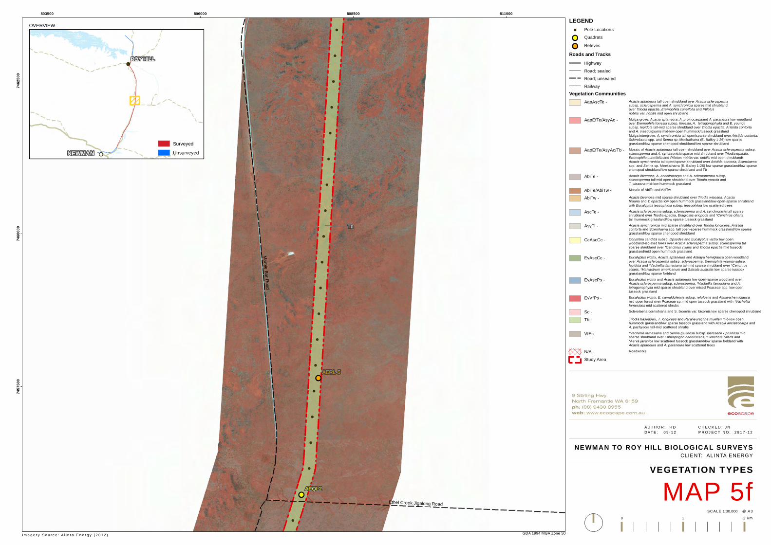
!
!
!
!
!
!
!
!
!
!
!
!
!
!
!
!
!
!
!
!
!
!
!
!!
!!
Tb
AERL-5
AEQL2
Marble Bar RoadEthel Creek Jigalong Road
803500 806000 808500 81100074
5750
074
6000
074
6250
0
GDA 1994 MGA Zone 50
NEWMAN TO ROY HILL BIOLOGICAL SURVEYS
MAP 5fVEGETATION TYPES
1:30,000SC ALE @ A3
A U T H O R : R D C H E C K E D : J N D AT E : 0 9 - 1 2 P R O J E C T N O : 2 8 1 7 - 1 2
0 1 2 km
CLIENT: ALINTA ENERGY
LEGEND! Pole Locations!! Quadrats
!! RelevésRoads and Tracks
HighwayRoad; sealedRoad; unsealedRailway
Vegetation CommunitiesAapAscTe - Acacia aptaneura tall open shrubland over Acacia sclerosperma
subsp. sclerosperma and A. synchronicia sparse mid shrublandover Triodia epactia, Eremophila cuneifolia and Ptilotus nobilis var. nobilis mid open shrubland
AapEfTe/AsyAc - Mulga grove: Acacia aptaneura, A. pruinocarpaand A. paraneura low woodlandover Eremophila forrestii subsp. forrestii, A. tetragonophylla and E. youngiisubsp. lepidota tall-mid sparse shrubland over Triodia epactia, Aristida contorta and A. inaequiglumis mid-low open hummock/tussock grasslandMulga intergrove: A. synchronicia tall open/sparse shrubland over Aristida contorta,Sclerolaena spp. and Senna sp. Meekatharra (E. Bailey 1-26) low sparsegrassland/low sparse chenopod shrubland/low sparse shrubland
AapEfTe/AsyAc/Tb - Mosaic of Acacia aptaneura tall open shrubland over Acacia sclerosperma subsp.sclerosperma and A. synchronicia sparse mid shrubland over Triodia epactia,Eremophila cuneifolia and Ptilotus nobilis var. nobilis mid open shrubland/Acacia synchronicia tall open/sparse shrubland over Aristida contorta, Sclerolaenaspp. and Senna sp. Meekatharra (E. Bailey 1-26) low sparse grassland/low sparsechenopod shrubland/low sparse shrubland and Tb
AbiTe - Acacia bivenosa, A. ancistrocarpa and A. sclerosperma subsp.sclerosperma tall-mid open shrubland over Triodia epactia andT. wiseana mid-low hummock grassland
AbiTe/AbiTw - Mosaic of AbiTe and AbiTw
AbiTw - Acacia bivenosa mid sparse shrubland over Triodia wiseana, Acaciahilliana and T. epactia low open hummock grassland/low open-sparse shrublandwith Eucalyptus leucophloia subsp. leucophloia low scattered trees
AscTe - Acacia sclerosperma subsp. sclerosperma and A. synchronicia tall sparseshrubland over Triodia epactia, Eragrostis eriopoda and *Cenchrus ciliaristall hummock grassland/low sparse tussock grassland
AsyTl - Acacia synchronicia mid sparse shrubland over Triodia longiceps, Aristidacontorta and Sclerolaena spp. tall open-sparse hummock grassland/low sparsegrassland/low sparse chenopod shrubland
CcAscCc - Corymbia candida subsp. dipsodes and Eucalyptus victrix low openwoodland-isolated trees over Acacia sclerosperma subsp. sclerosperma tallsparse shrubland over *Cenchrus ciliaris and Triodia epactia mid tussockgrassland/mid open hummock grassland
EvAscCc - Eucalyptus victrix, Acacia aptaneura and Atalaya hemiglauca open woodlandover Acacia sclerosperma subsp. sclerosperma, Eremophila youngii subsp.lepidota and *Vachellia farnesiana tall-mid sparse shrubland over *Cenchrusciliaris, *Malvastrum americanum and Salsola australis low sparse tussockgrassland/low sparse forbland
EvAscPs - Eucalyptus victrix and Acacia aptaneura low open-sparse woodland overAcacia sclerosperma subsp. sclerosperma, *Vachellia farnesiana and A.tetragonophylla mid sparse shrubland over mixed Poaceae spp. low opentussock grassland
EvVfPs - Eucalyptus victrix, E. camaldulensis subsp. refulgens and Atalaya hemiglaucamid open forest over Poaceae sp. mid open tussock grassland with *Vachelliafarnesiana mid scattered shrubs
Sc - Sclerolaena cornishiana and S. bicornis var. bicornis low sparse chenopod shrubland
Tb - Triodia basedowii, T. longiceps and Paraneurachne muelleri mid-low openhummock grassland/low sparse tussock grassland with Acacia ancistrocarpa andA. pachyacra tall-mid scattered shrubs
VfEc *Vachellia farnesiana and Senna glutinosa subsp. luerssenii x pruinosa midsparse shrubland over Enneapogon caerulscens, *Cenchrus ciliaris and *Aerva javanica low scattered tussock grassland/low sparse forbland withAcacia aptaneura and A. paraneura low scattered trees
N/A - Roadworks
Study Area
Im a g e r y S o u r c e : A l i n t a E n e r g y ( 2 0 1 2 )
OVERVIEW
!!
!
NEWMAN
ROY HILL
SurveyedUnsurveyed
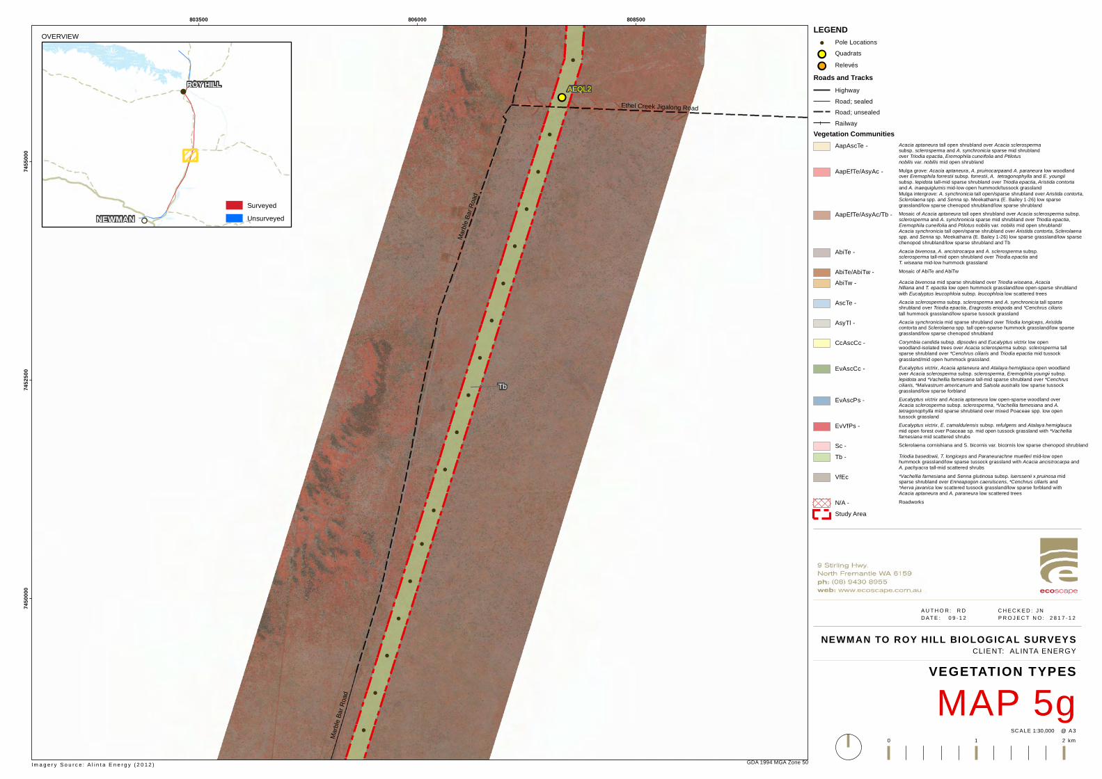
!
!
!
!
!
!
!
!
!
!
!
!
!
!
!
!
!
!
!
!
!
!
!
!!
Tb
AEQL2
Marbl
e Bar
Road
Marbl
e Bar
Road
Ethel Creek Jigalong Road
803500 806000 80850074
5000
074
5250
074
5500
0
GDA 1994 MGA Zone 50
NEWMAN TO ROY HILL BIOLOGICAL SURVEYS
MAP 5gVEGETATION TYPES
1:30,000SC ALE @ A3
A U T H O R : R D C H E C K E D : J N D AT E : 0 9 - 1 2 P R O J E C T N O : 2 8 1 7 - 1 2
0 1 2 km
CLIENT: ALINTA ENERGY
LEGEND! Pole Locations!! Quadrats
!! RelevésRoads and Tracks
HighwayRoad; sealedRoad; unsealedRailway
Vegetation CommunitiesAapAscTe - Acacia aptaneura tall open shrubland over Acacia sclerosperma
subsp. sclerosperma and A. synchronicia sparse mid shrublandover Triodia epactia, Eremophila cuneifolia and Ptilotus nobilis var. nobilis mid open shrubland
AapEfTe/AsyAc - Mulga grove: Acacia aptaneura, A. pruinocarpaand A. paraneura low woodlandover Eremophila forrestii subsp. forrestii, A. tetragonophylla and E. youngiisubsp. lepidota tall-mid sparse shrubland over Triodia epactia, Aristida contorta and A. inaequiglumis mid-low open hummock/tussock grasslandMulga intergrove: A. synchronicia tall open/sparse shrubland over Aristida contorta,Sclerolaena spp. and Senna sp. Meekatharra (E. Bailey 1-26) low sparsegrassland/low sparse chenopod shrubland/low sparse shrubland
AapEfTe/AsyAc/Tb - Mosaic of Acacia aptaneura tall open shrubland over Acacia sclerosperma subsp.sclerosperma and A. synchronicia sparse mid shrubland over Triodia epactia,Eremophila cuneifolia and Ptilotus nobilis var. nobilis mid open shrubland/Acacia synchronicia tall open/sparse shrubland over Aristida contorta, Sclerolaenaspp. and Senna sp. Meekatharra (E. Bailey 1-26) low sparse grassland/low sparsechenopod shrubland/low sparse shrubland and Tb
AbiTe - Acacia bivenosa, A. ancistrocarpa and A. sclerosperma subsp.sclerosperma tall-mid open shrubland over Triodia epactia andT. wiseana mid-low hummock grassland
AbiTe/AbiTw - Mosaic of AbiTe and AbiTw
AbiTw - Acacia bivenosa mid sparse shrubland over Triodia wiseana, Acaciahilliana and T. epactia low open hummock grassland/low open-sparse shrublandwith Eucalyptus leucophloia subsp. leucophloia low scattered trees
AscTe - Acacia sclerosperma subsp. sclerosperma and A. synchronicia tall sparseshrubland over Triodia epactia, Eragrostis eriopoda and *Cenchrus ciliaristall hummock grassland/low sparse tussock grassland
AsyTl - Acacia synchronicia mid sparse shrubland over Triodia longiceps, Aristidacontorta and Sclerolaena spp. tall open-sparse hummock grassland/low sparsegrassland/low sparse chenopod shrubland
CcAscCc - Corymbia candida subsp. dipsodes and Eucalyptus victrix low openwoodland-isolated trees over Acacia sclerosperma subsp. sclerosperma tallsparse shrubland over *Cenchrus ciliaris and Triodia epactia mid tussockgrassland/mid open hummock grassland
EvAscCc - Eucalyptus victrix, Acacia aptaneura and Atalaya hemiglauca open woodlandover Acacia sclerosperma subsp. sclerosperma, Eremophila youngii subsp.lepidota and *Vachellia farnesiana tall-mid sparse shrubland over *Cenchrusciliaris, *Malvastrum americanum and Salsola australis low sparse tussockgrassland/low sparse forbland
EvAscPs - Eucalyptus victrix and Acacia aptaneura low open-sparse woodland overAcacia sclerosperma subsp. sclerosperma, *Vachellia farnesiana and A.tetragonophylla mid sparse shrubland over mixed Poaceae spp. low opentussock grassland
EvVfPs - Eucalyptus victrix, E. camaldulensis subsp. refulgens and Atalaya hemiglaucamid open forest over Poaceae sp. mid open tussock grassland with *Vachelliafarnesiana mid scattered shrubs
Sc - Sclerolaena cornishiana and S. bicornis var. bicornis low sparse chenopod shrubland
Tb - Triodia basedowii, T. longiceps and Paraneurachne muelleri mid-low openhummock grassland/low sparse tussock grassland with Acacia ancistrocarpa andA. pachyacra tall-mid scattered shrubs
VfEc *Vachellia farnesiana and Senna glutinosa subsp. luerssenii x pruinosa midsparse shrubland over Enneapogon caerulscens, *Cenchrus ciliaris and *Aerva javanica low scattered tussock grassland/low sparse forbland withAcacia aptaneura and A. paraneura low scattered trees
N/A - Roadworks
Study Area
Im a g e r y S o u r c e : A l i n t a E n e r g y ( 2 0 1 2 )
OVERVIEW
!!
!
NEWMAN
ROY HILL
SurveyedUnsurveyed

!
!
!
!
!
!
!
!
!
!
!
!
!
!
!
!
!
!
!
!
!
!
!
!!
Tb
AERL-4
Marbl
e Bar
Road
801000 803500 80600074
4250
074
4500
074
4750
0
GDA 1994 MGA Zone 50
NEWMAN TO ROY HILL BIOLOGICAL SURVEYS
MAP 5hVEGETATION TYPES
1:30,000SC ALE @ A3
A U T H O R : R D C H E C K E D : J N D AT E : 0 9 - 1 2 P R O J E C T N O : 2 8 1 7 - 1 2
0 1 2 km
CLIENT: ALINTA ENERGY
LEGEND! Pole Locations!! Quadrats
!! RelevésRoads and Tracks
HighwayRoad; sealedRoad; unsealedRailway
Vegetation CommunitiesAapAscTe - Acacia aptaneura tall open shrubland over Acacia sclerosperma
subsp. sclerosperma and A. synchronicia sparse mid shrublandover Triodia epactia, Eremophila cuneifolia and Ptilotus nobilis var. nobilis mid open shrubland
AapEfTe/AsyAc - Mulga grove: Acacia aptaneura, A. pruinocarpaand A. paraneura low woodlandover Eremophila forrestii subsp. forrestii, A. tetragonophylla and E. youngiisubsp. lepidota tall-mid sparse shrubland over Triodia epactia, Aristida contorta and A. inaequiglumis mid-low open hummock/tussock grasslandMulga intergrove: A. synchronicia tall open/sparse shrubland over Aristida contorta,Sclerolaena spp. and Senna sp. Meekatharra (E. Bailey 1-26) low sparsegrassland/low sparse chenopod shrubland/low sparse shrubland
AapEfTe/AsyAc/Tb - Mosaic of Acacia aptaneura tall open shrubland over Acacia sclerosperma subsp.sclerosperma and A. synchronicia sparse mid shrubland over Triodia epactia,Eremophila cuneifolia and Ptilotus nobilis var. nobilis mid open shrubland/Acacia synchronicia tall open/sparse shrubland over Aristida contorta, Sclerolaenaspp. and Senna sp. Meekatharra (E. Bailey 1-26) low sparse grassland/low sparsechenopod shrubland/low sparse shrubland and Tb
AbiTe - Acacia bivenosa, A. ancistrocarpa and A. sclerosperma subsp.sclerosperma tall-mid open shrubland over Triodia epactia andT. wiseana mid-low hummock grassland
AbiTe/AbiTw - Mosaic of AbiTe and AbiTw
AbiTw - Acacia bivenosa mid sparse shrubland over Triodia wiseana, Acaciahilliana and T. epactia low open hummock grassland/low open-sparse shrublandwith Eucalyptus leucophloia subsp. leucophloia low scattered trees
AscTe - Acacia sclerosperma subsp. sclerosperma and A. synchronicia tall sparseshrubland over Triodia epactia, Eragrostis eriopoda and *Cenchrus ciliaristall hummock grassland/low sparse tussock grassland
AsyTl - Acacia synchronicia mid sparse shrubland over Triodia longiceps, Aristidacontorta and Sclerolaena spp. tall open-sparse hummock grassland/low sparsegrassland/low sparse chenopod shrubland
CcAscCc - Corymbia candida subsp. dipsodes and Eucalyptus victrix low openwoodland-isolated trees over Acacia sclerosperma subsp. sclerosperma tallsparse shrubland over *Cenchrus ciliaris and Triodia epactia mid tussockgrassland/mid open hummock grassland
EvAscCc - Eucalyptus victrix, Acacia aptaneura and Atalaya hemiglauca open woodlandover Acacia sclerosperma subsp. sclerosperma, Eremophila youngii subsp.lepidota and *Vachellia farnesiana tall-mid sparse shrubland over *Cenchrusciliaris, *Malvastrum americanum and Salsola australis low sparse tussockgrassland/low sparse forbland
EvAscPs - Eucalyptus victrix and Acacia aptaneura low open-sparse woodland overAcacia sclerosperma subsp. sclerosperma, *Vachellia farnesiana and A.tetragonophylla mid sparse shrubland over mixed Poaceae spp. low opentussock grassland
EvVfPs - Eucalyptus victrix, E. camaldulensis subsp. refulgens and Atalaya hemiglaucamid open forest over Poaceae sp. mid open tussock grassland with *Vachelliafarnesiana mid scattered shrubs
Sc - Sclerolaena cornishiana and S. bicornis var. bicornis low sparse chenopod shrubland
Tb - Triodia basedowii, T. longiceps and Paraneurachne muelleri mid-low openhummock grassland/low sparse tussock grassland with Acacia ancistrocarpa andA. pachyacra tall-mid scattered shrubs
VfEc *Vachellia farnesiana and Senna glutinosa subsp. luerssenii x pruinosa midsparse shrubland over Enneapogon caerulscens, *Cenchrus ciliaris and *Aerva javanica low scattered tussock grassland/low sparse forbland withAcacia aptaneura and A. paraneura low scattered trees
N/A - Roadworks
Study Area
Im a g e r y S o u r c e : A l i n t a E n e r g y ( 2 0 1 2 )
OVERVIEW
!!
!
NEWMAN
ROY HILL
SurveyedUnsurveyed
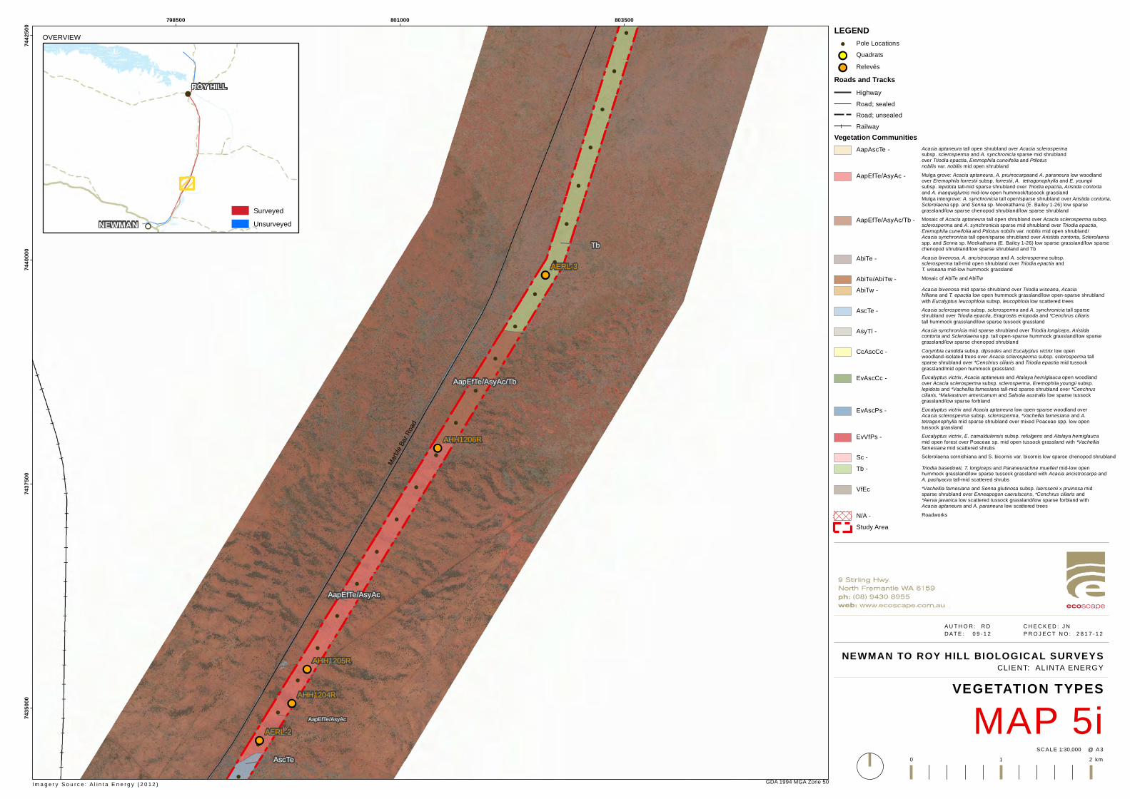
!
!
!
!
!
!
!
!
!
!
!
!
!
!
!
!
!
!
!
!
!
!
!
!
!
!
!!
!!
!!
!!
!!
AapEfTe/AsyAc
AapEfTe/AsyAc/Tb
Tb
AscTe
AapEfTe/AsyAc
AERL-3
AERL-2
AHH1206R
AHH1205R
AHH1204R
Marbl
e Bar
Road
798500 801000 80350074
3500
074
3750
074
4000
074
4250
0
GDA 1994 MGA Zone 50
NEWMAN TO ROY HILL BIOLOGICAL SURVEYS
MAP 5iVEGETATION TYPES
1:30,000SC ALE @ A3
A U T H O R : R D C H E C K E D : J N D AT E : 0 9 - 1 2 P R O J E C T N O : 2 8 1 7 - 1 2
0 1 2 km
CLIENT: ALINTA ENERGY
LEGEND! Pole Locations!! Quadrats
!! RelevésRoads and Tracks
HighwayRoad; sealedRoad; unsealedRailway
Vegetation CommunitiesAapAscTe - Acacia aptaneura tall open shrubland over Acacia sclerosperma
subsp. sclerosperma and A. synchronicia sparse mid shrublandover Triodia epactia, Eremophila cuneifolia and Ptilotus nobilis var. nobilis mid open shrubland
AapEfTe/AsyAc - Mulga grove: Acacia aptaneura, A. pruinocarpaand A. paraneura low woodlandover Eremophila forrestii subsp. forrestii, A. tetragonophylla and E. youngiisubsp. lepidota tall-mid sparse shrubland over Triodia epactia, Aristida contorta and A. inaequiglumis mid-low open hummock/tussock grasslandMulga intergrove: A. synchronicia tall open/sparse shrubland over Aristida contorta,Sclerolaena spp. and Senna sp. Meekatharra (E. Bailey 1-26) low sparsegrassland/low sparse chenopod shrubland/low sparse shrubland
AapEfTe/AsyAc/Tb - Mosaic of Acacia aptaneura tall open shrubland over Acacia sclerosperma subsp.sclerosperma and A. synchronicia sparse mid shrubland over Triodia epactia,Eremophila cuneifolia and Ptilotus nobilis var. nobilis mid open shrubland/Acacia synchronicia tall open/sparse shrubland over Aristida contorta, Sclerolaenaspp. and Senna sp. Meekatharra (E. Bailey 1-26) low sparse grassland/low sparsechenopod shrubland/low sparse shrubland and Tb
AbiTe - Acacia bivenosa, A. ancistrocarpa and A. sclerosperma subsp.sclerosperma tall-mid open shrubland over Triodia epactia andT. wiseana mid-low hummock grassland
AbiTe/AbiTw - Mosaic of AbiTe and AbiTw
AbiTw - Acacia bivenosa mid sparse shrubland over Triodia wiseana, Acaciahilliana and T. epactia low open hummock grassland/low open-sparse shrublandwith Eucalyptus leucophloia subsp. leucophloia low scattered trees
AscTe - Acacia sclerosperma subsp. sclerosperma and A. synchronicia tall sparseshrubland over Triodia epactia, Eragrostis eriopoda and *Cenchrus ciliaristall hummock grassland/low sparse tussock grassland
AsyTl - Acacia synchronicia mid sparse shrubland over Triodia longiceps, Aristidacontorta and Sclerolaena spp. tall open-sparse hummock grassland/low sparsegrassland/low sparse chenopod shrubland
CcAscCc - Corymbia candida subsp. dipsodes and Eucalyptus victrix low openwoodland-isolated trees over Acacia sclerosperma subsp. sclerosperma tallsparse shrubland over *Cenchrus ciliaris and Triodia epactia mid tussockgrassland/mid open hummock grassland
EvAscCc - Eucalyptus victrix, Acacia aptaneura and Atalaya hemiglauca open woodlandover Acacia sclerosperma subsp. sclerosperma, Eremophila youngii subsp.lepidota and *Vachellia farnesiana tall-mid sparse shrubland over *Cenchrusciliaris, *Malvastrum americanum and Salsola australis low sparse tussockgrassland/low sparse forbland
EvAscPs - Eucalyptus victrix and Acacia aptaneura low open-sparse woodland overAcacia sclerosperma subsp. sclerosperma, *Vachellia farnesiana and A.tetragonophylla mid sparse shrubland over mixed Poaceae spp. low opentussock grassland
EvVfPs - Eucalyptus victrix, E. camaldulensis subsp. refulgens and Atalaya hemiglaucamid open forest over Poaceae sp. mid open tussock grassland with *Vachelliafarnesiana mid scattered shrubs
Sc - Sclerolaena cornishiana and S. bicornis var. bicornis low sparse chenopod shrubland
Tb - Triodia basedowii, T. longiceps and Paraneurachne muelleri mid-low openhummock grassland/low sparse tussock grassland with Acacia ancistrocarpa andA. pachyacra tall-mid scattered shrubs
VfEc *Vachellia farnesiana and Senna glutinosa subsp. luerssenii x pruinosa midsparse shrubland over Enneapogon caerulscens, *Cenchrus ciliaris and *Aerva javanica low scattered tussock grassland/low sparse forbland withAcacia aptaneura and A. paraneura low scattered trees
N/A - Roadworks
Study Area
Im a g e r y S o u r c e : A l i n t a E n e r g y ( 2 0 1 2 )
OVERVIEW
!!
!
NEWMAN
ROY HILL
SurveyedUnsurveyed

!
!
!
!
!
!
!
!
!
!
!
!
!
!
!
!
!
!
!
!
!
!
!
!
!
!
!!
!!
!!
!!
!!
!!
!!
!!
!!
!!
!!
!!
!!
!!
N/A
AscTe
AapAscTe
AsyTl
AsyTl
AapEfTe/AsyAc
AscTe
AapEfTe/AsyAc
AERL-2
AERL-1
AERL-15
AERL-14
AERL-13
AHH1222R
AHH1205R
AHH1204R
AHH1203R
AHH1201RAHH1202R
AEQL1
AHH1231Q
AHH1230Q
KALGAN CREEK
FORTESCUE RIVER
Marble B
ar Ro
ad
Marbl
e Bar
Road
793500 796000 798500 80100074
2750
074
3000
074
3250
074
3500
0
GDA 1994 MGA Zone 50
NEWMAN TO ROY HILL BIOLOGICAL SURVEYS
MAP 5jVEGETATION TYPES
1:30,000SC ALE @ A3
A U T H O R : R D C H E C K E D : J N D AT E : 0 9 - 1 2 P R O J E C T N O : 2 8 1 7 - 1 2
0 1 2 km
CLIENT: ALINTA ENERGY
LEGEND! Pole Locations!! Quadrats
!! RelevésRoads and Tracks
HighwayRoad; sealedRoad; unsealedRailway
Vegetation CommunitiesAapAscTe - Acacia aptaneura tall open shrubland over Acacia sclerosperma
subsp. sclerosperma and A. synchronicia sparse mid shrublandover Triodia epactia, Eremophila cuneifolia and Ptilotus nobilis var. nobilis mid open shrubland
AapEfTe/AsyAc - Mulga grove: Acacia aptaneura, A. pruinocarpaand A. paraneura low woodlandover Eremophila forrestii subsp. forrestii, A. tetragonophylla and E. youngiisubsp. lepidota tall-mid sparse shrubland over Triodia epactia, Aristida contorta and A. inaequiglumis mid-low open hummock/tussock grasslandMulga intergrove: A. synchronicia tall open/sparse shrubland over Aristida contorta,Sclerolaena spp. and Senna sp. Meekatharra (E. Bailey 1-26) low sparsegrassland/low sparse chenopod shrubland/low sparse shrubland
AapEfTe/AsyAc/Tb - Mosaic of Acacia aptaneura tall open shrubland over Acacia sclerosperma subsp.sclerosperma and A. synchronicia sparse mid shrubland over Triodia epactia,Eremophila cuneifolia and Ptilotus nobilis var. nobilis mid open shrubland/Acacia synchronicia tall open/sparse shrubland over Aristida contorta, Sclerolaenaspp. and Senna sp. Meekatharra (E. Bailey 1-26) low sparse grassland/low sparsechenopod shrubland/low sparse shrubland and Tb
AbiTe - Acacia bivenosa, A. ancistrocarpa and A. sclerosperma subsp.sclerosperma tall-mid open shrubland over Triodia epactia andT. wiseana mid-low hummock grassland
AbiTe/AbiTw - Mosaic of AbiTe and AbiTw
AbiTw - Acacia bivenosa mid sparse shrubland over Triodia wiseana, Acaciahilliana and T. epactia low open hummock grassland/low open-sparse shrublandwith Eucalyptus leucophloia subsp. leucophloia low scattered trees
AscTe - Acacia sclerosperma subsp. sclerosperma and A. synchronicia tall sparseshrubland over Triodia epactia, Eragrostis eriopoda and *Cenchrus ciliaristall hummock grassland/low sparse tussock grassland
AsyTl - Acacia synchronicia mid sparse shrubland over Triodia longiceps, Aristidacontorta and Sclerolaena spp. tall open-sparse hummock grassland/low sparsegrassland/low sparse chenopod shrubland
CcAscCc - Corymbia candida subsp. dipsodes and Eucalyptus victrix low openwoodland-isolated trees over Acacia sclerosperma subsp. sclerosperma tallsparse shrubland over *Cenchrus ciliaris and Triodia epactia mid tussockgrassland/mid open hummock grassland
EvAscCc - Eucalyptus victrix, Acacia aptaneura and Atalaya hemiglauca open woodlandover Acacia sclerosperma subsp. sclerosperma, Eremophila youngii subsp.lepidota and *Vachellia farnesiana tall-mid sparse shrubland over *Cenchrusciliaris, *Malvastrum americanum and Salsola australis low sparse tussockgrassland/low sparse forbland
EvAscPs - Eucalyptus victrix and Acacia aptaneura low open-sparse woodland overAcacia sclerosperma subsp. sclerosperma, *Vachellia farnesiana and A.tetragonophylla mid sparse shrubland over mixed Poaceae spp. low opentussock grassland
EvVfPs - Eucalyptus victrix, E. camaldulensis subsp. refulgens and Atalaya hemiglaucamid open forest over Poaceae sp. mid open tussock grassland with *Vachelliafarnesiana mid scattered shrubs
Sc - Sclerolaena cornishiana and S. bicornis var. bicornis low sparse chenopod shrubland
Tb - Triodia basedowii, T. longiceps and Paraneurachne muelleri mid-low openhummock grassland/low sparse tussock grassland with Acacia ancistrocarpa andA. pachyacra tall-mid scattered shrubs
VfEc *Vachellia farnesiana and Senna glutinosa subsp. luerssenii x pruinosa midsparse shrubland over Enneapogon caerulscens, *Cenchrus ciliaris and *Aerva javanica low scattered tussock grassland/low sparse forbland withAcacia aptaneura and A. paraneura low scattered trees
N/A - Roadworks
Study Area
Im a g e r y S o u r c e : A l i n t a E n e r g y ( 2 0 1 2 )
OVERVIEW
!!
!
NEWMAN
ROY HILL
SurveyedUnsurveyed
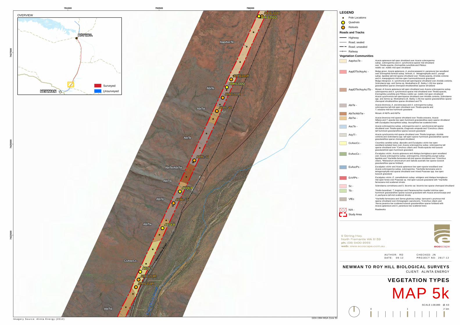
!
!
!
!
!
!
!
!
!
!
!
!
!
!
!
!
!
!
!
!
!
!
!
!
!
!!
!!
!!
!!
!!
!!
!!
!!
!!
!!
!!
!!
!!
!!
AapAscTe
AbiTw
AbiTe
CcAscCc
AbiTe
AbiTe
AbiTw
AbiTw
AsyTl
AbiTe/AbiTw
AbiTw
AERL-12
AERL-11
AERL-10
AHH1222R
AHH1221R
AHH1220R
AHH1219R
AHH1218R
AEQL9
AEQL8
AEQL7
AHH1232Q
AHH1231Q
FORT
ESCU
E RIVE
RMarb
le Bar
Road
791000 793500 79600074
2250
074
2500
074
2750
0
GDA 1994 MGA Zone 50
NEWMAN TO ROY HILL BIOLOGICAL SURVEYS
MAP 5kVEGETATION TYPES
1:30,000SC ALE @ A3
A U T H O R : R D C H E C K E D : J N D AT E : 0 9 - 1 2 P R O J E C T N O : 2 8 1 7 - 1 2
0 1 2 km
CLIENT: ALINTA ENERGY
LEGEND! Pole Locations!! Quadrats
!! RelevésRoads and Tracks
HighwayRoad; sealedRoad; unsealedRailway
Vegetation CommunitiesAapAscTe - Acacia aptaneura tall open shrubland over Acacia sclerosperma
subsp. sclerosperma and A. synchronicia sparse mid shrublandover Triodia epactia, Eremophila cuneifolia and Ptilotus nobilis var. nobilis mid open shrubland
AapEfTe/AsyAc - Mulga grove: Acacia aptaneura, A. pruinocarpaand A. paraneura low woodlandover Eremophila forrestii subsp. forrestii, A. tetragonophylla and E. youngiisubsp. lepidota tall-mid sparse shrubland over Triodia epactia, Aristida contorta and A. inaequiglumis mid-low open hummock/tussock grasslandMulga intergrove: A. synchronicia tall open/sparse shrubland over Aristida contorta,Sclerolaena spp. and Senna sp. Meekatharra (E. Bailey 1-26) low sparsegrassland/low sparse chenopod shrubland/low sparse shrubland
AapEfTe/AsyAc/Tb - Mosaic of Acacia aptaneura tall open shrubland over Acacia sclerosperma subsp.sclerosperma and A. synchronicia sparse mid shrubland over Triodia epactia,Eremophila cuneifolia and Ptilotus nobilis var. nobilis mid open shrubland/Acacia synchronicia tall open/sparse shrubland over Aristida contorta, Sclerolaenaspp. and Senna sp. Meekatharra (E. Bailey 1-26) low sparse grassland/low sparsechenopod shrubland/low sparse shrubland and Tb
AbiTe - Acacia bivenosa, A. ancistrocarpa and A. sclerosperma subsp.sclerosperma tall-mid open shrubland over Triodia epactia andT. wiseana mid-low hummock grassland
AbiTe/AbiTw - Mosaic of AbiTe and AbiTw
AbiTw - Acacia bivenosa mid sparse shrubland over Triodia wiseana, Acaciahilliana and T. epactia low open hummock grassland/low open-sparse shrublandwith Eucalyptus leucophloia subsp. leucophloia low scattered trees
AscTe - Acacia sclerosperma subsp. sclerosperma and A. synchronicia tall sparseshrubland over Triodia epactia, Eragrostis eriopoda and *Cenchrus ciliaristall hummock grassland/low sparse tussock grassland
AsyTl - Acacia synchronicia mid sparse shrubland over Triodia longiceps, Aristidacontorta and Sclerolaena spp. tall open-sparse hummock grassland/low sparsegrassland/low sparse chenopod shrubland
CcAscCc - Corymbia candida subsp. dipsodes and Eucalyptus victrix low openwoodland-isolated trees over Acacia sclerosperma subsp. sclerosperma tallsparse shrubland over *Cenchrus ciliaris and Triodia epactia mid tussockgrassland/mid open hummock grassland
EvAscCc - Eucalyptus victrix, Acacia aptaneura and Atalaya hemiglauca open woodlandover Acacia sclerosperma subsp. sclerosperma, Eremophila youngii subsp.lepidota and *Vachellia farnesiana tall-mid sparse shrubland over *Cenchrusciliaris, *Malvastrum americanum and Salsola australis low sparse tussockgrassland/low sparse forbland
EvAscPs - Eucalyptus victrix and Acacia aptaneura low open-sparse woodland overAcacia sclerosperma subsp. sclerosperma, *Vachellia farnesiana and A.tetragonophylla mid sparse shrubland over mixed Poaceae spp. low opentussock grassland
EvVfPs - Eucalyptus victrix, E. camaldulensis subsp. refulgens and Atalaya hemiglaucamid open forest over Poaceae sp. mid open tussock grassland with *Vachelliafarnesiana mid scattered shrubs
Sc - Sclerolaena cornishiana and S. bicornis var. bicornis low sparse chenopod shrubland
Tb - Triodia basedowii, T. longiceps and Paraneurachne muelleri mid-low openhummock grassland/low sparse tussock grassland with Acacia ancistrocarpa andA. pachyacra tall-mid scattered shrubs
VfEc *Vachellia farnesiana and Senna glutinosa subsp. luerssenii x pruinosa midsparse shrubland over Enneapogon caerulscens, *Cenchrus ciliaris and *Aerva javanica low scattered tussock grassland/low sparse forbland withAcacia aptaneura and A. paraneura low scattered trees
N/A - Roadworks
Study Area
Im a g e r y S o u r c e : A l i n t a E n e r g y ( 2 0 1 2 )
OVERVIEW
!!
!
NEWMAN
ROY HILL
SurveyedUnsurveyed
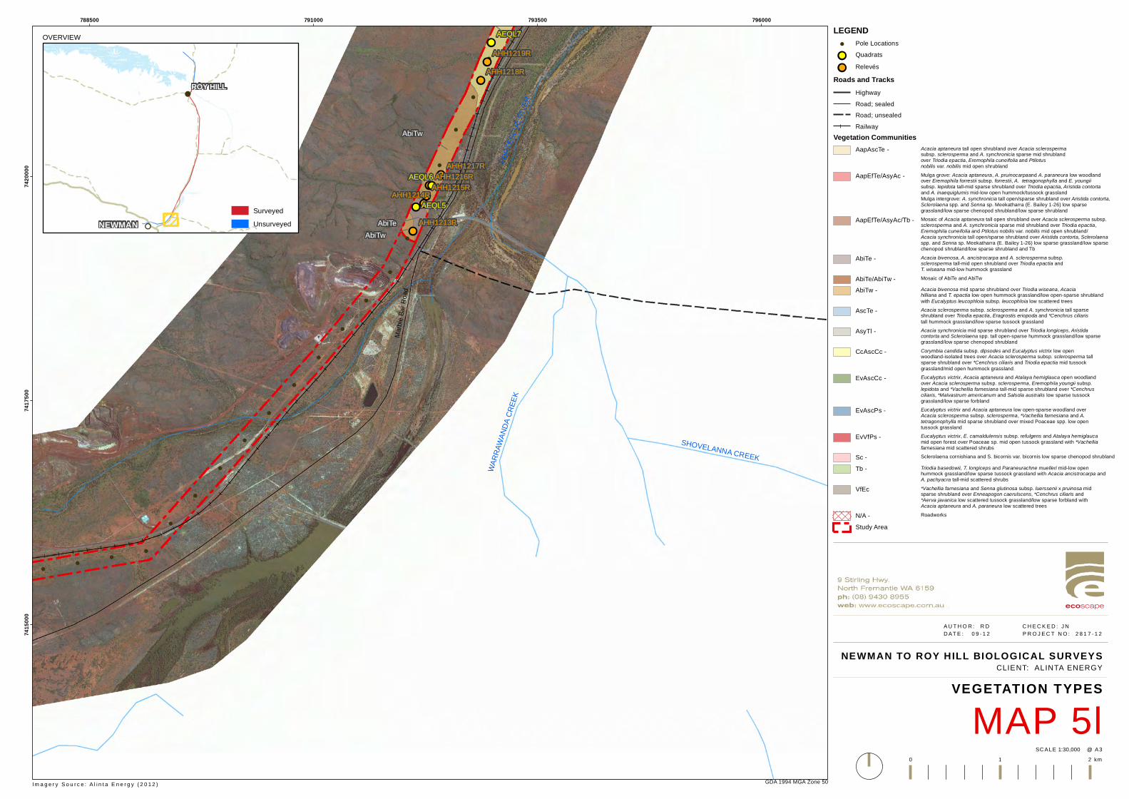
!
!
!
!
!
!
!
!
!
!
!
!
!
!
!
!
!
!
!
!
!
!
!!
!!!!!!!!
!!
!!
!!
!!
!!
AbiTw
CcAscCc
AbiTeAbiTw
AHH1219R
AHH1218R
AHH1217RAHH1216R
AHH1215RAHH1214R
AHH1213R
AEQL7
AEQL6
AEQL5
SHOVELANNA CREEK
WARR
AWAN
DA CR
EEK
FORT
ESCU
E RIVE
R
Marbl
e Bar
Road
788500 791000 793500 79600074
1500
074
1750
074
2000
0
GDA 1994 MGA Zone 50
NEWMAN TO ROY HILL BIOLOGICAL SURVEYS
MAP 5lVEGETATION TYPES
1:30,000SC ALE @ A3
A U T H O R : R D C H E C K E D : J N D AT E : 0 9 - 1 2 P R O J E C T N O : 2 8 1 7 - 1 2
0 1 2 km
CLIENT: ALINTA ENERGY
LEGEND! Pole Locations!! Quadrats
!! RelevésRoads and Tracks
HighwayRoad; sealedRoad; unsealedRailway
Vegetation CommunitiesAapAscTe - Acacia aptaneura tall open shrubland over Acacia sclerosperma
subsp. sclerosperma and A. synchronicia sparse mid shrublandover Triodia epactia, Eremophila cuneifolia and Ptilotus nobilis var. nobilis mid open shrubland
AapEfTe/AsyAc - Mulga grove: Acacia aptaneura, A. pruinocarpaand A. paraneura low woodlandover Eremophila forrestii subsp. forrestii, A. tetragonophylla and E. youngiisubsp. lepidota tall-mid sparse shrubland over Triodia epactia, Aristida contorta and A. inaequiglumis mid-low open hummock/tussock grasslandMulga intergrove: A. synchronicia tall open/sparse shrubland over Aristida contorta,Sclerolaena spp. and Senna sp. Meekatharra (E. Bailey 1-26) low sparsegrassland/low sparse chenopod shrubland/low sparse shrubland
AapEfTe/AsyAc/Tb - Mosaic of Acacia aptaneura tall open shrubland over Acacia sclerosperma subsp.sclerosperma and A. synchronicia sparse mid shrubland over Triodia epactia,Eremophila cuneifolia and Ptilotus nobilis var. nobilis mid open shrubland/Acacia synchronicia tall open/sparse shrubland over Aristida contorta, Sclerolaenaspp. and Senna sp. Meekatharra (E. Bailey 1-26) low sparse grassland/low sparsechenopod shrubland/low sparse shrubland and Tb
AbiTe - Acacia bivenosa, A. ancistrocarpa and A. sclerosperma subsp.sclerosperma tall-mid open shrubland over Triodia epactia andT. wiseana mid-low hummock grassland
AbiTe/AbiTw - Mosaic of AbiTe and AbiTw
AbiTw - Acacia bivenosa mid sparse shrubland over Triodia wiseana, Acaciahilliana and T. epactia low open hummock grassland/low open-sparse shrublandwith Eucalyptus leucophloia subsp. leucophloia low scattered trees
AscTe - Acacia sclerosperma subsp. sclerosperma and A. synchronicia tall sparseshrubland over Triodia epactia, Eragrostis eriopoda and *Cenchrus ciliaristall hummock grassland/low sparse tussock grassland
AsyTl - Acacia synchronicia mid sparse shrubland over Triodia longiceps, Aristidacontorta and Sclerolaena spp. tall open-sparse hummock grassland/low sparsegrassland/low sparse chenopod shrubland
CcAscCc - Corymbia candida subsp. dipsodes and Eucalyptus victrix low openwoodland-isolated trees over Acacia sclerosperma subsp. sclerosperma tallsparse shrubland over *Cenchrus ciliaris and Triodia epactia mid tussockgrassland/mid open hummock grassland
EvAscCc - Eucalyptus victrix, Acacia aptaneura and Atalaya hemiglauca open woodlandover Acacia sclerosperma subsp. sclerosperma, Eremophila youngii subsp.lepidota and *Vachellia farnesiana tall-mid sparse shrubland over *Cenchrusciliaris, *Malvastrum americanum and Salsola australis low sparse tussockgrassland/low sparse forbland
EvAscPs - Eucalyptus victrix and Acacia aptaneura low open-sparse woodland overAcacia sclerosperma subsp. sclerosperma, *Vachellia farnesiana and A.tetragonophylla mid sparse shrubland over mixed Poaceae spp. low opentussock grassland
EvVfPs - Eucalyptus victrix, E. camaldulensis subsp. refulgens and Atalaya hemiglaucamid open forest over Poaceae sp. mid open tussock grassland with *Vachelliafarnesiana mid scattered shrubs
Sc - Sclerolaena cornishiana and S. bicornis var. bicornis low sparse chenopod shrubland
Tb - Triodia basedowii, T. longiceps and Paraneurachne muelleri mid-low openhummock grassland/low sparse tussock grassland with Acacia ancistrocarpa andA. pachyacra tall-mid scattered shrubs
VfEc *Vachellia farnesiana and Senna glutinosa subsp. luerssenii x pruinosa midsparse shrubland over Enneapogon caerulscens, *Cenchrus ciliaris and *Aerva javanica low scattered tussock grassland/low sparse forbland withAcacia aptaneura and A. paraneura low scattered trees
N/A - Roadworks
Study Area
Im a g e r y S o u r c e : A l i n t a E n e r g y ( 2 0 1 2 )
OVERVIEW
!!
!
NEWMAN
ROY HILL
SurveyedUnsurveyed

!
!
!
!
!
!
!
!
!
!
!
!
!
!
!
!
!
!
!
!
!
!
!
!
!!
!!
!!
!!
!!
!!
!!
!
AERL-18
AHH1228R
AHH1227R
AHH1226R
AHH1225R
AHH1224R
AHH1223R
AEQL3
AHH1229QMa
rble B
ar Ro
ad
Noreena Roy Hill Road
Munjina Roy Hill Road
FORT
ESCU
E RI
VER KULKINBAH CREEK
ROY HILL
803500 806000 80850074
9250
074
9500
074
9750
0
GDA 1994 MGA Zone 50
NEWMAN TO ROY HILL BIOLO GICAL SURVEYS
MAP 6aVEGETATION CONDITION
1:30,000SCAL E @ A3
A UT H O R : RD C H E C K E D : J N DAT E : 0 9 - 1 2 P R O J E C T N O : 2 8 1 7 - 1 2
0 1 2 km
CLIENT: ALI NTA ENERGY
LEGEND! Pole Locations
Quadrat Relevé and Vegetation ConditionTrudgen (1991) Scale!! Excellent!! Very good!! Good!! Poor!! Very poor!! Degraded
Roads and TracksHighwayRoad; sealedRoad; unsealedRailwayDrainage
Vegetation ConditionTrudgen (1991) Scale
ExcellentVery goodGoodPoorVery poorCompletely degradedN/A - RoadworksStudy Area
I m a g e r y S o u r c e : A l i n t a E n e r g y ( 2 0 1 2 )
OVERVIEW
!!
!
NEWMAN
ROY HILL
SurveyedUnsurveyed
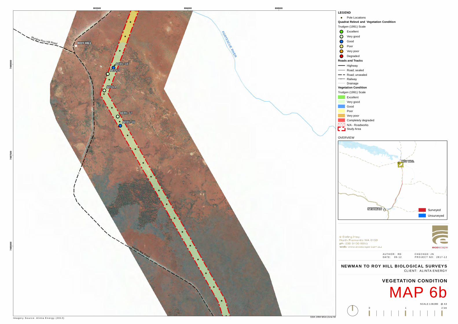
!
!
!
!
!
!
!
!
!
!
!
!
!
!
!
!
!
!
!
!
!
!
!
!
!
!!
!!
!!
!!
!!
!
AERL-18
AERL-17
AERL-16
AEQL4
AEQL3
Marble Bar Road
Munjina Roy Hill Road
FORTESCUE RIVER
ROY HILL
803500 806000 80850074
8500
074
8750
074
9000
0
GDA 1994 MGA Zone 50
NEWMAN TO ROY HILL BIOLO GICAL SURVEYS
MAP 6bVEGETATION CONDITION
1:30,000SCAL E @ A3
A UT H O R : RD C H E C K E D : J N DAT E : 0 9 - 1 2 P R O J E C T N O : 2 8 1 7 - 1 2
0 1 2 km
CLIENT: ALI NTA ENERGY
LEGEND! Pole Locations
Quadrat Relevé and Vegetation ConditionTrudgen (1991) Scale!! Excellent!! Very good!! Good!! Poor!! Very poor!! Degraded
Roads and TracksHighwayRoad; sealedRoad; unsealedRailwayDrainage
Vegetation ConditionTrudgen (1991) Scale
ExcellentVery goodGoodPoorVery poorCompletely degradedN/A - RoadworksStudy Area
I m a g e r y S o u r c e : A l i n t a E n e r g y ( 2 0 1 2 )
OVERVIEW
!!
!
NEWMAN
ROY HILL
SurveyedUnsurveyed
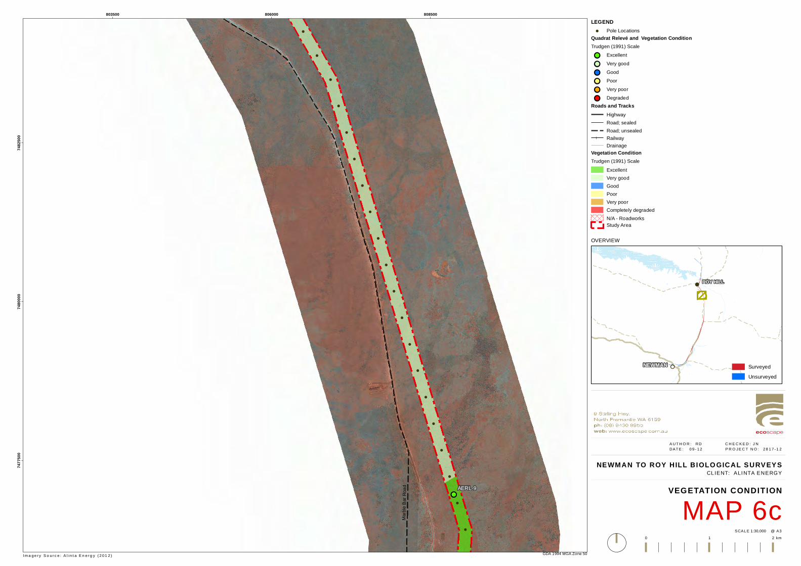
!
!
!
!
!
!
!
!
!
!
!
!
!
!
!
!
!
!
!
!
!
!
!
!
!!AERL-9
Marbl
e Bar
Road
803500 806000 80850074
7750
074
8000
074
8250
0
GDA 1994 MGA Zone 50
NEWMAN TO ROY HILL BIOLO GICAL SURVEYS
MAP 6cVEGETATION CONDITION
1:30,000SCAL E @ A3
A UT H O R : RD C H E C K E D : J N DAT E : 0 9 - 1 2 P R O J E C T N O : 2 8 1 7 - 1 2
0 1 2 km
CLIENT: ALI NTA ENERGY
LEGEND! Pole Locations
Quadrat Relevé and Vegetation ConditionTrudgen (1991) Scale!! Excellent!! Very good!! Good!! Poor!! Very poor!! Degraded
Roads and TracksHighwayRoad; sealedRoad; unsealedRailwayDrainage
Vegetation ConditionTrudgen (1991) Scale
ExcellentVery goodGoodPoorVery poorCompletely degradedN/A - RoadworksStudy Area
I m a g e r y S o u r c e : A l i n t a E n e r g y ( 2 0 1 2 )
OVERVIEW
!!
!
NEWMAN
ROY HILL
SurveyedUnsurveyed
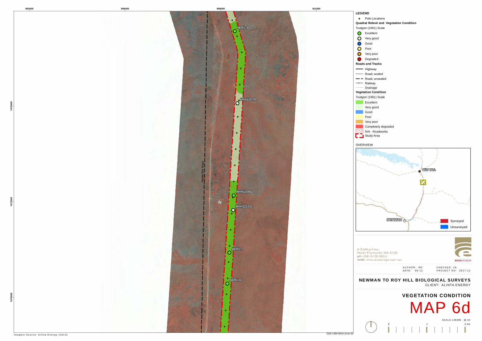
!
!
!
!
!
!
!
!
!
!
!
!
!
!
!
!
!
!
!
!
!
!
!
!!
!!
!!
!!
!!
!!
AERL-9
AERL-7
AERL-6
AHH1207R
AHH1212Q
AHH1208Q
Marbl
e Bar
Road
803500 806000 808500 81100074
7000
074
7250
074
7500
0
GDA 1994 MGA Zone 50
NEWMAN TO ROY HILL BIOLO GICAL SURVEYS
MAP 6dVEGETATION CONDITION
1:30,000SCAL E @ A3
A UT H O R : RD C H E C K E D : J N DAT E : 0 9 - 1 2 P R O J E C T N O : 2 8 1 7 - 1 2
0 1 2 km
CLIENT: ALI NTA ENERGY
LEGEND! Pole Locations
Quadrat Relevé and Vegetation ConditionTrudgen (1991) Scale!! Excellent!! Very good!! Good!! Poor!! Very poor!! Degraded
Roads and TracksHighwayRoad; sealedRoad; unsealedRailwayDrainage
Vegetation ConditionTrudgen (1991) Scale
ExcellentVery goodGoodPoorVery poorCompletely degradedN/A - RoadworksStudy Area
I m a g e r y S o u r c e : A l i n t a E n e r g y ( 2 0 1 2 )
OVERVIEW
!!
!
NEWMAN
ROY HILL
SurveyedUnsurveyed
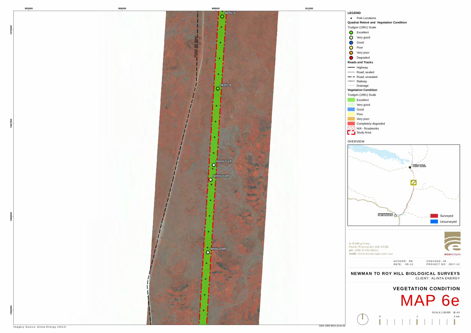
!
!
!
!
!
!
!
!
!
!
!
!
!
!
!
!
!
!
!
!
!
!
!
!!
!!
!!
!!
!!
AERL-8
AERL-6
AHH1211R
AHH1210R
AHH1209R
Marbl
e Bar
Road
803500 806000 808500 81100074
6250
074
6500
074
6750
074
7000
0
GDA 1994 MGA Zone 50
NEWMAN TO ROY HILL BIOLO GICAL SURVEYS
MAP 6eVEGETATION CONDITION
1:30,000SCAL E @ A3
A UT H O R : RD C H E C K E D : J N DAT E : 0 9 - 1 2 P R O J E C T N O : 2 8 1 7 - 1 2
0 1 2 km
CLIENT: ALI NTA ENERGY
LEGEND! Pole Locations
Quadrat Relevé and Vegetation ConditionTrudgen (1991) Scale!! Excellent!! Very good!! Good!! Poor!! Very poor!! Degraded
Roads and TracksHighwayRoad; sealedRoad; unsealedRailwayDrainage
Vegetation ConditionTrudgen (1991) Scale
ExcellentVery goodGoodPoorVery poorCompletely degradedN/A - RoadworksStudy Area
I m a g e r y S o u r c e : A l i n t a E n e r g y ( 2 0 1 2 )
OVERVIEW
!!
!
NEWMAN
ROY HILL
SurveyedUnsurveyed
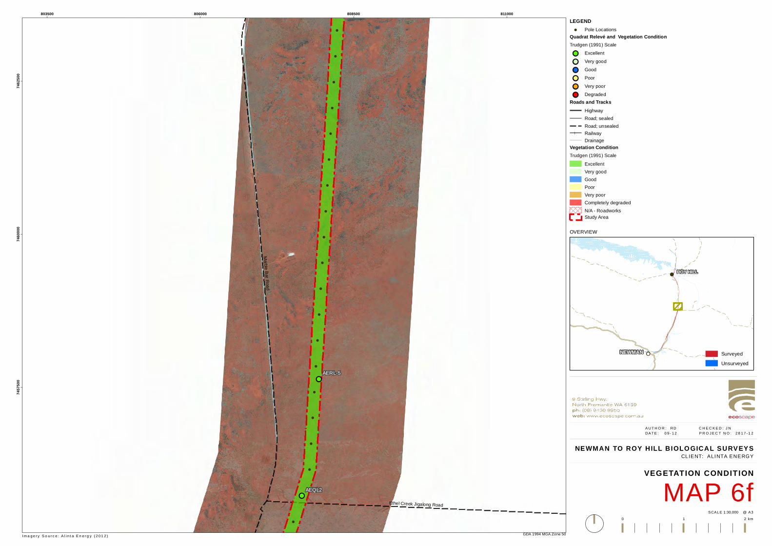
!
!
!
!
!
!
!
!
!
!
!
!
!
!
!
!
!
!
!
!
!
!
!
!!
!!
AERL-5
AEQL2
Marble Bar RoadEthel Creek Jigalong Road
803500 806000 808500 81100074
5750
074
6000
074
6250
0
GDA 1994 MGA Zone 50
NEWMAN TO ROY HILL BIOLO GICAL SURVEYS
MAP 6fVEGETATION CONDITION
1:30,000SCAL E @ A3
A UT H O R : RD C H E C K E D : J N DAT E : 0 9 - 1 2 P R O J E C T N O : 2 8 1 7 - 1 2
0 1 2 km
CLIENT: ALI NTA ENERGY
LEGEND! Pole Locations
Quadrat Relevé and Vegetation ConditionTrudgen (1991) Scale!! Excellent!! Very good!! Good!! Poor!! Very poor!! Degraded
Roads and TracksHighwayRoad; sealedRoad; unsealedRailwayDrainage
Vegetation ConditionTrudgen (1991) Scale
ExcellentVery goodGoodPoorVery poorCompletely degradedN/A - RoadworksStudy Area
I m a g e r y S o u r c e : A l i n t a E n e r g y ( 2 0 1 2 )
OVERVIEW
!!
!
NEWMAN
ROY HILL
SurveyedUnsurveyed
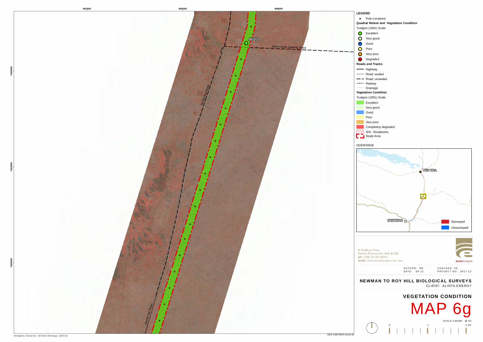
!
!
!
!
!
!
!
!
!
!
!
!
!
!
!
!
!
!
!
!
!
!
!
!!AEQL2
Marbl
e Bar
Road
Marbl
e Bar
Road
Ethel Creek Jigalong Road
803500 806000 80850074
5000
074
5250
074
5500
0
GDA 1994 MGA Zone 50
NEWMAN TO ROY HILL BIOLO GICAL SURVEYS
MAP 6gVEGETATION CONDITION
1:30,000SCAL E @ A3
A UT H O R : RD C H E C K E D : J N DAT E : 0 9 - 1 2 P R O J E C T N O : 2 8 1 7 - 1 2
0 1 2 km
CLIENT: ALI NTA ENERGY
LEGEND! Pole Locations
Quadrat Relevé and Vegetation ConditionTrudgen (1991) Scale!! Excellent!! Very good!! Good!! Poor!! Very poor!! Degraded
Roads and TracksHighwayRoad; sealedRoad; unsealedRailwayDrainage
Vegetation ConditionTrudgen (1991) Scale
ExcellentVery goodGoodPoorVery poorCompletely degradedN/A - RoadworksStudy Area
I m a g e r y S o u r c e : A l i n t a E n e r g y ( 2 0 1 2 )
OVERVIEW
!!
!
NEWMAN
ROY HILL
SurveyedUnsurveyed
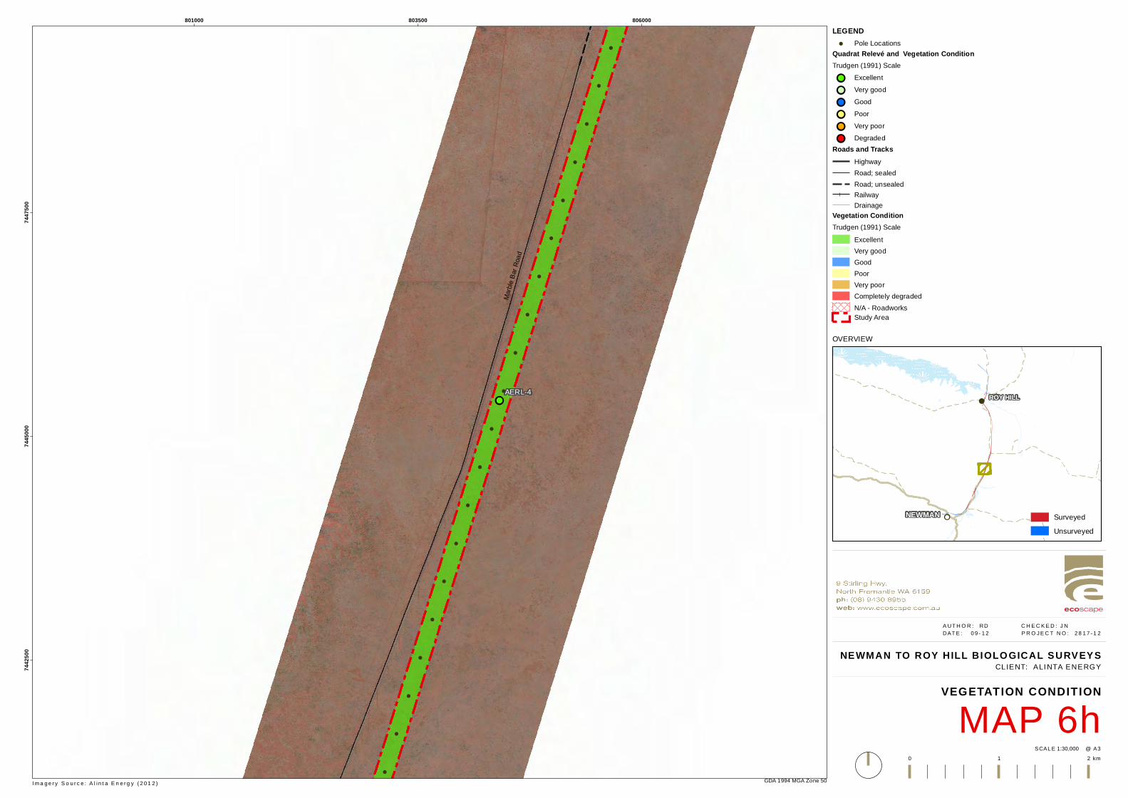
!
!
!
!
!
!
!
!
!
!
!
!
!
!
!
!
!
!
!
!
!
!
!
!!AERL-4
Marbl
e Bar
Road
801000 803500 80600074
4250
074
4500
074
4750
0
GDA 1994 MGA Zone 50
NEWMAN TO ROY HILL BIOLO GICAL SURVEYS
MAP 6hVEGETATION CONDITION
1:30,000SCAL E @ A3
A UT H O R : RD C H E C K E D : J N DAT E : 0 9 - 1 2 P R O J E C T N O : 2 8 1 7 - 1 2
0 1 2 km
CLIENT: ALI NTA ENERGY
LEGEND! Pole Locations
Quadrat Relevé and Vegetation ConditionTrudgen (1991) Scale!! Excellent!! Very good!! Good!! Poor!! Very poor!! Degraded
Roads and TracksHighwayRoad; sealedRoad; unsealedRailwayDrainage
Vegetation ConditionTrudgen (1991) Scale
ExcellentVery goodGoodPoorVery poorCompletely degradedN/A - RoadworksStudy Area
I m a g e r y S o u r c e : A l i n t a E n e r g y ( 2 0 1 2 )
OVERVIEW
!!
!
NEWMAN
ROY HILL
SurveyedUnsurveyed
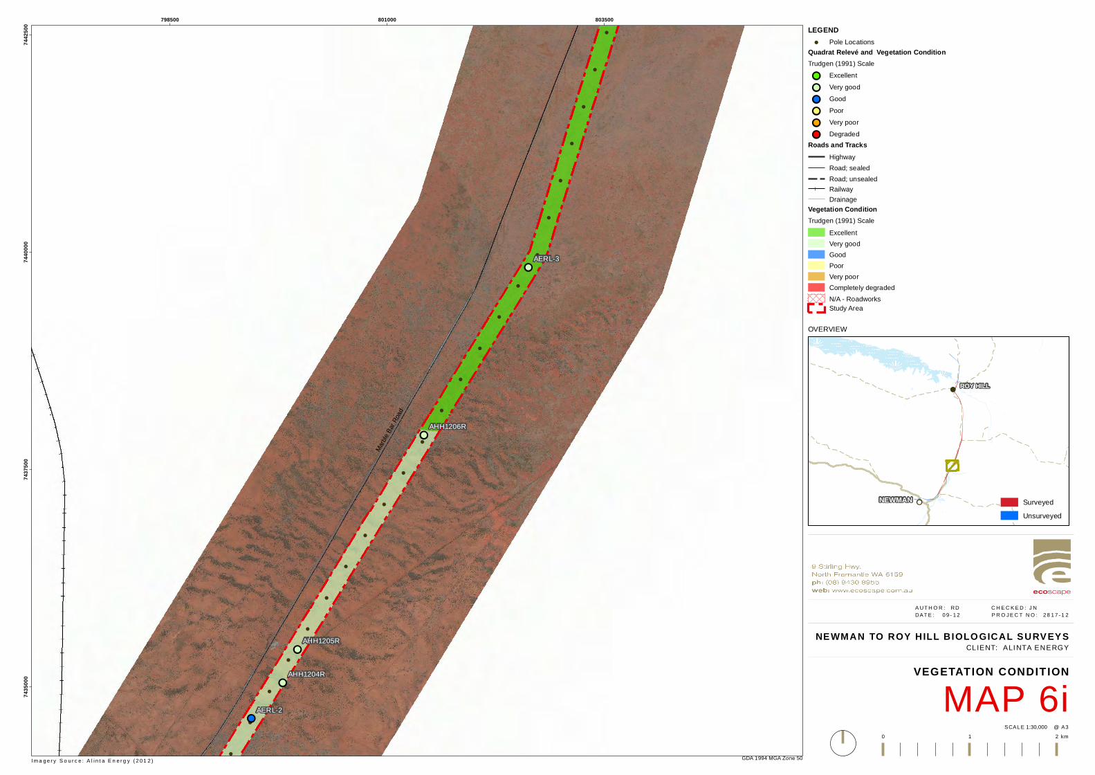
!
!
!
!
!
!
!
!
!
!
!
!
!
!
!
!
!
!
!
!
!
!
!
!
!
!
!!
!!
!!
!!
!!
AERL-3
AERL-2
AHH1206R
AHH1205R
AHH1204R
AEQL1
Marbl
e Bar
Road
798500 801000 80350074
3500
074
3750
074
4000
074
4250
0
GDA 1994 MGA Zone 50
NEWMAN TO ROY HILL BIOLO GICAL SURVEYS
MAP 6iVEGETATION CONDITION
1:30,000SCAL E @ A3
A UT H O R : RD C H E C K E D : J N DAT E : 0 9 - 1 2 P R O J E C T N O : 2 8 1 7 - 1 2
0 1 2 km
CLIENT: ALI NTA ENERGY
LEGEND! Pole Locations
Quadrat Relevé and Vegetation ConditionTrudgen (1991) Scale!! Excellent!! Very good!! Good!! Poor!! Very poor!! Degraded
Roads and TracksHighwayRoad; sealedRoad; unsealedRailwayDrainage
Vegetation ConditionTrudgen (1991) Scale
ExcellentVery goodGoodPoorVery poorCompletely degradedN/A - RoadworksStudy Area
I m a g e r y S o u r c e : A l i n t a E n e r g y ( 2 0 1 2 )
OVERVIEW
!!
!
NEWMAN
ROY HILL
SurveyedUnsurveyed
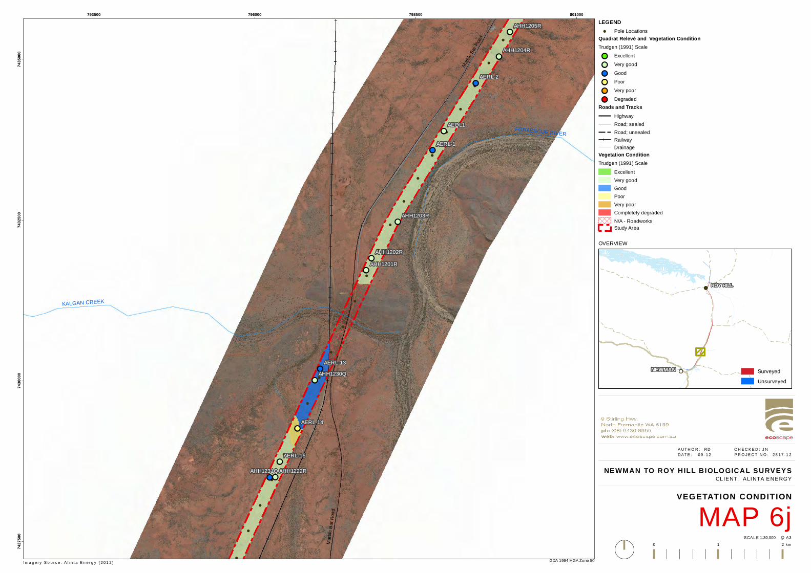
!
!
!
!
!
!
!
!
!
!
!
!
!
!
!
!
!
!
!
!
!
!
!
!
!
!
!!
!!
!!
!!
!!
!!
!!
!!
!!
!!
!!
!!
!!
!!
AERL-2
AERL-1
AERL-15
AERL-14
AERL-13
AHH1222R
AHH1221R
AHH1205R
AHH1204R
AHH1203R
AHH1201RAHH1202R
AEQL1
AHH1231Q
AHH1230Q
Marble B
ar Ro
ad
Marbl
e Bar
Road
KALGAN CREEK
FORTESCUE RIVER
793500 796000 798500 80100074
2750
074
3000
074
3250
074
3500
0
GDA 1994 MGA Zone 50
NEWMAN TO ROY HILL BIOLO GICAL SURVEYS
MAP 6jVEGETATION CONDITION
1:30,000SCAL E @ A3
A UT H O R : RD C H E C K E D : J N DAT E : 0 9 - 1 2 P R O J E C T N O : 2 8 1 7 - 1 2
0 1 2 km
CLIENT: ALI NTA ENERGY
LEGEND! Pole Locations
Quadrat Relevé and Vegetation ConditionTrudgen (1991) Scale!! Excellent!! Very good!! Good!! Poor!! Very poor!! Degraded
Roads and TracksHighwayRoad; sealedRoad; unsealedRailwayDrainage
Vegetation ConditionTrudgen (1991) Scale
ExcellentVery goodGoodPoorVery poorCompletely degradedN/A - RoadworksStudy Area
I m a g e r y S o u r c e : A l i n t a E n e r g y ( 2 0 1 2 )
OVERVIEW
!!
!
NEWMAN
ROY HILL
SurveyedUnsurveyed
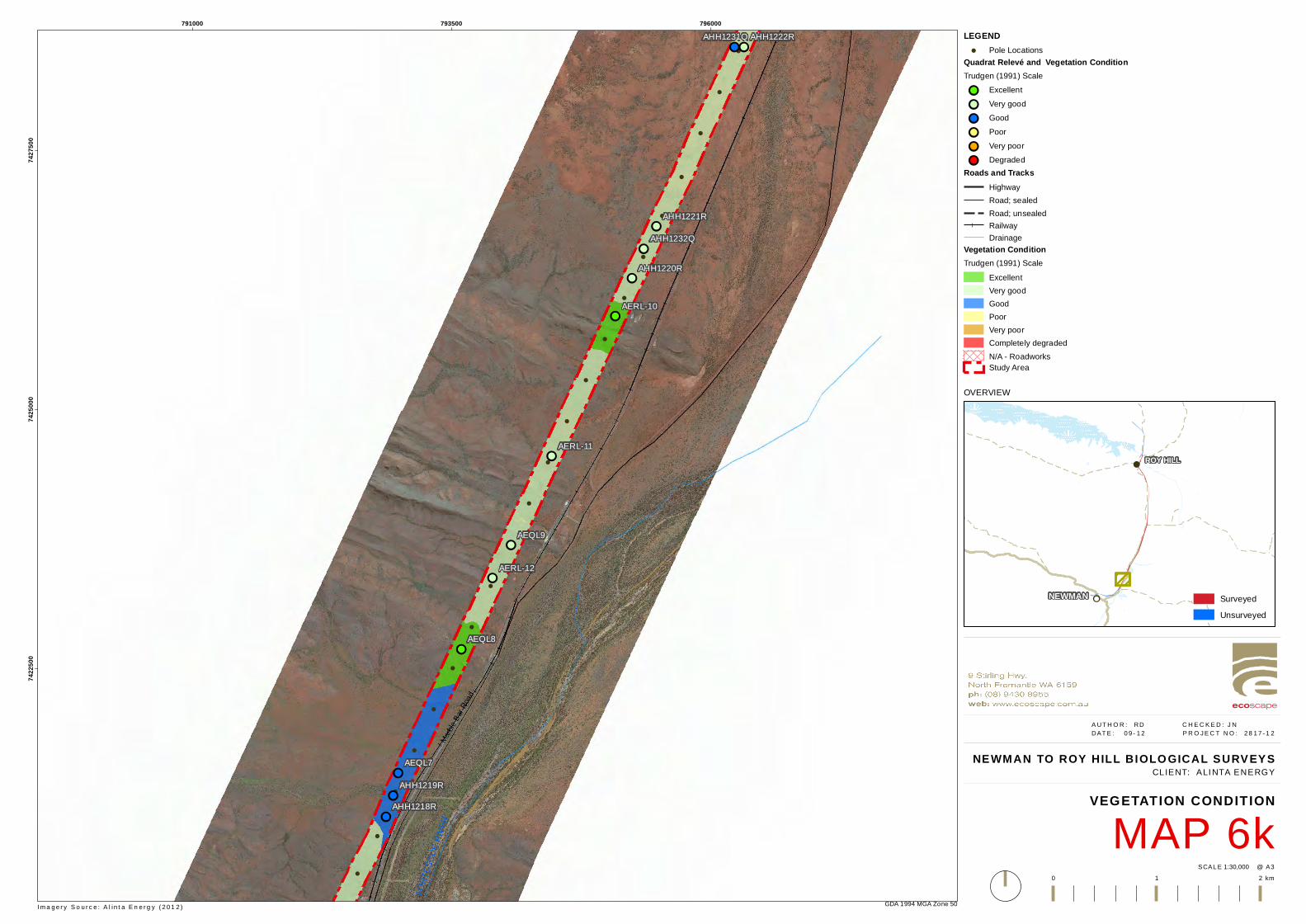
!
!
!
!
!
!
!
!
!
!
!
!
!
!
!
!
!
!
!
!
!
!
!
!
!
!!
!!
!!
!!
!!
!!
!!
!!
!!
!!
!!
!!
!!
!!
AERL-15
AERL-12
AERL-11
AERL-10
AHH1222R
AHH1221R
AHH1220R
AHH1219R
AHH1218R
AHH1217R
AHH1215RAHH1214R
AEQL9
AEQL8
AEQL7
AEQL6
AHH1232Q
AHH1231Q
Marbl
e Bar
Road
FORT
ESCU
E RIVE
R
791000 793500 79600074
2250
074
2500
074
2750
0
GDA 1994 MGA Zone 50
NEWMAN TO ROY HILL BIOLO GICAL SURVEYS
MAP 6kVEGETATION CONDITION
1:30,000SCAL E @ A3
A UT H O R : RD C H E C K E D : J N DAT E : 0 9 - 1 2 P R O J E C T N O : 2 8 1 7 - 1 2
0 1 2 km
CLIENT: ALI NTA ENERGY
LEGEND! Pole Locations
Quadrat Relevé and Vegetation ConditionTrudgen (1991) Scale!! Excellent!! Very good!! Good!! Poor!! Very poor!! Degraded
Roads and TracksHighwayRoad; sealedRoad; unsealedRailwayDrainage
Vegetation ConditionTrudgen (1991) Scale
ExcellentVery goodGoodPoorVery poorCompletely degradedN/A - RoadworksStudy Area
I m a g e r y S o u r c e : A l i n t a E n e r g y ( 2 0 1 2 )
OVERVIEW
!!
!
NEWMAN
ROY HILL
SurveyedUnsurveyed
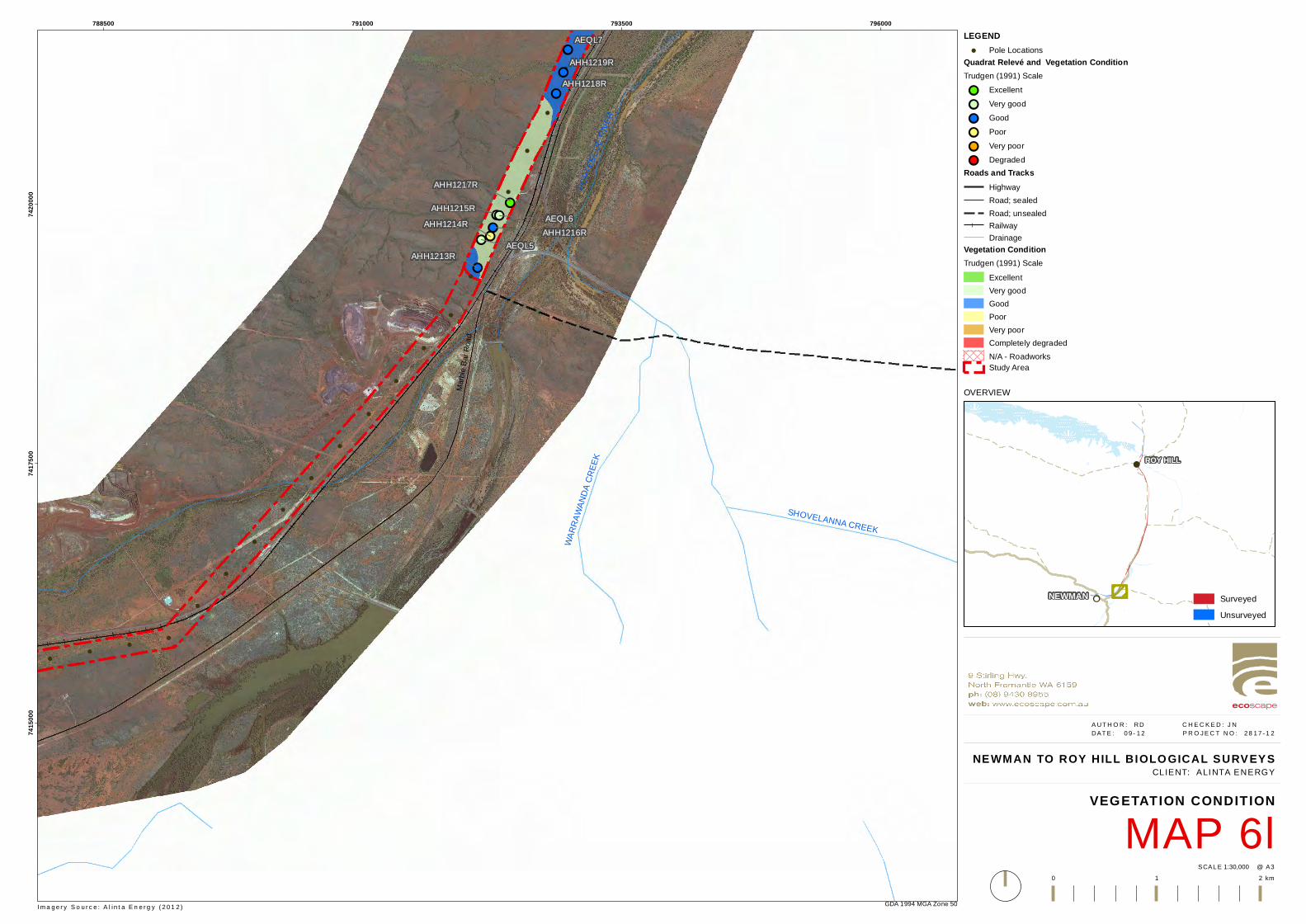
!
!
!
!
!
!
!
!
!
!
!
!
!
!
!
!
!
!
!
!
!
!
!!
!!!!!!!!
!!
!!
!!
!!
!!AHH1219R
AHH1218R
AHH1217R
AHH1216R
AHH1215RAHH1214R
AHH1213R
AEQL7
AEQL6
AEQL5
Marbl
e Bar
Road
SHOVELANNA CREEK
WARR
AWAN
DA C
REEK
FORT
ESCU
E RIVE
R
788500 791000 793500 79600074
1500
074
1750
074
2000
0
GDA 1994 MGA Zone 50
NEWMAN TO ROY HILL BIOLO GICAL SURVEYS
MAP 6lVEGETATION CONDITION
1:30,000SCAL E @ A3
A UT H O R : RD C H E C K E D : J N DAT E : 0 9 - 1 2 P R O J E C T N O : 2 8 1 7 - 1 2
0 1 2 km
CLIENT: ALI NTA ENERGY
LEGEND! Pole Locations
Quadrat Relevé and Vegetation ConditionTrudgen (1991) Scale!! Excellent!! Very good!! Good!! Poor!! Very poor!! Degraded
Roads and TracksHighwayRoad; sealedRoad; unsealedRailwayDrainage
Vegetation ConditionTrudgen (1991) Scale
ExcellentVery goodGoodPoorVery poorCompletely degradedN/A - RoadworksStudy Area
I m a g e r y S o u r c e : A l i n t a E n e r g y ( 2 0 1 2 )
OVERVIEW
!!
!
NEWMAN
ROY HILL
SurveyedUnsurveyed
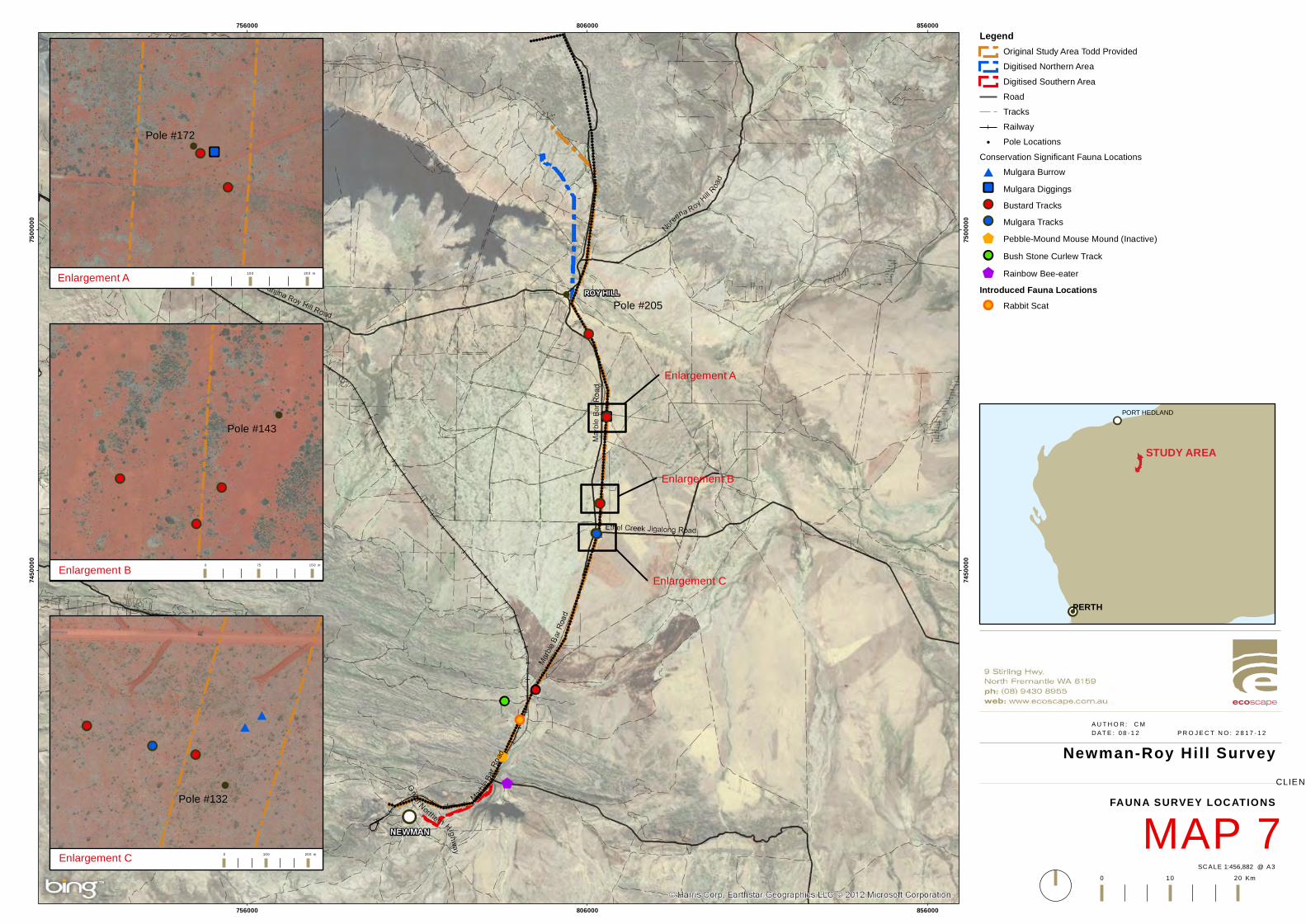
756000
756000
806000
806000
856000
856000
7450
000
7450
000
7500
000
7500
000
Newman-Roy Hil l Survey
MAP 7FAUNA SURVEY LOCATIONS
1:456,882SC ALE @ A3
A U T H O R : C MD AT E : 0 8 - 1 2 P R O J E C T N O : 2 8 1 7 - 1 2
0 10 20 Km
CLIENT: ALINTA ENERGY
LegendOriginal Study Area Todd ProvidedDigitised Northern AreaDigitised Southern AreaRoadTracksRailway
!. Pole LocationsConservation Significant Fauna Locations# Mulgara BurrowÆÆ Mulgara Diggings!! Bustard Tracks!! Mulgara Tracks$ Pebble-Mound Mouse Mound (Inactive)!! Bush Stone Curlew Track$ Rainbow Bee-eater
Introduced Fauna Locations!! Rabbit Scat
!!!
!!
STUDY AREA
PERTH
PORT HEDLAND
!! ÆÆ
!!
!
!
!
!!!!
!!
!
!
!
!
!!
!!
##
!!
!
!
!
!
!
0 100 200 m
0 75 150 m
0 100 200 m
Enlargement A
Enlargement B
Enlargement C
Enlargement A
Enlargement B
Enlargement C
Pole #205
Pole #172
Pole #143
Pole #132
© Ecoscape (Australia) Pty Ltd 8497-2817-12R_ 138
© E
cosc
ape
(Au
stra
lia)
Pty
Ltd
84
97
-28
17
-12
R_
1
38
Appendix One: Definitions and Criteria Table 17: EPBC Act categories for flora and fauna (Commonwealth of Australia 1999)
EPBC Act Category Definition
Extinct A native species is eligible to be included in the extinct category at a particular time if, at that time, there is no reasonable doubt that the last member of the species has died.
Extinct in the wild
A native species is eligible to be included in the extinct in the wild category at a particular time if, at that time:
(a) it is known only to survive in cultivation, in captivity or as a naturalised population well outside its past range; or
(b) it has not been recorded in its known and/or expected habitat, at appropriate seasons, anywhere in its past range, despite exhaustive surveys over a time frame appropriate to its life cycle and form.
Critically Endangered
A native species is eligible to be included in the critically endangered category at a particular time if, at that time, it is facing an extremely high risk of extinction in the wild in the immediate future, as determined in accordance with the prescribed criteria.
Endangered
A native species is eligible to be included in the endangered category at a particular time if, at that time:
(a) it is not critically endangered; and
(b) it is facing a very high risk of extinction in the wild in the near future, as determined in accordance with the prescribed criteria.
Vulnerable
A native species is eligible to be included in the vulnerable category at a particular time if, at that time:
(a) it is not critically endangered or endangered; and
(b) it is facing a high risk of extinction in the wild in the medium term future, as determined in accordance with the prescribed criteria.
Conservation Dependent
A native species is eligible to be included in the conservation dependent category at a particular time if, at that time:
(a) the species is the focus of a specific conservation program the cessation of which would result in the species becoming vulnerable, endangered or critically endangered; or
(b) the following subparagraphs are satisfied:
(i) the species is a species of fish;
(ii) the species is the focus of a plan of management that provides for management actions necessary to stop the decline of, and support the recovery of, the species so that its chances of long term survival in nature are maximised;
(iii) the plan of management is in force under a law of the Commonwealth or of a State or Territory;
(iv) cessation of the plan of management would adversely affect the conservation status of the species.
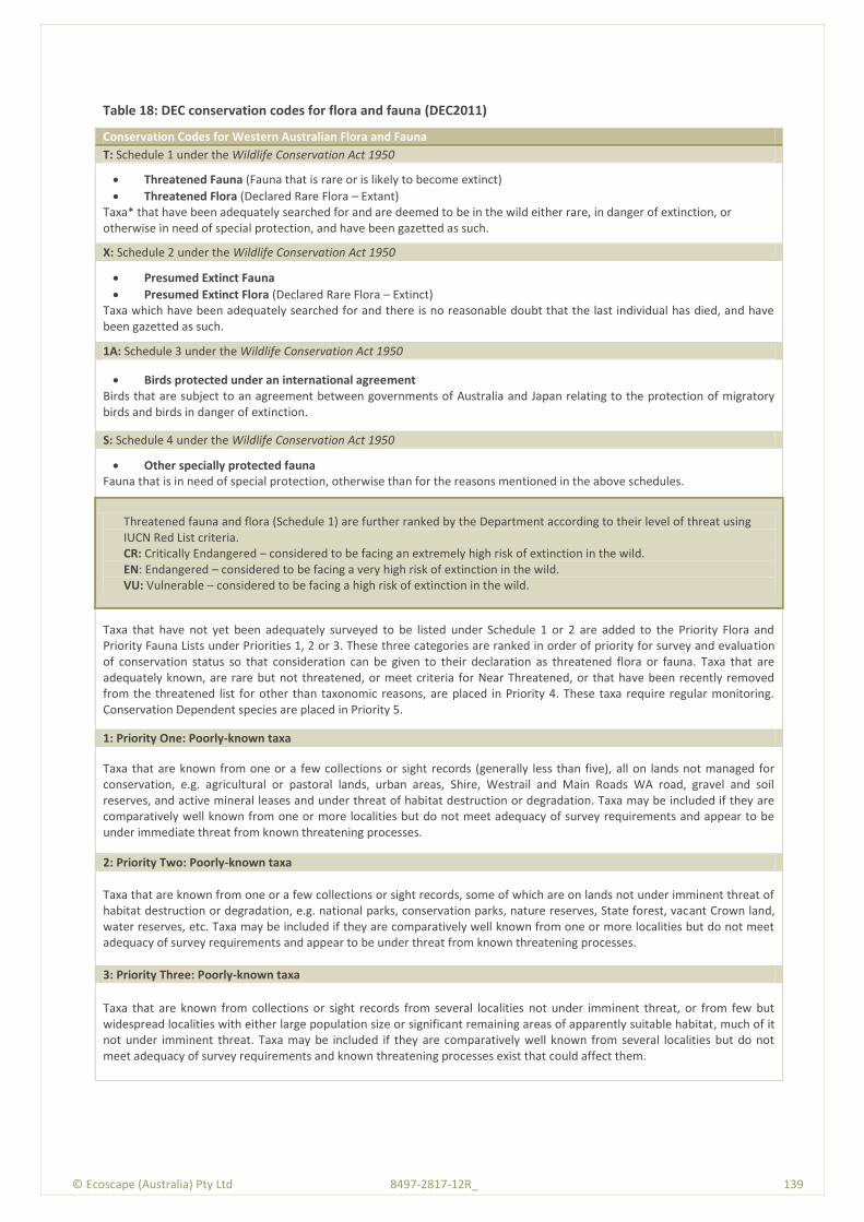
© Ecoscape (Australia) Pty Ltd 8497-2817-12R_ 139
Table 18: DEC conservation codes for flora and fauna (DEC2011)
Conservation Codes for Western Australian Flora and Fauna
T: Schedule 1 under the Wildlife Conservation Act 1950
Threatened Fauna (Fauna that is rare or is likely to become extinct)
Threatened Flora (Declared Rare Flora – Extant) Taxa* that have been adequately searched for and are deemed to be in the wild either rare, in danger of extinction, or otherwise in need of special protection, and have been gazetted as such.
X: Schedule 2 under the Wildlife Conservation Act 1950
Presumed Extinct Fauna
Presumed Extinct Flora (Declared Rare Flora – Extinct) Taxa which have been adequately searched for and there is no reasonable doubt that the last individual has died, and have been gazetted as such.
1A: Schedule 3 under the Wildlife Conservation Act 1950
Birds protected under an international agreement Birds that are subject to an agreement between governments of Australia and Japan relating to the protection of migratory birds and birds in danger of extinction.
S: Schedule 4 under the Wildlife Conservation Act 1950
Other specially protected fauna Fauna that is in need of special protection, otherwise than for the reasons mentioned in the above schedules.
Threatened fauna and flora (Schedule 1) are further ranked by the Department according to their level of threat using IUCN Red List criteria. CR: Critically Endangered – considered to be facing an extremely high risk of extinction in the wild. EN: Endangered – considered to be facing a very high risk of extinction in the wild. VU: Vulnerable – considered to be facing a high risk of extinction in the wild.
Taxa that have not yet been adequately surveyed to be listed under Schedule 1 or 2 are added to the Priority Flora and Priority Fauna Lists under Priorities 1, 2 or 3. These three categories are ranked in order of priority for survey and evaluation of conservation status so that consideration can be given to their declaration as threatened flora or fauna. Taxa that are adequately known, are rare but not threatened, or meet criteria for Near Threatened, or that have been recently removed from the threatened list for other than taxonomic reasons, are placed in Priority 4. These taxa require regular monitoring. Conservation Dependent species are placed in Priority 5.
1: Priority One: Poorly-known taxa
Taxa that are known from one or a few collections or sight records (generally less than five), all on lands not managed for conservation, e.g. agricultural or pastoral lands, urban areas, Shire, Westrail and Main Roads WA road, gravel and soil reserves, and active mineral leases and under threat of habitat destruction or degradation. Taxa may be included if they are comparatively well known from one or more localities but do not meet adequacy of survey requirements and appear to be under immediate threat from known threatening processes.
2: Priority Two: Poorly-known taxa
Taxa that are known from one or a few collections or sight records, some of which are on lands not under imminent threat of habitat destruction or degradation, e.g. national parks, conservation parks, nature reserves, State forest, vacant Crown land, water reserves, etc. Taxa may be included if they are comparatively well known from one or more localities but do not meet adequacy of survey requirements and appear to be under threat from known threatening processes.
3: Priority Three: Poorly-known taxa
Taxa that are known from collections or sight records from several localities not under imminent threat, or from few but widespread localities with either large population size or significant remaining areas of apparently suitable habitat, much of it not under imminent threat. Taxa may be included if they are comparatively well known from several localities but do not meet adequacy of survey requirements and known threatening processes exist that could affect them.
© Ecoscape (Australia) Pty Ltd 8497-2817-12R_ 140
Conservation Codes for Western Australian Flora and Fauna
4: Priority Four: Rare, Near Threatened and other taxa in need of monitoring
(a) Rare. Taxa that are considered to have been adequately surveyed, or for which sufficient knowledge is available, and that are considered not currently threatened or in need of special protection, but could be if present circumstances change. These taxa are usually represented on conservation lands. (b) Near Threatened. Taxa that are considered to have been adequately surveyed and that do not qualify for Conservation Dependent, but that are close to qualifying for Vulnerable. (c) Taxa that have been removed from the list of threatened species during the past five years for reasons other than taxonomy.
5: Priority Five: Conservation Dependent taxa
Taxa that are not threatened but are subject to a specific conservation program, the cessation of which would result in the taxa becoming threatened within five years.
Table 19: DEC definitions and criteria for TECs and PECs (DEC 2010)
Criteria Definition
Threatened Ecological Communities
Presumed Totally Destroyed (PD)
An ecological community that has been adequately searched for but for which no representative occurrences have been located. The community has been found to be totally destroyed or so extensively modified throughout its range that no occurrence of it is likely to recover its species composition and/or structure in the foreseeable future. An ecological community will be listed as presumed totally destroyed if there are no recent records of the community being extant and either of the following applies (A or B): A. Records within the last 50 years have not been confirmed despite thorough searches of
known or likely habitats or B. All occurrences recorded within the last 50 years have since been destroyed
Critically Endangered (CR)
An ecological community that has been adequately surveyed and found to have been subject to a major contraction in area and/or that was originally of limited distribution and is facing severe modification or destruction throughout its range in the immediate future, or is already severely degraded throughout its range but capable of being substantially restored or rehabilitated. An ecological community will be listed as Critically Endangered when it has been adequately surveyed and is found to be facing an extremely high risk of total destruction in the immediate future. This will be determined on the basis of the best available information, by it meeting any one or more of the following criteria (A, B or C): A) The estimated geographic range, and/or total area occupied, and/or number of
discrete occurrences since European settlement have been reduced by at least 90% and either or both of the following apply (i or ii): i) geographic range, and/or total area occupied and/or number of discrete
occurrences are continuing to decline such that total destruction of the community is imminent (within approximately 10 years);
ii) modification throughout its range is continuing such that in the immediate future (within approximately 10 years) the community is unlikely to be capable of being substantially rehabilitated.
B. Current distribution is limited, and one or more of the following apply (i, ii or iii): i) geographic range and/or number of discrete occurrences, and/or area occupied
is highly restricted and the community is currently subject to known threatening processes which are likely to result in total destruction throughout its range in the immediate future (within approximately 10 years);
ii) there are very few occurrences, each of which is small and/or isolated and extremely vulnerable to known threatening processes;
iii) there may be many occurrences but total area is very small and each occurrence is small and/or isolated and extremely vulnerable to known threatening processes.
C. The ecological community exists only as highly modified occurrences that may be

© Ecoscape (Australia) Pty Ltd 8497-2817-12R_ 141
Criteria Definition
capable of being rehabilitated if such work begins in the immediate future (within approximately 10 years).
Endangered (EN)
An ecological community that has been adequately surveyed and found to have been subject to a major contraction in area and/or was originally of limited distribution and is in danger of significant modification throughout its range or severe modification or destruction over most of its range in the near future. An ecological community will be listed as Endangered when it has been adequately surveyed and is not Critically Endangered but is facing a very high risk of total destruction in the near future. This will be determined on the basis of the best available information by it meeting any one or more of the following criteria (A, B, or C): A) The geographic range, and/or total area occupied, and/or number of discrete
occurrences have been reduced by at least 70% since European settlement and either or both of the following apply (i or ii): i) the estimated geographic range, and/or total area occupied and/or number of
discrete occurrences are continuing to decline such that total destruction of the community is likely in the short term future (within approximately 20 years);
ii) modification throughout its range is continuing such that in the short term future (within approximately 20 years) the community is unlikely to be capable of being substantially restored or rehabilitated.
B) Current distribution is limited, and one or more of the following apply (i, ii or iii): i) geographic range and/or number of discrete occurrences, and/or area occupied
is highly restricted and the community is currently subject to known threatening processes which are likely to result in total destruction throughout its range in the short term future (within approximately 20 years);
ii) there are few occurrences, each of which is small and/or isolated and all or most occurrences are very vulnerable to known threatening processes;
iii) there may be many occurrences but total area is small and all or most occurrences are small and/or isolated and very vulnerable to known threatening processes.
C) The ecological community exists only as very modified occurrences that may be capable of being substantially restored or rehabilitated if such work begins in the short-term future (within approximately 20 years).
Vulnerable (VU)
An ecological community that has been adequately surveyed and is found to be declining and/or has declined in distribution and/or condition and whose ultimate security has not yet been assured and/or a community that is still widespread but is believed likely to move into a category of higher threat in the near future if threatening processes continue or begin operating throughout its range. An ecological community will be listed as Vulnerable when it has been adequately surveyed and is not Critically Endangered or Endangered but is facing a high risk of total destruction or significant modification in the medium to long-term future. This will be determined on the basis of the best available information by it meeting any one or more of the following criteria (A, B or C): D) The ecological community exists largely as modified occurrences that are likely to be
capable of being substantially restored or rehabilitated. E) The ecological community may already be modified and would be vulnerable to
threatening processes, is restricted in area and/or range and/or is only found at a few locations.
F) The ecological community may be still widespread but is believed likely to move into a category of higher threat in the medium to long term future because of existing or impending threatening processes.
Priority Ecological Communities
Priority One
Poorly known ecological communities Ecological communities with apparently few, small occurrences, all or most not actively managed for conservation (e.g. within agricultural or pastoral lands, urban areas, active mineral leases) and for which current threats exist. Communities may be included if they are comparatively well-known from one or more localities but do not meet adequacy of survey requirements, and/or are not well defined, and appear to be under immediate threat
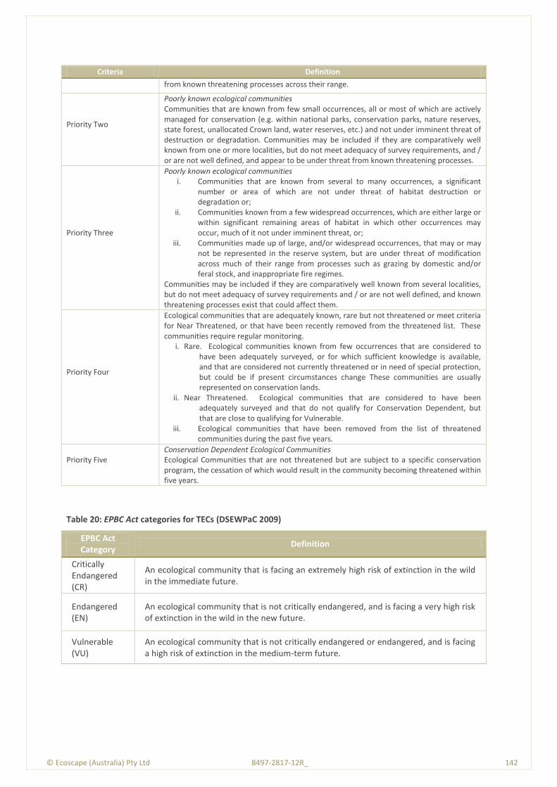
© Ecoscape (Australia) Pty Ltd 8497-2817-12R_ 142
Criteria Definition
from known threatening processes across their range.
Priority Two
Poorly known ecological communities Communities that are known from few small occurrences, all or most of which are actively managed for conservation (e.g. within national parks, conservation parks, nature reserves, state forest, unallocated Crown land, water reserves, etc.) and not under imminent threat of destruction or degradation. Communities may be included if they are comparatively well known from one or more localities, but do not meet adequacy of survey requirements, and / or are not well defined, and appear to be under threat from known threatening processes.
Priority Three
Poorly known ecological communities i. Communities that are known from several to many occurrences, a significant
number or area of which are not under threat of habitat destruction or degradation or;
ii. Communities known from a few widespread occurrences, which are either large or within significant remaining areas of habitat in which other occurrences may occur, much of it not under imminent threat, or;
iii. Communities made up of large, and/or widespread occurrences, that may or may not be represented in the reserve system, but are under threat of modification across much of their range from processes such as grazing by domestic and/or feral stock, and inappropriate fire regimes.
Communities may be included if they are comparatively well known from several localities, but do not meet adequacy of survey requirements and / or are not well defined, and known threatening processes exist that could affect them.
Priority Four
Ecological communities that are adequately known, rare but not threatened or meet criteria for Near Threatened, or that have been recently removed from the threatened list. These communities require regular monitoring.
i. Rare. Ecological communities known from few occurrences that are considered to have been adequately surveyed, or for which sufficient knowledge is available, and that are considered not currently threatened or in need of special protection, but could be if present circumstances change These communities are usually represented on conservation lands.
ii. Near Threatened. Ecological communities that are considered to have been adequately surveyed and that do not qualify for Conservation Dependent, but that are close to qualifying for Vulnerable.
iii. Ecological communities that have been removed from the list of threatened communities during the past five years.
Priority Five
Conservation Dependent Ecological Communities Ecological Communities that are not threatened but are subject to a specific conservation program, the cessation of which would result in the community becoming threatened within five years.
Table 20: EPBC Act categories for TECs (DSEWPaC 2009)
EPBC Act Category
Definition
Critically Endangered (CR)
An ecological community that is facing an extremely high risk of extinction in the wild in the immediate future.
Endangered (EN)
An ecological community that is not critically endangered, and is facing a very high risk of extinction in the wild in the new future.
Vulnerable (VU)
An ecological community that is not critically endangered or endangered, and is facing a high risk of extinction in the medium-term future.

© Ecoscape (Australia) Pty Ltd 8497-2817-12R_ 143
Table 21: NVIS structural formation terminology (terrestrial vegetation) (NHT 2003)
Cover Characteristics
Foliage cover *
70-100 30-70 10-30 <10 » 0 (scattered)
0-5 (clumped)
unknown
Cover code d c i r bi bc unknown
Growth Form
Height Ranges (m)
Structural Formation Classes
tree, palm <10,10-30, >30
closed forest open forest woodland open woodland
isolated trees isolated clumps of trees
trees
tree mallee <3, <10, 10-30
closed mallee forest
open mallee forest
mallee woodland
open mallee woodland
isolated mallee trees
isolated clumps of mallee trees
mallee trees
shrub, cycad, grass-tree, tree-fern
<1,1-2,>2 closed shrubland
shrubland open shrubland
sparse shrubland
isolated shrubs
isolated clumps of shrubs
shrubs
mallee shrub
<3, <10, 10-30
closed mallee shrubland
mallee shrubland
open mallee shrubland
sparse mallee shrubland
isolated mallee shrubs
isolated clumps of mallee shrubs
mallee shrubs
heath shrub
<1,1-2,>2 closed heathland
heathland open heathland
sparse heathland
isolated heath shrubs
isolated clumps of heath shrubs
heath shrubs
chenopod shrub
<1,1-2,>2 closed chenopod shrubland
chenopod shrubland
open chenopod shrubland
sparse chenopod shrubland
isolated chenopod shrubs
isolated clumps of chenopod shrubs
chenopod shrubs
samphire shrub
<0.5,>0.5 closed samphire shrubland
samphire shrubland
open samphire shrubland
sparse samphire shrubland
isolated samphire shrubs
isolated clumps of samphire shrubs
samphire shrubs
hummock grass
<2,>2 closed hummock grassland
hummock grassland
open hummock grassland
sparse hummock grassland
isolated hummock grasses
isolated clumps of hummock grasses
hummock grasses
tussock grass
<0.5,>0.5 closed tussock grassland
tussock grassland
open tussock grassland
sparse tussock grassland
isolated tussock grasses
isolated clumps of tussock grasses
tussock grasses
other grass <0.5,>0.5 closed grassland
grassland open grassland
sparse grassland
isolated grasses
isolated clumps of grasses
other grasses
sedge <0.5,>0.5 closed sedgeland
sedgeland open sedgeland
sparse sedgeland
isolated sedges
isolated clumps of sedges
sedges
rush <0.5,>0.5 closed rushland
rushland open rushland
sparse rushland
isolated rushes
isolated clumps of rushes
rushes
herb <0.5,>0.5 closed herbland
herbland open herbland
sparse herbland
isolated herbs isolated clumps of herrbs
herbs
fern <1,1-2,>2 closed fernland
fernland open fernland
sparse fernland
isolated ferns isolated clumps of ferns
ferns
bryophyte <0.5 closed bryophyte-land
bryophyte-land
open bryophyteland
sparse bryophyteland
isolated bryophytes
isolated clumps of bryophytes
bryophytes
lichen <0.5 closed lichenland
lichenland open lichenland
sparse lichenland
isolated lichens
isolated clumps of lichens
lichens
vine <10,10-30, >30
closed vineland
vineland open vineland
sparse vineland
isolated vines isolated clumps of vines
vines
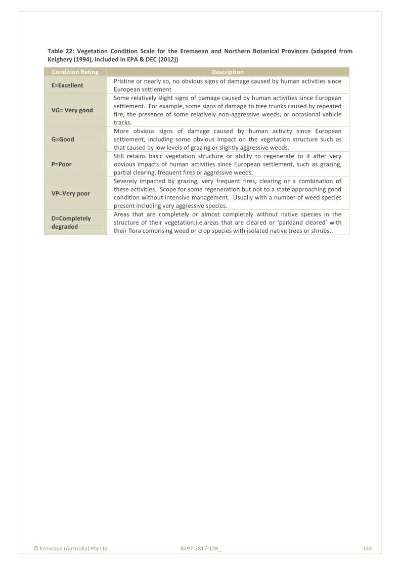
© Ecoscape (Australia) Pty Ltd 8497-2817-12R_ 144
Table 22: Vegetation Condition Scale for the Eremaean and Northern Botanical Provinces (adapted from Keighery (1994), included in EPA & DEC (2012))
Condition Rating Description
E=Excellent Pristine or nearly so, no obvious signs of damage caused by human activities since European settlement
VG= Very good
Some relatively slight signs of damage caused by human activities since European settlement. For example, some signs of damage to tree trunks caused by repeated fire, the presence of some relatively non-aggressive weeds, or occasional vehicle tracks.
G=Good More obvious signs of damage caused by human activity since European settlement, including some obvious impact on the vegetation structure such as that caused by low levels of grazing or slightly aggressive weeds.
P=Poor Still retains basic vegetation structure or ability to regenerate to it after very obvious impacts of human activities since European settlement, such as grazing, partial clearing, frequent fires or aggressive weeds.
VP=Very poor
Severely impacted by grazing, very frequent fires, clearing or a combination of these activities. Scope for some regeneration but not to a state approaching good condition without intensive management. Usually with a number of weed species present including very aggressive species.
D=Completely degraded
Areas that are completely or almost completely without native species in the structure of their vegetation;i.e.areas that are cleared or ‘parkland cleared’ with their flora comprising weed or crop species with isolated native trees or shrubs..
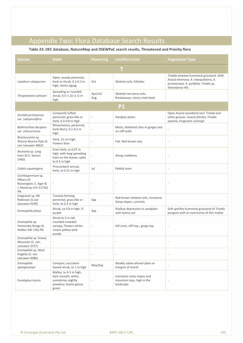
© Ecoscape (Australia) Pty Ltd 8497-2817-12R_ 145
© E
cosc
ape
(Au
stra
lia)
Pty
Ltd
84
97
-28
17
-12
R_
1
45
Appendix Two: Flora Database Search Results Table 23: DEC database, NatureMap and DSEWPaC search results, Threatened and Priority flora
Species Habit Flowering Landform\Soil Vegetation Type
T
Lepidium catapycnon Open, woody perennial, herb or shrub, 0.2-0.3 m high, stems zigzag
Oct Skeletal soils, hillsides
Triodia wiseana hummock grassland. With Acacia bivenosa, A. inaequilatera, A. pruinocarpa, A. pyrifolia, Triodia sp. Shovelanna Hill.
Thryptomene wittweri Spreading or rounded shrub, 0.5–1.5(–2.1) m high
Apr/Jul/ Aug
Skeletal red stony soils. Breakaways, stony creek beds
P1 Aristida jerichoensis var. subspinulifera
Compactly tufted perennial, grass-like or herb, 0.3-0.8 m high
- Hardpan plains Open Acacia woodland over Triodia and other grasses. Acacia falcata, Triodia epactia, Eragrostis cumingii
Bothriochloa decipens var. cloncurrensis
Rhizomatous, perennial, herb (fern), 0.1-0.2 m high
- Moist, sheltered sites in gorges and on cliff walls
-
Brachyscome sp. Wanna Munna Flats (S. van Leeuwen 4662)
Herb, 15 cm high. Flowers blue
- Flat. Red brown clay -
Brunonia sp. Long hairs (D.E. Symon 2440)
Erect herb, to 0.07 m high, with long spreading hairs on the leaves; spike to 0.3 m high
- Along creeklines -
Calotis squamigera Procumbent annual, herb, to 0.21 m high
Jul Pebbly loam -
Cochlospermum sp. Pilbara (D. Brassington, E. Agar & J. Macknay LCH 31756) PN
- - - -
Eragrostis sp. Mt Robinson (S.van Leeuwen 4109)
Tussock-forming perennial, grass-like or herb, to 0.3 m high
Sep Red-brown skeletal soils, ironstone. Steep slopes, summits
Eremophila pilosa Shrub, ca 0.8 m high. Fl purple
Sep Shallow depression in sandplain with loamy soil
Soft spinifex hummock grassland of Triodia pungens with an overstorey of this mallee
Eremophila sp. Hamersley Range (K. Walker KW 136) PN
Shrub to 2 m tall, rounded crowded canopy, Flowers white-cream-yellow-pink-purple
- Hill crest, cliff top , gorge top -
Eremophila sp. Snowy Mountain (S. van. Leeuwen 3737)
- - - -
Eremophila sp. West Angelas (S. van Leeuwen 4086)
- - - -
Eremophila spongiocarpa
Compact, succulent-leaved shrub, to 1 m high
May/Sep Weakly saline alluvial plain on margins of marsh
-
Eucalyptus lucens
Mallee, to 4.5 m high, bark smooth, white, sometimes slightly powdery; leaves glossy green
- Ironstone rocky slopes and mountain tops, high in the landscape
-

© Ecoscape (Australia) Pty Ltd 8497-2817-12R_ 146
Species Habit Flowering Landform\Soil Vegetation Type
Genus sp. Hamersley Range hilltops (S van Leeuwen 4345)
Rounded shrub, to 0.4 m high
Oct Skeletal, brown gritty soil over ironstone. Hill summit
Growing in VOSM of Eucalyptus leucophloia and E. gamophylla over LSB of Senna pruinosa, Acacia bivenosa, A. maitlandii and A. pyrifolia over ODSD of A. marramamba over MDHG of Triodia sp.
Goodenia pallida Erect herb, to 0.5 m high Aug Red soils Annual grassland, Acacia scrub-steppe
Grevillea sp. Turee (J. Bull & G. Hopkinson ONS JJ 01.01) PN
Low, single stemmed tree to 2 m
- Steep scree slope, hill crest of low foothill below main range
Acacia aneuraopen woodland
Gunniopsis sp. Fortescue (M.E. Trudgen 11019)
- - - -
Helichrysum oligochaetum
Erect annual, herb, to ca 0.25 m high. Fl. yellow
Aug to Nov Red clay. Alluvial plains Eucalyptus camaldulensis, Gossypium sp. etc.
Hibiscus sp. Mt Brockman (E. Thoma ET 1354) PN
Leafless except at apices of stems. Flowers purple with dark violet centres
- Gorge -
Myriocephalus scalpellus
Semi-erect herb, 0.03-0.08 m high
- Clay -
Nicotiana heterantha
Decumbent, short-lived annual or perennial, herb, to 0.5 m high, forming low, spreading colonies Fl. white-cream
Mar to Jun or Sep
Black clay. Seasonally wet flats -
Peplidium sp. Fortescue Marsh (S. van Leeuwen 4865)
Herb to 4 cm tall and 30 cm across, in full to late flower
Growing in Low Heath of Haloscarcia spp. (H. indica, H. halocnemoides, H. auriculata) and Eremophila spongiocarpa
Sida sp. Hamersley Range (K. Newbey 10692)
- - -
VOSM of Eucalyptus gamophylla and E. xerothermica with scattered emergent E. leucophloia over OLSB of Acacia pyrifolia (SVL 4375) and Hakea lorea over DHG of Triodia sp.
Stemodia sp. Battle Hill (A.L. Payne 1006)
Low shrub - Cracking clay. Floodplain -
Tecticornia globulifera Small spreading shrub to 0.3 m. Articles bright red
- - Samphire flats
Tecticornia sp. Christmas Creek (K.A. Shepherd & T. Colmer et al. KS 1063)
A low spreading shrub, 25 cm high, 50 cm across with articles varying in colour from a dull green to a purple red
- Near man made channel. Gently undulating floodway. Red clayey sand
-
Tetratheca fordiana Dwarf shrub, 0.3–0.4 m high
- Shale pocket amongst ironstone -
Teucrium pilbaranum Rounded shrub, to 0.4 m high
May/Sep Clay. Crab hole plain in a river floodplain, margin of calcrete table
Chrysopogon fallax tussock grassland, Open woodland of Eucalyptus victrix, with a tussock grass understorey of Eriachne benthamii
Triodia triticoides Tussock-forming perennial, grass-like or herb, 0.45-2 m high
Jan to Mar or Jun to Jul
Rocky sandstone & limestone hillslopes
-
Vittadinia sp. Coondewanna Flats (s. van Leeuwen 4684)
Tall daisy to 1 m , open canopy, in late flower and dehiscing fruit, cream/white flowers.
May/Sep Clay loam soils
Acacia thicket over mixed grassland. Species dominating in area include: Acacia aneura, Eucalyptus ?xerothermica, Themeda ?triandra.
P2 Adiantum capillus-veneris
Rhizomatous, perennial, herb (fern), 0.1-0.2 m high
- Moist, sheltered sites in gorges and on cliff walls
-

© Ecoscape (Australia) Pty Ltd 8497-2817-12R_ 147
Species Habit Flowering Landform\Soil Vegetation Type
Aristida lazaridis Tufted perennial, grass-like or herb, 0.4-1.5 m high
Apr Sand or loam -
Calotis squamigera Densely tufted perennial, grass-like or herb (sedge), 2 m high
Nov Perennial pools -
Cladium procerum Densely tufted perennial, grass-like or herb (sedge), 2 m high
Nov? Perennial pools With Cyperus and Typha and Date Palms
Dicladanthera glabra
Spreading perennial, herb or shrub, to 0.6(-1) m high. Fl. white/white-blue
Apr or Aug-Oct
Alluvium , Along watercourses, near rock pools
-
Eragrostis sp. Mt Robinson (S.van Leeuwen 4109)
Low shrub 0.5 m tall with red or pinky flowers with long exerted stamens
May-Jul Stony soil, slopes -
Eremophila forrestii subsp. Pingandy (M.E. Trudgen 2662)
Subshrub to 50 cm tall, compact tight bush
-
Flat terrain, low in landscape, base of braod valley, stony gibber plain above shallow drainage line, red clay-loam
-
Gompholobium karijini Rounded shrub ca 40 cm high, 60 cm diameter
- Hilltop with shaley ironstone substrate, red-brown gravelly loam
Eucalyptus leucophloia, Senna spp., Triodia spp.
Hibiscus sp. Gurinbiddy Range (M.E. Trudgen MET 15708) PN
Spindly upright shrub to 3 m tall
-
Near summit of hill, high in landscape, skeletal red-brown stony soil over massive ironstone of the Brockman Iron Formation
Growing in Very Open Shrub Mallee of Eucalyptus kingsmillii, E, leucophloia & E. gamophylla over Open Shrub of Acacia aneura, A. rhodophloia over Open Low Scrub of Scaevola acacioides, Eremophila latrobei over Mid-Dense Hummock Grass of Triodia wiseana
Oxalis sp. Pilbara (M.E. Trudgen 12725)
Creeping annual herb <0.3 m high. Flowers yellow
- Gully. Brown-red loam, cobbles and pebbles
Paspalidium retiglume Tufted annual, grass-like or herb, 0.1-0.5 m high
Apr Clay -
Pilbara trudgenii Gnarled, aromatic shrub, to 1 m high
Sep Skeletal, red stony soil over ironstone. Hill summits, steep slopes, screes, cliff faces
Eucalyptus kingsmillii
Scaevola sp. Hamersley Range basalts (S. van Leeuwen 3675)
hrub, to 1 m high Jul to Aug Skeletal, brown gritty soil over basalt. Summits of hills, steep hills
Acacia hamersleyensis with emergent Brachychiton gregorii
Sida sp. Hamersley Range (K. Newbey 10692)
50 m high x 50 m wide. -
Sandy plain, Plain with thin sheet of sand (light orange / brown) over compacted hardpan and limestone rock, Claypan of fine cracking clays. Basalt hills in the immediate distance.
Triodia epactia hummock grassland over *Cenchrus ciliaris very open tussock grassland, Indigofera colutea / Vigna sp Central / Rhynchosia minima low open shrubland. Eucalyptus camaldulensis and *Cenchrus ciliaris association.
P3
Acacia daweana Spreading shrub, 0.3–1.5(–2) m high
Jul-Sep Stony red loamy soils. Low rocky rises, along drainage lines
Acacia effusa
Low, dense, spreading, somewhat viscid shrub, 0.3-1 m high, bark 'minni-ritchi'.
May to Aug Stony red loam. Scree slopes of low ranges
Open Woodland of Eucalyptus leucophloia, over Open Low Shrub of Acacia bivenosa, A. effusa and Mid-dense Hummock Grass of Triodia basedowii and Themeda triandra
Acacia glaucocaesia Dense, glabrous shrub or tree, 1.8-6 m high
Jul to Sep Red loam, sandy loam, clay. Floodplains
Low shrubland
Acacia subtiliformis Spindly, slender, erect shrub, to 3.5 m high
Jun On rocky calcrete plateau Tall open scrub to low shrubland over hummock grassland. Eucalyptus leucophloia, Triodia aff. basedowii
Amaranthus centralis Single stemmed herb to 50 cm
- River bank With Cenchrus ciliaris under Eucalyptus camaldulensis
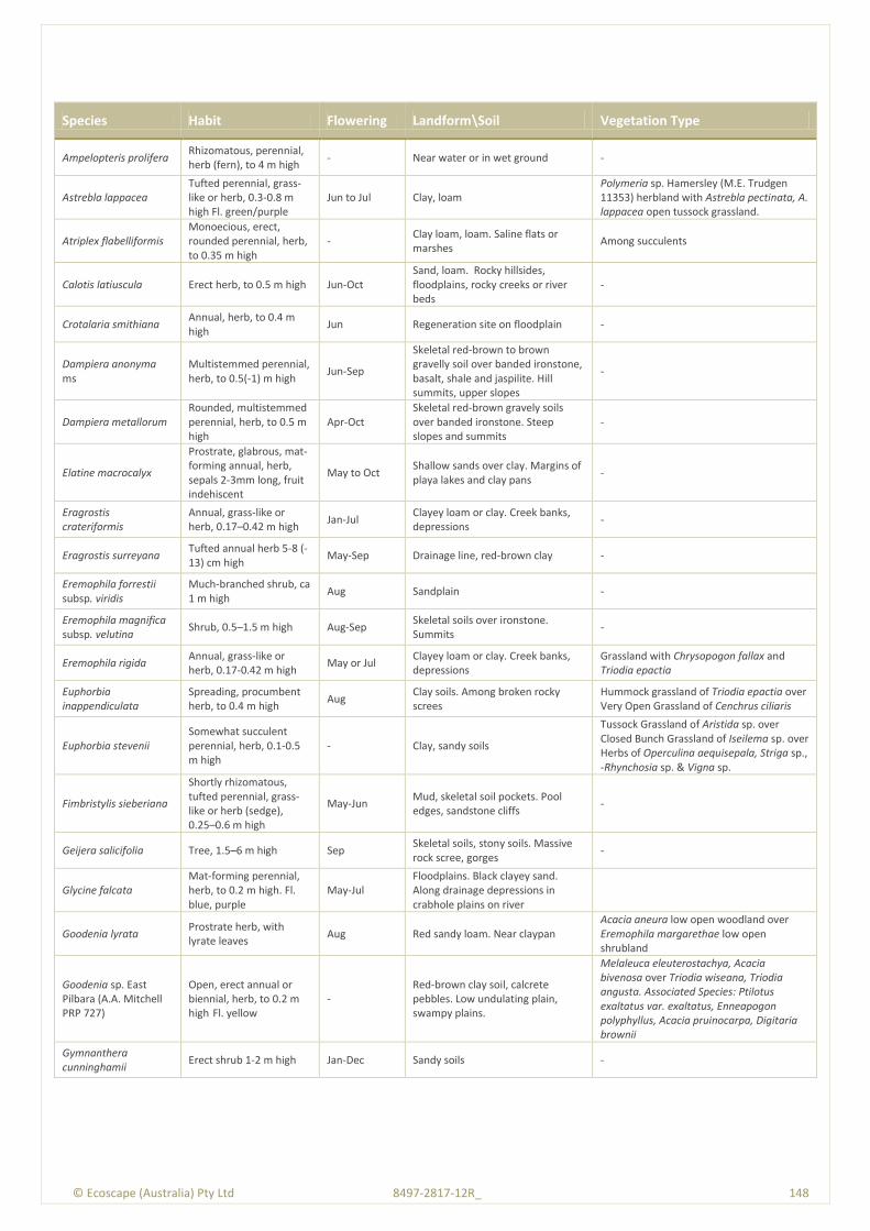
© Ecoscape (Australia) Pty Ltd 8497-2817-12R_ 148
Species Habit Flowering Landform\Soil Vegetation Type
Ampelopteris prolifera Rhizomatous, perennial, herb (fern), to 4 m high
- Near water or in wet ground -
Astrebla lappacea Tufted perennial, grass-like or herb, 0.3-0.8 m high Fl. green/purple
Jun to Jul Clay, loam Polymeria sp. Hamersley (M.E. Trudgen 11353) herbland with Astrebla pectinata, A. lappacea open tussock grassland.
Atriplex flabelliformis Monoecious, erect, rounded perennial, herb, to 0.35 m high
- Clay loam, loam. Saline flats or marshes
Among succulents
Calotis latiuscula Erect herb, to 0.5 m high Jun-Oct Sand, loam. Rocky hillsides, floodplains, rocky creeks or river beds
-
Crotalaria smithiana Annual, herb, to 0.4 m high
Jun Regeneration site on floodplain -
Dampiera anonyma ms
Multistemmed perennial, herb, to 0.5(-1) m high
Jun-Sep
Skeletal red-brown to brown gravelly soil over banded ironstone, basalt, shale and jaspilite. Hill summits, upper slopes
-
Dampiera metallorum Rounded, multistemmed perennial, herb, to 0.5 m high
Apr-Oct Skeletal red-brown gravely soils over banded ironstone. Steep slopes and summits
-
Elatine macrocalyx
Prostrate, glabrous, mat-forming annual, herb, sepals 2-3mm long, fruit indehiscent
May to Oct Shallow sands over clay. Margins of playa lakes and clay pans
-
Eragrostis crateriformis
Annual, grass-like or herb, 0.17–0.42 m high
Jan-Jul Clayey loam or clay. Creek banks, depressions
-
Eragrostis surreyana Tufted annual herb 5-8 (-13) cm high
May-Sep Drainage line, red-brown clay -
Eremophila forrestii subsp. viridis
Much-branched shrub, ca 1 m high
Aug Sandplain -
Eremophila magnifica subsp. velutina
Shrub, 0.5–1.5 m high Aug-Sep Skeletal soils over ironstone. Summits
-
Eremophila rigida Annual, grass-like or herb, 0.17-0.42 m high
May or Jul Clayey loam or clay. Creek banks, depressions
Grassland with Chrysopogon fallax and Triodia epactia
Euphorbia inappendiculata
Spreading, procumbent herb, to 0.4 m high
Aug Clay soils. Among broken rocky screes
Hummock grassland of Triodia epactia over Very Open Grassland of Cenchrus ciliaris
Euphorbia stevenii Somewhat succulent perennial, herb, 0.1-0.5 m high
- Clay, sandy soils
Tussock Grassland of Aristida sp. over Closed Bunch Grassland of Iseilema sp. over Herbs of Operculina aequisepala, Striga sp., -Rhynchosia sp. & Vigna sp.
Fimbristylis sieberiana
Shortly rhizomatous, tufted perennial, grass-like or herb (sedge), 0.25–0.6 m high
May-Jun Mud, skeletal soil pockets. Pool edges, sandstone cliffs
-
Geijera salicifolia Tree, 1.5–6 m high Sep Skeletal soils, stony soils. Massive rock scree, gorges
-
Glycine falcata Mat-forming perennial, herb, to 0.2 m high. Fl. blue, purple
May-Jul Floodplains. Black clayey sand. Along drainage depressions in crabhole plains on river
Goodenia lyrata Prostrate herb, with lyrate leaves
Aug Red sandy loam. Near claypan Acacia aneura low open woodland over Eremophila margarethae low open shrubland
Goodenia sp. East Pilbara (A.A. Mitchell PRP 727)
Open, erect annual or biennial, herb, to 0.2 m high Fl. yellow
- Red-brown clay soil, calcrete pebbles. Low undulating plain, swampy plains.
Melaleuca eleuterostachya, Acacia bivenosa over Triodia wiseana, Triodia angusta. Associated Species: Ptilotus exaltatus var. exaltatus, Enneapogon polyphyllus, Acacia pruinocarpa, Digitaria brownii
Gymnanthera cunninghamii
Erect shrub 1-2 m high Jan-Dec Sandy soils -
© Ecoscape (Australia) Pty Ltd 8497-2817-12R_ 149
Species Habit Flowering Landform\Soil Vegetation Type
Indigofera gilesii subsp. gilesii
Shrub, to 1.5 m high May/Aug Pebbly loam amongst boulders & outcrops, hills
-
Indigofera sp. Bungaroo Creek (S. van Leeuwen 4301)
Erect shrub to 2.3 m high, red-pink flowers
Jul-Oct Creeks and gorges -
Iotasperma sessilifolium
Erect herb. Fl. pink. - Cracking clay, black loam. Edges of waterholes, plains
-
Nicotiana umbratica Erect, short-lived annual or perennial, herb, 0.3-0.7 m high
Apr to Jun Shallow soils. Rocky outcrops -
Oldenlandia sp. Hamersley Station (A.A. Mitchell PRP 1479)
Spreading annual, herb, 0.05–0.1 m high
Mar. Cracking clay, basalt. Gently undulating plain with large surface rocks, flat crabholed plain
-
Olearia mucronata
Densely branched, unpleasantly aromatic shrub, 0.6–1 m high. Fl. white, yellow
Aug-Jan Schistose hills, along drainage channels
-
Phyllanthus aridus Erect, much-branched shrub, to 0.25 m high. Fl. cream, green
May–Jun Sandstone, gravel, red sand -
Polymeria distigma Prostrate trailing herb. Fl. pink
Apr to Jul Sandy soils -
Ptilotus subspinescens Compact shrub, to 0.8 m high. Fl. pink, bases of screes
Sep–Oct Gentle rocky slopes, screes and the bases of screes
-
Rhagodia sp. Hamersley (M. Trudgen 17794)
Erect shrub - Floodplain / lower slopes -
Rostellularia adscendens var.latifolia
Herb or shrub, 0.1–0.3 m high
Apr-May Ironstone soils. Near creeks, rocky hills
-
Sida sp. Barlee Range (S van Leeuwen 1642)
Spreading shrub, to 0.5 m high
Aug Skeletal red soils pockets. Steep slope
-
Solanum sp. Hamersley clay (D. Halford Q 9280) PN
Low shrub 10 cm high and up to 20 cm across, suckering, fruit green, globose
-
Flat to slightly undulating plain. Red-brown clay (cracking in places) with ironstone rocks and pebbles scattered on surface
Tussock grassland
Swainsona sp. Hamersley Station (A.A. Mitchell 196)
Prostrate annual, herb, to 0.1 m high
- Flat crabholed plain. Open Eremophila maculata shrubland over moderately dense herbs. Tussock grassland of Astrebla pectinata.
Tecticornia medusa Erect shrub 0.5 m high. Articles bright green
1.8 km from the shoreline. Flat floodplain. Red clayey sand
-
Themeda sp. Hamersley Station (M.E. Trudgen 11431)
Tussocky perennial, grass-like or herb, 0.9-1.8 m high
Aug Red clay. Clay pan, grass plain
Polymeria sp. Hamersley (M.E. Trudgen 11353) herbland with Chrysopogon fallax, Astrebla pectinata, Aristida latifolia very open tussock grassland
Triodia sp. Mt. Ella (ME Trudgen 12739)
Perennial, grass-like or herb, 0.4 m high
- Light orange-brown, pebbly loam. Amongst rocks & outcrops, gully slopes
-
Triodia sp. Robe River (M.E. Trudgen et al. MET 12367)
Perennial hummock grass to 0.6 m high
- Rocky hills and mesas -
Whiteochloa capillipes Annual or perennial, grass-like or herb, 0.4-1 m high
Feb to Jun Red-brown Astrebla tussock grassland
P4
Acacia bromilowiana Tree or shrub, to 12 m high
Jul-Aug
Red skeletal stony loam, orange-brown pebbly, gravel loam, laterite, banded ironstone, basalt. Rocky hills, breakaways, scree slopes, gorges, creek beds
-
© Ecoscape (Australia) Pty Ltd 8497-2817-12R_ 150
Species Habit Flowering Landform\Soil Vegetation Type
Eremophila magnifica subsp. magnifica
Shrub, 0.5-1.5 m high Aug-Nov Skeletal soils over ironstone. Rocky screes
-
Eremophila youngii subsp. lepidota
Dense, spreading shrub, (0.2-)1-3 m high. Fl. purple-red-pink
Jan or Mar or Jun or Aug to Sep
Stony red sandy loam. Flats plains, floodplains, sometimes semi-saline, clay flats.
-
Goodenia nuda Erect to ascending herb, to 0.5 m high Fl. yellow
Apr to Aug Red--brown clay loam, ironstone. Acacia tumida tall shrubland with mixed grass understorey including Triodia epactia.
Rhynchosia bungarensis
Compact, prostrate shrub, to 0.5 m high
- Pebbly, coarse sand, banks of flow line
-

© Ecoscape (Australia) Pty Ltd 8497-2817-12R_ 151
© E
cosc
ape
(Au
stra
lia)
Pty
Ltd
84
97
-28
17
-12
R_
1
51
Appendix Three: EPBC Protected Matters Search Results
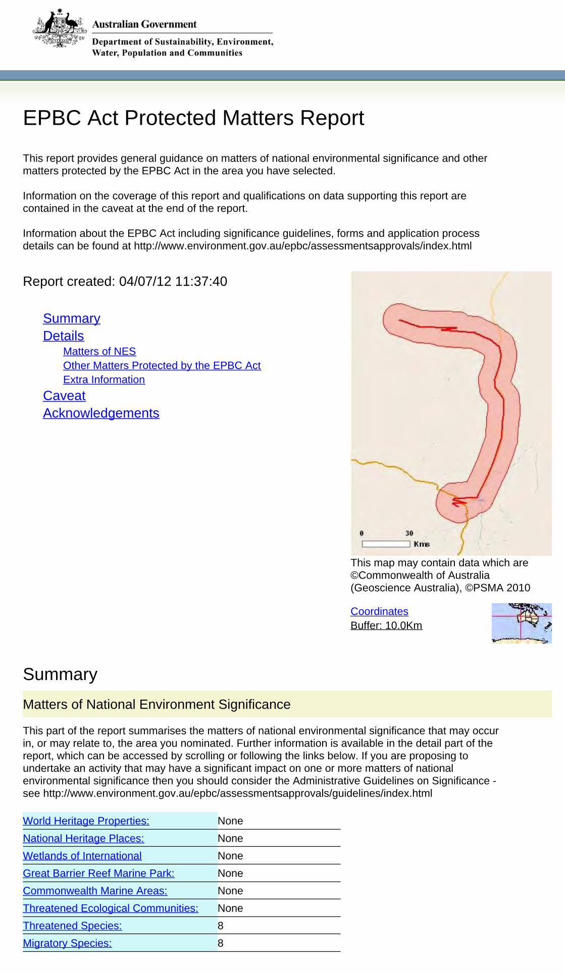
None
8
None
None
None
None
None
8
Matters of National Environment Significance
This part of the report summarises the matters of national environmental significance that may occurin, or may relate to, the area you nominated. Further information is available in the detail part of thereport, which can be accessed by scrolling or following the links below. If you are proposing toundertake an activity that may have a significant impact on one or more matters of nationalenvironmental significance then you should consider the Administrative Guidelines on Significance -see http://www.environment.gov.au/epbc/assessmentsapprovals/guidelines/index.html
World Heritage Properties:
National Heritage Places:
Wetlands of International
Great Barrier Reef Marine Park:
Commonwealth Marine Areas:
Threatened Ecological Communities:
Threatened Species:
Migratory Species:
Summary
EPBC Act Protected Matters Report
Coordinates
Summary
Matters of NES
This map may contain data which are©Commonwealth of Australia(Geoscience Australia), ©PSMA 2010
Extra Information
Buffer: 10.0Km
Report created: 04/07/12 11:37:40
This report provides general guidance on matters of national environmental significance and othermatters protected by the EPBC Act in the area you have selected.
Information on the coverage of this report and qualifications on data supporting this report arecontained in the caveat at the end of the report.
Information about the EPBC Act including significance guidelines, forms and application processdetails can be found at http://www.environment.gov.au/epbc/assessmentsapprovals/index.html
Other Matters Protected by the EPBC Act
CaveatAcknowledgements
Details
Details
Matters of National Environmental Significance
Threatened Species [ Resource Information ]Name Status Type of PresenceBIRDS
Night Parrot [59350] Endangered Species or specieshabitat likely to occurwithin area
Pezoporus occidentalis
2
None
None
5
None
None
1
None
None
2
6
Other Matters Protected by the EPBC Act
Critical Habitats:
Whales and Other Cetaceans:
Commonwealth Heritage Places:
Listed Marine Species:
Commonwealth Reserves:
Commonwealth Lands:
This part of the report summarises other matters protected under the Act that may relate to the areayou nominated. Approval may be required for a proposed activity that significantly affects theenvironment on Commonwealth land, when the action is outside the Commonwealth land, or theenvironment anywhere when the action is taken on Commonwealth land. Approval may also berequired for the Commonwealth or Commonwealth agencies proposing to take an action that is likelyto have a significant impact on the environment anywhere.
This part of the report summarises other matters protected under the Act that may relate to the areayou nominated. Approval may be required for a proposed activity that significantly affects theenvironment on Commonwealth land, when the action is outside the Commonwealth land, or theenvironment anywhere when the action is taken on Commonwealth land. Approval may also berequired for the Commonwealth or Commonwealth agencies proposing to take an action that is likelyto have a significant impact on the environment anywhere.
The EPBC Act protects the environment on Commonwealth land, the environment from the actionstaken on Commonwealth land, and the environment from actions taken by Commonwealth agencies.As heritage values of a place are part of the 'environment', these aspects of the EPBC Act protect theCommonwealth Heritage values of a Commonwealth Heritage place and the heritage values of aplace on the Register of the National Estate. Information on the new heritage laws can be found athttp://www.environment.gov.au/heritage/index.html
A permit may be required for activities in or on a Commonwealth area that may affect a member of alisted threatened species or ecological community, a member of a listed migratory species, whalesand other cetaceans, or a member of a listed marine species. Information on EPBC Act permitrequirements and application forms can be found at http://www.environment.gov.
Extra Information
This part of the report provides information that may also be relevant to the area you have
State and Territory Reserves:
Nationally Important Wetlands:
Place on the RNE:
Regional Forest Agreements:
Invasive Species:
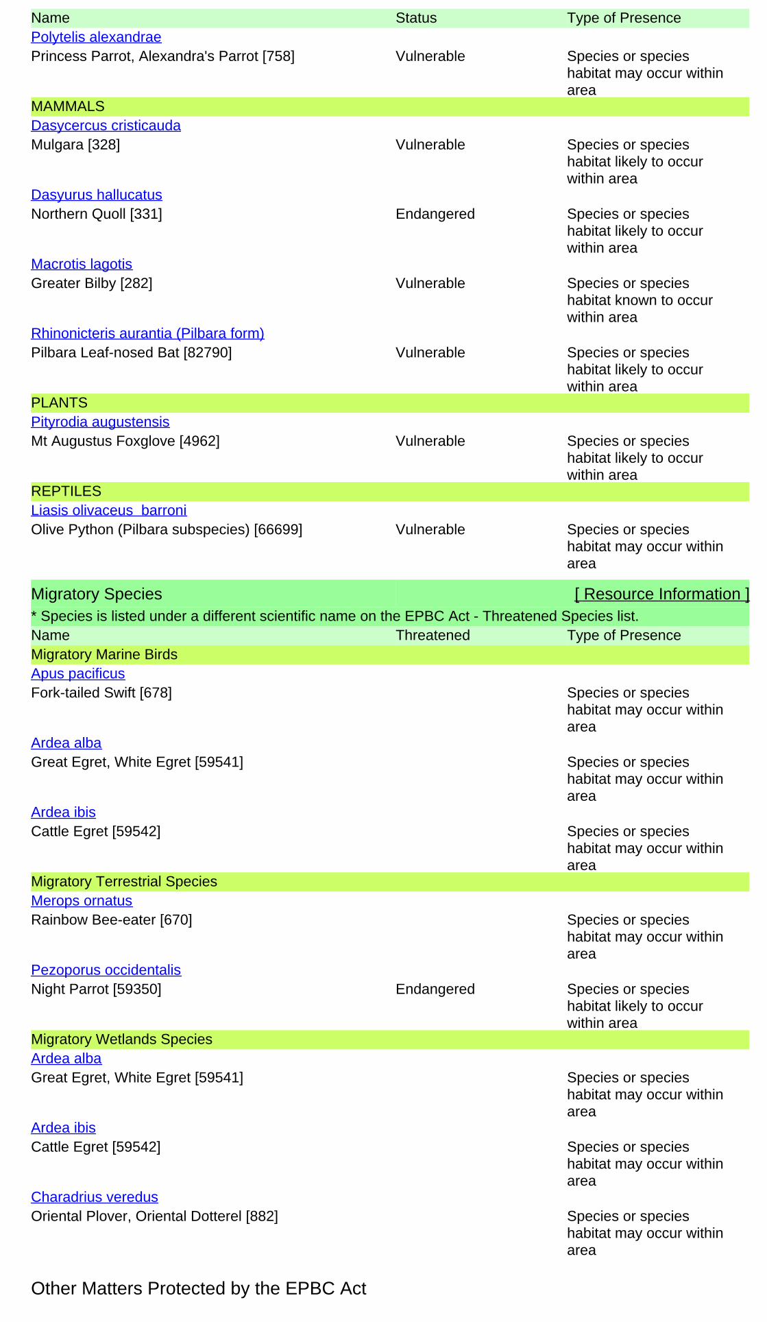
Name Status Type of Presence
Princess Parrot, Alexandra's Parrot [758] Vulnerable Species or specieshabitat may occur withinarea
Polytelis alexandrae
MAMMALS
Mulgara [328] Vulnerable Species or specieshabitat likely to occurwithin area
Dasycercus cristicauda
Northern Quoll [331] Endangered Species or specieshabitat likely to occurwithin area
Dasyurus hallucatus
Greater Bilby [282] Vulnerable Species or specieshabitat known to occurwithin area
Macrotis lagotis
Pilbara Leaf-nosed Bat [82790] Vulnerable Species or specieshabitat likely to occurwithin area
Rhinonicteris aurantia (Pilbara form)
PLANTS
Mt Augustus Foxglove [4962] Vulnerable Species or specieshabitat likely to occurwithin area
Pityrodia augustensis
REPTILES
Olive Python (Pilbara subspecies) [66699] Vulnerable Species or specieshabitat may occur withinarea
Liasis olivaceus barroni
Migratory Species [ Resource Information ]* Species is listed under a different scientific name on the EPBC Act - Threatened Species list.Name Threatened Type of PresenceMigratory Marine Birds
Fork-tailed Swift [678] Species or specieshabitat may occur withinarea
Apus pacificus
Great Egret, White Egret [59541] Species or specieshabitat may occur withinarea
Ardea alba
Cattle Egret [59542] Species or specieshabitat may occur withinarea
Ardea ibis
Migratory Terrestrial Species
Rainbow Bee-eater [670] Species or specieshabitat may occur withinarea
Merops ornatus
Night Parrot [59350] Endangered Species or specieshabitat likely to occurwithin area
Pezoporus occidentalis
Migratory Wetlands Species
Great Egret, White Egret [59541] Species or specieshabitat may occur withinarea
Ardea alba
Cattle Egret [59542] Species or specieshabitat may occur withinarea
Ardea ibis
Oriental Plover, Oriental Dotterel [882] Species or specieshabitat may occur withinarea
Charadrius veredus
Other Matters Protected by the EPBC Act
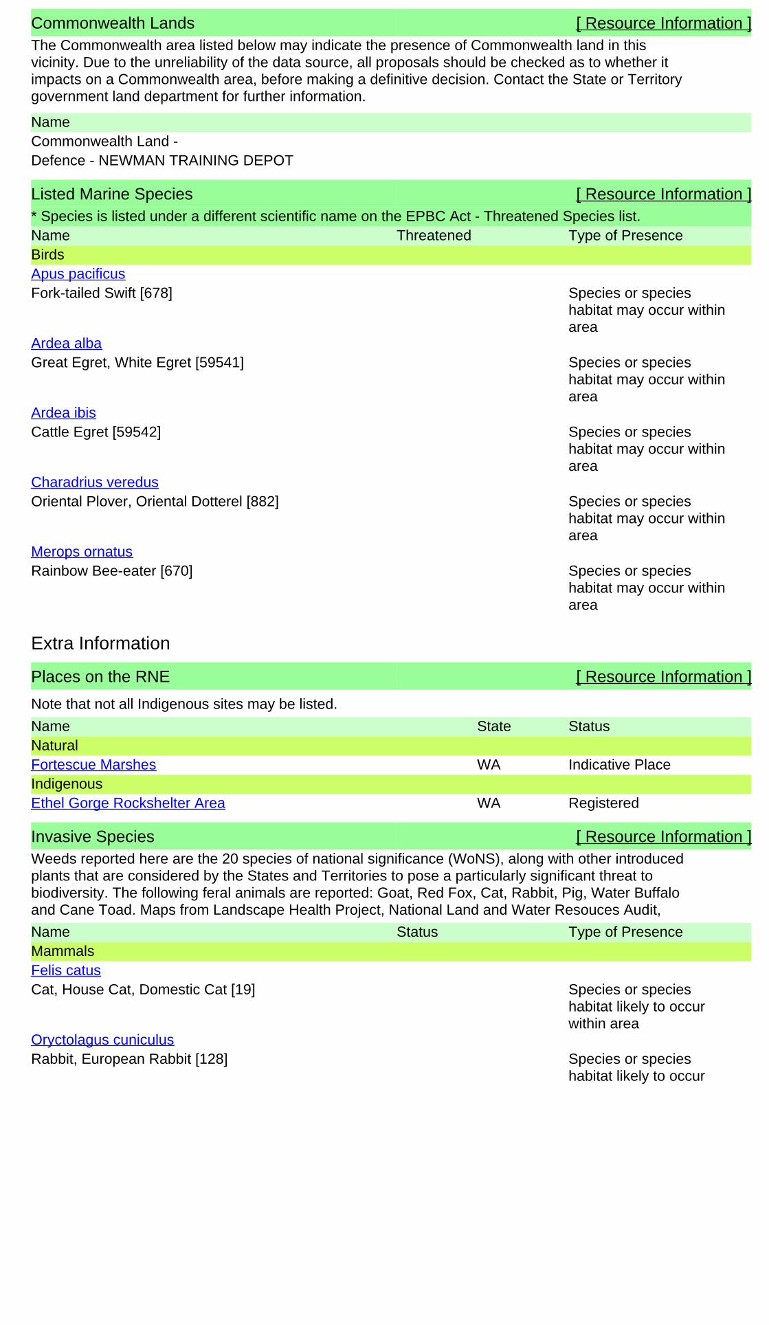
Commonwealth Lands [ Resource Information ]The Commonwealth area listed below may indicate the presence of Commonwealth land in thisvicinity. Due to the unreliability of the data source, all proposals should be checked as to whether itimpacts on a Commonwealth area, before making a definitive decision. Contact the State or Territorygovernment land department for further information.
NameCommonwealth Land -Defence - NEWMAN TRAINING DEPOT
Listed Marine Species [ Resource Information ]* Species is listed under a different scientific name on the EPBC Act - Threatened Species list.Name Threatened Type of PresenceBirds
Fork-tailed Swift [678] Species or specieshabitat may occur withinarea
Apus pacificus
Great Egret, White Egret [59541] Species or specieshabitat may occur withinarea
Ardea alba
Cattle Egret [59542] Species or specieshabitat may occur withinarea
Ardea ibis
Oriental Plover, Oriental Dotterel [882] Species or specieshabitat may occur withinarea
Charadrius veredus
Rainbow Bee-eater [670] Species or specieshabitat may occur withinarea
Merops ornatus
Extra Information
Places on the RNE [ Resource Information ]
Note that not all Indigenous sites may be listed.
Name StatusStateNatural
Indicative PlaceFortescue Marshes WAIndigenous
RegisteredEthel Gorge Rockshelter Area WA
Invasive Species [ Resource Information ]Weeds reported here are the 20 species of national significance (WoNS), along with other introducedplants that are considered by the States and Territories to pose a particularly significant threat tobiodiversity. The following feral animals are reported: Goat, Red Fox, Cat, Rabbit, Pig, Water Buffaloand Cane Toad. Maps from Landscape Health Project, National Land and Water Resouces Audit,
Name Status Type of PresenceMammals
Cat, House Cat, Domestic Cat [19] Species or specieshabitat likely to occurwithin area
Felis catus
Rabbit, European Rabbit [128] Species or specieshabitat likely to occur
Oryctolagus cuniculus

Name Status Type of Presencewithin area
Red Fox, Fox [18] Species or specieshabitat likely to occurwithin area
Vulpes vulpes
Plants
Buffel-grass, Black Buffel-grass [20213] Species or specieshabitat likely to occurwithin area
Cenchrus ciliaris
Parkinsonia, Jerusalem Thorn, Jelly Bean Tree,Horse Bean [12301]
Species or specieshabitat likely to occurwithin area
Parkinsonia aculeata
Athel Pine, Athel Tree, Tamarisk, Athel Tamarisk,Athel Tamarix, Desert Tamarisk, FloweringCypress, Salt Cedar [16018]
Species or specieshabitat likely to occurwithin area
Tamarix aphylla
Nationally Important Wetlands [ Resource Information ]Name StateFortescue Marshes WA
Caveat
-23.38212 119.74832,-23.38065 119.74492,-23.37976 119.74244,-23.36738 119.71572,-23.36517 119.71273,-23.36172 119.70807,-23.36091 119.7891,-23.35272 119.74973,-23.34383 119.71288,-23.34255 119.7142,-23.34131 119.7153,-23.33967 119.71631,-23.33871 119.71688,-23.33782 119.71776,-23.33748 119.71864,-23.32817 119.85177,-23.32713 119.85269,-23.32405 119.85422,-23.32027 119.85487,-23.26749 119.881,-23.26621 119.88179,-23.21302 119.90529,-23.14181 119.93877,-22.9987 119.9883,-22.89604 119.9937,-22.84719 120.00279,-22.83948 120.00304,-22.76709 119.99808,-22.71031 119.95628,-22.70818 119.95371,-22.66789 119.94888,-22.66654 119.94755,-22.6654 119.94773,-22.66377 119.94735,-22.66264 119.9482,-22.58815 119.97472,-22.52338 119.98487,-22.52213 119.98477,-22.47489 119.97511,-22.47489 119.97511,-22.43553 119.92136,-22.43553 119.92136,-22.43333 119.91925,-22.43333 119.91925,-22.39624 119.83365,-22.39624 119.83365,-22.39578 119.83511,-22.39578 119.83511,-22.39576 119.83669,-22.39576 119.83669,-22.39576 119.83669,-22.38235 119.6464,-22.37003 119.73047,-22.3698 119.61012,-22.36863 119.73515,-22.36779 119.73738,-22.36579 119.60891,-22.36175 119.5197,-22.32314 119.4072
Coordinates
For threatened ecological communities where the distribution is well known, maps are derived fromrecovery plans, State vegetation maps, remote sensing imagery and other sources. Where threatenedecological community distributions are less well known, existing vegetation maps and point locationdata are used to produce indicative distribution maps.
The information presented in this report has been provided by a range of data sources asacknowledged at the end of the report.
Only selected species covered by the following provisions of the EPBC Act have been mapped:
The following species and ecological communities have not been mapped and do not appear inreports produced from this database:
Not all species listed under the EPBC Act have been mapped (see below) and therefore a report is ageneral guide only. Where available data supports mapping, the type of presence that can bedetermined from the data is indicated in general terms. People using this information in making areferral may need to consider the qualifications below and may need to seek and consider other
- migratory and
This report is designed to assist in identifying the locations of places which may be relevant indetermining obligations under the Environment Protection and Biodiversity Conservation Act 1999. Itholds mapped locations of World Heritage and Register of National Estate properties, Wetlands ofInternational Importance, Commonwealth and State/Territory reserves, listed threatened, migratoryand marine species and listed threatened ecological communities. Mapping of Commonwealth landis not complete at this stage. Maps have been collated from a range of sources at various
- marine
For species where the distributions are well known, maps are digitised from sources such asrecovery plans and detailed habitat studies. Where appropriate, core breeding, foraging and roostingareas are indicated under 'type of presence'. For species whose distributions are less well known,point locations are collated from government wildlife authorities, museums, and non-governmentorganisations; bioclimatic distribution models are generated and these validated by experts. In somecases, the distribution maps are based solely on expert knowledge.
Please feel free to provide feedback via the Contact Us page.
GPO Box 787
Canberra ACT 2601 Australia
Department of Sustainability, Environment, Water, Population and Communities
© Commonwealth of Australia
+61 2 6274 1111
Acknowledgements
- migratory species that are very widespread, vagrant, or only occur in small numbersThe following groups have been mapped, but may not cover the complete distribution of the species:
Such breeding sites may be important for the protection of the Commonwealth Marine environment.- seals which have only been mapped for breeding sites near the Australian continent
- some species and ecological communities that have only recently been listed
- non-threatened seabirds which have only been mapped for recorded breeding sites
- some terrestrial species that overfly the Commonwealth marine area
- threatened species listed as extinct or considered as vagrants
This database has been compiled from a range of data sources. The department acknowledges thefollowing custodians who have contributed valuable data and advice:
-National Herbarium of NSW
-Parks and Wildlife Service NT, NT Dept of Natural Resources, Environment and the Arts
-Queensland Museum-Online Zoological Collections of Australian Museums
-Birds Australia
-State Forests of NSW
-University of New England
-Queensland Herbarium
-Environmental and Resource Management, Queensland
-Royal Botanic Gardens and National Herbarium of Victoria-Tasmanian Herbarium
-Australian National Herbarium, Atherton and Canberra
-Department of Environment and Conservation, Western Australia
-Australian Government, Department of Defence
-SA Museum
-State Herbarium of South Australia
-Department of Primary Industries, Parks, Water and Environment, Tasmania
-Australian National Wildlife Collection
-Department of Environment and Natural Resources, South Australia
-Western Australian Herbarium
The Department is extremely grateful to the many organisations and individuals who providedexpert advice and information on numerous draft distributions.
-Department of the Environment, Climate Change, Energy and Water
-Australian Museum
-Other groups and individuals
-Natural history museums of Australia
-Department of Environment, Climate Change and Water, New South Wales
-Museum Victoria
-Department of Sustainability and Environment, Victoria
-Australian Bird and Bat Banding Scheme
-Northern Territory Herbarium
-Ocean Biogeographic Information System
© Ecoscape (Australia) Pty Ltd 8497-2817-12R_ 158
Appendix Four: NatureMap Search Results and Fauna Inventory
Table 24: Vertebrate taxa known or potentially present in the Study Area
Based on EPBC Act Protected Matters Search Tool, NatureMap reports, and previous survey reports for eastern Pilbara. Pink shading: conservation significant species. Light brown shading: species known or likely to be present based on site and nearby records and available habitat. Records denote presence (+), number (individuals sighted or trapped, number of sites, or number of traces depending on detection method for species), percentage occurrence at sampling sites, or codes (initials for rare, scarce, uncommon, moderately common, common, very common). Sources of survey data:
% PIL quadrats: Microbats – McKenzie & Bullen (2009); Small terrestrial mammals – Gibson & McKenzie (2009); Frogs and reptiles – Doughty et al. (2011); Birds – Burbidge et al. (2010) (based on occurrence at 297 quadrats, except bats based on occurrence in 24 survey areas). All species recorded in quadrats of Roy Hill – Newman (RHN) cell by Doughty et al. (2011) are listed, even if no other records available.
DEC Threatened fauna database: Number of records listed in DEC report on search area (buffer not specified by DEC).
Nyidinghu (FMG Marillana mine area): Bamford & Tomlinson (2012) – number trapped or recorded in timed survey, ‘+’ other sighting, ‘e’ expected based on database search and other data
Iron Valley (IOH Marillana mine area): Everard et al. (2012)
Hope Downs 4 Mining Area: Ninox (2009)
Cloudbreak: Davis et al. (2005) – ‘+’ recorded in survey, ‘e’ expected based on database search and other data, ‘x’ considered regionally extinct
BHP Jimblebar: Outback Ecology (2009) – number recorded in 2008 survey, ‘+’ recorded by other surveys in Study Area, ‘e’ expected based on nearby surveys and NatureMap search (40 km buffer)
FerrAus (east of Jimblebar): Phoenix (2011a; 2011b)
Roy Hill: Ecologia (2006) [Phoenix 2011 survey records in NatureMap, including Melithreptus brevirostris which is a likely error for M. gularis, report not available]
BCI Nullagine: Everard & Bamford (2009) - ‘+’ recorded in survey, ‘e’ expected based on database search and other data
Cookes Ck, Nullagine: Ecoscape (2011a)
Abydos/Woodstock: How & Dell (2004), herpetofauna; How & Cooper (2002), small mammals – numbers trapped, ‘+’ observational record
Notes: Extralimital species ‘expected’ but not recorded by previous surveys removed if inclusion not otherwise indicated.
Ctenophorus maculatus removed (one NatureMap record from Newman WGS84 50 785126 mE 7413049 mN on BHP Main Line, ID reported as ‘certain’; this is nearly 500 km from the nearest other records of the species, and interpreted as either a misidentification or accidentally transported individual).
Ctenophorus scutulatus removed (NatureMap record from Mt Webber WGS84 50 740171 mE 7618625 mN, ID reported as ‘certain’; the only other Pilbara records, in the Hamersley Ranges, are flagged on NatureMap as ‘reported and under review’).
Demansia shinei is not recorded on NatureMap or survey reports, but two atypical specimens are known from close to the east Pilbara (about 100 km SE of Newman in WGS84 51 ~255500 mE, 7356600 mN; and about 180 km NE of Roy Hill in 51 ~352300 mE, 7604300 mS) (Shea & Scanlon 2007)

© Ecoscape (Australia) Pty Ltd 8497-2817-12R_ 159
Family Species Common Name
EPB
C A
ct s
tatu
s
WC
Act
sta
tus
DEC
sta
tus
DEC
Th
reat
en
ed
fau
na
dat
abas
e
EPB
C A
ct P
MST
% P
IL q
uad
rats
NM
ap N
ew
man
+40
km
NM
ap e
aste
rn
Fort
esc
ue
NM
ap R
oy
Hill
+40
km
Nyi
din
ghu
Iro
n V
alle
y
Ho
pe
Do
wn
s
Clo
ud
bre
ak
BH
P J
imb
leb
ar
Ferr
Au
s
Ro
y H
ill
BC
I Nu
llagi
ne
Co
oke
s C
k
Nu
llagi
ne
Ab
ydo
s/W
’sto
ck
Au
gust
20
12
FISH
Clupeidae Nematolosa erebi Bony Bream e
Plotosidae Neosilurus hyrtli Hyrtl’s Tandan + e
Atherinidae Craterocephalus
cuneiceps
Murchison River
Hardyhead e
Melanotaeniidae Melanotaenia australis Western Rainbowfish + e +
Terapontidae Amniataba percoides Barred Grunter e
Leiopotherapon unicolor Spangled Perch e e e
AMPHIBIANS
Hylidae
Cyclorana maini Sheep Frog 6.4 + + + 31 + e + e e + 73
Cyclorana platycephala Water-holding Frog 0.0 + + e e e + + e e e
Litoria rubella Little Red Tree Frog 2.0 + + + 1 e + 5 + + e e 48
Myobatrachidae
Pseudophryne douglasi Gorge Toadlet 0.0 + e e e e e
Uperoleia glandulosa Glandular Toadlet 1.0 + + e + 3
Uperoleia russelli Northwest Toadlet - + + e e e 1 + e e 124
Limnodynastidae
Neobatrachus aquilonius Northern Burrowing Frog 4.0 +
Neobatrachus “centralis” Desert Trilling Frog - e + e e
Neobatrachus kunapalari Kunapalari Frog - + e e
Neobatrachus sutor Shoemaker Ftrog - e e +
Notaden nichollsi Desert Spadefoot 5.4 + e e + e e e +
Platyplectrum ornatum Ornate Burrowing Frog - +
Platyplectrum spenceri Desert Burrowing Frog 1.0 + + e e + + e e 103
MAMMALS
Tachyglossidae Tachyglossus aculeatus Echidna + + + e + e + 1 + e e e +
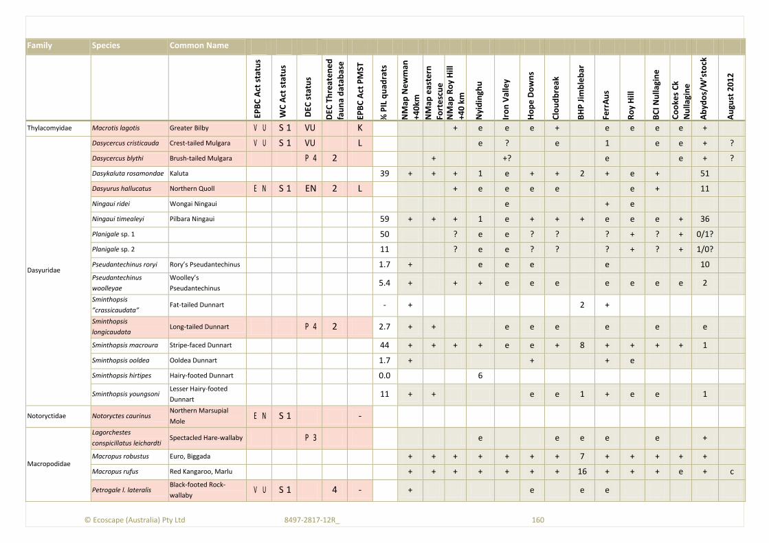
© Ecoscape (Australia) Pty Ltd 8497-2817-12R_ 160
Family Species Common Name
EPB
C A
ct s
tatu
s
WC
Act
sta
tus
DEC
sta
tus
DEC
Th
reat
en
ed
fau
na
dat
abas
e
EPB
C A
ct P
MST
% P
IL q
uad
rats
NM
ap N
ew
man
+40
km
NM
ap e
aste
rn
Fort
esc
ue
NM
ap R
oy
Hill
+40
km
Nyi
din
ghu
Iro
n V
alle
y
Ho
pe
Do
wn
s
Clo
ud
bre
ak
BH
P J
imb
leb
ar
Ferr
Au
s
Ro
y H
ill
BC
I Nu
llagi
ne
Co
oke
s C
k
Nu
llagi
ne
Ab
ydo
s/W
’sto
ck
Au
gust
20
12
Thylacomyidae Macrotis lagotis Greater Bilby V U S 1 VU K + e e e + e e e e +
Dasyuridae
Dasycercus cristicauda Crest-tailed Mulgara V U S 1 VU L e ? e 1 e e + ?
Dasycercus blythi Brush-tailed Mulgara P 4 2 + +? e e + ?
Dasykaluta rosamondae Kaluta 39 + + + 1 e + + 2 + e + 51
Dasyurus hallucatus Northern Quoll E N S 1 EN 2 L + e e e e e + 11
Ningaui ridei Wongai Ningaui e + e
Ningaui timealeyi Pilbara Ningaui 59 + + + 1 e + + + e e e + 36
Planigale sp. 1 50 ? e e ? ? ? + ? + 0/1?
Planigale sp. 2 11 ? e e ? ? ? + ? + 1/0?
Pseudantechinus roryi Rory’s Pseudantechinus 1.7 + e e e e 10
Pseudantechinus
woolleyae
Woolley’s
Pseudantechinus 5.4 + + + e e e e e e e 2
Sminthopsis
”crassicaudata” Fat-tailed Dunnart - + 2 +
Sminthopsis
longicaudata Long-tailed Dunnart P 4 2 2.7 + + e e e e e e
Sminthopsis macroura Stripe-faced Dunnart 44 + + + + e e + 8 + + + + 1
Sminthopsis ooldea Ooldea Dunnart 1.7 + + + e
Sminthopsis hirtipes Hairy-footed Dunnart 0.0 6
Sminthopsis youngsoni Lesser Hairy-footed
Dunnart 11 + + e e 1 + e e 1
Notoryctidae Notoryctes caurinus Northern Marsupial
Mole E N S 1 -
Macropodidae
Lagorchestes
conspicillatus leichardti Spectacled Hare-wallaby P 3 e e e e e +
Macropus robustus Euro, Biggada + + + + + + + 7 + + + + +
Macropus rufus Red Kangaroo, Marlu + + + + + + + 16 + + + e + c
Petrogale l. lateralis Black-footed Rock-
wallaby V U S 1 4 - + e e e
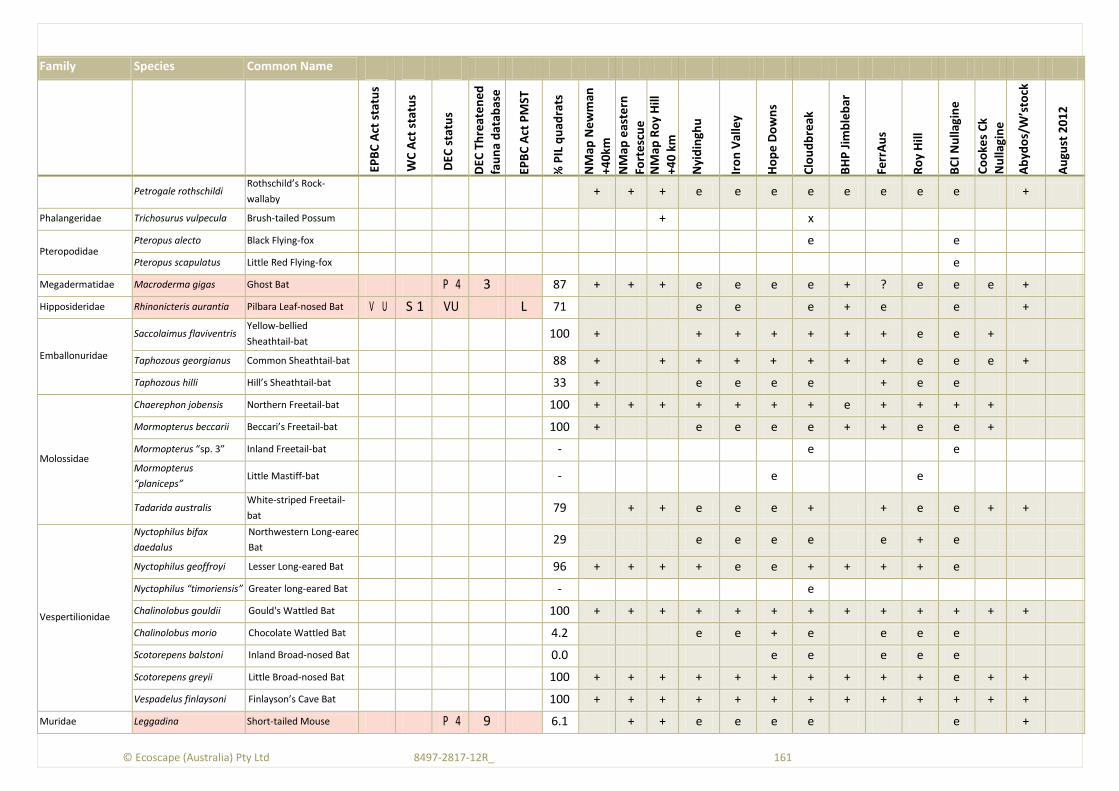
© Ecoscape (Australia) Pty Ltd 8497-2817-12R_ 161
Family Species Common Name
EPB
C A
ct s
tatu
s
WC
Act
sta
tus
DEC
sta
tus
DEC
Th
reat
en
ed
fau
na
dat
abas
e
EPB
C A
ct P
MST
% P
IL q
uad
rats
NM
ap N
ew
man
+40
km
NM
ap e
aste
rn
Fort
esc
ue
NM
ap R
oy
Hill
+40
km
Nyi
din
ghu
Iro
n V
alle
y
Ho
pe
Do
wn
s
Clo
ud
bre
ak
BH
P J
imb
leb
ar
Ferr
Au
s
Ro
y H
ill
BC
I Nu
llagi
ne
Co
oke
s C
k
Nu
llagi
ne
Ab
ydo
s/W
’sto
ck
Au
gust
20
12
Petrogale rothschildi Rothschild’s Rock-
wallaby + + + e e e e e e e e +
Phalangeridae Trichosurus vulpecula Brush-tailed Possum + x
Pteropodidae Pteropus alecto Black Flying-fox e e
Pteropus scapulatus Little Red Flying-fox e
Megadermatidae Macroderma gigas Ghost Bat P 4 3 87 + + + e e e e + ? e e e +
Hipposideridae Rhinonicteris aurantia Pilbara Leaf-nosed Bat V U S 1 VU L 71 e e e + e e +
Emballonuridae
Saccolaimus flaviventris Yellow-bellied
Sheathtail-bat 100 + + + + + + + e e +
Taphozous georgianus Common Sheathtail-bat 88 + + + + + + + + e e e +
Taphozous hilli Hill’s Sheathtail-bat 33 + e e e e + e e
Molossidae
Chaerephon jobensis Northern Freetail-bat 100 + + + + + + + e + + + +
Mormopterus beccarii Beccari’s Freetail-bat 100 + e e e e + + e e +
Mormopterus “sp. 3” Inland Freetail-bat - e e
Mormopterus
“planiceps” Little Mastiff-bat - e e
Tadarida australis White-striped Freetail-
bat 79 + + e e e + + e e + +
Vespertilionidae
Nyctophilus bifax
daedalus
Northwestern Long-eared
Bat 29 e e e e e + e
Nyctophilus geoffroyi Lesser Long-eared Bat 96 + + + + e e + + + + e
Nyctophilus “timoriensis” Greater long-eared Bat - e
Chalinolobus gouldii Gould's Wattled Bat 100 + + + + + + + + + + + + +
Chalinolobus morio Chocolate Wattled Bat 4.2 e e + e e e e
Scotorepens balstoni Inland Broad-nosed Bat 0.0 e e e e e
Scotorepens greyii Little Broad-nosed Bat 100 + + + + + + + + + + e + +
Vespadelus finlaysoni Finlayson’s Cave Bat 100 + + + + + + + + + + + + +
Muridae Leggadina Short-tailed Mouse P 4 9 6.1 + + e e e e e +

© Ecoscape (Australia) Pty Ltd 8497-2817-12R_ 162
Family Species Common Name
EPB
C A
ct s
tatu
s
WC
Act
sta
tus
DEC
sta
tus
DEC
Th
reat
en
ed
fau
na
dat
abas
e
EPB
C A
ct P
MST
% P
IL q
uad
rats
NM
ap N
ew
man
+40
km
NM
ap e
aste
rn
Fort
esc
ue
NM
ap R
oy
Hill
+40
km
Nyi
din
ghu
Iro
n V
alle
y
Ho
pe
Do
wn
s
Clo
ud
bre
ak
BH
P J
imb
leb
ar
Ferr
Au
s
Ro
y H
ill
BC
I Nu
llagi
ne
Co
oke
s C
k
Nu
llagi
ne
Ab
ydo
s/W
’sto
ck
Au
gust
20
12
lakedownensis
Mus musculus House Mouse I n t 26 + + + e e + 1 + + + e 118
Notomys alexis Spinifex Hopping-mouse 3.0 + + e e e e + 2 e e e
Pseudomys chapmani Western Pebble-mound
Mouse P 4 49 10 + + + + + + + 4 + + + + 6
Pseudomys delicatulus Delicate Mouse 6.4 + + 4
Pseudomys desertor Desert Mouse 27 + + + + e + + + + + + + +
Pseudomys
hermannsburgensis Sandy Inland Mouse 42 + + + 2 e + e 5 + + e e 99
Zyzomys argurus Common Rock-rat 4.7 + + + e + + 3 + e + 67
Leporidae Oryctolagus cuniculus Rabbit I n t L + e e e + + e e +
Camelidae Camelus dromedaries Camel I n t + + e e + + + e +
Bovidae Bos taurus European Cattle I n t + + + + e + + + + +
Capra hircus Goat I n t e e
Equidae Equus asinus Donkey I n t + + + e e + 1 + + e +
Equus caballus Horse I n t + + e e + 3 + + e +
Canidae Canis lupus dingo Dingo I n t + + + + + + + 8 ? + e + + +
Vulpes vulpes Fox I n t M + e e e e + e
Felidae Felis catus Cat I n t L + + + + + + 3 + + + + + +
REPTILES
Cheluidae Chelodina steindachneri Flat-shelled Turtle 0.0 + + e e e + + e e e +
Agamidae
Amphibolurus gilberti Gilbert’s Dragon 0.0 +
Amphibolurus
longirostris Long-nosed Dragon 12 + + + + + + + + + + + + 12
Caimanops
amphiboluroides Mulga Dragon 2.0 e e + e + +
Ctenophorus
caudicinctus Ringtailed Dragon 63 + + + 3+ + + + 1 + + + + 27

© Ecoscape (Australia) Pty Ltd 8497-2817-12R_ 163
Family Species Common Name
EPB
C A
ct s
tatu
s
WC
Act
sta
tus
DEC
sta
tus
DEC
Th
reat
en
ed
fau
na
dat
abas
e
EPB
C A
ct P
MST
% P
IL q
uad
rats
NM
ap N
ew
man
+40
km
NM
ap e
aste
rn
Fort
esc
ue
NM
ap R
oy
Hill
+40
km
Nyi
din
ghu
Iro
n V
alle
y
Ho
pe
Do
wn
s
Clo
ud
bre
ak
BH
P J
imb
leb
ar
Ferr
Au
s
Ro
y H
ill
BC
I Nu
llagi
ne
Co
oke
s C
k
Nu
llagi
ne
Ab
ydo
s/W
’sto
ck
Au
gust
20
12
Ctenophorus isolepis Military Dragon 24 + + + 77 e + e + + e e 47 +
Ctenophorus nuchalis Central Netted Dragon 13 + + + 9+ e + e 4 + e e e 29 ?
Ctenophorus reticulatus Western Netted Dragon 10 + + + e e + e + + e + + ?
Ctenophorus rubens Red Dragon 0.0 +
Diporiphora valens Pilbara Two-lined Dragon 4.4 e e e e e +
Diporiphora winneckei Canegrass Dragon - e + e 3
Moloch horridus Thorny Devil 0.7 +
Pogona minor Western Bearded
Dragon 20 + + + 2+ e + e + + + + e 9
Tympanocryptis cephalus Pebble Dragon 1.0 + + e e e e e e e
Tympanocryptis sp. nov. 5.1
Gekkonidae
Gehyra ‘fenestra’ 9.8
Gehyra pilbara Pilbara Dtella 3.7 + e e e e e e e + 67
Gehyra punctata Spotted Dtella 26 + + + e + + e 2 + + e + 58
Gehyra purpurascens Purplish Dtella 29
4 + e + + e
Gehyra variegata Common Dtella + + + 13 + + + 13 + + + + 23
Hemidactylus frenatus Asian House Gecko I n t - e
Heteronotia binoei Bynoe’s Prickly Gecko 42 + + + 11 + + + 1 + + + + 15
Heteronotia planiceps North-west Prickly Gecko - +
Heteronotia spelea Desert Cave Gecko 1.0 + + + e + e + + e e e + 1
Carphodactylidae
Nephrurus levis Smooth Knob-tailed
Gecko 6.1 e e + e e 20
Nephrurus laevissimus Pale Knob-tailed Gecko 0.3 e e
Nephrurus wheeleri
cinctus
Banded Knob-tailed
Gecko 4.3 + + + e + + e + + e
Underwoodisaurus
seorsus Pilbara Barking Gecko 0.0 e e
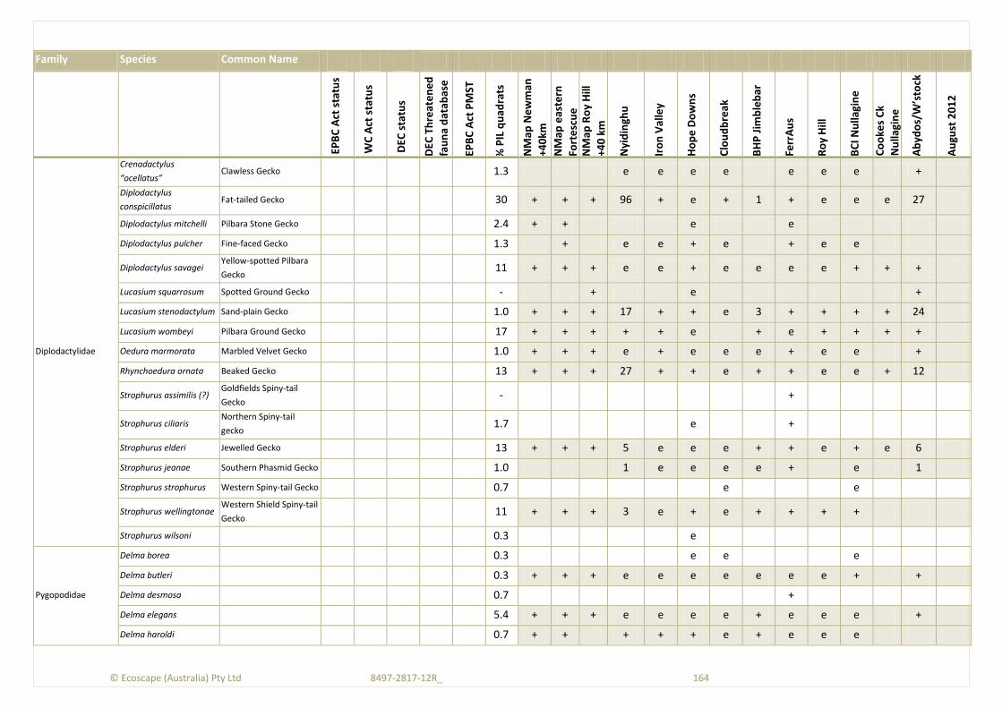
© Ecoscape (Australia) Pty Ltd 8497-2817-12R_ 164
Family Species Common Name
EPB
C A
ct s
tatu
s
WC
Act
sta
tus
DEC
sta
tus
DEC
Th
reat
en
ed
fau
na
dat
abas
e
EPB
C A
ct P
MST
% P
IL q
uad
rats
NM
ap N
ew
man
+40
km
NM
ap e
aste
rn
Fort
esc
ue
NM
ap R
oy
Hill
+40
km
Nyi
din
ghu
Iro
n V
alle
y
Ho
pe
Do
wn
s
Clo
ud
bre
ak
BH
P J
imb
leb
ar
Ferr
Au
s
Ro
y H
ill
BC
I Nu
llagi
ne
Co
oke
s C
k
Nu
llagi
ne
Ab
ydo
s/W
’sto
ck
Au
gust
20
12
Diplodactylidae
Crenadactylus
“ocellatus” Clawless Gecko 1.3 e e e e e e e +
Diplodactylus
conspicillatus Fat-tailed Gecko 30 + + + 96 + e + 1 + e e e 27
Diplodactylus mitchelli Pilbara Stone Gecko 2.4 + + e e
Diplodactylus pulcher Fine-faced Gecko 1.3 + e e + e + e e
Diplodactylus savagei Yellow-spotted Pilbara
Gecko 11 + + + e e + e e e e + + +
Lucasium squarrosum Spotted Ground Gecko - + e +
Lucasium stenodactylum Sand-plain Gecko 1.0 + + + 17 + + e 3 + + + + 24
Lucasium wombeyi Pilbara Ground Gecko 17 + + + + + e + e + + + +
Oedura marmorata Marbled Velvet Gecko 1.0 + + + e + e e e + e e +
Rhynchoedura ornata Beaked Gecko 13 + + + 27 + + e + + e e + 12
Strophurus assimilis (?) Goldfields Spiny-tail
Gecko - +
Strophurus ciliaris Northern Spiny-tail
gecko 1.7 e +
Strophurus elderi Jewelled Gecko 13 + + + 5 e e e + + e + e 6
Strophurus jeanae Southern Phasmid Gecko 1.0 1 e e e e + e 1
Strophurus strophurus Western Spiny-tail Gecko 0.7 e e
Strophurus wellingtonae Western Shield Spiny-tail
Gecko 11 + + + 3 e + e + + + +
Strophurus wilsoni 0.3 e
Pygopodidae
Delma borea 0.3 e e e
Delma butleri 0.3 + + + e e e e e e e + +
Delma desmosa 0.7 +
Delma elegans 5.4 + + + e e e e + e e e +
Delma haroldi 0.7 + + + + + e + e e e

© Ecoscape (Australia) Pty Ltd 8497-2817-12R_ 165
Family Species Common Name
EPB
C A
ct s
tatu
s
WC
Act
sta
tus
DEC
sta
tus
DEC
Th
reat
en
ed
fau
na
dat
abas
e
EPB
C A
ct P
MST
% P
IL q
uad
rats
NM
ap N
ew
man
+40
km
NM
ap e
aste
rn
Fort
esc
ue
NM
ap R
oy
Hill
+40
km
Nyi
din
ghu
Iro
n V
alle
y
Ho
pe
Do
wn
s
Clo
ud
bre
ak
BH
P J
imb
leb
ar
Ferr
Au
s
Ro
y H
ill
BC
I Nu
llagi
ne
Co
oke
s C
k
Nu
llagi
ne
Ab
ydo
s/W
’sto
ck
Au
gust
20
12
Delma nasuta 5.7 + + + e e + e + + + + e e
Delma pax 8.1 + + + + e + e 2 + + + + 5
Delma tincta 5.1 + + e e + e 1 + + e 1
Lialis burtonis Burton’s Legless lizard 3.7 + + + + + + + 3 + + + e 12
Pygopus nigriceps Hooded Scaly-foot 0.7 + + + e + e + + + e +
Scincidae
Carlia munda Shaded-litter Rainbow
Skink 25 + + + 1 e + + + + + + + 9
Carlia triacantha Rainbow Skink 6.1 + + + e e + e + + e e
Cryptoblepharus
buchananii 0.7 + + e e + e
Cryptoblepharus
plagiocephalus 1.0 + e ? + e e e e 9
Cryptoblepharus
ustulatus Russet Snake-eyed Skink 0.0 + e + + e +
Ctenotus ariadnae 1.3 + 16 e e e + e e
Ctenotus atlas Southern Mallee
Ctenotus - +
Ctenotus brooksi 0.3 e
Ctenotus duricola Pilbara Ctenotus 32 + + + 17 e + e 2 + + e e 28
Ctenotus grandis titan Titan Ctenotus 16 + + 11 e e e 1 + e e e 262
Ctenotus greeri - + e
Ctenotus hanloni Nimble Ctenotus 5.4 + + 59 e e e + e e
Ctenotus helenae (and
aff.) Clay-soil Ctenotus 39 + + + e e + e 4 + e e e 50
Ctenotus leonhardii Leonhard’s Ctenotus 3.4 + + + 4 e e e + + e e
Ctenotus nasutus 1.0 e
Ctenotus nigrilineatus P 1 0.0 + e e e 2
Ctenotus pantherinus Leopard Ctenotus 39 + + + 11 + + + 13 + + + 50
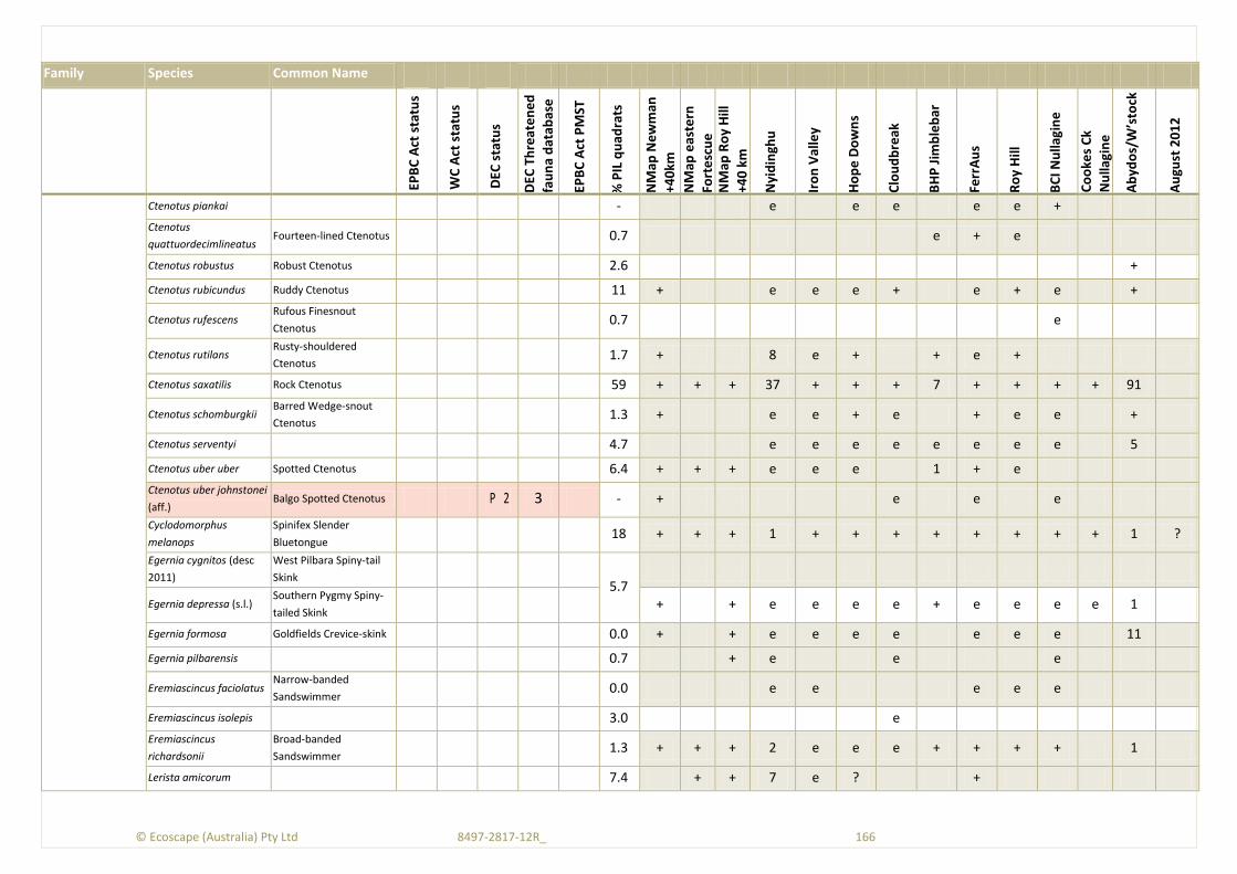
© Ecoscape (Australia) Pty Ltd 8497-2817-12R_ 166
Family Species Common Name
EPB
C A
ct s
tatu
s
WC
Act
sta
tus
DEC
sta
tus
DEC
Th
reat
en
ed
fau
na
dat
abas
e
EPB
C A
ct P
MST
% P
IL q
uad
rats
NM
ap N
ew
man
+40
km
NM
ap e
aste
rn
Fort
esc
ue
NM
ap R
oy
Hill
+40
km
Nyi
din
ghu
Iro
n V
alle
y
Ho
pe
Do
wn
s
Clo
ud
bre
ak
BH
P J
imb
leb
ar
Ferr
Au
s
Ro
y H
ill
BC
I Nu
llagi
ne
Co
oke
s C
k
Nu
llagi
ne
Ab
ydo
s/W
’sto
ck
Au
gust
20
12
Ctenotus piankai - e e e e e +
Ctenotus
quattuordecimlineatus Fourteen-lined Ctenotus 0.7 e + e
Ctenotus robustus Robust Ctenotus 2.6 +
Ctenotus rubicundus Ruddy Ctenotus 11 + e e e + e + e +
Ctenotus rufescens Rufous Finesnout
Ctenotus 0.7 e
Ctenotus rutilans Rusty-shouldered
Ctenotus 1.7 + 8 e + + e +
Ctenotus saxatilis Rock Ctenotus 59 + + + 37 + + + 7 + + + + 91
Ctenotus schomburgkii Barred Wedge-snout
Ctenotus 1.3 + e e + e + e e +
Ctenotus serventyi 4.7 e e e e e e e e 5
Ctenotus uber uber Spotted Ctenotus 6.4 + + + e e e 1 + e
Ctenotus uber johnstonei
(aff.) Balgo Spotted Ctenotus P 2 3 - + e e e
Cyclodomorphus
melanops
Spinifex Slender
Bluetongue 18 + + + 1 + + + + + + + + 1 ?
Egernia cygnitos (desc
2011)
West Pilbara Spiny-tail
Skink
5.7
Egernia depressa (s.l.) Southern Pygmy Spiny-
tailed Skink + + e e e e + e e e e 1
Egernia formosa Goldfields Crevice-skink 0.0 + + e e e e e e e 11
Egernia pilbarensis 0.7 + e e e
Eremiascincus faciolatus Narrow-banded
Sandswimmer 0.0 e e e e e
Eremiascincus isolepis 3.0 e
Eremiascincus
richardsonii
Broad-banded
Sandswimmer 1.3 + + + 2 e e e + + + + 1
Lerista amicorum 7.4 + + 7 e ? +
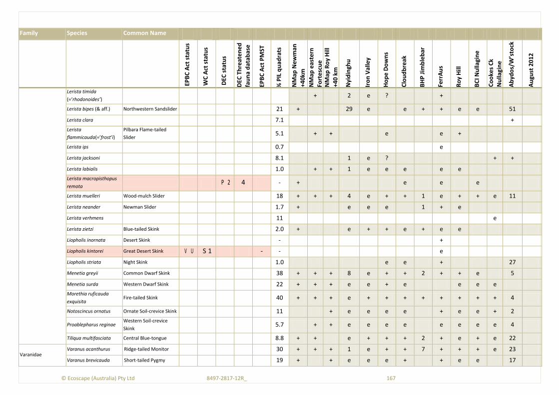
© Ecoscape (Australia) Pty Ltd 8497-2817-12R_ 167
Family Species Common Name
EPB
C A
ct s
tatu
s
WC
Act
sta
tus
DEC
sta
tus
DEC
Th
reat
en
ed
fau
na
dat
abas
e
EPB
C A
ct P
MST
% P
IL q
uad
rats
NM
ap N
ew
man
+40
km
NM
ap e
aste
rn
Fort
esc
ue
NM
ap R
oy
Hill
+40
km
Nyi
din
ghu
Iro
n V
alle
y
Ho
pe
Do
wn
s
Clo
ud
bre
ak
BH
P J
imb
leb
ar
Ferr
Au
s
Ro
y H
ill
BC
I Nu
llagi
ne
Co
oke
s C
k
Nu
llagi
ne
Ab
ydo
s/W
’sto
ck
Au
gust
20
12
Lerista timida
(=‘rhodonoides’) + 2 e ? +
Lerista bipes (& aff.) Northwestern Sandslider 21 + 29 e e + + e e 51
Lerista clara 7.1 +
Lerista
flammicauda(=’frost’i)
Pilbara Flame-tailed
Slider 5.1 + + e e +
Lerista ips 0.7 e
Lerista jacksoni 8.1 1 e ? + +
Lerista labialis 1.0 + + 1 e e e e e
Lerista macropisthopus
remota P 2 4 - + e e e
Lerista muelleri Wood-mulch Slider 18 + + + 4 e + + 1 e + + e 11
Lerista neander Newman Slider 1.7 + e e e 1 + e
Lerista verhmens 11 e
Lerista zietzi Blue-tailed Skink 2.0 + e + + e + e e
Liopholis inornata Desert Skink - +
Liopholis kintorei Great Desert Skink V U S 1 - - e
Liopholis striata Night Skink 1.0 e e + 27
Menetia greyii Common Dwarf Skink 38 + + + 8 e + + 2 + + e 5
Menetia surda Western Dwarf Skink 22 + + + e e + e e e e
Morethia ruficauda
exquisita Fire-tailed Skink 40 + + + e + + + + + + + + 4
Notoscincus ornatus Ornate Soil-crevice Skink 11 + e e e e + e e + 2
Proablepharus reginae Western Soil-crevice
Skink 5.7 + + e e e e e e e e 4
Tiliqua multifasciata Central Blue-tongue 8.8 + + e + + + 2 + e + e 22
Varanidae Varanus acanthurus Ridge-tailed Monitor 30 + + + 1 e + + 7 + + + e 23
Varanus brevicauda Short-tailed Pygmy 19 + + e e e + + e e 17

© Ecoscape (Australia) Pty Ltd 8497-2817-12R_ 168
Family Species Common Name
EPB
C A
ct s
tatu
s
WC
Act
sta
tus
DEC
sta
tus
DEC
Th
reat
en
ed
fau
na
dat
abas
e
EPB
C A
ct P
MST
% P
IL q
uad
rats
NM
ap N
ew
man
+40
km
NM
ap e
aste
rn
Fort
esc
ue
NM
ap R
oy
Hill
+40
km
Nyi
din
ghu
Iro
n V
alle
y
Ho
pe
Do
wn
s
Clo
ud
bre
ak
BH
P J
imb
leb
ar
Ferr
Au
s
Ro
y H
ill
BC
I Nu
llagi
ne
Co
oke
s C
k
Nu
llagi
ne
Ab
ydo
s/W
’sto
ck
Au
gust
20
12
Monitor
Varanus bushi Pilbara Mulga Monitor 0.0 e e + e
Varanus caudolineatus Stripe-tailed Monitor 5.7 + + + e e e + 3 + + e
Varanus eremius Pygmy Desert Monitor 9.8 6 e e e e + e e e 4 +
Varanus giganteus Perentie 0.0 + + e e e e + + e + e 1+ +
Varanus gilleni Pygmy Mulga Monitor 0.0 e e + e e
Varanus gouldii Sand Monitor 0.7 + + + 2+ e e e 1 + e e 7+ ?
Varanus panoptes Yellow-spotted Monitor 0.3 + + + 1+ e e + + + + + + ?
Varanus pilbarensis Pilbara Rock Monitor 1.3 + + + e e e e e e e 2
Varanus tristis Black-tailed Monitor 0.7 + + + 1+ e + + 2 + + + + 3
Typhlopidae
Ramphotyphlops
ammodytes 21 + + + e e e + e e + e e 5
Ramphotyphlops
endoterus - e
Ramphotyphlops ganei P 1 12 1.7 + + + e e e e e e e e +
Ramphotyphlops grypus 17 + + + e e e + + + + + e 2
Ramphotyphlops
hamatus 3.0 + + + e e + 1 + + +
Ramphotyphlops
pilbarensis 1.7 + e e e 2
Ramphotyphlops waitii 1.0 + e e e e e
Pythonidae
Antaresia perthensis Pigmy Python 1.0 + + + 1 e e e + + e e e 1
Antaresia stimsoni Stimson’s Python 0.0 + + + + e e e + e e e e 4
Aspidites
melanocephalus Black-headed Python 0.3 + + + + + + + e e e e 1
Aspidites ramsayi Woma S 4 0.0 e e
Liasis olivaceus barroni Pilbara Olive Python V U S 1 VU 3 M 0.0 + + + e e e e e e + 1
Elapidae Acanthophis pyrrhus Desert Death Adder 0.0 e
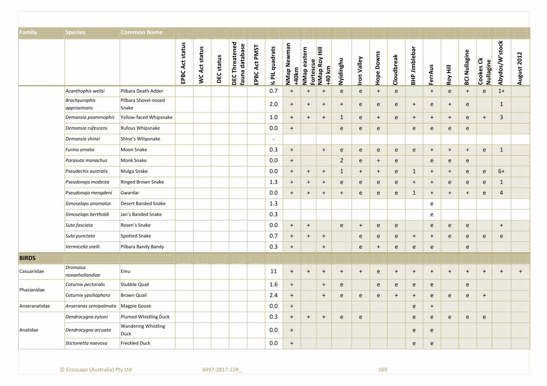
© Ecoscape (Australia) Pty Ltd 8497-2817-12R_ 169
Family Species Common Name
EPB
C A
ct s
tatu
s
WC
Act
sta
tus
DEC
sta
tus
DEC
Th
reat
en
ed
fau
na
dat
abas
e
EPB
C A
ct P
MST
% P
IL q
uad
rats
NM
ap N
ew
man
+40
km
NM
ap e
aste
rn
Fort
esc
ue
NM
ap R
oy
Hill
+40
km
Nyi
din
ghu
Iro
n V
alle
y
Ho
pe
Do
wn
s
Clo
ud
bre
ak
BH
P J
imb
leb
ar
Ferr
Au
s
Ro
y H
ill
BC
I Nu
llagi
ne
Co
oke
s C
k
Nu
llagi
ne
Ab
ydo
s/W
’sto
ck
Au
gust
20
12
Acanthophis wellsi Pilbara Death Adder 0.7 + + + e e + e + e + e 1+
Brachyurophis
approximans
Pilbara Shovel-nosed
Snake 2.0 + + + + e e e + e + e 1
Demansia psammophis Yellow-faced Whipsnake 1.0 + + + 1 e + e + + + e + 3
Demansia rufescens Rufous Whipsnake 0.0 + e e e e e e e
Demansia shinei Shine’s Whipsnake -
Furina ornata Moon Snake 0.3 + + e e e e e + + + e 1
Parasuta monachus Monk Snake 0.0 + 2 e + e e e e
Pseudechis australis Mulga Snake 0.0 + + + 1 + + e 1 + + e e 6+
Pseudonaja modesta Ringed Brown Snake 1.3 + + + e e e e + + e e e 1
Pseudonaja mengdeni Gwardar 0.0 + + + + e e e 1 + + + e 4
Simoselaps anomalus Desert Banded Snake 1.3 e
Simoselaps bertholdi Jan’s Banded Snake 0.3 e
Suta fasciata Rosen’s Snake 0.0 + + e + e e e e e +
Suta punctata Spotted Snake 0.7 + + + e e e + + e e e e
Vermicella snelli Pilbara Bandy Bandy 0.3 + + e + e e e e
BIRDS
Casuariidae Dromaius
novaehollandiae Emu 11 + + + + + e + + + + + + + +
Phasianidae Coturnix pectoralis Stubble Quail 1.6 + + e e e e e e
Coturnix ypsiliophora Brown Quail 2.4 + + e e e + + e e e +
Anseranatidae Anseranas semipalmata Magpie Goose 0.0 + e +
Anatidae
Dendrocygna eytoni Plumed Whistling Duck 0.3 + + + e e e e e e e
Dendrocygna arcuata Wandering Whistling
Duck 0.0 + e e
Stictonetta naevosa Freckled Duck 0.0 + e e
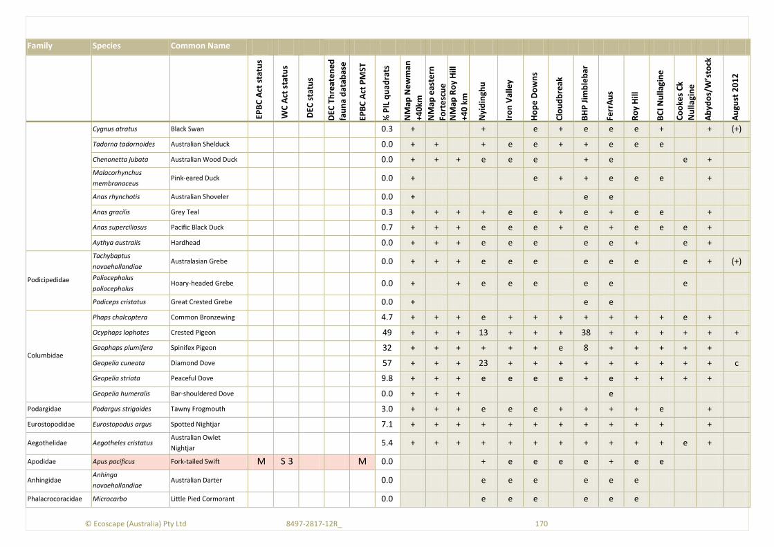
© Ecoscape (Australia) Pty Ltd 8497-2817-12R_ 170
Family Species Common Name
EPB
C A
ct s
tatu
s
WC
Act
sta
tus
DEC
sta
tus
DEC
Th
reat
en
ed
fau
na
dat
abas
e
EPB
C A
ct P
MST
% P
IL q
uad
rats
NM
ap N
ew
man
+40
km
NM
ap e
aste
rn
Fort
esc
ue
NM
ap R
oy
Hill
+40
km
Nyi
din
ghu
Iro
n V
alle
y
Ho
pe
Do
wn
s
Clo
ud
bre
ak
BH
P J
imb
leb
ar
Ferr
Au
s
Ro
y H
ill
BC
I Nu
llagi
ne
Co
oke
s C
k
Nu
llagi
ne
Ab
ydo
s/W
’sto
ck
Au
gust
20
12
Cygnus atratus Black Swan 0.3 + + e + e e e + + (+)
Tadorna tadornoides Australian Shelduck 0.0 + + + e e + + e e e
Chenonetta jubata Australian Wood Duck 0.0 + + + e e e + e e +
Malacorhynchus
membranaceus Pink-eared Duck 0.0 + e + + e e e +
Anas rhynchotis Australian Shoveler 0.0 + e e
Anas gracilis Grey Teal 0.3 + + + + e e + e + e e +
Anas superciliosus Pacific Black Duck 0.7 + + + e e e + e + e e e +
Aythya australis Hardhead 0.0 + + + e e e e e + e +
Podicipedidae
Tachybaptus
novaehollandiae Australasian Grebe 0.0 + + + e e e e e e e + (+)
Poliocephalus
poliocephalus Hoary-headed Grebe 0.0 + + e e e e e e
Podiceps cristatus Great Crested Grebe 0.0 + e e
Columbidae
Phaps chalcoptera Common Bronzewing 4.7 + + + e + + + + + + + e +
Ocyphaps lophotes Crested Pigeon 49 + + + 13 + + + 38 + + + + + +
Geophaps plumifera Spinifex Pigeon 32 + + + + + + e 8 + + + + +
Geopelia cuneata Diamond Dove 57 + + + 23 + + + + + + + + + c
Geopelia striata Peaceful Dove 9.8 + + + e e e e + e + + + +
Geopelia humeralis Bar-shouldered Dove 0.0 + + + e
Podargidae Podargus strigoides Tawny Frogmouth 3.0 + + + e e e + + + + e +
Eurostopodidae Eurostopodus argus Spotted Nightjar 7.1 + + + + + + + + + + + +
Aegothelidae Aegotheles cristatus Australian Owlet
Nightjar 5.4 + + + + + + + + + + + e +
Apodidae Apus pacificus Fork-tailed Swift M S 3 M 0.0 + e e e e + e e
Anhingidae Anhinga
novaehollandiae Australian Darter 0.0 e e e e e e
Phalacrocoracidae Microcarbo Little Pied Cormorant 0.0 e e e e e e

© Ecoscape (Australia) Pty Ltd 8497-2817-12R_ 171
Family Species Common Name
EPB
C A
ct s
tatu
s
WC
Act
sta
tus
DEC
sta
tus
DEC
Th
reat
en
ed
fau
na
dat
abas
e
EPB
C A
ct P
MST
% P
IL q
uad
rats
NM
ap N
ew
man
+40
km
NM
ap e
aste
rn
Fort
esc
ue
NM
ap R
oy
Hill
+40
km
Nyi
din
ghu
Iro
n V
alle
y
Ho
pe
Do
wn
s
Clo
ud
bre
ak
BH
P J
imb
leb
ar
Ferr
Au
s
Ro
y H
ill
BC
I Nu
llagi
ne
Co
oke
s C
k
Nu
llagi
ne
Ab
ydo
s/W
’sto
ck
Au
gust
20
12
melanoleucos
Phalacrocorax carbo Great Cormorant 0.0 + + e e (?)
Phalacrocorax
sulcirostris Little Black Cormorant 0.0 + + + e e e + + + e + (?)
Phalacrocorax varius Pied Cormorant 0.0 + e e
Pelecanidae Pelecanus conspicillatus Australian Pelican 0.0 + + + + e + e +
Ciconiidae Ephippiorhynchus
asiaticus Black-necked Stork 0.0 + + + e e e e + +
Ardeidae
Ardea pacifica White-necked Heron 0.3 + + + e + + + + e + e e +
Ardea modesta (=alba) Great Egret M S 3 M 0.0 + e e e e + e +
Ardea intermedia Intermediate Egret 0.0 + e e
Ardea ibis Cattle Egret M S 3 M 0.0 + + e e e e e
Egretta novaehollandiae White-faced Heron 0.0 + + e + + + e e + + +
Egretta garzetta Little Egret 0.0 e e e e e
Nycticorax caledonicus Nankeen Night-heron 0.3 + + e e e e e e + +
Threskiornithidae
Plegadis falcinellus Glossy Ibis 0.0 + e e
Threskiornis molucca Australian White Ibis 0.7 + e e
Threskiornis spinicollis Straw-necked Ibis 0.0 + + + + e e + e e e e + (+)
Platalea regia Royal Spoonbill 0.0 + + e e e e +
Platalea flavipes Yellow-billed Spoonbill 0.0 + + e e e e e e
Accipitridae
Elanus axillaris Black-shouldered Kite 3.4 e e e e + e + e +
Lophoictinia isura Square-tailed Kite 0.0 e e e e e e e
Hamirostra
melanosternon Black-breasted Buzzard 0.7 + + + 1 + + e 1 + e e +
Haliaeetus leucogaster White-bellied Sea-eagle M S 3 - 0.7 + e e e e
Haliastur sphenurus Whistling Kite 13 + + + 3 + + + 12 + + + + + c
Milvus migrans Black Kite 0.7 + + + 3 e e + 2 + e e e +
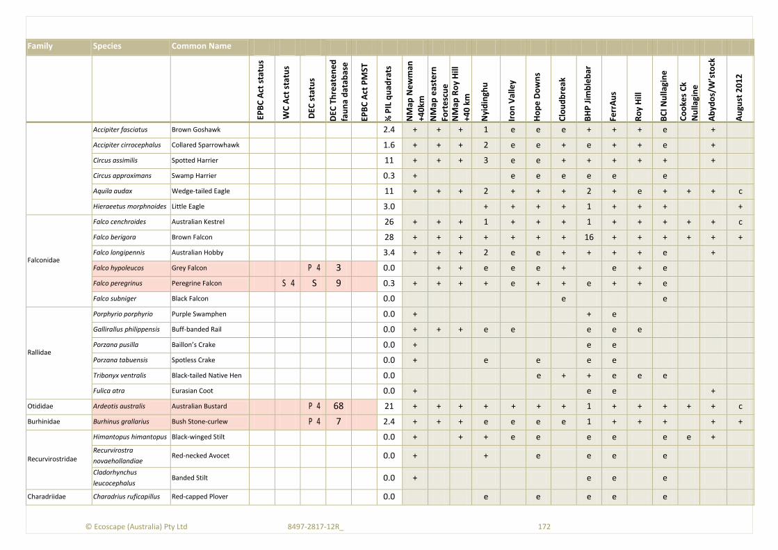
© Ecoscape (Australia) Pty Ltd 8497-2817-12R_ 172
Family Species Common Name
EPB
C A
ct s
tatu
s
WC
Act
sta
tus
DEC
sta
tus
DEC
Th
reat
en
ed
fau
na
dat
abas
e
EPB
C A
ct P
MST
% P
IL q
uad
rats
NM
ap N
ew
man
+40
km
NM
ap e
aste
rn
Fort
esc
ue
NM
ap R
oy
Hill
+40
km
Nyi
din
ghu
Iro
n V
alle
y
Ho
pe
Do
wn
s
Clo
ud
bre
ak
BH
P J
imb
leb
ar
Ferr
Au
s
Ro
y H
ill
BC
I Nu
llagi
ne
Co
oke
s C
k
Nu
llagi
ne
Ab
ydo
s/W
’sto
ck
Au
gust
20
12
Accipiter fasciatus Brown Goshawk 2.4 + + + 1 e e e + + + e +
Accipiter cirrocephalus Collared Sparrowhawk 1.6 + + + 2 e e + e + + e +
Circus assimilis Spotted Harrier 11 + + + 3 e e + + + + + +
Circus approximans Swamp Harrier 0.3 + e e e e e e
Aquila audax Wedge-tailed Eagle 11 + + + 2 + + + 2 + e + + + c
Hieraeetus morphnoides Little Eagle 3.0 + + + + 1 + + + +
Falconidae
Falco cenchroides Australian Kestrel 26 + + + 1 + + + 1 + + + + + c
Falco berigora Brown Falcon 28 + + + + + + + 16 + + + + + +
Falco longipennis Australian Hobby 3.4 + + + 2 e e + + + + e +
Falco hypoleucos Grey Falcon P 4 3 0.0 + + e e e + e + e
Falco peregrinus Peregrine Falcon S 4 S 9 0.3 + + + + e + + e + + e
Falco subniger Black Falcon 0.0 e e
Rallidae
Porphyrio porphyrio Purple Swamphen 0.0 + + e
Gallirallus philippensis Buff-banded Rail 0.0 + + + e e e e e
Porzana pusilla Baillon’s Crake 0.0 + e e
Porzana tabuensis Spotless Crake 0.0 + e e e e
Tribonyx ventralis Black-tailed Native Hen 0.0 e + + e e e
Fulica atra Eurasian Coot 0.0 + e e +
Otididae Ardeotis australis Australian Bustard P 4 68 21 + + + + + + + 1 + + + + + c
Burhinidae Burhinus grallarius Bush Stone-curlew P 4 7 2.4 + + + e e e e 1 + + + + +
Recurvirostridae
Himantopus himantopus Black-winged Stilt 0.0 + + + e e e e e e +
Recurvirostra
novaehollandiae Red-necked Avocet 0.0 + + e e e e
Cladorhynchus
leucocephalus Banded Stilt 0.0 + e e e
Charadriidae Charadrius ruficapillus Red-capped Plover 0.0 e e e e e
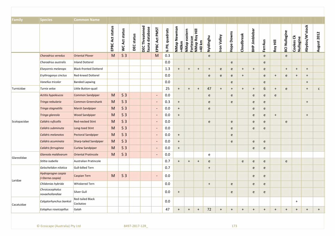
© Ecoscape (Australia) Pty Ltd 8497-2817-12R_ 173
Family Species Common Name
EPB
C A
ct s
tatu
s
WC
Act
sta
tus
DEC
sta
tus
DEC
Th
reat
en
ed
fau
na
dat
abas
e
EPB
C A
ct P
MST
% P
IL q
uad
rats
NM
ap N
ew
man
+40
km
NM
ap e
aste
rn
Fort
esc
ue
NM
ap R
oy
Hill
+40
km
Nyi
din
ghu
Iro
n V
alle
y
Ho
pe
Do
wn
s
Clo
ud
bre
ak
BH
P J
imb
leb
ar
Ferr
Au
s
Ro
y H
ill
BC
I Nu
llagi
ne
Co
oke
s C
k
Nu
llagi
ne
Ab
ydo
s/W
’sto
ck
Au
gust
20
12
Charadrius veredus Oriental Plover M S 3 M 0.3 e e e
Charadrius australis Inland Dotterel 0.0 e e
Elseyornis melanops Black-fronted Dotterel 1.3 + + + + e e + + e + + +
Erythrogonys cinctus Red-kneed Dotterel 0.0 e e e + e + e + +
Vanellus tricolor Banded Lapwing 0.0 e e +
Turnicidae Turnix velox Little Button-quail 25 + + + 47 + + + + 6 + e + c
Scolopacidae
Actitis hypoleucos Common Sandpiper M S 3 - 0.0 e e e e e
Tringa nebularia Common Greenshank M S 3 - 0.3 + e e e e +
Tringa stagnatilis Marsh Sandpiper M S 3 - 0.0 + e e e
Tringa glareola Wood Sandpiper M S 3 - 0.0 + e e + +
Calidris ruficollis Red-necked Stint M S 3 - 0.0 e e e e e
Calidris subminuta Long-toed Stint M S 3 - 0.0 e e e
Calidris melanotos Pectoral Sandpiper M S 3 - 0.0 + e
Calidris acuminata Sharp-tailed Sandpiper M S 3 - 0.0 + e e e
Calidris ferruginea Curlew Sandpiper M S 3 - 0.0 + e e
Glareolidae Glareola maldivarum Oriental Pratincole M S 3 - 0.0 e
Stiltia isabella Australian Pratincole 0.7 + + + e e e e e
Laridae
Gelochelidon nilotica Gull-billed Tern 0.7 + e e
Hydroprogne caspia
(=Sterna caspia) Caspian Tern M S 3 - 0.0 e e
Chlidonias hybrida Whiskered Tern 0.0 + e e e
Chroicocephalus
novaehollandiae Silver Gull 0.0 + e e e
Cacatuidae Calyptorhynchus banksii
Red-tailed Black
Cockatoo 0.0 +
Eolophus roseicapillus Galah 47 + + + 72 + + + + + + + + + +

© Ecoscape (Australia) Pty Ltd 8497-2817-12R_ 174
Family Species Common Name
EPB
C A
ct s
tatu
s
WC
Act
sta
tus
DEC
sta
tus
DEC
Th
reat
en
ed
fau
na
dat
abas
e
EPB
C A
ct P
MST
% P
IL q
uad
rats
NM
ap N
ew
man
+40
km
NM
ap e
aste
rn
Fort
esc
ue
NM
ap R
oy
Hill
+40
km
Nyi
din
ghu
Iro
n V
alle
y
Ho
pe
Do
wn
s
Clo
ud
bre
ak
BH
P J
imb
leb
ar
Ferr
Au
s
Ro
y H
ill
BC
I Nu
llagi
ne
Co
oke
s C
k
Nu
llagi
ne
Ab
ydo
s/W
’sto
ck
Au
gust
20
12
Cacatua sanguinea Little Corella 16 + + + 17 + + + 42 + + + + + +
Nymphicus hollandicus Cockatiel 27 + + + 259 + + + + + + + + + c
Psittacidae
Polytelis alexandrae Princess Parrot V U P 4 M 0.0 e e
Barnardius zonarius Australian Ringneck 28 + + + 14 + + + 7 + + + + + +
Psephotus varius Mulga Parrot 0.7 e e e + e
Melopsittacus undulatus Budgerigar 53 + + + 1244 + + + 2 + + e + + c
Neopsephotus bourkii Bourke’s Parrot 1.3 + + + e e e + + + e e
Neophema elegans Elegant Parrot 0.3 e e e
Pezoporus occidentalis Night Parrot E N S 1 CR 1 L 0.0 e e e + e e e
Cuculidae
Centropus phasianinus Pheasant Coucal 0.7 + + e e + e e e + +
Chalcites osculans Black-eared Cuckoo 2.7 + e e e e + + + +
Chalcites basalis Horsfield's Bronze-
Cuckoo 23 + + 2 + + + + + + e e +
Cacomantis pallidus Pallid Cuckoo 24 + + + 6 + + + + + + + + +
Cacomantis flabelliformis Fan-tailed Cuckoo 0.0 e
Strigidae Ninox connivens Barking Owl 1.7 + e e + e e e e e e
Ninox novaeseelandiae Southern Boobook 4.4 + + + + + + + 2 + + + + +
Tytonidae Tyto javanica Eastern Barn Owl 1.0 + + + + e e + 1 + + e
Halcyonidae
Dacelo leachii Blue-winged Kookaburra 9.8 + + + e e + + + + + + + +
Todiramphus sanctus Sacred Kingfisher 8.1 + + + e e + e + e e + + + ?
Todiramphus
pyrrhopygia Red-backed Kingfisher 15 + + + 2 + + + 1 + + + + ?
Meropidae Merops ornatus Rainbow Bee-eater M S 3 M 35 + + + 14 + + + 12 3 + + + + (+)
Climacteridae Climacteris melanura Black-tailed Treecreeper 2.0 + + e e e + e e e +
Ptilonorhynchidae Ptilonorhynchus guttatus Western Bowerbird 10 + + + e + e + + e e e +
Maluridae Malurus splendens Splendid Fairy-wren 0.7 + e + e +
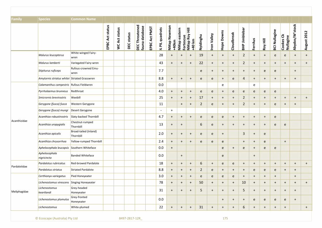
© Ecoscape (Australia) Pty Ltd 8497-2817-12R_ 175
Family Species Common Name
EPB
C A
ct s
tatu
s
WC
Act
sta
tus
DEC
sta
tus
DEC
Th
reat
en
ed
fau
na
dat
abas
e
EPB
C A
ct P
MST
% P
IL q
uad
rats
NM
ap N
ew
man
+40
km
NM
ap e
aste
rn
Fort
esc
ue
NM
ap R
oy
Hill
+40
km
Nyi
din
ghu
Iro
n V
alle
y
Ho
pe
Do
wn
s
Clo
ud
bre
ak
BH
P J
imb
leb
ar
Ferr
Au
s
Ro
y H
ill
BC
I Nu
llagi
ne
Co
oke
s C
k
Nu
llagi
ne
Ab
ydo
s/W
’sto
ck
Au
gust
20
12
Malurus leucopterus White-winged Fairy-
wren 28 + + + 19 + + + 2 + + e e + +
Malurus lamberti Variegated Fairy-wren 43 + + + 22 + + + 2 + + + + + +
Stipiturus ruficeps Rufous-crowned Emu-
wren 7.7 e + + + + + e e +
Amytornis striatus whitei Striated Grasswren 8.8 + + + e e + e 4 + + + + +
Acanthizidae
Calamanthus campestris Rufous Fieldwren 0.0 e e
Pyrrholaemus brunneus Redthroat 4.0 + + + e e + e e e e e
Smicrornis brevirostris Weebill 25 + + + 17 + + + 2 + + + + + +
Gerygone (fusca) fusca Western Gerygone 11 + + 2 e + + 2 + + e + +
Gerygone (fusca) mungi Desert Gerygone - +
Acanthiza robustirostris Slaty-backed Thornbill 4.7 + + + e e e + + + + e
Acanthiza uropygialis Chestnut-rumped
Thornbill 13 + + 6 e + + + + + e e
Acanthiza apicalis Broad-tailed (Inland)
Thornbill 2.0 + + + e e + 3 + e
Acanthiza chrysorrhoa Yellow-rumped Thornbill 2.4 + + + e e e + + e +
Aphelocephala leucopsis Southern Whiteface 0.0 + e + e + e e
Aphelocephala
nigricincta Banded Whiteface 0.0 + e +
Pardalotidae Pardalotus rubricatus Red-browed Pardalote 18 + + + 6 + e e + + + + + + +
Pardalotus striatus Striated Pardalote 8.8 + + + 2 e + + + e e e + +
Meliphagidae
Certhionyx variegatus Pied Honeyeater 3.0 + + + e e e e + + + + +
Lichenostomus virescens Singing Honeyeater 78 + + + 50 + + + 10 + + + + + +
Lichenostomus
keartlandi
Grey-headed
Honeyeater 31 + + + 5 + + + 5 + + + + +
Lichenostomus plumulus Grey-fronted
Honeyeater 0.0 + + + e e e e +
Lichenostomus White-plumed 22 + + + 31 + + + 6 + + + + +
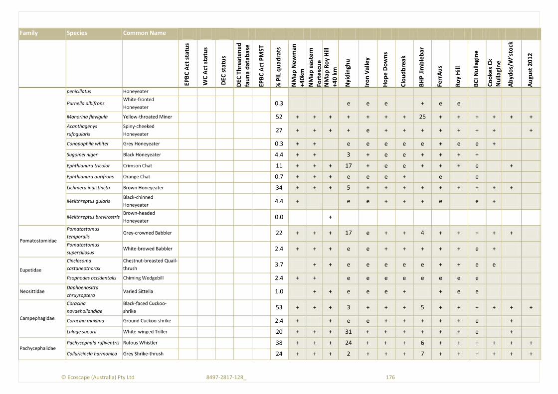
© Ecoscape (Australia) Pty Ltd 8497-2817-12R_ 176
Family Species Common Name
EPB
C A
ct s
tatu
s
WC
Act
sta
tus
DEC
sta
tus
DEC
Th
reat
en
ed
fau
na
dat
abas
e
EPB
C A
ct P
MST
% P
IL q
uad
rats
NM
ap N
ew
man
+40
km
NM
ap e
aste
rn
Fort
esc
ue
NM
ap R
oy
Hill
+40
km
Nyi
din
ghu
Iro
n V
alle
y
Ho
pe
Do
wn
s
Clo
ud
bre
ak
BH
P J
imb
leb
ar
Ferr
Au
s
Ro
y H
ill
BC
I Nu
llagi
ne
Co
oke
s C
k
Nu
llagi
ne
Ab
ydo
s/W
’sto
ck
Au
gust
20
12
penicillatus Honeyeater
Purnella albifrons White-fronted
Honeyeater 0.3 e e e + e e
Manorina flavigula Yellow-throated Miner 52 + + + + + + + 25 + + + + + +
Acanthagenys
rufogularis
Spiny-cheeked
Honeyeater 27 + + + + e + + + + + + + +
Conopophila whitei Grey Honeyeater 0.3 + + e e e e e + e e +
Sugomel niger Black Honeyeater 4.4 + + 3 + e e + + + +
Ephthianura tricolor Crimson Chat 11 + + + 17 + e e + + + e +
Ephthianura aurifrons Orange Chat 0.7 + + + e e e + e e
Lichmera indistincta Brown Honeyeater 34 + + + 5 + + + + + + + + +
Melithreptus gularis Black-chinned
Honeyeater 4.4 + e e + + + e e +
Melithreptus brevirostris Brown-headed
Honeyeater 0.0 +
Pomatostomidae
Pomatostomus
temporalis Grey-crowned Babbler 22 + + + 17 e + + 4 + + + + +
Pomatostomus
superciliosus White-browed Babbler 2.4 + + + e e + + + + + e +
Eupetidae
Cinclosoma
castaneothorax
Chestnut-breasted Quail-
thrush 3.7 + + e e e e e + + e e
Psophodes occidentalis Chiming Wedgebill 2.4 + + e e e e e e e e
Neosittidae Daphoenositta
chruysoptera Varied Sittella 1.0 + + e e e + + e e
Campephagidae
Coracina
novaehollandiae
Black-faced Cuckoo-
shrike 53 + + + 3 + + + 5 + + + + + +
Coracina maxima Ground Cuckoo-shrike 2.4 + + e e + + + + + e +
Lalage sueurii White-winged Triller 20 + + + 31 + + + + + + e +
Pachycephalidae Pachycephala rufiventris Rufous Whistler 38 + + + 24 + + + 6 + + + + + +
Colluricincla harmonica Grey Shrike-thrush 24 + + + 2 + + + 7 + + + + + +

© Ecoscape (Australia) Pty Ltd 8497-2817-12R_ 177
Family Species Common Name
EPB
C A
ct s
tatu
s
WC
Act
sta
tus
DEC
sta
tus
DEC
Th
reat
en
ed
fau
na
dat
abas
e
EPB
C A
ct P
MST
% P
IL q
uad
rats
NM
ap N
ew
man
+40
km
NM
ap e
aste
rn
Fort
esc
ue
NM
ap R
oy
Hill
+40
km
Nyi
din
ghu
Iro
n V
alle
y
Ho
pe
Do
wn
s
Clo
ud
bre
ak
BH
P J
imb
leb
ar
Ferr
Au
s
Ro
y H
ill
BC
I Nu
llagi
ne
Co
oke
s C
k
Nu
llagi
ne
Ab
ydo
s/W
’sto
ck
Au
gust
20
12
Oreoica gutturalis Crested Bellbird 41 + + + 1 e + + + + + + +
Oreoica g. gutturalis Cr. Bellbird (southern) P 4 2 + +
Artamidae
Artamus leucorynchus White-breasted
Woodswallow 0.0 e
Artamus personatus Masked Woodswallow 19 + + + 80 + + e 3 + + e + +
Artamus superciliosus White-browed
Woodswallow 0.0 + e e e e
Artamus cinereus Black-faced
Woodswallow 64 + + + 96 + + + 7 + + + + +
Artamus cyanopterus Dusky Woodswallow 0.0 + e e
Artamus minor Little Woodswallow 6.7 + + + e + + e + + + e e + c
Cracticus torquatus Grey Butcherbird 15 + + + + e + + + + + e +
Cracticus nigrogularis Pied Butcherbird 51 + + + 12 + + + 11 + + + + + +
Cracticus tibicen Australian Magpie 14 + + + + + + + 13 + + + + +
Rhipiduridae Rhipidura albiscapa Grey Fantail 4.7 + e + + + e e + e
Rhipidura leucophrys Willie Wagtail 67 + + + 20 + + + 12 + + + + + +
Corvidae
Corvus coronoides Australian Raven 0.0 + + e +
Corvus bennetti Little Crow 11 + + + 1 e + + + e + + + + +
Corvus orru Torresian Crow 45 + + + 7 + + + 8 + + + + + +
Monarchidae Grallina cyanoleuca Magpie-Lark 25 + + + 14 + + + 4 + + + + + +
Petroicidae Petroica goodenovii Red-capped Robin 5.1 + + + 1 e + + 3 + + e
Melanodryas cucullata Hooded Robin 13 + + 3 + + + 2 + + e e
Alaudidae Mirafra javanica
horsfieldii
Horsfield’s (Singing)
Bushlark 19 + + + 8 + e + 1 + + + +
Acrocephalidae Acrocephalus australis Australian Reed-warbler 0.3 + + e e + e e + e +
Megaluridae Megalurus gramineus Little Grassbird 0.0 + e e e e e
Cincloramphus mathewsi Rufous Songlark 7.4 + + + e + e e + + + e e +
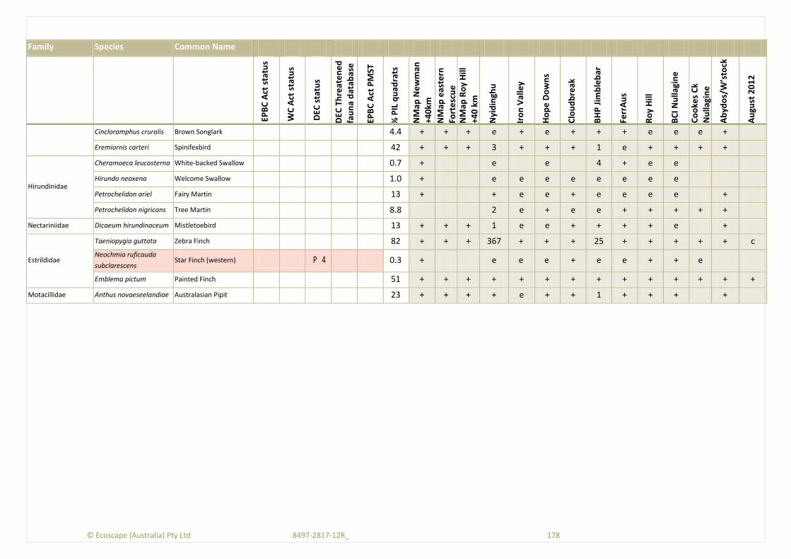
© Ecoscape (Australia) Pty Ltd 8497-2817-12R_ 178
Family Species Common Name
EPB
C A
ct s
tatu
s
WC
Act
sta
tus
DEC
sta
tus
DEC
Th
reat
en
ed
fau
na
dat
abas
e
EPB
C A
ct P
MST
% P
IL q
uad
rats
NM
ap N
ew
man
+40
km
NM
ap e
aste
rn
Fort
esc
ue
NM
ap R
oy
Hill
+40
km
Nyi
din
ghu
Iro
n V
alle
y
Ho
pe
Do
wn
s
Clo
ud
bre
ak
BH
P J
imb
leb
ar
Ferr
Au
s
Ro
y H
ill
BC
I Nu
llagi
ne
Co
oke
s C
k
Nu
llagi
ne
Ab
ydo
s/W
’sto
ck
Au
gust
20
12
Cincloramphus cruralis Brown Songlark 4.4 + + + e + e + + + e e e +
Eremiornis carteri Spinifexbird 42 + + + 3 + + + 1 e + + + +
Hirundinidae
Cheramoeca leucosterna White-backed Swallow 0.7 + e e 4 + e e
Hirundo neoxena Welcome Swallow 1.0 + e e e e e e e e
Petrochelidon ariel Fairy Martin 13 + + e e + e e e e +
Petrochelidon nigricans Tree Martin 8.8 2 e + e e + + + + +
Nectariniidae Dicaeum hirundinaceum Mistletoebird 13 + + + 1 e e + + + + e +
Estrildidae
Taeniopygia guttata Zebra Finch 82 + + + 367 + + + 25 + + + + + c
Neochmia ruficauda
subclarescens Star Finch (western) P 4 0.3 + e e e + e e + + e
Emblema pictum Painted Finch 51 + + + + + + + + + + + + + +
Motacillidae Anthus novaeseelandiae Australasian Pipit 23 + + + + e + + 1 + + + +

© Ecoscape (Australia) Pty Ltd 8497-2817-12R_ 179
Appendix Five: Correspondence

From: Van Leeuwen, Stephen
To: Lyn Atkins
Cc: Baker, Murray; Corbellini, Michelle
Subject: RE: Proposed Pilbara field survey for July
Date: Thursday, 14 June 2012 5:14:39 PM
Lyn Given seasonal conditions and previous survey effort in close proximity to this road (e.g. Roy Hillborefield pipeline) I think a single session Level 2 type survey along the road verge would fulfilDEC requirements. If any new alignment or a re0alignment was to occur then we would need toreconsider this advice. Cheers Stephen Dr Stephen van LeeuwenBiogeography Program Leader & Partnerships ManagerWestern Australian Conservation Science CentreScience DivisionDepartment of Environment and ConservationPostal Address: Locked Bag 104, BENTLEY DELIVERY CENTRE WA 6983Street Address: Room 2.44, 17 Dick Perry Avenue, KENSINGTON WA 6151Phone: +61 8 9219 9042Fax: +61 8 9334 0135Mobile: 0438 757 556Email: [email protected] P Please consider the environment before printing this email From: Lyn Atkins [mailto:[email protected]] Sent: Thursday, 14 June 2012 1:53 PMTo: Van Leeuwen, StephenSubject: Proposed Pilbara field survey for July
Hi Stephen, I’m wondering if you are available give advice in relation to a proposed field survey? The proposal is for a single season Level 2 survey for an infrastructure corridor betweenNewman and Roy Hill, basically along the road. We’ve only just been given the go-ahead forthe project so we won’t be able to mobilise until July. No, it’s not for a mining company. What are the prospects of this being acceptable to the OEPA/DEC? I know it is not optimal (andcertainly not within the ‘season following rain’), but this year that part of the Pilbara has haddecent rainfall. Having travelled along the road to Nullagine a number of times, I know a lot ofthe area is pretty heavily grazed and degraded (but better towards Newman than on theFortescue floodplain). Your advice would be appreciated. Thanks, Lyn

Lyn AtkinsAssociate Environmental ScientistEcologist/Botanist
ecoscapePO Box 50 / 9 Stirling Highway, North Fremantle WA 6159Ph: (08) 9430 8955 | Mob: 0438 040 962 | Fax: (08) 9430 8977 www.ecoscape.com.au
science+design Please consider the environment before printing this email.
This email, together with any attachments, is intended for theaddressee only. It may contain confidential or privileged information.If you are not the intended recipient of this email, please notifythe sender, delete the email and attachments from your system anddestroy any copies you may have taken of the email and its attachments.Duplication or further distribution by hardcopy, by electronic meansor verbally is not permitted without permission.

© Ecoscape (Australia) Pty Ltd 8497-2817-12R_ 182
Appendix Six: Floristic Quadrat Data
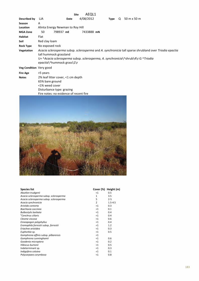
183
Site AEQL1 Described by LJA Date 4/08/2012 Type Q 50 m x 50 m Season A Location Alinta Energy Newman to Roy Hill MGA Zone 50 798937 mE 7433888 mN Habitat Flat Soil Red clay loam Rock Type No exposed rock Vegetation Acacia sclerosperma subsp. sclerosperma and A. synchronicia tall sparse shrubland over Triodia epactia tall hummock grassland U+ ^Acacia sclerosperma subsp. sclerosperma, A. synchronicia\^shrub\4\r:G ^Triodia epactia\^hummock grass\1\r
Veg Condition Very good Fire Age >5 years Notes 2% leaf litter cover, <1 cm depth 65% bare ground <1% weed cover Disturbance type: grazing Fire notes: no evidence of recent fire
Species list Cover (%) Height (m) Abutilon trudgenii <1 0.5 Acacia sclerosperma subsp. sclerosperma 1 3.5 Acacia sclerosperma subsp. sclerosperma 5 2-5 Acacia synchronicia 2 1.5-4.5 Aristida contorta <1 0.3 Boerhavia coccinea <1 0.1 Bulbostylis barbata <1 0.4 *Cenchrus ciliaris <1 0.4 Cleome viscosa <1 0.6 Enneapogon polyphyllus <1 0.4 Eremophila forrestii subsp. forrestii <1 1.2 Eriachne aristidea <1 0.3 Euphorbia sp. <1 0.5 Gomphrena affinis subsp. pilbarensis <1 Gomphrena cunninghamii <1 0.6 Goodenia microptera <1 0.2 Hibiscus burtonii <1 0.5 Indeterminant sp. <1 0.3 Indigofera colutea <1 0.1 Polycarpaea corymbosa <1 0.8

184
*Portulaca oleracea <1 Ptilotus astrolasius <1 1.8 Ptilotus nobilis <1 0.5 Ptilotus polystachyus <1 0.6 Rhagodia eremaea <1 1 Senna artemisioides subsp. oligophylla <1 1 Senna artemisioides subsp. oligophylla x helmsii <1 Senna glutinosa subsp. pruinosa <1 1.5 Senna notabilis <1 0.1 Sida echinocarpa <1 0.3 Sida echinocarpa <1 0.5 Solanum lasiophyllum <1 0.6 Sporobolus australasicus <1 0.4 Stylobasium spathulatum <1 1.2 Tribulus ?terrestris <1 0.1 Tribulus macrocarpus <1 0.1 Trichodesma zeylanicum var. zeylanicum <1 1.2 Triodia epactia 35 0.4
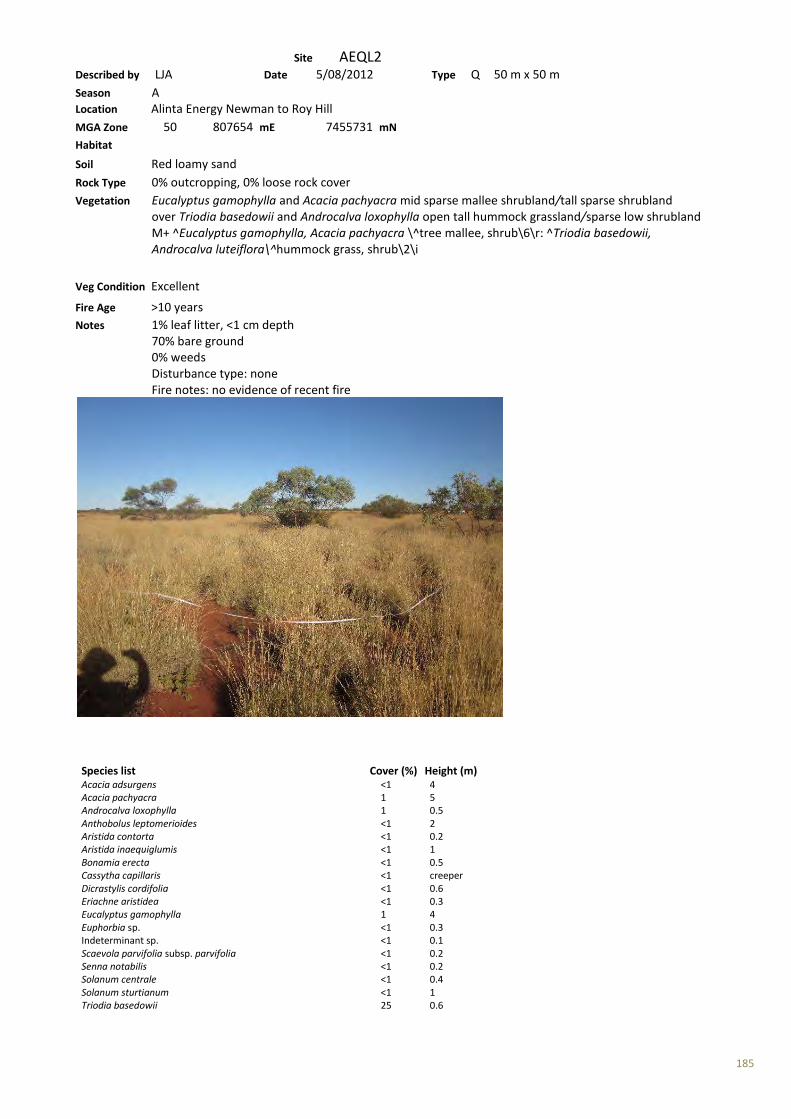
185
Site AEQL2 Described by LJA Date 5/08/2012 Type Q 50 m x 50 m Season A Location Alinta Energy Newman to Roy Hill MGA Zone 50 807654 mE 7455731 mN Habitat Soil Red loamy sand Rock Type 0% outcropping, 0% loose rock cover Vegetation Eucalyptus gamophylla and Acacia pachyacra mid sparse mallee shrubland/tall sparse shrubland over Triodia basedowii and Androcalva loxophylla open tall hummock grassland/sparse low shrubland M+ ^Eucalyptus gamophylla, Acacia pachyacra \^tree mallee, shrub\6\r: ^Triodia basedowii, Androcalva luteiflora\^hummock grass, shrub\2\i
Veg Condition Excellent Fire Age >10 years Notes 1% leaf litter, <1 cm depth 70% bare ground 0% weeds Disturbance type: none Fire notes: no evidence of recent fire
Species list Cover (%) Height (m) Acacia adsurgens <1 4 Acacia pachyacra 1 5 Androcalva loxophylla 1 0.5 Anthobolus leptomerioides <1 2 Aristida contorta <1 0.2 Aristida inaequiglumis <1 1 Bonamia erecta <1 0.5 Cassytha capillaris <1 creeper Dicrastylis cordifolia <1 0.6 Eriachne aristidea <1 0.3 Eucalyptus gamophylla 1 4 Euphorbia sp. <1 0.3 Indeterminant sp. <1 0.1 Scaevola parvifolia subsp. parvifolia <1 0.2 Senna notabilis <1 0.2 Solanum centrale <1 0.4 Solanum sturtianum <1 1 Triodia basedowii 25 0.6

186
Yakirra australiensis <1 0.1
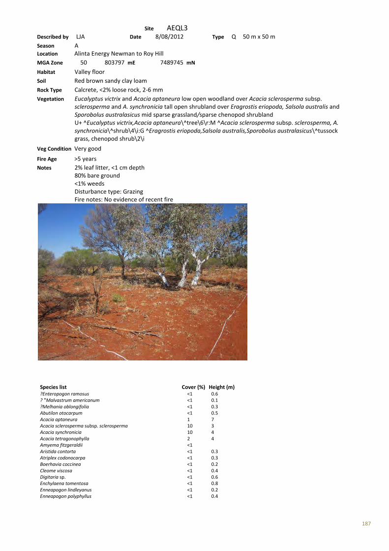
187
Site AEQL3 Described by LJA Date 8/08/2012 Type Q 50 m x 50 m Season A Location Alinta Energy Newman to Roy Hill MGA Zone 50 803797 mE 7489745 mN Habitat Valley floor Soil Red brown sandy clay loam Rock Type Calcrete, <2% loose rock, 2-6 mm Vegetation Eucalyptus victrix and Acacia aptaneura low open woodland over Acacia sclerosperma subsp. sclerosperma and A. synchronicia tall open shrubland over Eragrostis eriopoda, Salsola australis and Sporobolus australasicus mid sparse grassland/sparse chenopod shrubland U+ ^Eucalyptus victrix,Acacia aptaneura\^tree\6\r:M ^Acacia sclerosperma subsp. sclerosperma, A. synchronicia\^shrub\4\i:G ^Eragrostis eriopoda,Salsola australis,Sporobolus australasicus\^tussock grass, chenopod shrub\2\i
Veg Condition Very good Fire Age >5 years Notes 2% leaf litter, <1 cm depth 80% bare ground <1% weeds Disturbance type: Grazing Fire notes: No evidence of recent fire
Species list Cover (%) Height (m) ?Enteropogon ramosus <1 0.6 ? *Malvastrum americanum <1 0.1 ?Melhania oblongifolia <1 0.3 Abutilon otocarpum <1 0.5 Acacia aptaneura 1 7 Acacia sclerosperma subsp. sclerosperma 10 3 Acacia synchronicia 10 4 Acacia tetragonophylla 2 4 Amyema fitzgeraldii <1 Aristida contorta <1 0.3 Atriplex codonocarpa <1 0.3 Boerhavia coccinea <1 0.2 Cleome viscosa <1 0.4 Digitaria sp. <1 0.6 Enchylaena tomentosa <1 0.8 Enneapogon lindleyanus <1 0.2 Enneapogon polyphyllus <1 0.4

188
Eragrostis eriopoda 5 0.3 Eremophila youngii subsp. lepidota 1 3 Eucalyptus victrix 2 6 Euphorbia sp. <1 0.2 Gomphrena sp. <1 0.2 Goodenia sp. <1 0.1 Lepidium phlebopetalum <1 0.1 Maireana tomentosa subsp. tomentosa <1 0.4 *Malvastrum americanum <1 0.4 *Portulaca oleracea <1 0.1 Ptilotus nobilis <1 0.4 Rhagodia eremaea <1 1.2 Salsola australis 2 0.5 Sclerolaena cornishiana <1 0.3 Sclerolaena costata <1 0.5 Sclerolaena densiflora <1 0.4 Senna sp. Meekatharra (E. Bailey 1-26) <1 0.6 Solanum lasiophyllum <1 0.4 Sporobolus australasicus 2 0.2 Streptoglossa decurrens <1 0.1 Stylobasium spathulatum <1 2 Tribulus astrocarpus <1 0.1
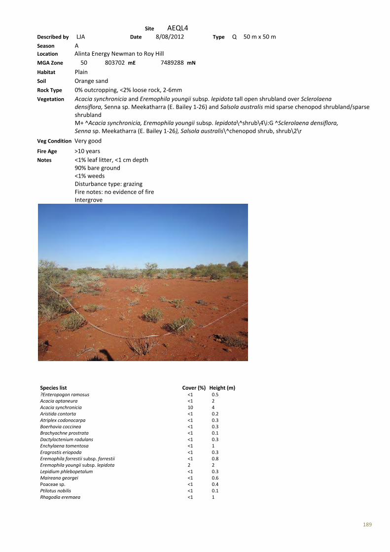
189
Site AEQL4 Described by LJA Date 8/08/2012 Type Q 50 m x 50 m Season A Location Alinta Energy Newman to Roy Hill MGA Zone 50 803702 mE 7489288 mN Habitat Plain Soil Orange sand Rock Type 0% outcropping, <2% loose rock, 2-6mm Vegetation Acacia synchronicia and Eremophila youngii subsp. lepidota tall open shrubland over Sclerolaena densiflora, Senna sp. Meekatharra (E. Bailey 1-26) and Salsola australis mid sparse chenopod shrubland/sparse shrubland M+ ^Acacia synchronicia, Eremophila youngii subsp. lepidota\^shrub\4\i:G ^Sclerolaena densiflora, Senna sp. Meekatharra (E. Bailey 1-26), Salsola australis\^chenopod shrub, shrub\2\r Veg Condition Very good Fire Age >10 years Notes <1% leaf litter, <1 cm depth 90% bare ground <1% weeds Disturbance type: grazing Fire notes: no evidence of fire Intergrove
Species list Cover (%) Height (m) ?Enteropogon ramosus <1 0.5 Acacia aptaneura <1 2 Acacia synchronicia 10 4 Aristida contorta <1 0.2 Atriplex codonocarpa <1 0.3 Boerhavia coccinea <1 0.3 Brachyachne prostrata <1 0.1 Dactyloctenium radulans <1 0.3 Enchylaena tomentosa <1 1 Eragrostis eriopoda <1 0.3 Eremophila forrestii subsp. forrestii <1 0.8 Eremophila youngii subsp. lepidota 2 2 Lepidium phlebopetalum <1 0.3 Maireana georgei <1 0.6 Poaceae sp. <1 0.4 Ptilotus nobilis <1 0.1 Rhagodia eremaea <1 1

190
Salsola australis 2 0.5 Sclerolaena cornishiana <1 0.3 Sclerolaena costata <1 0.2 Sclerolaena cuneata <1 0.5 Sclerolaena densiflora 2 0.3 Senna sp. Meekatharra (E. Bailey 1-26) 2 0.5 Solanum lasiophyllum <1 0.5 Streptoglossa decurrens <1 0.4 Trianthema triquetra <1 0.1

191
Site AEQL5 Described by LJA Date 9/08/2012 Type Q 50 m x 50 m Season A Location Alinta Energy Newman to Roy Hill MGA Zone 50 792143 mE 7419660 mN Habitat Valley Soil Red brown clay loam Rock Type 0% outcropping, 0% loose rock, 6-20 mm Vegetation Acacia bivenosa and A. sclerosperma subsp. sclerosperma tall sparse shrubland over Triodia epactia mid hummock grassland M ^Acacia bivenosa, A. sclerosperma subsp. sclerosperma\^shrub\4\r:G ^Triodia epactia \^hummock grass\2\c
Veg Condition Very good Fire Age >5 years Notes 2% leaf litter, 1-2cm depth 65% bare ground >1% weeds Disturbance type: grazed, possibly some clearing (very old road) Fire notes: no evidence of recent fire
Species list Cover (%) Height (m) Acacia bivenosa 2 2.5 Acacia dictyophleba <1 1.5 Acacia inaequilatera <1 3.5 Acacia sclerosperma subsp. sclerosperma 1 2.5 Aristida contorta <1 0.2 Aristida inaequiglumis <1 0.3 Bulbostylis barbata <1 0.1 *Cenchrus ciliaris <1 0.6 Cleome viscosa <1 0.4 Corymbia hamersleyana <1 0.5 Cymbopogon ambiguus <1 0.8 Dicrastylis cordifolia <1 0.6 Dysphania rhadinostachya <1 0.2 Enneapogon caerulescens <1 0.2 Enneapogon sp. <1 0.3 Eragrostis eriopoda <1 0.4 Eremophila cuneifolia <1 0.6 Eremophila platycalyx subsp. pardalota 1 1.8 Eucalyptus gamophylla <1 3.5 Euphorbia australis <1 0.1
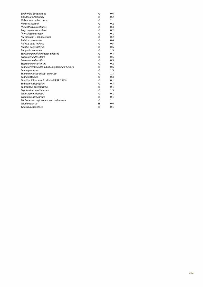
192
Euphorbia boophthona <1 0.6 Goodenia vilmoriniae <1 0.2 Hakea lorea subsp. lorea <1 2 Hibiscus burtonii <1 0.2 Hybanthus aurantiacus <1 0.3 Polycarpaea corymbosa <1 0.2 *Portulaca oleracea <1 0.1 Pterocaulon ? sphacelatum <1 0.2 Ptilotus astrolasius <1 0.6 Ptilotus calostachyus <1 0.5 Ptilotus polystachyus <1 0.6 Rhagodia eremaea <1 1.5 Scaevola parvifolia subsp. pilbarae <1 0.3 Sclerolaena densiflora <1 0.5 Sclerolaena densiflora <1 0.3 Sclerolaena eriacantha <1 0.2 Senna artemisioides subsp. oligophylla x helmsii <1 0.6 Senna glutinosa <1 1.5 Senna glutinosa subsp. pruinosa <1 1.3 Senna notabilis <1 0.3 Sida ?sp. Pilbara (A.A. Mitchell PRP 1543) <1 0.1 Solanum lasiophyllum <1 0.3 Sporobolus australasicus <1 0.1 Stylobasium spathulatum <1 1.5 Trianthema triquetra <1 0.1 Tribulus macrocarpus <1 0.1 Trichodesma zeylanicum var. zeylanicum <1 1 Triodia epactia 35 0.6 Yakirra australiensis <1 0.1
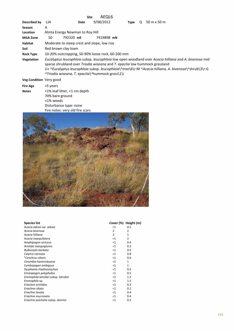
193
Site AEQL6 Described by LJA Date 9/08/2012 Type Q 50 m x 50 m Season A Location Alinta Energy Newman to Roy Hill MGA Zone 50 792320 mE 7419898 mN Habitat Moderate to steep crest and slope, low rise Soil Red brown clay loam Rock Type 10-20% outcropping, 50-90% loose rock, 60-200 mm Vegetation Eucalyptus leucophloia subsp. leucophloia low open woodland over Acacia hilliana and A. bivenosa mid sparse shrubland over Triodia wiseana and T. epactia low hummock grassland U+ ^Eucalyptus leucophloia subsp. leucophloia\^tree\6\r:M ^Acacia hilliana, A. bivenosa\^shrub\3\r:G ^Triodia wiseana, T. epactia\^hummock grass\1\i
Veg Condition Very good Fire Age >5 years Notes <1% leaf litter, <1 cm depth 70% bare ground <1% weeds Disturbance type: none Fire notes: very old fire scars
Species list Cover (%) Height (m) Acacia adoxa var. adoxa <1 0.5 Acacia bivenosa 2 2 Acacia hilliana 3 1 Acacia inaequilatera <1 2 Amphipogon sericeus <1 0.4 Aristida inaequiglumis <1 0.3 Bulbostylis barbata <1 0.4 Calytrix carinata <1 0.8 *Cenchrus ciliaris <1 0.6 Corymbia hamersleyana <1 1 Cymbopogon ambiguus <1 1 Dysphania rhadinostachya <1 0.3 Enneapogon polyphyllus <1 0.5 Eremophila latrobei subsp. latrobei <1 1.3 Eremophila sp. <1 1.5 Eriachne aristidea <1 0.3 Eriachne ciliata <1 0.2 Eriachne lanata <1 0.4 Eriachne mucronata <1 0.4 Eriachne pulchella subsp. dominii <1 0.2
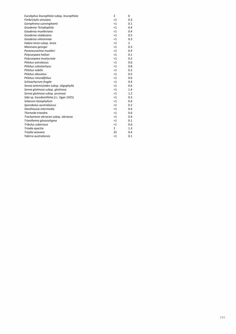
194
Eucalyptus leucophloia subsp. leucophloia 2 6 Fimbristylis simulans <1 0.3 Gomphrena cunninghamii <1 0.1 Goodenia ?triodiophila <1 0.4 Goodenia muelleriana <1 0.4 Goodenia stobbsiana <1 0.5 Goodenia vilmoriniae <1 0.3 Hakea lorea subsp. lorea <1 2 Maireana georgei <1 0.3 Paraneurachne muelleri <1 0.4 Polycarpaea holtzei <1 0.1 Polycarpaea involucrata <1 0.2 Ptilotus astrolasius <1 0.6 Ptilotus calostachyus <1 0.8 Ptilotus nobilis <1 0.2 Ptilotus obovatus <1 0.5 Ptilotus rotundifolius <1 0.6 Schizachyrium fragile <1 0.4 Senna artemisioides subsp. oligophylla <1 0.6 Senna glutinosa subsp. glutinosa <1 1.4 Senna glutinosa subsp. pruinosa <1 1.2 Sida sp. Excedentifolia (J.L. Egan 1925) <1 0.3 Solanum lasiophyllum <1 0.4 Sporobolus australasicus <1 0.2 Stackhousia intermedia <1 0.4 Themeda triandra <1 0.6 Trachymene oleracea subsp. oleracea <1 0.4 Trianthema glossostigma <1 0.1 Tribulus suberosus <1 0.6 Triodia epactia 2 1.3 Triodia wiseana 25 0.4 Yakirra australiensis <1 0.1

195
Site AEQL7 Described by LJA Date 9/08/2012 Type Q 50*50 m Season A Location Alinta Energy Newman to Roy Hill MGA Zone 50 792983 mE 7421494 mN Habitat Valley Soil Red brown loamy sand Rock Type 0% outcropping, <2% loose rock cover, 20-60 mm rock size Vegetation Corymbia candida subsp. dipsodes and Hakea lorea subsp. lorea low scattered trees over Acacia sclerosperma subsp. sclerosperma tall sparse shrubland over *Cenchrus ciliaris and Triodia epactia mid open tussock grassland/open hummock grassland U+ ^Corymbia candida subsp. dipsodes, Hakea lorea subsp. lorea\^tree\6\bi:M ^Acacia sclerosperma subsp. sclerosperma\^shrub\4\r:G ^Cenchrus ciliaris, Triodia epactia \^tussock grass, hummock grass\2\i Veg Condition Good Fire Age >5years Notes 1% leaf litter, <1 cm depth 70% bare ground 20% weeds Disturbance type: grazed Fire notes: no evidence of recent fire
Species list Cover (%) Height (m) Acacia aptaneura <1 2 Acacia sclerosperma subsp. sclerosperma 3 2 Acacia synchronicia <1 1.2 Aristida contorta <1 0.2 Aristida contorta <1 0.2 Aristida inaequiglumis <1 0.5 Boerhavia coccinea <1 0.1 Bonamia erecta <1 0.4 Bulbostylis barbata <1 0.1 *Cenchrus ciliaris 20 0.6 Chrysocephalum pterochaetum <1 0.4 Chrysopogon fallax <1 1.2 Cleome viscosa <1 0.3 Corchorus tridens <1 0.2 Corymbia candida subsp. dipsodes 1 6 Cymbopogon ambiguus <1 1.2 Duperreya commixta <1 climber Enneapogon polyphyllus <1 0.3 Eragrostis eriopoda 1 0.4
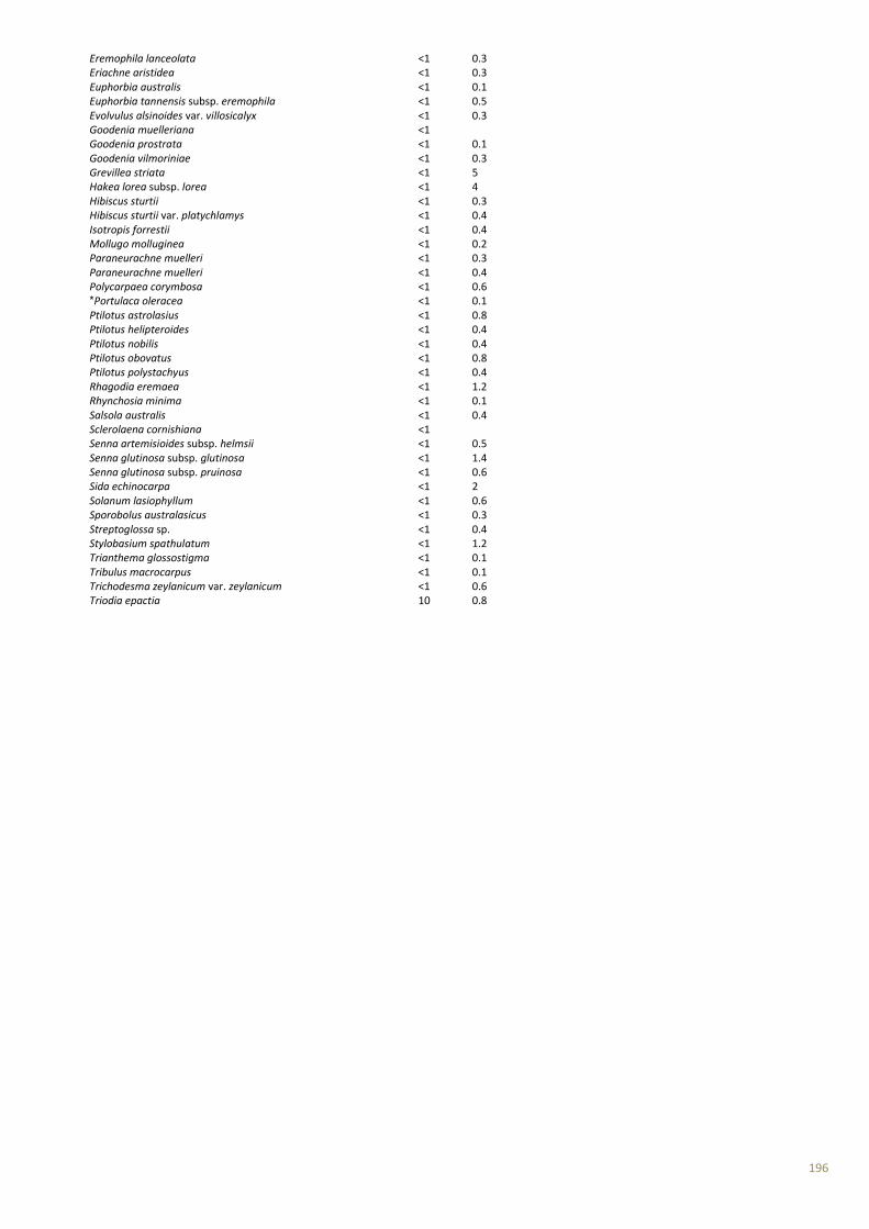
196
Eremophila lanceolata <1 0.3 Eriachne aristidea <1 0.3 Euphorbia australis <1 0.1 Euphorbia tannensis subsp. eremophila <1 0.5 Evolvulus alsinoides var. villosicalyx <1 0.3 Goodenia muelleriana <1 Goodenia prostrata <1 0.1 Goodenia vilmoriniae <1 0.3 Grevillea striata <1 5 Hakea lorea subsp. lorea <1 4 Hibiscus sturtii <1 0.3 Hibiscus sturtii var. platychlamys <1 0.4 Isotropis forrestii <1 0.4 Mollugo molluginea <1 0.2 Paraneurachne muelleri <1 0.3 Paraneurachne muelleri <1 0.4 Polycarpaea corymbosa <1 0.6 *Portulaca oleracea <1 0.1 Ptilotus astrolasius <1 0.8 Ptilotus helipteroides <1 0.4 Ptilotus nobilis <1 0.4 Ptilotus obovatus <1 0.8 Ptilotus polystachyus <1 0.4 Rhagodia eremaea <1 1.2 Rhynchosia minima <1 0.1 Salsola australis <1 0.4 Sclerolaena cornishiana <1 Senna artemisioides subsp. helmsii <1 0.5 Senna glutinosa subsp. glutinosa <1 1.4 Senna glutinosa subsp. pruinosa <1 0.6 Sida echinocarpa <1 2 Solanum lasiophyllum <1 0.6 Sporobolus australasicus <1 0.3 Streptoglossa sp. <1 0.4 Stylobasium spathulatum <1 1.2 Trianthema glossostigma <1 0.1 Tribulus macrocarpus <1 0.1 Trichodesma zeylanicum var. zeylanicum <1 0.6 Triodia epactia 10 0.8
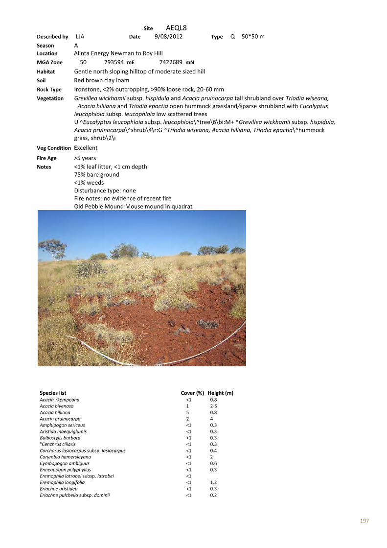
197
Site AEQL8 Described by LJA Date 9/08/2012 Type Q 50*50 m Season A Location Alinta Energy Newman to Roy Hill MGA Zone 50 793594 mE 7422689 mN Habitat Gentle north sloping hilltop of moderate sized hill Soil Red brown clay loam Rock Type Ironstone, <2% outcropping, >90% loose rock, 20-60 mm Vegetation Grevillea wickhamii subsp. hispidula and Acacia pruinocarpa tall shrubland over Triodia wiseana, Acacia hilliana and Triodia epactia open hummock grassland/sparse shrubland with Eucalyptus leucophloia subsp. leucophloia low scattered trees U ^Eucalyptus leucophloia subsp. leucophloia\^tree\6\bi:M+ ^Grevillea wickhamii subsp. hispidula, Acacia pruinocarpa\^shrub\4\r:G ^Triodia wiseana, Acacia hilliana, Triodia epactia\^hummock grass, shrub\2\i
Veg Condition Excellent Fire Age >5 years Notes <1% leaf litter, <1 cm depth 75% bare ground <1% weeds Disturbance type: none Fire notes: no evidence of recent fire Old Pebble Mound Mouse mound in quadrat
Species list Cover (%) Height (m) Acacia ?kempeana <1 0.8 Acacia bivenosa 1 2-5 Acacia hilliana 5 0.8 Acacia pruinocarpa 2 4 Amphipogon sericeus <1 0.3 Aristida inaequiglumis <1 0.3 Bulbostylis barbata <1 0.3 *Cenchrus ciliaris <1 0.3 Corchorus lasiocarpus subsp. lasiocarpus <1 0.4 Corymbia hamersleyana <1 2 Cymbopogon ambiguus <1 0.6 Enneapogon polyphyllus <1 0.3 Eremophila latrobei subsp. latrobei <1 Eremophila longifolia <1 1.2 Eriachne aristidea <1 0.3 Eriachne pulchella subsp. dominii <1 0.2
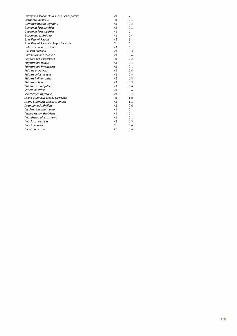
198
Eucalyptus leucophloia subsp. leucophloia <1 7 Euphorbia australis <1 0.1 Gomphrena cunninghamii <1 0.2 Goodenia ?triodiophila <1 0.3 Goodenia ?triodiophila <1 0.4 Goodenia stobbsiana <1 0.4 Grevillea wickhamii <1 3 Grevillea wickhamii subsp. hispidula 2 4 Hakea lorea subsp. lorea <1 3 Hibiscus burtonii <1 0.3 Paraneurachne muelleri <1 0.4 Polycarpaea corymbosa <1 0.2 Polycarpaea holtzei <1 0.1 Polycarpaea involucrata <1 0.1 Ptilotus astrolasius <1 0.6 Ptilotus calostachyus <1 0.8 Ptilotus helipteroides <1 0.3 Ptilotus nobilis <1 0.3 Ptilotus rotundifolius <1 0.6 Salsola australis <1 0.4 Schizachyrium fragile <1 0.2 Senna glutinosa subsp. glutinosa <1 1.8 Senna glutinosa subsp. pruinosa <1 1.2 Solanum lasiophyllum <1 0.6 Stackhousia intermedia <1 0.3 Stenopetalum decipiens <1 0.4 Trianthema glossostigma <1 0.1 Tribulus suberosus <1 0.5 Triodia epactia 2 0.6 Triodia wiseana 20 0.4
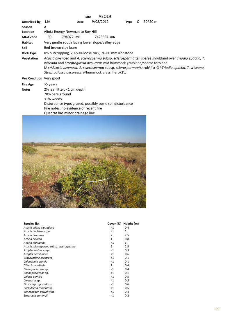
199
Site AEQL9 Described by LJA Date 9/08/2012 Type Q 50*50 m Season A Location Alinta Energy Newman to Roy Hill MGA Zone 50 794072 mE 7423694 mN Habitat Very gentle south facing lower slope/valley edge Soil Red brown clay loam Rock Type 0% outcropping, 20-50% loose rock, 20-60 mm ironstone Vegetation Acacia bivenosa and A. sclerosperma subsp. sclerosperma tall sparse shrubland over Triodia epactia, T. wiseana and Streptoglossa decurrens mid hummock grassland/sparse forbland M+ ^Acacia bivenosa, A. sclerosperma subsp. sclerosperma\^shrub\4\r:G ^Triodia epactia, T. wiseana, Streptoglossa decurrens \^hummock grass, herb\2\c
Veg Condition Very good Fire Age >5 years Notes 2% leaf litter, <1 cm depth 70% bare ground <1% weeds Disturbance type: grazed, possibly some soil disturbance Fire notes: no evidence of recent fire Quadrat has minor drainage line
Species list Cover (%) Height (m) Acacia adoxa var. adoxa <1 0.4 Acacia ancistrocarpa <1 2 Acacia bivenosa 2 2.5 Acacia hilliana 1 0.8 Acacia maitlandii <1 3 Acacia sclerosperma subsp. sclerosperma 2 2.5 Atriplex codonocarpa <1 0.3 Atriplex semilunaris <1 0.6 Brachyachne prostrata <1 0.1 Calandrinia pumila <1 0.1 *Cenchrus ciliaris 1 0.4 Chenopodiaceae sp. <1 0.4 Chenopodiaceae sp. <1 0.1 Chloris pumilio <1 0.5 Corchorus sp. <1 0.5 Dissocarpus paradoxus <1 0.6 Enchylaena tomentosa <1 0.5 Enneapogon polyphyllus <1 0.4 Eragrostis cumingii <1 0.2

200
Eragrostis dielsii <1 0.1 Eragrostis eriopoda <1 0.4 Eragrostis falcata <1 0.4 Eragrostis setifolia <1 0.1 Eriachne aristidea <1 0.3 Eucalyptus leucophloia subsp. leucophloia <1 2 Goodenia muelleriana <1 0.2 Goodenia vilmoriniae <1 0.3 Gossypium robinsonii <1 2 Haloragis gossei var. gossei <1 0.4 Hibiscus sturtii <1 0.3 Isotropis atropurpurea <1 0.5 Lepidium phlebopetalum <1 0.1 Maireana tomentosa subsp. tomentosa <1 0.3 Pluchea rubelliflora 1 0.4 Polycarpaea holtzei <1 0.1 Ptilotus nobilis <1 0.4 Salsola australis <1 0.5 Sclerolaena costata 1 0.4 Senna notabilis <1 0.1 Streptoglossa decurrens 2 0.4 Trianthema glossostigma <1 0.1 Triodia epactia 30 0.8 Triodia wiseana 2 0.4

201
Site AERL-1 Described by LJA Date 3/08/2012 Type R Season A Location Alinta Energy Newman to Roy Hill MGA Zone 50 798765 mE 7433592 mN Habitat Flat Soil Red clay loam Rock Type n/a Vegetation Acacia synchronicia and Acacia sclerosperma subsp. sclerosperma tall sparse shrubland over Triodia epactia, *Cenchrus ciliaris and Eragrostis eriopoda mid open hummock grassland/low sparse tussock grassland with Corymbia hamersleyana low scattered trees U+ ^Corymbia hamersleyana\^tree\6\bi;M ^Acacia synchronicia,Acacia sclerosperma\^shrub\4\r;G ^Triodia epactia,Cenchrus ciliaris,Eragrostis eriopoda\^hummock grass,tussock grass\2\i Veg Condition Good Fire Age > 5 years Notes Disturbance: grazing 2% weed cover
Species list Acacia sclerosperma subsp. sclerosperma Acacia synchronicia *Cenchrus ciliaris Corymbia hamersleyana Eragrostis eriopoda Triodia epactia
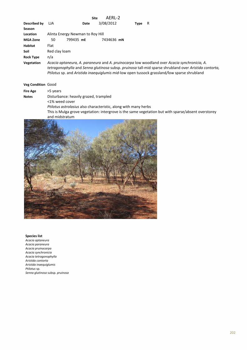
202
Site AERL-2 Described by LJA Date 3/08/2012 Type R Season Location Alinta Energy Newman to Roy Hill MGA Zone 50 799435 mE 7434636 mN Habitat Flat Soil Red clay loam Rock Type n/a Vegetation Acacia aptaneura, A. paraneura and A. pruinocarpa low woodland over Acacia synchronicia, A. tetragonophylla and Senna glutinosa subsp. pruinosa tall-mid sparse shrubland over Aristida contorta, Ptilotus sp. and Aristida inaequiglumis mid-low open tussock grassland/low sparse shrubland
Veg Condition Good Fire Age >5 years Notes Disturbance: heavily grazed, trampled <1% weed cover Ptilotus astrolasius also characteristic, along with many herbs This is Mulga grove vegetation: intergrove is the same vegetation but with sparse/absent overstorey and midstratum
Species list Acacia aptaneura Acacia paraneura Acacia pruinocarpa Acacia synchronicia Acacia tetragonophylla Aristida contorta Aristida inaequiglumis Ptilotus sp. Senna glutinosa subsp. pruinosa

203
Site AERL-3 Described by LJA Date 4/08/2012 Type R Season A Location Alinta Energy Newman to Roy Hill MGA Zone 50 802623 mE 7439828 mN Habitat Flat Soil Red sandy loam Rock Type Mixed rock type, <2% cover, no outcropping Vegetation Triodia basedowii, ?Glycine sp. and Bonamia erecta mid open hummock grassland/low sparse shrubland with Acacia pachyacra tall scattered shrubs
Veg Condition Very good Fire Age >5 years Notes Disturbance: a few signs of grazing
Species list ?Glycine sp. Acacia pachyacra Bonamia erecta Triodia basedowii

204
Site AERL-4 Described by LJA Date 4/08/2012 Type R Season Location Alinta Energy Newman to Roy Hill MGA Zone 50 804410 mE 7445402 mN Habitat Flat Soil Red clay loam Rock Type n/a Vegetation Triodia basedowii low hummock grassland with Corymbia deserticola subsp. deserticola low scattered trees with Acacia ancistrocarpa and Hakea chordophylla tall-mid scattered shrubs
Veg Condition Excellent Fire Age >5 years Notes No evidence of disturbance No weeds
Species list Acacia ancistrocarpa Corymbia deserticola subsp. deserticola Hakea chordophylla Triodia basedowii
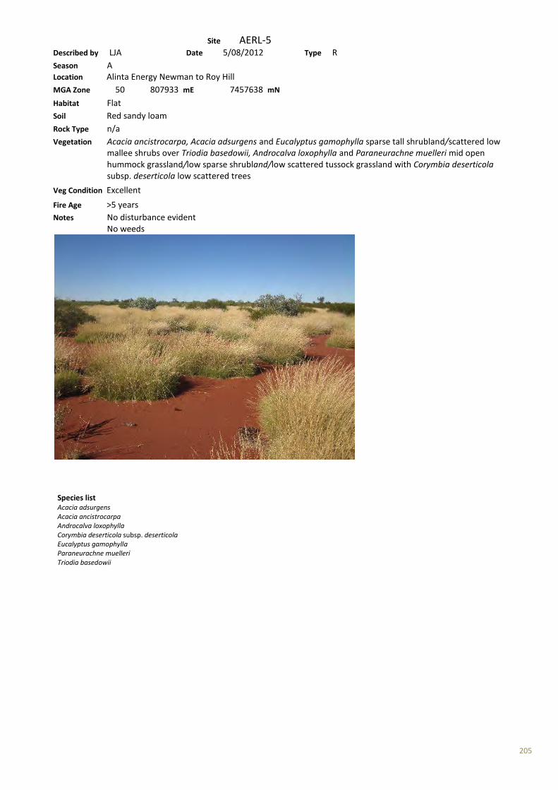
205
Site AERL-5 Described by LJA Date 5/08/2012 Type R Season A Location Alinta Energy Newman to Roy Hill MGA Zone 50 807933 mE 7457638 mN Habitat Flat Soil Red sandy loam Rock Type n/a Vegetation Acacia ancistrocarpa, Acacia adsurgens and Eucalyptus gamophylla sparse tall shrubland/scattered low mallee shrubs over Triodia basedowii, Androcalva loxophylla and Paraneurachne muelleri mid open hummock grassland/low sparse shrubland/low scattered tussock grassland with Corymbia deserticola subsp. deserticola low scattered trees
Veg Condition Excellent Fire Age >5 years Notes No disturbance evident No weeds
Species list Acacia adsurgens Acacia ancistrocarpa Androcalva loxophylla Corymbia deserticola subsp. deserticola Eucalyptus gamophylla Paraneurachne muelleri Triodia basedowii
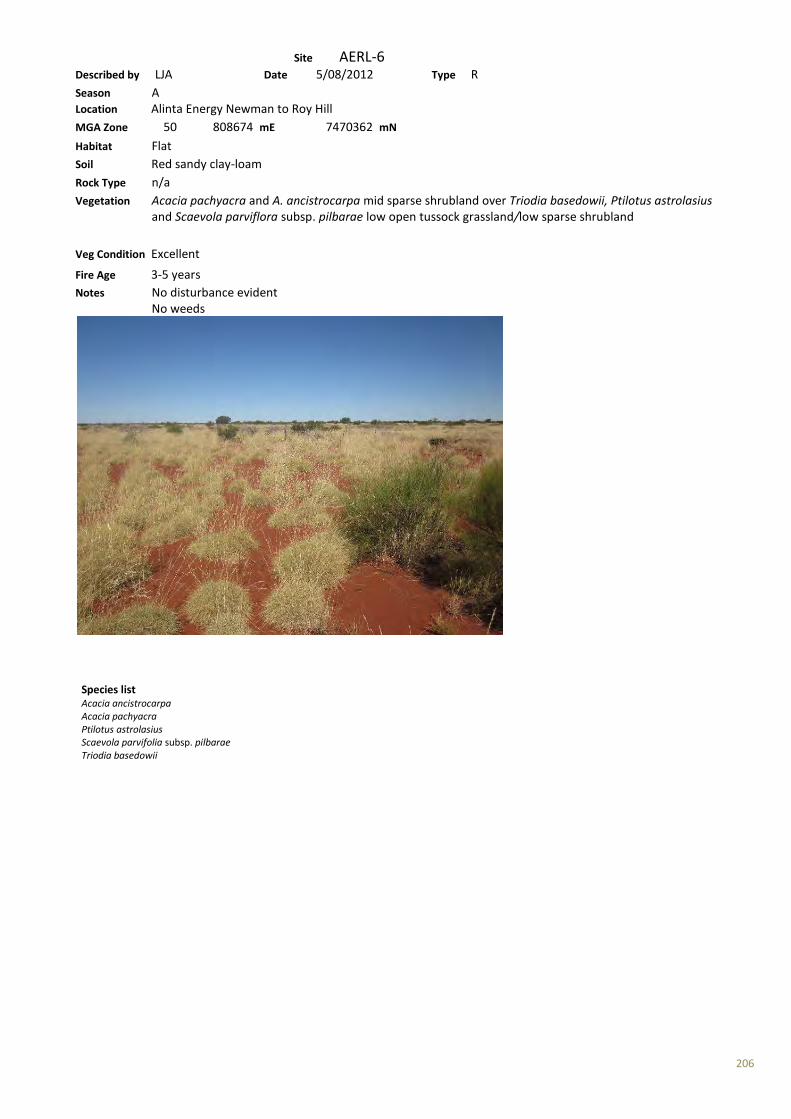
206
Site AERL-6 Described by LJA Date 5/08/2012 Type R Season A Location Alinta Energy Newman to Roy Hill MGA Zone 50 808674 mE 7470362 mN Habitat Flat Soil Red sandy clay-loam Rock Type n/a Vegetation Acacia pachyacra and A. ancistrocarpa mid sparse shrubland over Triodia basedowii, Ptilotus astrolasius and Scaevola parviflora subsp. pilbarae low open tussock grassland/low sparse shrubland
Veg Condition Excellent Fire Age 3-5 years Notes No disturbance evident No weeds
Species list Acacia ancistrocarpa Acacia pachyacra Ptilotus astrolasius Scaevola parvifolia subsp. pilbarae Triodia basedowii
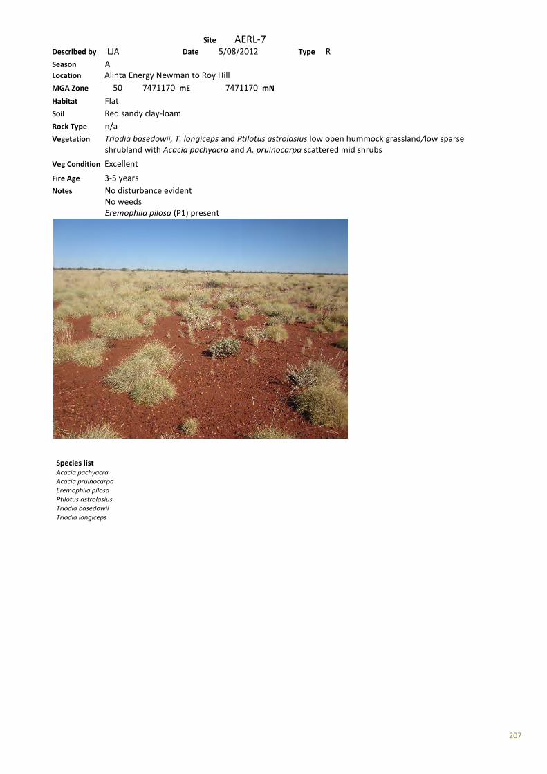
207
Site AERL-7 Described by LJA Date 5/08/2012 Type R Season A Location Alinta Energy Newman to Roy Hill MGA Zone 50 7471170 mE 7471170 mN Habitat Flat Soil Red sandy clay-loam Rock Type n/a Vegetation Triodia basedowii, T. longiceps and Ptilotus astrolasius low open hummock grassland/low sparse shrubland with Acacia pachyacra and A. pruinocarpa scattered mid shrubs
Veg Condition Excellent Fire Age 3-5 years Notes No disturbance evident No weeds Eremophila pilosa (P1) present
Species list Acacia pachyacra Acacia pruinocarpa Eremophila pilosa Ptilotus astrolasius Triodia basedowii Triodia longiceps

208
Site AERL-8 Described by LJA Date 6/08/2012 Type R Season A Location Alinta Energy Newman to Roy Hill MGA Zone 50 808558 mE 7468433 mN Habitat Flat Soil Red loamy sand Rock Type n/a Vegetation Triodia basedowii, T. longiceps and Ptilotus astrolasius mid-low open hummock grassland/low sparse shrubland with Acacia pachyacra and A. ancistrocarpa tall scattered shrubs
Veg Condition Excellent Fire Age >5 years Notes No disturbance evident Sparse Eremophila pilosa (P1) Many other grass species characteristic including Aristida spp., Paraneurachne muelleri
Species list Acacia ancistrocarpa Acacia pachyacra Eremophila pilosa Ptilotus astrolasius Triodia basedowii Triodia longiceps
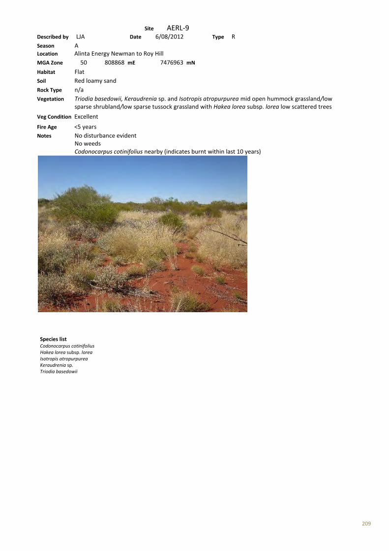
209
Site AERL-9 Described by LJA Date 6/08/2012 Type R Season A Location Alinta Energy Newman to Roy Hill MGA Zone 50 808868 mE 7476963 mN Habitat Flat Soil Red loamy sand Rock Type n/a Vegetation Triodia basedowii, Keraudrenia sp. and Isotropis atropurpurea mid open hummock grassland/low sparse shrubland/low sparse tussock grassland with Hakea lorea subsp. lorea low scattered trees
Veg Condition Excellent Fire Age <5 years Notes No disturbance evident No weeds Codonocarpus cotinifolius nearby (indicates burnt within last 10 years)
Species list Codonocarpus cotinifolius Hakea lorea subsp. lorea Isotropis atropurpurea Keraudrenia sp. Triodia basedowii
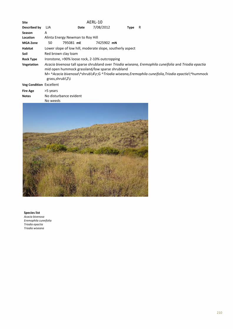
210
Site AERL-10 Described by LJA Date 7/08/2012 Type R Season A Location Alinta Energy Newman to Roy Hill MGA Zone 50 795081 mE 7425902 mN Habitat Lower slope of low hill, moderate slope, southerly aspect Soil Red brown clay loam Rock Type Ironstone, >90% loose rock, 2-10% outcropping Vegetation Acacia bivenosa tall sparse shrubland over Triodia wiseana, Eremophila cuneifolia and Triodia epactia mid open hummock grassland/low sparse shrubland M+ ^Acacia bivenosa\^shrub\4\r;G ^Triodia wiseana,Eremophila cuneifolia,Triodia epactia\^hummock grass,shrub\2\i
Veg Condition Excellent Fire Age >5 years Notes No disturbance evident No weeds
Species list Acacia bivenosa Eremophila cuneifolia Triodia epactia Triodia wiseana
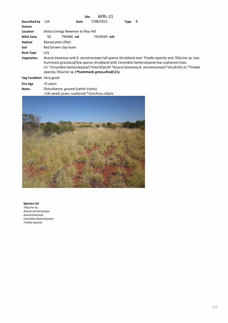
211
Site AERL-11 Described by LJA Date 7/08/2012 Type R Season Location Alinta Energy Newman to Roy Hill MGA Zone 50 794466 mE 7424550 mN Habitat Raised plain (flat) Soil Red brown clay loam Rock Type n/a Vegetation Acacia bivenosa and A. ancistrocarpa tall sparse shrubland over Triodia epactia and ?Glycine sp. low hummock grassland/low sparse shrubland with Corymbia hamersleyana low scattered trees U+ ^Corymbia hamersleyana\^tree\6\bi;M ^Acacia bivenosa,A. ancistrocarpa\^shrub\4\r;G ^Triodia epactia,?Glycine sp.\^hummock grass,shrub\1\c
Veg Condition Very good Fire Age >5 years Notes Disturbance: grazed (cattle tracks) <1% weed cover; scattered *Cenchrus ciliaris
Species list ?Glycine sp. Acacia ancistrocarpa Acacia bivenosa Corymbia hamersleyana Triodia epactia
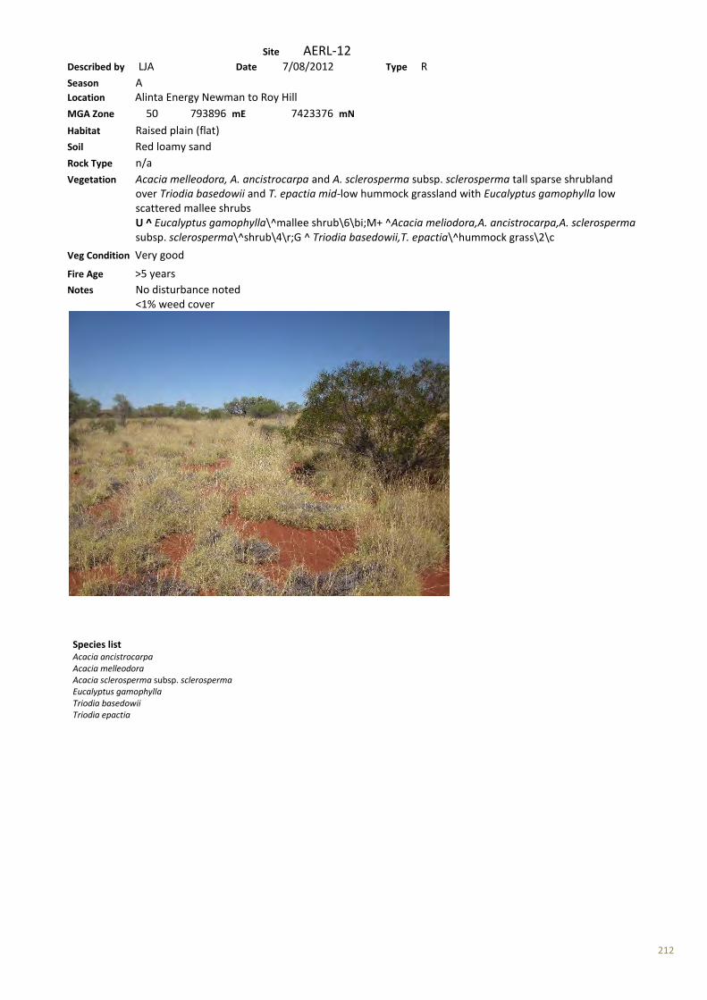
212
Site AERL-12 Described by LJA Date 7/08/2012 Type R Season A Location Alinta Energy Newman to Roy Hill MGA Zone 50 793896 mE 7423376 mN Habitat Raised plain (flat) Soil Red loamy sand Rock Type n/a Vegetation Acacia melleodora, A. ancistrocarpa and A. sclerosperma subsp. sclerosperma tall sparse shrubland over Triodia basedowii and T. epactia mid-low hummock grassland with Eucalyptus gamophylla low scattered mallee shrubs U ^ Eucalyptus gamophylla\^mallee shrub\6\bi;M+ ^Acacia meliodora,A. ancistrocarpa,A. sclerosperma subsp. sclerosperma\^shrub\4\r;G ^ Triodia basedowii,T. epactia\^hummock grass\2\c Veg Condition Very good Fire Age >5 years Notes No disturbance noted <1% weed cover
Species list Acacia ancistrocarpa Acacia melleodora Acacia sclerosperma subsp. sclerosperma Eucalyptus gamophylla Triodia basedowii Triodia epactia
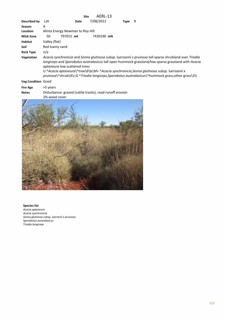
213
Site AERL-13 Described by LJA Date 7/08/2012 Type R Season A Location Alinta Energy Newman to Roy Hill MGA Zone 50 797015 mE 7430190 mN Habitat Valley (flat) Soil Red loamy sand Rock Type n/a Vegetation Acacia synchronicia and Senna glutinosa subsp. luerssenii x pruinosa tall sparse shrubland over Triodia longiceps and Sporobolus australasicus tall open hummock grassland/low sparse grassland with Acacia aptaneura low scattered trees U ^Acacia aptaneura\^tree\6\bi;M+ ^Acacia synchronicia,Senna glutinosa subsp. luerssenii x pruinosa\^shrub\4\r;G ^Triodia longiceps,Sporobolus australasicus\^hummock grass,other grass\3\i Veg Condition Good Fire Age >5 years Notes Disturbance: grazed (cattle tracks), road runoff erosion 2% weed cover
Species list Acacia aptaneura Acacia synchronicia Senna glutinosa subsp. luersenii x pruinosa Sporobolus australasicus Triodia longiceps
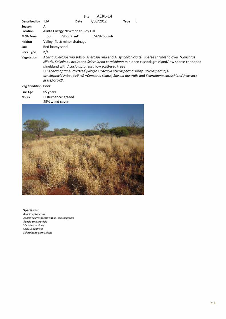
214
Site AERL-14 Described by LJA Date 7/08/2012 Type R Season A Location Alinta Energy Newman to Roy Hill MGA Zone 50 796662 mE 7429260 mN Habitat Valley (flat); minor drainage Soil Red loamy sand Rock Type n/a Vegetation Acacia sclerosperma subsp. sclerosperma and A. synchronicia tall sparse shrubland over *Cenchrus ciliaris, Salsola australis and Sclerolaena cornishiana mid open tussock grassland/low sparse chenopod shrubland with Acacia aptaneura low scattered trees U ^Acacia aptaneura\^tree\6\bi;M+ ^Acacia sclerosperma subsp. sclerosperma,A. synchronicia\^shrub\4\r;G ^Cenchrus ciliaris, Salsola australis and Sclerolaena cornishiana\^tussock grass,forb\2\i
Veg Condition Poor Fire Age >5 years Notes Disturbance: grazed 25% weed cover
Species list Acacia aptaneura Acacia sclerosperma subsp. sclerosperma Acacia synchronicia *Cenchrus ciliaris Salsola australis Sclerolaena cornishiana
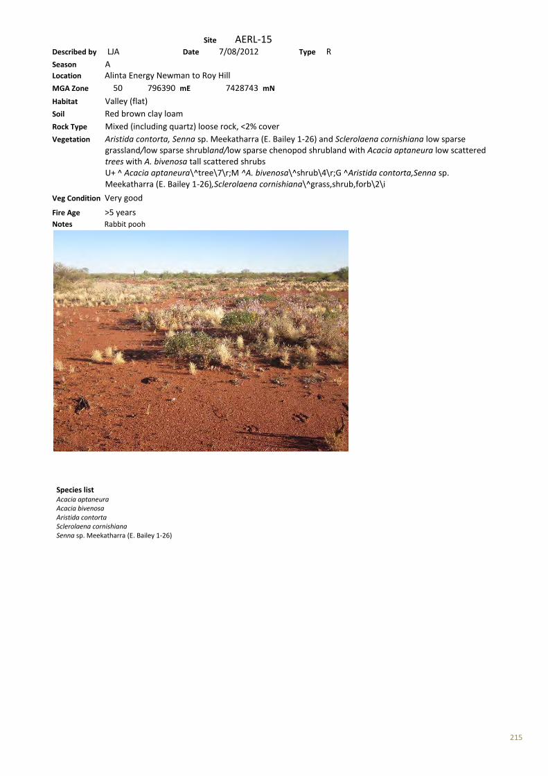
215
Site AERL-15 Described by LJA Date 7/08/2012 Type R Season A Location Alinta Energy Newman to Roy Hill MGA Zone 50 796390 mE 7428743 mN Habitat Valley (flat) Soil Red brown clay loam Rock Type Mixed (including quartz) loose rock, <2% cover Vegetation Aristida contorta, Senna sp. Meekatharra (E. Bailey 1-26) and Sclerolaena cornishiana low sparse grassland/low sparse shrubland/low sparse chenopod shrubland with Acacia aptaneura low scattered trees with A. bivenosa tall scattered shrubs U+ ^ Acacia aptaneura\^tree\7\r;M ^A. bivenosa\^shrub\4\r;G ^Aristida contorta,Senna sp. Meekatharra (E. Bailey 1-26),Sclerolaena cornishiana\^grass,shrub,forb\2\i Veg Condition Very good Fire Age >5 years Notes Rabbit pooh
Species list Acacia aptaneura Acacia bivenosa Aristida contorta Sclerolaena cornishiana Senna sp. Meekatharra (E. Bailey 1-26)
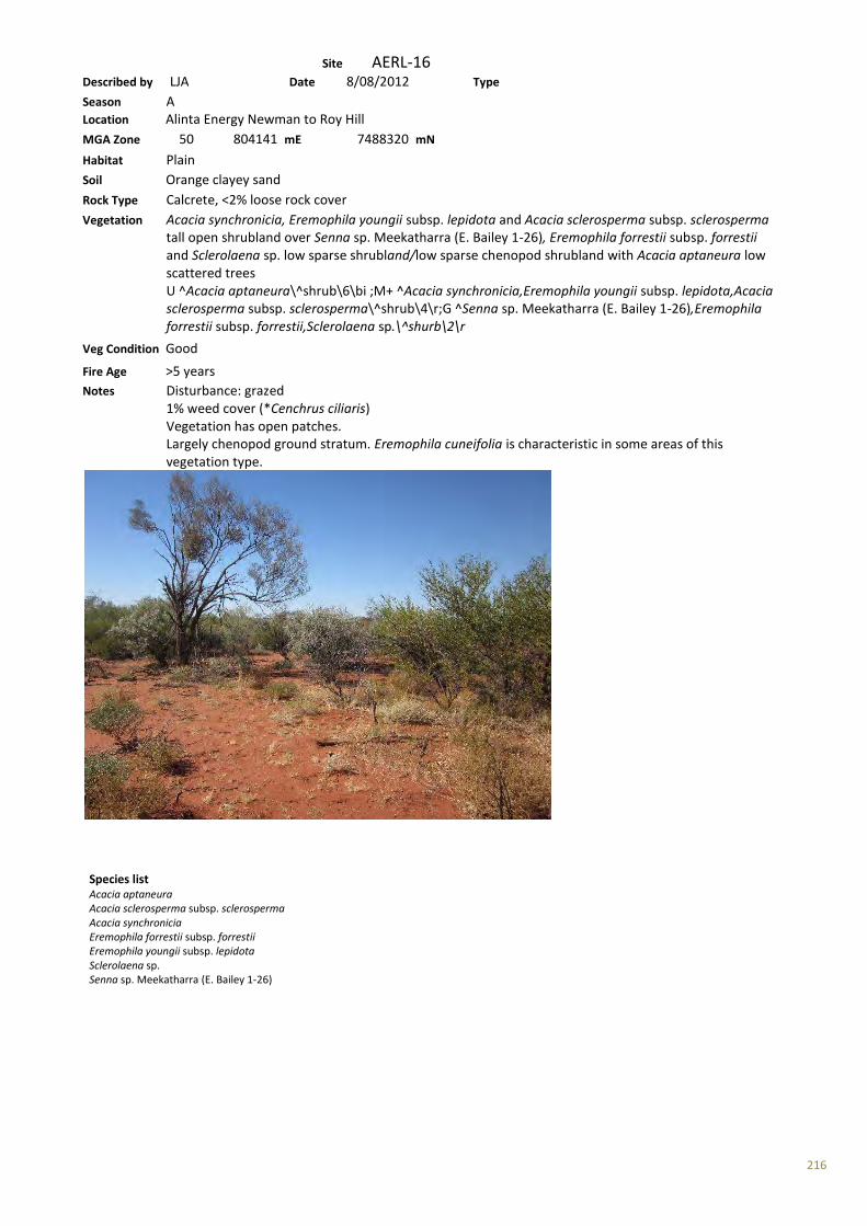
216
Site AERL-16 Described by LJA Date 8/08/2012 Type Season A Location Alinta Energy Newman to Roy Hill MGA Zone 50 804141 mE 7488320 mN Habitat Plain Soil Orange clayey sand Rock Type Calcrete, <2% loose rock cover Vegetation Acacia synchronicia, Eremophila youngii subsp. lepidota and Acacia sclerosperma subsp. sclerosperma tall open shrubland over Senna sp. Meekatharra (E. Bailey 1-26), Eremophila forrestii subsp. forrestii and Sclerolaena sp. low sparse shrubland/low sparse chenopod shrubland with Acacia aptaneura low scattered trees U ^Acacia aptaneura\^shrub\6\bi ;M+ ^Acacia synchronicia,Eremophila youngii subsp. lepidota,Acacia sclerosperma subsp. sclerosperma\^shrub\4\r;G ^Senna sp. Meekatharra (E. Bailey 1-26),Eremophila forrestii subsp. forrestii,Sclerolaena sp.\^shurb\2\r
Veg Condition Good Fire Age >5 years Notes Disturbance: grazed 1% weed cover (*Cenchrus ciliaris) Vegetation has open patches. Largely chenopod ground stratum. Eremophila cuneifolia is characteristic in some areas of this vegetation type.
Species list Acacia aptaneura Acacia sclerosperma subsp. sclerosperma Acacia synchronicia Eremophila forrestii subsp. forrestii Eremophila youngii subsp. lepidota Sclerolaena sp. Senna sp. Meekatharra (E. Bailey 1-26)
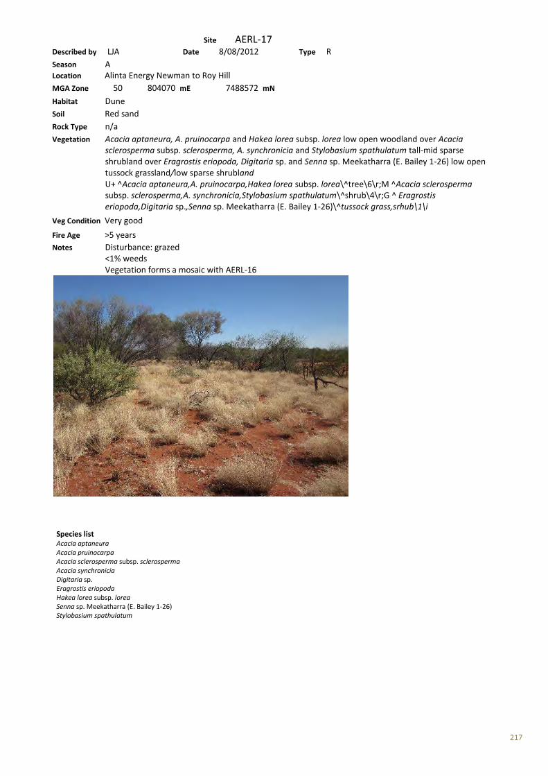
217
Site AERL-17 Described by LJA Date 8/08/2012 Type R Season A Location Alinta Energy Newman to Roy Hill MGA Zone 50 804070 mE 7488572 mN Habitat Dune Soil Red sand Rock Type n/a Vegetation Acacia aptaneura, A. pruinocarpa and Hakea lorea subsp. lorea low open woodland over Acacia sclerosperma subsp. sclerosperma, A. synchronicia and Stylobasium spathulatum tall-mid sparse shrubland over Eragrostis eriopoda, Digitaria sp. and Senna sp. Meekatharra (E. Bailey 1-26) low open tussock grassland/low sparse shrubland U+ ^Acacia aptaneura,A. pruinocarpa,Hakea lorea subsp. lorea\^tree\6\r;M ^Acacia sclerosperma subsp. sclerosperma,A. synchronicia,Stylobasium spathulatum\^shrub\4\r;G ^ Eragrostis eriopoda,Digitaria sp.,Senna sp. Meekatharra (E. Bailey 1-26)\^tussock grass,srhub\1\i
Veg Condition Very good Fire Age >5 years Notes Disturbance: grazed <1% weeds Vegetation forms a mosaic with AERL-16
Species list Acacia aptaneura Acacia pruinocarpa Acacia sclerosperma subsp. sclerosperma Acacia synchronicia Digitaria sp. Eragrostis eriopoda Hakea lorea subsp. lorea Senna sp. Meekatharra (E. Bailey 1-26) Stylobasium spathulatum

218
Site AERL-18 Described by LJA Date 8/08/2012 Type R Season A Location Alinta Energy Newman to Roy Hill MGA Zone 50 803953 mE 7489919 mN Habitat Floodplain Soil Red brown clay loam Rock Type n/a Vegetation Eucalyptus victrix and Acacia aptanerua low open woodland over Acacia tetragonophylla and *Vachellia farnesiana tall-mid sparse shrubland over Urochloa occidentalis var. occidentalis, Eragrostis xerophylla and *Malvastrum americanum mid tussock grassland/low sparse forband U+ ^Eucalyptus victrix,Acacia aptanerua\^tree\6\r;M ^Acacia salicina,Alectryon oleifolius,Acacia stenophylla\^shrub\4\r;G ^Aristida ramosa,Astrebla squarrosa,Bothriochloa decipiens\^tussock grass,forb\2\i
Veg Condition Good Fire Age >10 years Notes Disturbance: grazed 5% weed cover Many grass species: some areas dominated by Chrysopogon fallax
Species list Acacia aptaneura Acacia tetragonophylla Eragrostis xerophila Eucalyptus victrix *Malvastrum americanum Urochloa occidentalis var. occidentalis *Vachellia farnesiana
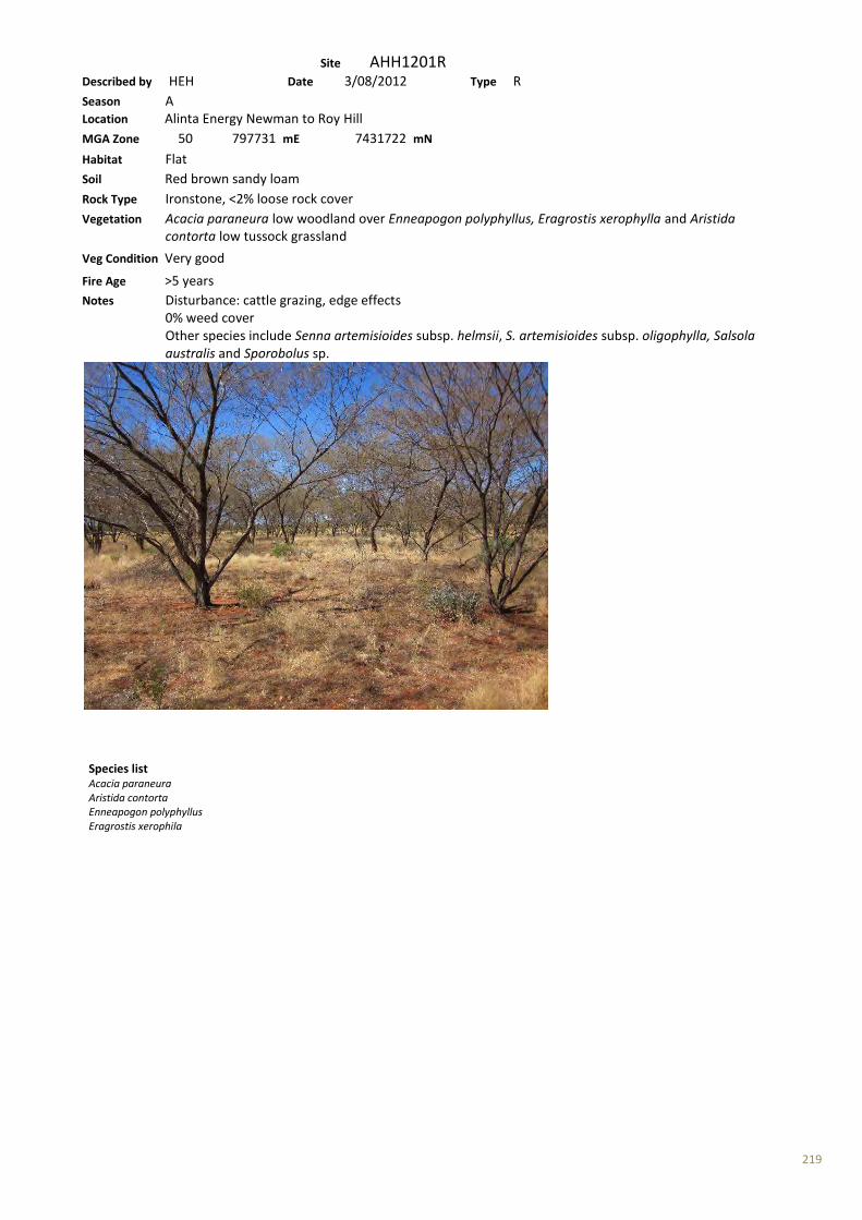
219
Site AHH1201R Described by HEH Date 3/08/2012 Type R Season A Location Alinta Energy Newman to Roy Hill MGA Zone 50 797731 mE 7431722 mN Habitat Flat Soil Red brown sandy loam Rock Type Ironstone, <2% loose rock cover Vegetation Acacia paraneura low woodland over Enneapogon polyphyllus, Eragrostis xerophylla and Aristida contorta low tussock grassland
Veg Condition Very good Fire Age >5 years Notes Disturbance: cattle grazing, edge effects 0% weed cover Other species include Senna artemisioides subsp. helmsii, S. artemisioides subsp. oligophylla, Salsola australis and Sporobolus sp.
Species list Acacia paraneura Aristida contorta Enneapogon polyphyllus Eragrostis xerophila
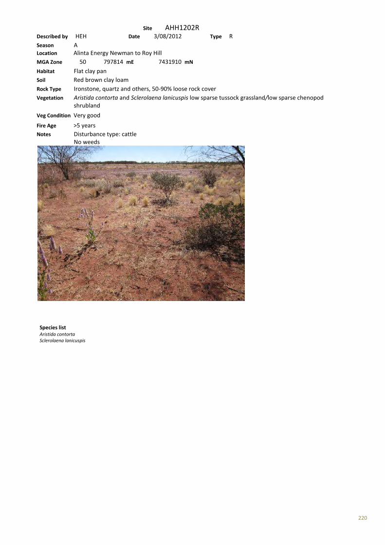
220
Site AHH1202R Described by HEH Date 3/08/2012 Type R Season A Location Alinta Energy Newman to Roy Hill MGA Zone 50 797814 mE 7431910 mN Habitat Flat clay pan Soil Red brown clay loam Rock Type Ironstone, quartz and others, 50-90% loose rock cover Vegetation Aristida contorta and Sclerolaena lanicuspis low sparse tussock grassland/low sparse chenopod shrubland
Veg Condition Very good Fire Age >5 years Notes Disturbance type: cattle No weeds
Species list Aristida contorta Sclerolaena lanicuspis

221
Site AHH1203R Described by HEH Date 3/08/2012 Type R Season A Location Alinta Energy Newman to Roy Hill MGA Zone 50 798223 mE 7432476 mN Habitat Flat Soil Red brown loam Rock Type Ironstone, >90% loose rock cover Vegetation Acacia aptaneura and A. synchronicia low woodland over Senna artemisioides subsp. oligophylla and Eremophila cuneifolia mid sparse shrubland over Triodia epactia low open hummock grassland
Veg Condition Good-Very good Fire Age >5 years Notes Disturbance: cattle grazing No weeds
Species list Acacia aptaneura Acacia synchronicia Eremophila cuneifolia Senna artemisioides subsp. oligophylla Triodia epactia
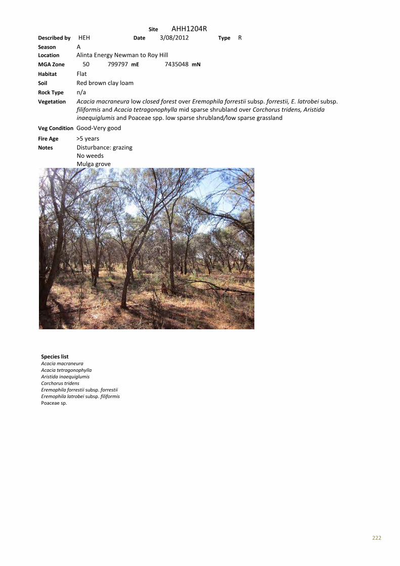
222
Site AHH1204R Described by HEH Date 3/08/2012 Type R Season A Location Alinta Energy Newman to Roy Hill MGA Zone 50 799797 mE 7435048 mN Habitat Flat Soil Red brown clay loam Rock Type n/a Vegetation Acacia macraneura low closed forest over Eremophila forrestii subsp. forrestii, E. latrobei subsp. filiformis and Acacia tetragonophylla mid sparse shrubland over Corchorus tridens, Aristida inaequiglumis and Poaceae spp. low sparse shrubland/low sparse grassland
Veg Condition Good-Very good Fire Age >5 years Notes Disturbance: grazing No weeds Mulga grove
Species list Acacia macraneura Acacia tetragonophylla Aristida inaequiglumis Corchorus tridens Eremophila forrestii subsp. forrestii Eremophila latrobei subsp. filiformis Poaceae sp.
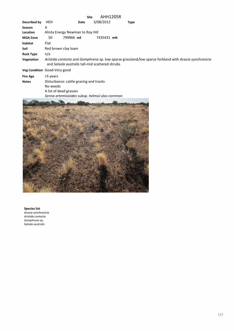
223
Site AHH1205R Described by HEH Date 3/08/2012 Type Season A Location Alinta Energy Newman to Roy Hill MGA Zone 50 799966 mE 7435431 mN Habitat Flat Soil Red brown clay loam Rock Type n/a Vegetation Aristida contorta and Gomphrena sp. low sparse grassland/low sparse forbland with Acacia synchronicia and Salsola australis tall-mid scattered shrubs
Veg Condition Good-Very good Fire Age >5 years Notes Disturbance: cattle grazing and tracks No weeds A lot of dead grasses Senna artemisioides subsp. helmsii also common
Species list Acacia synchronicia Aristida contorta Gomphrena sp. Salsola australis
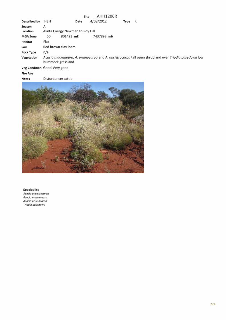
224
Site AHH1206R Described by HEH Date 4/08/2012 Type R Season A Location Alinta Energy Newman to Roy Hill MGA Zone 50 801423 mE 7437898 mN Habitat Flat Soil Red brown clay loam Rock Type n/a Vegetation Acacia macraneura, A. pruinocarpa and A. ancistrocarpa tall open shrubland over Triodia basedowii low hummock grassland
Veg Condition Good-Very good Fire Age Notes Disturbance: cattle
Species list Acacia ancistrocarpa Acacia macraneura Acacia pruinocarpa Triodia basedowii

225
Site AHH1207R Described by HEH Date 5/08/2012 Type R Season A Location Alinta Energy Newman to Roy Hill MGA Zone 50 808937 mE 7475078 mN Habitat Flat, possibly slightly damp Soil Red brown loam (silty?) Rock Type n/a Vegetation Eucalyptus gamophylla and Acacia coriacea subsp. pendens low sparse mallee shrubland/low open woodland over Acacia ancistrocarpa mid sparse shrubland over Triodia basedowii and Paraneurachne muelleri low open hummock grassland/low sparse tussock grassland
Veg Condition Very good Fire Age >3 years Notes Disturbance: cattle No weeds
Species list Acacia ancistrocarpa Acacia coriacea subsp. pendens Eucalyptus gamophylla Paraneurachne muelleri Triodia basedowii
226
Site AHH1208Q Described by HEH Date 9/08/2012 Type Q Season A Location Alinta Energy Newman to Roy Hill MGA Zone 50 808841 mE 7472668 mN E S Habitat Flat Soil Red brown stony loam Rock Type No exposed rock Vegetation Triodia basedowii and Bonamia erecta low open hummock grassland/sparse shrubland with Eucalyptus gamophylla low scattered trees over Acacia ancistrocarpa mid scattered shrubs U ^Eucalyptus gamophylla\^tree\6\bi:M ^ Acacia ancistrocarpa\^shrub\3\bi:G+ ^Triodia basedowii, Bonamia rosea\^hummock grass, shrub\1\i
Veg Condition Excellent Fire Age >2 years Notes <1% leaf litter, <1 cm depth 75% bare ground 0% weeds Disturbance type: none Fire notes: regrowth of trees/shrubs, fire response species, blackened stags No photo
Species list Cover (%) Height (m) Acacia ancistrocarpa <2 1.6 Acacia melleodora <1 0.3 Acacia pachyacra <1 0.2-1 Acacia pruinocarpa <1 1.7 Aristida inaequiglumis <1 0.2 Aristida inaequiglumis <1 0.6 Bonamia erecta 2 0.2 Bulbostylis barbata <1 0.1 Corchorus sp. <1 Cymbopogon sp. <1 0.3 Dicrastylis cordifolia <1 0.3 Dodonaea coriacea <1 0.8 Eremophila longifolia <1 0.7 Eucalyptus gamophylla <2 3 Euphorbia australis <1 0.15 Hibiscus coatesii <1 0.2 Paraneurachne muelleri <1 0.3 Ptilotus astrolasius <1 0.3 Ptilotus exaltatus <1 0.8 Senna artemisioides subsp. oligophylla <1 0.1 Senna notabilis <1 0.1 Sida echinocarpa <1 Sporobolus australasicus <1 0.1 Streptoglossa decurrens <1 1.6 Tribulus sp. <1 prostrate Triodia basedowii 20 0.3
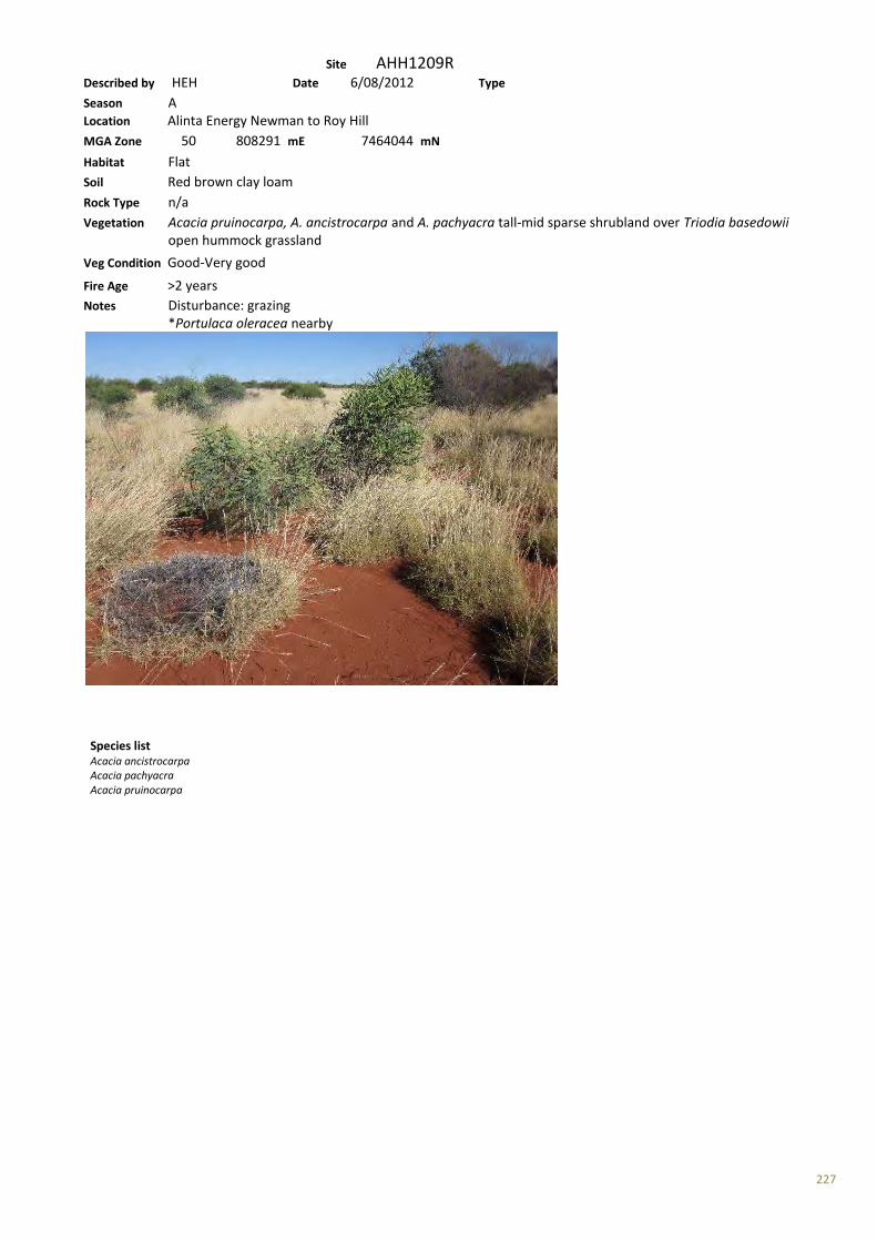
227
Site AHH1209R Described by HEH Date 6/08/2012 Type Season A Location Alinta Energy Newman to Roy Hill MGA Zone 50 808291 mE 7464044 mN Habitat Flat Soil Red brown clay loam Rock Type n/a Vegetation Acacia pruinocarpa, A. ancistrocarpa and A. pachyacra tall-mid sparse shrubland over Triodia basedowii open hummock grassland
Veg Condition Good-Very good Fire Age >2 years Notes Disturbance: grazing *Portulaca oleracea nearby
Species list Acacia ancistrocarpa Acacia pachyacra Acacia pruinocarpa

228
Site AHH1210R Described by HEH Date 6/08/2012 Type R Season A Location Alinta Energy Newman to Roy Hill MGA Zone 50 808365 mE 7465994 mN Habitat Flat Soil Red brown clay loam Rock Type n/a Vegetation Acacia ancistrocarpa mid sparse shrubland over Triodia basedowii low hummock grassland with Corymbia deserticola subsp. deserticola low scattered trees
Veg Condition Very good Fire Age >5 years Notes Disturbance: cattle No weeds Shrubs get sparser and dominant species change in this vegetation type
Species list Acacia ancistrocarpa Corymbia deserticola subsp. deserticola Triodia basedowii
229
Site AHH1211R Described by HEH Date 6/08/2012 Type R Season A Location Alinta Energy Newman to Roy Hill MGA Zone 50 808447 mE 7466386 mN Habitat Flat Soil Red brown clay loam Rock Type Mixed including ironstone and quartz; 20-50% loose rock cover Vegetation Triodia longiceps low hummock grassland Veg Condition Very good Fire Age >3 years Notes Disturbance: ?cattle No weeds
Species list Triodia longiceps
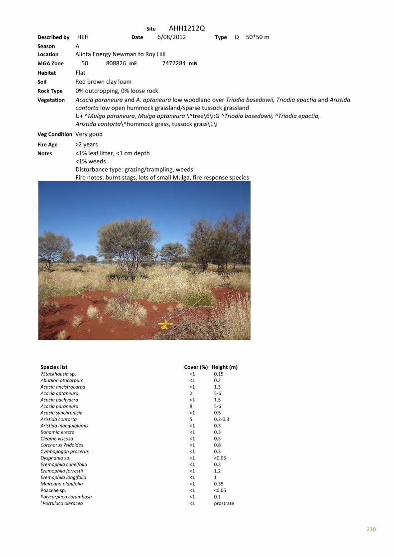
230
Site AHH1212Q Described by HEH Date 6/08/2012 Type Q 50*50 m Season A Location Alinta Energy Newman to Roy Hill MGA Zone 50 808826 mE 7472284 mN Habitat Flat Soil Red brown clay loam Rock Type 0% outcropping, 0% loose rock Vegetation Acacia paraneura and A. aptaneura low woodland over Triodia basedowii, Triodia epactia and Aristida contorta low open hummock grassland/sparse tussock grassland U+ ^Mulga paraneura, Mulga aptaneura \^tree\6\i:G ^Triodia basedowii, ^Triodia epactia, Aristida contorta\^hummock grass, tussock grass\1\i
Veg Condition Very good Fire Age >2 years Notes <1% leaf litter, <1 cm depth <1% weeds Disturbance type: grazing/trampling, weeds Fire notes: burnt stags, lots of small Mulga, fire response species
Species list Cover (%) Height (m) ?Stackhousia sp. <1 0.15 Abutilon otocarpum <1 0.2 Acacia ancistrocarpa <1 1.5 Acacia aptaneura 2 5-6 Acacia pachyacra <1 1.5 Acacia paraneura 8 5-6 Acacia synchronicia <1 0.5 Aristida contorta 5 0.2-0.3 Aristida inaequiglumis <1 0.3 Bonamia erecta <1 0.3 Cleome viscosa <1 0.5 Corchorus ?sidoides <1 0.8 Cymbopogon procerus <1 0.3 Dysphania sp. <1 <0.05 Eremophila cuneifolia <1 0.3 Eremophila forrestii <1 1.2 Eremophila longifolia <1 1 Maireana planifolia <1 0.35 Poaceae sp. <1 <0.05 Polycarpaea corymbosa <1 0.1 *Portulaca oleracea <1 prostrate

231
Ptilotus astrolasius <1 0.4 Ptilotus exaltatus <1 1.1 Salsola australis <1 0.2 Sclerolaena cornishiana <1 0.4 Senna artemisioides subsp. helmsii <1 0.5 Senna artemisioides subsp. oligophylla <1 0.4 Senna glutinosa subsp. glutinosa x luerssenii <1 1.6 Senna notabilis <1 0.15 Sida arenicola <1 1 Sida echinocarpa <1 0.7 Solanum lasiophyllum <1 1 Solanum sturtianum <1 1.5 Sporobolus australasicus <1 0.05 Triodia basedowii 10 0.3 Triodia epactia 10 0.4
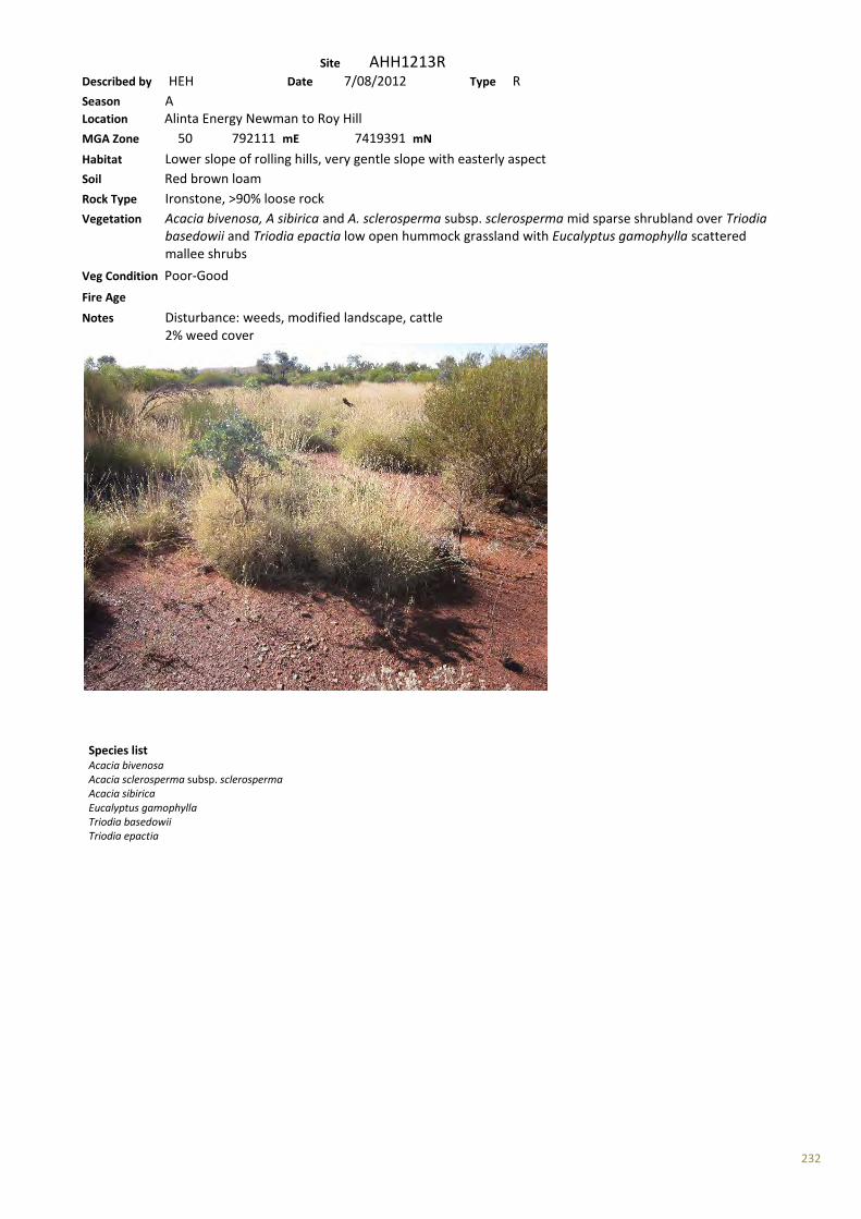
232
Site AHH1213R Described by HEH Date 7/08/2012 Type R Season A Location Alinta Energy Newman to Roy Hill MGA Zone 50 792111 mE 7419391 mN Habitat Lower slope of rolling hills, very gentle slope with easterly aspect Soil Red brown loam Rock Type Ironstone, >90% loose rock Vegetation Acacia bivenosa, A sibirica and A. sclerosperma subsp. sclerosperma mid sparse shrubland over Triodia basedowii and Triodia epactia low open hummock grassland with Eucalyptus gamophylla scattered mallee shrubs
Veg Condition Poor-Good Fire Age Notes Disturbance: weeds, modified landscape, cattle 2% weed cover
Species list Acacia bivenosa Acacia sclerosperma subsp. sclerosperma Acacia sibirica Eucalyptus gamophylla Triodia basedowii Triodia epactia
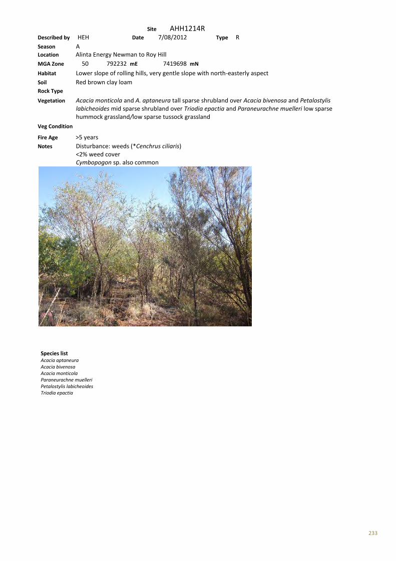
233
Site AHH1214R Described by HEH Date 7/08/2012 Type R Season A Location Alinta Energy Newman to Roy Hill MGA Zone 50 792232 mE 7419698 mN Habitat Lower slope of rolling hills, very gentle slope with north-easterly aspect Soil Red brown clay loam Rock Type Vegetation Acacia monticola and A. aptaneura tall sparse shrubland over Acacia bivenosa and Petalostylis labicheoides mid sparse shrubland over Triodia epactia and Paraneurachne muelleri low sparse hummock grassland/low sparse tussock grassland Veg Condition
Fire Age >5 years Notes Disturbance: weeds (*Cenchrus ciliaris) <2% weed cover Cymbopogon sp. also common
Species list Acacia aptaneura Acacia bivenosa Acacia monticola Paraneurachne muelleri Petalostylis labicheoides Triodia epactia

234
Site AHH1215R Described by HEH Date 7/08/2012 Type R Season A Location Alinta Energy Newman to Roy Hill MGA Zone 50 792260 mE 7419782 mN Habitat Minor drainage depression Soil Red brown clay loam Rock Type n/a Vegetation Acacia ancistrocarpa and A. bivenosa tall shrubland over *Cenchrus ciliaris and Triodia epactia mid open tussock grassland/mid open hummock grassland
Veg Condition Poor-good Fire Age >5 years Notes Disturbance: weeds 25% weed cover
Species list Acacia ancistrocarpa Acacia bivenosa *Cenchrus ciliaris Triodia epactia

235
Site AHH1216R Described by HEH Date 7/08/2012 Type R Season A Location Alinta Energy Newman to Roy Hill MGA Zone 50 792294 mE 7419902 mN Habitat Mid slope of rolling hills, gentle-very gentle slope of various aspects Soil Red brown loam Rock Type Ironstone, >90% loose rock cover, <2% outcropping Vegetation Triodia basedowii and Acacia hilliana low hummock grassland/low sparse shrubland with Eucalyptus leucophloia subsp. leucophloia low scattered trees over Acacia bivenosa mid scattered shrubs
Veg Condition Very good Fire Age >3 years Notes Disturbance: cattle
Species list Acacia bivenosa Acacia hilliana Eucalyptus leucophloia subsp. leucophloia Triodia basedowii
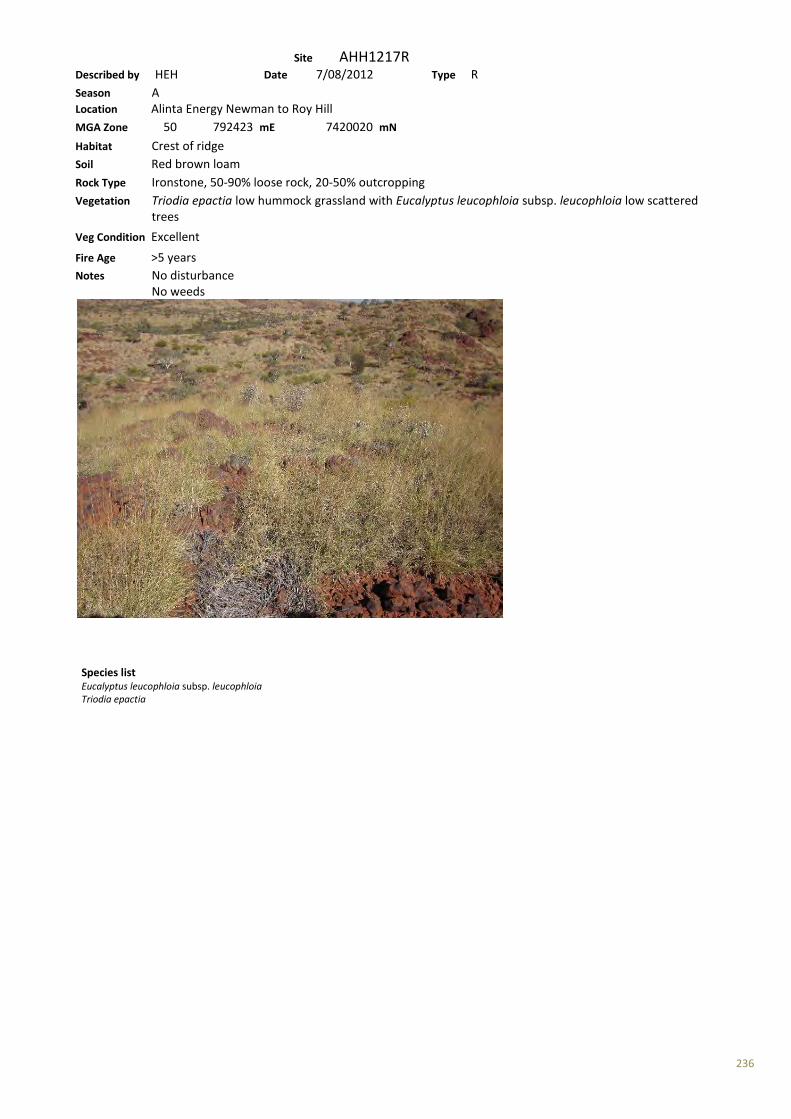
236
Site AHH1217R Described by HEH Date 7/08/2012 Type R Season A Location Alinta Energy Newman to Roy Hill MGA Zone 50 792423 mE 7420020 mN Habitat Crest of ridge Soil Red brown loam Rock Type Ironstone, 50-90% loose rock, 20-50% outcropping Vegetation Triodia epactia low hummock grassland with Eucalyptus leucophloia subsp. leucophloia low scattered trees
Veg Condition Excellent Fire Age >5 years Notes No disturbance No weeds
Species list Eucalyptus leucophloia subsp. leucophloia Triodia epactia
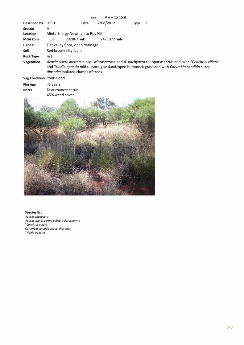
237
Site AHH1218R Described by HEH Date 7/08/2012 Type R Season A Location Alinta Energy Newman to Roy Hill MGA Zone 50 792867 mE 7421072 mN Habitat Flat valley floor, open drainage Soil Red brown silty loam Rock Type n/a Vegetation Acacia sclerosperma subsp. sclerosperma and A. pachyacra tall sparse shrubland over *Cenchrus ciliaris and Triodia epactia mid tussock grassland/open hummock grassland with Corymbia candida subsp. dipsodes isolated clumps of trees
Veg Condition Poor-Good Fire Age >5 years Notes Disturbance: cattle 45% weed cover
Species list Acacia pachyacra Acacia sclerosperma subsp. sclerosperma *Cenchrus ciliaris Corymbia candida subsp. dipsodes Triodia epactia

238
Site AHH1219R Described by HEH Date 7/08/2012 Type R Season A Location Alinta Energy Newman to Roy Hill MGA Zone 50 792937 mE 7421278 mN Habitat Incised drainage Soil Stony loam Rock Type Alluvial rocks, >90% loose rock cover Vegetation Eucalyptus victrix mid woodland over Acacia citrinoviridis tall sparse shrubland over *Cenchrus ciliaris, Themeda triandra and Tephrosia rosea var. glabrior mid tussock grassland/low sparse shrubland
Veg Condition Poor-Good Fire Age >5 years Notes Disturbance: weeds, cattle 25% weed cover
Species list Acacia citrinoviridis *Cenchrus ciliaris Eucalyptus victrix Tephrosia rosea var. glabrior Themeda triandra
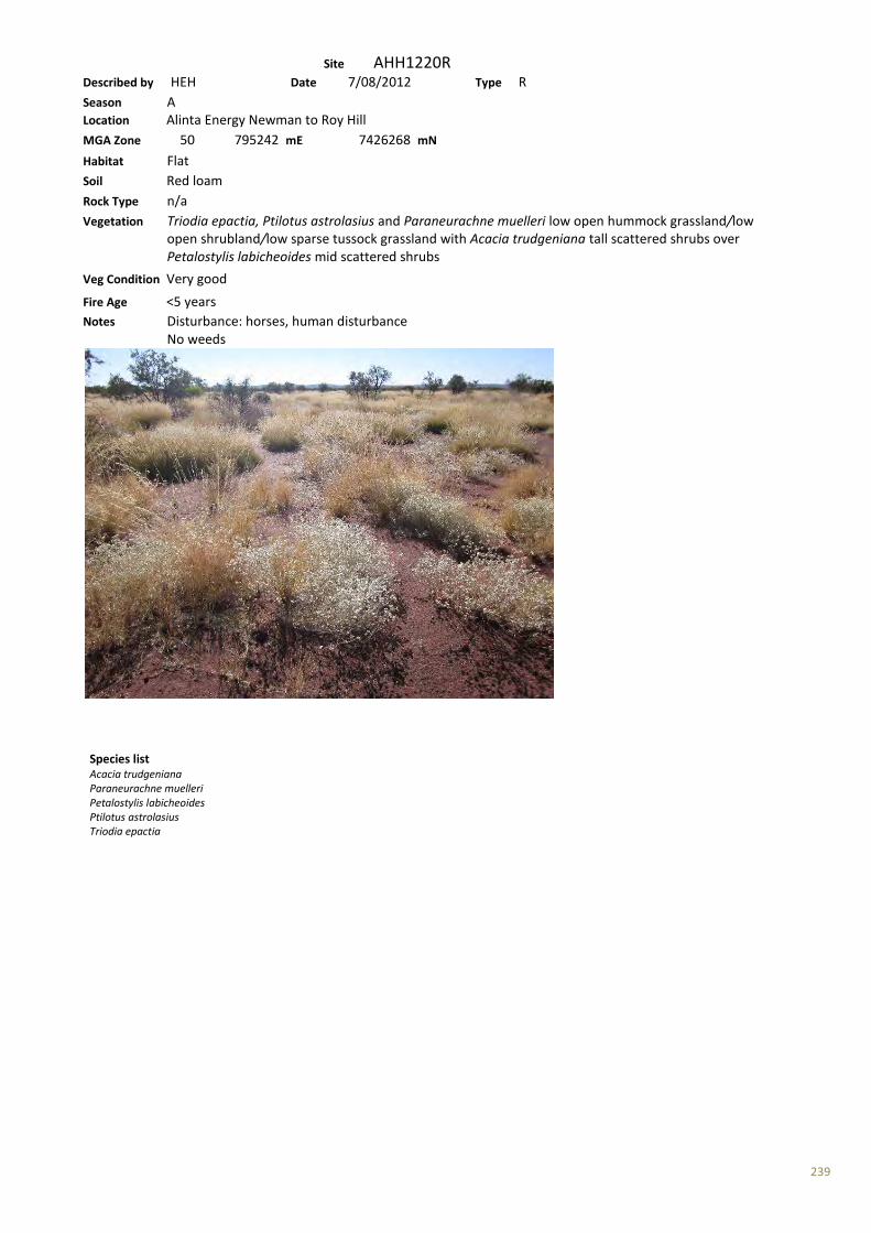
239
Site AHH1220R Described by HEH Date 7/08/2012 Type R Season A Location Alinta Energy Newman to Roy Hill MGA Zone 50 795242 mE 7426268 mN Habitat Flat Soil Red loam Rock Type n/a Vegetation Triodia epactia, Ptilotus astrolasius and Paraneurachne muelleri low open hummock grassland/low open shrubland/low sparse tussock grassland with Acacia trudgeniana tall scattered shrubs over Petalostylis labicheoides mid scattered shrubs
Veg Condition Very good Fire Age <5 years Notes Disturbance: horses, human disturbance No weeds
Species list Acacia trudgeniana Paraneurachne muelleri Petalostylis labicheoides Ptilotus astrolasius Triodia epactia
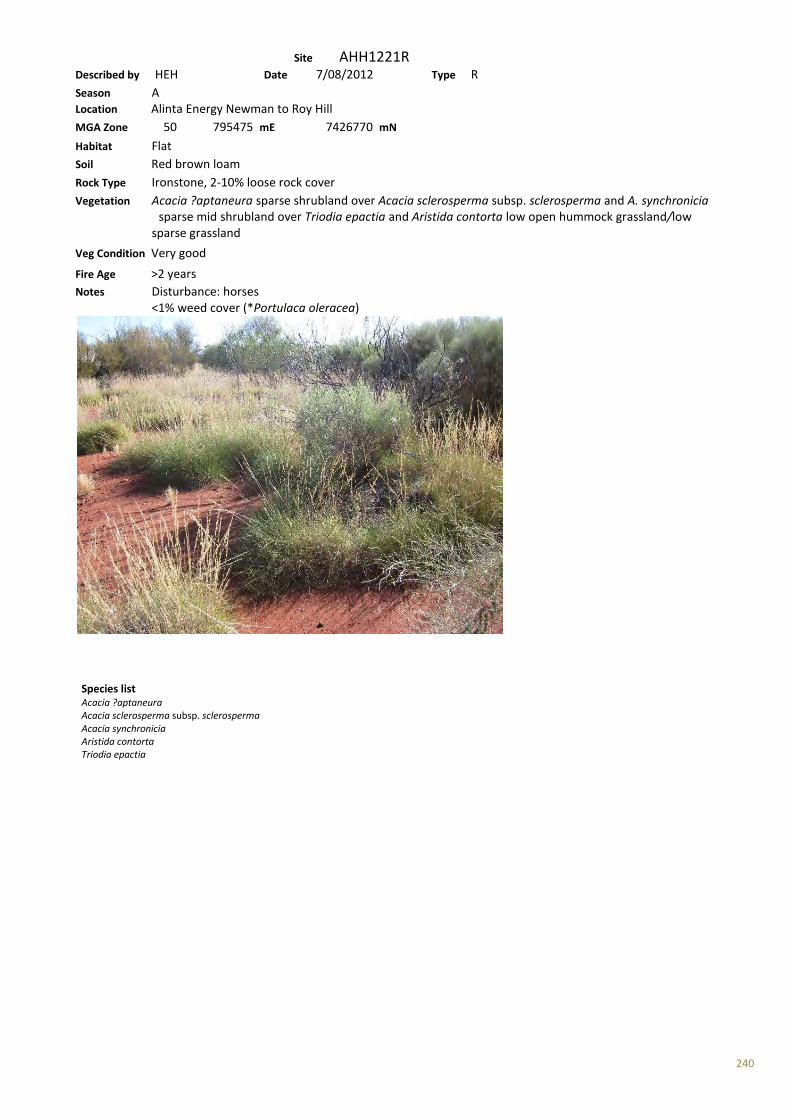
240
Site AHH1221R Described by HEH Date 7/08/2012 Type R Season A Location Alinta Energy Newman to Roy Hill MGA Zone 50 795475 mE 7426770 mN Habitat Flat Soil Red brown loam Rock Type Ironstone, 2-10% loose rock cover Vegetation Acacia ?aptaneura sparse shrubland over Acacia sclerosperma subsp. sclerosperma and A. synchronicia sparse mid shrubland over Triodia epactia and Aristida contorta low open hummock grassland/low sparse grassland
Veg Condition Very good Fire Age >2 years Notes Disturbance: horses <1% weed cover (*Portulaca oleracea)
Species list Acacia ?aptaneura Acacia sclerosperma subsp. sclerosperma Acacia synchronicia Aristida contorta Triodia epactia
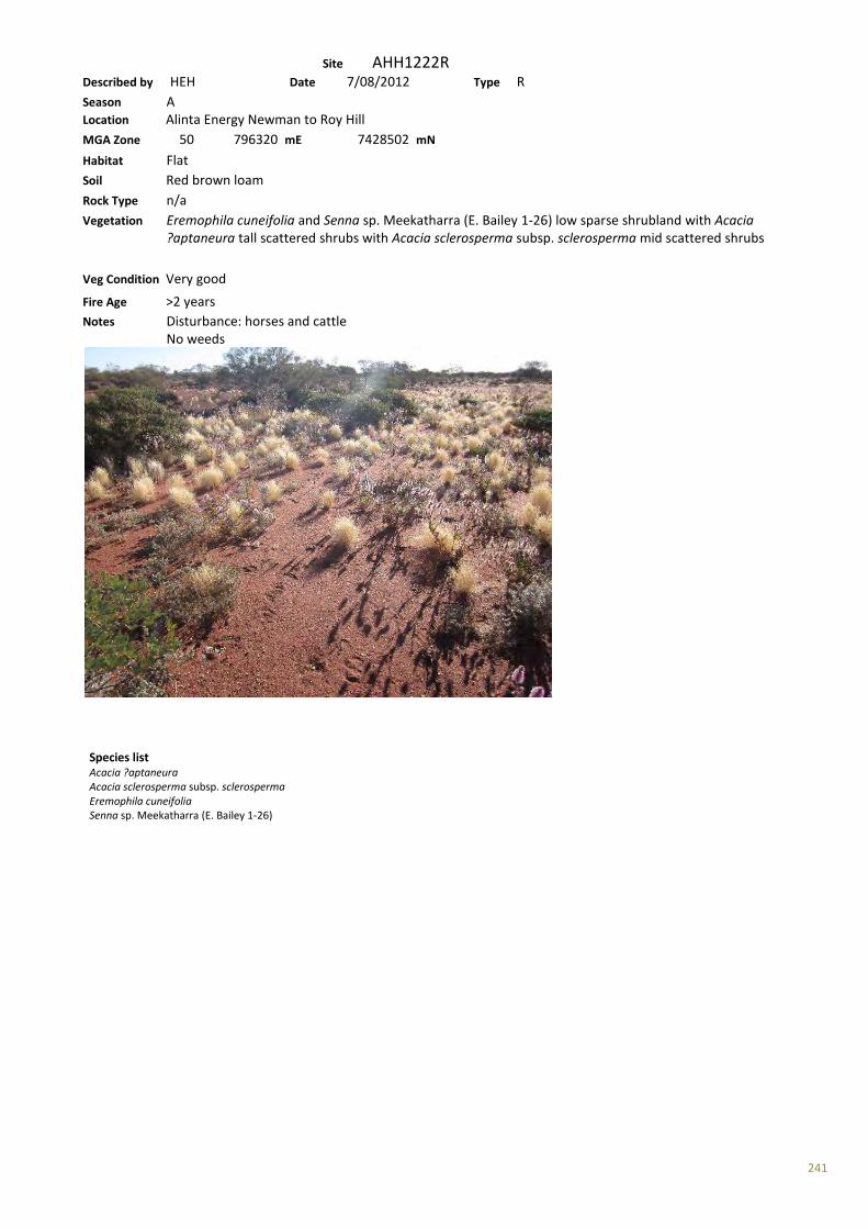
241
Site AHH1222R Described by HEH Date 7/08/2012 Type R Season A Location Alinta Energy Newman to Roy Hill MGA Zone 50 796320 mE 7428502 mN Habitat Flat Soil Red brown loam Rock Type n/a Vegetation Eremophila cuneifolia and Senna sp. Meekatharra (E. Bailey 1-26) low sparse shrubland with Acacia ?aptaneura tall scattered shrubs with Acacia sclerosperma subsp. sclerosperma mid scattered shrubs
Veg Condition Very good Fire Age >2 years Notes Disturbance: horses and cattle No weeds
Species list Acacia ?aptaneura Acacia sclerosperma subsp. sclerosperma Eremophila cuneifolia Senna sp. Meekatharra (E. Bailey 1-26)

242
Site AHH1223R Described by HEH Date 8/08/2012 Type R Season A Location Alinta Energy Newman to Roy Hill MGA Zone 50 805942 mE 7495492 mN Habitat Flat, claypan Soil Red brown clay loam Rock Type Ironstone, 2-10% loose rock cover Vegetation Sclerolaena cornishiana and S. bicornis var. bicornis low sparse chenopod shrubland Veg Condition Poor-Good Fire Age >5 years Notes Disturbance: grazing No weeds
Species list Sclerolaena bicornis var. bicornis Sclerolaena cornishiana
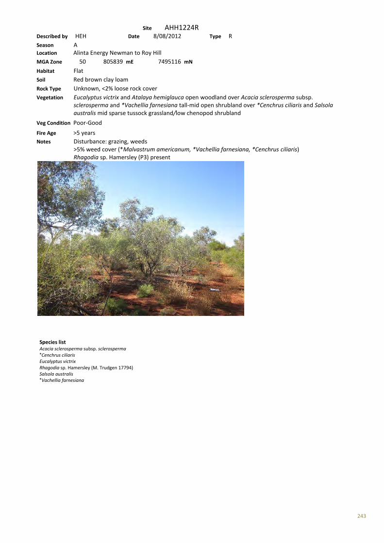
243
Site AHH1224R Described by HEH Date 8/08/2012 Type R Season A Location Alinta Energy Newman to Roy Hill MGA Zone 50 805839 mE 7495116 mN Habitat Flat Soil Red brown clay loam Rock Type Unknown, <2% loose rock cover Vegetation Eucalyptus victrix and Atalaya hemiglauca open woodland over Acacia sclerosperma subsp. sclerosperma and *Vachellia farnesiana tall-mid open shrubland over *Cenchrus ciliaris and Salsola australis mid sparse tussock grassland/low chenopod shrubland
Veg Condition Poor-Good Fire Age >5 years Notes Disturbance: grazing, weeds >5% weed cover (*Malvastrum americanum, *Vachellia farnesiana, *Cenchrus ciliaris) Rhagodia sp. Hamersley (P3) present
Species list Acacia sclerosperma subsp. sclerosperma *Cenchrus ciliaris Eucalyptus victrix Rhagodia sp. Hamersley (M. Trudgen 17794) Salsola australis *Vachellia farnesiana
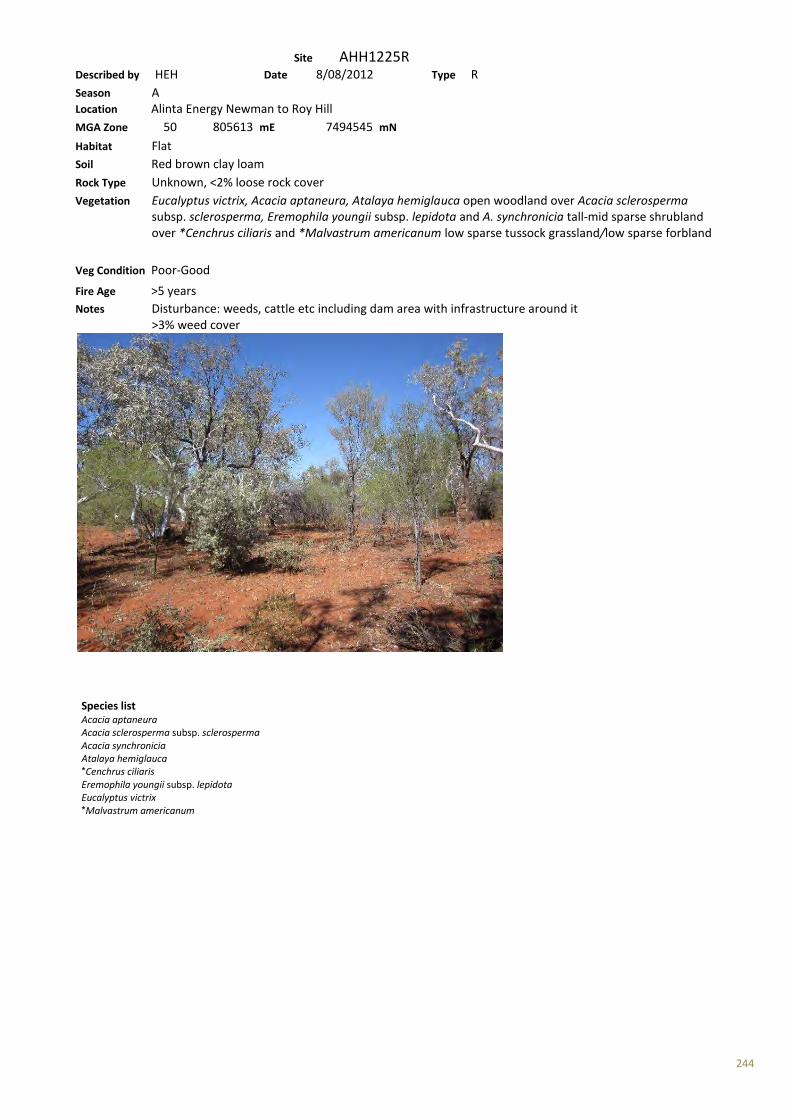
244
Site AHH1225R Described by HEH Date 8/08/2012 Type R Season A Location Alinta Energy Newman to Roy Hill MGA Zone 50 805613 mE 7494545 mN Habitat Flat Soil Red brown clay loam Rock Type Unknown, <2% loose rock cover Vegetation Eucalyptus victrix, Acacia aptaneura, Atalaya hemiglauca open woodland over Acacia sclerosperma subsp. sclerosperma, Eremophila youngii subsp. lepidota and A. synchronicia tall-mid sparse shrubland over *Cenchrus ciliaris and *Malvastrum americanum low sparse tussock grassland/low sparse forbland
Veg Condition Poor-Good Fire Age >5 years Notes Disturbance: weeds, cattle etc including dam area with infrastructure around it >3% weed cover
Species list Acacia aptaneura Acacia sclerosperma subsp. sclerosperma Acacia synchronicia Atalaya hemiglauca *Cenchrus ciliaris Eremophila youngii subsp. lepidota Eucalyptus victrix *Malvastrum americanum
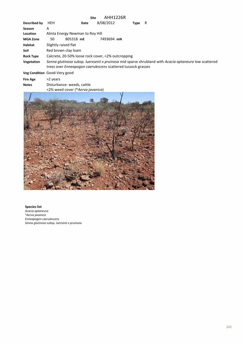
245
Site AHH1226R Described by HEH Date 8/08/2012 Type R Season A Location Alinta Energy Newman to Roy Hill MGA Zone 50 805318 mE 7493694 mN Habitat Slightly raised flat Soil Red brown clay loam Rock Type Calcrete, 20-50% loose rock cover, <2% outcropping Vegetation Senna glutinosa subsp. luerssenii x pruinosa mid sparse shrubland with Acacia aptaneura low scattered trees over Enneapogon caerulescens scattered tussock grasses
Veg Condition Good-Very good Fire Age >2 years Notes Disturbance: weeds, cattle <2% weed cover (*Aerva javanica)
Species list Acacia aptaneura *Aerva javanica Enneapogon caerulescens Senna glutinosa subsp. luersenii x pruinosa
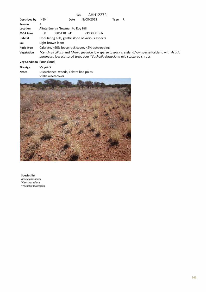
246
Site AHH1227R Described by HEH Date 8/08/2012 Type R Season A Location Alinta Energy Newman to Roy Hill MGA Zone 50 805118 mE 7493060 mN Habitat Undulating hills, gentle slope of various aspects Soil Light brown loam Rock Type Calcrete, >90% loose rock cover, <2% outcropping Vegetation *Cenchrus ciliaris and *Aerva javanica low sparse tussock grassland/low sparse forbland with Acacia paraneura low scattered trees over *Vachellia farnesiana mid scattered shrubs
Veg Condition Poor-Good Fire Age >5 years Notes Disturbance: weeds, Telstra line poles >10% weed cover
Species list Acacia paraneura *Cenchrus ciliaris *Vachellia farnesiana
247
Site AHH1228R Described by HEH Date 8/08/2012 Type R Season A Location Alinta Energy Newman to Roy Hill MGA Zone 50 804918 mE 7492830 mN Habitat Incised creek Soil Red brown loam Rock Type n/a Vegetation Eucalyptus victrix, E. camaldulensis subsp. refulgens and Atalaya hemiglauca mid open forest over Poaceae sp. mid open tussock grassland with *Vachellia farnesiana mid scattered shrubs
Veg Condition Poor Fire Age >5 years Notes Disturbance: weeds, cattle, horses >25% weed cover
Species list Atalaya hemiglauca Eucalyptus camaldulensis subsp. refulgens Eucalyptus victrix Poaceae sp. *Vachellia farnesiana
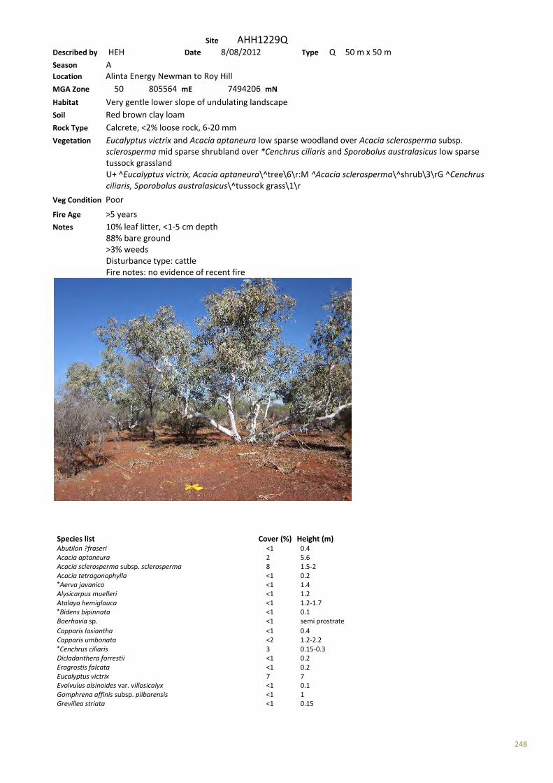
248
Site AHH1229Q Described by HEH Date 8/08/2012 Type Q 50 m x 50 m Season A Location Alinta Energy Newman to Roy Hill MGA Zone 50 805564 mE 7494206 mN Habitat Very gentle lower slope of undulating landscape Soil Red brown clay loam Rock Type Calcrete, <2% loose rock, 6-20 mm Vegetation Eucalyptus victrix and Acacia aptaneura low sparse woodland over Acacia sclerosperma subsp. sclerosperma mid sparse shrubland over *Cenchrus ciliaris and Sporobolus australasicus low sparse tussock grassland U+ ^Eucalyptus victrix, Acacia aptaneura\^tree\6\r:M ^Acacia sclerosperma\^shrub\3\rG ^Cenchrus ciliaris, Sporobolus australasicus\^tussock grass\1\r Veg Condition Poor Fire Age >5 years Notes 10% leaf litter, <1-5 cm depth 88% bare ground >3% weeds Disturbance type: cattle Fire notes: no evidence of recent fire
Species list Cover (%) Height (m) Abutilon ?fraseri <1 0.4 Acacia aptaneura 2 5.6 Acacia sclerosperma subsp. sclerosperma 8 1.5-2 Acacia tetragonophylla <1 0.2 *Aerva javanica <1 1.4 Alysicarpus muelleri <1 1.2 Atalaya hemiglauca <1 1.2-1.7 *Bidens bipinnata <1 0.1 Boerhavia sp. <1 semi prostrate Capparis lasiantha <1 0.4 Capparis umbonata <2 1.2-2.2 *Cenchrus ciliaris 3 0.15-0.3 Dicladanthera forrestii <1 0.2 Eragrostis falcata <1 0.2 Eucalyptus victrix 7 7 Evolvulus alsinoides var. villosicalyx <1 0.1 Gomphrena affinis subsp. pilbarensis <1 1 Grevillea striata <1 0.15

249
Grevillea striata <1 1.5 *Heliotropium europaeum <1 0.1 Malvaceae sp. <1 *Malvastrum americanum 2 0.1 Ptilotus exaltatus <1 0.1 Ptilotus sp. <1 0.8 Salsola australis <1 2 Scaevola spinescens <1 0.8 Sclerolaena cornishiana <1 0.2 Sclerolaena costata <1 0.15 Senna artemisioides subsp. oligophylla <1 1 Sporobolus australasicus <2 0.7 *Vachellia farnesiana <1 <0.05
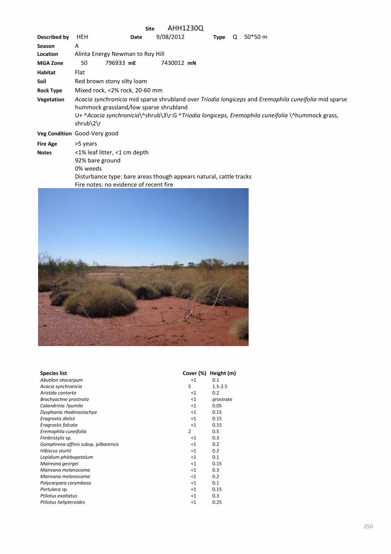
250
Site AHH1230Q Described by HEH Date 9/08/2012 Type Q 50*50 m Season A Location Alinta Energy Newman to Roy Hill MGA Zone 50 796933 mE 7430012 mN Habitat Flat Soil Red brown stony silty loam Rock Type Mixed rock, <2% rock, 20-60 mm Vegetation Acacia synchronicia mid sparse shrubland over Triodia longiceps and Eremophila cuneifolia mid sparse hummock grassland/low sparse shrubland U+ ^Acacia synchronicia\^shrub\3\r:G ^Triodia longiceps, Eremophila cuneifolia \^hummock grass, shrub\2\r
Veg Condition Good-Very good Fire Age >5 years Notes <1% leaf litter, <1 cm depth 92% bare ground 0% weeds Disturbance type: bare areas though appears natural, cattle tracks Fire notes: no evidence of recent fire
Species list Cover (%) Height (m) Abutilon otocarpum <1 0.1 Acacia synchronicia 5 1.5-2.5 Aristida contorta <1 0.2 Brachyachne prostrata <1 prostrate Calandrinia ?pumila <1 0.05 Dysphania rhadinostachya <1 0.15 Eragrostis dielsii <1 0.15 Eragrostis falcata <1 0.15 Eremophila cuneifolia 2 0.5 Fimbristylis sp. <1 0.3 Gomphrena affinis subsp. pilbarensis <1 0.2 Hibiscus sturtii <1 0.2 Lepidium phlebopetalum <1 0.1 Maireana georgei <1 0.15 Maireana melanocoma <1 0.3 Maireana melanocoma <1 0.2 Polycarpaea corymbosa <1 0.1 Portulaca sp. <1 0.15 Ptilotus exaltatus <1 0.3 Ptilotus helipteroides <1 0.25

251
Sclerolaena beaugleholei <1 0.2 Sclerolaena densiflora <1 0.2 Sclerolaena densiflora <1 0.4 Sclerolaena eriacantha <1 0.2 Senna sp. Meekatharra (E. Bailey 1-26) <1 1 Sida sp. <1 0.15 Solanum lasiophyllum <1 0.2 Sporobolus australasicus <1 0.1 Streptoglossa bubakii <1 0.15 Streptoglossa liatroides <1 0.2 Triodia longiceps 5 1
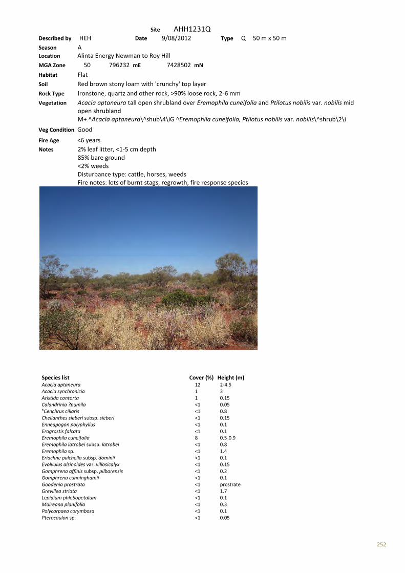
252
Site AHH1231Q Described by HEH Date 9/08/2012 Type Q 50 m x 50 m Season A Location Alinta Energy Newman to Roy Hill MGA Zone 50 796232 mE 7428502 mN Habitat Flat Soil Red brown stony loam with 'crunchy' top layer Rock Type Ironstone, quartz and other rock, >90% loose rock, 2-6 mm Vegetation Acacia aptaneura tall open shrubland over Eremophila cuneifolia and Ptilotus nobilis var. nobilis mid open shrubland M+ ^Acacia aptaneura\^shub\4\iG ^Eremophila cuneifolia, Ptilotus nobilis var. nobilis\^shrub\2\i
Veg Condition Good Fire Age <6 years Notes 2% leaf litter, <1-5 cm depth 85% bare ground <2% weeds Disturbance type: cattle, horses, weeds Fire notes: lots of burnt stags, regrowth, fire response species
Species list Cover (%) Height (m) Acacia aptaneura 12 2-4.5 Acacia synchronicia 1 3 Aristida contorta 1 0.15 Calandrinia ?pumila <1 0.05 *Cenchrus ciliaris <1 0.8 Cheilanthes sieberi subsp. sieberi <1 0.15 Enneapogon polyphyllus <1 0.1 Eragrostis falcata <1 0.1 Eremophila cuneifolia 8 0.5-0.9 Eremophila latrobei subsp. latrobei <1 0.8 Eremophila sp. <1 1.4 Eriachne pulchella subsp. dominii <1 0.1 Evolvulus alsinoides var. villosicalyx <1 0.15 Gomphrena affinis subsp. pilbarensis <1 0.2 Gomphrena cunninghamii <1 0.1 Goodenia prostrata <1 prostrate Grevillea striata <1 1.7 Lepidium phlebopetalum <1 0.1 Maireana planifolia <1 0.3 Polycarpaea corymbosa <1 0.1 Pterocaulon sp. <1 0.05

253
Ptilotus nobilis var. nobilis 2 0.2-0.5 Rhagodia eremaea <1 0.7 Rhagodia sp. Hamersley (M. Trudgen 17794) <1 0.6 Salsola australis <1 0.5 Sclerolaena bicornis var. bicornis <1 0.3 Sclerolaena densiflora <1 0.2 Senna glutinosa subsp. luersenii x pruinosa <1 0.5-1.2 Senna sp. Meekatharra (E. Bailey 1-26) <1 1.1 Sida echinocarpa <1 0.4 Sida sp. <1 0.7 Solanum lasiophyllum <1 0.3 Streptoglossa bubakii <1 0.6 Trianthema sp. <1 prostrate

254
Site AHH1232Q Described by HEH Date 9/08/2012 Type Q 50 m x 50 m Season A Location Alinta Energy Newman to Roy Hill MGA Zone 50 795355 mE 7426554 mN Habitat Flat Soil Red brown stony loam Rock Type No exposed rock Vegetation Acacia sclerosperma subsp. sclerosperma, A. synchronicia and Stylobasium spathulatum mid open shrubland over Triodia epactia mid open hummock grassland M+ ^Acacia sclerosperma subsp. sclerosperma, A. synchronicia, Stylobasium spathulatum\^shrub\3\iG ^Triodia epactia\^hummock grass\2\i
Veg Condition Good-Very good Fire Age >5 years Notes 3% leaf litter, <1-1 cm depth 75% bare ground <2% weeds Disturbance type: cattle, horses, weeds Fire notes: no evidence of recent fire
Species list Cover (%) Height (m) Acacia ancistrocarpa 1 2-2.5 Acacia bivenosa <1 2.5 Acacia sclerosperma subsp. sclerosperma 10 1.7-2.2 Acacia synchronicia 2 1.5-2 Aristida contorta <1 0.1 *Cenchrus ciliaris 1 0.4 Cleome viscosa <1 0.3 Cymbopogon sp. <1 0.2 Duperreya commixta <1 climber Dysphania sp. <1 0.1 Eragrostis eriopoda <1 0.4 Euphorbia australis <1 0.1 Euphorbia australis <1 0.15 Euphorbia tannensis subsp. eremophila <1 0.4 Gomphrena affinis subsp. pilbarensis <1 0.2 Goodenia prostrata <1 prostrate Goodenia prostrata <1 prostrate Heliotropium europaeum <1 0.05 Hibiscus burtonii <1 0.4 Indigofera monophylla <1 0.2

255
Maireana planifolia <1 1.3 Petalostylis labicheoides <1 1.6 Polycarpaea corymbosa <1 0.1 Pterocaulon sp. <1 <0.05 Ptilotus astrolasius <1 0.3 Ptilotus obovatus <1 0.8 Ptilotus sp. <1 0.2 Senna artemisioides subsp. oligophylla x helmsii <1 0.9 Senna glutinosa subsp. luersenii x pruinosa <1 1.2 Senna notabilis <1 0.1 Sida echinocarpa <1 0.4 Sida echinocarpa <1 0.4 Solanum lasiophyllum <1 0.7 Streptoglossa bubakii <1 1 Stylobasium spathulatum 5 1.8 Tribulus sp. <1 prostrate Trichodesma zeylanicum var. zeylanicum <1 1 Triodia epactia 20 0.5-0.6

© Ecoscape (Australia) Pty Ltd 8497-2817-12R_ 255
Appendix Seven: Flora Inventory Table 25: Flora Inventory
FCode Family Cons Code Introduced Species
29 Pteridaceae
Cheilanthes sieberi subsp. sieberi
80 Lauraceae
Cassytha capillaris
156 Cyperaceae
Bulbostylis barbata
Fimbristylis simulans
Fimbristylis sp.
163 Poaceae
Amphipogon sericeus
Aristida contorta
Aristida inaequiglumis
Brachyachne prostrata
* Cenchrus ciliaris
Chloris pumilio
Chrysopogon fallax
Cymbopogon ambiguus
Cymbopogon procerus
Cymbopogon sp.
Dactyloctenium radulans
Digitaria sp.
Enneapogon caerulescens
Enneapogon lindleyanus
Enneapogon polyphyllus
Enneapogon sp.
?Enteropogon ramosus
Eragrostis cumingii
Eragrostis dielsii
Eragrostis eriopoda
Eragrostis falcata
Eragrostis setifolia
Eragrostis xerophila
Eriachne aristidea
Eriachne ciliata
Eriachne lanata
Eriachne mucronata
Eriachne pulchella subsp. dominii
Eulalia aurea
Paraneurachne muelleri
Poaceae sp.
Schizachyrium fragile
Sporobolus australasicus

© Ecoscape (Australia) Pty Ltd 8497-2817-12R_ 256
FCode Family Cons Code Introduced Species
P3
Themeda sp. Hamersley Station (M.E. Trudgen 11431)
Themeda triandra
Triodia basedowii
Triodia epactia
Triodia longiceps
Triodia wiseana
Urochloa occidentalis var. occidentalis
Yakirra australiensis
175 Proteaceae
Grevillea juncifolia subsp. juncifolia
Grevillea striata
Grevillea wickhamii
Grevillea wickhamii subsp. hispidula
Hakea chordophylla
Hakea lorea subsp. lorea
196 Haloragaceae
Haloragis gossei var. gossei
Haloragis sp.
199 Zygophyllaceae *? Tribulus ?terrestris
Tribulus astrocarpus
Tribulus macrocarpus
Tribulus sp.
Tribulus suberosus
201 Fabaceae
Acacia ?aptaneura
Acacia ?kempeana
Acacia adoxa var. adoxa
Acacia adsurgens
Acacia ancistrocarpa
Acacia aptaneura
Acacia bivenosa
Acacia citrinoviridis
Acacia coriacea subsp. pendens
Acacia dictyophleba
Acacia hilliana
Acacia inaequilatera
Acacia macraneura
Acacia maitlandii
Acacia melleodora
Acacia monticola
Acacia orthocarpa
Acacia pachyacra
Acacia paraneura
Acacia pruinocarpa
Acacia rhodophloia

© Ecoscape (Australia) Pty Ltd 8497-2817-12R_ 257
FCode Family Cons Code Introduced Species
Acacia sclerosperma subsp. sclerosperma
Acacia sibirica
Acacia synchronicia
Acacia tetragonophylla
Acacia trudgeniana
Acacia wanyu
Alysicarpus muelleri
?Glycine sp.
Indigofera colutea
Indigofera monophylla
Isotropis atropurpurea
Isotropis forrestii
Petalostylis cassioides
Petalostylis labicheoides
Rhynchosia minima
Senna artemisioides subsp. helmsii
Senna artemisioides subsp. oligophylla
Senna artemisioides subsp. oligophylla x helmsii
Senna glutinosa
Senna glutinosa subsp. glutinosa
Senna glutinosa subsp. glutinosa x luerssenii
Senna glutinosa subsp. luersenii x pruinosa
Senna glutinosa subsp. pruinosa
Senna notabilis
Senna sp. Meekatharra (E. Bailey 1-26)
Tephrosia rosea var. glabrior
* Vachellia farnesiana
202 Surianaceae
Stylobasium spathulatum
229 Celastraceae
Stackhousia intermedia
?Stackhousia sp.
409 Rubiaceae
Psydrax latifolia
415 Boraginaceae * Heliotropium europaeum
Trichodesma zeylanicum var zeylanicum
416 Convolvulaceae
Bonamia erecta
Duperreya commixta
Evolvulus alsinoides var. villosicalyx
Ipomoea calobra
417 Solanaceae
Solanum centrale
Solanum lasiophyllum
Solanum sturtianum
428 Scrophulariaceae
Eremophila cuneifolia
Eremophila forrestii
Eremophila forrestii subsp. forrestii
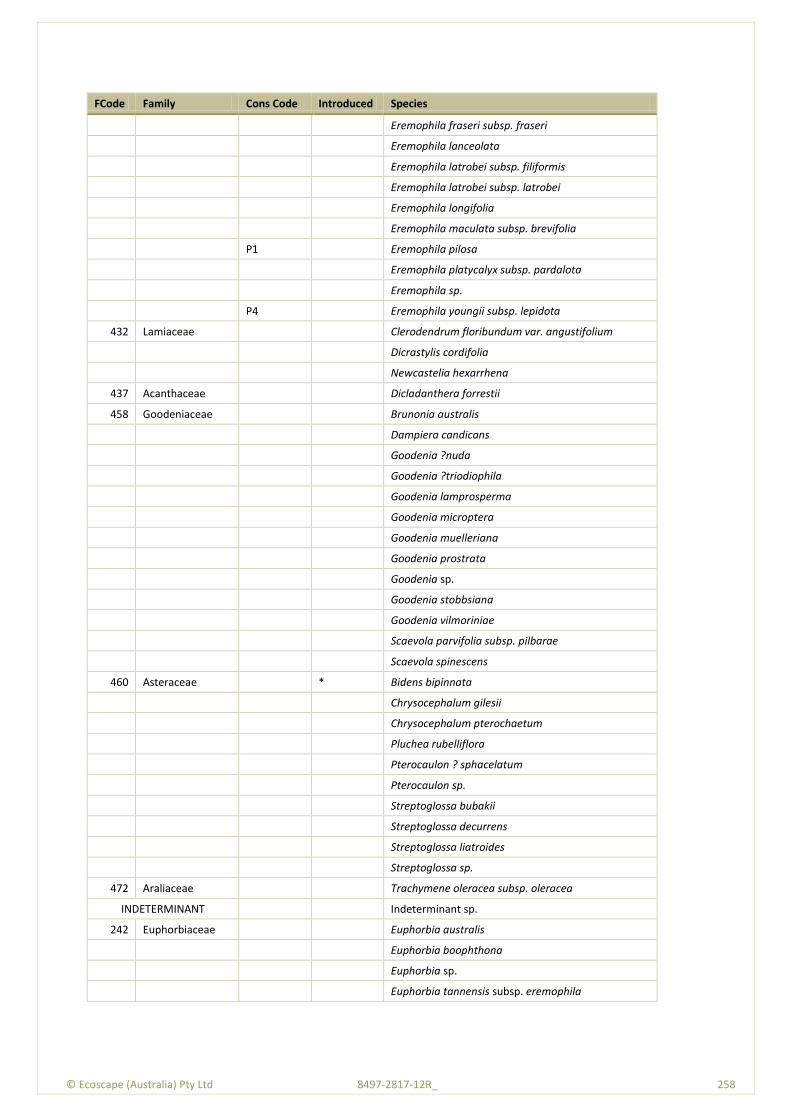
© Ecoscape (Australia) Pty Ltd 8497-2817-12R_ 258
FCode Family Cons Code Introduced Species
Eremophila fraseri subsp. fraseri
Eremophila lanceolata
Eremophila latrobei subsp. filiformis
Eremophila latrobei subsp. latrobei
Eremophila longifolia
Eremophila maculata subsp. brevifolia
P1
Eremophila pilosa
Eremophila platycalyx subsp. pardalota
Eremophila sp.
P4
Eremophila youngii subsp. lepidota
432 Lamiaceae
Clerodendrum floribundum var. angustifolium
Dicrastylis cordifolia
Newcastelia hexarrhena
437 Acanthaceae
Dicladanthera forrestii
458 Goodeniaceae
Brunonia australis
Dampiera candicans
Goodenia ?nuda
Goodenia ?triodiophila
Goodenia lamprosperma
Goodenia microptera
Goodenia muelleriana
Goodenia prostrata
Goodenia sp.
Goodenia stobbsiana
Goodenia vilmoriniae
Scaevola parvifolia subsp. pilbarae
Scaevola spinescens
460 Asteraceae * Bidens bipinnata
Chrysocephalum gilesii
Chrysocephalum pterochaetum
Pluchea rubelliflora
Pterocaulon ? sphacelatum
Pterocaulon sp.
Streptoglossa bubakii
Streptoglossa decurrens
Streptoglossa liatroides
Streptoglossa sp.
472 Araliaceae
Trachymene oleracea subsp. oleracea
INDETERMINANT
Indeterminant sp.
242 Euphorbiaceae
Euphorbia australis
Euphorbia boophthona
Euphorbia sp.
Euphorbia tannensis subsp. eremophila
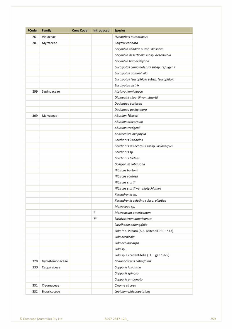
© Ecoscape (Australia) Pty Ltd 8497-2817-12R_ 259
FCode Family Cons Code Introduced Species
261 Violaceae
Hybanthus aurantiacus
281 Myrtaceae
Calytrix carinata
Corymbia candida subsp. dipsodes
Corymbia deserticola subsp. deserticola
Corymbia hamersleyana
Eucalyptus camaldulensis subsp. refulgens
Eucalyptus gamophylla
Eucalyptus leucophloia subsp. leucophloia
Eucalyptus victrix
299 Sapindaceae
Atalaya hemiglauca
Diplopeltis stuartii var. stuartii
Dodonaea coriacea
Dodonaea pachyneura
309 Malvaceae
Abutilon ?fraseri
Abutilon otocarpum
Abutilon trudgenii
Androcalva loxophylla
Corchorus ?sidoides
Corchorus lasiocarpus subsp. lasiocarpus
Corchorus sp.
Corchorus tridens
Gossypium robinsonii
Hibiscus burtonii
Hibiscus coatesii
Hibiscus sturtii
Hibiscus sturtii var. platychlamys
Keraudrenia sp.
Keraudrenia velutina subsp. elliptica
Malvaceae sp.
* Malvastrum americanum
?* ?Malvastrum americanum
?Melhania oblongifolia
Sida ?sp. Pilbara (A.A. Mitchell PRP 1543)
Sida arenicola
Sida echinocarpa
Sida sp.
Sida sp. Excedentifolia (J.L. Egan 1925)
328 Gyrostemonaceae
Codonocarpus cotinifolius
330 Capparaceae
Capparis lasiantha
Capparis spinosa
Capparis umbonata
331 Cleomaceae
Cleome viscosa
332 Brassicaceae
Lepidium phlebopetalum
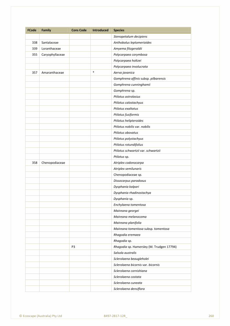
© Ecoscape (Australia) Pty Ltd 8497-2817-12R_ 260
FCode Family Cons Code Introduced Species
Stenopetalum decipiens
338 Santalaceae
Anthobolus leptomerioides
339 Loranthaceae
Amyema fitzgeraldii
355 Caryophyllaceae
Polycarpaea corymbosa
Polycarpaea holtzei
Polycarpaea involucrata
357 Amaranthaceae * Aerva javanica
Gomphrena affinis subsp. pilbarensis
Gomphrena cunninghamii
Gomphrena sp.
Ptilotus astrolasius
Ptilotus calostachyus
Ptilotus exaltatus
Ptilotus fusiformis
Ptilotus helipteroides
Ptilotus nobilis var. nobilis
Ptilotus obovatus
Ptilotus polystachyus
Ptilotus rotundifolius
Ptilotus schwartzii var. schwartzii
Ptilotus sp.
358 Chenopodiaceae
Atriplex codonocarpa
Atriplex semilunaris
Chenopodiaceae sp.
Dissocarpus paradoxus
Dysphania kalpari
Dysphania rhadinostachya
Dysphania sp.
Enchylaena tomentosa
Maireana georgei
Maireana melanocoma
Maireana planifolia
Maireana tomentosa subsp. tomentosa
Rhagodia eremaea
Rhagodia sp.
P3
Rhagodia sp. Hamersley (M. Trudgen 17794)
Salsola australis
Sclerolaena beaugleholei
Sclerolaena bicornis var. bicornis
Sclerolaena cornishiana
Sclerolaena costata
Sclerolaena cuneata
Sclerolaena densiflora
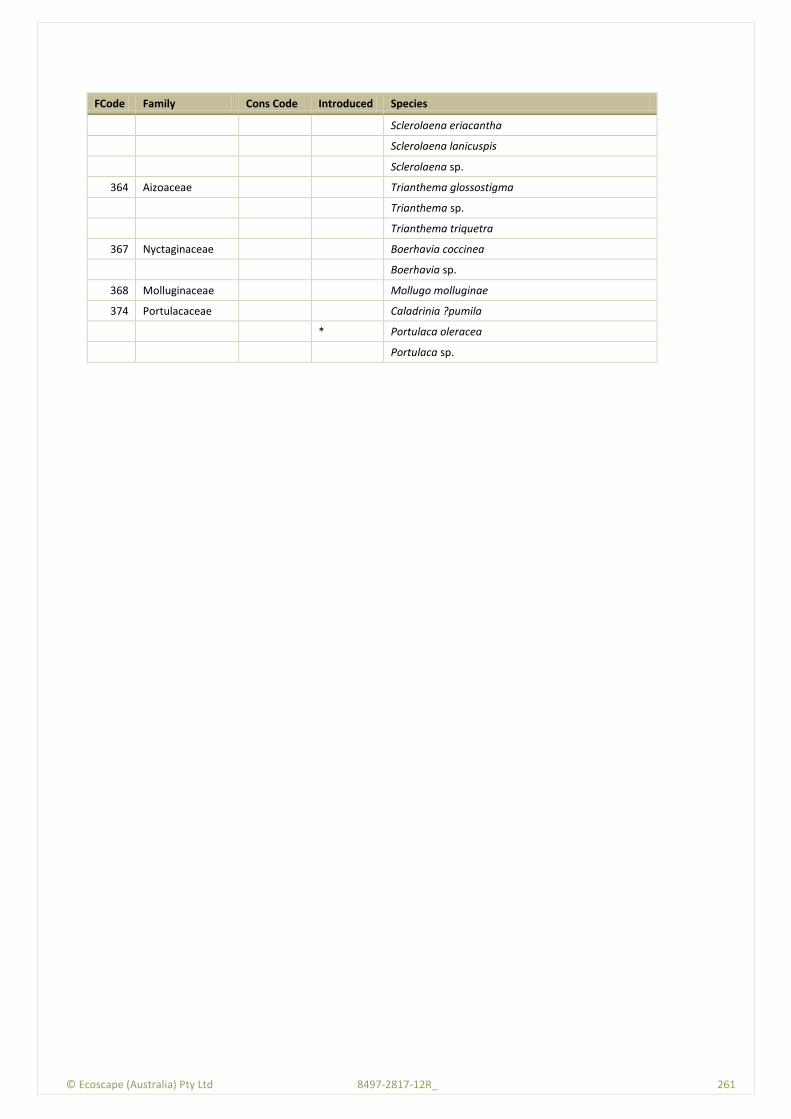
© Ecoscape (Australia) Pty Ltd 8497-2817-12R_ 261
FCode Family Cons Code Introduced Species
Sclerolaena eriacantha
Sclerolaena lanicuspis
Sclerolaena sp.
364 Aizoaceae
Trianthema glossostigma
Trianthema sp.
Trianthema triquetra
367 Nyctaginaceae
Boerhavia coccinea
Boerhavia sp.
368 Molluginaceae
Mollugo molluginae
374 Portulacaceae
Caladrinia ?pumila
* Portulaca oleracea
Portulaca sp.

© Ecoscape (Australia) Pty Ltd 8497-2817-12R_ 262
Appendix Eight: Threatened and Priority Flora Report Forms
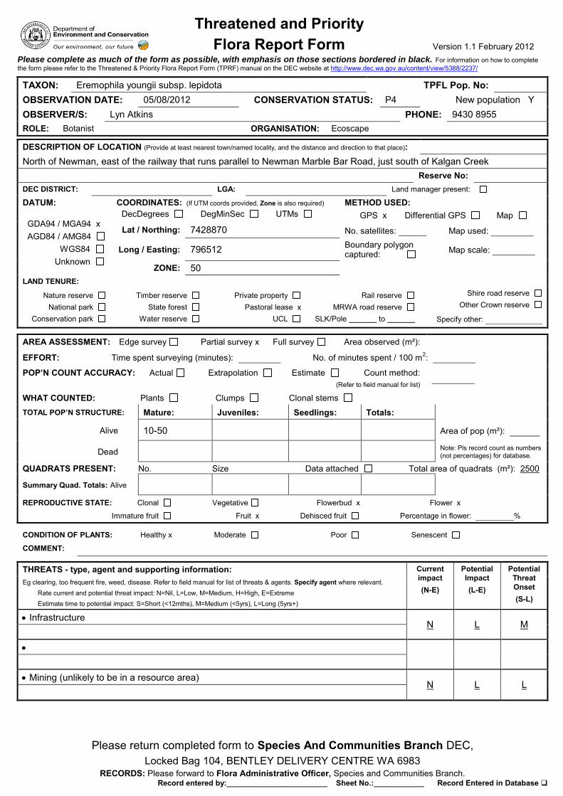
Threatened and Priority Flora Report Form Version 1.1 February 2012
Please return completed form to Species And Communities Branch DEC, Locked Bag 104, BENTLEY DELIVERY CENTRE WA 6983
RECORDS: Please forward to Flora Administrative Officer, Species and Communities Branch. Record entered by:________________________ Sheet No.:____________ Record Entered in Database
Please complete as much of the form as possible, with emphasis on those sections bordered in black. For information on how to complete the form please refer to the Threatened & Priority Flora Report Form (TPRF) manual on the DEC website at http://www.dec.wa.gov.au/content/view/5388/2237/
TAXON: Eremophila youngii subsp. lepidota TPFL Pop. No: OBSERVATION DATE: 05/08/2012 CONSERVATION STATUS: P4 New population Y OBSERVER/S: Lyn Atkins PHONE: 9430 8955 ROLE: Botanist ORGANISATION: Ecoscape
DESCRIPTION OF LOCATION (Provide at least nearest town/named locality, and the distance and direction to that place): North of Newman, east of the railway that runs parallel to Newman Marble Bar Road, just south of Kalgan Creek Reserve No: DEC DISTRICT: LGA: Land manager present:
DATUM:
GDA94 / MGA94 x AGD84 / AMG84 WGS84 Unknown
COORDINATES: (If UTM coords provided, Zone is also required) DecDegrees DegMinSec UTMs
METHOD USED: GPS x Differential GPS Map
Lat / Northing: 7428870 No. satellites: Map used:
Long / Easting: 796512 Boundary polygon captured: Map scale:
ZONE: 50 LAND TENURE:
Nature reserve National park
Conservation park
Timber reserve State forest
Water reserve
Private property Pastoral lease x
UCL
Rail reserve MRWA road reserve
SLK/Pole to
Shire road reserve
Other Crown reserve
Specify other:
AREA ASSESSMENT: Edge survey Partial survey x Full survey Area observed (m²):
EFFORT: Time spent surveying (minutes): No. of minutes spent / 100 m2:
POP’N COUNT ACCURACY: Actual Extrapolation Estimate Count method: (Refer to field manual for list)
WHAT COUNTED: Plants Clumps Clonal stems
TOTAL POP’N STRUCTURE: Mature: Juveniles: Seedlings: Totals:
Alive 10-50 Area of pop (m²):
Dead Note: Pls record count as numbers (not percentages) for database.
QUADRATS PRESENT: No. Size Data attached Total area of quadrats (m²): 2500
Summary Quad. Totals: Alive
REPRODUCTIVE STATE: Clonal Vegetative Flowerbud x Flower x
Immature fruit Fruit x Dehisced fruit Percentage in flower: %
CONDITION OF PLANTS: Healthy x Moderate Poor Senescent
COMMENT:
THREATS - type, agent and supporting information: Current impact (N-E)
Potential Impact (L-E)
Potential Threat Onset (S-L)
Eg clearing, too frequent fire, weed, disease. Refer to field manual for list of threats & agents. Specify agent where relevant. Rate current and potential threat impact: N=Nil, L=Low, M=Medium, H=High, E=Extreme Estimate time to potential impact: S=Short (<12mths), M=Medium (<5yrs), L=Long (5yrs+)
Infrastructure N L M
Mining (unlikely to be in a resource area)
N L L
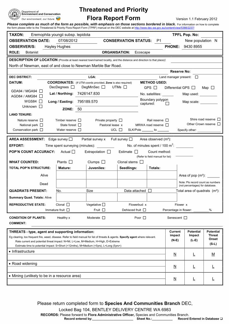
Threatened and Priority Flora Report Form Version 1.1 February 2012
Please return completed form to Species And Communities Branch DEC, Locked Bag 104, BENTLEY DELIVERY CENTRE WA 6983
RECORDS: Please forward to Flora Administrative Officer, Species and Communities Branch. Record entered by:________________________ Sheet No.:____________ Record Entered in Database
Please complete as much of the form as possible, with emphasis on those sections bordered in black. For information on how to complete the form please refer to the Threatened & Priority Flora Report Form (TPRF) manual on the DEC website at http://www.dec.wa.gov.au/content/view/5388/2237/
TAXON: Eremophila youngii subsp. lepidota TPFL Pop. No: OBSERVATION DATE: 07/08/2012 CONSERVATION STATUS: P1 New population N OBSERVER/S: Hayley Hughes PHONE: 9430 8955 ROLE: Botanist ORGANISATION: Ecoscape
DESCRIPTION OF LOCATION (Provide at least nearest town/named locality, and the distance and direction to that place): North of Newman, east of and close to Newman Marble Bar Road. Reserve No: DEC DISTRICT: LGA: Land manager present:
DATUM:
GDA94 / MGA94 AGD84 / AMG84 WGS84 Unknown
COORDINATES: (If UTM coords provided, Zone is also required) DecDegrees DegMinSec UTMs
METHOD USED: GPS Differential GPS Map
Lat / Northing: 7426147.830 No. satellites: Map used:
Long / Easting: 795189.570 Boundary polygon captured: Map scale:
ZONE: 50 LAND TENURE:
Nature reserve National park
Conservation park
Timber reserve State forest
Water reserve
Private property Pastoral lease x
UCL
Rail reserve MRWA road reserve
SLK/Pole to
Shire road reserve
Other Crown reserve
Specify other:
AREA ASSESSMENT: Edge survey Partial survey x Full survey Area observed (m²):
EFFORT: Time spent surveying (minutes): No. of minutes spent / 100 m2:
POP’N COUNT ACCURACY: Actual Extrapolation Estimate Count method: (Refer to field manual for list)
WHAT COUNTED: Plants Clumps Clonal stems
TOTAL POP’N STRUCTURE: Mature: Juveniles: Seedlings: Totals:
Alive Area of pop (m²):
Dead Note: Pls record count as numbers (not percentages) for database.
QUADRATS PRESENT: No. Size Data attached Total area of quadrats (m²):
Summary Quad. Totals: Alive
REPRODUCTIVE STATE: Clonal Vegetative Flowerbud x Flower x
Immature fruit Fruit Dehisced fruit Percentage in flower: %
CONDITION OF PLANTS: Healthy x Moderate Poor Senescent
COMMENT:
THREATS - type, agent and supporting information: Current impact (N-E)
Potential Impact (L-E)
Potential Threat Onset (S-L)
Eg clearing, too frequent fire, weed, disease. Refer to field manual for list of threats & agents. Specify agent where relevant. Rate current and potential threat impact: N=Nil, L=Low, M=Medium, H=High, E=Extreme Estimate time to potential impact: S=Short (<12mths), M=Medium (<5yrs), L=Long (5yrs+)
Infrastructure N L M
Road widening
N L L Mining (unlikely to be in a resource area)
N L L
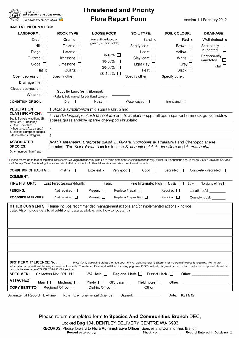
Threatened and Priority Flora Report Form Version 1.1 February 2012
Please return completed form to Species And Communities Branch DEC, Locked Bag 104, BENTLEY DELIVERY CENTRE WA 6983
RECORDS: Please forward to Flora Administrative Officer, Species and Communities Branch. Record entered by:________________________ Sheet No.:____________ Record Entered in Database
HABITAT INFORMATION:
LANDFORM: Crest
Hill
Ridge
Outcrop
Slope
Flat x
Open depression
Drainage line
Closed depression
Wetland
ROCK TYPE: Granite
Dolerite
Laterite
Ironstone
Limestone
Quartz
Specify other:
LOOSE ROCK: (on soil surface; eg gravel, quartz fields)
0-10%
10-30%
30-50%
50-100%
SOIL TYPE: Sand x
Sandy loam
Loam
Clay loam
Light clay
Peat
Specify other:
SOIL COLOUR: Red x
Brown
Yellow
White
Grey
Black
Specify other:
DRAINAGE: Well drained x
Seasonally inundated
Permanently inundated
Tidal
Specific Landform Element: (Refer to field manual for additional values)
CONDITION OF SOIL: Dry Moist Waterlogged Inundated
VEGETATION CLASSIFICATION*: Eg: 1. Banksia woodland (B. attenuata, B. ilicifolia); 2. Open shrubland (Hibbertia sp., Acacia spp.) ; 3. Isolated clumps of sedges (Mesomelaena tetragona)
1. Acacia synchronicia mid sparse shrubland 2. Triodia longiceps, Aristida contorta and Sclerolaena spp. tall open-sparse hummock grassland/low sparse grassland/low sparse chenopod shrubland
3.
4.
ASSOCIATED SPECIES: Other (non-dominant) spp
Acacia aptaneura, Eragrostis dielsii, E. falcata, Sporobolis australasicus and Chenopodiaceae species. The Sclerolaena species include S. beaugleholei, S. densiflora and S. eriacantha.
* Please record up to four of the most representative vegetation layers (with up to three dominant species in each layer). Structural Formations should follow 2009 Australian Soil and
Land Survey Field Handbook guidelines – refer to field manual for further information and structural formation table.
CONDITION OF HABITAT: Pristine Excellent x Very good Good Degraded Completely degraded
COMMENT:
FIRE HISTORY: Last Fire: Season/Month: Year: Fire Intensity: High Medium Low No signs of fire
FENCING: Not required Present Replace / repair Required Length req’d:
ROADSIDE MARKERS: Not required Present Replace / reposition Required Quantity req’d:
OTHER COMMENTS: (Please include recommended management actions and/or implemented actions - include date. Also include details of additional data available, and how to locate it.)
DRF PERMIT/ LICENCE No: Note if only observing plants (i.e. no specimens or plant matieral is taken) then no permit/licence is required. For further information on permit and licening requirements see the Threatened Flora and Wildlife Licensing pages on DEC’s website. Any actions carried out under licence/permit should be recorded above in the OTHER COMMENTS section. SPECIMEN: Collectors No: OPHH12 WA Herb. Regional Herb. District Herb. Other: __________________
ATTACHED: Map
Mudmap
Photo
GIS data
Field notes
Other:
______________________
COPY SENT TO: Regional Office District Office Other:
Submitter of Record: L Atkins Role: Environemental Scientist Signed: Date: 16/11/12

Threatened and Priority Flora Report Form Version 1.1 February 2012
Please return completed form to Species And Communities Branch DEC, Locked Bag 104, BENTLEY DELIVERY CENTRE WA 6983
RECORDS: Please forward to Flora Administrative Officer, Species and Communities Branch. Record entered by:________________________ Sheet No.:____________ Record Entered in Database
HABITAT INFORMATION:
LANDFORM: Crest
Hill
Ridge
Outcrop
Slope
Flat x
Open depression
Drainage line
Closed depression
Wetland
ROCK TYPE: Granite
Dolerite
Laterite
Ironstone
Limestone
Quartz
Specify other:
LOOSE ROCK: (on soil surface; eg gravel, quartz fields)
0-10%
10-30%
30-50%
50-100%
SOIL TYPE: Sand x
Sandy loam
Loam
Clay loam
Light clay
Peat
Specify other:
SOIL COLOUR: Red x
Brown
Yellow
White
Grey
Black
Specify other:
DRAINAGE: Well drained x
Seasonally inundated
Permanently inundated
Tidal
Specific Landform Element: (Refer to field manual for additional values)
CONDITION OF SOIL: Dry Moist Waterlogged Inundated
VEGETATION CLASSIFICATION*: Eg: 1. Banksia woodland (B. attenuata, B. ilicifolia); 2. Open shrubland (Hibbertia sp., Acacia spp.) ; 3. Isolated clumps of sedges (Mesomelaena tetragona)
1. Acacia synchronicia mid sparse shrubland over 2. Triodia longiceps, Aristida contorta and Sclerolaena spp. tall open-sparse hummock grassland/low sparse grassland/low sparse chenopod shrubland
3.
4.
ASSOCIATED SPECIES: Other (non-dominant) spp
Acacia aptaneura, Eragrostis dielsii, E. falcata, Sporobolis australasicus and Chenopodiaceae species. The Sclerolaena species include S. beaugleholei, S. densiflora and S. eriacantha.
* Please record up to four of the most representative vegetation layers (with up to three dominant species in each layer). Structural Formations should follow 2009 Australian Soil and
Land Survey Field Handbook guidelines – refer to field manual for further information and structural formation table.
CONDITION OF HABITAT: Pristine Excellent x Very good Good Degraded Completely degraded
COMMENT: Semi-saline alluvial soil FIRE HISTORY: Last Fire: Season/Month: Year: Fire Intensity: High Medium Low No signs of fire
FENCING: Not required Present Replace / repair Required Length req’d:
ROADSIDE MARKERS: Not required Present Replace / reposition Required Quantity req’d:
OTHER COMMENTS: (Please include recommended management actions and/or implemented actions - include date. Also include details of additional data available, and how to locate it.)
DRF PERMIT/ LICENCE No: Note if only observing plants (i.e. no specimens or plant matieral is taken) then no permit/licence is required. For further information on permit and licening requirements see the Threatened Flora and Wildlife Licensing pages on DEC’s website. Any actions carried out under licence/permit should be recorded above in the OTHER COMMENTS section. SPECIMEN: Collectors No: LA V20 WA Herb. Regional Herb. District Herb. Other: __________________
ATTACHED: Map
Mudmap
Photo
GIS data
Field notes
Other:
______________________
COPY SENT TO: Regional Office District Office Other:
Submitter of Record: L Atkins Role: Environemental Scientist Signed: Date: 16/11/12
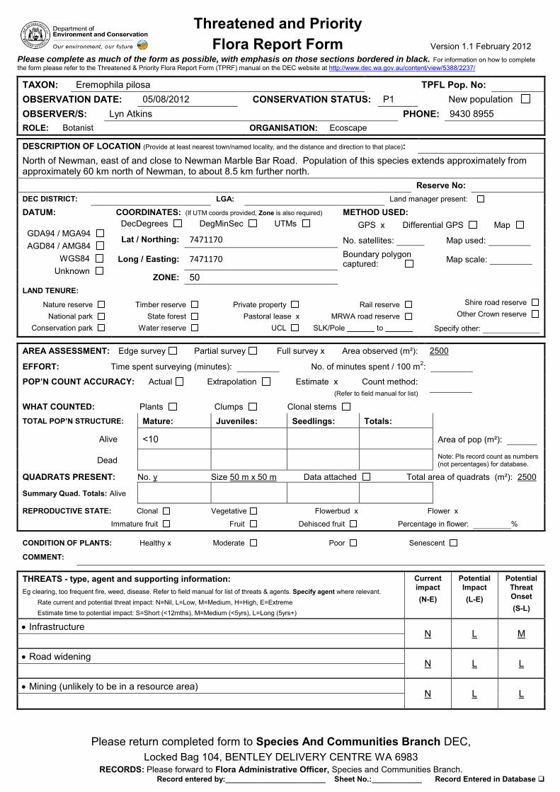
Threatened and Priority Flora Report Form Version 1.1 February 2012
Please return completed form to Species And Communities Branch DEC, Locked Bag 104, BENTLEY DELIVERY CENTRE WA 6983
RECORDS: Please forward to Flora Administrative Officer, Species and Communities Branch. Record entered by:________________________ Sheet No.:____________ Record Entered in Database
Please complete as much of the form as possible, with emphasis on those sections bordered in black. For information on how to complete the form please refer to the Threatened & Priority Flora Report Form (TPRF) manual on the DEC website at http://www.dec.wa.gov.au/content/view/5388/2237/
TAXON: Eremophila pilosa TPFL Pop. No: OBSERVATION DATE: 05/08/2012 CONSERVATION STATUS: P1 New population OBSERVER/S: Lyn Atkins PHONE: 9430 8955 ROLE: Botanist ORGANISATION: Ecoscape
DESCRIPTION OF LOCATION (Provide at least nearest town/named locality, and the distance and direction to that place): North of Newman, east of and close to Newman Marble Bar Road. Population of this species extends approximately from approximately 60 km north of Newman, to about 8.5 km further north. Reserve No: DEC DISTRICT: LGA: Land manager present:
DATUM:
GDA94 / MGA94 AGD84 / AMG84 WGS84 Unknown
COORDINATES: (If UTM coords provided, Zone is also required) DecDegrees DegMinSec UTMs
METHOD USED: GPS x Differential GPS Map
Lat / Northing: 7471170 No. satellites: Map used:
Long / Easting: 7471170 Boundary polygon captured: Map scale:
ZONE: 50 LAND TENURE:
Nature reserve National park
Conservation park
Timber reserve State forest
Water reserve
Private property Pastoral lease x
UCL
Rail reserve MRWA road reserve
SLK/Pole to
Shire road reserve
Other Crown reserve
Specify other:
AREA ASSESSMENT: Edge survey Partial survey Full survey x Area observed (m²): 2500
EFFORT: Time spent surveying (minutes): No. of minutes spent / 100 m2:
POP’N COUNT ACCURACY: Actual Extrapolation Estimate x Count method: (Refer to field manual for list)
WHAT COUNTED: Plants Clumps Clonal stems
TOTAL POP’N STRUCTURE: Mature: Juveniles: Seedlings: Totals:
Alive <10 Area of pop (m²):
Dead Note: Pls record count as numbers (not percentages) for database.
QUADRATS PRESENT: No. y Size 50 m x 50 m Data attached Total area of quadrats (m²): 2500
Summary Quad. Totals: Alive
REPRODUCTIVE STATE: Clonal Vegetative Flowerbud x Flower x
Immature fruit Fruit Dehisced fruit Percentage in flower: %
CONDITION OF PLANTS: Healthy x Moderate Poor Senescent
COMMENT:
THREATS - type, agent and supporting information: Current impact (N-E)
Potential Impact (L-E)
Potential Threat Onset (S-L)
Eg clearing, too frequent fire, weed, disease. Refer to field manual for list of threats & agents. Specify agent where relevant. Rate current and potential threat impact: N=Nil, L=Low, M=Medium, H=High, E=Extreme Estimate time to potential impact: S=Short (<12mths), M=Medium (<5yrs), L=Long (5yrs+)
Infrastructure N L M
Road widening
N L L Mining (unlikely to be in a resource area)
N L L

Threatened and Priority Flora Report Form Version 1.1 February 2012
Please return completed form to Species And Communities Branch DEC, Locked Bag 104, BENTLEY DELIVERY CENTRE WA 6983
RECORDS: Please forward to Flora Administrative Officer, Species and Communities Branch. Record entered by:________________________ Sheet No.:____________ Record Entered in Database
HABITAT INFORMATION:
LANDFORM: Crest
Hill
Ridge
Outcrop
Slope
Flat x
Open depression
Drainage line
Closed depression
Wetland
ROCK TYPE: Granite
Dolerite
Laterite
Ironstone
Limestone
Quartz
Specify other:
LOOSE ROCK: (on soil surface; eg gravel, quartz fields)
0-10%
10-30%
30-50%
50-100%
SOIL TYPE: Sand x
Sandy loam
Loam
Clay loam
Light clay
Peat
Specify other:
SOIL COLOUR: Red x
Brown
Yellow
White
Grey
Black
Specify other:
DRAINAGE: Well drained x
Seasonally inundated
Permanently inundated
Tidal
Specific Landform Element: (Refer to field manual for additional values)
CONDITION OF SOIL: Dry Moist Waterlogged Inundated
VEGETATION CLASSIFICATION*: Eg: 1. Banksia woodland (B. attenuata, B. ilicifolia); 2. Open shrubland (Hibbertia sp., Acacia spp.) ; 3. Isolated clumps of sedges (Mesomelaena tetragona)
1. Acacia pachyacra and A. pruinocarpa scattered mid shrubs
2. Triodia basedowii, T. longiceps and Ptilotus astrolasius low open hummock grassland/low sparse shrubland
3.
4.
ASSOCIATED SPECIES: Other (non-dominant) spp
* Please record up to four of the most representative vegetation layers (with up to three dominant species in each layer). Structural Formations should follow 2009 Australian Soil and
Land Survey Field Handbook guidelines – refer to field manual for further information and structural formation table.
CONDITION OF HABITAT: Pristine Excellent x Very good Good Degraded Completely degraded
COMMENT:
FIRE HISTORY: Last Fire: Season/Month: Year: Fire Intensity: High Medium Low No signs of fire
FENCING: Not required Present Replace / repair Required Length req’d:
ROADSIDE MARKERS: Not required Present Replace / reposition Required Quantity req’d:
OTHER COMMENTS: (Please include recommended management actions and/or implemented actions - include date. Also include details of additional data available, and how to locate it.)
DRF PERMIT/ LICENCE No: Note if only observing plants (i.e. no specimens or plant matieral is taken) then no permit/licence is required. For further information on permit and licening requirements see the Threatened Flora and Wildlife Licensing pages on DEC’s website. Any actions carried out under licence/permit should be recorded above in the OTHER COMMENTS section. SPECIMEN: Collectors No: AERL7-1___ WA Herb. Regional Herb. District Herb. Other: __________________
ATTACHED: Map
Mudmap
Photo
GIS data
Field notes
Other:
______________________
COPY SENT TO: Regional Office District Office Other:
Submitter of Record: L Atkins Role: Environemental Scientist Signed: Date: 16/11/12

Threatened and Priority Flora Report Form Version 1.1 February 2012
Please return completed form to Species And Communities Branch DEC, Locked Bag 104, BENTLEY DELIVERY CENTRE WA 6983
RECORDS: Please forward to Flora Administrative Officer, Species and Communities Branch. Record entered by:________________________ Sheet No.:____________ Record Entered in Database
Please complete as much of the form as possible, with emphasis on those sections bordered in black. For information on how to complete the form please refer to the Threatened & Priority Flora Report Form (TPRF) manual on the DEC website at http://www.dec.wa.gov.au/content/view/5388/2237/
TAXON: Eremophila pilosa TPFL Pop. No: OBSERVATION DATE: 05/08/2012 CONSERVATION STATUS: P1 New population OBSERVER/S: Lyn Atkins PHONE: 9430 8955 ROLE: Botanist ORGANISATION: Ecoscape
DESCRIPTION OF LOCATION (Provide at least nearest town/named locality, and the distance and direction to that place): North of Newman, east of and close to Newman Marble Bar Road. Population of this species extends approximately from approximately 60 km north of Newman, to about 8.5 km further north. Reserve No: DEC DISTRICT: LGA: Land manager present:
DATUM:
GDA94 / MGA94 x AGD84 / AMG84 WGS84 Unknown
COORDINATES: (If UTM coords provided, Zone is also required) DecDegrees DegMinSec UTMs
METHOD USED: GPS x Differential GPS Map
Lat / Northing: 7470146.548 No. satellites: Map used:
Long / Easting: 808615.548 Boundary polygon captured: Map scale:
ZONE:
LAND TENURE:
Nature reserve National park
Conservation park
Timber reserve State forest
Water reserve
Private property Pastoral lease x
UCL
Rail reserve MRWA road reserve
SLK/Pole to
Shire road reserve
Other Crown reserve
Specify other:
AREA ASSESSMENT: Edge survey Partial survey x Full survey Area observed (m²): 8.5 km x 100 m
EFFORT: Time spent surveying (minutes): No. of minutes spent / 100 m2:
POP’N COUNT ACCURACY: Actual Extrapolation Estimate x Count method: (Refer to field manual for list)
WHAT COUNTED: Plants Clumps Clonal stems
TOTAL POP’N STRUCTURE: Mature: Juveniles: Seedlings: Totals:
Alive <10 (within sight) Area of pop (m²):
Dead Note: Pls record count as numbers (not percentages) for database.
QUADRATS PRESENT: No. Size Data attached Total area of quadrats (m²): 2500
Summary Quad. Totals: Alive
REPRODUCTIVE STATE: Clonal Vegetative Flowerbud x Flower x
Immature fruit Fruit Dehisced fruit Percentage in flower: %
CONDITION OF PLANTS: Healthy x Moderate Poor Senescent
COMMENT: Plants were scattered at varying densities
THREATS - type, agent and supporting information: Current impact (N-E)
Potential Impact (L-E)
Potential Threat Onset (S-L)
Eg clearing, too frequent fire, weed, disease. Refer to field manual for list of threats & agents. Specify agent where relevant. Rate current and potential threat impact: N=Nil, L=Low, M=Medium, H=High, E=Extreme Estimate time to potential impact: S=Short (<12mths), M=Medium (<5yrs), L=Long (5yrs+)
Infrastructure N L M
Road widening
N L L Mining (unlikely to be in a resource area)
N L L

Threatened and Priority Flora Report Form Version 1.1 February 2012
Please return completed form to Species And Communities Branch DEC, Locked Bag 104, BENTLEY DELIVERY CENTRE WA 6983
RECORDS: Please forward to Flora Administrative Officer, Species and Communities Branch. Record entered by:________________________ Sheet No.:____________ Record Entered in Database
HABITAT INFORMATION:
LANDFORM: Crest
Hill
Ridge
Outcrop
Slope
Flat x
Open depression
Drainage line
Closed depression
Wetland
ROCK TYPE: Granite
Dolerite
Laterite
Ironstone
Limestone
Quartz
Specify other:
LOOSE ROCK: (on soil surface; eg gravel, quartz fields)
0-10%
10-30%
30-50%
50-100%
SOIL TYPE: Sand x
Sandy loam
Loam
Clay loam
Light clay
Peat
Specify other:
SOIL COLOUR: Red x
Brown
Yellow
White
Grey
Black
Specify other:
DRAINAGE: Well drained x
Seasonally inundated
Permanently inundated
Tidal
Specific Landform Element: (Refer to field manual for additional values)
CONDITION OF SOIL: Dry Moist Waterlogged Inundated
VEGETATION CLASSIFICATION*: Eg: 1. Banksia woodland (B. attenuata, B. ilicifolia); 2. Open shrubland (Hibbertia sp., Acacia spp.) ; 3. Isolated clumps of sedges (Mesomelaena tetragona)
1. Acacia ancistrocarpa and A. pachyacra tall-mid scattered shrubs 2. Triodia basedowii, T. longiceps and Paraneurachne muelleri mid-low open hummock grassland/low sparse tussock grassland
3.
4.
ASSOCIATED SPECIES: Other (non-dominant) spp
Aristida contorta, Aristida inaequilatera, Bonamia erecta, Ptilotus asterolasius and Senna notabilis. The mid stratum, and occasionally upper stratum, emergent species were very variable and included several Acacia species (including A. aptaneura and A. paraneura), Corymbia deserticola subsp. deserticola, Eucalyptus gamophylla and Grevillea species.
* Please record up to four of the most representative vegetation layers (with up to three dominant species in each layer). Structural Formations should follow 2009 Australian Soil and
Land Survey Field Handbook guidelines – refer to field manual for further information and structural formation table.
CONDITION OF HABITAT: Pristine Excellent x Very good Good Degraded Completely degraded
COMMENT:
FIRE HISTORY: Last Fire: Season/Month: Year: Fire Intensity: High Medium Low No signs of fire
FENCING: Not required Present Replace / repair Required Length req’d:
ROADSIDE MARKERS: Not required Present Replace / reposition Required Quantity req’d:
OTHER COMMENTS: (Please include recommended management actions and/or implemented actions - include date. Also include details of additional data available, and how to locate it.)
DRF PERMIT/ LICENCE No: Note if only observing plants (i.e. no specimens or plant matieral is taken) then no permit/licence is required. For further information on permit and licening requirements see the Threatened Flora and Wildlife Licensing pages on DEC’s website. Any actions carried out under licence/permit should be recorded above in the OTHER COMMENTS section. SPECIMEN: Collectors No:LA V11 WA Herb. Regional Herb. District Herb. Other: __________________
ATTACHED: Map
Mudmap
Photo
GIS data
Field notes
Other:
______________________
COPY SENT TO: Regional Office District Office Other:
Submitter of Record: L Atkins Role: Environemental Scientist Signed: Date: 16/11/12
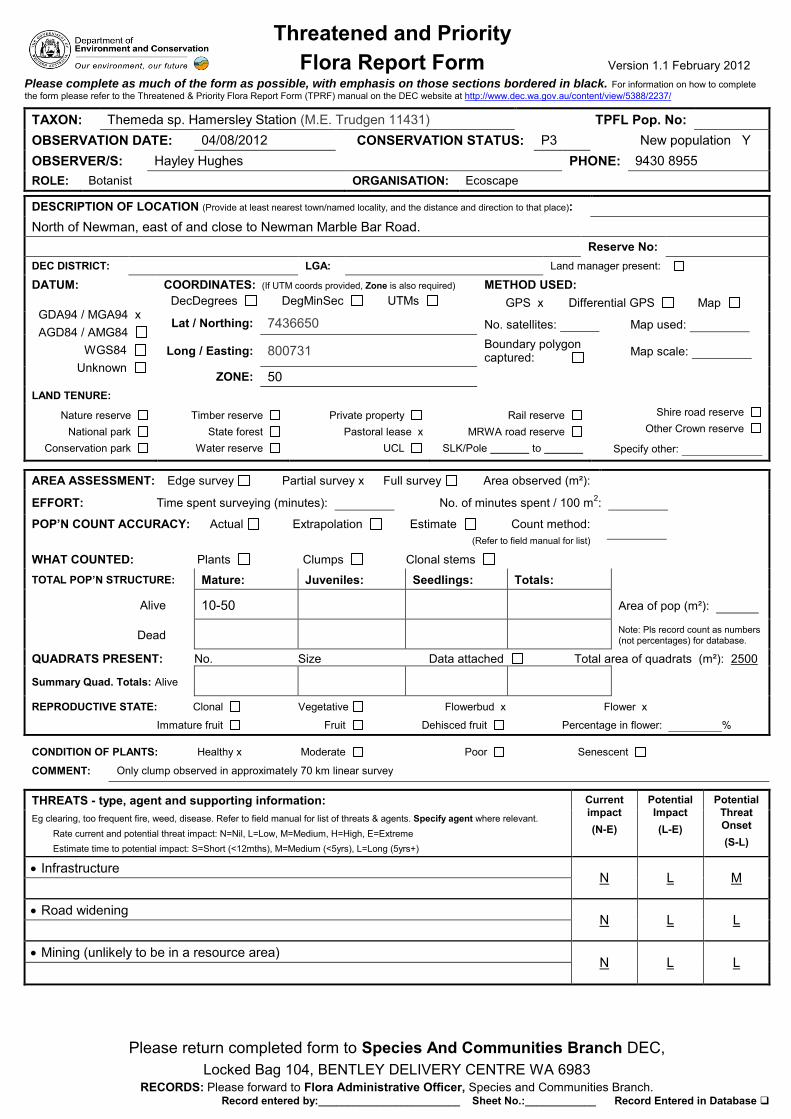
Threatened and Priority Flora Report Form Version 1.1 February 2012
Please return completed form to Species And Communities Branch DEC, Locked Bag 104, BENTLEY DELIVERY CENTRE WA 6983
RECORDS: Please forward to Flora Administrative Officer, Species and Communities Branch. Record entered by:________________________ Sheet No.:____________ Record Entered in Database
Please complete as much of the form as possible, with emphasis on those sections bordered in black. For information on how to complete the form please refer to the Threatened & Priority Flora Report Form (TPRF) manual on the DEC website at http://www.dec.wa.gov.au/content/view/5388/2237/
TAXON: Themeda sp. Hamersley Station (M.E. Trudgen 11431) TPFL Pop. No: OBSERVATION DATE: 04/08/2012 CONSERVATION STATUS: P3 New population Y OBSERVER/S: Hayley Hughes PHONE: 9430 8955 ROLE: Botanist ORGANISATION: Ecoscape
DESCRIPTION OF LOCATION (Provide at least nearest town/named locality, and the distance and direction to that place): North of Newman, east of and close to Newman Marble Bar Road. Reserve No: DEC DISTRICT: LGA: Land manager present:
DATUM:
GDA94 / MGA94 x AGD84 / AMG84 WGS84 Unknown
COORDINATES: (If UTM coords provided, Zone is also required) DecDegrees DegMinSec UTMs
METHOD USED: GPS x Differential GPS Map
Lat / Northing: 7436650 No. satellites: Map used:
Long / Easting: 800731 Boundary polygon captured: Map scale:
ZONE: 50 LAND TENURE:
Nature reserve National park
Conservation park
Timber reserve State forest
Water reserve
Private property Pastoral lease x
UCL
Rail reserve MRWA road reserve
SLK/Pole to
Shire road reserve
Other Crown reserve
Specify other:
AREA ASSESSMENT: Edge survey Partial survey x Full survey Area observed (m²):
EFFORT: Time spent surveying (minutes): No. of minutes spent / 100 m2:
POP’N COUNT ACCURACY: Actual Extrapolation Estimate Count method: (Refer to field manual for list)
WHAT COUNTED: Plants Clumps Clonal stems
TOTAL POP’N STRUCTURE: Mature: Juveniles: Seedlings: Totals:
Alive 10-50 Area of pop (m²):
Dead Note: Pls record count as numbers (not percentages) for database.
QUADRATS PRESENT: No. Size Data attached Total area of quadrats (m²): 2500
Summary Quad. Totals: Alive
REPRODUCTIVE STATE: Clonal Vegetative Flowerbud x Flower x
Immature fruit Fruit Dehisced fruit Percentage in flower: %
CONDITION OF PLANTS: Healthy x Moderate Poor Senescent
COMMENT: Only clump observed in approximately 70 km linear survey
THREATS - type, agent and supporting information: Current impact (N-E)
Potential Impact (L-E)
Potential Threat Onset (S-L)
Eg clearing, too frequent fire, weed, disease. Refer to field manual for list of threats & agents. Specify agent where relevant. Rate current and potential threat impact: N=Nil, L=Low, M=Medium, H=High, E=Extreme Estimate time to potential impact: S=Short (<12mths), M=Medium (<5yrs), L=Long (5yrs+)
Infrastructure N L M
Road widening
N L L Mining (unlikely to be in a resource area)
N L L
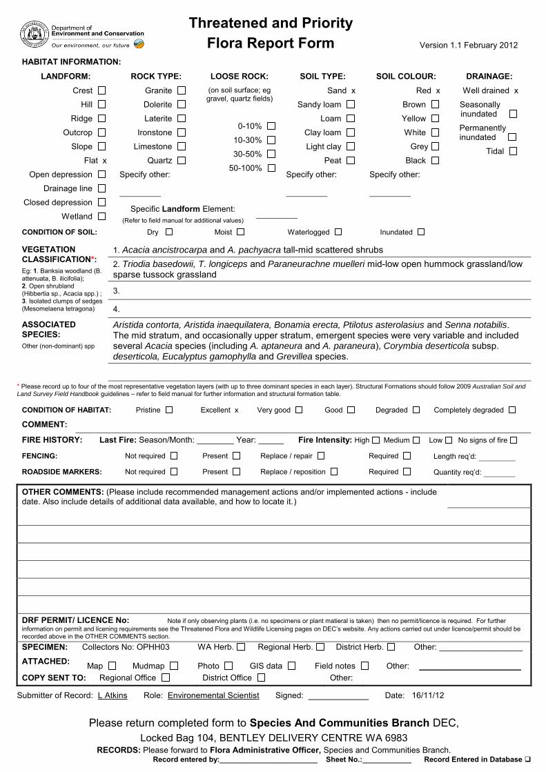
Threatened and Priority Flora Report Form Version 1.1 February 2012
Please return completed form to Species And Communities Branch DEC, Locked Bag 104, BENTLEY DELIVERY CENTRE WA 6983
RECORDS: Please forward to Flora Administrative Officer, Species and Communities Branch. Record entered by:________________________ Sheet No.:____________ Record Entered in Database
HABITAT INFORMATION:
LANDFORM: Crest
Hill
Ridge
Outcrop
Slope
Flat x
Open depression
Drainage line
Closed depression
Wetland
ROCK TYPE: Granite
Dolerite
Laterite
Ironstone
Limestone
Quartz
Specify other:
LOOSE ROCK: (on soil surface; eg gravel, quartz fields)
0-10%
10-30%
30-50%
50-100%
SOIL TYPE: Sand x
Sandy loam
Loam
Clay loam
Light clay
Peat
Specify other:
SOIL COLOUR: Red x
Brown
Yellow
White
Grey
Black
Specify other:
DRAINAGE: Well drained x
Seasonally inundated
Permanently inundated
Tidal
Specific Landform Element: (Refer to field manual for additional values)
CONDITION OF SOIL: Dry Moist Waterlogged Inundated
VEGETATION CLASSIFICATION*: Eg: 1. Banksia woodland (B. attenuata, B. ilicifolia); 2. Open shrubland (Hibbertia sp., Acacia spp.) ; 3. Isolated clumps of sedges (Mesomelaena tetragona)
1. Acacia ancistrocarpa and A. pachyacra tall-mid scattered shrubs 2. Triodia basedowii, T. longiceps and Paraneurachne muelleri mid-low open hummock grassland/low sparse tussock grassland
3.
4.
ASSOCIATED SPECIES: Other (non-dominant) spp
Aristida contorta, Aristida inaequilatera, Bonamia erecta, Ptilotus asterolasius and Senna notabilis. The mid stratum, and occasionally upper stratum, emergent species were very variable and included several Acacia species (including A. aptaneura and A. paraneura), Corymbia deserticola subsp. deserticola, Eucalyptus gamophylla and Grevillea species.
* Please record up to four of the most representative vegetation layers (with up to three dominant species in each layer). Structural Formations should follow 2009 Australian Soil and
Land Survey Field Handbook guidelines – refer to field manual for further information and structural formation table.
CONDITION OF HABITAT: Pristine Excellent x Very good Good Degraded Completely degraded
COMMENT:
FIRE HISTORY: Last Fire: Season/Month: Year: Fire Intensity: High Medium Low No signs of fire
FENCING: Not required Present Replace / repair Required Length req’d:
ROADSIDE MARKERS: Not required Present Replace / reposition Required Quantity req’d:
OTHER COMMENTS: (Please include recommended management actions and/or implemented actions - include date. Also include details of additional data available, and how to locate it.)
DRF PERMIT/ LICENCE No: Note if only observing plants (i.e. no specimens or plant matieral is taken) then no permit/licence is required. For further information on permit and licening requirements see the Threatened Flora and Wildlife Licensing pages on DEC’s website. Any actions carried out under licence/permit should be recorded above in the OTHER COMMENTS section. SPECIMEN: Collectors No: OPHH03 WA Herb. Regional Herb. District Herb. Other: __________________
ATTACHED: Map
Mudmap
Photo
GIS data
Field notes
Other:
______________________
COPY SENT TO: Regional Office District Office Other:
Submitter of Record: L Atkins Role: Environemental Scientist Signed: Date: 16/11/12
© Ecoscape (Australia) Pty Ltd 8497-2817-12R_ 273
Appendix Nine: Floristic Analysis Dendrogram
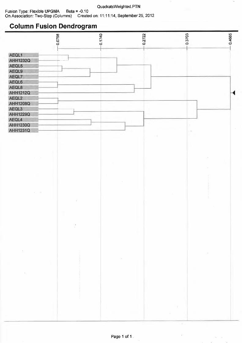
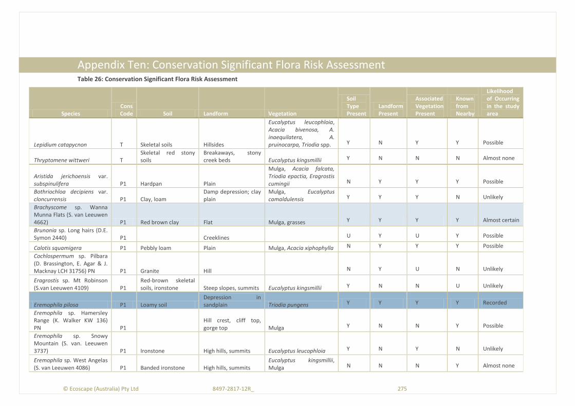
© Ecoscape (Australia) Pty Ltd 8497-2817-12R_ 275
Appendix Ten: Conservation Significant Flora Risk Assessment Table 26: Conservation Significant Flora Risk Assessment
Species Cons Code Soil Landform Vegetation
Soil Type Present
Landform Present
Associated Vegetation Present
Known from Nearby
Likelihood of Occurring in the study area
Lepidium catapycnon T Skeletal soils Hillsides
Eucalyptus leucophloia, Acacia bivenosa, A. inaequilatera, A. pruinocarpa, Triodia spp. Y N Y Y Possible
Thryptomene wittweri T Skeletal red stony soils
Breakaways, stony creek beds Eucalyptus kingsmillii Y N N N Almost none
Aristida jerichoensis var. subspinulifera P1 Hardpan Plain
Mulga, Acacia falcata, Triodia epactia, Eragrostis cumingii N Y Y Y Possible
Bothriochloa decipiens var. cloncurrensis P1 Clay, loam
Damp depression; clay plain
Mulga, Eucalyptus camaldulensis Y Y Y N Unlikely
Brachyscome sp. Wanna Munna Flats (S. van Leeuwen 4662) P1 Red brown clay Flat Mulga, grasses Y Y Y Y Almost certain
Brunonia sp. Long hairs (D.E. Symon 2440) P1
Creeklines
U Y U Y Possible
Calotis squamigera P1 Pebbly loam Plain Mulga, Acacia xiphophylla N Y Y Y Possible
Cochlospermum sp. Pilbara (D. Brassington, E. Agar & J. Macknay LCH 31756) PN P1 Granite Hill
N Y U N Unlikely
Eragrostis sp. Mt Robinson (S.van Leeuwen 4109) P1
Red-brown skeletal soils, ironstone Steep slopes, summits Eucalyptus kingsmillii Y N N U Unlikely
Eremophila pilosa P1 Loamy soil Depression in sandplain Triodia pungens Y Y Y Y Recorded
Eremophila sp. Hamersley Range (K. Walker KW 136) PN P1
Hill crest, cliff top, gorge top Mulga Y N N Y Possible
Eremophila sp. Snowy Mountain (S. van. Leeuwen 3737) P1 Ironstone High hills, summits Eucalyptus leucophloia Y N Y N Unlikely
Eremophila sp. West Angelas (S. van Leeuwen 4086) P1 Banded ironstone High hills, summits
Eucalyptus kingsmillii, Mulga N N N Y Almost none
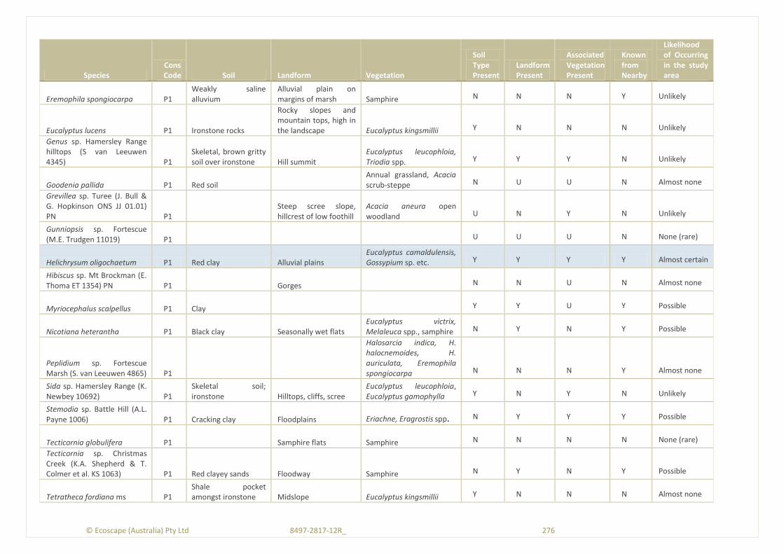
© Ecoscape (Australia) Pty Ltd 8497-2817-12R_ 276
Species Cons Code Soil Landform Vegetation
Soil Type Present
Landform Present
Associated Vegetation Present
Known from Nearby
Likelihood of Occurring in the study area
Eremophila spongiocarpa P1 Weakly saline alluvium
Alluvial plain on margins of marsh Samphire N N N Y Unlikely
Eucalyptus lucens P1 Ironstone rocks
Rocky slopes and mountain tops, high in the landscape Eucalyptus kingsmillii Y N N N Unlikely
Genus sp. Hamersley Range hilltops (S van Leeuwen 4345) P1
Skeletal, brown gritty soil over ironstone Hill summit
Eucalyptus leucophloia, Triodia spp. Y Y Y N Unlikely
Goodenia pallida P1 Red soil
Annual grassland, Acacia scrub-steppe N U U N Almost none
Grevillea sp. Turee (J. Bull & G. Hopkinson ONS JJ 01.01) PN P1
Steep scree slope, hillcrest of low foothill
Acacia aneura open woodland U N Y N Unlikely
Gunniopsis sp. Fortescue (M.E. Trudgen 11019) P1
U U U N None (rare)
Helichrysum oligochaetum P1 Red clay Alluvial plains Eucalyptus camaldulensis, Gossypium sp. etc. Y Y Y Y Almost certain
Hibiscus sp. Mt Brockman (E. Thoma ET 1354) PN P1
Gorges
N N U N Almost none
Myriocephalus scalpellus P1 Clay
Y Y U Y Possible
Nicotiana heterantha P1 Black clay Seasonally wet flats Eucalyptus victrix, Melaleuca spp., samphire N Y N Y Possible
Peplidium sp. Fortescue Marsh (S. van Leeuwen 4865) P1
Halosarcia indica, H. halocnemoides, H. auriculata, Eremophila spongiocarpa N N N Y Almost none
Sida sp. Hamersley Range (K. Newbey 10692) P1
Skeletal soil; ironstone Hilltops, cliffs, scree
Eucalyptus leucophloia, Eucalyptus gamophylla Y N Y N Unlikely
Stemodia sp. Battle Hill (A.L. Payne 1006) P1 Cracking clay Floodplains Eriachne, Eragrostis spp. N Y Y Y Possible
Tecticornia globulifera P1
Samphire flats Samphire N N N N None (rare)
Tecticornia sp. Christmas Creek (K.A. Shepherd & T. Colmer et al. KS 1063) P1 Red clayey sands Floodway Samphire N Y N Y Possible
Tetratheca fordiana ms P1 Shale pocket amongst ironstone Midslope Eucalyptus kingsmillii Y N N N Almost none

© Ecoscape (Australia) Pty Ltd 8497-2817-12R_ 277
Species Cons Code Soil Landform Vegetation
Soil Type Present
Landform Present
Associated Vegetation Present
Known from Nearby
Likelihood of Occurring in the study area
Teucrium pilbaranum P1 Clay
Crab hole plain in a river floodplain, margin of calcrete table
Eucalyptus camaldulensis, Eucalyptus victrix, Chrysopogon fallax Y Y Y N Almost none
Triodia triticoides P1 Red sandstone, limestone Hillslopes
N N N N None (rare)
Vittadinia sp. Coondewanna Flats (S. van Leeuwen 4684) P1 Clay loam soils Plain Mulga Y Y Y N Unlikely
Adiantum capillus-veneris P2 Rocky
Moist, sheltered sites in gorges and on cliff walls Unknown Y N N N None (Rare)
Aristida lazaridis P2 Sand, loam Crest Eucalyptus leucophloia Y N Y Y Possible
Cladium procerum P2 Loam, gravel Perennial pools Unknown Y N U N Almost none
Dicladanthera glabra P2 Alluvium Watercourses, near rock pools
Y N U N Almost none
Eremophila forrestii subsp. Pingandy (M.E. Trudgen 2662) P2 Stony soil
Slopes, low in landscape Mulga Y Y Y N Unlikely
Gompholobium karijini P2 Shale, red brown gravelly loam Hilltop
Y Y Y N Unlikely
Hibiscus sp. Gurinbiddy Range (M.E. Trudgen MET 15708) PN P2
Skeletal red brown stony soil over massive ironstone
Hilltops, high in landscape Eucalyptus kingsmillii Y N N Y Unlikely
Isotropis parviflora P2
Valley slope of ironstone plateau
Corymbia hamersleyana, Triodia basedowii U N Y Y Possible
Oxalis sp. Pilbara (M.E. Trudgen 12725) P2
Red-brown pebbly/rocky loam amongst boulders Gullies
Acacia spp, Eucalyptus leucophloia Y N Y N Unlikely
Paspalidium retiglume P2 Clay; cracking Plain Grassland/herbland Y Y Y N Unlikely
Pilbara trudgenii P2 Skeletal, red stony soil over ironstone
Hill summits, steep slopes, screes, cliff faces Eucalyptus kingsmillii Y N N N Almost none
Scaevola sp. Hamersley Range basalts (S. van Leeuwen 3675) P2
Skeletal, brown gritty soil over basalt
Summits of hills, steep hills Eucalyptus kingsmillii Y N N N Almost none
Spartothamnella puberula P2 Rocky loam, sandy or skeletal soils, clay Gorge, gully Acacia spp. Y N N N Almost none
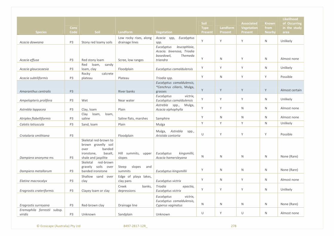
© Ecoscape (Australia) Pty Ltd 8497-2817-12R_ 278
Species Cons Code Soil Landform Vegetation
Soil Type Present
Landform Present
Associated Vegetation Present
Known from Nearby
Likelihood of Occurring in the study area
Acacia daweana P3 Stony red loamy soils Low rocky rises, along drainage lines
Acacia spp, Eucalyptus spp. Y Y Y N Unlikely
Acacia effusa P3 Red stony loam Scree, low ranges
Eucalyptus leucophloia, Acacia. bivenosa, Triodia basedowii, Themeda triandra Y N Y N Almost none
Acacia glaucocaesia P3 Red loam, sandy loam, clay Floodplain Eucalyptus camaldulensis Y Y Y N Unlikely
Acacia subtiliformis P3 Rocky calcrete plateau Plateau Triodia spp. Y N Y Y Possible
Amaranthus centralis P3
River banks
Eucalyptus camaldulensis, *Cenchrus ciliaris, Mulga, grasses Y Y Y Y Almost certain
Ampelopteris prolifera P3 Wet Near water Eucalyptus victrix, Eucalyptus camaldulensis Y Y Y N Unlikely
Astrebla lappacea P3 Clay, loam Plain Astrebla spp., Mulga, Acacia xiphophylla Y Y N N Almost none
Atriplex flabelliformis P3 Clay loam, loam, saline Saline flats, marshes Samphire Y N N N Almost none
Calotis latiuscula P3 Sand, loam Plain Mulga Y Y Y N Unlikely
Crotalaria smithiana P3
Floodplain Mulga, Astrebla spp., Aristida contorta U Y Y Y Possible
Dampiera anonyma ms P3
Skeletal red-brown to brown gravelly soil over banded ironstone, basalt, shale and jaspilite
Hill summits, upper slopes
Eucalyptus kingsmillii, Acacia hamersleyana N N N N None (Rare)
Dampiera metallorum P3
Skeletal red-brown gravely soils over banded ironstone
Steep slopes and summits Eucalyptus kingsmillii Y N N N None (Rare)
Elatine macrocalyx P3 Shallow sand over clay
Edge of playa lakes, clay pans Eucalyptus victrix Y N Y N Almost none
Eragrostis crateriformis P3 Clayey loam or clay Creek banks, depressions
Triodia epactia, Eucalyptus victrix Y Y Y N Unlikely
Eragrostis surreyana P3 Red-brown clay Drainage line
Eucalyptus victrix, Eucalyptus camaldulensis, Cyperus vaginatus N N N N None (Rare)
Eremophila forrestii subsp. viridis P3 Unknown Sandplain Unknown U Y U N Almost none
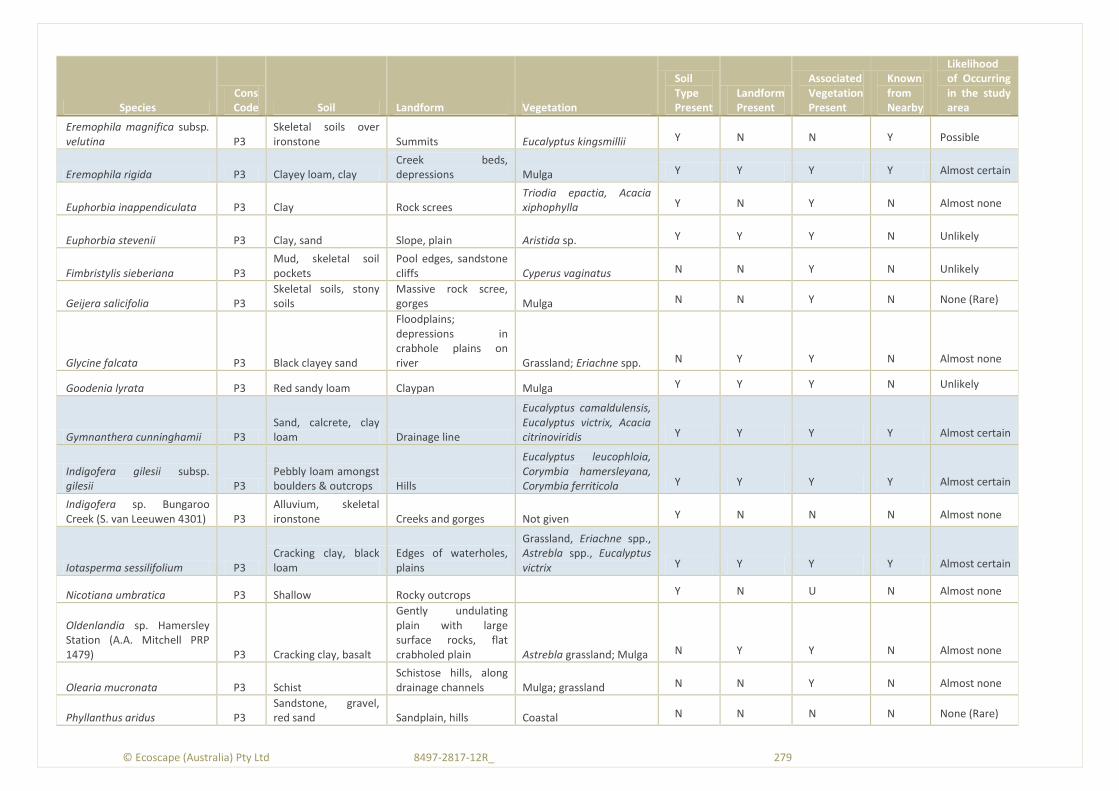
© Ecoscape (Australia) Pty Ltd 8497-2817-12R_ 279
Species Cons Code Soil Landform Vegetation
Soil Type Present
Landform Present
Associated Vegetation Present
Known from Nearby
Likelihood of Occurring in the study area
Eremophila magnifica subsp. velutina P3
Skeletal soils over ironstone Summits Eucalyptus kingsmillii Y N N Y Possible
Eremophila rigida P3 Clayey loam, clay Creek beds, depressions Mulga Y Y Y Y Almost certain
Euphorbia inappendiculata P3 Clay Rock screes Triodia epactia, Acacia xiphophylla Y N Y N Almost none
Euphorbia stevenii P3 Clay, sand Slope, plain Aristida sp. Y Y Y N Unlikely
Fimbristylis sieberiana P3 Mud, skeletal soil pockets
Pool edges, sandstone cliffs Cyperus vaginatus N N Y N Unlikely
Geijera salicifolia P3 Skeletal soils, stony soils
Massive rock scree, gorges Mulga N N Y N None (Rare)
Glycine falcata P3 Black clayey sand
Floodplains; depressions in crabhole plains on river Grassland; Eriachne spp. N Y Y N Almost none
Goodenia lyrata P3 Red sandy loam Claypan Mulga Y Y Y N Unlikely
Gymnanthera cunninghamii P3 Sand, calcrete, clay loam Drainage line
Eucalyptus camaldulensis, Eucalyptus victrix, Acacia citrinoviridis Y Y Y Y Almost certain
Indigofera gilesii subsp. gilesii P3
Pebbly loam amongst boulders & outcrops Hills
Eucalyptus leucophloia, Corymbia hamersleyana, Corymbia ferriticola Y Y Y Y Almost certain
Indigofera sp. Bungaroo Creek (S. van Leeuwen 4301) P3
Alluvium, skeletal ironstone Creeks and gorges Not given Y N N N Almost none
Iotasperma sessilifolium P3 Cracking clay, black loam
Edges of waterholes, plains
Grassland, Eriachne spp., Astrebla spp., Eucalyptus victrix Y Y Y Y Almost certain
Nicotiana umbratica P3 Shallow Rocky outcrops
Y N U N Almost none
Oldenlandia sp. Hamersley Station (A.A. Mitchell PRP 1479) P3 Cracking clay, basalt
Gently undulating plain with large surface rocks, flat crabholed plain Astrebla grassland; Mulga N Y Y N Almost none
Olearia mucronata P3 Schist Schistose hills, along drainage channels Mulga; grassland N N Y N Almost none
Phyllanthus aridus P3 Sandstone, gravel, red sand Sandplain, hills Coastal N N N N None (Rare)
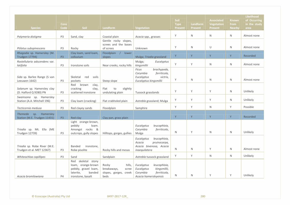
© Ecoscape (Australia) Pty Ltd 8497-2817-12R_ 280
Species Cons Code Soil Landform Vegetation
Soil Type Present
Landform Present
Associated Vegetation Present
Known from Nearby
Likelihood of Occurring in the study area
Polymeria distigma P3 Sand, clay Coastal plain Acacia spp., grasses Y N N N Almost none
Ptilotus subspinescens P3 Rocky
Gentle rocky slopes, screes and the bases of screes Unknown Y N U N Almost none
Rhagodia sp. Hamersley (M. Trudgen 17794) P3
Clay loam, sand loam, colluvium
Floodplain / lower slopes Mulga; Triodia grassland Y Y Y Y Recorded
Rostellularia adscendens var. latifolia P3 Ironstone soils Near creeks, rocky hills
Mulga; Eucalyptus kingsmillii Y Y N N Almost none
Sida sp. Barlee Range (S van Leeuwen 1642) P3
Skeletal red soils pockets Steep slope
Ficus brachypoda, Corymbia ferriticola, Eucalyptus victrix, Eucalyptus kingsmillii Y N N N Almost none
Solanum sp. Hamersley clay (D. Halford Q 9280) PN P3
Red brown clay, cracking clay, scattered ironstone
Flat to slightly undulating plain Tussock grasslands Y Y Y N Unlikely
Swainsona sp. Hamersley Station (A.A. Mitchell 196) P3 Clay loam (cracking) Flat crabholed plain Astrebla grassland; Mulga Y Y Y N Unlikely
Tecticornia medusa P3 Red clayey sands Floodplain Samphire Y Y N Y Possible
Themeda sp. Hamersley Station (M.E. Trudgen 11431) P3 Red clay Clay pan, grass plain
Y Y Y Y Recorded
Triodia sp. Mt. Ella (ME Trudgen 12739) P3
Light orange-brown, pebbly loam. Amongst rocks & outcrops, gully slopes Hilltops, gorges, gullies
Eucalyptus leucophloia, Corymbia ferriticola, Mulga N Y N N Unlikely
Triodia sp. Robe River (M.E. Trudgen et al. MET 12367) P3
Banded ironstone, Robe pisolite Rocky hills and mesas
Eucalyptus leucophloia, Acacia pruinocarpa, Acacia bivenosa, Acacia inaequilatera N N Y N Almost none
Whiteochloa capillipes P3 Sand Sandplain Astrebla tussock grassland Y Y N N Unlikely
Acacia bromilowiana P4
Red skeletal stony loam, orange-brown pebbly, gravel loam, laterite, banded ironstone, basalt
Rocky hills, breakaways, scree slopes, gorges, creek beds
Eucalyptus leucophloia, Eucalyptus kingsmillii, Corymbia ferriticola, Acacia hamersleyensis N N Y Y Unlikely

© Ecoscape (Australia) Pty Ltd 8497-2817-12R_ 281
Species Cons Code Soil Landform Vegetation
Soil Type Present
Landform Present
Associated Vegetation Present
Known from Nearby
Likelihood of Occurring in the study area
Eremophila magnifica subsp. magnifica P4
Skeletal soils over ironstone Rocky screes
Corymbia hamersleyana, Eucalyptus leucophloia, Eucalyptus kingsmillii Y N Y Y Possible
Eremophila youngii subsp. lepidota
Stony red sandy loam
Flats, plains, semi-saline areas, clay flats
Mulga, Acacia xiphophylla, Samphire Y Y Y Y Recorded
Goodenia nuda P4 Alluvium, loam, clay (various)
Adjacent to drainage, floodplain, hills Various Y Y Y Y ?Recorded
Rhynchosia bungarensis P4 Pebbly, coarse sand Banks of flow line Various Y Y Y N Unlikley
Table 27: Vegetation conservation risk assessment
Code Vegetation Type
Small extent within study area
Restricted landform* Riparian/GDE Mulga
Supports PF/new spp.
Vulnerable to disturbance
Significant ephemeral species component TEC/PEC Risk
Value
1=1-5% 2=<1%
1= not confined 2 = confined 1
1=non-groving 2=SFDV
1=P3,P4 2=P1,P2, multiple P3,P4, new spp. 1 1
1=PEC (or similar to) 2=TEC
AapAscTe
Acacia aptaneura tall open shrubland
over Acacia sclerosperma subsp.
sclerosperma and A. synchronicia
sparse mid shrubland over Triodia
epactia, Eremophila cuneifolia and
Ptilotus nobilis var. nobilis mid open
shrubland 1
1 1 1
4
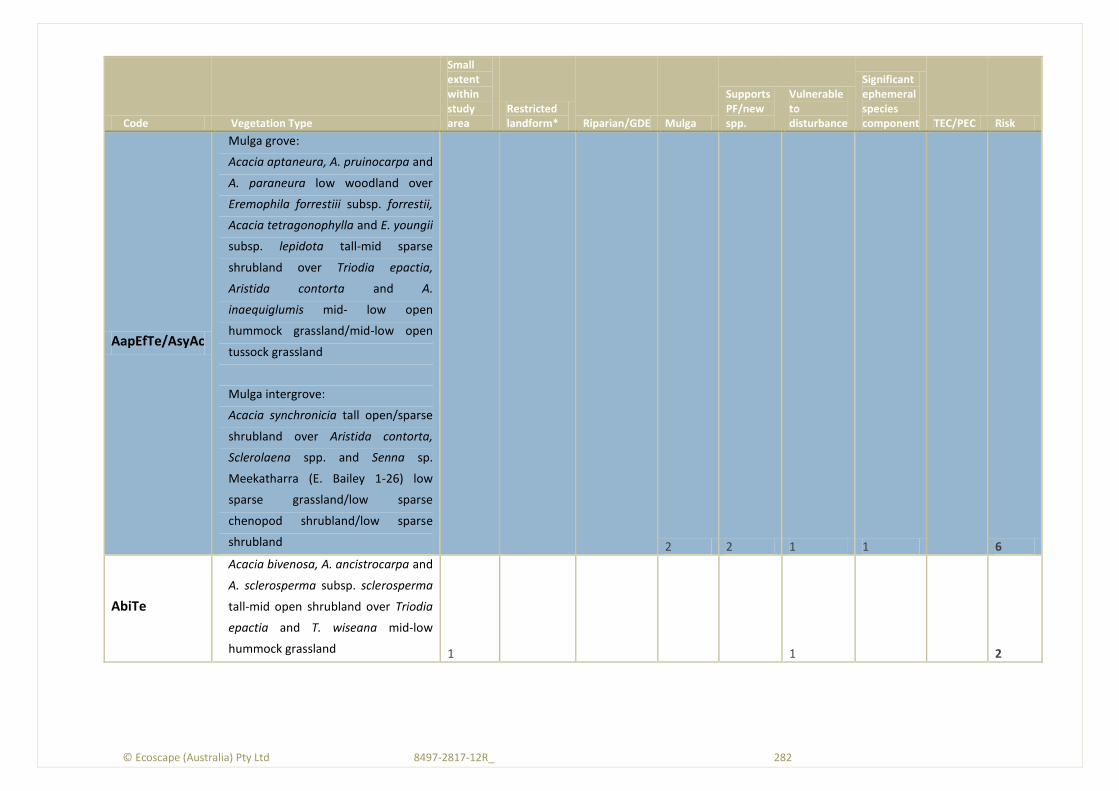
© Ecoscape (Australia) Pty Ltd 8497-2817-12R_ 282
Code Vegetation Type
Small extent within study area
Restricted landform* Riparian/GDE Mulga
Supports PF/new spp.
Vulnerable to disturbance
Significant ephemeral species component TEC/PEC Risk
AapEfTe/AsyAc
Mulga grove:
Acacia aptaneura, A. pruinocarpa and
A. paraneura low woodland over
Eremophila forrestiii subsp. forrestii,
Acacia tetragonophylla and E. youngii
subsp. lepidota tall-mid sparse
shrubland over Triodia epactia,
Aristida contorta and A.
inaequiglumis mid- low open
hummock grassland/mid-low open
tussock grassland
Mulga intergrove:
Acacia synchronicia tall open/sparse
shrubland over Aristida contorta,
Sclerolaena spp. and Senna sp.
Meekatharra (E. Bailey 1-26) low
sparse grassland/low sparse
chenopod shrubland/low sparse
shrubland
2 2 1 1
6
AbiTe
Acacia bivenosa, A. ancistrocarpa and
A. sclerosperma subsp. sclerosperma
tall-mid open shrubland over Triodia
epactia and T. wiseana mid-low
hummock grassland 1
1
2
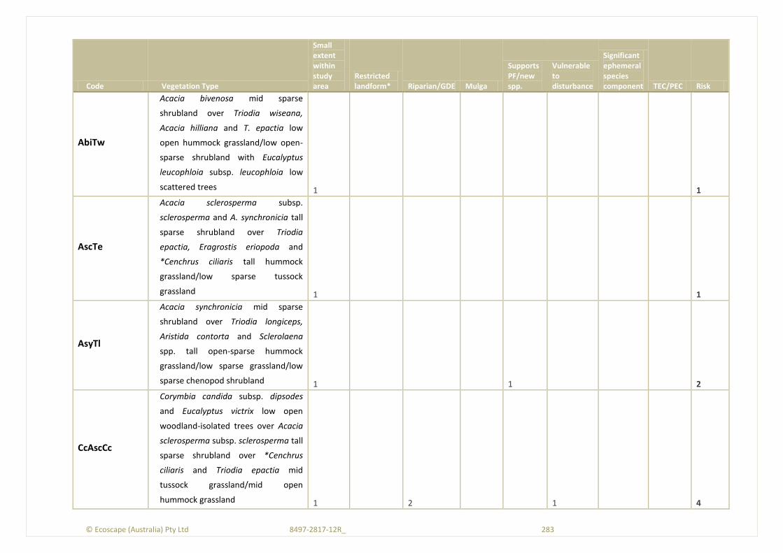
© Ecoscape (Australia) Pty Ltd 8497-2817-12R_ 283
Code Vegetation Type
Small extent within study area
Restricted landform* Riparian/GDE Mulga
Supports PF/new spp.
Vulnerable to disturbance
Significant ephemeral species component TEC/PEC Risk
AbiTw
Acacia bivenosa mid sparse
shrubland over Triodia wiseana,
Acacia hilliana and T. epactia low
open hummock grassland/low open-
sparse shrubland with Eucalyptus
leucophloia subsp. leucophloia low
scattered trees 1
1
AscTe
Acacia sclerosperma subsp.
sclerosperma and A. synchronicia tall
sparse shrubland over Triodia
epactia, Eragrostis eriopoda and
*Cenchrus ciliaris tall hummock
grassland/low sparse tussock
grassland 1
1
AsyTl
Acacia synchronicia mid sparse
shrubland over Triodia longiceps,
Aristida contorta and Sclerolaena
spp. tall open-sparse hummock
grassland/low sparse grassland/low
sparse chenopod shrubland 1
1
2
CcAscCc
Corymbia candida subsp. dipsodes
and Eucalyptus victrix low open
woodland-isolated trees over Acacia
sclerosperma subsp. sclerosperma tall
sparse shrubland over *Cenchrus
ciliaris and Triodia epactia mid
tussock grassland/mid open
hummock grassland 1
2
1
4

© Ecoscape (Australia) Pty Ltd 8497-2817-12R_ 284
Code Vegetation Type
Small extent within study area
Restricted landform* Riparian/GDE Mulga
Supports PF/new spp.
Vulnerable to disturbance
Significant ephemeral species component TEC/PEC Risk
EvAscCc
Eucalyptus victrix, Acacia aptaneura
and Atalaya hemiglauca open
woodland over Acacia sclerosperma
subsp. sclerosperma, Eremophila
youngii subsp. lepidota and
*Vachellia farnesiana tall-mid sparse
shrubland over *Cenchrus ciliaris,
*Malvastrum americanum and
Salsola australis low sparse tussock
grassland/low sparse forbland 1
2
2
5
EvAscPs
Eucalyptus victrix and Acacia
aptaneura low open-sparse
woodland over Acacia sclerosperma
subsp. sclerosperma, *Vachellia
farnesiana and A. tetragonophylla
mid sparse shrubland over mixed
Poaceae spp. low open tussock
grassland 1
2
1 1
5
EvVfPs
Eucalyptus victrix, E. camaldulensis
subsp. refulgens and Atalaya
hemiglauca mid open forest over
Poaceae sp. mid open tussock
grassland with *Vachellia farnesiana
mid scattered shrubs 2 1 2
1
6
Sc Sclerolaena cornishiana and S.
bicornis var. bicornis low sparse
chenopod shrubland 2 1
1
4
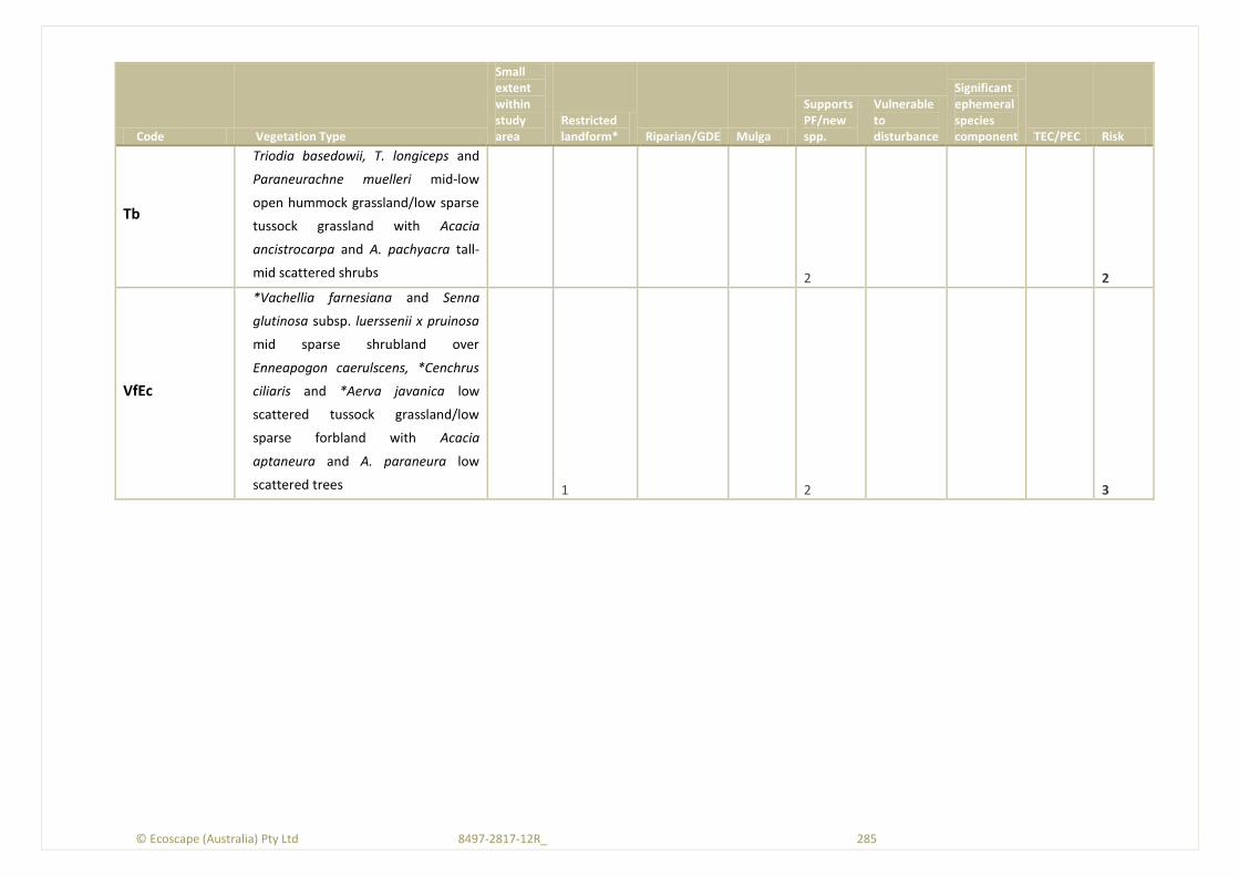
© Ecoscape (Australia) Pty Ltd 8497-2817-12R_ 285
Code Vegetation Type
Small extent within study area
Restricted landform* Riparian/GDE Mulga
Supports PF/new spp.
Vulnerable to disturbance
Significant ephemeral species component TEC/PEC Risk
Tb
Triodia basedowii, T. longiceps and
Paraneurachne muelleri mid-low
open hummock grassland/low sparse
tussock grassland with Acacia
ancistrocarpa and A. pachyacra tall-
mid scattered shrubs
2
2
VfEc
*Vachellia farnesiana and Senna
glutinosa subsp. luerssenii x pruinosa
mid sparse shrubland over
Enneapogon caerulscens, *Cenchrus
ciliaris and *Aerva javanica low
scattered tussock grassland/low
sparse forbland with Acacia
aptaneura and A. paraneura low
scattered trees
1
2
3
© Ecoscape (Australia) Pty Ltd 8497-2817-12R_ 286
Appendix Eleven: Vegetation Significance Review Summary Table 28: Reports reviewed for vegetation significance and summary of findings relevant to the Study Area
Author/Year Reference Report Title Summary of report findings of relevance to the study area
Environmental Protection Authority (2012a)
Cloudbreak Life of Mine Project. Report and Recommendations of the Environmental Protection Authority. Report 1429
The EPA considers saltmarsh, Mulga and creekline (groundwater dependent) vegetation to be significant
Environmental Protection Authority (2012b)
FerrAus Pilbara Project. Report and Recommendations of the Environmental Protection Authority. Report 1449
The EPA considers impacts on vegetation consisting of the partly groundwater dependent Eucalyptus camaldulensis and E. victrix, and nearby Fortescue Marsh may be significant (but can be managed)
Environmental Protection Authority (2012c)
Yandicoogina Iron Ore Project – expansion to include Junction south West and Oxbow Depostis. Report and Recommendations of the Environmental Protection Authority. Report 1448 Riparian vegetation is considered significant
Fortescue Metals Group (2011)
Significant Flora, Vegetation, Fauna and Fauna Habitats of the Special Rail Licence
This report summarized the findings of a number of biological surveys in the Pilbara. Mulga vegetation types were considered to have high conservation significance.
Mattiske Consulting Pty Ltd (2011a)
Flora and Vegetation Survey of Roy Hill Infrastructure Railway– Bonney Downs Alignment
11 vegetation communites were identified; none were TECs or PECs. Many of the vegetation communities were similar to those identified from the Alinta Study Area.
Mattiske Consulting Pty Ltd (2011b)
Review of Flora and Vegetation Along Weeli Wolli, Mindy Mindy and Coondiner Creeklines Mainly and flora and vegetation monitoring report. No vegetation significance was discussed.
Coffey Environments (2010a)
Flora and Vegetation Assessment, Solomon Project and Investigator
Mulga vegetation was considered to have regional significance due to its vulnerability to changes in surface drainage.
Coffey Environments (2010b)
Flora and Vegetation Assessment, Solomon Rail Project Volume 1 No vegetation types were listed as having significance
Ecologia Environment (2009)
Brockman Resources Limited Marillana (E47/1408) Vegetation and Flora Report Version 5 Vegetation of the Fortescue Land system was considered to have conservation significance
ENVIRON Australia Pty Ltd (2009)
Roy Hill 1 Iron Ore Mining Project: Stage 2. Environmental
Identifies groups of vegetation communities from the Stage 2 area; five Triodia sp. hummock grasslands (dominated by various species: T. brizoides, T. sp. Shovelanna Hill, T. longiceps, T.
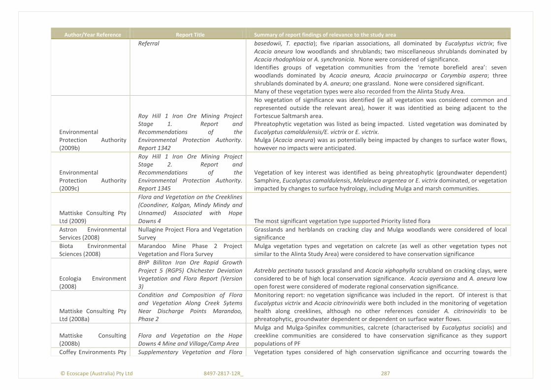
© Ecoscape (Australia) Pty Ltd 8497-2817-12R_ 287
Author/Year Reference Report Title Summary of report findings of relevance to the study area
Referral basedowii, T. epactia); five riparian associations, all dominated by Eucalyptus victrix; five Acacia aneura low woodlands and shrublands; two miscellaneous shrublands dominated by Acacia rhodophloia or A. synchronicia. None were considered of significance. Identifies groups of vegetation communities from the ‘remote borefield area’: seven woodlands dominated by Acacia aneura, Acacia pruinocarpa or Corymbia aspera; three shrublands dominated by A. aneura; one grassland. None were considered significant. Many of these vegetation types were also recorded from the Alinta Study Area.
Environmental Protection Authority (2009b)
Roy Hill 1 Iron Ore Mining Project Stage 1. Report and Recommendations of the Environmental Protection Authority. Report 1342
No vegetation of significance was identified (ie all vegetation was considered common and represented outside the relevant area), hower it was identitied as being adjacent to the Fortescue Saltmarsh area. Phreatophytic vegetation was listed as being impacted. Listed vegetation was dominated by Eucalyptus camaldulensis/E. victrix or E. victrix. Mulga (Acacia aneura) was as potentially being impacted by changes to surface water flows, however no impacts were anticipated.
Environmental Protection Authority (2009c)
Roy Hill 1 Iron Ore Mining Project Stage 2. Report and Recommendations of the Environmental Protection Authority. Report 1345
Vegetation of key interest was identified as being phreatophytic (groundwater dependent) Samphire, Eucalyptus camaldulensis, Melaleuca argentea or E. victrix dominated, or vegetation impacted by changes to surface hydrology, including Mulga and marsh communities.
Mattiske Consulting Pty Ltd (2009)
Flora and Vegetation on the Creeklines (Coondiner, Kalgan, Mindy Mindy and Unnamed) Associated with Hope Downs 4 The most significant vegetation type supported Priority listed flora
Astron Environmental Services (2008)
Nullagine Project Flora and Vegetation Survey
Grasslands and herblands on cracking clay and Mulga woodlands were considered of local significance
Biota Environmental Sciences (2008)
Marandoo Mine Phase 2 Project Vegetation and Flora Survey
Mulga vegetation types and vegetation on calcrete (as well as other vegetation types not similar to the Alinta Study Area) were considered to have conservation significance
Ecologia Environment (2008)
BHP Billiton Iron Ore Rapid Growth Project 5 (RGP5) Chichester Deviation Vegetation and Flora Report (Version 3)
Astrebla pectinata tussock grassland and Acacia xiphophylla scrubland on cracking clays, were considered to be of high local conservation significance. Acacia ayersiana and A. aneura low open forest were considered of moderate regional conservation significance.
Mattiske Consulting Pty Ltd (2008a)
Condition and Composition of Flora and Vegetation Along Creek Sytems Near Discharge Points Marandoo, Phase 2
Monitoring report: no vegetation significance was included in the report. Of interest is that Eucalyptus victrix and Acacia citrinoviridis were both included in the monitoring of vegetation health along creeklines, although no other references consider A. citrinoviridis to be phreatophytic, groundwater dependent or dependent on surface water flows.
Mattiske Consulting (2008b)
Flora and Vegetation on the Hope Downs 4 Mine and Village/Camp Area
Mulga and Mulga-Spinifex communities, calcrete (characterised by Eucalyptus socialis) and creekline communities are considered to have conservation significance as they support populations of PF
Coffey Environments Pty Supplementary Vegetation and Flora Vegetation types considered of high conservation significance and occurring towards the
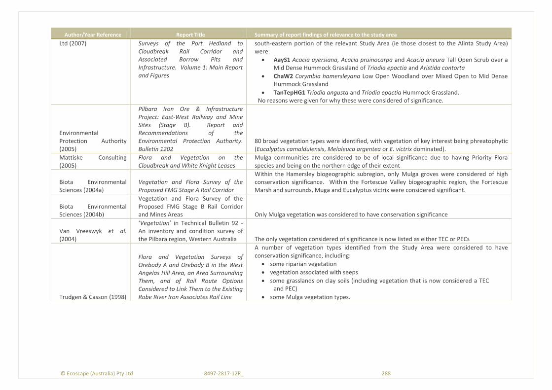
© Ecoscape (Australia) Pty Ltd 8497-2817-12R_ 288
Author/Year Reference Report Title Summary of report findings of relevance to the study area
Ltd (2007) Surveys of the Port Hedland to Cloudbreak Rail Corridor and Associated Borrow Pits and Infrastructure. Volume 1: Main Report and Figures
south-eastern portion of the relevant Study Area (ie those closest to the Alinta Study Area) were:
AayS1 Acacia ayersiana, Acacia pruinocarpa and Acacia aneura Tall Open Scrub over a Mid Dense Hummock Grassland of Triodia epactia and Aristida contorta
ChaW2 Corymbia hamersleyana Low Open Woodland over Mixed Open to Mid Dense Hummock Grassland
TanTepHG1 Triodia angusta and Triodia epactia Hummock Grassland. No reasons were given for why these were considered of significance.
Environmental Protection Authority (2005)
Pilbara Iron Ore & Infrastructure Project: East-West Railway and Mine Sites (Stage B). Report and Recommendations of the Environmental Protection Authority. Bulletin 1202
80 broad vegetation types were identified, with vegetation of key interest being phreatophytic (Eucalyptus camaldulensis, Melaleuca argentea or E. victrix dominated).
Mattiske Consulting (2005)
Flora and Vegetation on the Cloudbreak and White Knight Leases
Mulga communities are considered to be of local significance due to having Priority Flora species and being on the northern edge of their extent
Biota Environmental Sciences (2004a)
Vegetation and Flora Survey of the Proposed FMG Stage A Rail Corridor
Within the Hamersley biogeographic subregion, only Mulga groves were considered of high conservation significance. Within the Fortescue Valley biogeographic region, the Fortescue Marsh and surrounds, Muga and Eucalyptus victrix were considered significant.
Biota Environmental Sciences (2004b)
Vegetation and Flora Survey of the Proposed FMG Stage B Rail Corridor and Mines Areas Only Mulga vegetation was considered to have conservation significance
Van Vreeswyk et al. (2004)
‘Vegetation’ in Technical Bulletin 92 - An inventory and condition survey of the Pilbara region, Western Australia The only vegetation considered of significance is now listed as either TEC or PECs
Trudgen & Casson (1998)
Flora and Vegetation Surveys of Orebody A and Orebody B in the West Angelas Hill Area, an Area Surrounding Them, and of Rail Route Options Considered to Link Them to the Existing Robe River Iron Associates Rail Line
A number of vegetation types identified from the Study Area were considered to have conservation significance, including:
some riparian vegetation
vegetation associated with seeps
some grasslands on clay soils (including vegetation that is now considered a TEC and PEC)
some Mulga vegetation types.

© Ecoscape (Australia) Pty Ltd 8497-2817-12R_ 289
Appendix Twelve: Fauna Species Profiles
PROFILES OF POTENTIALLY OCCURRING CONSERVATION SIGNIFICANT FAUNA
Mammals
Dasyurus hallucatus (Northern Quoll)
Conservation status
EPBC Act EN, WC Act S1, DEC EN
Distribution and Preferred habitat
The Northern Quoll formerly occurred across northern Australia from the Pilbara region in Western
Australia to south‐eastern Queensland. A 75% reduction of available habitat occurred during the
20th century, so that the species is now restricted to the Pilbara and north Kimberley in Western
Australia and a few discrete populations across the Northern Territory and eastern Queensland
(Braithwaite & Griffiths 1994). Pilbara populations are considered to be already fragmented and to
have been in decline since the mid-1980s, with the precise causes unknown (Threatened Species
Scientific Committee 2005). Northern Quolls are most common on dissected rocky escarpments, but
are also found in eucalypt forest and woodland (Oakwood 2008). Potential denning / shelter habitat
(considered critical for quoll survival) includes rocky gorges, gullies, major creeklines and
escarpments associated with Corymbia woodland, boulder fields, termite mounds, and small caves.
Foraging or dispersal habitat is considered to include any areas of predominantly native vegetation
up to 2 km from denning habitat (DSEWPaC 2012c).
Biota (2009) made a very useful compilation of Northern Quoll distribution records and trapping
results across the Pilbara, which were mapped and related to Land Systems (Van Vreeswyk et al.
2004), but their discussion does not fully account for unequal distribution of area and trapping effort.
While Biota (2009; table 4.1) ranked land systems based on the raw number of Northern Quoll
records (regarding those with 8 or more as containing ‘core habitat’), they are ranked here (Table 29)
based on the number of records in proportion to area.
Table 29. Ranking of Land Systems by number of Norther Quoll records (if >3) in proportion to land area (Land Systems intersected by Study Area shown in bold)
Land System Area (ha) (Van
Vreeswyk et al. 2004) NQ records (Biota 2009)
NQ records per 10,000 km
2
Robe 865 31 358
Horseflat 1,261 7 56
Wona 1,815 10 55
Calcrete 1,444 5 35
Macroy 13,095 38 29
Rocklea 22,993 49 21
River 4,088 8 20
Capricorn 5,296 10 19
McKay 4,202 5 12
© Ecoscape (Australia) Pty Ltd 8497-2817-12R_ 290
Land System Area (ha) (Van
Vreeswyk et al. 2004) NQ records (Biota 2009)
NQ records per 10,000 km
2
Boolgeeda 7,748 5 6.5
Newman 14,580 7 4.8
Ecology
Northern Quolls are nocturnal and opportunistic omnivores feeding primarily on large insects, small
vertebrates and soft fruits. They are both arboreal and terrestrial and use a variety of den sites
including rock crevices, tree hollows, logs, termite mounds, house roofs and goanna burrows
(Oakwood 2008). Breeding tends to occur near creeklines, where individuals go to drink when water
is available. Body size, home range size and survival rate vary between rocky and savannah habitats,
but Pilbara populations have not been well studied. The short generations, large litter sizes and large
home ranges of this species mean that population density and occupancy of habitat may fluctuate
greatly between years, and sites that are occupied only occasionally may still be critical for long-term
survival in the region.
Likelihood of Occurrence
Potentially suitable denning and foraging habitat occurs where the Fortescue River cuts through the
Ophthalmia Range, where ironstone ridges with caves and crevices occur in proximity to riparian
woodland and pools or flowing creeks; cavities suitable for denning also occur where calcrete layers
(former channels, now ridges) are undercut by weathering (Plate 33, Plate 34). However, most of
the habitat types comprising the Study Area are not suitable for this species (compare
Table 3 and Table 29); there are only two NatureMap records (DEC 2012b) to the south or east of the
Study Area (in 2010 and 2011), separated by nearly 200 km from the more continuous area of
distribution to the north and west, indicating occasional long-distance dispersals but no evidence for
self-sustaining resident populations in the area.
Potential Impacts
No impact to existing populations is likely to occur due to the proposed clearing. The possibility of
intermittent use or future recolonisation means that disturbance to critical habitat should be
avoided.
Macrotis lagotis (Greater Bilby)
Conservation status
EPBC Act VU, WC Act S1, DEC VU
Distribution and Preferred habitat
Once very widespread, the Bilby (Macrotis lagotis, Thylacomyidae) is now rare and scattered,
confined to northern and mostly inland locations, particularly sandy deserts (patchily distributed
through the Tanami Desert in the Northern Territory, west to Broome and south to Warburton in
Western Australia). It occupies a variety of habitats, including cracking clays, desert sandplains, and
dune fields with hummock grassland and Acacia shrubland (Van Dyck & Strahan 2008).
Ecology

© Ecoscape (Australia) Pty Ltd 8497-2817-12R_ 291
The Bilby is terrestrial, nocturnal and omnivorous, constructing an extensive burrow where it remains
during the day, emerging at night to dig for insects, very small vertebrates, seeds, fruit and fungi. The
burrow provides refuge from fires and many of its food plants are promoted by disturbance, so
Bilbies are able to occupy recently burnt areas and have been considered ‘dependent on fire’ (Friend
et al. 2011). Lavery & Kirkpatrick (1997) suggest that very small populations may leave traces that
incorrectly suggest much larger numbers and healthier populations than is actually the case.
Likelihood of Occurrence
There are two records near the eastern end of the Fortescue Valley, one based on a WAM specimen
some decades ago but the other only ‘moderately certain’ (DEC 2012b). Apparently suitable habitat
for Bilby is widespread in the Study Area (e.g. Turee and Jamindie LS in the northern part, as well as
Fan and Divide) but no evidence of burrows, digs or scats observed during the survey could be
positively associated with this species. It is likely that this species is now locally extinct.
Potential Impacts
No impact on this species is likely due to its absence.
Dasycercus cristicauda (Crest-tailed Mulgara)
Conservation status
EPBC Act VU, WC Act S1, DEC VU
Dasycercus blythi (Brush-tailed Mulgara)
Conservation status
DEC P4
Two species of Mulgara (Dasyuridae) have only recently been consistently distinguished by Woolley
(Woolley 2005), and the actual distribution and conservation status of each remain uncertain. The
current EPBC Act listing is based on the Action Plan for Australian Marsupials and Monotremes
(Maxwell et al. 1996) and does not reflect current taxonomic understanding. The species are
distinguished by distribution of long, dark, stiff hairs on the tail, number of upper premolars, and
number of teats in the pouch: D. cristicauda with dorsally crested tail, small P3 [third upper premolar]
present, and 8 teats, vs. D. blythi non-crested, only two upper premolars, and 6 teats (Woolley 2005).
DSEWPaC’s current position (eg DSEWPaC 2010) is that where specimens of Dasycercus have not
been positively assigned to species based on diagnostic characters, as a precautionary measure they
are assumed to represent D. cristicauda due to its higher level of statutory protection.
Distribution and Preferred habitat
Both Mulgara species have a wide geographic range in the arid zone of Australia, and broadly
overlapping distributions, typically occurring in mature spinifex grasslands on sandy substrates
(including sandy loam). Within the Pilbara, there are many records of Mulgara in the Chichester IBRA
subregion and eastern Fortescue valley, but very few in the Hamersley subregion, where rocky
substrates predominate. There were no confirmed records of D. cristicauda in WA after 1931 (Ric
How [WAM] via David Pearson [DEC] pers comm 2012), until recently when a specimen trapped east
of Newman was positively identified by genetic testing (Phoenix 2011b). Evidence from areas of

© Ecoscape (Australia) Pty Ltd 8497-2817-12R_ 292
sympatry outside the Pilbara indicates habitat differences between the two species, with D.
cristicauda occurring on sandhills and sandridges, D. blythi mostly on sandplains and gibber plains
(Pavey et al. 2011; Woolley 2005). This pattern is likely also to apply to Pilbara populations.
Ecology
Both Mulgara species are primarily nocturnal, carnivorous marsupials, feeding mainly on
invertebrates, along with some reptiles and small mammals. The Crest-tailed Mulgara is somewhat
larger: females up to 80 g and males up to 140 g, vs 60 and 75 g respectively in Brush-tailed Mulgara
(Pavey et al. 2011). They construct and occupy burrow systems with two or more entrances, usually
at the edge of spinifex hummocks (Thompson & Thompson 2007; Woolley 1990).
Likelihood of Occurrence
There are two 2009 records of D. blythi on NatureMap about 20 km west of the Study Area on the
Fortescue Valley floor (DEC 2012b). The Study Area intersects extensive sandplain or sandy loam
habitat with spinifex or tussock grass, which may be suitable for D. blythi or both species. The
species therefore potentially occurs as a resident in one or more of these habitat types. Likely
presence was confirmed by observation of burrows typical of Mulgara at several locations, including
clusters of several burrows under or between Spinifex hummocks, with fresh digging evident. Tracks
consistent with Mulgara were also observed.
Potential Impacts
Any impact is expected to be relatively minor because of the sparse and patchy distribution of the
species in widespread and abundant habitat, and the relatively small and discontinuous areas of
disturbance associated with the proposed activity.
Sminthopsis longicaudata (Long-tailed Dunnart)
Conservation status
DEC P4
Distribution and Preferred habitat
This species of Dasyuridae is rare and patchily distributed in rocky areas of central Western Australia
(Pilbara, Murchinson, Northeastern Goldfields, Ashburton, and Gibson Desert regions) and a few
sites in central southern Northern Territory, but at times it can be locally common. It is found in
rocky scree and plateau areas, generally with little vegetation or of spinifex hummock grassland,
shrubs, and open woodland (Burbidge et al. 2008).
Ecology
This species is nocturnal, and its diet includes a variety of invertebrates. Females in captivity give
birth to up to five young between the months of October and December (Pavey 2006). Likelihood of Occurrence
There are records of this species from rocky areas near Newman and Roy Hill (DEC 2012b) so it is
likely to occur as a resident or irruptive visitor near the northern and southern parts of the Study
Area.
Potential Impacts

© Ecoscape (Australia) Pty Ltd 8497-2817-12R_ 293
There appear to be no major threats to this species. In the range within central Australia this species
is affected by the spread of exotic buffel grass, which increases frequency and intensity of fires. This
is also likely to be an issue in some areas in Western Australia (IUCN 2011). Localised clearing does
not represent a threat and negligible or no impact is likely to occur.
Planigale sp. 1 and sp. 2 (Pilbara Planigales)
Conservation status
None recognised, but should be treated as equivalent to DEC Priority species as they are undescribed
and poorly known (without taxonomy, no information can be reliably associated with species).
Distribution and Preferred habitat
Planigales are carnivorous marsupials (Dasyuridae) and the smallest terrestrial mammals in Australia.
It has long been recognized that Planigale is represented by two species in the Pilbara, but they have
often been conflated with P. ingrami and P. maculata (Biota 2005a; Blacket et al. 2000; Dunlop &
Sawle 1983; Gibson & McKenzie 2009). Gibson and McKenzie (2009) considered both of these
species to be endemic to the Pilbara, and confirmed that they have distinct habitat preferences, with
Planigale sp. 1 associated with rugged substrates dominated by exposed bedrock, and Planigale sp. 2
appearing to prefer clay substrates and avoid massive rocky habitats.
Ecology
Planigales are very small marsupial insectivore/carnivores with more or less flattened heads and
splayed hindlimbs, which enable them to shelter and forage in narrow soil cracks and rock crevices,
but they are also active on the surface at night and sometimes early morning (Van Dyck & Strahan
2008).
Likelihood of Occurrence
Both species are very likely to be resident in the Study Area where suitable habitats occur (rocky
outcrops and cracking clay soils respectively).
Potential Impacts
Any impact is likely to be very minor, as the effected area represents a very small proportion of
extensive habitats for both species in the region.
Notoryctes caurinus (Kakarratul, Northern Marsupial Mole)
Conservation status
EPBC Act EN, WC Act S1, DEC EN
Distribution and Preferred habitat
The two species of Marsupial Moles (Notoryctidae) are most often recorded in sandy dune habitats
supporting various acacias and other shrubs, and often but not always in association with spinifex
(Benshemesh 2004; Benshemesh & Johnson 2003; DSEWPaC 2012c; IUCN 2007; Pearson & Turner
2000). N. caurinus appears to be restricted to northern WA, while N. typhlops occurs in south-
eastern WA, southern NT and northern SA; there is an area of overlap and apparent sympatry around
Warburton and the Gibson Desert (Benshemesh & Aplin 2008).
Ecology
© Ecoscape (Australia) Pty Ltd 8497-2817-12R_ 294
Recent investigations have found that marsupial moles tunnel, rather than ‘swim’ through sand as
previously thought, and back fill as they move along (Benshemesh 2004). Northern and southern
marsupial moles, Notoryctes caurinus and N. typhlops, leave very different tracks on the surface,
making them easy to differentiate. The southern marsupial mole leaves a distinctive sinuous tail-
mark in the sand, whereas the northern marsupial mole shows no obvious tail-marks and leaves
marks resembling a miniature turtle hauling itself over the sand (Benshemesh & Aplin 2008).
Detected either by tracks or when active on or just under the surface (which occurs most often just
after heavy rain), but otherwise leaves few detectible traces and is very rarely trapped. A survey
methodology has been developed involving the digging of a steep and smooth sided trench to detect
tunnels. Trenches are normally dug at three levels on a dune: near the crest, mid slope, and base
(Benshemesh 2004; Benshemesh 2005).
Remains of marsupial moles are found frequently in the scats of introduced foxes, and to a lesser
extent those of dingos and feral cats, but it is not clear to what extent these predators limit their
populations or distribution. Other possible threats include changed fire regimes, and trampling and
habitat changes due to introduced cattle and camels, which potentially affect moles by modifying
availability of invertebrate prey.
Likelihood of Occurrence
The nearest record of N. caurinus is approximately 150 km east of the Study Area (DEC 2012b), but
the possibility of occurrence is considered here due to the cryptic nature of the species, and the low
overall number of fauna records in the potentially suitable sandplain habitat intersected by the Study
Area (Divide LS). However, all the areas of sandy habitat intersected by the powerline corridor are
relatively flat and well vegetated, without dunes, so presence of Notoryctes is considered unlikely.
Potential Impacts
No impact to any population is likely to occur.
Lagorchestes conspicillatus leichardti (Spectacled Hare-wallaby - mainland)
Conservation status
DEC P3
Distribution and Preferred habitat
The Spectacled Hare Wallaby (Macropodidae) has declined dramatically in WA; it is now extremely
rare and reduced to a few isolated populations in the Pilbara and Kimberley regions (Wildlife
Australia 1996). It occupies a wide variety of habitat types including: open forests, open woodland,
tall shrublands, tussock grasslands and hummock grasslands. In the drier southern parts of its range
it commonly occupies spinifex (Triodia or Plectrachne spp.) sandplains interspersed with low shrubs
and a diversity of either soft grasses, sedges or forb species.
Ecology
This small nocturnal macropod shelters by day under grass tussocks or shrubs, and feeds on grass,
herbs, seeds, and browse (shrub foliage). Threats probably include introduced predators (foxes in
southern parts of the range, and possibly cats), and impacts on food resources and habitat from the

© Ecoscape (Australia) Pty Ltd 8497-2817-12R_ 295
pastoral industry (particularly sheep, which are now relatively unimportant in the Pilbara) and
changes in fire regimes (Ingleby 1991; Ingleby & Westoby 1992; Wildlife Australia 1996).
Likelihood of Occurrence
Extant remnant populations have been reported near Jimblebar (about 45 km east of Newman) and
to the north-west of Nullagine (Ingleby 1991; Ingleby & Westoby 1992), but no other records in the
vicinity (DEC 2012b), and it is unlikely that any still occurs closer to the Study Area.
Potential Impacts
No impact is likely, as the species is considered to be locally extinct.
Petrogale lateralis lateralis (Black-flanked Rock-wallaby)
Conservation status
EPBC Act VU, WC Act S1, DEC VU
Distribution and Preferred habitat
The Black-flanked (or Black-footed) Rock-wallaby (Macropodidae) has declined greatly due to foxes
and other threats, and only scattered, small and insecure populations remain in the Pilbara, mostly
near the coast (Barrow Island, Cape Range, Ningaloo Station, Fortescue River Roadhouse [near
Roebourne]); populations also exist far inland (Calvert Range) and further south in the Murchison
and Wheatbelt (Pearson & Kinnear 1997). Habitat depends on availability of suitable refuge (cliff,
rock-pile, talus or escarpment) close to sufficient vegetation to provide food. The Pilbara craton is
otherwise occupied by the regional endemic P. rothschildi (not conservation listed).
Ecology
Diet is generalized, including forbs, browse, and minor amounts of grass, fruit, seeds, flowers and
insect larvae (Van Dyck & Strahan 2008).
Likelihood of Occurrence
There are records from 1975 about 20 km north of Newman (DEC 2012b), but remnant populations
are not known to occur in the eastern Pilbara (Pearson & Kinnear 1997), and this species is
considered to be locally extinct.
Potential Impacts
No impact is likely due to absence of the species.
Rhinonicteris aurantia (Pilbara Leaf-nosed Bat)
Conservation status
EPBC Act VU, WC Act S1, DEC VU
Distribution and Preferred habitat
The Pilbara Leaf-nosed Bat is an isolated population of a species (Orange Leaf-nosed Bat or Orange
Horseshoe Bat, Hipposideridae) that also occurs from the Kimberley to north-west Queensland. It
appears to be divided into three discrete subpopulations (eastern Pilbara mines and granite,
Hamersley Range, Upper Gascoyne), separated by relatively flat areas that impede gene flow such as
the Fortescue and Ashburton valley. Many records of the species in the region are of bats in flight or
roadkills, so the number of distinct roosts is not known.
© Ecoscape (Australia) Pty Ltd 8497-2817-12R_ 296
Because of its poor ability to thermoregulate and retain water, the Pilbara Leaf-nosed Bat is normally
restricted to caves and mine adits (horizontal shafts) with stable, warm and humid microclimates
(Van Dyck & Strahan 2008). Temporary roosts such as crevices and tree hollows could be used in
warm and humid conditions, allowing greater dispersal during the wet season. The roosting site is
often at depth in mines; in small crevices within caves, usually those ascending between sedimentary
rock layers; and with associated groundwater seeps, e.g. at Barlee Range (Armstrong 2001). Simple
vertical shafts are not used and shallow caves beneath mesa bluffs are also unlikely roost sites.
Foraging in the Pilbara has been observed in the following habitats: Triodia hummock grasslands
covering low rolling hills and shallow gullies, with scattered Eucalyptus camaldulensis along the
creeks (e.g. near Marble Bar, Bamboo Creek, Lalla Rookh and Copper Hills); over small watercourses
amongst granite boulder terrain and around nearby koppies; over pools and low shrubs in ironstone
gorges; and above low shrubs and around pools in gravelly watercourses with Melaleuca
leucodendron, such as in Barlee Range Nature Reserve (Armstrong 2001; Churchill et al. 1988).
Ecology
Typically, the Pilbara Leaf-nosed Bat flies low in the open spaces in watercourses and gorges, and
over Triodia grassland, sometimes within centimetres of the ground, but up to 2–3 m in height. It
feeds mainly on moths, but also beetles, bugs, wasps and ants. Feeding is mainly close to roost sites,
the bat returning to the roost several times during the night between feeding flights. This species is
very sensitive to even slight human disturbances. If subject to continual human interference it may
completely abandon a roost. It often shares roosts with the Ghost Bat, Macroderma gigas,
Finlayson's Cave Bat, Vespadelus finlaysoni, Common Sheath-tailed Bat, Taphzous georgianus, and
possibly Hill's Sheath-tailed Bat, Taphozous hilli, in some parts of its range. Any management
strategy that benefits the Pilbara Leaf-nosed Bat is also likely to benefit these species (Armstrong
2001; Churchill et al. 1988; DSEWPaC 2012c).
Likelihood of Occurrence
There are records to the north and west of the Study Area (DEC 2012b) but none to the south or east,
so it lies outside the known range; none have been recorded in the well-surveyed areas around
Newman, Roy Hill, or Cloudbreak. It is questionable whether suitable roosting sites occur in the
Ophthalmia or southern Chichester Range, and there are no records of the species within 60 km of
Newman or within 80 km of the northern part of the Study Area. No indication of deep horizontal
caves providing suitable roosts was observed in this survey. It is therefore unlikely that the species
occurs either as a resident, or temporarily during wet-season dispersal.
Potential Impacts
No impact is likely to occur to this species.
Macroderma gigas (Ghost Bat)
Conservation status
DEC P4
Distribution and Preferred habitat

© Ecoscape (Australia) Pty Ltd 8497-2817-12R_ 297
Regional populations of Australia’s only carnivorous bat (Megadermatidae) are centred on maternity
roosts that are genetically isolated from each other, and only 10 such sites are known to exist
(Worthington-Wilmer et al. 1994). Populations are known to disperse in the non-breeding (dry)
season (Toop 1979; Toop 1985). The persisting arid zone regional population in the Pilbara is also
geographically isolated, being separated from extant northern Australian populations and the
historical central Australian populations by extensive sandy deserts (Richards & Hand 1995). Roosts
occur in caves, mines, and rock clefts, and most of the distribution is in the arid zone but the species
also occurs in mesic environments including rainforest. Its range appears to have contracted into
northern Australia in relatively recent times, especially in Central Australia (Churchill & Helman
1990).
Ecology
Forages by gleaning (picking prey items from surfaces), eating large insects, frogs, lizards, small birds
and mammals. Tidemann et al. (1985) reported Ghost Bats in the Northern Territory foraged, on
average, 1.9km from their day roost, with a mean foraging area of 61 ha. This species detects prey
using eyes and ears rather than using echolocation, and changes vantage points about every 15
minutes during foraging periods, with a mean distance of 360 m between them. It is an obligate
troglodyte, and survival is critically dependent on finding natural roosts in caves, crevices, deep
overhangs, and artifical roosts such as abandoned mine adits (Hall et al. 1997). Threats include
disturbance and loss of roosting sites due to mining, tourism and internal dereliction of mines
through aging of timber supports (Hall et al. 1997). In recent times population declines could be
attributable to competition for prey with foxes, feral cats, and prey lost through habitat modification
by fire and livestock (Environment Australia 1999).
Likelihood of Occurrence
This species has been recorded in hilly habitat near the northern and southern parts of the Study
Area where suitable roost caves are likely to occur, and also (further west) on the Fortescue Valley
floor (DEC 2012b), where presence would be more intermittent (foraging and dispersing individuals).
Potential Impacts
Minor impact may occur through clearing (reduction of foraging area), particularly in the southern
section where the Fortescue River intersects the Ophthalmia Range. Electrocution on powerlines is a
frequent source of mortality for Pteropodid fruit bats, but this does not seem to be a known hazard
for the Ghost Bat despite its comparably large size.
Short-tailed Mouse, Lakeland Downs Mouse (Leggadina lakedownensis)
Conservation status
DEC P4
Distribution and Preferred habitat
This native rodent (Muridae) is a nocturnal species found in areas of open tussock and hummock
grassland, acacia shrubland, and savanna woodland, on alluvial clay or sandy soils. The population is

© Ecoscape (Australia) Pty Ltd 8497-2817-12R_ 298
rare and scattered on the mainland with large annual fluctuations that may not correlate with
environmental fluctuations or seasonality (Moro & Kutt 2008).
Ecology
Females give birth to two litters annually. Litters contain up to four young and the gestation period
lasts about 30 days. No major or general threats have been identified (IUCN 2011).
Likelihood of Occurrence
There are NatureMap (DEC 2012b) records of this species along the southern edge of the Chichester
Range adjacent to the northern part of the Study Area, so it is likely to occur as a resident or irruptive
visitor, especially along drainage lines where clay and sandy soils with Acacia shrubland represent
suitable habitat.
Potential Impacts
Given the patchy and fluctuating population, any impact would be very difficult to measure but some
may occur due to clearing. Any impact would be minor in proportion to the area affected, as suitable
habitat is extensive in the region.
Pseudomys chapmani (Western Pebble-mound Mouse)
Conservation status
DEC P4
Distribution and Preferred habitat
This native rodent (Muridae) occurs across the central and southern Pilbara and into smaller ranges
of the Little Sandy Desert, although it was formerly more widespread (IUCN 2011). Abandoned
mounds found in the Gascoyne and Murchison districts indicate a recent decline in distribution, most
likely due to fox and feral cat predation. The species does however appear secure in its remaining
range (Start 2008). The preferred habitat is gentle slopes of rocky ranges sparsely vegetated by
Triodia grasses, Senna, Acacia and Ptilotus species.
Ecology
Animals live in small family groups in burrows below mounds of pebbles. Each mouse utilises and
maintains several mounds, and active mounds are identifiable by structural features and absence of
vegetation, but remain recognisable for some time once abandoned (Anstee 1996). Females can
produce several litters of four young annually. There appear to be no major threats to this species.
The reasons for its elimination from the southern portion of its range are unclear, but may have been
related to predation by feral cats and foxes. Mining may be a localized threat (Anstee et al. 1997),
but this would not significantly affect the overall population size (IUCN 2011). Diet has not been
reported, but likely to be mainly seeds, with some leaves and invertebrates.
Likelihood of Occurrence
Suitable habitat occurs on slopes and hilltops in and adjacent to the Newman LS in the southern part
of the Study Area; these areas were mostly not accessed during the fauna reconnaissance survey, but
an inactive mound was located by the Flora team. The species is considered likely to be a resident in
© Ecoscape (Australia) Pty Ltd 8497-2817-12R_ 299
the Ophthalmia Range, and may also occur where stony mantles occur in the northern part of the
Study Area (e.g. Jamindie and Turee Land Systems) depending on the final alignment.
Potential Impacts
Any impacts of the proposed clearing are unlikely to be significant for this species due to the low
density of populations and extensive known distribution of habitat across the region. Local impacts
may be further reduced by surveying clearing locations in suitable habitat (slopes or ridgetops) for
active mounds, and trapping/translocation of resident individuals immediately prior to clearing.
Reptiles
Liasis olivaceus barroni (Pilbara Olive Python)
Conservation status
EPBC Act VU, WC Act S1, DEC VU
Distribution and Preferred habitat
The Pilbara subspecies of the Olive Python (Pythonidae) only occurs in the ranges of the Pilbara
region of Western Australia, and islands of the Dampier Archipelago. It inhabits watercourses and
areas of permanent water in rocky gorges and gullies (Pearson 2003). The Pilbara subspecies was
reported from nine localities when first described (Smith 1981) and listed as threatened in WA soon
afterward, but many more locality records have accumulated subsequently (Pearson 1993) and it has
been considered “Not threatened, or likely to be. Shouldn’t be on list, common and widespread”
(Kendrick 2002). The species is considered stable and in sizable numbers at some known sites
(Pearson 2003).
Ecology
This large constricting snake is an adept swimmer, often hunting in water, feeding on a variety of
vertebrates including rock wallabies, fruit bats, ducks, and pigeons. Individuals may be sedentary
(with a discrete home range associated with water) for most of the year, but can move several
kilometres through rocky hills in some seasons, e.g. during June and July males may travel long
distances to locate females for breeding (Pearson 2003; Wilson & Swan 2008)). Individuals spend the
cooler winter months sheltering in caves and rock crevices. In the warmer months the pythons can
move widely, usually in close proximity to water and rock outcrops (Department of Environment
Water Heritage and the Arts 2008). In late winter or early spring males will travel large distances to
find and mate with females.
They are mostly found close to permanent waterholes, not because they need to drink frequently
but because their prey does. They are most often seen at night and are generally found around rocky
areas, rocky outcrops and cliffs, but they also shelter in logs, flood debris, caves, tree hollows and
thick vegetation. Juvenile Olive Pythons feed on small reptiles and (probably) frogs as well as small
mammals, shifting to birds and medium-sized mammals (e.g. quolls, rock-wallabies) as adults, which
may grow to at least 4 m.
Likelihood of Occurrence

© Ecoscape (Australia) Pty Ltd 8497-2817-12R_ 300
There are numerous NatureMap records of the Pilbara Olive Python from the Hamersley Range, but
few in the less rugged Chichesters and none on the broad part of the Fortescue Valley floor (DEC
2012b). It occurs close to Newman in the Ophthalmia Range (e.g. Kalgan Pool), but appears to be at
the limit of its distribution as there are no records either south of the range, or east of the Fortescue
River. Thus, the entire Study Area may lie outside the current distribution of the species and it is
unlikely to be resident.
Potential Impacts
The main threats to this subspecies come from predation from feral cats and foxes, particularly of
juveniles, loss of suitable prey species (e.g. due to Fox in coastal areas), and accidental or deliberate
killing of individual snakes by people (Pearson 2003). Mortality may occur during clearing in the
Ophthalmia Range section of the Study Area, but this would not represent a significant impact to a
population because the area is marginal habitat if the species occurs at all.
Ramphotyphlops ganei (Pilbara Blindsnake)
Conservation status
DEC P1
Distribution and Preferred habitat
This species of Blindsnake (Typhlopidae) occurs at widely scattered sites in the Pilbara, including the
eastern and western Hamersley, Fortescue valley, and Chichester range (Aplin 1998; DEC 2012b). It
appears to be associated with moist areas such as gorges, gullies and floodplains, though there is a
record from sandy soil with spinifex (WAM record cited by Ecologia 2010).
Ecology
Like most other typhlopids it presumably feeds on eggs, larvae and pupae of ants, and individuals are
likely to mostly inhabit the topsoil, termitaria and ant nests (Greer 1997; Webb & Shine 1993).
Typhlopids emerge only at night and follow chemical trails to locate food sources and mates, and are
most often seen active or trapped in warm, humid conditions.
Likelihood of Occurrence
This species has been recorded near the northern and southern part of the Study Area and on the
Fortescue Valley floor (DEC 2012b). The most suitable habitat (rocky gorges) occurs where the
Fortescue River cuts through the Ophthalmia Range, but it may also be present in any other habitats
intersected by the corridor.
Potential Impacts
Impact would be very difficult to quantify because of the low detectibility of the species, but it is
likely to be minor because it is broadly distributed within the Pilbara.
Ctenotus nigrilineatus (Pinstriped Finesnout Ctenotus)
Conservation status
DEC P1
Distribution and Preferred habitat
© Ecoscape (Australia) Pty Ltd 8497-2817-12R_ 301
This boldly patterned skink is recorded from few locations, ranging from Abydos/Woodstock to
Nullagine in the Chichester subregion (DEC 2012b). Originally described from one isolated granite
rockpile near Woodstock, Abydos Plain (How & Dell 2004; Storr 1990), the only other reported
habitat data are for an uncertain sighting in Acacia adsurgens (Wattle) shrubland over Triodia epactia
hummock grassland (DEC 2012b).
Ecology
Associated with hummock grass habitats, and with multiple specimen records from each of few
localities indicating patchy local abundance. Like most other Ctenotus species, this is an active
diurnal terrestrial lizard and probably a generalist invertebrate feeder; some dietary specialization on
different invertebrate groups occurs within the genus (Goodyear & Pianka 2011).
Likelihood of Occurrence
The Study Area is outside the known area of distribution, so presence is not predcted. However,
given the sparse locality records relative to the total distribution, further range extensions are
considered likely, and extensive hummock grass habitat occurs in the Study Area so it may occur.
Potential Impacts
Due to the paucity of information regarding this species little is known about potential threats. The
proposed vegetation clearing will impact any local populations that may be present, but is unlikely to
significantly impact regional populations.
Ctenotus aff. uber johnstonei (Balgo Spotted Ctenotus)
Conservation status
Ctenotus uber johnstonei is a DEC P2 taxon known definitively from the south-east Kimberley, that
differs from the nominate subspecies in presence of a distinct dark vertebral stripe and contact
between nasal scales (DEC 2012b; Wilson & Swan 2008). The taxonomic and conservation status of
similar specimens from the Pilbara remains obscure. Doughty et al. (2011) do not list or discuss this
form as part of the Pilbara herpetofauna, but record C. u. uber from 19 of 273 quadrats throughout
the bioregion. It is assumed here that Pilbara records represent a taxon potentially distinct from
both named subspecies, but of equivalent conservation significance to C. uber johnstonei (P2).
Distribution and Preferred habitat
Ctenotus uber (all subspecies) occurs mainly on hard reddish soils, including rocky hills and
floodplains. C. uber johnstonei occurs in an area of chenopod shrubland at the base of a sandstone
hill near Balgo in the Kimberley. Biota (2005b) report Pilbara specimens from several distinct
habitats (Triodia on a dolerite hillslope, snakewood Acacia xiphophylla over chenopods, and
snakewood over Sclerolaena cuneata herbland), both north and south of the Fortescue Marsh. It is
also recorded from the western Hamersley Range (Wilson & Swan 2008).
Ecology
Like most other Ctenotus species, this is an active diurnal terrestrial lizard and probably a generalist
invertebrate feeder; some dietary specialization on different invertebrate groups occurs within the
genus (Goodyear & Pianka 2011).
© Ecoscape (Australia) Pty Ltd 8497-2817-12R_ 302
Likelihood of Occurrence
Recorded from about 30 km east of Newman, and also further west on the Fortescue Valley floor
(DEC 2012b). Based on association with chenopods, Triodia and/or Acacia shrubland and occurrence
north and south of Fortescue Marsh, this taxon could be expected to occur in almost any habitat type
within the Study Area.
Potential Impacts
Any impact is likely to be minor because this lizard is widely but sparsely distributed through the
Pilbara.
Lerista macropisthopus remota (Robust Lerista)
Conservation status
DEC P2
Distribution and Preferred habitat
Populations of this widespread burrowing skink in the south-east Pilbara are recognised as a
subspecies, originally described from one locality northeast of Jiggalong on the edge of the Little
Sandy Desert (Storr 1991), but now also recorded as occurring at Newman and up to 150 km to the
south-east (DEC 2012b). All forms of the species typically shelter in loose soil under leaf litter at
bases of shrubs, usually Acacia (Wilson & Swan 2008). Habitat records for L. m. remota on
NatureMap (DEC 2012b) include Acacia woodland, mallee, or Corymbia over tussock grass or Triodia,
and some on rock outcrops.
Ecology
This species is moderately specialised as a sand-swimmer, and usually found sheltering under
relatively deep layers of litter (Kendrick 1991). In a study on Shark Bay specimens (L. m. fusciceps), it
was found to feed predominantly on soft-bodied subterranean insect larvae, but also other
invertebrates. Preferred body temperature is similar to other Lerista species at about 32° C. Rarely
active on the surface, and most active in the substrate between 1600 and 2000 hrs (Pough et al.
1997).
Likelihood of Occurrence
Present at Newman (DEC 2012b), and likely to occur in Acacia shrubland habitats in the southern
part of the Study Area.
Potential Impacts
Minor local impact may occur due to clearing, but is unlikely to be significant for the regional
population.
Birds
Apus pacificus (Fork-tailed Swift)
Conservation status
EPBC Act Migratory, WC Act S3
Distribution and Preferred habitat
© Ecoscape (Australia) Pty Ltd 8497-2817-12R_ 303
In Australia they mostly occur over dry and open inland plains, but also over a wide variety of land
and marine habitats. In Western Australia, the Fork‐tailed Swift is considered uncommon to
moderately common near the north‐west, west and south‐east coasts, common in the Kimberley and
rare or scarce elsewhere (Johnstone & Storr 1998). Some birds have been sighted in Western
Australia arriving from Indonesia between October–November. Flocks have been recorded near
Broome on southward passage across the continent. In north and north-west Western Australia,
most birds have departed by the end of April.
Ecology
A non-breeding visitor to all states and territories of Australia, this swift (Apodidae) feeds on flying
insects and is almost exclusively aerial in habits, flying from less than 1 m to at least 300 m above
ground and probably much higher (Simpson & Day 2004). Fork‐tailed Swifts are nomadic and typically
respond to broad‐scale weather pattern changes. They are attracted to thunderstorms and cyclonic
disturbances where they can be seen in flocks hawking insects from the storm fronts with numbers
ranging from a few individuals to flocks of up to 2,000 birds.
Likelihood of Occurrence
Fork-tailed Swifts were not observed on this survey. There are numerous records from adjoining
regions except to the south-east (DEC 2012b). The species is likely to seasonally visit the area to
forage.
Potential Impacts
There are no significant threats to the Fork-tailed Swift in Australia (DSEWPaC 2012c). As migratory
visitors to the project area, negligible or no impact is anticipated to this species due to its highly
nomadic lifestyle.
Ardea modesta (Eastern Great Egret)
Conservation status
EPBC Act Migratory, WC Act S3
Distribution and Preferred habitat
Eastern Great Egrets (Ardeidae; listed by DEC as Ardea alba or A. alba modesta) are widespread in
Australia, occurring in a wide range of wetland habitats and breeding (November to April, depending
on rainfall) in colonies in wooded and shrubby swamps.
Ecology
They feed on a wide range of invertebrates and small vertebrates including birds, reptiles and small
mammals. The species undertakes some regular seasonal movements, mostly to and from breeding
colonies, and towards the coast in the dry season. Regional differences in reporting rates suggest
that individuals migrate north to winter in tropical northern Australia, consistent with changes in the
availability of suitable wetland habitat. Regular migration to locations outside of Australia is
suspected but not confirmed. Threats include loss and/or degradation of foraging and especially
breeding habitat through alteration of water flows, drainage and/or clearing of wetlands for
© Ecoscape (Australia) Pty Ltd 8497-2817-12R_ 304
development, frequent burning of wetland vegetation used as nest sites, salinisation, and invasion by
exotic plants or fishes (DSEWPaC 2012c).
Likelihood of Occurrence
There are few records of Great Egret in the Pilbara, including one near Cloudbreak but otherwise far
north or west of the Study Area (DEC 2012b); it was not recorded during this survey, and no suitable
wetland habitat was present in the Study Area. However, it is likely to visit the Study Area when
surface water is present on and adjacent to Fortescue River after sufficient rainfall.
Potential Impacts
Impact on this species may occur through reduction of wet-season foraging area, but this is unlikely
to be significant at the population level because of the large area of similar habitats available in the
region.
Ardea ibis (Cattle Egret)
Conservation status
EPBC Act Migratory, WC Act S3
Distribution and Preferred habitat
The Cattle Egret (Ardeidae) is a relatively recent colonist of Australia (from 1948) from Asia, and
occurs in tropical and temperate grasslands, wooded lands and terrestrial wetlands. The main areas
of distribution are from Wyndham (WA) to Arnhem Land (NT), and in south-eastern Australia, but
there are scattered records in other areas; it remains extremely rare in arid and semi-arid regions
(DSEWPaC 2012c). It uses predominately shallow, open and fresh wetlands including poorly drained
pastures and swamps with tall grass, abundant aquatic flora and emergent vegetation. It has been
recorded on earthen dam walls and ploughed fields, and is commonly associated with the habitats of
farm animals (particularly cattle, but also pigs, sheep, horses and deer) but avoids low grass pastures.
Ecology
The Cattle Egret feeds mostly on grasshoppers during the breeding season. It is, however, known to
consume other insects including cicadas, centipedes, spiders, cattle ticks, frogs (including cane
toads), lizards (particularly skinks) and small mammals (Marchant & Higgins 1990). The Cattle Egret
is known to follow earth-moving machinery and has been located at rubbish tips. Breeds in colonies
in wooded swamps such as mangrove forests (e.g. the lower Adelaide River, Northern Territory),
Melaleuca swamps (e.g. Shortland, NSW) and the eucalypt/lignum swamps of the Murray-Darling
Basin. They may breed in artificial situations or close to urban areas; generally the nesting trees are
inundated except where breeding on small islands. Nests are sited usually in middle to upper
branches (Marchant & Higgins 1990).
In Australia exotic species, especially Feral Cats (Felis catus), is a major threat for many native birds.
Cats are distributed across the entire country (including islands off the mainland). Due to their
agility, climbing ability and stealthy characteristics they are able to seek prey in a diverse range of
habitats. The Cattle Egret roosts both in trees and on the ground in vegetation, making it particularly
susceptible to predation by cats.

© Ecoscape (Australia) Pty Ltd 8497-2817-12R_ 305
Likelihood of Occurrence
There are few sightings of this species in the Pilbara and no breeding has been reported, but it has
been recorded on Fortescue Marsh and at Ophthalmia Dam near Newman (DEC 2012b), so may be
expected to occur in the Study Area when conditions are suitable after rainfall.
Potential Impacts
Any impact will very minor or negligible due to the infrequent regional occurrence of this highly
mobile species.
Haliaeetus leucogaster (White-bellied Sea-eagle)
Conservation status
EPBC Act Migratory, WC Act S3
Distribution and Preferred habitat
A large raptor (Accipitridae) distributed mainly along coastlines, offshore islands and large inland
waterways, with breeding only in limited areas of its range; it also occurs around freshwater swamps,
lakes, reservoirs etc. It is common and widespread in much of southern Asia, but has declined in
some areas including Australia.
Ecology
Feeds on a wide variety of fish, crustaceans, turtles, waterbirds, and terrestrial vertebrates including
carrion. Breeding occurs in tall open forest or woodland. The main threats are loss of habitat due to
land development, and the disturbance of nesting pairs by human activity (DSEWPaC 2012c).
Likelihood of Occurrence
Sea-eagles are recorded along the lower Fortescue River, but there is only one record on the marsh
near Cloudbreak, and two at Ophthalmia Dam near Newman (DEC 2012b). They are likely to be
occasional visitors to the central and southern part of the Study Area, but there is no evidence of a
resident population and no breeding activity is likely.
Potential Impacts
Any impact on this species is likely to be very minor due to the low number of individuals potentially
affected, and the fact they can readily move to unaffected areas.
Falco hypoleucos (Grey Falcon)
Conservation status
DEC P4
Distribution and Preferred habitat
Grey Falcons are a rare, nomadic species sparsely distributed across much of arid and semi‐arid
Australia; sightings are very uncommon, but coastal sightings may occur in drought years. Occurs in
a wide variety of arid habitats including open woodlands and open acacia shrubland, hummock and
tussock grasslands, low shrublands and may also be seen around swamps and waterholes that attract
prey (Ehmann & Watson 2008). Grey Falcons once occurred across much of Western Australia, with
sightings as far south as York and New Norcia during colonial times. However, the current
distribution is now thought to be restricted to north of 26°S (Johnstone & Storr 1998), i.e. the
© Ecoscape (Australia) Pty Ltd 8497-2817-12R_ 306
latitude of Shark Bay and the SA-NT border. The distribution of the Grey Falcon is centred on inland
drainage systems. It prefers areas of timbered lowland plains, particularly Acacia shrublands that are
crossed by tree-lined watercourses. However, it may also frequent other grassland and woodland
habitats (IUCN 2011).
Ecology
Grey falcons feed on a wide variety of birds, but most often on ground-feeding parrots and pigeons,
as well as some snakes, lizards, and grasshoppers. They use the nests of crows, kites or eagles, most
often placed in upper branches of emergent eucalypts, often on a tree-lined watercourse, and eggs
are laid between July and October (Ehmann & Watson 2008; Olsen & Olsen 1986).
Likelihood of Occurrence
The Grey Falcon was not recorded during the field survey. However, there are NatureMap records in
the vicinity (DEC 2012b) and the Acacia shrublands and tree-lined creeklines would provide suitable
habitat for this species in which it may occur.
Potential Impacts
The limited extent of proposed clearing is highly unlikely to significantly impact foraging habitat, so
the only potential impact on this species would be through disturbance of nesting habitat,i.e.large
trees near watercourses, which may occur where the corridor crosses the Fortescue River.
Falco peregrinus (Peregrine Falcon)
Conservation status
WC Act S4
The Bonn Convention defines as Migratory, “any species or lower taxon…, a significant proportion of
whose members cyclically and predictably cross one or more national jurisdictional boundaries.” The
EPBC Act (1999) includes as Migratory all taxa listed in Appendix II of the Bonn Convention, including
“All species in the family Falconidae for which Australia is a Range State” (Department of the
Environment and Heritage 2001). However, these criteria are now applied at the level of subspecies
or population; the two subspecies of F. peregrinus that occur in Australia (out of 19 worldwide) do
not regularly cross borders, and the EPBC Act is not applied to them (Debus 2009). Thus, this species
is not listed on recent PMST results, although it would have been in previous years (up to about
2009).
Distribution and Preferred habitat
This species (Falconidae) is uncommon but wide-ranging throughout Australia, preferring areas with
rocky ledges, cliffs, watercourses, open woodland or margins with cleared land. Ledges, cliff faces,
large tree hollows and spouts, or abandoned nests of other raptors are used for nesting.
Ecology
Feeds almost exclusively on birds (including pigeons, parrots and passerines) which are captured in
flight, but rarely takes mammals (e.g. possums, rabbits) (Olsen et al. 2008).
Likelihood of Occurrence

© Ecoscape (Australia) Pty Ltd 8497-2817-12R_ 307
Individual Peregrine Falcons are occasionally sighted throughout the region (DEC 2012b) and would
certainly use the Study Area at least for foraging. Cliffs suitable for nesting do not occur in the Study
Area, but large trees along watercourses that may contain hollows, or stick-nests of other raptor
species (e.g. Australian Kestrel, Wedge-tailed Eagle) are likely to provide suitable nesting sites.
Potential Impacts
Impacts on adult individuals or foraging habitat are not likely to be significant, but destruction of tree
hollows or existing nests of other birds could affect value of the habitat for breeding, especially if any
are in use by this species. Impact is likely to be minor due to low density of population and ability to
relocate to unaffected areas.
Ardeotis australis (Australian Bustard)
Conservation status
DEC P4
Distribution and Preferred habitat
The Australian Bustard (Otididae) typically occurs in open country, preferring grasslands, low
shrublands, grassy woodlands and other structurally similar but artificial habitats such as croplands
and airfields. There has been a large historical decline in abundance, particularly south of the tropics,
but to a smaller extent across northern Australia where it remains moderately common (Garnett &
Crowley 2000).
Ecology
Bustards (Otididae) are large, nomadic, partly nocturnal birds with an omnivorous diet comprising
seeds, fruit, vegetation, invertebrates and small vertebrates. Numbers of Australian Bustard present
in any particular area fluctuate with the availability of food with seasons and following irregular
rainfall, and variation between regions in timing and duration of residence and breeding activity has
been documented; In the Pilbara, breeding may occur at any time of year but mostly in May –
September (Ziembicki & Woinarski 2012). Decline is attributed to hunting, degradation of grassland
habitat by sheep and rabbits, predation by foxes and cats, and thickening of vegetation due to
overgrazing or lack of fire (Garnett & Crowley 2000; Schodde & Tidemann 1986). As ground nesters,
they are particularly vulnerable to fire in the nesting season, and readily desert nests in response to
disturbance by humans, sheep or cattle (Garnett & Crowley 2000).
Likelihood of Occurrence
Two individuals of this species were seen at the northern edge of the Ophthalmia Range, and fresh
tracks were observed at numerous sites further north in the River, Fan and Divide Land Systems
(eucalypt woodland, acacia shrubland, and hummock grassland). Bustards are likely to utilise most of
the Study Area including areas close to Newman, where it has been recorded recently (DEC 2012b).
No evidence of juveniles, nests or eggs was observed during the survey.
Potential Impacts
© Ecoscape (Australia) Pty Ltd 8497-2817-12R_ 308
Any impact on extent of foraging habitat is likely to be negligible, due to the ability of these birds to
move to large areas of similar habitat in the region. Clearing has the potential to be more disruptive
if it coincides with breeding activity.
Burhinus grallarius (Bush Stone-curlew)
Conservation status
DEC P4
Distribution and Preferred habitat
While this bird, also known as the Bush Thick-knee (Burhinidae) is found in all mainland states, it is
sparsely distributed and continues to decline. Historically the species was widely distributed
throughout much of Western Australia but is now considered rare, with an estimated population of
15,000 individuals (Garnett & Crowley 2000). It prefers grassy woodlands with low, sparse grassy or
herb understorey.
Ecology
The species is insectivorous, preying primarily upon beetles, although they will also eat seeds and
shoots, frogs, lizards and snakes (Marchant & Higgins 1993). Activity is mainly nocturnal, especially
on moonlit nights (NSW National Parks and Wildlife Service 1999). Breeding takes place mainly from
August to January, but at any time of year depending on local conditions. They are usually seen in
pairs, but sometimes form flocks. Branches on the ground are essential for the bird’s camouflage,
and it is unlikely to attempt nesting without it (Department of Sustainability and Environment
(Victoria) 2005). Since Bush Stone‐curlews are a ground dwelling and non‐migratory species they are
quite susceptible to local disturbances by humans and to predation by cats and foxes (Frith 1976;
Johnstone & Storr 1998). They are most common where land disturbance is minimal and generally
become rare or extinct around human settlements (Johnstone & Storr 1998).
Likelihood of Occurrence
This species is widespread in the Pilbara and may occur in any part of the Study Area, although there
is only one record in the immediate vicinity (DEC 2012b). During the survey, tracks consistent with
this species were observed on the road to Kalgan Pool west of the Study Area (Washplain/River Land
Systems) and it is likely to be resident in similar woodland habitats intersected by the corridor.
Potential Impacts
Adult birds are able to move away from disturbance, but clearing of vegetation, especially logs and
branches on the ground, could potentially disrupt breeding.
Charadrius veredus (Oriental Plover)
Conservation status
EPBC Act Migratory, WC Act S3
Distribution and Preferred habitat
The Oriental Plover (Charadriidae) breeds in Mongolia and adjacent parts of Manchuria and Siberia,
and spends the non-breeding season (September to March) in northern Australia, in both coastal and
inland areas. Most records are along the north-western coast, between Exmouth Gulf and Derby in
© Ecoscape (Australia) Pty Ltd 8497-2817-12R_ 309
Western Australia. Immediately after arriving, Oriental Plovers spend a few weeks in coastal habitats
before dispersing further inland to flat, open, semi-arid or arid grasslands, particularly locations with
short, sparse grass interspersed with hard, bare ground, such as claypans, dry paddocks, lawns, cattle
camps, or recently burnt grasslands. Saltmarsh and mudflats are also used for feeding and roosting.
Ecology
Diet poorly known, but includes various insects. Often feeds in mixed flocks with other waterbirds,
and sometimes at night. This species is not considered globally threatened (DSEWPaC 2012c).
Likelihood of Occurrence
Not recorded in these or previous surveys of the Study Area, but there is one record from 1981 just
south of Newman (DEC 2012b). Unlikely to occur regularly in any part of the Study Area, but may
utilise parts of open grassland habitats when grass is short, e.g. after fire.
Potential Impacts
Any impact is likely to be negligible due to the low frequency of occurrence in the area and ability to
relocate to unaffected areas.
Actitis hypoleucos (Common Sandpiper)
Tringa nebularia (Common Greenshank)
Tringa stagnatilis (Marsh Sandpiper)
Tringa glareola (Wood Sandpiper)
Calidris ruficollis (Red-necked Stint)
Calidris subminuta (Long-toed Stint)
Calidris melanotos (Pectoral Sandpiper)
Calidris acuminata (Sharp-tailed Sandpiper)
Calidris ferruginea (Curlew Sandpiper)
Conservation status
EPBC Act Migratory, WC Act S3
Distribution and Preferred habitat
Each of these Wader or Shorebird species (Scolopacidae) breeds in the northern hemisphere (mostly
Siberia) and migrates along the East Asian - Australasian Flyway (DSEWPaC 2012c). Each of them has
a broad distribution on the north, west and south coasts of WA (beaches, saltmarshes etc), but is also
recorded from inland localities (ephemeral or permanent natural and artificial wetlands such as
dams, floodplains, salt lakes etc) including Ophthalmia Dam and/or the town of Newman.
Ecology
Most members of this family feed on small invertebrates picked out of mud or soil by pecking or
probing, but some catch small fish in shallow water.
Likelihood of Occurrence
No species of Scolopacidae is predicted to occur by the PMST (Table 7), despite actual records within
a few km of the Study Area (DEC 2012b). Presence of any of these species in areas to be affected by
© Ecoscape (Australia) Pty Ltd 8497-2817-12R_ 310
clearing will be intermittent, and confined to temporary wetlands (most likely in River, Coolibah or
Narbung Land Systems).
Potential Impacts
Negligible or no impact is likely to occur to these species.
Pezoporus occidentalis (Night Parrot)
Conservation status
EPBC Act EN [and Migratory], WC Act S1, DEC EN
Listed as Migratory under the EPBC Act (DEH 2001); DSEWPaC (2012c) indicates that this is a
consequence of listing under JAMBA ([1981] ATS 6). However, the Night Parrot is not listed in the
Annex (Migratory species as defined under Article 1, as amended) but in the separate ‘Official List of
Australian Endangered Birds’ (Department of Foreign Affairs 1995). DSEWPaC is aware of this
inconsistency and modification of the listing has been proposed (P O'Neill 2012, pers comm).
Distribution and Preferred habitat
Night Parrots (Psittacidae) have been reported from all mainland states (Higgins 1999), but the few
recent records come from southwestern Queensland and the eastern Pilbara. This species is most
frequently associated with Triodia hummock grass and chenopod shrubs (samphire, saltbush etc),
particularly where these occur together as a mosaic or along a boundary (ecotone). Suitability of
habitat is thought to depend on particular stages of regeneration after fire, so that patch burning and
low stocking rates may be important for persistence (Garnett et al. 1993).
Ecology
Nocturnal or crepuscular, reported drinking shortly after nightfall and then dispersing to forage.
Sightings during the day are of birds flushed from cover by stock, dogs or fire; utilisation of diurnal
retreats is not well documented but they may include caves, or burrows of other vertebrates, in
addition to Spinifex clumps and dense samphire (Biota 2005b; FMG 2005). Evidence suggests the
species is either nomadic, or with very large individual home range (Boles et al. 1994), rather than
‘migratory’ (as incorrectly implied by EPBC listing). Like other seed-eating birds (e.g. most other
parrots, pigeons and finches) it is likely to drink frequently, and thus be dependent on water sources
which are often temporary. Threats are considered to include predation by foxes and feral cats,
modification of vegetation by introduced herbivores (stock and feral), loss or degradation of watering
points, and altered fire regimes (Blyth et al. 1996).
Likelihood of Occurrence
There is a recent sighting of Night Parrots, considered reliable, at Mingarwirriewirrie (Minga) Well
(FMG 2005), and a less positive record at Moojarri Well (Biota 2005b), both sites located in open
mulga woodland near the northern margin of Fortescue Marsh. The species is therefore considered
likely to occur at least as an irregular visitor in the Study Area, and to utilise mulga woodland (visiting
permanent and temporary pools for drinking) as well as feeding in chenopod shrubland and Spinifex
grassland. Potential Night Parrot habitat thus includes all parts of the Study Area north of the
Ophthalmia Range.
© Ecoscape (Australia) Pty Ltd 8497-2817-12R_ 311
Potential Impacts
Likelihood and magnitude of impact are very difficult to assess due to the lack of adequate biological
data and survey methods for this rare and cryptic species. Strategies to avoid or limit impacts to the
Night Parrot in the Fortescue Marsh area have previously been developed by FMG (2005) in
connection with the Cloudbreak Mine development. Any impact is likely to be minor, in proportion
to the area affected relative to the extent of suitable habitat in the region.
Polytelis alexandrae (Princess Parrot)
Conservation status
EPBC Act VU, DEC P4
Distribution and Preferred habitat
This parrot (Psittacidae) is restricted to arid regions of Western Australia, southern NT and north-
western South Australia, all records being far inland except where the Great Sandy Desert reaches
the coast south of Broome. Distribution is sparse and sightings rare except in the Great Sandy,
Gibson, Tanami and Great Victoria Deserts, and central ranges; the Great Sandy Desert is considered
to be the ‘core range’. Habitats include sand dunes and flats with open savannah woodlands
(scattered stands of Eucalyptus gongylocarpa, E. chippendalei and mallee species, Casuarina or
Allocasuarina) over Acacia, Cassia, Eremophila, Grevillea, Hakea and Senna shrublands, over Triodia
hummock grassland. It has been recorded in the far east of the Pilbara region (single 1981 record
from Bird Atlas), with few other records within hundreds of kilometres (DEC 2012b).
Ecology
The Princess Parrot feeds on seeds of grasses and shrubs, and some flowers, nectar and leaves. Birds
may live up to 30 years, but commence breeding in their first or second year. Nests in hollows of
Eucalyptus close to watercourses, or occasionally in Allocasuarina away from water, breeding
between September and January or opportunistically after rains. There are reports of up to 10 pairs
nesting in a single tree. Movements are poorly known, but described as nomadic, irruptive, or both.
Active, noisy and conspicuous in the morning and evening, but difficult to observe in the middle of
the day. No threatening processes have been demonstrated, but populations may have been
impacted by changes in vegetation due to grazing, altered fire regimes, and competition from more
water-dependent species following provision of artificial water sources. Other possible threats are
Psittacine Beak and Feather Disease (symptoms of which have been observed in the wild), and
poaching of eggs or young (known to occur, but unlikely to be important because of the large
captive-bred population and low demand for wild-caught birds) (DSEWPaC 2012c).
Likelihood of Occurrence
This species has rarely been recorded in the Pilbara and is considered to be an occasional vagrant,
with no resident population or regular use of resources in the region.
Potential Impacts
No impact is likely to this species.
© Ecoscape (Australia) Pty Ltd 8497-2817-12R_ 312
Merops ornatus (Rainbow Bee-eater)
Conservation status
EPBC Act Migratory, WC Act S3
Distribution and Preferred habitat
The Rainbow Bee-eater is widespread throughout most of Australia, and does not depend on any
particular habitat or vegetation type for feeding or breeding. They are scarce to common throughout
much of Western Australia except for the arid interior, preferring lightly wooded, sandy country near
water (DSEWPaC 2012c).
Ecology
Bee-eaters feed mainly on insects taken in flight (hawking), but also take prey from the ground and
foliage (gleaning). Populations in southern Australia are migratory, wintering in Indonesia and New
Guinea, moving south over summer and breeding in Australia, but the species is resident and present
year-round in parts of northern Australia including the Pilbara (DSEWPaC 2012c). Nesting occurs in
burrows dug in flat or slightly sloping ground, sandy banks or cuttings, and often at the margins of
roads or tracks; breeding is often colonial and cooperative (Boland 2004).
Likelihood of Occurrence
Rainbow Bee-eaters are commonly sighted throughout the region (DEC 2012b), were recorded at
Ophthalmia Dam during the survey, and are preseumed to be resident; suitable conditions for
breeding may exist along banks of drainage lines.
Potential Impacts
Disturbance to areas utilised by the Rainbow Bee-eater, such as sand banks of creeks and drainage
lines used to burrow to create nesting chambers between September and February, may have some
impact on the breeding success of this species. However, historical disturbance does not represent a
major issue to this species and it is common in cleared and semi-cleared habitats (DSEWPaC 2012c).
No significant impact is likely.
Oreoica gutturalis gutturalis (Crested Bellbird [southern])
Conservation status
DEC P4
Distribution and Preferred habitat
This single species of Oreoica (Pachycephalidae) occurs over most of the continent, excluding only
the wet areas (in the southwest, southeast, and most of the eastern and northern coast). Northern
and southern subspecies are distinguished on size, tail/wing ratio and coloration details (Schodde &
Mason 1999), but there is a broad zone of intergradation between them (clinal variation or
introgression). The minority of records in NatureMap that are identified to subspecies indicate broad
overlap in the western third of WA, with a few records of the ‘southern’ form deep within the range
of O. gutturalis pallescens, including some in the eastern Pilbara (DEC 2012b). Crested Bellbirds
mainly inhabit tall dry acacia shrublands or thickets, low eucalypt woodlands, including open mallee,
with a shrub layer or understorey, or among spinifex, chenopods and sometimes heathland growing
© Ecoscape (Australia) Pty Ltd 8497-2817-12R_ 313
on treeless plains or sand-dunes. They usually occur near the ground or in the dense vegetation of
the shrub layer of various acacias, Eremophila, Dodonaea, Thryptomene, Grevillea or chenopods.
Ecology
Usually solitary (sometimes pairs or small parties), mostly forage on the ground, among grass, stones
or leaf-litter, and less often in low shrubs, but may sing from trees. Feeds on a variety of insects and
seeds. No distinct breeding season; 2-4 eggs in a cup-shaped nest usually ‘decorated’ with live,
immobilised hairy caterpillars around the rim. Declines and local extinctions at the periphery of the
species range are mostly attributable to extensive clearing, and particularly fragmentation of
woodland habitat, with isolated areas of apparently suitable habitat as large as 5000 ha now
unoccupied. The southern form was listed as ‘Near Threatened a’ in the 2000 Action Plan for
Australian Birds, but revised to ‘Least Concern’ in 2010 (Garnett et al. 2011; Garnett & Crowley
2000).
Likelihood of Occurrence
Crested Bellbirds are likely to occur in shrub, woodland and Spinifex habitats (essentially, all habitat
types) throughout the Study Area, but are inferred to be sparsely distributed as none were heard
during the survey. The Pilbara population as a whole is part of the northern subspecies O. gutturalis
pallescens, but since the subspecies are considered to intergrade rather than remaining distinct in
sympatry, some individuals within the normal range of variation would be expected to resemble
typical southern specimens in colour or measurements. It is inferred here that such normal variation
accounts for the records of ‘O. g. gutturalis’ listed in the DEC databases, and that the P4 southern
subspecies is absent.
Potential Impacts
No impact will occur to the conservation listed subspecies because it is absent from the Study Area.
In any case, the proposed clearing will not lead to fragmentation of habitat, and impact to the
species will therefore be limited to disturbance of the actual cleared area.
Neochmia ruficauda subclarescens (Star Finch [western])
Conservation status
DEC P4
This subspecies is listed as Least Concern (Garnett et al. 2011), but conservation categories may not
provide sufficient information about actual status. The Cape York subspecies (N. r. clarescens) is
Near Threatened, but is not listed by federal or state statutes as it has been recognized as a separate
subspecies for only a few years; some Pilbara survey records are identified as that form, in error. The
southern or eastern subspecies N. r. ruficauda is listed under the EPBC Act as EN, but Garnett et al.
(2011) consider it Critically Endangered, possibly extinct.
Distribution and Preferred habitat
Star Finches (Estrildidae) live in reedbeds, grasslands and eucalypt woodland close to water. The
western subspecies has three sub-populations: 1. Shark Bay to Pilbara, 2. Fitzroy River valley, West
Kimberley, and 3. Gibb River to Gulf of Carpentaria.
© Ecoscape (Australia) Pty Ltd 8497-2817-12R_ 314
Ecology
A seed-eater like most other ‘finches’; reported to feed on seeds of sedges (Cyperus sp.) and Buffel
Grass (Cenchrus ciliaris), but also insects during the breeding season. Birds tend to be resident in
large flocks close to permanent waterways during the dry season, and disperse to breed during the
wet season. The main threat is thought to be overgrazing of grasslands near water; the species may
also require mosaic burning to maintain food supply.
Likelihood of Occurrence
There are scattered records of this species through most parts of the Pilbara (DEC 2012b), including
Ophthalmia Dam and other sites in the Ophthalmia Range, but not on the floor of the eastern
Fortescue Valley. It was not recorded in this survey, but is likely to occur in the Study Area where
suitable habitat occurs, adjacent to the Fortescue River where it cuts through the Range. Wet season
surveys would be required to determine whether breeding sites occur.
Potential Impacts
Any impact is likely to be restricted to wet season breeding habitat, when the birds are dispersed
from colonies and thus able to relocate to avoid disturbance, so considered minor.