naples and its parallel city
TRANSCRIPT

Th
ink
De
ep
: Pla
nn
ing
, deve
lop
me
nt a
nd
use
of u
nd
erg
rou
nd
space
in c
ities
Think Deep: Planning, development and use of underground space in cities

Think Deep: Planning, development and use of underground space in cities
Copyright 2015 © International Society of City and Regional Planners and International Tunnelling and Underground Space Association.All rights reserved.
This publication is part of the ongoing co-operation between ISOCARP and ITA/ITACUS. This project was managed by ISOCARP and financed by ITA. All contributors are members of ISOCARP.
No part of this publication may be reproduced, stored in a retrieval system or transmitted in any form or by any means electronic, mechanical, photocopying, recording or otherwise, without the prior written permission of the Publisher.Authorship Responsibility: the original author is responsible for the content of the manuscript.
EditorsHan Admiraal, ITACUSShipra Narang Suri, ISOCARP
CoordinatorGaby Kurth, ISOCARP
Designer Ricardo Moura, Portugal(www.ricardomoura.pt)
ISBN 978-94-90354-34-3
Cover: Naples underground cavities map Copyright 2015 © Vincenzo De Stefano, Valerio Di Pinto, Carlo Gerundo
Printed in the Netherlands by Drukkerij Aktief, Pijnacker
ForewordShipra Narang Suri, ISoCArP vice president
Han Admiraal, ITACUS chair
PlANNINg For UNdergroUNd SPACeS “NY-loN” UNdergroUNdelizabeth reynolds
Paul reynold
NAPleS ANd ITS PArAllel CITYVincenzo de Stefano
Valerio di Pinto
Carlo gerundo
NeTworkINg UNdergroUNd ArCHAeologICAl ANd CUlTUrAl SITeS: THe CASe oF THe ATHeNS MeTroMarilena Papageorgiou
UNdergroUNd ANd CAVerN SPACe deVeloPMeNT IN HoNg koNgliang Huew wANg
THe UTIlIzATIoN oF UNdergroUNd SPACe PlANNINg IN TIANjIN (CHINA) CeNTrAl CITY (2013-2020)Shi wujun
Xiao Yu
gong Yuan
zhao guang
liu wei
4
6
34
54
72
88

34 35N
apl
es a
Nd
its
para
llel
cit
y
BrIeF HIstory oF underground sPaces In naPles
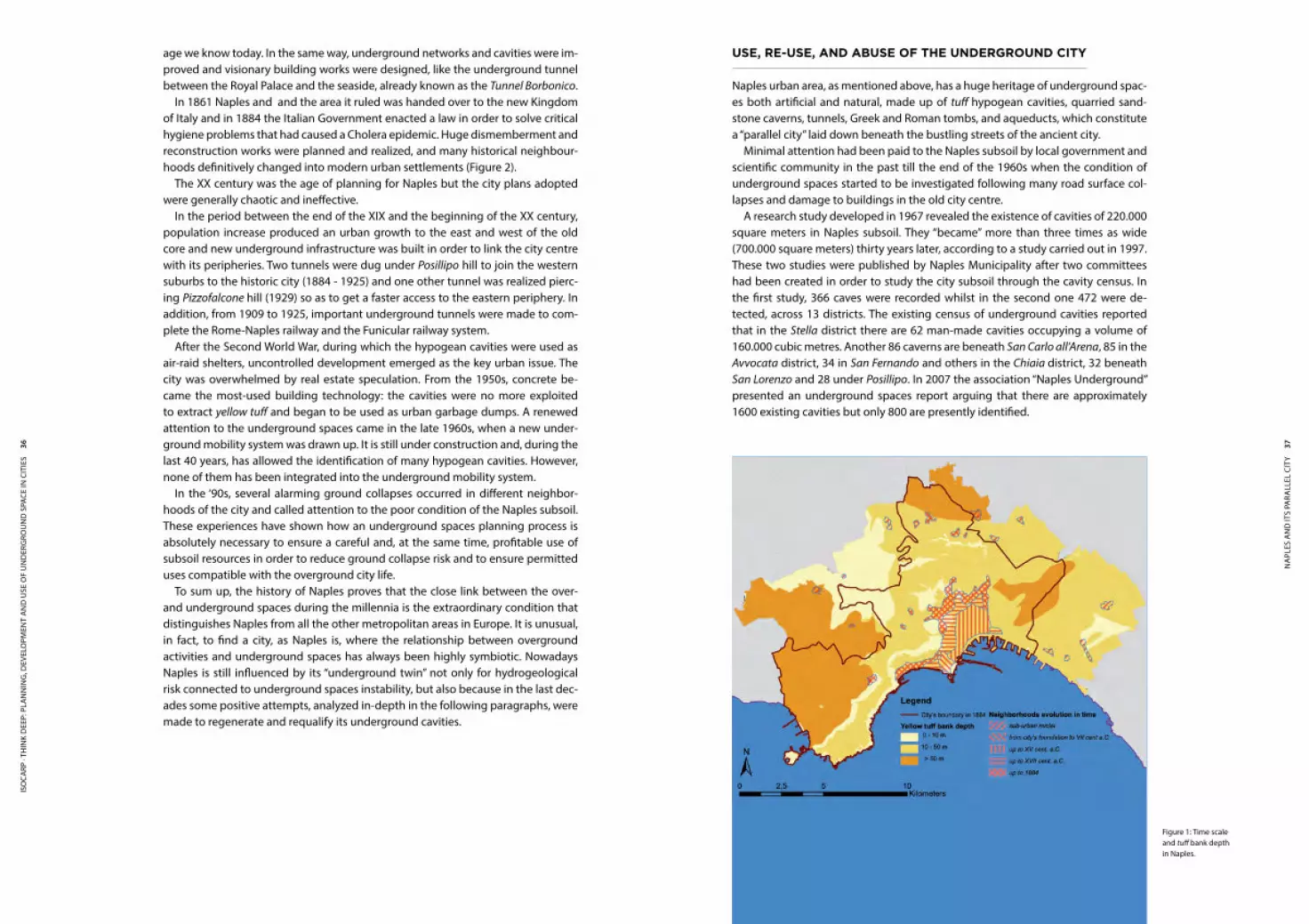
Naples is the capital of the Italian region of Campania and the third-largest mu-nicipality in Italy. Its metropolitan area is one of the most populated in Europe. The city rises up in the middle of an extremely elaborate and characteristic volcanic region that includes the Somma-Vesuvius crater complex to the east, and dozens of craters in the Campi Flegrei volcanic district, to the west. Almost the whole area where the most densely built conurbation lies was created by the volcanic activ-ity of the Campi Flegrei, while the eruptions of Somma-Vesuvius gave origin to the eastern outlying areas.
For these reasons, Naples and its historical centre sits on a bank madeup of the volcanic rock known as yellow tuff, never less than 10 meters thick. The geological subsoil structure has undoubtedly been a critical factor in the city’s development, determining, since its establishment, the main building technology (Figure 1).
Moreover, Naples can be proud of a very long urban history. The city was found-ed in the VII century BC as a Rhodian colony named Palaepolis, and was built in the traditional archaic settlement shape: a dock downstream of a hill village. Palepolis maintained its independence for over four centuries, despite the Etruscan pres-sure, till 474 BC, when a new colony, named Neapolis, was established. The new town was settled in a plain by the sea, enclosed by a hill system and two rivers (no longer visible), large enough to allow the development of a well-structured ur-ban texture. During the III century BC, a defending wall system started to be built. This process gave birth to the methodical extraction of yellow tuff from Naples subsoil as a building material, which engendered the former and oldest artificial hypogean cavities1. The persisting tuff mining over the centuries gave birth to a complex system of underground spaces, nowadays consisting of more than 800 elements for an overall volume of 6.000.000 m3, and, at the same time, allowed the development of a building technology based on the tuff bricks that had been regularly used and improved till the first half of the XX century. In this way, the transformation of the visible city has gone hand in hand with the enlargement of the invisible one.
In the Pax Augusti era (29 BC - AD 180) Neapolis suffered from urban decay. In this period the existing hypogean cavities were often re-used as early Christian Basili-cas. After the western Roman Empire downfall (AD 476) the city experienced a new period of development and prosperity. From the year 1000 to the late Renaissance, Naples was conquered and governed by many foreign powers (Angevins, Nor-mans, Aragons), which gradually expanded the city boundary and increased the existing settlements. During the reign of Charles V of Habsburg (1516-1558) the city doubled in size, compared with the pre-imperial one, and, simultaneously, the underground spaces system was hugely enlarged. Naples and its population kept on growing during the next two centuries and new suburbs were built outside the walls, in the external belt of the old city. This massive building construction led to very intense mining activity to extract the yellow tuff from the subsoil. During the Spanish Bourbons domination (1734-1861) Naples became one of the most impor-tant European capitals, experiencing the best period of its history, in terms of ex-pansion, magnificence and wealth. Great urban infrastructure was built to improve the hygienic conditions of a large part of the urban area, giving it the modern im-
1 It refers to the underground network made of passages, tunnel, wells, tanks, and variable-size cavities.
NAPLES AND ItS PARALLEL CItY
Vincenzo De Stefano · Valerio Di Pinto · Carlo Gerundo
ISO
CARP
· Th
Ink
Dee
P: P
lAn
nIn
g, D
evel
OPm
enT
An
D u
Se O
f u
nD
eRg
ROu
nD
SPA
Ce In
CIT
IeS
36 37N
apl
es a
Nd
its
para
llel
cit
y
use, re-use, and aBuse oF tHe underground cIty
Naples urban area, as mentioned above, has a huge heritage of underground spac-es both artificial and natural, made up of tuff hypogean cavities, quarried sand-stone caverns, tunnels, Greek and Roman tombs, and aqueducts, which constitute a “parallel city” laid down beneath the bustling streets of the ancient city.
Minimal attention had been paid to the Naples subsoil by local government and scientific community in the past till the end of the 1960s when the condition of underground spaces started to be investigated following many road surface col-lapses and damage to buildings in the old city centre.
A research study developed in 1967 revealed the existence of cavities of 220.000 square meters in Naples subsoil. They “became” more than three times as wide (700.000 square meters) thirty years later, according to a study carried out in 1997. These two studies were published by Naples Municipality after two committees had been created in order to study the city subsoil through the cavity census. In the first study, 366 caves were recorded whilst in the second one 472 were de-tected, across 13 districts. The existing census of underground cavities reported that in the Stella district there are 62 man-made cavities occupying a volume of 160.000 cubic metres. Another 86 caverns are beneath San Carlo all’Arena, 85 in the Avvocata district, 34 in San Fernando and others in the Chiaia district, 32 beneath San Lorenzo and 28 under Posillipo. In 2007 the association “Naples Underground” presented an underground spaces report arguing that there are approximately 1600 existing cavities but only 800 are presently identified.
Figure 1: Time scale and tuff bank depth in Naples.
age we know today. In the same way, underground networks and cavities were im-proved and visionary building works were designed, like the underground tunnel between the Royal Palace and the seaside, already known as the Tunnel Borbonico.
In 1861 Naples and and the area it ruled was handed over to the new Kingdom of Italy and in 1884 the Italian Government enacted a law in order to solve critical hygiene problems that had caused a Cholera epidemic. Huge dismemberment and reconstruction works were planned and realized, and many historical neighbour-hoods definitively changed into modern urban settlements (Figure 2).
The XX century was the age of planning for Naples but the city plans adopted were generally chaotic and ineffective.
In the period between the end of the XIX and the beginning of the XX century, population increase produced an urban growth to the east and west of the old core and new underground infrastructure was built in order to link the city centre with its peripheries. Two tunnels were dug under Posillipo hill to join the western suburbs to the historic city (1884 - 1925) and one other tunnel was realized pierc-ing Pizzofalcone hill (1929) so as to get a faster access to the eastern periphery. In addition, from 1909 to 1925, important underground tunnels were made to com-plete the Rome-Naples railway and the Funicular railway system.
After the Second world war, during which the hypogean cavities were used as air-raid shelters, uncontrolled development emerged as the key urban issue. The city was overwhelmed by real estate speculation. From the 1950s, concrete be-came the most-used building technology: the cavities were no more exploited to extract yellow tuff and began to be used as urban garbage dumps. A renewed attention to the underground spaces came in the late 1960s, when a new under-ground mobility system was drawn up. It is still under construction and, during the last 40 years, has allowed the identification of many hypogean cavities. However, none of them has been integrated into the underground mobility system.
In the ‘90s, several alarming ground collapses occurred in different neighbor-hoods of the city and called attention to the poor condition of the Naples subsoil. These experiences have shown how an underground spaces planning process is absolutely necessary to ensure a careful and, at the same time, profitable use of subsoil resources in order to reduce ground collapse risk and to ensure permitted uses compatible with the overground city life.
To sum up, the history of Naples proves that the close link between the over- and underground spaces during the millennia is the extraordinary condition that distinguishes Naples from all the other metropolitan areas in Europe. It is unusual, in fact, to find a city, as Naples is, where the relationship between overground activities and underground spaces has always been highly symbiotic. Nowadays Naples is still influenced by its “underground twin” not only for hydrogeological risk connected to underground spaces instability, but also because in the last dec-ades some positive attempts, analyzed in-depth in the following paragraphs, were made to regenerate and requalify its underground cavities.

ISO
CARP
· Th
Ink
Dee
P: P
lAn
nIn
g, D
evel
OPm
enT
An
D u
Se O
f u
nD
eRg
ROu
nD
SPA
Ce In
CIT
IeS
38 39N
apl
es a
Nd
its
para
llel
cit
y
1. Catacomb of Sant’Arpino, (II cent.) renamed Catacomb of San Gennaro after he was buried there at the beginning of V century (Figure 3);
2. Catacomb of Sant’Eufebio, (end of III cent.);3. Catacomb of San Severo (end of IV cent.);4. Catacomb of San Gaudioso (V cent.);5. Catacomb of Santa Maria del Pianto (uncertain date);6. Catacomb of San Martino or Sant’Eramo (historical hints as its location cannot be
precisely traced).
As also previously discussed, Naples has created links to its cavities and under-ground spaces from the start. Long hypogean cavities were dug since the Ancient Greek period not only for service infrastructure as holding tanks and Roman aque-ducts, but also for leisure and recreation as thermal tanks or theatres. Under the Spanish domination (1588-1615 AD) some royal edicts forbade the introduction of building materials within the city walls to avoid the uncontrolled expansion of its core. In order to avoid penalties and, at the same time, to satisfy the necessity of new building construction, people used to extract tuff in the subsoil through already existing wells, extending the existent cisterns for drinking water and build-ing new ones. This type of extraction created a sort of parallel underground city consisting of miles and miles of tunnels, tanks, cavities and narrow channels used as links between other cavities known as cunicoli.
In addition to catacombs, a great number of water tanks of various size was dug in Naples subsoil since water supply was one of the first issues that Neapolitan area colonizers had to face. with the increase in demand for water, it was necessary to overcome the dependence on rain water and to build the network of channels and cisterns that now constitute the bulk of underground cunicoli.
The first aqueduct that was built was the “Bolla”, running about five miles from a hinterland hilly area to Stadera district, distributing the water drawn from the river Sebeto to the districts of Dogana, Mercato, Annunziata, Cappella Vecchia and Loreto.
During the I century AD, under roman Emperor Claudio Nerone, a second aque-duct started to be built; it carried water from the headwaters of the river Serino to the Piscina Mirabilis in Baia, running 92 km, and crossing the whole city. At Piedi-grotta it forked: one branch crossed lengthwise Posillipo Hill to serve the Gajola; the other one followed a perpendicular path and ran inside the city to come out in the plain of Fuorigrotta.
Moreover, in the XVIII century, a new aqueduct was built to support the existing ones.Tuff was not the only volcanic rock extracted from the underground since an-
cient times. Lapillus and Pozzolana were also intensely exploited in building works to improve the mechanical qualities of cement mixture.
It is possible to classify the underground cavities on the basis of their entrance type: ∙ at-grade access; ∙ access from wells or tunnels.
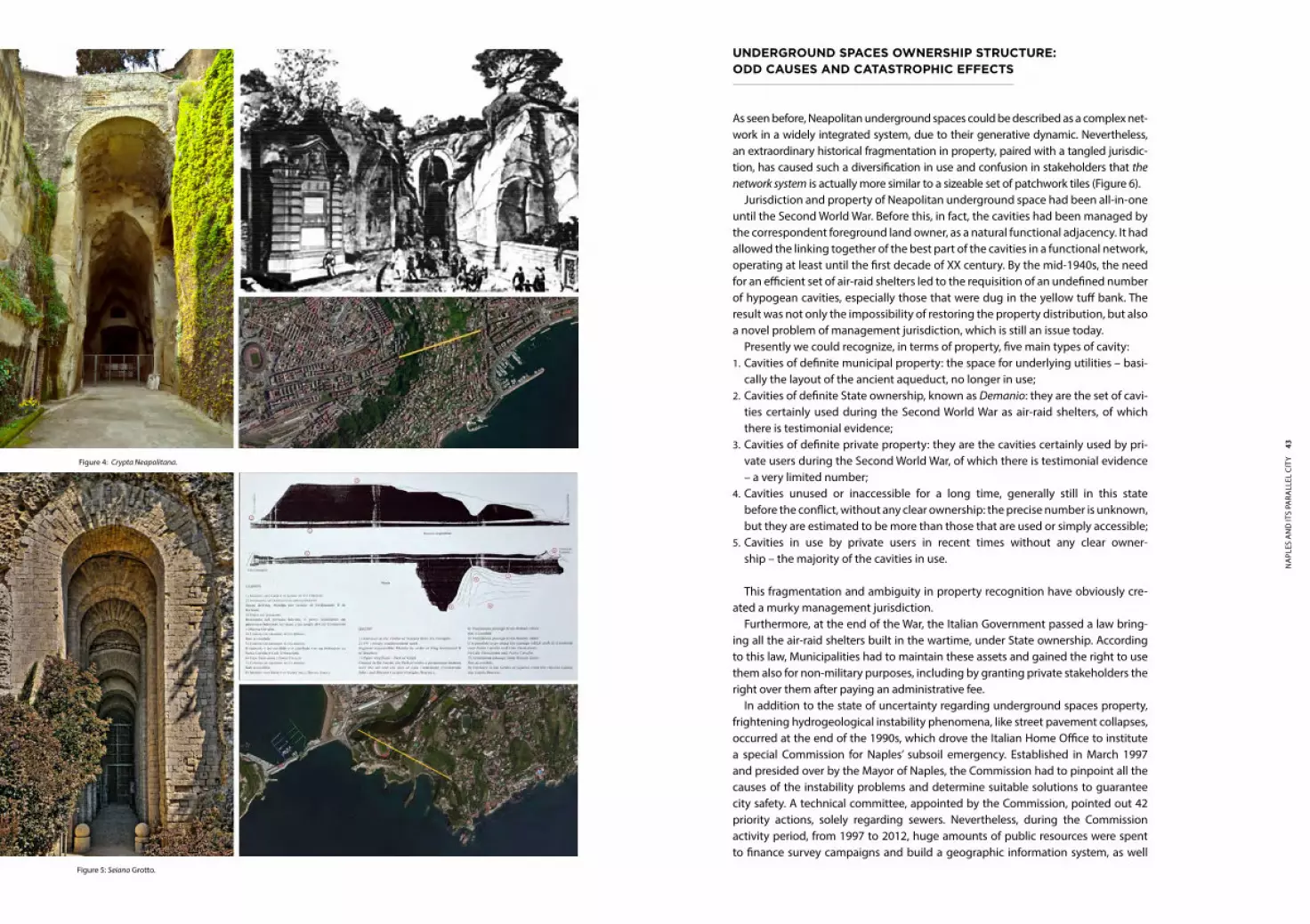
The last category of underground cavities includes pathways and galleries. The old city core was surrounded by a hilly range, and the creation of connecting routes that could allow a faster transit of people and goods was necessary. The first galleries excavations, carried out by Romans, were the Crypta Neapolitana and the Seiano Grotto. The first one starts from Piedigrotta, crosses the Hill of Posillipo, and arrives in the plain of Fuorigrotta (Figure 4). The second one goes from Gajola to Coroglio, traversing the Cape of Posillipo (Figure 5). No other underground roads
The multitude and variety of hypogean cavities make it difficult to present an overall view of these underground spaces. It is possible to categorize the artificial caves in Naples subsoil into the following sections: ∙ Tombs and places of worship; ∙ Rain tanks; ∙ Aqueducts; ∙ Tuff caves; ∙ Lapillus and Pozzolana caves; ∙ Tunnels and walking caves.
This paper does not take into account excavation works to realize modern water supply, sewer and technological systems because they go beyond the purpose of the study and do not illustrate anything particularly special about Naples.
Most ancient artificial caves were dug to build burial places. In 1950, two rock-cut tombs were discovered in Stella district. They are estimated to be 4500 years old and were originally located just outside the city walls. As time went by and the city grew, they were included in the urban perimeter.
The spread of Christianity played an important role in increasing the use of un-derground caves as burial places. The burial of the mortal remains of the Christian dead has always been regarded as a solemn religious act and it brought about the building of catacombs in the II century AD. The major catacombs in Naples subsoil are, in chronological order:
Figure 2: Naples districts and its stages of expansion.

ISO
CARP
· Th
Ink
Dee
P: P
lAn
nIn
g, D
evel
OPm
enT
An
D u
Se O
f u
nD
eRg
ROu
nD
SPA
Ce In
CIT
IeS
40 41N
apl
es a
Nd
its
para
llel
cit
y
PlannIng, Planners, and tHe underground cIty: an examPle oF worst PractIce
Underground city planning and the planners’ role has never sparked a keen inter-est in Italy: until 1999, the basic regulation about underground space utilization was limited to a few rules included in the Italian Highway Code (1992) and in its Fulfilment Regulations (1992), mainly focused on preserving road safety. Simi-larly, other sector-based rules had been introduced in 1993 (related to taxes) and in 1997 (related to the installation of telecommunication networks).
The first general and consistent regulation was the Guideline of Italian Prime Minister dated 1999, also known as Direttiva Micheli. It approached the under-ground space administration as a planning issue, introducing a specific instru-ment of planning: the General urban plan of underlying utilities, also known by its Italian acronym P.U.G.G.S., required for cities with more than 30.000 inhabitants. Unfortunately, very poorly detailed indications concerning the P.U.G.G.S. subjects and contents are given by the Direttiva and consequently only a few cities have drawn up and approved it.
Although Naples is supposed to adopt a P.U.G.G.S., not only has the local ad-ministration never fulfilled this obligation, but also scarce attention is paid to the hypogean cavities in the Town Plan, ratified in 1999. Underground spaces are seen simply as potential sources of archaeological discoveries. The Town Plan identi-fies the undercity as a means to show the relationship between the ancient town and the contemporary one. Anyway, no practical recommendations are given to regulate how historical underground spaces should be linked to urban strategies.
As far as the Town Plan is concerned, functional use of hypogean cavities is only contemplated for underground car parking. Building works inside cavities are per-mitted and an increase in floor area is allowed, providing that new excavations are prevented and building works do not interfere with vertical walls and ceilings.
The Town Plan commits the historic city centre regulation to specific legislation wherein building typologies are described item by item, but it provides no hint about the hypogean cavities existence and how these spaces have to be used.
Collapses in the undercity periodically wreak havoc overground, and there is no doubt that these events, in the historic city centre, are not due to the instability of the structure of the cavities but to the meager and badly-maintained under-ground infrastructural system. Recurring water leakages in the aqueduct network and their consequent interaction with pre-existing underground spaces are the main cause of instability, collapses and damage to buildings and, sometimes, to people.
In this context of risk, a deeper knowledge of the location of underground spaces is needed, but it is definitely not enough. An underground spaces use plan is equally necessary to facilitate cavities and wells maintenance work, both to preserve their efficiency and to plan their functional use. On the contrary, poorly planned interventions, without taking into account all the problems of the subsoil system, prevent local administration from both solving subsoil instability prob-lems and ensuring sustainable uses to underground spaces from which Naples and its population could benefit.
Underground spaces, therefore, have to be assessed, monitored, evaluated, planned and managed as other natural resources are. To do that, first of all, new legislation is needed to regulate their development and use.
were built for a very long time thereafter. In 1855, under the Bourbon Reign, an underground tunnel was planned to link the Royal Palace to the beach of Chiaia, passing underneath the Hill of Pizzofalcone.
As previously mentioned, in the first half of the XX century, important road and railway galleries were built to connect the city centre and the suburbs which had come up beyond the hill range. The latest excavation of buildings carried out, with modern building techniques, are the tunnels of the Naples Bypass, High Speed Tramway and Underground Metro.
It is possible to say that the most recent and widespread uses of underground spaces in Naples, and more generally in Italy, apart from sporadic tourist initiatives, were directed at improving the quality of both urban and suburban mobility, and then aimed at improving the living conditions of these places. Most of the invest-ment was directed mainly at the implementation of urban and national under-ground railway routes. Underground parking lots with different design solutions are also gaining popularity.
Figure 3: Catacomb of San Gennaro
43N
apl
es a
Nd
its
para
llel
cit
y
underground sPaces ownersHIP structure: odd causes and catastroPHIc eFFects
As seen before, Neapolitan underground spaces could be described as a complex net-work in a widely integrated system, due to their generative dynamic. Nevertheless, an extraordinary historical fragmentation in property, paired with a tangled jurisdic-tion, has caused such a diversification in use and confusion in stakeholders that the network system is actually more similar to a sizeable set of patchwork tiles (Figure 6).
Jurisdiction and property of Neapolitan underground space had been all-in-one until the Second world war. Before this, in fact, the cavities had been managed by the correspondent foreground land owner, as a natural functional adjacency. It had allowed the linking together of the best part of the cavities in a functional network, operating at least until the first decade of XX century. By the mid-1940s, the need for an efficient set of air-raid shelters led to the requisition of an undefined number of hypogean cavities, especially those that were dug in the yellow tuff bank. The result was not only the impossibility of restoring the property distribution, but also a novel problem of management jurisdiction, which is still an issue today.
Presently we could recognize, in terms of property, five main types of cavity:1. Cavities of definite municipal property: the space for underlying utilities – basi-
cally the layout of the ancient aqueduct, no longer in use;2. Cavities of definite State ownership, known as Demanio: they are the set of cavi-
ties certainly used during the Second world war as air-raid shelters, of which there is testimonial evidence;
3. Cavities of definite private property: they are the cavities certainly used by pri-vate users during the Second world war, of which there is testimonial evidence – a very limited number;
4. Cavities unused or inaccessible for a long time, generally still in this state before the conflict, without any clear ownership: the precise number is unknown, but they are estimated to be more than those that are used or simply accessible;
5. Cavities in use by private users in recent times without any clear owner-ship – the majority of the cavities in use.
This fragmentation and ambiguity in property recognition have obviously cre-ated a murky management jurisdiction.
Furthermore, at the end of the war, the Italian Government passed a law bring-ing all the air-raid shelters built in the wartime, under State ownership. According to this law, Municipalities had to maintain these assets and gained the right to use them also for non-military purposes, including by granting private stakeholders the right over them after paying an administrative fee.
In addition to the state of uncertainty regarding underground spaces property, frightening hydrogeological instability phenomena, like street pavement collapses, occurred at the end of the 1990s, which drove the Italian Home Office to institute a special Commission for Naples’ subsoil emergency. Established in March 1997 and presided over by the Mayor of Naples, the Commission had to pinpoint all the causes of the instability problems and determine suitable solutions to guarantee city safety. A technical committee, appointed by the Commission, pointed out 42 priority actions, solely regarding sewers. Nevertheless, during the Commission activity period, from 1997 to 2012, huge amounts of public resources were spent to finance survey campaigns and build a geographic information system, as well
Figure 5: Seiano Grotto.
Figure 4: Crypta Neapolitana.

ISO
CARP
· Th
Ink
Dee
P: P
lAn
nIn
g, D
evel
OPm
enT
An
D u
Se O
f u
nD
eRg
ROu
nD
SPA
Ce In
CIT
IeS
44 45N
apl
es a
Nd
its
para
llel
cit
y
as to assure the maintenance of hypogean cavities. Moreover, to coordinate this prolific fact-finding survey, a pre-existing municipal soil conservation department was strengthened. It continues to manage the upgrade of the underground spaces register, even if new hypogean cavities are identified only when collapses or soil instability happen. Unfortunately, the Naples subsoil has always been considered as a problem for the city safety and not as a resource, implying that no in-depth analysis on property and usage rights was carried out. In other words, the Com-mission acted without knowing who the main beneficiaries of their efforts were. Moreover, it established the common practice to consider the Municipality as the only actor in charge for cavities maintenance, and so relieving private users of their responsibility. In other words, the commissarial regime has not contributed to solv-ing this long-standing issue.
In this same frame, from the late 1980s, sporadic business initiatives have con-templated the opportunity to take advantage of the underground city through the granting of concessions to hypogean cavities. It generates a new controversial issue, founded on the unclear property distribution and the very confused Italian legislation about public concessions. Moreover, the Municipality of Naples, years before the Commission, autonomously decided to sign a set of memoranda of un-derstanding with private stakeholders to grant them the right over some cavities, even though those spaces didn’t belong to the municipality . Today it can be argued that this was not the best choice.
In 2005, a new Italian law allowed a public concession to be obtained directly from the State, excluding the intermediation of local institutions, which was previ-ously required. Before 2005, in fact, Government public concessions were submit-ted to the signature of an institutional agreement between the State and a local institution, such as a Municipality. As a consequence, the stakeholders became more interested in Naples underground spaces, and the Italian State was inevitably re-involved in that issue. Unexpectedly, it claimed possession of the hypogean cavi-ties requisitioned during the Second world war. Anyway, for the cavities previously categorized as definite State ownership, the old agreements were replaced by new Government concessions, costly and at a renewable fixed-term.
In 2010, the Italian Government reformed the military organization and decreed that the hypogean cavities used as air-raid shelters were not assets of the State (re-ferred to as Demanio), but the special assets of Military property (Demanio Militare). It obviously generated a new wave of confusion. In particular, the Government con-cessions have been frozen, and at present no one is able to foresee when and in which way this litigation will finish.
Finally, in May 2010, a federal reform act was approved by the Italian Government in order to make over to the local authorities’ ownership some state-owned assets, among which properties belonging to Demanio Militare, not used for military pur-poses like Naples underground cavities are, were included.
This complex framework has obviously prevented the development of an institu-tional culture of the underground in Naples, clashing with the common sentiments of the inhabitants associated with these mysterious locations. De facto, the under-ground has been completely marginalized from any planning and regulatory pro-cess. Due to the lack of an underground spaces plan, regulations and planning strat-egies developed and established for overground development are roughly applied to the underlying cavities. Proposals openly developed are caught in red tape: this leads people not to take entrepreneurial initiatives, or worse, to sidestep the system.
Despite this situation, notable success has been achieved by some initiatives. If
Figure 6 - City center of Naples with cavities (points size grows with age of cavities).

The non-profit association which takes care of these was founded in the 1960s in order to begin an exploratory, geological, speleological, archaeological and an-thropological program for every artifact of artificial extraction and of the subsoil of the city of Naples. In addition, these activities were aimed also at building a better understanding of these cavities to assess the safety of the city of Naples, which is historically known to rest on an empty space for nearly a third of its surface area.
In the mid-1980s, this association fostered the establishment of a committee to value and revive Naples’ underground. The organization of “walking tours” in some historically and archaeologically interesting hypogean cavities was one of its key ef-forts. These excursions were repeated weekly and aroused the interest of hundreds of people who booked these underground trips.
Thus, born as a movement involving just experts and technicians keen on Naples’ under-city, at the end of the 1980s it turned into a touristic phenomenon with the Association signing a memorandum of understanding with the Naples Municipality. This agreement allowed the Association to manage more than 4000 square meters of hypogean cavities underneath Naples historic city centre, in return for mainte-nance and clean-up activities.
Although the ownership of these cavities didn’t belong to the Municipality, but to Demanio, the Association managed it from 1989 to 2005, pursuant to the memo-randum of understanding mentioned before and never institutionally opposed by Demanio itself.
The lack of any underground space planning activities and public funding has not prevented the Association from independently managing these hypogean cavities, giving life to an international tourist phenomenon which, thanks to the interest and
Figure 8: Cross-section type of Napoli Sotterranea.
some steps progess has been made in recent times, in fact, it is only due to the commitment of a small group of businessmen that have carried on their proposals struggling against institutional opposition. Two of the most interesting cases from this viewpoint are Napoli Sotterranea and Tunnel Borbonico. The former initiative led to a renewed attention to the Neapolitan hypogean cavity system in the late 1980s, after being in limbo for over forty years. It was the first, and for many years the only, activity that had ever been formalized by relationship with the Municipality, inciting the latter to the development of a kind of agreement, achieved in the memoran-dum of understandings previously discussed. The second one, the Tunnel Borboni-co, obtained in 2005 the first direct State concession in Naples, and probably in Italy.
In the next two paragraphs the two cases are analyzed in-depth in order to highlight the complexity of the Neapolitan hypogean grid as well as the need of a master-plan able to define ideas and a strategy for the future of such an important resource of the city.
napoli sotterranea
The complex of tunnels which is commonly called Napoli Sotterranea is located in the heart of the historical centre of Naples (Figure 7). There are several access points to this maze that is about 30 metres below the street level, running under down-town streets, but not all of them have been discovered yet (Figure 8). The main body of such a tourist complex is formed essentially by aqueducts, water storage tanks and their connecting pipes. They are mainly characterized by classical architecture: Greek and Roman.
Figure 7: Layout of Napoli Sotterranea.

ISO
CARP
· Th
Ink
Dee
P: P
lAn
nIn
g, D
evel
OPm
enT
An
D u
Se O
f u
nD
eRg
ROu
nD
SPA
Ce In
CIT
IeS
48 49N
apl
es a
Nd
its
para
llel
cit
y
been left in a state of abandon, totally degraded, filled with debris and residue com-ing from the new subway digging works. These surveys enabled them to discover hypogean cavities that were never surveyed before and enhance the awareness of underground spaces in that area.
The Association began to clear the tunnel of the debris with the sole support of its members and other volunteers who also contributed during a five-year period to organizing and studying the archaeological material discovered. They then man-aged to secure a Real Estate Grant from Demanio, and Tunnel Borbonico was opened to the public in October 2010, after five years of cleaning and restoration work. To-day, a section of the path is reserved for the exhibition of cars and motorcycles, abandoned for years in the tunnel, freed from piles of rubbish, restored, arranged and illuminated ad hoc for the route (Figure 11).
At present, the Tunnel Borbonico has regular state authorization to carry out guid-ed tours and cultural events are also periodically organized right inside.
The important contribution made by the Association could be seriously compro-mised due to the lack of underground space planning, which prevents the Associa-tion itself from improving the touristic package of Tunnel Borbonico. The prospect of creating a permanent museum inside, for instance, has not materialized because the developed project can’t be authorized, in accordance with the building code, commonly used to regulate building work procedures above the ground.
The Tunnel Borbonico, since December 2010, has benefited from a restored and scenic entrance thanks to the opening of a multi-storey car park, built up in a huge hypogean cavity (it can reach 40 meters in height) used since the 16th century as
Figure 9: Layout of Tunnel Borbonico.
dissemination of the mass media, has been attracting tourists from all around the world for 25 years.
In 2005 a new law concerning criteria and procedures to follow for Government real estate grants, threw light on the controversial agreement signed by the Mu-nicipality. The Association had to adapt to this regulation and got a 12-year Govern-ment real estate grant.
In the absence of a clear planning framework for underground spaces, with the ability to unravel and solve the thorny problem of the cavities propriety, one of the most appreciated hubs of the tourist industry in Naples could have been seriously jeopardized.
Today this Association continues to be motivated by its primary exploration mis-sion, bringing to light hidden sides of the Neapolitan underworld and, at the same time, preserving underground spaces from degradation and neglect. It still organ-izes excursions starting from Piazza San Gaetano, a square that, at first in the Greek age, and then in the Roman one, was occupied by the agora and the forum, respec-tively. The path followed during these underground “walks” is long and twisting and leads visitors to 17 hypogean cavities and tanks linked by 9 main cunicoli.
Napoli Sotterranea’s success has obviously been produced by private enterprise, which was the first to grasp the potential charm and appeal of urban cavities tour-istic exploration in a town where there is a profusion of historic and cultural attrac-tions. The lack of underground space planning has, however, slowed down the pro-cesses activated by the Association.
tunnel Borbonico
The Tunnel Borbonico is a long underground passage, built in the XIX century be-neath Pizzofalcone hill. In February 1853, Ferdinand II of Bourbon commissioned the famous Neapolitan architect Errico Alvino to design an underground passage under Pizzofalcone hill that would link the Royal Palace with a barrack near the seaside, for a total length of 530 meters (Figure 9). The aim of the project, originally envisaging two underground parallel paths, was to create a rapidly accessible military passage to defend the Royal Palace, and a safe exit route for the royal family.
The works started by digging into the hill from a little square by the seaside and creating two parallel tunnels. After 84 m, the double path stops and runs into a huge empty space, 3180 square meters wide and 35 meters high, used as a yellow tuff cave since 1512 and named “Cave Carafa”; thereafter, only a single tunnel was built (Figure 10).
The project did not fare well, however, and the building works were interrupted in 1855, before the second exit was ever realized, due to the numerous setbacks encountered and the political upheaval which led to the end of the Kingdom of the Two Sicilies and the Bourbon rule.
During the Second world war, this cavernous structure served as an air raid shel-ter and military hospital, providing aid and protection to almost 10,000 Neapoli-tans. After the war, the tunnel was used as an impound lot until the 1970s.
In March 2005 a group of geologists and speleologists2, members of a cultural association, accessed the Tunnel Borbonico to do some surveys and found it had
2 Scientist and/or researcher in the field of speleology, the scientific study of caves, their make-up, structure, physical properties, history, life forms, and the processes by which they form (speleogenesis) and change over time (speleomorphology).

51N
apl
es a
Nd
its
para
llel
cit
y
a water tank. Seven parking floors (overall, about 20,000 square meters wide), con-nected by a circular ramp, offer long and short-term parking. In the hall, located in the heart of the building called Agorà, cultural events, expositions, concerts, etc are usually organized.
Although this majestic building project has a strategic role in the reduction of traffic congestion, it too suffered from a lack of underground space planning and from red tape during its construction. A public company initially achieved a munici-pal concession in 1990 to build and manage the multi-storey car park, but building works, which lasted 3 years in all, ended in 2010, about 20 years later.
conclusIons
The authors have attempted to demonstrate how Naples is unique from a morpho-logical point of view, its historic city center area almost entirely settled on a bank of yellow tuff, whose easy workability and recurring use in the building industry had fostered, over the centuries, a constant underground mining activity. Therefore, Naples has inherited a large and complex system of underground spaces. Lacking an organic vision of their use, this system has always been perceived as a threat rather than an opportunity for the city to solve the problems it has always been beset with.
Naples is presently afflicted by soil instability, very high-density housing and a considerable lack of public services (e.g. parking lots) in the inner city. In this context, the planning of existing underground spaces is more urgent than other common urban planning activities. Therefore, a plan for underground spaces use (masterplan) needs to be drawn up. It should be based on a sound knowledge of the existing underground spaces, deeper and more accurate than the current one and it should plan: ∙ the hypogean cavities’ permitted uses, considering not only the conservation
status and the use-related risk, but also their location, accessibility, relationships with the upper-city, the potential use (e.g. touristic activities, new paths, etc.);
∙ permitted building works in each cavity in order to preserve the soil stability and allow a safe and easy conversion of abandoned cavities;
∙ -how to make a network of best practices in underground space utilization, born in the absence of planning activity.
Only through a planning process focusing on these aspects can a sustainable and responsible use of underground spaces be promoted in Naples. A stable and long-lasting use of underground spaces is essential to continuously monitor hypo-gean cavities, broaden Naples’ subsoil knowledge, and subsequently implement a strategy to mitigate hydrogeological risk. Moreover, a clear framework of the own-ership pattern of known cavities needs to be established. Only in this way will it be possible to successfully regulate the relations between the public and private sectors, overcome conflicts and encourage synergies between local owners, entre-preneurs, planners and associations.
Figure 11: Interior view of Tunnel Borbonico.
Figure 10: Cross-section type of Tunnel Borbonico.

ISO
CARP
· Th
Ink
Dee
P: P
lAn
nIn
g, D
evel
OPm
enT
An
D u
Se O
f u
nD
eRg
ROu
nD
SPA
Ce In
CIT
IeS
52 53N
apl
es a
Nd
its
para
llel
cit
y
References
Carratelli, M. (2006), ‘Nel ventre di Napoli - Viaggio alla scoperta della “città di sotto”’. National Geographic, 18 (6).
Commissione di Studio per il Sottosuolo di Napoli. (1967), Il sottosuolo di Napoli. Naples - IT: Municipality of Naples.
Lavagno, E., & Schranz, L. (2007), ‘Recent development and utilisation of Underground Space in Italy’. 11th ACUUS Conference - Underground Space: Expanding the Frontiers. Athens - GR.
Melisburgo, G. (1889), Napoli Sotterranea. Naples, IT: Colonnese Editore.
Monda, L. (2005), ‘Napoli durante la II guerra mondiale, ovvero: i 100 bombardamenti di Napoli’. Convegno I.SS.E.S. - Istituto di Studi Economici e Sociali - Napoli durante la II guerra mondiale.Naples - IT.
Municipality of Naples, (2004), Naples Town Plan. Naples, IT.
Piedimonte, A. E. (2008), Napoli sotterranea: percorsi tra i misteri della città parallela. Naples, IT: Edizioni Intra Moenia.
Puntillo, E. (1994). Grotte e caverne di Napoli.Rome, IT: Newton Compton.
autHors
Vincenzo De Stefano is a PhD in “Hydraulic, Transportation and Territorial Systems Engineering” and graduated in Environmental Engineering at the University of Naples Federico II. He took part in research projects in the Department of Civil, Architectural and Environmental Engineering of the University of Naples “Federico II”, including PRIN ITATOUR about tourism, sustainability and transportation. He has published and presented papers about Spatial Decision Support Systems.
Valerio Di Pinto is a registered architect. On April 2013 he was awarded his PhD by the Department of Civil, Architectural and Environmental Engineering at the Uni-versity of Naples “Federico II”. His research work is focused on the analysis of urban pattern. In 2013, he gained a recognition of merit by the Urban Studies Founda-tion for the research programme Safer Communities; Safer Cities - How urban layout affects crime and social integration in the European City. During the academic year 2013/2014, as adjunct professor, he has been teaching the “Urban Design Lab” at Y2, at the University of Naples “Federico II” - Architectural Construction Engineer-ing Degree course.
Carlo Gerundo graduated (cum laude) in Architecture and Building Engineering at the University of Salerno in 2011 and he is currently a PhD student in “Hydrau-lic, Transportation and Territorial Systems Engineering” at the University of Naples “Federico II”. He is co-worker in urban planning activities and advice for Public Ad-ministrations. He won first prize in the Ischia Architecture Short Film Festival in 2009. He took part in the European Architecture Students Assembly in Manchester (UK) in 2010. He is a member of Istituto Nazionale di Urbanistica. He has published es-says and presented papers at specialized conferences on the topic of interaction between urban planning and transportation planning.