mudrock dominate fills formed in avulsion splay channels: examples from the willwood formation,...
TRANSCRIPT
Mudrock-dominated fills formed in avulsion splay channels:examples from the Willwood Formation, Wyoming
MARY J. KRAUS* and K. SIAN DAVIES-VOLLUM�*Department of Geological Sciences, University of Colorado, Boulder, CO 80309-0399, USA (E-mail:[email protected])�Interdisciplinary Arts and Sciences, University of Washington Tacoma, Box 358436, 1900 CommerceSt., Tacoma, WA 98402, USA
ABSTRACT
Mudrock-dominated channel fills are common features of the fluvial
Palaeogene Willwood Formation of Wyoming. These fills are small, on
average 30 m wide and 3 m deep, and they vary from simple plugs to more
lithologically complex fills with internal scour surfaces. Some fills preserve
plant material, and others show pedogenic modification. All fills are located
within metre-thick intervals of weakly pedogenically modified mudstones that
surround ribbon sandstones. The intervals have previously been attributed to
channel avulsion; the fine-grained channel fills are interpreted as crevasse-
splay feeder channels within these avulsion deposits.Variation in fill type,
particularly the presence of pedogenic features, appears to be related to
floodplain drainage. Possible factors that influenced drainage were basin
position of the fills and Palaeogene climate fluctuations, although the role of
either is not unequivocal. In general, channel fills with sombre colours and
preserved plant detritus, indicating poorly drained conditions, dominate
locations that were proximal to the Palaeogene basin axes. Fills that contain
root traces, red and yellow-brown matrix colours and mottling, which indicate
pedogenic modification and episodic subaerial exposure of the sediment,
dominate locations that were more distal to the Palaeogene basin axes. Eocene
climate fluctuations, particularly episodes of global warming, may have been a
secondary control on the kind of fill that developed. Mudrock-dominated
channel fills have not been described previously from ancient avulsion
deposits. Their common presence in the Willwood Formation suggests that
they are a typical component of avulsion belts and that similar channel fills in
other stratigraphic units should be considered with regard to channel
avulsion. The variety of fills observed in the Willwood Formation indicates
that avulsion belt channels can experience very different fill histories. The
descriptive details of fills provided here should help in their recognition
elsewhere. In addition, the nature of the channel fill provides important
information on ancient drainage conditions in the avulsion belt.
Pedogenically modified channel fills have been recognized only rarely from
the stratigraphic record. Their presence throughout the Willwood Formation
suggests that they should exist in other alluvial successions and may have
been overlooked previously. They indicate that periods of sediment exposure
alternated with episodic influxes of water and sediment in an active avulsion
belt.
Keywords Abandoned channel, avulsion, channel fills, palaeosol.
Sedimentology (2004) 51, 1127–1144 doi: 10.1111/j.1365-3091.2004.00664.x
� 2004 International Association of Sedimentologists 1127
INTRODUCTION
Previous research on fluvial cut-and-fill struc-tures at the channel scale has emphasized grav-elly and/or sandy bedload fills (e.g. Allen, 1965;Miall, 1985; Mackey & Bridge, 1995). Work onfine-grained, suspended-load channel fills hasfocused on the formation of oxbow lakes inmeandering river systems (e.g. Allen, 1970; Lewis& Lewin, 1983; Walker & Cant, 1984). Descrip-tions of fine-grained fills are uncommon, andmost are in the context of channel abandonmentin anastomosing river systems (e.g. Eberth &Miall, 1991; Kirschbaum & McCabe, 1992) orincision related to a drop in base level (Kraus &Bown, 1993). Only rarely have fine-grainedchannel fills been considered in the context ofchannel avulsions (e.g. Berendsen, 1982; Stout-hammer, 2001).This study describes mudrock-dominated chan-
nel fills from the Palaeogene Willwood Formationand documents their relationship to previouslyrecognized avulsion deposits (Kraus & Wells,1999; Davies-Vollum & Kraus, 2001). Althoughsome fills consist only of carbonaceous shale,mudstone and siltstone, most fills also includesome sandstone. Fifty-seven mudrock-filled chan-nels have been studied, and these identify fourtypes of fill that appear to be related to differentpalaeodrainage conditions. The geographic andstratigraphic distributions of the different types ofchannel fill are examined, and the factors thatmight have influenced these distributions arediscussed.This study indicates that mudrock-dominated
channel fills should be present in other alluvialsuccessions and that they might be examined inthe context of channel avulsions. Kraus (1996)suggested that avulsion deposits may be relativelycommon in the stratigraphic record but misiden-tified. In particular, pedogenically modified fills,which are common in some parts of the Willwoodsection, may be an important tool for recognizingancient avulsion belts in other alluvial basins. Inaddition, the nature of the channel fill providesimportant information on ancient drainage con-ditions on the floodplain.
GEOLOGICAL SETTING
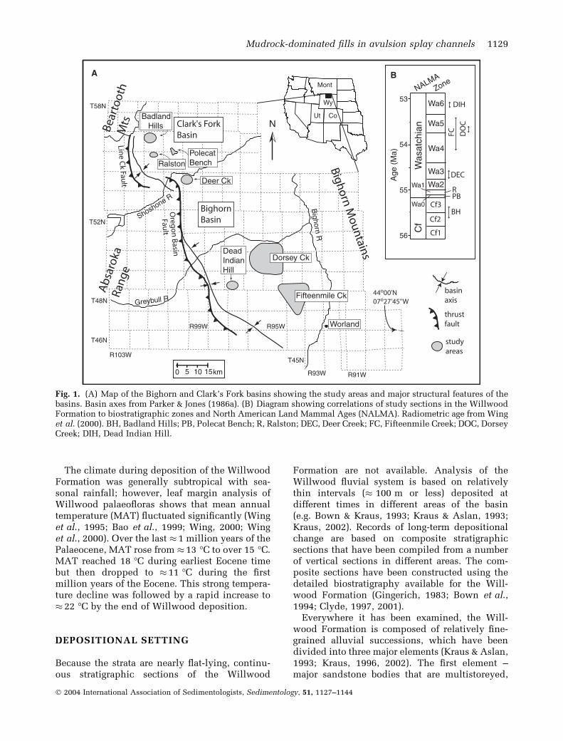
The Willwood Formation consists of fluvial stratathat accumulated during latest Palaeocene andearly Eocene time in the Bighorn Basin and theClark’s Fork Basin, a small basin north of the
Bighorn Basin and separated from it by a NE-trending subsurface arch in the vicinity of theShoshone River (Neasham & Vondra, 1972; Ginge-rich, 1983; Parker & Jones, 1986a; DeCelles et al.,1991; Fig. 1A). The Bighorn, Beartooth and OwlCreek ranges, which formed during the Laramideorogeny, were the main source of sediments;however, most orogenic uplift of these ranges hadceased before Willwood deposition (Omar et al.,1994). The basin is bounded to the west by theAbsaroka volcanic complex, which formed afterdeposition of the Willwood Formation (Bown,1980). The basin was open to the north.The structural and depositional history of the
Palaeogene deposits was controlled by severalmajor thrust faults that dip to the west and havelateral and vertical offsets that can be measured intens of kilometres (Fig. 1A). The faults are con-sidered to have been the result of north-east–south-west compression related to the Laramideorogeny (Stone, 1985; Blackstone, 1986). Thesedeep-seated faults cut the Precambrian basementand the sedimentary section older than the Will-wood Formation; however, seismic data show thatWillwood strata are not cut, and fault motion isbelieved to have terminated by the end of Palaeo-cene time (Stone, 1985; Parker & Jones, 1986a).The Bighorn Basin and the position of its axis
were influenced by the Oregon Basin fault, whichis about 120 km long (Fig. 1A). Seismic data showthat this west-dipping fault has a vertical offset of6100 m and a horizontal offset of 4000 m (Stone,1985). Uppermost Cretaceous and Palaeogenedeposits thicken towards the Oregon Basin faultand indicate that there was an actively subsiding,north- to south-oriented depocentre just east ofthat fault (Parker & Jones, 1986a,b). The structuralaxis of the Clark’s Fork Basin is offset from that ofthe main Bighorn Basin and, to the north, is over-ridden by the fault-bounded Beartooth Mountains(Foose et al., 1961; Bonini & Kinard, 1983;Fig. 1A). A second major thrust fault – the LineCreek fault – influenced the Clark’s Fork Basin(Fig. 1A). Earliest movement on that fault isbelieved to have been during early Palaeocenetime and, because the Willwood Formation is notcut by the fault, fault motion had ended by latestPalaeocene time (Blackstone, 1986). The axis ofthe Clark’s Fork Basin shifted westward duringPalaeocene time, and Gingerich (1983) has shownthat, by middle Late Palaeocene time, it was onthe west side of the basin close to the Line Creekfault (Fig. 1A). That position is confirmed byisopach maps of the Palaeocene Fort UnionFormation (Moore, 1961).
1128 M. J. Kraus & K. S. Davies-Vollum
� 2004 International Association of Sedimentologists, Sedimentology, 51, 1127–1144
The climate during deposition of the WillwoodFormation was generally subtropical with sea-sonal rainfall; however, leaf margin analysis ofWillwood palaeofloras shows that mean annualtemperature (MAT) fluctuated significantly (Winget al., 1995; Bao et al., 1999; Wing, 2000; Winget al., 2000). Over the last � 1 million years of thePalaeocene, MAT rose from � 13 �C to over 15 �C.MAT reached 18 �C during earliest Eocene timebut then dropped to � 11 �C during the firstmillion years of the Eocene. This strong tempera-ture decline was followed by a rapid increase to� 22 �C by the end of Willwood deposition.
DEPOSITIONAL SETTING
Because the strata are nearly flat-lying, continu-ous stratigraphic sections of the Willwood
Formation are not available. Analysis of theWillwood fluvial system is based on relativelythin intervals (� 100 m or less) deposited atdifferent times in different areas of the basin(e.g. Bown & Kraus, 1993; Kraus & Aslan, 1993;Kraus, 2002). Records of long-term depositionalchange are based on composite stratigraphicsections that have been compiled from a numberof vertical sections in different areas. The com-posite sections have been constructed using thedetailed biostratigraphy available for the Will-wood Formation (Gingerich, 1983; Bown et al.,1994; Clyde, 1997, 2001).Everywhere it has been examined, the Will-
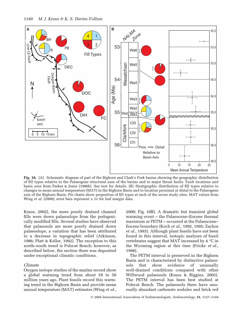
wood Formation is composed of relatively fine-grained alluvial successions, which have beendivided into three major elements (Kraus & Aslan,1993; Kraus, 1996, 2002). The first element –major sandstone bodies that are multistoreyed,
Fig. 1. (A) Map of the Bighorn and Clark’s Fork basins showing the study areas and major structural features of thebasins. Basin axes from Parker & Jones (1986a). (B) Diagram showing correlations of study sections in the WillwoodFormation to biostratigraphic zones and North American Land Mammal Ages (NALMA). Radiometric age from Winget al. (2000). BH, Badland Hills; PB, Polecat Bench; R, Ralston; DEC, Deer Creek; FC, Fifteenmile Creek; DOC, DorseyCreek; DIH, Dead Indian Hill.
Mudrock-dominated fills in avulsion splay channels 1129
� 2004 International Association of Sedimentologists, Sedimentology, 51, 1127–1144
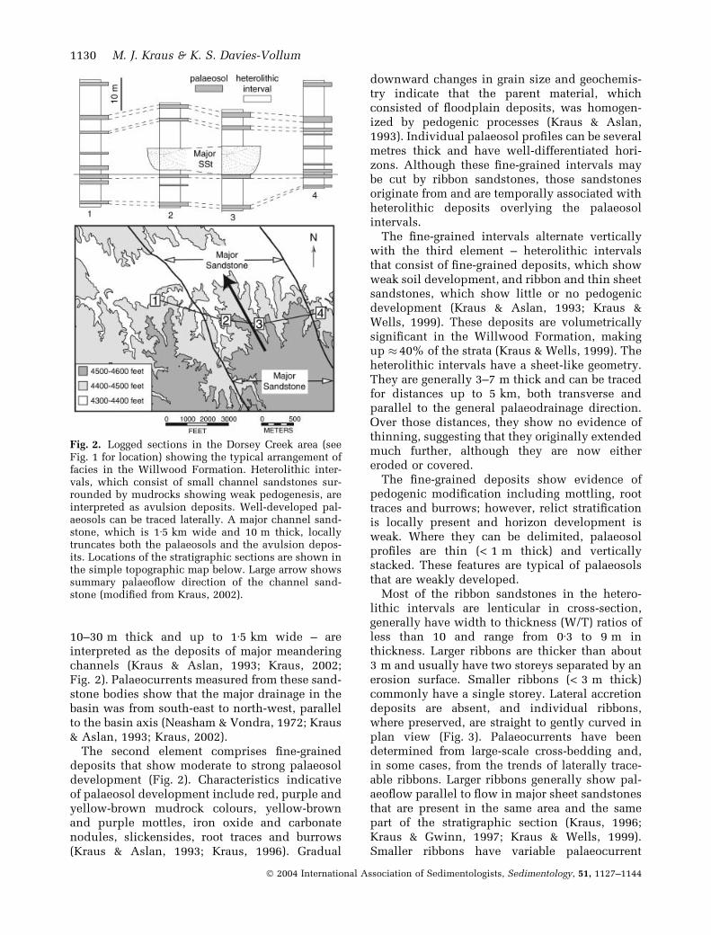
10–30 m thick and up to 1Æ5 km wide – areinterpreted as the deposits of major meanderingchannels (Kraus & Aslan, 1993; Kraus, 2002;Fig. 2). Palaeocurrents measured from these sand-stone bodies show that the major drainage in thebasin was from south-east to north-west, parallelto the basin axis (Neasham & Vondra, 1972; Kraus& Aslan, 1993; Kraus, 2002).The second element comprises fine-grained
deposits that show moderate to strong palaeosoldevelopment (Fig. 2). Characteristics indicativeof palaeosol development include red, purple andyellow-brown mudrock colours, yellow-brownand purple mottles, iron oxide and carbonatenodules, slickensides, root traces and burrows(Kraus & Aslan, 1993; Kraus, 1996). Gradual
downward changes in grain size and geochemis-try indicate that the parent material, whichconsisted of floodplain deposits, was homogen-ized by pedogenic processes (Kraus & Aslan,1993). Individual palaeosol profiles can be severalmetres thick and have well-differentiated hori-zons. Although these fine-grained intervals maybe cut by ribbon sandstones, those sandstonesoriginate from and are temporally associated withheterolithic deposits overlying the palaeosolintervals.The fine-grained intervals alternate vertically
with the third element – heterolithic intervalsthat consist of fine-grained deposits, which showweak soil development, and ribbon and thin sheetsandstones, which show little or no pedogenicdevelopment (Kraus & Aslan, 1993; Kraus &Wells, 1999). These deposits are volumetricallysignificant in the Willwood Formation, makingup � 40% of the strata (Kraus & Wells, 1999). Theheterolithic intervals have a sheet-like geometry.They are generally 3–7 m thick and can be tracedfor distances up to 5 km, both transverse andparallel to the general palaeodrainage direction.Over those distances, they show no evidence ofthinning, suggesting that they originally extendedmuch further, although they are now eithereroded or covered.The fine-grained deposits show evidence of
pedogenic modification including mottling, roottraces and burrows; however, relict stratificationis locally present and horizon development isweak. Where they can be delimited, palaeosolprofiles are thin (< 1 m thick) and verticallystacked. These features are typical of palaeosolsthat are weakly developed.Most of the ribbon sandstones in the hetero-
lithic intervals are lenticular in cross-section,generally have width to thickness (W/T) ratios ofless than 10 and range from 0Æ3 to 9 m inthickness. Larger ribbons are thicker than about3 m and usually have two storeys separated by anerosion surface. Smaller ribbons (< 3 m thick)commonly have a single storey. Lateral accretiondeposits are absent, and individual ribbons,where preserved, are straight to gently curved inplan view (Fig. 3). Palaeocurrents have beendetermined from large-scale cross-bedding and,in some cases, from the trends of laterally trace-able ribbons. Larger ribbons generally show pal-aeoflow parallel to flow in major sheet sandstonesthat are present in the same area and the samepart of the stratigraphic section (Kraus, 1996;Kraus & Gwinn, 1997; Kraus & Wells, 1999).Smaller ribbons have variable palaeocurrent
Fig. 2. Logged sections in the Dorsey Creek area (seeFig. 1 for location) showing the typical arrangement offacies in the Willwood Formation. Heterolithic inter-vals, which consist of small channel sandstones sur-rounded by mudrocks showing weak pedogenesis, areinterpreted as avulsion deposits. Well-developed pal-aeosols can be traced laterally. A major channel sand-stone, which is 1Æ5 km wide and 10 m thick, locallytruncates both the palaeosols and the avulsion depos-its. Locations of the stratigraphic sections are shown inthe simple topographic map below. Large arrow showssummary palaeoflow direction of the channel sand-stone (modified from Kraus, 2002).
1130 M. J. Kraus & K. S. Davies-Vollum
� 2004 International Association of Sedimentologists, Sedimentology, 51, 1127–1144
trends (Kraus & Wells, 1999; Davies-Vollum &Kraus, 2001).The heterolithic intervals have been interpreted
as ancient avulsion belt deposits formed as thetrunk channels avulsed and became abandoned(Kraus & Aslan, 1993; Kraus, 1996; Kraus & Wells,1999). They are analogous to modern depositsdescribed from the Saskatchewan River (Smithet al., 1989; Smith & Perez-Arlucea, 1994; Sling-erland & Smith, 2004). In the abandonmentprocess observed in that system, a network ofsplay channels takes up flow from the formerlydominant channel, and those networks spreadwater and sediment on to low parts of theadjacent floodplain. The deposits consist ofribbon sands, representing deposits of the splaychannels, and fine-grained deposits representingflood-basin deposits associated with the splaychannels. Soils formed on the fine-grained depos-its are only weakly developed because depositionof the avulsion deposits was rapid (tens tohundreds of years; Smith et al., 1989). The heter-olithic avulsion deposits are laterally extensive(Figs 2 and 3), which is consistent with the
modern example described by Smith et al.(1989), covering roughly 500 km2.
FINE-GRAINED CHANNEL-FILLDEPOSITS
Channels with fills that are dominated by fine-grained deposits are common in the WillwoodFormation. The 57 fine-grained fills that havebeen studied are distributed throughout the Big-horn and Clark’s Fork basins and at all strati-graphic levels of the Willwood Formation(Table 1). These sites can be broadly divided intoseven areas: Badland Hills, Ralston, PolecatBench, Deer Creek, Dorsey Creek, FifteenmileCreek and Dead Indian Hill (Fig. 1). Based on thebiostratigraphic studies of Gingerich (1983, 2001),Gingerich & Klitz (1985), Bown et al. (1994) andClyde (1997, 2001), the fills can be assigned todifferent Palaeogene biozones. The fills studied inthe Badland Hills area are located in strataassigned to the upper part of the Clarkforkian-2(Cf-2) and lower part of the Clarkforkian-3 (Cf-3)biozones (Gingerich, 1983), making them theoldest fills in this study (Table 1; Fig. 1B). Thefills studied at south Polecat Bench are locatednear the base of the Wasatchian-0 (Wa-0) biozone(e.g. Koch et al., 1995; Gingerich, 2001), andthose studied in the Ralston area formed duringWasatchian-1 (Wa-1) time. Willwood strata in theDeer Creek area have been assigned to the lowerpart of the Wa-3 biozone (Clyde, 1997, 2001). Fillsin the Dorsey Creek area and fills from alongFifteenmile Creek are stratigraphically higher(Wa-4 to Wa-5; Bown et al., 1994). Fills fromDead Indian Hill correspond to the middle ofWa-6 (Bown et al., 1994).
General characteristics
In the field, the channel fills described in thisstudy are recognized as bodies of predominantlyfine-grained, horizontally bedded sedimentaryrocks that sit within U-shaped erosion surfacesthat truncate other fine-grained deposits (Figs 4and 5). The fills can be recognized in the fieldbecause they differ from the truncated, confiningdeposits in colour and, less strikingly, in litho-logy (Fig. 5). Some fills are entirely fine-grainedwith mudstones and siltstones and, in someexamples, carbonaceous shales. Most fills alsocontain sandstone beds, generally at the base ofthe fill, and some contain a second sandstone bedhigher within the fill (Fig. 6).
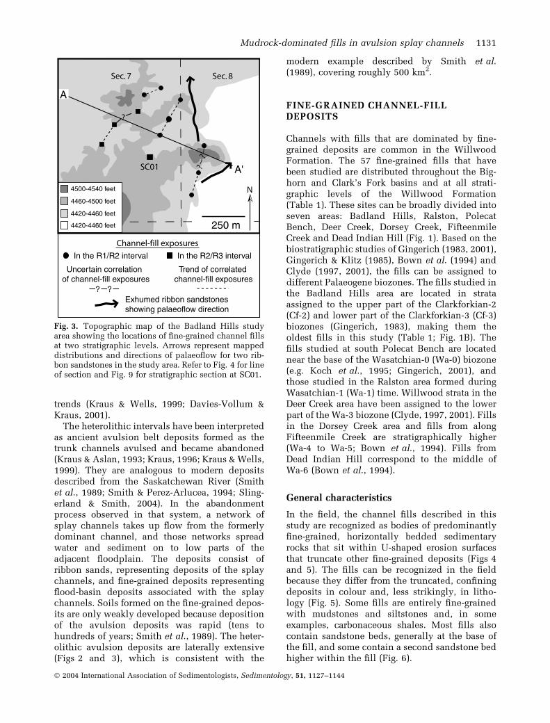
Fig. 3. Topographic map of the Badland Hills studyarea showing the locations of fine-grained channel fillsat two stratigraphic levels. Arrows represent mappeddistributions and directions of palaeoflow for two rib-bon sandstones in the study area. Refer to Fig. 4 for lineof section and Fig. 9 for stratigraphic section at SC01.
Mudrock-dominated fills in avulsion splay channels 1131
� 2004 International Association of Sedimentologists, Sedimentology, 51, 1127–1144
Although many channel fills are only partiallypreserved, those that can be measured range indepth from 0Æ5 to 10 m and average � 3 m.Maximum widths vary from 10 to 100 m butaverage less than 30 m. Width to thickness ratiosfor the channel-fill deposits are variable butaverage 20 m or less at most localities (Table 1).More than two-thirds of the fills incise from a
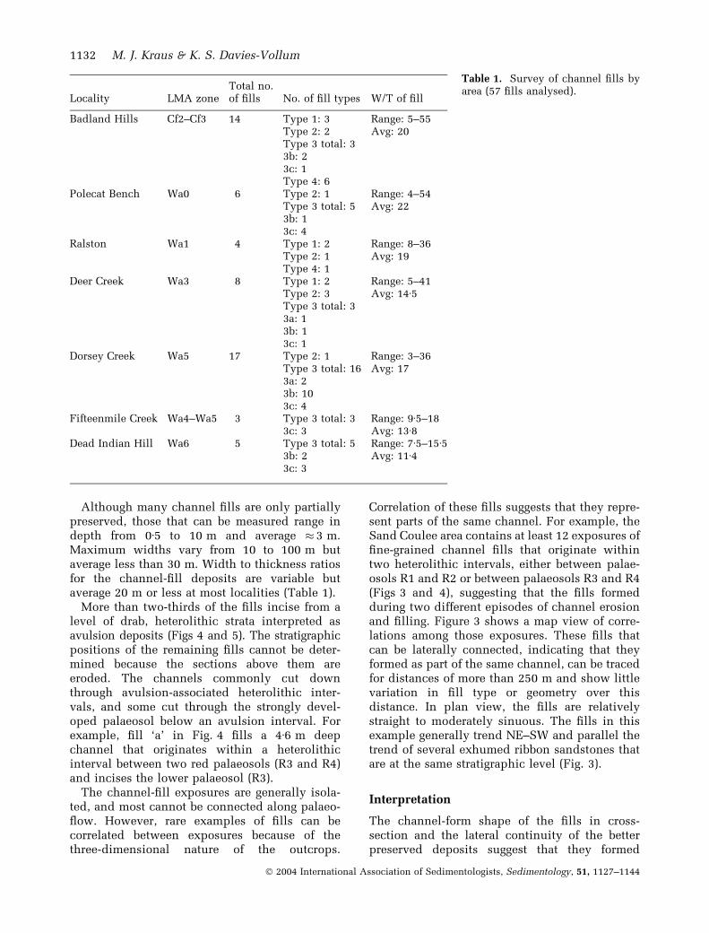
level of drab, heterolithic strata interpreted asavulsion deposits (Figs 4 and 5). The stratigraphicpositions of the remaining fills cannot be deter-mined because the sections above them areeroded. The channels commonly cut downthrough avulsion-associated heterolithic inter-vals, and some cut through the strongly devel-oped palaeosol below an avulsion interval. Forexample, fill ‘a’ in Fig. 4 fills a 4Æ6 m deepchannel that originates within a heterolithicinterval between two red palaeosols (R3 and R4)and incises the lower palaeosol (R3).The channel-fill exposures are generally isola-
ted, and most cannot be connected along palaeo-flow. However, rare examples of fills can becorrelated between exposures because of thethree-dimensional nature of the outcrops.
Correlation of these fills suggests that they repre-sent parts of the same channel. For example, theSand Coulee area contains at least 12 exposures offine-grained channel fills that originate withintwo heterolithic intervals, either between palae-osols R1 and R2 or between palaeosols R3 and R4(Figs 3 and 4), suggesting that the fills formedduring two different episodes of channel erosionand filling. Figure 3 shows a map view of corre-lations among those exposures. These fills thatcan be laterally connected, indicating that theyformed as part of the same channel, can be tracedfor distances of more than 250 m and show littlevariation in fill type or geometry over thisdistance. In plan view, the fills are relativelystraight to moderately sinuous. The fills in thisexample generally trend NE–SW and parallel thetrend of several exhumed ribbon sandstones thatare at the same stratigraphic level (Fig. 3).
Interpretation
The channel-form shape of the fills in cross-section and the lateral continuity of the betterpreserved deposits suggest that they formed
Table 1. Survey of channel fills byarea (57 fills analysed).
Locality LMA zoneTotal no.of fills No. of fill types W/T of fill
Badland Hills Cf2–Cf3 14 Type 1: 3 Range: 5–55Avg: 20Type 2: 2
Type 3 total: 33b: 23c: 1Type 4: 6
Polecat Bench Wa0 6 Type 2: 1 Range: 4–54Avg: 22Type 3 total: 5
3b: 13c: 4
Ralston Wa1 4 Type 1: 2 Range: 8–36Avg: 19Type 2: 1
Type 4: 1Deer Creek Wa3 8 Type 1: 2 Range: 5–41
Avg: 14Æ5Type 2: 3Type 3 total: 33a: 13b: 13c: 1
Dorsey Creek Wa5 17 Type 2: 1 Range: 3–36Avg: 17Type 3 total: 16
3a: 23b: 103c: 4
Fifteenmile Creek Wa4–Wa5 3 Type 3 total: 3 Range: 9Æ5–18Avg: 13Æ83c: 3
Dead Indian Hill Wa6 5 Type 3 total: 5 Range: 7Æ5–15Æ5Avg: 11Æ43b: 2
3c: 3
1132 M. J. Kraus & K. S. Davies-Vollum
� 2004 International Association of Sedimentologists, Sedimentology, 51, 1127–1144
within small channels. The stratigraphic positionof the channel fills within the heterolithic inter-vals, their cross-section widths and thicknessesand their plan view patterns are similar to thoseof the ribbon sandstones that are found in whathave been interpreted as avulsion deposits. Thesesimilarities suggest that the fine-grained fillsinitiated as feeder channels in avulsion belts ina manner similar to the ribbon sandstones (Smithet al., 1989; Kraus & Wells, 1999).The grain size of sediment in the Willwood
channel fills is thought to have been controlled bythe proximity of the channel reach to the avulsionnode on the trunk channel and by whether thesplay channel was abandoned or remained activeduring filling (Fig. 7). The ribbon sandstonesrepresent splay channels that remained activeuntil they filled with sand and were abandoned.Most of the channel fills with sandstone inaddition to fine-grained deposits are attributedto splay channels that were abandoned shortlyafter they formed and that later filled with mainly
fine-grained sediment. Newly abandoned chan-nels may stay partly active but, as upstream fillingcontinues in a particular channel reach, down-stream flows become weaker, allowing only finermaterials to accumulate from suspension in theabandoning reach. The Willwood channel fillsthat contain only fine-grained deposits and car-bonaceous material are interpreted as downflowreaches of the splay channels that were too farfrom the avulsion node to receive bedload. Thelatter filled either when they were still active(rarely) or, more commonly, after they had beenabandoned (Fig. 7). These interpretations areconsistent with the observations of Smith &Perez-Arlucea (1994), who found that upflowreaches of splay channels fill with sand unlessthey are abandoned, whereas downflow reachesmay fill with silt. They are also compatible withthe observations of Berendsen (1982) andStouthammer (2001), who recognized distal splaychannels that filled with finer suspended sedi-ment after they were abandoned.
TYPES OF MUDROCK-DOMINATEDCHANNEL-FILL DEPOSITS
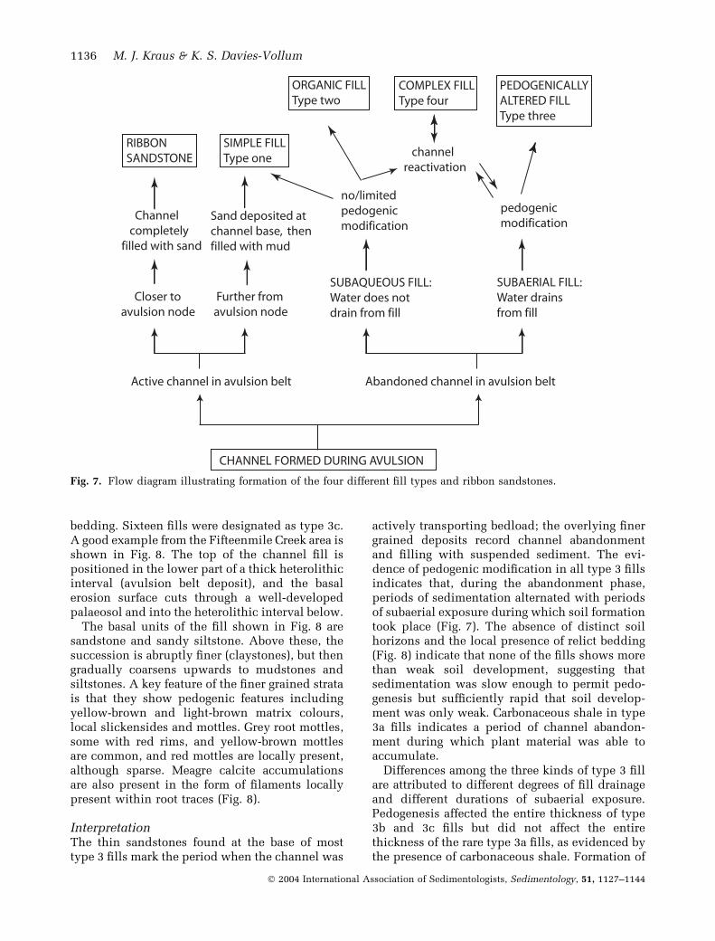
Four general types of mudrock-dominated fills arerecognized: (1) type 1 – simple, low-chroma(greyish), mudrock fill; (2) type 2 – carbonaceousshale fill; (3) type 3 – pedogenically alteredmudrock fill; (4) type 4 – complex fill withcoarse-grained and fine-grained deposits. Thissection describes the four different fill types,and the following section explores how thedifferent kinds of fill formed.
Type 1 fills
Type 1 fills (Fig. 5A) are composed mainly of low-chroma and green mudrock and sandy mudrock.The mudrock shows weak bedding and localbioturbation. Fossil plant material is rare andpoorly preserved. Type 1 fills lack sedimentarystructures that might indicate significant breaksin sedimentation during filling; they do containsingle or, more rarely, multiple fining-upwardssuccessions. Seven type 1 fills are recognized.
InterpretationType 1 fills were deposited relatively rapidly asindicated by fining-upward successions and theabsence of internal scour surfaces. Relict beddingis present and pedogenic features are absent; thisis attributed to rapid filling as well as to a high
Fig. 4. Cross-section through deposits in the BadlandHills study area. Heterolithic deposits consist of fine-grained deposits (white) that show weak pedogenesisand ribbon sandstones. They are interbedded with redpalaeosols (labelled R1 to R4). U-shaped scours filleddominantly by fine-grained deposits incise from thelevel of several heterolithic intervals. A major sand-stone locally truncates both heterolithic intervals(avulsion deposits) and red palaeosols. Line of cross-section is shown in Fig. 3. R4 is used as datum for thesection.
Mudrock-dominated fills in avulsion splay channels 1133
� 2004 International Association of Sedimentologists, Sedimentology, 51, 1127–1144
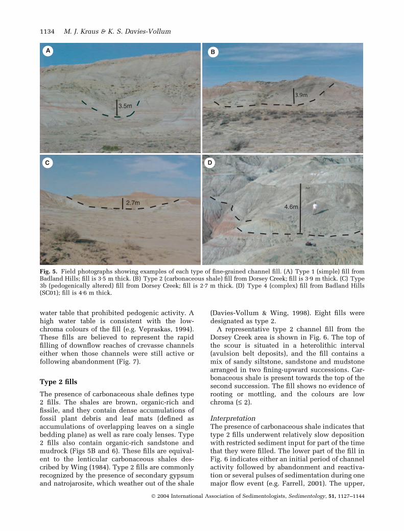
water table that prohibited pedogenic activity. Ahigh water table is consistent with the low-chroma colours of the fill (e.g. Vepraskas, 1994).These fills are believed to represent the rapidfilling of downflow reaches of crevasse channelseither when those channels were still active orfollowing abandonment (Fig. 7).
Type 2 fills
The presence of carbonaceous shale defines type2 fills. The shales are brown, organic-rich andfissile, and they contain dense accumulations offossil plant debris and leaf mats (defined asaccumulations of overlapping leaves on a singlebedding plane) as well as rare coaly lenses. Type2 fills also contain organic-rich sandstone andmudrock (Figs 5B and 6). These fills are equival-ent to the lenticular carbonaceous shales des-cribed by Wing (1984). Type 2 fills are commonlyrecognized by the presence of secondary gypsumand natrojarosite, which weather out of the shale
(Davies-Vollum & Wing, 1998). Eight fills weredesignated as type 2.A representative type 2 channel fill from the
Dorsey Creek area is shown in Fig. 6. The top ofthe scour is situated in a heterolithic interval(avulsion belt deposits), and the fill contains amix of sandy siltstone, sandstone and mudstonearranged in two fining-upward successions. Car-bonaceous shale is present towards the top of thesecond succession. The fill shows no evidence ofrooting or mottling, and the colours are lowchroma (£ 2).
InterpretationThe presence of carbonaceous shale indicates thattype 2 fills underwent relatively slow depositionwith restricted sediment input for part of the timethat they were filled. The lower part of the fill inFig. 6 indicates either an initial period of channelactivity followed by abandonment and reactiva-tion or several pulses of sedimentation during onemajor flow event (e.g. Farrell, 2001). The upper,
Fig. 5. Field photographs showing examples of each type of fine-grained channel fill. (A) Type 1 (simple) fill fromBadland Hills; fill is 3Æ5 m thick. (B) Type 2 (carbonaceous shale) fill from Dorsey Creek; fill is 3Æ9 m thick. (C) Type3b (pedogenically altered) fill from Dorsey Creek; fill is 2Æ7 m thick. (D) Type 4 (complex) fill from Badland Hills(SC01); fill is 4Æ6 m thick.
1134 M. J. Kraus & K. S. Davies-Vollum
� 2004 International Association of Sedimentologists, Sedimentology, 51, 1127–1144
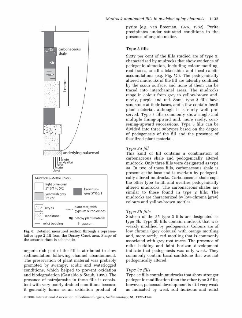
organic-rich part of the fill is attributed to slowsedimentation following channel abandonment.The preservation of plant material was probablypromoted by swampy, acidic and waterloggedconditions, which helped to prevent oxidationand biodegradation (Gastaldo & Staub, 1999). Thepresence of natrojarosite in these fills is consis-tent with very poorly drained conditions becauseit generally forms as an oxidation product of
pyrite (e.g. van Breeman, 1975, 1982). Pyriteprecipitates under saturated conditions in thepresence of organic matter.
Type 3 fills
Sixty per cent of the fills studied are of type 3,characterized by mudrocks that show evidence ofpedogenic alteration, including colour mottling,root traces, small slickensides and local calciteaccumulations (e.g. Fig. 5C). The pedogenicallyaltered mudrocks of the fill are laterally confinedby the scour surface, and none of them can betraced into interchannel areas. The mudrocksrange in colour from grey to yellow-brown and,rarely, purple and red. Some type 3 fills havesandstone at their bases, and a few contain fossilplant material, although it is rarely well pre-served. Type 3 fills commonly show single andmultiple fining-upward and, more rarely, coar-sening-upward successions. Type 3 fills can bedivided into three subtypes based on the degreeof pedogenesis of the fill and the presence offossilized plant material.
Type 3a fillThis kind of fill contains a combination ofcarbonaceous shale and pedogenically alteredmudrock. Only three fills were designated as type3a. In two of these fills, carbonaceous shale ispresent at the base and is overlain by pedogeni-cally altered mudrocks. Carbonaceous shale capsthe other type 3a fill and overlies pedogenicallyaltered mudrocks. The carbonaceous shales aresimilar to those found in type 2 fills. Themudrocks are characterized by low-chroma (grey)colours and yellow-brown mottles.
Type 3b fillsSixteen of the 35 type 3 fills are designated astype 3b. Type 3b fills contain mudrock that wasweakly modified by pedogenesis. Colours are oflow chroma (grey colours) with orange mottlingand, more rarely, red mottling that is commonlyassociated with grey root traces. The presence ofrelict bedding and faint horizon developmentindicate that pedogenesis was only weak. Theycommonly contain basal sandstone that was notpedogenically altered.
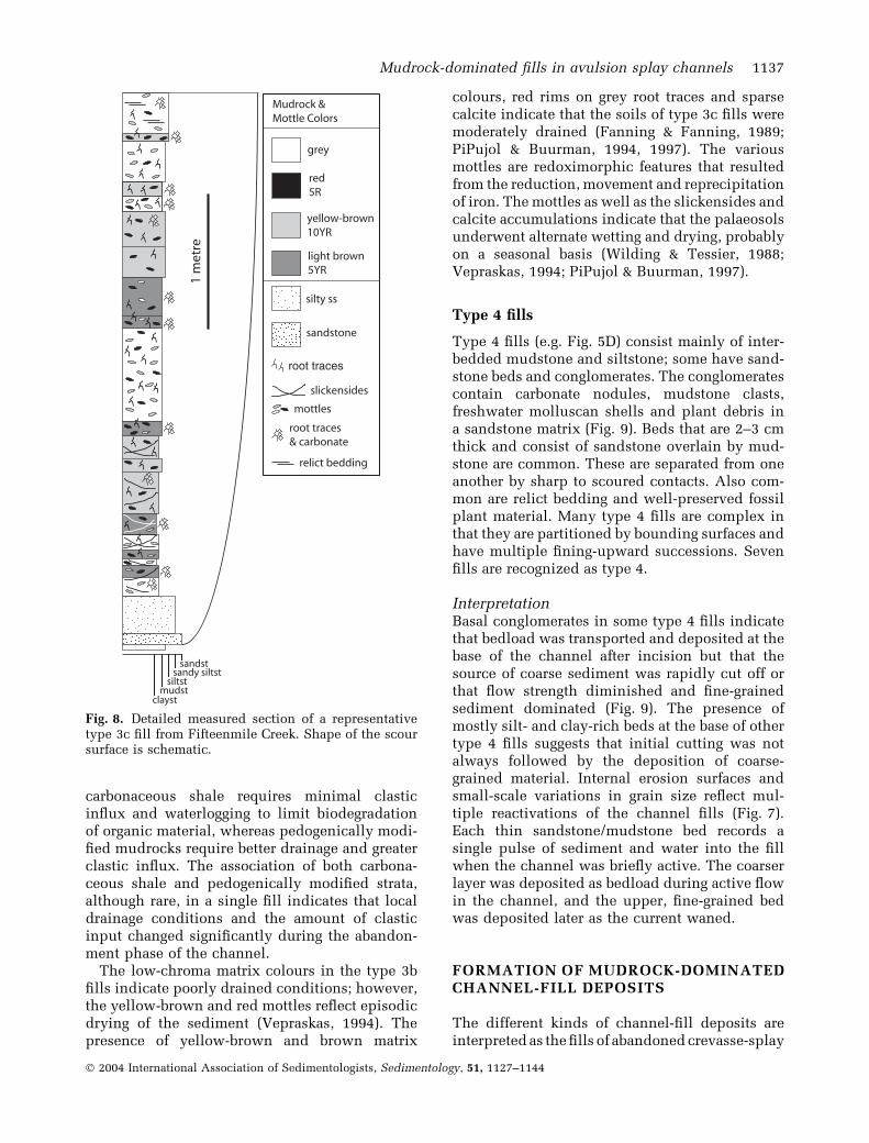
Type 3c fillsType 3c fills contain mudrocks that show strongerpedogenic modification than the other type 3 fills;however, palaeosol development is still very weakas indicated by weak soil horizons and relict
Fig. 6. Detailed measured section through a represen-tative type 2 fill from the Dorsey Creek area. Shape ofthe scour surface is schematic.
Mudrock-dominated fills in avulsion splay channels 1135
� 2004 International Association of Sedimentologists, Sedimentology, 51, 1127–1144
bedding. Sixteen fills were designated as type 3c.A good example from the Fifteenmile Creek area isshown in Fig. 8. The top of the channel fill ispositioned in the lower part of a thick heterolithicinterval (avulsion belt deposit), and the basalerosion surface cuts through a well-developedpalaeosol and into the heterolithic interval below.The basal units of the fill shown in Fig. 8 are
sandstone and sandy siltstone. Above these, thesuccession is abruptly finer (claystones), but thengradually coarsens upwards to mudstones andsiltstones. A key feature of the finer grained stratais that they show pedogenic features includingyellow-brown and light-brown matrix colours,local slickensides and mottles. Grey root mottles,some with red rims, and yellow-brown mottlesare common, and red mottles are locally present,although sparse. Meagre calcite accumulationsare also present in the form of filaments locallypresent within root traces (Fig. 8).
InterpretationThe thin sandstones found at the base of mosttype 3 fills mark the period when the channel was
actively transporting bedload; the overlying finergrained deposits record channel abandonmentand filling with suspended sediment. The evi-dence of pedogenic modification in all type 3 fillsindicates that, during the abandonment phase,periods of sedimentation alternated with periodsof subaerial exposure during which soil formationtook place (Fig. 7). The absence of distinct soilhorizons and the local presence of relict bedding(Fig. 8) indicate that none of the fills shows morethan weak soil development, suggesting thatsedimentation was slow enough to permit pedo-genesis but sufficiently rapid that soil develop-ment was only weak. Carbonaceous shale in type3a fills indicates a period of channel abandon-ment during which plant material was able toaccumulate.Differences among the three kinds of type 3 fill
are attributed to different degrees of fill drainageand different durations of subaerial exposure.Pedogenesis affected the entire thickness of type3b and 3c fills but did not affect the entirethickness of the rare type 3a fills, as evidenced bythe presence of carbonaceous shale. Formation of
Fig. 7. Flow diagram illustrating formation of the four different fill types and ribbon sandstones.
1136 M. J. Kraus & K. S. Davies-Vollum
� 2004 International Association of Sedimentologists, Sedimentology, 51, 1127–1144
carbonaceous shale requires minimal clasticinflux and waterlogging to limit biodegradationof organic material, whereas pedogenically modi-fied mudrocks require better drainage and greaterclastic influx. The association of both carbona-ceous shale and pedogenically modified strata,although rare, in a single fill indicates that localdrainage conditions and the amount of clasticinput changed significantly during the abandon-ment phase of the channel.The low-chroma matrix colours in the type 3b
fills indicate poorly drained conditions; however,the yellow-brown and red mottles reflect episodicdrying of the sediment (Vepraskas, 1994). Thepresence of yellow-brown and brown matrix
colours, red rims on grey root traces and sparsecalcite indicate that the soils of type 3c fills weremoderately drained (Fanning & Fanning, 1989;PiPujol & Buurman, 1994, 1997). The variousmottles are redoximorphic features that resultedfrom the reduction, movement and reprecipitationof iron. Themottles as well as the slickensides andcalcite accumulations indicate that the palaeosolsunderwent alternate wetting and drying, probablyon a seasonal basis (Wilding & Tessier, 1988;Vepraskas, 1994; PiPujol & Buurman, 1997).
Type 4 fills
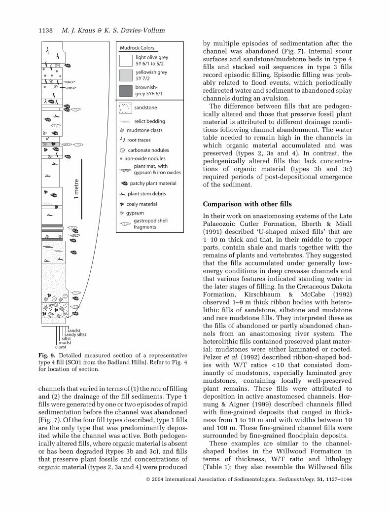
Type 4 fills (e.g. Fig. 5D) consist mainly of inter-bedded mudstone and siltstone; some have sand-stone beds and conglomerates. The conglomeratescontain carbonate nodules, mudstone clasts,freshwater molluscan shells and plant debris ina sandstone matrix (Fig. 9). Beds that are 2–3 cmthick and consist of sandstone overlain by mud-stone are common. These are separated from oneanother by sharp to scoured contacts. Also com-mon are relict bedding and well-preserved fossilplant material. Many type 4 fills are complex inthat they are partitioned by bounding surfaces andhave multiple fining-upward successions. Sevenfills are recognized as type 4.
InterpretationBasal conglomerates in some type 4 fills indicatethat bedload was transported and deposited at thebase of the channel after incision but that thesource of coarse sediment was rapidly cut off orthat flow strength diminished and fine-grainedsediment dominated (Fig. 9). The presence ofmostly silt- and clay-rich beds at the base of othertype 4 fills suggests that initial cutting was notalways followed by the deposition of coarse-grained material. Internal erosion surfaces andsmall-scale variations in grain size reflect mul-tiple reactivations of the channel fills (Fig. 7).Each thin sandstone/mudstone bed records asingle pulse of sediment and water into the fillwhen the channel was briefly active. The coarserlayer was deposited as bedload during active flowin the channel, and the upper, fine-grained bedwas deposited later as the current waned.
FORMATION OF MUDROCK-DOMINATEDCHANNEL-FILL DEPOSITS
The different kinds of channel-fill deposits areinterpreted as thefills of abandonedcrevasse-splay
Fig. 8. Detailed measured section of a representativetype 3c fill from Fifteenmile Creek. Shape of the scoursurface is schematic.
Mudrock-dominated fills in avulsion splay channels 1137
� 2004 International Association of Sedimentologists, Sedimentology, 51, 1127–1144
channels that varied in termsof (1) the rate of fillingand (2) the drainage of the fill sediments. Type 1fillswere generated by one or two episodes of rapidsedimentation before the channel was abandoned(Fig. 7). Of the four fill types described, type 1 fillsare the only type that was predominantly depos-ited while the channel was active. Both pedogen-ically altered fills, where organicmaterial is absentor has been degraded (types 3b and 3c), and fillsthat preserve plant fossils and concentrations oforganic material (types 2, 3a and 4) were produced
by multiple episodes of sedimentation after thechannel was abandoned (Fig. 7). Internal scoursurfaces and sandstone/mudstone beds in type 4fills and stacked soil sequences in type 3 fillsrecord episodic filling. Episodic filling was prob-ably related to flood events, which periodicallyredirectedwater and sediment to abandoned splaychannels during an avulsion.The difference between fills that are pedogen-
ically altered and those that preserve fossil plantmaterial is attributed to different drainage condi-tions following channel abandonment. The watertable needed to remain high in the channels inwhich organic material accumulated and waspreserved (types 2, 3a and 4). In contrast, thepedogenically altered fills that lack concentra-tions of organic material (types 3b and 3c)required periods of post-depositional emergenceof the sediment.
Comparison with other fills
In their work on anastomosing systems of the LatePalaeozoic Cutler Formation, Eberth & Miall(1991) described ‘U-shaped mixed fills’ that are1–10 m thick and that, in their middle to upperparts, contain shale and marls together with theremains of plants and vertebrates. They suggestedthat the fills accumulated under generally low-energy conditions in deep crevasse channels andthat various features indicated standing water inthe later stages of filling. In the Cretaceous DakotaFormation, Kirschbaum & McCabe (1992)observed 1–9 m thick ribbon bodies with hetero-lithic fills of sandstone, siltstone and mudstoneand rare mudstone fills. They interpreted these asthe fills of abandoned or partly abandoned chan-nels from an anastomosing river system. Theheterolithic fills contained preserved plant mater-ial; mudstones were either laminated or rooted.Pelzer et al. (1992) described ribbon-shaped bod-ies with W/T ratios < 10 that consisted dom-inantly of mudstones, especially laminated greymudstones, containing locally well-preservedplant remains. These fills were attributed todeposition in active anastomosed channels. Hor-nung & Aigner (1999) described channels filledwith fine-grained deposits that ranged in thick-ness from 1 to 10 m and with widths between 10and 100 m. These fine-grained channel fills weresurrounded by fine-grained floodplain deposits.These examples are similar to the channel-
shaped bodies in the Willwood Formation interms of thickness, W/T ratio and lithology(Table 1); they also resemble the Willwood fills
Fig. 9. Detailed measured section of a representativetype 4 fill (SC01 from the Badland Hills). Refer to Fig. 4for location of section.
1138 M. J. Kraus & K. S. Davies-Vollum
� 2004 International Association of Sedimentologists, Sedimentology, 51, 1127–1144
in that the U-shaped bodies are commonly situ-ated within other fine-grained deposits. A keyway in which the four ancient examples des-cribed above differ from channel fills in theWillwood Formation is that, other than therooting described by Kirschbaum & McCabe(1992), pedogenic modification has not beenrecognized in them.Fine-grained fills that are pedogenically mod-
ified have been described at a larger scale (kilo-metres wide and tens of metres deep) in a smallnumber of alluvial successions. For example,Kraus & Middleton (1987) described a Triassicscour system that could be traced for severalkilometres and was up to 30 m deep. The scourcould be recognized because it truncated stronglydeveloped palaeosols that differed in colour fromweakly developed palaeosols filling the scour.Bestland (1997) described similar features inOligocene strata. These examples differ from theWillwood fine-grained channel fills not only interms of their larger scale but also because theyhave erosional bases that consist of multiple,stepped surfaces rather than a simple U-shapedsurface. In addition, these larger scour systemshave been attributed to base-level fluctuationsresulting from climate change or tectonic activity,whereas the Willwood channel fills are attributedto autogenic fluvial processes.The following section examines the factors that
might have controlled the pedogenic modificationof some fills and the preservation of plant mater-ial in other fills in the Willwood Formation.
Possible controls on fill type
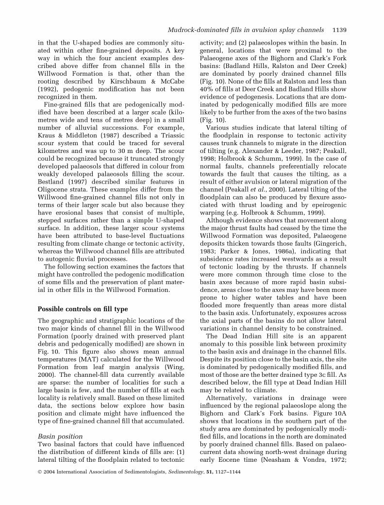
The geographic and stratigraphic locations of thetwo major kinds of channel fill in the WillwoodFormation (poorly drained with preserved plantdebris and pedogenically modified) are shown inFig. 10. This figure also shows mean annualtemperatures (MAT) calculated for the WillwoodFormation from leaf margin analysis (Wing,2000). The channel-fill data currently availableare sparse: the number of localities for such alarge basin is few, and the number of fills at eachlocality is relatively small. Based on these limiteddata, the sections below explore how basinposition and climate might have influenced thetype of fine-grained channel fill that accumulated.
Basin positionTwo basinal factors that could have influencedthe distribution of different kinds of fills are: (1)lateral tilting of the floodplain related to tectonic
activity; and (2) palaeoslopes within the basin. Ingeneral, locations that were proximal to thePalaeogene axes of the Bighorn and Clark’s Forkbasins: (Badland Hills, Ralston and Deer Creek)are dominated by poorly drained channel fills(Fig. 10). None of the fills at Ralston and less than40% of fills at Deer Creek and Badland Hills showevidence of pedogenesis. Locations that are dom-inated by pedogenically modified fills are morelikely to be further from the axes of the two basins(Fig. 10).Various studies indicate that lateral tilting of
the floodplain in response to tectonic activitycauses trunk channels to migrate in the directionof tilting (e.g. Alexander & Leeder, 1987; Peakall,1998; Holbrook & Schumm, 1999). In the case ofnormal faults, channels preferentially relocatetowards the fault that causes the tilting, as aresult of either avulsion or lateral migration of thechannel (Peakall et al., 2000). Lateral tilting of thefloodplain can also be produced by flexure asso-ciated with thrust loading and by epeirogenicwarping (e.g. Holbrook & Schumm, 1999).Although evidence shows that movement along
the major thrust faults had ceased by the time theWillwood Formation was deposited, Palaeogenedeposits thicken towards those faults (Gingerich,1983; Parker & Jones, 1986a), indicating thatsubsidence rates increased westwards as a resultof tectonic loading by the thrusts. If channelswere more common through time close to thebasin axes because of more rapid basin subsi-dence, areas close to the axes may have been moreprone to higher water tables and have beenflooded more frequently than areas more distalto the basin axis. Unfortunately, exposures acrossthe axial parts of the basins do not allow lateralvariations in channel density to be constrained.The Dead Indian Hill site is an apparent
anomaly to this possible link between proximityto the basin axis and drainage in the channel fills.Despite its position close to the basin axis, the siteis dominated by pedogenically modified fills, andmost of those are the better drained type 3c fill. Asdescribed below, the fill type at Dead Indian Hillmay be related to climate.Alternatively, variations in drainage were
influenced by the regional palaeoslope along theBighorn and Clark’s Fork basins. Figure 10Ashows that locations in the southern part of thestudy area are dominated by pedogenically modi-fied fills, and locations in the north are dominatedby poorly drained channel fills. Based on palaeo-current data showing north-west drainage duringearly Eocene time (Neasham & Vondra, 1972;
Mudrock-dominated fills in avulsion splay channels 1139
� 2004 International Association of Sedimentologists, Sedimentology, 51, 1127–1144
Kraus, 2002), the more poorly drained channelfills were down palaeoslope from the pedogeni-cally modified fills. Several studies have observedthat palaeosols are more poorly drained downpalaeoslope, a variation that has been attributedto a decrease in topographic relief (Atkinson,1986; Platt & Keller, 1992). The exception to thisnorth–south trend is Polecat Bench; however, asdescribed below, the section there was depositedunder exceptional climatic conditions.
ClimateOxygen isotope studies of the marine record showa global warming trend from about 59 to 50million years ago. Plant fossils record this warm-ing trend in the Bighorn Basin and provide meanannual temperature (MAT) estimates (Wing et al.,
2000; Fig. 10B). A dramatic but transient globalwarming event – the Palaeocene–Eocene thermalmaximum or PETM – occurred at the Palaeocene–Eocene boundary (Koch et al., 1992, 1995; Zachoset al., 1993). Although plant fossils have not beenfound in this interval, isotopic analyses of fossilvertebrates suggest that MAT increased by 4 �C inthe Wyoming region at this time (Fricke et al.,1998).The PETM interval is preserved in the Bighorn
Basin and is characterized by distinctive palaeo-sols that show evidence of unusuallywell-drained conditions compared with otherWillwood palaeosols (Kraus & Riggins, 2002).The PETM interval has been best studied atPolecat Bench. The palaeosols there have unu-sually abundant carbonate nodules and brick red
Fig. 10. (A) Schematic diagram of part of the Bighorn and Clark’s Fork basins showing the geographic distributionof fill types relative to the Palaeogene structural axes of the basins and to major thrust faults. Fault locations andbasin axes from Parker & Jones (1986b). See text for details. (B) Stratigraphic distribution of fill types relative tochanges in mean annual temperature (MAT) in the Bighorn Basin and to location proximal or distal to the Palaeogeneaxis of the Bighorn Basin. Pie charts show proportion of fill types at each of the seven study sites. MAT values fromWing et al. (2000); error bars represent ± 1r for leaf margin data.
1140 M. J. Kraus & K. S. Davies-Vollum
� 2004 International Association of Sedimentologists, Sedimentology, 51, 1127–1144
colours indicating well-drained soil conditions(e.g. Torrent et al., 1980). Purple and yellow-brown, colours that indicate less-well drainedconditions, are uncommon (Wright et al., 2000;Kraus, 2002). These features have been attributedto climatic drying that accompanied the dramaticwarming of the PETM (Kraus & Riggins, 2002).The presence of pedogenically modified channelfills at Polecat Bench is consistent with the dryconditions indicated by the PETM palaeosols(Fig. 10). Thus, climatic drying may have beenthe primary reason why pedogenically modifiedfills formed at Polecat Bench.As stated above, despite its proximity to the
Palaeogene basin axis, the Dead Indian Hill site isdominated by pedogenically modified channelfills. The Willwood Formation here formed asMAT was approaching its early Eocene peak of� 22 �C during Wa6 (Fig. 10A). The betterdrained character of those channel fills mayreflect drier conditions related to the unusuallyhigh MAT. Climatic drying is also indicated byanalysis of the more strongly developed palaeo-sols in the southern two-thirds of the basin (Bown& Kraus, 1993). Palaeosols in the upper part of theWillwood section show a marked decrease in soilhydromorphy relative to older palaeosols.Despite the possible influence of climate on
fine-grained channel fills at Polecat Bench andDead Indian Hill, the link between climate andfill type is uncertain because it does not appear tobe systematic. Although pedogenically modifiedfills are found at Polecat Bench and Dead IndianHill at times of high MAT, pedogenically mod-ified channel fills also dominate in the DorseyCreek area even though they formed during asignificant cooling trend (Fig. 10A). It is difficultto test a possible relationship between climateand fill type: trends in palaeoprecipitation didnot necessarily track trends in palaeotemperatureduring early Eocene time (Bice & Marotzke, 2002),and reliable data on palaeoprecipitation are notcurrently available for most of the Willwoodstrata.
CONCLUSIONS
Fine-grained and heterolithic deposits fillingchannels in Palaeogene alluvial strata of theBighorn Basin, Wyoming, are interpreted as thefills of abandoned splay channels associated withavulsion belts. The type of fill that accumulatedappears to have been influenced by the proximityof the avulsion belt to the basin axis. Channel fills
close to the basin axis generally show limitedpedogenic modification and contain strata thatreflect poor drainage. Fills further from the basinaxis are pedogenically modified, reflecting moredistal, better drained areas of the basin thatreceived influxes of floodwaters and sedimentless frequently than areas that were closer to theaxis. This difference is attributed to floodplaintilting towards major thrust faults in the basin.Locations close to the faults had higher watertables and underwent more frequent floodingthan locations more distal to the faults. Alternat-ively, variations in drainage represented by thedifferent kinds of fills were influenced by thepalaeoslope of the Bighorn and Clark’s Forkbasins. Unusually warm climates may also haveinfluenced the kinds of fill that formed in theupper part of the Willwood Formation. Thissuggests that climate also plays a role; however,it appears to be secondary to the tectonic controlon the kind of channel fill that developed.This study has implications for understanding
the fine-grained facies of other fluvial succes-sions. Pedogenically modified channel fills haveonly rarely been recognized in the stratigraphicrecord (Bown & Kraus, 1993). Unless there areobvious colour differences between the palaeo-sols that are scoured and the palaeosols that formthe channel fill, these features may be verydifficult to identify. Yet, their presence in numer-ous Willwood avulsion deposits suggests thatthey represent a typical component of avulsionbelt deposits, but one that, until now, has notbeen recognized (Kraus & Wells, 1999). In addi-tion, the nature of the channel fill providesimportant information on ancient drainage con-ditions in the avulsion belt.Their presence within avulsion sequences of
the Willwood Formation also indicates that mud-rock-dominated channel fills could be an import-ant tool for recognizing ancient avulsion belts inother alluvial successions. In view of this study, itis suggested that mudrock-dominated channelfills that have been described previously in termsof anastomosing river systems might warrantfurther consideration in the context of avulsions.
ACKNOWLEDGEMENTS
M.J.K. acknowledges support from National Sci-ence Foundation grant EAR-0000616. K.S.D.V.acknowledges support from a Smithsonian Insti-tution Scholarly Studies Grant and DelaneyFunds from the Pomona College Geology
Mudrock-dominated fills in avulsion splay channels 1141
� 2004 International Association of Sedimentologists, Sedimentology, 51, 1127–1144
Department. We thank Susan Riggins and HannahWanebo for field assistance in 2001 and 2002,respectively, students interning with the Paleobi-ology Department at the National Museum ofNatural History during the summer of 2000 andundergraduate students from Pomona College inthe summer of 2002.
REFERENCES
Alexander, J. and Leeder, M.R. (1987) Active tectonic control
on alluvial architecture. In: Recent Developments in Fluvial
Sedimentology (Eds F.G. Ethridge, R.M. Flores and M.D.
Harvey), SEPM Spec. Publ., 39, 243–252.Allen, J.R.L. (1965) A review of the origin and characteristics
of recent alluvial sediments. Sedimentology, 5, 89–191.Allen, J.R.L. (1970) A quantitative model of grain size and
sedimentary structures in lateral deposits. Geol. J., 7, 129–146.
Atkinson, C.D. (1986) Tectonic control on alluvial sedimen-
tation as revealed by an ancient catena in the Capella For-
mation (Eocene) of northern Spain. In: Paleosols: TheirRecognition and Interpretation (Ed. V.P. Wright), pp. 139–
179. Blackwell Scientific Publications, Cambridge.
Bao, H., Koch, P.L. and Rumble, D., III (1999) Paleocene–
Eocene climatic variation in western North America: evi-
dence from the d18O of pedogenic hematite. Geol. Soc. Am.
Bull., 111, 1405–1415.Berendsen, H.J.A. (1982) De genese van het landschap in het
zuiden van de provinccie Utrecht, een fysisch-geografische
studie. PhD Thesis, Utrecht University, 256 pp.
Bestland, E.A. (1997) Alluvial terraces and paleosols as indi-
cators of early Oligocene climate change (John Day Forma-
tion, Oregon). J. Sed. Res., 67, 840–855.Bice, K.L. and Marotzke, J. (2002) Could changing ocean cir-
culation have destabilized methane hydrate at the Paleo-
cene/Eocene boundary? Paleoceanography, 17. DOI:
10.1029/2001PA000678.
Blackstone, D.L. (1986) Foreland compressional tectonics:
southern Bighorn Basin and adjacent areas. Wyoming Geol.Surv. Rept. Invest., 34, 32 pp.
Bonini, W.E. and Kinard, R.E. (1983) Gravity anomalies along
the Beartooth front, Montana. Guidebook of the Wyoming
Geol. Assoc., 34th Annual Field Conference, pp. 89–95.Bown, T.M. (1980) Summary of latest Cretaceous and Ceno-
zoic sedimentary, tectonic, and erosional events, Bighorn
Basin, Wyoming. In: Early Cenozoic Paleontology and
Stratigraphy of the Bighorn Basin, Wyoming (Ed. P.D.
Gingerich), Univ. Mich. Paper Paleont., 24, 5–32.Bown, T.M. and Kraus, M.J. (1993) Time-stratigraphic recon-
struction and integration of paleopedologic, sedimentolog-
ic, and biotic events (Willwood Formation, Lower Eocene,
northwest Wyoming, USA). Palaios, 8, 68–80.Bown, T.M., Rose, K.D., Simons, E.L. and Wing, S.L. (1994)
Distribution and stratigraphic correlation of fossil mammal
and plant localities of the Fort Union, Willwood, and Tat-
man formations (Upper Paleocene–Lower Eocene), central
and southern Bighorn Basin, Wyoming. US Geol. Surv. Prof.
Paper, 1540, 103 pp.
van Breeman, N. (1975) Acidification and deacidification of
coastal plain soils as a result of periodic flooding. Soil Sci.
Soc. Am. Proc., 39, 1153–1157.
van Breeman, N. (1982) Genesis, morphology, and classifica-
tion of acid sulfate soils in coastal plains. In: Acid Sulfate
Weathering (Eds J.A. Kittrick, D.S. Fanning and L.R. Hoss-
ner), Soil Sci. Soc. Am. Spec. Publ., 10, 95–108.Clyde, W.C. (1997) Stratigraphy and mammalian paleontology
of the McCullough Peaks, northern Bighorn Basin, Wyom-
ing: implications for biochronology, basin development, and
community reorganization across the Paleocene–Eoceneboundary. PhD Thesis, University of Michigan, Ann Arbor,
MI, 271 pp.
Clyde, W.C. (2001) Mammalian biostratigraphy of the McCul-
lough Peaks area in the northern Bighorn Basin. In: Paleo-
cene–Eocene Stratigraphy and Biotic Change in the Bighorn
and Clark’s Fork Basins, Wyoming (Ed. P.D. Gingerich),
Univ. Mich. Paper Paleontol., 33, 109–126.Davies-Vollum, K.S. and Kraus, M.J. (2001) A relationship
between alluvial backswamps and avulsion cycles: an
example from the Willwood Formation of the Bighorn
Basin, Wyoming. Sed. Geol., 140, 235–249.Davies-Vollum, K.S. and Wing, S.L. (1998) Sedimentological,
taphonomic, and climatic aspects of Eocene swamp depos-
its (Willwood Formation, Bighorn Basin, Wyoming). Pala-ios, 13, 28–40.
DeCelles, P.G., Gray, M.B., Ridgway, K.D., Cole, R.B.,Srivastava, P., Pequera, N. and Pivnik, D.A. (1991) Kine-
matic history of a foreland uplift from Paleocene synoro-
genic conglomerate, Beartooth Range, Wyoming and
Montana. Bull. Geol. Soc. Am., 103, 1458–1475.Eberth, D.A. and Miall, A.D. (1991) Stratigraphy, sedimen-
tology and evolution of a vertebrate-bearing braided to
anastomosed fluvial system, Cutler Formation (Permian–
Pennsylvanian), north-central New Mexico. Sed. Geol., 72,225–252.
Fanning, D.S. and Fanning, M.C.B. (1989) Soil: Morphology,
Genesis, and Classification. Wiley & Sons, New York,
395 pp.
Farrell, K.M. (2001) Geomorphology, facies architecture, and
high-resolution, non-marine sequence stratigraphy in avul-
sion deposits, Cumberland Marshes, Saskatchewan. Sed.
Geol., 139, 93–150.Foose, R.M., Wise, D.U. and Garbarini, G.S. (1961) Structural
geology of the Beartooth Mountains, Montana and Wyom-
ing. Bull. Geol. Soc. Am., 72, 1143–1172.Fricke, H.C., Clyde, W.C., O’Neil, J.R. and Gingerich, P.D.
(1998) Evidence for rapid climate change in North America
during the latest Paleocene thermal maximum: oxygen iso-
tope compositions of biogenic phosphate from the Bighorn
Basin (Wyoming). Earth Planet. Sci. Lett., 160, 193–208.Gastaldo, R.A. and Staub, J.R. (1999) A mechanism to explain
the preservation of leaf litter in coals derived from raised
mires. Palaeogeogr. Palaeoclimatol. Palaeoecol., 149, 1–14.Gingerich, P.D. (1983) Paleocene–Eocene faunal zones and
preliminary analysis of Laramide structure deformation in
the Clark’s Fork Basin, Wyoming. Guidebook of the
Wyoming Geol. Assoc., 34th Annual Field Conference,
pp. 185–195.
Gingerich, P.D. (2001) Biostratigraphy of the continental
Paleocene–Eocene boundary interval on Polecat Bench in
the northern Bighorn Basin. In: Paleocene–Eocene Strati-graphy and Biotic Change in the Bighorn and Clark’s Fork
Basins, Wyoming (Ed. P.D. Gingerich), Univ. Mich. Paper
Paleontol., 33, 37–71.Gingerich, P.D. and Klitz, K. (1985) University of Michigan
Paleocene and Eocene fossil localities in the Fort Union and
Willwood Formations, Clark’s Fork Basin, Wyoming.
1142 M. J. Kraus & K. S. Davies-Vollum
� 2004 International Association of Sedimentologists, Sedimentology, 51, 1127–1144
University of Michigan Museum of Paleontology, map, 1
sheet, scale approx. 1:62,500.
Holbrook, J. and Schumm, S.A. (1999) Geomorphic and sedi-
mentary response of rivers to tectonic deformation: a brief
review and critique of a tool for recognizing subtle epeiro-
genic deformation in modern and ancient settings. Tecton-
ophysics, 305, 287–306.Hornung, J.A. and Aigner, T. (1999) Reservoir and aquifer
characterization of fluvial architectural elements: Stuben-
sandstein, Upper Triassic, southwest Germany. Sed. Geol.,
129, 215–280.Kirschbaum, M.A. and McCabe, P.J. (1992) Controls on the
accumulation of coal and on the development of anasto-
mosed fluvial systems in the Cretaceous Dakota Formation
of southern Utah. Sedimentology, 39, 581–598.Koch, P.L., Zachos, J.C. and Gingerich, P.D. (1992) Correlation
between isotope records in marine and continental carbon
reservoirs near the Paleocene/Eocene boundary. Nature,
358, 319–322.Koch, P.L., Zachos, J.C. and Dettmann, D.L. (1995) Stable
isotope stratigraphy and paleoclimatology of the Paleogene
Bighorn Basin (Wyoming, USA). Palaeogeogr. Palaeocli-matol. Palaeoecol., 115, 61–89.
Kraus, M.J. (1996) Avulsion deposits in lower Eocene alluvial
rocks, Bighorn Basin, Wyoming. J. Sed. Res., 66, 354–363.Kraus, M.J. (2002) Basin-scale changes in floodplain paleosols:
implications for interpreting alluvial architecture. J. Sed.
Res., 72, 500–509.Kraus, M.J. and Aslan, A. (1993) Eocene hydromorphic pale-
osols: significance for interpreting ancient floodplain pro-
cesses. J. Sed. Petrol., 63, 453–463.Kraus, M.J. and Bown, T.M. (1993) Short-term sediment
accumulation rates determined from Eocene alluvial pale-
osols. Geology, 21, 743–746.Kraus, M.J. and Gwinn, B.M. (1997) Controls on the devel-
opment of early Eocene avulsion deposits and floodplain
paleosols, Willwood Formation, Bighorn Basin. Sed. Geol.,114, 33–54.
Kraus, M.J. and Middleton, L.T. (1987) Dissected paleo-
topography and base-level changes in a Triassic fluvial
sequence. Geology, 15, 18–21.Kraus, M.J. and Riggins, S. (2002) Effects of the PETM on
continental weathering: analysis of alluvial paleosols, Big-
horn Basin, Wyoming. Geol. Soc. Am. Abstract Prog. 34,535.
Kraus, M.J. and Wells, T.M. (1999) Recognizing avulsion
deposits in the ancient stratigraphical record. In: Fluvial
Sedimentology VI (Eds N.D. Smith and J. Rogers), IAS Spec.Publ., 28, 251–268.
Lewis, G.W. and Lewin, J. (1983) Alluvial cutoffs in Wales
and Borderlands. In: Modern and Ancient Fluvial Systems
(Eds J.D. Collinson and J. Lewin), IAS Spec. Publ., 6, 145–154.
Mackey, S.D. and Bridge, J.S. (1995) Three-dimensional
model of alluvial stratigraphy: theory and application.
J. Sed. Res., 65B, 7–31.Miall, A.D. (1985) Architectural-element analysis: a new
method of facies analysis applied to fluvial deposits. Earth
Sci. Rev., 22, 261–308.Moore, D.A. (1961) Isopachous map Fort Union Formation,
Bighorn Basin. Guidebook of the Wyoming Geol. Assoc.,
16th Annual Field Conference, pp. 200–203.
Neasham, J.W. and Vondra, C.F. (1972) Stratigraphy and
petrology of the lower EoceneWillwood Formation, Bighorn
Basin, Wyoming. Bull. Geol. Soc. Am., 83, 2167–2180.
Omar, G.I., Lutz, T.M. and Giegengack, R. (1994) Apatite fis-
sion-track evidence for Laramide and post-Laramide uplift
and anomalous thermal regime at the Beartooth overthrust,
Montana-Wyoming. Bull. Geol. Soc. Am., 106, 74–85.Parker, S.E. and Jones, R.W. (1986a) Influence of faulting on
Upper Cretaceous-lower Tertiary deposition, Bighorn basin,
Wyoming. Montana Geol. Soc. and Yellowstone Bighorn
Res. Assoc., 50th Annual Field Conference, Guidebook,pp. 137–144.
Parker, S.E. and Jones, R.W. (1986b) Isopachous map of Ter-
tiary overburden above latest Cretaceous Lance Formation,
Bighorn Basin, Wyoming. Geol. Survey Wyoming Open File
Report, 86-8.Peakall, J. (1998) Axial river evolution in response to half-
graben faulting: Carson River, Nevada, USA. J. Sed. Res., 68,788–799.
Peakall, J., Leeder, M., Best, J. and Ashworth, P. (2000) Riverresponse to lateral ground tilting: a synthesis and some
implications for the modelling of alluvial architecture in
extensional basins. Basin Res., 12, 413–424.Pelzer, G., Riegel, W. and Wilde, V. (1992) Depositional con-
trols on the Lower Cretaceous Wealden coals of northwest
Germany. In: Controls on the Distribution and Quality of
Cretaceous Coals (Eds P.J. McCabe and J.T. Parrish), Geol.
Soc. Am. Spec. Paper, 267, 227–244.PiPujol, M.D. and Buurman, P. (1994) The distinction between
ground-water gley and surface-water gley phenomena in
Tertiary Paleosols of the Ebro Basin, NE Spain. Palaeogeogr.
Palaeoclimatol. Palaeoecol., 110, 103–113.PiPujol, M.D. and Buurman, P. (1997) Dynamics of iron and
calcium carbonate redistribution and palaeohydrology in
middle Eocene alluvial paleosols of the southeast Ebro
Basin margin (Catalonia, northeast Spain). Palaeogeogr.Palaeoclimatol. Palaeoecol., 134, 87–107.
Platt, N.H. and Keller, B. (1992) Distal alluvial deposits in a
foreland basin setting – the Lower freshwater Molasse
(lower Miocene), Switzerland: sedimentology, architecture
and palaeosols. Sedimentology, 39, 545–565.Slingerland, R. and Smith, N.D. (2004) River avulsions and
their deposits. Annu. Rev. Earth Planet. Sci., 32, 257–285.Smith, N.D. and Perez-Arlucea, M. (1994) Fine-grained splay
deposition in the avulsion belt of the Lower Saskatchewan
River, Canada. J. Sed. Res., B64, 159–168.Smith, N.D., Cross, T.A., Dufficy, J.P. and Clough, S.R. (1989)
Anatomy of an avulsion. Sedimentology, 36, 1–23.Stone, D.S. (1985) Geologic interpretation of seismic profiles,
Bighorn Basin, Wyoming, Part II: West flank. In: Seismic
Exploration of the Rocky Mountain Region: Denver, Color-ado (Eds R.R. Gries and R.C. Dyer), pp. 175–186. Rocky
Mountain Association of Geologists and Denver Geophysi-
cal Society.
Stouthammer, E. (2001) Sedimentary products of avulsion in
the Rhine–Meuse Delta, The Netherlands. Sed. Geol., 145,73–92.
Torrent, J., Schwertmann, U. and Schulze, D.G. (1980) Iron
oxide mineralogy of some soils of two river terrace
sequences in Spain. Geoderma, 23, 191–208.Vepraskas, M.J. (1994) Redoximorphic features for identifying
aquic conditions. North Carolina Agric. Res. Serv. Tech.Bull., 301, 33 pp.
Walker, R.G. and Cant, D.J. (1984) Sandy fluvial systems. In:
Facies Models (Ed. R.G. Walker), Geoscience Canada Rep-
rint Series, 1, 71–90.Wilding, L.P. and Tessier, D. (1988) Genesis of Vertisols:
shrink-swell phenomena. In. Vertisols: Their Distribution,
Mudrock-dominated fills in avulsion splay channels 1143
� 2004 International Association of Sedimentologists, Sedimentology, 51, 1127–1144

Properties, Classification and Management. (Eds L.P. Wil-
ding and R. Puentes), Technical Monograph, 18, pp.
55–96.Texas A&M University, College Station, TX.
Wing, S.L. (1984) Relation of paleovegetation to geometry and
cyclicity of some fluvial carbonaceous deposits. J. Sed.
Petrol., 54, 52–66.Wing, S.L. (2000) Cool, warm, cool, warm – climate oscillation
and floral change during the Paleocene/Eocene boundary
interval. In: Early Paleogene Warm Climates and Biosphere
Dynamics (Eds B. Schmitz, B. Sundquist and F.P. Andre-
asson), Geol. Foren. Forh., 122, 57–59.Wing, S.L., Alroy, J. and Hickey, L.J. (1995) Plant and mam-
mal diversity in the Paleocene to Early Eocene of the Big-
horn Basin. Palaeogeogr. Palaeoclimatol. Palaeoecol., 115,117–155.
Wing, S.L., Bao, H. and Koch, P.L. (2000) An early Eocene cool
period? Evidence for continental cooling during the warm-
est part of the Cenozoic. In: Warm Climates in Earth History
(Eds B.T. Huber, K.G. Macleod and S.L. Wing), pp. 197–237.
Cambridge University Press, Cambridge.
Wright, V.P., Taylor, K.G. and Beck, V.H. (2000) The paleo-
hydrology of Lower Cretaceous seasonal wetlands, Isle of
Wight, southern England. J. Sed. Res., 70, 619–632.Zachos, J.C., Lohmann, K.C., Walker, J.C.G. and Wise, S.W.
(1993) Abrupt climate change and transient climates during
the Paleogene: a marine perspective. J. Geol., 101, 191–213.
Manuscript received 5 November 2002; revisionaccepted 15 June 2004.
1144 M. J. Kraus & K. S. Davies-Vollum
� 2004 International Association of Sedimentologists, Sedimentology, 51, 1127–1144