minnesota department of transportation
TRANSCRIPT
This document is made available electronically by the Minnesota Legislative Reference Library as part of an ongoing digital archiving project. http://www.leg.state.mn.us/lrl/lrl.asp
Minnesota Department of Transportation
Office of Aeronautics222 East Plato BoulevardSt. Paul, MN 55107-1618651-234-7200 800-657-3922
Hello Aviators!
As a new member of the Aviation Community I am honored to providethe cover letter for this year's directory. In my short time on the job it isvery obvious that Minnesota's excellent system of airports is the resultof a solid and committed partnership with the local communities, aviation interest groups, Federal Aviation Administration andMinnesota's Department of Transportation's Office of Aeronautics.
The Minnesota Airport Directory and Travel Guide is published annually in support of a nationally recognized system of local airportfacilities, navigational aids, and weather-access systems.
To help you safely utilize Minnesota airports this directory is packedwith important information about the more than 140 airports across thestate. It also contains detailed information about the many amenitiesoffered by the airports or located in the airport vicinities.
We hope you will find this directory useful in planning your flights inMinnesota. I encourage you to explore new locations and get to knowthe people that make Minnesota a great state to live in or visit. FlyMinnesota Safely!
Gary E. WorkmanDirector

Notice to Directory UsersThe information contained in this directory was current asof October 1, 2007. This directory (along with up-to-datechanges) is also on our web site at www.mndot.gov (clickon the airplane).
Please inform us of corrections and/or additions that cometo your attention while using this directory. Changes can bemade by phone, fax, e-mail or by marking the affectedpage and mailing to:
Mn/DOT Office of AeronauticsAttn: Jenny Olson222 East Plato Blvd.St. Paul, MN 55107-16181-800-657-3922FAX [email protected]
A replacement directory will be returned at no charge.
Thank you!
Customs ProceduresPrior to conducting international flights between theUnited States and Canada, pilots are encouraged tobecome familiar with applicable requirements pertain-ing to documents, flight planning and arrival notification,the transporting of articles, authorized airports, on-siteinspection procedures, etc.
This information may be obtained from various sources, which include:
• Canada Customs—800-O-CANADA or canada.gc.ca.
• Canada Flight Supplement and Canada WaterAerodrome Supplement—available from the MapTown Company, Calgary, Alberta 877-921-6277 orwww.maptown.com.
• U.S. Customs Service, Minneapolis, MN office - 612-725-3689 or www.customs.gov.
• Guide for Private Flyers and Know Before YouGo—available from the U.S. Customs & Border Protection at www.cbp.gov.
Substantial penalties may be imposed for failure tocomply with customs and immigrations regulations.
Government AgenciesCamp Ripley............................................................................320-616-2699
FAA - www.faa.govMinneapolis ARTCC .................................................................651-463-5500
Enroute Air Traffic ControlMinneapolis Airports District Office...........................................612-713-4350
Airport Construction & MaintenanceMinneapolis Flight Standards District Office .............................612-713-4211
Licensing of Airmen & Mechanics; Aircraft Certification; Accident Prevention Program; Air Carrier Operations
Princeton Automated Flight Service Station .............................800-992-7433Filing Flight Plans........................................................... (800-WX-BRIEF)Weather & Airport Information
National Transportation Safety Board (NTSB).....................630-377-8177www.ntsb.gov
Accident ReportingInvestigation
Metropolitan Airports Commission.......................................612-726-8100www.mspairport.com/mac
Other Aeronautics OfficesIllinois Department of Transportation........................................217-785-8500Iowa Department of Transportation ..........................................515-239-1659North Dakota Aeronautics Commission....................................701-328-9650South Dakota Aeronautics Commission ...................................605-773-3862Wisconsin Department of Transportation .................................608-266-3351
Mn/DOT Office of AeronauticsGeneral Information .........................................800-657-3922, 651-234-7200Aircraft Registration ..................................................................651-234-7201MnWAS.....................................................................................651-234-7235
U.S. Department of AgricultureU.S. Forest Service ............................................................www.fs.fed.us/fire
U.S. Department of the Interior AgricultureAviation Management ................................................................www.oas.gov
Individual airport numbers are listed on their respective page.
Automated Weather Observation Systems (AWOS) &Automated Surface Observation Systems (ASOS)
Airport Facility/Frequency Phone NumberAitkin........................................................VHF 118.675 .....................................218-927-2101Albert Lea ................................................VOR 109.8 ........................................507-377-1583Alexandria................................................VHF 118.375 .....................................320-763-7174Appleton ..................................................NDB 356 ...........................................320-289-1265Austin.......................................................VHF 119.025 .....................................507-433-6667Baudette ..................................................VHF 126.775 ....................................218-634-3080Bemidji .....................................................VHF 119.275.................................... 218-759-2501Bemidji SPB.............................................VHF 119.275 .....................................218-759-2501Benson ....................................................NDB 239 ...........................................320-843-3242Bigfork .....................................................NDB 345 ...........................................218-743-3289Brainerd ...................................................VHF 126.775.....................................218-828-3314Buffalo......................................................VHF 120.450.....................................763-684-0762Cambridge ...............................................VHF 121.125.....................................763-689-9562Canby ......................................................VHF 118.575 .....................................507-223-5293Cloquet ....................................................VHF 118.525 .....................................218-879-0783Cook ........................................................VHF 118.175 .....................................218-666-2539Crane Lake ..............................................NDB 385 ...........................................218-993-2467Crookston ................................................NDB 400 ...........................................218-281-3018Detroit Lakes ...........................................VOR 111.2.........................................218-847-8626Dodge Center .........................................VHF 119.075 .....................................507-374-6369Duluth Int'l .........................................................................................................218-723-8340Duluth Sky Harbor ...................................VHF 119.275 .....................................218-720-4886Ely............................................................VHF 132.025.....................................218-365-3814Eveleth.....................................................VOR 108.2 ........................................218-744-2369Eveleth SPB ............................................VOR 108.2 ........................................218-744-2369Fairmont ..................................................VOR 110.2 ........................................507-238-1562Faribault...................................................VOR 111.2.........................................507-332-2505Fergus Falls.............................................VOR 110.4 ........................................218-736-7216Flag Island ...............................................VHF 118.375 .....................................218-223-4023Fosston....................................................NDB 224 ...........................................218-435-6448Glencoe ...................................................NDB 407 ...........................................320-864-5830Glenwood ................................................NDB 346 ...........................................320-634-5660Grand Marais...........................................VHF 119.925 .....................................218-387-1971Grand Marais SPB ..................................VHF 119.925 .....................................218-387-1971Grand Rapids ..........................................VOR 111.4.........................................218-326-8337Granite Falls ............................................VHF 120.10 ......................................320-564-9388Hallock.....................................................VHF 126.475.....................................218-843-2415Hibbing ....................................................VHF 126.425.....................................218-263-8384Hutchinson...............................................VHF 118.525 .....................................320-587-3343International Falls ....................................VHF 120.0.........................................218-285-2996International Falls SPB............................VHF 120.0.........................................218-285-2996Jackson ..................................................NDB 353 ...........................................507-847-5810Litchfield ..................................................VOR 109.0 ........................................320-693-6456Little Falls ................................................NDB 359 ...........................................320-632-6791Longville ..................................................NDB 392 ...........................................218-363-3347Luverne....................................................VHF 119.825 .....................................507-283-5027Madison ...................................................NDB 341 ...........................................320-598-3863Mankato...................................................VOR 110.8 ........................................507-625-3726Maple Lake ..............................................VHF 128.325.....................................320-963-3300Marshall ...................................................VOR 111.0.........................................507-532-5269McGregor.................................................VHF 119.575 .....................................218-768-2593Minneapolis-MIC ................................................................................................763-531-2343Minneapolis-LVN......................................VHF 118.0 .........................................952-469-5850
Airport Facility/Frequency Phone NumberMinneapolis-MSP ...............................................................................................612-725-0939Minneapolis-FCM ...............................................................................................952-941-4156Minneapolis-ANE.....................................VHF 120.625.....................................763-780-9025Montevideo ..............................................VOR 111.6.........................................320-269-5830Moorhead ................................................VHF 120.0.........................................218-287-5049Moose Lake .............................................NDB 362 ...........................................218-485-5199Mora ........................................................NDB 327 ...........................................320-679-1629Morris.......................................................VOR 109.6 ........................................320-589-1303New Ulm..................................................VHF 118.325 .....................................507-359-1656Olivia........................................................VHF 119.275 .....................................320-523-5924Orr ...........................................................VHF 118.325 .....................................218-757-3169Ortonville .................................................NDB 332 ...........................................320-839-2363Owatonna ................................................VHF 128.325.....................................507-455-0642Park Rapids .............................................VOR 110.6 ........................................218-732-0920Paynesville ..............................................VHF 120.35.......................................320-243-4538Pine River ................................................VHF 118.525 .....................................218-587-3420Pipestone.................................................VHF 118.375 .....................................507-825-6895Preston ....................................................VHF 118.925 .....................................507-765-2182Princeton .................................................VHF 119.025 .....................................763-389-0615Red Wing.................................................VHF 119.250 .....................................715-594-3763Redwood Falls.........................................VHF 126.575.....................................507-644-3564Rochester...........................................................................................................507-285-0298Roseau ....................................................VOR 108.8 ........................................218-463-1803Rush City .................................................NDB 282 ...........................................320-358-3339St. Cloud..................................................VOR 112.1 ........................................320-240-8781St. James.................................................NDB 260 ...........................................507-375-7105St. Paul-STP ......................................................................................................651-298-1410Silver Bay ................................................NDB 350 ...........................................218-226-3537Slayton.....................................................VHF 118.55 .......................................507-664-3806South St. Paul..........................................VHF 119.425 .....................................651-457-8120Stanton ....................................................VHF 119.35 .......................................507-664-3806Staples.....................................................VHF 118.325 .....................................218-894-3666Thief River Falls ......................................VOR 108.4 ........................................218-681-1918Tracy........................................................VHF 120.0.........................................507-629-9006Two Harbors ............................................VHF 119.325 .....................................218-834-6591Wadena ...................................................VHF 128.325.....................................218-631-7774Warroad ...................................................VHF 119.925 .....................................218-386-1813Waseca....................................................NDB 371 ...........................................507-835-3657Waskish ...................................................VHF 124.175.....................................218-647-8415Wheaton ..................................................NDB 326 ...........................................320-563-4975Willmar.....................................................VOR 113.7 ........................................320-235-8287Windom ...................................................VHF 118.525 .....................................507-831-1833Winona ....................................................VOR 111.4.........................................507-453-2991Worthington .............................................VOR 110.6 ........................................507-376-9441
The State of Minnesota, Office of Aeronautics, Navigation Systems Section has installedAutomated Weather Observation Systems (AWOS) at the locations listed above. The equipment,installation, and maintenance of these systems is funded entirely by this office.From an optimum location on the airport, the AWOS measures and reports wind direction andspeed, visibility, sky condition, temperature, dew point, type of precipitation, lightning strikes andbarometric pressure which is converted into an altimeter setting. Current weather information canbe obtained by telephoning the AWOS site. A computer generated voice relays up-to-the-minuteobservations.The AWOS data is visually displayed on a remote computer monitor at the airport, and issimultaneously broadcast over the local radio navigation aid or a VHF transmitter for in-flight use.Data is gathered in 20-minute intervals from each AWOS site (ASOS data is gathered hourly withspecials) and distributed nationally over an FAA NADIN computer network, allowing these reportsto become available through computer weather systems such as MnWAS.Where installed, the AWOS or ASOS is an official weather reporting source, and is approvedwithout restriction for FAR Part 121 and 135 operations. If you have any questions regarding theAWOS, please contact Bob Milton at 651-234-7250.
Minnesota Weather Access System(MnWAS)
The Mn/DOT, Office of Aeronautics in cooperation with Meteorlogix, providesa computer weather access program that offers textual data, graphic displays, and flight planning capabilities at airports throughout our state.
This is now available at the following locations:
Aitkin Fergus Falls Milaca RoseauAlbert Lea Forest Lake Minneapolis-MIC Rush CityAlexandria Fosston Minneapolis-LVN RushfordAustin Glencoe Minneapolis-MSP St. CloudBaudette Glenwood Minneapolis-ANE St. JamesBemidji Grand Marais Minneapolis-FCM St. Paul-21DBenson Grand Rapids Montevideo St. Paul-STPBlue Earth Granite Falls Moorhead Sauk CentreBrainerd Hallock Mora South St. PaulBuffalo Hector Morris SpringfieldCambridge Hibbing Nary StantonCamp Ripley Hinckley New Ulm StaplesCanby Hutchinson Olivia StarbuckCloquet International Falls Orr Thief River FallsCook Jackson Ortonville TowerCrane Lake LeSueur Owatonna TracyCrookston Lino Lakes Park Rapids Two HarborsDetroit Lakes Litchfield Paynesville WadenaDodge Center Little Falls Perham WarroadDuluth Int’l Long Prairie Pinecreek WasecaDuluth Sky Harbor Longville Pipestone WellsElbow Lake Luverne Preston WillmarEly Madison Princeton WindomEveleth Mankato Red Wing WinonaEveleth SPB Maple Lake Redwood Falls WinstedFairmont Marshall Rochester WorthingtonFaribault McGregor
Home User Program
The Minnesota Weather Access System (MnWAS) has made it possible toaccess weather data and utilize flight planning features through theInternet. Simply call up the Office of Aeronautics web site atwww.mndot.gov then click on the airplane and select “Weather.”
For additional information or questions regarding MnWAS or the HomeUser Program, contact the Office of Aeronautics at 651-234-7235 or 800-657-3922.
Inquiries pertaining to operational or equipment problems at airport-based computer weather sites should be directed to Meteorlogix at 800-326-3272.For printer related problems call 952-882-4499.

Control Towers
Hours ofOperation
Airport (Local Time) ATIS App Cont Tower Ground Phone
Duluth Int'l 24 hours 124.1 125.45 118.3 121.9 218-722-7326270.1 255.9 257.8 348.6
Fargo 24 hours 124.5 120.4 133.8 121.9 701-235-8894125.125
Grand Forks 0600-2330 119.4 118.1 118.4 124.575 701-792-4260120.55
LaCrosse 0600-2100 124.95 Mpls Ctr 128.6 118.45 121.8 608-783-0202
0700-2100 Mpls Anoka Oct 1-Apr 30 120.625 126.5 126.05 121.85 763-717-3045
0700-2200May 1-Sep 30
0700-2100Mpls Crystal Oct 1-Apr 30 124.475 126.5 120.7 121.6 763-537-9161
0700-2200May 1-Sep 30
Mpls 0700-2100Flying Cloud Nov 1-Mar 30 124.9 125.0 118.1 121.7 952-941-1188
0700-2200 125.2Apr 1-Oct 31
Mpls/St. Paul 24 hours 135.35 ARR* 119.3 N or E 126.7 121.9 S 612-726-9086International 120.8 DEP 126.95 S or W 123.95 121.8 N
118.72 RWY 35 123.675 127.925 W
Rochester 0500-2300 120.5 119.8 SW 118.3 121.9 507-289-3198International 119.2 NE
St. Cloud 0700-2300 119.375 121.05 118.25 121.6 320-650-3288Regional 121.6
St. Paul 0600-2200 M-F 118.35 121.2 119.1 121.675 651-312-8840Downtown 0700-2200 S-S
Sioux Falls 0500-2300 126.6 125.8 118.3 121.9 605-338-4841126.9
*Minneapolis ATIS is also available by phone at 612-726-9240.
Frequencies
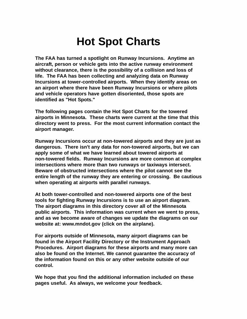
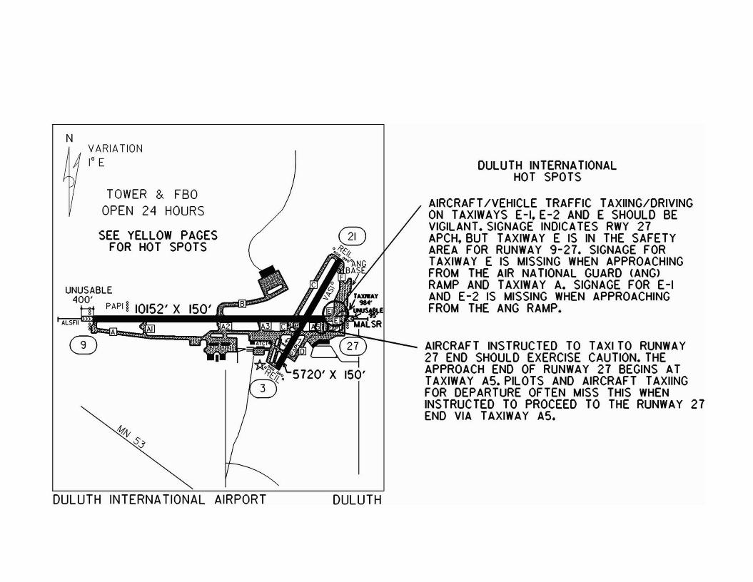
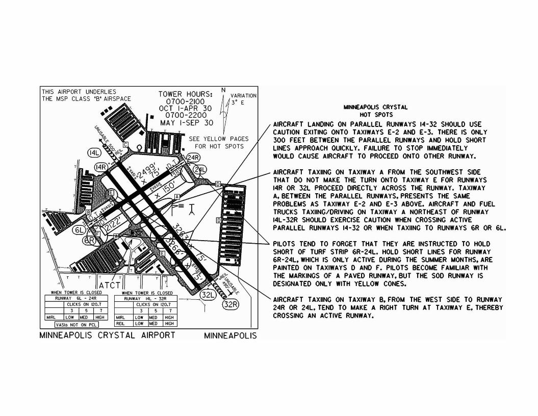
Hot Spot ChartsThe FAA has turned a spotlight on Runway Incursions. Anytime anaircraft, person or vehicle gets into the active runway environmentwithout clearance, there is the possibility of a collision and loss oflife. The FAA has been collecting and analyzing data on RunwayIncursions at tower-controlled airports. When they identify areas onan airport where there have been Runway Incursions or where pilotsand vehicle operators have gotten disoriented, those spots areidentified as "Hot Spots."
The following pages contain the Hot Spot Charts for the toweredairports in Minnesota. These charts were current at the time that thisdirectory went to press. For the most current information contact theairport manager.
Runway Incursions occur at non-towered airports and they are just asdangerous. There isn't any data for non-towered airports, but we canapply some of what we have learned about towered airports at non-towered fields. Runway Incursions are more common at complexintersections where more than two runways or taxiways intersect.Beware of obstructed intersections where the pilot cannot see theentire length of the runway they are entering or crossing. Be cautiouswhen operating at airports with parallel runways.
At both tower-controlled and non-towered airports one of the besttools for fighting Runway Incursions is to use an airport diagram.The airport diagrams in this directory cover all of the Minnesotapublic airports. This information was current when we went to press,and as we become aware of changes we update the diagrams on ourwebsite at: www.mndot.gov (click on the airplane).
For airports outside of Minnesota, many airport diagrams can befound in the Airport Facility Directory or the Instrument ApproachProcedures. Airport diagrams for these airports and many more canalso be found on the Internet. We cannot guarantee the accuracy ofthe information found on this or any other website outside of our control.
We hope that you find the additional information included on thesepages useful. As always, we welcome your feedback.
NVARIATION1° E
TOWER & FBOOPEN 24 HOURS
SEE YEllOW PAGESFOR HOT SPOTS
UNUSABLE400' PAPII 10152' X
ALSFII
1111'$:.J
DULUTH INTERNATIONAL AIRPORT DULUTH
DULUTH INTERNATIONALHOT SPOTS
AIRCRAF T/VEHIClE TRAFFIC TAXIING/DRIVINGON TAXIWAYS E-I, E-2 AND E SHOULD BEVIGilANT. SIGNAGE INDICATES RWY 27APCH, BUT TAXIWAY E IS IN THE SAFETYAREA FOR RUNWAY 9-27. SIGNAGE FORTAXIWAY E IS MISSING WHEN APPROACHINGFROM THE AIR NATlONAl GUARD CANG>RAMP AND TAXIWAY A. SIGNAGE FOR E-IAND E-2 IS MISSING WHEN APPROACHINGFROM THE ANG RAMP.
AIRCRAFT INSTRUCTED TO TAXI TO RUNWAY27 END SHOULD EXERCISE CAUTION. THEAPPROACH END OF RUNWAY 27 BEGINS ATTAXIWAY AS. PilOTS AND AIRCRAFT TAXIINGFOR DEPARTURE OFTEN MISS THIS WHENINSTRUCTED TO PROCEED TO THE RUNWAY 27END VIA TAXIWAY A5.
AIRCRAFT TAXIING ON TAXIWAY B. FROM THE WEST SIDE TO RUNWAY24R OR 24L. TEND TO MAKE A RIGHT TURN AT TAXIWAY E. THEREBYCROSSING AN ACTIVE RUNWAY.
YNNEAPOLIS CRYSTALHOT SPOTS
AIRCRAFT LANDING ON PARALLEL RUNWAYS 14-32 SHOULD USECAUTION EXITING ONTO TAXIWAYS E-2 AND E-3. THERE IS ONLY300 FEET BETWEEN THE PARALLEL RUNWAYS AND HOLD SHORTLINES APPROACH QUICKLY. FAILURE TO STOP IMMEDIA TELYWOULD CAUSE AIRCRAFT TO PROCEED ONTO OTHER RUNWAY.
AIRCRAFT TAXIING ON TAXIWAY A FROM THE SOUTHWEST SIDETHAT DO NOT MAKE THE TURN ONTO TAXIWAY E FOR RUNWAYS14R OR 32L PROCEED DIRECTLY ACROSS THE RUNWAY. TAXIWAYA.BETWEEN THE PARALLEL RUNWAYS. PRESENTS THE SAMEPROBLEMS AS TAXIWAY E-2 AND E-3 ABOVE. AIRCRAFT AND FUELTRUCKS TAXIING/DRIVING ON TAXIWAY A NORTHEAST OF RUNWAY14L-32R SHOULD EXERCISE CAUTION WHEN CROSSING ACTIVEPARALLEL RUNWAYS 14-32 OR WHEN TAXIING TO RUNWAYS 6R OR 6L.
r--il~' PILOTS TEND TO FORGET THAT THEY ARE INSTRUCTED TO HOLDSHORT OF TURF STRIP 6R-24L. HOLD SHORT LINES FOR RUNWAY6R-24L. WHICH IS ONLY ACTIVE DURING THE SUMMER MONTHS. AREPAINTED ON TAXIWAYS 0 AND F. PILOTS BECOME FAMILIAR WITHTHE MARKINGS OF A PAVED RUNWAY. BUT THE SOD RUNWAY ISDESIGNATED ONLY WITH YELLOW CONES.
NTOWER HOURS: ~VARIATION
0700-2100 3' EOCT I-APR 30
0700-2200MAY I-SEP 30
SEE YELLOW PAGESFOR HOT SPOTS
REILIro4IRL
THIS AIRPORT UNDERLIESTHE MSP CLASS "S' AIRSPACE....
•••
MINNEAPOLIS CRYSTAL AIRPORT MINNEAPOLIS
TRAFFIC EXITING EAST OR WESTBOUND ON TAXIWAY A SHOULDBE VIGILANT. THIS TAXIWAY CROSSES THE APPROACH END OFRUNWAY 18.
TRAFFIC ON TAXIWAY A-I SHOULD USE CAUTION CROSSING THEAPPROACH ENDS OF RUNWAYS 28L AND 28R.DUE TO THE CLOSEPROXIMITY OF PARALLEL RUNWAYS AND HOLDING POSITIONS.
TRAFFIC LANDING ON RUNWAYS IOR-28L AND IOL-28R SHOULDUSE CAUTION EXITING ONTO TAXIWAYS D. E. AND F. SINCE THEHOLD SHORT LINES FOR THE PARALLEL RUNWAY APPROACHOUICKLY. TRAFFIC ON TAXIWAYS D. E AND F SHOULD BE CAREFULCROSSING RUNWAYS IOR-28L AND IOL-28R DUE TO THE CLOSEPROXIMITY OF PARALLEL RUNWAYS AND HOLDING POSITIONS.
3 I 5 I 7CLICKS ON 118.1
LIGHTS LOW "EO HIGH
VASI ON ON ON
TAXI LOW MEO HIGH
REILS OFF ON ON
• WHEN TOWER IS CLOSEDRUNWAY 18 - 36
MINNEAPOLIS FL YING CLOUDHOT SPOTS>rR.....~ ~_.~ .. - _.•.._•.
3 5 7LIGHTS LOW "EO HIG AIRCRAFT ON TAXIWAY G WILL NORMALLY BE ADVISED BYMALSR HIGH GROUND CONTROL TO HOLD SHORT OF THE PROTECTED
AXI LOW "EO HIGH AREA AROUND THE EXTENDED CENTERLINE OF RUNWAY.- • VASI ON ON ON• ___ ~__ ~.. ~.. IOL. WHEN RUNWAYS IOR-28L AND IOL-28R ARE ACTIVE
RUNWAYS. AIRCRAFT CROSSING THE APPROACH ENDS OFRUNWAYS IOL AND lOR SHOULD BE VIGILANT DUE TO THECLOSE PROXIMITY OF PARALLEL RUNWAYS AND HOLDINGPOSITIONS.
THIS AIRPORT UNDERLIESTHE MSP CLASS "B" AIR~n. A~
uS 2\2T T
SEE YELLOW PAGESFOR HOT SPOTS
TOWER HOURS:0700-2100
OCT I-APR 300700-2200
MAY I-SEP 30ATeT
N!1 VARIAnON
~ ,.,
MINNEAPOLIS FLYING CLOUD AIRPORT MINNEAPOLIS
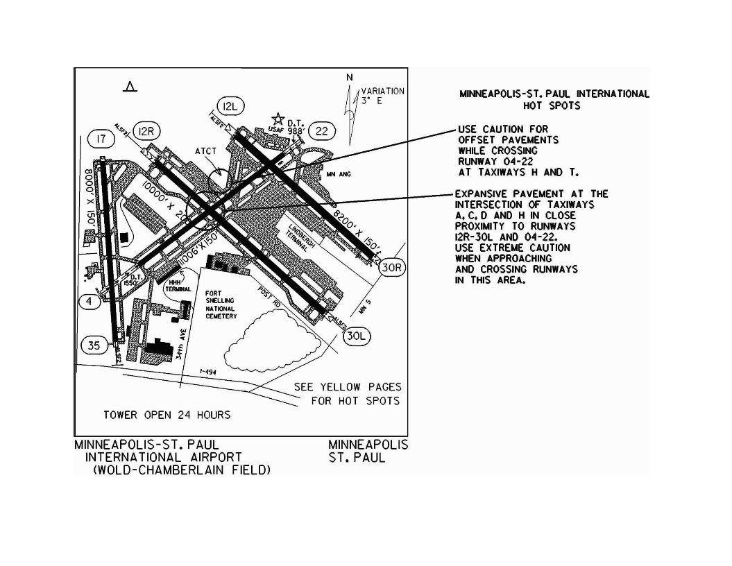
MINNEAPOLIS-ST. PAUL INTERNATIONALHOT SPOTS
VARIATION3' E
N
USE CAUTION FOROFFSET PAVEMENTSWHilE CROSSINGRUNWAY 04-22AT TAXIWAYS H AND T.
~ + EXPANSIVE PAVEMENT AT THE• INTERSECTION OF TAXIWAYS
A. C. D AND H IN CLOSEPROXIMITY TO RUNWAYS12R-JOl AND 04 -22.USE EXTREME CAUTIONWHEN APPROACHINGAND CROSSING RUNWAYSIN THIS AREA.
SEE YELLOW PAGESFOR HOT SPOTS
'* D.T. r::;;:;\22USAF 98.a'~
FORTSNELLINGNATIONALCEIlETERY
/-494
A
TOWER OPEN 24 HOURS
®~~"~®
MINNEAPOLIS-ST. PAULINTERNAT10NAL AIRPORT
(WOLD-CHAMBERLAIN FIELD>
MINNEAPOLISST. PAUL
TOWER HOURS0500 - 2300
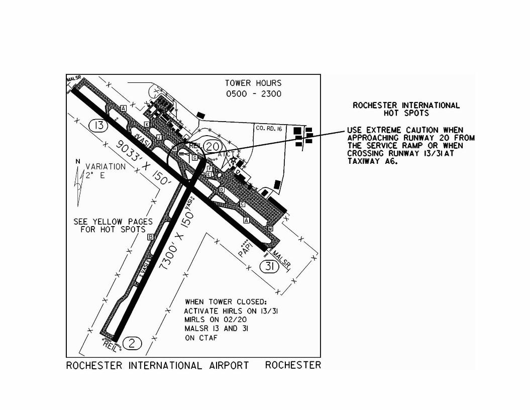
ROCHES TER INTERNATIONALHOT SPOTS
"-f-""~ co. RD. 16 •• USE EXTREME CAUTION WHEN
"" () • APPROACHING RUNWAY 20 FROM-f-. vo • THE SERVICE RAMP OR WHEN
" Jj> CROSSING RUNWAY 13/31ATN __ ",- ; I TAXIWAY A6.
2' E '~s:;0;""" ~'
/ ~() ,
SEE YELLOW PAGES!:!:j ~FOR HOT SPOTS M ~/ ~(I- 00 -f-, -r o~, "
"""!] ~~ # ~ ')
/ I::' ~ ~;- ®S~ /+~-f-/+
IHEN TOWER CLOSED:""" ACTIVATE HIRLS ON 13/31
/
MIRLS ON 02120""" ~ MALSR 13 AND 31
! ~ '''2'"''" ON CT AFIi'~/.("~ \...£) /
ROCHESTER INTERNATIONAL AIRPORT ROCHESTER
THIS AIRPORT UNDERLIES THE'MSP CLASS'S' AIRSPACE
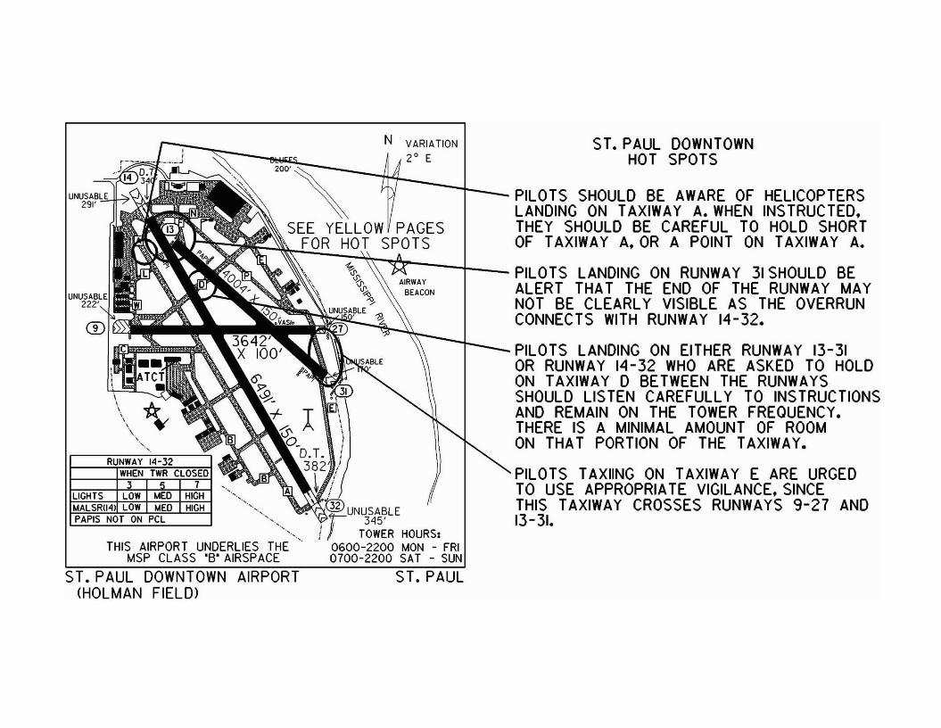
ST. PAUL DOWNTOWN AIRPORT(HOLMAN FIELD>
ST. PAUL DOWNTOWNHOT SPOTS
N VARIA liON2° E
'OO~--~1--_-{__ r~~~~GS~~U~~X?iA:W:RiH~~1~~~~3~~~~:SEE YELLOW PAGES THEY SHOULD BE CAREFUL TO HOLD SHORT
FOR HOT SPOTS OF TAXIWAY A. OR A POINT ON TAXIWAY A.
~ ~o PILOTS LANDING ON RUNWAY 31 SHOULD BEALERT THAT THE END OF THE RUNWAY MAYNOT BE CLEARLY VISIBLE AS THE OVERRUNCONNECTS WITH RUNWAY 14-32.
PILOTS LANDING ON EITHER RUNWAY 13-31OR RUNWAY 14-32 WHO ARE ASKED TO HOLDON TAXIWAY 0 BETWEEN THE RUNWAYSSHOULD LISTEN CAREFULLY TO INSTRUCTIONSAND REMAIN ON THE TOWER FREQUENCY.THERE IS A MINIMAL AMOUNT OF ROOMON THAT PORTION OF THE TAXIWAY•
PILOTS TAXIING ON TAXIWAY E ARE URGEDTO USE APPROPRIATE VIGILANCE. SINCETHIS TAXIWAY CROSSES RUNWAYS 9-27 AND13-31................
'.HIGHHIGH
WHEN TWR CLOSED
,,
3 I s I 7
RUNWAY 14-32
\"
.' .....
UNUSABLE291'
UNUSABLE222'
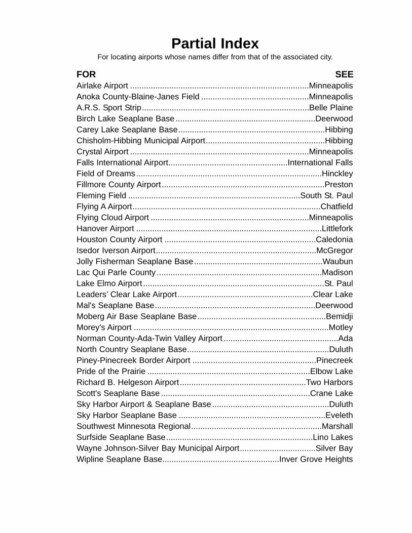
Partial IndexFor locating airports whose names differ from that of the associated city.
FOR SEEAirlake Airport ..............................................................................MinneapolisAnoka County-Blaine-Janes Field ...............................................MinneapolisA.R.S. Sport Strip.........................................................................Belle PlaineBirch Lake Seaplane Base .............................................................DeerwoodCarey Lake Seaplane Base................................................................HibbingChisholm-Hibbing Municipal Airport....................................................HibbingCrystal Airport ..............................................................................MinneapolisFalls International Airport....................................................International FallsField of Dreams.................................................................................HinckleyFillmore County Airport .......................................................................PrestonFleming Field ...........................................................................South St. PaulFlying A Airport..................................................................................ChatfieldFlying Cloud Airport .....................................................................MinneapolisHanover Airport .................................................................................LittleforkHouston County Airport ..................................................................CaledoniaIsedor Iverson Airport......................................................................McGregorJolly Fisherman Seaplane Base........................................................WaubunLac Qui Parle County ........................................................................MadisonLake Elmo Airport ...............................................................................St. PaulLeaders’ Clear Lake Airport...........................................................Clear LakeMal's Seaplane Base......................................................................DeerwoodMoberg Air Base Seaplane Base........................................................BemidjiMorey's Airport .....................................................................................MotleyNorman County-Ada-Twin Valley Airport ..................................................AdaNorth Country Seaplane Base..............................................................DuluthPiney-Pinecreek Border Airport ......................................................PinecreekPride of the Prairie .......................................................................Elbow LakeRichard B. Helgeson Airport .......................................................Two HarborsScott's Seaplane Base .................................................................Crane LakeSky Harbor Airport & Seaplane Base ...................................................DuluthSky Harbor Seaplane Base ................................................................EvelethSouthwest Minnesota Regional.........................................................MarshallSurfside Seaplane Base................................................................Lino LakesWayne Johnson-Silver Bay Municipal Airport.................................Silver BayWipline Seaplane Base...................................................Inver Grove Heights
Airport Identifiers By CityIdent. City Airport NameDØØ..........................Ada/Twin Valley..................................Norman County/Ada/Twin ValleyAIT ............................Aitkin ................................................Aitkin Municipal-Steve Kurtz FieldAEL ...........................Albert Lea .............................................................Albert Lea MunicipalAXN...........................Alexandria....................................Alexandria Municipal-Chandler FieldAQP ..........................Appleton ..................................................................Appleton MunicipalAUM ..........................Austin ..........................................................................Austin Municipal7Y3............................Backus ......................................................................Backus Municipal7Y4............................Bagley ........................................................................Bagley MunicipalBDE...........................Baudette .............................................................Baudette InternationalBDE...........................Baudette ...................................Baudette International Seaplane Base7Y7............................Belle Plaine ...............................................................A.R.S. Sport StripBJI.............................Bemidji ........................................................................Bemidji Regional96M ...........................Bemidji ..............................................Moberg Air Base Seaplane BaseBBB...........................Benson..............................................Benson Municipal-Veterans Field7Y9............................Big Falls...................................................................Big Falls MunicipalFOZ...........................Bigfork ........................................................................Bigfork MunicipalSBU...........................Blue Earth.............................................................Blue Earth Municipal9YØ...........................Bowstring ...............................................................................BowstringBRD ..........................Brainerd.....................................Brainerd-Crow Wing County Regional6D1 ...........................Brooten .....................................................................Brooten MunicipalCFE...........................Buffalo ........................................................................Buffalo MunicipalCHU ..........................Caledonia.....................................................................Houston CountyCBG ..........................Cambridge ...........................................................Cambridge MunicipalCNB ..........................Canby......................................................Canby Municipal-Myers Field2C4 ...........................Chatfield....................................................................................Flying A8Y5............................Clarissa ....................................................................Clarissa Municipal8Y6............................Clear Lake.............................................................Leaders’ Clear LakeCOQ..........................Cloquet ............................................................Cloquet-Carlton CountyCQM..........................Cook..............................................................................Cook MunicipalCDD ..........................Crane Lake........................................................Scott’s Seaplane BaseCKN ..........................Crookston.....................................Crookston Municipal-Kirkwood FieldM69 ...........................Deerwood....................................................Birch Lake Seaplane BaseM14 ...........................Deerwood ............................................................Mal's Seaplane BaseDTL ...........................Detroit Lakes.............................Detroit Lakes Municipal-Wething FieldTOB...........................Dodge Center .................................................Dodge Center MunicipalDLH...........................Duluth .....................................................................Duluth International9MØ ..........................Duluth ....................................................North Country Seaplane BaseDYT...........................Duluth.......................................................................Duluth Sky HarborDYT...........................Duluth .............................................Duluth Sky Harbor Seaplane Base9Y2............................East Gull Lake................................................................East Gull LakeY63............................Elbow Lake..........................Elbow Lake Municipal-Pride of the PrairieELO...........................Ely ....................................................................................Ely MunicipalEVM ..........................Eveleth .........................................................Eveleth-Virginia Municipal9Y5............................Eveleth .......................................................Sky Harbor Seaplane BaseFRM ..........................Fairmont ..................................................................Fairmont MunicipalFBL ...........................Faribault ..................................................................Faribault MunicipalFFM...........................Fergus Falls ...................Fergus Falls Municipal-Einar Mickelson FieldD14 ...........................Fertile ..........................................................................Fertile Municipal25D ...........................Forest Lake.........................................................................Forest LakeFSE ...........................Fosston.....................................................................Fosston MunicipalGYL...........................Glencoe..............................Glencoe Municipal-Vernon Perschau FieldGHW .........................Glenwood ..............................................................Glenwood Municipal
Ident. City Airport NameCKC ..........................Grand Marais.............................................Grand Marais-Cook CountyØG5 ..........................Grand Marais ...................Grand Marais-Cook County Seaplane BaseGPZ...........................Grand Rapids ..........Grand Rapids/Itasca Co-Gordon Newstrom FieldGDB ..........................Granite Falls ...............Granite Falls Muni/Lenzen-Roe Memorial Field3G2 ...........................Grygla............................................Grygla Municipal-Mel Wilkens FieldHCO ..........................Hallock.......................................................................Hallock MunicipalØ4Y...........................Hawley.......................................................................Hawley Municipal1D6 ...........................Hector .........................................................................Hector MunicipalØ5Y...........................Henning....................................................................Henning MunicipalØ6Y...........................Herman.....................................................................Herman MunicipalHIB ............................Hibbing......................................................Chisholm-Hibbing Municipal9MNØ........................Hibbing ......................................................Carey Lake Seaplane BaseØ7Y...........................Hill City ........................................................Hill City-Quadna MountainØ4W..........................Hinckley........................................................................Field of DreamsHCD ..........................Hutchinson ......................................Hutchinson Municipal-Butler FieldINL ............................International Falls .....................................................Falls InternationalØ9I ............................International Falls ...........................International Falls Seaplane BaseØ9Y...........................Inver Grove Heights .........................................Wipline Seaplane BaseMJQ ..........................Jackson ....................................................................Jackson Municipal23D ...........................Karlstad ....................................................................Karlstad Municipal12Y............................Le Sueur .................................................................Le Sueur Municipal8Y4............................Lino Lakes ......................................................Surfside Seaplane BaseLJF ............................Litchfield ..................................................................Litchfield MunicipalLXL............................Little Falls ..................................................Little Falls-Morrison County13Y............................Littlefork ....................................................Littlefork Municipal-Hanover14Y............................Long Prairie ..........................................Long Prairie Airport-Todd FieldXVG ..........................Longville ..................................................................Longville MunicipalLYV............................Luverne......................................Luverne Municipal-Quentin AanensonDXX...........................Madison......................................Lac Qui Parle County-Bud Frye Field3N8 ...........................Mahnomen .............................................................Mahnomen CountyMKT ..........................Mankato ...............................................Mankato Regional-Sohler FieldMGG .........................Maple Lake .........................................................Maple Lake MunicipalMML ..........................Marshall ..............Southwest Minnesota Regional-Marshall-Ryan FieldHZX...........................McGregor.......................................................McGregor-Isedor Iverson18Y............................Milaca .........................................................................Milaca MunicipalFCM ..........................Minneapolis .......................................................................Flying CloudANE...........................Minneapolis ......................................Anoka County/Blaine-Janes FieldMSP ..........................Minneapolis ....................................................Minneapolis-St. Paul Int'lLVN ...........................Minneapolis.................................................................................AirlakeMIC ...........................Minneapolis ................................................................................CrystalMVE ..........................Montevideo............................................Montevideo-Chippewa CountyJKJ ............................Moorhead ..............................................................Moorhead MunicipalMZH ..........................Moose Lake ..............................................Moose Lake-Carlton CountyJMR...........................Mora ..............................................................................Mora MunicipalMOX..........................Morris ..........................................................................Morris Municipal22Y............................Motley........................................................................................Morey's23Y............................Murdock...................................................................Murdock Municipal5C3 ...........................Nary .........................................................Nary National-Shefland FieldULM ..........................New Ulm .................................................................New Ulm Municipal25Y............................New York Mills ...............................................New York Mills Municipal43Y............................Northome...............................................................Northome MunicipalOVL...........................Olivia .............................................................................Olivia RegionalORB ..........................Orr .....................................................................................Orr RegionalVVV...........................Ortonville ......................................Ortonville Municipal-Martinson Field
Ident. City Airport NameOWA..........................Owatonna .................................................Owatonna Degner RegionalPKD...........................Park Rapids ..............................Park Rapids Municipal-Konshok FieldPEX...........................Paynesville .........................................................Paynesville Municipal47Y............................Pelican Rapids .........................Pelican Rapids Municipal-Lyon's Field16D ...........................Perham.....................................................................Perham MunicipalPWC..........................Pine River .............................................................Pine River Regional48Y............................Pinecreek ........................................................Piney-Pinecreek BorderPQN ..........................Pipestone..............................................................Pipestone MunicipalFKA ...........................Preston...........................................................Preston-Fillmore CountyPNM ..........................Princeton ...............................................................Princeton MunicipalD81 ...........................Red Lake Falls .............................................Red Lake Falls MunicipalRGK ..........................Red Wing ...............................................................Red Wing RegionalRWF..........................Redwood Falls ..............................................Redwood Falls Municipal52Y............................Remer ........................................................................Remer MunicipalRST...........................Rochester ........................................................Rochester InternationalROX ..........................Roseau .....................................Roseau Municipal-Rudy Billberg FieldROS ..........................Rush City ...............................................................Rush City Regional55Y............................Rushford.................................................................Rushford MunicipalD39 ...........................Sauk Centre......................................................Sauk Centre MunicipalBFW ..........................Silver Bay .................................Wayne Johnson-Silver Bay MunicipalDVP...........................Slayton......................................................................Slayton MunicipalY58............................Sleepy Eye .........................................................Sleepy Eye MunicipalSGS ..........................South St. Paul.........................South St. Paul Municipal-Fleming FieldD42 ...........................Springfield ............................................................Springfield MunicipalSTC...........................St. Cloud .................................................................St. Cloud RegionalJYG ...........................St. James ..............................................................St. James MunicipalSTP ...........................St. Paul.............................................St. Paul Downtown-Holman Field21D ...........................St. Paul ................................................................................Lake ElmoSYN...........................Stanton..........................................................................Stanton AirfieldSAZ ...........................Staples ......................................................................Staples MunicipalD32 ...........................Starbuck..................................................................Starbuck MunicipalD41 ...........................Stephen ...................................................................Stephen MunicipalTVF ...........................Thief River Falls ..........................................Thief River Falls Regional12D ...........................Tower...........................................................................Tower Municipal12D ...........................Tower .................................................Tower Municipal Seaplane BaseTKC...........................Tracy ............................................................................Tracy MunicipalTWM .........................Two Harbors...................................Two Harbors-Richard B. Helgeson63Y............................Tyler ..............................................................................Tyler MunicipalADC ..........................Wadena ...................................................................Wadena MunicipalY49............................Walker........................................................................Walker MunicipalD37 ...........................Warren ......................................................................Warren MunicipalRRT...........................Warroad ...........Warroad International Memorial-Swede Carlson FieldACQ ..........................Waseca ....................................................................Waseca MunicipalVWU..........................Waskish...................................................................Waskish MunicipalM49 ...........................Waubun..............................................Jolly Fisherman Seaplane Base68Y............................Wells ............................................................................Wells MunicipalETH...........................Wheaton .................................................................Wheaton MunicipalBDH ..........................Willmar......................................................................Willmar MunicipalMWM.........................Windom ...................................................................Windom MunicipalONA ..........................Winona........................................Winona Municipal-Max Conrad Field1ØD...........................Winsted....................................................................Winsted MunicipalOTG ..........................Worthington .......................................................Worthington Municipal
Airport Identifiers By CodeIdent. City Airport NameØ4W..........................Hinckley........................................................................Field of DreamsØ4Y ..........................Hawley.......................................................................Hawley MunicipalØ5Y ..........................Henning....................................................................Henning MunicipalØ6Y ..........................Herman.....................................................................Herman MunicipalØ7Y ..........................Hill City ........................................................Hill City-Quadna MountainØ9I ...........................International Falls ............................International Falls Seaplane BaseØ9Y ..........................Inver Grove Heights .........................................Wipline Seaplane BaseØG5 ..........................Grand Marais ...................Grand Marais-Cook County Seaplane Base1ØD .........................Winsted ....................................................................Winsted Municipal12D ...........................Tower ...........................................................................Tower Municipal12D ...........................Tower..................................................Tower Municipal Seaplane Base12Y ...........................Le Sueur .................................................................Le Sueur Municipal13Y ..........................Littlefork ....................................................Littlefork Municipal-Hanover14Y ...........................Long Prairie ..........................................Long Prairie Airport-Todd Field16D ...........................Perham .....................................................................Perham Municipal18Y ...........................Milaca..........................................................................Milaca Municipal1D6 ...........................Hector .........................................................................Hector Municipal21D ...........................St. Paul .................................................................................Lake Elmo22Y ...........................Motley........................................................................................Morey's23D ...........................Karlstad ....................................................................Karlstad Municipal23Y ...........................Murdock...................................................................Murdock Municipal25D ...........................Forest Lake.........................................................................Forest Lake25Y ...........................New York Mills ...............................................New York Mills Municipal2C4 ...........................Chatfield....................................................................................Flying A3G2...........................Grygla............................................Grygla Municipal-Mel Wilkens Field3N8 ...........................Mahnomen ..............................................................Mahnomen County43Y ...........................Northome...............................................................Northome Municipal47Y ...........................Pelican Rapids ..........................Pelican Rapids Municipal-Lyon's Field48Y ...........................Pinecreek.........................................................Piney-Pinecreek Border52Y ...........................Remer.........................................................................Remer Municipal55Y ...........................Rushford .................................................................Rushford Municipal5C3 ...........................Nary .........................................................Nary National-Shefland Field63Y ..........................Tyler ...............................................................................Tyler Municipal68Y ...........................Wells .............................................................................Wells Municipal6D1 ...........................Brooten .....................................................................Brooten Municipal7Y3 ...........................Backus.......................................................................Backus Municipal7Y4 ..........................Bagley ........................................................................Bagley Municipal7Y7 ...........................Belle Plaine ...............................................................A.R.S. Sport Strip7Y9 ...........................Big Falls...................................................................Big Falls Municipal8Y4 ...........................Lino Lakes ......................................................Surfside Seaplane Base8Y5 ...........................Clarissa ....................................................................Clarissa Municipal8Y6 ...........................Clear Lake.............................................................Leaders’ Clear Lake96M...........................Bemidji ..............................................Moberg Air Base Seaplane Base9MØ..........................Duluth ....................................................North Country Seaplane Base9MNØ........................Hibbing ......................................................Carey Lake Seaplane Base9YØ ..........................Bowstring ...............................................................................Bowstring9Y2 ...........................East Gull Lake................................................................East Gull Lake9Y5 ...........................Eveleth .......................................................Sky Harbor Seaplane Base
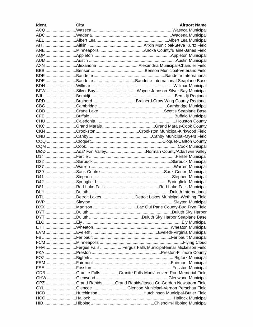
Ident. City Airport NameACQ..........................Waseca.....................................................................Waseca MunicipalADC ..........................Wadena....................................................................Wadena MunicipalAEL...........................Albert Lea .............................................................Albert Lea MunicipalAIT ............................Aitkin ................................................Aitkin Municipal-Steve Kurtz FieldANE ..........................Minneapolis .....................................Anoka County/Blaine-Janes FieldAQP ..........................Appleton ..................................................................Appleton MunicipalAUM..........................Austin ..........................................................................Austin MunicipalAXN ..........................Alexandria....................................Alexandria Municipal-Chandler FieldBBB ..........................Benson..............................................Benson Municipal-Veterans FieldBDE ..........................Baudette .............................................................Baudette InternationalBDE ..........................Baudette ...................................Baudette International Seaplane BaseBDH ..........................Willmar ......................................................................Willmar Municipal BFW..........................Silver Bay...................................Wayne Johnson-Silver Bay MunicipalBJI ............................Bemidji ........................................................................Bemidji RegionalBRD ..........................Brainerd.....................................Brainerd-Crow Wing County RegionalCBG..........................Cambridge ...........................................................Cambridge MunicipalCDD..........................Crane Lake........................................................Scott’s Seaplane BaseCFE ..........................Buffalo ........................................................................Buffalo MunicipalCHU..........................Caledonia.....................................................................Houston CountyCKC ..........................Grand Marais.............................................Grand Marais-Cook CountyCKN ..........................Crookston.....................................Crookston Municipal-Kirkwood FieldCNB ..........................Canby......................................................Canby Municipal-Myers FieldCOQ .........................Cloquet.............................................................Cloquet-Carlton CountyCQM .........................Cook..............................................................................Cook MunicipalDØØ .........................Ada/Twin Valley..................................Norman County/Ada/Twin ValleyD14 ...........................Fertile ..........................................................................Fertile MunicipalD32 ...........................Starbuck...................................................................Starbuck MunicipalD37 ...........................Warren .......................................................................Warren MunicipalD39 ...........................Sauk Centre ......................................................Sauk Centre MunicipalD41 ...........................Stephen ....................................................................Stephen MunicipalD42 ..........................Springfield.............................................................Springfield MunicipalD81 ...........................Red Lake Falls ..............................................Red Lake Falls MunicipalDLH ..........................Duluth .....................................................................Duluth InternationalDTL...........................Detroit Lakes.............................Detroit Lakes Municipal-Wething FieldDVP ..........................Slayton ......................................................................Slayton MunicipalDXX ..........................Madison......................................Lac Qui Parle County-Bud Frye FieldDYT ..........................Duluth.......................................................................Duluth Sky HarborDYT ..........................Duluth .............................................Duluth Sky Harbor Seaplane BaseELO ..........................Ely ....................................................................................Ely MunicipalETH ..........................Wheaton..................................................................Wheaton MunicipalEVM..........................Eveleth .........................................................Eveleth-Virginia MunicipalFBL ...........................Faribault ..................................................................Faribault MunicipalFCM..........................Minneapolis .......................................................................Flying CloudFFM ..........................Fergus Falls ...................Fergus Falls Municipal-Einar Mickelson FieldFKA...........................Preston ...........................................................Preston-Fillmore CountyFOZ ..........................Bigfork ........................................................................Bigfork MunicipalFRM..........................Fairmont ..................................................................Fairmont MunicipalFSE...........................Fosston.....................................................................Fosston MunicipalGDB..........................Granite Falls ...............Granite Falls Muni/Lenzen-Roe Memorial FieldGHW.........................Glenwood ..............................................................Glenwood MunicipalGPZ ..........................Grand Rapids ..........Grand Rapids/Itasca Co-Gordon Newstrom FieldGYL ..........................Glencoe..............................Glencoe Municipal-Vernon Perschau FieldHCD..........................Hutchinson .......................................Hutchinson Municipal-Butler FieldHCO..........................Hallock.......................................................................Hallock MunicipalHIB............................Hibbing......................................................Chisholm-Hibbing Municipal
Ident. City Airport NameHZX .........................McGregor.......................................................McGregor-Isedor IversonINL ............................International Falls .....................................................Falls InternationalJKJ............................Moorhead ..............................................................Moorhead MunicipalJMR ..........................Mora ..............................................................................Mora MunicipalJYG...........................St. James...............................................................St. James MunicipalLJF............................Litchfield ..................................................................Litchfield MunicipalLVN...........................Minneapolis.................................................................................AirlakeLXL ...........................Little Falls ..................................................Little Falls-Morrison CountyLYV ...........................Luverne......................................Luverne Municipal-Quentin AanensonM14...........................Deerwood ............................................................Mal's Seaplane BaseM49...........................Waubun...............................................Jolly Fisherman Seaplane BaseM69...........................Deerwood....................................................Birch Lake Seaplane BaseMGG .........................Maple Lake .........................................................Maple Lake MunicipalMIC ...........................Minneapolis ................................................................................CrystalMJQ ..........................Jackson ....................................................................Jackson MunicipalMKT ..........................Mankato ...............................................Mankato Regional-Sohler FieldMML..........................Marshall ..............Southwest Minnesota Regional-Marshall-Ryan FieldMOX .........................Morris ..........................................................................Morris MunicipalMSP..........................Minneapolis ....................................................Minneapolis-St. Paul Int'lMVE..........................Montevideo............................................Montevideo-Chippewa CountyMWM ........................Windom ....................................................................Windom MunicipalMZH..........................Moose Lake ..............................................Moose Lake-Carlton CountyONA .........................Winona ........................................Winona Municipal-Max Conrad FieldORB..........................Orr .....................................................................................Orr RegionalOTG..........................Worthington........................................................Worthington MunicipalOVL ..........................Olivia .............................................................................Olivia RegionalOWA .........................Owatonna..................................................Owatonna Degner RegionalPEX ..........................Paynesville ..........................................................Paynesville MunicipalPKD ..........................Park Rapids ...............................Park Rapids Municipal-Konshok FieldPNM..........................Princeton ................................................................Princeton MunicipalPQN..........................Pipestone ..............................................................Pipestone MunicipalPWC .........................Pine River ..............................................................Pine River RegionalRGK..........................Red Wing................................................................Red Wing RegionalROS..........................Rush City ................................................................Rush City RegionalROX..........................Roseau ......................................Roseau Municipal-Rudy Billberg FieldRRT ..........................Warroad ............Warroad International Memorial-Swede Carlson FieldRST ..........................Rochester .........................................................Rochester InternationalRWF..........................Redwood Falls...............................................Redwood Falls MunicipalSAZ...........................Staples.......................................................................Staples MunicipalSBU ..........................Blue Earth.............................................................Blue Earth MunicipalSGS ..........................South St. Paul .........................South St. Paul Municipal-Fleming FieldSTC ..........................St. Cloud ..................................................................St. Cloud RegionalSTP...........................St. Paul .............................................St. Paul Downtown-Holman FieldSYN ..........................Stanton ..........................................................................Stanton AirfieldTKC ..........................Tracy.............................................................................Tracy MunicipalTOB ..........................Dodge Center .................................................Dodge Center MunicipalTVF...........................Thief River Falls ...........................................Thief River Falls RegionalTWM .........................Two Harbors ...................................Two Harbors-Richard B. HelgesonULM ..........................New Ulm .................................................................New Ulm MunicipalVVV ..........................Ortonville ......................................Ortonville Municipal-Martinson FieldVWU .........................Waskish....................................................................Waskish MunicipalXVG ..........................Longville ..................................................................Longville MunicipalY49 ...........................Walker ........................................................................Walker MunicipalY58 ...........................Sleepy Eye..........................................................Sleepy Eye MunicipalY63 ...........................Elbow Lake..........................Elbow Lake Municipal-Pride of the Prairie
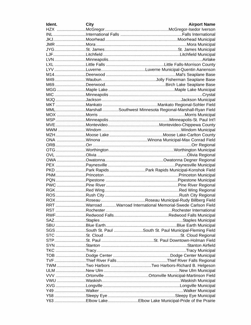
2. AIR
-C
RA
FTID
EN
TIFI-C
ATION
3. AIR
-C
RA
FTTY
PE
/S
PE
CIA
LE
QU
IP-
ME
NT
4. TRU
EA
IRS
PE
ED
KTS
5. DE
PAR
-TU
RE
PO
INT
6. DE
PAR
TUR
E TIM
E
PR
OP
OS
ED
(Z)A
CTU
AL
(Z)
7. CR
UIS
-IN
GA
LTITUD
EV
FR
IFR
DV
FR
8. RO
UTE
OF FLIG
HT
9. DE
STIN
A-
TION
(Nam
eof airport &city)
MIN
UTE
S
11. RE
MA
RK
S
12. FUE
LO
N B
OA
RD
HO
UR
SM
INU
TES
13. ALTE
R-
NATE
AIR
-P
OR
T(S)
14. PILO
T'S N
AM
E, A
DD
RE
SS
, TELE
PH
ON
E N
UM
BE
R &
A
IRC
RA
FTH
OM
E B
AS
E
17. DE
STIN
ATION
CO
NTA
CT/TE
LEP
HO
NE
(OP
TION
AL)
15. NU
M-
BE
RA
BO
AR
D
16. CO
LOR
OF A
IRC
RA
FTC
IVIL
AIR
CR
AFT
PILO
TS. FA
R P
art 91 requires you file an IFR flight plan to operate under instrum
entflight rules in controlled airspace. Failure to file could result in a civil penalty not to exceed $1,000 for eachviolation (S
ection 901 of the Federal Aviation Act of 1958, as am
ended). Filing of a VFR
flight plan is rec-om
mended as a good operating practice. S
ee also Part 99 for requirem
ents concerning DV
FR flight plans.
NO
DM
E:
Area N
avigation (RN
AV):
/XN
o Transponder/Y
LOR
AN
, VO
R/D
ME
, or INS
with no Transponder
/TTransponder w
ith no Mode C
/TLO
RA
N, V
OR
/DM
E, or IN
S w
ith Transponder with no M
ode C/U
Transponder with M
ode C/U
LOR
AN
, VO
R/D
ME
, or INS
with Transponder w
ith Mode C
DM
E:
Advanced R
NAV
with Transponder w
ith Mode C
:/D
No Transponder
/EFM
S w
ith DM
E/D
ME
and IRU
position updating/B
Transponder with no M
ode C/F
FMS
with D
ME
/DM
E position updating
TAC
AN
Only:
/GG
NS
S including G
PS
or WA
AS
with enroute and term
inal capability/A
Transponder with M
ode C/R
Required N
avigational Perform
ance (RN
P)
/M
No Transponder
Reduced Vertical S
eparation Minim
um (R
VS
M):
/NTransponder w
ith no Mode C
/J-/E w
ith RV
SM
/L-/G w
ith RV
SM
/W-R
VS
M/P
Transponder with M
ode C/K
-/F with R
VS
M/Q
-/R w
ith RV
SM
FLIGH
T PLAN
SP
EC
IAL
EQ
UIP
ME
NT
SU
FFIX:
1. TYP
E10. ES
T. TIME
EN
RO
UTE
HO
UR
S
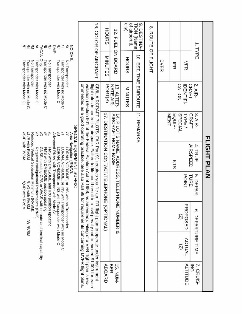
TEMPERATURE CONVERSIONS
SUMMER WINTER
30
20
10
o
-
- -
- -
- -
-
- -
- -
-
100
90
80
70
60
50
40
30
o
-10
-20
-30
--
- -- -
- --
- --
--
40
30
20
10
o
-10
-20
-30
-40 -40
MINNEAPOLIS CLASS "8" AIRSPACE
OSCEOLA
10070
//
¢-3°"'41
MODE-CVEIL
100Q 70
~ ¢-~ STANTON
LIND LAKES
FOREST LAKE --0GEP 117.3ANOKA
% 100veo
---1i APP. CONT. 121.2
SHAKOPEE
r--- ----------- ---------- --------i GEP
APP. CONT. 126.5 i 117.3
BELLE PLAINE
¢-
BUFFALO~
100 = CEILING X 100'40 = FLOOR
NOTE: EXPECTED CLASS "B" AIRSPACECHECK FAA CHARTS FORCURRENT CONDITIONS
10,000' MSL
VARIOUSALTITUDESFROM 4000' MSL
VARIOUS
ALTITUDESFROM 4000' MSL
000' MSL
3000' MSL
2300' MSL
GROUND LEVEL ~6NM;'-8.5 NM+----12NM+-:=======':2~0~N~Mo1..::=~f- 30 NM ---4
The requirements of FAR 91.131 must be met before requesting Class "B" clearance.Clearance into MSP Class "B" must be received prior to entering. Flight withinthe 30 MI "veil" requires operating Mode - C Transponder or a waiver from ATC.
.
AWOS
Attended = MonthslDays/Hours
Airport/Seaplane Base DrawingsAre Not To Scale
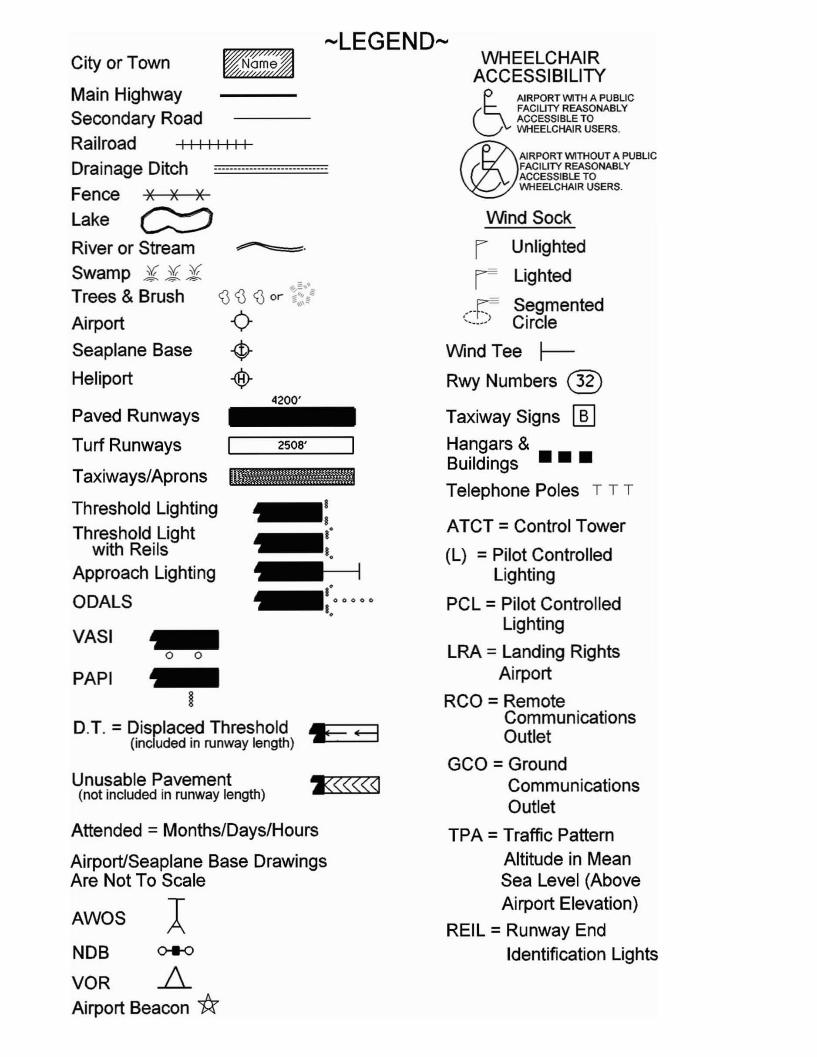
WHEELCHAIRACCESSIBILITY
~AIRPORT WITH A PUBLIC
CJFACILITY REASONABLYACCESSIBLE TOW1HEELCHAIR USERS.
®AlRPORT WITHOUT A PUBLICFACILITY REASONABLYACCESSIBLE TOW1HEELCHAIR USERS.
Wind Sock
r Unlighted
I Lighted
(_-_-_r_-:~ Segmented. Circle
Wind Tee ~
Rwy Numbers ®Taxiway Signs lliJHangars &Buildings •••
Telephone Poles T T T
ATCT =Control Tower
(l) =Pilot ControlledLighting
PCl =Pilot ControlledLighting
lRA = landing RightsAirport
RCO = RemoteCommunicationsOutlet
GCO = GroundCommunicationsOutlet
TPA =Traffic PatternAltitude in MeanSea level (AboveAirport Elevation)
REll =Runway EndIdentification Lights
-LEGEND-
1<<<<<<1
~:I·
~I.~
I·~ 00000
I.
4200'
VASI ~o 0
~H
DT =Displaced Threshold F +=3(inclUded in runway length)
PAPI
Unusable Pavement(not included in runway length)
NDB 0+0
VOR AAirport Beacon *
Paved Runways
Turf Runways
Taxiways/Aprons
Threshold Lighting
Threshold Lightwith Reils
Approach Lighting
ODAlS
City or Town
Main HighwaySecondary Road
Railroad I I I I I I I I
Drainage Ditch -----------------------------
Fence x x x
lake G::::?River or Stream
Swamp Ji Ji JiTrees & Brush
Airport
Seaplane Base
Heliport

PublicAirports
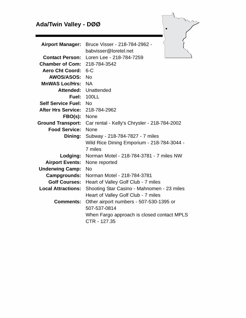
Ada/Twin Valley - DØØ
Airport Manager: Bruce Visser - 218-784-2962 [email protected]
Contact Person: Loren Lee - 218-784-7259 Chamber of Com: 218-784-3542
Aero Cht Coord: 6-CAWOS/ASOS: No
MnWAS Loc/Hrs: NAAttended: Unattended
Fuel: 100LLSelf Service Fuel: NoAfter Hrs Service: 218-784-2962
FBO(s): NoneGround Transport: Car rental - Kelly's Chrysler - 218-784-2002
Food Service: NoneDining: Subway - 218-784-7827 - 7 miles
Wild Rice Dining Emporium - 218-784-3044 - 7 miles
Lodging: Norman Motel - 218-784-3781 - 7 miles NWAirport Events: None reported
Underwing Camp: NoCampgrounds: Norman Motel - 218-784-3781Golf Courses: Heart of Valley Golf Club - 7 miles
Local Attractions: Shooting Star Casino - Mahnomen - 23 milesHeart of Valley Golf Club - 7 miles
Comments: Other airport numbers - 507-530-1395 or 507-537-0814When Fargo approach is closed contact MPLS CTR - 127.35
•
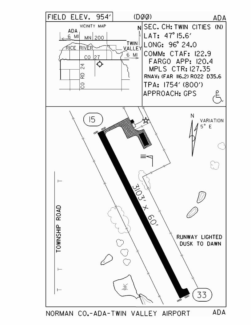
FIELD ELEV. 954' <D~~) ADA
o-'-1--10::
oU
VICINITY MAP
ADA6 MI MN 200
N SEC. CH: TWIN CITIES eN)~ LA T: 47
0
15.6'
~+"'-'=--f-'-'--'--'~----t__'v-...'- Vr~~~y LONG: 960
24.06 MI COMM: CTAF: 122.9
Ir--L-p:Ll.f-!.;-J....L-~~:> FARG0 APP: 120.4MPLS CTR: 127.35
RNAV: <FAR 116.2> R022 D35.6
TPA: 1754' (800')APPROACH: GPS
(:)<{oa:::a..:::I:VlZ~oI-
VQ
cO Q
NVARIATION50 E
o
NORMAN CO.-ADA- TWIN VALLEY AIRPORT ADA
Aitkin - AIT
Airport Manager: Kathy Brophy - 218-927-2527 - [email protected]
Contact Person: Mike & Jake Carlson -218-927-4104 - [email protected]
Chamber of Com: 800-526-8342 - www.aitkin.comAero Cht Coord: 7-H
AWOS/ASOS: 218-927-2101 - VHF 118.675MnWAS Loc/Hrs: Arrival/Departure Building - 24 hours - door code is
UnicomAttended: All/May-Oct/0900-1700, All/Nov-Apr/0900-1600
Fuel: 100LL, Jet ASelf Service Fuel: NoAfter Hrs Service: 218-845-2808
FBO(s): Aitkin Aviation, Inc. - 218-927-4104 - 123.05 - [email protected] - www.aitkinaviation.com
Ground Transport: Taxi Express - 218-927-3598 or 218-330-4497Courtesy car - fuel customers have priority
Food Service: Vending machinesDining: Roadside Restaurant - 218-927-2114 - 1 mile; 40 Club
Inn - 218-927-7090 - 2 miles; Hawkeye's Coffee Shop - 218-927-1485 - 1 mile; Birchwood Inn - 218-927-6400 -1 mile; Dairy Queen - 218-927-2918 - 1 mile; Subway - 218-927-4500 - 2 miles; Rosallini's Pizza - 218-927-6412 - 1 mile; The Beanery Internet Café - 218-927-7811 - 1 mile; Aitkin Barbeque - 218-927-7020 - 1 mile
Lodging: 40 Club Inn - 218-927-2903 - 2 milesRipple River Motel - 218-927-3734 - 2 miles
Airport Events: Fly-In Breakfast & Car Show - last Sunday in June;Sloppy Joe & Bean Feed - every weekend; TaildraggerFly-In - September; Ski-Plane Fly-In - February
Underwing Camp: YesCampgrounds: Big K - 218-927-6001 - 8 miles
Bill's Resort & Campground - 218-927-3841 - 10 milesMississippi County Park - 218-927-7364 -1 mileRipple River Campground - 218-927-3734 - 2 miles
Golf Courses: Cuyuna Country Club - 218-534-3489 - 8 milesRuttger's Bay Lake - 218-678-2885 - 10 miles
Local Attractions: Resorts; lakes; woods; fishing; hunting; snowmobiling; festivals & events year-round; dog sled race; Riverboat Heritage Days - third weekend in July; Festival of Adventures - second weekend after Labor Day; World Famous Fishhouse Parade - Friday after Thanksgiving
Comments: Fuel, maintenance or after hours service call 218-845-2808 or 218-820-5114; glider activity; runway 8/26 groomed for ski-planes - call ahead
•
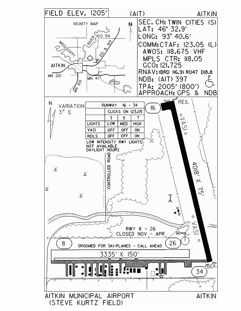
FIELD ELEV. 1205' (All> AITKIN
MN 210
)N SEC. CH: TWIN CITIES (5)~ LAT: 46° 32.9'I LONG: 93° 40.6'
COMM: CT AF: 123.05 (l)AWOS: 118.675 VHFMPL S CTR: 118.05GCO: 121.725
RNA V: (BRO 116.9) R047 018.8
~~~~ kA~6k:~;00') 6APPROACH:GPS & NOB
AITKIN
TT
150'
TTT
00
00
0
00
REIL \RUNWAY 16 - 34 ®
LIGHTS ~~:KSM~: 12~E \ ~ ~\VASI OFF OFF ON \ \ \.f2REILS OFF OFF ON
LOW INTENSITY RWY LIGHTSNOT AVAILABLEDAYliGHT HOURS
o<l:o
" 0::",0'1LI;..J;..J'0;0::: ....!z;0!U
T
~-r/~L.RWY 8 - 26 '\' Y'
CLOSED NOV - APR ~ \.f2x x X ~/"
GROOMED FOR SKI-PLANES - CALL AHEAD ~,,-)
TT
N VARIATION3° E
AITKIN MUNICIPAL AIRPORT(STEVE KURTZ FIELD>
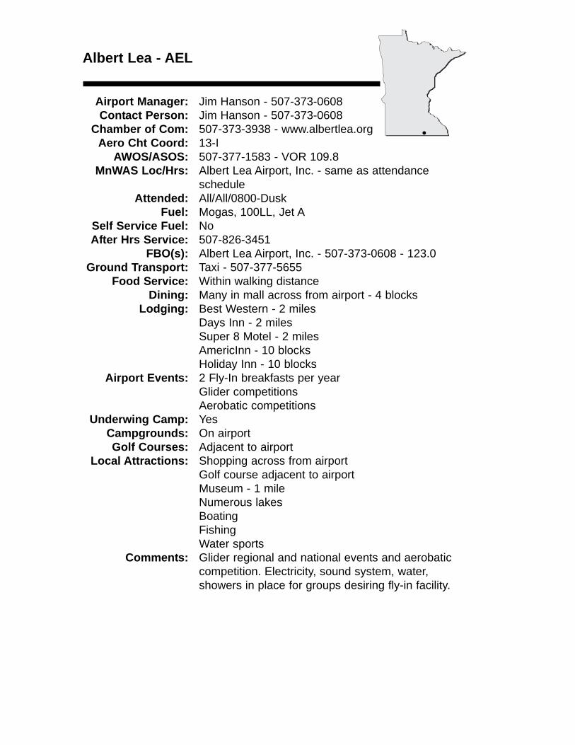
Albert Lea - AEL
Airport Manager: Jim Hanson - 507-373-0608 Contact Person: Jim Hanson - 507-373-0608
Chamber of Com: 507-373-3938 - www.albertlea.orgAero Cht Coord: 13-I
AWOS/ASOS: 507-377-1583 - VOR 109.8MnWAS Loc/Hrs: Albert Lea Airport, Inc. - same as attendance
scheduleAttended: All/All/0800-Dusk
Fuel: Mogas, 100LL, Jet ASelf Service Fuel: NoAfter Hrs Service: 507-826-3451
FBO(s): Albert Lea Airport, Inc. - 507-373-0608 - 123.0Ground Transport: Taxi - 507-377-5655
Food Service: Within walking distanceDining: Many in mall across from airport - 4 blocks
Lodging: Best Western - 2 milesDays Inn - 2 milesSuper 8 Motel - 2 milesAmericInn - 10 blocksHoliday Inn - 10 blocks
Airport Events: 2 Fly-In breakfasts per yearGlider competitionsAerobatic competitions
Underwing Camp: YesCampgrounds: On airportGolf Courses: Adjacent to airport
Local Attractions: Shopping across from airportGolf course adjacent to airportMuseum - 1 mileNumerous lakesBoatingFishingWater sports
Comments: Glider regional and national events and aerobaticcompetition. Electricity, sound system, water, showers in place for groups desiring fly-in facility.
•
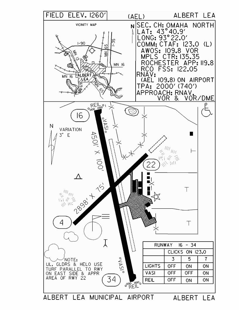
FIELD ELEV. 1260' (AEL) ALBERT LEA
N SEC. CH: OMAHA NORTH~ LAT: 43°40.9'I LONG: 93° 22.0'
COMM: CT AF: 123.0 (l)AWOS: 109.8 VORMPLS CTR: 135.35ROCHES TER APP: 119.8RCO FSS: 122.05
RNAV:(AEL 109.8) ON AIRPORT
TPA: 2000' <740')APPROACH:RNAV ......
VOR & VOK/DME
•
T
357
T
CLICKS ON 123.0
/',," ,,">, /
RUNWAY 16 - 34
----.---1
LIGHTS OFF ON ON
VASI OFF OFF ON
REIL OFF ON ON
~I~ >.<
VICINITY MAP
NVARIATION3· E
\
1111 "\0
~!f/f -\-
\11\ ~ ~ ~~' \\1\ ~coO)
O -_.~.. =~~ ~~,- ,, ,, ,
(2) \\",..../)l
ONOTE'UL, GLDRS & HELO USETURF PARALLEL TO RWY ~ON EAS T SIDE & APPR ® 0
AREA OF RWY 22 34a:P
o~E.lL0
ALBERT LEA MUNICIPAL AIRPORT ALBERT LEA
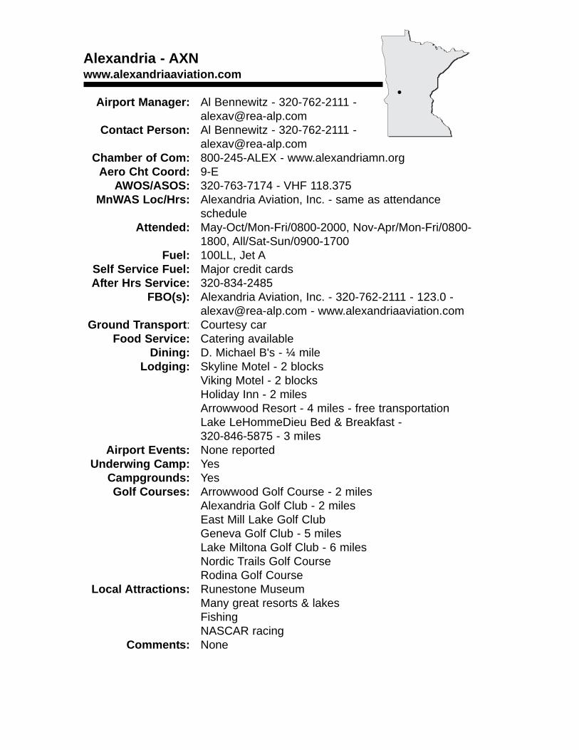
Alexandria - AXNwww.alexandriaaviation.com
Airport Manager: Al Bennewitz - 320-762-2111 - [email protected]
Contact Person: Al Bennewitz - 320-762-2111 - [email protected]
Chamber of Com: 800-245-ALEX - www.alexandriamn.orgAero Cht Coord: 9-E
AWOS/ASOS: 320-763-7174 - VHF 118.375MnWAS Loc/Hrs: Alexandria Aviation, Inc. - same as attendance
scheduleAttended: May-Oct/Mon-Fri/0800-2000, Nov-Apr/Mon-Fri/0800-
1800, All/Sat-Sun/0900-1700Fuel: 100LL, Jet A
Self Service Fuel: Major credit cardsAfter Hrs Service: 320-834-2485
FBO(s): Alexandria Aviation, Inc. - 320-762-2111 - 123.0 - [email protected] - www.alexandriaaviation.com
Ground Transport: Courtesy carFood Service: Catering available
Dining: D. Michael B's - ¼ mileLodging: Skyline Motel - 2 blocks
Viking Motel - 2 blocksHoliday Inn - 2 milesArrowwood Resort - 4 miles - free transportationLake LeHommeDieu Bed & Breakfast - 320-846-5875 - 3 miles
Airport Events: None reportedUnderwing Camp: Yes
Campgrounds: YesGolf Courses: Arrowwood Golf Course - 2 miles
Alexandria Golf Club - 2 milesEast Mill Lake Golf ClubGeneva Golf Club - 5 milesLake Miltona Golf Club - 6 milesNordic Trails Golf CourseRodina Golf Course
Local Attractions: Runestone MuseumMany great resorts & lakesFishingNASCAR racing
Comments: None
•
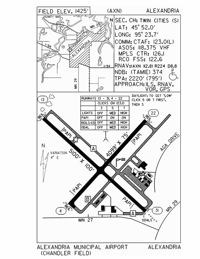
z::::;
FIELD ELEV. 1425' (AXN) ALEXANDRIAVICINITY MAP ,--',!Y ~ 7 (1
o ']V ~ N SEC. CH: TWIN CITIES (S)W;GO ~\'\ '2.'~ ~~ LAT: 45° 52.0'fb Q U LONG: 95° 23.7'
~~ COMM: CTAF: 123.0(U+~'j ASOS: 118.375 VHF
.-tr---v~<V MPL S CTR: 126.1/ RCO FSS: 122.6
t-_--'-'<.:!........jRNAV:(AXN 112.8) R224 D8.8
NDB: (l AMIE) 374 e.TPA: 2220' (795') QAPPROACH: ILS, RNAV,
VOR,GPS
N
RUNWAYS 13 ... 31,4 ... 22
CLICKS ON 123.0
3 5 7LIGHTS OFF MED HIGH
PAPI OFF ON ON
REILS (13 OFF MED HIGH
ODAL OFF MED HIGH
DAYLIGHT; TO GET "LOW'CLICK 5 OR 7 FIRST,THEN 3
ALEXANDRIA MUNICIPAL AIRPORT(CHANDLER FIELD>
ALEXANDRIA
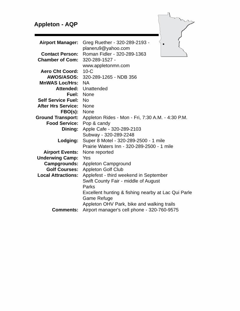
Appleton - AQP
Airport Manager: Greg Ruether - 320-289-2193 - [email protected]
Contact Person: Roman Fidler - 320-289-1363Chamber of Com: 320-289-1527 -
www.appletonmn.comAero Cht Coord: 10-C
AWOS/ASOS: 320-289-1265 - NDB 356MnWAS Loc/Hrs: NA
Attended: UnattendedFuel: None
Self Service Fuel: NoAfter Hrs Service: None
FBO(s): NoneGround Transport: Appleton Rides - Mon - Fri, 7:30 A.M. - 4:30 P.M.
Food Service: Pop & candyDining: Apple Cafe - 320-289-2103
Subway - 320-289-2248Lodging: Super 8 Motel - 320-289-2500 - 1 mile
Prairie Waters Inn - 320-289-2500 - 1 mileAirport Events: None reported
Underwing Camp: YesCampgrounds: Appleton CampgroundGolf Courses: Appleton Golf Club
Local Attractions: Applefest - third weekend in SeptemberSwift County Fair - middle of AugustParksExcellent hunting & fishing nearby at Lac Qui Parle Game RefugeAppleton OHV Park, bike and walking trails
Comments: Airport manager's cell phone - 320-760-9575
•
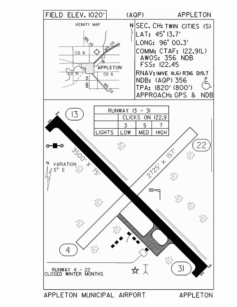
FIELD ELEV. 1020'VICINITY MAP
(AQP) APPLETON
N SEC. CH: TWIN CITIES (S)
~ LAT: 450 13.7'I LONG: 960 00.3'
COMM: CT AF: 122.9(l)AWOS: 356 NDBFSS: 122.45
RNAV: (MVE 111.6> R316 019.7
NDB: (AQP) 356 r..TPA: 1820' (800') VAPPROACH:GPS & NDB
RUNWAY 13 - 31CLICKS ON 122.9
3 5 7LIGHTS LOW MED HIGH
•••RUNWAY 4 - 22
CLOSED WINTER MONTHS
APPLETON MUNICIPAL AIRPORT APPLETON
Austin - AUMwww.austinaeroflight.com
Airport Manager: Bruce Budahn - 507-433-1813 - See comments for e-mail address
Contact Person: Bruce Budahn - 507-433-1813 Chamber of Com: 507-437-4561 -
www.austincoc.comAero Cht Coord: 13-J
AWOS/ASOS: 507-433-6667 - VHF 119.025MnWAS Loc/Hrs: Arrival/Departure Building - same as attendance
scheduleAttended: ALL/M-F/0800-1800, ALL/Sat/0800-1600,
All/Sun/0900-1500Fuel: 100LL, Jet A
Self Service Fuel: NoAfter Hrs Service: 507-433-1813
FBO(s): Austin Aeroflight, Inc. - 507-433-1813 - 122.7 - [email protected] - www.austinaeroflight.com
Ground Transport: Rental carTaxi
Food Service: NoneDining: Watts Cooking - 507-433-2633 - 1 mile
Lodging: Holiday Inn - 507-433-1000 - 2½ milesSuper 8 Motel - 507-433-1801 - 3 milesDays Inn - 507-433-8600 - 2½ milesAustin Motel - 507-433-9254 - ½ blockIce Haus Bed & Breakfast - 507-584-0101 - 9 miles -will provide transportation from airport - www.icehaus.com
Airport Events: None reportedUnderwing Camp: Yes
Campgrounds: Beaver Trail Campground - 507-584-6611Golf Courses: Austin Country Club - 507-437-7631
Ramsey Golf Course - 507-433-9098Meadow Greens Golf Course - 507-433-4878
Local Attractions: J. C. Hormel Nature Center - 507-437-7519Spam Museum - 800-LUV-SPAM
Comments: Airport manager’s e-mail address - [email protected]
•
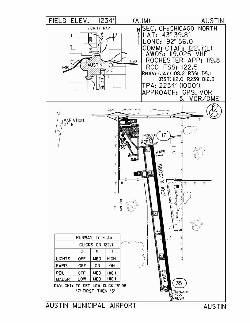
FIELD ELEV. 1234' (AUM) AUS TINVICINITY MAP N SEC. CH: CHICAGO NORTH
~ LA T: 430 39.8'I LONG: 920 56.0
COMM: CT AF: 122.7(UAWOS: 119.025 VHF
~E~I-~90 ROCHESTER APP: 119.8(/;: RCO FSS: 122.5
RNAV: (JAY) 108.2 R351 05.1CRSTlIl2.0 R239 016.3
TPA: 2234' (1000')APPROACH: GPS, VOR
& VOR/DME
AUS TIN MUNICIPAL AIRPORT
DAYLIGHT: TO GET LOW CLICK '5' OR'7' FIRST THEN '3'
AUSTIN
T T
00
1£Q..
A3
A
T
T~-Xl
x
Ix
I1
T
T===:;~~TVARIATION
2 0 E
N
RUNWAY 17 - 35
CLICKS ON 122.7
3 5 7
LIGHTS OFF MED HIGH
PAPIS OFF ON ON
REIL OFF MED HIGH
MALSR LOW MED HIGH
Backus - 7Y3www.uslink.net/~flyaird/info.html
Airport Manager: Denny Williams - 218-947-3100 - [email protected]
Contact Person: Denny Williams - 218-947-3100 - [email protected]
Chamber of Com: 218-947-3221 - www.backusmn.comAero Cht Coord: 7-F
AWOS/ASOS: No MnWAS Loc/Hrs: NA
Attended: All/All/0800-1700Fuel: Mogas, 100LL
Self Service Fuel: NoAfter Hrs Service: 218-947-3100
FBO(s): Air D, Inc. - 218-947-3100 - 122.90 - [email protected] - www.flyaird.com
Ground Transport: May be available - call Denny Williams - 218-947-3100
Food Service: NoneDining: Corner Restaurant - 218-947-4115 - across highway,
south end of runwayLodging: Pine Mountain Inn Bed & Breakfast - 218-947-3050 -
½ mileSunset Resort - 218-947-3344 - ½ mileMountain View Resort - 218-947-3233 - ¾ mile
Airport Events: Fly-In - last Sunday in JulyUnderwing Camp: Yes
Campgrounds: Pine Mountain Manor Campground - 2 milesLindsey Lake Campground - 2 milesSunset Resort - ½ mileMountain View Resort - 218-947-3233 - ¾ Mile
Golf Courses: Pine River Country Club - 218-587-4774 - 9 milesIrish Hills at Piney Ridge Lodge - 218-587-2296Black Bear - 218-587-880 - 7 miles
Local Attractions: Fishing within ½ mile; Northern Lights Casino - 20 miles; Paul Bunyan Trail - snowmobiling, cross-country skiing, hiking, biking; hunting
Comments: One hour drive to Itasca State Park where you canvisit the Headwaters of the Mississippi. Fifteen minute drive to Deep Portage Conservation Reserve. Countless number of gift, craft & antique shops, water slides and other tourist attractions within minutes of the airport. Use after hours service number listed above or 218-947-4214.
•
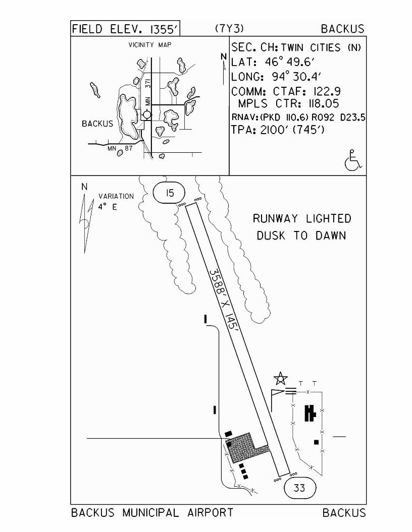
FIELD ELEV. 1355'VICINITY MAP
BACKUS
(7Y3) BACKUS
SEC. CH: TWIN CITIES (N)
N LAT: Ll6° Ll9.6'~ LONG: 9L1° 30.LI'
COMM: CTAF: 122.9MPLS CTR: 118.05
RNAV: (PKO 110.6) R092 023.5TPA: 2100' (7Ll5')
NVARIATION
4° E
I
I
RUNWAY LIGHTED
DUSK TO DAWN
BACKUS MUNICIPAL AIRPORT BACKUS
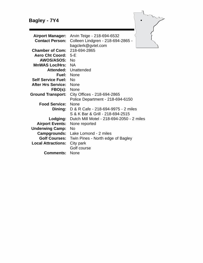
Bagley - 7Y4
Airport Manager: Arvin Teige - 218-694-6532 Contact Person: Colleen Lindgren - 218-694-2865 -
[email protected] of Com: 218-694-2865
Aero Cht Coord: 5-EAWOS/ASOS: No
MnWAS Loc/Hrs: NAAttended: Unattended
Fuel: NoneSelf Service Fuel: NoAfter Hrs Service: None
FBO(s): NoneGround Transport: City Offices - 218-694-2865
Police Department - 218-694-6150Food Service: None
Dining: D & R Cafe - 218-694-9975 - 2 milesS & K Bar & Grill - 218-694-2515
Lodging: Dutch Mill Motel - 218-694-2050 - 2 milesAirport Events: None reported
Underwing Camp: NoCampgrounds: Lake Lomond - 2 milesGolf Courses: Twin Pines - North edge of Bagley
Local Attractions: City parkGolf course
Comments: None
•
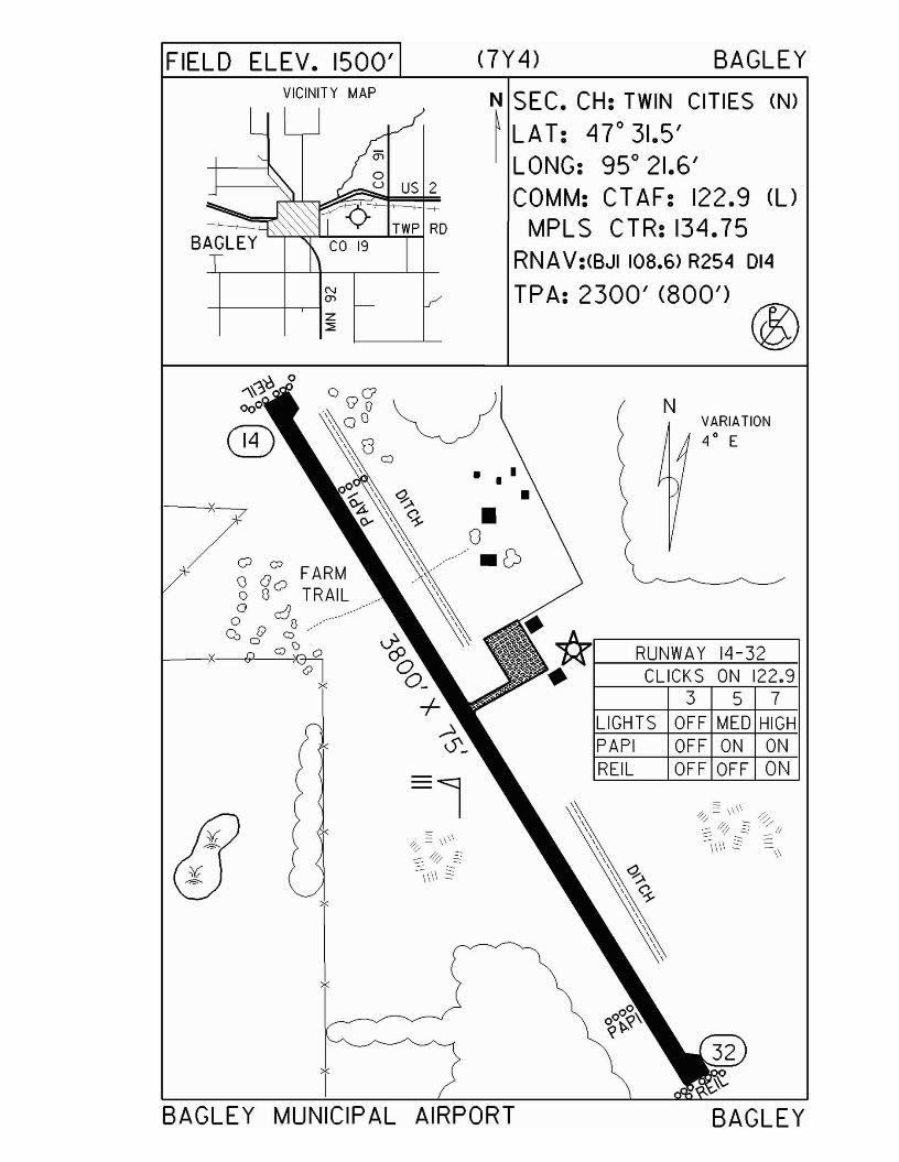
FIELD ELEV. 1500' <7Y 4) BAGLEYVICINITY MAP
BAGLEY
N
'"-+----+----.----t z::;:
US 2
N SEC. CH: TWIN CITIES (N)
~ LAT: 4r31.5'LONG: 95° 21.6'COMM: CTAF: 122.9 (U
MPLS CTR: 134.75RNAV:(BJI 108.6> R254 DI4
TPA: 2300' (800') ®
3 5 7OFF MED HIGHOFF ON ONOFF OFF ON
CLICKS ON 122.9RUNWAY 14-32
NVARIATION4
0E
REILPAPILIGHTS
•• • •
x
T
x
1---4X""-J:;\<
/0 0
Q Goo G TRAILo JJ ./o c:.; (l .
Cbcf C).-I)
x P G)~
x
BAGLEY MUNICIPAL AIRPORT BAGLEY
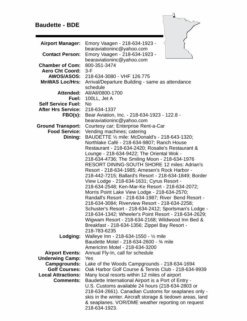
Baudette - BDE
Airport Manager: Emory Vaagen - 218-634-1923 - [email protected]
Contact Person: Emory Vaagen - 218-634-1923 - [email protected]
Chamber of Com: 800-351-3474 Aero Cht Coord: 3-F
AWOS/ASOS: 218-634-3080 - VHF 126.775MnWAS Loc/Hrs: Arrival/Departure Building - same as attendance
scheduleAttended: All/All/0800-1700
Fuel: 100LL, Jet ASelf Service Fuel: NoAfter Hrs Service: 218-634-1337
FBO(s): Bear Aviation, Inc. - 218-634-1923 - 122.8 - [email protected]
Ground Transport: Courtesy car; Enterprise Rent-a-CarFood Service: Vending machines; catering
Dining: BAUDETTE ½ mile: McDonald's - 218-643-1320; Northlake Café - 218-634-9807; Ranch House Restaurant - 218-634-2420; Rosalie's Restaurant & Lounge - 218-634-9422; The Oriental Wok - 218-634-4736; The Smiling Moon - 218-634-1976RESORT DINING-SOUTH SHORE 12 miles: Adrian's Resort - 218-634-1985; Arnesen's Rock Harbor - 218-442-7215; Ballard's Resort - 218-634-1849; Border View Lodge - 218-634-1631; Cyrus Resort - 218-634-2548; Ken-Mar-Ke Resort - 218-634-2072; Morris Point Lake View Lodge - 218-634-2570; Randall's Resort - 218-634-1987; River Bend Resort - 218-634-3084; Riverview Resort - 218-634-2258; Schuster's Resort - 218-634-2412; Sportsman's Lodge - 218-634-1342; Wheeler's Point Resort - 218-634-2629; Wigwam Resort - 218-634-2168; Wildwood Inn Bed & Breakfast - 218-634-1356; Zippel Bay Resort - 218-783-6235
Lodging: Walleye Inn - 218-634-1550 - ½ mileBaudette Motel - 218-634-2600 - ¾ mileAmericInn Motel - 218-634-3200
Airport Events: Annual Fly-In, call for scheduleUnderwing Camp: Yes
Campgrounds: Lake of the Woods Campgrounds - 218-634-1694Golf Courses: Oak Harbor Golf Course & Tennis Club - 218-634-9939
Local Attractions: Many local resorts within 12 miles of airportComments: Baudette International Airport is a Port of Entry -
U.S. Customs available 24 hours (218-634-2803 or 218-634-2661). Canadian Customs for seaplanes only - skis in the winter. Aircraft storage & tiedown areas, land & seaplanes. VOR/DME weather reporting on request 218-634-1923.
•
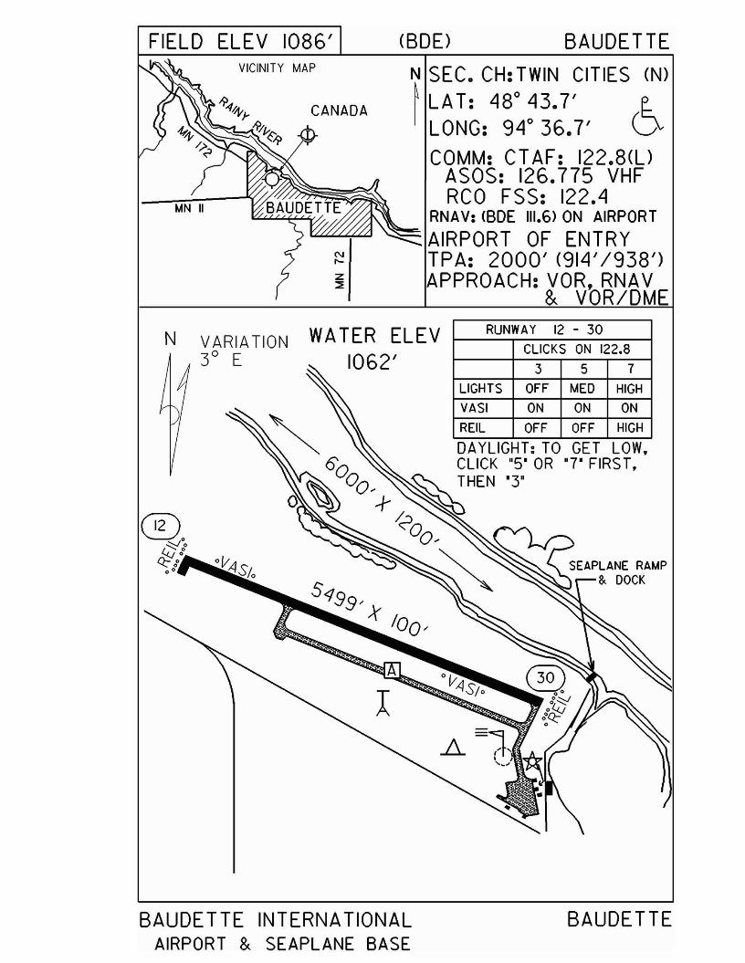
FIELD ELEV 1086' (BDD BAUDETTEVICINITY MAP
CANADA
N SEC. CH: TWIN CITIES (N)
~ LAT: 480
43.7' (~LONG: 94 0 36.7' VCOMM: CT AF: 122.8(l)
ASOS: 126.775 VHFRCO FSS: 122.4
RNAV: <BDE 111.6> ON AIRPORT""""""'-'~ ~ AIRPORT OF ENTRY
TPA: 2000' (914'/938')APPROACH: VOR, RNAV
& VOR/DME
N VARIATION3° E
WATER ELEV1062'
RUNWAY 12 - 30
CLICKS ON 122.8
3 5 7
LIGHTS OFF MED HIGH
VASI ON ON ON
REIL OFF OFF HIGH
DA YLiGHT: TO GET LOW,
BAUDETTE INTERNATIONALAIRPORT & SEAPLANE BASE
BAUDETTE
Belle Plaine - 7Y7
Airport Manager: James Drometer - 952-873-6659 Contact Person: James Drometer - 952-873-6659
Chamber of Com: 952-873-4295 - www.belleplainemn.com
Aero Cht Coord: 11-HAWOS/ASOS: No
MnWAS Loc/Hrs: NAAttended: All/All/All
Fuel: NoneSelf Service Fuel: NoAfter Hrs Service: None
FBO(s): NoneGround Transport: Yes
Food Service: NoneDining: Emma Krumbee's - 4 miles
Lodging: Belle Plaine Motel - 3 milesAirport Events: None reported
Underwing Camp: YesCampgrounds: None reportedGolf Courses: Valley View Golf Club - 6 miles
Local Attractions: Bar-B-Q Days - third weekend in JulyComments: Airport is attended 23½ hours a day.
•
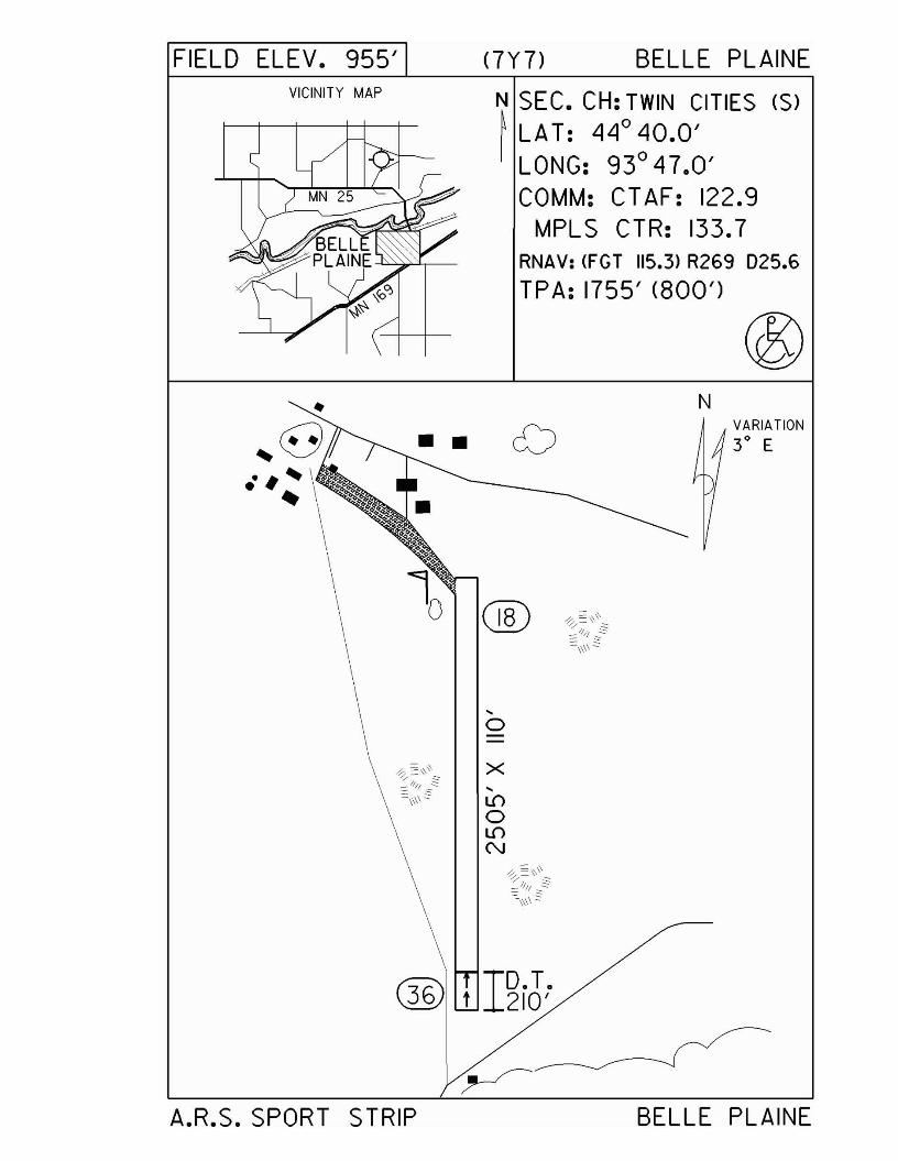
FIELD ELEV. 955'VICINITY MAP
<7Y7) BELLE PLAINE
~ SEC. CH: TWIN CITIES (S)I LAT: LIllo L10.0'
LONG: 93° L17 .0'COMM: CT AF: 122.9
MPL S CTR: 133.7RNAV: <FGT 115.3> R269 D25.6
TPA: 1755' (800')
,o
x,L{)
oL{)
N
NVARIATION
3° E
r:ir\36 10.T.\d.3J t 210'
A.R.S. SPORT STRIP BELLE PLAINE
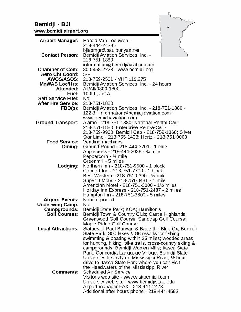
Bemidji - BJIwww.bemidjiairport.org
Airport Manager: Harold Van Leeuwen - 218-444-2438 - [email protected]
Contact Person: Bemidji Aviation Services, Inc. - 218-751-1880 - [email protected]
Chamber of Com: 800-458-2223 - www.bemidji.orgAero Cht Coord: 5-F
AWOS/ASOS: 218-759-2501 - VHF 119.275MnWAS Loc/Hrs: Bemidji Aviation Services, Inc. - 24 hours
Attended: All/All/0800-1800Fuel: 100LL, Jet A
Self Service Fuel: NoAfter Hrs Service: 218-751-1880
FBO(s): Bemidji Aviation Services, Inc. - 218-751-1880 - 122.8 - [email protected] - www.bemidjiaviation.com
Ground Transport: Alamo - 218-751-1880; National Rental Car - 218-751-1880; Enterprise Rent-a-Car - 218-759-9960; Bemidji Cab - 218-759-1368; Silver Star Limo - 218-755-1433; Hertz - 218-751-0063
Food Service: Vending machinesDining: Ground Round - 218-444-3201 - 1 mile
Applebee's - 218-444-2038 - ¾ milePeppercorn - ¾ mileGreenmill - 5 miles
Lodging: Northern Inn - 218-751-9500 - 1 blockComfort Inn - 218-751-7700 - 1 blockBest Western - 218-751-0390 - ½ mileSuper 8 Motel - 218-751-8481 - 1 mileAmericInn Motel - 218-751-3000 - 1½ milesHoliday Inn Express - 218-751-2487 - 2 milesHampton Inn - 218-751-3600 - 5 miles
Airport Events: None reportedUnderwing Camp: No
Campgrounds: Bemidji State Park; KOA; Hamilton'sGolf Courses: Bemidji Town & Country Club; Castle Highlands;
Greenwood Golf Course; Sandtrap Golf Course; Maple Ridge Golf Course
Local Attractions: Statues of Paul Bunyan & Babe the Blue Ox; BemidjiState Park; 300 lakes & 88 resorts for fishing, swimming & boating within 25 miles; wooded areas for hunting, hiking, bike trails, cross-country skiing &campgrounds; Bemidji Woolen Mills; Itasca State Park; Concordia Language Village; Bemidji State University; first city on Mississippi River; ½ hour drive to Itasca State Park where you can visit the Headwaters of the Mississippi River
Comments: Scheduled Air ServiceVisitor's web site - www.visitbemidji.comUniversity web site - www.bemidjistate.eduAirport manager FAX - 218-444-2473Additional after hours phone - 218-444-4592
•

FIELD ELEV. 1390' (BJD BEMIDJI
3 5 7CLICKS ON 122.8
RUNWAY 7 - 25
PAPI ON ON ON
LIGHTS LOW MED HIGH
N SEC. CH: TWIN CITIES (N)~ LAT: 47"30.6' eI LONG: 94° 56.0' D-
COMM: CT AF: 122.8(l)AWOS: 119.275 VHFRCO FSS: 123.6MPL S CTR: 134.75
RNAV: <BJII08.6) RI33 05.4TPA: 2390' (1000')APPROACH: IL S, CPS, VOR,
VOR/DME & RNAV
357
CLICKS ON 122.8
RUNWAY 13 - 31
LIGHTS HIGH HIGH HIGH
PAPI ON ON ON
MALSRl31l LOW MED HIGH
REIL <13> OFF OFF ON
VICINITY MAP
N VARIATION4°E
BEMIDJI REGIONAL AIRPORT BEMIDJI
Benson - BBB
Airport Manager: Elliot Nelson - 320-843-4775 - [email protected]
Contact Person: Leroy Noreen - 320-843-4384Chamber of Com: 320-843-3618 -
www.bensonareachamber.comAero Cht Coord: 10-D
AWOS/ASOS: 320-843-3242 - NDB 239MnWAS Loc/Hrs: Main Hangar Office - 24 hours
Attended: UnattendedFuel: 100LL
Self Service Fuel: Visa, MastercardAfter Hrs Service: None
FBO(s): JED-AIRE Aviation, LLC - 320-843-4461 - 122.80 - [email protected]
Ground Transport: Benson Heartland Express - 320-843-4293Food Service: Candy, pop & water
Dining: Burger King - 320-843-2505 - 2 miles; Coyote CoffeeCo. - 320-843-4900 - 2 miles; Detoy's Family Restaurant - 320-843-4767 - 2 miles; Duffy's Bar & Grill - 320-843-8777 - 2 miles; Subway - 320-843-3666 -2 miles; Whistle Stop Diner - 320-843-3800 - 2 miles; Jimmy's Pizza - 320-843-3600 - 2 miles; Sandy's Café - 320-843-2125 - 2 miles; DS Lageson's - 320-843-4333 - 2 miles
Lodging: Benson Inn - 320-842-6990 - 2 milesCountry Inn & Suites - 320-843-4395 - 2 milesMotel One - 320-843-3484 - 2½ miles
Airport Events: Fly-In Pancake Breakfast, Kid Day Celebration & Parade, Car Show - third Sunday of July - contact Leroy Noreen at 320-843-4384 for information
Underwing Camp: YesCampgrounds: Ambush Park - 320-843-4775Golf Courses: Benson Golf Club - 320-842-7901 - Holes: 18
Local Attractions: Swift County Historical Museum - 320-843-4467; Langhei Hills Shooting Preserve - 320-392-5808; Cottonwood Creek Hunting Preserve, LLC - 320-793-6604; 1 antique store in Benson; Syttende Mai Celebration - May (Norwegian Heritage); Pioneerland Band Festival; High School Marching BandsCompetition - June 14th; Kid Day Celebration &Parade - third weekend in July; Community Celebration - July; Antique Car Show - 100 collectible cars on display - third weekend in July; Farmer's Market Day - Saturday after Labor Day; Holiday Stroll (Community Christmas Open House) - Sunday following Thanksgiving
Comments: Airport has bathrooms, showers (open 24-hours) for campers and pilots.
•
FIELD ELEV. 1039' <BBB) BENSON
,~= ><,t\, ,,-,
N SEC. CH: TWIN CITIES (5)~ LAT: 45°19.9'I LONG: 95°39.0'
COMM: CT AF: 122.8(l)AWOS: 239 NDBMPLS CTR: 125.5
RNAV: (MOX 109.6) R131019.5NDB: <BBB) 239TPA: 1839' (800')RWY 14 RGT TFCAPPROACH: RNAV,NDB
TT
\ \, RUNWAY 14 - 32
® \~=C-~~ LIGHTS :~I:KSM:: 12:::HPAPI OFF ON ON
REIL OFF LOW HIGH
DAYLIGHT: TO GET LOW,
CLICK "5" OR '7' FIRS T,
THEN '3'
T
VICINITY MAP
••T
N VARIATION5° E
T
BENSON MUNICIPAL AIRPORT(VETERANS FIELD>
BENSON
Big Falls - 7Y9
Airport Manager: Terry Baird - 218-556-4827 - [email protected]
Contact Person: Terry Baird - 218-276-2282 - [email protected]
Chamber of Com: NoneAero Cht Coord: 4-H
AWOS/ASOS: No MnWAS Loc/Hrs: NA
Attended: UnattendedFuel: None
Self Service Fuel: NoAfter Hrs Service: None
FBO(s): NoneGround Transport: None
Food Service: NoneDining: Café 671 - 218-276-0011 - 2 miles
Lodging: Big Falls Motel - 1½ milesAirport Events: None reported
Underwing Camp: NoCampgrounds: Big Falls Tourist Park - 2 milesGolf Courses: None reported
Local Attractions: FishingCampingCanoeing on Big Fork River
Comments: Camping on Big Fork River has restrooms, showers,electricity & water.
•
FIELD ELEV. 1232' (7Y9) BIG FALLSVICINITY MAP
BIGFALLS
N SEC. CH: TWIN CITIES (N)~LAT: 48°11.8'I LONG: 93° 46.0'
COMM: CTAF: 122.9MPLS eTR: 120.9
RNAV: (INL 111.0> R208 D26.7
TPA: 2030' (798')
@
I
TT
RUNWAY 11/29 LIGHTED DUSK TO DAWN
VARIATION2° E
N
AIRPORT CLOSED WINTER MONTHS
BIG FALLS MUNICIPAL AIRPORT BIG FALLS
Bigfork - FOZ
Airport Manager: Loren Hovila - 218-743-3640 Contact Person: None
Chamber of Com: None Aero Cht Coord: 5-H
AWOS/ASOS: 218-743-3289 - NDB 345MnWAS Loc/Hrs: NA
Attended: UnattendedFuel: None
Self Service Fuel: NoAfter Hrs Service: None
FBO(s): NoneGround Transport: None
Food Service: NoneDining: Huskie's Café - 218-743-6688 - 2 miles
Lodging: Richie's Marcell Inn - 218-832-3906 - 12 milesTimberwolf Inn - 218-832-3990 - 9 miles
Airport Events: Fly-In Breakfast last Sunday in JulyUnderwing Camp: No
Campgrounds: Scenic State Park - 7 milesGolf Courses: Edge of Wilderness Golf Course - 2 miles
Local Attractions: CanoeingFishing
Comments: None
•
FIELD ELEV. 13Ll8' (FOn BIGFORKVICINITY MAP
N~ SEC. CH: TWIN CITIES (N)LAT: Ll7°Ll7.0'LONG: 93° 39.0'COMM: CT AF: 122.9 (l)
AWOS: 3Ll5 NOBMPL S CTR: 127.9GCO: 121.725
RNAV: CGPZ 111.4) R344 037.8
NOB: (FOn 3Ll5 a?\TPA: 2350' (1002')~APPROACH:GPS & NOB
z2
BIGFORK
f--
VARIATION3° E
N
o
o
o
o
Q
3 5 7
CLICKS ON 122.9
RUNWAY 15 - 33
LIGHTS LOW MED HIGH
BIGFORK MUNICIPAL AIRPORT
~J
1-----0
Blue Earth - SBU
Airport Manager: Tim Steier - 507-526-7264 - [email protected]
Contact Person: Barb Steier - 507-526-5115 - [email protected]
Chamber of Com: 507-526-2916 - www.blueearthchamber.comAero Cht Coord: 13-G
AWOS/ASOS: NoMnWAS Loc/Hrs: Blue Earth Aviation - 24 hours
Attended: All/Mon-Fri/0800-1700Fuel: 100LL, Jet A
Self Service Fuel: NoAfter Hrs Service: 507-526-2056
FBO(s): Blue Earth Aviation - 507-526-7264 - 122.8 - [email protected]
Ground Transport: Courtesy carFood Service: None
Dining: Country Kitchen - 507-526-2169 - 3 milesDouble Play - 507-526-3032 - 3 miles
Lodging: Super 8 Motel - 507-526-7376 - 3 milesAmericInn Motel - 507-526-4215 - 3 miles
Airport Events: Fly-In SupperUnderwing Camp: No
Campgrounds: 48 hours free camping at fairgroundsGolf Courses: Minn Iowa - 5 miles South
Local Attractions: Largest Green Giant Statue - 3 milesHistorical Homes & Museums
Comments: Summer months - aerial application & ultralightsAdditional after hours service phone - 507-525-3068
•
FIELD ELEV. 1107' (SBU) BLUE EARTHVICINITY MAP
1- 90 N SEC. CH: OMAHA NORTH~ LAT: 43°35.7'I LONG: 94° 05.6'
COMM: CT AF: 122.8(l)MPL S CTR: 127.75
RNAV: (FRM 110.2> R09S 014.7
NOB: (SBW 332 eTPA: 2107' (1000') VAPPROACH:GPS & NDB
N
...,
...,
...,
...,
Vl
:::J
RWY 3-21 CLOSEDWINTER MONTHS
3 S 7
CLICKS ON 122.8
RUNWAY 16 - 34
LIGHTS OFF MED HIGH
VARIATION4 0 E
BLUE EARTH MUNICIPAL AIRPORT BLUE EARTH
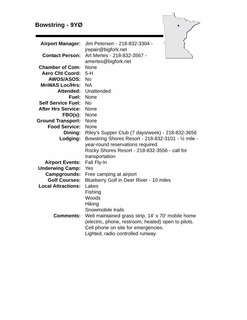
Bowstring - 9YØ
Airport Manager: Jim Petersen - 218-832-3304 - [email protected]
Contact Person: Art Mertes - 218-832-3567 - [email protected]
Chamber of Com: NoneAero Cht Coord: 5-H
AWOS/ASOS: No MnWAS Loc/Hrs: NA
Attended: UnattendedFuel: None
Self Service Fuel: NoAfter Hrs Service: None
FBO(s): NoneGround Transport: None
Food Service: NoneDining: Riley's Supper Club (7 days/week) - 218-832-3656
Lodging: Bowstring Shores Resort - 218-832-3101 - ½ mile -year-round reservations requiredRocky Shores Resort - 218-832-3556 - call fortransportation
Airport Events: Fall Fly-InUnderwing Camp: Yes
Campgrounds: Free camping at airportGolf Courses: Blueberry Golf in Deer River - 10 miles
Local Attractions: LakesFishingWoodsHikingSnowmobile trails
Comments: Well maintained grass strip, 14' x 70' mobile home(electric, phone, restroom, heated) open to pilots.Cell phone on site for emergencies.Lighted, radio controlled runway.
•
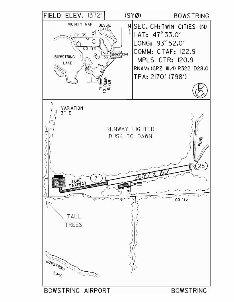
FIELD ELEV. 1372' (9Y0) BOWS TRING
BOWSTRING
LAKE
N SEC. CH: TWIN CITIES (N)
~LAT: 47°33.0'I LONG: 93° 52.0'
~-l-lJi>iJijlRING COMM: CTAF: 122.9MPLS CTR: 120.9
RNAV: (CPZ 111.4) R322 D28.0
TPA: 2170' <798')
RUNWAY LIGHTEDDUSK TO DAWN
VARIATION3 0 E
N
~~ T:-" "s::::~~~~~~:iT ~I,r ~- ~ co \73
~ TALLTREES
BOWS TRING AIRPORT BOWSTRING
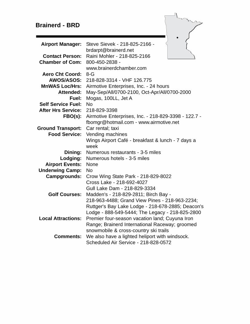
Brainerd - BRD
Airport Manager: Steve Sievek - 218-825-2166 - [email protected]
Contact Person: Raini Mohler - 218-825-2166 Chamber of Com: 800-450-2838 -
www.brainerdchamber.comAero Cht Coord: 8-G
AWOS/ASOS: 218-828-3314 - VHF 126.775MnWAS Loc/Hrs: Airmotive Enterprises, Inc. - 24 hours
Attended: May-Sep/All/0700-2100, Oct-Apr/All/0700-2000Fuel: Mogas, 100LL, Jet A
Self Service Fuel: NoAfter Hrs Service: 218-829-3398
FBO(s): Airmotive Enterprises, Inc. - 218-829-3398 - 122.7 [email protected] - www.airmotive.net
Ground Transport: Car rental; taxiFood Service: Vending machines
Wings Airport Café - breakfast & lunch - 7 days aweek
Dining: Numerous restaurants - 3-5 milesLodging: Numerous hotels - 3-5 miles
Airport Events: NoneUnderwing Camp: No
Campgrounds: Crow Wing State Park - 218-829-8022Cross Lake - 218-692-4027Gull Lake Dam - 218-829-3334
Golf Courses: Madden's - 218-829-2811; Birch Bay - 218-963-4488; Grand View Pines - 218-963-2234;Ruttger's Bay Lake Lodge - 218-678-2885; Deacon'sLodge - 888-549-5444; The Legacy - 218-825-2800
Local Attractions: Premier four-season vacation land; Cuyuna Iron Range; Brainerd International Raceway; groomed snowmobile & cross-country ski trails
Comments: We also have a lighted heliport with windsock.Scheduled Air Service - 218-828-0572
•
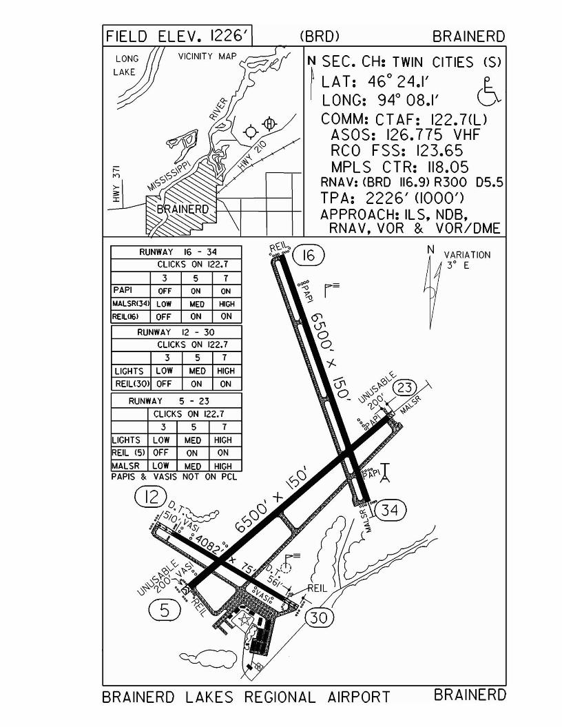
BRAINERD LAKES REGIONAL AIRPORT BRAINERD
N SEC. CH: TWIN CITIES (S)
~ LAT: 46° 24.1' e.I LONG: 94° 08.1' (]v
COMM: CTAF: 122.7(l)ASOS: 126.775 VHFRCO FSS: 123.65MPLS CTR: 118.05
RNAV: (BRO 116.9) R300 05.5TPA: 2226' (1000')APPROACH: ILS, NDB,
RNAV,VOR & VOR/DME
CBRD) BRAINERD
\<.O\-o® N° 16 VARIATION
3° E
VICINITY MAP
3 5 7
3 5 7
CLICKS ON 122.7
CLICKS ON 122.7
RUNWAY 16 - 34
LIGHTS LOW MED HIGH
REILl301 OFF ON ON
PAPI OFF ON ON
MALSR(34) LOW MED HIGH
REIL1I61 OFF ON ON
RUNWAY 12 - 30
FIELD ELEV. 1226'
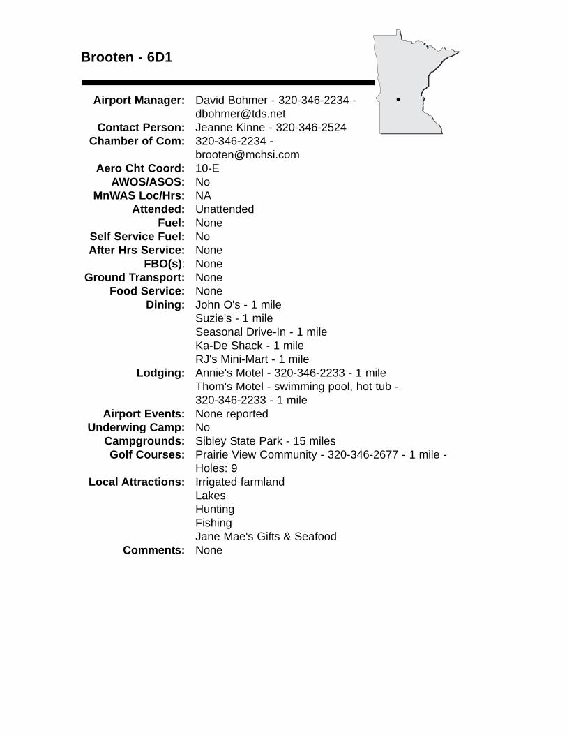
Brooten - 6D1
Airport Manager: David Bohmer - 320-346-2234 - [email protected]
Contact Person: Jeanne Kinne - 320-346-2524 Chamber of Com: 320-346-2234 -
[email protected] Cht Coord: 10-E
AWOS/ASOS: No MnWAS Loc/Hrs: NA
Attended: UnattendedFuel: None
Self Service Fuel: NoAfter Hrs Service: None
FBO(s): NoneGround Transport: None
Food Service: NoneDining: John O's - 1 mile
Suzie's - 1 mileSeasonal Drive-In - 1 mileKa-De Shack - 1 mileRJ's Mini-Mart - 1 mile
Lodging: Annie's Motel - 320-346-2233 - 1 mileThom's Motel - swimming pool, hot tub - 320-346-2233 - 1 mile
Airport Events: None reportedUnderwing Camp: No
Campgrounds: Sibley State Park - 15 milesGolf Courses: Prairie View Community - 320-346-2677 - 1 mile -
Holes: 9Local Attractions: Irrigated farmland
LakesHuntingFishingJane Mae's Gifts & Seafood
Comments: None
•
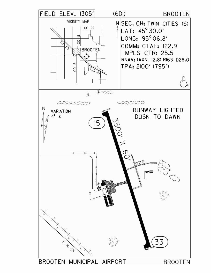
FIELD ELEV. 1305' (601) BROOTENVICINITY MAP
N SEC. CH: TWIN CITIES (S)
~ LAT: Ll5°30.0'LONG: 95 0 06.8'COMM: CTAF: 122.9
MPLS CTR: 125.5RNAV: (AXN 112.8) RI63 D28.0
TPA: 2100' <795')
RUNWAY LIGHTEDDUSK TO DAWN
~U'oo-
--/--0'o
~
N VARIATION
4° E
©0 00 0
BROOTEN MUNICIPAL AIRPORT BROOTEN
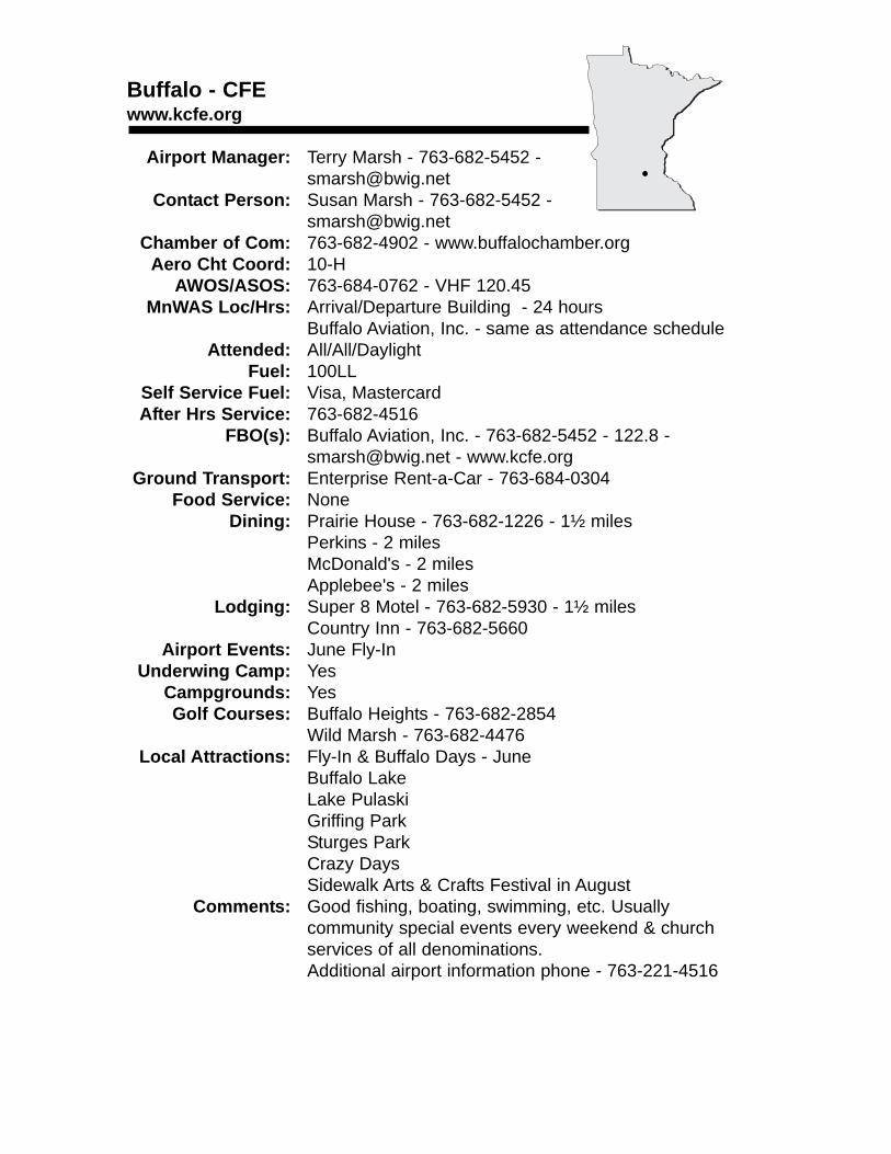
Buffalo - CFEwww.kcfe.org
Airport Manager: Terry Marsh - 763-682-5452 - [email protected]
Contact Person: Susan Marsh - 763-682-5452 - [email protected]
Chamber of Com: 763-682-4902 - www.buffalochamber.orgAero Cht Coord: 10-H
AWOS/ASOS: 763-684-0762 - VHF 120.45MnWAS Loc/Hrs: Arrival/Departure Building - 24 hours
Buffalo Aviation, Inc. - same as attendance scheduleAttended: All/All/Daylight
Fuel: 100LLSelf Service Fuel: Visa, MastercardAfter Hrs Service: 763-682-4516
FBO(s): Buffalo Aviation, Inc. - 763-682-5452 - 122.8 - [email protected] - www.kcfe.org
Ground Transport: Enterprise Rent-a-Car - 763-684-0304Food Service: None
Dining: Prairie House - 763-682-1226 - 1½ milesPerkins - 2 milesMcDonald's - 2 milesApplebee's - 2 miles
Lodging: Super 8 Motel - 763-682-5930 - 1½ milesCountry Inn - 763-682-5660
Airport Events: June Fly-InUnderwing Camp: Yes
Campgrounds: YesGolf Courses: Buffalo Heights - 763-682-2854
Wild Marsh - 763-682-4476Local Attractions: Fly-In & Buffalo Days - June
Buffalo LakeLake PulaskiGriffing ParkSturges ParkCrazy DaysSidewalk Arts & Crafts Festival in August
Comments: Good fishing, boating, swimming, etc. Usually community special events every weekend & church services of all denominations.Additional airport information phone - 763-221-4516
•
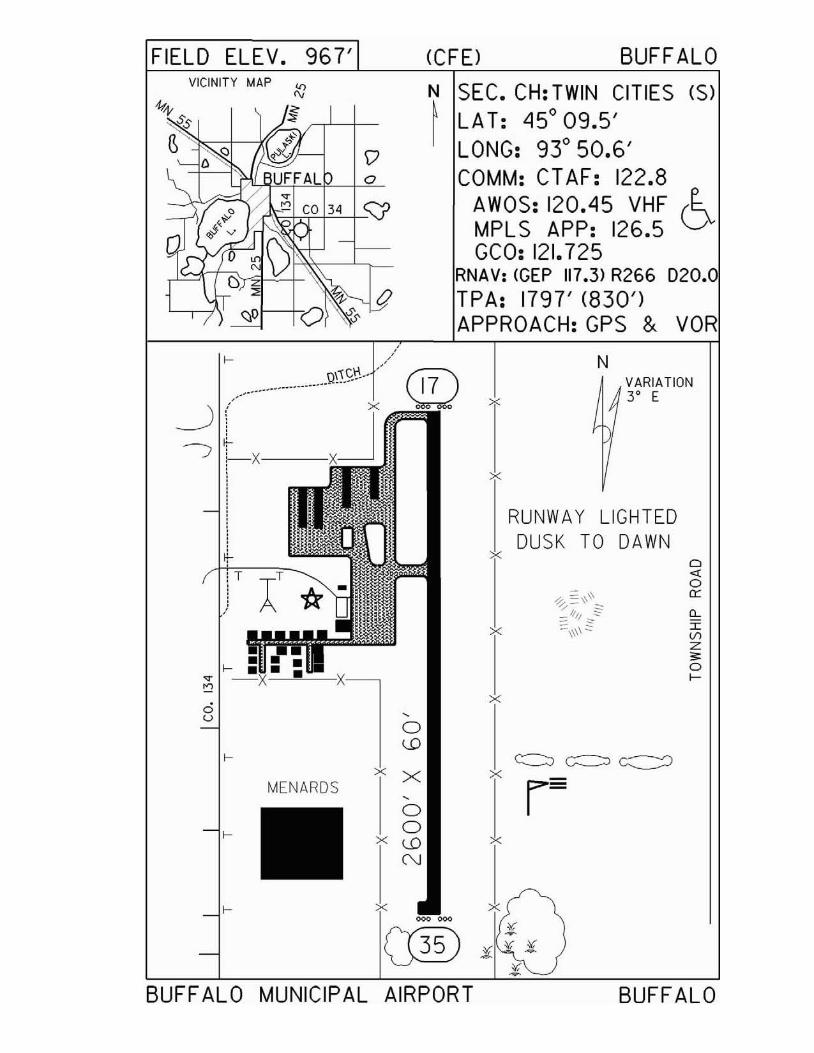
FIELD ELEV. 967' (CFE) BUFF ALO
o""ocr0:r:VlZ
'"of-
VARIATION3° E
BUFFALO
N
RUNWAY LIGHTEDDUSK TO DAWN
x
x
x
x
x
x
N SEC. CH: TWIN CITIES (S)
~ LA T: 450
09.5'LONG: 93
050.6'
COMM: CT AF: 122.8AWOS: 120.45 VHF (~MPLS APP: 126.5 vGCO: 121.725
RNAV: (GEP 117.3) R266 D20.TPA: 1797' (830')APPROACH:GPS & VOR
Do
<::fJ1--+
VICINITY MAP (()
'"!
iT
~(~Lx---
II~
/'
Q\'.<;'~.• ,.-..---_..-----_ .
~ X
'"<5 ,u a
u:>
MENARDSx X
,a
f- ax u:>
N
x~~
C®BUFF AL 0 MUNICIPAL AIRPORT
Caledonia - CHU
Airport Manager: Tom Molling - 507-725-3925 Contact Person: Houston County Highway Dpt. -
507-725-3925Chamber of Com: 507-725-5477 - caledoniamn.com
Aero Cht Coord: 13-MAWOS/ASOS: No
MnWAS Loc/Hrs: NAAttended: Unattended
Fuel: 100LL, ASelf Service Fuel: Major credit cardsAfter Hrs Service: None
FBO(s): NoneGround Transport: None
Food Service: NoneDining: Good Times - 507-725-3839 - 1½ miles
Elmer's Supper Club - 507-725-2686 - 2 milesRedwood Café - 507-725-2270 - 2 milesPJ Diner - 507-725-8686 - 2½ milesSonny & Bev's - 507-725-3313 - 2½ milesChina Buffet - 507-725-8788 - 2½ miles
Lodging: Red Carpet Inn - 507-724-3311 - 1 mileAmericInn Motel - 507-725-8000 - 2 miles
Airport Events: Fly-In - last Sunday in JuneUnderwing Camp: No
Campgrounds: Dunromin Park - 507-724-2514 - 2½ milesGolf Courses: Mal-Cal Grove - 507-725-2733 - 1 mile
Local Attractions: None reportedComments: None
•
FIELD ELEV. 1179' (CHU) CALEDONIA
o
T
T T
N
N SEC. CH: CHICAGO NORTH~ LAT: 43° 35.8'I LONG: 91° 30.2'
COMM: CT AF: 122.9 (l)RCO FSS: 122.IR 117.9TMPLS CTR: 128.6
RNAV: <ODI1I7.9) RI84 D19.NDB: (CHU) 209TPA: 2170' (991') (~APPROACH: GPS & V
VOR/DME
DA YTIME: LOW CLICK "5" OR '7'FIRS T. THEN '3'
RUNWAY 13 - 31CLICKS ON 122.9
3 5 7
LIGHTS OFF MED HIGH
TURFTAXIWAY30' WIDE
VICINITY MAP
HOUS TON COUNTY AIRPORT CALEDONIA
Cambridge - CBGwww.ci.cambridge.mn.us
Airport Manager: Steve Wegwerth - 763-689-1800 [email protected]
Contact Person: Steve Wegwerth - 763-689-1800 [email protected]
Chamber of Com: 763-689-2505 - www.cambridgechamber.comAero Cht Coord: 10-I
AWOS/ASOS: 763-689-9562 - VHF 121.125MnWAS Loc/Hrs: Arrival/Departure Building - 24 hours
Attended: UnattendedFuel: 100LL
Self Service Fuel: Visa, MastercardAfter Hrs Service: 763-689-2141
FBO(s): All American Aviation, Inc. - 763-552-4359 - 122.80 - [email protected] -allamericanaviation.comSun Aviation, Inc. - 763-689-4708 - [email protected]
Ground Transport: Cambridge Cab, Inc. - 763-552-8294Food Service: Pop
Dining: Many restaurants within 3 milesLodging: Country Inn - 763-689-0542
Airport Events: Fly-in breakfast - Father's Day 2009Underwing Camp: Yes
Campgrounds: Spring Vale Campgrounds - 763-689-3208 - 6½ milesGolf Courses: Purple Hawk Country Club - 763-689-3800 - 8 miles
Grandy 9 - 7 milesLocal Attractions: Lakes
CampgroundIsanti County Fair in JulyIsanti Rodeo in July
Comments: Free overnight parking of aircraft.Runway 16 traffic pattern is left hand pattern.Other airport businesses:Pirate Air LLC - aircraft painting - 763-458-8707 - www.brewstercorsair.comJ & M Aviation, Inc. - aircraft repair - 612-281-8925 - [email protected] Aviation, Inc. does flight training & aircraft rental.
•

FIELD ELEV. 945' (CBG) CAMBRIDGEN SEC. CH: TWIN CITIES (S)~ LAT: 45°33.5'I LONG: 93°15.9'
COMM: CT AF: 122.8 (l)AWOS: 121.125 VHFMPLS CTR: 121.05
RNAV: (GEP 117.3> R005 D25.1NDB: (CBG) 350TPA: 1945' (1000' AT 2
NAUTICAL MILES)APPROACH:GPS & NDB
CAMBRIDGE MUNICIPAL AIRPORT
VARIATION2° E
N
CAMBRIDGE
.'-'
"cq
pooo
--r-
FF OFF ON
3 5 7
OFF ON ON
CLICKS ON 122.8
RUNWAY 16 - 34
LIGHTS LOW MED HIGH
REILPAPI

Canby - CNBcanby.govoffice.com
Airport Manager: Matt Wagner - 507-829-9608 - [email protected]
Contact Person: Chris Husby - 507-223-7295 - [email protected]
Chamber of Com: 507-223-5303 -www.canbychamber.com
Aero Cht Coord: 11-CAWOS/ASOS: 507-223-5293 - VHF 118.575
MnWAS Loc/Hrs: Arrival/Departure Building - business hoursAttended: Unattended
Fuel: 100LLSelf Service Fuel: Visa, MastercardAfter Hrs Service: 507-829-9608
FBO(s): NoneGround Transport: Courtesy car by appointment
Food Service: Snacks and pop availableDining: Numerous restaurants in City of Canby
Lodging: Tower Motel - 507-223-7284 - 1½ milesAirport Events: Fly-In - Father's Day
Underwing Camp: YesCampgrounds: Triangle Park
Swimming Pool ParkStone Hill Regional Park
Golf Courses: Canby Golf Course - $12 green fees with cartLocal Attractions: High Prairie sporting clays
Canby Hat Days - June (Father's Day weekend)Del Clark Recreational Facility - 1½ miles WestCity swimming pool
Comments: Aircraft rental & hangar space availableAgricultural operations at airport
•
FIELD ELEV.1I93' (CNB) CANBY
VICINITY MAP
MN 68
N
~SEC. CH: TWIN CITIES (S)LAT: 44° 43.7'LONG: 96° 16'COMM: CT AF: 122.9 (l)AWOS: 118.575 VHFFSS (MADISON RCO>: 122.3MPLS CTR: 128.5GCO: 121.725
RNAV: (MML III.OJ R307 025.2TPA: 2200' (1007') (~APPROACH: RNAV v
NVARIATIONSO E
00
00
TOWNSHIP ROAD
RUNWAY 12 - 30CLICKS ON 122.9
3 5 1
LIGHTS OFF MEO HIGHPAPI ON ON ONREILS OFF OFF ON
PRIVA TE ROAD
CANBY MUNICIPAL AIRPORT(MYERS FIELD>
CANBY
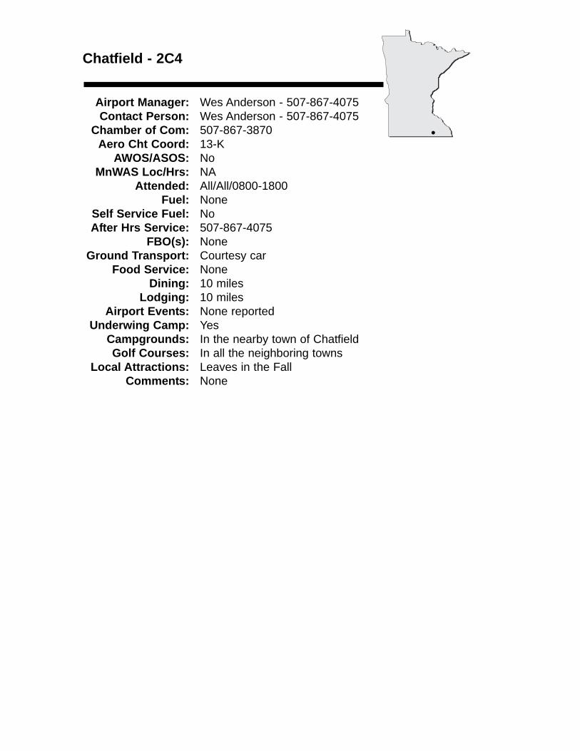
Chatfield - 2C4
Airport Manager: Wes Anderson - 507-867-4075 Contact Person: Wes Anderson - 507-867-4075
Chamber of Com: 507-867-3870 Aero Cht Coord: 13-K
AWOS/ASOS: No MnWAS Loc/Hrs: NA
Attended: All/All/0800-1800Fuel: None
Self Service Fuel: NoAfter Hrs Service: 507-867-4075
FBO(s): NoneGround Transport: Courtesy car
Food Service: NoneDining: 10 miles
Lodging: 10 milesAirport Events: None reported
Underwing Camp: YesCampgrounds: In the nearby town of ChatfieldGolf Courses: In all the neighboring towns
Local Attractions: Leaves in the FallComments: None
•
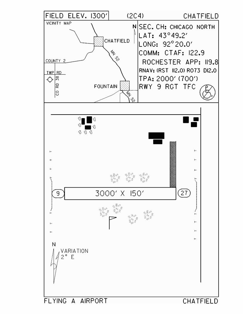
FIELD ELEV. 1300' (2C4) CHA TFIELD
FOUNTAIN
VICINITY MAP
COUNTY 2
TWP R
-¢-~Cl0::
oU
N SEC. CH: CHICAGO NORTH
~ LAT: 43°49.2'CHATFIELD I LONG: 92° 20.0'
COMM: CT AF: 122.9ROCHES TER APP: 119.8
RNAV: (RST 112.0> R073 D12.0
TPA: 2000' (700')RWY 9 RGT TFC~
3000' X 150'
--•••
....
....
....
....
NVARIATION2 0 E
FL YING A AIRPORT CHATFIELD
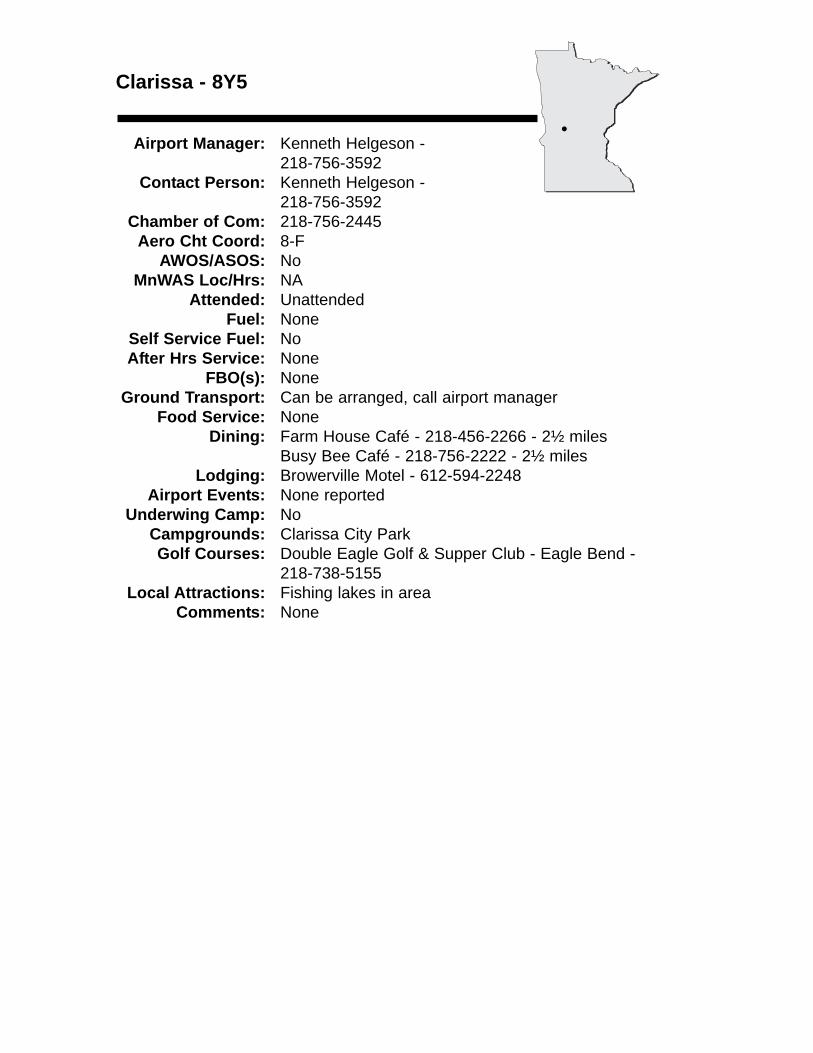
Clarissa - 8Y5
Airport Manager: Kenneth Helgeson - 218-756-3592
Contact Person: Kenneth Helgeson -218-756-3592
Chamber of Com: 218-756-2445 Aero Cht Coord: 8-F
AWOS/ASOS: No MnWAS Loc/Hrs: NA
Attended: UnattendedFuel: None
Self Service Fuel: NoAfter Hrs Service: None
FBO(s): NoneGround Transport: Can be arranged, call airport manager
Food Service: NoneDining: Farm House Café - 218-456-2266 - 2½ miles
Busy Bee Café - 218-756-2222 - 2½ milesLodging: Browerville Motel - 612-594-2248
Airport Events: None reportedUnderwing Camp: No
Campgrounds: Clarissa City ParkGolf Courses: Double Eagle Golf & Supper Club - Eagle Bend -
218-738-5155Local Attractions: Fishing lakes in area
Comments: None
•
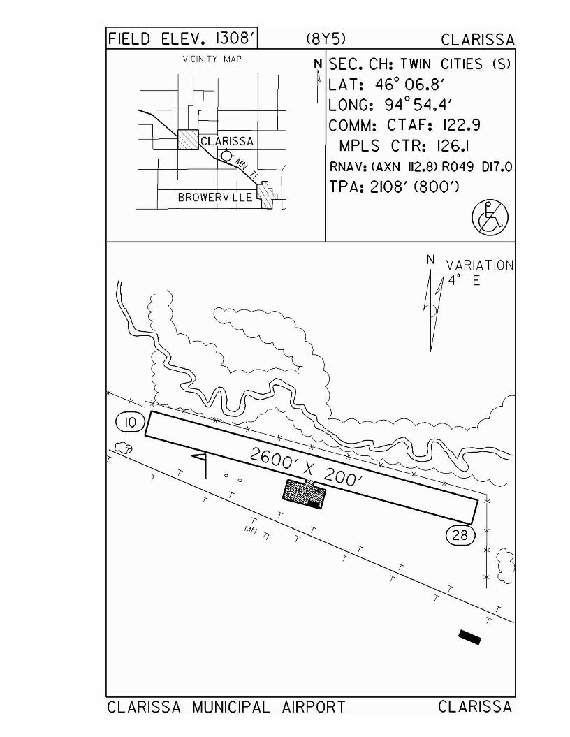
FIELD ELEV. 130S'VICINITY MAP
CLARISSA
BROWERVILLE
o
(SY5) CLARISSA
N SEC. CH: TWIN CITIES (S)
~ LAT: 46° 06.S'LONG: 94° 54.4'COMM: CT AF: 122.9
MPLS CTR: 126.1RNAV: (AXN 112.8> R049 D17.0
TPA: 210S' (SOO')
N VARIATION4° E
CLARISSA MUNICIPAL AIRPORT
7'7' l
7'7'
CLARISSA
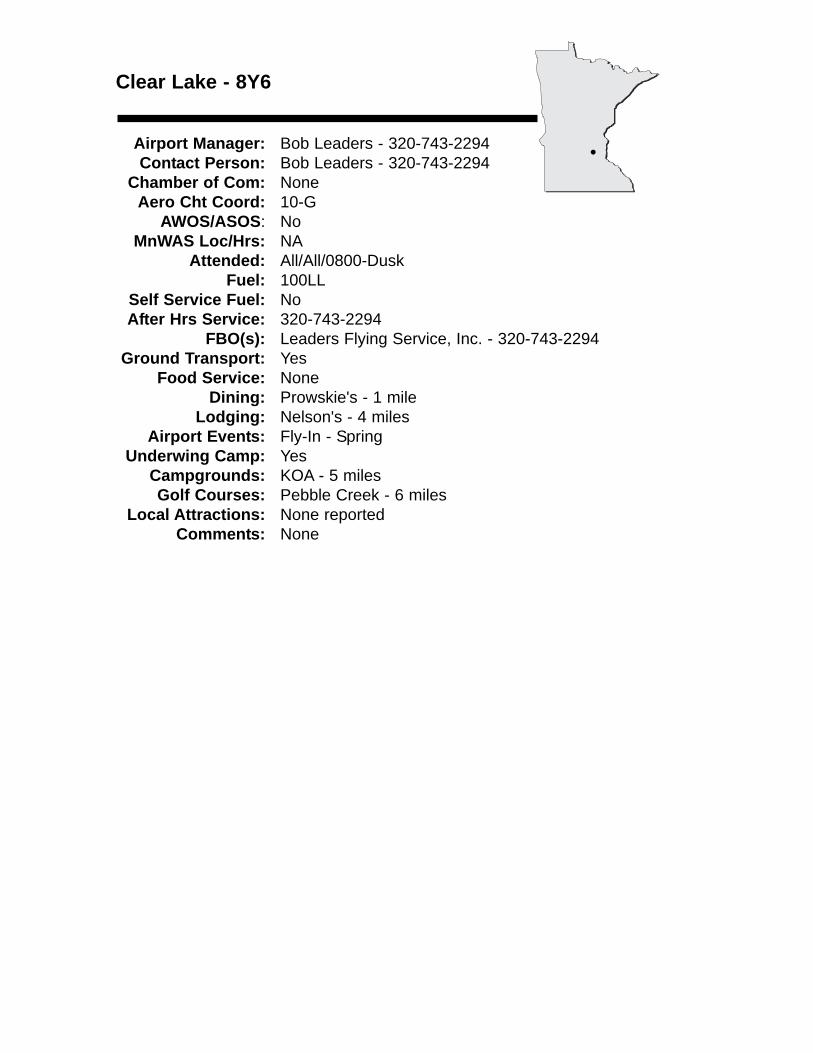
Clear Lake - 8Y6
Airport Manager: Bob Leaders - 320-743-2294 Contact Person: Bob Leaders - 320-743-2294
Chamber of Com: None Aero Cht Coord: 10-G
AWOS/ASOS: No MnWAS Loc/Hrs: NA
Attended: All/All/0800-DuskFuel: 100LL
Self Service Fuel: NoAfter Hrs Service: 320-743-2294
FBO(s): Leaders Flying Service, Inc. - 320-743-2294 Ground Transport: Yes
Food Service: NoneDining: Prowskie's - 1 mile
Lodging: Nelson's - 4 milesAirport Events: Fly-In - Spring
Underwing Camp: YesCampgrounds: KOA - 5 milesGolf Courses: Pebble Creek - 6 miles
Local Attractions: None reportedComments: None
•
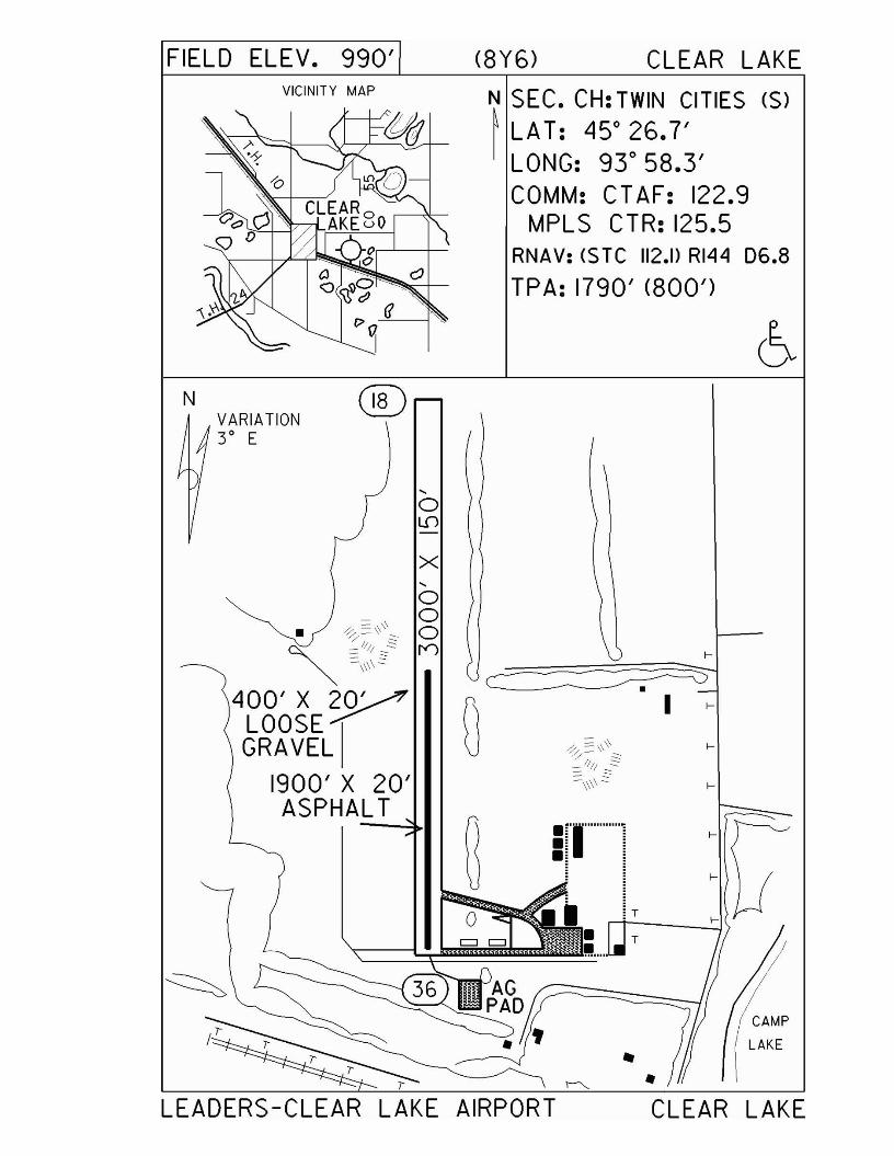
FIELD ELEV. 990' (8Y6) CLEAR LAKEVICINITY MAP
N SEC. CH: TWIN CITIES (S)~ LA T: 45° 26.7'I LONG: 93° 58.3'
COMM: CTAF: 122.9MPLS CTR: 125.5
RNAV: <$ Te 112.1> RI44 D6.8
TPA: 1790' (800')
NVARIATIONY E
®
,oLD
x
CAMP
LAKE
•
T
T
•!!!..."
!'I""""''''
•I
o
,oo
=:-.\\ 0. ~-' ~~ =.11/1 3~ I"J"" -\\\\-
400' X 20'~
LOOSE~GRAVEL
1900' X 20'ASPHALT
LEADERS-CLEAR LAKE AIRPORT CLEAR LAKE
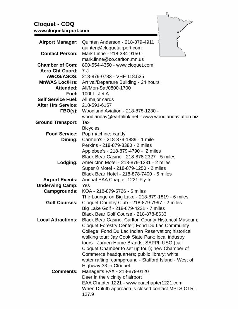
Cloquet - COQwww.cloquetairport.com
Airport Manager: Quinten Anderson - [email protected]
Contact Person: Mark Linne - 218-384-9150 - [email protected]
Chamber of Com: 800-554-4350 - www.cloquet.comAero Cht Coord: 7-J
AWOS/ASOS: 218-879-0783 - VHF 118.525MnWAS Loc/Hrs: Arrival/Departure Building - 24 hours
Attended: All/Mon-Sat/0800-1700Fuel: 100LL, Jet A
Self Service Fuel: All major cardsAfter Hrs Service: 218-591-6157
FBO(s): Woodland Aviation - 218-878-1230 - [email protected] - www.woodlandaviation.biz
Ground Transport: TaxiBicycles
Food Service: Pop machine; candyDining: Carmen's - 218-879-1889 - 1 mile
Perkins - 218-879-8380 - 2 milesApplebee’s - 218-879-4790 - 2 milesBlack Bear Casino - 218-878-2327 - 5 miles
Lodging: AmericInn Motel - 218-879-1231 - 2 milesSuper 8 Motel - 218-879-1250 - 2 milesBlack Bear Hotel - 218-878-7400 - 5 miles
Airport Events: Annual EAA Chapter 1221 Fly-InUnderwing Camp: Yes
Campgrounds: KOA - 218-879-5726 - 5 milesThe Lounge on Big Lake - 218-879-1819 - 6 miles
Golf Courses: Cloquet Country Club - 218-879-7997 - 2 milesBig Lake Golf - 218-879-4221 - 7 milesBlack Bear Golf Course - 218-878-8633
Local Attractions: Black Bear Casino; Carlton County Historical Museum;Cloquet Forestry Center; Fond Du Lac Community College; Fond Du Lac Indian Reservation; historical walking tour; Jay Cook State Park; local industry tours - Jarden Home Brands; SAPPI; USG (call Cloquet Chamber to set up tour); new Chamber of Commerce headquarters; public library; white water rafting; campground - Stafford Island - West of Highway 33 in Cloquet
Comments: Manager's FAX - 218-879-0120Deer in the vicinity of airportEAA Chapter 1221 - www.eaachapter1221.comWhen Duluth approach is closed contact MPLS CTR - 127.9
•
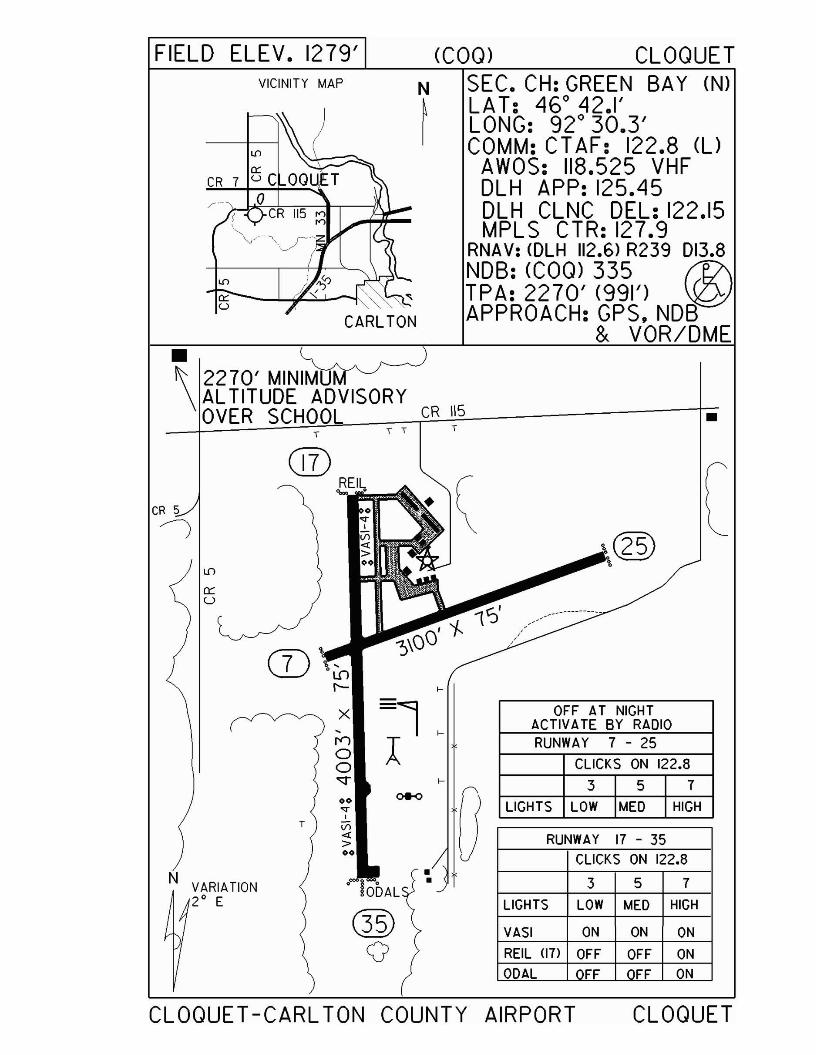
FIELD ELEV. 1279' (COQ) CLOQUET
•\
2270' MINIMUAL TITUDE ADVISORYOVER SCHOOL CR 115
VICINITY MAP
CARLTON
SEC. CH: GREEN BAY (N)LAT: 460 42.1'LONG: 92 0 30.3'COMM: CT AF: 122.8 (l)
AWOS: 118.525 VHFDLH APP: 125.45DLH CLNC DEL: 122.15MPLS CTR: 127.9
RNA V: <DLH 112.6) R239 013.8NDB: (Com 335 f1l\TPA: 2270' (991') ~APPROACH: GPS,NDB
& VOR/DME
•
[
FF ON
ON ON
OFF ON
3 5 7
357
CLICKS ON 122.8
CLICKS ON 122.8
RUNWAY 17 - 35
RUNWAY 7 - 25
OFF AT NIGHTACTIVA TE BY RADIO
LIGHTS LOW MED HIGH
VASI
REll (17)
ODAL
LIGHTS lOW MED HIGH
,..
f-
rO':, r
,.. T
®o
• lobAl
T
x,r"100"'1'"
00..,.,T Vi
4:>00
N VARIATION2° E
CLOQUET -CARL TON COUNTY AIRPORT CLOQUET
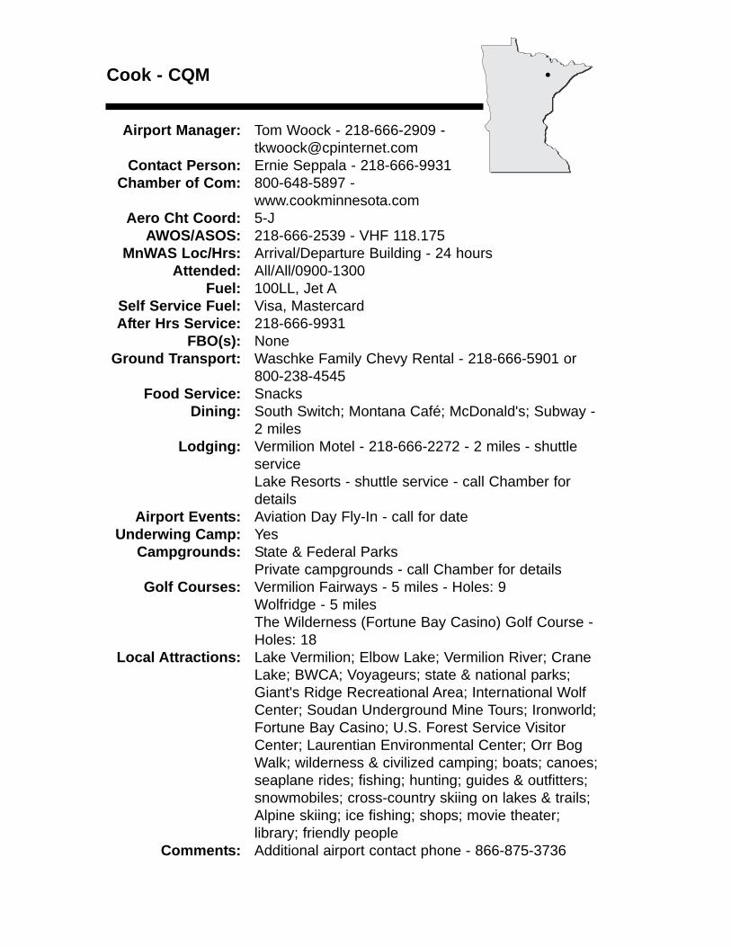
Cook - CQM
Airport Manager: Tom Woock - 218-666-2909 - [email protected]
Contact Person: Ernie Seppala - 218-666-9931 Chamber of Com: 800-648-5897 -
www.cookminnesota.comAero Cht Coord: 5-J
AWOS/ASOS: 218-666-2539 - VHF 118.175MnWAS Loc/Hrs: Arrival/Departure Building - 24 hours
Attended: All/All/0900-1300Fuel: 100LL, Jet A
Self Service Fuel: Visa, MastercardAfter Hrs Service: 218-666-9931
FBO(s): NoneGround Transport: Waschke Family Chevy Rental - 218-666-5901 or
800-238-4545Food Service: Snacks
Dining: South Switch; Montana Café; McDonald's; Subway - 2 miles
Lodging: Vermilion Motel - 218-666-2272 - 2 miles - shuttle serviceLake Resorts - shuttle service - call Chamber for details
Airport Events: Aviation Day Fly-In - call for dateUnderwing Camp: Yes
Campgrounds: State & Federal ParksPrivate campgrounds - call Chamber for details
Golf Courses: Vermilion Fairways - 5 miles - Holes: 9Wolfridge - 5 milesThe Wilderness (Fortune Bay Casino) Golf Course - Holes: 18
Local Attractions: Lake Vermilion; Elbow Lake; Vermilion River; CraneLake; BWCA; Voyageurs; state & national parks; Giant's Ridge Recreational Area; International Wolf Center; Soudan Underground Mine Tours; Ironworld; Fortune Bay Casino; U.S. Forest Service Visitor Center; Laurentian Environmental Center; Orr Bog Walk; wilderness & civilized camping; boats; canoes; seaplane rides; fishing; hunting; guides & outfitters; snowmobiles; cross-country skiing on lakes & trails; Alpine skiing; ice fishing; shops; movie theater; library; friendly people
Comments: Additional airport contact phone - 866-875-3736
•
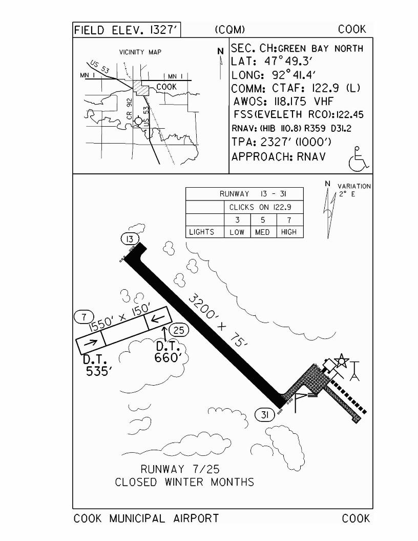
FIELD ELEV. 1327' (COM) COOK
VICINITY MAP N SEC. CH:GREEN BAY NORTH~ LAT: 47 0 49.3'I LONG: 92 0 41.4'
COMM: CT AF: 122.9 (l)
AWOS: 118.175 VHFFSS (EVELETH RCO>: 122.45
RNAV: (HIB 110.8> R359 031.2
TPA: 2327' (1000')APPROACH:RNAV ~
RUNWAY 13 - 31
CLICKS ON 122.9
3 5 7
LIGHTS LOW MED HIGH
RUNWAY 7/25CLOSED WINTER MONTHS
COOK MUNICIPAL AIRPORT
N VARIATION2° E
COOK
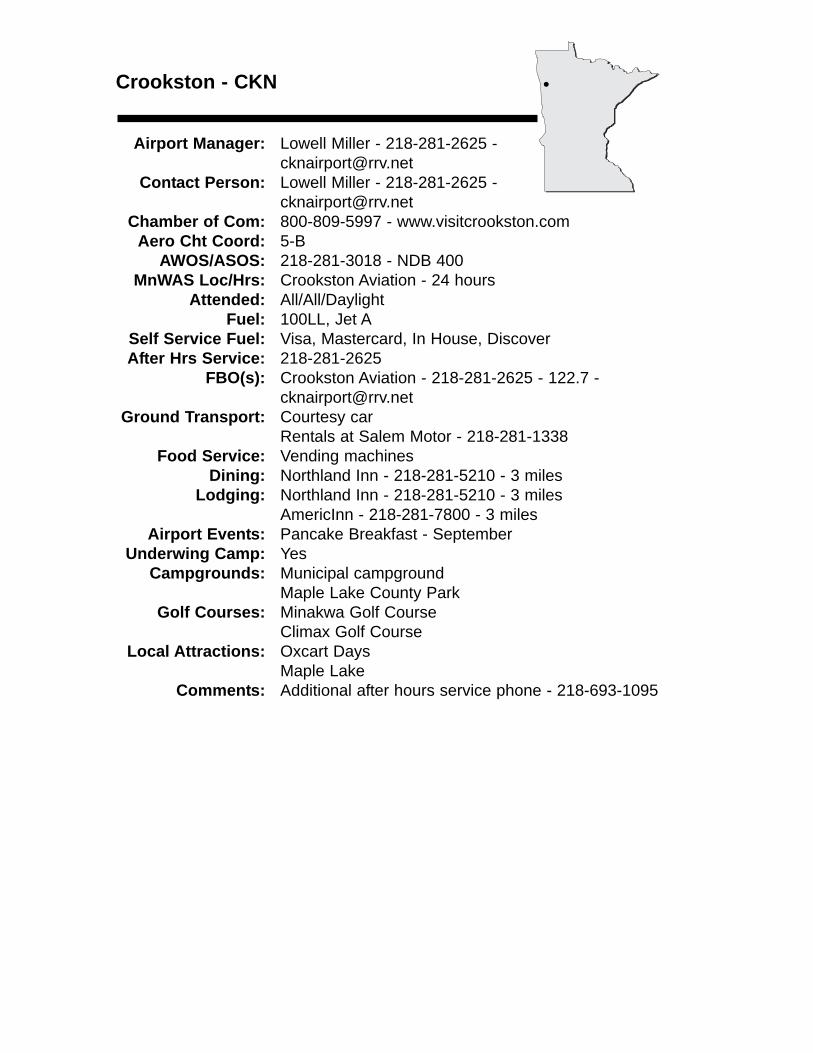
Crookston - CKN
Airport Manager: Lowell Miller - 218-281-2625 [email protected]
Contact Person: Lowell Miller - 218-281-2625 - [email protected]
Chamber of Com: 800-809-5997 - www.visitcrookston.comAero Cht Coord: 5-B
AWOS/ASOS: 218-281-3018 - NDB 400MnWAS Loc/Hrs: Crookston Aviation - 24 hours
Attended: All/All/DaylightFuel: 100LL, Jet A
Self Service Fuel: Visa, Mastercard, In House, DiscoverAfter Hrs Service: 218-281-2625
FBO(s): Crookston Aviation - 218-281-2625 - 122.7 - [email protected]
Ground Transport: Courtesy carRentals at Salem Motor - 218-281-1338
Food Service: Vending machinesDining: Northland Inn - 218-281-5210 - 3 miles
Lodging: Northland Inn - 218-281-5210 - 3 milesAmericInn - 218-281-7800 - 3 miles
Airport Events: Pancake Breakfast - SeptemberUnderwing Camp: Yes
Campgrounds: Municipal campgroundMaple Lake County Park
Golf Courses: Minakwa Golf CourseClimax Golf Course
Local Attractions: Oxcart DaysMaple Lake
Comments: Additional after hours service phone - 218-693-1095
•
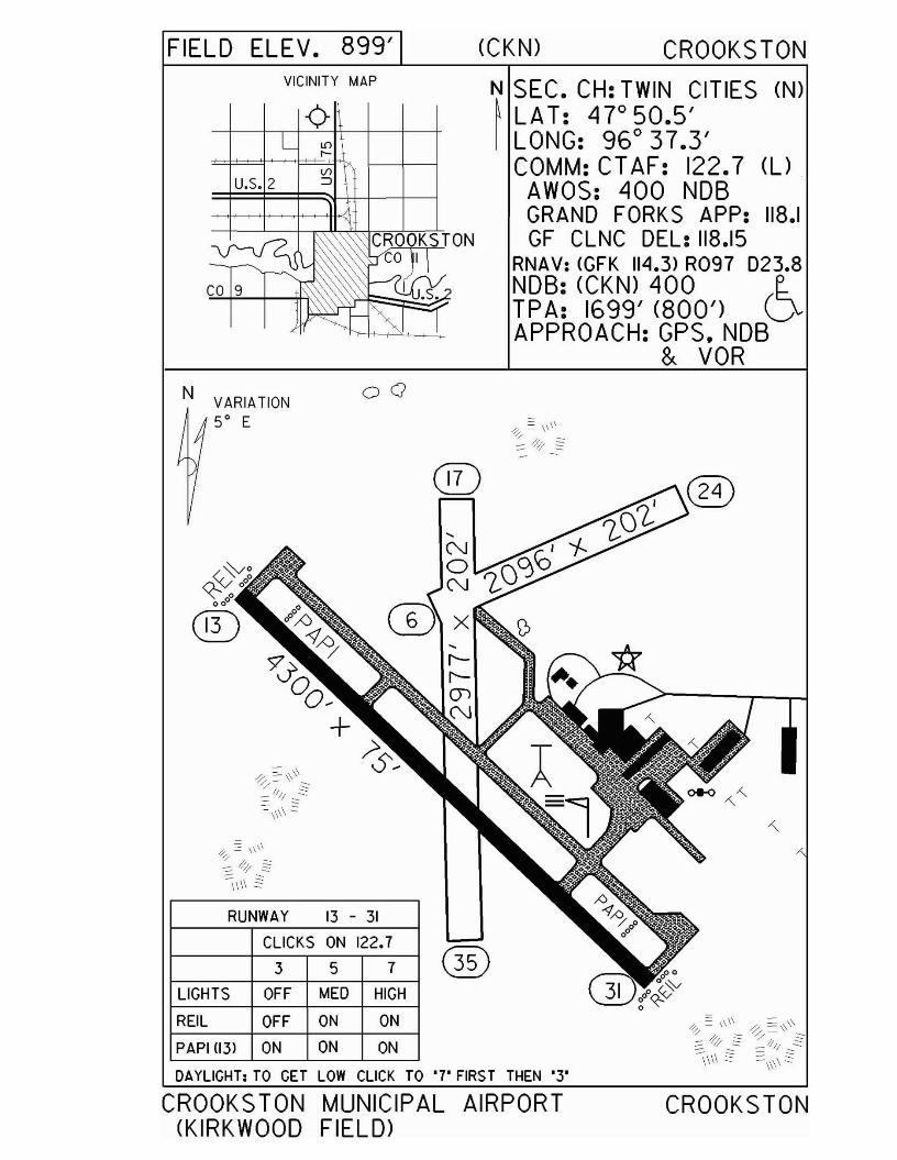
FIELD ELEV. 899' (CKN) CROOKS TONVICINITY MAP
N SEC. CH: TWIN CITIES (N)~LAT: 47°50.5'I LONG: 96° 37.3'
COMM: CT AF: 122.7 (UAWOS: 400 NOBGRAND FORKS APP: 118.1GF CLNC DEL: 118.15
RNAV: (GFK 114.3> R097 D23.8NOB: (CKN) 400 e..TPA: 1699' (800') QAPPROACH: GPS, NOB
& VOR
CIT)
00
RUNWAY 13 - 31
N VARIATION5° E
CLICKS ON 122.7
3 5 7 ®LIGHTS OFF MED HIGH
REIL OFF ON ON
PAPI (13) ON ON ON
DAYLIGHT; TO GET LOW CLICK TO '7' FIRST THEN '3'
CROOKSTON MUNICIPAL AIRPORT(KIRKWOOD FIELD>
CROOKSTON
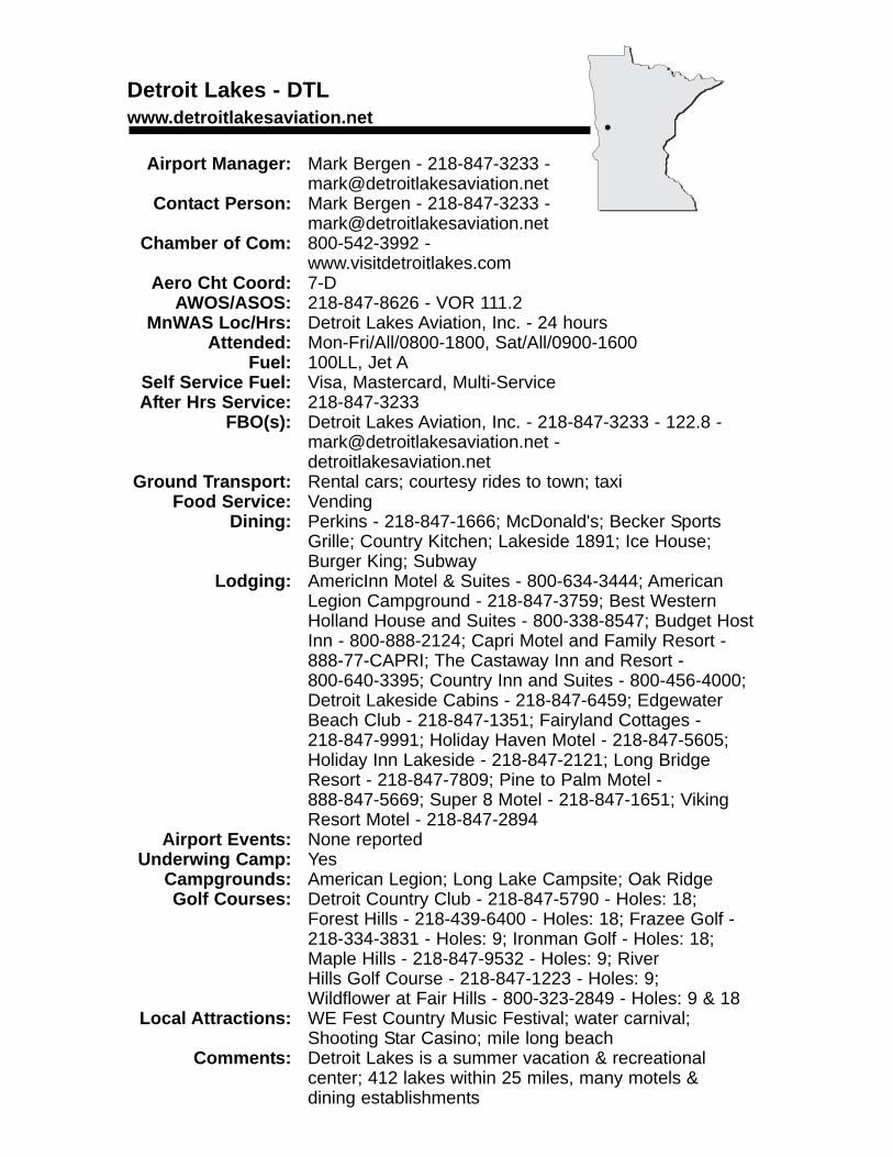
Detroit Lakes - DTLwww.detroitlakesaviation.net
Airport Manager: Mark Bergen - 218-847-3233 - [email protected]
Contact Person: Mark Bergen - 218-847-3233 - [email protected]
Chamber of Com: 800-542-3992 -www.visitdetroitlakes.com
Aero Cht Coord: 7-DAWOS/ASOS: 218-847-8626 - VOR 111.2
MnWAS Loc/Hrs: Detroit Lakes Aviation, Inc. - 24 hoursAttended: Mon-Fri/All/0800-1800, Sat/All/0900-1600
Fuel: 100LL, Jet ASelf Service Fuel: Visa, Mastercard, Multi-ServiceAfter Hrs Service: 218-847-3233
FBO(s): Detroit Lakes Aviation, Inc. - 218-847-3233 - 122.8 - [email protected] -detroitlakesaviation.net
Ground Transport: Rental cars; courtesy rides to town; taxiFood Service: Vending
Dining: Perkins - 218-847-1666; McDonald's; Becker Sports Grille; Country Kitchen; Lakeside 1891; Ice House; Burger King; Subway
Lodging: AmericInn Motel & Suites - 800-634-3444; AmericanLegion Campground - 218-847-3759; Best Western Holland House and Suites - 800-338-8547; Budget Host Inn - 800-888-2124; Capri Motel and Family Resort - 888-77-CAPRI; The Castaway Inn and Resort - 800-640-3395; Country Inn and Suites - 800-456-4000; Detroit Lakeside Cabins - 218-847-6459; Edgewater Beach Club - 218-847-1351; Fairyland Cottages - 218-847-9991; Holiday Haven Motel - 218-847-5605; Holiday Inn Lakeside - 218-847-2121; Long Bridge Resort - 218-847-7809; Pine to Palm Motel - 888-847-5669; Super 8 Motel - 218-847-1651; Viking Resort Motel - 218-847-2894
Airport Events: None reportedUnderwing Camp: Yes
Campgrounds: American Legion; Long Lake Campsite; Oak RidgeGolf Courses: Detroit Country Club - 218-847-5790 - Holes: 18;
Forest Hills - 218-439-6400 - Holes: 18; Frazee Golf - 218-334-3831 - Holes: 9; Ironman Golf - Holes: 18; Maple Hills - 218-847-9532 - Holes: 9; River Hills Golf Course - 218-847-1223 - Holes: 9; Wildflower at Fair Hills - 800-323-2849 - Holes: 9 & 18
Local Attractions: WE Fest Country Music Festival; water carnival; Shooting Star Casino; mile long beach
Comments: Detroit Lakes is a summer vacation & recreational center; 412 lakes within 25 miles, many motels & dining establishments
•
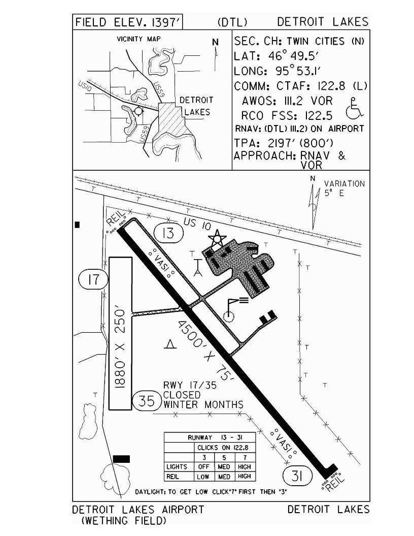
FIELD ELEV. 1397' <DTU DETROIT LAKES
VICINITY MAP N SEC. CH: TWIN CITIES (N)
>5)-/ ~ LAT: 46° 49.5'IL£\~ I LONG: 95°53.1'
COMM: CT AF: 122.8 (UAWOS: 111.2 VORRCO FSS: 122.5
RNAV: <DTU 111.2> ON AIRPORT
TPA: 2197' (800')APPROACH: RNAV &
VOR
T
T
N VARIATION5° E
T
T
DETROIT LAKES
3 5 7
CLICKS ON 122,8
RUNWAY 13 - 31
LIGHTS OFF MED HIGH
REIL LOW MED HIGH
DAYLIGHT: TO GET LOW CLlCK"7' FIRST THEN "3'
~A 00_
+~-
RWY 17/35,-...... CLOSED
WINTER MONTHS
"-
oOJOJ
"-
o ~=z:::z=L.f)
N
X
T
r
•
DETROIT LAKES AIRPORT(WETHING FIELD>
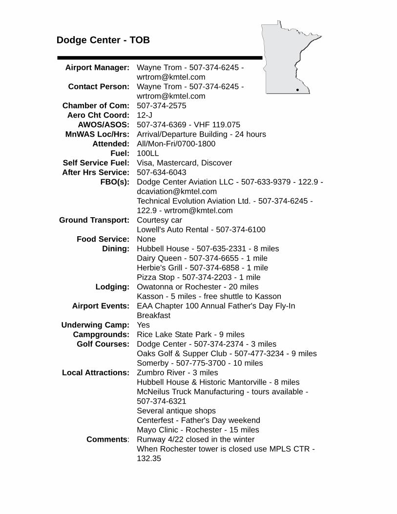
Dodge Center - TOB
Airport Manager: Wayne Trom - 507-374-6245 - [email protected]
Contact Person: Wayne Trom - 507-374-6245 - [email protected]
Chamber of Com: 507-374-2575Aero Cht Coord: 12-J
AWOS/ASOS: 507-374-6369 - VHF 119.075MnWAS Loc/Hrs: Arrival/Departure Building - 24 hours
Attended: All/Mon-Fri/0700-1800Fuel: 100LL
Self Service Fuel: Visa, Mastercard, DiscoverAfter Hrs Service: 507-634-6043
FBO(s): Dodge Center Aviation LLC - 507-633-9379 - 122.9 - [email protected] Evolution Aviation Ltd. - 507-374-6245 - 122.9 - [email protected]
Ground Transport: Courtesy carLowell's Auto Rental - 507-374-6100
Food Service: NoneDining: Hubbell House - 507-635-2331 - 8 miles
Dairy Queen - 507-374-6655 - 1 mileHerbie's Grill - 507-374-6858 - 1 milePizza Stop - 507-374-2203 - 1 mile
Lodging: Owatonna or Rochester - 20 milesKasson - 5 miles - free shuttle to Kasson
Airport Events: EAA Chapter 100 Annual Father's Day Fly-In Breakfast
Underwing Camp: YesCampgrounds: Rice Lake State Park - 9 milesGolf Courses: Dodge Center - 507-374-2374 - 3 miles
Oaks Golf & Supper Club - 507-477-3234 - 9 milesSomerby - 507-775-3700 - 10 miles
Local Attractions: Zumbro River - 3 milesHubbell House & Historic Mantorville - 8 milesMcNeilus Truck Manufacturing - tours available - 507-374-6321Several antique shopsCenterfest - Father's Day weekendMayo Clinic - Rochester - 15 miles
Comments: Runway 4/22 closed in the winterWhen Rochester tower is closed use MPLS CTR -132.35
•
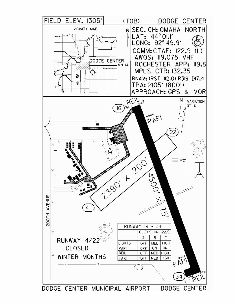
FIELD ELEV. 1305'VICINITY MAP
•
x
~IZxW>«IIaaN
(TOB) DODGE CENTERN SEC. CH: OMAHA NORTH~ LAT: 44°01.1' r1?\I LONG: 92° 49.9' \Q!
COMM: CT AF: 122.9 (l)AWOS: 119.075 VHFROCHES TER APP: 119.8MPL S CTR: 132.35
RNAV: <RST 112.0) R319 017.4TPA: 2105' (800')APPROACH:GPS & VOR
RUNWAY 16 - 34CLICKS ON 122.9
3 5 7
LIGHTS OFF MED HIGH
PAPI OFF ON ONREIL OFF MED HIGH
TAXI OFF MED HIGH
DODGE CENTER MUNICIPAL AIRPORT

Duluth - DLHwww.duluthairport.com
Airport Manager: Brian Ryks - 218-727-2968 - [email protected]
Contact Person: Brian Ryks - 218-727-2968 - [email protected]
Chamber of Com: 218-722-5501 - www.duluthchamber.com
Aero Cht Coord: 7-KAWOS/ASOS: 218-723-8340
MnWAS Loc/Hrs: 148th Fighter Group in the Command Post - 24 hoursDuluth Airport Authority - Mon-Fri, 8:00 A.M.-4:30 P.M.Lake Superior State College - business hoursMonaco Air Duluth, LLC - same as attendance schedule
Attended: All/All/0500-2230Fuel: 100LL, Jet A
Self Service Fuel: NoAfter Hrs Service: 218-727-2911
FBO(s): Monaco Air Duluth, LLC - 218-727-2911 - 122.95 - [email protected] - www.monacoairduluth.comWoodland Aviation - 218-878-1230 - www.woodland-aviation.com
Ground Transport: Taxi; rentalsFood Service: Self-serve fast food; vending machines; coffee shop;
The Afterburner - 218-727-1152Dining: None
Lodging: Country Inn & Suites Duluth (North) - 218-245-1406 ortoll-free - 866-381-1406Econolodge Airport - 218-722-5522 - 1 mileFairfield Inn - 218-723-8607
Airport Events: NoneUnderwing Camp: No
Campgrounds: Camping Available at Island Lake - 17 miles - call Island Lake Inn - 218-721-4604Indian Point - 218-624-5637Duluth Trailer Camp - 218-525-1350
Golf Courses: Enger Golf Course - 218-723-3451; Lester - 218-525-0828; Ridgeview - 218-728-5128; Northland
Local Attractions: Lake Superior; Canal Park; Miller Mall; Train Museum; William Irvin Ore Boat
Comments: RWY 9 110.3 IDLH LOM 379 DL, RWY 27 108.7 IJUDDuluth Convention & Visitor's Bureau - 218-722-4011National Weather Service - 218-729-6697U.S. Customs - 218-720-5203/5201/5220Scheduled Air ServiceDuluth Airport Authority - www.duluthairport.com - [email protected] Duluth approach is closed use MPLS CTR - 127.9
•
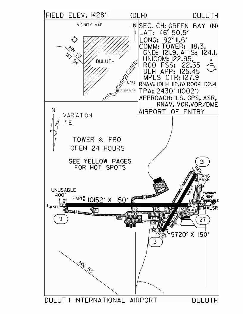
FIELD ELEV. 1428' (DLH) DULUTHVICINITY MAP
VARIATION1° E
N
N SEC. CH: GREEN SAY (N)~ LAT: 460 50.5'
/& I LONG: 920 11.6'//$j; COMM: TOWER: 118.3,
/:;/ GND: 121.9, ATIS: 124.1,DULUTH UNICOM: 122.95, e..
~ RCO FSS: 122.35 (~
~m DLH APP: 125.45 \J:!;j// MPLS CTR: 127.9
LAKE RNAV: <DLH 112.6) R004 D2.4SUPERIOR TPA: 2430' (1002')
1- ----"-' ---lAPPROACH: ILS, GPS, ASR,RNAV, VOR,VOR/DME
AIRPORT OF ENTRY
UNUSABLE400'
PAPI ~ 10152' X 150'
AIA
TOWER & FBOOPEN 24 HOURS
SEE YELLOW PAGESFOR HOT SPOTS
ALSFII 0
DULUTH INTERNATIONAL AIRPORT DULUTH

Duluth - DYTwww.duluthairport.com\skyharbor
Airport Manager: Joe Gallmeier - 218-391-8073 - [email protected]
Contact Person: Joe Gallmeier - 218-391-8073 - [email protected]
Chamber of Com: 218-722-5501 - www.duluthchamber.com
Aero Cht Coord: 7-KAWOS/ASOS: 218-720-4886 - VHF 119.275
MnWAS Loc/Hrs: Duluth Airport Authority - 24 hoursAttended: May-Oct/All/Sunrise-Sunset, Nov-Apr/All/0800-1600
Fuel: 100LLSelf Service Fuel: Visa, Mastercard, Multi-ServiceAfter Hrs Service: 218-720-4886
FBO(s): Duluth Airport Authority - 218-733-0078 Ground Transport: Taxis available
Food Service: Soft drink vending machinesDining: Grandma's Saloon & Deli - 218-727-4192 - 5 miles;
Red Lobster - 218-722-7390 - 5 miles; Timberlodge - 218-722-2624 - 5 miles; Old Chicago - 218-720-2966 - 5 miles; Little Angie's Cantina & Grill - 5 miles
Lodging: Comfort Suites - 218-727-1378 - 5 milesCanal Park Inn - 218-727-8821 - 5 milesHampton Inn - 218-720-3000 - 5 milesHawthorn Suites - 218-727-4663 - 5 milesThe Inn on Lake Superior - 888-On-The-Lake - 5 miles
Airport Events: Ski-Plane/Wheel-Plane Fly-In - first Saturday in MarchUnderwing Camp: Yes
Campgrounds: Adjacent to airportGolf Courses: Enger Golf Course - 218-723-3451 - 7 miles
Local Attractions: Lake Superior; Canal Park; Grandma's Sports Garden;Nature trail to Superior Ship Canal; Spirit Mountain; Great Lakes Aquarium; Lake Superior Zoo
Comments: National Weather Service - 218-729-6697U.S. Customs - 218-720-5203Duluth Airport Authority web site - www.duluthairport.com & e-mail - [email protected] of EntryWhen Duluth approach is closed use MPLS CTR - 127.9
•
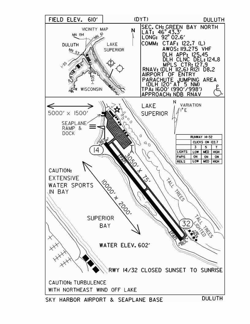
FIELD ELEv. 610' <DYT) DULUTH
ClICKS ON 122.7
357
ON ON ON
LOW !olEO HIGH
LOW !olEO HIGH
RUNWAY 14-32
NVARIATION1° E
LAKESUPERIOR
N SEC. CH: GREEN BAY NORTHLAT: 460 43.3'
~ LONG: 920 02.6'I COMM: CT AF: 122.7 <l)
AWOS: 119.275 VHFDLH APP: 125.45DLH CLNC DEL: 124.8MPLS CTR: 127.9
RNAV: <DLH 112.6) RI21 08.2AIRPORT OF ENTRYPARACHUTE JUMPING AREA
<DLH 120· AT 5 NM)TPA: 1600' <990'/998') (~APPROACH: NOB RNAV ~
RWY 14/32 CLOSED SUNSET TO SUNRISE
LAKESUPERIOR
WATER ELEV. 602'
SUPERIORBAY
VICINITY MAPMN 194 ~~ '0\
CAUTION:EXTENSIVEWATER SPORTSIN BAY
CAUTION: TURBULENCEWITH NORTHEAST WIND OFF LAKE
SKY HARBOR AIRPORT &. SEAPLANE BASE DULUTH
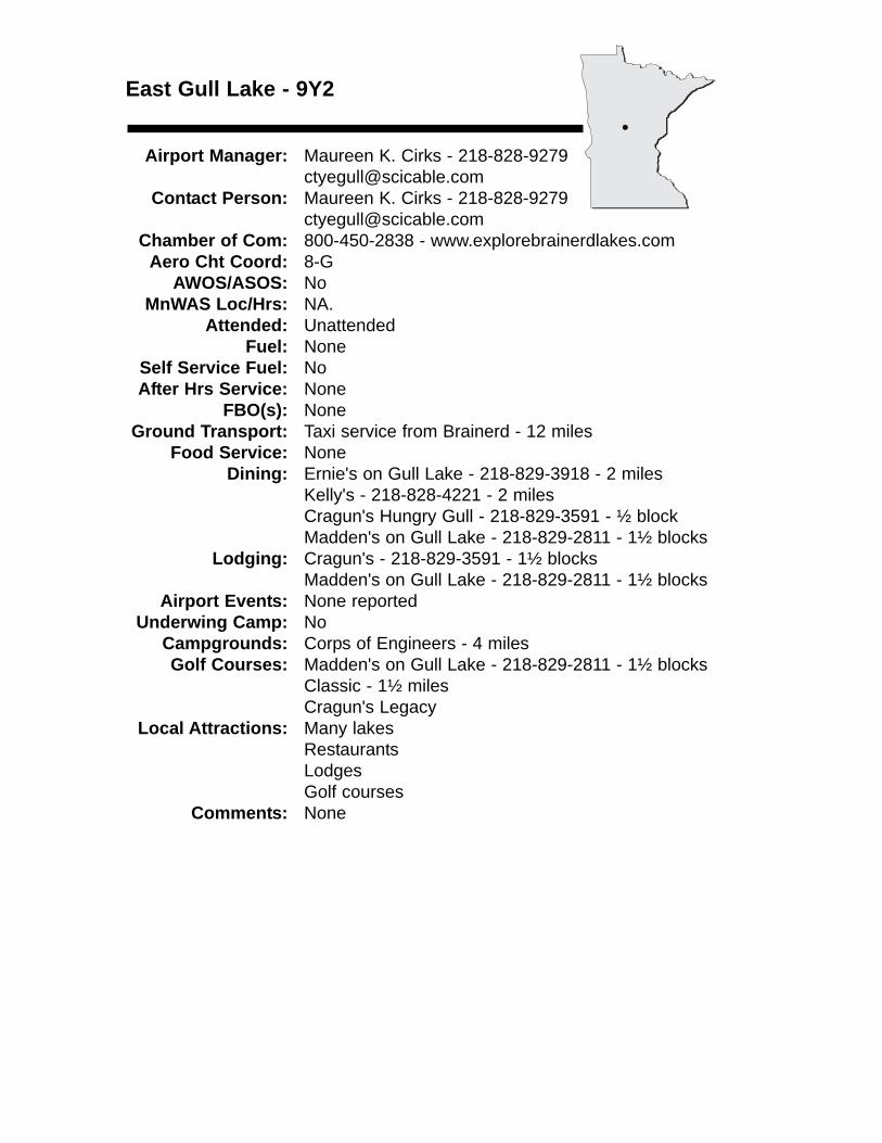
East Gull Lake - 9Y2
Airport Manager: Maureen K. Cirks - [email protected]
Contact Person: Maureen K. Cirks - [email protected]
Chamber of Com: 800-450-2838 - www.explorebrainerdlakes.comAero Cht Coord: 8-G
AWOS/ASOS: No MnWAS Loc/Hrs: NA.
Attended: UnattendedFuel: None
Self Service Fuel: NoAfter Hrs Service: None
FBO(s): NoneGround Transport: Taxi service from Brainerd - 12 miles
Food Service: NoneDining: Ernie's on Gull Lake - 218-829-3918 - 2 miles
Kelly's - 218-828-4221 - 2 milesCragun's Hungry Gull - 218-829-3591 - ½ blockMadden's on Gull Lake - 218-829-2811 - 1½ blocks
Lodging: Cragun's - 218-829-3591 - 1½ blocksMadden's on Gull Lake - 218-829-2811 - 1½ blocks
Airport Events: None reportedUnderwing Camp: No
Campgrounds: Corps of Engineers - 4 milesGolf Courses: Madden's on Gull Lake - 218-829-2811 - 1½ blocks
Classic - 1½ milesCragun's Legacy
Local Attractions: Many lakesRestaurantsLodgesGolf courses
Comments: None
•
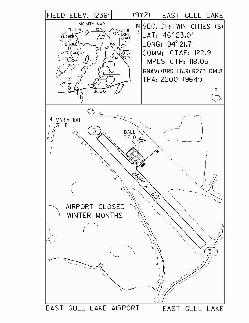
FIELD ELEV. 1236' (9Y2) EAST GULL LAKE
EAST GULL LAKE
raD
N SEC. CH: TWIN CITIES (S)~ LAT: 46° 23.0'
LONG: 94° 21.7'COMM: CT AF: 122.9
MPLS CTR: 118.05RNAV: <BRO 116.9) R273 014.8
TPA: 2200' (964')
AIRPORT CLOSEDWINTER MONTHS
('
(
N VARIATION3' E
EAS T GULL LAKE AIRPORT
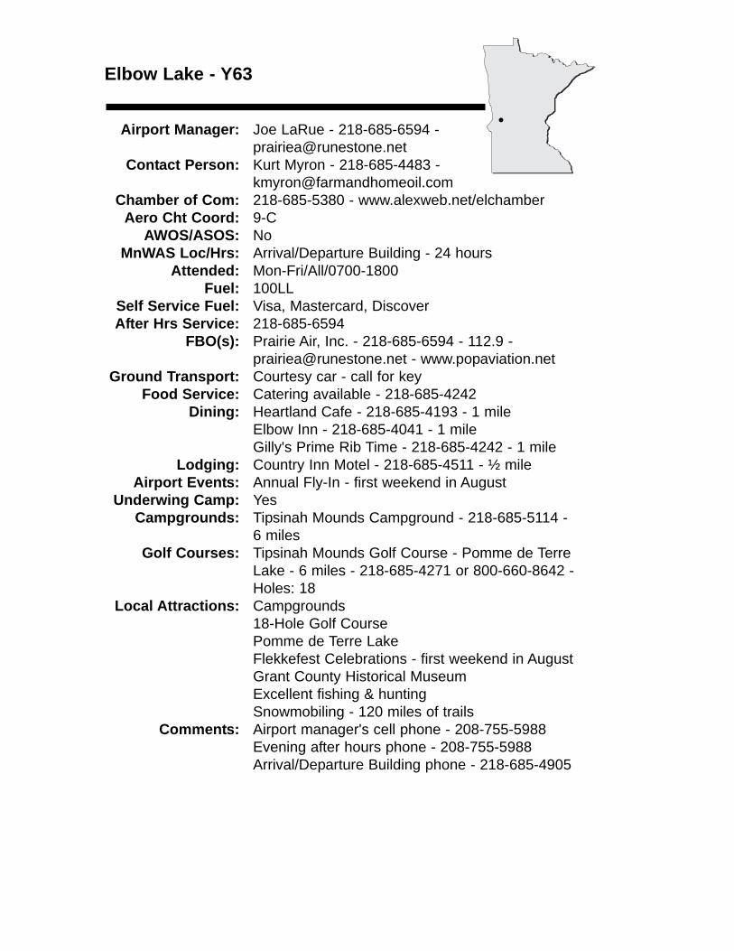
Elbow Lake - Y63
Airport Manager: Joe LaRue - 218-685-6594 - [email protected]
Contact Person: Kurt Myron - 218-685-4483 - [email protected]
Chamber of Com: 218-685-5380 - www.alexweb.net/elchamberAero Cht Coord: 9-C
AWOS/ASOS: NoMnWAS Loc/Hrs: Arrival/Departure Building - 24 hours
Attended: Mon-Fri/All/0700-1800Fuel: 100LL
Self Service Fuel: Visa, Mastercard, DiscoverAfter Hrs Service: 218-685-6594
FBO(s): Prairie Air, Inc. - 218-685-6594 - 112.9 - [email protected] - www.popaviation.net
Ground Transport: Courtesy car - call for keyFood Service: Catering available - 218-685-4242
Dining: Heartland Cafe - 218-685-4193 - 1 mileElbow Inn - 218-685-4041 - 1 mileGilly's Prime Rib Time - 218-685-4242 - 1 mile
Lodging: Country Inn Motel - 218-685-4511 - ½ mileAirport Events: Annual Fly-In - first weekend in August
Underwing Camp: YesCampgrounds: Tipsinah Mounds Campground - 218-685-5114 -
6 milesGolf Courses: Tipsinah Mounds Golf Course - Pomme de Terre
Lake - 6 miles - 218-685-4271 or 800-660-8642 - Holes: 18
Local Attractions: Campgrounds18-Hole Golf CoursePomme de Terre LakeFlekkefest Celebrations - first weekend in AugustGrant County Historical MuseumExcellent fishing & huntingSnowmobiling - 120 miles of trails
Comments: Airport manager's cell phone - 208-755-5988Evening after hours phone - 208-755-5988Arrival/Departure Building phone - 218-685-4905
•
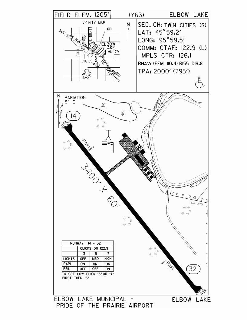
FIELD ELEV. 1205' (Y63) ELBOW LAKEVICINITY MAP
N SEC. CH: TWIN CITIES <S>~ LAT: 45°59.2'
LONG: 95°59.5'COMM: CTAF: 122.9 (l)
MPLS CTR: 126.1RNAV: (FFM 110.4) RI55 DI9,8
TPA: 2000' <795')
ELBOW LAKE MUNICIPAL -PRIDE OF THE PRAIRIE AIRPORT
ELBOW LAKE
¥~
':::-' III
-1// \\\
l11/ \\\ =1
J'>00_
+6'0_
0111-
/;/ \\\
TO GET LOW CLICK '5' OR '7'FIRST THEN "3"
RUNWAY 14 - 32
CLICKS ON 122,9
3 5 7
LIGHTS OFF MED HIGH
PAPI ON ON ONREIL OFF OFF ON
N
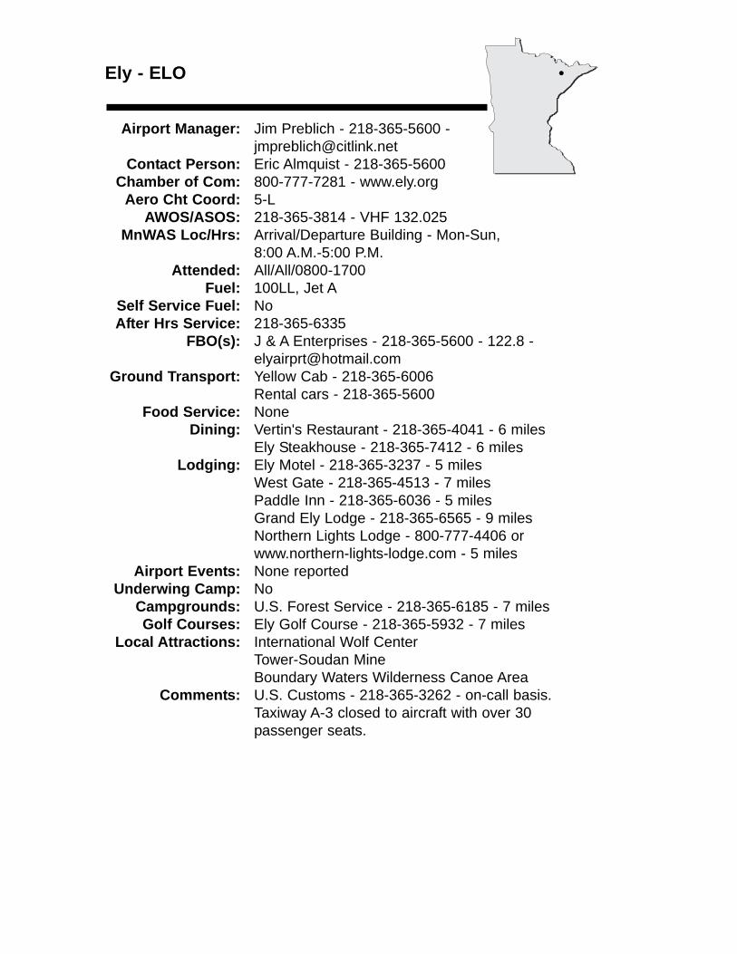
Ely - ELO
Airport Manager: Jim Preblich - 218-365-5600 - [email protected]
Contact Person: Eric Almquist - 218-365-5600Chamber of Com: 800-777-7281 - www.ely.org
Aero Cht Coord: 5-LAWOS/ASOS: 218-365-3814 - VHF 132.025
MnWAS Loc/Hrs: Arrival/Departure Building - Mon-Sun,8:00 A.M.-5:00 P.M.
Attended: All/All/0800-1700Fuel: 100LL, Jet A
Self Service Fuel: NoAfter Hrs Service: 218-365-6335
FBO(s): J & A Enterprises - 218-365-5600 - 122.8 - [email protected]
Ground Transport: Yellow Cab - 218-365-6006Rental cars - 218-365-5600
Food Service: NoneDining: Vertin's Restaurant - 218-365-4041 - 6 miles
Ely Steakhouse - 218-365-7412 - 6 milesLodging: Ely Motel - 218-365-3237 - 5 miles
West Gate - 218-365-4513 - 7 milesPaddle Inn - 218-365-6036 - 5 milesGrand Ely Lodge - 218-365-6565 - 9 milesNorthern Lights Lodge - 800-777-4406 or www.northern-lights-lodge.com - 5 miles
Airport Events: None reportedUnderwing Camp: No
Campgrounds: U.S. Forest Service - 218-365-6185 - 7 milesGolf Courses: Ely Golf Course - 218-365-5932 - 7 miles
Local Attractions: International Wolf CenterTower-Soudan MineBoundary Waters Wilderness Canoe Area
Comments: U.S. Customs - 218-365-3262 - on-call basis.Taxiway A-3 closed to aircraft with over 30passenger seats.
•
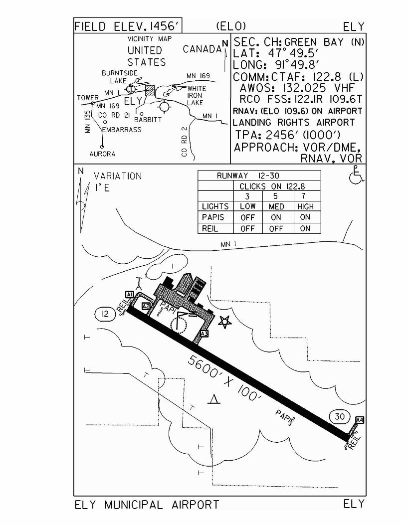
FIELD ELEV. 1456' (ELO) EL Y
o0::
ou
VICINITY MAP CANADA~ cf~; C4H7oG~§~~, BAY (N)
I LONG: 91 0 49.8'MN 169 COMM: CT AF: 122.8 (l)
~_~------~WHITE AWOS: 132.025 VHF~R2K~ RCO FSS: 122.IR 109.6T
MN I RNAV: <ELO 109.6> ON AIRPORTLANDING RIGHTS AIRPORTTPA: 2456' (1000')APPROACH: VOR/DME.
RNAV VORAURORA
N VARIATION1° E
RUNWAY 12-30CLICKS ON 122.8
3 5 7LIGHTS LOW MED HIGHPAPIS OFF ON ON
REIL OFF OFF ON
MN \
I--
;;;
._.._.. _.. _.. _.. - .. _.. _.. _.. _.. _.._.._.._.._.._.._.. j
._..-.._..-.._..~ .._.. _.. _.. _.. _.. _..-
I--
----~-~------ ----------- ------,
EL Y MUNICIPAL AIRPORT ELY
Eveleth - EVM
Airport Manager: Gary Ulman - 218-744-6175 - [email protected]
Contact Person: Gary Ulman - 218-744-1428 - [email protected]
Chamber of Com: 218-744-1940 - www.evelethmn.comAero Cht Coord: 6-K
AWOS/ASOS: 218-744-2369 - VOR 108.2MnWAS Loc/Hrs: Arrival/Departure Building - same as attendance
scheduleAttended: All/M-F/0800-1900, All/Sat/0800-1800,
All/Sun/0900-1700Fuel: 100LL, Jet A
Self Service Fuel: NoAfter Hrs Service: 218-258-3639
FBO(s): Taconite Aviation, Inc. - 218-744-1428 - 122.7 - [email protected]
Ground Transport: C & M Taxi - 218-749-4000Second Avenue Auto - 218-749-6883
Food Service: Vending machineDining: K & B Restaurant - 218-744-2772 - 2 miles
Subway - 218-744-2673 - 3 milesVillage Inn - 218-749-8289 - 9 miles
Lodging: Koke's Motel - 218-744-4500 - 3 milesSuper 8 Motel - 218-744-1661 - 3 milesAmericInn Motel - 218-741-7839 - 10 miles
Airport Events: None reportedUnderwing Camp: Yes
Campgrounds: Ely Lake Campground - ½ mileBiwabik Campground - 20 milesGilbert Sherwood Forest Campground - 7 miles
Golf Courses: Eveleth - 2 miles - Holes: 9Giants Ridge - 25 miles - Holes: 18Virginia - 12 miles - Holes: 18
Local Attractions: Hockey Hall of FameGiants Ridge Ski AreaMine Views & Tours
Comments: When Duluth approach is closed use MPLSCTR - 127.9
•

FIELD ELEV. 1378' (EVM) EVELETH-VIRGINIA
N SEC. CH: GREEN SAY (N)~ LAT: 4r25.5'I LONG: 92° 29.9'
COMM: CT AF: 122.7 (UAWOS: 108.2 VORRCO FSS: 122.45 (~DLH APP: 125.45 VMPLS CTR: 127.9
RNAV: (EVM 108.2) AT FIELDTPA: 2380' (1002')APPROACH:VOR/OME,
GPS & VOR
VICINITY MAP
ELY LAKECR97
>LfL-':J>-'I:'\Y' /P---~ ELY LAKE DR.r:,,,?-o,<o
N
VARIATION10 E
••.-__x-x--x--
RUNWAY 9 - 27
CLICKS ON 122.7
3 5 7
LIGHTS LOW MED HIGH
REIL LOW MED HIGH
PAPI ON ON ON
RUNWA Y 14 - 32
CLICKS ON 122.7
357LIGHTS LOW MED HIGH
EVELETH-VIRGINIA MUNICIPAL AIRPORT EVELETH-VIRGINIA
Fairmont - FRMwww.fivelakesaviation.com
Airport Manager: Al Pelzer - 507-235-2537 - [email protected]
Contact Person: Al Pelzer - 507-235-2537 - [email protected]
Chamber of Com: 507-235-5547 - www.fairmont.orgAero Cht Coord: 13-G
AWOS/ASOS: 507-238-1562 - VOR 110.2MnWAS Loc/Hrs: Arrival/Departure Building - 24 hours
Attended: All/Mon-Sat/0800-1700, All/Sun/1230-1600Fuel: 100LL, Jet A
Self Service Fuel: Visa, MastercardAfter Hrs Service: 507-238-9216
FBO(s): Five Lakes Aviation, Inc. - 507-235-2537 - 122.8 - [email protected] - www.fivelakesaviation.com
Ground Transport: Taxi - 507-235-5558 or 507-235-5559Car rentals - 507-238-4686Courtesy car
Food Service: Vending machinesDining: Kentucky Fried Chicken - 507-238-4116 - 1 mile
Ranch - 507-235-3044 - 2 milesPerkins - 507-238-4500 - 2 milesTorge's - 507-238-4771 - 2 milesChannel Inn - 507-238-9700 - 2 milesSirloin House - 507-235-3856
Lodging: Comfort Inn - 507-238-5444 - 3 milesHoliday Inn - 507-238-4771 - 3 milesBudget Inn - 507-235-3373 - 2½ milesSuper 8 Motel - 507-238-9444 - 3 milesHall Lake Cabins - 507-235-9785Highland Court Motel - 507-235-6686
Airport Events: Lion's Sponsored Fly-In Breakfast - fourth Sunday inJune
Underwing Camp: YesCampgrounds: Dawson's - 507-235-5753 - 12 miles
Flying Goose - 507-235-3458 - 2 milesGolf Courses: Rose Lake - 507-235-5274
Interlaken - 507-235-5143Local Attractions: Five lakes in town; golf courses; opera house;
Historical Society Museum; Heritage Acres; Agriculture Interpretive Center; Aquatic Park; beaches; fishing
Comments: Overnight hangar space available for most aircraftWireless Internet service
•
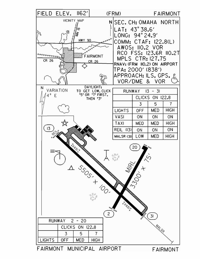
FIELD ELEV. 1162' (FRM) FAIRMONT
OFF MED HIGHLIGHTS
DAYLIGHT:TO GET LOW. CLICK RUNWA Y 13 - 31
'S' OR '7' FIRS T, I-----~~-----___lTHEN '3' CLICKS ON 122.8
3 5 7
VICINITY MAP
CR 26
aN VARIATION
4 0 E
N SEC. CH: OMAHA NORTH~ LAT: Ll3°38.6'I LONG: 9Llo 2Ll.9'
I+-~-"'¥--t+~~-:--:;~_COMM: CTAF: 122.8(l)AWOS: 110.2 VORRCO FSS: 123.6R 110.2MPLS CTR: 127.75
>:I'""'""'"~~'-lL----lRNAV:(FRM 110.2) ON AIRPORT
TPA: 2000' (838')APPROACH: ILS. GPS. (~
VOR/DME & VOR V
VASI ON ON ON
MALSR <3D LOW MED HIGH
RUNWAY 2 - 20
TAXI
REIL (13)
MED MED HIGH
ON ON ON
CLICKS ON 122.8
357LIGHTS OFF MED HIGH
FAIRMONT MUNICIPAL AIRPORT FAIRMONT
Faribault - FBL
Airport Manager: Gerald Serres - 507-332-0140 - [email protected]
Contact Person: Gerald Serres - 507-332-0140 - [email protected]
Chamber of Com: 800-658-2354 - www.faribaultmn.orgAero Cht Coord: 12-I
AWOS/ASOS: 507-332-2505 - VOR 111.2MnWAS Loc/Hrs: Arrival/Departure Building - 24 hours
Attended: May-Sep/All/0800-1900, Oct-Apr/All/0800-1700Fuel: 100LL, Jet A
Self Service Fuel: Visa, MastercardAfter Hrs Service: 507-838-7152
FBO(s): Quality Aviation, Inc. - 507-332-0140 - [email protected] - www.planequality.com
Ground Transport: TaxiCar rental
Food Service: Vending machinesDining: AmericInn & Suites - 800-634-3444 - ½ mile
Microtel Inn & Suites - 888-771-7171 - ½ mileLodging: Super 8 Motel - 507-334-1634 - ½ mile
Airport Events: Airfest/Balloon Rally - SeptemberUnderwing Camp: Yes
Campgrounds: Camp Faribo - 507-332-8453LeMieux Resort - 507-334-5334Robert's Lake Resort - 507-332-8978Shady Acres Resort - 507-334-6661
Golf Courses: Faribault Golf & Country ClubLocal Attractions: Self-Guided Historic Tour
Alexander Faribault HouseRice County MuseumFaribo Woolen Mill & Factory Store
Comments: Glider activity April-November
•
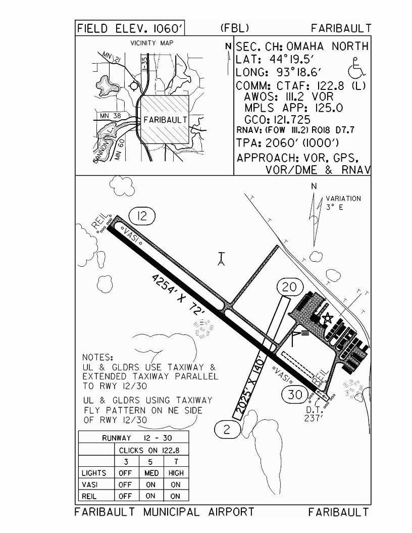
FIELD ELEV. 1060'VICINITY MAP
Qo
NOTES: (UL & GLDRS USE TAXIWAY &EXTENDED TAXIWAY PARALLELTO RWY 12/30
UL & GLDRS USING TAXIWAYFL Y PATTERN ON NE SIDEOF RWY 12/~
RUNWAY 12 - 30
CLICKS ON 122.8
3 5 7
LIGHTS OFF MED HIGH
VASI OFF ON ON
REIL OFF ON ON
(FBU FARIBAUL T
N SEC. CH: OMAHA NORTH~LAT: LjLjo19.5' E.I LONG: 93° 18.6' V
COMM: CT AF: 122.8 (UAWOS: 111.2 VORMPL S APP: 125.0GCO: 121.725
RNAV: <FOW 111.2) ROl8 07.7
TPA: 2060' (1000')APPROACH: VOR, GPS,
VOR/DME & RNAN
VARIATION3 0 E
FARIBAUL T MUNICIPAL AIRPORT FARIBAUL T
Fergus Falls - FFM
Airport Manager: Bryan Hauschild - 218-739-3733 Contact Person: Bryan Hauschild - 218-739-3733
Chamber of Com: 218-736-6951 - www.fergusfalls.com
Aero Cht Coord: 8-CAWOS/ASOS: 218-736-7216 - VOR 110.4
MnWAS Loc/Hrs: Arrival/Departure Building - business hoursAttended: All/Mon-Fri/0730-1900, All/Sat/0800-1200
Fuel: 100LL, Jet ASelf Service Fuel: Major credit cardsAfter Hrs Service: 218-739-3733
FBO(s): City of Fergus Falls - 218-739-3733 - 122.80 - www.fergusfalls.com
Ground Transport: Taxi service; car lease - 800-666-0952; courtesy car;Quality Auto - 218-739-3247
Food Service: By requestDining: Perkins - 218-739-2241 - 1½ miles
Applebee's - 1½ milesArby's - 1½ milesMcDonald's - 1½ milesPizza Ranch - 1½ milesKentucky Fried Chicken - 1½ milesDebbie's Kitchen - 1½ milesBig Harvest Buffet - 1½ milesMabel Murphy's - 1½ miles
Lodging: Super 8 Motel - 218-739-3261 - 1½ milesBest Western - 218-739-2211 - 1½ milesComfort Inn - 218-736-5787 - 1½ milesAmericInn Motel - 218-739-3900 - 1½ milesDays Inn - 218-739-3311 - 1½ milesMotel 7 - 218-736-2554 - 1½ miles
Airport Events: Annual Fly-In Pancake Breakfast during Summerfest -June
Underwing Camp: YesCampgrounds: 3 campgroundsGolf Courses: Pebble Lake Golf Course - Holes: 18
Local Attractions: Fergus Falls Museum; Otter Tail River Trail; parks &lakes; YMCA; library; FFCC bowling alley; health gyms
Comments: FAX - 218-739-2990Additional after hours phone - 320-760-6474
•
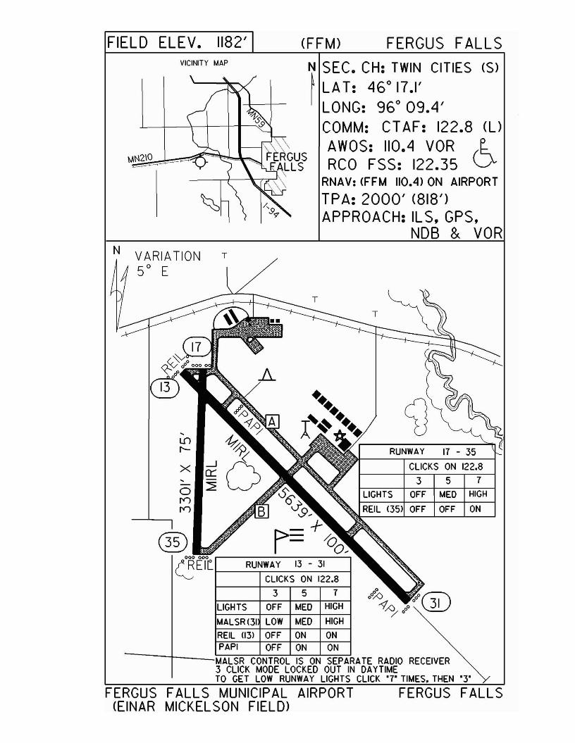
FIELD ELEV. 1182' (FFM) FERGUS FALLSVICINITY MAP
MN2\O
N SEC. CH: TWIN CITIES (S)~ LAT: 460 17.1'I LONG: 960 09.4'
COMM: CT AF: 122.8 (l)
AWOS: 110.4 VOR (~RCO FSS: 122.35 V
RNAV: <FFM 110.4) ON AIRPORT
TPA: 2000' (818')APPROACH: IL S. GPS.
NOB & VOR
3 5 7
CLICKS ON 122.8
RUNWAY 17 - 35
T
LIGHTS OFF MED HIGH
REIL (35) OFF OFF ON
ATE RADIO RECEIVERDAYTIME
TO GET LOW RUNWAY LIGHTS CLICK '7' TIMES. THEN '3'
(!!EYr RUNWAY 13 - 31
CLICKS ON 122.8
3 5 7
LIGHTS OFF MED HIGH
MALSR(31 LOW MED HIGH
REIL (13) OFF ON ONPAPI OFF ON ON
MALSR CONTROL IS ON SEPAR3 CLICK MODE LOCKED OUT IN
N VARIATION T
50 E
FERGUS FALLS MUNICIPAL AIRPORT FERGUS FALLS(EINAR MICKEL SON FIELD>
Fertile - D14
Airport Manager: Roger Raaen - 218-945-3136 - [email protected]
Contact Person: Sharon Edlund - 218-945-6516 Chamber of Com: 218-945-3136
Aero Cht Coord: 5-CAWOS/ASOS: No
MnWAS Loc/Hrs: NAAttended: Unattended
Fuel: 100LLSelf Service Fuel: NoAfter Hrs Service: 218-945-6332
FBO(s): NoneGround Transport: None
Food Service: NoneDining: Sand Hill Supper Club - 218-945-6806 - 1 mile
DeeVine Dining - 218-945-3663 - ½ mileEats & Antiques - 218-945-6134
Lodging: Sand Hill Motel - 218-945-6114 - 1 mileHillview Apartments - 218-356-8630
Airport Events: None reportedUnderwing Camp: Yes
Campgrounds: Fertile Nature Center - 218-945-3129Golf Courses: 218-945-3535
Local Attractions: Sand HillsPolk County FairAgassiz Environmental Learning Center - 218-945-3129
Comments: None
•
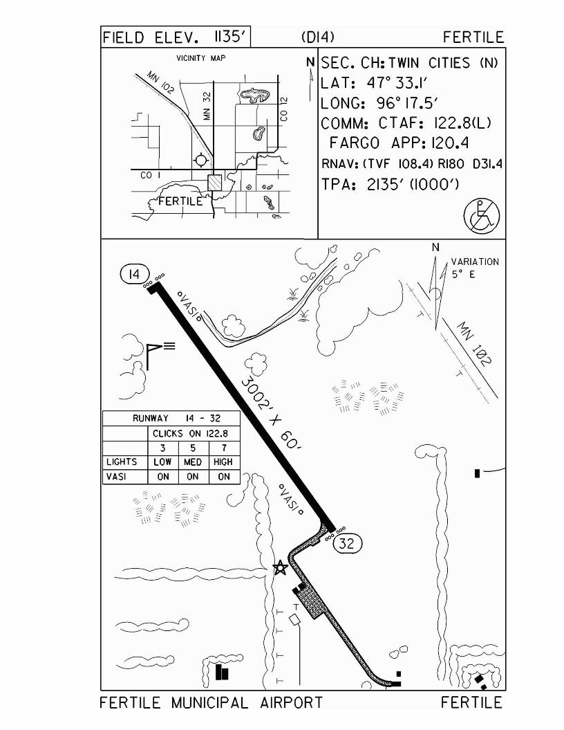
FIELD ELEV. 1135' (014) FERTILEVICINITY MAP N SEC. CH: TWIN CITIES (N)
~ LAT: 4r33.I'I LONG: 960 17.5'
COMM: CT AF: 122.8(l)FARGO APP: 120.4
RNAV: (TVF 108.4) RI80 031.4
TPA: 2135' (1000')
®VARIATION5° E
FERTILE
N
•I--
I--
I--
I--
3 5 7
CLICKS ON 122.8
RUNWAY 14 - 32
LIGHTS LOW MED HIGH
VASI ON ON
FERTILE MUNICIPAL AIRPORT
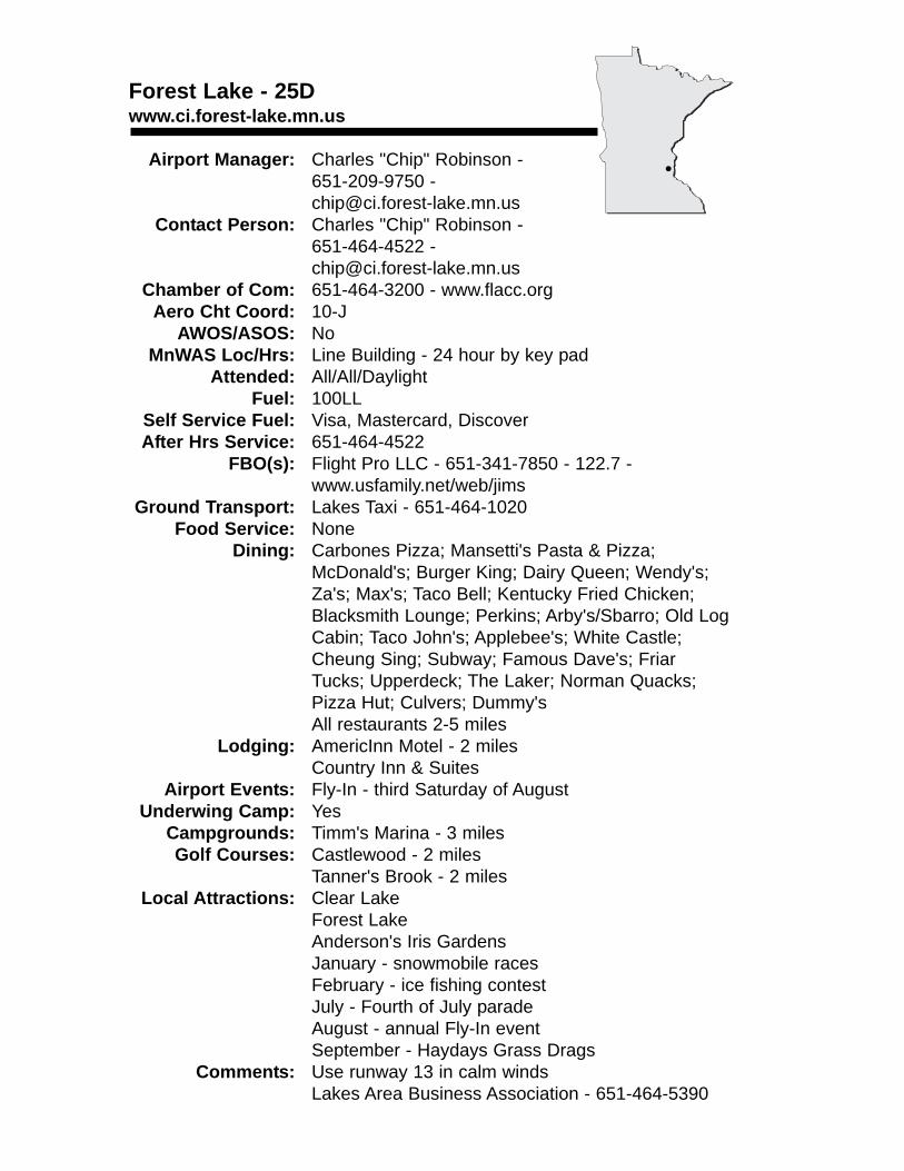
Forest Lake - 25Dwww.ci.forest-lake.mn.us
Airport Manager: Charles "Chip" Robinson - 651-209-9750 - [email protected]
Contact Person: Charles "Chip" Robinson - 651-464-4522 - [email protected]
Chamber of Com: 651-464-3200 - www.flacc.orgAero Cht Coord: 10-J
AWOS/ASOS: No MnWAS Loc/Hrs: Line Building - 24 hour by key pad
Attended: All/All/DaylightFuel: 100LL
Self Service Fuel: Visa, Mastercard, DiscoverAfter Hrs Service: 651-464-4522
FBO(s): Flight Pro LLC - 651-341-7850 - 122.7 - www.usfamily.net/web/jims
Ground Transport: Lakes Taxi - 651-464-1020Food Service: None
Dining: Carbones Pizza; Mansetti's Pasta & Pizza; McDonald's; Burger King; Dairy Queen; Wendy's; Za's; Max's; Taco Bell; Kentucky Fried Chicken; Blacksmith Lounge; Perkins; Arby's/Sbarro; Old Log Cabin; Taco John's; Applebee's; White Castle; Cheung Sing; Subway; Famous Dave's; Friar Tucks; Upperdeck; The Laker; Norman Quacks; Pizza Hut; Culvers; Dummy'sAll restaurants 2-5 miles
Lodging: AmericInn Motel - 2 milesCountry Inn & Suites
Airport Events: Fly-In - third Saturday of AugustUnderwing Camp: Yes
Campgrounds: Timm's Marina - 3 milesGolf Courses: Castlewood - 2 miles
Tanner's Brook - 2 milesLocal Attractions: Clear Lake
Forest LakeAnderson's Iris GardensJanuary - snowmobile racesFebruary - ice fishing contestJuly - Fourth of July paradeAugust - annual Fly-In eventSeptember - Haydays Grass Drags
Comments: Use runway 13 in calm windsLakes Area Business Association - 651-464-5390
•
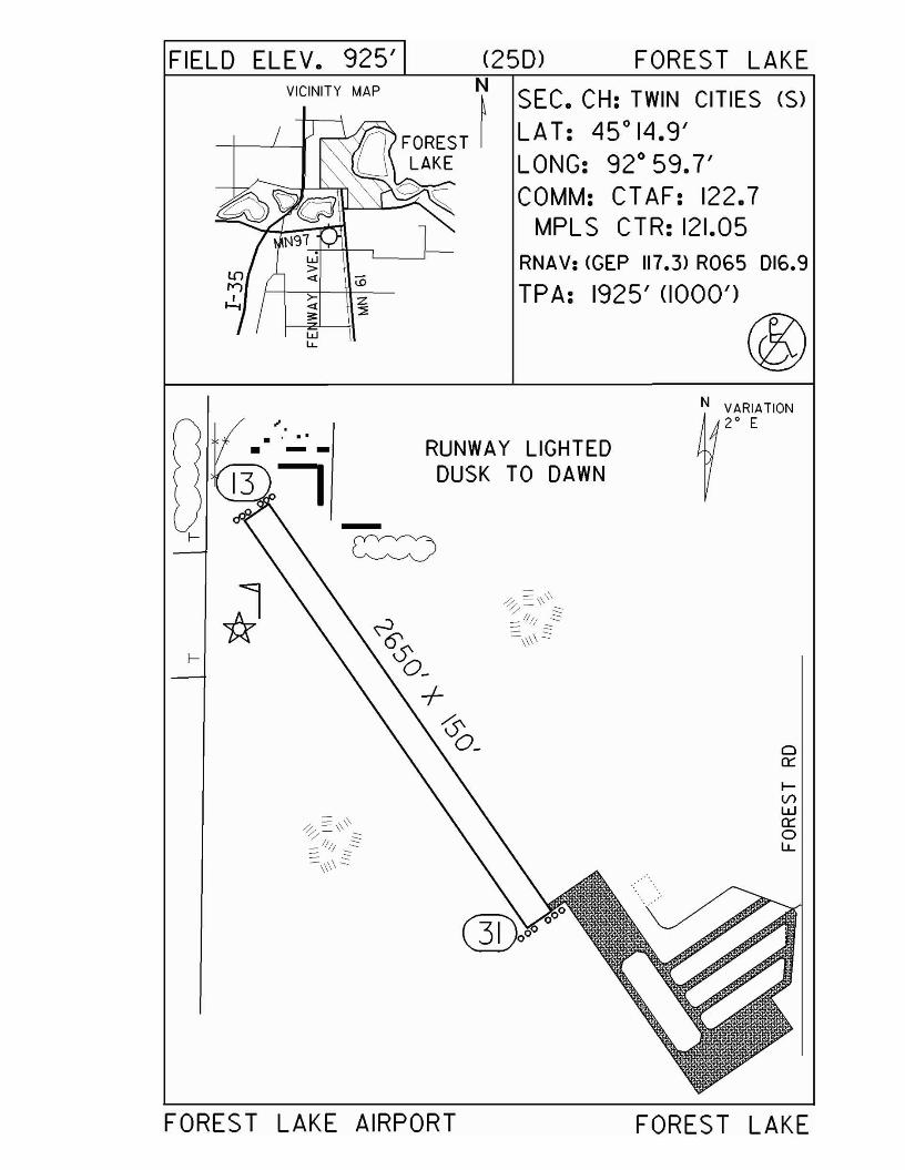
FIELD ELEV. 925' (25m FOREST LAKEVICINITY MAP ~
-+----.l-~ n FOREST I
U LAKEo~
Wl.L
SEC. CH: TWIN CITIES (S)LAT: 45°14.9'LONG: 92° 59.7'COMM: CTAF: 122.7
MPLS CTR: 121.05RNAV: <GEP 117.3> R06S 016.9
TPA: 1925' (1000')
@
I-
I-
". . ... ---
RUNWAY LIGHTEDDUSK TO DAWN
oa:::lV>Wa:::oI.L.
FOREST LAKE AIRPORT FOREST LAKE
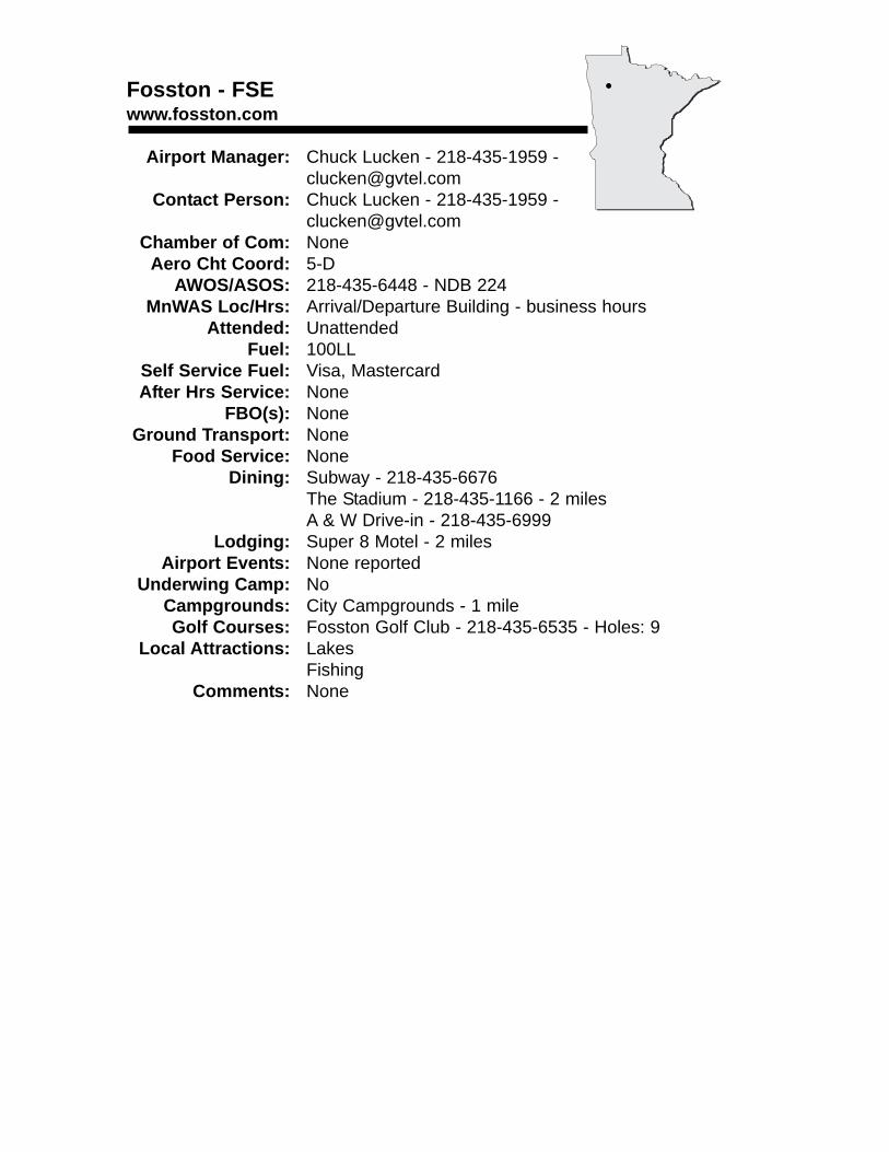
Fosston - FSEwww.fosston.com
Airport Manager: Chuck Lucken - 218-435-1959 [email protected]
Contact Person: Chuck Lucken - 218-435-1959 - [email protected]
Chamber of Com: NoneAero Cht Coord: 5-D
AWOS/ASOS: 218-435-6448 - NDB 224MnWAS Loc/Hrs: Arrival/Departure Building - business hours
Attended: UnattendedFuel: 100LL
Self Service Fuel: Visa, MastercardAfter Hrs Service: None
FBO(s): NoneGround Transport: None
Food Service: NoneDining: Subway - 218-435-6676
The Stadium - 218-435-1166 - 2 milesA & W Drive-in - 218-435-6999
Lodging: Super 8 Motel - 2 milesAirport Events: None reported
Underwing Camp: NoCampgrounds: City Campgrounds - 1 mileGolf Courses: Fosston Golf Club - 218-435-6535 - Holes: 9
Local Attractions: LakesFishing
Comments: None
•
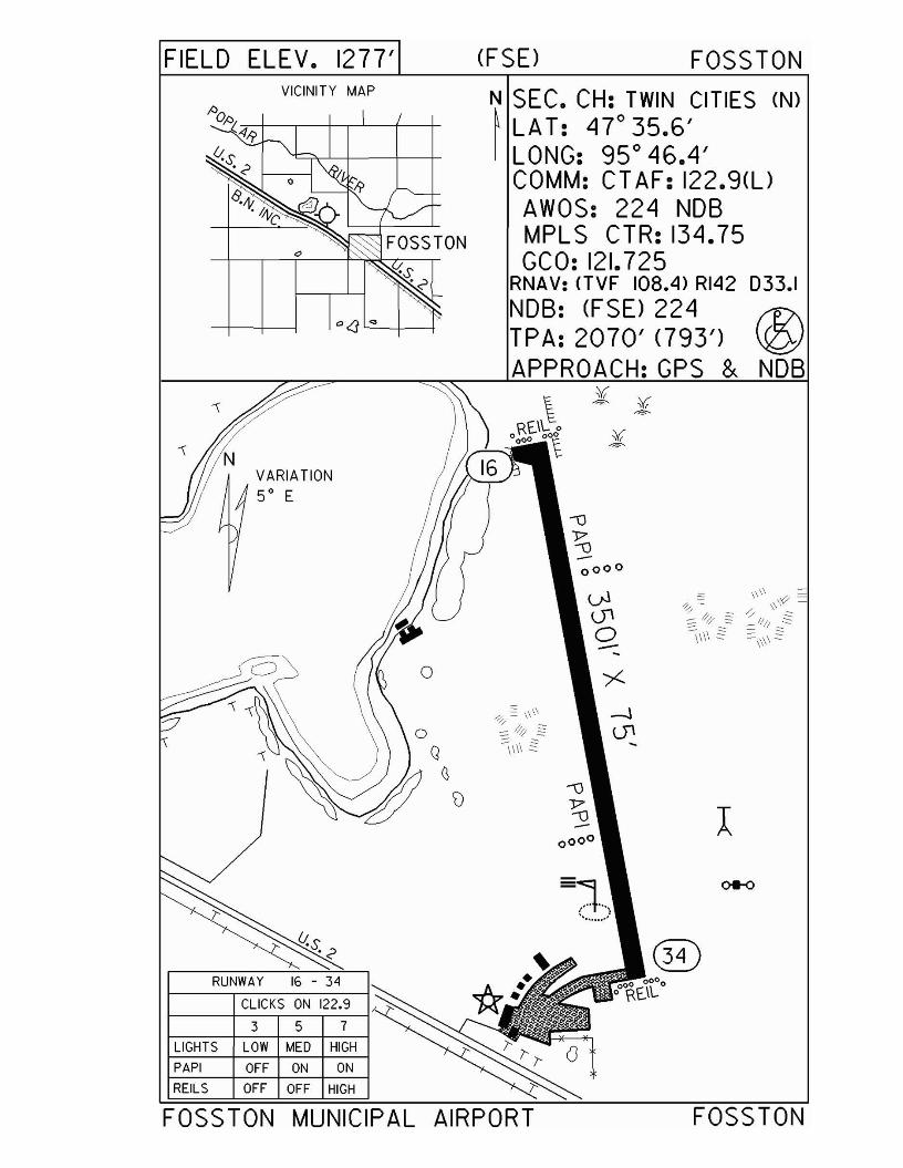
FIELD ELEV. 1277' (FSE) FOSSTON
®
N SEC. CH: TWIN CITIES (N)~ LA T: 47 0 35.6'I LONG: 95 0 46.4'
COMM: CT AF: 122.9(l)AWOS: 224 NOBMPLS CTR: 134.75GCO: 121.725
RNAV: (TVF 108.4> RI42 033.1
NOB: (FSD 224 f1?\TPA: 2070' (793') \Q1APPROACH:GPS & NOB
VARIATION50 E
VICINITY MAP
3 5 7
CLICKS ON 122.9
RUNWAY 16 - 34
LIGHTS LOW MED HIGH
PAPI OFF ON ON
REILS OFF OFF HIGH
FOSSTON MUNICIPAL AIRPORT FOSSTON
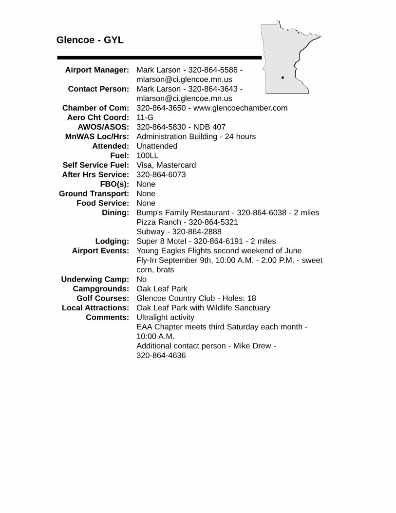
Glencoe - GYL
Airport Manager: Mark Larson - 320-864-5586 - [email protected]
Contact Person: Mark Larson - 320-864-3643 - [email protected]
Chamber of Com: 320-864-3650 - www.glencoechamber.comAero Cht Coord: 11-G
AWOS/ASOS: 320-864-5830 - NDB 407MnWAS Loc/Hrs: Administration Building - 24 hours
Attended: UnattendedFuel: 100LL
Self Service Fuel: Visa, MastercardAfter Hrs Service: 320-864-6073
FBO(s): NoneGround Transport: None
Food Service: NoneDining: Bump's Family Restaurant - 320-864-6038 - 2 miles
Pizza Ranch - 320-864-5321Subway - 320-864-2888
Lodging: Super 8 Motel - 320-864-6191 - 2 milesAirport Events: Young Eagles Flights second weekend of June
Fly-In September 9th, 10:00 A.M. - 2:00 P.M. - sweet corn, brats
Underwing Camp: NoCampgrounds: Oak Leaf ParkGolf Courses: Glencoe Country Club - Holes: 18
Local Attractions: Oak Leaf Park with Wildlife SanctuaryComments: Ultralight activity
EAA Chapter meets third Saturday each month - 10:00 A.M.Additional contact person - Mike Drew - 320-864-4636
•
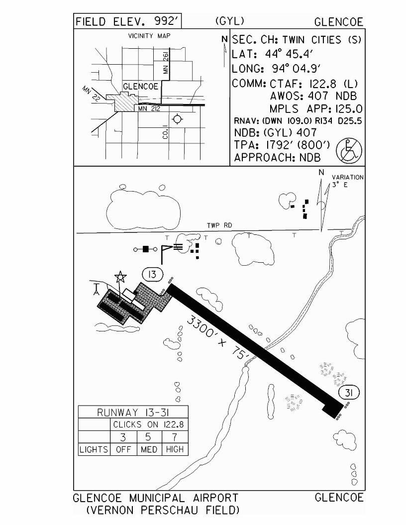
FIELD ELEV. 992' (GYL) GLENCOEVICINITY MAP
MN 212
ou
N SEC. CH: TWIN CITIES (S)~ LA T: 44
045.4'
LONG: 940 04.9'COMM: CT AF: 122.8 (U
AWOS: 407 NDBMPL S APP: 125.0
RNAV: <OWN 109.0> RI34 D25.5NDB: (GYU 407TPA: 1792' (800') f%/\APPROACH:NDB '@
Q I-I•
NVARIATION3° Eo 0
QoC3
RUNWA Y 13-31CLICKS ON 122.8
3 5 7LIGHTS OFF MED HIGH
TWP RD
~:§.I}\\-
=<;;g: §~\\
~t;l)
oGo
GLENCOE MUNICIPAL AIRPORT(VERNON PERSCHAU FIELD>
GLENCOE
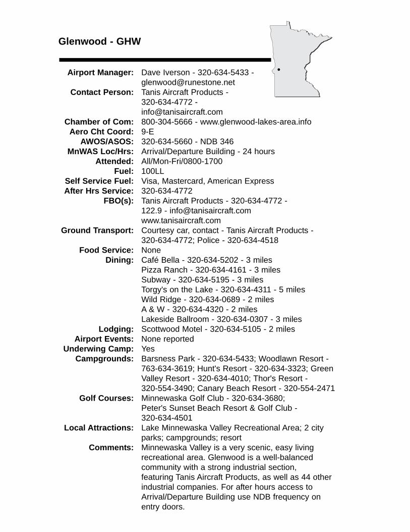
Glenwood - GHW
Airport Manager: Dave Iverson - 320-634-5433 - [email protected]
Contact Person: Tanis Aircraft Products - 320-634-4772 - [email protected]
Chamber of Com: 800-304-5666 - www.glenwood-lakes-area.infoAero Cht Coord: 9-E
AWOS/ASOS: 320-634-5660 - NDB 346MnWAS Loc/Hrs: Arrival/Departure Building - 24 hours
Attended: All/Mon-Fri/0800-1700Fuel: 100LL
Self Service Fuel: Visa, Mastercard, American ExpressAfter Hrs Service: 320-634-4772
FBO(s): Tanis Aircraft Products - 320-634-4772 - 122.9 - [email protected]
Ground Transport: Courtesy car, contact - Tanis Aircraft Products - 320-634-4772; Police - 320-634-4518
Food Service: NoneDining: Café Bella - 320-634-5202 - 3 miles
Pizza Ranch - 320-634-4161 - 3 milesSubway - 320-634-5195 - 3 milesTorgy's on the Lake - 320-634-4311 - 5 milesWild Ridge - 320-634-0689 - 2 milesA & W - 320-634-4320 - 2 milesLakeside Ballroom - 320-634-0307 - 3 miles
Lodging: Scottwood Motel - 320-634-5105 - 2 milesAirport Events: None reported
Underwing Camp: YesCampgrounds: Barsness Park - 320-634-5433; Woodlawn Resort -
763-634-3619; Hunt's Resort - 320-634-3323; Green Valley Resort - 320-634-4010; Thor's Resort -320-554-3490; Canary Beach Resort - 320-554-2471
Golf Courses: Minnewaska Golf Club - 320-634-3680; Peter's Sunset Beach Resort & Golf Club - 320-634-4501
Local Attractions: Lake Minnewaska Valley Recreational Area; 2 cityparks; campgrounds; resort
Comments: Minnewaska Valley is a very scenic, easy living recreational area. Glenwood is a well-balanced community with a strong industrial section, featuring Tanis Aircraft Products, as well as 44 otherindustrial companies. For after hours access to Arrival/Departure Building use NDB frequency on entry doors.
•
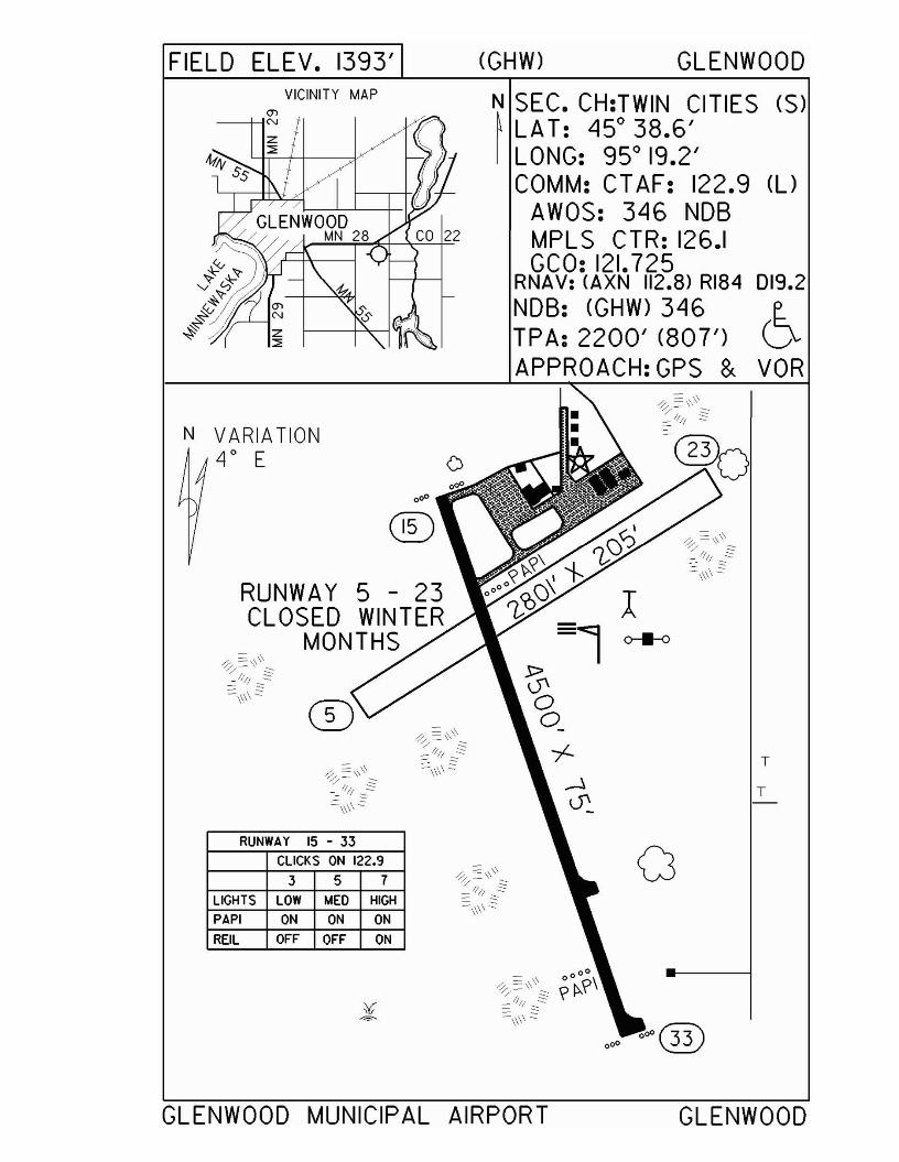
FIELD ELEV. 1393'VICINITY MAP
(GHW) GLENWOOD
N~ SEC. CH:TWIN CITIES (S)LA T: 45° 38.6'LONG: 95° 19.2'COMM: CT AF: 122.9 (l)
AWOS: 346 NDBMPLS CTR: 126.1GCO: 121.725
RNAV: (AXN 112.8) RI84 019.2NDB: (GHW) 346 e..TPA: 2200' (807') 0.APPROACH:GPS & VOR
N VARIATION4° E
RUNWAY 5 - 23CLOSED WINTER
MONTHS
RUNWAY 15 - 33CLICKS ON 122.9
3 5 7
LIGHTS LOW I.AEO HIGH
PAPI ON ON ON
REIL OFF OFF ON
o
T
T
a
GLENWOOD MUNICIPAL AIRPORT GLENWOOD
Grand Marais - CKCwww.boreal.org/airport
Airport Manager: Rodney Roy - 218-387-2012 - [email protected]
Contact Person: Dottie & Rodney Roy - 218-387-3024 - [email protected]
Chamber of Com: 888-922-5000 - www.grandmaraismn.comAero Cht Coord: 5-O
AWOS/ASOS: 218-387-1971 - VHF 119.925MnWAS Loc/Hrs: Arrival/Departure Building - 24 hours
Attended: All/All/0800-1700Fuel: 100LL, Jet A
Self Service Fuel: NoAfter Hrs Service: 218-387-3024
FBO(s): Roy Aero Service - 218-387-3024 - 122.80 - [email protected] - www.boreal.org/airport
Ground Transport: Rentals - Steve's Sports & Auto - 218-387-1060Taxi - Superior RV - 218-287-1801
Food Service: VendingCatering
Dining: The Landing - 1 mileLodging: The Landing - 1 mile
Airport Events: Fisherman's Picnic Fly-In - first full weekend in August
Underwing Camp: NoCampgrounds: Devil's Track Campground - 5 miles
Pine Mountain Campground - 1 mileGolf Courses: Gunflint Hills - 4½ miles
Superior National at Lutsen - 20 milesLocal Attractions: Boundary Waters Canoe Area
HikingBikingSkiing (cross-country & downhill)FishingBoatingGolf
Comments: Heated hangar space availableU.S. Customs Landing Rights Airport - May 15 through October 15 - advance notice required - 218-387-1148 (9:00 A.M. - 5:00 P.M.) or 218-475-2244 (24 hours)Boreal Forest web site - www.boreal.org
•
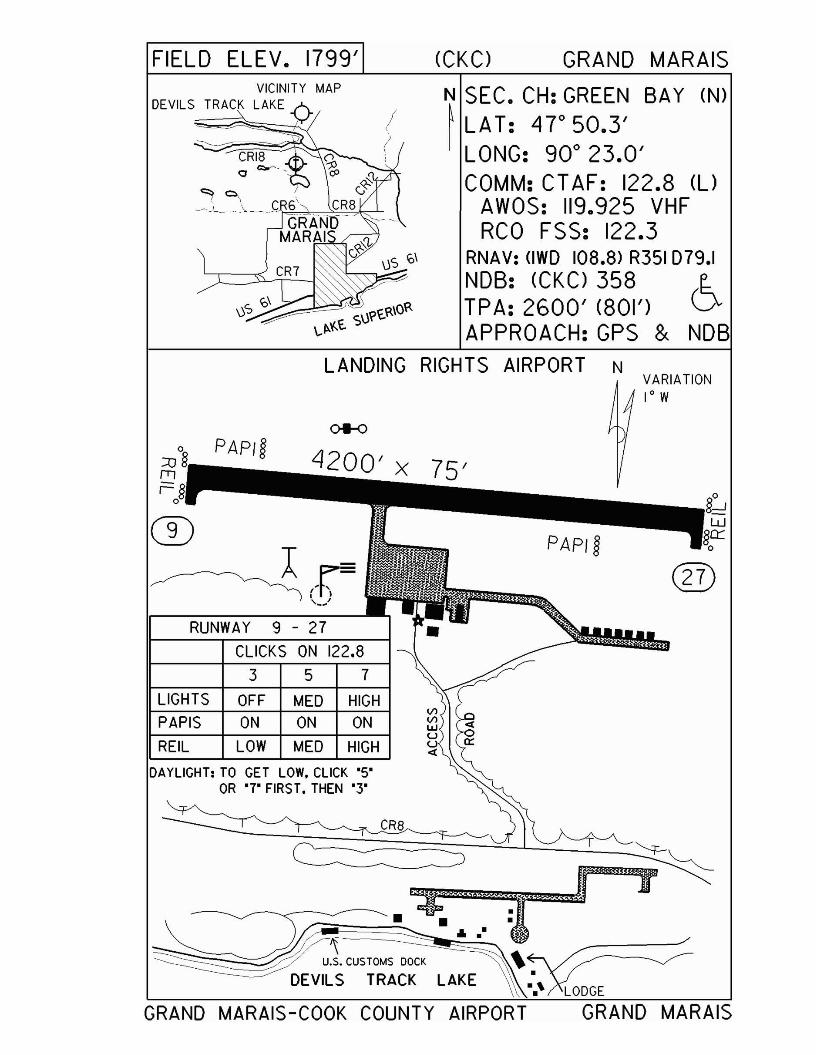
FIELD ELEV. 1799' (CKC) GRAND MARAISVICINITY MAP
DEVILS TRACK LAKE N SEC. CH: GREEN SAY (N)~ LAT: 4r50.3'
LONG: 90° 23.0'COMM: CT AF: 122.8 (l)
AWOS: 119.925 VHFRCO FSS: 122.3
RNAV: (IWD 108.8) R351 D79.1NOB: (CKC) 358 e..TPA: 2600' (801') DAPPROACH:GPS & NOB
LANDING RIGHTS AIRPORT N
RUNWAY 9 - 27
CLICKS ON 122,8
DAYLIGHT: TO GET LOW. CLICK '5'OR '7' FIRST. THEN '3'
®
VARIATION1° W
VIVIlJJUU«
3 5 7
ON ON ONOFF MED HIGH
LOW MED HIGH
PAP/g
PAPIS
REIL
LIGHTS
CD~(~=
'--
~:OO'" ..."~~~-~DEVILS TRACK LAKE •
••' LODGE
GRAND MARAIS-COOK COUNTY AIRPORT GRAND MARAIS
Grand Rapids - GPZgrandrapids.govoffice.com
Airport Manager: Mark Hoyne - 218-326-0893 - [email protected]
Contact Person: Airways Aviation Center - 218-326-1226 - [email protected]
Chamber of Com: 800-GRANDMN - www.grandmn.comAero Cht Coord: 6-H
AWOS/ASOS: 218-326-8337 - VOR 111.4MnWAS Loc/Hrs: Airways Aviation Center, Inc. - same as attendance
scheduleAttended: All/All/0700-2100
Fuel: 100LL, Jet ASelf Service Fuel: NoAfter Hrs Service: # on door
FBO(s): Airways Aviation Center, Inc. - 218-326-1226 - 122.8 - [email protected]
Ground Transport: Avis Rental Car - 218-326-1226; Rapid Taxi -218-327-2389; courtesy van
Food Service: NoneDining: Sawmill Inn - 218-326-8501 - 1 mile
Rainbow Inn - 218-326-9655 - 1 mileLodging: Super 8 Motel - 218-327-1108 - ½ mile; Sawmill Inn -
218-326-8501 - 1 mile; Rainbow Inn - 218-326-9655 - 1 mile; Country Inn - 218-327-4960 - ½ mile; AmericInn Motel - 218-326-8999 - ¾ mile
Airport Events: Father's Day Fly-In Breakfast by Civil Air Patrol &Airport Open House
Underwing Camp: YesCampgrounds: Pokegama Dam; Fairgrounds; Grand Rapids CampingGolf Courses: Pokegama Lake Golf Course; Wendigo Golf Club;
Ruttger's Sugar Lake; Eagle Ridge Golf Course; Blueberry Hills Golf Course
Local Attractions: Forest History Center; Blandin Paper Company; Iron Mines; Itasca County Area of 1,000 Lakes;Tall Timber Days - first weekend of August; local area fishing guide service; olympic size ski jump; home of MN Deer Hunters Association; Fall National Grouse Hunts; Judy Garland Festival in June; Hill Annex Iron Mine Tours; 62 local resorts; Northern MN Car Show & Swap Meet in July; Fall color tours in September
Comments: Seaplane base on airport; call in advance for after hours re-fueling service; aircraft with greater than 30 passengers require PPR 48 hours in advance - call 218-259-2733; call in advance for underwing camping
•
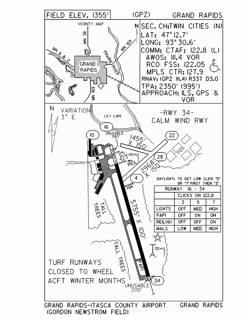
FIELD ELEV. 1355' (GPZ> GRAND RAPIDSVICINITY MAP
N
N SEC. CH:TWIN CITIES (N)~ LAT: 4rI2.7'I LONG: 93 0 30.6'
COMM: CT AF: 122.8 (l)AWOS: 111.4 VORRCO FSS: 122.05 (~MPLS CTR: 127.9 V
RNAV: (GPZ 111.4) R337 03.0TPA: 2350' (995')APPROACH: IL S. GPS &
VOR
-RWY 34CALM WIND RWY
DAYLIGHT, TO GET LOW CLICK '5'OR '7' FIRST THEN '3'
RUNWAY 16 - 34
CLICKS ON 122.8
LIGHTS OFF MED HIGH
3 5 7
PAPI OFF ON ON
( REIUl6l OFF OFF ON
<5 e...,M_A....,..LS----'L-L_O_W---L.-M_E_D -l...-H_IGH---JC?*Al
TURF RUNWAYSCLOSED TO WHEELACFT WINTER MONTHS )f
UNUSABLE200'
GRAND RAPIDS-ITASCA COUNTY AIRPORT(GORDON NEWSTROM FIELD>
GRAND RAPIDS
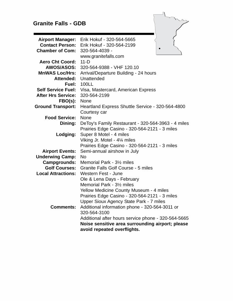
Granite Falls - GDB
Airport Manager: Erik Hokuf - 320-564-5665 Contact Person: Erik Hokuf - 320-564-2199
Chamber of Com: 320-564-4039 -www.granitefalls.com
Aero Cht Coord: 11-DAWOS/ASOS: 320-564-9388 - VHF 120.10
MnWAS Loc/Hrs: Arrival/Departure Building - 24 hoursAttended: Unattended
Fuel: 100LLSelf Service Fuel: Visa, Mastercard, American ExpressAfter Hrs Service: 320-564-2199
FBO(s): NoneGround Transport: Heartland Express Shuttle Service - 320-564-4800
Courtesy carFood Service: None
Dining: DeToy's Family Restaurant - 320-564-3963 - 4 milesPrairies Edge Casino - 320-564-2121 - 3 miles
Lodging: Super 8 Motel - 4 milesViking Jr. Motel - 4¼ milesPrairies Edge Casino - 320-564-2121 - 3 miles
Airport Events: Semi-annual airshow in JulyUnderwing Camp: No
Campgrounds: Memorial Park - 3½ milesGolf Courses: Granite Falls Golf Course - 5 miles
Local Attractions: Western Fest - JuneOle & Lena Days - FebruaryMemorial Park - 3½ milesYellow Medicine County Museum - 4 milesPrairies Edge Casino - 320-564-2121 - 3 milesUpper Sioux Agency State Park - 7 miles
Comments: Additional information phone - 320-564-3011 or 320-564-3100Additional after hours service phone - 320-564-5665 Noise sensitive area surrounding airport; please avoid repeated overflights.
•
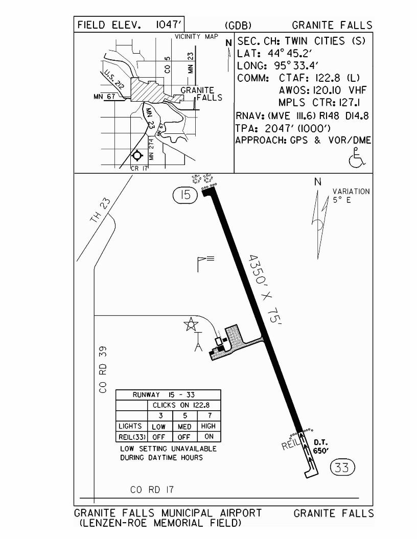
FIELD ELEV. 1047' (GOB) GRANITE FALLS
VARIATION50 E
N
N SEC. CH: TWIN CITIES (S)~ LAT: 44° 45.2'I LONG: 95° 33.4'
COMM: CT AF: 122.8 (UAWOS: 120.10 VHFMPLS CTR: 127.1
RNAV: (MVE 111.6) RI48 D14.8TPA: 2047' (1000')APPROACH:GPS & VOR/DME
6
r- ~0'0_
-I-.--1
"* 0'
A
VICINITY MAP
,..,ltl N
o zu ::;
RUNWAY 15 - 33
CLICKS ON 122.8
3 5 7
LIGHTS LOW MED HIGH
REIU33l OFF OFF ON
LOW SETTING UNAVAILABLEDURING DAYTIME HOURS
(J)
n
o0::
oU
~S'.~
MN 67
CO RD 17
GRANITE FALLS MUNICIPAL AIRPORT(LENZEN-ROE MEMORIAL FIELD>
GRANITE FALLS
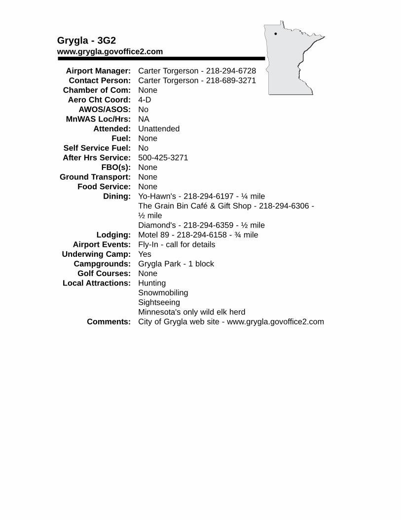
Grygla - 3G2www.grygla.govoffice2.com
Airport Manager: Carter Torgerson - 218-294-6728 Contact Person: Carter Torgerson - 218-689-3271
Chamber of Com: None Aero Cht Coord: 4-D
AWOS/ASOS: No MnWAS Loc/Hrs: NA
Attended: UnattendedFuel: None
Self Service Fuel: NoAfter Hrs Service: 500-425-3271
FBO(s): NoneGround Transport: None
Food Service: NoneDining: Yo-Hawn's - 218-294-6197 - ¼ mile
The Grain Bin Café & Gift Shop - 218-294-6306 -½ mileDiamond's - 218-294-6359 - ½ mile
Lodging: Motel 89 - 218-294-6158 - ¾ mileAirport Events: Fly-In - call for details
Underwing Camp: YesCampgrounds: Grygla Park - 1 blockGolf Courses: None
Local Attractions: HuntingSnowmobilingSightseeingMinnesota's only wild elk herd
Comments: City of Grygla web site - www.grygla.govoffice2.com
•
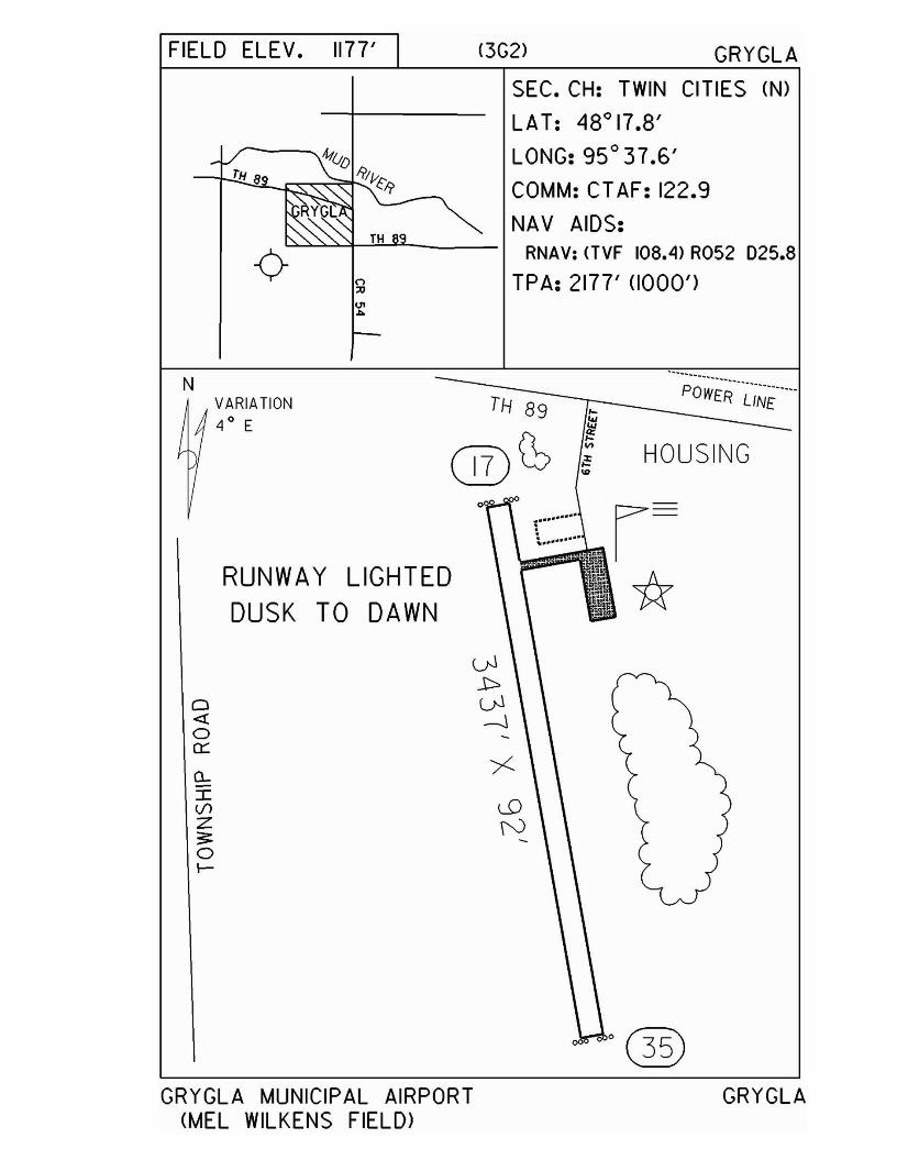
FIELD ELEV. 1177' <3G2> GRYGLA
SEC. CH: TWIN CITIES (N)
LAT: 48°17.8'
LONG: 95° 37.6'
COMM: CT AF: 122.9
NAV AIDS:RNAV: nVF 108.4> R052 025.8
TPA: 2177' (1000')
NVARIATION4 0 E
TH 89
~ .. ~~
POWER"~';NE""-
HOUSING
RUNWAY LIGHTEDDUSK TO DAWN
o
r·····.. rt ·· ..
*o4:o0::
a..IV1z3:oI--
GRYGLA MUNICIPAL AIRPORT(MEL WILKENS FIELD)
GRYGLA
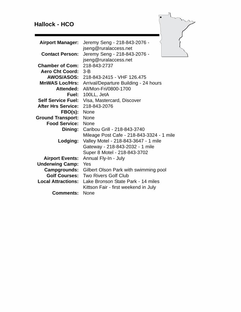
Hallock - HCO
Airport Manager: Jeremy Seng - 218-843-2076 [email protected]
Contact Person: Jeremy Seng - 218-843-2076 - [email protected]
Chamber of Com: 218-843-2737 Aero Cht Coord: 3-B
AWOS/ASOS: 218-843-2415 - VHF 126.475MnWAS Loc/Hrs: Arrival/Departure Building - 24 hours
Attended: All/Mon-Fri/0800-1700Fuel: 100LL, JetA
Self Service Fuel: Visa, Mastercard, DiscoverAfter Hrs Service: 218-843-2076
FBO(s): NoneGround Transport: None
Food Service: NoneDining: Caribou Grill - 218-843-3740
Mileage Post Cafe - 218-843-3324 - 1 mileLodging: Valley Motel - 218-843-3647 - 1 mile
Gateway - 218-843-2032 - 1 mileSuper 8 Motel - 218-843-3702
Airport Events: Annual Fly-In - JulyUnderwing Camp: Yes
Campgrounds: Gilbert Olson Park with swimming poolGolf Courses: Two Rivers Golf Club
Local Attractions: Lake Bronson State Park - 14 milesKittson Fair - first weekend in July
Comments: None
•
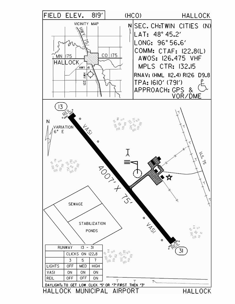
FIELD ELEV. 819' (HCO) HALLOCK
N SEC. CH:TWIN CITIES (N)~ LAT: 48° 45.2'I LONG: 96 0 56.6'
COMM: CT AF: 122.8(l)AWOS: 126.475 VHFMPLS CTR: 132.15
RNAV: (HML 112.4) RI26 09.8
TPA: 1610' <791') (~APPROACH:GPS & v
VOR/DME
l
=;"rt J, ,'...'
ST ABILIZATION
PONDS
SEWAGE
LIGHTS
N
VASI ON ON ON
T TDAYLIGHT; TO GET LOW CLICK "5' OR '7" FIRST THEN "3"
REIL OFF OFF ON~ .
HALLOCK MUNICIPAL AIRPORT HALLOCK
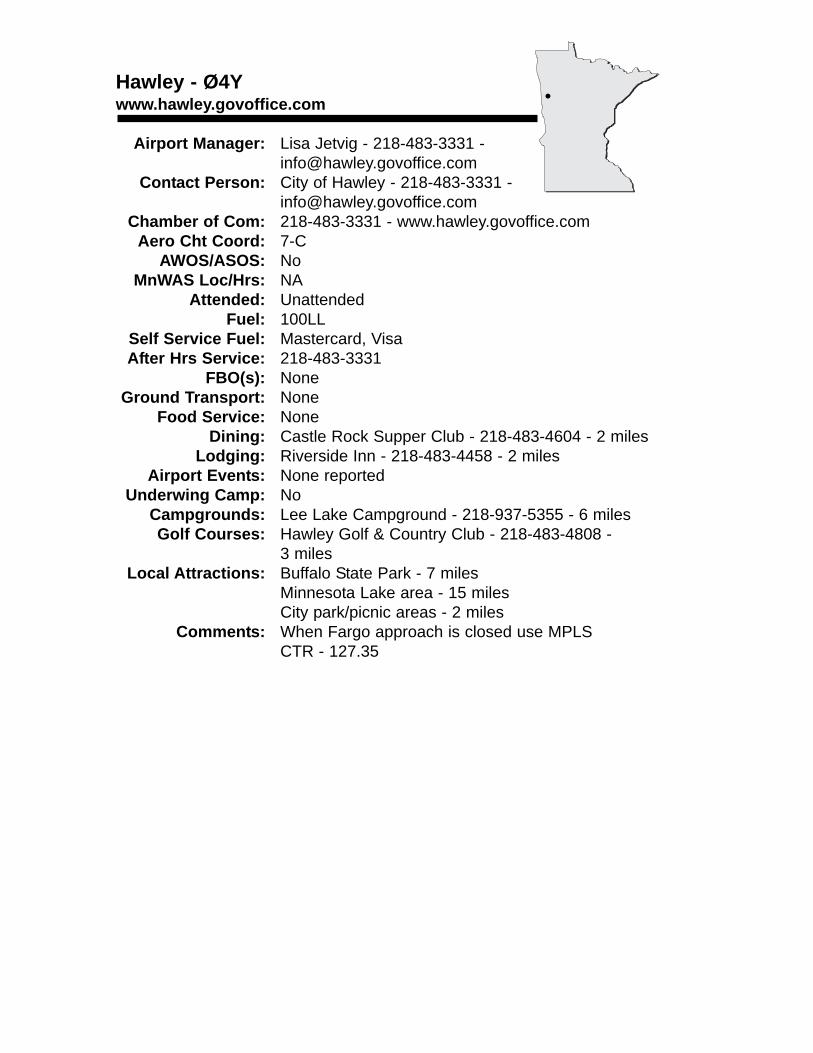
Hawley - Ø4Ywww.hawley.govoffice.com
Airport Manager: Lisa Jetvig - 218-483-3331 - [email protected]
Contact Person: City of Hawley - 218-483-3331 - [email protected]
Chamber of Com: 218-483-3331 - www.hawley.govoffice.comAero Cht Coord: 7-C
AWOS/ASOS: No MnWAS Loc/Hrs: NA
Attended: UnattendedFuel: 100LL
Self Service Fuel: Mastercard, VisaAfter Hrs Service: 218-483-3331
FBO(s): NoneGround Transport: None
Food Service: NoneDining: Castle Rock Supper Club - 218-483-4604 - 2 miles
Lodging: Riverside Inn - 218-483-4458 - 2 milesAirport Events: None reported
Underwing Camp: NoCampgrounds: Lee Lake Campground - 218-937-5355 - 6 milesGolf Courses: Hawley Golf & Country Club - 218-483-4808 -
3 milesLocal Attractions: Buffalo State Park - 7 miles
Minnesota Lake area - 15 milesCity park/picnic areas - 2 miles
Comments: When Fargo approach is closed use MPLSCTR - 127.35
•
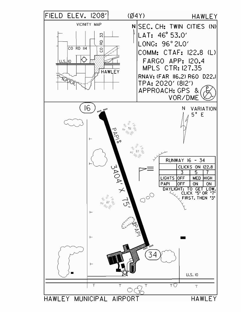
FIELD ELEV. 1208' (04Y) HAWLEYVICINITY MAP
CO RD 114
u.s. 10
N SEC. CH: TWIN CITIES (N)
~ LAT: 460 53.0'I LONG: 96 0 21.0'
COMM: CT AF: 122.8 (UFARGO APP: 120.4MPLS CTR: 127.35
RNAV: (F AR 116.2) R60 022.1TPA: 2020' (812') ®APPROACH:GPS &
VOR/DME
T
HAWLEY
u.s. 10
N VARIATION5· E
-
T
LIGHTS OFF MED HIGHPAPI OFF ON ON
DAYLIGHT: TO GET LOW.~~~ICK '5' OR ·7·
\RST, THEN '3·
T
~UNWAY 16 - 34
r- CLICKS ON 122.8357
oTT
•
HAWLEY MUNICIPAL AIRPORT
Hector - 1D6
Airport Manager: Ed Newberg - 320-848-2745 [email protected]
Contact Person: Ed Newberg - 320-848-2745 - [email protected]
Chamber of Com: 320-848-2122 - hector.govoffice.comAero Cht Coord: 11-F
AWOS/ASOS: No MnWAS Loc/Hrs: Arrival/Departure Building - 24 hours
Attended: All/All/AllFuel: 100LL
Self Service Fuel: NoAfter Hrs Service: 320-848-2745
FBO(s): Newberg Sky Spray LLC - 320-848-2745 - [email protected] - www.pipercubs.com
Ground Transport: Possible - call Ed NewbergFood Service: None
Dining: Pete's Grill - 320-848-2200 - 1 mileHigh Point Cafe - 320-848-6112 - 1 mileThe Other Place - 320-848-6421 or 320-848-6428 -½ mileCenex Pizza & Subs - 320-848-2286 - ½ mile
Lodging: Sheepshed Hotel - 320-523-5000 - 15 miles West212 Motel - 320-523-1480 - 15 miles West
Airport Events: Annual Flight Breakfast - third Sunday in SeptemberUnderwing Camp: Yes
Campgrounds: None reportedGolf Courses: Oakdale Country Club - 12 miles
Local Attractions: Corn Chaff Days - second weekend in JulyComments: Newberg Brothers (aircraft sales) -
www.pipercubs.com
•
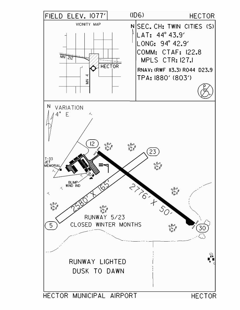
FIELD ELEV. 1077'VICINITY MAP
-
--- ~IMN 2/2
'~ HECTOR
<T
z:::;;
I
-
N VARIATION4' E '"
_./
RUNWAY LIGHTEDDUSK TO DAWN
(ID6) HECTOR
N SEC. CH: TWIN CITIES (S)~ LAT: 44° 43.9'
LONG: 94° 42.9'COMM: CT AF: 122.8
MPLS CTR: 127.1RNAV: (RWF 113.3) R044 023.9
TPA: 1880' (803')
/
<:<>II
I II
HECTOR MUNICIPAL AIRPORT HECTOR
Henning - Ø5Y
Airport Manager: Tony Thalmann - 218-583-2270 - [email protected]
Contact Person: Tony or John Thalmann - 218-583-2270 - [email protected]
Chamber of Com: 218-583-2402 - henning.govoffice.comAero Cht Coord: 8-E
AWOS/ASOS: No MnWAS Loc/Hrs: NA
Attended: UnattendedFuel: 100LL
Self Service Fuel: Visa, MastercardAfter Hrs Service: 218-583-2402
FBO(s): NoneGround Transport: Tony Thalmann - 218-583-2270 (day)
Henning Police - 218-583-2903 (night)Food Service: None
Dining: Mama Boe's Cafe - 2 milesKountry Korner Kafe - 2 milesChagen's Pizza Pub - 2 miles
Lodging: Bed & Breakfast - 218-583-4369 - 2 milesAirport Events: Annual Fly-In
Underwing Camp: YesCampgrounds: Henning FairgroundsGolf Courses: Oakwood Golf Course
Balmoral Golf CourseLocal Attractions: City parks
Bowling alleyLakes
Comments: New schoolAdditional airport information phone - 218-583-4296
•
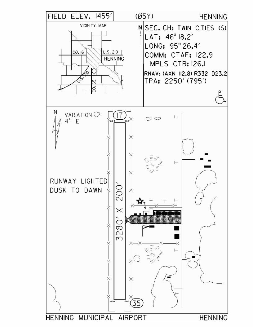
FIELD ELEV. 1455' <05 Y) HENNINGVICINITY MAP N SEC. CH: TWIN CITIES (S)
~ LA T: 46° 18.2'LONG: 95° 26.4'COMM: CT AF: 122.9
MPLS CTR: 126.1RNAV: (AXN 112.8> R332 023.2TPA: 2250' <795')
N VARIA TION 0 i@7l4 0 E :1<.00 oooX CJ c;;
x x
x x -0/ ~\\\\ --/ "" I-- 1/// .::::::- -- ~
x X:=\\\\ ~
0RUNWAY LIGHTED ....
DUSK TO DAWN x 0 x0 l*, T X GN T
xX " T....
x 0CD r= •N •n
x x-x x X:= \\0/ =\\ I-
/ ""x O :::. /1// :::.:::::
X :=\\\\ ::::
Ix x -
l-X x
L ~35)
HENNING MUNICIPAL AIRPORT HENNING
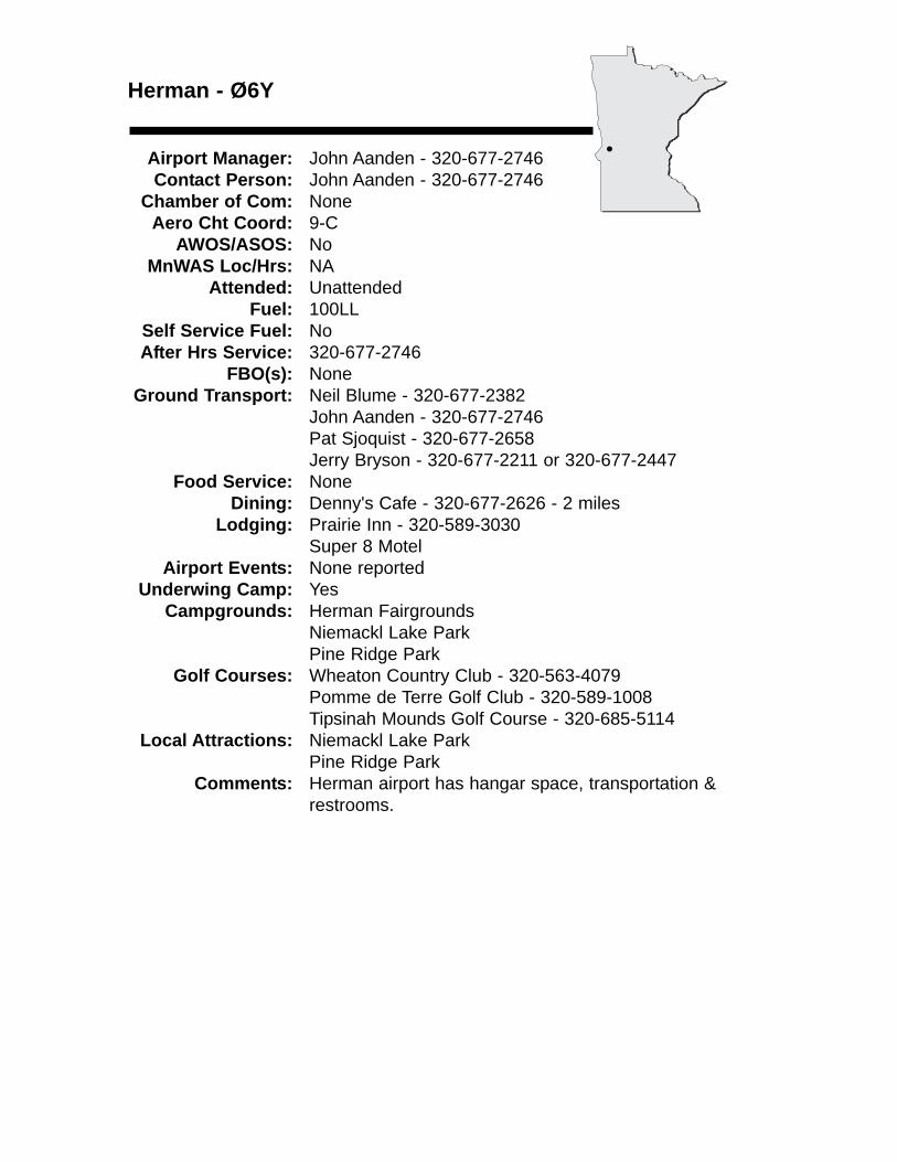
Herman - Ø6Y
Airport Manager: John Aanden - 320-677-2746 Contact Person: John Aanden - 320-677-2746
Chamber of Com: None Aero Cht Coord: 9-C
AWOS/ASOS: No MnWAS Loc/Hrs: NA
Attended: UnattendedFuel: 100LL
Self Service Fuel: NoAfter Hrs Service: 320-677-2746
FBO(s): NoneGround Transport: Neil Blume - 320-677-2382
John Aanden - 320-677-2746Pat Sjoquist - 320-677-2658Jerry Bryson - 320-677-2211 or 320-677-2447
Food Service: NoneDining: Denny's Cafe - 320-677-2626 - 2 miles
Lodging: Prairie Inn - 320-589-3030Super 8 Motel
Airport Events: None reportedUnderwing Camp: Yes
Campgrounds: Herman FairgroundsNiemackl Lake ParkPine Ridge Park
Golf Courses: Wheaton Country Club - 320-563-4079Pomme de Terre Golf Club - 320-589-1008Tipsinah Mounds Golf Course - 320-685-5114
Local Attractions: Niemackl Lake ParkPine Ridge Park
Comments: Herman airport has hangar space, transportation & restrooms.
•
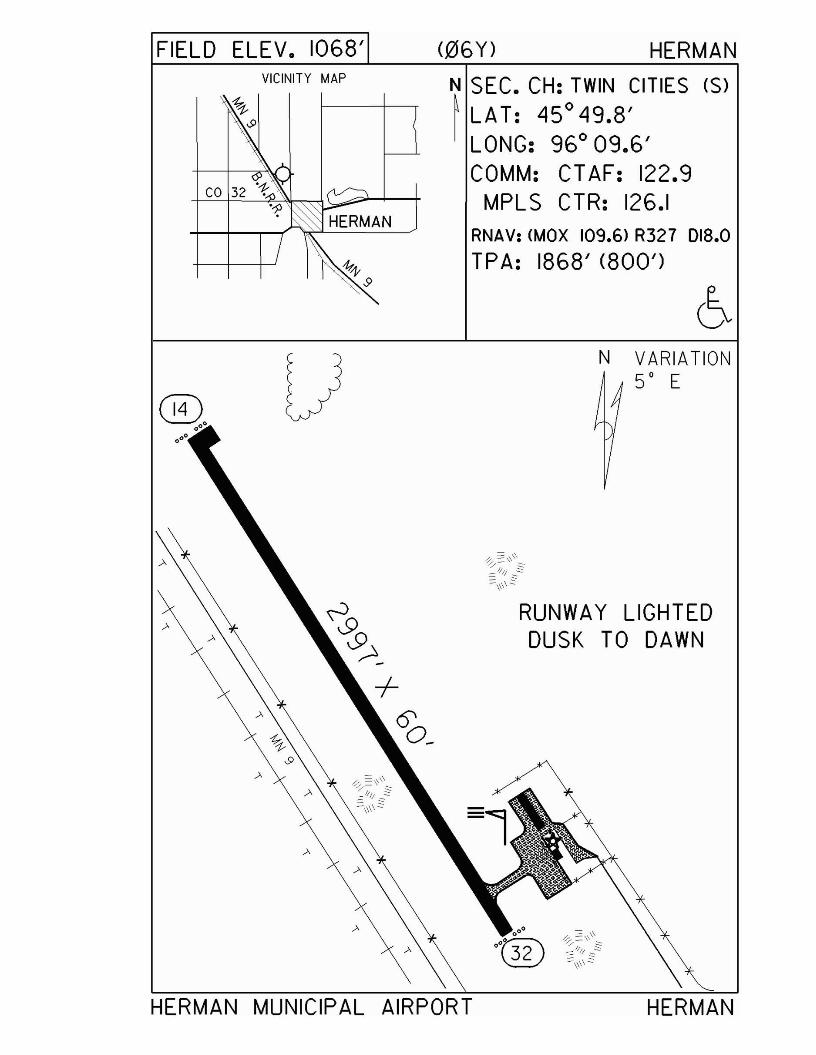
FIELD ELEV. 1068' <06Y) HERMANVICINITY MAP N SEC. CH: TWIN CITIES (S)
~ LAT: 45° 49.8'LONG: 96° 09.6'COMM: CTAF: 122.9
MPL S CTR: 126.1RNAV: (MOX 109.6) R327 018.0
TPA: 1868' <800')
HERMAN
RUNWAY LIGHTEDDUSK TO DAWN
N VARIATION50 E
® •••.0·
HERMAN MUNICIPAL AIRPORT
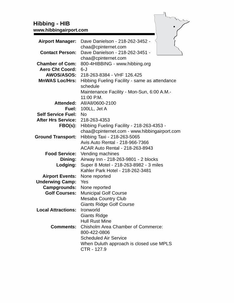
Hibbing - HIBwww.hibbingairport.com
Airport Manager: Dave Danielson - 218-262-3452 [email protected]
Contact Person: Dave Danielson - 218-262-3451 - [email protected]
Chamber of Com: 800-4HIBBING - www.hibbing.orgAero Cht Coord: 6-J
AWOS/ASOS: 218-263-8384 - VHF 126.425MnWAS Loc/Hrs: Hibbing Fueling Facility - same as attendance
scheduleMaintenance Facility - Mon-Sun, 6:00 A.M.-11:00 P.M.
Attended: All/All/0600-2100Fuel: 100LL, Jet A
Self Service Fuel: NoAfter Hrs Service: 218-263-4353
FBO(s): Hibbing Fueling Facility - 218-263-4353 - [email protected] - www.hibbingairport.com
Ground Transport: Hibbing Taxi - 218-263-5065Avis Auto Rental - 218-966-7366ACAR Auto Rental - 218-263-8943
Food Service: Vending machinesDining: Airway Inn - 218-263-9801 - 2 blocks
Lodging: Super 8 Motel - 218-263-8982 - 3 milesKahler Park Hotel - 218-262-3481
Airport Events: None reportedUnderwing Camp: Yes
Campgrounds: None reportedGolf Courses: Municipal Golf Course
Mesaba Country ClubGiants Ridge Golf Course
Local Attractions: IronworldGiants RidgeHull Rust Mine
Comments: Chisholm Area Chamber of Commerce: 800-422-0806Scheduled Air ServiceWhen Duluth approach is closed use MPLS CTR - 127.9
•
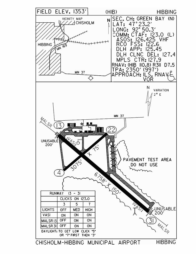
FIELD ELEV. 1353'VICINITY MAP
\f-+-..L....L.J CHISHOLM
MN 37
(HI B) HIBBINGN SEC. CH: GREEN SAY (N)~ LAT: 4r23.2'I LONG: 92° 50.3'
COMM: CT AF: 123.0 (l)ASOS: 126.425 VHFRCO FSS: 122.6DLH APP: 125.45DLH CLNC DEL: 127.4MPLS CTR: 127.9
RNAV: (HIS 110.8) R311 07.5TPA: 2350' (997')APPROACH: ILS. RNAV(~
VOR VN
VARIATION2° E
RUNWAY 13 - 31
CLICKS ON 123,0
3 5 7
LIGHTS OFF MED HIGH
VASI ON ON ON
MALSR 13 OFF ON ON
MALSR 31 OFF ON ONDAYLIGHT: TO GET LOW CLICK "5"
OR '7' FIRST THEN '3'
MN 37
\ P)VEt.lENT TEST) DO NOT USE~
AREA
CHISHOLM-HIBBING MUNICIPAL AIRPORT HIBBING
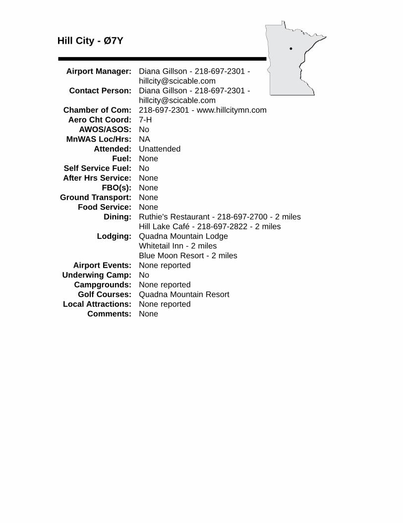
Hill City - Ø7Y
Airport Manager: Diana Gillson - 218-697-2301 - [email protected]
Contact Person: Diana Gillson - 218-697-2301 - [email protected]
Chamber of Com: 218-697-2301 - www.hillcitymn.comAero Cht Coord: 7-H
AWOS/ASOS: No MnWAS Loc/Hrs: NA
Attended: UnattendedFuel: None
Self Service Fuel: NoAfter Hrs Service: None
FBO(s): NoneGround Transport: None
Food Service: NoneDining: Ruthie's Restaurant - 218-697-2700 - 2 miles
Hill Lake Café - 218-697-2822 - 2 milesLodging: Quadna Mountain Lodge
Whitetail Inn - 2 milesBlue Moon Resort - 2 miles
Airport Events: None reportedUnderwing Camp: No
Campgrounds: None reportedGolf Courses: Quadna Mountain Resort
Local Attractions: None reportedComments: None
•
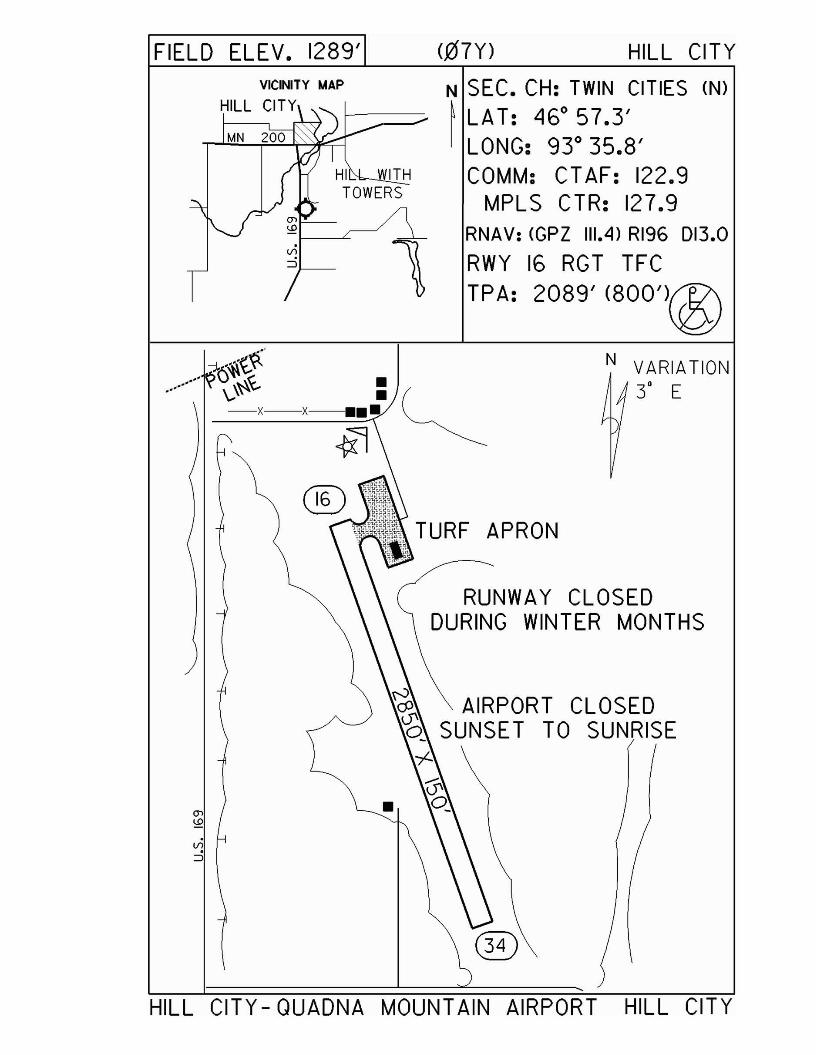
FIELD ELEV. 1289' (Q17Y) HILL CITYVICINITY MAP
HILL CITY
1
N SEC. CH: TWIN CITIES (N)
~ LAT: 46° 57.3'I LONG: 93° 35.8'
COMM: CT AF: 122.9MPLS CTR: 127.9
RNAV: <GPZ 111.4) RI96 013.0
RWY 16 RGT TFCTPA: 2089' (800')@
N VARIATION3' E
AIRPORT CLOSEDTO SUNRISE
RUNWAY CLOSEDDURING WINTER MONTHS
TURF APRON
-j.··~t~·.... 0 I(.. •./ \-\~ . (
-x-x-••• ~
HILL CITY - QUADNA MOUNTAIN AIRPORT HILL CITY
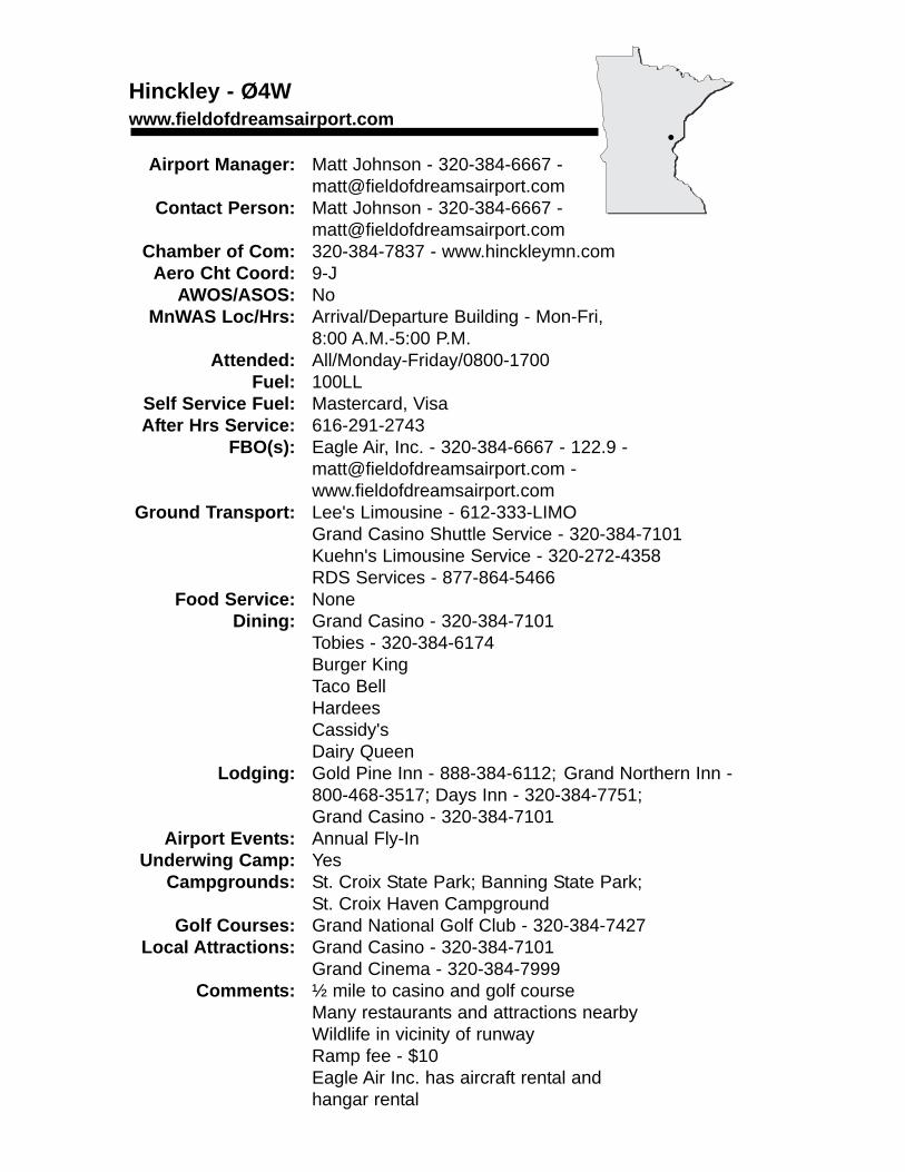
Hinckley - Ø4Wwww.fieldofdreamsairport.com
Airport Manager: Matt Johnson - 320-384-6667 - [email protected]
Contact Person: Matt Johnson - 320-384-6667 - [email protected]
Chamber of Com: 320-384-7837 - www.hinckleymn.comAero Cht Coord: 9-J
AWOS/ASOS: No MnWAS Loc/Hrs: Arrival/Departure Building - Mon-Fri,
8:00 A.M.-5:00 P.M.Attended: All/Monday-Friday/0800-1700
Fuel: 100LLSelf Service Fuel: Mastercard, VisaAfter Hrs Service: 616-291-2743
FBO(s): Eagle Air, Inc. - 320-384-6667 - 122.9 - [email protected] - www.fieldofdreamsairport.com
Ground Transport: Lee's Limousine - 612-333-LIMOGrand Casino Shuttle Service - 320-384-7101Kuehn's Limousine Service - 320-272-4358RDS Services - 877-864-5466
Food Service: NoneDining: Grand Casino - 320-384-7101
Tobies - 320-384-6174Burger KingTaco BellHardeesCassidy'sDairy Queen
Lodging: Gold Pine Inn - 888-384-6112; Grand Northern Inn - 800-468-3517; Days Inn - 320-384-7751;Grand Casino - 320-384-7101
Airport Events: Annual Fly-InUnderwing Camp: Yes
Campgrounds: St. Croix State Park; Banning State Park;St. Croix Haven Campground
Golf Courses: Grand National Golf Club - 320-384-7427Local Attractions: Grand Casino - 320-384-7101
Grand Cinema - 320-384-7999Comments: ½ mile to casino and golf course
Many restaurants and attractions nearbyWildlife in vicinity of runwayRamp fee - $10Eagle Air Inc. has aircraft rental and hangar rental
•
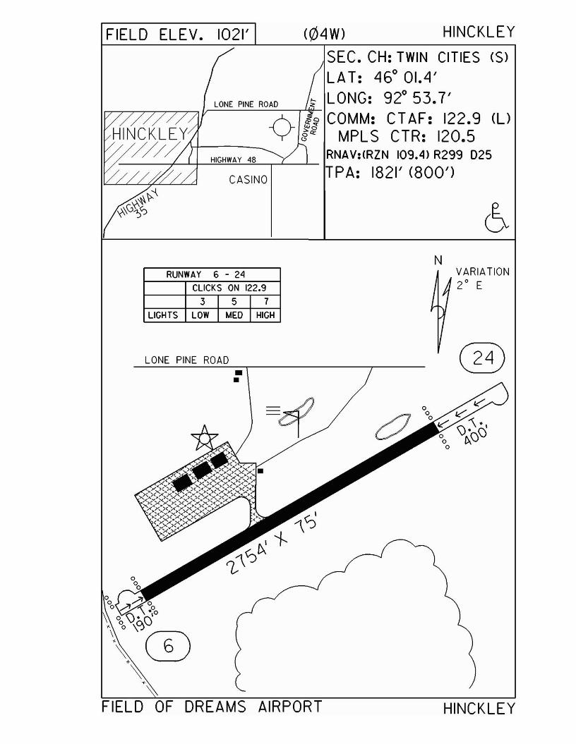
FIELD ELEV. 1021' (04W) HINCKLEY
CASINO
SEC. CH: TWIN CITIES (S)LAT: 46° 01.4'
LONE PINE ROAD ~ LONG: 92° 53.7'A if; COMM: CTAF: 122.9 (l)
HINCKLEY V if? MPLS CTR: 120.5/ //~ \-I---HIG-HW-A-Y-48- RNAV:(RZN 109.4) R299 025
TPA: 1821' (800')
NRUNWAY 6 - 24
CLICKS ON 122.9
3 5 7
LIGHTS LOW MED HIGH
LONE PINE ROAD
VARIATION2
0E
FIELD OF DREAMS AIRPORT HINCKLEY
Hutchinson - HCDwww.ci.hutchinson.mn.us
Airport Manager: John Olson - 320-234-4473 - [email protected]
Contact Person: Tom Parker - 320-587-7615 - [email protected]
Chamber of Com: 320-587-5252 - www.hutchinsonchamber.com
Aero Cht Coord: 11-GAWOS/ASOS: 320-587-3343 - VHF 118.525
MnWAS Loc/Hrs: Arrival/Departure Building - 24 hoursAttended: All/All/All
Fuel: 100LL, Jet ASelf Service Fuel: Visa, MastercardAfter Hrs Service: 320-587-7615
FBO(s): Hutchinson Aviation - 320-587-7615 - 122.8 - [email protected]
Ground Transport: Courtesy car - call ahead; taxi - 320-587-7878; TrailblazerTransit, 6:30 A.M.-5:15 P.M. - 320-587-4757
Food Service: NoneDining: American Pastime BBQ - 320-234-7427; Applebee's -
320-587-2331; Arby's - 320-234-7337; Bavarian Haus - 320-587-4560; Burger King - 320-587-9225; Coffee Company - 320-587-8450; Country Kitchen - 320-587-4940; Culver's - 320-234-8333; Dairy Queen Brazier - 320-587-2076; Domino's Pizza - 320-587-7070; Edge Bar & Grill - 320-587-4428; Emma Dee's Buffet - 320-234-6990; Godfather's Pizza - 320-587-2864; Gold Coin - 320-587-3810; Hardee's - 320-587-3429; Hutch Café - 320-587-2438; Kentucky Fried Chicken - 320-587-9383; King's Wok - 320-587-2662; Lake Marion Supper Club - 320-328-4111; Lamplighter Bar & Grill - 320-587-1010; Mariachi Fiesta - 320-587-3197; Main Street Restaurant - 320-587-2760; McCormick's Family Restaurant - 320-587-4417; McDonald's - 320-587-2449; Pizza Hut - 320-587-7633; Quizno's - 320-587-0099; Sonora's (Mexican) - 320-587-7303; Subway - 320-587-3074; Taco Bell - 320-587-7477; Taco John's - 320-587-3424
Lodging: AmericInn Lodge & Suites - 320-587-3233; Best Western Victorian Inn & Conference Center - 320-587-6030; Economy Inn - 320-587-2129; King Motel - 320-587-4737; 7-Hi Budget Motel - 320-587-2088; Super 8 Motel - 320-587-9299
Airport Events: Water Carnival/Father's Day Fly-In Breakfast & Pork ChopDinner
Underwing Camp: NoCampgrounds: Lake Marion Park - 320-328-4479; Masonic West River Park -
320-234-4494; Piepenburg Park - 320-587-2082Golf Courses: Crow River Golf Club - 320-587-3070
Meadow Links Public Golf Course - 320-234-9533Local Attractions: Apple orchards; biking; bowling; Burich Arena; camping; fishing;
Gopher Campfire Wildlife Sanctuary; historic tour; Luce Line Trail; McLeod County Museum; movie theaters; parks; public library; recreation center; senior center; skate park; snowmobiling; swimming pools (indoor & outdoor); area lakes; local events
Comments: None
•
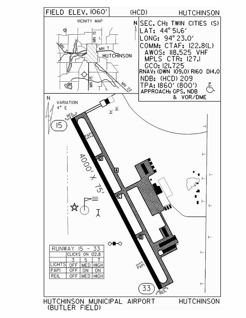
FIELD ELEV. 1060' (HCD) HUTCHINSON
--I
•
VICINITY MAP
so<b_
+~0'_
:*(:1) l
VARIATION40E
~0\-oo@j000
RUNWAY 15 - 33CLICKS ON 122.8
3 5 7LIGHTS OFF MED HIGHPAPI OFF ON ONREIL OFF MED HIGH
N
N SEC. CH: TWIN CITIES (S)~ LA T: 44 0 51.6'I LONG: 94 0 23.0'
COMM: CT AF: 122.8(l)AWOS: 118.525 VHFMPLS CTR: 127.1GCO: 121.725
RNAV: <OWN 109.0) RIGO 014.0NOB: (HCD> 209
I----~---~--__:;r_~____lI~t~ol~~H~~~~?~~~ 6& VOR/OME
HUTCHINSON MUNICIPAL AIRPORT(BUTLER FIELD)
HUTCHINSON
International Falls - INLwww.internationalfallsairport.com
Airport Manager: Thor Einarson - 218-283-4461 - [email protected]
Contact Person: Susan Baratono - 218-283-0738 Chamber of Com: 800-FALLS-MN -
www.internationalfallsmn.usAero Cht Coord: 3-I
AWOS/ASOS: 218-285-2996 - VHF 120.0MnWAS Loc/Hrs: Einarson Flying Service, Inc. - same as attendance
scheduleAttended: All/All/0500-2300
Fuel: Mogas, 100LL, Jet ASelf Service Fuel: NoAfter Hrs Service: 218-283-2712
FBO(s): Einarson Flying Service, Inc. - 218-283-4461 - 122.8 - [email protected]
Ground Transport: North Air Limo & Taxi - 218-283-4422Hertz Rental Cars - 218-283-4461National Rental Cars - 218-283-4626Avis Rental Cars - 218-285-7799
Food Service: Vending machinesDining: INTERNATIONAL FALLS: Barney's Restaurant -
218-283-3333; Cookie's Restaurant - 218-283-3565; Holiday Inn - 218-283-4451; Sandy's Place - 218-285-9108; Spot Supper Club -218-283-2440RANIER: Grandma's Pantry - 218-286-5584; Icebox Café & Pub - 218-283-4600; Thunderbird Lodge -218-286-3151
Lodging: Budget Host Inn - 218-283-2577; Falls Motel - 218-283-8434; Hilltop Motel - 218-283-2505; Holiday Inn - 218-283-4451; Northern Lights Motel - 218-283-2508; Rambler Motel - 218-283-8454; TeePee Motel - 218-283-8494; Voyageur Motel - 218-283-9424
Airport Events: None reportedUnderwing Camp: Yes
Campgrounds: Camp Idlewood - Rainy Lake - 218-286-5551 - 4 milesArnold's Campground & R.V. Park - 218-285-9100 - 3 miles
Golf Courses: Falls Country Club - 218-283-4491Local Attractions: Rainy Lake; Boise Paper Industry; Bronco Nagurski
Museum; Voyageurs National Park; Grand Mound Interpretive Center
Comments: U.S. Customs - 218-283-2541Scheduled Air ServiceArea web site - www.rainylake.org
•
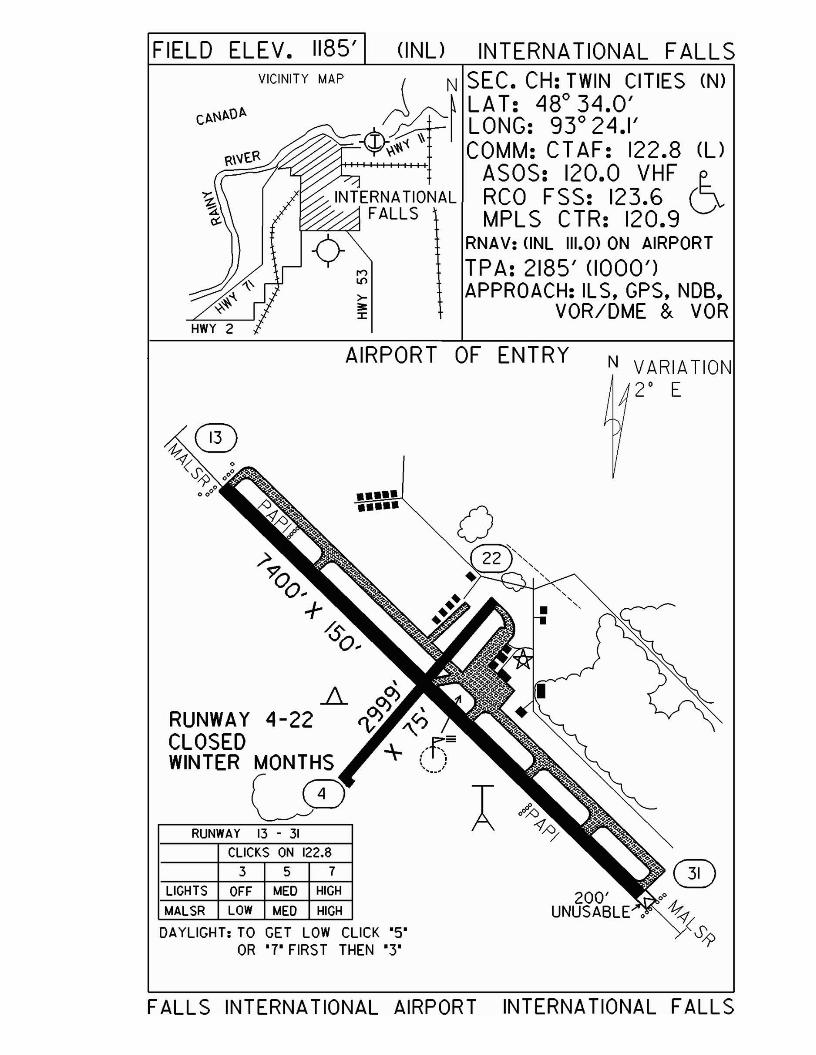
N VARIATION2° E
AIRPORT OF ENTRY
FIELD ELEV. 1185' (INU INTERNATIONAL FALLSVICINITY MAP ~ N SEC. CH: TWIN CITIES (N)
~LA T: 480 34.0'
Cf<l'lf<Of< N /0- 0:f'h./~ LONG: 93 24.1'~~'t\'{ ~ COMM: CT AF: 122.8 (U
;,t++++-+-+++-1-1-'>++1 AS0 S: 120.0 VHF E-INTERNATIONAL RCO FSS: 123.6 (]v
FALLS MPLS CTR: 120.9~~-c> RNAV: (INL 1II.0l ON AIRPORT
...., TPA: 2185' (1000'): APPROACH: IL S. GPS. NOB.~ VOR/DME & VOR
••••••••••
RUNWAY 4-22CLOSEDWINTER MONTHS
LCDRUNWAY 13 - 31
ClICKS ON 122.8
357LIGHTS OFF MED HIGH
MALSR LOW MED HIGH
DAYLIGHT: TO GET LOW CLICK '5'OR '7' FIRST THEN '3'
200'UNUSABLE.
FALLS INTERNATIONAL AIRPORT INTERNATIONAL FALLS
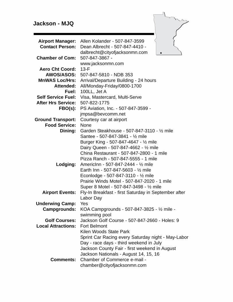
Jackson - MJQ
Airport Manager: Allen Kolander - 507-847-3599 Contact Person: Dean Albrecht - 507-847-4410 -
[email protected] of Com: 507-847-3867 -
www.jacksonmn.comAero Cht Coord: 13-F
AWOS/ASOS: 507-847-5810 - NDB 353MnWAS Loc/Hrs: Arrival/Departure Building - 24 hours
Attended: All/Monday-Friday/0800-1700Fuel: 100LL, Jet A
Self Service Fuel: Visa, Mastercard, Multi-ServeAfter Hrs Service: 507-822-1775
FBO(s): PS Aviation, Inc. - 507-847-3599 - [email protected]
Ground Transport: Courtesy car at airportFood Service: None
Dining: Garden Steakhouse - 507-847-3110 - ½ mileSantee - 507-847-3841 - ½ mileBurger King - 507-847-4647 - ½ mileDairy Queen - 507-847-4662 - ½ mileChina Restaurant - 507-847-2800 - 1 milePizza Ranch - 507-847-5555 - 1 mile
Lodging: AmericInn - 507-847-2444 - ½ mileEarth Inn - 507-847-5603 - ½ mileEconlodge - 507-847-3110 - ½ milePrairie Winds Motel - 507-847-2020 - 1 mileSuper 8 Motel - 507-847-3498 - ½ mile
Airport Events: Fly-In Breakfast - first Saturday in September afterLabor Day
Underwing Camp: YesCampgrounds: KOA Campgrounds - 507-847-3825 - ½ mile -
swimming poolGolf Courses: Jackson Golf Course - 507-847-2660 - Holes: 9
Local Attractions: Fort BelmontKilen Woods State ParkSprint Car Racing every Saturday night - May-Labor Day - race days - third weekend in JulyJackson County Fair - first weekend in AugustJackson Nationals - August 14, 15, 16
Comments: Chamber of Commerce e-mail - [email protected]
•
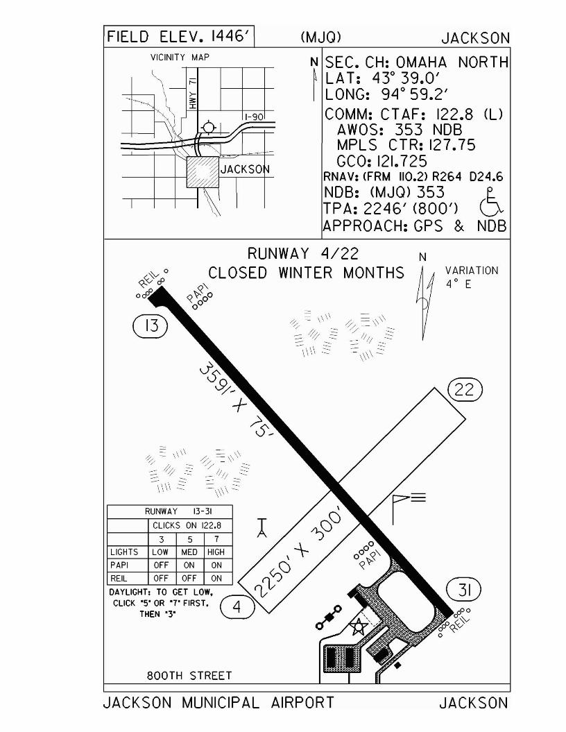
FIELD ELEV. 1446' (MJO) JACKSON
D24.6
6NOB
VICINITY MAP
1-90
JACKSO
N SEC. CH: OMAHA NORTH~ LAT: 430 39.0'I LONG: 94 0 59.2'
COMM: CT AF: 122.8 (l)AWOS: 353 NOBMPL S CTR: 127.75GCO: 121.725
RNAV: (FRM 110.2> R264NOB: (MJO) 353TPA: 2246' (800')APPROACH:GPS &
VARIATION4 0 E
RUNWAY 4/22 NCLOSED WINTER MONTHS
«."«"i-0000
CLICKS ON 122.8 J3 5 7
800TH STREET
RUNWAY 13-31
LIGHTS LOW MED HIGH
PAPI OFF ON ON
JACKSON MUNICIPAL AIRPORT JACKSON
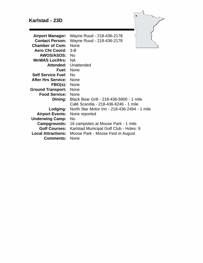
Karlstad - 23D
Airport Manager: Wayne Ruud - 218-436-2178 Contact Person: Wayne Ruud - 218-436-2178
Chamber of Com: NoneAero Cht Coord: 3-B
AWOS/ASOS: NoMnWAS Loc/Hrs: NA
Attended: UnattendedFuel: None
Self Service Fuel: NoAfter Hrs Service: None
FBO(s): NoneGround Transport: None
Food Service: NoneDining: Black Bear Grill - 218-436-5900 - 1 mile
Café Scandia - 218-436-6246 - 1 mileLodging: North Star Motor Inn - 218-436-2494 - 1 mile
Airport Events: None reportedUnderwing Camp: No
Campgrounds: 16 campsites at Moose Park - 1 mileGolf Courses: Karlstad Municipal Golf Club - Holes: 9
Local Attractions: Moose Park - Moose Fest in AugustComments: None
•
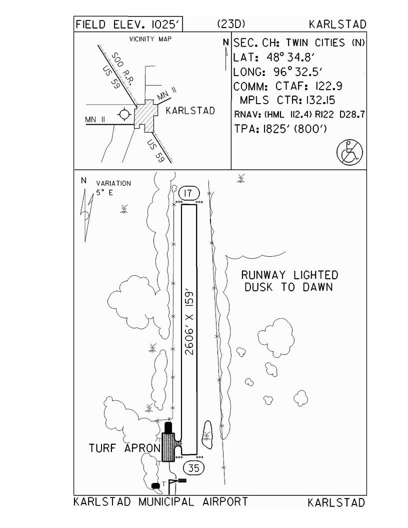
FIELD ELEV. 1025' (230) KARLSTAD
KARLSTAD
v 0
RUNWAY LIGHTEDDUSK TO DAWN
N SEC. CH: TWIN CITIES (N)~ LA T: 480 34.8'
LONG: 96 0 32.5'COMM: CTAF: 122.9
MPLS CTR: 132.15RNAV: (HML 112.4) RI22 D28.7
TPA: 1825' (800')
,enLf)
X,U)
0¥ U)-=- N
VICINITY MAP
TURF
N VARIATION
5° E
KARL STAD MUNICIPAL AIRPORT
Le Sueur - 12Ywww.cityoflesueur.com
Airport Manager: Dean Kunze - 507-665-2266 - [email protected]
Contact Person: Dean Kunze - 507-665-2266 - [email protected]
Chamber of Com: 507-665-2501 - www.co.le-sueur.mn.usAero Cht Coord: 12-H
AWOS/ASOS: No MnWAS Loc/Hrs: Administration Building - 24 hours
Attended: All/Mon-Fri/0800-1700Fuel: 100LL
Self Service Fuel: Visa, MastercardAfter Hrs Service: None
FBO(s): Scott's Helicopter Services, Inc. - 507-665-4064 - [email protected] - scottshelicopter.com
Ground Transport: City transit busFood Service: None
Dining: The Le Sueur Diner - 1 mileLodging: Downtown Motel - 1 mile
Airport Events: None reportedUnderwing Camp: Yes
Campgrounds: Peaceful Valley - 2 milesGolf Courses: Le Sueur Country Club - ½ mile
Local Attractions: Mayo House & MuseumGreen Giant Museum
Comments: None
•
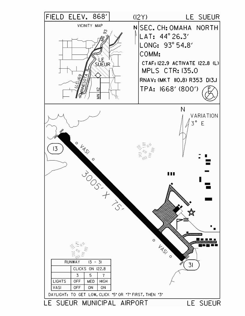
FIELD ELEV. 868' <I2Y) LE SUEUR
N SEC. CH: OMAHA NORTH~ LA T: 44° 26.3'
LONG: 93° 54.8'COMM:CT AF: 122.9 ACTIVATE 122.8 ll)
MPLS CTR: 135.0RNAV: (MK T 110.8> R353 013.1
TPA: 1668' (800') @N
••
-•
••••
----.•
I
VARIATION
3 0 E
III
\\RUNWAY 13 - 31
CLICKS ON 122.8
3 5 7
LIGHTS OFF MED HIGH
VASI OFF ON ON
J~
®
DAYLIGHT: TO GET LOW, CLICK "5" OR "7' FIRST. THEN "3"
LE SUEUR MUNICIPAL AIRPORT LE SUEUR
Litchfield - LJF
Airport Manager: Glenn E. Young - 320-693-8571 [email protected]
Contact Person: Glenn E. Young - 320-693-8571 - [email protected]
Chamber of Com: 320-693-8184 - www.litch.comAero Cht Coord: 10-F
AWOS/ASOS: 320-693-6456 - VOR 109.0MnWAS Loc/Hrs: Arrival/Departure Building - call 320-693-8571 for
combinationAttended: Unattended
Fuel: 100LL, Jet ASelf Service Fuel: Visa, MastercardAfter Hrs Service: 320-693-8571
FBO(s): NoneGround Transport: Courtesy car
Food Service: NoneDining: Golf Club (Peter's) - 320-693-6425 - 2 miles
Farmer's Daughter - 320-693-8211 - 3 milesLodging: Ripley Motel - 320-693-3227 - 1½ miles
Scottwood Motel - 320-693-2496 - 2½ milesAmericInn Lodge & Suites - 320-693-1600 - 2½ miles
Airport Events: None reportedUnderwing Camp: Yes
Campgrounds: Lake RipleyGolf Courses: Litchfield - Holes: 18
Local Attractions: Lake RipleyG.A.R. Hall-MuseumCivil War Museum
Comments: Monitor 122.9 for traffic
•
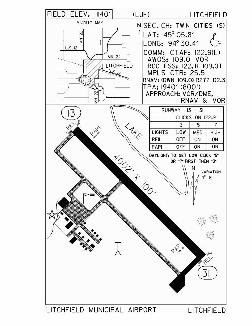
FIELD ELEV. 1140' (LJF) LITCHFIELD
RUNWA Y 13 - 31
IIII ,~~::;,""\1I1
I!II ~1111
VARIATION
4° E
357LOW MED HIGH
OFF ON ON
OFF ON ON
CLICKS ON 122.9
LIGHTS
REIL
PAPI
DAYLIGHTI TO GET LOW CLICK ·S·OR '7' FIRST THEN '3'
N
N SEC. CH: TWIN CITIES (S)
~ LA T: 45° 05.8' E.I LONG: 94° 30.4' V
COMM: CT AF: 122.9(l)AWOS: 109.0 VORRCO FSS: 122.IR I09.0TMPLS CTR: 125.5
RNAV: <OWN 109.0> R277 02.3TPA: 1940' (800')APPROACH:VOR/DME,
RNAV & VOR
VICINITY MAP
LITCHFIELD MUNICIPAL AIRPORT LITCHFIELD
Little Falls - LXL
Airport Manager: Tom Olson - 320-616-5525 - [email protected]
Contact Person: Big Sky Aviation, Inc. - 320-616-5525 - [email protected]
Chamber of Com: 320-632-5155 - www.littlefallsmnchamber.comAero Cht Coord: 9-G
AWOS/ASOS: 320-632-6791 - NDB 359MnWAS Loc/Hrs: Arrival/Departure Building - same as attendance
scheduleAttended: All/Mon-Fri/0800-1700
Fuel: 100LLSelf Service Fuel: Visa, Mastercard, Discover, American ExpressAfter Hrs Service: 320-632-9480
FBO(s): Big Sky Aviation, Inc. - 320-616-5525 - [email protected] Aviation, Inc. - 320-250-0132 - 122.80 - [email protected] - www.prairieaviation.com
Ground Transport: Taxi - 320-632-4104Car rental - Little Falls Dodge - 320-632-2908
Food Service: Vending machinesDining: Jason's - 320-632-2501 - 2 miles
Cabin Fever - 320-632-2356 - 3 milesPerkins - 320-632-5610Many fast food restaurants
Lodging: Country Inn - 320-632-1000Super 8 Motel - 320-632-2351AmericInn Motel - 320-632-1964
Airport Events: None reportedUnderwing Camp: Yes
Campgrounds: Lindbergh State ParkGolf Courses: Public Course - 320-616-5520 - Holes: 18
Local Attractions: Lindbergh State ParkLindbergh Interpretive CenterPine Grove Park ZooCamp Ripley Military MuseumBoyhood home of Charles Lindbergh, visit his home and museumArts, crafts & antique auto show - second weekend of September
Comments: Prairie Aviation - has flight instruction & air tours - 763-226-7842
•
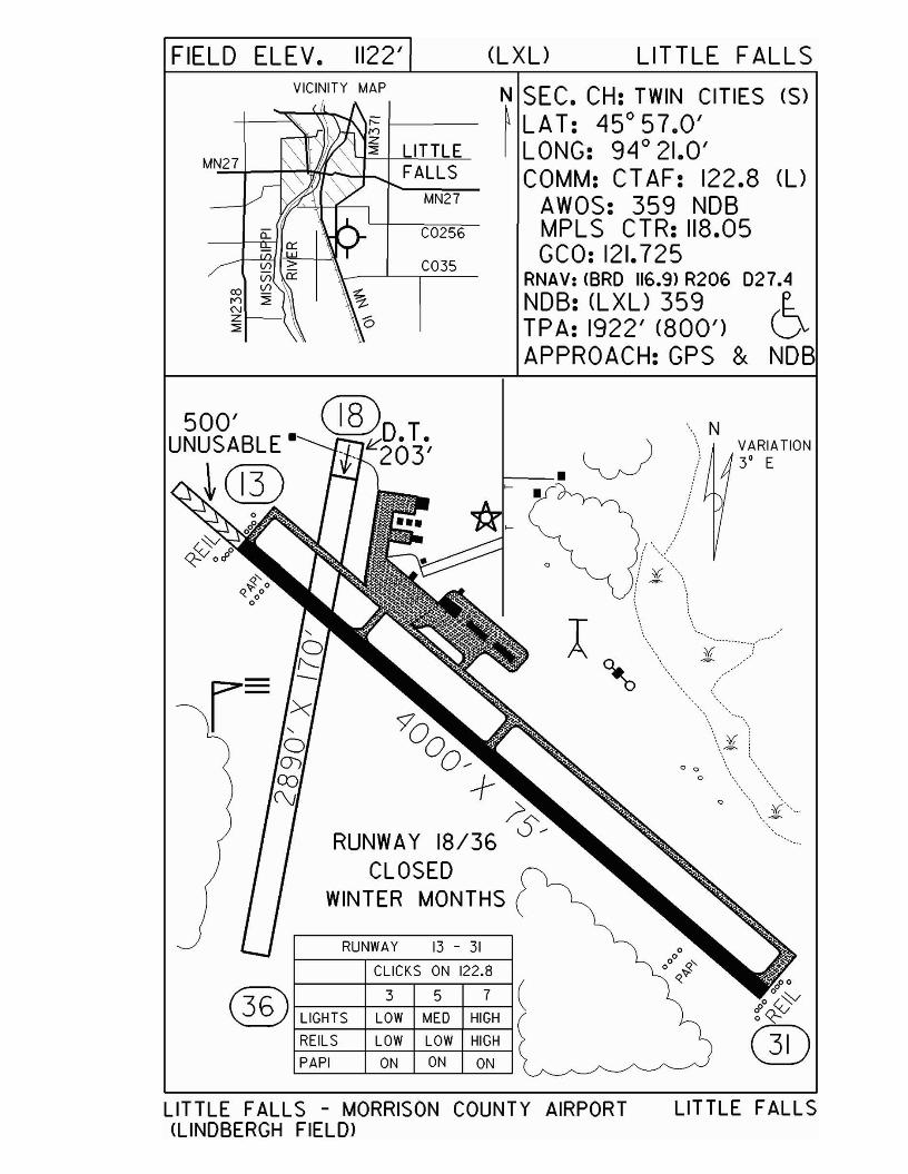
FIELD ELEV. 1122' (LXU LITTLE FALLSVICINITY MAP
LITTLEMN=27'-t----r~~"hJ FAL LS
MN27
C0256
C035
N SEC. CH: TWIN CITIES (S)~ LAT: 45°57.0'I LONG: 94° 21.0'
COMM: CT AF: 122.8 (UAWOS: 359 NOBMPLS CTR: 118.05GCO: 121.725
RNAV: <BRO 116.9> R206 027.4NOB: (LXU 359 E.TPA: 1922' (800') VAPPROACH:GPS & NOB
VARIATION3' E
o
\\ N
o 0
o
CLICKS ON 122.8
RUNWAY 13 - 31
'9'0°O?
-+~
RUNWA Y 18/36 S?CLOSED
WINTER MONTHS
@O.T.J- k'203'
PAPI ON ON ON
f7:C\ 3 5 7® f-L-IG-HT-S-+-L-OW--+M-E-D-+-HI-GH-l
REILS LOW LOW HIGH
500'UNUSABLE-
~©
LITTLE FALLS - MORRISON COUNTY AIRPORT(LINDBERGH FIELD)
LITTLE FALLS
Littlefork - 13Y
Airport Manager: Mike Fairchild - 218-278-4468 Contact Person: Mike Fairchild - 218-278-6710
Chamber of Com: 218-278-6617 Aero Cht Coord: 4-H
AWOS/ASOS: NoMnWAS Loc/Hrs: NA
Attended: UnattendedFuel: None
Self Service Fuel: NoAfter Hrs Service: None
FBO(s): NoneGround Transport: None
Food Service: NoneDining: DJ's Big Spoon - 218-278-6613 - 1½ miles
Hometown Café & Motel - 218-278-4788 - 1½ milesA & W - 1½ miles
Lodging: Gail's Country Cutter - 218-278-6222 - 1½ milesHometown Café & Motel - 218-278-4788 - 1½ miles
Airport Events: None reportedUnderwing Camp: No
Campgrounds: Lofgren Park - 1½ milesGolf Courses: International Falls - 19 miles
Local Attractions: Littlefork RiverFishingHuntingHikingATV trails
Comments: None
•
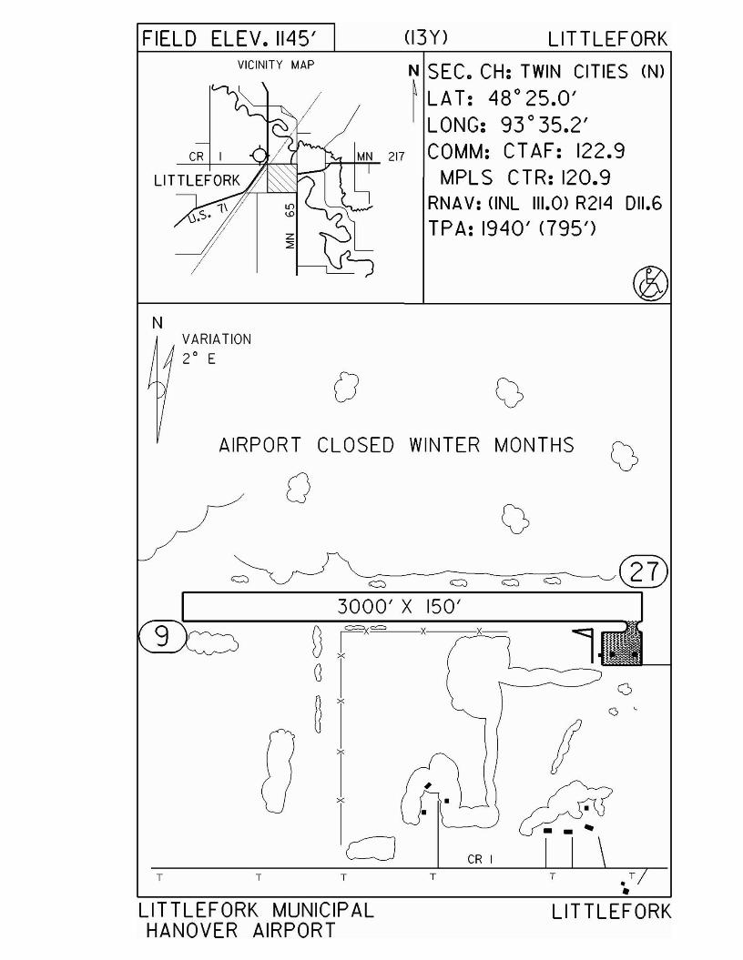
FIELD ELEV. 1145' (13Y) LITTLEFORKVICINITY MAP
N SEC. CH: TWIN CITIES (N)
~ LAT: 48°25.0'LONG: 93 °35.2'COMM: CTAF: 122.9
MPLS CTR: 120.9RNAV: (INL 111.0) R214 011.6
TPA: 1940' <795')
NVARIATION2° E
oAIRPORT CLOSED WINTER MONTHS
o
o c
LITTLEFORK
CR I
•
T
3000' X ISO'
T
x
x
(i, =x= xUlG
~ x
TT
9
LIT TLEFORK MUNICIPALHANOVER AIRPORT
Long Prairie - 14Y
Airport Manager: Chad Kuehne - 320-732-2167 - [email protected]
Contact Person: Chad Kuehne - 320-732-2167 - [email protected]
Chamber of Com: 320-732-2514 - www.longprairie.orgAero Cht Coord: 9-F
AWOS/ASOS: No MnWAS Loc/Hrs: Arrival/Departure Building - 24 hours
Attended: All/All/AllFuel: 100LL
Self Service Fuel: NoAfter Hrs Service: 320-732-3827
FBO(s): Popple Creek Air - 973-953-5462 - 122.9 - [email protected]
Ground Transport: Courtesy car available 24 hoursFood Service: Pop
Dining: Subway - 5 milesGriff's Pizza - 5 milesGene O's - 5 milesPier 71 - 5 milesDairy Queen - 5 milesHardee's - 5 miles
Lodging: Flamingo Motel - 320-732-6118 - 5 milesSuper 8 Motel - 5 miles
Airport Events: None reportedUnderwing Camp: Yes
Campgrounds: Lake Osakis CampgroundsBig Birch CampgroundsSauk Centre CampgroundsR & L Campgrounds - 6 milesBig Sauk Resort
Golf Courses: Long Prairie - Holes: 18Sauk Centre - Holes: 9 & 18Eagle Bend - Holes: 9
Local Attractions: Good swimming lake & park in Long PrairieMuseums (Todd County & Christie House)
Comments: People welcome to fly in to camp. Bathroom facility in pilot's lounge. Grill & picnic table. Fuel available 24 hours.
•

FIELD ELEV. 1333' (14Y) LONG PRAIRIE
SEC. CH: TWIN CITIES (S)LAT: 45°53.9'LONG: 94° 52.4'COMM: CTAF: 122.9 (l)
MPLS CTR: 126.1RNAV: CAXN 112.8> R096 015.5
TPA: 2130' <797')
357CLICKS ON 122.9
RUNWAY 16 - 34
CO.RD. 101
LIGHTS LOW MED HIGH
PAPI ON ON ON
REIL OFF OFF ON
I ~ROUND ~PRAIRIE
•
N VARIATION4° E
LONG PRAIRIE MUNICIPAL<TODD FIELD)
AIRPORT LONG PRAIRIE
Longville - XVG
Airport Manager: Dayna Merten - 218-363-2022 - [email protected]
Contact Person: City Offices - 218-363-2022 - [email protected]
Chamber of Com: 800-756-7583 - www.longville.comAero Cht Coord: 7-G
AWOS/ASOS: 218-363-3347 - NDB 392MnWAS Loc/Hrs: Arrival/Departure Building - 24 hours
Attended: UnattendedFuel: 100LL
Self Service Fuel: Visa, Mastercard, DiscoverAfter Hrs Service: None
FBO(s): NoneGround Transport: Eric Myrha Ford - 800-266-9702 or 218-547-1412 in
Walker, MNFood Service: None
Dining: Patrick's Fine Dining - 218-363-2995 - ¾ mileRedbird Café - 218-363-2210Frosty's - 218-363-2299Florio's - 218-363-3663Docksider MLS - 218-363-9703Common Grounds - 218-363-2292 - www.commongroundsoflongville.com
Lodging: Longville Inn - 218-363-2400 - ½ mileGirl Lake Resort - 218-363-2371 - ½ mileCamp Of My Dreams (B&B) - 218-363-2507 - ¼ mile
Airport Events: Centennial Fly-In in AugustUnderwing Camp: No
Campgrounds: Austin Swamp - 1¼ mileGolf Courses: Ridgewood Golf Course - 5 miles
Chippewa National Golf Course - 8 milesLocal Attractions: Women Lakes Chain
Comments: Airport manager's phone & information phone hours -8:30 A.M.-4:00 P.M. - Mon-FriLongville Lakes Clinic - 218-363-3300Longville City Hall - 218-363-2022Cass County Sheriff's Office (non-emergency) - 218-547-1424Time & temperature - 218-547-3535Weather machine, restrooms & pilot lounge located in City Hall immediately west of the hangar area - entry code is the sum of the numbers in the CTAF (14).
•
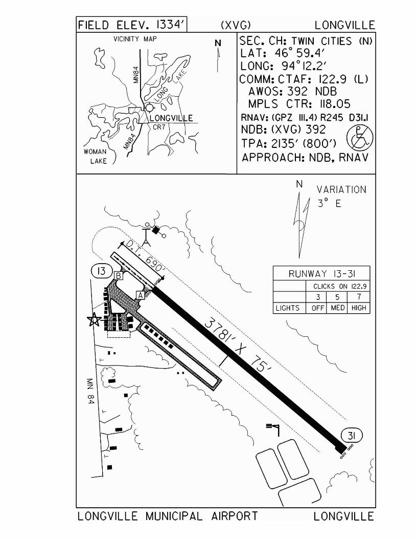
FIELD ELEV. 1334' (XVG) LONGVILLEVICINITY MAP SEC. CH: TWIN CITIES (N)
LAT: 460
59.4'LONG: 94 0 12.2'COMM: CT AF: 122.9 (l)
AWOS: 392 NOBMPLS CTR: 118.05
RNAV: <GPZ 111.4) R245 031.1NOB: (XVG) 392 f1?'\TPA: 2135' (800') ~APPROACH: NOB,RNAV
LIGHTS OFF MED HIGH
VARIATION30 E
3 5 7CLICKS ON 122.9
N
RUNWAY 13-31
••f--
s:Z
co •.l:>
f--
- ~- 000
f--
•
LONGVILLE MUNICIPAL AIRPORT LONGVILLE
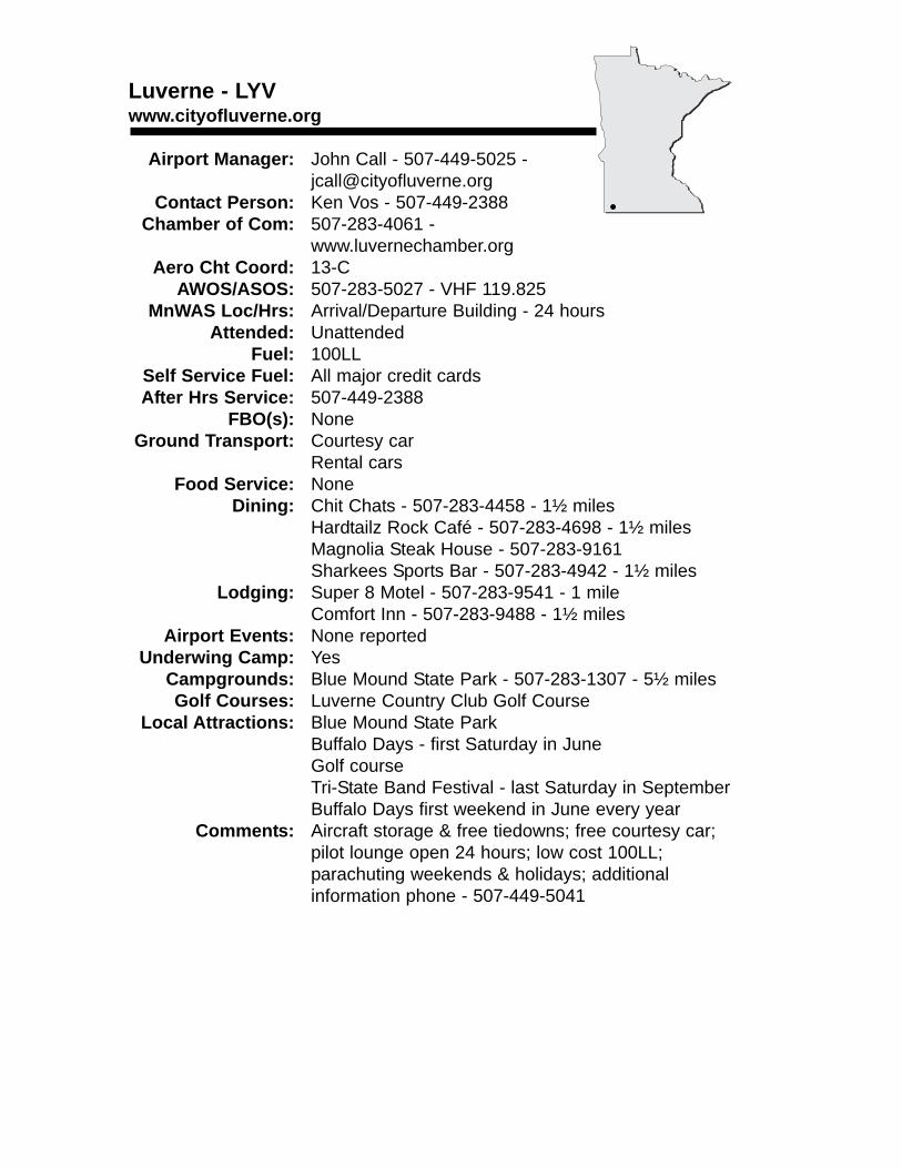
Luverne - LYVwww.cityofluverne.org
Airport Manager: John Call - 507-449-5025 - [email protected]
Contact Person: Ken Vos - 507-449-2388Chamber of Com: 507-283-4061 -
www.luvernechamber.orgAero Cht Coord: 13-C
AWOS/ASOS: 507-283-5027 - VHF 119.825MnWAS Loc/Hrs: Arrival/Departure Building - 24 hours
Attended: UnattendedFuel: 100LL
Self Service Fuel: All major credit cardsAfter Hrs Service: 507-449-2388
FBO(s): NoneGround Transport: Courtesy car
Rental carsFood Service: None
Dining: Chit Chats - 507-283-4458 - 1½ milesHardtailz Rock Café - 507-283-4698 - 1½ milesMagnolia Steak House - 507-283-9161Sharkees Sports Bar - 507-283-4942 - 1½ miles
Lodging: Super 8 Motel - 507-283-9541 - 1 mileComfort Inn - 507-283-9488 - 1½ miles
Airport Events: None reportedUnderwing Camp: Yes
Campgrounds: Blue Mound State Park - 507-283-1307 - 5½ milesGolf Courses: Luverne Country Club Golf Course
Local Attractions: Blue Mound State ParkBuffalo Days - first Saturday in JuneGolf courseTri-State Band Festival - last Saturday in SeptemberBuffalo Days first weekend in June every year
Comments: Aircraft storage & free tiedowns; free courtesy car; pilot lounge open 24 hours; low cost 100LL; parachuting weekends & holidays; additional information phone - 507-449-5041
•
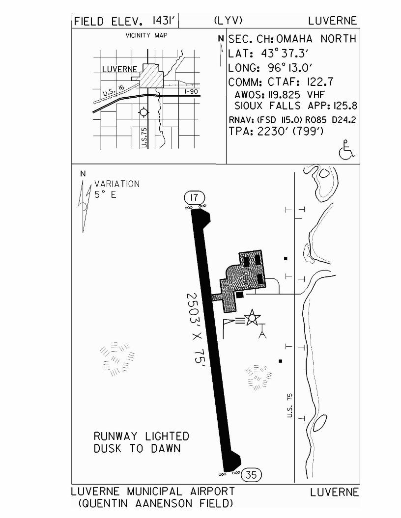
FIELD ELEV. 1431' (L YV) LUVERNEVICINITY MAP
1-90
N SEC. CH: OMAHA NORTH~ LAT: 43°37.3'I LONG: 96° 13.0'
COMM: CTAF: 122.7AWOS: 119.825 VHFSIOUX FALLS APP: 125.8
RNAV: (FSO 115.0> R085 024.2TPA: 2230' <799')
Vl
:::J -j
f--j
f- -j
•
•
VARIATION50 E
RUNWAY LIGHTEDDUSK TO DAWN
N
LUVERNE MUNICIPAL AIRPORT<QUENTIN AANENSON FIELD)
LUVERNE
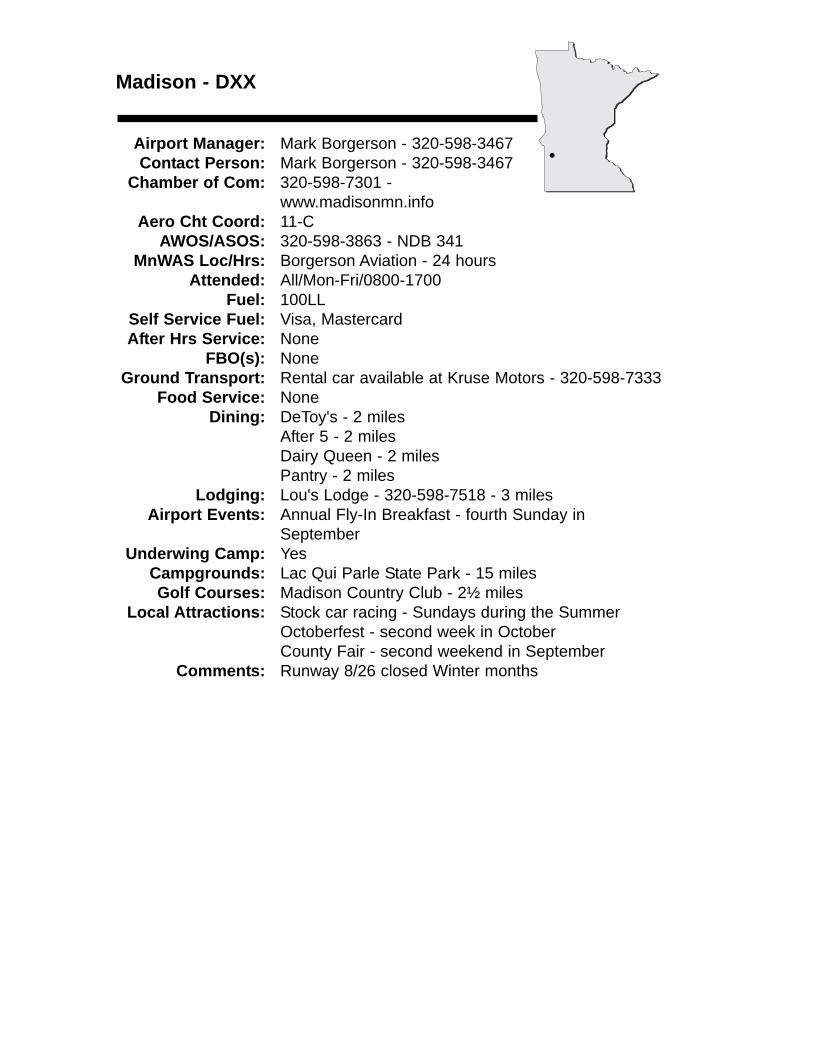
Madison - DXX
Airport Manager: Mark Borgerson - 320-598-3467 Contact Person: Mark Borgerson - 320-598-3467
Chamber of Com: 320-598-7301 - www.madisonmn.info
Aero Cht Coord: 11-CAWOS/ASOS: 320-598-3863 - NDB 341
MnWAS Loc/Hrs: Borgerson Aviation - 24 hoursAttended: All/Mon-Fri/0800-1700
Fuel: 100LLSelf Service Fuel: Visa, MastercardAfter Hrs Service: None
FBO(s): NoneGround Transport: Rental car available at Kruse Motors - 320-598-7333
Food Service: NoneDining: DeToy's - 2 miles
After 5 - 2 milesDairy Queen - 2 milesPantry - 2 miles
Lodging: Lou's Lodge - 320-598-7518 - 3 milesAirport Events: Annual Fly-In Breakfast - fourth Sunday in
SeptemberUnderwing Camp: Yes
Campgrounds: Lac Qui Parle State Park - 15 milesGolf Courses: Madison Country Club - 2½ miles
Local Attractions: Stock car racing - Sundays during the SummerOctoberfest - second week in OctoberCounty Fair - second weekend in September
Comments: Runway 8/26 closed Winter months
•
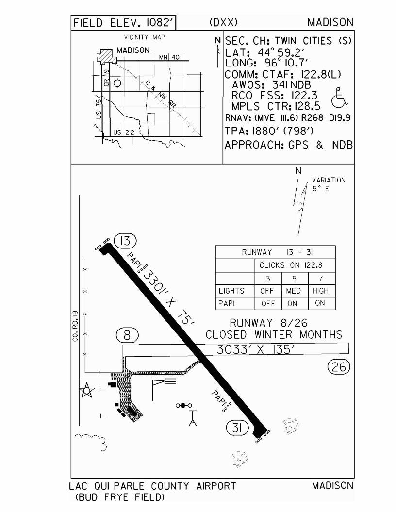
FIELD ELEV. 1082' <DXX) MADISONVICINITY MAP
MN 40
N SEC. CH: TWIN CITIES (S)~ LA T: LILlo 59.2'I LONG: 96° 10.7'
COMM: CT AF: 122.8(l)AWOS: 3L11 NOBRCO FSS: 122.3 (~MPLS CTR: 128.5 V
RNAV: (MVE 111.6) R268 019.9
TPA: 1880' (798')APPROACH:GPS & NOB
NVARIATION50 E
RUNWAY 13 - 31
CLICKS ON 122.8
3 5 7
LIGHTS OFF MED HIGH
PAPI OFF ON ON
RUNWAY 8/26CLOSED WINTER MONTHS
3033' X I '®
~
c:ia::ou
LAC QUI PARLE COUNTY AIRPORT(BUD FRYE FIELD)
MADISON
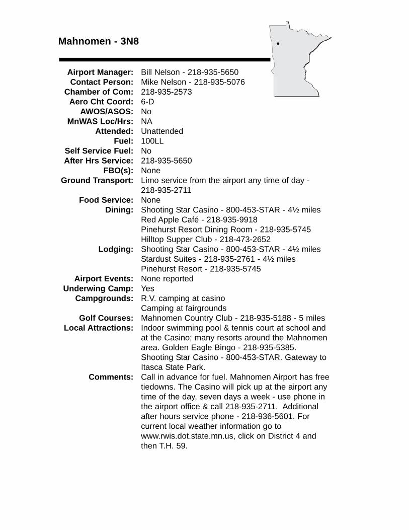
Mahnomen - 3N8
Airport Manager: Bill Nelson - 218-935-5650 Contact Person: Mike Nelson - 218-935-5076
Chamber of Com: 218-935-2573 Aero Cht Coord: 6-D
AWOS/ASOS: NoMnWAS Loc/Hrs: NA
Attended: UnattendedFuel: 100LL
Self Service Fuel: NoAfter Hrs Service: 218-935-5650
FBO(s): NoneGround Transport: Limo service from the airport any time of day -
218-935-2711Food Service: None
Dining: Shooting Star Casino - 800-453-STAR - 4½ milesRed Apple Café - 218-935-9918Pinehurst Resort Dining Room - 218-935-5745Hilltop Supper Club - 218-473-2652
Lodging: Shooting Star Casino - 800-453-STAR - 4½ milesStardust Suites - 218-935-2761 - 4½ milesPinehurst Resort - 218-935-5745
Airport Events: None reportedUnderwing Camp: Yes
Campgrounds: R.V. camping at casinoCamping at fairgrounds
Golf Courses: Mahnomen Country Club - 218-935-5188 - 5 milesLocal Attractions: Indoor swimming pool & tennis court at school and
at the Casino; many resorts around the Mahnomen area. Golden Eagle Bingo - 218-935-5385. Shooting Star Casino - 800-453-STAR. Gateway to Itasca State Park.
Comments: Call in advance for fuel. Mahnomen Airport has freetiedowns. The Casino will pick up at the airport any time of the day, seven days a week - use phone in the airport office & call 218-935-2711. Additional after hours service phone - 218-936-5601. For current local weather information go to www.rwis.dot.state.mn.us, click on District 4 and then T.H. 59.
•
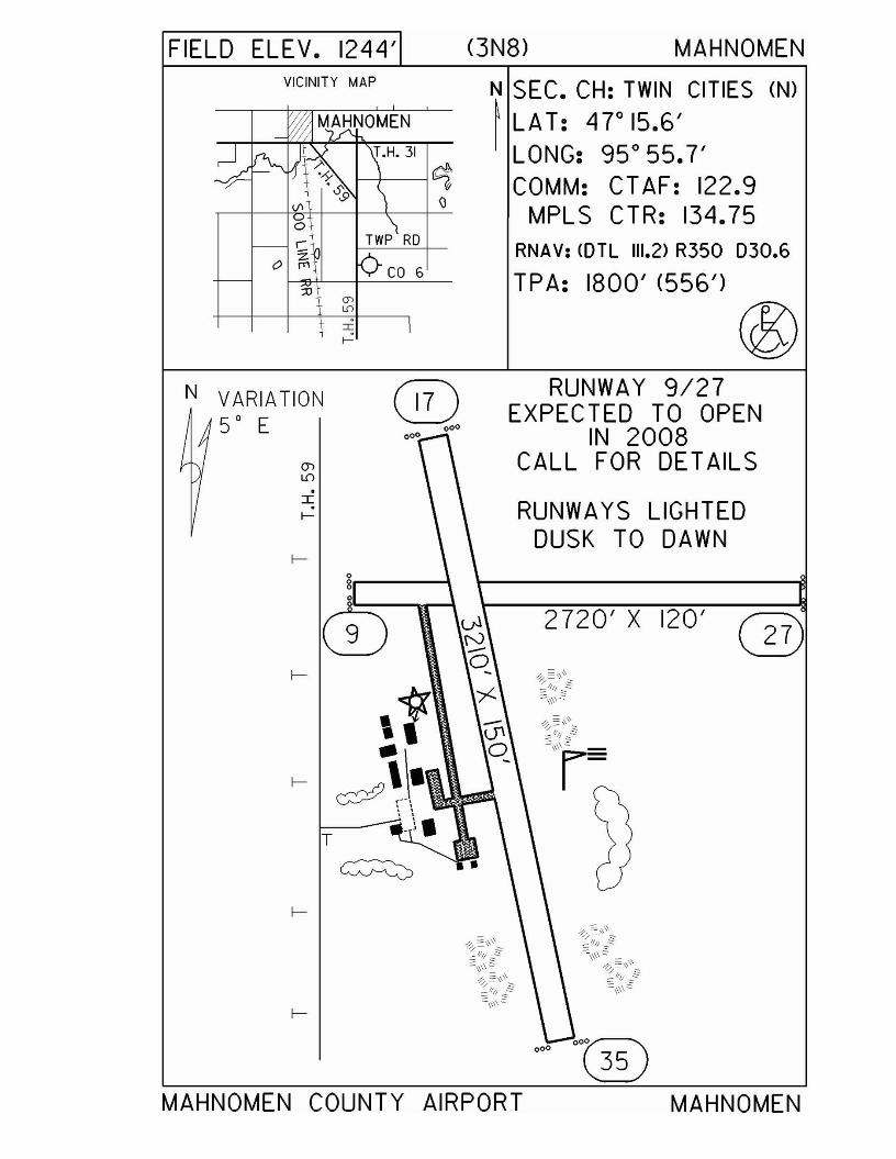
FIELD ELEV. 1244' (3N8) MAHNOMEN
2720' X 120'
RUNWAY 9/27EXPECTED TO OPEN
IN 2008CALL FOR DETAILS
RUNWAYS LIGHTEDDUSK TO DAWN
N SEC. CH: TWIN CITIES (N)
~ LAT: 4r15.6'LONG: 95 0 55.7'COMM: CTAF: 122.9
MPLS CTR: 134.75RNAV: COTL 111.2> R350 030.6
TPA: 1800' (556')
@®
000
I
f-
.:r:t-
f-0g0
0f-
,1f- ~\.
'. ~.T
~
f-
VICINITY MAP
Q)
L0
o.-
o ~
N VARIATION50 E
MAHNOMEN COUNTY AIRPORT MAHNOMEN
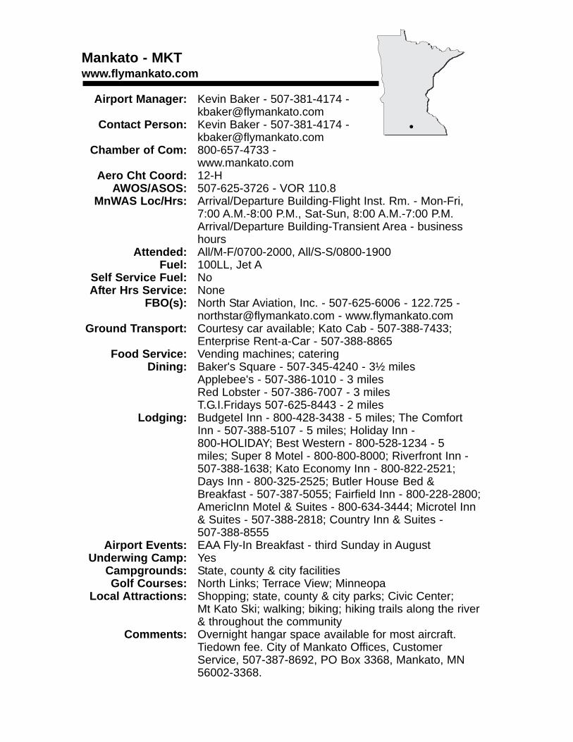
Mankato - MKTwww.flymankato.com
Airport Manager: Kevin Baker - 507-381-4174 - [email protected]
Contact Person: Kevin Baker - 507-381-4174 - [email protected]
Chamber of Com: 800-657-4733 - www.mankato.com
Aero Cht Coord: 12-HAWOS/ASOS: 507-625-3726 - VOR 110.8
MnWAS Loc/Hrs: Arrival/Departure Building-Flight Inst. Rm. - Mon-Fri, 7:00 A.M.-8:00 P.M., Sat-Sun, 8:00 A.M.-7:00 P.M.Arrival/Departure Building-Transient Area - business hours
Attended: All/M-F/0700-2000, All/S-S/0800-1900Fuel: 100LL, Jet A
Self Service Fuel: NoAfter Hrs Service: None
FBO(s): North Star Aviation, Inc. - 507-625-6006 - 122.725 - [email protected] - www.flymankato.com
Ground Transport: Courtesy car available; Kato Cab - 507-388-7433;Enterprise Rent-a-Car - 507-388-8865
Food Service: Vending machines; cateringDining: Baker's Square - 507-345-4240 - 3½ miles
Applebee's - 507-386-1010 - 3 milesRed Lobster - 507-386-7007 - 3 milesT.G.I.Fridays 507-625-8443 - 2 miles
Lodging: Budgetel Inn - 800-428-3438 - 5 miles; The ComfortInn - 507-388-5107 - 5 miles; Holiday Inn - 800-HOLIDAY; Best Western - 800-528-1234 - 5 miles; Super 8 Motel - 800-800-8000; Riverfront Inn - 507-388-1638; Kato Economy Inn - 800-822-2521; Days Inn - 800-325-2525; Butler House Bed & Breakfast - 507-387-5055; Fairfield Inn - 800-228-2800; AmericInn Motel & Suites - 800-634-3444; Microtel Inn & Suites - 507-388-2818; Country Inn & Suites - 507-388-8555
Airport Events: EAA Fly-In Breakfast - third Sunday in AugustUnderwing Camp: Yes
Campgrounds: State, county & city facilitiesGolf Courses: North Links; Terrace View; Minneopa
Local Attractions: Shopping; state, county & city parks; Civic Center; Mt Kato Ski; walking; biking; hiking trails along the river & throughout the community
Comments: Overnight hangar space available for most aircraft. Tiedown fee. City of Mankato Offices, Customer Service, 507-387-8692, PO Box 3368, Mankato, MN 56002-3368.
•
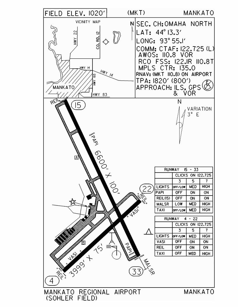
FIELD ELEV. 1020' (MKT) MANKATO
CLICKS ON 122.725
7
HIGH
HIGH
ON
ON
HIGH
VARIATION3° E
CLICKS ON 122.725
OFF ON ON
OFF MED HIGH
3 5 7
FF/LOW MED HIGH
OFF ON ON
RUNWAY 4 - 22
TAXI
REIL
.1l.. LIGHTS
VASI
3 5
RUNWAY 15 - 33
N
N SEC. CH: OMAHA NORTH~ LAT: 44
013.3'
LONG: 93 0 55.1'COMM: CT AF: 122.725 (l)AWOS: 110.8 VORRCO FSS: 122.IR 1I0.8TMPLS CTR: 135.0
RNAV: (MKT 110.8> ON AIRPORTTPA: 1820' (800') ~APPROACH: ILS. GPS 'W
& VOR
@ LIGHTS OFF/LOW MED
o~ PAPI OFF ONoOo~ REILliSl OFF ON
000 MALSR LOW MEDo
'7' TAXI OFF/LOW MEDo~~
VICINITY MAP
NN
>;;::r:
MANKATO REGIONAL(SOHLER FIELD>
AIRPORT MANKATO
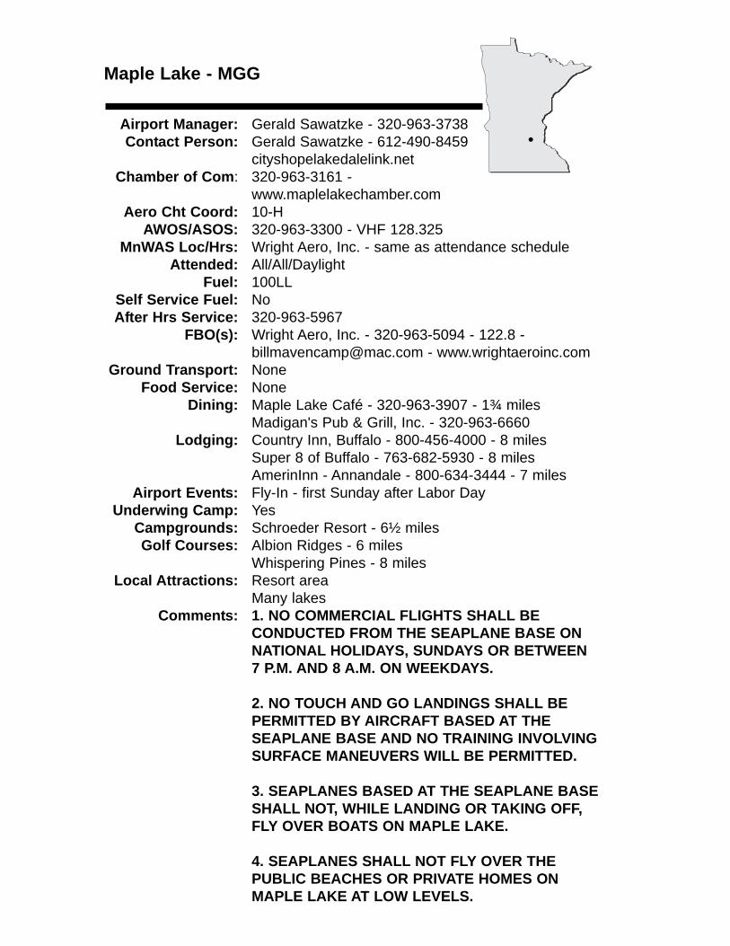
Maple Lake - MGG
Airport Manager: Gerald Sawatzke - 320-963-3738Contact Person: Gerald Sawatzke - 612-490-8459
cityshopelakedalelink.netChamber of Com: 320-963-3161 -
www.maplelakechamber.comAero Cht Coord: 10-H
AWOS/ASOS: 320-963-3300 - VHF 128.325MnWAS Loc/Hrs: Wright Aero, Inc. - same as attendance schedule
Attended: All/All/DaylightFuel: 100LL
Self Service Fuel: NoAfter Hrs Service: 320-963-5967
FBO(s): Wright Aero, Inc. - 320-963-5094 - 122.8 - [email protected] - www.wrightaeroinc.com
Ground Transport: NoneFood Service: None
Dining: Maple Lake Café - 320-963-3907 - 1¾ milesMadigan's Pub & Grill, Inc. - 320-963-6660
Lodging: Country Inn, Buffalo - 800-456-4000 - 8 milesSuper 8 of Buffalo - 763-682-5930 - 8 milesAmerinInn - Annandale - 800-634-3444 - 7 miles
Airport Events: Fly-In - first Sunday after Labor DayUnderwing Camp: Yes
Campgrounds: Schroeder Resort - 6½ milesGolf Courses: Albion Ridges - 6 miles
Whispering Pines - 8 milesLocal Attractions: Resort area
Many lakesComments: 1. NO COMMERCIAL FLIGHTS SHALL BE
CONDUCTED FROM THE SEAPLANE BASE ON NATIONAL HOLIDAYS, SUNDAYS OR BETWEEN 7 P.M. AND 8 A.M. ON WEEKDAYS.
2. NO TOUCH AND GO LANDINGS SHALL BE PERMITTED BY AIRCRAFT BASED AT THESEAPLANE BASE AND NO TRAINING INVOLVING SURFACE MANEUVERS WILL BE PERMITTED.
3. SEAPLANES BASED AT THE SEAPLANE BASE SHALL NOT, WHILE LANDING OR TAKING OFF, FLY OVER BOATS ON MAPLE LAKE.
4. SEAPLANES SHALL NOT FLY OVER THEPUBLIC BEACHES OR PRIVATE HOMES ON MAPLE LAKE AT LOW LEVELS.
•
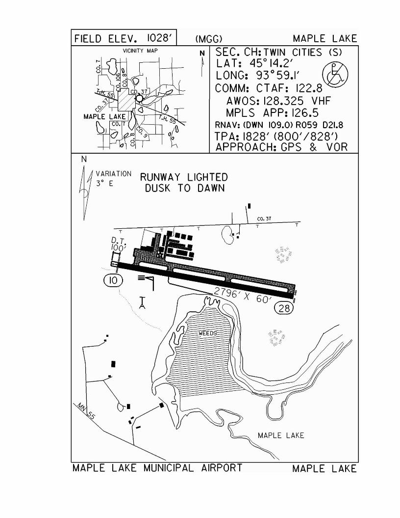
FIELD ELEV. 1028'VICINITY MAP
(MGG) MAPLE LAKEN SEC. CH: TWIN CITIES (S)~ LAT: 45°14.2' r1?\I LONG: 93°59.1' Vl2J
COMM: C1 AF: 122.8AWOS: 128.325 VHFMPLS APP: 126.5
RNAV: <OWN 109.0> R059 021.8TPA: 1828' (800'1828')APPROACH:GPS & VOR
VARIATION3° E
•
RUNWAY LIGHTEDDUSK TO DAWN
CO. 377 T
MAPLE LAKE
MAPLE LAKE MUNICIPAL AIRPORT MAPLE LAKE
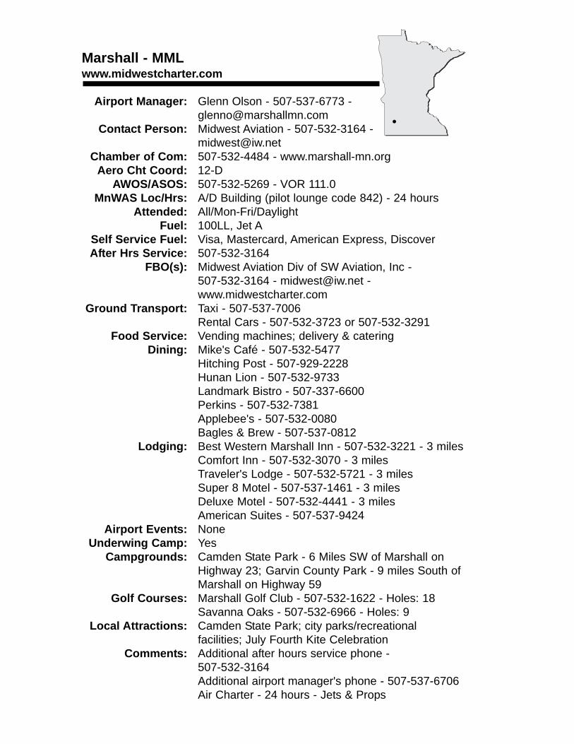
Marshall - MMLwww.midwestcharter.com
Airport Manager: Glenn Olson - 507-537-6773 - [email protected]
Contact Person: Midwest Aviation - 507-532-3164 - [email protected]
Chamber of Com: 507-532-4484 - www.marshall-mn.orgAero Cht Coord: 12-D
AWOS/ASOS: 507-532-5269 - VOR 111.0MnWAS Loc/Hrs: A/D Building (pilot lounge code 842) - 24 hours
Attended: All/Mon-Fri/DaylightFuel: 100LL, Jet A
Self Service Fuel: Visa, Mastercard, American Express, DiscoverAfter Hrs Service: 507-532-3164
FBO(s): Midwest Aviation Div of SW Aviation, Inc - 507-532-3164 - [email protected] - www.midwestcharter.com
Ground Transport: Taxi - 507-537-7006Rental Cars - 507-532-3723 or 507-532-3291
Food Service: Vending machines; delivery & cateringDining: Mike's Café - 507-532-5477
Hitching Post - 507-929-2228Hunan Lion - 507-532-9733Landmark Bistro - 507-337-6600Perkins - 507-532-7381Applebee's - 507-532-0080Bagles & Brew - 507-537-0812
Lodging: Best Western Marshall Inn - 507-532-3221 - 3 milesComfort Inn - 507-532-3070 - 3 milesTraveler's Lodge - 507-532-5721 - 3 milesSuper 8 Motel - 507-537-1461 - 3 milesDeluxe Motel - 507-532-4441 - 3 milesAmerican Suites - 507-537-9424
Airport Events: NoneUnderwing Camp: Yes
Campgrounds: Camden State Park - 6 Miles SW of Marshall on Highway 23; Garvin County Park - 9 miles South of Marshall on Highway 59
Golf Courses: Marshall Golf Club - 507-532-1622 - Holes: 18Savanna Oaks - 507-532-6966 - Holes: 9
Local Attractions: Camden State Park; city parks/recreational facilities; July Fourth Kite Celebration
Comments: Additional after hours service phone -507-532-3164Additional airport manager's phone - 507-537-6706Air Charter - 24 hours - Jets & Props
•
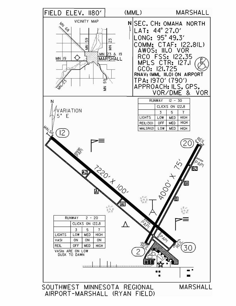
FIELD ELEV. 1180'VICINITY MAP
N
VARIATION5' E
RUNWAY 2 - 20
CLICKS ON 122.8
3 5 7
LIGHTS LOW MED HIGH
VASI ON ON ON
REIL OFF MED HIGH
VASls ARE ON LOWDUSK TO DAWN
(MML) MARSHALL
N SEC. CH: OMAHA NORTH~ LAT: 44 0 27.0'I LONG: 95 0 49.3'
COMM: CT AF: 122.8(l)AWOS: 111.0 VORRCO FSS: 122.35 ®MPLS CTR: 127.1GCO: 121.725
RNAV: (MML 111.0) ON AIRPORTTPA: 1970' <790')APPROACH: IL S. GPS.
VOR/DME & VORRUNWAY 12 - 30
CLICKS ON 122.8
357LIGHTS LOW MED HIGH
REIU30) OFF MED HIGH
MALSR1I2l LOW MED HIGH
."•
SOUTHWEST MINNESOTA REGIONALAIRPORT -MARSHALL (RYAN FIELD>
MARSHALL

McGregor - HZXwww.mcgregorairport.com
Airport Manager: Mike Zebro - 406-223-4955 - [email protected]
Contact Person: Judy Cirilli - 218-768-2717 - [email protected]
Chamber of Com: 218-768-3692 - www.mcgregormn.comAero Cht Coord: 7-I
AWOS/ASOS: 218-768-2593 - VHF 119.575MnWAS Loc/Hrs: Arrival/Departure Building - 24 hours
Attended: UnattendedFuel: Mogas, 100LL
Self Service Fuel: Visa, Mastercard, Diner's ClubAfter Hrs Service: None
FBO(s): NoneGround Transport: Courtesy car
Food Service: NoneDining: Fireside Inn - 218-768-9971 - ¼ mile
Subway - 218-768-7827 - ½ mileDairy Queen - 218-768-2050 - ½ mile
Lodging: Town & Country Motel - 218-768-3271 - 1 mileCountry Meadows Inn - 218-768-7378 or888-321-7378 - ½ mile
Airport Events: Wild Rice Days - Saturday, Labor Day weekendCorn Feed - Sunday, Labor Day weekend
Underwing Camp: YesCampgrounds: Big Sandy Dam
Savanna Portage State ParkLarson's Barn CampgroundEagle Point ResortAitkin Lake Resort
Golf Courses: Minnesota National Golf Course - 9 miles North on Highway 65
Local Attractions: Wild Rice Days - Saturday, Labor Day weekendLion's Corn Feed - Sunday, Labor Day weekendRice Lake National Wildlife RefugeSavanna Portage State Park
Comments: McGregor is located close to lakes, with four seasons of outdoor recreation. Fishing, hunting & snowmobiling are important activities.Airport manager's work phone - 218-768-7827Airport manager's FAX - 218-768-2717Self-serve credit card fuel available 24 hoursAdditional airport web site - www.iversonfield.com
•
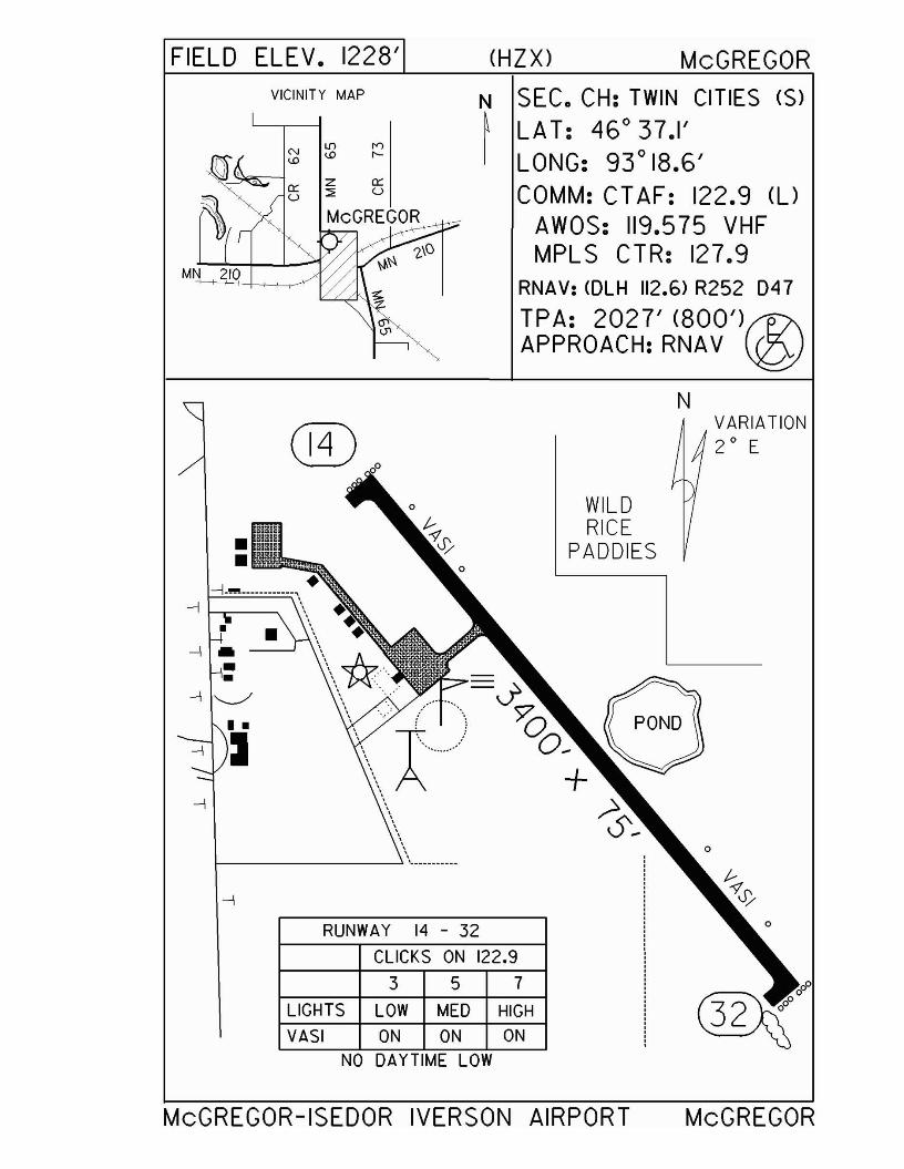
FIELD ELEV. 1228' (HZX) McGREGOR
MN 210
VICINITY MAP
Z 0:::::::;; U
McGREGOR~"'-Y-'
N SEC. CH: TWIN CITIES (S)~ LAT: 46° 37.1'I LONG: 93° 18.6'
COMM: CT AF: 122.9 (l)
AWOS: 119.575 VHFMPLS CTR: 127.9
RNAV: CDLH 112.6) R252 D47
TPA: 2027' (800')r1?\APPROACH: RNAV \gJ
N
RUNWAY 14 - 32
CLICKS ON 122.9
357LIGHTS LOW MED HIGH
VASI ON ON ONNO DAYTIME LOW
VARIATION2 0 E
WILDRICE
PADDIES
McGREGOR-ISEDOR IVERSON AIRPORT McGREGOR
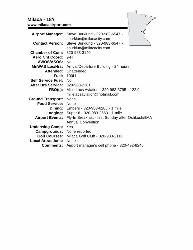
Milaca - 18Ywww.milacaairport.com
Airport Manager: Steve Burklund - 320-983-6547 - [email protected]
Contact Person: Steve Burklund - 320-983-6547 - [email protected]
Chamber of Com: 320-983-3140Aero Cht Coord: 9-H
AWOS/ASOS: NoMnWAS Loc/Hrs: Arrival/Departure Building - 24 hours
Attended: UnattendedFuel: 100LL
Self Service Fuel: NoAfter Hrs Service: 320-983-2381
FBO(s): Mille Lacs Aviation - 320-983-3795 - 122.9 - [email protected]
Ground Transport: NoneFood Service: None
Dining: Embers - 320-983-6288 - 1 mileLodging: Super 8 - 320-983-2660 - 1 mile
Airport Events: Fly-In Breakfast - first Sunday after Oshkosh/EAAAnnual Convention
Underwing Camp: YesCampgrounds: None reportedGolf Courses: Milaca Golf Club - 320-983-2110
Local Attractions: NoneComments: Airport manager's cell phone - 320-492-8246
•
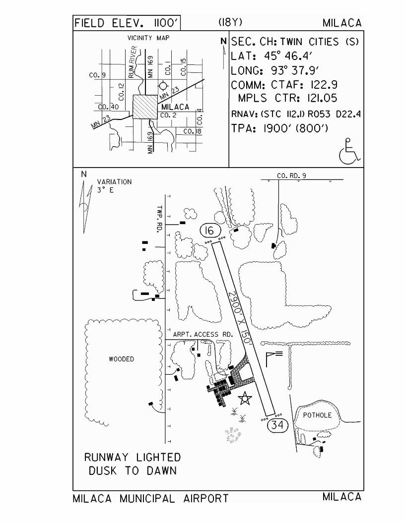
FIELD ELEV. 1100'VICINITY MAP
NVARIATION3° E
WOODED
RUNWAY LIGHTEDDUSK TO DAWN
(18Y) MILACA
N SEC. CH: TWIN CITIES (S)
~ LA T: 45° 46.4'LONG: 93° 37.9'COMM: CT AF: 122.9
MPLS CTR: 121.05RNAV: <$ TC 112.1> R053 022.4
TPA: 1900' (800')
CO.RD.9
MILACA MUNICIPAL AIRPORT MILACA
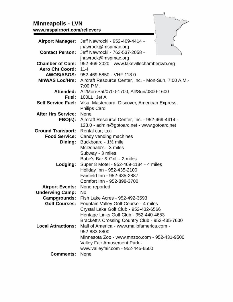
Minneapolis - LVNwww.mspairport.com/relievers
Airport Manager: Jeff Nawrocki - 952-469-4414 - [email protected]
Contact Person: Jeff Nawrocki - 763-537-2058 - [email protected]
Chamber of Com: 952-469-2020 - www.lakevillechambercvb.orgAero Cht Coord: 11-I
AWOS/ASOS: 952-469-5850 - VHF 118.0MnWAS Loc/Hrs: Aircraft Resource Center, Inc. - Mon-Sun, 7:00 A.M.-
7:00 P.M.Attended: All/Mon-Sat/0700-1700, All/Sun/0800-1600
Fuel: 100LL, Jet ASelf Service Fuel: Visa, Mastercard, Discover, American Express,
Philips CardAfter Hrs Service: None
FBO(s): Aircraft Resource Center, Inc. - 952-469-4414 - 123.0 - [email protected] - www.gotoarc.net
Ground Transport: Rental car; taxiFood Service: Candy vending machines
Dining: Buckboard - 1½ mileMcDonald's - 3 milesSubway - 3 milesBabe's Bar & Grill - 2 miles
Lodging: Super 8 Motel - 952-469-1134 - 4 milesHoliday Inn - 952-435-2100Fairfield Inn - 952-435-2887Comfort Inn - 952-898-3700
Airport Events: None reportedUnderwing Camp: No
Campgrounds: Fish Lake Acres - 952-492-3593Golf Courses: Fountain Valley Golf Course - 4 miles
Crystal Lake Golf Club - 952-432-6566Heritage Links Golf Club - 952-440-4653Brackett's Crossing Country Club - 952-435-7600
Local Attractions: Mall of America - www.mallofamerica.com - 952-883-8800Minnesota Zoo - www.mnzoo.com - 952-431-9500Valley Fair Amusement Park - www.valleyfair.com - 952-445-6500
Comments: None
•
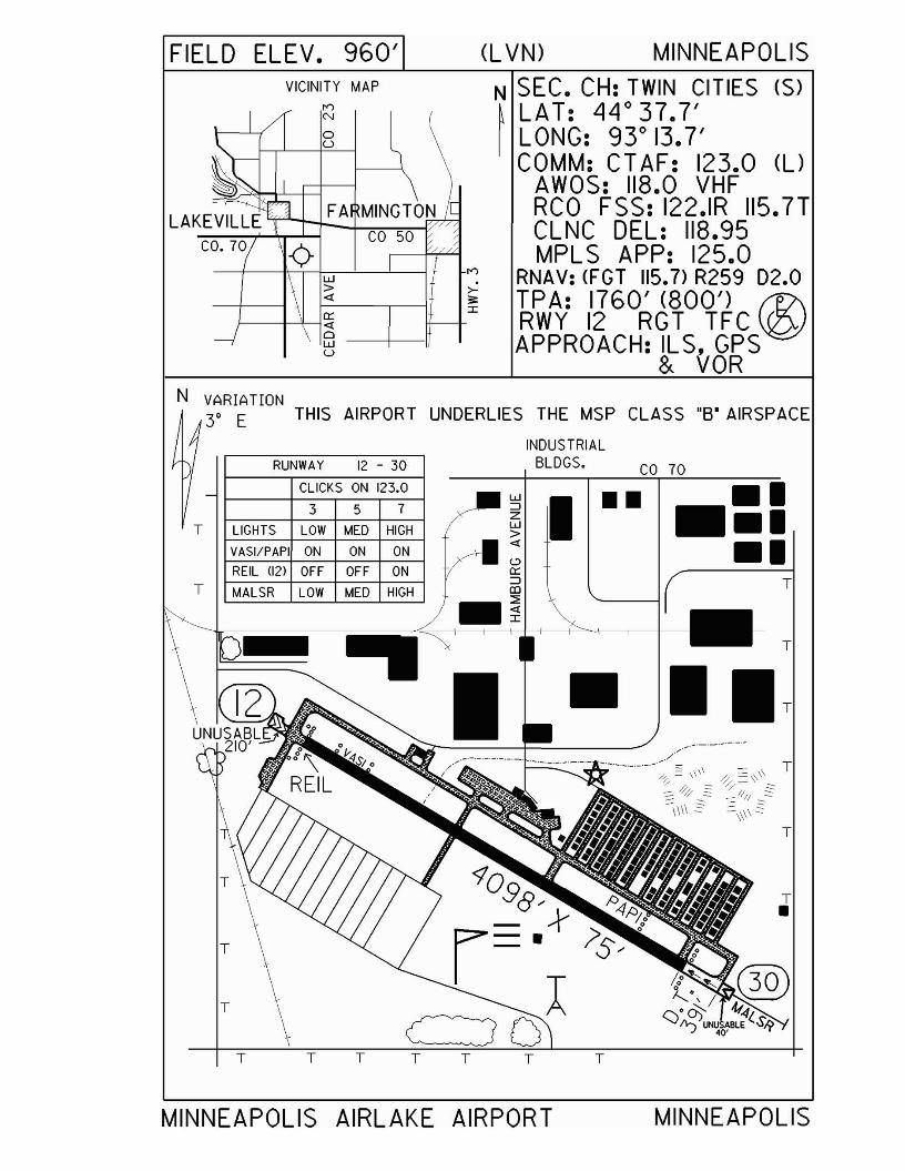
FIELD ELEV. 960' (L VN) MINNEAPOLISVICINITY MAP
l")
N
oU
FA MINGTONCO 50
w>«
~--+-+----I~~ --+--11u
l")
>3:I
N SEC. CH: TWIN CITIES (S)~ LAT: LjLjo37.7'I LONG: 9Y 13.7'
COMM: CTAF: 123.0 (l)AWOS: 118.0 VHFRCO FSS: 122.IR 115.7TCLNC DEL: 118.95MPL S APP: 125.0
RNAV: (FGT 115.7) R259 D2.0TPA: 1760' (800') f17\RWY 12 RGT TFC~APPROACH: ILS, GPS
& VOR
INDUSTRIALBLDGS. CO 70RUNWAY 12 - 30
N VARIATION3' E THIS AIRPORT UNDERLIES THE MSP CLASS "S' AIRSPACE
LIGHTS LOW MED HIGH
VASI/PAPI ON ON ON
REIL 1I2) OFF OFF ON
MALSR LOW MED HIGH
CLICKS ON 123.0
T
T
T•
T
T
•
I ..•::••
T
w::JZw>«
T T
..
T T
3 5 7
T
T
T
T
T
MINNEAPOLIS AIRLAKE AIRPORT MINNEAPOLIS
Minneapolis - ANEwww.mspairport.com/relievers
Airport Manager: Joseph Harris - 763-717-0001 - [email protected]
Contact Person: Joseph Harris - 763-717-0001 - [email protected]
Chamber of Com: 763-421-7130 - www.anokaareachamber.com
Aero Cht Coord: 10-IAWOS/ASOS: 763-780-9025 - VHF 120.625
MnWAS Loc/Hrs: AAH - Mon-Fri, 6:30 A.M.-5:30 P.M.; Cirrus Flight Opns, Inc./Great Lakes Air - Mon-Sun, 6:00 A.M.-12:00 A.M.;Control Tower - Mon-Sun, 7:00 A.M.-10:00 P.M.;Crossroads Aviation, LLC - business hours; Erickson Hangar, NE side, hangar number 2435 on "North Dakota" row - business hours
Attended: CST/All/0700-2100,CDT/All/0700-2200Fuel: 100LL, Jet A
Self Service Fuel: Visa, Mastercard, American ExpressAfter Hrs Service: 763-784-6614
FBO(s): Bolduc Aviation Specialized Services, Inc - 763-780-1185 - [email protected]; Cirrus Flight Operations, Inc. - 763-784-6614 - 122.95 [email protected] - www.cirrusflight.com; Crossroads Aviation, LLC - 763-783-1866 - 123.3 - [email protected] - www.crossroadsaviation.com; Knowlton Flight Instruction Services, Inc. - 763-780-4375; Twin Cities Flight Training LLC - 763-784-8627 - 126.05 - [email protected] - www.twincitiesflight.com; Whirlwind Helicopters, Inc. - 763-784-9496 - [email protected] - www.whirlwindhelicopters.com
Ground Transport: Car rental & limousine service at Cirrus Flight Operations - 763-784-6614 & Crossroads Aviation - 763-783-1866; taxi
Food Service: Vending machinesDining: Ole Piper - 1 mile
Lodging: Hospitality Suites - 763-780-3797Airport Events: See www.discoveraviationdays.org
Underwing Camp: YesCampgrounds: None reportedGolf Courses: Bunker Hills; TPC - Blaine; National Youth Golf Center -
763-717-3240Local Attractions: National Sports Center; Metrodome; Target Center
Comments: ATIS 120.625; Clearance Delivery 121.3; Ground 121.85; Tower 126.05Self service fuel located at Cirrus Flight OperationsFlight physicals on field at Anoka Aeromedical Clinic - 763-780-2987
•
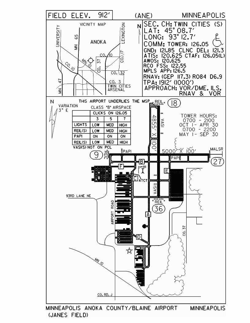
FIELD ELEV. 912' (ANE) MINNEAPOLIS
>lv;0::w>Z:::J
VICINITY MAP
ANOKA
zole.:>zXw--'
N SEC. CH: TWIN CITIES (S)
~LAT: 45 0 08.7'LONG: 93 0 12.7' E..COMM: TOWER: 126.05 VGND: 121.85 CLNC DEL: 121.3ATIS: 120.625 CT AF: 126.05<l)AWOS: 120.625RCO FSS: 122.55MPLS APP: 126.5RNAV: <GEP 117.3> R084 D6.9TPA: 1912' (1000')APPROACH: VOR/DME, ILS,
RNAV & VOR
CO.RD.J
CLICKS ON 126.05
3 5 7
LIGHTS lOW MED HIGH
RElllSl lOW MED HIGHPAPI ON ON ON
RElllSl lOW MED HIGH
93RD LANE NE
THIS AIRPORT UNDERLIES THE MSP o~fJho fj8\VARIATION CLASS'S' AIRSPACE \.!.QJ3 0 E
~ TOWER HOURS:OJ < 0700 - 2100~ C; OCT I - APR 30
0700 - 2200x 00 MA Y I - SEP 30
VASllSl NOT ON PCl g f....rJo !PAPI ' 5000~ 100' MAlSR® ~.""'jiIiii"'-"---I"'iiiII!p~A!!PjIiIIi.,...--.t-----I
N
MINNEAPOLIS ANOKA COUNTY/BLAINE AIRPORT<JANES FIELD>
MINNEAPOLIS
Minneapolis - MICwww.mspairport.com/relievers
Airport Manager: Jeff Nawrocki - 763-537-2058 - [email protected]
Contact Person: Jeff Nawrocki - 763-537-2058 - [email protected]
Chamber of Com: 612-370-9100 - www.minneapolischamber.orgAero Cht Coord: 10-I
AWOS/ASOS: 763-531-2343 - MnWAS Loc/Hrs: Flying Scotchman, Inc. - Mon-Sun, 8:00 A.M.-
8:00 P.M.Northland Aircraft - Mon-Fri 7:00 A.M.-10:00 P.M., Sat-Sun, 7:00 A.M.- 7:00 P.MThunderbird Aviation, Inc. - Mon-Sun, 7:00 AM-9:00 PM
Attended: ALL/M-F/0700-2100, ALL/SS/0700-1900Fuel: Mogas, 100LL, Jet A
Self Service Fuel: Visa, Discover, MastercardAfter Hrs Service: None
FBO(s): Academy Flight Operations, Inc. - 763-533-4162 - [email protected] - www.thunderbirdaviation.comFlying Scotchman, Inc. - 763-537-8485 - 122.95 - [email protected] - www.flyingscotchman.comNorthland Aircraft - 763-745-7888 - 122.95 - [email protected]
Ground Transport: Taxi; rentalsFood Service: Vending machines
Dining: None reportedLodging: Northwest Inn - 1 mile
Super 8 Motel - 763-537-8888 - adjacent to airportAirport Events: Open house in June (Father's Day)
Underwing Camp: NoCampgrounds: None reportedGolf Courses: None reported
Local Attractions: Target CenterMetrodome
Comments: Control Tower - 120.7Ground Control - 121.6ATIS - 124.475Use caution for close proximity of parallel runways
•
FIELD ELEV. 869' (MIC) MINNEAPOLISVICINITY MAP
1-694 \BROOKLYN
CENTER
N SEC. CH: TWIN CITIES (S)~ LAT: 450 03.7'I LONG: 93 0 21.2'
COMM: TOWER: 120.7 (l)GND: 121.6CLNC DEL: 121.6ATIS: 124.475CT AF: 120.7 (l)MPL S APP: 126.5 (~
RNAV: (GEP 117.3> RIGS 05.1 \......ITPA: 1869' (1000')APPROACH:GPS & VOR
SEE YELLOW PAGESSPOTS
TOWER HOURS: N VARIATION
0700-2100 3° EOCT I-APR 30
• 0700-2200MAY I-SEP 30
357
CLICKS ON 120.7
WHEN TOWER IS CLOSEDRUNWAY 14L - 32R
MIRL LOW MED HIGH
REIL LOW MED HIGHIVASls NOT ON PCL I
WHEN TOWER IS CLOSEDRUNWAY 6L - 24R
CLICKS ON 120.7
3 I 5 I 7
MIRL LOW IMED I HIGH
THIS AIRPORT UNDERLIESTHE MSP CLASS'S" AIRSPACE
•••
MINNEAPOLIS CRYSTAL AIRPORT MINNEAPOLIS
Minneapolis - FCMwww.mspairport.com/relievers
Airport Manager: Joseph Harris - 763-717-0001 - [email protected]
Contact Person: Joseph Harris - 763-537-2058 - [email protected]
Chamber of Com: 612-370-9100 - www.minneapolischamber.org
Aero Cht Coord: 11-IAWOS/ASOS: 952-941-4156
MnWAS Loc/Hrs: Academy Education Center, Inc. - student use onlyASI Flight Training Facility - Mon-Sun, 7:00 A.M.-9:00 P.M.Aviation Pro Shop - business hoursElliott Aviation of Minneapolis, Inc. - Mon-Fri, 6:00 A.M.-11:00 P.M., Sat-Sun, 7:00 A.M.-10:00 P.M.Executive Aviation - Mon-Fri 6:00 A.M.-10:00 P.M., Sat-Sun6:00 A.M.-10:00 P.M.Hummingbird Helicopters LLC - Mon-Sun, 8:00 A.M.-6:00 P.M.Modern Aero, Inc. - Mon-Sun, 6:00 A.M.-10:00 P.M.Thunderbird Aviation, Inc. - Mon-Sun, 6:30 A.M.-9:00 P.M.
Attended: All/All/0700-2200Fuel: Mogas, 100LL, Jet A
Self Service Fuel: Major credit cards, AvFuel CardAfter Hrs Service: None
FBO(s): Elliott Aviation of Minneapolis, Inc. - 952-944-1200 - 130.60 - [email protected] - www.elliottaviation.comExecutive Aviation - 952-943-1519 - 122.95 - [email protected] - www.executive-aviation.comHummingbird Aviation LLC - 952-942-4911 - [email protected] - www.hummingbirdhelicopters.usModern Aero, Inc. - 952-941-2595 - 122.85 - [email protected] - www.modernaero.comModern Avionics, Inc. - 952-941-2783 - [email protected] - modernavionics.comThunderbird Aviation, Inc. - 952-941-1212 - 130.05 - [email protected] - www.thunderbirdaviation.com
Ground Transport: Taxi; rentals & courtesy car at Elliott Aviation; rentals & courtesycar at Executive Aviation
Food Service: Vending machinesDining: Lion's Tap - 952-935-5299 - 1 mile
Lodging: Super 8 Motel - 2 milesAirport Events: See www.wotn.org
Underwing Camp: YesCampgrounds: None reportedGolf Courses: Hazeltine; Bear Path; Olympic Hills; Chaska Town Course
Local Attractions: ValleyFair; Mystic Lake Casino; Canterbury Downs; Mall of America; Eden Prairie Mall; Metrodome; Target Center
Comments: Self service fuel located at Modern Avionics & Hummingbird Helicopters.
•
FIELD ELEV. 906' (FCM) MINNEAPOLIS
CO. I
N SEC. CH: TWIN CITIES (S)~ LA T: 44° 49.6' l:-I LONG: 93° 27.4' D
COMM:TOWER: 118.1 <l) OR 125.2GND: 121.7 CLNC DEL: 121.7ATlS: 124.9 CTAF: 118.1MPL S APP: 125.0RNAV: <FCM 111.8) ON ARPTTPA: 1906' (1000')RWY lOR & 28R RGT TFCAPPROACH: ILS, RNAV,
V R
, 'uS 212
SEE YELLOW PAGESFOR HOT SPOTS
IS CLOSED
3 5 7CLICKS ON 118.1
RUNWAY 18 - 36
RUNWAY lOR - 28L
3 5 7
CLICKS ON 118.1
LIGHTS LOW MED HIGHVASI ON ON ON
TAXI LOW MED HIGH
REILS OFF ON ON
LIGHTS LOW MED HIGHMALSR LOW MED HIGH
TAXI LOW MED HIGH
I VASI ON ON ONREILSl28U OFF ON ON
RWY IOL - 28R CLOSED~~ WHEN TOWER CLOSED
THIS AIRPORT UNDERLIESTHE MSP CLASS 'S' AIRSPACE
VARIATION3° E
N
TOWER HOURS:0700-2100
OCT I-APR 300700-2200
MAY I-SEP 30ATCT~
*.
MINNEAPOLIS FLYING CLOUD AIRPORT MINNEAPOLIS

Minneapolis - MSPwww.mspairport.com
Airport Manager: Steve Wareham - 612-726-5519 - [email protected]
Contact Person: Shelly Lopez - 612-726-5555 - [email protected]
Chamber of Com: 612-370-9100 -www.minneapolischamber.org
Aero Cht Coord: 11-IAWOS/ASOS: 612-725-0939
MnWAS Loc/Hrs: ASIG Operations in the Humphrey Terminal - 24 hoursSignature Flight Support, Inc. - Hangar 4 - 24 hoursSignature Flight Support, Inc. - lobby - 24 hoursUnited Parcel Service - 24 hours
Attended: All/All/AllFuel: 100LL, Jet A
Self Service Fuel: 612-726-5700After Hrs Service: None
FBO(s): General Dynamics Aviation Services Corp - 612-638-2006 - [email protected] - www.gdaviationservices.comSignature Flight Support, Inc. - 612-726-5700 - [email protected] - www.signatureflight.com
Ground Transport: Bus; taxi; limo/van; rental cars; light railFood Service: Restaurants; snack bars
Dining: Within airportLodging: Highway 494 - 1½ miles
Airport Events: NoneUnderwing Camp: No
Campgrounds: None reportedGolf Courses: Hiawatha - South Minneapolis
Fort Snelling - St. PaulLocal Attractions: Mall of America
Historic Fort SnellingComments: Control Tower - assigned by ATIS 126.7, 123.95 or
123.675ATIS - 135.35 (arrival) 120.8 (departure)Clearance Delivery - 133.2Ground - 121.9, 121.8 or 127.925ASIG Flight Support (Humphrey Terminal) Ramp Control 122.95U.S. Customs - 612-725-3689 or 612-725-3690Metering - 133.575Scheduled Air Service
•
VARIATION3' E
N
FORTSNELLINGNATIONALCEMETERY
1-494
.,"''",
RICHFIELD
BLOOMINGTON
FIELD ELEV. 841' (MSP) MINNEAPOLIS-ST. PAUL
VICINITY MAP N SEC. CH: TWIN CITIES (S)MINNEAPOLIS \, ST. PAUL ~ LAT: 44° 53.0'
'i '\ I LONG: 93° 13.3''1} ~ ,,<J<. COMM: ATIS: 135.35 ARR
120.8 DEP~ TOWER: 126.7 RWYS 12R-30L.04-22
123.95 RWY 12L - 30R123.675 RWY 17-35
GND: NI21.8. SI21.9. W127.925CLNC DEL: 133.2RCO FSS: 122.3
RNAV: IMSP 115.3) RI42 01.1 (~APPROACH: ILS. RNAV. LOC V
SEE YELLOW PAGESFOR HOT SPOTS
TOWER OPEN 24 HOURS
MINNEAPOLlS-S T. PAULINTERNATIONAL AIRPORT
(WOLD-CHAMBERLAIN FIELD>
MINNEAPOLISST. PAUL
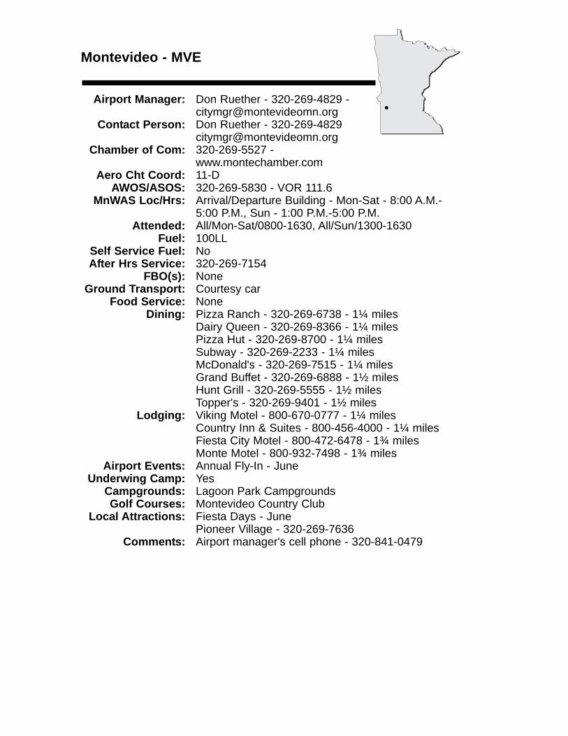
Montevideo - MVE
Airport Manager: Don Ruether - 320-269-4829 - [email protected]
Contact Person: Don Ruether - 320-269-4829 [email protected]
Chamber of Com: 320-269-5527 - www.montechamber.com
Aero Cht Coord: 11-DAWOS/ASOS: 320-269-5830 - VOR 111.6
MnWAS Loc/Hrs: Arrival/Departure Building - Mon-Sat - 8:00 A.M.-5:00 P.M., Sun - 1:00 P.M.-5:00 P.M.
Attended: All/Mon-Sat/0800-1630, All/Sun/1300-1630Fuel: 100LL
Self Service Fuel: NoAfter Hrs Service: 320-269-7154
FBO(s): NoneGround Transport: Courtesy car
Food Service: NoneDining: Pizza Ranch - 320-269-6738 - 1¼ miles
Dairy Queen - 320-269-8366 - 1¼ milesPizza Hut - 320-269-8700 - 1¼ milesSubway - 320-269-2233 - 1¼ milesMcDonald's - 320-269-7515 - 1¼ milesGrand Buffet - 320-269-6888 - 1½ milesHunt Grill - 320-269-5555 - 1½ milesTopper's - 320-269-9401 - 1½ miles
Lodging: Viking Motel - 800-670-0777 - 1¼ milesCountry Inn & Suites - 800-456-4000 - 1¼ milesFiesta City Motel - 800-472-6478 - 1¾ milesMonte Motel - 800-932-7498 - 1¾ miles
Airport Events: Annual Fly-In - JuneUnderwing Camp: Yes
Campgrounds: Lagoon Park CampgroundsGolf Courses: Montevideo Country Club
Local Attractions: Fiesta Days - JunePioneer Village - 320-269-7636
Comments: Airport manager's cell phone - 320-841-0479
•
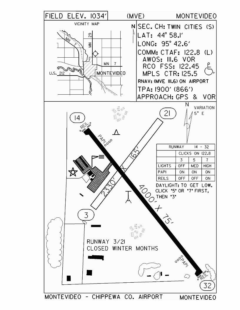
FIELD ELEV. 1034' (MVE> MONTEVIDEOVICINITY MAP
MN 7
N SEC. CH: TWIN CITIES (S)
~ LAT: 44° 58.1'LONG: 95° 42.6'COMM: CT AF: 122.8 (l)
AWOS: 111.6 VORRCO FSS: 122.45 (~MPLS CTR: 125.5 \J
RNAV: (MVE 111.6> ON AIRPORT
TPA: 1900' (866')APPROACH:GPS & VOR
NVARIATION50 E
o
357
MONTEVIDEO
CLICKS ON 122.8
RUNWAY 14 - 32
LIGHTS OFF MED HIGH
PAPI ON ON ON
REILS OFF OFF ON
=' DAYLIGHT: TO GET LOW,TO CLICK'S' OR '7' FIRST,o THEN '3'
O~
+~~
RUNWAY 3/21CLOSED WINTER MONTHS
".1
••MONTEVIDEO - CHIPPEWA CO. AIRPORT
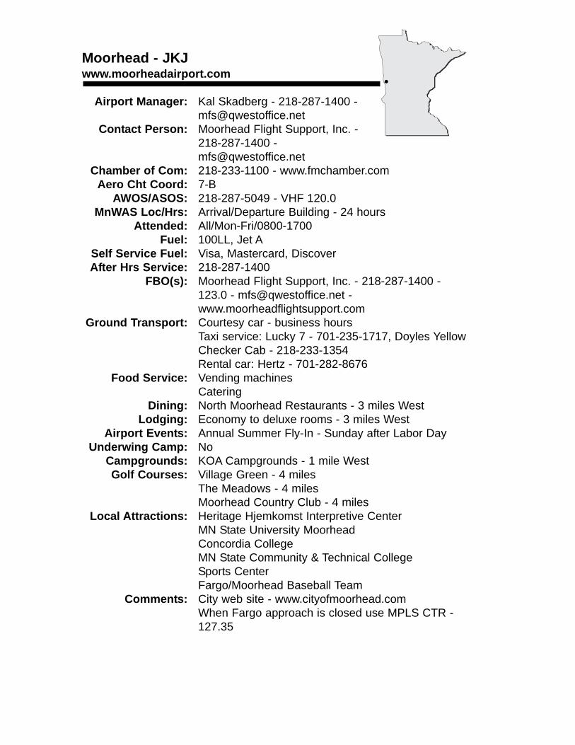
Moorhead - JKJwww.moorheadairport.com
Airport Manager: Kal Skadberg - 218-287-1400 - [email protected]
Contact Person: Moorhead Flight Support, Inc. - 218-287-1400 - [email protected]
Chamber of Com: 218-233-1100 - www.fmchamber.comAero Cht Coord: 7-B
AWOS/ASOS: 218-287-5049 - VHF 120.0MnWAS Loc/Hrs: Arrival/Departure Building - 24 hours
Attended: All/Mon-Fri/0800-1700Fuel: 100LL, Jet A
Self Service Fuel: Visa, Mastercard, DiscoverAfter Hrs Service: 218-287-1400
FBO(s): Moorhead Flight Support, Inc. - 218-287-1400 - 123.0 - [email protected] - www.moorheadflightsupport.com
Ground Transport: Courtesy car - business hoursTaxi service: Lucky 7 - 701-235-1717, Doyles YellowChecker Cab - 218-233-1354Rental car: Hertz - 701-282-8676
Food Service: Vending machinesCatering
Dining: North Moorhead Restaurants - 3 miles WestLodging: Economy to deluxe rooms - 3 miles West
Airport Events: Annual Summer Fly-In - Sunday after Labor DayUnderwing Camp: No
Campgrounds: KOA Campgrounds - 1 mile WestGolf Courses: Village Green - 4 miles
The Meadows - 4 milesMoorhead Country Club - 4 miles
Local Attractions: Heritage Hjemkomst Interpretive CenterMN State University MoorheadConcordia CollegeMN State Community & Technical CollegeSports CenterFargo/Moorhead Baseball Team
Comments: City web site - www.cityofmoorhead.comWhen Fargo approach is closed use MPLS CTR - 127.35
•
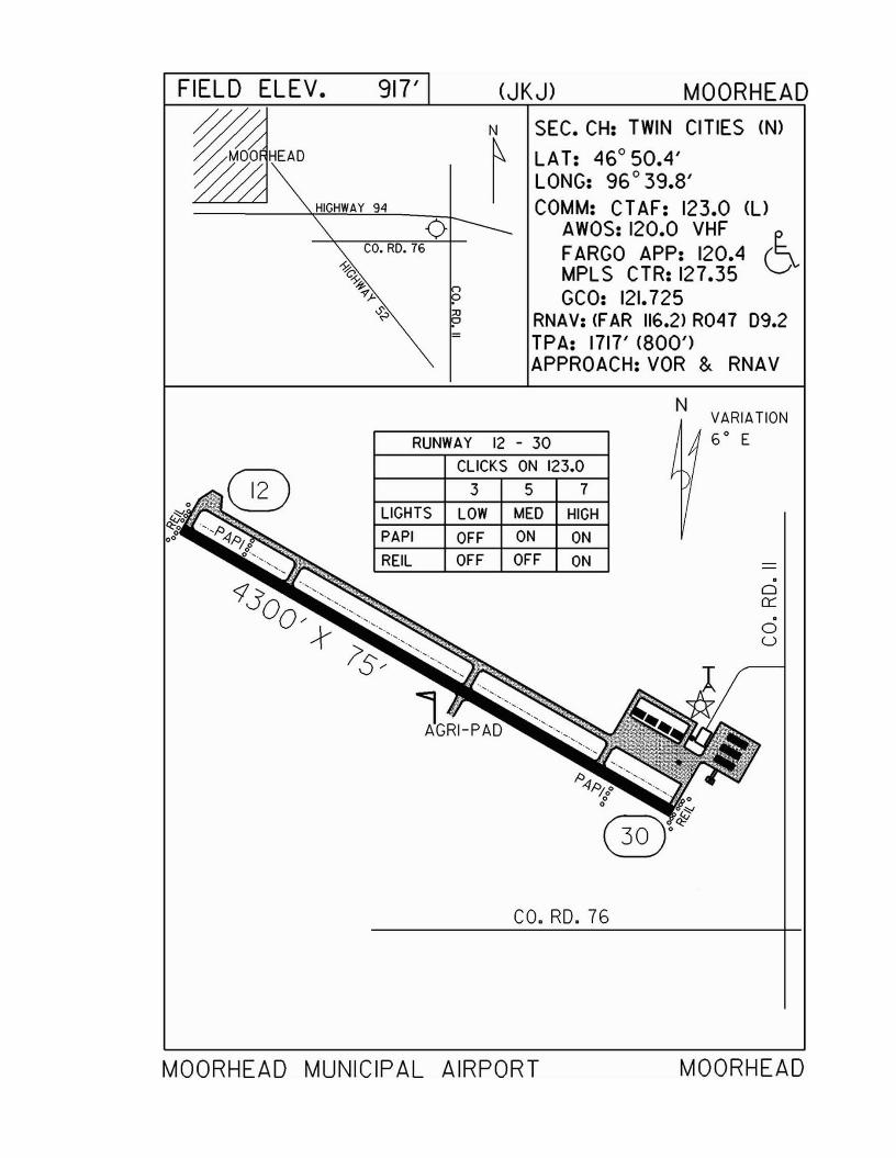
FIELD ELEV. 917' (JKJ) MOORHEAD
~HEAON
~SEC. CH: TWIN CITIES (N)
LAT: 46°50.4'LONG: 96°39.8'COMM: CTAF: 123.0 (l)
AWOS: 120.0 VHFFARGO APP: 120.4 (~MPLS CTR: 127.35 VGCO: 121.725
RNAV: (FAR 116.2> R047 09.2TPA: 1717' (800')APPROACH:VOR & RNAV
N
.ou
.o0:::
VARIATION6 0 E
1 """AGRI-PAD
RUNWAY 12 - 30
CLICKS ON 123.0
3 5 7
LIGHTS LOW MED HIGHPAPI OFF ON ON
REIL OFF OFF ON
co. RD. 76
MOORHEAD MUNICIPAL AIRPORT MOORHEAD
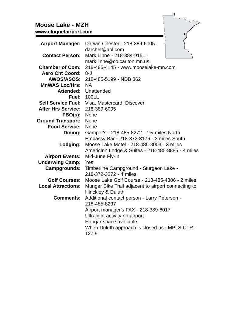
Moose Lake - MZHwww.cloquetairport.com
Airport Manager: Darwin Chester - 218-389-6005 - [email protected]
Contact Person: Mark Linne - 218-384-9151 - [email protected]
Chamber of Com: 218-485-4145 - www.mooselake-mn.comAero Cht Coord: 8-J
AWOS/ASOS: 218-485-5199 - NDB 362MnWAS Loc/Hrs: NA
Attended: UnattendedFuel: 100LL
Self Service Fuel: Visa, Mastercard, DiscoverAfter Hrs Service: 218-389-6005
FBO(s): NoneGround Transport: None
Food Service: NoneDining: Gamper's - 218-485-8272 - 1½ miles North
Embassy Bar - 218-372-3176 - 3 miles SouthLodging: Moose Lake Motel - 218-485-8003 - 3 miles
AmericInn Lodge & Suites - 218-485-8885 - 4 milesAirport Events: Mid-June Fly-In
Underwing Camp: YesCampgrounds: Timberline Campground - Sturgeon Lake -
218-372-3272 - 4 milesGolf Courses: Moose Lake Golf Course - 218-485-4886 - 2 miles
Local Attractions: Munger Bike Trail adjacent to airport connecting to Hinckley & Duluth
Comments: Additional contact person - Larry Peterson - 218-485-8237Airport manager's FAX - 218-389-6017Ultralight activity on airportHangar space availableWhen Duluth approach is closed use MPLS CTR - 127.9
•
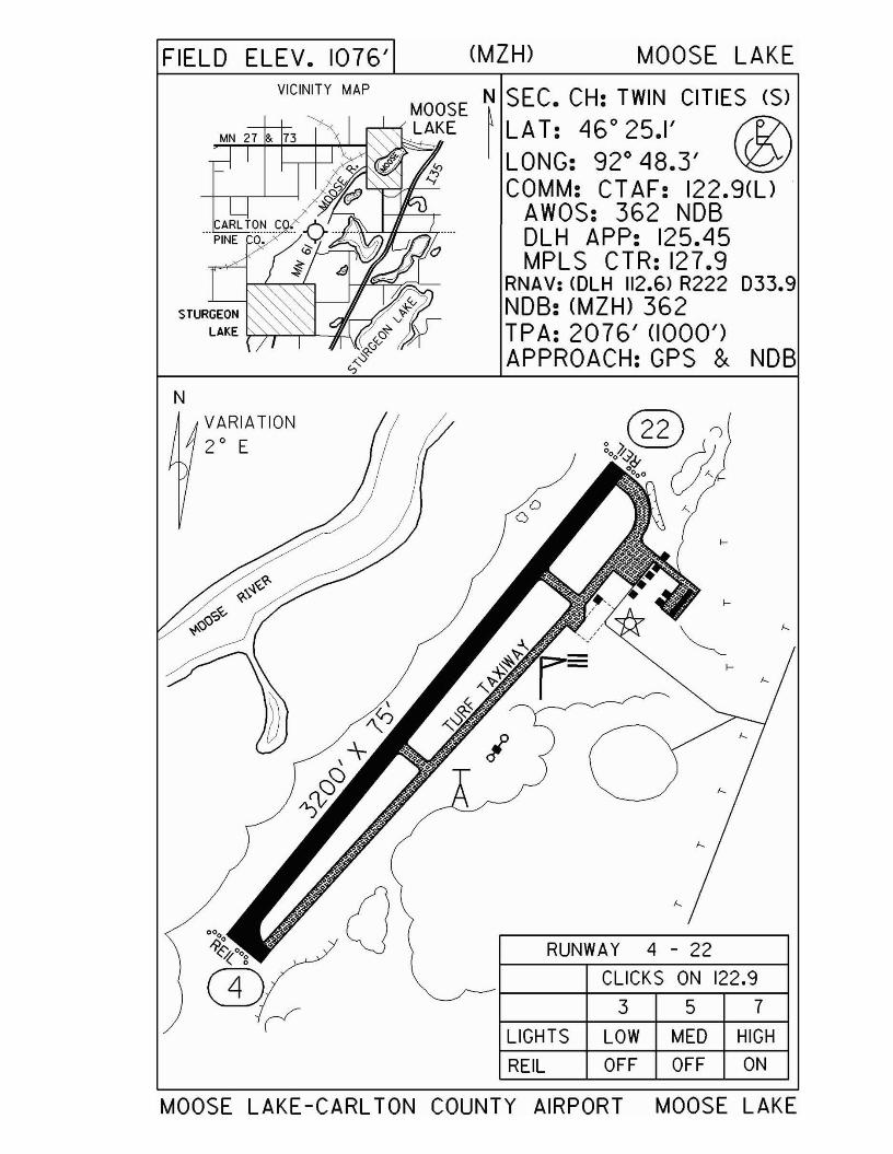
FIELD ELEV. 1076' (MZH) MOOSE LAKEVICINITY MAP N SEC. CH: TWIN CITIES (S)
~LAT: 46°25.1' f1:I\LONG: 92° 48.3' ~COMM: CT AF: 122.9(U
AWOS: 362 NDBDLH APP: 125.45MPLS CTR: 127.9
RNAV: (OLH 112.6) R222 033.9NDB: (MZH) 362TPA: 2076' (1000')APPROACH:GPS & NDB
N
357CLICKS ON 122.9
RUNWAY 4 - 22
LIGHTS LOW MED HIGH
REIL OFF OFF ON
VARIATION2 0 E
MOOSE LAKE -CARL TON COUNTY AIRPORT MOOSE LAKE
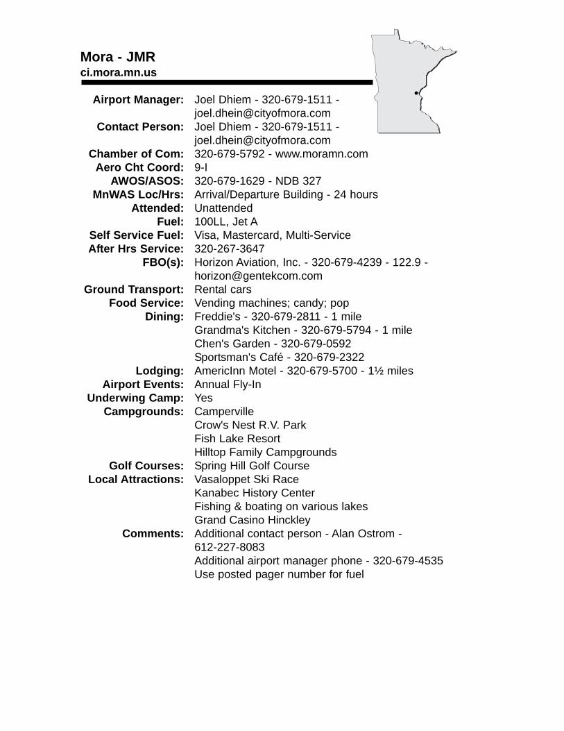
Mora - JMRci.mora.mn.us
Airport Manager: Joel Dhiem - 320-679-1511 - [email protected]
Contact Person: Joel Dhiem - 320-679-1511 - [email protected]
Chamber of Com: 320-679-5792 - www.moramn.comAero Cht Coord: 9-I
AWOS/ASOS: 320-679-1629 - NDB 327MnWAS Loc/Hrs: Arrival/Departure Building - 24 hours
Attended: UnattendedFuel: 100LL, Jet A
Self Service Fuel: Visa, Mastercard, Multi-ServiceAfter Hrs Service: 320-267-3647
FBO(s): Horizon Aviation, Inc. - 320-679-4239 - 122.9 - [email protected]
Ground Transport: Rental carsFood Service: Vending machines; candy; pop
Dining: Freddie's - 320-679-2811 - 1 mileGrandma's Kitchen - 320-679-5794 - 1 mileChen's Garden - 320-679-0592Sportsman's Café - 320-679-2322
Lodging: AmericInn Motel - 320-679-5700 - 1½ milesAirport Events: Annual Fly-In
Underwing Camp: YesCampgrounds: Camperville
Crow's Nest R.V. ParkFish Lake ResortHilltop Family Campgrounds
Golf Courses: Spring Hill Golf CourseLocal Attractions: Vasaloppet Ski Race
Kanabec History CenterFishing & boating on various lakesGrand Casino Hinckley
Comments: Additional contact person - Alan Ostrom - 612-227-8083Additional airport manager phone - 320-679-4535Use posted pager number for fuel
•
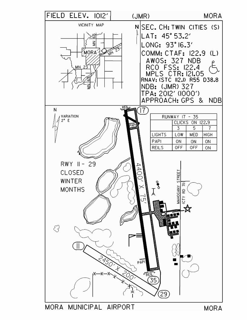
FIELD ELEV. 1012' (JMR) MORAVICINITY MAP N SEC. CH: TWIN CITIES (S)
~ LAT: 45 0 53.2'I LONG: 93 0 16.3'
COMM: CT AF: 122.9 (l)
AWOS: 327 NOB tRCO FSS: 122.4 DMPLS CTR: 121.05
RNAV: ($ TC 112.1> R55 038.8NOB: (JMR) 327TPA: 2012' (1000')APPROACH:GPS & NOB
VARIATION2° E
RUNWAY 17 - 35CLICKS ON 122.9
3 5 7
LIGHTS LOW MED HIGH
PAPI ON ON ONREILS OFF OFF ON
29 () t
p~
r-
RWY 11
CLOSEDWINTERMONTHS
N
MORA MUNICIPAL AIRPORT MORA
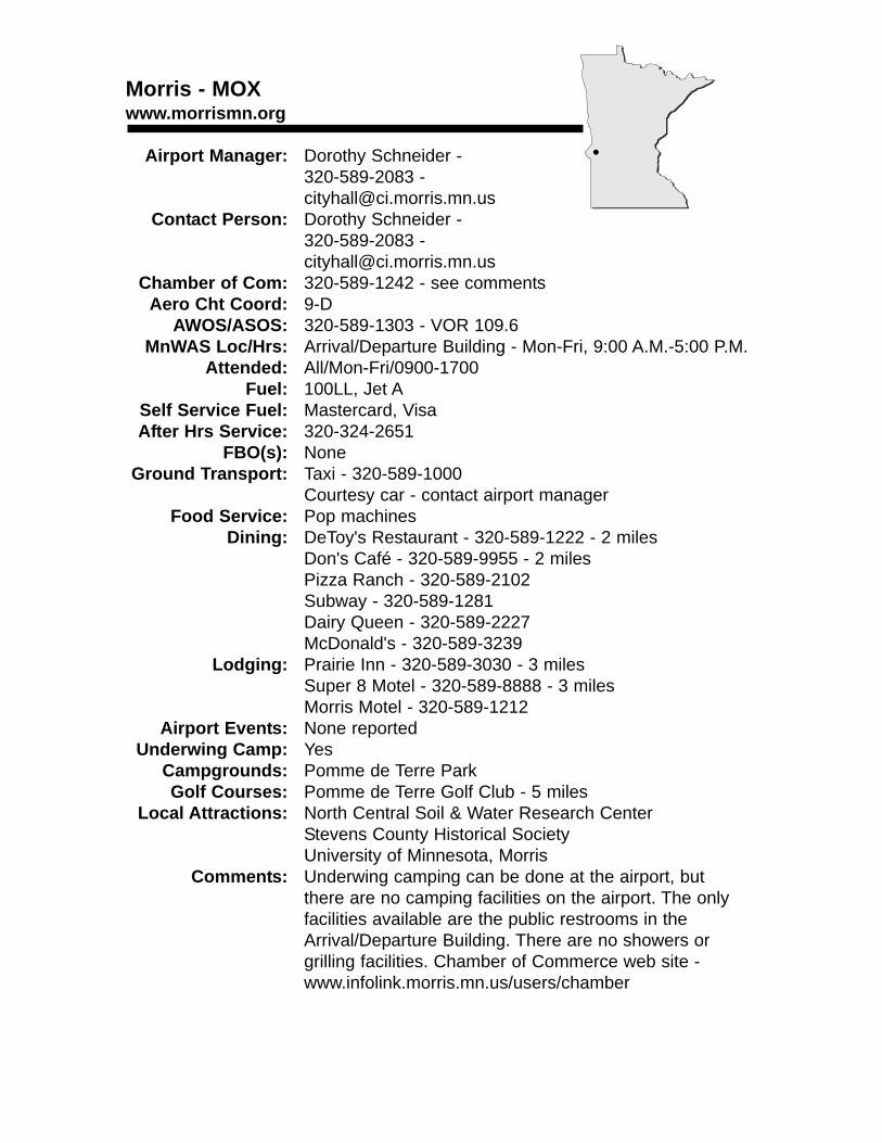
Morris - MOXwww.morrismn.org
Airport Manager: Dorothy Schneider - 320-589-2083 - [email protected]
Contact Person: Dorothy Schneider -320-589-2083 [email protected]
Chamber of Com: 320-589-1242 - see commentsAero Cht Coord: 9-D
AWOS/ASOS: 320-589-1303 - VOR 109.6MnWAS Loc/Hrs: Arrival/Departure Building - Mon-Fri, 9:00 A.M.-5:00 P.M.
Attended: All/Mon-Fri/0900-1700Fuel: 100LL, Jet A
Self Service Fuel: Mastercard, VisaAfter Hrs Service: 320-324-2651
FBO(s): NoneGround Transport: Taxi - 320-589-1000
Courtesy car - contact airport managerFood Service: Pop machines
Dining: DeToy's Restaurant - 320-589-1222 - 2 milesDon's Café - 320-589-9955 - 2 milesPizza Ranch - 320-589-2102Subway - 320-589-1281Dairy Queen - 320-589-2227McDonald's - 320-589-3239
Lodging: Prairie Inn - 320-589-3030 - 3 milesSuper 8 Motel - 320-589-8888 - 3 milesMorris Motel - 320-589-1212
Airport Events: None reportedUnderwing Camp: Yes
Campgrounds: Pomme de Terre ParkGolf Courses: Pomme de Terre Golf Club - 5 miles
Local Attractions: North Central Soil & Water Research CenterStevens County Historical SocietyUniversity of Minnesota, Morris
Comments: Underwing camping can be done at the airport, butthere are no camping facilities on the airport. The only facilities available are the public restrooms in the Arrival/Departure Building. There are no showers or grilling facilities. Chamber of Commerce web site - www.infolink.morris.mn.us/users/chamber
•
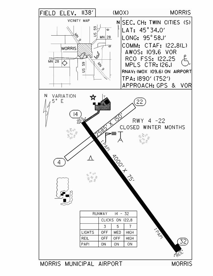
FIELD ELEV. 1138'VICINITY MAP
(MOX) MORRIS
N SEC. CH: TWIN CITIES (S)~ LAT: 45°34.0'I LONG: 95 0 58.1'
COMM: CT AF: 122.8(l)AWOS: 109.6 VORRCO FSS: 122.25 (~MPLS CTR: 126.1 \......I
RNAV: (MOX 109.6) ON AIRPORT
TPA: 1890' (752')APPROACH:GPS & VOR
N VARIATION50 E
RUNWAY 14 - 32
CLICKS ON 122.8
3 5 7
LIGHTS OFF MED HIGH
REIL OFF OFF HIGH
PAPI ON ON ON
MORRIS MUNICIPAL AIRPORT
MONTHS
MORRIS
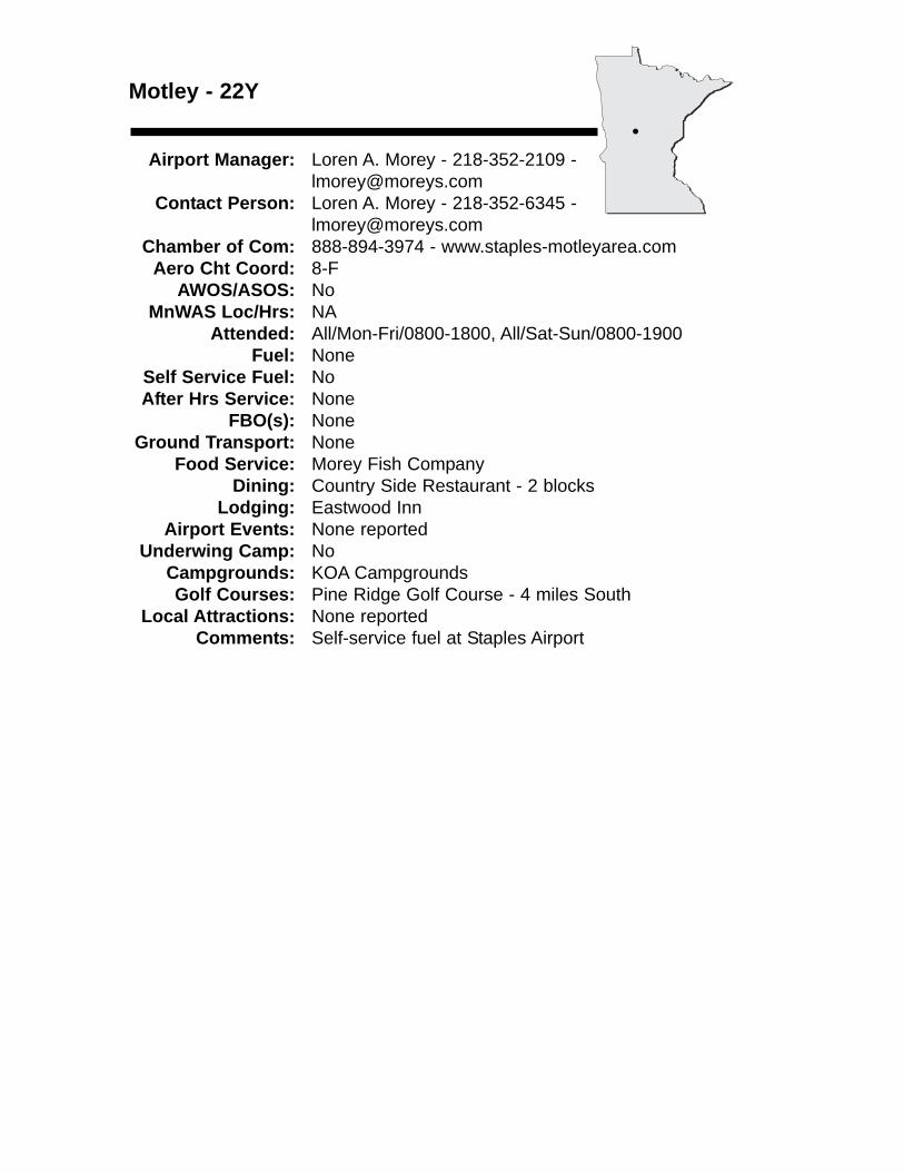
Motley - 22Y
Airport Manager: Loren A. Morey - 218-352-2109 [email protected]
Contact Person: Loren A. Morey - 218-352-6345 - [email protected]
Chamber of Com: 888-894-3974 - www.staples-motleyarea.comAero Cht Coord: 8-F
AWOS/ASOS: NoMnWAS Loc/Hrs: NA
Attended: All/Mon-Fri/0800-1800, All/Sat-Sun/0800-1900Fuel: None
Self Service Fuel: NoAfter Hrs Service: None
FBO(s): NoneGround Transport: None
Food Service: Morey Fish CompanyDining: Country Side Restaurant - 2 blocks
Lodging: Eastwood InnAirport Events: None reported
Underwing Camp: NoCampgrounds: KOA CampgroundsGolf Courses: Pine Ridge Golf Course - 4 miles South
Local Attractions: None reportedComments: Self-service fuel at Staples Airport
•
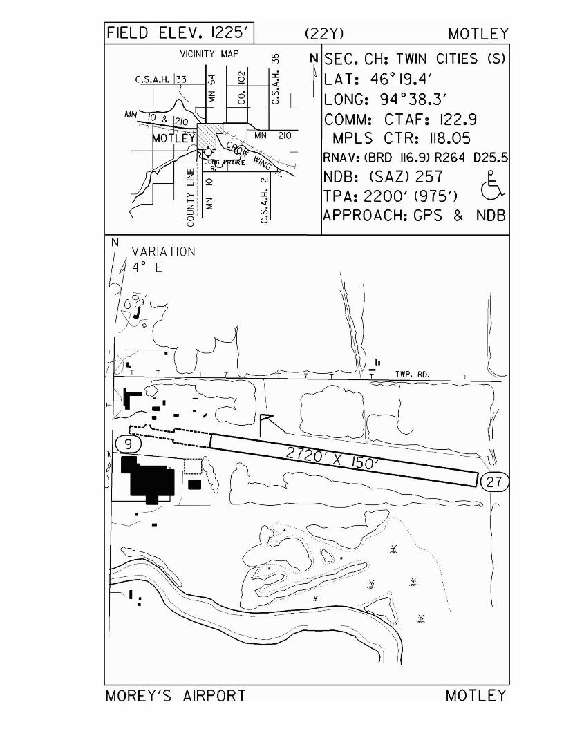
FIELD ELEV. 1225' (22Y) MOTLEYVICINITY MAP N SEC. CH: TWIN CITIES (S)
~ LAT: 46°19.4'LONG: 94 °38.3'COMM: CT AF: 122.9
MPLS CTR: 118.05RNA V: <BRO 116.9> R264 025.5
NOB: (SAn 25 7 ~
TPA: 2200' (975') CJAPPROACH:GPS & NOB
I
4VlU
ou
N IC.S••H. 33 }--=-Q1--1 4
VlU
NVARIATION4 0 E
)
TTWP. RD.
hTTTTT T T
-----;r--.
e-r-~O~• •· - ,
i'··:.·~:···.r-······r~~~~Ri~~~= I
••
~I .
•
MOREY'S AIRPORT MOTLEY
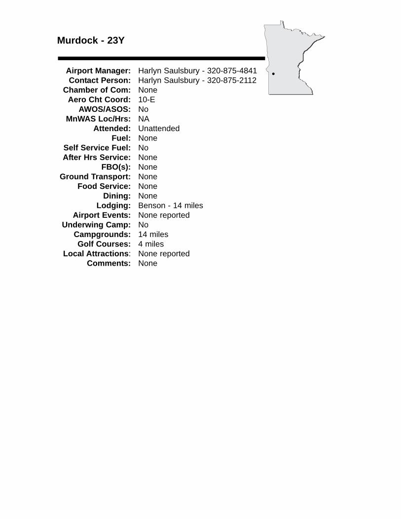
Murdock - 23Y
Airport Manager: Harlyn Saulsbury - 320-875-4841 Contact Person: Harlyn Saulsbury - 320-875-2112
Chamber of Com: None Aero Cht Coord: 10-E
AWOS/ASOS: No MnWAS Loc/Hrs: NA
Attended: UnattendedFuel: None
Self Service Fuel: NoAfter Hrs Service: None
FBO(s): NoneGround Transport: None
Food Service: NoneDining: None
Lodging: Benson - 14 milesAirport Events: None reported
Underwing Camp: NoCampgrounds: 14 milesGolf Courses: 4 miles
Local Attractions: None reportedComments: None
•
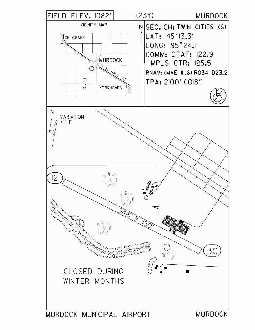
FIELD ELEV. 1082' (23Y) MURDOCKVICINITY MAP N SEC. CH: TWIN CITIES (S)
~ LAT: 45°13.3'LONG: 95 ° 24.1'COMM: CT AF: 122.9
MPLS CTR: 125.5RNAV: (MVE 111.6) R034 D23.2
TPA: 2100' (1018')
NVARIATION4 0 E
I/
o~ <> §"
~\\\\ §
: (--:.:------• •CLOSED DURING
WINTER MONTHS
@
MURDOCK MUNICIPAL AIRPORT MURDOCK
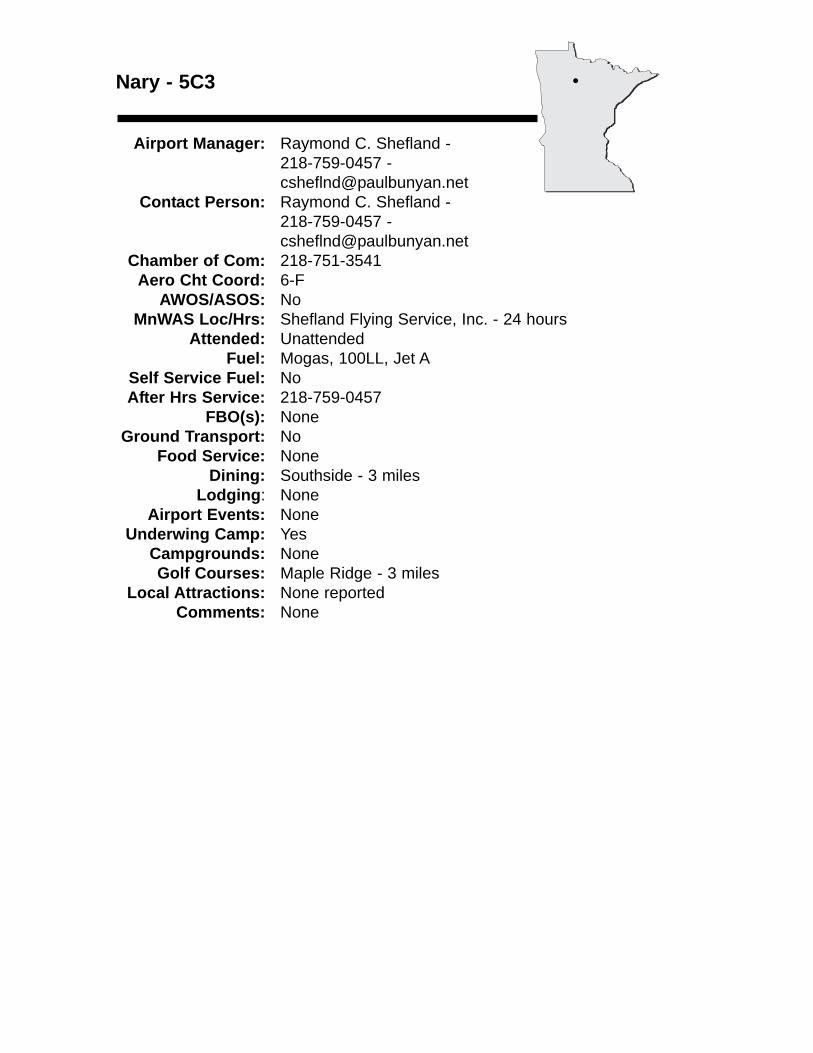
Nary - 5C3
Airport Manager: Raymond C. Shefland - 218-759-0457 - [email protected]
Contact Person: Raymond C. Shefland - 218-759-0457 - [email protected]
Chamber of Com: 218-751-3541 Aero Cht Coord: 6-F
AWOS/ASOS: No MnWAS Loc/Hrs: Shefland Flying Service, Inc. - 24 hours
Attended: UnattendedFuel: Mogas, 100LL, Jet A
Self Service Fuel: NoAfter Hrs Service: 218-759-0457
FBO(s): NoneGround Transport: No
Food Service: NoneDining: Southside - 3 miles
Lodging: NoneAirport Events: None
Underwing Camp: YesCampgrounds: NoneGolf Courses: Maple Ridge - 3 miles
Local Attractions: None reportedComments: None
•
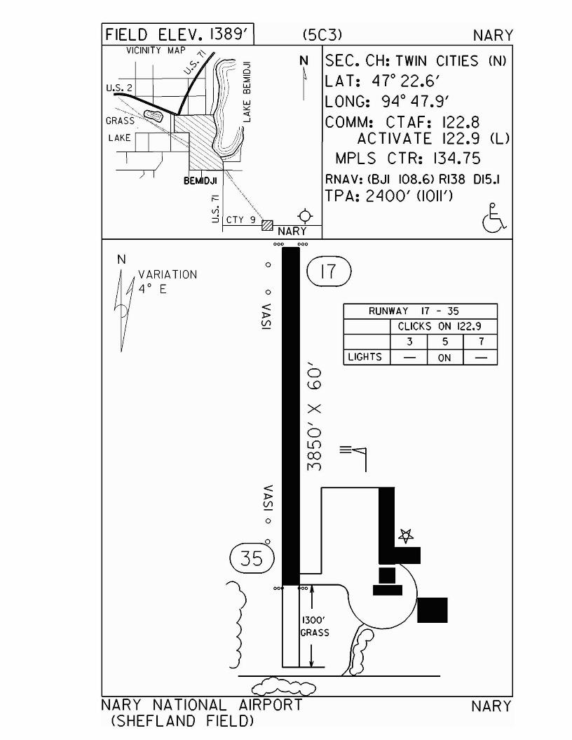
NARY
RUNWAY 17 - 35
CLICKS ON 122.9
3 5 7
LIGHTS - ON -
(5C3) NARY
1300'GRASS
N SEC. CH: TWIN CITIES (N)~ LAT: 4r22.6'
LONG: 94 0 47.9'COMM: CT AF: 122.8
ACTIVATE 122.9 (l)
MPLS CTR: 134.75RNAV: (BJI 108.6) RI38 D15.1
TPA: 2400' (1011')
NARY
o
o
...0\.D
X...0LD0)
rr>
<:t>(/l
0
<:t>(/l
=;o:::<w00
w""«-J
VARIATION4 0 E
VICINITY MAP ~
0'0'
N
FIELD ELEV. 1389'
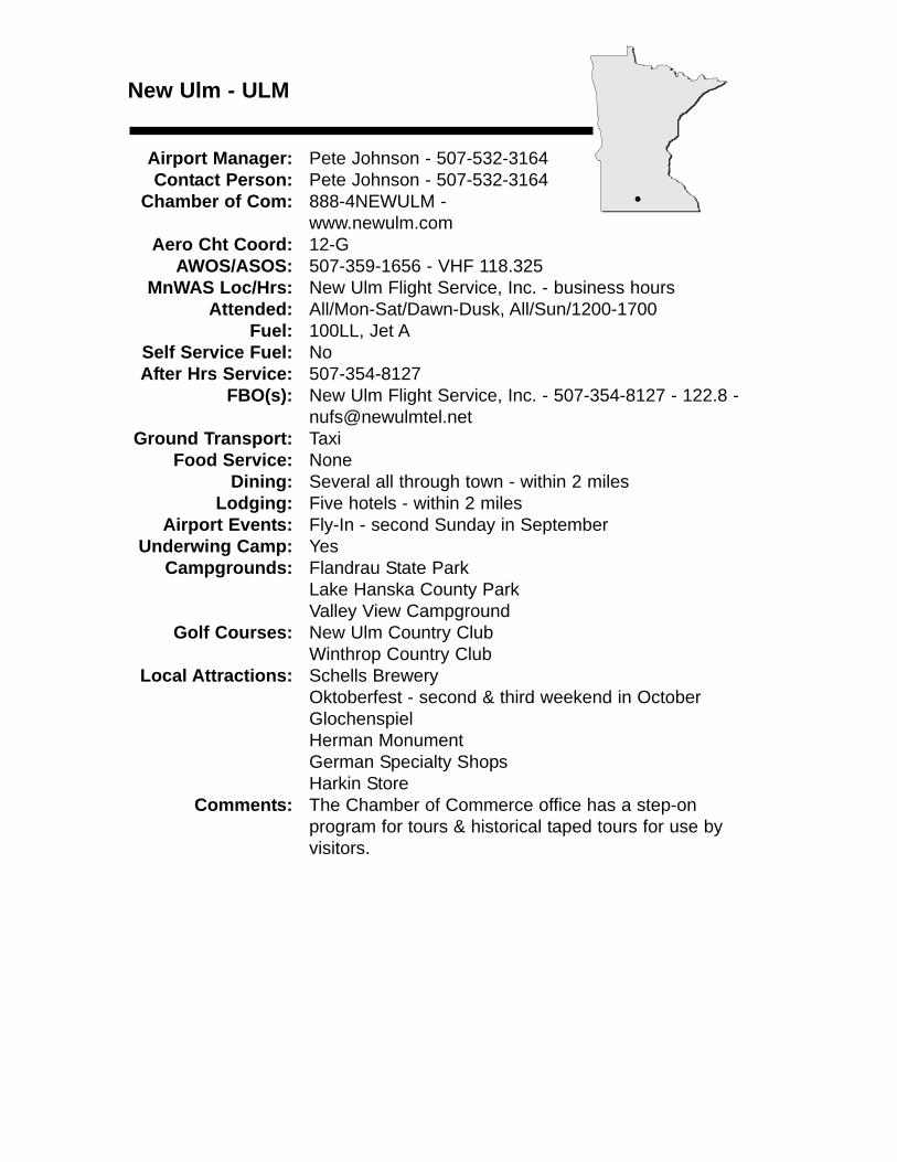
New Ulm - ULM
Airport Manager: Pete Johnson - 507-532-3164 Contact Person: Pete Johnson - 507-532-3164
Chamber of Com: 888-4NEWULM - www.newulm.com
Aero Cht Coord: 12-GAWOS/ASOS: 507-359-1656 - VHF 118.325
MnWAS Loc/Hrs: New Ulm Flight Service, Inc. - business hoursAttended: All/Mon-Sat/Dawn-Dusk, All/Sun/1200-1700
Fuel: 100LL, Jet ASelf Service Fuel: NoAfter Hrs Service: 507-354-8127
FBO(s): New Ulm Flight Service, Inc. - 507-354-8127 - 122.8 - [email protected]
Ground Transport: TaxiFood Service: None
Dining: Several all through town - within 2 milesLodging: Five hotels - within 2 miles
Airport Events: Fly-In - second Sunday in SeptemberUnderwing Camp: Yes
Campgrounds: Flandrau State ParkLake Hanska County ParkValley View Campground
Golf Courses: New Ulm Country ClubWinthrop Country Club
Local Attractions: Schells BreweryOktoberfest - second & third weekend in OctoberGlochenspielHerman MonumentGerman Specialty ShopsHarkin Store
Comments: The Chamber of Commerce office has a step-on program for tours & historical taped tours for use by visitors.
•
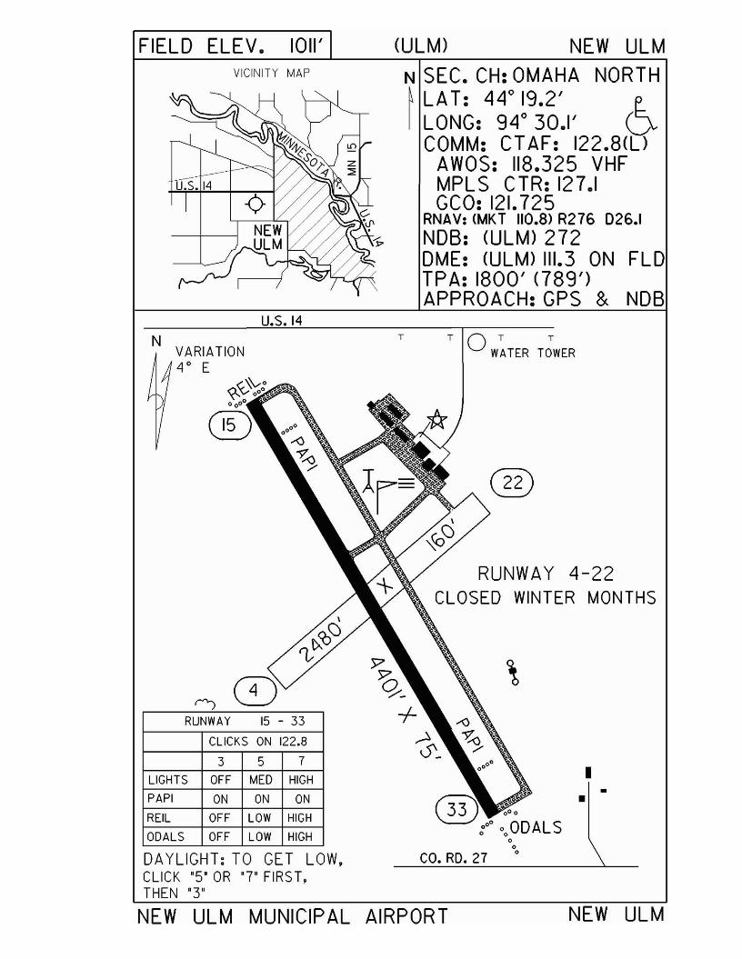
FIELD ELEV. 1011' (ULM) NEW ULM
RUNWAY 4-22CLOSED WINTER MONTHS
TOT T
WATER TOWER
N SEC. CH: OMAHA NORTH~ LAT: 44°19.2' t:.I LONG: 94° 30.1' V
COMM: CT AF: 122.8(l)AWOS: 118.325 VHFMPLS CTR: 127.1GCO: 121.725
RNAV: (MKT 110.8) R276 026.1NDB: (ULM) 272DME: (ULM) 111.3 ON FLDTPA: 1800' <789')APPROACH:GPS & NDB
T
u.s. 14
VICINITY MAP
u.s. 14
NVARIATION4 0 E
)7 \5Q/-
RUNWAY 15 - 33 +CLICKS ON 122.8 'S_
3 5 7
LIGHTS OFF MED HIGH I•PAPI ON ON ON
REIL OFF LOW HIGH
ODALS OFF LOW HIGH 00
DAYLIGHT: TO GET LOW, co. RD. 270
CLICK "5' OR '7' FIRST,THEN "3"
NEW ULM MUNICIPAL AIRPORT NEW ULM
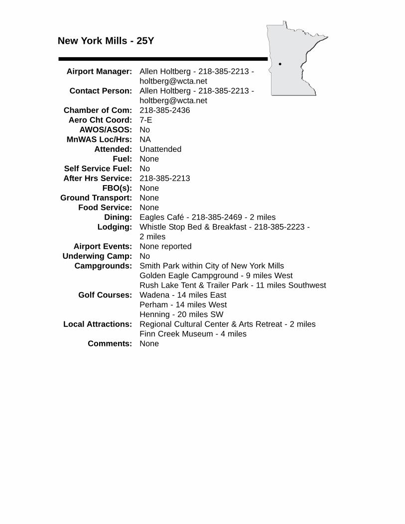
New York Mills - 25Y
Airport Manager: Allen Holtberg - 218-385-2213 [email protected]
Contact Person: Allen Holtberg - 218-385-2213 - [email protected]
Chamber of Com: 218-385-2436Aero Cht Coord: 7-E
AWOS/ASOS: NoMnWAS Loc/Hrs: NA
Attended: UnattendedFuel: None
Self Service Fuel: NoAfter Hrs Service: 218-385-2213
FBO(s): NoneGround Transport: None
Food Service: NoneDining: Eagles Café - 218-385-2469 - 2 miles
Lodging: Whistle Stop Bed & Breakfast - 218-385-2223 - 2 miles
Airport Events: None reportedUnderwing Camp: No
Campgrounds: Smith Park within City of New York MillsGolden Eagle Campground - 9 miles WestRush Lake Tent & Trailer Park - 11 miles Southwest
Golf Courses: Wadena - 14 miles EastPerham - 14 miles WestHenning - 20 miles SW
Local Attractions: Regional Cultural Center & Arts Retreat - 2 milesFinn Creek Museum - 4 miles
Comments: None
•
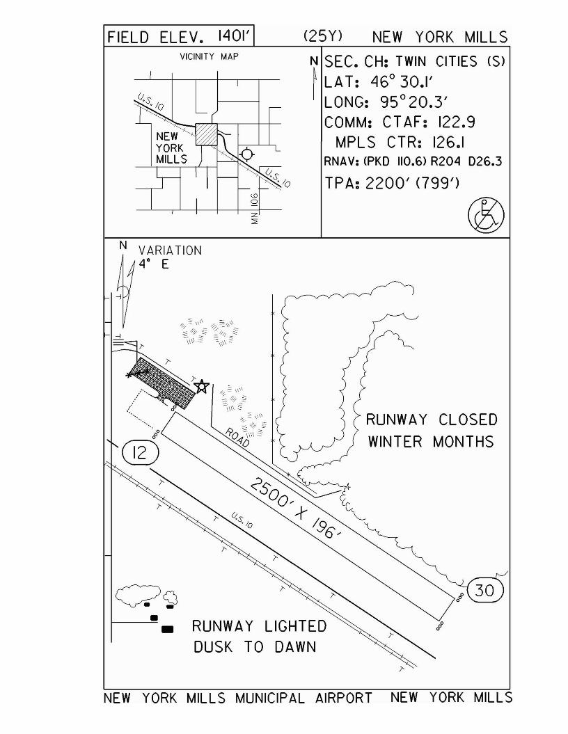
FIELD ELEV. 1401' (25Y) NEW YORK MILLSVICINITY MAP N SEC. CH: TWIN CITIES (S)
~ LA T: 46° 30.1'LONG: 95 0 20.3'COMM: CTAF: 122.9
MPL S CTR: 126.1RNAV: <PKD 110.6) R204 D26.3
TPA: 2200' <799')
®N VARIATION
4° E
i'
RUNWAY CLOSEDWINTER MONTHS
RUNWAY LIGHTEDDUSK TO DAWN
••
NEW YORK MILLS MUNICIPAL AIRPORT NEW YORK MILLS
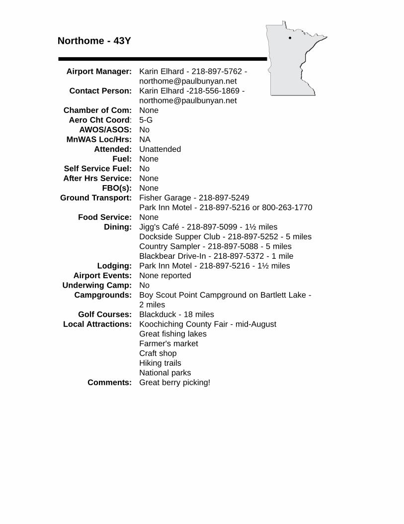
Northome - 43Y
Airport Manager: Karin Elhard - 218-897-5762 - [email protected]
Contact Person: Karin Elhard -218-556-1869 - [email protected]
Chamber of Com: NoneAero Cht Coord: 5-G
AWOS/ASOS: No MnWAS Loc/Hrs: NA
Attended: UnattendedFuel: None
Self Service Fuel: NoAfter Hrs Service: None
FBO(s): NoneGround Transport: Fisher Garage - 218-897-5249
Park Inn Motel - 218-897-5216 or 800-263-1770Food Service: None
Dining: Jigg's Café - 218-897-5099 - 1½ milesDockside Supper Club - 218-897-5252 - 5 milesCountry Sampler - 218-897-5088 - 5 milesBlackbear Drive-In - 218-897-5372 - 1 mile
Lodging: Park Inn Motel - 218-897-5216 - 1½ milesAirport Events: None reported
Underwing Camp: NoCampgrounds: Boy Scout Point Campground on Bartlett Lake -
2 milesGolf Courses: Blackduck - 18 miles
Local Attractions: Koochiching County Fair - mid-AugustGreat fishing lakesFarmer's marketCraft shopHiking trailsNational parks
Comments: Great berry picking!
•
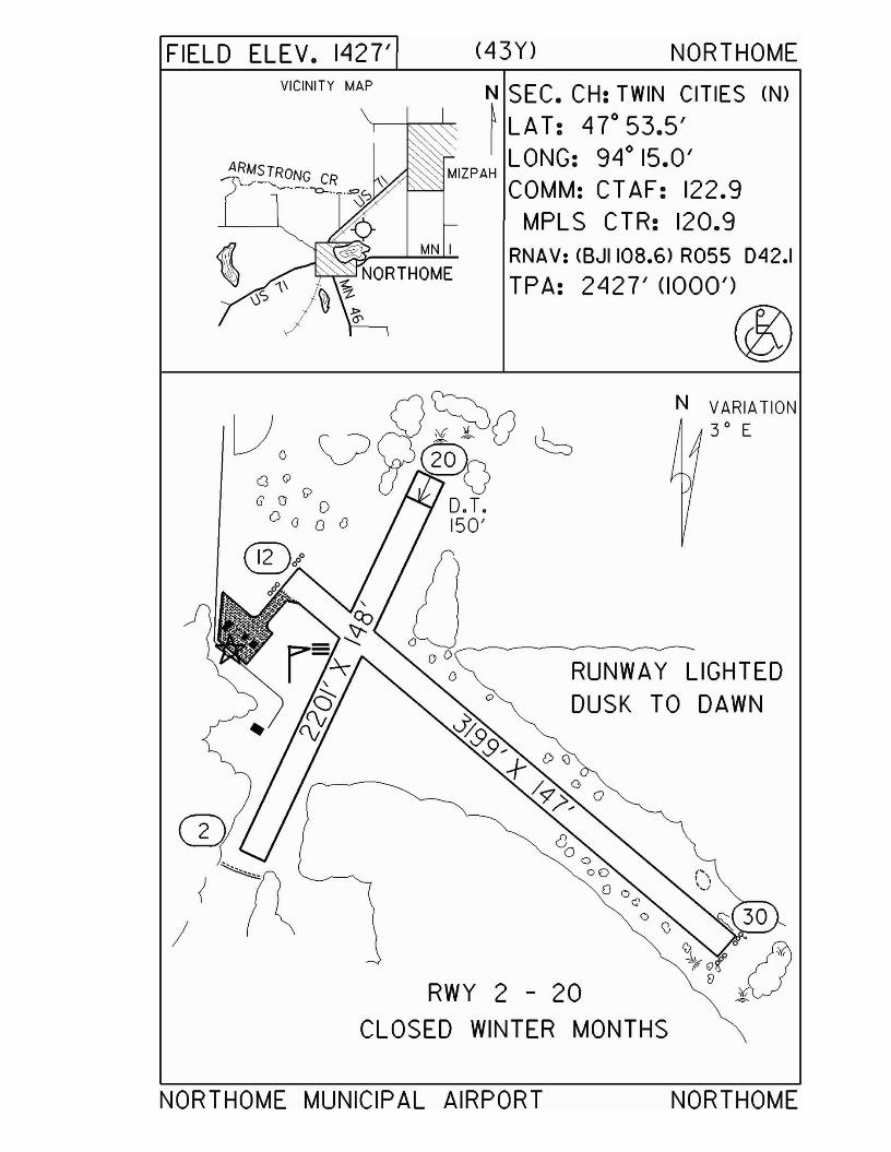
MN I
FIELD ELEV. 1427'VICINITY MAP
(43Y) NORTHOME
N SEC. CH: TWIN CITIES (N)~ LAT: 47°53.5'
LONG: 94° 15.0'MIZPAH
COMM: CTAF: 122.9MPLS CTR: 120.9
RNAV: (BJII08.6) R055 D42.1
TPA: 2427' (1000')
®N VARIATION
3 0 E
RUNWAY LIGHTEDDUSK TO DAWN
\) ~ 30
'i, :fP 0 U'~
(ifOlS
RWY 2 - 20 [) ~
CLOSED WINTER MONTHS
NORTHOME MUNICIPAL AIRPORT NORTHOME
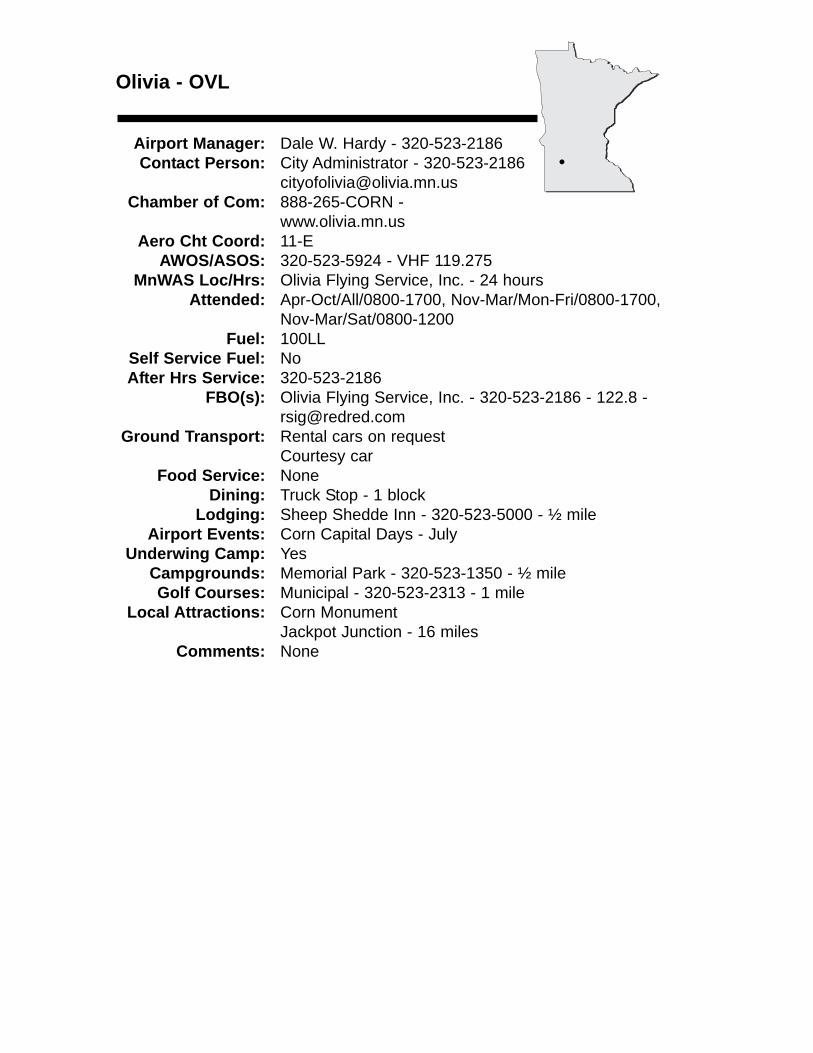
Olivia - OVL
Airport Manager: Dale W. Hardy - 320-523-2186 Contact Person: City Administrator - 320-523-2186
[email protected] of Com: 888-265-CORN -
www.olivia.mn.usAero Cht Coord: 11-E
AWOS/ASOS: 320-523-5924 - VHF 119.275MnWAS Loc/Hrs: Olivia Flying Service, Inc. - 24 hours
Attended: Apr-Oct/All/0800-1700, Nov-Mar/Mon-Fri/0800-1700, Nov-Mar/Sat/0800-1200
Fuel: 100LLSelf Service Fuel: NoAfter Hrs Service: 320-523-2186
FBO(s): Olivia Flying Service, Inc. - 320-523-2186 - 122.8 [email protected]
Ground Transport: Rental cars on requestCourtesy car
Food Service: NoneDining: Truck Stop - 1 block
Lodging: Sheep Shedde Inn - 320-523-5000 - ½ mileAirport Events: Corn Capital Days - July
Underwing Camp: YesCampgrounds: Memorial Park - 320-523-1350 - ½ mileGolf Courses: Municipal - 320-523-2313 - 1 mile
Local Attractions: Corn MonumentJackpot Junction - 16 miles
Comments: None
•
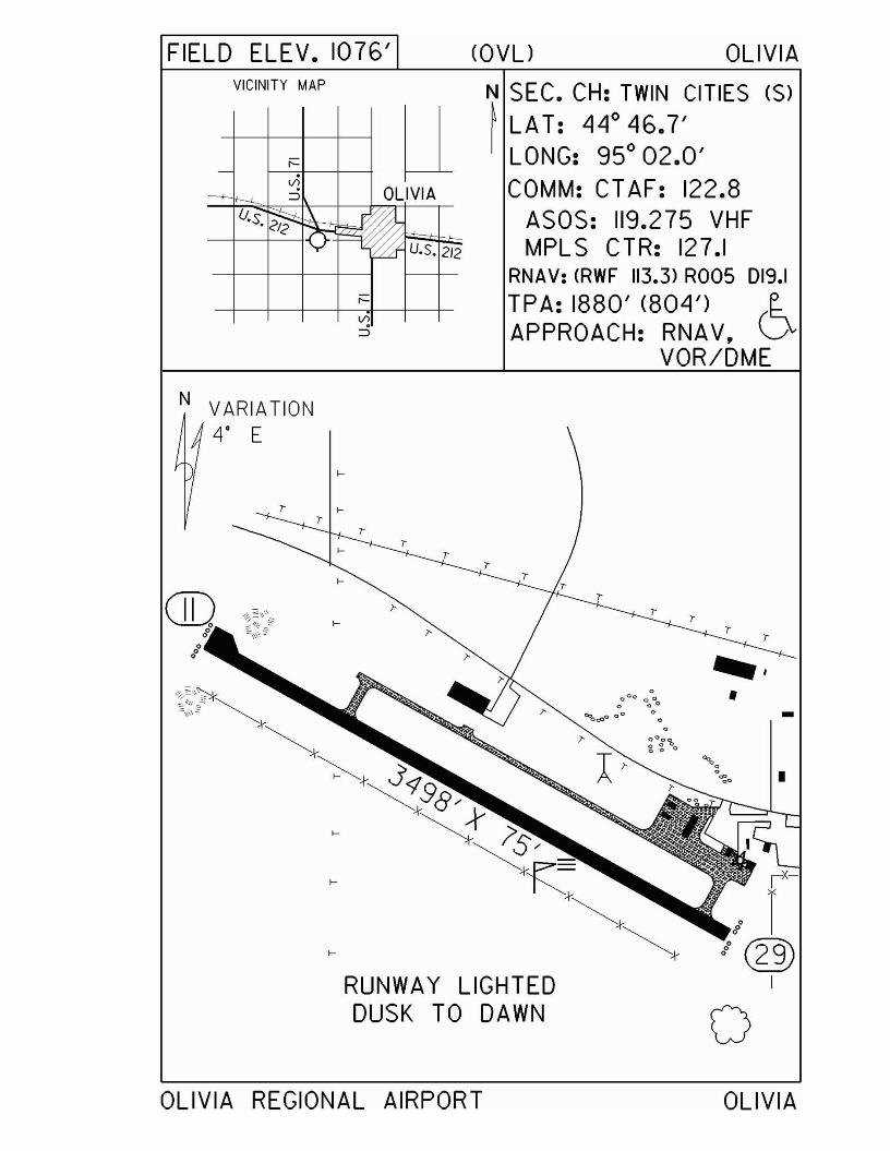
FIELD ELEV. 1076' <OVU OLIVIAVICINITY MAP
u-;::::
vi----+-- i--L ~ OLIVIA
U.S.~"\
~"0- ~ U.S. 2/2
;::::(/)
N SEC. CH: TWIN CITIES (S)~ LAT: 44° 46.7'
LONG: 95° 02.0'COMM: CTAF: 122.8
ASOS: 119.275 VHFMPLS CTR: 127.1
RNAV: <RWF 113.3) ROOS D19.1
TPA: 1880' (804') (~
APPROACH: RNAV, \.JVOR/DME
• -
o
"".o~ •
r
r
.0°0 <> <>. ..
~d)O 0° <> <>.~Og'bo..
r
I-
I-
I-
I-
N VARIATION4' E
I-
r I-r
rr
l-
I-
OLIVIA REGIONAL AIRPORT OLIVIA
Orr - ORBwww.orrairport.com
Airport Manager: Rod Dunn - 218-757-9994 - [email protected]
Contact Person: Rod Dunn - 218-757-9994 - [email protected]
Chamber of Com: 218-757-3932 - www.orrmn.comAero Cht Coord: 4-J
AWOS/ASOS: 218-757-3169 - VHF 118.325MnWAS Loc/Hrs: Arrival/Departure Building - 24 hours
Attended: All/All/0900-1600Fuel: 100LL, Jet A
Self Service Fuel: Visa, Mastercard, American Express, Discover,Multi-Service
After Hrs Service: 218-757-3416FBO(s): None
Ground Transport: Rental car - please call for reservationsRides into Orr can be providedLocal resorts will pick up at airport
Food Service: Pop; candyDining: Sandy's Orr Café - 218-757-3355 - 5 miles -
www.sandysorrcafe.com - will deliver to airportThe Dam Supper Club - 218-757-3985 - 1 milePattenn's Café - 218-757-3908 - 2 miles
Lodging: Anderson Motel - 218-757-3272 - 2 miles; North Country Inn - 218-757-3778 - 2 miles (willprovide transportation); AmericInn Lodge - 800-634-3444 - will provide transportation; numerous resorts & campgrounds - 800-357-9255
Airport Events: None reportedUnderwing Camp: Yes
Campgrounds: Pelican Lake - contact Voyageurs National Park & OrrArea Tourist Center at 800-357-9255 for more information
Golf Courses: 3 Brothers Vermilion River Greens - 218-993-2246 -15 miles
Local Attractions: Pelican Lake/Orr - fishing pier, swimming beach, tennis courts, boat, pontoon & paddle boat rentals; Orr General Store; Wetlands Interpretative Boardwalk; Vince Shute Wildlife Sanctuary; Vermilion River Falls; sporting clays; Upland Bird Preserve; hunting & big game hunt; Voyageurs National Park; Crane Lake/BWCA; Kettle Falls; Namakan Lake; groomedcross-country ski trails & snowmobile trails
Comments: Because of its unique location to both the VoyageursNational Park & BWCA, the Orr Regional Airport is the stepping stone to some of the most diversevacation opportunities in the nation. Jet A fuel is over-wing & single-point.
•
FIELD ELEV. 1311'VICINITY MAP
~ HIGH HILL~ 2 RADIO TOWERSu M.S.L. 1740' -'6
(ORB) ORR
N SEC. CH: TWIN CITIES (N)~ LA T: 48 0 01.0'I LONG: 920 51.4'
COMM: CTAF: 122.8(l)AWOS: 118.325 VHFMPLS CTR: 120.9GCO: 121.725
RNAV: (INL 111.0) RI40 D39.7NOB: caRB) 341 f1?\TPA: 2100' (789') \!Q;IAPPROACH:GPS & NOB
RUNWAY 13 - 31
CLICKS ON 122.8
3 5 7
LIGHTS OFF MED HIGH
REILS OFF ON ON
PAPI OFF ON ON
NVARIATION2° E
HILLWITH
LIGHTS
ORR REGIONAL AIRPORT ORR

Ortonville - VVVwww.ortonville.net
Airport Manager: David Lang - 320-839-3428Contact Person: Todd & Sara Verheul -
320-839-3846 Chamber of Com: 800-568-5722 -
www.bigstonelake.comAero Cht Coord: 10-C
AWOS/ASOS: 320-839-2363 - NDB 332MnWAS Loc/Hrs: Lobby - 24 hours
Attended: All/All/0800-1700Fuel: 100LL
Self Service Fuel: Visa, MastercardAfter Hrs Service: 320-839-3846
FBO(s): NoneGround Transport: City transit bus - 320-839-2050
Food Service: NoneDining: Matador Supper Club - 320-839-9981 - adjacent to
airportTheater of Seasons - 320-839-2261 - adjacent toairportPizza Ranch - 320-839-3006 - 1 mileHeadwaters Grill & Bar - 1 mileDairy Queen - 320-839-3605 - ½ mile
Lodging: Valley View Motel - 320-839-2558 - ½ mile; Econo Lodge - 320-839-2414 - ½ mile; Anchor Motel -½ mile; Sunrise Motel - 800-337-6106 - ½ mile
Airport Events: Airshow - third weekend in AugustUnderwing Camp: Yes
Campgrounds: Municipal - at foot of lakeLakeshore RV Park & Skeeters Restaurant - www.lakeshorervpark.comMeadowbrook State Park
Golf Courses: Municipal Golf Course - Holes: 18Local Attractions: Archery range; Big Stone Lake; Big Stone County
Museum; Big Stone National Wildlife Refuge; municipal swimming pool; mini golf
Comments: Additional contact person - Darell McKinney - 877-520-9074Parking permitted on grass next to grass runway for walking distance to dining facilities.Additional after hours service phone - Todd & Sara - 320-839-6263Police - 320-839-6161Airport manager e-mail - [email protected]
•
FIELD ELEV. 1100' (VVV) ORTONVILLEN
~VICINITY MAP
SOUTHDAKOTA
<I:tOV'lWZz:::i:
SEC. CH: TWIN CITIES (S)LAT: 45°18.3'LONG: 96° 25.5'COMM: CTAF: 122.8 (l)
AWOS: 332 NDBMPLS CTR: 128.5(l)GCO: 121.725
RNAV: (MOX 109.6> R226 024.8NDB: (VVV) 332 f1?\TPA: 2100' (1000') ~APPROACH:GPS & NDB
N
RUNWAY 16 - 34
CLICKS ON 122.8
3 5 7
LIGHTS lOW MED HIGHPAPI ON ON ON
TO GET lOW IN DAYTIMECLICK '5' OR '7'. THEN '3'WINDCONE CAN ALSO BETURNED ON BY PCl
VARIATION50 E
o
RUNWAY 4/22CLOSED WINTER
MONTHS
ORTONVILLE MUNICIPAL AIRPORT(MARTINSON FIELD>
ORTONVILLE
Owatonna - OWAwww.owatonnaairport.com
Airport Manager: Dave Beaver - 507-444-2448 [email protected]
Contact Person: Dave Beaver - 507-444-2448 - [email protected]
Chamber of Com: 800-423-6466 - www.ci.owatonna.mn.usAero Cht Coord: 12-I
AWOS/ASOS: 507-455-0642 - VHF 128.325MnWAS Loc/Hrs: Arrival/Departure Building - 24 Hours Area - 24 hours
Arrival/Departure Building - Flight Planning Room - Mon-Sun, 8:00 A.M.-8:00 P.M.
Attended: May-Sep/All/0800-2000, Oct-Apr/All/0800-1800Fuel: 100LL, Jet A
Self Service Fuel: Visa, Mastercard, DiscoverAfter Hrs Service: 507-451-6611
FBO(s): Langer Aviation, Inc. - 507-444-0535 - [email protected] Aircraft, Ltd. - 507-451-6611 - 122.7 - [email protected] - www.rareaircraft.com
Ground Transport: Courtesy carFood Service: Vending machines
Dining: Perkins - 507-451-6831 - 1½ milesHappy Chef - 507-451-8613 - 1½ milesFamous Daves - 507-451-4008 - 1 mileTimberlodge - 507-444-0303 - 1 mile
Lodging: Comfort Inn - 507-444-0818 - 1 mileHoliday Inn - 507-446-8900 - 1 mileCountry Inn & Suites - 507-455-9295 - 3 milesAmericInn - 507-455-1142 - 3 miles
Airport Events: Annual Fly-InUnderwing Camp: No
Campgrounds: KOA Campgrounds - 507-451-8050 - 5 milesGolf Courses: Municipal Golf Course - 507-451-0730 - 3 miles
Hidden Creek Golf Club - 507-444-9229 - 5 miles EastHavanna Hills Par 3 & Driving Range - 507-451-2577 -4 miles East
Local Attractions: Cabela's - call for shuttle from airport - 1 mileHoliday Inn Convention Center & Water Park - 1 mile
Comments: When Rochester approach is closed use MPLS CTR -132.35
•
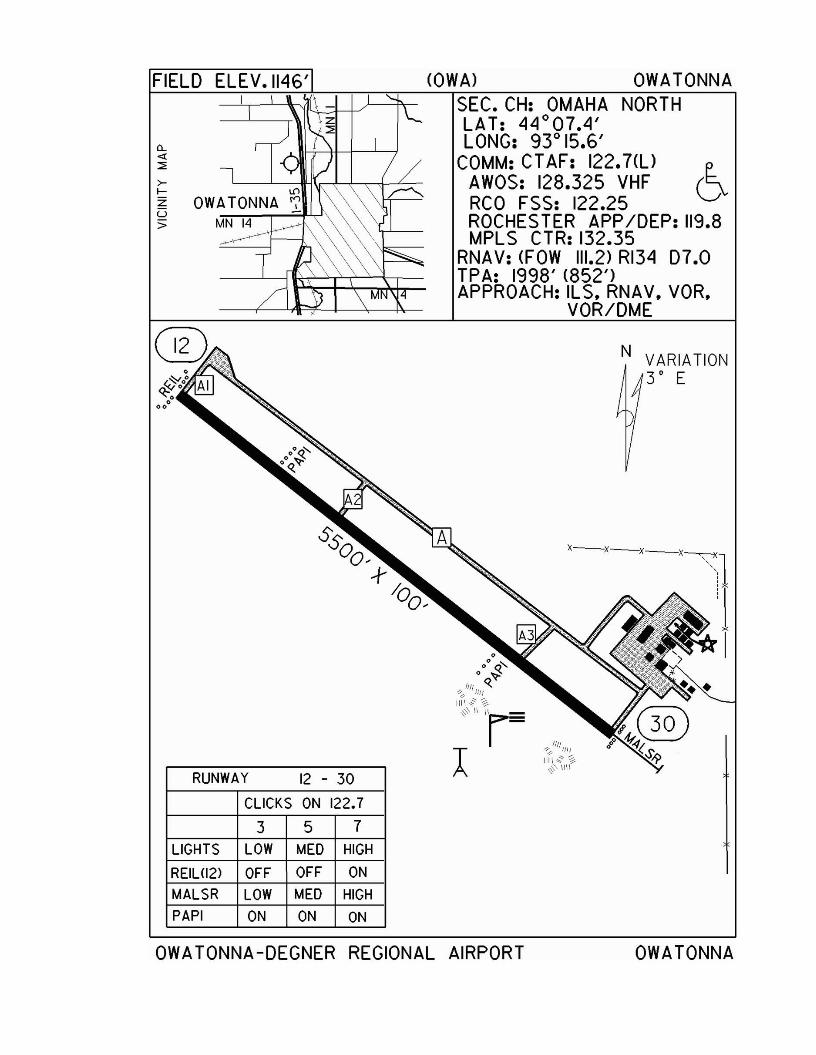
FIELD ELEV.1I46'
CL«::;:
>I-
ZU;:;
RUNWAY 12 - 30
CLICKS ON 122.7
3 5 7LIGHTS LOW MED HIGH
REIUI2) OFF OFF ON
MALSR LOW MED HIGH
PAPI ON ON ON
<OWA) OWATONNASEC. CH: OMAHA NORTHLAT: 44°07.4'LONG: 93° 15.6'
COMM: CTAF: 122.7<l) (~AWOS: 128.325 VHF VRCO FSS: 122.25ROCHES TER APPIDEP: 119.8MPLS CTR: 132.35
RNAV: <FOW 111.2) RI34 07.0TPA: 1998' <852')APPROACH: ILS. RNAV. VOR.
VOR/DME
N VARIATION3 0 E
X-X-x_x
~1:II
III!~'l' II11
IIII~~>$:' 11\\
OWATONNA-DEGNER REGIONAL AIRPORT OWATONNA
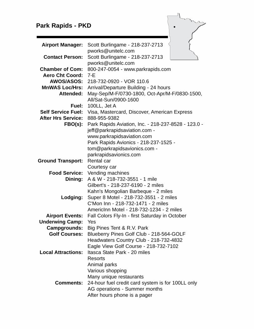
Park Rapids - PKD
Airport Manager: Scott Burlingame - 218-237-2713 [email protected]
Contact Person: Scott Burlingame - 218-237-2713 [email protected]
Chamber of Com: 800-247-0054 - www.parkrapids.comAero Cht Coord: 7-E
AWOS/ASOS: 218-732-0920 - VOR 110.6MnWAS Loc/Hrs: Arrival/Departure Building - 24 hours
Attended: May-Sep/M-F/0730-1800, Oct-Apr/M-F/0830-1500, All/Sat-Sun/0900-1600
Fuel: 100LL, Jet ASelf Service Fuel: Visa, Mastercard, Discover, American ExpressAfter Hrs Service: 888-955-9382
FBO(s): Park Rapids Aviation, Inc. - 218-237-8528 - 123.0 - [email protected] - www.parkrapidsaviation.comPark Rapids Avionics - 218-237-1525 - [email protected] - parkrapidsavionics.com
Ground Transport: Rental carCourtesy car
Food Service: Vending machinesDining: A & W - 218-732-3551 - 1 mile
Gilbert's - 218-237-6190 - 2 milesKahn's Mongolian Barbeque - 2 miles
Lodging: Super 8 Motel - 218-732-3551 - 2 milesC'Mon Inn - 218-732-1471 - 2 milesAmericInn Motel - 218-732-1234 - 2 miles
Airport Events: Fall Colors Fly-In - first Saturday in OctoberUnderwing Camp: Yes
Campgrounds: Big Pines Tent & R.V. ParkGolf Courses: Blueberry Pines Golf Club - 218-564-GOLF
Headwaters Country Club - 218-732-4832Eagle View Golf Course - 218-732-7102
Local Attractions: Itasca State Park - 20 milesResortsAnimal parksVarious shoppingMany unique restaurants
Comments: 24-hour fuel credit card system is for 100LL onlyAG operations - Summer monthsAfter hours phone is a pager
•
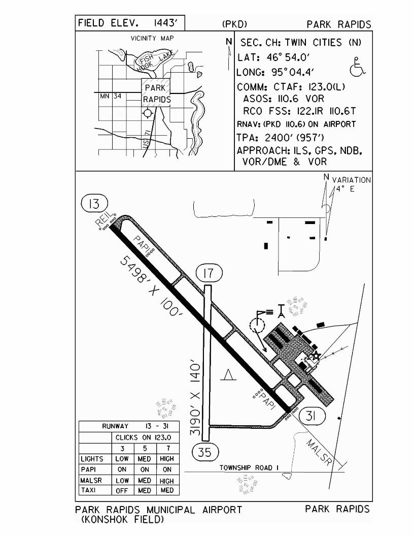
FIELD ELEV. 1443' (PKD) PARK RAPIDSVICINITY MAP N SEC. CH: TWIN CITIES (N)
~ LAT: 46°54.0' e.LONG: 95°04.4' DCOMM: CTAF: 123.0(l)
ASOS: 110.6 VORRCO FSS: 122.IR 110.6T
RNAV: <PKD 110.6> ON AIRPORT
TPA: 2400' (957')APPROACH: ILS. GPS. NOB.
VOR/DME & VOR
N VARIATION4 0 E
- .-•
-•
)
TOWNSHIP ROAD I
x...o(jl
n
3 5 7
ON ON ON
OFF MED MED
CLICKS ON 123.0
LOW MED HIGH
LOW MED HIGH
RUNWAY 13 - 31
TAXI
PAPI
LIGHTS
MALSR
PARK RAPIDS MUNICIPAL AIRPORT(KONSHOK FIELD>
PARK RAPIDS
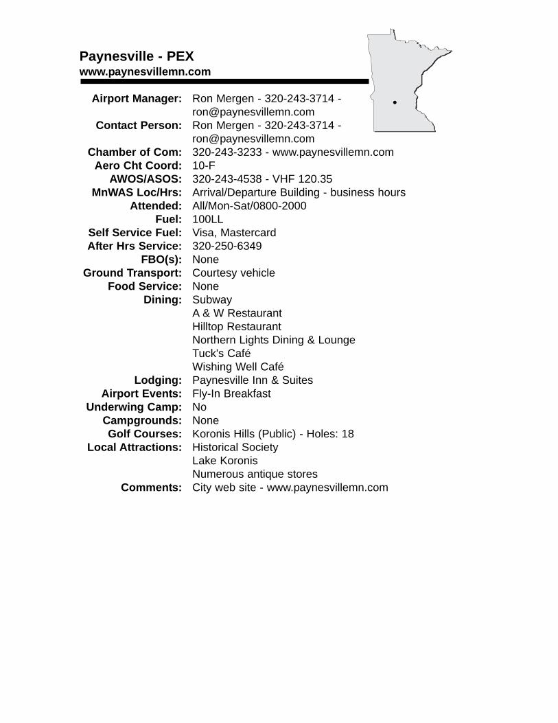
Paynesville - PEXwww.paynesvillemn.com
Airport Manager: Ron Mergen - 320-243-3714 - [email protected]
Contact Person: Ron Mergen - 320-243-3714 - [email protected]
Chamber of Com: 320-243-3233 - www.paynesvillemn.comAero Cht Coord: 10-F
AWOS/ASOS: 320-243-4538 - VHF 120.35MnWAS Loc/Hrs: Arrival/Departure Building - business hours
Attended: All/Mon-Sat/0800-2000Fuel: 100LL
Self Service Fuel: Visa, MastercardAfter Hrs Service: 320-250-6349
FBO(s): NoneGround Transport: Courtesy vehicle
Food Service: NoneDining: Subway
A & W RestaurantHilltop RestaurantNorthern Lights Dining & LoungeTuck's CaféWishing Well Café
Lodging: Paynesville Inn & SuitesAirport Events: Fly-In Breakfast
Underwing Camp: NoCampgrounds: NoneGolf Courses: Koronis Hills (Public) - Holes: 18
Local Attractions: Historical SocietyLake KoronisNumerous antique stores
Comments: City web site - www.paynesvillemn.com
•
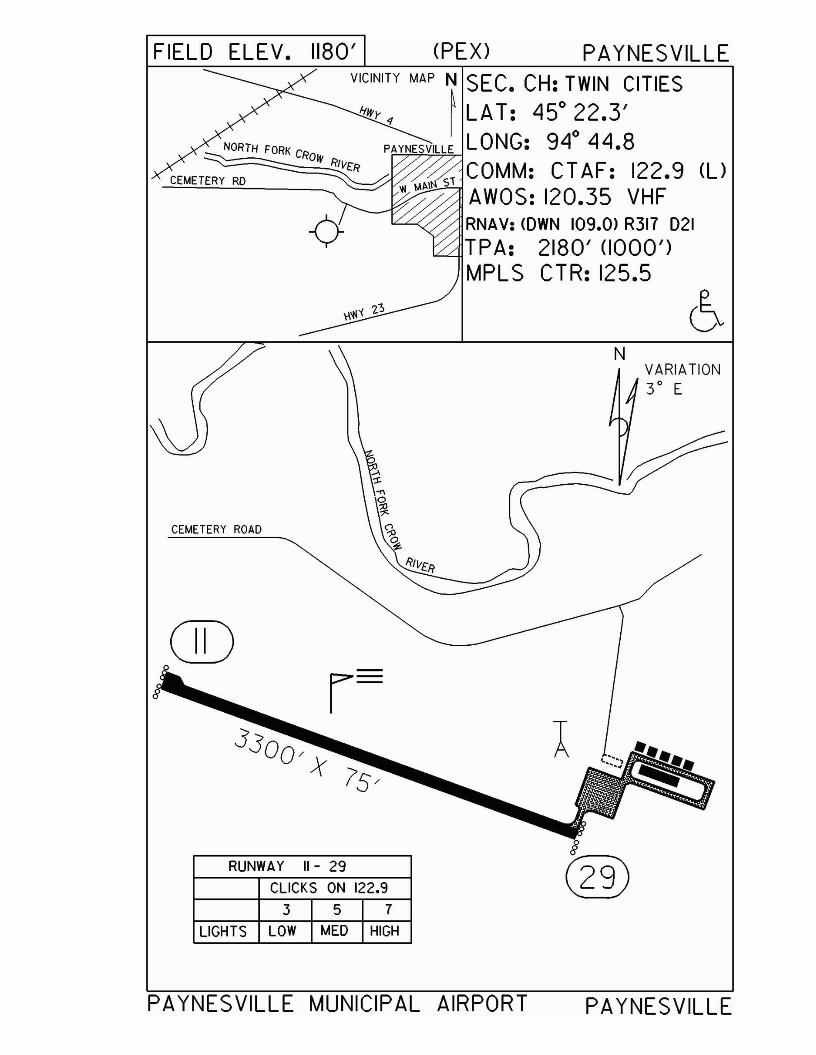
VARIATION3° E
N
CEMETERY ROAD
FIELD ELEV. 1180' (PEX) PAYNESVILLEVICINITY MAP N SEC. CH: TWIN CITIES
Ifl'{y ~ t LAT: 450 ~2•3'
NORTH FORK PAYNESVILLE LONG: 94 44.8CEMETERY RD CROW R1VtR COMM: CT AF: 122.9 (l)
AWOS: 120.35 VHFRNAV: <OWN 109.0> R317 021TPA: 2180' (1000')MPLS CTR: 125.5
GO
RUNWAY 11- 29
CLICKS ON 122.9
3 5 7
LIGHTS LOW MED HIGH
8
@
PAYNESVILLE MUNICIPAL AIRPORT PAYNESVILLE
Pelican Rapids - 47Y
Airport Manager: Don Solga - 218-863-6571 - [email protected]
Contact Person: Brian Olson - 218-731-4050 - [email protected]
Chamber of Com: 800-545-3711 - www.pelicanrapids.comAero Cht Coord: 7-C
AWOS/ASOS: NoMnWAS Loc/Hrs: NA
Attended: UnattendedFuel: 100LL
Self Service Fuel: NoAfter Hrs Service: 218-731-4050
FBO(s): NoneGround Transport: None
Food Service: NoneDining: The Rapids - 218-863-1726 - 4 miles
Lodging: Pelican Motel - 218-863-3281 - 4 milesAirport Events: None reported
Underwing Camp: NoCampgrounds: Maplewood State Park - 10 miles
Sherin Park - 5 milesGolf Courses: Birchwood
Lida GreensLocal Attractions: World's Largest Pelican
July Third CelebrationTurkey DaysFarmer's Market DayArt in the ParkInternational Friendship Festival
Comments: Good fishing lakes
•
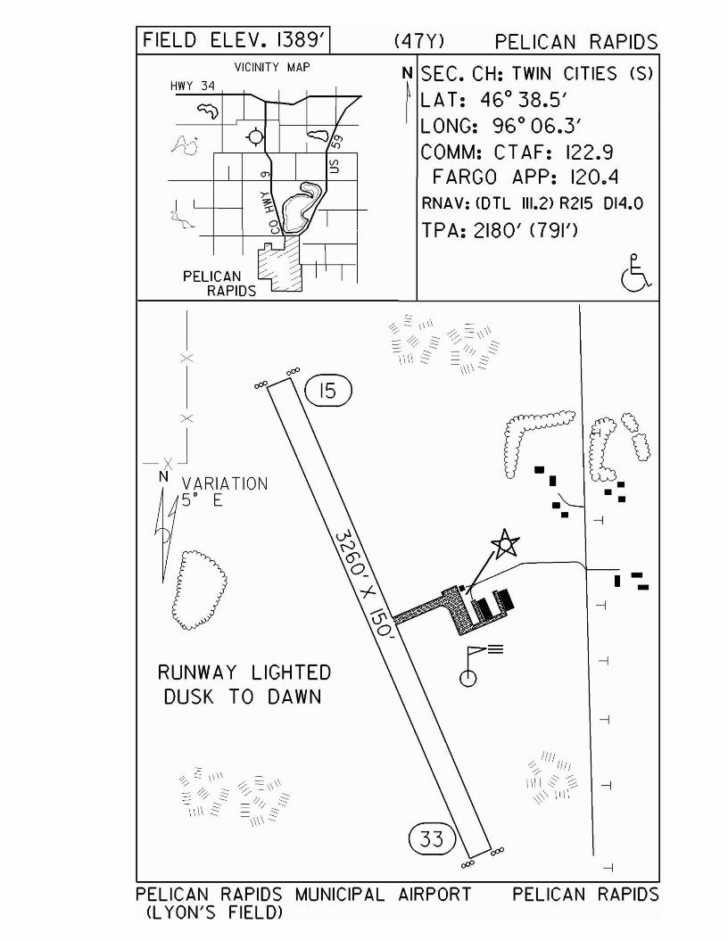
FIELD ELEV. 1389'VICINITY MAP
HWY 34
PELICANRAPIDS
(47Y) PELICAN RAPIDS
N SEC. CH: TWIN CITIES (S)
~ LAT: 46 0 38.5'LONG: 96 0 06.3'COMM: CTAF: 122.9
FARGO APP: 120.4RNAV: <DTL 111.2> R215 014.0
TPA: 2180' <791')
x
x
-XJN VARIATION
5' E
RUNWAY LIGHTEDDUSK TO DAWN
•••
--I
1111-:-", If It'" ,/'
\\\\ c2: ~ --I~' 11\\
•
I --
PELICAN RAPIDS MUNICIPAL AIRPORT(L YON'S FIELD>
PELICAN RAPIDS
Perham - 16Dwww.cityofperham.com
Airport Manager: Bob Louiseau - 218-346-4455 - [email protected]
Contact Person: Merle Meece - 218-346-4455 - [email protected]
Chamber of Com: 800-634-6112 - www.perham.comAero Cht Coord: 7-D
AWOS/ASOS: NoMnWAS Loc/Hrs: Arrival/Departure Building - business hours
Attended: UnattendedFuel: 100LL
Self Service Fuel: Visa, MastercardAfter Hrs Service: 218-346-4455
FBO(s): North Air, Inc. - 218-346-5110 - 122.9 - [email protected] - www.northair.net
Ground Transport: Courtesy carPolice Department - 218-346-4452Rental cars - Marlo Motors - 218-346-5888Phelp's Ford - 218-345-3210
Food Service: NoneDining: The Cactus - 218-346-2555 - 3 miles
Station House - 218-346-7181Gathering Grounds - 1½ milesPizza Ranch - 1½ milesDairy Queen - 1½ milesSubway - 1½ milesZorbaz - 218-346-4900 - 3 miles
Lodging: Super 8 Motel - 218-346-7888 - will providetransportationBudget Host - 218-346-7810 - 1½ miles
Airport Events: None reportedUnderwing Camp: No
Campgrounds: Golden Eagle Campground - Big Pine LakeGolf Courses: Perham Lakeside Golf Course - 218-346-6070 -
Holes: 27Local Attractions: Many lakes & recreational resorts
Community center with pool, track, etc.Turtle Fest in June (Wednesday A.M. turtle races) East Otter Tail Fair in mid-JulyPioneer Days in August
Comments: None
•
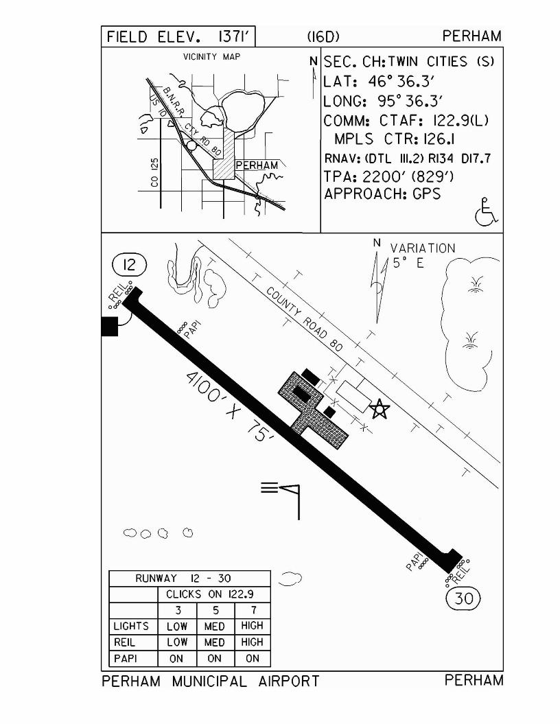
FIELD ELEV. 1371'VICINITY MAP
®
00 a CJ
RUNWAY 12 - 30 JCLICKS ON 122.9
357LIGHTS LOW MED HIGH
REIL LOW MED HIGH
PAPI ON ON ON
(160) PERHAM
N SEC. CH: TWIN CITIES (S)
~ LA T: 46° 36.3'I LONG: 95° 36.3'
COMM: CT AF: 122.9(l)MPLS CTR: 126.1
RNAV: <OTL 111.2> RI34 017.7
TPA: 2200' (829')APPROACH:GPS
N VARIATION50 E
PERHAM MUNICIPAL AIRPORT PERHAM
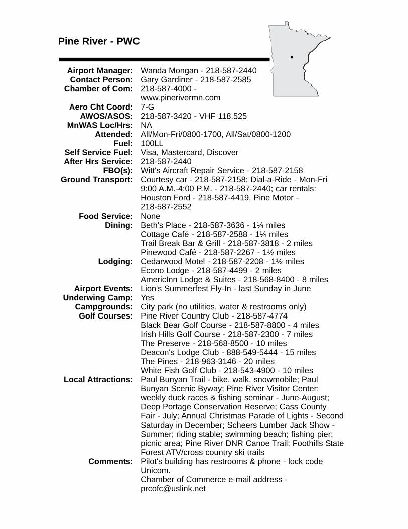
Pine River - PWC
Airport Manager: Wanda Mongan - 218-587-2440 Contact Person: Gary Gardiner - 218-587-2585
Chamber of Com: 218-587-4000 - www.pinerivermn.com
Aero Cht Coord: 7-GAWOS/ASOS: 218-587-3420 - VHF 118.525
MnWAS Loc/Hrs: NAAttended: All/Mon-Fri/0800-1700, All/Sat/0800-1200
Fuel: 100LLSelf Service Fuel: Visa, Mastercard, DiscoverAfter Hrs Service: 218-587-2440
FBO(s): Witt's Aircraft Repair Service - 218-587-2158 Ground Transport: Courtesy car - 218-587-2158; Dial-a-Ride - Mon-Fri
9:00 A.M.-4:00 P.M. - 218-587-2440; car rentals: Houston Ford - 218-587-4419, Pine Motor - 218-587-2552
Food Service: NoneDining: Beth's Place - 218-587-3636 - 1¼ miles
Cottage Café - 218-587-2588 - 1¼ milesTrail Break Bar & Grill - 218-587-3818 - 2 milesPinewood Café - 218-587-2267 - 1½ miles
Lodging: Cedarwood Motel - 218-587-2208 - 1½ milesEcono Lodge - 218-587-4499 - 2 milesAmericInn Lodge & Suites - 218-568-8400 - 8 miles
Airport Events: Lion's Summerfest Fly-In - last Sunday in JuneUnderwing Camp: Yes
Campgrounds: City park (no utilities, water & restrooms only)Golf Courses: Pine River Country Club - 218-587-4774
Black Bear Golf Course - 218-587-8800 - 4 milesIrish Hills Golf Course - 218-587-2300 - 7 milesThe Preserve - 218-568-8500 - 10 milesDeacon's Lodge Club - 888-549-5444 - 15 milesThe Pines - 218-963-3146 - 20 milesWhite Fish Golf Club - 218-543-4900 - 10 miles
Local Attractions: Paul Bunyan Trail - bike, walk, snowmobile; Paul Bunyan Scenic Byway; Pine River Visitor Center; weekly duck races & fishing seminar - June-August; Deep Portage Conservation Reserve; Cass County Fair - July; Annual Christmas Parade of Lights - Second Saturday in December; Scheers Lumber Jack Show - Summer; riding stable; swimming beach; fishing pier; picnic area; Pine River DNR Canoe Trail; Foothills StateForest ATV/cross country ski trails
Comments: Pilot's building has restrooms & phone - lock code Unicom.Chamber of Commerce e-mail address - [email protected]
•
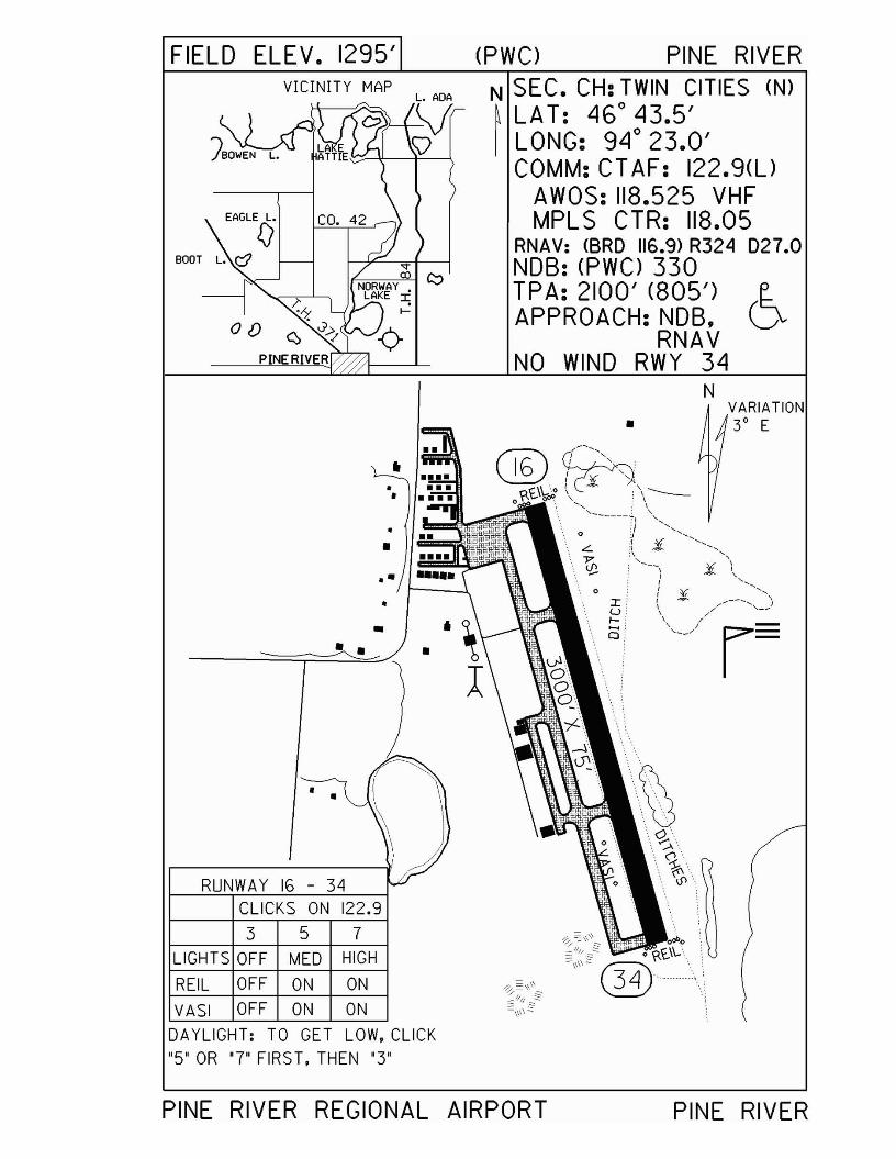
FIELD ELEV. 1295' (PWC) PINE RIVERVICINITY MAP
EAGLE L.
fJBOOT L. r:::J
Of)
N SEC. CH: TWIN CITIES (N)~ LAT: 46° 43.5'I LONG: 94° 23.0'
COMM: CT AF: 122.9(l)AWOS: 118.525 VHFMPLS CTR: 118.05
RNAV: <BRO 116.9> R324 027.0NOB: (PWC> 330TPA: 2100' (805')APPROACH: NOB,
RNAVNO WIND RWY 34
N
CLICKS ON 122.9
•
VARIATION• 3° E
••
357
•
•
RUNWAY 16 - 34
.-•
••
LIGHTS OFF MED HIGH
REIL OFF ON ON
VASI OFF ON ON
DAYLIGHT: TO GET LOW, CLICK"5" OR '7" FIRS T, THEN '3'
PINE RIVER REGIONAL AIRPORT PINE RIVER
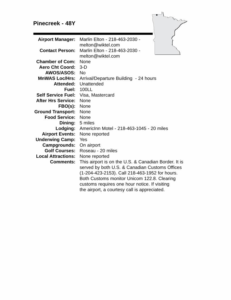
Pinecreek - 48Y
Airport Manager: Marlin Elton - 218-463-2030 - [email protected]
Contact Person: Marlin Elton - 218-463-2030 - [email protected]
Chamber of Com: NoneAero Cht Coord: 3-D
AWOS/ASOS: No MnWAS Loc/Hrs: Arrival/Departure Building - 24 hours
Attended: UnattendedFuel: 100LL
Self Service Fuel: Visa, MastercardAfter Hrs Service: None
FBO(s): NoneGround Transport: None
Food Service: NoneDining: 5 miles
Lodging: AmericInn Motel - 218-463-1045 - 20 milesAirport Events: None reported
Underwing Camp: YesCampgrounds: On airportGolf Courses: Roseau - 20 miles
Local Attractions: None reportedComments: This airport is on the U.S. & Canadian Border. It is
served by both U.S. & Canadian Customs Offices (1-204-423-2153). Call 218-463-1952 for hours. Both Customs monitor Unicom 122.8. Clearing customs requires one hour notice. If visiting the airport, a courtesy call is appreciated.
•
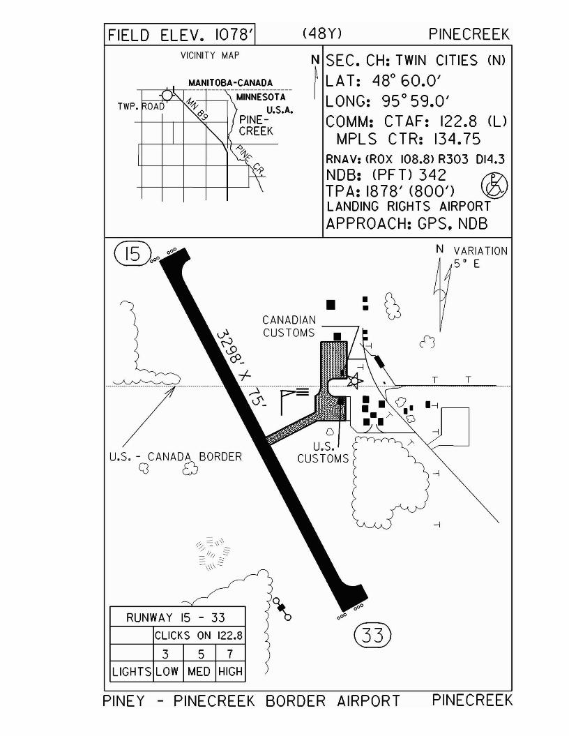
FIELD ELEV. 1078' (48Y) PINECREEKVICINITY MAP
MANITOBA-CANADA-r---~-,----- ---- -----------------
-+------, \ MINNESOTA
N SEC. CH: TWIN CITIES (N)
~ LAT: 480 60.0'I LONG: 95 0 59.0'
COMM: CT AF: 122.8 (UMPLS CTR: 134.75
RNAV: <ROX 108.8> R303 014.3NDB: (PFT) 342 f17\TPA: 1878' (800') \QJLANDING RIGHTS AIRPORTAPPROACH: GPS,NDB
T
--I
T
•
N VARIATION50 E
oU.S.
CUSTOMS
: r\CANADIAN -----r \»CUSTOMS
3 5 7
CLICKS ON 122.8
RUNWAY 15 - 33
LIGHTS LOW MED HIGH
U.S. - CANADA BORDERCJ 0
PINEY - PINECREEK BORDER AIRPORT PINECREEK
Pipestone - PQN
Airport Manager: Robert Dykstra - 507-562-2473 - [email protected]
Contact Person: Robert Dykstra - 507-562-2473 - [email protected]
Chamber of Com: 507-825-3316 - www.pipestoneminnesota.comAero Cht Coord: 13-C
AWOS/ASOS: 507-825-6895 - VHF 118.375MnWAS Loc/Hrs: Arrival/Departure Building - 24 hours
Attended: All/Mon-Fri/0800-1700Fuel: 100LL, Jet A
Self Service Fuel: Visa, MastercardAfter Hrs Service: 507-562-2473
FBO(s): Country Aire LLC - 507-562-2473 - 122.8 - [email protected]
Ground Transport: Courtesy carTaxi
Food Service: NoneDining: Lange's - 507-825-4488 - 1¼ miles
Calumet Inn - 507-825-5871 - 1½ milesFlanagan's - ½ mileThe Villager - 1½ milesDar's Pizza - 2½ milesPizza Hut - 1 milePizza Ranch - 1½ milesMcDonald's - ¾ mile
Lodging: Arrow Motel - 1-888-825-9599 - 1½ milesSuper 8 Motel - 507-825-4217 - 1 mileCalumet Inn - 507-825-5871 or 800-535-7610 - 1½ miles
Airport Events: None reportedUnderwing Camp: Yes
Campgrounds: Pipestone Campground - 507-825-2455Golf Courses: Pipestone Country Club - 507-825-2592
Local Attractions: Pipestone National MonumentCounty MuseumRestored 100+ year old Calumet InnHiawatha Pageant
Comments: Peacepipes, pioneers & progress, Red Stone Town on the Prairie; Pipestone is the home of the stone quarries from which Indian peacepipes are made.
•
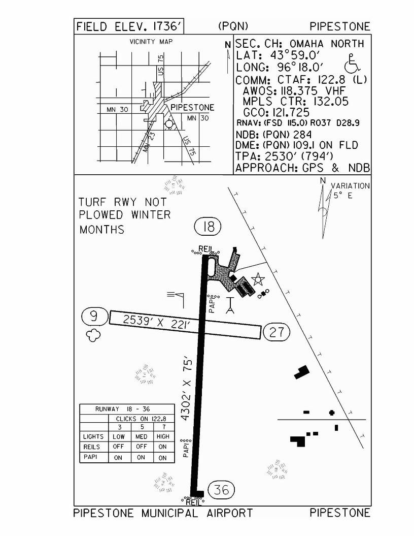
FIELD ELEV. 1736' (PON) PIPES TONEVICINITY MAP N SEC. CH: OMAHA NORTH
~ LAT: 43°59.0' e..I LONG: 96° 18.0' V
COMM: CT AF: 122.8 (l)AWOS: 118.375 VHFMPLS CTR: 132.05GCO: 121.725
RNAV: <FSO 115.0> R037 028.9NOB: (PON) 284OME: (PON) 109.1 ON FLOTPA: 2530' <794')APPROACH:GPS & NOB
TURF RWY NOTPLOWED WINTERMONTHS (]§)
N VARIATION50 E
-1®r--?'2:~__
2539' X 22/' ®o -----.1 27
I
- .
PIPESTONE
•••
x
0000
Q~£L
LIGHTS LOW MED HIGH
REILS OFF OFF ON
PAPI ON ON ON
,('\.J
,...----- -----, 0RUNWAY 18 - 36 ......
I---,........,.---.,..-,........,..-----,--,-...,...---l ,- J
1--_+---"C=L1C"TKS"---,,-,,ON'--'i12=2=.8---j ~3 5 7
PIPESTONE MUNICIPAL AIRPORT
Preston - FKA
Airport Manager: Larry Tammel - 507-937-3000 Contact Person: Larry Tammel - 507-765-4701
Chamber of Com: None Aero Cht Coord: 13-K
AWOS/ASOS: 507-765-2182 - VHF 118.925MnWAS Loc/Hrs: Arrival/Departure Building - 24 hours
Attended: UnattendedFuel: None
Self Service Fuel: NoAfter Hrs Service: None
FBO(s): NoneGround Transport: Rental car - Brunsvold Enterprises - 507-765-3642
Food Service: NoneDining: Branding Iron - 507-765-3388 - 5 miles
Lodging: Country Hearth Motel - 507-765-2533 - 5 milesJailhouse Historic Inn - 507-765-2181 - 5 milesSuper 8 Motel Spring Valley - 507-346-7788 -14 milesCountry Lodge Motel - 507-886-2515 - 14 miles
Airport Events: None reportedUnderwing Camp: Yes
Campgrounds: Hidden Valley - 507-765-2467 - 7 milesOld Barn Resort - 507-467-2512 - 9 milesForestville State Park - 507-352-5111 - 4 miles
Golf Courses: Preston - 4 milesLocal Attractions: Hard Surface Bike Trail - 5 miles
Comments: Pay phone in the Arrival/Departure Building - 507-765-9950
•
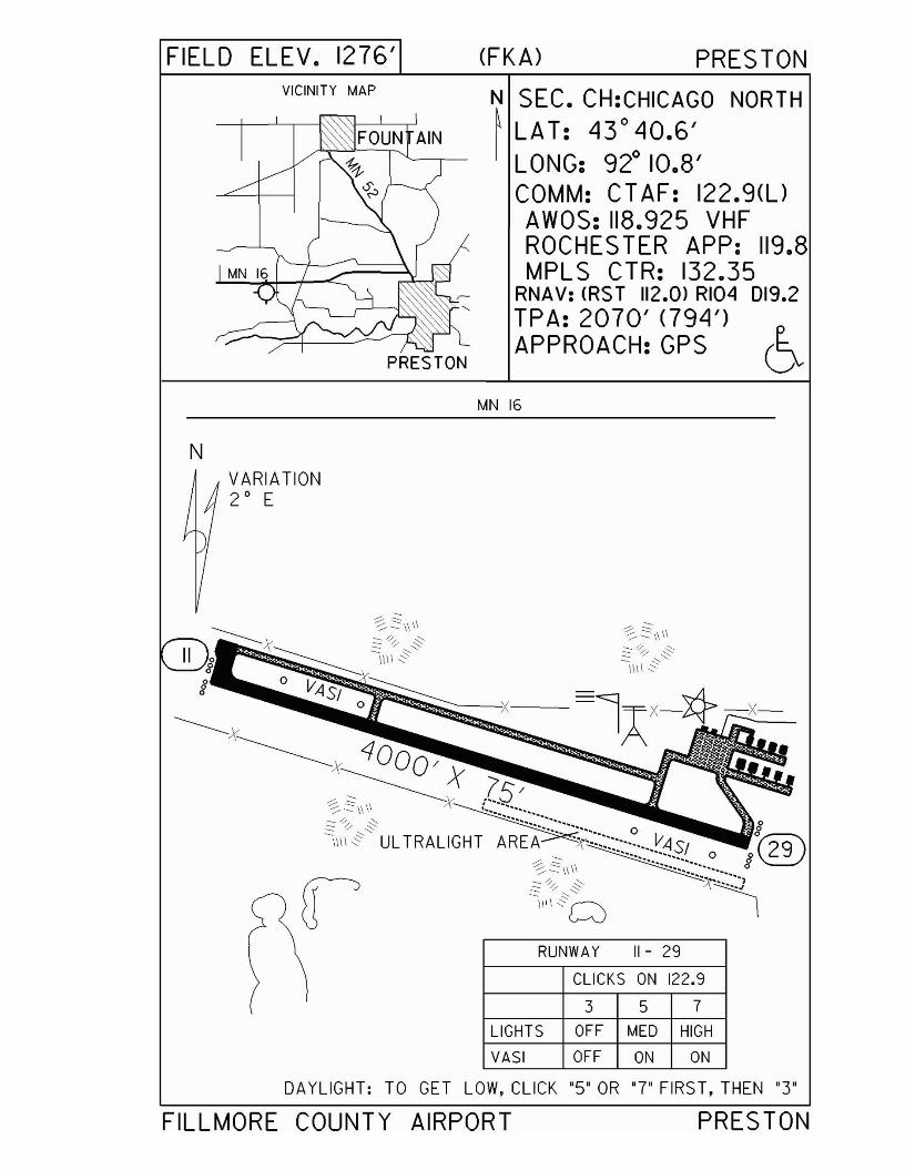
FIELD ELEV. 1276'VICINITY MAP
PRESTON
N
(FKA) PRES TON
N SEC. CH:CHICAGO NORTH~ LAT: 43° 40.6'
LONG: 92° 10.8'COMM: CTAF: 122.9(l)AWOS: 118.925 VHFROCHES TER APP: 119.8MPLS CTR: 132.35
RNAV: <RS T 112.0> RI04 019.2TPA: 2070' <794')APPROACH: GPS 6
MN 16
VARIATION2 0 E
RUNWAY 11- 29
CLICKS ON 122.9
3 5 7
LIGHTS OFF MED HIGH
VASI OFF ON ON
DAYLIGHT: TO GET LOW, CLICK '5' OR '7' FIRST, THEN '3"
FILLMORE COUNTY AIRPORT PRESTON
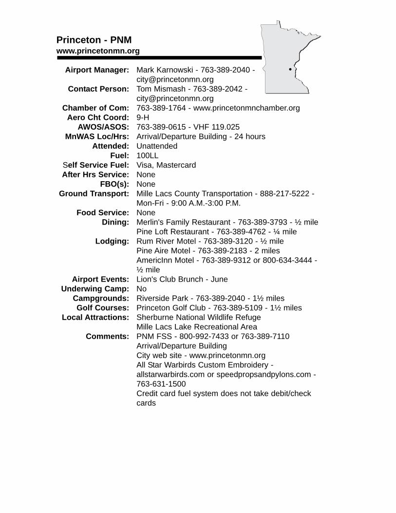
Princeton - PNMwww.princetonmn.org
Airport Manager: Mark Karnowski - 763-389-2040 - [email protected]
Contact Person: Tom Mismash - 763-389-2042 - [email protected]
Chamber of Com: 763-389-1764 - www.princetonmnchamber.orgAero Cht Coord: 9-H
AWOS/ASOS: 763-389-0615 - VHF 119.025MnWAS Loc/Hrs: Arrival/Departure Building - 24 hours
Attended: UnattendedFuel: 100LL
Self Service Fuel: Visa, MastercardAfter Hrs Service: None
FBO(s): NoneGround Transport: Mille Lacs County Transportation - 888-217-5222 -
Mon-Fri - 9:00 A.M.-3:00 P.M.Food Service: None
Dining: Merlin's Family Restaurant - 763-389-3793 - ½ milePine Loft Restaurant - 763-389-4762 - ¼ mile
Lodging: Rum River Motel - 763-389-3120 - ½ milePine Aire Motel - 763-389-2183 - 2 milesAmericInn Motel - 763-389-9312 or 800-634-3444 - ½ mile
Airport Events: Lion's Club Brunch - JuneUnderwing Camp: No
Campgrounds: Riverside Park - 763-389-2040 - 1½ milesGolf Courses: Princeton Golf Club - 763-389-5109 - 1½ miles
Local Attractions: Sherburne National Wildlife RefugeMille Lacs Lake Recreational Area
Comments: PNM FSS - 800-992-7433 or 763-389-7110Arrival/Departure BuildingCity web site - www.princetonmn.orgAll Star Warbirds Custom Embroidery - allstarwarbirds.com or speedpropsandpylons.com - 763-631-1500Credit card fuel system does not take debit/check cards
•
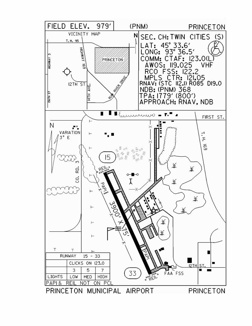
(PNM) PRINCETON
••
FIRST ST.-. --:x •
I :x
N~ SEC. CH: TWIN CITIES (S)~.,..,.,.,..,.,,.,.,.,..,..,..,.,j- LAT: 45° 33.6' ~
LONG: 93° 36.5' \iQICOMM: CT AF: 123.0(l)
AWOS: 119.025 VHFRCO FSS: 122.2MPLS CTR: 121.05
RNAV: ($Te 112.1> R085 019.0NOB: (PNM) 368TPA: 1779' (800')APPROACH:RNAV,NDB
f-
oc::
c5u
f-
CLICKS ON 123.0
357
RUNWAY 15 - 33
T T
LIGHTS LOW MED HIGH
PAPI & REll NOT ON pel
PRINCETON MUNICIPAL AIRPORT PRINCETON

Red Lake Falls - D81www.redlakefalls.com
Airport Manager: Scott Larson - 218-253-2684 Contact Person: Allen Ducharme - 218-253-2684 -
[email protected] of Com: 218-253-2684 -
www.redlakefalls.comAero Cht Coord: 5-C
AWOS/ASOS: NoMnWAS Loc/Hrs: NA
Attended: UnattendedFuel: None
Self Service Fuel: NoAfter Hrs Service: None
FBO(s): NoneGround Transport: None
Food Service: NoneDining: Uncle Bill's - 4 miles
Joe DiMaggio's Sports Café - 4 milesBig Swen's Restaurant & Lounge - 8 milesMemories on Main Street
Lodging: Chateau BottineauAirport Events: Yearly Fly-In
Underwing Camp: NoCampgrounds: Voyager View
Riverside ParkSportsman's Park
Golf Courses: Oak Knolls Golf CourseLocal Attractions: Trail - 4 miles biking/walking
TubingCampingCanoeingOf The Land Art Gallery
Comments: None
•
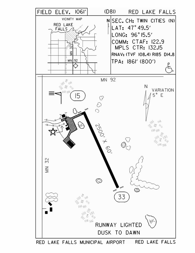
FIELD ELEV. 1061' C08D RED LAKE FALLS
VARIATION50 E
\\\\ IIII
/. .:::::::: /~ ~ ///
11\1 IIII
N
N SEC. CH: TWIN CITIES (N)
~ LAT: 470
49.5'LONG: 96 0 15.5'COMM: CTAF: 122.9
MPLS CTR: 132.15RNAV: (lVF 108.4) RI8S 014.8
TPA: 1861' (800')
MN 92
GD
()
VICINITY MAP
z:2
RED LAKE FALLS MUNICIPAL AIRPORT RED LAKE FALLS

Red Wing - RGKwww.redwingairport.com
Airport Manager: Denny Tebbe - 651-385-3653 [email protected]
Contact Person: Tom Blue, Blue Airways - 715-594-3701 - [email protected]
Chamber of Com: 800-762-9516 - www.redwingchamber.comAero Cht Coord: 11-K
AWOS/ASOS: 715-594-3763 - VHF 119.250MnWAS Loc/Hrs: Arrival/Departure Building - 24 hours
Attended: All/Mon-Sat/0800-1700, All/Sun/1000-1600Fuel: 100LL, Jet A
Self Service Fuel: Visa, MC, Disc, Am Express, Multi-Serve, AvCardAfter Hrs Service: 651-764-1959
FBO(s): Blue Airways - 715-594-3999 - [email protected] - www.blue-airways.comRed Wing Aeroplane Company - 715-594-3761 - [email protected] - www.redwingaero.comSeifert Skyways, Inc. - 715-594-3041 - [email protected] - www.seifertskyways.com
Ground Transport: St. James Hotel; car rental; courtesy carFood Service: Vending machines
Dining: Hager Heights Drive-In - 715-792-2118 - 3 milesNorton's - 715-792-2464 - across field from airportSeveral restaurants located downtown - 5 miles
Lodging: St. James Hotel - 651-388-2846 - 5 miles; AmericInn -651-388-2846 - 5 miles; Best Western - 651-388-1577 - 5 miles; Nichols Inn & Suites - 651-388-6633 - 5 miles;Rodeway Inn - 651-388-1502 - 5 miles; Super 8 Motel - 651-388-0491 - 5 miles; Days Inn - 651-388-3568 - 5 miles; Several bed & breakfasts located in downtown Red Wing
Airport Events: UHVPA Fly-In Breakfast - AugustUnderwing Camp: Yes
Campgrounds: Island Campground & Marina - 715-222-1808Golf Courses: Mississippi National Golf Course - 651-388-1874
Red Wing Golf Club - 651-388-9524Local Attractions: Pottery Mall; St. James Hotel; shopping;
antiques/crafts; river parks; bluff hiking; Cannon Valley Bike Trail; Goodhue County Museum; River City Days Summer Celebration; Treasure Island Casino; cross-country & downhill skiing
Comments: For noise abatement, aircraft departing Runway 27fly straight ahead to 500' AGL. Chamber of Commerce has many maps available to assist in Red Wing attractions, including walking tour of historic districts, etc. Red Wing Visitor & Convention Bureau - 651-385-5934 or 800-498-3444.Remote Communications Outlet on field - 122.6
•

FIELD ELEV. 780' (RGK) RED WINGVICINITY MAP
>~
Z MINNESOTA
~ SEC. CH: GREEN SAY (5)
I LAT: 44° 35.4'LONG: 92° 29.1'COMM: CT AF: 123.05(l)
AWOS: 119.250 VHFRCO FSS: 122.6MPL S APP: 121.2 U
RNAV: (FGT 115.7) R089 030TPA: 1800' (1015')APPROACH: RNAV• IL S
NVARIATION2 0 E
RUNWAY 9 - 27
CLICKS ON 123.05
3 5 7
LIGHTS LOW MED HIGH
PAPI ON ON ON
REIL (27) OFF MED HIGH
MALSR(9) LOW MED HIGH
TAXI LOW MED HIGH
l
r=
® ....J
§~~PAPI •
....~=~ (I')~, "
5010' X 100'
~PAPI
, ~--::::::=:::~=~~~
MISSISSIPPI RIVER(GOOSE LAKE)
.o
RED WING REGIONAL AIRPORT RED WING
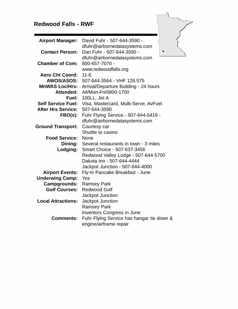
Redwood Falls - RWF
Airport Manager: David Fuhr - 507-644-3590 - [email protected]
Contact Person: Dan Fuhr - 507-644-3590 - [email protected]
Chamber of Com: 800-657-7070 -www.redwoodfalls.org
Aero Cht Coord: 11-EAWOS/ASOS: 507-644-3564 - VHF 126.575
MnWAS Loc/Hrs: Arrival/Departure Building - 24 hoursAttended: All/Mon-Fri/0800-1700
Fuel: 100LL, Jet ASelf Service Fuel: Visa, Mastercard, Multi-Serve, AvFuelAfter Hrs Service: 507-644-3590
FBO(s): Fuhr Flying Service - 507-644-5419 - [email protected]
Ground Transport: Courtesy carShuttle to casino
Food Service: NoneDining: Several restaurants in town - 3 miles
Lodging: Smart Choice - 507-637-3456Redwood Valley Lodge - 507-644-5700Dakota Inn - 507-644-4444Jackpot Junction - 507-644-4000
Airport Events: Fly-In Pancake Breakfast - JuneUnderwing Camp: Yes
Campgrounds: Ramsey ParkGolf Courses: Redwood Golf
Jackpot JunctionLocal Attractions: Jackpot Junction
Ramsey ParkInventors Congress in June
Comments: Fuhr Flying Service has hangar tie down & engine/airframe repair
•
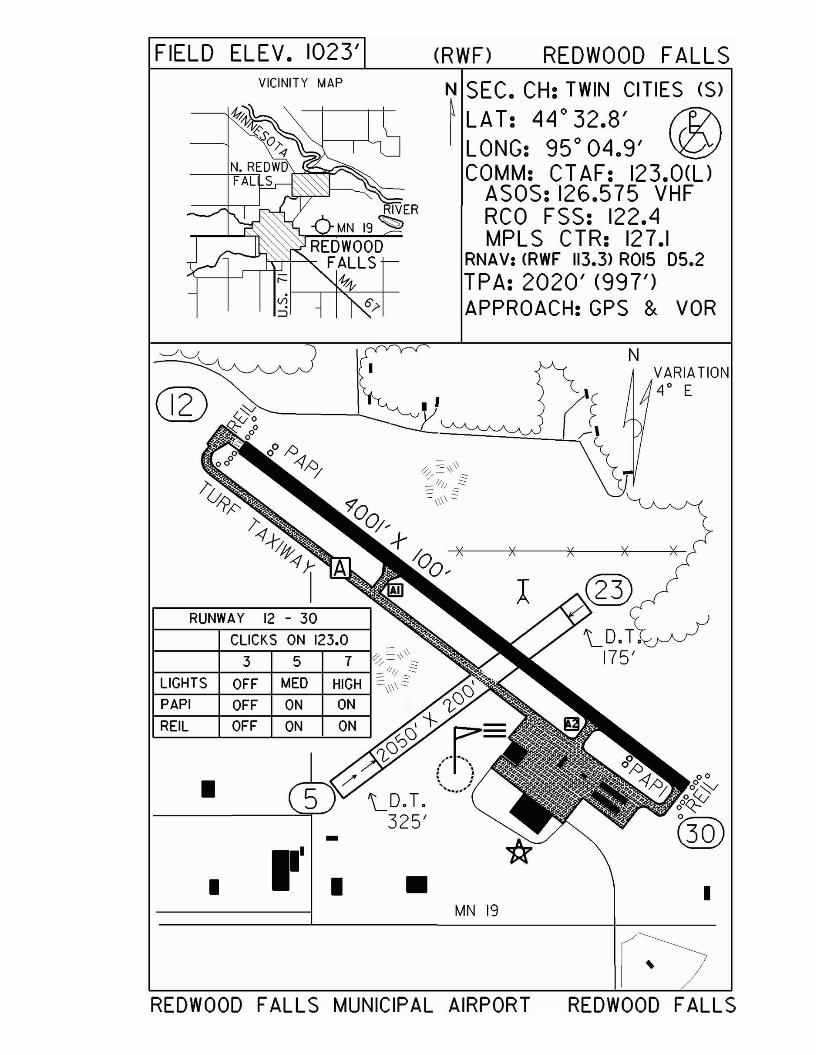
FIELD ELEV. 1023'VICINITY MAP
(RWF) REDWOOD FALLS
N SEC. CH: TWIN CITIES (S)~ LA T: 44
0
32.8' f1?\I LONG: 95 0 04.9' ~
COMM: CT AF: 123.0(l)ASOS: 126.575 VHFRCO FSS: 122.4MPLS CTR: 127.1
RNAV: <RWF 113.3> ROl5 05.2TPA: 2020' (997')APPROACH:GPS & VOR
RUNWAY 12 - 30
CLICKS ON 123.0
3 5 7
LIGHTS OFF MED HIGH
PAPI OFF ON ON
REIL OFF ON ON
• /"'LD.T.
325'-•
III • •MN 19
NVARIATION4° E
I
REDWOOD FALLS MUNICIPAL AIRPORT REDWOOD FALLS
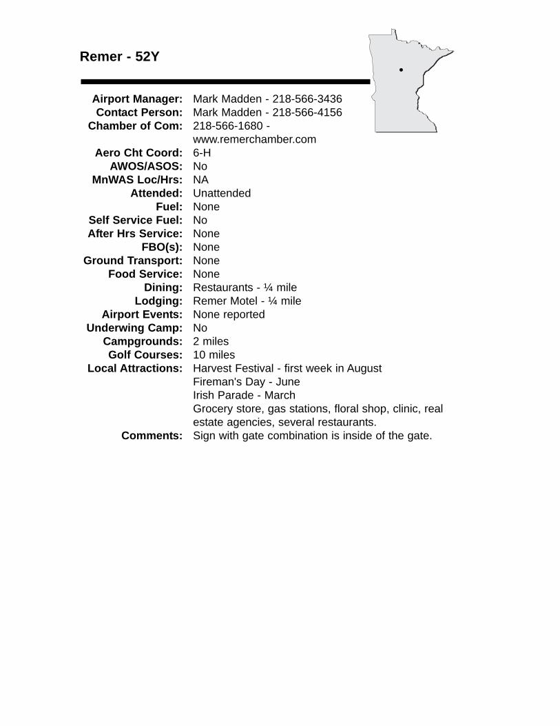
Remer - 52Y
Airport Manager: Mark Madden - 218-566-3436 Contact Person: Mark Madden - 218-566-4156
Chamber of Com: 218-566-1680 - www.remerchamber.com
Aero Cht Coord: 6-HAWOS/ASOS: No
MnWAS Loc/Hrs: NAAttended: Unattended
Fuel: NoneSelf Service Fuel: NoAfter Hrs Service: None
FBO(s): NoneGround Transport: None
Food Service: NoneDining: Restaurants - ¼ mile
Lodging: Remer Motel - ¼ mileAirport Events: None reported
Underwing Camp: NoCampgrounds: 2 milesGolf Courses: 10 miles
Local Attractions: Harvest Festival - first week in AugustFireman's Day - JuneIrish Parade - MarchGrocery store, gas stations, floral shop, clinic, real estate agencies, several restaurants.
Comments: Sign with gate combination is inside of the gate.
•
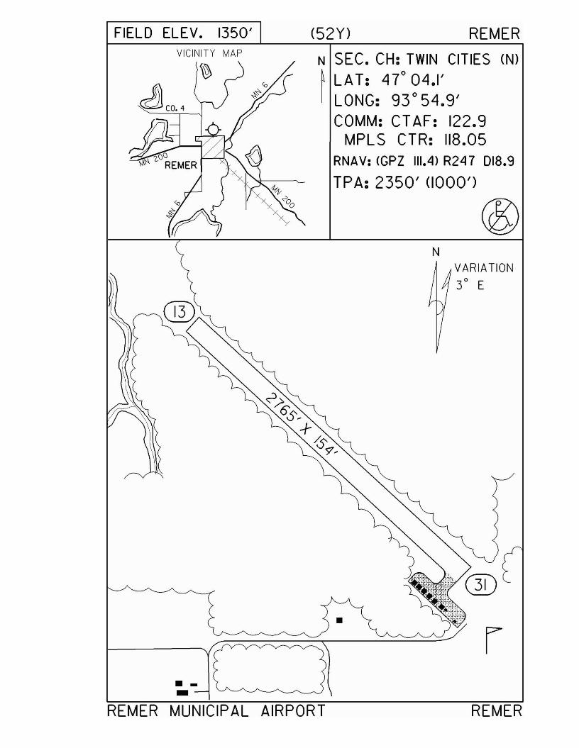
FIELD ELEV. 1350'VICINITY MAP
J)COo4
~E"ER
(52Y) REMER
N SEC. CH: TWIN CITIES (N)
~ LAT: 47° 04.1'I LONG: 93°54.9'
COMM: CT AF: 122.9MPL S CTR: 118.05
RNAV: <GPZ 111.4> R247 D18.9
TPA: 2350' (1000')
N
•
.-REMER MUNICIPAL AIRPORT
VARIATION
3° E
rREMER
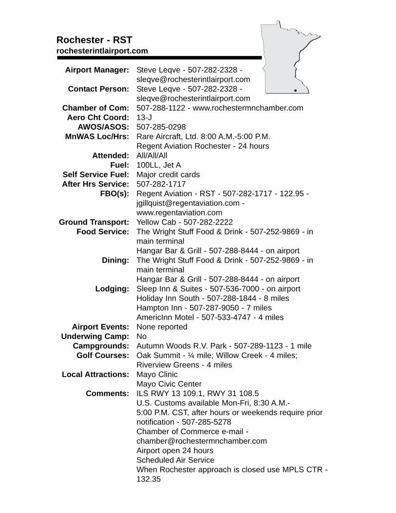
Rochester - RSTrochesterintlairport.com
Airport Manager: Steve Leqve - 507-282-2328 - [email protected]
Contact Person: Steve Leqve - 507-282-2328 - [email protected]
Chamber of Com: 507-288-1122 - www.rochestermnchamber.comAero Cht Coord: 13-J
AWOS/ASOS: 507-285-0298MnWAS Loc/Hrs: Rare Aircraft, Ltd. 8:00 A.M.-5:00 P.M.
Regent Aviation Rochester - 24 hoursAttended: All/All/All
Fuel: 100LL, Jet ASelf Service Fuel: Major credit cardsAfter Hrs Service: 507-282-1717
FBO(s): Regent Aviation - RST - 507-282-1717 - 122.95 - [email protected] - www.regentaviation.com
Ground Transport: Yellow Cab - 507-282-2222Food Service: The Wright Stuff Food & Drink - 507-252-9869 - in
main terminalHangar Bar & Grill - 507-288-8444 - on airport
Dining: The Wright Stuff Food & Drink - 507-252-9869 - in main terminalHangar Bar & Grill - 507-288-8444 - on airport
Lodging: Sleep Inn & Suites - 507-536-7000 - on airportHoliday Inn South - 507-288-1844 - 8 milesHampton Inn - 507-287-9050 - 7 milesAmericInn Motel - 507-533-4747 - 4 miles
Airport Events: None reportedUnderwing Camp: No
Campgrounds: Autumn Woods R.V. Park - 507-289-1123 - 1 mileGolf Courses: Oak Summit - ¼ mile; Willow Creek - 4 miles;
Riverview Greens - 4 milesLocal Attractions: Mayo Clinic
Mayo Civic CenterComments: ILS RWY 13 109.1, RWY 31 108.5
U.S. Customs available Mon-Fri, 8:30 A.M.-5:00 P.M. CST, after hours or weekends require prior notification - 507-285-5278Chamber of Commerce e-mail - [email protected] open 24 hoursScheduled Air ServiceWhen Rochester approach is closed use MPLS CTR - 132.35
•
FIELD ELEV. 1317' (RS T) ROCHES TER
••••••co. RD. 16
TOWER HOURS0500 - 2300
N SEC. CH: CHICAGO (N)~ LAT: 43° 54.5' e..I LONG: 92° 30' D
COMM:GND: 121.9 ATIS: 120.5CTAF: 118.3 RCO FSS: 122.45ROCHES TER APP: 119.8 OR 119.2MPLS CTR: 132.35
RNAV: <RS T 112.0> R025 D8.6TPA: 2300' (983')LANDING RIGHTS AIRPORT
APPROACH: ILS. VOR. ASRVOR/DME.RNAVSTEWARTVILLE
VICINITY MAP
g~~lL.J ~
co. RD. 1& :r -,--1lO-[
g<;>-0:::
T.H. 30
"-I-~ .. ,
-I-~SOJ'N ~~
VARIA TION -1--+20 E ~S
)O~
-\-
/SEE YELLOW PAGES ~
FOR HOT SPOTS ""
/ B -I-~o~, -I-~
/-\- ~~,~ +
-I- QDS~ /
~~ ~:HEN TOWER CLo~-I-~+I -\- ACTIVATE HIRLS ON 13/31
/
MIRLS ON 02120-\- MALSR 13 AND 31
/ 0 0' -\- ON CTAF( t?~/(~~ '-.0 /
ROCHES TER INTERNATIONAL AIRPORT ROCHESTER
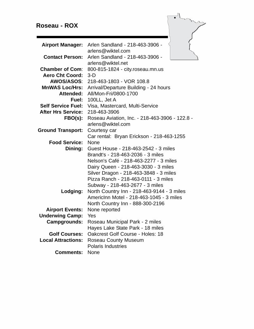
Roseau - ROX
Airport Manager: Arlen Sandland - 218-463-3906 - [email protected]
Contact Person: Arlen Sandland - 218-463-3906 - [email protected]
Chamber of Com: 800-815-1824 - city.roseau.mn.usAero Cht Coord: 3-D
AWOS/ASOS: 218-463-1803 - VOR 108.8MnWAS Loc/Hrs: Arrival/Departure Building - 24 hours
Attended: All/Mon-Fri/0800-1700Fuel: 100LL, Jet A
Self Service Fuel: Visa, Mastercard, Multi-ServiceAfter Hrs Service: 218-463-3906
FBO(s): Roseau Aviation, Inc. - 218-463-3906 - 122.8 - [email protected]
Ground Transport: Courtesy carCar rental: Bryan Erickson - 218-463-1255
Food Service: NoneDining: Guest House - 218-463-2542 - 3 miles
Brandt's - 218-463-2036 - 3 milesNelson's Café - 218-463-2277 - 3 milesDairy Queen - 218-463-3030 - 3 milesSilver Dragon - 218-463-3848 - 3 milesPizza Ranch - 218-463-0111 - 3 milesSubway - 218-463-2677 - 3 miles
Lodging: North Country Inn - 218-463-9144 - 3 milesAmericInn Motel - 218-463-1045 - 3 milesNorth Country Inn - 888-300-2196
Airport Events: None reportedUnderwing Camp: Yes
Campgrounds: Roseau Municipal Park - 2 milesHayes Lake State Park - 18 miles
Golf Courses: Oakcrest Golf Course - Holes: 18Local Attractions: Roseau County Museum
Polaris IndustriesComments: None
•
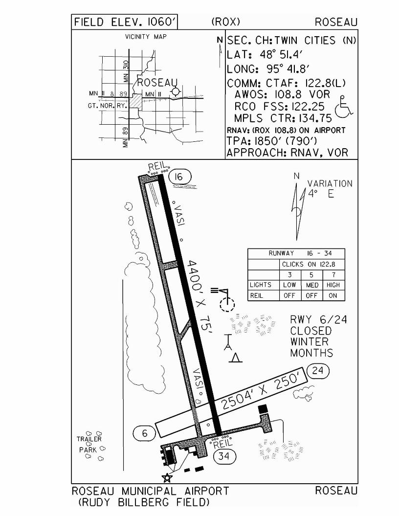
FIELD ELEV. 1060' (ROX) ROSEAUVICINITY MAP
VARIATION4° E
3 5 7
CLICKS ON 122.8
RUNWAY 15 - 34
LIGHTS LOW MED HIGH
REIL OFF OFF ON
N
N SEC. CH: TWIN CITIES (N)~ LA T: 48° 51.4'
LONG: 95° 41.8'COMM: CT AF: 122.8(l)
AWOS: 108.8 VORRCO FSS: 122.25 6MPLS CTR: 134.75
RNAV: (ROX 108.8> ON AIRPORT
TPA: 1850' <790')APPROACH:RNAV, VOR
°
/
~ {z
~OSEA.i>:::;:
I & 89 MN II ~
NOR. RY.~~1
(j> ;r--- -00
~z "\ T
MN
GT.
o[)
~o
(
00TRAILERoPARK 0
o 0
ROSEAU MUNICIPAL AIRPORT(RUDY BILLBERG FIELD)
ROSEAU
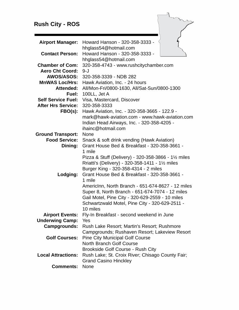
Rush City - ROS
Airport Manager: Howard Hanson - 320-358-3333 [email protected]
Contact Person: Howard Hanson - 320-358-3333 - [email protected]
Chamber of Com: 320-358-4743 - www.rushcitychamber.comAero Cht Coord: 9-J
AWOS/ASOS: 320-358-3339 - NDB 282MnWAS Loc/Hrs: Hawk Aviation, Inc. - 24 hours
Attended: All/Mon-Fri/0800-1630, All/Sat-Sun/0800-1300Fuel: 100LL, Jet A
Self Service Fuel: Visa, Mastercard, DiscoverAfter Hrs Service: 320-358-3333
FBO(s): Hawk Aviation, Inc. - 320-358-3665 - 122.9 - [email protected] - www.hawk-aviation.comIndian Head Airways, Inc. - 320-358-4205 - [email protected]
Ground Transport: NoneFood Service: Snack & soft drink vending (Hawk Aviation)
Dining: Grant House Bed & Breakfast - 320-358-3661 - 1 milePizza & Stuff (Delivery) - 320-358-3866 - 1½ milesRriatti's (Delivery) - 320-358-1411 - 1½ milesBurger King - 320-358-4314 - 2 miles
Lodging: Grant House Bed & Breakfast - 320-358-3661 - 1 mileAmericInn, North Branch - 651-674-8627 - 12 milesSuper 8, North Branch - 651-674-7074 - 12 milesGail Motel, Pine City - 320-629-2559 - 10 milesSchwartzwald Motel, Pine City - 320-629-2511 - 10 miles
Airport Events: Fly-In Breakfast - second weekend in JuneUnderwing Camp: Yes
Campgrounds: Rush Lake Resort; Martin's Resort; Rushmore Campgrounds; Rushaven Resort; Lakeview Resort
Golf Courses: Pine City Municipal Golf CourseNorth Branch Golf CourseBrookside Golf Course - Rush City
Local Attractions: Rush Lake; St. Croix River; Chisago County Fair; Grand Casino Hinckley
Comments: None
•
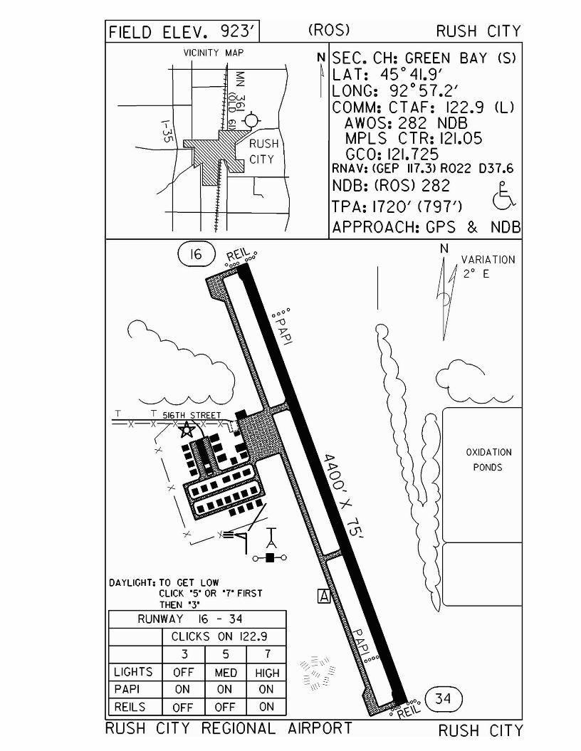
FIELD ELEV. 923' eROS) RUSH CITYVICINITY MAP
s::1----71 Z
N SEC. CH: GREEN BAY (S)~ LAT: 45°41.9'I LONG: 92°57.2'
COMM: CT AF: 122.9 el)AWOS:282 NOBMPLS CTR: 121.05GCO: 121.725
RNAV: <GEP 117.3) R022 037.6NOB: eROS) 282TPA: 1720' <797')APPROACH:GPS & NOB
RUSH CITY REGIONAL AIRPORT
DAYLIGHT; TO GET LOWCLICK'S' OR '7' FIRS TTHEN ·3'
OXIDATION
PONDS
VARIATION2° E
N
RUSH CITY
oOo@4x.\\",
357
ON ON ON
OFF MED HIGH
OFF OFF ON
CLICKS ON 122,9
RUNWAY 16 - 34
T
REILS
PAPI
LIGHTS
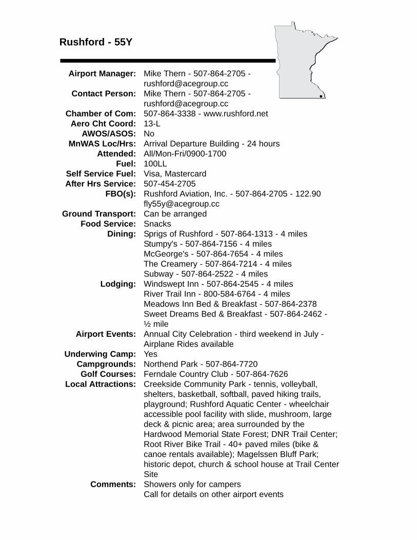
Rushford - 55Y
Airport Manager: Mike Thern - 507-864-2705 - [email protected]
Contact Person: Mike Thern - 507-864-2705 [email protected]
Chamber of Com: 507-864-3338 - www.rushford.netAero Cht Coord: 13-L
AWOS/ASOS: NoMnWAS Loc/Hrs: Arrival Departure Building - 24 hours
Attended: All/Mon-Fri/0900-1700Fuel: 100LL
Self Service Fuel: Visa, MastercardAfter Hrs Service: 507-454-2705
FBO(s): Rushford Aviation, Inc. - 507-864-2705 - [email protected]
Ground Transport: Can be arrangedFood Service: Snacks
Dining: Sprigs of Rushford - 507-864-1313 - 4 milesStumpy's - 507-864-7156 - 4 milesMcGeorge's - 507-864-7654 - 4 milesThe Creamery - 507-864-7214 - 4 milesSubway - 507-864-2522 - 4 miles
Lodging: Windswept Inn - 507-864-2545 - 4 milesRiver Trail Inn - 800-584-6764 - 4 milesMeadows Inn Bed & Breakfast - 507-864-2378Sweet Dreams Bed & Breakfast - 507-864-2462 - ½ mile
Airport Events: Annual City Celebration - third weekend in July - Airplane Rides available
Underwing Camp: YesCampgrounds: Northend Park - 507-864-7720Golf Courses: Ferndale Country Club - 507-864-7626
Local Attractions: Creekside Community Park - tennis, volleyball, shelters, basketball, softball, paved hiking trails, playground; Rushford Aquatic Center - wheelchair accessible pool facility with slide, mushroom, large deck & picnic area; area surrounded by the Hardwood Memorial State Forest; DNR Trail Center; Root River Bike Trail - 40+ paved miles (bike & canoe rentals available); Magelssen Bluff Park; historic depot, church & school house at Trail Center Site
Comments: Showers only for campersCall for details on other airport events
•
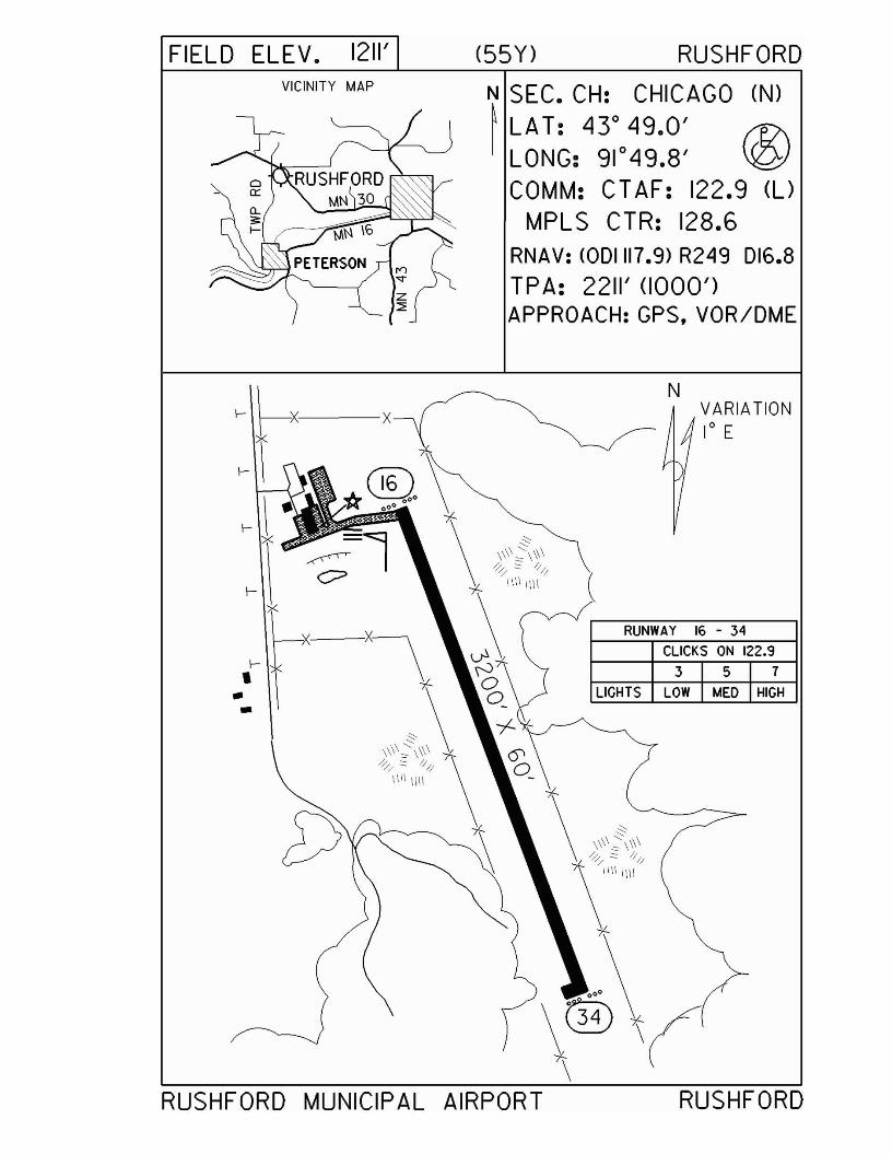
FIELD ELEV. 1211'VICINITY MAP
(55Y) RUSHFORD
N SEC. CH: CHICAGO (N)~ LAT: 43° 49.0' (1;\I LONG: 91°49.8' \!(2:J
COMM: CTAF: 122.9 (UMPLS CTR: 128.6
RNAV: <ODI1I7.9) R249 D16.8TPA: 2211' (1000')APPROACH: GPS, VOR/DME
NVARIATION1° E
(
f-I..•
RUNWAY 16 - 34
CLICKS ON 122.9
357LIGHTS LOW MED HIGH
RUSHFORD MUNICIPAL AIRPORT RUSHFORD
St. Cloud - STCwww.stcloudairport.com
Airport Manager: Bill Towle - 320-255-7292 - [email protected]
Contact Person: Bill Towle - 320-255-7292 - [email protected]
Chamber of Com: 320-251-2940 - www.stcloudareachamber.com
Aero Cht Coord: 9-GAWOS/ASOS: 320-240-8781 - VOR 112.1
MnWAS Loc/Hrs: Control Tower - 7:00 A.M.-11:00 P.M.General Aviation Building - same as attendance schedule
Attended: All/All/0500-2300Fuel: 100LL, Jet A
Self Service Fuel: NoAfter Hrs Service: 320-253-1500
FBO(s): St. Cloud Aviation, Inc. - 320-253-1500 - 123.5 - [email protected] - www.stcloudaviation.comWright Aero, Inc. - 320-252-5858 - 123.5 - www.wrightaeroinc.com
Ground Transport: Yellow Cab - 320-251-5050Executive Express - 320-253-2226Enterprise Rent-a-Car - 320-240-9000Hertz Auto Rental - 320-253-9480Avis Auto Rental - 320-252-4012
Food Service: The Ground Crew - 5:00 A.M.-2:00 P.M. - Mon-FriDining: Green Mill (Kelly Inn) - 320-259-6455; Copper
Lantern - 320-252-0672; Michael's Steak & Seafood (Americanna Inn) - 320-252-7100 - 3 miles
Lodging: Holiday Inn - 320-253-9000; Radisson - 320-654-1661; Best Western Americanna Inn - 320-252-8700 - 3 Miles; Best Western Kelly Inn - 320-253-0606; Ramada Limited & Suites - 320-253-3200; Super 8 - 320-253-5530
Airport Events: Airport DayCivil Air Patrol Fly-In Breakfast
Underwing Camp: NoCampgrounds: St. Cloud Campground & RV Park - 320-251-4463
KOA Campground - 320-558-2876Golf Courses: Wapicada - 4 miles; Country Club - 7 miles;
Angushire - 10 miles; The Fairways - 1 mileLocal Attractions: Heritage Center Museum; sports center; National
Hockey Center; Munsinger Gardens; MN Baseball Hall of Fame Museum; granite quarry tours; Hill Monastic Library; Molitor's Trout Heaven Park; Natural History Museum; Virginia Clemens Rose Garden
Comments: St. Cloud area web site - www.visitstcloudmn.comConvention & Visitor's Bureau - 800-264-2940No underwing campingScheduled Air Service
•

FIELD ELEV. 1031' (STC) ST. CLOUD
VARIATION3° E
N
357CLICKS ON 118.25
RUNWAY 5 - 23
LIGHTS OFF MED HIGH
N SEC. CH: TWIN CITIES (S)~ LAT: 45° 32.8' E-I LONG: 94° 03.6' D
COMM: CT AF: 118.25(l)TOWER: 118.25 GROUND: 121,6
ATIS: 119.375ASOS: 112.1 VORRCO FSS: 122.5MPLS CTR: 121.05
RNAV: <S Te 112.1> ON AIRPORTTPA: 1831' (800')APPROACH: IL S. RNAV.
VOR/DME, VOR
3 5 7
CLICKS ON 118.25
RUNWAY 13 - 31
PAPI OFF ON ON
MALSR LOW MED HIGH
MALSR LOW MED HIGH
DAYLIGHT: TO GET LOW, CLICK '5' OR '7' FIRST,THEN '3'
LIGHTS OFF MED HIGH
TOWER HOURS:0700 - 2300
S1. CLOUD REGIONAL AIRPORT S1. CLOUD
St. James - JYG
Airport Manager: DeWayne Malmgren - 507-375-4976 - [email protected]
Contact Person: DeWayne Malmgren -507-375-4976 - [email protected]
Chamber of Com: 507-375-3333 - stjameschamberofcommerce.comAero Cht Coord: 13-F
AWOS/ASOS: 507-375-7105 - NDB 260MnWAS Loc/Hrs: Arrival/Departure Building - 24 hours
Attended: UnattendedFuel: 100LL
Self Service Fuel: All major credit cardsAfter Hrs Service: 507-375-4976
FBO(s): NoneGround Transport: Dick Olson Motors - 800-247-0977
Rental carsFood Service: None
Dining: Happy Chef - 507-375-7100Pizza Hut - 507-375-7199 Jake's Pizza - 507-375-5939Home Town Café - 507-375-4955Subway - 507-375-7456McDonald's - 507-375-7552Hickory Inn - 507-375-3227
Lodging: Super 8 Motel - 507-375-4708 - 2 miles WestAirport Events: None
Underwing Camp: YesCampgrounds: Municipal campgrounds - 3 miles West
Eagles Nest - 2 miles EastGolf Courses: St. James Golf Course - Holes: 18
Local Attractions: Railroad Days - third weekend in June4 mile bike trail around St. James LakeSt. James Lake - 3 miles WestMany unique restaurantsOutdoor swimming poolGroomed snowmobile trialsWatonwan County Fair - second weekend in JulyHot Dog Days - third weekend in MayBranch of Watonwan County Historical Museum
Comments: None
•
FIELD ELEV. 1067' (JYG) ST. JAMES
VICINITY MAP
~~ MN.60 & 30
S1. JAMES
N SEC. CH: OMAHA NORTH~ LAT: 430 59.2'I LONG: 94 0 33.5'
COMM: CT AF: 122.9(l)AWOS: 260 NOBMPL S CTR: 127.75GCO: 121.725
RNAV: (FRM 110.2) R337 021.3NOB: (JYG) 260 r12\TPA: 2060' (993') \QJAPPROACH: NOB
& RNAV
LIGHTS OFF MED HIGH
REILS OFF MED HIGH
VASI OFF ON ON
DAYLIGHT: TO GET LOW,CLICK '5' FIRS T THEN "3"
VARIATION.q0 E
N
357
CLICKS ON 122.9
RUNWAY 15 - 33
/~,/ ,, \, ,, ,, ,\ ,
\ ;,--_.... 1'
ST. JAMES MUNICIPAL AIRPORT ST. JAMES
St. Paul - STPwww.mspairport.com/relievers
Airport Manager: Gregory Fries - 651-224-4306 - [email protected]
Contact Person: Gregory Fries - 651-224-4306 - [email protected]
Chamber of Com: 651-223-5000 -www.saintpaulchamber.com
Aero Cht Coord: 11-IAWOS/ASOS: 651-298-1410
MnWAS Loc/Hrs: Army Guard - Mon-Fri, 7:00 A.M.-4:30 P.M.Main Terminal - Mon-Fri, 7:00 A.M.-10:00 P.M.Office of Aeronautics, 222 E. Plato Blvd. - Mon-Fri, 8:00 A.M.-4:30 P.M.Regent Aviation - 24 hoursRegent Aviation, Hangar 1, Airnet Systems - 24 hoursSt. Paul Flight Center, Inc. - Mon-Sun, 5:00 A.M.-11:00 P.M.State Patrol - 24 hours
Attended: All/All/AllFuel: 100LL, Jet A
Self Service Fuel: Visa, MastercardAfter Hrs Service: None
FBO(s): Regent Aviation, Inc. - 651-224-1100 - 131.35 - [email protected] - www.regentaviation.comSt. Paul Flight Center, Inc. - 651-227-8108 - 129.0 - [email protected] - www.stpaulflight.com
Ground Transport: Rental cars available at St. Paul Flight Center &Million Air
Food Service: Regent AviationSt. Paul Flight Center
Dining: Many local restaurantsLodging: Radisson City Center - 651-292-1900 - 1½ miles
St. Paul Hotel - 651-292-9292 - 3 milesHoliday Inn - 651-731-2220 - 5 milesEmbassy Suites - 651-224-5400 - 5 milesRadisson Riverfront - 651-291-8800 - 2 miles
Airport Events: None reportedUnderwing Camp: No
Campgrounds: KOA St. Paul East - 651-436-6436Golf Courses: Como Golf Course - 651-488-9673
Highland Golf Course - 651-699-3650Phalen Golf Course - 651-778-0424Cimarron Park - 651-436-6188
Local Attractions: Science Museum of Minnesota; Guthrie Theatre; Minnesota State Capitol; Minnesota Museum of Art; Como Park; Mall of America; Xcel Energy
Comments: Control Tower - 119.1; ATIS - 118.35; Ground 121.675; Control Tower 651-312-8840; U.S. Customs - 612-725-3770 or 800-992-7433; City of St. Paul web site - www.stpaul.gov
•
FIELD ELEV. 705' (STP) ST. PAULVICINITY MAP
FALCON HEIGHTS
UNIVERSITY1- ~
N SEC. CH: TWIN CITIES (S)
~LA T: 44° 56.1'
w NORTH ST. PAUL LONG: 93°03.6''"'( COMM: TOWER: 119.1(l)
MINNEHAHA AVE GND: 121.675 ATIS: 118.35CTAF: 119.1 MPLS APP: 121.2CLNC DEL: 121.675
RNAV: (GEP 117.3) RI27 018.4NDB: (PPD 400TPA: 1905' (1200')RWY 27 RGT TFCLANDING RIGHTS AIRPORTAPPROACH: ILS. NOB. RNAV
SOUTH S1. PAUL
THIS AIRPORT UNDERLIES THEMSP CLASS "B" AIRSPACE
UNUSABL=E-It-"7291'
UNUSABLE222'
RUNWAY 14-32WHEN TWR CLOSED
3 5 7LIGHTS lOW '-AED HIGH'-AAlSR1I4) lOW MED HIGHPAPIS NOT ON PCl
'.'. '., .,
N VARIATION
BLUFFS 2° E
"'"SEE YELLOW PAGES
FOR HOT SPOTS
*AIRWAYBEACON
,
........"r--.;® UNUSABLEr 345'! TOWER HOURS:
0600-2200 MON - FRI0700-2200 SAT - SUN
ST. PAUL DOWNTOWN AIRPORT(HOLMAN FIELD)
ST. PAUL
St. Paul - 21Dwww.mspairport.com/relievers
Airport Manager: Gregory Fries - 651-224-4306 - [email protected]
Contact Person: Gregory Fries - 651-777-6300 - [email protected]
Chamber of Com: 651-223-5000 - www.saintpaulchamber.comAero Cht Coord: 11-J
AWOS/ASOS: NoMnWAS Loc/Hrs: Valters Aviation, Inc. - Mon-Sun, 8:00 A.M.-Dark
Attended: All/All/0700-1900Fuel: 100LL
Self Service Fuel: Major credit cardsAfter Hrs Service: None
FBO(s): Valters Aviation, Inc. - 651-777-1399 - 122.8 - [email protected] - www.valtersaviation.com
Ground Transport: TaxiFood Service: Vending machines
Dining: Gorman's - 2 milesLodging: None
Airport Events: Fly-In Breakfast - AugustCivil Air Patrol Father's Day Fly-In Pancake Breakfast - June
Underwing Camp: NoCampgrounds: 5 milesGolf Courses: Afton Golf Course - 2 miles
Oak Glen - 2 milesLocal Attractions: City of Stillwater - 6 miles
St. Croix River - 6 milesComments: City of St. Paul web site - www.stpaul.gov
City of Stillwater web site - www.ilovestillwater.com24-hour self-service fuel
•
FIELD ELEV. 932/ (210) ST. PAULVICINITY MAP
o
ou
ST. PAULl{)
ou HIGHWAY 94
N SEC. CH: GREEN BAY ($)
~ LAT: 44°59.9/ E..I LONG: 92° 51.3/ D
COMM: CT AF: 122.8(l)MPLS APP: 121.2MPLS CLNC DEL: 118.625
RNAV: <GEP 117.3> RI06 D23.7NOB: (PPD 400TPA: 1932/ <1000/)APPROACH: NOB.RNAV.
GPSCLASS 'B" AIRSPACE
••••.:THE MSP
T
N VARIATION2· E
T
3 5 7
T
CLICKS ON 122.8
REIL ON ON ONPAPI ON ON ONLIGHTS LOW MED HIGH
THIS AIRPORT UNDERLIESRUNWAY 14 - 32
LAKE ELMO AIRPORT ST. PAUL
Sauk Centre - D39www.ci.sauk-centre.mn.us
Airport Manager: Butch Wessel - 320-352-2203 -See comments for e-mail address
Contact Person: Butch Wessel - 320-352-2598 - Chamber of Com: 320-352-5201 -
www.saukcentre.comAero Cht Coord: 9-F
AWOS/ASOS: No MnWAS Loc/Hrs: Arrival/Departure Building (combination lock) - 24
hoursAttended: All/Mon-Fri/0800-1630
Fuel: 100LLSelf Service Fuel: Mastercard, VisaAfter Hrs Service: 320-352-2203
FBO(s): Central Planes Aviation, Inc. - 320-352-3013 - 122.9 - [email protected]
Ground Transport: Courtesy carFood Service: Vending Machines - pop
Dining: River's Edge - 320-352-6506 - 1 mileTrucker's Inn - 320-352-3429Ding Dong Café - 320-352-6853Palmer House Hotel & Restaurant - 320-352-3431Hometown Café - 320-351-3512Gerads Dining & Banquet - 320-351-3463Sassy's Restaurant & Catering - 320-352-3521
Lodging: Hillcrest - 320-352-2215AmericInn Motel - 320-352-2800Gopher Prairie - 320-352-2275Palm's Motel - 320-351-7256
Airport Events: NoneUnderwing Camp: No
Campgrounds: Sinclair Lewis Park - 80 sites - 4 milesGolf Courses: Grey Stone - 6 miles
Lynx National - 4 milesSauk Centre Country Club - 2 miles
Local Attractions: Sinclair Lewis MuseumI-94 RacewayMany lakes & resorts with good fishing
Comments: Free overnight aircraft parkingArrival/Departure Building - 320-352-2598Airport manager’s e-mail - [email protected]
•
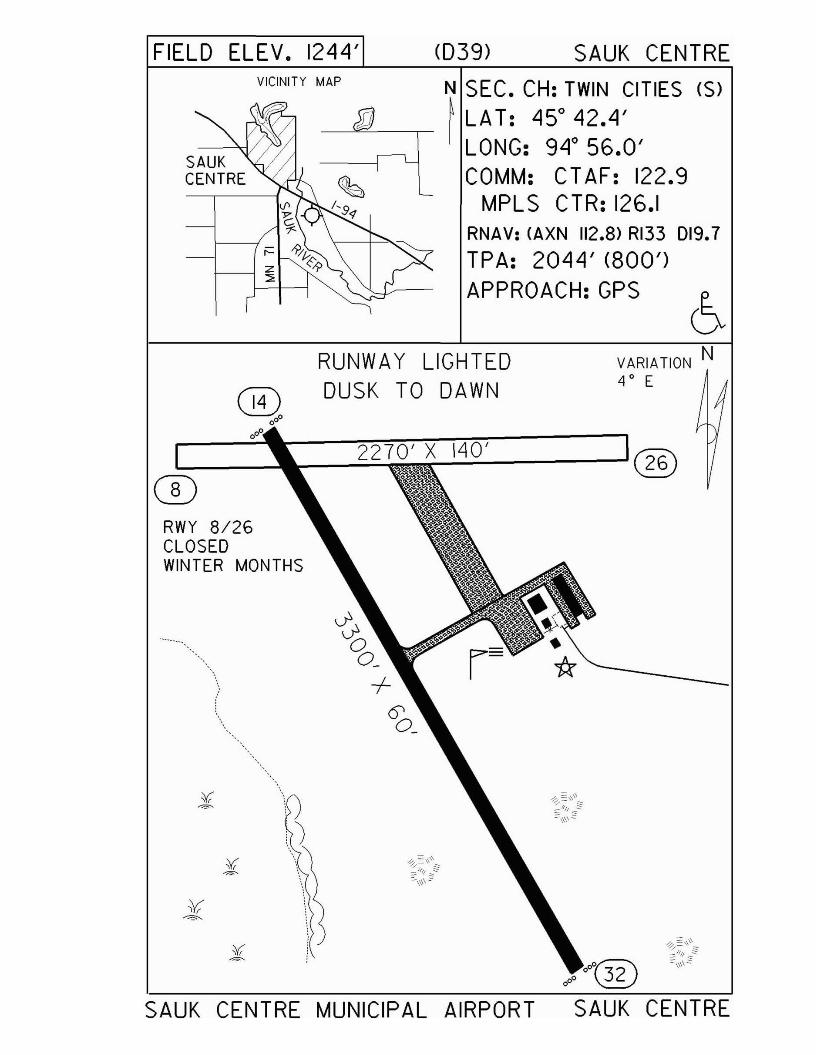
FIELD ELEV. 1244' (039) SAUK CENTREVICINITY MAP N SEC. CH: TWIN CITIES (S)
--------"=-------.-- ~ LAT: 450
42•4'LONG: 94 0 56.0'COMM: CTAF: 122.9
MPLS CTR: 126.1RNAV: (AXN 112.8) RI33 D19.7
TPA: 2044' (800')APPROACH:GPS
VARIATION N4 ° E
RUNWAY LIGHTEDDUSK TO DAWN
)')
®0°°
....--_--'0o.-ll0o ----::::"":'=~""""";""/i"'A"i"----...,
:.....:....:..~----'@
RWY 8/26CLOSEDWINTER MONTHS
CD
SAUK CENTRE MUNICIPAL AIRPORT SAUK CENTRE
Silver Bay - BFWwww.silverbay.com/airport.htm
Airport Manager: Tom Smith - 218-226-4408 - [email protected]
Contact Person: Tom Smith - 218-226-4408 - [email protected]
Chamber of Com: 800-777-7384 - www.twoharborschamber.comAero Cht Coord: 6-M
AWOS/ASOS: 218-226-3537 - NDB 350MnWAS Loc/Hrs: NA
Attended: UnattendedFuel: 100LL
Self Service Fuel: Visa, MastercardAfter Hrs Service: 218-353-7372
FBO(s): NoneGround Transport: Call local establishment ahead
Food Service: Beverage vending machineDining: Silver Bay - 5 miles:
Northwoods Café - 218-226-3699Jimmy's Pizza - 218-226-4142
Beaver Bay - 5 miles:Northern Lights - 218-226-3012Lemon Wolf Café - 218-226-7225Blue Anchor Café - 218-226-3101
Lodging: Mariner Motel - 218-226-4488 - 7 milesCove Point Lodge - 218-226-3221 - 5 milesAmericinn - 218-226-3170
Airport Events: August Fly-In (see website for events)Underwing Camp: Yes
Campgrounds: Wildhurst CampgroundsSplit Rock Lighthouse State ParkTettegouche Campground - 10 miles
Golf Courses: Silver Bay Golf Course - 218-226-3012Local Attractions: Lake Superior - charter fishing & cruises
Split Rock Lighthouse State ParkTettegouche State ParkTrails: hiking, cross-country ski, snowmobile, ATVHunting Fishing
Comments: Airport manager additional phone - 218-220-0251Additional after hours service phone - 218-226-4408Airport phone - 218-226-3542
•
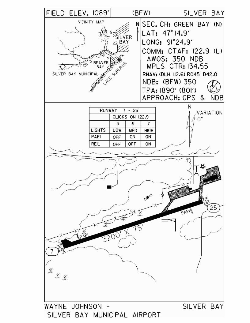
'-
"
RUNWAY 7 - 25
CLICKS ON 122.9
3 5 7
LIGHTS LOW MED HIGHPAPI OFF ON ON
REIL OFF OFF ON
NVARIATION0°
WAYNE JOHNSON -SIL VER BAY MUNICIPAL AIRPORT
SILVER BAY
Slayton - DVP
Airport Manager: Mike Gillette - 507 836-8534 Contact Person: Mike Gillette - 507-836-8534
Chamber of Com: 507-836-6902 Aero Cht Coord: 13-D
AWOS/ASOS: 507-836-6128 - VHF 118.55MnWAS Loc/Hrs: NA
Attended: UnattendedFuel: 100LL
Self Service Fuel: NoAfter Hrs Service: 507-836-6460
FBO(s): NoneGround Transport: None
Food Service: NoneDining: Country Host - 507-836-8332 - 1 mile
Lodging: Ridotto Inn - 507-836-8511 - 1¼ milesAirport Events: None reported
Underwing Camp: NoCampgrounds: Shetek State ParkGolf Courses: Slayton Country Club
Local Attractions: Lake ShetekComments: None
•
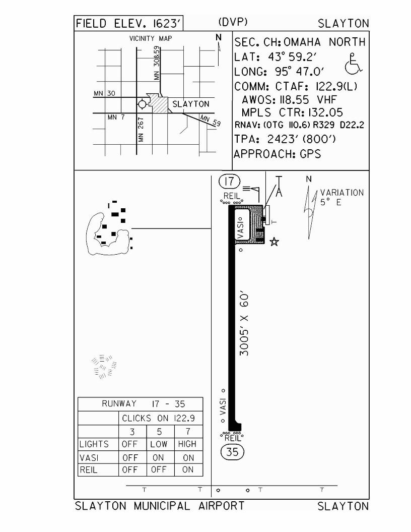
FIELD ELEV. 1623' mVp) SLAYTONVICINITY MAP N SEC. CH: OMAHA NORTH
~~- (J>
~ LAT: 43° 59.2' 60rr>
Z LONG: 95° 47.0':::;:
COMM: CTAF: 122.9(l)MN 30
AWOS: 118.55 VHF<)~ SL~YTONMPLS CTR: 132.05MN 7 r- )' !:!.,!V s<0 ~9 RNAV: WTG 110.6> R329 022.2- N -
z TPA: 2423' (800'):::>
I -- APPROACH:GPS
®= AN
4VARIATION- o!:oE!~o-l1f 50 EI.-
[I::&:0
,0\..D
X,L[)
00
= \\ I"J~ =\\
/ ~
== /11; :::.::.:::::
=:\\\\ ::::
0
RUNWAY 17 - 35 Vl<!
CLICKS ON 122.9>0
3 5 7 000 000
LIGHTS OFF LOW HIGHoREILo
®VASI OFF ON ONREIL OFF OFF ON
T T 0 o T T
SLAYTON MUNICIPAL AIRPORT SLAYTON
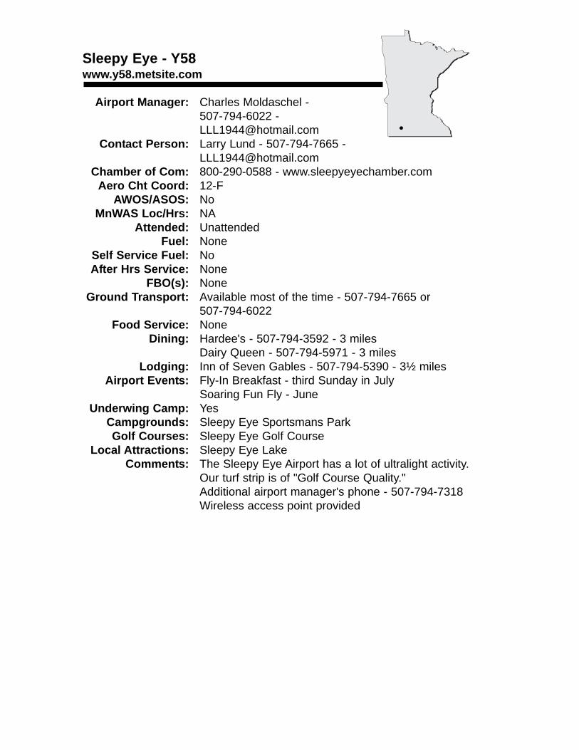
Sleepy Eye - Y58www.y58.metsite.com
Airport Manager: Charles Moldaschel - 507-794-6022 - [email protected]
Contact Person: Larry Lund - 507-794-7665 - [email protected]
Chamber of Com: 800-290-0588 - www.sleepyeyechamber.comAero Cht Coord: 12-F
AWOS/ASOS: NoMnWAS Loc/Hrs: NA
Attended: UnattendedFuel: None
Self Service Fuel: NoAfter Hrs Service: None
FBO(s): NoneGround Transport: Available most of the time - 507-794-7665 or
507-794-6022Food Service: None
Dining: Hardee's - 507-794-3592 - 3 milesDairy Queen - 507-794-5971 - 3 miles
Lodging: Inn of Seven Gables - 507-794-5390 - 3½ milesAirport Events: Fly-In Breakfast - third Sunday in July
Soaring Fun Fly - JuneUnderwing Camp: Yes
Campgrounds: Sleepy Eye Sportsmans ParkGolf Courses: Sleepy Eye Golf Course
Local Attractions: Sleepy Eye LakeComments: The Sleepy Eye Airport has a lot of ultralight activity.
Our turf strip is of "Golf Course Quality."Additional airport manager's phone - 507-794-7318Wireless access point provided
•
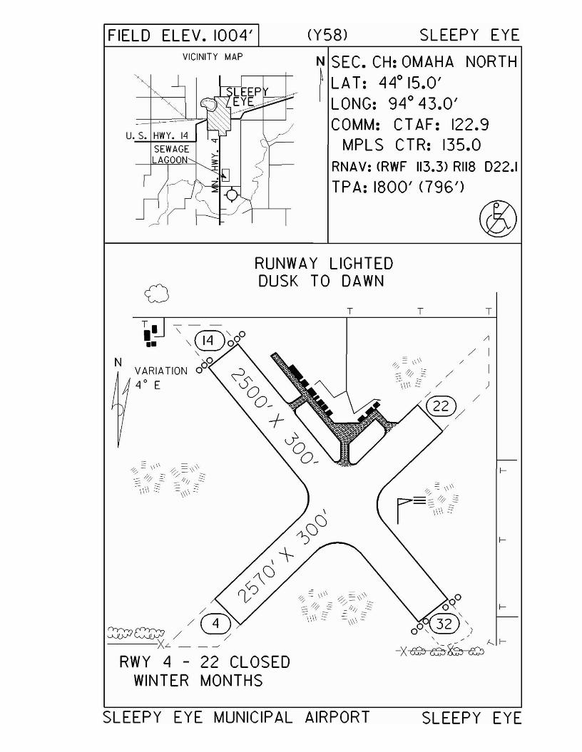
FIELD ELEV. 1004'VICINITY MAP
u. s. HWY. 14SEWAGELAGOON
o
(Y58) SLEEPY EYE
N SEC. CH: OMAHA NORTH~ LA T: 440 15.0'I LONG: 94 0 43.0'
COMM: CT AF: 122.9MPLS CTR: 135.0
RNAV: (RWF 113.3) RII8 D22.1
TPA: 1800' <796')
RUNWAY LIGHTEDDUSK TO DAWN
T T T
SLEEPY EYE MUNICIPAL AIRPORT SLEEPY EYE

South St. Paul - SGSwww.flemingfield.com
Airport Manager: Glenn Burke - 651-554-3350 - [email protected]
Contact Person: Glenn Burke - 651-554-3350 - [email protected]
Chamber of Com: 651-451-2266 -www.riverheights.com
Aero Cht Coord: 11-IAWOS/ASOS: 651-457-8120 - VHF 119.425
MnWAS Loc/Hrs: Arrival/Departure Building - Mon-Sun - 6:00 A.M.-10:00 P.M.; EAC Helicopters - Mon-Sun - 8:00 A.M.-5:00 P.M.; Entry Way - 24 hours; Lysdale Hangar - Mon-Sun - 8:00 A.M.-8:00 P.M.; Wipaire Hangar - Mon-Sun - 8:00 A.M.-5:00 P.M.
Attended: All/M-F/0800-1700, All/S-S/1000-1700Fuel: Mogas, 100LL, Jet A
Self Service Fuel: Visa, Mastercard, American Express, Discover, Phillips,AvFuel
After Hrs Service: 651-554-3350FBO(s): Cadotte Aero, Inc. - 651-894-4907 - 122.7 -
[email protected], Inc. - 651-451-1205 - [email protected] - www.wipaire.com
Ground Transport: Suburban Taxi - 651-222-2222Enterprise Rent-a-Car - 651-457-7000Hertz Car Rental - 651-457-2788
Food Service: Vending machinesDining: Drover's Inn - 651-455-3600 - 1 mile; McDonald's -
½ mile; Kentucky Fried Chicken - ½ mile; Applebee's - 1 mile; Outback Steakhouse - 1 mile; Major's - 1 mile; Khoury's - 1 mile
Lodging: Best Western - 651-455-3600 - 1 mile; Country Inn - 651-450-1100; AmericInn Motel - 651-450-7511; Microtel - 651-552-0555
Airport Events: Commemorative Air Force Spring Hangar Dance - thirdSaturday in MayFleming Field Days & Commemorative Air Force Fall Hangar Dance - third weekend in September
Underwing Camp: NoCampgrounds: KOA St. Paul East - WoodburyGolf Courses: InverWood Golf Course - 651-457-3667
River Oaks Municipal - 651-438-2121Somerset Country Club - 651-457-1416Southview Country Club - 651-451-6856
Local Attractions: CAF Southern MN Wing Headquarters - 651-455-6942Science Museum of Minnesota - 6 milesXcel Energy Center - 6 milesMall of America - 10 milesMinnesota State Capitol - 6 miles
Comments: Tiedowns available
•
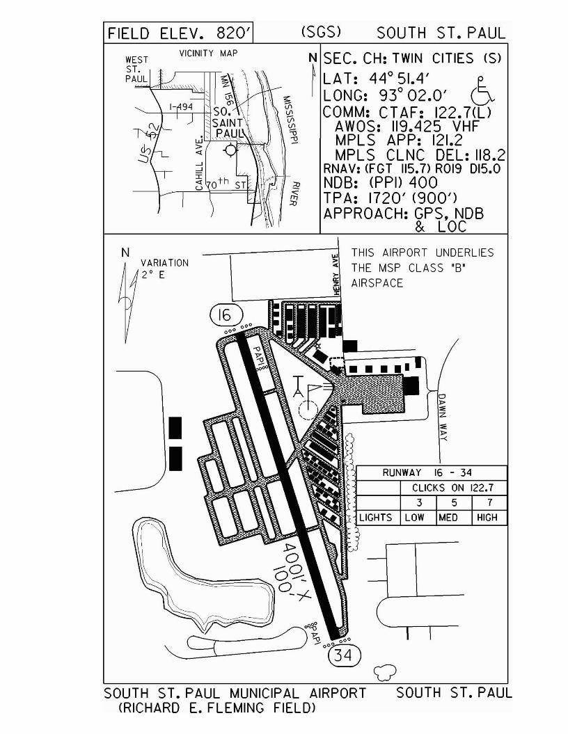
FIELD ELEV. 820' (SGS) SOUTH ST. PAUL
WESTST.PAUL
VICINITY MAP N SEC. CH: TWIN CITIES (S)
~ LA T: 44° 51.4' e..I LONG: 93° 02.0' D
COMM: CT AF: 122.7(UAWOS: 119.425 VHFMPL S APP: 121.2MPLS CLNC DEL: 118.2
RNAV: (FGT 115.7) ROl9 D15.03! NOB: (PPI) 400
FE TPA: 1720' (900')APPROACH: GPS, NOB
& LOC
CLICKS ON 122.7357
RUNWAY 16 - 34
LIGHTS LOW MED HIGH
----,-------;j'" THIS AIRPORT UNDERLIES~ THE MSP CLASS '8'
~ AIRSPACE
h:::-~~~
II
VARIATION2° E
N
SOUTH ST. PAUL MUNICIPAL AIRPORT SOUTH(RICHARD E. FLEMING FIELD>
S1. PAUL
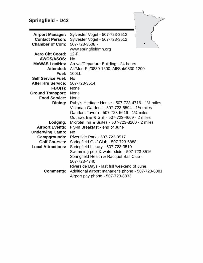
Springfield - D42
Airport Manager: Sylvester Vogel - 507-723-3512 Contact Person: Sylvester Vogel - 507-723-3512
Chamber of Com: 507-723-3508 - www.springfieldmn.org
Aero Cht Coord: 12-FAWOS/ASOS: No
MnWAS Loc/Hrs: Arrival/Departure Building - 24 hoursAttended: All/Mon-Fri/0830-1600, All/Sat/0830-1200
Fuel: 100LLSelf Service Fuel: NoAfter Hrs Service: 507-723-3514
FBO(s): NoneGround Transport: None
Food Service: NoneDining: Ruby's Heritage House - 507-723-4716 - 1½ miles
Victorian Gardens - 507-723-6594 - 1¼ milesGanders Tavern - 507-723-5619 - 1¼ milesOutlaws Bar & Grill - 507-723-4669 - 2 miles
Lodging: Microtel Inn & Suites - 507-723-8200 - 2 milesAirport Events: Fly-In Breakfast - end of June
Underwing Camp: NoCampgrounds: Riverside Park - 507-723-3517Golf Courses: Springfield Golf Club - 507-723-5888
Local Attractions: Springfield Library - 507-723-3510Swimming pool & water slide - 507-723-3516Springfield Health & Racquet Ball Club - 507-723-4740Riverside Days - last full weekend of June
Comments: Additional airport manager's phone - 507-723-8881Airport pay phone - 507-723-8833
•
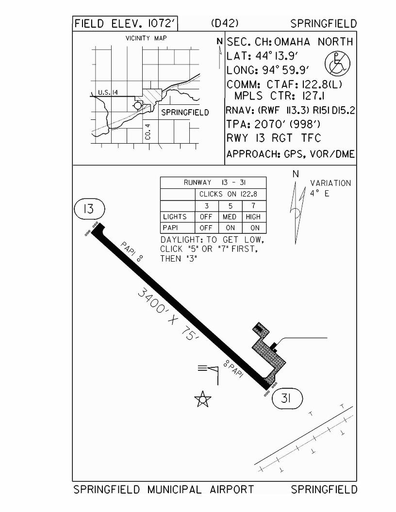
FIELD ELEV. 1072'VICINITY MAP
(042) SPRINGFIELD
N SEC. CH: OMAHA NORTH~ LAT: 44° 13.9' f1?\
LONG: 94° 59.9' ~COMM: CT AF: 122.8(l)
MPLS CTR: 127.1RNA V: <RWF 113.3) RI51 D15.2TPA: 2070' (998')RWY 13 RGT TFCAPPROACH: GPS. VOR/DME
N
®i'
RUNWAY 13 - 31
CLICKS ON 122.8
3 5 7
LIGHTS OFF MED HIGH
PAPI OFF ON ON
DA YLIGHT: TO GET LOW,CLICK "5" OR "7" FIRST,THEN "3"
VARIATION4 0 E
SPRINGFIELD MUNICIPAL AIRPORT SPRINGFIELD

Stanton - SYNwww.stantonairfield.com
Airport Manager: Kent Johnson - 507-645-4030 Contact Person: Kent Johnson - 507-645-4030
Chamber of Com: None Aero Cht Coord: 12-I
AWOS/ASOS: 507-664-3806 - VHF 119.35MnWAS Loc/Hrs: Stanton Sport Aviation, Inc. - same as attendance
scheduleAttended: All/All/0800-1730
Fuel: 100LLSelf Service Fuel: NoAfter Hrs Service: None
FBO(s): Stanton Sport Aviation, Inc. - 507-645-4030 - 122.8 - www.stantonairfield.com
Ground Transport: TaxiRides provided on request
Food Service: Microwave sandwichesDining: Country Crossroads - 507-263-5157 - 4 miles
Archer House - 507-645-5661 - 7 miles WestNumerous restaurants - 7 miles
Lodging: Archer House - 507-645-5661 - 7 miles WestCountry Inn - 507-645-2286 - 7 miles WestSaratoga Inn - 507-263-7272 - 7 miles East
Airport Events: Fly-In Breakfast - Father's DayGliders (Summer)
Underwing Camp: NoCampgrounds: Lake Byllesby County Park - 6 milesGolf Courses: Northfield
Cannon FallsLocal Attractions: St. Olaf & Carleton Colleges in Northfield
Comments: Noise Sensitive Area - 1 mile SouthDue to mixed airplane & glider training, all aircraft are requested to fly a complete, standard traffic pattern as described in the Aeronautical Information Manual; no straight-in approaches, please. Airport closed sunset to sunrise.
•
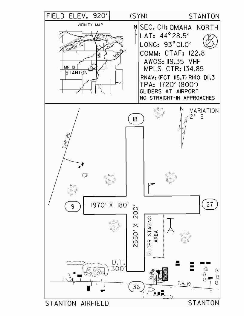
FIELD ELEV. 920' (SYN) STANTONVICINITY MAP
N SEC. CH: OMAHA NORTH~ LAT: 44° 28.5' f1l\I LONG: 93°01.0' \Q)
COMM: CT AF: 122.8AWOS: 119.35 VHFMPLS CTR: 134.85
RNAV: (FGT 115.7) RI40 011.3TPA: 1720' (800')GLIDERS AT AIRPORTNO STRAIGHT-IN APPROACHES
T
--T
STANTON
N VARIATION2° E
T.H. /9TI •
~ )/
0 ~~/\\\~/.: ;;\\\.\~- :::-_11// .::::
==\\\\ § r ==-\\\\2
1970' X 180' ,00N <.:>
A~~/\\\~Z
X <.:>~\\\\§ «,
I- «0 VI W ~~/\\\~Lf) a::Lf) a:: « :::\\\\ .2N w
a....J<.:> ............
D.T. • •-300' •C> G' •~~
I T I
STANTON AIRFIELD
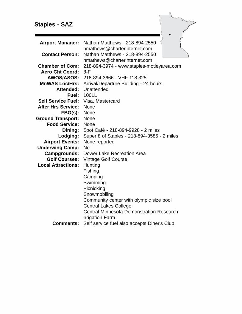
Staples - SAZ
Airport Manager: Nathan Matthews - [email protected]
Contact Person: Nathan Matthews - 218-894-2550 [email protected]
Chamber of Com: 218-894-3974 - www.staples-motleyarea.comAero Cht Coord: 8-F
AWOS/ASOS: 218-894-3666 - VHF 118.325MnWAS Loc/Hrs: Arrival/Departure Building - 24 hours
Attended: UnattendedFuel: 100LL
Self Service Fuel: Visa, MastercardAfter Hrs Service: None
FBO(s): NoneGround Transport: None
Food Service: NoneDining: Spot Café - 218-894-9928 - 2 miles
Lodging: Super 8 of Staples - 218-894-3585 - 2 milesAirport Events: None reported
Underwing Camp: NoCampgrounds: Dower Lake Recreation AreaGolf Courses: Vintage Golf Course
Local Attractions: HuntingFishingCampingSwimmingPicnickingSnowmobilingCommunity center with olympic size poolCentral Lakes CollegeCentral Minnesota Demonstration Research Irrigation Farm
Comments: Self service fuel also accepts Diner's Club
•

FIELD ELEV. 1287'VICINITY MAP
(SAl> STAPLES
N SEC. CH: TWIN CITIES (S)~ LAT: 46 0 22.9' e..I LONG: 94 0 48.4' V
COMM: CT AF: 122.9(l)AWOS: 118.325 VHFMPLS CTR: 118.05GCO: 121.725
RNAV: (AXN 112.8> R028 031.0NOB: (SAl> 257TPA: 2287 (1000')APPROACH:GPS & NOB
RUNWAY 14 - 32
ON ON ON
OFF OFF ON
•
STAPLES MUNICIPAL AIRPORT
N VARIATION
4 0 E
STAPLES
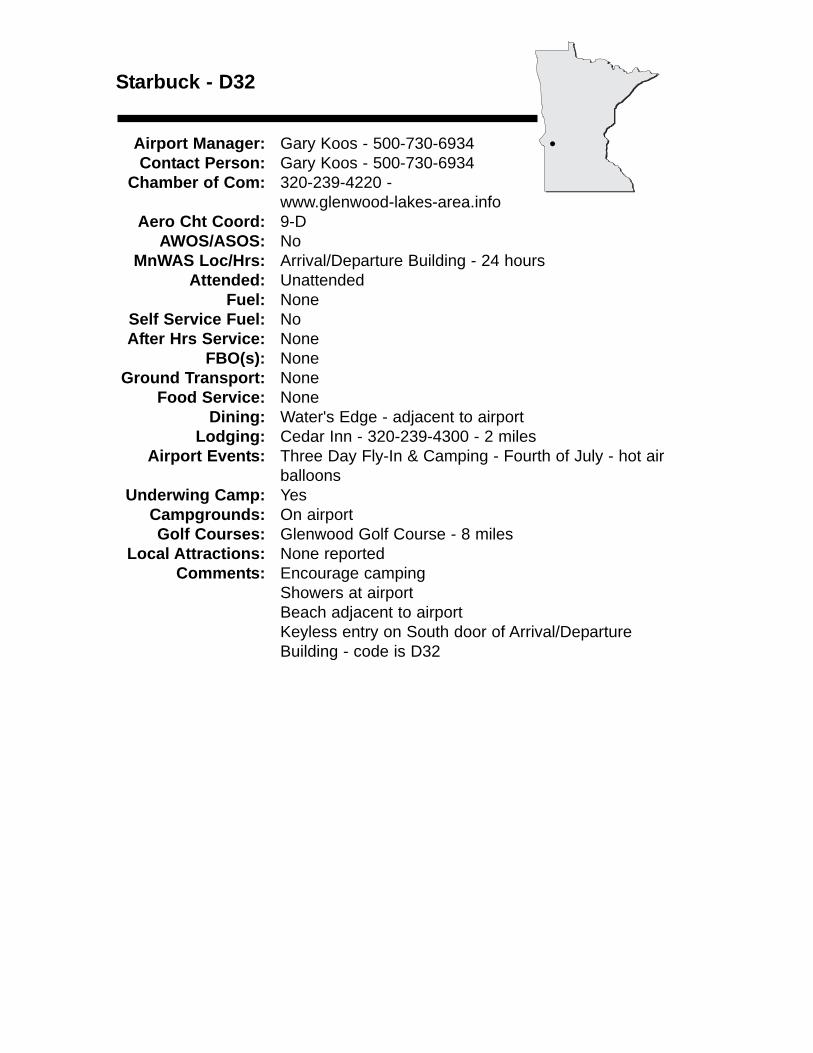
Starbuck - D32
Airport Manager: Gary Koos - 500-730-6934 Contact Person: Gary Koos - 500-730-6934
Chamber of Com: 320-239-4220 - www.glenwood-lakes-area.info
Aero Cht Coord: 9-DAWOS/ASOS: No
MnWAS Loc/Hrs: Arrival/Departure Building - 24 hoursAttended: Unattended
Fuel: NoneSelf Service Fuel: NoAfter Hrs Service: None
FBO(s): NoneGround Transport: None
Food Service: NoneDining: Water's Edge - adjacent to airport
Lodging: Cedar Inn - 320-239-4300 - 2 milesAirport Events: Three Day Fly-In & Camping - Fourth of July - hot air
balloonsUnderwing Camp: Yes
Campgrounds: On airportGolf Courses: Glenwood Golf Course - 8 miles
Local Attractions: None reportedComments: Encourage camping
Showers at airportBeach adjacent to airportKeyless entry on South door of Arrival/Departure Building - code is D32
•
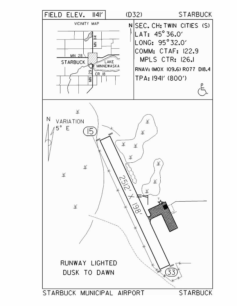
FIELD ELEV. 1141' (032) STARBUCKVICINITY MAP N SEC. CH: TWIN CITIES (S)
~ LA T: 450
36.0'LONG: 95 0 32.0'COMM: CTAF: 122.9
MPLS CTR: 126.1RNAV: (MOX 109.6) R077 D18.4
TPA: 1941' (800')
, .,.,\
\\
\ .,.,.,\ .,
\\
\\ .,.,.,.,
'.RUNWAY LIGHTED
DUSK TO DAWN
N VARIATION5° E
'.
STARBUCK MUNICIPAL AIRPORT STARBUCK
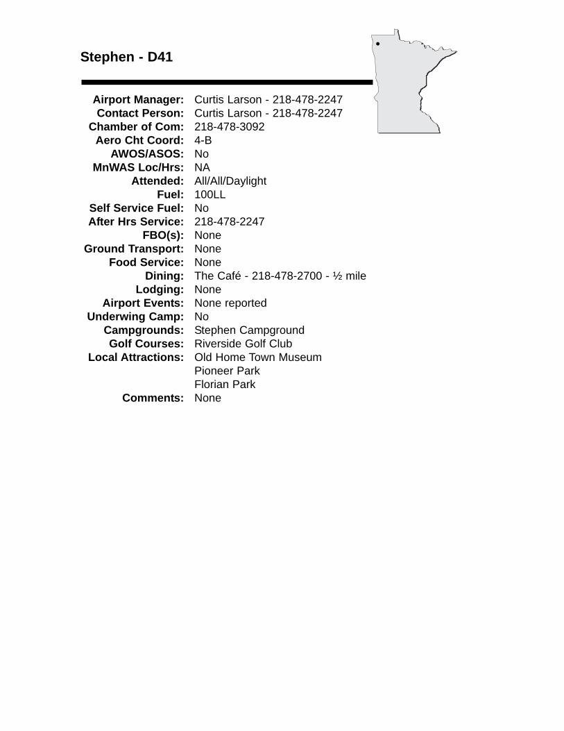
Stephen - D41
Airport Manager: Curtis Larson - 218-478-2247 Contact Person: Curtis Larson - 218-478-2247
Chamber of Com: 218-478-3092Aero Cht Coord: 4-B
AWOS/ASOS: NoMnWAS Loc/Hrs: NA
Attended: All/All/DaylightFuel: 100LL
Self Service Fuel: NoAfter Hrs Service: 218-478-2247
FBO(s): NoneGround Transport: None
Food Service: NoneDining: The Café - 218-478-2700 - ½ mile
Lodging: NoneAirport Events: None reported
Underwing Camp: NoCampgrounds: Stephen CampgroundGolf Courses: Riverside Golf Club
Local Attractions: Old Home Town MuseumPioneer ParkFlorian Park
Comments: None
•
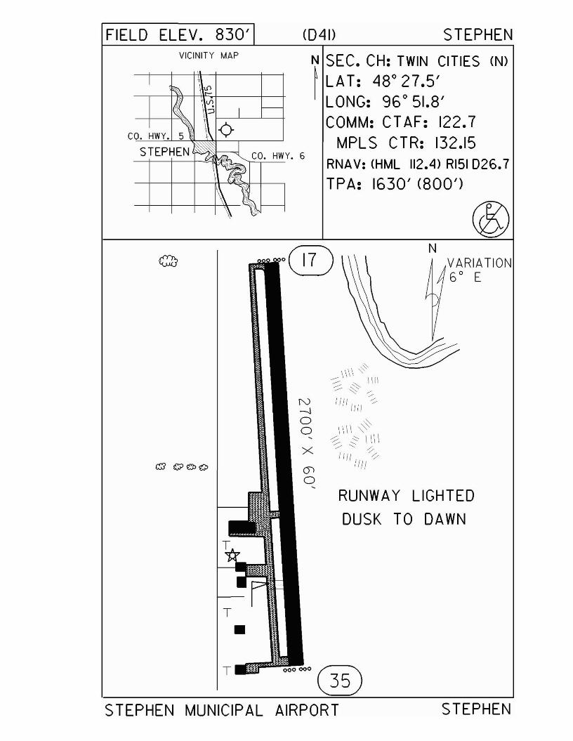
FIELD ELEV. 830'VICINITY MAP
<041> STEPHEN
N SEC. CH: TWIN CITIES (N)
~ LAT: 48 0 27.5'LONG: 96 0 51.8'COMM: CT AF: 122.7
MPLS CTR: 132.15RNAV: (HML 112.4) RI51 026.7
TPA: 1630' (800')
NVARIATION6 0 E
'"\\\\ '0-::::- '" \\1\::::::~'" -;;.
~ 11111111-;;'
g IIII ,,~~ 'i ~ \ II \
/' ~X /' ~I iii 'l
Ii Ii
RUNWAY LIGHTED
DUSK TO DAWN
000000 (illSTEPHEN MUNICIPAL AIRPORT STEPHEN
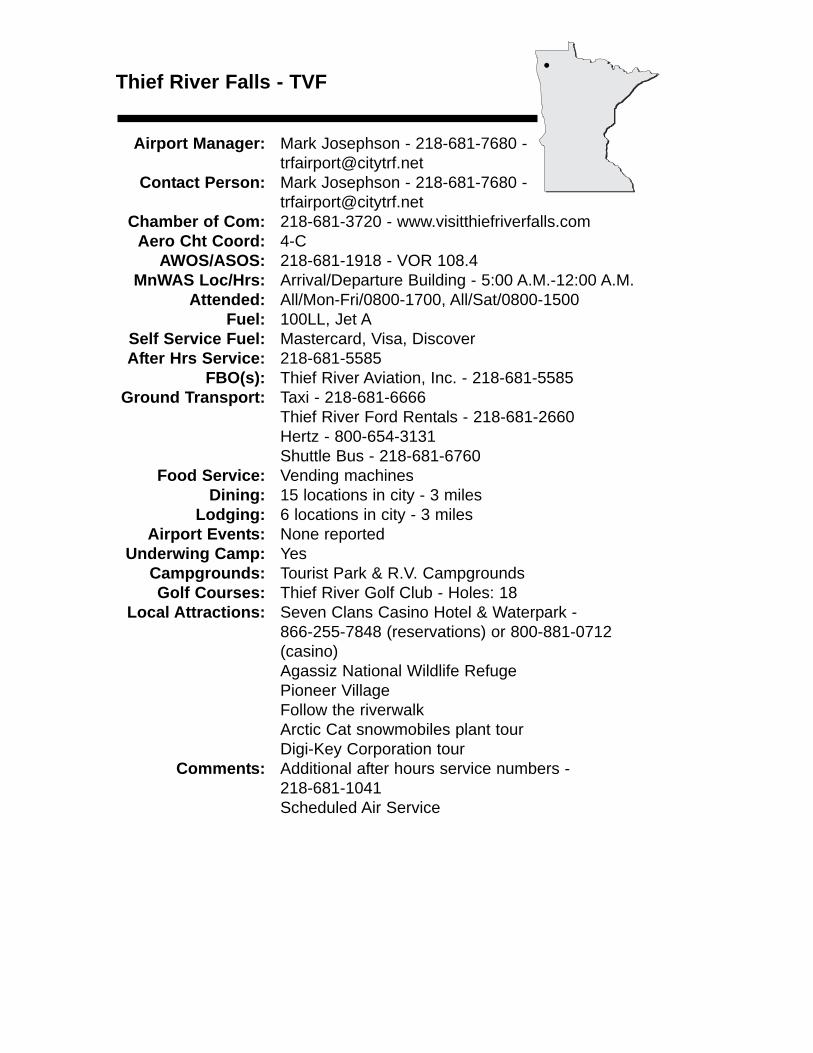
Thief River Falls - TVF
Airport Manager: Mark Josephson - 218-681-7680 [email protected]
Contact Person: Mark Josephson - 218-681-7680 - [email protected]
Chamber of Com: 218-681-3720 - www.visitthiefriverfalls.comAero Cht Coord: 4-C
AWOS/ASOS: 218-681-1918 - VOR 108.4MnWAS Loc/Hrs: Arrival/Departure Building - 5:00 A.M.-12:00 A.M.
Attended: All/Mon-Fri/0800-1700, All/Sat/0800-1500Fuel: 100LL, Jet A
Self Service Fuel: Mastercard, Visa, DiscoverAfter Hrs Service: 218-681-5585
FBO(s): Thief River Aviation, Inc. - 218-681-5585 Ground Transport: Taxi - 218-681-6666
Thief River Ford Rentals - 218-681-2660Hertz - 800-654-3131Shuttle Bus - 218-681-6760
Food Service: Vending machinesDining: 15 locations in city - 3 miles
Lodging: 6 locations in city - 3 milesAirport Events: None reported
Underwing Camp: YesCampgrounds: Tourist Park & R.V. CampgroundsGolf Courses: Thief River Golf Club - Holes: 18
Local Attractions: Seven Clans Casino Hotel & Waterpark - 866-255-7848 (reservations) or 800-881-0712(casino)Agassiz National Wildlife RefugePioneer VillageFollow the riverwalkArctic Cat snowmobiles plant tourDigi-Key Corporation tour
Comments: Additional after hours service numbers - 218-681-1041Scheduled Air Service
•
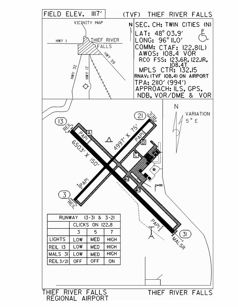
FIELD ELEV. 1117'VIC NITY MAP
RUNWAY 13-31 & 3-21
CLICKS ON 122.8
3 5 7
LIGHTS LOW MED HIGH
REIL 13 LOW MED HIGH
MALS 31 LOW MED HIGH
REIL3121 OFF OFF ON
nVF) THIEF RIVER FALLS
N SEC. CH: TWIN CITIES (N)
~ LAT: 48° 03.9' eI LONG: 96° 11.0' D
COMM: CT AF: 122.8(l)AWOS: 108.4 VORRCO FSS: 123.6R, 122.IR,
108.41MPLS CTR: 132.15
RNAV: (TVF 108.4) ON AIRPORT
TPA: 2110' (994')APPROACH: ILS, GPS,NOB, VOR/DME & VOR
NVARIATION50 E
THIEF RIVER FALLS THIEF RIVER FALLSREGIONAL AIRPORT
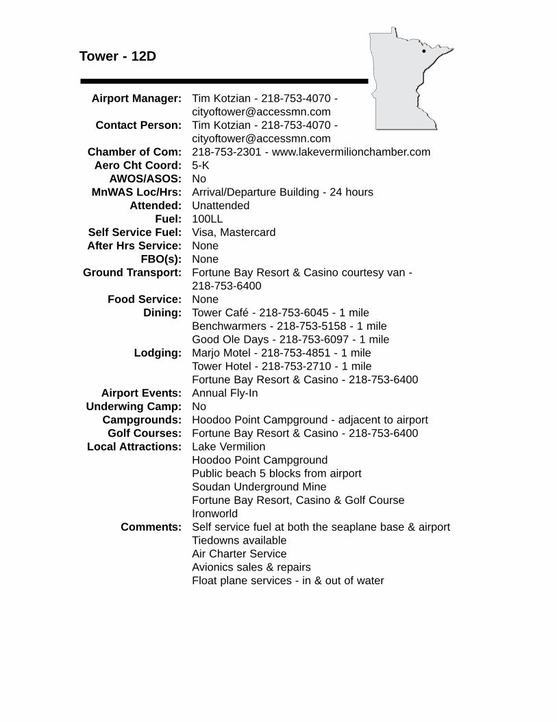
Tower - 12D
Airport Manager: Tim Kotzian - 218-753-4070 - [email protected]
Contact Person: Tim Kotzian - 218-753-4070 - [email protected]
Chamber of Com: 218-753-2301 - www.lakevermilionchamber.comAero Cht Coord: 5-K
AWOS/ASOS: NoMnWAS Loc/Hrs: Arrival/Departure Building - 24 hours
Attended: UnattendedFuel: 100LL
Self Service Fuel: Visa, MastercardAfter Hrs Service: None
FBO(s): NoneGround Transport: Fortune Bay Resort & Casino courtesy van -
218-753-6400Food Service: None
Dining: Tower Café - 218-753-6045 - 1 mileBenchwarmers - 218-753-5158 - 1 mileGood Ole Days - 218-753-6097 - 1 mile
Lodging: Marjo Motel - 218-753-4851 - 1 mileTower Hotel - 218-753-2710 - 1 mileFortune Bay Resort & Casino - 218-753-6400
Airport Events: Annual Fly-InUnderwing Camp: No
Campgrounds: Hoodoo Point Campground - adjacent to airportGolf Courses: Fortune Bay Resort & Casino - 218-753-6400
Local Attractions: Lake VermilionHoodoo Point CampgroundPublic beach 5 blocks from airportSoudan Underground MineFortune Bay Resort, Casino & Golf CourseIronworld
Comments: Self service fuel at both the seaplane base & airportTiedowns availableAir Charter ServiceAvionics sales & repairsFloat plane services - in & out of water
•
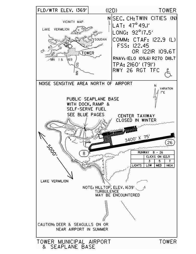
FLO/WTR ELEV. 1369' (120) TOWER
N SEC. CH: TWIN CITIES (N~ LAT: 47°49.1'I LONG: 92°17.5'
COMM: CTAF: 122.9 (l)
FSS: 122.45OR 1221R 109.6T
RNAV: <ELO 109.6) R270 018.7
TPA: 2160' <791')RWY 26 RGT TFC 6-.
NOISE SENSITIVE AREA NORTH OF AIRPORTN
VARIATION
1° E
3 5 7CLICKS ON 122.9
RUNWAY 8 - 26
LIGHTS LOW MED HIGH
3400' 'A 15'
CENTER TAXIWAYCLOSEDIN~
~
NOTE: HILL TOP, ELEV. 1639'~TURBULENCEMAY BE ENCOUNTERED
PUBLIC SEAPLANE BASEWITH DOCK, RAMP &SELF-SERVE FUELSEE BLUE PAGES
J(/l
LAKE VERMILION
\CAUTION: DEER & SEAGULLS ON OR
NEAR AIRPORT IN SUMMER
TOWER MUNICIPAL AIRPORT& SEAPLANE BASE
TOWER
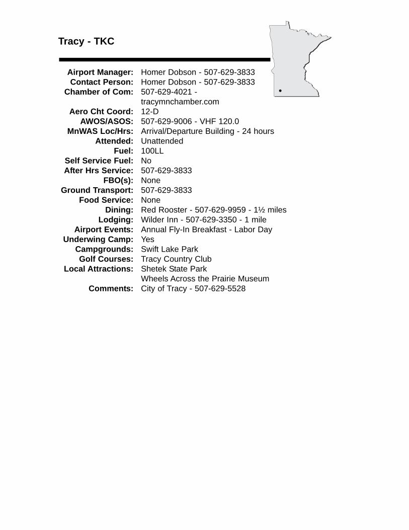
Tracy - TKC
Airport Manager: Homer Dobson - 507-629-3833 Contact Person: Homer Dobson - 507-629-3833
Chamber of Com: 507-629-4021 - tracymnchamber.com
Aero Cht Coord: 12-DAWOS/ASOS: 507-629-9006 - VHF 120.0
MnWAS Loc/Hrs: Arrival/Departure Building - 24 hoursAttended: Unattended
Fuel: 100LLSelf Service Fuel: NoAfter Hrs Service: 507-629-3833
FBO(s): NoneGround Transport: 507-629-3833
Food Service: NoneDining: Red Rooster - 507-629-9959 - 1½ miles
Lodging: Wilder Inn - 507-629-3350 - 1 mileAirport Events: Annual Fly-In Breakfast - Labor Day
Underwing Camp: YesCampgrounds: Swift Lake ParkGolf Courses: Tracy Country Club
Local Attractions: Shetek State ParkWheels Across the Prairie Museum
Comments: City of Tracy - 507-629-5528
•
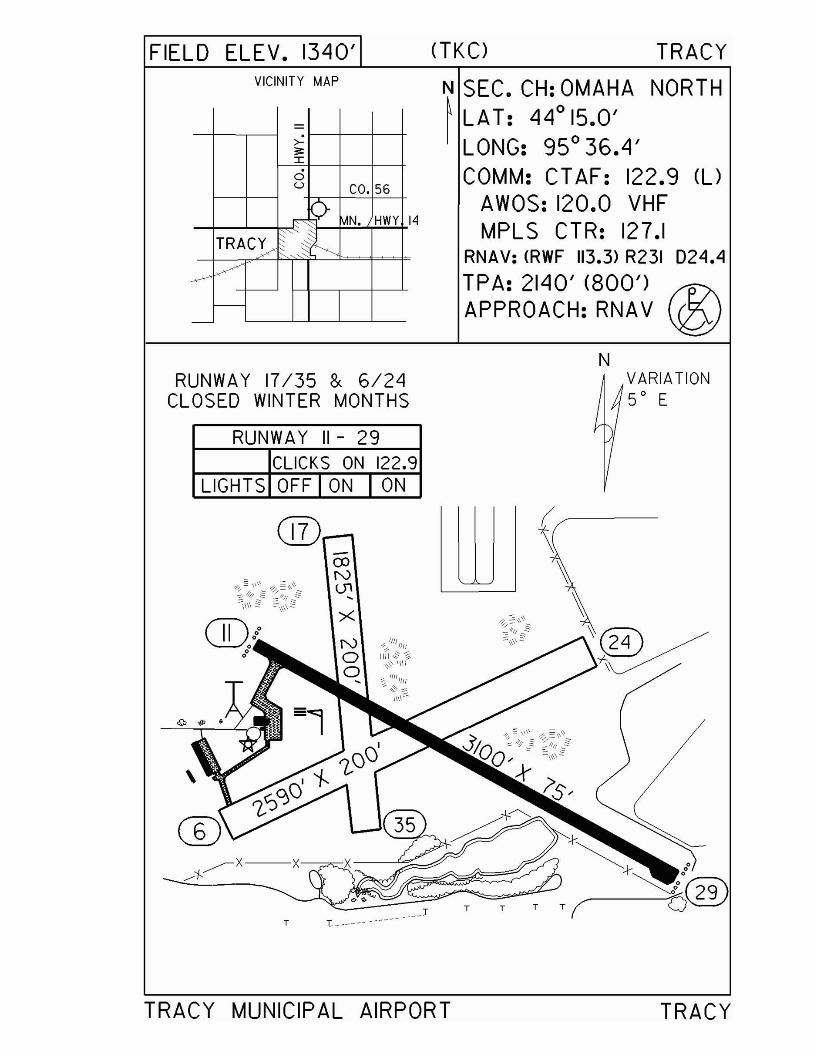
FIELD ELEV. 1340'VICINITY MAP
=>-;;::r:0u CO. 56
r ~ MN. HWY I
TRAC~~',~f:::
~Vf---
-
CTKC) TRACY
N SEC. CH: OMAHA NORTH~ LAT: 44
015.0'
LONG: 95 0 36.4'COMM: CTAF: 122.9 (U
AWOS: 120.0 VHFMPL S CTR: 127.1
RNAV: <RWF 113.3> R231 024.4
TPA: 2140' (800') f1?\APPROACH: RNAV ~
NRUNWAY 17/35 & 6/24
CLOSED WINTER MONTHS
RUNWAY 11-29CLICKS ON 122.9
VARIATION5° E
LIGHTS OFF I ON I ON
®coNU1,
T L _
TRACY MUNICIPAL AIRPORT
(~-
~,,~~
T T T
TRACY
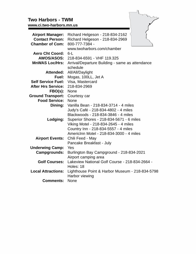
Two Harbors - TWMwww.ci.two-harbors.mn.us
Airport Manager: Richard Helgeson - 218-834-2162Contact Person: Richard Helgeson - 218-834-2969
Chamber of Com: 800-777-7384 - www.twoharbors.com/chamber
Aero Cht Coord: 6-LAWOS/ASOS: 218-834-6591 - VHF 119.325
MnWAS Loc/Hrs: Arrival/Departure Building - same as attendance schedule
Attended: All/All/DaylightFuel: Mogas, 100LL, Jet A
Self Service Fuel: Visa, MastercardAfter Hrs Service: 218-834-2969
FBO(s): NoneGround Transport: Courtesy car
Food Service: NoneDining: Vanilla Bean - 218-834-3714 - 4 miles
Judy's Café - 218-834-4802 - 4 milesBlackwoods - 218-834-3846 - 4 miles
Lodging: Superior Shores - 218-834-5671 - 6 milesViking Motel - 218-834-2645 - 4 milesCountry Inn - 218-834-5557 - 4 milesAmericInn Motel - 218-834-3000 - 4 miles
Airport Events: Chili Feed - MayPancake Breakfast - July
Underwing Camp: YesCampgrounds: Burlington Bay Campground - 218-834-2021
Airport camping areaGolf Courses: Lakeview National Golf Course - 218-834-2664 -
Holes: 18Local Attractions: Lighthouse Point & Harbor Museum - 218-834-5798
Harbor viewingComments: None
•

FIELD ELEV. 1080'VICINITY MAP
N VARIATION1° E
TURF RWY CLOSEDTO WHEEL AIRCRAFTWINTER MONTHS
6
(TWM) TWO HARBORS
N SEC. CH: GREEN BAY (N)~ LAT: 4r 03.0'I LONG: 910 44.7'
COMM: CTAF: 122.9 (l)AWOS: 119.325 VHFDLH APP: 125.45GCO: 121.725
RNAV: COLH 112.6> R047 D24.NDB: CTWM) 243TPA: 1880' (800') j~APPROACH:GPS NDB'J
T AIRPORT ROAD T T·
3 5 7
LIGHTS OFF MED HIGH
VASI ON ON ON
REILS OFF OFF ON
RICHARD B. HELGESON AIRPORT TWO HARBORS
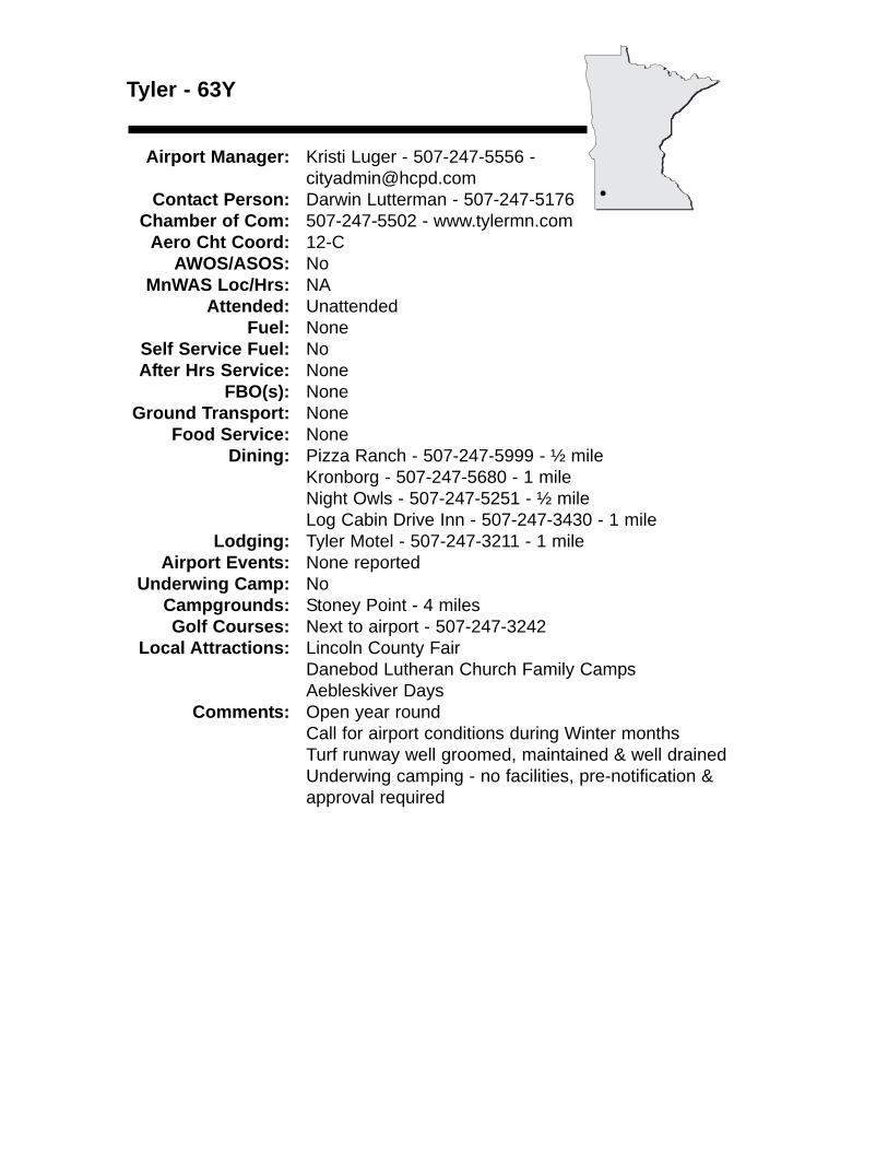
Tyler - 63Y
Airport Manager: Kristi Luger - 507-247-5556 - [email protected]
Contact Person: Darwin Lutterman - 507-247-5176 Chamber of Com: 507-247-5502 - www.tylermn.com
Aero Cht Coord: 12-CAWOS/ASOS: No
MnWAS Loc/Hrs: NAAttended: Unattended
Fuel: NoneSelf Service Fuel: NoAfter Hrs Service: None
FBO(s): NoneGround Transport: None
Food Service: NoneDining: Pizza Ranch - 507-247-5999 - ½ mile
Kronborg - 507-247-5680 - 1 mileNight Owls - 507-247-5251 - ½ mileLog Cabin Drive Inn - 507-247-3430 - 1 mile
Lodging: Tyler Motel - 507-247-3211 - 1 mileAirport Events: None reported
Underwing Camp: NoCampgrounds: Stoney Point - 4 milesGolf Courses: Next to airport - 507-247-3242
Local Attractions: Lincoln County FairDanebod Lutheran Church Family CampsAebleskiver Days
Comments: Open year roundCall for airport conditions during Winter monthsTurf runway well groomed, maintained & well drainedUnderwing camping - no facilities, pre-notification &approval required
•
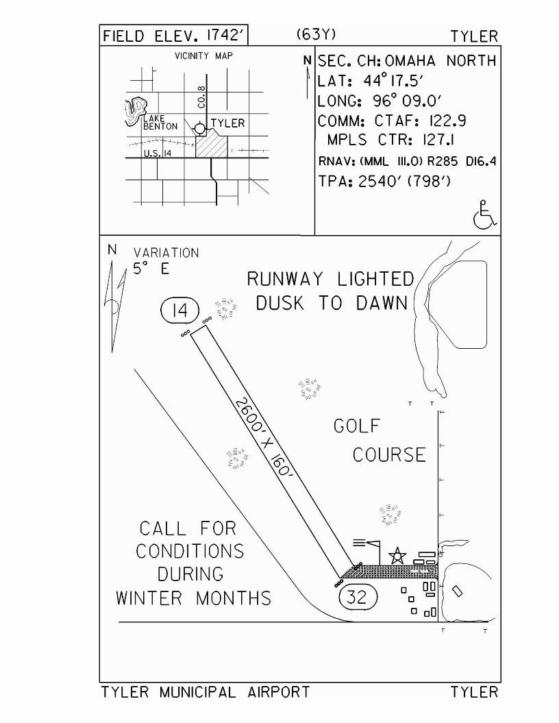
FIELD ELEV. 1742' (63Y) TYLERVICINITY MAP
+t 00
IAJE0u
1\,-'-,~YLERBENTONy- WU.S. 14
I
t---~
N SEC. CH: OMAHA NORTH~ LA T: 44
017.5'
LONG: 960 09.0'COMM: CT AF: 122.9
MPLS CTR: 127.1RNAV: (MML 111.0> R285 016.4
TPA: 2540' <798')
RUNWAY LIGHTED® ooJ~~':~ DUSK TO DAWN
~;/\\\~:::\\\\~
T T
f-
GOLFf-
~§'\\\,==:: COURSE~/fll _"'"
~\\\\=:
f-
~;,\~~ f-
CALL FOR ~\\\\2
CONDITIONSDURING
JP
WINTER MONTHS (ill 0 00 \>0 =o DO
T T
N VARIATIONSO E
TYLER MUNICIPAL AIRPORT TYLER

Wadena - ADC
Airport Manager: Stanley Weitemier - 218-631-1196 [email protected]
Contact Person: Brad Swenson - 218-631-7775 - [email protected]
Chamber of Com: 218-632-7704 - www.wadena.orgAero Cht Coord: 8-E
AWOS/ASOS: 218-631-7774 - VHF 128.325MnWAS Loc/Hrs: Arrival/Departure Building - 24 hours/keypad
Attended: All/Mon-Fri/0800-1700Fuel: Mogas, 100LL
Self Service Fuel: Visa, Mastercard, DiscoverAfter Hrs Service: 218-820-2427
FBO(s): Wadena Aviation, Inc. - 218-631-1196 - 122.8 - [email protected]
Ground Transport: Friendly Rider - 218-631-5730 or 888-773-5500Food Service: None
Dining: Numerous restaurantsLodging: Brookside Motel - 218-631-2930 - 8 miles
Jensen's Terry Motel - 218-631-1956 - 8 milesAmericInn Motel - 218-631-1580 - 7 milesWadena Inn - 218-631-3725 - 7 miles
Airport Events: Fly-In/Drive-In - AugustUnderwing Camp: No
Campgrounds: Sunny Brook Park - 7½ miles EastGolf Courses: Whitetail Run Golf Course - 218-631-7778 - 11 miles
Local Attractions: Sunny Brook Park - 7½ miles EastBlack Groves City Park - 1 mile
Comments: Additional servicing phone number - 218-631-1196Free tiedowns, free 24-hour service, office open during business hours - Mon - Fri.
•
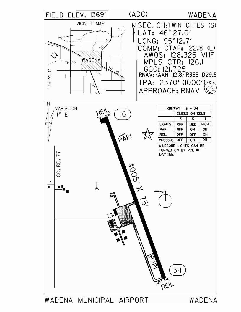
FIELD ELEV. 1369'VICINITY MAP
o0::
oU
(ADC) WADENA
N SEC. CH:TWIN CITIES (S)~LAT: 46°27.0'I LONG: 95° 12.7'
COMM: CT AF: 122.8 (UAWOS: 128.325 VHFMPLS CTR: 126.1GCO: 121.725
RNAV: (AXN 112.8> R355 029.5
TPA: 2370' (1000')APPROACH:RNAV
WADENA MUNICIPAL AIRPORT WADENA
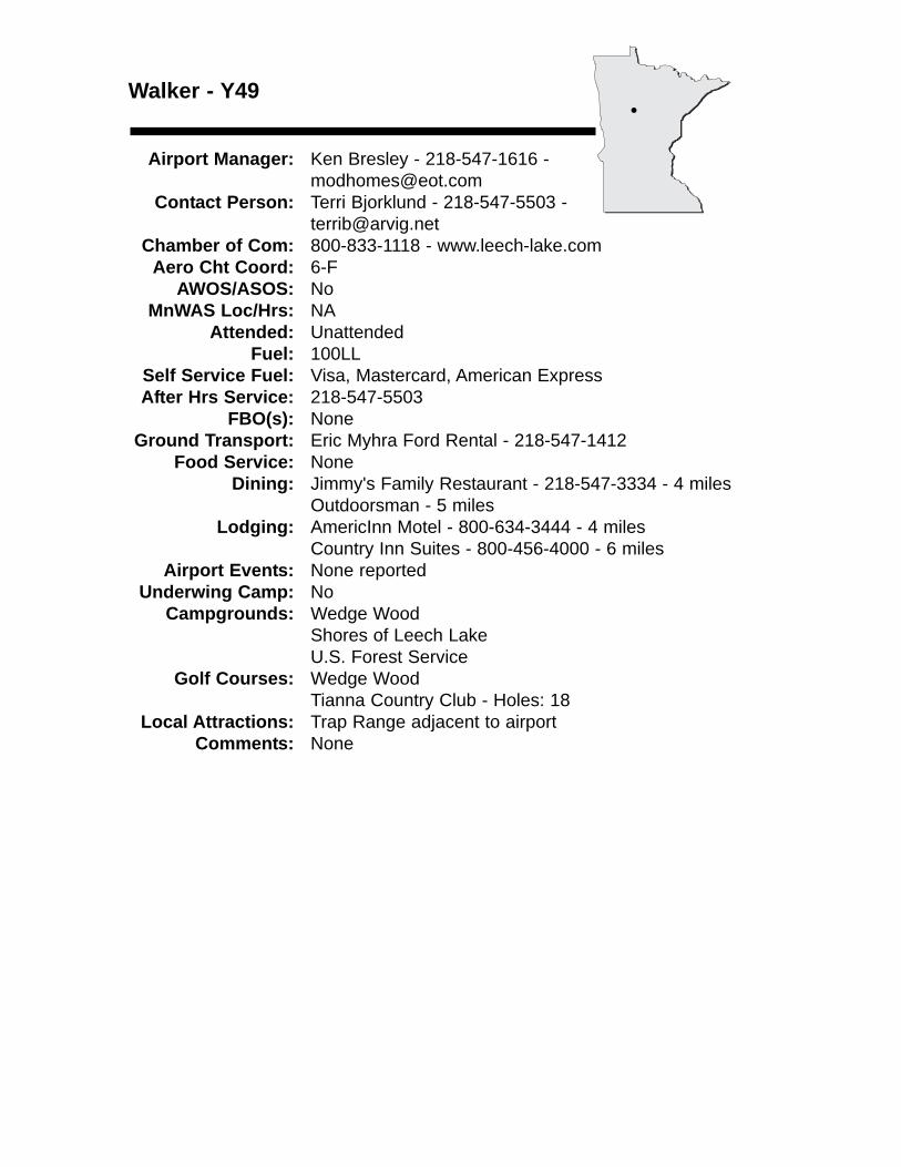
Walker - Y49
Airport Manager: Ken Bresley - 218-547-1616 - [email protected]
Contact Person: Terri Bjorklund - 218-547-5503 - [email protected]
Chamber of Com: 800-833-1118 - www.leech-lake.comAero Cht Coord: 6-F
AWOS/ASOS: No MnWAS Loc/Hrs: NA
Attended: UnattendedFuel: 100LL
Self Service Fuel: Visa, Mastercard, American ExpressAfter Hrs Service: 218-547-5503
FBO(s): NoneGround Transport: Eric Myhra Ford Rental - 218-547-1412
Food Service: NoneDining: Jimmy's Family Restaurant - 218-547-3334 - 4 miles
Outdoorsman - 5 milesLodging: AmericInn Motel - 800-634-3444 - 4 miles
Country Inn Suites - 800-456-4000 - 6 milesAirport Events: None reported
Underwing Camp: NoCampgrounds: Wedge Wood
Shores of Leech LakeU.S. Forest Service
Golf Courses: Wedge WoodTianna Country Club - Holes: 18
Local Attractions: Trap Range adjacent to airportComments: None
•
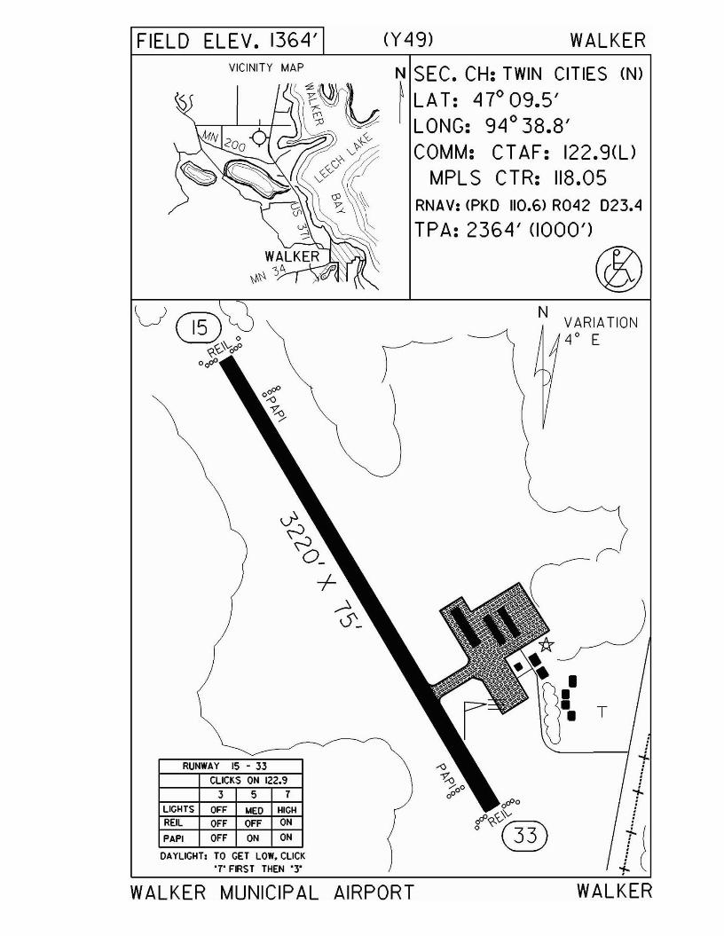
FIELD ELEV. 1364' (Y49) WALKER
.
tr
Ii
T
WALKER
N VARIATION4 0 E
N SEC. CH: TWIN CITIES (N)
~LAT: 47°09.5'LONG: 94° 38.8'COMM: CT AF: 122.9(l)
MPL S CTR: 118.05RNAV: <PKO 110.6) R042 023.4
TPA: 2364' (1000')
®
VICINITY MAP
CLICKS ON 122.9
3 5 7
RUNWAY 15 - 33
LICHTS OFF MEO HICH
REIL OFF OFF ON
PAPI OFF ON ON
DAYLICHT, TO CET LOW, CLICK'7' FIRST THEN '3"
WALKER MUNICIPAL AIRPORT
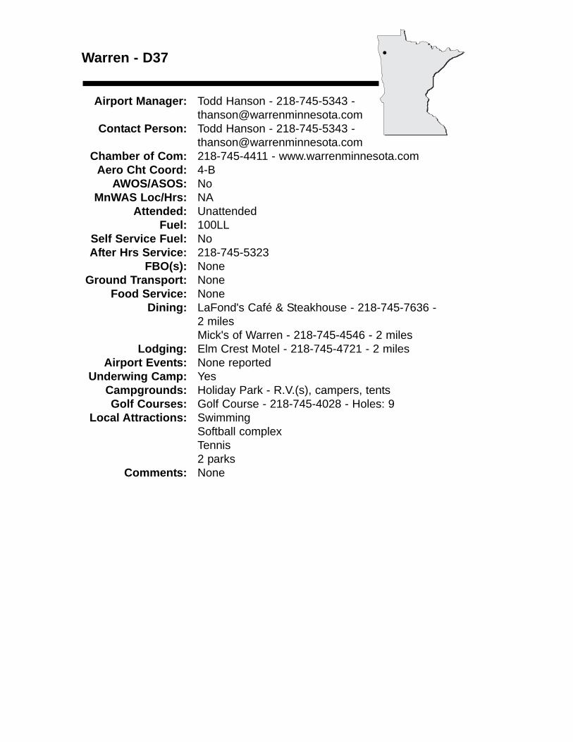
Warren - D37
Airport Manager: Todd Hanson - 218-745-5343 - [email protected]
Contact Person: Todd Hanson - 218-745-5343 - [email protected]
Chamber of Com: 218-745-4411 - www.warrenminnesota.comAero Cht Coord: 4-B
AWOS/ASOS: No MnWAS Loc/Hrs: NA
Attended: UnattendedFuel: 100LL
Self Service Fuel: NoAfter Hrs Service: 218-745-5323
FBO(s): NoneGround Transport: None
Food Service: NoneDining: LaFond's Café & Steakhouse - 218-745-7636 -
2 milesMick's of Warren - 218-745-4546 - 2 miles
Lodging: Elm Crest Motel - 218-745-4721 - 2 milesAirport Events: None reported
Underwing Camp: YesCampgrounds: Holiday Park - R.V.(s), campers, tentsGolf Courses: Golf Course - 218-745-4028 - Holes: 9
Local Attractions: SwimmingSoftball complexTennis2 parks
Comments: None
•
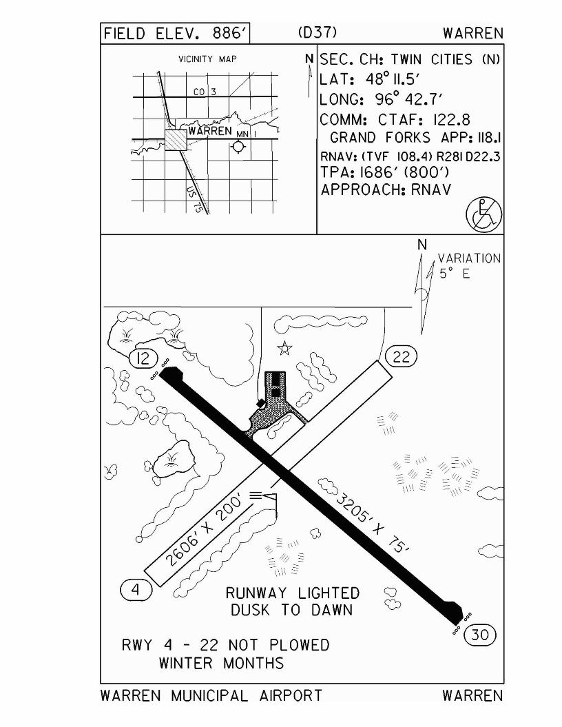
FIELD ELEV. 886'
VICINITY MAP
<037> WARREN
N SEC. CH: TWIN CITIES (N)~ LAT: 480 11.5'I LONG: 960 42.7'
COMM: CT AF: 122.8GRAND FORKS APP: 118.1
RNAV: (TVF 108.4) R281 D22.3TPA: 1686' (800')APPROACH:RNAV
N
RUNWAY LIGHTEDDUSK TO DAWN
RWY 4 - 22 NOT PLOWEDWINTER MONTHS
WARREN MUNICIPAL AIRPORT
VARIATION5° E
WARREN
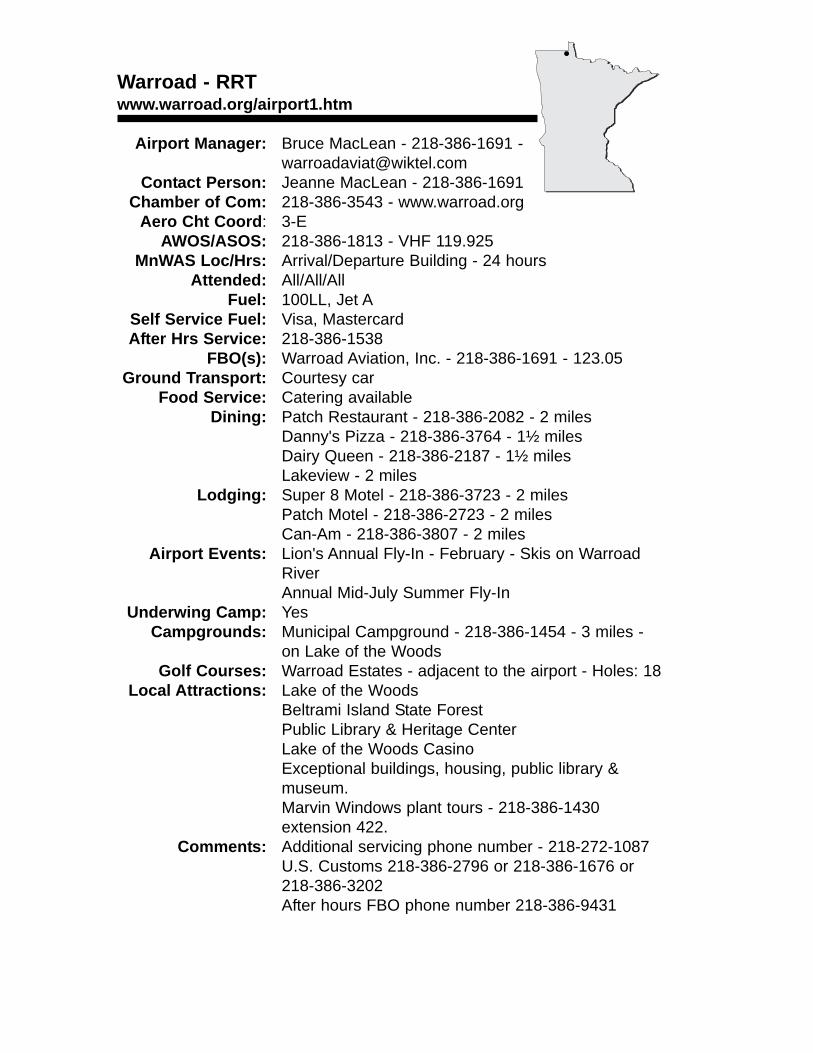
Warroad - RRTwww.warroad.org/airport1.htm
Airport Manager: Bruce MacLean - 218-386-1691 [email protected]
Contact Person: Jeanne MacLean - 218-386-1691 Chamber of Com: 218-386-3543 - www.warroad.org
Aero Cht Coord: 3-EAWOS/ASOS: 218-386-1813 - VHF 119.925
MnWAS Loc/Hrs: Arrival/Departure Building - 24 hoursAttended: All/All/All
Fuel: 100LL, Jet ASelf Service Fuel: Visa, MastercardAfter Hrs Service: 218-386-1538
FBO(s): Warroad Aviation, Inc. - 218-386-1691 - 123.05Ground Transport: Courtesy car
Food Service: Catering availableDining: Patch Restaurant - 218-386-2082 - 2 miles
Danny's Pizza - 218-386-3764 - 1½ milesDairy Queen - 218-386-2187 - 1½ milesLakeview - 2 miles
Lodging: Super 8 Motel - 218-386-3723 - 2 milesPatch Motel - 218-386-2723 - 2 milesCan-Am - 218-386-3807 - 2 miles
Airport Events: Lion's Annual Fly-In - February - Skis on Warroad RiverAnnual Mid-July Summer Fly-In
Underwing Camp: YesCampgrounds: Municipal Campground - 218-386-1454 - 3 miles -
on Lake of the WoodsGolf Courses: Warroad Estates - adjacent to the airport - Holes: 18
Local Attractions: Lake of the WoodsBeltrami Island State ForestPublic Library & Heritage CenterLake of the Woods CasinoExceptional buildings, housing, public library & museum.Marvin Windows plant tours - 218-386-1430 extension 422.
Comments: Additional servicing phone number - 218-272-1087U.S. Customs 218-386-2796 or 218-386-1676 or 218-386-3202After hours FBO phone number 218-386-9431
•
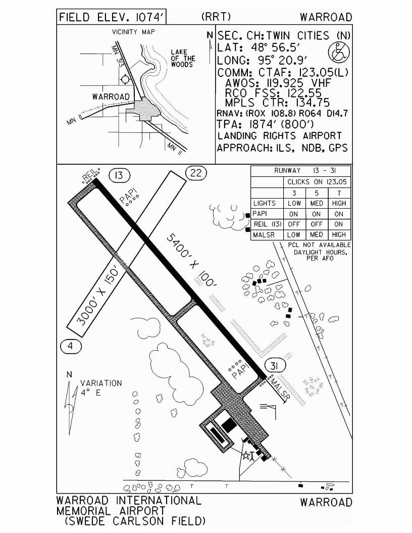
FIELD ELEV. 107"1' (RRT) WARROADVICINITY MAP N SEC. CH: TWIN CITIES (N)
~ LA T: "18° 56.5' r1i\I LONG: 95° 20.9' ~
COMM: CT AF: 123.05(l)AWOS: 119.925 VHFRCO FSS: 122.55MPL S CTR: 13"1.75
RNAV: (ROX 108.8> R064 014.7TPA: 187"1' (800')LANDING RIGHTS AIRPORTAPPROACH: ILS. NOB. GPS
N
•
3 5 7
pel NOT AVAilABLEDAYLIGHT HOURS.
PER AFO
CLICKS ON 123.05
RUNWAY 13 - 31
T
~u LIGHTS LOW MED HIGH
V )_f--PA_P_I-----t_O_N-+-_ON-+_O_N_IIREIL (13) OFF OFF ON
.f-------j--l--c---=-:::-+------,-------i IMALSR LOW MED HIGH
DDGJ\]
e
VARIATION4
0E 0
ooS()
WARROAD INTERNATIONALMEMORIAL AIRPORT
(SWEDE CARLSON FIELD)
WARROAD
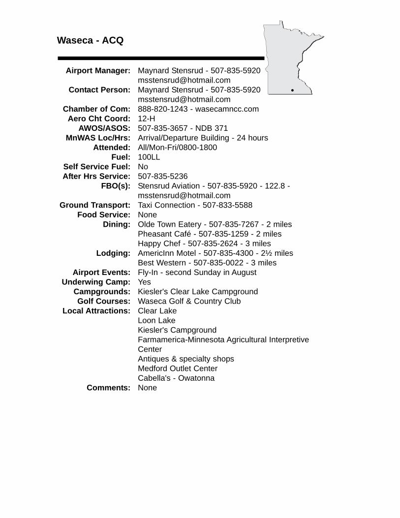
Waseca - ACQ
Airport Manager: Maynard Stensrud - [email protected]
Contact Person: Maynard Stensrud - 507-835-5920 [email protected]
Chamber of Com: 888-820-1243 - wasecamncc.comAero Cht Coord: 12-H
AWOS/ASOS: 507-835-3657 - NDB 371MnWAS Loc/Hrs: Arrival/Departure Building - 24 hours
Attended: All/Mon-Fri/0800-1800Fuel: 100LL
Self Service Fuel: NoAfter Hrs Service: 507-835-5236
FBO(s): Stensrud Aviation - 507-835-5920 - 122.8 - [email protected]
Ground Transport: Taxi Connection - 507-833-5588Food Service: None
Dining: Olde Town Eatery - 507-835-7267 - 2 milesPheasant Café - 507-835-1259 - 2 milesHappy Chef - 507-835-2624 - 3 miles
Lodging: AmericInn Motel - 507-835-4300 - 2½ milesBest Western - 507-835-0022 - 3 miles
Airport Events: Fly-In - second Sunday in AugustUnderwing Camp: Yes
Campgrounds: Kiesler's Clear Lake CampgroundGolf Courses: Waseca Golf & Country Club
Local Attractions: Clear LakeLoon LakeKiesler's CampgroundFarmamerica-Minnesota Agricultural Interpretive CenterAntiques & specialty shopsMedford Outlet CenterCabella's - Owatonna
Comments: None
•
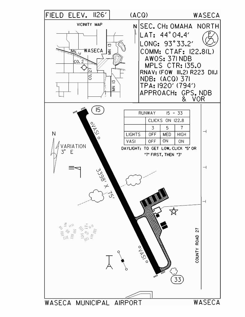
FIELD ELEV. 1126'VICINITY MAP
(ACQ) WASECA
N SEC. CH: OMAHA NORTH~ LA T: 44 0 04.4' f1?\I LONG: 93 0 33.2' \JQ;J
COMM: CT AF: 122.8(l)AWOS: 371 NOBMPLS CTR: 135.0
RNAV: (FOW 111.2) R223 011.1NOB: (ACQ) 371TPA: 1920' <794')APPROACH: GPS,NDB
& VOR
N
VARIATION3° E
RUNWAY 15 - 33
CLICKS ON 122.8
3 5 7
LIGHTS OFF MED HIGH
VASI OFF ON ON
DAYLIGHT: TO GET LOW, CLICK "5" OR
'7" FIRS T, THEN ·3'
r-N
o<toa::>IZ:::loU
WASECA MUNICIPAL AIRPORT WASECA
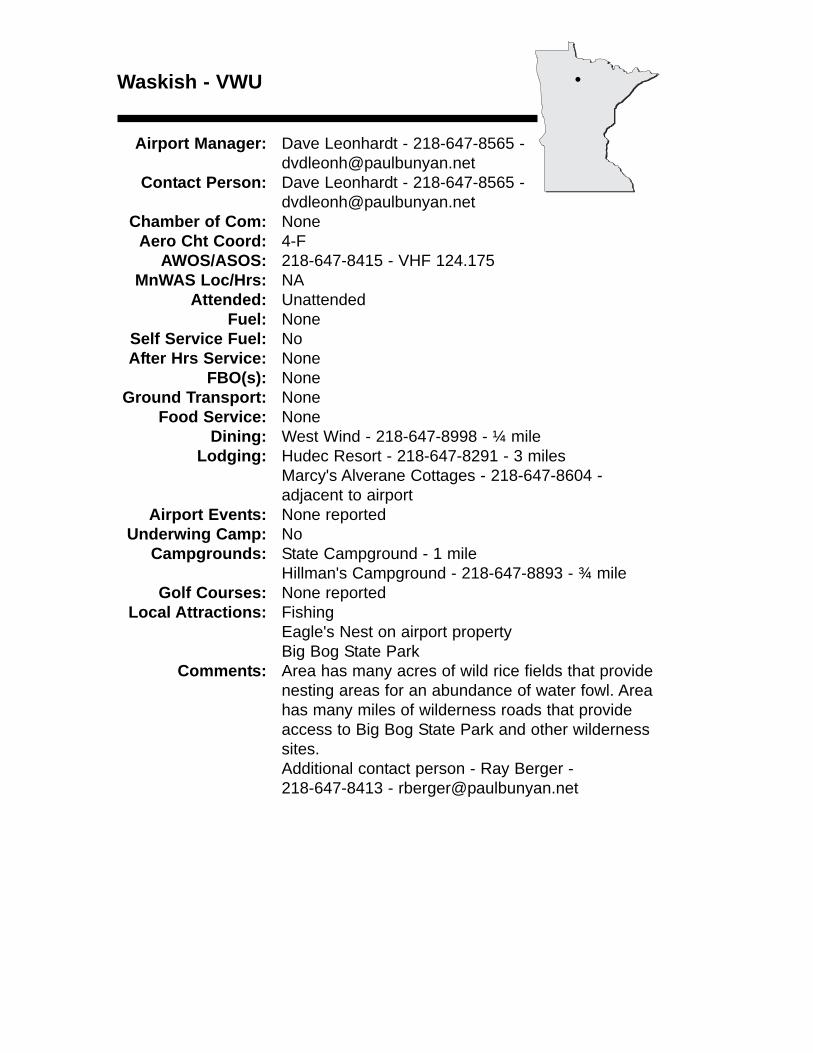
Waskish - VWU
Airport Manager: Dave Leonhardt - 218-647-8565 [email protected]
Contact Person: Dave Leonhardt - 218-647-8565 - [email protected]
Chamber of Com: NoneAero Cht Coord: 4-F
AWOS/ASOS: 218-647-8415 - VHF 124.175MnWAS Loc/Hrs: NA
Attended: UnattendedFuel: None
Self Service Fuel: NoAfter Hrs Service: None
FBO(s): NoneGround Transport: None
Food Service: NoneDining: West Wind - 218-647-8998 - ¼ mile
Lodging: Hudec Resort - 218-647-8291 - 3 milesMarcy's Alverane Cottages - 218-647-8604 - adjacent to airport
Airport Events: None reportedUnderwing Camp: No
Campgrounds: State Campground - 1 mileHillman's Campground - 218-647-8893 - ¾ mile
Golf Courses: None reportedLocal Attractions: Fishing
Eagle's Nest on airport propertyBig Bog State Park
Comments: Area has many acres of wild rice fields that providenesting areas for an abundance of water fowl. Area has many miles of wilderness roads that provide access to Big Bog State Park and other wilderness sites.Additional contact person - Ray Berger - 218-647-8413 - [email protected]
•
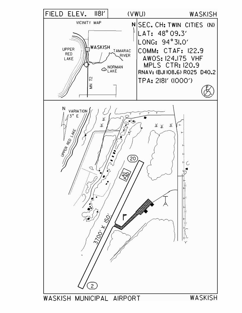
FIELD ELEV. 1181'VICINITY MAP
UPPERRED
LAKE
@NORMAN= LAKE
NI'-
(VWU) WASKISH
N SEC. CH: TWIN CITIES (N)
~ LA T: 480
09.3'LONG: 94 0 31.0'COMM: CTAF: 122.9
AWOS: 124.175 VHFMPLS CTR: 120.9
RNAV: <BJII08.6> R025 040.2
TPA: 2181' (1000')
:i}! :i ~i
~i
~
i' ..V
y
WASKISH MUNICIPAL AIRPORT WASKISH
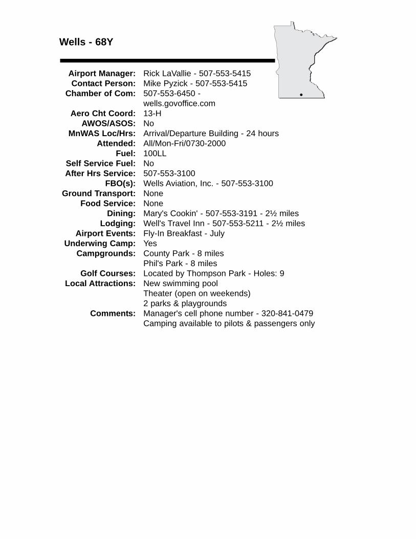
Wells - 68Y
Airport Manager: Rick LaVallie - 507-553-5415 Contact Person: Mike Pyzick - 507-553-5415
Chamber of Com: 507-553-6450 -wells.govoffice.com
Aero Cht Coord: 13-HAWOS/ASOS: No
MnWAS Loc/Hrs: Arrival/Departure Building - 24 hoursAttended: All/Mon-Fri/0730-2000
Fuel: 100LLSelf Service Fuel: NoAfter Hrs Service: 507-553-3100
FBO(s): Wells Aviation, Inc. - 507-553-3100 Ground Transport: None
Food Service: NoneDining: Mary's Cookin' - 507-553-3191 - 2½ miles
Lodging: Well's Travel Inn - 507-553-5211 - 2½ milesAirport Events: Fly-In Breakfast - July
Underwing Camp: YesCampgrounds: County Park - 8 miles
Phil's Park - 8 milesGolf Courses: Located by Thompson Park - Holes: 9
Local Attractions: New swimming poolTheater (open on weekends)2 parks & playgrounds
Comments: Manager's cell phone number - 320-841-0479Camping available to pilots & passengers only
•
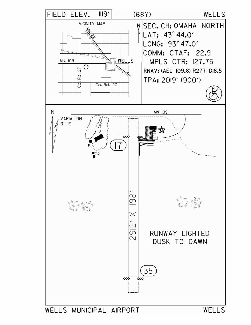
FIELD ELEV.
MN. 109
u
1119'
Co. Rd. 120
(68Y) WELLS
N SEC. CH: OMAHA NORTH~ LA T: 43° 44.0'I LONG: 93° 47.0'
COMM: CT AF: 122.9MPLS CTR: 127.75
RNAV: (AEL 109.8) R277 018.5
TPA: 2019' (900')
·0•®
MN 109:-._._._-,, .· ,, .· ,, ,i :· ,, .· ,, .· ,, .
... _---
,CDen
x,NenN
RUNWAY LIGHTEDDUSK TO DAWN
;;;;
._._._.;
WELLS MUNICIPAL AIRPORT WELLS
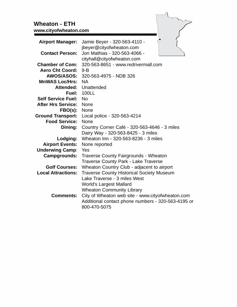
Wheaton - ETHwww.cityofwheaton.com
Airport Manager: Jamie Beyer - 320-563-4110 - [email protected]
Contact Person: Jon Mathias - 320-563-4066 - [email protected]
Chamber of Com: 320-563-8651 - www.redrivermall.comAero Cht Coord: 9-B
AWOS/ASOS: 320-563-4975 - NDB 326MnWAS Loc/Hrs: NA
Attended: UnattendedFuel: 100LL
Self Service Fuel: NoAfter Hrs Service: None
FBO(s): NoneGround Transport: Local police - 320-563-4214
Food Service: NoneDining: Country Corner Café - 320-563-4646 - 3 miles
Dairy Way - 320-563-8425 - 3 milesLodging: Wheaton Inn - 320-563-8236 - 3 miles
Airport Events: None reportedUnderwing Camp: Yes
Campgrounds: Traverse County Fairgrounds - WheatonTraverse County Park - Lake Traverse
Golf Courses: Wheaton Country Club - adjacent to airportLocal Attractions: Traverse County Historical Society Museum
Lake Traverse - 3 miles WestWorld's Largest MallardWheaton Community Library
Comments: City of Wheaton web site - www.cityofwheaton.comAdditional contact phone numbers - 320-563-4195 or800-470-5075
•
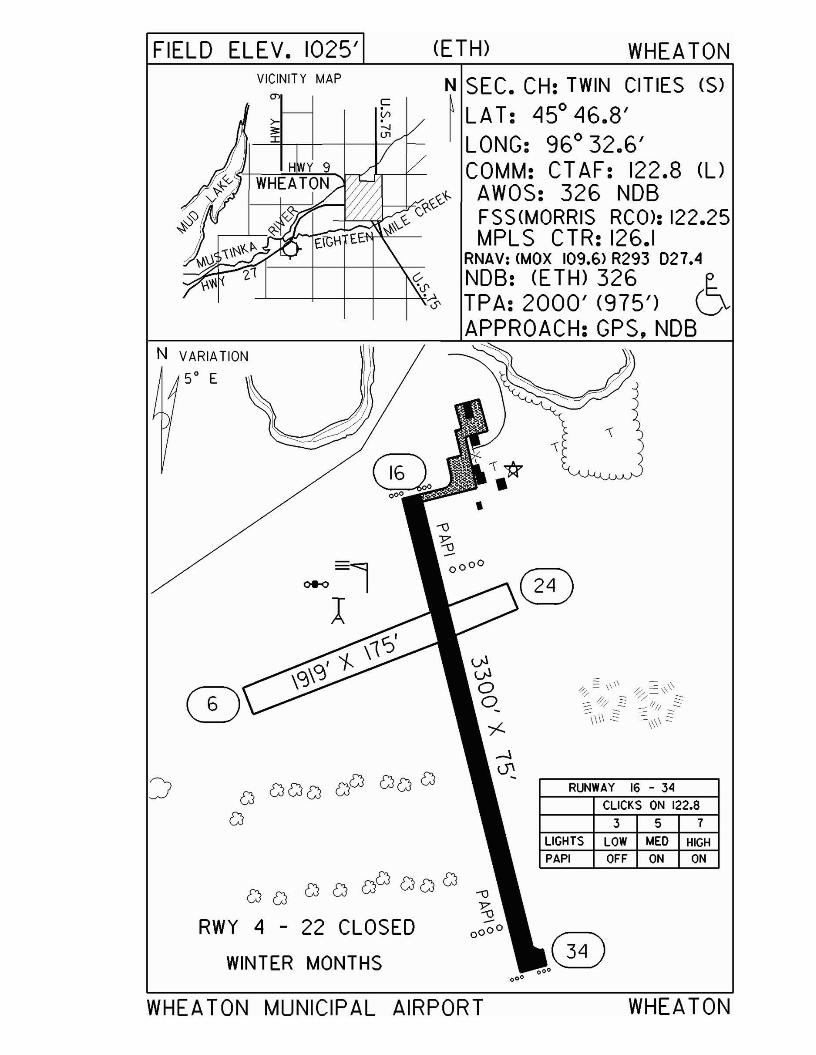
FIELD ELEV. 1025' (ETH) WHEA TON
CJ CJ CJ CJ CJGJ CJ CJ CJ
RWY 4 - 22 CLOSED
WINTER MONTHS
RUNWAY 16 - 34
CLICKS ON 122.8
3 5 7
LIGHTS LOW "-lED HIGHPAPI OFF ON ON
VICINITY MAP N SEC. CH: TWIN CITIES (S)
~ LA T: "15° "16.8'LONG: 96° 32.6'COMM: CT AF: 122.8 (l)
AWOS: 326 NOBFSS(MORRIS RCO>: 122.25MPLS CTR: 126.1
RNAV: (MaX 109.6> R293 027.4«0' NOB: (E TH) 326 e..
---'-------+---+--+----+--¥..~ TPA: 2000' (975') DAPPROACH: GPS,NDB
CD
N VARIATION
5° E
WHEATON MUNICIPAL AIRPORT WHEATON
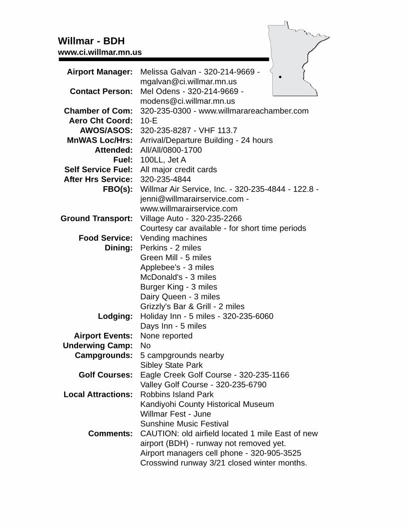
Willmar - BDHwww.ci.willmar.mn.us
Airport Manager: Melissa Galvan - 320-214-9669 - [email protected]
Contact Person: Mel Odens - 320-214-9669 - [email protected]
Chamber of Com: 320-235-0300 - www.willmarareachamber.comAero Cht Coord: 10-E
AWOS/ASOS: 320-235-8287 - VHF 113.7MnWAS Loc/Hrs: Arrival/Departure Building - 24 hours
Attended: All/All/0800-1700Fuel: 100LL, Jet A
Self Service Fuel: All major credit cardsAfter Hrs Service: 320-235-4844
FBO(s): Willmar Air Service, Inc. - 320-235-4844 - 122.8 - [email protected] - www.willmarairservice.com
Ground Transport: Village Auto - 320-235-2266Courtesy car available - for short time periods
Food Service: Vending machinesDining: Perkins - 2 miles
Green Mill - 5 milesApplebee's - 3 milesMcDonald's - 3 milesBurger King - 3 milesDairy Queen - 3 milesGrizzly's Bar & Grill - 2 miles
Lodging: Holiday Inn - 5 miles - 320-235-6060Days Inn - 5 miles
Airport Events: None reportedUnderwing Camp: No
Campgrounds: 5 campgrounds nearbySibley State Park
Golf Courses: Eagle Creek Golf Course - 320-235-1166Valley Golf Course - 320-235-6790
Local Attractions: Robbins Island ParkKandiyohi County Historical MuseumWillmar Fest - JuneSunshine Music Festival
Comments: CAUTION: old airfield located 1 mile East of newairport (BDH) - runway not removed yet.Airport managers cell phone - 320-905-3525Crosswind runway 3/21 closed winter months.
•
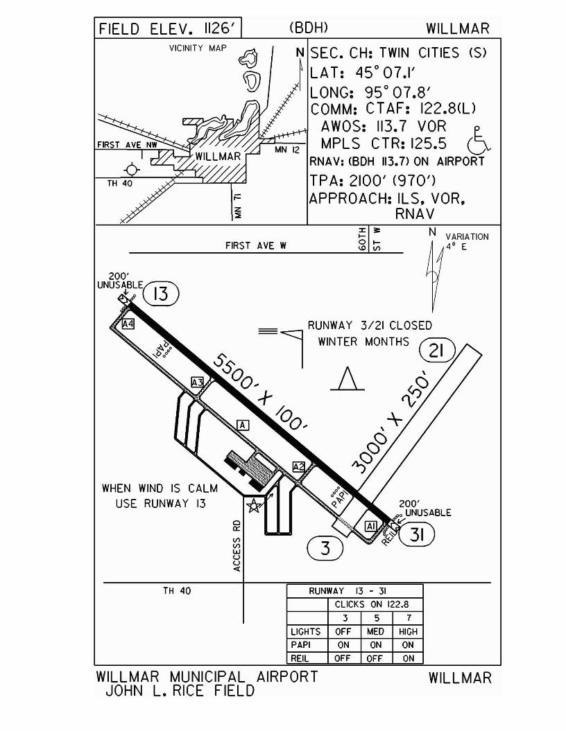
FIELD ELEV. 1126' (SOH) WILLMAR
N VARIATION4' E
N SEC. CH: TWIN CITIES (S)
~ LAT: 45°07.1'LONG: 95° 07.8'COMM: CT AF: 122.8(l)
AWOS: 113.7 VOR eMPLS CTR: 125.5 V
RNAV: <BDH 113.7> ON AIRPORT
TPA: 2100' (970')APPROACH: ILS. VOR.
RNA Vz:::lE
oa:V1V1WUU<l:
___ RUNWAY 3/21 CLOSED=l WINTER MONTHS ®Ss
00.. A-+
/Q0 ..
VICINITY MAP
FIRST AVE W
WHEN WIND IS CALMUSE RUNWAY 13
TH 40 RUNWAY 13 - 31CLICKS ON 122.8
357LIGHTS OFF MED HIGH
PAPI ON ON ON
REIL OFF OFF ON
WILLMAR MUNICIPAL AIRPORTJOHN L. RICE FIELD
WILLMAR
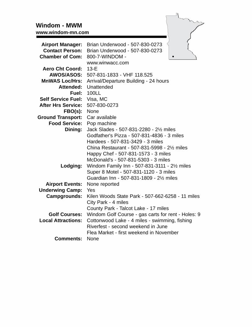
Windom - MWMwww.windom-mn.com
Airport Manager: Brian Underwood - 507-830-0273Contact Person: Brian Underwood - 507-830-0273
Chamber of Com: 800-7-WINDOM - www.winwacc.com
Aero Cht Coord: 13-EAWOS/ASOS: 507-831-1833 - VHF 118.525
MnWAS Loc/Hrs: Arrival/Departure Building - 24 hoursAttended: Unattended
Fuel: 100LLSelf Service Fuel: Visa, MCAfter Hrs Service: 507-830-0273
FBO(s): NoneGround Transport: Car available
Food Service: Pop machineDining: Jack Slades - 507-831-2280 - 2½ miles
Godfather's Pizza - 507-831-4836 - 3 milesHardees - 507-831-3429 - 3 milesChina Restaurant - 507-831-5998 - 2½ milesHappy Chef - 507-831-1573 - 3 milesMcDonald's - 507-831-5303 - 3 miles
Lodging: Windom Family Inn - 507-831-3111 - 2½ milesSuper 8 Motel - 507-831-1120 - 3 milesGuardian Inn - 507-831-1809 - 2½ miles
Airport Events: None reportedUnderwing Camp: Yes
Campgrounds: Kilen Woods State Park - 507-662-6258 - 11 milesCity Park - 4 milesCounty Park - Talcot Lake - 17 miles
Golf Courses: Windom Golf Course - gas carts for rent - Holes: 9Local Attractions: Cottonwood Lake - 4 miles - swimming, fishing
Riverfest - second weekend in JuneFlea Market - first weekend in November
Comments: None
•
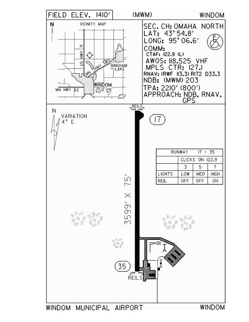
FIELD ELEV. 1410'N VICINITY MAP
~
NVARIATION4 0 E
(MWM) WINDOM
SEC. CH:OMAHA NORTHLAT: 43 0 54.8'LONG: 95 0 06.6' (1?\COMM: '¥2JCTAF: 122.9 <UAWOS: 118.525 VHFMPLS CTR: 127.1
RNAV: (RWF 113.3) RI72 033.3NDB: (MWM) 203TPA: 2210' (800')APPROACH: NDB, RNA V,
GPS
®
RUNWAY 17 - 35
CLICKS ON 122.9
3 5 7
LIGHTS LOW MED HIGH
REIL OFF OFF ON
x
ill)0000 000
REILS
WINDOM MUNICIPAL AIRPORT WINDOM

Winona - ONAwww.winairaviation.com
Airport Manager: Keith Nelson - 507-457-8274 - [email protected]
Contact Person: George Bolon - 507-452-2220 - [email protected]
Chamber of Com: 800-657-4972 - www.visitwinona.comAero Cht Coord: 12-L
AWOS/ASOS: 507-453-2991 - VOR 111.4MnWAS Loc/Hrs: Training Center - Mon-Sun, 8:00 A.M.-Sunset
Win Air - Mon-Sun, 8:00 A.M.-SunsetAttended: All/Mon-Fri/0700-1930, All/Sat-Sun/0800-1700
Fuel: 100LL, Jet ASelf Service Fuel: NoAfter Hrs Service: 507-452-2220
FBO(s): Win Air - 507-452-2220 - 122.8 - [email protected] - www.winairaviation.com
Ground Transport: TaxiHertz Rent-a-Car - 507-454-2888
Food Service: Golden Harvest Café & Bakery - 5 blocksDining: Beier's - 507-452-3390 - 3 miles
Green Mill - 8 milesPerkins - 507-452-1618 - 8 milesCountry Kitchen - 507-454-5104 - 4 miles
Lodging: Quality Inn - 507-454-4390 - 8 milesRiverport Inn (Best Western) - 507-452-0606 - 8 milesDays Inn - 507-454-6930 - 4 milesAmericInn Motel - 507-457-0249 - 4 milesHoliday Inn Hotel & Suites - 507-453-0303 - 8 miles
Airport Events: Fly-In - Fourth of July WeekendUnderwing Camp: No
Campgrounds: Prairie Island Campground - 507-452-4501 - 4 milesGolf Courses: Westfield Golf Course - 507-452-8700 - 3 miles
Cedar Valley Golf Course - 507-457-3129 - 15 milesWinona Golf Course - 507-452-3535 - 10 miles
Local Attractions: Winona County Historical Society - 507-454-2723Historic tours - see FBO for details
Comments: The natural beauty of the Winona Area is unmatched. Biking, skiing, fishing, hunting, boating, hiking and swimming are readily available; or enjoy the world class stained glass windows and landmark architecture.
•
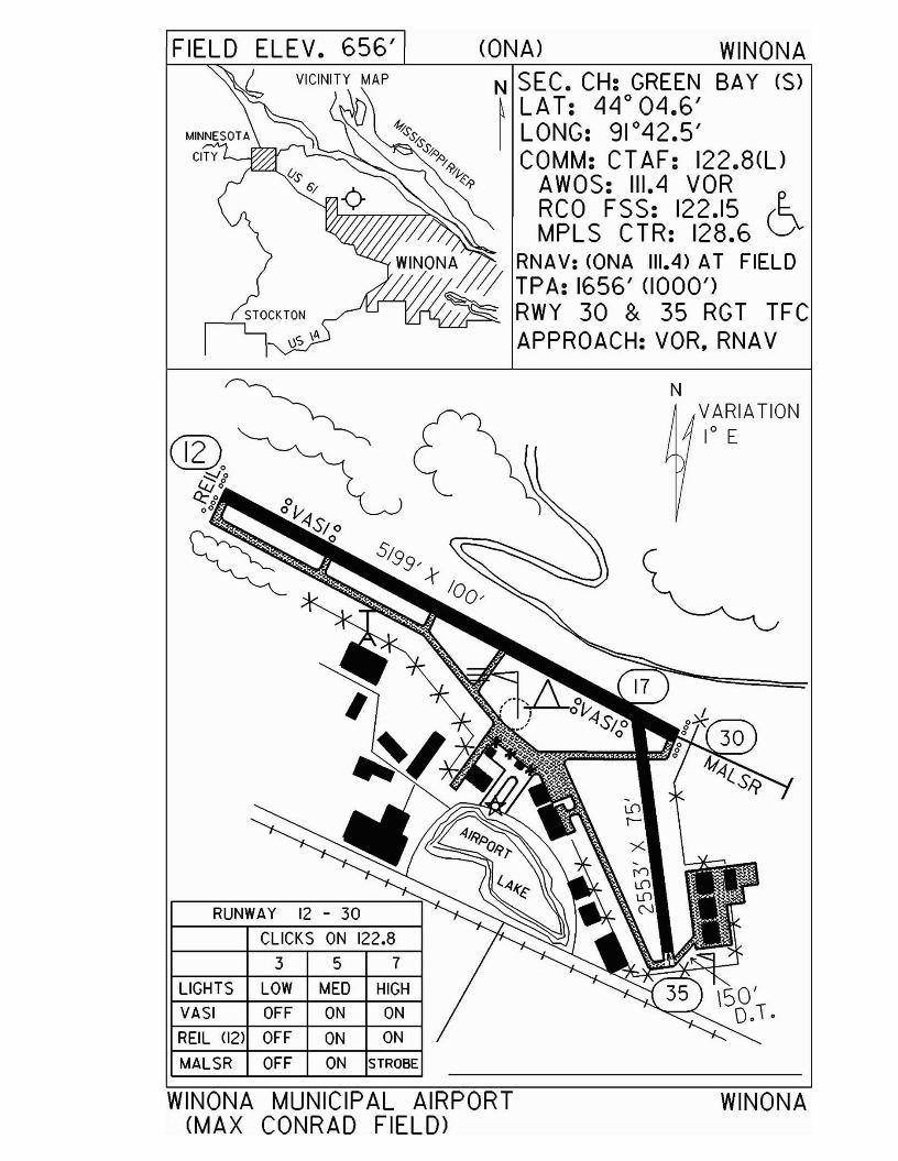
FIELD ELEV. 656'
STOCKTONr-I \)s \A
CONA) WINONAN SEC. CH: GREEN BAY (S)~ LA T: 44° 04.6'I LONG: 91°42.5'
COMM: CT AF: 122.8(l)AWOS: 111.4 VORRCO FSS: 122.15 (~MPLS CTR: 128.6 v
WINONA 1// RNAV: CONA 111.4) AT FIELDII/j TPA: 1656' (1000')
n/..-L-L-< """"'~ RWY 30 & 35 RGT TFCAPPROACH:VOR,RNAV
N
RUNWAY 12 - 30
CLICKS ON 122.8
LIGHTS
VASI
REIL (12)
MALSR
3 5 7
LOW MED HIGH
OFF ON ON
OFF ON ON
OFF ON STROBE
VARIATION1° E
WINONA MUNICIPAL AIRPORT(MAX CONRAD FIELD)
WINONA
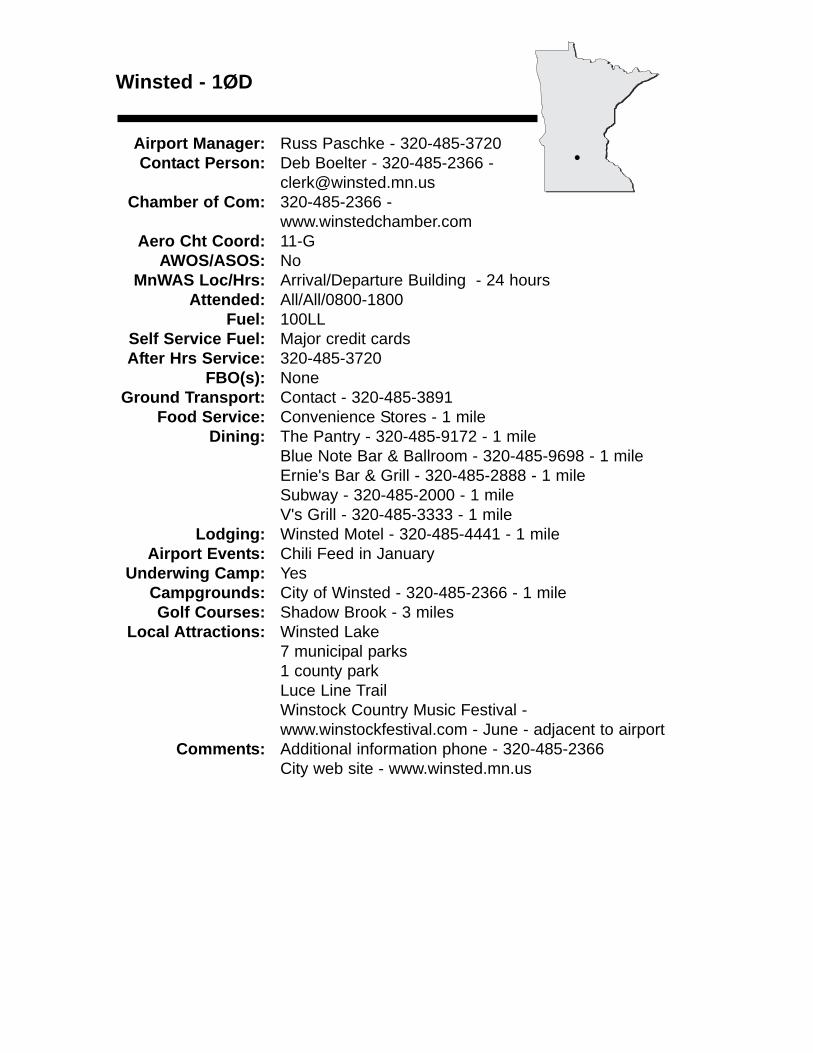
Winsted - 1ØD
Airport Manager: Russ Paschke - 320-485-3720 Contact Person: Deb Boelter - 320-485-2366 -
[email protected] of Com: 320-485-2366 -
www.winstedchamber.comAero Cht Coord: 11-G
AWOS/ASOS: NoMnWAS Loc/Hrs: Arrival/Departure Building - 24 hours
Attended: All/All/0800-1800Fuel: 100LL
Self Service Fuel: Major credit cardsAfter Hrs Service: 320-485-3720
FBO(s): NoneGround Transport: Contact - 320-485-3891
Food Service: Convenience Stores - 1 mileDining: The Pantry - 320-485-9172 - 1 mile
Blue Note Bar & Ballroom - 320-485-9698 - 1 mileErnie's Bar & Grill - 320-485-2888 - 1 mileSubway - 320-485-2000 - 1 mileV's Grill - 320-485-3333 - 1 mile
Lodging: Winsted Motel - 320-485-4441 - 1 mileAirport Events: Chili Feed in January
Underwing Camp: YesCampgrounds: City of Winsted - 320-485-2366 - 1 mileGolf Courses: Shadow Brook - 3 miles
Local Attractions: Winsted Lake7 municipal parks1 county parkLuce Line TrailWinstock Country Music Festival - www.winstockfestival.com - June - adjacent to airport
Comments: Additional information phone - 320-485-2366City web site - www.winsted.mn.us
•
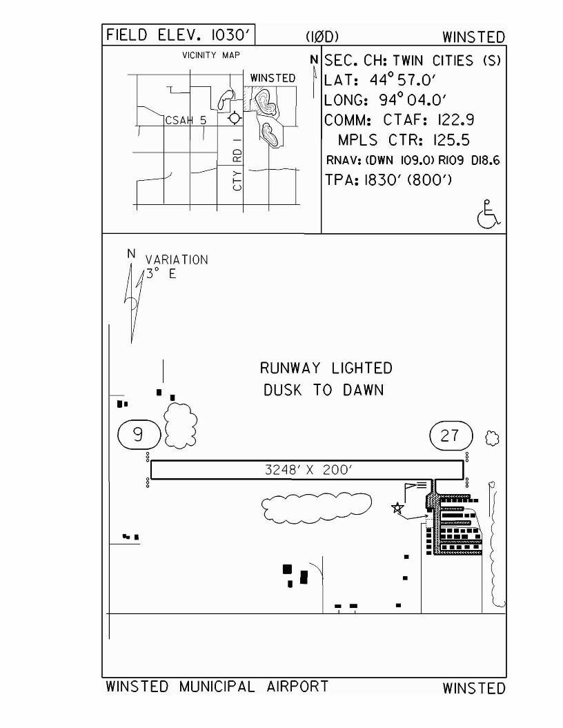
FIELD ELEV. 1030' (100) WINS TEDVICINITY MAP
-----,--------II---------r-l WINSTED
CSA 5
o0:::
>- -1------+f-U
N SEC. CH: TWIN CITIES (S)~ LAT: 44°57.0'I LONG: 94° 04.0'
COMM: CTAF: 122.9MPLS CTR: 125.5
RNAV: <OWN 109.0> RI09 D18.6
TPA: 1830' (800')
N VARIATION3° E
•
•
•. -• I•
...
I RUNWAY LIGHTEDDUSK TO DAWN
®O @ogr------- ~___:_~----___,g
32"18' X 200'O°L--------=..=....;.::........:....:--=-::.....::......----=-=-ll~o r=
*"----t-
WINSTED MUNICIPAL AIRPORT WINSTED
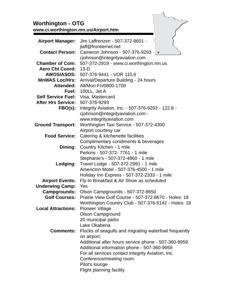
Worthington - OTGwww.ci.worthington.mn.us/Airport.htm
Airport Manager: Jim Laffrenzen - 507-372-8601 - [email protected]
Contact Person: Cameron Johnson - 507-376-9293 [email protected]
Chamber of Com: 507-372-2919 - www.ci.worthington.mn.usAero Cht Coord: 13-D
AWOS/ASOS: 507-376-9441 - VOR 110.6MnWAS Loc/Hrs: Arrival/Departure Building - 24 hours
Attended: All/Mon-Fri/0800-1700Fuel: 100LL, Jet A
Self Service Fuel: Visa, MastercardAfter Hrs Service: 507-376-9293
FBO(s): Integrity Aviation, Inc. - 507-376-9293 - 122.8 - [email protected] - www.integrityaviation.com
Ground Transport: Worthington Taxi Service - 507-372-4300Airport courtesy car
Food Service: Catering & kitchenette facilitiesComplimentary condiments & beverages
Dining: Country Kitchen - 1 milePerkins - 507-372- 7761 - 1 mileStephanie's - 507-372-4860 - 1 mile
Lodging: Travel Lodge - 507-372-2991 - 1 mileAmericInn Motel - 507-376-4500 - 1 mileHoliday Inn Express - 507-372-2333 - 1 mile
Airport Events: Fly-In Breakfast & Air Show as scheduledUnderwing Camp: Yes
Campgrounds: Olson Campgrounds - 507-372-8650Golf Courses: Prairie View Golf Course - 507-372-8670 - Holes: 18
Worthington Country Club - 507-376-5142 - Holes: 18Local Attractions: Pioneer Village
Olson Campground20 municipal parksLake Okabena
Comments: Flocks of seagulls and migrating waterfowl frequentlyon airport.Additional after hours service phone - 507-360-9959Additional information phone - 507-360-9959For all services contact Integrity Aviation, Inc.Conference/meeting roomPilot's loungeFlight planning facility
•
VICINITY MAP
FIELD <OTG) WORTHINGTON
N SEC. CH: OMAHA NORTH~ LAT: 43 0 39.3' E-I LONG: 950 34.8' D
COMM: CT AF: 122.8(l)AWOS: 110.6 VORRCO FSS: 123.6R,122.IR,1I0.6T
MPLS CTR: 132.05RNAV: <OTG 110.6) ON AIRPORTTPA: 2400' (826')APPROACH: ILS, GPS,
VOR & NOBN RUNWAY 11- 29 RUNWAY 17 - 35
VARIATION5° E
LIGHTS
CLICKS ON 122.83 5 7
LOW MED HIGH
CLICKS ON 122.83 5 7
LIGHTS LOW MED HIGH
PAPI ON ON ON VASI ON ON ON
o
REIL OFF OFF ON
l
OFF OFF ON
LOW MED HIGH
B
MALSR® REIL (II)oREI ~'-o----'-----'----'-------'
000 000
..•
•-I~~-00-
WORTHINGTON MUNICIPAL AIRPORT WORTHINGTON


PublicSeaplaneBases

FDC Notice
Excerpt from FDC Notice: FDC 2/5167 Special NoticeVFR Operations in the United States.
A. In the interest of National Security and to the extent practicable, pilots are advised to avoid the airspaceabove, or in proximity to, sites such as nuclear powerplants, dams, refineries, industrial complexes, and othersimilar facilities. Pilots should not circle as to loiter in thevicinity of such facilities.
Seaplane pilots should check for dams and powerplantsin proximity to the waters where they intend to operate.
SEAPLANE OPERATIONS1. State of Minnesota
A. Minnesota Rules 8800.2600 Compliance with Marine Traffic Rules: All seaplanes must comply with marine traffic rules to the extent that such rules do not interfere with the safeoperations of aircraft.
B. Minnesota Rules 8800.2700 Approaches and Takeoffs: All approaches to and takeoffs fromthe water area shall be made in such a manner as to clear all structures on the land by at least100 feet, and wherever the area of the body of water will permit, such landing and takeoffs shallbe made at a distance of not less than 300 feet, both laterally and vertically, from any boat orperson on the surface of the water, or as near to 300 feet as the area of the water will permit.
C. Seven County Metro Area Operations: Department of Transportation, Office of AeronauticsMinnesota Rules 8800.2800; Seaplane operations are permitted only on the following publicwaters within the seven county metro area.
8800.2800 Subp. 3. Prohibited operations. Seaplane operations are prohibited on all publicwaters within the seven-county metro area not listed in subpart 2; also see subpart 5.
*Pilots are requested to maintain 2000 feet above the terrain while flying over the portions of the St. Croix River designated and depicted on the Federal charts as "NationalScenic Riverway" administered by the National Park Service.
All seaplane operations are prohibited from 11 A.M. (CDST) to 6 P.M. (CDST) on Saturdays,Sundays, and national legal holidays between June 1 and September 15 on the followingpublic waters:1. Lake Minnetonka and all bays and lakes therein.2. White Bear Lake and all bays and lakes therein.3. Lake Owasso and all bays and lakes therein.
This restriction does not apply to the private or personal seaplane licensee while operating toand from the licensed base subject to the following conditions:1. Such operations are limited to a maximum of one takeoff and one landing during these
restricted hours; and2. Such operations are authorized only when lake traffic and use permit such operations to be
conducted in a safe and reasonable manner.
Anoka CountyCenterville LakeCoon LakeGeorge Watch LakeHam LakeHoward LakeLake GeorgeLinwood LakeMartin LakeMississippi RiverMud LakeOtter LakePeltier LakePickerel LakeReshenau LakeRice LakeRound Lake
Carver CountyGoose LakeHazeltine LakeLake MinnewashtaLake PattersonLake RileyLake WaconiaLunsten LakeMud LakeOak LakeParley LakePierson LakeTiger Lake
Dakota CountyAlimagnet LakeByllesby ReservoirCrystal LakeLake MarionMississippi RiverOrchard LakeSt. Croix River
Hennepin CountyBryant LakeDiamond LakeEagle LakeFish LakeFrench LakeLake IndependenceLake Minnetonka
Excluding theFollowing:
Black LakeEmerald LakeFrench LakeForest LakeGray's BayLibb's LakePeavy LakeSeton LakeTanager Lake
Lake SarahMedicine LakeMississippi RiverOx Yoke LakeSchmidt LakeWhaletail Lake
Ramsey CountyBald Eagle LakeLake OwassoLong LakeMississippi RiverTurtle LakeWhite Bear Lake
Scott CountyCedar LakeGeis LakePleasant LakePrior Lake EastPrior Lake WestSpring Lake
Washington CountyBig Carnelian LakeBig Marine LakeClear LakeForest LakeLake ElmoMississippi RiverOneka Lake*St. Croix River
SEAPLANE OPERATIONSD. Department of Natural ResourcesNR #1 Minnesota State Park Rules
"It is unlawful for any person to land any aircraft on lands or waters totally within the boundaries of any State Park except by permit or on a designated airport or landing strip or inmaking an emergency landing, conducting rescue operations or in conducting or assisting inthe conduct of official business of the United States of America, the State of Minnesota, or theCounty in which the park is located."
Lakes totally within the boundaries of a State Park. For possible additions or changescontact the Division of Parks and Recreation.
To obtain maps of the above State Parks, call or write to:Division of Parks and RecreationDepartment of Natural Resources500 LaFayette Road St. Paul, MN 55155-4039651-296-6157 / 888-646-6367
Bear Head Lake State ParkBear Head LakeSquare LakeBlueberry Lake
Blue Mound State ParkUpper Mound LakeLower Mound Lake
Camden State ParkBrowner Lake
Fort Snelling State ParkSnelling LakeGun Club Lake
George H. Crosby Manitou State ParkBenson Lake
Glacial Lake State ParkSignalness LakeMountain Lake
Glendalough State ParkAnnie Battle LakeSunset LakeMolly Stark Lake
Hayes Lake State ParkHayes Lake
Itasca State ParkLake ItascaElk LakeVarious Others
Lake Bronson State ParkLake Bronson
Lake Carlos State ParkHidden Lake
Lake Louise State ParkLake Louise
Lake Maria State ParkMaria LakeSlough LakeBjorkland LakePutnam Lake
Maplewood State ParkBeers LakeTwenty-One LakeVarious Others
Mille Lacs Kathio State ParkOgechie LakeShakopee Lake
Rice Lake State ParkRice Lake
Savanna Portage State ParkSavanna LakeWolf LakeLake ShumwayLoon Lake
Scenic State ParkCoon LakeTell LakeSandwick Lake
Sibley State ParkSwan Lake
Split Rock Creek State ParkSplit Rock Lake
William O'Brien State ParkLake Alice
SEAPLANE OPERATIONS
DNR-Migratory Waterfowl Sanctuary Order Number 30
It has been determined in the best interests of proper game management to have waters setaside for migratory waterfowl feeding and resting areas. Therefore, the Department of NaturalResources prescribes the following regulations relating thereto:
Waterfowl Hunting Regulations
Motors prohibited on migratory waterfowl feeding and resting areas.
Annually a list of waters is designated by Commissioner's Order and by posting as migratorywaterfowl feeding and resting areas during the open waterfowl season. No persons other thanagents of the Commissioner in the performance of their duties may use any kind of motor propelled watercraft or aircraft on the listed waters during the open migratory waterfowl season.For current information concerning the restricted water areas and the Migratory WaterfowlSanctuary Order Number 30, Call the Department of Natural Resources at (651) 296-5484.
2. Federal
A. Regulations regarding flights over charted National Park Service Areas, U.S. Fish andWildlife Service areas, and U.S. Forest Service Areas.
The landing of aircraft is prohibited on lands or waters administered by the National ParkService, the U.S. Fish and Wildlife Service, or the U.S. Forest Service without authorizationfrom the respective agency. Exceptions include 1) when forced to land due to an emergencybeyond the control of the operator, 2) at officially designated landing sites, and 3) on approvedofficial business of the United States Government.
All aircraft are requested to maintain a minimum altitude of 2000 feet above the terrain of thefollowing: National Parks, Monuments, Seashores, Lakeshores, Recreation Areas and ScenicRiverways administered by the National Park Service, National Wildlife Refuges, Big GameRefuges, Game Ranges, and Wildlife Ranges administered by the U.S. Fish and WildlifeService, and Wilderness and Primitive Areas administered by the U.S. Forest Service.
. . . . . . . Depicts the boundary of National Park Service Areas, U.S. Fish and WildlifeService Areas, and U.S. Forest Service Wilderness Primitive Areas on NOAA SectionalAeronautical Charts.
B. Departments that have or may have additional restrictions
(1) Department of the Interior - National Parks, Forests
A. National Wildlife Refuge
Restrictions as printed on current NOAA Sectional Aeronautical Charts
RefugeAgassizBig StoneTamaracRice LakeMille LacsSherburne
LocationThief River FallsOrtonvilleDetroit LakesAitkinIsleSaint Cloud
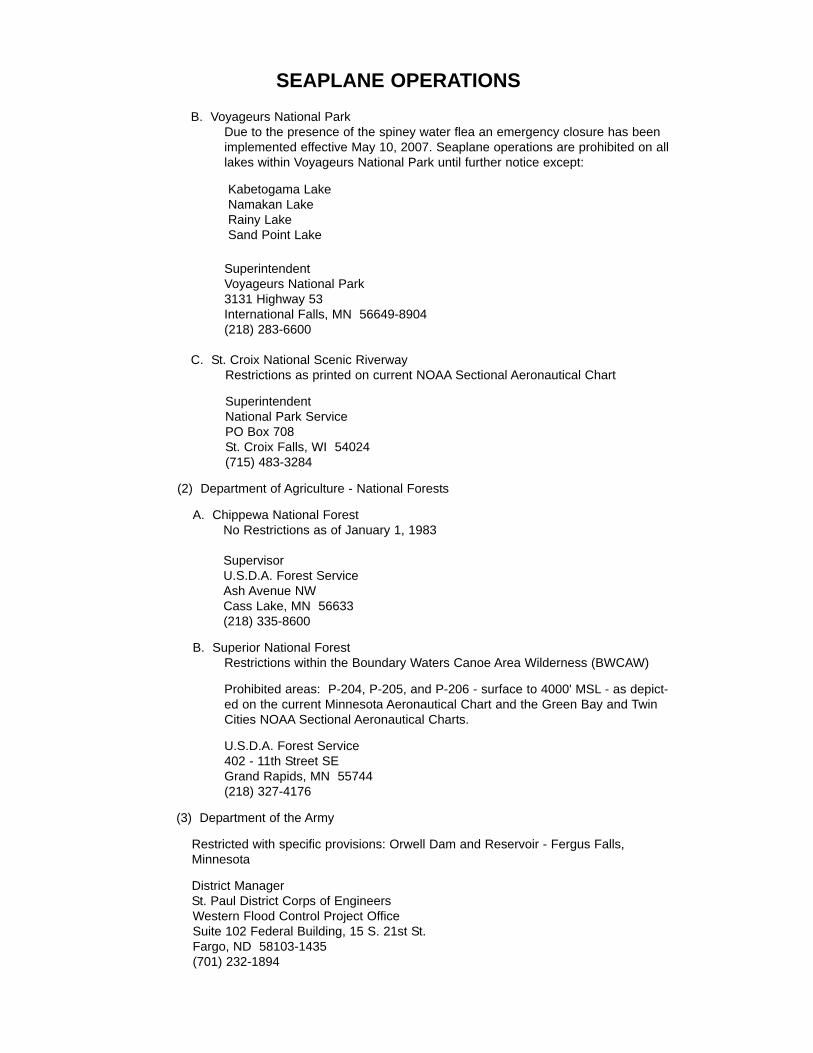
SEAPLANE OPERATIONSB. Voyageurs National Park
Due to the presence of the spiney water flea an emergency closure has beenimplemented effective May 10, 2007. Seaplane operations are prohibited on alllakes within Voyageurs National Park until further notice except:
SuperintendentVoyageurs National Park3131 Highway 53International Falls, MN 56649-8904(218) 283-6600
C. St. Croix National Scenic RiverwayRestrictions as printed on current NOAA Sectional Aeronautical Chart
SuperintendentNational Park ServicePO Box 708St. Croix Falls, WI 54024(715) 483-3284
(2) Department of Agriculture - National Forests
A. Chippewa National ForestNo Restrictions as of January 1, 1983
SupervisorU.S.D.A. Forest ServiceAsh Avenue NWCass Lake, MN 56633(218) 335-8600
B. Superior National ForestRestrictions within the Boundary Waters Canoe Area Wilderness (BWCAW)
Prohibited areas: P-204, P-205, and P-206 - surface to 4000' MSL - as depict-ed on the current Minnesota Aeronautical Chart and the Green Bay and TwinCities NOAA Sectional Aeronautical Charts.
U.S.D.A. Forest Service402 - 11th Street SEGrand Rapids, MN 55744(218) 327-4176
(3) Department of the Army
Restricted with specific provisions: Orwell Dam and Reservoir - Fergus Falls,Minnesota
District ManagerSt. Paul District Corps of EngineersWestern Flood Control Project OfficeSuite 102 Federal Building, 15 S. 21st St.Fargo, ND 58103-1435(701) 232-1894
Kabetogama LakeNamakan LakeRainy LakeSand Point Lake
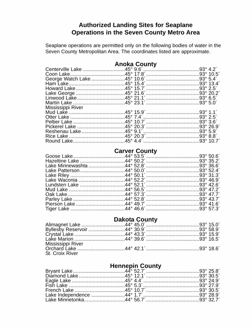
Authorized Landing Sites for SeaplaneOperations in the Seven County Metro Area
Seaplane operations are permitted only on the following bodies of water in theSeven County Metropolitan Area. The coordinates listed are approximate.
Anoka CountyCenterville Lake ..............................45° 9.6´........................................93° 4.2´Coon Lake.......................................45° 17.8´......................................93° 10.5´George Watch Lake ........................45° 10.6´......................................93° 5.4´Ham Lake........................................45° 15.4´......................................93° 13.4´Howard Lake...................................45° 15.7´......................................93° 2.5´Lake George ...................................45° 21.6´......................................93° 20.2´Linwood Lake..................................45° 21.1´......................................93° 6.5´Martin Lake .....................................45° 23.1´......................................93° 5.0´Mississippi RiverMud Lake ........................................45° 15.9´......................................93° 1.1´Otter Lake .......................................45° 7.4´........................................93° 2.5´Peltier Lake .....................................45° 10.7´......................................93° 3.6´Pickerel Lake ..................................45° 20.3´......................................93° 26.9´Reshenau Lake...............................45° 9.1´........................................93° 5.9´Rice Lake ........................................45° 20.3´......................................93° 8.8´Round Lake.....................................45° 4.4´........................................93° 10.7´
Carver CountyGoose Lake.....................................44° 53.5´......................................93° 50.6´Hazeltine Lake ................................44° 50.2´......................................93° 35.2´Lake Minnewashta ..........................44° 52.8´......................................93° 36.6´Lake Patterson................................44° 50.0´......................................93° 52.4´Lake Riley .......................................44° 50.1´......................................93° 31.3´Lake Waconia .................................44° 52.2´......................................93° 46.9´Lundsten Lake ................................44° 52.1´......................................93° 42.6´Mud Lake ........................................44° 56.5´......................................93° 47.2´Oak Lake.........................................44° 57.3´......................................93° 47.7´Parley Lake .....................................44° 52.8´......................................93° 43.7´Pierson Lake ...................................44° 49.7´......................................93° 41.6´Tiger Lake .......................................44° 46.6´......................................93° 57.3´
Dakota CountyAlimagnet Lake ...............................44° 45.0´......................................93° 15.0´Byllesby Reservoir ..........................44° 30.9´......................................93° 58.9´Crystal Lake ....................................44° 43.3´......................................93° 15.9´Lake Marion ....................................44° 39.6´......................................93° 16.5´Mississippi RiverOrchard Lake ..................................44° 42.1´......................................93° 18.6´St. Croix River
Hennepin CountyBryant Lake.....................................44° 52.7´......................................93° 25.8´Diamond Lake.................................45° 12.1´......................................93° 30.5´Eagle Lake ......................................45° 4.4´........................................93° 24.9´Fish Lake ........................................45° 5.3´........................................93° 27.9´French Lake ....................................45° 10.7´......................................93° 30.5´Lake Independence ........................44° 1.7´........................................93° 28.9´Lake Minnetonka.............................44° 56.7´......................................93° 32.7´
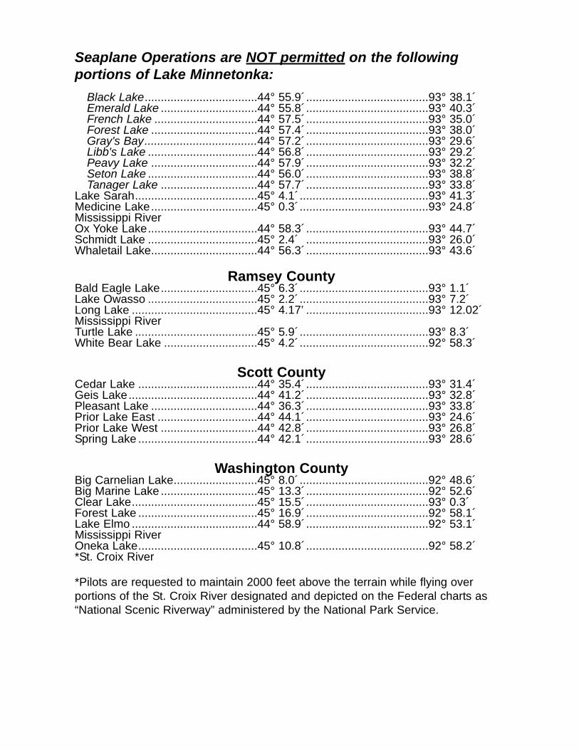
Seaplane Operations are NOT permitted on the followingportions of Lake Minnetonka:
Black Lake...................................44° 55.9´......................................93° 38.1´Emerald Lake ..............................44° 55.8´......................................93° 40.3´French Lake ................................44° 57.5´......................................93° 35.0´Forest Lake .................................44° 57.4´......................................93° 38.0´Gray's Bay...................................44° 57.2´......................................93° 29.6´Libb's Lake ..................................44° 56.8´......................................93° 29.2´Peavy Lake .................................44° 57.9´......................................93° 32.2´Seton Lake ..................................44° 56.0´......................................93° 38.8´Tanager Lake ..............................44° 57.7´......................................93° 33.8´
Lake Sarah......................................45° 4.1´........................................93° 41.3´Medicine Lake.................................45° 0.3´........................................93° 24.8´Mississippi RiverOx Yoke Lake..................................44° 58.3´......................................93° 44.7´Schmidt Lake ..................................45° 2.4´ ......................................93° 26.0´Whaletail Lake.................................44° 56.3´......................................93° 43.6´
Ramsey CountyBald Eagle Lake..............................45° 6.3´........................................93° 1.1´Lake Owasso ..................................45° 2.2´........................................93° 7.2´Long Lake .......................................45° 4.17’ ......................................93° 12.02´Mississippi RiverTurtle Lake ......................................45° 5.9´........................................93° 8.3´White Bear Lake .............................45° 4.2´........................................92° 58.3´
Scott CountyCedar Lake .....................................44° 35.4´......................................93° 31.4´Geis Lake........................................44° 41.2´......................................93° 32.8´Pleasant Lake .................................44° 36.3´......................................93° 33.8´Prior Lake East ...............................44° 44.1´......................................93° 24.6´Prior Lake West ..............................44° 42.8´......................................93° 26.8´Spring Lake .....................................44° 42.1´......................................93° 28.6´
Washington CountyBig Carnelian Lake..........................45° 8.0´........................................92° 48.6´Big Marine Lake ..............................45° 13.3´......................................92° 52.6´Clear Lake.......................................45° 15.5´......................................93° 0.3´Forest Lake .....................................45° 16.9´......................................92° 58.1´Lake Elmo .......................................44° 58.9´......................................92° 53.1´Mississippi RiverOneka Lake.....................................45° 10.8´......................................92° 58.2´*St. Croix River
*Pilots are requested to maintain 2000 feet above the terrain while flying overportions of the St. Croix River designated and depicted on the Federal charts as“National Scenic Riverway” administered by the National Park Service.
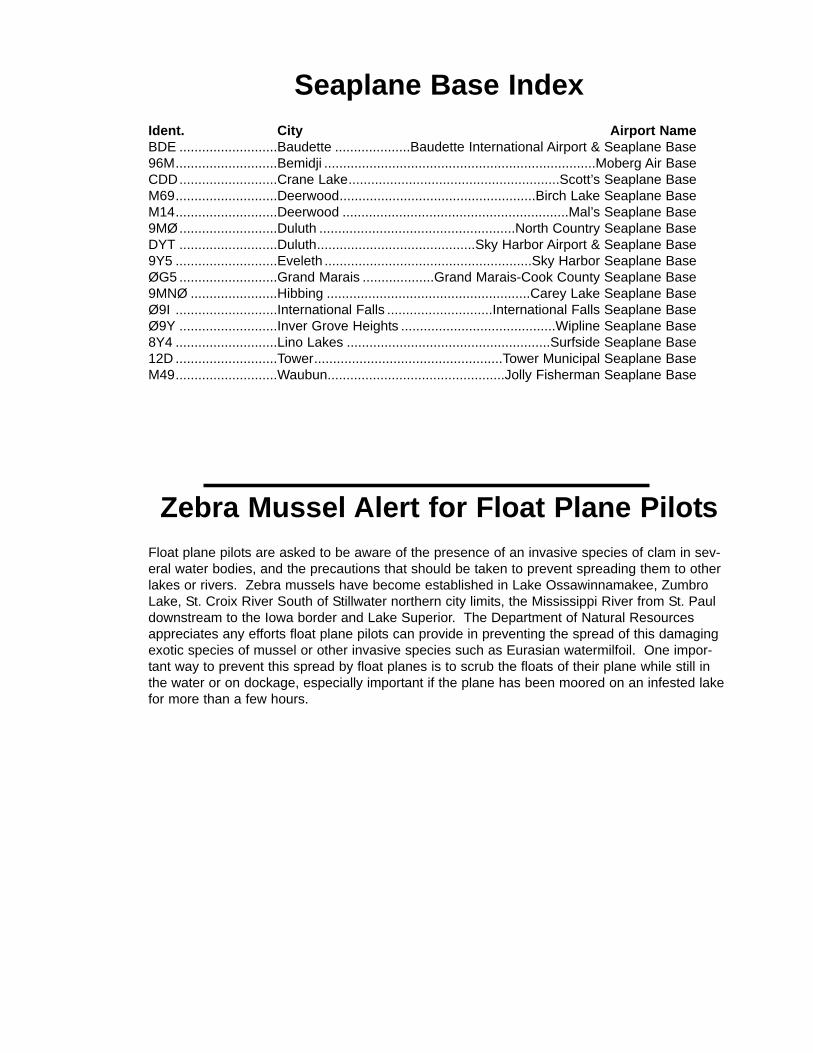
Seaplane Base IndexIdent. City Airport NameBDE ..........................Baudette ....................Baudette International Airport & Seaplane Base96M...........................Bemidji ........................................................................Moberg Air BaseCDD..........................Crane Lake........................................................Scott’s Seaplane BaseM69...........................Deerwood....................................................Birch Lake Seaplane BaseM14...........................Deerwood ............................................................Mal’s Seaplane Base9MØ..........................Duluth ....................................................North Country Seaplane BaseDYT ..........................Duluth..........................................Sky Harbor Airport & Seaplane Base9Y5 ...........................Eveleth .......................................................Sky Harbor Seaplane BaseØG5 ..........................Grand Marais ...................Grand Marais-Cook County Seaplane Base9MNØ .......................Hibbing ......................................................Carey Lake Seaplane BaseØ9I ...........................International Falls ............................International Falls Seaplane BaseØ9Y ..........................Inver Grove Heights .........................................Wipline Seaplane Base8Y4 ...........................Lino Lakes ......................................................Surfside Seaplane Base12D ...........................Tower..................................................Tower Municipal Seaplane BaseM49...........................Waubun...............................................Jolly Fisherman Seaplane Base
Zebra Mussel Alert for Float Plane PilotsFloat plane pilots are asked to be aware of the presence of an invasive species of clam in sev-eral water bodies, and the precautions that should be taken to prevent spreading them to otherlakes or rivers. Zebra mussels have become established in Lake Ossawinnamakee, ZumbroLake, St. Croix River South of Stillwater northern city limits, the Mississippi River from St. Pauldownstream to the Iowa border and Lake Superior. The Department of Natural Resourcesappreciates any efforts float plane pilots can provide in preventing the spread of this damagingexotic species of mussel or other invasive species such as Eurasian watermilfoil. One impor-tant way to prevent this spread by float planes is to scrub the floats of their plane while still inthe water or on dockage, especially important if the plane has been moored on an infested lakefor more than a few hours.

Baudette - BDE
Airport Manager: Emory Vaagen - 218-634-1923 - [email protected]
Contact Person: Emory Vaagen - 218-634-1923 - [email protected]
Chamber of Com: 800-351-3474 Aero Cht Coord: 3-F
AWOS/ASOS: 218-634-3080 - VHF 126.775MnWAS Loc/Hrs: Arrival/Departure Building - same as attendance
scheduleAttended: All/All/0800-1700
Fuel: 100LL, Jet ASelf Service Fuel: NoAfter Hrs Service: 218-634-1337
FBO(s): Bear Aviation, Inc. - 218-634-1923 - 122.8 - [email protected]
Ground Transport: Courtesy car; Enterprise Rent-a-CarFood Service: Vending machines; catering
Dining: BAUDETTE ½ mile: McDonald's - 218-643-1320; Northlake Café - 218-634-9807; Ranch House Restaurant - 218-634-2420; Rosalie's Restaurant & Lounge - 218-634-9422; The Oriental Wok - 218-634-4736; The Smiling Moon - 218-634-1976RESORT DINING-SOUTH SHORE 12 miles: Adrian's Resort - 218-634-1985; Arnesen's Rock Harbor - 218-442-7215; Ballard's Resort - 218-634-1849; Border View Lodge - 218-634-1631; Cyrus Resort - 218-634-2548; Ken-Mar-Ke Resort - 218-634-2072; Morris Point Lake View Lodge - 218-634-2570; Randall's Resort - 218-634-1987; River Bend Resort - 218-634-3084; Riverview Resort - 218-634-2258; Schuster's Resort - 218-634-2412; Sportsman's Lodge - 218-634-1342; Wheeler's Point Resort - 218-634-2629; Wigwam Resort - 218-634-2168; Wildwood Inn Bed & Breakfast - 218-634-1356; Zippel Bay Resort - 218-783-6235
Lodging: Walleye Inn - 218-634-1550 - ½ mileBaudette Motel - 218-634-2600 - ¾ mileAmericInn Motel - 218-634-3200
Airport Events: Annual Fly-In, call for scheduleUnderwing Camp: Yes
Campgrounds: Lake of the Woods Campgrounds - 218-634-1694Golf Courses: Oak Harbor Golf Course & Tennis Club - 218-634-9939
Local Attractions: Many local resorts within 12 miles of airportComments: Baudette International Airport is a Port of Entry -
U.S. Customs available 24 hours (218-634-2803 or 218-634-2661). Canadian Customs for seaplanes only - skis in the winter. Aircraft storage & tiedown areas, land & seaplanes. VOR/DME weather reporting on request 218-634-1923
•
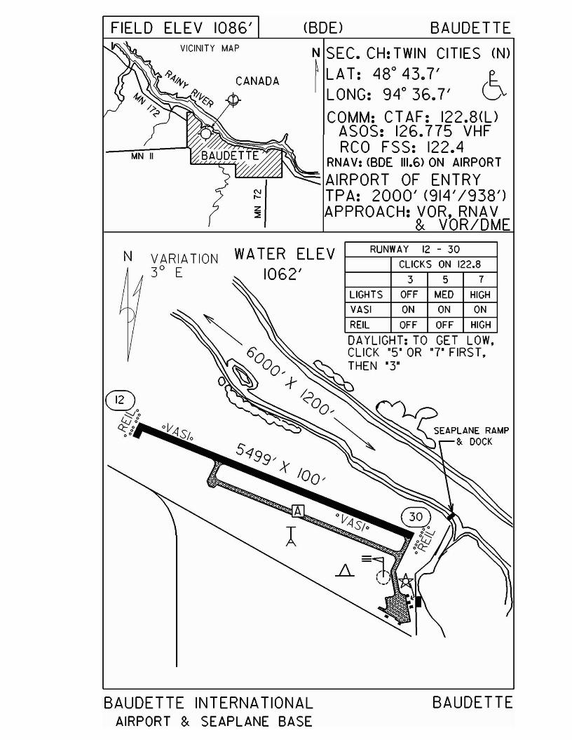
FIELD ELEV 1086' (BDD BAUDETTE
N....z::::!!
N SEC. CH: TWIN CITIES (N)
~ LAT: 480
43.7' (~LONG: 94 0 36.7' VCOMM: CT AF: 122.8(l)
ASOS: 126.775 VHFRCO FSS: 122.4
RNA V: <BDE 111.6> ON AIRPORT'"""""""'~ ~ AIRPORT OF ENTRY
TPA: 2000' (914'/938')APPROACH: VOR, RNAV
& VOR/DME
VICINITY MAP
-94,q,}- CANADA~_ n>/J..:~~ ~-9
N VARIATION3° E
WATER ELEV1062'
RUNWAY 12 - 30
CLICKS ON 122.8
3 5 7
LIGHTS OFF MED HIGH
VASI ON ON ON
REIL OFF OFF HIGH
DAYLIGHT: TO GET LOW,
BAUDETTE INTERNATIONALAIRPORT & SEAPLANE BASE
BAUDETTE
Bemidji - 96M
Airport Manager: Paul Grand - 218-444-9164 - [email protected]
Contact Person: Paul Grand - 218-751-2468 - [email protected]
Chamber of Com: 800-458-2223 - www.bemidji.orgAero Cht Coord: 5-F
AWOS/ASOS: 218-759-2501 - VHF 119.275MnWAS Loc/Hrs: NA
Attended: UnattendedFuel: Mogas, 100LL
Self Service Fuel: NoAfter Hrs Service: See comments
FBO(s): NoneGround Transport: None
Food Service: NoneDining: None
Lodging: NoneAirport Events: None reported
Underwing Camp: NoCampgrounds: Bemidji State Park
KOAHamilton's
Golf Courses: Bemidji Town & Country ClubCastle HighlandsGreenwood Golf CourseSandtrap Golf Course
Local Attractions: Statues of Paul Bunyan & Babe the Blue Ox; beautiful Bemidji State Park; excellent lakes for fishing; swimming; boating; wooded areas for hunting; hiking; cross-country skiing; resorts & campgrounds; Bemidji Woolen Mills; Itasca State Park; Concordia Language Village
Comments: After hours service phone - phone on premises withseven contact numbers available.Visitor's web site - www.visitbemidji.comUniversity web site - www.bemidjistate.edu
•

WA TER ELEV. 1370' (96M) BEMIDJIVICINITY MAP
'\"0'
-0'
N SEC. CH: TWIN CITIES (N)
3 ~ LAT: 4r30.0'~ LONG: 94° 56.7'wco COMM: CTAF: 122.9w~ AWOS: 119.275 VHF--.J
MPLS CTR: 134.75RNAV: <BJII08.6) RI33 D5.4
TPA: 1670' (300') ®N
GRASS LAKE
~---5280' X 26L10/-----~
VARIATION4° E
TRAFFIC PATTERNS SHALL BE SOUTHOF THE BEMIDJI MUNICIPAL AIRPORT.FLIGHTS MAY NOT BE CONDUCTED MORE THAN 300' ABOVETHE TERRAIN OR WATER WITHIN 3 MILES OF THEBEMIDJI MUNICIPAL AIRPORT,
MOBERG AIR BASE BEMIDJI

Crane Lake - CDD
Airport Manager: Darrell Scott - 218-993-2341 Contact Person: Carole Scott - 218-993-2341
Chamber of Com: 218-993-2901 - www.visitcranelake.com
Aero Cht Coord: 4-KAWOS/ASOS: 218-993-2467 - NDB 385
MnWAS Loc/Hrs: Restaurant - same as attendance scheduleAttended: May-Sep/All/0700-Dark
Fuel: Mogas, 100LLSelf Service Fuel: NoAfter Hrs Service: 218-993-2341
FBO(s): NoneGround Transport: None
Food Service: Restaurant on airportDining: On airport
Lodging: On airportAirport Events: None reported
Underwing Camp: NoCampgrounds: Scott's Resort & Seaplane Base - ½ mileGolf Courses: Vermilion River Greens - 12 miles
Local Attractions: Voyaguers National ParkComments: U.S. Customs - 218-993-2321 - on-call basis
•
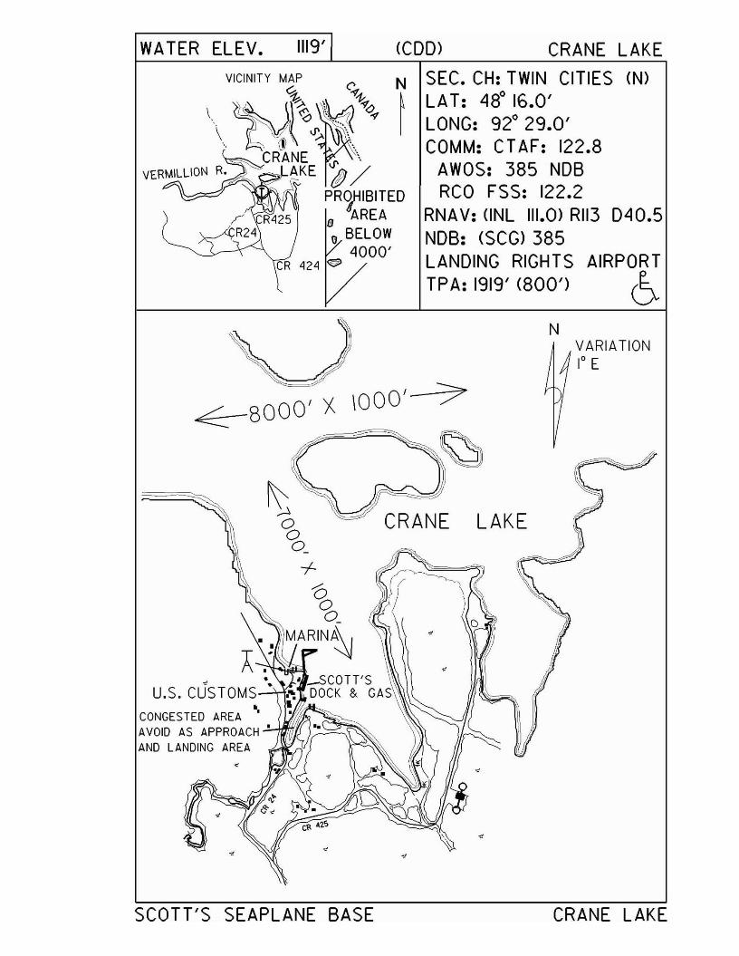
AIRPORT
6
WA TER ELEV. 1119' (COD> CRANE LAKE
VICINITY MAP (' N SEC. CH: TWIN CITIES (N)% \,;~ ~ LAT: 48° 16.0'\ ~r~V'",~~ ~q, I LONG: 92° 29.0'
... ~~\ \ COMM: CTAF: 122.8CRANE V' \
--'-~ AKE tP / AWOS: 385 NOB\.~=--- PR~IBITED RCO FSS: 122.2
B AREA RNA V: (INL 111.0) RII3 040.5e BELOW NOB: (SCG) 385
4000' LANDING RIGHTSTPA: 1919' (800')
N
< -8000 ' X 1000'- )7-
~
u.s. CUSTOMS•CONGESTED AREA •
AVOID AS APPROACH;'"-+f!ItIyr
AND LANDING A~EA U~
LAKE
VARIATION1° E
SCOTT'S SEAPLANE BASE CRANE LAKE
Deerwood - M69
Airport Manager: Dave Ramsay - 952-831-6622 Contact Person: Dave Ramsay - 952-831-6622
Chamber of Com: 800-450-2838 - www.explorebrainerdlakes.com
Aero Cht Coord: 8-HAWOS/ASOS: No
MnWAS Loc/Hrs: NAAttended: May-Oct/All/0800-1700
Fuel: NoneSelf Service Fuel: NoAfter Hrs Service: 952-831-6622
FBO(s): NoneGround Transport: None
Food Service: NoneDining: Ruttger's Bay Lake Lodge - 218-678-2885 - 3 miles
White Hawk Supper Club - 218-678-2419 - 1 mileLonesome Pine - 218-678-2874
Lodging: Ruttger's Bay Lake Lodge - 218-678-2885 - 3 milesAirport Events: None reported
Underwing Camp: YesCampgrounds: On Bay LakeGolf Courses: Cuyuna Country Club - 218-534-3489
Ruttger's - 218-678-2885 - 3 milesLocal Attractions: Restoration of wood boats on site
Bay Lake Classics - 218-678-3624Comments: Winter storage of aircraft on floats
•
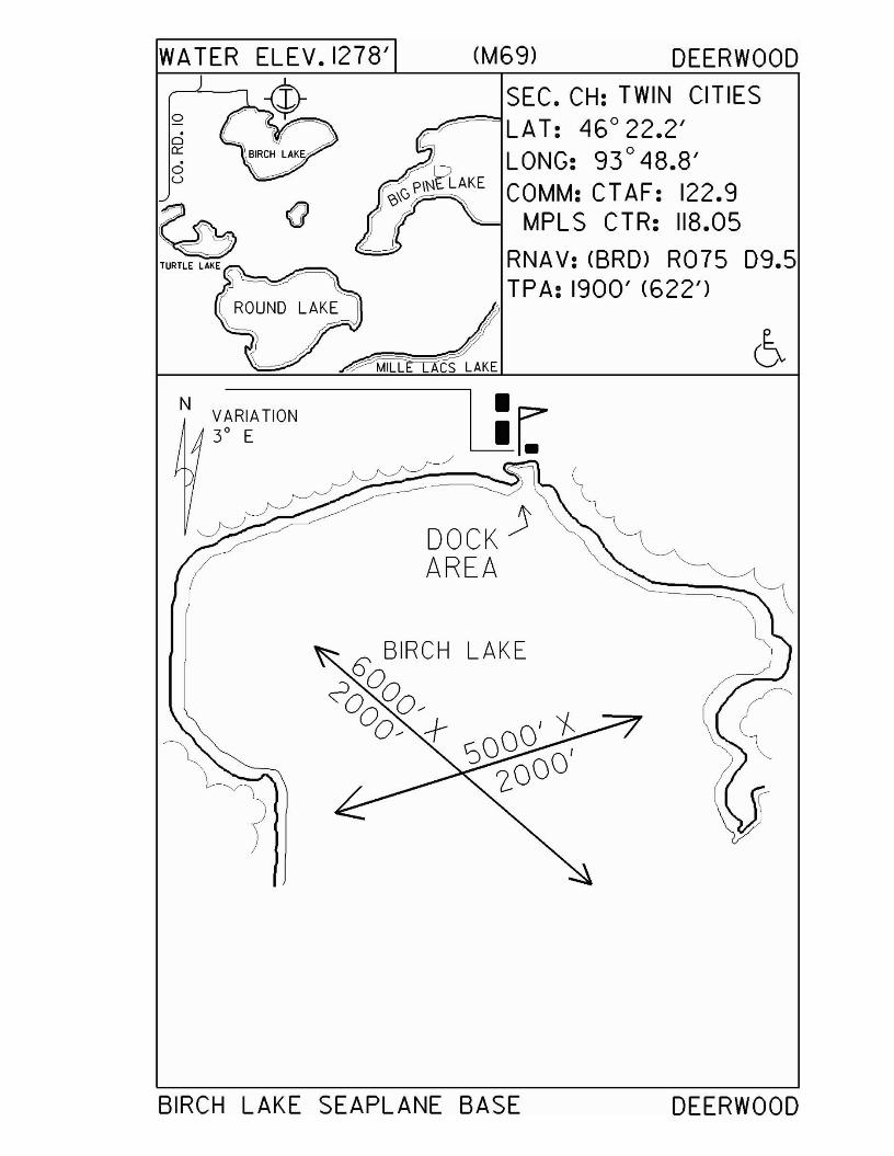
WA TER ELEV. 1278' (M69) DEERWOOD
L!r.DOCK)AREA
SEC. CH: TWIN CITIES~~LAT: 46° 22.2'
LONG: 93°48.8'COMM: CTAF: 122.9
MPLS CTR: 118.05
RNA V: <BRD> R075 D9.5TPA: 1900' (622')
ROUND LAKE~
N VARIATION30 E
o
c::i0:::
oU
BIRCH LAKE SEAPLANE BASE DEERWOOD
Deerwood - M14
Airport Manager: Malcolm Karnowski - 218-534-3582
Contact Person: Malcolm Karnowski - 218-534-3582
Chamber of Com: 800-450-2838 - www.explorebrainerdlakes.comAero Cht Coord: 8-H
AWOS/ASOS: No MnWAS Loc/Hrs: NA
Attended: UnattendedFuel: None
Self Service Fuel: NoAfter Hrs Service: None
FBO(s): NoneGround Transport: Contact Malcolm Karnowski
Food Service: NoneDining: Heartland Café (Crosby) - 218-546-5746 - 4 miles
Coach's Restaurant (Deerwood) - 1 mileLodging: Country Inn - 218-534-3101 - 1 mile
Airport Events: None reportedUnderwing Camp: No
Campgrounds: Crosby Park - 2½ milesGolf Courses: Cuyuna Country Club - 218-534-2489 - 1½ miles
Local Attractions: Mine MuseumFishing
Comments: None
•
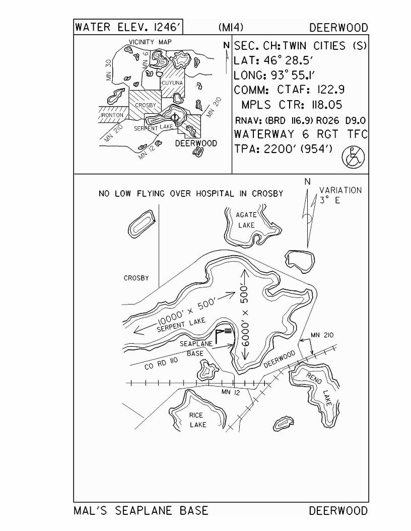
WATER ELEV. 1246' (MI4) DEERWOOD
on
;IRONTON
~ ;l..~ DEERWOOD~~' ~
N SEC. CH: TWIN CITIES (S)~ LAT: 46
0
28.5'LONG: 93
0
55.1'COMM: CTAF: 122.9
MPLS CTR: 118.05RNAV: (8RD 116.9> R026 D9.0
WATERWAY 6 RGT TFCTPA: 2200' (954') ®
NNO LOW FLYING OVER HOSPITAL IN CROSBY
CROSBY
MAL'S SEAPLANE BASE
VARIATION3
0E
DEERWOOD
Duluth - 9MØwww.NorthCountryAviation.com
Airport Manager: Neil Mathison - 218-348-3176 Contact Person: Donald Monaco - 218-348-3176
Chamber of Com: 218-722-5501 -www.duluthchamber.com
Aero Cht Coord: 6-KAWOS/ASOS: No
MnWAS Loc/Hrs: NAAttended: Unattended
Fuel: NoneSelf Service Fuel: NoAfter Hrs Service: 218-348-3176
FBO(s): NoneGround Transport: Taxi
Food Service: NoneDining: Island Lake Inn - 218-721-4604 - 5 miles
Lodging: NoneAirport Events: None reported
Underwing Camp: NoCampgrounds: Camping Available at Island Lake - 5 milesGolf Courses: Enger Golf Course - 218-723-3451
Local Attractions: Lake SuperiorCanal Park
Comments: National Weather Service - 218-720-5255100LL fuel available on an emergency basis only
•
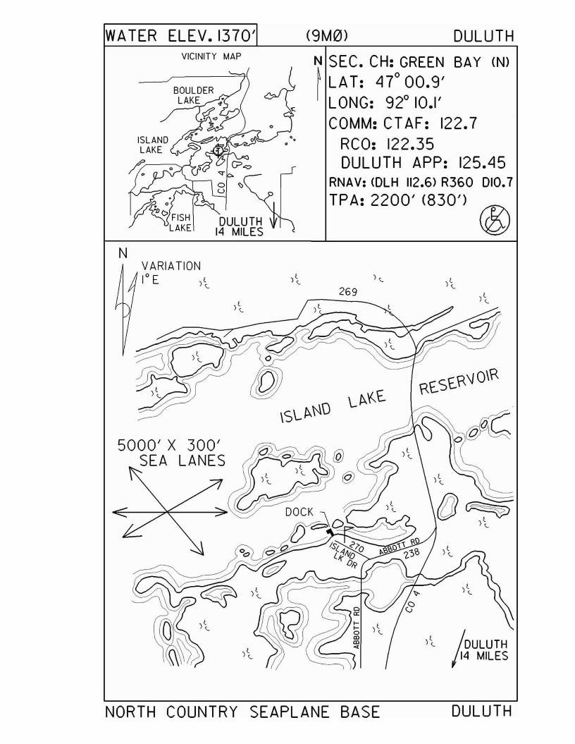
WATER ELEV.1370'VICINITY MAP
N
(9M0> DULUTH
~ SEC. CH: GREEN BAY (N)I LAT: Ll7°00.9'
LONG: 92° 10.1'COMM: CT AF: 122.7
RCO: 122.35DULUTH APP: 125.Ll5
RNAV: <DLH 112.6> R360 010.7
TPA: 2200' (830') ®
VARIATION10 E )t
<..
5000' X 300'SEA LANES
269
)~ IOULUTH114 MILES
NORTH COUNTRY SEAPLANE BASE DULUTH
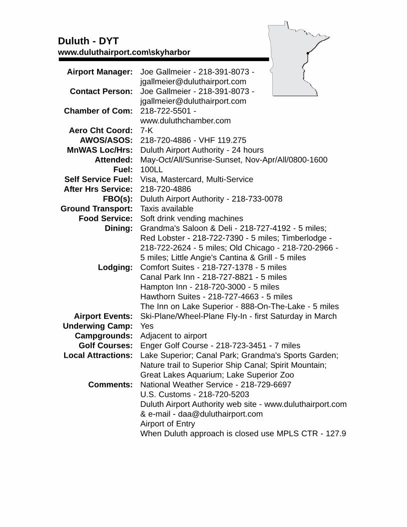
Duluth - DYTwww.duluthairport.com\skyharbor
Airport Manager: Joe Gallmeier - 218-391-8073 - [email protected]
Contact Person: Joe Gallmeier - 218-391-8073 - [email protected]
Chamber of Com: 218-722-5501 - www.duluthchamber.com
Aero Cht Coord: 7-KAWOS/ASOS: 218-720-4886 - VHF 119.275
MnWAS Loc/Hrs: Duluth Airport Authority - 24 hoursAttended: May-Oct/All/Sunrise-Sunset, Nov-Apr/All/0800-1600
Fuel: 100LLSelf Service Fuel: Visa, Mastercard, Multi-ServiceAfter Hrs Service: 218-720-4886
FBO(s): Duluth Airport Authority - 218-733-0078 Ground Transport: Taxis available
Food Service: Soft drink vending machinesDining: Grandma's Saloon & Deli - 218-727-4192 - 5 miles;
Red Lobster - 218-722-7390 - 5 miles; Timberlodge - 218-722-2624 - 5 miles; Old Chicago - 218-720-2966 - 5 miles; Little Angie's Cantina & Grill - 5 miles
Lodging: Comfort Suites - 218-727-1378 - 5 milesCanal Park Inn - 218-727-8821 - 5 milesHampton Inn - 218-720-3000 - 5 milesHawthorn Suites - 218-727-4663 - 5 milesThe Inn on Lake Superior - 888-On-The-Lake - 5 miles
Airport Events: Ski-Plane/Wheel-Plane Fly-In - first Saturday in MarchUnderwing Camp: Yes
Campgrounds: Adjacent to airportGolf Courses: Enger Golf Course - 218-723-3451 - 7 miles
Local Attractions: Lake Superior; Canal Park; Grandma's Sports Garden;Nature trail to Superior Ship Canal; Spirit Mountain; Great Lakes Aquarium; Lake Superior Zoo
Comments: National Weather Service - 218-729-6697U.S. Customs - 218-720-5203Duluth Airport Authority web site - www.duluthairport.com & e-mail - [email protected] of EntryWhen Duluth approach is closed use MPLS CTR - 127.9
•
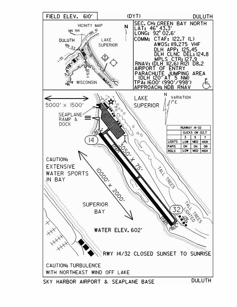
FIELD ELEv. 610' (DYT) DULUTH
ON ON ON
LOW !olEO Ill~
357
ClICKS ON 122.7
LOW !olEO IlICIl
RUNWAY 14-32
NVARIATION1° E
LAKESUPERIOR
NSEC. CH: GREEN BAY NORTHLAT: 460 43.3'
~ LONG: 920 02.6'I COMM: CT AF: 122.7 (l)
AWOS: 119.275 VHFDLH APP: 125.45DLH CLNC DEL: 124.8MPLS CTR: 127.9
RNAV: COLH 112.6) RI21 08.2AIRPORT OF ENTRYPARACHUTE JUMPING AREA
COLH 120· AT 5 NM)TPA: 1600' <990'/998') (~APPROACH: NOB RNAV ~
RWY 14/32 CLOSED SUNSET TO SUNRISE
WATER ELEV. 602'
SUPERIORBAY
VICINITY MAPMN 194 ~~ '0\
CAUTION:EXTENSIVEWATER SPORTSIN BAY
CAUTION: TURBULENCEWITH NORTHEAST WIND OFF LAKE
SKY HARBOR AIRPORT &. SEAPLANE BASE DULUTH
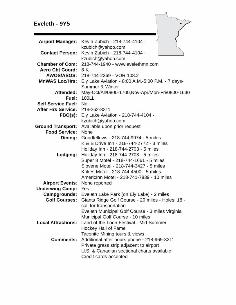
Eveleth - 9Y5
Airport Manager: Kevin Zubich - 218-744-4104 - [email protected]
Contact Person: Kevin Zubich - 218-744-4104 - [email protected]
Chamber of Com: 218-744-1940 - www.evelethmn.comAero Cht Coord: 6-K
AWOS/ASOS: 218-744-2369 - VOR 108.2MnWAS Loc/Hrs: Ely Lake Aviation - 8:00 A.M.-5:00 P.M. - 7 days-
Summer & WinterAttended: May-Oct/All/0800-1700,Nov-Apr/Mon-Fri/0800-1630
Fuel: 100LLSelf Service Fuel: NoAfter Hrs Service: 218-262-3211
FBO(s): Ely Lake Aviation - 218-744-4104 - [email protected]
Ground Transport: Available upon prior requestFood Service: None
Dining: Goodfellows - 218-744-9974 - 5 milesK & B Drive Inn - 218-744-2772 - 3 milesHoliday Inn - 218-744-2703 - 5 miles
Lodging: Holiday Inn - 218-744-2703 - 5 milesSuper 8 Motel - 218-744-1661 - 5 milesSlovene Motel - 218-744-3427 - 5 milesKokes Motel - 218-744-4500 - 5 milesAmericInn Motel - 218-741-7839 - 10 miles
Airport Events: None reportedUnderwing Camp: Yes
Campgrounds: Eveleth Lake Park (on Ely Lake) - 2 milesGolf Courses: Giants Ridge Golf Course - 20 miles - Holes: 18 -
call for transportationEveleth Municipal Golf Course - 3 miles Virginia Municipal Golf Course - 10 miles
Local Attractions: Land of the Loon Festival - Mid-SummerHockey Hall of FameTaconite Mining tours & views
Comments: Additional after hours phone - 218-969-3211Private grass strip adjacent to airportU.S. & Canadian sectional charts availableCredit cards accepted
•
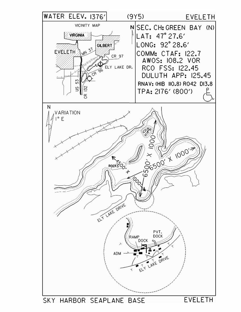
WATER ELEV. 1376' (9Y5) EVELETH
'......,.,
""
""""",,,;;,i,;i,
iii
ii
ii
ii,.
"../
""
.. .,~ ...•. ~._._.-._.- ......
"
//'"
ii
ii
ii
ii
ii
ii,,: ADM --"'-~;,,,,","----
"
""
"'''''
N SEC. CH: GREEN BAY (N)~ LAT: L17° 27.6'
LONG: 92° 28.6'COMM: CTAF: 122.7
AWOS: 108.2 VORELY LAKE DR. RCO FSS: 122.L15o,Co
C?- DULUTH APP: 125A5III /,L¥-- RNAV: (HIS 110.8) R042 013.8
TPA: 2176' (800') 6
VICINITY MAP
Vl N
:::J "..,
c:::u
NVARIATION1° E
SKY HARBOR SEAPLANE BASE EVELETH
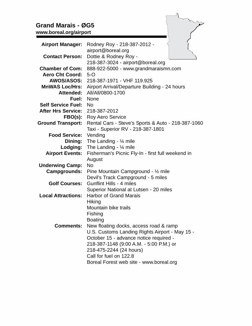
Grand Marais - ØG5www.boreal.org/airport
Airport Manager: Rodney Roy - 218-387-2012 [email protected]
Contact Person: Dottie & Rodney Roy -218-387-3024 - [email protected]
Chamber of Com: 888-922-5000 - www.grandmaraismn.comAero Cht Coord: 5-O
AWOS/ASOS: 218-387-1971 - VHF 119.925MnWAS Loc/Hrs: Airport Arrival/Departure Building - 24 hours
Attended: All/All/0800-1700Fuel: None
Self Service Fuel: NoAfter Hrs Service: 218-387-2012
FBO(s): Roy Aero ServiceGround Transport: Rental Cars - Steve's Sports & Auto - 218-387-1060
Taxi - Superior RV - 218-387-1801Food Service: Vending
Dining: The Landing - ¼ mileLodging: The Landing - ¼ mile
Airport Events: Fisherman's Picnic Fly-In - first full weekend in August
Underwing Camp: NoCampgrounds: Pine Mountain Campground - ½ mile
Devil's Track Campground - 5 milesGolf Courses: Gunflint Hills - 4 miles
Superior National at Lutsen - 20 milesLocal Attractions: Harbor of Grand Marais
HikingMountain bike trailsFishingBoating
Comments: New floating docks, access road & rampU.S. Customs Landing Rights Airport - May 15 -October 15 - advance notice required - 218-387-1148 (9:00 A.M. - 5:00 P.M.) or 218-475-2244 (24 hours)Call for fuel on 122.8Boreal Forest web site - www.boreal.org
•
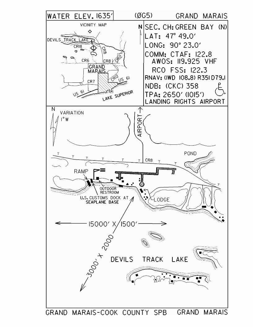
WA TER ELEV. 1635' (0G5) GRAND MARAISVICINITY MAP
<>N SEC. CH: GREEN BAY (N)~ LAT: 4r 49.0'
LONG: 90 0 23.0'COMM: CTAF: 122.8
AWOS: 119.925 VHFRCO FSS: 122.3
RNAV: (IWD 108.8) R351 079.1NOB: (eKC) 358 r..TPA: 2650' <1015') VLANDING RIGHTS AIRPORT
NVARIATIONlOW
tI0:::o00:::«
E: >
§ ~~e&
~~ DEVILS TRACK LAKE,§~ • ••
• • ••••I • ••• • •
T
~_T_(=~::::=:====T===~T~)~~T~C~R8~T__1T
RAMP - _=:0" mlf~~~------- ·! A.' I
OUTDOORRESTROOM ,
U.S. CUSTOMS DOCK ATSEAPLANE BASE
GRAND MARAIS-COOK COUNTY SPB GRAND MARAIS
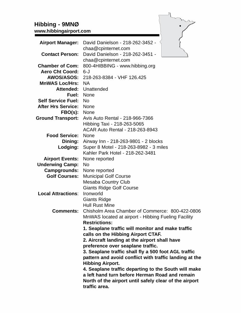
Hibbing - 9MNØwww.hibbingairport.com
Airport Manager: David Danielson - 218-262-3452 [email protected]
Contact Person: David Danielson - 218-262-3451 - [email protected]
Chamber of Com: 800-4HIBBING - www.hibbing.orgAero Cht Coord: 6-J
AWOS/ASOS: 218-263-8384 - VHF 126.425MnWAS Loc/Hrs: NA
Attended: UnattendedFuel: None
Self Service Fuel: NoAfter Hrs Service: None
FBO(s): NoneGround Transport: Avis Auto Rental - 218-966-7366
Hibbing Taxi - 218-263-5065ACAR Auto Rental - 218-263-8943
Food Service: NoneDining: Airway Inn - 218-263-9801 - 2 blocks
Lodging: Super 8 Motel - 218-263-8982 - 3 milesKahler Park Hotel - 218-262-3481
Airport Events: None reportedUnderwing Camp: No
Campgrounds: None reportedGolf Courses: Municipal Golf Course
Mesaba Country ClubGiants Ridge Golf Course
Local Attractions: IronworldGiants RidgeHull Rust Mine
Comments: Chisholm Area Chamber of Commerce: 800-422-0806MnWAS located at airport - Hibbing Fueling FacilityRestrictions:1. Seaplane traffic will monitor and make traffic calls on the Hibbing Airport CTAF.2. Aircraft landing at the airport shall have preference over seaplane traffic.3. Seaplane traffic shall fly a 500 foot AGL trafficpattern and avoid conflict with traffic landing at the Hibbing Airport.4. Seaplane traffic departing to the South will make a left hand turn before Herman Road and remain North of the airport until safely clear of the airport traffic area.
•
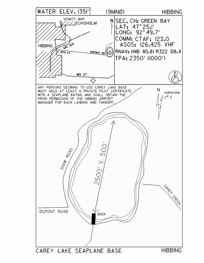
WA TER ELEV. 1351' (9MN0) HIBBING
MN 37
VICINITY MAP\jLA":....L-LJ CHISHOLM N SEC. CH: GREEN BAY
~ LAT: 47 0 25.1'I LONG: 92 0 49.7'
COMM: CT AF: 123.0--- ASOS: 126.425 VHF
t1~G---..QjOU~P02!!NT!....!RJO @RNAV:(HISII0.8)R32208.4TPA: 2350' (1000')
ANY PERSONS DESIRING TO USE CAREY LAKE BASEMUST HOLD AT LEAST A PRIVATE PILOT CERTIFICATEWITH A SEAPLANE RATING AND SHALL OBTAIN THEPRIOR PERMISSION OF THE HIBBING AIRPORTMANAGER FOR EACH LANDING AND TAKEOFF.
NVARIATION2 0 E
CAREY LAKE SEAPLANE BASE HIBBING
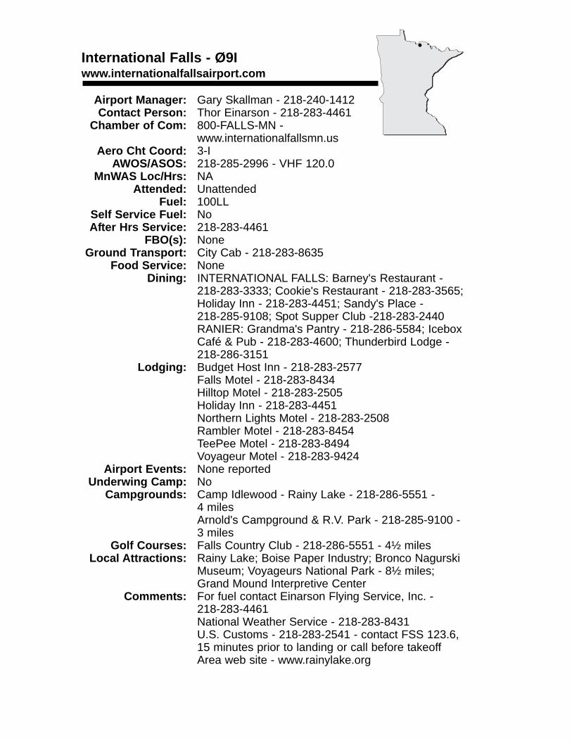
International Falls - Ø9Iwww.internationalfallsairport.com
Airport Manager: Gary Skallman - 218-240-1412 Contact Person: Thor Einarson - 218-283-4461
Chamber of Com: 800-FALLS-MN - www.internationalfallsmn.us
Aero Cht Coord: 3-IAWOS/ASOS: 218-285-2996 - VHF 120.0
MnWAS Loc/Hrs: NAAttended: Unattended
Fuel: 100LLSelf Service Fuel: NoAfter Hrs Service: 218-283-4461
FBO(s): NoneGround Transport: City Cab - 218-283-8635
Food Service: NoneDining: INTERNATIONAL FALLS: Barney's Restaurant -
218-283-3333; Cookie's Restaurant - 218-283-3565; Holiday Inn - 218-283-4451; Sandy's Place - 218-285-9108; Spot Supper Club -218-283-2440RANIER: Grandma's Pantry - 218-286-5584; Icebox Café & Pub - 218-283-4600; Thunderbird Lodge - 218-286-3151
Lodging: Budget Host Inn - 218-283-2577Falls Motel - 218-283-8434Hilltop Motel - 218-283-2505Holiday Inn - 218-283-4451Northern Lights Motel - 218-283-2508Rambler Motel - 218-283-8454TeePee Motel - 218-283-8494Voyageur Motel - 218-283-9424
Airport Events: None reportedUnderwing Camp: No
Campgrounds: Camp Idlewood - Rainy Lake - 218-286-5551 - 4 milesArnold's Campground & R.V. Park - 218-285-9100 -3 miles
Golf Courses: Falls Country Club - 218-286-5551 - 4½ milesLocal Attractions: Rainy Lake; Boise Paper Industry; Bronco Nagurski
Museum; Voyageurs National Park - 8½ miles;Grand Mound Interpretive Center
Comments: For fuel contact Einarson Flying Service, Inc. - 218-283-4461National Weather Service - 218-283-8431U.S. Customs - 218-283-2541 - contact FSS 123.6, 15 minutes prior to landing or call before takeoffArea web site - www.rainylake.org
•
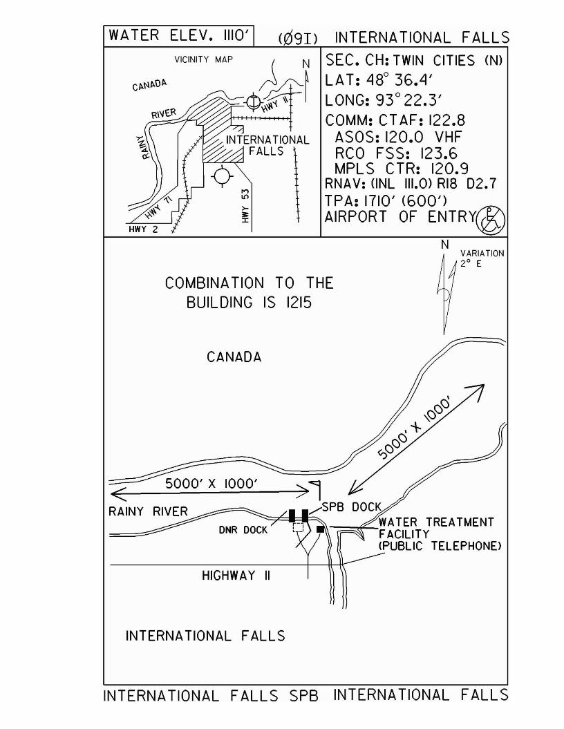
WATER ELEV. 1110' (091) INTERNATIONAL FALLSVICINITY MAP SEC. CH: TWIN CITIES (N)
LAT: 48° 36.4'LONG: 93° 22.3'COMM: CT AF: 122.8
ASOS: 120.0 VHFRCO FSS: 123.6MPLS CTR: 120.9
RNAV: (INL 111.0) RI8 D2.7TPA: 1710' (600')AIRPORT OF ENTRY@
NVARIATION20 E
COMBINA TION TO THEBUILDING IS 1215
>1/SPB DOCK
DNR DO""'CK=::::;:C::I-=-=""" WA TER TREATMENTFACILITY(PUBLIC TELEPHONE>
CANADA
5000' X 1000'<RAINY
HIGHWAY II
INTERNAT10NAL FALLS
INTERNATIONAL FALLS SPB INTERNATIONAL FALLS
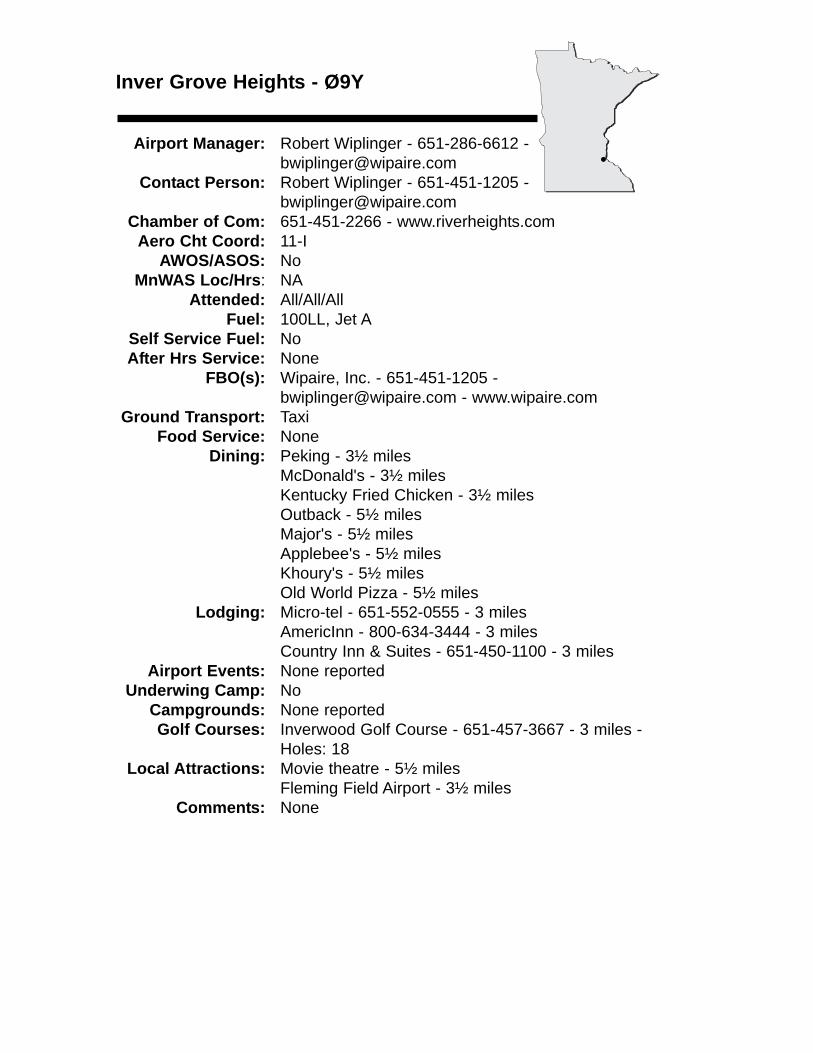
Inver Grove Heights - Ø9Y
Airport Manager: Robert Wiplinger - 651-286-6612 [email protected]
Contact Person: Robert Wiplinger - 651-451-1205 [email protected]
Chamber of Com: 651-451-2266 - www.riverheights.comAero Cht Coord: 11-I
AWOS/ASOS: No MnWAS Loc/Hrs: NA
Attended: All/All/AllFuel: 100LL, Jet A
Self Service Fuel: NoAfter Hrs Service: None
FBO(s): Wipaire, Inc. - 651-451-1205 - [email protected] - www.wipaire.com
Ground Transport: TaxiFood Service: None
Dining: Peking - 3½ milesMcDonald's - 3½ milesKentucky Fried Chicken - 3½ milesOutback - 5½ milesMajor's - 5½ milesApplebee's - 5½ milesKhoury's - 5½ milesOld World Pizza - 5½ miles
Lodging: Micro-tel - 651-552-0555 - 3 milesAmericInn - 800-634-3444 - 3 milesCountry Inn & Suites - 651-450-1100 - 3 miles
Airport Events: None reportedUnderwing Camp: No
Campgrounds: None reportedGolf Courses: Inverwood Golf Course - 651-457-3667 - 3 miles -
Holes: 18Local Attractions: Movie theatre - 5½ miles
Fleming Field Airport - 3½ milesComments: None
•
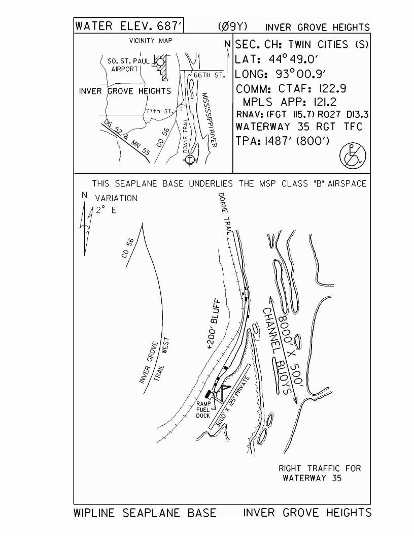
WATER ELEV.687'VICINITY MAP
INVER
(.09Y) INVER GROVE HEIGHTS
N SEC. CH: TWIN CITIES (S)
\J\ ~ LAT: 44° 49.0'66TH ST. LONG: 93° 00.9'
~ COMM: CT AF: 122.9~ MPLS APP: 121.2'G,
<fl RNA V: <FGT 115.7> R027 013.3~ WATERWAY 35 RGT TFC~';\ TPA: 1487' (800') ®
THIS SEAPLANE BASE UNDERLIES THE MSP CLASS "B' AIRSPACE
N VARIATION '3J7
20 E ~
RIGHT TRAFFIC FORWATERWAY 35
WIPLINE SEAPLANE BASE INVER GROVE HEIGHTS
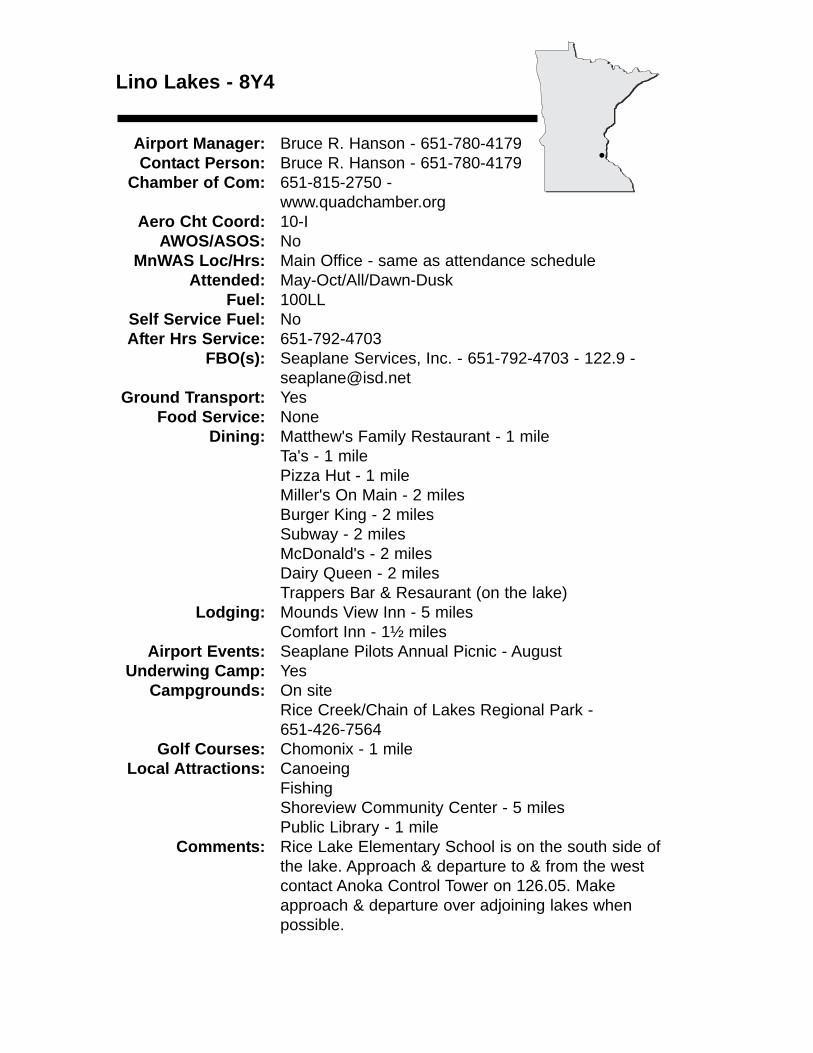
Lino Lakes - 8Y4
Airport Manager: Bruce R. Hanson - 651-780-4179 Contact Person: Bruce R. Hanson - 651-780-4179
Chamber of Com: 651-815-2750 -www.quadchamber.org
Aero Cht Coord: 10-IAWOS/ASOS: No
MnWAS Loc/Hrs: Main Office - same as attendance scheduleAttended: May-Oct/All/Dawn-Dusk
Fuel: 100LLSelf Service Fuel: NoAfter Hrs Service: 651-792-4703
FBO(s): Seaplane Services, Inc. - 651-792-4703 - 122.9 - [email protected]
Ground Transport: YesFood Service: None
Dining: Matthew's Family Restaurant - 1 mileTa's - 1 milePizza Hut - 1 mileMiller's On Main - 2 milesBurger King - 2 milesSubway - 2 milesMcDonald's - 2 milesDairy Queen - 2 milesTrappers Bar & Resaurant (on the lake)
Lodging: Mounds View Inn - 5 milesComfort Inn - 1½ miles
Airport Events: Seaplane Pilots Annual Picnic - AugustUnderwing Camp: Yes
Campgrounds: On siteRice Creek/Chain of Lakes Regional Park -651-426-7564
Golf Courses: Chomonix - 1 mileLocal Attractions: Canoeing
FishingShoreview Community Center - 5 milesPublic Library - 1 mile
Comments: Rice Lake Elementary School is on the south side of the lake. Approach & departure to & from the west contact Anoka Control Tower on 126.05. Make approach & departure over adjoining lakes when possible.
•
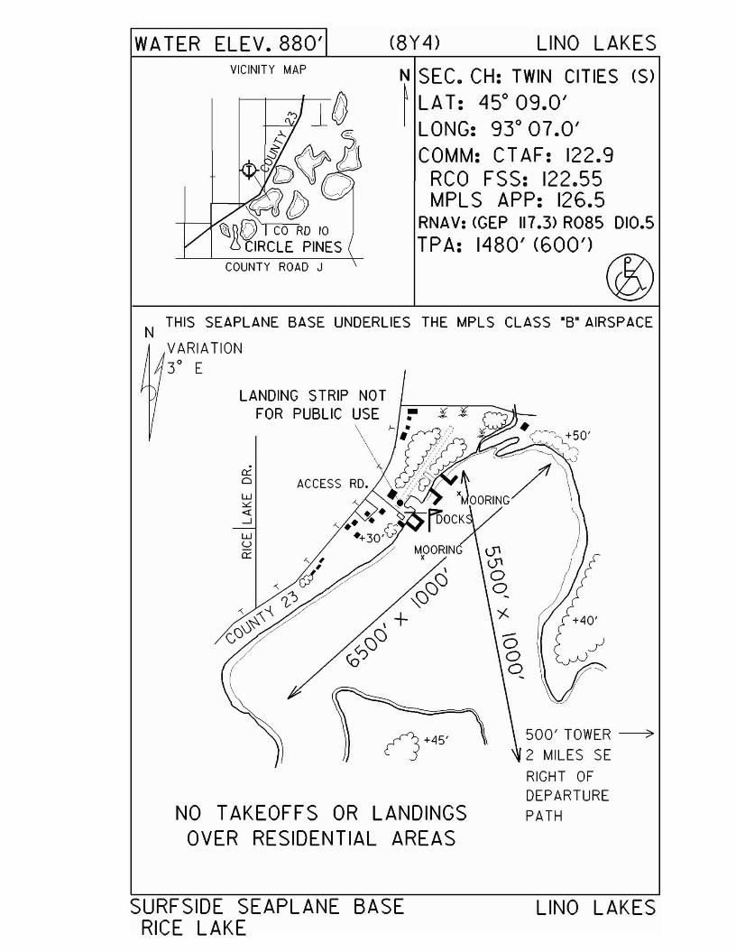
WA TER ELEV. 880' (8Y 4) L1NO LAKESVICINITY MAP N SEC. CH: TWIN CITIES (S)
~ LA T: 450
09.0'LONG: 93 0 07.0'COMM: CT AF: 122.9
RCa FSS: 122.55MPL S APP: 126.5
RNAV: <GEP 117.3> R085 010.5TPA: 1480' (600')
500' TOWER~2 MILES SE
RIGHT OFDEPARTUREPATH
- ¥ 'til -- .....
(j+45'
0::oW>L«--'wU0::
NO TAKEOFFS OR LANDINGSOVER RESIDENTIAL AREAS
THIS SEAPLANE BASE UNDERLIES THE MPLS CLASS "B' AIRSPACEN
VARIATION3° E
SURFSIDE SEAPLANE BASERICE LAKE
L1NO LAKES

Tower - 12D
Airport Manager: Tim Kotzian - 218-753-4070 - [email protected]
Contact Person: Tim Kotzian - 218-753-4070 - [email protected]
Chamber of Com: 218-753-2301 - www.lakevermilionchamber.comAero Cht Coord: 5-K
AWOS/ASOS: NoMnWAS Loc/Hrs: Arrival/Departure Building - 24 hours
Attended: UnattendedFuel: 100LL
Self Service Fuel: Visa, MastercardAfter Hrs Service: None
FBO(s): NoneGround Transport: Fortune Bay Resort & Casino courtesy van -
218-753-6400Food Service: None
Dining: Tower Café - 218-753-6045 - 1 mileBenchwarmers - 218-753-5158 - 1 mileGood Ole Days - 218-753-6097 - 1 mile
Lodging: Marjo Motel - 218-753-4851 - 1 mileTower Hotel - 218-753-2710 - 1 mileFortune Bay Resort & Casino - 218-753-6400
Airport Events: Annual Fly-InUnderwing Camp: No
Campgrounds: Hoodoo Point Campground - adjacent to airportGolf Courses: Fortune Bay Resort & Casino - 218-753-6400
Local Attractions: Lake VermilionHoodoo Point CampgroundPublic beach 5 blocks from airportSoudan Underground MineFortune Bay Resort, Casino & Golf CourseIronworld
Comments: Self service fuel at both the seaplane base & airportTiedowns availableAir Charter ServiceAvionics sales & repairsFloat plane services - in & out of water
•
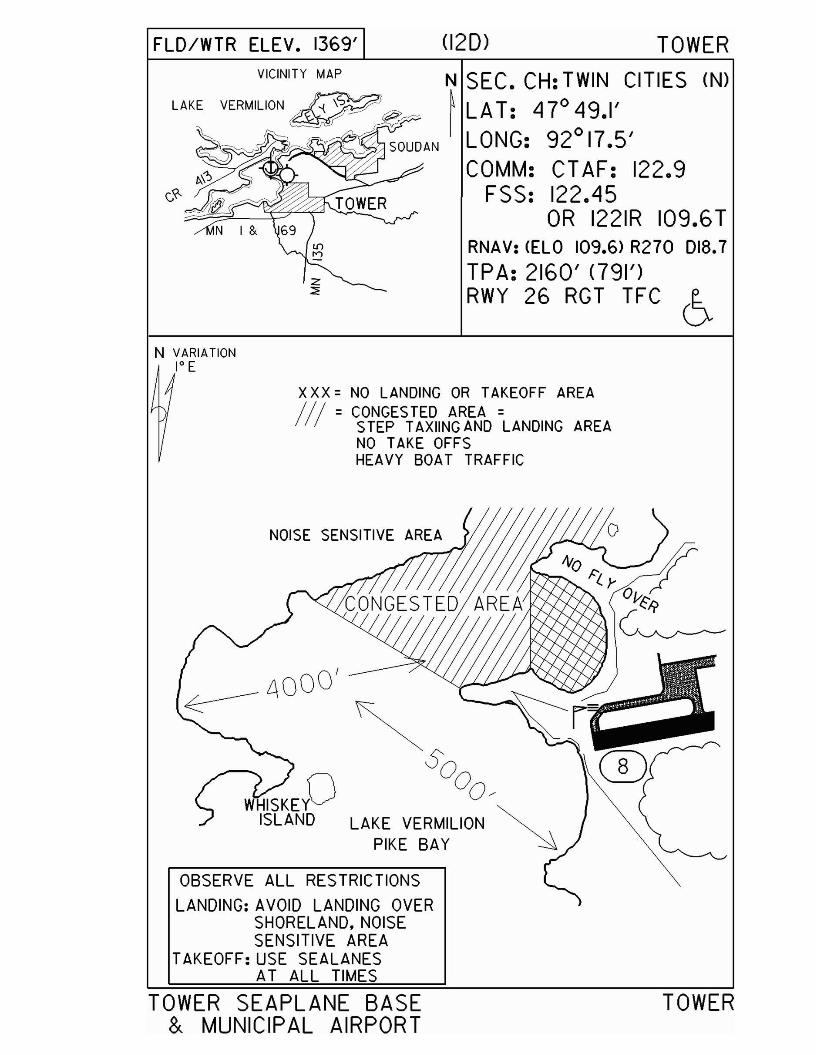
FLD/WTR ELEV. 1369' (120) TOWER
VICINITY MAP N SEC. CH: TWIN CITIES (N)LAKE VERMILION~~ ~ LAT: 470 49.1'
~SOUDAN LONG: 92
017.5'
IJ..\"; COMM: CT AF: 122.9c-~ FSS: 122.45
OR 1221R 109.6TRNAV: (ELO 109.6) R270 D18.7
TPA: 2160' <791')RWY 26 RGT TFC 6
N VARIATION1° E
xXX = NO LANDING OR TAKEOFF AREAII! = CONGESTED AREA =
STEP TAXIING AND LANDING AREANO TAKE OFFSHEAVY BOAT TRAFFIC
£\000'
~ ~So
W ISKEYO Oo/~ISLAND LAKE VERMILION
PIKE BAY
OBSERVE ALL RESTRICTIONS
LANDING: AVOID LANDING OVERSHORELAND. NOISESENSITIVE AREA
TAKEOFF: USE SEALANESAT ALL TIMES
TOWER SEAPLANE BASE& MUNICIPAL AIRPORT
TOWER
Waubun - M49www.jollyfisherman.com
Airport Manager: Anne Buelow - 218-734-2262 - [email protected]
Contact Person: Anne Buelow - 218-734-2262 - [email protected]
Chamber of Com: NoneAero Cht Coord: 6-D
AWOS/ASOS: No MnWAS Loc/Hrs: NA
Attended: May-Oct/All/Daylight, Nov-Apr/UnattendedFuel: None
Self Service Fuel: NoAfter Hrs Service: None
FBO(s): NoneGround Transport: None
Food Service: Microwave foodFrozen pizza
Dining: 10 milesLodging: 15 cabins at seaplane base
Airport Events: None reportedUnderwing Camp: No
Campgrounds: Across the lakeGolf Courses: 30 miles
Local Attractions: Big Elbow LakeComments: None
•
WATER ELEV. 1499'
N
(M49) WAUBUN
N SEC. CH: TWIN CITIES (N)~ LAT: £17°08.6'
LONG: 95° 31.7'COMM: CT AF: 122.9FSS: 122.IR 110.6T 122.5
RNAV: (PKO 110.6> R300 024.3
TPA: 2300' (801')
VARIATION4 0 E
ACEL[PHONTOWER
MOORELAKE
JOLL Y FISHERMAN SEAPLANE BASE WAUBUN