milestones and challenges in karstology
TRANSCRIPT
25th INTERNATIONAL KARSTOLOGICAL SCHOOL “CLASSICAL KARST”
25. MEDNARODNA KRASOSLOVNA ŠOLA “KLASIČNI KRAS”
MILESTONES AND CHALLENGES IN KARSTOLOGY
MEJNIKI IN IZZIVI V KRASOSLOVJU
ABSTRACTS & GUIDE BOOK
POVZETKI & VODNIK
Postojna 2017
25th
International Karstological School “Classical Karst”, Postojna, Slovenia, 2017 25. Mednarodna krasoslovna šola “Klasični kras”, Postojna, Slovenija, 2017
2
Editor / Urednica: Petra Gostinčar Issued by / Izdal: Karst Research Institute, Scientific Research Centre of the Slovenian Academy of Sciences and Arts, Titov trg 2,
6230 Postojna, Slovenia Published by / Založila: ZRC Publishing / Založba ZRC Represented by / Zanju: Oto Luthar Printrun / Naklada: 180 Organizing committee / Organizacijski odbor: Petra Gostinčar, Franci Gabrovšek, Martin Knez, Blaž Kogovšek, Andrej Mihevc, Janez Mulec, Metka Petrič,
Tanja Pipan, Tadej Slabe, Stanka Šebela, Nataša Viršek Ravbar, Nadja Zupan Hajna, Matej Blatnik, Marjutka Hafner, Mitja Prelovšek, Philipp Häuselmann, Peter Kozel, Cyril Mayaud, Bojan Otoničar, Sonja Stamenković.
Supported by / Izid knjige so podprli:
Scientific Research Centre of the Slovenian Academy of Sciences and Arts Slovenian National Commission for UNESCO Municipality of Postojna Zavod Znanje Park Škocjanske jame Postojnska jama d. d.
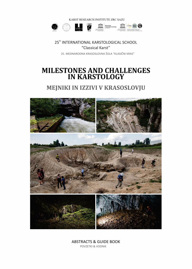
Cover photos / Naslovne fotografije: The Unica River spring; Nabrežina / Aurisina Quarry (Italy); Rešeto ponors at Cerkniško polje; Cave Skednena
jama (M. Blatnik) Printed by / Tisk: CICERO, Begunje, d.o.o. First edition, first printrun. Prva izdaja, prvi natis. Postojna 2017
CIP - Kataložni zapis o publikaciji
Narodna in univerzitetna knjižnica, Ljubljana
551.44(048)(082)
INTERNATIONAL Karstological School Classical Karst (25 ; 2017 ; Postojna)
Milestones and challenges in karstology : abstracts & guide book = Mejniki
in izzivi v krasoslovju : povzetki & vodnik / 25th International Karstological
School Classical Karst, [Postojna, 2017] = 25. mednarodna krasoslovna šola
Klasični kras ; [editor Petra Gostinčar]. - Ljubljana : Založba ZRC, 2017
ISBN 978-961-05-0004-9
1. Gl. stv. nasl. 2. Vzp. stv. nasl. 3. Dodat. nasl. 4. Gostinčar, Petra, 1984-
290302720
25th
International Karstological School “Classical Karst”, Postojna, Slovenia, 2017 25. Mednarodna krasoslovna šola “Klasični kras”, Postojna, Slovenija, 2017
3
CONTENTS
GENERAL INFORMATION 5
PROGRAMME 6 MAP OF POSTOJNA 11 INVITATION TO A SPECIAL SESSION: UNRESOLVED MYSTERIES OF KARST 12
ABSTRACTS 13 FIELD TRIPS 61
Afternoon field trip (A): Tourist visit of Postojnska jama 62 Afternoon field trip (B): The Rižana karst spring and its catchment 68 Whole-day field trip (C): Škocjanske jame, from the cave to the landscape morphology 78 Whole-day field trip (D): Hydrology, geomorphology and speleology of the Ljubljanica recharge area 97
VSEBINA
SPLOŠNE INFORMACIJE 5
PROGRAM 6 KARTA POSTOJNE 11 POVABILO NA POSEBNO SEKCIJO: NERAZREŠENE SKRIVNOSTI KRASA 12
IZVLEČKI 13 TERENSKO DELO 61
Popoldansko terensko delo (A): Turistični obisk Postojnske jame 62 Popoldansko terensko delo (B): Kraški izvir Rižane in njeno vodozbirno območje 68 Celodnevno terensko delo (C): Škocjanske jame, od jame do površinske morfologije 78 Celodnevno terensko delo (D): Hidrologija, geomorfologija in speleologija porečja Ljubljanice 97

25th
International Karstological School “Classical Karst”, Postojna, Slovenia, 2017 25. Mednarodna krasoslovna šola “Klasični kras”, Postojna, Slovenija, 2017
4
25th
International Karstological School “Classical Karst”, Postojna, Slovenia, 2017 25. Mednarodna krasoslovna šola “Klasični kras”, Postojna, Slovenija, 2017
5
GENERAL INFORMATION
SPLOŠNE INFORMACIJE
25th
International Karstological School “Classical Karst”, Postojna, Slovenia, 2017 25. Mednarodna krasoslovna šola “Klasični kras”, Postojna, Slovenija, 2017
6
PROGRAMME
PROGRAM
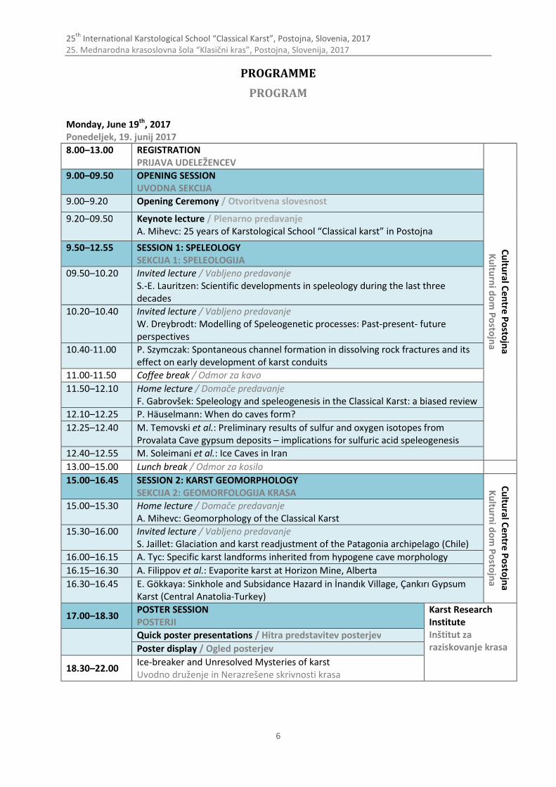
Monday, June 19th, 2017 Ponedeljek, 19. junij 2017
8.00–13.00 REGISTRATION PRIJAVA UDELEŽENCEV
Cu
ltural C
entre P
osto
jna
Ku
lturn
i do
m P
osto
jna
9.00–09.50 OPENING SESSION UVODNA SEKCIJA
9.00–9.20 Opening Ceremony / Otvoritvena slovesnost
9.20–09.50 Keynote lecture / Plenarno predavanje A. Mihevc: 25 years of Karstological School “Classical karst” in Postojna
9.50–12.55 SESSION 1: SPELEOLOGY SEKCIJA 1: SPELEOLOGIJA
09.50–10.20 Invited lecture / Vabljeno predavanje S.-E. Lauritzen: Scientific developments in speleology during the last three decades
10.20–10.40 Invited lecture / Vabljeno predavanje W. Dreybrodt: Modelling of Speleogenetic processes: Past-present- future perspectives
10.40-11.00 P. Szymczak: Spontaneous channel formation in dissolving rock fractures and its effect on early development of karst conduits
11.00-11.50 Coffee break / Odmor za kavo
11.50–12.10 Home lecture / Domače predavanje F. Gabrovšek: Speleology and speleogenesis in the Classical Karst: a biased review
12.10–12.25 P. Häuselmann: When do caves form?
12.25–12.40 M. Temovski et al.: Preliminary results of sulfur and oxygen isotopes from Provalata Cave gypsum deposits – implications for sulfuric acid speleogenesis
12.40–12.55 M. Soleimani et al.: Ice Caves in Iran
13.00–15.00 Lunch break / Odmor za kosilo
15.00–16.45 SESSION 2: KARST GEOMORPHOLOGY SEKCIJA 2: GEOMORFOLOGIJA KRASA
Cu
ltural C
entre P
osto
jna
Ku
lturn
i do
m P
osto
jna
15.00–15.30 Home lecture / Domače predavanje A. Mihevc: Geomorphology of the Classical Karst
15.30–16.00 Invited lecture / Vabljeno predavanje S. Jaillet: Glaciation and karst readjustment of the Patagonia archipelago (Chile)
16.00–16.15 A. Tyc: Specific karst landforms inherited from hypogene cave morphology
16.15–16.30 A. Filippov et al.: Evaporite karst at Horizon Mine, Alberta
16.30–16.45 E. Gökkaya: Sinkhole and Subsidance Hazard in İnandık Village, Çankırı Gypsum Karst (Central Anatolia-Turkey)
17.00–18.30 POSTER SESSION POSTERJI
Karst Research Institute Inštitut za raziskovanje krasa
Quick poster presentations / Hitra predstavitev posterjev
Poster display / Ogled posterjev
18.30–22.00 Ice-breaker and Unresolved Mysteries of karst Uvodno druženje in Nerazrešene skrivnosti krasa
25th
International Karstological School “Classical Karst”, Postojna, Slovenia, 2017 25. Mednarodna krasoslovna šola “Klasični kras”, Postojna, Slovenija, 2017
7
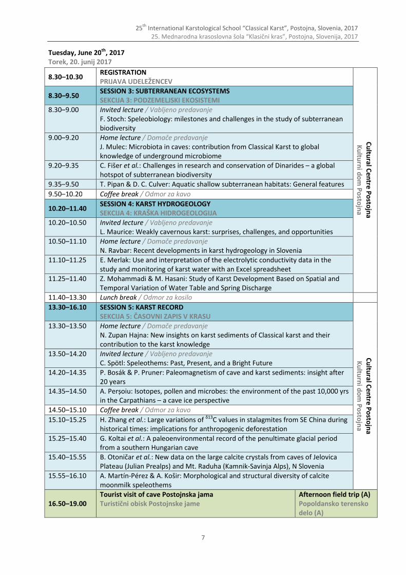
Tuesday, June 20th, 2017 Torek, 20. junij 2017
8.30–10.30 REGISTRATION PRIJAVA UDELEŽENCEV
Cu
ltural C
entre P
osto
jna
Ku
lturn
i do
m P
osto
jna
8.30–9.50 SESSION 3: SUBTERRANEAN ECOSYSTEMS SEKCIJA 3: PODZEMELJSKI EKOSISTEMI
8.30–9.00 Invited lecture / Vabljeno predavanje F. Stoch: Speleobiology: milestones and challenges in the study of subterranean biodiversity
9.00–9.20 Home lecture / Domače predavanje J. Mulec: Microbiota in caves: contribution from Classical Karst to global knowledge of underground microbiome
9.20–9.35 C. Fišer et al.: Challenges in research and conservation of Dinarides – a global hotspot of subterranean biodiversity
9.35–9.50 T. Pipan & D. C. Culver: Aquatic shallow subterranean habitats: General features
9.50–10.20 Coffee break / Odmor za kavo
10.20–11.40 SESSION 4: KARST HYDROGEOLOGY SEKCIJA 4: KRAŠKA HIDROGEOLOGIJA
10.20–10.50 Invited lecture / Vabljeno predavanje L. Maurice: Weakly cavernous karst: surprises, challenges, and opportunities
10.50–11.10 Home lecture / Domače predavanje N. Ravbar: Recent developments in karst hydrogeology in Slovenia
11.10–11.25 E. Merlak: Use and interpretation of the electrolytic conductivity data in the study and monitoring of karst water with an Excel spreadsheet
11.25–11.40 Z. Mohammadi & M. Hasani: Study of Karst Development Based on Spatial and Temporal Variation of Water Table and Spring Discharge
11.40–13.30 Lunch break / Odmor za kosilo
13.30–16.10 SESSION 5: KARST RECORD SEKCIJA 5: ČASOVNI ZAPIS V KRASU
Cu
ltural C
entre P
osto
jna
Ku
lturn
i do
m P
osto
jna
13.30–13.50 Home lecture / Domače predavanje N. Zupan Hajna: New insights on karst sediments of Classical karst and their contribution to the karst knowledge
13.50–14.20 Invited lecture / Vabljeno predavanje C. Spötl: Speleothems: Past, Present, and a Bright Future
14.20–14.35 P. Bosák & P. Pruner: Paleomagnetism of cave and karst sediments: insight after 20 years
14.35–14.50 A. Perșoiu: Isotopes, pollen and microbes: the environment of the past 10,000 yrs in the Carpathians – a cave ice perspective
14.50–15.10 Coffee break / Odmor za kavo
15.10–15.25 H. Zhang et al.: Large variations of δ13C values in stalagmites from SE China during historical times: implications for anthropogenic deforestation
15.25–15.40 G. Koltai et al.: A paleoenvironmental record of the penultimate glacial period from a southern Hungarian cave
15.40–15.55 B. Otoničar et al.: New data on the large calcite crystals from caves of Jelovica Plateau (Julian Prealps) and Mt. Raduha (Kamnik-Savinja Alps), N Slovenia
15.55–16.10 A. Martín-Pérez & A. Košir: Morphological and structural diversity of calcite moonmilk speleothems
16.50–19.00 Tourist visit of cave Postojnska jama Turistični obisk Postojnske jame
Afternoon field trip (A) Popoldansko terensko delo (A)

25th
International Karstological School “Classical Karst”, Postojna, Slovenia, 2017 25. Mednarodna krasoslovna šola “Klasični kras”, Postojna, Slovenija, 2017
8
Wednesday, June 21st, 2017 Sreda, 21. junij 2017
8.30–10.30 REGISTRATION PRIJAVA UDELEŽENCEV
Cu
ltural C
entre P
osto
jna / K
ultu
rni d
om
Po
stojn
a
8.30–10.30 SESSION 6: DEVELOPMENT CHALLENGES ON KARST SEKCIJA 6: RAZVOJNI IZZIVI NA KRASU
8.30–9.00 Invited lecture / Vabljeno predavanje P-Y. Jeannin: Characterizing fluxes through karst: a challenge for development in karst
9.00–9.20 Home lecture / Domače predavanje M. Knez et al.: Development challenges on karst
9.20–9.35 P. Griffiths & C. Ramsey: Evolution of Karst Management in British Columbia (Canada): 50 Long Years in 15 Short Minutes
9.35–9.50 D. Cailhol et al.: Fourneau du Diable an emblematic karstic and archaeological site from Solutrean period in Dordogne France
09.50–10.05 M. Breg Valjavec et al.: The importance of doline habitats for conservation of Natura 2000 karst landscapes (Kras Plateau, Slovenia)
10.05–10.30 Coffee break / Odmor za kavo
10.30–12.15 SESSION 7: KARSTOLOGY SEKCIJA 7: KRASOSLOVJE
10.30–11.00 Invited lecture / Vabljeno predavanje D. Ford: Karstology, 1990-2040 and before
11.00–11.20 Home lecture / Domače predavanje T. Slabe: Karstology in the Classical Karst
11.20–11.35 J. Rodet: The cave: a result of a long evolution named karstification
11.35–11.50 F. Tomassini Loureiro: Speleology as a regulated profession in Brazil
11.50–12.05 S. Brennan: Karst on Haida Gwaii
12.05–12.15 Closing remarks / Zaključek
12.15–14.00 Lunch break / Odmor za kosilo
14.00–20.00
The Rižana karst spring and its catchment (guided by M. Petrič & N. Ravbar) Kraški izvir Rižane in njeno vodozbirno območje (vodita M. Petrič & N. Ravbar)
Afternoon field trip (B) Popoldansko terensko delo (B)
Thursday, June 22nd, 2017 Četrtek, 22. junij 2017
8.30-19.30
Škocjanske jame, from the cave to the landscape morphology (guided by A. Mihevc, N. Zupan Hajna, S. Šebela & F. Gabrovšek Škocjanske jame, od jame do površinske morfologije (vodijo A. Mihevc, N. Zupan Hajna, S. Šebela & F. Gabrovšek)
Whole-day field trip (C) Celodnevno terensko delo (C)
20.00–
Reception at the Karst Research Institute Sprejem na Inštitutu za raziskovanje krasa
Friday, June 23rd, 2017 Petek, 23. junij 2017
8.30–18.00 Hydrology, geomorphology and speleology of the Ljubljanica recharge area (guided by F. Gabrovšek & M. Blatnik) Hidrologija, geomorfologija in speleologija porečja Ljubljanice (vodita F. Gabrovšek & M. Blatnik)
Whole-day field trip (D) Celodnevno terensko delo (D)

25th
International Karstological School “Classical Karst”, Postojna, Slovenia, 2017 25. Mednarodna krasoslovna šola “Klasični kras”, Postojna, Slovenija, 2017
9
Oral presentations - PowerPoint presentations should be given to organizers at the break before the Session starts.
Posters - Poster size: max. format is 70 cm x 100 cm (width x height, portret layout). - Each author(s) should prepare a 1–2 minute presentation (1–3 slides) where the essence of their
poster is presented. These short presentations will be presented at the beginning of the Poster session. Afterwards, the posters will be displayed and the authors will be able to answer the questions and discuss their research in detail.
- Leave the posters and short poster presentations (.ppt, .pdf) at registration desk on Monday, June 19th, before the lunch break.
- Stand by your poster during the poster display.
Lunch - Lunches are not organized on field trips and during the session days with exception on a Whole-
day excursion (C) and Whole-day excursion (D), when simple packed lunches will be provided. - Lunch breaks are in the schedule during the session days.
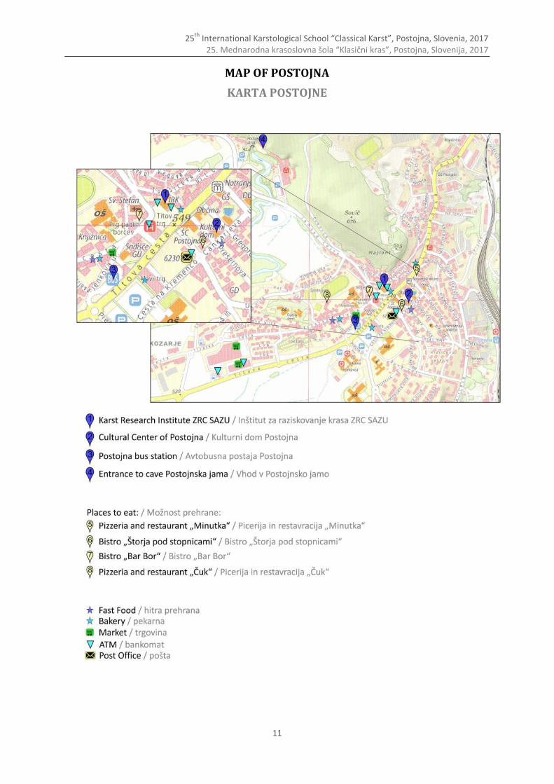
Field trips - Register for each the field trips at the registration desk. - Bus departure for the field trips is from the parking place at the Postojna bus station (marked
with No. 3 on Map of Postojna, p. 11) - Take care for additional information and changes regarding the bus departures. - Walking shoes and field clothes are recommended. - Drinking water will be available on all busses. - Insect repellents are recommended as we will be walking in the areas populated with ticks
(Ixodes ricinus) that transfer mainly lyme desease and tick-borne meningitis. - Participation on the excursions is voluntary and at your own risk. The organisers do not accept
any liability for any loss, damage, injury or death arising from or connected with the excursions. Participants are advised to arrange an appropriate insurance policy. The participants are obliged to to comply with the instructions of the organizer.

25th
International Karstological School “Classical Karst”, Postojna, Slovenia, 2017 25. Mednarodna krasoslovna šola “Klasični kras”, Postojna, Slovenija, 2017
10
Predavanja - Prosimo, da PowerPoint predstavitve oddajte organizatorjem v odmoru pred začetkom vaše
sekcije.
Posterji - Velikost posterjev: največji format je 70 cm x 100 cm (širina x višina, pokončna lega), - Vsak avtor (oz. avtorji) naj pripravi 1–2 minuti dolgo predstavitev (1–3 diapozitivi), v kateri naj
bodo predstavljeni bistveni vsebinski poudarki prispevka. Kratke predstavitve bodo predstavljene na začetku sekcije, sledil pa bo ogled posterjev, kjer bodo avtorji lahko odgovarjali na morebitna vprašanja udeležencev.
- Posterje in kratke prestavitve (.ppt, .pdf) pustite pri mizi za prijavo udeležencev, in sicer v ponedeljek, 19. junija, do odmora za kosilo.
- Med ogledom posterjev stojte poleg svojega posterja.
Kosilo - Kosilo med predavanji in terenskim delom ni organizirano, razen na Celodnevnem terenskem delu
(C) in Celodnevnem terenskem delu (D), za kateri bomo pripravili enostavne pakirane obroke. - Odmori za kosilo so v času predavanj vključeni v program.
Terensko delo - Pri mizi za prijavo udeležencev se prijavite za terensko delo. - Odhod avtobusov je z glavne avtobusne postaje Postojna (označeno s št. 3 na karti Postojne,
str. 11). - Bodite pozorni na dodatne informacije glede morebitnih sprememb o odhodih avtobusov. - Priporočamo terensko obleko in obutev. - Za vse udeležence bo na avtobusih na voljo pitna voda. - Priporočamo uporabo repelentov proti insektom. Hodili bomo po območjih, kjer se nahajajo
populacije klopov (Ixodes ricinus), ki so lahko prenašalci povzročiteljev lymske borelioze ali meningitisa.
- Udeležba na terenskem delu je prostovoljna in na lastno odgovornost. Organizator ne prevzema odgovornosti za morebitne izgube, škodo, poškodbe ali smrtne primere, ki bi nastali v povezavi s terenskim delom. Udeležencem svetujemo, da si pred odhodom na terensko delo uredijo ustrezno zavarovanje. Udeleženci so tekom terenskega dela dolžni upoštevati navodila organizatorja.
25th
International Karstological School “Classical Karst”, Postojna, Slovenia, 2017 25. Mednarodna krasoslovna šola “Klasični kras”, Postojna, Slovenija, 2017
11
MAP OF POSTOJNA
KARTA POSTOJNE
25th
International Karstological School “Classical Karst”, Postojna, Slovenia, 2017 25. Mednarodna krasoslovna šola “Klasični kras”, Postojna, Slovenija, 2017
12
INVITATION TO A SPECIAL SESSION: UNRESOLVED MYSTERIES OF KARST (Scheduled Monday, 19th June, 2017)
This year’s school will be as always a great opportunity as a meeting point between experienced
and new researchers from different parts of the globe. The last years, a Special Session on Mysteries in Karst science was held, and it was quite
successful, in that some answers could be found, and others are actively investigated at the moment. Usually talks in schools and congresses deal with progress of ongoing research and with their
results. This session, however, has the aim to present the still-unresolved problems and to promote and stimulate research! In opposition to many other scientific branches, karstologists most often try to collaborate in order to resolve problems. This session should therefore promote further the world-wide collaboration.
Because there are no results, talks usually are short, but because questions are formulated, discussion should be longer. Therefore, talks are limited to max. 5 minutes, while discussions may last 10–15 minutes.
You are all invited to contribute to the session. Please send a brief problem outline and
description to [email protected].
With best regards, Philipp Häuselmann
POVABILO NA POSEBNO SEKCIJO: NERAZREŠENE SKRIVNOSTI KRASA (na urniku v ponedeljek, 19.6.2017)
Kot je že v navadi, tudi letošnja Krasoslovna šola predstavlja odlično priložnost za srečanje tako
uveljavljenih kot tistih manj uveljavljenih raziskovalcev krasa iz različnih predelov sveta. V zadnjih letih, ko prirejamo posebno sekcijo, t.i. “Nerazrešene skrivnosti krasa”, se je izkazalo, da
je tovrsten način sodelovanja med raziskovalci zelo učinkovit, saj je bila tekom let razrešena marsikatera raziskovalna dilema, z mnogimi izmed njih pa se raziskovalci trenutno še aktivno ukvarjajo.
Običajno predstavitve na izobraževanjih, delavnicah in kongresih podajajo informacije o poteku raziskovanja ter končne rezultate raziskav. Pristop te sekcije pa je drugačen, saj je njen namen predstavitev še nerešenih raziskovalnih problemov ter spodbujanje raziskovalnega dela. V nasprotju z mnogimi drugimi panogami je pri reševanju krasoslovnih raziskovalnih vprašanj pogosto vzpostavljeno sodelovanje strokovnjakov z različnih področij, kar v širšem mednarodnem okviru spodbuja tudi ta sekcija.
Predstavitve naj bodo kratke, največ 5 minut; predstavljeni naj ne bodo rezultati raziskav, temveč raziskovalna vprašanja. Diskusija pa je lahko daljša, od 10 do 15 minut.
Vabim vas, da se aktivno udeležite sekcije. Prosim vas, da krajši povzetek raziskovalnega problema
in njegov opis pošljete na e-mail [email protected]. S spoštovanjem, Philipp Häuselmann
25th
International Karstological School “Classical Karst”, Postojna, Slovenia, 2017 25. Mednarodna krasoslovna šola “Klasični kras”, Postojna, Slovenija, 2017
13
ABSTRACTS1
IZVLEČKI2
1 * In alphabetical order
2 Po abecednem redu
25th
International Karstological School “Classical Karst”, Postojna, Slovenia, 2017 25. Mednarodna krasoslovna šola “Klasični kras”, Postojna, Slovenija, 2017
14
The little known impact of bats and bat guano in the late stages of cave morphology Manj znan vpliv netopirjev in netopirjevega guana na zadnje faze razvoja jamske morfologije
Philippe Audra
1, Lionel Barriquand
2, Jean-Yves Bigot
3, Didier Cailhol
4, Hector Caillaud
5, Nathalie Vanara
6
1 Université de Nice Sophia-Antipolis, Polytech’Lab, 930 route des Colles, 06903 Sophia-Antipolis, Nice, France,
e-mail: [email protected] 2
ARPA, Université Claude Bernard, France, e-mail: [email protected] 3
Association française de karstologie (AFK), 21 rue des Hospices, 34090 Montpellier, France, e-mail: [email protected]
4 Laboratoire EDYTEM, Université Savoie – Mont-Blanc, CNRS, Pôle Montagne, 73376 Le Bourget-du-Lac,
France, e-mail: [email protected] 5
Laboratoire de Géographie Physique Environnements Quaternaires et Actuels - UMR 8591, Bat. Y, 1 place Aristide Briand, 92195 Meudon cedex, France, e-mail: [email protected]
6 Université Paris 1 – Panthéon-Sorbonne, UMR 5608 TRACES, e-mail: [email protected]
Bats are considered as symbolic cave inhabitants. The colonies, sometimes huge, may occupy caves through
long periods. Large guano deposits were accumulated. Some have been mined for phosphates, either by hand or at the industrial scale. Bat impact is triple: breathing releases CO2, urine is corrosive, and guano mineralization releases acids (carbonic, nitric, sulfuric, and phosphoric). Such aggressive compounds have an effect on carbonate rock and flowstones, either by direct ground corrosion at the contact of the guano, or by condensation-corrosion on walls and ceilings. The speleogenetic impact of these late stages of cave evolution is considerable and may provoke denudation of several meters of rock. The long lasting presence of bat colonies is a major factor of the late speleogenetical stages, making specific morphologies, significant phosphate deposits, and wall reworking ranging from some centimeters to several meters. These corrosion morphologies, sometimes interpreted as marks of flooding, are also responsible of the destruction of many prehistoric realizations, which have been preserved only in specific conditions. Keywords: bats, guano, condensation-corrosion, speleogenesis Ključne besede: netopirji, guano, kondenzna korozija, speleogeneza
The History of Speleological Researches in Kosovo Zgodovina speleoloških raziskav na Kosovu
Fadil Bajraktari, Sami Behrami, Nazmi Zogaj Ministry of Environment and Spatial Planning, Kosovo Institute for Nature Protection, Rr. L. Haradinaj, ish
Rilindja, kati XIV nr. 1403/A, 10000 Pristina, Kosovo, e-mail: [email protected]
By the geological aspect, Kosova is located in a very specific territory and is characterized by a diversified geodiversity of geological formations. Karstic terrains in Kosovo are made from karstic limestone of Triassic and Cretaceous age and the Paleozoic marbles. These territories include the area around 1300 km
2 or up to 11% of
Kosovo's territory. On these locations are created numerous surface and underground relief forms, where the most important ones are caves.
There is a considerable number of caves in Kosovo dating from prehistoric times, but speleological researches in Kosovo dating from the 60s of the last century.
The first publication of speleological researches in Kosovo was published in 1966 for the cave Radavci by the author J. Petrovic in the magazine for Nature Protection (No: 33/1966, Belgrade). In 1969 it is discovered the cave Gadime, while in 1970 commenced the first research in this cave by institutions and experts of various fields (Provincial Institute for Nature Protection, Mustafa Muratagiq, Ruzhdi Pllana, Vahdet Pruthi, J. Petrovic, D. Manakoviq, etc.). In 1975 is published the book ""Gadime Cave"" by the author J. Petrović. The author Ibrahim Ahmetaj, in 1981 published ""Karst Terrains in Kosovo"" in the bulletin (No. 7. UP. FSHMN) and the paper ""Karstic Source of Drini i Bardhe"" in the scientific journal ""Geographic Researches"" (No. 3), while in 1983 in the scientific journal ""Geographic Researches"" (No: 2) published the paper ""Kishnareka Cave"". The same author in 1994 published the monograph ""Geomorphology of Mirusha Basin"" where are addressesd several caves in Mirusha river basin.
In 1983 the association ""Zeljenicar"" from Zagreb, with the author Mladen Kuhta, published a research on Dushi cave. In 1994 was explored the cave of Zgatar by the following authors: P. Lazarević, B. Kirbus and
P. Durovic. While in 2003 the association “Internationale Speläologische Arbeitsgruppe Alpiner Karst – ISAAK”,

25th
International Karstological School “Classical Karst”, Postojna, Slovenia, 2017 25. Mednarodna krasoslovna šola “Klasični kras”, Postojna, Slovenija, 2017
15
published the research on Panorci cave. After 2000 up to now, the Kosovo Institute for Nature Protection, in cooperation with the Speleological associations ""Aragonit"", speleologists from Slovakia and the Department of Geography, have conducted a large number of expeditions researches in the caves of Kosovo, such as: Gryka e Madhe Cave, Radavci Cave, Panorci Cave, Dushi Cave, Kishnareka Cave, Nekoci Cave, Cave in Zatriq and in Pjetërshtica Cave. During these researches are made measurements and description of spaces inside the caves and are prepared the profiles of caves. The greatest Publication up to now for the caves in Kosovo is the publication of monography ""Kosovo Caves"" (2010) which is published by the Association ProGEO-Kosova (The European association for the conservation of the Geological heritage) by the authors: Fadil Bajraktari, Sami Behrami and Fatos Katallozi. In this publication are described totally 19 caves and is made the morphological description. The Caves are demonstrated with photos and is published the map of Kosovo caves. Although in recent years there are ongoing researching expedition in the caves and various publications, it is still lack of general overview of karst data in Kosovo. Keywords: cave, author, year, researches, Kosovo Ključne besede: jama, avtor, leto, raziskave, Kosovo
Measurements of the outflow along the eastern border of Planinsko Polje, Slovenia Meritve odtoka na vzhodnem robu Planinskega polja, Slovenija
Matej Blatnik
1, Cyril Mayaud
1, Peter Frantar
2, Denis Kosec
2, Franci Gabrovšek
1
1 Karst Research Institute ZRC SAZU, Titov trg 2, 6230 Postojna, Slovenia, e-mail: [email protected]
2 Slovenian Environment Agency, Vojkova 1b, SI-1000 Ljubljana, Slovenia
Planinsko Polje is the westernmost active polje of Dinaric karst. It is a typical overflow-structural polje, with
springs on the southern side feeding the superficial flow of Unica River. The river meanders over the polje towards the terminal outflow area on its northern side, where it sinks back into the aquifer through several ponors. Along the reach in proximity to the eastern border of the polje, the Unica River loses water through several outflow zones into distinct ponors and into a set of small openings and fracture zones. To estimate the outflow rate along these zones, the Unica River discharge was measured upstream and downstream to the outflow zone. Seven velocity profiles were recorded with an Acoustic Doppler Current Profiler and the corresponding discharges were calculated. The measurements were taken within four hours during the flow recession following a partial flooding of the Planinsko Polje. Therefore, six outflow zones were evaluated with an outflow rate ranging between 1 m
3/s and 5.6 m
3/s. The total loss of water along the eastern border summed
up to 18 m3/s under the given hydrological conditions. These results give new insight into the functioning of
karst poljes and provide an important input for eventual future hydrological modelling of the area. Keywords: polje, outflow, ponors, discharge, Planinsko Polje, Unica River Ključne besede: polje, odtok, ponori, pretok, Planinsko polje, Unica
Karst geomorphology and speleology research as helpful tool for designation and interpretation of the protected area - Significant landscape “Barać caves” (Croatia)
Raziskave kraške geomorfologije in speleologije kot uporabno orodje za oznako in interpretacijo zavarovanega območja - Pomembno območje jame Barać (Hrvaška)
Neven Bočić University of Zagreb, Faculty of Science, Department of Geography, e-mail: [email protected]
Barać caves are located on the Slunj karstic plateau, not far from the Plitvice Lakes National Park in Croatia. There are four Barać caves: Lower Barać Cave, Upper Barać Cave, New Barać Cave and source Baraćevac. There are also several other caves in the research area. Lower and Upper Barać cave have great significance in the history of speleology and speleological tourism in Croatia. In 1892 the Board of Arrangement of Barać caves was founded, and we consider it one of the first organizations in Croatia whose activity was speleological. The caves and the surrounding area were not particularly protected. Due to the need of their protection, but also the successful tourist interpretation, targeted geomorphological and geospeleological research of the wider area was carried out. In the morphometry, data on elevations, inclinations, exposure and relative relief were
25th
International Karstological School “Classical Karst”, Postojna, Slovenia, 2017 25. Mednarodna krasoslovna šola “Klasični kras”, Postojna, Slovenija, 2017
16
analyzed. Morphogenetic analysis included analysis of morphostructural and exogenous features. Geospeleological analysis included collecting and analyzing data on speleological objects of the area with an emphasis on geospeleological values. The development of the landscape in the wider area was described and geomorphological map of the area was done. Evaluation of the landscape revealed four morphogenetic types (areas) and 33 basic relief forms and phenomena, classified into eight morphogenetic groups. Geospeleological values were determined for eight known caves of the area. Finally, an assessment of the state and the vulnerability of the area was carried out. We proposed measures for protection and management of the future protected area. After these researches the permanent protection of the caves and the surrounding area was declared in the Significant landscape category. Keywords: karst, caves, geomorphology, geospeleology, speleology, nature protection Ključne besede: kras, jame, geomorfologija, geospeleologija, speleologija, varstvo narave
Paleomagnetism of cave and karst sediments: insight after 20 years Paleomagnetizem jamskih in kraških sedimentov: vpogled po 20 letih
Pavel Bosák
1, 2, Petr Pruner
1, 2
1 Institute of Geology CAS, v.v.i., Rozvojová 269, 165 00 Praha 6, Czech Republic, e-mail: [email protected]
2 Karst Research Institute ZRC SAZU, Titov trg 2, 6230 Postojna, Slovenia
Palaeomagnetic method studies the ancient magnetic field by measuring the orientation of magnetic
minerals in rocks and sediments; then use geomagnetic theory to determine what configuration of the Earth’s magnetic field may have resulted in the observed orientation. Palaeomagnetic and magnetostratigraphic studies of cave deposits can serve as helpful tool to interpret the age of karst sediments as well as to understand the evolution of karst. The aim of such studies was to determine the principal magnetic polarity directions both in clastic and chemogenic deposits, to compare them with the GPTS, and to prepare data for the magnetostratigraphic correlation of studied sections. Dating cave sediments by the application of this method is a difficult and sometimes risky task, as the method is comparative in its principles and does not provide numerical ages. The dating of cave fills is limited by the complex conditions occurring underground so that it is often necessary to combine it with other methods that offer supplementary absolute-, calibrate-, relative- or correlate-ages. Intensive palaeomagnetic research especially in Slovenia and Slovakia in past
20 years has contributed substantially to the understanding of cave sediments in different tectonic and
geomorphic settings in the territory. The high-resolution method was applied for the first time in the Snežna jama Cave (SLO). The new results of high-resolution magnetostratography in the Domica–Baradla Cave System (SK/H) indicate the Brunhes/Matuyama boundary and Jaramillo subchrone allowing to calculate depositional rates. Palaeomagnetic data in combination with other dating methods, especially biostratigraphy and cosmogenic nuclide dating, have shifted the possible beginning not only of the speleogenesis but also of the cave filling processes in SLO and SK/H far below the Tertiary/Quaternary boundary (at 2.58 Ma). Keywords: magnetostratigraphy, Cenozoic, Dinarides, West Carpathians, Bohemian Massif, Slovenia, Slovakia,
Hungary, Czech Republic Ključne besede: magnetostratigrafija, kenozoik, Dinaridi, zahodni Karpati, vzhodni Karpati, Bohemijski masiv,
Slovenija, Slovaška, Madžarska, Češka
25th
International Karstological School “Classical Karst”, Postojna, Slovenia, 2017 25. Mednarodna krasoslovna šola “Klasični kras”, Postojna, Slovenija, 2017
17
The importance of doline habitats for conservation of Natura 2000 karst landscapes (Kras Plateau, Slovenia)
Pomen habitatov v vrtačah za ohranjanje Natura 2000 kraških pokrajin (Kras, Slovenija) Mateja Breg Valjavec
1, Andraž Čarni
2, 3, Matija Zorn
1
1 Anton Melik Geographical Institute, Research Centre of the Slovenian Academy of Sciences and Arts, Novi trg
2, 1000 Ljubljana, Slovenia, e-mail: [email protected] 2
Jovan Hadži Biological Institute, Research Centre of the Slovenian Academy of Sciences and Arts, Novi trg 5, 1000 Ljubljana, Slovenia
3 University of Nova Gorica, Vipavska 13, Rožna Dolina, 5000 Nova Gorica, Slovenia
Dolines are the basic landforms of karst landscape that have been so far overlooked as an important
(micro)habitats in the Natura 2000 protected areas. In the study area of Kras Plateau over 14,000 dolines exist and should be considered as landform vegetation units with specific ecological conditions offering refugium to some plant species and habitats in the upcoming climate warming.
Field survey of plant composition was conducted in selected dolines. We classified dolines as (agri)cultural bowl-shaped dolines with prevailing semi-natural mesic grasslands, funnel-shaped dolines with forest habitats and flattened degraded dolines where ruderal vegetation is developing towards semi-natural one. Using a time series of aerial photographs we were able to determine the period of land use change and the degradation in dolines. Based on Ellenberg bioindicator values two groups of plant communities were classified at degradation sites: mesic ruderal grasslands and dry ruderal grasslands. Upon results a succession model of degraded karst landscape was made to simulate the influence of human-induced degradation of cultural dolines on biodiversity of Kras Plateau. Over 20 years is needed for the reconstruction of semi-natural mesic grasslands in the case if the degraded doline topsoil consists of material, similar to topsoil of cultural doline and over
30 years for the reconstruction towards dry grasslands if the topsoil consists of debris. The alpha biodiversity
(species richness) of ruderal communities is higher than in semi-natural mesic grasslands. The ruderal communities feature plants from the initial development stages (ruderal species) and also from the higher development stages (grasslands). The occurrence of alien or invasive species increases the (alpha) biodiversity, even though these species are undesired in the cultural landscape. In addition, a low alpha biodiversity of mesic grasslands does not necessarily mean that such habitats have less significance in the landscape. Keywords: doline, biodiversity, succession, indicators of degradation, grasslands, Kras Plateau Ključne besede: vrtače, biotska pestrost, sukcesija, indikatorji degradacije, travišča, Kras
Karst on Haida Gwaii Kras na otočju Haida Gwaii
Sean Brennan Council of the Haida Nation, Haida Gwaii, British Columbia, Canada,e-mail: [email protected]
For centuries the Haida people have called Haida Gwaii home, this presentation will explore the interactions of Haida archaeology and some discoveries in recent years in and around Karst caves in Gwaii Haanas and the west coast of Haida Gwaii. Some of these discoveries date back to over 13,000 years before present. We will also touch on The Haida Gwaii Land Use Order and discuss how karst areas have been protected through legislation.
25th
International Karstological School “Classical Karst”, Postojna, Slovenia, 2017 25. Mednarodna krasoslovna šola “Klasični kras”, Postojna, Slovenija, 2017
18
Fourneau du Diable an emblematic karstic and archaeological site from Solutrean period in Dordogne France
Fourneau du Diable, značilno kraško in arheološko najdišče iz obdobja kulture Solutrean, Dordogne, Francija
Didier Cailhol1, Malvina Baumann
2, Romain Mensan
3, Hugues Plisson
2
1 EDYTEM UMR 5204 - Savoie Mont-Blanc University, e-mail: [email protected]
2 PACEA UMR 5199 - Bordeaux University, France
3 TRACES UMR 5608 - Toulouse University, France
Fourneau du diable (Devil’s stove) is an outstanding site of Solutrean culture located in the Dronne Valley in
the White Perigord (Dordogne, South West of France). It’s a long-term human occupation in caves and karst, with archaeological remains from Mousterian to Neolithic periods.
Since 3 years, an archaeological program under the supervision of Malvina Baumann has started with an interdisciplinary approach about the human use of the Fourneau du Diable during Paleolithic.
Périgord is a karst covered with crystalline fluvial sediments originating from the Massif Central linked with the tectonic evolution of the Aquitaine Basin from the Miocene. The major karst features in the Dronne Valley are corridors and pinnacles, developed according to the regional tectonic frame. This is the result of a particular process called «ghost rocks weathering», which consists in the dissolution and the oxidation of the rock mass by very slow seepage water. The meteoric water seepage through the sediment cover corresponds to supergene processes with simultaneous oxidation and chemical weathering due to the iron originating from the detrical cover and reacting with limestone. The weathering and oxidation potential is entirely linked with the chemical and ionic available energy in this system (sediments and limestone). The results are: (I) large weathered rock volumes along vertical joints and bedding planes developing along dip gradients, (II) wide opened corridors or pockets, emptied of their ghost by the mechanical erosion along valley slopes.
This presentation describes this karst and the geomorphic evolution from Pleistocene and the interest of a multidisciplinary approach to understand the paleoenvironment, the evolution of the human culture, and to increase the conservation of the karstic sites with high value inheritages. Keywords: ghost rocks weathering, Périgord, Solutrean culture, paleo environment Ključne besede: fantomsko preperevanje, Périgord, kultura Solutrean, paleookolje
“Davorjevo Brezno multidisciplinary project”: regional and/or local groundwater flow systems. Preliminary chemical and isotope investigation
"Interdisciplinaren projekt Davorjevo brezno": regionalni in/ali lokalni tokovi podzemne vode reliminarne kemične in izotopske raziskave
Riccardo Corazzi
1, Clarissa Brun
2
1 Commissione Grotte E. Boegan Trieste, Italy, e-mail: [email protected]
2 Nacionalni laboratorij za Zdravje, Okolje in Hrano, Slovenia
The karst basin where the "Davorjevo Brezno" 10060 KS (E 13.9716 ° N 45.6376 °) opens is situated in the
SW part of Slovenia, in an area between the water reservoir of Matarsko Podolje and the water reservoir of the river Timavo/Reka. The abyss (-304m; svil 4258m), discovered in 2008, opens at 511m a.s.l on the side of a small blind valley formed by Alveolinid-Nummulitid limestone. The cave spreds into three areas: from the entrance to -170m (fossil-vertical), from -170m to -230m (active with two internal waterstreams) and from -230m to -304m (main waterway). A remarkable branch grows upstream from -230m to -94m. In addition to the beauty of some branches, an extensive part of the abyss develops beneath non-carbonated rocks (flysch, quaternary deposits). Water catchment areas are still unknown. In collaboration with NLZOH Koper, water sampling for chemical and isotope analysis of surface surrounding the cave, meteoric and groundwater flowing streams, were carried out: a meteoric water collector is installed nearby. It’s observed seasonal variation of the isotope signals inside the cave in according with the surface inflow and as a response to input events infiltration processes originates exclusively inside the watershed bounderies. The inflow includes the infiltration of meteoric water and polje collected waters. The other and most important component that contributes to the water hypogean network of the cave is an allogenic recharge: this originates at a distance and has the potential to infiltrate the local aquifer and make believe the presence of a wide catchment area. Keywords: caving exploration, stable isotopes, hypogean karstic flow conduits Ključne besede: raziskovanje jam, stabilni izotopi, hipogeni kraški vodni kanali
25th
International Karstological School “Classical Karst”, Postojna, Slovenia, 2017 25. Mednarodna krasoslovna šola “Klasični kras”, Postojna, Slovenija, 2017
19
Postojna Cave as possible Near Fault Observatory mini site in SW Slovenia Postojnska jama kot primerna mini lokacija za NFO (observatorij v bližini preloma) v JZ Sloveniji
Giovanni Costa
1, Jurij Pahor², Stanka Šebela³, Janja Vaupotič
4, Blaž Vičič
5, Mladen Živčić²
1 SeisRaM group, Università degli Studi di Trieste, Dipartimento di Matematica e Geoscienze, via Weiss 2 -
34128 Trieste, Italy, e-mail: [email protected] ² Slovenian Environment Agency, Vojkova 1b, 1000 Ljubljana, e-mails: [email protected], [email protected] ³ Karst Research Institute ZRC SAZU, Titov trg 2, 6230 Postojna, Slovenia, e-mail: [email protected] 4
Jožef Stefan Institute, IJS, Jamova cesta 39, 1000 Ljubljana, Slovenia, e-mail: [email protected] 5
Università degli Studi di Trieste, Dipartimento di Matematica e Geoscienze, via Weiss 2 - 34128 Trieste, Italy, e-mail: [email protected]
Within EPOS IP (H2020 project, no. 676564) four organizations (ZRC SAZU as EPOS IP partner, University of
Trieste as member of EPOS Italy, Jožef Stefan Institute as member of consortium EPOS-SI and Slovenian Environment Agency as member of consortium EPOS-SI) are ready to participate in development of Postojna Cave (SW Slovenia) mini site as possible future Near Fault Observatory (NFO). NFO is included in EPOS IP as WP (TCS) – 9. Intensive geological, hydrogeological, seismological and karstological studies are taking place in Postojna Cave. Being a show cave the Postojna Cave has good infrastructure (electricity, cave train, optical cable etc.) what is positive for on-line scientific measurements inside the cave and transfer of data.
Postojna Cave is situated in SW part of Slovenia in External Dinarides with tectonically active Alpine thrusts and Dinaric (NW-SE) and cross-Dinaric (NE-SW) faults. It belongs to NE part of Adria microplate. Detailed tectonic-lithological map of Postojna Cave was published in 1998 (Šebela) and presented as general geological map in 2012 (Šebela). Postojna Cave is situated between Dinaric-oriented Idrija Fault in the North and Predjama Fault in the South. Idrija Fault was responsible for 1511 earthquake (M=6.8), which is the strongest earthquake in the territory of Slovenia. In Postojna Cave there are numerous broken speleothems, some of them can be due to tectonic activity (Šebela 2008). Postojna Cave mini site will include:
1. Regular micro-climatic monitoring (cave air temperature, water temperature, rock temperature, CO2, humidity, air pressure, wind speed and direction) at several locations is going on since 2009 to assess impact of tourism on cave environment (Gregorič et al. 2013; Šebela & Turk 2011, 2014;
Šebela et al. 2015; Mulec et al. 2012; Mulec 2014). Monitoring responsible is ZRC SAZU.
2. Radon monitoring in cave atmosphere started in 1995. In the first period seasonal measurements of radon activity concentration, equilibrium factor, radon progeny activity concentrations in attached and unattached form have been carried out to establish the reliable methodology for dose estimates of cave workers (Vaupotič et al. 2001; Vaupotič, 2008; Gregorič et al. 2011). Contemporary measurements of radon progeny activity concentrations and number concentrations and size distribution of general aerosol particles started in 2010 and are carried out periodically (Iskra et al., 2010; Bezek et al. 2013). Since 2011 continuous radon monitoring (once an hour) is going on, using radon as a tracer for cave ventilation (Gregorič et al. 2013, 2014; Šebela et al. 2010). Monitoring responsible is Jožef Stefan Institute.
3. 3D micro-displacement monitoring on two Dinaric oriented fault zones in the cave with four TM 71 extensometers (Gosar et al. 2009; Šebela et al. 2009, 2010; Briestenský et al. 2015). Monitoring responsible is ZRC SAZU.
4. Seismic station in Postojna Cave (Živčić et al. 2014) is operating since 2010, with large periods of inoperability due to power supply problems and hardware malfunctions. The station in the Tartarus tunnel (TTPJ) recorded more than hundred earthquakes of the sequence near Ilirska Bistrica that started on 15 September 2010, with two MLV = 3.5 earthquakes and lasted till the end of the year 2010, without accurate timing at that time. A fibre optic cable was installed later on and a Quanterra Q330 datalogger with accurate timing and real-time telemetry was installed with an Episensor accelerometer and a Lennartz 5 s seismometer. The instrument has been installed by the University of Trieste, Italy, which operates accelerometric and broadband stations in the NE Italy (Costa et al. 2010), some of which are installed near the Slovenian border not far from the cave, with the collaboration of the Slovenian Environment Agency which operates Seismic Network of the Republic of Slovenia and ZRC SAZU.
Within EPOS-SI consortium scientific cooperation between more institutions from Slovenia on the same site is possible. University of Trieste (Italy) is not part of Slovenian consortium, but is included in EPOS Italy and due

25th
International Karstological School “Classical Karst”, Postojna, Slovenia, 2017 25. Mednarodna krasoslovna šola “Klasični kras”, Postojna, Slovenija, 2017
20
to the near vicinity of Trieste (50 km far from Postojna) has good options to be actively involved in Postojna Cave mini site.
In the future we would like to enlarge mini site to »regular« NFO site (SW Slovenia, area between Trieste, Italy and Ljubljana, Slovenia). We will need to put more seismic stations and also GNSS stations, what will help to understand active tectonic displacements along Dinaric oriented faults in SW Slovenia (Kraški Rob Fault, Divača Fault, Raša Fault, Predjama Fault, Idrija Fault, Ravne Fault, Borovnica Fault etc.). Keywords: tectonics, displacement, karst, EPOS project Ključne besede: tektonika, premiki, kras, projekt EPOS References: Bezek, M., Gregorič, A., Vaupotič, J. 2013. Radon decay products and 10-1100 nm aerosol particles in Postojna
Cave. Natural Hazards and Earth System Sciences, 13, 3, 823-831. Briestenský, M., Rowberry, M. D., Stemberk, J., Stefanov, P., Vozár, J., Šebela, S., Petro, Ĺ., Bella, P., Gaál, Ĺ., Ormukov, C.
2015. Evidence of a plate-wide tectonic pressure pulse provided by extensometric monitoring in the Balkan Mountains (Bulgaria). Geologica Carpathica, 66, 5, 427-438, doi: 10.1515/geoca-2015-0035.
Costa G, Moratto L, Suhadolc P 2010. The Friuli Venezia Giulia accelerometric network: RAF. Bull Earthq Eng 8:1141–1157. Gosar, A., Šebela, S., Košťák, B., Stemberk, J. 2009. Surface versus underground measurements of active tectonic
displacements detected with TM 71 extensometers in Western Slovenia. Acta Carsologica, 38, 2/3, 213-226. Gregorič, A., Zidanšek, A., Vaupotič, J. 2011. Dependence of radon levels in Postojna Cave on outside air
temperature. Natural Hazards and Earth System Sciences, 11, 5, 1523-1528. Gregorič, A., Vaupotič, J., Gabrovšek, F. 2013. Reasons for large fluctuation of radon and CO2 levels in a dead-end passage of
a karst cave (Postojna Cave, Slovenia). Natural Hazards and Earth System Sciences, 13, 2, 287-297. Gregorič, A., Vaupotič, J., and S. Šebela. 2014. The role of cave ventilation in governing cave air temperature and radon
levels (Postojna Cave, Slovenia). International Journal of Climatology 34: 1488–1500. Iskra, I., Kávási, N., Vaupotič, J. 2010. Nano aerosols in the Postojna Cave. Acta Carsologica, 39, 3, 523-528. Mulec, J., Vaupotič, J., and J., Walonchik. 2012. Prokaryotic and Eukaryotic Airborne Microorganisms as Tracers of
Microclimatic Changes in the Underground (Postojna Cave, Slovenia). Microbial Ecology 64: 654–667. Mulec, J. 2014. Human impact on underground cultural and natural heritage sites, biological parameters of monitoring and
remediation actions for insensitive surfaces: Case of Slovenian show caves. Journal for Nature Conservation, 22, 132-141.
Šebela, S. 1998. Tectonic structure of Postojnska jama cave system, 112 pp., Ljubljana. Šebela, S. 2008. Broken speleothems as indicators of tectonic movements. Acta Carsologica, 37, 1, 51-62. Šebela, S., Turk, J., Mulec, J., Košťák, B., Stemberk, J. 2009. Statistical evaluation of the 3D monitoring of displacements of
Dinaric fault zone in Postojna Cave, Slovenia. Acta geodynamica et geomaterialia, 6, 2, 163-176. Šebela, S., Vaupotič, J., Košt'ák, B., Stemberk, J. 2010. Direct measurement of present-day tectonic movement and
associated radon flux in Postojna cave, Slovenia. Journal of caves and karst studies, 72, 1, 21-34. Šebela, S. & Turk, J., 2011. Local characteristic of Postojna Cave climate, air temperature, and pressure monitoring.
Theoretical and Applied Climatology, 105, 371-386. Šebela, S. 2012. Postojna Planina Cave System, Slovenia. In W.B. White, & D. C. Culver (Eds.), Encyclopedia of Caves (pp.
618–624). Amsterdam, Boston, Heidelberg, London, New York, Oxford, Paris, San Diego, San Francisco, Sydney, Tokyo: Academic Press, Elsevier.
Šebela, S. & Turk, J, 2014. Natural and anthropogenic influences on the year-round temperature dynamics of air and water in Postojna show cave, Slovenia. Tourism Management, 40, 233-243. DOI: 10.1016/j.tourman.2013.06.011
Šebela, S., Turk J. & Pipan T. 2015. Cave micro-climate and tourism: towards 200 years (1819 – 2015) at Postojnska jama (Slovenia). Cave and Karst Science, 42/2, 78-85.
Vaupotič, J., Csige, I., Radolić, V., Hunyadi, I., Planinić, J., Kobal, I. 2001. Methodology of radon monitoring and dose estimates in Postojna Cave, Slovenia. Health Physics, 80, 142-147.
Vaupotič, J. 2008. Nanosize radon short-lived decay products in the air of the Postojna Cave. Science of the Total Environment, 393, 1, 27-38.
Živčić, M., Costa, G., Suhadolc, P., Šebela, S. 2014. Temporary seismological measurements in Postojna cave system, 43, 1, 149-157, http://ojs.zrc-sazu.si/carsologica/article/view/569/713, doi: 10.3986/ac.v43i1.569.

25th
International Karstological School “Classical Karst”, Postojna, Slovenia, 2017 25. Mednarodna krasoslovna šola “Klasični kras”, Postojna, Slovenija, 2017
21
Modeling of speleogenetic processes: Past-present- future perspectives Modeliranje speleogeneze: peteklost-sedanjost in prihodnje usmeritve
Wolfgang Dreybrodt Karst Research Institute ZRC SAZU, Postojna, Slovenia; University of Bremen, Bremen, Germany, e-mail:
The basic ideas of the process oriented modeling approach, as suggested by Dreybrodt et al. (2005) are presented. This model consists of a 2-dimensional fracture network. Each individual fracture is characterized by its aperture width, its length, and the dissolution kinetics of the rock. Furthermore inputs for water, such as hydraulic head or constant flow and the chemical composition of inflowing water (calcium and CO2 concentration) can be applied to each fracture. First the flow rate in each fracture of the net is calculated, then the chemical composition of the aggressive solution in it is found. From this the widening by dissolution is obtained during a selected time step. This procedure is repeated to find the evolution of the karst system and its caves. We present results for a single fracture as basic element. Then we proceed to confined aquifers showing the evolution of Ford's high dip and low dip model. Then we turn to evolution of Dual Fracture Aquifers where a coarse net of wide prominent fractures is embedded into a dense net of narrow fractures to illustrate the influence of the geological setting. We apply the model to karstification below dam sites to illustrate the risk of leakage. It is also possible to investigate the migration of pollutants through a karst aquifer at its various stages of its evolution. Finally we present a recent model on the formation of collapse dolines.
Recent research (Szymczak and Ladd, 2011) has investigated the properties of the evolution of a homogeneous single fracture constituting the basic element of our net and has shown that instead of even widening of the fracture an instability with respect to infinitely small perturbations causes wormholes with shorter breakthrough times. Future work is needed to combine these findings with the classical model. Keywords: karst evolution, numerical models, worm hole, speleogenesis Ključne besede: razvoj krasa, numerični modeli, črvojedina, speleogeneza
Karstic processes in siliciclastic substratum of tropical areas – Example of the Southern Espinhaço Range, Brazil
Kraški procesi na siliciklastični matični podlagi v tropskih območjih – primer južnega dela pogorja Espinhaço, Brazilija
Fabiana Fabri
1, 2, Joël Rodet
2, Alessandra Vasconcelos
3, Nicolas Lecoq
2, Cristiane Oliveira
4, Fábio Soares
4
1 IGC – UFMG, Belo Horizonte, Brazil, PHD granted CAPES, e-mail: [email protected]
2 CNEK – UMR 6143 Université de Rouen–Normandie, France
3 Geology – UFVJM, Diamantina, Brazil
4 IGC – UFMG, Belo Horizonte, Brazil
Karst landscape offers original features caracterized by specific forms resulting in geochimical and
hydrodynamic processes imprinted in the substratum. These specific features are observed in various types of substratum, one of them is the quartzite bedrock. Karstic features developed in quartzites are the results of solution processes. Comparing these case studies to karstic features developped in carbonate, the solution process is important, and needs a longer time to obtain comparative forms.
Studies about karst features and processes in siliciclasted rocks are not common. One of the rare examples in the world is the karstic landscape of the Southern Espinhaço Range (Minas Gerais, Brazil) with its large variety of forms and caves revealed by few present speleological explorations. The Southern Espinhaço Range is a precambrian orogen mainly composed by quartzites of the Espinhaço Supergroup. The median elevation of this region is around 1200 m asl, with the highest point at the Pico do Itambé (2062 m). Two areas, Diamantina (North-West), and Itambé do Mato Dentro (South-East) comprise various karst features developed in the Sopa Brumadinho Formation (Espinhaço Supergroup, Mesoproterozoic), and composed by micaceous medium to fine grained mesoquartzites with hematitic lens. Former studies demonstrated that the Southern Espinhaço Range with both Diamantina and Itambé do Mato Dentro areas was conditioned by weathering conditions with a deep loss of silica. These conditions are the result of a long warm and wet climate period associated with a long tectonic stability period.
25th
International Karstological School “Classical Karst”, Postojna, Slovenia, 2017 25. Mednarodna krasoslovna šola “Klasični kras”, Postojna, Slovenija, 2017
22
The Diamantina area presents more surface karstic features whereas the Itambé do Mato Dentro area comprise more cave entrances opened in dolinas. In Diamantina area, the landscape presents residual quartzite outcrops of two types: (i) karst towers and (ii) karrens on the top. These residual outcrops are surrounded by large horizontal sandy areas caracterized by hydromorphism during the wet season. Several of these areas present caracteristics of polje, with hum and kamenitzas. On the hilly side, the presence of relic forms like residual bridges or perched galleries infer to a former karstification stage.
Twelve solution caves where identified near Diamantina. The most importants are Salitre Cave (595 m), Extração Cave (387 m), Monte Cristo Cave (216 m). In the area of Itambé do Mato Dentro, at least eleven caves where surveyed, with less than 250 m long. However, some caves such as Baixada das Crioulas Cave are exceptionaly long with 1300 m long and 75 m deep. As the Diamantina’s caves are caracterized by a relicted hydrological activity limited to the wet season, several caverns of Itambé do Mato Dentro area are drained even during the dry season. These caves infer to an adaptation condition of the main galleries to a lower base water level, mostly in the Baixada das Crioulas Cave where new entrances are open. This cave considered as a large karst system in the regional context comprises ten entrances and a longitudinal conduit with rapids, waterfalls and pools. Keywords: karst, geoforms, siliciclastic rocks, Brazil Ključne besede: kras, reliefne oblike, siliciklastične kamnine, Brazilija
Evaporite karst at Horizon Mine, Alberta Evaporitni kras v rudniku Horizon, Alberta
Andrei Filippov
1, Scott Morton
2, Yuri Dublyansky
3, Ron McNeil
2
1 Karst Research Inc., Airdrie, Canada, e-mail: [email protected]
2 Canadian Natural Resources Ltd., Calgary, Canada
3 Innsbruck University, Innsbruck, Austria
Horizon Mine is an open pit operation quarrying oil sands in northeastern Alberta, Canada (N57.33°,
W111.76°). Middle Devonian evaporites (salt, gypsum-anhydritic rocks and anhydrites) are 25-198 m thick and spread out in the area being overlaid by Upper Devonian marine carbonates and shales, Upper Cretaceous continental and marine sands, silt- and claystones and Pleistocene glacial deposits.
All authors describing karst in NE Alberta agree that hypogenic karstification of the Devonian evaporites took place as a result of the influx of fresh waters introduced along the eroding basin margin (so called salt scarp or edge) (Stoakes, Schneider, Broughton, Cowie and others). New data acquired at the Horizon Mine site suggest that evaporite karst development may be much more complex and diverse than was previously thought. 1. Core from deep wells revealed that epigenic karstification have impressive impact on upper gypsum-
anhydrite beds at depth 187-527 m under Upper Devonian, Cretaceous and Quaternary carbonates and siliciclastics, to the west of the Athabasca River.
2. Chemical composition and salinity of waters (brackish to high saline, sodium chloride) of Cretaceous basal water sands confined aquifer provide strong evidence of its connection to deep Lower Prairie Evaporite aquifer and ascending character of waters flowing through anhydrite and salt beds.
3. Seismic survey revealed series of vertical faults crosscutting Devonian strata. In March 2017, the slant well intercepted one of the imaged faults in the South pit at a depth of 164m. This is the first direct evidence of fissure conduit but it is still unknown if these faults provide upward mobility of water from the deeper aquifer.
4. Hydrothermal salt removal and metasomatic replacement of anhydrites by zebra calcite rocks took place. Timing of this event is uncertain. Thermal origin of zebra calcites was inferred from its strongly depleted values
δ18O (19.0 to -21.4 ‰ VPDB).
Keywords: hypogene, epigenic, karst, evaporites, Athabasca basin Ključne besede: hipogen, epigen, kras, evaporiti, kotlina Athabasca
25th
International Karstological School “Classical Karst”, Postojna, Slovenia, 2017 25. Mednarodna krasoslovna šola “Klasični kras”, Postojna, Slovenija, 2017
23
Challenges in research and conservation of Dinarides – a global hotspot of subterranean biodiversity
Izzivi pri proučevanju in varovanju Dinaridov - globalna vroča točka podzemeljske biodiverzitete Cene Fišer, Teo Delić, Žiga Fišer, Marjeta Konec, Simona Prevorčnik, Rudi Verovnik, Peter Trontelj,
Maja Zagmajster, Valerija Zakšek
University of Ljubljana, Biotechnical Faculty, Department of Biology, SubBio lab, Večna pot 111, 1000 Ljubljana, Slovenia, e-mail: [email protected]
Dinardes are a global hotspot of subterranean biodiversity and an indispensable part of world natural
heritage, which deserves full attention in research and nature conservation programs. Here we present three key findings that improved our understanding of the subterranean fauna of the region in during the past decades, and identify main challenges that need to be addressed in the future.
First, it is clear that species inventory of the Dinarides is still incomplete. Many species are rare and can be collected only through exhaustive field work, with repetitive visits to the same sites. In addition, application of molecular methods revealed that cryptic species are a common phenomenon among subterranean species, including some of the most visible representatives such as Proteus anguinus. The next important finding, linked to widespread presence of cryptic species, is that the degree of endemism is much higher than previously thought. Only few species have relatively large distributional ranges, while most of the species are strikingly localized, with high percentage of species known per one locality only. The third milestone was the recognition, that species richness in the Dinarides peaks in the North West and South East parts of the region, and we are just at the start of revealing why.
There are many future challenges in research and conservation of subterranean fauna in the Dinarides. Complete inventarisation of subterranean fauna requires extensive field work, conjointly with modernization of taxonomy supported with molecular data. Organized databases including such data covering the whole region have already started. These are a prerequisite for studies of species distributions, assessments of their vulnerability, and conservation and monitoring programs. In addition, the Dinarides present a sample case of the region that should be treated beyond political borders, as research and conservation problems need to be resolved on a regional basis. Keywords: biodiversity, Dinaric Karst, endemism, nature conservation, molecular taxonomy Ključne besede: biodiverziteta, Dinarski kras, endemizem, varovanje narave, molekularna taksonomija
Karstology, 1990-2040 and before Krasoslovje, 1990-2040 in prej
Derek Ford Professor Emeritus, Geography and Earth Sciences, McMaster University, Canada, e-mail: [email protected]
Taking a view based on more than sixty years in cave and karst science, it is true to write that the word ‘karst’ and the concept of the distinctive physical system that it describes is now recognized throughout the world, far from its geographic point of origin. This is evidenced by its adoption and promotion by UNESCO, IUCN, etc. An early division between karstologists trained in university Geography departments and those in Geology has been bridged, as seen in the recent formation of a Karst Division of the Geological Society of America. There is vigorous and effective interaction with civil engineering, and with conservation and management programmes; regrettably less with standard hydrogeology, which remains wedded to Darcian concepts although major programs such as MODFLOW are being adapted and new ones like KARSYS developed. Karstologists can now enjoy a wide range of international meetings. The record of scientific publication since 1990 is outstanding, both in print and online: it includes general textbooks, encyclopedias, well established international periodicals, and more specific volumes on speleogenesis, hypogene caves, karst hydrogeology, engineering, ice caves, biota, plus many excellent regional studies.
The future looks very exciting. The physical morphometry of karst phenomena can be investigated in detail at scales ranging from the atomic and microscopic, through drones and lidar, up to manipulable imagery such as Google Earth that is global in its extent and accessibility. Underground, speleomorphologic viewing from laser scanning to deep diving videos also provide unprecedented detail, a boon for those now too old for big
25th
International Karstological School “Classical Karst”, Postojna, Slovenia, 2017 25. Mednarodna krasoslovna šola “Klasični kras”, Postojna, Slovenija, 2017
24
pits or long crawls. Data storage to handle it all and supercomputing to process it are now dirt cheap and will allow future karstologists to give their scientific imagination full rein.
Speleology and speleogenesis in the Classical Karst: a biased review Speleologija in speleogeneza na Klasičnem krasu: omejen pregled
Franci Gabrovšek Karst Research Institute ZRC SAZU, Titov trg 2, 6230 Postojna, Slovenia, e-mail: [email protected]
Speleology in Classical Karst (and elsewhere) has been developed in multiple directions during the last quater-century. A brief review of some efforts, surely biased by the author's own work, is given. 1) When confronted with the Classical a Karst modeller gets no less than frustrated. The genesis of caves in a complex structural/tectonic setting is by far too complex to be interpreted even with most sophisticated numerical models. However, there are concepts which may be specific for the Classical Karst that can be tested by simple generic models. 2) Caves are active or passive pathways of groundwater flow. They provide direct access into the karst aquifer, where autonomic device can be placed to monitor groundwater. Classical Karst is known for large »river« caves often obstructed by a sudden constriction or a breakdown giving rise to an interesting groundwater dynamics. 3) Recent development has been studied in may active caves in Classical Karst. However, the results show that there is not much going on. So, when and where do caves develop? 4) Classical Karst is an example of a meteoric karst systems. However, in some adjacent regions, several caves have been discovered with forms and features indicating at least partial development in hypogenic settings. Keywords: speleology, speleogenesis, ground water dynamics, modelling, Classical Karst Ključne besede: speleologija, speleogeneza, dinamika podzemne vode, modeliranje, Klasični kras
Preliminary speleogenetic considerations on the deepest Serbian cave – Rakin Ponor on Mt. Miroč Predhodna speleogenetska obravnava najglobje srbske jame - Rakin ponor na gori Miroč
Vojkan Gajović
1, 2, Jelena Ćalić
3, 2, Ana Mladenović
4, 2, Andrea Rajšić
4, 2
1 PhD student in Karstology, University of Nova Gorica, e-mail: [email protected]
2 Students speleologic and alpinistic club, Studentski trg 16/II, 11000 Belgrade, Serbia
3 Geographical Institute „Jovan Cvijić“ SASA, Đure Jakšića 9, 11000 Belgrade, Serbia
4 University of Belgrade - Faculty of Mining and Geology, Đušina 7, Belgrade, Serbia
The presented work is the introduction into the planned detailed research of the main speleogenetic issues
of the Rakin Ponor cave. The cave is situated on Mt. Miroč in north-eastern Serbia and is presently the deepest Serbian cave, with -303 m, the last 29 m being submerged in a siphon. The introductory speleogenetic considerations include measurements of bedding and the main structural elements, discussion on the relations between vertical and horizontal passages, as well as relations between phreatic passages and vadose inlets. Morphological analysis of cave erosional forms is aimed at determining the conditions of their morphogenesis with influence of bedding planes and main structural elements in local and regional level.
Preliminary considerations show that there strong influence of local and regional structural elements on speleogenesis of Rakin Ponor cave. Keywords: speleogenesis, Rakin Ponor cave, Mt. Miroč Ključne besede: speleogeneza, Rakin ponor, gora Miroč
25th
International Karstological School “Classical Karst”, Postojna, Slovenia, 2017 25. Mednarodna krasoslovna šola “Klasični kras”, Postojna, Slovenija, 2017
25
Milestones and challenges in karstology and speleology in Croatia Mejniki in izzivi v krasoslovju in speleologiji Hrvaške
Mladen Garašić, Davor Garašić University of Zagreb, Croatia, e-mail: [email protected]
In last 125 years, from the time when the first speleological organisation were founded in Croatia (in the year 1892), and after foundation of Geologial Institute (1909) in Zagreb, many milestones and challenges were existed in people who were involved in this part of human activity – Karstology and speleology. At the beggining in was only few people who tried to understand problems of karst and cave genesis. They started to explored caves and everything in relation with them, in one wery poor and small country. In that time they had no any support. But results were incredeble and recongnised in world science of that time – as exploration of cave and discovering a World known very rich Neandertahal site of early man today known as „Krapina man“ (Krapinski pračovjek) (Dragutin Gorjanović Kramberger, 1899) or discontinuity between the Earth's crust and the mantle (Andija Mohorovičić, 1909) today called „Moho discontinuty“ all over the World. Later, many theories about of ground water flow in hydrogeological and tectonical discusians and papers were started in Croatian karst area. Knowledge about speleologenesis were in near contact with neotectons movements of plates (Adriatic and Dinaric). Really vertical tectonics in Croatian caves and karst springs (pits, shafts, channels) needs geological, hydrogeological and speleological explainations and this is a big challenge. That tectonics in correlation with radon concentration in caves without natural entraces. There are many examples for that in Croatian karst. Keywords: speleology, karst geology, caves, Croatia Ključne besede: speleologija, geologija krasa, jame, Hrvaška
Characterization of the groundwater flow by natural and artificial tracers - A case study of the Manastirec spring (Republic of Macedonia)
Karakterizacija toka podzemne vode z uporabo naravnih in umetnih sledil - primer izvira Manastirec (Makedonija)
Biljana Gičevski
1, Metka Petrič
2, Slavčo Hristovski
3
1 Exploring society “Ursus speleos”-Skopje, R. of Macedonia, e-mail: [email protected]
2 Karst Research Institute ZRC SAZU, Titov trg 2, 6230 Postojna, Slovenia
3 Institute of Biology, Faculty of Natural Sciences and Mathematics, Ss. Cyril and Methodius University, Skopje,
R. of Macedonia
The Manastirec spring is the only drinking water source that supplies 200 inhabitants of the municipality Goren Manastirec in West-Central Macedonia. Natural and artificial tracers were applied in order to characterize the properties of the groundwater flow and transport of contaminants through the karst system and to study the functioning of the spring. During several rain events in 2015 and 2016, water level, temperature and electrical conductivity of the spring were measured with data logger in hourly intervals. Rain events caused rise of water level and decrease of water temperature and electrical conductivity. At the end of July 2016 an artificial tracer test was applied. The injection of uranine into the Manastirečka Reka sinking stream was followed by three rain events. At the same time water was sampled for the analysis of calcium, magnesium, sulphate, nitrate and chloride concentrations, as well as measurements of fluorescence intensity. The results showed that sulphate, chloride and Ca/Mg ratio increase, whereas nitrate decrease after rain events. Flow through the system was characterized by apparent dominant flow velocity of 133 m/h. Breakthrough curve was continuous and single peaked, and 40% of tracer recovered in the spring. All results demonstrate high vulnerability of the Manastirec spring to contamination from the river basin of Manastirečka Reka. Keywords: natural tracers, artificial tracer, karst spring, Manastirec Ključne besede: naravna sledila, umetna sledila, kraški izvir, Manastirec
25th
International Karstological School “Classical Karst”, Postojna, Slovenia, 2017 25. Mednarodna krasoslovna šola “Klasični kras”, Postojna, Slovenija, 2017
26
Analysis of Exploration of the Orlovača Cave in BiH Analiza raziskovanja jame Orlovača v BiH
Jelena Golijanin Department of Geography, University of East Sarajevo, Alekse Šantića 1, 71420 Pale, Bosnia and Herzegovina,
e-mail: [email protected]
The first known explorations of Orlovača Cave near Sarajevo, are dating from 1975. In that time members of the Speleological Society ""Zelena brda"" from Trebinje, Miroslav and Božidar Kurtović and members of the caving section of the Mountaineering Society ""Jahorina"" from Sarajevo, Momčilo Piljević and Muhamed Hadžiabdić are the first one who entered this cave. Almost ten years after discovery of the cave (at end of 1984), is cleaned and putted into use current, much more passable, cave entrance, and it started an era of systematic exploration.
Analysis showed that in the 42-year of exploration, there are two periods of the research of this speleological object, with ten-year break between them (1992–2002.). In the first period, most of the research was based on the general speleological, quaternary geological and paleontological research (especially research of Ursus spelaeus fossils), and biospeleology research which are actively implemented till today (Sket, Čurčić
et al.), as well as hydrological and in lesser extent tourism researches. The second period, from 2002., beside
general, researches are based on an analysis of geoecological parameters of cave, biodiversity, eco-climate, and also on the analysis an implementation of methods of practical teaching of students of physical geography disciplines in cave. In late 2011, the cave is placed under protection regime as a Natural Monument "Cave Orlovača", what has partly influenced on direction of research. Keywords: Orlovača Cave, cave exploration, natural monument, BiH Ključne besede: jama Orlovača, raziskovanje jam, naravna vrednota, BiH
Spatial distribution of karst in Slovenia Prostorska razširjenost krasa v Sloveniji
Petra Gostinčar Karst Research Institute ZRC SAZU, Titov trg 2, 6230 Postojna, Slovenia; e-mail: [email protected]
Up to now various studies of distribution of carbonate rocks in Slovenia have been published in Slovenian Karstological, geographical, and geological literature (Gams 1974, 1983, 2003; Habič 1982, 1993; Gabrovec 1994; Verbič 1998; Komac 2005; Rejec Brancelj & Zupan 2007, Verbovšek 2008; OneGeology-Europe 2010; Komac & Urbanc 2012). Some authors only report percentage of carbonate rocks, while others also report percentage of carbonate clastic rocks.
Most commonly used data about carbonate rock extent in Slovenia was calculated and published by Gams (1974, 2004). His calculations were made after the engineering-geological map of SFRY (Ćubrilović et al. 1967). According to Gams 43 % of Slovenian territory is karst. Approximately 35 % of the surface is on limestone and about 8 % on dolomite. During my doctoral research on karst in Slovenia I noticed that at least the percentage of dolomite in Slovenia, determined by Gams (1974, 2003), which is commonly cited, was underestimated.
Moreover, the studies on extent of karst in Slovenia only took into account the spatial data on geology – the presence of carbonate rocks on the surface – leaving out some large karst areas, such as poljes, which are covered by alluvium.
With the use of Geological map of Slovenia in scale 1:100.000, the extent on of karst in Slovenia was calculated. The analyses show that the total extent of carbonate rocks in Slovenia is 47% of its territory – 27% being limestone, 14% dolomite and 6% clastic carbonate rocks. Taking into account the karst areas, mostly covered by alluvium (e.g. poljes), the total extent of karst in Slovenia exceeds 50%. A map of spatial distribution of karst in Slovenia will be presented on a poster. Keywords: karst, Slovenia, limestone, dolomite, GIS Ključne besede: kras, Slovenija, apnenec, dolomit, GIS
25th
International Karstological School “Classical Karst”, Postojna, Slovenia, 2017 25. Mednarodna krasoslovna šola “Klasični kras”, Postojna, Slovenija, 2017
27
Sinkhole and Subsidance Hazard in İnandık Village, Çankırı Gypsum Karst (Central Anatolia-Turkey)
Nevarnost pojavljanja grezov v vasi İnandık, kras v sadri v Çankırı (osrednja Anatolija, Turčija) Ergin Gökkaya Ankara University, Ankara, Turkey, e-mail: [email protected]
Gypsum and other evaporites are dissolved faster than carbonates, so they can evolve on a human time-scale that can be accelerated by human-induced changes and often results severe damage. This study has been carried out to shed light on a karst hazard in İnandık Village which is located 22 km southwest of Çankırı city center. Pliocene Gypsum and other evaporites crop in this area. Seven collapse sinkholes, six of them cover collapse sinkhole, are identified northwest of İnandık settlement via aerial and satellite images. Four of them generated before 1953, one of them generated between 2010 and 2013. And four of them were buried by local people. The Sinkholes developed in NW-SE direction about 490 m
2 area which is between two river valley. This
area has a high risk of generation of the sudden collapse sinkholes because of vertical water movements and cavity generation. Furthermore, continually subsidence in settlement area is another geohazard due to dissolution of the bedrock in İnandık and it has become an important hazard last four years. Subsidence causes microseism and building damage, so most of the buildings in the settlement have large open fractures and tilted, cracked walls. That is why some of the buildings were demolished due to this high damage. The worst building hazard is concentrated along the line of sewage pipes which was installed five years ago. Natural processes cause to the dissolution of the bedrock, it has been highly accelerated by leakage and breakage service water and sewage pipes of the settlement. The local people applied to Disaster and Emergency Management Presidency (DEMP) because of the subsidence hazard of their village and microseism. Geophysical and drilling datas of DEMP shows that there are cavities under the settlement area. Consequently, relocation of the village to three km south, current location, is decided by the Council of Ministers. Keywords: sinkhole, subsidence, karst hazard, evaporite, İnandık Ključne besede: grez, nevarnost na krasu, evaporiti, İnandık
Automatic measurements in Postojna cave Samodejno merjenje v Postojnski jami
Boštjan Grašič
1, Primož Mlakar
1, Marija Zlata Božnar
1, Darko Popović
1, Franci Gabrovšek
2
1 MEIS d.o.o., Mali Vrh pri Šmarju 78, SI-1293 Šmarje-Sap, Slovenia, e-mail: [email protected]
2 Karst Research Institute ZRC SAZU, Titov trg 2, 6230 Postojna, Slovenia
Scientific research of karst cave micrometeorology is based on high quality automatic measurements of the
most important physical quantities. Long term continuous monitoring is performed on several representative locations in the cave that adequately describe the main processes in the cave. World meteorological organization (WMO) provides detail recommendations and standards for measuring meteorological quantities in outer atmosphere. But recommendations for measurements in karst caves are not set yet.
Design, construction and operation of automatic cave information system in Postojna cave is presented. Cave information system is based on five cave automatic measuring stations and central unit. Each station is equipped with several sensors for measuring air temperature, air flow speed and direction and CO2 concentrations. Central unit performs collection, control, processing, archiving and presentation of measured data. Design and construction is based on a good practice from many years of experience in the field of automatic measurements in the outer atmosphere, five years of experiences of measurements in karst cave and the principle of continuous improvement based on the recommendations of the ISO 9001 standard for quality assurance.
There is also demonstration of data transfer from automatic measuring stations to central unit using DTN (Delay and disruption network) protocol originally developed for deep-space communications and terrestrial areas with poor or non-existent communication infrastructure.
This work presents necessary conditions that must be provided for establishing high quality automatic measuring network and critically discusses the question of using large number of low-cost and low-quality measuring devices. Overview of the properties of high quality automatic measuring systems shows that large
25th
International Karstological School “Classical Karst”, Postojna, Slovenia, 2017 25. Mednarodna krasoslovna šola “Klasični kras”, Postojna, Slovenija, 2017
28
number of measurements in time and space keeps or increases the real time availability and under certain conditions also representativeness and resolution. But in it cannot improve the accuracy. Keywords: karst cave, micrometeorology, high quality automatic measurements, long term continuous
monitoring Ključne besede: kraška jama, mikrometeorologija, kvalitetne samodejne meritve, dolgotrajno zvezno
opazovanje
Evolution of Karst Management in British Columbia (Canada): 50 Long Years in 15 Short Minutes Razvoj upravljanja s krasom v Britanski Kolumbiji (Kanada): 50 dolgih let v 15 kratkih minutah
Paul Griffiths
1, Carol Ramsey
2
1Karstology Programme, University of Nova Gorica, Nova Gorica, Slovenia, e-mail: [email protected]
2Honorary Research Associate, Vancouver Island University, Nanaimo, British Columbia, Canada
The focus of this research was karst management in coastal British Columbia (BC) forests. The objective was to examine key karst management milestones and events from 1967 to present. The research strategy was to assemble the historical timeline from published and unpublished reports, newspaper articles, archived correspondence, and interviews.
The results of this research revealed three distinct evolutionary stages: 1) a prolonged cave-centric period characterized by an institutional culture and tradition of substituting the recreational management of caves for management of the karst system; 2) rejection of the recreation management ethos in 1997 followed by government initiatives to develop provincial karst inventory standards and practice guidelines based on an ecological approach; and 3) a new legislative framework in 2002 for managing forest resources (including karst) based on an untested results-based model.
While the two key management elements (i.e., the karst inventory standards and practice guidelines) remain in place, the succeeding results-based model, instituted in 2002, has presented significant new challenges to effective implementation of karst management in BC. Further analysis of the critical historical factors and turning points leading to present-day karst management in BC will increase understanding so that corrective measures may be applied. Keywords: karst, karst management, British Columbia, Canada, forestry Ključne besede: kras, upravljanje s krasom, Britanska Kolumbija, Kanada, gozdarstvo
Microbial diversity in two Slovak ice caves Mikrobna raznolikost dveh slovaških ledenih jam
C. Haidău
1, A. Novakova
2, A. Hillebrand-Voiculescu
1
1 Emil Racoviţă Institute of Speleology, Romanian Academy, str. Frumoasă, no.31, sect.1, Bucharest, Romania,
e-mail: [email protected] 2
Institute of Microbiology, Czech Academy of Sciences, Videnska 1083, CZ – 14220 Prague 4, Czech Republic
Cave ice microbiota is starting to gain interest since it is believed to be a proxy to climatic and environmental changes (Yao et al., 2008). Reconstruction of past environmental conditions in correlations with various natural events and anthropogenic activities can enable us to predict near future climate changes as well as to better understand the mechanisms leading to those changes, and prevent environment deterioration.
Our study aims to describe the microbial diversity from two under-ground ice blocks, namely from Demänovská Ice Cave and Dobšinská Ice Cave (Slovakia). Dobšinská Ice Cave is one of the largest ice caves in Europe, hosting a 110.000 m
3 ice block in places thicker than 25 m (Bella, 2006), while Demänovská Ice Cave is
part of the longest cave system in Slovakia (Piasecki et al., 2006). Using classic molecular approaches based on the
16S and
18S sequences, we already highlighted the
presence of Archaea, Bacteria and Eukaryotes in the ice/drip-water samples (Haidău C. & Hillebrand A., 2017). Now, we present in more details some of the species forming the microbial communities of the two ice caves studied, entrapped in the ice and present in the drip water, obtained by sequencing the PCR products resolved

25th
International Karstological School “Classical Karst”, Postojna, Slovenia, 2017 25. Mednarodna krasoslovna šola “Klasični kras”, Postojna, Slovenija, 2017
29
by DGGE. Bacterial strains were isolated from ice samples and from swabs by cultivation on YES (Yeast extract agar). Keywords: microbial diversity, ice block, ice cave, cave microorganisms Ključne besede: mikrobna raznolikost, kos ledu, ledena jama, jamski mikroorganizmi References: Bella P. (2006). Morphology of ice surface in the Dobšiná ice cave. Proceedings of the 2nd International Worshop on ice
caves, Demänovská dolina. Haidău C., Hillebrand A. Preliminary data on themicrobialdiversity of two underground iceblocks. Poster presented at
Originsandevolution of life: from early Earth to exo-Earths. 2017 April 04-07; Warsaw. Piasecki J., Sawiński T., Strug K., Zelinka J. (2006). Selected characteristics of the microclimate of the Demänovská ice cave
(Slovakia). Proceedings of the 2nd International Worshop on ice caves, Demänovská dolina. Yao, T., Liu, Y., Kang, S., Jiao, N., Zeng, Y., Liu, X., & Zhang, Y. (2008). Bacteria variabilities in a Tibetan ice core and their
relations with climate change. Global Biogeochemical Cycles, 22(4), 1–11. https://doi.org/10.1029/2007GB003140
When do caves form? Kdaj nastajajo jame?
Philipp Häuselmann SISKA, c.p. 775, 2301 La Chaux-de-Fonds, Switzerland, e-mail: [email protected]
During the last decades, knowledge of speleogenetical processes has progressed tremendously. While 50 years ago some scientists indicated that caves are primarily created by glacial waters, due to the better solubility of CO2 in cold water, the present state of the art stipulates that caves mainly form with the help of soil CO2 in a warm, moist climate. However, some data, both qualitative and quantitative, indicate that this is not necessarily true: speleogenesis in the Slovene classical karst seems not to happen today. At least in winter, Milandre cave (Switzerland) is depositing flowstone. Humpleu cave in Romania is rather aggrading than eroding. All areas are in green, soil-rich, and wet regions of the world. A hunt for answers to the title question... Keywords: speleogenesis, CO2, temperate climate, timespan Ključne besede: speleogeneza, CO2, zmerno podnebje, časovni razpon
The origin of clastic sediments in the Khase-Tarash Cave (Northeastern Isfahan) Izvor klastičnih sedimentov v jami Khase-Tarash (severnovzhodni Isfahan)
Sayed Hassan Hejazi
1, Fatemeh Sabokkhiz
2, Shirin Bahadorinia
1
1 Department of Geology, Isfahan (Khorasgan) Branch, Islamic Azad University, Isfahan, Iran, e-mail:
Faculty of Geographical Sciences and Planning, Isfahan University, Isfahan, Iran
Khase-Tarash cave which is located in the northeastern Isfahan has a wide range of clastic and chemical sediments. In this study, clastic sediments are investigated. Cave is formed in old dark gray limestones (Permian age) with locally interlayers of sandstone. Mechanism and origin of these deposits have evaluated according to sedimentological and mineralogical analysis. Based on the Bosch and White (2004) classification, clastic sediments of Khase-Tarash cave are classified to Dismicton and Beckswamp facies. These particles have two sources, Autochthonous (including cave host rock, speleothem particles) and Allochthonous (infiltrated particles through the joints and fissures). Cave passages are covered by a set of sediments which are sorted badly and are angular. Mineralogy and petrography of these sediments is the same as cave host rock. These sediments are an important part of Khase-Tarash cave infillings. Results of the mineralogical analysis showed that the composition of sediments include quartz, calcite, dolomite, halite, Muscovite, gypsum, montmorillonite, albite and chlorite. The origin of dolomite, calcite, quartz and silicate minerals can be caused by weathering of bed rock (layers of sandstone). The cave is in the category of dry caves so, evaporate minerals are the results of evaporation processes that are going on in this cave. Keywords: Khase-Tarash, clastic sediments, Autochthonous, Allochthonous, clay minerals Ključne besede: jama Khase-Tarash, klastični sedimenti, avtohtoni, alohtoni, glineni minerali
25th
International Karstological School “Classical Karst”, Postojna, Slovenia, 2017 25. Mednarodna krasoslovna šola “Klasični kras”, Postojna, Slovenija, 2017
30
Spatio-temporal relations between karstification levels and alluvial terraces. The example of the stepped karst in Villefranche de Conflent in the Têt valley. Pyrénées-Orientales – France
Prostorsko-časovno razmerje med stopnjo zakrasevanja in aluvialnimi terasami. Primer stopničastega krasa v Villefranche de Conflent v dolini Têt. Vzhodni Pireneji, Francija
Gabriel Hez
1, 2, Stéphane Jaillet
1, 3, Marc Calvet
4, Magali Delmas
4
1 Laboratoire EDYTEM Université de Savoie, France, e-mails: [email protected], stephane.jaillet@univ-
savoie.fr 2
Spéléo Club de Villefranche de Conflent, France 3
3CNRS UMR 5204 4
Université de Perpignan, UMR 7194 Histoire Naturelle de l’Homme Préhistorique, Via Domitia 52, Avenue Paul Alduy, 66860 Perpignan cedex, France, e-mails: [email protected], [email protected]
The Villefranche karst is characterized by 9 karstification levels, nearly 1000m in height in the Devonian
limestone of Mont Coronat. The high levels are troncated and filled, they are difficult to penetrate. The large subhorinzontal underground networks contain more than 70 kms of topographied galleries and they are located in a 100 m section above the present level of the valley. The lowest karstification levels are in relation with the alluvial terraces of the Têt and its tributaries (5 levels stepped from T1 to T5). Obviously they have worked with the stream self-capture. The material archives found in these caves are represented by allogenous alluvial deposits and erosion morphologies. This constitutes a well preserved data bank which allows to get information to close chronological and genetic relations between the endokarst and the valley. The large lower underground networks (Puits des racines-En Gorner, the Lachambre network, Fuilla-Canalettes) connected to the terraces T1 and T2 offer remarkable examples of karst valley relations, partly detailed in the poster. They allow a fine study of the correlations between the aggradation phases of the valley and those of the underground filling (stone deposits, clay loam sequences, paragenetic evolution); and (ii) the incision phases of the valley with the endokarstic withdrawings and incisions. These examples can be extrapolated with all the stepped karstic levels and they contributes to the understanding of the Têt valley deep cutting in the middle time (quaternary ) and the long time (Neogene). Keywords: Villefranche karst, karstification levels, relationship karst/valley, alluvial terraces, aggradation,
incision phases Ključne besede: kras v Villefranche, stopnja zakrasevanja, razmerje kras/dolina, aluvialne terase, faze zasipanja
in vrezovanja
Glaciation and karst readjustment of the Patagonia archipelago (Chile) Poledenitev in prilagajanje krasa patagonskega otočja (Čile)
Stéphane Jaillet EDYTEM laboratory, Univ. Savoie & CNRS, France, e-mail: [email protected]
Among the seacoast channels of Patagonia (Chile), at latitude 50° S, lies the Madre de Dios archipelago, a group of islands with the most southerly limestone exposures on the planet. During expeditions from 1995 to 2017, alpine caves, marine caves, and spectacular lapiaz were explored in a mountain-and-fjord environment. Precipitation of 8000 mm/yr and strong winds have produced exaggerated superficial karst forms. The main subject of this paper is the legacy of quaternary glaciers – dynamics of glacier retreat, eustatic variation in sea level, and isostatic rebound. Bordered by the Andes Mountains to the east and the Pacific Ocean to the west, the karst, with its surface, subterranean and sub-marine forms, constitutes the major key to understanding the landscape. We show that in each stage of its evolution (glacial retreat, sea-level rise, and isostatic rebound), the karst has developed forms that register 21,000 years of geomorphic history in this unique region. These expeditions also revealed rock-art caves, testimonies of the passage of the Kawesqar Indians, the "nomads of the sea", who travelled the canals of Patagonia less than a century ago. For all of these reasons, the island of Madre de Dios, the most significant of the karstic islands, was chosen for protection by the Chilean government in 2008. It is now a candidate for a UNESCO World Heritage Site. Keywords: subpolar karst, Quaternary glaciation, Madre de Dios, Chile, Patagonia Ključne besede: subpolarni kras, kvartarna poledenitev, Madre de Dios, Čile, Patagonija

25th
International Karstological School “Classical Karst”, Postojna, Slovenia, 2017 25. Mednarodna krasoslovna šola “Klasični kras”, Postojna, Slovenija, 2017
31
Characterizing fluxes through karst: a challenge for development in karst Prepoznavanje tokov skozi kras: izziv za razvoj na krasu
Pierre-Yves Jeannin Swiss Institute for Speleology and Karst-Studies, ISSKA, e-mail: [email protected]
The talk will consider 5 challenging issues for development in karst, each of them strongly depending on fluxes:
1) Collapses/sinkhole hazards Flux: H2O 2) Water issues (quality, floods, tapping) Flux: H2O 3) Tunneling in karst (underground construction Flux: H2O 4) Heat exploitation in karst Fluxes: H2O + Heat (incl. air) 5) Ecological conditions / impact assessment Fluxes: H2O + Heat (incl. air) + Carbon + Phosphorus + Nitrogen
The management of issues 1) to 3) requires a very detailed understanding of the spatial distribution the flux of water. This depends on the flow parameters and conditions prevailing in karst, which in turn depends on the genesis of karst systems. A good understanding of the spatial distribution of highly water-conductive karst-channels, based on geological information and on speleogenetical knowledge makes predictions possible about the position and the characterization of the main flow-paths and karst-channels. At ISSKA we developed a few methods and tool in this domain, which will be shortly presented. Many aspects remain however quite challenging in order to improve the liability of the predictions.
For issue 4) heat fluxes through karst systems have to be characterized. A few concepts and examples will be sketched.
Ecological conditions in karst (issue 5) are poorly known. We can find a few studies on carbon flux (CO2, DOC) through karst, but very few on fluxes of Nitrogen, Phosphorus and air (or oxygen). A quick analysis of conditions prevailing in karst shows that at least 16 different sets of conditions must be distinguished (e.g. dry heterothermic or active heterothermic conduits). Life is probably present in almost all these compartments. However, most studies provide data on vadose channels, which is a very small part (maybe 1 percent of the volume of karst massifs!). Conditions and biodiversity in several of these compartments are simply unknown as of today.
A better characterization of all above-mentioned fluxes in all compartments of karst systems is required for managing karst in a sustainable and safe way. This is a real challenge for the next decades. Keywords: collapses, water, tunnels, heat, habitats, fluxes Ključne besede: udori, voda, predori, toplota, habitati, tokovi
The Pivka intermittent lakes – an example of groundwater dependent ecosystems with high nature conservation value
Pivška presihajoča jezera – primer ekosistemov, neposredno odvisnih od podzemne vode z visoko naravovarstveno vrednostjo
Tina Kirn E-mail: [email protected]
The Pivka intermittent lakes are unique hydrological system of 17 intermittent lakes of the Upper Pivka (SW Slovenia), of which nine occur more frequently and eight occur less frequently. The majority of the intermittent lakes (11) are located in the Municipality of Pivka that gave the name to the Landscape park of the Pivka intermittent lakes (also the Natura 2000 site).
On the basis of several years of field observation of 15 intermittent lakes and selected Pivka springs we explored their geomorphological characteristics and dynamics of lake formation in relation to hydrological conditions of the Pivka river and precipitation in the observation period. We made the inventory of karst inflows and outflows for individual lakes and defined five types of lake formation with corresponding phases of lake formation (phases of filling and emptying of lake). The dynamics of lake formation of the intermittent lakes was defined as the frequency of occurrence, seasonal occurrence and duration of lake formation.
The Pivka intermittent lakes are heterogeneous group of lakes which have a variety of karst inflows and outflows, as well as the number of them differs between the lake basins. The Prestranek gauging station on the
25th
International Karstological School “Classical Karst”, Postojna, Slovenia, 2017 25. Mednarodna krasoslovna šola “Klasični kras”, Postojna, Slovenija, 2017
32
Pivka river as the only station in the wider area of the Pivka intermittent lakes is only partially a reference station for the dynamics of lake formation of the intermittent lakes, which are complex hydrological system with different dynamics between the lakes. The Pivka river has the most common features with Petelinjsko jezero, which is also the nearest lake to the gauging station.
The intermittent lakes are as the groundwater dependent ecosystems also interesting to observe the subterranean animals like olm (Proteus anguinus). We found 10 washed out olms on some of the intermittent lakes and the Pivka springs or tributaries, of which four were saved. Keywords: dynamics of lake formation, karst inflows and outflows, groundwater dependent ecosystems, Pivka
intermittent lakes, Pivka river Ključne besede: dinamika ojezerjevanja, kraški dotoki in odtoki, ekosistemi, neposredno odvisni od podzemne
vode, Pivška presihajoča jezera, reka Pivka
Development challenges on karst Razvojni izzivi na krasu
Martin Knez
1, 2, Metka Petrič
1, 2, Tadej Slabe
1, 2
1 Karst Research Institute ZRC SAZU, Titov trg 2, 6230 Postojna, Slovenia; UNESCO Chair on Karst Education,
University of Nova Gorica, Glavni trg 8, SI-5271 Vipava, Slovenia, e-mails: [email protected], [email protected], [email protected]
2 Yunnan University International Joint Research Center for Karstology, Xueyun rd. 5, CN-650223, Kunming,
China, e-mails: [email protected], [email protected], [email protected]
A good knowledge of the natural and cultural heritage of karst is a precondition for the rational planning of life on it. The karst can be known and understood primarily through the comprehensive study of its surface, caves, waters, and ecological characteristics.
The Karst Research Institute of the Research Centre of the Slovenian Academy of Sciences and Arts has been involved in developing this basic knowledge, establishing interdisciplinary connections among the most important fields of karstology, and consolidating them into an integral science of karstology for seven decades. It is tried to organize the knowledge to make it as useful as possible for planning life in karst regions and are directly involved in larger major projects.
The Karst Research Institute is involved in individual projects related to the development and protection of the natural and cultural heritage of karst areas, regional planning, water supply systems, the construction of transportation infrastructure, the closure of dump sites in karst areas, the collection of data on karst caves and their protection, karst ecology and determining the extent of human influence on the karst underground, and planning and monitoring the exploitation of karst phenomena for tourism.
Planning without a thorough understanding of the environment and consequently a vision of its development—even though within the boundaries of environmental protection legislation—is certainly not sufficient. We wish to build a foundation for the rational planning of activities on karst based on good karstological research, as much in individual fields of karstology as in interdisciplinary studies. Such planning must take the natural and cultural characteristics and the vulnerability of karst landscapes into consideration and overcome the inevitable pursuit of profit. Environmental planning must realistically consider the socioeconomic conditions for the benefit of local karst populations and the short- and long-term development of karst regions. While the mission of the Karst Research Institute is primarily to expand the basic knowledge of karst, karst phenomena, and karst waters, we are also aware of the need for the continuous and effective communication of karstological knowledge to the wider social community, including through our participation in the more important and directly useful projects.
Seventeen years ago, the Karst Research Institute established a Doctoral Graduate Study Programme in Karstology and incorporated karstology courses in the undergraduate curriculums in several Slovene universities. Keywords: natural and cultural heritage, development and protection, applied projects, regional planning,
monitoring Ključne besede: naravna in kulturna dediščina, razvoj in varstvo, aplikativni projekti, regionalno planiranje,
monitoring
25th
International Karstological School “Classical Karst”, Postojna, Slovenia, 2017 25. Mednarodna krasoslovna šola “Klasični kras”, Postojna, Slovenija, 2017
33
The underground world of Hungary Podzemni svet Madžarske
Gabriella Köblös Hungarian Speleological Society; Plant Protection Institute, Centre for Agricultural Research (CAR), Hungarian
Academy of Sciences (HAS), Hungary, e-mail: [email protected]
Although, 1.5% of the surface of the country are constituted by rock suitable for karstification, thanks to the official cave definition, the precise cadastral work and last but not least the undiminished zest of speleologists, we score 4130 caves in Hungary. All of them are under ex lege protection, visiting is subject to permission by competent authorities. The main mass of the host rocks are soluble Triassic sedimentary rocks, the character of the karstic areas are medium mountain-like. The forms of a classical karst are well observable at the Bükk Mountains and at Aggtelek Karst. The later one together with the Slovak Karst is part of the UNESCO World Heritage. Another world famous area is the hypogenic karst territory of the capital. The Molnár János Cave, an active hydrothermal cave, is located here on the karstic erosional base level (Danube), in witch the recent hypgenic cave development processes are well investigable. The Buda Thermal Karst System also includes the recently longest cave of Hungary named Pál Valley System with the length of 31 km. Therapy of respiratory problems, motion and joy therapy of handicapped children and developing of their social skills are conducted here and also in some other caves. Since Hungary is a country of thermal bathes, and also the karst water reservoirs play role in drinking water supply the roots of the chemical investigations go back to the last century. Because of geographical and climatic reasons, subterranean biological researches mostly focusing on Arthropoda and bats. Cave exploration and raising a new generation of speleologist centered around of an active club culture in witch beside the technical coaching the erudition is also important. Keywords: hypogenic karst, thermal bath, troglobiont Arthropoda, cave exploration, cave therapy Ključne besede: hipogeni kras, terme, troglobiont Arthropoda, raziskovanje jam, speleoterapija
The importance of continuous monitoring of physico-chemical parameters of water for understanding the functioning of karst aquifers
Pomen stalnega spremljanja fizikalno-kemijskih parametrov vode za razumevanje kraških vodonosnikov
Blaž Kogovšek1, 2
, Matej Blatnik1, 2
, Metka Petrič1, 2
, Nataša Ravbar1, 2
, Franci Gabrovšek1, 2
1
Karst Research Institute ZRC SAZU, Titov trg 2, 6230 Postojna, Slovenia, e-mail: [email protected] 2
UNESCO Chair on Karst Education, University of Nova Gorica, Glavni trg 8, 5271 Vipava, Slovenia
Due to the highly heterogeneous structure of karst aquifers, the nature of the water flow and solute transport in the underground differ from the one in the intergranular and fractured aquifers. A great variability of these characteristics in space and time is typical too. Knowledge of the dynamics and extent of the hydrological variability provides added value in understanding the functioning of the aquifers. However, they are rarely the subject of detailed studies, because they require properly adapted research techniques and methods. Monitoring of physical and chemical characteristics of water is one of the most effective and commonly used hydrogeological methods. Karst aquifers respond to rainfall events and water characteristics change throughout different time intervals, sometimes very quickly. Measuring of these changing parameters in short intervals (e.g. hourly or shorter) and in various points of the karst system (springs, ponors, underground streams and precipitation) is very suitable for better understanding of their functioning. Here the experiences in planning and establishing a study polygon in the recharge area of karst springs on the outskirts of the Planinsko polje, in south-western Slovenia, are presented. Data loggers, measuring water level, water temperature and electrical conductivity in 30-minute intervals were installed in two main springs, three small springs, four underground streams, one surface stream and five caves with a water flow. Also two rain-gauges were applied for measuring the precipitation at the same time interval as data loggers. Where it was technically possible, hydrological measurements (discharge measurement) were made using Acoustic Doppler velocimetry (ADV). The discussion includes an assessment of the problems encountered when installing devices in harsh environments and of the needs of their ongoing maintenance, a description of methods and frequency of data recording and downloading, and the analysis of the adequacy and usefulness of a comprehensive database collected. Keywords: karst, aquifer, monitoring, physico-chemical characteristics, Slovenia. Ključne besede: kras, vodonosnik, monitoring, fizikalno-kemijske značilnosti, Slovenija
25th
International Karstological School “Classical Karst”, Postojna, Slovenia, 2017 25. Mednarodna krasoslovna šola “Klasični kras”, Postojna, Slovenija, 2017
34
A paleoenvironmental record of the penultimate glacial period from a southern Hungarian cave Paleookoljski zapis predzadnje poledenitve iz jame na jugu Madžarske
G. Koltai
1, C. Spötl
1, C.-C. Shen
2, C.-C. Wu
2, Z. Rao
2, 3, L. Palcsu
4, S. Kele
5, G. Surányi
6, I. Bárány-Kevei
7
1 Institut für Geologie, Leopold-Franzens-Universität Innsbruck, Austria, e-mail: [email protected]
2 High-Precision Mass Spectrometry and Environment Change Laboratory (HISPEC), Department of Geosciences,
National Taiwan University, Taiwan, ROC 3
Collaborative Innovation Centre for Arid Environments and Climate Change, Lanzhou University, PRC 4
Hertelendi Laboratory of Environmental Studies, Institute of Nuclear Research, Hungarian Academy of Sciences, Hungary
5 Institute for Geological and Geochemical Research, Research Centre for Astronomy and Earth Sciences,
Hungarian Academy of Sciences, Hungary 6
Geological, Geophysical and Space Science Research Group, Hungarian Academy of Sciences - Eötvös Loránd University (MTA-ELTE), Hungary
7 Department of Climatology and Landscape Ecology, University of Szeged, Hungary
A flowstone from Abaliget Cave (Mecsek Mts., Hungary) provides a record of uninterrupted calcite
deposition between ~160 and ~124 ka BP, covering most of Marine Isotope Stage (MIS) 6 and the first part of 5e. The oxygen isotope values of three lateral drill cores exhibit high-frequency (millennial-scale) variability during MIS 6 and a major rise (~ 3.4‰ in ABA 1 core) at the MIS 6/5e boundary. The
δ18O maxima and minima
during MIS 6 are interpreted as interstadials and stadials, respectively. Changes in δ13
C values lag those in δ18
O by 1-2 ka and rises (decreases) in
δ18O are followed by drops (increases) in
δ13C, suggesting enhanced (reduced)
soil bioproductivity. During the penultimate glacial period the
δ18O values show two broad minima at ca. 160-148 ka and
134- 129 ka BP and an interval of generally higher δ18
O levels in between, mirroring the first-order pattern of
sea-surface temperature reconstructions from deep-sea sediment cores in the western Mediterranean (Martrat et al., 2004). The high-amplitude millennial-scale variability in
δ18O is mostly confined to the period
from 148 to 134 ka BP. This study provides the first reliably dated terrestrial climate record of the penultimate glacial in central Europe. Keywords: penultimate glaciation, millennial-scale variability, flowstone, central Europe Ključne besede: predzadnja poledenitev, tisočletna spremenljivost, siga, Srednja Evropa References: Martrat B, Grimalt JO, Lopez-Martinez C, Chaco I, Sierro FJ, Flores JA, Zahn R, Canals M, Jason HC, Hodell DA. 2004. Abrupt
temperature changes in the Western Mediterranean over the past 250,000 years. Science 306: 1762–1765.
Gravity measurements of the "Grotta Impossibile" cave Gravimetrične meritve v jami Grotta Impossibile
Domagoj Korais
1, 2, Varla Braitenberg
2, Giorgio Poretti
2, Tommaso Pivetta
2
1 Dipartimento di Fisica, Università di Trieste, Via Valerio 2, 34127 Trieste, e-mail: [email protected]
2 Dipartimento di Matematica e Geoscienze, Universita’ di Trieste, Via Weiss 1, 34100 Trieste
During the 2016 we have conducted a surface gravimetric survey of the “Grotta Impossibile” cave, near the
Italian city of Trieste. The cave is a quite good candidate for gravimetric studies since it posses a huge main chamber near the surface.
The study focused on the comparison between the measured gravity field and the simulated one obtained starting from available reliefs of the cave.
We wanted to check the possibility of the existence of new, still undiscovered, passages. No signal of this kind was detected on the studied zone, although the presence of vegetation prevented us from studying the complete surface of interest.
Furthermore it is not possible to exclude the existence of passages too small, or too deep, to be observed only with gravimetric techniques. Keywords: gravimetry, geophysics, cave, speleology Ključne besede: gravimetrija, geofizika, jama, speleologija
25th
International Karstological School “Classical Karst”, Postojna, Slovenia, 2017 25. Mednarodna krasoslovna šola “Klasični kras”, Postojna, Slovenija, 2017
35
Results of long-term ice cave research in Slovenia (2009–2016) Rezultati dolgoročnih raziskav ledenih jam v Sloveniji (2009–2016)
Jure Košutnik University of Nova Gorica, e-mail: [email protected]
In 2009 a project of systematic temperature measurements and ice mass balance studies were launched in Slovene ice caves. Aim of the study were multi-layered and included morphological, geographical, geological, sedimentary and hydrological characteristics of selected ice caves, regional patterns and altitude significance of studied caves, their microclimate and energy equilibrium, their dynamic processes and historic importance. 14 caves and one surface locality were chosen for the study, with all lying at or below 1500 meters of altitude. All case studies host distinct cold thermal anomaly, most also perennial ice deposits.
Air temperature graphs for all selected localities follow basic principles of ice caves. Cave’s morphology defines its climatic characteristics, with less effect from their geographical position or altitude of its entrance(s). Altitude defines the length of the cold part of the year but morphology of the cave defines the way air currents circulate in a cave. We obtained statistically significant air temperature data for 13 study sites and 41 measuring stations (13 surface stations). Surface mean annual air temperatures (MAAT) for all caves are positive, ranging between 4 °C and 10 °C. Six localities have negative MAAT, with values not lower than -1 °C. Higher surface MAAT imply lower MAAT measured in the cave, suggesting stable warmer summers are favourable for ice caves. Measured Cave glaciation index and Freezing index suggest that cave glaciation should in Slovenia occur only above 900 (1000) meters of altitude.
Although winter ice loss due to sublimation was observed the majority of ice mass was lost in the warm part of the year due to sensible and latent heat advected by air circulation, by ground heat flux and sensible heat advected by water circulation. From ice mass balance observations only, we can conclude that percolating water, especially in exceptionally wet summer and autumn, can be an important energy source and factor for ice loss.
For ice cave climatic equilibrium warm winters, with positive air temperatures and low accumulation of snow cover and colder summer/autumn months with above average precipitation amounts are least favourable. Keywords: temperature monitoring, ice mass balance, climatic (dis)equilibrium, precipitation effect, ice cave,
Slovenia Ključne besede: merjenje temperatur, spremembe volumna ledu, klimatsko (ne)ravnovesje, učinek padavin,
ledena jama, Slovenija
Scientific developments in speleology during the last three decades Razvoj znanstvene misli v speleologiji v zadnjih treh desetletjih
Stein-Erik Lauritzen Department of Earth Sciences, Bergen University, Norway, e-mail: [email protected]
The development of speleology as a science over the last three decades is rewieved. The development has followed, and absorbed the parallel development of general scientific understanding and methodology. Cave exploration is the primary business of investigation that takes place in darkness. In the past, lighting was often inadequate, but exploration still produced a mental, physiographic map of the cave and its contents, concretized into drawings and maps. Mapping by different individuals could result in rather different maps (“explorational bias”) and thus in theories on speleogenesis. Through this process, concepts on essential agents were deduced, following estimates on relative age relationships, morphological development, etc. Based on such concepts one can perform a sort of hypothsesis testing through “mental experiments” on speleogenesis. The qualitative process has gradually given place for quantification (measurement) of cave properties, morphology and processes. Examples are field and laboratory measurement of water chemistry, dissolution kinetics, radiometric dating and not least, more accurate and semi-automatic cave mapping methods. Hardware experiments, could be performed on analog plaster models (scallops, paragenesis, etc.), and later replaced by numerical modelling. The recent developments on speleological science is characterized by combining quantitative aspects of geology (stratigraphy, tectonics, hydrology, and climate) with speleology into comprehensive geo-models.
25th
International Karstological School “Classical Karst”, Postojna, Slovenia, 2017 25. Mednarodna krasoslovna šola “Klasični kras”, Postojna, Slovenija, 2017
36
Possible cryogenic origin of some kamenitzas Morebitni kriogeni izvor nekaterih škavnic
Tihomir Marjanac, Marina Čalogović Department of Geology, Faculty of Science, University of Zagreb, Croatia, e-mail: [email protected]
Origin of kamenitzas is usually attributed to leaching of limestone by aggressive meteoric water, sometimes under pedogenic cover. However, this rather simple process does not explain their position on tops of boulders and on flanks of rillen-karren where meteoric water could not accumulate.
Some kamenitzas on southern Velebit Mt. and northern Adriatic islands occur on top of boulders which have not been buried under vegetated soil, a prerequisite for formation of initial depression which could continue to grow by biochemical corrosion to achieve their characteristic overhang rim. These kamenitzas have formed on bare boulder tops where there was no primary accumulation of water, on the rock surfaces exposed to strong winds on sun-exposed rock faces which facilitate efficient evaporation. So, how were these karst forms created?
Some kamenitzas are also formed on steep rock faces which are sculptured by sharp rillen-karren, and are apparently younger in origin, since the contact between the two is sharp and their stratigraphic relationship is very clear. How were these kamenitzas formed, when all rainwater rapidly drains down the rock face?
The described kamenitzas must have been formed by other processes than those described in literature (Perica & Marjanac 2009). We herein propose an alternative explanation which involves accumulation of snow, and cryogenic destruction of the host rock by freezing water. This process is essentially mechanical, and may form initial depressions in any position on the host rock, and will eventually form overhang rims by repeated freezing and thawing of frozen water surface, as described in the poster. Keywords: karstification, grikes, geomorphology, palaeoclimate Ključne besede: zakrasevanje, škraplje, geomorfologija, paleoklima References: Perica D. & Marjanac T. (2009): Types of karren and their genesis on the Velebit Mountain. In: Carsologica 9. Karst Rock
Features. Karren sculpturing, 259-274.
Morphological and structural diversity of calcite moonmilk speleothems Morfološka in teksturna raznolikost speleotemov iz kalcitnega jamskega mleka
Andrea Martín-Pérez
1, Adrijan Košir
1, 2
1 Institute of Palaeontology ZRC SAZU, Novi trg 2, SI 1000 Ljubljana, Slovenia, e-mail: [email protected]
2 School of Earth and Ocean Sciences, Cardiff University, UK
Moonmilk is a type of speleothem defined by its texture. Moonmilk speleothems are very porous
microcrystalline aggregates that usually contain high amounts (up to 95%!) of interstitial water, which gives them a distinctive soft and plastic consistency. Most commonly it is composed of fibrous microcrystalline calcite (FMC), which includes needle fibre calcite and calcite nanofibres.
Calcite moonmilk has been a subject of numerous studies, mostly investigating the extent of microbial role in its formation. Some of these studies rely on molecular and classic microbiology and geochemistry, however, the current biogenic hypotheses are largely based on SEM observations showing association of calcite moonmilk with organic matrix and microbial communities and morphological similarities of calcite fibres to fungal hyphae and filamentous bacteria. Although most of the studies have illustrated moonmilk microstructure under the SEM, only few have tackled the macroscopic structure of moonmilk deposits and their characterization at the meso and micro scale (petrography and fabric).
We have studied moonmilk speleothems from four Slovenian caves: Snežna jama na Raduhi, Potočka Zijalka, Brezno za Hramon and Košelevka cave. Moonmilk occurs in morphological varieties identical to classical speleothems (flowstones, stalactites, stalagmites, gours and cave pearls) and specific forms, like subaqueous spherical aggregates in cave ponds (cottonballs) and subaerial patches or veils coating the walls. Moonmilk textures include dry, cotton-like white aggregates and water-saturated brown spongy textures, composed of variable amounts of FMC, organic matter and clays. Microcrystalline aggregates observed in thin section display
25th
International Karstological School “Classical Karst”, Postojna, Slovenia, 2017 25. Mednarodna krasoslovna šola “Klasični kras”, Postojna, Slovenija, 2017
37
various fabrics such as homogeneous micrite, clotted, peloidal, microlaminated and arborescent micrite. These fabrics can alternate with sparitic features like columnar calcite.
The study of moonmilk macromorphologies is aimed at understanding the controlling factors of moonmilk microlocations, such as lithology, structure, and hydrology while understanding the genetic implications and the distribution of each fabric type can help to determine the role of microbes in the depositional mechanisms of moonmilk. Keywords: moonmilk, speleothem microfabric, fibrous microcrystalline calcite Ključne besede: jamsko mleko, mikrozgradba speleotemov, fibrozni mikrokristalni kalcit
Weakly cavernous karst: surprises, challenges, and opportunities Slabo prevotljen kras: presenečenja, izzivi in priložnosti
Lou Maurice British Geological Survey, UK, e-mail: [email protected]
Carbonate aquifers in which caves are rare are often not viewed as karstic, and yet there can be a surprisingly high density of small karst features (for example stream sinks, dolines and solution pipes); and tracer tests have demonstrated that rapid groundwater flow can occur over distances of many kilometres. In the UK these types of carbonate aquifers (the Cretaceous Chalk and the Jurassic and Permian aged limestones) have large outcrop areas, and provide a substantial proportion of the water supply, and hence there have been extensive hydrogeological studies of these aquifers over many decades. Despite this, the important role of karst in these aquifers has only recently started to be recognised. There are big challenges in characterising and understanding the nature and distribution of karst where accessible cave systems are rare. In particular it is very difficult to know where the main flowpaths are, and how frequently rapid conduit flow is occurring. Key questions include: (1) determining the extent to which borehole abstractions and springs are karstic (2) assessing how karst is affecting water quality, especially nitrates and pesticides which impact many supplies (3) integrating karst understanding in groundwater models (4) undertaking source protection (5) Understanding how karst is affecting recharge and unsaturated zone flow. These are also all key questions in all karst aquifers, and the study of these largely non-cavernous aquifers offer opportunities to increase our general understanding of karst hydrogeology. For example, in many cavernous karst aquifers the least well understood part of the system is the solutional fissures and smaller inaccessible conduits which are sometimes termed the “diffuse” flow component. The widespread weakly cavernous carbonates in the UK offer a unique opportunity to improve our understanding of these features, and the interaction between different types of karstic void. In this presentation, tracer test and geomorphological data will be presented, and the particular challenges and opportunities of studying weakly cavernous aquifers will be discussed. Keywords: weakly cavernous karst; tracer test; aquifer functioning; groundwater protection Ključne besede: slabo prevotljen kras, sledenje, delovanje vodonosnika, zaščita podzemne vode
Impact of an overflow on the hydrogeological behaviour of a complex karst system Učinek prelitja na hidrogeologijo kompleksnega kraškega sistema
Cyril Mayaud
1, 2, Matej Blatnik
1, 2, Blaž Kogovšek
1, 2, Nataša Ravbar
1, 2, Metka Petrič
1, 2, Franci Gabrovšek
1, 2
1 Karst Research Institute ZRC SAZU, Titov trg 2, 6230 Postojna, Slovenia, e-mail: [email protected]
2 UNESCO Chair on Karst Education, University of Nova Gorica, Glavni trg 8, 5271 Vipava, Slovenia
Karst aquifers are a unique source of drinking water in several regions. However, their important reserves
are highly sensitive to contamination due to the fast flow velocities prevailing in the conduit network. In addition, hydrological temporal variation due to overflow processes adds another supplementary difficulty to keep their reserves suitable for consumption. Namely, contaminated areas separated from a given aquifer under low flow conditions can connect to it during higher flow and pollute it irremediably. The present work aims to investigate the impact of an overflow on the hydrogeological behaviour of a binary karst system located in Slovenia. This aquifer is drained by two important springs located 800 m apart from each other and belonging to the same underground network of conduits. During low flow conditions, one spring keeps an
25th
International Karstological School “Classical Karst”, Postojna, Slovenia, 2017 25. Mednarodna krasoslovna šola “Klasični kras”, Postojna, Slovenija, 2017
38
important baseflow whereas the other spring shows a minimal discharge. In opposite, when the water level in the underground network increases, the first spring shows a damped behaviour whereas the second spring becomes the main outlet of the system. Observations made by cavers report an inversion of the main flow direction from one spring to the other depending on the water level in the cave network, and put clearly in evidence the role of an overflow. To evaluate the impact of this bifurcation under different hydrogeological conditions, a groundwater flow and transport model using all available data will be implemented. Various simulations during high and low flow periods combined with several numerical tracer tests are planned, in order to validate the flow directions under different hydrogeological conditions. Results are expected to improve the current knowledge of this system and to give more general information about the functioning of overflow processes within karst aquifers. Keywords: binary karst aquifer, overflow, groundwater flow modelling, transport Ključne besede: binarni kraški vodonosnik, prelitje, modeliranje podzemne vode, prenos
Understanding flooding on Planinsko Polje: a modelling approach Razumevanje poplav na Planinskem polje: primer modela
Cyril Mayaud
1, 2, Matej Blatnik
1, 2, Blaž Kogovšek
1, 2, Nataša Ravbar
1, 2, Metka Petrič
1, 2, Franci Gabrovšek
1, 2
1 Karst Research Institute ZRC SAZU, Titov trg 2, 6230 Postojna, Slovenia, e-mail: [email protected]
2 UNESCO Chair on Karst Education, University of Nova Gorica, Glavni trg 8, 5271 Vipava, Slovenia
Poljes are the largest geomorphological features existing in karst terrains and undergo a greater population
pressure than the rest of the karst regions. These large flat closed depressions are prone to regular flood events, which form temporary lakes on their surface that can persist for several weeks. Up to now, most studies dedicated to poljes were mainly focused on engineering purposes, in order to use them as permanent storage reservoirs for drinking water and to produce hydroelectric power. Two catastrophic flood events occurred in Planinsko Polje in 2014 and raised high public interest in improving the understanding of these systems, as it became obvious that current knowledge of the main factors controlling polje flooding is insufficient. In addition, a recent study has shown that prevailing humid climate of mid-Holocene (8000–5000 BP) drove to more severe floods in Planinsko Polje, making it a potential threat for the neighbouring settlements under changing climatic conditions. This work aims to identify and evaluate the impact of the factors controlling flooding on Planinsko Polje. To do so, several groundwater models of different complexities will be implemented. By combining all available geological and hydrogeological information, the models will attempt to reproduce the behaviour of the polje under various hydrogeological conditions. This would include the different durations and intensities of flood events, the polje water balance, flooded surfaces and lake volumes as well as the flood rise and recession dynamics in a reasonable manner. Results are expected to improve the current understanding of the hydrogeological role of poljes in karst aquifers and will help to contribute to a better flood prediction. Keywords: polje, flood, modelling, Planinsko Polje Ključne besede: polje, poplave, modeliranje, Planinsko polje
The karst of the 2016 Central Italy earthquake area Kraško območje v osrednji Italiji, prizadeto ob potresu leta 2016
Marco Menichetti, Daniela Piacentini, Andrea Tamburini Pure and Applied Sciences Department, University of Urbino, Italy, e-mail: [email protected]
Central Italy was affected by several earthquakes with 6 < Mw > 6.5 from August 24th
to October 30th
, 2016. The focal mechanisms show a general extension in NE-SW direction according with the surface fault planes. These seismic events produced horizontal peak ground accelerations (pga) as high as 50% of gravity and a Mercalli (MCS) intensity of IX with violent perceived shaking. The epicentral area is located in the Sibillini Mountains, a region characterized by steep calcareous mountains chain, alternating with limited intramountain basins, formed during an active extensional tectonic phase that overprinted older compressional structures. A karstic drainage network characterizes these basins where several sink points and sinkholes are recognised.
25th
International Karstological School “Classical Karst”, Postojna, Slovenia, 2017 25. Mednarodna krasoslovna šola “Klasični kras”, Postojna, Slovenija, 2017
39
Ground ruptures associate to the main active normal faults strands are common in the border as well as in the midpoints of the basins, with development of further sinkholes.
More than 600 caves of different sizes are known in the region. The Città Reale cave is the closer to the epicentre of Mw 6.0 seismic event, where a MCS intensity of IX and a pga of 50% has been recorded (INGV, 2016) and no significant damages has been observed. In the Acquasanta Terme active hypogenic karst system, just 15-20 km distant and shaken by a MCS intensity of VIII with pga of 40%, discharge and geochemical variations in the underground sulfuric streams occurred. Larger underground karst systems of Frasassi Gorge and Mt Cucco are located 70 km northward. Despite macroseismic intensity reaches respectively MCS VII and MCS V with pga of 8% and 5%, no valuable damage occurred in the caves, both on the host rock masses and on the speleothems. Small movements of rock blocks and in the debris fans have been surveyed, probably related to the seismic shocks. In the Frasassi and Mt Cucco caves several broken speleothems or stalagmites with shifted vertical axis that can be related to historical seismic events are identified. The ruptures extend for several meters and some concretions show an aperture of few centimetres. No directly observable damages or shift in the principal dripping water sites has been recently observed. However, it is important to consider that the crustal deformation normally is post-seismic and rarely co-seismic. The increasing of CO2 concentration and water temperature in the sulphuric streams of few caves were recorded before earthquakes, while increasing temperature, conductivity and discharge, both of the springs and dripping water, were recorded as post-seismic signals. Keywords: morphotectonic, sinkhole, earthquake, geochemistry, Central Italy Ključne besede: morfotektonika, grezi, potres, geokemija, osrednja Italija
Use and interpretation of the electrolytic conductivity data in the study and monitoring of karst water with an Excel spreadsheet
Uporaba in interpretacija podatkov o električni prevodnosti za študije in monitoring kraške vode z uporabo Excela
Enrico Merlak Commissione Grotte "E. Boegan" – C.A.I. –Trieste, via Beda 3, 34139 Trieste, Italy, e-mail: [email protected]
The measurement of electrolitic conductance of karstic water has assumed a remarkable importance in the last few years and the conductometer method is applied in the field and in laboratory for the evaluation of total dissolved solid (TDS) and for the quality check of chemical analyses. Moreover, the measurement finds general application, among these: water typology, provenience, anthropical pollutions and water-rock interaction, and permits a rapid evaluation of the quality of the water and sudden change of the characteristic feature. Data relative to a study on the ratio between electric conductance and physical-chemical characteristic of water solutions of karst-water are described in this work. The aim of the work is that supplying the researchers for the correct interpretation of the instrumental data. The first part of the article regards the theory of conductance and the theoretical systems that link the chemical composition of karstic water to the value of its electrical conductance. For the program extensive equations are given in an Excel spreadsheet, including functions and parameters useful in computation.
The calculation program created by the author for karst water is made available for free to those who request it. Keywords: electrical conductance, monitoring in karstic water, electrolytic solutions, anthropical pollution Ključne besede: električna prevodnost, monitoring kraške vode, elektrolitska raztopina, antropogeno
onesnaženje
25th
International Karstological School “Classical Karst”, Postojna, Slovenia, 2017 25. Mednarodna krasoslovna šola “Klasični kras”, Postojna, Slovenija, 2017
40
Geomorphology of the Classical Karst Geomorfologija Klasičnega krasa
Andrej Mihevc Karst Research Institute ZRC SAZU, Titov trg 2, 6230 Postojna, Slovenia, e-mail: [email protected]
The first karst researchers of the area deal mostly with speleology. It was in the second half of the 19th century, during geological mapping karst researchers paid more interest on karst morphology, both forms and processes. Introduction of the model of geographic cycle to karst introduced later, failed to contribute to a better understanding, it helped to classifications only. This paradigm was later modified with climatic and structural geomorphology.
Now less schematic approach in geomorphology is used. It considers gradual and differentiated development of individual structural units on which karst forms in conditions of active tectonics. This development started in Oligocene, after the exposure of carbonate rocks. Since then general denudation removed several hundred meters of rock. This approach to karst geomorphology requires the study of caves, karst sediments and relief forms considering regional tectonics. To illustrate this approach I will present geomorphology of the contact karst and studies of the unroofed caves.
Relief features of the contact karst like blind and dry valeys have characteristic morphology and reflect the long going interaction of fluvial and karst hydrology. The latter is mostly controled by regional geological structures and is changing due to tectonics. These changes are well preserved in caves and in morphology of the contact karst.
Detailed study of morphology of karst show a large number of unroofed caves, that is caves exposed to the surface due to karst denudation. With different dating methods we date them to be several milllion years old. By that we can better evaluete the denudation rate, the relation to formation of dolines and other relief features on the karst. Great age of unroofed caves show that karst morphology evolved in span of time where regional tectonics played important role. Keywords: age, paradigm, karst evolution, denudation, tectonics Ključne besede: starost, paradigma, razvoj krasa, denudacija, tektonika
25 years of Karstological School “Classical karst” in Postojna 25 let krasoslovne šole "Klasični kras" v Postojni
Andrej Mihevc Karst Research Institute ZRC SAZU, Titov trg 2, 6230 Postojna, Slovenia, e-mail: [email protected]
Classical karst, as we understand it today, is an area between springs of Ljubljanica in Ljubljana Basin and Trieste bay. This karst faced because of its remarkable speleological, hydrological and morphological phenomena, continuous research by several branches of science since 17
th Century. Describing and explaining
curiosities at first and later systematic study of phenomena created karstology as an integrated system of sciences devoted to karst and at the end of 19
th Century Cvijić already named this area as the area of classic
explorations. The idea to organise a regular annual meeting appeared with support of Slovene Commission for UNESCO in
1993 on the basis of previous international meetings and field trips in late eighties, and following the example of Polish Szkoła Speleologiczna. It was after the large political changes in Middle Europe and independence of Slovenia, but also changes of generations, increasing specialisation in sciences and new computer based technologies. The aim of School is to show and promote the Classical karst, to show state of the art in karstology and to provide a place for people to meet and discuss.
Schools are organised as three days of morning sessions with invited lecturers and poster presentations and afternoon field work. Thursday is whole day field work dedicated to the topic of the school. On Friday is whole day field trip Classical Karst. Organisation of the school faced some minor changes during time. We try to keep the presentations as short as possible to emphasise the time spent on the field.
Each school was devoted to a special topic of the karst. That is explained during the presentations and later visited and discussed on the field. The first was about Classical Karst, the 2
nd was dedicated to karst Poljes, the
third to Dolines, the fourth to Shafts and the fifth to Cave systems. The sixth was about Alpine karst and was held in Bovec. The 7
th school was about Unroofed caves and the 8
th about Collapse dolines. The 9
th was about
25th
International Karstological School “Classical Karst”, Postojna, Slovenia, 2017 25. Mednarodna krasoslovna šola “Klasični kras”, Postojna, Slovenija, 2017
41
Contact karst, it was followed by Types of karst, Karst terminology, Dating of karst sediments, Karst in various rocks, Sustainable management of karst, Management transboundary karst aquifers, Cave climate, Karst sediments, Dinaric Karst, Karst underground protection, Karst landforms and processes, Hypogene speleogenesis, Karst and microorganisms, Caves – Exploration and studies and Paleokarst. This year the school has a title Milestones and Challenges in karstology.
First Schools were attended by 30–40 people, but number increased to about 70–120. During past 25 years over 2910 people from 46 countries met in Postojna. Most of them were karstologists and cavers, students and professional from universities, but there were also people from water management, nature protection or other public services, civil engineers, tourist cave managers and others. With time school became the largest regular meeting of karstologists.
Schools were organised by Karst Research Institute ZRC SAZU supported by Slovene speleological association and International speleological Union, with support of the Slovene National Commission for UNESCO and of Ministry for Science, Municipality Postojna, Postojnska Jama and Park Škocjanske jame. Several years it was supported also by EU Marie Curie project and for two years by EU KUP bilateral project with Croatia.
Participants of the School presented more than 300 lectures, slide shows and video presentations. But most important were the field trips, which gave opportunity to people to see classical locations, where many karst features or ideas were described for the first time. Keywords: Classical Karst, meeting, history Ključne besede: Klasični kras, srečanje, zgodovina
Study of Karst Development Based on Spatial and Temporal Variation of Water Table and Spring Discharge
Študija razvoja krasa na podlagi prostorske in časovne spremenljivosti gladine vode in pretoka izvirov Zargham Mohammadi, Masoome Hasani Department of Earth Sciences, Shiraz University, Shiraz, 7146713565, Iran, e-mails: [email protected],
In this research, development of karst in Ravandi Anticline karst aquifer, Zagros Region, Iran was investigated based on temporal and spatial variation of water table in 11 observation wells and discharge of 14 springs. The wells and springs are located downstream and in the left and right abutments of Seymareh Dam. Fluctuation of water table and spring discharge in the study area are in direct control of the dam reservoir. The reservoir water level (RWL) during time period of 2010-2015 was fluctuated from 584 in 21 June, 2010 to maximum 682 m asl in 12 Nov. 2015. Lag time between variation of RWL and the spring discharge and water table in the observation wells are computed in different time intervals. Relationship between increasing of RWL and the spring discharge and water table are evaluated. The results reveal that lag time range from minimum 2 day in the observation well LOW15 to maximum 158 days in the spring SPR5. Increasing of RWL by 10 m caused maximum 4 m and 102 lit increasing in water table and discharge of LOW18 and S24, respectively. Probable zones of developed karst are concluded based on spatial variation of lag time, coefficient of variation, relationship between rising slope of RWL and the spring discharge and water table in the observation wells. Combination of the results suggests a zone of developed karst close to the observation well LOW18 and the spring S24 in map view. The suggested zones for development of karst are confirmed by results of previous dye tracing tests in the study area. Maximum groundwater velocity were computed about 14 m/h in the spring S24 and observation well LOW18. Keywords: karst development, spring discharge, time series, Iran Ključne besede: razvoj krasa, pretok izvirov, časovna vrsta, Iran
25th
International Karstological School “Classical Karst”, Postojna, Slovenia, 2017 25. Mednarodna krasoslovna šola “Klasični kras”, Postojna, Slovenija, 2017
42
Geotourism in caves of The Ibitipoca State Park: Potentialities and limitations Geoturizem v jamah državnega parka Ibitipoca: potenciali in omejitve
Lilian Carla Moreira Bento
1, Sílvio Carlos Rodrigues
1, Luiz Eduardo Panisset Travassos
2
1 Federal University of Uberlandia, Brazil
2 Pontifical Catholic University of Minas Gerais, Brazil, e-mail: [email protected]
The Ibitipoca State Park is renowned for the beauty and diversity of its geodiversity, highlighting the high
number of natural caves found within its limits. Many of them are currently open to the public, but there is no program focused on the interpretation of these places, neglecting their educational value. Precisely, the main objective of this work is to discuss the potentials and limitations for the practice of geotourism in these caves, intending mainly to fill a gap from the point of view of information, linking contemplation with the understanding of these fragile and rich sites in the perspective of both biodiversity and geodiversity. The results presents as the deepening of the themes worked on the doctoral research of the leading author and obtained through theoretical and fieldwork. Keywords: caves, geotourism, Ibitipoca State Park, valorization Ključne besede: jame, geoturizem, državni park Ibitipoca, vrednotenje
Microbiota in caves: contribution from Classical Karst to global knowledge of underground microbiome
Mikrobiota v jamah: prispevek Klasičnega krasa h globalnemu poznavanju podzemnega mikrobioma Janez Mulec Karst Research Institute ZRC SAZU, Titov trg 2, 6230 Postojna, Slovenia, e-mail: [email protected]
Cave microbiology as an interdisciplinary study stands in close cooperation among microbiology, geology and chemistry. Karst caves are excellent models to study various ecological interactions and processes. Microbiota is an integral part of caves and actively involved in lithogenic and litholitic processes although our knowledge is still in many cases limited and its role is yet to be determined. The accessibility of many caves on Classical Karst gave birth to biospeleology (1832) including one of the earliest documented records (1879) of aquatic microorganisms (Peridinium, Gymnodinium) in the karst underground (Pivka jama). For complete understanding of geochemical cycles in the subterranean ecosystem, all three major microbial habitats need to be studied: water, air and sediments. A conditional “cave” environment is a cave entrance with availability of light quanta. There are a variety of biogenic speleothems whose formation is related to microbial activities. Stromatolitic stalagmites with biofilm layer are a complex microbiome including amoebae as grazers and vehicle for microbial transport in the entrance of Škocjan Caves (Škocjanske jame). Airborne microbes in caves are natural tracers, responders to climatic changes and indicators of human impact. In large cave systems such as Postojna Cave (Postojnska jama) dynamic atmospheric conditions prevail, especially in the transitory seasonal periods between winter and summer. In caves with flowing rivers, air is directly impacted by the river. The aerosolized river biomass represents an important energy input for the cave, particularly in caves with high discharge and consequently high aerosolization rates of waterborne microbes, e.g. the Reka River in Škocjan Caves. Microbial indicators offer a very useful piece of information for water supply management in karst. Depending on the karst spring, in some cases, microbiological indicators of water quality can be directly related to the discharge. Sediments deposited by underground rivers, as the Pivka River in Postojna Cave, are rich in biomass and metabolically diverse microbial lineages including chemolithotrophic ones. Cave sediments function as long-term refuges for microbes, a source of nutrients and re-colonization potential. A concentrated organic material, such as bat guano, is always a potential source of health affecting microbes. For example, in guano from Škocjan Caves, the presence of Pseudogynmnoascus desctructans, responsible for White-Nose-Syndrome in Northern America, was confirmed. As elsewhere in karst, also in Slovenian karst, further research is needed to assess underground biodiversity and the factors that impact animal and human health. Particular attention should be given to study of show caves where external impact, reflecting in infrastructure, lighting, climate and alien biomass, might irreversible affect the integrity of cave ecosystem and its biota. Keywords: caves, water, air, sediments, microbiology, metabolism, biohazard Ključne besede: jame, voda, zrak, sedimenti, mikrobiologija, metabolizem, biološko tveganje
25th
International Karstological School “Classical Karst”, Postojna, Slovenia, 2017 25. Mednarodna krasoslovna šola “Klasični kras”, Postojna, Slovenija, 2017
43
Microorganisms as integral part of underground ecosystems of pristine karst springs Mikroorganizmi kot sestavni del podzemnih ekosistemov neokrnjenih kraških izvirov
Janez Mulec
1, Lejla Pašić
2, Zala Prevoršek
2, Petra Šenica
2, Robert Šket
2, Metka Petrič
1, Cene Gostinčar
2,
Blaž Stres2
1 Karst Research Institute ZRC SAZU, Titov trg 2, 6230 Postojna, Slovenia, e-mail: [email protected]
2 Biotechnical Faculty, University of Ljubljana, Jamnikarjeva 101, 1000 Ljubljana, Slovenia
Karst aquifers are generally largely impacted and vulnerable for surface interventions. Two pristine karst
springs were monitored for a one-year hydrological cycle for geochemical characteristics, microbial biomass and amount of retrievable DNA: (i) a 120-m deep well in Upper Triassic dolomite in the Belca Valley (Idrija) provides a constant discharge of 10 liters of water per second which is used for human consumption, and (ii) one of the springs located in the Zadnjica Valley (Triglav National Park, Julian Alps) on the contact between Upper Triassic limestone and dolomite covered with maraine and used for water supply in the Trenta Valley. Geochemical analyses indicated stable physical conditions (temperature: Idrijska Bela – 9.2°C, Krajcarca – 5.5°C, pH: Idrijska Bela – 7.74, Krajcarca – 8.14) and comparable low level of chlorides, sulphates and o-phosphates for both springs, but significant difference in electric conductivity (Idrijska Bela – 329 μS/cm, Krajcarca –
166 μS/cm), alkalinity (Idrijska Bela – 190 mg CaCO3/l, Krajcarca – 87 mg CaCO3/l) and concentration of nitrates
(Idrijska Bela – 5.9 mg/l, Krajcarca – 1.6 mg/l). Both springs discharged comparable concentration of microbial cells (Idrijska Bela – 2.40×10⁴ cells per ml, Krajcarca – 5.07×10⁴ cells per ml), but Krajcarca spring expressed higher fluctuations. The particulate material of spring water carried the highest concentration of retrievable DNA in 0.1 μm fraction (Idrijska Bela – 57.6%, Krajcarca – 57.6%), followed by 0.45 μm fraction (Idrijska Bela – 36.7%, Krajcarca – 20.8%), and 5 μm fraction (Idrijska Bela – 5.7%, Krajcarca – 4.1%). Both aquifers proved to be a source of low but rather constant microbial biomass. The analyses of shot-gun sequencing data that are underway are going to shed light into the identity and the biogeochemical role of these microbial cells in the subsurface. The results are not relevant only for the understanding of the microbial dynamics in the low energy karst aquifers, but also for water management in order to minimize the pressure on underground ecosystems. Keywords: karst, groundwater, microorganisms, geochemistry, deep sequencing Ključne besede: kras, podzemna voda, mikroorganizmi, geokemija, globoko sekveniranje
Study of water cycle in karst with chemical and microbiological parameters Študij vodnega cikla v krasu s kemijskimi in mikrobiološkimi parametri
Andreea Oarga-Mulec
1, Ladislav Holko
2, Andreja Nataša Kopitar
3, Janez Mulec
4
1 Laboratory for Environment and Life Sciences, University of Nova Gorica, Vipavska 13, SI-5000 Nova Gorica,
Slovenia, e-mail: [email protected] 2
Institute of Hydrology, Slovak Academy of Sciences, Ondrašovská 16, 03105 Liptovský Mikuláš, Slovakia 3
Institute of Microbiology and Immunology, University of Ljubljana, Faculty of Medicine, SI-1000 Ljubljana, Slovenia
4 Karst Research Institute ZRC SAZU, Titov trg 2, 6230 Postojna, Slovenia
The proper understanding of the water cycle in karst requires good knowledge of the environment
characterized by a fractured and karstified aquifer system and large-scale hydraulic heterogeneities. A karst aquifer is fed by diffuse infiltration from epikarst and point infiltration by ponor rivers. The water flow in the karst aquifer of Postojna Cave (Postojnska jama) and Planina Cave (Planinska jama) interconnecting with the underground flow of the Pivka River was studied using natural tracers: anions (F
-, Cl
-, Br
-, NO3
-, PO4
- and SO4
2-),
stable isotopes (2H and
18O) and microorganisms. During one year of regular monthly sampling, the average
concentration of chlorides in the percolation water was lower (3-12 mg/l) compared to the river samples
(9-47 mg/l), with an inverse trend in concentrations of nitrates (percolation water: 3-22 mg/l, river: 4-7 mg/l).
Except for the Pivka River sample at the ponor (49 mg/l), sulphates indicated similar range of concentrations in percolation water (6-10 mg/l) and downstream sampled river water from the ponor (5-11 mg/l). The concentrations of fluorides and o-phosphates were low (< 1 mg/l). Flow cytometry showed lower, but not negligible microbial biomass entering in karst aquifer via percolation water (5100-19990 cells per ml) compared to the river input (42920-123770 cells per ml) with a large proportion of live cells in all of the samples (>70%).
25th
International Karstological School “Classical Karst”, Postojna, Slovenia, 2017 25. Mednarodna krasoslovna šola “Klasični kras”, Postojna, Slovenija, 2017
44
The percolation waters were isotopically lighter than the Pivka River, which also expressed typical isotopic variability, lighter in the spring and heavier in the summer. The percolation waters were probably of the same origin with significant differences in isotopic composition among some sampling sites. Keywords: water cycle, percolation water, anions, stable isotopes, microbiology Ključne besede: vodni cikel, prenikla voda, anioni, stabilni izotopi, mikrobiologija
New data on the large calcite crystals from caves of Jelovica Plateau (Julian Prealps) and Mt. Raduha (Kamnik-Savinja Alps), N Slovenia
Novi podatki o velikih kalcitnih kristalih iz jam Jelovice in Raduhe Bojan Otoničar
1, Yuri Dublyansky
2, Lena Bodeving
2
1 Karst Research Institute ZRC SAZU, Titov trg 2, 6230 Postojna, Slovenia, e-mail: [email protected]
2 Leopold-Frannzens-University of Innsbruck, Faculty of Geo- and Atmospheric Sciences, Institute of Geology,
Innrain 52f, 6020 Innsbruck, Austria
We present new findings on the genesis of the large calcite crystals known from caves of Jelovica plateau and Mt. Raduha for decades. Our previous investigations revealed that the crystals found in widened joints and niches (geodes), where they were commonly growing centripetally, precipitated from deep-seated phreatic water with moderately elevated temperatures (i.e. hypogene karst). Inner parts of these features remained opened or were subsequently partly of completely filled by fine-grained sediments. The genetic relation of the discussed cavities with later phreatic caves that cut them is still not yet resolved. Similar crystals have also been found as calcite veins on the land surface, quarries and road-cuts. In both investigated areas the general geological setting is rather similar. The caves are developed in Middle and Upper Triassic limestone and dolomitized limestone underlain by Middle Triassic volcanoclastics and primary most probably overlain by Oligocene clastic and/or carbonate deposits. In the area the extended stratigraphic gap is locally denoted by bauxite deposits. It is characteristic for both areas that adjacent to the sites Oligocene vulcanoclastics and igneous rocks also occur. Post-Oligocene vertical displacement between the top of Jelovica Plateau and the contact between Triassic and Oligocene successions in the northern Ljubljana depression is close to 2 km or even more while proposed Quaternary uplift of the Mt. Raduha is approx. 1,5 km. Post-Oligocene tectonic activities along Sava fault displaced the investigated areas somewhere between 25 and 65 km.
New data obtained from petrographic studies, stable isotope analyses and microthermometry of fluid inclusions of the calcite crystals reveal that crystals were formed at higher temperatures than previously suggested. Mechanical twins in all investigated samples indicate some degree of tectonisation since the crystal formation. In the Jelovica samples minimum temperatures of the mineral-depositing water obtained from measured homogenisation temperatures of two-phase fluid inclusions range from 52 to 70 °C, while in Mt. Raduha these temperatures are slightly lower - from 48 to 52°C. Equilibrium fractionation calculations between oxygen in water and oxygen in calcite indicate
δ18Owater values ranging from -3,3 to 0,6 ‰ in Jelovica and from
-9,7 to -5,0 in Mt. Raduha. These results plot the Jelovica samples to the sea water values while Mt. Raduha samples to meteoric water.
Further work on the topics, especially dating of the crystals, would contributes important information not only on the tectonic evolution and uplift of the areas of interest but also on geologic and even landscape evolution of the wider region. Keywords: large calcite crystals, fluid inclusions, stable isotopes, hypogene karst, Jelovica, Raduha Ključne besede: veliki kalcitni kristali, tekočinski vključki, stabilni izotopi, hipogeni kras, Jelovica, Raduha
25th
International Karstological School “Classical Karst”, Postojna, Slovenia, 2017 25. Mednarodna krasoslovna šola “Klasični kras”, Postojna, Slovenija, 2017
45
The role of scientific research of Dinaric karst in modern education Vloga znanstvenega preučevanja dinarskega krasa v sodobnem izobraževanju
Dalibor Paar
1, Nenad Buzjak
2
1 Department of Physics, Faculty of Science, University of Zagreb, Bijenička c.32, Zagreb, Croatia, e-mail:
Department of Geography, Faculty of Science, University of Zagreb, Marulićev trg 19, Zagreb, Croatia
One of the foundations of sustainable development, as well as nature and environment protection, should be better knowledge of geodiversity, which is one of the basis of the functioning and stability of ecosystems and protection of geologic, pedologic and geomorphological values. It is important to highlight values and importance of geodiversity and geoheritage of karst, which has, in recent decades, an increasing importance as a source of information about the history of the Earth. Numerous scientific studies clearly show that unlike conventional modes of presentation (educational panels, brochures, etc.), the contents presented in an interesting, unusual, unexpected and often interactive manner in the presence of other elements, that were once unimaginable, have much greater educational impact, particularly in the direction of the acquisition of permanent and applicable knowledge. When talking about the public awareness of the importance of karst phenomena, education is the most effective channel. The interdisciplinary nature of the research of karst is a framework suitable for the development of educational programs that can contribute in solving global problem: too few students are interested in the natural sciences.
A large number of karst phenomena of Dinaric karst opens up numerous opportunities to generate dynamic educational programs that can be continuously upgraded through collaboration with researchers. What is better for “advertising” and attract attention but to periodically publish new discoveries. Programs should include challenges that arouse curiosity, encourage visitors to participate in research in order to achieve wisely defined goal. Periodical upgrading of presentation content with active research results, attracts visitors to repeatedly visit the location, and science educators to provide students with a direct insight into the latest discoveries in a stimulating environment. The new, unusual, unexpected discoveries are something that with proper presentation techniques can arouse the student interests in many areas of natural sciences. Keywords: geodiversity, geoheritage, reseach, education, Dinaric karst Ključne besede: geodiverziteta, geodediščina, raziskave, izobraževanje, Dinarski kras
Stable isotope analysis of karst hydrological system: Mt. Velebit, Dinaric karst, Croatia Analiza stabilnih izotopov kraškega hidrološkega sistema Velebita (Dinarski kras, Hrvaška)
Mirja Pavić
1, Dalibor Paar
2, Diana Mance
3, Andrej Stroj
4
1 Speleological Society Velebit, Radićeva 23, 10000 Zagreb, Croatia, e-mail: [email protected]
2 Department of Physics, Faculty of Science, University of Zagreb, Bijenička c. 32, 10000 Zagreb, Croatia
3 Department of Physics, University of Rijeka, Radmile Matejčić 2, 51000 Rijeka, Croatia
4 Croatian Geological Survey, Sachsova 2, 10000 Zagreb, Croatia
Mt. Velebit is a 145 km long mountain in the Croatian Dinaric Karst lying between the Adriatic Sea, the Ličko
Polje and the Gacko Polje. It has been the subject of many research due to complex hydrogeological conditions resulting from intensive neotectonics and long lasting processes of karstification. There are many unknowns in the functioning of the Mt. Velebit’s hydrological system. The discovery of vertical and up to 1431 m deep caves during the last decades gives us the opportunity to gather new data “in situ” regarding the system’s hydrology. We used stable water isotopes of oxygen (
18O,
16O) and hydrogen (
1H,
2H) as natural tracers to expose water
infiltration properties of the system. These environmental tracers are widely used to trace the origins of water in the hydrological cycle and its subsequent movement.
δ18O and
δ2H water values of precipitation and karst
groundwater may provide information on the elevation of the mean recharge area, the origin of the water, residence times, and other information. We compared the stable isotope content of the monthly precipitation samples with that of groundwater samples collected in caves, and spring water samples collected at main discharge points of the system. Observed attenuation of the meteoric isotope signal at depths around 600 m in the Velebita Cave system coincides with disparities in the geological composition of surrounding limestone types and could indicate a water mixing zone. The measured range of
δ2H variability in this 1026 m deep Cave
was -60.66 to -66.29 ‰, and -9.60 to -10.23 ‰ for δ18
O. δ18
O and δ2
H water samples values are negatively
25th
International Karstological School “Classical Karst”, Postojna, Slovenia, 2017 25. Mednarodna krasoslovna šola “Klasični kras”, Postojna, Slovenija, 2017
46
correlated with the progression through the karst system. Slightly higher values at discharge points suggest water inflows from piracy routes. Further continuous systematical monitoring in other caves is planned in order to obtain enough data to model the infiltration and vadose flow processes of the observed karst hydrological system, possibly by applying the lumped-parameter modeling approach. Keywords: stable water isotopes, environmental tracers, Velebit Mt., Dinaric karst, Croatia Ključne besede: stabilni izotopi vode, okoljska sledila, Velebit, Dinarski kras, Hrvaška
Isotopes, pollen and microbes: the environment of the past 10,000 yrs in the Carpathians – a cave ice perspective
Izotopi, pelod in mikrobi: okolje Karpatov v zadnjih 10.000 letih z vidika ledenih jam Aurel Perșoiu
1 & the Scărișoara research team
1 Emil RAcoviță Institute of Speleology, Romania, e-mail: [email protected]
Scărișoara Ice Cave in Romania has been investigated continuously since the early 20
th century. The earliest
studies focused on ice morphology and dynamics, and later included cave climate and ice dynamics; the results leading to a comprehensive understanding of the cave processes and their links with external climatic and environmental conditions. This “accumulation” phase led to the development of a palaeoclimatic research program, initiated in the early 21
st century and presently ongoing. We will present here the results of this latest
program; build around three main themes. First, we will discuss the development of various climatic proxies – the isotopic composition of ice and cryogenic calcite, ice accumulation rate – registered by the subterranean ice block. In part two, we will present the results of palaeoenvironmental reconstruction (winter temperature, precipitation amount and source, soil moisture and vegetation) focusing on two time scales: a longer – Holocene one, and a shorter, but with higher resolution – the last 1000 years. In the last part, we will discuss the active microbial life in the ice, as a possible source of novel climatic information, as well as its relevance for astrobiology and the search for life on other planets. Keywords: ice in caves, palaeoclimate Ključne besede: led v jamah, paleoklima This study was financially supported by ANCS-UEFISCDI, Project CAVICE EraNet-LAC ELAC2014/DCC0178
Aquatic Shallow Subterranean Habitats: General Features Vodni plitvi podzemeljski habitati: splošne značilnosti
Tanja Pipan
1, David C. Culver
2
1 Karst Research Institute ZRC SAZU, Titov trg 2, 6230 Postojna, Slovenia, e-mail: [email protected]
2 Department of Environmental Science, American University, 4400 Massachusetts Ave. NW, Washington, DC
20016, USA, e-mail: [email protected]
Shallow (superficial) subterranean habitats, or SSHs are very close to the surface, but are aphotic. Some of these habitats are large cavities, especially lava tubes, while others are small cavity habitats, especially the underflow of streams and rivers (interstitial aquifers), and the soil. But, there is an especially interesting set of SSHs that do not fit into either category, with intermediate sized space with many close connections with the surface. These habitats include talus and scree slopes, milieu souterrain superficiel (MSS), in both carbonate (soluble) and non-carbonate rocks, including volcanic rocks. Epikarst, the uppermost layer of karst formed largely by solutional processes that may be air or water filled, occupies a similar vertical position to that of the MSS, but perhaps with smaller spaces. The most superficial of SSHs are the miniature perched aquifers (isolated wetlands) given the name hypotelminorheic that exit through seepage springs, diffuse discharges when the flow cannot be immediately observed but the land surface is wet compared to the surrounding area. These two SSHs (epikarst and hypotelminorheic), which do not extend beyond a few meters in depth are called strict sense shallow subterranean habitats and will be presented in more detail. Keywords: epikarst, hypotelminorheic, seepage springs, shallow subterranean habitats Ključne besede: epikras, hipotelminorejik, mezišča, plitvi podzemeljski habitati
25th
International Karstological School “Classical Karst”, Postojna, Slovenia, 2017 25. Mednarodna krasoslovna šola “Klasični kras”, Postojna, Slovenija, 2017
47
Linguistic relations between little known historical maps of Karst Lingvistična razmerja med manj znanimi zgodovinskimi kartami Krasa
Michael Pondělíček Department of Regional Development, College of Regional Development, Prague, Czech Republic, e-mail:
Poster is focused on sources of historical knowledge of classical karst region and on naming of karstic phenomenons. There are three main sources of this historical knowledge about geomorphology of karstic areas - the old map from the 18
th century with detail of Cerknisko polje area and maps from Vatican Libraries and old
Austro-Hungarian Empire map from the II. Military mapping. Maps form those three sources will be compared. The comparison of those maps is interesting to the knowledge about development in karstological terminology whose was based on that time geographical mapping works in Karst. For example in map from the 18th century is presented ground knowledge about names of phenomenas in Slovenian language, some descriptions are in German language and the whole map is based on Latin terms. There is visible that between maps from different sources are many important differencies. The poster is a new presentation of comparison this differentcies in those maps as a cartographical outputs of local knowledge. Keywords: karst historical maps, history of maping in Karstic areas, geographical language Ključne besede: zgodovinske karte krasa, zgodovina kartiranja kraških območij, geografska terminologija
Land use disturbance patterns in a binary recharge karst catchment Sprememba vzorcev rabe tal na območju binarnega kraškega vodonosnika
C. L. Ramsey
1, P. A. Griffiths
2, T. R. Stokes
3
1 Honorary Research Associate, Vancouver Island University, Nanaimo, British Columbia, Canada, e-mail:
Karstology Programme, University of Nova Gorica, Nova Gorica, Slovenia, e-mail: [email protected] 3
Vancouver Island University, Earth Science Department, Nanaimo, British Columbia, Canada
This project examined land use activities in northern Vancouver Island’s Kinman karst unit and its contributing allogenic catchments. The Kinman karst unit is typical of other karst units in the region in that its karst catchment has never been precisely delineated. As a result, land use activity planning within the unit has not utilized a total catchment approach to karst management. The Kinman karst unit differs from many karst units on northern Vancouver Island in that land use activities were almost nil prior to 1994. Land use activities in the Kinman karst unit can therefore be mapped using technologies that were unavailable for many other karst units where land use activities occurred earlier.
A series of maps were produced in a GIS environment showing: 1) the autogenic and allogenic components of the Kinman karst catchment; 2) the spatial extent of the allogenic catchments; 3) the spatial extent of land use-related disturbance within the autogenic and allogenic catchment areas. Satellite imagery was used to refine the spatial extent of a 2014 wildfire within the karst catchment.
The final map products a) provide a preliminary delineation and characterizationof the karst catchment associated with the Kinman karst unit; b) identify the types of land use activities occurring within the karst catchment; c) characterize and quantify the extent of land use activities within the karst catchment since 1994. The results help to identify and refine future management and research priorities in the Kinman karst catchment. Keywords: karst, forest fragmentation, catchment management, geographic Information systems (GIS), British
Columbia, Canada Ključne besede: kras, gozd, fragmentacija, urejanje porečja, geografski informacijski sistemi (GIS), Britanska
Kolumbija, Kanada
25th
International Karstological School “Classical Karst”, Postojna, Slovenia, 2017 25. Mednarodna krasoslovna šola “Klasični kras”, Postojna, Slovenija, 2017
48
Wildfires on Karst Požari v naravi na krasu
C. L. Ramsey
1, P. A. Griffiths
2
1 Honorary Research Associate, Vancouver Island University, Nanaimo, British Columbia, Canada, e-mail:
Karstology Programme, University of Nova Gorica, Nova Gorica, Slovenia, e-mail: [email protected]
The impacts of fire on karst within the coastal temperate rainforest biome have been poorly studied in coastal British Columbia (BC). Field observations by the authors suggest that wildfires are an important and under-studied karst management issue in BC’s coastal temperate rainforest karst. Among the main post-fire karst management concerns are soil loss and diminished site productivity (Harding, 1987; see also Harding & Ford, 1993).
To date, only Harding (1987; see also Harding & Ford, 1993) has undertaken fire-related research on karst in this region. Most, though not all, of Harding’s logged study sites were subjected to intentional post-harvest broadcast burning of varying intensities, a practice that was common. Though this practice was largely discontinued in the early 1980s, fires unrelated to silviculture still occur on karst. Preliminary results of our photo monitoring of the site of a recent wildfire on karst on northern Vancouver Island show evidence of significant and rapid post-fire soil loss. These results suggest that despite the discontinuation of prescribed intense broadcast burning, 1) fires on karst remain a significant karst management concern in some parts of coastal BC; and 2) Harding’s 1987 thesis research remains as relevant today as when it was first published. Keywords: wildfires, karst, soil loss, coastal temperate rainforest, British Columbia, Canada Ključne besede: požari v naravi, kras, izguba zemlje, zmerni deževni gozd, obalno območje, Britanska
Kolumbija, Kanada References: Harding, K.A., 1987. Deforestation on Limestone Slopes on Vancouver Island. M.Sc. Hamilton, Ontario: McMaster
University. Harding, K.A. & Ford, D.C., 1993. Impacts of primary deforestation upon limestone slopes in Northern Vancouver Island,
British Columbia. Environmental Geology, 21, pp. 137–143.
The cave: a result of a long evolution named karstification. A conceptual approach Jama: rezultat dolgotrajne evolucije, imenovane zakrasevanje. Konceptualni pristop
Joël Rodet CNEK, 11 rue du Bel Air, 76130 Mont Saint Aignan, France <www.cnek.org>; Normandie Université, UMR 6143
CNRS, University of Rouen, bât. Blondel, 76821 Mont Saint Aignan, France, e-mail: [email protected]
The hydrodynamic continuity in karstic drainage is the result of a long and complex evolution. Above all this karstic continuity between the water input and water output is not systematic. Most of the potential links between input karst features and output karst features fail, demonstrating a diachronic evolution of the two sets. For example, the buried chalk limestone in the Western Paris Basin (France) shows that 100% of infiltration water is introduced by the karst in the substratum, but only 1 to 5% of the infiltrated water exits from karstic springs. This particular example shows that the hydrodynamic continuity is not always systematic. The underground flow of karstic waters is the result of a long gestation with many attempts to cross the massif until a path is created.
During this long evolution, the karstification process - meaning the concentration of altered material and water drainage within a geological formation – is the result of a very long process I have named the ‘antekarst’ stage. This stage consists of the general weathering front progression into the substratum. This multiphase progression periodically undergoes saturation phases underlined by mineral concentrations exhibited in special altered features called ‘Liesegang rings and lines‘. Such lines are the result of a progression of fronts into the mass as well as fronts of exudation from the interior. The Liesegang phenomena indicates the primary process of alteration that occur within the substratum, the walls and the sedimentary infilling.
If the Liesegang lines highlight progression fronts on a large scale, the rings illustrate the notion of alteration nodes that occur within a specific space. That is to say, the inception of an alteration that prefigures
25th
International Karstological School “Classical Karst”, Postojna, Slovenia, 2017 25. Mednarodna krasoslovna šola “Klasični kras”, Postojna, Slovenija, 2017
49
the implantation of a future karst development. It is the commencement of a second stage named ‘primokarst’ that prefigures the karstic network. This stage of cycles of concentrated alteration, sometimes termed ‘Ghost rock process’ during which the future drain evolves from a state of alteration node to the empty alveolus via the phases of isalterite (iso-volumetric rock skeleton) followed by alloterite (collapse of the rock skeleton and the opening of an empty space).
This creation of an empty space allows the concentration of water, which may by coalescence realize a physical continuity. The network then enters the third stage named ‘karst’ with the commencement of the hydrodynamic process which progress alongside the hydro-geochemical processes (paragenetic dynamics) until the speleological opening of the cave after which the hydrodynamic process becomes dominant (syngenetic dynamics).
Finally, the karst system may be disconnected from the subterranean hydrodynamic drainage and become a relic karst element called ‘paleo-karst’ which as a result of surface weathering will be eventually recut before disappearing. Keywords: prekarst, alteration, antekarst, primokarst, karst, continuity concept Ključne besede: predkras, zgodnje zakrasevanje, kras, koncept zveznosti
Problems associated with land use in karst areas in the municipality of Divina Pastora – Sergipe, Brazil
Problematika, povezana z rabo tal na kraških območjih občine Divina Pastora – Sergipe, Brazilija Heleno dos Santos Macedo
1, Luiz Eduardo Panisset Travassos
2, Hélio Mário de Araújo
1
1 Federal University of Sergipe, Brazil
2 Pontifical Catholic University of Minas Gerais, Brazil, e-mail: [email protected]
Among the many landscapes occupied by societies, karst is one of the most endangered for its natural
vulnerability, and due to disorganized occupation and economic activities such as mining and agriculture. In the Brazilian State of Sergipe, the process is intensified by the lack of systematic research and projects with karst as the main object of study. Therefore, this research aims to identify the main aspects of land use at karst areas in the municipality of Divina Pastora. The main objective is to subsidize future environmental planning proposals, seeking to reconcile the sustainable use of karst in association with urban expansion and economic activities, as well as its conservation. From bibliographic review to the characterization of the physical and socioeconomic constraints on the regional karst, it is possible to detect some major problems. Among them, there is a lack of proper environmental planning proposals to support territorial management in karst, making this type of geosystem even more vulnerable to exploitation and indiscriminate use and occupation without any concerns for the maintenance of its environmental quality. Another problem is the disorderly urban occupation, another factor that can trigger numerous problems, especially those regarding geological hazards. In addition to urban sprawl, there are also problems related to the management of urban solid waste and sewage disposal that can contaminate superficial and underground water sources if not properly handled. Tourism presents as a problem in the region since management plans and studies of speleological carrying capacity are scarce or non-existent. Keywords: land use, karst, Sergipe, Brazil Ključne besede: raba tal, kras, Sergipe, Brazilija
25th
International Karstological School “Classical Karst”, Postojna, Slovenia, 2017 25. Mednarodna krasoslovna šola “Klasični kras”, Postojna, Slovenija, 2017
50
Karstology in the Classical Karst Krasoslovje na Klasičnem Krasu
Tadej Slabe Karst Research Institute ZRC SAZU, Titov trg 2, 6230 Postojna, Slovenia, e-mail: [email protected]
We karstologists in the country of the Classical Karst are continuing to develop Slovenia’s Karst Research Institute of the Scientific Research Centre of Slovenian Academy of Sciences and Arts as a karstology research and education center. Almost half of Slovenia is karst and more than half of its water supply comes from karst aquifers.
We are developing a comprehensive approach to karstology that incorporates all of its most important fields. We are expanding the basic knowledge of karst that serves as a starting point for understanding the karst heritage and the rational planning of life in vulnerable regions (participating in numerous directly useful projects involving water supply and conservation, the planning and construction of traffic routes, etc.) and developing and providing courses for university students. The Institute is responsible for implementing Slovenia’s national Karst Research Program and leads and participates in numerous domestic and international projects.
The Institute offers a course in karstology at the University of Nova Gorica that is the only one of its kind and also acts as UNESCO’s Karstology Study Center.
We work together with karstologists from around the world and initiated the foundation of the International Karstological Academy. The Institute organizes the International Karstological School and also hosts the seat of the International Union of Speleology. Together with Yunnan University in Kunming in the province of Yunnan in China, it established the International Center for Karst Research. The Institute publishes the karstology scientific journal Acta Carsologica and edits the Carsologica karstological anthology.
The Institute actively supports the development of karstology in numerous countries around the world.
There are many open questions regarding the efforts to advance karstology, the success of its previous development, and the direction of its further development. Together we can continue to discuss: - comprehensive karstology (as a whole and its parts, regional karstology, the preservation and presentation
of karst, etc.) as the basis for better understanding the karst and life on it and through closer linkage of karstologists at the international level;
- joint work (personal, institutional, interdisciplinary, … cooperation) pursuing the bases for the development of karstology;
- sustainable development on karst as a comprehensive social, democratic, and environmental goal; - karstology education; - the creative role of karstology in research and science and development policies at the national, EU, and
international levels along with genuine progress rather than easy adaptations and quick development; - cooperation of karstologists and institutions; - karstology as a separate branch of science; - overcoming the classical division of roles in society; - promoting the karst heritage and karstological knowledge as a common good. Keywords: karstology, Classical Karst, development of comprehensive karstology, role in the society Ključne besede: krasoslovje, Klasični Kras, razvoj celostnega krasoslovja, vloga v družbi
25th
International Karstological School “Classical Karst”, Postojna, Slovenia, 2017 25. Mednarodna krasoslovna šola “Klasični kras”, Postojna, Slovenija, 2017
51
Dosar Cave, a Giant Cave Chamber in the Desert of Central Iran Jama Dosar, jama z veliko dvorano v puščavi osrednjega Irana
Mojgan Soleimani1, Alireza Nadimi
2, Mansooreh Sani
2
1 Department of Earth Science, Kharazmi University, Iran, e-mail: [email protected]
2 Department of Geology, University of Isfahan, Iran
Dosar Cave is an isolated chamber at approximately 1900 m above sea level, recently discovered in an eastern ridge of Tang-e-Chenar Mountain in the Yazd region of central Iran. It is entered by an overhead shaft 80 m deep, with a further descent of ~30 m onto a breakdown pile. The host rocks are thick- to massively-bedded Orbitolina limestones (Lower Cretaceous), dipping steeply eastwards. There is much tectonic deformation, with overlying and inter-faulted conglomerates and calcareous sandstones (U. Cretaceous). The modern climate is arid (~70 mm annual precipitation) with a regional mean temperature of 17.6o C. A stable 22oC is recorded inside the cave.
The chamber, surveyed by laser in February 2017, is roughly ovoid in plan form, measuring 385 x 265 m and oriented broadly down the stratal dip. Its volume is ~90,000 m3, placing it in the global ‘giant’ category. It is largely of breakdown origin, with roof heights up to 60 m or more. The overhead entrance shaft is vertical and displays smooth, rounded solutional morphology. Large solution pocketing is also preserved in places in the chamber walls. There is evidence of modern a-periodic stream flow from the north wall, creating a shallow pond of 50 x 30 m in the eastern, lowest area; sand and small angular pebble clasts can be transported. Minor evidence of condensation corrosion was also noted. There are small calcite stalagmites and popcorns, some of which appear to be modern. Aragonite or gypsum crusts were also noted, including one unusual spread of dendritic pattern of decimetric scale.
It is considered that this striking chamber is of hypogene origin but further studies are needed. Keywords: giant chambers, cave, Central Iran, speleology Ključne besede: velike dvorane, jama, osrednji Iran, speleologija
Ice Caves in Iran Ledene jame v Iranu
Mojgan Soleimani1, Derek Ford
2, Mohammad Nakhei
1, Alireza Nadimi
3
1 Department of Geology, Kharazmi University, Iran, e-mail: [email protected]
2 Geography and Earth Sciences, McMaster University, Canada, e-mail: [email protected]
3 Department of Geology, University of Isfahan, Iran
Physically, Iran is best known for its warm-to-hot, semi-arid to arid climatic conditions. Scientific investigation of caves in the mountains is in its early stages. Two examples with perennial ice have received preliminary study; (1) Yakh-Morad cave, at 2490 m above sea level in the Alborz, has perennial ice from seepage entering a lower level cold trap and retains seasonal ice into August in warmer upper levels; it is believed that a net loss of the perennial ice is occurring. The ice features include seasonal stalagmite, stalactite, flowstone, dripstone, drapery, ice falls, etc.; and the perennial forms include ice waterfall, ice blocks, ice pond.
Dena Ice Cave, at 3900m asl in the Zagros, is a single descending passage with large ice stalactites, stalagmites and flowstones from seepage. It is an arid region but with residual snow and firn fields. There is one small remnant glacier (4200 to 3800m asl) with prominent recessional moraines that suggests that it may have been active as recently as the Little Ice Age (1550-1800 AD). The cave may be experiencing net accumulation of ice today. There is a thin and variable ice cover on the breakdown floor throughout the cave, partly supplied by melt from the entrance snowbank. At some points, tributary seepage inlets high in the passage walls have supplied the water to build columns of ice four-five metres in height and decimetres to one-two metres in diameter, and then overspilled to build bigger, layered ice masses across the floor of the main cave beneath them.
In contrast to Yakh-Morad Cave it appears that there is substantial net accumulation of seepage ice below two or three tributary inlets today. If that is correct it is most likely to be attributable to regional warming melting ground ice obstructions in the tiny tributary tubes. Keywords: ice cave, Iran, Yakh-Morad cave, Dena cave, speleology Ključne besede: ledena jama, Iran, jama Yakh-Morad, jama Dena, speleologija
25th
International Karstological School “Classical Karst”, Postojna, Slovenia, 2017 25. Mednarodna krasoslovna šola “Klasični kras”, Postojna, Slovenija, 2017
52
Speleothems: Past, Present, and a Bright Future Sige: preteklost, sedanjost in svetla prihodnost
Christoph Spötl Institute of Geology, University of Innsbruck, Austria, e-mail: [email protected]
The science of caves and karst is of fundamental importance for variety of fields, ranging from hydrogeology to microbiology and from archaeology to engineering. Since about two decades, caves and karst also play a key role in (paleo)climate and paleo(environmental) science, thanks to the fact that speleothems act as „archives“, ranging from timescales of seasons to millions of years.
This keynote will shed light on the history of speleothem research, discuss practical issues of relevance to students studying caves and their chemical deposits, and highlight some facets of paleoscience where speleothems are likely to play an increasing role in the near future. Keywords: speleothem, paleoclimate, paleoenvironment, review Ključne besede: siga, paleoklima, paleookolje, pregled
Speleobiology: milestones and challenges in the study of subterranean biodiversity Speleobiologija: mejniki in izzivi pri proučevanju podzemeljske biodiverzitete
Fabio Stoch Evolutionary Biology and Ecology Unit, Université Libre de Bruxelles, Brussels, Belgium, e-mail:
Since the discovery and description of the first specialized cave species, subterranean fauna stimulated scientific research of several generations of biologists. Speleobiology (or biospeleology) was formalized as a science by Emil Racovitza only in 1907. The first speleobiological milestone can be considered Racovitza's classification of cave species, which is still used today.
More than 21,000 terrestrial and 7,000 aquatic obligate subterranean species are known worldwide. However, these figures are likely to be underestimated since the presence of overlooked cryptic species may be relevant in some areas and species richness distribution is highly correlated with research effort.
Milestones in evolutionary biology are several hypotheses concerning the colonization of subsurface habitats and the evolution of subterranean species, which are still controversial (i.e. climate relict vs. adaptive shift in colonization and radiation, dispersal vs. vicariance in shaping distributional patterns, and selective vs. neutral hypotheses in explaining regressive evolution, especially eye and pigment loss). Milestones in ecology are the definition of the truncated functional diversity of subterranean ecosystems, the discovery of chemoautotrophic ecosystems in hypogenic and anchialine caves, and the recognition that caves are not isolated environments but part of -or deeply interconnected with- the shallow subterranean habitats and other kinds of widespread subterranean ecosystems.
Finally, in the last decades, a large amount of molecular data have been obtained for subterranean species, allowing some of the classical debates on the colonization, evolution, dispersal and distribution of subterranean fauna to be revisited.
Unfortunately, after more than one century of speleobiological research, large gaps remain in our knowledge of phylogeny, richness and distribution of subterranean fauna (the so called Darwinian, Linnean and Wallacean shortfalls), as well as in the functioning of subterranean ecosystems, which prevent the definition of large-scale sound management and protection plans. Filling these gaps is perhaps the biggest challenge for tomorrow's speleobiologists. Keywords: biospeleology, troglobites, cryptic species, evolutionary biology Ključne besede: biospeleologija, troglobionti, kriptične vrste, evolucijska biologija
25th
International Karstological School “Classical Karst”, Postojna, Slovenia, 2017 25. Mednarodna krasoslovna šola “Klasični kras”, Postojna, Slovenija, 2017
53
Drip hydrology recognized in speleothem architecture Hidrološke značilnosti kapljanja vode, prepoznane iz zgradbe sige
Maša Surić1, Nina Lončar
1, Robert Lončarić
1, Neven Bočić
2
1 Department of Geography, Center for Karst and Coastal Research, University of Zadar, 23000 Zadar, Croatia,
e-mail: [email protected] 2
Department of Geography, Faculty of Science, University of Zagreb, 10000 Zagreb, Croatia
Characterisation of the karst aquifers and associated processes that are essential for the interpretation of palaeoclimate speleothem proxy records requires observation of relationship between precipitation and cave discharge which reflects in speleothem architecture.
Ten stalagmites were recovered from 5 caves located in Croatian part of the Dinaric karst: Modrič Cave (MOD; Dalmatian coast), Strašna peć Cave (SP; Dugi otok Island), Lokvarka Cave (LOK; mountainous Gorski Kotar region), Nova Grgosova Cave (NG; central Croatia) and Manita peć Cave (MP; seaward side of Velebit Mountain). Within them, ten drip sites were monitored in terms of drip rates and isotopic composition, seven of them covering sites of collected speleothems. After 1-2 years of monitoring we compared speleothem fabrics visible on polished halves with drip intensities i.e. discharge type, showing different, but indicative relations. MOD speleothems covered with drip logging showed relatively homogenous petrography in accordance with very stable seepage flow. In NG cave, regardless of discharge regime, practically completely homogenized dripwater produces speleothems with very homogenous internal structure indicating relatively uniform deposition without visually observable hiatuses. LOK speleothems, which contain substantial portion of detritus and periodically interrupted growth, depict fracture flow very responsive to the surface events. MP speleothems keep records of aquifer evolution which led to variations in water supply i.e. possible shift from seepage to fracture flow upon the flowpaths widening, while SP speleothem probably recorded seismotectonic event which might have changed flow pattern noticeable in changed calcite fabrics. However, although the macroscopically observed growth pattern can provide provisional insight in hydrological behaviour, the most confident interpretation would arise from detailed micropetrography. Keywords: cave, drip hydrology, speleothem architecture, Croatia Ključne besede: jama, hidrologija, kapljanje, zgradba sige, Hrvaška The research was funded by the University of Zadar (project Reconstruction of the regional palaeoclimate change – speleothem records from the North Dalmatia (Croatia)) and Croatian Science Foundation (project HRZZ-IP-11-2013-1623 Reconstruction of the Quaternary environment in Croatia using isotope methods).
Spontaneous channel formation in dissolving rock fractures and its effect on early development of karst conduits
Vpliv spontanega nastanka kanalov v kraških razpokah na zgodnj razvoj kraškega vodonosnika
Piotr Szymczak Institute of Theoretical Physics, Faculty of Physics, University of Warsaw, Poland, e-mail: [email protected]
A dissolution front in a single rock fracture is unstable to small variations in local permeability, leading to spontaneous formation of wormhole-like channels. These channels have a very high flow rate and can carry an under-saturated solution deep into the fracture, thus dramatically increasing the conduit growth rate. We analyze the instability leading to the formation of such conduits, identifying the physical factors controlling the initial distance between them and their initial growth rate. Then, using numerical simulations, we look into the later stages of the fracture dissolution when the conduits grow and compete between themselves for the flow.
The numerical results are complemented by experimental studies using a simple microfluidic setup, with a gypsum block inserted in between two polycarbonate plates, which is the simplest model of a dissolving fracture. This gives us a unique opportunity to observe the evolution of the dissolution patterns in a single fracture in-situ and in real-time. Finally, we comment on the link between the experimentally observed patterns and the natural karst systems – both cave conduits and epikarst solution pipes. Keywords: speleogenesis, fracture dissolution, conduit formation, numerical modeling, microfluidic
experiments Ključne besede: speleogeneza, raztapljanje razpoke, nastanek kanalov, numerično modeliranje, fizični modeli
25th
International Karstological School “Classical Karst”, Postojna, Slovenia, 2017 25. Mednarodna krasoslovna šola “Klasični kras”, Postojna, Slovenija, 2017
54
Preliminary results of sulfur and oxygen isotopes from Provalata Cave gypsum deposits – implications for sulfuric acid speleogenesis
Žveplovi in kisikovi izotopi iz sadre v jami Provalata kot indikatorji speleogeneze pod vplivom žveplove kisline: predhodni rezultati
Marjan Temovski, László Palcsu, István Futó, Marianna Túri Isotope Climatology and Environmental Research Centre, Institute for Nuclear Research, Hungarian Academy of
Sciences, e-mail: [email protected]
We present preliminary results from a detailed study of the sulfur and oxygen stable isotopes in the sulfate part of the gypsum deposits from Provalata Cave, Macedonia. We studied 93 micro-samples collected from drilled cores and hand samples of gypsum deposits from six locations in the cave. Although Provalata is a small cave, with all sampled locations found within 50 m of each other, both sulfur and oxygen isotope values show wide variation, from -7.5 to +1.23 ‰ for
δ34S and -3.89 to +6.71 ‰ for
δ18O. There is a statistically significant,
strong positive correlation between the δ18
O and δ34
S values for the whole dataset (r=.720, n=93, p<.001), indicating that the sulfur and oxygen isotopes signatures in the sulfate were to some extent influenced by the same factors. As the sulfuric acid speleogenesis (SAS) in Provalata Cave was mostly by condensation-corrosion in subaerial settings, we interpret the oxygen isotope values, obtained during the oxidation of H2S, to be largely controlled by the conditions of the cave atmosphere (more oxic vs. more anoxic environment), likely controlled by the cave ventilation (higher vs. lower), which based on the strong positive correlation, likely also influenced the sulfur isotope values through diffusive fractionation of H2S (partial vs. complete H2S oxidation). At one location, there is no correlation between the
δ18O and
δ34S values in the studied gypsum profile, although parts
of the profile show either positive or negative correlation, indicating more complex control on the sulfate stable isotope signature. Keywords: sulfuric acid speleogenesis, sulfur isotopes, oxygen isotopes, gypsum, Provalata Cave Ključne besede: speleogeneza, žveplova kislina, izotopi žvepla, izotopi kisika, sadra, jama Provalata This research was carried as part of the MTA Postdoctoral Fellowship Programme, No. PP-030/2015, and was partly supported by the European Union and the State of Hungary, co-financed by the European Regional Development Fund in the project of GINOP-2.3.2.-15-2016-00009 ‘ICER’.
Preliminary characterization of Martimiano II: Possibly the biggest quartzite cave in Brazil Predhodna opredelitev jame Martimiano II, verjetno največje kvarcitne jame v Braziliji
Felipe Tomassini Loureiro
1, 2, Paulo Eduardo Santos Lima
1, 2, Pedro Henrique Assunção Silva
1, 2, Syro Gusthavo
Lacerda1, 2
, Vítor Hugo Rios Bernardes1, 2
, Fabrício Fernandes Vieira1, Guido Vernooy Mantega
1, 2, Bruno
Fernandes de Aguiar1, 2
, Celso Paschoal Constâncio Junior1, 2
, Bruna de Oliveira Meyer1, 2
1Sociedade Excursionista Espeleológica, Brazil, e-mail: [email protected]
2Universidade Federal de Ouro Preto, Brazil
The geomorphological domain of the Ibitipoca State Park (PEI), located on the southeast of Minas Gerais
state, Brazil, has a rich natural patrimony of extreme beauty, with mountain ranges, lookouts, rivers, waterfalls and several natural cavities. The region has a number of expressive karstic features with remarkable development of caves in quartzitic rocks, wich are rare for this lithology. Undoubtedly, the karstological studies has always focused on the processes occuring in carbonate rocks, due to majority of caves beeing on this lithology. Nevertheless, the same proceces has been observed in other rock types, and it is a matter of constant debate in the cientific comunity. Indeed the cientific and turistic potencial of the caves is indeniable. This implicates on the need for multidisciplinary studies to optimize the turistic potential, and most of all the conservation of this singular karstic formations. The composition of the quartzite rocks associated with the diferent deformation fases that occured in the region are fundamental to the development of the karstification process. However, the litological composition is the most important conditioning factor, due to the changes of granulometry, muscovite content and the presence of more soluble metamorphic minerals. Martimiano II cave is located inside the Park and is currently one of the biggest caves in quartzite in Brazil, with a potencial to be the biggest. This study presents it’s preliminar map with almost 4000 meters of underground passages. Furthermore, it proposes a subdvision in 7 diferent sectors based on the speleological characterization,
25th
International Karstological School “Classical Karst”, Postojna, Slovenia, 2017 25. Mednarodna krasoslovna šola “Klasični kras”, Postojna, Slovenija, 2017
55
considering variations on cave morphology, preferencial development directions, chemical and sedimentar deposits, lithological and stratigraphical controls. The results of this study proposes to add in the coprehension of the quartzite karstic systems inside the Ibitipoca State Park. Keywords: quartzite cave, Brazil, speleological characterization Ključne besede: kvartictna jama, Brazilija, speleološka opredelitev
Speleology as a Regulated Profession in Brazil Speleologija kot poklic v Braziliji
Felipe Tomassini Loureiro, Bruno Fernandes de Aguiar Federal University of Ouro Preto, Sociedade Excurcionista e Espeleológica(SEE), Brazil, e-mail:
Speleology is a relatively new Science in Brazil with over a centrury of existance. Only on 1937 the Speleological & Excurcionist Society (SEE), the first entity dedicated to the subject, was created by the students of the School of Mines of Ouro Preto, currently the Federal University of Ouro Preto. After the creation of the Brazillian Society of Speleology in 1969, all sorts of activites related to the subject have been promoted in the intention of propagating the Science. Nevertheless, there isn’t any protocol for the teaching and formation of professionals, and not even an specific legislation dealing with the regulamentation of the profession. Since the early days, the SEE members have been promoting introduction courses for the students of the university on a regular basis, providing 30 hours of theoretical and practical knowledge for over 50 people per year. The courses do not intend to form professional but only to present the multidisciplinar aspects of Speleology, as well as it’s scientific and enviromental importance. Normally, this courses are the first contact the students have with the Science, and if they are intrested in learning more and performing as professionals they will need to study by themselfs and seek knowledge with more experieced people afterwards. The interest of professionals from different fields is fundamental to the development of the Science, thus the multidisciplinary approach is so important. The model that has been executed for several years by the SEE has brought many new members and is a valuable tool to keep disseminating the knowledge. In a country of such vast speleological potencial, it’s essencial that a method for teaching the Science and forming professionals is implemented. Therefore, the multidisciplinar approach of the Introduction course performed by the SEE should serve as basis for the creation of a reguleted professionilizing course. Keywords: speleology, multidisciplinary, profession, formation course Ključne besede: speleologija, interdisciplinarnost, poklic, usposabljanje
Fossil tufa barrier Gazin kuk at the Zrmanja River (Croatia) Fosilni lehnjakovi pragovi Gazin kuk na reki Zrmanji (Hrvaška)
Iva Veverec 1, Sanja Faivre
2, Jadranka Barešić
3, Nenad Buzjak
2, Nada Horvatinčić
3
1 Jelkovec Primary School, Dragana Plamenca 1, 10360 Sesvete, Croatia, e-mail: [email protected]
2 University of Zagreb, Faculty of Science, Department of Geography, Marulićev trg 19/II, 10000 Zagreb, Croatia
3 Ruđer Bošković Institute, Bijenička 54, 10000 Zagreb, Croatia
Zrmanja is a fluviokarstic river located in the Dinaric karst of Croatia. Tufa is a continental, highly porous limestone, which forms valuable geomorphological deposits as they enable palaeoenvironmental and palaeoclimatic reconstructions. For this purpose, fossil tufa samples were collected at the Gazin kuk barrier in the midstream of the Zrmanja River. The samples were prepared at the Laboratory of Physical Geography of the Department of Geography, Faculty of Science, and were dated using the
14C method (LSC technique) at the
Ruđer Bošković Institute in Zagreb. The dating showed that the fossil barrier was formed between 5318±79 years BP, and 1618±78 years BP revealing thus its Holocene age. Based on the age - height analysis, barrier growth rate correspond to 0,31 cm/year. The results showed that the relationship between height and age is mostly regular. This paper is part of the scientific project HRZZ–IP–11–2013-1623: Reconstruction of the Quaternary environment in Croatia using isotope methods, supported by the Croatian Science Foundation. Keywords: tufa barrier,
14C method, Zrmanja River, Croatia
Ključne besede: lehnjakovi pragovi, metoda 14
C, Zrmanja, Hrvaška
25th
International Karstological School “Classical Karst”, Postojna, Slovenia, 2017 25. Mednarodna krasoslovna šola “Klasični kras”, Postojna, Slovenija, 2017
56
Specific karst landforms inherited from hypogene cave morphology Posebne kraške oblike, nastale s preoblikovanjem hipogenih jam
Andrzej Tyc Department of Geomorphology, University of Silesia, ul. Będzińska 60, 41-200 Sosnowiec, Poland, e-mail:
According to the sources of aggressiveness hypogene karst is almost entirely subsurface with only little surface expression. Hypogene, ascending processes play mostly speleogenetic, not geomorphogenetic role in karst evolution. In the most cases remnants of hypogene cave features are exposed along the cliffs of plateaux, as well as walls of deep valleys or rock hills. These remains are exposed on the surface and are present in the landform due to fluvial incision or slope retreating of the karst massif affected by hypogene processes. Features directly related to these processes are rarely present on land surface and they are not similar to common karst landforms as dolines or karrens. Hollows of different size (from a few decimetres to several tens of meters) and shafts on the top of karst topography, irregular and shallow depressions infilled with results of supergene alteration of ore bodies or ghost-rock weathering are an examples of the specific surface landforms in hypogene karst. Surface features from active and inactive hypogene karst areas of Central-Eastern Europe and Australia are presented in this contribution. Keywords: karst geomorphology, hypogene speleogenesis, inheritance, Central-Eastern Europe, Australia Ključne besede: kraška geomorfologija, hipogena speleogeneza, podedovane oblike, Osrednja Evropa,
Avstralija
Cave in Tounj quarry – Croatia: How natural and human induced processes are changing the cave Jama v kamnolomu Tounj, Hrvaška: kako naravni in človeški procesi vplivajo na spreminjanje jame
Pava Vidić
1, Dalibor Paar
2, Nenad Buzjak
3, Damir Lacković
4
1 Speleological Society Velebit, Radićeva 23, Zagreb, Croatia, e-mail: [email protected]
2 Department of Physics, Faculty of Science, University of Zagreb, Bijenička c.32, Zagreb, Croatia
3 Department of Geography, Faculty of Science, University of Zagreb, Marulićev trg 19, Zagreb, Croatia
4 Croatian Natural History Museum, Demetrova 1, Zagreb, Croatia
An important role in the research of karst caves is to make strong and quantitative measures of their
natural values through determination of geodiversity, geoheritage and legal protection. Caves in active quarries represent an additional challenge. One such example is the Cave in Tounj quarry, one of the longest (8487 m) and most important Croatian caves, characterized by numerous geological, geomorphological and biological values, that include underground lakes, various geomorphological forms, but most importantly, the rare phreatic speleothems which were likely produced during the late/postglacial warming period. The cave channels are a part of an underground conduit system, probably connected with the sinkholes of the Zagorska Mrežnica river and the springs of the Tounjčica river.
We present the history of the exploration and an overview of its natural values with a focus on active processes, geological and geomorphological characteristics. Cave entrance opened in 1983 due to the mining blasts in the quarry. In 1986, Speleological section Velebit (Zagreb), started the explorations. During the last two decades, significant damages of the entrance parts of the cave were documented. A conflict of interests of different stakeholders (nature protection system, cavers, the management of quarry, local community) does not lead to a solution that is best for the cave. The aim our activities is to raise the knowledge of its geodiversity, first among the researchers, caving and scientific community and all levels of educational system. Keywords: cave, quarry, geodiversity, geoheritage, Croatia Ključne besede: jama, kamnolom, geodiverziteta, geodediščina, Hrvaška
25th
International Karstological School “Classical Karst”, Postojna, Slovenia, 2017 25. Mednarodna krasoslovna šola “Klasični kras”, Postojna, Slovenija, 2017
57
Altered zones as evidences for an unusual sulphuric acid related carbonate dissolution in the Buda Thermal Karst (Hungary)
Spremenjena območja kot dokaz nenavadnega raztapljanja, povezanega z žveplovo kislino, termalni kras hribovja Buda (Madžarska)
Magdolna Virág
1, Péter Vörös
2, Andrea Mindszenty
1, Tibor Németh
3, Zsolt Bendő
4, Szabolcs Leél-Őssy
1
1 Eötvös Loránd University, Department of Physical and Applied Geology, Budapest, Hungary, e-mail:
Adventure Caving Bt, Budapest, Danube-Ipoly National Park, Hungary 3
Eötvös Loránd University, Department of Mineralogy, Budapest, Hungary 4
Eötvös Loránd University, Department of Petrology & Geochemistry, Budapest, Hungary
The Buda Thermal Karst is famous for its hypogenic caves were formed during the Pleistocene, on interaction with ascending thermal waters rich in CO2 (and H2S). In Rózsadomb area, the host rocks of these caves are Triassic limestones/dolomites and Eocene limestones and marls. These Eocene carbonate sediments contain also finely dispersed pyrite. In some of the tectonically controlled fractures of these carbonates, in Miocene times, well before the event of hypogenic cave-formation, hydrothermal fluids deposited vein-filling calcite, barite and pyrite. On the ceiling of many of the thermal karstic cavities it is possible to see these old mineralized veins indicating that the dissolution in Pleistocene times followed - at least partly – the old mineralized fractures (Poros et al. 2012).
Around all those pyritic vein-fillings a colorful and highly porous often 0.5 to 2.0 m thick altered halo can be observed. Detailed mineralogical study of the individual bands of these altered zones shows that they consist of quartz, kaolinite, goethite, and minor amounts of alunite and jarosite, all arranged parallel to the vein. The above paragenesis suggests that the altered zones are the results of in situ oxidation of the iron-sulfide minerals of the veins. The unusual mineral association is probably the product of the interaction of the sulphuric acid thus formed, with the clay and carbonate minerals of the host rock (Vörös et al. 2013). Keywords: altered zone, sulphuric acid speleogenesis, hypogenic cave, Buda Thermal Karst Ključne besede: spremenjeno območje, speleogeneza, žveplova kislina, termalni kras hribovja Buda This research was supported by OTKA 72590K to A.Mindszenty.
References: Poros, Zs., Mindszenty, A., Molnár, F., Pironon, J., Győri, O., Ronchi, P., Szekeres, Z. 2012: Imprints of hydrocarbon-bearing
basinal fluids on a karst system: mineralogical and fluid inclusion studies from the Buda Hills, Hungary. – International Journal of Earth Sciences (Geol. Rundsch.) 101, pp. 429-452.
Vörös P., Virág M., Mindszenty A., Bendő Zs., Németh T., Leél-Őssy Sz. 2013: Altered zones along the vein-filling mineral paragenesis in Eocene host rocks in the caves of Buda Thermal Karst). – In: Mindszenty A (ed): Budapest: geoheritage and humans - urban geological studies) („In urbe et pro urbe”). ELTE Eötvös Kiadó, Budapest, pp. 34-39. (in Hungarian).
25th
International Karstological School “Classical Karst”, Postojna, Slovenia, 2017 25. Mednarodna krasoslovna šola “Klasični kras”, Postojna, Slovenija, 2017
58
Large variations of δ13C values in stalagmites from SE China during historical times: implications for anthropogenic deforestation
Velika spremenljivost vrednosti δ13
C v stalagmitih JV Kitajske skozi zgodovino kot dokaz za antropogeno izsekavanje gozdov
Haiwei Zhang
1, 2, Yanjun Cai
1, 2, Liangcheng Tan
1, Shijiang Qin
1, Zhisheng An
1, Le Ma
1, Hai Cheng
3, 4,
R. Lawrence Edwards4
1 State Key Laboratory of Loess and Quaternary Geology, Institute of Earth Environment, Chinese Academy of
Sciences, Xi’an 710075, China, e-mails: [email protected], [email protected] 2 Institute of Global Environmental Change, Xi’an Jiaotong University, Xi’an 710049, China
3 Institute of Global Environmental Change, Xi’an Jiaotong University, Xi’an 710049, China
4 Department of Earth Sciences, University of Minnesota, Minneapolis, MN 55455, USA
Variations in speleothem
δ13C values can reflect changes in overlying surface vegetation, which, over
historical time scales, may represent the influence of human activities. Here, we examined δ13
C variations in two stalagmites growing for the last 2200 years in Shennong Cave, SE China. The two
δ13C records corroborate
well one another and show a prominent 6‰ enrichment of the δ13
C values from AD 700 to 1100. The isotopic equilibrium for modern calcite and negative correlation between
δ18O and
δ13C values along the growth axis
suggest that the influences of kinetic fractionation are negligible. Varied correlations between Mg/Ca and Sr/Ca ratios and divergent changes between
δ13C values and Mg/Ca and Sr/Ca ratios from AD 700 to 1100 reveal that
the prior calcite precipitation (PCP) and water–rock interaction did not dominate the increase of δ13
C values. It is plausible that the obvious
δ13C variation was largely influenced by the changes in vegetation cover overlying
the cave. Our δ13
C results, together with the records of climate and human activity from historical documentary records, suggest that: (i) prior to AD 700, small fluctuations in relatively light
δ13C values reflect the presence of
lush forest coverage above the cave, which was minimally disturbed by human activities; (ii) during AD 700–1100, the drastic increase in
δ13C values indicates persistent and massive deforestation associated with
large-scale immigration into northern Jiangxi after the Rebellion of An & Shi (AD 755–763) in the Tang Dynasty and the subsequent development of agriculture and economic activity; and (iii) since AD 1100, fluctuations in relatively high
δ13C values suggest that local vegetation during the last millennium has been sparse. Since the
Rebellion of An & Shi, southeastern China was progressively developed, coincident with deforestation and vegetation deterioration caused by human disturbance in the form of deforestation and cultivation. Keywords: carbon isotope, stalagmite, aragonite, calcite, deforestation, the Rebellion of An&Shi Ključne besede: izotopi ogljka, stalagmit, aragonit, kalcit, izsekavanje gozdov, upor An&Shi
New insights on karst sediments of Classical karst and their contribution to the karst knowledge Nova spoznanja o kraških sedimentih Klasičnega krasa in njihov prispevek k znanju o krasu
Nadja Zupan Hajna Karst Research Institute ZRC SAZU, Titov trg 2, 6230 Postojna, Slovenia, e-mail: [email protected]
Various karst sediments, from caves and surface, represent traps of past geologic and environmental records in spite of the fact that sediments mostly represent the latest episodes of deposition. Many times sediments from diverse karst environments are the only sediments representing terrestrial phase of landscape evolution and they indirectly indicate the manner and age of various processes, speleogenesis and karst evolution.
In last 70th years in Slovenia study and interpretations of the cave sediments and sediments on karst surfaces went through different stages in accordance with then prevailing various theoretical models, knowledges about karst processes and especially the development of dating methods.
Clastic sediments on the surface and in the caves are different in e.g. size, shape, colour, texture and have various proveniences. One of the characteristics of the Kras is red soil (i.e. terra rossa, jerovica) although the sediments colour in Kras comprehends all varieties from yellow to red. The origin of red soils was at first attributed to insoluble remains of limestone, especially the one containing cherts. Later also the possible eolian origin as loess sedimentation during Pleistocene was considered. Regarding mineral composition of red soils on Kras they represent accumulation of insoluble residues, but can origin also from weathered remains of flysch rocks, eolian sediments or even alluvium from now unroofed caves. Red soils can represent mixture from two
25th
International Karstological School “Classical Karst”, Postojna, Slovenia, 2017 25. Mednarodna krasoslovna šola “Klasični kras”, Postojna, Slovenija, 2017
59
or more origins and different time of pedogenesis. The colour of unconsolidated clastic sediments on Kras was in the past defined by climate; the yellow colour reflected the sedimentation in cold climate, e.g. Pleistocene glacial periods, and red colour in tropical climate, e.g. Pliocene. The study of the mineral composition showed that yellow colour is usually an indicator of sediments of Eocene flysch origin, which were weathered in different degree and were after deposition in caves or karst depressions protected against atmospheric influences (e.g. oxidation). If those yellow sediments were in the contact with percolating meteoric water they have changed colour to red due to the oxidation of goethite to hematite. In sediments from caves close to the surface and from unroofed caves sediments no minerals indicating loess origin were found.
Open fissures and shafts filled with sediments were always of interest to Slovenian researchers. An opinion prevailed for a long time that in karst in all fissures (and also along faults) loams are either ""terra rossa"" infiltrated into the karst from the surface, eolian deposits or remains of flood sediments in underground open fissures or cavities; all of them containing quartz as a dominant mineral among various clay minerals. With the study of materials from selected locations it was found that a lot of the time red clays/silts are actually tectonic clays (mylonite) of the inner fault zones with mineral compositions mostly of calcite in clay or silt size clasts (or dolomite; depends on parent rock), where clay minerals, goethite and hematite were present only in traces.
Quartz pebbles and sands found on the karst surface were at first all contributed to fluvial transport of weathered remains of flysch rocks over karst in so-called “pre-karst” phase. With the research of those sediments, founding and geomorphological explanation of denuded caves many of those sediments were determined as surface remanence of cave sediments.
The first systematic studies of cave sediments in Slovenia were carried out during the archaeological and paleontological excavations of sediments in entrance parts of the caves, where they interpreted all sediments with alternation of cold and warm periods during Pleistocene, disintegration of cave walls and the sliding of the slope materials into the cave. More extensive and detailed study of cave sediments was done by R. Gospodarič in the 70s and 80s of the last century. Gospodarič applied a relative method of the comparison of cave sediments from different sites to establish the age of deposits and also used available dating methods; he suspected that the cave sediments are not much older than 350 ka although it has been already noted that some dating results beyond this time. In his geochronological ranging of cave sediments, based on recognitions and descriptions of several profiles from various caves, he classified different deposition phases in the subsurface and linked them to sea level oscillations and climate changes during the Pleistocene.
A better understanding of cave sediments and their age was achieved by more concentrated dating of speleothems by U-series in 90s of the last century. Results indicated that speleothem growth corresponds to warmer periods during the Pleistocene; nevertheless there were large numbers of speleothems older than the limit of the method (350 ka in 90s). This meant that the cave sediments are older than was previously thought.
The application and interpretation of paleomagnetic analysis and magnetostratigraphy of the cave sediments, both alogenic and chemogenic, which began by cooperation with the Institute of Geology CAS from Prague in the area of Kras in 1997, suggested substantial changes in the lower limit ages of cave fill deposition. First it was important to confirm different polarity zones and great age in studied profiles; and after research of cave sediments become more complex. Paleomagnetic data in combination with other dating methods, especially U-series dating and biostratigraphy have shifted the possible beginning of cave infilling processes and speleogenesis in Slovenia below the Tertiary/Quaternary boundary. All cave fills were deposited within one ongoing post-Eocene karstification period. The period can be subdivided to some distinct phases of massive deposition in caves, dated to about 5.4 –4.1 Ma (Miocene–Pliocene), 3.6 –1.8 Ma (Pliocene–Pleistocene) and Pleistocene. The research of cave sediments is not finished; in progress are interpretations of obtained data regarding tectonic, climate, geomorphological and speleological evolution of specific karst areas.
By mineral composition studies of cave alluvial sediments, it was also noticed that in many cases high amount of carbonate clasts is significant. It was recognized that the origin of the carbonate clasts (clay, silt and sand size) is the selective and incomplete solution of limestones and dolomites of the caves walls where weathered carbonate rocks were eroded by flowing water. The solution is very similar to the subsoil corrosion on the karst surface, just that there carbonate particles are not mechanical eroded and transported. By the presence of non-dissolved carbonate particles it can be concluded that the removal of the limestone from its primary place is not always conditioned merely by dissolution, but also by mechanical erosion. Keywords: karst sediments, red soil, cave sediments, mineral composition, dating, Classical karst Ključne besede: kraški sedimenti, rdeča tla, jamski sedimenti, mineralna sestava, datacije, Klasični kras

25th
International Karstological School “Classical Karst”, Postojna, Slovenia, 2017 25. Mednarodna krasoslovna šola “Klasični kras”, Postojna, Slovenija, 2017
60

25th
International Karstological School “Classical Karst”, Postojna, Slovenia, 2017 25. Mednarodna krasoslovna šola “Klasični kras”, Postojna, Slovenija, 2017
61
FIELD TRIPS
TERENSKO DELO
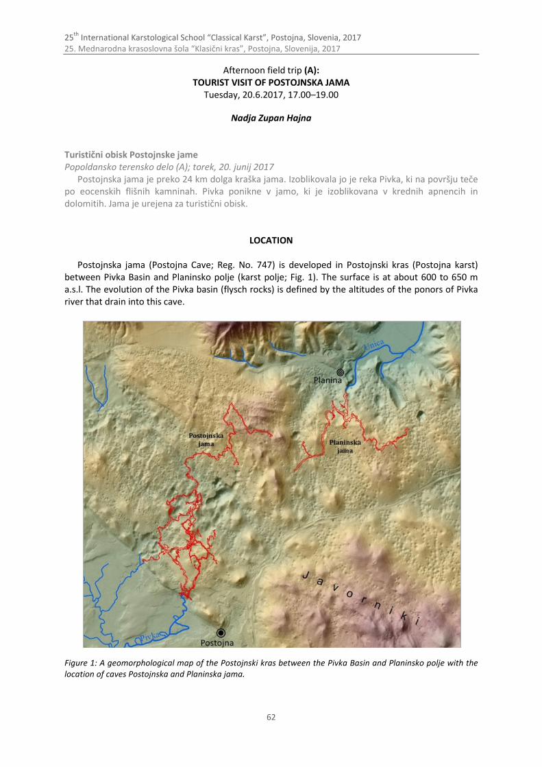
25th
International Karstological School “Classical Karst”, Postojna, Slovenia, 2017 25. Mednarodna krasoslovna šola “Klasični kras”, Postojna, Slovenija, 2017
62
Afternoon field trip (A): TOURIST VISIT OF POSTOJNSKA JAMA
Tuesday, 20.6.2017, 17.00–19.00
Nadja Zupan Hajna Turistični obisk Postojnske jame Popoldansko terensko delo (A); torek, 20. junij 2017
Postojnska jama je preko 24 km dolga kraška jama. Izoblikovala jo je reka Pivka, ki na površju teče po eocenskih flišnih kamninah. Pivka ponikne v jamo, ki je izoblikovana v krednih apnencih in dolomitih. Jama je urejena za turistični obisk.
LOCATION
Postojnska jama (Postojna Cave; Reg. No. 747) is developed in Postojnski kras (Postojna karst) between Pivka Basin and Planinsko polje (karst polje; Fig. 1). The surface is at about 600 to 650 m a.s.l. The evolution of the Pivka basin (flysch rocks) is defined by the altitudes of the ponors of Pivka river that drain into this cave.
Figure 1: A geomorphological map of the Postojnski kras between the Pivka Basin and Planinsko polje with the location of caves Postojnska and Planinska jama.

25th
International Karstological School “Classical Karst”, Postojna, Slovenia, 2017 25. Mednarodna krasoslovna šola “Klasični kras”, Postojna, Slovenija, 2017
63
The gentle fluvial surface of the Pivka basin itself stands out in sharp contrast to the karst lands above the cave and to other higher karst plateaus, where there are no traces of fluvial valleys or other elements of the early fluvial relief today (Fig. 1). These surfaces are dissected with numerous dolines. Sixteen large collapse dolines developed above some parts of Postojnska jama, blocking some of the passages. The thickness of bedrock above the cave is 60 to 120 m.
The cave was formed by the river Pivka. Its modern ponor is at 511 m a.s.l. and the sump in Pivka jama (Pivka Cave) is at 477 m a.s.l. There are still more than 800 m of unexplored galleries before the river re-appears in Planinska jama at 460 m a.s.l. In May 2015 the cave divers started to explore the most remote parts of the cave after siphons in Pivka jama (Fig. 1).
GEOLOGY
Surface geology of the Postojna karst terrain between caves Postojnska jama and Planinska jama bases on studies of Buser et al. (1967), Gospodarič 1976, Čar & Gospodarič (1984), Placer (1996), Rižnar 1997 from which results was compiled on new geology map for the purpose of exhibition at Postojna Expo (Zupan Hajna 2015).
Karst between Postojna and Planina builds up about 800 m thick limestones and dolomites of Cretaceous age. Carbonate beds of various thicknes are overthrusted, folded and faulted due to regional tectonics (Placer 1996). Important structural elements of folding are Postojna anticline and Studeno syncline, which are oriented in SE–NW direction. Significant faults are in Dinaric direction (SE–NW; dextral strike-slip fault) and in Cross-Dinaric direction (sinistral strike-slip fault); some of them are vertical.
River Pivka flows on impermeable Eocene flysch and on the contact with limestones sinks into cave Postojnska jama. River Pivka flows underground towards cave Planinska jama, from where then emerges as river Unica. The entire cave is developed in an 800-meter thick sequence of limestones confined by two distinctive dextral strike-slip fault zones in the Dinaric trend (Predjama and Idrija faults). Cave passages were mostly formed following inter-bedded slips (Šebela 1998) in the limestones of the Postojna anticline, which is oriented in the NW–SE direction (Gospodarič 1963, 1964, 1976). The cave is intersected by several fault zones in the Dinaric and cross-Dinaric direction; some faults were important for guiding the direction of the water flow and for the formation of passages, while others were simply traversed by the water flow. Large breakdown halls in caves are formed in thick-bedded and tectonically collapsed limestones in the fluctuation zone of the groundwater that dissolves the collapsed blocks.
THE CAVE
The total length of known passages is (in May 2017) more than 24 km and the calculated volume of all cave passages is 1.7 million cubic meters (Glažar & Drole 2015). The graund plan is on Figure 2 (Glažar et al. 2015). The passages were formed in two levels. The upper dry section of the cave lies between 520 and 530 m.
The altitude difference between the highest point at the entrance to Magdalena jama and the lowest point at the siphon in Pivka jama is 115 m. The distance from the ponor of River Pivka into Postojnska jama to the siphon in Pivka jama is approx. 3.5 km. The known section of the Rov podzemne Pivke (Passage of the Subterranean Pivka) ends about 800 m before reached Planinska jama passages (Fig. 1). The source of River Unica is in Planinska jama, from where the river flows on the surface of the Planinsko polje.
Active water passages are on average smaller than the passages in the presently dry sections. Flysch gravel and sand are predominant in the rocky bottom. The average water discharge is
5.2 m3/s. During flooding, the water in passages can raise by 10 m. Signs of flows with various velocities are visible on walls in scallops of different sizes.

25th
International Karstological School “Classical Karst”, Postojna, Slovenia, 2017 25. Mednarodna krasoslovna šola “Klasični kras”, Postojna, Slovenija, 2017
64
Figure 2: The ground plan of Postojnska jama with its entrances.
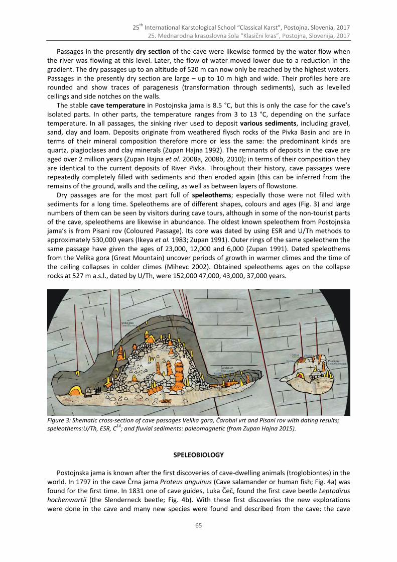
25th
International Karstological School “Classical Karst”, Postojna, Slovenia, 2017 25. Mednarodna krasoslovna šola “Klasični kras”, Postojna, Slovenija, 2017
65
Passages in the presently dry section of the cave were likewise formed by the water flow when the river was flowing at this level. Later, the flow of water moved lower due to a reduction in the gradient. The dry passages up to an altitude of 520 m can now only be reached by the highest waters. Passages in the presently dry section are large – up to 10 m high and wide. Their profiles here are rounded and show traces of paragenesis (transformation through sediments), such as levelled ceilings and side notches on the walls.
The stable cave temperature in Postojnska jama is 8.5 °C, but this is only the case for the cave’s isolated parts. In other parts, the temperature ranges from 3 to 13 °C, depending on the surface temperature. In all passages, the sinking river used to deposit various sediments, including gravel, sand, clay and loam. Deposits originate from weathered flysch rocks of the Pivka Basin and are in terms of their mineral composition therefore more or less the same: the predominant kinds are quartz, plagioclases and clay minerals (Zupan Hajna 1992). The remnants of deposits in the cave are aged over 2 million years (Zupan Hajna et al. 2008a, 2008b, 2010); in terms of their composition they are identical to the current deposits of River Pivka. Throughout their history, cave passages were repeatedly completely filled with sediments and then eroded again (this can be inferred from the remains of the ground, walls and the ceiling, as well as between layers of flowstone.
Dry passages are for the most part full of speleothems; especially those were not filled with sediments for a long time. Speleothems are of different shapes, colours and ages (Fig. 3) and large numbers of them can be seen by visitors during cave tours, although in some of the non-tourist parts of the cave, speleothems are likewise in abundance. The oldest known speleothem from Postojnska jama’s is from Pisani rov (Coloured Passage). Its core was dated by using ESR and U/Th methods to approximately 530,000 years (Ikeya et al. 1983; Zupan 1991). Outer rings of the same speleothem the same passage have given the ages of 23,000, 12,000 and 6,000 (Zupan 1991). Dated speleothems from the Velika gora (Great Mountain) uncover periods of growth in warmer climes and the time of the ceiling collapses in colder climes (Mihevc 2002). Obtained speleothems ages on the collapse rocks at 527 m a.s.l., dated by U/Th, were 152,000 47,000, 43,000, 37,000 years.
Figure 3: Shematic cross-section of cave passages Velika gora, Čarobni vrt and Pisani rov with dating results; speleothems:U/Th, ESR, C
14; and fluvial sediments: paleomagnetic (from Zupan Hajna 2015).
SPELEOBIOLOGY
Postojnska jama is known after the first discoveries of cave-dwelling animals (troglobiontes) in the world. In 1797 in the cave Črna jama Proteus anguinus (Cave salamander or human fish; Fig. 4a) was found for the first time. In 1831 one of cave guides, Luka Čeč, found the first cave beetle Leptodirus hochenwartii (the Slenderneck beetle; Fig. 4b). With these first discoveries the new explorations were done in the cave and many new species were found and described from the cave: the cave
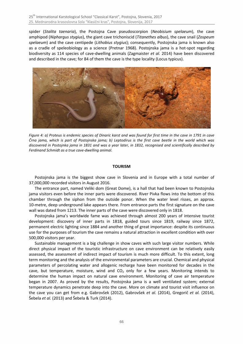
25th
International Karstological School “Classical Karst”, Postojna, Slovenia, 2017 25. Mednarodna krasoslovna šola “Klasični kras”, Postojna, Slovenija, 2017
66
spider (Stalita taenaria), the Postojna Cave pseudoscorpion (Neobisium spelaeum), the cave amphipod (Niphargus stygius), the giant cave trichoniscid (Titanethes albus), the cave snail (Zospeum spelaeum) and the cave centipede (Lithobius stygius); consequently, Postojnska jama is known also as a cradle of speleobiology as a science (Pretnar 1968). Postojnska jama is a hot-spot regarding biodiversity as 114 species of cave-dwelling animals (Zagmaister et al. 2014) have been discovered and described in the cave; for 84 of them the cave is the type locality (Locus typicus).
Figure 4: a) Proteus is endemic species of Dinaric karst and was found for first time in the cave in 1791 in cave Črna jama, which is part of Postojnska jama; b) Leptodirus is the first cave beetle in the world which was discovered in Postojnka jama in 1831 and was a year later, in 1832, recognised and scientifically described by Ferdinand Schmidt as a true cave-dwelling animal.
TOURISM
Postojnska jama is the biggest show cave in Slovenia and in Europe with a total number of 37,000,000 recorded visitors in August 2016.
The entrance part, named Veliki dom (Great Dome), is a hall that had been known to Postojnska jama visitors even before the inner parts were discovered. River Pivka flows into the bottom of this chamber through the siphon from the outside ponor. When the water level risses, an approx. 10-metre, deep underground lake appears there. From entrance parts the first signature on the cave wall was dated from 1213. The inner parts of the cave were discovered only in 1818.
Postojnska jama’s worldwide fame was achieved through almost 200 years of intensive tourist development: discovery of inner parts in 1818, guided tours since 1819, railway since 1872, permanent electric lighting since 1884 and another thing of great importance: despite its continuous use for the purposes of tourism the cave remains a natural attraction in excellent condition with over 500,000 visitors per year.
Sustainable management is a big challenge in show caves with such large visitor numbers. While direct physical impact of the touristic infrastructure on cave environment can be relatively easily assessed, the assessment of indirect impact of tourism is much more difficult. To this extent, long term monitoring and the analysis of the environmental parameters are crucial. Chemical and physical parameters of percolating water and allogenic recharge have been monitored for decades in the cave, but temperature, moisture, wind and CO2 only for a few years. Monitoring intends to determine the human impact on natural cave environment. Monitoring of cave air temperature began in 2007. As proved by the results, Postojnska jama is a well ventilated system; external temperature dynamics penetrate deep into the cave. More on climate and tourist visit influence on the cave you can get from e.g. Gabrovšek (2012), Gabrovšek et al. (2014), Gregorič et al. (2014), Šebela et al. (2013) and Šebela & Turk (2014).
25th
International Karstological School “Classical Karst”, Postojna, Slovenia, 2017 25. Mednarodna krasoslovna šola “Klasični kras”, Postojna, Slovenija, 2017
67
References Buser S., Grad K. & Pleničar M., 1967: Osnovna geološka karta SFRJ, list Postojna, 1 : 100 000. Zvezni geološki zavod
Beograd, Beograd. Čar J. & Gospodarič R., 1984: O geologiji krasa med Postojno, Planino in Cerknico. Acta Carsologica, 12(1983/1984),
91-105. Gabrovšek F., 2012: Relevance and measurements of selected physical quantities representing cave environment:
examples from Postojna cave and Škocjan cave (Slovenia). In: Šebela, S. (ed.): International Congress on "Scientific Research in Show Caves", 13th to 15th September 2012, Postojna, Guide book and abstracts, Inštitut za raziskovanje krasa ZRC SAZU, 24-25.
Gabrovšek F., Grašič B., Božnar M., Mlakar P. Udén M. & Davies E., 2014: Karst show caves - how DTN technology as used in space assists automatic environmental monitoring and tourist protection - experiment in Postojna Cave. Natural hazards and earth system sciences, 14/2, 443-457.
Glažar S., Drole F. & J. Hajna, 2015: The preparation of a new plan of Postojnska jama in accordance with the Karst Research Institute ZRC SAZU Cadastre for new Exhibition at Postojnska jama.
Gospodarič R., 1963: K poznavanju Postojnske jame – Pisani rov. Naše jame, 4 (1962), 9-16. Gospodarič R., 1964: Sledovi tektonskih premikov iz ledene dobe v Postojnski jami. Naše jame, 5 (1963), 5-11. Gospodarič R., 1976: The Quaternary Caves Developement Between the Pivška kotlina (Pivka Basin) and Planinsko
polje (polje of Planina). Acta Carsologica, 7, 5-139. Gregorič A., Vaupotič J. & Šebela S., 2014: The role of cave ventilation in governing cave air temperature and radon
levels (Postojna Cave, Slovenia). International journal of climatology, 34/5, 1488-1500. Ikeya M., Miki T. & Gospodarič R., 1983: ESR Dating of Postojna Cave Stalactite. Acta Carsologica, 11 (1982), 117-130. Mihevc A., 2002: Postojnska jama cave system, U/Th datation of the collapse processes on Velika Gora. In: Gabrovšek
F. (Ed.): Programme and guide booklet for the excursions: Evolution of Karst: from Prekarst to Cessation, September, 17th –21st, 2002. Postojna, 14-15.
Placer L., 1996: O zgradbi Soviča nad Postojno. Geologija, 37/38 (1994/95), 551-560, Ljubljana. Pretnar, E., 1968: Živalstvo Postojnske jame. 150 let Postojnske jame, 1818–1968. Zavod Postojnske jame, Postojna,
59–71. Rižnar I., 1997: Geology of Postojna area. MSc. Thesis, NTF, University of Ljubljana, 78 pp., Ljubljana. Šebela S., & Turk J., 2014: Natural and anthropogenic influences on the year-round temperature dynamics of air and
water in Postojna show cave, Slovenia. Tourism Management, 40, 233–243. Šebela S., 1998: Tectonic structure of Postojnska Jama Cave system. Založba ZRC, 18, p. 112, Ljubljana. Šebela S., Prelovšek M. & Turk J., 2013: Impact of peak period visits on the Postojna cave (Slovenia) microclimate.
Theoretical and Applied Climatology, 111, 51–64. Zagmajster, M., Prevorčnik, S., in Sket, B., 2014: Seznam izključno podzemnih (troglobiotskih) vrst ali populacij živali v
Postojnsko-planinskem jamskem sistemu. Poročilo, p. 5, Ljubljana. Zupan N., 1991: Flowstone datations in Slovenia. Acta Carsologica, 20, 187-204. Zupan Hajna N., 1992: Mineral composition of mechanical sediments from some parts on Slovenian karst. Acta
Carsologica, 21, 115-130. Zupan Hajna N., Mihevc A., Pruner P. & Bosák P., 2008a: Cave sediments from the Postojnska-Planinska cave system
(Slovenia): evidence of multiphase evolution in epiphreatic zone. Acta Carsologica, 37/1, 63-86. Zupan Hajna N., Mihevc A., Pruner P. & Bosák P., 2008b: Palaeomagnetism and Magnetostratigraphy of Karst
Sediments in Slovenia. Carsologica 8, Založba ZRC, p. 266, Ljubljana. Zupan Hajna N., Mihevc A., Pruner P., Bosák P., 2010: Palaeomagnetic research on karst sediments in Slovenia.
International journal of speleology, 39/2, 47-60. Zupan Hajna, N., 2015: The concept and settings of nature phenomena of an interpretative exhibition at Postojnska
jama. Exhibition, Postojnska jama EXPO.
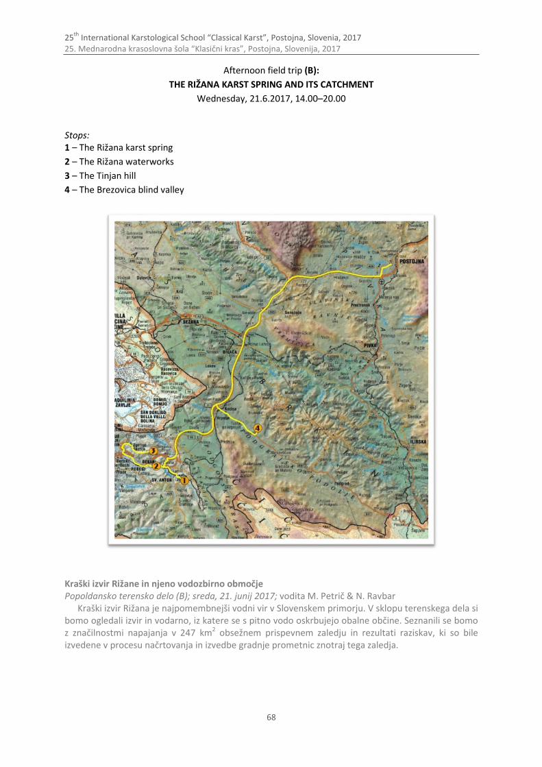
25th
International Karstological School “Classical Karst”, Postojna, Slovenia, 2017 25. Mednarodna krasoslovna šola “Klasični kras”, Postojna, Slovenija, 2017
68
Afternoon field trip (B):
THE RIŽANA KARST SPRING AND ITS CATCHMENT
Wednesday, 21.6.2017, 14.00–20.00 Stops: 1 – The Rižana karst spring
2 – The Rižana waterworks
3 – The Tinjan hill
4 – The Brezovica blind valley
Kraški izvir Rižane in njeno vodozbirno območje Popoldansko terensko delo (B); sreda, 21. junij 2017; vodita M. Petrič & N. Ravbar
Kraški izvir Rižana je najpomembnejši vodni vir v Slovenskem primorju. V sklopu terenskega dela si bomo ogledali izvir in vodarno, iz katere se s pitno vodo oskrbujejo obalne občine. Seznanili se bomo z značilnostmi napajanja v 247 km2 obsežnem prispevnem zaledju in rezultati raziskav, ki so bile izvedene v procesu načrtovanja in izvedbe gradnje prometnic znotraj tega zaledja.
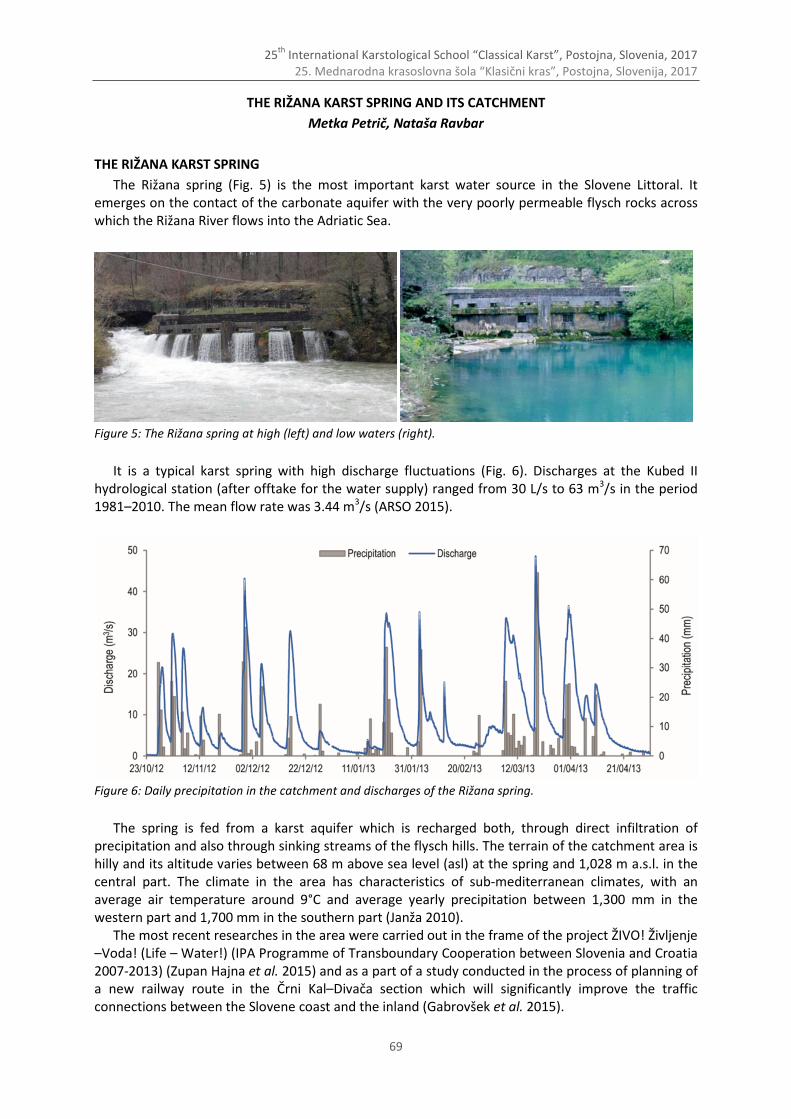
25th
International Karstological School “Classical Karst”, Postojna, Slovenia, 2017 25. Mednarodna krasoslovna šola “Klasični kras”, Postojna, Slovenija, 2017
69
THE RIŽANA KARST SPRING AND ITS CATCHMENT
Metka Petrič, Nataša Ravbar
THE RIŽANA KARST SPRING
The Rižana spring (Fig. 5) is the most important karst water source in the Slovene Littoral. It emerges on the contact of the carbonate aquifer with the very poorly permeable flysch rocks across which the Rižana River flows into the Adriatic Sea.
Figure 5: The Rižana spring at high (left) and low waters (right).
It is a typical karst spring with high discharge fluctuations (Fig. 6). Discharges at the Kubed II hydrological station (after offtake for the water supply) ranged from 30 L/s to 63 m3/s in the period 1981–2010. The mean flow rate was 3.44 m3/s (ARSO 2015).
Figure 6: Daily precipitation in the catchment and discharges of the Rižana spring.
The spring is fed from a karst aquifer which is recharged both, through direct infiltration of precipitation and also through sinking streams of the flysch hills. The terrain of the catchment area is hilly and its altitude varies between 68 m above sea level (asl) at the spring and 1,028 m a.s.l. in the central part. The climate in the area has characteristics of sub-mediterranean climates, with an average air temperature around 9°C and average yearly precipitation between 1,300 mm in the western part and 1,700 mm in the southern part (Janža 2010).
The most recent researches in the area were carried out in the frame of the project ŽIVO! Življenje –Voda! (Life – Water!) (IPA Programme of Transboundary Cooperation between Slovenia and Croatia 2007-2013) (Zupan Hajna et al. 2015) and as a part of a study conducted in the process of planning of a new railway route in the Črni Kal–Divača section which will significantly improve the traffic connections between the Slovene coast and the inland (Gabrovšek et al. 2015).

25th
International Karstological School “Classical Karst”, Postojna, Slovenia, 2017 25. Mednarodna krasoslovna šola “Klasični kras”, Postojna, Slovenija, 2017
70
HYDROGEOLOGICAL CHARACTERISTICS
On the basis of hydrogeological studies and numerous tracer experiments (Krivic et al. 1987, 1989; Gabrovšek et al. 2015) the catchment of the Rižana is estimated at 247 km2. For the most part it lies within Slovenia, with only a small part extending to the Croatian side of the border. It is characterised by an alternation of highly permeable Cretaceous and Palaeocene limestone and dolomite and very poorly permeable Eocene flysch (Fig. 7). Karstification is related to bedding planes and tectonic features with prevailing NW–SE strike (Janža 2010). From the tectonic point of view, the area is positioned in the border area between Dinarides and Adriatic–Apulian foreland (Placer 1998). The spring is located in the narrow SW-verging imbricate belt in the front of the External Dinarides, believed to have formed in response to Adriatic–Apulian (Istria, Friuli) underthrusting External Dinarides (Kras, Čičarija). Within the underthrusting belt a geomorphological step was formed at sites where limestones are thrusted on flysch rocks (Placer 2007). This so-called Kraški Rob (»karst edge« in English) is cut by a series of reverse and thrust faults into a system of thrust-plane bounded slices which are partly hydraulically connected and form very complex hydrogeological conditions.
Karst aquifer with underground water flow developed in carbonate rocks, while flysch areas feature a network of surface streams along which alluvial sediments are deposited. Surface streams from flysch percolate into the karst underground at points of contact with carbonate rocks, while on the other side of the karst aquifer groundwater comes to the surface through karst springs at points of contact of this kind (Biondić et al. 2015).
At the southern margin of the Brkini hills (Fig. 7), surface waters disappear underground into the karst aquifer at a contact approximately 20 km long, where the limestones dip steeply under the flysch. Blind valleys with solution-widened floors are a typical karst landform. Numerous small surface watercourses drain an area of approximately 30 km2. The sizes of the catchment areas of individual sinking streams range from 0.5 to 13.2 km2. The ponors are at 490 to 510 m a.s.l. Some of them continue into karst caves that end with siphons of trapped water at heights of between 370 and 430 m a.s.l. The deepest cave has a depth of 150 m and the longest a length of 6 km (Mihevc 1994).
The alternation of flysch and limestone is also typical for the area southern of the Rižana spring. At the contact, elongated shallow karst depressions called vale (singular: vala) have developed at heights of between 168 and 300 m a.s.l. In terms of their hydrological characteristics, these are a kind of periodically flooded boundary karst poljes. The floods are caused by the insufficient absorption capacity of ponors when the water level is high. They occur two to three times a year and last from a few hours to a few days (Habič et al. 1983).

25th
International Karstological School “Classical Karst”, Postojna, Slovenia, 2017 25. Mednarodna krasoslovna šola “Klasični kras”, Postojna, Slovenija, 2017
71
Figure 7: Hydrogeological map of the area.
TRACER TESTS IN THE RIŽANA CATCHMENT
The first tracer tests in the area were carried out in the early 20th century when Timeus injected uranine into a stream in the Odolina blind valley on the southern margin of the Brkini hills and proved the existence of a connection with the Rižana spring (Timeus 1910). Later on, following several unsuccessful tests (Čadež 1963), doubts were raised about these results, but subsequent tracings have confirmed them.
Three multi-tracer tests have been carried in the area of the Brkini sinking streams. In April 1985 uranine was injected into a sinking stream Ločica near Brezovica, potassium chloride (KCl) in Male Loče, rhodamine in Gračišče and bacteriophages near Smokvica (Krivic et al. 1987). Tracing with KCl was unsuccessful, probably because the quantity of salt injected was insufficient, while despite several springs being observed, the other tracers only appeared in the Rižana spring. In May 1986 researchers injected rhodamine in the Jezerina blind valley, uranine in Male Loče and bacteriophages into a stream near Hotična. The rhodamine from Jezerina appeared in the Rižana, while in an intermittent spring named Osapska Reka it only appeared in low concentrations in the water pulse following rainfall. Even so this connection was considered very probable. The uranine from Male Loče appeared in the Rižana and Osapska Reka springs in very low concentrations but the connection was assessed as being very probable. The connection of these two injection points with some observed springs in Croatia was assessed as possible but could not be reliably confirmed on the basis of the results. The bacteriophages injected into the stream near Hotična proved a connection with the Rižana.
In the recent years, three tracer tests were carried out in the process of planning of a new railway line in the Črni Kal–Divača section, of which a considerable part will run through tunnels. This line bisects the trans-boundary karst aquifer with two important water sources: the Rižana spring and the Boljunec spring (Italian: Bagnoli della Rosandra) on the Italian side of the border (Fig. 7). The latter is much smaller (discharges from merely a few litres per second to more then 2 m3/s) and is only used in a nearby fish farm.
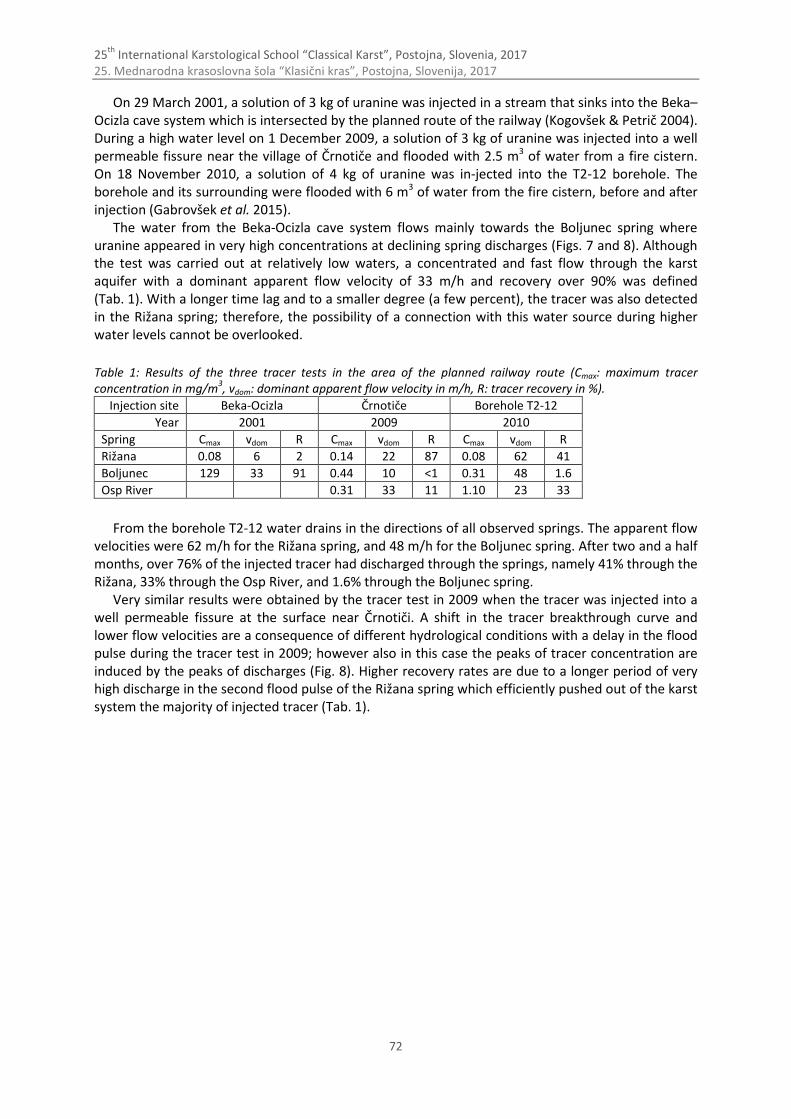
25th
International Karstological School “Classical Karst”, Postojna, Slovenia, 2017 25. Mednarodna krasoslovna šola “Klasični kras”, Postojna, Slovenija, 2017
72
On 29 March 2001, a solution of 3 kg of uranine was injected in a stream that sinks into the Beka–Ocizla cave system which is intersected by the planned route of the railway (Kogovšek & Petrič 2004). During a high water level on 1 December 2009, a solution of 3 kg of uranine was injected into a well permeable fissure near the village of Črnotiče and flooded with 2.5 m3 of water from a fire cistern. On 18 November 2010, a solution of 4 kg of uranine was in-jected into the T2-12 borehole. The borehole and its surrounding were flooded with 6 m3 of water from the fire cistern, before and after injection (Gabrovšek et al. 2015).
The water from the Beka-Ocizla cave system flows mainly towards the Boljunec spring where uranine appeared in very high concentrations at declining spring discharges (Figs. 7 and 8). Although the test was carried out at relatively low waters, a concentrated and fast flow through the karst aquifer with a dominant apparent flow velocity of 33 m/h and recovery over 90% was defined (Tab. 1). With a longer time lag and to a smaller degree (a few percent), the tracer was also detected in the Rižana spring; therefore, the possibility of a connection with this water source during higher water levels cannot be overlooked.
Table 1: Results of the three tracer tests in the area of the planned railway route (Cmax: maximum tracer concentration in mg/m
3, vdom: dominant apparent flow velocity in m/h, R: tracer recovery in %).
Injection site Beka-Ocizla Črnotiče Borehole T2-12
Year 2001 2009 2010
Spring Cmax vdom R Cmax vdom R Cmax vdom R
Rižana 0.08 6 2 0.14 22 87 0.08 62 41
Boljunec 129 33 91 0.44 10 <1 0.31 48 1.6
Osp River 0.31 33 11 1.10 23 33
From the borehole T2-12 water drains in the directions of all observed springs. The apparent flow velocities were 62 m/h for the Rižana spring, and 48 m/h for the Boljunec spring. After two and a half months, over 76% of the injected tracer had discharged through the springs, namely 41% through the Rižana, 33% through the Osp River, and 1.6% through the Boljunec spring.
Very similar results were obtained by the tracer test in 2009 when the tracer was injected into a well permeable fissure at the surface near Črnotiči. A shift in the tracer breakthrough curve and lower flow velocities are a consequence of different hydrological conditions with a delay in the flood pulse during the tracer test in 2009; however also in this case the peaks of tracer concentration are induced by the peaks of discharges (Fig. 8). Higher recovery rates are due to a longer period of very high discharge in the second flood pulse of the Rižana spring which efficiently pushed out of the karst system the majority of injected tracer (Tab. 1).
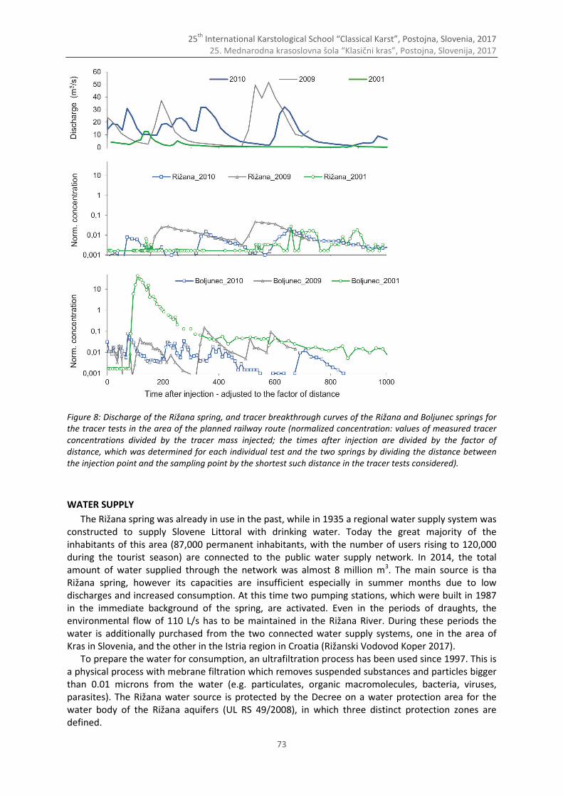
25th
International Karstological School “Classical Karst”, Postojna, Slovenia, 2017 25. Mednarodna krasoslovna šola “Klasični kras”, Postojna, Slovenija, 2017
73
Figure 8: Discharge of the Rižana spring, and tracer breakthrough curves of the Rižana and Boljunec springs for the tracer tests in the area of the planned railway route (normalized concentration: values of measured tracer concentrations divided by the tracer mass injected; the times after injection are divided by the factor of distance, which was determined for each individual test and the two springs by dividing the distance between the injection point and the sampling point by the shortest such distance in the tracer tests considered).
WATER SUPPLY
The Rižana spring was already in use in the past, while in 1935 a regional water supply system was constructed to supply Slovene Littoral with drinking water. Today the great majority of the inhabitants of this area (87,000 permanent inhabitants, with the number of users rising to 120,000 during the tourist season) are connected to the public water supply network. In 2014, the total amount of water supplied through the network was almost 8 million m3. The main source is tha Rižana spring, however its capacities are insufficient especially in summer months due to low discharges and increased consumption. At this time two pumping stations, which were built in 1987 in the immediate background of the spring, are activated. Even in the periods of draughts, the environmental flow of 110 L/s has to be maintained in the Rižana River. During these periods the water is additionally purchased from the two connected water supply systems, one in the area of Kras in Slovenia, and the other in the Istria region in Croatia (Rižanski Vodovod Koper 2017).
To prepare the water for consumption, an ultrafiltration process has been used since 1997. This is a physical process with mebrane filtration which removes suspended substances and particles bigger than 0.01 microns from the water (e.g. particulates, organic macromolecules, bacteria, viruses, parasites). The Rižana water source is protected by the Decree on a water protection area for the water body of the Rižana aquifers (UL RS 49/2008), in which three distinct protection zones are defined.

25th
International Karstological School “Classical Karst”, Postojna, Slovenia, 2017 25. Mednarodna krasoslovna šola “Klasični kras”, Postojna, Slovenija, 2017
74
WATER QUALITY
Regular monitoring at the Rižana spring in the period 2010–2015
The water quality monitoring is carried out by the water supply company weekly at varios points within the water supply system, ATP (adenosine triphosphate) tests for microbiological quality are performed even more frequently. The raw water at the spring is tested more seldomly (usually monthly), below the results for the period from 2010 to 2015 are discussed (Diković & Koželj 2015).
The organoleptic properties of the water at the spring are acceptable, but it is unrefined water which requires processing in order to be potable. The turbidity is usually between 2 NTU and 6 NTU, and the average turbidity for the period 2010 – May 2015 is 3.9 NTU. During rainy periods the turbidity can increase to 10 NTU or even as high as 70 NTU. Water is classified as moderately hard
(11 °dH–15 °dH or 195 mg CaCO3/L–263 mg CaCO3/L). The water’s ionic composition has not significantly changed over the years of research, but there are seasonal variations relating to changing hydrological conditions. The average electrical conductivity of the water for the period
2010 – February 2015 is 390 µS/cm, the levels fluctuated within an interval of (390 ± 70) µS/cm. The predominant ions in the water at the Rižana spring are calcium and hydrogen carbonate. The
concentration of dissolved calcium in 2014 ranged between 75 mg/L and 85 mg/L. The average concentration of hydrogen carbonate for the period 2010 – February 2015 was 249 mg/L and ranged between 230 mg/L and 280 mg/L. In the same period the average concentration of sulphate was 4.5 mg/L and chloride 3.6 mg/L. The content of nitrates at the Rižana spring in the period from 2010 – February 2015 ranged between 2.8 mg NO3/L and 7.3 mg NO3/L with an average level of 4.4 mg NO3/L. The contents of nitrite and ammonium during this period were below the limit of detection for the methods used (below 0.010 mg NO2/L or below 0.026 mg NH4/L). The o-phosphate content ranged from 0.018 mg PO4/L to 0.044 mg PO4/L with an average level of 0.030 mg PO4/L.
The content of organic pollutants at the spring was evaluated with respect to the total organic carbon (TOC) content. The average concentration of TOC during the period 2010 – February 2015 was 0.92 mg C/L and ranged between 0.6 mg C/L and 1.6 mg C/L.
Monitoring of physical and chemical parameters during two flood pulses
In June 2015, a detailed monitoring of the quality of the Rižana spring was carried out during two consecutive flood pulses following a dry period that had lasted since the end of March 2015, while at the same time monitoring precipitation and hydrological conditions (Petrič et al. 2015).
Extremely wet hydrological year 2014 was followed by an extremely arid semi-annual period in 2015. In the three-day period between 14 and 16 June 2015 the first more abundant precipitation event (in total 25 mm) occurred. After a few days, between 23 and 24 June, additional 71 mm of rain fell, with a maximum hourly quantity of precipitation of as much as 22 mm. In the studied area, this rainfall intensity is rather a rare phenomenon with a one-year return period. Consequently, the two recharge events provoked two different flood pulses at the observed spring of different magnitude (Fig. 9).
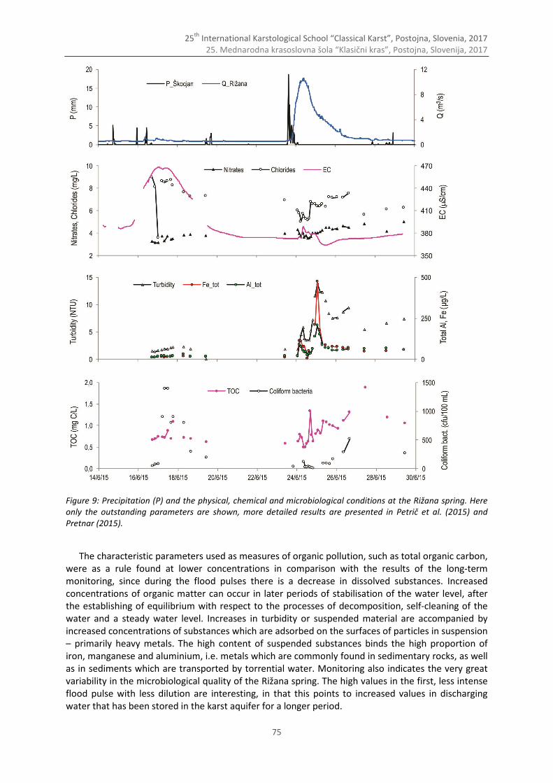
25th
International Karstological School “Classical Karst”, Postojna, Slovenia, 2017 25. Mednarodna krasoslovna šola “Klasični kras”, Postojna, Slovenija, 2017
75
Figure 9: Precipitation (P) and the physical, chemical and microbiological conditions at the Rižana spring. Here only the outstanding parameters are shown, more detailed results are presented in Petrič et al. (2015) and Pretnar (2015).
The characteristic parameters used as measures of organic pollution, such as total organic carbon, were as a rule found at lower concentrations in comparison with the results of the long-term monitoring, since during the flood pulses there is a decrease in dissolved substances. Increased concentrations of organic matter can occur in later periods of stabilisation of the water level, after the establishing of equilibrium with respect to the processes of decomposition, self-cleaning of the water and a steady water level. Increases in turbidity or suspended material are accompanied by increased concentrations of substances which are adsorbed on the surfaces of particles in suspension – primarily heavy metals. The high content of suspended substances binds the high proportion of iron, manganese and aluminium, i.e. metals which are commonly found in sedimentary rocks, as well as in sediments which are transported by torrential water. Monitoring also indicates the very great variability in the microbiological quality of the Rižana spring. The high values in the first, less intense flood pulse with less dilution are interesting, in that this points to increased values in discharging water that has been stored in the karst aquifer for a longer period.
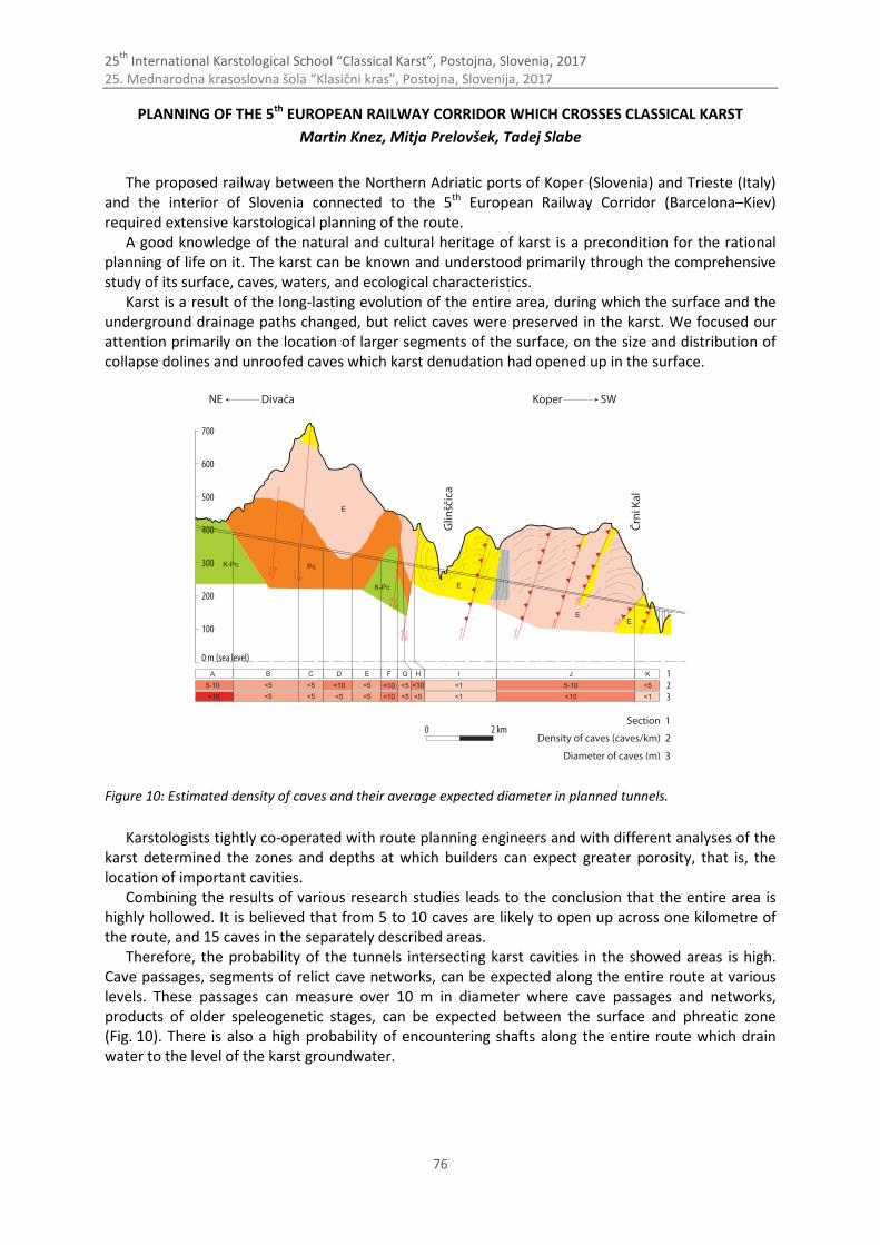
25th
International Karstological School “Classical Karst”, Postojna, Slovenia, 2017 25. Mednarodna krasoslovna šola “Klasični kras”, Postojna, Slovenija, 2017
76
PLANNING OF THE 5th EUROPEAN RAILWAY CORRIDOR WHICH CROSSES CLASSICAL KARST
Martin Knez, Mitja Prelovšek, Tadej Slabe
The proposed railway between the Northern Adriatic ports of Koper (Slovenia) and Trieste (Italy) and the interior of Slovenia connected to the 5th European Railway Corridor (Barcelona–Kiev) required extensive karstological planning of the route.
A good knowledge of the natural and cultural heritage of karst is a precondition for the rational planning of life on it. The karst can be known and understood primarily through the comprehensive study of its surface, caves, waters, and ecological characteristics.
Karst is a result of the long-lasting evolution of the entire area, during which the surface and the underground drainage paths changed, but relict caves were preserved in the karst. We focused our attention primarily on the location of larger segments of the surface, on the size and distribution of collapse dolines and unroofed caves which karst denudation had opened up in the surface.
Figure 10: Estimated density of caves and their average expected diameter in planned tunnels.
Karstologists tightly co-operated with route planning engineers and with different analyses of the karst determined the zones and depths at which builders can expect greater porosity, that is, the location of important cavities.
Combining the results of various research studies leads to the conclusion that the entire area is highly hollowed. It is believed that from 5 to 10 caves are likely to open up across one kilometre of the route, and 15 caves in the separately described areas.
Therefore, the probability of the tunnels intersecting karst cavities in the showed areas is high. Cave passages, segments of relict cave networks, can be expected along the entire route at various levels. These passages can measure over 10 m in diameter where cave passages and networks, products of older speleogenetic stages, can be expected between the surface and phreatic zone (Fig. 10). There is also a high probability of encountering shafts along the entire route which drain water to the level of the karst groundwater.
25th
International Karstological School “Classical Karst”, Postojna, Slovenia, 2017 25. Mednarodna krasoslovna šola “Klasični kras”, Postojna, Slovenija, 2017
77
References
ARSO, 2015: Arhiv hidroloških podatkov.- [Online] Available from:
http://vode.arso.gov.si/hidarhiv/pov_arhiv_tab.php [Accessed 21st May 2015]. Biondić, R., Petrič, M. & J. Rubinić, 2015: Overview of the hydrogeology.- In: Zupan Hajna et al. (Eds.) Life and water
on Karst: monitoring of transboundary water resources of Northern Istria. ZRC Publishing, p. 60-74, Ljubljana. Čadež, N., 1963: Barvanje in poizkus z raziskovalno metodo s trosi v Brkinih leta 1963.- HMZ, Ljubljana. Diković, S. & A. Koželj, 2015: Groundwater quality in changing hydrological conditions and comparison with the
results of long-term monitoring.- In: Zupan Hajna et al. (Eds.) Life and water on Karst: monitoring of transboundary water resources of Northern Istria. ZRC Publishing, p. 105-123, Ljubljana.
Gabrovšek, F., Knez, M., Kogovšek, J., Mihevc, A., Mulec, J., Otoničar, B., Perne, M., Petrič, M., Pipan, T., Prelovšek, M., Slabe, T., Šebela, S., Turk, J. & N. Zupan Hajna, 2015: The Beka-Ocizla cave system: karstological railway planning in Slovenia.- Springer, pp. 102, Cham.
Habič, P., Gospodarič, R., Mihevc, A. & F. Šušteršič, 1983: Movraška in Smokavska vala ter Jama pod Krogom.- Acta Carsologica, 11, 77-97.
Janža, M., 2010: Hydrological modeling in the karst area, Rižana spring catchment, Slovenia.- Environmental earth sciences, 61, 5, 909-920.
Kogovšek, J. & M. Petrič, 2004: Advantages of longer-term tracing – three case studies from Slovenia.- Environmental geology, 47, 76-83.
Krivic, P., Bricelj, M., Trišič, N. & M. Zupan, 1987: Sledenje podzemnih vod v zaledju Rižane.- Acta Carsologica, 16, 83-104.
Krivic, P., Bricelj, M. & M. Zupan, 1989: Podzemne vodne zveze na področju Čičarije in osrednjega dela Istre (Slovenija, Hrvatska, NW Jugoslavija).- Acta Carsologica, 18, 265-295.
Mihevc, A., 1994: Contact karst of Brkini hills.- Acta Carsologica, 23, 99-109. Petrič, M., Ravbar, N., Brun, C., Biondić, R. & J. Kogovšek, 2015: Asessment of flow dynamics and solute transport
based on the monitroing of a flood pulse.- In: Zupan Hajna et al. (Eds.) Life and water on Karst: monitoring of transboundary water resources of Northern Istria. ZRC Publishing, p. 124-133, Ljubljana.
Placer, L., 1998: Contribution to the macrotectonic subdivision of the border region between Southern Alps and External Dinarides.- Geologija 41, 223-255.
Placer, L., 2007: Kraški rob (landscape term), Geologic section along the motorway Kozina–Koper (Capodistria).- Geologija 50(1), 29-44.
Pretnar, G., 2015: Microbiological characteristics of selected karst springs.- In: Zupan Hajna et al. (Eds.) Life and water on Karst: monitoring of transboundary water resources of Northern Istria. ZRC Publishing, p. 135-142, Ljubljana.
Rižanski vodovod Koper, 2017: Vodovodno omrežje in objekti.- [Online] Available from: http://www.rvk-jp.si/ [Accessed 10th April 2017].
Timeus, G., 1910: Studi in relazione al provvedimento d'acqua per la citta di Trieste.- Caprin, pp. 82, Trieste. UL RS 49/2008: Uredba o vodovarstvenem območju za vodno telo vodonosnikov Rižane.- [Online] Available from:
http://www.pisrs.si/Pis.web/pregledPredpisa?id=URED4397 [Accessed 21st May 2015]. Zupan Hajna, N., Ravbar, N., Rubinić, J. & M. Petrič (Eds.), 2015: Life and water on Karst: monitoring of transboundary
water resources of Northern Istria.- ZRC Publishing, pp. 151, Ljubljana.
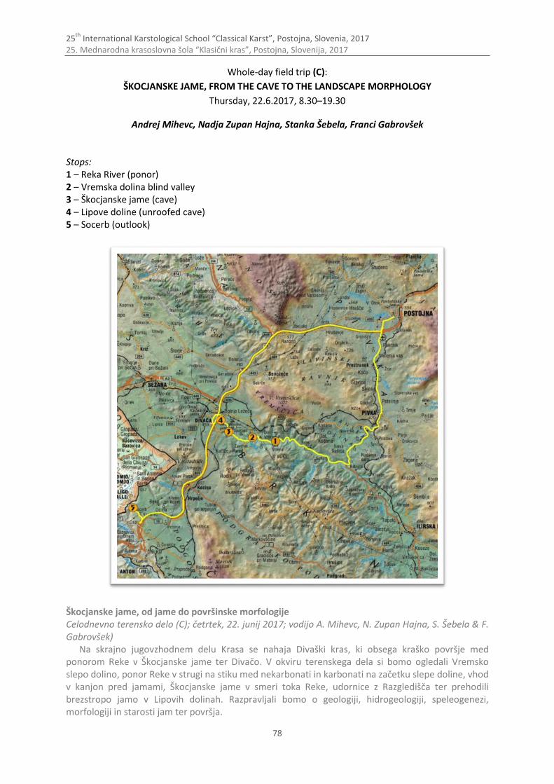
25th
International Karstological School “Classical Karst”, Postojna, Slovenia, 2017 25. Mednarodna krasoslovna šola “Klasični kras”, Postojna, Slovenija, 2017
78
Whole-day field trip (C):
ŠKOCJANSKE JAME, FROM THE CAVE TO THE LANDSCAPE MORPHOLOGY
Thursday, 22.6.2017, 8.30–19.30
Andrej Mihevc, Nadja Zupan Hajna, Stanka Šebela, Franci Gabrovšek Stops: 1 – Reka River (ponor) 2 – Vremska dolina blind valley 3 – Škocjanske jame (cave) 4 – Lipove doline (unroofed cave) 5 – Socerb (outlook)
Škocjanske jame, od jame do površinske morfologije Celodnevno terensko delo (C); četrtek, 22. junij 2017; vodijo A. Mihevc, N. Zupan Hajna, S. Šebela & F. Gabrovšek)
Na skrajno jugovzhodnem delu Krasa se nahaja Divaški kras, ki obsega kraško površje med ponorom Reke v Škocjanske jame ter Divačo. V okviru terenskega dela si bomo ogledali Vremsko slepo dolino, ponor Reke v strugi na stiku med nekarbonati in karbonati na začetku slepe doline, vhod v kanjon pred jamami, Škocjanske jame v smeri toka Reke, udornice z Razgledišča ter prehodili brezstropo jamo v Lipovih dolinah. Razpravljali bomo o geologiji, hidrogeologiji, speleogenezi, morfologiji in starosti jam ter površja.
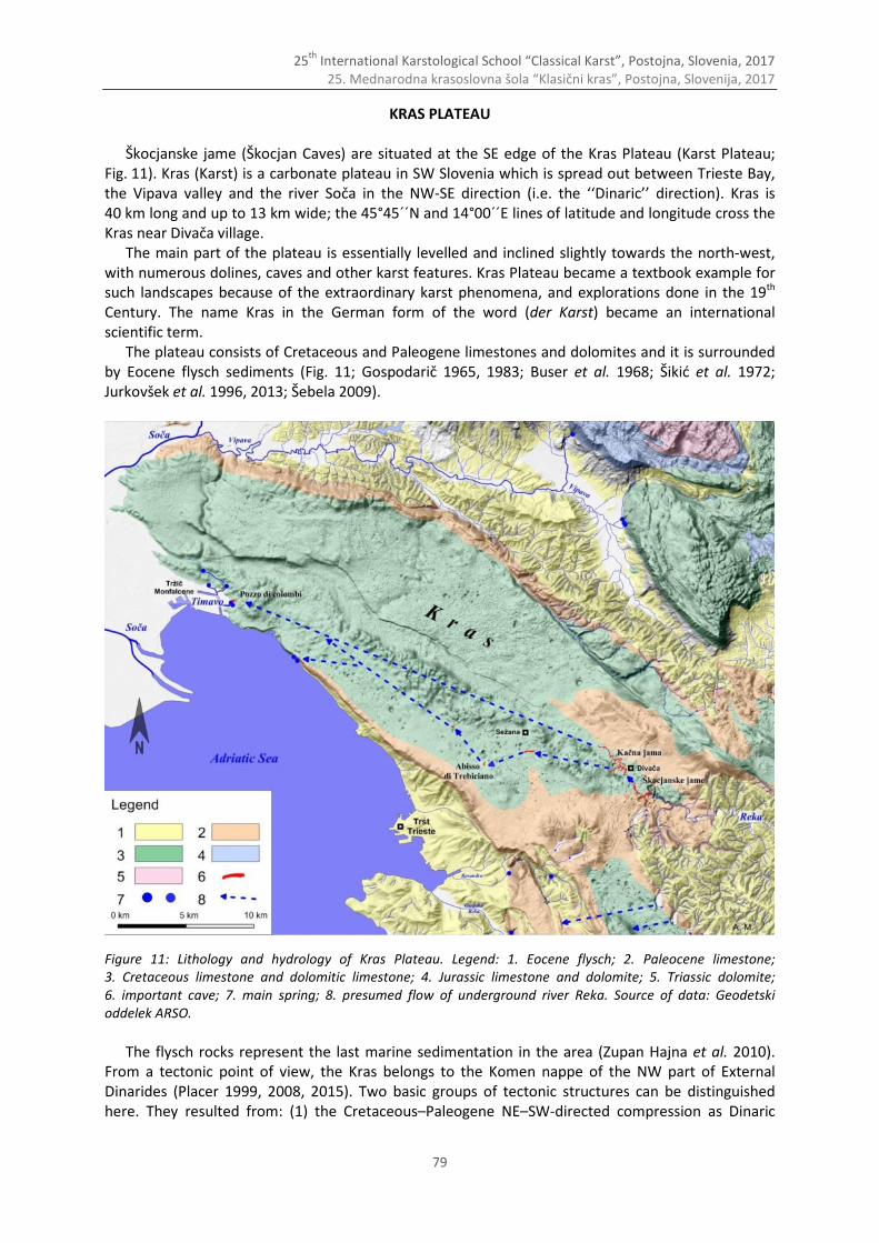
25th
International Karstological School “Classical Karst”, Postojna, Slovenia, 2017 25. Mednarodna krasoslovna šola “Klasični kras”, Postojna, Slovenija, 2017
79
KRAS PLATEAU
Škocjanske jame (Škocjan Caves) are situated at the SE edge of the Kras Plateau (Karst Plateau; Fig. 11). Kras (Karst) is a carbonate plateau in SW Slovenia which is spread out between Trieste Bay, the Vipava valley and the river Soča in the NW-SE direction (i.e. the ‘‘Dinaric’’ direction). Kras is 40 km long and up to 13 km wide; the 45°45´´N and 14°00´´E lines of latitude and longitude cross the Kras near Divača village.
The main part of the plateau is essentially levelled and inclined slightly towards the north-west, with numerous dolines, caves and other karst features. Kras Plateau became a textbook example for such landscapes because of the extraordinary karst phenomena, and explorations done in the 19th Century. The name Kras in the German form of the word (der Karst) became an international scientific term.
The plateau consists of Cretaceous and Paleogene limestones and dolomites and it is surrounded by Eocene flysch sediments (Fig. 11; Gospodarič 1965, 1983; Buser et al. 1968; Šikić et al. 1972; Jurkovšek et al. 1996, 2013; Šebela 2009).
Figure 11: Lithology and hydrology of Kras Plateau. Legend: 1. Eocene flysch; 2. Paleocene limestone; 3. Cretaceous limestone and dolomitic limestone; 4. Jurassic limestone and dolomite; 5. Triassic dolomite; 6. important cave; 7. main spring; 8. presumed flow of underground river Reka. Source of data: Geodetski oddelek ARSO.
The flysch rocks represent the last marine sedimentation in the area (Zupan Hajna et al. 2010).
From a tectonic point of view, the Kras belongs to the Komen nappe of the NW part of External Dinarides (Placer 1999, 2008, 2015). Two basic groups of tectonic structures can be distinguished here. They resulted from: (1) the Cretaceous–Paleogene NE–SW-directed compression as Dinaric
25th
International Karstological School “Classical Karst”, Postojna, Slovenia, 2017 25. Mednarodna krasoslovna šola “Klasični kras”, Postojna, Slovenija, 2017
80
structures (NW–SE-trending regional folds and reverse faults, also cross-Dinaric normal faults), and (2) the Neogene and Quaternary N–S-directed compression (NW–SE-trending strike-slip faults; Jurkovšek et al. 1996, 2013; Šebela 2009; Placer et al. 2010; Placer 2015; Žvab Rožič et al. 2015).
About 3,490 caves are known on the plateau. There is about 300 m of accessible vadose zone with caves formed at all altitudes from the surface to the sea level and below it. In seven of the caves (see Fig. 14) the underground river Reka, which flows between 200 and 300 m below the surface, can be reached. In the NW part, the plateau descends to below 50 m a.s.l.; on its SE edge, altitudes are about 500 m a.s.l. No superficial streams occur on the Kras surface, because all rainwater immediately infiltrates the carbonate rocks. There are two dry valleys crossing the plateau. A NW–SE-trending belt of lower relief in the center of plateau is a result of younger tectonics.
The age of the Kras plateau can be defined as the time when the karst rocks were uplifted out of the sea in the late Eocene, since after that there is no evidence of younger marine sediments. As soon as the carbonate rocks were exposed, we presume that the karst was formed, but there are no remnants of karst relief or other features from that time. The age of karst evolution of the area can be gained by dating of karst surface and caves sediments. Since 1997 eleven sites on Kras were studied regarding the origin and age of the sediments (e.g. Bosák et al. 1998, 2000; Zupan Hajna et al. 2008, 2010). The main results were that the oldest sediments are over 10 Ma old and that sediments in the caves represent some distinct phases of massive deposition in caves, dated to about 5.4–4.1 Ma (Miocene–Pliocene), 3.6–1.8 Ma (Pliocene–Pleistocene) and the Pleistocene. The research of cave sediments is not finished; interpretations of data regarding tectonic, climate, geomorphological and speleological evolution of specific karst areas are in progress.
The climate of the Kras is sub-Mediterranean with warm dry summers. Most of the precipitation occurs in autumn and spring. Cold winters, with the NE wind "burja" (bora = borealis), show the strong influence of the continent. Average yearly precipitation varies from 1,400 to 1,650 mm. Because of intensive pasturing in past centuries, Kras was bare, with a rocky and grassy surface. In recent decades the trees have overgrown the landscape.
Kras receives water from precipitation (ca. 1200–1600 mm), allogenic rivers like Reka in the SE, some smaller brooks in the NE and strong inflow from alluvium along the Soča River to the N. Because of the flysch barrier along the coast, water emerges as springs only where this is below the water table. The largest springs join into the river Timavo. DIVAŠKI KRAS
Divaški kras (Divača Karst) is a karst surface between the ponor of the Reka River to Škocjanske jame and the village of Divača (Fig. 12) and represents the extreme SE part of Kras.
The karst morphology of Divaški kras (Fig. 12) is exceptional: on a small area of about 32 km2 there are sinks of the river Reka, 15 large collapse dolines and hundreds of dolines. These features represent about 12 % of the area (Mihevc 2001). Numerous caves are known; the biggest among them are Škocjanske jame, Kačna jama, Divaška jama and Trhlovca.
On the surface, at elevations 400–450 m a.s.l., there are numerous unroofed caves, as demonstrated by allogenic cave sediments and massive flowstone (Fig. 12). The first recognized unroofed cave was a 350 m long cave near Povir village, which was filled by fluvial sediments and speleothems (Mihevc & Zupan Hajna 1996; Mihevc et al. 1998; Knez et al. 2016). The largest, 1.8 km long, is known in Lipove doline above Škocjanske jame. The actual underground river bed in Škocjanske jame is 230 m below those unroofed caves. Morphological analysis of several unroofed caves on the Divaški kras (Mihevc 2001) and paleomagnetic dating of sedimentary fills (Zupan Hajna et al. 2008, 2010), have indicated cave origin and the age of a few million years.

25th
International Karstological School “Classical Karst”, Postojna, Slovenia, 2017 25. Mednarodna krasoslovna šola “Klasični kras”, Postojna, Slovenija, 2017
81
Figure 12: Divaški kras with studied caves and unroofed caves. Legend: 1- caves with active water flow; 2 - relict caves with sediments; 3 - unroofed caves. Source of Lidar data: Geodetski oddelek ARSO.
CATCHMENT AREA OF THE REKA RIVER AND VREMSKA DOLINA BLIND VALLEY
On the SE edge of Kras plateau is an area built of Eocene flysch with developed surface drainage and fluvial morphology. Most of the flysch area belongs to Brkini hills. All surface waters from flysch flow and sink in the karst (Fig. 13). On the southern side of Brkini (in Podgrajsko podolje) are 18 separately sinking streams, which all form blind valleys. All water from the northern side of the flysch hills as well as water from some karst springs are collected into the river Reka, which has formed the Vremska dolina blind valley and Škocjanske jame.

25th
International Karstological School “Classical Karst”, Postojna, Slovenia, 2017 25. Mednarodna krasoslovna šola “Klasični kras”, Postojna, Slovenija, 2017
82
Figure 13: Flysch landscape on SE edge of the Kras Plateau with fluvial topography and surface rivers that all sink on the edge into karst. DEM made on 12.5 m grid. Source of DEM data: Geodetski oddelek ARSO.
REKA
The Reka is the main sinking river at the edge of the Kras Plateau (Fig. 13). Water from the Reka and water in the form of precipitation infiltrate into the Kras and surfaces again at the springs along the NW coast of Adriatic, mainly at the springs of Timavo about 35 km NW from Škocjanske jame (Fig. 14). The springs are additionally recharged from the Soča, Vipava and Raša rivers. Three main springs with a mean discharge 30.2 m3/s are connected by a network of passages that reach a depth of about 80 m below the sea level.
Figure 14: Cross-section of Kras Plateau from the sink point of the river Reka in Škocjanske jame to the springs of Timavo, with caves in which the underground water flow can be reached.

25th
International Karstological School “Classical Karst”, Postojna, Slovenia, 2017 25. Mednarodna krasoslovna šola “Klasični kras”, Postojna, Slovenija, 2017
83
The catchment area of the river Reka (Fig. 13) exceeds 350 km2, with about 60% of surface drainage network on the flysch. The river flows about 50 km in a fluvial valley formed in impermeable Eocene flysch rocks of the Ilirska Bistrica basin. When the river in the valley reaches the limestone bedrock, the river starts to lose water into ponors which are immediately at the contact. If at that point the discharge for the Reka is larger than 1 m3/s, the river flows on the surface for another 7 km and sinks into Škocjanske jame cave. In the period between 1961 and 1990 the minimal measured discharge of the Reka was 0.18 m3/s and the mean discharge was 8.26 m3/s. During extreme floods the discharge can surpass 300 m3/s. The ratio between maximum and minimum flow is thus over 1,700. The Reka sinks into Škocjanske jame and then flows about 250–300 m below the surface. Its flow can be partly followed in caves: Kačna jama, then in Brezno v Kanjeducah and Labodnica (Abisso di Trebiciano) (Fig. 14). Further NW, no caves with open flow of the Reka are known. VREMSKA DOLINA BLIND VALLEY
Blind valleys are valleys formed by allogenic rivers that flow to karst and sink. Allogenic rivers with large quantities of water, sediment transport and regime enhance and modify the shaping of the karst. But a shape of the blind valley, especially the width of its bottom, is controlled by the karst drainage system and the height of the ground water table. They are the most characteristic forms of contact karst (e.g. blind valleys of Podgrajsko podolje in Fig. 13).
Figure 15: Lithology of the SE edge of Kras with Vremska dolina blind valley. When the Reka crosses the flysch-limestone contact it starts to sink into the karst. The blind valley has a wide bottom and two higher terraces. After about 3.5 km the river enters a canyon which ends with the gaping entrance of Škocjanske jame. Only main ponors are marked. Source of Lidar data: Geodetski oddelek ARSO.
25th
International Karstological School “Classical Karst”, Postojna, Slovenia, 2017 25. Mednarodna krasoslovna šola “Klasični kras”, Postojna, Slovenija, 2017
84
Vremska dolina is a large blind valley formed by the Reka (Fig. 15). It is about 3 km long and 1.5 km wide. Some karstologists count it as border polje. The Reka flows through it at elevations between 345 m and 335 m. Above the riverbed there are two higher rock terraces, at about 360 m and 380 m. On the terraces, thick soils developed on fluvial sediments in which numerous chert pebbles originating from flysch can be found. In all studied sediments (see Fig. 22) from the river and from its tributary, the Sušica, quartz prevails, with some clay minerals (illite/muscovite group), plagioclase and chlorite (Zupan Hajna et al. 2017).
On the NW edge of the blind valley, the Reka enters a narrow canyon which ends with Škocjanske jame at an elevation of 314 m. Towards the NW, above the Škocjanske jame, a higher levelled surface of Kras is at the elevation of about 410 – 450 m. No fluvial sediments are preserved there, but many unroofed caves are located on the surface. The evolution of the blind valley was controlled by the water level in the karst and caves (i.e. Škocjanske jame) and tectonic uplift (Placer 2015).
ŠKOCJANSKE JAME
Because of the caves’ extraordinary significance for the world's natural heritage, the Škocjanske jame were included in UNESCO’s World Heritage List in 1986. The Republic of Slovenia pledged to ensure the protection of the Škocjanske jame area and therefore adopted the Škocjanske jame Regional Park Act.
Škocjanske jame are 5.8 km long cave (Fig. 16) formed by the river Reka that enters the cave at an altitude of 314 m a.s.l., flows towards Martelova dvorana (Martelova Chamber) at 214 m a.s.l. and to terminal sump at 190 m a.s.l. (i.e. 124 m lower). At low water levels the Reka sinks before it enters the cave. Floods usually reach up to 30 m. The largest known flood in the 19th century raised the water table level by 132 m. The largest chambers are Martelova dvorana, with a volume of 2.1 x 10⁶ m3, and Šumeča jama with 0.87 x 10⁶ m3 (Mihevc 2001). Some of the big chambers have been transformed into collapse dolines like Velika and Mala dolina.
The first paths in the cave area were made in 1823, but construction of paths for exploration and for the visitors started in 1884. Cave exploration was done by cavers of DÖAV (Littoral section of Austrian Alpine Club) from Trieste. The most important explorers were Anton Hanke and Joseph Marinitsch. In 1891 they had already reached the final sump in the cave.
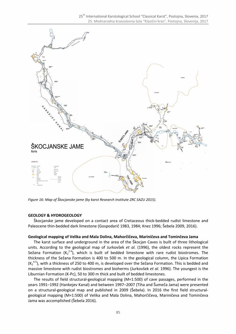
25th
International Karstological School “Classical Karst”, Postojna, Slovenia, 2017 25. Mednarodna krasoslovna šola “Klasični kras”, Postojna, Slovenija, 2017
85
Figure 16: Map of Škocjanske jame (by karst Research Institute ZRC SAZU 2015).
GEOLOGY & HYDROGEOLOGY
Škocjanske jame developed on a contact area of Cretaceous thick-bedded rudist limestone and Paleocene thin-bedded dark limestone (Gospodarič 1983, 1984; Knez 1996; Šebela 2009, 2016). Geological mapping of Velika and Mala Dolina, Mahorčičeva, Mariničeva and Tominčeva Jama
The karst surface and underground in the area of the Škocjan Caves is built of three lithological units. According to the geological map of Jurkovšek et al. (1996), the oldest rocks represent the Sežana Formation (K2
2-4), which is built of bedded limestone with rare rudist biostromes. The thickness of the Sežana Formation is 400 to 500 m. In the geological column, the Lipica Formation (K2
4-5), with a thickness of 250 to 400 m, is developed over the Sežana Formation. This is bedded and massive limestone with rudist biostromes and bioherms (Jurkovšek et al. 1996). The youngest is the Liburnian Formation (K-Pc), 50 to 300 m thick and built of bedded limestones.
The results of field structural-geological mapping (M=1:500) of cave passages, performed in the years 1991–1992 (Hankejev Kanal) and between 1997–2007 (Tiha and Šumeča Jama) were presented on a structural-geological map and published in 2009 (Šebela). In 2016 the first field structural-geological mapping (M=1:500) of Velika and Mala Dolina, Mahorčičeva, Mariničeva and Tominčeva Jama was accomplished (Šebela 2016).
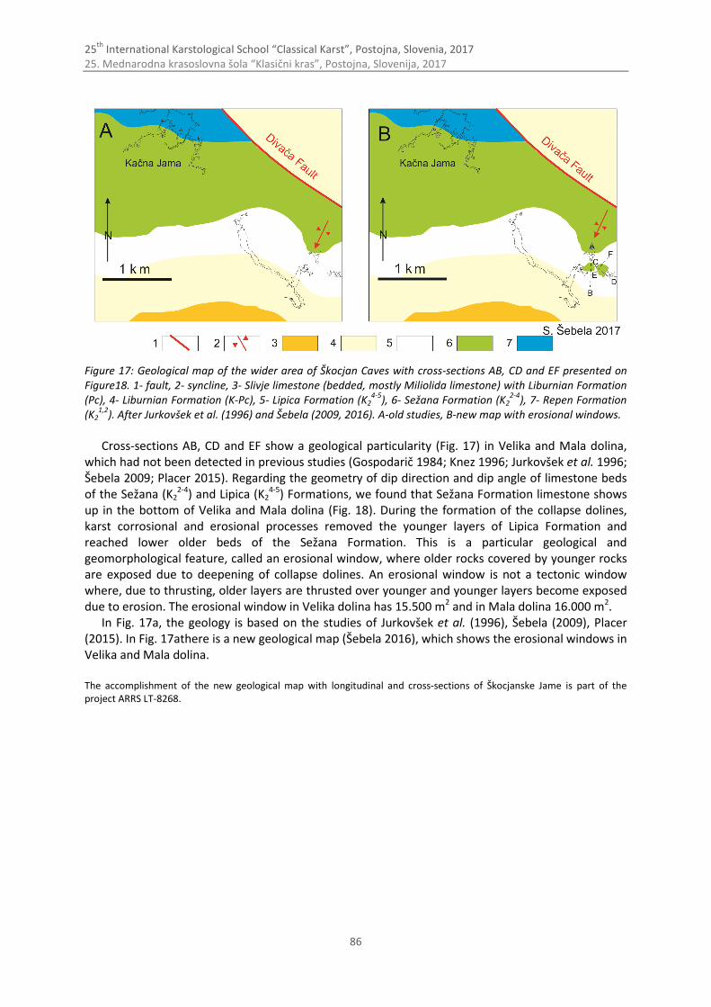
25th
International Karstological School “Classical Karst”, Postojna, Slovenia, 2017 25. Mednarodna krasoslovna šola “Klasični kras”, Postojna, Slovenija, 2017
86
Figure 17: Geological map of the wider area of Škocjan Caves with cross-sections AB, CD and EF presented on Figure18. 1- fault, 2- syncline, 3- Slivje limestone (bedded, mostly Miliolida limestone) with Liburnian Formation (Pc), 4- Liburnian Formation (K-Pc), 5- Lipica Formation (K2
4-5), 6- Sežana Formation (K2
2-4), 7- Repen Formation
(K21,2
). After Jurkovšek et al. (1996) and Šebela (2009, 2016). A-old studies, B-new map with erosional windows.
Cross-sections AB, CD and EF show a geological particularity (Fig. 17) in Velika and Mala dolina,
which had not been detected in previous studies (Gospodarič 1984; Knez 1996; Jurkovšek et al. 1996; Šebela 2009; Placer 2015). Regarding the geometry of dip direction and dip angle of limestone beds of the Sežana (K2
2-4) and Lipica (K24-5) Formations, we found that Sežana Formation limestone shows
up in the bottom of Velika and Mala dolina (Fig. 18). During the formation of the collapse dolines, karst corrosional and erosional processes removed the younger layers of Lipica Formation and reached lower older beds of the Sežana Formation. This is a particular geological and geomorphological feature, called an erosional window, where older rocks covered by younger rocks are exposed due to deepening of collapse dolines. An erosional window is not a tectonic window where, due to thrusting, older layers are thrusted over younger and younger layers become exposed due to erosion. The erosional window in Velika dolina has 15.500 m2 and in Mala dolina 16.000 m2.
In Fig. 17a, the geology is based on the studies of Jurkovšek et al. (1996), Šebela (2009), Placer (2015). In Fig. 17athere is a new geological map (Šebela 2016), which shows the erosional windows in Velika and Mala dolina.
The accomplishment of the new geological map with longitudinal and cross-sections of Škocjanske Jame is part of the project ARRS LT-8268.
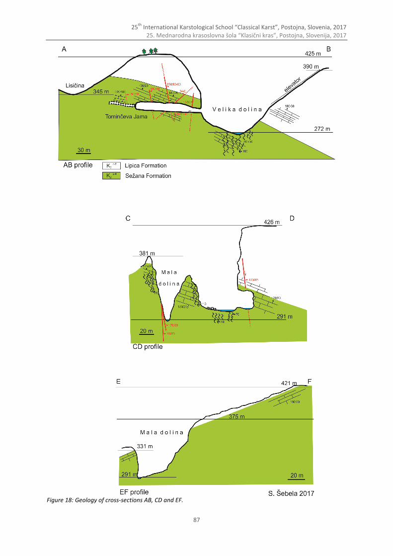
25th
International Karstological School “Classical Karst”, Postojna, Slovenia, 2017 25. Mednarodna krasoslovna šola “Klasični kras”, Postojna, Slovenija, 2017
87
Figure 18: Geology of cross-sections AB, CD and EF.
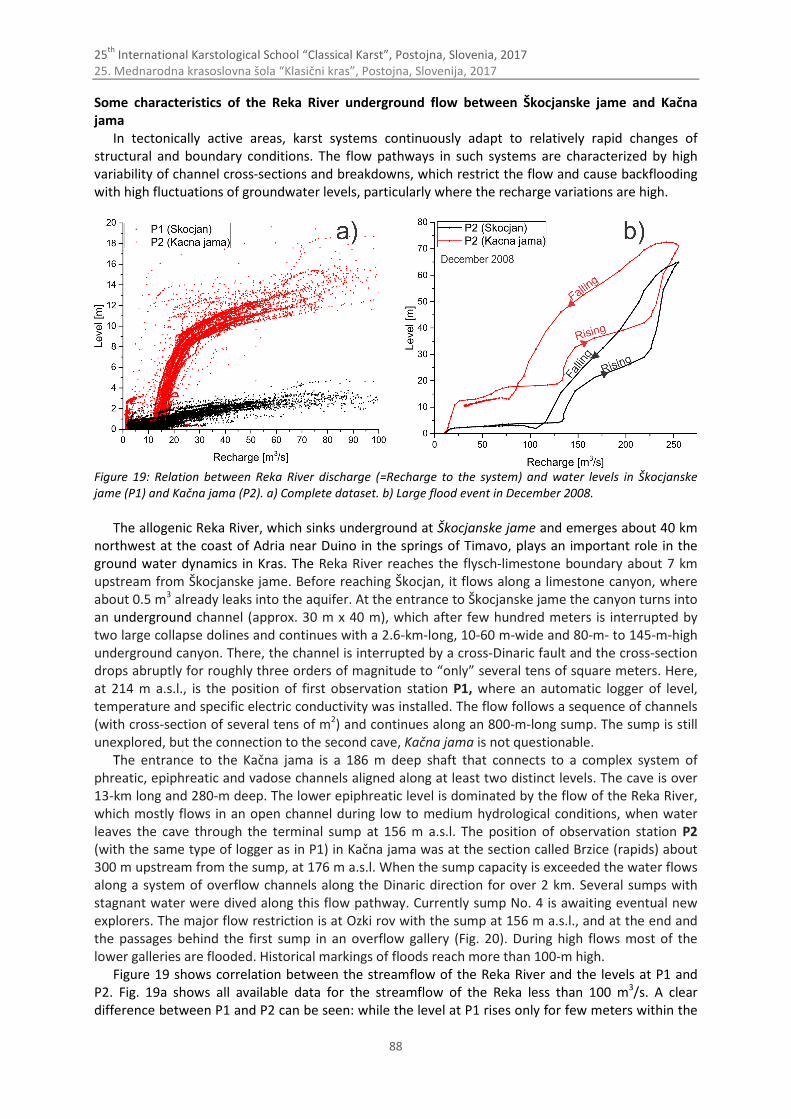
25th
International Karstological School “Classical Karst”, Postojna, Slovenia, 2017 25. Mednarodna krasoslovna šola “Klasični kras”, Postojna, Slovenija, 2017
88
Some characteristics of the Reka River underground flow between Škocjanske jame and Kačna jama
In tectonically active areas, karst systems continuously adapt to relatively rapid changes of structural and boundary conditions. The flow pathways in such systems are characterized by high variability of channel cross-sections and breakdowns, which restrict the flow and cause backflooding with high fluctuations of groundwater levels, particularly where the recharge variations are high.
Figure 19: Relation between Reka River discharge (=Recharge to the system) and water levels in Škocjanske jame (P1) and Kačna jama (P2). a) Complete dataset. b) Large flood event in December 2008.
The allogenic Reka River, which sinks underground at Škocjanske jame and emerges about 40 km
northwest at the coast of Adria near Duino in the springs of Timavo, plays an important role in the ground water dynamics in Kras. The Reka River reaches the flysch-limestone boundary about 7 km upstream from Škocjanske jame. Before reaching Škocjan, it flows along a limestone canyon, where about 0.5 m3 already leaks into the aquifer. At the entrance to Škocjanske jame the canyon turns into an underground channel (approx. 30 m x 40 m), which after few hundred meters is interrupted by two large collapse dolines and continues with a 2.6-km-long, 10-60 m-wide and 80-m- to 145-m-high underground canyon. There, the channel is interrupted by a cross-Dinaric fault and the cross-section drops abruptly for roughly three orders of magnitude to “only” several tens of square meters. Here, at 214 m a.s.l., is the position of first observation station P1, where an automatic logger of level, temperature and specific electric conductivity was installed. The flow follows a sequence of channels (with cross-section of several tens of m2) and continues along an 800-m-long sump. The sump is still unexplored, but the connection to the second cave, Kačna jama is not questionable.
The entrance to the Kačna jama is a 186 m deep shaft that connects to a complex system of phreatic, epiphreatic and vadose channels aligned along at least two distinct levels. The cave is over 13-km long and 280-m deep. The lower epiphreatic level is dominated by the flow of the Reka River, which mostly flows in an open channel during low to medium hydrological conditions, when water leaves the cave through the terminal sump at 156 m a.s.l. The position of observation station P2 (with the same type of logger as in P1) in Kačna jama was at the section called Brzice (rapids) about 300 m upstream from the sump, at 176 m a.s.l. When the sump capacity is exceeded the water flows along a system of overflow channels along the Dinaric direction for over 2 km. Several sumps with stagnant water were dived along this flow pathway. Currently sump No. 4 is awaiting eventual new explorers. The major flow restriction is at Ozki rov with the sump at 156 m a.s.l., and at the end and the passages behind the first sump in an overflow gallery (Fig. 20). During high flows most of the lower galleries are flooded. Historical markings of floods reach more than 100-m high.
Figure 19 shows correlation between the streamflow of the Reka River and the levels at P1 and P2. Fig. 19a shows all available data for the streamflow of the Reka less than 100 m3/s. A clear difference between P1 and P2 can be seen: while the level at P1 rises only for few meters within the
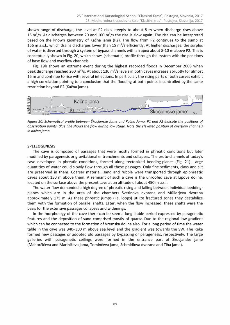
25th
International Karstological School “Classical Karst”, Postojna, Slovenia, 2017 25. Mednarodna krasoslovna šola “Klasični kras”, Postojna, Slovenija, 2017
89
shown range of discharge, the level at P2 rises steeply to about 8 m when discharge rises above 15 m3/s. At discharges between 20 and 100 m3/s the rise is slow again. The rise can be interpreted based on the known geometry of Kačna jama (P2). The flow from P2 continues to the sump at 156 m a.s.l., which drains discharges lower than 15 m3/s efficiently. At higher discharges, the surplus of water is diverted through a system of bypass channels with an apex about 8-10 m above P2. This is conceptually shown in Fig. 20, which shows (schematic) profile through the system with the positions of base flow and overflow channels.
Fig. 19b shows an extreme event during the highest recorded floods in December 2008 when peak discharge reached 260 m3/s. At about 130 m3/s levels in both caves increase abruptly for almost 15 m and continue to rise with several inflections. In particular, the rising parts of both curves exhibit a high correlation pointing to a conclusion that the flooding at both points is controlled by the same restriction beyond P2 (Kačna jama).
Figure 20: Schematical profile between Škocjanske Jame and Kačna Jama. P1 and P2 indicate the positions of observation points. Blue line shows the flow during low stage. Note the elevated position of overflow channels in Kačna jama.
SPELEOGENESIS
The cave is composed of passages that were mostly formed in phreatic conditions but later modified by paragenesis or gravitational entrenchments and collapses. The proto-channels of today's cave developed in phreatic conditions, formed along tectonized bedding-planes (Fig. 21). Large quantities of water could slowly flow through all these passages. Only fine sediments, clays and silt are preserved in them. Coarser material, sand and rubble were transported through epiphreatic caves about 150 m above them. A remnant of such a cave is the unroofed cave at Lipove doline, located on the surface above the present cave at an altitude of about 450 m a.s.l.
The water flow demanded a high degree of phreatic rising and falling between individual bedding- planes which are in the area of the chambers Svetinova dvorana and Müllerjeva dvorana approximately 175 m. As these phreatic jumps (i.e. loops) utilize fractured zones they destabilize them with the formation of parallel shafts. Later, when the flow increased, these shafts were the basis for the extensive passages collapses and widenings.
In the morphology of the cave there can be seen a long stable period expressed by paragenetic features and the deposition of sand comprised mostly of quartz. Due to the regional low gradient which can be connected to the formation of Vremska dolina also. For a long period of time the water table in the cave was 340–300 m above sea level and the gradient was towards the SW. The Reka formed new passages or adopted old passages by bypassing or paragenesis, respectively. The large galleries with paragenetic ceilings were formed in the entrance part of Škocjanske jame (Mahorčičeva and Mariničeva jama, Tominčeva jama, Schmidlova dvorana and Tiha jama).
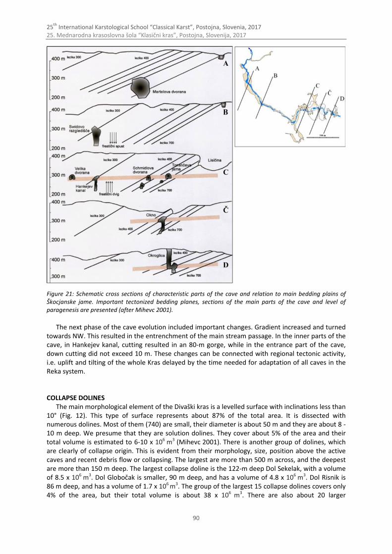
25th
International Karstological School “Classical Karst”, Postojna, Slovenia, 2017 25. Mednarodna krasoslovna šola “Klasični kras”, Postojna, Slovenija, 2017
90
Figure 21: Schematic cross sections of characteristic parts of the cave and relation to main bedding plains of Škocjanske jame. Important tectonized bedding planes, sections of the main parts of the cave and level of paragenesis are presented (after Mihevc 2001).
The next phase of the cave evolution included important changes. Gradient increased and turned
towards NW. This resulted in the entrenchment of the main stream passage. In the inner parts of the cave, in Hankejev kanal, cutting resulted in an 80-m gorge, while in the entrance part of the cave, down cutting did not exceed 10 m. These changes can be connected with regional tectonic activity, i.e. uplift and tilting of the whole Kras delayed by the time needed for adaptation of all caves in the Reka system. COLLAPSE DOLINES
The main morphological element of the Divaški kras is a levelled surface with inclinations less than 10° (Fig. 12). This type of surface represents about 87% of the total area. It is dissected with numerous dolines. Most of them (740) are small, their diameter is about 50 m and they are about 8 -10 m deep. We presume that they are solution dolines. They cover about 5% of the area and their total volume is estimated to 6-10 x 106 m3
(Mihevc 2001). There is another group of dolines, which are clearly of collapse origin. This is evident from their morphology, size, position above the active caves and recent debris flow or collapsing. The largest are more than 500 m across, and the deepest are more than 150 m deep. The largest collapse doline is the 122-m deep Dol Sekelak, with a volume of 8.5 x 10⁶ m3. Dol Globočak is smaller, 90 m deep, and has a volume of 4.8 x 10⁶ m3. Dol Risnik is 86 m deep, and has a volume of 1.7 x 10⁶ m3. The group of the largest 15 collapse dolines covers only 4% of the area, but their total volume is about 38 x 106 m3. There are also about 20 larger
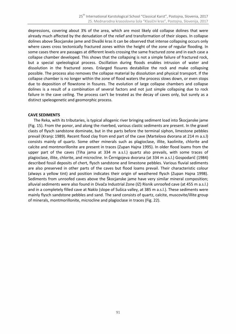
25th
International Karstological School “Classical Karst”, Postojna, Slovenia, 2017 25. Mednarodna krasoslovna šola “Klasični kras”, Postojna, Slovenija, 2017
91
depressions, covering about 3% of the area, which are most likely old collapse dolines that were already much affected by the denudation of the relief and transformation of their slopes. In collapse dolines above Škocjanske jame and Divaški kras it can be observed that intense collapsing occurs only where caves cross tectonically fractured zones within the height of the zone of regular flooding. In some cases there are passages at different levels crossing the same fractured zone and in each case a collapse chamber developed. This shows that the collapsing is not a simple failure of fractured rock, but a special speleological process. Oscillation during floods enables intrusion of water and dissolution in the fractured zones. Enlarged fissures destabilize the rock and make collapsing possible. The process also removes the collapse material by dissolution and physical transport. If the collapse chamber is no longer within the zone of flood waters the process slows down, or even stops due to deposition of flowstone in fissures. The evolution of large collapse chambers and collapse dolines is a result of a combination of several factors and not just simple collapsing due to rock failure in the cave ceiling. The process can’t be treated as the decay of caves only, but surely as a distinct speleogenetic and geomorphic process.
CAVE SEDIMENTS The Reka, with its tributaries, is typical allogenic river bringing sediment load into Škocjanske jame
(Fig. 15). From the ponor, and along the riverbed, various clastic sediments are present. In the gravel clasts of flysch sandstone dominate, but in the parts before the terminal siphon, limestone pebbles prevail (Kranjc 1989). Recent flood clay from end part of the cave (Martelova dvorana at 214 m a.s.l) consists mainly of quartz. Some other minerals such as plagioclase, illite, kaolinite, chlorite and calcite and montmorillonite are present in traces (Zupan Hajna 1995). In older flood loams from the upper part of the caves (Tiha jama at 334 m a.s.l.) quartz also prevails, with some traces of plagioclase, illite, chlorite, and microcline. In Černigojeva dvorana (at 334 m a.s.l.) Gospodarič (1984) described fossil deposits of chert, flysch sandstone and limestone pebbles. Various fluvial sediments are also preserved in other parts of the caves but flood loams prevail. Their characteristic colour (always a yellow tint) and position indicates their origin of weathered flysch (Zupan Hajna 1998). Sediments from unroofed caves above the Škocjanske jame have very similar mineral composition; alluvial sediments were also found in Divača Industrial Zone (IZ) Risnik unroofed cave (at 455 m a.s.l.) and in a completely filled cave at Naklo (slope of Sušica valley, at 385 m a.s.l.). These sediments were mainly flysch sandstone pebbles and sand. The sand consists of quartz, calcite, muscovite/illite group of minerals, montmorillonite, microcline and plagioclase in traces (Fig. 22).
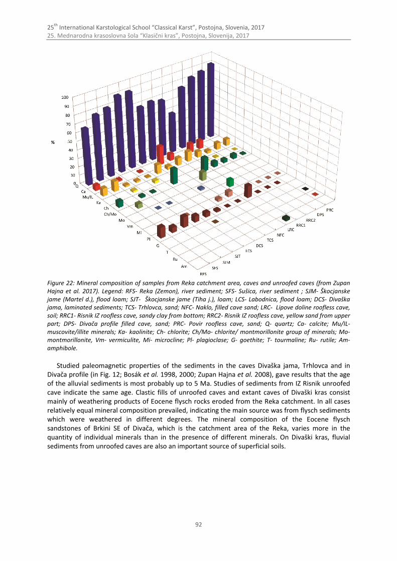
25th
International Karstological School “Classical Karst”, Postojna, Slovenia, 2017 25. Mednarodna krasoslovna šola “Klasični kras”, Postojna, Slovenija, 2017
92
Figure 22: Mineral composition of samples from Reka catchment area, caves and unroofed caves (from Zupan Hajna et al. 2017). Legend: RFS- Reka (Zemon), river sediment; SFS- Sušica, river sediment ; SJM- Škocjanske jame (Martel d.), flood loam; SJT- Škocjanske jame (Tiha j.), loam; LCS- Labodnica, flood loam; DCS- Divaška jama, laminated sediments; TCS- Trhlovca, sand; NFC- Naklo, filled cave sand; LRC- Lipove doline roofless cave, soil; RRC1- Risnik IZ roofless cave, sandy clay from bottom; RRC2- Risnik IZ roofless cave, yellow sand from upper part; DPS- Divača profile filled cave, sand; PRC- Povir roofless cave, sand; Q- quartz; Ca- calcite; Mu/IL- muscovite/illite minerals; Ka- kaolinite; Ch- chlorite; Ch/Mo- chlorite/ montmorillonite group of minerals; Mo- montmorillonite, Vm- vermiculite, Mi- microcline; Pl- plagioclase; G- goethite; T- tourmaline; Ru- rutile; Am- amphibole.
Studied paleomagnetic properties of the sediments in the caves Divaška jama, Trhlovca and in
Divača profile (in Fig. 12; Bosák et al. 1998, 2000; Zupan Hajna et al. 2008), gave results that the age of the alluvial sediments is most probably up to 5 Ma. Studies of sediments from IZ Risnik unroofed cave indicate the same age. Clastic fills of unroofed caves and extant caves of Divaški kras consist mainly of weathering products of Eocene flysch rocks eroded from the Reka catchment. In all cases relatively equal mineral composition prevailed, indicating the main source was from flysch sediments which were weathered in different degrees. The mineral composition of the Eocene flysch sandstones of Brkini SE of Divača, which is the catchment area of the Reka, varies more in the quantity of individual minerals than in the presence of different minerals. On Divaški kras, fluvial sediments from unroofed caves are also an important source of superficial soils.
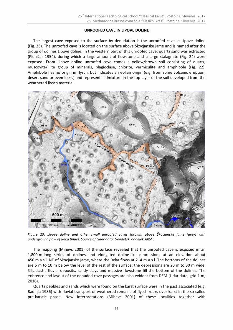
25th
International Karstological School “Classical Karst”, Postojna, Slovenia, 2017 25. Mednarodna krasoslovna šola “Klasični kras”, Postojna, Slovenija, 2017
93
UNROOFED CAVE IN LIPOVE DOLINE
The largest cave exposed to the surface by denudation is the unroofed cave in Lipove doline (Fig. 23). The unroofed cave is located on the surface above Škocjanske jame and is named after the group of dolines Lipove doline. In the western part of this unroofed cave, quartz sand was extracted (Pleničar 1954), during which a large amount of flowstone and a large stalagmite (Fig. 24) were exposed. From Lipove doline unroofed cave comes a yellow/brown soil consisting of quartz, muscovite/illite group of minerals, plagioclase, chlorite, vermiculite and amphibole (Fig. 22). Amphibole has no origin in flysch, but indicates an eolian origin (e.g. from some volcanic eruption, desert sand or even loess) and represents admixture in the top layer of the soil developed from the weathered flysch material.
Figure 23: Lipove doline and other small unroofed caves (brown) above Škocjanske jame (grey) with underground flow of Reka (blue). Source of Lidar data: Geodetski oddelek ARSO.
The mapping (Mihevc 2001) of the surface revealed that the unroofed cave is exposed in an
1,800-m-long series of dolines and elongated doline-like depressions at an elevation about 450 m a.s.l. NE of Škocjanske jame, where the Reka flows at 214 m a.s.l. The bottoms of the dolines are 5 m to 10 m below the level of the rest of the surface; the depressions are 20 m to 30 m wide. Siliciclastic fluvial deposits, sandy clays and massive flowstone fill the bottom of the dolines. The existence and layout of the denuded cave passages are also evident from DEM (Lidar data, grid 1 m; 2016).
Quartz pebbles and sands which were found on the karst surface were in the past associated (e.g. Radinja 1986) with fluvial transport of weathered remains of flysch rocks over karst in the so-called pre-karstic phase. New interpretations (Mihevc 2001) of these localities together with
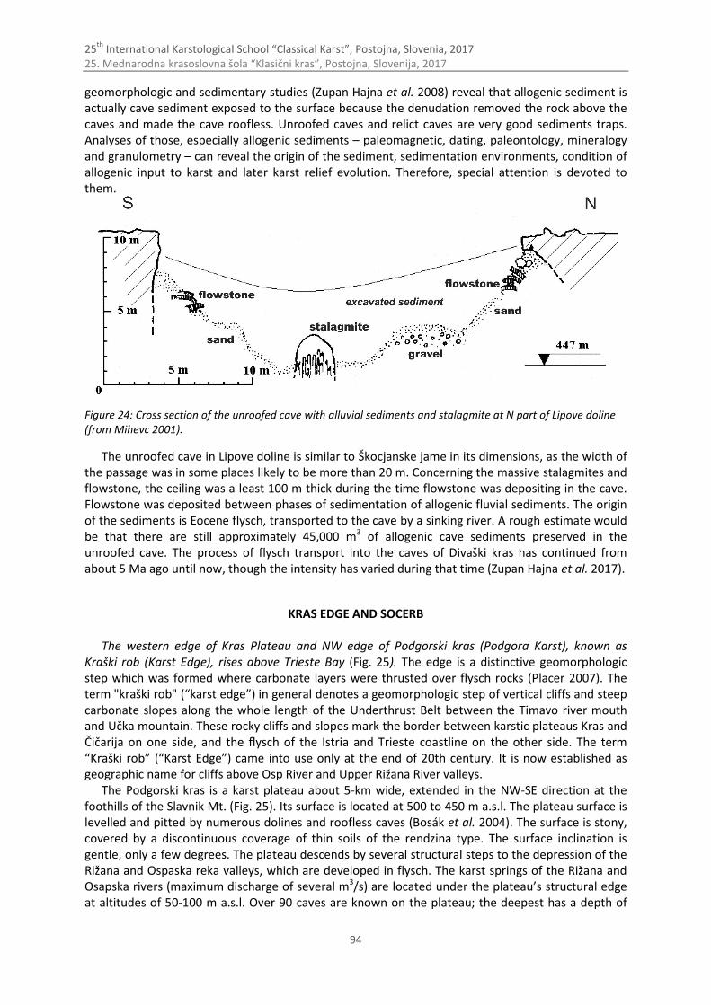
25th
International Karstological School “Classical Karst”, Postojna, Slovenia, 2017 25. Mednarodna krasoslovna šola “Klasični kras”, Postojna, Slovenija, 2017
94
geomorphologic and sedimentary studies (Zupan Hajna et al. 2008) reveal that allogenic sediment is actually cave sediment exposed to the surface because the denudation removed the rock above the caves and made the cave roofless. Unroofed caves and relict caves are very good sediments traps. Analyses of those, especially allogenic sediments – paleomagnetic, dating, paleontology, mineralogy and granulometry – can reveal the origin of the sediment, sedimentation environments, condition of allogenic input to karst and later karst relief evolution. Therefore, special attention is devoted to them.
Figure 24: Cross section of the unroofed cave with alluvial sediments and stalagmite at N part of Lipove doline (from Mihevc 2001).
The unroofed cave in Lipove doline is similar to Škocjanske jame in its dimensions, as the width of the passage was in some places likely to be more than 20 m. Concerning the massive stalagmites and flowstone, the ceiling was a least 100 m thick during the time flowstone was depositing in the cave. Flowstone was deposited between phases of sedimentation of allogenic fluvial sediments. The origin of the sediments is Eocene flysch, transported to the cave by a sinking river. A rough estimate would be that there are still approximately 45,000 m3 of allogenic cave sediments preserved in the unroofed cave. The process of flysch transport into the caves of Divaški kras has continued from about 5 Ma ago until now, though the intensity has varied during that time (Zupan Hajna et al. 2017).
KRAS EDGE AND SOCERB
The western edge of Kras Plateau and NW edge of Podgorski kras (Podgora Karst), known as Kraški rob (Karst Edge), rises above Trieste Bay (Fig. 25). The edge is a distinctive geomorphologic step which was formed where carbonate layers were thrusted over flysch rocks (Placer 2007). The term "kraški rob" (“karst edge”) in general denotes a geomorphologic step of vertical cliffs and steep carbonate slopes along the whole length of the Underthrust Belt between the Timavo river mouth and Učka mountain. These rocky cliffs and slopes mark the border between karstic plateaus Kras and Čičarija on one side, and the flysch of the Istria and Trieste coastline on the other side. The term “Kraški rob” (“Karst Edge”) came into use only at the end of 20th century. It is now established as geographic name for cliffs above Osp River and Upper Rižana River valleys.
The Podgorski kras is a karst plateau about 5-km wide, extended in the NW-SE direction at the foothills of the Slavnik Mt. (Fig. 25). Its surface is located at 500 to 450 m a.s.l. The plateau surface is levelled and pitted by numerous dolines and roofless caves (Bosák et al. 2004). The surface is stony, covered by a discontinuous coverage of thin soils of the rendzina type. The surface inclination is gentle, only a few degrees. The plateau descends by several structural steps to the depression of the Rižana and Ospaska reka valleys, which are developed in flysch. The karst springs of the Rižana and Osapska rivers (maximum discharge of several m3/s) are located under the plateau’s structural edge at altitudes of 50-100 m a.s.l. Over 90 caves are known on the plateau; the deepest has a depth of
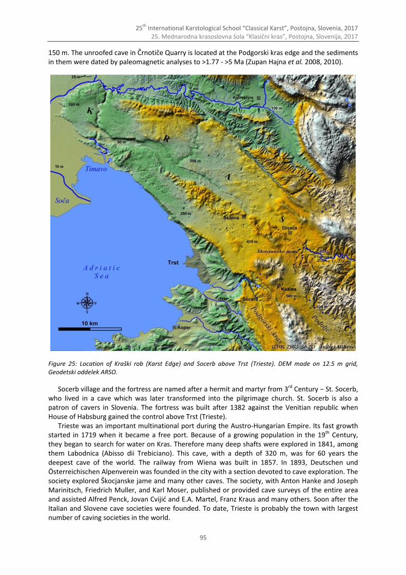
25th
International Karstological School “Classical Karst”, Postojna, Slovenia, 2017 25. Mednarodna krasoslovna šola “Klasični kras”, Postojna, Slovenija, 2017
95
150 m. The unroofed cave in Črnotiče Quarry is located at the Podgorski kras edge and the sediments in them were dated by paleomagnetic analyses to >1.77 - >5 Ma (Zupan Hajna et al. 2008, 2010).
Figure 25: Location of Kraški rob (Karst Edge) and Socerb above Trst (Trieste). DEM made on 12.5 m grid, Geodetski oddelek ARSO.
Socerb village and the fortress are named after a hermit and martyr from 3rd Century − St. Socerb, who lived in a cave which was later transformed into the pilgrimage church. St. Socerb is also a patron of cavers in Slovenia. The fortress was built after 1382 against the Venitian republic when House of Habsburg gained the control above Trst (Trieste).
Trieste was an important multinational port during the Austro-Hungarian Empire. Its fast growth started in 1719 when it became a free port. Because of a growing population in the 19th Century, they began to search for water on Kras. Therefore many deep shafts were explored in 1841, among them Labodnica (Abisso dii Trebiciano). This cave, with a depth of 320 m, was for 60 years the deepest cave of the world. The railway from Wiena was built in 1857. In 1893, Deutschen und Österreichischen Alpenverein was founded in the city with a section devoted to cave exploration. The society explored Škocjanske jame and many other caves. The society, with Anton Hanke and Joseph Marinitsch, Friedrich Muller, and Karl Moser, published or provided cave surveys of the entire area and assisted Alfred Penck, Jovan Cvijić and E.A. Martel, Franz Kraus and many others. Soon after the Italian and Slovene cave societies were founded. To date, Trieste is probably the town with largest number of caving societies in the world.
25th
International Karstological School “Classical Karst”, Postojna, Slovenia, 2017 25. Mednarodna krasoslovna šola “Klasični kras”, Postojna, Slovenija, 2017
96
References Bosák, P., Pruner, P., Mihevc, A. & N., Zupan Hajna, 2000: Magnetostratigraphy and unconformities in cave
sediments: case study from the Classical Karst, SW Slovenia. Geologos 5, 13–30. Bosák, P., Pruner, P. & N, Zupan Hajna, 1998: Paleomagnetic research of cave sediments in SW Slovenia. Acta
Carsologica, 28, 151-179. Bosák, P., Mihevc A. & P., Pruner, 2004: Geomorphological evolution of the Podgorski Karst, SW Slovenia:
contribution of magnetostratgraphic research of the Črnotiče II site with Marifugia sp. Acta Carsologica 33/1, 12, 175-204.
Buser, S., Pavlovec, R. & M. Pleničar, 1968: Osnovna geološka karta SFRJ, list Gorica, 1 : 100 000. Zvezni geološki zavod Beograd, Beograd.
Gospodarič, R., 1983: About geology and speleogenesis of Škocjanske Jame. Geološki zbornik, 4, 163-172, Ljubljana. Gospodarič, R., 1984: Cave sediments and Škocjanske jame speleogenesis. Acta Carsologica, 12 (1983), 27-48. Gospodarič, R., 1965: Škocjanske jame. Guide book of the Congress Excursion through Dinaric Karst, 4th International
Congress of Speleology in Yugoslavia, Union Yug. Spel., 137-140, Ljubljana. Jurkovšek, B., Toman, M., Ogorelec, B., Šribar, L., Drobne, K., Poljak, M. & L., Šribar, 1996: Geological map of the
southern part of the Trieste – Komen plateau 1-50.000. Cretaceous and Paleogene carbonate rocks. Inštitut za geologijo, geotehniko in geofiziko, Ljubljana.
Jurkovšek., B., Cvetko Tešović., B. & T., Kolar-Jurkovšek, 2013: Geology of Kras. Geological Survey of Ljubljana, 205 p. Knez, M., Slabe, T. (Eds.), Gabrovšek, F., Kogovšek, J., Kranjc, A., Mihevc, A., Mulec, J., Otoničar, B., Perne, M., Petrič,
M., Pipan, T., Prelovšek, M., Ravbar, N., Šebela, S., Zupan Hajna, N., Bosák, P., Pruner, P. & H., Liu, 2016: Cave Exploration in Slovenia. Discovering Over 350 New Caves During Motorway Construction on Classical Karst. Springer International Publishing, Switzerland.
Knez, M., 1996: Vpliv lezik na razvoj kraških jam, primer Velike doline, Škocjanske jame (The bedding-plane impact on development of karst caves (An example of Velika dolina, Škocjanske jame caves). Založba ZRC 14, pp. 186, Ljubljana.
Kranjc, A., 1989: Recent fluvial cave sediments, their origin and role in speleogenesis. Opera 4. razreda, SAZU, ZRC, Karst Research Institute, Ljubljana.
Mihevc, A., 2001: Speleogeneza Divaškega krasa. Zbirka ZRC, 27, Ljubljana. Mihevc, A., Slabe, T. & S., Šebela, 1998: Denuded caves – an inherited element in the karst morphology; the case
from Kras. Acta Carsologica, 27, 167-174. Mihevc, A. & N., Zupan Hajna, 1996: Clastic sediments from dolines and caves found during the construction of the
motorway near Divača, on the classical Karst. Acta Carsologica, 25, 169-191. Placer, L., 1999: Contribution to the macrotectonic subdivision of the border region between Southern Alps and
External Dinarides. Geologija, 41(1998), 223-255. Placer, L., 2007: Kraški rob (landscape term). Geologic section along the motorway Kozina – Koper (Capodistria).
Geologija, 50/1, 29-44. Placer, L., 2008: Principles of the tectonic subdivision of Slovenia. Geologija, 51/2, 205-217. Placer, L., 2015: Simplified structural map of Kras. Geologija, 58/1, 89-93. Placer, l., Vrabec, M. & Celarc, B., 2010: The bases for understanding of the NW Dinarides and Istria Peninsula
tectonics. Geologija, 53/1, 55–86. Pleničar, M., 1954: Vrnik. Proteus, 17, 89-90, Ljubljana. Radinja, D., 1986: The Karst in the light of fossilized fluvial deposition. Acta Carsologica, 14-15, 101-108. Šebela, S. 2016. Tectonic-lithological mapping for composition of geological map of Škocjan Caves. Unpublished
report, Postojna, 12 pp. Šebela, S., 2009: Structural geology of the Škocjan Caves.- Acta Carsologica, 38/2-3, 165-177. Šikić, D., Pleničar, M. & M. Šparica, 1972: Osnovna geološka karta SFRJ, list Ilirska Bistrica, 1 : 100 000. Zvezni geološki
zavod Beograd, Beograd. Zupan Hajna, N., 1995: A comparison of the mechanical cave sediments from the caves the Škocjanske jame, the
Labodnica, the Prevala II and the Mejame. Annales for Istrian and Mediterranean Studies, 7, 117-120. Zupan Hajna, N., 1998: Mineral composition of clastic sediments in some dolines along the new motorway Divača-
Kozina. Acta Carsologica, 27, 277-296. Zupan Hajna, N., Mihevc, A., Pruner, P. & P., Bosák, 2008: Palaeomagnetism and Magnetostratigraphy of Karst
Sediments in Slovenia. Carsologica, 8, ZRC Publishing, Ljubljana. Zupan Hajna, N., Mihevc, A., Pruner, P. & P., Bosák, 2010: Palaeomagnetic research on karst sediments in Slovenia.
International Journal of Speleology, 39(2), 47-60. Zupan Hajna, N., Mihevc, A., Pruner, P. & P., Bosák, 2017: Cave sediments in Škocjanske jame and Unroofed caves
above them, SW Slovenia. In press: Proceedings, 17 ICS, Sydney 2017. Žvab Rožič, P., Čar, J. & B., Rožič, 2015: Geological Structure of the Divača Area and its Influence on the Speleogenesis
and Hydrology of Kačna jama. Acta Carsologica, 44/2, 153-168.
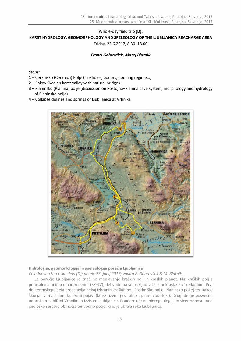
25th
International Karstological School “Classical Karst”, Postojna, Slovenia, 2017 25. Mednarodna krasoslovna šola “Klasični kras”, Postojna, Slovenija, 2017
97
Whole-day field trip (D):
KARST HYDROLOGY, GEOMORPHOLOGY AND SPELEOLOGY OF THE LJUBLJANICA REACHARGE AREA
Friday, 23.6.2017, 8.30–18.00
Franci Gabrovšek, Matej Blatnik
Stops: 1 – Cerkniško (Cerknica) Polje (sinkholes, ponors, flooding regime…) 2 – Rakov Škocjan karst valley with natural bridges 3 – Planinsko (Planina) polje (discussion on Postojna–Planina cave system, morphology and hydrology
of Planinsko polje) 4 – Collapse dolines and springs of Ljubljanica at Vrhnika
Hidrologija, geomorfologija in speleologija porečja Ljubljanice Celodnevno terensko delo (D); petek, 23. junij 2017; vodita F. Gabrovšek & M. Blatnik
Za porečje Ljubljanice je značilno menjavanje kraških polj in kraških planot. Niz kraških polj s ponikalnicami ima dinarsko smer (SZ–JV), del vode pa se priključi z JZ, z nekraške Pivške kotline. Prvi del terenskega dela predstavlja nekaj izbranih kraških polj (Cerkniško polje, Planinsko polje) ter Rakov Škocjan z značilnimi kraškimi pojavi (kraški izviri, požiralniki, jame, vodotoki). Drugi del je posvečen udornicam v bližini Vrhnike in izvirom Ljubljanice. Poudarek je na hidrogeologiji, in sicer odnosu med geološko sestavo območja ter vodno potjo, ki jo je ubrala reka Ljubljanica.
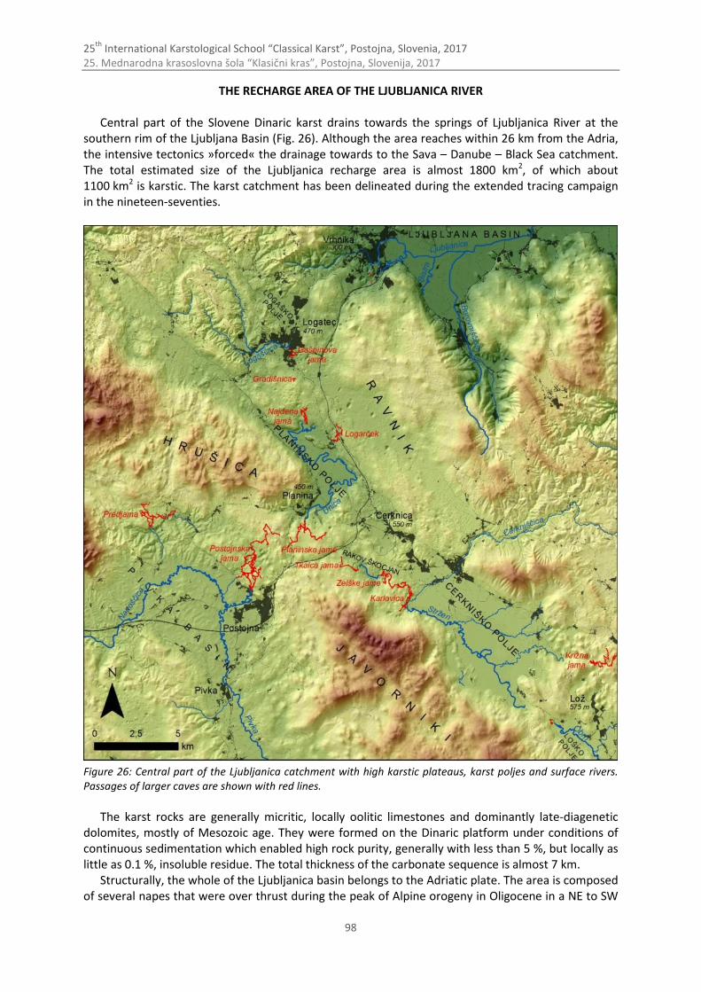
25th
International Karstological School “Classical Karst”, Postojna, Slovenia, 2017 25. Mednarodna krasoslovna šola “Klasični kras”, Postojna, Slovenija, 2017
98
THE RECHARGE AREA OF THE LJUBLJANICA RIVER
Central part of the Slovene Dinaric karst drains towards the springs of Ljubljanica River at the southern rim of the Ljubljana Basin (Fig. 26). Although the area reaches within 26 km from the Adria, the intensive tectonics »forced« the drainage towards to the Sava – Danube – Black Sea catchment. The total estimated size of the Ljubljanica recharge area is almost 1800 km2, of which about 1100 km2 is karstic. The karst catchment has been delineated during the extended tracing campaign in the nineteen-seventies.
Figure 26: Central part of the Ljubljanica catchment with high karstic plateaus, karst poljes and surface rivers. Passages of larger caves are shown with red lines.
The karst rocks are generally micritic, locally oolitic limestones and dominantly late-diagenetic
dolomites, mostly of Mesozoic age. They were formed on the Dinaric platform under conditions of continuous sedimentation which enabled high rock purity, generally with less than 5 %, but locally as little as 0.1 %, insoluble residue. The total thickness of the carbonate sequence is almost 7 km.
Structurally, the whole of the Ljubljanica basin belongs to the Adriatic plate. The area is composed of several napes that were over thrust during the peak of Alpine orogeny in Oligocene in a NE to SW
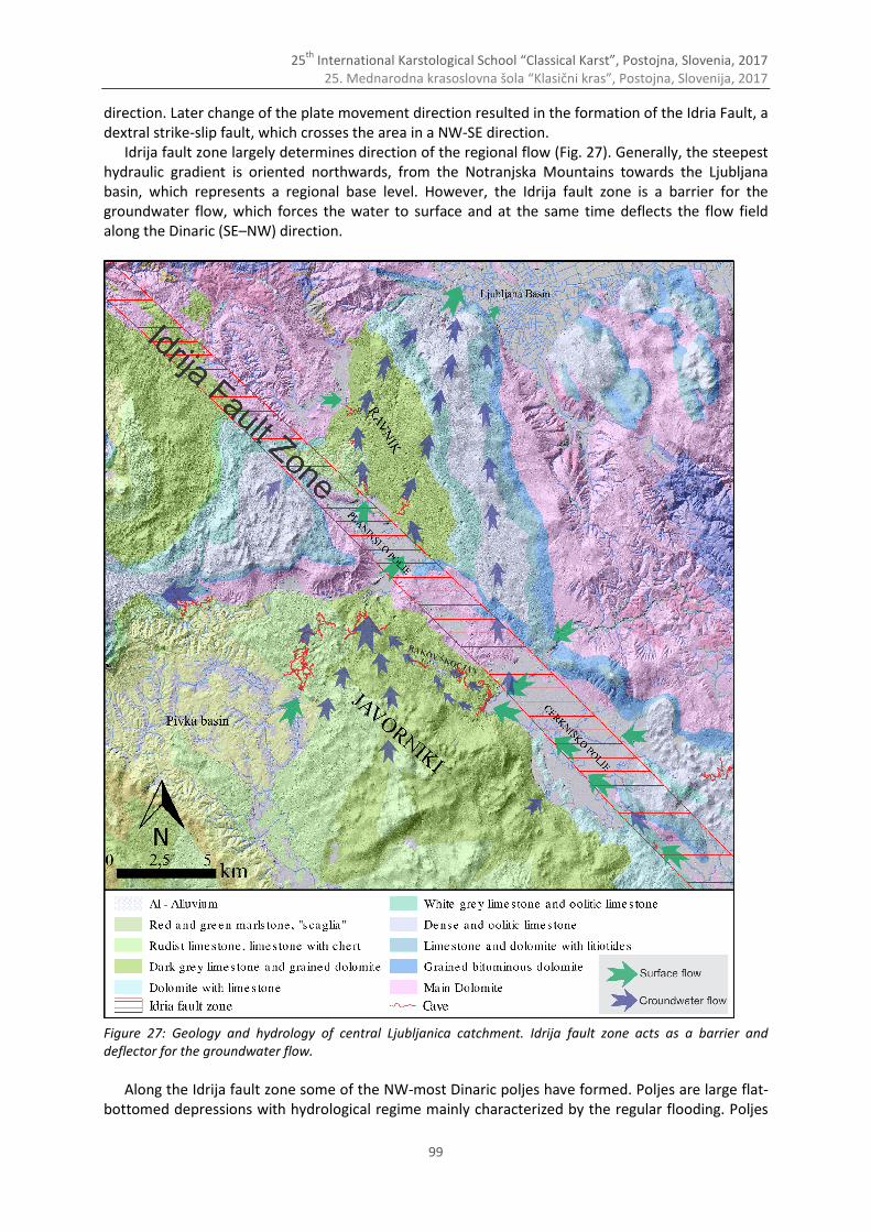
25th
International Karstological School “Classical Karst”, Postojna, Slovenia, 2017 25. Mednarodna krasoslovna šola “Klasični kras”, Postojna, Slovenija, 2017
99
direction. Later change of the plate movement direction resulted in the formation of the Idria Fault, a dextral strike-slip fault, which crosses the area in a NW-SE direction.
Idrija fault zone largely determines direction of the regional flow (Fig. 27). Generally, the steepest hydraulic gradient is oriented northwards, from the Notranjska Mountains towards the Ljubljana basin, which represents a regional base level. However, the Idrija fault zone is a barrier for the groundwater flow, which forces the water to surface and at the same time deflects the flow field along the Dinaric (SE–NW) direction.
Figure 27: Geology and hydrology of central Ljubljanica catchment. Idrija fault zone acts as a barrier and deflector for the groundwater flow.
Along the Idrija fault zone some of the NW-most Dinaric poljes have formed. Poljes are large flat-
bottomed depressions with hydrological regime mainly characterized by the regular flooding. Poljes

25th
International Karstological School “Classical Karst”, Postojna, Slovenia, 2017 25. Mednarodna krasoslovna šola “Klasični kras”, Postojna, Slovenija, 2017
100
are often the only areas on karst with surface waters. The formation of poljes is preconditioned by tectonics, in this case the structures within Idrija strike slip fault (e.g. pull-apart zones), but the forming mechanism is the corrosional planation at the groundwater level.
Generally, the flow system cascades along the SE–NW direction with surface flow over the poljes and groundwater flow in-between (Fig. 28). Additional water enters the flow system at numerous springs draining the areas of Snežnik and Javorniki mountains on the South of the Idrija fault Zone. Several sinking rivers that drain dolomite or flysch areas also contribute to the system. Elevation of active poljes drops from about 750 m to 550 m. The streams on poljes have different names: Trbuhovica, Obrh, Stržen, Rak, Pivka, Unica.
Apart from (presumably) small amount of water, which flows directly from the Cerkniško polje to the springs of Ljubljanica, most of the water surfaces at the southern rim of the Planinsko Polje, sinks back underground along its eastern and northern border and flows northwards towards several large and many small springs aligned along the southern edge of the Ljubljana basin, which is connected with gradual tectonic subsidence of the area. Mean annual discharge of the Ljubljanica at springs is 38.6 m3.
There are 1540 caves, accessible fragments of of an active and fossil underground drainage system known in the catchments area of the Ljubljanica. The average cave length of is 48 m and the depth 18 m. However, the largest caves are the ponor and spring caves; in them we can follow about 80 km of epiphreatic channels.
Figure 28: Longitudinal cross section of Ljubljanica karst river basin (Gabrovšek, 2016). It follows a broken line, initially along SE-NW trend of the Idrija fault between Loško and Planinsko Polje and along the N trend from Planinsko Polje toward the springs at Vrhnika. The red text denotes major caves, the cyan large collapse dolines.
CERKNIŠKO POLJE
Cerkniško polje is the largest karst polje in Slovenia. Due to its regular flooding it is often called Cerkniško jezero (Lake of Cerknica). When full, the intermittent lake covers up to 26 km2 out of 38 km2 of the polje’s total surface area. The bottom elevation is about 550 m. Its intermittency has attracted many scholars since the beginning of the New age including polihistor Valvasor, who published his famous study on Cerkniško jezero in 1689.
The main part of the polje is underlained by the Upper Triassic dolomite which builds dominates in N, E and SE border. Areas on the W and NW are mainly underlain by the Cretaceous limestone (Fig. 27).
The main inflows to the Polje are set of karst springs at the eastern and southern border of the polje (Žerovniščica, Šteberščica and Stržen) (Fig. 26). The springs on the SW side (e.g. Suhadolca, Vranja jama) present important recharge during floods. The only allogenic recharge is Cerkniščica which drains dolomitic area on the SE. Inflow/outflow to/from the polje also occurs through several estavelas.
Besides estavelas, several ponor areas in the inner part of the polje drain some amount of water directly to the springs of Ljubljanica. However, the main ponors are aligned along the W side of Polje, with Velika and Mala Karlovica as the most prominent. Both caves extend over 8.5 km between
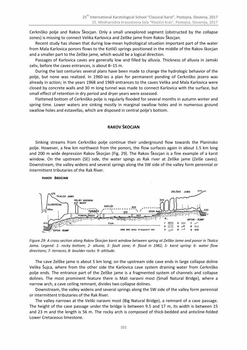
25th
International Karstological School “Classical Karst”, Postojna, Slovenia, 2017 25. Mednarodna krasoslovna šola “Klasični kras”, Postojna, Slovenija, 2017
101
Cerkniško polje and Rakov Škocjan. Only a small unexplored segment (obstructed by the collapse zones) is missing to connect Velika Karlovica and Zelške jame from Rakov Škocjan.
Recent study has shown that during low-mean hydrological situation important part of the water from Mala Karlovica ponors flows to the Kotliči springs positioned in the middle of the Rakov škocjan and a smaller part to the Zelške jame, which would be a logical direction.
Passages of Karlovica caves are generally low and filled by alluvia. Thickness of alluvia in Jamski zaliv, before the caves entrances, is about 8–15 m.
During the last centuries several plans have been made to change the hydrologic behavior of the polje, but none was realized. In 1960-ies a plan for permanent ponding of Cerkniško jezero was already in action; in the years 1968 and 1969 entrances to the caves Velika and Mala Karlovica were closed by concrete walls and 30 m long tunnel was made to connect Karlovica with the surface, but small effect of retention in dry period and dryer years were assessed.
Flattened bottom of Cerkniško polje is regularly flooded for several months in autumn winter and spring time. Lower waters are sinking mostly in marginal swallow holes and in numerous ground swallow holes and estavellas, which are disposed in central polje's bottom.
RAKOV ŠKOCJAN
Sinking streams from Cerkniško polje continue their underground flow towards the Planinsko polje. However, a few km northwest from the ponors, the flow surfaces again in about 1.5 km long and 200 m wide depression Rakov Škocjan (Fig. 29). The Rakov Škocjan is a fine example of a karst window. On the upstream (SE) side, the water spings as Rak river at Zelške jame (Zelše caves). Downstream, the valley widens and several springs along the SW side of the valley form perennial or intermittent tributaries of the Rak River.
Figure 29: A cross-section along Rakov Škocjan karst window between spring at Zelške Jame and ponor in Tkalca Jama. Legend: 1- rocky bottom; 2- alluvia; 3- fault zone; 4- flood in 1982; 5- karst spring: 6- water flow directions; 7- terraces; 8- boulder rocks: 9- altitude.
The cave Zelške jame is about 5 km long; on the upstream side cave ends in large collapse doline
Velika Šujca, where from the other side the Karlovica cave system draining water from Cerkniško polje ends. The entrance part of the Zelške jame is a fragmented system of channels and collapse dolines. The most prominent feature there is Mali naravni most (Small Natural Bridge), where a narrow arch, a cave ceiling remnant, divides two collapse dolines.
Downstream, the valley widens and several springs along the SW side of the valley form perennial or intermittent tributaries of the Rak River.
The valley narrows at the Veliki naravni most (Big Natural Bridge), a remnant of a cave passage. The height of the cave passage under the bridge is between 9.5 and 17 m, its width is between 15 and 23 m and the length is 56 m. The rocky arch is composed of thick-bedded and anticline-folded Lower Cretaceous limestone.
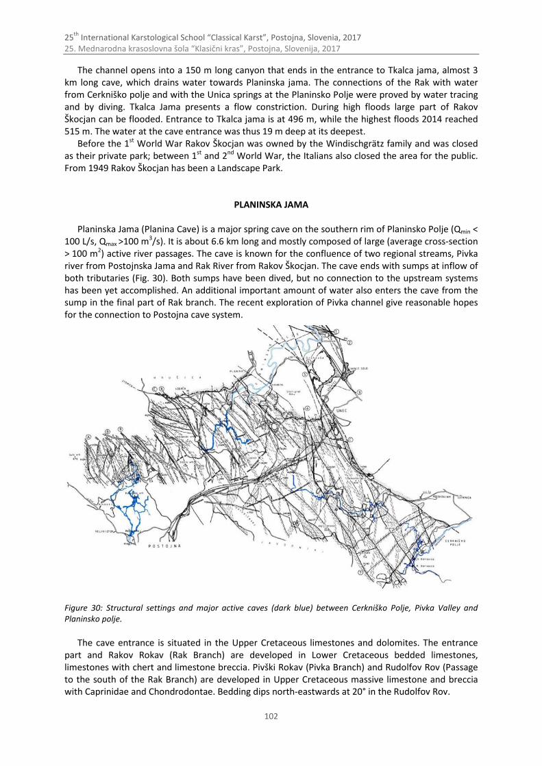
25th
International Karstological School “Classical Karst”, Postojna, Slovenia, 2017 25. Mednarodna krasoslovna šola “Klasični kras”, Postojna, Slovenija, 2017
102
The channel opens into a 150 m long canyon that ends in the entrance to Tkalca jama, almost 3 km long cave, which drains water towards Planinska jama. The connections of the Rak with water from Cerkniško polje and with the Unica springs at the Planinsko Polje were proved by water tracing and by diving. Tkalca Jama presents a flow constriction. During high floods large part of Rakov Škocjan can be flooded. Entrance to Tkalca jama is at 496 m, while the highest floods 2014 reached 515 m. The water at the cave entrance was thus 19 m deep at its deepest.
Before the 1st World War Rakov Škocjan was owned by the Windischgrätz family and was closed as their private park; between 1st and 2nd World War, the Italians also closed the area for the public. From 1949 Rakov Škocjan has been a Landscape Park.
PLANINSKA JAMA
Planinska Jama (Planina Cave) is a major spring cave on the southern rim of Planinsko Polje (Qmin < 100 L/s, Qmax >100 m3/s). It is about 6.6 km long and mostly composed of large (average cross-section > 100 m2) active river passages. The cave is known for the confluence of two regional streams, Pivka river from Postojnska Jama and Rak River from Rakov Škocjan. The cave ends with sumps at inflow of both tributaries (Fig. 30). Both sumps have been dived, but no connection to the upstream systems has been yet accomplished. An additional important amount of water also enters the cave from the sump in the final part of Rak branch. The recent exploration of Pivka channel give reasonable hopes for the connection to Postojna cave system.
Figure 30: Structural settings and major active caves (dark blue) between Cerkniško Polje, Pivka Valley and Planinsko polje.
The cave entrance is situated in the Upper Cretaceous limestones and dolomites. The entrance
part and Rakov Rokav (Rak Branch) are developed in Lower Cretaceous bedded limestones, limestones with chert and limestone breccia. Pivški Rokav (Pivka Branch) and Rudolfov Rov (Passage to the south of the Rak Branch) are developed in Upper Cretaceous massive limestone and breccia with Caprinidae and Chondrodontae. Bedding dips north-eastwards at 20° in the Rudolfov Rov.
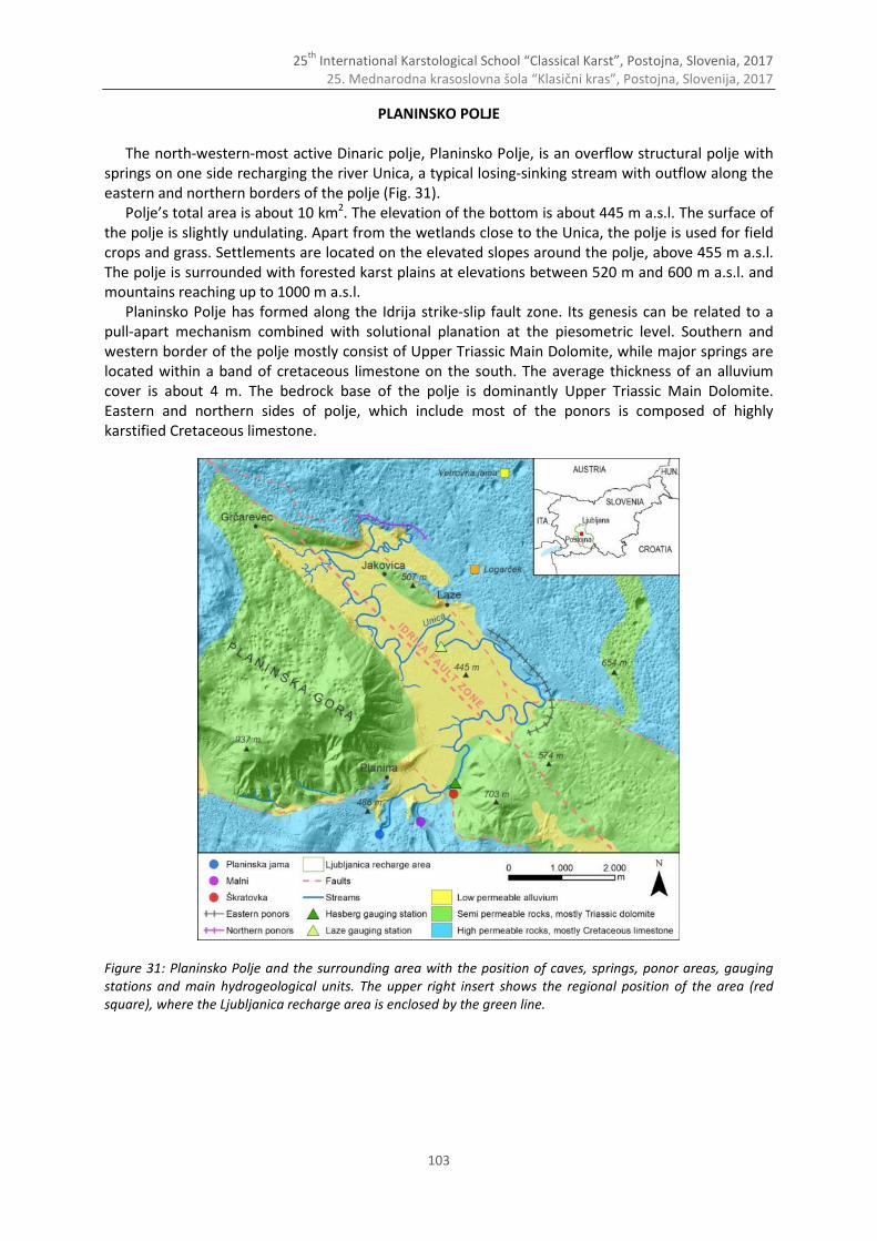
25th
International Karstological School “Classical Karst”, Postojna, Slovenia, 2017 25. Mednarodna krasoslovna šola “Klasični kras”, Postojna, Slovenija, 2017
103
PLANINSKO POLJE
The north-western-most active Dinaric polje, Planinsko Polje, is an overflow structural polje with springs on one side recharging the river Unica, a typical losing-sinking stream with outflow along the eastern and northern borders of the polje (Fig. 31).
Polje’s total area is about 10 km2. The elevation of the bottom is about 445 m a.s.l. The surface of the polje is slightly undulating. Apart from the wetlands close to the Unica, the polje is used for field crops and grass. Settlements are located on the elevated slopes around the polje, above 455 m a.s.l. The polje is surrounded with forested karst plains at elevations between 520 m and 600 m a.s.l. and mountains reaching up to 1000 m a.s.l.
Planinsko Polje has formed along the Idrija strike-slip fault zone. Its genesis can be related to a pull-apart mechanism combined with solutional planation at the piesometric level. Southern and western border of the polje mostly consist of Upper Triassic Main Dolomite, while major springs are located within a band of cretaceous limestone on the south. The average thickness of an alluvium cover is about 4 m. The bedrock base of the polje is dominantly Upper Triassic Main Dolomite. Eastern and northern sides of polje, which include most of the ponors is composed of highly karstified Cretaceous limestone.
Figure 31: Planinsko Polje and the surrounding area with the position of caves, springs, ponor areas, gauging stations and main hydrogeological units. The upper right insert shows the regional position of the area (red square), where the Ljubljanica recharge area is enclosed by the green line.
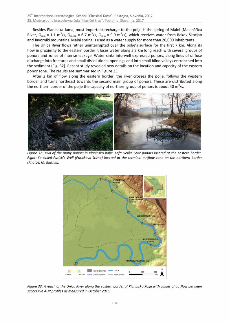
25th
International Karstological School “Classical Karst”, Postojna, Slovenia, 2017 25. Mednarodna krasoslovna šola “Klasični kras”, Postojna, Slovenija, 2017
104
Besides Planinska Jama, most important recharge to the polje is the spring of Malni (Malenščica River, Qmin = 1.1 m3/s, Qmean = 6.7 m3/s, Qmax = 9.9 m3/s), which receives water from Rakov Škocjan and Javorniki mountains. Malni spring is used as a water supply for more than 20,000 inhabitants.
The Unica River flows rather uninterrupted over the polje’s surface for the first 7 km. Along its flow in proximity to the eastern border it loses water along a 2 km long reach with several groups of ponors and zones of intense leakage. Water sinks into well expressed ponors, along lines of diffuse discharge into fractures and small dissolutional openings and into small blind valleys entrenched into the sediment (Fig. 32). Recent study revealed new details on the location and capacity of the eastern ponor zone. The results are summarised in Figure 33.
After 2 km of flow along the eastern border, the river crosses the polje, follows the western border and turns northeast towards the second main group of ponors. These are distributed along the northern border of the polje the capacity of northern group of ponors is about 40 m3/s.
Figure 32: Two of the many ponors in Planinsko polje. Left: Velike Loke ponors located at the eastern border. Right: So-called Putick’s Well (Putickova štirna) located at the terminal outflow zone on the northern border (Photos: M. Blatnik).
Figure 33: A reach of the Unica River along the eastern border of Planinsko Polje with values of outflow between successive ADP profiles as measured in October 2015.
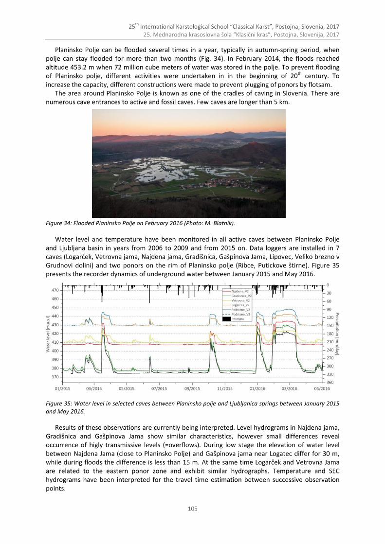
25th
International Karstological School “Classical Karst”, Postojna, Slovenia, 2017 25. Mednarodna krasoslovna šola “Klasični kras”, Postojna, Slovenija, 2017
105
Planinsko Polje can be flooded several times in a year, typically in autumn-spring period, when polje can stay flooded for more than two months (Fig. 34). In February 2014, the floods reached altitude 453.2 m when 72 million cube meters of water was stored in the polje. To prevent flooding of Planinsko polje, different activities were undertaken in in the beginning of 20th century. To increase the capacity, different constructions were made to prevent plugging of ponors by flotsam.
The area around Planinsko Polje is known as one of the cradles of caving in Slovenia. There are numerous cave entrances to active and fossil caves. Few caves are longer than 5 km. Figure 34: Flooded Planinsko Polje on February 2016 (Photo: M. Blatnik).
Water level and temperature have been monitored in all active caves between Planinsko Polje and Ljubljana basin in years from 2006 to 2009 and from 2015 on. Data loggers are installed in 7 caves (Logarček, Vetrovna jama, Najdena jama, Gradišnica, Gašpinova Jama, Lipovec, Veliko brezno v Grudnovi dolini) and two ponors on the rim of Planinsko polje (Ribce, Putickove štirne). Figure 35 presents the recorder dynamics of underground water between January 2015 and May 2016.
Figure 35: Water level in selected caves between Planinsko polje and Ljubljanica springs between January 2015 and May 2016.
Results of these observations are currently being interpreted. Level hydrograms in Najdena jama, Gradišnica and Gašpinova Jama show similar characteristics, however small differences reveal occurrence of higly transmissive levels (=overflows). During low stage the elevation of water level between Najdena Jama (close to Planinsko Polje) and Gašpinova jama near Logatec differ for 30 m, while during floods the difference is less than 15 m. At the same time Logarček and Vetrovna Jama are related to the eastern ponor zone and exhibit similar hydrographs. Temperature and SEC hydrograms have been interpreted for the travel time estimation between successive observation points.
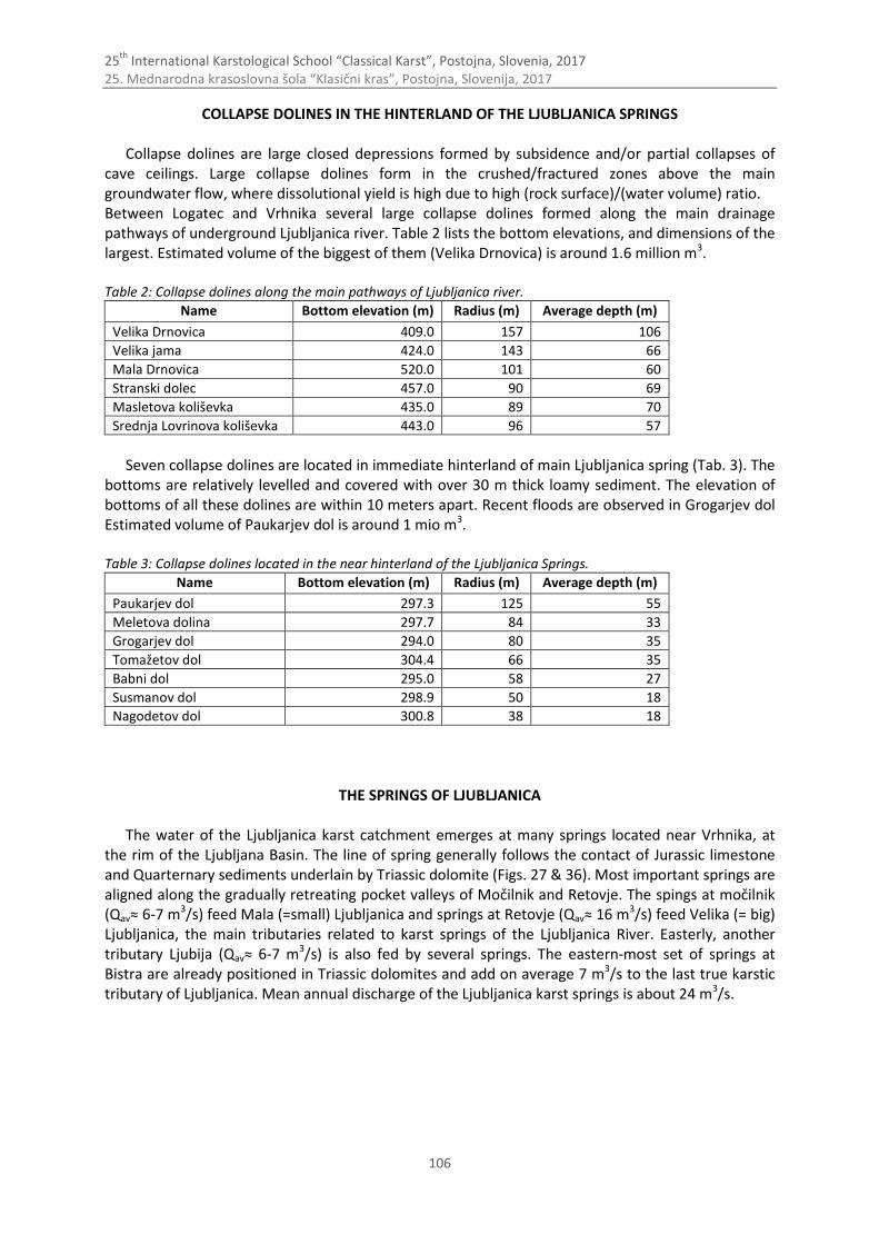
25th
International Karstological School “Classical Karst”, Postojna, Slovenia, 2017 25. Mednarodna krasoslovna šola “Klasični kras”, Postojna, Slovenija, 2017
106
COLLAPSE DOLINES IN THE HINTERLAND OF THE LJUBLJANICA SPRINGS
Collapse dolines are large closed depressions formed by subsidence and/or partial collapses of cave ceilings. Large collapse dolines form in the crushed/fractured zones above the main groundwater flow, where dissolutional yield is high due to high (rock surface)/(water volume) ratio. Between Logatec and Vrhnika several large collapse dolines formed along the main drainage pathways of underground Ljubljanica river. Table 2 lists the bottom elevations, and dimensions of the largest. Estimated volume of the biggest of them (Velika Drnovica) is around 1.6 million m3. Table 2: Collapse dolines along the main pathways of Ljubljanica river.
Name Bottom elevation (m) Radius (m) Average depth (m)
Velika Drnovica 409.0 157 106
Velika jama 424.0 143 66
Mala Drnovica 520.0 101 60
Stranski dolec 457.0 90 69
Masletova koliševka 435.0 89 70
Srednja Lovrinova koliševka 443.0 96 57
Seven collapse dolines are located in immediate hinterland of main Ljubljanica spring (Tab. 3). The
bottoms are relatively levelled and covered with over 30 m thick loamy sediment. The elevation of bottoms of all these dolines are within 10 meters apart. Recent floods are observed in Grogarjev dol Estimated volume of Paukarjev dol is around 1 mio m3. Table 3: Collapse dolines located in the near hinterland of the Ljubljanica Springs.
Name Bottom elevation (m) Radius (m) Average depth (m)
Paukarjev dol 297.3 125 55
Meletova dolina 297.7 84 33
Grogarjev dol 294.0 80 35
Tomažetov dol 304.4 66 35
Babni dol 295.0 58 27
Susmanov dol 298.9 50 18
Nagodetov dol 300.8 38 18
THE SPRINGS OF LJUBLJANICA
The water of the Ljubljanica karst catchment emerges at many springs located near Vrhnika, at the rim of the Ljubljana Basin. The line of spring generally follows the contact of Jurassic limestone and Quarternary sediments underlain by Triassic dolomite (Figs. 27 & 36). Most important springs are aligned along the gradually retreating pocket valleys of Močilnik and Retovje. The spings at močilnik (Qav≈ 6-7 m3/s) feed Mala (=small) Ljubljanica and springs at Retovje (Qav≈ 16 m3/s) feed Velika (= big) Ljubljanica, the main tributaries related to karst springs of the Ljubljanica River. Easterly, another tributary Ljubija (Qav≈ 6-7 m3/s) is also fed by several springs. The eastern-most set of springs at Bistra are already positioned in Triassic dolomites and add on average 7 m3/s to the last true karstic tributary of Ljubljanica. Mean annual discharge of the Ljubljanica karst springs is about 24 m3/s.
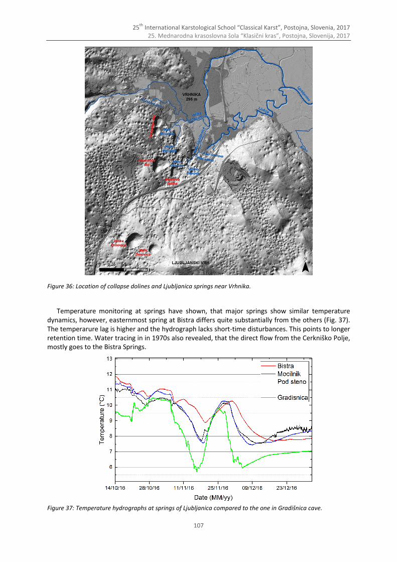
25th
International Karstological School “Classical Karst”, Postojna, Slovenia, 2017 25. Mednarodna krasoslovna šola “Klasični kras”, Postojna, Slovenija, 2017
107
Figure 36: Location of collapse dolines and Ljubljanica springs near Vrhnika.
Temperature monitoring at springs have shown, that major springs show similar temperature dynamics, however, easternmost spring at Bistra differs quite substantially from the others (Fig. 37). The temperarure lag is higher and the hydrograph lacks short-time disturbances. This points to longer retention time. Water tracing in in 1970s also revealed, that the direct flow from the Cerkniško Polje, mostly goes to the Bistra Springs. Figure 37: Temperature hydrographs at springs of Ljubljanica compared to the one in Gradišnica cave.
25th
International Karstological School “Classical Karst”, Postojna, Slovenia, 2017 25. Mednarodna krasoslovna šola “Klasični kras”, Postojna, Slovenija, 2017
108
References and further reading Blatnik, M., Frantar, P., Kosec, D. & F. Gabrovšek, 2017: Merasurements of the Outflow Along the Eastern Border of
Planinsko Polje, Slovenija.-Acta Carsologica (in print). Breznik, M., 1961: Akumulacija na Cerkniškem in Planinskem polju.- Geologija, 7, 119–149. Buser, S., 1965: Geološka zgradba južnega dela Ljubljanskega barja in njegovega obrobja.- Geologija, 8, 34–57. Čar, J., 1982: Geološka zgradba požiralnega obrobja Planinskega polja.- Acta Carsologica, 10, 75–104. Drole, F., 2015. Rakov Škocjan in Planinsko polje 2014.- Proteus, 76, 6, 275–281. Ferk, M., 2014: Kvartarne poplave v porečju kraške Ljubljanice.- Univerza v Ljubljani, Filozofska fakulteta, pp. 217,
Ljubljana. Fetter, C. W., 2000: Applied hydrogeology.- Prentice Hall, pp. 598, Upper Saddle River, N. J. Frantar, P., (ed) 2008: Water balance of Slovenia 1971–2000.- Ministrstvo za okolje in prostor, Agencija Republike
Slovenija za okolje, pp. 119, Ljubljana. Frantar, P. & Ulaga, F., 2015: Visoke vode Planinskega polja leta 2014.- Ujma, 29, 66–73. Gams, I., 2004: Kras v Sloveniji v prostoru in času.- Inštitut za raziskovanje krasa ZRC SAZU, pp. 515, Ljubljana. Gabrovšek, F., Kogovšek, J., Kovačič, G., Petrič, M., Ravbar, N. & Turk, J., 2010: Recent results of tracer tests in the
catchment of the Unica River (SN Slovenia).- Acta Carsologica, 39, 1, 27–38. Gabrovšek, F. & Turk, J., 2010: Observations of stage and temperature dynamics in the epiphreatic caves within the
catchment area of the Ljubljanica river.- Geologia Croatica, 63, 2, 187–193. Gospodarič, R. & P. Habič, (ed), 1976: Underground water tracing: Investigations in Slovenia 1972–1975.- Third
International Symposium of Underground Water Tracing (3. SUWT), pp. 312, Ljubljana, Bled. Habič, P., (ed) 1973: Speleološka karta – List Vrhnika 2-D.- Inštitut za raziskovanje krasa ZRC SAZU, pp. 156, Postojna. Kogovšek, J., 1999: Nova spoznanja o podzemnem pretakanju vode v severnem delu Javornikov (Visoki kras)).- Acta
Carsologica, 28, 1, 161–200. Mihevc, A., Prelovšek, M., Zupan Hajna, N., 2010: Introduction to Dinaric Karst.- Inštitut za raziskovanje krasa ZRC
SAZU, pp. 71., Postojna. Petrič, M. & S. Šebela, 2005: Hydrogeological research as a basis for the preparation of the plan of monitoring
groundwater contamination – a case study of the Stara vas landfill near Postojna (SW Slovenia).- Acta Carsologica, 34, 2, 489–505.
Placer, L., 2008: Principles of the tectonic subdivision of Slovenia = Osnove tektonske razčlenitve Slovenije.- Geologija, 51, 2, 205–217.
Placer, L., Vrabec, M., Celarc, B., 2010: The bases for understanding of the NW Dinarides and Istria Peninsula tectonics.- Geologija, 53, 1, 55–86.
Putick, V., 1889: Die hydrologischen Geheimnisse des Karstes und seine unterirdischen Wasserläufe : auf Grundlage der neuesten hydrotechnischen Forschungen.- Himmel und Erde, pp. 13, Berlin.
Stepišnik, U., 2006: Udornice v Sloveniji.-Znanstvena založba Filozofske fakultete, 116 pp. Ravnik, D., 1976: Kameninska podlaga Planinskega polja.- Geologija, 19, 291–315. Šušteršič, F., 2002: Where does Underground Ljubljanica Flow?- RMZ Materials and Geoenvironment, 49, 1, 61–84. Šušteršič, F., 1999: Speleogenesis of the Ljubljanica River Drainage Basin, Slovenia.- In: Klimchouk, A.B., Ford, D.C.,
Palmer, A.N. & W. Dreybrodt (Eds.): Speleogenesis: Evolution of Karst Aquifers. NSS, Huntsville, Alabama, 397-406.
Turk, J., 2010: Dinamika podzemne vode v kraškem zaledju izvirov Ljubljanice – Dynamics of underground water in the karst catchment area of the Ljubljanica springs.- Inštitut za raziskovanje krasa ZRC SAZU, pp. 136, Ljubljana.
Vrabec, M., 1994: Some thoughts on the pull-apart origin of karst poljes along the Idrija strike-slip fault zone in Slovenia.- Acta Carsologica.
25th
International Karstological School “Classical Karst”, Postojna, Slovenia, 2017 25. Mednarodna krasoslovna šola “Klasični kras”, Postojna, Slovenija, 2017
109
Have you thought about publishing your presentation?
All presenters and other participants are invited to submit their work for publication in Acta Carsologica.*
Acta Carsologica publishes original research papers and reviews, letters, essays and reports covering
topics related to specific of karst areas. These comprise, but are not limited to karst geology,
hydrology and geomorphology, speleology, hydrogeology, biospeleology and history of karst science.
Visit, read & submit at: http://ojs.zrc-sazu.si/carsologica
*Papers will be considered for publications in one of the forthcoming regular issues. Therefore, no submission deadlines are given.
25th
International Karstological School “Classical Karst”, Postojna, Slovenia, 2017 25. Mednarodna krasoslovna šola “Klasični kras”, Postojna, Slovenija, 2017
110
Welcome to Karstology doctoral study
The Karstology doctoral study programme is a world-wide unique programme which provides a
comprehensive study of karst science, combining the study of the karst landscape, karst caves,
karst hydrogeology, biology and ecology of karst in one course of study. It was designed for
students who wish to gain deeper insight of this broadly integrated system of karst sciences. The
fundamental objective of the programme is to produce two types of karstologists. The first is the
karstologist-researcher who can conduct independent research on karst and karst phenomena
from multiple aspects. The second type is the karstologist- manager who can apply the full
knowledge of karst conveyed by narrowly specialized experts for different applications
(economy, education, protection).
The programme was developed with researchers of the Karst Research Institute at Research
Centre of the Slovene Academy of Sciences and Arts (ZRC SAZU) and is carried out by professors
and researchers from Karst Research Institute and invited foreign professors, and is coordinated
and managed by the University of Nova Gorica. Lectures and research take place in the premises
of the Karst Research Institute in Postojna where students are provided all necessary
professional and scientific support for their own research work. Successful functioning of
doctoral study programme Karstology resulted in naming it in 2014 as the UNESCO Chair on Karst Education.
http://www.ung.si/en/ http://www.ung.si/en/study/graduate-school/study/3KR/
Information:
Associate professor dr. Martin KNEZ, univ. grad. eng. geology
Director of Graduate study programme Karstology Graduate School, University of Nova Gorica, Slovenia Karst Research Institute Research Centre of the Slovenian Academy of Sciences and Arts P.O.Box 59, SI-6230 Postojna, Slovenia Tel: ++386 5 700 1915, ++386 5 700 1900 Fax: ++386 5 700 1999 Email: [email protected]