last glacial maximum and holocene lake levels of owens lake, eastern california, usa
TRANSCRIPT

ARTICLE IN PRESS
0277-3791/$ - se
doi:10.1016/j.qu
�CorrespondUSA. Tel.: +1
E-mail addr
Quaternary Science Reviews 25 (2006) 1264–1282
Last glacial maximum and Holocene lake levels of Owens Lake,eastern California, USA
Steven N. Bacona,�, Raymond M. Burkea, Silvio K. Pezzopanea, Angela S. Jaykob
aDepartment of Geology, Humboldt State University, Arcata, CA 95521, USAbUS Geological Survey, U.C. White Mountain Research Station, Bishop, CA 93514, USA
Received 25 February 2005; accepted 6 October 2005
Abstract
Stratigraphic investigations of fluvio-deltaic and lacustrine sediments exposed in stream cuts, quarry walls, and deep trenches east of
the Sierra Nevada in Owens Valley near Lone Pine, California have enabled the reconstruction of pluvial Owens Lake level oscillations.
Age control for these sediments is from 22 radiocarbon (14C) dates and the identification and stratigraphic correlation of a tephra, which
when plotted as a function of age versus altitude, define numerous oscillations in the level of pluvial Owens Lake during the latest
Pleistocene and early Holocene. We have constructed a lake-level altitude curve for the time interval �27,000 cal yr BP to present that is
based on the integration of this new stratigraphic analysis with published surface stratigraphic data and subsurface core data. Pluvial
Owens Lake regressed from its latest Pleistocene highstands from �27,000 to �15,300 cal yr BP, as recorded by �15m of down cutting of
the sill from the altitudes of �1160 to 1145m. By �11,600 cal yr BP, the lake had dropped �45m from the 1145m sill. This lowstand was
followed by an early Holocene transgression that attained a highstand near 1135m before dropping to 1120m at 7860–7650 cal yr BP that
had not been recognized in earlier studies. The lake then lowered another �30m to shallow and near desiccation levels between �6850
and 4300 cal yr BP. Fluvial cut-and-fill relations north of Lone Pine and well-preserved shoreline features at �1108m indicate a minor
lake-level rise after 4300 cal yr BP, followed by alkaline and shallow conditions during the latest Holocene. The new latest Quaternary
lake-level record of pluvial Owens Lake offers insight to the hydrologic balance along the east side of the southern Sierra Nevada and will
assist regional paleoclimatic models for the western Basin and Range.
r 2005 Elsevier Ltd. All rights reserved.
1. Introduction
Owens Valley is an approximately 15–40 km wide and200 km long complex graben in the southwestern GreatBasin in eastern California. The valley lies adjacent to theeastern Sierra Nevada which forms one of the principalrain shadows in the western US (Fig. 1). The valley has adrainage area of �8450 km2 bounded by the crests of theSierra Nevada Range to the west, White-Inyo Mountainsto the east, and the Coso Range to the south and east. Thenorthern extent of the watershed reaches north of Bishopnear Long Valley, Adobe Valley and occasionally Monobasin during extreme pluvial times (Reheis et al., 2002), butpresently is limited by a drainage divide that separates
e front matter r 2005 Elsevier Ltd. All rights reserved.
ascirev.2005.10.014
ing author. Desert Research Institute, Reno, NV 89512,
775 673 7473; fax: +1 775 673 7485.
ess: [email protected] (S.N. Bacon).
Mono basin and the Volcanic Tableland to the north(Hollett et al., 1991) (Fig. 1). Crests of the Sierra Nevadaand White-Inyo Mountains rise more than 3000m abovethe floor of Owens Valley, with Mt. Whitney (alt. 4417m)rising �3280m above the town of Lone Pine to the west.The depocenter of the valley, which underlies Owens
Lake playa within the southern portion of the valley, is agraben formed by prominent normal faults of the SierraNevada frontal fault system and the oblique-normal Inyo-White Mountains fault zones. The latest high stand of thelake, controlled by a spillway at 1145m near HaiweeReservoir, formed a water body at least 50 km long and80m deep (Gale, 1914; Smith and Bischoff, 1997) (Fig. 2).Owens Valley is generally steep-sided and flat-bottomed;thus, at 10m below the sill altitude of 1145m only 7%(40 km2) of the lake bottom is exposed. About 40–45 km2 isexposed with each 10m of lowering in lake level to thecurrent playa bottom at �1085m (Mensing, 2001) (Fig. 2).

ARTICLE IN PRESS
36°
38°
118°
118°
116°
36°
116°
MonoLake
LakeCrowley
OwensLake
ChinaLake
SearlesLake
PanamintLake
BadWater
LakeTecopa
Ow
ens
Riv
er
MojaveRiver
Am
argosa
B
AdobeLake
VT
SIE
RR
A
NE
VA
DA
INY
O M
TS
WH
ITE
MT
S
CO
SOR
AN
GE
River
OW
EN
S
VA
LL
EY
LakeRussell
PluvialOwensLake
I
LP
PluvialSearles
Lake
PluvialPanamint
Lake
LakeManly
Nevada
AREA OF MAP
EXPLANATION
Present-day playa orlake
Pleistocene pluvial lake
Present-day river
Pleistocene river(direction of flow)
Long Valley Caldera
0 30 km
Drainage basins ofOwens and Mono LakesSierra Nevada crest
California
NEVA
DA
CA
LIFOR
NIA
Fig. 1. Map of present day and pluvial Owens Lake, and other lakes
hydrologically connected upstream and downstream from it during pluvial
periods of the Pleistocene. B, Bishop; I, Independence; LP, Lone Pine; VT,
Volcanic Tableland (figure modified from Smith and Bischoff (1997)).
S.N. Bacon et al. / Quaternary Science Reviews 25 (2006) 1264–1282 1265
During much of the middle and late Quaternary, OwensLake was a perennial freshwater lake that periodicallyoverflowed into a chain of lakes occupying one or more offour successively lower-altitude basins (Gale, 1914; Smithand Street-Perrott, 1983; Smith and Bischoff, 1997; Smithet al., 1997) (Fig. 1). The Owens River drainage systemsupplied most of the water to the lower chain of lakes,although at times pluvial Lake Russell in Mono basin hasintermittently overflowed to become the northernmost lakein the drainage system (Lajoie, 1968; Smith and Street-Perrott, 1983; Reheis et al., 2002) (Fig. 1). In this paper, weuse the term pluvial to mean a climatic regimen of sufficientduration to be represented in the physical or organicrecord, and in which the precipitation/evaporation ratioresults in greater net moisture available for water bodies
and organisms than is available in the same area today orin the preceding regimen (Flint, 1971).The highest identified shorelines without numerical age
control within Owens Valley are located at an altitude of�1180m in the southern margin of Owens Lake basin (e.g.,Hollett et al., 1991; Beanland and Clark, 1994). During thelatest Pleistocene, at sill altitudes between �1160 and1145m, pluvial Owens Lake filled the southern �90 km ofthe valley north to about the location of Independence,covering more than �700 km2 (Smith and Street-Perrott,1983; Orme and Orme, 2000) (Fig. 2). During the middleand late Holocene, Owens Lake was mostly a shallow,highly saline closed-basin lake (Benson et al., 1997; Smithet al., 1997; Li et al., 2000).In 1872 AD, Owens Lake was a perennial closed-basin
lake that covered more than 256 km2 having a historicalmaximum lake level at �1096m and a water depth of14.9m (Gale, 1914). Major water diversions in OwensValley began in 1921 AD with the construction of theOwens River-Los Angeles aqueduct that transports OwensRiver water more than 320 km to the south for distribution(Hollett et al., 1991). Owens Lake first began depositingsalts onto the lake floor in 1921 AD because of thesediversions, and by around 1931 AD, Owens Lake haddesiccated and become a playa (Smith et al., 1997).
1.1. Previous stratigraphic investigations in southern Owens
Valley
The Quaternary lacustrine history of southern OwensValley has previously attracted stratigraphic investigations,with one of the earliest by Smith and Pratt (1957). Morerecently, sediment cores have documented the timing andqualitative changes of latest Quaternary lake-level fluctua-tions based on attributes such as isotopic, geochemical,mineralogical, and sedimentological, along with ostracode,diatom, and pollen biological proxy climatic indicators(e.g., Newton, 1991; Benson et al., 1996, 1997, 2002; Smithet al., 1997; Smoot, 1998; Forester, 2000; Li et al., 2000;Mensing, 2001; Bischoff and Cummins, 2001). Althoughsediment core proxy data are useful in detecting changes ina paleolake system, core data alone do not provide anyindication of the surface altitude of a paleolake level,except during desiccation when evaporite minerals orevidence of a soil are present.Stratigraphic and geomorphic data from shoreline
deposits and associated features presented by Orme andOrme (1993, 2000), Smith (1997a), Stone et al. (2000), andBacon (2003), combined with sediment cores of Benson etal. (1997, 2002) and Smith et al. (1997) document an open-basin lake during the latest Pleistocene and a closed-basinlake during the Holocene. These studies demonstrate thatpluvial Owens Lake water levels fluctuated throughout thelatest Pleistocene and Holocene, mostly within the basin ataltitudes much above the playa, yet below the overflow sillat 1145m. All but one of these studies were completed afterthe paleoseismic investigation on the Owens Valley fault
ARTICLE IN PRESS
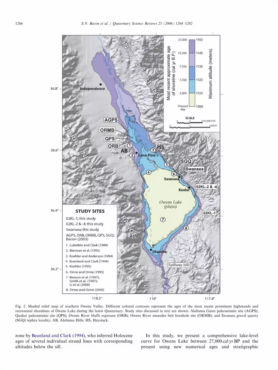
Fig. 2. Shaded relief map of southern Owens Valley. Different colored contours represent the ages of the most recent prominent highstands and
recessional shorelines of Owens Lake during the latest Quaternary. Study sites discussed in text are shown: Alabama Gates paleoseismic site (AGPS);
Quaker paleoseismic site (QPS); Owens River bluffs exposure (ORB); Owens River meander belt borehole site (ORMB); and Swansea gravel quarry
(SGQ) tephra locality; AB, Alabama Hills; HS, Haystack.
S.N. Bacon et al. / Quaternary Science Reviews 25 (2006) 1264–12821266
zone by Beanland and Clark (1994), who inferred Holoceneages of several individual strand lines with correspondingaltitudes below the sill.
In this study, we present a comprehensive lake-levelcurve for Owens Lake between 27,000 cal yr BP and thepresent using new numerical ages and stratigraphic

ARTICLE IN PRESSS.N. Bacon et al. / Quaternary Science Reviews 25 (2006) 1264–1282 1267
correlations combined with stratigraphic, geomorphic, andsediment core data from previous work (Fig. 3). Altitudesare mainly derived from 1:24,000 topographic maps, total-station and leveling surveys, and global positioning system(GPS) (Tables 1–3). We consider the wide range ofdifferent methods used to measure or estimate altitudesto have a vertical accuracy that ranges from o1 to 5m.
We also present the age and altitudes of specific lakelevels based on the sequence stratigraphy of latestPleistocene to early Holocene fluvio-deltaic and lacustrinesediments of pluvial Owens Lake near Lone Pine (Figs. 2and 3). Sequence stratigraphic analyses are based on thesubdivision of a sedimentary section into hierarchies ofstrata that together form geometric packages which aredefined and characterized by bounding and internalsurfaces of erosion or non-deposition (sequence bound-aries) (e.g., Einsele, 2000). The stratigraphic analysisincludes a description of �1.5 km of Owens River bluffs(ORB) exposed along the west bank of the river, the OwensRiver meander belt (ORMB) borehole site, and theSwansea gravel quarry (SGQ) that exposes a tephra(Fig. 2). In addition, we report on the results from seventrenches and four pits at the Alabama Gates (AGPS) andthe Quaker paleoseismic sites (QPS) that were originallyexcavated to provide stratigraphic context for a paleoseis-mic investigation on the Owens Valley fault zone near LonePine (Bacon, 2003; Bacon et al., 2003), but that alsoprovide important new stratigraphic constraints for thealtitudes of the latest lake levels (Fig. 2).
1.2. Age control and correlations
We present 22 new radiocarbon (14C) dates as well as onenew tephra correlation analyzed by A.M. Sarna-Wojcicki,US Geological Survey, Menlo Park, California (Tables 1and 2) and integrate these data with published 14C dates(Table 3). These numerical dates constrain the age of bothsubaqueous deposits and subaerial shoreline features.Accelerator mass spectrometry (AMS) and conventional14C dates were obtained on charcoal, tufa, shells, and bulkorganic carbon. Conventional 14C dates reported in thisstudy and prior studies have been converted to calibratedyears before present (cal yr BP) using the CALIB v 5.0.1program (Stuiver and Reimer, 1993) with the INTCAL04data set (Reimer et al., 2004) for dates younger than�20,000 yr BP (Tables 1 and 3 and Fig. 3). Furthermore,conventional 14C dates reported in this study and priorstudies that are older than �20,000 yr BP were calibratedusing 230Th–234U and 14C ages of corals after Bard et al.(1998) (Tables 1 and 3 and Fig. 3). Where conventionaldates from published data lacked an uncertainty at 71s,we infer a standard error 760 yr BP in an effort to bestpresent a calibrated age. Many of the 14C dates containmultiple intercepts when calibrated, thereby providingmultiple calibrated ages with different probabilities. Thepreferred intervals shown in bold in Tables 1 and 3represent the range of calibrated ages at 72s that includes
the y-intercept of the conventional radiocarbon age. Thecalibrated range of ages at 72s and the intercept betweenthe conventional 14C ages are plotted to construct the lake-level curve.Stratigraphic and geomorphic data are compiled from
Orme and Orme (1993, 2000), Beanland and Clark (1994),Koehler and Anderson (1994), Bierman et al. (1995),Koehler (1995), Smith et al. (1997), Li et al. (2000), andBacon (2003) (Fig. 3). Sediment core data from Benson etal. (1997), Smith et al. (1997), and Li et al. (2000) are alsointegrated with the shoreline data (Fig. 3). The altitude ofeach sediment core data point is approximated bycomparing the reported age with a corresponding depth(altitude) using the graphic log of core OL-92 in Smith(1997). Age control of sediment cores is derived from AMS14C on carbonate and humate. Li et al. (2000) reported theages of lacustrine sediment based on the correlation topaleomagnetic secular variations, because of uncertaintiesin the reservoir age estimation of Owens Lake, and are alsoshown on the lake-level curve. Organic-rich sediment(humate) that bound sediment hiatuses (unconformitiesand/or facies changes) provide 14C dates that are inter-preted by Smith et al. (1997) as proxy indicators of achange from deposition in deep-water to moderate- orshallow-water within a closed-basin lake. Sediment hia-tuses in cores appear as frosted quartz grains, coarse sand,oolites or rubified clay with prismatic soil structure, allindicators of shallow to dry lake conditions (Benson et al.,1997; Smith et al., 1997). In addition to sediment hiatuses,the variation of d18O values from the sediment core recordindicates changes in evaporation of the Owens Lake system(Benson et al., 1997). During a wet period, the volume of aclosed-basin lake increases, which typically drives the d18Ovalue in the lake to decrease, whereas during a dry periodthe d18O value in the lake increases as the lake shrinks(Benson et al., 2002); thus constraining the direction oflake-level oscillations in the absence of surface data.It has been demonstrated that tufas (e.g., Bischoff et al.,
1993) and shells (e.g., Brennan and Quade, 1997) in certainenvironmental conditions are unsuitable for numericaldating by the radiocarbon method, because tufas and shellsare susceptible to contamination with older carbon. Also,Benson (1994) explains how reservoir corrections need tobe applied to 14C dates from tufa in lake systems. Weacknowledge the uncertainty in dating tufa carbonates andshells, which may provide artificially older 14C ages, butused with additional supporting 14C dates from charcoal inaddition to stratigraphic relations, may still offer reliableages.
1.3. Uncertainties with altitude correlations across Owens
Lake basin
Owens Valley is a region of active tectonism (Savage andLisowski, 1995), with most of the study sites located on thevalley bottom or graben block and bounded by the OwensValley fault and Inyo Mountains fault blocks and

ARTICLE IN PRESS
Fig.3.Lake-level
curveofOwensLakebetween�27,000calyrBPandpresent.Thelake-level
curveis
acompilationofstratigraphic,geomorphic,andsedim
entcore
data
from
investigationsin
southernOwensValley.Calibrated
14C
datesare
after
Bard
etal.(1998)andReimer
etal.(2004).Data
from
thisstudyare
from
sitesnearSwanseaandKeeler.Data
from
Bacon(2003)are
from
the
AlabamaGatespaleoseismic
site
(AGPS),Quaker
paleoseismic
site
(QPS),OwensRiver
bluffsexposure
(ORB),OwensRiver
meander
beltborehole
site
(ORMB),andSwanseagravel
quarrytephra
locality
(SGQ)(see
Fig.2forstudysite
locations,Tables1–3forages
andcorrelations,andtextforamore
complete
descriptionandreference
tooriginaldata).
S.N. Bacon et al. / Quaternary Science Reviews 25 (2006) 1264–12821268
ARTICLE IN PRESS
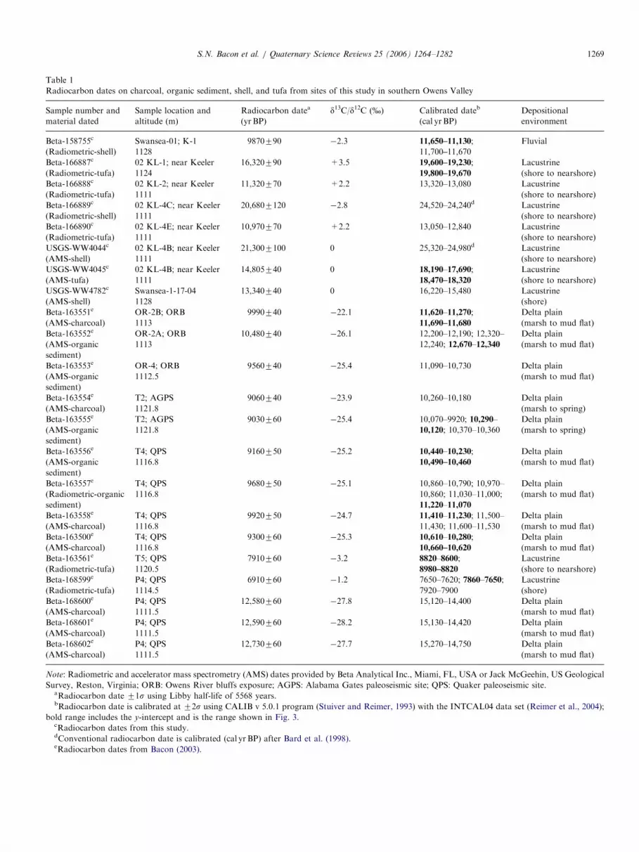
Table 1
Radiocarbon dates on charcoal, organic sediment, shell, and tufa from sites of this study in southern Owens Valley
Sample number and
material dated
Sample location and
altitude (m)
Radiocarbon datea
(yr BP)
d13C/d12C (%) Calibrated dateb
(cal yrBP)
Depositional
environment
Beta-158755c Swansea-01; K-1 9870790 �2.3 11,650–11,130; Fluvial
(Radiometric-shell) 1128 11,700–11,670
Beta-166887c 02 KL-1; near Keeler 16,320790 +3.5 19,600–19,230; Lacustrine
(Radiometric-tufa) 1124 19,800–19,670 (shore to nearshore)
Beta-166888c 02 KL-2; near Keeler 11,320770 +2.2 13,320–13,080 Lacustrine
(Radiometric-tufa) 1111 (shore to nearshore)
Beta-166889c 02 KL-4C; near Keeler 20,6807120 �2.8 24,520–24,240d Lacustrine
(Radiometric-shell) 1111 (shore to nearshore)
Beta-166890c 02 KL-4E; near Keeler 10,970770 +2.2 13,050–12,840 Lacustrine
(Radiometric-tufa) 1111 (shore to nearshore)
USGS-WW4044c 02 KL-4B; near Keeler 21,3007100 0 25,320–24,980d Lacustrine
(AMS-shell) 1111 (shore to nearshore)
USGS-WW4045c 02 KL-4B; near Keeler 14,805740 0 18,190–17,690; Lacustrine
(AMS-tufa) 1111 18,470–18,320 (shore to nearshore)
USGS-WW4782c Swansea-1-17-04 13,340740 0 16,220–15,480 Lacustrine
(AMS-shell) 1128 (shore)
Beta-163551e OR-2B; ORB 9990740 �22.1 11,620–11,270; Delta plain
(AMS-charcoal) 1113 11,690–11,680 (marsh to mud flat)
Beta-163552e OR-2A; ORB 10,480740 �26.1 12,200–12,190; 12,320– Delta plain
(AMS-organic
sediment)
1113 12,240; 12,670–12,340 (marsh to mud flat)
Beta-163553e OR-4; ORB 9560740 �25.4 11,090–10,730 Delta plain
(AMS-organic
sediment)
1112.5 (marsh to mud flat)
Beta-163554e T2; AGPS 9060740 �23.9 10,260–10,180 Delta plain
(AMS-charcoal) 1121.8 (marsh to spring)
Beta-163555e T2; AGPS 9030760 �25.4 10,070–9920; 10,290– Delta plain
(AMS-organic
sediment)
1121.8 10,120; 10,370–10,360 (marsh to spring)
Beta-163556e T4; QPS 9160750 �25.2 10,440–10,230; Delta plain
(AMS-organic
sediment)
1116.8 10,490–10,460 (marsh to mud flat)
Beta-163557e T4; QPS 9680750 �25.1 10,860–10,790; 10,970– Delta plain
(Radiometric-organic
sediment)
1116.8 10,860; 11,030–11,000; (marsh to mud flat)
11,220–11,070
Beta-163558e T4; QPS 9920750 �24.7 11,410–11,230; 11,500– Delta plain
(AMS-charcoal) 1116.8 11,430; 11,600–11,530 (marsh to mud flat)
Beta-163500e T4; QPS 9300760 �25.3 10,610–10,280; Delta plain
(AMS-charcoal) 1116.8 10,660–10,620 (marsh to mud flat)
Beta-163561e T5; QPS 7910760 �3.2 8820–8600; Lacustrine
(Radiometric-tufa) 1120.5 8980–8820 (shore to nearshore)
Beta-168599e P4; QPS 6910760 �1.2 7650–7620; 7860–7650; Lacustrine
(Radiometric-tufa) 1114.5 7920–7900 (shore)
Beta-168600e P4; QPS 12,580760 �27.8 15,120–14,400 Delta plain
(AMS-charcoal) 1111.5 (marsh to mud flat)
Beta-168601e P4; QPS 12,590760 �28.2 15,130–14,420 Delta plain
(AMS-charcoal) 1111.5 (marsh to mud flat)
Beta-168602e P4; QPS 12,730760 �27.7 15,270–14,750 Delta plain
(AMS-charcoal) 1111.5 (marsh to mud flat)
Note: Radiometric and accelerator mass spectrometry (AMS) dates provided by Beta Analytical Inc., Miami, FL, USA or Jack McGeehin, US Geological
Survey, Reston, Virginia; ORB: Owens River bluffs exposure; AGPS: Alabama Gates paleoseismic site; QPS: Quaker paleoseismic site.aRadiocarbon date 71s using Libby half-life of 5568 years.bRadiocarbon date is calibrated at 72s using CALIB v 5.0.1 program (Stuiver and Reimer, 1993) with the INTCAL04 data set (Reimer et al., 2004);
bold range includes the y-intercept and is the range shown in Fig. 3.cRadiocarbon dates from this study.dConventional radiocarbon date is calibrated (cal yr BP) after Bard et al. (1998).eRadiocarbon dates from Bacon (2003).
S.N. Bacon et al. / Quaternary Science Reviews 25 (2006) 1264–1282 1269

ARTICLE IN PRESS
Table 2
Major oxide composition and correlation of a tephra from the Swansea gravel quarry near Lone Pine, Owens Valley
Sample SiO2 Al2O3 FeO MgO MnO CaO TiO2 Na2O K2O Total
Swansea gravel quarry OL-SW-1 (all glass) T470-9
Mean (n ¼ 23) 71.72 12.16 0.951 0.024 0.053 0.538 0.051 3.624 4.555 93.67
Std. dev. 0.43 0.10 0.066 0.010 0.029 0.028 0.033 0.103 0.105 0.60
Tephra layer exposed at the Swansea gravel quarry at an altitude �1125m. Tephra has a homogenous, compositionally tight mode, and matches best with
Holocene tephra from the Mono Craters in Mono basin. Best matches are to tephra samples in the age range 1100–1200 14C yrBP, but the greater part of
the Holocene time span, from about 560 to 7000 14C yrBP cannot be excluded, because there is a Holocene tephra layer with similar composition that is
�6900 14C yrBP. The tephra at the Swansea gravel quarry is located �20m below the sill altitude of Owens Lake basin, therefore the tephra is likely within
the older range of ages because it is overlain by younger beach barrier gravels that appear to extend to �1135m. The tephra is inferred to correlate with the
oldest age of �6900 14C yrBP (7830–7670 cal yr BPa) from the Mono Crater series.
Note: Original analytical data from electron-microprobe analysis of volcanic glass shards separated from tephra layer and correlation of tephra, which is
based on the calculation of similarity coefficients using selected oxides, are presented in Bacon (2003). Shards were analyzed using the JEOL8900 (use of
trade names by the US Geological Survey does not represent endorsement of the product) instrument. N ¼ number of shards analyzed for each sample.
Varying fluids account for differences in totals from 100%. Electron-microprobe analyses performed by J. Walker and tephra identification analyses
performed by A.M. Sarna-Wojcicki, US Geological Survey, Menlo Park, California in 2001.aCalibrated age of tephra is in calender years after Reimer et al. (2004).
S.N. Bacon et al. / Quaternary Science Reviews 25 (2006) 1264–12821270
associated fault zones (Pakiser et al., 1964). Owens Valleycontains several active normal and oblique fault zones thatgenerate large magnitude earthquakes that can cause widespread subsidence and uplift. Several shorelines of differentages are deformed where they extend across or are nearfault zones (Carver, 1970; Beanland and Clark, 1994;Bacon, 2003). For example, the magnitude 71
2–73
4Owens
Valley earthquake in 1872 AD, created a seismic seiche(tsunami) as well as laterally shifted the position of theeastern shoreline of Owens Lake hundreds of meters to thewest, raising the western shoreline �1m in altitude(Ventura Signal, 1872; Meyer, 1977; Smoot et al., 2000).
Paleoseismic investigations on the Owens Valley faultzone near Lone Pine by Bacon (2003) provide minimumestimates for the amount of vertical deformation in thevalley during the latest Quaternary. Geomorphic featuresand sediments deposited prior to the penultimate event at93007300 cal yr BP are vertically deformed as much as2.5m. In addition, sediments and features deposited orformed during the time between the penultimate and 1872AD earthquakes are vertically displaced �1m. Thesedisplacements are considered a minimum, because it isnot clear how much subsidence or uplift is distributedwithin southern Owens Valley during earthquakes on theOwens Valley fault zone or on other faults that bound thevalley, nor is it clear how much differential uplift hasoccurred due to isostatic rebound since the last significanthighstands. In addition to ground deformation affectingthe original altitude of sediments and features, the naturalvariability in the height of constructional beach features inLahontan basin were within 2.5m in altitude whenspatially compared to shoreline features of the same lakelevel (Adams and Wesnousky, 1998). This range would besmaller for Owens Lake basin because of its lesser size. Thereported altitudes shown on the lake-level curve have notbeen corrected because of the uncertainties in the original
altitude of sediments and shoreline features, which likelyhave been affected by the processes discussed above.
2. Latest Quaternary Owens Lake level curve
2.1. 27,000–15,800 cal yr BP
The highest latest-Pleistocene shoreline complex withnumerical age control is located at an altitude of �1160min southern Owens Valley (Fig. 2), where it is characterizedby moderately to well-preserved beach ridges and wave-cutnotches. Published lake-level data from Owens Valley aresparse, and three previous studies with 14C controlconstrain the age of shoreline features at this altitude.The �1160m shoreline has yielded a 26,250–23,230 calyr BP 14C date on lithoid tufa-cemented beach gravel at analtitude of �1156m near Lone Pine (Lubetkin and Clark,1988) (Table 3 and Figs. 2 and 3). The altitude of the datedbeach gravel is considered a minimum because construc-tion of the Los Angeles aqueduct has removed �2–3m ofthe upper section of the shoreline record at the site.A maximum altitude for this shoreline of �1160m is datedto �24,230–23,730 cal yr BP from shells within beach ridgesediments from a site along the southern margin of OwensLake basin (Orme and Orme, 2000) (Table 3 and Figs. 2and 3). Furthermore, dung from packrat middens atan altitude of �1155m at Haystack east of Lone Pinedate between 27,130 and 20,560 cal yr BP (Koehler andAnderson, 1994) (Table 3 and Figs. 2 and 3). The age andpreservation of the packrat midden constrain the positionof a lake level below 1155m as recently as �20,560 calyr BP. Although it appears that there is overlap with the14C dates and altitudes from each of the three studies, it ispossible that the altitude estimate of �1155m for thepackrat midden is incorrect as much as 5m because it wasprobably approximated from a 1:24,000-scale topographic

ARTICLE IN PRESS
Table 3
Compilation of radiocarbon dates on charcoal, organic sediment, shell, and oolites from previous investigations in southern Owens Valley
Reference and material dated Sample location and
altitude (m)
Radiocarbon datea
(yr BP)
Calibrated dateb (cal yr BP) Depositional
environment
Li et al. (2000) Owens playa NA (130) NA Lacustrine
Historical 1096 (shore)c
Li et al. (2000) Owens playa 9157135d NA Dry
(PSV) 1082 (oLi & Mg)e
Beanland and Clark (1994) Northern Owens Lake �2000f NA Lacustrine
Artifact 1100 (shore)c
Bierman et al. (1995) Near lone pine 4030760 4330–4300; 4370–4350; Alluvium
(radiometric-charcoal) 1030–1150 4390–4390; 4660–4400; (alluvial fan)c
4710–4670; 4810–4760
Benson et al. (1997) Owens playa 5870760* to 6850–6820; 6800–6530; Shallow
(AMS-organic sediment) 1081 4040760* 6520–6500 to 4820–4750; (erosional; sand)e
4730–4410
Smith et al. (1997) Owens playa 5100760* 5670–5660; 5690–5680; Shallow
(AMS-oolites) 1080 5950–5710; 5990–5970 (erosion; oolites)e
Orme and Orme (1993) Northern Owens Lake 9600760* 11,170–10,750 Lacustrine
(radiometric-shell) 1120 (shore)c
Benson et al. (1997) Owens playa 9700760* 10,970–10,790; 11,030– Dry
(AMS-organic sediment) 1079.5 11,000; 11,240–11,070 (d18O content)e
Orme and Orme (1993) Northern Owens Lake 10,000760* 11,720–11,260; Lacustrine
(radiometric-shell) 1100 11,750–11,730 (shore)c
Beanland and Clark (1994) AGPS 10,190770 11,430–11,410; 11,530– Delta plain
(radiometric-charcoal) 1122 11,500; 11,550–11,540; (marsh to spring)c
12,150–11,600
Benson et al. (1997) Owens playa 10,450760* 12,650–12,120 Dry
(AMS-organic sediment) 1079 (soil)e
Orme and Orme (1993) Northern Owens Lake 10,940760* 12,990–12,820 Lacustrine
(radiometric-shell) 1116 (shore)c
Koehler (1995) Northern Owens Lake 11,400760 13,380–13,150 Lacustrine
(radiometric-shell) 1097 (shore to nearshore)c
Benson et al. (1997) Owens playa 11,280760* 13,280–13,070 Dry
(AMS-organic sediment) 1078 (d18O content)e
Orme and Orme (1993) Northern Owens Lake 11,450760* 13,420–13,200 Lacustrine
(radiometric-shell) 1123 (shore)c
Smith et al. (1997) Owens playa 12,000760* 14,000–13,740 shallow
(AMS-organic sediment) 1077 (sand)e
Orme and Orme (1993) Northern Owens Lake 12,200760* 14,210–13,880 Lacustrine
(radiometric-shell) 1126 (shore)c
Benson et al. (1997) Owens playa 12,850760* 15,460–14,940 Dry
(AMS-organic sediment) 1076 (d18O content)e
Orme and Orme (1993) Northern Owens Lake 13,000760* 15,690–15,070 Lacustrine
(radiometric-shell) 1138 (shore)c
Benson et al. (1997) Owens playa 15,510760* to 18,920–18,700 to Shallow
(AMS-organic sediment) 1073–1075 13,430760* 16,370–15,590 (soil; sand)e
Koehler and Anderson (1994) Northern Owens Lake 22,9007270 to 27,130–26,990g to Terrestrial
(radiometric-dung) 1155 17,6807150 21,220–20,560 (packrat midden)c
Orme and Orme (2000) Eastern Owens Lake 20,000760* 24,230–23,731 lacustrine
(radiometric-shell) 1160 (shore)c
Lubetkin and Clark (1988) Near Lone Pine 21,00071300 26,250–23,230g Lacustrine
(radiometric-tufa) 1156 (shore)c
Note: PSV: paleomagnetic secular variations; NA: not applicable; AMS: accelerator mass spectrometry; AGPS: Alabama Gates paleoseismic site;
*Indicates assumed uncertainty of 760 yrBP, because reported conventional date lacked one.aRadiocarbon date at 71s.bRadiocarbon date is calibrated at 72s using CALIB v 5.0.1 program (Stuiver and Reimer, 1993) with the INTCAL04 data set (Reimer et al., 2004);
bold range includes the y-intercept and is the range shown in Fig. 3.cDepositional environment interpreted from stratigraphic evidence.dAge is determined from paleomagnetic secular variations.eDepositional environment interpreted from proxy indicators in sediment cores.fEstimated age on native American artifact.gRadiocarbon date is calibrated (cal yrBP) after Bard et al. (1998).
S.N. Bacon et al. / Quaternary Science Reviews 25 (2006) 1264–1282 1271

ARTICLE IN PRESSS.N. Bacon et al. / Quaternary Science Reviews 25 (2006) 1264–12821272
map. In contrast, if the altitude estimate is correct, thedifference of altitudes between similar aged study sitescould be attributed to vertical deformation. The packratmidden study site on the southern Inyo Mountains blocknear Lone Pine could be vertically deformed and down-dropped relative to the Owens Valley fault zone located�5 km to the east, providing an estimate for the position ofa lake level between 1155 and 1160m.
In addition to shoreline and terrestrial evidence forthe age of the highstand lake, articulated mussels(Margaritifera sp.) in living position with a 14C date of24,520–24,240 cal yr BP occur at �1111m altitude south ofKeeler, providing a minimum constraint on lake altitude atthat time (Table 1 and Figs. 2 and 3). Sediment that filledthe in situ articulated mussels contain the ostracode faunalassociation of Candona caudata and Cytherissa lacustris tothe exclusion of other species; this occurrence indicates acold fresh water lake with limited seasonal variability andtherefore, full glacial conditions (R. Forester, writtencomm., 2001). Also, from the same altitude, but from anearby site near Keeler, other in situ mussels (Margaritifera
sp.) partly encrusted with tufa in a sandy substrateprovided a 14C date of 25,320–24,980 cal yr BP (Table 1and Figs. 2 and 3). These paleontological relations indicatethe water level of the lake was above 1111m altitude andthat it may have lowered from its highstand for a briefperiod from �25,300 to 24,200 cal yr BP (Fig. 3). Manyvarieties of aquatic molluscan fauna grow their shells inwaters with an initial 14C deficiency and as a result, yieldartificially older 14C ages (Brennan and Quade, 1997).Changes in the reservoir effect in Owens Lake basin are notestablished, so we do not apply a reservoir correction, butinstead interpret the 14C ages of the mussels as a maximumestimate of their time of death (e.g., Briggs et al., 2005).
In addition to 14C dates from mussels, two dates fromtufa constrain the lake level during a pluvial time. Tufaencrusting basaltic beach cobbles at an altitude of �1124min the southeastern part of the basin yield a 14C date of19,600–19,230 cal yr BP (Table 1 and Figs. 2 and 3).Furthermore, tufa encrusting the mussel shell dated at�25,000 cal yr BP yields a 14C date of 18,190–17,690 calyr BP, thereby providing confidence in the 14C datesbecause the tufa has a younger age, as would be expected(Table 1 and Figs. 2 and 3).
Between �27,000 and 15,800 cal yr BP, the lake-levelcurve is poorly constrained because of sparse lake-levelindicators. However, proxy indicators from sediment cores,such as d18O and total inorganic carbon (TIC), can be usedto indicate the probable existence of a relatively deepfreshwater lake that may have been punctuated by at leasttwo periods of a closed-basin lake (Benson et al., 1996,1997; Smith et al., 1997). Evidence in sediment cores for aclosed lake, and even a desiccation event, includes possiblesub-aerial features such as a 1–3mm thick lag deposit offrosted quartz grains between �18,920 and 15,590 cal yr BP(Benson et al., 1997) (Table 3 and Fig. 3). The observed3700 yr long sediment hiatus in this interval from sediment
cores, which is inferred to represent a desiccation event byBenson et al. (1997) and/or shallow lake conditions,partially overlaps with the interval of time of a possiblelake-level lowering suggested by tufa precipitation nearKeeler from �19,480 to 17,740 cal yr BP (Fig. 3).Additionally, probable low lake levels during this time
corroborates the 14C ages on shells from shoreline depositsdated by Orme and Orme (2000) that represent possiblelowstands below �1160m between �19,300 and 14,700 calyr BP which are not shown on Fig. 3. We acknowledge theuncertainties in the ages of the materials dated thatconstrain the lake-level curve, but the apparent overlapof the time of low lake levels likely represents theoccurrence of moderate fluctuations below the overflowsill altitude between 27,000 and 15,800 cal yr BP. Thesefluctuating water levels apparently did not lower enough toprecipitate carbonate during this interval of time, becausecore OL-90 records the occurrence of maximum rock flourand low percentage of carbonate during this period,implying moderate to overflowing lake conditions (Bischoffand Cummins, 2001).
2.2. 15,800–11,000 cal yr BP
Shoreline data from beach ridges and barriers indicatesthe lake level of pluvial Owens Lake oscillated between�15,800 and 11,000 cal yr BP, and at times was punctuatedby minor and brief transgressions of varying durations(Orme and Orme, 1993). Sediment core data also revealthe presence of sharp facies changes during this timeperiod in the form of two sand horizons (Benson et al.,1997; Smith et al., 1997) and two extremely dry eventsindicated by d18O data (Benson et al., 1997) that to-gether suggest drops in lake level that are within the ageresolution of the ends of five highstands, which areindicated by shoreline data (Table 3 and Fig. 3). Accordingto shoreline data alone, pluvial Owens Lake significantlyreceded with an overall drop in altitude of �38m bet-ween �15,300 and 11,400 cal yr BP (Orme and Orme, 1993)(Fig. 3).The lower of the two latest Pleistocene highstand
shorelines in southern Owens Valley is located at or nearthe overflow sill altitude of 1145m (Carver, 1970; Smithand Street-Perrott, 1983; Lubetkin and Clark, 1988; Ormeand Orme, 1993, 2000) (Fig. 2). Beach ridges, wave-cutnotches, and broad terraces of this shoreline complex aremore common than the higher shoreline features at�1160m. A minimum age for the 1145m highstandcomes from 14C dates on shells within the highest beachbarrier sediments at �1138m near Swansea that are15,690–15,070 cal yr BP (Orme and Orme, 1993) (Table 3and Figs. 2 and 3). Also, disarticulated and broken musselshells (Margaritifera sp.) collected at an altitude of�1128m within well-imbricated beach barrier gravels atSwansea yielded an AMS date of 16,220–15,480 cal yr BP(Table 1 and Figs. 3 and 5). The mussels from Swansea at�1128m were probably deposited during a transgression

ARTICLE IN PRESS
Altitude~1113 m
Lacustrine nearshore facies:Sandy silt, massive, hard.Delta plain (playa) facies:Thinly bedded, silty loess horizon; organic-rich silt andcharcoalized detritus; anddiatamecous silt.
Av Vesicular A , silty loose, loess.
Delta plain (dune) facies:
Lacustrine nearshore facies:Sandy silt, massive, hard.
Delta plain (playa) facies:Alternating, thinly bedded, siltyloess horizon ; diatamecous silt;fine sand; and organic-rich siltand charcoalized detritus datedbetween 12,670 and 10,730 cal yr B.P. (see Table 1).
Owens River
B
B
Sand (fine to medium), well sorted,well rounded; contains forset-bedding.
Fig. 4. Photographs and stratigraphic column of interbedded lacustrine nearshore sandy silt sediments with delta plain, playa and eolian sediments
exposed at the Owens River bluff (ORB) exposure along the west bank of the Owens River (see Fig. 2 for location). Several 14C dates at an elevation of
�1113m are from charcoalized woody debris, which constrain the age and position of Owens Lake water levels (ORB; Table 1 and Fig. 3). Alternating
sandy silt sediments of a lacustrine nearshore facies are part of a transgressive sequence that occurred after �10,730 cal yr BP and attained an altitude
greater than �1116m.
S.N. Bacon et al. / Quaternary Science Reviews 25 (2006) 1264–1282 1273
that attained an altitude above 1138m prior to �15,300 calyr BP (Fig. 3).Additional corroborative evidence supporting the brief
oscillating lake levels during this interval comes from theQuaker paleoseismic site (Fig. 2). This site exposes aterrestrial depositional environment at 1111.5m in Pit P4(Bacon, 2003) indicating the lake was below this altitude(Fig. 3). From this site, three AMS radiocarbon samples ofwell-preserved charcoalized fragments of willow (Salix sp.)that appear to have been transported and deposited in amarsh or mud flat (playa) environment, indicate an agerange of 15,270 to 14,400 cal yr BP (Table 1). Soon after,the lake level apparently rose to an altitude of 1126m at14,210–13,880 cal yr BP based on dated shells in beachsediments (Orme and Orme, 1993; Table 3), which wasfollowed by a significant lowering indicated by sandy faciesin sediment cores dated to 14,000–13,740 cal yr BP (Smithet al., 1997; Table 3).
During a subsequent lake-level oscillation, which wasfollowed by a brief lake level high that reached �1123m at13,420–13,200 cal yr BP (Orme and Orme, 1993; Table 3),tufa at �1111m near Keeler dates to 13,320–13,080 calyr BP (Table 1 and Figs. 2 and 3). The age of the tufa thatis presumed to have formed at or below wave-base is withinthe uncertainties of the age of shoreline sediments at
�1123m of Orme and Orme (1993) that are �12m higherin altitude. This regressive lake level reached an altitude of�1097m at 13,380–13,150 cal yr BP based on a 14C date onbivalve shells (Anodonta californiensis) from an assemblagein the northeastern basin (Koehler, 1995) (Table 3 andFigs. 2 and 3). A regressive and low lake level at this time issupported by d18O proxy data in cores of Benson et al.(1997) that indicate dry conditions at 13,280–13,070cal yr BP (Table 3 and Fig. 3). Also, during a subse-quent lake-level transgression, lacustrine conditions near�1111m are suggested by the presence of algal orstromatolitic colonial tufa south of Keeler that yielded a14C date of 13,050–12,840 cal yr BP (Table 1 and Figs. 2and 3). The tufa is well-preserved with concentric growthrings, and bowl-shaped with flat upper surfaces resemblingin situ tufa heads of Newton and Grossman (1988),implying formation at or below wave-base. The age ofthe tufa heads that are presumed to have formed belowwave-base coincides with 12,990–12,820 cal yr BP shorelinesediments at �1116m of Orme and Orme (1993) that are5m higher in altitude (Table 3 and Fig. 3).Evidence for low lake levels between �1100 and 1122m
from �12,600 to 10,000 cal yr BP is from the indication oftwo dry intervals in sediment cores (Benson et al., 1997),from beach barrier sediments (Orme and Orme, 1993), and

ARTICLE IN PRESS
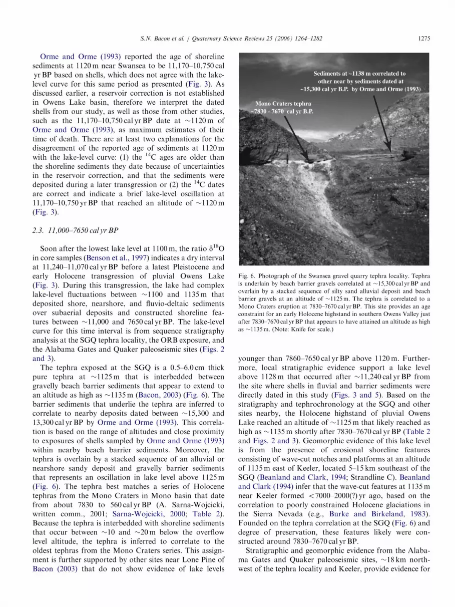
Fig. 5. Photograph of gravel quarry near Swansea. Image shows �40 cm
thick gravelly fluvial deposit interbedded between barrier beach sands and
gravels at an altitude of �1128m. Top of fluvial deposit contains a thin,
shelly horizon of well-preserved gastropods (Helisoma newberryi) dated to
11,650–11,130 cal yrBP. The barrier gravels below the fluvial deposit
contain disarticulated mussels (Margaritifera sp.) that yielded a 14C date
of 16,220–15,480 cal yrBP. The stratigraphic relations at this site indicate
fluctuating water levels at or after �15,800 cal yrBP, a fluvial environment
prior to �11,200 cal yrBP, which was followed by a water level as high as
�1128m after �11,200 cal yrBP. (Note: �0.5m high shovel for scale.)
S.N. Bacon et al. / Quaternary Science Reviews 25 (2006) 1264–12821274
from marsh, spring, and playa sediments representingsubaerial conditions at sites near Lone Pine (Beanland andClark, 1994; Bacon, 2003) (Tables 1 and 3 and Figs. 2 and3). During this interval, the lake level appears to havesignificantly dropped because cores reveal rubified colorand prismatic cracking implying soil development at12,650–12,120 cal yr BP (Benson et al., 1997) (Table 3 andFig. 3). This low lake level was followed by a transgressionthat reached 1100m at 11,720–11,260 cal yr BP (Orme andOrme, 1993) (Table 3 and Fig. 3).
These low lake levels are supported by the existence ofterrestrial facies of a delta plain depositional environmentat an altitude of �1113m along the ORB exposure (Figs. 2and 3). The bluffs exposure exhibits a delta plaindepositional environment consisting of interbedded sanddune facies with thinly bedded and alternating organic-rich, diatomaceous, and wind-blown silty horizons repre-senting marsh to playa facies dated between �12,670 and10,730 cal yr BP (Table 1 and Figs. 3 and 4). Furthermore,the delta plain sediments are overlain by a succession oflacustrine nearshore facies and interbedded marsh to playafacies of the delta plain, which represent at least twolake-cycles above �1113m after �10,730 cal yr BP (Figs. 3and 4).
Within this interval and at higher altitudes, marsh and/or spring deposits are exposed at altitudes from �1117 to1122m at the Alabama Gates (Trench T2) and Quaker(Trench T4) paleoseismic sites that indicate terrestrialconditions from �11,400 to 10,120 cal yr BP (Bacon, 2003;Table 1 and Figs. 2 and 3), as well as a 14C date of12,150–11,600 cal yr BP from an altitude of 1122m at theAlabama Gates site (Beanland and Clark, 1994; Table 3and Figs. 2 and 3). Two AMS 14C samples from Trench T2of the Alabama Gates site are of charcoalized plant fibersand bulk organic sediment from the base of a finingupward sequence of silty peat to organic-rich silt to clayand fine sand (Bacon, 2003). The organic-rich silt to claysample contains numerous seeds and rhizome fragments ofbulrush (Scirpus sp.) and pondweed (Potamogeton cf.gramineus), flora indicative of freshwater springs, ponds,and marshes. The AMS analyses of this deposit in TrenchT2 provide dates of 10,290–10,120 and 10,260–10,180 calyr BP (Table 1 and Fig. 3). In Trench T4 of the Quaker site,two samples of charcoal within an organic-rich silt horizonrepresenting a marsh to mud flat (playa) setting yields14C dates of 11,410–11,230 and 10,610–10,280 cal yr BPand two bulk samples of organic sediment have 14C datesof 11,220–11,070 and 10,440–10,230 cal yr BP (Table 1 andFig. 3).
In addition, a well-preserved gastropod-bearing bed at�1128m near Swansea, which is at the upper contact ofgravelly sediment that is sedimentologically characteristicof a fluvial deposit, is bounded by lacustrine gravel beachfacies (Fig. 5). The gastropod-bearing bed containsabundant adult and juvenile forms that date to11,650–11,130 cal yr BP (Table 1). The fluvial depositconsists of very poorly sorted and well-rounded to sub-
rounded cobbles. The cobbles are equant and composi-tionally distinct from the bounding horizons. The matrixconsists of sandy to gravelly sediment. Gastropod shells arefresh, intact, have pigment and are well exposed within a�5 cm thick shelly horizon at the upper contact of thedeposit (Fig. 5). The shells appear not to have beenredistributed or significantly reworked, based on theirdegree of preservation. The shells are mostly the largeplanorbid snail (Helisoma (carinifex) newberryi) with lesseroccurrences of the smaller planorbid snail (Helisoma
(vorticifex) newberryi), which both live in large perennialfreshwater lakes and permanent streams (Miller, 1989).The gastropod-rich fluvial bed is underlain by beach
gravels dated at �15,800 cal yr BP and overlain by youngercross-bedded beach pea gravels (Table 1 and Fig. 5). Bothoverlying and underlying beach deposits are distinctly well-sorted and consist of well-rounded clasts, but the twodeposits sharply contrast in their average clast size, shapeand composition, likely reflecting different beach facies andprovidence source areas to this part of the shoreline, whichcompletely changed in the time interval preceding andfollowing the deposition of the fluvial, gastropod-bearinghorizon. The lower beach deposit consists of greenish-grayweathering, strongly imbricated, �2–3 cm sized, oblate-shaped clasts (Fig. 5), whereas the overlying beach depositconsists of reddish weathered equant to sub-equant, pea-sized (�0.3–0.7 cm) gravel and sand.
ARTICLE IN PRESS
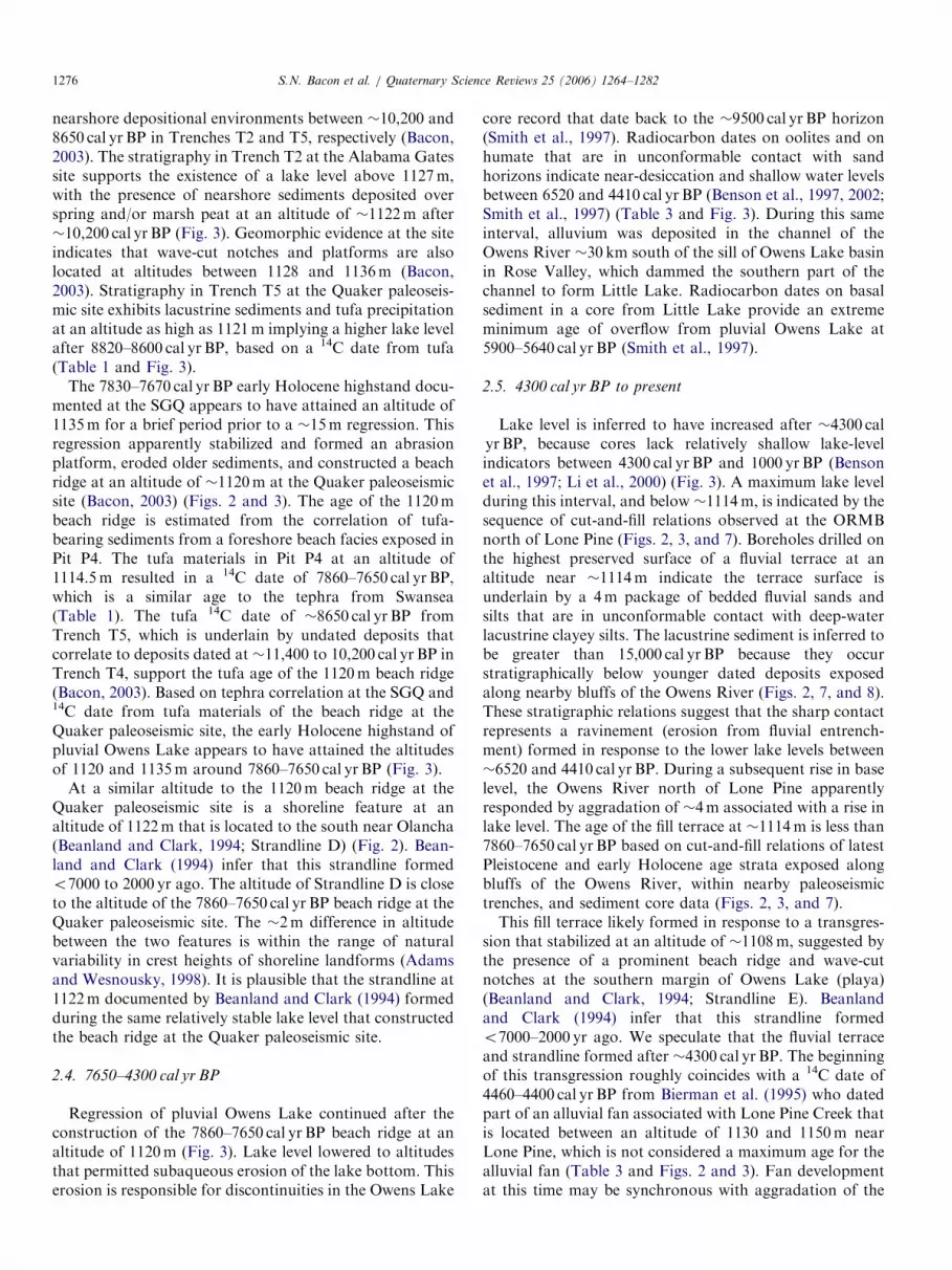
Mono Craters tephra~7830 - 7670 cal yr B.P.
Sediments at ~1138 m correlated toother near by sediments dated at
~15,300 cal yr B.P. by Orme and Orme (1993)
Fig. 6. Photograph of the Swansea gravel quarry tephra locality. Tephra
is underlain by beach barrier gravels correlated at �15,300 cal yr BP and
overlain by a stacked sequence of silty sand alluvial deposit and beach
barrier gravels at an altitude of �1125m. The tephra is correlated to a
Mono Craters eruption at 7830–7670 cal yrBP. This site provides an age
constraint for an early Holocene highstand in southern Owens Valley just
after 7830–7670 cal yrBP that appears to have attained an altitude as high
as �1135m. (Note: Knife for scale.)
S.N. Bacon et al. / Quaternary Science Reviews 25 (2006) 1264–1282 1275
Orme and Orme (1993) reported the age of shorelinesediments at 1120m near Swansea to be 11,170–10,750 calyr BP based on shells, which does not agree with the lake-level curve for this same period as presented (Fig. 3). Asdiscussed earlier, a reservoir correction is not establishedin Owens Lake basin, therefore we interpret the datedshells from our study, as well as those from other studies,such as the 11,170–10,750 cal yr BP date at �1120m ofOrme and Orme (1993), as maximum estimates of theirtime of death. There are at least two explanations for thedisagreement of the reported age of sediments at 1120mwith the lake-level curve: (1) the 14C ages are older thanthe shoreline sediments they date because of uncertaintiesin the reservoir correction, and that the sediments weredeposited during a later transgression or (2) the 14C datesare correct and indicate a brief lake-level oscillation at11,170–10,750 yr BP that reached an altitude of �1120m(Fig. 3).
2.3. 11,000–7650 cal yr BP
Soon after the lowest lake level at 1100m, the ratio d18Oin core samples (Benson et al., 1997) indicates a dry intervalat 11,240–11,070 cal yr BP before a latest Pleistocene andearly Holocene transgression of pluvial Owens Lake(Fig. 3). During this transgression, the lake had complexlake-level fluctuations between �1100 and 1135m thatdeposited shore, nearshore, and fluvio-deltaic sedimentsover subaerial deposits and constructed shoreline fea-tures between �11,000 and 7650 cal yr BP. The lake-levelcurve for this time interval is from sequence stratigraphyanalysis at the SGQ tephra locality, the ORB exposure, andthe Alabama Gates and Quaker paleoseismic sites (Figs. 2and 3).
The tephra exposed at the SGQ is a 0.5–6.0 cm thickpure tephra at �1125m that is interbedded betweengravelly beach barrier sediments that appear to extend toan altitude as high as �1135m (Bacon, 2003) (Fig. 6). Thebarrier sediments that underlie the tephra are inferred tocorrelate to nearby deposits dated between �15,300 and13,300 cal yr BP by Orme and Orme (1993). This correla-tion is based on the range of altitudes and close proximityto exposures of shells sampled by Orme and Orme (1993)within nearby beach barrier sediments. Moreover, thetephra is overlain by a stacked sequence of an alluvial ornearshore sandy deposit and gravelly barrier sedimentsthat represents an oscillation in lake level above 1125m(Fig. 6). The tephra best matches a series of Holocenetephras from the Mono Craters in Mono basin that datefrom about 7830 to 560 cal yr BP (A. Sarna-Wojcicki,written comm., 2001; Sarna-Wojcicki, 2000; Table 2).Because the tephra is interbedded with shoreline sedimentsthat occur between �10 and �20m below the overflowlevel altitude, the tephra is inferred to correlate to theoldest tephras from the Mono Craters series. This assign-ment is further supported by other sites near Lone Pine ofBacon (2003) that do not show evidence of lake levels
younger than 7860–7650 cal yr BP above 1120m. Further-more, local stratigraphic evidence support a lake levelabove 1128m that occurred after �11,240 cal yr BP fromthe site where shells in fluvial and barrier sediments weredirectly dated in this study (Figs. 3 and 5). Based on thestratigraphy and tephrochronology at the SGQ and othersites nearby, the Holocene highstand of pluvial OwensLake reached an altitude of �1125m that likely reached ashigh as �1135m shortly after 7830–7670 cal yr BP (Table 2and Figs. 2 and 3). Geomorphic evidence of this lake levelis from the presence of erosional shoreline featuresconsisting of wave-cut notches and platforms at an altitudeof 1135m east of Keeler, located 5–15 km southeast of theSGQ (Beanland and Clark, 1994; Strandline C). Beanlandand Clark (1994) infer that the wave-cut features at 1135mnear Keeler formed o7000–2000(?) yr ago, based on thecorrelation to poorly constrained Holocene glaciations inthe Sierra Nevada (e.g., Burke and Birkeland, 1983).Founded on the tephra correlation at the SGQ (Fig. 6) anddegree of preservation, these features likely were con-structed around 7830–7670 cal yr BP.Stratigraphic and geomorphic evidence from the Alaba-
ma Gates and Quaker paleoseismic sites, �18 km north-west of the tephra locality and Keeler, provide evidence for
ARTICLE IN PRESSS.N. Bacon et al. / Quaternary Science Reviews 25 (2006) 1264–12821276
nearshore depositional environments between �10,200 and8650 cal yr BP in Trenches T2 and T5, respectively (Bacon,2003). The stratigraphy in Trench T2 at the Alabama Gatessite supports the existence of a lake level above 1127m,with the presence of nearshore sediments deposited overspring and/or marsh peat at an altitude of �1122m after�10,200 cal yr BP (Fig. 3). Geomorphic evidence at the siteindicates that wave-cut notches and platforms are alsolocated at altitudes between 1128 and 1136m (Bacon,2003). Stratigraphy in Trench T5 at the Quaker paleoseis-mic site exhibits lacustrine sediments and tufa precipitationat an altitude as high as 1121m implying a higher lake levelafter 8820–8600 cal yr BP, based on a 14C date from tufa(Table 1 and Fig. 3).
The 7830–7670 cal yr BP early Holocene highstand docu-mented at the SGQ appears to have attained an altitude of1135m for a brief period prior to a �15m regression. Thisregression apparently stabilized and formed an abrasionplatform, eroded older sediments, and constructed a beachridge at an altitude of �1120m at the Quaker paleoseismicsite (Bacon, 2003) (Figs. 2 and 3). The age of the 1120mbeach ridge is estimated from the correlation of tufa-bearing sediments from a foreshore beach facies exposed inPit P4. The tufa materials in Pit P4 at an altitude of1114.5m resulted in a 14C date of 7860–7650 cal yr BP,which is a similar age to the tephra from Swansea(Table 1). The tufa 14C date of �8650 cal yr BP fromTrench T5, which is underlain by undated deposits thatcorrelate to deposits dated at �11,400 to 10,200 cal yr BP inTrench T4, support the tufa age of the 1120m beach ridge(Bacon, 2003). Based on tephra correlation at the SGQ and14C date from tufa materials of the beach ridge at theQuaker paleoseismic site, the early Holocene highstand ofpluvial Owens Lake appears to have attained the altitudesof 1120 and 1135m around 7860–7650 cal yr BP (Fig. 3).
At a similar altitude to the 1120m beach ridge at theQuaker paleoseismic site is a shoreline feature at analtitude of 1122m that is located to the south near Olancha(Beanland and Clark, 1994; Strandline D) (Fig. 2). Bean-land and Clark (1994) infer that this strandline formedo7000 to 2000 yr ago. The altitude of Strandline D is closeto the altitude of the 7860–7650 cal yr BP beach ridge at theQuaker paleoseismic site. The �2m difference in altitudebetween the two features is within the range of naturalvariability in crest heights of shoreline landforms (Adamsand Wesnousky, 1998). It is plausible that the strandline at1122m documented by Beanland and Clark (1994) formedduring the same relatively stable lake level that constructedthe beach ridge at the Quaker paleoseismic site.
2.4. 7650–4300 cal yr BP
Regression of pluvial Owens Lake continued after theconstruction of the 7860–7650 cal yr BP beach ridge at analtitude of 1120m (Fig. 3). Lake level lowered to altitudesthat permitted subaqueous erosion of the lake bottom. Thiserosion is responsible for discontinuities in the Owens Lake
core record that date back to the �9500 cal yr BP horizon(Smith et al., 1997). Radiocarbon dates on oolites and onhumate that are in unconformable contact with sandhorizons indicate near-desiccation and shallow water levelsbetween 6520 and 4410 cal yr BP (Benson et al., 1997, 2002;Smith et al., 1997) (Table 3 and Fig. 3). During this sameinterval, alluvium was deposited in the channel of theOwens River �30 km south of the sill of Owens Lake basinin Rose Valley, which dammed the southern part of thechannel to form Little Lake. Radiocarbon dates on basalsediment in a core from Little Lake provide an extrememinimum age of overflow from pluvial Owens Lake at5900–5640 cal yr BP (Smith et al., 1997).
2.5. 4300 cal yr BP to present
Lake level is inferred to have increased after �4300 calyr BP, because cores lack relatively shallow lake-levelindicators between 4300 cal yr BP and 1000 yr BP (Bensonet al., 1997; Li et al., 2000) (Fig. 3). A maximum lake levelduring this interval, and below �1114m, is indicated by thesequence of cut-and-fill relations observed at the ORMBnorth of Lone Pine (Figs. 2, 3, and 7). Boreholes drilled onthe highest preserved surface of a fluvial terrace at analtitude near �1114m indicate the terrace surface isunderlain by a 4m package of bedded fluvial sands andsilts that are in unconformable contact with deep-waterlacustrine clayey silts. The lacustrine sediment is inferred tobe greater than 15,000 cal yr BP because they occurstratigraphically below younger dated deposits exposedalong nearby bluffs of the Owens River (Figs. 2, 7, and 8).These stratigraphic relations suggest that the sharp contactrepresents a ravinement (erosion from fluvial entrench-ment) formed in response to the lower lake levels between�6520 and 4410 cal yr BP. During a subsequent rise in baselevel, the Owens River north of Lone Pine apparentlyresponded by aggradation of �4m associated with a rise inlake level. The age of the fill terrace at �1114m is less than7860–7650 cal yr BP based on cut-and-fill relations of latestPleistocene and early Holocene age strata exposed alongbluffs of the Owens River, within nearby paleoseismictrenches, and sediment core data (Figs. 2, 3, and 7).This fill terrace likely formed in response to a transgres-
sion that stabilized at an altitude of �1108m, suggested bythe presence of a prominent beach ridge and wave-cutnotches at the southern margin of Owens Lake (playa)(Beanland and Clark, 1994; Strandline E). Beanlandand Clark (1994) infer that this strandline formedo7000–2000 yr ago. We speculate that the fluvial terraceand strandline formed after �4300 cal yr BP. The beginningof this transgression roughly coincides with a 14C date of4460–4400 cal yr BP from Bierman et al. (1995) who datedpart of an alluvial fan associated with Lone Pine Creek thatis located between an altitude of 1130 and 1150m nearLone Pine, which is not considered a maximum age for thealluvial fan (Table 3 and Figs. 2 and 3). Fan developmentat this time may be synchronous with aggradation of the

ARTICLE IN PRESS
Fig. 8. Stratigraphic column and photograph of the borehole site within the Owens River meander belt (ORMB) north of Lone Pine. Column shows three
sequences of normally graded sands and silts representing deposition in a meandering stream environment that overly an erosional boundary (ravinement
III on Fig. 7) cut into lacustrine deep-water clay and silt. Photograph of the low gradient meander belt of the Owens River and hand-auger. View to the
south, down Owens Valley towards Owens Lake playa.
Fig. 7. Schematic geologic cross-section along a composite east–west transect across the Quaker paleoseismic site, the Owens River bluffs exposure, the
Owens River meander belt borehole site, and the eastern margin of the meander belt. The schematic cross-section shows prominent cut-and-fill relations
within fluvio-deltaic and lacustrine valley fill sediments along with the structural orientation of the Owens Valley fault zone half-graben. The faults of the
half-graben are the Diaz Lake section (main trace) and the East Valley section of Bryant (1988). Roman numerals denote at least four spatially continuous
ravinements within this part of Owens Valley near Lone Pine. The different ravinements are related to base-level changes associated with latest Quaternary
Owens Lake water levels. The age of ravinements I and II are constrained by the age of strata exposed at the Quaker paleoseismic and Owens River bluffs
exposure sites. The age of ravinement III is correlated, based on cut-and-fill relations at the Owens River borehole site and sediment core data. Ravinement
IV is the active ravinement surface near Lone Pine (view looking north, up valley).
S.N. Bacon et al. / Quaternary Science Reviews 25 (2006) 1264–1282 1277

ARTICLE IN PRESSS.N. Bacon et al. / Quaternary Science Reviews 25 (2006) 1264–12821278
Owens River and construction of a prominent beach ridgeand wave-cut notches in Owens Lake basin during a timeof relatively wetter conditions when compared to theearlier period between �6520 and 4410 cal yr BP (Fig. 3).
A regression after aggradation of the Owens River isimplied by �10m of incision within the meander beltbetween the Alabama Gates paleoseismic site and OwensLake (playa) (Fig. 2). The late Holocene incision formed asequence of cut terraces into post 4300 cal yr BP fluvialsediments and exposed a lacustrine and fluvio-deltaicstratigraphic section along the margins of the meanderbelt that dates back to older than �12,500 cal yr BP(Fig. 7).
Besides incision near Lone Pine, a drop in lake level isindicated by the lowest suite of prominent beach ridges andwave-cut notches that encompass Owens Lake (playa)at an altitude of 1096–1100m (Fig. 2). These shorelinefeatures are inferred to have formed o7000(?) yr ago to�1872 AD (Beanland and Clark, 1994; Strandline F). Anative American artifact from one of the higher beachridges at �1100m is estimated to be a few thousand yearsold, which provides a poorly constrained minimum agefor the feature (Beanland and Clark, 1994) (Table 3 andFigs. 2 and 3). Between 1000 and 730 yr BP, sediment coresprovide evidence for highly saline and alkaline lakeconditions that imply relatively low lake levels during aneffectively dry climate corresponding to the MedievalClimatic Anomaly (a warm period in northern Europe)that was followed by relatively wet climate and higher lakelevels from 730 to 670 yr BP (Li et al., 2000) (Table 3 andFig. 3). The period between 670 and �135 yr BP (1872 AD)is characterized as fluctuating with lake depths that rangefrom o10m to the historical maximum of 14.9m with alake level at 1096m (Li et al., 2000) (Fig. 3). Around 1921AD, Owens Lake first began depositing salts onto the lakefloor when the lake surface was at an altitude of �1086mbecause of source water diversions that began nearly eightyears prior. By 1931 AD, Owens Lake had desiccated andbecome a playa (Smith et al., 1997).
2.6. Response of the Owens River to latest Quaternary lake-
level changes
During the latest Quaternary, dramatic shifts in climaticconditions initiated base-level changes of the Owens Riverthat responded by creating a sequence of cut-and-fillterraces down the axis of Owens Valley near Lone Pine(Fig. 7). Within the ORMB, vertical bluffs oriented nearlynorth-south through the �1116m playa surface expose�10m thick section of latest Pleistocene to early Holocenefluvio-deltaic and lacustrine sediments adjacent to themodern channel of the river. Middle to late Holocenefluvial sediments are inset to the older strata exposed alongthe bluffs within the meander belt. The Diaz Lake (maintrace) and East Valley sections of the Owens Valley faultzone half graben, largely control the distribution of latest
Quaternary sediments north of Lone Pine (Bacon, 2003)(Fig. 7).There are at least four spatially continuous ravinements
within this part of Owens Valley that formed duringperiods of subaerial exposure (Fig. 7). Ravinement Irepresents a brief period of marsh or mud flat (playa)conditions at an altitude of �1112m around �14,800 calyr BP that was followed by a sequence of cut-and-fill(Figs. 3 and 7). Ravinement II signifies a period of marshconditions from �12,600 to 10,000 cal yr BP above analtitude of �1112m during a major regression of pluvialOwens Lake (Figs. 3 and 7). Shoreline and nearshoresediments associated with an early Holocene highstand at7860–7650 cal yr BP overlie ravinement II. A significantregression after 7860–7650 cal yr BP, likely from �6520 to4410 cal yr BP, formed ravinement III that was followed byaggradation of the river at �4300 cal yr BP (Figs. 3 and 6).The latest incision within the meander belt is related toan overall regression of latest Holocene and historicOwens Lakes, which is inferred to have occurred after�3000 cal yr BP and is the active ravinement surface IV inthe valley (Fig. 7).
3. Synthesis of the Owens Lake level curve
3.1. Last Glacial Maximum
During the interval 30,500–15,000 yr BP, the SierraNevada had the most intense and prolonged glacialadvance in the last 79,000 yr (Bischoff and Cummins,2001). At this time, pluvial Owens Lake attained a lakelevel of �1155–1160m as recently as �20,600 cal yr BP.The lake level lowered �13m to the Owens Lake basin sillaltitude of �1145m in �11,000 to 7700 yr, which wascharacterized by relatively stable overflowing lake levelsthat were punctuated by oscillating lower ones. The sillaltitude probably lowered to its present altitude by acombination of erosion by overflow and uplift associatedwith local faults and volcanism within the Coso Range.Packrat midden records at Haystack near Lone Pine recordthe departure of trees and shrubs, such as Joshua tree(Yucca brevifolia) and bitterbrush (Purshia tridenta) andthe first occurrence of cliffrose (Purshia glandulosa)
between �23,300 and 20,600 cal yr BP, suggesting a de-crease in temperature, but the disappearance of bitterbrushsupports a slight decrease in effective moisture (Koehlerand Anderson, 1995). Packrat middens in the AlabamaHills near Lone Pine record Pinyon-Juniper woodland toabout 21,000 cal yr BP and Rocky Mountain Juniper toabout 19,100 cal yr BP when woodlands were succeeded bysage brush (Koehler and Anderson, 1994). The successionof sage brush in the valley after �19,100 cal yr BP is a timewhen pluvial Owens Lake apparently began a regression(Fig. 3). During this interval, pluvial Searles Lake, the nextconsecutive basin downstream of Owens Lake basin, aswell as Lake Russell located upstream in Mono Lake basin(Fig. 1), record less-effective moisture between �25,500

ARTICLE IN PRESSS.N. Bacon et al. / Quaternary Science Reviews 25 (2006) 1264–1282 1279
and 22,300 cal yr BP when intermediate to low levels aredocumented (Benson et al., 1990). Similar to both of theselakes, pluvial Owens Lake records a drop in lake levelbetween �25,000 and 24,000 cal yr BP (Fig. 3).
Pluvial Owens Lake subsequently transgressed, and lastoverflowed sometime before �15,300 cal yr BP (Orme andOrme, 1993) (Fig. 3). Pollen records in cores indicate thatclimate became fairly warm and dry after this timecompared to the earlier period when the lake was atmoderate levels or overflowing (Mensing, 2001). The lakeceased to overflow because of a decrease in discharge fromthe Owens River caused by a decrease in effective moistureand increase in evaporation (Koehler and Anderson, 1994,1995) (Fig. 1). Around this time, pluvial Searles Lake hadlow lake levels that were 180m below its sill between�16,800 and 14,400 cal yr BP that imply relatively little orno overflow from pluvial Owens Lake (Smith and Street-Perrott, 1983; Lin et al., 1998).
3.2. Post-Last Glacial Maximum Owens Lake and Sierra
Nevada glacial records
The water-level record of pluvial Owens Lake appears tobe in phase with the end of the Tioga glaciation (oxygenisotope stage 2) in the Sierra Nevada. Stratigraphic coredata from Grass Lake Bog near Luther Pass in the centralSierra Nevada records the initial retreat of a Tioga glacierat 20,540–20,080 cal yr BP (Clark et al., 2003). Lakesediment cores from near Tioga Pass in the central SierraNevada indicate Tioga deglaciation was completed by�15,500 cal yr BP (Clark et al., 2003) (Fig. 3). The samecores, from Greenstone Lake, preserve the entire section ofoutwash sediment related to the Recess Peak advance andretreat, which occurred between �14,200 and 13,100 calyr BP (Clark and Gillespie, 1997).The timing of the deglaciation by �15,500 cal yr BP
roughly coincides with low lake levels prior to �16,000 calyr BP (Fig. 3). It appears that shoreline and core datarecord the Recess Peak advance dated between �14,200and 13,100 cal yr BP in the form of one significantoscillation centered at 13,420–13,200 cal yr BP that reachedan altitude of �1123m (Fig. 3). Although it appears thatpluvial Owens Lake likely overflowed for the last timearound �15,300 cal yr BP, the timing of the deglaciationroughly coincides with the end of overflow and the startof a major regression and low lake levels endingat �11,000 cal yr BP. Based on TIC and d18O recordsfrom cores, the Pleistocene–Holocene transition (11,600–10,000 cal yr BP) was characterized by a drying trend thatwas interrupted by a brief (200 yr) wet oscillation centeredat 10,300 cal yr BP (Benson et al., 2002). Furthermore, it isnot clear if Holocene alpine glacier advances are synchro-nous with water-level changes since �11,000 cal yr BP. Theabsence of till between Recess Peak moraines and the200–300 year old Matthes (Little Ice Age) moraines, as wellas the lack of evidence of outwash between 13,100 and3400 cal yr BP, indicates that no significant glacial advances
occurred in the Sierra Nevada during that time, includingthe Younger Dryas interval (Clark and Gillespie, 1997).These new investigations have refined earlier studies of theHolocene glacial record that were based on soils, weath-ering characteristics, and limited 14C dates (e.g., Burke andBirkeland, 1983).
3.3. Holocene lake-level record
Pluvial Owens Lake began a �4000 yr long transgressionat the Holocene–Pleistocene transition that culminatedwith a highstand at 7860–7650 cal yr BP, suggesting that theSierra Nevada was relatively wet (Fig. 3). During thisperiod, at �8000 cal yr BP, the Owens River west of Bishopformed a fill-and-cut terrace above the flood plain of theriver (Pinter et al., 1994). The age of this fill-and-cut terraceis similar to the age of alluvial fans that were depositednear Lone Pine Creek and along the Alabama Hills�8000 yr ago (Bierman et al., 1995) (Figs. 1 and 2). Theserelations indicate that regional conditions were relativelywet between 11,000 and 7860–7650 cal yr BP compared tothe earlier period when lake levels were lower than 1100mbetween �12,600 and 11,000 cal yr BP (Fig. 3). Core data(TIC and d18O records) lend further support to theinterpretation of a wet early Holocene by showing thatwet conditions prevailed from 10,000 to 7700 cal yr BP(Benson et al., 2002). We note that the well-documented8200 cal yr BP cold event identified in climate proxy datasets throughout the circum-North Atlantic region andelsewhere occurs within this interval (e.g., Alley et al., 1997;Dean et al., 2002).Based on Owens Lake cores and surface data, between
7860–7650 and 4300 cal yr BP drought conditions domi-nated in Owens Lake basin with the beginning of a majorregression that coincides with the beginning of a widelyrecognized mid-Holocene ‘‘altithermal’’ event (Benson etal., 1997, 2002; Smith et al., 1997) (Fig. 3). An unusualostracode assemblage in sediment cores existed in the lakefrom �8300 to 6800 cal yr BP that was dominated byLimnocythere sappaensis with moderate occurrences ofLimnocythere ceriotuberosa and rare occurrences of Can-
dona caudate (Forester, 2000). This mixed assemblageindicates strong seasonal variability with low flow from theOwens River, but the occurrences of C. caudate and L.
ceriotuberosa imply that there were wet decades andperhaps centuries during this period, when seasonal flowin the river was greater (Forester, 2000).The early Holocene hightstand at 7860–7650 cal yr BP is
centered between times characterized by mixed ostracodeassemblages. We infer that higher seasonal flows likelyoccurred at the beginning of the period coinciding with the7860–7650 cal yr BP highstand. The last ostracode assem-blage in the cores existed from �4500 to 3800 cal yr BP andis represented by only abundant L. sappaensis (Forester,2000). This ostracode, as described above, is indicative of avery saline lake, and after �3500 cal yr BP brine andephemeral lakes were common (Forester, 2000). Around

ARTICLE IN PRESSS.N. Bacon et al. / Quaternary Science Reviews 25 (2006) 1264–12821280
this time, Owens Lake apparently expanded between�3800 and 3000 cal yr BP indicated by TIC and d18Orecords (Benson et al., 2002). The expansion of OwensLake at this time is supported by the occurrence of 100mlowering of tree line in the White Mountains between 4100and 3500 cal yr BP, implying a 1 1C decrease in warm-season temperatures (LaMarche, 1973). Within this inter-val, cored lake sediments within the southern SierraNevada below rock glaciers (Konrad and Clark, 1998)and the Palisades Glacier (Bowerman and Clark, 2005)indicate the beginning of a Neoglacial advance at�3500 cal yr BP. The late Holocene ostracode recordapparently does not preserve a time of wetter or coolerconditions after �4300 cal yr BP, whereas stratigraphic,geomorphic, geochemical, and dendrologic evidence ap-parently does (Fig. 3).
3.4. Latest Quaternary pluvial Owens Lake and regional
climate records
The timing of significant oscillations of pluvial OwensLake from �15,000 cal yr BP to present is similar to thetrend of pollen records in North America, which demon-strate wide evidence of 1500 yr climate variability duringthe past 14,000 yr (Viau et al., 2002). This terrestrial pollenrecord is supported by marine and ice-core records fromthe North Atlantic that contain evidence of millennial-scaleclimate oscillation that are independent of glacial–intergla-cial cycles (Viau et al., 2002). In addition, the abrupt, andhigh frequency lake-level oscillation between 12,900 and11,600 cal yr BP, indicated in the Owens Lake core record,may correlate with the Younger Dryas interval (Bensonet al., 1996, 1997; Mensing, 2001), which also appearsapparent in the geomorphic record (Fig. 3). In southernNevada, the formation of organic-rich layers (black mats)associated with spring discharge occurred from �14,300 to7200 cal yr BP (Quade et al., 1998), which is during a timeof fluctuating lake levels and the early Holocene transgres-sion of Owens Lake (Fig. 3). The formation of most blackmats in southern Nevada date at �11,600 cal yr BP, whichsuggests a link to Younger Dryas cooling at the end of theinterval (Quade et al., 1998). An indication of relativelywetter conditions at Owens Lake around the end of theYounger Dryas interval is from an increase in lake level toan altitude of �1100m (Fig. 3).
Within the dating uncertainties, the six high frequencylake-level oscillations between �18,000 and 11,000 calyr BP shown in the lake-level record of pluvial OwensLake appear to be roughly synchronous with variations inclimatic conditions described in the North Atlantic regionas Dansgaard–Oeschger oscillations, Heinrich Events, andBond Cycles (Benson et al., 1996, 1997). Based on acomparison of climatic data sets from Owens Lake andMono basins, dry events in western North America occurat approximately the same time as cold events in Greenlandice, with shifts between the climate regimes occurringwithin a few hundred years (e.g., Benson et al., 1996, 1997,
1998). Detailed lake records in the northwestern GreatBasin substantiate the relation between high lake levels inwestern North America during warm North Atlanticclimatic phases and low lake levels during cold ones (Zicet al., 2002).
4. Conclusions
Following a regression from its latest Pleistocene high-stands at altitudes of �1160 and 1145m between �27,000and 15,300 cal yr BP, respectively, pluvial Owens Lakedropped �45m around �11,400 cal yr BP (Lubetkin andClark, 1988; Orme and Orme, 1993, 2000). The results fromthis work indicate that at least 10 significant latestQuaternary lake-level oscillations are distinguished fromboth near-surface stratigraphic and geomorphic data andsub-surface core data sets. Between 18,000 and 11,000 calyr BP, the duration of six �1000–2000 yr high frequencylake-level oscillations are consistent with the magnitudeand duration of climatically driven events recognized in theNorth Atlantic region (e.g., Benson et al., 1996, 1997). Atthe last glacial termination, a lowstand at �11,200 cal yr BPwas followed by a fluctuating transgression that attainedan early Holocene highstand near 1135m, which was shortlived before dropping to form shoreline features at 1120maround 7860–7650 cal yr BP. The altitude and age of thisearly Holocene highstand was previously unrecognized andis chronologically well constrained. The occurrence of theearly Holocene highstand from surface data is also presentin the core record, where Benson et al. (2002) concludedthat relatively wet conditions prevailed prior to and duringthe time of this highstand. Soon after the construction ofthe �1120m shoreline features, the lake lowered �30m tonear desiccation lake levels between �6500 and 4400 calyr BP (Benson et al., 1997, 2002; Smith et al., 1997).Fluvial cut-and-fill relations at the ORMB north of LonePine and shoreline features that surround Owens Lakebasin at �1108m indicate a minor lake-level oscillationafter 4300 cal yr BP. This lake oscillation was followed byalkaline conditions with fluctuating and shallow lake-levelsduring the latest Holocene (Li et al., 2000).The new latest Quaternary lake-level record of pluvial
Owens Lake documents high frequency changes in thewater balance of the Owens Lake system that have not yetbeen recognized in other pluvial lake basins in the westernUnited States. The magnitude of these lake level oscilla-tions can only be documented through field studies ofdeposits and landforms that actually constrain the altitudeof lake levels, information that is unavailable throughsediment core studies alone.
Acknowledgments
Journal reviews by Ken Adams and Doug Clarksignificantly improved the manuscript. We thank JimBischoff and Ken Adams for thoughtful and constructivereviews on an early version of the manuscript. We also

ARTICLE IN PRESSS.N. Bacon et al. / Quaternary Science Reviews 25 (2006) 1264–1282 1281
thank Andrei Sarna-Wojcicki for tephra identification andcorrelation, and Jack McGeehin for radiocarbon analysis.David Rhode graciously assisted with identification ofplant remains in 14C samples. We acknowledge RichardForester for identification of ostracodes and William MillerIII for identification of mollusks. We also thank RobertNegrini for sampling for paleomagnetics in fault trenches,which later proved to be sedimentologically unfavorablefor laboratory analysis. We acknowledge the City of LosAngeles Department of Water and Power for permission toaccess their property and the California Department ofTransportation for providing trench excavations at theAlabama Gates paleoseismic site. The University ofCalifornia, White Mountain Research Station providedtravel funding to S. Bacon (WMRS, Travel Mini-grants1999–2001). Research was supported by the US GeologicalSurvey’s National Earthquake Hazards Reduction pro-gram under Awards #01-HQ-GR-0013 and #02-HQ-GR-0003. The views and conclusions contained in this reportare those of the authors and should not be interpreted asnecessarily representing the official policies, either ex-pressed or implied, of the US Government.
References
Adams, K.D., Wesnousky, S.G., 1998. Shoreline processes and the age of
the Lake Lahontan highstand in the Jessup embayment, Nevada.
Geological Society of America Bulletin 110, 1318–1332.
Alley, R.B., Mayewski, P.A., Sowers, T., Stuiver, M., Taylor, K.C., Clark,
P.U., 1997. Holocene climatic instability: a prominent, widespread
event 8200 yr ago. Geology 25, 483–486.
Bacon, S.N., 2003. Latest Quaternary fluvio-deltaic and lacustrine
stratigraphy in Owens Valley and paleoseismology on the Owens
Valley fault near Lone Pine, eastern California. Unpublished M.Sc.
Thesis, Humboldt State University, 227pp.
Bacon, S.N., Pezzopane, S.K., Burke, R.M., 2003. Paleoseismology on the
Owens Valley fault and latest Quaternary stratigraphy in Owens Valley
near Lone Pine, eastern California. US Geological Survey, National
Earthquake Hazards Reduction Program (NEHRP) Final Technical
Report, 42pp. http://erp-web.er.usgs.gov/reports/abstract/2002/ni/
02hqgr0003.pdf.
Bard, E., Arnold, M., Hamelin, B., Tisnerat-Laborde, N., Cabioch, G.,
1998. Radiocarbon calibration by means of mass spectrometric230Th-234U and 14C ages on corals: an updated data base including
samples from Barbados, Mururoa, and Tahiti. Radiocarbon 40,
1085–1092.
Beanland, S., Clark, M.M., 1994. The Owens Valley fault zone, eastern
California, and surface rupture associated with the 1872 earthquake.
US Geological Survey Bulletin 1982, 29pp.
Benson, L.V., 1994. Carbonate deposition, Pyramid Lake subbasin,
Nevada: 1. Sequence of formation and altitudeal distribution of
carbonate deposits (tufas). Palaeogeography, Palaeoclimatology,
Palaeoecology 109, 55–87.
Benson, L.V., Currey, D.R., Dorn, R.I., Lajoi, K.R., Oviatt, C.G.,
Robinson, S.W., Smith, G.I., Stine, S., 1990. Chronology of expansion
and contraction of four Great Basin lake systems during the past
35,000 years. Palaeogeography, Palaeoclimatology, Palaeoecology 78,
241–286.
Benson, L.V., Burdett, J.W., Kashgarian, M., Lund, S.P., Phillips, F.M.,
Rye, R.O., 1996. Climatic and hydrologic oscillations in the Owens
Lake basin and adjacent Sierra Nevada, California. Science 274,
746–748.
Benson, L., Burdett, J., Lund, S., Kashgarian, M., Mensing, S., 1997.
Nearly synchronous climate change in the Northern Hemisphere
during the last glacial termination. Nature 388, 263–265.
Benson, L.V., Rose, T.P., Smoot, J.P., Schwartz, M., Lund, S.P., Burdett,
J.W., Kashgarian, M., 1998. Correlation of late-Pleistocene lake-levels
oscillations in Mono Lake, California, with North Atlantic climate
events. Quaternary Research 49, 1–10.
Benson, L., Kashgarian, M., Rye, R., Lund, S., Paillet, F., Smoot, J.,
Kester, C., Mensing, S., Meko, D., Lindstrom, S., 2002. Holocene
multidecadal and multicentennial droughts affecting northern Cali-
fornia and Nevada. Quaternary Science Review 21, 659–682.
Bierman, P.R., Gillespie, A.R., Caffee, M.W., 1995. Cosmogenic ages for
earthquake recurrence intervals and debris flow fan deposition, Owens
Valley, California. Science 20, 447–450.
Bischoff, J.L., Cummins, K., 2001. Wisconsin glaciation of the Sierra
Nevada (79,000–15,000 yr BP) as recorded by rock flour in sediments
of Owens Lake, California. Quaternary Research 55, 14–24.
Bischoff, J.L., Stine, S., Rosenbauer, R.J., Fitzpatrick, J.A., Stafford Jr.,
T.W., 1993. Ikaite precipitation by mixing of shoreline springs and
lake water, Mono Lake, California, USA. Geochimica et Cosmochi-
mica Acta 57, 3855–3865.
Bowerman, N.D., Clark, D.H., 2005. New age constraints on Holocene
glaciations in the Sierra Nevada, California. Geological Society of
America Abstracts with Programs 37, 79.
Brennan, R., Quade, J., 1997. Reliable late-Pleistocene stratigraphic
ages and shorter groundwater travel times from 14C in fossil
snails from the southern Great Basin. Quaternary Research 47,
329–336.
Briggs, R.W., Wesnousky, S.G., Adams, K.D., 2005. Late Pleistocene and
late Holocene lake highstands in the Pyramid Lake subbasin of Lake
Lahontan, Nevada, USA. Quaternary Research 64, 257–263.
Bryant, W.A., 1988. Owens Valley fault zone, Inyo County. Fault
Evaluation Report FER-192, California Department of Conservation,
Division of Mines and Geology.
Burke, R.M., Birkeland, P.W., 1983. Holocene glaciation in the mountain
ranges of the Western United States. In: Wright, H.E. (Ed.), Late-
Quaternary Environments of the United States. University of
Minnesota, Minneapolis, MN, pp. 3–11.
Carver, G.A., 1970. Quaternary tectonism and surface faulting in Owens
Lake basin, California. Technical Report AT2, MacKay School of
Mines, University of Nevada, Reno, 103pp.
Clark, D.H., Gillespie, A.R., 1997. Timing and significance of late-glacial
and Holocene cirque glaciation in the Sierra Nevada, California.
Quaternary International 38/39, 21–38.
Clark, D., Gillespie, A.R., Clark, M., Burke, R., 2003. Mountain
glaciations of the Sierra Nevada. In: Easterbrook, D.J. (Ed.),
Quaternary Geology of the United States. INQUA 2003 Field Guide
Volume, Desert Research Institute, Reno, NV, pp. 287–311.
Dean, W.E., Forester, R.M., Bradbury, J.P., 2002. Early Holocene change
in atmospheric circulation in the Northern Great Plains: an upstream
view of the 8.2 ka cold event. Quaternary Science Reviews 21,
1763–1775.
Einsele, G., 2000. Sedimentary Basins: Evolution, Facies, and Sediment
Budget, second ed. Springer, New York, p. 804.
Flint, R.F., 1971. Glacial and Quaternary Geology. Wiley, New York,
p. 892.
Forester, R.M., 2000. An ostracode record of Holocene climate change
from Owens Lake, California. In: Jayko, A.S., Miller, C.I. (Eds.),
Impacts of Climate Change on Landscapes of the Eastern Sierra
Nevada and Western Great Basin. US Geological Survey Open-File
Report 01-202, pp. 7–8.
Gale, H.S., 1914. Salines in the Owens, Searles, and Panamint
basins, southeastern California. US Geological Survey Bulletin 580,
281–323.
Hollett, K.J., Danskin, W.R., McCafferey, W.F., Walti, C.L., 1991.
Geology and water resources of Owens Valley, California. US
Geological Survey Water-Supply Paper 2370, 77pp.
ARTICLE IN PRESSS.N. Bacon et al. / Quaternary Science Reviews 25 (2006) 1264–12821282
Koehler, P.A., 1995. Late Pleistocene Mollusks from the Doolomite Site,
Owens Lake Playa, California. The Veliger 38, 312–318.
Koehler, P.A., Anderson, R.S., 1994. Full-glacial shoreline vegetation
during the maximum highstand at Owens Lake, California. Great
Basin Naturalist 54, 142–149.
Koehler, P.A., Anderson, R.S., 1995. Thirty thousand years of vegetation
changes in the Alabama Hills, Owens Valley, California. Quaternary
Research 43, 238–248.
Konrad, S.K., Clark, D.H., 1998. Evidence for an early Neoglacial glacier
advance from rock glaciers and lake sediments in the Sierra Nevada,
California, USA. Arctic and Alpine Research 30, 272–284.
Lajoie, K.R., 1968. Late Quaternary stratigraphy and geologic history of
Mono basin, eastern California. Unpublished Ph.D. Thesis, University
of California, Berkeley, 271pp.
LaMarche, V.C., 1973. Holocene climatic variations inferred from treeline
fluctuations in the White Mountains, California. Quaternary Research
3, 632–660.
Li, H., Bischoff, J.L., Ku, T., Lund, S.P., Stott, L.D., 2000. Climate
variability in east-central California during the past 1000 years
reflected by high-resolution geochemical and isotopic records from
Owens Lake sediments. Quaternary Research 54, 187–197.
Lin, J.C., Broecker, W.S., Hemming, S.R., Hajdas, I., Anderson, R.F.,
Smith, G.I., Kelley, M., Bonani, G., 1998. A reassessment of U–Th
and 14C ages for late-glacial high frequency hydrological events a
Searles Lake, California. Quaternary Research 49, 11–23.
Lubetkin, L.K.C., Clark, M.M., 1988. Late Quaternary activity along the
Lone Pine fault, eastern California. Geological Society of America
Bulletin 100, 755–766.
Mensing, S.A., 2001. Late-glacial and early Holocene vegetation and
climate change near Owens Lake, eastern California. Quaternary
Research 55, 57–65.
Meyer, L.L., 1977. California Quake. Sherbourne Press, Tennessee, pp.
19–27.
Miller, W., 1989. Pleistocene freshwater mollusks on the floor of Owens
Valley playa, eastern California. Tulane Studies in Geology and
Paleontology 22, 47–54.
Newton, M.S., 1991. Holocene stratigraphy and magnetostratigraphy of
Owens and Mono Lakes, eastern California. Unpublished Ph.D.
Thesis, University of Southern California, Los Angeles, 330pp.
Newton, M.S., Grossman, E.L., 1988. Late Quaternary chronology of tufa
deposits, Walker Lake, Nevada. Journal of Geology 96, 417–433.
Orme, A.R., Orme, A.J., 1993. Late Pleistocene oscillations of Lake
Owens, eastern California. Geological Society of America Abstracts
with Programs 25, 129–130.
Orme, A.R., Orme, A.J., 2000. Deformation of late Pleistocene shorelines at
Owens Lake, eastern California: tectonic and hydrologic implication.
Geological Society of America Abstracts with Programs 32, A333.
Pakiser, L.C., Kane, M.F., Jackson, W.H., 1964. Structural geology and
volcanism of Owens Valley region, California—a geophysical study.
US Geological Survey Professional Paper 438, 65pp.
Pinter, N., Keller, E.A., West, R.B., 1994. Relative dating of terraces of
the Owens River, northern Owens Valley, California, and correlation
with moraines of the Sierra Nevada. Quaternary Research 42, 266–276.
Quade, J., Forester, R.M., Pratt, W.L., Carter, C., 1998. Black mats,
spring-fed streams, and late-glacial-age recharge in the southern Great
Basin. Quaternary Research 49, 129–148.
Reheis, M.C., Stine, S., Sarna-Wojcicki, A.M., 2002. Drainage reversals in
Mono Basin during the late Pliocene and Pleistocene. Geological
Society of America Bulletin 114, 991–1006.
Reimer, P.J., Baillie, M.G.L., Bard, E., Bayliss, A., Beck, J.W., Bertrand,
C.P., Blackwell, G., Buck, C.E., Burr, G., Cutler, K.B., Damon, P.E.,
Edwards, R.L., Fairbanks, R.G., Friedrich, M., Guilderson, T.P.,
Hughen, K.A., Kromer, B.F., McCormac, G., Manning, S., Bronk
Ramsey, C., Reimer, R.W., Remmele, S., Southon, J.R., Stuiver, M.,
Talamo, S., Taylor, F.W., van der Plicht, J., Weyhenmeyer, C.E., 2004.
IntCal04 terrestrial radiocarbon age calibration, 0–26 cal kyrBP.
Radiocarbon 46, 1029–1058.
Sarna-Wojcicki, A.M., 2000. Tephrochronology. In: Noller, J.S., Sowers,
J.M., Lettis, W.R. (Eds.), Quaternary Geochronology: Methods and
Applications. AGU Reference Shelf, vol. 4. American Geophysical
Union, Washington, DC, pp. 357–378.
Savage, J.C., Lisowski, M., 1995. Strain accumulation in Owens Valley.
Seismological Society of America Bulletin 85, 151–158.
Smith, G.I., 1997. Stratigraphy, lithologies, and sedimentary structures of
Owens Lake core OL-92. In: Smith, G.I., Bischoff, J.L. (Eds.), An
800,000-year Paleoclimatic Record from Core OL-92, Owens Lake,
Southeast California. Geological Society of America Special Paper
317, pp. 9–23.
Smith, G.I., Bischoff, J.L., 1997. Core OL-92 from Owens Lake: project
rationale, geologic setting, drilling procedures, and summary. In:
Smith, G.I., Bischoff, J.L., (Eds.), An 800,000-year Paleoclimatic
Record from Core OL-92, Owens Lake, Southeast California.
Geological Society of America Special Paper 317, pp. 1–8.
Smith, G.I., Pratt, W.P., 1957. Core logs from Owens, China, Searles, and
Panamint Basins, California. US Geological Survey Bulletin 1045-A,
1–62.
Smith, G.I., Street-Perrott, F.A., 1983. Pluvial lakes of the western United
States. In: Wright, Jr., H.E., Porter, S.C. (Eds.), Late-Quaternary
Environments of the United States, vol. 1. University of Minnesota
Press, Minneapolis, pp. 190–212.
Smith, G.I., Bischoff, J.L., Bradbury, J.P., 1997. Synthesis of the
Paleoclimatic record from Owens Lake core OL-92. In: Smith, G.I.,
Bischoff, J.L. (Eds.), An 800,000-year Paleoclimatic Record from Core
OL-92, Owens Lake, Southeast California. Geological Society of
America Special Paper 317, pp. 143–160.
Smoot, J.P., 1998. A comparison of the lacustrine sedimentary record
for the Holocene and the last interglacial at Owens Lake,
California. Geological Society of America Abstracts with Programs
30, A308.
Smoot, J.P., Litwin, R.J., Bischoff, J.L., Lund, S.P., 2000. Sedimentary
record of the 1872 earthquake and ‘‘Tsunami’’ at Owens
Lake, southeast California. Journal of Sedimentary Geology 135,
241–254.
Stone, P., Dunne, G.C., Moore, J.G., Smith, G.I., 2000. Geologic map of
the Lone Pine 150 quadrangle, Inyo County, California. US Geological
Survey Geological Investigation Series I-2617, scale 1:62,500.
Stuiver, M., Reimer, P., 1993. Extended 14C databases and revised
CALIB radiocarbon calibration program. Radiocarbon 28,
1022–1030.
Ventura Signal, 1872. The earthquake. Article published Saturday, April
6, 1872. Bradley, H. (Ed.), complied by S. McPherson. 3pp.
Viau, A.E., Gajewski, K., Fines, P., Atkinson, D.E., Sawada, M.C., 2002.
Widespread evidence of 1500 yr climate variability in North America
during the past 14,000 yr. Geology 30, 455–458.
Zic, M., Negrini, R.M., Wigand, P.E., 2002. Evidence of synchronous
climate change across the Northern Hemisphere between the North
Atlantic and the Northwestern Great Basin, United States. Geology
30, 635–638.