land cover classification - esa earth online
TRANSCRIPT

Land Cover ClassificationProf. Dr. Christiane Schmullius
Friedrich Schiller University Jena, GermanyDepartment of Geoinformatics and Remote Sensing
(P)P
P
P
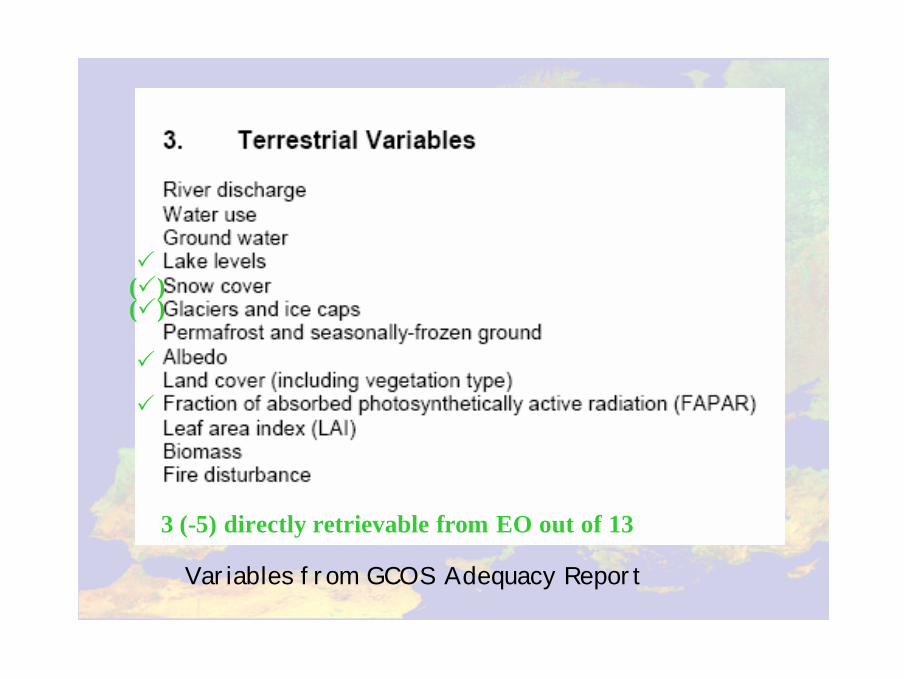
3 (-5) directly retrievable from EO out of 13
(P)
Variables from GCOS Adequacy Report
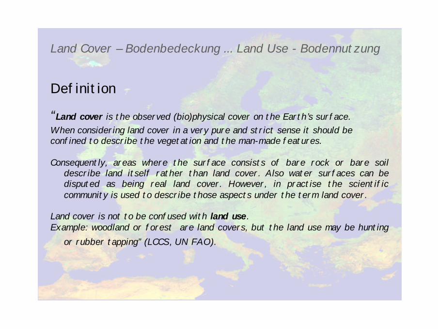
Land Cover – Bodenbedeckung ... Land Use - Bodennutzung
Definition
“Land cover is the observed (bio)physical cover on the Earth’s surface.When considering land cover in a very pure and strict sense it should beconfined to describe the vegetation and the man-made features.
Consequently, areas where the surface consists of bare rock or bare soil describe land itself rather than land cover. Also water surfaces can be disputed as being real land cover. However, in practise the scientific community is used to describe those aspects under the term land cover.
Land cover is not to be confused with land use. Example: woodland or forest are land covers, but the land use may be hunting
or rubber tapping” (LCCS, UN FAO).

IGBP Land Cover
LPJ „Land Cover“
Sitch et al. 2000
DISCREPANCIES
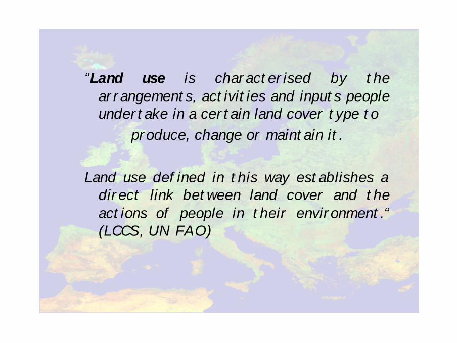
“Land use is characterised by the arrangements, activities and inputs people undertake in a certain land cover type to
produce, change or maintain it.
Land use defined in this way establishes a direct link between land cover and the actions of people in their environment.“ (LCCS, UN FAO)
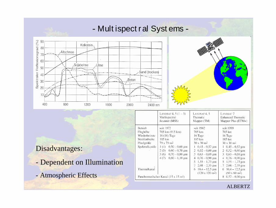
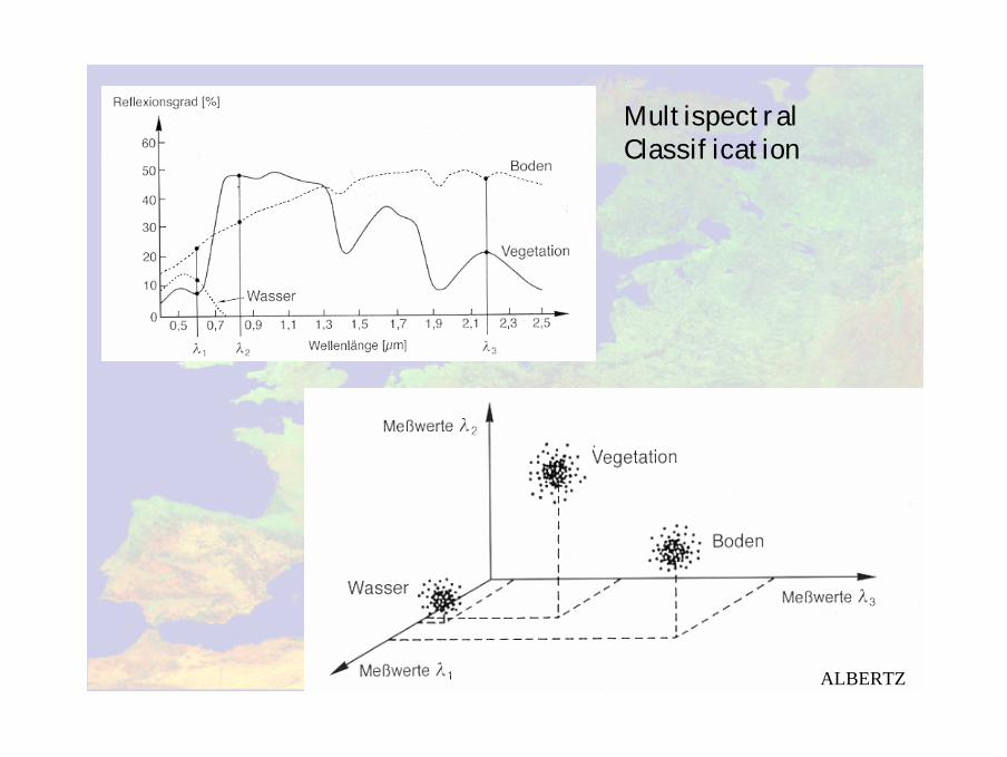
- Multispectral Systems -
Disadvantages:
- Dependent on Illumination
- Atmospheric Effects
ALBERTZ
- Radar -
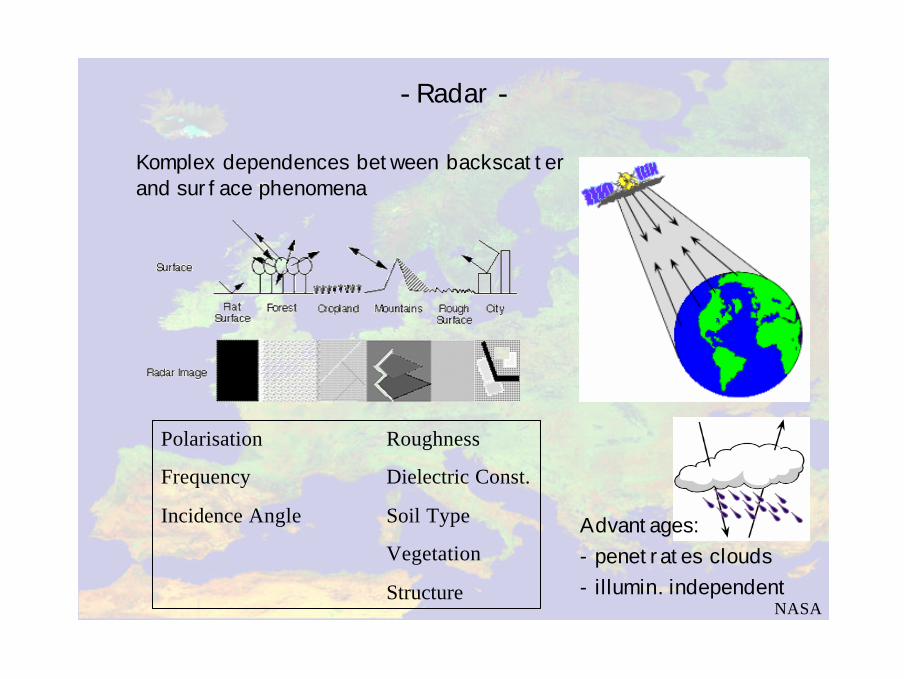
Komplex dependences between backscatterand surface phenomena
NASA
Polarisation Roughness
Frequency Dielectric Const.
Incidence Angle Soil Type
Vegetation
Structure
Advantages:- penetrates clouds- illumin. independent
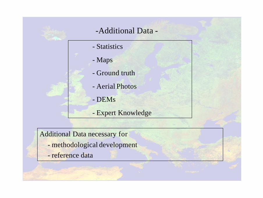
Additional Data necessary for- methodological development- reference data
-Additional Data -
- Statistics
- Maps
- Ground truth
- Aerial Photos
- DEMs
- Expert Knowledge
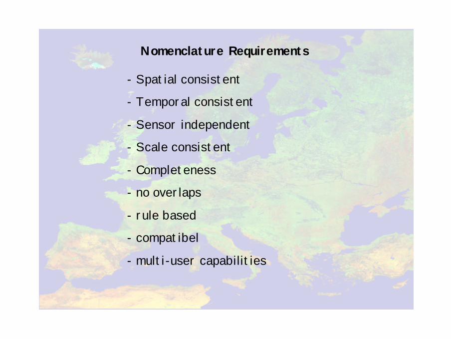
Nomenclature Requirements
- Spatial consistent
- Temporal consistent
- Sensor independent
- Scale consistent
- Completeness
- no overlaps
- rule based
- compatibel
- multi-user capabilities
Theoretischer Aufbau
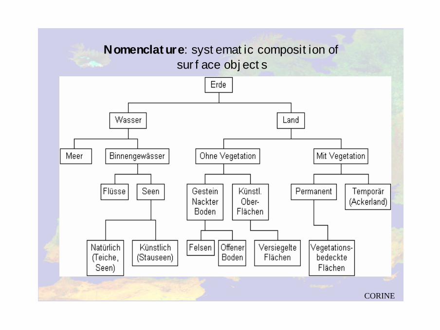
Nomenclature: systematic composition of surface objects
CORINE
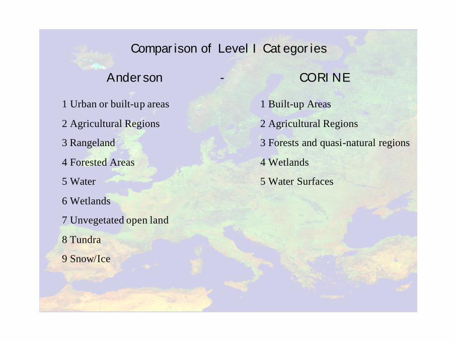
Comparison of Level I Categories
Anderson - CORINE
1 Urban or built-up areas
2 Agricultural Regions
3 Rangeland
4 Forested Areas
5 Water
6 Wetlands
7 Unvegetated open land
8 Tundra
9 Snow/Ice
1 Built-up Areas
2 Agricultural Regions
3 Forests and quasi-natural regions
4 Wetlands
5 Water Surfaces
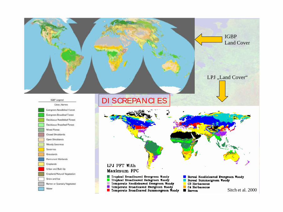
IGBP Land Cover
LPJ „Land Cover“
Sitch et al. 2000
DISCREPANCIES
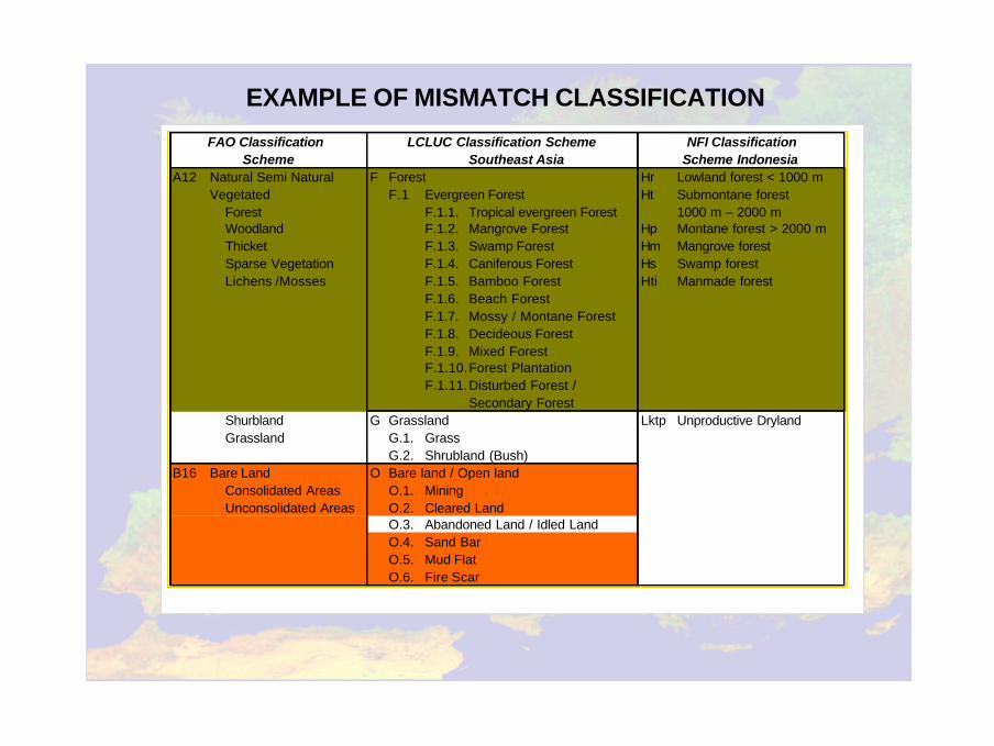
Southeast AsiaA12 Natural Semi Natural F Forest Hr Lowland forest < 1000 m
Vegetated F.1 Evergreen Forest Ht Submontane forestForest F.1.1. Tropical evergreen Forest 1000 m – 2000 mWoodland F.1.2. Mangrove Forest Hp Montane forest > 2000 mThicket F.1.3. Swamp Forest Hm Mangrove forestSparse Vegetation F.1.4. Caniferous Forest Hs Swamp forestLichens /Mosses F.1.5. Bamboo Forest Hti Manmade forest
F.1.6. Beach ForestF.1.7. Mossy / Montane ForestF.1.8. Decideous ForestF.1.9. Mixed ForestF.1.10.Forest PlantationF.1.11.Disturbed Forest /
Secondary ForestShurbland G Grassland Lktp Unproductive DrylandGrassland G.1. Grass
G.2. Shrubland (Bush)B16 Bare Land O Bare land / Open land
Consolidated Areas O.1. MiningUnconsolidated Areas O.2. Cleared Land
O.3. Abandoned Land / Idled LandO.4. Sand BarO.5. Mud FlatO.6. Fire Scar
FAO Classification Scheme
NFI ClassificationLCLUC Classification SchemeScheme Indonesia
EXAMPLE OF MISMATCH CLASSIFICATION
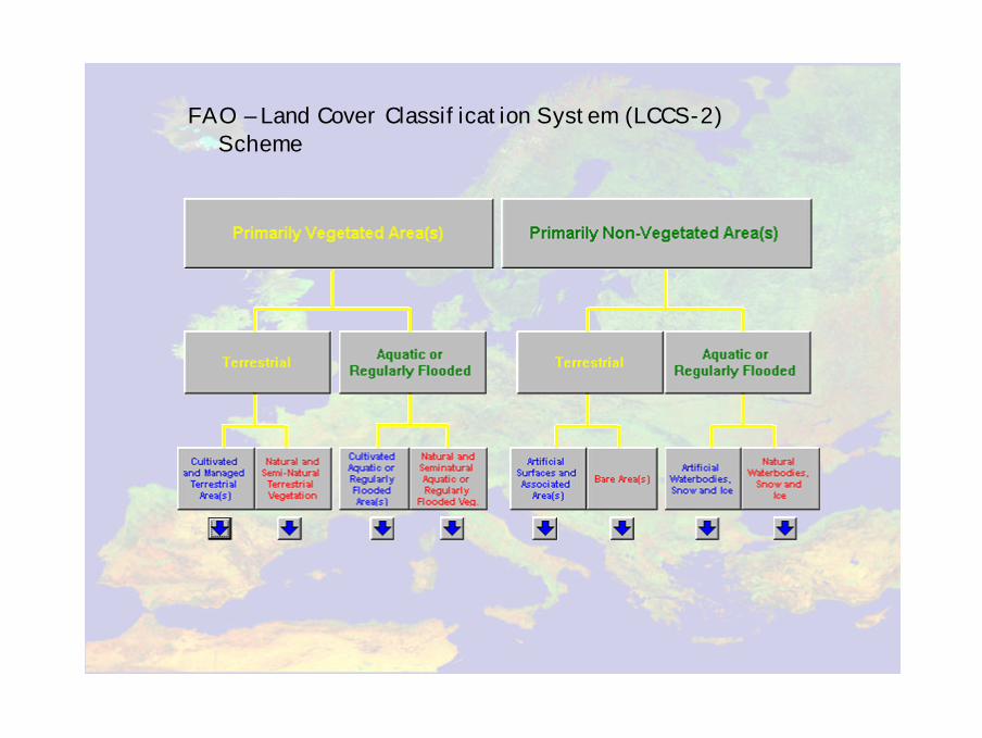
FAO – Land Cover Classification System (LCCS-2) Scheme
GOFC-GOLD Land Cover Implementation plan2-4 March Jena
Afr
ico
ver/
GL
CN
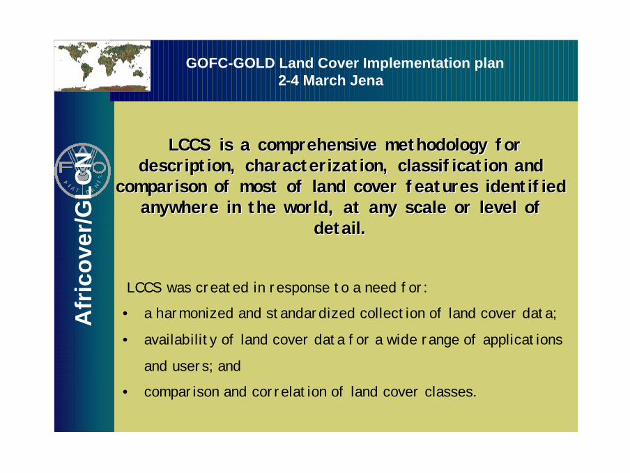
LCCS was created in response to a need for:
• a harmonized and standardized collection of land cover data;
• availability of land cover data for a wide range of applications
and users; and
• comparison and correlation of land cover classes.
LCCS is a comprehensive methodology for LCCS is a comprehensive methodology for description, characterization, classification and description, characterization, classification and
comparison of most of land cover features identified comparison of most of land cover features identified anywhere in the world, at any scale or level of anywhere in the world, at any scale or level of
detail.detail.
GOFC-GOLD Land Cover Implementation plan2-4 March Jena
Afr
ico
ver/
GL
CN
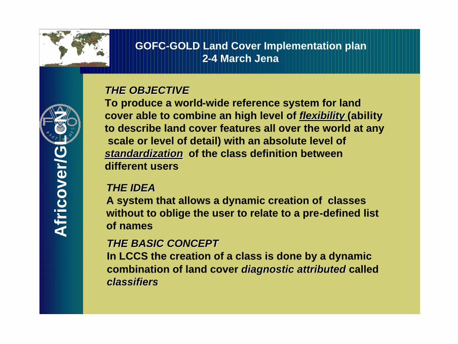
THE OBJECTIVETHE OBJECTIVETo produce a world-wide reference system for landcover able to combine an high level of flexibilityflexibility (abilityto describe land cover features all over the world at anyscale or level of detail) with an absolute level of standardizationstandardization of the class definition between different users
THE IDEATHE IDEAA system that allows a dynamic creation of classeswithout to oblige the user to relate to a pre-defined list of names
THE BASIC CONCEPTTHE BASIC CONCEPTIn LCCS the creation of a class is done by a dynamic combination of land cover diagnostic attributed diagnostic attributed calledclassifiers classifiers
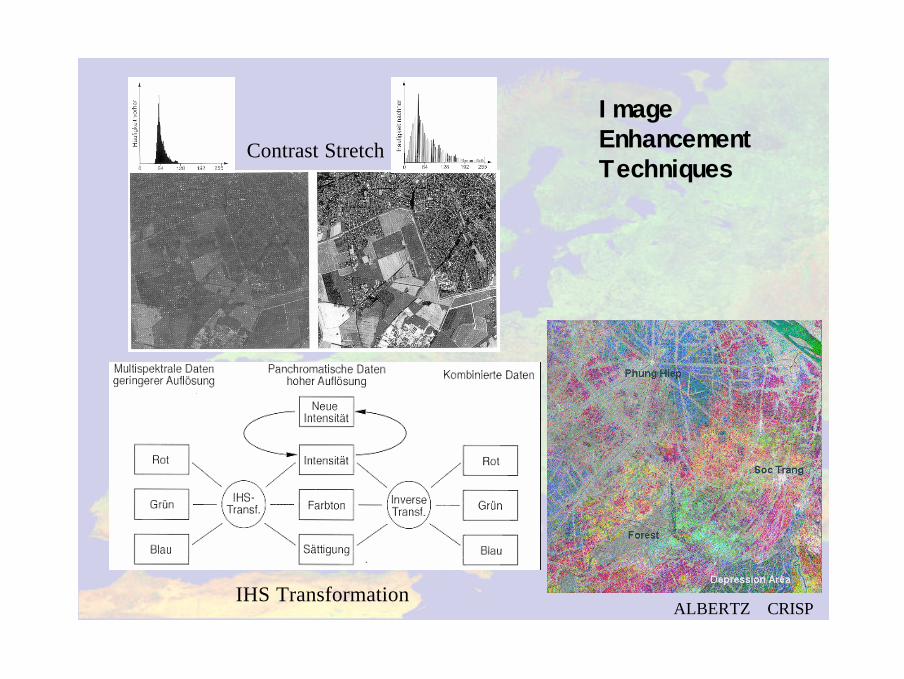
Image EnhancementTechniques
Contrast Stretch
IHS TransformationALBERTZ+
CRISP
RSRG Bonn
RSRG Bonn
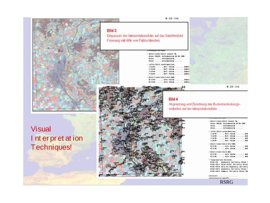
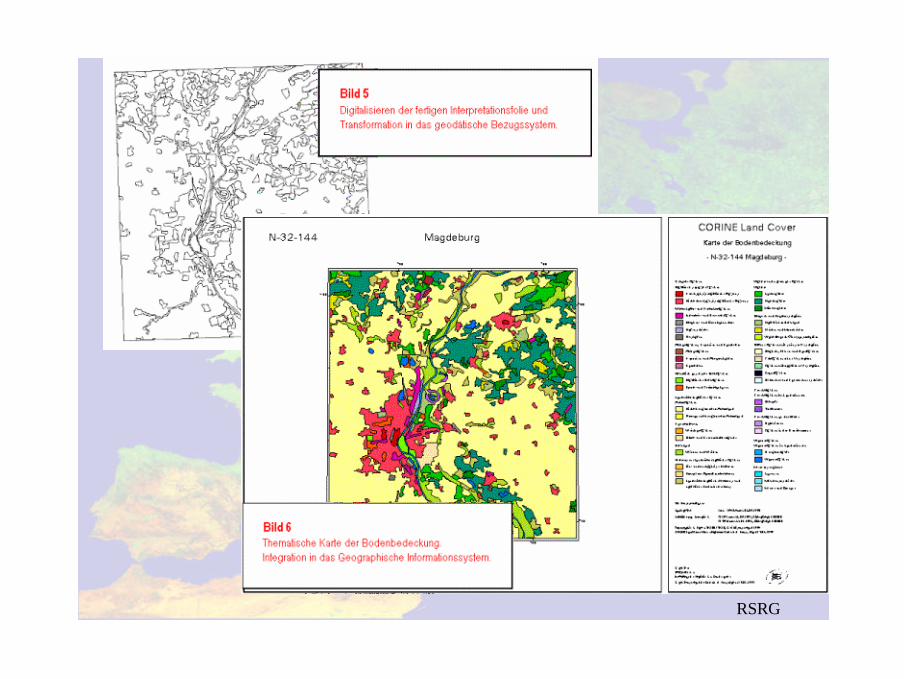
Visual InterpretationTechniques!
RSRG Bonn
FSU Jena � Institut für Geographie � Vorlesung Bildverarbeitung � Prof. Dr. C. Schmullius
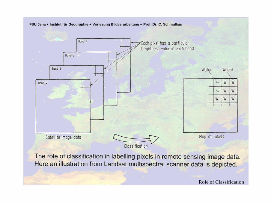
Role of Classification
FSU Jena � Institut für Geographie � Vorlesung Bildverarbeitung � Prof. Dr. C. Schmullius
ALBERTZ
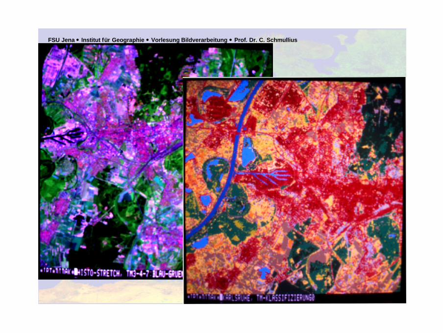
MultispectralClassification
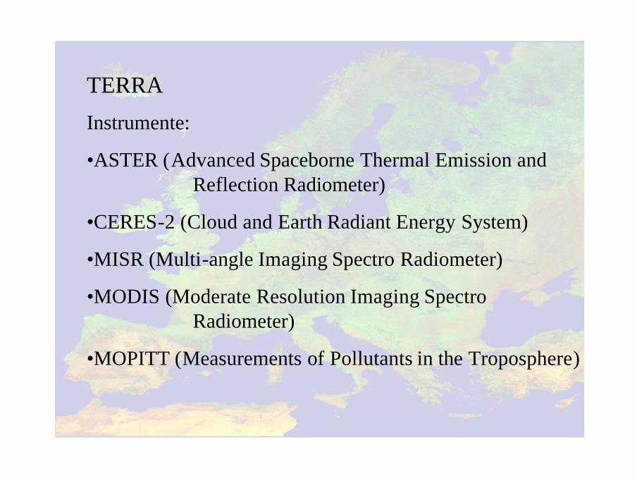
TERRA
Instrumente:
•ASTER (Advanced Spaceborne Thermal Emission and Reflection Radiometer)
•CERES-2 (Cloud and Earth Radiant Energy System)
•MISR (Multi-angle Imaging Spectro Radiometer)
•MODIS (Moderate Resolution Imaging SpectroRadiometer)
•MOPITT (Measurements of Pollutants in the Troposphere)
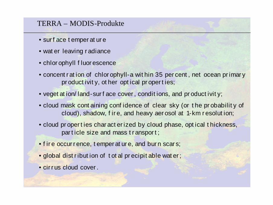
TERRA – MODIS-Produkte
• surface temperature
• water leaving radiance
• chlorophyll fluorescence
• concentration of chlorophyll-a within 35 percent, net ocean primary productivity, other optical properties;
• vegetation/land-surface cover, conditions, and productivity;
• cloud mask containing confidence of clear sky (or the probability of cloud), shadow, fire, and heavy aerosol at 1-km resolution;
• cloud properties characterized by cloud phase, optical thickness, particle size and mass transport;
• fire occurrence, temperature, and burn scars;
• global distribution of total precipitable water;
• cirrus cloud cover.
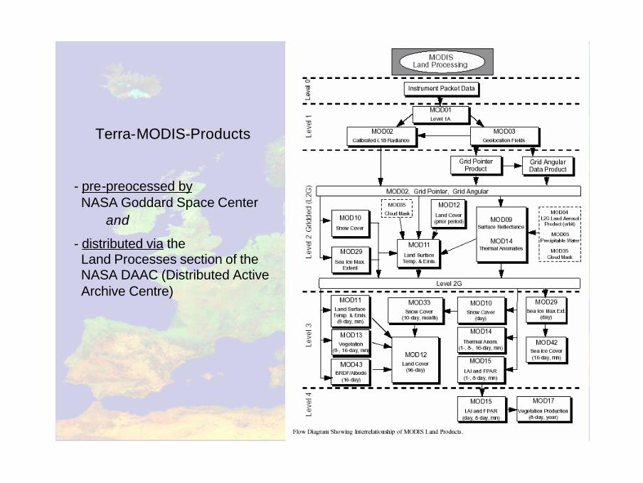
TerraTerra--MODISMODIS--ProductsProducts
- pre-preocessed byNASA Goddard Space Center
and
- distributed via the Land Processes section of theNASA DAAC (Distributed ActiveArchive Centre)
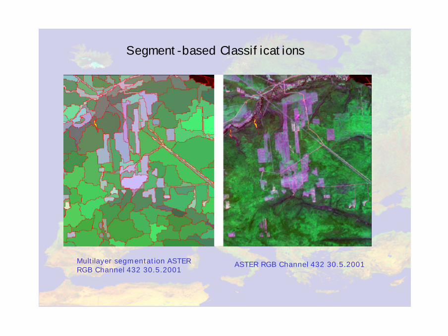
Segment-based Classifications
ASTER RGB Channel 432 30.5.2001Multilayer segmentation ASTER RGB Channel 432 30.5.2001
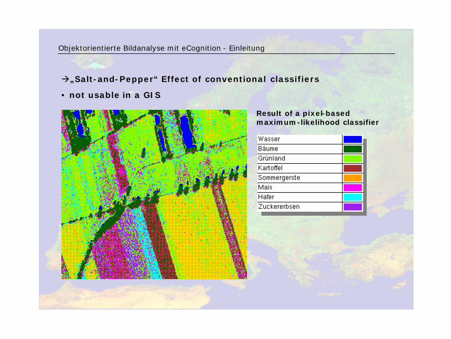
à„Salt-and-Pepper“ Effect of conventional classifiers
• not usable in a GIS
Objektorientierte Bildanalyse mit eCognition - Einleitung
Result of a pixel-basedmaximum-likelihood classifier
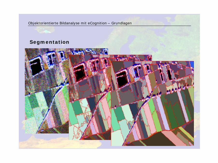
Objektorientierte Bildanalyse mit eCognition – Grundlagen
Segmentation
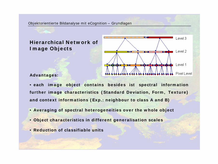
Advantages:
• each image object contains besides ist spectral information
further image characteristics (Standard Deviation, Form, Texture)
and context informations (Exp.: neighbour to class A and B)
• Averaging of spectral heterogeneities over the whole object
• Object characteristics in different generalisation scales
• Reduction of classifiable units
Objektorientierte Bildanalyse mit eCognition – Grundlagen
Hierarchical Network of Image Objects
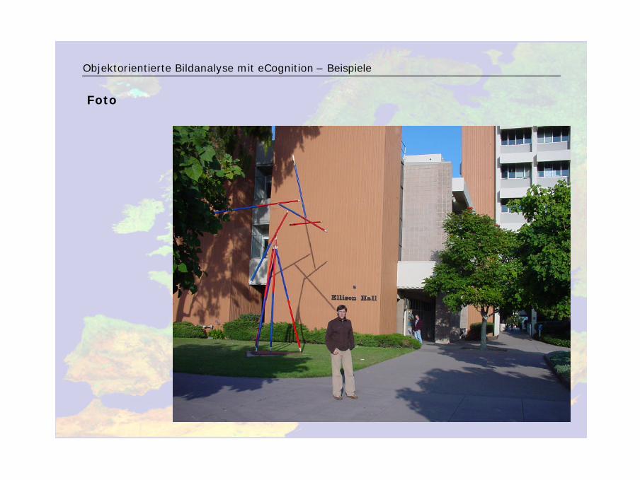
Foto
Objektorientierte Bildanalyse mit eCognition – Beispiele
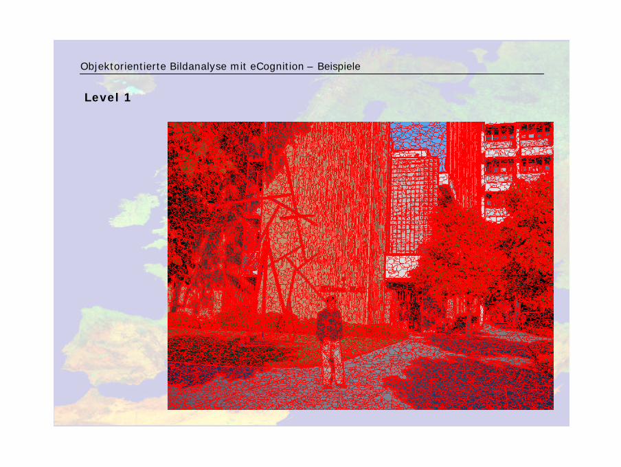
Level 1
Objektorientierte Bildanalyse mit eCognition – Beispiele
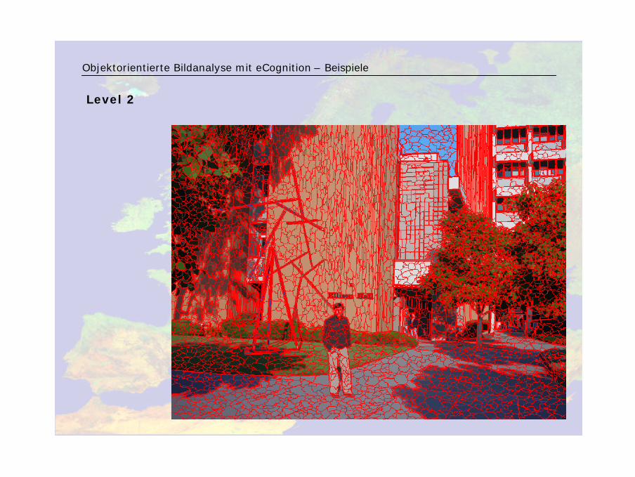
Level 2
Objektorientierte Bildanalyse mit eCognition – Beispiele
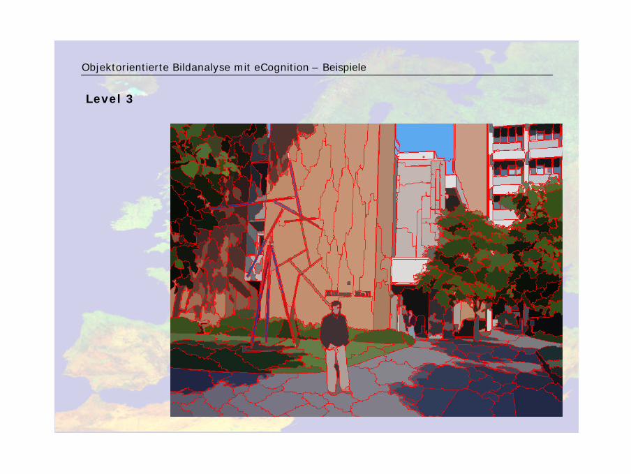
Level 3
Objektorientierte Bildanalyse mit eCognition – Beispiele
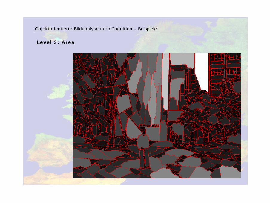
Level 3: Area
Objektorientierte Bildanalyse mit eCognition – Beispiele

Level 3: Length/Width
Objektorientierte Bildanalyse mit eCognition – Beispiele
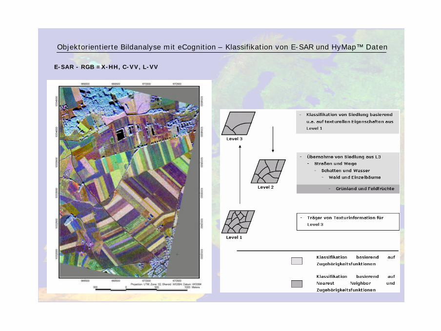
E-SAR - RGB =X-HH, C-VV, L-VV
Objektorientierte Bildanalyse mit eCognition – Klassifikation von E-SAR und HyMap™ Daten
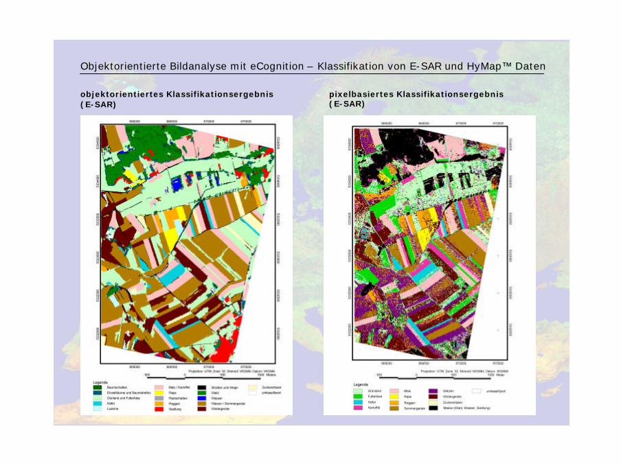
objektorientiertes Klassifikationsergebnis (E-SAR)
Objektorientierte Bildanalyse mit eCognition – Klassifikation von E-SAR und HyMap™ Daten
pixelbasiertes Klassifikationsergebnis (E-SAR)
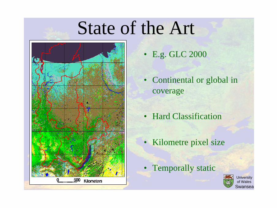
State of the Art• E.g. GLC 2000
• Continental or global in coverage
• Hard Classification
• Kilometre pixel size
• Temporally staticUniversity of Wales
Swansea
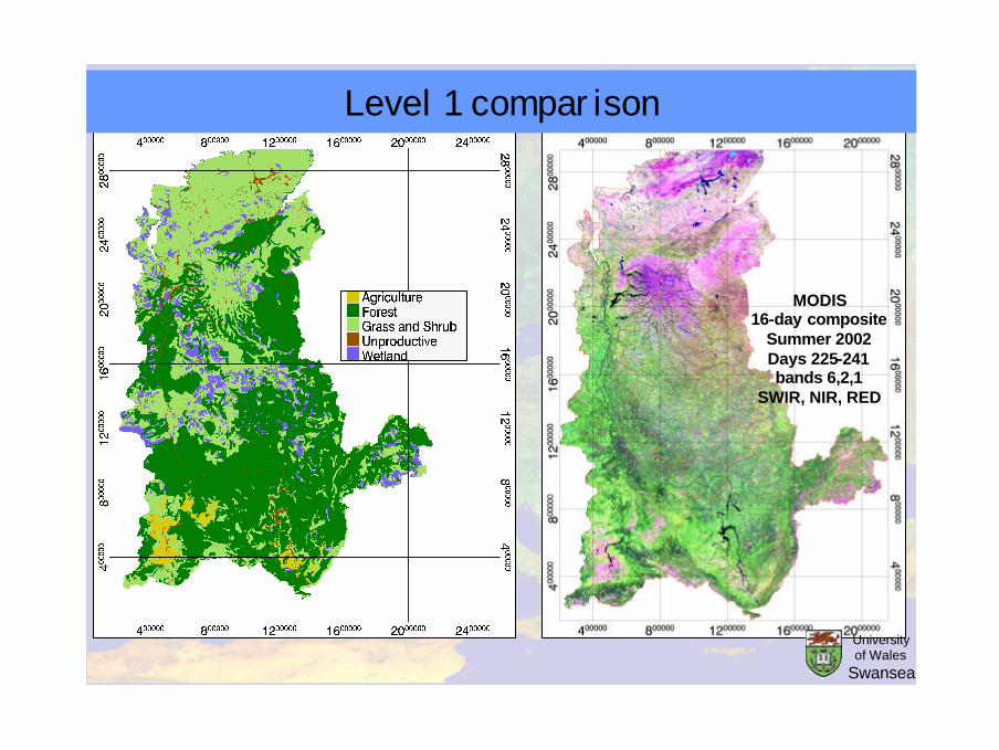
MODIS16-day composite
Summer 2002Days 225-241bands 6,2,1
SWIR, NIR, RED
Level 1 comparison
University of Wales
Swansea
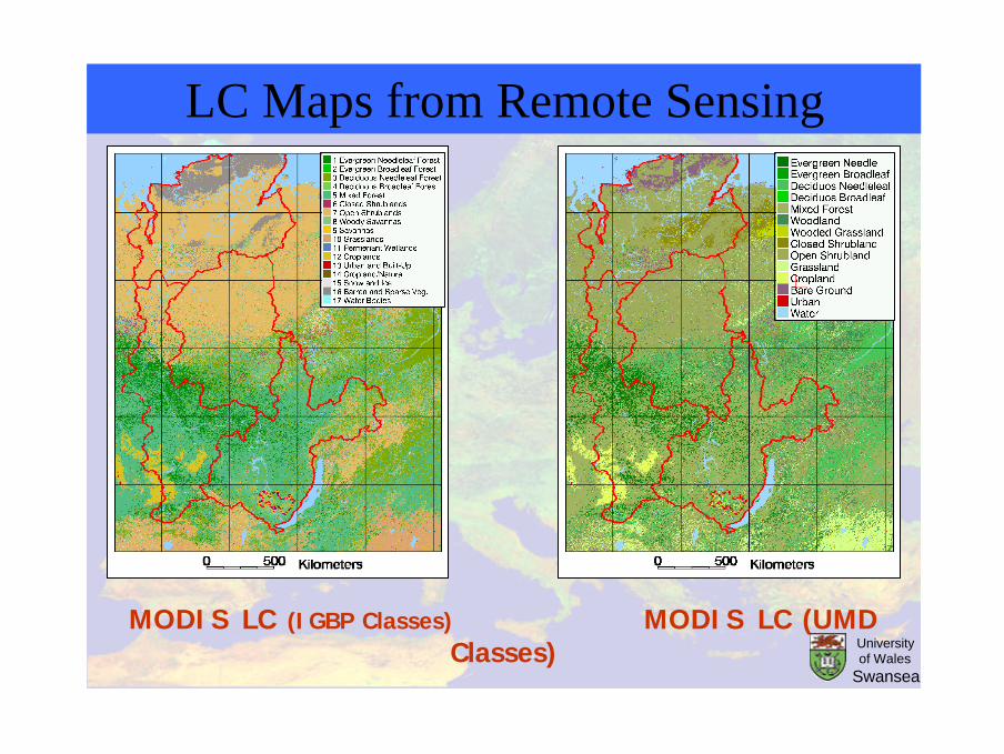
MODIS LC (IGBP Classes) MODIS LC (UMD Classes)
LC Maps from Remote Sensing
University of Wales
Swansea
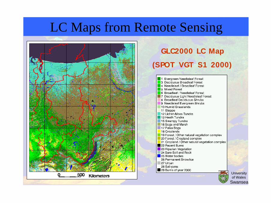
GLC2000 LC Map
(SPOT VGT S1 2000)
LC Maps from Remote Sensing
University of Wales
Swansea
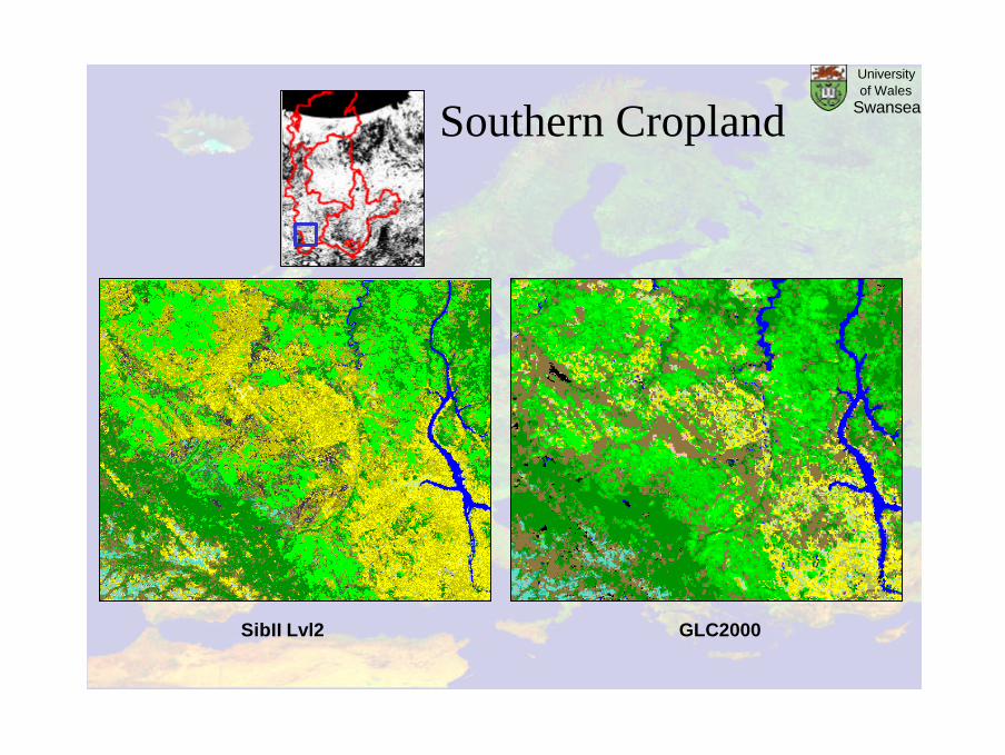
Southern Cropland
SibII Lvl2 GLC2000
University of Wales
Swansea
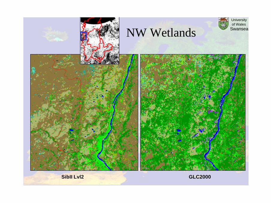
NW Wetlands
SibII Lvl2 GLC2000
University of Wales
Swansea

FAO – Land Cover Classification System (LCCS-2) Scheme
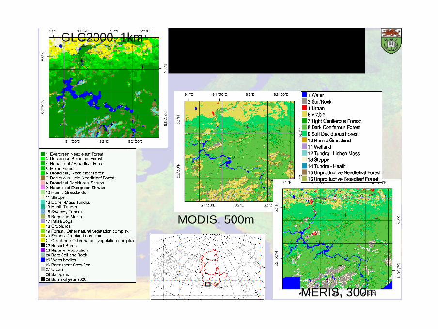
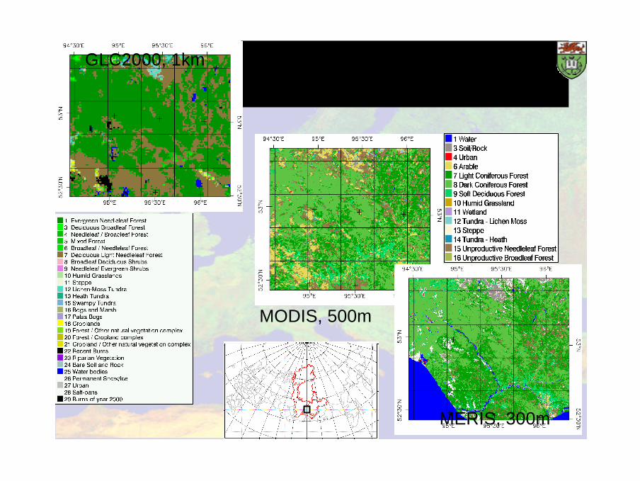
Result: Agriculture-forest-tundra
MODIS, 500m
MERIS, 300m
GLC2000, 1km
Result: River in forest
MODIS, 500m
MERIS, 300m
GLC2000, 1km
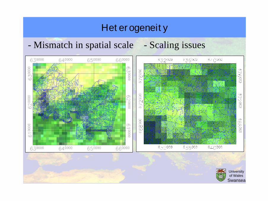
Heterogeneity
- Mismatch in spatial scale - Scaling issues
University of Wales
Swansea
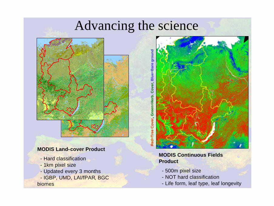
Advancing the science
MODIS Land-cover Product
- Hard classification- 1km pixel size- Updated every 3 months- IGBP, UMD, LAI/fPAR, BGC
biomes
MODIS Continuous Fields Product
- 500m pixel size- NOT hard classification- Life form, leaf type, leaf longevity
Red
=Tre
e C
ove
r, G
reen
=Her
b. C
ove
r,B
lue=
Bar
e g
rou
nd
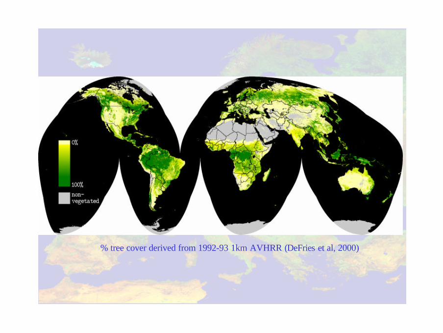
% tree cover derived from 1992-93 1km AVHRR (DeFries et al, 2000)
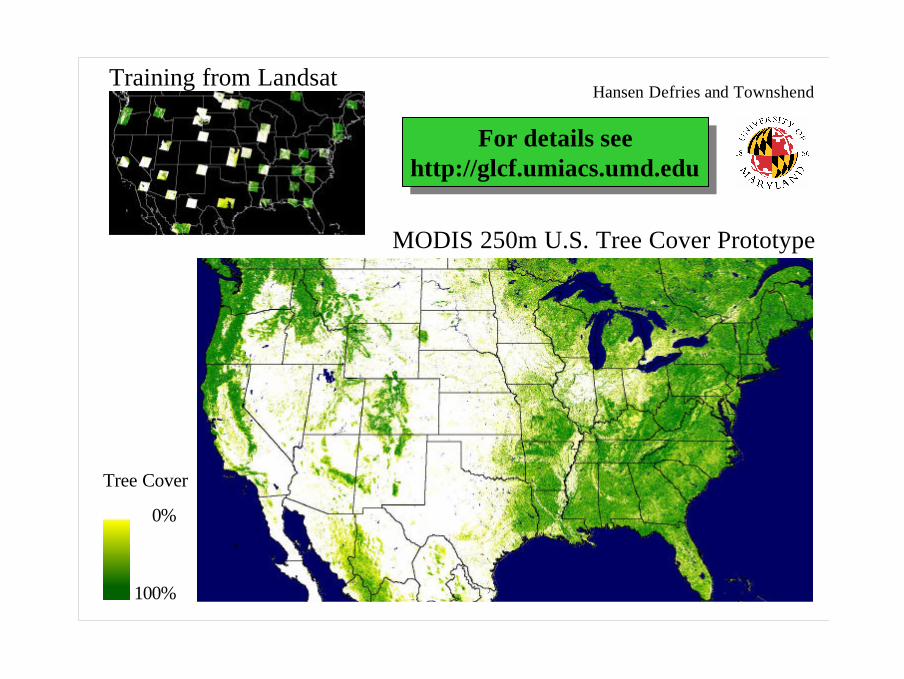
Training from Landsat
MODIS 250m U.S. Tree Cover Prototype
0%
100%
Tree Cover
For details seehttp://glcf.umiacs.umd.edu
For details seehttp://glcf.umiacs.umd.edu
Hansen Defries and Townshend
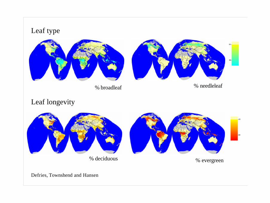
Leaf type
Leaf longevity
% evergreen% deciduous
% needleleaf% broadleaf
Defries, Townshend and Hansen
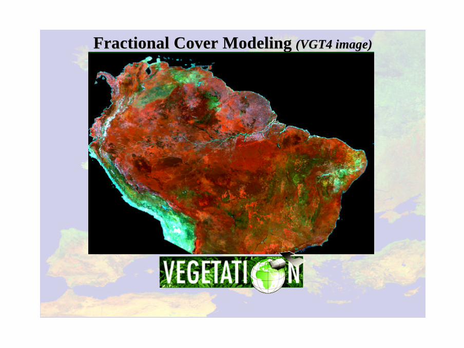
Fractional Cover Modeling Fractional Cover Modeling (VGT4 image)(VGT4 image)
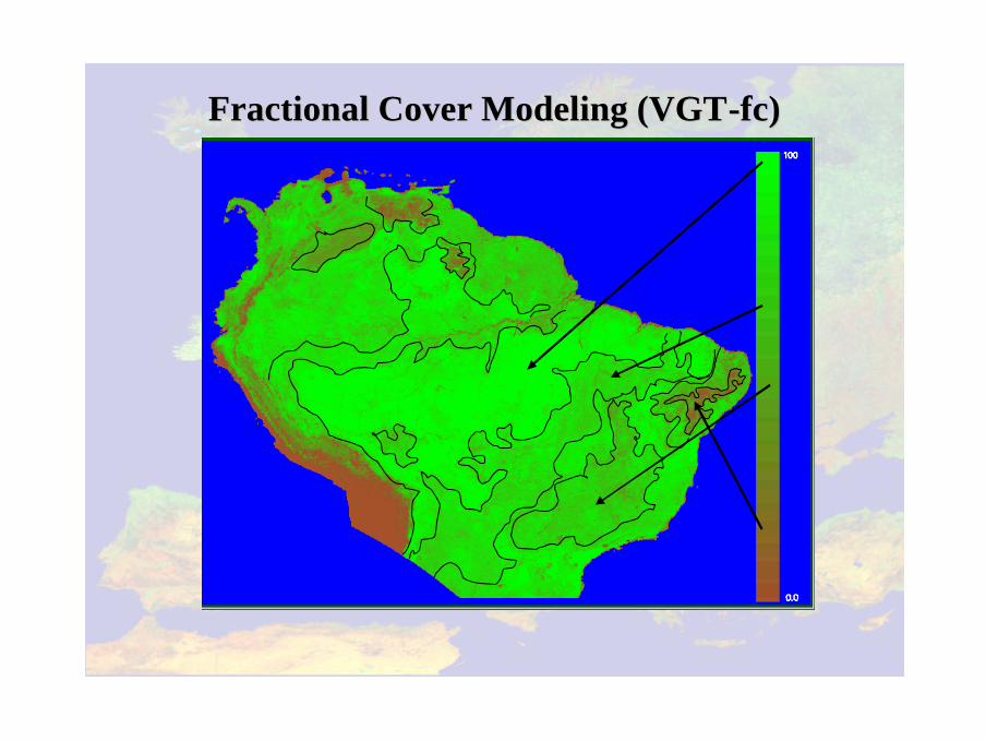
Fractional Cover Modeling (VGTFractional Cover Modeling (VGT--fcfc))
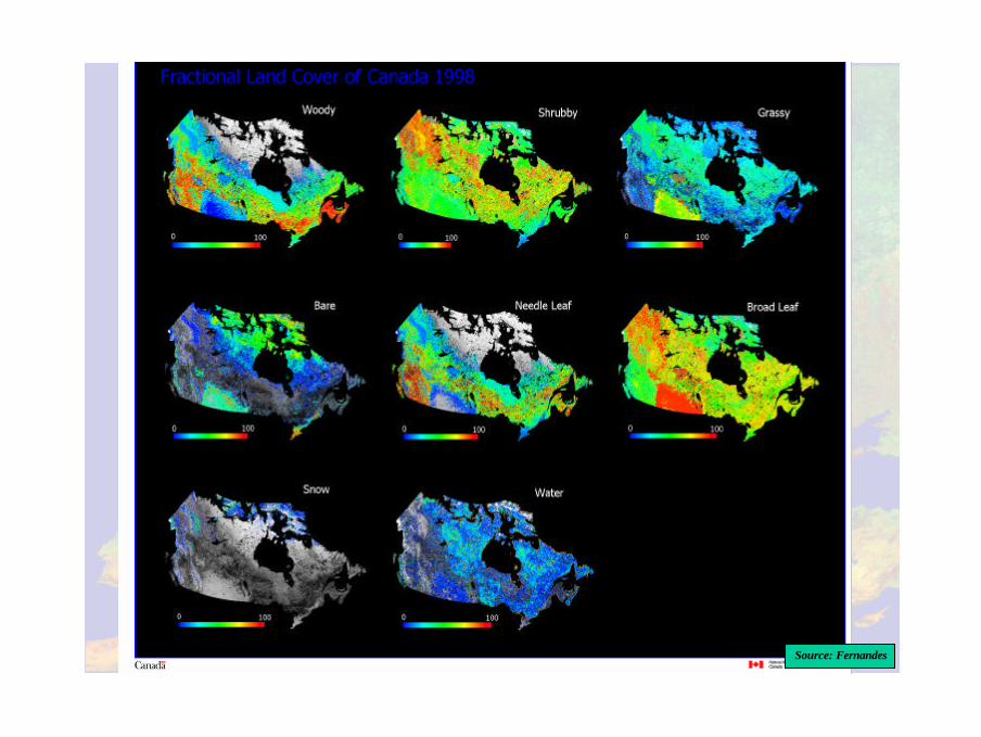
Source: Fernandes
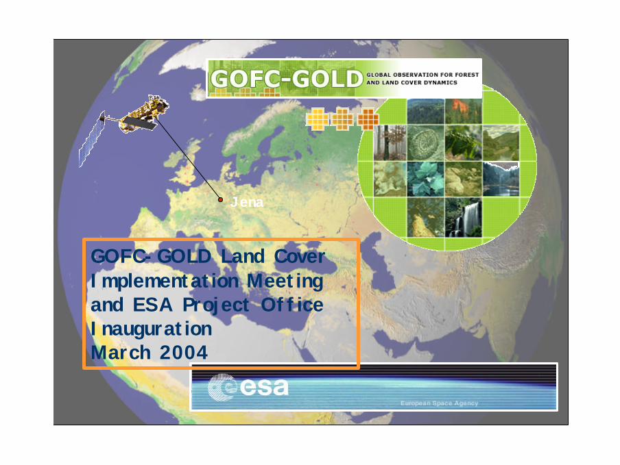
GOFC-GOLD Land Cover Implementation Meeting and ESA Project OfficeInaugurationMarch 2004
Jena
What is GOFC?• An ambitious, multifaceted international strategy to bring the Earth’s
forests/land cover under continuous observation.• A vision to share data, information and knowledge, leading to
informed action.• A coordinated program of activities to ensure that earth observation
and other data are used effectively for global monitoring for natural resource management, policy and global change research.
• A network of participants implementing coordinated demonstrations of the use of geospatial information and technology for sustainable development
• An international organization of space agencies and end users working together.
• A long term process of building an improved match between data products and user needs.
Organizational Status• Started as a project of the Integrated Global Observation
Strategy proposed by CSA.• Panel of the Global Terrestrial Observing System• Two main implementation teams: Landcover, Fire• Scope: transitioning from
– GOFC (Global Observations of Forest Cover) to– GOLD (Global Observations of Landcover Dynamics)
• Principal Role of GOFC/GOLD is to act as a coordinating mechanism for national and regional activities.
• Active regional networks developing• Secretariat established with Canadian Forest Service
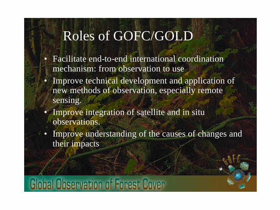
Roles of GOFC/GOLD
• Facilitate end-to-end international coordination mechanism: from observation to use
• Improve technical development and application of new methods of observation, especially remote sensing.
• Improve integration of satellite and in situ observations.
• Improve understanding of the causes of changes and their impacts
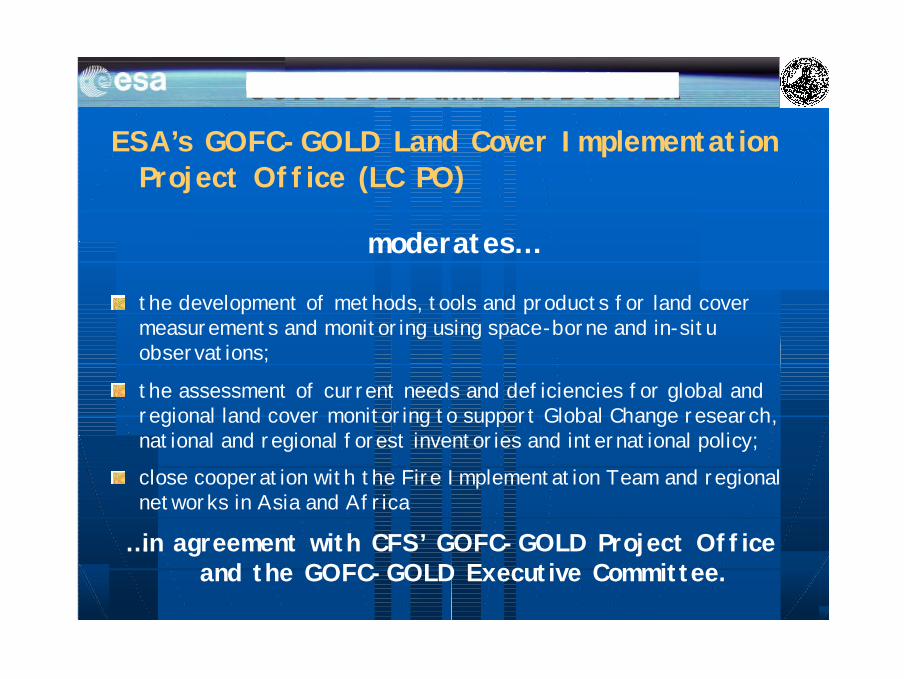
ESA’s GOFC-GOLD Land Cover Implementation Project Office (LC PO)
moderates…
the development of methods, tools and products for land cover measurements and monitoring using space-borne and in-situobservations;
the assessment of current needs and deficiencies for global and regional land cover monitoring to support Global Change research, national and regional forest inventories and international policy;
close cooperation with the Fire Implementation Team and regionalnetworks in Asia and Africa
…in agreement with CFS’ GOFC-GOLD Project Office and the GOFC-GOLD Executive Committee.
Land Cover ClassificationProf. Dr. Christiane Schmullius
Friedrich Schiller University Jena, GermanyDepartment of Geoinformatics and Remote Sensing