international 2016
TRANSCRIPT
AIR TRAFFIC TECHNOLOGY INTERNATIONAL 2016
• U
KIP Media &
Events Ltd •
INTERNATIONAL 2016THE INTERNATIONAL REVIEW OF AIR TRAFFIC TECHNOLOGY AND MANAGEMENT
SESAR Massimo Garbini talks about SESAR Deployment Manager
NEXTGEN NextGen’s foundation pieces are beginning to settle into place
WEATHER Detailed and timely weather prediction is crucial to flight safety
HAS CHANGED GLOBAL AIRCRAFT TRACKING
HOW
AIR TRAFFIC MANAGEMENT & AIRPORTS
LEADING SOLUTIONS IN AIR TRAFFIC MANAGEMENT AND AIRPORTS
Supplying ATM systems around the world for more than 95 years
More than 4,000 major ATM installations in over 160 countries
Active contribution to Single European Sky
Customer oriented project management
Smart IT systems for CDM Airport operations
New generation of Airport Management & Control for Land side and Air side
Total commitment to ATM & Airport customers, dedicated to overcoming business and traffic challenges with a focus on environmental sustainability
Systems in all continents, 39,000 professionals, 46 nationalities,R&D 6-8% of sales.
indracompany.com

Foreword
It is fashionable to be negative about the pace of change, or lack of it, within the ATM industry. The
second Reference Period for the European Commission’s (EC) Single European Sky (SES) program began in 2015. While the first Reference Period was considered by many to be transitional, expectations were high for performance improvements from 2015. However, at the time of writing, many member states are still discussing with the EC what plans are necessary in order for them to meet its ambitions, even though the second Reference Period has already started.
There is therefore some understandable frustration about what has been achieved so far, but equally there have been successes that critics are quick to ignore. As an industry we are delivering innovative and meaningful differences to airlines and passengers and I am optimistic that momentum is building and will continue in 2016.
In March 2015, NATS became the first ANSP in the world to begin separating aircraft by time instead of by distance – a practice that was delivered three years ahead of schedule. It will save 80,000 minutes of weather-related delay a year at London Heathrow and was made possible because NATS was able to bring the airlines, the airport and the regulator together to achieve a common operational goal that was in everyone’s interest.
Similarly the Borealis Alliance of Northern European ANSPs, including NATS, is looking beyond FABs to implement free route airspace across their entire airspace, not because the EC has told us to but because it will enable us to offer a better service to our airline customers.
From now until 2017 satellites will be launched that enable space-based ADS-B and the potential for a revolution in oceanic control across the North Atlantic and beyond. This project brings together ANSPs and the industry to increase North Atlantic ATC capacity and generate considerable CO2 and fuel savings for airlines.
The creation of the SESAR Deployment Manager at the end of 2014 should also be seen as a real breakthrough and it has already delivered its first deployment plan to the EC. As a true industry-wide collaboration, it demonstrates that the ANSP community is capable of making the right progress both technically and politically with the airlines and airports. I hope this is seen as an opportunity for the whole industry to move forward together.
The common denominator in all these examples – and I could have listed many more – has been the ability to bring the wider industry together because it makes good operational and business sense. My hope for 2016 and beyond is that as an aviation industry we can take the lessons from these examples and continue to accelerate the valuable progress that has been made.
Martin Rolfe, chief executive, NATS
FOREWORD
Editor Helen NormanDeputy editor Hazel KingAssistant editor Daniel SymondsProduction editor Alex BradleyChief sub editor Andrew PickeringDeputy production editor Nick ShepherdSenior sub editor Christine VelardeSub editor Alasdair MortonArt director Craig MarshallArt editor Andy BassDesign team Louise Adams, Anna Davie, Andrew Locke, Duncan Norton, Nicola Turner, Julie Welby, Ben WhiteProject manager Roger BakerPublication director Simon HughesHead of production & logistics Ian DonovanDeputy production manager Lewis HopkinsProduction team Carole Doran, Cassie Inns, Frank Millard, Robyn SkalskyCirculation Adam FrostEditorial director Anthony JamesManaging director Graham JohnsonCEO Tony Robinson
Air Traffic Technology International 2016 has been distributed worldwide free of charge to directors and senior technical managers responsible for air traffic control and related services. Additional copies are available from the publishers, priced £65 (US$104) including delivery.
The views expressed in the articles and technical papers are those of the authors and are not endorsed by the publishers. While every care has been taken during production, the publisher does not accept any liability for any errors that may have occurred.
Published by
ISSN 1366-7041Air Traffic Technology International 2016This publication is protected by copyright. © 2016
UKIP Media and Events Ltd, Abinger House, Church Street, Dorking, Surrey RH4 1DF, UKTel: +44 1306 743744Main fax: +44 1306 742525Editorial fax: +44 1306 887546Email: [email protected]
Printed by William Gibbons & Sons Ltd, PO Box 103, 26 Planetary Road, Willenhall, West Midlands, WV13 3XT
INTERNATIONAL
INTERNATIONAL
www.ukipme.com/info/att
FREE SERVICE!
www.ukipme.com/info/attINTERNATIONAL 2016
LEARN MORE ABOUT OUR ADVERTISERS NOW!Visit www.ukipme.com/info/att to request exclusive and rapid information about the latest technologies and services featured in this issue
AIR TRAFFIC TECHNOLOGY INTERNATIONAL 2016
• UKIP M
edia & Events Ltd •
INTERNATIONAL 2016
THE INTERNATIONAL REVIEW OF AIR TRAFFIC TECHNOLOGY AND MANAGEMENT
SESAR Massimo Garbini talks about
SESAR Deployment Manager NEXTGEN NextGen’s foundation pieces are
beginning to settle into place WEATHER Detailed and timely weather
prediction is crucial to flight safety
HAS CHANGED GLOBAL AIRCRAFT TRACKING
HOW
CONTENTS
2 AIR TRAFFIC TECHNOLOGY INTERNATIONAL 2016.
CONTENTS
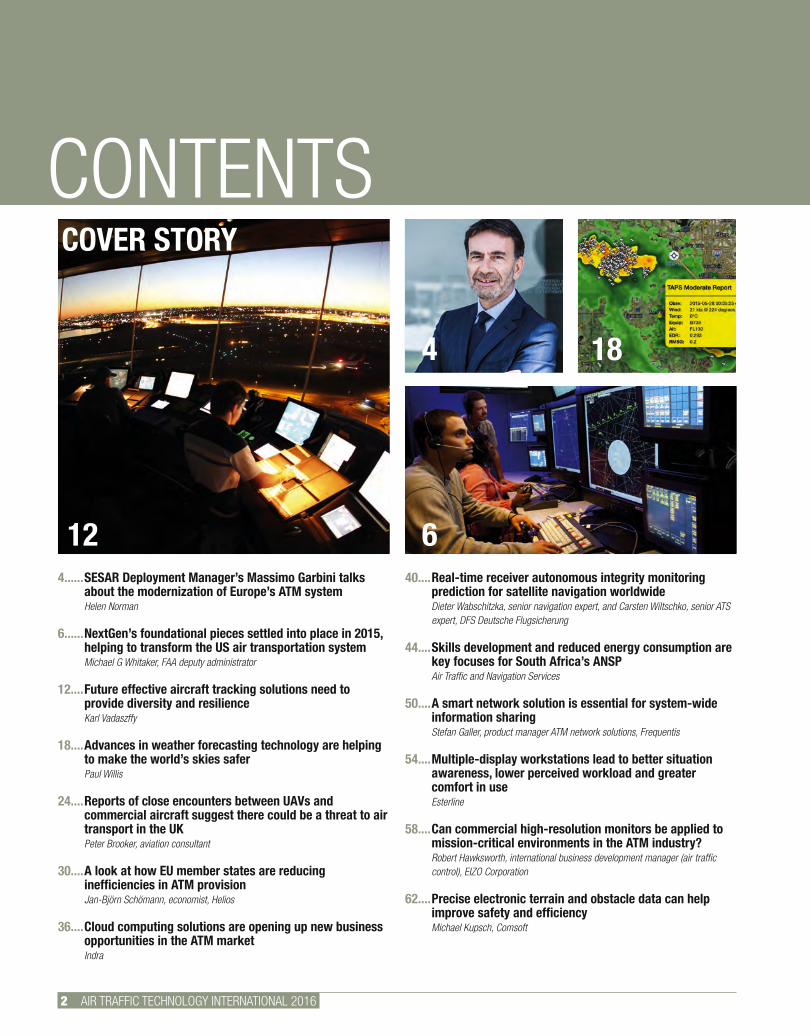
4SESAR Deployment Manager’s Massimo Garbini talks about the modernization of Europe’s ATM systemHelen Norman
6NextGen’s foundational pieces settled into place in 2015, helping to transform the US air transportation systemMichael G Whitaker, FAA deputy administrator
12Future effective aircraft tracking solutions need to provide diversity and resilience Karl Vadaszffy
18Advances in weather forecasting technology are helping to make the world’s skies saferPaul Willis
24Reports of close encounters between UAVs and commercial aircraft suggest there could be a threat to air transport in the UKPeter Brooker, aviation consultant
30A look at how EU member states are reducing inefficiencies in ATM provisionJan-Björn Schömann, economist, Helios
36Cloud computing solutions are opening up new business opportunities in the ATM marketIndra
40Real-time receiver autonomous integrity monitoring prediction for satellite navigation worldwideDieter Wabschitzka, senior navigation expert, and Carsten Wiltschko, senior ATS expert, DFS Deutsche Flugsicherung
44Skills development and reduced energy consumption are key focuses for South Africa’s ANSPAir Traffic and Navigation Services
50A smart network solution is essential for system-wide information sharingStefan Galler, product manager ATM network solutions, Frequentis
54Multiple-display workstations lead to better situation awareness, lower perceived workload and greater comfort in useEsterline
58Can commercial high-resolution monitors be applied to mission-critical environments in the ATM industry?Robert Hawksworth, international business development manager (air traffic control), EIZO Corporation
62Precise electronic terrain and obstacle data can help improve safety and efficiency Michael Kupsch, Comsoft
12
COVER STORY
4
6
18
CONTENTS
AIR TRAFFIC TECHNOLOGY INTERNATIONAL 2016 3.
CONTENTS
67A new workforce shift management product that is able to meet realistic operating needs Duccio Grandi, rostering specialist, ENAV
70State-of-the-art ATM technology at John F Kennedy International AirportWEY Technology
72New technologies to facilitate intelligent airports, flights and landingsAileen McDowall, VP airlines EMEAI, Honeywell Aerospace
76Air surveillance across Portugal is being improved through new multilateration and ADS-B technologiesLuis Pissarro, head of CNS projects, NAV Portugal
78Providing a better understanding of ATM systems through an automated analysis modelPaula Santos, NAV Portugal
80The deployment of new ATM technologies in Canada has transformed the controller environment NAV Canada
83A look at the latest navigational technologies deployed by the Swiss ANSPSkyguide
84The management and identification of unmanned aerial vehicles to improve ATM safetySkySoft-ATM
86The protection of voice communication systems in ATC operations to tackle cyber securityLaurent Regulier, CS Communication & Systems, France
88Tackling an airfield infrastructure modernization or expansion projectADB Airfield Solutions
90Commercial airports are beginning to adopt the latest technologies in birdstrike avoidanceMike Bierman, director, birdstrike avoidance systems, DeTect
92Advanced ‘follow the green’ concepts are being developed to reduce taxi times and fuel burnStephen O’Flynn, Safegate global ATM advisor
94A mobile TACAN system that is rugged, lightweight and easily deployable Moog
96The use of big data in the aviation industry and how to embrace further opportunitiesSimon Daykin, chief architect at NATS
76
70
83 90
4 AIR TRAFFIC TECHNOLOGY INTERNATIONAL 2016
SESAR DEPLOYMENT
The Single European Sky Air Traffic Management Research (SESAR) project, which was set up in 2004 to modernize and harmonize ATM systems, has reached a
pivotal milestone. In June 2015 the first SESAR Deployment Program was delivered to the European Commission’s Directorate General for Mobility and Transport. This development marked a move from the R&D phase of SESAR to the modernization of European ATM technology.
Heading up the modernization project is SESAR Deployment Manager (SDM), which comprises ANSPs, airlines and the SESAR-related Deployment Airport Operators Group (SDAG). Its role is to coordinate the implementation of the EU’s Pilot Common Project (PCP), the first set of SESAR solutions to be deployed across Europe.
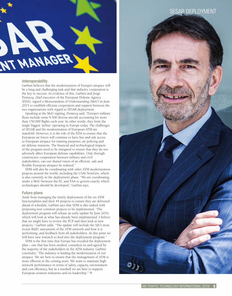
Massimo Garbini (right), managing director of SDM, explains more: “Our main task is to drive modernization in a timely manner. We will develop, consult, submit to the EC for approval, and execute the deployment program.”
The PCP is a European law covering six ATM functionalities that have to be implemented by EU member states. These functionalities were researched and developed by the SESAR Joint Undertaking (SJU), which was founded in 2007 to pool the knowledge and resources of the entire ATM community in order to define, develop and validate new ATM solutions. The release of the first SESAR Deployment Program marked the end of the SJU’s first phase of R&D. The SJU is now preparing for a new wave of projects under SESAR 2020.
“The PCP ATM functionalities have been recognized by the EC as the main areas the industry has to address to improve ATM,” explains Garbini. “The deployment program will build on the solutions validated by the SJU and implement them in a timely manner over the next 10 years. We will also work closely with the SJU on a daily basis to ensure our programs stay aligned and focused on the common SESAR vision.”
With a budget of €3bn (US$3.3bn), SDM is now ramping up its activities to deploy projects that meet the demands of the PCP. The PCP focuses on the technological improvements that are mature enough to start deployment between now and 2024. It also fosters the implementation of key ground-ground and air-ground infrastructural building blocks for future common projects for ATM modernization.
ATM functionalities“The initial deployment program, which was delivered in June 2015, provides a project overview for full PCP implementation,” says Garbini. “All six of the ATM functionalities (see below) are crucial for PCP implementation. The functionalities have been translated into 44 implementation projects. The program is a blueprint for PCP operational stakeholders.”
One of the most urgent projects, according to Garbini, is the extended arrival management (AMAN) and performance-based navigation (PBN) in high-density terminal maneuvering areas. “This functionality is expected to improve the precision of approach trajectories, as well as facilitate traffic sequencing at an earlier stage, thus reducing fuel consumption and environmental impact in descent/arrival phases,” he says.
Currently basic AMAN, which covers arrival management extended to en route airspace, is already widely implemented in the ATM industry. The next step is to upgrade to include an extended horizon function, which will extend the AMAN horizon from 100-120 nautical miles from the arrival airport to 180-200 nautical miles.
“ATM functionality number four, network collaborative management, is also a priority for us right now,” says Garbini. “This represents the ATM interface between the ANSPs and the network management systems. The aim is to provide a complete overview of information from all stakeholders so that collaborative decision making can be achieved at the network level.”
ACTION PLANATTI talks with SESAR Deployment Manager’s Massimo Garbini about the modernization of Europe’s air traffic systemHelen Norman
PILOT COMMON PROJECT FUNCTIONALITIES1. Extended AMAN and PBN in the high density terminal maneuvering areas to improve the precision of approach trajectories and facilitate air traffic sequencing at an earlier stage, including extended horizon function.2. Airport integration and throughput, including electronic flight strips, time-based separation and basic A-CDM, to improve runway throughput.3. Flexible airspace management and free routes, including airspace management of real-time data and management of dynamic airspace configurations, to enable airspace users to fly as closely as possible to their preferred trajectory.4. Network collaborative management, including short-term ATFCM measures (STAM) phases 1 and 2, and interface ATM systems, to improve European ATM network performance through the exchange, modifications and management of trajectory information.5. Initial system wide information management (iSWIM). SWIM will comprise standard infrastructures and governance, enabling the management of information and its exchange between operational stakeholders via interoperable services.6. Initial trajectory information sharing, including FDP upgrade, air-ground datalink deployment and air-ground communication service upgrade. This will improve the use of target time trajectories information, including the use of onboard 4D trajectory data by ground ATM systems and network management systems.
AIR TRAFFIC TECHNOLOGY INTERNATIONAL 2016 5.
SESAR DEPLOYMENT
InteroperabilityGarbini believes that the modernization of Europe’s airspace will be a long and challenging task and that industry cooperation is the key to success. As evidence of this, Garbini and Jorge Domecq, chief executive of the European Defense Agency (EDA), signed a Memorandum of Understanding (MoU) in June 2015 to establish efficient cooperation and support between the two organizations with regard to SESAR deployment.
Speaking at the MoU signing, Domecq said, “Europe’s military fleets include some 9,500 diverse aircraft accounting for more than 150,000 flights each year. In other words, they form the single biggest ‘airline’ operating in Europe today. The challenges of SESAR and the modernization of European ATM are manifold. However, it is the role of the EDA to ensure that the European air forces will continue to have free and safe access to European airspace for training purposes, air policing and air defense missions. The financial and technological impacts of the program need to be mitigated to ensure that they do not adversely affect European defense capabilities. Only through constructive cooperation between military and civil stakeholders, can our shared vision of an efficient, safe and flexible European airspace be realized.”
SDM will also be coordinating with other ATM modernization projects around the world, including the USA’s NextGen, which is also currently in the deployment phase. “We are coordinating under a MoU between the EC and FAA to govern exactly which technologies should be developed,” Garbini says.
Future plansAside from managing the timely deployment of the six ATM functionalities and their 44 projects to ensure they are delivered ahead of schedule, Garbini says that SDM is also tasked with proposing new common projects to be implemented. “The deployment program will release an early update by June 2016, which will look at what has already been implemented. I believe that we might have to review the PCP and then look at new projects,” Garbini adds. “The update will include the SJU’s most recent R&D, assessment of the ATM network and how it is performing, and feedback from all stakeholders. At this point we will have new research to feed into the deployment program.”
SDM is the first time that Europe has revealed the deployment plan – one that has been studied, consulted on and agreed by the majority of the stakeholders in the ATM industry. Garbini concludes, “The industry is leading the modernization of our airspace. We are here to ensure that the management of ATM is more efficient in the coming years. We want to maintain high network performance in terms of safety, capacity, environment and cost efficiency, but in a nutshell we are here to support European aviation industries and its leadership.” v
6 AIR TRAFFIC TECHNOLOGY INTERNATIONAL 2016
NEXTGEN
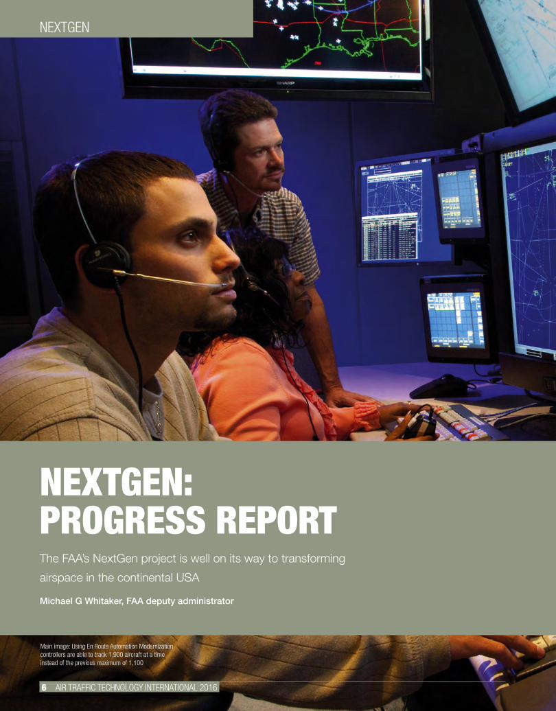
NEXTGEN: PROGRESS REPORTThe FAA’s NextGen project is well on its way to transforming
airspace in the continental USA
Michael G Whitaker, FAA deputy administrator
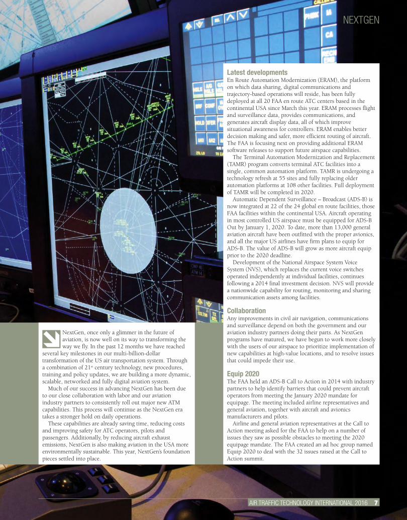
Main image: Using En Route Automation Modernization controllers are able to track 1,900 aircraft at a time instead of the previous maximum of 1,100
AIR TRAFFIC TECHNOLOGY INTERNATIONAL 2016 7.
NEXTGEN: PROGRESS REPORTThe FAA’s NextGen project is well on its way to transforming
airspace in the continental USA
Michael G Whitaker, FAA deputy administrator
NextGen, once only a glimmer in the future of aviation, is now well on its way to transforming the way we fly. In the past 12 months we have reached
several key milestones in our multi-billion-dollar transformation of the US air transportation system. Through a combination of 21st century technology, new procedures, training and policy updates, we are building a more dynamic, scalable, networked and fully digital aviation system.
Much of our success in advancing NextGen has been due to our close collaboration with labor and our aviation industry partners to consistently roll out major new ATM capabilities. This process will continue as the NextGen era takes a stronger hold on daily operations.
These capabilities are already saving time, reducing costs and improving safety for ATC operators, pilots and passengers. Additionally, by reducing aircraft exhaust emissions, NextGen is also making aviation in the USA more environmentally sustainable. This year, NextGen’s foundation pieces settled into place.
NEXTGEN
Latest developmentsEn Route Automation Modernization (ERAM), the platform on which data sharing, digital communications and trajectory-based operations will reside, has been fully deployed at all 20 FAA en route ATC centers based in the continental USA since March this year. ERAM processes flight and surveillance data, provides communications, and generates aircraft display data, all of which improve situational awareness for controllers. ERAM enables better decision making and safer, more efficient routing of aircraft. The FAA is focusing next on providing additional ERAM software releases to support future airspace capabilities.
The Terminal Automation Modernization and Replacement (TAMR) program converts terminal ATC facilities into a single, common automation platform. TAMR is undergoing a technology refresh at 55 sites and fully replacing older automation platforms at 108 other facilities. Full deployment of TAMR will be completed in 2020.
Automatic Dependent Surveillance – Broadcast (ADS-B) is now integrated at 22 of the 24 global en route facilities, those FAA facilities within the continental USA. Aircraft operating in most controlled US airspace must be equipped for ADS-B Out by January 1, 2020. To date, more than 13,000 general aviation aircraft have been outfitted with the proper avionics, and all the major US airlines have firm plans to equip for ADS-B. The value of ADS-B will grow as more aircraft equip prior to the 2020 deadline.
Development of the National Airspace System Voice System (NVS), which replaces the current voice switches operated independently at individual facilities, continues following a 2014 final investment decision. NVS will provide a nationwide capability for routing, monitoring and sharing communication assets among facilities.
CollaborationAny improvements in civil air navigation, communications and surveillance depend on both the government and our aviation industry partners doing their parts. As NextGen programs have matured, we have begun to work more closely with the users of our airspace to prioritize implementation of new capabilities at high-value locations, and to resolve issues that could impede their use.
Equip 2020The FAA held an ADS-B Call to Action in 2014 with industry partners to help identify barriers that could prevent aircraft operators from meeting the January 2020 mandate for equipage. The meeting included airline representatives and general aviation, together with aircraft and avionics manufacturers and pilots.
Airline and general aviation representatives at the Call to Action meeting asked for the FAA to help on a number of issues they saw as possible obstacles to meeting the 2020 equipage mandate. The FAA created an ad hoc group named Equip 2020 to deal with the 32 issues raised at the Call to Action summit.
NEXTGEN
All regions have well-established implementation plans in place and are progressing their individual programs
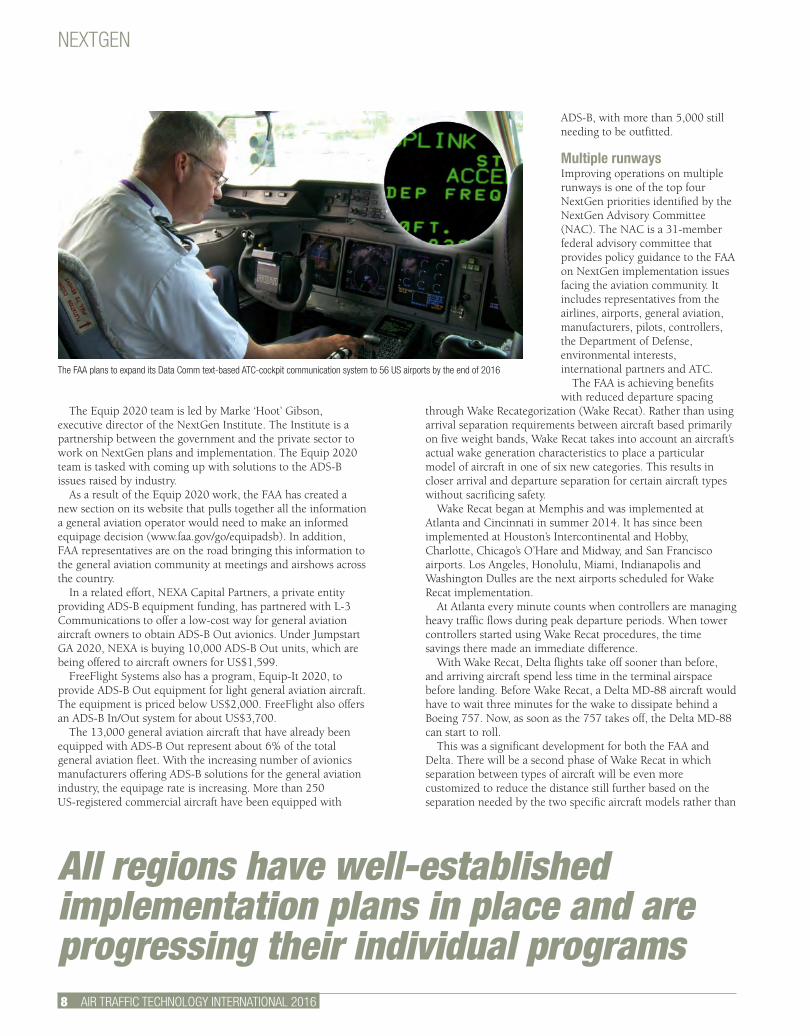
The FAA plans to expand its Data Comm text-based ATC-cockpit communication system to 56 US airports by the end of 2016
8 AIR TRAFFIC TECHNOLOGY INTERNATIONAL 2016
The Equip 2020 team is led by Marke ‘Hoot’ Gibson, executive director of the NextGen Institute. The Institute is a partnership between the government and the private sector to work on NextGen plans and implementation. The Equip 2020 team is tasked with coming up with solutions to the ADS-B issues raised by industry.
As a result of the Equip 2020 work, the FAA has created a new section on its website that pulls together all the information a general aviation operator would need to make an informed equipage decision (www.faa.gov/go/equipadsb). In addition, FAA representatives are on the road bringing this information to the general aviation community at meetings and airshows across the country.
In a related effort, NEXA Capital Partners, a private entity providing ADS-B equipment funding, has partnered with L-3 Communications to offer a low-cost way for general aviation aircraft owners to obtain ADS-B Out avionics. Under Jumpstart GA 2020, NEXA is buying 10,000 ADS-B Out units, which are being offered to aircraft owners for US$1,599.
FreeFlight Systems also has a program, Equip-It 2020, to provide ADS-B Out equipment for light general aviation aircraft. The equipment is priced below US$2,000. FreeFlight also offers an ADS-B In/Out system for about US$3,700.
The 13,000 general aviation aircraft that have already been equipped with ADS-B Out represent about 6% of the total general aviation fleet. With the increasing number of avionics manufacturers offering ADS-B solutions for the general aviation industry, the equipage rate is increasing. More than 250 US-registered commercial aircraft have been equipped with
ADS-B, with more than 5,000 still needing to be outfitted.
Multiple runways Improving operations on multiple runways is one of the top four NextGen priorities identified by the NextGen Advisory Committee (NAC). The NAC is a 31-member federal advisory committee that provides policy guidance to the FAA on NextGen implementation issues facing the aviation community. It includes representatives from the airlines, airports, general aviation, manufacturers, pilots, controllers, the Department of Defense, environmental interests, international partners and ATC.
The FAA is achieving benefits with reduced departure spacing
through Wake Recategorization (Wake Recat). Rather than using arrival separation requirements between aircraft based primarily on five weight bands, Wake Recat takes into account an aircraft’s actual wake generation characteristics to place a particular model of aircraft in one of six new categories. This results in closer arrival and departure separation for certain aircraft types without sacrificing safety.
Wake Recat began at Memphis and was implemented at Atlanta and Cincinnati in summer 2014. It has since been implemented at Houston’s Intercontinental and Hobby, Charlotte, Chicago’s O’Hare and Midway, and San Francisco airports. Los Angeles, Honolulu, Miami, Indianapolis and Washington Dulles are the next airports scheduled for Wake Recat implementation.
At Atlanta every minute counts when controllers are managing heavy traffic flows during peak departure periods. When tower controllers started using Wake Recat procedures, the time savings there made an immediate difference.
With Wake Recat, Delta flights take off sooner than before, and arriving aircraft spend less time in the terminal airspace before landing. Before Wake Recat, a Delta MD-88 aircraft would have to wait three minutes for the wake to dissipate behind a Boeing 757. Now, as soon as the 757 takes off, the Delta MD-88 can start to roll.
This was a significant development for both the FAA and Delta. There will be a second phase of Wake Recat in which separation between types of aircraft will be even more customized to reduce the distance still further based on the separation needed by the two specific aircraft models rather than
NEXTGEN
AIR TRAFFIC TECHNOLOGY INTERNATIONAL 2016 9.
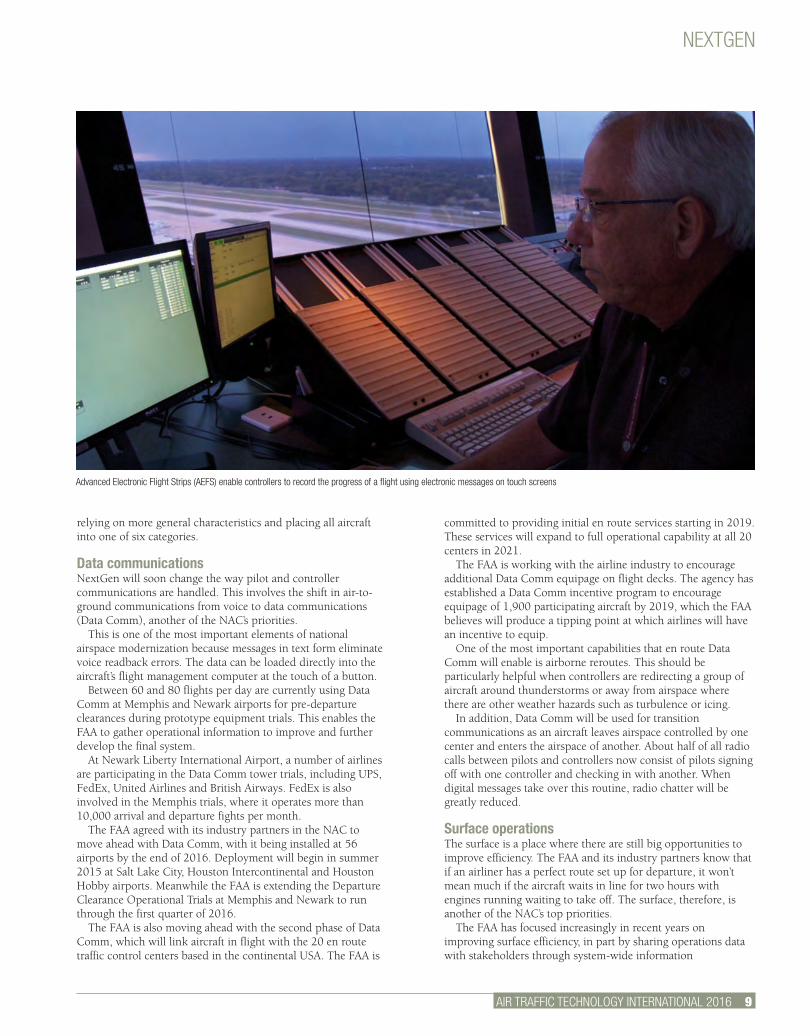
Advanced Electronic Flight Strips (AEFS) enable controllers to record the progress of a flight using electronic messages on touch screens
relying on more general characteristics and placing all aircraft into one of six categories.
Data communicationsNextGen will soon change the way pilot and controller communications are handled. This involves the shift in air-to-ground communications from voice to data communications (Data Comm), another of the NAC’s priorities.
This is one of the most important elements of national airspace modernization because messages in text form eliminate voice readback errors. The data can be loaded directly into the aircraft’s flight management computer at the touch of a button.
Between 60 and 80 flights per day are currently using Data Comm at Memphis and Newark airports for pre-departure clearances during prototype equipment trials. This enables the FAA to gather operational information to improve and further develop the final system.
At Newark Liberty International Airport, a number of airlines are participating in the Data Comm tower trials, including UPS, FedEx, United Airlines and British Airways. FedEx is also involved in the Memphis trials, where it operates more than 10,000 arrival and departure fights per month.
The FAA agreed with its industry partners in the NAC to move ahead with Data Comm, with it being installed at 56 airports by the end of 2016. Deployment will begin in summer 2015 at Salt Lake City, Houston Intercontinental and Houston Hobby airports. Meanwhile the FAA is extending the Departure Clearance Operational Trials at Memphis and Newark to run through the first quarter of 2016.
The FAA is also moving ahead with the second phase of Data Comm, which will link aircraft in flight with the 20 en route traffic control centers based in the continental USA. The FAA is
committed to providing initial en route services starting in 2019. These services will expand to full operational capability at all 20 centers in 2021.
The FAA is working with the airline industry to encourage additional Data Comm equipage on flight decks. The agency has established a Data Comm incentive program to encourage equipage of 1,900 participating aircraft by 2019, which the FAA believes will produce a tipping point at which airlines will have an incentive to equip.
One of the most important capabilities that en route Data Comm will enable is airborne reroutes. This should be particularly helpful when controllers are redirecting a group of aircraft around thunderstorms or away from airspace where there are other weather hazards such as turbulence or icing.
In addition, Data Comm will be used for transition communications as an aircraft leaves airspace controlled by one center and enters the airspace of another. About half of all radio calls between pilots and controllers now consist of pilots signing off with one controller and checking in with another. When digital messages take over this routine, radio chatter will be greatly reduced.
Surface operationsThe surface is a place where there are still big opportunities to improve efficiency. The FAA and its industry partners know that if an airliner has a perfect route set up for departure, it won’t mean much if the aircraft waits in line for two hours with engines running waiting to take off. The surface, therefore, is another of the NAC’s top priorities.
The FAA has focused increasingly in recent years on improving surface efficiency, in part by sharing operations data with stakeholders through system-wide information
NEXTGEN
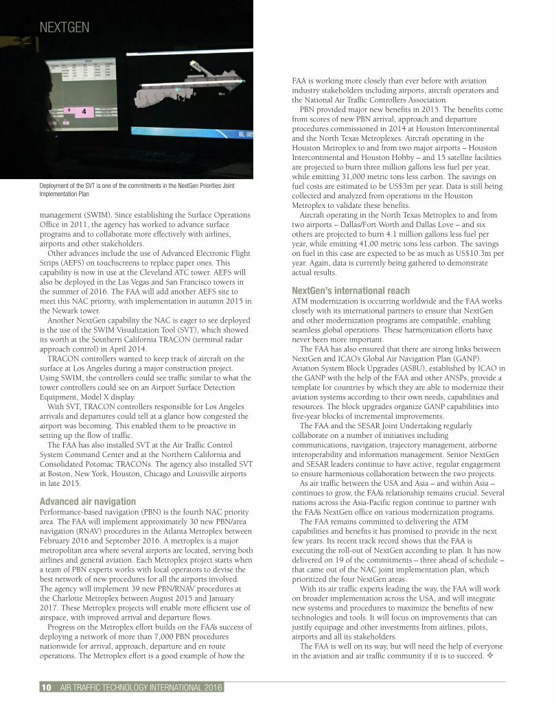
Deployment of the SVT is one of the commitments in the NextGen Priorities Joint Implementation Plan
10 AIR TRAFFIC TECHNOLOGY INTERNATIONAL 2016
management (SWIM). Since establishing the Surface Operations Office in 2011, the agency has worked to advance surface programs and to collaborate more effectively with airlines, airports and other stakeholders.
Other advances include the use of Advanced Electronic Flight Strips (AEFS) on touchscreens to replace paper ones. This capability is now in use at the Cleveland ATC tower. AEFS will also be deployed in the Las Vegas and San Francisco towers in the summer of 2016. The FAA will add another AEFS site to meet this NAC priority, with implementation in autumn 2015 in the Newark tower.
Another NextGen capability the NAC is eager to see deployed is the use of the SWIM Visualization Tool (SVT), which showed its worth at the Southern California TRACON (terminal radar approach control) in April 2014.
TRACON controllers wanted to keep track of aircraft on the surface at Los Angeles during a major construction project. Using SWIM, the controllers could see traffic similar to what the tower controllers could see on an Airport Surface Detection Equipment, Model X display.
With SVT, TRACON controllers responsible for Los Angeles arrivals and departures could tell at a glance how congested the airport was becoming. This enabled them to be proactive in setting up the flow of traffic.
The FAA has also installed SVT at the Air Traffic Control System Command Center and at the Northern California and Consolidated Potomac TRACONs. The agency also installed SVT at Boston, New York, Houston, Chicago and Louisville airports in late 2015.
Advanced air navigationPerformance-based navigation (PBN) is the fourth NAC priority area. The FAA will implement approximately 30 new PBN/area navigation (RNAV) procedures in the Atlanta Metroplex between February 2016 and September 2016. A metroplex is a major metropolitan area where several airports are located, serving both airlines and general aviation. Each Metroplex project starts when a team of PBN experts works with local operators to devise the best network of new procedures for all the airports involved. The agency will implement 39 new PBN/RNAV procedures at the Charlotte Metroplex between August 2015 and January 2017. These Metroplex projects will enable more efficient use of airspace, with improved arrival and departure flows.
Progress on the Metroplex effort builds on the FAA’s success of deploying a network of more than 7,000 PBN procedures nationwide for arrival, approach, departure and en route operations. The Metroplex effort is a good example of how the
FAA is working more closely than ever before with aviation industry stakeholders including airports, aircraft operators and the National Air Traffic Controllers Association.
PBN provided major new benefits in 2015. The benefits come from scores of new PBN arrival, approach and departure procedures commissioned in 2014 at Houston Intercontinental and the North Texas Metroplexes. Aircraft operating in the Houston Metroplex to and from two major airports – Houston Intercontinental and Houston Hobby – and 15 satellite facilities are projected to burn three million gallons less fuel per year, while emitting 31,000 metric tons less carbon. The savings on fuel costs are estimated to be US$3m per year. Data is still being collected and analyzed from operations in the Houston Metroplex to validate these benefits.
Aircraft operating in the North Texas Metroplex to and from two airports – Dallas/Fort Worth and Dallas Love – and six others are projected to burn 4.1 million gallons less fuel per year, while emitting 41,00 metric tons less carbon. The savings on fuel in this case are expected to be as much as US$10.3m per year. Again, data is currently being gathered to demonstrate actual results.
NextGen’s international reach ATM modernization is occurring worldwide and the FAA works closely with its international partners to ensure that NextGen and other modernization programs are compatible, enabling seamless global operations. These harmonization efforts have never been more important.
The FAA has also ensured that there are strong links between NextGen and ICAO’s Global Air Navigation Plan (GANP). Aviation System Block Upgrades (ASBU), established by ICAO in the GANP with the help of the FAA and other ANSPs, provide a template for countries by which they are able to modernize their aviation systems according to their own needs, capabilities and resources. The block upgrades organize GANP capabilities into five-year blocks of incremental improvements.
The FAA and the SESAR Joint Undertaking regularly collaborate on a number of initiatives including communications, navigation, trajectory management, airborne interoperability and information management. Senior NextGen and SESAR leaders continue to have active, regular engagement to ensure harmonious collaboration between the two projects.
As air traffic between the USA and Asia – and within Asia – continues to grow, the FAA’s relationship remains crucial. Several nations across the Asia-Pacific region continue to partner with the FAA’s NextGen office on various modernization programs.
The FAA remains committed to delivering the ATM capabilities and benefits it has promised to provide in the next few years. Its recent track record shows that the FAA is executing the roll-out of NextGen according to plan. It has now delivered on 19 of the commitments – three ahead of schedule – that came out of the NAC joint implementation plan, which prioritized the four NextGen areas.
With its air traffic experts leading the way, the FAA will work on broader implementation across the USA, and will integrate new systems and procedures to maximize the benefits of new technologies and tools. It will focus on improvements that can justify equipage and other investments from airlines, pilots, airports and all its stakeholders.
The FAA is well on its way, but will need the help of everyone in the aviation and air traffic community if it is to succeed. v
12 AIR TRAFFIC TECHNOLOGY INTERNATIONAL 2016
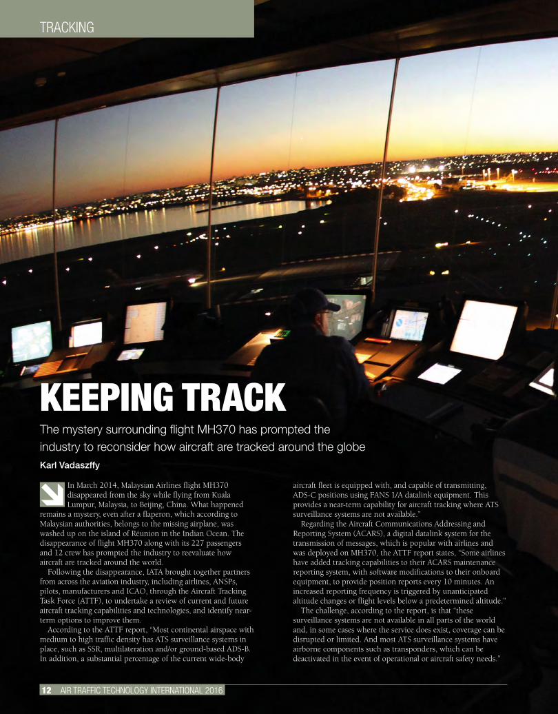
TRACKING
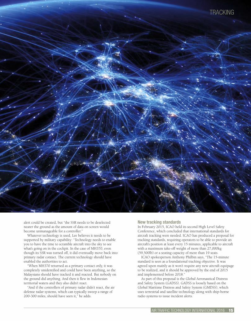
In March 2014, Malaysian Airlines flight MH370 disappeared from the sky while flying from Kuala Lumpur, Malaysia, to Beijing, China. What happened
remains a mystery, even after a flaperon, which according to Malaysian authorities, belongs to the missing airplane, was washed up on the island of Réunion in the Indian Ocean. The disappearance of flight MH370 along with its 227 passengers and 12 crew has prompted the industry to reevaluate how aircraft are tracked around the world.
Following the disappearance, IATA brought together partners from across the aviation industry, including airlines, ANSPs, pilots, manufacturers and ICAO, through the Aircraft Tracking Task Force (ATTF), to undertake a review of current and future aircraft tracking capabilities and technologies, and identify near-term options to improve them.
According to the ATTF report, “Most continental airspace with medium to high traffic density has ATS surveillance systems in place, such as SSR, multilateration and/or ground-based ADS-B. In addition, a substantial percentage of the current wide-body
aircraft fleet is equipped with, and capable of transmitting, ADS-C positions using FANS 1/A datalink equipment. This provides a near-term capability for aircraft tracking where ATS surveillance systems are not available.”
Regarding the Aircraft Communications Addressing and Reporting System (ACARS), a digital datalink system for the transmission of messages, which is popular with airlines and was deployed on MH370, the ATTF report states, “Some airlines have added tracking capabilities to their ACARS maintenance reporting system, with software modifications to their onboard equipment, to provide position reports every 10 minutes. An increased reporting frequency is triggered by unanticipated altitude changes or flight levels below a predetermined altitude.”
The challenge, according to the report, is that “these surveillance systems are not available in all parts of the world and, in some cases where the service does exist, coverage can be disrupted or limited. And most ATS surveillance systems have airborne components such as transponders, which can be deactivated in the event of operational or aircraft safety needs.”
KEEPING TRACKThe mystery surrounding flight MH370 has prompted the industry to reconsider how aircraft are tracked around the globeKarl Vadaszffy
AIR TRAFFIC TECHNOLOGY INTERNATIONAL 2016 13.
TRACKING
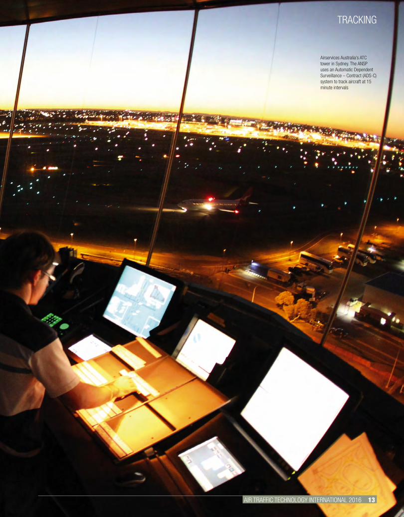
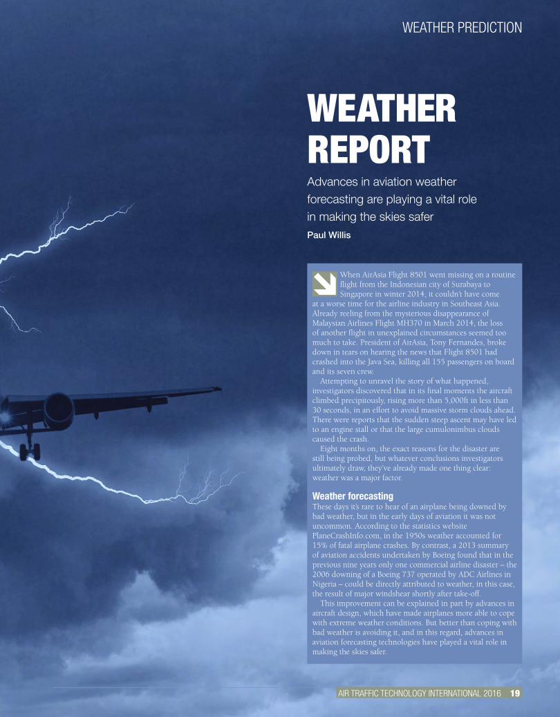
Airservices Australia’s ATC tower in Sydney. The ANSP uses an Automatic Dependent Surveillance – Contract (ADS-C) system to track aircraft at 15 minute intervals
TRACKING
14 AIR TRAFFIC TECHNOLOGY INTERNATIONAL 2016
Possible solutionsAtholl Buchan, IATA’s head of flight operations regulatory affairs, points out, “Airline operations are diverse; not all airlines use the same type of equipment and not all ANSPs enjoy the same capabilities. So there is no one-size-fits-all solution.”
During MH370’s flight, the aircraft’s transponder stopped transmitting. If this happened because of human intervention, why not devise a system that cannot be manipulated by crew? Buchan comments, “A so-called tamper-proof system isn’t an easy fix; it requires manufacturer support and certification processes, which take time. And it raises the issue of the crew’s ability to disable a malfunctioning system.”
Former military pilot, air traffic controller and military accident investigator Peter Lee served in the Royal Navy for 21 years. He is the author of the book MH370: By Accident or Design? He concurs, “The pilot needs to be able to control the aircraft in its entirety, so this would include tripping circuit breakers for safety reasons. The answer is to have a technology that’s independent of ACARS and the secondary surveillance radar (SSR), accessible only from outside the aircraft so that it can’t be tampered with.”
The solution, he suggests, might be the adoption of a device placed near the flight data recorder (FDR) to intercept signals, thereby monitoring the FDR input. Canadian company First Air has developed such a system, called AFIRS (Automated Flight Information Reporting System).
“This monitors and analyzes flight information as it’s being sent to the FDR and, if any unusual activity is reported by the sensors – for example, an unplanned turn, a rapid descent – that information is transmitted to ground stations,” says Lee. “The progress of the flight is monitored and essentially the information being recorded by the black box is available to the authorities on the ground in real time. If that ends up as a standard fit on aircraft, it’ll mean a situation like MH370 can never happen again.”
In addition, Lee argues that there are ways the SSR could be safeguarded: “It would be comparatively easy to legislate that a pilot cannot deselect the SSR if the aircraft is higher than 5,000ft, for instance.” If it were disabled above this height, an
SPACE-BASED TRACKING
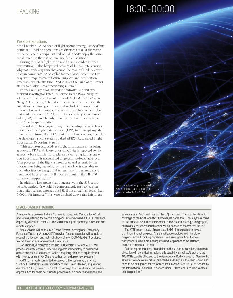
A joint venture between Iridium Communications, NAV Canada, ENAV, IAA and Naviair, utilizing the world’s first global satellite-based ADS-B surveillance capability, Aireon will offer ATC the visibility of flights operating in oceanic and remote airspace.
Also available will be the free Aireon Aircraft Locating and Emergency Response Tracking (Aireon ALERT) service. Rescue agencies will be able to request the location and last flight track of any 1090MHz ADS-B equipped aircraft flying in airspace without surveillance.
Don Thomas, Aireon president and CEO, explains, “Aireon ALERT will provide accurate and real-time tracking data immediately to authorized search and rescue operations, without requiring airlines to equip aircraft with new avionics, or ANSPs and authorities to deploy new systems.”
NATS has already committed to deploying the system as part of its £600m (US$940m) five-year investment plan. David Hawken, engineering director at NATS, comments, “Satellite coverage that’s worldwide will provide opportunities for some countries to provide a much better surveillance and
safety service. And it will give us [the UK], along with Canada, first-time full coverage of the North Atlantic.” However, he notes that such a system could still be affected by human intervention in the cockpit, stating, “Holographic, multistatic and conventional radars will be needed to resolve that issue.”
The ATTF report notes, “Space-based ADS-B is expected to have a significant impact on global ATS surveillance services and, therefore, on global aircraft tracking capability. It will use signals from Mode-S transponders, which are already installed, or planned to be installed, on most commercial aircraft.”
But the report cautions, “In addition to the launch of satellites, frequency allocation will be critical in making this capability a reality. At present, the 1090MHz band is allocated to the Aeronautical Radio Navigation Service. For satellites to receive aircraft-transmitted ADS-B signals, the band would also need to be designated for the Aeronautical Mobile Satellite Route Service by the International Telecommunications Union. Efforts are underway to obtain this designation.”
NATS currently uses ground-based ADS-B and has plans to implement space-based ADS-B in 2018
TRACKING
AIR TRAFFIC TECHNOLOGY INTERNATIONAL 2016 15.
alert could be created, but “the SSR needs to be deselected nearer the ground as the amount of data on screen would become unmanageable for a controller.”
Whatever technology is used, Lee believes it needs to be supported by military capability: “Technology needs to enable you to have the time to scramble aircraft into the sky to see what’s going on in the cockpit. In the case of MH370, even though its SSR was turned off, it did eventually move back into primary radar contact. The current technology should have enabled the authorities to act.
“When MH370 returned as a primary contact only, it was completely unidentified and could have been anything, so the Malaysians should have tracked it and reacted. But nobody on the ground did anything. And then it flew in Indonesian territorial waters and they also didn’t react.
“And if the controllers of primary radar didn’t react, the air defense radar systems, which can typically sweep a range of 200-300 miles, should have seen it,” he adds.
New tracking standardsIn February 2015, ICAO held its second High Level Safety Conference, which concluded that international standards for aircraft tracking were needed. ICAO has produced a proposal for tracking standards, requiring operators to be able to provide an aircraft’s position at least every 15 minutes, applicable to aircraft with a maximum take-off weight of more than 27,000kg (59,500lb) or a seating capacity of more than 19 seats.
ICAO spokesperson Anthony Philbin says, “The 15-minute standard is seen as a foundational tracking objective. It was agreed upon mainly as it won’t require any new aircraft equipage to be realized, and it should be approved by the end of 2015 and implemented before 2018.”
As part of this proposal is the Global Aeronautical Distress and Safety System (GADSS). GADSS is loosely based on the Global Maritime Distress and Safety System (GMDSS), which uses terrestrial and satellite technology along with ship-borne radio systems to issue incident alerts.
TRACKING
Airspace managed by Australia, Indonesia and Malaysia
16 AIR TRAFFIC TECHNOLOGY INTERNATIONAL 2016
The hope with GADSS, which is considered an appropriate foundation to support currently targeted and future aircraft tracking needs, is for airlines to continue to track their aircraft during normal operations (Aircraft Tracking-Normal). Abnormal events will trigger more frequent reporting, with the target being tracked every minute (Aircraft Tracking-Abnormal). If a situation worsens, Autonomous Distress Tracking will be triggered, using systems that are independent of the aircraft. The final step, in a worst-case scenario, is the automated deployment of a flight recorder that’s attached to the aircraft’s external surface.
Philbin explains, “The one-minute GADSS tracking requirement is expected to become applicable to new aircraft entering service from 2021.”
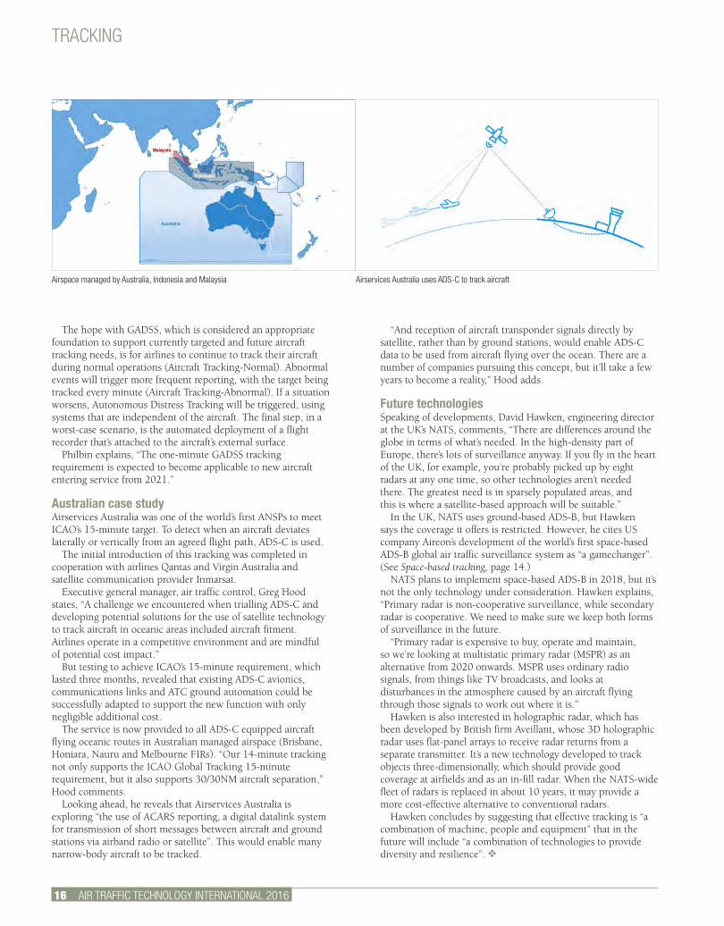
Australian case study Airservices Australia was one of the world’s first ANSPs to meet ICAO’s 15-minute target. To detect when an aircraft deviates laterally or vertically from an agreed flight path, ADS-C is used.
The initial introduction of this tracking was completed in cooperation with airlines Qantas and Virgin Australia and satellite communication provider Inmarsat.
Executive general manager, air traffic control, Greg Hood states, “A challenge we encountered when trialling ADS-C and developing potential solutions for the use of satellite technology to track aircraft in oceanic areas included aircraft fitment. Airlines operate in a competitive environment and are mindful of potential cost impact.”
But testing to achieve ICAO’s 15-minute requirement, which lasted three months, revealed that existing ADS-C avionics, communications links and ATC ground automation could be successfully adapted to support the new function with only negligible additional cost.
The service is now provided to all ADS-C equipped aircraft flying oceanic routes in Australian managed airspace (Brisbane, Honiara, Nauru and Melbourne FIRs). “Our 14-minute tracking not only supports the ICAO Global Tracking 15-minute requirement, but it also supports 30/30NM aircraft separation,” Hood comments.
Looking ahead, he reveals that Airservices Australia is exploring “the use of ACARS reporting, a digital datalink system for transmission of short messages between aircraft and ground stations via airband radio or satellite”. This would enable many narrow-body aircraft to be tracked.
“And reception of aircraft transponder signals directly by satellite, rather than by ground stations, would enable ADS-C data to be used from aircraft flying over the ocean. There are a number of companies pursuing this concept, but it’ll take a few years to become a reality,” Hood adds.
Future technologiesSpeaking of developments, David Hawken, engineering director at the UK’s NATS, comments, “There are differences around the globe in terms of what’s needed. In the high-density part of Europe, there’s lots of surveillance anyway. If you fly in the heart of the UK, for example, you’re probably picked up by eight radars at any one time, so other technologies aren’t needed there. The greatest need is in sparsely populated areas, and this is where a satellite-based approach will be suitable.”
In the UK, NATS uses ground-based ADS-B, but Hawken says the coverage it offers is restricted. However, he cites US company Aireon’s development of the world’s first space-based ADS-B global air traffic surveillance system as “a gamechanger”. (See Space-based tracking, page 14.)
NATS plans to implement space-based ADS-B in 2018, but it’s not the only technology under consideration. Hawken explains, “Primary radar is non-cooperative surveillance, while secondary radar is cooperative. We need to make sure we keep both forms of surveillance in the future.
“Primary radar is expensive to buy, operate and maintain, so we’re looking at multistatic primary radar (MSPR) as an alternative from 2020 onwards. MSPR uses ordinary radio signals, from things like TV broadcasts, and looks at disturbances in the atmosphere caused by an aircraft flying through those signals to work out where it is.”
Hawken is also interested in holographic radar, which has been developed by British firm Aveillant, whose 3D holographic radar uses flat-panel arrays to receive radar returns from a separate transmitter. It’s a new technology developed to track objects three-dimensionally, which should provide good coverage at airfields and as an in-fill radar. When the NATS-wide fleet of radars is replaced in about 10 years, it may provide a more cost-effective alternative to conventional radars.
Hawken concludes by suggesting that effective tracking is “a combination of machine, people and equipment” that in the future will include “a combination of technologies to provide diversity and resilience”. v
Airservices Australia uses ADS-C to track aircraft


18 AIR TRAFFIC TECHNOLOGY INTERNATIONAL 2016
WEATHER PREDICTION
AIR TRAFFIC TECHNOLOGY INTERNATIONAL 2016 19.
When AirAsia Flight 8501 went missing on a routine flight from the Indonesian city of Surabaya to Singapore in winter 2014, it couldn’t have come
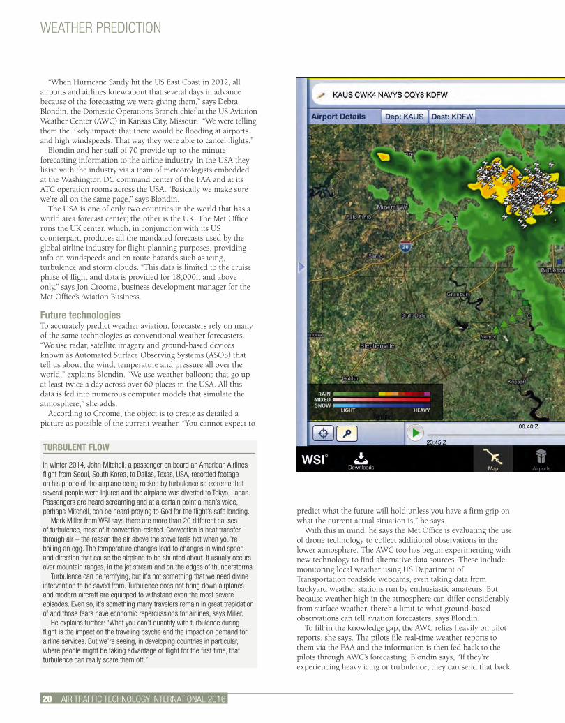
at a worse time for the airline industry in Southeast Asia. Already reeling from the mysterious disappearance of Malaysian Airlines Flight MH370 in March 2014, the loss of another flight in unexplained circumstances seemed too much to take. President of AirAsia, Tony Fernandes, broke down in tears on hearing the news that Flight 8501 had crashed into the Java Sea, killing all 155 passengers on board and its seven crew.
Attempting to unravel the story of what happened, investigators discovered that in its final moments the aircraft climbed precipitously, rising more than 5,000ft in less than 30 seconds, in an effort to avoid massive storm clouds ahead. There were reports that the sudden steep ascent may have led to an engine stall or that the large cumulonimbus clouds caused the crash.
Eight months on, the exact reasons for the disaster are still being probed, but whatever conclusions investigators ultimately draw, they’ve already made one thing clear: weather was a major factor.
Weather forecastingThese days it’s rare to hear of an airplane being downed by bad weather, but in the early days of aviation it was not uncommon. According to the statistics website PlaneCrashInfo.com, in the 1950s weather accounted for 15% of fatal airplane crashes. By contrast, a 2013 summary of aviation accidents undertaken by Boeing found that in the previous nine years only one commercial airline disaster – the 2006 downing of a Boeing 737 operated by ADC Airlines in Nigeria – could be directly attributed to weather, in this case, the result of major windshear shortly after take-off.
This improvement can be explained in part by advances in aircraft design, which have made airplanes more able to cope with extreme weather conditions. But better than coping with bad weather is avoiding it, and in this regard, advances in aviation forecasting technologies have played a vital role in making the skies safer.
WEATHER REPORTAdvances in aviation weather forecasting are playing a vital role in making the skies saferPaul Willis
WEATHER PREDICTION
WEATHER PREDICTION
20 AIR TRAFFIC TECHNOLOGY INTERNATIONAL 2016
“When Hurricane Sandy hit the US East Coast in 2012, all airports and airlines knew about that several days in advance because of the forecasting we were giving them,” says Debra Blondin, the Domestic Operations Branch chief at the US Aviation Weather Center (AWC) in Kansas City, Missouri. “We were telling them the likely impact: that there would be flooding at airports and high windspeeds. That way they were able to cancel flights.”
Blondin and her staff of 70 provide up-to-the-minute forecasting information to the airline industry. In the USA they liaise with the industry via a team of meteorologists embedded at the Washington DC command center of the FAA and at its ATC operation rooms across the USA. “Basically we make sure we’re all on the same page,” says Blondin.
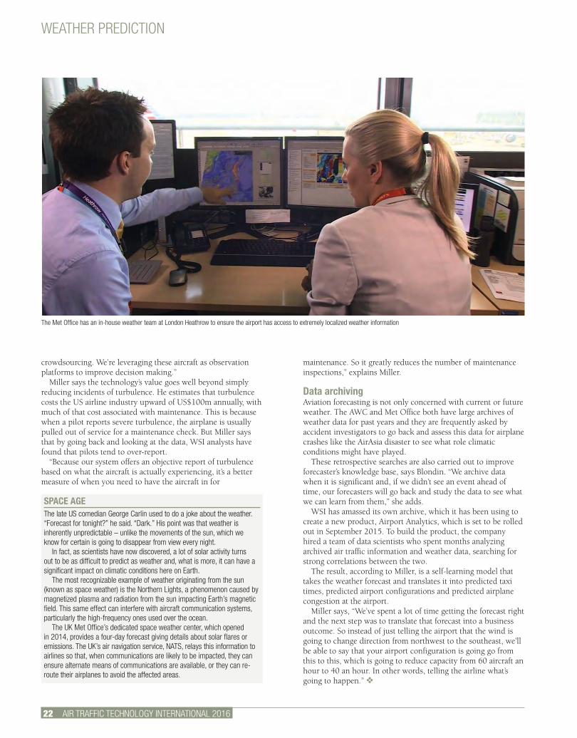
The USA is one of only two countries in the world that has a world area forecast center; the other is the UK. The Met Office runs the UK center, which, in conjunction with its US counterpart, produces all the mandated forecasts used by the global airline industry for flight planning purposes, providing info on windspeeds and en route hazards such as icing, turbulence and storm clouds. “This data is limited to the cruise phase of flight and data is provided for 18,000ft and above only,” says Jon Croome, business development manager for the Met Office’s Aviation Business.
Future technologiesTo accurately predict weather aviation, forecasters rely on many of the same technologies as conventional weather forecasters. “We use radar, satellite imagery and ground-based devices known as Automated Surface Observing Systems (ASOS) that tell us about the wind, temperature and pressure all over the world,” explains Blondin. “We use weather balloons that go up at least twice a day across over 60 places in the USA. All this data is fed into numerous computer models that simulate the atmosphere,” she adds.
According to Croome, the object is to create as detailed a picture as possible of the current weather. “You cannot expect to
TURBULENT FLOW
In winter 2014, John Mitchell, a passenger on board an American Airlines flight from Seoul, South Korea, to Dallas, Texas, USA, recorded footage on his phone of the airplane being rocked by turbulence so extreme that several people were injured and the airplane was diverted to Tokyo, Japan. Passengers are heard screaming and at a certain point a man’s voice, perhaps Mitchell, can be heard praying to God for the flight’s safe landing.
Mark Miller from WSI says there are more than 20 different causes of turbulence, most of it convection-related. Convection is heat transfer through air – the reason the air above the stove feels hot when you’re boiling an egg. The temperature changes lead to changes in wind speed and direction that cause the airplane to be shunted about. It usually occurs over mountain ranges, in the jet stream and on the edges of thunderstorms.
Turbulence can be terrifying, but it’s not something that we need divine intervention to be saved from. Turbulence does not bring down airplanes and modern aircraft are equipped to withstand even the most severe episodes. Even so, it’s something many travelers remain in great trepidation of and those fears have economic repercussions for airlines, says Miller.
He explains further: “What you can’t quantify with turbulence during flight is the impact on the traveling psyche and the impact on demand for airline services. But we’re seeing, in developing countries in particular, where people might be taking advantage of flight for the first time, that turbulence can really scare them off.”
predict what the future will hold unless you have a firm grip on what the current actual situation is,” he says.
With this in mind, he says the Met Office is evaluating the use of drone technology to collect additional observations in the lower atmosphere. The AWC too has begun experimenting with new technology to find alternative data sources. These include monitoring local weather using US Department of Transportation roadside webcams, even taking data from backyard weather stations run by enthusiastic amateurs. But because weather high in the atmosphere can differ considerably from surface weather, there’s a limit to what ground-based observations can tell aviation forecasters, says Blondin.
To fill in the knowledge gap, the AWC relies heavily on pilot reports, she says. The pilots file real-time weather reports to them via the FAA and the information is then fed back to the pilots through AWC’s forecasting. Blondin says, “If they’re experiencing heavy icing or turbulence, they can send that back
WEATHER PREDICTION
AIR TRAFFIC TECHNOLOGY INTERNATIONAL 2016 21.
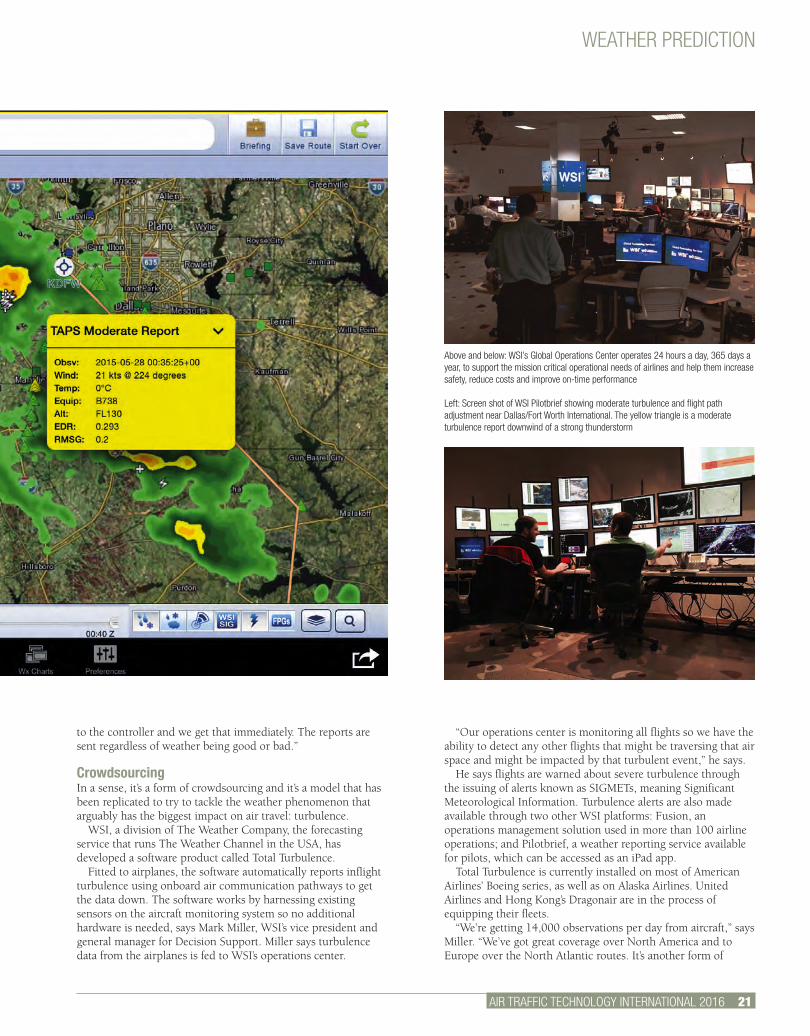
Above and below: WSI’s Global Operations Center operates 24 hours a day, 365 days a year, to support the mission critical operational needs of airlines and help them increase safety, reduce costs and improve on-time performance
Left: Screen shot of WSI Pilotbrief showing moderate turbulence and flight path adjustment near Dallas/Fort Worth International. The yellow triangle is a moderate turbulence report downwind of a strong thunderstorm
to the controller and we get that immediately. The reports are sent regardless of weather being good or bad.”
CrowdsourcingIn a sense, it’s a form of crowdsourcing and it’s a model that has been replicated to try to tackle the weather phenomenon that arguably has the biggest impact on air travel: turbulence.
WSI, a division of The Weather Company, the forecasting service that runs The Weather Channel in the USA, has developed a software product called Total Turbulence.
Fitted to airplanes, the software automatically reports inflight turbulence using onboard air communication pathways to get the data down. The software works by harnessing existing sensors on the aircraft monitoring system so no additional hardware is needed, says Mark Miller, WSI’s vice president and general manager for Decision Support. Miller says turbulence data from the airplanes is fed to WSI’s operations center.
“Our operations center is monitoring all flights so we have the ability to detect any other flights that might be traversing that air space and might be impacted by that turbulent event,” he says.
He says flights are warned about severe turbulence through the issuing of alerts known as SIGMETs, meaning Significant Meteorological Information. Turbulence alerts are also made available through two other WSI platforms: Fusion, an operations management solution used in more than 100 airline operations; and Pilotbrief, a weather reporting service available for pilots, which can be accessed as an iPad app.
Total Turbulence is currently installed on most of American Airlines’ Boeing series, as well as on Alaska Airlines. United Airlines and Hong Kong’s Dragonair are in the process of equipping their fleets.
“We’re getting 14,000 observations per day from aircraft,” says Miller. “We’ve got great coverage over North America and to Europe over the North Atlantic routes. It’s another form of
WEATHER PREDICTION
22 AIR TRAFFIC TECHNOLOGY INTERNATIONAL 2016
crowdsourcing. We’re leveraging these aircraft as observation platforms to improve decision making.”
Miller says the technology’s value goes well beyond simply reducing incidents of turbulence. He estimates that turbulence costs the US airline industry upward of US$100m annually, with much of that cost associated with maintenance. This is because when a pilot reports severe turbulence, the airplane is usually pulled out of service for a maintenance check. But Miller says that by going back and looking at the data, WSI analysts have found that pilots tend to over-report.
“Because our system offers an objective report of turbulence based on what the aircraft is actually experiencing, it’s a better measure of when you need to have the aircraft in for
maintenance. So it greatly reduces the number of maintenance inspections,” explains Miller.
Data archivingAviation forecasting is not only concerned with current or future weather. The AWC and Met Office both have large archives of weather data for past years and they are frequently asked by accident investigators to go back and assess this data for airplane crashes like the AirAsia disaster to see what role climatic conditions might have played.
These retrospective searches are also carried out to improve forecaster’s knowledge base, says Blondin. “We archive data when it is significant and, if we didn’t see an event ahead of time, our forecasters will go back and study the data to see what we can learn from them,” she adds.
WSI has amassed its own archive, which it has been using to create a new product, Airport Analytics, which is set to be rolled out in September 2015. To build the product, the company hired a team of data scientists who spent months analyzing archived air traffic information and weather data, searching for strong correlations between the two.
The result, according to Miller, is a self-learning model that takes the weather forecast and translates it into predicted taxi times, predicted airport configurations and predicted airplane congestion at the airport.
Miller says, “We’ve spent a lot of time getting the forecast right and the next step was to translate that forecast into a business outcome. So instead of just telling the airport that the wind is going to change direction from northwest to the southeast, we’ll be able to say that your airport configuration is going go from this to this, which is going to reduce capacity from 60 aircraft an hour to 40 an hour. In other words, telling the airline what’s going to happen.” v
SPACE AGEThe late US comedian George Carlin used to do a joke about the weather. “Forecast for tonight?” he said. “Dark.” His point was that weather is inherently unpredictable – unlike the movements of the sun, which we know for certain is going to disappear from view every night.
In fact, as scientists have now discovered, a lot of solar activity turns out to be as difficult to predict as weather and, what is more, it can have a significant impact on climatic conditions here on Earth.
The most recognizable example of weather originating from the sun (known as space weather) is the Northern Lights, a phenomenon caused by magnetized plasma and radiation from the sun impacting Earth’s magnetic field. This same effect can interfere with aircraft communication systems, particularly the high-frequency ones used over the ocean.
The UK Met Office’s dedicated space weather center, which opened in 2014, provides a four-day forecast giving details about solar flares or emissions. The UK’s air navigation service, NATS, relays this information to airlines so that, when communications are likely to be impacted, they can ensure alternate means of communications are available, or they can re-route their airplanes to avoid the affected areas.
The Met Office has an in-house weather team at London Heathrow to ensure the airport has access to extremely localized weather information

Further information: Please contact Simon Willard at: UKIP Media & Events Ltd, Abinger House, Church Street, Dorking, Surrey, RH4 1DF, UKTel: +44 1306 743744 • Email: [email protected]
THE WORLD’S LARGEST EXHIBITION OF TECHNOLOGIES FOR AVIATION METEOROLOGYAre you in charge of flight or ground ops? Are you responsible for airport meteorology, static equipment arrays and wind-shear detection? Do you oversee flight forecasting and routing? Perhaps you are in charge of service quality and training for aviation meteorology. Then you need to attend Meteorological Technology World Expo 2015, held in Brussels from 13th to 15th October 2015
Featuring more product launches, more service offerings and the most practical applied sciences conference of its kind anywhere in the World, this is an absolute must-attend event for aviation professionals.
OCTOBER 13, 14, 15, 2015BRUSSELS BELGIUM
REGISTER FOR YOUR FREE EXHIBITION BADGE ONLINE NOW!www.meteorologicaltechnologyworldexpo.com
165+
EXHIBITORS
EXPECTED

24 AIR TRAFFIC TECHNOLOGY INTERNATIONAL 2016
UNMANNED AIRCRAFT
“Near-collisions between drones, airliners surge, new FAA reports show.” This headline from the Washington Post highlights serious concerns about drones – unmanned aerial
vehicles (UAVs) – and safety in the USA. The aviation community will do everything it can to ensure high safety levels. But even a small drone might cripple a passenger jet’s engine. What is the picture in the UK? Are drones generating increasing numbers of near collisions with Commercial Air Transport (CAT) aircraft? Are drones the main problem, or just one of several kinds of intruder? What do the numbers look like? The following attempts to put drones into context.
For UK airspace safety, the ‘gold standard’ for information on incidents is through Airprox reports. An Airprox is formally defined as “a situation in which, in the opinion of a pilot or a controller, the distance between aircraft as well as their relative positions and speed have been such that the safety of the aircraft involved was or may have been compromised”. The UK Airprox Board (UKAB) deals with all Airproxes reported in UK airspace. Independent expert members carefully assess every incident in order to determine the causal factors, such as failure to obey ATC instructions, late sighting of
traffic, pilot not adhering to procedures, etc – and what lessons should be learnt. Safety performance in the UK is very high; the great majority of Airproxes in fact posed no risk at all. UKAB Reports list the details of every Airprox report. Although the definition above covers ‘normal’ aircraft, including microlights and gliders, pilots and controllers often report incidents with ‘objects’, balloons and model aircraft.
Unknown AirproxesTo put incidents into context, it is necessary to compare them with all the other relevant categories of ‘similar’ intruder. The need for similarity means that CAT and military intruders are not relevant. Their in-depth safety defences – ATC supervision, collision avoidance kit, etc – mean that their Airproxes have little in common with those involving drones. This leaves what can be termed an Extended General Aviation (EGA) set. This comprises normally understood elements of general aviation – private flights, training, and business flights – plus drones, balloons, objects, etc. (‘Intruder’ is used here as a shorthand for the EGA aircraft, object, etc, but in practice a few EGA Airproxes are caused by the CAT aircrew or by ATC.)
WITHOUT WARNING!Reports of close encounters between UAVs and commercial aircraft suggest there could be a threat to air traffic and its passengers. Are these incidents increasing over the UK and how serious are they really? Peter Brooker, aviation consultant

AIR TRAFFIC TECHNOLOGY INTERNATIONAL 2016 25.
UNMANNED AIRCRAFT

WHO SHOULD ATTEND?• Airport operational management and technical services• Airline flight ops and safety management• Runway condition management and monitoring• ATC management• Airfield control and airside operations• Regional and international flight standards and safety organisations• Aviation meteorologists and anyone involved in flight briefing and operation
WHAT WILL YOU SEE?• Lightning detection and warning systems • automatic weather observation systems • airport radar • radome structures • forecasting services • wind shear detection systems • micro-meteorological detection systems and devices • integrated ATC platforms • service providers including personnel and meteorologist training • air quality monitoring equipment • warning and alert systems • met-masts and more...
WHO WILL YOU SEE?Over 165 exhibitors including leading solutions providers and product innovators
Further information: Please contact Simon Willard at: UKIP Media & Events Ltd, Abinger House, Church Street, Dorking, Surrey, RH4 1DF, UKTel: +44 1306 743744 • Email: [email protected]
OCTOBER 13, 14, 15, 2015BRUSSELS BELGIUM
REGISTER FOR YOUR FREE EXHIBITION BADGE ONLINE NOW!www.meteorologicaltechnologyworldexpo.com
FREE TO ATTEND!
UNMANNED AIRCRAFT
AIR TRAFFIC TECHNOLOGY INTERNATIONAL 2016 27.
Figure 1: CAT (Commercial Air Transport) and EGA (Expanded General Aviation) UK Airproxes, Total and Unknown
Figure 3: Unknown UK CAT/EGA Airproxes broken down by intruder
Figure 2: Unknown CAT/EGA Airproxes as percentage of Total UK CAT/EGA Airproxes
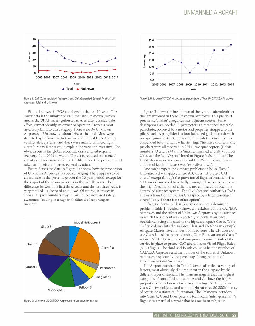
Figure 1 shows the EGA numbers for the last 10 years. The lower data is the number of EGA that are ‘Unknown’, which means the UKAB investigation team, even after considerable effort, cannot identify an owner or operator. Drones almost invariably fall into this category. There were 34 Unknown Airproxes – ‘Unknowns’, about 14% of the total. Most were detected by the aircrew. Just six were identified by ATC or by conflict alert systems, and these were mainly untraced light aircraft. Many factors could explain the variation over time. The obvious one is the global economic crisis and subsequent recovery, from 2007 onwards. The crisis reduced commercial activity and very much affected the likelihood that people would take part in leisure-focused general aviation.
Figure 2 uses the data in Figure 1 to show how the proportion of Unknown Airproxes has been changing. There appears to be an increase in the percentage over the 10-year period, except for the impact of the economic crisis in the middle years. The difference between the first three years and the last three years is very marked – a factor of about two. Of course, increases in annual Airprox numbers may in part reflect increased safety awareness, leading to a higher likelihood of reporting an incident.
Figure 3 shows the breakdown of the types of aircraft/object that are involved in these Unknown Airproxes. This pie chart puts some ‘similar’ categories into adjacent sectors. Some descriptions are needed. A paramotor is a motorized steerable parachute, powered by a motor and propeller strapped to the pilot’s back. A paraglider is a foot-launched glider aircraft with no rigid primary structure, wherein the pilot sits in a harness suspended below a hollow fabric wing. The three drones in the pie chart were all reported in 2014: two quadcopters (UKAB numbers 73 and 194) and a ‘small unmanned aircraft’ (number 233). Are the five ‘Objects’ listed in Figure 3 also drones? The UKAB discussions mention a possible UAV in just one case – and the object in this case was “two silver discs”.
One might expect the airspace problems to be in Class G – Uncontrolled – airspace, where ATC does not protect CAT aircraft except through the provision of flight information. The CAT aircraft involved have to fly through Class G airspace when the origin/destination of a flight is not connected through the controlled airspace system. The Civil Aviation Authority (CAA) allows a transition into Class G airspace by a large passenger aircraft “only if there is no other option”.
In fact, incidents in Class G airspace are not a dominant problem. Table 1 (overleaf) shows a breakdown of the CAT/EGA Airproxes and the subset of Unknown Airproxes by the airspace in which the incident was reported (incidents at airspace boundaries being allocated to the highest airspace Class). Table 1’s first column lists the airspace Class and sketches an example. Airspace Classes have not been omitted here. The UK does not use Class B, and has stopped using Class F – a variant of Class G – since 2014. The second column provides some details of the service in place to protect CAT aircraft from Visual Flight Rules (VFR) flights. The third and fourth columns list the number of CAT/EGA Airproxes and the number of the subset of Unknown Airproxes respectively, the percentage being the ratio of Unknown to total Airproxes.
The Airprox numbers in Table 1 (overleaf) reflect a variety of factors, most obviously the time spent in the airspace by the different types of aircraft. The main message is that the highest categories of controlled airspace – A and C – have the highest proportions of Unknown Airproxes. The high 60% figure for Class C – two ‘objects’ and a microlight (at circa 20,000ft) – may of course be a statistical fluctuation. The Unknown intruders into Class A, C and D airspace are technically ‘infringements’: “a flight into a notified airspace that has not been subject to
2005 2006 2007 2008 2009 2010 2011 2012 2013 20140
Year
Total Unknown
Num
ber
10
20
30
40
50
2005 2006 2007 2008 2009 2010 2011 2012 2013 20140.0
Year
Perc
enta
ge
0.5
10.0
15.0
20.0
25.0
30.0
Glider 5
Drone 3
Object 5
Microlight 5Balloon 3
Paraglider 2
Paramotor 1
Aircraft 8
Model Helicopter 2
UNMANNED AIRCRAFT
28 AIR TRAFFIC TECHNOLOGY INTERNATIONAL 2016.
approval by the designated controlling authority”. (VFR traffic cannot infringe Class E airspace because it does not require either an ATC clearance or a radio communication to enter or operate within it.)
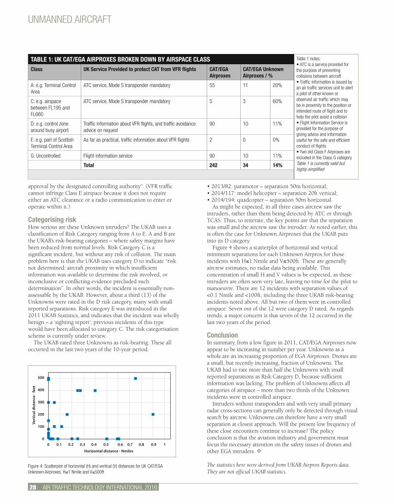
Categorising riskHow serious are these Unknown intruders? The UKAB uses a classification of Risk Category ranging from A to E. A and B are the UKAB’s risk-bearing categories – where safety margins have been reduced from normal levels. Risk Category C is a significant incident, but without any risk of collision. The main problem here is that the UKAB uses category D to indicate “risk not determined: aircraft proximity in which insufficient information was available to determine the risk involved, or inconclusive or conflicting evidence precluded such determination”. In other words, the incident is essentially non-assessable by the UKAB. However, about a third (13) of the Unknowns were rated in the D risk category, many with small reported separations. Risk category E was introduced in the 2011 UKAB Statistics, and indicates that the incident was wholly benign – a ‘sighting report’; previous incidents of this type would have been allocated to category C. The risk categorisation scheme is currently under review.
The UKAB rated three Unknowns as risk-bearing. These all occurred in the last two years of the 10-year period:
• 2013/82: paramotor – separation 50m horizontal;• 2014/117: model helicopter – separation 20ft vertical;• 2014/194: quadcopter – separation 50m horizontal.
As might be expected, in all three cases aircrew saw the intruders, rather than them being detected by ATC or through TCAS. Thus, to reiterate, the key points are that the separation was small and the aircrew saw the intruder. As noted earlier, this is often the case for Unknown Airproxes that the UKAB puts into its D category.
Figure 4 shows a scatterplot of horizontal and vertical minimum separations for each Unknown Airprox for those incidents with H≤1 Nmile and V≤500ft. These are generally aircrew estimates, no radar data being available. This concentration of small H and V values is be expected, as these intruders are often seen very late, leaving no time for the pilot to manoeuvre. There are 12 incidents with separation values of <0.1 Nmile and <100ft, including the three UKAB risk-bearing incidents noted above. All but two of them were in controlled airspace. Seven out of the 12 were category D rated. As regards trends, a major concern is that seven of the 12 occurred in the last two years of the period.
ConclusionIn summary, from a low figure in 2011, CAT/EGA Airproxes now appear to be increasing in number per year. Unknowns as a whole are an increasing proportion of EGA Airproxes. Drones are a small, but recently increasing, fraction of Unknowns. The UKAB had to rate more than half the Unknowns with small reported separations as Risk Category D, because sufficient information was lacking. The problem of Unknowns affects all categories of airspace – more than two thirds of the Unknown incidents were in controlled airspace.
Intruders without transponders and with very small primary radar cross-sections can generally only be detected through visual search by aircrew. Unknowns can therefore have a very small separation at closest approach. Will the present low frequency of these close encounters continue to increase? The policy conclusion is that the aviation industry and government must focus the necessary attention on the safety issues of drones and other EGA intruders. v
The statistics here were derived from UKAB Airprox Reports data. They are not official UKAB statistics.
TABLE 1: UK CAT/EGA AIRPROXES BROKEN DOWN BY AIRSPACE CLASSClass UK Service Provided to protect CAT from VFR flights CAT/EGA
AirproxesCAT/EGA Unknown Airproxes / %
A: e.g. Terminal Control Area
ATC service, Mode S transponder mandatory 55 11 20%
C: e.g. airspace between FL195 and FL660
ATC service, Mode S transponder mandatory 5 3 60%
D: e.g. control zone around busy airport
Traffic information about VFR flights, and traffic avoidance advice on request
90 10 11%
E: e.g. part of Scottish Terminal Control Area
As far as practical, traffic information about VFR flights 2 0 0%
G: Uncontrolled Flight information service 90 10 11%
Total 242 34 14%
Figure 4: Scatterplot of horizontal (H) and vertical (V) distances for UK CAT/EGA Unknown Airproxes. H≤1 Nmile and V≤500ft
0 0.1 0.2 0.3 0.4 0.5 0.6 0.7 0.8 0.9 1
Horizontal distance - Nmiles
Vert
ical
dis
tanc
e - f
eet
500
400
300
200
100
0
Table 1 notes:• ATC is a service provided for the purpose of preventing collisions between aircraft• Traffic information is issued by an air traffic services unit to alert a pilot of other known or observed air traffic which may be in proximity to the position or intended route of flight and to help the pilot avoid a collision• Flight Information Service is provided for the purpose of giving advice and information useful for the safe and efficient conduct of flights• Two old Class F Airproxes are included in the Class G categoryTable 1 is currently valid but highly simplified
LEARN MORE ABOUT OUR ADVERTISERS
NOW!Visit www.ukipme.com/info/att to request exclusive and rapid information about the latest technologies and services featured in this issue
FREE SERVICE!
ww
w.u
kipm
e.co
m/i
nfo/
att
INTERNATIONAL 2016
AIR TRAFFIC TECHNOLOGY INTERNATIONAL 2016
• U
KIP Media &
Events Ltd •
INTERNATIONAL 2016THE INTERNATIONAL REVIEW OF AIR TRAFFIC TECHNOLOGY AND MANAGEMENT
SESAR Massimo Garbini talks about SESAR Deployment Manager
NEXTGEN NextGen’s foundation pieces are beginning to settle into place
WEATHER Detailed and timely weather prediction is crucial to flight safety
HAS CHANGED GLOBAL AIRCRAFT TRACKING
HOW
AWOSAWOSAviation Weather Stations
NAV CANADA, Multiple Sites
Nigeria, Solar Powered
US Presidential Airfield, Andrews AFB
Jakarta International Airport, North and South Runways
Lublin, Poland, Europe’s Newest Airport
Saudi Air Force, Portables
Reliable Worldwide
• Certifi ed by ICAO, WMO, FAA, US Air Force, US Marines, US Navy, NWS, and Transport Canada
• Over 1000 installations worldwide• Automated METAR, SPECI, SYNOP, AFTN and
other interfaces• Heliports, offshore platforms, single/multiple
runway airports• User work stations via simple Internet browser
or web services
+1 206 682-6048www.CoastalEnvironmental.com/awos
Please visit Coastal’s stands at ATC Global and the
World ATM Congress

30 AIR TRAFFIC TECHNOLOGY INTERNATIONAL 2016
ATM COST EFFICIENCY
GOOD REGULATION?The European ATM Performance Scheme sets ambitious goals for cost efficiency, capacity, safety and the environmental aspects of ATM across 30 European countries. As Reference Period 2 begins, what were the cost-efficiency achievements of the first Reference Period and how will these influence the future cost of service provision?Jan-Björn Schömann, economist, Helios

AIR TRAFFIC TECHNOLOGY INTERNATIONAL 2016 31.
ATM COST EFFICIENCY
Under the Single European Sky (SES) legislation, a main priority of the European Commission (EC) has been to reduce inefficiencies in ATM provision in the 28
member states of the EU plus Norway and Switzerland. The Performance Scheme forms part of the SES framework and provides a common regulatory basis for ANS in Europe, covering cost efficiency, capacity, safety and environment, and is consistent with ICAO’s framework for performance-based ATM.1
Cost efficiency is a primary concern The EC has the long-term aim to reduce ANS unit charges to 50% of their 2004 level to support sustainability and reduce the cost of air transport across Europe. Analysis suggests that current inefficiencies in the system of European ANS provision are around 40%.2 The Performance Scheme is designed to improve cost efficiency by introducing an innovative price-setting mechanism for ANS charges and an incentive and risk-sharing structure. This encourages ANSPs to be more efficient, while being responsive to traffic demand.
The Performance Scheme changed the funding of European ANSPs from a traditional cost-recovery regime to a regulated cost base with traffic risk sharing. In a cost-recovery regime, the ANSP can recover all its costs from airline user charges, which means that if traffic rises or falls, the unit charge in future years is adjusted accordingly. However, under the Performance Scheme, the ANSP is required by the EC and its advisory body, the Performance Review Board (PRB), to reduce its unit costs and to absorb part of the risk from a decline of traffic. Under this scheme ANSPs can benefit from both cost savings and growth in traffic without losing revenue from having to lower charges. On the other hand, if ANSPs incur higher costs or encounter traffic decreases, they will have to absorb the resulting losses. Hence this new scheme creates an incentive for ANSPs to reduce their cost bases.
An iterative processIn practice, the setting of cost-efficiency targets is an iterative process (see Figure 1). The regulatory requirements are first issued by the EC in the form of EU-wide targets and then need to be adopted by national regulators in the Performance Plans (PPs), which contain binding targets at both Functional Airspace Block (FAB) and local level. Once more, the EC (through its advisory body, the PRB) needs to review and approve the PPs and assess the alignment with the union-wide targets. In this process the definition of the individual PPs becomes critical for the ANSPs since their PPs represent a commitment to a cost base and to a traffic forecast that drives both unit cost and unit rate.
Lessons from RP1Reference Period 1 (RP1) from 2012 to 2014 aimed to bring early benefits to the industry and teach lessons on the operation of the scheme before extending its scope for Reference Period 2 (RP2). A risk-sharing mechanism was put in place by defining a determined cost (DC) base up-front, together with an agreed traffic scenario. The DC refers to the cost base that the EC and ANSP agree will be recovered through ANS charges and is subject to cost-efficiency targets. The traffic scenario is usually based on STATFOR (Eurocontrol) data and needs to be agreed by the EC and the ANSP as it sets the basis for calculating determined unit costs (DUC), which are also subject to set targets. It was agreed that within a band of ±2% the ANSPs

Full issue archive online here:www.airtraffictechnologyinternational.com
AIR TRAFFIC TECHNOLOGY INTERNATIONAL 2012
• U
KIP Media &
Events Ltd •
INTERNATIONAL 2012
INTERNATIONAL 2012
THE INTERNATIONAL REVIEW OF AIR TRAFFIC TECHNOLOGY AND MANAGEMENT
FIRST FRUITS SESAR delivers concrete achievements
WHAT’S THE RISK?
Safe transition to a trajectory-based air traffic system
BLOCK UPGRADES
ICAO’s plans for NextGen and SESAR harmonisation and global ATM
WEATHER FORECAST
Major changes in aviation weather requirements predicted
SHOWCASE
2012
AIR TRAFFIC TECHNOLOGY INTERNATIONAL 2014
• U
KIP Media &
Events Ltd •
INTERNATIONAL 2014
INTERNATIONAL 2014
THE INTERNATIONAL REVIEW OF AIR TRAFFIC TECHNOLOGY AND MANAGEMENT
SHOWCASE
2014UAV FOCUS
Can unmanned aerial vehicles really
coexist alongside manned aircraft?
OCEANIC AIRSPACE
Technology to make intercontinental
flights more fuel efficient
INTEROPERABILITY
NextGen and SESAR join forces to improve
standards worldwide
INTERVIEW CANSO’s Jeff Poole talks sovereignty and
how it may be standing in the way of a
more harmonised airspace
AIR TRAFFIC TECHNOLOGY INTERNATIONAL 2015
• U
KIP Media &
Events Ltd •
INTERNATIONAL 2015
THE INTERNATIONAL REVIEW OF AIR TRAFFIC TECHNOLOGY AND MANAGEMENT
SHOWCASE
2015CONTROLLED FLIGHT
INTO TERRAINThe development of advance warning systems has
brought the elimination of CFIT accidents ever closer
REMOTE TOWERS
Delivering safe air traffic control
from remote locations
NEXTGEN The ATC modernization program is
reaching a crucial milestone
METEOROLOGY
Meteorological training should not
be overlooked in the ATC industry
AIR TRAFFIC TECHNOLOGY INTERNATIONAL 2016
• U
KIP Media &
Events Ltd •
INTERNATIONAL 2016
THE INTERNATIONAL REVIEW OF AIR TRAFFIC TECHNOLOGY AND MANAGEMENT
SESAR Massimo Garbini talks about
SESAR Deployment Manager
NEXTGEN NextGen’s foundation pieces are
beginning to settle into place
WEATHER Detailed and timely weather
prediction is crucial to flight safety
HAS CHANGED GLOBAL AIRCRAFT TRACKING
HOW
Veristore Record and Replay SystemsInstalled at international airports, aerodromes and heliports
Designed for ATM and VTSNew Voice Recorders announced Q3 2015
(Linux and Windows based)
TTW and ATG Radar Recorders
CCTV Recorders
44 (0) 1749 [email protected]
Support and Upgrades for all existing installations
ATM COST EFFICIENCY
AIR TRAFFIC TECHNOLOGY INTERNATIONAL 2016 33.
would bear traffic risks entirely, and from ±2% to ±10% ANSPs would share the risk with airspace users (Figure 2).
In 2013, against a scenario of declining traffic, the European ANS system collectively reduced its real cost base by 5.4% (compared with 2009) to match lower revenues and fulfill its agreed unit cost target. As expected, the main cost driver behind these changes was staff-related. However it could also be observed that some ANSPs chose to achieve short-term cost savings by deferring part of their planned capital expenditure and depreciation.
During RP1 the costs of terminal ANS services and terminal unit rates were not subject to binding targets and only subject to monitoring activities. Still, even under this ‘lighter’ approach based on transparency and monitoring, considerable reductions of 8.6% of the cost base were realized during 2013 (against PP),
mainly due to cost improvements in several bigger member states.
Cost base flawsWhile RP1 proved its overall effectiveness in achieving cost reductions, it revealed flaws in reliably determining the cost base across various European ANSPs. There were inconsistencies between accounting practices and national legislation among countries and ANSPs (particularly with regard to pension costs, tax-related costs and cost of capital). This led to ambiguities in defining the determined cost base. As a consequence the
PRB recommended to the EC that future RPs should push for more accurate and detailed information about the cost items provided by the ANSP.
Also, one problematic effect of setting cost-reduction targets was that some ANSPs chose to postpone investment, resulting in lower than planned depreciation when compared with the determined cost base. This led to a situation where revenues earmarked to cover depreciation were collected, even when assets had not yet been purchased. This means that there is a risk of double charging if projects are delayed into the next RP and depreciation is charged again to the users.
RP2 is more demanding2015 marks the first year of RP2, which extends until 2019. Lessons learned from RP1 were essential to defining the new
scheme. National regulators and ANSPs had to evaluate the range of possible cost options, assess the risks related to the adoption of traffic forecasts and clearly make the case that their PP contributes adequately to new and more ambitious targets. To add to the challenges, the assessment criteria in the new Performance Scheme have been substantially more demanding. Information on terminal unit cost trends, common projects, pension costs, restructuring costs, cost of capital, ‘uncontrollable costs’ and capital expenditure have been subject to more attention than in RP1.
Based on a scenario of moderate traffic growth, the PRB set an EU-wide cost-efficiency target to reduce DUC by 3.3% per annum. The unit cost reduction is expected to be achieved by reducing the real cost base, aided by a small increase in traffic that would lower the unit cost. For most ANSPs, achieving real-term reductions might be challenging and all cost categories need to be scrutinized to identify possible efficiency gains. Staff costs are likely to be examined in the first instance, in an effort to enhance productivity, since they typically represent over 50% of an ANSP’s costs. This creates a link to technology developments, such as those provided by the SESAR program, since they could also deliver increases in controller productivity.
Figure 1: Performance scheme target setting process
Policy objectivesDelivery of objectives
Nationalregulators (NSA)
NationalANSPs
EU policy
European Commission (EC)
Performance Review Body
(PRB)
Functional Airspace Block (FAB)
Sets union-wide performance targets
FAB Performance Plans need to align with union-wide targets
UNION-WIDE PERFORMANCE TARGETS UNDER THE PERFORMANCE SCHEMEScope area Reference Period 1 Reference Period 2
Cost efficiency • Cost reduction target for en-route air navigation services (ANS)
• Cost reduction target for en-route air navigation services (ANS)
• Union-wide cost reduction targets for terminal air navigation services (TANS) may be introduced over the Reference Period
Capacity • Target for average en-route air traffic flow management (ATFM) delay per flight
• Target for average en-route air traffic flow management (ATFM) delay per flight
Environment • Target for horizontal flight efficiency of last filed flight plan
• Target for horizontal flight efficiency of last filed flight plan
• Target for horizontal flight efficiency for actual trajectory
Safety • Target on safety culture
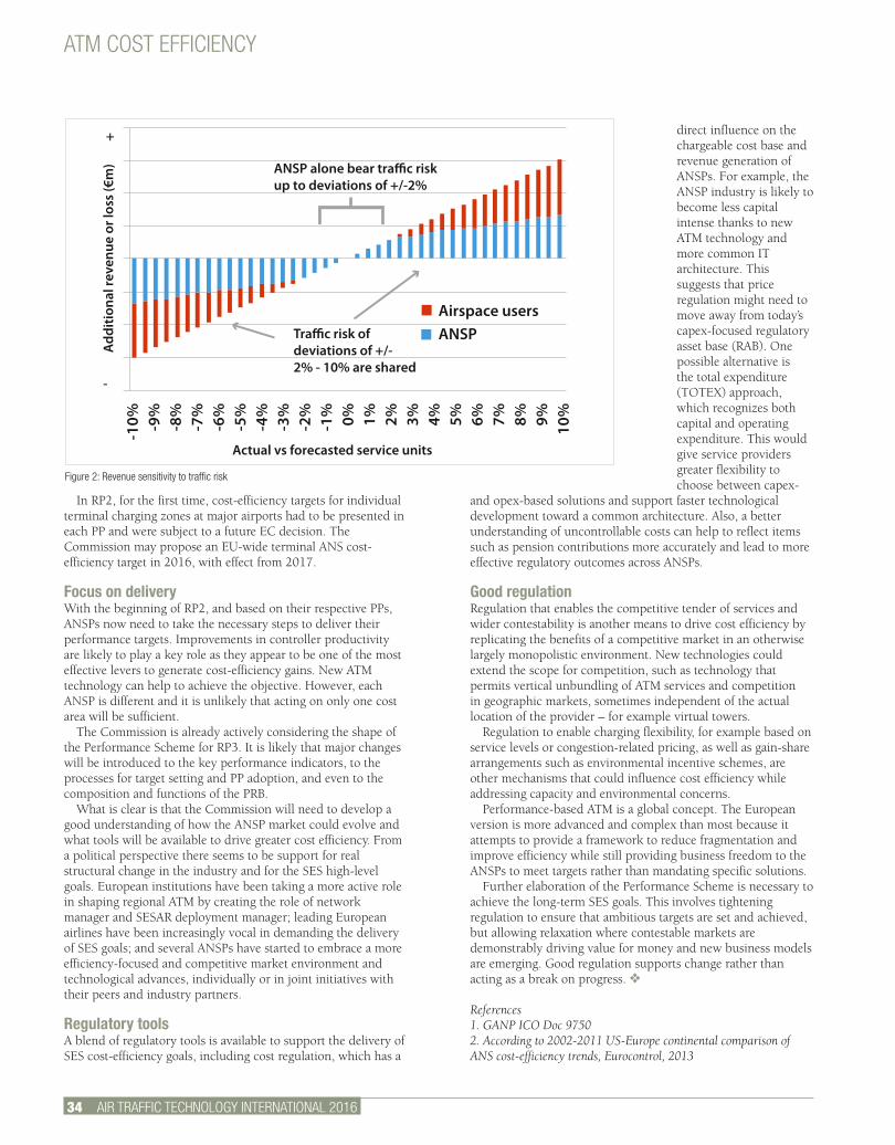
34 AIR TRAFFIC TECHNOLOGY INTERNATIONAL 2016
ATM COST EFFICIENCY
direct influence on the chargeable cost base and revenue generation of ANSPs. For example, the ANSP industry is likely to become less capital intense thanks to new ATM technology and more common IT architecture. This suggests that price regulation might need to move away from today’s capex-focused regulatory asset base (RAB). One possible alternative is the total expenditure (TOTEX) approach, which recognizes both capital and operating expenditure. This would give service providers greater flexibility to choose between capex-
and opex-based solutions and support faster technological development toward a common architecture. Also, a better understanding of uncontrollable costs can help to reflect items such as pension contributions more accurately and lead to more effective regulatory outcomes across ANSPs.
Good regulationRegulation that enables the competitive tender of services and wider contestability is another means to drive cost efficiency by replicating the benefits of a competitive market in an otherwise largely monopolistic environment. New technologies could extend the scope for competition, such as technology that permits vertical unbundling of ATM services and competition in geographic markets, sometimes independent of the actual location of the provider – for example virtual towers.
Regulation to enable charging flexibility, for example based on service levels or congestion-related pricing, as well as gain-share arrangements such as environmental incentive schemes, are other mechanisms that could influence cost efficiency while addressing capacity and environmental concerns.
Performance-based ATM is a global concept. The European version is more advanced and complex than most because it attempts to provide a framework to reduce fragmentation and improve efficiency while still providing business freedom to the ANSPs to meet targets rather than mandating specific solutions.
Further elaboration of the Performance Scheme is necessary to achieve the long-term SES goals. This involves tightening regulation to ensure that ambitious targets are set and achieved, but allowing relaxation where contestable markets are demonstrably driving value for money and new business models are emerging. Good regulation supports change rather than acting as a break on progress. v
References1. GANP ICO Doc 97502. According to 2002-2011 US-Europe continental comparison of ANS cost-efficiency trends, Eurocontrol, 2013
In RP2, for the first time, cost-efficiency targets for individual terminal charging zones at major airports had to be presented in each PP and were subject to a future EC decision. The Commission may propose an EU-wide terminal ANS cost-efficiency target in 2016, with effect from 2017.
Focus on delivery With the beginning of RP2, and based on their respective PPs, ANSPs now need to take the necessary steps to deliver their performance targets. Improvements in controller productivity are likely to play a key role as they appear to be one of the most effective levers to generate cost-efficiency gains. New ATM technology can help to achieve the objective. However, each ANSP is different and it is unlikely that acting on only one cost area will be sufficient.
The Commission is already actively considering the shape of the Performance Scheme for RP3. It is likely that major changes will be introduced to the key performance indicators, to the processes for target setting and PP adoption, and even to the composition and functions of the PRB.
What is clear is that the Commission will need to develop a good understanding of how the ANSP market could evolve and what tools will be available to drive greater cost efficiency. From a political perspective there seems to be support for real structural change in the industry and for the SES high-level goals. European institutions have been taking a more active role in shaping regional ATM by creating the role of network manager and SESAR deployment manager; leading European airlines have been increasingly vocal in demanding the delivery of SES goals; and several ANSPs have started to embrace a more efficiency-focused and competitive market environment and technological advances, individually or in joint initiatives with their peers and industry partners.
Regulatory toolsA blend of regulatory tools is available to support the delivery of SES cost-efficiency goals, including cost regulation, which has a
Actual vs forecasted service units
+
-}ANSP alone bear tra�c risk
up to deviations of +/-2%
Tra�c risk of deviations of +/-2% - 10% are shared
Airspace usersANSP
Add
ition
al re
venu
e or
loss
(€m
)
-10% -9
%-8
%-7
%-6
%-5
%-4
%-3
%-2
%-1
% 0% 1% 2% 3% 4% 5% 6% 7% 8% 9% 10%
Figure 2: Revenue sensitivity to traffic risk

DUBAI – LOCATION OF CHOICE
The Gulf region is a growing global air
transport hub. Now the busiest international
airport, Dubai serves every continent and directly links
more than 280 cities.
COMPREHENSIVE EXHIBITION
100+ organisations leading the
transformation of ATM. Get up to speed with
the latest trends and see exciting new
technologies fi rst-hand.
EDUCATIONAL PROGRAMMELed by 40+ industry
experts, the exceptional three-day programme inclusive of a high-level
conference and free-to-attend workshops will explore critical topics
around the what, why and how of ATM.
NETWORKING OPPORTUNITIES
Take advantage of a variety of networking activities – the VIP Gala Dinner, site visits to the Sheikh Zayed
Centre and Dubai Air Navigation Services Facilities
and exhibitor-led product launches – to network with
global counterparts.
DUBAI WORLD TRADE CENTRE, UAE5-7 OCTOBER 2015
25TH
ANNIVERSARY
EXHIBITION & CONFERENCELeaders and executives from air navigation service providers, aviation
regulators, air traffi c management suppliers, defence organisations, airports and airlines will unite in Dubai to build partnerships, share knowledge, meet
new customers and debate the most critical issues facing ATM today
REGISTER FOR YOUR PASS AT WWW.ATCGLOBALHUB.COM
Media partners:
Organised by:In partnership with: Platinum sponsor:Supported by: Gold sponsor:
2388_ ATC15_275x215+3mm.indd 1 28/07/2015 12:08
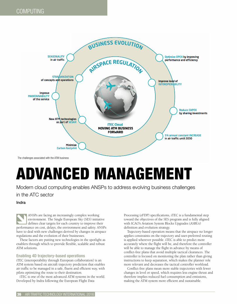
36 AIR TRAFFIC TECHNOLOGY INTERNATIONAL 2016
COMPUTING
ANSPs are facing an increasingly complex working environment. The Single European Sky (SES) initiative defines clear targets for each country to improve their
performance on cost, delays, the environment and safety. ANSPs have to deal with new challenges derived by changes in airspace regulations and the evolution of their businesses.
These factors are putting new technologies in the spotlight as enablers through which to provide flexible, scalable and robust ATM solutions.
Enabling 4D trajectory-based operationsiTEC (interoperability through European collaboration) is an ATM system based on aircraft trajectory prediction that enables air traffic to be managed in a safe, fluent and efficient way, with pilots optimizing the route to their destination.
iTEC is one of the most advanced ATM systems in the world. Developed by Indra following the European Flight Data
Processing (eFDP) specifications, iTEC is a fundamental step toward the objectives of the SES program and is fully aligned with ICAO’s Aviation System Blocks Upgrades (ASBUs) definition and evolution strategy.
Trajectory-based operation means that the airspace no longer applies constraints on the trajectory and user-preferred routing is applied wherever possible. iTEC is able to predict more accurately where the flight will be, and therefore the controller will be able to manage the flight in advance by means of conflict-free plans that avoid multiple tactical clearances. The controller is focused on monitoring the plan rather than giving instructions to keep separation, which makes the planner role more relevant and decreases the tactical controller workload.
Conflict-free plans mean more stable trajectories with fewer changes in level or speed, which requires less engine thrust and therefore implies reduced fuel consumption and emissions, making the ATM system more efficient and sustainable.
ADVANCED MANAGEMENTModern cloud computing enables ANSPs to address evolving business challenges in the ATC sectorIndra
The challenges associated with the ATM business
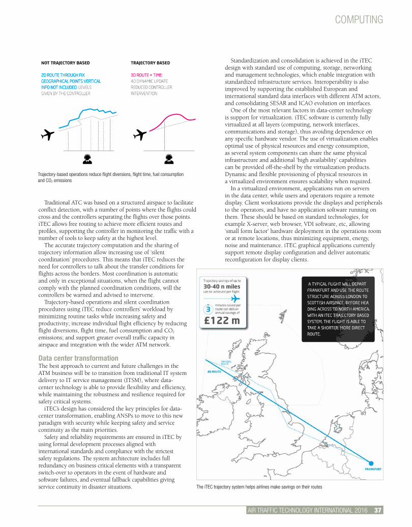
AIR TRAFFIC TECHNOLOGY INTERNATIONAL 2012 46.
COMPUTING
AIR TRAFFIC TECHNOLOGY INTERNATIONAL 2016 37.
Traditional ATC was based on a structured airspace to facilitate conflict detection, with a number of points where the flights could cross and the controllers separating the flights over those points. iTEC allows free routing to achieve more efficient routes and profiles, supporting the controller in monitoring the traffic with a number of tools to keep safety at the highest level.
The accurate trajectory computation and the sharing of trajectory information allow increasing use of ‘silent coordination’ procedures. This means that iTEC reduces the need for controllers to talk about the transfer conditions for flights across the borders. Most coordination is automatic and only in exceptional situations, when the flight cannot comply with the planned coordination conditions, will the controllers be warned and advised to intervene.
Trajectory-based operations and silent coordination procedures using iTEC reduce controllers’ workload by minimizing routine tasks while increasing safety and productivity; increase individual flight efficiency by reducing flight diversions, flight time, fuel consumption and CO2 emissions; and support greater overall traffic capacity in airspace and integration with the wider ATM network.
Data center transformationThe best approach to current and future challenges in the ATM business will be to transition from traditional IT system delivery to IT service management (ITSM), where data-center technology is able to provide flexibility and efficiency, while maintaining the robustness and resilience required for safety critical systems.
iTEC’s design has considered the key principles for data-center transformation, enabling ANSPs to move to this new paradigm with security while keeping safety and service continuity as the main priorities.
Safety and reliability requirements are ensured in iTEC by using formal development processes aligned with international standards and compliance with the strictest safety regulations. The system architecture includes full redundancy on business critical elements with a transparent switch-over to operators in the event of hardware and software failures, and eventual fallback capabilities giving service continuity in disaster situations.
Standardization and consolidation is achieved in the iTEC design with standard use of computing, storage, networking and management technologies, which enable integration with standardized infrastructure services. Interoperability is also improved by supporting the established European and international standard data interfaces with different ATM actors, and consolidating SESAR and ICAO evolution on interfaces.
One of the most relevant factors in data-center technology is support for virtualization. iTEC software is currently fully virtualized at all layers (computing, network interfaces, communications and storage), thus avoiding dependence on any specific hardware vendor. The use of virtualization enables optimal use of physical resources and energy consumption, as several system components can share the same physical infrastructure and additional ‘high availability’ capabilities can be provided off-the-shelf by the virtualization products. Dynamic and flexible provisioning of physical resources in a virtualized environment ensures scalability when required.
In a virtualized environment, applications run on servers in the data center, while users and operators require a remote display. Client workstations provide the displays and peripherals to the operators, and have no application software running on them. These should be based on standard technologies, for example X-server, web browser, VDI software, etc, allowing ‘small form factor’ hardware deployment in the operations room or at remote locations, thus minimizing equipment, energy, noise and maintenance. iTEC graphical applications currently support remote display configuration and deliver automatic reconfiguration for display clients.
Trajectory-based operations reduce flight diversions, flight time, fuel consumption and CO2 emissions
The iTEC trajectory system helps airlines make savings on their routes

COMPUTING
iTEC Collaboration: ENAIRE, NATS, DFS and LVNL with Indra as the technological partner at the CANSO World ATM Congress in Madrid in March 2015
38 AIR TRAFFIC TECHNOLOGY INTERNATIONAL 2016
Modern IT architectures rely on automation for routine and repetitive tasks. This approach greatly reduces effort and time required as well as human errors, optimizing operational and maintenance costs. Infrastructure services can be provided in a virtualized environment by using commercial automation tools. In addition, iTEC software provides tools to fully automate deployment and installation.
Security is also a key concept in the system architecture to ensure confidentiality, integrity and availability of data. iTEC applies a hardened configuration at several layers, for example hypervisor, operating system, network and application. This is supplemented by the support of a centralized and standardized authentication, authorization and accounting (AAA) system and log management.
Services from the cloudBased on Indra’s experience in ATM systems and IT technology, iTEC Cloud addresses the demand for software as a service (SaaS) for ATM. It is based on the iTEC software and includes all its functional and architectural features. iTEC Cloud relies on the following key architectural principles:• The software layer is completely independent of supporting hardware and facilities.• Operational and technical users work with thin clients (a network computer without a hard disk drive), which may be located in remote facilities as all processing is performed in centralized servers.
The flexibility, scalability and high availability features supported by iTEC Cloud enable different possibilities in providing ATM services to potential customers, based on the SaaS approach:
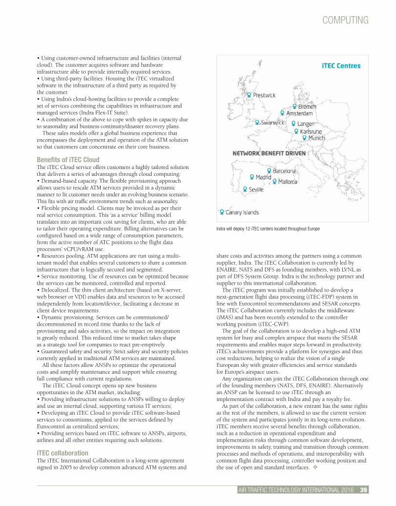
COMPUTING
AIR TRAFFIC TECHNOLOGY INTERNATIONAL 2016 39.
Indra will deploy 12 iTEC centers located throughout Europe
• Using customer-owned infrastructure and facilities (internal cloud). The customer acquires software and hardware infrastructure able to provide internally required services.• Using third-party facilities. Housing the iTEC virtualized software in the infrastructure of a third party as required by the customer.• Using Indra’s cloud-hosting facilities to provide a complete set of services combining the capabilities in infrastructure and managed services (Indra Flex-IT Suite).• A combination of the above to cope with spikes in capacity due to seasonality and business continuity/disaster recovery plans.
These sales models offer a global business experience that encompasses the deployment and operation of the ATM solution so that customers can concentrate on their core business.
Benefits of iTEC CloudThe iTEC Cloud service offers customers a highly tailored solution that delivers a series of advantages through cloud computing:• Demand-based capacity. The flexible provisioning approach allows users to rescale ATM services provided in a dynamic manner to fit customer needs under an evolving business scenario. This fits with air traffic environment trends such as seasonality.• Flexible pricing model. Clients may be invoiced as per their real service consumption. This ‘as a service’ billing model translates into an important cost saving for clients, who are able to tailor their operating expenditure. Billing alternatives can be configured based on a wide range of consumption parameters, from the active number of ATC positions to the flight data processors’ vCPU/vRAM use.• Resources pooling. ATM applications are run using a multi-tenant model that enables several customers to share a common infrastructure that is logically secured and segmented.• Service monitoring. Use of resources can be optimized because the services can be monitored, controlled and reported. • Delocalized. The thin client architecture (based on X-server, web browser or VDI) enables data and resources to be accessed independently from location/device, facilitating a decrease in client device requirements.• Dynamic provisioning. Services can be commissioned/decommissioned in record time thanks to the lack of provisioning and sales activities, so the impact on integration is greatly reduced. This reduced time to market takes shape as a strategic tool for companies to react pre-emptively.• Guaranteed safety and security. Strict safety and security policies currently applied in traditional ATM services are maintained.
All these factors allow ANSPs to optimize the operational costs and simplify maintenance and support while ensuring full compliance with current regulations.
The iTEC Cloud concept opens up new business opportunities in the ATM market, including:• Providing infrastructure solutions to ANSPs willing to deploy and use an internal cloud, supporting various IT services;• Developing an iTEC Cloud to provide iTEC software-based services to consortiums, applied to the services defined by Eurocontrol as centralized services;• Providing services based on iTEC software to ANSPs, airports, airlines and all other entities requiring such solutions.
iTEC collaborationThe iTEC International Collaboration is a long-term agreement signed in 2005 to develop common advanced ATM systems and
share costs and activities among the partners using a common supplier, Indra. The iTEC Collaboration is currently led by ENAIRE, NATS and DFS as founding members, with LVNL as part of DFS System Group. Indra is the technology partner and supplier to this international collaboration.
The iTEC program was initially established to develop a next-generation flight data processing (iTEC-FDP) system in line with Eurocontrol recommendations and SESAR concepts. The iTEC Collaboration currently includes the middleware (iMAS) and has been recently extended to the controller working position (iTEC-CWP).
The goal of the collaboration is to develop a high-end ATM system for busy and complex airspace that meets the SESAR requirements and enables major steps forward in productivity. iTEC’s achievements provide a platform for synergies and thus cost reductions, helping to realize the vision of a single European sky with greater efficiencies and service standards for Europe’s airspace users.
Any organization can join the iTEC Collaboration through one of the founding members (NATS, DFS, ENAIRE). Alternatively an ANSP can be licensed to use iTEC through an implementation contract with Indra and pay a royalty fee.
As part of the collaboration, a new entrant has the same rights as the rest of the members, is allowed to use the current version of the system and participates jointly in its long-term evolution.iTEC members receive several benefits through collaboration, such as a reduction in operational expenditure and implementation risks through common software development, improvements in safety, training and transition through common processes and methods of operations, and interoperability with common flight data processing, controller working position and the use of open and standard interfaces. v
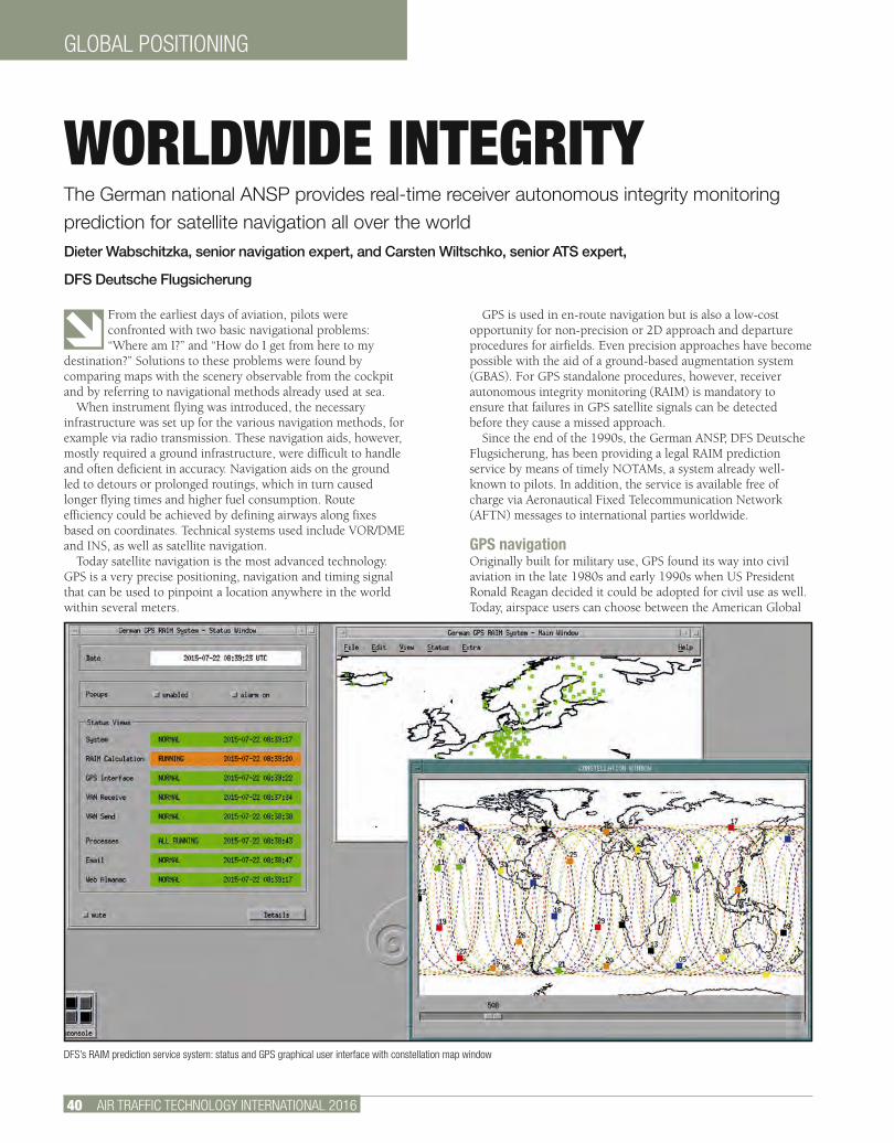
40 AIR TRAFFIC TECHNOLOGY INTERNATIONAL 2016
GLOBAL POSITIONING
From the earliest days of aviation, pilots were confronted with two basic navigational problems: “Where am I?” and “How do I get from here to my
destination?” Solutions to these problems were found by comparing maps with the scenery observable from the cockpit and by referring to navigational methods already used at sea.
When instrument flying was introduced, the necessary infrastructure was set up for the various navigation methods, for example via radio transmission. These navigation aids, however, mostly required a ground infrastructure, were difficult to handle and often deficient in accuracy. Navigation aids on the ground led to detours or prolonged routings, which in turn caused longer flying times and higher fuel consumption. Route efficiency could be achieved by defining airways along fixes based on coordinates. Technical systems used include VOR/DME and INS, as well as satellite navigation.
Today satellite navigation is the most advanced technology. GPS is a very precise positioning, navigation and timing signal that can be used to pinpoint a location anywhere in the world within several meters.
GPS is used in en-route navigation but is also a low-cost opportunity for non-precision or 2D approach and departure procedures for airfields. Even precision approaches have become possible with the aid of a ground-based augmentation system (GBAS). For GPS standalone procedures, however, receiver autonomous integrity monitoring (RAIM) is mandatory to ensure that failures in GPS satellite signals can be detected before they cause a missed approach.
Since the end of the 1990s, the German ANSP, DFS Deutsche Flugsicherung, has been providing a legal RAIM prediction service by means of timely NOTAMs, a system already well-known to pilots. In addition, the service is available free of charge via Aeronautical Fixed Telecommunication Network (AFTN) messages to international parties worldwide.
GPS navigationOriginally built for military use, GPS found its way into civil aviation in the late 1980s and early 1990s when US President Ronald Reagan decided it could be adopted for civil use as well.Today, airspace users can choose between the American Global
WORLDWIDE INTEGRITYThe German national ANSP provides real-time receiver autonomous integrity monitoring prediction for satellite navigation all over the worldDieter Wabschitzka, senior navigation expert, and Carsten Wiltschko, senior ATS expert,
DFS Deutsche Flugsicherung
DFS’s RAIM prediction service system: status and GPS graphical user interface with constellation map window
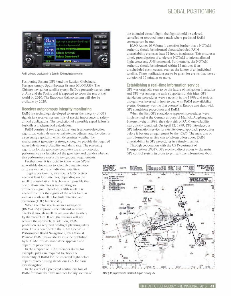
AIR TRAFFIC TECHNOLOGY INTERNATIONAL 2012 2.
the intended aircraft flight, the flight should be delayed, cancelled or rerouted onto a track where predicted RAIM coverage can be met.
ICAO Annex 10 Volume 1 describes further that a NOTAM authority should be informed about scheduled RAIM unavailability events at least 72 hours in advance. This ensures a timely promulgation of a relevant NOTAM to inform affected flight crews and ANS personnel. Furthermore, the NOTAM authority should be informed within 15 minutes if an unscheduled event occurs, such as the failure of an individual satellite. These notifications are to be given for events that have a duration of 15 minutes or more.
Establishing a real-time information serviceGPS was originally seen to be the future of navigation in aviation and DFS was among the early supporters of this idea. GPS standalone procedures were a novelty in the 1990s and serious thought was invested in how to deal with RAIM unavailability events. Germany was the first country in Europe that dealt with GPS standalone procedures and RAIM.
When the first GPS standalone approach procedures were implemented at the German airports of Munich, Augsburg and Braunschweig in 1998, the safety risk of RAIM unavailability was quickly identified. On April 22, 1999, DFS introduced a GPS information service for satellite-based approach procedures before it became a requirement by the ICAO. The main aim of this information service was to inform pilots about RAIM unavailability in GPS procedures in a timely manner.
Through cooperation with the US Department of Transportation (DOT), DFS received direct access to the main GPS control system in order to get real-time information about
Positioning System (GPS) and the Russian Globalnaya Navigatsionnaya Sputnikovaya Sistema (GLONASS). The Chinese navigation satellite system BeiDou presently serves parts of Asia and the Pacific and is expected to cover the rest of the world by 2020. The European Galileo system will also be available by 2020.
Receiver autonomous integrity monitoring RAIM is a technology developed to assess the integrity of GPS signals in a receiver system. It is of special importance in safety-critical applications. The prediction of a possible signal failure is basically a mathematical calculation.
RAIM consists of two algorithms: one is an error-detection algorithm, which detects actual satellite failures; and the other is a screening algorithm, which determines whether the measurement geometry is strong enough to provide the required missed detection probability and alarm rate. The screening algorithm for the geometry computes the error-detection performance as a function of the geometry and decides whether this performance meets the navigational requirements.
Furthermore, it is crucial to know when GPS is unavailable due either to scheduled maintenance or to system failure of individual satellites.
To get a position fix, an aircraft’s GPS receiver needs at least four satellites, depending on the satellite constellation. It is, however, possible that one of those satellites is transmitting an erroneous signal. Therefore, a fifth satellite is needed to check the signals of the other four, as well as a sixth satellite for fault detection and exclusion (FDE) functionality.
When the pilot selects an area navigation (RNAV-GPS) approach, the onboard receiver checks if enough satellites are available to safely fly the procedure. If not, the receiver will not activate the approach. In addition, RAIM prediction is a required pre-flight planning safety item. This is described in the ICAO Doc 9613 Performance Based Navigation (PBN) Manual. Possible RAIM unavailability must be published by NOTAM for GPS standalone approach and departure procedures.
In the airspace of ECAC member states, for example, pilots are required to check the availability of RAIM for the intended flight before departure when using standalone GPS for basic area navigation.
In the event of a predicted continuous loss of RAIM for more than five minutes for any section of
GLOBAL POSITIONING
AIR TRAFFIC TECHNOLOGY INTERNATIONAL 2016 41.
RNAV (GPS) approach to Frankfurt Airport runway 25L
RAIM onboard prediction in a Garmin 430 navigation system
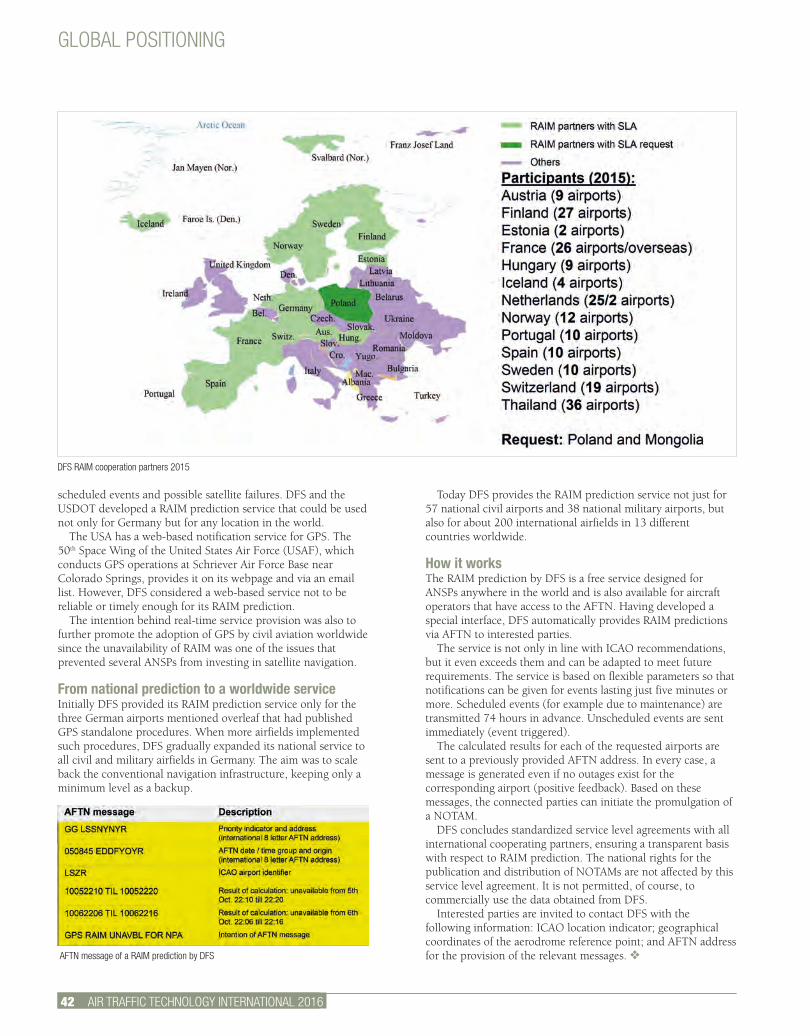
3 AIR TRAFFIC TECHNOLOGY INTERNATIONAL 2012.
GLOBAL POSITIONING
42 AIR TRAFFIC TECHNOLOGY INTERNATIONAL 2016
scheduled events and possible satellite failures. DFS and the USDOT developed a RAIM prediction service that could be used not only for Germany but for any location in the world.
The USA has a web-based notification service for GPS. The 50th Space Wing of the United States Air Force (USAF), which conducts GPS operations at Schriever Air Force Base near Colorado Springs, provides it on its webpage and via an email list. However, DFS considered a web-based service not to be reliable or timely enough for its RAIM prediction.
The intention behind real-time service provision was also to further promote the adoption of GPS by civil aviation worldwide since the unavailability of RAIM was one of the issues that prevented several ANSPs from investing in satellite navigation.
From national prediction to a worldwide serviceInitially DFS provided its RAIM prediction service only for the three German airports mentioned overleaf that had published GPS standalone procedures. When more airfields implemented such procedures, DFS gradually expanded its national service to all civil and military airfields in Germany. The aim was to scale back the conventional navigation infrastructure, keeping only a minimum level as a backup.
Today DFS provides the RAIM prediction service not just for 57 national civil airports and 38 national military airports, but also for about 200 international airfields in 13 different countries worldwide.
How it worksThe RAIM prediction by DFS is a free service designed for ANSPs anywhere in the world and is also available for aircraft operators that have access to the AFTN. Having developed a special interface, DFS automatically provides RAIM predictions via AFTN to interested parties.
The service is not only in line with ICAO recommendations, but it even exceeds them and can be adapted to meet future requirements. The service is based on flexible parameters so that notifications can be given for events lasting just five minutes or more. Scheduled events (for example due to maintenance) are transmitted 74 hours in advance. Unscheduled events are sent immediately (event triggered).
The calculated results for each of the requested airports are sent to a previously provided AFTN address. In every case, a message is generated even if no outages exist for the corresponding airport (positive feedback). Based on these messages, the connected parties can initiate the promulgation of a NOTAM.
DFS concludes standardized service level agreements with all international cooperating partners, ensuring a transparent basis with respect to RAIM prediction. The national rights for the publication and distribution of NOTAMs are not affected by this service level agreement. It is not permitted, of course, to commercially use the data obtained from DFS.
Interested parties are invited to contact DFS with the following information: ICAO location indicator; geographical coordinates of the aerodrome reference point; and AFTN address for the provision of the relevant messages. v
DFS RAIM cooperation partners 2015
AFTN message of a RAIM prediction by DFS
THE FIRST CHOICE FOR SAFE COMMUNICATIONS. SENNHEISER ATC HEADSETS
The International Air Traffic Control network form one of the most reliable, successful and safe organizations in the world. The people who are at the core of this system are highly trained professionals that are on duty in ATC Towers and Centers everyday. Sennheiser supports the safe performance of these professionals with state-of-the-art communications technology. Our new generation of ATC headsets are lighter and offer a more comfortable fit even after long hours of operation.
Our innovative ActiveGard TM circuit protects air traffic controllers ears from acoustic bursts. Our world renown audio performance provides Air Traffic Controllers with the best speech intelligibility and acoustic performance on the market today.
For more information on our full line of Air Traffic Control headsets visit us at: www.sennheiser-aviation.com
HME 43-3 HME 46-3
0112_AV_ATC.indd 1 1/17/12 3:13 PM
Worldwide Solutions. Consulting. Systems. Simulation. Training.
A trusted partner for decades – a proven operator for generations.
Contact us:DFS Deutsche Flugsicherung GmbHGerman air navigation servicesBusiness Unit Aeronautical SolutionsTelephone: +49 (0)6103 707-2051E-Mail: [email protected]: www.worldwide.dfs.eu
Motiv2_Consulting_183x115_Ssp_engl.indd 1 18.07.13 16:47
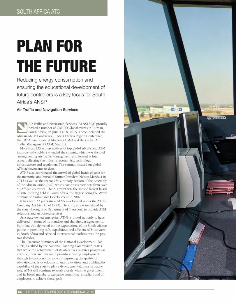
SOUTH AFRICA ATC
44 AIR TRAFFIC TECHNOLOGY INTERNATIONAL 2016
Air Traffic and Navigation Services (ATNS) SOC proudly hosted a number of CANSO Global events in Durban, South Africa, on June 13-16, 2015. These included the
African ANSP Conference, CANSO Africa Region Conference, the 19th Annual General Meeting (AGM) and the Global Air Traffic Management (ATM) Summit.
More than 225 representatives of top global ANSPs and ATM industry stakeholders attended the summit, which was themed ‘Strengthening Air Traffic Management’ and looked at four aspects affecting the industry: economics, technology, infrastructure and regulation. The summit focused on global ATM achievements to date.
ATNS also coordinated the arrival of global heads of state for the memorial and burial of former President Nelson Mandela in 2013 as well as the recent 25th Ordinary Session of the Assembly of the African Union (AU), which comprises members from over 50 African countries. The AU event was the second largest heads of state meeting held in South Africa, the largest being the World Summit on Sustainable Development in 2002.
It has been 22 years since ATNS was formed under the ATNS Company Act (Act 45 of 1993). The company is mandated by the state, through the Department of Transport, to provide ATM solutions and associated services.
As a state-owned enterprise, ATNS is proud not only to have delivered in terms of its mandate and shareholder agreements, but it has also delivered on the expectations of the South African public in providing safe, expeditious and efficient ATM services in South Africa and selected international markets over the past two decades.
The Executive Summary of the National Development Plan 2030, as tabled by the National Planning Commission, states that while the achievement of its objectives requires progress as a whole, there are four main priorities: raising employment through faster economic growth; improving the quality of education; skills development and innovation; and building the capability of the state to play a developmental, transformative role. ATNS will continue to work closely with the government and its board members, executive committee, suppliers and all employees to achieve these goals.
PLAN FOR THE FUTUREReducing energy consumption and ensuring the educational development of future controllers is a key focus for South Africa’s ANSP Air Traffic and Navigation Services
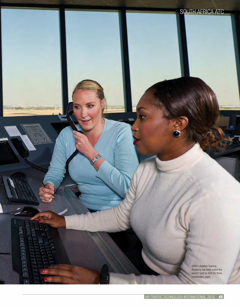
AIR TRAFFIC TECHNOLOGY INTERNATIONAL 2016 45.
SOUTH AFRICA ATC
ATNS’s Aviation Training Academy has been voted the world’s best by IATA for three consecutive years
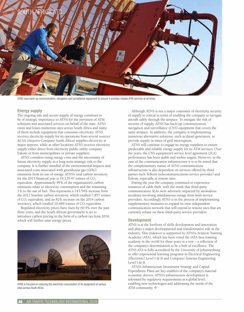
SOUTH AFRICA ATC
46 AIR TRAFFIC TECHNOLOGY INTERNATIONAL 2016
Energy supplyThe ongoing safe and secure supply of energy continues to be of strategic importance to ATNS for the provision of ATM solutions and associated services on behalf of the state. ATNS owns and leases numerous sites across South Africa and many of them include equipment that consumes electricity. ATNS receives electricity supply for its operations from several sources: ACSA (Airports Company South Africa) supplies electricity at major airports, while at other locations ATNS receives electricity supply either direct from electricity public utility company Eskom or from municipalities or private suppliers.
ATNS considers rising energy costs and the uncertainty of future electricity supply as a long-term strategic risk to the company. It is further mindful of the environmental impacts and associated costs associated with greenhouse gas (GHG) emissions from its use of energy. ATNS’s total carbon inventory for the 2015 financial year is 19,135.47 tonnes of CO2
equivalent. Approximately 99% of the organization’s carbon emissions relate to electricity consumption and the remaining 1% to the use of fuel. This represents a 143.54% increase from the 2012 baseline carbon inventory, which totalled 7,857 tonnes of CO2 equivalent, and an 82% increase on the 2014 carbon inventory, which totalled 10,469 tonnes of CO2 equivalent.
Regulated electricity prices have risen by 60.9% over the past three years, and the South African government is set to introduce carbon pricing in the form of a carbon tax from 2016, which will further raise energy prices.
Although ATNS is not a major consumer of electricity, security of supply is critical in terms of enabling the company to navigate aircraft safely through the airspace. To mitigate the risk of security of supply, ATNS has back-up communication, navigation and surveillance (CNS) equipment that covers the same airspace. In addition, the company is implementing numerous alternative solutions, such as diesel generators, to provide supply in times of grid interruption.
ATNS will continue to engage its energy suppliers to ensure predictable and reliable energy supply for its ATM services. Over the years, the CNS equipment’s service level agreement (SLA) performance has been stable and within targets. However, in the case of the communication infrastructure it is to be noted that the complementary nature of ATNS communication infrastructure is also dependent on services offered by third parties such Telkom (telecommunications service provider) and Eskom, especially at remote sites.
During the year the company continued to experience instances of cable theft, with the result that third-party communication SLAs were adversely impacted by anomalous incidents involving simultaneous outage from both service providers. Accordingly ATNS is in the process of implementing supplementary measures to expand its own independent communication network that will extend to remote sites that are currently reliant on these third-party service providers.
DevelopmentATNS is at the forefront of skills development and innovation and plays a major developmental and transformative role in the industry. This endeavor is supported by ATNS’s Aviation Training Academy (ATA), which has been voted the IATA best training academy in the world for three years in a row – a reflection of the company’s determination to be a hub of excellence. The ATNS ATA is fully accredited by the University of Johannesburg to offer experiential learning programs in Electrical Engineering (Electronic) Level I & II and Computer Systems Engineering Level I & II.
ATNS’s Infrastructure Investment Strategy and Capital Expenditure Plans are key enablers of the company’s material economic drivers. ATNS’s infrastructure development is informed by regulatory requirements at a global level, enabling new technologies and addressing the needs of the ATM community. v
ATNS uses back-up communication, navigation and surveillance equipment to ensure it provides reliable ATM services at all times
ATNS is focused on reducing the electricity consumption of its equipment at various sites across South Africa
LEARN MORE ABOUT OUR ADVERTISERS NOW!Visit www.ukipme.com/info/att to request exclusive and rapid information about the latest technologies and services featured in this issue
FREE SERVICE!
www.ukipme.com/info/att
INTERNATIONAL 2016
AIR TRAFFIC TECHNOLOGY INTERNATIONAL 2016
• U
KIP Media &
Events Ltd •
INTERNATIONAL 2016THE INTERNATIONAL REVIEW OF AIR TRAFFIC TECHNOLOGY AND MANAGEMENT
SESAR Massimo Garbini talks about SESAR Deployment Manager
NEXTGEN NextGen’s foundation pieces are beginning to settle into place
WEATHER Detailed and timely weather prediction is crucial to flight safety
HAS CHANGED GLOBAL AIRCRAFT TRACKING
HOW
ATC. Know-how. Expertise. Ideas. Innovation. Solutions. DFS.
Consulting Services from DFS: 20 years of experience in consulting. 60 years of history in air traffic control.
Contact us:DFS Deutsche Flugsicherung GmbHGerman air navigation servicesBusiness Unit Aeronautical SolutionsTelephone: +49 (0)6103 707-2051E-Mail: [email protected]: www.worldwide.dfs.eu
2486_Consulting Anzeige ATC.indd 1 17.07.13 10:21
ATNS IS AN ENTITY OF THE NATIONAL DEPARTMENT OF TRANSPORT
Here’s to another year of ensuring safer African skies.
Air Traffi c and Navigation Services SOC Limited (ATNS) continues to grow as a preferred provider of Air Traffi c Management solutions and associated services to the African continent and selected international markets.
Celebrating our 22nd birthday has allowed us to look back on our many achievements with a sense of pride as well as purpose. We are motivated to continually improve our safety performance and technological capabilities.
For a comprehensive list of our products and services visit www.atns.com or call ATNS head offi ce on +27 11 607 1000.
ATNS IS AN ENTITY OF THE NATIONAL DEPARTMENT OF TRANSPORT
Celebrating our 22nd birthday!y
DLC
416

ATNS IS AN ENTITY OF THE NATIONAL DEPARTMENT OF TRANSPORT
Here’s to another year of ensuring safer African skies.
Air Traffi c and Navigation Services SOC Limited (ATNS) continues to grow as a preferred provider of Air Traffi c Management solutions and associated services to the African continent and selected international markets.
Celebrating our 22nd birthday has allowed us to look back on our many achievements with a sense of pride as well as purpose. We are motivated to continually improve our safety performance and technological capabilities.
For a comprehensive list of our products and services visit www.atns.com or call ATNS head offi ce on +27 11 607 1000.
ATNS IS AN ENTITY OF THE NATIONAL DEPARTMENT OF TRANSPORT
Celebrating our 22nd birthday!y
DLC
416
50 AIR TRAFFIC TECHNOLOGY INTERNATIONAL 2016
SMART NETWORKS
Flexibly matching demand with supply is the biggest challenge in ATM. It is the core element to achieving the ambitious goals of the industry around the world.
In 2012 the European Commission set high industry expectations: enable a three-fold capacity increase combined with a factor of 10 safety increase, while cutting costs in half by 2020. NextGen, a similar initiative in the USA, asks for safety and efficiency benefits by focusing on performance-based navigation, surface operation, multiple runway operation and data communication.
System-wide information sharing and decoupling of operational and geographic entities by means of virtual centers and remote towers are key elements to achieving the necessary performance, safety and efficiency objectives. The underlying network infrastructure enables these concepts and applications. But they all have different performance, safety and security requirements that need to be considered in an ATM-grade network.
System Wide Information Management (SWIM) is the means for sharing information among all aviation stakeholders. Moving from a product-centric to an information-centric aviation system increases end-to-end efficiency. On the other hand, the information sharing has to be enabled by an underlying ground-ground connectivity infrastructure. Since SWIM deals with fundamental safety-critical information and is open to many stakeholders, a holistic security concept is required.
The virtual centers concept focuses on the decoupling of geographical flight areas and locations from which the operational service is provided. It breaks up the hardware-focused installations in centers and tower deployments by moving applications into a network-centric deployment – the ATM cloud. A radio is represented through a software-based frequency service hosted somewhere in the network infrastructure rather than the physical radio. Smart client-based controller working positions (CWPs) connect to the frequency services they need for their operation. The geographic location of all services and CWPs is flexible and driven by business rather than technical aspects. The underlying network needs to provide high availability at a reasonable price to achieve the expected cost-savings and efficiency gains.
Remote towers enable ANSPs to offer ATC service remotely. This remote operation requires access to information and resources. The virtual center concept enables the remote towers. In addition, a visual video stream from the remote airport is required at the center. Safety and security are especially important. Different network performance demands for voice, data and video streaming, and the need for clearly defined contingency scenarios, require a properly designed network. Only a smart end-to-end design will deliver cost savings.
Independent of the application, end-to-end communication relies heavily on performance of the wide area network (WAN). The WAN service providers invest a lot to maintain and keep the backbone infrastructure up-to-date. To protect this investment they hide the internal network architecture as much as possible. Furthermore, standardized service level agreements (SLAs) ensure a constant revenue stream. But these agreements are static and do not describe the actual network performance at any given time. ANSPs have little knowledge of how the WAN operates, but heavily depend on its performance.
In ATM, conventional networks do not deliver the necessary performance. Rather, we need an ATM-grade network infrastructure. We consider a network to be ATM-grade if it:
ATM-GRADE NETWORKSNetwork infrastructure is the enabler of future ATM concepts. Only an end-to-end network design that delivers ATM-grade safety and performance enables the industry to achieve expected performance gains and cost reductionsStefan Galler, product manager ATM network solutions, Frequentis AG

AIR TRAFFIC TECHNOLOGY INTERNATIONAL 2016 51.
SMART NETWORKS
• Uses real-time information of the actual network performance to reroute safety-critical communication flows before the link is completely down;• Enables deterministic behavior to ensure that safety-critical high-priority communication flows get the necessary end-to-end network performance in the event of limited resources; and• Provides information security of relevant data and business continuity for safety-critical communications.
Benefits of a smart design and routing mechanismA smart network solution saves operational costs while increasing safety. Operational costs can be reduced through a combination of diverse backbone networks. The network costs
depend on the defined SLA. Availability of the network link is a major cost driver. There are two options to achieve the necessary availability: ask one network provider to deliver the requested high availability, or combine two networks with lower availability. By smart end-to-end network design of the latter, the SLA for each network can be relaxed, therefore reducing costs.
Operational voice communication requires 99.9999% availability. Frequentis ATM Networks achieves this by combining two networks: one from provider A and one from provider B. The two networks offer an availability of, for example, 99.95% and 99.8%. The former has strong SLAs and is therefore more expensive, whereas the latter has weaker SLAs
Image: iStock
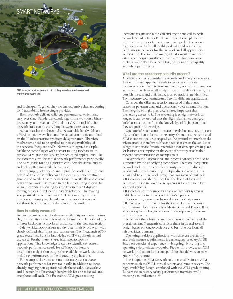
SMART NETWORKS
52 AIR TRAFFIC TECHNOLOGY INTERNATIONAL 2016
and is cheaper. Together they are less expensive than requesting six-9 availability from a single provider.
Each network delivers different performance, which may vary over time. Standard network algorithms work on a binary decision system, such as ‘OK’ and ‘not OK’. In real life, the network state can be everything between these extremes.
Actual weather conditions change available bandwidth on a VSAT or microwave link and the actual communication load on the IP infrastructure produces delay variation. Therefore mechanisms need to be applied to increase availability of the services. Frequentis ATM Networks integrates multiple backbone technologies with a smart routing mechanism to achieve ATM-grade availability for dedicated applications. The solution measures the actual network performance periodically. The ATM-grade routing algorithm considers the actual end-to-end delay, jitter and available bandwidth.
For example, networks A and B provide constant end-to-end delays of 45 and 40 milliseconds respectively between Rio de Janeiro and Recife. Due to heavier rain in Recife, the end-to-end delay on network B increased in the last measuring interval to 70 milliseconds. Following this the Frequentis ATM-grade routing decides to reduce the load on network B by moving safety-critical traffic to network A. This rerouting ensures business continuity for the safety-critical applications and stabilizes the end-to-end performance of network B.
How is safety ensured?Two important aspects of safety are availability and determinism. High availability can be achieved by the smart combination of two or more backbone networks as explained in the previous section.
Safety-critical applications require deterministic behavior with clearly defined algorithms and parameters. The Frequentis ATM-grade router has built-in knowledge of ATM applications and use-cases. Furthermore, it uses interfaces to specific applications. This knowledge is used to identify the current network performance needs for ATM applications. A deterministic algorithm assigns the available network resources, including performance, to the requesting applications.
For example, the voice communication system requests network performance for two radio calls in addition to three already ongoing non-operational telephone calls. Networks A and B currently offer enough bandwidth for one radio call and one phone call each. The Frequentis ATM-grade routing
therefore assigns one radio call and one phone call to both network A and network B. The non-operational phone call with the lowest priority receives a busy signal. This ensures high voice quality for all established calls and results in a deterministic behavior for the network and all applications. Without the deterministic router, all calls would have been established despite insufficient bandwidth. Random voice packets would then have been lost, decreasing voice quality and safety performance.
What are the necessary security means?A holistic approach considering security and safety is necessary. This end-to-end approach needs to consider corporate processes, system architecture and security appliances. Based on an in-depth analysis of all safety- or security-relevant assets, the possible threats and their impacts on operations are identified. The necessary countermeasures vary for different applications.
Consider the different security aspects of flight plans, customer payment data and operational voice communication. The integrity of flight plan data is more important than preventing access to it. The reasoning is straightforward: as long as it can be assured that the flight plan is not changed, little harm can come from the knowledge of flight plans since they are public knowledge.
Operational voice communication needs business resumption plans rather than information security. Operational voice in civil ATM is transmitted unencrypted on the ground-air interface; the information is therefore public as soon as it enters the air. But it is highly important for safe operations that concepts are in place for business resumption in the event of security attacks that prevent communication or manipulate it.
Nevertheless all operational and process concepts need to be supported by the underlying technology. Therefore Frequentis network architectures consider security zones with diverse vendor solutions. Combining multiple diverse vendors in a smart end-to-end network design has two main advantages: • It increases availability, since the likelihood of the same failure occurring in two diverse systems is lower than in two identical systems;• It increases security since an attack on vendor’s system is unlikely to work in the second vendor’s equipment.
For example, a smart end-to-end network design uses different vendor equipment for the two redundant network paths between locations such as Mexico City and Puebla. If an attacker exploits a bug in one vendor’s equipment, the second path is still secure.
To achieve these benefits and the increased resilience of the overall system, Frequentis considers them in its end-to-end design based on long experience and best practice from all safety-critical domains.
Operating multiple applications with different availability and performance requirements is challenging for every ANSP. Based on decades of experience in designing, delivering and operating safety-critical networks, Frequentis provides an ATM network product and solutions portfolio that delivers an ATM-grade infrastructure.
The Frequentis ATM Network solution enables future ATM concepts such as SWIM, virtual centers and remote towers. The high-availability design, combined with the ATM-grade routing, delivers the necessary safety performance increases while realizing cost reductions. v
ATM Network provides deterministic routing based on real-time network performance capabilities

Commitment is a BIG word at Frequentis. A commitment to air safety and those who manage it. A commitment to innovation
and cutting-edge solutions. A commitment to the responsibility that comes with a market-leading reputation earned
through decades of successful ATM projects. We bring you world-beating expertise, a strong user focus and the experience
gained from installing more than 25,000 operator positions in over 115 countries. As a result, our solutions meet your
performance and operational objectives while protecting your investments. That‘s why 80.000+ users rely on our systems.
EFFICIENCY FLEXIBILITY INNOVATION PARTNERSHIP HUMAN FACTORS SAFETY PERFORMANCE COMMITMENT
WWW.FREQUENTIS.COM
COMMUNICATION SYSTEMS & NETWORKS
TOWER & AIRPORT AUTOMATION SOLUTIONS
AERONAUTICAL INFORMATION MANAGEMENT
ENROUTEPRODUCTS &SERVICES
SOLUTIONSFOR MILITARY ATC
SYSTEMS INTEGRATION &TURNKEY DELIVERY
AIR TRAFFIC MANAGEMENT
EXPERIENCE OUR
COMMITMENT & LEADERSHIP
FRQ_Air Traffic Technology International 2015_215x275_3mm_RZ.indd 1 09.02.15 16:38
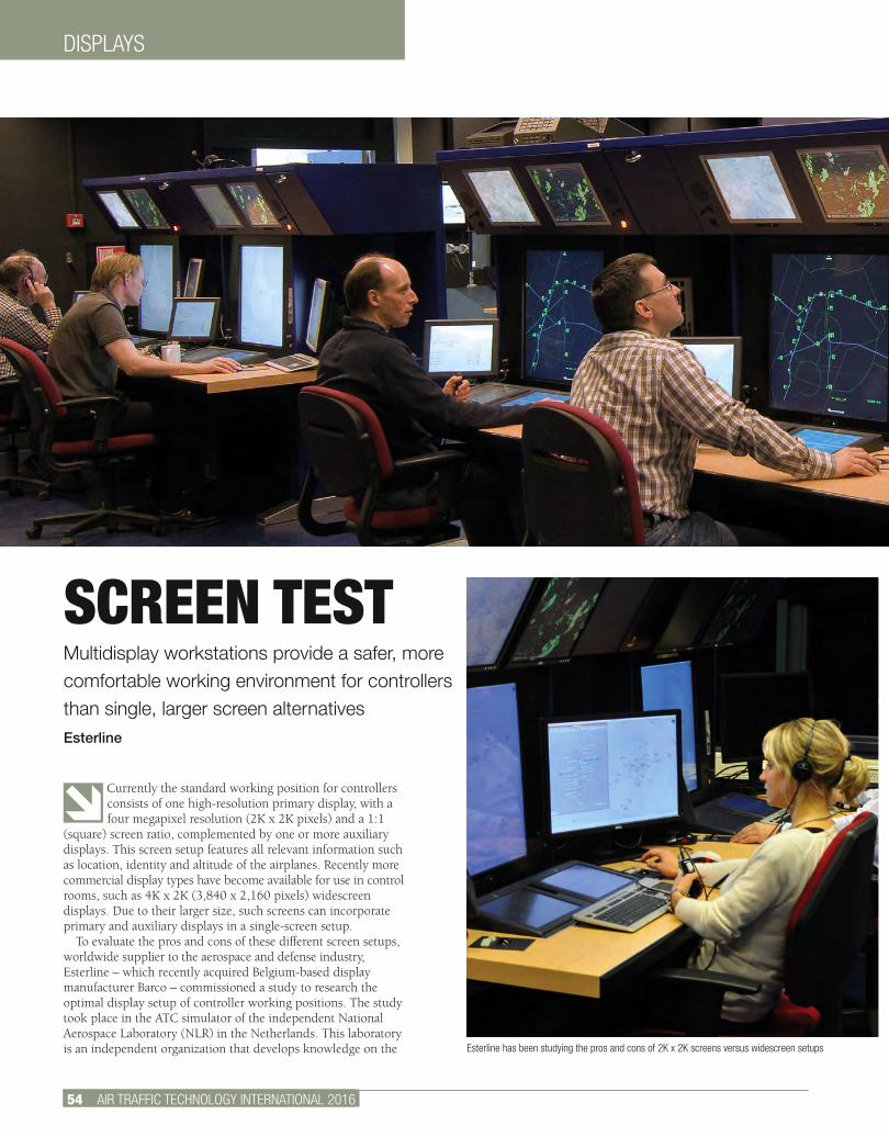
46 AIR TRAFFIC TECHNOLOGY INTERNATIONAL 2012
DISPLAYS
54 AIR TRAFFIC TECHNOLOGY INTERNATIONAL 2016
Currently the standard working position for controllers consists of one high-resolution primary display, with a four megapixel resolution (2K x 2K pixels) and a 1:1
(square) screen ratio, complemented by one or more auxiliary displays. This screen setup features all relevant information such as location, identity and altitude of the airplanes. Recently more commercial display types have become available for use in control rooms, such as 4K x 2K (3,840 x 2,160 pixels) widescreen displays. Due to their larger size, such screens can incorporate primary and auxiliary displays in a single-screen setup.
To evaluate the pros and cons of these different screen setups, worldwide supplier to the aerospace and defense industry, Esterline – which recently acquired Belgium-based display manufacturer Barco – commissioned a study to research the optimal display setup of controller working positions. The study took place in the ATC simulator of the independent National Aerospace Laboratory (NLR) in the Netherlands. This laboratory is an independent organization that develops knowledge on the
SCREEN TESTMultidisplay workstations provide a safer, more comfortable working environment for controllers than single, larger screen alternativesEsterline
Esterline has been studying the pros and cons of 2K x 2K screens versus widescreen setups
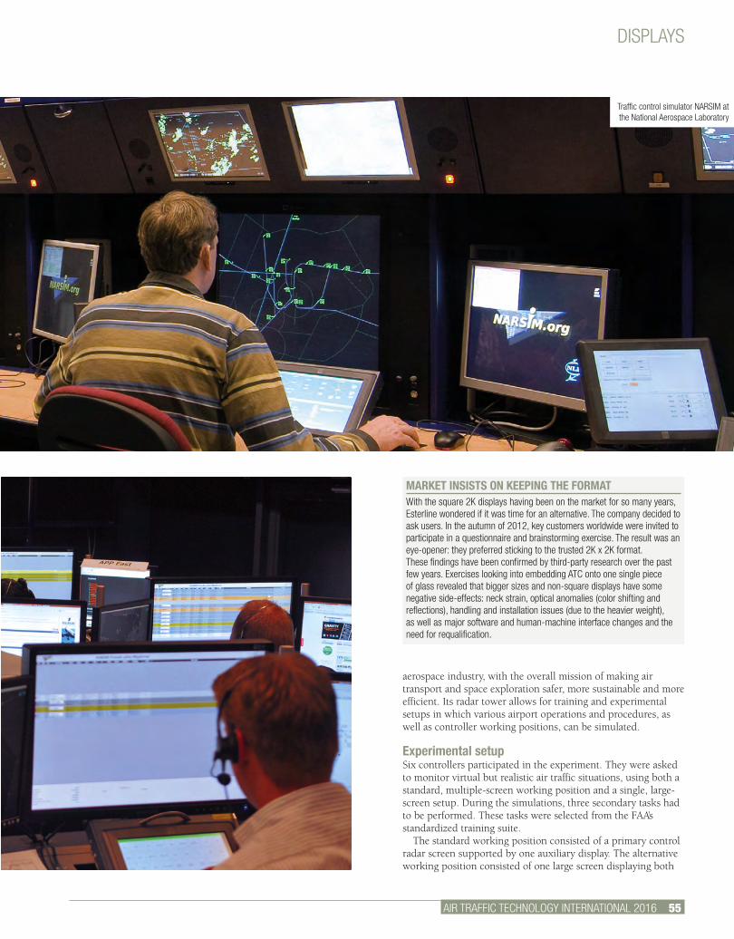
DISPLAYS
AIR TRAFFIC TECHNOLOGY INTERNATIONAL 2016 55.
aerospace industry, with the overall mission of making air transport and space exploration safer, more sustainable and more efficient. Its radar tower allows for training and experimental setups in which various airport operations and procedures, as well as controller working positions, can be simulated.
Experimental setupSix controllers participated in the experiment. They were asked to monitor virtual but realistic air traffic situations, using both a standard, multiple-screen working position and a single, large-screen setup. During the simulations, three secondary tasks had to be performed. These tasks were selected from the FAA’s standardized training suite.
The standard working position consisted of a primary control radar screen supported by one auxiliary display. The alternative working position consisted of one large screen displaying both
MARKET INSISTS ON KEEPING THE FORMATWith the square 2K displays having been on the market for so many years, Esterline wondered if it was time for an alternative. The company decided to ask users. In the autumn of 2012, key customers worldwide were invited to participate in a questionnaire and brainstorming exercise. The result was an eye-opener: they preferred sticking to the trusted 2K x 2K format.These findings have been confirmed by third-party research over the past few years. Exercises looking into embedding ATC onto one single piece of glass revealed that bigger sizes and non-square displays have some negative side-effects: neck strain, optical anomalies (color shifting and reflections), handling and installation issues (due to the heavier weight), as well as major software and human-machine interface changes and the need for requalification.
Esterline has been studying the pros and cons of 2K x 2K screens versus widescreen setups
Traffic control simulator NARSIM at the National Aerospace Laboratory
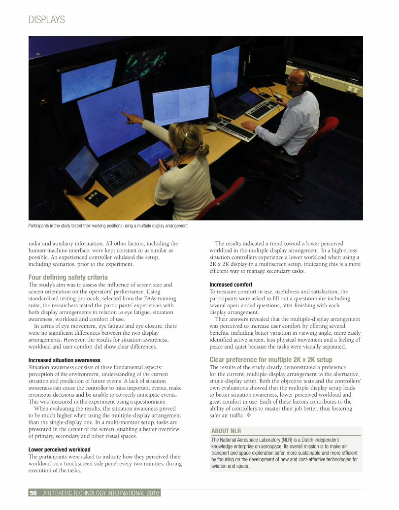
56 AIR TRAFFIC TECHNOLOGY INTERNATIONAL 2016.
The results indicated a trend toward a lower perceived workload in the multiple display arrangement. In a high-stress situation controllers experience a lower workload when using a 2K x 2K display in a multiscreen setup, indicating this is a more efficient way to manage secondary tasks.
Increased comfortTo measure comfort in use, usefulness and satisfaction, the participants were asked to fill out a questionnaire including several open-ended questions, after finishing with each display arrangement.
Their answers revealed that the multiple-display arrangement was perceived to increase user comfort by offering several benefits, including better variation in viewing angle, more easily identified active screen, less physical movement and a feeling of peace and quiet because the tasks were visually separated.
Clear preference for multiple 2K x 2K setupThe results of the study clearly demonstrated a preference for the current, multiple-display arrangement to the alternative, single-display setup. Both the objective tests and the controllers’ own evaluations showed that the multiple-display setup leads to better situation awareness, lower perceived workload and great comfort in use. Each of these factors contributes to the ability of controllers to master their job better, thus fostering safer air traffic. v
radar and auxiliary information. All other factors, including the human-machine interface, were kept constant or as similar as possible. An experienced controller validated the setup, including scenarios, prior to the experiment.
Four defining safety criteriaThe study’s aim was to assess the influence of screen size and screen orientation on the operators’ performance. Using standardized testing protocols, selected from the FAA’s training suite, the researchers tested the participants’ experiences with both display arrangements in relation to eye fatigue, situation awareness, workload and comfort of use.
In terms of eye movement, eye fatigue and eye closure, there were no significant differences between the two display arrangements. However, the results for situation awareness, workload and user comfort did show clear differences.
Increased situation awarenessSituation awareness consists of three fundamental aspects: perception of the environment, understanding of the current situation and prediction of future events. A lack of situation awareness can cause the controller to miss important events, make erroneous decisions and be unable to correctly anticipate events. This was measured in the experiment using a questionnaire.
When evaluating the results, the situation awareness proved to be much higher when using the multiple-display arrangement than the single-display one. In a multi-monitor setup, tasks are presented in the center of the screen, enabling a better overview of primary, secondary and other visual spaces.
Lower perceived workloadThe participants were asked to indicate how they perceived their workload on a touchscreen side panel every two minutes, during execution of the tasks.
DISPLAYS
ABOUT NLR The National Aerospace Laboratory (NLR) is a Dutch independent knowledge enterprise on aerospace. Its overall mission is to make air transport and space exploration safer, more sustainable and more efficient by focusing on the development of new and cost-effective technologies for aviation and space.
Participants in the study tested their working positions using a multiple display arrangement
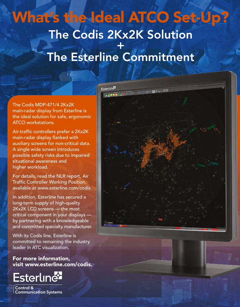
The Codis MDP-471/4 2Kx2K main-radar display from Esterline is the ideal solution for safe, ergonomic ATCO workstations.
Air-traffi c controllers prefer a 2Kx2K main-radar display fl anked with auxiliary screens for non-critical data. A single wide screen introduces possible safety risks due to impaired situational awareness and higher workload.
For details, read the NLR report, Air Traffi c Controller Working Position, available at www.esterline.com/codis.
In addition, Esterline has secured a long-term supply of high-quality 2Kx2K LCD screens — the most critical component in your displays — by partnering with a knowledgeable and committed specialty manufacturer.
With its Codis line, Esterline is committed to remaining the industry leader in ATC visualization.
For more information, visit www.esterline.com/codis.
What’s the Ideal ATCO Set-Up?The Codis 2Kx2K Solution
+The Esterline Commitment
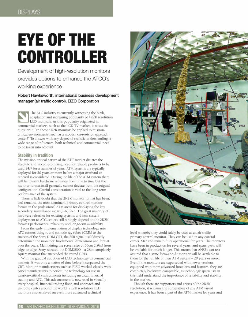
58 AIR TRAFFIC TECHNOLOGY INTERNATIONAL 2016
DISPLAYS
The ATC industry is currently witnessing the birth, adaptation and increasing popularity of 4K2K resolution LCD monitors. As this popularity originated in
commercial markets, such as the LCD TV market, it raises the question: “Can these 4K2K monitors be applied to mission-critical environments, such as a modern en-route or approach center?” To answer with any degree of realistic understanding, a wide range of influences, both technical and commercial, need to be taken into account.
Stability in traditionThe mission-critical nature of the ATC market dictates the absolute and uncompromising need for reliable products to be used 24/7 for a number of years. ATM systems are typically deployed for 20 years or more before a major overhaul or renewal is considered. During the life of the ATM system there will be interim hardware refreshes from time to time but the monitor format itself generally cannot deviate from the original configuration. Careful consideration is vital to the long-term performance of the system.
There is little doubt that the 2K2K monitor format has been, and remains, the most dominant primary control monitor format in the professional ATM arena for displaying the key secondary surveillance radar (SSR) feed. The great majority of hardware refreshes for existing systems and new system deployment to ATC centers still strongly depend on the 2K2K format’s performance, reliability and long-term availability.
From the early implementation of display technology into ATC centers using round cathode ray tubes (CRTs) to the success of the Sony DDM CRT, the SSR signal itself directly determined the monitors’ fundamental dimensions and format over the years. Maintaining the screen size of 50cm (19in) from edge-to-edge, Sony released the DDM2800 – a 28in completely square monitor that succeeded the round CRTs.
With the gradual adoption of LCD technology in commercial markets, it was only a matter of time before it surpassed the CRT. Monitor manufacturers such as EIZO worked closely with panel manufacturers to perfect the technology for use in mission-critical environments including medical, financial trading and ATC. This advancement is now used in virtually every hospital, financial trading floor, and approach and en-route center around the world. 2K2K resolution LCD monitors also achieved an even more advanced technical
level whereby they could safely be used as an air traffic primary control monitor. They can be used in any control center 24/7 and remain fully operational for years. The monitors have been in production for several years, and spare parts will be available for much longer. This means that ANSPs can rest assured that a same form-and-fit monitor will be available to them for the full life of their ATM system – 20 years or more. Even if the monitors are superseded with newer versions equipped with more advanced functions and features, they are completely backward compatible, as technology specialists in this field understand the importance of reliability and stability in the market.
Though there are supporters and critics of the 2K2K resolution, it remains the cornerstone of any ATM visual experience. It has been a part of the ATM market for years and
EYE OF THE CONTROLLERDevelopment of high-resolution monitors provides options to enhance the ATCO’s working experience
Robert Hawksworth, international business development manager (air traffic control), EIZO Corporation
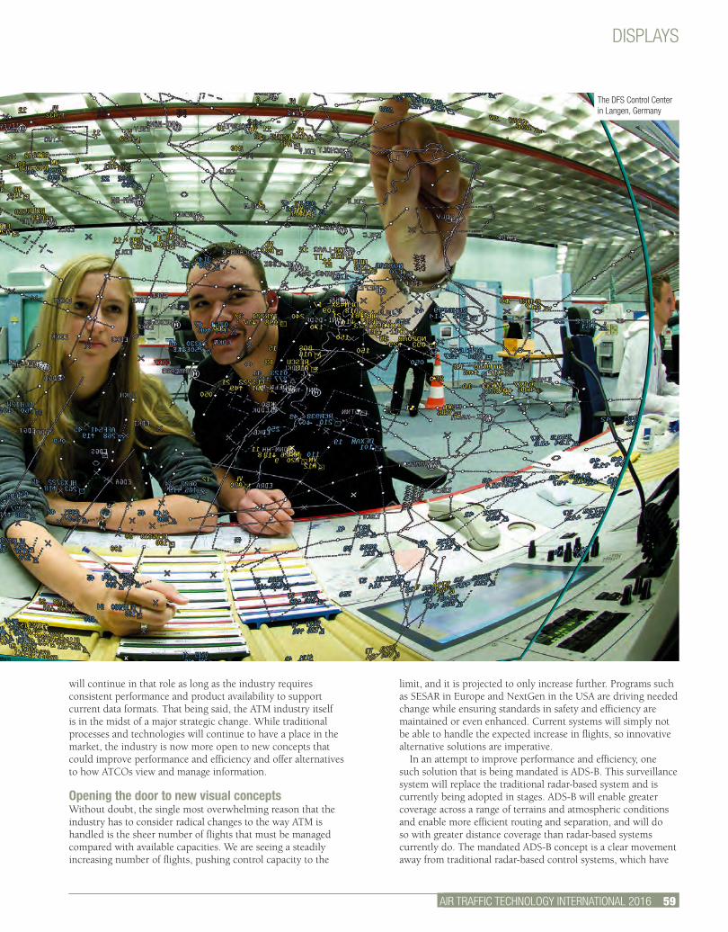
AIR TRAFFIC TECHNOLOGY INTERNATIONAL 2012 2.
limit, and it is projected to only increase further. Programs such as SESAR in Europe and NextGen in the USA are driving needed change while ensuring standards in safety and efficiency are maintained or even enhanced. Current systems will simply not be able to handle the expected increase in flights, so innovative alternative solutions are imperative.
In an attempt to improve performance and efficiency, one such solution that is being mandated is ADS-B. This surveillance system will replace the traditional radar-based system and is currently being adopted in stages. ADS-B will enable greater coverage across a range of terrains and atmospheric conditions and enable more efficient routing and separation, and will do so with greater distance coverage than radar-based systems currently do. The mandated ADS-B concept is a clear movement away from traditional radar-based control systems, which have
will continue in that role as long as the industry requires consistent performance and product availability to support current data formats. That being said, the ATM industry itself is in the midst of a major strategic change. While traditional processes and technologies will continue to have a place in the market, the industry is now more open to new concepts that could improve performance and efficiency and offer alternatives to how ATCOs view and manage information.
Opening the door to new visual conceptsWithout doubt, the single most overwhelming reason that the industry has to consider radical changes to the way ATM is handled is the sheer number of flights that must be managed compared with available capacities. We are seeing a steadily increasing number of flights, pushing control capacity to the
DISPLAYS
AIR TRAFFIC TECHNOLOGY INTERNATIONAL 2016 59.
The DFS Control Center in Langen, Germany
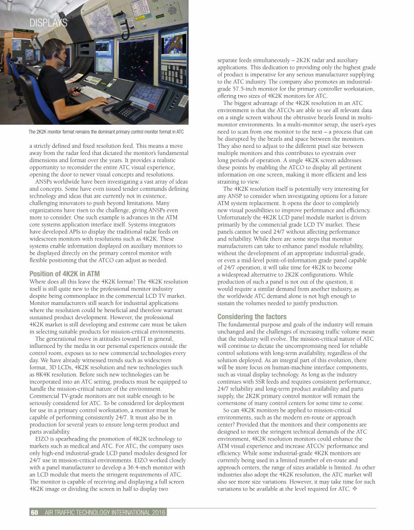
60 AIR TRAFFIC TECHNOLOGY INTERNATIONAL 2016
a strictly defined and fixed resolution feed. This means a move away from the radar feed that dictated the monitor’s fundamental dimensions and format over the years. It provides a realistic opportunity to reconsider the entire ATC visual experience, opening the door to newer visual concepts and resolutions.
ANSPs worldwide have been investigating a vast array of ideas and concepts. Some have even issued tender commands defining technology and ideas that are currently not in existence, challenging innovators to push beyond limitations. Many organizations have risen to the challenge, giving ANSPs even more to consider. One such example is advances in the ATM core systems application interface itself. Systems integrators have developed APIs to display the traditional radar feeds on widescreen monitors with resolutions such as 4K2K. These systems enable information displayed on auxiliary monitors to be displayed directly on the primary control monitor with flexible positioning that the ATCO can adjust as needed.
Position of 4K2K in ATMWhere does all this leave the 4K2K format? The 4K2K resolution itself is still quite new to the professional monitor industry despite being commonplace in the commercial LCD TV market. Monitor manufacturers still search for industrial applications where the resolution could be beneficial and therefore warrant sustained product development. However, the professional 4K2K market is still developing and extreme care must be taken in selecting suitable products for mission-critical environments.
The generational move in attitudes toward IT in general, influenced by the media in our personal experiences outside the control room, exposes us to new commercial technologies every day. We have already witnessed trends such as widescreen format, 3D LCDs, 4K2K resolution and new technologies such as 8K4K resolution. Before such new technologies can be incorporated into an ATC setting, products must be equipped to handle the mission-critical nature of the environment. Commercial TV-grade monitors are not stable enough to be seriously considered for ATC. To be considered for deployment for use in a primary control workstation, a monitor must be capable of performing consistently 24/7. It must also be in production for several years to ensure long-term product and parts availability.
EIZO is spearheading the promotion of 4K2K technology to markets such as medical and ATC. For ATC, the company uses only high-end industrial-grade LCD panel modules designed for 24/7 use in mission-critical environments. EIZO worked closely with a panel manufacturer to develop a 36.4-inch monitor with an LCD module that meets the stringent requirements of ATC. The monitor is capable of receiving and displaying a full screen 4K2K image or dividing the screen in half to display two
separate feeds simultaneously – 2K2K radar and auxiliary applications. This dedication to providing only the highest grade of product is imperative for any serious manufacturer supplying to the ATC industry. The company also promotes an industrial-grade 57.5-inch monitor for the primary controller workstation, offering two sizes of 4K2K monitors for ATC.
The biggest advantage of the 4K2K resolution in an ATC environment is that the ATCOs are able to see all relevant data on a single screen without the obtrusive bezels found in multi-monitor environments. In a multi-monitor setup, the user’s eyes need to scan from one monitor to the next – a process that can be disrupted by the bezels and space between the monitors. They also need to adjust to the different pixel size between multiple monitors and this contributes to eyestrain over long periods of operation. A single 4K2K screen addresses these points by enabling the ATCO to display all pertinent information on one screen, making it more efficient and less straining to view.
The 4K2K resolution itself is potentially very interesting for any ANSP to consider when investigating options for a future ATM system replacement. It opens the door to completely new visual possibilities to improve performance and efficiency. Unfortunately the 4K2K LCD panel module market is driven primarily by the commercial grade LCD TV market. These panels cannot be used 24/7 without affecting performance and reliability. While there are some steps that monitor manufacturers can take to enhance panel module reliability, without the development of an appropriate industrial-grade, or even a mid-level point-of-information grade panel capable of 24/7 operation, it will take time for 4K2K to become a widespread alternative to 2K2K configurations. While production of such a panel is not out of the question, it would require a similar demand from another industry, as the worldwide ATC demand alone is not high enough to sustain the volumes needed to justify production.
Considering the factorsThe fundamental purpose and goals of the industry will remain unchanged and the challenges of increasing traffic volume mean that the industry will evolve. The mission-critical nature of ATC will continue to dictate the uncompromising need for reliable control solutions with long-term availability, regardless of the solution deployed. As an integral part of this evolution, there will be more focus on human-machine interface components, such as visual display technology. As long as the industry continues with SSR feeds and requires consistent performance, 24/7 reliability and long-term product availability and parts supply, the 2K2K primary control monitor will remain the cornerstone of many control centers for some time to come.
So can 4K2K monitors be applied to mission-critical environments, such as the modern en-route or approach center? Provided that the monitors and their components are designed to meet the stringent technical demands of the ATC environment, 4K2K resolution monitors could enhance the ATM visual experience and increase ATCOs’ performance and efficiency. While some industrial-grade 4K2K monitors are currently being used in a limited number of en-route and approach centers, the range of sizes available is limited. As other industries also adopt the 4K2K resolution, the ATC market will also see more size variations. However, it may take time for such variations to be available at the level required for ATC. v
The 2K2K monitor format remains the dominant primary control monitor format in ATC
DISPLAYS
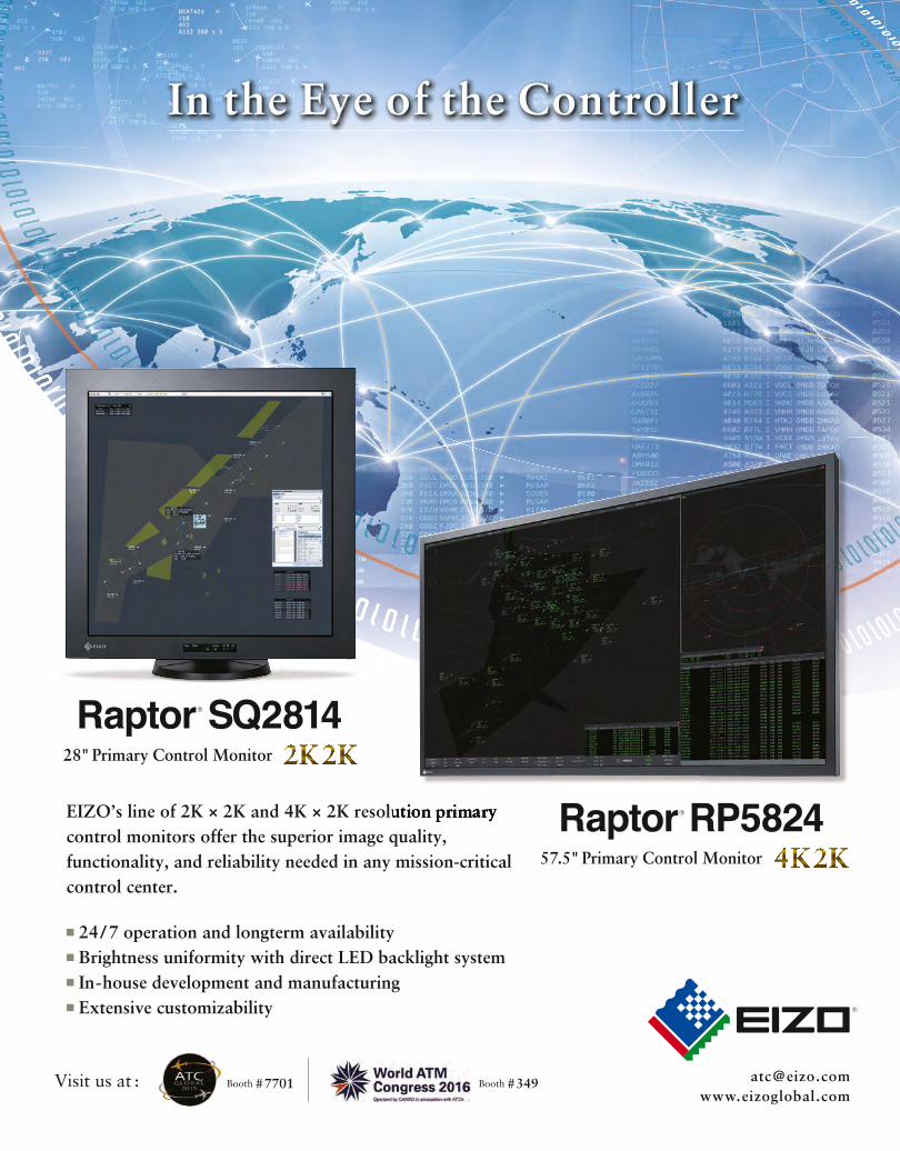
FLIGHT DATA
62 AIR TRAFFIC TECHNOLOGY INTERNATIONAL 2016
Accurate terrain and obstacle information is of great importance for the safety of flights. This applies in particular for the approach phase, where aircraft
intentionally reduce their altitude and maintaining safety margins is crucial. As air traffic volumes increase and airspace capacity grows closer to saturation, there becomes a need for more sophisticated routes and procedures to increase efficiency, while reducing fuel consumption and emissions. To maintain safety margins, accurate and detailed terrain and obstacle data is essential. Growing numbers of obstacles around airports, as well as a growing number of aircraft equipped with enhanced ground proximity warning systems and synthetic vision, are contributing to the demand for accurate and up-to-date terrain and obstacle data.
With the help of precise and reliable electronic terrain and obstacle data (eTOD), used by inflight and ground-based applications, substantial benefits in safety and efficiency are achieved. Consequently, ICAO requires all member states to ensure the availability of eTOD for Area 1 (the complete state territory) and Area 4 (a rectangle at CAT II/III runways) for all aerodromes regularly used by international civil aviation. By November 12, 2015, Area 2 (the vicinity of an aerodrome) will follow. Providing terrain and obstacle data electronically is also explicitly required in the transition from Aeronautical Information Services (AIS) to Aeronautical Information Management (AIM) and an important prerequisite for implementing Aviation System Block Upgrades B0-SNET and B1-SNET.
eTOD essentialsTerrain data represents the surface of Earth including mountains, hills, ridges, valleys, lakes, seas and other bodies of water, as well as permanent ice and snow. It describes a closed surface of an area and is available either as grid data with a defined resolution, or as height contours in topographic maps. Obstacle data represents individual points, lines or contours indicating the horizontal and vertical extent of a structure. It supersedes the terrain data. In addition, a variety of mandatory and optional attributes for terrain and obstacle data, as well as numerical requirements for the data itself, are defined.
Typically, it is the responsibility of the ANSP to maintain, manage and publish terrain and obstacle data, which includes collecting raw data from various sources – such as the state, aerodromes and surveyors – storing the consolidated data, assessing the criticality of obstacles, and then publishing the data. Due to the numerous data originators, fast-changing obstacles such as cranes and construction sites, various data formats, extensive data requirements and numerous data users, managing the electronic terrain and obstacle data in a reliable and cost-efficient way is a challenging task that requires a shift from the product-centric to the data-centric view.
The technologyCOMSOFT’s Aeronautical Information Management Database (CADAS-AIMDB) is the ideal solution for state-of-the-art eTOD management. It has been chosen by numerous customers around the world as their central database for managing
eTOD EXPLAINEDA new solution for electronic terrain and obstacle data management will help improve flight safety Michael Kupsch, COMSOFT
Terrain data represents a closed surface of an area, available as grid data or as height contours as on topographic maps. Obstacle data represents individual points, lines or polygons indicating the horizontal and vertical extent of a structure
Central collection and storage of data is the ideal precondition for efficient data use by a variety of systems
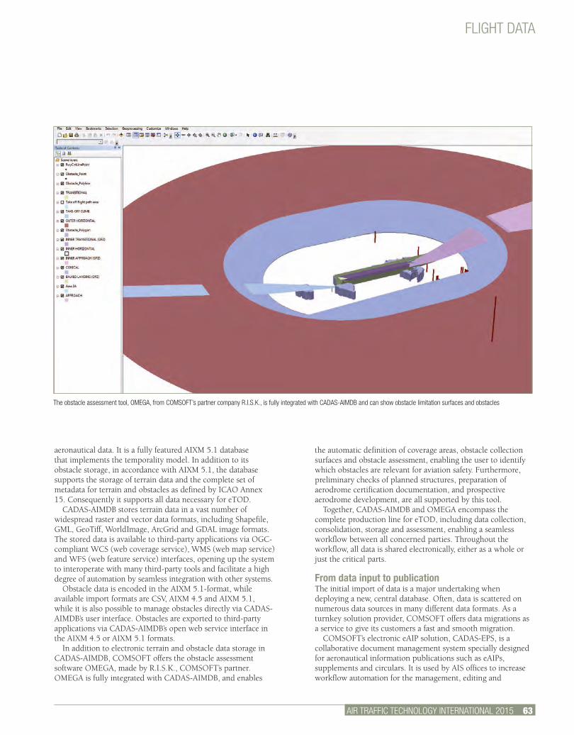
AIR TRAFFIC TECHNOLOGY INTERNATIONAL 2015 63.
FLIGHT DATA
aeronautical data. It is a fully featured AIXM 5.1 database that implements the temporality model. In addition to its obstacle storage, in accordance with AIXM 5.1, the database supports the storage of terrain data and the complete set of metadata for terrain and obstacles as defined by ICAO Annex 15. Consequently it supports all data necessary for eTOD.
CADAS-AIMDB stores terrain data in a vast number of widespread raster and vector data formats, including Shapefile, GML, GeoTiff, WorldImage, ArcGrid and GDAL image formats. The stored data is available to third-party applications via OGC-compliant WCS (web coverage service), WMS (web map service) and WFS (web feature service) interfaces, opening up the system to interoperate with many third-party tools and facilitate a high degree of automation by seamless integration with other systems.
Obstacle data is encoded in the AIXM 5.1-format, while available import formats are CSV, AIXM 4.5 and AIXM 5.1, while it is also possible to manage obstacles directly via CADAS-AIMDB’s user interface. Obstacles are exported to third-party applications via CADAS-AIMDB’s open web service interface in the AIXM 4.5 or AIXM 5.1 formats.
In addition to electronic terrain and obstacle data storage in CADAS-AIMDB, COMSOFT offers the obstacle assessment software OMEGA, made by R.I.S.K., COMSOFT’s partner. OMEGA is fully integrated with CADAS-AIMDB, and enables
the automatic definition of coverage areas, obstacle collection surfaces and obstacle assessment, enabling the user to identify which obstacles are relevant for aviation safety. Furthermore, preliminary checks of planned structures, preparation of aerodrome certification documentation, and prospective aerodrome development, are all supported by this tool.
Together, CADAS-AIMDB and OMEGA encompass the complete production line for eTOD, including data collection, consolidation, storage and assessment, enabling a seamless workflow between all concerned parties. Throughout the workflow, all data is shared electronically, either as a whole or just the critical parts.
From data input to publication The initial import of data is a major undertaking when deploying a new, central database. Often, data is scattered on numerous data sources in many different data formats. As a turnkey solution provider, COMSOFT offers data migrations as a service to give its customers a fast and smooth migration.
COMSOFT’s electronic eAIP solution, CADAS-EPS, is a collaborative document management system specially designed for aeronautical information publications such as eAIPs, supplements and circulars. It is used by AIS offices to increase workflow automation for the management, editing and
The obstacle assessment tool, OMEGA, from COMSOFT’s partner company R.I.S.K., is fully integrated with CADAS-AIMDB and can show obstacle limitation surfaces and obstacles
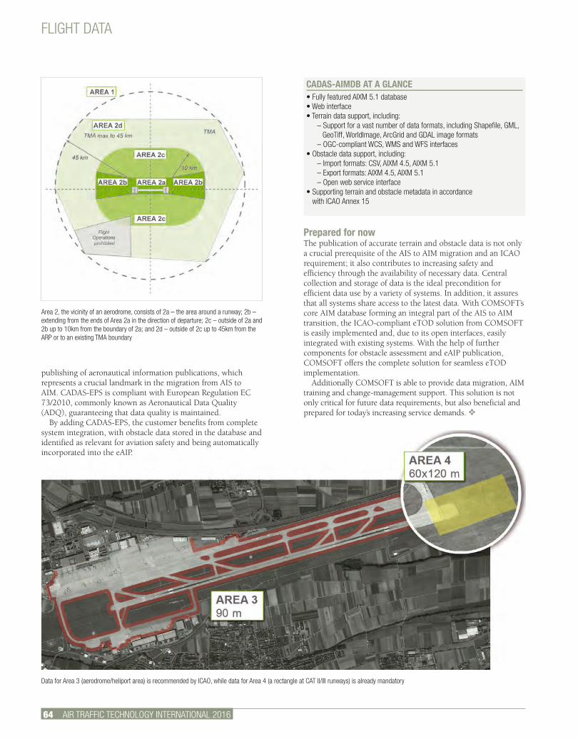
FLIGHT DATA
Data for Area 3 (aerodrome/heliport area) is recommended by ICAO, while data for Area 4 (a rectangle at CAT II/III runways) is already mandatory
64 AIR TRAFFIC TECHNOLOGY INTERNATIONAL 2016
Prepared for now The publication of accurate terrain and obstacle data is not only a crucial prerequisite of the AIS to AIM migration and an ICAO requirement; it also contributes to increasing safety and efficiency through the availability of necessary data. Central collection and storage of data is the ideal precondition for efficient data use by a variety of systems. In addition, it assures that all systems share access to the latest data. With COMSOFT’s core AIM database forming an integral part of the AIS to AIM transition, the ICAO-compliant eTOD solution from COMSOFT is easily implemented and, due to its open interfaces, easily integrated with existing systems. With the help of further components for obstacle assessment and eAIP publication, COMSOFT offers the complete solution for seamless eTOD implementation.
Additionally COMSOFT is able to provide data migration, AIM training and change-management support. This solution is not only critical for future data requirements, but also beneficial and prepared for today’s increasing service demands. v
CADAS-AIMDB AT A GLANCE• Fully featured AIXM 5.1 database• Web interface• Terrain data support, including:
– Support for a vast number of data formats, including Shapefile, GML,GeoTiff, WorldImage, ArcGrid and GDAL image formats
– OGC-compliant WCS, WMS and WFS interfaces• Obstacle data support, including:
– Import formats: CSV, AIXM 4.5, AIXM 5.1– Export formats: AIXM 4.5, AIXM 5.1– Open web service interface
• Supporting terrain and obstacle metadata in accordance with ICAO Annex 15
Area 2, the vicinity of an aerodrome, consists of 2a – the area around a runway; 2b – extending from the ends of Area 2a in the direction of departure; 2c – outside of 2a and 2b up to 10km from the boundary of 2a; and 2d – outside of 2c up to 45km from the ARP or to an existing TMA boundary
publishing of aeronautical information publications, which represents a crucial landmark in the migration from AIS to AIM. CADAS-EPS is compliant with European Regulation EC 73/2010, commonly known as Aeronautical Data Quality (ADQ), guaranteeing that data quality is maintained.
By adding CADAS-EPS, the customer benefits from complete system integration, with obstacle data stored in the database and identified as relevant for aviation safety and being automatically incorporated into the eAIP.
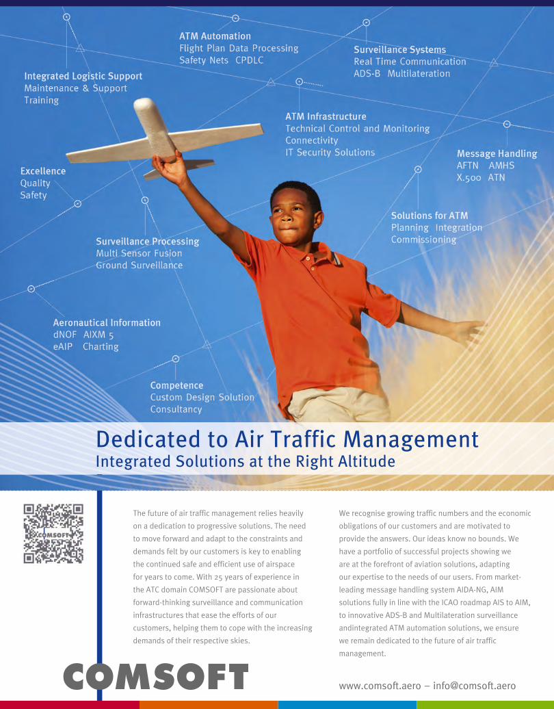
www.comsoft.aero – [email protected]
The future of air traffic management relies heavily
on a dedication to progressive solutions. The need
to move forward and adapt to the constraints and
demands felt by our customers is key to enabling
the continued safe and efficient use of airspace
for years to come. With 25 years of experience in
the ATC domain COMSOFT are passionate about
forward-thinking surveillance and communication
infrastructures that ease the efforts of our
customers, helping them to cope with the increasing
demands of their respective skies.
We recognise growing traffic numbers and the economic
obligations of our customers and are motivated to
provide the answers. Our ideas know no bounds. We
have a portfolio of successful projects showing we
are at the forefront of aviation solutions, adapting
our expertise to the needs of our users. From market-
leading message handling system AIDA-NG, AIM
solutions fully in line with the ICAO roadmap AIS to AIM,
to innovative ADS-B and Multilateration surveillance
andintegrated ATM automation solutions, we ensure
we remain dedicated to the future of air traffic
management.
Dedicated to Air Traffic ManagementIntegrated Solutions at the Right Altitude
The Italian ANSP
enav.it [email protected]
A GLOBAL LEADER IN AIR NAVIGATION SERVICES
OUR COMMERCIAL OFFER INCLUDES:
AERONAUTICAL CONSULTING & DESIGN
FLIGHT INSPECTION
ENGINEERING TRAINING
AERONAUTICAL METEOROLOGY
MANAGEMENT CONSULTING
commercial offer 1 pagina.indd 1 20/07/15 09:24

AIR TRAFFIC TECHNOLOGY INTERNATIONAL 2016 67.
Large organizations with complex labor contracts regularly have to deal with issues surrounding the
management of staff shifts. The primary objective is to ensure service is provided 24/7 by assigning shifts to each available operator within the scope of constraints laid down by national laws and national collective labor agreements. Within ATC this complexity is increased by the additional constraints imposed by aviation rules. This complexity can lead to excessive overtime across the group as well as decisions that accidentally overlook violations and expose the organization to serious legal risks.
The market offers many off-the-shelf solutions for the management of work shifts, but all too often their application in the context of ATC leads to poor performance as they don’t allow management to navigate all the variables that come into play in the staff-planning process. Rostering solutions are often used for resource optimization in the matters of staff turnover at public transport companies and airlines. However, the operations research models used to mathematically represent the problem of shift management at public transport companies are not exactly the same as in the ATC industry, and neither are the solution algorithms. However, the approach was the same: the search for a single solution for the entire body of staff that would give automated optimized solutions to problems of different sizes and within different normative scopes.
For reasons of structure, corporate history and culture, each company has slightly different objectives and needs to reach them by different routes. For years, software development projects of this type have viewed a project management approach as more profitable than an extreme programming one – an ‘agile’ methodology that emphasizes the writing of high-quality code and the responsiveness to changing requirements. Particular importance is given to direct and frequent communication between developers and users, and among the developers themselves.
This synergy has enabled ENAV to create the Central Rostering System (CRS), a new shift management product that is able to meet realistic operating needs and to be monetized.
No more hassleThe introduction of a roster management system allows ANSPs to greatly improve work efficiency. Benefits include:• Zero resources needed to input data in payroll system;• Enormous reduction of time in the production of summary
reports and analysis, which themselves provide greater reliability in terms of data accuracy;
• Maximum of two operators required to plan and manage a roster of 1,000 or more shift workers;
• Complete elimination of overtime; and• Major reduction of work in external offices of area control
centers (ACC) and airports.
OptimizationAt the heart of a rostering software lies the optimization of shifts. For an ANSP there are a number of issues: long-term planning, monthly and weekly management, and daily assignment of work positions. These issues have their corresponding solutions.
Long-term planning in shift work is often resolved using multilevel bottleneck assignment algorithms. Shifts are assigned
ROSTERING
STAFF PLANNINGA roster management system ensures efficient, flexible deployment of personnelDuccio Grandi, rostering specialist, ENAV
ENAV’s Central Rostering System (CRS) allows ATCs to optimize their workforce by producing four-month plans of each worker’s shifts
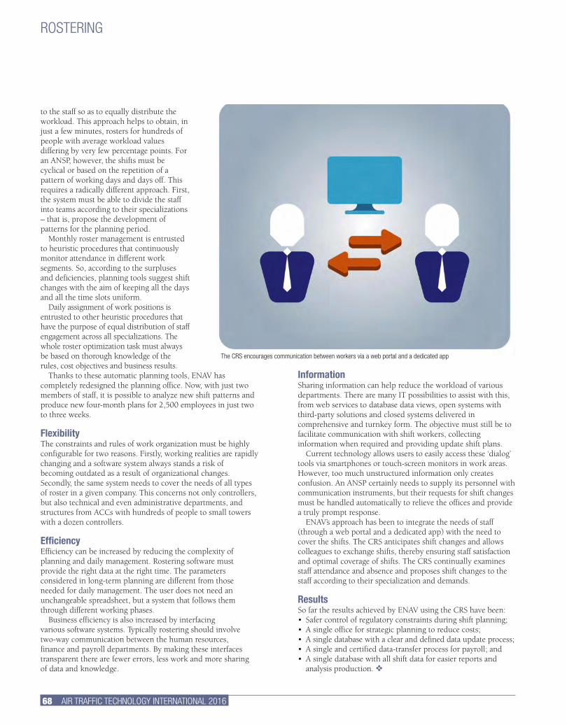
InformationSharing information can help reduce the workload of various departments. There are many IT possibilities to assist with this, from web services to database data views, open systems with third-party solutions and closed systems delivered in comprehensive and turnkey form. The objective must still be to facilitate communication with shift workers, collecting information when required and providing update shift plans.
Current technology allows users to easily access these ‘dialog’ tools via smartphones or touch-screen monitors in work areas. However, too much unstructured information only creates confusion. An ANSP certainly needs to supply its personnel with communication instruments, but their requests for shift changes must be handled automatically to relieve the offices and provide a truly prompt response.
ENAV’s approach has been to integrate the needs of staff (through a web portal and a dedicated app) with the need to cover the shifts. The CRS anticipates shift changes and allows colleagues to exchange shifts, thereby ensuring staff satisfaction and optimal coverage of shifts. The CRS continually examines staff attendance and absence and proposes shift changes to the staff according to their specialization and demands.
ResultsSo far the results achieved by ENAV using the CRS have been:• Safer control of regulatory constraints during shift planning;• A single office for strategic planning to reduce costs;• A single database with a clear and defined data update process;• A single and certified data-transfer process for payroll; and• A single database with all shift data for easier reports and
analysis production. v
to the staff so as to equally distribute the workload. This approach helps to obtain, in just a few minutes, rosters for hundreds of people with average workload values differing by very few percentage points. For an ANSP, however, the shifts must be cyclical or based on the repetition of a pattern of working days and days off. This requires a radically different approach. First, the system must be able to divide the staff into teams according to their specializations – that is, propose the development of patterns for the planning period.
Monthly roster management is entrusted to heuristic procedures that continuously monitor attendance in different work segments. So, according to the surpluses and deficiencies, planning tools suggest shift changes with the aim of keeping all the days and all the time slots uniform.
Daily assignment of work positions is entrusted to other heuristic procedures that have the purpose of equal distribution of staff engagement across all specializations. The whole roster optimization task must always be based on thorough knowledge of the rules, cost objectives and business results.
Thanks to these automatic planning tools, ENAV has completely redesigned the planning office. Now, with just two members of staff, it is possible to analyze new shift patterns and produce new four-month plans for 2,500 employees in just two to three weeks.
FlexibilityThe constraints and rules of work organization must be highly configurable for two reasons. Firstly, working realities are rapidly changing and a software system always stands a risk of becoming outdated as a result of organizational changes. Secondly, the same system needs to cover the needs of all types of roster in a given company. This concerns not only controllers, but also technical and even administrative departments, and structures from ACCs with hundreds of people to small towers with a dozen controllers.
EfficiencyEfficiency can be increased by reducing the complexity of planning and daily management. Rostering software must provide the right data at the right time. The parameters considered in long-term planning are different from those needed for daily management. The user does not need an unchangeable spreadsheet, but a system that follows them through different working phases.
Business efficiency is also increased by interfacing various software systems. Typically rostering should involve two-way communication between the human resources, finance and payroll departments. By making these interfaces transparent there are fewer errors, less work and more sharing of data and knowledge.
68 AIR TRAFFIC TECHNOLOGY INTERNATIONAL 2016
ROSTERING
The CRS encourages communication between workers via a web portal and a dedicated app
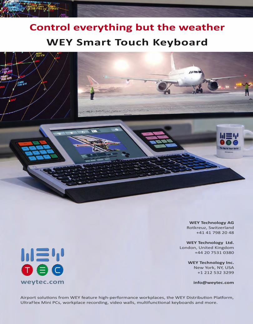
Airport solutions from WEY feature high-performance workplaces, the WEY Distribution Platform, UltraFlex Mini PCs, workplace recording, video walls, multifunctional keyboards and more.
Control everything but the weatherWEY Smart Touch Keyboard
WEY Technology AGRotkreuz, Switzerland
+41 41 798 20 48
WEY Technology Ltd. London, United Kingdom
+44 20 7531 0380
WEY Technology Inc.New York, NY, USA
+1 212 532 3299
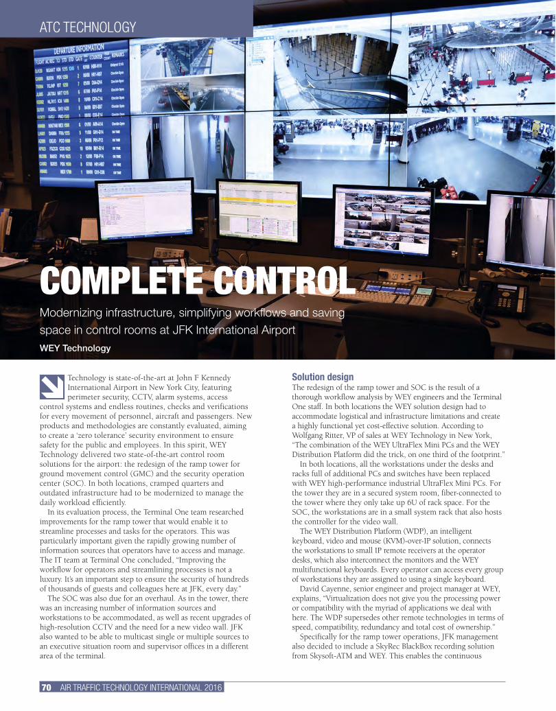
70 AIR TRAFFIC TECHNOLOGY INTERNATIONAL 2016
Technology is state-of-the-art at John F Kennedy International Airport in New York City, featuring perimeter security, CCTV, alarm systems, access
control systems and endless routines, checks and verifications for every movement of personnel, aircraft and passengers. New products and methodologies are constantly evaluated, aiming to create a ‘zero tolerance’ security environment to ensure safety for the public and employees. In this spirit, WEY Technology delivered two state-of-the-art control room solutions for the airport: the redesign of the ramp tower for ground movement control (GMC) and the security operation center (SOC). In both locations, cramped quarters and outdated infrastructure had to be modernized to manage the daily workload efficiently.
In its evaluation process, the Terminal One team researched improvements for the ramp tower that would enable it to streamline processes and tasks for the operators. This was particularly important given the rapidly growing number of information sources that operators have to access and manage. The IT team at Terminal One concluded, “Improving the workflow for operators and streamlining processes is not a luxury. It’s an important step to ensure the security of hundreds of thousands of guests and colleagues here at JFK, every day.”
The SOC was also due for an overhaul. As in the tower, there was an increasing number of information sources and workstations to be accommodated, as well as recent upgrades of high-resolution CCTV and the need for a new video wall. JFK also wanted to be able to multicast single or multiple sources to an executive situation room and supervisor offices in a different area of the terminal.
Solution designThe redesign of the ramp tower and SOC is the result of a thorough workflow analysis by WEY engineers and the Terminal One staff. In both locations the WEY solution design had to accommodate logistical and infrastructure limitations and create a highly functional yet cost-effective solution. According to Wolfgang Ritter, VP of sales at WEY Technology in New York, “The combination of the WEY UltraFlex Mini PCs and the WEY Distribution Platform did the trick, on one third of the footprint.”
In both locations, all the workstations under the desks and racks full of additional PCs and switches have been replaced with WEY high-performance industrial UltraFlex Mini PCs. For the tower they are in a secured system room, fiber-connected to the tower where they only take up 6U of rack space. For the SOC, the workstations are in a small system rack that also hosts the controller for the video wall.
The WEY Distribution Platform (WDP), an intelligent keyboard, video and mouse (KVM)-over-IP solution, connects the workstations to small IP remote receivers at the operator desks, which also interconnect the monitors and the WEY multifunctional keyboards. Every operator can access every group of workstations they are assigned to using a single keyboard.
David Cayenne, senior engineer and project manager at WEY, explains, “Virtualization does not give you the processing power or compatibility with the myriad of applications we deal with here. The WDP supersedes other remote technologies in terms of speed, compatibility, redundancy and total cost of ownership.”
Specifically for the ramp tower operations, JFK management also decided to include a SkyRec BlackBox recording solution from Skysoft-ATM and WEY. This enables the continuous
ATC TECHNOLOGY
COMPLETE CONTROLModernizing infrastructure, simplifying workflows and saving space in control rooms at JFK International AirportWEY Technology
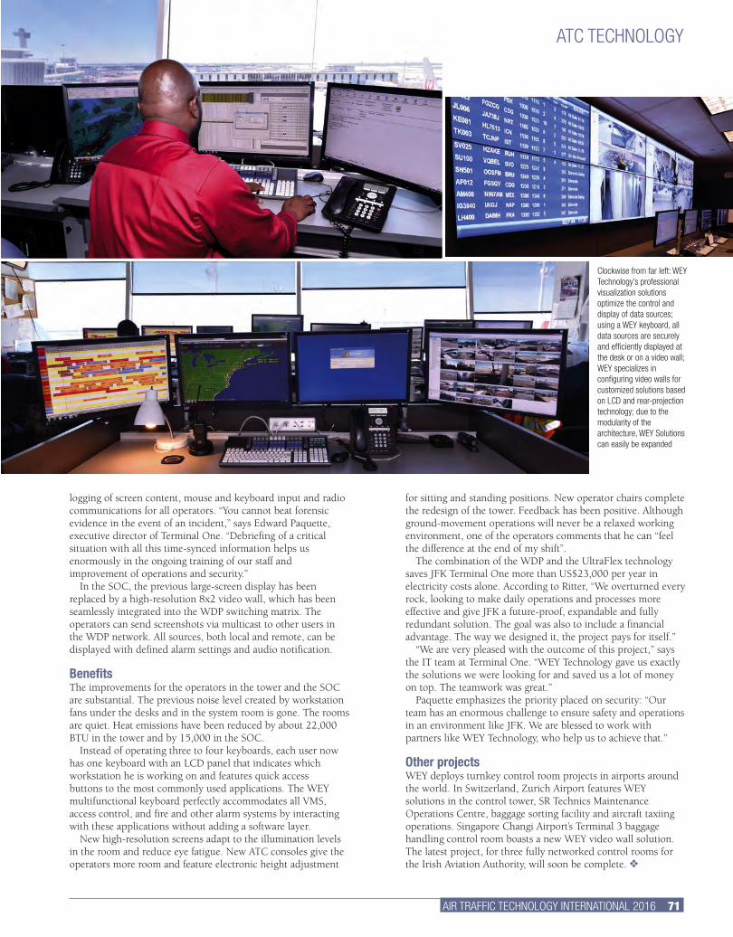
AIR TRAFFIC TECHNOLOGY INTERNATIONAL 2016 71.
for sitting and standing positions. New operator chairs complete the redesign of the tower. Feedback has been positive. Although ground-movement operations will never be a relaxed working environment, one of the operators comments that he can “feel the difference at the end of my shift”.
The combination of the WDP and the UltraFlex technology saves JFK Terminal One more than US$23,000 per year in electricity costs alone. According to Ritter, “We overturned every rock, looking to make daily operations and processes more effective and give JFK a future-proof, expandable and fully redundant solution. The goal was also to include a financial advantage. The way we designed it, the project pays for itself.”
“We are very pleased with the outcome of this project,” says the IT team at Terminal One. “WEY Technology gave us exactly the solutions we were looking for and saved us a lot of money on top. The teamwork was great.”
Paquette emphasizes the priority placed on security: “Our team has an enormous challenge to ensure safety and operations in an environment like JFK. We are blessed to work with partners like WEY Technology, who help us to achieve that.”
Other projects WEY deploys turnkey control room projects in airports around the world. In Switzerland, Zurich Airport features WEY solutions in the control tower, SR Technics Maintenance Operations Centre, baggage sorting facility and aircraft taxiing operations. Singapore Changi Airport’s Terminal 3 baggage handling control room boasts a new WEY video wall solution. The latest project, for three fully networked control rooms for the Irish Aviation Authority, will soon be complete. v
logging of screen content, mouse and keyboard input and radio communications for all operators. “You cannot beat forensic evidence in the event of an incident,” says Edward Paquette, executive director of Terminal One. “Debriefing of a critical situation with all this time-synced information helps us enormously in the ongoing training of our staff and improvement of operations and security.”
In the SOC, the previous large-screen display has been replaced by a high-resolution 8x2 video wall, which has been seamlessly integrated into the WDP switching matrix. The operators can send screenshots via multicast to other users in the WDP network. All sources, both local and remote, can be displayed with defined alarm settings and audio notification.
BenefitsThe improvements for the operators in the tower and the SOC are substantial. The previous noise level created by workstation fans under the desks and in the system room is gone. The rooms are quiet. Heat emissions have been reduced by about 22,000 BTU in the tower and by 15,000 in the SOC.
Instead of operating three to four keyboards, each user now has one keyboard with an LCD panel that indicates which workstation he is working on and features quick access buttons to the most commonly used applications. The WEY multifunctional keyboard perfectly accommodates all VMS, access control, and fire and other alarm systems by interacting with these applications without adding a software layer.
New high-resolution screens adapt to the illumination levels in the room and reduce eye fatigue. New ATC consoles give the operators more room and feature electronic height adjustment
ATC TECHNOLOGY
Clockwise from far left: WEY Technology’s professional visualization solutions optimize the control and display of data sources; using a WEY keyboard, all data sources are securely and efficiently displayed at the desk or on a video wall; WEY specializes in configuring video walls for customized solutions based on LCD and rear-projection technology; due to the modularity of the architecture, WEY Solutions can easily be expanded
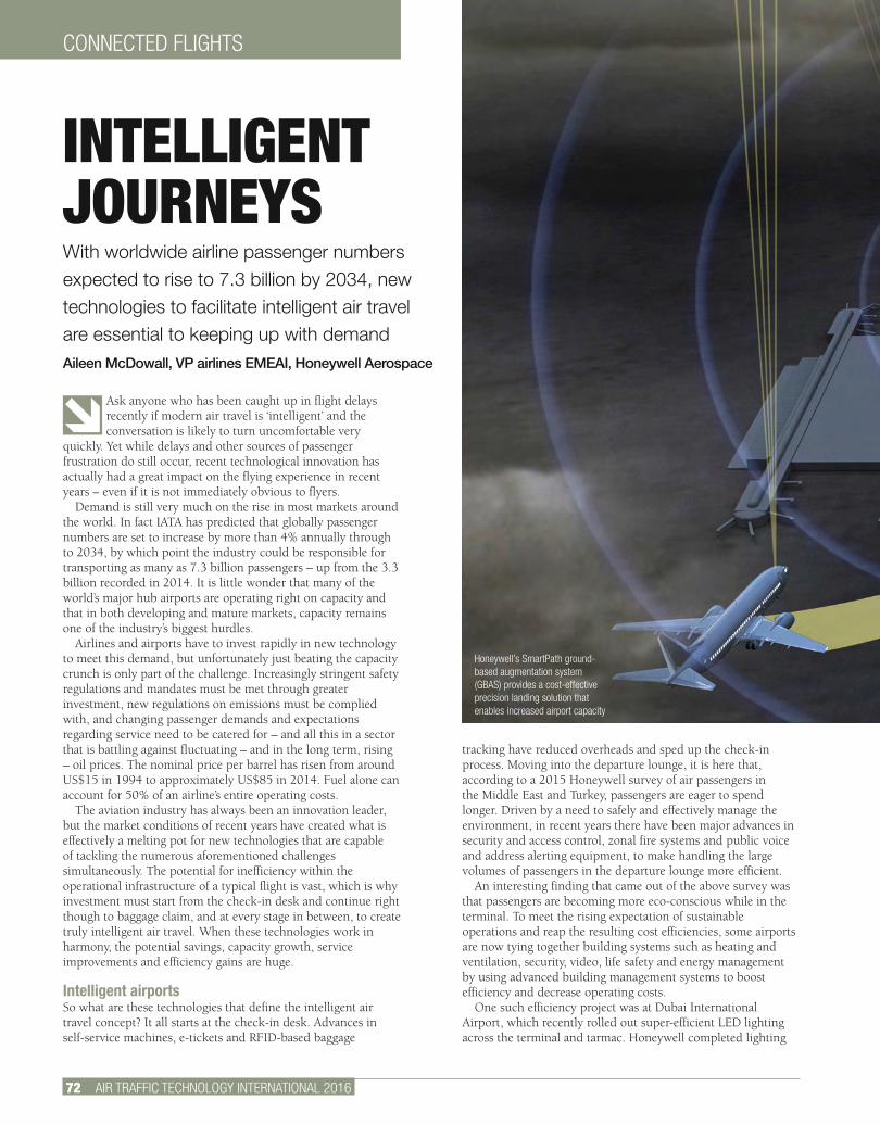
72 AIR TRAFFIC TECHNOLOGY INTERNATIONAL 2016
CONNECTED FLIGHTS
Ask anyone who has been caught up in flight delays recently if modern air travel is ‘intelligent’ and the conversation is likely to turn uncomfortable very
quickly. Yet while delays and other sources of passenger frustration do still occur, recent technological innovation has actually had a great impact on the flying experience in recent years – even if it is not immediately obvious to flyers.
Demand is still very much on the rise in most markets around the world. In fact IATA has predicted that globally passenger numbers are set to increase by more than 4% annually through to 2034, by which point the industry could be responsible for transporting as many as 7.3 billion passengers – up from the 3.3 billion recorded in 2014. It is little wonder that many of the world’s major hub airports are operating right on capacity and that in both developing and mature markets, capacity remains one of the industry’s biggest hurdles.
Airlines and airports have to invest rapidly in new technology to meet this demand, but unfortunately just beating the capacity crunch is only part of the challenge. Increasingly stringent safety regulations and mandates must be met through greater investment, new regulations on emissions must be complied with, and changing passenger demands and expectations regarding service need to be catered for – and all this in a sector that is battling against fluctuating – and in the long term, rising – oil prices. The nominal price per barrel has risen from around US$15 in 1994 to approximately US$85 in 2014. Fuel alone can account for 50% of an airline’s entire operating costs.
The aviation industry has always been an innovation leader, but the market conditions of recent years have created what is effectively a melting pot for new technologies that are capable of tackling the numerous aforementioned challenges simultaneously. The potential for inefficiency within the operational infrastructure of a typical flight is vast, which is why investment must start from the check-in desk and continue right though to baggage claim, and at every stage in between, to create truly intelligent air travel. When these technologies work in harmony, the potential savings, capacity growth, service improvements and efficiency gains are huge.
Intelligent airportsSo what are these technologies that define the intelligent air travel concept? It all starts at the check-in desk. Advances in self-service machines, e-tickets and RFID-based baggage
tracking have reduced overheads and sped up the check-in process. Moving into the departure lounge, it is here that, according to a 2015 Honeywell survey of air passengers in the Middle East and Turkey, passengers are eager to spend longer. Driven by a need to safely and effectively manage the environment, in recent years there have been major advances in security and access control, zonal fire systems and public voice and address alerting equipment, to make handling the large volumes of passengers in the departure lounge more efficient.
An interesting finding that came out of the above survey was that passengers are becoming more eco-conscious while in the terminal. To meet the rising expectation of sustainable operations and reap the resulting cost efficiencies, some airports are now tying together building systems such as heating and ventilation, security, video, life safety and energy management by using advanced building management systems to boost efficiency and decrease operating costs.
One such efficiency project was at Dubai International Airport, which recently rolled out super-efficient LED lighting across the terminal and tarmac. Honeywell completed lighting
INTELLIGENT JOURNEYSWith worldwide airline passenger numbers expected to rise to 7.3 billion by 2034, new technologies to facilitate intelligent air travel are essential to keeping up with demandAileen McDowall, VP airlines EMEAI, Honeywell Aerospace
Honeywell’s SmartPath ground-based augmentation system (GBAS) provides a cost-effective precision landing solution that enables increased airport capacity
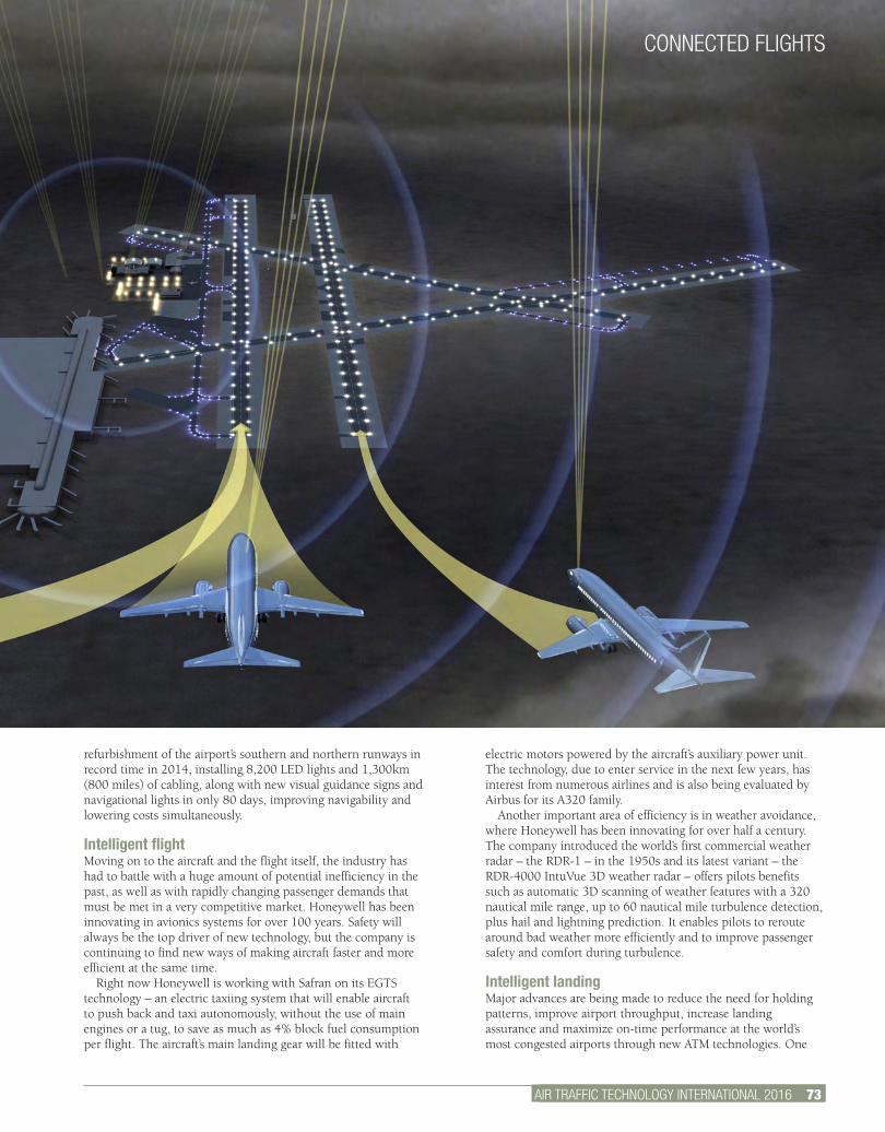
AIR TRAFFIC TECHNOLOGY INTERNATIONAL 2012 2.
electric motors powered by the aircraft’s auxiliary power unit. The technology, due to enter service in the next few years, has interest from numerous airlines and is also being evaluated by Airbus for its A320 family.
Another important area of efficiency is in weather avoidance, where Honeywell has been innovating for over half a century. The company introduced the world’s first commercial weather radar – the RDR-1 – in the 1950s and its latest variant – the RDR-4000 IntuVue 3D weather radar – offers pilots benefits such as automatic 3D scanning of weather features with a 320 nautical mile range, up to 60 nautical mile turbulence detection, plus hail and lightning prediction. It enables pilots to reroute around bad weather more efficiently and to improve passenger safety and comfort during turbulence.
Intelligent landingMajor advances are being made to reduce the need for holding patterns, improve airport throughput, increase landing assurance and maximize on-time performance at the world’s most congested airports through new ATM technologies. One
refurbishment of the airport’s southern and northern runways in record time in 2014, installing 8,200 LED lights and 1,300km (800 miles) of cabling, along with new visual guidance signs and navigational lights in only 80 days, improving navigability and lowering costs simultaneously.
Intelligent flightMoving on to the aircraft and the flight itself, the industry has had to battle with a huge amount of potential inefficiency in the past, as well as with rapidly changing passenger demands that must be met in a very competitive market. Honeywell has been innovating in avionics systems for over 100 years. Safety will always be the top driver of new technology, but the company is continuing to find new ways of making aircraft faster and more efficient at the same time.
Right now Honeywell is working with Safran on its EGTS technology – an electric taxiing system that will enable aircraft to push back and taxi autonomously, without the use of main engines or a tug, to save as much as 4% block fuel consumption per flight. The aircraft’s main landing gear will be fitted with
AIR TRAFFIC TECHNOLOGY INTERNATIONAL 2016 73.
CONNECTED FLIGHTS
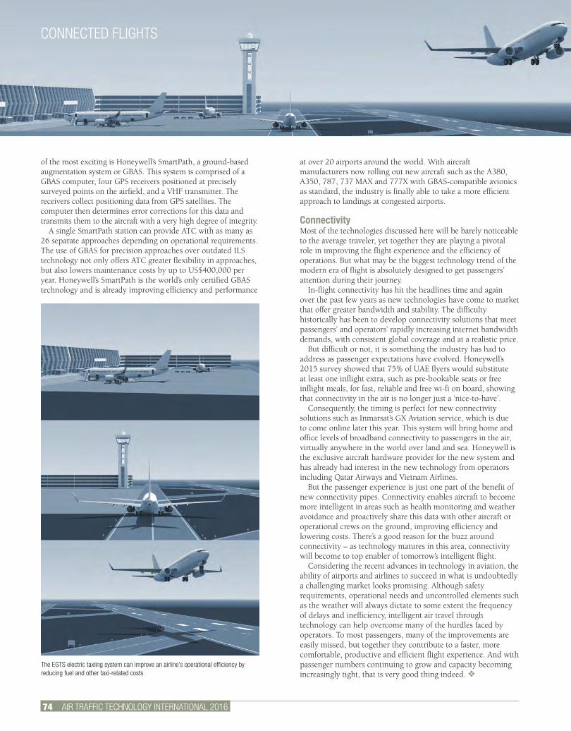
CONNECTED FLIGHTS
74 AIR TRAFFIC TECHNOLOGY INTERNATIONAL 2016
of the most exciting is Honeywell’s SmartPath, a ground-based augmentation system or GBAS. This system is comprised of a GBAS computer, four GPS receivers positioned at precisely surveyed points on the airfield, and a VHF transmitter. The receivers collect positioning data from GPS satellites. The computer then determines error corrections for this data and transmits them to the aircraft with a very high degree of integrity.
A single SmartPath station can provide ATC with as many as 26 separate approaches depending on operational requirements. The use of GBAS for precision approaches over outdated ILS technology not only offers ATC greater flexibility in approaches, but also lowers maintenance costs by up to US$400,000 per year. Honeywell’s SmartPath is the world’s only certified GBAS technology and is already improving efficiency and performance
at over 20 airports around the world. With aircraft manufacturers now rolling out new aircraft such as the A380, A350, 787, 737 MAX and 777X with GBAS-compatible avionics as standard, the industry is finally able to take a more efficient approach to landings at congested airports.
Connectivity Most of the technologies discussed here will be barely noticeable to the average traveler, yet together they are playing a pivotal role in improving the flight experience and the efficiency of operations. But what may be the biggest technology trend of the modern era of flight is absolutely designed to get passengers’ attention during their journey.
In-flight connectivity has hit the headlines time and again over the past few years as new technologies have come to market that offer greater bandwidth and stability. The difficulty historically has been to develop connectivity solutions that meet passengers’ and operators’ rapidly increasing internet bandwidth demands, with consistent global coverage and at a realistic price.
But difficult or not, it is something the industry has had to address as passenger expectations have evolved. Honeywell’s 2015 survey showed that 75% of UAE flyers would substitute at least one inflight extra, such as pre-bookable seats or free inflight meals, for fast, reliable and free wi-fi on board, showing that connectivity in the air is no longer just a ‘nice-to-have’.
Consequently, the timing is perfect for new connectivity solutions such as Inmarsat’s GX Aviation service, which is due to come online later this year. This system will bring home and office levels of broadband connectivity to passengers in the air, virtually anywhere in the world over land and sea. Honeywell is the exclusive aircraft hardware provider for the new system and has already had interest in the new technology from operators including Qatar Airways and Vietnam Airlines.
But the passenger experience is just one part of the benefit of new connectivity pipes. Connectivity enables aircraft to become more intelligent in areas such as health monitoring and weather avoidance and proactively share this data with other aircraft or operational crews on the ground, improving efficiency and lowering costs. There’s a good reason for the buzz around connectivity – as technology matures in this area, connectivity will become to top enabler of tomorrow’s intelligent flight.
Considering the recent advances in technology in aviation, the ability of airports and airlines to succeed in what is undoubtedly a challenging market looks promising. Although safety requirements, operational needs and uncontrolled elements such as the weather will always dictate to some extent the frequency of delays and inefficiency, intelligent air travel through technology can help overcome many of the hurdles faced by operators. To most passengers, many of the improvements are easily missed, but together they contribute to a faster, more comfortable, productive and efficient flight experience. And with passenger numbers continuing to grow and capacity becoming increasingly tight, that is very good thing indeed. v
The EGTS electric taxiing system can improve an airline’s operational efficiency by reducing fuel and other taxi-related costs

Introducing SmartPath®
For airports around the world, SmartPath is the most important arrival in over 50 years. One SmartPath station can provide up to 26 precision approaches, enabling multiple approach paths and touchdown points to all runway ends, with flexibility to support the unique needs of even the world‘s most challenging airspaces.
SmartPath is already supporting safer and more efficient landings at airports worldwide including Frankfurt, Newark and Sydney. To see how it could transform your operations search SmartPath.
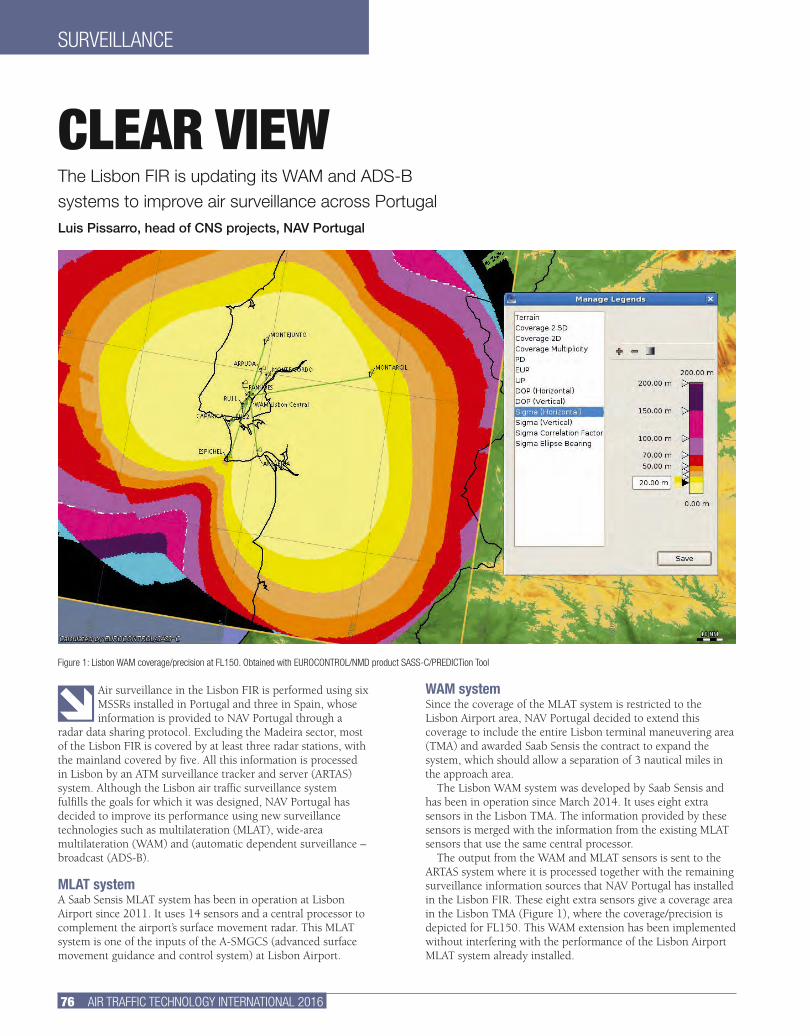
76 AIR TRAFFIC TECHNOLOGY INTERNATIONAL 2016
SURVEILLANCE
WAM systemSince the coverage of the MLAT system is restricted to the Lisbon Airport area, NAV Portugal decided to extend this coverage to include the entire Lisbon terminal maneuvering area (TMA) and awarded Saab Sensis the contract to expand the system, which should allow a separation of 3 nautical miles in the approach area.
The Lisbon WAM system was developed by Saab Sensis and has been in operation since March 2014. It uses eight extra sensors in the Lisbon TMA. The information provided by these sensors is merged with the information from the existing MLAT sensors that use the same central processor.
The output from the WAM and MLAT sensors is sent to the ARTAS system where it is processed together with the remaining surveillance information sources that NAV Portugal has installed in the Lisbon FIR. These eight extra sensors give a coverage area in the Lisbon TMA (Figure 1), where the coverage/precision is depicted for FL150. This WAM extension has been implemented without interfering with the performance of the Lisbon Airport MLAT system already installed.
Air surveillance in the Lisbon FIR is performed using six MSSRs installed in Portugal and three in Spain, whose information is provided to NAV Portugal through a
radar data sharing protocol. Excluding the Madeira sector, most of the Lisbon FIR is covered by at least three radar stations, with the mainland covered by five. All this information is processed in Lisbon by an ATM surveillance tracker and server (ARTAS) system. Although the Lisbon air traffic surveillance system fulfills the goals for which it was designed, NAV Portugal has decided to improve its performance using new surveillance technologies such as multilateration (MLAT), wide-area multilateration (WAM) and (automatic dependent surveillance – broadcast (ADS-B).
MLAT systemA Saab Sensis MLAT system has been in operation at Lisbon Airport since 2011. It uses 14 sensors and a central processor to complement the airport’s surface movement radar. This MLAT system is one of the inputs of the A-SMGCS (advanced surface movement guidance and control system) at Lisbon Airport.
CLEAR VIEWThe Lisbon FIR is updating its WAM and ADS-B systems to improve air surveillance across PortugalLuis Pissarro, head of CNS projects, NAV Portugal
Figure 1: Lisbon WAM coverage/precision at FL150. Obtained with EUROCONTROL/NMD product SASS-C/PREDICTion Tool
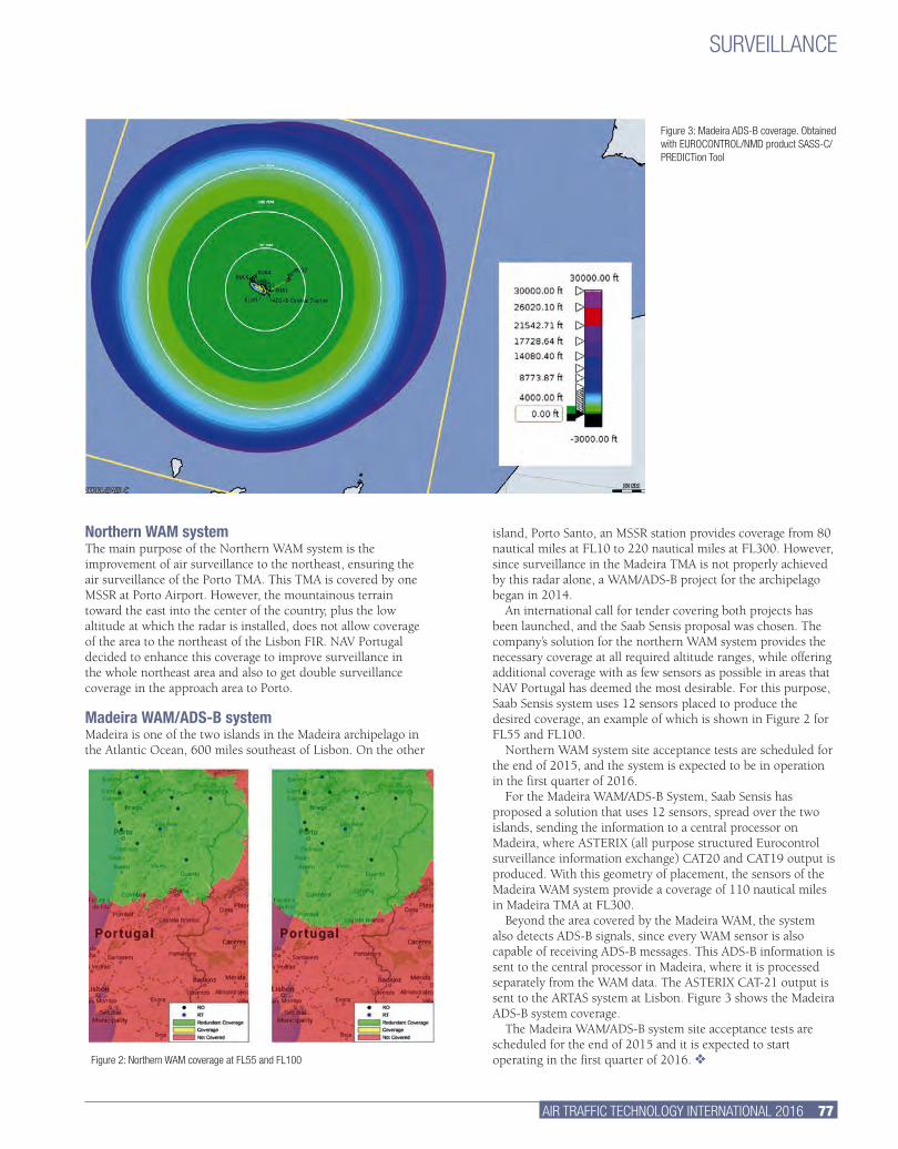
AIR TRAFFIC TECHNOLOGY INTERNATIONAL 2016 77.
island, Porto Santo, an MSSR station provides coverage from 80 nautical miles at FL10 to 220 nautical miles at FL300. However, since surveillance in the Madeira TMA is not properly achieved by this radar alone, a WAM/ADS-B project for the archipelago began in 2014.
An international call for tender covering both projects has been launched, and the Saab Sensis proposal was chosen. The company’s solution for the northern WAM system provides the necessary coverage at all required altitude ranges, while offering additional coverage with as few sensors as possible in areas that NAV Portugal has deemed the most desirable. For this purpose, Saab Sensis system uses 12 sensors placed to produce the desired coverage, an example of which is shown in Figure 2 for FL55 and FL100.
Northern WAM system site acceptance tests are scheduled for the end of 2015, and the system is expected to be in operation in the first quarter of 2016.
For the Madeira WAM/ADS-B System, Saab Sensis has proposed a solution that uses 12 sensors, spread over the two islands, sending the information to a central processor on Madeira, where ASTERIX (all purpose structured Eurocontrol surveillance information exchange) CAT20 and CAT19 output is produced. With this geometry of placement, the sensors of the Madeira WAM system provide a coverage of 110 nautical miles in Madeira TMA at FL300.
Beyond the area covered by the Madeira WAM, the system also detects ADS-B signals, since every WAM sensor is also capable of receiving ADS-B messages. This ADS-B information is sent to the central processor in Madeira, where it is processed separately from the WAM data. The ASTERIX CAT-21 output is sent to the ARTAS system at Lisbon. Figure 3 shows the Madeira ADS-B system coverage.
The Madeira WAM/ADS-B system site acceptance tests are scheduled for the end of 2015 and it is expected to start operating in the first quarter of 2016. v
Northern WAM systemThe main purpose of the Northern WAM system is the improvement of air surveillance to the northeast, ensuring the air surveillance of the Porto TMA. This TMA is covered by one MSSR at Porto Airport. However, the mountainous terrain toward the east into the center of the country, plus the low altitude at which the radar is installed, does not allow coverage of the area to the northeast of the Lisbon FIR. NAV Portugal decided to enhance this coverage to improve surveillance in the whole northeast area and also to get double surveillance coverage in the approach area to Porto.
Madeira WAM/ADS-B systemMadeira is one of the two islands in the Madeira archipelago in the Atlantic Ocean, 600 miles southeast of Lisbon. On the other
SURVEILLANCE
Figure 2: Northern WAM coverage at FL55 and FL100
Figure 3: Madeira ADS-B coverage. Obtained with EUROCONTROL/NMD product SASS-C/PREDICTion Tool
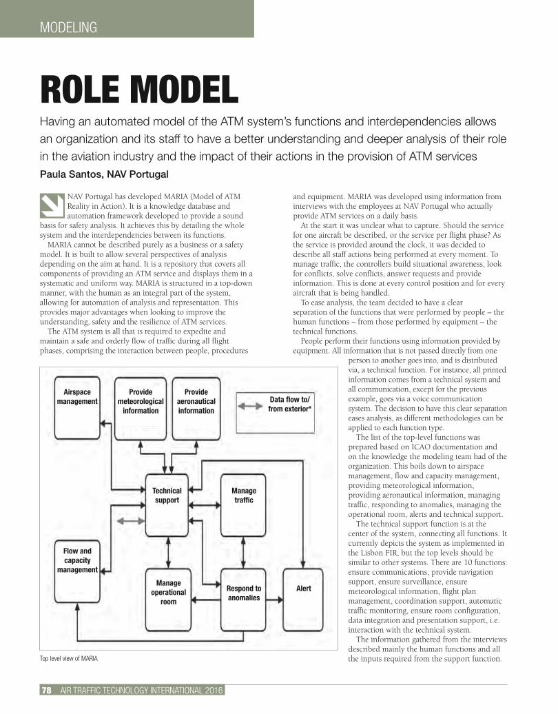
MODELING
78 AIR TRAFFIC TECHNOLOGY INTERNATIONAL 2016
NAV Portugal has developed MARIA (Model of ATM Reality in Action). It is a knowledge database and automation framework developed to provide a sound
basis for safety analysis. It achieves this by detailing the whole system and the interdependencies between its functions.
MARIA cannot be described purely as a business or a safety model. It is built to allow several perspectives of analysis depending on the aim at hand. It is a repository that covers all components of providing an ATM service and displays them in a systematic and uniform way. MARIA is structured in a top-down manner, with the human as an integral part of the system, allowing for automation of analysis and representation. This provides major advantages when looking to improve the understanding, safety and the resilience of ATM services.
The ATM system is all that is required to expedite and maintain a safe and orderly flow of traffic during all flight phases, comprising the interaction between people, procedures
and equipment. MARIA was developed using information from interviews with the employees at NAV Portugal who actually provide ATM services on a daily basis.
At the start it was unclear what to capture. Should the service for one aircraft be described, or the service per flight phase? As the service is provided around the clock, it was decided to describe all staff actions being performed at every moment. To manage traffic, the controllers build situational awareness, look for conflicts, solve conflicts, answer requests and provide information. This is done at every control position and for every aircraft that is being handled.
To ease analysis, the team decided to have a clear separation of the functions that were performed by people – the human functions – from those performed by equipment – the technical functions.
People perform their functions using information provided by equipment. All information that is not passed directly from one
person to another goes into, and is distributed via, a technical function. For instance, all printed information comes from a technical system and all communication, except for the previous example, goes via a voice communication system. The decision to have this clear separation eases analysis, as different methodologies can be applied to each function type.
The list of the top-level functions was prepared based on ICAO documentation and on the knowledge the modeling team had of the organization. This boils down to airspace management, flow and capacity management, providing meteorological information, providing aeronautical information, managing traffic, responding to anomalies, managing the operational room, alerts and technical support.
The technical support function is at the center of the system, connecting all functions. It currently depicts the system as implemented in the Lisbon FIR, but the top levels should be similar to other systems. There are 10 functions: ensure communications, provide navigation support, ensure surveillance, ensure meteorological information, flight plan management, coordination support, automatic traffic monitoring, ensure room configuration, data integration and presentation support, i.e. interaction with the technical system.
The information gathered from the interviews described mainly the human functions and all the inputs required from the support function.
ROLE MODELHaving an automated model of the ATM system’s functions and interdependencies allows an organization and its staff to have a better understanding and deeper analysis of their role in the aviation industry and the impact of their actions in the provision of ATM servicesPaula Santos, NAV Portugal
Top level view of MARIA
Airspace management
Provide meteorological
information
Provide aeronautical information
Data flow to/from exterior*
Technical support
Manage traffic
Flow and capacity
management
Manage operational
room
Respond to anomalies
Alert
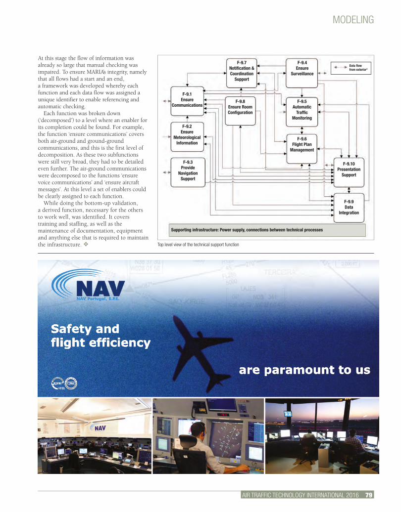
MODELING
AIR TRAFFIC TECHNOLOGY INTERNATIONAL 2016 79.
Top level view of the technical support function
Safety andflight efficiency
are paramount to us
At this stage the flow of information was already so large that manual checking was impaired. To ensure MARIA’s integrity, namely that all flows had a start and an end, a framework was developed whereby each function and each data flow was assigned a unique identifier to enable referencing and automatic checking.
Each function was broken down (‘decomposed’) to a level where an enabler for its completion could be found. For example, the function ‘ensure communications’ covers both air-ground and ground-ground communications, and this is the first level of decomposition. As these two subfunctions were still very broad, they had to be detailed even further. The air-ground communications were decomposed to the functions ‘ensure voice communications’ and ‘ensure aircraft messages’. At this level a set of enablers could be clearly assigned to each function.
While doing the bottom-up validation, a derived function, necessary for the others to work well, was identified. It covers training and staffing, as well as the maintenance of documentation, equipment and anything else that is required to maintain the infrastructure. v
F-9.7Notification & Coordination
Support
F-9.1Ensure
Communications
F-9.2Ensure
Meteorological Information
F-9.3Provide
Navigation Support
F-9.8Ensure Room Configuration
F-9.4Ensure
Surveillance
F-9.5Automatic
Traffic Monitoring
F-9.6 Flight Plan
Management
F-9.10 Presentation
Support
F-9.9Data
Integration
Data flow from exterior*
Supporting infrastructure: Power supply, connections between technical processes
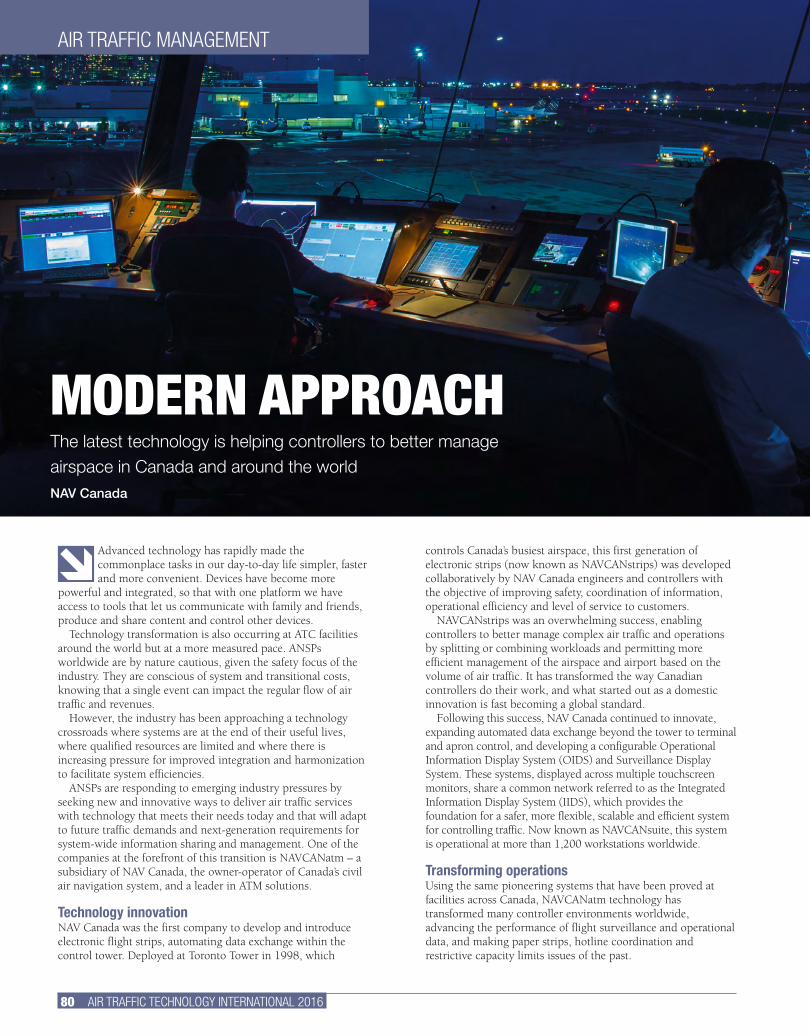
80 AIR TRAFFIC TECHNOLOGY INTERNATIONAL 2016
Advanced technology has rapidly made the commonplace tasks in our day-to-day life simpler, faster and more convenient. Devices have become more
powerful and integrated, so that with one platform we have access to tools that let us communicate with family and friends, produce and share content and control other devices.
Technology transformation is also occurring at ATC facilities around the world but at a more measured pace. ANSPs worldwide are by nature cautious, given the safety focus of the industry. They are conscious of system and transitional costs, knowing that a single event can impact the regular flow of air traffic and revenues.
However, the industry has been approaching a technology crossroads where systems are at the end of their useful lives, where qualified resources are limited and where there is increasing pressure for improved integration and harmonization to facilitate system efficiencies.
ANSPs are responding to emerging industry pressures by seeking new and innovative ways to deliver air traffic services with technology that meets their needs today and that will adapt to future traffic demands and next-generation requirements for system-wide information sharing and management. One of the companies at the forefront of this transition is NAVCANatm – a subsidiary of NAV Canada, the owner-operator of Canada’s civil air navigation system, and a leader in ATM solutions.
Technology innovationNAV Canada was the first company to develop and introduce electronic flight strips, automating data exchange within the control tower. Deployed at Toronto Tower in 1998, which
controls Canada’s busiest airspace, this first generation of electronic strips (now known as NAVCANstrips) was developed collaboratively by NAV Canada engineers and controllers with the objective of improving safety, coordination of information, operational efficiency and level of service to customers.
NAVCANstrips was an overwhelming success, enabling controllers to better manage complex air traffic and operations by splitting or combining workloads and permitting more efficient management of the airspace and airport based on the volume of air traffic. It has transformed the way Canadian controllers do their work, and what started out as a domestic innovation is fast becoming a global standard.
Following this success, NAV Canada continued to innovate, expanding automated data exchange beyond the tower to terminal and apron control, and developing a configurable Operational Information Display System (OIDS) and Surveillance Display System. These systems, displayed across multiple touchscreen monitors, share a common network referred to as the Integrated Information Display System (IIDS), which provides the foundation for a safer, more flexible, scalable and efficient system for controlling traffic. Now known as NAVCANsuite, this system is operational at more than 1,200 workstations worldwide.
Transforming operationsUsing the same pioneering systems that have been proved at facilities across Canada, NAVCANatm technology has transformed many controller environments worldwide, advancing the performance of flight surveillance and operational data, and making paper strips, hotline coordination and restrictive capacity limits issues of the past.
AIR TRAFFIC MANAGEMENT
MODERN APPROACHThe latest technology is helping controllers to better manage airspace in Canada and around the worldNAV Canada
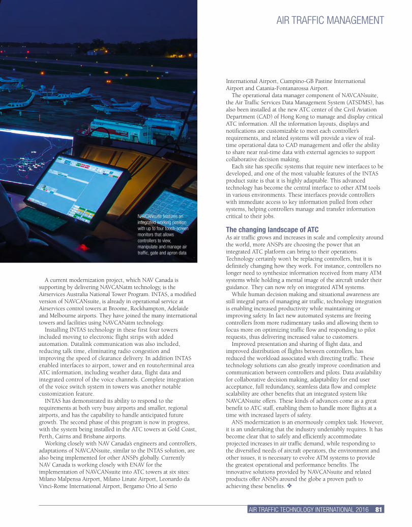
AIR TRAFFIC TECHNOLOGY INTERNATIONAL 2016 81.
International Airport, Ciampino-GB Pastine International Airport and Catania-Fontanarossa Airport.
The operational data manager component of NAVCANsuite, the Air Traffic Services Data Management System (ATSDMS), has also been installed at the new ATC center of the Civil Aviation Department (CAD) of Hong Kong to manage and display critical ATC information. All the information layouts, displays and notifications are customizable to meet each controller’s requirements, and related systems will provide a view of real-time operational data to CAD management and offer the ability to share near real-time data with external agencies to support collaborative decision making.
Each site has specific systems that require new interfaces to be developed, and one of the most valuable features of the INTAS product suite is that it is highly adaptable. This advanced technology has become the central interface to other ATM tools in various environments. These interfaces provide controllers with immediate access to key information pulled from other systems, helping controllers manage and transfer information critical to their jobs.
The changing landscape of ATCAs air traffic grows and increases in scale and complexity around the world, more ANSPs are choosing the power that an integrated ATC platform can bring to their operations. Technology certainly won’t be replacing controllers, but it is definitely changing how they work. For instance, controllers no longer need to synthesize information received from many ATM systems while holding a mental image of the aircraft under their guidance. They can now rely on integrated ATM systems.
While human decision making and situational awareness are still integral parts of managing air traffic, technology integration is enabling increased productivity while maintaining or improving safety. In fact new automated systems are freeing controllers from more rudimentary tasks and allowing them to focus more on optimizing traffic flow and responding to pilot requests, thus delivering increased value to customers.
Improved presentation and sharing of flight data, and improved distribution of flights between controllers, has reduced the workload associated with directing traffic. These technology solutions can also greatly improve coordination and communication between controllers and pilots. Data availability for collaborative decision making, adaptability for end user acceptance, full redundancy, seamless data flow and complete scalability are other benefits that an integrated system like NAVCANsuite offers. These kinds of advances come as a great benefit to ATC staff, enabling them to handle more flights at a time with increased layers of safety.
ANS modernization is an enormously complex task. However, it is an undertaking that the industry undeniably requires. It has become clear that to safely and efficiently accommodate projected increases in air traffic demand, while responding to the diversified needs of aircraft operators, the environment and other issues, it is necessary to evolve ATM systems to provide the greatest operational and performance benefits. The innovative solutions provided by NAVCANsuite and related products offer ANSPs around the globe a proven path to achieving these benefits. v
A current modernization project, which NAV Canada is supporting by delivering NAVCANatm technology, is the Airservices Australia National Tower Program. INTAS, a modified version of NAVCANsuite, is already in operational service at Airservices control towers at Broome, Rockhampton, Adelaide and Melbourne airports. They have joined the many international towers and facilities using NAVCANatm technology.
Installing INTAS technology in these first four towers included moving to electronic flight strips with added automation. Datalink communication was also included, reducing talk time, eliminating radio congestion and improving the speed of clearance delivery. In addition INTAS enabled interfaces to airport, tower and en route/terminal area ATC information, including weather data, flight data and integrated control of the voice channels. Complete integration of the voice switch system in towers was another notable customization feature.
INTAS has demonstrated its ability to respond to the requirements at both very busy airports and smaller, regional airports, and has the capability to handle anticipated future growth. The second phase of this program is now in progress, with the system being installed in the ATC towers at Gold Coast, Perth, Cairns and Brisbane airports.
Working closely with NAV Canada’s engineers and controllers, adaptations of NAVCANsuite, similar to the INTAS solution, are also being implemented for other ANSPs globally. Currently NAV Canada is working closely with ENAV for the implementation of NAVCANsuite into ATC towers at six sites: Milano Malpensa Airport, Milano Linate Airport, Leonardo da Vinci-Rome International Airport, Bergamo Orio al Serio
AIR TRAFFIC MANAGEMENT
NAVCANsuite features an integrated working position with up to four touch-screen monitors that allows controllers to view, manipulate and manage air traffic, gate and apron data
NAVCANatm is a subsidiary of NAV CANADA
Visit us at the World ATM Congress, Stand 826.
C
M
Y
CM
MY
CY
CMY
K
NAVCANatm-ATTI-ad-2015.pdf 1 02/07/2015 4:27:06 PM
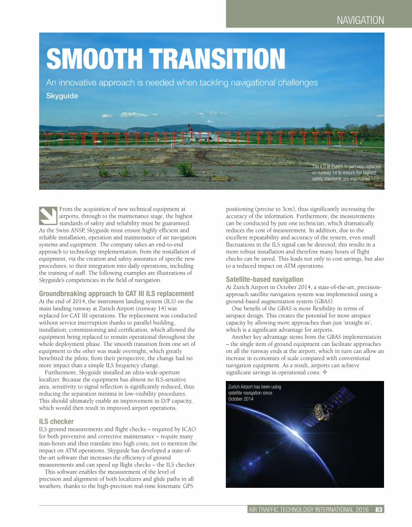
NAVIGATION
AIR TRAFFIC TECHNOLOGY INTERNATIONAL 2016 83.
From the acquisition of new technical equipment at airports, through to the maintenance stage, the highest standards of safety and reliability must be guaranteed.
As the Swiss ANSP, Skyguide must ensure highly efficient and reliable installation, operation and maintenance of air navigation systems and equipment. The company takes an end-to-end approach to technology implementation, from the installation of equipment, via the creation and safety assurance of specific new procedures, to their integration into daily operations, including the training of staff. The following examples are illustrations of Skyguide’s competencies in the field of navigation.
Groundbreaking approach to CAT III ILS replacement At the end of 2014, the instrument landing system (ILS) on the main landing runway at Zurich Airport (runway 14) was replaced for CAT III operations. The replacement was conducted without service interruption thanks to parallel building, installation, commissioning and certification, which allowed the equipment being replaced to remain operational throughout the whole deployment phase. The smooth transition from one set of equipment to the other was made overnight, which greatly benefitted the pilots; from their perspective, the change had no more impact than a simple ILS frequency change.
Furthermore, Skyguide installed an ultra-wide-aperture localizer. Because the equipment has almost no ILS-sensitive area, sensitivity to signal reflection is significantly reduced, thus reducing the separation minima in low-visibility procedures. This should ultimately enable an improvement in LVP capacity, which would then result in improved airport operations.
ILS checker ILS ground measurements and flight checks – required by ICAO for both preventive and corrective maintenance – require many man-hours and thus translate into high costs, not to mention the impact on ATM operations. Skyguide has developed a state-of-the-art software that increases the efficiency of ground measurements and can speed up flight checks – the ILS checker.
This software enables the measurement of the level of precision and alignment of both localizers and glide paths in all weathers, thanks to the high-precision real-time kinematic GPS
positioning (precise to 3cm), thus significantly increasing the accuracy of the information. Furthermore, the measurements can be conducted by just one technician, which dramatically reduces the cost of measurement. In addition, due to the excellent repeatability and accuracy of the system, even small fluctuations in the ILS signal can be detected; this results in a more robust installation and therefore many hours of flight checks can be saved. This leads not only to cost savings, but also to a reduced impact on ATM operations.
Satellite-based navigation At Zurich Airport in October 2014, a state-of-the-art, precision-approach satellite navigation system was implemented using a ground-based augmentation system (GBAS).
One benefit of the GBAS is more flexibility in terms of airspace design. This creates the potential for more airspace capacity by allowing more approaches than just ‘straight in’, which is a significant advantage for airports.
Another key advantage stems from the GBAS implementation – the single item of ground equipment can facilitate approaches on all the runway ends at the airport, which in turn can allow an increase in economies of scale compared with conventional navigation equipment. As a result, airports can achieve significant savings in operational costs. v
SMOOTH TRANSITIONAn innovative approach is needed when tackling navigational challengesSkyguide
The ILS at Zurich Airport was replaced on runway 14 to ensure the highest safety standards are maintained
Zurich Airport has been using satellite navigation since October 2014
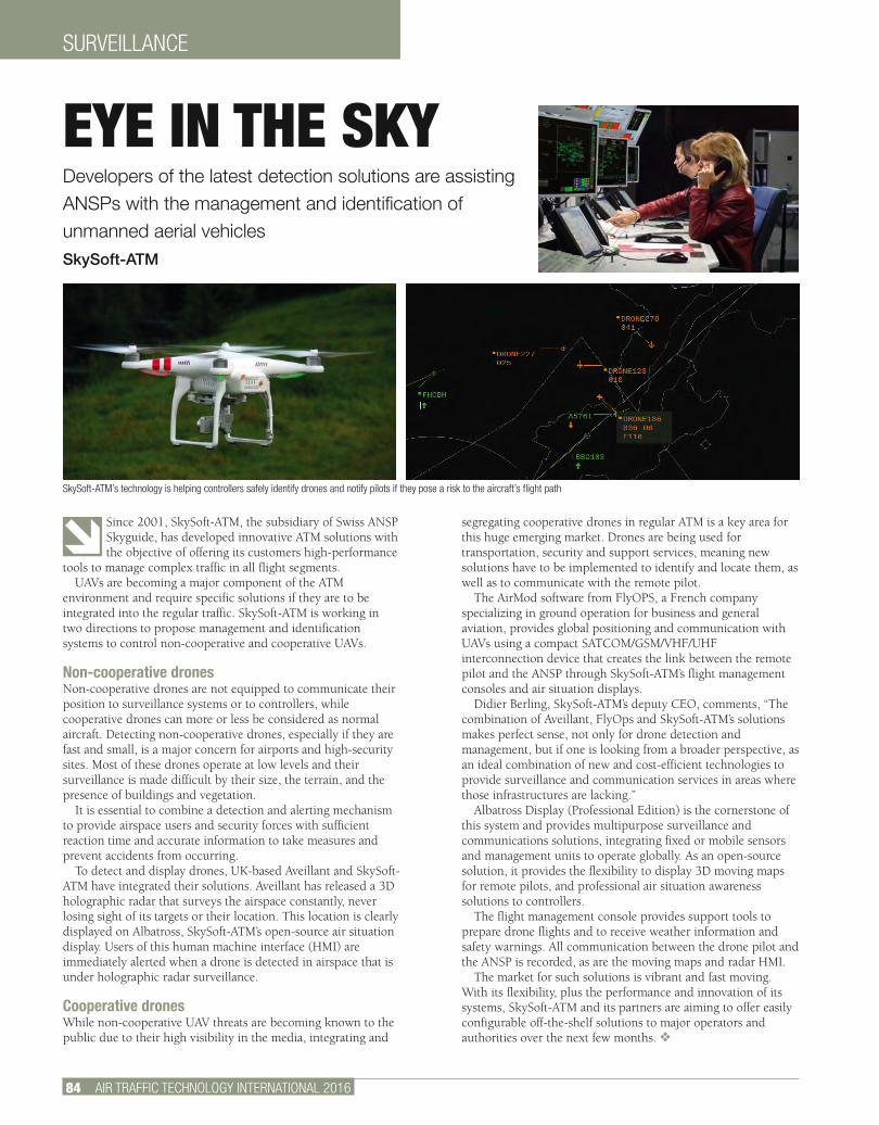
SURVEILLANCE
84 AIR TRAFFIC TECHNOLOGY INTERNATIONAL 2016
Since 2001, SkySoft-ATM, the subsidiary of Swiss ANSP Skyguide, has developed innovative ATM solutions with the objective of offering its customers high-performance
tools to manage complex traffic in all flight segments.UAVs are becoming a major component of the ATM
environment and require specific solutions if they are to be integrated into the regular traffic. SkySoft-ATM is working in two directions to propose management and identification systems to control non-cooperative and cooperative UAVs.
Non-cooperative dronesNon-cooperative drones are not equipped to communicate their position to surveillance systems or to controllers, while cooperative drones can more or less be considered as normal aircraft. Detecting non-cooperative drones, especially if they are fast and small, is a major concern for airports and high-security sites. Most of these drones operate at low levels and their surveillance is made difficult by their size, the terrain, and the presence of buildings and vegetation.
It is essential to combine a detection and alerting mechanism to provide airspace users and security forces with sufficient reaction time and accurate information to take measures and prevent accidents from occurring.
To detect and display drones, UK-based Aveillant and SkySoft-ATM have integrated their solutions. Aveillant has released a 3D holographic radar that surveys the airspace constantly, never losing sight of its targets or their location. This location is clearly displayed on Albatross, SkySoft-ATM’s open-source air situation display. Users of this human machine interface (HMI) are immediately alerted when a drone is detected in airspace that is under holographic radar surveillance.
Cooperative dronesWhile non-cooperative UAV threats are becoming known to the public due to their high visibility in the media, integrating and
segregating cooperative drones in regular ATM is a key area for this huge emerging market. Drones are being used for transportation, security and support services, meaning new solutions have to be implemented to identify and locate them, as well as to communicate with the remote pilot.
The AirMod software from FlyOPS, a French company specializing in ground operation for business and general aviation, provides global positioning and communication with UAVs using a compact SATCOM/GSM/VHF/UHF interconnection device that creates the link between the remote pilot and the ANSP through SkySoft-ATM’s flight management consoles and air situation displays.
Didier Berling, SkySoft-ATM’s deputy CEO, comments, “The combination of Aveillant, FlyOps and SkySoft-ATM’s solutions makes perfect sense, not only for drone detection and management, but if one is looking from a broader perspective, as an ideal combination of new and cost-efficient technologies to provide surveillance and communication services in areas where those infrastructures are lacking.”
Albatross Display (Professional Edition) is the cornerstone of this system and provides multipurpose surveillance and communications solutions, integrating fixed or mobile sensors and management units to operate globally. As an open-source solution, it provides the flexibility to display 3D moving maps for remote pilots, and professional air situation awareness solutions to controllers.
The flight management console provides support tools to prepare drone flights and to receive weather information and safety warnings. All communication between the drone pilot and the ANSP is recorded, as are the moving maps and radar HMI.
The market for such solutions is vibrant and fast moving. With its flexibility, plus the performance and innovation of its systems, SkySoft-ATM and its partners are aiming to offer easily configurable off-the-shelf solutions to major operators and authorities over the next few months. v
EYE IN THE SKYDevelopers of the latest detection solutions are assisting ANSPs with the management and identification of unmanned aerial vehicles SkySoft-ATM
SkySoft-ATM’s technology is helping controllers safely identify drones and notify pilots if they pose a risk to the aircraft’s flight path
skyrec_add_14.indd 3 30.01.14 11:11
skyrec_add_14.indd 3 30.01.14 11:11
From Technology to Operational Benefits – skyguide develops your solution
Our services are the solution to your operational, economic and environmental challenges
skyguide solutions’ webpage
TECHNOLOGY • SUPPORT TO OPERATION • DATA • TRAINING • OPERATION
Contact us at : [email protected]
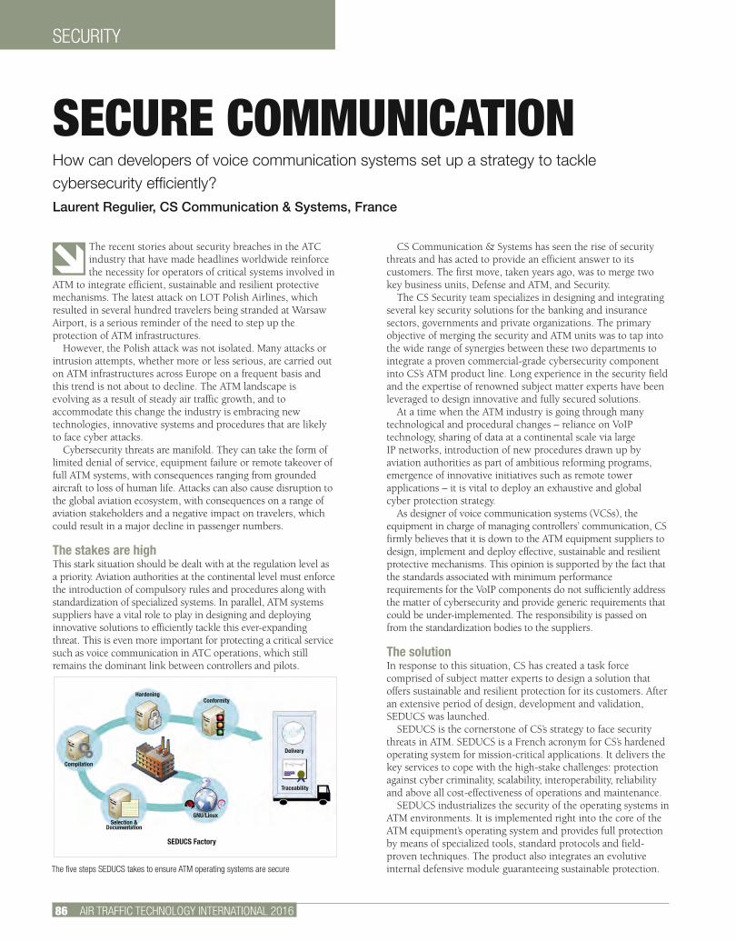
SECURITY
86 AIR TRAFFIC TECHNOLOGY INTERNATIONAL 2016
The recent stories about security breaches in the ATC industry that have made headlines worldwide reinforce the necessity for operators of critical systems involved in
ATM to integrate efficient, sustainable and resilient protective mechanisms. The latest attack on LOT Polish Airlines, which resulted in several hundred travelers being stranded at Warsaw Airport, is a serious reminder of the need to step up the protection of ATM infrastructures.
However, the Polish attack was not isolated. Many attacks or intrusion attempts, whether more or less serious, are carried out on ATM infrastructures across Europe on a frequent basis and this trend is not about to decline. The ATM landscape is evolving as a result of steady air traffic growth, and to accommodate this change the industry is embracing new technologies, innovative systems and procedures that are likely to face cyber attacks.
Cybersecurity threats are manifold. They can take the form of limited denial of service, equipment failure or remote takeover of full ATM systems, with consequences ranging from grounded aircraft to loss of human life. Attacks can also cause disruption to the global aviation ecosystem, with consequences on a range of aviation stakeholders and a negative impact on travelers, which could result in a major decline in passenger numbers.
The stakes are highThis stark situation should be dealt with at the regulation level as a priority. Aviation authorities at the continental level must enforce the introduction of compulsory rules and procedures along with standardization of specialized systems. In parallel, ATM systems suppliers have a vital role to play in designing and deploying innovative solutions to efficiently tackle this ever-expanding threat. This is even more important for protecting a critical service such as voice communication in ATC operations, which still remains the dominant link between controllers and pilots.
CS Communication & Systems has seen the rise of security threats and has acted to provide an efficient answer to its customers. The first move, taken years ago, was to merge two key business units, Defense and ATM, and Security.
The CS Security team specializes in designing and integrating several key security solutions for the banking and insurance sectors, governments and private organizations. The primary objective of merging the security and ATM units was to tap into the wide range of synergies between these two departments to integrate a proven commercial-grade cybersecurity component into CS’s ATM product line. Long experience in the security field and the expertise of renowned subject matter experts have been leveraged to design innovative and fully secured solutions.
At a time when the ATM industry is going through many technological and procedural changes – reliance on VoIP technology, sharing of data at a continental scale via large IP networks, introduction of new procedures drawn up by aviation authorities as part of ambitious reforming programs, emergence of innovative initiatives such as remote tower applications – it is vital to deploy an exhaustive and global cyber protection strategy.
As designer of voice communication systems (VCSs), the equipment in charge of managing controllers’ communication, CS firmly believes that it is down to the ATM equipment suppliers to design, implement and deploy effective, sustainable and resilient protective mechanisms. This opinion is supported by the fact that the standards associated with minimum performance requirements for the VoIP components do not sufficiently address the matter of cybersecurity and provide generic requirements that could be under-implemented. The responsibility is passed on from the standardization bodies to the suppliers.
The solutionIn response to this situation, CS has created a task force comprised of subject matter experts to design a solution that offers sustainable and resilient protection for its customers. After an extensive period of design, development and validation, SEDUCS was launched.
SEDUCS is the cornerstone of CS’s strategy to face security threats in ATM. SEDUCS is a French acronym for CS’s hardened operating system for mission-critical applications. It delivers the key services to cope with the high-stake challenges: protection against cyber criminality, scalability, interoperability, reliability and above all cost-effectiveness of operations and maintenance.
SEDUCS industrializes the security of the operating systems in ATM environments. It is implemented right into the core of the ATM equipment’s operating system and provides full protection by means of specialized tools, standard protocols and field-proven techniques. The product also integrates an evolutive internal defensive module guaranteeing sustainable protection.
SECURE COMMUNICATIONHow can developers of voice communication systems set up a strategy to tackle cybersecurity efficiently? Laurent Regulier, CS Communication & Systems, France
The five steps SEDUCS takes to ensure ATM operating systems are secure
Hardening
Compilation
Conformity
Delivery
Traceability
GNU/Linux
SEDUCS Factory
Selection & Documentation
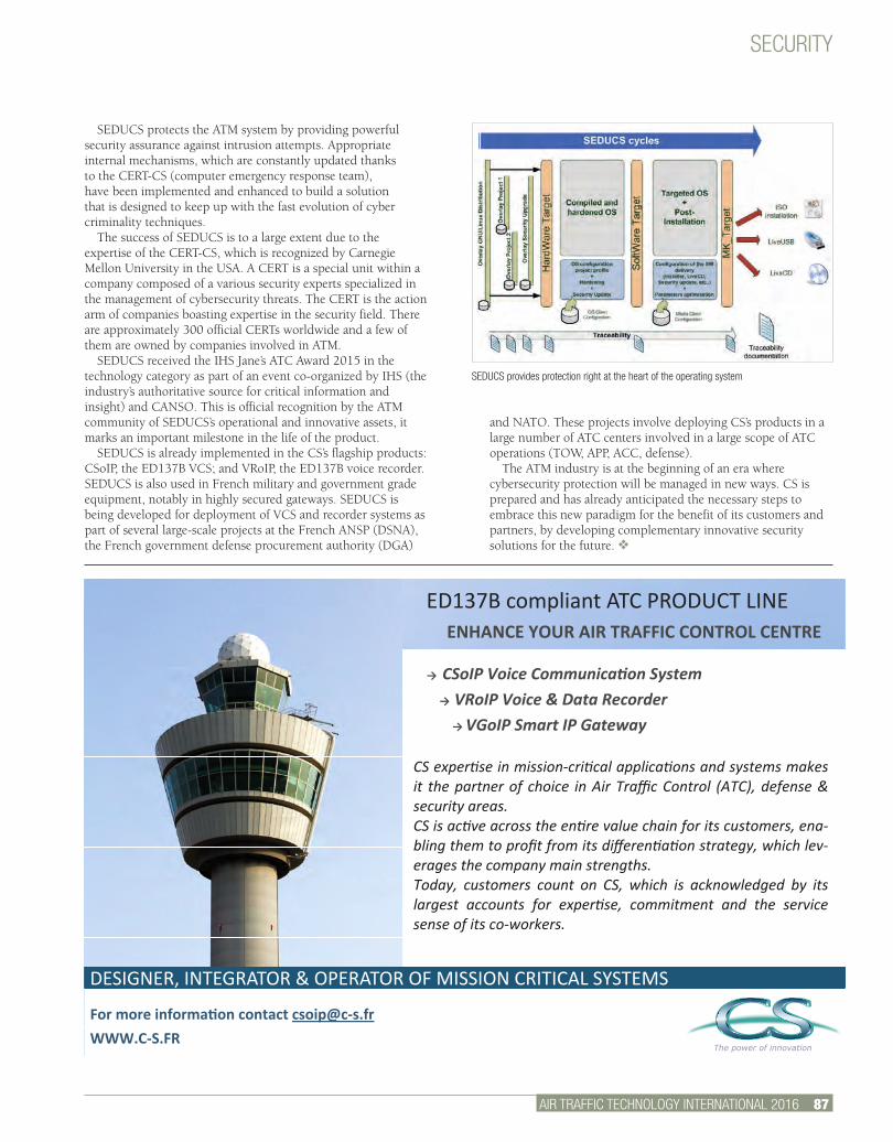
SECURITY
AIR TRAFFIC TECHNOLOGY INTERNATIONAL 2016 87.
SEDUCS protects the ATM system by providing powerful security assurance against intrusion attempts. Appropriate internal mechanisms, which are constantly updated thanks to the CERT-CS (computer emergency response team), have been implemented and enhanced to build a solution that is designed to keep up with the fast evolution of cyber criminality techniques.
The success of SEDUCS is to a large extent due to the expertise of the CERT-CS, which is recognized by Carnegie Mellon University in the USA. A CERT is a special unit within a company composed of a various security experts specialized in the management of cybersecurity threats. The CERT is the action arm of companies boasting expertise in the security field. There are approximately 300 official CERTs worldwide and a few of them are owned by companies involved in ATM.
SEDUCS received the IHS Jane’s ATC Award 2015 in the technology category as part of an event co-organized by IHS (the industry’s authoritative source for critical information and insight) and CANSO. This is official recognition by the ATM community of SEDUCS’s operational and innovative assets, it marks an important milestone in the life of the product.
SEDUCS is already implemented in the CS’s flagship products: CSoIP, the ED137B VCS; and VRoIP, the ED137B voice recorder. SEDUCS is also used in French military and government grade equipment, notably in highly secured gateways. SEDUCS is being developed for deployment of VCS and recorder systems as part of several large-scale projects at the French ANSP (DSNA), the French government defense procurement authority (DGA)
and NATO. These projects involve deploying CS’s products in a large number of ATC centers involved in a large scope of ATC operations (TOW, APP, ACC, defense).
The ATM industry is at the beginning of an era where cybersecurity protection will be managed in new ways. CS is prepared and has already anticipated the necessary steps to embrace this new paradigm for the benefit of its customers and partners, by developing complementary innovative security solutions for the future. v
SEDUCS provides protection right at the heart of the operating system
DESIGNER, INTEGRATOR & OPERATOR OF MISSION CRITICAL SYSTEMS
The power of innovation
For more informaon contact [email protected] WWW.C-S.FR
→ CSoIP Voice Communicaon System → VRoIP Voice & Data Recorder → VGoIP Smart IP Gateway
ED137B compliant ATC PRODUCT LINE ENHANCE YOUR AIR TRAFFIC CONTROL CENTRE
CS experse in mission-crical applicaons and systems makes it the partner of choice in Air Traffic Control (ATC), defense & security areas. CS is acve across the enre value chain for its customers, ena-bling them to profit from its differenaon strategy, which lev-erages the company main strengths. Today, customers count on CS, which is acknowledged by its largest accounts for experse, commitment and the service sense of its co-workers.

PLANNING
88 AIR TRAFFIC TECHNOLOGY INTERNATIONAL 2016
If there’s one thing airports dread, it’s the stress that comes with planning, budgeting, executing and taking delivery of an airfield infrastructure modernization or
expansion project. Typically these may require an upgrade of systems or moving to a completely new technology with the aim of improving safety, compliance or supporting passenger growth.
But expansion and modernization needn’t be stressful, especially if it’s managed the right way and by the right partner. With more than 68 years of experience in airfield ground lighting (AGL) projects around the world, ADB Group understands how stressful airfield infrastructure projects can be. At leading airports like Qatar’s Hamad International Airport in Doha, Malaysia’s Kuala Lumpur International Airport and Taiwan’s Taoyuan International Airport, ADB has honed its turnkey expertise.
Over the years ADB has refined its approach with SmartExpansion Path, which bundles the company’s turnkey expertise into eight domains that cover the complete cycle of airside operations. This helps airports pursue their most ambitious growth plans, even while effectively tackling operational challenges such as air traffic, compliance, technology, downtime and costs.
Intelligent management of eight domains SmartExpansion Path’s eight domains are essentially building blocks. Depending on an airport’s growth objectives, these can be studied in parts by picking relevant elements, or as a whole
in a logical flow. After assessing the impact of aspects such as air traffic and regularity compliance on airside operations, ADB can recommend how these domains can be managed intelligently to help an airport achieve its growth objectives. Data-driven traffic management By analyzing the ebb and flow of current and future air traffic, ADB can help airports maximize airside capacity for safe and smooth traffic flow by analyzing current and future movements. Routing management helps pilots maneuver complex taxiway networks, while intelligent systems such as the Sensor Controlled Incursion Prevention System and user-friendly human-machine interface at the control tower enable precise guidance. Detailed audit and survey It is imperative to assess the current AGL setup and regulatory compliance status to address safety needs while keeping in mind future plans. For existing airports this could include extensive on-site surveys of AGL-related infrastructure, their location and current condition. ADB can also propose initial phasing of the works for budgeting purposes.Intuitive AGL design Based on a traffic analysis and audit, the ADB team delivers a complete customized and detailed airside design, from runways to taxiways, that is compliant with applicable international standards including those from ICAO and the FAA. Innovative products and solutions As a pioneer and market leader in LED, ADB offers the industry’s first complete LED AGL portfolio. Using the airside design as a reference, the
EXPANSION PLANSAirports looking to expand their airfield infrastructure can follow an eight-step plan to ensure a stress-free experience ADB Airfield Solutions
The ADB SmartExpansion Path helps airports study traffic management, training and maintenance, among other things, when looking to expand their airfield

PLANNING
AIR TRAFFIC TECHNOLOGY INTERNATIONAL 2016 89.
ADB partners with best-in-class providers of solutions to complete its solutions portfolio
NO STRESSYou need only one expert to lead your airport to secure growth.
Our turnkey capabilities help airports address their greatest growth ambitions and tackle operational challenges, such as increasing air traffic, efficiency, changing regulations, safety and new technology. We bundled all our expertise in ADB’s SmartExpansion Path. It ensures you can count on our full commitment, from AGL design, products and solutions to system engineering, training and maintenance, from a trusted and reliable partner since 68 years.
DISCOVER HOW OUR SMARTEXPANSION PATHHELPS YOU REALIZE YOUR AMBITIONS. Surf to:www.adb-air.com/nostressAirfield. Our Field.
company’s experts recommend the right mix of AGL products, power management equipment and AGL control and monitoring systems.Robust system engineering An airport’s airfield monitoring and control systems need to be customized for scalability and flexibility so that airside movement is controlled seamlessly. This is achieved by integrating various third-party systems. Dedicated services and project management To address the growing complexity of airfield projects, the package includes dedicated project management expertise and multiple layers of service, from installation and commissioning to comprehensive after-sales support. In-depth training A comprehensive product-training portfolio ensures that airport staff are well equipped to manage the airport’s newly installed systems. Proactive maintenance Solutions like ADB’s AirSide maximize uptime by leveraging the inherent communication capabilities of AGL assets to track their performance in real time, enabling airports to take corrective or preventive action.
ADB is currently using this approach to support a major expansion project at a leading airport in Asia where it is the main contractor in a multi-year turnkey project that spans AGL survey, design, project management, procurement, electrical and civil installations and services. After learning the airport’s key challenges and growth plans, ADB studied
the relevant domains and proposed a host of solutions that address challenges such as runway safety, ground movement, operational flexibility and capacity management. ADB will also coordinate with multiple other stakeholders and vendors to execute this mega project. v
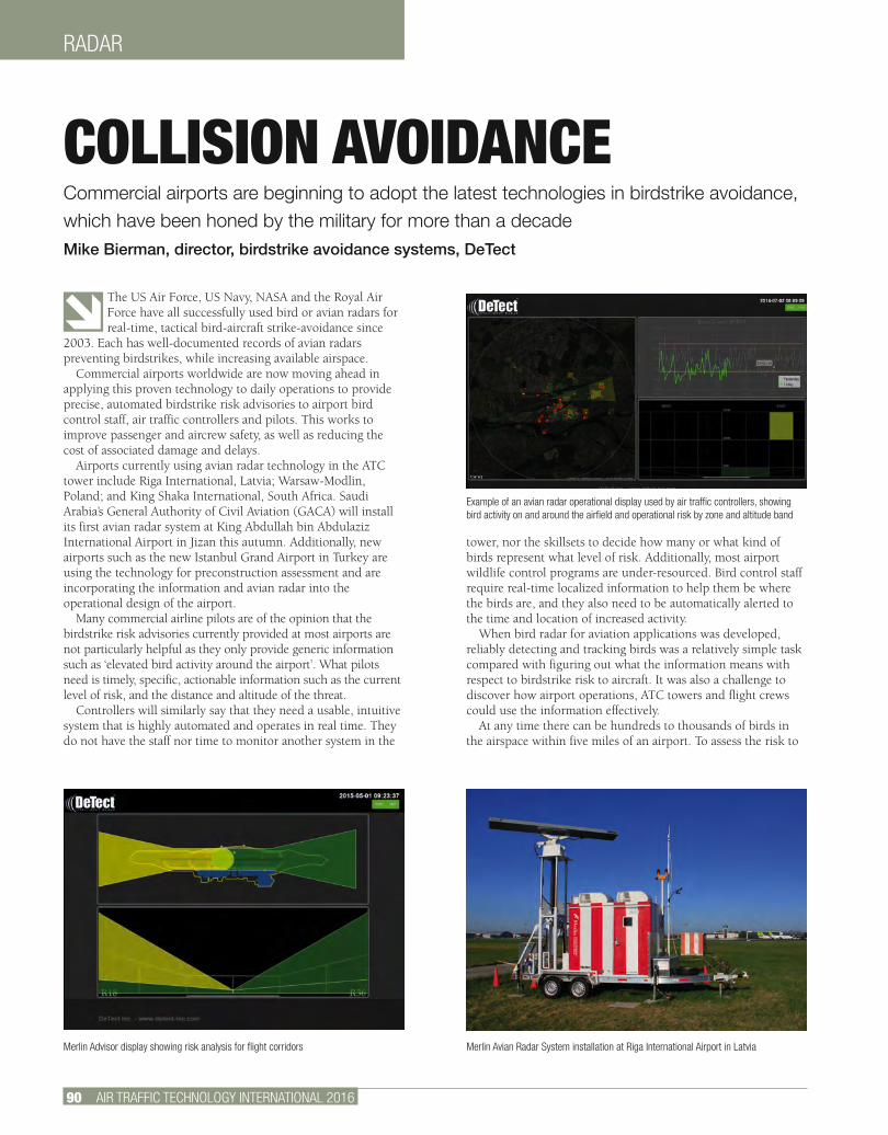
RADAR
90 AIR TRAFFIC TECHNOLOGY INTERNATIONAL 2016
The US Air Force, US Navy, NASA and the Royal Air Force have all successfully used bird or avian radars for real-time, tactical bird-aircraft strike-avoidance since
2003. Each has well-documented records of avian radars preventing birdstrikes, while increasing available airspace.
Commercial airports worldwide are now moving ahead in applying this proven technology to daily operations to provide precise, automated birdstrike risk advisories to airport bird control staff, air traffic controllers and pilots. This works to improve passenger and aircrew safety, as well as reducing the cost of associated damage and delays.
Airports currently using avian radar technology in the ATC tower include Riga International, Latvia; Warsaw-Modlin, Poland; and King Shaka International, South Africa. Saudi Arabia’s General Authority of Civil Aviation (GACA) will install its first avian radar system at King Abdullah bin Abdulaziz International Airport in Jizan this autumn. Additionally, new airports such as the new Istanbul Grand Airport in Turkey are using the technology for preconstruction assessment and are incorporating the information and avian radar into the operational design of the airport.
Many commercial airline pilots are of the opinion that the birdstrike risk advisories currently provided at most airports are not particularly helpful as they only provide generic information such as ‘elevated bird activity around the airport’. What pilots need is timely, specific, actionable information such as the current level of risk, and the distance and altitude of the threat.
Controllers will similarly say that they need a usable, intuitive system that is highly automated and operates in real time. They do not have the staff nor time to monitor another system in the
tower, nor the skillsets to decide how many or what kind of birds represent what level of risk. Additionally, most airport wildlife control programs are under-resourced. Bird control staff require real-time localized information to help them be where the birds are, and they also need to be automatically alerted to the time and location of increased activity.
When bird radar for aviation applications was developed, reliably detecting and tracking birds was a relatively simple task compared with figuring out what the information means with respect to birdstrike risk to aircraft. It was also a challenge to discover how airport operations, ATC towers and flight crews could use the information effectively.
At any time there can be hundreds to thousands of birds in the airspace within five miles of an airport. To assess the risk to
COLLISION AVOIDANCECommercial airports are beginning to adopt the latest technologies in birdstrike avoidance, which have been honed by the military for more than a decade Mike Bierman, director, birdstrike avoidance systems, DeTect
Merlin Advisor display showing risk analysis for flight corridors Merlin Avian Radar System installation at Riga International Airport in Latvia
Example of an avian radar operational display used by air traffic controllers, showing bird activity on and around the airfield and operational risk by zone and altitude band
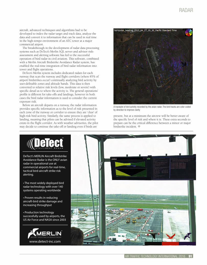
RADAR
AIR TRAFFIC TECHNOLOGY INTERNATIONAL 2016 91.
A trackplot of bird activity recorded by the avian radar. The bird tracks are color coded by direction to improve clarity
• The most widely deployed bird radar technology with over 140 systems operating worldwide
• Proven results in reducing aircraft-bird strike damage and increasing throughput
• Production technology successfully used by airports, the US Air Force and NASA since 2003
DeTect’s MERLIN Aircraft Birdstrike Avoidance Radar is the ONLY avian radar in operational use at commercial airports for real-time, tactical bird-aircraft strike risk alerting.
www.detect-inc.com
TM
AIRCRAFT BIRDSTRIKE AVOIDANCE RADAR
aircraft, advanced techniques and algorithms had to be developed to index the radar target and track data, analyze the data and convert it to information that can be used in real time in the high-tempo environment of an ATC tower at a major commercial airport.
The breakthrough in the development of radar data processing systems such as DeTect’s Merlin SQL server and advisor risk-assessment and alerting software has led to the successful operation of bird radar in civil aviation. This software, combined with a Merlin Aircraft Birdstrike Avoidance Radar system, has enabled the real-time integration of bird radar information into tower and flight operations.
DeTect’s Merlin system includes dedicated radars for each runway that scan the runway and flight corridors (where 85% of airport birdstrikes occur) continually analyzing bird activity by user-definable zones and altitude bands. This data is then converted to relative risk levels (low, moderate or severe) with specific detail as to where the activity is. The general operations’ profile is different for take-offs and landings, however in both cases the bird radar information is used to consider the current exposure risk.
Before an aircraft departs on a runway, the radar information provides specific information as to the level of risk presented in each zone of the runway or corridor to ensure they are ‘clear’ of high-risk bird activity. Similarly, the same process is applied to landing, meaning that pilots can be advised if elevated activity exists in the flight corridor. As with weather advisories, the pilot may decide to continue the take-off or landing even if birds are
present, but at a minimum the aircrew will be better aware of the specific level of risk and where it is. These extra seconds to prepare can be the critical difference between a minor or major birdstrike incident. v
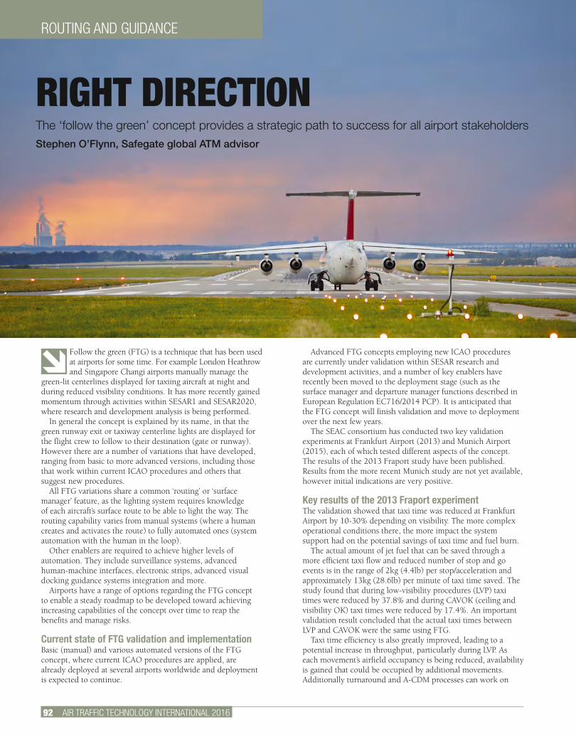
ROUTING AND GUIDANCE
92 AIR TRAFFIC TECHNOLOGY INTERNATIONAL 2016
Follow the green (FTG) is a technique that has been used at airports for some time. For example London Heathrow and Singapore Changi airports manually manage the
green-lit centerlines displayed for taxiing aircraft at night and during reduced visibility conditions. It has more recently gained momentum through activities within SESAR1 and SESAR2020, where research and development analysis is being performed.
In general the concept is explained by its name, in that the green runway exit or taxiway centerline lights are displayed for the flight crew to follow to their destination (gate or runway). However there are a number of variations that have developed, ranging from basic to more advanced versions, including those that work within current ICAO procedures and others that suggest new procedures.
All FTG variations share a common ‘routing’ or ‘surface manager’ feature, as the lighting system requires knowledge of each aircraft’s surface route to be able to light the way. The routing capability varies from manual systems (where a human creates and activates the route) to fully automated ones (system automation with the human in the loop).
Other enablers are required to achieve higher levels of automation. They include surveillance systems, advanced human-machine interfaces, electronic strips, advanced visual docking guidance systems integration and more.
Airports have a range of options regarding the FTG concept to enable a steady roadmap to be developed toward achieving increasing capabilities of the concept over time to reap the benefits and manage risks.
Current state of FTG validation and implementationBasic (manual) and various automated versions of the FTG concept, where current ICAO procedures are applied, are already deployed at several airports worldwide and deployment is expected to continue.
Advanced FTG concepts employing new ICAO procedures are currently under validation within SESAR research and development activities, and a number of key enablers have recently been moved to the deployment stage (such as the surface manager and departure manager functions described in European Regulation EC716/2014 PCP). It is anticipated that the FTG concept will finish validation and move to deployment over the next few years.
The SEAC consortium has conducted two key validation experiments at Frankfurt Airport (2013) and Munich Airport (2015), each of which tested different aspects of the concept. The results of the 2013 Fraport study have been published. Results from the more recent Munich study are not yet available, however initial indications are very positive.
Key results of the 2013 Fraport experimentThe validation showed that taxi time was reduced at Frankfurt Airport by 10-30% depending on visibility. The more complex operational conditions there, the more impact the system support had on the potential savings of taxi time and fuel burn.
The actual amount of jet fuel that can be saved through a more efficient taxi flow and reduced number of stop and go events is in the range of 2kg (4.4lb) per stop/acceleration and approximately 13kg (28.6lb) per minute of taxi time saved. The study found that during low-visibility procedures (LVP) taxi times were reduced by 37.8% and during CAVOK (ceiling and visibility OK) taxi times were reduced by 17.4%. An important validation result concluded that the actual taxi times between LVP and CAVOK were the same using FTG.
Taxi time efficiency is also greatly improved, leading to a potential increase in throughput, particularly during LVP. As each movement’s airfield occupancy is being reduced, availability is gained that could be occupied by additional movements. Additionally turnaround and A-CDM processes can work on
RIGHT DIRECTION The ‘follow the green’ concept provides a strategic path to success for all airport stakeholdersStephen O’Flynn, Safegate global ATM advisor
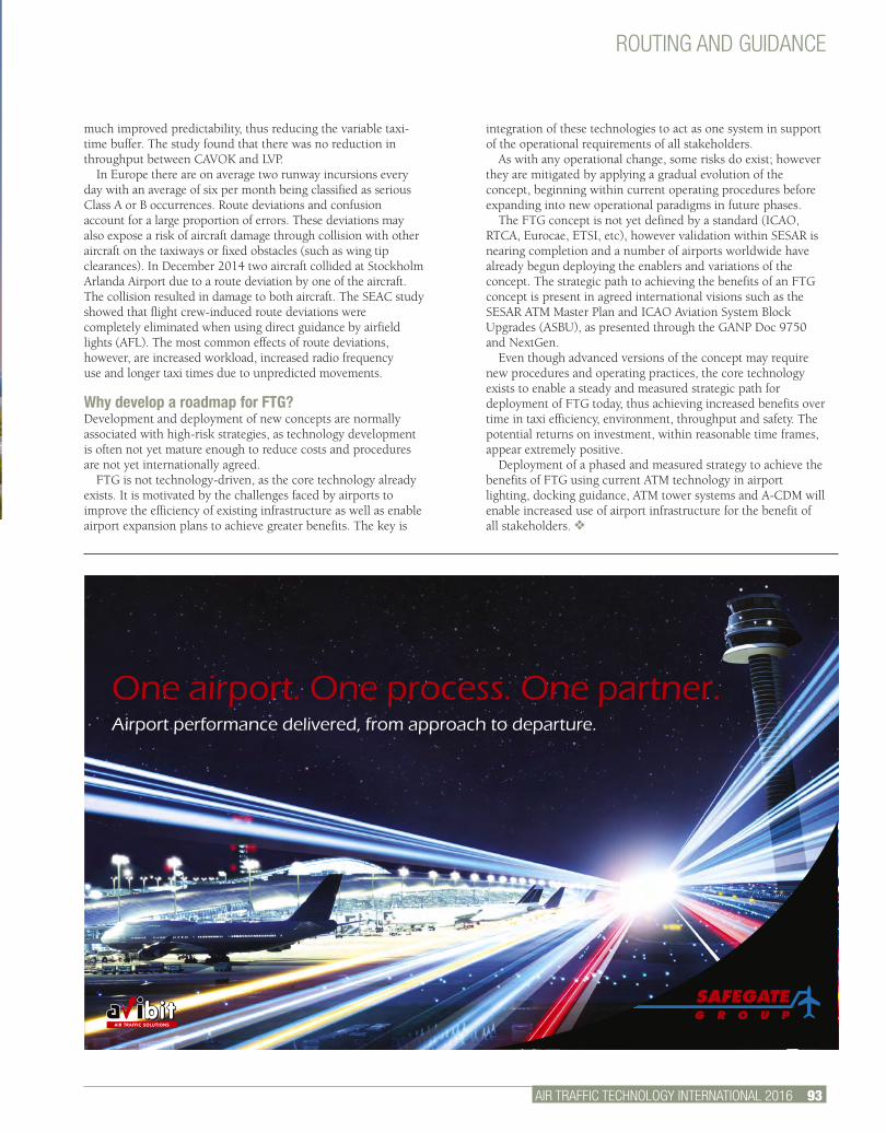
ROUTING AND GUIDANCE
AIR TRAFFIC TECHNOLOGY INTERNATIONAL 2016 93.
One airport. One process. One partner.Airport performance delivered, from approach to departure.
much improved predictability, thus reducing the variable taxi-time buffer. The study found that there was no reduction in throughput between CAVOK and LVP.
In Europe there are on average two runway incursions every day with an average of six per month being classified as serious Class A or B occurrences. Route deviations and confusion account for a large proportion of errors. These deviations may also expose a risk of aircraft damage through collision with other aircraft on the taxiways or fixed obstacles (such as wing tip clearances). In December 2014 two aircraft collided at Stockholm Arlanda Airport due to a route deviation by one of the aircraft. The collision resulted in damage to both aircraft. The SEAC study showed that flight crew-induced route deviations were completely eliminated when using direct guidance by airfield lights (AFL). The most common effects of route deviations, however, are increased workload, increased radio frequency use and longer taxi times due to unpredicted movements.
Why develop a roadmap for FTG?Development and deployment of new concepts are normally associated with high-risk strategies, as technology development is often not yet mature enough to reduce costs and procedures are not yet internationally agreed.
FTG is not technology-driven, as the core technology already exists. It is motivated by the challenges faced by airports to improve the efficiency of existing infrastructure as well as enable airport expansion plans to achieve greater benefits. The key is
integration of these technologies to act as one system in support of the operational requirements of all stakeholders.
As with any operational change, some risks do exist; however they are mitigated by applying a gradual evolution of the concept, beginning within current operating procedures before expanding into new operational paradigms in future phases.
The FTG concept is not yet defined by a standard (ICAO, RTCA, Eurocae, ETSI, etc), however validation within SESAR is nearing completion and a number of airports worldwide have already begun deploying the enablers and variations of the concept. The strategic path to achieving the benefits of an FTG concept is present in agreed international visions such as the SESAR ATM Master Plan and ICAO Aviation System Block Upgrades (ASBU), as presented through the GANP Doc 9750 and NextGen.
Even though advanced versions of the concept may require new procedures and operating practices, the core technology exists to enable a steady and measured strategic path for deployment of FTG today, thus achieving increased benefits over time in taxi efficiency, environment, throughput and safety. The potential returns on investment, within reasonable time frames, appear extremely positive.
Deployment of a phased and measured strategy to achieve the benefits of FTG using current ATM technology in airport lighting, docking guidance, ATM tower systems and A-CDM will enable increased use of airport infrastructure for the benefit of all stakeholders. v
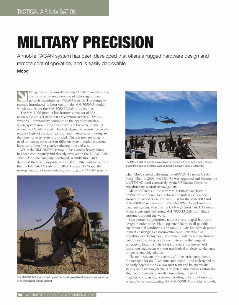
TACTICAL AIR NAVIGATION
94 AIR TRAFFIC TECHNOLOGY INTERNATIONAL 2016
Moog, one of the world’s leading TACAN manufacturers, claims to be the only provider of lightweight, man-portable expeditionary TACAN systems. The company
recently introduced its latest version, the MM-7000MP model, which rounds out the MM-7000 TACAN product line.
The MM-7000 product line features a core set of line replaceable units (LRUs) that are common across all TACAN versions. Commonality continues to the operator interface, where system monitoring and control are the same no matter where the TACAN is sited. This high degree of consistency greatly reduces logistics costs, as operator and maintenance training are the same for every system provided. There is now no longer a need to manage three or four different system implementations logistically, therefore greatly reducing time and cost.
While the MM-7000MP is new, it has a strong legacy. Moog has been continuously and directly involved in the TACAN field since 1955. The company developed, manufactured and delivered the first man-portable TACAN in 1967 and the world’s first mobile TACAN system in 1968. The year 1975 saw the next-generation of man-portable, air-droppable TACAN systems,
when Moog started delivering the AN/TRN-41 to the US Air Force. Then in 2008, the TRN-41 was upgraded and became the AN/TRN-47, used extensively by the US Marine Corps for expeditionary tactical air navigation.
All critical items in the new MM-7000MP have been in production and have been delivered to military customers around the world. Core TACAN LRUs for the MM-7000 and MM-7000MP are identical in the AN/URN-32 shipboard and fixed-site system, which is the US Navy’s latest TACAN system. Moog is currently delivering MM-7000 TACANs to military customers around the world.
Man-portable applications require a very rugged hardware design in order to be able to operate reliably in all possible environmental conditions. The MM-7000MP has been designed to meet challenging environmental conditions while on expeditionary deployment. The system will operate in climatic conditions that are typically encountered in the range of geographic locations where expeditionary maneuvers and operations may occur without mechanical or electrical damage, or operational degradation.
The main system only consists of three basic components – the transponder (R/T), antenna and tripod – and is designed to be easily deployable by a two-man team and be operational shortly after arriving on site. The system also features automatic alignment to magnetic north, eliminating the need for a magnetic compass and a manual heading to be input into the system. Once broadcasting, the MM-7000MP provides azimuth,
MILITARY PRECISIONA mobile TACAN system has been developed that offers a rugged hardware design and remote control operation, and is easily deployable Moog
The MM-7000MP’s remote maintenance monitor circuitry and embedded firmware enable both local and remote users to adjust the system using a simple GUI
The MM-7000MP is easy to set up and can be fully operational within minutes of arrival at an unprepared tactical position

TACTICAL AIR NAVIGATION
AIR TRAFFIC TECHNOLOGY INTERNATIONAL 2016 95.
distance and station identification, supporting non-precision instrument approach, terminal area navigation, and en route navigation in both instrument meteorological conditions (IMC) and visual meteorological conditions (VMC). The antenna support assembly legs adjust and lock in any position, and a swivel head means the system can be set up on irregular terrain. The tripod includes a level, so the antenna can be erected on a slope of up to 10°. The deployed system can withstand winds up to 50kts.
Man-portable TACAN systems are often deployed in locations that put soldiers in harm’s way. The MM-7000MP is equipped with various remote control capabilities so that the system can be controlled from a safe location, protected from undesirable environmental conditions. A remote control system that offers full setup monitoring and troubleshooting capability is available. A simple remote control unit that offers basic status and radio silence commands is also available.
To aid in location flexibility, the system accommodates a wide range of power sources from either 20-30V DC power or 85-265V AC power. Power can be supplied by battery, generator and solar cells, or from the local power grid.
In order to ensure TACAN signal compliance, the MM-7000MP has a comprehensive signal monitor and a built-in
interrogator, which simulates an aircraft. System signal integrity is constantly being tested to ensure that
accurate information to the aircraft and the pilot is being provided. Additional sensors continuously monitor the system, detecting if the antenna position has been disturbed at all. If an out-of-tolerance condition is detected, transmission is
interrupted and an alarm is generated.The all-band AS-4502 antenna is the world’s smallest,
lightest, most versatile, full-service, instantaneous TACAN antenna in use today. There are more than 130 AS-4502
antennas in service around the world. The AS-4502 acts as both a receiving and transmitting antenna, and adds 15Hz and 135Hz amplitude modulation to the radiated signals through the use of parasitic elements.
According to Moog, the MM-7000 TACAN platform is the only TACAN available that can satisfy the requirements of man-portable, mobile and deployable, shipboard or fixed-base
applications, with a single product. The logistical advantages of this single-platform approach, especially for customers who have
requirements for multiple applications, enable Moog to offer the best-value TACAN solutions available in the industry. v
World’s Smallest, Lightest, Full-featured Tactical Air Navigation System
The New MM-7000MPFrom the Market Leader in TACAN Systems
www.moog.com
BACK CHAT
96 AIR TRAFFIC TECHNOLOGY INTERNATIONAL 2016
The use of data to improve performance is nothing new – ‘big data’ has been the buzz phrase of the technology industry for a long time. Lots of companies have
dedicated a huge amount of effort and resource in recent years to finding the best ways to get data, analyze it, and use it to improve performance or their offering to customers. From sports such as Formula 1, using real-time data to constantly analyze performance, the competition and devise strategy; through to retail and loyalty cards using big data sets to predict the future, provide better experiences and offers for their customers based on modeling their habits and preferences – getting your hands on good data and using it effectively is at the heart of many of today’s industries.
The aviation industry uses data in some areas better than others, but there’s definitely more we can do. Some of the challenges we face are technological and unique to the aviation industry – for example finding a reliable way to regularly transmit data from aircraft at 30,000ft to the ground. However, some of the challenges are cultural – about recognizing the value data can provide, ensuring we share data, and using that data to improve decision making.
Having better access to data and, importantly, sharing it, will transform the way we manage air traffic. We have some examples of this that hint at what might be possible: our joint cross-border arrival management (XMAN) work to reduce stack holding at London Heathrow, which uses system-wide information management (SWIM) to share data between organizations, and the recent introduction of time-based separation at Heathrow, indicate the improvements that can be gained from the use of real-time data.
Still, we need to build on this. The opportunities are huge. I recently spoke at a Digital Summit organized by the Welsh government on the notion of digital in the skies. I truly believe that the future of ATM, and the way we’ll be able to safely manage growth in air traffic while at the same time improving environmental performance, is by using real-time data to improve performance.
Using increased computational power to predict the future in four dimensions, creating more efficient flight profiles and empowering airspace users to take user-preferred routes; exploiting new data sources and fusing data to increase
surveillance reach and fidelity; sharing information in real time to increase network wide performance and efficiency; exploiting access to real-time data to improve weather resilience. All of these are examples of where real-time data can help us to improve the service we offer airspace users and make better use of our airspace, further improving safety, reducing environmental impact, and saving fuel, time and money.
We know there is still much work to do until we have all the technologies in place and working, but real-time big data is on its way and the sooner we can make it happen, the better. v
A version of this article first appeared on nats.aero/blog
Simon Daykin, chief architect at NATS, is responsible for the overall design of NATS’s operational systems, ensuring that its current and future systems developments are aligned with the business and operational strategy. Daykin has a wide-ranging background in systems development and design. Before joining NATS in 2013, Daykin was chief technology officer for IT solutions company Logicalis UK, where he led the development and design of its data centers, cloud platform and major customer projects. He has also worked as a systems integrator at Thales and as an architect at the Portman Building Society
IMPROVING ATM WITH BIG DATA
INDEX TO ADVERTISERS60th Annual ATCA Conference and Exposition ..................17
ADB Airfield Solutions ....................................................89
Air Traffic Technology International .................................32
Air Traffic Technology International Reader Inquiry Service ........29, 47
ATNS (Air Traffic and Navigation Services) .......................48
AviBit GmbH .................................................................93
Coastal Environmental Systems Inc ................................29
Comsoft GmbH .............................................................65
CS Communication & Systems .......................................87
De-Tect Inc ...................................................................91
DFS Deutsche Flugsicherung GmbH ......................... 43, 47
Eizo Corporation ............................................................61
ENAV SpA .....................................................................66
Esterline Belgium BVBA ................................................57
Frequentis AG ...............................................................53
Honeywell Aerospace ....................................................75
INDRA ................................................... Inside Front Cover
Isode Ltd .............................................Outside Back Cover
Korea Airports Corporation .............................................11
Meteorological Technology World Expo 2015 ............ 23, 26
MOOG .........................................................................95
NAV Canada .................................................................82
NAV Portugal ................................................................79
Pal Support...................................................................32
Sennheiser ...................................................................43
Skyguide ......................................................................85
SkySoft .......................................................................85
UBM China (Beijing) Co Ltd ............................................35
Wey Elektronik AG .........................................................69
World ATM Congress 2016 ......................Inside Back Cover