integrating hunter-gatherer sites, environments, technology and art in western victoria
TRANSCRIPT
lI"""""""
Routledge Studies in Archaeology Archaeology in Environment
1 An Archaeology of Materials Substantial Transfonnations in Early Prehistoric Europe Chantal Conne/ler
2 Roman Urban Street Networks Streets and the Organization of Space in Four Cities Alan Kaiser
3 Tracing Prehistoric Social Networks through Technology A Diachronic Perspective on the Aegean Edited by Ann Btysbaert
4 Hadrian's Wall and the End of Empire The Roman Frontier in the 4th and 5th Centuries Rob Collins
5 U.S. Cultural Diplomacy and Archaeology Soft Power, Hard Heritage Christina Luke and Morag M Kersel
6 The Prehistory of Iberia Debating Early Social Stratification and the State Edited by Maria Cruz Berroeal, Leonardo Garcia Sanjuan and Antonio Gilman
7 Materiality and Consumption in the Bronze Age Mediterranean Louise Steel
8 Archaeology in Environment and Technology Intersections and Transfonnations Edited by David Frankel, Jennifer M Webb and Susan Lawrence
and Technology Intersections and Transformations
Edited by David Frankel, Jennifer M. Webb and Susan Lawrence
I~ ~~o~1!r:n~~~up
NEW YORK AND LONDON
III""""'""
First published 2013 by Routledge 711 Third Avenue, New York, NY 10017
Simultaneously published in the UK by Routledge 21'ark Square, Milton Park, Abingdon, Oxon OX14 4RN
Rou/ledge is an imprim o(tlle Taylor & Francis Group, an informa business
© 2013 Taylor & Franeis
The right of the editors to be identified as the author of the editorial material, and ofthc authors for their individual chapters, has been asserted in accordancc with sections 77 and 78 of the Copyright, Designs and Patents Act 1988.
All rights reserved. No part of this book may be reprinted or reproduced or utilised in any 101m or by any electronic, mechanical, or other means, now known or hereafter inventcd, including photocopying and recording, or in any information storage or retrieval system, without permission in writing from the publishers.
Trademark Notice: Product or corporate names may be trademarks or registered trademarks, and are used only for identification and explanation without intent to infringe.
Library o/Congress Ca/aloging-in-PubJication Data
Archaeology in environment and technology intersections and transformations / edited by David Frankel, Jennifer M. Webb and Susan Lawrence.
pages cm. - (Routledge studies in archaeology; 8) Includes bibliographical relerences and index. 1. Environmental archaeology-Case studies. 2. Landscape
archaeology-Case studies. 3. Human geography-Case studies. 4. Agriculture, Prehistoric-Case studies. 5. Tools, Prchistoric-Case studies. I. Frankel, David, 1946- author, editor of compilation. n. Webb, Jennifer M. autor, editor of compilation. 111. Lawrence, Susan, 1966- author, editor of compilation.
CC81.A672013 930.1----dc23 2012045042
ISBN: 978-0-415-83201-4 (hbk) ISBN: 978-0-203-50894-7 (ebk)
Typeset in Sabon by Apex CoVantage, LLC
Printed and bound in the United States of America by Publishers Graphics,
LtC on sustainably sourced paper.
Contents
List of Figures List of Tables
Vll
IX
1 Complex Relations: Intersections in Time and Space DAVID FRANKEL, JENNIFER M. WEBB AND SUSAN LAWRENCE
1
PART I Responses to Environments
2 Perspectives on Global Comparative Hunter-Gatherer Archaeology: Glacial Southwest Tasmania and Southwest France RICHARD COSGROVE, JEAN-MICHEL GENESTE, JEAN-PIERRE CHADELLE AND
JEAN-CHRISTOPHE CASTEL
13
3 Strategies for Investigating Human Responses to Changes in Landscape and Climate at Lake Mungo in the Willandra Lakes, Southeast Australia NICOLA STERN, JACQUELINE TUMNEY, KATHRYN E. FITZSIMMONS AND
PAUL KAJEWSKI
31
4 A New Ecological Framework for Understanding Human-Environment Interactions in Arid Australia SIMON J. HOLDAWAY, MATTHEW J. DOUGLASS AND PATRICIA C. FANNING
51
5 Integrating Hunter-Gatherer Sites, Environments, Technology and Art in Western Victoria DAVID FRANKEL AND CAROLINE BIRD
69
6 Pushing the Boundaries: Imperial Responses to Environmental Constraints in Early Islamic Afghanistan DAVID C. THOMAS
84
.......
VI Contents
PART II FiguresTechnology and the Environment
7 A Long-Term History of Horticultural Innovation and Introduction in the Highlands of Papua New Guinea 101
TIM DENHAl'v1
8 Agricultural Economies and Pyrotechnologies in Bronze Age Jordan and Cyprus 123
STEVEN E. FALCONER AND PATRICIA L. FALL
9 Changing Technological and Social Environments in the 2.1 Location of Combe Sauniere, southwest France 16 Second Half of the Third Millennium BC in Cyprus 135 2.2 The stratigraphy of Combe Sauniere 17 JENNIFER M. WEBB 2.3 Plan of Combe Sauniere showing squares H16-H21 18
10 Landscape Learning in Colonial Australia: Technologies of Water Management on the Central Highlands Goldfields of Victoria 149
2.4 3.1
Plotted artefacts and fauna at Combe Sauniere Map of Australia showing the main river systems draining the southeast Australian highlands and the location of the Willandra Lakes
20
32 SUSAN LAWRENCE AND PETER DAVIES
3.2 Geological map of the Willandra Lakes region 34
3.3 Map of part of the northern Mungo lunette 38 PARTIII 4.1 An aerial image of the Rutherfords Creek and Howells Nature and Culture Creek catchments draining into Peery Lake in western
New South Wales 63
11 Exploring Human-Plant Entanglements: The Case of 5.1 Map of Gariwerd showing the location of sites mentioned
Australian Dioscorea Yams 167 in the text 70
JENNIFER ATCHISON & LESLEY HEAD 5.2 Summary of the chronological framework for assemblages and rock art phases 71
12 People and Their Environments: Do Cultural and Natural 5.3 Proportions of main raw material types in each assemblage 73 Values Intersect in the Cultural Landscapes on the World Heritage List? 181
5.4 Schematic models of land use patterns in and beside the ranges 81
ANITA SMITH 6.1 The Ghurids' sphere of influence at its maximum extent
Contributors Index
205 211
6.2 ca 1200 CE Minaret of lliam and surrounding mountain slopes, pock-marked by robber holes
87
88 6.3 Estimated extent of the Ghurid summer capital at lliam 89 7.1 Map of Papua New Guinea with inset, showing sites
mentioned in the text 104 7.2 Chronology of practices and forms of plant exploitation
in the Upper Wahgi Valley 105 7.3 Composite image showing practices discussed in the text 106
68 Simon]. Holdaway, Matthew]. Douglass and Patricia C. Fanning
Veth, P. & EJ. Walsh. 1988. The concept of 'staple' plant foods in the western desert region of Western Australia. Australian Aboriginal Studies 2: 19-25.
Walsh, EJ. 1987. Influence of the spatial and temporal distribution of plant food resources on traditional Martujarra subsistence strategies. Australian Archaeol_ ogy 25: 88-101.
Walsh, EJ. 1990. An ecological study of traditional Aboriginal use of "country": Martu in the Great and Little Sandy Deserts, Western Australia. Proceedings of the Ecological Society of Australia 16: 23-37.
White, C. & N. Peterson. 1969. Ethnographic interpretations of the prehistory of Western Arnhem Land. Southwestern Journal of Anthropology 25: 45-67.
Williams, E. 1987. Complex hunter-gatherers: a view from Australia. Antiquity 61: 310-21.
Yellen, J. 1977. Archaeological approaches to the present-models for reconstructing the past. New York: Academic Press.
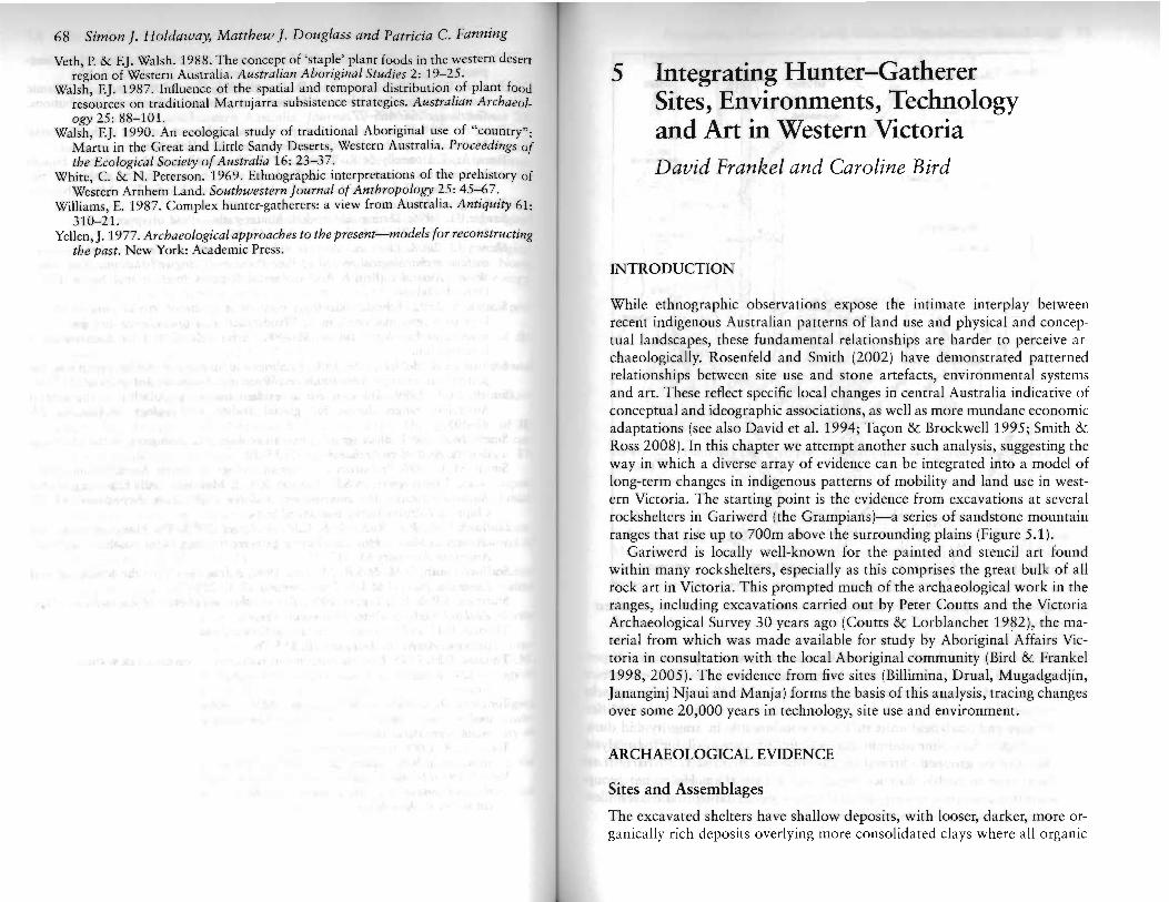
5 Integrating Hunter-Gatherer Sites, Environments, Technology and Art in Western Victoria David Frankel and Caroline Bird
INTRODUCTION
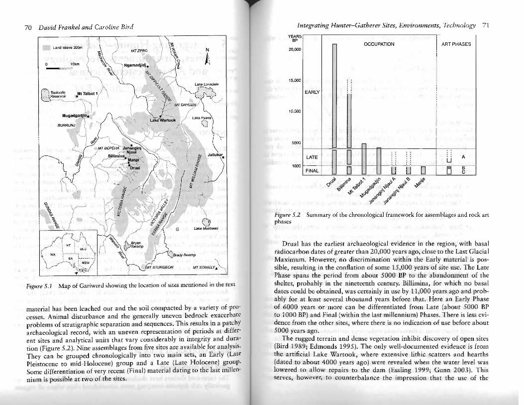
While ethnographic observations expose the intimate interplay between recent indigenous Australian patterns of land use and physical and conceptual landscapes, these fundamental relationships are harder to perceive archaeologically. Rosenfeld and Smith (2002) have demonstrated patterned relationships between site use and stone artefacts, environmental systems and art. These reflect specific local changes in central Australia indicative of conceptual and ideographic associations, as well as more mundane economic adaptations (see also David et al. 1994; Tac;on & Brockwell 1995; Smith & Ross 2008). In this chapter we attempt another such analysis, suggesting the way in which a diverse array of evidence can be integrated into a model of long-term changes in indigenous patterns of mobility and land use in western Victoria. The starting point is the evidence from excavations at several rockshelters in Gariwerd (the Grampians)-a series of sandstone mountain ranges that rise up to 700m above the surrounding plains (Figure 5.1).
Gariwerd is locally well-known for the painted and stencil art found within many rockshelters, especially as this comprises the great bulk of all rock art in Victoria. This prompted much of the archaeological work in the ranges, including excavations carried out by Peter Coutts and the Victoria Archaeological Survey 30 years ago (Coutts & Lorblanchet 1982), the material from which was made available for study by Aboriginal Affairs Victoria in consultation with the local Aboriginal community (Bird & Frankel 1998, 2005). The evidence from five sites (Billimina, Drual, Mugadgadjin, Jananginj Njaui and Manja) forms the basis of this analysis, tracing changes over some 20,000 years in technology, site use and environment.
ARCHAEOLOGICAL EVIDENCE
Sites and Assemblages
The excavated shelters have shallow deposits, with looser, darker, more organically rich deposits overlying more consolidated clays where all organic
Integrating Hunter-Gatherer Sites, Environments, Technology 7170 David Frankel and Caroline Bird
Land above 300m ~ ) MTZERO N( ~ /
\ \- ~ /
o 10krn~) '\ ·"---iNgamadjidi. . ~
---"'===>' ~)~.A .~
"- I ~ /'�\" ~i Lake Lonsdale
I \ " ("".......� .·::.:.TooIondOMtTalbot1('\f'::::::: ReseTVOlr .:--.....t@......:. -"-\) \ l
Mugadgadjln. ,,~.\:. '\. ' lakeVWartook/:-\
BURRUNJ , I ("\ "\\o"~;' \ ... ~, 'r J.:.L..:, \
«-r--',~ ':'::---.<, ).,,~ - ..j" MT BEPCHA Janan!!,"j '~/
,J ,- , NJaul _, --' Blllimina./,. & JJaUUkar.1
(' ~'-- ManJa', ..,,'1 I . /...,.-e./ / "\ ! ~\<-!~ :~- .~~ual <\' .5 .
¥ 1 i"'- tJI--~~ /
t·
'\ ev,r~$! V
() Lake Muirhead
,~\ (' ~" Bryan~
p\ NT i QLD"~ (\ O"'il r!pSwam'-----'-, '\ . .lBrady Swamp
WA : SA :- ~ ...~- '"" .... ~'v1 L"NSW /
'MT STURGEON MT STAVELY.\ .../" "'\~I
~
Figure 5.1 Map of Gariwerd showing the location of sites mentioned in the text
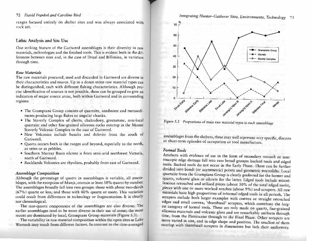
material has been leached out and the soil compacted by a variety of processes, Animal disturbance and the generally uneven bedrock exacerbate problems of stratigraphic separation and sequences. This results in a patchy archaeological record, with an uneven representation of periods at different sites and analytical units that vary considerably in integrity and duration (Figure 5.2). Nine assemblages from five sites are available for analysis. They can be grouped chronologically into two main sets, an Early (LatC Pleistocene to mid-Holocene) group and a Late (Late Holocene) group. Some differentiation of very recent (Final) material dating to the last millcnnium is possible at two of the sites.
YEARS BP
OCCUPATION ART PHASES 20,000
15,000I ' .
.. EARLY ..
-
,10,000
5000
LATE .. A
U0 .. . . FINAL C
1000
D U U D D 8
~~ .~'/; ~... i:>"'~ ;y"?" <~ i::-~
Q .~~ ",~-<Jl roo<:tJ . ~-!f .~~-s ~'If
<Q ~ ~.;;,<:tJ i:;;~ ',s-\~'/;<:' ro~<:tJ
';,'If ';,'/;<::'
Figure 5.2 Summary of the chronological framework for assemblages and rock art phases
Drual has the earliest archaeological evidence in the region, with basal radiocarbon dates of greater than 20,000 years ago, close to the Last Glacial Maximum. However, no discrimination within the Early material is possible, resulting in the conflation of some 15,000 years of site use. The Late Phase spans the period from about 5000 BP to the abandonment of the shelter, probably in the nineteenth century. Billimina, for which no basal dates could be obtained, was certainly in use by 11,000 years ago and probably for at least several thousand years before that. Herc an Early Phase of 6000 years or more can be differentiated from Late (about 5000 BP to 1000 BP) and Final (within the last millennium) Phases. There is less evidence from the other sites, where there is no indication of use before about 5000 years ago.
The rugged terrain and dense vegetation inhibit discovery of open sites (Bird 1989; Edmonds 1995). The only well-documented evidence is from the artificial Lake Wartook, where extensive lithic scatters and hearths (dated to about 4000 years ago) were revealed when the water level was lowered to allow repairs to the dam (Essling 1999; Gunn 2003). This serves, however, to counterbalance the impression that the use of the
72 David Frankel and Caroline Bird� Integrating Hunter-Gatherer Sites, Environments, Technology 73 %ranges focused entirely on shelter sites and was always associated with 70
rock art.
60
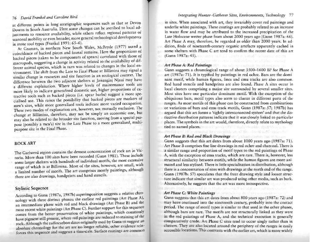
Lithic Analysis and Site Use 50One striking feature of the Gariwerd assemblages is their diversity in raw __ Grampians Groupmaterials, technologies and the finished tools. This is evident both in the dif - ... - Silcreteferences between sites and, in the case of Drual and Billimina, in variation� 40
~ Stavely Complexthrough time.
30
Raw MaterialsThe raw materials procured, used and discarded in Gariwerd are diverse in 20�
their characteristics and source. Up to a dozen stone raw material types can , .....�be distinguished, each with different flaking characteristics. Although pre 10� " .."", .... .&. ...cise identification of sources is not possible, these can be grouped to give an� .. , .." " ...... ~"� ,;' ........~indication of major source areas, both within Gariwerd and in surrounding� o I I I I I'" I I I
d1>?:-4,reglOns: v -t4, ~0 ~0 .,,<Q ',,'?' ~qy.~ V V ~ . ~ ,;,.- i/~~ .!1> .,s:-'I> ~ .~-!(i .~-!(i !1>' ~'Ii
~ / .# ~ ~ ~•� The Grampians Group consists of quartzite, sandstone and metasedi <?>~ <Q'$ ~Cf, ~Cf, .~.#
~'Ii ~'Ii 'C)'Iiments producing large flakes or angular chunks.� )'Ii
•� The Staverly Complex of cherts, chalcedony, greenstone, non-local Figure 5.3 Proportions of main raw material types in each assemblagequartzite and other fine-grained siliceous rocks outcrop in the Mount�Staverly Volcanic Complex to the east of Gariwerd.�
•� New Volcanics include basalts and dolerite from the south of assemblages from the shelters, these may well represent very specific, discreteGariwerd. or short-term episodes of occupation or tool manufacture.•� Quartz occurs both in the ranges and beyond, especially to the north,�as veins or as pebbles.� Formal Tools•� Southern Murray Basin silcrete is from semi-arid northwest Victoria, Artefacts with evidence of use in the form of secondary retouch or macnorth of Gariwerd.� roscopic edge damage fall into two broad groups: backed tools and edged•� Rocklands Volcanics are rhyolites, probably from east of Gariwerd. tools. Backed tools do not occur in the Early Phase. These can be further
divided into bondi (or asymmetric) points and geometric microliths. LocalAssemblage Composition quartzite from the Grampians Group is clearly preferred for the former andAlthough the percentage of quartz in assemblages is variable, all assem- quartz, volcanic glass or silcrete for the latter. Edged tools include miscelblages, with the exception of Manja, contain at least 50% quartz by number. laneous retouched and utilised pieces (about 50% of the total edged tools),The assemblages broadly fall into twO groups: those with about two-thirds pieces with one or more worked notches (about 9%) and scrapers. All raw(67%) quartz or less, and those with 80% quartz or more. This variation materials have high proportions of informal edged tools in all periods. Thecould result from differences in technology or fragmentation. It is clearly scrapers include both larger examples with convex or straight retouchednot chronological. edges and small convex, 'thumbnail' scrapers, which constitute the largThe non-quartz components of the assemblages are also diverse. Theearlier assemblages tend to be more diverse in their use of stone; the most
est category of formal tools. These arc only made on quartz, fine-grainedsiliceous materials and volcanic glass and are remarkably uniform throughrecent are dominated by local, Grampians Group materials (Figure 5.3). time, from the Pleistocene through to the Final Phase. Other scrapers areThe variability in raw material composition within the open sites at Lake more varied in size, and in edge shape and position. The smallest of themWartook may result from different factors. [n contrast to the time-averaged overlap with thumbnail scrapers in dimensions but lack their uniformity.

74 David Frankel and Caroline Bird
This variation is probably related to raw material characteristics and to
res harpening.
Technology The Gariwerd assemblages can generally be described in terms of a single general reduction sequence, with most technological variation related to raw materials. The clearest change in technology through time is the appearance in the mid-Holocene of specialised burin cores made on large flakes associated with the production of blades for making bondi points.
Site Usage Tables 5.1a and 5.1b summarise key attributes for each of the lithic assemblages. These show significant variability, although their varied integrity and duration militates against simple direct comparisons. Proxy measures of site usage, such as artefact discard rate, can be employed, although they are affected by raw material and technological variability, with the high fragmentation of quartz and the use of bipolar techniques being the most
obvious distorting factors. Table 5.1a shows a noticeable difference in discard rate between the
Early Phase assemblages from Drual and Billimina. This could be attributed to the higher percentage of quartz fragments at Billimina. However, the far lower mean weight of fragments shows that the pieces were more highly reduced, so that the difference is more likely to be one of technology than intensity of site use. This in turn may be related to raw material availability-the quartz used at Drual in the Early Phase is distinctive and probably comes from a particular source. Billimina also differs from Drual in the high proportion of materials (primarily chert) from east of
Gariwerd.
Table 5.la Summary data on stone assemblages: Early assemblages
Drual Billimina
Date (range cal BP) 22,000-<:. 4000 >10,000--4000
Artefact discard rate per 1000 years corrected for area excavated
7 54 (9945-6665 cal BP) 29 (6665-3980 cal BP)
% quartz 67 85
Mean weight quartz artefacts (g) 1.14 0.35
Total % local materials 83 90
Non-local materials as percentage of non-quartz materials
33 21Silcrete 5 40Stavely complex
Rhyolite/new volcanics 14 7
Integrating Hunter-Gatherer Sites, Environments, Technology 75
Table 5.1b Summary data on stone assemblages: Late and Final assemblages
Mugadg- Billimina Drual Billimina adjin Late Late JNA JNB Final Manja
Date (range cal BP)
?4000-0 ?3980-950 ?4000-0 ?2000-o 2000-0 950-0 <1000-0
Artefact discard 61 8-35 25 555? 350? 49-158 >2000 rate per 1000 years corrected for area excavated
% quartz 89 61 81 66 84 66 22
Mean weight quartz artefacts (g)
0.75 0.38 0.38 0.50 0.37 0.51 0.55
Total % local materials
92 90 87 89 95 92 77
Silcrete stavely complex rhyolite/ new
volcanics
62 13 4
6 18 3
15 32 22
10 22
1
2 18 10
3 17
5
17 9 4
Ratio backed to edged tools
1:1.4 1:0.5 1:4 1:0.5 1:4.3 1:1.3 1:1.1
Artefact discard rates in the later periods also vary (Table 5.1b). Mugadgadjin and a nearby site at Mount Talbot 1 have higher discard rates than the Late Phase at BUlimina and Drual. The Final Phase, however, is characterised by significantly higher discard rates at both Billimina and Manja. The figures for the two shelters at Jananginj Njaui must be treated with caution, given the uncertainty of dating and duration. However, both assemblages are probably relatively recent, and the discard rate is high. As the rate for the Late and Final assemblages shows no relationship to the incidence or degree of reduction of quartz, it seems likely that changes in it may signal different scales of site usage. Billimina is the only site for which discard rates can be estimated for more than two phases. Here a decline from sometime after 7000 BP is followed by an increase in the last millennium.
Stone artefact manufacture was clearly a significant activity at all sites. The composition of assemblages provides some insights into site function. The ratios of backed to edged tools vary from one backed to more than four edged tools at Jananginj Njaui B to two backed for each edged tool at Billimina in the Late Phase and at Jananginj Njaui A (Table 5.1b). Different modes of explanation for this may be employed which operate at different scales of time and space, as can be seen in the factors affecting changes
76 David Frankel and Caroline Bird
at different points in long stratigraphic sequences such as that at Devon Downs in South Australia. Here some changes can be ascribed to local adjustments to resource availability, while others reflect regional patterns of seasonal mobility or even btoader, more general technological developments in stone tool types (Frankel 1991: 65-6).
At Graman, in northern New South Wales, McBryde (1977) noted a coincidence of backed pieces and faunal remains. Here the proportions of backed pieces (taken to be components of spears) correlated with those of macropods, suggesting a change in activity related to the availability of different animal species, which in turn was related to changes in the local environment. The shift from the Late to Final Phase at Billimina may signal a similar change in resources and site function in an ecological context. The difference between the two adjacent shelters at ]ananginj Njaui may have a different explanation. Where higher levels of maintenance tools are more likely to indicate generalised domestic use, higher proportions of extractive tools such as backed pieces (i.e. spear barbs) suggest a more specialised use. This raises the possibility that backed pieces are markers of men's sites, while more generalised tools indicate more varied occupation. These two modes of explanation are, however, not mutually exclusive. The change at Billimina, therefore, may not be simply an economic one, but may also be related to the broader site function, moving from a special purpose (possibly a men's) site in the Late Phase to a more generalised, multipurpose site in the Final Phase.
ROCK ART
The Gariwerd region contains the densest concentration of rock art in Victoria. More than 100 sites have been recorded (Gunn 1981). These include some larger shelters with hundreds of individual motifs, the most extensive range of which is at Billimina. Most of the sites, however, are small, with a limited number of motifs. The art comprises mostly paintings, although there are also drawings, handprints and hand stencils.
Stylistic Sequence
According to Gunn (1987a, 1987b) superimposition suggests a relative chronology with three distinct phases: the earliest red paintings (Art Phase A), an intermediate phase with red and black drawings (Art Phase B) and the most recent white paintings (Art Phase C). Further support for this sequence comes from the better preservation of white paintings, which commonly have pigment still present, where red paintings are reduced to staining of the rock. Although the radiocarbon dates originally used by Gunn to suggest an absolute chronology for the art are no longer reliable, other evidence reinforces this sequence and suggests a timescale. Surface coatings are common
Integrating Hunter-Gatherer Sites, Environments, Technology 77
in sites. When associated with art, they invariably cover red paintings and underlie white paintings. These coatings are probably related to an increase in water flow and may be attributed to the increased precipitation of the Late Holocene wetter phase from about 2000 years ago (Gunn 1987a: 66). Art Phase A may, therefore, be regarded as older than 2000 years. In addition, finds of nineteenth-century organic artefacts apparently cached in some shelters with Phase C art tend to confirm the recent date of this art (Gunn 1987a: 45).
Art Phase A: Red Paintings Gunn suggests a chronological range of about 3500-1600 BP for Phase A art (1987a: 71). It is typified by paintings in red ochre. Bars are the dominant motif, while human figures, lines and emu tracks are also common. Red hand stencils and handprints are also found. Phase A sites occur in local clusters comprising a major site surrounded by several smaller sites. Most sites have one particular dominant motif. With the exception of the ubiquitous bars, motif types also seem to cluster in different parts of the ranges. As most motifs of this phase can be constructed from combinations or variations of bars and emu track motifs, Gunn (1987a: 57; 1987b) has argued that this art forms a 'tightly interconnected system' and that the distinctive distribution patterns indicate that it was closely linked to particular places. The symbols in the art would, therefore, directly relate to mythology tied to named places.
Art Phase B: Red and Black Drawings Gunn suggests that this art dates from about 1000 years ago (1987a: 71). Art Phase B comprises fine line drawings in red ochre and charcoal. There is a similar range and proportion of motif types to the red paintings of Phase A, with the exception of emu tracks, which are rare. There is, however, less structural similarity between motifs, while the human figures are more animated and less stylised. There is little specialisation in distribution, although there is a concentration of sites with drawings at the north end of the range. Gunn (1987b: 57) speculates that the freer drawing style and looser structure indicate that similar art was produced using other media, such as bark. Alternatively, he suggests that the art was more introspective.
Art Phase C: White Paintings Gunn suggests that this art dates from about 800 years ago (1987a: 72) and may have continued into the nineteenth century, probably into the contact period. The range of motif types is similar to that used in the other phases, although bars are rare. The motifs are not structurally linked as they were in the red paintings of Phase A, and the technical execution is generally comparatively crude. Art Phase C sites tend to occur singly rather than in clusters. They are also located around the periphery of the ranges in easily accessible locations. This contrasts with the earlier art, which is more widely
78 David Frankel and Caroline Bird
distributed and often less accessible. There is no evidence of site-specific specialisation of motifs and the range of motifs is evenly distributed.
Understanding the Art
Gunn's analysis (1987a, 1987b) and characterisation of the phases allows their interpretation as distinct periods of artistic activity, while indicating strong continuity between them. He has persuasively argued that the sequence could be related to differences in the social context within which the art was produced. In this way the art of Phase A can be regarded as tightly controlled and associated with particular locations, and was perhaps carried out in specific ritual contexts, while the art of Phases Band C suggests a more casual, public art.
ENVIRONMENTAL HISTORY
The rugged and broken topography of the ranges is characterised by eastfacing steep escarpments and shallow slopes to the west. Between these ranges are long, narrow valleys drained by rivers to the north and south, with swampy flats where drainage is restricted. Today Gariwerd has a significantly different climate from that of the surrounding plains, with a relatively high annual rainfall. The complex terrain leads to varied microclimates. This is reflected in the diversity and richness of its vegetative communities and corresponding resources.
The general pattern of environmental change in south-western Victoria through the Late Pleistocene and Holocene is known from studies of lake levels and microfossils (Jones et al. 1998, 2001) (Table 5.2). At the Last Glacial Maximum, about 18,000 years ago, Gariwerd would have been on the southern edge of an expanded arid zone (Dodson et al. 1992). Small pockets of woodland vegetation may have survived in sheltered places, but the ranges were probably mostly treeless and carried heath or scrub. The valleys would probably have been open grassland with scattered trees. Open grasslands and heath would have persisted throughout the Late Pleistocene, although the diverse topography may well have made parts of Gariwerd a refuge area for tree species. Gariwerd could thus have provided an open and diverse environment with available water, so that the ranges were more attractive than the arid surrounding plains.
As elsewhere in western Victoria, an increase in tree cover followed postPleistocene climatic amelioration. The Early Holocene expansion of tree cover in the ranges would have been quite rapid and followed a characteristic succession of Casuarina-dominated woodlands followed by eucalypt woodland and grasses. The open red gum woodland with grassy undersrorey that characterised parts of the Victoria Valley at European settlement may have become established about 7000 years ago. Today the ranges are
Integrating Hunter-Gatherer Sites, Environments, Technology 79
Table 5.2 Summary of climatic changes over the last 16,000 years in southwest� Victoria, based on modelling of the precipitation/evaporation ratio (after Jones� et al. 1998)
Late Pleistocene 16,000-10,500 BP Dry climate; increasing temperature and precipitation following the Last Glacial Maximum
Early Holocene 10,500-7500 BP Wetter climate; lake levels began rising about 8500 BPj lakes overflowing by 7000 BP
Mid-Holocene 7000-5500 BP Wettest period of the Holocene 5500-3500 BP Drying conditions
Late Holocene 3100-2000 BP Dry but unstable conditions 2000-110 BP Wetter period
AD 1840-present Drier climate, falling lake levels; comparable to Early Holocene
very densely vegetated and relatively inaccessible. However, this probably results from the cessation of Aboriginal burning ('tracks formed by the natives' were identified by early European visitors; G.B. Hall in Bride] 983: 267) and for much of the Holocene the vegetation was probably kept more open than today, particularly in the valleys. A possible exception was during the mid-Holocene wet period, 7000 to 5500 years ago, when the ranges could well have been densely vegetated and relatively inaccessible.
INTEGRATION
Integrating different lines of evidence, from sites, artefacts, art and environment, allows us to identify behavioural changes in time and space.
Billimina provides the best single sequence, with all three art phases represented. The vast majority of the motifs belong to Art Phase A and are, therefore, probably associated with the Late Phase of occupation. This was a period with a relatively low discard rate and a high incidence of backed pieces. It was followed by a period during the last millennium with little art and a lower incidence of backed pieces. That is, there is a systematic variation in the nature of art and the use of the shelter.
At Manja art and archaeological deposition seem to be mutually exclusive. Here nearly all the art belongs to Art Phase A, while the archaeological evidence of occupation falls entirely within the last millennium-that is, painting did not take place at times when the site was in normal domestic use. A similar pattern may explain the predominance of red paintings at both Jananginj Njaui shelters, which have no unequivocal evidence of contemporary occupation.
80 David Frankel and Caroline Bird
The evidence from Billimina and Manja fits well with Gunn's interpretation of Art Phase A red paintings as tightly controlled and associated with particular locations, and perhaps carried out in specific ritual contexts. At a time equivalent to Art Phase A these particular sites seem to have been used on a limited basis by specific groups of men (as argued from the dominance of extractive tools). Little or no art production took place during the Final Phase, when the sites had a more domestic character. Only at Drual and Mugadgadjin are there significant numbers of recent white paintings. The range of stone artefacts at these sites can be interpreted as indicating a wider array of activities and more broadly based site use. Once again this fits with Gunn's suggestion that the white paintings of Art Phase C represent a more casual, public art.
It is also possible to relate this sequence to the broad environmental changes from the Last Glacial Maximum through to the recent period. Twenty thousand years ago Gariwerd would have stood out from a semiarid to arid sand-plain, much as the ranges of central Australia do today. With climatic amelioration towards the end of the Pleistocene the ranges became more heavily vegetated and the plains less arid. At later times, fluctuating levels of precipitation increased water availability both in the ranges and in the rivers, creeks and lakes of the surrounding plains. From a human point of view the place of Gariwerd in the perceived and useable environment must have changed significantly in step with these fluctuations. This can be monitored through consideration of the use of raw materials.
Billimina provides the best basis for exploring change through time. In the Early (i.e. Terminal Pleistocene and Early Holocene) deposits, raw material came from both east and north of the ranges. From about 4000 years ago these materials declined and there was greater focus on local Grampians Group stone. A similar domination of Late and, especially, Final assemblages by local stone is seen at other sites. At Mugadgadjin there is a slightly different pattern, perhaps related to the location of this site in the Burrunj outlier on the western fringe of Gariwerd. Here, silcrete from much farther north of the ranges is dominant in the Late Phase, signalling that Mugadgadjin may have been part of a different land use system, linked more to the adjacent semi-arid regions of the Wimmera and Mallee to the northeast. This perhaps indicates a social pattern not dissimilar to those seen in the nineteenth century when the ranges were at the boundaries of several Aboriginal language groups (Clark 1990), each connected to clans further afield through intermarriage, language and shared matrilineal moiety organisation.
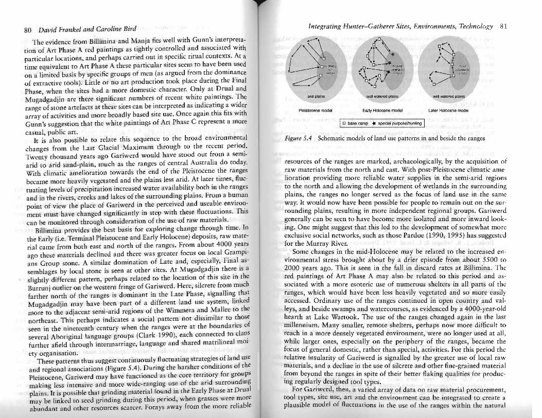
These patterns thus suggest continuously fluctuating strategies of land use and regional associations (Figure 5.4). During the harsher conditions of the Pleistocene, Gariwerd may have functioned as the core territory for groups making less intensive and more wide-ranging use of the arid surrounding plains. It is possible that grinding material found in the Early Phase at Drual may be linked to seed grinding during this period, when grasses were more abundant and other resources scarcer. Forays away from the more reliable
Integrating Hunter-Gatherer Sites, Environments, Technology 81
I 0"-\ \~o
J/~\ <~. 1"".1 orelal,;e,y o 0"---'" o
nch "\_. heaVily-.. --:tl ,egelaled / \ acce~ble ~o ranges ... ......0 I ranges \o/~ ranges0""'-/\--+/ '0
arid plains well watered plains well walered plains
Pleistocene model Early Holocene model Later Holocene model
I0 base camp .. special purpoSe/hunting I Figure 5.4 Schematic models of land use patterns in and beside the ranges
resources of the ranges are marked, archaeologically, by the acquisition of raw materials from the north and east. With post-Pleistocene climatic amelioration providing more reliable water supplies in the semi-arid regions to the north and allowing the development of wetlands in the surrounding plains, the ranges no longer served as the focus of land use in the same way. It would now have been possible for people to remain out on the surrounding plains, resulting in more independent regional groups. Gariwerd generally can be seen to have become more isolated and more inward looking. One might suggest that this led to the development of somewhat more exclusive social networks, such as those Pardoe (1990, 1995) has suggested for the Murray River.
Some changes in the mid-Holocene may be related to the increased environmental stress brought about by a drier episode from about 5500 to 2000 years ago. This is seen in the fall in discard rates at Billimina. The red paintings of Art Phase A may also be related to this period and associated with a more esoteric use of numerous shelters in all parts of the ranges, which would have been less heavily vegetated and so more easily accessed. Ordinary use of the ranges continued in open country and valleys, and beside swamps and watercourses, as evidenced by a 4000-year-old hearth at Lake Wartook. The use of the ranges changed again in the last millenniwn. Many smaller, remote shelters, perhaps now more difficult to reach in a more densely vegetated environment, were no longer used at all, while larger ones, especially on the periphery of the ranges, became the focus of general domestic, rather than special, activities. For this period the relative insularity of Gariwerd is signalled by the greater use of local raw materials, and a decline in the use of silcrete and other fine-grained material from beyond the ranges in spite of their better flaking qualities for producing regularly designed tool types.
For Gariwerd, then, a varied array of data on raw material procurement, tool types, site use, art and the environment can be integrated to create a plausible model of fluctuations in the use of the ranges within the natural
82 David Frankel and Caroline Bird
and culturally perceived environment. The resulting model is one in which responses to climatic circumstances were mediated by historically contingent factors involving pre-existing social relationships and technological processes. This can be seen as leading to periodic reorganisation in the way the ranges and the surrounding plains were integrated within technological systems and regional land use patterns.
REFERENCES
Bird, C.F.M. ] 989. Archaeological field survey in the Grampians National Park, 1988. Unpublished report to Parks Victoria, Melbourne.
Bird, C.F.M. & D. Frankel. 1998. University, community and government: developing a collaborative archaeological research project in western Victoria. Australian Aboriginal Studies 1998(1): 35-9.
Bird, C.F.M. & D. Frankel. 2005. An archaeology of Gariwerd. From Pleistocene to Holocene in western Victoria (Tempus 8). St Lucia: Anthropology Museum, The University of Queensland.
Bride, T.F. (ed.) ] 983. Letters from Victorian pioneers. South Yarra: Currey O'Niel. Clark, 1.D. ] 990. Aboriginal languages and clans: an historical atlas of western
and central Victoria, 1800-1900 (Monash Publications in Geography No. 37). Melbourne: Monash University.
Coutts, P.J.F. & M. Lorblanchet. 1982. Aboriginals and rock art in the Grampians, Victoria, Australia (Records of the Victorian Archaeological Survey 12). Melbourne: Victoria Archaeological Survey.
David, B., 1.]. McNiven, V. Attenbrow, ]. Flood & J. Collins. 1994. Of Lightning Brothers and white cockatoos: dating the antiquity of signifying systems in the Northern Territory, Australia. Antiquity 68: 241-51.
Dodson, J., R. Fullagar & L. Head. 1992. Dynamics of environment and people in the forested crescents of temperate Australia, in J. Dodson (ed.) The naive lands: prehistory and environmental change in Australia and the south-west Pacific: ] 15-59. Melbourne: Longman Cheshire.
Edmonds, V. 1995. An archaeological survey of the Serra Range, Grampians (Gariwerd) National Park, south-west Victoria. Unpublished report to Aboriginal Affairs Victoria, Melbourne.
Essling, J. ]999. Analysis of the lithic assemblage from Lake Wartook, Gariwerd, Victoria. Unpublished BA (Honours) thesis, Department of Archaeology, La Trobe University.
Frankel, D. 1991. Remains to be seen: archaeological insights into Australian prehistory. Melbourne: Longman Cheshire.
Gunn, R.G. ]981. The prehistoric rock art sites of Victoria: a catalogue (Victoria Archaeological Survey Occasional Reports Series 5). Melbourne: Ministry for Conservation, Victoria.
Gunn, R.G. 1987a. Aboriginal rock art of Victoria. Unpublished report to the Victoria Archaeological Survey, Melbourne.
Gunn, R.G. ]987b. The Aboriginal rock art in the Grampians, in Australia Felix: the Chap Wurrung and Major Mitchell: 52-63. Dunkeld: Dunkeld and District Historical Museum.
Gunn, R.G. 2003. Three more pieces to the puzzle: Aboriginal occupation of Gariwerd (Grampians) western Victoria. The Artefact 26: 32-50.
Jones, R.N., ].M. Bowler & T. McMahon. 1998. A high resolution Hulocene record of PIE ratio from closed lakes, western Victoria. Palaeoclimates 3: 5]-82.
Integrating Hunter-Gatherer Sites, Environments, Technology 83
Jones, R.N., T.A. McMahon & ].M. Bowler. 2001. Modelling historical lake levels and recent climatic change at three closed lakes, western Victoria, Australia (c. 1840-1990). Journal ofHydrology 246: ]59-80.
McBryde, 1. 1977. Determinants of assemblage variation in New England prehistory, in R. V.S. Wright (cd.) Stone tools as cultural markers: 225-50. Canberra: Australian Institute of Aboriginal Studies.
Pardoe, C. ] 990. The demographic basis of human evolution in southeastern Australia, in B. Meehan & N.G. White (ed.) Hunter-gatherer demography: past and present: 59-70 (Oceania Monograph 39). Sydney: Oceania Publications.
Pardoe, C. 1995. Riverine, biological and cultural evolution in southeastern Australia. Antiquity 69: 696-713.
Rosenfeld, A. & M.A. Smith. 2002. Rock art and the history of Puritjarra rockshelter, Cleland Hills, Australia. Proceedings of the Prehistoric Society 68: ] 03-24.
Smith, M.A. &J. Ross. 2008. What happened at 1500-1000 cal. BP in Central Australia? Timing, impact and archaeological signatures. The Holocene 18: 379-88.
Ta~on, P.S.c. & S. Brockwell. 1995. Arnhem Land prehistory in landscape, stone and paint. Antiquity 69: 676-95.