insight, part of a special feature on the influence of human demography and agriculture on natural...
TRANSCRIPT

Copyright © 2008 by the author(s). Published here under license by the Resilience Alliance.Padoch, C., E. Brondizio, S. Costa, M. Pinedo-Vasquez, R. R. Sears, and A. Siqueira. 2008. Urban forestand rural cities: multi-sited households, consumption patterns, and forest resources in Amazonia. Ecologyand Society 13(2): 2. [online] URL: http://www.ecologyandsociety.org/vol13/iss2/art2/
Insight, part of a Special Feature on The influence of human demography and agriculture on naturalsystems in the NeotropicsUrban Forest and Rural Cities: Multi-sited Households, ConsumptionPatterns, and Forest Resources in Amazonia
Christine Padoch 1, Eduardo Brondizio 2, Sandra Costa 3, Miguel Pinedo-Vasquez 4, Robin R. Sears 5,6, and Andrea Siqueira 7
ABSTRACT. In much of the Amazon Basin, approximately 70% of the population lives in urban areasand urbanward migration continues. Based on data collected over more than a decade in two long-settledregions of Amazonia, we find that rural–urban migration in the region is an extended and complex process.Like recent rural–urban migrants worldwide, Amazonian migrants, although they may be counted as urbanresidents, are often not absent from rural areas but remain members of multi-sited households and continueto participate in rural–urban networks and in rural land-use decisions. Our research indicates that, despitetheir general poverty, these migrants have affected urban markets for both food and construction materials.We present two cases: that of açaí palm fruit in the estuary of the Amazon and of cheap construction timbersin the Peruvian Amazon. We find that many new Amazonian rural–urban migrants have maintained someimportant rural patterns of both consumption and knowledge. Through their consumer behavior, they areaffecting the areal extent of forests; in the two floodplain regions discussed, tree cover is increasing. Wealso find changes in forest composition, reflecting the persistence of rural consumption patterns in citiesresulting in increased demand for and production of açaí and cheap timber species.
Key Words: afforestation; Amazonia; deforestation; rural–urban migration; urban–rural interactions
ENTERING THE URBAN MILLENNIUM
The United Nations Population Fund (UNFPA)estimates that, in 2008, for the first time in history,more than half the world’s human population isliving in urban areas (UNFPA 2007). The pace ofrural–urban migration has been rapid throughout the20th century, but over the last few decades, it pickedup markedly and is expected to continue to surge incoming years.
Although cities around the globe are growing,populations in developing countries are urbanizingmost rapidly. In the future, new urbanites willincreasingly be found in developing countries; agreat many of them will be poor. Since 1970, thegrowth rate of slums generally has outpaced that ofurban areas (Davis 2006:17). The United NationsHuman Settlements Programme (UN-HABITAT)
reports that, in 2001, about 32% of the world’s urbanpopulation lived in slums; in developing countries,this percentage stood at 43% (UN-HABITAT2003).
The movement of rural people to cities and thegrowth of those urban areas are processes that havehistorically had important impacts on ruralenvironments, including forests. How rural–urbanmigration specifically affects forest cover in tropicalcountries has recently received considerableattention (Lambin et al. 2001, Aide and Grau 2004,Wright and Muller-Landau 2006, Garcia et al. 2007,and others). Urbanization will lead to recovery ofsubstantial areas of tropical forest if migrationdrains the rural zones of population and returnsabandoned farmland to forest, as occurred innorthern Europe and North America, as well as insome areas of the Caribbean and South America
1The New York Botanical Garden, 2Dept. of Anthropology, Anthropological Center for Training and Research on Global Environmental Change, Center forthe Study of Institutions, Population, and Environmental Change, Indiana University, 3Laboratory of Urban and Regional Planning, University of Vale doParaiba – SP, 4Center for Environmental Research and Conservation and Dept. of Ecology, Evolution, and Environmental Biology, Columbia University,5Center for Environmental Research and Conservation, Columbia University, 6The School for Field Studies, 7Center for Latin American & CaribbeanStudies and ACT - Dept. of Anthropology, Indiana University

Ecology and Society 13(2): 2http://www.ecologyandsociety.org/vol13/iss2/art2/
(Grau et al. 2003, Aide and Grau 2004, Wright andMuller-Landau 2006). In some tropical countrieswhere urbanward migration is taking place, andsmall farmers have decamped, researchers havenoted, however, that forests do not increase. Rather,many smallholder farms are replaced by a few large-scale producers—in Latin America, often cattleranches (Rudel et al. 2002)—or by new migrantfarmers who simply replace those who left(Fearnside 2005).
Elsewhere in tropical regions undergoingsubstantial urbanization, migration results in neitherdramatic decreases in rural populations norabandonment of crop production, but does lead togrowth of forest cover. In these zones, both theextent of tree cover and the composition of forestsmay change because of shifts in the type of cropsproduced and the kind of resource managementemployed (Rudel et al. 2002). The prevalence ofsuch trends, Rudel notes, may reflect substantivedifferences between the patterns of urbanization andindustrialization in present-day Latin America andSoutheast Asia and those that prevailed in NorthAmerica and Europe when their “forest transitions”occurred. Among such important dissimilarities arenew forms of migration and household economicstrategies reflecting improvements in communicationand transportation in many poor countries of Asiaand Latin America. But, although relocation maybe easier, good jobs in growing cities remain scarce,making exclusively urban employment andresidence a risky strategy. Researchers worldwidehave pointed out that rural–urban movements inpoorer countries are now typically impermanent orcircular, and multi-sited or dispersed householdsthat continue rural production yet also depend onoff-farm, often urban, incomes, are increasingly thenorm (Kruger 1998, Rudel et al. 2002, Tacoli 2002,Rigg 2003, Dufour and Piperata 2004).
Based on our research in several regions ofAmazonia, in this paper, we suggest that complexdemographic flows between rural and urban areas,and multi-sited households characterize communitiesin the Amazon floodplain, and these characteristicsare affecting both the extent and the nature of forestsin these long-settled areas of Amazonia. Our datasuggest that many urbanward migrants in Amazoniaare not really absent from rural zones; they remainmembers of households with livelihood activities inboth rural and urban environments. Whatever theirprimary residence, these mobile Amazonianscontinue to participate in rural–urban networks,
maintain their rural-based preferences and needs,and retain their knowledge of rural resources andproducts.
Several specific mechanisms, other than landabandonment, through which rural–urban shiftsaffect rural communities and environments, havebeen described. These include the remitting of fundsto rural household members (Tiffen et al. 1994,Hecht and Saatchi, 2007), changes in rural laboravailability (Preston 1989, Rudel et al. 2005),variation in the gender composition of households(David 1995, cited in McDowell and de Haan 1997),and the shifting demands urban consumers make onagricultural and other rural resources (Brondizio etal. 2002, Tacoli 2002). In this paper, we suggestthat, as consumers, new city dwellers in the Amazonhave significantly changed urban markets andconsumption patterns for forest products despitetheir poverty. We use examples of a staple food andconstruction materials to illustrate how theconsumer choices of recent urbanites are affectingrural landscapes, specifically forest cover and thenature, structure, and composition of Amazonforests.
THE URBANIZATION OF AMAZONIA
The complex history of urbanization in the BrazilianAmazon has interested scholars since at least the1950s (Wagley 1953, Becker 1985, Browder andGodfrey 1997, Vicentini 2006). Regionalurbanization reflects an interaction, on one hand, ofthe region’s economic and demographic history andlong-standing connections to global markets, and,on the other, a strong presence of the state.Following a vision of national integration datingback more than half a century, the federalgovernment of Brazil has repeatedly articulated andexecuted strategies of colonization, resourceexploitation, and economic development. Theseefforts spurred migration to Amazonia, marked bywaves of colonization of agrarian settlements andrural towns. High rates of turnover in colonizationareas, in turn, accelerated urban expansion. AsBecker (1988) observed, urbanization in theBrazilian Amazon—and this also applies toneighboring Peru—is a complex and multi-facetedprocess that comprises the growth of older centers(such as Belém and Manaus in Brazil and Iquitos inPeru), the formation of new ones (such as Jiparanáin Rondônia, and Nueva Cajamarca in Peru’s SanMartin region), as well as the reproduction of

Ecology and Society 13(2): 2http://www.ecologyandsociety.org/vol13/iss2/art2/
numerous small and medium towns throughout theregion.
By 2000, the national census indicated thepopulation of Brazil’s “Amazônia Legal” (i.e., thestates of Amazonas, Para, Acre, Tocantins, MatoGrosso, Maranhão, Amapá, Rondônia, andRoraima) was already about 70% urbanized,compared with 82% for the country as a whole.Comparing the broad process of urbanization in allof Brazil to that of its Amazonian region, we notethat Amazonia’s urban growth began later (in the1970s vs. the 1950s for Brazil), but that in recentdecades, the Amazonian urbanization rate hasincreased rapidly and is approaching that of thecountry as a whole. Census data show the urbanpopulation of all Brazil increased by 82% between1970 and 2007. The urban population of AmazôniaLegal grew 430% during this same period (InstitutoBrasileiro de Geografia e Estatística (IBGE) 2007).Whereas Brazil has mostly experienced steadilydeclining rates of population increase, the Amazonregion continued to see recurrent spikes andcontractions in growth rates, reflecting waves ofmigration to different parts of the region.
In the Peruvian national census of 2005, thepopulations of the vast departments of Loreto andUcayali, which cover the greatest portion of thelowland Amazon region, were already 63% and72% urban, respectively, in a country where almost75% of the total lived in cities (Instituto Nacionalde Estadística e Informática (INEI) 2007). Thisurban predominance largely reflects rapid growthof Peru’s two largest Amazonian cities, Iquitos andPucallpa, which increased in size dramaticallybeginning in the 1960s. Due to massive immigrationfrom rural areas of Loreto, the population of Iquitosmore than quadrupled between 1961 and 1993(Santos-Granero and Barclay 2000:286). In thesame period, the population of Pucallpa along theupper Ucayali River increased more than six-fold(Santos-Granero and Barclay 2000:286).
As we describe in more depth for Pucallpa below,urban immigrants tend to reside in hastilyconstructed, grossly substandard housing in urbansettlements that are opportunistic, illegallyoccupying terrain formally owned by either privateor public entities. Although infrastructure tends toimprove with time, access to basic urban servicesin virtually all of these settlements is very limited.In 1991, in Belém and Manaus, respectively, 25%and 35% of households were not connected to the
municipal water system and only 2% wereconnected to sewers (IBGE 1990), a situation thatresembles the rural areas from which immigrantscome where such services are generally absent (Perz2000).
Brazilian urban geographer Bertha Becker (2005)has noted the need to understand urbanizationprocesses in a broader context, and suggests thatmere numbers showing the growth of populationsin cities and towns give an inadequate picture of theextent and meaning of urbanization in Amazonia.The transformation of the values of Amazon societyare another, if less easily calculated, measure ofurbanization. Becker famously describes allAmazonia as an “urbanized forest.” In similarfashion, we argue in this paper that family networksspanning rural and urban areas create venues for thecirculation of goods, access to employment,education, and health services. These networksmake urban areas an intrinsic part of an expansionof the rural, and vice versa.
RURAL, URBAN, AND IN-BETWEEN
Despite the dramatic growth of Amazonian urbanplaces mentioned above, it is important to note thatthe urbanization of Amazonia as a process has notbeen simple, linear, or unidirectional. Demographicexchanges between rural and urban areas in recentdecades have included shifts that temporarilyreversed present urbanward trends (Paganoto2007). A recent example is the negative growth ofBoa Vista, capital of the Brazilian state of Roraima,which saw a 4% drop in population between 1995and 2000, as government-sponsored ruralresettlement programs pulled the urban poor backto the countryside, temporarily reversingurbanization trends (Sathler et al. 2007). Similarshifts in Peruvian Amazonia occurred in the 1970sand early 1980s when large numbers of men—bothrural and urban dwellers—found long-termemployment in distant forests where oil explorationand pipeline construction was underway.
The numbers and narratives describing the ebb andflow of people present, however, a deceptivelysimple picture of demographic relationshipsbetween urban and rural places. Although people inAmazonia are classified as residing in either urbanor rural places, researchers around the world havenoted (Tacoli 2002, Smit 1998, Rigg 2002, 2003)that the distinction is often difficult to make.

Ecology and Society 13(2): 2http://www.ecologyandsociety.org/vol13/iss2/art2/
Whereas rural areas in Africa and Asia are becomingincreasingly “de-agrarianized” and urban, a trendof “ruralization” of cities and towns has also beendescribed, with rural lifestyles, attitudes, andoccupations persisting in even large conurbations(Kruger 1998).
Categorization of people, households, or evencommunities in Amazonia as rural or urban isdifficult as rural and urban spaces and peoples areinextricably linked in numerous ways (Wagley1953, Nugent 1993, WinklerPrins 2002, WinklerPrinsand de Souza 2005, Siqueira 2006). A great manynewly urban households are “multi-sited,” “multi-local,” or dispersed, maintaining houses and,commonly, economic activities in rural areas as wellas in the city. Data obtained through interviews infive rural communities in the Brazilian state ofAmapá confirm these findings: of the 483households censused in the five villages of Foz deMazagão, Ipixuna, Bacaba, Santo Antônio, andLontra Pedreira in 2005, 402 (83%), have a housein the state’s largest cities of Macapá or Santana, orin the district capital, Mazagão Novo (Pinedo-Vasquez and Padoch 2008).
Although multi-sited households are not new toAmazonia, recent changes in communications andtransportation, markets, and labor opportunitieshave greatly amplified the prevalence of thisresidence and economic pattern (Stearman 1985).Nugent (1993) described how several such largeextended families, or “kindreds,” in the region ofSantarém maintained firm residential bases in bothcity and village, relying on the resources of both.More recently, WinklerPrins (2002, 2006) hasdescribed smaller groupings or households thatmaintain such dual residence patterns in theSantarém area. She describes not only frequentdemographic movements between urban and ruralplaces, but also complex and multi-functionalnetworks of support and interaction that linkresidents of Santarém with their rural kin in an“economy of affection” (WinklerPrins and de Souza2005). Two-way flows of food and other resources—of people, as well as of news and knowledge—reinforce this “economy of affection,” continue toblur rural–urban distinctions, and render rural–urban migration a drawn-out process rather than asimple event.
Two case studies of urban and rural change fromtwo widely separated areas of Amazonia (see Fig.1) serve to illustrate our points. Each case study,
based on field research we have been conductingfor over a decade (see Appendix 1 for a descriptionof research sites and summary of methods), involves“ribeirinho” (in Brazil, “ribereño” in Peru) peasanthouseholds and communities that occupy andmanage sites in the “várzea,” or floodplains of theAmazon and other rivers.
AÇAÍ: RURAL TASTES AND URBANMARKETS
The floodplains of the Brazilian Amazon in thestates of Amapá and Pará are areas where the“deforestation frontier” passed centuries or decadesago, but where important land-use and land-coverchange continues (Perz and Skole 2003). Theribeirinhos comprise a mixed population ofresidents native to the estuary and long-settledmigrants from other regions and environments.Households are typically multi-sited, combiningproduction activities with labor in both rural andurban settings. In rural areas, families engage indiverse production activities, including small-scaleswidden agriculture, agroforestry, forest managementfor timber and non-timber products, fishing andshrimping, cattle and buffalo ranching, and hunting.The rural landscape comprises a mosaic of ranches,villages, farms, gardens, isolated houses,abandoned house sites, and young and old second-growth forests. The city is important to families asa center for education, health care, and employment,and it is where rural families must go to collectpension payments and other government benefits.
Recent government census data show mostestuarine municipalities with a majority of familiesstill living in rural areas (IBGE 2007), but our fielddata indicate that most rural households interactwith and depend on urban areas very frequently. Arecent unpublished survey we carried out among262 households (including 2166 individuals) inseven rural communities in Ponta de Pedras, Pará(see Fig. 1), indicates that 41% of individuals whowere considered members of these rural householdsactually live in the city. The same survey indicatesthat over 95% of individuals go to town at least oncea week. Preliminary data from an ongoing surveyof urban households show similar dependence oftown residents on the rural environment.
Frequent movements between village and city in theestuary commonly take many hours of travel by boat

Ecology and Society 13(2): 2http://www.ecologyandsociety.org/vol13/iss2/art2/
Fig. 1. Map of research sites.
and/or bus, but in most places, travel has becomeincreasingly convenient. Twenty years ago, a tripfrom Ponta de Pedras to the city of Belém, forinstance, could be done only once a week in a cattleboat and took 5 to 6 hours or more; today, twocompeting boats make the daily journey in 2 to 4hours. From our Mazagão River research sites inAmapá, villagers now reach the small district capitalof Mazagão Novo in about 3 hours and the regionalcities of Santana and Macapá in an additional 2hours.
The estuarine region is characterized by highlydynamic cultural and natural landscapes. Globalmarket transformations, migration, and dislocationof rural and urban populations, and socialinstitutions and networks have played importantroles in shaping these landscapes by creating
demands for certain products and services at distincthistorical periods and effecting fluctuations in forestcover (Pinedo-Vasquez et al. 2002a, Perz and Skole2003, Brondizio 2006). The estuary is home toAmazonia’s historically preeminent city, Belém,Amapá’s state capital, Macapá (pop. 345 000), anda series of secondary urban areas mostly accessedby river or air. Although it has recently been eclipsedby Manaus as the Basin’s largest city, Belémregistered meteoric growth over the last severaldecades, increasing in population from about 300000 residents in the 1950s to over 2 million in themetropolitan area today. Much of that growth wasa result of rural families migrating or sendingmembers from the islands, floodplains, and smalltowns of the estuary, an area traditionally settled byribeirinhos with distinct rural culture, includingfood-consumption patterns (Murrieta et al. 1999).

Ecology and Society 13(2): 2http://www.ecologyandsociety.org/vol13/iss2/art2/
Our survey, referenced above, indicates that 25%of household members who left the rural area wentto Belém.
The impacts of international market demands onAmazon environments, including markets forrubber (Weinstein 1983, Barham and Coomes 1994)and timber (Bierregard et al. 2001) have been widelydiscussed, but changes in demand for low-cost,distinctly regional staple foods in an urbanizingAmazonia are also important. The fruits of açaí(Euterpe oleracea), a palm native to the Amazonestuary and extensively managed in mixed forestryand agroforestry systems by farmers, have been animportant food in the Amazon estuary since pre-Columbian times. Until the 1970s, however, whenurbanward migration surged in the region, theconsumption of açaí was invariably a sign of ruralresidence and rural tastes, eaten in urban areas onlyas an occasional treat, usually dessert (Strudwickand Sobel 1988).
Açaí consumption is no longer just a rural habit.Reports indicate that consumption of açaí juice inBelém rose from 90 000 L/day in the late 1980s toan estimated 400 000 L/day in the late 1990s(Mourão 1999, Rogez 2000, IBGE 1974–2003), anincrease largely mirroring urbanization rates. Thisfigure implies an estimated consumption of morethan 60 L/person/year, or as noted by Rogez (2000),twice the volume of milk consumed in Belém.Families with the lowest level of income consumethe largest amount of this food, buying and eatingit fresh twice daily as a staple. Poullet (1998)estimates that daily consumption in another smallerestuarine city, Macapá, ranges from 27 000 to 34000 L.
The boom in açaí consumption and productionrepresents perhaps the most impressive case of arural food both supporting a growing, low-incomeurban population, and spurring the intensificationand expansion of a forest-based production systemthroughout the estuary. In contrast to earlier urbandwellers, when ribeirinhos established urbanresidence in large numbers, they brought andmaintained their açaí habits. In addition to providingaffordable nourishment, açaí adapted well to anurban lifestyle based on opportunistic work and theinformal economy. The preference for açaí by theurban poor, and its importance as a cultural foodprovided continuity and security to a populationliving with the uncertainties of an informal urbaneconomy. Açaí continues to have important
symbolic value as nourishment that is both familiarand plentiful for the underprivileged, both therecently rural and those who always lived in cities.Açaí has become not only an urban food, but a“fashionable” one as well (Brondizio 2008.)
As açaí has gained importance as a food during thelast 30 years, the Amazon estuary has experiencedwhat Hiraoka (1994) called “açaízation” or theexpansion of açaí production in estuarineecosystems. Over the past two decades, farming inthe region has shifted from predominantly annual-crop agriculture to forest-based production systemscentered on açaí fruit, heart of palm, and managedand unmanaged forestry (Pinedo-Vasquez andPadoch 2008). This region, which corresponds inpart to the “settled” zone discussed by Perz andSkole (2003) has, contrary to much of the rest of theAmazon, recently experienced net afforestation anddecreasing rates of forest clearing over the pastseveral decades (Brondizio 2008; also see Appendix1).
Within a 10-km radius around the of Marajó Islandtown of Ponta de Pedras, the area of intensive açaíagroforestry increased from around 1100 ha in 1985to around 2150 ha in 2000, and we estimate it nowoccupies more than 4000 ha (see Appendix 1). Thislast estimate represents more than 75% of the totalarea of floodplain forest in the area analyzed. At thecommunity level, riverine communities have 75%or more of their territories under forest cover mostlymanaged for açaí production, whereas uplandcommunities with a history of pasture andmechanized agriculture experienced a doubling ofarea in secondary vegetation over the past decadewhen these activities were abandoned in favor againof agroforestry. Similar rates of regrowthcharacterize communities previously dedicated tosmall-scale manioc cultivation (Brondizio 2006,2008; see also Appendix 1).
The expansion of açaí agroforestry in the Amazonestuary has had varying impacts on forestbiodiversity. Açaí palms are relatively abundant inestuarine floodplain forests, varying in density anddistribution depending on environmental andanthropogenic factors. Different management andplanting strategies transform these areas into açaíagroforestry, or in local terms, “açaizais.” The termencompasses stands under different intensities ofmanagement, population densities, structures,species diversity, and composition. Although at theplot level, one may observe a decline in tree species

Ecology and Society 13(2): 2http://www.ecologyandsociety.org/vol13/iss2/art2/
diversity in the açaizais compared with unmanagedfloodplain forest, a broader landscape viewincluding plots at different levels of managementmay show an increase of tree species diversity(Brondizio 2008). As a number of researchers havepointed out, the composition of forests in manyinstances of “forest transition” is highly variable,ranging from plantations of exotics to diverseforests, and often bear little resemblance to whatexisted before recent deforestation (Perz and Skole2003, Rudel et al. 2005, Farley 2007).
BUILDING SQUATTER SETTLEMENTS:FORESTRY BY THE POOR FOR THEPOOR
At almost the other end of the Amazon Basin, alongthe Ucayali River in Peru (see Fig. 1), an influx ofcheap agricultural products to Amazon cities fromoutside the region has led to a decline in theagricultural sector and the loss of an importantsource of income for smallholders (Pinedo-Vasquezet al. 2002b). At the same time, however, increasingurbanization, especially the growth of squattersettlements in Pucallpa and other cities as distant asLima, has created demand for inexpensiveconstruction materials. The economic growth ofsmall urban centers, such as provincial capitals, hasadded to that demand. More than half the populationof Pucallpa, the second largest city of the PeruvianAmazon, resides in informal or squatter settlements,known as “asentamientos humanos ” (AA.HH.).According to a director of a grassroots organizationrepresenting inhabitants of many AA.HH., the“Comité Unificado” of the “Federación deAsentamientos Humanos” of Pucallpa andneighboring Yarinacocha, by mid-2007 there were579 named and organized squatter settlements in theurban area. Some AA.HH. date from the 1970s andhave been legalized, with title granted to allresidents. The great majority of AA.HH. residentshowever, remain members of illegal or extra-legalsettlements. Reflecting the precariousness of manysettlements and the poverty of their residents,dwellings are mostly built by the squattersthemselves of cheap wood, palm thatch, as well asplastic sheeting, and other inexpensive materials.Of 438 households surveyed in 42 AA.HH. inPucallpa and Yarinacocha, we found that 285houses (65%) had walls made of “bolaina”(Guazuma crinita), a fast-growing timber speciesfound in agricultural fallows; many were framed
with “capirona” (Calycophyllum spruceanum),another prolific fallow species.
Timber-rich fallows exist throughout Amazonia.The highly agrodiverse landholdings of ruralsmallholder farmers, with patches of species-richfields, fallows, housegardens, and forest, allow fora high degree of flexibility in what they produce aswell as in the volume of production (Pinedo-Vasquez et al. 2002b, Padoch and Pinedo-Vasquez2006). Rural smallholder farmers in PeruvianAmazonia, as elsewhere, have responded to thegrowing demand for timber and other forest-basedproducts in regional cities by shifting their emphasisfrom commercially oriented crop production to acombination of smaller scale subsistenceagriculture and management of forest products,especially of fast-growing timbers.
Along the Ucayali, downriver from Pucallpa, wehave documented a broad decline in the numbers ofproduction units dedicated to agricultural cash cropsand mature forests, and a corresponding increase inunits dedicated to complex agroforestry andmanaged secondary forest systems, subsumedunder the “fallows” category (Table 1). Similar tothe case on the Brazilian estuary described above,this trend has resulted in an increase in forest coverin traditionally agricultural areas (see Appendix 1).
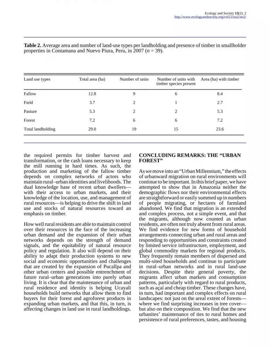
The increased demand for cheap constructionmaterials has resulted in a significant decrease inthe average size of annually cropped fields and acorresponding increase in the size of fallows (Table2). Data collected in 2007 from a sample of 39landholdings in two districts along Peru’s UcayaliRiver show that all households maintain fallows,with an average of 2.4 fallow units per landholding;86% of these fallows contain timber (see Appendix1).
As the demand for fallow timber is rising, farmersare managing for timber production on theirlandholdings. Farmers produce timber inagricultural fallows by protecting the naturalregeneration of fast-growing species at the end ofthe cropping cycle and by enriching the establishedfallows with slow-growing species. This pattern ofconcurrent management of annual and tree crops(Padoch and Pinedo-Vasquez 2006) allows for theestablishment of tree saplings on cleared land beforeweedy second growth begins to dominate andovertake the slower growing trees. In some cases,

Ecology and Society 13(2): 2http://www.ecologyandsociety.org/vol13/iss2/art2/
Table 1. Changes over 20 years in average area of four types of land-use units on 47 family landholdingsnear Contamana from 1986 to 2006.
Area under land use (ha) 1986 1996 2006
Average landholding 29 27 28
Forests 7 6 3
Fallows 5 12 18
Fields 8 3 2
Pastures 9 6 5
farmers have ceased planting semiperennial cropssuch as bananas in fields where natural regenerationof timber trees is healthy.
Under this fallow management system, bolaina cangrow in dense, monodominant stands, with upwardof 1200 trees/ha in a young fallow (<3 yr). Once thestand is 4 years old, the bolaina, which can attain adiameter of 25 cm at breast height (dbh) by then(Weber and Sotelo Montes 2008), can be harvestedfor production of “tablillas” or small boards, a formof timber used by AA.HH. residents. Our survey oflandholdings revealed that, with little management,farmers have an average of 200 commercial-sizedtrees (≥25 cm dbh) per hectare. Intensively managedstands can yield 500 commercial trees per hectare,either for clearcutting in a single year or as threeharvests 2 years apart with an average yield of 150commercial trees per harvest.
Timber for construction is one of the most importantproducts of fallow management systems (Sears andPinedo-Vasquez 2004). Simple house constructiondemands a number of products, including poles,tablillas, and plywood. Each product can be madeof several different species, which allows for themanagement of a diversity of timber species infallows. In our survey of fields and fallows, a totalof 30 useful tree and palm species were found, 17of which are timber species, six fruits, and the restother utilitarian species. One farmer had all 17timber species growing in his managed fallow.
The sale of fallow timbers can be very profitable,depending on access to labor, transportation, andpermits. Increasingly, bolaina- and capirona-richfallows are becoming the main source of income forsmallholders affected by low prices for traditionalagricultural crops. Farmers calculate that sellingtimber from managed fallows yields more profitthan raising cattle in the same area. A single hectareof bolaina under minimal management, yielding200 trees per hectare at year 4, can net US$1300 inprofit for the producer (Table 3). More intensivemanagement can yield over $3000, and a well-managed fallow can yield three harvest cycles, each2 years apart, netting on average $1000 per harvest.Data collected in the Pucallpa markets in 2007 showthat the price of 100 tablillas of bolaina lumber hasmore than tripled between 2004—when bolainatablillas first emerged as a market item—and 2007,from $16 to $53 per 100 tablillas. Likewise the pricehas almost doubled in Lima over the same timeframe, from $50 to $88 per 100 tablillas, indicatingthat demand for tablillas has been increasing incoastal cities that are also experiencing an influx ofpoor rural immigrants.
The transformation of fallow timber to constructionlumber useful in the AA.HH. mostly occurs in ruralareas, with the use of portable sawmills. The millsare usually owned and operated by rural residents.However, their success depends on the political andeconomic backstopping of an urban associate,without which they have little chance of obtaining
Ecology and Society 13(2): 2http://www.ecologyandsociety.org/vol13/iss2/art2/
Table 2. Average area and number of land-use types per landholding and presence of timber in smallholderproperties in Contamana and Nuevo Piura, Peru, in 2007 (n = 39).
Land use types Total area (ha) Number of units Number of units withtimber species present
Area (ha) with timber
Fallow 12.8 9 6 8.4
Field 3.7 2 1 2.7
Pasture 5.3 2 2 5.3
Forest 7.2 6 6 7.2
Total landholding 29.0 19 15 23.6
the required permits for timber harvest andtransformation, or the cash loans necessary to keepthe mill running in hard times. As such, theproduction and marketing of the fallow timberdepends on complex networks of actors whomaintain rural–urban identities and livelihoods. Thedual knowledge base of recent urban dwellers—with their access to urban markets, and theirknowledge of the location, use, and management ofrural resources—is helping to drive the shift in landuse and stocks of natural resources toward anemphasis on timber.
How well rural residents are able to maintain controlover their resources in the face of the increasingurban demand and the expansion of their urbannetworks depends on the strength of demandsignals, and the equitability of natural resourcepolicy and regulation. It also will depend on theirability to adapt their production systems to newsocial and economic opportunities and challengesthat are created by the expansion of Pucallpa andother urban centers and possible entrenchment offuture rural–urban generations into purely urbanliving. It is clear that the maintenance of urban andrural residence and identity is helping Ucayalihouseholds build networks that allow them to findbuyers for their forest and agroforest products inexpanding urban markets, and that this, in turn, isaffecting changes in land use in rural landholdings.
CONCLUDING REMARKS: THE “URBANFOREST”
As we move into an “Urban Millennium,” the effectsof urbanward migration on rural environments willcontinue to be important. In this brief paper, we haveattempted to show that in Amazonia neither thedemographic flows nor their environmental effectsare straightforward or easily summed up in numbersof people migrating, or hectares of farmlandabandoned. We find that migration is an extendedand complex process, not a simple event, and thatthe migrants, although now counted as urbanresidents, are often not truly absent from rural areas.We find evidence for new forms of householdarrangements connecting urban and rural areas andresponding to opportunities and constraints createdby limited service infrastructure, employment, andglobal commodity markets for regional products.They frequently remain members of dispersed andmulti-sited households and continue to participatein rural–urban networks and in rural land-usedecisions. Despite their general poverty, themigrants affect urban markets and consumptionpatterns, particularly with regard to rural products,such as açaí and cheap timber. These changes have,in turn, had important and complex effects on rurallandscapes: not just on the areal extent of forests—where we find surprising increases in tree cover—but also on their composition. We find that the newurbanites’ maintenance of ties to rural homes andpersistence of rural preferences, tastes, and housing

Ecology and Society 13(2): 2http://www.ecologyandsociety.org/vol13/iss2/art2/
Table 3. Potential tablilla production and profits to the farmer from 1 ha of managed fallow, assuming 25cm dbh commercial diameter, according to management intensity and harvest cycle.
Management level No. commercial trees/ha No. of tablillas Potential profit
Light 200 4800 $1300
Intensive, Clearcut 500 12 000 $3300
Intensive, First harvest 200 4800 $1300
Second harvest 150 7200 $1800
Third harvest 100 10 000 $2700
patterns, have been in some senses a “ruralization”of Amazonian cities. Households of the Amazon“urban forest,” like their counterparts in Africa andSoutheast Asia continue to move to cities,redefining what it is to be urban as well as rural, andthereby transforming the forests and cities ofAmazonia.
Responses to this article can be read online at:http://www.ecologyandsociety.org/vol13/iss2/art2/responses/
Acknowledgments:
This paper is based on work supported by theNational Science Foundation under Grant No.BCS-0527578, as well as by grants from theOverbrook Foundation to M. Pinedo-Vasquez, fromthe Tinker Foundation to M. Pinedo-Vasquez and R.R. Sears, and from the Tinker Foundation to C.Padoch. We also acknowledge the support of NSFGrant No. DEB-0731594. We received indispensableaid from many institutions and individuals in Braziland Peru. We particularly would like to thank oursponsors in Brazil, the Núcleo de Altos EstudosAmazônicos of the Universidade Federal do Pará,and especially Drs. Edna Castro and DavidMcGrath. In Peru, the Universidad Nacional deUcayali also generously offered sponsorship. Muchof the field data presented were gathered by ourlong-term skilled field researchers; among them wewould like to especially acknowledge the work ofValois Delcastagne, Socorro Tavares, and NathanVogt in Brazil, and of Jino Cardenas, Medardo
Miranda, and Jim Rodriguez in Peru. We also wishto thank Louis Putzel for his perceptive editing ofthe text and the tables, and Chuck Peters for hisexpert editing of the revised manuscript. Finally, ourgreatest debts are owed to the many rural and urbanfamilies who have kindly shared their ideas andinformation with us over many years in Ponta dePedras, Mazagão, and Ipixuna Miranda in Braziland in Pucallpa, Contamana, and other Ucayalicommunities in Peru.
LITERATURE CITED
Aide, T. M., and H. R. Grau. 2004. Globalization,migration, and Latin American ecosystems. Science 305(5692):1915–1916.
Barham, B., and O. T. Coomes. 1994.Reinterpreting the Amazon rubber boom:investment, the state, and Dutch disease. LatinAmerican Research Review 29(2):73–109.
Becker, B. K. 1985. Fronteira e urbanizaçãorepensadas. Revista Brasileira de Geografia 47(3/4):357–371.
Becker, B. K. 1988. Significado atual da fronteira:Uma interpretação geopolítica a partir da Amazôniabrasileira. Pages 60–89 in C. Aubertin, editor.Fronteiras. Universidade de Brasilia (UNB)/ORSTOM, Brasília, Brasil.

Ecology and Society 13(2): 2http://www.ecologyandsociety.org/vol13/iss2/art2/
Becker, B. K. 2005. Geopolítica da Amazônia.Estudos Avançados 19(53):71–86.
Bierregard, R. O., C. Gason, T. E. Lovejoy, andR. Mesquita. 2001. Lessons from Amazonia: theecology and conservation of a fragmented forest. Yale University Press, New Haven, Connecticut,USA.
Brondizio, E. S. 2006. Landscapes of the past,footprints of the future: historical ecology and theanalysis of land use change in the Amazon. Pages365–405 in W. Balée and C. Erikson, editors. Timeand complexity in historical ecology: studies in theNeotropical lowlands. Columbia University Press,New York, New York, USA.
Brondizio, E. S. 2008. The Amazonian Caboclo andthe Açaí palm: forest farmers in the global market. New York Botanical Garden Press, New York, NewYork, USA.
Brondizio, E. S., C. C. M. Safar, and A. D.Siqueira. 2002. The urban market of Açaí fruit(Euterpe oleracea Mart.) and rural land use change:ethnographic insights into the role of price and landtenure constraining agricultural choices in theAmazon estuary. Urban Ecosystems 6(1/2):67–98.
Browder, J., and B. Godfrey. 1997. Rainforestcities: urbanization, development, and globalizationof the Brazilian Amazon. Columbia UniversityPress, New York, New York, USA.
David, R. 1995. Changing places: women, resourcemanagement and migration in the Sahel. SOS Sahe,London, UK.
Davis, M. 2006. Planet of slums. Verso, London,UK; New York, New York, USA.
Dufour, D. L., and B. A. Piperata. 2004. Rural-to-urban migration in Latin America: an update andthoughts on the model. American Journal of HumanBiology 16:395–404.
Farley, K. A. 2007. Grasslands to tree plantations:forest transition in the Andes of Ecuador. Annals ofthe Association of American Geographers 97:755–771.
Fearnside, P. M. 2005. Deforestation in BrazilianAmazonia: history, rates and consequences.Conservation Biology 19(3):680–688.
Garcia, R. A., B. S. Soares-Filho, and D. O.Sawyer. 2007. Socioeconomic dimensions,migration, and deforestation: an integrated modelof territorial organization for the Brazilian Amazon.Ecological Indicators 7(3):719–730.
Grau, H. R., T. M. Aide, J. Zimmerman, J. R.Thomlinson, E. Helmer, and X. Zou. 2003. Theecological consequences of socioeconomic andland-use changes in post-agriculture Puerto Rico.Bioscience 53(12):1159–1168.
Hecht, S. B., and S. S. Saatchi. 2007. Globalizationand forest resurgence: changes in forest cover in ElSalvador. Bioscience 57(8):663–672.
Hiraoka, M. 1994. Mudanças nos padrõeseconômicos de uma população ribeirinha doestuário do Amazonas. Pages 133–157 in L.Furtado, A. F. Mello, and W. Leitão, editors. Povosdas Águas: Realidade e Perspectivas na Amazônia. MPEG/Universidade Federal do Para, Belém, Para,Brazil.
Instituto Brasileiro de Geografia e Estatística(IBGE). 1974–2003. Produção da Extração Vegetale da Silvicultura. Departamento Agropecuário,Diretoria de Pesquisas, Instituto Brasileiro deGeografia e Estatística, Rio de Janeiro, Brazil.[online] URL: www.ibge.gov.br.
———. 1990. Diagnóstico Brasil: a ocupação doterritório e o meio ambiente. R. P. de Gusmão,editor. Fundação Instituto Brasileiro de Geografiae Estatística, Rio de Janeiro, Brazil.
———. 2007. Contagem Populacional de 2007.[online] URL: www.ibge.gov.br.
Instituto Nacional de Estadística e Informática(INEI). 2007. Censos Nacionales 2005: X dePoblación y V de Vivienda. [online] URL: http://www.inei.gob.pe/.
Kruger, F.1998. Taking advantage of rural assetsas a coping strategy for the urban poor: the case ofrural–urban interrelationships in Botswana.Environment and Urbanization 10(1):199–134.
Lambin, E. F., B. L. Turner, H. J. Geist, S. B.Agbola, A. Angelsen, J. W. Bruce, O. T. Coomes,R. Dirzo, G. Fischer, C. Folke, P. S. George, K.Homewood, J. Imbernon, R. Leemans, X. Li, E.F. Moran, M. Mortimore, P. S. Ramakrishnan,

Ecology and Society 13(2): 2http://www.ecologyandsociety.org/vol13/iss2/art2/
J. F. Richards, H. Skanes, W. Steffen, G. D. Stone,U. Svedin, T. A. Veldkamp, C. Vogel, and J. Xu. 2001. The causes of land-use and land cover change:moving beyond the myths. Global EnvironmentalChange 11:261–269.
McDowell, C., and A. de Haan. 1997. Migrationand sustainable livelihoods: a critical review of theliterature. IDS Working Paper 65, Institute ofDevelopment Studies Brighton, UK.
Mourão, L. 1999. Do açaí ao palmito: uma históriaecológica das permanencias, tensões e rupturas noestuário Amazônico. Dissertation, Núcleo de AltosEstudos Amazônicos, Universidade Federal doPara, Belém, Brazil.
Murrieta, R., D. Dufour, and A. D. Siqueira. 1999.Diet, subsistence and market in three Caboclopopulations on Marajó Island, Amazonia, Brazil.Human Ecology 3:455–475.
Nugent, S. 1993. Amazonian Caboclo society: anessay on invisibility and peasant economy. OxfordUniversity Press, Oxford, UK.
Padoch C., and M. Pinedo-Vasquez. 2006.Concurrent activities and invisible technologies: anexample of timber management in Amazonia. Pages172–180 in D. A. Posey, editor. Human Impacts onthe Amazon: the role of traditional ecologicalknowledge in conservation and development. Columbia University Press, New York, New York,USA.
Paganoto, F. 2007. Reflexões sobre novastendêncas migratórias no Brasil contemporâneo: aascensão do fluxo urbano–rural. Pages 1–16 in Proceedings of the 12th Encontro Nacional daAssociação Nacional de Pós-graduação e Pesquisaem Planejamento Urbano e Regional (ANPUR), 21–25 May 2007, Belém, Brazil.
Perz, S. G. 2000. The quality of urban environmentsin the Brazilian Amazon. Social IndicatorsResearch 49(2):181–212.
Perz, S. G., and D. L. Skole. 2003. Secondary forestexpansion in the Brazilian Amazon and therefinement of forest transition theory. Society andNatural Resources 16:277–294.
Pinedo-Vasquez, M., J. Barletti Pasquale, D. DelCastillo Torres, and K. Coffey. 2002a. A tradition
of change: the dynamic relationship betweenbiodiversity and society in sector Muyuy, Peru.Environmental Science and Policy 5:45–53.
Pinedo-Vasquez, M., and C. Padoch. 2008. Urban,rural and in-between: multi-sited households,mobility and resource management in the Amazonfloodplain. In M. N. Alexiades, editor. Mobility andmigration in indigenous Amazonia: contemporaryethnoecological perspectives. Berghahn, Oxford,UK. (In press.)
Pinedo-Vasquez, M., C. Padoch, D. McGrath,and T. Ximenes-Ponte. 2002b. Biodiversity as aproduct of smallholder response to change inAmazonia. Pages 167–178 in H. Brookfield, C.Padoch, H. Parsons, and M. Stocking, editors.Cultivating biodiversity: understanding, analysingand using agricultural diversity. ITDG Publishing,London, UK.
Poullet, D. 1998. Açaí: estudo da cadeia produtiva:fruto e palmito. Instituto de Pesquisas Científicas eTecnológicas do Estado do Amapá. Publicaçãoavulsa, Macapá, Amapá, Brazil.
Preston, D. A. 1989. Too busy to farm: under-utilisation of farm land in Central Java. Journal ofDevelopment Studies 26(1):43–57.
Rigg, J. 2002. Land, farming, livelihoods, andpoverty: rethinking the links in the rural South.World Development 34(1):180–202.
Rigg, J. 2003. Evolving rural–urban relations andlivelihoods in Southeast Asia. Pages 231–256 in Chia Lin Sien, editor. Southeast Asia transformed:a geography of change. Institute of Southeast AsianStudies, Singapore.
Rogez, H. 2000. Açaí: preparo, composição emelhoramento da conservação. Editora daUniversidade Federal do Para, Belém, Para, Brazil.
Rudel, T. K. 2003. Tropical deforestation. Columbia University Press, New York, New York,USA.
Rudel, T. K., D. Bates, and R. Machinguiashi. 2002. A tropical forest transition? Agriculturalchange, out-migration, and secondary forests in theEcuadorian Amazon. Annals of the Association ofAmerican Geographers 92(1):87–102.

Ecology and Society 13(2): 2http://www.ecologyandsociety.org/vol13/iss2/art2/
Rudel, T. K., O. T. Coomes, E. Moranc, F. Achard,A. Angelsen. J. C. Xu, and E. Lambin. 2005.Forest transitions: toward a global understanding ofland use change. Global Environmental Change 15:23–31.
Santos-Granero, F., and F. Barclay. 2000. Tamedfrontiers: society, and civil rights in upperAmazonia. Westview Press, Washington, D.C.,USA.
Sathler, D., M. Felippe, and E. Ribeiro. 2007. Ascidades médias da Amazônia Legal: uma análisecomparativa dos aspectos demográficos esocioeconômicos. Pages 1–23 in Proceedings of the12th Encontro Nacional da Associação Nacional dePós-graduação e Pesquisa em PlanejamentoUrbano e Regional (ANPUR), 21–25 May 2007,Belém, Brazil.
Sears, R. R., and M. Pinedo-Vasquez. 2004.Axing the trees, growing the forest: smallholdertimber production on the Amazon varzea. Pages258–275 in D. J. Zarin, J. R. R. Alavalapatti, F. E.Putz, and M. Schmink, editors. Working forests inthe Neotropics: conservation through sustainablemanagement? Columbia University Press, NewYork, New York, USA.
Siqueira, A. D. 2006. Mulheres, relações de gêneroe tomadas de decisão em unidades caboclas doestuário amazônico. Pages 135–236 in C. Adams,R. S. S. Murrieta, and W. A. Neves, editors.Sociedades Caboclas Amazônicas. AnaBlume/FAPESP, São Paulo, Brazil.
Smit, W. 1998. The rural linkages of urbanhouseholds in Durban, South Africa. Environmentand Urbanization 10(1):77–87.
Stearman, A. M. 1985. Camba and kolla:migration and development in Santa Cruz, Bolivia. University of Florida Press, Gainsville, Florida,USA.
Strudwick, J., and G. L. Sobel. 1988. Uses ofEuterpe oleracea Mart. in the Amazon estuary,Brazil. Pages 225–253 in M. Balick, editor. Thepalm-tree of life: biology, utilization andconservation. Advances in Economic Botany 6,New York Botanical Garden Press, New York, NewYork, USA.
Tacoli, C. 2002. Changing rural–urban interactionsin sub-Saharan Africa and their impact onlivelihoods: a summary. Working Paper Series onRural–Urban Interactions and Livelihood Strategies. IIED, London, UK.
Tiffen, M., M. Mortimore, and F. Gichuki. 1994.More people less erosion: environmental recoveryin Kenya. John Wiley, London, UK.
United Nations Population Fund (UNFPA). 2007.State of World Population 2007: unleashing thepotential of urban growth. UNFPA, New York, NewYork, USA.
United Nations Human Settlements Programme(UN-HABITAT). 2003. The challenge of slums:global report on human settlements. UN-HABITAT, New York, New York, USA.
Vicentini, Y. 2006. Cidade e História na Amazônia. Editora Universidade Federal do Paraná, Curitiba,Brazil.
Wagley, M. 1953. Amazon town: a study of man intropics. Macmillan Company, New York, NewYork, USA.
Weber, J. M., and C. Sotelo Montes. 2008.Geographic variation in tree growth and wooddensity of Guazuma crinita Mart. in the PeruvianAmazon. New Forests 36:29–52. [online] URL: https://commerce.metapress.com/content/q5167345671q782q/resource-secured/?target=fulltext.html&sid=z3bysz555ao10n330omea5bp&sh=www.springerlink.com.
Weinstein, B. 1983. The Amazon rubber boom,1850–1920. Stanford University Press, Palo Alto,California, USA.
WinklerPrins, A. M. G. A. 2002. House-lotgardens in Santarém, Para, Brazil: linking rural withurban. Urban Ecosystems 6(1–2):43–65.
WinklerPrins, A. M. G. A. 2006. Urban house-lotgardens and agrodiversity in Santarém, Pará, Brazil:spaces of conservation that link urban with rural.Pages 121–140 in K. S. Zimmer, editor.Globalization and new geographies of conservation. University of Chicago Press, Chicago, Illinois,USA.

Ecology and Society 13(2): 2http://www.ecologyandsociety.org/vol13/iss2/art2/
WinklerPrins, A. M. G. A., and P. S. de Souza. 2005. Surviving the city: urban home gardens andthe economy of affection in the Brazilian Amazon.Journal of Latin American Geography 4(1):107–126.
Wright, S. J., and H. C. Muller-Landau. 2006.The future of tropical forest species.Biotropica 38(3):287–301.

Ecology and Society 13(2): 2http://www.ecologyandsociety.org/vol13/iss2/art2/
APPENDIX 1. Field Sites and Research Methods.
The research on which much of the data presented in this paper are based was carried out in three fieldresearch sites (see Fig. 1). Two are located in the estuary of the Amazon River: one on Marajó Island,focused on the region around the town of Ponta de Pedras in the Brazilian State of Pará, the second onthe floodplains around the city of Macapá in the State of Amapá. The third is on the Ucayali andAguaytia Rivers in the lowland Peruvian Amazon, focusing on rural sites near the town of Contamanaalong the Ucayali and the village of Nuevo Piura on the Aguaytia. Urban data were gathered in thefollowing cities: Pucallpa and Yarinacocha in Peru, and Macapá, Santana, Belém and Ponta de Pedras inBrazil.
Marajó. The Marajó Island research site has been studied since 1989. Data reported on local patterns ofresource management are based on systematic ethnographic surveys that began in 1990. Data onmigration and land use histories are based on structured and semi-structured interviews andquestionnaires applied to 129 sampled households. A strong emphasis was also placed on participantobservation during this and later phases of fieldwork. All data collected were spatially referenced.
The changes reported in land use and forest composition in the Ponta de Pedras site are based on datagathered using vegetation inventories, land use histories, and experiments to measure fruit productivityunder different intensities of forest management, as well as through analysis of remotely sensed images.Selection of areas for inventory was based two main factors: (1) years since management started and (2)management steps applied to the stand. Four adjacent plots (25 X 25 meters), and four randomlydistributed subplots (5 X 2 meters and in some cases 10 X 2 meters) were distributed within the area.The total sampling area (2500 m2) was distributed according to spatial characteristics of açaí stands andthe floodplain environment. However, in areas of unmanaged floodplain forest, the sampled area wasdoubled (5000 m2) to increase the representation of floristic and structural measurements. In these areasplots were sorted randomly into different sides of a 200-meter transect, and subplots were randomlydistributed within each plot. In each plot, all tree species with dbh 10 cm were identified at the specieslevel and measured for dbh, stem height (measured at the first major branch) and total height (measuredat the top of the canopy). In the plots, all açaí stems with dbh ≥5 cm were measured for dbh and totalheight, and number of stems per clump assessed. In each subplot, all individuals, including grasses, wereidentified and counted, and individuals with dbh 2 cm were measured for dbh and total height. Theidentification of plant species was done in the field (for commonly known species) and samples werecollected and later identified at EMBRAPA’s herbarium in Belém.
All sampled areas were geo-referenced and contributed to a multitemporal analysis of land cover changeusing aerial photography and satellite data. Land cover mapping and change detection was carried outfor 1969, 1985, 1988, 1991, 1995, 2001. Intensively managed açaí agroforestry areas were mappedusing Landsat TM, ETM, and IKONOS data coupled with intensive fieldwork and vegetation sampling.Transition matrices were used to estimate rates and direction of change between dates, including forareas of intensively managed açaí agroforestry. See Brondizio (2006, 2008) for more detaileddescriptions of multi-temporal assessment of land cover change using remote sensing data andclassification accuracy.
Experiments to measure açaí fruit productivity were carried out during the whole production season of1994 and 1995. Experimental plots were located based on the producer’s indication of the site (with itsrespective history) and on the analysis of area boundaries and characteristics. At each site, a 25 X 25meter plot was marked. A subplot of 10 X 10 meters was set up inside the plot and marked in the sameway. Subplot location was based on a stratified random selection.
Amapá. In the Amapá floodplain data collection began in 1994. Changes in land use were studied inseven communities in the Mazagão watershed southwest of Macapá and in five communities in Ipixuna,
Ecology and Society 13(2): 2http://www.ecologyandsociety.org/vol13/iss2/art2/
northeast of the city. Demographic, economic, and land use surveys were carried out using semi-structured household interviews with 140 families in 1994, 1999, and 2006. Market surveys wereconducted at various times over the last decade.
Permanent plots of one hectare were set up in twelve landholdings in each of the two floodplain areas,Mazagão and Ipixuna in 1999. Permanent plots of one hectare were also established in 12 unmanagedforests (6 in each site) surrounding the 24 selected landholdings. Floristic inventories of all trees ≥5cmdbh in 100% of the total area of the permanent plots were carried out in the 24 selected landholdings and12 surrounding unmanaged forests. Floristic inventories continue to be carried out every three years inall the permanent plots, measuring growth to estimate mortality and recruitment, and collecting data onproductivity of extracted products.
For estimates of changes in land cover we have been using greyscale areal photographs from November1976, Landsat TM images from July 1986, August 1992 and October 2006. Land cover mapping andchange detection was carried out for 1976, 1986, 1988 and 1992 and published in a master thesis(Pereira 1998).
Peru. Research on the specific areas and issues relevant to this article began in 1999. The data cited inTables 2 and 3 were gathered through interviews with 47 farm households with rural landholdingsaround the town of Contamana and from data in cadastres located in the archives found in Contamana.Floristic inventories were also conducted in 20 of those landholdings in Contamana as well as ninelandholdings in Nuevo Piura along the Aguaytia River. In each of the 29 selected landholdings onehectare of forest was sampled and all trees ≥5cm dbh were measured.
Urban data have been collected in the city of Pucallpa and neighboring Yarinacocha since 2005. Semi-structured interviews were carried out with residents of about 500 households in 42 of the city’sasentamientos humanos. Interviews focused on the migration history, employment history, and use of avariety of rural products including construction materials in housing. In Peru we have used Landsat TMimages from July 1992 and August 2005 to build land cover maps to detect the impact of land-usechanges, particularly timber extraction.