identification of mangrove zonation and succession pattern the deltaic islands
TRANSCRIPT
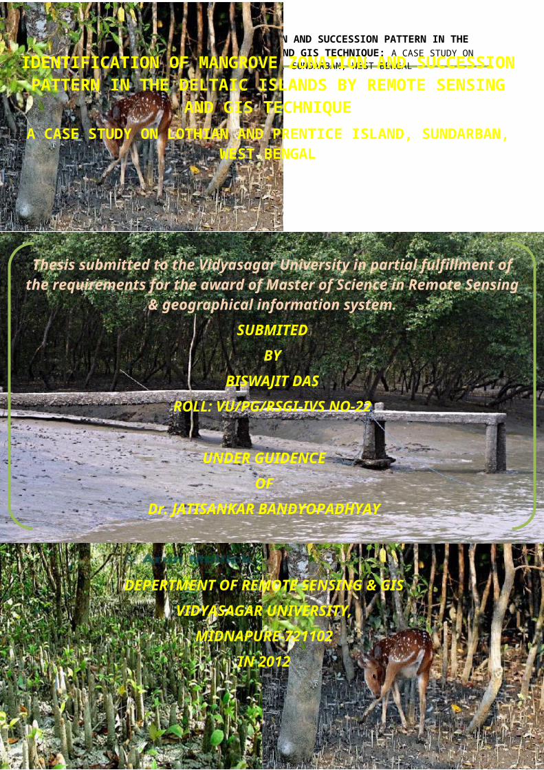
IDENTIFICATION OF MANGROVE ZONATION AND SUCCESSION PATTERN IN THEDELTAIC ISLANDS BY REMOTE SENSING AND GIS TECHNIQUE: A CASE STUDY ON
LOTHIAN AND PRENTICE ISLAND, SUNDARBAN, WEST BENGAL
Page No. 1
IDENTIFICATION OF MANGROVE ZONATION AND SUCCESSIONPATTERN IN THE DELTAIC ISLANDS BY REMOTE SENSING
AND GIS TECHNIQUEA CASE STUDY ON LOTHIAN AND PRENTICE ISLAND, SUNDARBAN,
WEST BENGAL
Thesis submitted to the Vidyasagar University in partial fulfillment ofthe requirements for the award of Master of Science in Remote Sensing
& geographical information system.SUBMITED
BYBISWAJIT DAS
ROLL: VU/PG/RSGI-IVS NO-22
UNDER GUIDENCEOF
Dr. JATISANKAR BANDYOPADHYAY
DEPERTMENT OF REMOTE SENSING & GISVIDYASAGAR UNIVERSITY,
MIDNAPURE-721102IN 2012
IDENTIFICATION OF MANGROVE ZONATION AND SUCCESSION PATTERN IN THEDELTAIC ISLANDS BY REMOTE SENSING AND GIS TECHNIQUE: A CASE STUDY ON
LOTHIAN AND PRENTICE ISLAND, SUNDARBAN, WEST BENGAL
IDENTIFICATION OF MANGROVE ZONATION ANDSUCCESSION PATTERN IN THE DELTAIC ISLANDS
BY REMOTE SENSING AND GIS TECHNIQUEA CASE STUDY ON LOTHIAN AND PRENTICE ISLAND,
SUNDARBAN, WEST BENGAL
SUBMITEDBY
BISWAJIT DASROLL: VU/PG/RSGI-IVS NO-22
UNDER GUIDENCEOF
Dr. JATISANKAR BANDYOPADHYAY
DEPERTMENT OF REMOTE SENSING & GISVIDYASAGAR UNIVERSITY
MIDNAPURE-7211022012
Page No. 2
IDENTIFICATION OF MANGROVE ZONATION AND SUCCESSION PATTERN IN THEDELTAIC ISLANDS BY REMOTE SENSING AND GIS TECHNIQUE: A CASE STUDY ON
LOTHIAN AND PRENTICE ISLAND, SUNDARBAN, WEST BENGAL
Page No. 3
IDENTIFICATION OF MANGROVE ZONATION AND SUCCESSION PATTERN IN THEDELTAIC ISLANDS BY REMOTE SENSING AND GIS TECHNIQUE: A CASE STUDY ON
LOTHIAN AND PRENTICE ISLAND, SUNDARBAN, WEST BENGAL
ACKNOWLEDGEMENT
I would like to thanks Dr. Jatisankar
Bandyopadhyay (Faculty of Remote Sensing & GIS dept., Vidyasagar
University), Dr. Abhisek Chakraborty (Faculty of Remote
Sensing & GIS dept., Vidyasagar University) and Dr. Sikhendra
Kishor De (Visiting Faculty, Retired Director G.S.I) for their
valuable thought and knowledge given throughout the
study of M.Sc. course
I wish to express my deep sense of gratitude to
Mr. Ratnadeep Ray (Faculty of Remote Sensing & GIS dept.,
Vidyasagar University) for his advice, support and
assistance throughout my dissertation work.
Finally, yet importantly, I would like to express
my heartfelt thanks to my beloved parents for their
blessings, my friends/classmates for their help and
wishes for the successful completion of this project
work
Page No. 4
IDENTIFICATION OF MANGROVE ZONATION AND SUCCESSION PATTERN IN THEDELTAIC ISLANDS BY REMOTE SENSING AND GIS TECHNIQUE: A CASE STUDY ON
LOTHIAN AND PRENTICE ISLAND, SUNDARBAN, WEST BENGAL
……………………………………
Biswajit Das
Dept of Remote Sensing and GIS
Vidyasagar University
ABSTRACTRemote Sensing and GIS of vegetation can be an
attractive and alternative to the traditional methodsof field scouting because of the capability ofcovering large areas rapidly and repeatedly providingspatial and temporal information necessary for asustainable management. The potential of remotesensing in vegetation is very high because it is ableto infer about vegetation amount and its nature as anon-destructive mean. Numerous spectral vegetationindices (VIs) have been developed to characterize
Page No. 5
IDENTIFICATION OF MANGROVE ZONATION AND SUCCESSION PATTERN IN THEDELTAIC ISLANDS BY REMOTE SENSING AND GIS TECHNIQUE: A CASE STUDY ON
LOTHIAN AND PRENTICE ISLAND, SUNDARBAN, WEST BENGAL
vegetation canopy. Plant canopy reflectance factorsand derived multispectral VIs are receiving increasedattention in floristic research as robust surrogatesfor traditional biophysical parameters. Spectralreflectance and thermal emittance properties of soiland vegetations have been used extensively to predictecological variables such as percent vegetationcovers, plant biomass, green leaf area index andother biophysical characteristics. VIs is stronglymodulated by interaction of solar radiation withphoto synthetically active plant tissues and thusalso is indicative of dynamic biophysical propertiesrelated to productivity and surface energy balance.The basic objective of this study is to convey thepotentiality of vegetation indices in thequantification of bio physical principles offloristic habitat of deltaic environment and toreview the remote sensing application in botanicalresearch.
Key Words: Mangrove Zonation, Succession Pattern,Complexity Index, Different Canopy, Correlation andRegression.
Page No. 6
IDENTIFICATION OF MANGROVE ZONATION AND SUCCESSION PATTERN IN THEDELTAIC ISLANDS BY REMOTE SENSING AND GIS TECHNIQUE: A CASE STUDY ON
LOTHIAN AND PRENTICE ISLAND, SUNDARBAN, WEST BENGAL
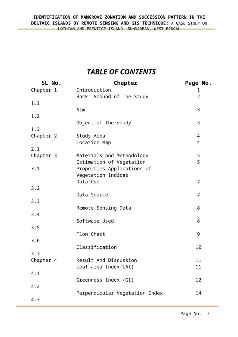
TABLE OF CONTENTSSL No. Chapter Page No.
Chapter 1 Introduction 1 1.1
Back Ground of The Study 2
1.2
Aim 3
1.3
Object of the study 3
Chapter 2 Study Area 4 2.1
Location Map 4
Chapter 3 Materials and Methodology 5 3.1
Estimation of Vegetation Properties Applications of Vegetation Indices
5
3.2
Data Use 7
3.3
Data Source 7
3.4
Remote Sensing Data 8
3.5
Software Used 8
3.6
Flow Chart 9
3.7
Classification 10
Chapter 4 Result And Discussion 11 4.1
Leaf area Index(LAI) 11
4.2
Greenness Index (GI) 12
4.3
Perpendicular Vegetation Index 14
Page No. 7
IDENTIFICATION OF MANGROVE ZONATION AND SUCCESSION PATTERN IN THEDELTAIC ISLANDS BY REMOTE SENSING AND GIS TECHNIQUE: A CASE STUDY ON
LOTHIAN AND PRENTICE ISLAND, SUNDARBAN, WEST BENGAL
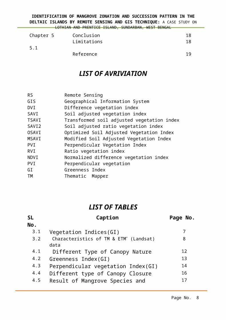
Chapter 5 Conclusion 18 5.1
Limitations 18
Reference 19
LIST OF AVRIVIATION
RS Remote SensingGIS Geographical Information SystemDVI Difference vegetation indexSAVI Soil adjusted vegetation indexTSAVI Transformed soil adjusted vegetation indexSAVI2 Soil adjusted ratio vegetation indexOSAVI Optimized Soil Adjusted Vegetation IndexMSAVI Modified Soil Adjusted Vegetation IndexPVI Perpendicular Vegetation IndexRVI Ratio vegetation indexNDVI Normalized difference vegetation indexPVI Perpendicular vegetationGI Greenness IndexTM Thematic Mapper
LIST OF TABLESSL No.
Caption Page No.
3.1 Vegetation Indices(GI) 73.2 Characteristics of TM & ETM+ (Landsat)
data8
4.1 Different Type of Canopy Nature 124.2 Greenness Index(GI) 134.3 Perpendicular vegetation Index(GI) 144.4 Different type of Canopy Closure 164.5 Result of Mangrove Species and 17
Page No. 8
IDENTIFICATION OF MANGROVE ZONATION AND SUCCESSION PATTERN IN THEDELTAIC ISLANDS BY REMOTE SENSING AND GIS TECHNIQUE: A CASE STUDY ON
LOTHIAN AND PRENTICE ISLAND, SUNDARBAN, WEST BENGAL
Canopy Closure
LIST OF FIGURESSL No.
Caption Page No.
1 Location map of the Lothian and Prentice Island, Sundarban
4
2 Digital Classification Using FUZZY K-mean 103 Leaf area Index (LAI) 124 Greenness Index(GI) 135 Correlation between Leave Area Index and
Greenness Index13
6 Perpendicular vegetation Index(PVI) 157 Co-relation Regression Between PVI and
GI 15
8 Co-relation between infrared band and RedBand
16
9 Different type of Canopy Closure 17
Page No. 9
IDENTIFICATION OF MANGROVE ZONATION AND SUCCESSION PATTERN IN THEDELTAIC ISLANDS BY REMOTE SENSING AND GIS TECHNIQUE: A CASE STUDY ON
LOTHIAN AND PRENTICE ISLAND, SUNDARBAN, WEST BENGAL
CHAPTER-1INTRODUCTION
Approximately 70% of the earth’s surface iscovered with vegetation (J.R.Jenson). Furthermorevegetation is one of the most important components ofthe eco-system. The knowledge about the variations invegetation species and community distributionpatterns, alternations in vegetation phonologicalcycles and modifications in plant physiology andmorphology provide valuable insight into climaticedaphic, geologic and physiographic characteristicsof an area (Jones et.al.1998).Scientists have devoteda significant amount of effort to develop sensors andvisual and digital image processing algorithms toextract important vegetation bio-physical informationfrom remotely sensed data. (Frhon,1998; Huete, andJustice, 1999). Many of the remote sensing techniquesare generic in nature and may be applied to varietyof vegetated landscapes including agriculture,forests, wetlands, manicured urban vegetations(Danson,1998; Lyon et.al., 1998).
Remote sensing vis-a-vis the application of spacetechnology over the vegetation study has opened a newdimension for the botanists and environmentalists.Analysis of sensor to signature interaction, spectralresponse pattern, Indices generation, mathematicalformulation etc has given a great impetus to thefloristic research.
Mangroves have a wide geographical distributionand are most extensive along tropical coasts wherethe sea and freshwater mix. Mangrove vegetation has avital role in maintaining the equilibrium andsecondary productivity of coastal lagoons andestuaries and forms the base of most coastal tropic
Page No. 10
IDENTIFICATION OF MANGROVE ZONATION AND SUCCESSION PATTERN IN THEDELTAIC ISLANDS BY REMOTE SENSING AND GIS TECHNIQUE: A CASE STUDY ON
LOTHIAN AND PRENTICE ISLAND, SUNDARBAN, WEST BENGAL
structures by means of a constant organic matterproduction throughout the year (Blasco et al. 1996).Being located at the land-sea interface, mangrovesprovide habitat for a multitude of terrestrial andaquatic organisms, offering sites for nesting andbreeding by migratory birds and protection forspawning and feeding by fish and prawns. Many faunaland floral species are endemic to mangroves, makingthese important ecosystems in terms of globalbiodiversity. Despite their robust appearance theseare fragile ecosystems, sensitive to fluctuations inenvironmental stresses caused by high soil salinity,tidal currents and storms, which may be enhanced byglobal climatic change. However,a more serious threatis being posed by human activity as economic andpopulation pressures rise along many tropical coasts(Field 1995). Often the exploitation of mangroves isunsustainable and occurs unnoticed and unquantified(Gang and Agatsiva 1992), and there is littleempirical evidence to indicate how mangroves willreact to such pressures. It is important, therefore,to implement accurate, rapid and cost-effectivemapping techniques to study mangrove areaseffectively (Green et al. 1998a).1.1 Background of the Study Area
Imagery from satellite and airborne remotesensing systems has the ability to provide spatiallycomprehensive information for remote and inaccessiblelocations, making this a valuable tool for researchon mangrove ecosystems. Green et al. (1998) provideda good account of the sensors and image processingmethods that have been used in the remote sensing ofthese environments with differing degrees of success.
Page No. 11
IDENTIFICATION OF MANGROVE ZONATION AND SUCCESSION PATTERN IN THEDELTAIC ISLANDS BY REMOTE SENSING AND GIS TECHNIQUE: A CASE STUDY ON
LOTHIAN AND PRENTICE ISLAND, SUNDARBAN, WEST BENGAL
They noted that the majority of work has focused onclassifying and mapping mangrove communities and thatonly recently has attention been drawn to thequantification of canopy biophysical properties usingspectral vegetation indices derived from remotely-sensed data. Of the several types of spectralvegetation indices available, ratio indices have beenmost frequently applied to satellite data formangroves. For example, Green et al. (1997, 1998b)used imagery from the SPOTHRV (System Pourl’Observation de la Terre—Haute Resolution Visible)satellite sensor and the CASI (Compact AirborneSpectrographic Imager) airborne instrument to derivethe widely used Normalized Difference VegetationIndex (NDVI) and correlated this with in situmeasurements of mangrove leaf area index (LAI). Theyobtained reasonably good coefficients ofdetermination (r2=0.74 (SPOT) and 0.77 (CASI)) byfitting a linear regressions through the data. Thismodel was then used to estimate values of mangroveLAI for the entire image and it was found that thesethematic maps were very successful, with quotedaccuracies based on a 95% confidence interval were88% for the SPOT HRV data, and 94% for the CASI data.However, despite these promising results, Green etal. (1997) warned that care should be taken wheninterpreting LAI values ≤1.5 derived from remotelysensed data. They argued that the LAI of mangroveswith relatively open canopies might be underestimatedif they were growing over white sand, oroverestimated if dark organic detritus covered thesediment (Green et al. 1997). It is probably the casethat mangroves experience a wider variation inbackground conditions, both spatially and temporally,than any other vegetation community. Slight
Page No. 12
IDENTIFICATION OF MANGROVE ZONATION AND SUCCESSION PATTERN IN THEDELTAIC ISLANDS BY REMOTE SENSING AND GIS TECHNIQUE: A CASE STUDY ON
LOTHIAN AND PRENTICE ISLAND, SUNDARBAN, WEST BENGAL
topographic variations can mean that the surfacebeneath the vegetation can vary spatially betweenexposed sediments or sands, soils of differentdevelopmental stages, plant litter and water withvarying suspended sediment concentrations. Likewise,over a tidal cycle at a specific location, thebackground can change from dry exposed sediment whichis then inundatedwith water, and then as the tiderecedes the wet sediment progressively dries.Therefore, it is important that we systematicallyinvestigate the influence of variations in backgroundreflectance properties, created by differentbackground types and changes in moisture content, onthe relationships between spectral indices and canopybiophysical properties in order to identify robustpredictive approaches.
The region like the deltaic parts of Sundarbanhaving a huge biophysical diversity is being huntedby the numbers of environmentalists as well asecologists, botanists etc. But this wonderfulmangrove habitat and the maximum portions of itsassociates are being unexplored due to itswilderness,in-accessibility due to creek dynamics,sand under mining due to the changingbehavior of tide etc.So in the perspective of remotesensing or the space application and mathematicalformulation using band algebra will help thescientists in a great extent.
1.2 Aim
Identification of mangrove zonation andsuccession pattern a Lothian and prentice Island,sundarban, West Bengal, India.
Page No. 13
IDENTIFICATION OF MANGROVE ZONATION AND SUCCESSION PATTERN IN THEDELTAIC ISLANDS BY REMOTE SENSING AND GIS TECHNIQUE: A CASE STUDY ON
LOTHIAN AND PRENTICE ISLAND, SUNDARBAN, WEST BENGAL
1.3 Objectives of the StudyArea
Land use & Land cover Classification to delineatethe study area.
Leaf area index measurement to find out mangrovearea zonation.
Measurement of Greenness index to find out canopycover density.
To assess correlation between Leaf area index andGreenness index .
Perpendicular Vegetation Index (PVI) to assessvegetation cover.
To assess correlation between PerpendicularVegetation Index (PVI) and Greenness index (GI).
To assess correlation between Red Band andInfared Band.
Different type of Mangrove Species and CanopyCover dencity
Page No. 14
IDENTIFICATION OF MANGROVE ZONATION AND SUCCESSION PATTERN IN THEDELTAIC ISLANDS BY REMOTE SENSING AND GIS TECHNIQUE: A CASE STUDY ON
LOTHIAN AND PRENTICE ISLAND, SUNDARBAN, WEST BENGAL
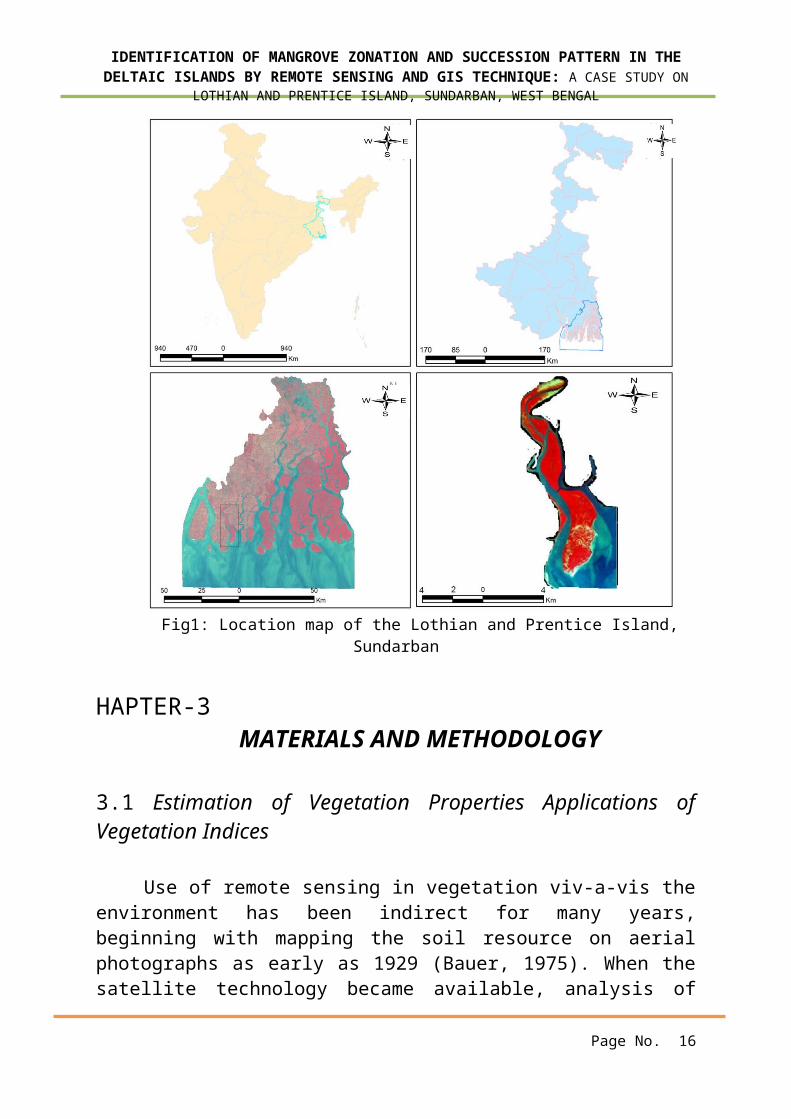
CHAPTER-2 STUDY AREALandsat Thematic Mapper image data (path 138 and
45) at 30m spatial resolution with seven channels ranging from blue to the thermal infrared portion of the spectral was used in this study. The image data were acquired over an area with three different typesof mangroves in LOTHIAN AND PRENTICE ISLAND, SUNDARBAN, INDIA. The location of the study area on the LOTHIAN ANDPRENTICE ISLAND, is presented in figure1.The present thestudy was undertaken at Lothian and Prentice ISLAND of the western Sundarbans from October2000 to November 2010.It is a small island of approximately 38sq. km area,which extends from 88o18’10”E to 88o21’30” E longitude and 21o32’50” N to 21o42’30” N latitude The island is regularly inundated by diurnaltide up to a certain distance from the northern coast. A North-South Spinal road approaches from northern coast upto nearly middle of the island. Our study sites ware selected on either sides of the spatial road.
Page No. 15
INDIA WEST BENGAL
SUNDARBAN LOTHIAN &PRENTICEI
SLAND
IDENTIFICATION OF MANGROVE ZONATION AND SUCCESSION PATTERN IN THEDELTAIC ISLANDS BY REMOTE SENSING AND GIS TECHNIQUE: A CASE STUDY ON
LOTHIAN AND PRENTICE ISLAND, SUNDARBAN, WEST BENGAL
Fig1: Location map of the Lothian and Prentice Island,Sundarban
HAPTER-3MATERIALS AND METHODOLOGY
3.1 Estimation of Vegetation Properties Applications ofVegetation Indices
Use of remote sensing in vegetation viv-a-vis theenvironment has been indirect for many years,beginning with mapping the soil resource on aerialphotographs as early as 1929 (Bauer, 1975). When thesatellite technology became available, analysis of
Page No. 16
IDENTIFICATION OF MANGROVE ZONATION AND SUCCESSION PATTERN IN THEDELTAIC ISLANDS BY REMOTE SENSING AND GIS TECHNIQUE: A CASE STUDY ON
LOTHIAN AND PRENTICE ISLAND, SUNDARBAN, WEST BENGAL
remotely sensed data was, and still is, the objectiveof many multidisciplinary research programs aroundthe world. Since 1960s, scientists have extracted andmodeled various vegetation biophysical variablesusing remotely sensed data. Much of the effort hasgone into the development of vegetation indices –defined as dimensionless, radiometric measures thatfunctionas indicators of relative abundance andactivity of green vegetation, often including leafarea index(LAI), percentage green cover, chlorophyllcontent, and green biomass and absorbedphotosynthetically active radiation (APAR).Vegetation monitoring is usually accomplished bysimple regression approach, modeling approach usingremote sensing data and by computing vegetationindices (VIs). A vegetation index should (Running etal.,1994; Huete and Justice,1999):
Maximize sensitivity to plant biophycalparameters, preferably with a linear response inorder that sensitivity be available for a widerange of vegetation conditions and to facilitatevalidation and calibration of the index;
Normalize or model external effects such as sunangle, viewing angle and the atmosphere forconsistent spatial and temporal comparisons;
Normalize internal effects such as canopybackground variations, including topography(slope and aspect), soil variations anddifferences in senesced or woody vegetation (nophotosynthetic canopy components); and
Be coupled to some specific measurablebiophysical parameter such as biomass, LAI orAPAR as part of the validation effort and qualitycontrol.
Page No. 17
IDENTIFICATION OF MANGROVE ZONATION AND SUCCESSION PATTERN IN THEDELTAIC ISLANDS BY REMOTE SENSING AND GIS TECHNIQUE: A CASE STUDY ON
LOTHIAN AND PRENTICE ISLAND, SUNDARBAN, WEST BENGAL
Several vegetation indices have been developed bylinear combination or ratios of red, green andnear infrared spectral bands. Vegetation indicesare more sensitive than individual bands tovegetation parameters (Baret and Guyot, 1991; Qiet al., 1993).VIs are strongly modulated byinteractions of solar radiation withphotosynthetically activeplant tissues and thusalso are indicative of dynamic biophysicalproperties related to Productivity and surface energy balance.Vegetation indices (VIs) have been designed tofind a functional relationship between vegetationcharacteristics and remote spatial observation(Wiegandet al., 1990). VIs tend to reach asaturation level asymptotically for values of LAIbetween 3 to 6, based on the type of index usedand type of plant (Carlson, et al., 1997; Aparicioetal.,2000). Another application is the use of VIs asa mapping device. In this case VIs are use inimage classification, to separate vegetated fromnon-vegetated areas, to distinguish betweendifferent types and densities of vegetation, tomonitor seasonal variations in vegetative vigor,abundance and distribution (Campbell, 1996;Barnes etal., 2003).Daughtryet al. (2000) classified VIs into twocategories: Intrinsic indices that include ratiosof two or more bands in the visible and NIRwavelengths (NIR/Red; NIR/Green; NDVI; GreenNormalized Difference Vegetative Index). Theseindices are sensitive to background reflectanceproperties and are often difficult to interpretat low LAI (Daughtryet al.,2000; Rondeauxet al.,1996); Soil-line vegetationindices, use the
Page No. 18
IDENTIFICATION OF MANGROVE ZONATION AND SUCCESSION PATTERN IN THEDELTAIC ISLANDS BY REMOTE SENSING AND GIS TECHNIQUE: A CASE STUDY ON
LOTHIAN AND PRENTICE ISLAND, SUNDARBAN, WEST BENGAL
information of soil line in NIR-Red reflectanceto reduce the effect of the soil on canopyreflectance (SAVI; Optimized Soil AdjustedVegetative Index (OSAVI); Transformed SoilAdjusted Vegetative Index (TSAVI).Beret and Guyot(1991) have classified VIs into two categories:Indices characterized by “slope”: RVI; NDVI;SAVI; TSAVI. Indices characterized by “distance”:PVI; WDVI; GVI.
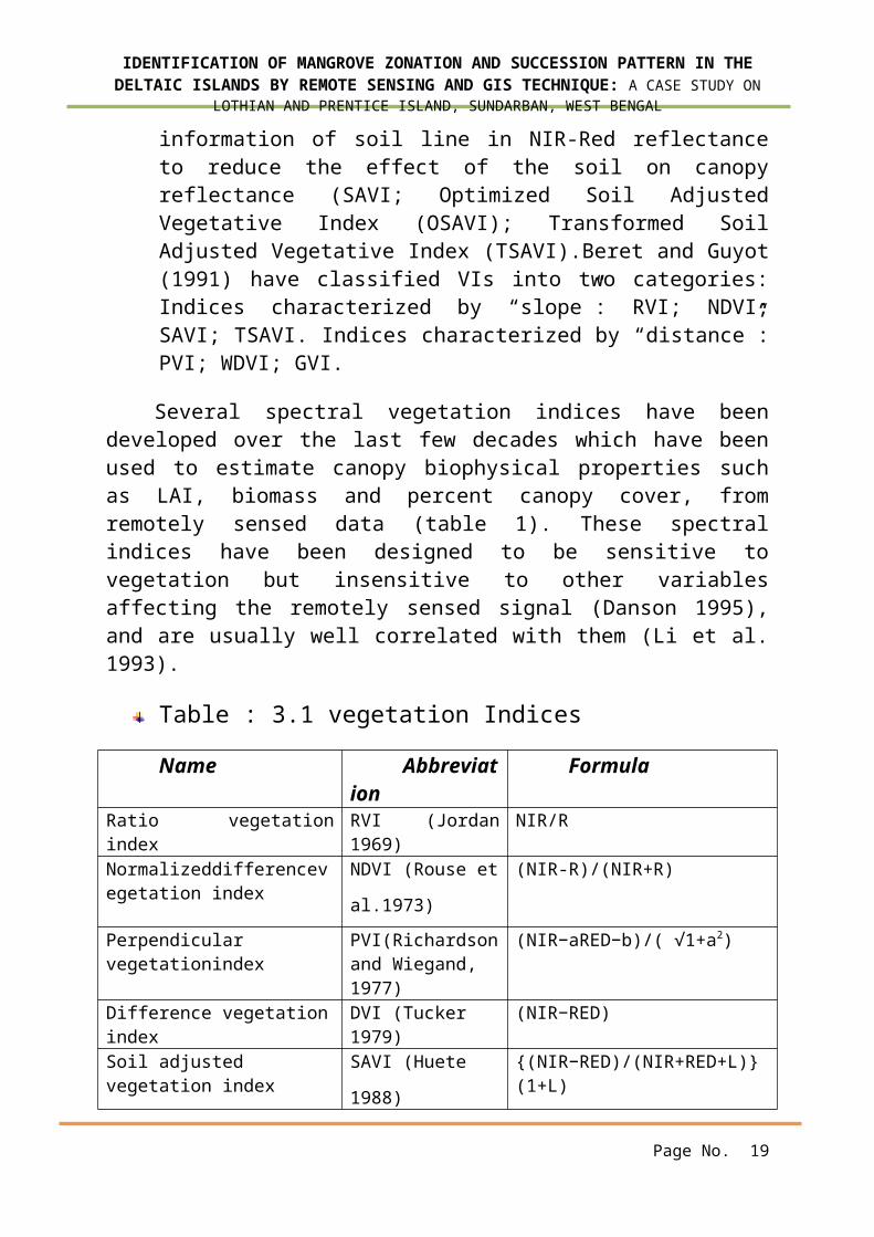
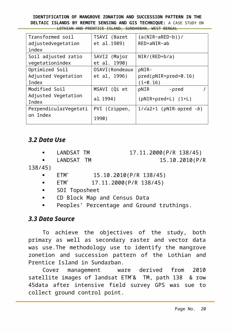
Several spectral vegetation indices have beendeveloped over the last few decades which have beenused to estimate canopy biophysical properties suchas LAI, biomass and percent canopy cover, fromremotely sensed data (table 1). These spectralindices have been designed to be sensitive tovegetation but insensitive to other variablesaffecting the remotely sensed signal (Danson 1995),and are usually well correlated with them (Li et al.1993).
Table : 3.1 vegetation Indices
Name Abbreviation
Formula
Ratio vegetationindex
RVI (Jordan1969)
NIR/R
Normalizeddifferencevegetation index
NDVI (Rouse et
al.1973)
(NIR-R)/(NIR+R)
Perpendicular vegetationindex
PVI(Richardsonand Wiegand, 1977)
(NIR−aRED−b)/( √1+a2)
Difference vegetationindex
DVI (Tucker 1979)
(NIR−RED)
Soil adjusted vegetation index
SAVI (Huete
1988)
{(NIR−RED)/(NIR+RED+L)}(1+L)
Page No. 19
IDENTIFICATION OF MANGROVE ZONATION AND SUCCESSION PATTERN IN THEDELTAIC ISLANDS BY REMOTE SENSING AND GIS TECHNIQUE: A CASE STUDY ON
LOTHIAN AND PRENTICE ISLAND, SUNDARBAN, WEST BENGAL
Transformed soil adjustedvegetation index
TSAVI (Baret et al.1989)
{a(NIR−aRED−b)}/RED+aNIR−ab
Soil adjusted ratio vegetationindex
SAVI2 (Major et al. 1990)
NIR/(RED+b/a)
Optimized Soil Adjusted Vegetation Index
OSAVI(Rondeauxet al, 1996)
ρNIR-ρred(ρNIR+ρred+0.16)(1+0.16)
Modified Soil Adjusted Vegetation Index
MSAVI (Qi et
al. 1994)
ρNIR -ρred /
(ρNIR+ρred+L) (1+L)
PerpendicularVegetation Index
PVI (Crippen,
1990)
1/√a2+1 (ρNIR- aρred -b)
3.2 Data Use
LANDSAT TM 17.11.2000(P/R 138/45) LANDSAT TM 15.10.2010(P/R
138/45) ETM+ 15.10.2010(P/R 138/45) ETM+ 17.11.2000(P/R 138/45) SOI Toposheet CD Block Map and Census Data Peoples’ Percentage and Ground truthings.
3.3 Data Source
To achieve the objectives of the study, bothprimary as well as secondary raster and vector datawas use.The methodology use to identify the mangrovezonetion and succession pattern of the Lothian andPrentice Island in Sundarban.
Cover management ware derived from 2010satellite images of landsat ETM+& TM, path 138 & row45data after intensive field survey GPS was sue tocollect ground control point.
Page No. 20

IDENTIFICATION OF MANGROVE ZONATION AND SUCCESSION PATTERN IN THEDELTAIC ISLANDS BY REMOTE SENSING AND GIS TECHNIQUE: A CASE STUDY ON
LOTHIAN AND PRENTICE ISLAND, SUNDARBAN, WEST BENGAL
RRSC(IIT,KHARAGPUR)/ www.glcf.org USGS(United State)/ www.glovis.usgs.gov.in Hyderabad, NDC/ www.bhuvan.in NASA / www.reverb.echo.nasa.gov USGS / www. earth explower.usgs.gov.in
3.4 Remote Sensing Data
Landsat TM ETM+satellite data collated to theselected delta was produce from USGS, unitedstate.The specification of the satellite and its productsare described in table.
TABLE :3.2 Characteristics of TM & ETM+ (Landsat)dataSensor TM ETM+
SpatialResolution
30, (Thermal 120) 30, (Thermal 60, PAN 15)
RadiometricResolution
8 bit 8 bit
TemporalResolution
16 days 16 days
Swath 185 185
Spectralband
(Band1) 0.45-0.52 (Band1) 0.45-0.52(Band2) 0.52-0.60 (Band2) 0.52-0.60(Band 3) 0.63-0.69 (Band 3) 0.63-0.69(Band 4)NIR: 0.76-0.90
(Band4)NIR: 0.76-0.90
(Band 5)NIR:1.55-1.75
(Band 5)NIR:1.55-1.75
Band 6)Thermal: 10.40-12.50
(Band 6.1)Thermal: 10.40-12.50(Band 6.2)Thermal: 10.40-12.50
(Band 7)Mid IR:2.08-2.35
-
(Band 7)Mid IR: 2.08-2.35(Band 8)PAN: 0.52-0.90
Page No. 21

Collection of FCC
Indices Calculation
Digital Classification(Using fuzzy k-
means)()
Extraction of Red & IR Bands
PVI, LAI, Greenness
Primary Zonation of Vegetation
Cover
IDENTIFICATION OF MANGROVE ZONATION AND SUCCESSION PATTERN IN THEDELTAIC ISLANDS BY REMOTE SENSING AND GIS TECHNIQUE: A CASE STUDY ON
LOTHIAN AND PRENTICE ISLAND, SUNDARBAN, WEST BENGAL
3.5 Softweres Used
Image Processing:ERDAS IMAGINE 9.0, TNTmips 2008:74
Geographical Information System:ARCGIS 9.3
Others:MS-Office (MS-Word, MS-Excel) for documentationandcalculation. Adobe PhotoshopCS5
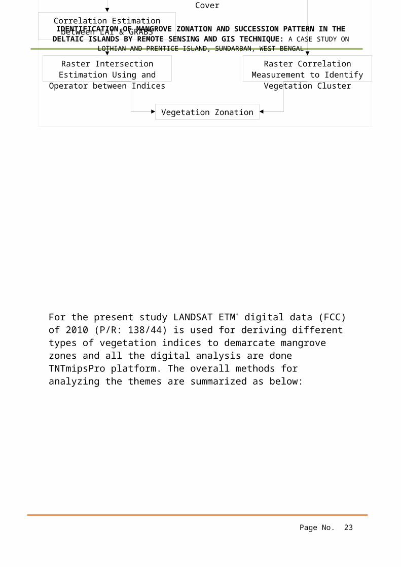
3.6 Flow Chart
Page No. 22
Correlation Estimation between LAI & GRABS
Raster Intersection Estimation Using and
Operator between Indices
Vegetation Zonation
Primary Zonation of Vegetation
Cover
Raster Correlation Measurement to Identify
Vegetation Cluster
IDENTIFICATION OF MANGROVE ZONATION AND SUCCESSION PATTERN IN THEDELTAIC ISLANDS BY REMOTE SENSING AND GIS TECHNIQUE: A CASE STUDY ON
LOTHIAN AND PRENTICE ISLAND, SUNDARBAN, WEST BENGAL
For the present study LANDSAT ETM+ digital data (FCC) of 2010 (P/R: 138/44) is used for deriving different types of vegetation indices to demarcate mangrove zones and all the digital analysis are done TNTmipsPro platform. The overall methods for analyzing the themes are summarized as below:
Page No. 23
IDENTIFICATION OF MANGROVE ZONATION AND SUCCESSION PATTERN IN THEDELTAIC ISLANDS BY REMOTE SENSING AND GIS TECHNIQUE: A CASE STUDY ON
LOTHIAN AND PRENTICE ISLAND, SUNDARBAN, WEST BENGAL
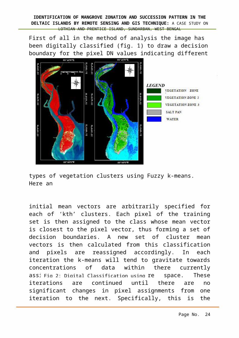
First of all in the method of analysis the image has been digitally classified (fig. 1) to draw a decisionboundary for the pixel DN values indicating different
types of vegetation clusters using Fuzzy k-means. Here an
initial mean vectors are arbitrarily specified foreach of ‘kth’ clusters. Each pixel of the trainingset is then assigned to the class whose mean vectoris closest to the pixel vector, thus forming a set ofdecision boundaries. A new set of cluster meanvectors is then calculated from this classificationand pixels are reassigned accordingly. In eachiteration the k-means will tend to gravitate towardsconcentrations of data within there currentlyassigned region of the feature space. Theseiterations are continued until there are nosignificant changes in pixel assignments from oneiteration to the next. Specifically, this is the
Page No. 24
Fig 2: Digital Classification using
IDENTIFICATION OF MANGROVE ZONATION AND SUCCESSION PATTERN IN THEDELTAIC ISLANDS BY REMOTE SENSING AND GIS TECHNIQUE: A CASE STUDY ON
LOTHIAN AND PRENTICE ISLAND, SUNDARBAN, WEST BENGAL
magnitude change of the mean vectors from (i-l) tothe iteration i, summed allk-clusters.
𝚫𝛍=∑k=l
K❑ μ│ k(i)-μk-l(i-l)│
Here for the betterment of accuracy, iterationhas been incremented (here 9times is used). Finallyafter following all the rules of fuzzy k-meansalgorithm 3 vegetation zones has been segmented buthere specifications cannot be drawn. So for givingthe actuality the following band algebra are used.
CHAPTER-4RESULT AND DISCUSSION
This has been said prior that no clear successionpattern is seen in the Sunderban regions. The tidalbehavior, creek dynamics, mangrove and salt marshinteractions, the differential colonization of thehalophytic species etc hinders to identify thezonation of the floristic environment. So a microlevel zonation would be an wise approach.
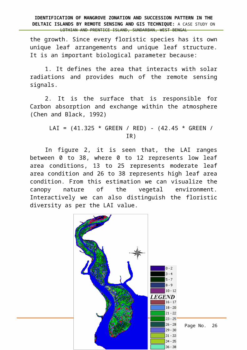
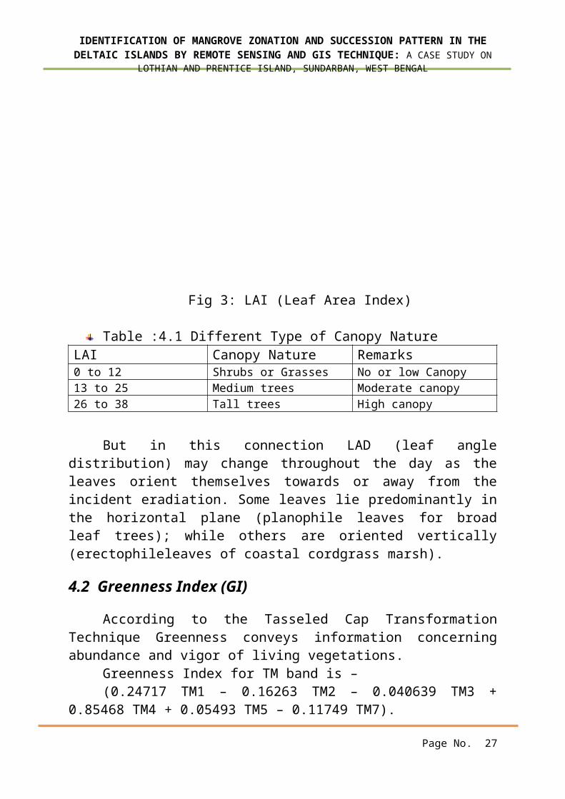
4.1 LAI (Leaf Area Index)
The spectral characteristics of canopy areinfluenced by Leaf area index (LAI) and per cent ofvegetative cover, growth stage, stress condition.Besides background soil, moisture content of the soilhas significant influence on the vegetationreflection or absorption during the early stages of
Page No. 25
IDENTIFICATION OF MANGROVE ZONATION AND SUCCESSION PATTERN IN THEDELTAIC ISLANDS BY REMOTE SENSING AND GIS TECHNIQUE: A CASE STUDY ON
LOTHIAN AND PRENTICE ISLAND, SUNDARBAN, WEST BENGAL
the growth. Since every floristic species has its ownunique leaf arrangements and unique leaf structure.It is an important biological parameter because:
1. It defines the area that interacts with solarradiations and provides much of the remote sensingsignals.
2. It is the surface that is responsible forCarbon absorption and exchange within the atmosphere(Chen and Black, 1992)
LAI = (41.325 * GREEN / RED) - (42.45 * GREEN /IR)
In figure 2, it is seen that, the LAI rangesbetween 0 to 38, where 0 to 12 represents low leafarea conditions, 13 to 25 represents moderate leafarea condition and 26 to 38 represents high leaf areacondition. From this estimation we can visualize thecanopy nature of the vegetal environment.Interactively we can also distinguish the floristicdiversity as per the LAI value.
Page No. 26
IDENTIFICATION OF MANGROVE ZONATION AND SUCCESSION PATTERN IN THEDELTAIC ISLANDS BY REMOTE SENSING AND GIS TECHNIQUE: A CASE STUDY ON
LOTHIAN AND PRENTICE ISLAND, SUNDARBAN, WEST BENGAL
Fig 3: LAI (Leaf Area Index)
Table :4.1 Different Type of Canopy NatureLAI Canopy Nature Remarks0 to 12 Shrubs or Grasses No or low Canopy13 to 25 Medium trees Moderate canopy26 to 38 Tall trees High canopy
But in this connection LAD (leaf angledistribution) may change throughout the day as theleaves orient themselves towards or away from theincident eradiation. Some leaves lie predominantly inthe horizontal plane (planophile leaves for broadleaf trees); while others are oriented vertically(erectophileleaves of coastal cordgrass marsh).
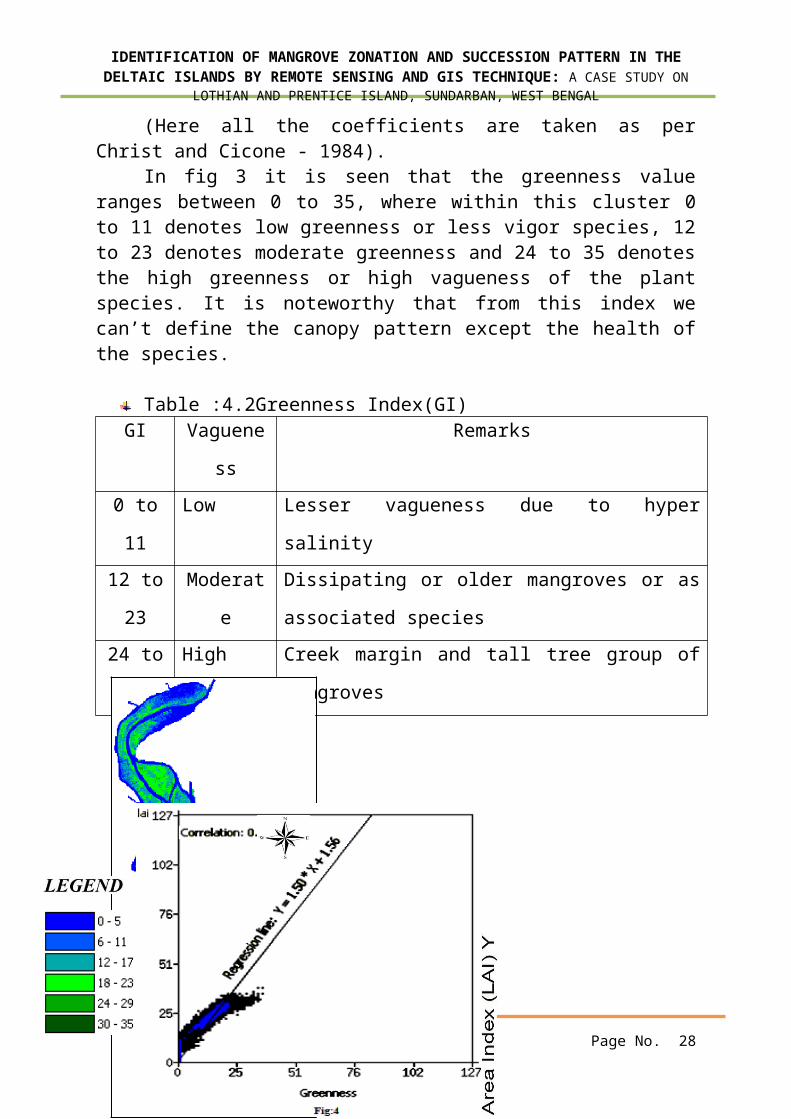
4.2 Greenness Index (GI)
According to the Tasseled Cap TransformationTechnique Greenness conveys information concerningabundance and vigor of living vegetations.
Greenness Index for TM band is –(0.24717 TM1 – 0.16263 TM2 – 0.040639 TM3 +
0.85468 TM4 + 0.05493 TM5 – 0.11749 TM7).
Page No. 27
IDENTIFICATION OF MANGROVE ZONATION AND SUCCESSION PATTERN IN THEDELTAIC ISLANDS BY REMOTE SENSING AND GIS TECHNIQUE: A CASE STUDY ON
LOTHIAN AND PRENTICE ISLAND, SUNDARBAN, WEST BENGAL
(Here all the coefficients are taken as perChrist and Cicone - 1984).
In fig 3 it is seen that the greenness valueranges between 0 to 35, where within this cluster 0to 11 denotes low greenness or less vigor species, 12to 23 denotes moderate greenness and 24 to 35 denotesthe high greenness or high vagueness of the plantspecies. It is noteworthy that from this index wecan’t define the canopy pattern except the health ofthe species.
Table :4.2Greenness Index(GI)GI Vaguene
ss
Remarks
0 to
11
Low Lesser vagueness due to hyper
salinity12 to
23
Moderat
e
Dissipating or older mangroves or as
associated species24 to
35
High Creek margin and tall tree group of
mangroves
Page No. 28

IDENTIFICATION OF MANGROVE ZONATION AND SUCCESSION PATTERN IN THEDELTAIC ISLANDS BY REMOTE SENSING AND GIS TECHNIQUE: A CASE STUDY ON
LOTHIAN AND PRENTICE ISLAND, SUNDARBAN, WEST BENGAL
Here a bivariate relationship is drawn (fig 4)between GI (in X axis) and LAI (in Y axis) – apositive relationship is seen, where the co-relationis 0.968 and the regression equation is –
LAI = 1.50* GI + 1.56
Here this is clear that the increment of the LAIdenotes the Vagueness development of the vegetationcover. But we have to keep concern about the LAD. Incase of the Planophile leaves this relationship maynot be fitted.
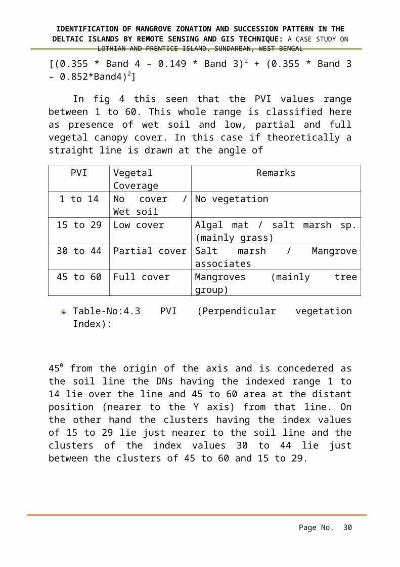
4.3 PVI (Perpendicular Vegetation Index)
This is such an index that uses the soil base lineco-efficient (slope and intercept). Here the soilbase line is a relationship between the reflectancein the red and infrared regions for the range of thesoil types without the vegetation cover. This can bedefined as a perpendicular point presented by the redand near infrared reflectance from the bare soilbaseline, expressing the distance between canopy redand near infrared and the soil baseline (Major etal.). PVI for TM band is –
Page No. 29
Fig 4: Greenness IndexFig 5: Correlation between
leave Area Index (LAI) &
Greenness Index
IDENTIFICATION OF MANGROVE ZONATION AND SUCCESSION PATTERN IN THEDELTAIC ISLANDS BY REMOTE SENSING AND GIS TECHNIQUE: A CASE STUDY ON
LOTHIAN AND PRENTICE ISLAND, SUNDARBAN, WEST BENGAL
[(0.355 * Band 4 – 0.149 * Band 3)2 + (0.355 * Band 3– 0.852*Band4)2]
In fig 4 this seen that the PVI values rangebetween 1 to 60. This whole range is classified hereas presence of wet soil and low, partial and fullvegetal canopy cover. In this case if theoretically astraight line is drawn at the angle of
PVI VegetalCoverage
Remarks
1 to 14 No cover /Wet soil
No vegetation
15 to 29 Low cover Algal mat / salt marsh sp.(mainly grass)
30 to 44 Partial cover Salt marsh / Mangroveassociates
45 to 60 Full cover Mangroves (mainly treegroup)
Table-No:4.3 PVI (Perpendicular vegetationIndex):
450 from the origin of the axis and is concedered asthe soil line the DNs having the indexed range 1 to14 lie over the line and 45 to 60 area at the distantposition (nearer to the Y axis) from that line. Onthe other hand the clusters having the index valuesof 15 to 29 lie just nearer to the soil line and theclusters of the index values 30 to 44 lie justbetween the clusters of 45 to 60 and 15 to 29.
Page No. 30
IDENTIFICATION OF MANGROVE ZONATION AND SUCCESSION PATTERN IN THEDELTAIC ISLANDS BY REMOTE SENSING AND GIS TECHNIQUE: A CASE STUDY ON
LOTHIAN AND PRENTICE ISLAND, SUNDARBAN, WEST BENGAL
Page No. 31

IDENTIFICATION OF MANGROVE ZONATION AND SUCCESSION PATTERN IN THEDELTAIC ISLANDS BY REMOTE SENSING AND GIS TECHNIQUE: A CASE STUDY ON
LOTHIAN AND PRENTICE ISLAND, SUNDARBAN, WEST BENGAL
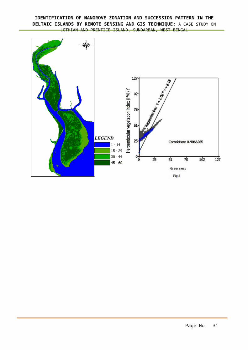
Fig 6:Perpendicular vegetation IndexFig 7: Co-relation Regression Between
(PVI) PVI andGreennessINDEX (GI)
Like LAI, here due to the positive relationshipPVI is increasing with the GI (fig 5) and if adomainfunction is drawn for the GI, like 1>GI>-1, forGI towards 1 denotes the presence of medium to talltrees and vice versa.
Now if an intersection operation (BooleanAND operator) is followed over the LAI, PVI and GI,we can clearly identify the succession pattern aswell as the nature of the canopy coverage. Theoutcome of this operation is tabulated later.
This has been said prior that no clear successionpattern is seen in the Sunderban regions. The tidalbehavior, creek dynamics, mangrove and salt marshinteractions, the differential colonization of thehalophytic species etc hinders to identify thezonation of the floristic environment. So a microlevel zonation would be an wise approach.
In fig 1 it is seen that within this estuarinearea basically 3 vegetation zones are prominent,where after comparing with PVI and LAI, the zone 2will show the densenature of vegetation,having the tree groupsof mangroves.But on the other handzone 2 and 2 accordingto the PVI and LAI
Page No. 32
IDENTIFICATION OF MANGROVE ZONATION AND SUCCESSION PATTERN IN THEDELTAIC ISLANDS BY REMOTE SENSING AND GIS TECHNIQUE: A CASE STUDY ON
LOTHIAN AND PRENTICE ISLAND, SUNDARBAN, WEST BENGAL
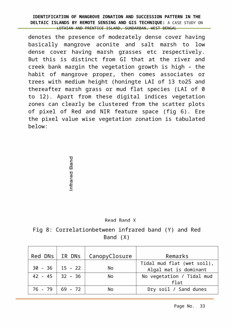
denotes the presence of moderately dense cover havingbasically mangrove aconite and salt marsh to lowdense cover having marsh grasses etc respectively.But this is distinct from GI that at the river andcreek bank margin the vegetation growth is high – thehabit of mangrove proper, then comes associates ortrees with medium height (honingte LAI of 13 to25 andthereafter marsh grass or mud flat species (LAI of 0to 12). Apart from these digital indices vegetationzones can clearly be clustered from the scatter plotsof pixel of Red and NIR feature space (fig 6). Erethe pixel value wise vegetation zonation is tabulatedbelow:
Fig 8: Correlationbetween infrared band (Y) and RedBand (X)
Red DNs IR DNs CanopyClosure Remarks
30 - 36 15 – 22 NoTidal mud flat (wet soil),
Algal mat is dominant42 - 45 32 – 36 No No vegetation / Tidal mud
flat76 - 79 69 – 72 No Dry soil / Sand dunes
Page No. 33
Read Band X
IDENTIFICATION OF MANGROVE ZONATION AND SUCCESSION PATTERN IN THEDELTAIC ISLANDS BY REMOTE SENSING AND GIS TECHNIQUE: A CASE STUDY ON
LOTHIAN AND PRENTICE ISLAND, SUNDARBAN, WEST BENGAL
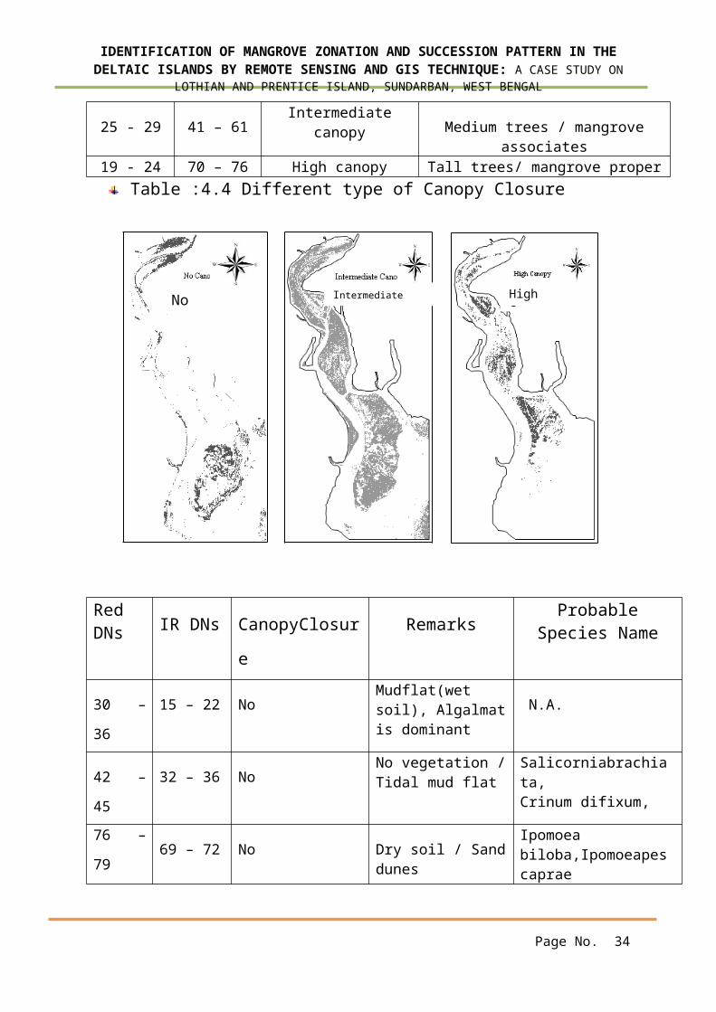
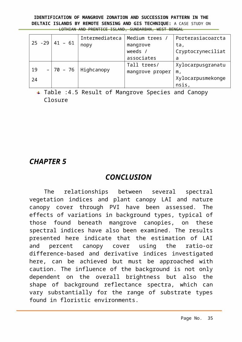
25 - 29 41 – 61Intermediate
canopy Medium trees / mangroveassociates
19 - 24 70 – 76 High canopy Tall trees/ mangrove properTable :4.4 Different type of Canopy Closure
RedDNs IR DNs CanopyClosur
e
RemarksProbable
Species Name
30 –
36
15 – 22 NoMudflat(wet soil), Algalmatis dominant
N.A.
42 –
45
32 – 36 NoNo vegetation /Tidal mud flat
Salicorniabrachiata,Crinum difixum,
76 –
7969 – 72 No Dry soil / Sand
dunes
Ipomoea biloba,Ipomoeapescaprae
Page No. 34
No IntermediateCanopy
HighCanopy
IDENTIFICATION OF MANGROVE ZONATION AND SUCCESSION PATTERN IN THEDELTAIC ISLANDS BY REMOTE SENSING AND GIS TECHNIQUE: A CASE STUDY ON
LOTHIAN AND PRENTICE ISLAND, SUNDARBAN, WEST BENGAL
25 -29 41 – 61Intermediatecanopy
Medium trees / mangrove weeds / associates
Porterasiacoarctata,Cryptocryneciliata
19 –
24
70 – 76 HighcanopyTall trees/ mangrove proper
Xylocarpusgranatum,Xylocarpusmekongensis,
Table :4.5 Result of Mangrove Species and Canopy Closure
CHAPTER 5
CONCLUSION
The relationships between several spectralvegetation indices and plant canopy LAI and naturecanopy cover through PVI have been assessed. Theeffects of variations in background types, typical ofthose found beneath mangrove canopies, on thesespectral indices have also been examined. The resultspresented here indicate that the estimation of LAIand percent canopy cover using the ratio-ordifference-based and derivative indices investigatedhere, can be achieved but must be approached withcaution. The influence of the background is not onlydependent on the overall brightness but also theshape of background reflectance spectra, which canvary substantially for the range of substrate typesfound in floristic environments.
Page No. 35
IDENTIFICATION OF MANGROVE ZONATION AND SUCCESSION PATTERN IN THEDELTAIC ISLANDS BY REMOTE SENSING AND GIS TECHNIQUE: A CASE STUDY ON
LOTHIAN AND PRENTICE ISLAND, SUNDARBAN, WEST BENGAL
In this present study a strong relationship isseen between the GI and LAI but from this relationthe segmentation of the canopy nature may beerroneous due to differential leaf geometry andalignments. It is seen that at some optimum point orextent this linear relation may break and in thatsituation a polynomial regression line should befitted between the variables (indices). Besides somewhere it is seen that inspire of having higher GI,according to PVI that has been indicated asintermediate to higher canopy cover – from whichsuccession interpretation may not be done. So it isbetter to identify the the vegetation pattern andnature (three tire orientation)from the scatter plotsof Red and NIR feature space.
5.1 Limitations
Non availability of data in particularstudy area.
Time period is very short to work outclearly.
Short time of field visit.No available the same time weather data
for this study.
Page No. 36

IDENTIFICATION OF MANGROVE ZONATION AND SUCCESSION PATTERN IN THEDELTAIC ISLANDS BY REMOTE SENSING AND GIS TECHNIQUE: A CASE STUDY ON
LOTHIAN AND PRENTICE ISLAND, SUNDARBAN, WEST BENGAL
REFERENCES
Bannari, A, Huete, A. R., Morin, D., andZagolski, F,, 1996, Effects de la couleur et dela brillance du sol sur les indices devegetation. International Journal of RemoteSensing, 17, 1885–1906.
Ball, M.C. 1996. Comparative ecophysiology ofmangrove forest and tropical lowland moistforest. Pp. 461-469. In ;s.s.Mulkey, R.L.chazdon& A.O Smith (eds.) Tropical Forest PlantEcophysiology. Chapman and Hall, New York.
Ball, M.C. 1998. Mangrove species richness inrelation to salinity and water logging. GlobalEcology and Biogeography Letters7:73-82.
Banerjee, L.K., A.R.K. Sastry& M.P. Nayar. 1989.Mangroves in India, Identification Manual.Botanical Survey of India, Kolkata.
B. Meza D´ıaz and G. A. Blackburn Remote sensingof mangrove biophysical properties: evidence froma laboratory simulation of the possible effectsof background variation on spectral vegetationindices, INT.J.Remote Sensing, 2003,vol 24, No 1,53 - 73
Chen, R. & R.R. Twilley. 1998. A gap dynamicmodel of mangrove forest development alonggradients of soil salinity and nutrientresources. Journal of Ecology 86: 37-52.
Page No. 37
IDENTIFICATION OF MANGROVE ZONATION AND SUCCESSION PATTERN IN THEDELTAIC ISLANDS BY REMOTE SENSING AND GIS TECHNIQUE: A CASE STUDY ON
LOTHIAN AND PRENTICE ISLAND, SUNDARBAN, WEST BENGAL
Chen, R. & R.R. Twilley. 1999. Patterns ofmangrove forest structure and soil nutrientdynamics along the Shark River estuary, Florida.Estuaries 22: 955-970.Jordan, C. F., 1969, Derivation of leaf areaindex from quality of light at the forest floor.Ecology, 50, 663–666.
http://glovis.usgs.gov/
http://reverb.echo.nasa.gov
http://glcf.gov.in
http://bhuvan.gov.in
http://earth.exploer.gov.in
Kathiresan, K., N. Rajendran& G. Thangadurai.1996. Growth of mangrove seedlings in intertidalarea of Vellar estuary southeast coast of India.Indian Journal of Marine Sciences 25: 240-243.
Kennealy, K.F. 1982. Mangroves of WesternAustralia. pp. 95-110. In: B.F. Clough (ed.)Mangrove Ecosystem in Australia: Structure,Function and Management. Australian Institute ofMarine Sciences, Australia.
Lugo, A.E. & S.C. Snedaker. 1974. The ecology ofmangroves. Annual Review of Ecology andSystematics 5: 39-64.
Page No. 38
IDENTIFICATION OF MANGROVE ZONATION AND SUCCESSION PATTERN IN THEDELTAIC ISLANDS BY REMOTE SENSING AND GIS TECHNIQUE: A CASE STUDY ON
LOTHIAN AND PRENTICE ISLAND, SUNDARBAN, WEST BENGAL
Landsat 7 Science User Data Handbook Chap.11,(2002),
Macnae, W. 1968. A general account of the faunaand flora of mangrove swamps and forests in theIndoWest Pacific Region. Advances in MarineBiology 6: 72-270.
Mckee, K.L. 1993. Soil physicochemical propertiesand mangrove species distribution – reciprocaleffects? Journal of Ecology 81: 477-487.
Ormsby, J. P., Choudhury, B. J., and Owe, M.,1987, Vegetation spatial variability and itseffect on vegetation indices. InternationalJournal of Remote Sensing, 8, 1301–1306.
Pal, D., A.K. Das, S.K. Gupta & A.K. Sahoo. 1996.Vegetation pattern and soil characteristics ofsome mangrove forest zones of the Sundarbans,West Bengal. Indian Agriculturist 40: 71-78.
Page No. 39